The Natural Disaster in Bangladesh
21
THE NATURAL DISASTERS IN BANGLADESH 1. INTRODUCTION: Natural calamity is a natural event which has an adverse sociological and economic impact on the whole environment. In recent years, they have become more frequent because of the climate change over the world. That is way; they are now being addressed as a global problem. Bangladesh, a South Asian Country located next to India is prone to natural disasters i.e. flood, cyclone, tornado etc. due to being situated on the Ganges Delta and the many tributaries flowing into the Bay of Bengal. 1 Bangladesh, a nation is very much at risk of such natural hazards despite its development. Such natural disasters cause heavy damage to the lives, goods and properties. Effective measures can play a vital role in the mitigation of the sufferings of lives, loss of goods and properties etc. 2. NATURAL DISASTER: CONCEPT AND MEANING: Natural disaster is a major adverse even resulting from natural processes which could be related to weather, geology, biology or even more factors outside the Earth. For example: Floods Volcanic Eruptions Earthquakes 1 http://en.wikipedia.org/wiki/Natural_disaster 12/02/2014.
-
Upload
independent -
Category
Documents
-
view
1 -
download
0
Transcript of The Natural Disaster in Bangladesh

THE NATURAL DISASTERS IN BANGLADESH
1. INTRODUCTION:Natural calamity is a natural event which has an adverse
sociological and economic impact on the whole environment. In
recent years, they have become more frequent because of the
climate change over the world. That is way; they are now being
addressed as a global problem. Bangladesh, a South Asian
Country located next to India is prone to natural disasters
i.e. flood, cyclone, tornado etc. due to being situated on
the Ganges Delta and the many tributaries flowing into the Bay
of Bengal.1 Bangladesh, a nation is very much at risk of such
natural hazards despite its development. Such natural
disasters cause heavy damage to the lives, goods and
properties. Effective measures can play a vital role in the
mitigation of the sufferings of lives, loss of goods and
properties etc.
2. NATURAL DISASTER: CONCEPT AND MEANING:Natural disaster is a major adverse even resulting from
natural processes which could be related to weather, geology,
biology or even more factors outside the Earth. For example:
Floods
Volcanic Eruptions
Earthquakes1 http://en.wikipedia.org/wiki/Natural_disaster. Date of access- 12/02/2014.

Tsunamis
Landslides
and for other Geological Processes
These are natural disasters which are caused by environmental
factors that injure people, damage property and leave some of
economic damage in its wake.
3. NATURAL DISASTERS IN BANGLADESH:Bangladesh, a country in Southern Asia is a home of 140
million people, is widely known as a land of natural
disasters. Every year, Bangladesh is affected by natural
disasters like, cyclones, drought, earthquake, tornado, river
bank erosion, landslide etc. Recently, tsunami also little bit
has affected our country. Natural disaster causes heavy tolls
in our country. Many people are killed and many other become
homeless. After disaster, many diseases break out and
communication system is suspended causing untold sufferings to
people.
2
Figure 1: Natural

Map 1: Hazard groups in Bangladesh
3.1 FLOODS: Floods are the overflow of a
large amount of water beyond
its normal limits, especially
over what is normally dry
land. Floods are the most
significant natural hazard in
Bangladesh causing extensive damage to human life and
property. The major floods that occurred in 1954, 1955, 1974,
1984, 1987, 1988, 1993, 1998, 1999, 2000 and 2007 have been
very destructive and caused serious threat to lives and
economy. Floods hit our country during the rainy season when
3
Figure 2: Floods in Bangladesh
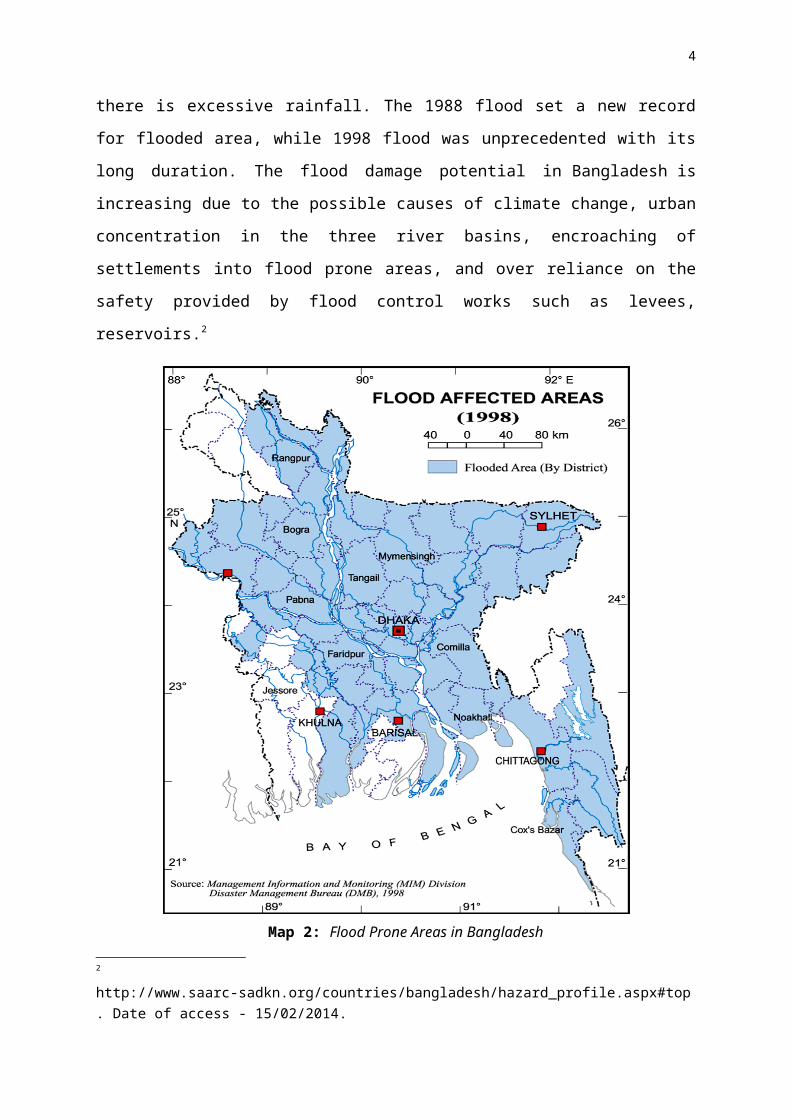
there is excessive rainfall. The 1988 flood set a new record
for flooded area, while 1998 flood was unprecedented with its
long duration. The flood damage potential in Bangladesh is
increasing due to the possible causes of climate change, urban
concentration in the three river basins, encroaching of
settlements into flood prone areas, and over reliance on the
safety provided by flood control works such as levees,
reservoirs.2
2 http://www.saarc-sadkn.org/countries/bangladesh/hazard_profile.aspx#top. Date of access - 15/02/2014.
4
Map 2: Flood Prone Areas in Bangladesh

There are two types of floods which occur in Bangladesh:
annual floods (barsha) that inundate up to 20% of the land
area; and low frequency floods of high magnitude that inundate
more than 35% of the area (bonna). In the context of human
exposure in flood hazard zones, nearly 19,279,960 people are
present in these zones and Bangladesh ranks 1st among 162
nations. Similarly, the modeled amount of GDP in seismically
hazardous zones puts Bangladesh 3rd among 162 countries.
Year Death
1988 1708
1998 918
2004 747
2007 800
Table 1: Major Floods in Bangladesh
3.2 CYCLONE:
Cyclone is the system of winds rotating inwards to an area of
low barometric pressure, with an anticlockwise (northern
hemisphere) or clockwise (southern hemisphere) circulation.
Cyclones, sometimes associated with storm surge have been a
cause of concern for Bangladesh. From 1891–98, approximately
178 severe cyclones with wind speeds of more than 87
5
kilometers per hour (km/h) formed in the Bay of Bengal,
causing extensive loss of life and destruction of property.3
From 1970–98, there was devastation due to 38 severe cyclones.
The April 1991 cyclone inflicted a material damage was about
USD 2.4 billion and human casualties numbered around 140,000.
In 1970, a similar catastrophe claimed some 500,000 lives. In
addition, storm surge, an unusual rise in seawater associated
with a tropical cyclone originating in the Bay of Bengal, has
also caused major devastation in the coastal region.
3 http://www.saarc-sadkn.org/countries/bangladesh/hazard_profile.aspx#top. Date of access- 15.02.2014.
6
Figure 3:Mahasen
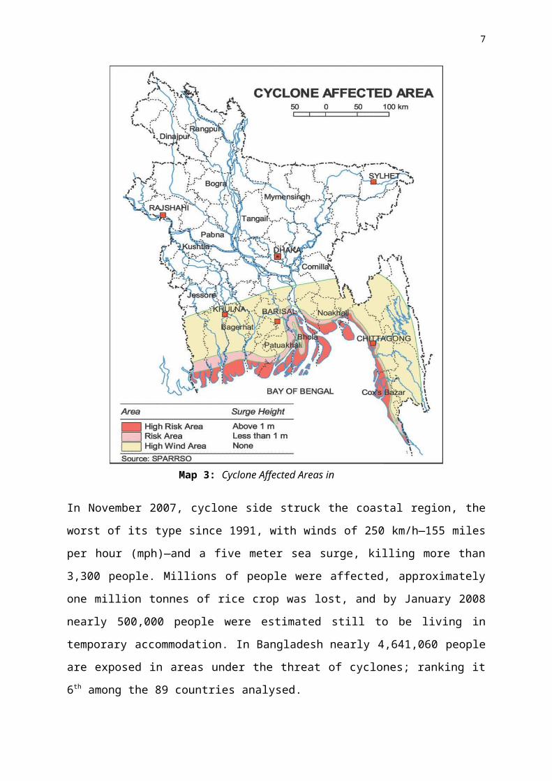
In November 2007, cyclone side struck the coastal region, the
worst of its type since 1991, with winds of 250 km/h—155 miles
per hour (mph)—and a five meter sea surge, killing more than
3,300 people. Millions of people were affected, approximately
one million tonnes of rice crop was lost, and by January 2008
nearly 500,000 people were estimated still to be living in
temporary accommodation. In Bangladesh nearly 4,641,060 people
are exposed in areas under the threat of cyclones; ranking it
6th among the 89 countries analysed.
7
Map 3: Cyclone Affected Areas in Bangladesh

Date Maximum Wind
speed
(km/hr)
Storm Surge
height
(metres)
Death Toll
11 May 1965 161 3.7-7.6 19,27915
December1965 217 2.4-3.6 873
01
October1966 139 6.0-6.7 850
12
November1970 224 6.0-10.0 300,000
25 May 1985 154 3.0-4.6 11,06929 April 1991 225 6.0-7.6 138,88219 May 1997 232 3.1-4.6 15515
November2007 223 -- 3363
25 May
(AILA)2009 92 -- 190
TABLE 2: Major cyclones that hit the Bangladesh coast4
3.3 RIVER BANK EROSION:River Bank Erosion refers to the wearing off; of the top soil
that encloses a river or a stream. This is an ongoing disaster
and there is no specific indicator to measure the extent of
damage. So the extent of damage caused by river erosion in
most cases is based on various reports/information. Needless
to say whatever the difference in ascertaining the extent of
damage river erosion causes huge loss of property throughout
4 Source: Bangladesh Meteorological Department 2007.
8
Figure 4: River Bank

the year. According to “World
Disaster Report 2001”
published by IFRCS every year
about 10, 00,000 people are
affected by river erosion and
9,000 hectare cultivable
lands are banished in river.
Among these only a few affected people are able to find new
shelters while others become homeless for uncertain period.5
River bank erosion in Bangladesh is no less dangerous than
other sudden and devastating calamities. Losses due to river
erosion occur slowly and gradually. Though losses are slow and
gradual, they are more destructive and far-reaching than other
sudden and devastating calamities. The effects of river
erosion are long-term. It takes a few decades to make up the
losses, which a family has incurred by river erosion. There
has been little progress, however, for improving the lives of
erosion-affected people due to resource constraint.
5 http://www.saarc-sadkn.org/countries/bangladesh/hazard_profile.aspx#top. Date Access: 15.02.2014.
9

3.4 LANDSLIDE:Landslide is the collapse of a mass of earth or rock from a
mountain or cliff. Large and small landslides occur almost
every year in nearly all regions of the world. In the past,
landslide was not considered a major hazard in Bangladesh.
However, recently landslide has emerged as a major hazard,
particularly after the Chittagong Landslide 2007. Due to heavy
rainfall during 10-11 June 2007, landslides collapsed walls
which caused widespread damages in six areas of Chittagong
10
Map 4: Bangladesh River Bank Prone Areas

city and in different Upazilas of the District. 50mm of
rainfall was recorded from 12:00 AM on 10 June 2007 to 6:00 AM
on 11 June 2007, and 315mm of rainfall was recorded from
6:00am to 2:00 PM on 11 June 2007. More than 120 people have
been reported dead due to Chittagong landslide.
Year Death Location
2012 122Chittagong, Cox’s Bazar,
Bandarban2010 96 Cox Bazar2008 11 Chittagong2007 127 Chittagong
TABLE 3: Recent Major Landslide in Bangladesh
3.5 EARTHQUAKE:
Earthquake is the sudden
violent shaking of the ground,
typically causing great
destruction, as a result of
movements within the earth's
crust or volcanic action. In 1993, 26 percent
of Bangladesh falls in high risk, 38 percent moderate and 36
percent in low risk zone in terms of earthquake vulnerability.
The distribution of recorded earthquakes indicate a major
clustering of seism city around the Dauki Fault and scattering
of other events along other major fault systems of Bangladesh.
The magnitude of the earthquakes are moderate (4-6) and
11
Figure 5: Earthquake in Bangladesh

majority of them are shallow depth. The historical records
show that the there have been some major earthquakes
in Bangladesh. 6
The 1548 earthquake had affected Sylhet and Chittagong with
reports of ground rupture and hydrological changes. The 1762
earthquake had raised the Foul Island by 2.74 meters and the
northwest coast of Chedua by 6.71 meters above the MSL and had
caused permanent submergence of part of Chittagong. The 1897
Great India earthquake had caused extensive damage to parts of
Mymensingh, Dhaka and Rajshahi. Among the recent major
earthquakes, the 1997 Chittagong earthquake caused extensive
damage to the adjacent areas. In the context of human exposure
in seismically hazardous zones, nearly 1,330,958 people are
present in these zones and Bangladesh ranks 17th among 153
nations. Similarly, the modeled amount of GDP in seismically
hazardous zones puts Bangladesh 42nd among 153 countries.
6 http://www.saarc-sadkn.org/countries/bangladesh/hazard_profile.aspx#top.
12
Figure 4: Earthquake Affected Areas in Bangladesh

In the context of human exposure in seismically hazardous
zones, nearly 1,330,958 people are present in these zones and
Bangladesh ranks 17th among 153 nations. Similarly, the
modeled amount of GDP in seismically hazardous zones puts
Bangladesh 42nd among 153 countries.
Date Name Magnitude(Richter)10 January, 1869 Cachar Earthquake 7.514 July, 1885 Bengal Earthquake 7.0
12 June, 1897Great Indian
Earthquake8.7
8 July, 1918 Srimongal 7.6
13
Map 4: Earthquake Zoning Areas in Bangladesh
Earthquake2 July, 1930 Dhubri Earthquake 7.1
15 January, 1934Bihar-Nepal
Earthquake8.3
15 August, 1950 Assam Earthquake 8.5
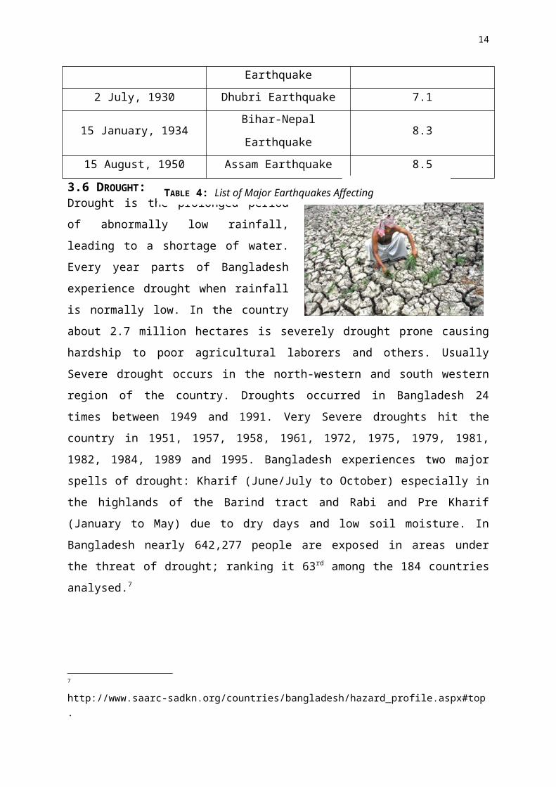
3.6 DROUGHT:Drought is the prolonged periodof abnormally low rainfall,leading to a shortage of water.Every year parts of Bangladeshexperience drought when rainfallis normally low. In the countryabout 2.7 million hectares is severely drought prone causinghardship to poor agricultural laborers and others. UsuallySevere drought occurs in the north-western and south westernregion of the country. Droughts occurred in Bangladesh 24times between 1949 and 1991. Very Severe droughts hit thecountry in 1951, 1957, 1958, 1961, 1972, 1975, 1979, 1981,1982, 1984, 1989 and 1995. Bangladesh experiences two majorspells of drought: Kharif (June/July to October) especially inthe highlands of the Barind tract and Rabi and Pre Kharif(January to May) due to dry days and low soil moisture. InBangladesh nearly 642,277 people are exposed in areas underthe threat of drought; ranking it 63rd among the 184 countriesanalysed.7
7 http://www.saarc-sadkn.org/countries/bangladesh/hazard_profile.aspx#top.
14
Figure 6:Drought
TABLE 4: List of Major Earthquakes Affecting Bangladesh

3.7 TORNADO:The two transitional periods between southwest and northeast
monsoons over the Indian sub-continent are characterized by
local severe storms. The transitional periods are usually
referred to as pre-monsoon (March-May), and post-monsoon
(October- November). It is the pre-monsoon period when most of
the abnormal rainfall or drought conditions frequently occur
in different parts of Bangladesh. Also there are severe local
seasonal storms, popularly known as nor’westers
(kalbaishakhi). Severe nor’westers are generally associated
with tornadoes. Tornadoes are embedded within a mother
thundercloud, and moves along the direction of the squall of
the mother storm.
15
Figure 7: A scene of tornado in Bangladesh
Map 5: Drought Affected Areas in Bangladesh

The frequency of devastating
nor’westers usually reaches
the maximum in April, while a
few occur in May, and the
minimum in March. Nor’westers and tornadoes are more frequent
in the afternoon. Table 3 shows some of the devastating
nor’westers and tornadoes that hit Bangladesh. Nor’westers may
occur in late February due to early withdrawal of winter
from Bangladesh, Bihar, West Bengal, Assam, and adjoining
areas. The occasional occurrence of nor’westers in early June
is due to the delay in the onset of the southwest monsoon over
the region (Karmakar, 1989).8
Date Location14 April 1969 Demra (Dhaka)17 April 1973 Manikganj (Dhaka)10 April 1974 Faridpur11 April 1974 Bogra09 May 1976 Narayanganj01 April 1977 Faridpur26 April 1989 Saturia (Manikganj)14 May 1993 Southern Bangladesh13 May 1996 Tangail04 May 2003 Brahmanbaria21 March 2005 GaibandhaTABLE 5: Some of the devastating nor westers and tornadoes
4. STATISTICS OF NATURAL DISASTERS IN BANGLADESH: Bangladesh has a long history of natural disasters. Between
1980 and 2008, it experienced 219 natural disasters, causing
8 http://www.saarc-sadkn.org/countries/bangladesh/hazard_profile.aspx#top
16

over US$16 billion in total damage. The predicted effects of
climate change will only compound these impacts.
Disaster Date Killed Disaster Date AffectedFamine 1943 1,900,000 Flood 22-Jul-
1987
73,000,00
0Epidemic 1918 393,000 Flood Aug-1988 73,000,00
0Wind
Storm
12-Nov-
1970
300,000 Flood Jul-1974 38,000,00
0Wind
Storm
30-Apr-
1991
138,866 Flood May-1984 30,000,00
0Wind
Storm
Oct-1942 61,000 Drought 5-Jul-
1983
20,000,00
0Wind
Storm
11-May-
1965
36,000 Flood Jul-1968 15,889,61
6Flood Jul-1974 28,700 Wind
Storm
11-May-
1965
15,600,00
0Wind
Storm
Jun-1965 12,047 Wind
Storm
30-Apr-
1991
15,438,84
9Wind
Storm
28-May-
1963
11,500 Flood 8-Jul-
1998
15,000,05
0Wind
Storm
9-May-
1961
11,000 Flood 15-Jun-
1995
12,656,00
6
TABLE 6: Incidence of Natural Disasters in Bangladesh
5. CAUSES BEHIND NATURAL CALAMITIES: Natural disasters are very common in Bangladesh due to her
peculiar geograph. The funnel shaped coast helps cyclones
which are formed in the Bay of Bengal to land in Bangladesh.
17

Again, heavy rainfall, tidal, bores, melting of snow of the
Himalayas cause floods here. Global warming is another factor
in causing natural calamities. Natural calamities cause
maximum damage in Bangladesh. This is because of the low flat
land, high density of population, poorly built houses and also
lack of drastic plans.9
6. EFFECTS OF NATURAL DISASTERS:Natural disasters have become so commonplace that they hardly
receive passing notice on the news unless there have been a
large number of casualties. Volcanoes, mudslides, tsunamis and
floods are just a few of the ways nature strikes on a daily
basis, leaving behind destruction and heartache. Humans have
learned to prepare for the possibility of tornadoes,
earthquakes, hurricanes and wildfires, but no amount of
preparation can lessen the impact that natural disasters have
on every aspect of society.10
6.1 Physical Destruction:
The biggest visible effect of natural disasters is the
physical ruin they leave behind. Homes, vehicles and personal
possessions are often destroyed within a short period of time,
leaving families homeless and shutting some businesses down
permanently. Tornadoes destroy structures at whim, earthquakes
can cause structural damage that might not be apparent at
9 http://www.ghior.com/2013/02/natural-calamities-or-disasters-in.html.10 http://www.slideshare.net/SayefAmin1/natural-disaster-its-causes-effects.
18

first glance, and tsunamis and floods sweep homes off their
foundations.
6.2 Emotional Toll:
Possessions are not hard to replace, as many people keep
insurance on their property and tangible goods. The emotional
toll of natural disasters is much more devastating. The death
of a loved one may be the worst-case scenario but its not the
only lasting emotional effect victims experience. Whole
communities may be displaced, separating friends and
neighbors; victims face anxiety and depression as they wonder
if it could happen again. In extreme cases, they may
experience post traumatic stress disorder (PTSD).
6.3 Economic Concerns:
According to the National Hurricane Center, Hurricane Katrina
cost the U.S. $75billion when it slammed into New Orleans in
August 2005. That doesn’t include the damage caused in the
Florida counties of Miami-Dade and Broward by the same storm.
While destruction of this magnitude is not commonplace, even a
minor storm can cause considerable damage. At the very least,
the local economy must be able to absorb the cost of cleanup
and repairs.
6.4 Indirect Effects:
While the visible effects of natural disasters are immediate
and strongly felt, communities that surround ground zero can
be indirectly affected by them as well. Natural disasters
almost always lead to a disruption in utility services around
the area impacted. This can mean life or death for those who
19

rely on dialysis or oxygen to live. Medical assistance is also
often slowed, as emergency crews must focus on the victims of
the disaster. Banks and other businesses might be closed,
affecting a family’s ability to withdraw money to pay bills
and buy groceries.
6.5 Disruption of Utilities:
Communities that surround areas affected by natural disasters
are seriously affected by the disruption caused to utility
services. Generally, power is the first thing to go when there
is a natural disaster. This can literally mean life or death
to the people who are on life support systems such as oxygen
and dialysis. Medical assistance becomes hard to get since the
crews are busy helping the victims of the disaster. Banks can
be shut down; causing a shortage of cash circulation that
prevents people from accessing funds for much needed
provisions for babies and small children.
6.6 Emotional Damage:
When a natural disaster strikes, the emotional toll on the
people affected is quite devastating. While possessions can be
replaced eventually through insurance, the emotional damage
can take a long while to heal. People lose loved ones in
natural disasters; deaths of people and precious pets, serious
injury and people missing all add up to severe emotional
trauma. Communities get displaced meaning separation from
family and friends. Victims face stress, trauma, anxiety and
depression as a result of natural disasters.
6.7 Social Consequences:
20

The social consequences of natural disasters in the short and
long term are wide ranging. The disasters affect housing;
people are left homeless and rebuilding a home takes a long
time and a lot of money. Health care infrastructure is
affected; the impacts are worse in developing countries that
already have poor facilities to begin with. Disease starts
spreading and, without proper medical attention, makes a bad
situation worse. Education is a big loser when a natural
disaster happens, schools are often closed, teachers are
unable to come in to work and children are displaced and
unable to attend school. Transportation capacity is reduced
hindering relief efforts and disrupting normal life.
7. PROTECTIVE MEASURES FOR NATURAL DISASTERS IN BANGLADESHNatural disaster, being a natural phenomenon, it is not
possible to prevent. We can take some protective measures to
lessen the sufferings of the victims. Both long and short term
plans can be taken. Government must take projects for
forestation. In addition, warning and preparatory measures
have to be improved. Finally we should rise awareness in
people to protect our lives and properties from the tremendous
attack of natural calamities. Concerted efforts for the
lessening of the sufferings of the victims can play a vital
role in mitigating natural disasters in Bangladesh.
8. CONCLUSION:Natural calamities cause huge loss to our country every year.
However, the effect of those may be mitigated with the
combined efforts of both the government and the mass people.
21