The Mykut Rockshelter, 36HU143: An Upland Hunting/Buthcering Station in Central Pennsylvania
39
Archaeology of Eastern North America (2008) 36:25-62 THE MYKUT ROCKSHELTER, 36Hu143: AN UPLAND HUNTING/BUTCHERING STATION IN CENTRAL PENNSYLVANIA Paul A. Raber The Mykut Rockshelter, 36Hu143, an upland rockshelter in the Upper Juniata River drainage, served repeatedly as a deer hunting and butchering station. Although the rockshelter may have first been used as early as the Paleoindian or Early Archaic period, much of the recorded activity there seems to date to the Late Woodland period (AD 900-1650). Fine-grained excavation techniques yielded abundant data on the organization of subsistence activities at the site, allowing a comparison with the use of nearby Sheep Rock Shelter (36Hu1) and a reconstruction of the Mykut Rockshelter’s role in local prehistoric settlement. PREHISTORIC SETTLEMENT AND ROCKSHELTER USE IN THE UPPER JUNIATA RIVER DRAINAGE Archaeologists have long recognized rockshelters as distinctive and valuable settings for the preservation and study of a wide variety of archaeological data. They offer the possibility of examining stratified, sometimes deeply stratified, deposits (e.g., the Pennsylvania examples of Meadowcroft Rockshelter and Sheep Rock Shelter; Adovasio 1982; Michels and Dutt 1968; Michels and Smith 1967), a wide range of well- preserved organic materials, including perishable materials not normally available at other sites (e.g., Michels and Smith 1967; Stile 1982), and, perhaps most importantly, the repeated use of a fixed place over a long time span with a compressed record of the varying interests and purposes of the prehistoric inhabitants. The last factor – the typical concentration and compression of the deposits – has often led archaeologists to despair over the potential of rockshelters, dismissing them as palimpsests in which the record of successive occupations is hopelessly confused, mixed or obscured. Rather than aiming to reconstruct activities and behavior, the excavation of rockshelters has often focused on culture historical sequences or evidence of cultural contact, treating the behavioral data from rockshelters as an essentially undifferentiated mass. Given their characteristic settings and spatial constraints, rockshelters offer the possibility of looking at a particular set of activities relating to a narrowly defined function over a long span. Defining those activities requires methods appropriate to recover behavior at a human scale (Burns 2005; Burns and Raber 2003). The recovery of information on activities and behavior at these sites allows the archaeological information from rockshelters to be integrated with the body of ethnographic data on rockshelter use and placed in a regional context of settlement and site use. Rockshelters have certainly not been neglected in previous research in the Middle Atlantic region or the Upper Juniata River drainage. The work at Sheep Rock Shelter (36Hu1), in particular, has created a chronological and interpretative framework critical to an understanding the region’s prehistory (Figures 1 and 2). The excavation of Sheep Rock Shelter yielded the earliest absolute date (8870 ± 320 B.P.) and the most complete stratigraphic sequence in the region, with a record of the entire post-Pleistocene (Early Archaic through Contact period) occupation of the Raystown Valley in a stratified and radiocarbon-dated sequence. Sheep Rock Shelter was examined in a series of investigations in the late 1950s and 1960s (Michels 1968, 1994; Michels and Dutt 1968, Michels and Smith 1967; Smith 1966; Stackhouse and Corl 1962). These studies revealed extensive and deeply stratified deposits dating to the early Holocene (Bebrich and Willey 1968). The living surface available within the dripline increased through time: from ca. 167 m 2 during the Early Archaic, to 223 m 2 by the Middle Archaic, 280 m 2 during the Early Woodland, and 335 m 2 by the
-
Upload
independent -
Category
Documents
-
view
1 -
download
0
Transcript of The Mykut Rockshelter, 36HU143: An Upland Hunting/Buthcering Station in Central Pennsylvania
Archaeology of Eastern North America (2008) 36:25-62
THE MYKUT ROCKSHELTER, 36Hu143: AN UPLANDHUNTING/BUTCHERING STATION IN CENTRAL PENNSYLVANIA
Paul A. Raber
The Mykut Rockshelter, 36Hu143, an upland rockshelter in the Upper Juniata River drainage,served repeatedly as a deer hunting and butchering station. Although the rockshelter may have firstbeen used as early as the Paleoindian or Early Archaic period, much of the recorded activity thereseems to date to the Late Woodland period (AD 900-1650). Fine-grained excavation techniquesyielded abundant data on the organization of subsistence activities at the site, allowing acomparison with the use of nearby Sheep Rock Shelter (36Hu1) and a reconstruction of the MykutRockshelter’s role in local prehistoric settlement.
PREHISTORIC SETTLEMENT AND ROCKSHELTER USE IN THE UPPER JUNIATA RIVER DRAINAGE
Archaeologists have long recognized rockshelters as distinctive and valuable settings for the preservationand study of a wide variety of archaeological data. They offer the possibility of examining stratified,sometimes deeply stratified, deposits (e.g., the Pennsylvania examples of Meadowcroft Rockshelter andSheep Rock Shelter; Adovasio 1982; Michels and Dutt 1968; Michels and Smith 1967), a wide range of well-preserved organic materials, including perishable materials not normally available at other sites (e.g., Michelsand Smith 1967; Stile 1982), and, perhaps most importantly, the repeated use of a fixed place over a long timespan with a compressed record of the varying interests and purposes of the prehistoric inhabitants. The lastfactor – the typical concentration and compression of the deposits – has often led archaeologists to despairover the potential of rockshelters, dismissing them as palimpsests in which the record of successiveoccupations is hopelessly confused, mixed or obscured. Rather than aiming to reconstruct activities andbehavior, the excavation of rockshelters has often focused on culture historical sequences or evidence ofcultural contact, treating the behavioral data from rockshelters as an essentially undifferentiated mass.
Given their characteristic settings and spatial constraints, rockshelters offer the possibility of lookingat a particular set of activities relating to a narrowly defined function over a long span. Defining thoseactivities requires methods appropriate to recover behavior at a human scale (Burns 2005; Burns and Raber2003). The recovery of information on activities and behavior at these sites allows the archaeologicalinformation from rockshelters to be integrated with the body of ethnographic data on rockshelter use andplaced in a regional context of settlement and site use.
Rockshelters have certainly not been neglected in previous research in the Middle Atlantic region or theUpper Juniata River drainage. The work at Sheep Rock Shelter (36Hu1), in particular, has created achronological and interpretative framework critical to an understanding the region’s prehistory (Figures 1 and2). The excavation of Sheep Rock Shelter yielded the earliest absolute date (8870 ± 320 B.P.) and the mostcomplete stratigraphic sequence in the region, with a record of the entire post-Pleistocene (Early Archaicthrough Contact period) occupation of the Raystown Valley in a stratified and radiocarbon-dated sequence.
Sheep Rock Shelter was examined in a series of investigations in the late 1950s and 1960s (Michels1968, 1994; Michels and Dutt 1968, Michels and Smith 1967; Smith 1966; Stackhouse and Corl 1962).These studies revealed extensive and deeply stratified deposits dating to the early Holocene (Bebrich andWilley 1968). The living surface available within the dripline increased through time: from ca. 167 m2duringthe Early Archaic, to 223 m2 by the Middle Archaic, 280 m2 during the Early Woodland, and 335 m2 by the

26 Archaeology of Eastern North America
Figure 1. The Upper Juniata River Basin (adapted from MacDonald 2003, with permission).
Late Woodland period. Up to 6 m of stratified deposits were present in portions of the site (Michels1967:810-824). Two radiocarbon dates represent the earliest occupations of the site, 7050± 250 B.P. and8870±320 B.P., the latter (calibrated to a 1σ range of 8345-7584 B.C.) from a feature associated with a celtfragment in a level underlying that containing Kirk corner-notched projectile points. This is the earliestabsolutely-dated context in the region. The later date (7050±250 B.P.) was initially described as associated
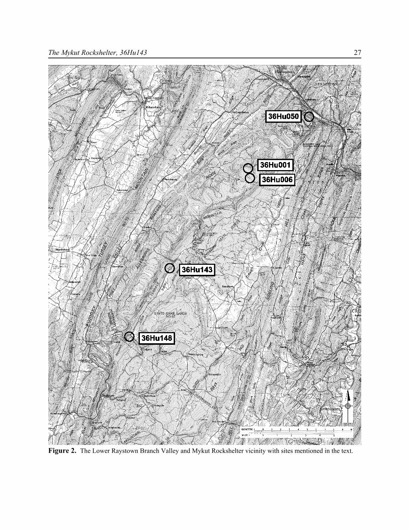
The Mykut Rockshelter, 36Hu143 27
Figure 2. The Lower Raystown Branch Valley and Mykut Rockshelter vicinity with sites mentioned in the text.
28 Archaeology of Eastern North America
with diagnostic Early Archaic period artifacts (Michels 1967:863), but probably represents an early MiddleArchaic period (ca. 6500-5500 B.C.) occupation, based on the calibration of the date. The later occupations,through the terminal Late Woodland, were also well-represented and radiocarbon-dated, with separate datesfor the Late and Terminal Archaic period, and the Shenks Ferry and Susquehannock Late Woodland periodoccupations. In addition to the Susquehanna River Valley influences represented by the Clemson Island,Shenks Ferry, and Susquehannock artifacts, there is evidence for contacts with the Ohio River drainage inthe form of Monongahela pottery.
Because Sheep Rock was a dry rockshelter, many normally perishable items were well-preserved, at leastthose from the Late Woodland/Protohistoric levels. Animal and human bone, seeds and nutshell, fibers andbasketry were all present, providing a glimpse of non-lithic technologies absent from most sites inPennsylvania. As a result, we have a fuller view of prehistoric life at this site than at almost any other site inPennsylvania, with the exception of Meadowcroft Rockshelter in Washington County where a similar varietyof fiber and basketry have been found (Stile 1982).
The stratigraphic sequence at Sheep Rock Shelter covers the entire span of Holocene human occupationof the region, with well-dated deposits from the Early through Terminal Archaic, and the Early to LateWoodland periods. Ten master levels define the more or less continuous use of the shelter for over 9500years. According to Michels (1967:801-824; 1968) the nature of settlement at the site changed through time.The earlier periods represented a “nomadic” pattern of settlement, reflecting sub-optimal population densitiesduring the Early and Middle Archaic with “optimal” hunter-gatherer population levels from the Late Archaicon, while later Late Woodland occupation represented a pattern of dispersed sedentary hamlets. The extentto which these generalizations can still be supported is discussed below.
A recent summary of the prehistory of the Upper Juniata river drainage (MacDonald 2003, 2006) andearlier work in the Raystown Branch, especially that at Sheep Rock Shelter, provide a basis for detailedstudies of prehistoric settlement in the region. Michels’ (1967) model of settlement posits a central role forsites along the rivers, comparable to that suggested by Raber (1995) in which seasonal habitation at basecamps along the major streams is complemented by the use of special-purpose upland and riverine camps,where local residents obtained a variety of food and other resources.
The Mykut Rockshelter, 36Hu143, is one of several known rockshelters in the Raystown Branchwatershed (Figure 2). The same geological conditions that created the Mykut Rockshelter also formednumerous rockshelters large and small along the Raystown Branch and in upland settings along its tributaries.With the exception of the Middletown Rockshelter (36Hu148) at the southern end of Little Valley, all of thesesites lie between 36Hu143 and the mouth of the Raystown Branch, where the river and its tributaries haveexposed the appropriate sedimentary strata. In Little Valley and along Trough Creek to the north are dozensof rock overhangs, many of which likely contain cultural deposits. Only three of these have been recordedin the Pennsylvania Archaeological Site Survey (PASS) files. Despite the attention that Sheep Rock Shelter(36Hu1) has received, the six other recorded rockshelters along the lower Raystown Branch between Saxtonand the confluence with the Juniata River remain poorly known. Smith conducted excavations at MusselRockshelter (36Hu6) as part of the survey program associated with the Sheep Rock excavations (Smith 1967),and the Fisherman’s Point Rockshelter (36Hu49) has been tested (GAI Consultants 1984). Preliminarysoundings at the Corbin Rockshelter (36Hu50) suggest that deeply stratified deposits (> 2 m deep) exist there,perhaps comparable in time depth to those at Sheep Rock Shelter (Hay et al. 1980:48). Aside from the MykutRockshelter, however, none of the local upland rockshelters has been systematically examined.
THE SETTING OF THE MYKUT ROCKSHELTER
The site is located in the Appalachian Mountains section of the Ridge and Valley physiographic province(Thornbury 1965) in Little Valley, a narrow upland valley between Bunns and Broad Top mountains to theeast and Terrace Mountain to the west (Figure 2). Little Valley lies to the east of the Raystown Branch of the

The Mykut Rockshelter, 36Hu143 29
Figure 3. Mykut Rockshelter, Little Valley Road to the right.
Juniata River, to which it is con-nected by narrow gaps in TerraceMountain at its northern and south-ern ends. The rockshelter, situatedat an elevation of ca. 323 m amsl,overlooks Tatman Run, whichflows north and then west throughTerrace Mountain to its confluencewith the Raystown Branch (Fig. 2).
The local area is underlain bynearly flat or moderately foldedrocks of the Mississippian Poconoand Catskill formations (Berg1980). The Pocono formation con-sists predominately of gray to gray-brown sandstones, often conglom-eratic, well-sorted and thick-bed-ded. The Catskill formation consistsprimarily of deltaic red to brownishshales and sandstones exposed along the steep valley side walls of major tributaries in the county. The roofand walls of the shelter are of Pocono Formation sandstone while the base or floor has formed from theresidual weathering of shales of the Catskill Formation.
The chief characteristics of the site setting relevant to the formation of the rockshelter and it prehistoricsettlement and use are:
1) the location at the contact between the more resistant overlying sandstones of the Pocono formationand the more easily weathered shales and siltstones of the Catskill formation that encouraged the formationof the reentrant;
2) the narrowness of Little Valley, especially at its northern and southern ends, which restricts thesettings available to prehistoric settlers;
3) the proximity of the site to the breach in Terrace Mountain created by Tatman Run, allowing easyaccess to the broader and environmentally more diverse settings of the Raystown Valley, as well as controlof a critical game path and routes of communication to the north, east, and west;
4) the availability of a perennial water source in Tatman Run; and5) the southwestern aspect of the rockshelter, providing long exposures to the sun and some protection
from prevailing westerly/northwesterly winds, which are blocked by Terrace Mountain.When first encountered during preliminary testing, the rockshelter evidenced some disturbance from
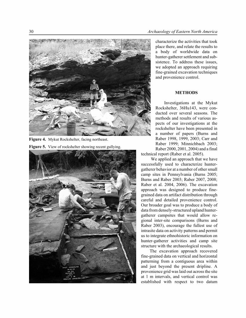
looting and water erosion. Looters had dug at least one pit in the area behind the dripline, and a deterioratingdrainage pipe had allowed runoff to gully the southern edge of the site (Figures 3-5). Despite this initialimpression, much of the disturbance proved to be superficial and limited in extent. Subsequent testingrevealed that the site prior to disturbance had covered an area of perhaps 41 m2. Some 5 m2 had been lost torecent erosion and another 2-3 m2 had likely been disturbed by previous looting and Phase I archaeologicaltesting. Assuming ca. 34 m2 of intact rockshelter deposits, the data recovery excavations exposed 31.5 m2 orroughly 77% of the area available for habitation and 92% of the estimated undisturbed portion of the site.
Several considerations encouraged us to pursue the intensive examination of a substantial area of therockshelter in a way that would yield the greatest amount of behavioral information. These considerationsincluded the discovery of a relatively large undisturbed living area at 36Hu143, the distinctive setting of thesite at a critical location commanding local game trails and human paths to and from Little Valley, and thepossibility of relating the data from the site to those from Sheep Rock Shelter and other settlements in thenearby Raystown Branch valley. We hoped to define the site’s place in the local settlement system,
30 Archaeology of Eastern North America
Figure 4. Mykut Rockshelter, facing northeast.
Figure 5. View of rockshelter showing recent gullying.
characterize the activities that tookplace there, and relate the results toa body of worldwide data onhunter-gatherer settlement and sub-sistence. To address these issues,we adopted an approach requiringfine-grained excavation techniquesand provenience control.
METHODS
Investigations at the MykutRockshelter, 36Hu143, were con-ducted over several seasons. Themethods and results of various as-pects of our investigations at therockshelter have been presented ina number of papers (Burns andRaber 1998, 1999, 2003; Carr andRaber 1999; Minnichbach 2003;Raber 2000, 2001, 2004) and a final
technical report (Raber et al. 2005). We applied an approach that we have
successfully used to characterize hunter-gatherer behavior at a number of other smallcamp sites in Pennsylvania (Burns 2005;Burns and Raber 2003; Raber 2007, 2008;Raber et al. 2004, 2006). The excavationapproach was designed to produce fine-grained data on artifact distribution throughcareful and detailed provenience control.Our broader goal was to produce a body ofdata from densely-structured upland hunter-gatherer campsites that would allow re-gional inter-site comparisons (Burns andRaber 2003), encourage the fullest use ofintrasite data on activity patterns and permitus to integrate ethnohistoric information onhunter-gatherer activities and camp sitestructure with the archaeological results.
The excavation approach recoveredfine-grained data on vertical and horizontalpatterning from a contiguous area withinand just beyond the present dripline. Aprovenience grid was laid out across the siteat 1 m intervals, and vertical control wasestablished with respect to two datum
The Mykut Rockshelter, 36Hu143 31
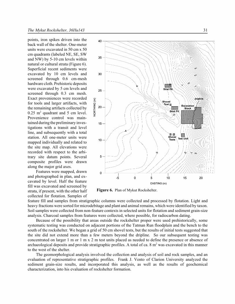
Figure 6. Plan of Mykut Rockshelter.
points, iron spikes driven into theback wall of the shelter. One-meterunits were excavated in 50 cm x 50cm quadrants (labeled NE, SE, SWand NW) by 5-10 cm levels withinnatural or cultural strata (Figure 6).Superficial recent sediments wereexcavated by 10 cm levels andscreened through 0.6 cm-meshhardware cloth. Prehistoric depositswere excavated by 5 cm levels andscreened through 0.3 cm mesh.Exact proveniences were recordedfor tools and larger artifacts, withthe remaining artifacts collected by0.25 m2 quadrant and 5 cm level.Provenience control was main-tained during the preliminary inves-tigations with a transit and levelline, and subsequently with a totalstation. All one-meter units weremapped individually and related tothe site map. All elevations wererecorded with respect to the arbi-trary site datum points. Severalcomposite profiles were drawnalong the major grid axes.
Features were mapped, drawnand photographed in plan, and ex-cavated by level. Half the featurefill was excavated and screened bystrata, if present, with the other halfcollected for flotation. Samples offeature fill and samples from stratigraphic columns were collected and processed by flotation. Light andheavy fractions were sorted for microdebitage and plant and animal remains, which were identified by taxon.Soil samples were collected from non-feature contexts in selected units for flotation and sediment grain-sizeanalysis. Charcoal samples from features were collected, where possible, for radiocarbon dating.
Because of the possibility that areas outside the rockshelter proper were used prehistorically, somesystematic testing was conducted on adjacent portions of the Tatman Run floodplain and the bench to thesouth of the rockshelter. We began a grid of 50 cm shovel tests, but the results of initial tests suggested thatthe site did not extend more than a few meters beyond the dripline. So our subsequent testing wasconcentrated on larger 1 m or 1 m x 2 m test units placed as needed to define the presence or absence ofarchaeological deposits and provide stratigraphic profiles. A total of ca. 8 m2 was excavated in this mannerto the west of the shelter.
The geomorphological analysis involved the collection and analysis of soil and rock samples, and anevaluation of representative stratigraphic profiles. Frank J. Vento of Clarion University analyzed thesediment grain-size results, and incorporated this analysis, as well as the results of geochemicalcharacterization, into his evaluation of rockshelter formation.
32 Archaeology of Eastern North America
ROCKSHELTER FORMATION AND STRUCTURE
The rockshelter presently appears as an overhang located immediately below Little Valley Road (S. R.3001), some 15 m east of Tatman Run and roughly 5 m above the stream channel (Figures 1 and 2). The soilsat the Mykut Rockshelter derive from four principal sources: (1) grain-by-grain attrition or release ofindividual grains from the sandstone rockshelter roof and walls; (2) rockfall (pebble through boulder-sizedfragments) detached from the face and roof of the rockshelter; (3) creep/slopewash acting primarily on thedrip line and talus slope of the site; and (4) in situ weathering of the bedrock units. There is no evidence thatany overbank deposits from Tatman Run are included in the soil profile of the rockshelter. Field examinationand laboratory analysis indicate that the sediments in the rockshelter have been derived by the gradual, in situweathering and erosion of the sandstone and shale bedrock.
The formation of the rockshelter began immediately following the incision of the bedrock by TatmanRun that likely took place during Wisconsinan times and resulted in the stream channel being downcut belowthe present drip line of the rockshelter. At that time Tatman Run had a greater competence and capacity totransport material. During the late Pleistocene and Holocene, varying rates of grain-by-grain attrition, rockfallreleased along exposed joint sets and bedding planes, and slopewash have deposited the bulk of the colluvialsediments present today. There is clear evidence, in the form of several large, detached roof blocks, that theroof-edge or lip of the shelter has receded more than a meter to the east since that time. The recession of theroof-edge has substantially decreased the area of protected living floor within the dripline over time. Weestimate the protected area as roughly 16 m2, but the retreat of the roof-edge through the Holocene may havereduced the available sheltered space by as much as 33% (from ca. 24 m2).
The rates of rockfall and dripline retreat likely correspond to changes in climate as well as seasonalchanges in temperature and precipitation. The important processes responsible for rock attrition and therelease of large rock fragments were frost wedging and water movement along open fractures, and to a lesserdegree, root penetration and chemical weathering. The rates of attrition and rockfall were probably increasedby higher amounts of rainfall and lowered temperatures.
We noted three distinct units or facies of the sandstone in geological studies at the site. The upper zone,designated Zone A, comprised the roof of the shelter and consisted of well-sorted and thick-bedded quartzosesandstone with a silica cement. In Zone B, the more easily eroded and weathered face of the rockshelter, thesandstone beds were thinner, more poorly sorted, and finer grained, with a cement that varied from silica toclay. Zone C, the basal sandstone facies, was much like Zone A in that the beds are thick, well sorted witha strong silica cement. The superposition of these facies has created a weak intermediate zone in which moreactive erosion and weathering has caused the development of a pronounced reentrant (Figures 3 and 7).
The slopewash beyond the dripline and on the talus slope of the site is composed of rock fragments andfiner grained sediments detached from the roof and walls of the shelter, as well as sediments which havewashed from the top of the roof and along the sides of the reentrant and been deposited on the talus slope.The latter sediment source was especially important during historic times, when widespread deforestationfavored increased surface runoff and higher sediment yields to streams. Once in place outside the dripline,these sediments were exposed to much more intensive mechanical and chemical weathering than grainsprotected under the rockshelter roof. The micas, amphiboles and feldspars which comprise less than 10% ofthe mineral assemblage of the sandstone facies have chemically weathered to clay minerals and clay-sizedgrains outside the dripline. On the shelter floor within the dripline, post-depositional chemical weatheringwas much reduced, transport by slopewash and creep was absent, and the colluvium is significantly coarser.
Five distinct soil stratigraphic horizons (labeled Strata I-V) were identified within and immediatelyoutside the present drip line in an A/Bw/Ab/Bt/C/D sequence. The pedogenic immaturity of the upper solum(A and Bw) at the site is clearly due to: (1) the high silica content of the parent material (Catskill Formation)which has limited the degree of post-depositional chemical weathering or alteration of the silicate mineralsuite, and (2) frequent episodes of deposition and erosion in the form of active mass-wasting processes (e.g.,

The Mykut Rockshelter, 36Hu143 33
Figure 7. Profile of Mykut Rockshelter.
rockfall, creep, slopewash, sheetwash) which have been occurred over at least the last 12,000 years. Theseautogenic events have variously stopped, removed or slowed those active factors in soil formation and thuslimited soil development through the constant addition of new colluvial material to the site.
The five horizons or strata were present throughout the rockshelter within and immediately outside thedripline. The entire stratigraphic profile was compressed within roughly 50-70 cm but was present acrossthe site (Figure 7). The thickness of the strata varied across the site, reflecting the specific localized characterof sediment deposition and soil development. As noted above, test units placed outside the rockshelter properrevealed that the buried horizons were not present beyond the toe of the colluvial slope.
The great majority (87%) of the artifacts lay within the Ab (Stratum III; 53%) and the Bt (Stratum IV;34%) horizons. Likewise, nearly all of the faunal remains (85%; 81% by weight) came from Stratum III andStratum IV. In contrast, the upper soil horizons (Strata I and II) produced only 11% of the prehistoric artifacts.Despite the generally shallow depth of the deposits, there was evidence for vertical stratification in thenotably higher percentages of certain raw materials (e.g., rhyolite) in Stratum IV (13% of the assemblage, vs.3% in Stratum III), the discovery of a late Middle Archaic feature (F. 22) 20 cm below the top of that stratum,and the presence of the single possible Paleoindian/Early Archaic artifact from the site in Stratum IV.
THE GENERAL CHARACTER OF THE ASSEMBLAGE
From 31.5 m2 of excavated area we collected 16,579 pieces of debitage, 276 flaked stone tools (including129 utilized flakes), 15 cobble/pebble tools, and 1052 sherds (780 g) of pottery. Among the finished toolswere 63 projectile points or fragments, whose broken condition and distribution within the rockshelter suggestretooling as the primary focus of the lithic industry at the site, an observation consistent with the proposedidentification of the site as a hunting and processing station.
34 Archaeology of Eastern North America
Most of the pottery consisted of small, highly worn fragments, but almost 200 identifiable sherdsconfirmed the evidence of radiocarbon dates and stone tool types for repeated occupation throughout the LateWoodland period. Clemson Island/Owasco and Drew phase Monongahela pottery types suggest an earliercomponent (A.D. 900-1200) represented in at least one feature (F. 10), while Quiggle Complex and StewartPhase Shenks Ferry sherds document the fifteenth/sixteenth century occupation of the rockshelter evident inradiocarbon dates from features F. 5 and F. 13 (Beta-132312 and Beta-125341), calibrated to ca. A.D. 1450-1650. The presence of Drew phase Monongahela pottery at Mykut (as at Sheep Rock Shelter) documentscontacts and influences from the Ohio River Valley to the west as well as those eastern contacts marked bythe Clemson Island and Shenks Ferry sherds.
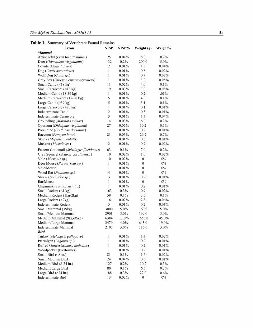
Our investigations recovered 54,253 fragments (ca. 3.5 kg total weight) of animal bone and teeth,mollusk shell (n=1520; 72 g) and other faunal remains, including turtle shell. Calcined or blackened bonecomprised 91% (by weight) of the assemblage. Not surprisingly, most of the bone fragments were small andidentifiable only as small or large mammal. Only a little over 1% (1.27%) of the assemblage specimens(8.05% of the assemblage by weight) could be identified to species, and an additional 0.2% could beidentified by order. Nearly a third of the assemblage (32%; 63% by weight), however, represented mediumor medium/large mammal, almost certainly deer (Table 1). Most of the identifiable specimens thus seem tobe white-tailed deer (Odocoileus virginianus), the processing of which was apparently a major focus ofactivity at the site. Other fauna documented to have been present prehistorically include eastern cottontailrabbit (Sylvilagus floridanus), turtle (Chrysemys sp., painted turtle, and others), various birds, fish and snakes.
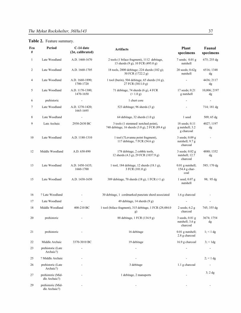
We noted 29 soil anomalies (F. 1-F. 29), 23 of which were confirmed as prehistoric cultural features,within the roughly 75% of the available surface area of the site excavated. Most were found at the StratumIII/IV interface, but some earlier features appeared lower in the profile. Almost all were classified as hearthson the basis of contents and general appearance (Table 2).
SUMMARY OF FEATURES
Given the distribution of the 23 features discovered (Figure 8), most of which lay within the dripline,we infer that more than 70% of the features at the site have been exposed, and that the total features at thesite probably numbered fewer than 30. The recent gully on the southern edge of the site and the associatederosion probably account for most of the lost data. The sample of features excavated and characterized is thuslikely representative of the variety of cultural features present at the site.
The most striking aspect of the features is that almost all of them are hearths or probable hearths (Table2). With one exception, a postmold (F. 26 in N14E19), all can minimally be described as fire-related features.No obvious storage or refuse pit features were found, and with the exception of the one postmold, nostructural features. The apparent absence of storage or refuse features is consistent with the presumed use ofthe site as a temporary encampment, with at least the Late Woodland camps focused on the processing ofdeer. Although rockshelters were sometimes used as cache locations (e.g., Fiedel 1984), there was noindication at the Mykut Rockshelter of any such use.
At least one feature (F. 22) dated to the end of the Middle Archaic, and another (F. 9) dated to the LateArchaic. Several features (F. 23, F. 27, F. 29) are presumed to be Archaic in date, given their stratigraphicpositions with respect to dated features, although none of these yielded diagnostic artifacts or radiocarbondates. Two features, F. 12 and F. 18, with radiocarbon dates of A.D. 650-890 and 390-210 B.C., respectively,represented the Middle Woodland period. The remaining features have either been positively dated to the LateWoodland period (F. 1, F. 2, F. 4, F. 5, F. 7, F. 13, and F. 15) or are presumed to date to that period on thebasis of contents and associations.
The distribution of features revealed that, as expected, most of the associated activities occurred withinthe present and the inferred prehistoric dripline. Allowing for a predicted 1 m recession of the dripline to the
The Mykut Rockshelter, 36Hu143 35
Table 1. Summary of Vertebrate Faunal RemainsTaxon NISP NISP% Weight (g) Weight%
MammalArtiodactyl (even toed mammal) 25 0.04% 8.0 0.2%Deer (Odocoileus virginianus) 132 0.2% 200.0 5.0%Coyote (Canis latrans) 2 0.01% 1.3 0.04%Dog (Canis domesticus) 1 0.01% 0.8 0.02%Wolf/Dog (Canis sp.) 1 0.01% 0.7 0.02%Gray Fox (Urocyon cinereoargenteus) 1 0.01% 3.2 0.08%Small Canid (<18 kg) 11 0.02% 4.0 0.1%Small Carnivore (<18 kg) 19 0.03% 3.0 0.08%Medium Canid (18-59 kg) 1 0.01% 0.2 .01%Medium Carnivore (18-80 kg) 5 0.01% 4.0 0.1%Large Canid (>59 kg) 5 0.01% 5.1 0.1%Large Carnivore (>80 kg) 1 0.01% 0.1 0.01%Indeterminate Canid 2 0.01% 0.3 0.01%Indeterminate Carnivore 3 0.01% 1.3 0.04%Groundhog (Marmota monax) 14 0.03% 6.0 0.2%Opossum (Didelphus virginiana) 27 0.05% 10.2 0.3%Porcupine (Erethizon dorsatum) 1 0.01% 0.2 0.01%Raccoon (Procyon lotor) 21 0.03% 26.2 0.7%Skunk (Mephitis mephitis) 1 0.01% 0.3 0.01%Muskrat (Mustela sp.) 2 0.01% 0.7 0.02%Eastern Cottontail (Sylvilagus floridanus) 63 0.1% 7.0 0.2%Gray Squirrel (Sciurus carolinensis) 10 0.02% 1.0 0.02%Vole (Microtus sp.) 10 0.02% 0 0%Deer Mouse (Peromyscus sp.) 1 0.01% 0 0%Vole/Mouse 1 0.01% 0 0%Wood Rat (Neotoma sp.) 4 0.01% 0 0%Shrew (Soricidae sp.) 3 0.01% 0.2 0.01%Rat/Mouse 1 0.01% 0 0%Chipmunk (Tamias striatus) 1 0.01% 0.2 0.01%Small Rodent (<1 kg) 163 0.3% 0.9 0.02%Medium Rodent (1kg-2kg) 59 0.1% 3.5 0.1%Large Rodent (>2kg) 16 0.02% 2.3 0.06%Indeterminate Rodent 5 0.01% 0.2 0.01%Small Mammal (<9kg) 3000 5.0% 169.0 5.0%Small/Medium Mammal 2901 5.0% 199.0 5.0%Medium Mammal (9kg-96kg) 6384 11.0% 1556.0 45.0%Medium/Large Mammal 2479 4.0% 643.0 19.0%Indeterminate Mammal 2107 3.0% 116.0 3.0%BirdTurkey (Meleagris gallopavo) 1 0.01% 1.3 0.02%Ptarmigan (Lagopus sp.) 1 0.01% 0.2 0.01%Ruffed Grouse (Bonasa umbellus) 1 0.01% 0.2 0.01%Woodpecker (Piciformes) 1 0.01% 0.2 0.01%Small Bird (<8 in.) 81 0.1% 1.6 0.02%Small/Medium Bird 24 0.04% 0.5 0.01%Medium Bird (8-24 in.) 127 0.2% 10.2 0.3%Medium/Large Bird 80 0.1% 6.3 0.2%Large Bird (>24 in.) 188 0.3% 22.0 0.6%Indeterminate Bird 13 0.02% 0 0%

36 Archaeology of Eastern North America
Table 1. Summary of Vertebrate Faunal Remains con’t.Taxon NISP NISP% Weight (g) Weight%
ReptileGarter Snake 2 0.01% 0.1 0.01%Indeterminate Snake 29 0.05% 2.9 0.1%Painted turtle (Chrysemys sp.) 3 0.01% 5.0 0.1%Small Turtle (<4 in.) 20 0.03% 2.0 0.05%Small/Medium Turtle 10 0.02% 1.1 0.03%Medium Turtle (4-8 in.) 46 0.08% 11.0 0.3%Medium/Large Turtle 43 0.08% 6.0 0.2%Large Turtle (>8 in.) 21 0.03% 7.1 0.2%Indeterminate Turtle 1 0.01% 0.2 0.01%Juvenile Turtle 1 0.01% 0.5 0.01%Small Reptile 1 0.01% 0 0%Indeterminate Reptile 1 0.01% 0 0%FishSmall Fish (<12 in.) 3 0.01% 0.1 0.01%Medium Fish (12-24 in.) 3 0.01% 0 0%Medium/Large Fish 5 0.01% 0.3 0.01%Large Fish (>24 in.) 3 0.01% 0.1 0.01%Indeterminate Fish 4 0.01% 0 0%Indeterminate TaxonSmall Mammal/ Small Bird 119 0.2% 0.7 0.02%Small Mammal/ Medium Bird 93 0.2% 4.3 0.1%Small Mammal/ Large Bird 70 0.1% 6.0 0.2%Small Mammal/ Indeterminate Bird 5 0.01% 0.3 0.01%Small Rodent/ Small Bird 2 0.01% 0 0%Medium Mammal/ Small Bird 3 0.01% 0 0%Medium Mammal/ Medium Bird 5 0.01% 0.2 0.01%Medium Mammal/ Large Bird 40 0.07% 5.1 0.1%Indeterminate Mammal/Small Bird 7 0.01% 0 0%Indeterminate Mammal/Medium Bird 11 0.02% 0.9 0.02%Indeterminate Mammal/Large Bird 5 0.01% 0.2 0.01%Indeterminate Mammal/ Indeterminate Bird 72 0.1% 4.0 0.1%Indeterminate Rodent/ Indeterminate Bird 2 0.01% 0.2 0.01%Small Mammal/ Small Turtle 2 0.01% 0.2 0.01%Small Mammal/ Medium Turtle 6 0.01% 0.5 0.01%Medium Mammal/ Small Turtle 2 0.01% 0.2 0.01%Medium Mammal/ Medium Turtle 120 0.2% 12.0 0.3%Medium Mammal/ Large Turtle 29 0.05% 5.1 0.1%Indeterminate Mammal/Small Turtle 4 0.01% 0.2 0.01%Indeterminate Mammal/Medium Turtle 11 0.02% 1.0 0.02%Indeterminate Mammal/ Indeterminate Turtle 154 0.2% 11.2 0.3%Small Toad/Small Turtle 1 0.01% 0 0%Small Fish/Small Reptile 1 0.01% 0 0%Indeterminate Fish/Indeterminate Reptile 1 0.01% 0 0%Indeterminate Taxon 28496 53.0% 302.0 8.0%Unidentified Taxon* 6090 11.0% 111.0 3.0%Total 54253 100%† 3518.1 100%†
*Unidentified Taxon was assigned to bone unidentifiable to element in heavy fractionsamples in sorting grade #10.† May not equal 100% due to rounding error.
The Mykut Rockshelter, 36Hu143 37
Table 2. Feature summary.
Fea#
Period C-14 date(2σ, calibrated)
Artifacts Plant specimens
Faunal specimens
1 Late Woodland A.D. 1460-1670 2 tools (1 biface fragment), 1112 debitage, 13 sherds (9 g), 10 FCR (495.0 g)
7 seeds; 0.01 gnutshell
675; 255 dg
2 Late Woodland A.D. 1660-1705 18 tools, 2800 debitage; 224 sherds (102 g); 50 FCR (1722.2 g)
20 seeds; 0.62gnutshell
6516; 1348dg
4 Late Woodland A.D. 1660-1890; 1700-1720
1 tool (burin), 504 debitage, 65 sherds (16 g), 27 FCR (3811.0 g)
- 4436; 2117dg
5 Late Woodland A.D. 1170-1300; 1470-1650
71 debitage, 74 sherds (6 g), 4 FCR (< 1.0 g)
17 seeds; 0.21g nutshell
10,006; 2197dg
6 prehistoric - 1 chert core - -
7 Late Woodland A.D. 1270-1420; 1665-1695
523 debitage; 96 sherds (3 g) - 714; 181 dg
8 Late Woodland - 64 debitage, 32 sherds (1.0 g) 1 seed 509; 65 dg
9 Late Archaic 2930-2630 BC 3 tools (1 stemmed/ notched point), 748 debitage, 16 sherds (3.0 g), 2 FCR (89.4 g)
18 seeds; 0.11g nutshell; 3.2
g charcoal
4027; 1197dg
10 Late Woodland A.D. 1180-1310 1 tool (?Levanna point fragment), 117 debitage, 7 FCR (54.6 g)
3 seeds; 0.09 gnutshell; 9.7 g
charcoal
-
12 Middle Woodland A.D. 650-890 178 debitage, 2 cobble tools, 12 sherds (4.3 g), 29 FCR (1037.9 g)
3 seeds; 0.02 gnutshell; 12.7
charcoal
4880; 1352dg
13 Late Woodland A.D. 1450-1635; 1660-1700
1 tool, 184 debitage, 12 sherds (18.1 g), 3 FCR (101.0 g)
0.01 g nutshell;154.4 g char-
coal
585; 170 dg
15 Late Woodland A.D. 1430-1650 389 debitage, 70 sherds (18 g), 1 FCR (<1 g) 1 seed; 0.07 gnutshell
98; 95 dg
16 ? Late Woodland - 30 debitage, 1 cordmarked punctate sherd associated 1.6 g charcoal -
17 Late Woodland - 49 debitage, 14 sherds (9 g) - -
18 Middle Woodland 400-210 BC 1 tool (biface fragment), 315 debitage, 1 FCR (29,484.0g)
2 seeds; 6.2 gcharcoal
745; 355 dg
20 prehistoric - 88 debitage, 1 FCR (134.9 g) 3 seeds, 0.81 gnutshell; 3.6 g
charcoal
3674; 1754dg
21 prehistoric - 16 debitage 0.01 g nutshell;2.8 g charcoal
1; < 1 dg
22 Middle Archaic 3370-3010 BC 19 debitage 16.9 g charcoal 3; < 1dg
23 prehistoric (LateArchaic?)
- - - -
25 ? Middle Archaic - - - 2; < 1 dg
26 prehistoric (LateArchaic?)
- 3 debitage 1.1 g charcoal -
27 prehistoric (Mid-dle Archaic?)
- 1 debitage, 2 manuports -3; 2 dg
29 prehistoric (Mid-dle Archaic?)
- - - -

38 Archaeology of Eastern North America
Figure 8. Feature locations.
present location (Figure 7), all of the fea-tures except F. 16 fall within the inferredprehistoric dripline, and only four of thefeatures (F. 10, F. 16, F. 20, F. 21) falloutside the present dripline. No horizontalclustering of features by period is appar-ent. The level or gently sloping spacewithin the dripline seems to have beenoccupied indiscriminately, with no consis-tent patterns evident in the use of space.The concentration of features within thedripline suggests, as does the distributionof artifacts on the periphery of the site, afairly sharp delimitation to the site area.The westernmost units of the block exca-vation along the E15 line yielded muchlower than average artifact counts (mean =52/m2 vs. 569/m2 for the site as whole).The site did not extend to the terrace ofTatman Run, as demonstrated by the re-sults from the test units placed to the westand south of the rockshelter proper, wherewe found a total of only nine pieces ofdebitage in six units (5.75 m2).
Many of the features contained arti-facts or organic remains (Table 2): 16contained artifacts, 13 had carbonizedplant remains, and 11 produced faunalspecimens, primarily bone. Of the 16 thatcontained artifacts, however, only ten (F.1, 2, 4, 8, 9, 10, 12, 13, 15, and 17) yield-ed artifacts that were to some degree chro-nologically diagnostic.
Eleven of the features containedpottery, and eight of those (F.1, 2, 4, 8, 12, 13 15, and 17) contained pottery that could be assigned toculturally diagnostic types: Owasco, Quiggle, and Shenks Ferry. The pottery generally confirms the LateWoodland period dates for F. 1, 2, 4, 13 and 15 suggested by the radiocarbon analysis. It also providesevidence of a Late Woodland date, probably ca. A.D. 1200-1500, for F. 17, which contained Quiggle-typesherds.
More specifically, the pottery from the eight features that yielded diagnostic sherds can be comparedwith the radiocarbon dates for those features (Table 3). In considering these data, we should keep in mindMoeller’s (1992:88-92) cautions regarding the error of treating pit features as sealed contexts: pit features areby their nature contexts in which widely divergent deposits may be mixed, either as a result of intrusion intoearlier deposits or through prolonged refilling. The Quiggle and Owasco sherds from F. 1 are consistent withthe earlier portion of the 2σ radiocarbon date range for that feature, placing the occupation associated withthe feature in the late fifteenth to early sixteenth centuries A.D. Likewise, the Quiggle sherds from F. 13 andF. 15 are in accord with the earlier parts of the radiocarbon date ranges for those features (late fifteenth andsixteenth centuries). The association of F. 15 with F. 17 and the Quiggle sherds from the latter feature suggest
The Mykut Rockshelter, 36Hu143 39
Table 3. Radiocarbon Dates from 36Hu143
Uncalibrated Calibrated
Feat
ure
Stra
tum
Sam
ple Lab. No. Conven-
tionalRadiocarbon
Age BP
Intercept 1 sigma range (68% prob)
2 sigma range (95%prob)
1 III/IV 1 Beta-165449 300±50 AD 1640 AD 1510-1600AD 1620-1650
AD 1460-1670
2 III/IV 1 Beta-123453 modern - - -2 2 Beta-132311 160±60 AD 1680, 1745,
1805, 1935, 1945AD 1660-1675AD 1715-1885AD 1910-1950
AD 1645-1955
4 I/II 1 Beta-125340 0±60 - - AD1700-1720AD1820-1855AD 1860-
19204 I/II 2 Beta-166210 150±60 AD 1680, 1740,
1810, 1930, 1950AD 1660-1890AD 1910-1950
AD 1650-1950
5 III/IV 1 Beta-132312 320±70 AD 1525, 1560, 1630
AD 1470-1650 AD 1435-1675AD1775-1800AD 1940-
19455 III/IV 2 Beta-166211 770±60 AD 1270 AD 1220-1290 AD 1170-13007 III 1 Beta-132313 160±40* AD 1680, 1745,
1845, 1935, 1945AD 1665-1695AD 1724-1815AD 1920-1950
AD 1655-1950
7 III 2 Beta-166212 650±60 AD 1300 AD 1290-1400 AD 1270-14209 III/IV 1 Beta-165450 4230±60 2880 BC 2900-2860 BC
2800-2760 BC2920-2630 BC
10 III 1 Beta-166214 750±60 AD 1270 AD 1240-1290 AD 1180-1310AD1370B1380
12 III/IV 1 Beta-165451 1270±60 AD 720, 740, 760 AD 680-790 AD 650-89013 III/IV 1 Beta-125341 380±60 AD 1485 AD 1450-
1535AD1545-1635AD 1425-1655
13 III/IV 2 Beta-132314 170±60 AD 1675, 1765, 1800, 1940, 1945
AD 1660-1700AD1720-1820AD 1835-1880AD 1915-1950
AD 1640-1955
15 III/IV 1 Beta-165452 370±50 AD 1490 AD 1450-1530AD1560-1630
AD 1430-1650
18 III/IV 1 Beta-166214 2280±50 380 BC 390-360 BC280-240BC
410-200 BC
22 IV+ 1 Beta-139447 4510±60 3330, 3315, 3180, 3155, 3125 BC
3355-3095 BC 3370-3010 BC
* adjusted for isotope fractionation+ top of feature located 20 cm below top of Stratum IV
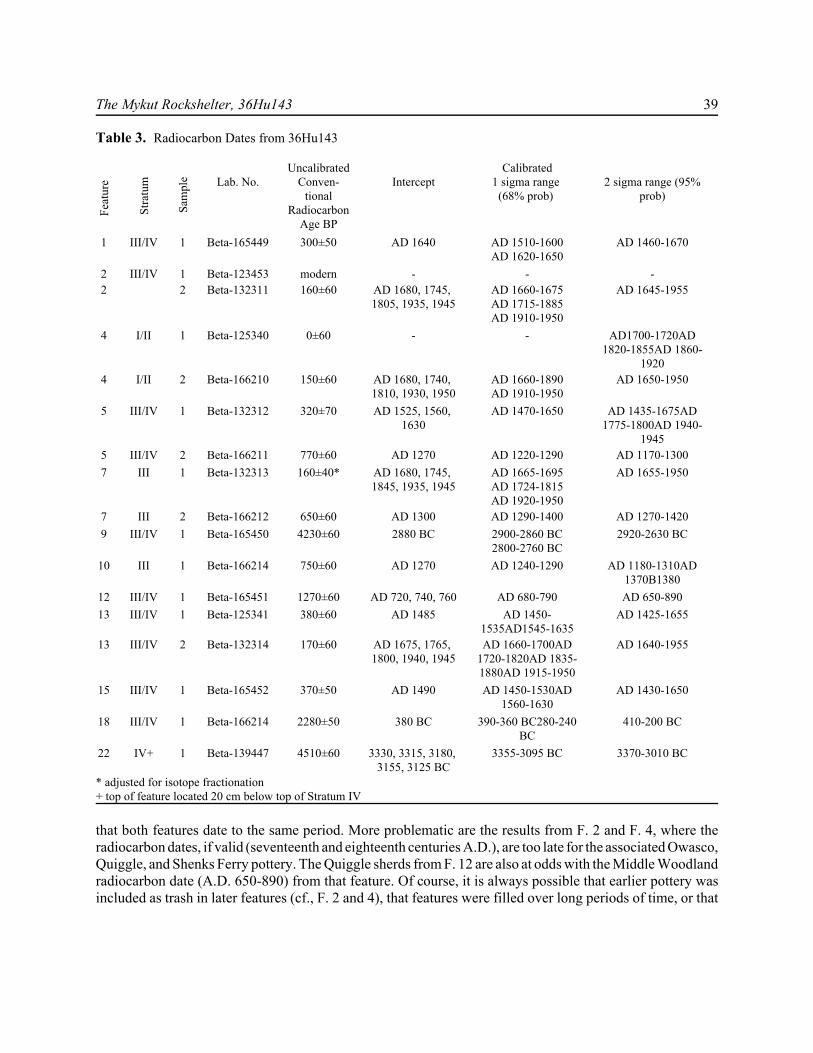
that both features date to the same period. More problematic are the results from F. 2 and F. 4, where theradiocarbon dates, if valid (seventeenth and eighteenth centuries A.D.), are too late for the associated Owasco,Quiggle, and Shenks Ferry pottery. The Quiggle sherds from F. 12 are also at odds with the Middle Woodlandradiocarbon date (A.D. 650-890) from that feature. Of course, it is always possible that earlier pottery wasincluded as trash in later features (cf., F. 2 and 4), that features were filled over long periods of time, or that
40 Archaeology of Eastern North America
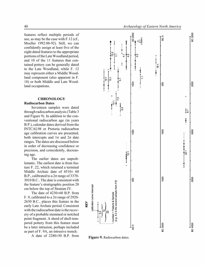
Figure 9. Radiocarbon dates.
features reflect multiple periods ofuse, as may be the case with F.12 (cf.,Moeller 1992:88-92). Still, we canconfidently assign at least five of theeight dated features to the appropriateportions of the Late Woodland period,and 10 of the 11 features that con-tained pottery can be generally datedto the Late Woodland, while F. 12may represent either a Middle Wood-land component (also apparent in F.18) or both Middle and Late Wood-land occupations.
CHRONOLOGYRadiocarbon Dates
Seventeen samples were datedthrough radiocarbon analysis (Table 3and Figure 9). In addition to the con-ventional radiocarbon age (in yearsB.P.), calendar dates derived from theINTCAL98 or Pretoria radiocarbonage calibration curves are presented,both intercepts and 1σ and 2σ dateranges. The dates are discussed belowin order of decreasing confidence orprecision, and coincidently, decreas-ing age.
The earlier dates are unprob-lematic. The earliest date is from fea-ture F. 22, which returned a terminalMiddle Archaic date of 4510± 60B.P., calibrated to a 2σ range of 3370-3010 B.C.. The date is consistent withthe feature’s stratigraphic position 20cm below the top of Stratum IV.
The date of 4230±60 B.P. fromF. 9, calibrated to a 2σ range of 2920-2630 B.C., places this feature in theearly Late Archaic period. Consistentwith the radiocarbon date is the recov-ery of a probable stemmed or notchedpoint fragment. A sherd of shell-tem-pered pottery from this feature mustbe a later intrusion, perhaps includedas part of F. 9A, an intrusive trench.
A date of 2280±50 B.P. from

The Mykut Rockshelter, 36Hu143 41
F.18, calibrated to 410-200 B.C. (2σ), represents a Middle Woodland component at the site, as does the dateof 1270±60 B.P. from F. 12, calibrated to a 2σ range of A.D. 650-890 (1σ: A.D. 680-790).
Aside from the modern sample from F. 2, probably the result of a recent intrusion into the feature, theremainder of the samples document the Late Woodland component at the site. One of the dates, that of thesample from F. 10, presents unambiguous evidence for an earlier Late Woodland occupation of the site. The750±60 B.P. date represents an occupation ca. A.D. 1270 (1σ range: A.D. 1240-1290), consistent with therecovery of a biface corner fragment representing a probable Levanna triangular point from this feature.
The dates from F. 5 and F. 7 are more problematic, since the two samples from each feature yielded non-overlapping date ranges. Samples 5.2 and 7.2 were derived from flotation samples and returned datesconsistent with that from F. 10. Sample 5.2 was dated to 770±60 B.P., calibrated (2σ) to A.D. 1170-1300.Likewise, sample 7.2 yielded a date of 650±60 B.P., with a 2σ range of A.D. 1270-1420. However, second(charcoal) samples from these features produced inconsistent, non-overlapping dates: 320±70 (1σ calibratedrange of A.D. 1470-1650) for sample 5.1 and 160±40 B.P. (1σ calibrated range of A.D. 1665-1695/1724-1815/1920-1950) for sample 7.1. Two sherds of shell-tempered pottery and specimens of deer bone supportthe Late Woodland date for F. 5, but offer no clear choice between the two inconsistent radiocarbon dates.Likewise, the small amounts of debitage and small mammal bone from F. 7 allow no obvious choice to bemade between the radiocarbon dates. It is possible that recent disturbance could have affected the dates fromone or both features, but there is no particular evidence to support the contention that the charcoal sampleswere affected by recent disturbances or intrusions. Both features likely date to the Late Woodland period, butmore precise dating is not possible.
The charcoal sample from F. 15 yielded clear evidence for a slightly later Late Woodland occupation,returning a date of ca. A.D. 1490 (2σ range1430-1650). Likewise, the date from F. 1 of 300±50 B.P. wascalibrated to a 2σ range of A.D. 1460-1670, overlapping the date range for F. 15.
The 2σ date ranges for both samples from F. 13 overlap, although the intercepts (A.D. 1485 for sample13.1 and multiple intercepts for sample 13.2) differ widely. Given the multiple intercepts and 1σ ranges forthe second sample, it seems preferable to accept the ca. A.D. 1485 date from sample 13.1. In the absence ofartifacts from this feature, there is no easy way to decide this issue, but the late fifteenth century A.D. datewould be consistent with the feature’s position and associations (e.g., with F. 5).
The 2σ date ranges for the two samples from F. 4 (samples 4.1 and 4.2) overlap and may both date anearly eighteenth century occupation. Roughly contemporary with this is the probable late seventeenth or earlyeighteenth century occupation represented by one of the samples from F. 2, which produced a possible 1σdate range of ca. 1660-1675. However, the intrusion of part of F. 2 into F. 4 implies that F.2 is later than F.4. The radiocarbon dates from both F. 2 and F. 4 are, however, inconsistent with the Shenks Ferry and otherpottery found in these features, unless the pottery represents trash of earlier origin swept into these featuresduring or after use.
The 300±50 B.P. date from F. 1, calibrated to a 2σ calendrical date range of A.D. 1470-1630, likelydates a fifteenth century occupation, and is consistent with the Quiggle pottery recovered from the feature,but not with the Brewerton style side-notched biface also found in the feature fill. The biface, reworked asa scraper, may represent the re-use and reworking of an earlier tool.
Despite the problems with some of the more recent dates, the radiocarbon analysis clearly documentsa strong Late Woodland presence at the shelter that is consistent with the results of the analysis and datingof feature and non-feature artifacts from the site. The results also yielded evidence associating certain features(F. 9, 12, 18, 22) with the some of the earlier components apparent in the artifact assemblage.
Diagnostic ArtifactsSome of the hafted bifaces or projectile points could be classified by widely recognized and
chronologically diagnostic types. Others could not be reliably assigned to any well-defined type, either
42 Archaeology of Eastern North America
because they fell outside the parameters of those types or because they were fragmentary. The identifiabletypes included, in order of abundance:1. Triangular points (n=25), all of chert, that we take as representative of the Late Woodland use of the
rockshelter (Custer 2001:48; Ritchie 1971:31-34, 86-88). Triangular points have been recoveredelsewhere from much earlier contexts, but both the proveniences in which triangular points were foundat 36Hu143 and related data (e.g., dated features and abundant Late Woodland pottery) suggest that allor most of the triangular points date to the Late Woodland occupation. One of the dated features, F. 2,contained a triangular point. Custer (2001:48) suggests that triangles are the only true arrowheads inPennsylvania. Following Custer, we have combined all triangular points under a single heading,although distinctions between smaller Madison and larger Levanna subtypes might be made. Roughlya quarter of the triangular points (n=6) have corner breaks, suggesting use-related damage at the haftingelement, while a third (n=8) show impact-related snaps.
2. Broadspears (n=6), four of the Susquehanna broadspear type and two of the Lehigh/Koens Crispin type(Custer 2001:37, 46; Kinsey 1972:423-426; Ritchie 1971: 53-54). Two are made from rhyolite, theothers from chert. The type has been dated to the period 2000-1500 B.C. and probably represents a kniferather than a projectile point.
3. Brewerton side-notched points (n=3). Ritchie (1971:19-20) defined these points as diagnostic of theArchaic Laurentian complex in New York, although Custer (2001:66) noted that there is considerablemorphological variation subsumed in this type. Small side-notched points of the Brewerton type have,however, typically been dated to the latter part of the Middle Archaic and Late Archaic periods.Although Ritchie (1971) and Fogelman (1988:58) note they are usually of local cherts, the specimensfrom Mykut Rockshelter were of varied materials: chert, jasper, and argillite.
4. A single Poplar Island base fragment (Custer 2001:43; Ritchie 1971:44-45, 101-102). These points arenot well-dated and might range from the Middle Archaic to the Middle Woodland, ca. 5000 B.C. to A.D.1000.
5. One Otter Creek point (Ritchie 1971:40-41, 96-98), related to the Brewerton series and dated to theMiddle and Late Archaic, ca. 4000-2500 B.C. (Custer 2001:39) Otter Creek points are characterized bydeep side notches and squared tangs, with a generally concave base.
6. Various stemmed and notched points (n=4) that we assign to the Middle Archaic through MiddleWoodland periods on the basis of comparative data from the region.
7. A jasper “thumbnail” scraper from N18E17 SE, Level 6, Stratum IV. This tool is of a non-local (i.e., notBald Eagle) jasper; possibly jasper from the Hardyston formation or perhaps from southern sources. Thescraper has the classic thumbnail shape and features, such as the steeply angled beveled cutting edge atone end, typical of Paleoindian tools. Scrapers of this type have been found in association with Clovisand later Paleoindian to Early Archaic (ca. 11,500-6500 B.C.) assemblages (Custer 1996:103-104). Itshould be noted, however, that similar scrapers have been found in Woodland period contexts in NewEngland and adjacent areas where they can not be differentiated from Paleoindian-age endscrapers bymanufacturing attributes (Dickinson 2001). Both ethnographic and replicative studies suggest that thesetools were more efficiently used when by hafted (Brink 1978; Frison 1968).
The Mykut Rockshelter, 36Hu143 43
Table 4. Vertical Distribution of Diagnostic PointsType Stratum
IStratum
IIStratum III Stratum
IVTotal
Stanly/Neville 1 1Otter Creek 1 1
Brewerton side-notched 1 1 1 3Lamoka 1 1
Susquehanna broadspear 1 3 4Triangular 4 10 14
Total 1 6 15 2 24
Examining the vertical distribution of diagnostic projectile points (Table 4), the most distinctivestratigraphic pattern we note is that Stratum IV is clearly earlier, containing a broadspear and a Brewertonside-notched point, as well as the possible Paleoindian/Early Archaic jasper scraper. This is consistent withthe radiocarbon samples and other contents of features in this stratum (e.g., F. 22, dated 3355-3095 B.C.),which uniformly suggest a Middle to Late Archaic date. Diagnostic point types in Stratum III, whichproduced almost two-thirds of the diagnostics, covered almost the entire chronological range at the site, fromthe late Middle Archaic through the Late Woodland, the same range seen in the dated features from thisstratum. We were, however, unable to stratigraphically separate the points within this stratum. This suggests,as the geomorphological data indicated (see above), that Stratum III represents a stable surface on whichsediments gradually accumulated over a long period. If, as the geomorphological data suggest, strata I andII represent the late prehistoric and historic surfaces, then the four triangular points might be in situ, but theother points from these strata (Brewerton and Susquehanna broadspear) are there through either redepositionor bioturbation.
The diagnostic point data suggest that there is a general stratigraphic progression through the 50-70 cmof the soil profile at 36Hu143, with distinctly earlier deposits evident in Stratum IV. Stratum III representsa palimpsest of at least 3500 years of occupation, within which stratigraphic separation of components maybe present on a small scale but is not discernible across the entire site. The dated artifacts support the datingof strata I and II to the Late Holocene, including the historic period. Within these levels, later deposits maybe in situ but earlier and later deposits may also be mixed through cultural or natural processes.
Late Woodland period occupation, attested in the radiocarbon dates and numerous triangular points, isalso evident in the various pottery specimens recovered from 36Hu143. Although they reflect a range of LateWoodland regional traditions, none of the roughly 200 identifiable pottery sherds predates the Late Woodlandperiod. We defined both early Late Woodland (Drew phase Monongahela and Clemson Island; pre-A.D.1300/1400) and later (Shenks Ferry and McFate-Quiggle; post-A.D. 1300) components.
SPATIAL PATTERNS AND ACTIVITY AREAS
One of our primary concerns was to recover, through careful and detailed provenience control andrecording, information on specific activities and the use of space at the rockshelter. The literature on
44 Archaeology of Eastern North America
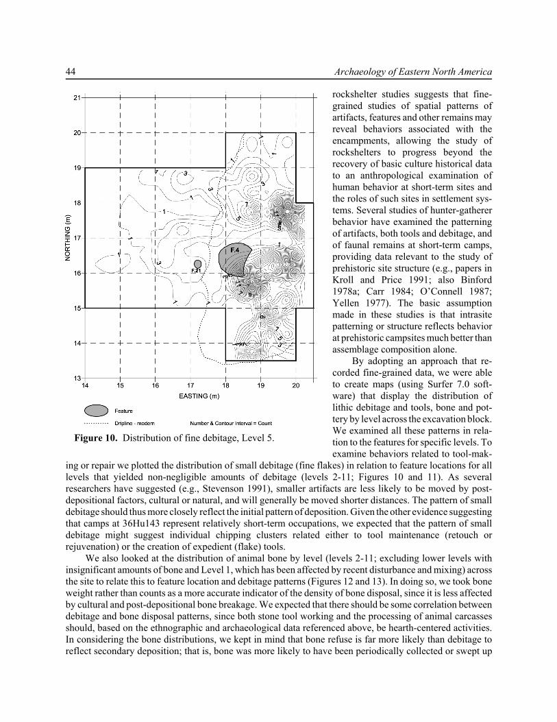
Figure 10. Distribution of fine debitage, Level 5.
rockshelter studies suggests that fine-grained studies of spatial patterns ofartifacts, features and other remains mayreveal behaviors associated with theencampments, allowing the study ofrockshelters to progress beyond therecovery of basic culture historical datato an anthropological examination ofhuman behavior at short-term sites andthe roles of such sites in settlement sys-tems. Several studies of hunter-gathererbehavior have examined the patterningof artifacts, both tools and debitage, andof faunal remains at short-term camps,providing data relevant to the study ofprehistoric site structure (e.g., papers inKroll and Price 1991; also Binford1978a; Carr 1984; O’Connell 1987;Yellen 1977). The basic assumptionmade in these studies is that intrasitepatterning or structure reflects behaviorat prehistoric campsites much better thanassemblage composition alone.
By adopting an approach that re-corded fine-grained data, we were ableto create maps (using Surfer 7.0 soft-ware) that display the distribution oflithic debitage and tools, bone and pot-tery by level across the excavation block.We examined all these patterns in rela-tion to the features for specific levels. Toexamine behaviors related to tool-mak-
ing or repair we plotted the distribution of small debitage (fine flakes) in relation to feature locations for alllevels that yielded non-negligible amounts of debitage (levels 2-11; Figures 10 and 11). As severalresearchers have suggested (e.g., Stevenson 1991), smaller artifacts are less likely to be moved by post-depositional factors, cultural or natural, and will generally be moved shorter distances. The pattern of smalldebitage should thus more closely reflect the initial pattern of deposition. Given the other evidence suggestingthat camps at 36Hu143 represent relatively short-term occupations, we expected that the pattern of smalldebitage might suggest individual chipping clusters related either to tool maintenance (retouch orrejuvenation) or the creation of expedient (flake) tools.
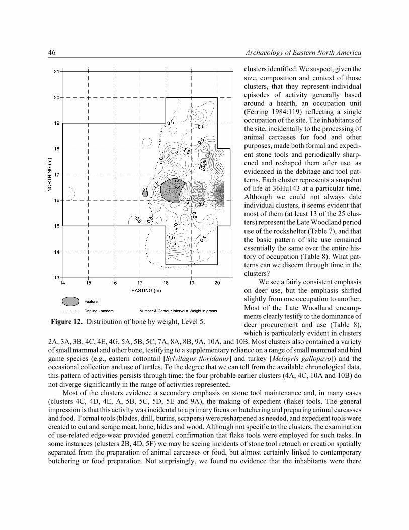
We also looked at the distribution of animal bone by level (levels 2-11; excluding lower levels withinsignificant amounts of bone and Level 1, which has been affected by recent disturbance and mixing) acrossthe site to relate this to feature location and debitage patterns (Figures 12 and 13). In doing so, we took boneweight rather than counts as a more accurate indicator of the density of bone disposal, since it is less affectedby cultural and post-depositional bone breakage. We expected that there should be some correlation betweendebitage and bone disposal patterns, since both stone tool working and the processing of animal carcassesshould, based on the ethnographic and archaeological data referenced above, be hearth-centered activities.In considering the bone distributions, we kept in mind that bone refuse is far more likely than debitage toreflect secondary deposition; that is, bone was more likely to have been periodically collected or swept up
The Mykut Rockshelter, 36Hu143 45
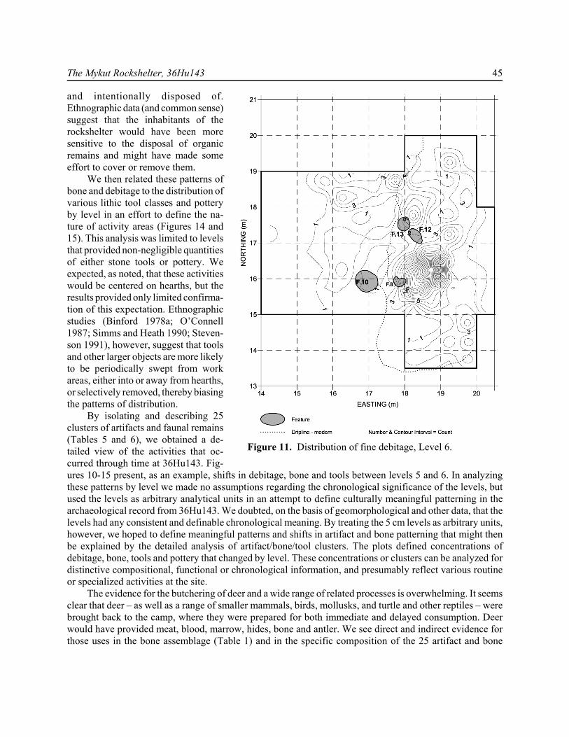
Figure 11. Distribution of fine debitage, Level 6.
and intentionally disposed of.Ethnographic data (and common sense)suggest that the inhabitants of therockshelter would have been moresensitive to the disposal of organicremains and might have made someeffort to cover or remove them.
We then related these patterns ofbone and debitage to the distribution ofvarious lithic tool classes and potteryby level in an effort to define the na-ture of activity areas (Figures 14 and15). This analysis was limited to levelsthat provided non-negligible quantitiesof either stone tools or pottery. Weexpected, as noted, that these activitieswould be centered on hearths, but theresults provided only limited confirma-tion of this expectation. Ethnographicstudies (Binford 1978a; O’Connell1987; Simms and Heath 1990; Steven-son 1991), however, suggest that toolsand other larger objects are more likelyto be periodically swept from workareas, either into or away from hearths,or selectively removed, thereby biasingthe patterns of distribution.
By isolating and describing 25clusters of artifacts and faunal remains(Tables 5 and 6), we obtained a de-tailed view of the activities that oc-curred through time at 36Hu143. Fig-ures 10-15 present, as an example, shifts in debitage, bone and tools between levels 5 and 6. In analyzingthese patterns by level we made no assumptions regarding the chronological significance of the levels, butused the levels as arbitrary analytical units in an attempt to define culturally meaningful patterning in thearchaeological record from 36Hu143. We doubted, on the basis of geomorphological and other data, that thelevels had any consistent and definable chronological meaning. By treating the 5 cm levels as arbitrary units,however, we hoped to define meaningful patterns and shifts in artifact and bone patterning that might thenbe explained by the detailed analysis of artifact/bone/tool clusters. The plots defined concentrations ofdebitage, bone, tools and pottery that changed by level. These concentrations or clusters can be analyzed fordistinctive compositional, functional or chronological information, and presumably reflect various routineor specialized activities at the site.
The evidence for the butchering of deer and a wide range of related processes is overwhelming. It seemsclear that deer – as well as a range of smaller mammals, birds, mollusks, and turtle and other reptiles – werebrought back to the camp, where they were prepared for both immediate and delayed consumption. Deerwould have provided meat, blood, marrow, hides, bone and antler. We see direct and indirect evidence forthose uses in the bone assemblage (Table 1) and in the specific composition of the 25 artifact and bone
46 Archaeology of Eastern North America
Figure 12. Distribution of bone by weight, Level 5.
clusters identified. We suspect, given thesize, composition and context of thoseclusters, that they represent individualepisodes of activity generally basedaround a hearth, an occupation unit(Ferring 1984:119) reflecting a singleoccupation of the site. The inhabitants ofthe site, incidentally to the processing ofanimal carcasses for food and otherpurposes, made both formal and expedi-ent stone tools and periodically sharp-ened and reshaped them after use. asevidenced in the debitage and tool pat-terns. Each cluster represents a snapshotof life at 36Hu143 at a particular time.Although we could not always dateindividual clusters, it seems evident thatmost of them (at least 13 of the 25 clus-ters) represent the Late Woodland perioduse of the rockshelter (Table 7), and thatthe basic pattern of site use remainedessentially the same over the entire his-tory of occupation (Table 8). What pat-terns can we discern through time in theclusters?
We see a fairly consistent emphasison deer use, but the emphasis shiftedslightly from one occupation to another.Most of the Late Woodland encamp-ments clearly testify to the dominance ofdeer procurement and use (Table 8),which is particularly evident in clusters
2A, 3A, 3B, 4C, 4E, 4G, 5A, 5B, 5C, 7A, 8A, 8B, 9A, 10A, and 10B. Most clusters also contained a varietyof small mammal and other bone, testifying to a supplementary reliance on a range of small mammal and birdgame species (e.g., eastern cottontail [Sylvilagus floridanus] and turkey [Melagris gallopavo]) and theoccasional collection and use of turtles. To the degree that we can tell from the available chronological data,this pattern of activities persists through time: the four probable earlier clusters (4A, 4C, 10A and 10B) donot diverge significantly in the range of activities represented.
Most of the clusters evidence a secondary emphasis on stone tool maintenance and, in many cases(clusters 4C, 4D, 4E, A, 5B, 5C, 5D, 5E and 9A), the making of expedient (flake) tools. The generalimpression is that this activity was incidental to a primary focus on butchering and preparing animal carcassesand food. Formal tools (blades, drill, burins, scrapers) were resharpened as needed, and expedient tools werecreated to cut and scrape meat, bone, hides and wood. Although not specific to the clusters, the examinationof use-related edge-wear provided general confirmation that flake tools were employed for such tasks. Insome instances (clusters 2B, 4D, 5F) we may be seeing incidents of stone tool retouch or creation spatiallyseparated from the preparation of animal carcasses or food, but almost certainly linked to contemporarybutchering or food preparation. Not surprisingly, we found no evidence that the inhabitants were there

The Mykut Rockshelter, 36Hu143 47
Figure 13. Distribution of bone by weight, Level 6.
primarily to knap stone tools but in allcases they maintained their tool kit toserve the main tasks of butchering,working bone, hide and wood, and pre-paring food.
In a few instances (clusters 2C and4G), we may be looking at the inten-tional redeposition of refuse. That is,refuse was periodically swept up orgathered and thrown or dumped some-where other than the location it fell. Weexpect to see this behavior mainly withbone refuse, where bone was removedfrom the vicinity of hearths and otherwork areas for sanitary and aestheticreasons. Most of such refuse would havebeen thrown downslope from the shel-tered area or perhaps to the back of therockshelter.
As noted earlier, we expected on thebasis of ethnographic information thatmuch of the activity at the site wouldhave been centered on hearths, whichwere (with one exception) the only fea-ture type present at 36Hu143. Therewere several fairly obvious cases in wecould connect a cluster to a hearth andinfer that the associated activity washearth-centered (clusters 2A, 3A, 3B,4A, 4B, 4C, 4E, 4F and 6A). In othercases, we could see no such relationshipand conclude that the activity was eithernot focused on a hearth or the hearth is no longer visible. Both explanations may be valid. We note (Table8) that stone tool maintenance and expedient tool manufacture often occurred away from a hearth in the upperlevels (levels 2-6), while deer butchering and processing were generally associated with a hearth. In the lowerlevels (levels 7-10), neither deer processing nor stone tool retouch were associated with features, perhapsimplying that features were simply no longer evident, or at least were not visible during excavation. A numberof investigators have reported the disappearance of features through soil leaching and other processes in somesettings (cf., Moeller 1992:96), identifying this as a factor that needs to be considered in evaluating featuresat Eastern North American sites. At 36Hu44, an open site on the upper terrace of the Juniata River (Raber1995), we traced a number of prehistoric features in fine-grained clayey soils that were no longer marked bycolor contrasts but solely by subtle soil texture variations. We have no reason to believe that this situationholds at 36Hu143, but the patterns of cluster association just noted suggest that we may have missed somefeatures not marked by strong color contrasts with the surrounding matrix.
We also note that clusters outside the sheltered portion of the site were generally focused on stone toolmaintenance and flake tool manufacture rather than butchering and related tasks (clusters 2B, 2C and 4D;Table 8). This holds even assuming some recession of the dripline through the late Holocene. The reverse isnot true: stone tool manufacture and maintenance areas were not invariably outside the dripline. This leads

48 Archaeology of Eastern North America
Figure 14. Distribution of tools, Level 5.
us to believe that the location of thoseactivities outside the dripline was idio-syncratic rather than reflecting any sig-nificant cultural patterns.
WHAT HAPPENED AT 36HU143?
The location and setting of theMykut Rockshelter are key aspects of itsuse. Located at a gap through TerraceMountain, the site offered a convenientplace to camp and an ideal spot fromwhich to monitor game animal move-ments and conduct hunting forays (Fig-ure 5). It mirrors the pattern of settle-ment noted throughout central Pennsyl-vania (Raber 1995, 2007), in whichcamps are frequently located at gaps thatfunctioned as critical points, channelingall prehistoric (and historic) movementthrough the region. This pattern reflectsthe distinctive physiography of theRidge and Valley physiographic region,which constrained movement in predict-able ways.
Virtually all movements by gameanimals or humans through the TerraceMountain gap passed directly beneaththe rockshelter. The evidence from thebone and artifact assemblages at36Hu143 confirms that local inhabitantssoon recognized the advantages of the
site as a base for hunting deer and trapping or collecting other small animals and a variety of plants. Withaccess to food resources of Little Valley and with potable water immediately adjacent, the Mykut Rockshelterprovided everything needed by small family or task groups for brief stays.
The bulk of the evidence from the site argues for a consistent focus through time on the hunting of deerand the processing of deer carcasses, for immediate and delayed consumption. Some of the individualoccupations may have been overnight bivouacs, but this use was clearly secondary and restricted to the earlierperiods of occupation, especially the Middle to Terminal Archaic periods. The size and duration of each campwould have varied within limits set by the nature of the site and the dynamics of hunter-gatherer groups.
The rockshelter itself set obvious limits on the size and duration of prehistoric occupations. Wecalculated that roughly 41 m2of space within and outside the dripline contained archaeological deposits, butthe distribution of artifacts and our analysis of artifacts clusters suggested that most of the activity wasfocused, as might be expected, inside the sheltered area, estimated at roughly 16 m2, although the retreat ofthe roof-edge through the Holocene may have reduced the available sheltered space by as much as 33% (from

The Mykut Rockshelter, 36Hu143 49
Figure 15. Distribution of tools, Level 6.
ca. 24 m2). The low roof at the back ofthe rockshelter may have prevented theuse of all of this space. We assume afigure of 18 m2 that accounts for bothunusable space within the rockshelterand the potential for a larger availablespace prior to the retreat of the roof-edge.
Most of the estimates of the arearequired per person at short-term campsare derived from ethnographic and ar-chaeological data based on open sitesand have varied widely. We note a widerange of figures for hunter-gatherercamps, varying largely by the anticipatedor actual length of the stay. Kent (1991)identifies “anticipated mobility” as themain factor influencing the size of tem-porary camps. Jones (1993:102-104)reports figures for several Aché foragingcamps occupied overnight by severalnuclear family-based forging groupstotaling 24-26 persons: the camps sizesaveraged 22.6 m2 (range: 19.6-29.0 m2),implying an average of 0.9 m2 per per-son. This estimate seems very low andmay reflect the extremely short durationof the stay and the nature of local tropi-cal forest environments. Jones’s reviewof comparable hunter-gatherer camp sizedata indicates that other short-termcamps ranged from roughly 4.2 m2 perperson upwards, and that area used perperson increased dramatically with the length of stay. The degree to which these data from open camps intropical forests and arid savanna or desert environments apply to rockshelter use in temperate forests can bequestioned. They do, however give us some reference points for estimating the size of the groups that usedthe Mykut Rockshelter.
Assuming an available living space of roughly 18 m2 and taking a figure of 3-4 m2 per person as withinthe range suggested by ethnographic data, we conclude that 4-6 persons might have occupied the rockshelterfor several days to a few weeks. This estimate fits well with the idea that a nuclear family or task-based groupwould have been the social unit involved in the activities surrounding hunting and butchering at therockshelter. Larger groups may have used the rockshelter for shorter periods, but we doubt that this happenedroutinely.
We believe that each artifact cluster identified in our analysis represents a single occupation unit inFerring’s (1984:119) terminology and may have included multiple activity areas. Taking the 25 identifiedartifact clusters as representing the minimum number of individual occupations evident at the site (a numbergenerally consistent with the 22 hearths identified), we calculate that each occupation may have produced1/25 of the total artifacts recovered: roughly 660 pieces of debitage, 11 tools and 2170 bone fragmentsweighing 140 g. These figures, while very rough, clearly suggests that each occupation involved a small

50 Archaeology of Eastern North America
Table 5. Debitage and Bone Cluster DefinitionsLevel Cluster Type Provenience (Unit and Quadrant)
22A bone N17E21NW/SW; N17E20NE/SE; N16E21NW2B debitage N16E17NE2C debitage N17E16NE/SE
3 3A debitage/bone N17E21NW/SW ; N16E21NW3B bone N18E17NW/SW/SE ; N18E16SE ; N17E17NW
4
4A debitage N20E19NE/SE ; N20E20NW/SW4B debitage N19E19NW4C debitage N18E20SE4D debitage N16E17SW4E debitage/bone N15E20SE4F debitage N14E19NE4G bone N17E21NW/SW; N16E21NW
5
5A debitage/bone N18E20NE; N18E21NW; N19E20SE5B bone N17E20SW; N17E19SE5C debitage/bone N17E21SW; N16E21NW; N17E20SE5D debitage N16E19NE; N17E19SE5E debitage N15E20NW5F debitage N14E19NE
6 6A debitage/bone N17E19SE/SW; N17E20SE; N16E19NE/NW
7 7A debitage/boneN17E19SE/SW/NW; N16E19NE/NW/SW;
N17E18SE; N16E18NE/SE; N17E20SW
8 8A bone N17E19NE/NW8B debitage/bone N16E19NE/SE
9 9A debitage/bone N17E19SE/NW; N16E19SE; N15E19NE
10 10A debitage N16E19SE10B bone N19E19SW
group and was relatively brief. The limited number of game animals available in the immediate vicinity (LittleValley) would have made extended stays unnecessary and unproductive.
We suspect that the rockshelter was occupied for many more than the 25 times represented by the artifactclusters. Over the course of at least five millennia of repeated use (excluding the possible earlierencampments), the site could have been used dozens or even hundreds of times. Many shorter and olderoccupations may simply not be as visible in the archaeological record because of differential preservation.Given the palimpsest character of rockshelter deposits, more recent occupations may have obscured or erasedthe traces of earlier camps. In any case, we may have underestimated the number of earlier, especially Archaicperiod, encampments.
What happened at these encampments? The combined faunal data indicate that deer were butchered atthe site, suggesting that the site served as a staging area for hunting forays. In keeping with ethnographic dataon hunting, butchering and carcass transport practices (e.g., Bartram 1993; Bartram et al. 1991; Binford1978a, 1978b; Bunn 1993; Bunn et al. 1988; Gifford-Gonzalez 1989; O’Connell and Hawkes 1988), wesuggest that some preliminary dismemberment of the carcass occurred at the kill site, and that partiallydisarticulated carcasses were brought to the rockshelter. There further disarticulation of the carcass andprocessing occurred. Large cuts of meat would have been separated and processed for both immediateconsumption and storage. The additional processing might have included pounding and cracking bones toextract marrow, boiling to obtain bone juice and bone grease, and drying or smoking. We have some evidence

The Mykut Rockshelter, 36Hu143 51
Table 6. Cluster Composition
Type SubtypeLevel 2 Level 3 Level 42A 2B 2C 2B 3B 2C 4B 4CNo. Wt.* No. Wt. No. Wt. No. Wt. No. Wt. No. Wt. No. Wt. No. Wt.
biface hafted 0 1 0 1 1 0 0 0biface other 0 1 0 0 0 0 0 0biface fragment 0 0 1 0 0 0 0 0scraper 0 0 0 0 1 0 0 0flake tool 0 1 5 0 0 0 1 1flake primary 1 9 9 5 1 11 0 2flake crude 2 4 2 0 0 2 0 0flake intermediate 5 2 4 6 2 6 1 11flake fine 11 23 18 17 8 25 14 22flake micro 0 0 0 0 0 0 0 0flake fragment 3 7 12 12 10 24 12 79shatter 2 4 2 0 1 0 0 0shatter with cortex 0 0 0 0 2 0 0 1core or core fragment 0 0 0 0 0 0 0 0cobble/pebble hammer 0 0 1 0 0 0 0 0cobble/pebble pitted 0 0 0 0 0 0 0 0cobble/pebble other 0 0 0 0 0 0 0 0manuport 0 0 1 0 0 0 0 0lithic artifact total 24 52 55 41 26 68 28 116lithic artifact density/m2 19 208 110 55 21 68 112 464pottery* 0 0 0 0 26 13 2 16 19 15 0 0 0 0 0 0pottery density/m2 0 0 0 0 52 27 3 22 15 12 0 0 0 0 0 0bone/tooth 55 40.3 33 5.7 14 0.6 198 45 40 34 61 12 71 6.7 31 3.4shell 2 <0.1 1 0.1 0 0 0 0 3 0.3 91 1.8 1 0.1 0 0total faunal density/m2 44 32.2 136 23 28 1.2 264 60 34 28 152 14 288 27 124 14* weight in grams
Type SubtypeLevel 4 Level 54D 4 4F 4G 5A 5B 5C 5DNo. Wt.* No. Wt. No. Wt. No. Wt. No. Wt. No. Wt. No. Wt. No. Wt.
biface hafted 0 0 0 0 0 0 0 0biface other 0 0 0 0 0 0 0 0biface fragment 0 1 0 0 0 0 0 0scraper 0 0 0 0 1 0 0 0flake tool 0 0 0 0 2 0 3 0flake primary 2 6 5 0 6 2 18 13flake crude 0 2 0 0 4 1 12 1flake intermediate 6 0 0 5 11 2 29 16flake fine 14 8 3 3 51 8 34 45flake micro 0 0 0 0 0 0 0 0flake fragment 14 4 2 4 154 17 54 47shatter 0 0 0 1 6 0 5 2shatter with cortex 0 2 0 1 0 1 6 1core or core fragment 0 0 0 0 0 0 0 0cobble/pebble hammer 0 0 0 0 0 0 0 0cobble/pebble pitted 0 0 0 0 0 0 0 0cobble/pebble other 0 0 0 0 0 0 0 0manuport 0 0 0 0 0 0 0 0lithic artifact total 36 23 10 14 235 31 161 125lithic artifact density/m2 144 92 40 19 313 62 215 250pottery* 2 0.6 2 1.1 0 0 0 0 0 0 0 0 10 4.4 7 1pottery density/m2 8 2.4 8 4.4 0 0 0 0 0 0 0 0 13 5.9 6 0.4bone/tooth 2 0.5 15 7.9 3 0.1 88 50 180 26 36 9.7 222 48 49 12shell 0 0 0 0 0 0 0 0 1 0.1 0 0 0 0 1 <0.1total faunal density/m2 8 2 60 32 12 0.4 117 67 241 34 72 19 296 64 98 24
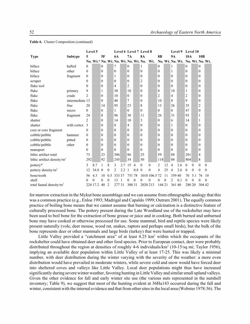
52 Archaeology of Eastern North America
Table 6. Cluster Composition (continued)
Type SubtypeLevel 5 Level 6 Level 7 Level 8 Level 9 Level 105 5F 6A 7A 8A 8B 9A 10A 10BNo. Wt.* No. Wt. No. Wt. No. Wt. No. Wt. No. Wt. No. Wt. No. Wt. No. Wt.
biface hafted 0 0 7 0 1 0 1 0 0biface other 0 0 0 0 0 0 1 0 0biface fragment 0 0 1 0 0 0 0 0 0scraper 0 0 0 0 2 0 0 0 0flake tool 0 0 4 2 0 0 0 0 0flake primary 9 1 30 10 0 8 10 1 0flake crude 2 0 10 0 0 2 4 2 0flake intermediate 13 0 40 7 0 10 8 9 0flake fine 20 14 95 23 8 13 26 35 2flake micro 0 0 1 0 0 0 0 47 0flake fragment 24 8 96 30 11 26 31 93 1shatter 2 0 14 10 3 0 6 14 1shatter with cortex 3 0 8 4 0 0 1 0 0core or core fragment 0 0 0 0 0 0 0 0 0cobble/pebble hammer 0 0 0 0 0 0 0 0 0cobble/pebble pitted 0 0 0 0 0 0 0 0 0cobble/pebble other 0 0 0 0 0 0 0 0 0manuport 0 0 0 0 0 0 0 0 0lithic artifact total 73 23 306 86 25 59 88 201 4lithic artifact density/m2 292 92 245 34 50 118 88 804 8pottery* 3 8.7 1 8 3 2.7 15 4 0 0 2 12 4 2.6 0 0 0 0pottery density/m2 12 34.8 0 0 2 2.2 1 0.8 0 0 4 25 4 2.6 0 0 0 0bone/tooth 56 4.3 10 0.5 333 37 751 78 1010 106.5 72 11 359 40 70 5.1 76 10shell 0 0 0 0 13 1 0 0 0 0 0 0 2 0.1 0 0 0 0total faunal density/m2 224 17.2 40 2 277 31 300 31 2020 213 144 21 361 40 280 20 304 42
for marrow extraction in the Mykut bone assemblage and we can assume from ethnographic analogy that thiswas a common practice (e.g., Enloe 1993; Madrigal and Capaldo 1999; Outram 2001). The equally commonpractice of boiling bone means that we cannot assume that burning or calcination is a distinctive feature ofculturally processed bone. The pottery present during the Late Woodland use of the rockshelter may havebeen used to boil bone for the extraction of bone grease or juice and in cooking. Both burned and unburnedbone may have cooked or otherwise processed for use. Some mammal, bird and reptile species were likelypresent naturally (vole, deer mouse, wood rat, snakes, raptors and perhaps small birds), but the bulk of thebone represents deer or other mammals and large birds (turkey) that were hunted or trapped.
Little Valley provided a “catchment area” of at least 4.25 km2 within which the occupants of therockshelter could have obtained deer and other food species. Prior to European contact, deer were probablydistributed throughout the region at densities of roughly 4-6 individuals/km2 (10-15/sq mi; Taylor 1956),implying an available deer population within Little Valley of at least 17-25. This was likely a minimalnumber, with deer distribution during the winter varying with the severity of the weather: a more evendistribution would have prevailed in moderate winters, while severe cold and snow would have forced deerinto sheltered coves and valleys like Little Valley. Local deer populations might thus have increasedsignificantly during severe winter weather, favoring hunting in Little Valley and similar small upland valleys.Given the other evidence for fall and early winter site use (the various nuts represented in the nutshellinventory; Table 9), we suggest that most of the hunting evident at 36Hu143 occurred during the fall andwinter, consistent with the internal evidence and that from other sites in the local area (Webster 1978:36). The

The Mykut Rockshelter, 36Hu143 53
concern for extracting as much foodand other value (e.g., clothing) fromdeer carcasses as possible – evident inthe cracking of bones to obtain mar-row, for instance – also suggests awinter occupation, when other foodsources would have been limited.
Perhaps as significant as the pres-ence of deer bone is the absence ofother large mammal bone, especiallybear, elk, and wolf, that occur at SheepRock, and frequently at other LateWoodland sites (Guilday and Parmalee1965; Guilday et al. 1962; Webster1978). Their absence relates both to thelocation of 36Hu143 and to its use. Theinhabitants of Sheep Rock had accessto a wider variety of species than didthose at Mykut Rockshelter (especiallyfish and other aquatic species), stayedlonger, and had a broader subsistencefocus, including the use of domesti-cates like corn, beans and squash(Webster 1978:35). The orientation at36Hu143, occupied by small groupsfor much shorter stays, was corre-spondingly narrow in focus.
Deer provided both immediatenourishment and satisfied longer-termneeds, in the form of preserved meat,hides, antler and bone. Nevertheless, it
Table 9. Nutshell from Features at 36Hu143Hickory
(Carya sp.)Black walnut
(Juglans nigra)Butternut
(Juglans cinerea)Walnut family(Juglandaceae)
Fea. Num-ber
Weight (g) Num-ber
Weight (g) Num-ber
Weight (g) Num-ber
Weight(g)
F. 1 1 0.01 0 0 0 0 5 <0.01F. 2 6 0.09 1 0.02 4 0.07 74 0.44F. 5 5 0.12 1 0.05 0 0 12 0.04F. 9 2 0.03 4 0.05 0 0 18 0.03
F. 10 6 0.04 0 0 0 0 15 0.05F. 12 0 0 0 0 0 0 6 0.02F. 13 0 0 0 0 0 0 7 0.01F. 15 3 0.04 0 0 0 0 6 0.03F. 20 35 0.46 0 0 0 0 100 0.35F. 21 1 0.01 0 0 0 0 0 0totals 59 0.8 6 0.12 4 0.07 243 0.97
Table 7. Cluster ChronologyCluster Inferred Date Supporting data2A Late Woodland (A.D. 1300-1400) C-14 (F. 5), pottery2B Late Woodland triangular point2C Late Woodland (A.D. 1400-1525) pottery3A Late Woodland (ca. A.D. 1300) C-14 (F. 7), pottery3B Late Woodland (A.D. 1400-1525) pottery4A Middle Woodland? (300-400
B.C.)C-14 (F. 18)
4B ?4C Late Archaic (2600-2900 B.C.) C-14 (F. 9)4D ?4E Late Woodland (A.D. 1400-1525) C-14 (F. 15), pottery4F Late Woodland (A.D. 1400-1525) C-14 (F. 15), pottery4G ?5A ?5B Late Woodland pottery5C ?5D early Late Woodland pottery5E ?5F Late Woodland? pottery6A early Late Woodland C-14 (F. 12), pottery7A early Late Woodland pottery8A ?8B ?9A Late Woodland triangular point,
pottery10A pre-Late Woodland stratigraphy10B pre-Late Woodland stratigraphy
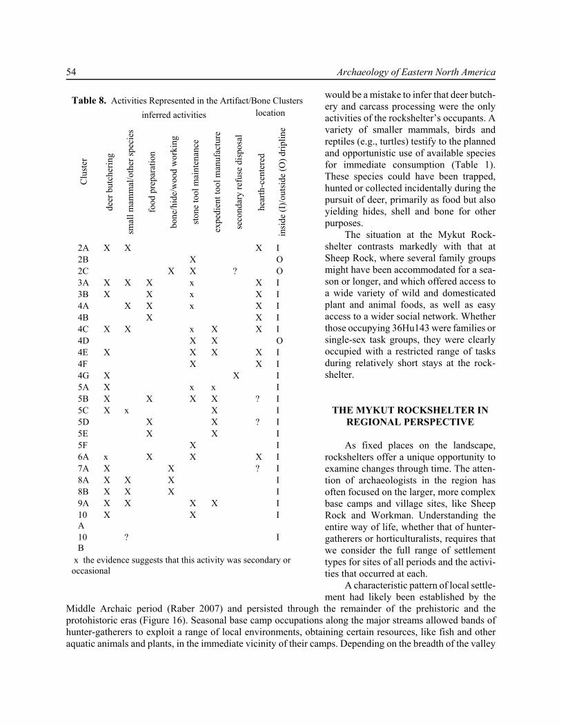
54 Archaeology of Eastern North America
would be a mistake to infer that deer butch-ery and carcass processing were the onlyactivities of the rockshelter’s occupants. Avariety of smaller mammals, birds andreptiles (e.g., turtles) testify to the plannedand opportunistic use of available speciesfor immediate consumption (Table 1).These species could have been trapped,hunted or collected incidentally during thepursuit of deer, primarily as food but alsoyielding hides, shell and bone for otherpurposes.
The situation at the Mykut Rock-shelter contrasts markedly with that atSheep Rock, where several family groupsmight have been accommodated for a sea-son or longer, and which offered access toa wide variety of wild and domesticatedplant and animal foods, as well as easyaccess to a wider social network. Whetherthose occupying 36Hu143 were families orsingle-sex task groups, they were clearlyoccupied with a restricted range of tasksduring relatively short stays at the rock-shelter.
THE MYKUT ROCKSHELTER INREGIONAL PERSPECTIVE
As fixed places on the landscape,rockshelters offer a unique opportunity toexamine changes through time. The atten-tion of archaeologists in the region hasoften focused on the larger, more complexbase camps and village sites, like SheepRock and Workman. Understanding theentire way of life, whether that of hunter-gatherers or horticulturalists, requires thatwe consider the full range of settlementtypes for sites of all periods and the activi-ties that occurred at each.
A characteristic pattern of local settle-ment had likely been established by the
Middle Archaic period (Raber 2007) and persisted through the remainder of the prehistoric and theprotohistoric eras (Figure 16). Seasonal base camp occupations along the major streams allowed bands ofhunter-gatherers to exploit a range of local environments, obtaining certain resources, like fish and otheraquatic animals and plants, in the immediate vicinity of their camps. Depending on the breadth of the valley
Table 8. Activities Represented in the Artifact/Bone Clusters
Clu
ster
inferred activities locationde
er b
utch
erin
g
smal
l mam
mal
/oth
er sp
ecie
s
food
pre
para
tion
bone
/hid
e/w
ood
wor
king
ston
e to
ol m
aint
enan
ce
expe
dien
t too
l man
ufac
ture
seco
ndar
y re
fuse
dis
posa
l
hear
th-c
ente
red
insi
de (I
)/out
side
(O) d
riplin
e
2A X X X I2B X O2C X X ? O3A X X X x X I3B X X x X I4A X X x X I4B X X I4C X X x X X I4D X X O4E X X X X I4F X X I4G X X I5A X x x I5B X X X X ? I5C X x X I5D X X ? I5E X X I5F X I6A x X X X I7A X X ? I8A X X X I8B X X X I9A X X X X I10A
X X I
10B
? I
x the evidence suggests that this activity was secondary oroccasional

The Mykut Rockshelter, 36Hu143 55
Figure 16. Schematic model of local settlement.
cross-section, the ease of movementalong the valley bottom and the associ-ated procurement costs (in time andeffort), exploiting the full range oflocal resources and microenvironmentsmight have involved either brief foraysfrom the base camp or the establish-ment of temporary upland or floodplaincamps. During brief occupations ofthese small camps family or taskgroups could obtain a variety of local-ized resources: chert and other materi-als for stone tools, plants and animals(deer and small game) used for foodand materials, etc. They scheduledtheir movements to and from thesesites based on resource availability (inthe case of game animals and plants)and need (in response to anticipated orexperienced shortages). The uplandcamps thus offer essential keys to theunderstanding of how the prehistoricinhabitants of the region were living,including their diet, social structureand the scheduling of activities.
Most models of regional settle-ment have, however, undervalued thesesites (e.g., Michels 1967), especiallyfor the study of Late Woodland settle-ment patterns. Yet the activities thatoccurred at the latter were integral tothe lives of the region’s inhabitants,even after the development of plantdomesticates (Raber 2000, 2004). Thecultivation of corn, beans and squash was introduced into an existing subsistence base of wild plant andanimal foods. Current knowledge suggests that both the importance of domesticates and the degree ofsedentism usually associated with agriculture varied widely by region and circumstances (Custer 1996:273-300; Raber 1993; Stewart 1994:201-106, 2003:23-24). The persistence of Archaic patterns of wild food useinto the Late Woodland period is widely acknowledged, yet most regional models of Late Woodland lifeassume a focus on agriculture and are based almost exclusively on the study of village or hamlet sites.
While we can trace a long span of occupation at 36Hu143, we also note an apparent intensification ofits use during the Late Woodland period (assuming this is not a result of differences in preservation andvisibility in the archaeological record).We suggest that this continuation and intensification of use relates tothe management of environmental risk. The shift to a reliance on domesticated plants likely involved a declinein overall dietary quality and health and increased risk of nutritional shortages (Custer 1996:297-300).Incorporating wild foods into this regime may not have been an option but a necessity to maintain health, andperhaps even to survive. Similar responses to seasonal food shortages are a widely noted feature of LateWoodland (or Late Prehistoric) life (see, for instance, Hart 1993 with regard to Monongahela settlement inwestern Pennsylvania), and indeed a common feature of most pre-modern life. The focus on hunting we see
56 Archaeology of Eastern North America
at 36Hu143 and other Late Woodland sites in the local area likely represented an essential aspect ofsubsistence rather than an addition or option to an already complete and satisfactory adaptation. The use ofdeer, especially the preserving of deer meat that seems to have occurred at 36Hu143, provided, in our view,an essential contribution to the diet, particularly during periods of anticipated shortages like late winter andearly spring. The way in which hunting was organized and incorporated into the subsistence regime had notchanged substantially from the Archaic period pattern, but its meaning and importance for Late Woodlandperiod groups had altered drastically.
In short, we propose that 36Hu143 and similar sites would have served a critical function in thesubsistence economy, providing a key dietary component through periods of food shortages. The basicoutlines of this adaptation – seasonal deer hunting at upland camps like 36Hu143 – remained essentiallyunchanged from at least the Middle Archaic through the protohistoric period. But it began to assume a specialimportance during the Late Woodland period, as the shift to a settled agricultural or horticultural life exposedlocal groups to periodic food shortages and related dietary deficiencies. This is a testable hypothesis, whichmight be addressed through the analysis of signs of dietary stress in human skeletal populations. At present,the data to address this question do not exist, but a program of bioarchaeological research aimed at identifyingand quantifying dietary stresses might resolve the issue.
SUMMARY
The investigations at Mykut Rockshelter yielded a remarkably complete picture of a special-use site andits relation to the local settlement system. The results are important in themselves, but the approach and theresults larger implications for methodology, rockshelter studies and regional research.
MethodologyThe results demonstrate the value of fine-grained provenience control and recovery methods applied to
dense and compact sites. This approach has been applied at several camps sites in central Pennsylvania (Raber2007, 2008) and at a small rockshelter (36Mr180) in the Pocono uplands (Burns 2005; Burns and Raber2003). This is not intended to be a cookbook recipe for excavation, but a suite of techniques some or all orwhich may be appropriate to dense, compact sites. Where applicable, these methods can produce fine-graineddata on specific activities. Analyzing these data in terms of ethnographic and archaeological information onhunter-gatherer behavior may allow archaeologists to move beyond gross characterizations of site functionand culture history to a detailed and more nuanced reconstruction of activities and human behavior. The datayielded by these methods are not simply more accurate, but qualitatively different, allowing us to see patternsin the structure of the site and to address behavioral questions that could not be answered with traditionalapproaches.
Rockshelter StudiesNumerous studies ave explored the use of rockshelters by hunter-gatherers and others throughout the
world. While most of these studies focus on rockshelter use by hunter-gatherers, rockshelters are also usedin comparable ways by pastoralist and horticultural/agricultural groups (Galanidou 2000; Gorecki 1991;Graham 1993). The variation in site functions, the use of rockshelters as persistent places on the landscapeand the internal use of space are themes common to all these studies. The results from Mykut Rockshelterrelate to all these topics.
Rockshelters may have been used as bivouacs, base camps, resource procurement sites or caching orstorage locations. The evidence from 36Hu143 points to its repeated occupation as a staging area for huntingforays and a butchering/processing site, and, at least occasionally, as a bivouac, both functions related to itssetting and control of local resources. We have posited that the use of the site during the Late Woodland, in
The Mykut Rockshelter, 36Hu143 57
particular, was an aspect of risk-reduction or management, in which local groups of horticulturalists hunteddeer from the site to minimize or compensate for seasonal food shortages. The maintenance of essentialfeatures of the earlier Archaic subsistence pattern was, we suggest, a way to reduce the uncertainty associatedwith plant domestication and horticulture. The site can be seen as illustrating both “spatial” and “temporalaveraging” as risk-reduction strategies (Goland 1991). The use of specialized sites like 36Hu143 was analternative to approaches like storage or sharing by which predictable fluctuations in food supply could bemanaged. By controlling and exploiting microenvironments like Little Valley, the residents of the RaystownValley spread their food procurement activities over a range of environmental settings and resources,lessening the risk associated with reliance on any one setting or resource. By preserving the deer meatobtained during these forays, they were able to “temporally average” that risk. The exploration of otherspecial-purpose camps, rockshelters and open sites, and bioarchaeological research on skeletal populationsmight further explicate this aspect of rockshelter use.
Implications for Regional ResearchRockshelters have played critical and currently underappreciated roles in the local settlement pattern.
We cannot assume, however, that all the rockshelters in the local area functioned in a similar manner or thattheir roles in local settlement were invariant. The specific roles that rockshelters played reflectedenvironmental setting, time period and related changes in cultural adaptations. We cannot simply extrapolatefrom our understanding of Sheep Rock Shelter and the Mykut Rockshelter to generalize about all localrockshelters. Most of the local rockshelters, of which several dozen are known, remain incompletely recorded,poorly characterized or completely unstudied. The research at Mykut Rockshelter has made clear the potentialfor valuable information from even the smallest of these sites, if adequately investigated. We see the MykutRockshelter studies as part of a continuing program of research on the rockshelters of the lower RaystownBranch drainage which might include more detailed analyses of the data from 36Hu143 and other sites.
ACKNOWLEDGMENTS
The work reported in this paper was funded by the Federal Highway Administration and the PennsylvaniaDepartment of Transportation (PENNDOT), District 9-0, in connection with improvements to Little Valley Road inHuntingdon County, Pennsylvania. Thanks to Dain Davis and William Savage of the Environmental Unit at District9-0 and Ken Smith at the EADS Group, Inc., for their help. Mr. Steven Mykut of Little Valley allowed us access to thesite over several years, took an active and informed interest in the investigations, protected the site, and arranged forthe local display of some of the results. The success of the investigations at 36Hu143 relied on the efforts of a large anddiverse field crew, ably directed by Jonathan Burns and Nicole Cooper Minnichbach. Chris Yohn prepared the figures.
REFERENCES
Adovasio, J. M. 1982 Multidisciplinary Research in the Northeast: One View from Meadowcroft Rockshelter. Pennsylvania
Archaeologist 52(3-4):57-68. Bartram, Laurence E. 1993 Perspectives on Skeletal Part Profiles and Utility Curves from Eastern Kalahari Ethnoarchaeology. In From
Bones to Behavior: Ethnoarchaeological and Experimental Contributions to the Interpretation of FaunalRemains, edited by Jean Hudson, pp. 115-137. Center for Archaeological Investigations, Southern IllinoisUniversity at Carbondale, Occasional Paper No. 21, Carbondale, Illinois.
Bartram, Laurence E., Ellen M. Kroll and Henry T. Bunn 1991 Variability in Camp Structure and Bone Food Refuse Patterning at Kua San Hunter-Gatherer Camps. In The
Interpretation of Archaeological Spatial Patterning, edited by E. M. Kroll and T. D. Price, pp. 77-148. PlenumPress, New York.

58 Archaeology of Eastern North America
Bebrich, Carl A. and Lorraine M. Willey 1968 The Stratigraphy of the Sheep Rock Shelter. In Archaeological Investigations of Sheep Rock Shelter,
Huntingdon County, Pennsylvania, Volume 3, edited by J.W. Michels and J.S. Dutt, pp. 33-92. ThePennsylvania State University, Department of Anthropology, Occasional Papers, University Park.
Berg, T.M., W.E. Edmunds, A.R. Geyer, A.D. Glover, D.M. Hoskins, J.G. Kuchinski, D.B. MacLachlan, C.E. Miles,S.I. Root, W.D. Sevon, and A.A. Socolow 1980 Geologic Map of Pennsylvania. Department of Environmental Resources, Bureau of Topographic and Geologic
Survey, Harrisburg.Binford, L. R. 1978a Dimensional Analysis of Behavior and Site Structure: Learning from an Eskimo Hunting Stand. American
Antiquity 43(3):330-361. 1978b Nunamiut Ethnoarchaeology. Academic Press, New York.Brink, J.W. 1978 An Experimental Study of Microwear Formation on Endscrapers. National Museum of Man, Archaeological
Survey of Canada, Mercury Series, No. 83.Bunn, Henry T. 1993 Bone Assemblages at Base Camps: A Further Consideration of Carcass Transport and Bone Destruction by
the Hadza. In From Bones to Behavior: Ethnoarchaeological and Experimental Contributions to theInterpretation of Faunal Remains, edited by Jean Hudson, pp. 156-168. Center for ArchaeologicalInvestigations, Southern Illinois University at Carbondale, Occasional Paper No. 21, Carbondale, Illinois.
Bunn, Henry T., Laurence E. Bartram and Ellen M. Kroll 1988 Variability in Bone Assemblage Formation from Hadza Hunting, Scavenging and Carcass Processing. Journal
of Anthropological Archaeology 7:412-457.Burns, Jonathan A. 2005 What About Behavior? Methodological Implications for Rockshelter Excavation and Spatial Analysis. North
American Archaeologist 26(3):267-282.Burns, Jonathan A. and Paul A. Raber 1998 Investigations at the Mykut Rockshelter, 36Hu143. Paper presented at the 69th annual meeting of the Society
for Pennsylvania Archaeology, April 2004, New Cumberland, Pennsylvania. 1999 Late Woodland Settlement in the Uplands of Central Pennsylvania: The View from the Mykut Rockshelter,
36Hu143. Paper presented at the 70th annual meeting of the Society for Pennsylvania Archaeology, April 23-25, Brookville, Pennsylvania.
2003 Method and Theory for Excavation and Comparative Spatial Analysis of Three Upland Locations in CentralPennsylvania. Paper presented at the annual meeting of the Eastern States Archaeological Federation,November 14, Laurel Ridge, New Jersey.
Carr, Christopher 1984 The Nature of Organization of Intrasite Archaeological Records and Spatial Analytic Approaches to their
Investigation. In, Advances in Archaeological Method and Theory, Volume 7, edited by M. B. Schiffer, pp.103-222. Academic Press, New York.
Carr, Brenda and Paul A. Raber 1999 Remnants of Subsistence at Mykut Rockshelter, 36Hu143. Paper presented at the 70th annual meeting of the
Society for Pennsylvania Archaeology, April 23-25, Brookville, Pennsylvania.Custer, Jay F. 1996 Prehistoric Cultures of Eastern Pennsylvania. Anthropological Series, No. 7. Pennsylvania Historical and
Museum Commission, Harrisburg. 2001 Classification Guide for Arrowheads and Spearpoints of Eastern Pennsylvania. Pennsylvania Historical and
Museum Commission, Harrisburg.Dickinson, Pamela2001 Late Maritime Woodland (Ceramic) and Paleoindian End Scrapers: Stone Tool Technology. Master of Science
Thesis, Quaternary Studies, University of Maine, Orono.

The Mykut Rockshelter, 36Hu143 59
Enloe, James G. 1993 Ethnoarchaeology of Marrow Cracking: Implications for the Recognition of Prehistoric Subsistence
Organization. In From Bones to Behavior: Ethnoarchaeological and Experimental Contributions to theInterpretation of Faunal Remains, edited by Jean Hudson, pp. 82-97. Center for Archaeological Investigations,Southern Illinois University at Carbondale, Occasional Paper No. 21, Carbondale, Illinois.
Ferring, C. Reid 1984 Intrasite Spatial Patterning: Its Role in Settlement-Subsistence Systems Analysis. In Intrasite Spatial Analysis
in Archaeology, edited by H.J. Hietala, pp. 116-126. Cambridge University Press, Cambridge.Fiedel, Stuart J. 1984 A Late Archaic Cache form the Ossining Rockshelter. Bulletin of the New York State Archaeological
Association 88:9-14.Fogelman, Gary L. 1988 Projectile Point Typology for Pennsylvania. Fogelman Publishing Company, Turbotville, Pennsylvania.Frison, George C. 1968 A Functional Analysis of Certain Chipped Stone Tools. American Antiquity 33:149-155.Galanidou, Nena 2000 Patterns in Caves: Foragers, Horticulturalist and the Use of Space. Journal of Anthropological Archaeology
19:243-275.GAI Consultants 1984 Phases II and III Archaeological Investigations, T-430 Reconstruction, Huntingdon County, Pennsylvania.
Report submitted to the Pennsylvania Department of Transportation, District 9-0. GAI Consultants, Inc.,Monroeville, Pennsylvania. (ER 82-0769-061)
Gifford-Gonzalez, Diane P 1989 Ethnographic Analogues for Interpreting Modified Bones: Some Cases from East Africa. In Bone Modification,
edited by R. Bonnichsen and M. H. Sorg, pp. 179-246. University of Maine Center for the Study of the FirstAmericans, Orono.
Goland, Carol 1991 The Ecological Context of Hunter-Gatherer Storage: Environmental Predictability and Environmental Risk.
In Foragers in Context: Long-Term Regional and Historical Perspectives in Hunter-Gatherer Studies, editedby P.T. Miracle, L.E. Fisher and J. Brown, pp. 107-120. Michigan Discussions in Anthropology, Volume 10.University of Michigan, Ann Arbor.
Gorecki, P.P. 1991 Horticulturalists as Hunter-Gatherers: Rock Shelter Use in Papua New Guinea. In Ethnoarchaeological
Approaches to Mobile Campsites, edited by C.S. Gamble and W.A. Boismier, pp. 237-262. InternationalMonographs in Prehistory, Ethnoarchaeological Series, No. 1. Ann Arbor, Michigan.
Graham, M. 1993 Settlement Organization and Residential Mobility among the Rarámuri. In Abandonment of Settlements and
Regions: Ethnoarchaeological and Archaeological Approaches, edited by C.M. Cameron and S.A. Tomka,pp. 25-42. Cambridge University Press, Cambridge.
Guilday, John E. and Paul W. Parmalee 1965 Animal Remains from the Sheep Rock Shelter (36 Hu 1), Huntingdon County, Pennsylvania. Pennsylvania
Archaeologist 35(1)34-49.Guilday, John E., Paul W. Parmalee and Donald P. Tanner 1962 Aboriginal Butchering Techniques at the Eschelman Site (36 La 12), Lancaster County, Pennsylvania.
Pennsylvania Archaeologist 32:59-83.Hart, J.P. 1993 Monongahela Subsistence-Settlement Change: The Late Prehistoric Period in the Lower Upper Ohio Valley.
Journal of World Prehistory 7:71-120.Hay, Conran A., Ira C. Beckerman, and Christopher M. Stevenson 1980 The 1979-1980 Central Region Archaeological Survey. Report submitted to the Pennsylvania Historical and
Museum Commission, Harrisburg. The Pennsylvania State University, Department of Anthropology,University Park.
60 Archaeology of Eastern North America
Jones, K. T. 1993 The Archaeological Structure of a Short-term Camp. In From Bones to Behavior: Ethnoarchaeological and
Experimental Contributions to the Interpretation of Faunal Remains, edited by Jean Hudson, pp. 101-114.Center for Archaeological Investigations, Southern Illinois University at Carbondale, Occasional Paper No.21, Carbondale, Illinois.
Kent, Susan 1991 The Relationship between Mobility Strategies and Site Structure. In The Interpretation of Archaeological
Spatial Patterning, edited by E. M. Kroll and T. D. Price, pp. 33-59. Plenum Press, New York.Kinsey, W. Fred, III 1972 Archeology in the Upper Delaware Valley: A Study of the Cultural Chronology of the Tocks Island Reservoir.
Anthropological Series, No. 2. Pennsylvania Historical and Museum Commission, Harrisburg. Kroll, E.M. and T.D. Price (editors) 1991 The Interpretation of Archaeological Spatial Patterning. Plenum Press, New York.MacDonald, Douglas H. 2003 Pennsylvania Archaeological Data Synthesis: The Upper Juniata River Sub-Basin 11 (Watersheds A-D).
Walter Industrial Park: Mitigation of Adverse Effects; United States Department of Commerce EconomicDevelopment Administration; Greenfield Township, Blair County, Pennsylvania. Report prepared for KellerEngineers, Inc., Hollidaysburg, Pennsylvania. GAI Consultants, Inc., Monroeville, Pennsylvania. (BHP ERNo. 00-2888-013)
2006 Prehistoric Settlement Patterns and Lithic Usage in the Upper Juniata River Basin. Pennsylvania Archaeologist76(1): 48-62.
Michels, Joseph W. 1967 A Culture History of the Sheep [Rock] Shelter. In Archaeological Investigations of Sheep Rock Shelter,
Huntingdon County, Pennsylvania, Volumes 1 and 2, edited by J.W. Michels and I.C. Smith, III, pp. 801-824.The Pennsylvania State University, Department of Anthropology, Occasional Papers, University Park.
1968 Settlement Patterns and Demography at Sheep Rock Shelter: Their Role in Culture Contact. SouthwesternJournal of Anthropology 24:66-82.
1994 Excavations at the Sheep Rock Shelter (36HU1): An Historical Review. Pennsylvania Archaeologist 64(1):28-40.
Michels, Joseph W. and James S. Dutt (editors) 1968 Archaeological Investigations of Sheep Rock Shelter, Huntingdon County, Pennsylvania, Volume 3. The
Pennsylvania State University, Department of Anthropology, Occasional Papers, University Park.Michels, Joseph W. and Ira C. Smith III (editors) 1967 Archaeological Investigations of Sheep Rock Shelter, Huntingdon County, Pennsylvania, Volumes 1 and 2.
The Pennsylvania State University, Department of Anthropology, Occasional Papers, University Park.Minnichbach, Nicole Cooper 2003 Mykut Rockshelter (36Hu143), Cultural Use and Activity in an Upland Rockshelter: A Study in Ceramics.
Paper presented at the 74th annual meeting of the Society for Pennsylvania Archaeology, State College, May11-12.
Moeller, Roger W. 1992 Analyzing and Interpreting Late Woodland Features. Occasional Publications in Northeastern Anthropology,
No. 12. Archaeological Services, Bethlehem, Connecticut.O’Connell, James F. 1987 Alyawara Site Structure and its Archaeological Implications. American Antiquity 52(1):74-108.O’Connell, James F. and Kristen Hawkes 1988 Hadza Hunting, Butchering and Bone Transport and Their Archaeological Implications. Journal of
Anthropological Research 44 (2):113-161.Outram, Alan K. 2001 A New Approach to Identifying Bone Marrow and Grease Exploitation: Why the “Indeterminate” Fragments
Should Not Be Ignored. Journal of Archaeological Science 28:401-410.
The Mykut Rockshelter, 36Hu143 61
Raber, Paul A. 1993 Late Woodland Period Settlement Patterns in the Piedmont Uplands of Pennsylvania: The Evidence from
36CH161. North American Archaeologist 14(3):245-285. 1995 Prehistoric Settlement and Resource Use in the Aughwick Creek Valley and Adjoining Areas of Central
Pennsylvania. Pennsylvania Archaeologist 65(1):1-18. 2000 Late Woodland Settlement in the Uplands of Central Pennsylvania: The View from the Mykut Rockshelter,
36Hu143. Paper presented at the 65th annual meeting of the Society for American Archaeology, April 6, 2000,Philadelphia.
2001 Looking Under a Rock: Archaeological Investigations at the Mykut Rockshelter. Paper presented at the 2nd
annual Byways to the Past Conference, March 7-8, Indiana, Pennsylvania. 2004 The (Non-) Village People: Late Woodland Life at Non-Village Sites. Paper presented at the 75th annual
meeting of the Society for Pennsylvania Archaeology, April 2004, Clarion, Pennsylvania. 2007 Moving People and Resources across Pennsylvania’s Prehistoric Landscape: Investigations at 36Ju104.
Pennsylvania Archaeologist 77(1):1-29. 2008 The Early and Middle Woodland in the Upper Juniata River Drainage: Archaeological Visibility and Regional
Population Decline. Pennsylvania Archaeologist 78(1):in press.Raber, Paul A, Jonathan A. Burns, Patti L. Byra, Brenda A. Carr, Nicole Cooper Minnichbach, Brian L. Fritz, and FrankJ. Vento 2004 Phase III Archaeological Data Recovery Investigations, Sites 36Ju104 and 36Mi92. S. R. 0022, Sections A09
and A11, Lewistown Narrows, Juniata and Mifflin Counties, Pennsylvania. Two volumes. Report prepared forthe Pennsylvania Department of Transportation, District 2-0, and the Federal Highway Administration.Heberling Associates, Inc., Alexandria, Pennsylvania. (BHP ER No. 97-8013-042)
Raber, Paul A., Jonathan A. Burns, Brenda A. Carr, Nicole Cooper Minnichbach, and Frank J. Vento 2005 Archaeological Testing and Data Recovery Investigations (Phase II and Phase III Archaeological Studies),
Site 36Hu143, Mykut Rockshelter, S.R. 3001, Little Valley Road, Todd Township, Huntingdon County,Pennsylvania. Two volumes. Report prepared for the Pennsylvania Department of Transportation, District 9-0,and the Federal Highway Administration. Heberling Associates, Inc., Alexandria, Pennsylvania. (BHP ER No.94-0607-061
Raber, Paul A, Jonathan A. Burns, Nicole Cooper Minnichbach, Brian L. Fritz, and Frank J. Vento 2006 Phase III Archaeological Data Recovery Investigations, Sites 36BL60 and 36BL62. S. R. 0022, Section 010,
Canoe Creek Improvements, Frankstown Township, Blair County, Pennsylvania. Report prepared for thePennsylvania Department of Transportation, District 9-0, and the Federal Highway Administration. HeberlingAssociates, Inc., Alexandria, Pennsylvania. (BHP ER No. 93-2438-013)
Ritchie, William A. 1971 A Typology and Nomenclature for New York Projectile Points. Revised edition. Bulletin No. 384, New York
State Museum, University of the State of New York, State Education Department, Albany.Simms, Steven R. and Kathleen M. Heath 1990 Site Structure of the Orbit Inn: An Application of Ethnoarchaeology. American Antiquity 55(4):797-813.Smith, Ira C., III 1966 Raystown Reservoir Archaeological Salvage and Survey Program, Final Report. Report submitted to the
National Park Service, Northeast Region, Philadelphia. 1967 Survey Excavations in the Raystown Drainage. In Archaeological Investigations of Sheep Rock Shelter,
Huntingdon County, Pennsylvania, Volume 2, edited by J.B. Michels and I.F. Smith, III, pp. 745-799. ThePennsylvania State University, Department of Anthropology, Occasional Papers, University Park.
Stackhouse, E.J. and M.W. Corl 1962 Discovery of the Sheep Rock Shelter (Site 36Hu-1). Pennsylvania Archaeologist 33(1): 1-13.Stevenson, M. G. 1991 Beyond the Identification of Hearth-Associated Artifact Assemblages. In The Interpretation of Archaeological
Spatial Patterning, edited by E. M. Kroll and T. D. Price, pp. 269-299. Plenum Press, New York.
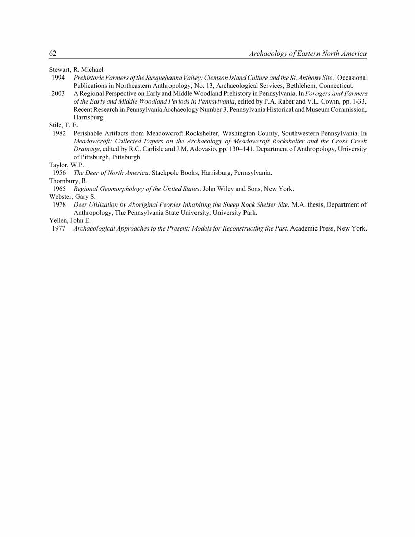
62 Archaeology of Eastern North America
Stewart, R. Michael 1994 Prehistoric Farmers of the Susquehanna Valley: Clemson Island Culture and the St. Anthony Site. Occasional
Publications in Northeastern Anthropology, No. 13, Archaeological Services, Bethlehem, Connecticut. 2003 A Regional Perspective on Early and Middle Woodland Prehistory in Pennsylvania. In Foragers and Farmers
of the Early and Middle Woodland Periods in Pennsylvania, edited by P.A. Raber and V.L. Cowin, pp. 1-33.Recent Research in Pennsylvania Archaeology Number 3. Pennsylvania Historical and Museum Commission,Harrisburg.
Stile, T. E. 1982 Perishable Artifacts from Meadowcroft Rockshelter, Washington County, Southwestern Pennsylvania. In
Meadowcroft: Collected Papers on the Archaeology of Meadowcroft Rockshelter and the Cross CreekDrainage, edited by R.C. Carlisle and J.M. Adovasio, pp. 130–141. Department of Anthropology, Universityof Pittsburgh, Pittsburgh.
Taylor, W.P. 1956 The Deer of North America. Stackpole Books, Harrisburg, Pennsylvania.Thornbury, R. 1965 Regional Geomorphology of the United States. John Wiley and Sons, New York.Webster, Gary S. 1978 Deer Utilization by Aboriginal Peoples Inhabiting the Sheep Rock Shelter Site. M.A. thesis, Department of
Anthropology, The Pennsylvania State University, University Park.Yellen, John E. 1977 Archaeological Approaches to the Present: Models for Reconstructing the Past. Academic Press, New York.
The Mykut Rockshelter, 36Hu143 63
EASTERN STATES ARCHEOLOGICAL FEDERATIONMEMBERSHIP INFORMATION
on the web at http://esaf-archeology.org
ARCHAEOLOGY OF EASTERN NORTH AMERICA REPRINT
ESAF membership ratesUS Individual, one year $30.00US Individual, 3 year $75.00non -US Individual, one year $40.00 (US funds)non-US Individual, 3 year $100.00 (US funds)US Institutional, one year $40.00 (US funds)non-US Institutional, one year $45.00 (US funds)
If the website is used to order Eastern States ArchaeologicalSociety membership, a PayPal link will appear, allowing creditcard purchase.
Membership includes Archaeology of Eastern North America (AENA) publishedannually in November, Bulletin of the Eastern States Archeological Federation, calls for
papers for the annual meeting, preliminary program for the annual meeting held inNovember, and special mailings.
A free back issue of AENA (volume 27, 28, 29, 30, 31, 32 or 33 is available with a 3 yearmembership.
For mailed-in memberships, please print off this form, indicate the membership category (andfree volume of AENA if a 3-year membership) and supply your name, mailing address and emailaddress below.Please make check payable to ESAF. Foreign memberships are limited to Canada.Checks must be in US funds and payable on a US bank. Prepayment is required.
Mail To: ESAF, P.O. BOX 386, BETHLEHEM CT 06751-0386
Name
Address
City/St-Province/Zip-Postal Code