THE MATIASSEE - Guide to Native American Pottery of South ...
434
J r r THE MATIASSEE lAKE SITES Archeological Investigations Along the Lower Santee River in the Coastal Plain of South Carolina USDI - National Park Service Interagency Archeological Services- Atlanta Special Publication - 1982 COMMONWEALTH ASSOCIATES INC. m --- - - ·.._ - -- "' - . ... -- "" --;, . I
-
Upload
khangminh22 -
Category
Documents
-
view
1 -
download
0
Transcript of THE MATIASSEE - Guide to Native American Pottery of South ...

J
r
r
THE MATIASSEE lAKE SITES
Archeological Investigations Along the Lower Santee River in the Coastal Plain of South Carolina
USDI - National Park Service Interagency Archeological Services- Atlanta
Special Publication - 1982
COMMONWEALTH ASSOCIATES INC.
m
--- -- _,.., ~T-·.._
- -- "' - ....
-~-:..-=-":""~ - -"" --;,
. I

..

THE MA 'ITASSEE LAKE SITES: ARCHEOLOGICAL INVESTIGATIONS ALONG THE LOWER
SANTEE RIVER IN THE COASTAL PLAIN OF SOUTH CAROLINA
PROJECT ARCHEOLOGISTS:
David G. Anderson Charles E. Cantley A. Lee Novick
PREPARED FOR:
THE U.S. DEPARTMENT OF THE INTERIOR ~ATIONAL PARK SERVICE
INTERAGENCY ARCHEOLOGICAL SERVICES- ATLANTA CONTRACT C54030(80)
SPECIAL PUBLICATION- 1982
BY:
COMMONWEALTH ASSOCIATES INC. 209 E. Washington Ave.- Jackson, Michigan 49201
FINAL REPORT REPORT NO. 2311 DECEMBER 1982
CONTRIBUTORS:
Gerald R. Baurn Marvin T. Smith Daniel R. Hayes William A. Lovis Randolph E. Donahue
PREPARED UNDER THE SUPERVISION OF:
David G. Anderson Principal Investigator
C. Stephen Demeter Suzanne E. Harris Michael P. Katuna Terrance J. Martin Elisabeth S. Sheldon
Funding fo r this project and the publication of the report were provided by the
Charleston District of the l: .S. Army Corps of Engineers and the
Inte ragency Archeological Services - Atlanta office of the National Park Ser vice.

lr
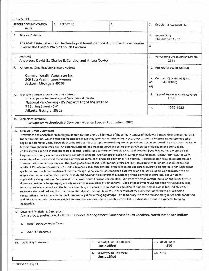
50272-101
REPORT DOCUMENTATION
PAGE
4. Title and Subtitle
1. REPORTNO. 2.
The Mattassee Lake Sites: Archeological Investigations Along the Lower Santee River in the Coastal Plain of South Carolina
Q
Author(s)
Anderson, David G., Charles E. Cantley, and A Lee Novick
Performing Organization Name and Address
Commonwealth Associates Inc. 209 East Washington Avenue Jackson, Michigan 49203
12. Sponsoring OrganizatiOn Name and Address
Interagency Archeological Services- Altanta National Park Service- US Department of the Interior 75 Spring Street- SW Atlanta, Georgia 30303
15. Supplementary Notes
Interagency Archeological Services- Atlanta Special Publication 1982
. 6. Abstract (limit: 200 words)
3. Recipient's AccessiOn No.
5. Report Date
December 1982
6.
8. Performmg Organizat1on Rpt. No.
2311
10. Project/Task/Work Unit No.
11. Contract(C) or Grant( G) No.
(C) 54030(80) (G)
13. Type of Report & Period Covered Final
14. 1979-1982
Excavations and analysis of archeological materials from along a kilometer of the pnmary terrace of the lower Santee River are summanzed.
" The terrace margin, which overlooks Mattassee Lake, a tributary channel Within the nver swamp, was 1mtially tested usmg systematiCally
d1spersed half meter un1ts. Three block units and a series of test p1ts were subsequently opened and document use of the area from the Early
Archaic through the historic era. An extensive assemblage was recovered, including over 88.000 p1eces of debitage and stone tools,
I ~
27,354 sherds, almost a metric ton of cracked rock, and lesser quantities of fired clay, charcoal, steatite, bone fragments. baked clay ball
fragments. historic glass, ceramics, beads, and other artifacts. Artifiact strat1ficat1on occurred in several areas. Eighty-four features were
encountered and excavated, the vast majority being remains of probable aboriginal fire hearths. Project research focused on assemblage
documentation and interpretation. The stratigraphic and spatial distributions of the artifacts. coupled with taxonomic analyses and the
results of 15 radiocarbon assays, are used to advance a sequence for local projectile points and ceramics, providing the basis for subsequent
synchronic and diachronic analyses of the assemblage. A previously unrecogmzed Late Woodland ceramic assemblage characterized by
simple stamped ceramics (typed Santee) was identified, and the excavations provide the first major test of extra local sequences for
applicability along the lower Santee and in the lower South Carollan coastal plaan. Outcrops of orthoquartzite occur on the lower terrace
slopes, and evidence for quarrying activity was noted in a number of components. Little ev1dence was found for either structures or long
term site use in any period. and the terrace assemblage appears to represent the accretion of numerous small camps focused on lim1ted
subsistence/related tasks and/or lithic raw material procurement. Terrace use over much of the Holocene is interpreted as reflecting
comparatively short-term visits by small, residentially mobile foraging groups. The temporary use of the t errace margi.-- for both hab1tat1on
and lithic raw matenal procurement, in th1s v1ew, was a normal, quite probably scheduled or ant1c1pated event an a general foragang
adaptation.
17. Document Analys1s a. Descnptors \ Archeology, prehistoric, Cultural Resource Management, Southeast South Carolina, North American Indians
I b. Identifiers/Open-Ended Terms
l C. COSATI Field/Group
1
18. Availability Statement 19. Security Class (This Report) 21 . No of Pages
Unclassified 435
20. Security Class (This Page) 22 . Price
Unclassified lL----------------------L----------------~------------~
S233/RDP- Page 1


ABSTRACT
Excavations and analysis of archeological materials from along a kilometer of the primary terrace of the lower Santee River are summarized. The terrace margin, which overlooks Mattassee Lake, a tributary channel within the river swamp, was initially tested using systematically dispersed half meter units. Three block units and a series of test pits were subsequently opened and document use of the area from the Early Archaic through the historic era. An extensive assemblage was recovered, including over 88,000 pieces of debitage and stone tools, 27,354 sherds, almost a metric ton of cracked rock, and lesser quantities of fired clay, charcoal, steatite, bone fragments, baked clay ball fragments, historic glass, ceramics, beads, and other artifacts. Artifact stratification occurred in several areas. Eighty-four features were encountered and excavated, the vast majority being remains of probable aboriginal fire hearths. Project research focused on assemblage documentation and interpretation. The stratigraphic and spatial distributions of the artifacts, coupled with taxonomic analyses and the results of 15 radiocarbon assays, are used to advance a sequence for local projectile points and ceramics, providing the basis for subsequent synchronic and diachronic analyses of the assemblage. A previously unrecognized Late Woodland ceramic assemblage characterized by simple stamped ceramics (typed Santee) was identified, and the excavations provide the first major test of extralocal sequences for applicability along the lower Santee and in the lower South Carolina coastal plain. Outcrops of orthoquartzite occur on the lower terrace slopes, and evidence for quarrying activity was noted in a number of components. Little evidence was found for either structures or longterm site use in any period, and the terrace assemblage appears to represent the accretion of numerous small camps focused on limited subsistence/related tasks and/or lithic raw material procurement. Terrace use over much of the Holocene is interpreted as reflecting comparatively short-term visits by small, residentially mobile foraging groups. The temporary use of the terrace margin, for both habitation and lithic raw material procurement, in this view, was a normal, quite probably scheduled or anticipated event in a general foraging adaptation.

PREFACE
This report represents an effort on the part of the Interagency Archeological ServicesAtlanta, National Park Service, to make the results of our major projects readily available to a broader scientific and interested lay public. It is also an attempt to demonstrate the significant research benefits which can accrue from contract archeology when the necessary dedication and commitment are present.
Clyde Kluckholn, in his Mirror for Man, notes how archeologists have traditionally been derided for their seemingly futile attempts to restore the past on the basis of "the contents of a small boy's overalls pocket," and he quotes Wallace Stenger's assertion that "time sucks the meaning from many things and the future finds the rind." This is the challenge we confront in every survey, every test pit, and every large scale data recovery project - to bring meaning to what Kroeber called these "fossils of the mind." David Anderson and his colleagues at Commonwealth Associates Inc. have successfully grappled with this issue at Mattassee Lake, and they are to be com mended for their work. The report represents a major contribution to the prehistory of the South Carolina coastal plain and we are proud to support its publication. It is the first in what we hope will be a continuing series of professional reports on the history and archeology of the southeast.
111
Victor A. Carbone Chief, Archeological Services National Park Service Atlanta, Georgia


FOREWORD
This report summarizes the results of nearly two years of analysis with archeological materials recovered from a series of sites along the lower Santee River in the coastal plain of South Carolina. The Mattassee Lake sites (38BK226, 38BK229, and 38BK246) extended for more than a kilometer along the terrace paralleling and overlooking the river swamp, and yielded remains from the Early Archaic through the historic era. Stratified artifact- rich deposits and well preserved features were encountered in several areas, providing an extensive body of information from which to begin examining past human use of the swamp margin and, generally, adaptations within the lower coastal plain and ultimately in the region. The sites contained a rich and varied data set. Over twenty different projectile point categories, and almost thirty major ceramic types were observed. Twenty-eight different kinds of lithic raw materials were present within the assemblage, and effective description and source identification formed a major part of the analysis. Research directed towards prehistoric lithic raw material procurement and use was enhanced by the presence of a source along Mattassee Lake itself. Extensive outcrops of orthoquartzite occurred on the lower slopes of the terrace, and the sites served as quarry/workshop areas during several periods. The quantity of material recovered -- over 80,000 pieces of debitage and 27,000 sherds - proved both challenging and exciting, since it formed one of the largest data sets ever recovered in controlled excavation from the interior of the coastal plain.
This report has a number of orientations, reflecting the status of local research, as well as goals of interest to the archeological profession in general. A major portion of the report is descriptive in nature, concerned with data presentation and the establishment of chronological sequences for the projectile points, pottery, and other categories of artifacts encountered on the project sites. . This has been necessitated by a general dearth of both excavation reports and sequence data, particularly for the Woodland period, from much of the central and lower South Carolina coastal plain. Description and chronology form only one area of the analyses reported here and the major purpose was to provide secure controls for the resolution of individual components and periods of site use. Only once temporal variability within site assemblages is recognized can more elaborate analytical efforts proceed. Orthoquartzite quarrying behavior is examined and correlates between lithic raw material procurement, use, and discard, and group subsistence and mobility patterns are explored. The investigations focus on both individual artifacts and on assemblages, in an effort to understand how the Mattassee Lake area was used in the past, and why. Strengths and weaknesses of field, laboratory, and analytical procedures are presented, to help guide subsequent researchers. Hopefully both the successes and pitfalls of the present study can prove instructive.
The Mattassee Lake report has been shaped by the work, commentary, and patient assistance of a large number of people. This help has been greatly appreciated, and wherever possible has been acknowledged. This report makes no pretense or claim to being a definitive statement on the archeology of the lower coastal plain. Hopefully, though, the ideas and information contained within these pages will shed some light on this part of the southeastern Atlantic slope.
v
David G. Anderson Principal Investigator

1
2
3
4
5
6
7
8
9
10
11
12
TABLE OF CONTENTS
Title
ABSTRACT
PREFACE - Victor A. Carbone
FOREWORD
ACKNOWLEDGEMENTS .AND RESEARCH ASSISTANCE
INTRODUCTION David G. Anderson
THE ENVIRONMENTAL SETTING OF THE MATTASSEE LAKE SITES David G. Anderson, Gerald R . Baum, and Michael P. Katuna
PREVIOUS INVESTIGATIONS Paul Brockington and David G. Anderson
RESEARCH DESIGN David G. Anderson
FIELD INVESTIGATIONS AT MATTASSEE LAKE David G. Anderson
LABORATORY ANALYmSPROCEDURES David G. Anderson, A. Lee Novick, William A. Lavis, Randolph E. Donahue, and Gerald R. Baum
THE MATTASSEE LAKE LITHIC ARTIFACT ASSEMBLAGE A. Lee Novick
THE MATTASSEE LAKE CERAMIC ARTIFACT ASSEMBLAGE David G. Anderson
OTHER ASPECTS OF THE TERRACE ASSEMBLAGE David G. Anderson, C. Stephen Demeter, Terrance J. Martin, and Marvin T. Smith
ETHNOBOTANICAL ANALYSES Suzanne E. Harris and Elisabeth Sheldon
RADIOCARBON DETERMINATIONS Irene Stehli and David G. Anderson
CONCLUSIONS: THE MATTASSEE LAKE SITES IN PERSPECTIVE David G. Anderson, Charles E. Cantley, and A Lee Novick
BIBLIOGRAPHY
vii
iii
v
xix
1
9
17
25
37
115
137
207
323
337
353
357


LIST OF TABLES
Title Page
1 THE 1979 EXCAVATION ASSEMBLAGE AT MATTASSEE LAKE: 7 SUMMARY DATA
2 ARTIFACTS AND OTHER MATERIAL RECOVERED IN THE HALF-METER 42 TEST UNITS AT MATTASSEE LAKE IN 1979: SUMMARY DATA
3 ARCHEOLOGICAL FEATURES AT MATTASSEE LAKE 50
4 ARTIFACTS AND OTHER MATERIAL RECOVERED IN THE BLOCK UNIT 53 AT SITE 38BK226 IN 1979: SUMMARY DATA
5 ARTIFACTS AND OTHER MATERIAL RECOVERED IN THE BLOCK UNIT 94 AT SITE 38BK229 IN 1979: SUMMARY DATA
6 ARTIFACTS AND OTHER MATERIAL RECOVERED IN THE BLOCK UNIT 103 AT SITE 28BK246 IN 1979: SUMMARY DATA
7 REFERENCES FOR THE IDENTIFICATION OF LITHIC RAW MATERIALS 121 FOUND AT THE MATTASSEE LAKE SITES
8 A COMPARISON OF QUARRY/WORKSHOP SITE TOOLS AND DEBITAGE 140
9 A COMPARISON OF DEBITAGE CATEGORIES OVER WORKSHOP/QUARRY 141 SITES
10 MAJOR PROJECTILE POINT GROUPS AT THE MATTASSEE LAKE SITES: 152 SUMMARY ATTRIBUTES
11 METRIC COMPARISIONS: GROUP 12, OTARRE STEMMED, AND 160 SWANNANOA
12 BIF ACE GROUP FORMULATIONS 166
13 BIF ACE/PREFORM TOTALS 166
14 UNIFACE CATEGORIES AT MATTASSEE LAKE 167
15 THE 1979 DEBITAGE ASSEMBLAGE AT MATTASSEE LAKE: 171 COUNT DATA BY RAW MATERIAL FOR ALL THREE SITES
16 DEBITAGE FROM COBBLE REDUCTION EXPERIMENT, EMPLOYING 172 MATERIALS RECOVERED FROM THE MATTASSEE LAKE MARGIN
17 AVERAGE FLAKE SIZE FOR MAJOR LITHIC RAW MATERIALS IN THE 173 1979 EXCAVATION ASSEMBLAGE
18 AVERAGE WEIGHTS FOR ORTHOQUARTZITE DEBITAGE REDUCTION 176 STAGES
ix

LIST OF TABLES (CONT.)
Title Page
19 TOOL TYPE BY RAW MATERIAL 181
20 TOOL BREAKAGE PATTERNS BETWEEN ORTHOQUARTZITE AND ALL 181 OTHER RAW MATERIALS
21 RATIOS OF BIFACIAL TOOLS TO DEBITAGE, BY RAW MATERIAL TYPES 182
22 THE PROJECTILE POINT ASSEMBLAGE AT THE MATTASSEE LAKE SITES: 182 SUMMARY MEASUREMENTS
23 THE MATTASSEE LAKE PROJECTILE PQINT ASSEMBLAGE: 183 BREAKAGE PATTERNS BY LITHIC MATERIAL
24 ORTHOQUARTZITE DEBITAGE IN THE 38BK226 ASSEMBLAGE: 184 COUNT BY REDUCTION STAGE
25 INCIDENCE OF TOOL CATEGORIES BY RAW MATERIAL AT 38BK266 189
26 BREAKAGE RATIOS OVER TOOL CATEGORIES AT 38BK226 192
27 BIFACE TO DEBITAGE RATIOS, SITE 38BK226 192
28 BIF ACE TO PROJECTILE POINT RATIOS IN THE 38BK226 BLOCK 192 UNIT ASSEMBLAGE
29 INCIDENCE OF ALL MAJOR TOOL CATEGORIES, BY LEVEL, IN THE 193 38BK226 EXCAVATION BLOCK
30 ORTHOQUARTZITE AND WHITE CHERT TOOLS, BIFACES AND DEBITAGE 194 IN THE 38BK226 BLOCK
31 WHITE QUARTZ AND ALLENDALE CHERT TOOLS, BIFACES, AND 194 DEBIT AGE IN THE 38BK226 BLOCK
32 FLOW BANDED AND PORPHYRITIC RHYOLITE TOOLS, BIF ACES, AND 194 DEBIT AGE IN THE 38BK226 BLOCK
33 PROJECTILE POINTS AT MATTASSEE LAKE: GROUP IDENTIFICATION 195 AND ESTIMATED AGE, BY SITE
34 PROJECTILE POINT BREAKAGE PATTERNS, BY LEVEL, IN THE 196 38BK226 BLOCK, MATTASSEE LAKE
35 BIFACE BREAKAGE PATTERNS, BY LEVEL, IN THE 38BK226 BLOCK, 196 MATTASSEE LAKE
36 ORTHOQUARTZITE DEBITAGE IN THE 38BK229 ASSEMBLAGE: 197 COUNT BY REDUCTION STAGE
X

LIST OF TABLES (CONT.)
Title Page
37 TOOL TYPES AND BREAKAGE PATTERN_S AT 38BK229 197
38 TOOL TYPE BY RAW MATERIAL AT SITE 38BK229 198
39 BREAKAGE RATIOS OVER TOOL CATEGORIES AT 38BK226 198
40 REDUCTION STAGE, BY LEVEL, SITE 38BK229 BLOCK 199
41 KNOWN DOMINANT EXOTICS AND ORTHOQUARTZITE DEBITAGE AT SITE 199 38BK229 BLOCK
42 TOOL CLASSES WITHIN SITE 38BK229 BLOCK 200
43 BIFACE TO DEBITAGE RATIO, BY LEVEL, SITE 38BK229 200
44 ORTHOQUARTZITE DEBITAGE, SITE 38BK246 INCIDENCE BY REDUCTION 202 STAGE
45 TOOL TYPE BY RAW MATERIAL AT 38BK246 203
46 TOOL BREAKAGE RATIOS OVER TOOL CATEGORIES AT 38BK246 203
47 REDUCTION STAGE, BY LEVEL, SITE 38BK246 BLOCK 204
48 DEBITAGE IN BLOCK ASSEMBLAGE AT 38BK246 204
49 TOOLS IN 38BK246 BLOCK 205
50 BIFACE TO DEBITAGE RATIO, BY LEVEL, IN THE SITE 38BK246 BLOCK 206
51 THE CERAMIC ASSEMBLAGE AT MATTASSEE LAKE: COUNT DATA FOR 208 ALL CATEGORIES BY SITE AND MAJOR EXCAVATION PROVENIENCES
52 STRATIGRAPHIC DISTRIBUTION OF CERAMIC ARTIFACTS, BY MAJOR 219 SORTING CATEGORIES, IN THE SITE 38BK226 EXCAVATION BLOCK
53 STRATIGRAPHIC DISTRIBUTION OF CERAMIC ARTIFACTS, BY MAJOR 220 SORTING CATEGORIES, IN THE SITE 38BK229 EXCAVATION BLOCK
54 STRATIGRAPHIC DISTRIBUTION OF CERAMIC ARTIFACTS, BY MAJOR 221 SORTING CATEGORIES, IN THE SITE 38BK246 EXCAVATION BLOCK
55 INTERIOR AND EXTERIOR COLOR, BY MAJOR SORTING CATEGORIES, 223 IN THE MATTASSEE LAKE CERAMIC ASSEMBLAGE, USING THE 1208 SHERD SPECIAL SAMPLE
56 PRIMARY AND MINOR PASTE INCLUSIONS BY MAJOR SORTING 226 CATEGORIES, IN THE MATTASSEE LAKE CERAMIC ASSEMBLAGE, USING THE 1208 SHERD SPECIAL SAMPLE
xi
57
58
59
60
61
LIST OF TABLES (CONT.)
Title
INTERIOR SURF ACE FINISH BY MAJOR SORTING CATEGORIES IN THE MATTASSEE LAKE CERAMIC ASSEMBLAGE, USING THE 1208 SHERD SPECIAL SAMPLE
POTTERY THICKNESS BY MAJOR SORTING CATEGORIES, IN THE MATTASSEE LAKE CERAMIC ASSEMBLAGE, USING THE 1208 SHERD SPECIAL SAMPLE
RIM FORM AND LIP SHAPE BY MAJOR SORTING CATEGORIES IN THE MATTASSEE LAKE CERAMIC ASSEMBLAGE, USING ALL DIAGNOSTIC RIMSHERDS
RIM LIP TREATMENT, BY MAJOR SORTING CATEGORIES, IN THE MATT ASSEE LAKE CERAMIC ASSEMBLAGE, USING ALL DIAGNOSTIC RIMSHERDS
ORIENTATION OF EXTERIOR FINISH WITH RIM, BY MAJOR SORTING CATEGORIES, IN THE MATTASSEE LAKE CERAMIC ASSEMBLAGE, USING ALL DIAGNOSTIC RIMSHERDS
230
232
236
238
240
62 COMPARISION OF AVERAGE SHERD WEIGHT IN DIFFERING EXCAVATION 242 PROVENIENCES AT MATTASSEE LAKE
63 A CERAMIC SEQUENCE FOR THE LOWER SANTEE RIVER 250
64 CHANGES IN RIM AND LIP TREATMENT OVER TIME (AS REFLECTED 292 BY ARTIFACT AND ATTRIBUTE STRATIFICATION) IN WOODLAND PLAIN, SANTEE SIMPLE STAMPED, AND CAPE FEAR FABRIC IMPRESSED WARES IN THE EXCAVATION BLOCK AT SITE 38BK226
65 BAKED CLAY OBJECT FRAGMENTS, BY EXCAVATION AREA, MATTASSEE 319 LAKE SITES: COUNT, WEIGHT, AND AVERAGE WEIGHT SUMMARY DATA
66
67
68
69
70
71
72
BAKED CLAY OBJECTS IN THE MATTASSEE LAKE BLOCK UNITS: WEIGHT BY LEVEL
FIRED CLAY, CRACKED ROCK AND CHARCOAL: WEIGHT SUMMARY DATA
CRACKED ROCK IN SITE 38BK226 BLOCK UNIT: AVERAGE WEIGHT, TOTAL WEIGHT, BY LEVEL
CRACKED QUARTZ: COUNT, WEIGHT AND AVERAGE WEIGHT
GNEISS AND STEATITE FRAGMENTS: COUNT AND WEIGHT
GNEISS: WEIGHT BY LEVEL
FERRUGINOUS SANDSTONE: COUNT, WEIGHT AND AVERAGE WEIGHT
xii
320
323
325
326
326
326
329
LIST OF TABLES (CONT.)
Title
73 HISTORIC METAL ARTIFACTS 331
74 HISTORIC GLASS AND CERAMIC ARTIFACTS 331
75 BONE FRAGMENTS: COUNT, WEIGHT AND AVERAGE WEIGHT 335
76 ETHNOBOTANICAL SAMPLES 338
77 ETHNOBOTANICAL SAMPLES: ,340 CULTURAL AFFILIATION AND FEATURE TYPES
78 ETHNOBOTANICAL MATERIAL, MORPHOLOGICAL CATEGORIES, COUNTS 342 AND WEIGHTS-MATTASSEE LAKE SITES (38BK226, 38BK229, 38BK246)
79
80
ETHNOBOTANICAL SAMPLES: WOOD CHARCOAL IDENTIFICATION BY PERCENT-MATTASSEE LAKE SITES (38BK226, 38BK229, 38BK246)
ETHNOBOT ANI CAL SAMPLES: NUMBER OF SAMPLES HAVING PINE AS MOST FREQUENT WOOD .CHARCOAL
344
345
81 ETHNOBOTANICAL SAMPLES: TOTAL CARBONIZED HICKORY NUT AND 346 ACORN REMAINS AS PERCENT OF TOTAL CARBONIZED PLANT MATERIAL
82 ETHNOBOTANICAL SAMPLES: SEED IDENTIFICATIONS 347
83 CORN COB MEASUREMENTS FROM FEATURE 21, SITE 38BK226 349
84 RADIOCARBON DATES 354
85 INCIDENCE OF PREHISTORIC CERAMIC ARTIFACTS BY TAXA 372
86 DISTRIBUTION OF PREHISTORIC COMPONENTS BY PERIOD, IN THE 374 RIVERINE AND INTERRIVERINE ZONES
87 INCIDENCE OF SINGLE AND MULTIPLE COMPONENT SITES IN THE 375 RIVERINE AND INTERRIVERINE ZONES: CHISQUARE CONTINGENCY TABLES
88 COMPARISON OF THE INCIDENCE OF PREHISTORIC CERAMIC TAXA IN 377 THE INTERIOR AND COASTAL REGIONS OF THE LOWER COASTAL PLAIN
89 OCCURRENCE OF PREHISTORIC CERAMIC TAXA AS REPORTED FROM 377 OTHER INTERIOR ARCHEOLOGICAL SITES IN THE PROJECT AREA
90 OCCURRENCE OF PREHISTORIC CERAMIC TAXA REPORTED FROM 378 COASTAL ARCHEOLOGICAL SITES IN THE PROJECT AREA
xiii


1
2
3
4
5
6
7
8
9
10
11
12
13
14
15
16
17
LIST OF FIGURES
Title
MATTASSEE LAKE SITES
19'79 EXCAVATION UNITS
TOPOGRAPHIC RELIEF
PRINCIPAL MICROENVIRONMENTAL ZONE
TYPICAL SOIL PROFILES
PRINCIPAL PREHISTORIC ARCHEOLOGICAL SITES & PROJECTS IN THE SOUTH CAROLINA AREA
PREHISTORIC ARCHEOLOGICAL SITES AND PROJECTS IN THE LOWER SANTEE -
ARCHEOLOGICAL SITES IN THE ROUTE OF THE COOPER RIVER REDIVERSION CANAL
CULTURAL SEQUENCE IN THE LOWER SANTEE RIVER AREA
SITE 38BK226
SITE 38BK229
SITE 38BK246
FEATURE REMOVAL
FIELD PHOTOGRAPHY
SITE 38BK226 - 1979 BLOCK UNIT
THE COMPLETED BLOCK UNIT- SITE 38BK226
GRIDDING OPERATIONS AT 38BK226
18-33 SITE 38BK226- BLOCK UNITS FEATURES AND PIECE-PLOTTED ARTIFACTS
34a-d FEATURES 1, 2, 4, AND 5 - SITE 38BK226
35a-d FEATURES 14, 16, 17, AND 26 - SITE 38BK226
36a-d FEATURES 28, 29, AND 32- SITE 38BK226
37a- c FEATURES 34 AND 36 -SITE 38BK226
XV
2
4
10
13
14
19
20
21
28
38
46
48
51
51
56
57
57
58-73
74
78
82
86
LIST OF FIGURES (CONT.)
Title
38a-d FEATURES 31, 45, AND 47- SITE 38BK226
39
40
SITE 38BK229- 1979 BLOCK UNIT
THE 1979 EXCAVATION BLOCK AND FEATURES 2 AND 4 IN EU1-SITE 38BK229
88
93
95
41-44 SITE 38BK229 - 1979 BLOCK UNITS - FEATURES AND PIECE PLOTTED 96-99 ARTIFACTS
45 SITE 38BK246 - 1979 BLOCK UNIT 104
46 THE 1979 EXCAVATIONS- SITE 38BK246 105
47-50 SITE 38BK246- 1979 BLOCK UNITS- FEATURES AND PIECE PLOTTED 106-109 ARTIFACTS
51a-d FEATURES 2, 5, AND 10- SITE 38BK246 110
52
53
54
55
56
57
58
59
60
61
62
63
64
65
66
THE FIELD CATALOG/ANALYSIS SHEET
LITHIC RAW MATERIAL SOURCES IN THE SOUTH CAROLINA AREA
FABRIC IMPRESSED RIMSHERDS- CLUSTER ANALYSIS DENDROGRAM
SIMPLE STAMPED RIMSHERDS- CLUSTER ANALYSIS DENDROGRAM
SIZE CATEGORIES EMPLOYED IN THE DEBITAGE SORTING ANALYSES
REDUCTION STAGE CLASSIFICATIONS
HAFTED BIF ACE GROUPS 1-3
HAFTED BIF ACE GROUPS 4-7
HAFTED BIF ACE GROUPS 8-11
HAFTED BIFACE GROUPS 12-16
HAFTED BIF ACE GROUPS 17-20
DOMINANT BIFACE TYPES
UNIF ACES AND MISCELLANEOUS HAFTED BIF ACES
CORES
PROJECTILE POINT KNAPPING EXPERIMENT
xvi
117
125
134
135
148
149
153
154
157
158
163
164
168
169
174
LIST OF FIGURES (CONT.)
Title Page
67 RELATIONSHIP BETWEEN AVERAGE FLAKE SIZE AND DISTANCE FROM 175 SOURCE
68 PRINCIPAL EXOTIC RAW MATERIAL TYPES- PERCENTAGES BY PLACE 178 OF ORIGIN
69 PRINCIPAL EXOTIC LITHIC RAW MATERIALS - PERCENT AGES BY SIZE 179 CLASS
70 AVERAGE WEIGHT OF CHERT DEBITAGE AS A MEASURE OF DISTANCE 180 TO SOURCE
71 RELATIVE PERCENTAGES BY LEVEL AND REDUCTION STAGE 185
72 A MODEL OF ORTHOQUARTZITE REDUCTION STRATEGIES 186
73 RELATIVE PERCENTAGES OF DOMINANT EXOTIC DEBITAGE 190
74 RELATIVE PERCENTAGES OF CHIPPED STONE TOOLS 191
75 SITE 38BK246-DISTRIBUTION OF ALL DIAGNOSTIC CERAMICS 210
76 STALLING'S PLAIN AND THOM'S CREEK REED PUNCTATE CERAMICS 249
77 STALLING'S AND THOM'S CREEK RIM PROFILES 253
78 THOM'S CREEK PLAIN, THOM'S CREEK INCISED, THOM'S CREEK 254 SIMPLE STAMPED AND THOM'S CREEK FINGER PINCHED CERAMICS
79 THOM'S CREEK SHELL PUNCTATE, REFUGE PUNCTATE, AND REFUGE 259 DENTATE STAMPED CERAMICS
80 REFUGE, WILMINGTON, AND DEPTFORD RIM PROFILES 267
81 REFUGE DENTATE STAMPED, WILMINGTON PLAIN, WILMINGTON(?) 274 SIMPLE STAMPED, WILMINGTON CHECK STAMPED, AND WILMINGTON FABRIC IMPRESSED CERAMICS
82 DEPTFORD LINEAR CHECK STAMPED CERAMICS 278
83 DEPTFORD CHECK AND LINEAR CHECK STAMPED AND DEPTFORD 283 SIMPLE STAMPED CERAMICS
84 DEPTFORD BRUSHED, DEPTFORD INCISED, YADKIN (?)PLAIN, 284 YADKIN (?) CORD MARKED, YADKIN (?)FABRIC IMPRESSED, AND WOODLAND PLAIN CERAMICS
85 WOODLAND PLAIN AND CAPE FEAR FABRIC IMPRESSED RIM PROFILES 291
xvii

LIST OF FIGURES (CONT.)
Title
86 CAPE FEAR NET IMPRESSED, CAPE FEAR CORDMARKED, AND CAPE 297 FEAR FABRIC IMPRESSED CERAMICS
87 CAPE FEAR FABRIC IMPRESSED AND SANTEE SIMPLE STAMPED 298 CERAMICS
88 SANTEE SIMPLE STAMPED SHERDS 305
89 CAPE FEAR, Y AD KIN (?), PEE DEE, AND ASHLEY RIM PROFILES 306
90 SAVANNAH/JEREMY(?) COMPLICATED STAMPED, SAVANNAH/JEREMY 310 JEREMY(?) CHECK STAMPED, PEE DEE COMPLICATED STAMPED, AND MISSISSIPPIAN BURNISHED PLAIN CERAMICS
91 ASHLEY COMPLICATED STAMPED, UNUSUAL CERAMIC ARTIFACTS AND 315 BAKED CLAY OBJECTS
92
93
94
95
96
97
BAKED CLAY OBJECTS, ABRADERS, ABORIGINAL AND EUROPEAN TRADE BEADS, AND COBBLE TOOLS
SITE 38BK226 BLOCK UNIT: EXCAVATION LEVELS CLUSTERED USING ALL MAJOR VARIABLES
SITE 38BK226 BLOCK UNIT: EXCAVATION LEVELS CLUSTERED USING POJECTILE POINT GROUP DATA
SITE 38BK229 BLOCK UNIT: EXCAVATION LEVELS CLUSTERED USING ALL MAJOR VARIABLES
SITE 38BK229 BLOCK UNIT: EXCAVATION LEVELS CLUSTERED USING ALL DEBITAGE AND TOOL CATEGORIES
THE MATTASSEE LAKE SEQUENCE
xviii
328
361
362
365
366
373

ACKNOWLEDGEMENTS AND RESEARCH ASSISTANCE
The analysis and reporting effort reflected in this volume has been the product of a great many individuals, whose assistance is here gratefully acknowledged. David G. Anderson served as the project principal investigator, coordinating and directing the fieldwork and much of the final analysis and report preparation. A. Lee Novick, the laboratory director during the summer 1979 excavations, joined the project full time in January 1980 and assumed responsibility for much of the lithic analysis and reporting effort. She additionally developed the cataloging procedures, providing quality control over the curation of the project records. Charles E. Cantley, the third primary member of the project team, assisted in the artifact analysis and reporting effort and, with Anderson, helped prepare much of the computer output.
Crew members during the 1979 excavations included JohnS. Cable, Stephen R. Claggett, Chevis D. Clark III, John Franzen, John Gram, David McClelland, Bill Phillips, Eric Poplin, Brett Riggs, Sam Smith and Donald Weston. Ellisa A. Novick directed the field laboratory during the April testing assisted by ·Noreen Weston. A. Lee Novick directed the laboratory during the final excavations (and afterward), assisted by Karen Chittenden. Several volunteers, all members of the Archeological Society of South Carolina, visited the project and worked on the sites for one or more days: Jimmy Beatty, Roger Kellog, Sammy T. Lee, Wayne Neighbors, John Paquet, and A. Robert Parler. Jimmy Beatty and John Paquet in particular spent several weeks on the sites, providing considerable assistance to the overall project. Members of the local professional archeological community who visited the sites and offered advice and commentary included Nancy Brock, Albert C. Goodyear III, Trisha Logan, Robert L. Stephenson (State Archeologist), Donald R. Sutherland (SHPO archeologist), and Michael B. Trinkley. The directors of the two other archeological projects associated with the Rediversion Canal, Paul Brockington and Mark J. Brooks from the Institute of Archeology and Anthropology, and Patrick H. Garrow and Thomas R. Wheaton, Jr., from Soil Systems Inc., also visited the sites with their crews, offering advice and commentary. The proximity of all of the projects, and the location of all of the field laboratories and crew quarters in St. Stephens, pr0vided daily opportunity for comparison and discussion of results.
The 1979 excavations at Mattassee Lake were greatly assisted by Youth Conservation Corps personnel provided by the U.S. Forest Service, through the cooperation of Oliver W. Buckles (YCC Camp Swamp Fox Director) and Trisha Logan (Forest Archeologist). The Mattassee Lake sites were on or adjoined portions of the Francis Marion National Forest, and each day during much of the summer excavation program a crew of from three to seven YCC members (high school students from 15 to 1 i years old) and a crew chief were available for up to six hours. This assistance, which almost doubled the crew size, permitted a tremendous amount of in-field data recovery and analysis that otherwise would not have been possible.
Artifact washing, cataloging, and bulk sorting by ·analysis categories was largely completed by the close of fieldwork. This effort was of critical importance to the final analysis, since it permitted far greater attention to assemblage measurement, as opposed to assemblage organization (i.e., processing and cataloging), after the close of fieldwork. Final sorting and organization of the collections was accomplished by Novick and Anderson, assisted by Sandy Kern and C. Jean Weir. The actual analysis and measurement of project artifacts was accomplished by Anderson, Cantley, and Novick. Specialized analyses included lithic raw material thin sectioning and descriptions by Dr. Gerald R. Baum of the Department of Geology, the College of Charleston; soils description, particle size, and pH analyses by Dr. Michael Katuna, also at the College of Charleston; a detailed ethnobotanical analysis of flotation samples from the aboriginal features by Suzanne E. Harris of Southeast
xix
Missouri State University; specialized analysis of corn fragments (Zea mays) from site 38BK226 by Elisabeth S. Sheldon, Auburn University; identification and description of historic artifacts by C. Stephen Demeter, Commonwealth Associates, Inc.; identification of historic trade beads by Marvin T. Smith, University of Georgia; zooarcheological analysis 9f all faunal remains by Terrance J . Martin, The Museum, Michigan State University; multivariate (clust~r) analyses of ceramic and projectile point data sets by Dr. William A. Levis and Randolph E. Donahue, The Museum, Michigan State University; and technical artifact photography by Daniel R. Hayes, Commonwealth Associates, Inc. Fifteen radiocarbon age determinations of charcoal recovered in thirteen aboriginal features from along the terrace were processed by Dr. Irene C. Stehli of Dicarb Radioisotope Company, Gainesville, Florida.
In the preparation of the text, A. Lee Novick prepared much of the lithic analysis results (Chapter 7}, the laboratory methods section in Chapter 6, and portions of the concluding intersite comparative summary (Chapter 12). Charles E. Cantley assisted Novick in the preparation of the lithic analysis (Chapter 7), and with the conclusions (Chapter 12). Suzanne E. Harris prepared the section on the ethnobotanical analysis, incorporating the results of Sheldon's analysis of the Zea mays (Chapter 10). Portions of the geological sections in the environmental overview (Chapter 2') were prepared by Gerald Baum and Michael Katuna; Baum additionally provided the technical descriptions of the thin sections reported in Chapter 6. Stephen Demeter prepared the historic artifact descriptions reported in Chapter 9. The results of specialized analyses conducted by Martin (faunal remains), Smith (trade beads), Lavis and Donahue (projectile point and ceramic cluster analyses), and Stehli (radiocarbon determinations) were incorporated into the text where appropriate. The balance of the text was written by David G. Anderson, who additionally integrated the various sections and contributions. Dr. John R. Kern and Mr. Donald J. Weir provided managerial review throughout the project. The report graphics were prepared by Jim Towler and Stephen R. Treichler, assisted by Sheri Swartz, Julie Brooks, and Harriet Pfitzner. The final manuscript was assembled and edited by David G. Anderson and Stephen R. Treichler. The typing effort was carried out by Dorothy A. Kelly and Garnett R. DeForest.
Draft copies of this report were formally reviewed by personnel at the Archeological Services Branch of the National Park Service, Atlanta and with the U.S. Army Corps of Engineers. In particular, the advice and commentary, at all stages of the project, of Victor Carbone, Wilfred Husted (project Contracting Officer's Authorized Representative), and James Thomson of the National Park Service -Atlanta staff, and Marc D. Rucker of the South Atlantic Division, U.S. Army Corps of Engineers, is deeply appreciated. A number of other people provided advice and commentary during both the analysis and report preparation, including Mark J. Brooks, Val Canouts, Keith Derting, Helen Haskell, and Jolee Pearson, all members of the IAA Cooper River team; together with Paul Brockington, Jeffre L. Coe, Chester DePratter, Albert C. Goodyear III, James B. Griffin, Trisha Logan, William A. Marquardt, Jenalee Muse, Wayne Neighbors, Bill Oliver, DavidS. Phelps, Robert L. Stephenson, Richard L. Taylor, Michael B. Trinkley, and Stephen Williams. The advice and assistance given by all of these people is appreciated, but as always, the interpretations presented here remain the responsibility of the authors.
XX

CHAPTER 1
INTRODUCTION
BACKGROUND TO THE INVESTIGATIONS
From March through August 1979, archeologists from Commonwealth Associates Inc., conducted extensive testing and mitigation stage excavations at three sites (38BK226, 38BK229, and 38BK246) in northeastern Berkeley County, South Carolina. The excavations, analysis, and report preparation were funded by the U.S. Army Corps of Engineers, as part of the cultural resources investigations accompanying the Cooper River Rediversion canal project. Quality assurance and overall management of the investigations were provided by Interagency Archeological Services (IAS) Atlanta, acting on behalf of the Corps of Engineers.
The sites, which yielded prehistoric artifacts and features dating from the Early Archaic through the Mississippian periods, extended for a kilometer along a low terrace overlooking the Santee River floodplain, near the town of St. Stephens. A major tributary of the Santee, Mattassee Lake, cuts through the river swamp immediately below the terrace defining the scatters, and it is for this feature that the sites were named (Figure 1). A review of the terrace setting in relation to the local and regional environment is presented in Chapter 2.
The Cooper River Rediversion Canal, now complete, connects Lake Moultrie (the old Cooper River basin) with the Santee River. As part of the environmental impact assessment associated with this project, a series of cultural resources surveys were conducted along the canal right-of-way (Asreen 1974, Brockington 1980), culminating in the 1979 excavations. The Mattassee Lake sites investigations, it should be emphasized, were only one of three large archeological projects undertaken along the canal route in 1979. The Institute of Archeology and Anthropology of the University of South Carolina conducted excavations at a series of prehistoric sites further north along the Santee (Brooks and Canouts 1982),
1
and archeologists from Soil Systems Inc., investigated two historic period plantation complexes just to the north of St. Stephens (Garrow and Wheaton 1982). The three projects combine to form an extensive record of human settlement along the middle Santee.
THE DISCOVERY OF THE SITES
The Mattassee Lake sites were originally discovered in 1977, during an intensive survey of the proposed rediversion canal right-of-way by archeologists from the Institute of Archeology and Anthropology (Brockington 1980). At the time of the 1977 survey the sites were grown up in hardwoods, although artifacts were observed in freshly cleared access roads and along a firebreak paralleling the swamp margin. Through careful surface inspection, coupled with limited testing operations, a more-orless continuous sea tter of prehistoric artifacts was detected along the terrace overlooking Mattassee Lake. Three site numbers (38BK226, 38BK229 and 38BK246) were assigned to the area within the project impact zone. Each "site" was bounded by roads or ditches bisecting the terrace, and the site areas were more-or-less arbitrarily selected, to reduce the scatter to manageable sections, rather than reflecting discrete artifact clusters. A review of the earlier archeological work on the Rediversion Canal project, and other archeological investigations in the general region, is presented in Chapter 3.
The report on the 1977 survey concluded that the three sites overlooking Mattassee Lake were potentially eligible for inclusion on the National Register of Historic Places (Brockington 1980). This finding necessitated additional cultural resources investigation, to ensure project compliance with existing environmental legislation. In late 1978, lAS-Atlanta (1978) issued Requests for Proposals for the testing of potentially significant sites and areas in the Rediversion Canal impact zone.

' ( i' \ I \ ,.
)t ~-
Source: USGS Bone au. S C IS • Quadrangle. 1943
(\
FIGURE
. MATTASSEE LAKE SITES, BERKELEY COUNTY, SOUTH CAROLINA
MATT ASSEE LAKE EXCAVATION! U.S. Army Corps of Engineers
Cooper River Red,vetSJOn C1nal PJotect

,....
,..
Interested contractors were asked to submit detailed research designs, and in early 197 9, Commonwealth was selected to test and evaluate the sites overlooking Mattassee Lake. The project research design, revised somewhat to accommodate the discoveries of the 1979 field season, is presented in Chapter 4, and field and laboratory methods used in this research are given in Chapters 5 and 6. The testing, undertaken in March and April of 1979, led to mitigation excavations on the sites from May through August, 1979. The final analysis and reporting effort, summarized in this report, occurred from September 1979 to mid-1981.
THE 1979 TESTING PROGRAM AT MATTASSEE LAKE
The 1979 testing program at Mattassee Lake occurred from March 6 through April 5, and consisted of the excavation of 144 half meter test pits systematically dispersed in a 20 meter grid over the terrace (F igure 2). The area examined, bounded by the project impact zone, encompassed the lower terrace slopes immediately back from, and overlooking, the river swamp. Sixty-four units were opened at 38BK226, 60 at 38BK229, and 20 at 38BK246. The major and minor axes of the area examined measured 1020 and 200 meters, respectively. Each half meter unit was opened in 20 em levels to sterile soil, with all fill passed through 1/4 inch mesh. All artifacts were washed, sorted, and cataloged in a field laboratory. Once the half meter pits were completed, four larger (1 x 2m and 2 x 2m) units were excavated, at unusual or high density areas within the scatter.
The information from the 144 test pits was used to prepare computer generated artifact density-distribution maps (SYMAPs), which served to graphically illustrate the occurrence of cultural materials along the terrace margin. The testing revealed a number of rich artifact concentrations characterized by midden, features and, in some areas, stratified cultural deposits. Recognizable prehistoric components spanned the Early Archaic through the Mississippian periods, · with a few comparatively recent (twentieth century) historic
3
artifacts also recovered. The most intensive aboriginal use of the terrace area appeared to be during the early through late Woodland era. The overall assemblage was dominated by orthoquartzite tools and debitage, and plain, linear check, fabric impressed, and simple stamped ceramics. The distributional evidence, and the results of a preliminary analysis of the artifacts, were used to prepare mitigation recommendations, which were evaluated by lASAtlanta and U.S. Army Corps of Engineers personnel.
THE 1979 EXCAVATIONS AT MATT ASSEE LAKE
Extensive, mitigation stage excavations were initiated at Mattassee Lake on May 29, and continued through August 12, 1979, at which time fieldwork was terminated and the assemblages removed to Michigan for analysis. The mitigation program consisted of the careful excavation of block units at three areas along the terrace, coupled with an expanded testing effort at a number of other locations, to provide clarification and additional documentation about site deposits (Figure 2).
At 38BK246, the westernmost site on the terrace, and the first excavated, a block of 10 2-meter units was opened in 10 em levels to subsoil, which all along the terrace was defined by either compact orange clay or coarse, sterile sands. All of the units in the block at 38BK246 were opened to between 40 and 50 em in depth. The block produced identifiable artifacts dating from the Middle Archaic to the later Woodland. Twenty features, defined on the basis of artifact clusters and/or charcoal stains, were detected and removed. Most of the features appeared to have been aboriginal hearths, and many had fire cracked rock, fired c lay, or fire damaged debitage in the fill. Through radiocarbon, stratigraphic, and typological analyses, most of the 38BK246 block unit assemblage was found to date to the later Woodland periods, although small quantities of earlier and later materials were also found. Two radiocarbon samples were processed from the site (Chapter 11), producing determinations supporting later Woodland use of the area. One other
SITE 38BK24S
f==========~6~0~========~ 0 1WMn~
200 400 FEET
0
SITE 38BK22g

--SITE
3 8BK226
1979 FIGURE 2
VATION UNITS EXCA
EXCAVATIONS SEE LAKE MATT AS ,
5 ot Engineers
U.S. Armv Co P Canal Project . Red•vers•on Cooper RIVer

2-meter unit was opened at 38BK246, on an adjoining ridge, to examine an area with extensive debitage noted during the testing.
At 38BK226, the easternmost site on the terrace, and the second examined, a block of 26 2- meter units was opened in 5 em levels to depths of from 30 to 65 em. The assemblage spanned the Early Archaic through the Mississippian periods, with most of the recovered materials dating from the Late Archaic to the later Woodland. The artifacts occurred in a logical superposition in the levels, although some mixing was evident. Eleven radiocarbon dates (Chapter 11) help to provide fine chronological control for the site assemblage. Fifty-six features were encountered, characterized by artifact concentrations and/or charcoal stains. Most of these features appeared to be the remains of hearths or pits, or else were concentrations of artifacts suggesting areas of accidental or intentional discard (i.e., potbusts or trash heaps). Five other 2-meter units were opened over the site, to further define concentrations of Woodland material noted during the testing.
The third block, encompassing 10 2-meter units, was opened at 38BK229, in deposits characterized by Late Archaic through Mississippian remains in a logical stratification. The block at 38BK229 was opened to a depth of 50 em, employing either 5 em or 10 em levels. Unlike the situation noted at the other two sites, only one recognizable feature was encountered in the block at 38BK229, a cluster of four Savannah River Stemmed bifaces and preforms. An appreciable proportion of the remains in the 38BK229 block occurred in association with Late Archaic sherds and bifaces, and during that period the immediate area appears to have functioned as a workshop/chipping station. Outcrops of the rna terial reduced, orthoquartzite, were observed less than 100 meters to the north, on the lower slope of the terrace. Seven other 2- meter units were opened over the site area, and two radiocarbon dates were obtained from one of them (Chapter 11), from apparent Late Archaic and late prehistoric features.
The 38BK229 block assemblage was unusual because the associated ceramics
6
included tideland/coastal wares - Thorn's Creek Finger Pinched - and Shell Punctatetypes never before detected on the Santee River or this far inland (Waddell 1965a; Trinkley 1976a). The pottery suggested direct visitation by a group or groups from the Sea Island area, probably (given the extensive chipping debris associated with the sherds) to obtain lithic raw material. A number of coastal Thorn's Creek sites, which occur from near Beaufort to just north of Awendaw, South Carolina, had yielded orthoquartzites like those found at Mattassee Lake (Trinkley 1980a). The pottery and lithic concentration found at site 38BK229 in 1979, therefore, was examined, in part, to see if it reflected a raw material procurement network previously assumed to exist by inference.
The final field program at Mattassee Lake, therefore, consisted of 46 two meter units opened in three blocks, and 13 others excavated singly or in groups of two or three elsewhere along the terrace. The isolated units were invariably opened around half meter pits excavated during the testing phase, usually in locations characterized by probable features or high artifact density.
THE NATURE OF THE MATTASSEE LAKE ASSEMBLAGES
Well over 100,000 artifacts were recovered during the 197 9 excavations at Mattassee Lake, together with over a ton of cracked rock and fired clay, several dozen soil samples, and 110 flotation samples. The total assemblage, briefly summarized in Table 1, proved both extensive and challenging over the analysis and reporting effort. The materials are discussed first category by category in the various chapters, and then taken together.
The excavation assemblages in all three blocks exhibited evidence for stratification, although some mixing of the deposits was apparent. This stratification was evident -when bifaces were examined on a level- by-level basis. At 38BK226 , where 5 em levels were employed, the upper two levels consistently produced small triangular bifaces, the next two a variety of small stemmed and triangular forms, while

TASL.E 1
THE 1979 EXCAVATION ASS018LAGE AT AATTASSEE LAKE: SLH1ARY OATA
Site Sit e Site Ca tegor~ ~ 388K229 388K246 Total
Orthoquartzi te Oebltage 36,979 23 ,1 73 21 ,642 81,794
Exoti c Oebit.a9e 4,545 658 213 5,416
Projectile Poin ts 311 127 39 477
Other Tools and Cores 263 233 141 637
Pottery 17 ,003 6,772 3,579 27,354
Baked Clay Objects 39 28 164 231
Steatite
Cracked Quartz 501 264 296 1,061
Ferruginous Sandstone 622.4g 98. 7g 172.7g 893.8g
Bone 155 23 28 206
Fired Clay 3,460.6g 1,42S.Og 3,679.6g 8 .565.2g
Cracked Rock 550,566.0g 278,086.0g 90,392.6g 919,044.8g
Features 56 8 20 84
Area Examined 140m2 79m2 49 .. 2 268m2
recognizable Late Archaic, Middle Archaic, and Early Archaic bifaces occurred in logical superposition in the levels below these. A similar patterning was evident at 38BK229, where first triangular, then stemmed and triangular Woodland forms, and finally Late Archaic types were recovered with increasing depth. Little evidence for pre-Late Archaic components was recovered in the 38BK229 block, however, unlike the pattern noted at 38BK226. The third block, at 38BK246, produced an almost pure Woodland biface assemblage, although the few earlier and later forms recovered were also in a logical superposition.
Debitage was the most common artifact in the 1979 excavations, with over 87,000 pieces and 24 raw material categories recovered. Much of the assemblage consisted of locally occurring orthoquartzite, but materials from sources up to 100 miles away or more were also present in the assemblage. Criteria for the identification of these raw materials, including an e.>r;tended discussion of probable source areas, is given in Chapter 6. Over 1000 chipped stone tools were recovered in the units, including projectile points, bifaces,
unifaces, utilized flakes, spokeshaves, and flake blanks, together with a number of formal cores. All lithic artifact categories are described and discussed in Chapter 7. Specific projectile point types recovered during the 1979 excavations at Mattassee Lake included Palmer Corner Notched; Guil-ford Lanceolate-like forms; Morrow Mountain-like forms; Savannah River Stemmed; and a range of stemmed and t riangular Woodland forms. Several previously undescribed categories were recognized within the assemblage, and are discussed in Chapter 7.
The ceramic assemblage at Mattassee . Lake encompassed many of the types cur
rently documented from the South Carolina Coastal Plain. Like the bifaces, the pottery was also found in a logical stratification in the excavation deposits, although again some mixing was evident. Thorn's Creek ceramics, comparatively common in the assemblage, were consistently the deepest (earliest) in the units. Surprisingly, only a few Stalling's fiber tempered sherds were recovered (at about the same depth as the Thorn's Creek material), although the ware has been reported from a number of other sites along the Santee (Anderson 1975a). The Thorn's Creek wares were overlain by Refuge ceramics, typified by dentate stamping, although other apparent Refuge f inishes present included plain and punctate. Closely related to the Refuge wares, and apparently only slightly later in time, were Wilmington ceramics, characterized by fabric impressed, simple stamped, plain, and linear check stamped finishes. The Refuge and Wilmington ceramics were overlain by Deptford plain, brushed, incised, simple stamped, and linear check stamped types, with linear check stamped the most unambiguous Early Woodland ware present in the assemblage. Ceramics dating to the later Woodland, and stratigraphically higher than the Deptford wares, included sand tempered plain, cord and fabric impressed wares. The most recent ceramics were characterized by check, simple, and complicated stamped finishes, reflecting late (terminal?) Woodland and Mississippian period site use. Of particular importance, a previously unrecognized simple stamped ware (typed Santee Simple Stamped) was identified, and securely dated to the Late Woodland by both
7

radiocarbon and stratigraphic analyses. Prior to the work at Mattassee Lake simple stamped ceramics found in the South Carolina area were typically assigned to the Early Woodland, which has undoubtedly produced a biased view of prehistoric settlement in the region. . A sequence for the wares found on the terrace, encompassing descriptive and stratigraphic information, is presented in Chapter 8. One additional category of ceramic artifacts recovered from along the terrace, baked clay objects, are also discussed in this chapter.
Other categories of artifacts recovered from the sites, and examined here, included worked steatite, grooved stone abraders, cobble tools, and historic glass, metal, and ceramic artifacts, including four trade beads. A number of potentially modified materials, or materials that are probable by-products of human behavior, were also recovered and investigated, including cracked rock, fired clay, cracked or split quartz pebbles, ferruginous sandstone fragments, and gneiss. All of these materials are examined in Chapter 9. Prehistoric subsistence information, consisting of bone fragments and charcoal from the general levels, and from 110 flotation samples taken primarily from features, was also recovered and is discussed in Chapters 9 and 10. A series of 15 radiocarbon age determinations, processed by Dr. Irene C. Stehli of the Dicarb Radioisotope Company, are summarized in Chapter 11. The final chapter of the report provides a synthesis of the analysis and research, including a period-byperiod discussion of the past human occupation of the lower Santee, drawing on material from this and other sites.
DISPOSITION OF THE ARTIFACT ASSEMBLAGE
All of the artifacts, field and analysis notes, photographs and slides, computer decks, and a copy of the final report have been curated at the Institute of Archeology and Anthropology at the University of South Carolina. All of the currently known artifact and analytical assemblages from the Mattassee Lake sites, therefore, are located at one repository.
8
A comprehensive Data Appendix Volume (Anderson et al. 1982) has been curated with the project assemblage, and with copies of the final report at a number of institutions, including lAS - Atlanta, the Charleston Museum, and with the - Charleston District of the U.S. Army Corps of Engineers. The Data Appendix Volume, which additionally serves as a formal catalog for the assemblage, includes detailed descriptions, measurements, and summary information for all artifact categories recovered during the 1979 excavations. Site maps, and detailed level-by-level floorplans depicting all artifacts and features within the block units are included in this volume, together with detailed information on the project soils, radiocarbon and ethnobotanical analyses. Attributes of all formal tools, and of the special ceramic sample, are reported by category and catalog number. Following guidelines established by Sabloff (1980) for American Antiquity, all artifact illustrations prepared for this project include catalog numbers. The data in the Appendix Volume are designed to complement, and document, the information and conclusions presented in this report, and should prove a useful source of comparative information, as well as permit additional analyses of the site assemblages in the future.
While additional materials from these sites may exist in private collections, these would be difficult to locate and document effectively. Given the almost total alteration of the terrace margin during the construction of the Rediversion Canal, information reported on here is as near to complete a record of the site assemblages as is currently possible to produce.
CHAPTER 2
THE ENVIRONMENTAL SETTING OF THE MATT ASSEE LAKE SITES
As we went up the River, we heard a great Noise, as if two Parties were engag'd against each other, seeming exactly like small Shot. When we approach'd nearer the Place, we found it to be some Sewee Indians firing the Canes Swamps, which drives out the Game, then taking their particular Stands, kill great Quanti ties of both Bear, Deer, Turkies, and what wild Creatures the Parts afford (John Lawson on the lower Santee River, January 1701, reported in Lefler 1967:17).
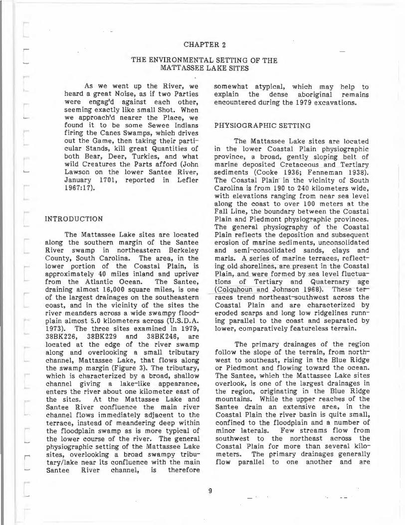
INTRODUCTION
The Mattassee Lake sites are located along the southern margin of the Santee River swamp in northeastern Berkeley County, South Carolina. The area, in the lower portion of the Coastal Plain, is approximately 40 miles inland and upriver from the Atlantic Ocean. The Santee, draining almost 16,000 square miles, is one of the largest drainages on the southeastern coast, and in the vicinity of the sites the river meanders across a wide swampy floodplain almost 5.0 kilometers across (U.S.D.A. 1973). The three sites examined in 1979, 38BK226, 38BK229 and 38BK246, are located at the edge of the river swamp along and overlooking a small tributary channel, Mattassee Lake, that flows along the swamp margin (Figure 3). The tributary, which is characterized by a broad, shallow channel gtvmg a lake-like appearance, enters the river about one kilometer east of the sites. At the Mattassee Lake and Santee River confluence the main river channel flows immediately adjacent to the terrace, instead of meandering deep within the floodplain swamp as is more typical of the lower course of the river. The general physiographic setting of the Mattassee Lake sites, overlooking a broad swampy tributary/lake near its confluence with the main Santee River channel, is therefore
9
somewhat atypical, which may help to explain the dense aboriginal remains encountered during the 1979 excavations.
PHYSIOGRAPHIC SETTING
The Mattassee Lake sites are located in the lower Coastal Plain physiographic province, a broad, gently sloping belt of marine deposited Cretaceous and Tertiary sediments (Cooke 1936; Fenneman 1938). The Coastal Plain in the vicinity of South Carolina is from 190 to 240 kilometers wide, with elevations ranging from near sea level along the coast to over 100 meters at the Fall Line, the boundary between the Coastal Plain and Piedmont physiographic provinces. The general physiography of the Coastal Plain reflects the deposition and subsequent erosion of marine sediments, unconsolidated and semi- consolidated sands, clays and marls. A series of marine terraces, reflecting old shorelines, are present in the Coastal Plain, and were formed by sea level fluctuations of Tertiary and Qua ternary age (Colquhoun and Johnson 1968). These ter races trend northeast-southwest across the Coastal Plain and are characterized by eroded scarps and long low ridgelines running parallel to the coast and separated by lower, comparatively featureless terrain.
The primary drainages of the region follow the slope of the terrain, from northwest to southeast, rising in the Blue Ridge or Piedmont and flowing toward the ocean. The Santee, which the Mattassee Lake sites overlook, is one of the largest drainages in the region, originating in the Blue Ridge mountains. While the upper reaches of the Santee drain an extensive area, in the Coastal Plain the river basin is quite small, confined to the floodplain and a number of minor laterals. Few streams flow from southwest to the northeast across the Coastal Plain for more than several kilometers. The primary drainages generally flow parallel to one another and are

~ ....
5 FOOT CONTOUR INTERVALS
0 400 800 FEET
1979 0.5m Test Units • 1979 Block Units
Note: Contour Information courteay of U.S. Army Corps of Engoneers
FIGURE: . TOPOGRAPHIC RELIEF IN THE
VICINITY OF MATT AS SEE LAKE' MATTASSEE LAKE EXCAVATIONl:.
U.S. Army Corps of Engoneers Cooper RIVer Red1versaon Canal Projec ·
separated by poorly drained, somewhat und iff eren tia ted terrain. ·
The Santee has an extremely broad floodplain, up to several kilometers across, and the river swamp is one of the most extensive in the southeast. Away from the river the terrain is relatively flat and featureless. Typically the interriverine area of the lower Coastal Plain is well to poorly drained, and is dominated by either broad flats or by swampy depressions locally called holes or bays. Some of these swamps extend over fairly large areas, with small patches of higher ground, or islands, within them. Recent research by Brooks and Scurry (1978) has demonstrated that prehistoric use of the interriverine area of the lower Coastal Plain focused on the higher, better drained areas (see also Scurry and
. Brooks 1980; Herold and Knick 1979a, 1979b). Between the sea islands and estuaries along the coast and the lower Coastal Plain in the vicinity of the Mattassee Lake sites the terrain is extremely swampy. The extent of accessible dry land and aboriginal exploitation patterns appear to have been related to fluctuations in sea level (e.g., Brooks et al. 1979,1980; Brooks 1980; Brooks and Scurry 1978), and Larson (1980: 16) has suggested that the variegated swampy terrain may have inhibited travel and communication between the sea islands and the interior.
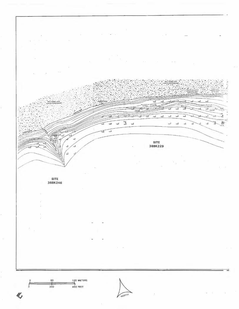
THE LOCAL SETTING: GEOLOGY AND MICROENVIRONMENT AL ZONES
The Mattassee Lake sites are located along the face of a prominent alluvial ter ·race demarcating the southern margin of the Santee River swamp (Figure 4). This terrace varies in width from 200 to 400 meters in the area of the sites, and corresponds to the 30 foot contour in Figures 3 and 4. An additional alluvial terrace, at approximately 20 feet in elevation, separates Mattassee Lake from the Santee River. This lower terrace, an elongated ridge or interfluve, corresponds to the general elevation of the floodplain surface in this area and therefore probably represents the modern terrace of the Santee River. This terrace has been extensively disse~ted by
the lateral migration of the river channel. The upper (30 foot) alluvial terrace demar eating the sites, however, is considerably older and represents a change in the regimen of the stream. The age of this terrace is not known, but appears to be the result of changes in the base level of the river, probably corresponding to the glac ial and interglacial phases during the Pleistocene, and concomitant fluctuations in sea level. The archeological record at the Mattassee Lake sites, consisting of remains from the Early Archaic through the Mississippian in primary context, indicates that the terrace must predate these occupations, and be of Late Pleistocene or earlier age. Borings conducted by the Corps of Engineers during planning for the Rediversion Canal indicate
- that there is approximately 10 feet of Quaternary alluvial ·sediments overlying Tertiary deposits of the Thanetian Black Mingo Formation, in the area of the Mattassee Lake sites. The Quaternary deposits vary from loose quartzose to argillaceous sands and unconsolidated clays. Much of the upper terrace and floodplain deposits associated with the Santee reflect the reworking of the underlying· Tertiary formations, with the addition of some materials during the Pleistocene and Holocene.
11
Four general microenvironmental zones occur in the vicinity of the Mattassee Lake sites, defined on the basis of soils and topography, and are illustrated in Figure 4. The first major zone, the lowest in elevation, corresponds to the Santee River channel and swamp, characterized by clayey alluvial floodplain sediments of the Tawcaw soil series (Long 1980:29). This zone is dominated by tupelo and cypress of the southern floodplain forest (Kuchler 1964:113), and supports a fairly high density of exploitable mammals, birds, and reptiles such as turtles and snakes. Larson (1980:57), in an estimate of animal populations in southern floodplain forests, fortuitously chose the lower Santee River near St. Stephens. He calculated that roughly 1800 deer and 396 turkeys could be found along a ten mile stretch of the floodplain. The main channel of the river, in contrast, was interpreted as having only small am·ounts of exploitable fish resources, due to the continuous fluctuation in water level and an absence of aquatic flora (Larson
1980:55). Economic species that were present included channel catfish, gar and, seasonally, anadromous blueback herring.
The second major environmental zone in the vicinity of the sites is the Mattassee Lake area itself. This zone includes both Mattassee Lake and the lower reaches of the Mattassee Branch, a swampy tributary channel entering the lower reaches of the lake (Figure 4). The tributary/lake is an unusual topographic feature within the flood plain, and potentially a rich source of food resources:
the greatest number of fish species and the largest quantity of fish occur in the small Coastal Plain tributaries of the major rivers, as well as in flooded portions of the backswamps, in oxbow lakes, and in small streams that drain these floodplain features (Larson 1980:55-56).
The vegetational community is essentially identical to that within the river swamp, characterized by gum and cypress. The soils in the Mattassee Lake area are slightly different, however, in that they are more poorly drained due to the proximity of the lake. Game animals probably occurred in both the river swamp and along the lake in comparable densities in the past, and it is primarily the greater potential for aquatic resources that sets the two zones apart.
The third microenvironmental zone defines the sites themselves and corresponds to the first or primary terrace margin overlooking the river/lake swamp. This area is characterized by higher, somewhat better drained soils than the river swamp, and is dominated by a mixed hardwood pine forest. The lower reaches of the terrace drop quickly to the floodplain, and in the vicinity of the Ma ttassee Lake sites, in places, there is a low bluff oq.e to three meters high at the terrace margin. _ Large cobbles and boulders of orthoquartzite occur along the bluff edge, and the area appears to have been exploited prehistorically for lithic raw materials. These lower areas tend to have more water tolerant species, such as tupelo. The higher areas on the terrace grade from hardwoods to a mixed hardwood pine forest. The climax vegetational community along
12
the terrace appears to have been an oakhickory-pine mixture (Kuchler 1964; Braun 1950), although the proportions of each species undoubtedly changed over time.
The fourth major microenvironmental zone in the area of the Mattassee Lake sites consists of the moderately to well-drained upland areas roughly corresponding to what Asreen (1974) calls the "flatwoods" and Larson (1980) the "pine barrens." In the general site area the uplands immediately away from the terrace are characterized by moderately well-drained sandy soils and a mixed hardwood-pine forest, with pines dominating the more excessively drained areas. Much of the occurrence of pines in the area appears to reflect timber management. Prehistorically, a more diversified situation existed in the interstream areas, with a mosaic of hardwoods, conifers, mixed communities, and in some areas treeless savannahs and bogs (cf. Brockington 1980:8-14; Anderson and Logan 1981).
SOILS IN THE EXCAVATION AREA
Several distinct soil zones have been identified in the Mattassee Lake area (e.g., Long 1980), and their distribution closely conforms to local topographic and drainage features. The soils on the terrace grade from poorly drained floodplain sediments in the lower areas to better drained, fine sandy loams on the upper slopes and crest. The 1979 excavations focused on the middle slopes of this zone, from roughly 20 to 60 meters from the terrace/floodplain margin. A series of soil samples were collected from across the units, to provide information about general soil conditions in the vicinity of the excavation assemblage (Figure 5). The soil profiles from the excavation units were quite homogeneous along the terrace, reflecting a roughly similar depositional environment. The soils consisted predominantly of gravelly sandy loams, gravelly loamy sands, and sandy loams. The percentage of gravel sized ·material varied from unit to unit and with depth, but was quite high. This was an unexpected occurrence, since large gravels are not typical of the site soil classes (Long 1980:14,17-21). These coarser fractions were basically quartzose in composition

0 300 600 METERS
0 1000 2000 FEET
~ 0
50 a c :l E 40 !I MIX EO HARDWOODS -0 PINE UPLANDS - FOREST f;
30 ~
Longleaf, loblollv p~ne.
E h•ckorv, while Oolk, pon
c 20 oak, red ook 0
'" ~ w 10
0 500 1000
E:;t:::'£;3 1:.~ ··:,::, (:ll!JJ
!.:.·.·.·········:.;.;.;.:.:, 1\11 \II IIIII
TERRACE
Santee River Swamp Mattassee Lake/Mattassee Branch Swamp First Terrace Margin Well Drained Uplands Prehistoric Archeological Site
I MARGIN I MATTASSEE LAKE SWAMP I SANTEE RIVE R SWAMP
1500
O•Jtanct ln feet
Tupelo gum, bald oyprw
2500 3000 3500 4000
FIGURE 4
PRINCIPAL MICROENVIRONMENTAL ZONES
MATT AS SEE LAKE EXCAVATIONS U.S. Army Corps o f Engineers
Cooper Rwer Redlvers•on Canal PtOJO'Ct

0
MATTASSEE LAKE
NORTH END OF PROFILE
EU8
2 3 4 5
EU12 EU9
6 7
EU6
8 meters
RIDGE CREST
50 em
100 em SOUTH END OF PROFILE
Note: Taken from the srte 38BK226 block umt EU's 8, 12, 9 and 6 combined east w all profile.
(veruca1 scale 2x horizon1aiJ
PARTICLE SIZE BREAKDOWN
LARGE MEDIUM FINE COARSE MEDIUM SAMPLE GRAVEL GRAVEL GRAVEL SAND SAND
1 0.0% 0.8% 5.9% 18.3% 18.6% 2 1.8% 0.8% 8.2% 24.7% 24.6% 3 0 .7% 1.6% 10.2% 27.4% 26.6% 4 0.3% 1.6% 9.9% 29.5% 29.8% 5 0.6% 5.0% 17.7% 20.5% 17.3% 6 0.0% 0.8% 4.7% 17.2% 21.0% 7 0.0% 0.4% 5.2% 16.0% 18.0% 8 0.0% 0.4% 5.0% 16.8% 16.3% 9 0.0% 0.2% 3.3% 11.9% 18.1%
10 0.5% 0.7% 2.3% 7.4% 8.9%
SOIL DESCRIPTION
1 Reddish Brown (5 YR 5/3) Sandy Loam 2 Brown (7 .5 YR 5/2) Gravelly Sandy Loam 3 Light Brown (7 .5 YR 6/4) Gravelly Sandy Loam 4 Light Yellowish Brown (10 YR 6/4) Gravelly Sand 5 Grayish Brown (10 YR 5/2) Sandy Loam 6 Light Yellowish Brown (10 YR 6/4) Sandy Loam 7 Brownish Yellow (10 YR 6/6) Sandy loam 8 Reddish Yellow (7.5 YR 6/6) Silt loam 9 Very Pale Brown (10 YR 7/3) Sandy loam
10 Brownish Yellow (10 YR 6/6) Loam
FINE SAND
11.1% 12.1% 11.8% 12.1% 6.2% 19.9% 18.2% 14.6% 21.7% 12.8%
VERY FINE SAND SILT CLAY
4.2% 4.1% 3.8% 4.0% 6.2% 7.5% 5.6% 3.2% 8.5% 4.1%
27.0% 18.1 % 16.3% 10.8% 19.9% 27.3% 35.7% 42.5% 51.5% 41.5%
pH: 4.5 pH: 4.5 pH: 5.0 pH: 5.5 pH: 4.5 pH: 4.5 pH: 4.0 pH: 4.0 pH: 4.5 pH : 4.0
14.4% 5.6% 1.6% 2.0% 12.6% 1.6% 0.9% 1.2% 4.8% 21.8%
FIGURE ! TYPICAL SOIL PROFILE:
MATT ASSEE LAKE EXCAVATION·
U.S. A rmy Corps of Engmeers Cooper A1ver Rediversion Canal Pro1ec1

with considerably high concentrations of detrital heavy minerals in the finer-grained fractions. Examination of the horizontal distribution of these gravels across the terrace, and their incidence stratigraphically (Chapter 9), indicates that most of them derive from cultural (aboriginal) agencies, probably the result of stones brought onto the site for use i·n fires and in raw material reduction.
In general, the soils in the excavation units at Mattassee Lake were more clayrich near the surface and became sandier with increasing depth. No noticeable changes in soil characteristics were observed between the sampling locations, which were located all along the terrace. The soils typically varied from an organic rich reddish brown to brown in color near the surface to a mottled light yellowish brown and brownish yellow with depth in the soil profile. The acidity of this soil varied between pH 4.0 and 6.5, with the organic surficial layers generally more acidic.
GEOLOGY AND GEOMORPHOLOGY IN THE MATT ASSEE LAKE AREA
The lower terrace margin along Ma ttassee Lake is characterized by large cobbles and boulders of orthoquartzite, and the area appears to have functioned as a quarry prehistorically. During the excavations a tremendous quantity of· orthoquartzite cracked rock and debitage was recovered, as well as minor quantities of over 20 other lithic raw materials. Source areas and criteria for identifying these sources, accordingly, were examined in some detail (Chapter 6). This topic has been the subject of some study in the South Carolina area in recent years, with much of the research focusing on materials originating in the Piedmont (e.g., Novick 1978; Weisenfluh 1978), or from chert sources along the Savannah and Congaree Rivers (Anderson 1979a,1979b). While the occurrence of chert and orthoquartzite outcrops in the vicinity of the lower Santee River has been noted (Anderson, Lee and Parler 1979:11-12), the nature of these sources has not been examined in any detail. It is apparent, however, that gross constituents, such as rna trix m inerological structure and
associated (fossil) faunal assemblages, can be used to differentiafe the sources or source areas of (potentially) knapable materials within this portion of the Coastal Plain; this finding (discussed below) is of considerable value in the interpretation of local site assemblages.
In the vicinity of the Mattassee Lake sites, along the middle Santee, three formations outcrop: the Thanetian Black Mingo Formation, the middle Eocene Santee limestone, and the upper Eocene Cross Formation (Cooke 1936; Baum et al. 1980). The Black Mingo Formation has been loosely used for units of formational rank which range in age from Danian (lower Paleocene) to Thanetian (upper Paleocene) to Ypresian (lower Eocene). The Thanetian Black Mingo Formation, which underlies the Mattassee Lake sites, consists of three lithofacies, in ascending stratigraphic order: a nonmarine claystone; a marginal marine quartz arenite (sandstone); and an overlying marine, pelecypod-mold biomicrudite (limestone) (Baum et al. 1980; Powell and Baum 1981). In certain areas, these three lithofacies are replaced and/or cemented by opal, chalcedony and chert. Knapable materials, of value to prehistoric populations, may occur in these locations, and outcrops of both chert and orthoquartzite have been reported (Anderson, Lee and Parler 1979:11-12). These sources, furthermore, should be distinguishable from one another, at least between major formations, b.y differences in constituent allochems. Such separation cannot be guaranteed in every case, however. Extreme replacement by silica tends to obliterate the original sedimentary textures and allochems (principally biologic allochems), which can render source identification difficult in the case of at least some transported materials. In general, though, this is not a great problem, since (potentially diagnostic) fossils are common in local materials.
15
The middle Eocene Santee limestone consists of two faunal zones: the lower Cubitostrea lisbonensis zone; and the overlying Cubitostrea sellaeformis zone (Baum et al. 1980:22). Both faunal zones consist of twodominant lithofacies: bryozoan biosparrudite (limestone) and bryozoan ciomicrudite (limestone). Although not as common

as in the Thanetian Black Mingo Formation, these lithofacies of the Santee limestone can be replaced and/or cemented by opal, chalcedony and chert. Small pockets of (knapable) chert are possible occurrences, and minor outcrops have been reported, notably from the area to the north of Lake Marion (e.g., Anderson, Lee and Parler 1979:11). In areas to the west, in contrast, the Santee Limestone has a diatomaceous lithofacies, and chert deposits are improbable.
Along the Middle Santee, the upper Eocene Cross Formation is at its updip limit and thus has a very limited distribution. The dominant lithofacies of the Cross Formation is a pelecypod-mold biomicrudite (limestone). This lithofacies has never been noted to be silicified and, hence, is unlikely to contain sources of knapable stone.
Both the Santee Limestone and Thanetian Black Mingo Formation outcrop along the Santee River. The unconformable contact between the two formations is at the low watermark of the river. Approximately 50 feet of the Santee Limestones were penetrated in cores drilled south of Lake Marion (western Berkeley County) and Jamestown (northern Berkeley County) (Baum et al. 1980). The latter core penetrated approximately 10 feet of the pelecypod-mold biomicrudite lithofacies of the Thanetian Black Mingo Formation. In contrast, in all of the cores drilled by the U.S. Army Corp of Engineers in the vicinity of St. Stephens (Berkeley County), the Santee Limestone was absent. The Thanetian Black Mingo Formation was directly overlain by fluvial sediments of late Quaternary age. The contact between the Thanetian Black Mingo Formation and fluvial sediments in the cores is approximately at the same elevation as the contact between the Thanetian Black Mingo Formation and the Santee Limestone along the Santee River. These relationships would suggest that at one time the Santee River meandered further to the south (vicinity of St. Stephens) than its present course suggests and eroded deeply into its southern channel margin. As a consequence, the Santee Limestone was eroded away and fluvial sediments were deposited. This is directly relevant to the present study, since
the surface exposure and erosion of the Thanetian Black Mingo Formation along this portion of the river prompted the extensive aboriginal quarrying behavior noted in the site assemblages.
CONCLUSIONS
Archeological remains in the general Mattassee Lake area appear, on the basis of current survey data, to be concentrated along the terrace overlooking the river/lake swamp (Asreen 197 4; Brockington 1980). This, as we have seen, is the richest and most diversified of the four microenvironmental zones recognized in the general area. The Mattassee Lake sites, viewed by themselves, are relatively uncomplicated, with minimal evidence for extended settlement (e.g., Chapter 12). Archeological sites are also located further to the east on the terrace, however, opposite the confluence of Mattassee Lake with the Santee River, on slightly pigher ground (Figure 4). A large, multicomponent Early Archaic through Mississippian site, 38BK83, is located in this area and appears to reflect extensive, complex use. Some of the aboriginal remains along Mattassee Lake, therefore, may reflect a concurrent use of both areas, possibly with more extended settlement on the higher ground (at the confluence) and shorter duration activities along the lake margin (in the vicinity of the 1979 excavations). The nature of aboriginal site use and settlement at Mattassee Lake, and its relationship to both local and regional enironmental conditions, formed a major part of the project research design (Chapter 4).
16

CHAPTER 3
PREVIOUS INVESTIGATIONS
INTRODUCTION
Detailed summaries of archeological research in the South Carolina area ha-ve appeared in recent years, encompassing the entire state {Stephenson 1975), the Coastal Plain {Anderson 1977), and the sea island area (Trinkley 1980a). Principal archeological sites in the South Carolina area are shown in Figure 6. In addition, detailed cultural resource overviews summarizing and synthesizing prehistoric and historic archeological investigations have appeared for the Cape Romain National Wildlife Refuge (Wright 1978; Anderson and Claggett 1979), the Santee National Wildlife Refuge {Anderson, Newkirk and Carter 1979), and the Francis Marion National Forest {Anderson and Logan 1981). These latter overviews correspond to the portions of the lower Coastal Plain immediately to the north of, to the south of, and including the Mattassee Lake/Rediversion Canal project area, respectively. The reviews provide extensive documentation of previous archeological investigations along the central and lower Santee River, material that does not need to be duplicated here. What is relevant, however, is a close examination of past investigations in the immediate project area, and at the Mattassee Lake sites, to provide a perspective for the 1979 excavations.
The general overviews, particularly that for the Francis Marion National Forest, which encompasses the project area, document that a considerable amount of archeological field research has taken place in the vicinity of the lower Santee River in recent years. The location and references for past projects in this part of the lower Coastal Plain are illustrated in Figure 7.
ARCHEOLOGICAL SURVEY FOR THE REDIVERSION CANAL PROJECT: THE 1974 RECONNAISSANCE
Archeological investigations associated with the Rediversion Canal project
17
began in 197 4, with a reconnaissance level survey along the right-of-way {Asreen 197 4). The reconnaissance was conducted by archeologists from the Institute of Archeology and Anthropology. Dr. Leland G. Ferguson served as the project director and principal investigator, and was assisted by Robert Asreen and David G. Anderson, then Research Assistants on the Institute staff. The proposed canal route ran from near Russellville on Lake Moultrie, across Berkeley County north of the town of St. Stephens, to the Santee River. In the vicinity of the river, the canal swung south and ran parallel to the main channel for several miles along the terrace margin, before emptying into Lake Mattassee, a tributary of the Santee. The area examined was approximately nine miles long and 500 feet wide.
Forty-four archeological sites were discovered, and two were tested, with the results used to provide recommendations for subsequent investigations. The survey was accomplished by a two person team, on foot, over a period of three weeks. General surface collections were made, with no shovel testing conducted. After the completion of the survey two sites {38BK76, 38BK83) were tested. Four 3-foot test units were opened at 38BK76, and two 5-foot units at 38BK83. This latter site, 38BK83, is located less than a kilometer east of the Mattassee Lake sites and on a slightly higher terrace, at the confluence of the lake with the river (Figures 3,4). Well preserved, relatively undisturbed ·deposits were found at both sites. A range of prehistoric components (including a small Mississippian period shell midden) were documented at 38BK83, and both historic and prehistoric components were found at 38BK76.
The canal route at the time of the initial survey ran to the north of Mattassee Lake, through the river swamp, and the area of the three sites reported here (388K226, 38BK229 and 38BK246) was not examined. The initial Rediversion Canal survey demonstrated that both prehistoric and early

historic occupation in the project area was most intensive along the Santee River terrace, with markedly less use of the pine barrens, or flatwoods away from the river (Asreen 1974:11-12). Complete excavation of three endangered sites (38BK76, 38BK83, and 38BK84) was recommended, together with additional testing at nine other sites. All of the records and artifacts from the 1974 survey were curated at the Institute, where they have been repeatedly examined in the course of subsequent investigations.
THE 1977 INTENSIVE SURVEY ALONG THE CANAL ROUTE
After the original cultural resources reconnaissance was completed in 197 4, the proposed route of the Rediversion Canal was altered slightly, necessitating addi tiona! cultural resource investigations. An intensive archeological survey over the entire revised right-of-way was conducted during 197 7 and 19 7 8, by archeologists from the Institute (Brockington 1980). Dr. Paul Brockington served as principal investigator, and directed field operations. The purpose of the survey was to locate, evaluate, and prepare mitigation recommendations for all sites affected by the project. Site evaluation was to be conducted in terms of National Register criteria, with mitigation recommendations advanced for all sites found eligible for inclusion on the National Register of Historic Places.
Fieldwork occurred from June through early September 1977. The entire project impact zone was surveyed on foot, including areas covered during the 19 7 4 reconnaissance. Shovel tests were employed throughout the project area, along standardized transect intervals whenever ground visibility was poor. When sites were discovered a general surface collection was made, with periodic shovel tests placed in areas of poor visibility. In addition to the 44 sites previously located during the reconnaissance, another 23 sites were located during the 1977 survey, including the three sites along Mattassee Lake investigated and reported here. In all, 66 sites were found within the project direct impact zone (Figure 8). Additional testing was recommended at 14 sites with large scale excavation recommended at
18
eight. An additional recommendation noted that a slight modification of project activity would preserve one additional site. All sites for which large scale excavation was recommended were considered eligible for inclusion on the National Registe~, and three of them, 38BK226, 38BK229 and 38BK246, formed the complex along Mattassee Lake examined in this report.
The report on the 1977-1978 intensive archeological survey along the Rediversion Canal route (Brockington 1980) produced a considerable amount of information on the prehistoric and historic human occupation of the middle Santee drainage. Among other things, it provided additional confirmation of the intensive use of the terrace area throughout all periods. At a closer level, Brockington's investigations at the Mattassee Lake sites are extremely relevant to the present report. His descriptions of the fieldwork at each site, and the results of a preliminary analysis and interpretation of the assemblages, follow. The text, taken from the final report on the Rediversion Canal survey (Brockington 1980), has been edited slightly to conform to this report.
THE DISCOVERY AND TESTING OF 38BK226 (adapted from Brockington 1980:67-70)
This large, multicomponent site was discovered in the cleared and graded area of the tailrace access road approximately 120 meters north of 38BK225. The access road terminates at the crest of a low ridge or terrace directly facing Lake Mattassee and the Santee Swamp to the north. This ridge, which is parallel to the swamp, is separated by a small, intermittent stream from the higher ridge to the south containing site 38BK225. Artifacts were discover.ed on the surface of the graded road and along a preexisting, but enlarged, road extending along the ridge to the west from the terminus of the tailrace access road.
Subsurface transect testing in the wooded area east of the access road showed artifacts present on this

VIRGINIA ~ /"'-..
-··ruiNES'See-·· --··-- ··-- ··-'"··r··-··-··-··-··--··---~~:~~!tAROliNA··---···· ~ --·· ··~ 4 ··-
o·
R. ~~~ •• ~~· f;>\.\NI'~ ~c.:~ 3•
-·~-R~\"\ 0 I
_.f"··'l .. / WINSTON -SALEM
2. War,.n Wilson 3. Oonnaha 4. G.uton 5. HlwRiva a. H41dlwov 7. Doend>ult 8. TownC<wl< 9. SC 151 Survey ICabio ....., C.nlley 19791
10. Com1l N.C. SuJVr; !South 111601 11. Mulbefry 12. 1·77 Su,...,. Windy Ridg• 13. Columbia Belrway Sites 14. Edenwood 15. Thorn's Creek 16. Tlylor
17, Laurtns·Anderson Survey IGoodytlr.
Hou$t, and Ad<.erlv. 1979) 18. Ric:hatd 8. Russell Reservoir 19. Watlac. Reservo1r 20. Stalling's Island 21. Savannah RWer Plltlt 22 Theriault 23. Rabbit Mount
24. CaiS~k 25 Fon W11tson
A TLANTIC OCEAN
26. Mattassee Lake/Red~VffSion C.f\fll S•ttl 27 s.w.. 28. HugH 29. PalmTret 30. Suatton Placa 31. ltghlhouM Poent 32, ChJtle1 Towne Landing 33. Ban Pond 34. SJ>~nish Mount 35. D•w"s l~a<ld 36. Plndr;nt~y lll1nd 37. Reluge l and II 38. Irene 39. Dept fOfd 40, Wilmington hhmd 4 1, Ouabaw h l1nd (Pn.-son 19771 42, S1. Catherine's Island (Thomu and Utsen 1910) 43. Sapello 44, St. S•mon's lsl.an<S tMarnNn 1975} 45. Tabtt POJft1 •&. Macon Plltuu
FIGURE 6 PRINCIPAL PREHISTORIC ARCHEOLOGICAL SITES AND PROJECTS
50 100 MILES
~ IN THE SOUTH CAROLINA AREA,
AS REPORTED IN THE LITERATURE MATTASSEE LAKE EXCAVATIONS
U.S. Army Corps of Englnee•s Coope1 R1ve.r Rediverslon Conal Pro,ect

~
( '\DARLINGTON ,...J
// ) / .,
/( LEE /
/ FLORENCE / l... /'
~-,
RICHLAND
SUMTER
ORANGEBURG 1se
HAMPTON ,A ~
COLLET ON
\. ""~ 2_j) .,, .
JASPER (
) JL
7i BEAUFORT
,.... 76
J 77• e75
e74
\.\~\ /r
l-- //\ / .... ---r"' • 20
CLARENDON
CHARLESTON
J '\__ /' \......v-...... __ ___.
( ----\ I WILLIAMSBURG 1
MATTASSEE/,; LAKE SITES
I
/ ! J
/ GEORGETOWN
ATLANTIC OCEAN
(See next page for site designations.)
FIGURE 7
PREHISTORIC ARCHEOLOGICAL SITES AND PROJECTS 0 8 16 MILES
~ VICINITY OF THE LOWER SANTEE RIVER,
AS REPORTED IN THE LITERATURE MATTASSEE LAKE EXCAVATIONS
U.S. Army Corps of Engoneers
Cooper Ri ver Rediversoon Canal PtOJOCt

FIGURE 7
1. Byrd Trust (South 1973a) 2. Mulberry (Ferguson 1974) 3. Crane Creek (Ferguson 1976) 4. Taylor, Edenwood (Michie 1971, 1979) 5. Congaree Creek Sites (Anderson 1979a) 6. Thorn's Cree~ (Griffin 1945, Michie 1969) 7. 38RD158 (Brooks & Scurry 1980) 8. Buyck's Bluff (Michie 1980a) 9. Congaree Swamp (Michie 1980a)
10. 38CL4 (Teague 1972) 11. Wateree-Orangebury 230 kV (Smith 1977) 12. Allen Mack (Parker and Lee 1981) 13. S-84 (Trinkley 1978a) 14. Cal Smoak (Anderson, Lee, and Parler 1979) 15. Horse Range Swamp (Ferguson and Luttrell 1973) 16. Fort Watson (Ferguson 1975a) 17. Santee National Wild I ife Refuge (Anderson, New-·
kirk and Carter 1978) 18. Pintail Island (Ferguson 1973) 19. Power Lines (Herold and Knick 1979a) 20. Lake City (Drucker and Anthony 1978a) 21. Cooper River Rediversion (Garrow and Wheaton
1982) 22. 38BK235, 38BK263 (Brooks and Canouts 1982) 23. Rediversion Canal Survey (Asreen 1974, Brocking
ton 1980) 24. Low Ridge and Deer Field (Kellar, Burnhardt, and
Garrow 1979) 25. Spier's Landing (Drucker and Anthony 1979a) 26. Cross Generating Plant (Herold and Knick 1978,
1979a, 1979b) 27. Highway 52 Widening (Asreen 1975) 28. U.S. Forest Service (Zierden 1980a, 1980b) 29. Jeffries 230 kV (Anderson, Claggett and Newkirk
1978) 30. U.S. Forest Service (Zierden 1980b, 1980c, Logan
1980i) 31. U.S. Forest Service (Logan 1980c, 1980d) 32. U.S. Forest Service (Logan 1979c) 33. U.S. Forest Service (Logan 1980e) 34. U.S. Forest Service (Zierden 1980f) 35. U.S. Forest Service (Logan 1980a) 36. U.S. Forest Service (Logan 1980b, Muse 1981 b) 37. U.S. Forest Service (Logan 1980f, Muse 1981a) 38. U.S. Forest Service (Dorian and Logan n.d., Logan
1979c) 39. U.S. Forest Service (Logan 1979a, Muse 1981c,
Zierden 1981a)
40. Ardea Site (Edwards 1964) 41. Jeremy Island (Trinkley 1980a) 42. Intra-Coastal Waterway Survey (Williams and
Garrow 1980) 43. U.S. Forest Service (Muse 1980a) 44. U.S. Forest Service (Logan 1979d, Muse 1980b,
Z ierden 1981 b) 45. Walnut Grove (Muse 1980b, Trinkley 1981b) 46. U.S. Forest Service (Logan 1979a) 47. Sewee (Edwards 1965) 48. Moore's Landing (Anderson and Claggett 1979,
Wright 1978) 49. U.S. Forest Service (Muse 1981c) 50. Charity 230 kV (Anderson, Claggett and Newkirk
1980) 51. U.S. Forest Service (Muse 1981c, Logan 1979d) 52. Huger (Widmer 1976b, Green and Brooks n.d.) 53. U.S. Forest Service (Logan 1979a, Zierden 1980c) 54. U.S. Forest Service (Logan 1979b, Zierden 1980d) 55. East Cooper R R (Widmer 1976b) 56. U.S. Forest Service (Logan 1979c) 57. Wastewater Survey (Lees and Michie 1978) 58. Mt. Holly Alumax (Popl in et al 1978) 59. Palm Tree/Amoco (Widmer 1976a, Brooks and
Scurry 1978, Hartley and Stephenson 1975, Herold, Knick and Liss 1978)
60. U.S. Forest Service (Muse 1981c) 61. Stratton Place (Trinkley 1980a) 62. Williams-Mt. Pleasant 230 kV (Wood 1977) 63. Bellevue (Scurry and Brooks 1980) 64. Mark Clark Expressway (Trinkley and Tippett
1980, Trinkley 1978) 65. I nnerbelt (House and Goodyear 1975) 66. Fort Johnson (South and Widmer 1976) 67. Charles Towne Landing (South 1971) 68. Lighthouse Point (Trinkley 1980a) 69. Bass Pond (Michie 1979b) 70. Fig Island (Hemings 1972) 71. Spanish Mount (Sutherland 1973, 1974) 72. Locklair Airport (Anthony and Drucker 1980) 73. Lake Plantation (Griffin 1943) 74. Port Royal Survey (Michie 1980b) 75. Daw's Island (Michie 1973a, 1974) 76. Victoria Bluff (Widmer 1976c) 77. Pinkney Island (Drucker and Anthony 1980a,
Trinkley 1981a)


i RUSSELLVILLE
\ I
• Archeological Site === Modified Canal Right-of-Way -·- Transmission Line .. . . ... Dike
Source: Brockington 1980:36 .
SANTEE
0 5000FEET
FIGURE 8
ARCHEOLOGICAL SITES IN THE ROUTE OF THE COOPER RIVER REDIVERSION CANAL
extension of the ridge also. Ten test pits were excavated at 38BK226. These included a 2 foot test and a .5 foot test in the cleared road area, as well as a one-meter square, two 50 ern squares, and five 25 ern tests east of the access road. In addition, three 25 ern tests were excavated to the west of the access road to supplement the surface collection from that area.
In all, 38BK226 was determined to extend east-west along the Lake Mattassee bluff-ridge for over 700 meters. Opportunistic inspection of roads and trails, as well as subsurface transect testing indicate that along this 700 meter length the site reaches a maximum width of about 100 meters at the access road, tapering to a width of about 30 meters at the eastern and
21
MATTASSEE lAKE EXCAVATION U.S. Army Corps of Engrneers
Cooper A rver Aodlversion Canal Project
western ends. In addition, 38BK226 may be related to and may have once been continuous with 38BK229 immediately to the west. The gap between these two sites contains a large drainage ditch and adjacent area heavily disturbed by bulldozers. This disturbance could account for the lack of artifacts discovered be tween the two sites. 38BK226 may also be re lated to the prehistoric occupations at 38BK225 to the south.
Woodland and Mississippian occupations are represented in the collection from 38BK226. The 256 sherds that were recovered from the surface of the entire site are all sand tempered. Representative of the Woodland period are 10 puncta ted sherds (Thorn's Creek phase), 8 check
stamped sherds (Deptford phase), 29 fabric marked and 7 cord marked sherds (Cape Fear phase). A Mississippian period occupation is indicated by 3 complicated stamped sherds, as well as by the discovery of, in 1 of the 2 test squares excavated in the tailrace access road, a glass trade bead indicative of early historic trade with late Mississippian period groups. Indeterminant as to Woodland or Mississippian periods were 41 simple stamped sherds, 1 dentate stamped sherd, 47 plain sherds and 90 worn sherds.
Lithic artifacts were numerous, although not so numerous or in such a high proportion relative to ceramics as at 38BK225. Lithic remains recovered from 38BK226 include 1 chert and 6 sandstone projectile points, 1 quartz and 6 sandstone bifaces, 2 sandstone unifaces, 1 chert and 1 sandstone flake tool and 2 quartz cobble hammerstones. Sandstone flakes recovered from the site number 139, of which 80 were of the specialized type produced in biface reduction. Two chert flakes of biface reduction were also discovered. None of the lithic artifacts was diagnostic of cultural period, although the projectile points are all small and appear to be representative of either the Woodland or Mississippian period. One small bone bead completes the inventory of artifacts recovered from 38BK226.
38BK226 lies completely within the project rightof-way and will be almost entirely destroyed by construction of dikes and disposal areas to the east and west of the access road terminus. A boat ramp planned for construction to the northeast of 38BK226 may also impact the site and as stated above, a large portion of the site has already been destroyed by construction of the access road. What was perhaps the part of the site with the highest artifact density is now destroyed by the access road, with the only recovered information being the artifacts discovered on its disturbed surface and in two small test pits there. 38BK226, before its partial
22
destruction, was probably eligible for the National Register because of its size, artifact density, range of cultural components and the significant information it could thus provide for study of prehistory of the Southeastern Coastal Plain.
Much of 38BK226 remains undisturbed at this time, however, and a large excavation and study are recommended to mitigate the damage that has been and will be done to the site. Such excavation should be done in two phases. First, a large number of small, sampling squares should be arranged over the site and excavated so as to provide a detailed picture of the patterns of occupation at the site over different time periods. Particular attention in this phase should be given to attempting to isolate house clusters or other activity areas. Some degree of internal temporal patterning at the site is evident in the survey data (e.g., Thorn's Creek phase materials were clustered at the eastern end of the site, while Cape Fear phase sherds occurred mostly in the center). This internal patterning should be more evident in the first stage intensive sampling excavations and should allow the placement of second stage, large block excavations at areas determined to be significant from a temporal or behavioral standpoint. Using this approach, it should be possible to determine whether the site represents a large village that was occupied relatively permanently or a series of small, successive occupations.
The second stage large block excavations should be located to maximize discovery of houses and other features so as (1) to gather faunal and floral data to provide information on seasonality and subsistence; (2) to recover architectural and population size data; and (3) to examine closely the indications of ordinary day-to-day behavior that occurred near houses (Brockington 1980:6 7-70).

The testing program and block unit excavations recommended by Brockington closely paraUel the actual investigations conducted in 1979.
THE DISCOVERY AND TESTING OF 38BK229 (adapted from Brockington 1980:71-72)
A large, multicomponent ecotone site, 38BK229 is located along the bluff or terrace slope facing Lake Mattassee and the Santee Swamp directly to the north. The site covers an area approximately 400 by 60 meters and has a high artifact density revealed by subsurface transect testing and opportunistic observation of ground disturbed by recent cutting of firebreak ditches. Potsherds recovered from the site were relatively large, often measuring 7-8 em in diameter and indicating little previous disturbance in the approximate 30 em of deposit. Eight 25 em square tests were excavated at the site. Six of these were placed at 60 meter intervals along the east-west extent of the site and 2 additional tests were excavated at the site's southern edge. These tests indicate that about 10 em of humus overlies approximately 20 em of yellow sandy loam. Underlying this sandy loam is a matrix of yellowish sandy clay. Artifacts occur in the top two strata.
Occupations at the site may be related to those at 38BK246 and 38BK241 to the west and 38BK22_6 to the east. The site lies completely within the project area and will be entirely destroyed by dike and disposal area construction.
Woodland and Mississippian period components are represented at 38BK229. A Woodland occupation is indicated by 27 fabric marked, sand tempered sherds (Cape Fear phase) and 16 check stamped, sand tempered sherds .(Deptford phase). Indicative of Mississippian occupation at the site are 15 sand tempered, complicated stamped sherds. These Mississippian
23
potsherds are large in size and were found concentrated in a 60 meter transect segment at approximately the eastwest center of the site. Indeterminant as to cultural period are 42 simple stamped, 12 plain and 77 worn sherds, all sand tempered. Lithic artifacts recovered from the site could have been manufactured during either or both of the Woodland and Mississippian periods. These lithics include 7 small projectile points, 7 bifaces and fragments, and 1 uniface, all of sandstone. Sandstone flakes recovered from 38BK229 number 165, of which 70 were the specialized flakes of biface reduction. One quartz cobble hammerstone completes the artifact inventory at the site. Observed, but not collected from the site, were numerous tabloid sandstone chunks exhibiting no evidence of modification, several pieces of fire-cracked rock and several small shell fragments.
The artifact sample from the site, consisting of a total of 181 lithics and 189 sherds, is indicative of a high artifact density when it is considered that only a small percentage of the site was examined using the subsurface testing and opportunistic survey. An intensively occupied village or continually reoccupied camp is indicated for both the Woodland and Mississippian components. The site surely contains detailed culture-history, subsistence and demographic data relative to the Woodland and Mississippian periods and thus would be eligible for the National Register.
It is recommended that excavations at 38BK229 be performed to mitigate the impact of project construction. These excavations should be carried out in two stages. First, a large series of small sampling excavations that are arranged so as to gather precise data about internal variation within the site should be made. Concentrations, activity areas and hopefully, house clusters, should be isolated by this approach. Evidence described above indicates that one concentration of the Mississippian

occupation has been already isolated. These concentrations should then be excavated in large blocks during a second phase of the field study •••.
The proposed study program should be designed to answer archeological and anthropological questions in several problem domains for which 38BK229 offers a unique opportunity of contributing to knowledge of Southeastern prehistory. First, cultural historical problems can be solved by proper isolation, excavation and comparison of temporally distinct components at the site. Precise relationships between Deptford and Cape Fear phase rna terials should be revealed if activity or occupation areas from these groups can be isolated. These relationships have long been a problem in Southeastern prehistory and materials from 38BK229 could aid in the solution. Second, little is known of the house types, demography, subsistence and ordinary behavior of Coastal Plain Woodland and Mississippian peoples. 38BK229 represents a unique, well preserved set of data for investigating these aspects of prehistoric life. Third, very few sites have been discovered that contain such evidently intensive occupations by both Woodland and Mississippian groups. 38BK229 may be very significant in analyzing and understanding the factors involved in the shift in lifeways of peoples of these two time periods. In summary, 38BK229 is a very significant site because of its potential contribution to prehistory in several different ways. Mitigation study of this site is strongly recommended (Brockington 1980:71-72).
Once again, as at 38BK226, the 1979 field program proved to be a microcosm of the original recommendations.
THE DISCOVERY AND TESTING OF 38BK246 (adapted from Brockington 1980:80)
Ten sandstone flakes and 2 sand tempered, fabric marked _potsherds
24
were recovered from 4 25-cm square subsurface transect tests at this ecotone zone site. The site appears to cover an oval area approximately 90 by 45 meters along the bluff overlooking the Santee swamp to the north. A small creek lies 120 meters to the northwest, and Lake Mattassee is 120 meters to the northeast, making the high ground of 38BK246 a favorable location for settlement during the Woodland period, Cape Fear phase.
A large and complex site, 38BK229, lies 60 meters to the east of 38BK246 and its Cape Fear component is almost certainly related to that component at 38BK246. It may be that 38BK246 represents a specialized activity of a larger village at 38BK229 or perhaps, simply an outlying house or group of houses. Preservation is good at 38BK246 with cultural materials restricted to the top 30 em of soil and subsoil.
It is recommended that close monitoring of 38BK246 be carried out during initial construction at the site area. In this way any features revealed can be quickly recorded and studied (Brockington 1980:80).
CONCLUSIONS
The results of the 1977 and 1978 testing operations at Mattassee Lake were used to prepare the 1979 testing and mitigation operations. It is inter.esting to compare the results of the 1977 work and recommendations with the subsequent investigations. The Ma ttassee Lake area, after 197 7, was believed to hold major research potential, and to perhaps include the remains of structures and possibly villages. The 197 9 fieldwork reaffirmed the research potential, but encountered little evidence for structures, or for extended site use.

CHAPTER 4
RESEARCH DESIGN
INTRODUCTION
The Mattassee Lake analysis and reporting effort focused on a series of general and specific goals and research topics, which are reviewed .here in some detail. Most of the topics raised in this chapter were develop.ed and included in the project research design, which was submitted to lAS - Atlanta in late 1978. Due to continued archeological activity in the Coastal Plain, however, by 1981, when this report was prepared, at least some of the arguments had become dated. Some work was necessary, therefore, to bring the discussions up to date, although in a few areas, notably the specific research questions, the research design remains unchanged. The arguments raised under the general questions, however, do reflect a fairly extensive revision of the original research design.
Since the completion of the Mattassee Lake fieldwork, a detailed archeological overview and general research design has been prepared for the lower Santee River area (Anderson and Logan 1981). This document, encompassing the historic and prehistoric cultural resources in and near the Francis Marion National Forest, provides a regional perspective to local site specific research, such as that conducted at Mattassee Lake, or in the innumerable recent survey and testing projects that have recently occurred in the area, as reported in Chapter 3 (Figure 8). Much of the discussion presented here, in the Mattassee Lake research design, reflects a modification of the arguments raised in the original proposal, to accommodate not only the results of the fieldwork itself, but also recent research and the broader perspective advocated in the overview document. What are advanced here, it is argued, are a series of both site specific research questions and general problem areas that any archeological project occurring in this part of the South Carolina Coastal Plain should consider.
25
SPECIFIC RESEARCH QUESTIONS
Five specific research topics were examined at each of the Mattassee Lake sites, to help define the local assemblages and the evidence for aboriginal use of the area. These questions included:
Question I
Question II
Question III
Question IV
Question V
What are the major period(s) of occupation?
Are discrete components/ behavioral events recognizable within the site?
Is selection for particular raw materials indicated by functional categories of stone tools? By component?
Why was each site selected for occupation or use?
What is the nature of subsistence activity for each site component?
In addition to these specific questions, a number of general topics were proposed in the project research design. These topics, discussed in the following pages, helped guide the Mattassee Lake analysis and reporting effort.
DESCRIPTIVE INVENTORY FUNCTIONS
A major goal of the project was the effective documentation of the archeologi-cal assemblages encountered along Mattassee Lake. Primarily an inventory function, this encompassed the preparation of descriptive information about site location, content, and general environmental associations. Detailed descriptions of the excavations, analysis procedures, and each site and its contents, are included in this report. Additionally, a comprehensive Appendix Volume (Anderson et al. 1982) documents the analysis activity and data
assemblage. The reason that such an apparently atheoretical topic as inventory activity is placed first in the general research design, follows from several grounds.
Careful and complete documentation of field and laboratory activity should be the responsibility of every professional archeologist. Effective documentation of data collection and analysis procedures, and results, provides the archeological community with the information necessary to evaluate or expand upon project work. In the present example, there is one very compelling reason why documentation is important: very little is known about the archeological resources along the lower Santee River, or from this portion of the South Carolina Coastal Plain. While there has been extensive small-scale activity (e.g., Figure 7), with limited exception (e.g., Brooks and Scurry 1978; Trinkley 1980a; Anderson and Logan 1981) there has been little attempt at synthesis. Any detailed report on the archeological resources that occur in the area, therefore, would be of considerable value. The Mattassee Lake assemblages represent the first extensive collections recovered in stratified context from along the lower Santee River. As such, the final report on the work will inevitably be used as a baseline in future investigations, particularly in the areas of typology, chronology, and assemblage composition (general seque.nce definition). Of the more than 300 archeological sites recorded in the state site files for Berkeley and Georgetown Counties, furthermore, over half are poorly documented, possessing minimal information about site location, condition, content, or age. A large number are the products of· informant interviews, and have never been visited, collected, or described by a professional archeologist. Refinement of the local sequence is essential to their accurate interpretation and comparison. Since site information is the basis upon which all subsequent archeological research is built, it is important that these data be as well-documented as possible. Recent investigations in the lower Coastal Plain, the general setting of the Mattassee Lake sites, have stressed the importance of accurate site records to the development of areal or diachronic analyses (e.g., Brooks and Scurry 1978; Brooks 1980).
26
CULTURAL HISTORICAL RESEARCH ·QUESTIONS
A second major goal of the Mattassee Lake project, closely linked with the inventory functions described above, was to provide a descriptive synthesis of the collected site data from a cultural historical perspective. This would indicate, generally, what was found, when sites were occupied, and how the new information corresponded to existing interpretive frameworks about human occupation in the area. In conjunction with the development of a general cultural historical overview, project information was examined in relation to two specific questions: (1) the Santee River "cultural boundary" problem and, (2) the evaluation of existing taxonomic· frameworks.
1. The Santee River "Cultural Boundary" Problem (adapted from Anderson and Logan 1981)
The Santee River and river swamp may have been an imposing geographical boundary to prehistoric occupants of the Coastal Plain. In the vicinity of Mattassee Lake, the Santee swamp is several miles wide; travel across the swamp would in all probability have been more difficult, even given dugout canoes, than up and down one side of the river, or the other. Group territories and travel patterns may, therefore, have tended to orient between or along drainages rather than across them, although this is a topic of debate in parts of the southeast (c.f., Morse 1975,1977; Schiffer 1975). A question to be asked of the project data set, encompassing as it does sites along the Santee, was whether or not evidence existed for the operation of the river as a cultural barrier during the prehistoric era. The occurrence of distinctive ceramic or stone tool forms on each side of the drainage, for example, might suggest such an effect.
On a more general level, the existence of a major aboriginal cultural boundary in the vicinity of central South Carolina has long been noted. Swanton (1946), for example, placed the contact period boundary between speakers of the Muskhogean and Siouan language families, the two

primary linguistic· groups in the southeast, along and just to the south of the Santee River. At the time of European contact, speakers of these two stocks exhibited differences in sociopolitical complexity, material culture, and subsistence orientation (Swanton 1946:10; Speck 1935,1938), with the northern Siouan groups generally less complex than the Muskhogean groups to the southwest. While the evidence for the Santee as the exact "boundary" zone is ambiguous, there is little argument in the extant ethnohistoric literature about the basic linguistic and adaptational differences between Contact period groups to the north and south of this area (cf. Swanton 1946,1952; Hudson 1976; Waddell 1980).
Evidence for a major cultural boundary in the Coastal Plain of South Carolina, both for the contact era and further into the past, is suggested by several lines of evidence. Ethnohistoric accounts, referenced above, st~nd -as the primary source of support for this inference, at least for the Santee River area. Through the investigation of protohistoric sites (cf. Stephenson 197 5), however, the archeological correlates of the ethnohistoric record can be directly examined. Work of this kind has been initiated; Trinkley (198lc,198ld), for example, has recently noted Siouan characteristics on protohistoric ceramics from two sites near Georgetown, at Wachesaw Landing and Yauhannah. The prehistoric archeological record also supports the inference that the South Carolina area is at the interface of two major traditions. The distribution of South Appalachian Mississippian mound- and ceramic sites, for example, effectively ceases with the Pee Dee drainage (Ferguson 1971,1975b), and differences in the ceramic assemblages to the northeast and southwest of the general SanteePee Dee region have long been noted. The occurrence of a cord and fabric marked (wrapped paddle) ceramic tradition in the northeast and a stamped carved paddle ceramic tradition to the southwest, for example, has been examined for almost a century (Holmes 1903; Coe 1952:307- 309; Evans 1955:142; Sears 1956:76; Caldwell · 1958:32,51; South 1960:72-73,1972; Ferguson 1971,1975b; Anderson 1975a:187-189).
The Mattassee Lake sites are located on the southeast side of the lower Santee drainage. Comparison of artifact assemblages on opposite sides of the river might document possible prehistoric "boundary effects." One would anticipate, for example, a lower incidence of carved paddle ceramics on the northeast side of the river, and a higher incidence of wrapped paddle ceramics, than on the southeast side. Minor
_ differences are, in fact, expected, given the general trends in the distribution of these technologies. If no differences are noted, or major differences; this would help, alternatively, refute or support the idea of a "boundary." From a larger perspective, an increase or decrease in the occurrence of particular categories of artifacts, as one proceeds from the northeast to the southwest in this part of the Coastal Plain, might additionally indicate potential directions and degrees of cultural mixing or attenuation (cf. Anderson 1975a).
27
2. The Evaluation Of Existing Taxonomic Frameworks (adapted from Anderson and Logan 1981)
In the vicinity of the lower Santee River ceramic and projectile point taxonomies provide the basic means for identifying and dating prehistoric sites. The basic cultural sequence for the lower Santee River area, as of 1980 (prior to the completion of the Rediversion Canal analyses), is illustrated in Figure 9. This sequence, constructed in the near-absence of reported excavation data from the lower Santee River area, was (predominantly) based on the crossdating of local artifacts with their more securely established counterparts elsewhere in the region. While a number of investigations have provided information about specific periods, notably the Late Archaic (e.g., Trinkley 1975,1980a), and the Early/Middle Woodland (South and Widmer 1976; Scurry and Brooks 1980; Dorian and Logan 1979), the basic sequence at the time of this report remained untested. Through work at stratified sites like those at Mattassee Lake, however, it should be possible to greatly refine existing taxonomies and sequences, for projectile point, ceramic, and other artifact classes.

STAGES
2000AO . (.) • a: 0 .... (/) : J:. z• ~£~ 1500AO
Mississippian a.. Ci5 (/)
Ci5 (/)
IOOOAO ~~~ Late Woodland
soo .. o
Cl z <(
Middle ...J
Woodland Cl AD 0 ec 0
?!:
500BC
Ear1y Woodland . .
i IOOOBC
Late Archaic
3000BC (.)
~ J:
Middle (.) Archaic CI:
<(
5000BC
7000BC Early . ArchaJc .
6 z ~
<(
0 <(
~-PRIOR TO I-a.. 9000BC
Note: The Culturel SeQuence lor the lower Santoe Rtvlt Are1 . SoulM C:.rollne. at env•s•oned '" 1980 IAdeotea from Anderson and Logan 1981 , Fogure 71.
CULTURAL COMPLEXES
AMERICAN NATIONAL
BRITISH COLONIAL
SPANISH COL. ASHLEY/YORK
PEE DEE/IRENE
SAVANNAH/ JEREMY
CAPE FEAR/ HANOVER
DEPTFORD
REFUGE
THOM'S CREEK! STALLINGS
GUILFORD
MORROW MOUNTAIN
KIRK
PALMER
DALTON
CLOVIS
GENERAL TRENDS
Forestry/Industrial Development
Plantation Agriculture Permanent Euro·African
Settlement Decline & Extirpation of
Native Groups
Initial European Contact
Mississippian Chiefdoms (Intensive a~ricultural/
ceremonia centers)
Intensive Ex~loitation of both the stuary &
the Interior
Introduction of Bow & Arrow
Intensified Use of Inter-riverine Zone
Hunt~/Foraglng/ H !culture
Introduction of "Northern" Cord/
Fabric Pottery Tradition
Beginnin~s of "South A&palachian' Carved Paddle
tamped Ceramic Tradition
Intensive Estuarine Adaptation (Coastal
Shell rings & middens)
First Appearance of Pottery
lncreas1ng Localization of Resource Exploitation
Residentially Mobile Hunting/ Foraging Strategies
Rivenne·onented Adaptations
Post-glac1al Readaptahon
Logistically· based Hunting/ Collecting Strateg1es
Decline of Megafauna
Initial Human Occupation
KEY DIAGNOSTIC I
REPORTED SITES ARTIFACTS
Drayton Hall l Spier's Landing Vaughan' Cumboo' Fort Moultrie Hampton•
European ceram1cs. metal. I Umerick' Chartes Towne
pipestems. glass
Santa Elena
Fort Watson Mulbeny Complicated stamped pottery. I Small triangular projectile pts. Moores Landing Walnut Grove • Platform mounds.
38BK 235' 38BK 236' I Awendaw Mound
Jeremy Island Cord marked & fabric
Mattasee Lake· impressed pottery
I Huger• Large triangular projectile pts.
Pinckney Island Palm Tree
Honey Hill' Unear check stamped I pottery.
Cal Smoak
I Refu3e
(1s & 2nd) Dentate stamped pottery I Fin~r pinched & punctated
Groton Plantation ( om's Creek/Stallings)
I pottery.
Sewee• Shell Rings. Straton Place Savannah River stemmed Ughthouse Point projectile points.
1 Bass Pond
Daw's Island
Guilford Lanceolate projectile points
I Morrow Mountain I & II
Icehouse Bottoms projectile points.
I Haw River
Kirk projecllle po1nts.
Hardaway Palmer projectile pomts. I
Doerschuk Dalton projectile points.
Taylor Clovis & Clovis Vanents. I 'Within the Francis Mar1on National I Forest Boundaries
FIGURE THECULTURALSEQUENCE
MATTASSEE LAKE EXCAVATIDI
U.S. Armv Corps of Engtneers Cooper RIVer Redtvetston Canal ProJeCt

The primary taxonomic framework currently in use for the area's ceramic assemblages is that developed by South (1973b, revised 1976). This taxonomy employs existing type descriptions from the region as its basic unit. The types are arranged into a hierarchical framework characterized by broad temporal dimensions, with major subdivisions (ware-groups), corresponding to specific periods, established on the basis of readily distinguishable technological attributes within the ceramics. The South taxonomy encompasses a great deal of the prehistoric ceramic variability found within the Coastal Plain, providing a basis for cultural-historical assignment for ceramic producing sites. While the South taxonomy has been found to be quite useful and accurate, particularly for the Late Archaic, Early Woodland, and later prehistoric (Mississippian) periods, some confusion is evident when it is applied to Middle and Late Woodland assemblages. For example, the temporal relationships of South's (1976) Cape Fear, Hanover, and Wilmington ware-group ceramics are ambiguous and unresolved. As discussed at length in Chapter 8, the placement of assemblages characterized by cord-marked, fabric impressed, plain, and simple stamped finishes within this taxonomy is unsatisfactory, since considerable (apparent) temporal and physical variability within the wares cannot be accounted for. Even within relatively well-documented periods much remains to be done, particularly in the recognition of temporally sensitive types, and in refinement of their ranges. Mississippian period ceramics, for example, are virtually unreported from along the smaller streams of the South Carolina Coastal Plain (Anderson 1975a: 189), and which wares, if any, were used as substitutes remains unresolved. As has recently been documented through intensive examination of the Thorn's Creek (Trinkley 1976a, 1980b) and Refuge series (DePratter 1979; Lepionka 1981), significant refinement of both typology and chronology is possible even within the well-established categories.
For sites without ceramics, projectile points represent an alternative method of cultural historical placement. In the Coastal Plain of South Carolina only very few reports document local biface
29
variability over time (Michie 1969; Stoltman 1974; Anderson, Lee, and Parler 1979; Charles 1981). The primary reference for local projectile points is the North Carolina Piedmont/Fall Line sequence developed by Coe (1964), and supplemented as necessary, by more distantly-based formulations, such as those by DeJarnette et al. (1962), Broyles (1971), Griffin (197 4) and others. While this sequence has been found to be of considerable use in the recognition and examination of Archaic period assemblages, the temporal affiliations of many apparent Woodland forms in the South Carolina area remain very poorly documented. Triangular forms are routinely categorized using Coe's (1964) sequence, which, like the ceramic sequence, should be tested for applicability and temporal equivalence. A range of stemmed forms of probable Woodland age have been reported from the South Carolina Coastal Plain (e.g.,_ Anderson, Lee, and Parler 1979:122-123; Charles 1981; Trinkley n.d.), but the age of these specimens remains unresolved.
The choice of sequence definition and refinement as a project research topic, and the extended discussions about existing taxonomic/chronological frameworks presented both here and elsewhere in this report, should not be considered a negative appraisal and/or dismissal of past formulations. The sole purpose has been to document both strengths and weaknesses, to facilitate refinement. The need for some refinement, or at least testing of the local sequence (as opposed to complacent acceptance) is, it is argued here, important, particularly for the accurate identification of Woodland period components. Without such a foundation, further analyses of such assemblages would be at best, somewhat limited. The development of sensitive taxonomic devices, therefore, is a major challenge before investigators working in the Coastal Plain of South Carolina.
CULTURAL ECOLOGICAL RESEARCH QUESTIONS
The distribution and contents of archeological sites may also be used to investigate bow past human populations lived within and made use of their

surrounding environment. Site locations may be examined, for example, for clues about settlement patterning or the selection and procurement of food and other resources. Through careful examination, recognizable adaptational patterns may obtain, and through further examination, explanations for these observed patterns. A primary goal of cultural ecological research is to determine how natural environmental conditions shape and constrain human adaptation. In the lower Coastal Plain, work along these lines is beginning to emerge as the basic culture-history becomes somewhat better understood. Currently four major problem areas are under investigation in this part of the Atlantic Coastal Plain that might be considered cultural-ecological in orientation. These topics, which are interrelated, deal with (1) the nature of prehistoric use of the riverine as opposed to interriverine zones; (2) use of coastal as opposed to interior areas; ( 3) lithic raw material sources and procurement patterns and, (4) movement (transhumance) between the coast and the interior, and the riverine and the interriverine zones.
1. The Nature of Prehistoric Use of the Riverine and Interriverine Areas of the Lower Coastal Plain (adapted from Anderson and Logan 1981)
The lower Coastal Plain away from the sea island area in the South Carolina area is characterized by a wide range of vegetational communities. Major drainages are bordered by bottomland hardwood communities, while the interriverine areas are more diversified, with stands of hardwoods, conifers, mixed hardwoods and conifers, and treeless savannahs and bogs (e.g., Wells 1942). The distribution of prehistoric archeological sites over these microecological zones has been a focus of study in recent years, in efforts to develop an understanding of patterns of environmental exploitation by past human populations.
In the lower Coastal Plain the ecological associations of archeological sites have been investigated in conjunction with the proposed Cooper River Rediversion Canal (Asreen 1974; Brockington 1980; Brooks and Canouts 1982); during survey activity associated with the Amoco Chemical Plant
30
project (Brooks and Scurry 1978); and over the entire Berkeley county area (Brooks 1980). The county-wide examination was part of an effort to interpret assemblages recovered during the Huger site excavations (Brooks 1980; Green and Brooks n.d.). Elsewhere in the South Carolina Coastal Plain similar studies have been conducted along the Savannah (Hanson, Most, and Anderson 1978}, the Edisto {Anderson, Lee, and Parler 1979), the Congaree (Anderson 1979a), and the Lynches (Cable and Cantley 1979) Rivers.
One pattern noted over all of these studies was that large, multicomponent prehistoric sites tended to occur in the terrace area between the riverine swamps and the more varied interriverine zone. Archeological sites are known from both the riverine swamp and the interriverine areas, but the larger sites were consistently reported from the terrace (riverine) microenvironment. Sites in other areas, in contrast, tended to be smaller, with fewer components. Periodspecific distributional patterns were also suggested. Several investigators, for example, have noted that Woodland sites tend to occur in a number of differing environmental zones, while Archaic sites were located almost exclusively along the ecotone (Asreen 197 4; Brooks and Scurry 1978; Brockington 1980). This apparent pattern, of increased exploitation of interior, interriverine areas of the lower Coastal Plain during the Woodland, and particularly during the later Woodland, has been examined at some length in recent years by Brooks and others (Brooks and Scurry 1978; Brooks 1980; Brooks and Canouts 1982).
In conjunction with the Amoco Realty survey two explicit hypotheses about the prehistoric settlement of the interriverine area were advanced:
(1) The prehistoric utilization of the interriverine zone of the interior lower Coastal Plain was primarily for the exploitation of acorns, hickory nuts, and deer during the fall and early winter when the nuts ripen and the deer aggregate to feed on them (Brooks and Scurry 1978:47).

(2) The Woodland Period, especially the Middle-Late Woodland, represents the most intensive utilization of the interriverine zone of the interior lower Coastal Plain during prehistory. In part, this is due to a higher, though possibly fluctuating, sea level than during earlier prehistoric times (Brooks and Scurry 1978:49).
A number of test implications for each hypothesis were advanced, and the assertions were found to be generally supported when compared with the survey data and with a 100 site sample from the county (Brooks and Scurry 1978:50-63). Further testing and refinement of these hypotheses has occurred, with particular attention to the documentation of sea level fluctuations (e.g., Brooks et al. 1979,1980; Brooks 1980). The primary hypothesis guiding the Institute of Archeology and Anthropology's Cooper River Rediversion Canal investigations is a direct outgrowth of this work, offering a general model of late prehistoric use of both the riverine and interriverine areas of the interior Coastal Plain:
Within the interior lower Coastal Plain of South Carolina the MiddleLate Woodland settlement patterning represents a diffuse or generalized subsistence economy, involving exploitation of riverine and interriverine resources, whereas the Mississippian settlement patterning represents a focal subsistence strategy, involving primarily the intensive exploitation of a relatively narrow range of specific, high density, seasonal and year-round riverine resources (principally those obtained from the river swamp) (Brooks and Canouts 1980: 12; 1982).
A series of corollary hypotheses were developed and tested with the IAA's Rediversion Canal data set, and interpreted as supporting the major hypothesis. Middle-Late Woodland use of the riverine zone was found to be intensive but (probably) seasonal, while Mississippian occupations (possibly) were year-round (Brooks and Canouts 1982). The model of subsistence change advanced by Brooks and Canouts (1981, 1982), and
31
their research methods and interpretations, provided a valuable perspective during the Mattassee Lake investigations, which were conducted on similar, although perhaps less complex sites, in roughly equivalent microenvironments.
2. The Nature of Prehistoric Use of the Coastal and Interior Areas of the Lower Coastal Plain (adapted from Anderson and Logan 1981)
At the present little is known about what the occurrence of specific archeological materials in the lower Coastal Plain actually means in terms of human adaptation. Although different subsistence strategies are clearly indicated by the shell middens along the coast and the non-shell sites in the interior, few sites in either area have been examined in any detail. Trinkley (1980a) has provided an i rnportant review of Woodland period adaptation along the coast, although most of this research was directed toward shell midden sites. Virtually nothing is known about coastal non-shell midden sites, or about the occupation of the interior. A major focus for local archeological research, therefore, involves the documentation of subsistence/adaptational strategies. Until quite recently, most work along these lines in the interior of the lower Coastal Plain has been directed towards distributional studies, that is, towards determining where in the environment sites of given periods were located (e.g., Brooks and Scurry 1978). This orientation has been due to a general absence of excavation data. The Rediversion Canal sites, as the first major prehistoric excavation assemblages recovered from the interior, are thus important for addressing questions of site function, that is, about what was occurring on the sites themselves.
From existing survey data, it appears that prehistoric occupation of the coastal zone and the interior, varies over time in the lower Santee River area (Brooks 1980; Anderson and Logan 1981). These apparent changes in settlement may be reflected in the Mattassee Lake excavation assemblages. Few Paleo- Indian or Early/Middle Archaic period sites, for example, are reported from along the coast, suggesting that most settlement during these times was restricted to

the interior. Late Archaic sites have been recovered in both areas, but during the immediately succeeding Early Woodland (Refuge/Deptford) period an interior adaptation is indicafed. Few sites with Refuge or Deptford period artifacts are known from the sea island area, possibly due to changes in sea level at this time (e.g., DePratter and Howard 1977; Brooks 1980). During the succeeding Woodland and Mississippian periods, however, this pattern is reversed again, with sites found both along the coast and in the interior (e.g., Anderson and Logan 1981). These gross patternings, it should be noted, are themselves subject to continued refinement, to control for survey bias and to accommodate advances in knowledge and coverage (see Chapter 12).
Artifacts from periods spanning the entire Holocene were recovered at Mattassee Lake, offering the opportunity to examine changes in the use of the interior riverine environment. Several components were of particular interest, in this regard, since their presence was unsuspected prior to the excavations, or else they represented periods about which virtually nothing was known. The Late Archaic Awendaw pottery (reported here as Thorn's Creek Finger Pinched) found at 38BK229 is one example; the ware had never been found along the Santee before, or so far inland. For almost 20 years archeologists have noted that Awendaw finger-pinched ceramics occur almost exclusively along the central South Carolina coast, in the region between Charleston Harbor and Awendaw Creek (e.g., Waddell 1965a; Anderson 1975b; Trinkley 1976a). An adaptation towards tideland resources has been assumed, since the ware has only rarely been found on nonshell midden sites and never in more than small quantities. An examination of Late Archaic .ceramics in the Ashley and Cooper river drainages (Widmer 1976a:25), did document the occurrence of fingerpinched ceramics on a few (non-shell midden) sites, although they were interpreted as reflecting little movement between the coastal zone and the interior. The Ma ttassee Lake Awendaw component offered the opportunity to examine this inference at some length.
32
A similar pattern of (apparent) estuarine adaptation may be indicated by the distribution of what South (1976) has called the Wilmington ware-group ceramics. Sites characterized by clay/grog and/or sherd tempered ceramics (a distinctive attribute of sherds of this ware-group have been found in the sea island/littoral area all along the South Carolina coast (e.g., Anderson 1975a; South 1976). Few Wilmington ware-group ceramics have been noted in the interior of the Coastal Plain southwest of the Santee, however, and the ware has also tended to be associated with groups living year-round in the sea island area (e.g., Anderson 1975a; Drucker and Anthony 1980a). A number of sherds of Hanover-like (South 1976} ceramics, a related ware, were found at Mattassee Lake, prompting an examination of this distribution (Chapter 12).
South Appalachian Mississippian sites have been reported from the coastal (sea island) area and inland along major drainage systems in South Carolina (Ferguson 1971, 1975b). Three mound sites have been investigated along the Santee drainage in the interior (e.g., Ferguson 197 4,197 Sa; Stuart 1975), and one coastal village site near Charleston (South 1971); until recently no other work on sites of this period in the lower Coastal Plain of South Carolina had gone beyond limited testing (e.g., Trinkley 1980a). In the interior riverine zone, little was known about (non-mound) sites prior to work on the Rediversion Canal. Evidence for Mississippian structures was found during the Institute's Rediversion Canal project, however, and a detailed study of the associated remains formed a major part of their investigations (Brooks and Canouts 1982). The nature of Mississippian period use of the interriverine area of the Coastal Plain, in contrast, is still largely unknown. Current research suggests that Mississippian period ceramics are rare in the interriverine zone, although projectile points dating to this period may be fairly common. Small triangular bifaces or "Mississippian triangulars", are found on sites in the interriverine zone, suggesting some late prehistoric use of the area (Anderson 197 Sa; Brooks and Scurry 1978; Anderson, Lee and Parler 1979). How local late prehistoric groups made use of the riverine and the

interriverine sections of the interior is only beginning to emerge. The nature of the coastal (sea island area) Mississippian adaptation is also poorly understood locally (Anderson and Claggett 1979), and its relationship to Mississippian systems in the interior is unknown. Recent work along the north Georgia coast, by Pearson (1977), suggests that a hierarchical settlement structure is probable, with expected site types ranging from small extraction stations to large ceremonial centers. Mississippian period artifacts were found at Mattassee Lake, offering the opportunity to examine late prehistoric use of a riverine terrace setting; the low density of these remains may suggest a low-order site in Pearson's (1977) hierarchy.
3. Prehistoric Lithic Raw Material Sources, Procurement, and Use in the Lower Coastal Plain (adapted from Anderson and Logan 1981)
Lithic raw material sources used by prehistoric populations are relatively uncommon in the lower Coastal Plain of South Carolina (e.g., Anderson, Lee and Parler 1979:10-12). A range of materials are found in site assemblages in the area, including chert, rhyolite, quartz, quartzite, steatite and ferruginous sandstone, but little is known about selection practices or procurement systems. It is not currently known, for example, if local raw material selection is dictated by the proximity of the source or by other factors, such as the intended function of the manufactured tools. Would f.ine quality materials from distant ·sources be used in a different manner than poorer quality, but more readily available local materials?
To examine questions of this nature it is first essential that the investigator can recognize the potential variability in his assemblage, to be able to sort fine quality from poor quality stone, or local from extralocal raw materials. Documenting lithic source areas is currently a focus of considerable research in the southeast Atlantic region (e.g., Novick 1978; Anderson, Lee and Parler 1979; Anderson 1979a; Goad 1979). ~ Chert and quartzite outcrops have been reported from along the middle course of the Santee River (Asreen
33
197 4; Anderson, Lee and Parler 1979; Chapter 6, this volume), but how these materials could be identified, and how they were used prehistorically, had not been attempted in any great detail prior to this study. These subjects are examined at length in Chapters 6 and 7, employing the materials from Mattassee Lake.
Given restricted sources, some patterning might be expected in the occurrence of raw materials. With increasing distance from the source, for example, fewer items of a particular raw material might be expected (Mathis 1977). A number of variables would have to be taken into account, although the general pattern is unquestionably viable. Raw material distribution studies would have to include considerations such as ease of procurement and current levels of sociopolitical complexity. Raw materials may also be more common on sites along trade routes, for example, or within, rather than between major drainages. Populat ions that were highly mobile, or that had surplus labor, might have been more· likely to possess extralocal raw materials than sedentary groups, or groups with relatively restricted travel patterns or constrained labor forces.
Given a relative scarcity of lithic raw materials, evidence for careful conservation might also be expected on site assemblages within the lower Coastal Plain. Few large, usable but unused chunks of material, particularly high quality material, might be expected, and local technologies and tool use systems might incorporate conservation strategies (i.e., reworking, recycling, curation), to facilitate efficient raw material use.
4. The Evidence for and Against a Transhumant Set tlement Pattern, Between the Coast and the Interior, in the Lower Coastal Plain (adapted from Anderson and Logan 1981)
Prehistoric archeological sites have been reported throughout the South Carolina Coastal Plain, from the sea island area to the Fall Line, along the major river margins, and in the interriverine zone. One explanation proposed to account for this distribution, is that the remains reflect

transhumance. Transhumance is a pattern of scheduled, seasonal population movement to exploit the resources of differing environmental zones. The principal exponent of this theme in the southeast in recent years has been Milanich (1971,1972), who proposed it in conjunction with his analysis of Deptford (early Woodland) culture in the region.
According to Milanich, prehistoric site distribution in the southeastern Atlantic Coastal Plain during much of the last 4000 years can be explained in terms of seasonal population movements between the sea island area and the interior. This pattern of regular settlement movement and subsistence orientation forms the basis for what Milanich (1971) calls the "Coastal Tradition", a transhumance-based adaptation that continued largely unchanged from the Late Archaic until the adoption of intensive agriculture during the Mississippian period.
Under this view, prehistoric populations spent much of the year living in the sea island area, exploiting the variable resources of the ocean and marshlands, and nearby upland communities. Movement into the interior river valleys occurred periodically, possibly during the fall when oak/hickory mast was abundant, or during periods of resource shortage along the coast. Scheduling patterns, and areaspecific resource exploitation models are currently poorly understood. The model remains hypothetical, although Milanich and others (Marrinan 1975; Trinkley 1980a,198lc) have attempted to test it through seasonality studies with ethnobotanical and zooarcheological remains.
Waddell (1980:46-48) has documented what is clearly a transhumant settlement system among the sixteenth century Edisto Indians, which may have been generally applicable up and down the coast. In 1562, Laudonniere mentions the Edisto moving inland during the winter to live on nuts and roots (in Waddell1980:47). The most extensive early Contact account of local aboriginal settlement, by the Jesuit Juan Rogel, was recorded in 1570, and referred to the annual movements of the Indians then living (part of the year) in the vicinity of Edisto Island:
34
At this season (summer) they were congregated together, but when the acorns ripened, they left me quite alone (in the village of Crista), all going to the forests, each one to his own quarter, and only met together for certain festivals, which occurred every two months, and this not always in the same spot, but now in one pla~e, now in another •••
Nevertheless I perservered, thinking to persuade them in the spring, at the time of planting maize, to put in sufficient to last them so that the subjects of one cacique could remain in the same place for the whole year.. . ! .. . proposed that they should sow it at the place where we were ..• there were twenty houses already built there .•• after having promised me many times to come and plant, the inhabitants of these twenty houses scattered themselves in twelve or thirteen different villages, some twenty leagues (eighty miles), some ten (forty), some six (twenty-four), and some four (sixteen). Only two families remained.
••• for nine out of the twelve months they wander about without any fixed abode. Even then, if they only went together, there would be some hope (for conversation) .•. But each one takes his own road.
••• they have been accustomed to this kind of life for thousands of years, and it would almost kill them to tear them rudely from it . .• if they were willing the nature of the soil would not permit it, as it is poor and barren and easily wears out; and they themselves say that it is for this reason that they live so scattered and wander so much (in Waddell 1980:46-48).
According to Waddell (1980:47) these groups, representing extended families, separated during the winter months and moved inland from sixteen to eighty miles. These small, scattered inland settlements are thought to have normally consisted of a single extended family.

A transhumant, or residentially mobile (cf. Binford 1980) settlement pattern would be represented archeologically by sites showing signs of temporary or semi.;. permanent, but not continuous occupation and use. For the lower Coastal Plain during the Woodland and Mississippian periods, year-round settlement in one location, such as in the sea island area or along one of the major drainages, would not be expected.
Trinkley (1975:11), Widmer (1976a:46), Milanich (et al. 1976), and others (Fish 1976; Brooks and Scurry 1978; Anderson, Lee and Parler 1979:22-24; Brockington 1980; Brooks and Canouts 1982) have recently argued that a model of transhumance may be inappropriate in the lower Coastal Plain. Instead, the possibility of year-round occupation in the sea island area and along the interior river valleys is suggested, as the ecological richness of both areas becomes better understood. One alternative to Milanich's model, by Widmer (1976a:46-47), hypothesizes a bipartite pattern of exploitation, with sedentary groups occupying the sea island area and seminomadic groups in the interior:
It is hypothesized here that this (estuarine) ecological zone allows the development of an adaptive system which favored sedentary life. This sedentary existence is evidenced by the large shell sites in the estuary sector .•• Because nonestuary resources such as deer, hickory nuts, acorns, and migratory waterfowl were also located in this sector there was no need to exploit the interior •••
A separate adaptive system was developed to exploit the relatively rich, but only temporarily available, resources in the non-estuary interior regions of the lower Coastal Plain. Therefore, a semi-nomadic adaptive strategy, possibly based on a seasonal scheduling pattern, but certainly of limited length of habitation at any one site, was developed. The resultant settlement pattern is one of small sites with individual activity areas representative of short-term utilization (Widmer 1976a:46-47).
35
Resolving archeological correlates for sedentary as opposed to mobile populations, or for long-term as opposed to short-term site· use, have been variously approached in the general theoretical 1i tera ture (Yellen 1977; Binford 1978,1980) and in the southeast (Morse 1975,1977; Bowen 1977; House and Ballenger 1976; Claggett and Cable 1982). In the vicinity of the South Carolina Coastal Plain subsistence remains have been examined for evidence of seasonality at a number of locations. Most of these have been shell midden sites (e.g., Trinkley 1976b,1980a,l98lc}, where the depositional environment favors preservation, but recently valuable subsistence information has been recovered at non-shell midden sites, from the interior of the Coastal Plain (Widmer 1976a: 36-37; Trinkley 1979; Anderson 1979a). These findings prompted extensive flotation/fine screening of feature fill at Mattassee Lake, while bone preservation was generally poor (Chapter 9), carbonized plant remains were encountered in moderate quantities (Chapter 10).
Comparison of prehistoric artifact assemblages from interior sites with remains from the sea island zone may help resolve questions about aboriginal use, and population movement between the two areas. The presence of similar remains, such as identical ceramic styles, in the two areas would support population movement, although it would not conclusively prove it. The occurrence of completely different assemblages in the two areas, particularly if environmentally-imposed functional diversity could be controlled for would, in contrast, argue against a model of transhumance.
A discussion of the research questions outlined in this chapter, using data from Mattassee Lake and from surrounding sites, is given in Chapter 12.


r
,...
r
[ ,...
CHAPTER 5
FIELD INVESTIGATIONS AT MATTASSEE LAKE
INTRODUCTION
Field and laboratory procedures used during the 1979 excavations at Mattassee Lake and afterwards were selected specifically to address, or operat ionalize, the project research goals and questions outl ined in Chapter 4. The procedures described here formed the instruments, or the means, by which the project goals were addressed. Research design, in this regard, is as much a process of developing the methods for answering questions as it is developing the questions themselves (e.g., Hill 1972; Redman 1973). Considerable effort was put forth to link general goals with specific procedures throughout the course of the Mattassee Lake project, both in the field and in the laboratory. The process was highly flexible, characterized by a fair amount of reformulation as specific techniques or analyses were found to work (or not work). Some procedures and even assumptions were revised or scrapped as the project progressed, while others were carried through with minimal alteration. Wherever possible both the advantages and disadvantages of specific procedures are discussed, to help prevent the duplication of mistakes, and to provide a guide where things worked well. The field and laboratory procedures reported here are those from the 1979 testing and subsequent excavation programs. Previous work along Mattassee Lake is reviewed in Chapter 3, and in the report on the intensive archeological survey that initially located the site (Brockington 1980).
THE 1979 TESTING PROGRAM
Archeological testing operations were conducted at the three Mattassee Lake si tes from March 6 through April 5, 1979. The field procedures used, and the general pur pose of the testing, were to some extent dictated by the government's scope- ofservices:
37
The contractor will prepare an excavation map for each of the three sites, including any features from any occupation and conduct a controlled surface collection. The contractor will also implement a systematic subsurface testing program at each site. This testing program will be designed a) to define the boundaries of the sites and provide controlled information on the depth and preservation of the aboriginal midden, b) to determine if there remain any undisturbed cultural deposits and/or features, and c) to make recommendations concerning any additional mitigation needed at these sites (lAS Atlanta 1978; reprinted in the Data Appendix Volume).
Notification of contract award was made on January 31, 1979, and a reconnaissance of the Mattassee Lake sites was conducted on February 6. All three sites were found to be extensively overgrown in brush and secondary st ands of pines and hardwoods, negating the possibility of a controlled surface collection. The original project research design (which had included provisions for a controlled surface collection) was amended, with a systematic subsurface testing program using a 20 meter grid replacing the proposed surface collection.
Field activity during the testing program initially consisted of the relocation and visual inspection of the three site scatters, followed by systematic subsurface testing to determine the depth and integrity of the artifact bearing deposits. Attention focused on the context of encounter ed remains, with particular attention directed to determining the extent of natural and cultural postdepositional modification (c.f., Schiffer 1976; Kirkby and Kirkby 1976; Anderson 1980; Lewarch and O'Brien 1981). Terrace deposits were exam ined to deter mine whether the remains were at or near their probable place of prehistoric loss, discard, or abandonment. lf artifacts or features were observed that supported such a conclusion, recommendations for

-. .... U.)l
,~(0UfkC1' D15llli8UJIO"f .,, IJAU ~'Oit.l VALIJ[~ IU f&C..t L(Wrt ~o.rvn. a ,_ l •
c:aaac••••••••••••••••••••••-••••••••••• ......... (1{)0000000 ....... :.
o • • • • • • o. • • • • • • •• • OOOOOODt'l-0 II····· ! SYWAQlf) ......... ::::::::: ggggggggg U!!iii!! r~;ra. 2-12-'lj'' ••••••i;••.--•• ..... ;•••
Fo=======3*o======~60METERS 0 100 200FEET
.:;. .... _- """ ~ -- ~-
... ~. - .!.
-·--·-------'

...... FIGURE 10
SITE 38BK226 All EXCAVATION UNITS
DISTRIBUTION OF All ARTIFACTS MATTASSEE LAKE EXCAVATIONS
U.S. Army Corps of Engineers Cooper R•ver Rediversion Canal Projecl

additional investigations would be supported. If the deposits were found to be massively disturbed, however, a negative evaluation would be probable. Massive disturbance was defined as deposits divorced from their original context, lacking features or other evidence for stratification or association.
The 197 9 testing program took approximately 1100 hours, including 40 hours of project set up and equipment preparation, 840 hours of in-field site mapping and testing, 160 hours of concomitant laboratory washing, sorting and cataloging, and 60 hours preparing summary reports and recommendations. Field operations consisted of the excavation of 144 systematically dispersed 0.5 meter test pits placed at 20 meter intervals along the ridgeline demarcating the three sites, followed by the excavation of one or two larger (1.0 by 2.0 or 2.0 by 2.0 meter) units at each site (Figure 2). Sixty-four half-meter and two 2.0 meter test units were opened at 38BK226, sixty half- meter and one 1.0 meter units were opened at 38BK229, and twenty half-meter and one 1.0 by 2.0 meter units were opened at 38BK246. In all, 148 excavation units were opened over the Mattassee Lake sites terrace during the 1979 testing program.
Unit placement during the testing program was accomplished using a transit and tape, and by taping (triangulation) from established base lines. The units were dispersed and excavated from east to west across the terrace, proceeding from 38BK226 to 38BK229 to 38BK246. The first site examined, 38BK226, extended along the terrace to the east and west of a recently constructed Corps of Engineer's access road turnaround (Figure 1 0). The portion of the site to the east of the access road was grown up in mature hardwoods, while the area to the west, which had been logged within the past 20 years, was characterized by nearly impenetrable underbrush. This area of second growth extended west from the access road for a distance of approximately 250 meters, where a deep ditch arbitrarily separated site 38BK226 from site 38BK229. The remainder of the terrace, encompassing sites 38BK229 and 38BK246, did not appear to have been logged in the
40
recent past and, like the eastern end of 38BK226, was grown up in hardwoods.
The dense underbrush over the western half of 38BK226 formed a considerable obstacle to dispersing the subsurface excavation sample. Fortunately, as part of the U.S. Army Corps of Engineer's Rediversion Canal construction effort, the entire 38BK226 area had been surveyed using a 100 foot grid within the past year, and a series of corridors had been cut through the under brush at 50 and 100 foot intervals. The half-meter test units were dispersed at 20 meter intervals along these corridors over the 38BK226 area, and the corridor survey alignment (2.83 24' east of magnetic north) was continued across the remainder of the terrace, over sites 38BK229 and 38BK246. On sites 38BK229 and 38BK246, where no previous survey cuts had been made, the test units were dispersed entirely within a 20 meter grid. By extending the transect alignment from one site to the next (i.e., along a line 283 24' east of magnetic north) the entire terrace was placed onto the same grid, with the major east/west axis 1020 meters long.
Use of the 50 and 100 foot survey corridors at 38BK226, which deviated slightly from the proposed 20 meter grid, was done to save field time; permission to do this was obtained from lAS-Atlanta. This modification resulted in a very real savings: all 64 test units at 38BK226 were dispersed within one day by two people, while over a week was required to establish the 20 meter grid over sites 38BK229 and 38BK246 (again, using two people). At these latter two sites, which were characterized by mature trees, the underbrush was not as dense as at 38BK226. In spite of this, a great deal of time was expended clearing vegetation, to establish the survey corridors essential to the accurate placement of the site grid and test units.
Sixty-four half-meter units were opened at 38BK226, at distances up to 150 meters away from the Mattassee Lake backswamp, on the slope and crest of the terrace. Artifacts were found along the entire length of the terrace, but werf observed in appreciable quantity only on thE slope and at the edge of the terrace crest,

and not in the flat areas away from the ridge. This finding was used to help guide unit placement at 38BK229 and 38BK246, by focusing on the artifact rich zone first no ted at 38BK226. The sixty half- meter units opened at 38BK229, and the twenty units opened at 38BK246, were placed at distances of from 10 to 80 meters from the terrace/backswamp margin.
The half-meter test units opened during the testing program were removed in 20 em levels, with all of the fill dry screened through 1/4 inch mesh. Features were drawn upon recognition, with the fill provenienced separately. It was usually not possible to recognize feature boundaries, however, until light, subhumus soils were observed in the walls or floor. Field notes detailing excavation procedure, stratigraphy, feature and artifact density, and general environmental conditions around the unit (i.e., slope, vegetation) were recorded for each test. Floor plans, feature diagrams, and field notes were recorded in mining transit books (Dietzgen No. S422V) with water resistant paper. Whenever possible the test units were placed exactly 20 meters apart. Surveyor wire flags were used to delimit the grid corners (where the test pits were to be dug), and were marked with the unit number upon placement. In areas where the terrain was disturbed or otherwise inaccessible (i.e., if a unit flag fell on a stump or in a firebreak), the nearest undisturbed ground was selected. The azimuth and distance of the pit from thEl flag was then recorded using a Brunton compass and a tape.
During the testing operations artifacts were bagged in plastic "zip-lock bags" with provenience data recorded on 3x5" yellow cards with a permanent marker; these cards were placed in the bag and returned to a field laboratory established at the Corps headquarters each afternoon. All artifacts were washed from one to three days after entering the lab, and assigned permanent provenience/catalog numbers employing the system in use at th~ Institute of Archeology and Anthropology at the University of South Carolina, the proposed curatorial institution. The rapid turnaround permitted close examination of the cleaned assemblage on a day to day basis, helping the field operations
41
by permitting quick identification of components and raw materials in the areas being opened. All recovered artifacts had been w~shed, bagged, and assigned provenience numbers by April 5, 1979, the last day of the testing.
THE RESULTS OF THE TESTING
The 1977 survey and testing program had documented the presence of a substantial artifact scatter along the margin of Ma ttassee Lake (Brockington 1980 ). The 1979 testing program was undertaken to provide additional, more precise information on the location, content, and context of these remains to determine whether additional data recovery was warranted. The results of the fieldwork were used to prepare a series of mitigation recommendations, which were forwarded to lAS-Atlanta for their consideration. This occurred in April 1979, shortly after the close of the testing program. The field laboratory operations were therefore essential, permitting the rapid (if preliminary) examination and interpretation of the data assemblage.
The dispersed half-meter test pits proved to be an extremely effective method for locating artifact concentrations along the terrace (e.g., Figure 1 0). A large quantity of artifacts were recovered in the halfmeter units, including pottery, debitage, cracked rock, and other remains (Table 2). Artifacts were encountered all along the lake margin, with most of the materials found in a series of concentrations on the terrace slopes, usually between the 7.0 and 9.0 meter contour intervals. These elevations, from 3 to 5 meters above the Mattassee Lake/Santee River swamp, corresponded to the lower slopes of the terrace, roughly 20 to 60 meters away from the terrace margin. A clear preference for this area was indicated all along the terrace, a pattern additionally confirmed during the final construction operations. After all the f ieldwork had been completed, canal construction exposed the terrace surface up to 200 meters away from the lake in many areas; this cleared zone was revisited and surface collected on several occasions, and was found to be generally artifact free
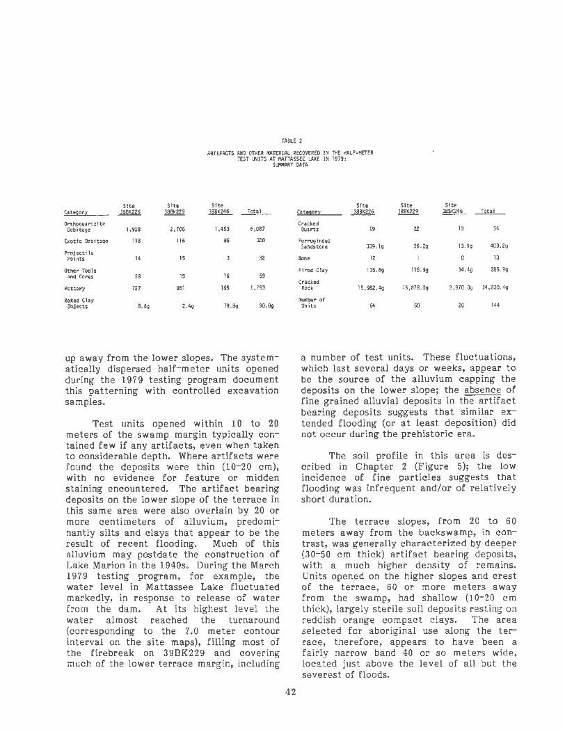
TABLE 2
ARTIFACTS AND OTHER MATERIAL RECOVERED IN THE IIALF-IIETER TEST UNITS AT IIATTASSEE LAKE IN 1979:
SU!+IARY DATA
Site Site Site Cat!l!JOr~ ~ ~ ~ Total
Orthoquartzite Oebitage 1,928 2,706 1,453 6,087
Exotic Oebftage 118 116 86 320
Projectile Points 14 15 32
Other Tools and Cort<S 28 15 16 59
Pottery 727 861 165 1,753
Baked Clay Objects 8.6g 2.4g 79 .8g 90.8g
up away from the lower slopes. The systematically dispel'sed half-meter units opened during the 1979 testing pl'ogram document this patterning with contl'olled excavation samples.
Test units opened within 10 to 20 metel's of the swamp margin typically contained few if any artifacts, even when taken to considerable depth. Where artifacts were found the deposits were thin (10-20 em), with no evidence for feature or midden staining encountered. The artifact bearing deposits on the lower slope of the terrace in this same area were also overlain by 20 or more centimeters of alluvium, predominantly silts and clays that appear to be the result of recent flooding. Much of this alluvium may postdate the construction of Lake Marion in the 1940s. Dul'ing the March 1979 testing program, for example, the watel' level in Mattassee Lake fluctuated markedly, in response to release of water from the dam. At its highest level the water almost reached the turnaround (corresponding to the 7.0 meter contour interval on the site maps), filling most of the firebreak on 38BK229 and covering much of the lower terrace margin, including
42
Site Site Site cat !!!lor~ ~ ~ ~ Total
Cracked Quartz 19 22 13 54
Ferruginous Sandstone 3J9.1g 56.2g 13.9g 409.2g
Bont< 12 0 13
Fired Clay 135.6g 115.9g 34.4g 285. 9g
Cracked Rock 15,982.4g 15,878.0g 2,970.0g ~.830.4g
Number of Units 64 60 20 144
a number of test units. These fluctuations, which last several days or weeks, appear to be the source of the alluvium capping the deposits on the lower slope; the absence of fine grained alluvial deposits in the artifact bearing deposits suggests that similar extended flooding (or at least deposition) did not occur during the prehistoric era.
The soil profile in this area is described in Chapter 2 (Figure 5); the low incidence of fine particles suggests that flooding was infrequent and/or of relatively short duration. ·
The terrace slopes, from 20 to 60 meters away from the backswamp, in contrast, was generally characterized by deeper (30-50 em thick) artifact bearing deposits, with a much higher density of remains. Units opened on the higher slopes and crest of the terrace, 60 or more meters away from the swamp, had shallow (10-20 em thick), largely sterile soil deposits resting on reddish orange compact clays. The area selected for aboriginal use along the terrace, therefore, appears to have been a fairly narrow band 40 or so meters wide, located just above the level of all but the severest of floods.

A number of unusually rich concentrations of artifacts and features were noted within the general scatter defining the three sites, all within the zone from roughly 20 to 60 meters from the backswamp. These were generally defined during the testing program, and were more precisely located later in the spring with the production of a series of computer genera ted artifact densitydistribution maps (SYMAPS) (e.g., Figure 10). Each concentration was flagged off the last day of the testing, using nylon string and red tape, to prevent loss due to construction and clearing activity, which was occurring by this time in the area. This proved to be a fortunate decision, since massive clearing occurred over the terrace area in April and May of 1979, between the close of the testing and the start of the final excavations. Over much of the terrace only the areas that had been taped off were left undisturbed, and in some places small portions of the flagged area had been damaged (i.e., around TU21 at site 38BK226). The entire western end of 38BK226, in fact, had been leveled and fenced off, and was being used as the field headquarters and staging area for one of the project contractors, Higgerson-Buchanan Inc. All of this had been anticipated (hence the flagging), but was nonetheless a shock when first observed; fortunately little real damage had occurred to any of the flagged areas, and the contractors themselves were especially cooperative over the remainder of the excavations.
Site 38BK226 Testing Results
At site 38BK226 major artifact concentrations were observed to both the east and west of the paved access road turnaround (Figure 10). The concentrations were (typically) characterized by several times the artifact density observed elsewhere along the terrace, with somewhat deeper, artifact bearing deposits and occasional midden or feature staining noted. The highest artifact density on the site was noted to the east of the turnaround, in an area roughly 30 m (N/S) by 100 m (E/W) on. the north (backswamp) side of a long ridge running between the lake and a small tributary. Upon closer examination this was found to actually reflect two concentrations, one about 30 meters in diameter
43
around test units 51,52,60 and 61, and the other about 20 meters in diameter centered on test units 53 and 54. A third, smaller concentration was located 80 meters further east, at a point on the ridgeline around test unit 58. The intermediate concentration, around TU's 53 and 54, was where a large block unit was opened later in the year.
A patchy midden stain characterized by mottled dark grayish-brown soil (10YR3/2) was observed from 10 to 20 em in depth in a number of the test units to the east of the turnaround. Possible pit or hearth features were also noted in a number of the units, but these were difficult to document given the small size of the excavations. A two meter unit (EU1) was opened in the vicinity of TU53 during the testing, but failed to delimit any features. A Guilfordlike point and a crude bifacial tool were located at a depth of about 30 em in the unit, however, and the deposits in several of the units opened in this area were found to exhibit fair stratification. Recognizable components identified in the concentrations to the east of the turnaround during the 1979 testing program dated to the Early Archaic (based on a quartz Palmer point found at 48 em in TU52), the Middle Archaic (the Guilford-like point found in EU1 at 30 em), the Late Archaic (identified by the presence of Thorn's Creek Punctate and Refuge Dentate Stamped pottery found in several of the units from 20 to 40 em), and the Woodland (based on the presence of linear check stamped, fabric impressed, and simple stamped pottery in the upper levels of most of the units).
On the western side of 38BK226 three small concentrations were recognized, in an area roughly 50 meters in diameter located some 100 meters northwest of the turnaround (Figure 10). These concentrations, centering on (and defined by) test units 21,29 and 31, were characterized by simple stamped and fabric impressed ceramic assemblages, and were interpreted as Middle or Late Woodland in age. A two meter unit (EU2) was opened in this area during the testing but failed to document the presence of features. During the subsequent, mitigation stage excavations, several additional two meter units were opened in this general area (EU's 2731), in an effort to further define these components.

Site 38BK229 Testing Results
At 38BK229 two major concentrations were recognized during the testing, at the eastern and western ends of the site (Figure 11). A third, smaller concentration was later resolved, between test units 18 and 20 in the east-central part of the site; during the testing program this had been assumed to be a part of the eastern concentration. The eastern concentration, which measured approximately 80 meters (E/W} by 40 meters (N/S}, was characterized by deep (40-60 em) deposits, Woodland pottery, and possible features. A Late Archaic Thorn's Creek Finger Pinched, Y!!:· Awendaw, sherd was recovered in TU4, a finding which prompted further testing and that ultimately led to the excavation of a small block unit in the area later in the year. Two possible postmolds were noted in TU45, in the central concentration, and a one meter pit opened adjacent to the test unit revealed a third circular stain, suggesting the possibility of a structure. A small block was opened in this area during the subsequent season; unfortunately conclusive evidence for structures was not detected. The western concentration at 38BK229 was defined primarily by a high artifact density in TU's 33, 37, and 52. This concentration, like the one at the eastern end of the site, was characterized by fairly deep deposits, Woodland period pottery, and possible features. Two 2-meter units were eventually opened in this area, during the summer 1979 excavations, and did locate several features. A small shell midden was also observed near the west end of 38BK229. This feature was a small (predominantly) surface scatter of shell fragments, roughly two to three meters in diameter and about five centimeters thick. The midden was probed in several places with a shovel, to determine its extent and content. Several pieces of glass, and metal historic debris were mixed in with the shell, which was identified as oyster. The general area had been used as a fishing camp in the early part of the century, and the shell midden apparently dated from that period.
Site 38BK246 Testing Results
At the third site examined during the testing program, 38BK246, two major artifa,ct concentrations were recognized, one on
44
each side of a small stream channel bisecting the scatter (Figure 12). The concentration to the west of the stream centered on TU17, where a large amount of orthoquartzite debitage (N=703) was recovered in the half-meter unit. A two meter unit (EUll) was opened in this area the next field season, in an effort to further define · the concentration. The second concentration detected at 38BK246 during the testing program was located to the east of the tributary, and centered on several test units (11,12 and 15) near the swamp margin. The assemblage from this area was dominated by plain and simple stamped pottery, and was interpreted as an "apparent Early Woodland assemblage" during the testing. This estimate, based primarily on the associated ceramics, was found to be a thousand or more years off when enough evidence was accumulated to place these finishes into the Late Woodland. A one by two meter unit opened near TU12 during the testing recovered a number of these sherds, plus baked clay object fragments and two contracting stemmed points, further suggesting an early date for the overall assemblage. Ultimately ten 2-meter units were opened in this area, during the summer excavation program, in an effort to resolve the nature of the concentration.
PREPARATION FOR THE 1979 EXCAVATION PROGRAM
A summary report on the 1979 testing program and a series of recommendations for further work along Mattassee Lake were forwarded to lAS-Atlanta on April 6, 1979, three days after the close of the testing program. The recommendations called for the excavation and analysis of enough material to adequately document the variability and content of each of the major concentrations discovered during the testing. The excavation of 60 two meter units was proposed, with the units placed both individually and in blocks along the terrace. Concomitant in-field screening, washing, and flotation activity, and laboratory sorting, cataloging, and bulk analysis were also proposed. All of the units were to be opened in 10 em levels, with the fill dry screened through 1/4 inch mesh. Soil and flotation samples would be collected from representative strata and feature areas.

.....
At 38BK226 it was initially recommended that at least 40 two meter units be opened, 30 to the east of the turnaround and 10 to the west. The 30 units in the eastern part of the site would document the stratified Early Archaic through Woodland assemblages found in that area during the testing. The 10 units recommended for the western part of the site were to document the apparent later Woodland materials found in this area. At 38BK229 10 two meter units were recommended, to help clarify the nature of the Woodland concentrations recognized during the testing. At the third site, 38BK246, a block of 10 two meter units was recommended, to help document the Woodland concentration noted immediately to the east of the small tributary bisecting the site. In all, the excavation of 60 two meter units was recommended. The recommendations were reviewed by IAS Atlanta, and after spirited discussion a field effort based on the excavation of 46 units was funded, consisting of 30 units at 38BK226, 6 at 38BK229, and 10 at 38BK246. Toward the end of the summer excavation program funding was obtained for another 10 units at 38BK229, for a final total of 56 two meter squares, in close agreement with the original recommendations.
THE 1979 EXCAVATION PROGRAM: GENERAL FIELD PROCEDURES
Final field investigations at the Mattassee Lake s ites were conducted from May 28 through August 10, 1979. Counting the larger units opened during the testing, in all 59 two meter units were opened at the sites; 31 at 388K226, 17 at 38BK229, and 11 at 38BK246. Three block units were opened, one at each site, and a series of units were opened singly or in small groups at a number of other locations along the terrace. To accommodate the construction schedule, the western end of the terrace, in the vicinity of 38BK246, was examined first. A block of 10 two meter units was opened around one of the test units, and when this was completed (in mid-June) work shifted to 38BK226 and 38BK229. Work concentrated on the large block at 38BK226, with scattered testing undertaken concurrently at 38BK229. The block at 38BK229 was the last opened, in late July and early August,
45
and when it was completed fieldwork ceased.
A standardized series of field procedures were employed during the excavations. The areas examined were first cleared with chain saws and brush axes and then sprayed with a malathion solution to discourage mosquitoes and gnats, which were present in abundance. Units were laid out along cardinal directions, and in the areas of the blocks a two meter grid was dispersed using a transit and tapes. Grid and unit corners were marked with 2 foot pine stakes (1 inch by 24 inch by 1/2 inch) that were cut at a local lumber yard. Ground surface elevations were obtained at each stake, to provide fine-grained contours of the areas excavated. All of the units were opened in arbitrary 5 or 10 em levels, using the ground surface at one of the corners (typically the northwest) as a reference. Line levels and tapes were used to maintain depth control with 1/16 inch nylon string used with the levels and to lay out the unit. Balks were left in the corners of each unit, to hold the stakes in place and provide a stratigraphic column once the surrounding units were removed. All fill was passed through 1/4 inch mesh, using 3 foot x 3 foot screen frames suspended from tripods by half inch nylon rope. The tripods were 10 to 12 foot saplings stripped of branches and lashed together, providing a strong, flexible support that was easily portable.
An attempt to establish water screening operations failed dismally. The water in Mattassee Lake was too far away, and the flow in the streams near the 388K226 and 38BK246 blocks wasn't sufficient; the pump dried up these "tributaries" after a few minutes operation. An attempt to sink a well point, at 38BK246, also failed when the pipe failed to penetrate the sandstone debris overlying the aquifer. Fortunately the artifact bearing deposits along the terrace were characterized by a gravelly sandy loam, which proved quite easy to dry screen.
The soil profiles along the terrace were quite uniform, consisting of a thin humus zone grading quickly into coarse very pale brown sands, underlain at various depths by compact reddish- brown silts and

0 30
0 100
~
, .. , ......
II•''
60 METERS
200 FEET
• TU11
1.0--=.:=::=::===:-::=::===--------==-
~ =

FIGURE 11
SITE 38BK229 ALL EXCAVATION UNITS
DISTRIBUTION OF ALL ARTIFACTS MATTASSEELAKEEXCAVATONS
U.S. Armv Corps of Engineers Cooper River Rediversion Canal Ptoject

""·
--· ~
,.,__ --· ---· A , -4!-' · A. ;to. •+ -:-.- _..,_. __ -.~ - --~- MATTASSEELAKE/ ,, . -·-:c-- .... -· ~. - ... - .-.• . ...... - ... -· . . :....~--=-~----..... - .:.; =- ~-~ ... · ~---·- - ·~~--!" - ·~ .... ~=:~--~ -*'- --~ ~ ... ~-~- • .,..~- ... -:·- : · - ·"" -~-:- ".:..:.~-- ..... :~ -~4- :.~.,:: ._ ~:-~-~ _.. :.;'~·=::-. : • ::;_--: ~-.:_.· SANTEE RIVER SWAMP .. ;.~ .... : ;_-·-· ~ ""::.--.:.,__- -~-~= ·<~·-::-_;
~,.
/ ,,
/-- .... --· ~~:"':~;n:c-- . :m~: 1 :. -~ 11 1;:·:1 .:-,:: _ .... .., .. -....... -......... , ......... ....... .
111 ooo t,U oo.u
~:jf.~L.~~~ .. -
0~=======3~0~=====~60 METERS
0 100 200 FEET
~-- .... - ...
FIGURE 12 SITE 38BK246
All EXCAVATION UNITS DISTRIBUTION OF All ARTIFACTS
MATTASSEE LAKE EXCAVATIONS U.S. Army Corps of Engineers
Cooper River Redoversoon Canal Protect
r L
clays. A number of soil samples from profiles and features in the excavation units were processed, with pH, particle size, and color recorded, and brief textural descriptions- prepared. This information is summarized in Chapter 2 in a review of the immediate terrace environment. Artifact bearing deposits near the crest of the terrace were generally quite shallow, with those on the slopes thicker and characterized by progressively deeper sands.
A series of forms documented the field data recovery activity. A master list was kept recording the location and date each unit was opened, and a similar list was kept for features. This precluded duplicat ion, and provided a quick review of the proveniences opened to date. Special colorcoded forms were used for unit levels (white) and features (blue); each form was four pages long and required approximately half an hour to fill out. Artifacts were placed in plastic "zip-lock" bags in the field. A 3x5 card with relevant provenience data, written using a waterproof marker, was placed in each bag. At the end of the _day each bag was assigned a number (which was written in the upper right hand corner of the 3x5 card) and logged into a master bag list (color-coded yellow). This record proved an invaluable inventory, and was used to keep track of the washing and cataloging process. Keeping a record of the bags also helped resolve problems. In a few cases (usually on extremely hot days) the cards were incompletely filled out; with the b·ag list it was possible to quickly determine where the material came from . A similar list, for special samples (i.e., soil and flotation), was also kept during the project (color-coded blue) and, like the bag list, proved quite useful. The special samples were typically kept in larger plastic bags (usually garbage bags), and were documented using a 3x5 card and a folded piece of aluminum foil placed in the fill. The use of both a card and the foil label was warranted by the dampness of the soil, which occasionally caused the card to tear.
The fill in the units was shovel skimmed, with trowels and brushes used when features were encountered. Features at the Mattassee Lake sites were defined by concentrations of charcoal, rock, or
49
artifacts. The charcoal staining was typically faint and somewhat diffuse, indicative of a poor preser.vation environment. A total of 84 features were identified during the excavations, many of which were interpreted as the remains of aboriginal hearths (Table 3). It should be noted that considerably more stains were encountered than were interpreted or .excavated as features, although all disturbances were recorded in the field notes. Burned tree stumps and roots were encountered frequently, as well as a large number of faint, amorphous stains that defied interpretation. These stains are recorded on the level sheets accompanying the block unit excavation descriptions.
Considerable effort was expended piece-plotting all large or unusual items encountered in the units, including projectile points, tools, large sherds, cores, fragments of steatite, large rocks, and concentrations of material. The depth below both the unit datum and local ground surface were taken (the two depths sometimes differed by a few centimeters if the unit was on a ·slope). Particular attention to piece-plotting followed from research interests in both site chronology and function. Precise vertical measurements were considered essential to the eventual temporal ordering of the projectile point and ceramic assemblage. Horizontal control was considered important to eventual activity reconstruction, and to delimiting associations between artifacts and with features. Piece-plotting . was intensified when features were examined to determine as accurately as possible the context of possible associated artifacts. This was considered essential to the accurate dating of site features, using diagnostic artifacts as temporal indicators. [t was also crucial to the absolute dating of the artifacts themselves; radiocarbon analyses, for example, could only be warranted if an indisputable association of the artifact with the charcoal to be dated occurred.
When features were encountered they_ were pedestalled and then carefully cleaned off or sectioned. Fill was troweled into plastic trash sacks for later flotation (Figure 13). When features were large or unusual, or contained potentially datable

TABLE 3
ARCHEOLOGICAL FEATURES AT MATTASSEE LAKE
SITE 3881<226 SITE 38BK226 (Cont. )
Feature 1 Hearth Late Woodland Feature 46 Hearth? Late Woodland Feature 2 Hearth Late Woodland Feature 47 Hearth Middle Woodland Feature 3 Hearth Late Woodland Feature 48 Hearth Middle Woodland Feature 4 Pottery Middle Woodland Feature 49 Hearth? Late Archaic?
Cluster Feature 50 Hearth Mississippian Feature 5 Pottery Late Woodland Feature 51 Tree Root
Cluster Feature 52 Hearth? Early Woodland Feature 6 Vague Stain ? Feature 53 Vague Stain ? Feature 7 Hearth? Late Woodland Feature 54 Hearth? Middle Woodland Feature 8 Hearth Early Woodland Feature 55 Midden Middle/Late Feature 9 Midden Middle/Late Woodland Woodland Feature 10 Tree Root Feature 56 Midden Middle/Late Wooa. dnd Feature 11 Tree Root Feature 12 Postmold? Middle/Late Woodland Feature 13 Hearth? Early Woodland SITE 3881<229 Feature 14 Hearth Middle Woodland Feature 15 Midden Middle/Late Woodland Feature 1 Vague Stain ? Feature 16 Hearth? Late Archaic/Early Feature 2 Hearth Late Woodland/
Woodland Mississippian Feature 17 Hearth? Early Woodland Feature 3 Tree Root Feature 18 Tree Stump Feature 4 Pit Late Archaic Feature 19 Tree Stump Feature 5 Pit Late Archaic Feature 20 Vague Stains ? Feature 6 Tree Root Feature 21 Hearth? Late Woodland? Feature 7 Hearth? Early Woodland Feature 22 Hearth? Woodland Feature 8 Biface Late Archaic Feature 23 Tree Root Cluster Feature 24 Pit Remnant? Middle/Late Woodland Feature 25 Hearth Middle Woodland Feature 26 Hearth Late Woodland SITE 38BK246 Feature 27 Hearth? Woodland Feature 28 Hearth Middle Woodland Feature 29 Hearth Middle Woodland Feature 1 Vague Stains ? Feature 30 Hearth? Early Woodland Feature 2 Hearth Late Woodland Feature 31 Hearth Late Woodland Feature 3 Rock Archaic? Feature 32 Pottery Early Woodland Cluster
Cluster Feature 4 Hearth Early/Middle Woo·11 an• Feature 33 Hearth Late Woodland Feature 5 Hearth Late Woodland Feature 34 Hearth Late Woodland/ Feature 6 Hearth Middle/Late Wooc nd
Mississippian Feature 7 Hearth Early/Middle Woodla~ Feature 35 Hearth? Late Archaic Feature 8 Hearth Middle Woodland Feature 36 Hearth Middle Woodland Feature 9 Hearth Middle Woodland Feature 37 Hearth? Late Woodland Feature 10 Hearth Late Woodland Feature 38 Tree Root Feature 11 Shell Woodland Feature 39 Hearth.? Middle Woodland? Cluster Feature 40 Tree Root Feature 12 Hearth? Middle Woodland Feature 41 Hearth? Early/Middle Woodland Feature 13 Vague Stains ? Feature 42 Hearth? Middle Woodland Feature 14 Vague Stain ? Feature 43 Tree Root Feature 15 Hearth? Middle Woodland feature 44 Tree Root Feature 16 Tree Root Feature 45 Hearth Late Woodland/ Feature 17 Vague Stain
Mississippian Feature 18 Hearth Middle Woodland Feature 19 Tree Root Feature 20 Vague Stain ?
50

Feature removed along Mattassee Lake.
Field photography, site 38BK226 block, Mattassee Lake
FIGURE 13
FIGURE 14
FIELD PHOTOGRAPHY
MATT ASSEE LAKE EXCAVATIONS U.S. Army Corps of Engineers
Cooper River Rediversion Canal Project

artifacts, up to several subsamples of fill were taken and carefully documented as to location within the feature. Radiocarbon and ethnobotanical analyses proceeded using the most "secure" samples first, that is, fill from the centers of stains and in and around artifact and/or burned rock clusters. The control employed in the collection of feature fill/flotation samples followed from a pressing local need (recounted in Chapter 4) for securely documented subsistence and assemblage data. In all, 70 of the 110 flotation samples, from 39 features, were analyzed (Chapter 10). While ethnobotanical identification of eyery sample collected would have been ideal, project resources did not permit this; all of the samples, analyzed and unanalyzed, were curated, however, and are available to interested researchers. Priol" to removal each feature was drawn and photographed, with all large and/or diagnostic artifacts (or rocks) found in association piece-plotted. During the note taking process, Munsell books were routinely used to document colors, both for features and in floor and profile drawings.
A series of procedures were adopted to accommodate in-field photography. Shots of normal site activity, showing exc·avation, clearing, or mapping activity, for example, were typically taken candid, using either color slide or black and white film. These shots were taken primarily to document field procedures, and to illustrate the progress and general appearance of the excavations. Record shots in the excavation units themselves were more stringently controlled. All photographs were taken using both color slide (Kodachrome-ASA64) and black and white (TriX-ASA400) film, with a record maintained for each shot on a colorcoded (green) sheet. All black and white shots were taken using a Hasselblad 500 em camera with an 80 mm lens (Figure 14). Color slides were taken using either a Canon F1 or a Pentax Spotmatic, both with 1.4 lenses. In all over 7 50 shots were taken during the 1979 field program.
Record shots of features and unit profiles were always taken with a scale, north arrow, and letter board in the frame. The board, which was covered with black felt, was labelled with one inch white plastic letters. The site number and the date were
52
always recorded, with the unit or feature number, floor depth, or profile orientation added as appropriate. Light mottling (from sunlight filtering through the trees) was eliminated using a linen sheet supported between two 10 foot, half inch diameter aluminum pipe sections. Prior to actual photography the area to be documented was carefully cleaned of all debris and loose dirt. Profiles and floors were carefully smoothed or leveled, to avoid the presence of confusing shadows on the photographs (which typically occur given depressions or irregularities in the matrix). Record shots were commonly taken using a tripod, with the exposure bracketed to maximize the chance of success.
At the close of fieldwork each day, or when rains occurred, units under excavation were covered with plastic dropcloths weighted down with earth. The sites were isolated, and most equipment was left in place or hidden in the nearby underbrush. Artifact and special sample (i.e., flotation) bags were removed to the lab, where they were stored until processing. The field laboratory operations are described in the latter part of this chapter. Although well over 100,000 artifacts and almost a ton of rock were recovered during the excavations, three quarters of the assemblage had been sorted and cataloged by the last day of the fieldwork. The fill from the project features was floated in nearby Lake Moultrie, with heavy and light fractions retained as fine screen and ethnobotanical samples, respectively (cf., Streuver 1968). One hundred and ten flotation samples were recovered and processed, with charcoal useful for both radiocarbon and ethnobotanical analyses recovered from many of the features. The flotation operations and results are described in detail in Chapter 10, while the radiocarbon results are given in Chapter 11.
THE EXCAVATIONS AT SITE 38BK226
Twenty-nine additional two meter units were opened at 38BK226 during the summer 1979 excavations. Most of these un its (N=24) were opened in a large, irregularly shaped block located roughly 60 meters due east of the access road turnaround (Figure 15). The remaining five units were

opened to the west of the turnaround, in two of the three concentrations located in that area during the testing. The block, consisting of 25 separate two meter units (including one unit opened during the testing phase), was placed in the central concentration to the east of the turnaround (Figure 10). Stratified Early Archaic through later Woodland remains, at depths up to 50 em, had been encountered in this area during the testing, and the excavations were designed to maximize this stratigraphic potential.
The twenty-four two meter units opened in the block unit during the summer field program were removed in 5 em levels, rather than the 10 c m levels originally planned. The excavations at 38BK246, the first site examined, indicated that the thicker levels were too coarse grained to be of much use in detailed stratigraphic analyses. While the field program had been scheduled using time estimates for 10 em levels (half the proveniences a 5 em excavation strategy would yield), with the additional labor provided by the U.S. Forest Service YCC program, it was possible to use
thinner levels. This modification, it should be noted, appears to have been sound, given the results of the subsequent analyses, which made extensive use of the finegrained stratigraphic controls.
The units within the block were opened to varying depths, between 30 and 65 em. Compact, artifact sterile silts and clays appeared at 30 to 40 em over the southern half of the block, precluding meaningful additional excavation in these areas. In the northern half of the block, the deposits were characterized by progressively coarser sands with increasing depth. Units in these areas were usually abandoned at 50 em, although a few were taken deeper. While artifacts were noted all the way down in these units, the density dropped markedly below 40 em. Diagnostic Early and Middle Archaic projectile points recovered in these units occurred from 30 to 50 em, with none found below this depth. Given the goals (and limited resources) of the excavation the deposits below 50 em were not, after examination in two units, considered worth investigating in detail.
TABLE 4
ARTIFACTS AND OTHER MATERIAL RECOVERED IN THE BLOCK UNIT AT SITE 38BK226 IN 1979:
SUMMARY DATA
Orthoquartzite Baked Clay Fired Debitage 26,472 Objects 903.7g Clay 3,038.5g
Exotic Debitage 3,946 Steatite Cracked
Rock 512,961.4g
Projectile Cracked Features 55 Points 276 Quartz 424
Other Tools Ferruginous Area 2 and Cores 173 Sandston.e 281.9g Examined 100 m
Pottery 14,927 Bone 142
(Includes All Artifacts in Features)
53

The irregular shape of the block was dictated to some extent by existing trees, and by a policy of chasing features or apparent occupation surfaces (Figures 16,1 7). While in retrospect a more regular unit shape would have been desirable, particularly for spatial analyses, this was difficult to accommodate given the heavily wooded site conditions. A tremendous quantity and variety of material was recovered in the block unit (Table 4), with components identified from the Early Archaic through the Mississippian periods. Fifty-five features were defined and investigated within the block, and are described in the next section. Eleven radiocarbon determinations were run from the site, using charcoal from some of these features, providing absolute age measures for both the features themselves, and for the general levels (Chapter 11). Examining the determinations level by level within various areas of the block, it isapparent that a logical super-positioning of the dates occurs: almost invariably, the deeper the feature, the older the date (Figures 18-33).
The remaining five two meter units opened during the summer 1979 excavations at 38BK226 were placed to the west of the turnaround, in the vicinity of Test Units 29, 31 and 45. Two of these units (29 and 31) had defined artifact concentrations during the testing program, while the third (TU45) appeared to contain a feature. The area of a third concentration noted during the testing, around TU21, had been destroyed by clearing and construction by the start of the summer excavations, and could not be examined. The five units were opened using 10 em levels, since the testing program had indicated that the deposits in this area were generally shallow and (possibly) reflected a single component. While a considerable quantity of artifacts were recovered, no aboriginal features were encountered. The excavations basically confirmed the results of the earlier testing, that appreciable later Woodland period artifacts were present in the area. The absence of features may reflect the small area examined (20 square meters), but may also indicate a pattern of site use in activities that did not result in many featur~s; comparable areas opened in
54
the block to the east of the turnaround, for example, produced an average of ten features.
A number of historic artifacts were recovered in excavation units 27,28 and 29, opened around TU31. Artifacts found included a number of rusty wire nails and other metal fragments, three pieces of bottle glass, a 1902 Liberty head nickel, and a 1906 Indian head cent. All of this suggests the presence of a simple dwelling or more probably a hunting shack somewhere in the general area. The historic artifact assemblage from all of the Mattassee Lake sites, and its implications, are discussed in greater detail in Chapter 9.
SITE 38BK226 FEATURES
Fifty-six features were recognized at 38BK226 in 1979, 55 in the block unit to the east of the turnaround and one in EU27, one of the five units opened to the west of the turnaround. Many of these features are unquestionably the result of aboriginal activity, and some of the remainder quite probably are, but are ambiguous enough to render such an assertion in at least some doubt (Table 3). In all, though, 43 of the 56 features at 38BK226 are of definite or at least probable aboriginal in origin. Most of these (N=34) appear to be hearths or hearth remnants, while three are pottery concentrations, two are possible posts, and four were segments of the patchy sheet midden that was observed over portions of the block from 10 to 20 em in depth. Ten of the stains initially assigned feature numbers were found, upon excavation, to definitely be tree stumps or roots (Features 10,11 ,18, 19,23,38,40,43,44 and 51), and three more (Features 6,20 and 53) were probably also natural in origin, although some question remained. One of the stains later identified as a tree, Feature 51, was the only feature noted in an excavation unit from outside of the block unit, suggesting a low overall feature density in the areas of the site to the west of the turnaround. Descriptions of all of the features follow; details on the context of each provenience, including summary measurements for all categories of artifacts, and attribute records for all

-
-
,...
r L r
formal tools, are to be found in the Data Appendix Volume.
FEATURE 1
Feature 1 was a circular charcoal stain approximately 80 em in diameter encountered immediately below the root mat in the northwest corner oCEU6 (Figure 34). The feature was well defined and basin-shaped, varying in depth from 2 to 10 em. Artifacts recovered in the fill included 24 sherds, an appreciable quantity of cracked rock (842.9 grams) and orthoquartzite debitage (N=132), and a minor amount of fired clay (3.0 grams) and exotic debitage. The pottery recovered from the fill included one Santee Simple Stamped, three Cape Fear Fabric Impressed, three Woodland Plain, and one Thorn's Creek Plain sherds. Two flotation samples taken from the fill were processed, revealing several species of wood charcoal, including hickory (Carya sp.), pine (Pinus sp.), and the white oak group (Quercus sp.), and a fair number of hickory nutshell fragments (Chapter 10). The size, shape, and contents of the feature, particularly the presence of wood charcoal from several species, argues for interpretation as a fire hearth. Given the shallow depth at which the stain began, and the presence of Santee Simple Stamped pottery, the feature appears to date to the Late Woodland period.
FEATURE 2
This feature was an oval basin-shaped charcoal stain recognized at a depth of 15 em in the southeast corner of EU6 (Figure 34). Feature 6 measured 37 em {N/S) by 32 em (E/W} and varied in depth from 1 to 3 em. A single Santee Simple Stamped sherd and a minor amount of cracked rock (20.3 grams) were recovered in the fill. The feature is interpreted as a probable Late Woodland period hearth remnant.
FEATURE 3
Feature 3 was an irregular, roughly oval-shaped charcoal stain first recognized just below the root mat in the center of
55
EU6. The feature measured 44 em {N/S) by 65 em {E/W), and varied in depth from ·1 to 4 em. A small circular charcoal stain about 10 em in diameter occurred in the southeast corner of Feature 3, and extended roughly 5 em below the feature. This smaller stain may have been a post or root mold; its relationship to the main body of the stain is unknown. The fill from Feature 3 was floated, yielding a number of small Santee Simple Stamped (N=2), Cape Fear Fabric Impressed (N=2) and nondiagnostic (N=5) sherds, together with a moderate amount of cracked rock (259. 7 grams), and minor amounts of fired clay (4.3 grams) and orthoquartzite debitage (N=21). Feature 3 is somewhat poorly defined, rendering precise identification difficult. It is tentatively interpreted as a hearth remnant, of probable Late Woodland age .
FEATURE 4
Feature 4 was a cluster of 12 fairly large Cape Fear Fabric Impressed (N=ll) and Santee Simple Stamped (N=l) sherds (weighing 397.9 grams) found from 10 to 15 em below the surface in the southwest corner of EU5 (Figure 34). No charcoal or other staining was noted around the sherds, which came from an area roughly 60 em in diameter. The fabric impressed pottery includes parts of at least two different vessels; the single Santee Simple Stamped sherd may or may not be associated (i.e., temporally contemporaneous) with the fabric impressed material. The cluster appears to represent secondary refuse (e.g., Schiffer 1976:30), debris relocated from the original place of breakage. The vessels the sherds derive from appear to have been large jars, with only a small fraction of the original vessels represented by the cluster. Feature 4 is tentatively dated to the Middle Woodland, based on the large quantity of fabric impressed pottery noted, although the single sherd of Santee Simple Stamped ware may suggest a somewhat later date, in the Late Woodland.
FEATURE 5
Feature 5 was a cluster of 15 large Woodland Plain (N=l), Cape Fear Fabric
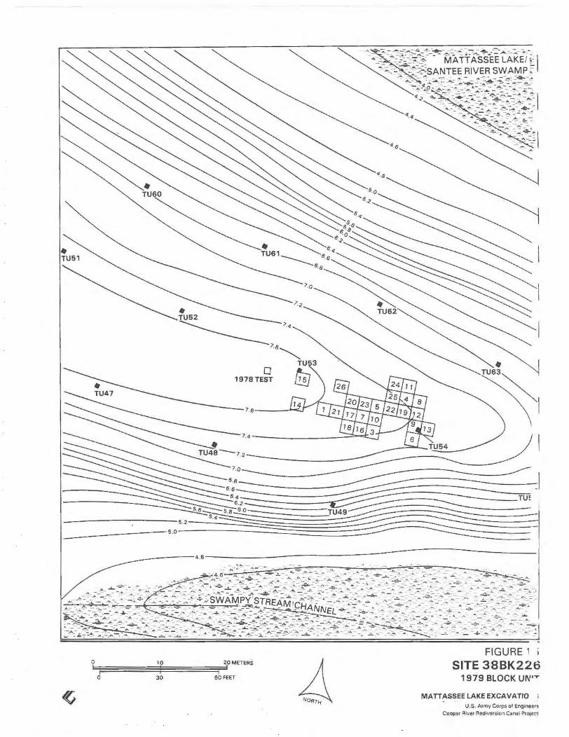
0
0 1978TEST
----------4.8--------------------------------------------------------------------------
30 60 FEET
FIGURE
SITE 38BK226 1979 BLOCK UI\'''T'
MATT AS SEE LAKE EX CAVA TIO U.S. Aomy Corps of Engonoers
Cooper Rtver Red•version Canal Ptotet1

The completed block unit at site 38BK226, Mattassee Lake, view to northwest.
Gridding operations at site 38BK226. The shape of the block was dictated to some extent by existing tree cores.
FIGURE 16
FIGURE 17
FIELD PHOTOGRAPHY 51
MATTASSEE LAKE EXCAVATIONS
U.S. A rmy Corps of Engineers Cooper River Rediveraion Cane I Projecl
-
....
-.,
.....
-...,

found w11h1n lhis '''""'~ p.oduced a mo•lem dbto tOIC·2114t
• Flake • Sherd 0 Utilized Flake/Uniface • Biface/Biface Fragment o Baked Clay Object x Rock
Note 1 t Detailed descr~pt1ve Information on all p1ece plotted ar· ltfacts by caralog number, mev be fourtd on the accompanytng block unit data sheet6 in the appendix volume
No1e 2! All of the ptece ploued arttfacts shown here are outside
ot known teatures. ln formatton on artifact s f ound •nd,Of plotted wrth•n teatures rs presented m the sectiOn on •nd.v•duul feature descnpuons.
(EASTERN HALF) 0-1 o em Level
0 2 METERS
0 4 8 FEET
A.D. 1040 :1: 70 OIC-1840
18. 19
FIGURE 18 SITE 38BK226 1979 BLOCK UNITS
FEATURES AND PIECE PLOTTED ARTIFACTS MATT ASSEE LAKE EXCAVATIONS
U S Army Corps of Eng•necrs Coope• RIVer Red•vers•on Canal ProJeCt
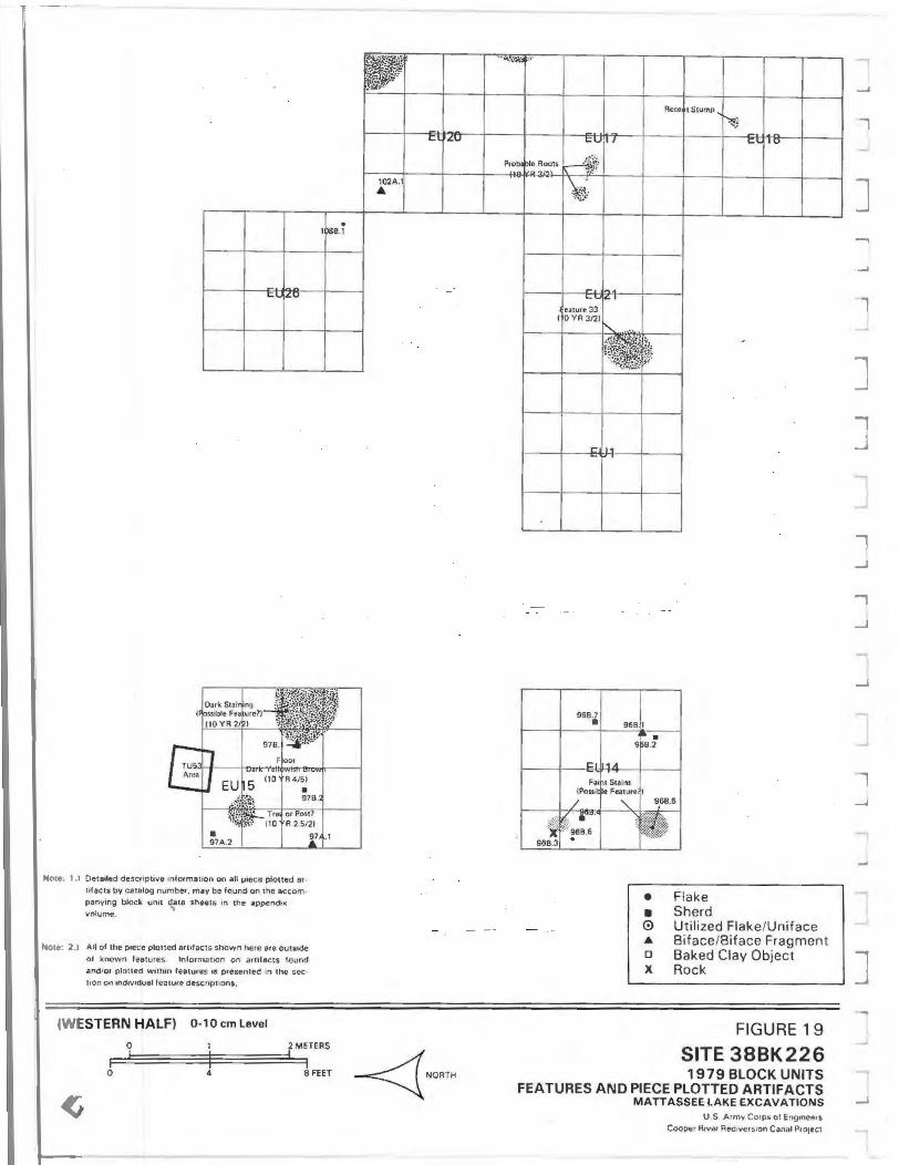
Neue· t , Oeta•led descnpu<~e 1nformar•on on all piece plotted ar· etfacts bv catalog number. may be found on the ac:com· pany•ng block un•t data sheets •n the append•• volume
Note 2 , AU of the p•ece plotted arulacts shown here are outs•de
of known features lnformattOn on artifacts found
and Of oloued wuh•n features •S ptesemed '" the sec· lion ontnd•v•duall ealure descup11ons.
(WESTERN HALF) 0 ·1 o em Level
I )8B.i
0 2 METERS
0 4 SFEET
102A. A
"' r .Lu
Rece tStump
CUfl/ Cl. o v
~--~---~~~~1---+--~
• Flake
• Sherd 0 Utilized Flake/Uni face A Biface/Biface Fragment 0 Baked Clay Object X Rock
FIGURE 19
SITE 38BK226 1979 BLOCK UNITS
FEATURES AND PIECE PLOTTED ARTIFACTS M ATTASSEE LAKE EXCAVATIONS
U S Armv Corps ot E•,g•neers Cooper Arvc1 Red•vct S1on Canal P1 o1ect
...,
-
--.., ...,
--
...,
...,
-

• Flake • Sherd 0 Utilized Flake/Uniface • Biface/Biface Fragment o Baked Clay Object X Rock
FNture 5 IShtrd Chnter)
Note: 1.• Oeta•ted descuptive 1nforma1ton on all piece plotted ar·
Ill acts by catalog number, may be found on the accom· panving block un.t data sheets an the appond•x volume
Note: 2 J All of the p1ece p&otted lfttfacts shown here are outside
ol known features lnformauon on artofacts found andtof plotted wllhtn features •s presented 1n the sec
t1on on •nd1v1dual feature descnptlons .
(EASTERN HALF) 1 0 ·15 em Level
0 4 BFEET
Fa11U Stainir\ICJ (Fealure 01 Midden Ar11?l
A.D. 650 < 55 (OIC· 18361 A 0. 700 >c 55 !DIC 18351
FIGURE 20 SITE 38BK226 1979 BLOCK UNITS
FEATURES AND PIECE PLOTTED ARTIFACTS MATTASSEE LAKE EXCAVATIONS
U S Army Corps ot Eng•ne.ers
Cooper A•vcr Aed•verston Canal Pro1et1

•
. 108C.I
Note 1 l Oeta•led descnpuve tnfOfrnauon on aU p1ece plotted ar·
t1fac1s by catalog number. may be found on tho accom· panv•ng block un•t dena sheets in the append•x volume.
Note 2 1 Allot the p .. ce plotted antfects shOwn here ere oots~e
ot known rea1Ures. lnformouon on ar tifacts found andlor ploned wuh•n features is presented •n the sec· uon on ind•v•duat feature descupuons
(WESTERN HALF) 1 0 · 1 5 em Level
• 108C.2
0 2MH~S
0 4 8 FEET
* ·6
. 96C. ro 96C.7
EU I''+
96C.
96C.3
6C.2
• • 0 4 D
X
Flake Sherd Utilized Flake/Uniface Biface/Biface Fragment Baked Clay Object Rock
FIGURE 21
SITE 38BK226 1979 BLOCK UNITS
FEATURES AND PIECE PLOTTED ARTIFACTS MATTASSEE LAKE EXCAVATIONS
U.S. Army Corps of Eng•neers
Cooper RIVer Red•verseon Canal Protect
...,
-

F1lnt St~ining (Possible Fe .. turt or Midden Are• ?I
110YR4/5)
• Flake • Sherd 0 Utilized Flake/Uniface .& Biface/Biface Fragment o Baked Clay Object x Rock
Note 1 . , Oetaded deser~pttve informauon on all piece plotted •r·
lifacts by catalog number, may be found on the accom· pany•ng block unn data sheen tn the appendi)( volume
Note. 2 .1 All of the poece plotted arufacts shown here are outsode
or known features lnforma1ton on arttfacts found
and/or plotted w1th1n features tS presented tn the sec·
tton on indtvidual feature descnptions .
(EASTERN HALF) 1 5-20 em Level
0 2MUffiS
0 4 8FEET
1050.14 •
FIGURE 22 SITE 38BK226 1979 BLOCK UNITS
FEATURES AND PIECE PLOTTED ARTIFACTS MATTASSEE LAKE EXCAVATIONS
U S Army CO<PS of Engoneers Cooper RIVer Redtvers•on Canal Pro,ect

Note: 1.1 Oeta•ted destfiPt•ve informacion on all piece ploued ar· 11faccs by catalog number. may be found on the acc:om·
panytng bloc-k. untt data shoets '" the append•• volume.
Noll 2.l Allot the piece ploued artttacts shown here aro outs•de ol known fetuures. lnforma1lon on an •facts found andlor plotted w•th•n fealures •s presented tn the sec· uon on tnclivtduat feature descnpttons
(WESTERN HALF) 15-20 em Level
0 2 METERS
0 4 8FEET
• Flake
• Sherd 0 Utilized Flake/Uniface • Biface/Biface Fragment 0 Baked Clay Object X Rock
FIGURE 23
SITE 38BK226 19 79 BLOCK UNITS
FEATURES AND PIECE PLOTTED ARTIFACTS MATTASSEE LAKE EXCAVATIONS
U.S Army Corps ot Eng•neers Cooper Atver Redtverston Canal Pro,cct
-
-
-..,
J
....,
-.,
-,

X
• Flake • Sherd 0 Utilized Flake/Uniface A Biface/Biface Fragment a Baked Clay Object x Rock
Note. 1 • Detailed desctlphve tnformation on all p•ece plotted ar· 11facts by catalog number. may be found on the ace om· panytng block. un1t data sheets '" the appendtx volume.
Note 2 1 All of the p•ece ploued artifacts shown here are outside
of known feawrcs 1nformatton on artifacts, fouMI
ancl'or plotted w•th•n features as presented m the !ec· lion on •nd•v•dual feature descnphons .
(EASTERN HALF) 20-25 em Level
0 2 METERS
0 4 B~ET
A 104E.15
E.l
~--~-- ·r-~---r--~
~ 91E.13
X 91E. I1
A 88 12
A 88E.13
• f------1--91E. 12.J---.J---.J---~--+,_,~-I---I
FIGURE 24 SITE 38BK226 1979 BLOCK UNITS
FEATURES AND PIECE PLOTTED ARTIFACTS MATT AS SEE LAKE EXCAVATIONS
U S Armv Corps of Engmeers Coopef R1ver Red•v•rston Canal ProteCt

Note· 1.) DeHt•led descnpt•ve infotmation on all piece plottod at·
II facts by catalog numt>tor may be found on the aecom· panv•ng block un•t data shee" 1n the appendix volume.
Note: 2.1 All of the p1ece plotted artifacts shown here are outside ol known features lnfOfmauon on an•facts found and or plotted wnhm fe~tures IS presented '" the sec· uon on 1ndwldual feature descriptions.
(WESTERN HALF) 20-25 em Level
0 4 8 FEET
• • 0 A 0
X
A.D. 710±60 D1C·1837
Flake Sherd Utilized Flake/Uniface Biface/Biface Fragment Baked Clay Object Rock
FIGURE 25
SITE 38BK226 1979 BLOCK UNITS
FEATURES AND PIECE PLOTTED ARTIFACTS MATTASSEE LAKE EXCAVATIONS
U.S. Army Corps of Engineers Cooper R1ver RediVers•on Canal Pro,ect
"""'\
..J
J
.,
.J
-
J .., ...J
.....J
J

• Flake • Sherd 0 Utilized Flake/Uniface .a. Biface/Biface Fragment o Baked Clay Object x Rock
Note 1 .I Oeteoled desenpttve information on all piece plotted ar· llfacts by call log nvm~r. may be found on the accom
panvong block unit data sheetS on the appendix oJolume
Note: 2.1 All of the piece plotted nrutacts shown here are outSide
of known features. lnformatton on artefacts found andtor pknted Wtthan features is presented tn the see· uon on md1vtdual feature descript•ons.
(EASTERN HALF) 25-30 em Level
0 2 METERS
o 4 e~n
• 91f.9
FIGURE 26 SITE 38BK226 1979 BLOCK UNITS
FEATURES AND PIECE PLOTTED ARTIFACTS MATT ASSEE LAKE EXCAVATIONS
U S Army Corps of Eng1neers
Cooptu River Redlvetston Canal Protecl

Dark Stalntng
r--
~ • 97F.9
l TU5 Ar .. ~ , .... -- • JIUO,U
Note l .• Deta•led descupuvo tnformatlon on all piece ploned ar· tifac.!s by catalog number. may be round on the accom· panymg block un•t data sheets •n the append•lt volume
Note: 2.i All of the p1ece plotted auifac ts shown here are outside of known features Information on arufacts found andior plot led w1th1n features 11 presented •n the sec· tcon on ind1vidual fealure descriptions.
(WESTERN HALF) 25-30 em Level
0 2 METERS
0 4 8FEET
• Flake
• Sherd 0 Utilized Flake/Unlface ... Biface/Biface Fragment 0 Baked Clay Object X Rock
FIGURE 27
SITE 38BK226 1979 BLOCK UNITS
FEATURES AND PIECE PLOTTED ARTIFACTS MATTASSEE LAKE EXCAVATIONS
U.S Army Corps ot Engoneers Cooper R1ver Red•vers1on Canal ProJeCt
J
-I ..J
J J J J ...., J
.,
_,
J
-"'

~-'i 9' 1G.11
lUG.U X
f- 11 01
90(
EUI
sg .11
t:U I d ''+
... 93G I
~07G 11
~6(;4 . J.O ~-' l06G 3 .
10 'G.2 .:u I"'+
104G
c nc:
106 ~
• Flake
• Sherd 0 Utilized Flake/Uniface ... Biface/Biface Fragment 0 Baked Clay Object X Rock
No1e: 1 I Oeta•led descr.pttve intormatton on aU ptece plotted ar· ufacts by catalog number may be found on the accom·
panytng block umt data sheet!. In the append•x volume
No1e: 21 All ol the ptece plotted art1toc•s shown here ate outs•de of known features. lnformatton on anifects found
and 'Of ptoued wtthtn features •s pre$ented '" the sec uon on •ndtv•dual feature descnpttons.
(EASTERN HALF) 30-35 em Level
0 2 METERS
0 4 8 FEET
l~~~~~!·~: :;,. ·~ 11" jM><IOin A< '" ~-~ 14
0 YR S/4
f:;.13 ~~~
10
<..U '"'
·" G.3
104G.I
"'"' • ... .... , ..
,... ,,.. ·~
• 87 10
.... "" -·
IG~
jH fu. l
'-'-' I"
lr::l r< 1-• ~
•
.... , In 1: I '"' I ~
~ I: I I'> -~
..,
~IG.l
1:1 II I: I '"'
FIGURE 28
SITE 38BK226 1979 BLOCK UNITS
FEATURES AND PIECE PLOTTED ARTIFACTS MATTASSEE LAKE EXCAVATIONS
U.S Army Corps of Eog1neers Cooper R1ver Red1vers1on Canal Pro1et1

*'06 .11
11sG.12
108G 3 ,. t:U ~0 108G.14
106G~I
Probobla 1 HRoot? (10 YR /31
fE •
l 97G.1
I EL 15 •
Note; 1.1 Detailed descuptrve mformatlon on all p.ee.e plotted ar
tifacts by catalog number, may be found on the accom· panying block unit data sheets '" the appendix volume.
Noce: 2 .1 All of the piece plotted artrfacts shown here are outside of known features. Information on artifacts found and/or plotted wuhm features •s presented in the seeuon on tnd•v•duel feature descriptions.
(WESTERN HALF) 30·35 em Level
• 108G.S
~~"i ~i(l,•:t
:,,
0 2 METERS
0 4 8 FEET
02G. 1
2
• 102G.2
EO flU
Probabl• TrM Root7 (10YR 3121
99 lo • . 99G~
99G.
tG:" ~-3
99 .2
t::U i/
t:U :I
103G.4 •
El!J.
• • 0 • 0
X
Flake Sherd
t::U 10
Utilized Flake/Uniface Biface/Biface Fragment Baked Clay Object Rock
FIGURE 29
SITE 38BK226 1979 BLOCK UNITS
FEATURES AND PIECE PLOTTED ARTIFACTS MATTASSEE LAKE EXCAVATIONS
U.S. Army Corps o t Eng•neers Cooper R1ver Redlversion Canal ProJeCt
J
J
J J J J
..,
J J

90t-i.i2 I- El ~8 • ~. :.11 1-
Piffuse ~~· ring, , [}10 YR 3. ~~ EIU11 691 ,.1
E fJ4 691 1-~
·-f--
1.1 I('"
h o7H. I2 1
106H II ~~~~H;:i p7H.I • I I06H -~ ~.,., I7H .I6
• tll:l4 EU; if 107 1.17
106H I 1071 4
~7H.8
! ~H.2
• Flake
• Sherd 0 Utilized Flake/Uniface • Biface/Biface Fragment 0 Baked Clay Object X Rock
Note 1 . ~ Oeta•led descuptive informateon on aU piece J)loued ar· hfac~s by catalog number, may be found on the accom, pany1ng block unit dala s heels in 1he append,. volume.
No to· 2 .1 All of the piece plotted art tfacts shown here are outs•dct of known features. Information on an ifacts found andtor plotted wtthin features IS presented •n the sec·
uon on mQ•vidua1 feature descripttons .
(EASTERN HALF) 35-40 em Level
0 2 METERS
0 4 8 FEET
EL !12
I t,l~
j
p ~
J tya
s:~\ 'W/...... ...
F . Fein Staining
~ 'R 4.5171
·~ 1: ,Ub
El /23
-1:1.. I 1.5
SIH-~ r=l ~~·
tU~ E ~6
!' )ssi~~~: orPosu
~~
G l:l ' IU t IJ;j
1: U7 El 16
FIGURE 30
SITE 38BK226 1979 BLOCK UNITS
FEATURES AND PIECE PLOTTED ARTIFACTS MATTASSEE LAKE EXCAVATIONS
U.S Army Corps ol Eng1neers Cooper R1vor Red1verston Canal Pro1ec1

-
I
~08H 1
1-----1--et ~a- t--
Note: 1 1 Detailed descupt•ve informat•on on all P•ece plotted ar· It facts by Cllll09 number, may be found on the ICCOm·
panying block unit data shOOIS '" the appendix volume.
Note: 2 .1 All of the pteee plotted arulaclS shown here are outside
of known features. lnformauon on artifacts found and/or plotted w•thm features is presented in the sec· tton on •ndtv•dual feature descriptions.
(WESTERN HALF) 35·40 em Level
0 1 2 METERS
0 4 8 FEET
~2H.1
1 3~1
103H.
... 111
103H.2 •
• • 0 • 0
X
Flake Sherd Utilized Flake/Uniface Biface/Biface Fragment Baked Clay Object Rock
FIGURE 31
SITE 38BK226 1979 BLOCK UNITS
FEATURES AND PIECE PLOTTED ARTIFACTS MATTASSEE LAKE EXCAVATIONS
U .S Army Corps ot Eng1neers
Cooper RIVer Redt\iets•on Canal Pro1ect
J
J J
..,

rp;,~~~~: ~~~~~~-~ ... , '" ~
• I 93111' 93J. 1
- 1-
... ... ·'-' l'
I 931.1~ ....
... 94J.1
107J.l
r- '"A . ~ 1.- •
• Flake
• Sherd 0 Utilized Flake/Uniface • Biface/Biface Fragment 0 Baked Clay Object X Rock
Note: 11 Oeta•led descnpuve •nformat•on on aU piece plotted •r· tlfacts by catalog number. may be found on the accom· pany1ng block unit data sheets In the appendix volume
Nolo: 2 .1 All of the p•ece ploned artitaciS shown here are outside
oe known features l.nfotmation on artifacts fOYnd
and/or plotted w1th•n features '' presented m the sec· 11on on •nd•v•dual feature descriptions.
(EASTERN HALF) Below 40 em Level
0 2 METERS
0 4 8FEET
_! fU1?
r:o l1n
l:l 1'1'1
I= (c:;
t: ,,,.,
J:;U ~·
91~ ];_;• I~
.I= IQ t: I t~
_El l1n t:l 11'1
c: ,., C:l ~1 a
FIGURE 32 SITE 38BK226 1979 BLOCK UNITS
FEATURES AND PIECE PLOTTED ARTIFACTS MATTASSEE LAKE EXCAVATIONS
U S Army C<»ps Of E.ng•neers Cooper R•ver Red•vers•on Canal Protect

tt1 fO
Note: 1. 1 Oet&liOd descnptivc •n formation o n all p iece plotted ar· ulacts by catalog number. may be found on the accom panytng block unu data sheets '" the appendix volume.
Note: 2.1 All of the piece ploucd ortlfacts shown here are outstde of known features ln formauon on arhfacts found
andtot plotted wlth•n features as presen ted '" the sec · tton on tndtvtdual feature descnphons.
(WESTERN HALF) 40-50 em Level
10 1.1
0 2 M ETERS
0 4 8 FEET
bl f~~ ~~ '~~ fe1ture 2
. '\ Attl
(IOVR3/ I 1021.7
~~ ,y
10 KA ... 02K.I
E-U: I
EU 1
El
EL 1A
• • 0
• 0
X
Flake Sherd
l=U,: l~
Utilized Flake/Uniface Biface/Biface Fragment Baked Clay Object Rock
FIGURE 3 3
SITE 38BK226 1979 BLOCK UNITS
FEATURES AND PIECE PLOTTED ARTIFACTS MATT A S SEE LA KE EXCAVATIONS
U S . Aomy Coops o l EngoneetS
Cooper Atver Red•versK>n Canal ProJect
.,
I ..J
..J
..J
..J
J J ..,
J J J J l
J

Impressed (N=4), and Santee Simple Stamped (N=lO) sherds found in the northeast corner of EUS, between 10 and 15 em below the ground surface (Figure 34). The pottery, which weighed 788.7 grams, was quite similar in appearance to the material making up Feature 4 which was located only a meter to the southeast. The two clusters may be related, although no cross-mends were noted. No staining was noted about the sherds, which occurred over an area roughly 0. 75 meters in diameter. A sample of fill from around the pottery was floated, however, producing predominantly pine wood charcoal and hickory and acorn nut shell fragments (Chapter 10). Some cracked rock (122.4 grams), fired clay (8.4 grams), four small sherds (11.4 grams), and a number of pieces of orthoquartzite debitage (N=31) were recovered around the stain, all of the latter three categories in the flotation sample fill. The four small sherds included one Thorn's Creek Plain, one Cape Fear CordMarked, and two nondiagnostic fragments under one-half inch in size. The material from the flotation sample appears to represent the normal artifact scatter found in
Note: Feature 1 extends into the west wal l of EU6 (unexcavated)
A'
A
Fill: 10YR3/3
Charcoal Flakes and Some Burnt Clay
ARTIFACTS CAT. #114-
0 Cracked Rock
• Flake
4 Biface ·Fragment
38BK226 -==-==- 25cm
FIGURE 34a FEATURE 1-PLAN VIEW
these levels. The pottery cluster, like Feature 4, is interpreted as probable secondary refuse. At least two vessels are represented and also like Feature 4, only small portions of each are present. The feature is dated to the Late Woodland period, based on the associated Santee Simple Stamped pottery.
FEATURE 6
This feature was a poorly defined irregular charcoal stain roughly 50 em in diameter that occurred from 13 to 16 em below the ground surface in the center of EUS. No artifacts were noted in the fill, and interpretation of the feature is difficult. Feature 6 occurs between and at about the same depth as the two sherd concentrations (Features 4 and 5) in the unit, and may be associated. If the feature is of aboriginal origin, it is probably of Middle or Late Woodland age.
t N
A-
Fill: 10YR3/3
ARTIFACTS CAT. #115-
1. Cracked Rock
2. Santee Simple Stamped Body Sherd
--A'
38BK226 -==-==- 1 Ocm
FIGURE 34b FEATURE 2-PLAN VIEW

FEATURE 7
Feature 7 was a well-defined oval charcoal stain encountered at a depth of 12 em in the southeast corner of EU12. The stain measured 45 em {E/W) by 20 em {N/S), and was basin-shaped, varying in depth from 5 to 10 c m. Material recovered in the fill, which was floated, included six small sherds (25.8 grams), cracked rock (199.3 grams), and a minor amount of fired clay (2.1 grams). The pottery recovered included Woodland Plain (N=l), Deptford Linear Check Stamped (N=l), Cape Fear Fabric Impres_sed (N=2), Santee Simple Stamped (N=1), and one small (under one-half inch) nondiagnostic sherd. Charcoal recovered from the flotation process was saved but was not analyzed. The feature is inter preted as an aboriginal feature, either a post or possibly a hearth remnant, of probable Late Woodland age. Feature 7 was underlain by Feature 37, which may be a continuation of Feature 7, although the two were assumed to be separate in the field.
3li 61\226
EU S
n.OOR AT IS CM 80 FEATURE 4
29 JUH 1979
FIGURE 34c FEATURE 4
FEATURE 8
This feature was characterized by a diffuse circular charcoal stain approximately 70 em in diameter first recognized at a depth of 25 em in the central portion of EU6. The feature was basin-shaped and varied in depth from 6 to 19 em, extending into the artifact free clay subsoil underlying the sandy upper terrace deposits. The upper portion of the stain was poorly defined, and the feature may have begun in the 15 to 20 em level. All of the fill from Feature 8 was floated, producing a considerable quantity of rna terial, including 48 plain or nondiagnostic potsherds (330. 7 grams), a moderate amount of cracked rock (748.0 grams) and orthoquartzite debitage (N=77), and a small amount of fired clay (15. 6 grams). Specific wares present in the ceramic assemblage included Thorn's Creek Plain (N=l4) and Woodland Plain (N=16), wi th the remainder (N=l8) nond iagnostic. Recovered charcoal included wood from several tree species, including red oak, hickory, and pine, as well as an appreciable quantity (10.9 grams) of hickory nutshell fragments (Chapter 10). A
38 OK 22& EU S
Fl.OOR AT 23 CM BO FEATURE S
29 JUll 1979
FIGURE 34d FEATURE 5
SITE 38BK226
MATTASSEE LAKE EXCAVATIONS
U.S Army Cotps of Eng•nt'ers Cooper R•ver Rediversion Canal Pro1ec t
..,
J
J

single light blue simple glass trade bead, of probable eighteenth century origin (Marvin T. Smith: personal communication; see Chapter 9), was found in one of the flotation samples from the feature. Given the depth and associated artifacts Feature 8 is interpreted as a probable Early Woodland period hearth remnant. The trade bead is assumed to be intrusive, and not indicative of the age of the feature.
FEATURE 9
Feature 9 was a large, diffuse, somewhat poorly defined charcoal stain occurring across much of EU7 and extending into EU17, that was first recognized at a depth of 15 em. The feature was quite shallow, no more than 2 to 3 em in maximum thickness, and highly irregular in shape measuring roughly 2.0 meters (N/S) by 4.0 meters (E/W). Woodland Plain, Cape Fear Fabric Impressed, Santee Simple Stamped, and Deptford Check Stamped sherds were encountered in the general level fill about the stain, together with moderate quantities of cracked rock and debitage. The feature appears to represent midden or occupational staining, although a precise period designation cannot be made due to the diversity of materials encountered. Similar staining was common across much of the 38BK226 block unit from 10 to 20 em, suggesting fairly intensive aboriginal use of the area during the periods represented by these levels, for the most part the Middle to Late Woodland.
FEATURE 10
Feature 10 was a well-defined circular charcoal stain roughly 30 em in diameter encountered at a depth of 20 cin in the southwest corner of EU6. Upon examination the stain was found to be a tree root.
FEATURE 11
Feature 11 was a well-defined circular charcoal stain 30 em in diameter encountered at a depth of 25 em in the southeast corner of EU6. Like Feature 10, which was nearby, this feature was found to be a tree root upon examination.
76
FEATURE 12
Feature 12 was a well-defined circular charcoal stain 25 em in diameter encountered at a depth of about 15 em in the northwest corner of EU13. The feature was approximately 10 em deep and basin-shaped, and intrudes slightly into Feature 13, which was underneath and to the north. The fill from Feature 12 was floated, producing several small fabric impressed and simple stamped sherds (N=7, 46.3 grams), a moderate amount of orthoquartzite debitage (N=62), and minor amounts of cracked rock (40. 7 grams) and fired clay (3.9 grams). Specific diagnostic pottery types recognized in the fill included Santee Simple Stamped (N=2), Cape Fear Fabric Impressed (N=l), and Woodland Plain (N=3). The feature appears to be a postmold, of probable Middle or Late Woodland age. A number of stains similar to Feature 12 were encountered in the 38BK226 block, and are illustrated on the level maps, yet none were conclusively identified as posts or postmolds. No alignments, clearly indicative of structures were observed in the units, although the small area and irregular shape of the block makes the resolution of wall lines difficult.
FEATURE 13
This feature was a well-defined circular charcoal stain approximately 50 em in diameter and 6 em thick that was encountered at a depth of 20 em in the northwest quarter of EU13. Feature 13 underlays Feature 12, and appears to have been disturbed slightly by that feature. The fill of Feature 13, which was floated, did not yield any diagnostic artifacts. Material recovered from the stain included small amounts of cracked rock (160.2 grams), fired clay (0.3 grams), and orthoquartzite debitage (N=3). Given the absence of associated artifacts interpretation is difficult, although the stain may represent a hearth or pit remnant. No period affiliation can be made, although the depth of the feature would suggest a possible Early Woodland age.

FEATURE 14
Feature 14 was a well-defined basinshaped pit filled with cracked rock and charcoal that was encountered at a depth of 15 em in the western half of EU13 (Figure 35). The feature was oval-shaped, measUJ: ing 54 em (E/W) by 44 em (N/S) and up to 18 em deep. All of the fill was floated, and the material recovered included a Deptford Linear Check Stamped rim and a Cape Fear Cord Marked body sherd. A large quantity of cracked rock (4063. 7 grams) was found in the fill, together with a small amount of fired clay (9.4 grams) and orthoquartzite debitage (N=42). The charcoal recovered in the flotation samples represented pine, hickory, and red oak, together with acorn and hickory nutshell fragments (Chapter 10). A radiocarbon sample was processed using charcoal from the fill around the rocks, giving a date of 1260~60BP, or AD 690 (DIC-1839). The radiocarbon date would argue for a Middle Woodland age for the feature, suggesting that the linear check stamped sherd, an Early Woodland form, may have been intrusive. Charcoal from two other rock-filled features processed within the block (Features 28 and 36) also yielded Middle Woodland period dates, suggesting that this form of hearth construction may have been comparatively common at that time. Given this, and the cord marked sherd, Feature 14 is interpreted as a Middle Woodland hearth.
FEATURE 15
This feature was characterized by diffuse irregular charcoal mottling that occurred at roughly 15 em below the surface in EU's 9 and 13, and appeared to represent midden or occupational staining. The feature extended over approximately a square meter, and varied in thickness from 1 to 8 em. A considerable temporal range of pottery (N=12, 79.4 grams) was recovered in the fill, including Woodland Plain (N=4), Deptford Linear Check Stamped (N=2), Cape Fear Fabric Impressed, and Thorn's Creek Reed Punctate (N=2) finishes, together with small amounts of cracked rock (151.5 grams), fired clay (1.2 grams) and orthoquartzite debitage (N=40). Feature 15 appears to be similar to Feature 9, part of a
77
general midden occurring intermittently at this depth across the block.
FEATURE 16
Feature 16 was a well-defined circular basinshaped charcoal stain approximately 40 em in diameter and 22 em deep that was encountered at a depth of 17 em in the central portion of EU22 (Figure 35). The fill from the stain was floated, and was found to contain almost exclusively pine wood charcoal, together with a few fragments of hickory nutshell (Chapter 10). Material recovered in the fill of Feature 16 included a moderate amount of cracked rock (495. 7 grams) and some orthoquartzite debitage (N=30). No temporally diagnostic artifacts were recovered in the fill, although an intact lanceola te Guilford-like projectile point (Figure 62:d) was recovered just outside and some 20 em to the northwest of the stain, at the same level. The relationship of the projectile point to the feature cannot be determined, although the two may be roughly contemporaneous. Feature 16 is tentatively interpreted as a hearth remnant of possible Late Archaic or Early Woodland age, based primarily on the depth at which it appeared in the levels.
FEATURE 17
This feature was characterized by a diffuse, somewhat irregular basin-shaped charcoal stain first recognized at a depth of 23 em in the eastern half of EU14 (Figure 35). The feature was poorly defined and appears to have begun at a depth of about 18 to 20 em, where it was observed in the profile. Charcoal flecks were observed over an area roughly 80 em (N/S) by 110 em (E/W). The base of the feature was irregular and attained a maximum depth of about 15 em. Artifacts recovered in the fill, most of which was floated, included two body sherds, one Refuge Dentate Stamped and one Deptford Linear Check Stamped, a moderate amount of cracked rock (660. 7 grams) and orthoquartzite debitage (N=131), and a trace of fired clay (1.2 grams). Ethnobotanical analysis of charcoal recovered in the fill of Feature 17 (Chapter 10) identified wood from several tree

species including hickory, white and red oak, and pine, and an appreciable number of hickory nutshell fragments (5.16 grams). The lower portion of the feature extended into orange clay subsoil, and was better defined than the upper fill. Feature 17 appears to represent a disturbance of some kind, and may be a weathered hearth base. Given the depth and associated artifacts the feature is interpreted as of probable Early Woodland age.
FEATURE 18
Feature 18 was an irregular circular charcoal stain approximately 60 em in diameter encountered at a depth of 18 em in the western half of EU14. The feature was irregular in shape and thickness, and contained only minor amounts of cracked rock (36.0 grams) and orthoquartzite debitage (N=6) in the fill. Feature 18 is interpreted as a probable tree stump.
~ N
ARTIFACTS
0 Cracked Rock
Linear Check Stamped Sherd
A A'
OIC!!IfiJ!II!I' 1260±60 BP
A.D. 690
38BK226 -=-=> 10cm
FIGURE 35a FEATURE 14-PLAN VIEW
FEATURE 19
Feature 19 was a well-defined irregular charcoal stain encountered at a depth of 15 to 20 em in the northwest corner of EU15. The fill within the stain was found to contain appreciable quantities of both charcoal and uncarbonized wood flecks upon excavation, and the feature is interpreted as a recent burned tree.
FEATURE 20
This feature was characterized by two small overlapping charcoal stains, each roughly 25 em in diameter, that were encountered at a depth of 20 em in the eastern half of EU15. Artifacts recovered in the fill included a number of small, weathered sherds (N=25), moderate amounts of cracked rock (291.2 grams) and orthoquartzite debitage (N=87), and a minor amount of fired clay (1.8 grams). The pottery included Thorn's Creek Plain (N=l), Woodland Plain (N=3), and Cape Fear Fabric Impressed (N=4), with the re mainder (N=17)
A' I ARTIFACTS
CAT. # 129-
• Flake
4 Biface
oCracked Rock
- A'
38BK226 ~10cm
FIGURE 35b FEATURE 16 -PLAN VIEW

nondiagnostic. Both stains were basinshaped and up to 10 em deep, and the clearly separable fill from each was bagged and floated. The charcoal from these samples was saved but was not analyzed. Feature 20 was somewhat poorly defined, and may represent two postmolds, although in the absence of conclusive supporting evidence they are interpreted as root stains.
FEATURE 21
Feature 21 was a dark, well-defined circular charcoal stain encountered at a depth of 10 em in the northwest corner of EU25. The stain, which measured approximately 40 em in diameter, varied in thickness from 10 to 15 em. Feature 31, located immediately to the north and slightly lower in the deposits, may be related to Feature 21. That feature was dated to AD 820 (DlC-1841), a date in agreement with that expected for Feature 21. So much charcoal was observed in the fill that the feature was interpreted as a burned tree base in the field, although all of the soil was saved.
38BK2~6
Vague 1 rregular Outline and
0 Cracked Rock
• Flake
4 Biface Fragment
Bottom {c. 15m Deep)
Fill : 10YR5/2
FIGURE 35c FEATURE 1 7 -PLAN VIEW
This proved fortunate, for upon flotation an appreciable quantity (13.3 grams) of charred corn was recovered, including 8 small cob fragments and 7.5 grams of single and joined cupules (Chapter 10). Wood in the fill was found to be exclusively pine, producing an ethnobotanical inventory of corn and pine. The corn remains in Feature 21 were highly unusual. Only traces of corn (i.e., single cupules or fragments) were encountered in the Mattassee Lake flotation samples, in three other late prehistoric features from the 38BK226 block (Features 25,45 and 50). The corn was examined by Elizabeth Sheldon of Auburn Univers ity (Chapter 10), who found that seven of the eight recovered cob fragments were 10-rowed, with one arowed. The cobs resembled "Northern Flint" or "Eastern Complex" types, but given the small sample size the materials could not be confidently identified to race. Additional descriptive information on this corn is given in Chapter 10, in the ethnobotanical analysis. A considerable quantity of material was recovered in the fill of Feature 21, including 44 sherds (500.4 grams), and fairly large amounts of cracked rock (1636.3 grams),
A
A-~-A' Fill: 10YR3/1
DIC-2115 1140BP±115
A.D. 810 1. Bitace Fragment
2. Refuge Dentate Sherd
3. Refuge Dentate Sherd 38BK226 4. Refuge Dentate Sherd -==-=~20cm
5. Deptford Linear Check Sherd
FIGURE 35d FEATURE 26 -PLAN VIEW
MATTASSEE LAKE EXCAVATIONS U .S. Atmy Cotps ot £ng•n@:ets
Cooper A•ver Red•vers•on Canal Pro1ect

fired clay (80.6 grams), and orthoquartzite debitage (N=187). Many of the sherds were small nondiagnostic fragments, but identifiable Thorn's Creek Plain (N=7), and Reed Drag and Jab) Punctate (N=4), Refuge Dentate Stamped (N=2), Woodland Plain (N=5), Cape Fear Fabric Impressed (N=1), and Santee Simple Stamped (N=13) types were also recovered. The large number of Santee Simple Stamped sherds suggested a Late Woodland age. The carbonized single corn cupules (5.3 grams) were submitted for radiocarbon dating and, unexpectedly, produced a modern date. Since the corn was presumably aboriginal the date was checked, employing a second sample made up of several of the smaller cob fragments. This also yielded a modern date (DIC-2114), supporting the results of the initial run. Given the dating results, the function or nature of Feature 21 is difficult to interpret. The extensive artifact assemblage coupled with the large quantity of corn recovered in the fill suggest that Feature 21 is aboriginal in origin, possibly a Late Woodland hearth remnant. The dominance of pine wood charcoal in the fill, however, is unusual, since most of the probable hearths along the terrace were characterized by a variety of wood species and, occasionally, other subsistence remains such as hickory or acorn nutshell fragments. The presence of appreciable quantities of Santee Simple Stamped pottery, which was dated from A.D. 810 to A.D. 1340 over six other features (see Chapter 9), provide a terminus post quem for the feature of the Late Woodland. While this is an acceptable range for the occurrence of corn in this part of the Southeast (cf. Griffin 1967), the feature could be considerably later, of Mississippian, protohistoric, or (as suggested by the dates) historic age.
Problems ar1smg from radiocarbon dating corn charcoal have been noted for some time, and appear due to differential isotopic fractionation among various plant species during photosynthesis (Browman 1981:268). Simply put, the photosynthetic pathway employed by a given plant species determines the degree to which the various isotopes of carbon (including c14, measured in the dating process) are taken up. The pathway for corn differs from that employed by most tree species, including
80
those contributing the wood charcoal found and dated at Mattassee Lake, and a 245-50 year correction factor has recently been proposed (Stuiver and Polach 1977:358, reported in Browman 1981:271). With this in mind, it is possible that the corn from Feature 21 could well be 200 or 300 years old, or older. Indian households are reported from along the lower Santee up to the time of the Yamassee War, in 1715, when indigenous aboriginal populations became effectively extinct in the Coastal Plain (Milling 1940; Lefler, ed. 1967; Waddell 1980). Both Mississippian and protohistoric Indian pottery, and eighteenth century European trade beads, were found at Mattassee Lake, and comparatively late aboriginal settlement and/or use of the area is likely. The corn found in Feature 21, it is argued, may derive from such an occupation.
FEATURE 22
Feature 22 was a shallow irregular basin-shaped charcoal stain approximately 30 em in diameter and between 5 and 10 em deep that was encountered at a depth of about 15 em in the southeast corner of EU25. The fill, which was floated, produced a number of small Woodland Plain (N=9) and nondiagnostic (N=lO) sherds, and a moderate amount of cracked rock (865. 7 grams) and orthoquartzite debitage (N=72). Feature 22 was poorly defined, rendering interpretation difficult, although' given the depth and associated artifacts it appears to be of Woodland age. It is tentatively interpreted as a pit or hearth remnant, primarily because of the moderate sherd and rock density.
FEATURE 23
This feature was a dark circular charcoal stain about 30 em in diameter first recognized at a depth of 42 em in the eastern half of EU20. Initially thought to be a possible feature, upon excavation the stain was found to represent a pine tap root.
FEATURE 24
Feature 24 was defined by a shallow basin-shaped charcoal stain recognized at a

depth of 15 em in the northeast quarter of EU9. The feature was approximately 25 em in diameter and 6 em deep. All of the fill was floated and the charcoal saved, but not analyzed. A number of ceramic types were recovered, including Refuge Dentate Stamped (N=1), Deptford Linear Check Stamped (N=2}, Woodland Plain (N=S}, and Santee Simple Stamped (N=1), as well as several small nondiagnostic sherds (N=5). Other materials in the fill included a small amount of cracked rock (11.6 grams), fired clay (1.9 grams), and debitage. Feature 24 is tentatively interpreted as a pit or post remnant of probable Middle or Late Woodland age.
FEATURE 25
Feature 25 was a well-defined circular charcoal stain approximately 50 em in diameter and from 5 to 17 em deep that was first recognized at a depth of 15 em in the north-central part of EUS. The fill was floated, producing oak and pine wood charcoal, and small amounts of acorn and hickory nutshell fragments (Chapter 10). The feature appears to date to the Middle Woodland. Such an inference is supported by the pottery from the feature, which included Deptford Linear Check Stamped (N=1), Woodland Plain (N=4), and Cape Fear Fabric Impressed (N=1} and nondiagnostic (N=1) sherds. Other material in the fill included cracked rock (410.4 grams}, fired clay (4.0 grams}, an unidentifiable biface fragment, and a moderate amount of orthoquartzite debitage (N=111). Given the presence of Cape Fear pottery, Feature 25 is interpreted as a hearth or pit of probable Middle Woodland age.
FEATURE 26
This feature was characterized by a diffuse linear charcoal stain approximately 40 to 60 em wide (N/S) by a meter long (E/W) that occurred in the southwest corner of EUS and the southeast corner of EU 4 (Figure 35). Feature 26 was first recognized
· at 15 em, below the surface, and extended to about 32 em, where it became indistinct. Grayish staining was observed in the deposits below the feature to a depth of 50
81
em, however, suggesting some leaching of the fill. The base of the feature, at 32 em, was fairly flat. Most of the fill from Feature 26 was floated, producing a considerable quantity of artifacts, including pottery (N=12), cracked rock (932.5 grams}, fired clay (29.6 grams), and debitage, as well as pine wood charcoal and hickory nutshell fragments (Chapter 10}. Several wares were present in the pottery recovered in the fill, including Refuge Dentate Stamped (N=3), Thorn's Creek Plain (N=l), and Reed Punctate (N=1), Deptford Linear Check Stamped, Woodland Plain (N=1), and Santee Simple Stamped (N=I), with the remainder (N=3) nondiagnost ic. Because all but one of the identifiable sherds found in the fill were of Lat e Archaic/Early Woodland age, the feature was originally thought to be about this age. Charcoal from around the Refuge sherds was submitted for radiocarbon dating, producing a date of A.D. 810 (1140 B.P.!l15, DIC- 2115). While ·this date is obviously too late for the Thorn's Creek/ Refuge/Deptford wares found in the fill, it is in agreement with the other dates obtained for Santee Simple Stamped pottery from Mattassee Lake. The single sherd of this ware identified in the fill would appear to be a more accurate temporal indicator than the comparatively large number of (presumably intrusive) earlier sherds. A later date for the feature is, however, also supported by its depth, which is in general agreement with that for other Late Woodland features at 38BK226. Feature 26, therefore, is interpreted as an Late Woodland feature, probably a hearth remnant.
FEATURE 27
Feature 27 was a vague, poorly defined oval charcoal stain encountered at a depth of about 15 em in the northwest corner of EU9. The feature measured 50 em (E/W) by 40 em (N/S}, and was quite shallow, varying between 1 and 4 em deep. The fill was floated and the charcoal was restain). Material recovered in the feature included a single Woodland Plain sherd, a moderate amount of cracked rock (453.0 grams) and minor amounts of fired clay (2.0 grams) and orthoquartzite debitage (N=22). Feature 27 is interpreted as a possible hearth base, of undetermined Woodland age.
J
J
J J
J

FEATURE 28
Feature 28 was a well-defined basinshaped pit filled with charcoal, cracked rock, and pottery that was encountered at a depth of about 12 em in the southwest corner of EU9 (Figure 36). The upper por tion of the feature was characterized by a concentration of Cape Fear Fabric Impressed sherds immediately underlain by an oval rock-filled pit, which also contained an appreciable number of fabric impressed sherds. A second well defined stain filled with Cape Fear Fabric Impressed pottery, Feature 29, was located slightly below and just to the west of Feature 28. All of the fill from Feature 28 was floated, producing a number of hickory and acorn nutshell fragments (Chapter 10). Wood charcoal recovered from the fill was found to be entirely from red oak. This was submitted for radiocarbon analysis, producing two dates in close agreement with one another, AD 700 and AD 650 (1250+55BP, DIC-1835; 1300-SSBP, DIC-1836). Material recovered in the fill from Feature 28 included Cape Fear Fabric Impressed pottery (N=19, 379.0
38 e" z2s EU 9
n.omt AT 37 CM DO nATUR£t 28 2U
12 ..IJU' 1979
FIGURE 36a FEATURE 28 & 29
(Feature 28 as Encountered-
Feature 29 is In the Wall to the West.)
grams), a tremendous amount of cracked rock (10,647 .4 grams), and minor amounts of fired clay (4.6 grams) and orthoquartzite debitage (N=37). Several other wares were present in the fill, including Thorn's Creek Reed Punctate (N=l), Deptford Linear Check Stamped (N=2), Woodland Plain (N=6), and nondiagnostic (N=lO) sherds, but these were invariably small fragments that are assumed to predate the feature. The fabric impressed pottery appears to come from no more than two large excurvate jars; only small portions of each vessel are represented, in spite of the comparatively large size and number of sherds recovered. The feature is interpreted as a Middle Woodland period hearth.
FEATURE 29
Feature 29, like Feature 28, was a well-defined basin-shaped pit filled with charcoal and fabric impressed pottery that was encountered at a depth of about 20 em in the southwest corner of EU9 (Figure 36). The fill from Feature 29 was floated, producing pine and red oak wood charcoal, a
39 BK 226 EU 9
FLOOR AT 25 CM BD
FEATURE 28
13JULY 1979
FIGURE 36b FEATURE 28
(Upon Excavation)

large quantity of hickory nutshell fragments (12.98 grams), and a few acorn shell fragments (Chapter 10}. Material recovered in the fill included fabric impressed pottery (N=63, 699.1 grams), a small amount of cracked rock (110.2 grams), fired clay (52.6 grams) and orthoquartzite debitage (N=63). The only other pottery recovered in the fill were nine small, nondiagnostic fragments. Charcoal from Feature 29 was submitted for radiocarbon dating, producing determinations of AD 560 (1390!155BP, DIC-1833) and AD 520 (1430!70BP, DIC-1834). This is in close agreement with the dates from Feature 28 (AD 650 and AD 700), which was just to the east and slightly higher than Feature 29. The four dates, taken together, would appear to securely place the associated fabric impressed ware, reported as Cape Fear Fabric Impressed, var. St. Stephens, in the mid-first millenium. The close proximity of the two features (28 and 29) may explain one of their primary differences. Feature 29 appears (given the dates) to have been used about a century before Feature 28. The fill from this feature produ.ced very little cracked rock, and it is
FIGURE 36c FEATURE 29
possible that some of this material (if originally present), may have been scavenged and used in (the later) Feature 28. Feature 29, like Feature 28, is interpreted as a Middle Woodland period hearth.
FEATURE 30
Feature 30 was a somewhat irregular, diffuse charcoal stain approximately 35 em in diameter and 14 em thick that was encountered at a depth of 25 em in the north wall of EU20. The fill was floated and the charcoal saved but not analyzed. Materials recovered in the fill included cracked rock (678.2 grams), fired clay (1.3 grams), orthoquartzite debitage (N=ll), and one small (4.4 grams) Woodland Plain sherd. Feature 30 is poorly defined and a cultural period cannot be conclusively demonstrated. It may be a hearth remnant of possible Early Woodland age given the depth at which it appeared.
FIGURE 36d FEATURE 32
MATTASSEE LAKE EXCAVATIONS
U.S. Army Corps of Engonaers Cooper R1ver Rediverslon Canal Pro10Ct
J
J
J J J
J J

FEATURE 31
Feature 31 was a circular charcoal stain that was first observed in the west profile of EU's 24 and 25 (see Figure 38a). It was originally thought to be a continuation of Feature 21, but upon examination was found to be a separate feature. Feature 31 began at a depth of about 10 em, just below the root mat. The feature was approximately 60 em in diameter and 20 em deep and had an irregular basin shape. Artifacts recovered in the fill, which was floated, included a number of large sherds of Santee Simple Stamped pottery (N=14, 175.0 grams), an orthoquartzite contracting stemmed projectile point (Figure 64:k), and minor amounts of cracked rock (28.1 grams), fired clay (1. 7 grams), and orthoquartzite debitage (N=l5). In addition to the simple stamped pottery, a number of other wares were recovered from the fill of Feature 31, including sherds of Deptford Linear Check Stamped (N=1), Woodland Plain (N=4), Cape Fear Fabric Impressed (N=4), as well as three nondiagnostic sherds. The non-simple stamped assemblage, however, consisted of small sherds that appear to be earlier inclusions. Red oak, hickory, and pine wood charcoal were identified in the fill, together with a number of hickory nutshell fragments (Chapter 10). A single radiocarbon sample was processed from Feature 31, using wood charcoal from the fill, yielding a date of AD 820 (1130:55BP; DIC-1841). The sample appears to accurately date the feature and the associated Santee Simple Stamped pottery; the date from Feature 31. is in general agreement with several other dates from along the terrace from features with a similar simple stamped ware in the fill (i.e., F2, FlO, 38BK246; F26, F34, F45, 38BK226). Feature 31 is interpreted as a Late Woodland period pit or hearth remnant.
FEATURE 32
Feature 32 was defined by a concentration of pottery encountered from 15 to 19 em below the surface in the western half of EU4 (Figure 36). The sherds (N=32), most of which were from a single Deptford Linear Check Stamped vessel, occurred within an area about 75 em in diameter. No staining was observed, but the fill around the larger
84
sherds was saved and floated. A small amount of charcoal was recovered, yielding identifiable pine and hickory nutshell (Chapter 10). An attempt to obtain a radiocarbon determination from this charcoal was unsuccessful due to insufficient carbon (DIC-1842). The linear checked stamped sherds represent about one-fourth of a small (30 em diameter) jar or bowl (no basal sherds were recovered) and the feature may represent secondary refuse. A few other sherds came from the area of the concentration including three Woodland Plain, one Cape Fear Fabric Impressed, one Santee Simple Stamped, one small (unknown) complicated stamped sherd and eight small, nondiagnostic fragments. Some of these sherds may be associated with the scatter, although the complicated stamped sherd is probably a later intrusion. Other artifacts recovered in the fill around the sherds included a small amount of cracked rock (236.0 grams), fired clay (1.9 grams), and orthoquartzite debitage (N=51), and a stemmed flow banded rhyolite projectile point (Figure 59:n) that may be associated with the pottery. Feature 32 is tentatively dated to the Early Woodland period, given the large quantity of Deptford pottery, although later wares are present in small quantity.
FEATURE 33
Feature 33 was characterized by a diffuse, poorly defined charcoal stain first noted at a depth of 10 em in the southwest corner of EU21. The feature was an irregular, shallow basin measuring approximately 60 em (N/S) by 40 em (E/W), and varying from 1 to 6 em deep. The fill included Woodland Plain (N=7), Thorn's Creek Plain (N=1), and Santee Simple Stamped (N=2) sherds, a moderate amount of cracked rock (667.9 grams), a baked clay object fragment (unidentifiable as to type), and a minor amount of fired clay (1.2 grams) and orthoquartzite debitage (N=31). Approximately eight liters of the fill was floated, producing identifiable red oak, hickory, and pine wood charcoal (Chapter 10). The feature is interpreted ~s a probable Late Woodland period hearth remnant, based on the depth at which it appeared and the presence of Santee Simple Stamped pottery.

FEATURE 34
This feature was an oval, basin-shaped charcoal stain measuring approximately 50 em (E/W) by 40 em (N/S), and up to 7 em deep, that was encountered at a depth of 18 em in the center of EU21 (Figure 37). The fill from the feature was floated, and was found to include identifiable red oak, hickory, and pine wood charcoal, and several hickory nutshell fragments (Chapter 10). Pottery recovered in the fill included Woodland Plain (N=1), Cape Fear Fabric Impressed (N=l), Santee Simple Stamped, and nondiagnostic (N=1) sherds. Other material present were cracked rock (63.1 grams), orthoquartzite debitage (N=28), fired clay (7. 7 grams), a crude squarestemmed Thelma-like point (Figure 64:m), and an unusual punctated fired clay disk (Figure 91:n). Charcoal from the fill of Feature 34 was submitted for radiocarbon analysis, producing a date of AD 1340 (610-SSBP; DIC-1838). This determination places the feature in the early to middle part of the Mississippian era (cf. Griffin 1967). Given the associated ceramics (Santee Simple Stamped sherds) and the presence of a possible corn cupule, this date is plausible, although it suggests that local "Late Woodland" pottery assemblages may extend later in time than may have been traditionally assumed. Feature 34 is interpreted as a late prehistoric hearth remnant.
FEATURE 35
Feature 35 was a small concentration of cracked rock and compact, possibly fired soil approximately 50 em in diameter that was encountered at a depth of 24 em in the southeast corner of EU21. No obvious staining was evident, but the presence of a few flecks of charcoal suggested that Feature 35 may have been an old, weathered hearth. No diagnostic artifacts were recovered in the fill, which was floated; material recovered included cracked rock (1130.1 grams), fired clay (9.6 grams), orthoquartzite debitage (N=l7), and one small nondiagnostic sherd. Feature 35 immediately underlay Feature 34, but was different in appearance and did not seem to be associated. Feature 35 is interpreted as a weathered hearth remnant of possible Late
85
Archaic or Early Woodland age, given the depth at which it occurred.
FEATURE 36
Feature 36 was a well-defined basinshaped pit full of cracked rock and charcoal that was encountered at a depth of 20 em in the extreme southeast corner of EU21 (Figure 37). The feature was approximately 70 em in diameter and 35 em deep, and contained a massive quantity of cracked rock (14,478.4 grams). The rock was badly fire damaged, and spalled and crumbled upon removal. The soil around most of the upper part of the feature was fired, as ·were portions of the basin. Two sherds, both fabric impressed, were recovered in the fill of Feature 36, among the rocks. A number of other sherds were recovered in the fill, but these were either nondiagnostic (N=12) or of less secure context (i.e., in the fired J clay or near the top of the stain). Among these, recognizable wares included Deptford Linear Check Stamped (N=3), Woodland Plain (N=S), and Cape Fear Fabric Impressed (N=1). Besides the pottery and cracked rock, some fired clay (78.3 grams) and orthoquartzite debitage (N=106) were also J recovered in the fill. All of the fill from Feature 36 was floated, yielding a consider-able quantity of wood charcoal, from red oak, hickory, pine and other species, as well as a number of hickory and acorn nutshell fragments (Chapter 10). Charcoal from the center of the feature (among the rocks) was J submitted for radiocarbon analysis, giving a date of AD 710 (1240:!:60BP, DIC-1837). This result is in close agreement with the J determinations from Features 14,28 and 29, all of which, like Feature 36, produced Cape Fear Cord Marked or Fabric Impressed pottery (see Chapter 10). Feature 36 is interpreted as a Middle Woodland period hearth.
FEATURE 37
Feature 37 was a oval, basin-shaped charcoal stain encountered at a depth of 20 em in the southeast corner of EU12. The feature measured 36 em (E/W) by 27 em (N/S), and varied in depth from 3 to 15 em. Feature 37 immediately underlay Feature 7,
·~---.----------------------------------------1

r
and may have been a continuation of that feature, although this was not apparent in the field. The fill of Feature 37 was floated and the charcoal retained (but not analyzed). Materials recovered in the fill included a few small sherds and minor amounts of cracked rock (38.9 grams), fired clay (1.4 grams), and orthoquartzite debitage (N=25). Pottery present in the fill included Woodland Plain (N=l), and Santee Simple Stamped (N=2), and one small (under one-half inch) nondiagnostic sherd. Feature 37 was poorly defined, rendering interpretation difficult; like Feature 7 it is tentatively interpreted as a possible post or hearth remnant of Late Woodland age.
FEATURE 38
Feature 38 was a circular charcoal stain first recognized at a depth of 30 em in the northeast corner of EU 12. Upon excavation it was found to be a tree tap root, extending to a depth of at least 95 em (where sectioning was abandoned).
FEATURE 39
Feature 39 was a circular stain filled with charcoal and cracked rock that was encountered at a depth of 20 em in the northeast corner of EU12. The feature was an irregular basin, approximately 50 em in diameter and 20 em deep. All of the fill was floated, producing a considerable quantity of cracked rock (2155.8 grams), a minor amount of fired clay (2.0 grams), and orthoquartzite debitage (N=28). No pottery or other potentially diagnostic artifacts were recovered in the fill, rendering period assignment difficult. Feature 39 is similar to a number of other rockfilled pits found in the 38BK226 block, most of which appear to be Middle Woodland period hearths. Given the depth at which it occurred, and the quantity of associated cracked rock, Feature 39 is interpreted as a Middle Woodland period hearth remnant.

FEATURE 40
Feature 40 was a pronounced circular charcoal stain 20 em in diameter encountered at a depth of 20 em in the extreme northwest corner of EU12. Upon examination this "feature" was found to be a tree tap root that extended to a depth of at least a meter below the surface.
FEATURE 41
This feature was characterized by a faint circular charcoal stain approximately 45 em in diameter that was encountered at a depth of 11 em in the southwest corner of EU12. Feature 41 was a shallow basin approximately 6 em deep. All of the fill was floated, with the charcoal saved but not analyzed. Material recovered in the fill included four small weathered sherds, minor amounts of cracked rock (25.8 grams), fired clay (8.8 grams), and orthoquartzite debitage (N=49). Of the four sherds, two were diagnostic: one was Deptford Linear Check Stamped and one Woodland Plain. Feature
A' I
A
ARTIFACTS CAT. #147-
"'- Sherd
<3 Biface
0 Pottery Discoided
DIC-1838 610+55BP A.D~ 1340
A,.~ ... fl1 ·38BK226
Fill : 10YR5/4 -=-:::1 1 Ocm
FIGURE 37b FEATURE 34-PLAN VIEW
41 is interpreted as a possible hearth remnant, of Early or Middle Woodland age.
FEATURE 42
Feature 42 was a poorly defined oval charcoal stain measuring 80 em {E/W) by 45 em (N/S) that was encountered at a depth of 15 em in the eastern half of EU25. The feature was basin-shaped and quite shallow, attaining a maximum depth of only 3 em. A sample of the fill from the center of the stain was floated and the charcoal retained but not analyzed. Material recovered from the feature included a number of small she'rds (N=20), most nondiagnostic but a few pla in, linear check stamped, or fabric impressed, together with minor amounts of cracked rock (37. 7 grams), fired clay (0.4 grams), and orthoquartzite debitage (N=29). Diagnostic pottery types present in the fill included Deptford Linear Check Stamped (N=l), Woodland Plain (N=2), and Cape Fear Fabric Impressed (N=5). Feature 42 is difficult to interpret, but may represent a hearth or pit remnant of Middle Woodland
Fill : 10YR3.5/2
DIC-1837 1240 BP±60
A.D. 710
ARTIFACTS
1,2,3,25.26 Sherds
4-24 Cracked Rock
Deep(35cm) Basin with Fired Clay Around the
South and East Edges
38BK226
-=-:=~10cm
FIGURE 37c FEATURE 36-PLAN VIEW
MATTASSEE LAKE EXCAVATIONS U S A fmy Corps o f E"g1neet$
Coooer R•ver RediVers,on Canal PrOJec t
J
J J J J
..,
J J

age given the association with fabric impressed pottery.
FEATURE 43
This feature was a well-defined circular stain encountered at a depth of 15 em in the east wall of EU3. Upon excavation Feature 43 was found to be a tree tap root.
FEATURE 44
Feature 44 was a large, well-defined oval charcoal stain encountered at a depth of 20 em in the southwest corner of EU4. Upon excavation, the feature was found to be a stump, with pieces of unburned wood present at lower depths.
FEATURE 45
Feature 45 was a well-defined oval charcoal stain measuring approximately 96 em (NW/SE) by 52 em (NE/SW) that was
t N
DIC-1841 1 130±55 BP '
A.D. 820
Fill: 10YR4~3
A' I
I
A
4 Biface
0 Cracked Rock
X Sherd ,
A~A'
FIGURE 38a FEATURE 31 -PLAN VIEW
encountered immediately below the root mat in the southwest corner of EU22 (Figure 38). Most of the fill was floated, yielding pine and hickory wood charcoal, acorn and hickory nutshell fragments, identifiable seeds including grape (Vitis sp.) and Achenes (Compositae) (ChapterlO\ Artifacts recovered in the fill included a number of sherds (N=13), two projectile points, a moderate amount of orthoquartzite debitage (N=129), plus some cracked rock {679.5 grams) and fired clay (7. 7 grams). Several types were present in the pottery assemblage, including Deptford Simple Stamped (N=1), Woodland Plain (N=2), Cape Fear Fabric Impressed (N=6), and Santee Simple Stamped (N=1), with the remaining sherds (N=3) nondiagnostic. The projectile points included one eared form, similar to Ritchie's (1961 :18) Brewerton Eared or Coe's (1964:47) eared Yadkin, and one contracting stemmed point resembling in some respects Coe's (1964:37-39) Morrow Mountain Type ll (Figures 59:f; 64:1). A sample of charcoal submitted for radiocarbon analysis produced a date of AD 1040 (910+70BP, DIC-1840). The date is plausible given the associated
FIGURE 38b FEATURE 47

Santee Simple Stamped pottery, and the shallow depth at which the feature occurred. Feature 45 is dated to the Late Woodland or Early Mississippian era, and is interpreted as a probable hearth.
FEATURE 46
Feature 46 was an oval charcoal stain encountered at a depth of 18 em in the center of EU23. The feature measured 40 em (E/W) by 30 em (N/S) and extended to below 35 em. The fill, which was floated (although the charcoal was not examined) produced small amounts of material, includ-ing three sherds: one Deptford Linear Check Stamped, one Santee Simple Stamped, and one nondiagnostic in finish. Other materials recovered included cracked rock (18.5 grams), fired clay (6.8 grams), and orthoquartzite debitage (N=37). Feature 46 is poorly defined, and a cultural origin could not be conclusively determined. The feature is tentatively interpreted as a Late Woodland pit or hearth remnant.
:. e• eea £U 1!1:
n.DOR AT L"t CN 110 FEATURe 4G
21 ..IULY t979
FIGURE 38c FEATURE 45
FEATURE 47
Feature 47 was a well-defined circular basin-shaped pit filled with cracked rock and charcoal that was first recognized at a depth of 20 em in the northeast corner of EU23 (Figure 38). The feature was approximately 50 em in diameter and 18 em deep, and characterized by an extensive amount of cracked rock (11,326.4 grams) . The fill was floated, producing identifiable pine and white oak wood charcoal, and several hickory nutshell fragments (Chapter 10). Two sherds were recovered, a Deptford Linear Check Stamped rim sherd just outside the feature, and a Woodland Plain body sherd in the fill . Other material in the fill included fired clay (24.1 grams) and orthoquartzite debitage (N=73). Feature 47 is similar to several other rock-filled hearths encountered in the 38BK226 block unit, such as Features 14,28 and 36, and is assumed to be of the same general age, the Early or more probable Middle Woodland.
t N
ARTIFACTS CAT. #158-
1. Biface (Yadkin)
2. Core (Orthoquartzite)
3. Biface
Note: SE edge of feature
·· ::.:.::::-.=.::::·.·:::::-~:.:::.1 excavated before Fill : 10YR3/2 ·.:·:.:i.\~Jt~L"i{A;ecognized
A~!ii;t0!I;~J.i),:·;@l ~ DIC-1840 . ...... 38BK226
910 BP±70 A.D. 1040 - - -20cm
FIGURE 38d FEATURE 45-PLAN VIEW
MATTASSEE LAKE EXCAVATIONS U S Army Corps of EngmP-ers
Cooper Rtvtr Redtvers•on Canal Prqec1
J J ]
J J
J J
J
FEATURE 48
Feature 48 was an irregular oval charcoal stain roughly 1.0 m (N/S) by 0.4 m (E/W) encountered at a depth of 25 em in the southwest corner of EU16. The feature was poorly defined and irregular in shape, attaining a maximum depth of about 25 em. The fill was floated, producing identifiable pine and red oak wood charcoal, together with a number of acorn and hickory nutshell fragments (Chapter 10). Woodland plain (N=4), Cape Fear Fabric Impressed (N=l4), and nondiagnostic (N=lO) pottery was recovered in the fill, together with a moderate amount of cracked rock (503.1 grams), fired clay (33.5 grams) and orthoquartzite debitage (N=lOS). Given the poor definition, interpretation is difficult, but considering the depth at which it occurred and the presence of Cape Fear Fabric Impressed pottery, the feature may date to the Middle Woodland period. The moderate quantity of cracked rock, and the various kinds of charcoal in the fill, argue for interpretation as a hearth remnant.
FEATURE 49
Feature 49 was an irregular charcoal stain encountered at a depth of 25 em in the western half of EU17. The stain was very poorly defined, measuring approximately 50 em (N/S) by 35 em (E/W), and forming a basin some 20 em deep. Half of the fill was floated, producing identifiable hickory and pine wood charcoal and several hickory nutshell fragments (Chapter 10). Other material in the fill included two sherds, one Woodland Plain and one Thorn's Creek Punctate, ~· Thorn's Creek, a large quartz pebble and a quartz cobble fragment, a moderate amount of cracked rock (846.8 grams), and orthoquartzite debitage (N=52), and a minor amount of fired clay (6.3 grams). The feature may be a Late Archaic or Early Woodland period hearth remnant, although it is so poorly defined that a cultural origin cannot be conclusively demonstrated. The presence of more than one species of wood in the fill, plus the nutshell, however, argues for cultural origin.
90
FEATURE 50
Feature 50 was an irregular, roughly circular basin-shaped charcoal stain approximately 45 em in diameter and up to 15 em deep that was encountered at a depth of 15 em in the southeast corner of EU16. The fill of the feature was floated, producing identifiable wood charcoal from red oak, hickory, and pine, together with acorn and hickory nutshell fragments, and one possible corn cupule (Chapter 10). A range of ceramics were recovered in the fill, including Santee Simple Stamped (N=5), Savannah Complicated Stamped (N=2), Savannah Check Stamped (N=l), Cape Fear Fabric Impressed (N=4), Woodland Plain (N=2), Deptford Linear Check (N=2) and Deptford Simple Stamped (N=2), and Thorn's Creek Punctate, var. Thorn's Creek (N=2). Seven of the 27 sherds recovered from the fill were nondiagnostic, either too small or eroded for confident identification. Other materials recovered in Feature 50 included cracked rock (437.0 grams), fired clay (8.0 grams), and orthoquartzite debitage (N=57). Feature 50 was poorly defined but is tentatively interpreted as a hearth or pit remnant of Early Mississippian age, given the presence of Jeremy Complicated Stamped pottery.
FEATURE 51
Feature 51 was a circular charcoal stain encountered at a depth of 27 em in the south wall of EU27, one of three units opened in a small block in the west-central part of 38BK226. Upon examination the feature was found to be a burned tree.
FEATURE 52
Feature 52 was an irregular, roughly oval shaped charcoal stain, measuring approximately 60 em (E/W) by 50 em (N/S), that was encountered at a depth of 25 em in the northwest corner of EU4. The feature was basin-shaped and up to 26 em deep. All of the fill was floated and the charcoal saved (but not analyzed). Material recovered in the fill included a number of small weathered pottery fragments (N=8, 16.9 grams), including one sherd each of

[
[
[
Deptford Linear Check Stamped and Woodland Plain, a large amount of cracked rock (2597 .6 grams), and small quantities of fired clay (3.5 grams) and orthoquartzite debitage (N=3 7). The presence of an appreciable quantity of cracked rock coupled with charcoal staining suggests that Feature '52 may have been a hearth. The depth at which the feature appeared, and the linear check stamped sherd, suggest a possible Early Woodland age.
FEATURE 53
Feature 53 was a circular charcoal stain approximately 22 em in diameter that was encountered at a depth of 23 em in the northeast corner of EU 16. The stain was poorly defined and quite shallow, less than 5 em deep. No artifacts were recovered in the fill, and the feature may have been either a root or post stain.
FEATURE 54
Feature 54 was an irregular charcoal stain encountered at a depth of 40 em in the southern wall of EU18. The feature was approximately 60 em in diameter and was an irregular basin, varying between 29 and 36 em in depth. A number of small sherds were recovered in the fill (N=9, 35.6 grams), characterized by plain, fabric impressed, and nondiagnostic finishes, together with some cracked rock (387.1 grams), fired clay (2. 7 grams), and a single piece of orthoquartzite debitage. The pottery included four sherds of Woodland Plain and two sherds of Cape Fear Fabric Impressed. Feature 54 is poorly defined and cannot be conclusively identified as a cultural feature, although the pottery and cracked rock suggest a Middle Woodland age.
FEATURE 55
Feature 55 was a small circular basinshaped pit intruding Feature 56, an irregular linear charcoal stain occurring at a depth of from 15 to 20 em across parts of EU4 and EU8. The staining comprising Features 55 and 56 appears to have been part of the patchy sheet midden observed in several
91
areas of the 38BK226 block at this depth. Feature 55, like Features 9,15 and 56, was a portion of this staining examined in detail. The fill from Feature 55 was floated and the charcoal was retained, but not analyzed due to the ambiguous nature of the feature. Feature 55 was a basin-shaped charcoal stain some 20 em in diameter and 22 em deep, and may represent an old tree or possibly a postmold. The fill included two plain sherds (one Woodland Plain and one Refuge Plain), a small amount of cracked rock (84.5 grams), and some orthoquartzite debitage (N=41). Feature 55, if indeed a postmold, is of probable Woodland age given the associated pottery.
FEATURE 56
Feature 56, like Feature 55, was a portion of a long linear charcoal stain extending across much of EU's 7 and 8. A section of the stain approximately 60 ern (E/W) by 50 em (N/S) was examined, with all the fill floated and the charcoal retained (but not analyzed). Like Features 9,15 and 55, Feature 56 was part of the patchy midden occurring over portions of the 38BK226 block from roughly 15 to 20 em in depth. The area examined as Feature 56 was shallow and somewhat irregular, varying in depth from 2 to 7 em. The fill included a crude (nondiagnostic) projectile point, Woodland Plain (N=1), Deptford Linear Check Stamped (N=l) and nondiagnostic (N=4) pottery, small quantities of cracked rock (40.3 grams) and fired clay (6.3 grams), and a moderate amount of orthoquartzite debitage (N=74). The ambiguous nature of the staining renders dating difficult, but Feature 56, like the other, similar midden stains at 38BK226, is assumed to date to the Middle or possibly later Woodland.
THE EXCAVATIONS AT SITE 38BK229
Seventeen two meter units were opened at 38BK229 during the summer 1979 excavations, ten in a block near the eastern end of the scatter and the remaining seven dispersed over the site (Figures 11,39). Two units were placed at the eastern end near the block (EU's 5 and 8); three were opened in a small block near the center of the
scatter, around TU45; and the final two units were opened at the western end of the site, around TU's 33 and 52. Most of the block was excavated after all of the other units had been opened, during the last two weeks of the field season. Six two-meter units were originally to be opened at the site, largely as an expanded testing program. Work on these units had been completed by early July, and project effort was focusing on the block at 38BK226. Because Thorn's Creek/ Awendaw pottery and an appreciable quantity of lithic reduction debris had been found in one of the six units, EU3 at the east end of the site, funding for the excavation of ten additional units in this area was provided by the Charleston District of the Corps of Engineers. The final field investigations at Mattassee Lake in 1979, therefore, were conducted at 38BK229.
Two, two meter units (EU's 1 and 4) were opened at the western end of the site during the initial work. These units were opened around half-meter test pits that produced high densities of artifacts during the spring testing. The first unit opened, EU1, was found to be quite rich, with Late Archaic through later Woodland period artifacts found in the fill. Four of the eight features recognized at the site came from this unit, and artifacts were recovered to below 70 em in depth. The features included one vague hearth, one fairly welldefined hearth, and two deep disturbance§ that may have been pits; these were designated Features 1,2,4 and 5, respectively. Two radiocarbon determinations (the only ones from the site) were obtained from this unit, from Features 2 and 4. These dates (AD 1590:!:125 for Feature 2 and 1160:!:185 BC for Feature 4, DIC-1843, DIC-1844), both appear plausible. The first dates a hearth found immediately below the surface while the second dates a probable Late Archaic biface and pottery assemblage. While EU1 proved quite productive, the second unit opened at this end of the site, EU4, did not exhibit features or unusual artifact concentrations, and further investigations were abandoned. A typically Woodland assemblage, with fabric impressed, plain, and simple stamped pottery, and orthoquartzite debitage, characterized the fill of the unit.
92
Three units (EU's 2, 6 and 7) were opened in a small block in the center of the scatter, around TU45. During the testing program three possible posts had been detected in TU45, and the three additional units were opened to see if a structure was indeed present in the area. Unfortunately, while several stains were encountered in the units, including one apparent hearth remnant (Feature 7), no clear evidence for structures was found. All of the stains except Feature 7, in fact, were found to be tree roots. The general fill of the units contained Woodland and Mississippian period ceramics and some debitage. Further investigations were considered of questionable value, since few features were apparent.
Three two meter units (EU's 3,5 and 8) were opened within 20 meters of each other at the eastern end of the terrace during the initial work at 38BK229. The squares were placed around test units that had defined a major orthoquartzite debitage concentration during the testing. The three units produced appreciable quantities of Late Archaic and Woodland period artifacts, but no features were encountered. In one of the three units (EU3), several Thorn's Creek Punctate and Finger-Pinched sherds were recovered, indicating a Late Archaic component. This was viewed as quite significant at the time, since Awendaw pottery, a coastal ware (Waddell 1965a), had never been found on the Santee drainage. Outcrops of orthoquartzitl! were observed on the lower terrace slopes, 60 meters to the north, and this fact, coupled with the large quantity of debitage suggested a possible quarry/work-shop station. . •
Nine additional two meter units were opened around EU3 to examine the Late Archaic component. These units, plus EU3, formed a small, irregular block extending over 40 square meters (Figures 39 and 40). Three of the ten units in the block (EU's 3,9 and 10) were opened using 10 em levels. It became apparent that stratified Late Archaic through Mississippian components were present in the area, and that 10 em levels were too coarse grained to effect ively separate the assemblages. As at 38BK226, the recovery effort was modified to use 5 em levels, a process facilitated by the YCC labor provided by the Forest
[
[
[
[
[
c [
[
l
• TU17
TU5
$
~0
~1======~10~=====r:::j20 METERS I J [ I • 0 30 60FEET
~0
~TU15 EU8
• TU3
~0
• TU39
TU2.
FIGURE 39 SITE 38BK229
1979 BLOCK UNIT
MATT AS SEE LAKE EXCAVATIONS
U.S. Army Corps of Engineers Cooper River Rediversion Canal Project

Service. Seven of the ten units in the block (EU's 11-17} were totally excavated using 5 ern levels, and two others (EU's 9 and 10) were partially excavated (below 20 and 30 ern, respectively) in this manner.
As at 38BK226, the irregular shape of the block was dictated by the occurrence of trees around and artifacts in the units. A tremendous quantity of material, a large portion of debitage and cracked rock, was recovered in the block (Table 5). Identifiable components spanned the Late Archaic through the Mississippian periods, with most of the material occurring in the upper 35 ern. All ten of the units were opened to a depth of 50 ern. While artifacts were observed all the way down in the levels, the density dropped off markedly below 35 ern, and no diagnostic, pre-Late Archaic artifacts were recovered below 30 ern. Soil profiles were similar to those at 38BK226, coarse sands underlain by clays. A number of faint charcoal stains were observed within the block, but none could be conclusively identified as aboriginal in origin (Figures 41-44}. The only feature identified in the block, Feature 8, was a cluster of Late Archaic bifaces found at a depth of 20 ern, with no associated staining. A zone of
extensive mottling was observed from 30 to 50 ern in the center of the block, and may reflect aboriginal activity, but this could not be conclusively determined. Descriptions of the site features, and illustrations of the piece-plotted remains and features in the block, are given in the following section.
SITE 38BK229 FEATURES
Eight features were recognized at 38BK229 in 1979, one in the major block unit at the east end of the site, three in a small block opened in the center of the scatter around TU45, and four in EU2 at the extreme western end of the site. Five of these features are quite probably the result of aboriginal behavior, and included four charcoal hearth or pit stains and a cluster of Late Archaic bifaces (Table 3). A sixth feature, a possible hearth base, was poorly defined, rendering interpretation difficult. The remaining two features were pronounced circular stains that were initially thought to be posts but upon excavation proved to be tree roots. Three of the features, two pits and the biface cluster, are of probable Late Archaic age, while the remaining three are Woodland or later in
TABLE 5
ARTIFACTS AND OTHER MATERIAL RECOVERED IN THE BLOCK UNIT AT SITE 38BK229 IN 1979:
SUMMARY DATA
Orthoquartzite Baked Clay Fired Debitage 8,600 Objects 17 Clay 262.3g
Exotic Debi tage 218 Steatite 2 Cracked
Rock 212,734.3g
Proj ecti 1 e Cracked Features Points 54 Quartz 96
Other Tools Ferruginous Area 40 m2 and Cores 104 Sandstone 12. Sg Examined
Pottery 2,127 Bone 11
(Includes All Artifacts in Features)
94

The 38BK229 block unit (view to east)
Feature 2 (Feature 4 is the dark stain to the south
in the floor)
0
20
40
60
100 I I I
I 120j
A. Reddish Brown (5YR4/ 3) Sandy Loam
B. Brown (7.5YR5/4) Gravelly Sandy Loam
C. Reddish Yellow (7.5YR6/6) Gravelly Sand
A
Area B Fil l DIC·1844
3110±185BP 1160B.C.
L Top of Feature
Feature 4 (plan)
EU1 SOUTH WAL L
PROFILE 3881<229 -=-==-20cm
FIGURE 40 THE 1979 EXCAVATION BLOCK AND FEATURES 2 AND 4 IN EU 1
SITE 38BK229 MATTASSEE LAKE EXCAVATIONS
U S Army Coros of Eng•noers Coooer Rtver Rediverslon Canal Protect

t: l II'~
R;:~:
I R•i~SI tmp "''-'
lllS IA-1
100 ~10
~::· I~
•
~~~-100A.9
r:·~ 1YI
• Flake • Sherd 0 Utilized Flake/Uniface • Biface/Biface Fragment o Baked Clay Object x Rock
Note 1 t Oetatled descupuve informat•on on all P•ece plotted at
c.faclS by catafog numb~tt. may be found on the aeeom
panyn"'g block umt data sheets •n the append•• volume
Note 2 I AU of the P•e<:e otoued ar11tacts shOwn hete are outsede of known features fntormat•on on ar etfacts found
and lur plou ed w•th•n features is presomed '" the see· t•on on tndlv•dual feature descnpt•ons.
10cm
148~7"
,..,
0-1 0 em Level
0 2 METERS
0 4 BFEET
103J j
10JA.l l)
---.-o3B.2 p3B.4
l1o3l J
• 94A.5
t:U .)
• 94::!.:
1008. 1
• 1088.1 1
A
1088.10 A
.. ,,~\\'!\'~
[R.::u;~f,':eok)
1048.2
• t:U IL t:U 1.)
1038.1
I·~ ~~~tump l 1~e. ' g.::i~ f· ~ Ao
IMM T, ..
~~! A
101A, 12 10 1A.2 94~~
94A.4 •
TU4 Area
1088.13 A
, ... ...,
1 02~. 11
·t (P:: ~~~;~:~ ~
~ ... Ill -~p ~u
:::~:: 10~B.f ~~2P'
10~.1
• 107A.1 ~
<;.U
1 1078.2
FIGURE 4
SITE 38BK229 1979 BLOCK UNIT
FEATURES AND PIECE PLOTTED ARTIFACT MATTASSEE LAKE EXCAVATIOI\~
U S Afmy Corps ol Engtt\eets Cooper RIVer Red•vers•on Cdndl ProJeCt
-
-

[
[
• ~
J
X
Flake Sherd
• 1008
1008.3 •
Utilized Flake/Uniface Biface/Biface Fragment Baked Clay Object Rock
Nt. l J Oeta•lftd descr•Pt•ve .nformahon on all ptece plotted ar· tttaccs by catalog nombe•. may be found on the accompanvtng block unu data sheets '" the append•• volume.
Note 2.) AU ot the o•ec.e ptotted aJllfacts shown hete ate outstde ot known features. lntormatton on artttacts found
andlo t plotted wnhin featuHlS ts presented in tho sec· I tOn on tndtvtdual teature descnpttons
) ·20 em level
0 2 METERS
0 4 8 FEET
0801 1-- - h...::--+----l-,oao.4
X
FIGURE 4 2
SITE 38BK229 1979 BLOCK UNITS
FEATURES AND PIECE PLOTTED ARTIFACTS MATIAS SEE LAKE EXCAVATIONS
U.S Army Corps of Engrneers COOJ-101 RtvtJJ RedtvCr$H')n Cdnol Protect

• Flake • Sherd 0 Utilized Flake/Unitace • Biface/Biface Fragment o Baked Clay Object x Rock
Note \ 1 Oel4uled deseup11ve mfo.-mallon on all peece ~otted ar ·
c•facts bv catalog number . may be found on 1he accom·
panyu\g block untt data shoets '" tho appendht v olume
Note 2 l All of the peece ploued artifacts shown hero are outs•de ol known features lnfo•mataon on artifacts found
and'Or plotted w•thm features •s presented tn the sec hon Ott lnd•v•dual feature rtescupttOr\S.
20-30 em Level
0 2 ME TERS
0 4 8 FEET
108E.2 X
E ·~
11E.3
lOSE. ~
o lOSE
108F. 1 •
FIGURE 4 SITE 38BK229 1979 BLOCK UNIT"
FEATURES AND PIECE PLOTTED ARTIFACT MATTASSEE LAKE EXCAVATIOL
U S Army Corps of Engoneers Cooper Rtver Red•vers•on Canat Pro1ect

[
• Flake • Sherd 0 Utilized Flake/Uni face ' Biface/Biface Fragment l Baked Clay Object x Rock
N 1 1 OeHuled desct~ptlve •nformahon on aU p•ece plotted If•
t•lacts by catalog number, mav be found on the ace om· panv•ng block un•t data sheets 1n tho append•x volume
Note 2 I Allot the P•ece paotted arufacts shown here are outs•de ot known features. lnformcmon on artifacts found and or ototted wtth&n features 1S presented '" the sec· uon on tnd•v•dual feature descuphons
')-50 em Level
0
0
2 METERS
8FEET
-· ........ ·-
FIGURE 44 SITE 38BK229 1979 BLOCK UNITS
FEATURES AND PIECE PLOTTED ARTIFACTS MATTASSEE LAKE EXCAVATIONS
U S A rmy Corps ol Engtneers
Cooper Rrver Red•vers.on Canal Pro1ec1

age. Two radiocarbon dates were obtained from the site, from Features 2 and 4 (Chapter 11).
Feature density was quite low at 38BK229 when compared to the other two sites. This may suggest slightly less aboriginal use of this portion of the Mattassee Lake terrace, at least in activities producing features. The number of two meter units opened (N=17) was small, however, in relation to the extent of the site, and it is possible that comparatively richer areas were missed. The blocks at the other two sites, where moderate numbers of features were encountered, were opened in areas adjacent to or overlooking small stream channels, which appear to have been more favored camping areas. No similar streams occurred along the stretch of terrace defining site 38BK229. Detailed information on the contents of each feature is given in the Data Appendix Volume.
FEATURE 1
Feature 1 at Site 38BK229 was an irregular, roughly oval-shaped charcoal stain encountered at the base of the root mat in the center of EU1, a two meter unit opened at the west end of the terrace. The stain measured approximately 0. 9 {N/S} by 0. 7 {E/W) meters, and was quite shallow, reaching a maximum depth of just under 5 em. Two small nondiagnostic sherds were recovered in the fill, together with small amounts of debitage, fired clay, and cracked rock. One end of the stain had been intersected by TU52. Given the low artifact density and the poor definition it was not possible to conclude that Feature 1 reflected aboriginal activity. It may be the remains of a fairly recent hearth, or else derived from natural burning.
FEATURE 2
This feature was defined by a cluster of cracked rock in a diffuse, roughly circular charcoal stain encountered 15 c m below the ground surface in the northeast corner of EU1 (Figure 40). The stain was about 0.6 meters in diameter, basin-shaped, and about 30 em deep. Deptford Linear Check
100
Stamped (N=3), Woodland Plain (N=5) and Santee Simple Stamped (N=l) sherds were recovered in the fill, together with nine small, highly weathered nondiagnostic fragments. Just over 200 grams of cracked rock came from the fill of the stain, together with small amounts of debitage and fired clay. All of the fill from the feature was floated, yielding charcoal from several tree species as well as acorn and hickory nut fragments (Chapter 10). Charcoal submitted for radiocarbon analysis from Feature 2 produced a date of 360::125BP, or AD 1590 (DIC-1843}. This date, the latest from the terrace, may be too recent given the apparent Early-to-Late Woodland pottery in the fill, unless these sherds were intrusive. The general area of the feature was disturbed by roots from a nearby tree, a possible source of intrusion or contamination. The presence of glass trade beads elsewhere on the terrace (at 38BK226), however, and historic accounts of Indian habitation along this general portion of the river as late as the start of the eighteenth century (e.g., Lawson 1701, in Lefler, ed. 1967:23) indicate that the date is certainly plausible.
FEATURE 3
Feature 3 was a dark circular charcoal stain in the southeast corner of EU2 that was first recognized in the wall of TU 45 during the testing program. Upon excavation, this stain, initially thought to be a post, was found to be a tree root.
FEATURE 4
This feature was a heavily mottled, irregular basin-shaped charcoal stain encountered at 45 em below the ground surface in the southeast corner of EU1 (Figure 40). The feature was observed in the south and east walls of EUl, and extended approximately 120 centimeters into the unit. The stain was quite distinct in the center but the boundaries were poorly defined and the feature, which extended to a depth of 120 em, was interpreted as a possible burned tree fall in the field. All of the fill was screened, however, and two flotation samples were taken from the darkest part of the stain, below 60 em. The

[
[
[
[
[
[
[
[
fill of the feature was heavily compacted, almost concretion-like, and contained 116 grams of fired clay, 232.2 grams of cracked rock, and a fair amount of debitage. A crude contracting stemmed orthoquartzite projectile point (Figure 61:j) was recovered from the feature, in a flotation sample taken from 60 to 70 em in depth, together with appreciable quantities . of heavily weathered plain sand or non-tempered sherds (N=81, 221.7 grams). The sherds were extremely friable, and crumbled easily, and appreciable quantities were undoubtedly lost during both the dry screening and flotation processes. Much of the pottery was so friable that it was suspected to be either unfired or very poorly or incompletely fired. The ethnobotanical analysis of charcoal recovered in the two flotation samples identified red oak and pine charcoal, and a number of hickory nutshell fragments (Chapter 10). Charcoal from the flotation sample yielding the projectile point was submitted for radiocarbon analysis, giving a date of 3110=155BP, or 1160 BC (DIC-1844). The projectile point is similar to specimens recovered with Thorn's Creek pottery at the Allen Mack site in Orang.eburg County (Parler and Lee 1981), indicating that the date may be accurate. In addition, the pottery in Feature 4, plain sand or nontempered ware, cannot be unequivocally typed but appears to be Thorn's Creek. Given the ambiguous nature of the feature interpretation is difficult. The friable pottery fragments and the deep pit-like shape suggest a possible pottery f iring station, but alternate explanations, such as a tree fall, or a pit formed where a tree uprooted (and was later opportunistically used?) are equally possible.
FEATURE 5
This feature was very similar to Feature 4, and occurred at the same depth in the northwest corner of EUL The two features were less than 50 em apart and may, in fact, have been part of a single, larger feature. Both had well-defined, discrete centers, however, and were clearly separated by sterile yellow sands below 70 em; above this depth both were poorly defined. The two features appear, at least, to have formed through similar processes.
Feature 5 extended into the north and west walls of the unit and was a somewhat irregular basin-shaped pit that appeared at 45 to 50 em and extended to a depth of 120 em. The fill, identical to that in Feature 4, was highly mottled and characterized by compacted, concretion-like lumps and a diffuse charcoal stain. A flotation sample taken from below 75 em yielded several species of wood as well as hickory nut fragments (Chapter 10). The fill contained plain, fine sand or nontempered pottery fragments (N=33, 154.2 grams) identical to those recovered in Feature 4, together with moderate amounts of debitage, cracked rock (1724.3 grams), and fired clay (66.1 grams). This feature, like Feature 4, had somewhat indistinct margins, rendering interpretation difficult, but a Late Archaic age is probable.
FEATURE 6
Feature 6 was an irregular circular charcoal stain observed in the southeast corner of EU2 in the central part of the site that, with Feature 3, was assumed to be part of a possible line of posts when first encountered. Upon excavation it was found to be a tree tap root.
101
FEATURE 7
This feature was a faint circular charcoal stain approximately 30 em in diameter, located in the west-central portion of EU7. The feature, first noted at 10 em, extended to a depth of 25 em, and was a slightly incurvate basin with a flat bottom. The fill included five small sherds, and minor amounts of fired clay (5. 7 grams) and cracked rock (28.3 grams). The only diagnostic pottery recovered from the feature were two sherds of Deptford Linear Check Stamped. All of the fill was floated, producing a variety of wood species, as well as one small hickory nutshell fragment (Chapter 10). The feature appears to represent a weathered hearth of possible Early Woodland age.

FEATURE 8
Feature 8 was a cluster of rock and bifaces found at a depth of 20 em in the northwest corner of EU13. This was the only apparent feature encountered in the block unit opened at the east end of 38BK229 in 1979. No staining was noted, and a flotation sample taken around the cluster produced only minor amounts of cracked rock, debitage (three small flakes) , and charcoal (Chapter 10). Three fair sized pieces of local sandstone were recovered but none exhibited evidence for use. The bifaces included two large, intact Savannah River Ste·mmed-like points, a large biface that may have been a preform, and a slightly smaller square stemmed projectile point base (Figures 61 :g,l; 64:q). A large Santee Simple Stamped sherd was recovered 40 em north of the cluster, but does not appear related. One small, weathered probable Woodland Plain body sherd was recovered in the flotation sample and may be intrusive; alternatively the sherd may be Thorn's Creek. The bifaces appear to represent a cache of some kind, although the use to which the (apparently) associated rocks were put is problematical. A Late Archaic age for the feature is probable given the point forms recovered.
THE EXCAVATIONS AT SITE 38BK246
Eleven two meter units were opened at 38BK246 during the summer 1979 excavations, ten in a block on the east side of the site, and one roughly 40 meters to the west, across a small stream channel (Figures 45, 46). The block (EU's 1 through 10) was opened around TU12, where an . apparent e·xtensive Early Woodland concentration had been located during the testing. The remaining unit (EUll) was opened around a unit (TU17) that had produced a large quantity of debitage during the testing. Both the block and the isolated unit were opened to provide additional information on what were initially thought to be relatively isolated (single component) assemblages.
The results of the excavation modified these views somewhat. Late Archaic through later Woodland artifacts were recovered in the block, with only minimal
102
evidence for stratification observed. Much of the assemblage, upon analysis, was found to date to the Middle and Late Woodland periods. The isolated excavation unit opened to the west, across the stream, confirmed the presence of a massive concentration of debitage, more than noted in any other area excavated on the terrace. A few diagnostic sherds and one projectile point were recovered among the debitage, indicating a probable Middle or Late Woodland age for the concentration.
All of the units at 38BK246 were opened in 10 em levels, to a depth of 40 em (Figures 47-50). The soil profile was similar to that observed at the other two sites, a thin humus zone underlain by increasingly coarse sands, resting on more compact silts and clays below 40 to 50 em in depth (Figure 46). A fairly extensive assemblage was recovered in the block (Table 6), with much of the material occurring in the first two levels. Artifact density dropped markedly below 20 em, with few items recovered outside of disturbances or features below 30 em.
SITE 38BK246 FEATURES
Twenty features were encountered at Site 38BK246, all within the block unit opened immediately to the east of the small stream channel cutting across the terrace. Eighteen of the features were characterized by charcoal staining and the remaining two by concentrations of material, one a cluster of cracked rock and the other a small concentration of mussel shell. The majority of the charcoal features (N=ll) are fairly well defined hearth remnants dating to the Woodland period (Table 3). The remaining nine features were poorly defined or lacked diagnostic artifacts, however, and at least two have been interpreted as probable trees. No conclusive evidence for structures was encountered, although three of the poorly defined features (1,13 and 17) may have been postmolds. Most of the well-defined hearth-like features appear to date to the Middle or Late Woodland periods, as evidenced by Cape Fear Fabric Impressed and Santee Simple Stamped pottery, respectively, in the fill. Two radiocarbon samples were processed from Features 2 and 10,
[
c [
[
[
[
[
c
TABLE 6
ARTIFACTS AND OTHER MATERIAL RECOVERED IN THE BLOCK UNIT AT SITE 38BK246 IN 1979:
SUMMARY DATA
Orthoquartzite Baked Clay Debitage 14,310 Objects
Exotic Debitage 115 Steatite
Projectile Cracked Points 30 Quartz
2,280.5g
4
236
Fired Clay
Cracked Rock
Features
3,584.9g
85,233.0g
20
Other Tools Ferruginous Area and Cores 112 Sandstone
Pottery 3,140 Bone
(Includes All Artifacts i n Features)
characterized by Santee Simple Stamped pottery. These produced dates of AD 1190 and AD 1320, respectively, in close agreement with a series of four dates obtained from features at 38BK226 yielding similar pottery. Detailed information on the contents of each feature is given in the Data Appendix Volume.
FEATURE 1
This feature was poorly defined and consisted of three faint circular charcoal stains that occurred from 10 to 15 em below the surface in the eastern half of EU3. The stains were in a rough line connected by a faint mottled soil, which extended for about 120 em across the unit. No artifacts were recovered in the fill, and interpretation of this staining as a cultural feature is problematical. It may represent part of a relatively insubstantial structure, or, alternatively (and more probably), may be natural tree or root stains. In the absence of associated artifacts no age could be confidently assigned to this feature.
158. lg Examined
28
FEATURE 2
Feature 2 was a well-defined circular charcoal stain approximately 40 em in diameter encountered immediately below the root mat in the southeast corner of EU2 (Figure 51). The feature was basin-shaped and shallow, attaining a maximum depth of only about 10 em. A considerable range of pottery types were recovered in the fill of Feature 2, including Wilmington Fabric Impressed, var. Berkeley (N=l), Yadkin (N=1), and Cape Fear Fabric Impressed (N=3), Woodland Plain (N=3), and Santee Simple Stamped (N=2), as well as one nondiagnostic sherd. One of the Santee Simple Stamped sherds was quite large (124.1 grams) and appeared to derive from a small (30 em diameter) bowl-shaped vessel (Figure 88:1). The fill of Feature 2 also contained moderate quantities of debitage and minor amounts of fired clay (19.1 grams) and cracked rock (17.9 grams). Three flotation samples were taken from the feature, producing oak (Quercus sp.) and pine (Pinus sp.) wood charcoal, and traces of hickory nutshell (Chapter 10). Charcoal from a one liter flotation sample taken from the center of the stain was submitted for radiocarbon
103

~, EU1 1
0
"o ·o
30 60FE£T
/I 0~ "
--/ 'o.s
FIG.URE' >
SITE 38BK246 1979 BLOCK UNIT
MATT ASSEE LAKE EXCAVATIOL. _ U.S. Army Corps of Engtneera
Cooper River Rediversion Canal ProJect
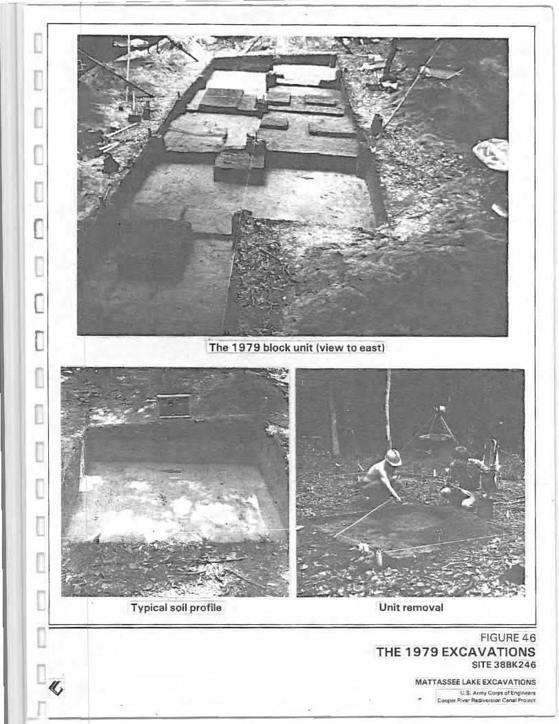
Typical soil profile Unit removal
FIGURE 46
THE 1979 EXCAVATIONS SITE 38BK246
MATTASSEE LAKE EXCAVATIONS U.S. Army Corps of Engineers
Cooper River Recftversaon Canal Projee•

• • 0 ... 0
X
Flake Sherd
Falnl Stamn~l IY/ChOICNl Flodt• {Poutble Feonurcl
Utilized Flake/Uniface Biface/Biface Fragment Baked Clay Object Rock
Note. 1 t Oeta•ted deseupuve ..ntormauon on all ptece plotted ar · 11tacts by cat31og number, may be tuund on the aceom
panytng block untt da ta &heels in 1h8 oppend1x
volume.
Note 2 1 All o f the P•eee plotted owl act s shown here are outstde of known ttu.Hures lnfotma tlon on attilacts tound and or p&otted wuhm features ts presented tn the see tton on .ndtvtdual feature descupttons
0 -1 0 em Level
0
0 4
2 METERS
8 FEE T
• 28A 18
23C.15 23Cib
•
A.D.1190ot110 --- ----' OlC 1845
(Possible Featurfl'l) (Tree or Post1)IIO YR 3/21
FIGURE 4 ·
SITE 38BK24b 1979 BLOCK UNIT~
FEATURES AND PIECE PLOTTED ARTIFACT! M ATTASSEE LAKE EXCAVATION
U S Army Cotps of Enganeers
Cooper Rrver Recf,vers•on Canet Protect

• Flake • Sherd 0 Utilized Flake/Uniface • Biface/Biface Fragment o Baked Clay Object x Rock
Note 1 t Oelalled descupl•ve enlorm1t1on on all paece ptoued ar ·
tttacts bv catalog number. may t>e found on the accom· panytng block un•t data sheets '" the append•x volume
Note: 2 .• All or the ptece plotted arufacts shown here are outs•de ol known hHUures lnlormateon on an•facts tound and or plotted wtth•n tea~ures as presented '" the sec uon on tndtvtdual featuu~ descnpuons
1 0·20 em Level
0
0 4
2 METERS
8FEET
I 4.~t~h,. RiifOf'te Poll _.._ __ +---1
1 (IOVR 3131
Fl()(tr l V IIOwtsh Br~wn
10V"515) - &U10 J2B.S
Fe"1ure 11 Sta•n W/Shell Fr"9f"~Cfl.IS .... ~r·/Jit ~~; •.• 248.3 328 4
•
);• ... , F IOOf 258.2 /''
Yell~tih Brown! . A T ee or Post (10 VR 5/4~ I 0 VR 4/31
FIGURE 48 SITE 38BK246 1979 BLOCK UNITS
FEATURES AND PIECE PLOTTED ARTIFACTS MATTASSEE LAKE EXCAVATIONS
U S Auny Corps ot Engmeers Cooper Rtver RedtversJOn Canal Prorect

• Flake • Sherd 0 Utilized Flake/Uniface • Biface/Biface Fragment o Baked Clay Object x Rock
Note: 1 .l Oeliuled delcripttve tnfOfmauon on all piece plotted artifacts by catalog numbet. may be found on the accom· panyt"Q block unit data sheets an the appendix
volume.
Noto: 2., All of the ptece plotted awlacts shown here ore outside of known features Information on artifacts found and 'Or ploued wtthtn leatures tS presented '" the sec· uon on .ndtvtdual feature descripuona.
20-30 em Level
0
0
2 METERS
4 8FEET
Proboblo floot (10 YR ~/5)
~~ r El;J3 FlooJ ~tllow1sh 8rcw.n
~--~----~r-110~
FIGURE 49 SITE 38BK246 1979 BLOCK UNITS
FEATURES AND PIECE PLOTTED ARTIFACTS MATTASSEE LAKE EXCAVATIONS
U S. Army Corps ol Engtneers Cooper R•ver Aec:t.vers•on Canal P'otect

L r "-·
I
I • X 260.10 260.7
2G0.8 _)[
E IH t:l ~4
2Gil. l 0
,1.~\\~~ Fealure 2 \'t.~~~u~ A,t'.,
r---
• Flake • Sherd 0 Uti lized Flake/Uniface a Biface/Biface Fragment o Baked Clay Object x Rock
.,,.;.;,~It 1 o vA sr. 1
I
E ~5 270.5 0
270.! •
No1o \ ) Ocla•led descnptiVe •ntotmauon on all P•eee plotted ar · 11tac1s by ca1a1og number. mav be found on the accom·
panvmg block un11 dara shee1s tn 1he append•x. volwne
NniC 2 t All n t the P•Cc,e plotted arutae1s shown here are OuiStde of known features Information on arutacls found
and o• plotted wlthrn features rs presented tn the sec uon on tnd•v•dual feature descupllons
30·40 em Level
0
0 4
2 METERS
8FEET
El
. 280.1 EU6
7
F:~~ Bwwrll$ Ycllnw (10YR617)
f-
310.7 31016 I • 0 • 310.2
r-- ~ 310.6
310.9 • X 310.11
El:fl9 El1
r" Flex ' Yt~Uowish Bmwn IIOYR 181
310.3 310.4
310. 1% TUI2
08 G) Arei 6)
I I I I I
El 2 EU -0
-- --
EU'l
FIGURE 50 SITE 38BK246 1979 BLOCK UNITS
FEATURES AND PIECE PLOTTED ARTIFACTS MATTASSEE LAKE EXCAVATIONS
U S Armv Corps of EngonceiS Coope• R•ver Rec11vtrs10n Can.tl Protect

dating, gtvmg a date of 760~110BP, or AD 1190 (DIC-1845). Feature 2 is interpreted as a Late Woodland hearth, and may be associated with Features 5,10 and 15 at 388K246, which are also well-defined hearths that appear to date to this period.
FEATURE 3
This feature was characterized by a cluster of angular sandstone fragments (N=10, 487.6 grams) encountered at a depth of 20 em in the southeast corner of EU3. No associated artifacts or charcoal staining were noted, although a lanceolate projectile point of possible Middle to Late Archaic age (Figure 62:c) was found lying flat one meter to the north at the same depth. The feature does not appear to be natural, and may be the remains of an old weathered hearth, or possibly reflects some type of crude reduction activity. The lack of associated artifacts makes cultural affiliations difficult, but the depth, and nearby point form, suggest a possible Archaic age.
FIGURE 51 a FEATURE 2
FEATURE 4
Feature 4 was a diffuse circular charcoal stain approximately 60 em in diameter that was recognized at a depth of 10 em in the western part of EU4. The feature was a shallow, somewhat irregular basin varying between 5 to 10 em in depth. All of the fill from the stain was floated, producing small amounts of oak (Quercus sp.) and pine (Pinus sp.) wood charcoal (Chapter 1 0). Artifacts recovered in the fill included several small sherds, two baked clay ball fragments (54. 7 grams), and a number of pieces of orthoquartzite debitage (N=l8). An orthoquartzite projectile point (Figure 61:d) was recovered at the base of the stain, and may be associated with the feature. A small amount of cracked rock (132. 7 grams) and fired clay (5.9 grams) was also recovered in the fill. The pottery recovered included Deptford Linear Check Stamped (N=l), Woodland Plain (N=2), and Cape Fear Fabric Impressed (N=2), and one nondiagnostic sherd. Given the poor definition an aboriginal origin cannot be conclusively determined. The feature may, however, be
DIC-1845 760±110BP
A.D.1190 8
Shallow (10cm) Basin
Fill: 10YR3/2
ARTIFACTS CAT. #34A-
• Flake X. Sherd
38BK246 • • •10cm
FIGURE 51
FEATURE 2-PLAN VIE"v
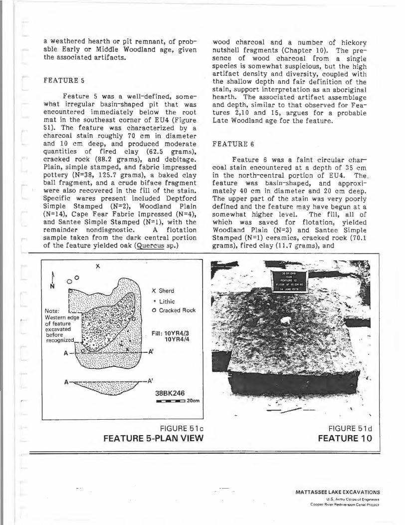
a weathered hearth or pit remnant, of probable Early or Middle Woodland age, given the assoc iated artifacts.
FEATURE 5
Feature 5 was a well-defined, somewhat irregular basin-shaped pit that was encountered immediately below the root mat in the southeast corner of EU4 (Figure 51). The feature was char ac terized by a charcoal stain roughly 70 em in diameter and 10 em deep, and produced moderate quantities of fired clay (62.5 grams), cracked rock (88.2 grams), and debitage. Pla in, simple stamped, and fabric impressed pottery (N=38, 125.7 grams), a baked clay ball fragment, and a crude biface fr agment were also recovered in the fill of the stain. Specific wares present included Deptford Simple Stamped (N=2), Woodland Plain (N=l4), Cape Fear Fabric Impressed (N=4), and Santee Simple Stamped (N=l), with the remainder nondiagnostic. A flotation sample taken from the dark central portion of the feature yielded oak (Quercus sp.)
X Sherd
• Lithic
0 Cracked Rock
Fill : 10YR4L3 10YR4/4
A~-A' 38BK246
w w • •20cm
FIGURE 51 c
FEATURE 5-PLAN VIEW
wood charcoal and a number of hickory nutshell fragments (Chapter 10). The presence of wood charcoal from a single species is somewhat suspicious, but the high artifact density and diversity, coupled with the shallow depth and fair definition of the stain, support interpretation as an aboriginal hearth. The associated artifact assemblage and depth, similar to that observed for Features 2,10 and 15, argues for a probable Late Woodland age for the feature.
FEATURE 6
Feature 6 was a faint c ircular c harcoal stain encountered at a depth of 35 em in the north-central portion of EU4. The . feature was basin-shaped, and approximately 40 em in diameter and 20 em deep. The upper part of the stain was very poorly defined and the feature may have begun at a somewhat higher level. The fill, all of which was saved for flotation, yielded Woodland Plain (N=3) and Santee Simple Stamped (N=l) ceramics, cracked rock {70.1 grams), fired clay (11 . 7 grams), and
~- -·· · . .
. . ------ "
FIGURE 51 d
FEATURE 10
MATTASSEE LAKE EXCAVATIONS U .S. Army C orps ot Eng1nt'tets
Cooper Rtver Aed •verston C anal Pro1eet

moderate quantities of orthoquartzite debitage (N=85). Ethnobotanical analysis of the recovered charcoal documented the presence of several tree species, as well as a number of hickory nutshell fragments (Chapter 10). The feature, a probable hearth base, appears to date to the Middle or more likely the Late Woodland period, given the associated artifacts.
FEATURE 7
This feature was defined by a faint circular charcoal stain encountered at a depth of 15 em in the south-west corner of EU5. The feature, which was poorly defined, was approximately 50 em in diameter and 13 em deep. Feature 7 was somewhat unusual in that two large sandstone cobbles (roughly 10 by 10 by 15 em) were recovered in a probable association, one each at the north and south sides of the stain. The fill, which was floated, produced two small nondiagnostic sherds, and minor amounts of debitage (N=9), fired clay (3.2 grams) and cracked rock (10.2 grams). Identifiable charcoal included oak (Quercus sp.), pine (Pinus sp.}, and hickory nutshell fragments (Chapter 10). The feature is interpreted as a weathered hearth of possible Early to Middle Woodland age, although given the absence of diagnostic artifacts a precise period affiliation cannot be confidently assigryed.
FEATURE 8
Feature 8 was a diffuse, oval-shaped basin roughly 75 em (E/W} by 50 em (N/S} in size, and 10 em deep, that was recognized at a depth of 13 em in the northwest corner of EU2. The fill, which was floated, yielded Woodland Plain (N=2), Cape Fear Fabric Impressed (N=1), and nondiagnostic (N=1) pottery, and minor amounts of fired clay (0.4 grams), cracked rock (21. 7 grams), and orthoquartzite debitage (N=ll). Ethnobotanical analysis documented the presence of red oak, white oak, hickory, and pine wood charcoal, and acorn and hickory nutshell fragments (Chapter 10). The feature appears to represent a somewhat weathered Middle Woodland period hearth.
112
FEATURE 9
Feature 9 was a faint, irregular charcoal stain that was encountered at a depth of 14 em in the southeast corner of EU2. The feature was characterized by a dark central portion some 30 em in diameter and 10 em deep, surrounded by a lighter, more diffuse charcoal stain roughly 70 em in diameter and up to 25 em deep. The fill of the central portion of the feature was floated, yielding wood charcoal from several tree species as well as a few hickory nutshell fragments (Chapter 1 0). Artifacts recovered in the fill of the feature included Woodland Plain (N=2), and Cape Fear Fabric Impressed (N=1) pottery, (recovered from the lighter, outer staining), and small amounts of orthoquartzite debitage (N=l3), cracked rock (53.6 grams), and fired clay (6 .9 grams). The feature is interpreted as the remains of a probable Middle Woodland period hearth.
FEATURE 10
Feature 10 was a large, well-defined oval basinshaped charcoal stain encountered just below the root mat in the center of EU9 (Figure 51). The feature, which measured approximately 110 em (E/W} by 70 em (N/ S}, had a somewhat irregular bottom from 10 to 15 em deep. A number of sherds (N=9) were recovered in the fill, including the rounded base of a Santee Simple Stamped bowl or jar. The total pottery assemblage included two sherds of Woodland Plain, one sherd of Cape Fear Fabric Impressed, two sherds of Santee Simple Stamped, and four nondiagnostic fragments under onehalf inch in size. Most of the fill from the feature was floated, producing charcoal from a range of wood species as well as a number of hickory nutshell fragments (Chapter 10}. Charcoal recovered from around the pot base was submitted for radiocarbon dating, and gave a date of 6304il5BP, or AD 1320 (DIC- 1846). This date is -in close agreement with the date obtained from Feature 2 (AD 1190), which occurred at the same depth and yielded similar pottery. Other materials in the fill of Feature 10 included fi re cracked rock (580.6 grams), fired clay (70.2 grams), and orthoquartzite debitage (N=144). The

feature is interpreted as a Late Woodland aboriginal hearth.
FEATURE 11
This feature was defined by a small concentration _of mussel shell fragments about 20 em in diameter encountered at a depth of about 20 em in the southwest corner of EU10. Shell was only infrequently observed in aboriginal context in the Mattassee Lake assemblage and, with the exception of this feature, was always found in very tiny, weathered fragments. Aboriginal use of shellfish in the area is clearly documented at 38BK83, 2000 meters downstream at the confluence of Mattassee Lake with the Santee River (Asreen 1974}, but no evidence for similar, extensive exploitation was found on the project sites. No artifacts were found associated with the shell, although the depth at which the material occurred suggests an Early or Middle Woodland age.
FEATURE 12
Feature 12 was characterized by a somewhat irregular oval basin-shaped charcoal stain encountered at a depth of 10 em in the northern portion of EU6. The feature measured roughly 1.0 m (NW /SE) by 0.8 m (NE/SW), with the base poorly defined and varying in depth from roughly 10 to 15 c m. Artifacts recovered in the fill included two small sherds, one nondiagnostic and the other Cape Fear Fabric Impressed, together with moderate quantities of cracked rock (69.9 grams), fired clay (10.1 grams), and orthoquartzite debitage (N=94). All of the fill was floated but the light fraction charcoal was not analyzed due to the poor overall definition of the feature. Feature 12 may represent a weathered hearth, although a precise identification is not possible given the ambiguous nature of the stain. The only diagnostic artifact in the fill, a sherd of Cape Fear Fabric Impressed pottery, suggests a Middle Woodland age.
FEATURE 13
This feature consisted of three small circular charcoal stains from 10 to 30 em in diameter in an irregular mottled soil zone roughly 50 em in diameter. The three stains
113
were shallow and extended only about 4 em below where they were recognized. Feature 13 was first encountered at a depth of 10 em in the southeast corner of EU6. The fill from two of the three smaller stains was floated but was not analyzed by the ethnobotanist due to an absence of associated diagnostic artifacts. Minor amounts of debitage, cracked rock, fired clay, three small Woodland Plain potsherds, and a baked clay object fragment were recovered in the general fill, but due to the poor definition of the surrounding mottled staining a clear association with the feature cannot be inferred. Feature 13 appears to represent a tree but may alternatively represent post stains, although this is considered less likely.
FEATURE14
Feature 14 was a diffuse circular charcoal stain approximately 50 em in diameter first recognized at a depth of 20 em in the north-central portion of EU7. The feature was an irregular basin up to 8 em deep. All of the fill was floated, producing a minor amount of fired clay (2.4 grams) and larger amounts of orthoquartzite debitage (N=43) and cracked rock (1 07.1 grams). One Woodland Plain sherd, and two small, nondiagnostic sherd fragments were also found in the fill. Recovered charcoal was saved but not identified due to the ambiguous nature of the assemblage. The feature may represent a weathered hearth base of Woodland age, but precise interpretation is difficult.
FEATURE 15
Feature 15 was a well-defined circular basin-shaped charcoal stain approximately 80 em in diameter encountered immediately below the root mat in the east-central portion of EU8. The feature attained a maximum depth of 15 em, and may have intruded slightly into Feature 4, which was lower and slightly to the east. All of the fill from Feature 15 was floated, producing a moderate amount of fired clay (23.4 grams), cracked rock (100.5 grams), orthoquartzite debitage (N=66), and pottery (N=ll, 37.1 grams). Diagnostic pottery included Woodland Plain (N=4), Deptford Simple Stamped (N=1), and Cape Fear Fabric Impres~ed

sherds, indicating a probable Middle Woodland age. The wood charcoal from the fill was found to be almost entirely oak, suggesting that the feature may have been a burned tree (Chapter 10), although no laterals were encountered. The depth at which the feature was recognized, and associated artifacts, suggest that Feature 15 is comparatively recent, of Middle Woodland or later age.
FEATURE 16
Feature 16 was characterized by an irregular ovalshaped charcoal stain encountered at a depth of 22 em in the northwest corner of EU8. The stain measured 58 em {N/S) by 44 em {E/W), and varied in depth from 2 to 8 em. Only small quantities of pottery (N=2, 11.9 grams), fired clay (1.6 grams), cracked rock (132.2 grams), and orthoquartzite debitage (N=16) were recovered in the fill. The two sherds recovered included one Woodland Plain and one Cape Fear Fabric Impressed. A flotation sample was taken and the charcoal was saved, but not analyzed, due to the ambiguous nature of the stain. Feature 16 was poorly defined and disturbed by large roots, rendering interpretation difficult. The feature is believed to represent an old burned tree.
FEATURE 17
Feature 17 was a shallow circular charcoal stain roughly 25 em in diameter and 4 em deep that was first recognized at a depth of 15 em in the center of EU7. Artifacts recovered in the fill included one small Santee Simple Stamped sherd and trace amounts of fired clay {0. 7 grams), cracked rock (1.2 grams), and orthoquartzite debitage (N=3). Interpretation of the feature was difficult, and it is assumed to be a root stain.
FEATURE 18
This feature was a shallow basinshaped charcoal stain encountered at a depth of 10 em in the southwest corner of EU9. The feature was an irregular oval measuring 47 em {N/S) by 40 em {E/W) that varied in depth from 2 to 3 em. All of the fill was floated, yielding charcoal from
several tree species, including white oak, red oak, and pine, and a single hickory nutshell fragment (Chapter 10). Artifacts recovered in the fill included two Woodland Plain and one Cape Fear Fabric Impressed sherds, 32 pieces of orthoquartzite debitage, and minor amounts of fired clay and cracked rock. The feature is adjacent to and slightly lower than Feature 10, and may be related. Feature 18 is interpreted as a probable Middle Woodland period hearth base.
FEATURE 19
Feature 19 was a distinct circular charcoal stain 50 em in diameter that was encountered at a depth of 27 em in the southwestern quarter of EU6. Large quantities of charcoal were recovered from the fill, which was floated; upon analysis the charcoal was found to be entirely from white oak (Chapter 10). Two Cape Fear Fabric Impressed sherds, a crude triangular arrow point, and a minor amount of cracked rock and debitage were found in the fill. Due to the (atypically) large quantities of charcoal in the fill, Feature 19 is inter preted as a recent burned tree.
114
FEATURE 20
This feature was characterized by a diffuse mottled charcoal stain recognized at a depth of 30 em in the southeast corner of EU4. The feature was irregular in shape, measuring 52 em (NW/SE) by 40 em (NE/SW), and varied in depth from 1 to 12 em. The fill, which was floated, produced a moderate amount of orthoquartzite debitage (N= 138) and minor quantities of cracked rock (75.1 grams) and fired clay (2.8 grams). No pottery was present, although a baked clay object fragment was recovered in the general level fill near the stain, and may be associated. The feature was very poorly defined, and an aboriginal origin cannot be demonstrated with any degree of certainty. Feature 20 may be a possible hearth or pit base, of unknown period.

CHAPTER 6
LABORATORY ANALYSIS PROCEDURES
INTRODUCTION
In this chapter three aspects of the Mattassee Lake project analysis are examined in depth. These topics are: (1) assemblage processing, cataloging, and curation procedures; (2) criteria for the identification of lithic raw materials, and (3) specific taxonomic (monothetic subdivisive clustering) procedures used to examine the hafted bifaces and ceramics. Each area is directly subsumed under major goals advanced in the project research design: effective assemblage documentation, lithic raw material source areas and procurement patterns, and the evaluation of existing taxonomies (Chapter 4). The analytical procedures discussed in this section are general in nature, and provide a background framework to the more specific artifact or category-oriented analyses reported in succeeding chapters. They are also important enough, and of sufficient complexity, to warrant separate treatment. The thin section descriptions reported here were prepared by Dr. Gerald R. Baum of the College of Charleston, while the discussion on numerical taxonomy was written by William A. Lovis and Randolph E. Donahue of Michigan State University.
LABORATORY AND CURATORIAL PROCEDURES EMPLOYED AT MATT ASSEE LAKE
Over the last decade, members of the Council for Museum Anthropology along with other interested individuals have advocated the need for careful curation of archeological assemblages. Two recent studies, by Ford and Lindsay (1979), Williams-Dean and Haas (1979), have focused on the condition of anthropological collections and records in institutions today. Several other authors have stressed the need for the long-term care and management of archeological assemblages and documents, and have offered methods for achieving this goal (e.g., Butler 1979; Ford 1980; Novick 1980; Wilcox 19~0). Curation guidelines
used by several archeological repositories, including the University of Kentucky Museum and the Arkansas Archeological
- Survey, were recently published by the Council for Museum Anthropology, Cambridge, Massachusetts. A recent trend that appears to be spreading, involves charging fees for access to or storage of research collections. Some institutions routinely levy fees to individuals and organizations who wish to gain access to archeological records and/or to deposit archeological ·collections for long-term storage. These examples indicate that the profession is becoming increasingly aware of the value of research collections, and the need for their effective management. The laboratory and curatorial procedures used during the Mattassee Lake project were implemented with this perspective in mind. A primary goal of the Mattassee Lake investigations, noted in the Research Design (Chapter 4), was to effectively inventory and document the assemblages and analyses used during the project. This responsibility was additionally clearly stated in the project contract, where provisions were included for the cataloging and temporary storage of the assemblage, prior to permanent curation. All of these thoughts guided the Mattassee lake documentation/analysis/curation effort.
THE 1979 FIELD LABORATORY
115
As noted previously, a fully operational field lab was maintained during both the testing and subsequent excavation seasons in 1979. During the testing program, in March and early April, the field lab was maintained at the Corps of Engineers headquarters maintenance building in St. Stephens. All three projects used this area during the testing program, through the courtesy of the local Corps of Engineers staff. During the subsequent mitigation stage excavations the Corps building was too cramped, and each project made other laboratory accommodations. To process the Mattassee Lake assemblage, a room was rented in a local warehouse, which was used

for bulk sorting and processing, and for storage. Final cataloging and analysis during the excavation season was done at the crew's quarters, a house in St. Stephens.
As artifacts were uncovered in the field, they were stored in "zip-lock" plastic bags accompanied by a yellow 3x5 inch file card labeled with the field provenience number and other relevant locational information (e.g., site number, unit number, level, date, and excavator's name). All materials recovered in the screen were initially bagged together. Specimens that were piece- plotted (mapped in three dimensions within the unit level) were bagged individually with an identifying label, or were marked in the field with a number or letter using a Sanford Sharpie permanent marker. This symbol written on th_e artifact itself, coiTesponded with an exact location on the field map. The general level fill and piece-plot bags were returned to the field lab each night, where they were stored for eventual washing and sorting. The bulk of the assemblage was washed in the parking area of the local Army Corps of Engineers Office in St. Stephens, South Carolina. The Institute of Archeology and Anthropology Cooper River Rediversion Canal project used the Corps headquarters area as a lab, and graciously shared their washing equipment, which consisted of screens set in a large holding tank. Artifacts were emptied into the screens and then hosed down and scrubbed. Clean artifacts were removed from the screens, placed on styrofoam meat trays, along with their provenience cards, and set in the sun to dry. Mud from the washing activity was released from the holding tank after each bag load, and passed through a screen to collect material that might have fallen or floated out of the washing screen. When dry, the artifacts were placed in clean "zip-lock" bags with their original provenience cards.
The washing operations at the Corps headquarters focused on the general level fill. Piece-plotted artifacts were washed separately, at the lab set up in the crew house. Each day as artifacts were brought in from the fie ld they were sorted. The general level bags were dropped off at the Corps headquarters where they were (temporarily) stored prior to washing. The
piece-plot bags were taken to the crew house/lab, where they were washed and cataloged. At this lab the plotted artifacts were removed from their bags and placed in alphabetical or numerical order on paper, and were then washed individually. Since the washing occasionally removed the field markings, the artifacts were cataloged as soon as they were dry, to prevent information loss. Both the piece-plotted and the general level artifacts were ultimately stored in boxes, by provenience, by the end of the fieldwork.
After the artifacts from the general level fill were dry, they were also sorted and cataloged. A coding sheet was used (Figure 52), to serve the dual role of a catalog form and a · preliminary analysis record. The general level fill was emptied onto a table surface for sorting and cataloging. Each major artifact category was bagged separately, using plastic "zip-lock" bags. All immediately recognizable tools were set aside to be cataloged with an individual number. Debitage was sorted by lithic raw material type, counted, and bagged, as was all pottery. Weights and/or counts were recorded for fired clay, ferruginous sandstone, bone, baked clay objects, steatite and charcoal. Unmodified rock and gravel was also sorted, weighed and bagged. This was by far the most common material recovered (and the most time consuming to sort through); almost 1000 kilograms of rock were found in the 1979 excavation units.
THE CATALOGING SYSTEM
116
Artifacts were cataloged according to the system used at the University of South Carolina's Institute of Archeology and Anthropology (IAA). Two major reasons prompted the selection of this system. First, it was assumed that the artifacts would be stored at the IAA, where the initial Rediversion Canal collections were maintained. Second, the authors and most of the crew members had worked at the IAA, and were familiar with this system. This familiarity helped avoid mistakes during both the fieldwork and the subsequent analyses. It should be stressed that for consistency only a select number of individuals actually cataloged the assemblage.

COOPER RIVER REDIVERSION CJL~AL PROJEC7 COMHOIDIEALTH ASSOCIATES INC. THREE PREHISTORIC SITES
LABORATORY CATALOG/Ai~ALYSIS SHEET 1979 TESTING ru~D MITIGATIONS
TENTATIVE AGE OF PROV.
LITHICS DEBITAGE
QUARTZITE N= --- Cat if N=
CHERT N= Cat f N=
QUARTZ N= Cat i! N=
RHYOLITE N= Cat " 11' N=
0 N= Cat " N= .. 0 N"' Cat if N=
0 N= Cat " .. N= ---POTTERY N= Cat " ,.
THOH'S CREEK PUNCTATE N=
REFUGE D~TATE STAMPED N= DEPTFORD LIN. CHECK ST N=
CAPE FEAR CORD !-iARKED N=
C.li.PE FEAR FABRIC IMP N=
HANOVER CORD MARKED N=
fl.AJ.~OVER FABRIC D1P N=
COMPLICATED ST&'1PED N==
OTHER ARTIFACTS
FIRED CLAY WT=
FERRGNS SS WT=
____ g. rams Cat. :'1
____ g.rams Cat if
BONE N= WT= ___ gran~s Cat " ..
SITE
UNI T
LV/F
PROV. :'1
RECR.
TOOLS
Cat ?.
Cat ;}
Cat ~
Cat " "f
Cat " " Cat t
Cat ~
PLAIN' (SAND)
PLAIN (FIBER) BURNISHED PLAIN
SIMPLE STAMPED
BRUSHED
0
0
NONDIAGNOSTIC
BAKED CLAY OBJECTS N= WT= ______ grams Cat ~
FIRE CRACKED ROCK N= WT= ~ams
STEATITE N= NT= ___ grams
Cat ~ CHARCOAL WT= grams
UNMODIFIED GRAVEL/ROCK N= o ___ _ Cat " " o ____ _ Cat ~
o ___ _ Cat * o ___ _ Cat " ~
COMMENTS:
Cat ii
'r<T==
Cat ~
Cat ~
POINTS N= Cat " " N= Cat if
N= Cat ;
N= Cat " ,. --N= Cat " " N= Cat ~
N= Cat " ,.
~=
N= N= ---N;,.
N=
N= N=
N=
FIGURE 52
THE FIELD CATALOG/ANALYSIS SHEET USED DURING THE 1979 EXCAVATING
MATTASSEE LAKE EXCAVATIONS U.S. Armv Coros of E.ng1neers
Cooper River Red1vers,on Canal Pro,ecr

All of the project personnel, however, were involved in- the initial washing and sorting activities, at one time or another, together with the YCC students provided by the U.S. Forest Service. Whenever preliminary sorts were made by untrained volunteers or by the YCC students, their work was checked by permanent project personnel before being bagged. The preliminary sorting procedure greatly facilitated the actual cataloging process, giving project personnel more time to both catalog and actually analyze the artifacts in the field.
A short summary of the IAA cataloging system is presented below. Using this system, it _is possible for archeologists to correlate catalog numbers with actual field locat ions in a way that is more readily interpretable than systems using only a museum accession number. Although both systems have advantages and disadvantages depending on what they are used for, this particular system works well with archeological assemblages.
Each catalog number has three components. For example the catalog number 38BK226-102D-2, is interpreted as the site number, followed by the provenience number (which corresponds to an excavation unit), followed by the artifact catalog number. Before any cataloging began, provenience numbers were assigned to all excavation units and features. The first provenience numbers for the three project sites had been assigned in 1978, to material recovered during the 1977 intensive survey by IAA personnel (Brockington 1980). This initial cataloging was conducted by Claudia Wolfe under the supervision of A. Lee Novick who was, at the time, the lab director at the Institute. A second set of consecutive provenience numbers was established by A. Lee Novick during the MarchApril 1979 testing program. During the subsequent mitigation stage excavations from May through August, 1979, excavation units were assigned a third set of consecutive provenience numbers correlating with all units, levels, and features. A listing of all proveniences and catalog numbers employed during each season of work at Mattassee Lake is provided in the Data Appendix Volume. A provenience number has two components: a number followed by
a letter. In the example, 38BK226-102D-2, 102 represents an excavation unit (in this case EU20), and the letter D signifies the fourth level in the excavation unit, 15-20 centimeters below the surface. All letters correspond to stratigraphic zones or arbitrary levels beginning at the surface with an A and proceeding with depth B,C,D, etc. In this way, examining an individual artifact, without field notes, it is possible to ascertain its relative depth. Although the number 102 may seem rather high for Excavation Unit 20, it is important to remember that IAA personnel excavated a number of test pits at the site in 1977 and that the spring 1979 testing program included the excavation of 64 test units. All of these units were assigned provenience numbers prior to the- summer 1979 excavations, when EU20 was dug.
During the cataloging process, efforts were made to catalog chipped stone tools first. Individual catalog numbers were used for each tool, which were described on the recording sheet using one of several preliminary categories (i.e., projectile points, bifaces), unifaces, and cores). Following IAA procedures, a toluene solution of DuPont acrolid B72 was brushed onto the artifact with a small artist's paint brush. From a conservator's standpoint this is a preferable procedure because the catalog number can be removed by rubbing with pure toluene without damaging the artifact. Because the lithic material in the Mattassee Lake assemblage was so irregular (rough), this coating made a smooth writing surface that ink would not penetrate, facilitating the actual numbering and protecting the artifact. A quill tip pen and Faber-Castell Higgins black, waterproof india ink were used to catalog light colored artifacts. Although some catalogers brush a small spot of white, typing correction fluid (e.g., Liquid Paper, White-out) or white paint on a dark colored artifact to serve as the base for a black ink catalog number, this base coat often cracks and peels off, resulting in the loss of an artifact's identification. Cataloging with white ink applied directly onto dark colored artifacts is preferable from a perspective emphasizing both longterm storage and safety in future analysis. Because it blends more easily than some ink and remains in a suspended mixture longer,
118

. Speedball waterproof, white drawing ink was selected for cataloging dark artifacts. Steatite fragments, baked clay objects, abraders, and other unusual artifacts were also cataloged with individual numbers. Categories with extensive quantities of artifacts, such as debitage, pottery, fired clay, ferruginous sandstone, bone, fire cracked rock, charcoal, and unmodified rock and gravel were assigned lot numbers. That is, one catalog number was assigned to all the artifacts of a given category, for example, to all the pieces of debitage made from one type of lithic material. These lots of artifacts were stored in "zip-lock" plastic bags with the catalog number written on the outside of the plastic bag with a permanent marker.
As noted above, piece-plotted artifacts were treated separately. ·These artifacts were taken out of their field bags and laid out in alphabetical or numerical order. In many instances piece-plotted artifacts were listed on the field provenience cards, in other cases field notes were checked. A listing of piece-plotted artifacts was made on the back of the catalog/analysis sheet. This information included the original field number, an assigned catalog number, and a description of the artifact. An outline of unusual projectile points was also drawn at this time. Artifacts were washed individually and then replaced in order. When dry these were cataloged in the usual manner. Piece-plotted artifacts, rather than being stored with similar tools or ceramics, from the unit level or feature bag, were kept together in a separately marked piece-plot bag.
THE USE OF RESEALABLE PLASTIC BAGS
During the course of the project a number of individuals inquired about ·the cost and rationale for using sealable ("ziplock") plastic bags. The storage of artifacts in plastic bags, particularly .004 mil "ziplock" sealed bags, may seem extravagant to some; however, they offer a number of advantages. Years ago all institutions and archeologists used brown paper bag~ to collect and store artifacts. Since field notes were often written on the field bag, the
system was maintained and is almost an institution in some areas. Unfortunately, paper bags tend to mold and mildew in damp storage conditions, or fall apart when wet. The growth of mold or bacteria can be a serious problem in some collections, particularly those with bone, cloth, friable ceramics, or ethnobotanical remains ·present. Paper bags also conceal artifacts and must be continually opened and closed. Perhaps the worst danger with paper bag storage is insect or rodent infestation. Unless the storage area is air tight and can be fumigated it is virtually impossible to kill these pests. Open (i.e., with no closure) plastic bags offer several advantages over paper bags, but still have problems. Artifacts stored in clear envelopestyle bags are visible, not susceptible to infestation, and protected, to some degree, from moisture. A major disadvantage with plastic bags lacking built-in closures is the need to seal the bags with tape or staples, which are both impermanent and damaging. Gummed tape will dry and fall from the bags (or conversely sometimes stick too well and tear the bag on removal), while staples will rip the bags as they are pulled out. The "zip-lock" top plastic bags offer the same advantages, without the disadvantages. One point to be made about both types of plastic bags is that if artifacts are damp, the bag should not be sealed until the contents are thoroughly dry, otherwise the moisture will cause mold and mildew to grow on paper labels in the bags, as well as on the contents.
As might be expected, there is a direct correlation between storage cost and storage quality. Labor costs are also something to consider. At some collection repositories all artifacts are cataloged; in large scale excavations, however, the costs of cataloging every flake or sherd is prohibitive (and given the volume of material, somewhat absurd). Prices of both paper and plastic bags vary by supplier, quantity ordered, shipping/freight cost, and cash discount. For example, at paper suppliers near Jackson, Michigan, prices for small 6x8 inch brown paper bags are about $10/1000 while .004 mil "zip-lock" plastic bags the same size cost $50/1000 (1981 prices). While the greatest savings would appear to come from using paper bags, the long-term "hidden"
119

costs may make them actually more expensive. When paper bags are used in the field provenience information is typically written on them, sometimes in prestamped recording blocks. Unless care is taken (i.e., permanent ink, dry field storage conditions), however, the provenience information may be lost if rain occurs. Damp bags may break and mix proveniences, another "expensive" loss (given field recovery costs). Even under the best of conditions paper bags suffer some attrition, and after laboratory washing and sorting many must be replaced outright. The provenience information must be cut from the old bag and transferred (or copied), a time consuming task that can also result in expensive information loss. Finally, if the bags are opened repeatedly while in storage, more replacements may be necessary. Finally, the storage environment itself must be fairly rigidly controlled, to prevent deterioration of the bags. In this light, paper bags are probably at least as "expensive" as plastic bags, and a potential source of considerably more trouble.
In contrast, plastic bags are tough and durable, and have tremendously long use lives. They can be washed and reused in both the field and the lab (a common procedure during the Mattassee Lake project), and the provenience data, on a card inside the bag, can be readily transferred yet at the same time is protected from loss or damage. The use of bright, color coded cards, furthermore, minimize errors in both the field and the lab, particularly on large or complex (i.e., multi-site) excavations. In sum mary, while initially more expensive, resealable plastic bags are actually a cost and information saving innovation.
CRITERIA FOR THE IDENTIFICATION OF LITHIC RAW MATERIALS FOUND AT MATT ASSEE LAKE
Lithic artifacts from the excavation assemblage at Mattassee Lake were sorted into 28 raw material categories, established on the basis of macroscopically visible characteristics such as color, texture, and inclusions. The identification and classification of lithic raw materials has been receiving increasing attention in the Southeast Atlantic region in· recent years (e.g., Novick
120
1978; Goad 1979; House and Wagaman 1978; Anderson 1979a; Claggett and Cable 1982), and the terminology selected to describe the Mattassee Lake assemblage was chosen to generally complement, and build upon, earlier investigations. A listing of the lithic raw materials found at Mattassee Lake, and references for formal descriptions of many of these categories, is given in Table 7. In order to continue the development of a standardized terminology, 21 raw material samples from the site assemblage and from local outcrops were submitted for thin sectioning and technical description. The technical analyses and descriptions concentrated on raw materials that had not previously been reported, or reported in detail, in the literature (Table 7). The majority of the specimens were orthoquartzites and cherts thought to be of local origin, from along or near the Santee River basin.
The technical thin section descriptions reported here were prepared by Dr. Gerald R. Baum of the Department of Geology at the College of Charleston, Charleston, South Carolina. Dr. Baum has conducted extensive research on the geological formations of the central Coastal Plain in recent years (Baum 1977; Baum and Powell 1979; Baum et al. 1981; Powell and Baum 1981) including criteria for the identification of specific facies, investigations essential to the determination of potential raw material source areas. Appropriate geological terminology characterizing each thin section is provided, although throughout the report the more concise, non-technical terms for each category, given in Table 7, are used. It should be emphasized that this effort should be viewed as an initial, preliminary study. Ideally, large numbers of samples should be examined for known outcrops, to establish specific faunal lists and other sorting criteria (e.g., Baum et al. 1980). The results reported here are encouraging, however, and should prove a useful guide to future research.
Orthoquartzite
The vast majority of the debitage assemblage at Mattassee Lake consisted of a light brown (5YR6/4) to white material variously described as sandstone (Brockington 1980), quartzite (Anderson, Lee, and
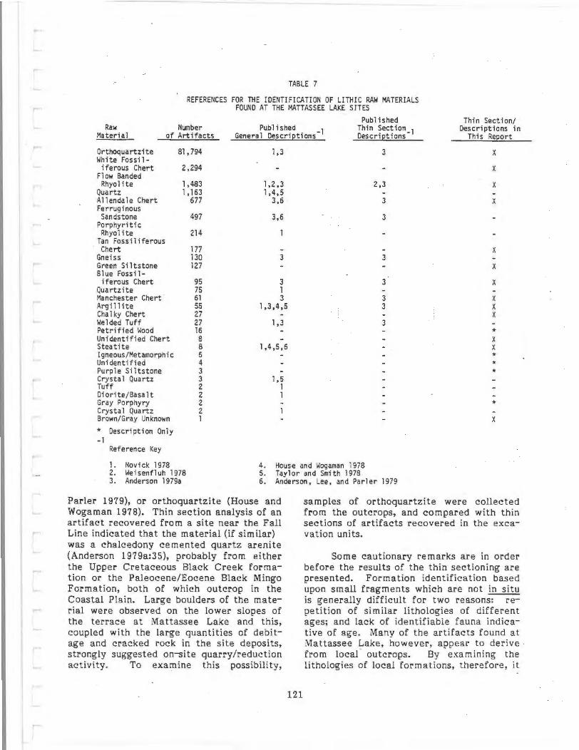
TABLE 7
REFERENCES FOR THE IDENTIFICATION OF LITHIC RAW MATERIALS FOUND AT THE MATTASSEE LAKE SJTES
Published Thin Section/ Raw
Material Number
of Artifacts Published
General Descrietions - l Thin Section_1 Descriptions in Descrietions This Report
Or thoquartzite Bl, 794 1,3 3 X White Fossil -
i ferous Chert 2,294 X Flow Banded Rhyolite 1,483 1,2 ,3 2,3 X
Quartz 1,163 1,4,5 Allendale Chert 677 3,6 3 X Ferruginous Sandstone 497 3,6 3
Porphyritic Rhyolite 214
Tan Fossiliferous Chert 177 X
Gneiss 130 3 3 Green Siltstone 127 X Slue Fossil -
i ferous Chert 95 3 3 X Quartzite 75 1 Manchester Chert 61 3 3 X Argi 11 ite 55 1,3,4,5 3 X Cha 1 ky Chert 27 X Welded Tuff 27 1,3 3 Petrified Wood 16 * Unidentified Chert 8 X Steatite 8 1,4,5,6 X Igneous/Metamorphic 6 * Unidentified 4 * Purple Siltstone 3 * Crysta 1 Quartz 3 1,5 Tuff 2 1 Diorite/Basa l t 2 1 Gray Porphyry 2 * Crysta 1 Quartz 2 Brown/Gray Unknown 1 X
* Description Only -1
Reference Key
1 . Novick 1978 2. Weisenfluh 1978
4. House and Wogaman 1978 5. Taylor and Smith 1978
3. Anderson 1979a 6. Anderson, Lee, and Parler 1979
Parler 1979), or orthoquartzite (House and Wagaman 1978). Thin section analysis of an artifact recovered from a site near the Fall Line indicated that the material (if s imilar) was a chalcedony cemented quar tz arenite (Anderson 1979a:35), probably from either the Upper Cretaceous Black Creek formation or the Paleocene/Eocene Black Mingo Formation, both of which outcrop in the Coastal Plain. Large boulders of the material were observed on the lower slopes of the terrace at Mattassee Lake and this, coupled with the large quantities of debitage and cracked rock in the site deposits, strongly suggested on-site quarry/reduction activity. To examine this possibility,
121
samples of orthoquartzite were collected from the outcrops, and compared with thin sections of artifacts recovered in the excavation units.
Some caut ionary remarks are in order before the results of the thin sectioning are presented. Formation identification based upon small fragments which are not in situ is generally difficult for two reasons: repetition of similar lithologies of different ages; and lack of identifiable fauna indicative of age. Many of the artifacts found at Mattassee Lake, however, appear to derive from local outcrops. By examining the lithologies of local formations, therefore, it

should be possible to make a reasonable judgement as to the formation and source area of both individual artifacts and raw material categories. Along the middle course of the Santee only two principal formations occur, the Santee Limestone and the Thanetian Black Mingo Formation. In the vicinity of the Rediversion Canal the only lithofacies of the Santee Limestone present are limestones (biosparrudites and biomicrudites). There are no terrigenous (extrabasinal) facies present. The limestones are characterized by a lack of detrital quartz (generally less than two percent by weight). The Thanetian Black Mingo Formation has three lithofacies: a claystone (never present in the Santee Limestone); a quartz arenite (sandstone) (never present in the Santee Limestone); and a limestone. If silicification has not obliterated the original sedimentar-Y textures and allochems, generally the Thanetian Black Mingo Formation limestones and Santee Limestones can be differentiated by the dominant fauna (e.g., Baum ~ ~· 1980). The Black Mingo limestones are dominated by pelecypods; the Santee limestones are dominated by bryozoans.
The larger cobbles on the terrace at Mattassee Lake have been interpreted as lag deposits, materials exposed and eroded from the underlying Black Mingo Formation by the action of the river. After the terrace was cleared in late 1979 access to the outcrops, formerly in densely overgrown hardwoods, was greatly improved. Several collections were made over the terrace in 1980, to gather materials for the lithic reduction/replication experiments (Chapter 7), and to collect outcrop samples for comparative analysis with site artifacts. Drs. Baum and Katuna, project geological consultants, supervised the collection activities. Two orthoquartzite samples, collected from large, in situ boulders, were thin sectioned, the first from the terrace slopes adjacent to the 38BK226 block, and the second from the slopes below the 38BK229 block:
Specimen 1 - Orthoquartzite (outcrop below 38BK226 excavation block)
Megascopic (Visual) Characteristics: Chert cemented quartz arenite (chert cemente.d sandstone).
Microscopic Characteristics: Fine, subangular, well-sorted quartz with minor amounts of feldspar and heavy minerals; hematite dust rings surround quartz grains; chert and chalcedony occlude interparticle porosity.
Source Area: Thane t ian Black Mingo Formation.
Specimen 2 - Orthoquartzite (outcrop below 38BK229 excavation block)
Megascopic (Visual) Characteristics: Chert and chalcedony cemented quartz arenite (chert and chalcedony cemented sandstone).
Microscopic Characteristics: Fine, subangular, well-sorted quartz with minor amounts of feldspar and heavy minerals; chert and chalcedony occlude interparticle porosity.
Source Area: Thanetian Black Mingo Formation.
Both specimens were quite similar in composition. The presence of macroscopically visible chalcedony in the sample from the 38BK229 area, something not observed in the sample from the 38BK226 block area, suggests that the material may have been of better knapping quality. This inference, intuitively noted while collecting knapable material for the replication experiments (see Chapter 7) is additionally supported by the excavation assemblages. A far higher proportional occurrence of orthoquartzite reduction debris was recovered at 38BK229 than in the 38BK226 block, suggesting a greater incidence of quarrying/reduction behavior in that area. These topics are discussed in some detail in Chapter 7. ·
122
To check the possibility that some or all of the orthoquartzite artifacts from the Mattassee Lake excavation assemblage could have come from the terrace outcrops, several artifacts were thin sectioned. Specimens were chosen in an effort to accommodate the perceived variability in the material; samples of differing colors, or with unusual (typically chert) inclusions were submitted for analysis. The vast majority of the site orthoquartzite debitage
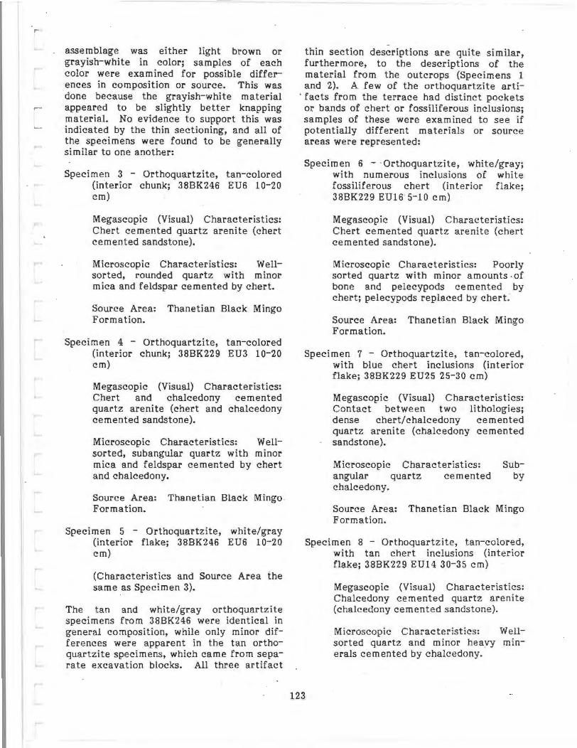
assemblage was either light brown or grayish-white in color; samples of each color were examined for possible differences in composition or source. This was done because the grayish-white material appeared to be slightly better knapping material. No evidence to support this was indicated by the thin sectioning, and all of the specimens were found to be generally similar to one another:
Specimen 3 - Orthoquartzite, tan-colored (interior chunk; 38BK246 EU6 10-20 em)
Megascopic (Visual) Characteristics: Chert cemented quartz arenite (chert cemented sandstone).
Microscopic Characteristics: Wellsorted, rounded quartz with minor mica and feldspar cemented by chert.
Source Area: Thanetian Black Mingo Formation.
Specimen 4 - Orthoquartzite, tan-colored (interior chunk; 38BK229 EU3 10-20 em)
Megascopic (Visual) Characteristics: Chert and chalcedony cemented quartz arenite (chert and chalcedony cemented sandstone).
Microscopic Characteristics: Wellsorted, subangular quartz with minor mica and feldspar cemented by chert and chalcedony.
Source Area: Thanetian Black Mingo Formation.
Specimen 5 - Orthoquartzite, white/gray (interior flake; 38BK246 EU6 10-20 em)
(Characteristics and Source Area the same as Specimen 3).
The tan and white/gray orthoquartzite specimens from 38BK246 were identical in general composition, while only minor differences were apparent in the tan orthoquartzite specimens, which came from separate excavation blocks. All three artifact
thin section descriptions are quite similar, furthermore, to the descriptions of the material from the outcrops (Specimens 1 and 2). A few of the orthoquartzite arti-
. facts from the terrace had distinct pockets or bands of chert or fossiliferous inclusions; samples of these were examined to see if potentially different materials or source areas were represented:
Specimen 6 - ·Orthoquartzite, white/gray; with numerous inclusions of white fossiliferous chert (interior flake; 38BK229 EU16 S-10 em)
Megascopic (Visual) Characteristics: Chert cemented quartz arenite (chert cemented sandstone).
Microscopic Characteristics: Poorly sorted quartz with minor amounts .of bone and pelecypods cemented by chert; pelecypods replaced by chert.
Source Area: Thanetian Black Mingo Formation.
Specimen 7 - Orthoquartzite, tan-colored, with blue chert inclusions (interior flake; 38BK229 EU25 25-30 em)
Megascopic (Visual) Characteristics: Contact between two lithologies; dense chert/chalcedony cemented quartz arenite (chalcedony cemented sandstone).
Microscopic Characteristics: Sub-angular quartz cemented by chalcedony.
Source Area: Thanetian Black Mingo Formation.
Specimen 8 - Orthoquartzite, tan-colored, with tan chert inclusions (interior flake; 38BK229 EU14 30-35 em)
123
Megascopic (Visual) Characteristics: Chalcedony cemented quartz arenite (chalcedony cemented sandstone).
Microscopic Characteristics: Wellsorted quartz and minor heavy minerals cemented by chalcedony.

Source Area: Thanetian Black Mingo Formation.
While there are minor differences in the orthoquartzites characterized by inclusions, all appear to derive from the Black Mingo Formation. Some chert bands or pockets would appear to be present in this formation; recognizable fauna, as expected, were pelecypods (where present). It is not currently known if chert pockets of sufficient size for knapping are present in the orthoquartzite outcrops and strata in the vicinity of Ma ttassee Lake. Chert quarries are reported from the Black Mingo Formation further up the river, in Sumter County (see the discussion below on Manchester chert), but little evidence for deposits of this magnitude is known locally. One possible outcrop, a collection of highly weathered chert cobbles noted a few miles to the north of the Mattassee Lake sites, was reported by Asreen (1974), but no evidence for quarrying was detected at this site.
The dominant fauna of the Black Mingo Formation are pelecypods, and detailed species lists are available to facilitate specimen identification (e.g., Baum et al. 1980: 25-26). While identifiable remains are more likely in chert deposits, fossils preserved in or with orthoquartzites can help identify this material. This is particularly important in the general South Carolina area, since silicified and/or metamorphosed quartz arenites are known to occur in the Piedmont (e.g., Camp et al. 1962:6). A minor constituent of the Mattassee Lake assemblage, classified as quartzite (N=7 5 artifacts; Table 7), may, in fact, be of Piedmont origin. This material, characterized by an absence of fossils and a granulated structure, appears to derive from one or a few cobbles; it generally fits Novick's (1978:433) description for quartzite, and is reported here under that category.
Source areas for aboriginally-exploited lithic raw materials in the general South Carolina area are illustrated in Figure 53. On the basis of the thin section/microfauna! analyses, most if not all of the material described in this report as orthoquartzite appears to have originated within the Black Mingo Formation. Potential outcrop .areas
along the lower Santee and Black Rivers are illustrated in Figure 53; the analyses of the Mattassee Lake assemblages additionally support the inference that at least some of this material could have come from the outcrops directly on the sites.
White Fossiliferous Chert
The second most common lithic raw material found in the 1979 excavation units at Mattassee Lake was a light grayish-white fossiliferous chert (Table 7). Although fossiliferous cherts had previously been reported from along the Santee drainage (e.g., Anderson 1979a; Anderson, Lee, and Parler 1979), none closely resembled this particular material in either color or t exture. Cherts from the Buyck's Bluff quarry (38CL17) on the upper Congaree (e .g., Michie 1977 ,1980) were _ characterized by unusually large fossiliferous inclusions, while cherts reported from both the Lake Marion area and from along the Wateree in Sumter County had a distinctive bluish hue (Figure 53). Due to its incidence in the excavation assemblage a comparatively local origin was inferred; thin sectioning was conducted in an effort to locate the probable source area:
Specimen 9 - White fossiliferous chert (chunk; 38BK226 EU26 40-45 em)
Megascopic (Visual) Characteristics: Chert replaced biosparrudite (chert replaced limestone).
124
Microscopic Characteristics: Bryozoans, pelecypods, corals, scaphopods, gastropods and fecal pellets replaced by chert; interparticle porosity occluded by chert.
Source Area: Santee Limestone Formation.
The white fossiliferous chert apparently derives from the Santee Limestone, which outcrops further to the north (upstream) near Lake Marion and to the west on the upper Cooper River drainage (now under Lake Moultrie). No quarry sites are currently known, although it is probable t hat sources will be encountered given greater survey coverage of the area where the Santee Limestone outcrops.

BLUERIDGE /
/ /
/ \)~
~~ ~-fl·--··~··- .. - ..
~ "q,~'"' Source area for:
welded tuff. tuff,
arg1lhte. grav oroohyry,
crystal queru, flow banded rhyolite. porphuue rhyolite. IgneouS/ meta-
morph•e. quanz . quaru•re a1
A Chert Outcrop or Quarry e Steatite Quarry
0 25
PIEDMONT
50 MILES
MORROW MOUNTAIN RHYOLITE QUARRY
I
I /
I (
I NORTH CAROLINA / /
.. s'OljiHCAA'cii.i;:;;-· . -!- · ·"..
1, Theriault (9BK2) 2 . Stony Bluff (9BK5) 3, Allendale (3BAL 14)
'"' ·""-.
ATLANTIC OCEAN
4 . 38AK9 (outcrop highly fossiliferous chert) 5 . no number (outcrop highly fossiliferous chen) 6 . Buyck ' s Bluff (38CL 17) 7. Manchester quarry, Sumter CountY 8. 3BCR33 (b lue fossiliferous chert outcrop) 9 . 388K 77 (white/ tan chert outcrop)
10. Chert nodules (river gravels)
FIGURE 53
LITHIC RAW MATERIAL SOURCES IN THE SOUTH CAROLINA AREA
MATTA$SEE LAKE EXCAVATIONS IJ.S. Army Coros o f Eng1neers
Cooper Al ver Aedavers1on Canal Pro1ect

Allendale Chert
The second most common chert in the Mattassee Lake assemblage, slightly lower than the white fossiliferous chert in incidence, was a fine-grained brownish yellow (10YR6/8) to very pale brown (lOYR 7 /4) rna terial described locally as "Allendale Chert" (Table 7). Outcrops of similar material occur on the lower Savannah River, at the Rice Site (38AL14) in Allendale County, South Carolina (Stoltman 197 4). Quarrying debris is extensive at these outcrops, and the material dominates site assemblages in the Coastal Plain between the Savannah and Edisto Rivers (Hanson, Most and Anderson 1978; Anderson, Lee, and Parler 1979). Allendale chert is perhaps the highest quality, readily available chert in the general South Carolina area; it certainly was widely preferred, since artifacts of this material have been found throughout the state (e.g., Taylor and Smith 1978; Cable and Cantley 1979; Anderson 1979b; Charles 1981). Although described as "Allendale" chert, the material should perhaps be more correctly called lower Savannah River chert, since at least three major outcrops are reported from this area (Figure 53). Materials from these o·utcrops are virtually indistinguishable, at least macroscopically, although no technical analyses similar to those reported here have been conducted in an effort to differentiate the sources (cf. Goad 1979).
Thin section descriptions, of both unaltered and thermally altered samples from the Allendale quarry, have been previously reported (Anderson 1979a:31-32). Two samples of Allendale chert from the Mattassee Lake assemblage were thin sectioned, for purposes of comparison with the original analysis, and to see (if possible) whether the material was, indeed, correctly classified:
Specimen 10 - Allendale Chert (interior flake; 38BK226 EU8 25-30 em)
Megascopic (Visual) Characteristics: Chert and chalcedony replaced(?) biosparrudite (chert and chalcedony replaced limestone).
Microscopic Characteristics: Bryo-- zoans, gastropods, pelecypods and(?)
corals replaced by chert.
Source Area: Unknown.
Specimen 11 - Allendale Chert (cortical flake; 38BK226 EU1 20-40 em)
Megascopic (Visual) Characteristics: Chert replaced(?) biosparrudite (chert replaced limestone).
Microscopic Characteristics: Bryozoans, corals, foraminifera, pelecypods, and echinoids replaced by chert.
Source Area: Possibly Santee Limestone Formation?
The thin section descriptions for both samples are in general agreement with previous descriptions of Allendale chert (cf. Anderson 1979a:31-32). The uncertainty about the source area is encouraging and supports an origin other than along the Santee; when the samples were submitted for descriptive analysis the geologist was not told that an extralocal origin was possible. If the source for Specimen 11 is, indeed, the Santee Limestone, though, than there may be pockets of comparatively high quality chert in this formation which could be confused with the Allendale material. This is considered unlikely, but the results suggest that local fine-grained, light colored cherts should not be arbitrarily categorized as "Allendale" without some recognition of the possibility for error.
126
Tan Fossiliferous Chert
A comparatively minor constituent of the Mattassee Lake assemblage was a light brown to light yellowish-brown (10YR6/4) fossiliferous chert (Table 7). Except for the color, the material was similar in appearance to the white fossiliferous chert described previously. No quarries of the material are known, although Asreen (1974) reported finding weathered chunks of a whitish-tan chert at 388K77, a site on the Rediversion Canal route a few miles to the north of Mattassee Lake, on the terrace overlooking the Santee River swamp. During the lit.hic artifact analysis the tan

and white cherts were assumed to be closely associated, poss ibly reflecting color variation within a single outcrop or deposit. This finding was supported by both the thin section descriptions and by the discovery of several artifacts in the collections with
- inclusions -of both colors.
Specimen 12 -Tan Fossiliferous Chert (interior flake; 38BK226 EU8 15- 20 em)
Megascopic (Visual) Characteristics: Chert replaced biosparrudite (chert replaced limestone).
Microscopic Characteristics: Bryozoans, scaphopods, corals, pelecypods, gastropods and fecal pellets replaced by chert; interparticle porosity occluded by chert.
Source Area: Santee Limestone Formation.
Specimen 13 - Tan Fossiliferous Chert/ White Fossiliferous Chert Mixture (interior flake; 38BK226 EUS 10-15 em)
Megascopic (Visual) Characteristics: Chert and chalcedony replaced biosparrudite (chert and chalcedony replaced limestone).
Microscopic Characteristics: Bryozoans, corals, pelecypods, foraminifera and gastropods replaced and cemented by chert and chalcedony; a few fine, subangular quartz grains.
Source Area: Santee Limestone Formation.
Like the white fossiliferous chert, the tan fossiliferous chert found at Mattassee Lake is assumed to originate a short distance to the north or west of the project sites, in the portions of the upper Cooper River or middle Santee drainages where the Santee Limestone outcrops. Much of this area, unfortunately, is now under Lakes Marion and Moultrie , and the discovery of sources may prove difficult.
Blue Fossiliferous Chert
Among the several different cherts observed at Mattassee Lake was a bluishgray (SBS/1) fossiliferous material of unknown, but presumably local origin (Table 7). The material was similar in appearance to a blue fossiliferous chert previously reported from a possible workshop/quarry area (38CR33; Figure 53) located to the north of the Lake Marion dam, in Clarendon County (Anderson, Lee, and Parler 1979:11-12; Anderson 1979a:32). A second bluishcolored chert , from Sumte r County, is also known (discussed below under "Manchester chert") and thin section analysis was considered essential to help resolve possible source areas for the Mat~assee Lake material.
Specimen 14 - Blue Fossiliferous Chert (interior flake; 38BK226 EU27 20-30 em)
Megascopic (Visual) Characteristics: Chert and chalcedony replaced biomicrudite (chert and chalcedony replaced limestone).
Microscopic Characteristics: Pelecypods, corals and micrite matrix replaced by chert and chalcedony; some detrital quartz.
Source Area: Thanetian Black Mingo Formation.
The blue fossiliferous chert from Mattassee Lake appears to more closely resemble Manchester chert than it does the material from the outcrop in Clarendon County, at 38CR33. The Clarendon County chert was dominated by bryozoans, a characteristic of the Santee Limestone, while both the blue fossiliferous chert from Mattassee Lake and Manchester chert are dominated by pelecypods and are (probably) from the Thanetian Black Mingo Formation. While the blue fossiliferous chert from Mattassee Lake is similar to Manchester chert, it differs enough in minor respects to at least suggest the possibility of a separate source area, although this remains to be demonstrated.
127

Manchester Chert
A second purplish fossiliferous chert was found within the Mattassee Lake assemblage, and was classified "Manchester chert" because of its similarity to material from an outcrop on the upper Wateree River, in the Manchester ·state Park, Sumter County, South Carolina (Table 7). This material differs from the blue fossiliferous chert reported previously in that it is somewhat darker and more lustrous, due in part (apparently) to a higher incidence of chalcedony in the matrix. Material from the Sumter County outcrop has been thin sectioned (Anderson 1979a:32), permitting comparison with artifacts of the material from Mattassee Lake:
Specimen 15 - 'Manchester' Chert (interior flake; 38BK226 EU8 35-40 em)
Megascopic (Visual) Characteristics: Chert and chalcedony replaced(?) biosparrudite (chert and chalcedony replaced limestone).
Microscopic Characteristics: Allochems replaced by chert (pelecypods?); interparticle porosity occluded by chalcedony.
Source Area: Thanetian Black Mingo Formation.
The description of the specimen from Mattassee Lake is similar to that for material from the Sumter County outcrop, and an origin at or near that source would appear supported. Further investigation of the occurrence and sources of Manchester chert would appear warranted since, with the possible exception of some materials from the Buyck's Bluff quarry, it appears to be the best quality chert found to date along the Santee drainage.
Chalky Chert
A comparatively minor constituent in the Mattassee Lake assemblage was a very pale brown (10YR7/4} to light yellowishbrown (10YR6/4} material categorized as "chalky chert" because its general color and texture resembled that substance. The material has a weathered appearance, and
may reflect patinated specimens of one or more of the other site cherts; alternatively it may reflect a poor quality source that, from its incidence at Mattassee Lake, was not extensively exploited (Table 7). No outcrops are known, and the material has not previously been reported in the literature.
Specimen 16 - Chalky Chert (interior flake; 38BK226 EU14 15-20 em)
Megascopic (Visual) Characteristics: Chert replaced biomicrudite (chert replaced limestone).
Microscopic Characteristics: Chert has replaced matrix (micrite), pelecypods, and (?) scaphopods; some quartz grains and dolomite; some hematite staining.
Source Area: Thanetian Black Mingo Formation.
The analysis supports a local origin for the material; the presence of quartz grains additionally suggests that it might occur in or near orthoquartzite-producing deposits, ·possibly as an inclusion. This, of course, remains to be demonstrated.
128
Unidentified High Quality Chert
Five pieces of unknown, fine-grained materials assumed to be cherts were recovered in the excavation assemblage at Mattassee Lake (Table 7). The category was something of a catch-all, to accommodate specimens that did not resemble the major chert categories described above. All of the specimens were very fine-grained, and fossiliferous inclusions, ubiquitous in cherts from the lower Savannah and Santee Rivers, were absent. Origin in the Piedmont, or some region other than the Coastal Plain, may be possible given the absence of microfauna (cf. Novick 1978: 432). One piece of the material was very dark gray (10YR3/1} to black in color; due to a considerable local interest in the occurrence and possible sources of "black chert" (e.g., Goodyear, House, and Ackerly 1979:185-187; Anderson 1979a: 33-34) the specimen was submitted for thin sectioning:

Specimen 17 - Black (Unidentified High Quality) Chert (interior flake; 38BK229 EU16 10-15 em)
Megascopic (Visual) Characteristics: Chert cemented quartz arenite (chert cemented sandstone).
Microscopic Characteristics: Wellsorted, fabric supported fine quartz with minor amounts of feldspar (microcline), mica and heavy minerals; hematite dust rings surround quartz grains; chert occludes interparticle porosity.
Source Area: Thanetian Black Mingo Formation.
As can be seen from the description, the "black chert'' is not really chert at all, but a fine-grained orthoquartzite of (probable) local origin. The color and texture appear to reflect variation within the formation; the specimen itself serves to highlight the problems of identification associated with this material (cf. Goodyear, House, and Ackerly 1979:186- 187). The Mattassee Lake specimen is somewhat duller in luster than some of the material classified as "black chert" or "Ridge and Valley chert" in the Piedmont; this is probably due to a lower incidence of chalcedony in the matrix. Regardless of the origin, the material would appear to be extremely rare, since only one flake was noted in a lithic artifact assemblage of over 88,000 items.
Brown/Gray High Quality Unknown
One flake of a brownish-gray translucent fine-grained material tentatively identified as a chert was recovered at Mattassee Lake. The specimen was sufficiently unusual to prompt thin sectioning:
Specimen 18 - Brown-Gray High Quality 'Chert' (flake of bifacial retouch; 38BK246 EU1 0-20 em)
Megascopic (Visual) Characteristics: Altered(?) tuff.
Microscopic Characteristics: Amphibole and biotite in a clay matrix.
Source Area: Piedmont(?).
The material is similar to what Novick (1978:428) has called welded vitric tuff. A number (N=27) of readily identifiable flakes of that material were found at Mattassee Lake (Table 7), however, characterized by a greenish-gray to olive green appearance. The single specimen examined here may reflect color variation within the category or, alternatively, may indicate another formation and/or source.
Argillite
A minor constituent in the Mattassee Lake assemblage was a greenish-gray (5GY5/1) to- grayish-gree n (5G5/2) finegrained material classified as argillite (Table 7). A common occurrence on sites along the Fall Line and throughout the Piedmont (e.g., Taylor and Smith 1978; Goodyear, House, and Ackerly 1979; Cable and Cantley 1979), the material is only infrequently noted in the lower Coastal Plain (e.g., Anderson, Lee, and Parler 1979; Trinkley 1980a). Origin as a (metamorphosed) sedimentary material (e.g., Novick 1978:431) was supported by the thin section description:
129
Specimen 19 - Argillite (weathered flake; 38BK226 EU2 0-20 em)
Megascopic (Visual) Characteristics: Hematite stained claystone.
Microscopic Characteristics: Laminated claystone; hematite along bedding planes, some biotite.
Source Area: Unknown (Piedmont?).
Similar in general appearance to the material classified as Green Unknown (discussed below), the Mattassee Lake argillite assemblage may derive from (roughly similar) source areas.
Green Unknown
A second light greenish-gray (5 GY5/ 1} fine-grained material was recovered at Mattassee Lake, and was initially classified as a green siltstone. The material had a weathered appearance, and had not pre-

viously been recognized, or separ9:ted .from other f ine-grained material in the area. While the possibility of variability in Piedmont metavolcanics may be explicitly or implicitly recognized, most investigators working in the Coastal Plain of South Carolina have tended to lump them together under single categories such as "slate", "argillite", or "rhyolite". In an effort to determine the nature of this material, and its relationship with other categories, particularly argillite, a thin section was prepared:
Specimen 20 - Green Unknown (interior flake; 38BK246 EUll 20-30 em)
Megascopic (Visual) Characteristics: Alkali rhyolite.
Microscopic Characteristics: Contains amphibole, quartz, epidote, and mica -may be slightly metamorphosed.
Source Area: Piedmont.
The analysis indicates that the category is distinct, reflecting a different origin (formation) and possible source from otherwise similar site materials such as the argillite reported above.
Steatite
Several fragments of carved steatite, from vessels and/or cooking stones, were recovered in the excavation units at Mattassee Lake (Table 7). The material has been widely noted on archeological sites in the South Carolina area, although local technical descriptions and attempts to investigate sources are still relatively infrequent (e.g., T. Ferguson 1976; Novick 1978; Elliot 1981; Dickens and Carnes 1976; Dickens, Carnes and McKinley 1981). One specimen from Mattassee Lake was thin sectioned, more in an effort to delimit gross composition than to document specific source areas:
Specimen 21 - Steatite (carved sherd(?) fragment, 38BK246 EU6 20-30 em)
Megascopic (Visual) Characteristics: Biotite shist.
Microscopic Characteristics: Holocrystalline, phenocrysts of biotite.
Source Area: Piedmont.
Investigating source areas for steatite artifacts has been the subject of considerable research in the Southeast in recent years, primarily due to the potential for identifying specific outcrops through neutron activation analysis (e.g., Allen 1975; Luckenbach et al. 1975). Several different sources havebeen reported in and near the South· Carolina Piedmont (e.g., Lowman and Wheatley 1970; T. Ferguson 1976; Elliot 1981; Figure 6), including some within the Santee drainage basin. Specific source identification should, therefore, be possible for artifacts from many South Carolina sites; a local (Piedmont) origin appears probable.
Other Lithic Materials
Several minor lithic raw material categories were established in the Mattassee Lake assemblage that have not been previously described in the local literature, including petrified wood, unknown igneous/metamorphic, purple siltstone, gray porphyry, and an unidentified category (Table 7).
Several were only represented by a few flakes, for which descriptions are presented below:
Petrified Wood
Petrified wood does occur in the unconsolidated sediments of the Coastal Plain. The few specimens found were variegated and ridged with a yellowish-brown color (10YR5/4-5/8).
Unidentified Chert
All chert that could not be identified as Allendale, Manchester, etc., were included in this category.
Igneous/Metamorphic
Flakes that were not rhyolite, tuff, etc. , or identified as specific igneous or metamorphic types were included in this category.
130
Unidentified
Lithic materials that were not identified were included in this category.
Purple Siltstone
These flakes have a weathered appear-·ance with a brownish cast. Color varies but ranges from a reddish-gray (10R5/1) to a weak red (lORS/2,4/2) with a very pale brown (10YR7/3,7/4) patina. Grain size is small and the soft nature led to the siltstone classification, however, it is possible that this material is a weathered basalt.
Gray Porphyry
This is a dark gray (N4/1) volcanic rock with white phenocrysts of quartz or feldspar. It is similar to porphyritic rhyolite.
MONOTHETIC SUBDIVISIVE ANALYSES OF PROJECTILE POINT AND CERAMIC ASSEMBLAGES FROM M,ATTASSEE LAKE
Cluster analyses were performed on two data sets recovered during the field phase of the Mattassee Lake Project. In large part these analyses were to be undertaken as a test of existing typological constructs of projectile points and prehistoric ceramics currently in use in the project area. As such, the primary goal of these analyses was to isolate significant attribute dimensions in such a manner that the traditional typologies might be either verified, or altered to better accommodate local type variations.
Any cluster analytic procedure is, in fact, an inductive search procedure and, as has been discussed elsewhere (cf. Goldstein 1980), it is the responsibility of the investigator to interpret the results of such an inductive procedure. In other words, the outcome of the cluster analysis per se may not produce meaningful analytic units, rather it is the interpretation of the outcome in terms of specific problem sets that lends value to the procedure. While this may sound rather straightforward, even the outcome states of a cluster analysis are subject to variations from several more or
131
less controllable factors. Specifically, the scale of the data (nominal, ordinal, or interval), the grouping procedure (divisive or agglomerative), the algorithm used to produce clusters, and the measure of similarity employed to determine the relationship between individuals or attributes may affect the results. Thus, the type of clustering which is appropriate for a specific data set is only partially conditioned by the data and the problem, while differences in the various measures may produce marked differences in the outcome. Decisions made throughout the research design, therefore, become of paramount importance to the interpretability of groups resulting from a cluster analysis in terms of a specific problem.
Projectile Point Analysis: Problem Orientation and Research Design
The sample of 477 intact and fragmentary projectile points from the three sites were in many cases capable of being 11typed11
according to traditional classification systems. However, there were several aspects of the traditional type systems as applied to these assemblages which posed specific problems, and which warranted an alternative view of the regularities and variability observed. Among these were: 1) the wide range of rework or different reduction stages present in the sample; 2) the majority of artifacts were manufactured on coarse raw materials which apparently did not allow refined 11thinning11
, and 3) the several time periods and cultural stages represented in the sample. The latter problem posed particular difficulties due to the range of overlap present in the traditional type definitions. That is, they appeared to be polythetic sets with, in some instances, few mutually exclusive attributes by which to distinguish between classes.
In large part it was the latter which conditioned the direction of the projectile point analysis in that the formal variability encountered in the first two cases could be analytically subsumed under the third. Broadly speaking, the problem was to create more mutually exclusive type definitions which would replicate at least portions of the original typology, yet also isolate other

attribute dimensions. These dime·nsions would be important in refining the traditional typological systems in order to accommodate the effects of rework, reduction stages and raw material variability.
Thus, the goal of the analysis was to create groups maximally homogeneous and by definition distinguishable from all other groups. This immediately reduced the potential cluster analytic procedures to monothetic subdivisive approaches (c.f. Whallon 1971,1972; Peebles 1972; Goldstein 1980), whereby successively smaller and more homogeneous groups are created based upon the presence or absence of a specific variable(s).
A critical choice for application of this approach is the measure employed for isolating that ·variable(s) upon which partition is to occur. This choice is partially problem dependent since different measures behave in different fashions. Because cluster analysis is an inductive method summarizing a data set, it behooves the analyst to employ a partitioning statistic which implicitly or explicitly extracts pertinent information in the reorganization of the data (Goldstein 1980; Peebles 1972). Thus, Whallon (1972) employs a measure of association (sum chi square) in the analysis of ceramics, whereas mortuary studies have often used an information statistic.
While there may be disagreement on the choice of a specific measure, the real proof of a measure's utility is whether or not it creates meaningful (i.e., interpretable) groups in the context of the problem being approached. Choice of measure in this analysis was premised on the following: 1) some of the nominal scale data displayed skewness; 2) specific projectile point types in traditional typologies from the area are viewed as tightly defined temporal/spatial markers implying stylistic features and regularities which may be symbolic of cultural contexts, and 3) the projectile point data included reworked items which suggested that there was a procedural dimension to certain of the attributes, i.e. , that specific attributes of rework might be limited to specific "types".
132
Whil~ our initial inclination was to employ an information statistic in the analysis, this was subsequently discarded in favor of a measure of variance (error sum square). As has been noted, information measures were developed for and highly suited to analysis of symbolic cont ent (Clifford and Stephenson 1975), are insensitive to skewness (Peebles 1972), and when employed in a monothetic subdivisive algorithm are susceptible to procedural treatment as formal keys (cf. Goldstein 1980). However, following data cleaning skewness was not a significant problem, and we could not definitely attribute dimensional regularities to symbolic causes. Therefore the choice was made to employ a measure which would result in st atistically homogeneous groups.
Projectile Point Analysis: Data Preparation
The projectile point data had been coded by the Commonwealth Associates staff prior to receipt by the authors, Lovis and Donahue. Each projectile point was entered on a two card record using Binford's (1963) projectile point attribute list. In this data set there were 16 interval scale variables, with the remainder being either multistate, dichotomous, or ordinally coded multistate variables (see the Data Appendix Volume for a complete listing). While the interval scale variables were subjected to basic descriptive statistics, correlation and the generation of scattergrams, they were eventually deleted from further analysis. The ordinally coded multistate variables were subsequently receded as dichotomous multistate variables, and frequency distributions and crosstabulations were generated using the Statistical Package for the Social Sciences (Nie et al. 1970). Those variables displaying at Teast one of the following characteristics were then deleted from further analysis: 1) those variables which occurred on no observations; 2) those with expected cell frequencies of less than five, and 3) those displaying a highly dispersed frequency distribution with no uni- or multimodal tendency. Given the large number of observations (i.e., projectile points) with missing information a decision was made in collaboration with Commonwealth Associates that only intact projectile points would
be employed. This resulted in a sample of n = 121 to be analyzed.
Projectile Point Analysis: The Structure of the Analysis
Clustan Version 1C (Wishart 1975) was implemented with Procedure DIVIDE. The nested division option was chosen with eight divisions specified, the latter allowing a potential maximum of 128 separate groups to be created. The eight division option was chosen so that smaller groups or terminal clusters could be aggregated through the hierarchy to the division node which either conformed to a traditional "type", indicated a procedural stage, or which demonstrated the greatest reduction in error mean square. Thus, the emphasis was on interpretability rather than the statistical significance of the groups created, although it should be recognized that significance tests for optimal partitioning are available (Hartigan 1975:135-137).
Upon completion of the cluster analysis several visual displays were created to aid interpretability. A dendrogram was created using Procedure PLINK, a key diagram constructed identifying the position of key partitioning variables, and the 121 artifact sample sorted into groups based upon the key variables defined by the analysis. This information was then transmitted to Commonwealth Associates, Inc., where it was used to help prepare the projectile point taxonomy presented in Chapter 7. In general, the defined .clusters were found to be quite useful as a basis for establishing the taxonomy; many of the analytical groups directly corresponded to locally established types.
Ceramic Analysis: Problem Orientation and Research Design
The pottery sample from the three sites (N=324 rimsherds) under consideration posed a somewhat different type of problem than that encountered with the projectile points. The problem was defined in a communication from David G. Anderson:
Using traditional typologies about 20-30 "types" are present in the Mattassee Lake ceramic assemblage;
133
some of these types are poorly defined, however, and crosscut several periods. I hope to be able to (minimally) refine the existing types, and develop reliable criteria for sorting wares that are currently poorly located in the sequence. To elaborate, there appear to be fabric impressed, simple stamped and plain wares present all through the Woodland and into the Mississippian in the area. A finer breakdown for these and other finishes would be useful. ... (letter of 6/30/80).
It should be further noted that both absolute dating and relative stratigraphic positions of some traditional types suggested that revision was necessary; an independent analysis of the assemblage would therefore afford an opportunity to assess either a replicated or revised typology. As noted above, however, it appeared that a revised typology was necessary. Poor definitions of some types (i.e., overlapping criteria, polythetic sets) and a lack of temporal integrity for some types, appeared to be the primary problem areas. This variability appeared to occur within gross categories of exterior surface treatment; plain, fabric and simple stamped (Figure 54).
Monothetic subdivision and its application to ceramic classification in archaeology has been the subject of ample discussion in the past ten years (e.g., Whallon 1971, 1972; Brashier 1973,1981). As such, its comparability to other methods, and its conformity to traditional typological approaches is rather well-known. Its implementations in archaeology have most commonly been through the use of Program TYPE (Whallon 1971), and through differing versions of the CLUSTAN package (in this case, Version 1C, Wishart 1975). These programs, however, have some points of difference which must be taken into account for purposes of interpretation. The two signal differences between them are that the latter (CLUSTAN) does not accommodate redundance in multistate nominal scale variables (i.e., dependent relationships), nor will it compute Yate's correction (c.f. McNaughtonSmith 1965; see also Whallon 1971: 17-18). On the other hand, Clustan does allow the use of the nested division option, a more efficient subdivision
3.871
3.470
3.069
2.668
2.267
1.865
1.464
1.063
0.662
0.261
Note: tMonolhl ttc: Subd•v•stve Cluster AnalySIS)
procedure. In most other respects the programs are substantially similar. Thus, in this case, it was feasible to employ sum of chi squared as the measure of association in conjunction with a nested monothetic subdivision, the sum of chi squared statistic having demonstrated utility in ceramic analysis (c.f. Whallon 1972).
Due to the structure of the classificatory problem(s) being addressed, a problem of class definition, and the critical defining variables both within and between gross ware groupings (i.e., fabric impressed, cord marked, and simple stamped), several
134
FIGURE 5t
FABRIC IMPRESSED RIMSHERDS CLUSTER ANALYSIS DENDROGRAIV'
MATTASSEE LAKE EXCAVATION U.S Army Coros of Eng1nears
Coooer River Redtvers•on C•n•l ProJeCt
cluster analyses needed to be performed. Independent analysis was undertaken on each of the previously mentioned ware groupings, and an "omnibus" analysis of the pooled ceramic sample (all rimsherds in the special sample) was also conducted to a id in clarification of between-ware relationsh ips. In all, four analyses were performed, a nd were used to help prepare the ceramic taxonomy/sequence presented in Chapt er 8 (Figure 55).

1.845
1.655
1.466
1.276
1.086
0.896
0.706
0.516
0.326
0. 137
Note: IMonothettc Subdtvtstve Cluster Analvs•.s•
Ceramic Analysis: Data Preparation
In most respects data preparation for the ceramic analysis conformed to those procedures presented earlier for the projectile point data. The major difference between the two data sets was the virtual absence of interval scale data in the ceramic analysis. Thus, the data included multista te, dichotomous, and ordinally coded multistate variables with the latter requiring recoding to conform to the input format for CLUSTAN. Similar cleaning procedures were followed for deletion of variables.
135
FIGURE 55 SIMPLE STAMPED RIMSHERDS
CLUSTER ANALYSIS DENDROGRAM
Conclusions
MATTASSEE LAKE EXCAVATIONS U.S. Army CorQS of Engtneers
Cooper River Rodlverston Canal Pro1ect
Five nested monothetic subdivisive cluster analyses were undertaken on projectile point and ceramic samples from the Mattassee Lake-Cooper River mitigation project for Commonwealth Associates, Inc. These were designed as inductive pattern recognition procedures to be employed in reappraisal of existing typologies critical to reconstruction of regional time-space systematics. Discussions about the interpretability and usefulness of these analyses are presented in Chapters 7 and 8.

CHAPTER 7
THE MATTASSEE LAKE LITHIC ARTIFACT ASSEMBLAGE
INTRODUCTION
This section examines the chipped stone tools and debitage recovered from the 1979 field program at the Mattassee Lake sites, including all materials from the testing and block unit excavations. In order to understand the rationale for the analytical procedures chosen, and the ensuing interpretations, the theoretical orientation within which the work was conducted will be reviewed first. Actual procedures, analysis results, and artifact descriptions are then presented. During the analysis all of the artifacts recovered from the ridge were first combined and examined as a single large assemblage. This general analysis is followed by a detailed examination of the lithic assemblages recovered at each of the three sites, 38BK226, 38BK229, and 38BK246.
THE GENERAL ORIENTATION OF THE MATTASSEE LAKE LITHIC ANALYSIS
Recent archeological research in South Carolina has included the extensive investigation of lithic assemblage variability, with particular emphasis on raw material selection practices (e.g., House and Wagaman 1978; Wogama:n, House and Goodyear 1976; Anderson, Lee, Parler 1979; Cable and Cantley 1979; Goodyear, House, and Ackerly 1979). The Mattassee Lake project research design (Chapter 4) included as a primary question for analysis:
Is selection for particular raw materials indicated by functional categories of stone tools? By component?
Examination of this question was considered particularly important as it became apparent that at least some of the materials at Mattassee Lake came from nearby sources. During the 197 4 reconnaissance, fo r example, Asreen (1974: Appendix 1) noted that "Chert is abundant in a limestone exposure along the creek." This apparent outcrop, near site 38BK77, occurs only four
137
kilometers northwest of the Mattassee Lake sites. In the final report on the 1977 intensive survey of the canal route, Brockington (1980:67-70, 7172,86) suggested that the sites along Mattassee Lake reflected multicomponent occupations, with 38BK229 representing (Brockington 1980:71) "An intensively occupied village or continually reoccupied camp." In a discussion. of local geology Brockington (1980:5) suggested that:
The white to yellow fine sandstone contained in the Black Mingo formation appears to have been utilized to a great extent by prehistoric Indians for tool manufacture. Although there is variab ili ty within this sandstone in terms of its suitability for flaking, much of it appears to be very fine grained and capable of being manufactured .. . [and was] thus an important local resource for prehistoric inhabitants of the area.
Although Brockington advanced this suggestion no specific mention was made of possible quarrying or workshop activities.
As the 1979 fieldwork progressed from testing to large scale excavation, concurrent laboratory processing indicated that orthoquartzites of probable local origin accounted for a major proportion of the debitage as well as a l;ligh percentage of the chipped stone tool assemblage. Fair-sized cobbles and boulders of orthoquartzite had been observed at the base of the terrace during the testing program, providing a possible source for at least some of the debitage, which was being recovered in large quantities from the excavation units. Additionally, smaller quantities of "exotic or extralocal" lithic materials were present suggesting the possibility that the Mattassee Lake sites might represent workshops, as well as occupations. Given this assumption, it was apparent that the sites offered considerable potential for monitoring procurement behavior. Consequently, analysis and interpretation of the chipped stone tool assemblage was directed toward this domain.

THEORETICAL PERSPECTIVES ON THE LITHIC ANALYSIS
Brew (1946), in his classic work on Alkali Ridge, argued that no single analysis or approach could bring out all the possible information about an assemblage. Since that time many archeologists have argued about culture historical and processual (Flannery 1967) interpretations of the archeological record, particularly lithic analysis and inference (Spaulding 1953; Binford 1973; Binford and Binford 1966; Bordes and de Sonneville-Bordes 1970; Isaac 1977). While most lithic studies prior to the 1960s were primarily concerned with the generation of typologies recent work has gone beyond mere description to topics such as the examination of artifact function through wear analysis (Semenov 1962; Hayden 1979; Keeley 1980), ethnoarcheological studies (Hayden 1977; Gould 1980), and replication experiments (Crabtree 1972; Solberger and Peterson 1976; Flenniken 1978). Sheets in a description of a chipped stone tool industry based on the excavation of an obsidian workshop, has illustrated this evolution:
Periods are listed in chronological order, each with its diagnostic traits or types ••. Each period is handled analytically as if there were no change within it •. • Such a procedure is defensible, and often initially advantageous, in a region that is archaeological terra incognita. The first project in a new area may well find it helpful to erect a large-scale culture history in terms of general phases. There is no reason, however, for one always or only to do culture history (Sheets 1975:370).
The lithic analysis reported here in combination with the analysis of the pottery, radiocarbon dates and the overall terrace assemblage, has helped to refine existing typologies and chronologies used within the South Carolina Coastal Plain ( Coe 1964; Stoltman 1974; South 1976; Anderson, Lee, and Parler 1979; Trinkley 1980a). An additional direction of the analysis has been toward more theoretical and behavior questions regarding lithic reduction strategies and trade.
138
Many recent works dealing with ethnoarcheology (Binford 1977; Hayden 1977; Gould 1980; Gould ed. 1979), model building, and explanation (Renfrew ed. 1973; Sabloff and Lamberg-Karlovsky 1975; Earle and Ericson 1977) have demonstrated how archeological data can be used to address problems such as trade, reduction/procurement strategies, and so on. These works were particularly useful in the interpretation of the Mattassee Lake lithic assemblage. As an example, are the full analyses and interpretations directed toward resolving the full range of activities that actually occurred at a given site? Activities may be conducted with tools that do not enter the archeological record, or tools may be used for a number of unrelated (and perhaps somewhat unpredictable) activities. As Binford (1977b:33) has argued with regard to Nunamiut hunting trips:
Cognition is not a static-formal system, but a dynamic system whose form is partially dependent upon the behavioral or interactive context of discrimination.
Schiffer (1978:235-236) has illustrated cognitive differences between observed and expected tool use with a contemporary tool, the screwdriver. He notes that it has an expected function, turning screws; yet it is used for a wide range of other activities including prying, punching, smoothing, and chiseling. Gould (1980) has noted that this same type of dichotomy exists in Central and Western Desert Aboriginal chipped stone tool assemblages; seemingly similar tool forms or "types" may have been employed in a range of activities. Likewise Hayden (1977) while observing Australian aboriginal woodworking, noted that if the tool edge was not acceptable the user would intentionally retouch it. This produced small flake scars that archeologically might be interpreted as use wear, yet actually reflected manufacture. Admittedly, assessing cognition in the archeological record is difficult, however the concept has important considerations with respect to behavioral interpretations of tool use and site function. Such variables as lithic material, craftmanship, experience, and so on are all interacting during manufacturing processes.

ARCHEOLOGICAL CORRELATES OF QUARRYING BEHAVIOR
The proximity of exploitable lithic material is an important aspect to consider when interpreting the analysis results of the Mattassee Lake chipped stone tool assemblage. As noted previously, at least two materials (chert and orthoquartzite) outcrop in the. area. Tan to gray orthoquartzite cobbles were observed on the lower slopes of the terrace defining the Mattassee Lake sites. Although no quarry per se has been recorded, it seems that some of the assemblage reflects workshop areas associated with the outcrops. Even though Brockington (1980:5) suggested that much of this material was high quality, it appears that the degree of cementation varies. While
· searching for material for use in a knapping experiment (discussed below) literally tremendous quantities of poorly cemented material had to be tested and discarded before suitable material was found.
Other quarry and workshop sites are reported in the Carolinas. Although neither has been intensively studied the best known quarry sites are Morrow Mountain, North Carolina, an area of volcanic and metamorphosed rhyolites and felsites, and the Rice Quarry (38AL14) a chert outcrop in Allendale County, South Carolina, producing what is locally ref erred to as "Allendale Chert". Some of the most useful and extensive literature on quarry/workshop activities and reduction strategies to date describes research that has been conducted in MesoAmerica, at obsidian quarry/workshops (Charlton 1969,1978, Charlton et al. 1978; Sheets 1975; Hammond et al. d77)~ Activity at these sites included the reduction of both nodules and outcr.ops, and reduction strategies and percentages of flake types varied depending on the condition of the material exploited. An examination of data from a number of North American quarry/ workshop sites (Table 8), including the percentages of flake types when available, lends support to the following interpretations of the Mattassee Lake assemblage. It is evident from this table that the nature of the lithic source material is an important variable to control for when examining quarry/workshop sites. When quarry activities involve the mining of a vein or outcrop
139
(Charlton 1969; Cable and Mueller 1980; Gramly 1980) a comparatively low incidence of decortication flakes relative to other (i.e., non- cortical) flake types would be expected. Conversely, when reduction is based on cobbles (Novick and Cantley 1977; Singer and Ericson 1977) a higher incidence of decortication flakes would be expected. At sites where it is possible to obtain material in both forms, one might expect a lower or possibly intermediate proportion of decortication flakes. The proportional occurrence of decortication flakes should be able to provide information about prehistoric quarrying and reduction strategies when the workshops are not immediately adjacent to outcrops or cobbles.
Recent surveys in the Carolinas have resulted in documentation of quarry/workshop sites based on the reduction of both cobbles and outcrops. Cable and Mueller (1980:20-21,44-68) discuss reduction activity at 38CH427, an andesite quarry northeast of Siler City in central North Carolina, located during survey of the U.S. 421 highway corridor. The site is located on a ridgetop, andesite porphyry outcrop. Portions of the site were systematically collected with particular effort made to collect all diagnostic artifacts. Assemblage information for 38CH427 is presented in Table 8. Although andesite porphyry outcrops at the site, decortication flakes comprise 40 percent of the total debitage assemblage. While this percent seems high, it should be noted that the material occurs in a linear, ridgetop exposure that would experience considerable erosion, resulting in continual formation of cortex or patina (Cable and Mueller 1980:53). The authors additionally argue that larger debitage will occur on quarry sites relative to other types of sites where late stage reduction is the primary activity (Cable and Mueller 1980:50).
Cable and Cantley {1979:106,249-250) report on discovery of 38CT44, a quartz quarry, during the South Carolina 151 highway corridor survey. The site is located on a sandy ridge overlooking Lynches Creek, along the Fall Line in northeaste rn South Carolina. Quartz is the dominant debitage, and all recovered chipped stone tools, mainly bifaces, (Table 9) were made of this material. Small flakes of exotic materials

S1te ~
Mount 1 Jasper
Plenge2
Raw Material
Rhyol1te A
8 go t: ~
Jasper ., Chert 1
... .:l :> « c .. 0 :> ~ .c s ... z: .. ~ ... ... uc: 0
:;; :;;,. ,.; 0 ... 0 ' z: f ...
~$ .. ~ .. .... ..... .... ... 0>'- ... ..... .... ..
:lli 000 :IU:: 3t .. u ...... u _._. :;; _ ...
:os .. .. .0 .0 ... ... ... ,!: .. c!l o!l ;; ;; Q
25,954 8 -138
50,984 - 36
144 1300 1132 702 106 10 251/ 451
10 270 230 17
TABLE 8
A C!»1PARISOH OF QUARRY/WORKSHOP SITES TOOLS AND OEBITAGE
QUARRIES
.. ::l H c .. ... .. :f ~ o~: .. ....... !: ...
01- .. ~I.~ '"'.! .. X r ~ " l "'" ...
.c .. :;:- I! _._ s +'0 .. !.X " :;;, ... ... .. u .. ..
u u VI ~ .. N .. .. .. VI t ff ~ u .. ~.:! .. " "0
~ 88 a: .s ;;; :!Sg ~
12 l 10 28 29 8
10 14 10 l
16/ 117 218 330 56 8 21
/6
25 9
TOTAL COUNTS
..: u
... 8 .. .. ~ X ... c:
0 .. .. s ]
.. .. 0
.X r ... ... .. :1 .. u ..
I ... ... .. :;:; .. :! Ai
.. z: z: Jl ... c!l .. ;; 0 :>:: 0
..: ... .. ... !l :Oo .!:~ .. 8 ....
8 ....
6 +13 5 25,954 +18 20 liB l :1290 34 Class 25,816
II 1 +13 50,948 +13 11 1:4631
2 Class II
28 7000 1:29 8 28=3. n·
5.5l
1 1 510 18 l :28
1951 136 1: 14.34
38CT443
3111.11824
Quartz
Quartz 511 908 /532 Ill ... :~15 Andesite/ 99/10 134/26 20/ l/6 l/2 233/ .... l: 11.09 ...
N ... CAL!F6
SU6597
SU5t87
Austral ta8
Ot.her S4l11ple
Obs1dtan ., 214 144 T-427 i~
.,.,=> Obsidian 10 162
Obsidian 315
e • est1ute
47 22 +Core Frags
65/
25/
14
p /ll
/2
/1
36 ...: l :2.25 -p 31 5278 act. l :754 479 e
llill.
2 1: 14.5
17 72 l :3.7
200-300 1:200-300 660 1:660
62 1:62
5 P • Presence - count not avalhble
In text Gramly 1980; Gramly and Cox 1976
2 Cable and ltleller 1980
6 mill • millimeters Kraft 1973
3 Singer and Ericson 1977
7 Cable and Cantley 1979
4 Chart ton 1978
8 Cantley (personal ccamunlcation) Gould 1978
were also recovered. Only a grab sample was collected at the site which may account for the low percentage (1.96 percent) of decortication flakes in Table 9.
A second quartz quarry/workshop assemblage that has been analyzed from the South Carolina area is from 38UN82, in the central Piedmont. Charles Cantley {personal communication) analyzed a grab collection from 38UN82. Quartz outcrops here as a vein and cobbles are foufld in the soil. The most common tool recovered was a biface preform category that was subdivided on the basis of reduction stage (Cable and Cantley 1979:131-132). The 112 preforms were separated into four stages: Stage I (15. 7 percent) were large with minimal flaking; Stage II (59.82 percent) were also large with a well formed edge; Stage III preforms (19.64 percent) were symmetrical with
secondary percussion flaking; and Stage IV preforms were (typically) fragments representing final stages resulting in projectile point manufacture. Many of the preforms were broken lending support to a frequent suggestion that quarry preforms are broken during manufacture or use and d-iscarded at the site. Additionally, 25 projectile points representing Palmer, Guilford, Morrow Mountain, and Savannah River periods were recovered.
The Plenge Site (Kraft 1973) is a Paleo-Indian quarry/workshop in northwestern New Jersey. An outcrop of black chert formed in the Kittatinny Formation occurs on the site (Kraft 1973:6-7), and brown jasper in cobble form occurs locally. Although fieldwork was carried out at this site the analysis focused on tools loaned by local collectors (Table 8). Analysis of a
140
~

TABLE 9
A COMPARISON OF DEBITAGE CATEGORIES OVER WORKSHOP/QUARRY SITES
Site Decortication Interior FBR Chunks Total
Plenge1 144 1,300 1,132 702 3,278 (4.4%) (39.7%) (34.5%) (21. 4%) (100. 0%)
NC 421 2 109 160 269 (40.5%) (59. 5%) ( 100. 0%)
CAUF3 214 144 47 22 427 (50.1%) (33.7%} (11.0%) ( 5. 2%) (100 .0%)
38CT444 10 270 230 510 (2.0%) (52.9%) ( 45.1 %) (100.0%)
SU6595 10 162 65 237 ( 4. 2%) (68.4% (27.4%) (100.0%}
Mattassee Lake6. 3,889 53,458 11 ,085 5,9647 77,468 (5.0%) (69.0%) (14.3%) (7. 7%) (100.0%)
1 3 5 7 Kraft 1973 Singer and Ericson 1977 Charlton 1978 Includes 72 Possible
Core Fragments 2 4 6 Cable and Mueller 1980 Cable and Cantley 1979 This Report
sample of debitage revealed a variety of flake types, including preliminary decortication through fine prepared trimming flakes. Ten core bifaces (Kraft 1973:41) were analyzed and several exhibited cortex. Five "heavy core bifaces with bold graver tips" (Kraft 1973:56) have been included in the graver flake tool category.
Singer and Ericson (1977) recorded a four percent sample of material from the Bodie Hills obsidian quarry/workshop in east-central California and obtained several collections for analysis. Obsidian is common along the eastern side of the Sierra Nevada Mountains and occurs as cobbles (Singer and Ericson 1977:172). As observed at several other quarries, bifacial cores and various size bifaces were the most common artifacts noted at the Bodie Hills site (exclusive of debitage). In an interesting statistical exercise (based on their sample) they estimated that the site may contain up to 479 million flakes, which serves to illustrate the extensive quantities of debris to be found at quarry sites.
141
One of the few quarry sites centering on a vein outcrop rather than on cobbles or a combination of both is Mount Jasper, a rhyolite quarry/workshop in the White Mountains of New Hampshire (Gramly 1980; Gramly and Cox 1976). The site is located on a hill above the Dead River. The rhyolite occurs as a dike 2m thick as well as in smaller stringers (Gramly and Cox 1976). Here an "adit" or tunnel mine had been dug horizontally into the rhyolite vein. Artifacts recovered from the site (Table 8) included debitage, cores, and unfinished tools of rhyolite {Class I artifacts); "tools of manufacture," mainly rhyolite unifaces and cobble hammerstones (Class II artifacts); and "curated tools" made of exotic materials (Class III artifacts) (Gramly 1980). Gramly (1980:825) focused his attention on the extralocal, curated tools; consequently information about the Class I and II artifacts is minimal. Of importance to the argument presented here however, is the presence of numerous "large biface-cores (ultimately destined to become knives) and smaller projectile point preforms!'

Ethnoarcheological research of quarry behavior can also aid in the interpretations of many prehistoric sites. In some instances for example, it has been noted that large blocks ·of material are removed from an outcrop, tested for quality, and then carried back to a workshop area. Gould (1980:126) observed Western Desert aborigines carry core·s as heavy as 11.4 pounds, and averaging 1.4 pounds, from quarry sites. In these circumstances one might expect a lower proportional incidence of decortication flakes at workshops. Cobbles checked for quality and flaws would also have decreased decortication flakes.
One of the important trends that can be observed in this examination of North American quarry/workshop sites is the presence of moderate to high quantities of bifaces, preforms, and/or bifacial cores. These appear to have been manufactured for transport and use at other sites. A well formed bifacial tool can serve several functions and be transported easily compared to large, amorphous or blocky cores. Binford (1979:259-260) observed Nunamiut men carrying and using this type of tool. The bifaces were used for scraping and cutting activities as well as for sources of flakes (i.e., cores) from which other tools could be manufactured. This highly structured logistically organized biface technology contrasts markedly with the casual or expedient flake technology of the Aborigines and Duna (Gould 1980; Hayden 1977; White 1968). Gould (1980:124-127) observed considerable differences in aboriginal flake production that were related to raw material type and form (e.g. , outcrop, cobble, etc.). Chert, a material commonly quarried from outcrops, was typically reduced using blockon-block percussion, producing numerous waste flakes. Chert quarried from below the ground surface in contrast, was worked with more care employing a prepared core technology. Quartzite cobbles dug from creek beds and materials used in resource-sparse localities were also carefully reduced (Gould 1978:283). Ratios of debitage to good, usable flakes ranged from 600:1 using the block-on-block technique, to 62:1 for flakes derived from prepared cores. Generally, the greater the initial expenditure of energy required to obtain the materials, the greater the care employed in their reduction. In a
related example of lithic raw material conservation practices, White (1968) recorded a bipolar cobble reduction strategy among the Duna of New Guinea, where a bark strip was wrapped around the cobble to help direct the force and to contain the debitage (and reduce loss). Transport strategies may also be influenced by procurement requirements. In White's film Axes and Are for example, New Guinea highlanders (to whom lith ics are a comparatively scarce commodity) are shown wrapping good flakes in leaves for transport. Gould (1978:282) observed Aborigines carrying good quality flakes in their hair or using cloth bags obtained at the Mission. In some instances however, Gould (1980:126) as noted above, also recorded the transportation of cores. Therefore, methods of stone tool manufacture and transportation can be expected to vary considerably among flake users and biface users.
142
IMPLICATIONS OF EXTRALOCAL LITHIC RAW MATERIALS
A major factor in chipped stone tool manufacture is the nature of the raw material employed. At most of the quarry/ workshop sites noted previously, at least some exotic or extralocal raw materials were recorded. One of the major difficulties in studying the occurrence and distribution of exotic materials, however, is locating the source area. While observations of exotics are often recorded, in the archeological literature, little in the way of interpretation can be made without some idea of the source area's location. When source areas are known, however, a number of study avenues open (e.g., Earl and Ericson 1977; Sabloff and Lamberg-Karlovsky 1978; Luedtke 1979; Reher and Frison 1980). While the association of exotic material and trade is often made, distributions of materials may not always reflect trade in the classic sense. As Renfrew (1977:72} notes:
Exchange (is) here interpreted in the widest sense, indeed in the case of some distributions it is not established that t he goods changed hands at all. Trade in this case implies procurement of materials from a distance, by whatever mechanism.

A number of models, borrowed from a variety of fields have been applied to archeological studies of exchange. Where complex societies .are observed some of the more popular models are network analysis (Haggett 1971:79-86), as applied to Puebloan Society in New Mexico (Irwin-Williams 1977); central place theory (Haggett 1971; Renfrew 1975; Johnson 1975), -especially in Old World studies; and the gravity model (Haggett 1971:35-40). Renfrew (1975,1977) reviews a series of different models, most of which relate to Early States and more complex societies. With respect to the Mattassee Lake assemblage the relative simplicity of the gravity or distance decay model is most appropriate. Since the movement of materials during many prehistoric periods is interpreted as a reflection of mobility rather than trade, the gravity model implies a relatively simple relationship of material and distance. One would predict, for example, that the quantity of a given raw material would decrease with increasing distance from the source.
Although in the Northeast, lithic materials and sources are known (e.g., Gramly and Cox 1976; Gramly 1980; Kraft 1973), quantification of distances and specialized debitage tool analyses are not common. In the Northwestern Plains, in contrast, (e.g., Wyoming, the Dakotas, Nebraska) distance decay models have been employed with considerable success. In this region a number of quarry sites have been identified, in part through efforts to identify lithic materials from Paleo-Indian assemblages (e.g., Reher and Frison 1980). Given known lithic raw material sources, artifacts may be identified and ranked with respect to the distance from their sources.
Reher and Frison's (1980:121-135) quantitative lithic source analysis at the Yore Site, in the Black Hills of eastern Wyoming, is innovative in this regard. The Yore Site is a Late Prehistoric (AD 1500-1800), stratified buffalo jump. The three major quarry sources for the Yore assemblage were the Spanish Diggings quartzite in eastern Wyoming (200 km SSW), the Powder River porcellanite on the Montana-Wyoming state line (200 km W), and the Knife River Flint in western North Dakota (300-350 km NW). Reher and Frison (1980:125) con-
ducted a factor analysis of material percentages "to correlate minor types to main ones, and to possibly indicate the direction of their source." Factor loads after oblique rotation (Reher and Frison 1980:125- 129) are interpreted as northwest/west for Factor 1 (Powder River), local or northern for Factor 2, south for Factor 3 {Spanish Diggings), and northeast for Factor 4 (Knife ~iver). Based on the factor analysis, mobility patterns were then proposed and tested against the remainder of the assemblage with some success.
Agenbroad's (1978:65- 100) and Huckell's (1978: 153-192) analysis of the Hudson-Meng bison kill is also instructive for documenting the role extralocal raw materials can play in site interpretation. The artifacts at this site were from tl]e same sources as in Reher and Frison's (1980) analysis of the Yore Site assemblage. The HudsonMeng Site is located in northwestern Nebraska, and represents an Alberta phase bison kill. A variety of projectile points, knives, unifacial flake tools, and debitage were recovered. The major lithic material represented is Knife River Flint (325 miles NNE), with lesser amounts of Spanish Diggings quartzite (50 miles W), Flint Hill quartzite (40 miles N), red jasper from the Bighorn Mountains of Wyoming (200 miles NW), and some unidentified materials that may have a local origin. Huckell's (1980) debitage analysis, based on 3000 pieces, focused on four knapping loci represented in the bone bed. Loci A and B were dominated by Knife River Flint followed by quartzite. Locus C was dominated by red jasper, followed by brown jasper and Knife River Flint. Locus D had a blend of unidentified cherts with major red jasper and Knife River Flint components. Huckell (1978: 154) conducted a qualitative study of the debitage since most of the recovered flakes were only 5 mm in maximum length or width. In Locus C, however, a cluster of chert flakes from an unidentified source area were larger, having a maximum length of 10 mm. Seven of 20 Alberta points recovered from the bone bed (Agenbroad 1978:76) are made of Knife River Flint. Since the majority of flakes had multifaceted platforms and were made of Knife River Flint, Huckell (1978: 1 70) argued that projectile point manufacture, sharpening, repair, and use, together
143

with biface reduction probably produced most of these flakes. Curiously, the second largest debitage category on the site was red jasper, yet no tools of this material were recovered. Additionally, although complete (Knife River chert) Alberta points and tip fragments were found, no bases were present. Huckell (1978: 185) suggests that the absence of bases reflects "material conservation," with bases salvaged for repair or reworking into small point forms or Cody Knives.
The lithic analysis from the HudsonMeng Site illustrates several important phenomenon of value to the interpretation of the Mattassee Lake lithic assemblage. First, raw materials were transported great distances (e.g., 325 miles in the case of Knife River Flint) .in biface and projectile point forms. Second, debitage analysis revealed that these tools, as well as others (made of red jasper in this example), not represented at the site, were used at the site and taken away, thus representing what Binford (1977, 1979) has termed a curate technology. Finally, both bifaces and unifaces were used and sharpened or reworked at the site resulting in debitage.
Another interesting study of chipped stone tools, involving quantification of raw material distribution is Gould's (1980: 144-159) analysis of the Puntutjarpa rockshelter assemblage in western Australia. In the assemblage local quartz and white chert were the most common materials. During the analysis a search explicitly for possible raw material sources was conducted over the territory up to 25 miles {40 km) from the site. The rockshelter sequence extended back before 8000 BC, when the percentage of exotic lithic material was between 2.4
·and 4. 7 percent of the assemblage. Between 8000 BC to 4700 BC the percentage dropped to 1.0, and then began to increase in the higher levels, peaking at 6.8 and 6.6 percent, about 185 years ago. The exotic materials found in the shelter occur 150 to 200 miles away.
A number of explanations may be raised to help interpret the presence of exotic lithics on prehistoric sites. Gould (1980:123) argues that one must weigh the utilitarian quality of the stone versus the
144
"ease of procurement." He notes that lithic raw materials are obtained in the context of two forms of behavior, special procurement, and as part of a seasonal round. For example:
Aborigines regularly made special visits to a large quarry containing dark bluish-gray chert, located on Mt. Weld Station, about 24 kilometers (15 miles) (Gould 1980:153).
This situation is juxtaposed with another observation:
Although precise calculations were impossible because of the fact that other activities like hunting and visits to sacred sites occurred at the same time, it was apparent that procurement of usable stone for toolmaking was the most time-consuming and laborious part of the entire stone toolmaking process (Gould 1980:124).
Thus, Gould (1980:153,1971:163,1978:282) observed aborigines make special trips exclusively for obtaining lithic material, as well as a mode of procurement that Binford (n.d.) has defined as an "embedded strategy," as illustrated by Gould's (1980: 124) latter statement. Binford on the basis of Nunamiut fieldwork, compares embedded versus direct procurement strategies:
If everything goes well there are no or only very few direct costs to the procurement of raw materials ... Raw materials used in the manufacture of implements are normally obtained incidentally to the execution of basic subsistence tasks. Put another way procurement of raw materials is embedded in basic subsistence schedules. Very rarely, and only when things have gone wrong does one go out into the environment for the express and exclusive purpose of obtaining raw material for tools (Binford 1979:259).
Quarry sites, therefore, may be locations regularly and comfortably intersected in a pattern of (scheduled) group mobility, rather than sources (laboriously) resorted to through necessity.

LITHIC RAW MATERIAL PROCUREMENT IN THE SOUTHEAST ATLANTIC REGION
Although the identification of lithic raw materials and source areas is oniy beginning in the Carolinas, some attempts have been made to use this category of artifacts to address questions about group mobility, procurement and resource exploitation patterns.
Much of the South Carolina archeological literature deals with the results of surveys, comparatively limited testing projects, and preliminary reports on excavations (Stephenson 1975; House and Ballenger 1976; Taylor and Smith 1978; Hanson, Most and Anderson 1978; Cable and Cantley 1979}. Comprehensive reports on testing and excavation at prehistoric sites in the state are few in number (Waring 1968a; Stoltman 197 4; South and Widmer 1976; Widmer 1976a; House and Wogaman 1978; Anderson, Lee, and Parler 1979; Novick and Cantley 1979; Trinkley 1980a, 198la). Traditionally 1i thic rna terial identifies tions have followed Coe's (1964) designations, that is, using general categories like quartz, slate, and chert. Increasingry, however, attention has focused on more refined lithic material categories (Weisenfluh 1978; Novick 1978,1979; Anderson 1979a). Several recent reports have tried to identify sources of these materials and examine distributions in terms of Piedmont, Fall-Line, and Coastal Plain origins.
Windy Ridge, a site in the South Carolina Piedmont, was excavated by House and Wogaman (1978) during the summer of 1977. A variety of lithic materials were thin sectioned and analyzed (Weisenfluh 1978). Several pieces of material bearing a similarity to material that outcrops at Morrow Mountain, North Carolina, the type of material that Coe (1964) describes as slate, were examined by Weisenfluh (1978: 135,437). His (1978) analysis resulted in several technical lithic classifications including laminated metasiltstone, metafelsite, felsic tuff, and prophyritic metadacite. Another material, grey andesite (Weisenfluh 1978: 187), that is similar in composition to the "slate" was also examined. Weisenfluh (1978:137) notes:
145
Texturally and compositionally this rock [unhanded Carolina Slate] is identical to "grey andesite," although it is finer grained .• .It is not impossible that the two specimens could have been derived from the same area of lithologic unit.
House a-nd Wogaman (1978:54) argue:
These observed similarities to Morrow Mountain, North Carolina have led us to hypothesize that the banded Carolina slate at prehistoric sites in this part of South Carolina is an extra-regional exotic raw material originating in the Morrow Mountain area in North Carolina or in an area of similar lithology elsewhere in the slate belt in North Carolina or extreme north-central South Carolina.
However the grey andesite, based primarily on the large flake size (House and Wogaman 1978:55) has been assigned a local origin. Quartz is also common in the assemblage, although Coastal Plain chert (e.g., Allendale) and other chert is rare.
At Cal Smoak, a site excavated by Lee and Parler (Anderson, Lee and Parler 197 9: 42,62-65) on the Edisto River in the inner Coastal Plain of South Carolina, the dominant lithic material recovered was chert (N=5,925), with lesser amounts of quartz (N=88), slate (N=59), quartzite (N=24) and steatite (N=19). The incidence of each of these materials in the site levels was examined, to develop a series of inferences about group procurement and mobility patterns over time:
The distribution of quartz debitage showed a pronounced peak in the lowest levels, and a second and lesser peak from nine to fifteen inches in depth. These peaks roughly correspond to the Early and Late Archaic. They suggest increased ties with the Fall Line or Piedmont at these times. This may reflect greater group mobility, or more widespread resource procurement activity. The distribution of quartz in the site levels closely parallels that for slate, another Fall Line / Piedmont resource, suggesting

similar procurement patterns for these two materials. The overall incidence of quartz, slate, and other Piedmont resources at the site was low. This may indicate that, at least in this part of the Coastal Plain, the Allendale quarry was the preferred prehistoric raw material source (Anderson, Lee and Parler 1979:63).
The site was located about 40 miles east of the Allendale quarry, where most of the cherts were assumed to originate, although a few pieces of unusual material were noted that might have been from other sources.
Stoltman (1974) and Peterson's (1971) excavations at Rabbit Mount and Clear Mount on Groton Plantation, Allendale County, South Carolina, were also within the interior of the Coastal Plain. As part of this work Stoltman (1974: 173-175) examined 20 other sites, including excavation of a test unit at the Rice Site, 38AL14 (Allendale Quarry). The results of that test form the only published work to date on the quarry. The southernmost site on the Plantation was no more than eight miles from the Allendale Quarry. Outcrops similar to the Rice Site, but of smaller scale, are known to occur in the general region (Anderson, Lee and Parler 1979: 1 0-12). All of the chipped stone recovered from Groton Plantation appeared to be made of Allendale chert. Since the fieldwork was conducted during the sum mer of 1964 (when far less was known about local chert sources) and since the debitage analysis is not included in the final report, minor amounts of other chert may have been present, as at Cal Smoak.
As noted above, the Mattassee Lake assemblage included a number of exotic or extralocal materials. Since knowledge of lithic source areas in the Carolinas has increased over the past several years, it is possible to make some interpretative statements about the assemblage. These arguments are based, in part, on the archeological and ethnoarcheological quarry evidence summarized previously; and on the recovered materials themselves. With respect to these data, several points should be elaborated.
146
It is argued that aboriginal procurement of lithic material during most if not all of the prehistoric era in lower Coastal South Carolina was viewed as an embedded strategy. Although Gould's (1980) quantitative analysis of exotic lithic materials recovered at Puntutjarpa is applicable, his observation that
Quarry visits were often planned ahead of time, since quarries seldom occur in close proximity to waterholes where Aborigines might otherwise camp in the normal course of their hunting and gathering routine (Gould 1978:282)
seems less appropriate to the present study. Gould (1968: 107) observed that many of the quarry sites were found near "totemic 'dreamtime' sites." Unlike Australian sources, frequently South Carolina l ithic resources outcrop adjacent or near to water (e.g., Allendale chert near the Savannah River, Manchester chert along the Wateree River, orthoquartzite along the Santee River). Consequently water would not be a limiting factor even at ridge top outcrops (e.g., 38CT44,38UN82) because streams are just a short distance away in adjacent valleys. Since South Carolina lithic materials are located in areas of ecological diversity, it seems plausible that stone was obtained during the execution of routine tasks. Embedded strategies are often used among hunters and gatherers (Binford 1979; Lee 1979:123). Presence of exotic or extralocal materials in the earlier horizons at the Mattassee Lake sites would appear to reflecting both quarrying and trading activities. During Late Woodland, Mississippian, and Contact periods, given the appar increase in socio-cultural complexity, it is plausible that both strategies may be reflected in the Mattassee Lake assemblage.
DEBIT AGE ANALYSIS PROCEDURES
Specific Category Descriptions
The debitage recovered at Mattassee Lake was analyzed in two broad divisions, tan and white orthoquartzite that outcrops locally at the sites, and all other types of lithic material. Actual classification of

flake type was based on a series of decortication/reduction stages previously developed by Anta White (1963) and supplemented by John House and David Ballenger's (1976: 89-91) divisions. Decortication stages included primary, exhibiting 90 percent or more cortex on the ventral surface; secondary, having less than 90 percent cortex on the ventral surface; interior, well formed, large flakes with no cortex; flakes of bifacial reduction (FBRs), that is, small, well-formed flakes as defined by House and Ballenger (1976:90); and chunks, the blocky by-products of chipped stone tool manufacture.
It is important to note here the peculiar characteristics of the principal recovered raw material, orthoquartzite, which affected the flake classification scheme outlined above. The quality of the locally occurring orthoquartzite varies considerably among outcrops as well as over artifacts, both on the site and in the general, lower Santee area. In some cases the exterior of a flake or tool appeared roughened, as if covered with cortex. If the surfaces were rubbed, however, the material would crumble and wear away. Sometimes distinguishing cortex from weathered, non-cortical material was difficult. To overcome this problem, conservative criteria were used for distinguishing cortex. What was identified as cortex was often a different color and more resistant, than non-cortical surfaces. Identification was also facilitated through the examination of unbroken pieces of stone, where surfaces often had rounded, or smoothed natural surfaces and concavities, as opposed to flake scars or fresh breaks.
A total of 81,794 pieces of orthoquartzite debitage was recovered and examined from the three project sites, using three separate analytical procedures. The entire assemblage was first sorted by decortication stage, employing the categories described previously (i.e., primary, secondary, inter ior, FBRs and chunks). A special sample (N=25, 738) of the overall collection, employing 15 excavation units randomly selected from within the excavation blocks, was then examined in detail by flake size, reduction stage, and condition. Flakes in the special sample were first sorted by
147
reduction stage and then by size, using seven categories marked out on a grid (Figure 56). Subsequently the special sample flakes were sorted by three categories of flake condition: complete, bulb of percussion only, and distal fragment only. Counts and weights for all combinations of decortication stages, sizes, and flake condition were recorded on coding forms for this special sample. Finally, a small sample (N=4326), encompassing all orthoquartzite debitage recovered in the flotation samples, was sorted using the method described below for the exotic debitage.
All exotic (i.e., non-orthoquartzite) debitage from the sites, including all piece plot and feature material, as well as debitage from the flotation samples, were analyzed using the same procedures employed over the orthoquartzite special sample assemblage. Decortication stage, flake condition, and a series of ten size categories (inclusive of the seven used over the orthoquartzite samples) were recorded over th_e entire exotic debitage assemblage. The ten size classes (Figure 56) ranged from a 2-1/2 x 2-1/2 mm square (Class 1) to a 6 x 6 em square for size class ten. Although these size classes are smaller and more numerous than those used for the orthoquartzite, they may be collapsed into similar size categories for comparative pur poses. For example, orthoquartzite size class one debitage (one centimeter square or smaller) encompasses the first three size classes of the exotic debitage (2 . 5, 5 and 10 millimeters). As a result of their small size, orthoquartzite flakes recovered from the feature fill, which was floated using 1/16 inch hardware cloth, were combined with the exotic debitage for analysis. A grand total of 9743 flakes, including all orthoquartzite flakes from the flotation samples, were analyzed using these methods.
Methodological Considerations
In retrospect, a major problem encountered during the debitage analysis, methodological in origin, concerns (apparently) inflated totals for the interior flake category over the orthoquartzite debitage. In the analysis of the general orthoquartzite debitage sample (N=51, 730), which was sorted only by reduction stage, all unidenti-

7 ~----------------------------~
6....--------------..., 5 ~--------------------~
4...-----------.
3 1----------,
2 .....----...,
1 r----
2
orthoquartzite debitage size categories
3 4 5 6 7
fied, noncortical flakes (exclusive of chunks or FBRs) were placed in the interior flake category, resulting in a high incidence at all three sites. The use of spec ialized analysis procedures, where size and flake condition were recorded by reduc tion stage over approxi rna te ly one-third of the total or thoquartzite asse mblage (i. e., the data from the special sample, and from the flotation samples), highlighted this problem. Figure 57 compares the incidence of interior flakes recorded over the general sample with the incidence noted using only intact flakes, drawn from the special sample. Complete flakes from the special sample analysis over the terrace, that is, those flakes retaining their bulbs of percussion and distal ends are shown by relative percentage of reduction stage (primary, secondary, etc.). The per centages of each reduct ion stage for debitage within the general analysis samples are also graphed. Interior flakes make up 14 to 18 percent of the entire flakes in the special samples. However for the general analysis, when identifiable (non-cortical) flakes were included in the inter ior flake class, they
148
10
9
8
7
6
5
4
3 2 T
-hl
1 2 3 4 5 6
exotic debitage (and all flotationderived orthoquartzite)
size categories
7 8 9 10
FIGURE 5E
SIZE CATEGORIES EMPLOYED IN I THE DEBIT AGE SORTING ANAL YSEf
MATTASSEE LAKE EXCAVATION!. U.S. Army Coros of EngJnters
Coooer River Red1vers1on Canal PtOJIC'
compose 60 to 70 percent of the assemblage . Interpretating these findings could result in two very different proposed reduction strategies. At sites 38BK226 and 388K246 this comparison yields very differ ent percentages of cortex. At 38BK226 the general sample shows only three percent cortex decortication flakes, while the special sample exhibits seven percent, at 38BK246 the ratio is three to nine percent.
A non-cortical flake fragment could come from either a secondary, interior or FBR flake. Consequently it is difficult to assign these broken pieces to any one flake class. For future analyses it is recommended that medial and distal interior flake fragments should be included in a miscellaneous category (Chomko 1977; Novick and Cantley 1977). Fortunately, the use of special samples helped to identify and control for this problem in the Mattassee Lake analysis.
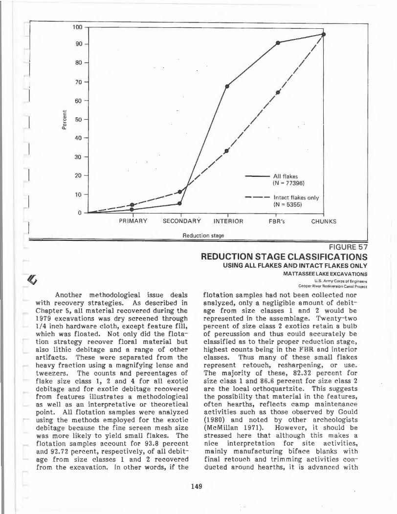
100
90
80
70
60 ... c <ll ~ 50 <ll
0..
40
30
20
10 -----_....., 0 --
/
/ /
/ ~
/ /
/
" // /
/ /
/
I I
/ I
/ All flakes (N = 77396)
Intact flakes only (N = 5355)
PRIMARY SECONDARY INTERIOR FBR's CHUNKS
Reduction stage
Another methodological issue deals with recovery strategies. As described in Chapter 5, all material recovered during the 1979 excavations was dry screened through 1/4 inch hardware cloth, except feature fill, which was floated. Not only did the flotation strategy recover floral material but also lithic debitage and a range of other artifacts. These were separated from the heavy fraction using a magnifying lense and tweezers. The counts and percentages of flake size class 1, 2 and 4 for all exotic debitage and for exotic debitage recovered from features illustrates a methodological as well as an interpretative or theoretical point. All flotation samples were analyzed using the methods employed for the exotic debitage because the fine screen mesh size was more likely to yield small flakes. The flotation samples account for 93.8 percent and 92.72 percent, respectively, of all debitage from size classes 1 and 2 recovered from the excavation. In other words, if the
FIGURE 57 REDUCTION STAGE CLASSIFICATIONS
USING ALL FLAKES AND INTACT FLAKES ONlY MATT AS SEE LAKE EXCAVATIONS
149
U.S. Army Corps ol Eng1neers
Cooper River Rediversion Canal PrOJect
flotation samples had not been collected nor analyzed, only a negligible amount of debitage from size classes 1 and 2 would be represented in the assemblage. Twenty-two percent of size class 2 exotics retain a bulb of percussion and thus could accurately be classified as to their proper reduction stage, highest counts being in the FBR and interior classes. Thus many of these small flakes represent retouch, resharpening, or use. The majority of these, 82.32 percent for size class 1 and 86.6 percent for size class 2 are the local orthoquartzite. This suggests the possibility that material in the features, often hearths, reflects camp maintenance activities such as those observed by Gould (1980) and noted by other archeologists (McMillan 1971). However, it should be stressed here that although this makes a nice interpretation for site activities, mainly manufacturing biface blanks with final retouch and trimming activities conducted around hearths, it is advanced with
caution. Unfortunately, only a few flotation samples were taken from the general levels (none recovered through controlled sampling), to compare with the feature flotation samples.
Projectile Points/Hafted Bifaces Analysis Procedures
Projectile points or hafted bifaces were identified during the initial cataloging procedures. Some were readily recognizable types, such as Palmers, Morrow Mountains, or Guilfords, that have been previously identified and documented in the Carolinas (Coe 1964). As the projectile points were pulled for analysis, however, it became apparent that much of the assemblage consisted of forms that are neither well known nor described in the region. Varieties of stemmed points were dominant. It should be stressed that while these tools are termed projectile points, Ahler (1971) and others have argued, through wear and resharpening studies, that these artifacts were actually multifunctional tools, serving as saws, knives, and scrapers. The hafted bifaces recovered at Mattassee Lake appear to have served some or all of these tasks. A second category of bifacially chipped implements, a group to be described later, under the term "bifaces," may have also been hafted. The traditional term projectile point is, however, retained here, with the stipulation that these particular tools served not only as projectiles, but as multifunctional tools.
Each tool was analyzed with respect to fifty-three variables. During early stages of analysis it became apparent that there were considerable problems in identifying use wear on most specimens, particularly those of the locally occurring orthoquartzite. Although this material is highly siliceous, it weathers and crumbles easily making use wear identification and interpretation a rather dubious undertaking, at least when compared with use wear studies of other, denser siliceous materials as chert or rhyolite. Many of the 53 attributes recorded over the assemblage were taken directly from Binford's (1963) list and are illustrated and defined in the Appendix Volume. For example axial length is measured from the distal tip of the point to the proximal, basal edge. Lithic raw material
150
was coded for each tool, employing the 24 types described earlier (Chapter 6, Table 7).
A word of caution should be noted with respect to the attribute coding employed. While 53 different variables were coded, they may be separated into three groups: nominal variables, measurements (interval scale variables), and multistate variables. Nominal variables, such as cortex were recorded as present or absent. Measurements were exact and recorded in millimeters, with the exception of weight, which was recorded in grams using a triple beam balance. However, many of the 53 variables were multistate, or variables within variables. Tool condition, for example, is a multistate variable. This refers to breakage, and every tool is in a certain condition. Nine different types of condition, or state, were recorded for the projectile points. These include whole points, tips, midsections, bases, lateral sections, obscured or undiscernible fragments, points mainly intact but missing a tip, a base and shoulder combination, and a point mainly intact but missing a base. In the Mattassee Lake analyses, tool condition was coded for each tool on this scale of one to nine. Alternatively it would have been possible to code each type of condition, and have nine nominal level condition variables that could be coded as to presence/absence. This would have produced an unwieldy number of variables, an alternative that was discarded. The data is amenable to receding into such a format, however, a procedure that was done during subsequent analyses.
Using the detailed attribute data coded for each point Dr. William Lavis and Randolph Donahue of Michigan State University conducted a monothetic subdivision cluster analysis over all of the complete projectile points recovered from the three sites (N=l21) (see Chapter 6).
Each cluster solution included the cluster number along with catalogue numbers for all points assigned to each cluster. Complete projectile points from 38BK226, 38BK229 and 38BK246 were placed on a table and points for each cluster were placed on a card with an identifying cluster number. After the clusters were laid out for examination the binary opposition
system was used for attribute classification. Presence or absence of key attributes was determined. Either basal tangs are present or absent, bases are either flat or they are not, and so on. One of the problems of applying this type of analysis to the Mattassee Lake assemblage is that of asymmetry. While symmetry was a variable in the analysis, some attributes, particularly those dealing with side notches (e.g., points of juncture), were noted for only one edge of each projectile point. Consequently points that would be grouped by an individual on purely morphological grounds, would be grouped by the computer based on what was coded for one side of the toor. These differences may be responsible for some of the noise within clusters~
Not all clusters had this problem, in fact a number were quite homogeneous. Cluster 8 was principally small to medium sized triangulars with straight bases. Cluster 19 was similar, however, in this case, bases were concave. Cluster 15 was composed of four points, three resembling Morrow Mountains (Coe 1964). Similarly Cluster 46 was composed of three points all having excurvate blades and small, basal ears, resembling Yadkin Eared (Coe 1964) or Brewerton Eared triangle points (Ritchie 1961:18).
The clusters were examined for crosscutting similarities and relationships to well known types in the Carolinas, using Coe (1964) as the primary referent. Projectile point fragments, mainly bases, were assembled for integration with the clusters or dominant types within clusters. Combining the cluster results with known cultural/historical types, the projectile points were segregated into 21 groups (Table 10). A number of points in the assemblage are singletons, or one of a kind. Only well made or radiocarbon dated points of this type were assigned group numbers. Other tools analyzed as projectile points are more similar to small, well made bifaces.
Projectile Point Group Descriptions
Summary information for the 20 groups is found in Table 10. Assigned group numbers are listed, followed by cluster num-
be~s. These include the major cluster as well as clusters from which one projectile point was assigned to a group. Consequentl~r cluster numbers overlap group numbers. A short verbal description proceeds a possible cultural affiliation or radiocarbon date for point or points within each group. Temporal assignments are very tentative and based on the radiocarbon dates, possible cultural affiliations, and morphology. In some cases, no similarities could be found between some projectile point groups and identified types. These forms, therefore, were placed within this very general, temporal framework primarily on morphological attributes or gross stratigraphic placement in the site levels (see below). Numbers of points found at each site, and group total are presented. Average deph below ground surface was calculated for all groups simply because so many had little or· no similarity to known types from the region. In this instance, intuition has worked out fairly well and the point groups do reflect, for the most part, stratigraphic continuity. There are some problems with this method, as test pits were dug in 5,10 or 20 centimeter levels, and the points recovered from features could not be readily assigned a depth. However, it does provide a general framework for dating the various forms.
Group 1
These (N=34) are small to medium sized symmetrical, triangular points having straight bases (Figure 58:af). Blades are usually straight, but in some instances may be slightly excurvate or incurvate. Incurvate blades are more common on points having isosceles triangular shapes. It is possible this incurvature may reflect blade attrition, rather than a consciously stylistic decision. Breakage patterns are discussed in a later section, however, the results suggest that even these small triangulars may have served as more than mere projectiles. The points in Group 1 are generally thin, with many apparently made on small flakes, still retaining an almost unifacial quality. Workmanship varies from well made points exhibiting care and craftsmanship to others that exhibit mere edge retouch of a flake to impart a triangular shape. Length of complete specimens ranges from 11 mm to 40 mm with an average of 28.3 mm. Basal
151
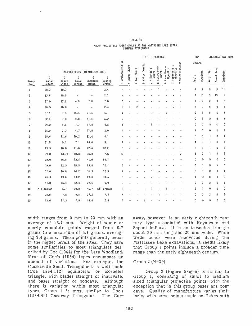
TABLE 10
MAJOR PROJECTILE POINT GROUPS AT THE MATIASSEE LAKE SITES: SUI+1ARY ATIRIBUTES
$
" .. .. "' MEASUREMENTS (IH IIILLIHETERS) :II
I x x i i i .. .. Group Axial Basal Basal Shoulder Weight C)
J!L Length Width ..!:!!!9.!!L ....!U!ill!.... (Grams)
28.3 1B.7 2.4
2 23. 8 1B.S 2.1
3 37.0 27.2 4.0 7.0 7.8 6
4 26. 3 16.8 2.4 5
s 37.5 7.5 15.5 21.5 6. 1
6 32.0 7.0 4.0 41.5 6.2 3
39.0 9.5 7. 7 17.8 4.5 5
8 25.0 3.3 4.7 17.8 2.0 4
9 28.6 13.6 10.2 22.4 4.1
10 31.5 9. 1 7.1 24.6 5.1
11 43.3 16.8 11.8 22.4 10.2 5
12 39. 0 13.75 10.8 26.0 7.5 10
13 99.0 16.5 13.5 41.0 54.1
14 49.0 12.0 15.5 29.0 12. 1 3
IS 57.0 18.0 10.2 35.3 12.5 4
16 46.3 19.6 13.2 23.8 10.6 s 17 51.0 16.4 12.3 22.5 9.9
18 All Broken 6.7 20.0 40.7 All Broken
19 39.6 7.8 9.5 27.2 7. 5 4
20 23. 0 17.3 7.0 19.0 2.4
width ranges from 9 mm to 23 mm with an average of 18.7 m m. Weight of whole or nearly complete points ranged from 0. 7 grams to a maximum of 5.1 grams, averaging 2.4 grams. These points generally occur in the higher levels of the sites. They have some similarities to most triangulars described by Coe (1964) for the Late Woodland. Most of Coe's (1964) types encompass an amount of variation. For example, the Clarksville Small Triangular is a well made (Coe 1964:112) equilateral or isosceles triangle, with blades straight or incurvate, and bases straight or concave. Although there is variation within most triangular types, Group 1 is most similar to Coe's (196 4:49) Car a way Triangular. The Car-
.. .. .. ~ u
' ~ ..
152
LITHIC MATERIAL TIP BREAKAGE PATTERNS
a BREAKS N .. ..,
" .. .. .. ~ .. .. "' ... "' ~ .. ..... " .. :II .. c: .. _.,
"' ... c: .. CT ., ..... 0~ .. _ ~-- .. "' :1 ~ ~; ~; Cl)o ~o t; ~ ;: .... u .. "' .. ... ~6 go ~~ ~~ ~ .. -:;; .. a. c: :;: ~ to .. < ~ t;:« got z "' .. .. 8 .... 3 c: .. .. "' "" "' > "' .... N "' C) ... "'
8 9 0 9 11
7 18 s 15 6
2 0 3 2
2 2 2 0 4 2
0 0 0
- • 0 0 0
0 0 0 0 0
0 0
0 0 0 4
4 0
2 0 2
2 3 3 5
0 0 0 0 0
0 0 0
3 0
0 0 3
0 2 0 0 6
2 0 0 0
0 0 2 0 3
2 0 0 0 0 3
away, however, is an early eighteenth century type associated with Keyauwee and Saponi Indians. It is an isosceles triangle about 30 m m long and 20 m m wide. While trade beads were recovered during the Mattassee Lake excavations, it seems likely that Group 1 points include a broader time range than the early eighteenth century.
Group 2 (N=39)
Group 2 (Figure 58:g-n) is similar to Group 1, consisting of small to medium sized triangular projectile points, with the exception that in this group bases are concave. Quality of manufacture varies similarly, with some points made on flakes with

-
r '-
e
h J
k
0 p q
or--------..----------=;2 in.
0 5cm
FIGURE 58. Hafted Biface Groups 1, 2, and 3 from Mattassee Lake. a-f Group 1: Small triangulars,
straight bases; g-n Group 2 : Small triangulars, concave bases; o-g Group 3: Large triangulars, concave bases.
CATALOG N U MBERS: a ( JSBK229.97A.1\ b (38BK229. 105C.10); c (38BK226.99A. l ); d (38BK226.69C.12); o (38BK246.29A.1 ) ; f (38BK246.27A.1); g (38BK226.107C. 1) ; h (38BK226. 1098.3) ; i (38BK226.108F.7);j (38BK229. 104F.3) ; k (38BK229. 1030.1); I (38BK226.94A.1 ) ; m (38BK229. 1078. 1) ; n (388K226.958. 1) ; o (38BK226.91 C. 11 ); p (38BK246.26A. 14); q (38BK226.1 06C.2).

d
,,
J
0 2in. ~----------~----------~
0 5cm
FIGURE 59. Hafted Biface Groups 4·7 from Mattassee Lake. a-f Group 4: Eared excurvate blade, Yadkin/ Brewerton Eared; g, h Group 5: Long stem lanceolate; i, j Group 6: Barbed; k·m Group 7: Thin straight stemmed lanceolate, Thelma.
CATALOG NUMBERS : a (38BK226.105D.11) ; b (38BK226. 107E.2) ; c {38BK226.69B.8); d {38BK226.107E.15); o
{38BK226.93G. 1); f (38BK226. 158.1 ) ; 9 {38BK246.20A.15) ; h (38BK246.23A.1); i {38BK246.28A.10) ; j (38BK229.
1088.10) ; k {3 8BK229. 1009.1); I {38BK226.9K.27);m {38BK2 26.1 00A.1) ; n {38BK226. 145.28).
f

only min or shaping, others are well made exhibiting small pressure flake scars. Complete specimens range in length from 16 mm to 47 mm, averaging 23.8 mm. Basal width ranges from 14 mm to 27 mm, with an average of 18.5 mm. Weight of whole or nearly complete specimens ranges from 1.1 grams to 3.6 grams, with an average of 2.1 grams. These triangulars also tend to occur in the upper 15 em of deposit. The strongest similarity to a known type is the Caraway Triangular (Coe 1964:49,48; Figure 43B).
Group 3 (N=6)
Large, thick triangular points ~ith concave bases compose Group 3 (Figure 58:o-q}. These are symmetrical, isosceles triangles with straight to concave blades. Flake scars on these points are large with manufacturing techniques not as well executed as on the smaller triangulars. Length ranges from 33 mm to 39 mm, averaging 37 mm on complete spec-imens. Base width varies from 20 mm to 31 mm with an average of 27.2 mm. Weight ranges from 6.8 to 10.2 grams, av.eraging 7.8 grams. These are most similar to Coe's Yadkin or possibly Badin types (1964:45,46; Figure 41 A and B; 47, Figure 42 B).
Group 4 (N=11)
Small to medium sized points with excurva te blades and basal ears characterize Group 4 (Figure 59:a-f). In outline they are similar to Brewerton Eared triangle points (Ritchie 1961:18), however they are interpreted here as representing a Woodland horizon. Workmanship varies over the group and may reflect differences in ·lithic material rather than style. All blades are excurvate and all specimens have basal ears, with straight or slightly concave bases. Blade cross-section is thin. Complete specimens vary from 19 to 54 mm in length, averaging 26.3 mm. One point, made of porphyritic rhyolite is comparatively long making the average greater than the length of most specimens. This point is similar to the eared Yadkin (Coe 1964:47,Figure 42C left). This point may represent an early stage in the life-history while the smaller points reflect blade attrition of the distal portion, accounting for the excurvate blades so near
the basal edges. The large specimen was recovered from the base of Feature 45, at Site 38BK226, which was radiocarbon dated to AD 1040 (DIC-1840}. Excluding the longest projectile point, average length of these specimens drops to 20.8 mm. Basal width averages 16.8 mm ranging from 11 to 20 mm. Average weight is 2.4 grams, r~nging from 1.0 to 7.2 grams.
Group 5 (N=2)
Two slender lanceolates with relatively long basal tangs constitute Group 5 (Figure 59:g,h). Blades are straight with fine pressure flakes along the blades; bases are similarly manufactured. In one instance the distal end is thick, a number of step fractures at this place on the blade suggest that several unsuccessful attempts were made to thin this spot. Both have angular shoulders, corners from which a gentle or sloping shoulder arc begins to form the basal tang. One base is straight while the other is rounded slightly. Average measurements are axial length 37.5 mm; shoulder width 21.5 mm; tang length 15.5 mm; basal length 7.5 mm and weight 6.1 grams.
Group 6 (N=3)
This group includes all the barbed points (Figure 59:i,j} recovered from the Mattassee Lake excavations. Two have excurvate blades while one has straight blades. One specimen seems to be reworked from a large point with a basal break; its barbs are asymmetrical and the base is pointed. The other two have straight bases. Because barbs are the distinguishing feature of this group their other attributes are variable. One point in this group is similar to the Wade point described in Florida (Bullen 1968). Axial length ranges from 27 to 37 mm, averaging 32 mm; shoulder width averages 11 .5 mm with a range of 22 to 38 mm; base width averages 7.0 and basal length averages 4.0 mm.
Group 7 (N=6)
155
Slender, straight square stemmed lanceolates constitute Group 7 (Figure 59:kn). Blades are generally straight, however, some may be slightly excurvate. Shoulders are rounded slightly and form a gentle arc

to the basal tang. Bases are straight. Mode of manufacture appears expedient with some points still retaining a nearly flat flake appearance on one surface. Flake scars are broad and shallow, with some pressure retouch, mainly on specimens of higher quality lithic material. Blade crosssections are thick, suggesting that thinning efforts were difficult or unnecessary. Morphologically these have a strong similarity to Thelma points (South 195 9), and two points similar to those in Group 7 were dated to 660 BC (RL-1037) at 38LX5, a site on the Fall Line on the upper Congaree River (Anderson 1979). One specimen excavated from Feature 34 at 38BK226, however, was radiocarbon dated to 610-55BP or 1340 AD, much later than the date generally associated with Thelma points. In this respect, Group 7 is problematic. While it is possible that small square stemmed points were manufactured during late Woodland times, it is also possible that an older point was recycled or otherwise entered the late feature fill. Numerous examples of ethnographic groups reusing old tools have been recorded. Measurements within Group 7 are homogeneous. Axial length ranges from 40 to 46 mm, averaging 43.3 mm; shoulder width ranges from 14 to 25 mm with an average of 22.4 mm. Basal width averages 16.8 mm, varying from 12 to 19 while tang length ranges from 10 to 14 mm with an average of 11.8 mm. Average weight for Group 7 points is 10.2 grams.
Group 8 (N=4)
Straight blade edges, trianguloid blade shape, and a small pointed base define Group 8 (Figure 60:a-c). Manufacture involves large, broad primary flakes supplemented by some pressure retouch along blade edges. Portions of blade edges may be left unretouched or shaped. Blade crosssections are thinly shaped and biconvex. Bases are small and pointed, protruding slightly from the base of the trianguloid blade. It is possible that this small base has been reworked from a larger base, however this seems unlikely. The form is similar to what Trinkley (198lb) has described as the Deptford Stemmed type, from a collection of points recovered at 38LX5, a Fall Line site on the SanteeCongaree drainage. Group 7 is homogeneous with averages of 25 mm
156
for axial length, 17.8 mm for shoulder width, basal width of 3.3 mm, tang length of 4. 7 mm and weight of 2.0 grams.
Group 9 (N=5)
Five small, straight stemmed points compose Group 9 (Figure 60:d-h). These are short points with broad blades and bases. Blade cross-sections are moderate to thick. Blades are triangular in shape with straight edges. Three specimens have nearly flat surfaces, retaining some of their original flake surface. One of these is unusual in that it has alternately beveled edges, a characteristic common to Palmers. Shoulders are angular but not straight and form an arc with the straight based, basal tangs. Most basal edges are retouched. Two specimens are quite thick, one exhibiting numerous step fractures, suggesting unsuccessful thinning attempts. Although Group 9 is homogeneous with respect to measurements, these small points may reflect late stages in the life cycle of points with longer blades. Average measurements for Group 9 are 28.6 mm, axial length; 22.4 mm, shoulder width; 13.6 mm, basal width; 10.2 mm, tang length and a weight of 4.06 grams.
Group 10 (N=7)
Group 10 includes seven points that have straight edged, isosceles trianguloid blades (Figure 60:i-1). Shoulders may include straight and sloping tangs, while two specimens have slight shoulder tangs of the type usually associated with corner notched points. Basal tangs are straight, bases are straight or slightly convex. Crosssections vary from thinly biconvex to thick. Thick specimens (N=2) may merely represent thinning problems. The manufacture technique is characterized by large, shallow flake scars, where retouch is rare. Distal ends of all but one specimen are broken. The complete specimen has an axial length of 31 mm. Other metric attributes are homogeneous. Average measurements for Group 10 are shoulder width 24.6 mm; base width 9.1 m m; base length 7.1 m m and weight 5.1 grams.

[
[
[
[
[
[ r
,.
b
J
or--------,...-----,2 in.
0 5cm
A ,
L~~\_', -~\
'
h
FIGURE 60. Hafted Biface Groups 8-11 from Mattassee Lake. a-c Group 8: Small pointed base; d-h Group
9: Small, straight stem; i-1 Group 10: Small, straight base, straight stem; m-q Group 11: Expanding base,
side notched M-0.
CATALOG NUMBERS: a (388K226.80A.1). b (388K229.99B.2). c (388K226.95C.3), d (388K226. 11 2C.1), e (388K246.24A,62). f (38BK246.318.4), g (388K246.26A.12), h (388K226. 101 F.23), i (388K226.86E. 1), j (388 K226.
880.23 ), k (388K229. 100E.S), I (388K226.910. 11 ), m (388K2 26.106E. 1), n (388K 229.102C. 1 ), o (388K229.968. 11 ),
p (388K229.1 031.8).
f
k
FIGURE 61. Hafted Biface Groups 12-16 from Mattassee Lake. a·f Group 12: Medium straight stemmed; Swannanoa, Otarre; g, h Group 13 Large, straight stem; i, j. Group 14: Adena-like; k·n Group 15 Broad, straight stem, Savannah River ; o-r Group 16: Lanceolate, straight stem, straight shoulder.
CATALOG NUMBERS: a (38BK229.1020.1); b (38BK246.53B.2); c (38BK226.99E.6); d (38BK246.26C.1) ; e (38BK229.94C. 1); f (38BK229.43B.2); g (38BK229. 101 8.29); h (388K229.48C.1 ); i (38BK226.64K. 21) ; j (38BK229. 112A.4); k (38BK229. 1030.4) ; I (38BK229.116. 1); m (38BK246.23C.1 ); n (38BK226.39C. 10); o (38BK246.30B.1); p (38BK226.80A.2); q (38BK226.51 0.1) ; r (38BK226.69E.11 ).

Group 11 (N=6)
Group 11 consists of five medium to large stemmed forms with weak sjde notches (Figure 60:m-q). Blades are trianguloid with slightly excurvate edges. Blade crosssections are thick and trianguloid with a medial ridge. Several specimens retain the flat, curved flake surface from which they were manufactured. This side of the point generally exhibits only minor blade retouch. Manufacturing techniques include broad, shallow flake scars as well as some pressure retouch. Shoulders are round and slope towards the base. The basal tang is side notched and expands at the most proximal basal edge. Base edge is straight. Three complete or nearly whole specimens have an average axial length of 43.3 mm. Other average metrics include shoulder width 22.4 mm; base width 16.8 mm; tang _length ll.8 mm and a weight of 10.2 grams. Group 11 in shape, size and technique of manufacture is similar to the Lamoka point type defined by Ritchie (1961:29-30) from collections in New York. He argues that the Lamoka point has a wide distribution, extending into Michigan where Binford (Ritchie 1961:29- 30) observed a "medially ridged blade." Lamoka points have been radiocarbon dated to 3500 BC to 2500 BC (Ritchie 1961:29) corresponding to the Savannah River horizon in the Carolinas (Coe 1964). However, Ritchie (1961:29) notes that the type continues into Middle Woodland periods. Thus in the Mattassee Lake assemblage this point may have a temporal range including Late Archaic through Middle Woodland.
Group 12 (N= 12)
Group 12 is one of the most common forms in the assemblage, following the triangular forms (Group 1 and 2). lt is composed of medium sized, straight stemmed points (Figure 6l:a- f) . Blades are trianguloid with straight to slightly excurvate edges. Blade cross-sections are biconvex, however medial ridges are present on several points. All have sloping shoulders, although in one case, the point is asym metrical and the other shoulder is straight. Tangs are straight, parallel sided and have straight square bases. Several of the bases are flat, made on flake platforms ·Or simply
snapped. Manufacture technique consists of small, pressure retouch along blade, tang, and base margins, however some broad flake scars are visible. Average measurements include axial length 39.0 mm; shoulder width 26 mm; basal width 13.75 mm; tang length
. 10.8 mm and a weight of 7 .5' grams. Group 12 includes attributes of both Otarre Ste mmed (Keel 1976:194- 196) and Swannanoa Stemmed (Keel 1976:196-198). Attributes of these types, and Group 12, are illustrated in Table 11. Keel (1976: 194) observed that of the Otarre Stemmed 30 percent retained evidence of a striking platform on the stem while the figure is 23 percent for the Swannanoas (Keel 1976:196). Tang length of Group 1 0 is shorter than either of these established types. Metrically, Group 10 is most similar to the Swannanoa; however, as Keel (1976: 196; Plate 402) notes the stem is contracting. Only three of the 12 points within the group have slightly contracting stems. Basal tangs of Group 10 are more similar to those straight stems illustrated for the Otarres (Keel 1976:Plate 39). Keel (1976: 168-169) explains that his distinction between Otarre and Swannanoa was based on features found in two zones, and assigns them to Late Archaic and Early Woodland periods (Keel 1976:233) respectively. Group 12 resembles what Oliver (1980) described as the "Gypsy Stemmed" type, an Early Woodland form recently recognized in North Carolina. Consequently Group 12 is here interpreted as representative of a Transitional, Late Archaic/Early Woodland form .
159
Group 13 (N=2)
Group 13 includes two very large, straight shouldered specimens (Figure 61:g,h). Tangs are thin, straight, and parallel-sided with straight bases. The blade width to tang ratio is 1:2.4. One specimen has a horizontal medial snap, and its blade edges are straight ·while slightly excurvate blades are found on the complete specimen. Manufacturing technology is dominated by large, broad, shallow flake scars, although some minor retouch is found along blade edges. One side of the complete specimen is flat and curved retaining a flake quality with little retouch of any type. Their massive size (x length = 99 m m; x shoulder width = 41 m m; x basal width =

TABLE 11
METRIC (MILLIMETERS) COMPARISONS: GROUP 12, OTARRE STEMMED AND SWANNANOA
Shoulder Length Width
Name (Range} - (Range) X
Group 12 35-41 39 23-31
Otarre 37-70 51.4 22-44
Swannanoa 21 -43 32.6 9. 5-24
16.5 mm; x basal length= 13.5 mm; x weight = 54.1 grams) is suggestive of Savannah River Stemmed forms (Coe 1964:42, Figure 37; 44 Figures 38 and 39; 45). Basal tangs of Group 13 are thinner than those illustrated for most Savannah Rivers, although the specimens in Coe's (1964:44) Figure 39 B and C - the "Broad, weakstemmed variety (hafted knives?)" - are most similar to the Mattassee Lake specimens. Consequently Group 13 is viewed within the Late Archaic/Early Woodland Transitional period.
Group 14 (N=3)
Group 14 includes two complete tools and one well made fragment that was originally interpreted as a base but may, in fact, be the extreme distal tip of the point. These are well made ovoid bifaces with broad corner notches, resulting in sloping shoulders and broad, lobate stems (Figure 6l:i,j). The basal edge is rounded. Manufacturing technology includes some broad flake scars, yet mainly well formed pressure flakes along the blade and base edge. Blade edges are excurvate. fn cross-section these are biconvex or asymmetrically biconvex. Average metrics on these specimens are 49 mm length; 29 mm shoulder width; 12 mm basal width; 15.5 mm basal length and 12.1 grams. Morphologically the form is similar to the Adena point (Bell 1958:4; Ritchie 1961: 12-13). One of the three points was recovered in association with plain, presumably Thorn's Creek pottery in Feature 4 at 38BK229. This feature was radiocarbon dated to 1160 BC (DIC-1844, 3110-185), an appropriate date for the pottery. Current
160
Basal Width Tang - {Range} - Length -
X X X
26 12-18 13.75 9-15 10.8
30.5 9-20 14 .9 9. 5-20 15 . 7
19 9-18 12.6 9-14 11.3
fieldwork at the Allen Mack Site (380R63) in Orangeburg County, South Carolina, by Sammy T. Lee and A. Robert Parler have yielded Thorn's Creek ceramics in association with points similar to Groups 14 and 18 (Parler and Lee 1981). Consequently this form is attributed to the Late Archaic.
Group 15 (N=5)
This group consists of large, broad stemmed hafted bifaces. The blade is triangular with slightly excurvate to straight blades (Figure 61:k-n). Shoulders are straight to very gently sloping. Basal tangs are straight, parallel sided, and broad by comparison to blade width. Basal edges are straight. Blade width to base ratio is 1:16.4. Two specimens have flat bases, possibly representing the flake platform. Manufacturing technology includes large, broad, shallow flake scars, with some pressure retouch along the blade edges. Average metrics for this group include length, 57 mm; shoulder width, 35.3 mm; basal width, 18 mm; basal length, 10.2 mm; and average weight, 12.5 grams. These are similar to Coe's (1964) Savannah River Stemmed type, although the blades are shorter and the bases are broader. The form resembles what Oliver (1980) has described as the "Small Savannah River" type, a Late Archaic-Early Woodland form found in North Carolina. One specimen in Group 15 is also similar to the point in Group 13, although much smaller.
Group 16 (N=S)
Lanceolates with long, broad straight stems compose Group 16 (Figure 61:o-r). These are generally long although some specimens are short and appear to be sharpened. Shoulders are very slight and gently sloping. The basal tang is broad, parallel sided, and straight based. In cross-section these are biconvex. Blade width to base width ratio is 1:26. Manufacturing technology appears related to lithic material quality. Specimens made of poorer quality stone exhibit both broad, shallow flake scars and pressure retouch along the blade. Points made of higher quality material are generally well made with lamellar flake scars along the blade edges. Average measurements are 46.3 em length; 23.8 em shoulder width; 19.6 em basal width; 13.2 em basal length and weight 10.6 grams. Group 16 has some morphological similarities to the Brier Creek Lanceolate (Michie 1968), however this type typically has a concave basal edge, as opposed to the straight basal edge characterizing Group 16. Although Group 16 is shorter than the Brier Creek Lanceolate, the shoulder is quite similar. Morphologically these are also similar to the Steubenville Stemmed (Ritchie 1961:51-52) reported in New York. Both of these types are Archaic and a Late Archaic temporal assignment to this group does not seem unreasonable.
Group 17 (N=8)
Group 17 consists of eight pentagonally shaped lanceolates (Figure 62:a-e). All but two are complete, these two having straight medial breaks. Blades are trianguloid and blade edges are slightly excurvate. Basal tangs contract slightly from the gentle pentagonal shoulder. Base edges are concave. Method of manufacture includes discontinuous flake scars, some ending in step fractures; and smooth lamellar scars. Cross-section is biconvex, and blades are beveled in some cases. Metric attributes for the group are average length = 51 mm; average shoulder width = 22.5 mm; average basal width = 16.4 mm; average tang length = 12.3 mm and average weight = 9.9 grams. One specimen in the group is a little unusual in that it bears s·imilarities to the orient Fishtail (Ritchie 1961:39-40) a Transitional
period Late Archai~/Early Woodland type found in the northeast. The Rice Lanceolate a midwestern type found in Early and Middle Archaic horizons (Chapman 1975: 253-254) is simihir in shape and manufacture technique. Points similar to those within Group 17 are known locally in South Carolina as "Coastal Plain Guilfords." Given the excavat ion contexts at Mattassee Lake, it is possible that the form may be Late Archaic in age.
Group 18 (N=3)
Group 18 consists of three, large, contracting stemmed points (Figure 62:f,h). Although all have medial breaks, blades are triangular and blade edges are straight to slightly excurvate. Shoulders are broad and straight to gently sloping. The stem is contracting with a rounded base. Shoulder width to basal width ratio is 6:3. All three are made of different material, consequently variat ions in manufacturing technique may reflect this rather than technological differences. The Allendale chert tool retains its original flake on one surface, although pressure retouch is apparent along portions of the blade length, shoulders, and basal tang. The distal tip is broken and appears to have suffered an impact fracture. Blade edges exhibit step fractures and polish. The orthoquartzite and rhyolite specimens exhibit medial bend breaks which Frison and Bradley (1980:43-44) have observed during manufacture and use. Breakage of these specimens occurred during use because in both cases the blade edges are rounded. The basal tang of the rhyolite point has numerous step fractures on alternative tang edges of both surfaces. Most flake scars are broad and shallow, some are hinged. Manufacture technology of the orthoquartzite specimen is similar, with broad, shallow, discontinuous flake scars, many of which are hinged. Portions of the blade and tang edges have been retouched. Average measurements are shoulder width, 40.7 mm; basal width, 6. 7 mm and tang length 20 mm. Although all of the points are broken and have an average weight of 14.6 grams making Group 18 one of the heaviest groups in the assemblage. Cross-sections are biconvex. Morphologically these are similar to Langtry points (Bell 1958: 38), identified in Missouri in late
161
Archaic contexts. Points similar to those in Group 18 have been recovered in clear Late Archaic contexts, with Thorn's Creek pottery, at the Allen Mack Site in Orangeburg County, South Carolina (Parler and Lee 1981).
Group 19 (N=3)
Group 19 consists of medium to large size points with small contracting stems (Figure 62:i-k). Blades are triangular in shape with straight to slightly excurvate blade edges. Shoulders slope to join the contracting stems. Cross-sections are biconvex. Flake scars are broad, shallow, and discontinuous, ~ and are often hinged. Some marginal retouch occurs on the blades, although specimens may retain a flat flake surface. Average measurements for Group 19 are: length, 39.6 mm; shoulder width, 27.2 mm; basal width, 7.8 mm; tang length, 9.5 mm and weight, 7.5 grams. These are identified here as Morrow Mountain projectile points (Coe 1964:37-39; 43; Figures 33 and 34), reflecting Middle Archaic horizons.
Group 20 (N=3)
Group 20 consists of three, small, well made Palmer points (Figure 62:1-n). Blades are triangular, one has been reworked to such a degree that it is a short broad equilateral shape. Blade edges are straight to slightly incurvate and alternately beveled. Two points are made of white quartz, and one of the local orthoquartzite. Bases are slightly concave with basal ears. Average measurements are length, 23 mm; shoulder width, 19 mm; basal width, 17.3 mm; basal length, 7 mm and weight, 2.4 grams. Palmers (Coe 1964:67-69; Figure 59A) are representative of the Early and Middle Archaic periods, as such they represent the oldest tools in the Mattassee Lake assemblage. The intense reworking suggests that these points had long productive lives, and were at the end of their life cycle.
Other Projectile Points
A variety of projectile points that did not fit into the previously described groups were also recovered. Some of these are described below.
162
One Allendale chert point (Figure 64:j) has an equilateral triangular blade with straight sides. Blade edges have pressure retouch scars as well as stepping. One edge of one blade has an almost serrated quality. One shoulder tang is broken, however the other shoulder is straight. The base is straight and shows slight polish. In crosssection the blade is flat with blade retouch imparting a biconvex shape. The base is significantly narrower than the blade and metric attributes are 28 mm, axial length; 25 mm, shoulder width; 18 mm, basal width; 10 mm, tang length and a weight of 4.0 grams. This point may represent a Woodland type or possibly a reworked Archaic type.
A well made orthoquartzite hafted biface was recovered from Feature 31 at 38BK226 and was radiocarbon dated to AD 820 (DIC-1841, 1130!55BP) (Figure 64:k). It is small, yet in shape it is similar to a Morrow Mountain Type II as well as to a group of Woodland points reported recently in the Haw River project excavations near Chapel Hill, North Carolina (Claggett and Cable 1982). The form also resembles the point comprising Group 4, which was dated slightly later. The specimen recovered from 38BK226 is well made with pressure retouch along the margins.
Another well made, orthoquartzite hafted biface is described as follows (Figure 64:1). In outline it is similar to a Morrow Mountain however, it is longer and thinner. It is a complete specimen recovered from Feature 45, 38BK226, and radiocarbon dated to AD 1040 (DIC-1840, 910!70BP). Axial length is 49 mm, shoulder width 28 mm, basal width 8 mm, and tang length 13 mm. Fine pressure flaking occurs on the blade and tang.
Several points (Figure 64:o-q) are almost certainly variants of Coe's (1964) Savannah River Stemmed type. Several were found clustered together with the points comprising Group 13 (Figure 61:g,h), in a probable Late Archaic context at site 38BK229. Axial length averages 65.5 mm and ranges from 40 to 91 mm. Other average measurements include 44 m m for shoulder width; 15.5 mm base width; 11.5 mm tang length and a weight of 30.9 grams.

l
[ [ [
[ [ [ [
[ [ (
[ [ [ [ r
b c e
~·7.:
' ;~ '
·~ - 4
m ~' n
0 2 in.
0 5 cm
FIGURE 62. Hafted Biface Groups 17-20 from Mattassee Lake. a-e Group 17: Pent agonal; f·h Group 18: Round, contracting stem; i-k Group 19: Morrow Mountain; 1-n Group 20 : Palmer.
CATALOG NUMBERS: a (38BK 2 29.61A.1); b (38BK226.1 02G. 1) ; c (38BK246.230. 1) ; d (38BK226.85C.1) ; e (38BK246.25B.3) ; f (38B K226.94J. 1 ); g (38BK226.94 F.1); h (38BK226.85G. 1) ; I (38B K226.900. 18) ; j (38BK226. 88E. 12) ; k (38BK226. 1 07E. 1) ; I (38BK226.94G.4); m (38BK226.74C. 1) ; n (388 K 226.90H. 1).

¥ . . . ·'"
g or--------,.---~---..;;;2 in.
0 5cm
FIGURE 63. Dominant Biface Types from Mattassee lake. a Group 2; b Group 3; c Group 4;d, e Group 5; f Group 6; g Group 8; h Group 9; i Bitriangular.
CATALOG NUMBERS: a (38BK246.28C.2); b (38BK246.28C.1); c (38BK226.106H.1); d (388K226.104G.3); a (38BK226.70B.1 ); f (388K246.23C.4); g (38BK246.27V.15); h (38BK229.107E. 1 5); i (388K246. 12. 1).

One has slightly excurvate blades while the smaller one has straight blade edges. The blade is trianguloid. In two specimens straight basal tangs join the blade edges in a gentle arc (Figure 64:n,q}, while another has straight shoulders (Figure 64:o). Bases are slightly convex. Manufacture technology is characterized by large, shallow flake scars. Retouch and step fractures are present on blade edges. One side of the largest specimen (38BK229-101B-30) retains a flake quality and exhibits several large, shallow flake scars.
Biface Analysis Procedures
Bifaces were identified during the initial cataloguing process. These were tentatively assigned to this category on their bifacial flaking (Crabtree 1972:38) and outline (Figure 63). These are thinner and more well defined than the bi-directional cores and have no specialized haft elements or shoulders as do tools assigned to the hafted biface/projectile point category. A total of 45 variables were recorded for each biface.
Attribute sorting procedures are outlined in the Appendix Volume and were developed by John S. Cable for analysis of the Haw River, North Carolina assemblage (Claggett and Cable 1982). These were applied here with minor changes. These procedures were developed for analysis of tools made of fine-grained igneous and metamorphic materials where flake scars are readily observable. Bifaciality measurements, which consist of the quantification of flake scars, were altered. Rather than count and measure all flake scars on invasive and marginal biface areas, the presence or absence of massive primary scars in the invasive and marginal areas was recorded. Presence or absence of marginal retouch was also recorded. With the exception of face height, edge and tip angles, all other variables were recorded. Tools were measured using metric calipers and weighed on a triple beam balance.
Initially, all bifaces were divided into biface and late stage preform categories. Late stage preforms were thought to represent later stages in biface manufacture, however this was an intuitive separation.
165
Both groups were subjected to a cluster analysis by Dr. William Lovis and Randy Donahue, and were found to be essentially similar. They were therefore combined, and are treated here as a single assemblage.
A total of 326 bifaces and preforms were analyzed, of which 94 or 28.8 percent were complete. Biface groups were derived from an analysis of these specimens. An SPSS crosstabulations program (Nie et al. 1975) was run on the complete specimens correlating the shapes of lateral-distal and lateral-proximal junctures, attributes illustrated in the Appendix Volume. Eight morphological categories included 84 of these specimens. The remaining ten intact specimens were combined into a series of minor associations having one or two specimens. One of the most unusual of these was the bitriangular (Figure 63:i), having a diamond shape. Of the nine groups (Table 12, Figure 63), Group 3, the oval (Figure 63:b), is the most prevalent in the assemblage, comprising 21.5 percent of the intact specimens. Three additional lateral sections can be added to the complete count of 18, for a total - of 21 specimens. Triangular (Figure 63:g) specimens account for a similarly high percentage -whether these shapes represent manufacturing stages in a reduction sequence, stylistic, or functional differences -is a difficult question to answer at this time. Of all specimens less than five percent retained cortex (Table 13). Differences between percentages of marginal retouch flake scars on preforms (79 to 88 percent) and bifaces (64 to 72 percent) suggests that in addition to being manufactured at the sites many may have been used as well.
Utilized Flakes
Analysis Procedures
Some utilized flakes were identified during the initial cataloguing process, however, as the debitage analysis progressed more were discovered and added to the catalogues for special analysis. The uniface coding form and manual (Appendix) developed by John S. Cable (Claggett and Cable 1982) for analysis of materials recovered from the Haw River, North Carolina excavations was used here with minor revisions.

A total of 40 variables were recorded for each utilized flake recognized in the 1979 excavation sample. Measurements were made using metric calipers and each tool was weighed on a triple beam balance.
Group Jl2:_
3
4
8
9
Name
Ovate
Ovoid
Oval
Ovate· Rectangular
Ovoid· Rectangular
Teardrop
Trlangulold
Trhngular
Rectangu Jar
TABLE 12
BlFACE GROUP FORMULATIONS
Distal Proxima l Juncture ~ Count ~
Ovate Ovate 6 7.1
Ovate Ovoid 8 9.5
Ovoid Ovoid 18 21.5
Ovate Sub· 9.5 rectangular
Ovoid Sub- 9.5 rectangu Ia r
Triangular Ovoid 6.0
Triangular Sub-~tangulu
7.1
Triangular Trapuoidal 18 21.5
Sub- Sub· 8.3 • rectangular · rectangular
------TOTALS 84 100.0
TABLE 13
BlFACE/PREFO~ TOTALS
WHOLE TOTAL TOTAL WHOLE TOTAL TOTAL
8IFACES {N•258l PREFORMS {H•68l
Side 1 No. Cortex 54 77.1: 214 82. 9S 20 83.3: 60 88.21
Side 2 No. Cortex 67 95.7: 247 95.71: 23 95.8: 66 97.1S
Face 1 Massive Invasive 37 52.9S 140 54.31: 16 66.7: 37 54.41
Massive llargl na 1 67 95.7: 238 92.2S 24 lOO.OS 66 97. 1S
Marglna 1 Retouch 51 72.9S 185 71. 7S 22 91. 7S 60 88.2S
Face 2 Massive fnvasive 29 41.4S 101 39.11: 11 45.8S 32 47.1:
Mass.ive Margfna 1 60 85.7: 219 84.9\ 23 95.8: 65 95.6S
Marginal Retouch 49 70.0: 166 64.3S 23 95.8S 54 79.41
As analysis of utilized flakes progressed it became apparent that due to the rather poor and variable quality of the local tan orthoquartzite, determinations of use would be difficult. Brose (1975) has argued, based on experimental evidence, that utilized flakes may appear no different than unmodified debitage. Assessments are difficult enough on chert tools, but are compounded by the material analyze<;:! in the present study. Some edges may be rubbed smooth with a finger if the stone's cement is deteriorating. Consequently, these questionable tools were sized to flake class and weighed.
166
Utilized flakes illustrated some edge damage. Flake scars may or may not· be regular. Flake scars were interpreted, in most instances, to reflect use rather than intentional edge modification.
Unifaces
Analysis Procedures
The majority of unifaces were identified during the initial cataloguing procedures. These were more readily recognizable than utilized flakes. Most are made of the local orthoquartzite (Figure 64:a-d,g), although several are made of chert (Figure 64:e,h,i). The uniface coding form and manual (Appendix) were used for analysis, and a total of 40 variables were recorded for each tool. All unifaces were examined for flake type and size class using the orthoquartzite debitage analysis procedures. Lithic material and condition were recorded for all tools. Each tool was measured using metric calipers and a triple beam balance.
Recent ethnographic work by Gould (1980, Gould et al. 1971) and Hayden (1977) among Australian aborigines has shown that tools having edges which archeologists term "scraper or uniface" edges most often result from whittling and adzing activities. Gould (1980), Hayden (1977) and White (1968) have demonstrated that flakes are selected for tools based on their cross-section shape, and that thick unifaces are generally preferred.
Mean thickness for all unifaces (N=lOO) in the Mattassee Lake assemblages is 11.8 millimeters, which is much thinner than aboriginal uniface tools, and may reflect functional differences (e.g., cutting versus adzing). The majority, 65 percent, of unifaces were made on interior flakes. Fourteen percent were made on primary flakes (Figure 64:b,c,g), 19 percent on secondary flakes, and two percent on thinning flakes. The use of decortication flakes providing a "natural back" (Bordes 196 8:10 2-103) with a rough surface may have facilitated holding the tool during use. Unfortunately 65 percent of the unifaces were broken, and no hafting evidence was observed on the complete specimens.

[ [
Eight scraper groups (Table 14), based on top view outline, were found in the assemblage. Although 65 percent of the unifaces were broken, nearly half of these had an identifiable top view outline. The most common uniface is the ovate or teardrop shaped. Triangular and subrectangular groups constituted about 20 percent of the assemblage each, and the remaining groups had from two to six specimens each.
TABLE 14
UNIFACE CATtGORI ES AT :-IATIASSEE LAKE
Group Name _£2!!!!.L ~ Percent Excluding Broken Soeci DOns
Triangular 15 15: 21.7~
Oval 6S 8. 7:
Trapezof da 1 z: 2.9:
Subrectangular 14 14S 20.3S
Seoofcf rcular 5% 7.2:
I rregu lar s: 7.2:
Ovate 22 22: 32. 0S
Broken 31 31: 0.0
TOTALS 100 lOOS 100. 01
Spokeshaves
Analysis Procedures
All spokeshaves were analyzed using the uniface tool coding form and manual (Appendix) with the same variables recorded as noted for that artifact category. Flakes were classified by reduction stage and size in the same manner as the orthoquartzite debitage.
Only seven spokeshaves, all recovered from 38BK229, were noted in the Mattassee Lake assemblage. None showed evidence of hafting. Six were made on whole orthoquartzite flakes ranging in size from 5 to 10 em; the seventh specimen, also an orthoquartzite, was broken. These have a concave working edge that has been retouched (Figure 64:f). Bordes (1968:102-103; 1972: 72-73) and Frison and Bradley (1980:72-74) refer to these unifacial tools as notches. The proposed function, smoothing or shaving wood or bone, resulted in the formation of the notch shape.
Core Analysis Procedures
Most cores and core fragments (Figure 65) were discovered during initial cataloguing procedures. Others identified during the debitage analysis were assigned catalogue numbers and included with the group for analysis. It became clear that bifaces were related to reduction strategies, accounting for the low number (N=65) of formal cores recovered from the three sites. Cores traditionally have not been the subject of intense analysis as, for example, have hafted bifaces/projectile points. Since the site area appeared to represent either a quarry or workshop during part of its history, cores represented a small but impor-
. tant tool class. Since the category offered the potential to explore on-site reduction strategies, a detailed analysis was undertaken.
Analysis procedures are outlined in the Appendix Volume in the coding manual. Cable's (Claggett and Cable 1982) coding procedure was used here with minor additions. Variables for measurement were selected, based on the work of Isaac (1977: 174-203) Crabtree (1972) and Callahan (1979: 41-66). A total of 25 variables were recorded over each specimen. Each core was examined and a decision made about its condition: whole, broken and indeterminate/broken. The next step was to decide on the core type (discussed below). Platforms were examined, counted and numbered with a colored pencil. Platform perimeter length was measured with a knotted nylon cord of 2 mm diameter. The knot was placed at the side of one platform and the cord laid along it's edge to it's termination. This length of cord was then measured against a metric ruler to obtain platform length. Other measurements were taken with metric calipers. Cores were weighed in grams using a triple beam balance.
167
Core Types
Whole cores were assigned to a type with the greatest degree of confidence, followed by broken fragments. In some cases when there was doubt as to broken core types they were coded and included in the indeterminate group. Twenty-six cores were assigned a type designation. Of four

0 2in.
o~-=~--~~~5cm
f
FIGURE 64. Unifaces and Miscellaneous Hafted Bifaces from Mattassee Lake. a ·d Orthoquartzite uniface fragments; e, g·i Chert unifaces, top and side views; f Orthoquartzite spokeshave; j-r Miscellaneous Hafted Bifaces.
CATALOG NUMBERS: a (38BK246.32A.1); b (38BK229.100F.7) ; c (38BK226.102F.3); d (38BK246.24C.4) ; e (388K226.960.14); f (38BK229.104G.14) ; g (38BK229.488.5); h (38BK226.99G.4); I (38BK226.103G .. 1); j (38BK226. 108C.2); k (38BK226.144.3); I (38BK226.158.3); m (38BK226.147.5); n (38BK229.105E.5); o (38BK226.93E.7); p (38BK226.129.1) ; q (38BK229.1018.30).

e
o~iillc:=~iiii:=::Jiill;?2in. 0 5cm
FIGURE 65. Cores from Mattassee· Lake. Core a is white fossiliferous chert, the rest are orthoquartzite.
CATALOG NUMBERS: a (38BK226.158.2); b (38BK226. 1020.4); c (388K226.980.2) ; d (38BK22p.95C.7) ; e (38BK246.24B. 1 ); f (38BK226.103E. 10).

· major core types listed in the appendix -unidirection, bidirectional, multidirectional, and bipolar - only bidirectional and multidirectional cores were recovered in the Mattassee Lake excavations. Although the assemblage was examined for possible bipolar reduction characteristics, no evidence for this form of reduction was noted. This is probably related to the ubiquity of the local tan orthoquartzite near the sites, precluding the necessity to conserve lithic material using a bipolar technology (cf. MacDonald 1968; Goodyear 197 4).
Crabtree (1972:55,97) has defined unidirectional cores as exhibiting flake or blade removal from one direction and from one platform surface. The classic example of a unidirectional core is a Meso-American polyhedral blade core. One specimen from Mattassee Lake, recovered from a feature, has clear flake scars in only one direction, but due to its shape and general flaking could be alternately classified as a disk core (cf. Isaac 1977:Figure 55). Within the present typology disk cores would be included in the bidirectional category. No strictly unidirectional cores, therefore, were recovered from the Mattassee Lake excavations.
Bidirectional cores (Crabtree 1972: 38,39; Isaac 1977:175, Figure 55) exhibit flake scars removed from two directions. A total of 12 bidirectional cores were recovered at Mattassee Lake, with three primary forms common in the assemblage. These forms include polyfaceted bidirectional cores (Isaac 1977:175 Figure 55:5a and 5b), casual cores with two edges (Isaac 1977:Figure 55:6b) and, the biconical percussion core (Crabtree 1972:39). These have a biface quality to their appearance as flake reduction results in a bifacial edge. The bidirectional specimens were the only cores recovered with evidence of battering.
Fifteen multidirectional cores were recovered at the Mattassee Lake sites. A multidirectional core has evidence of flake removal from more than a single direction or plane (Crabtree 1972:78). This is the most common classifiable core type in the assemblage. These include irregular, polyhedral, subspherical and polyfaceted (Isaac 1977). One specimen (38BK 246-24B-l) was
170
an irregular, multifaceted cobble core, as illustrated by Isaac (1977:Figure 65:3). Three areas of cortex remain on this specimen, which was made of the local orthoquartzite, indicating its cobble origin. Many of the multidirectional cores, as well as those cores that could not be confidently assigned to a type are "casual cores" (Isaac 1977:176), having less than five flake scars.
A General Overview of the Mattassee Lake Lithic Assemblage
The Debitage Assemblage
A total of 87,210 flakes, including 72 orthoquartzite possible core fragments, were recovered and analyzed from the Mattassee Lake sites (Table 15). Fifty-nine percent of the assemblage, comprising about two-thirds of the orthoquartzite debitage, was examined utilizing the general analysis procedures, with flakes counted and weighed by reduction stage. A special sample of orthoquartzite debitage was selected from 15 two meter units and comprised 29.5 percent of the assemblage. The remaining 11.5 percent of the assemblage included all the orthoquartzite flakes from features (5.6 percent) and all of the nonorthoquartzite or exotic debitage (5.9 percent). These samples were analyzed employing size, condition and decortication/reduction categories.
Of 81,722 pieces of orthoquartzite debitage, nearly five percent were primary or secondary decortication flakes (Figure 57). This was initially thought to be an unusually low incidence considering that orthoquartzite cobbles and outcrops occur on the sites. If cobbles were reduced at the site, one might expect a higher incidence of decortication flakes. Novick and Cantley (1977) in an analysis of Ozark rockshelter assemblages, however, argue that a range of from 5 to 21 percent incidence of decortication flakes appears to represent on-site cobble reduction. In this example, chert cobbles were common in nearby stream beds. As noted in the discussion of quarry/ workshop sites the percentage of cortex at such a site may vary considerably even though reduction is occurring. Given the onsite outcrops and the massive amount of debitage recovered at Mattassee Lake, quarrying in all probability did occur along

TABLE 15
THE 1979 OEBITAGE ASSEMBLAGE AT MATTASSEE LAKE: COUNT OATA BY RAW MATERIAL FOR ALL THREE SITES
Site Site Site Raw Material 38BK226 38BK229 38BK246 Total
Test Unit Orthoquartzite 1,928 2,706 1,453 6,087
Excavation Orthoquartzite 32,156 19,929 19,296 71,381
Flotation (Exotic Analysis) Orthoquartzite 2,895 538 893 4,326
Welded Tuff 23 4 0 27
Tuff 0 2
Argi 11 i te 22 32 55
Gray Porphyry 2 0 0 2
Blue Fossiliferous Chert 21 69 5 95
Crystal Quartz 2 0 3
Ye 11 ow Chert 2 0 0 2
Unidentified High Qua 1 i ty Chert 5 2 8
Quartzite 25 36 14 75
Igneous/Metamorphic 2 4 0 6
Purp le Siltstone 3 0 0 3
Unidentified 3 0 4
Cha 1 ky Chert 5 22 0 27
Petrified Wood 14 16
Manchester Chert 41 15 5 61
Allendale Chert 550 97 30 677
Tan Fossiliferous Chert 156 21 0 177
White Fossiliferous Chert 1,981 246 67 2,294
Brown/Gray High Qua 1 i ty Chert 0 0
Flow Banded Rhyolite 1,343 31 64 1,438
Porphyritic Rhyolite 210 2 2 214
Quartz 61 25 16 102
Green S i1 tstone 87 35 5 127
TOTALS 41,524 23,831 21 ,855 87,210
171

the terrace. The low percentage of decortication flakes in the Mattassee Lake assemblage may be accounted for in several ways. If the local material is exploited in large boulders or outcrops little cortex would be anticipated. Quarrying behavior or reduction strategies could affect the quant ity of cortex present at sites. This is addressed at length in the sect ion outlining the orthoquartzite reduction model.
If prehistoric peoples were using orthoquart zite cobbles for chipped stone tool manufacture at Mattassee Lake, a high incidence of decortication flakes would be expected, unless internal quality checks involved more than the removal of a few flakes. If, however, nearly all the cobble cortex was removed at the time the cobble was picked up, little or no cortical ma terial would enter the archeological assemblage, especially if the cobble was carried up the ridge to a workshop area. In Chapter 2 it was noted that local orthoquartzit es are exposed as the Santee River meanders migrate. Therefore large outcrops would be exposed and perhaps covered again by erosional and depositional activities. Availability and quality of material near the sites may have changed through time. Since large boulders are currently located at the base of the site terrace, and others were probably exposed in the past, it is plausible that few flakes needed to be knocked out to observe quality. Once suitable material was encountered, large chunks could be carried up the terrace slope. These chunks representing outcrop fragments or the interior of large boulders would yield a low incidence of cortical flakes. Given the nature of the local material and the evidence from the site assemblage itself, it is probable that outcrop rather than cobble reduction, was occurring along Mattassee Lake.
Support for this inference was obtained through knapping experiments employing orthoquartzites collected from the lower terrace margin (Table 16). A 233.2 gram nodule of fairly good material, Cobble 1, was reduced using a 309 gram quartzite ham merstone. Decortica t ion flakes accounted for about 50 percent of all flakes produced in the reduction of this cobble to a biface. Another large nodule, Cobble 2, that weighed 2096.4 grams was
172
TABLE 16
OEBITAGE FROM COBBLE REDUCTION EXPERIMEilT, EMPLOYING !"ATERIALS RECOV ER~D FiUl."1 THE
:-!ATIASSE£ LAKE MARGIN
COBBLE 1 REDUCTION SEQUEl'ICE
lleiqht Reduct 1 on Stage ~ {Gr ams)
Ortlloq~ruite Nodule 233.2
Pr imary Decortication Flakes 36 43.2
Secondary Oecortication Flakes 127 7l.8
Inte r ior Flakes , FBR 165 16.2
Siface/ Prefonn 89.4
Oust an<i Sma 11 Fragments 10.2
Accounts for 230. 6 of 233. 2
COBBLE 2 REDUCTION SEQUENCE STEP 1 (Rectucti on to Two Larqe Chunks)
No<iu le
Prillllry
Secondary
Interior , FoR
Broke Int o Two Pieces
27
22
2096.4
220.0
388.2
2.7
STEP 2 (Reduct ion of Larqe Chunk to aitace Us inq One of the Two Larqe Pi eces Fran STEP 1)
Split lio<iu le 543.0
Primary 35 32.3 Secondary 189 221.1
Inter ior 700 79 .3
a I face Preform 185.9 Just and Sma 11 Fragments 20.~
Account s for 539.0 of 543.0
STEPS 1 ANO 2 TOTALS
Primar1 62
Secondary 211 Interior, ;'SR ;'OJ
Pe rcent of Oebitaoe Assemolaae
10.97:
38. 71 ~
50.30~
100. 00~
51.92::
~2. 30l:
5.76::
100.00:
3. iS%
zo. so: 75 .so:
100.00%
s . .:s: 21.og
72 . ~!:
I OO . CO~

reduced using a 608 gram meta-igneous hammerstone (Table 16). This nodule split into two pieces after several large flakes had been removed. Nearly 95 percent of these flakes were decortication flakes. Only five percent of the debitage produced during the initial reduction process could be classified as interior flakes. One of the two pieces was retained and reduced to a bifacial preform, that when complete still had cortex over about 33 percent of one side. The same quartzite hammerstone used to reduce Cobble 1 was used to make the preform. Although a considerable amount of cortex had been removed in the initial reduction process (Step A), 24 percent of the flakes from the biface/preform manufacturing process (Step B) were decortication flakes (Table 16). If Steps A and B are combined, decortication flakes comprise nearly 2'8 percent of the assemblage. Based on this line of evidence, had cobble reduction strategies been occurring at the sites a much higher incidence of decortication flakes would be expected.
In order to gain more information about the manufacturing debris from projectile points, two small triangular points (Figure 66) were knapped as part of the experiment. Debitage ranged from exotic size class three to the majority in size class one (Table 16). This lends support to the argument that small flakes missed while screening soil with 1/4 inch mesh represent an important part of the lithic assemblage.
Other indices used to support workshop and biface/preform strategies at the Mattassee Lake sites include measures of flake size and weight (e.g., House and Wagaman 1978; Cable and Mueller 1980). Both of these measures were quantified over much of the Mattassee Lake assemblage. As noted in the section on analysis procedures, two size criteria were used, one for orthoquartzite debitage (exclusive of the debitage from the flotation samples) and another for the exotic debitage (Figure 56). Seventy-seven thousand four hundred sixtyeight orthoquartzite flakes were recovered using 1/4 inch mesh (exclusive of flakes in the flotation samples), and all were sorted by reduction stage, with count and weight recorded. Flake size was measured on a special sample of these flakes from 15 exca-
vation units from the blocks (N=25, 738). The average flake size over this sample was 3.53 square centimeters (3.53 cm2). The average size of orthoquartzite flakes recovered from the flotation samples, where 1/16 inch mesh was used, was 3.06 square centimeters (3 .06 cm2). The average size of each major class of lithic raw materials from the overall excavation assemblage illustrates (Table 17) interesting trends that will be discussed below.
A comparison of the average sizes for each rna terial shows that the local orthoquartzites are the -largest, with quartzite, a minor and probably related, local material, equal in size at 3.53 square centimeters. Forty-one percent of the quartzite flakes (N=75) are decortication products, suggesting an origin as local cobbles. Consequently a larger average size might be expected when compared with flakes from distant sources (e.g., Novick and Cantley 1977). Other materials that occur locally, the white, tan, and blue cherts, have large aver age sizes (Table 17). Material from a considerable distance away in the Coastal Plain, such as Manchester chert (originating 50 miles to the north of the project area) and Allendale chert (originating almost 100
173
TABLE 17
AVERAGE fLAKE SIZE FOR MAJOR LITHIC RAW I'ATERIALS IN THE 1979 EXCAVATION ASSEMBLAGE AT I'ATIASSEE LAKE
Average Average 2 Raw Material ~ Sfa {m) Size {em l Ortlloquartzl te
a. Special Sample l / 4 Inch llesh 25,738 18.8 3.53
b. Flotation Sample 1116 Inch Mesh 4,326 17.5 3.06
Quartz ite• 18.8 3. 53
White Chen:• 2,294 15.0 2.25
Tan Chert* 177 16.7 2.79
Blue Chert• 95 17. 5 3.06
Manchester Chert• 61 13.6 1.85
Welded Tuff* 21 15.0 2.25
Porphyritic Rhyolite• 214 14.6 2.13
\lhl te Quartz • 102 14,4 2.07
Flow Banded Rhyol ite• 1,438 14.4 2.07
All enda le Chert 677 13.8 1.90
•Figures calculated Us i ng Entire Site Assellll>lage. Including Mater ials Fr<llll Flota t ion Samples.

Finished artifacts and debitage from arrow point manufacture on a small decortication flake.
•
FIGURE 6
PROJECTILE POINT KNAPPING EXPERIMENT MATTASSEE LAKE EXCAVATIOII
U.S. Army Corps of Eng1n11 Cooper River Redtversaon Canal Pro,ec.;r

"' .... ~ Q)
E
.E c Q) N
en
20 -
9_
8_
7
6
5
4
3
2
1
0
B
A
: :
0
LOCAL ORIGIN A Local orthoquartzite B Quartzite C White chert D Tan chert E Blue chert
c
E
D
G
H I J
K F
~ ~ ~ ~ ~ ~ ~ "" ~ R f\-
5-15 50 75+ 100
Distance from sites in miles
LITHIC MATERIAL KEY
INTERIOR COASTAL PLAIN F Manchester chert K Allendale chert
FALL LINE/PIEDMONT G Welded tuff H Porphyritic rhyolite I White quartz J Flow banded rhyolite
FIGURE 67 RELATIONSHIP BETWEEN AVERAGE
FLAKE SIZE AND DISTANCE FROM SOURCE PRINCIPAL EXOTIC DEBIT AGE CATAGORIES
MATTASSEE LAKE EXCAVATIONS
U.S. Army Corps ol fngrneers Cooper River Redivers•on Canal PtOJBCt
miles to the west) are characterized by roughly comparable, quite small average sizes of 1.85 cm2 and 1.90 em, respectively. These are the smallest flakes in the assemblage. Lithic materials originating in the Piedmont or Fall Line regions are characterized by mid-range average flake sizes. The four major Piedmont/Fall Line materials in the assemblage include welded tuff (x = 2. 2 5 c m 2), porphyritic rhyolite (x = 2.1 3 cm2), white quartz (x = 2.07 cm2), and flow banded rhyolite (x = 2.07 cm2). It should be noted that while white quartz is available in the Piedmont, it may be obtained locally in cobble form. One hundred two white quartz flakes were recovered along the terrace, with 28.4 percent representing decortication stages. Small quartz pebbles up to 3.4 em in diameter occur locally and at least some of the site quartz may be from this source. At least some of the quartz debitage on the sites also reflects cobble tool (i.e., hammerstone) breakage and subsequent reduction, a procurement pattern differing from that for other lithics. While some of the quartz artifacts on the Mattassee Lake sites may have come from the Piedmont, particularly the exhausted Palmer points, at least some of it also appears to have originated locally. The general pattern evident from the Mattassee Lake assemblage is an illustration of the distance decay model, that is, that flake size diminishes as distance from source increases (Figure 67).
Flake Size and Reduction Strategies
As noted previously, large flake size is interpreted as representing a local or nearby origin of lithic materials. Cable and Mueller (1980:57) for example, calculated an average size of 9.24 em (N=239) for debitage from an andesite porphyry quarry/workshop site (31CH427). At a site (31CH425) 3 km southeast of this guarry the average flake size was 2.25 cm2 (N=13), while at a second site 3.5 km away (31CH423) the average flake size was 6.8 em (N=17). The sample sizes from these latter two sites are considerably smaller than for any of the Mattassee Lake exotics (Table 15).
Another discussion of flake size and reduction strategies is given in House and
176
Wagaman's (1978:82-92) analysis of the Windy Ridge assemblage. A detailed analysis of biface thinning flakes was conducted on materials from this interriverine site in the South Carolina Piedmont. These flakes, equivalent to the FBR category used at Mattassee Lake, "are assumed to have been removed during the process of thinning or resharpening bifaces" (House and Wagaman 1978:59). It should be cautioned that biface thinning flakes are often smaller than other types of flakes (e.g., primary and secondary decortication, interior). The average size of the Windy Ridge sample, therefore, should be smaller than the general figures (representing all flake types) reported by Cable and Mueller (1980) and at Mattassee Lake (Table 1 7). The size figures discussed here for biface thinning flakes from Windy Ridge therefore, should not be compared directly with those reported from Mattassee Lake or from the North Carolina study, unless only biface thinning flakes from these studies are used. The small size of biface thinning flakes to other types of flakes can be illustrated through a comparison of the average weights by reduction stage over the Mattassee Lake orthoquartzite assemblage (Table 18).
TABL£ 18
AVERAGE WEIGHTS FOR ORTHOQUARTZITE OEBITAGE REDUCTION STAGES IN THE
MATIASSEE LAKE ASSEMBLAGE
(N • 77,396)
Reduction Staoe Average Weioht (In Grams l ~ Primary 5.91 1 '136
Secondary 4.87 2, 753
Interior 1.29 53,458
FBR 0.52 11,085
Chunk 3.29 5,964
NOTE: These Figures are Based on All Orthoquartzite Debi tage Recovered In the 1979 Excavations ·~ith the Exception of Materials Fran the F1otation Samp les. (Excludes 72 Possible Core Fragments).
The FBR category at Mattassee Lake (x = 0.52 grams) is clearly the smallest flake class, averaging less than half the weight of the next lightest flake class, and only onetenth as much as the heaviest category, primary decortication flakes. With this caution noted the "local" grey andesite at

Windy Ridge has an average size of 1. 70 square centimeters (15 mm x 11.3 mm) (House and Wagaman 1978:86,88). This material is considerably larger than presumed extralocal materials such as white quartz (0.87 cm2) or Banded Carolina Slate (0.99 cm2). Therefore, even over this small specialized flake class, local materials were characterized by the highest average flake size.
Huckell's (1978) analysis of debitage from the Alberta period Hudson- Meng site revealed a dominance of bifacial retouch flakes over unifacial flakes representing manufacture, resharpening, or repair activities. Since the majority of these have a maximum length of 5 mm, they would be equivalent to exotic analysis flake size Classes 1 and 2. Over 50 of the HudsonMeng flakes measured 10 mm and are equivalent to exotic size Class 3. Had flotation samples not been processed at Mattassee Lake (Figure 55), we would have recovered little information regarding this aspect of site content. The majority of exotic or extralocal flakes measure 15 mm or less, and may be interpreted as representing biface reduction, repair, resharpening and use activities at the terrace sites. Since 61 percent of the orthoquartzite flakes at Ma ttassee Lake are larger than 15 mm on a side, initial biface reduction as well as use and resharpening activities are probably represented along the terrace.
Debitage and Mobility Patterns
At Mattassee Lake extralocal material accounted for 5.86 percent of all the debitage recovered from along the terrace. The presence and relative proportion of exotic lithic raw materials has been used by a number of researchers to develop inferences about group mobility patterns (Huckell 1978; Reher and Frison 1980:121- 135; Wilmsen 1974:112-114), exchange (Sidrys 1977; Ericson 1977; Renfrew 1975), and procurement preferences (Gould 1980). Although few tools were recovered at the HudsonMeng site, a bison kill site in northwest Nebraska, debitage analysis indicates that prehistoric hunters carried stone tools from sources encompassing a range of 40 to 325 miles. Analysis of the assemblage recovered from the late prehistoric Vore site,
a buffalo jump in southwestern Wyoming (Reher and Frison 1980), illustrates that even at this late temporal horizon materials from sources 200 miles away were brought onto the site. Judge (1973:142-145) in his survey of Paleo-Indian sites in the Rio Grande Valley of New Mexico notes the location of several lithic sources. In his analysis artifacts are not assigned lithic types, however an important mobility concept is demonstrated:
Types of silica minerals which elsewhere would be termed "exotic" are commonplace in these PaleoIndian assemblages where relative to later cultural manifestations, the entire collections can be termed exotic (Judge 1973:143).
Although there are no excavated Paleo-Indian sites in the Carolinas, Early and Middle Archaic assemblages from a number of sites illustrate moderate use of high quality, exotic or extralocal lithic materials.
177
Diagnostic Early and Middle Archaic artifacts from the I-77 Corridor (House and Ballenger 1976:68-74: 174) include a blend of the ubiquitous, Piedmont white quartz, as well as rhyolite (Carolina slate) and other higher quality materials. At Windy Ridge, an excavated site in the I-77 Corridor, three Palmer points were recovered, one each made of quartz, Carolina slate, and Coastal Plain chert (House and Wagaman 1978:95). At the Gregg Shoals site, a deeply stratified site on the upper Savannah River, Tippitt and Marquardt (1981) examined the relative proportions of all raw materials by level demonstrating a major incidence of exotic high quality material in the Early and Middle Archaic horizons. Farther south, at the Cal Smoak site in the inner Coastal Plain, exotics were found to comprise nearly four percent of all debitage, with the highest relative proportions occurring in the lower, Early Archaic levels (Anderson, Lee and Parler 1979:62). This was interpreted as indicating mobility rather than exchange.
The incidence of exotic debitage in the Mattassee Lake assemblage is illustrated in Figure 68. Because sources are not currently known for some of these

40
35
30
25
l3 20 .+= 0 X Q)
"' 15 .... 0 .... c Q)
~ 10 cf
5
1
1
0
:
A
LOCAL ORIGIN A White chert B Tan chert C Blue chert D Quartzite
Note~ Occurrence as percent of all exonc debitage (alt three s•tes eomb•ned).
8
~ ~ ~ ~
c D E I F G H J
Lithic material
INTERIOR COASTAL PLAIN E Allendale chert
FALL LINE/PIEDMONT G Flow banded rhyolite H White quartz F Manchester chert
I Porphritic rhyolite J Welded tuff
FIGURE 6f PRINCIPAL EXOTIC RAW MATERIAL TYPES
PERCENT AGES BY PLACE OF ORIGI~
MATTASSEE LAKE EXCAVATION: U.S. Army Corps of Engineers
Cooper River Red•verstOn Canal PrO)ec

r
,..
...
r
r-
·~
-,..
r-
.......
r
--r-
"
-
r
r-
LOCAL ORIGIN
7 Tan fossiliferous chert
6
5
4
3
2
1
0 1 2 3
20
15
10
5
0 1 2 3
50
40
30
20
10
0
Note: Incidence by size catagorv as a percent
of the total exotic assemblage Call three sites combinedl.
x Axis = Percentage of all Exotic Oebitage y Axis • Siz.e Class
12 Blue fossiliferous chert
10
8
6
4
2
4 5 6 7 9 10 0 1 2 3 4 5 6 7 8 9 10 N = 177 N = 95
50 Wh ite fossiliferous chert
40
30
20
10
0 1 2 3 4 5 6 7 8 9 10 N = 2994
INTERIOR COASTAL PLAIN
2.0-Allendale chert
1.5 - Manchester chert
1.0 r~
.5
4 5 6 7 8 9 10 0 1 2 3 4 5 6 7 8 9 10
N=677 N = 61
FALL LINE/PIEDMONT
Flow banded rhyolite
5 7
N = 1438
5-
4- Porphyritic rhyol ite
3-
2
1
1 0 1 2 3 4 5 6 7 8 9 10
N = 214
FIGURE 69 PRINCIPAL EXOTIC LITHIC RAW MATERIALS
PERCENT AGE BY SIZE CLASS
MATTASSEE LAKE EXCAVATIONS U.S. Army Corps of Engineers
Cooper River Aediversion Canal Project

materials, only the well documented, dominant exotic debitage is examined in detail. The largest quantity of exotic (i.e. , nonorthoquartzite) material at Mattassee Lake occurs within 5 to 12 miles of the sites. Materials originating over 75 miles away, in the Fall Line or Piedmont areas, were the second most common exotics, followed by cherts from the Coastal Plain, at the Allendale (100 miles) and Manchester (50 miles) quarries. As noted earlier in the discussion of average flake size (Figure 67) there is an inverse relationship between flake size and distance from source area. This relationship may be further illustrated by comparing the relative percentages of dominant exotics at Mattassee Lake by size class (Figure 69). Local materials trend from low quantities in small size classes to high quantities in large size classes (Figure 69:a,b,c). The opposite occurs in exotic materials from the Fall Line and/or Piedmont and from sources at some distance away from the site in the inner Coastal Plain (Figure 69:d,e,f,g). An examination of average weight for the five major chert types in the assemblage suggests the same inverse relationship between weight and distance (Figure 70). The Allendale chert debitage weighs least, the Manchester chert somewhat more, with the local tan, white and blue cherts all much heavier. This relationship is consistent for all size classes.
It is clear that stone tools made from lithic material occurring at least 100 miles away were utilized on the Mattassee Lake terrace. The presence of exoti~s from such distances, in combination with their small size, supports the inference that tools of exotic stone were carried onto the ridge, used, resharpened, and perhaps reworked. While debitage from such activities would enter the archeological record, it is probable that exotic stone tools were curated, and would thus be rare or uncommon on many sites.
It is argued here that documenting relative percentages of exotic materials through time can provide valuable information with respect to mobility patterns and other aspects of prehistoric behavior. For example, in many of the assemblages cited above exotic or extralocal materials are found in most time horizons. In fact, counts
180
... .s::. c:n
~
1.5
1.0
.5
0 A
Lithic material
INTERIOR COASTAL PLAIN A Allendale chert 8 Manchester chert
LOCAL ORIGIN C Blue fossiliferous chert D Tan fossiliferous chert E White fossiliferous chert
FIGURE 70 AVERAGE WEIGHT
OF CHERT DEBIT AGE AS A MEASURE OF DISTANCE TO SOURCE
MATTASSEE LAKE EXCAVATIONS U.S. Army Corps o f Engrneers
Cooper A•vet Red1Versmn Canal Pto,ect

of exotic flakes may be higher in later levels than in Archaic levels. However, it is the relative proportions of these materials, and the proportion of tools to flakes in specific horizons that should be emphasized and examined. By comparing these relative measures, inferences about material utilization through time may be proposed. Thus, while exotic debitage and/or tools are present in all levels of the Mattassee Lake sites, their relative incidence through time is examined in detail in subsequent sections.
The Stone Tool Assemblage
A total of 1087 tools were recovered during the 1979 excavations at 38BK226, 388K229 and 388K246 (Table 19). Nearly 74 percent were projectile points and bifaces. As noted earlier, low variability of tool classes at quarry/workshop sites is not uncommon (Table 8). Unifaces, especially, have a low occurrence at such sites.
The majority of the tool assemblage at Mattassee Lake is manufactured of local orthoquartzite, which accounts for 999, or 91.9 percent of all specimens. Exotic materials found within 5 to 12 miles of the site account for 23 tools, or 2.2 percent, while an additional 19 tools, or 1.8 percent are materials of uncertain origin, that may be local. Allendale or Manchester cherts originating some distance away in the Coastal Plain, account for 26 tools or 2.4 percent of the assemblag~. The remaining 22 tools (2.0 percent of the assemblage) are made from Piedmont or Fall Line materials.
fool type
Points
Btfacts
Ur.il U:ttd f1akts
Cores
TOTALS
TABLE 19
TOOl TYPE 8T AAW MATERIAL Al litE MATTASSEE I.AJ(E SitES
z 427 11 9 0 10 8 4 •
0309 52 224
07720 00102
478 ( ... 0~)
ll6 (30.0~)
83 (7.6~)
92 6 0 0 0 0 0 0 100 (9.2 )
02900 000000 29 (2.1')
100 000000 I (0.6 )
OS802 200020 64 (5.9 )
3 999 20 S 16 2 12 10 10 10 lOBI (0.3<)(91.9S)( 1.8S)(O.S$)(1.SS)(O.H)( I, I S)(0.91)(0. 91)(0. 9S)( 100.0:)
Extralocal lithic materials account for 8.4 percent of the tools and 6.2 percent of all debitage at the Mattassee Lake sites. These figures are roughly comparable however, the slightly higher percentage of orthoquartzite debitag~ might be expected since some reduction of this material appears to have occurred locally. The presence of a moderate incidence of tools of extralocal origin along the ridge suggests some form of group mobility as advanced earlier. A comparison of complete to broken tools (Table 20) supplements this argument. If tool kits were carried by mobile groups a diversity of lithic materials, especially higher quality stone, might be anticipated (e.g., Judge 1973; Goodyear 1979). Consequently the discard rate for damaged exotic tools might be higher than for tools made of locally available materials. In other words if tools of high quality stone are discarded it is probably due to breakage or exhaustion. A slightly higher percentage of broken exotic tools compared to orthoquartzite tools, indeed does characterize the Mattassee Lake assemblage (Table 20).
Tool llateria1
TABLE ZO
TOOL SREAKAGE PATTERNS 8El11EEN ORTIIOQUARTZI TE A/10 All QT!(ER RAW MATERIALS AT MATTASSEE LAKE
TOOL COIIOITTON
\lho 1 ~/Broken l!!..illl ~ Totals RatiO
Orthoquartzite 308 691 999 1 :Z.Z (30.9~) ( 69.1 :t) (100.0:)
All Other Materials Z4 64 88 1:2.8
(26.4S) (73.6:) (100.0:)
TOTALS 332 755 1, 087 1:2. 27 (30.5S) (69.5: ) (loo.o:>
In an effort to determine whether stone tool manufacture has taken place on sites, several archeologists have argued for the application of biface to waste flake ratios to data sets. White and Peterson (1969:21), using archeological assemblages from northern Australia, argue that:
181
secondarily retouched implements seem to have been manufactured on the spot, as is evident from analysis of the raw material and size of waste flakes and implements, and by an overall ratio of tools to waste flakes of 1:33.
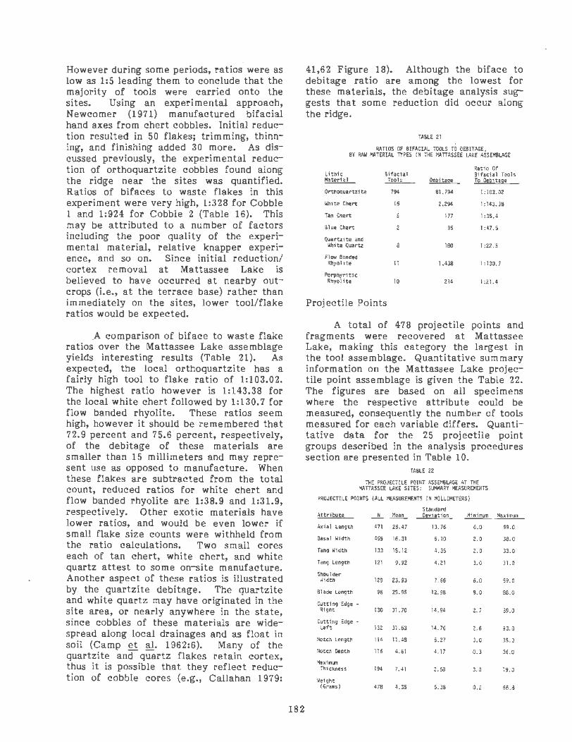
However during some periods, ratios were as low as 1:5 leading them to conclude that the majority of tools were carried onto the sites. Using an experimental approach, Newcomer (1971) manufactured bifacial hand axes from chert cobbles. Initial reduction resulted in 50 flakes; trimming, thinning, and finishing added 30 more. As discussed previously, the experimental reduction of orthoquartzite cobbles found along the ridge near the sites was quantified. Ratios of bifaces to waste flakes in this experiment were very high, 1:328 for Cobble 1 and 1:924 for Cobble 2 (Table 16). This may be attributed to a number of factors including the poor quality of the experimental material, relative knapper experience, and so on. Since initial reduction/ cortex removal at Mattassee Lake is believed to have occurred at nearby outcrops (i.e., at the terrace base) rather than immediately on the sites, lower tool/flake ratios would be expected.
.A comparison of biface to waste flake ratios over the Mattassee Lake assemblage yields interesting results (Table 21). As expected, the local orthoquartzite has a fairly high tool to flake ratio of 1:103.02. The highest ratio however is 1:143.38 for the local white chert followed by 1:130.7 for flow banded rhyolite. These ratios seem high, however it should be remembered that 72.9 percent and 75.6 percent, respectively, of the debitage of these materials are smaller than 15 millimeters and may represent use as opposed to manufacture. When these flakes are subtracted from the total count, reduced ratios for white chert and flow banded rhyolite are 1:38.9 and 1:31.9, respectively. Other exotic materials have lower ratios, and would be even lower if small flake size counts were withheld from the ratio calculations. Two small cores each of tan chert, white chert, and white quartz attest to some on-site manufacture. Another aspect of these ratios is illustrated by the quartzite debitage. The quartzite and white quartz may have originated in the site area, or nearly anywhere in the state, since cobbles of these materials are widespread along local drainages and as float in soil (Camp et al. 1962:6). Many of the quartzite and quartz flakes retain cortex, thus it is possible that they reflect reduction of cobble cores (e.g., Callahan 1979:
182
41,62 Figure 18). Although the biface to debitage ratio are among the lowest for these materials, the debitage analysis suggests that some reduction did occur along the ridge.
fABLE 21
RATIOS OF BIFACIAL TOOLS TO OEBITAGE , BY RAW MATERIAL TYPES IN THE MATTASSEE ~KE ASSD1B~GE
L1 th1c Material
Orthoquartzite
White Chert
Tan Chert
Blue Chert
Quartzite and
B1fac1al Tools
794
16
Whi te Quartz 8
Flow Banded Rhyolite 11
Porphyr1 t1 c Rhyolite 10
Projectile Points
Rat io Of 8lfac111 Tools
0~1tage To Oeb1tage
81,794 1:103.02
2,294 1:143.38
177 I :35.4
95 1 :47.5
180 1 :22.5
1,438 1:130.7
214 1:21.4
A total of 478 projectile points and fragments were recovered at Mattassee Lake, making this category the largest in the tool assemblage. Quantitative summary information on the Mattassee Lake projectile point assemblage is given the Table 22. The figures are based on all specimens where the respective attribute could be measured, consequently the number of tools measured for each variable differs. Quantitative data for the 25 projectile point groups described in the analysis procedures section are presented in Table 10.
TABLE 22
TliE PROJECTILE POINT ASSEI'18~E AT TliE I!.ATTASSEE ~KE SITES: SlHIARY IIEASURE!4ENTS
PROJECTILE POINTS (All MEASUREI!ENTS Ill IIILLIMETERS)
Standard Attribute -"- Mean Oev1ation ~ Axial length 471 26.47 13.76 6.0
Basa l Width 455 16.31 6.10 2. 0
Tang Width 133 15.12 4.35 2.0
Tang length 121 9.92 4.21 3.0
Shoulder Jldth 129 l3.93 1.66 6.0
Blade length 96 Z9.95 12.98 8.0
Cutting Edge -Right 130 31.70 14.94 2. 7
Cutting Edge -left 132 31.63 14.76 2.6
Notch length 114 11.48 5.27 3.0
,,otch Otpth 116 4.61 4. 17 0.3
'1axf111111 Thickness 194 7. 41 2.68 3.0
Weight (Grams) 478 4.35 6.38 0.2
11ax1111111
99.0
38.0
33.0
31.0
59.0
88.0
89.0
g3.0
35.0
36.0
19.0
66.8

Breakage patterns of hafted bifaces/ projectile points were initially coded using nine categories which are described above (analysis procedures) and are defined in the Appendix. For comparative purposes these have been reduced to five categories: whole, tips, midsections, bases, and other fragments (Table 23). Tip fragments account for the majority (41 percent) of the points on the sites. Occasionally the presence of projectile point tips has been interpreted as representing distal tips that were not removed from the carcass after shafts had been extracted from game kills. It is likely that animals were cooked. on the ridge, perhaps accounting for the presence of some tips. However, many of the distal breaks are transverse fractures which have been inferred to reflect either manufacture or use (e.g., Frison and Bradley 1980:51). While some of the Mattassee Lake tips may represent manufacturing breaks, ten percent (Table 23) were made of exotic materials. This may be interpreted as reflecting breakage during use, since the debitage analysis suggests that many of the extralocal hafted bifaces appear to have been transported onto the ridge. Use may have included a variety of tasks (e.g., Ahler 1971) such as sawing, cutting, scraping, or perhaps as a pry. Points used in prying functions would be expected to break at the extreme distal end.
lii!OLE
TIPS
MIOSECTIOHS
BASES
OllfER
TOTAL
PERCENT OF PROJECTILE POINT ASSEl\BLAGE
TABLE 23
TliE MATTASSEE LAKE PROJECTILE POINT A.SS~BLAGE: BREAKAGE PATTERNS BY LITHIC MATERIAL
! H ~ ...
l '-0
104
175
27
113
8
J .. tl ! :;: "'
;: " H ..:
~ u '-
w .. .. ... " i .. a B ! " .. " ;! :i :;;
427 4 11
J
~ u .. ! i u c: i
., u -8 .. ew ~~ ,._ ,__ .,_ ,_
0 .co u· ... >.
'""' -ex ""' ... ... 7
2
3
10 8
~
" 0
" ] -.; u
"' i
1
1
2
4
.. c .§ ..
c
'! .. t!
0 .... ~
118 24.6
196 41.1
30 6.3
126 26.3
8 1.7
478 100.0
89.3 1.9 0.6 0.8 2.3 0.4 2.1 1.7 0.8 100.0
An Intrasite Analysis of the 38BK226 Lithic Assemblage
Introduction
Site 38BK226 is the easternmost site on the ridge, and the closest to the Santee River. Of the three examined in 1979, this site is farthest from Mattassee Lake, the tributary that flows between the terrace and the main river channel. It is argued here that this microgeographical patterning is responsible, in part, for observed differences between 38BK226 and the other sites. Thirty-one two meter squares were opened at 38BK226, more than at any other site.
The discussion of the lithic artifacts recovered from 38BK226 focuses on two samples, the total site assemblage and data from a major excavation block, a subset of the total assemblage. The total assemblage includes artifacts recovered during the testing phase, from the 64 half meter units, as well as materials from the larger two meter units dug during both phases. The block assemblage refers to a group of 24 contiguous excavation units, EU's 3 through 26, excavated in arbitrary 5 em levels. It was believed that this sample possessed enough horizontal continuity and vertical control to justify combining materials by level.
Orthoquartzite Debitage at 38BK226
A total of 37,211 orthoquartzite flakes were recovered at 38BK226. Of this total, 26,472 flakes, or 71 percent of the total orthoquartzite debitage assemblage recovered at the site came from the block unit. The incidence of each reduction stage, over the total assemblage and within the block assemblage is presented in Table 24.
In both instances, primary and secondary decortication flakes account for approximately five percent of all debitage. As noted previously, this amount of cortical debitage seems quite low, particularly with a source nearby. Usually debitage from quarry/workshop sites (Table 8) is characterized by a high percentage of decortication flakes. In the Missouri Ozarks, for example, where chert occurs as stream cobbles or tabular outcrops debitage from eight rockshelter assemblages (Novick and
183

TABLE 24
ORTllOQUARTZITE OEBITAGE IH TllE 388K226 ASSEMBLAGE: COUNT BY REDUCTION STAGE
Total Block Assemblag~ Assemblag~
Pri ury 535 443 (1.67~ )
SKondary 1,331 996 (3.76S)
Interior 25,972 16,708 (63.12S)
FBR 4,717 5,986 (22 .61S )
Chunk 2,658 2,339 (8.84S)
TOTALS 35,2131
(100.0S) 26,472 ( lOO.OS)
1 Excludes AM:1facts 1n Features
Cantley 1977; Chomko 1977) included cortical flakes ranging from five (N=2) to 21 percent, and has been interpreted as representing cobble industries. At Cal Smoak Anderson, Lee and Parler (1979: 42) noted that:
All of the chert appears to have originated at the Allendale Quarry (38AL14) on the lower Savannah River about 40 miles away.
At Cal Smoak the incidence of cortical flakes ranged from 19.4 percent in the highest level of the site to under ten percent in the lower levels, with the assemblage as a whole averaging 13.5 percent. Suggested explanations (Anderson, Lee, and Parler 1979:48-50) for the temporal increase in cortical flakes, made of a raw material obtained 40 miles away, included changes in site use and group mobility patterns, greater tolerated waste during procurement, and an impoverishment of the quarry necessitating increased collection of cortical material. The incidence of cortical material at 38BK226 appears low by comparison to these other sites.
As noted previously, the inclusion of all noncorticai flakes and flake fragments (exclusive of FBR's and chunks) in the interior flake category appears to have reduced relative percentages of the other flake classes. This is borne out by examining the distribution of complete orthoquartzite flakes analyzed using the special analysis
procedures (Figure 71). A striking contrast is noted between these averages and the flake class averages for the total 38BK226 assemblage which are similar to the block assemblage percentages. Complete primary, secondary, and biface thinning flake classes double; the chunk flake class more than triples; and the interior flake class reduces to one quarter of the percentage for the block assemblage.
Average size for the reduction classes presents one unexpected yet interesting aspect. The average size for all orthoquartzite flakes from the terrace, with the exception of flakes from the flotation samples, was found to be 3.53 cm2 (Table 17). However, at 38BK226 the average sizes for all flake classes were lower than this figure: primary x = 2.50cm 2; secondary x = 2. 69 cm2; interior x = 3.15 cm2; biface thinning x = 1. 7 5 c m 2; and chunks x = 2.14 cm2. It was anticipated that decortication flakes would exhibit the largest average sizes, however, interior flakes are clearly the largest flakes in the assemblage. This would suggest that comparatively little initial reduction occurred on the site, with much of it (possibly) occurring elsewhere. This site, as noted in the beginning of this section, is farthest from Lake Mattassee, the probable source/outcrop area where much of the quality testing and initial reduction of the local orthoquartzites may have been done.
Average weights for orthoquartzite reduction flake classes in the 38BK226 assemblage are similar to the average weights observed over the entire Mattassee Lake assemblage (Table 18). Average flake weights at 38BK226, by category, are: primary x = 5.56 gm; secondary x = 3.87 gm; interior x = 1.12 gm; biface thinning x = 0.45 gm; and chunks x = 2.85 gm.
A Model of Orthoquartzite Reduction Strategies Along Mattassee Lake
Based on the observed percentages of reduction stages in combination with average flake size and weight measurements, the following reduction strategy for locally occurring orthoquartzite at 38BK226 is presented (Figure 72). Exposed outcrops are
184

-
LEVEL em
LEVEL em
LEVEL em
LEVEL em
Note Petctnts 1n each level for 1U fl1ke cJasses
sum to 100"0
WHOLE FLAKES ONLY
Primary Secondary Interior
'
Primary
~ . .
FBR's Chunks
TOTAL FLAKES
Secondary Interior
FBR's Chunks
FIGURE 71
RELATIVE PERCENT AGES, BY LEVEL, AND REDUCTION STAGE WHOLE FLAKES AND TOTAL ORTHOQUARTZITE FLAKES
IN THE 38BK226 BLOCK MATTASSEE LAKE EXCAVATIONS
U S ~,,., Coro5 ol Enq.neers
Coooer "•ver Reo•v•rs•on CaftaJ Protee:

OUTCROP I
..:------ ----CHECK INTERNAL QUALITY
DEBIIAGE REMOVAL OF LARGE PIIECES FOR TRANSPORT
COBBLES
I TO WORKSHOPS
I .-------------SPLIT INTO PIECES
QUALITY CHECK-----~~
I DEBITAGE
REMOVE MOST CORTEX ____ _,t
' I ~
CORE RTUCTOON REMOVAL OF CORTEX ,,_--------PRELIMINARY BIFACEIPREFORM SHAPING
t ,~--~.~----~~-----------_,, DEBITAGE DEBITAGE
L SELECTL FOR
DEBIT AGE- CONTINUED USE MANUFACTURE TRANSPORT
UNIFACE AND EXPEDIENT TOOL
REOrTION RECrCLE BREfKAGE
' DISCARD
MANUFACTURE BIFACE/PREF~RM REDUCTION
I BIFAc4REFORMS
1
PROJEcJ.cEPOINTS MANUFACTURE BREAKAGE II OEBITAGE
DISCARD usE I u~E MANuFlcruRE
l l RESH~~~~NING J BREAI._KA_G_E ____ -r------'
BREA~GE .l. .!. DISCARD...--------.!.....-------___;,--. RECYCLE DISCARD
' I
' SMALL BIFACE/PREFORMS PROJECTILE POINTS I I
' TRANSPORT
FIGURE 7'... ORTHOQUARTZITE REDUCTION STRA TEGIEf
ALONG THE LOWER SANTEE RIVE
examined, then flakes are knocked off to check internal quality. Cobbles are treated in the same manner. Based on experimental reduction of orthoquartzite (Table 16), and using our flake classification large primary and secondary flakes, small interior flakes, and chunks would be produced during this initial step. Removing a large piece of stone from an outcrop would result in a similar debitage assemblage, however more chunks would be anticipated. If cobbles were selected, however, they probably were so weathered that much of the cortex was removed before they were transported. At this stage, small cobbles could then be reduced to bifaces or preforms. Large cobbles and pieces quarried from outcrops would
186
MATT AS SEE LAKE EXCAVATIONS U.S Army Cor-ps of Eng1nee
Cooper River Redivtrt•Of" Canal ProJe
then be transported to workshop areas that, along the ridge, are associated with habitation sites. Splitting results in the interior flake as the principal debitage class. Based on the tool analysis, it is apparent that although biface/preforms dominate, some cores are present (N=30 in the 38BK226 block assemblage). Consequently, after splitting both cores and biface/preforms were produced.
Core reduction continued with flake removal. In many instances platforms were not prepared. This may be related to the rough texture of the orthoquartzite, compared to such materials as chert and rhyolite. From these flakes, selections were

made for manufacture of uniface and expedient tools. During later prehistoric periods, small triangular points could . be manufactured easily from flakes, as demonstrated during the knapping experiments (Figure 66). Probably all of the manufactureq tools would have been used, resulting in wear, resharpening, and breakage. Broken tools could be recycled or discarded.
Returning to the level of manufacture where large pieces are split, preliminary biface/preform shaping would proceed with removal of most cortex. Much of this debitage would be classified as interior, with secondary and chunk classes present. At this point, the preliminary shaped biface/preforms would follow one of four routes, transportation away from the site, breakage during manufacture, use, or continued reduction. Manufacture breakage would be examined and a decision would be made as to whether to discard all pieces or to recycle one or more fragments. Preforms in use would produce debitage and might break. At this stage, the recycled broken fragment would follow the same route as continued biface/preform reduction. Interior and thinning flakes enter the system as by-products of reduction ·processes. This refined level of production results in more manufacturing breakage, projectile points, and biface/preforms. Broken fragments follow a path similar to that noted above. They may be discarded or recycled. Recycled biface fragments could be reworked into smaller bifaces or projectile points, in which case the entire process is repeated. Some broken fragments may be fashioned into a .uniface tool.
Bifaces and projectile points follow three routes; transport~tion away from the site, manufacture breakage, and use. Breakage of these tools again would involve discard and recycling decisions. Tools that were used at the site have the most variability with respect to archeological evidence. Initial by-products of use are debitage, mainly thinning and interior flakes, produced during wear and resharpening activities. These flakes may be examined and some selected with an eye towards uniface or small projectile point manufacture. In fact any time debitage is produced in the system, there is the possibility that it
187
will be selected for tool manufacture or expedient tool use. · For example, Gould et al. (1971:163) note that Aborigines occasionally used natural flakes for tools. Brose (1975: 93), in his functional analysis of flake knives, concluded that there was:
no practical way to distinguish flakes used for less than four minutes in butchering activities, from flakes which have not been used at all.
Therefore, utilized debitage, particularly the local, poor quality orthoquartzite may not be readily identified or recognized as having been used.
Uniface tool use (Figure 72, lower left) will result in wear, resharpening, and breakage. Because of its small size, it is less likely that debitage derived from unifaces will be used for tool manufacture. Although broken uniface tools could be discarded or reworked, analysis results suggest that most were simply discarded after breaking.
Biface/preform and projectile point use (e.g., cutting, scraping, whittling) at the site may be represented in the archeological record in a variety of ways. Utilization of debitage produced during use has been summarized above. However, use may also result in breakage. During the previous stages of manufacture biface preforms would be large and subsequenJ breakage would result in larger fragments that could readily be reworked. However, smaller bifaces and projectile points when broken would have a lesser chance of recycling. This case would be emphasized during later periods when tools were much smaller dur ing the initial use stage (e.g., small triangular projectile points).
Changes in Reduction Strategies Over Time: Evidence From the 38BK226 Block Unit
The 38BK226 block unit assemblage indicates that some differences occur over time with respect to site use and manufacturing strategies. The following interpretations, based on all intact and broken flakes, may be somewhat distorted due to an apparent overrepresentation _ of interior

flakes. A cursory examination of all the orthoquartzite debitage from the block (Figure 71) suggests that over all periods reduction strategies involved very little, if any, cobble reduction. The incidence of cortical material increases over time, a pattern similar to that noted at the Cal Smoak site. Even the greatest incidence of cortical material observed, however, does not begin to compare with normal output from a cobble reduction industry (Novick and Cantley 1977; Chomko 1978). Interior flakes dominate the assemblage over all periods, suggesting that reduction was a major concern, while trimming and use activities (reflected, in part, in the incidence of FBR's) were slightly less important during earlier times. The later time horizons are the inverse of the earlier horizons with increased cortical flakes and decreased interior flakes. Thinning flakes (FBR's) increase, suggesting that increased final stage reduction occurred.
Relative percentages of whole flakes (Figure 71) may be interpreted as representing a different reduction strategy. Using only whole flakes, the incidence of cortical flakes and chunks is much higher than when all of the flakes recovered from the block (whole and broken) are used. The comparatively high incidence of cortex may suggest that cobbles or chunks, having had some cortex removed, were brought onto the site and worked. Throughout time reduction appears to have been a problem since so many chunky byproducts are produced (25 to 48.9 percent of all intact debitage in the levels). Of particular interest is a decrease in the incidence of interior flakes compared with an increase in thinning flakes over time, from the lowest to the highest levels. In the lowest levels, which roughly correspond with the Early Archaic, initial cortical reduction was minor. Interior flake reduction took place; however, emphasis was on thinning processes. This seems to fluctuate as initial reduction decreased during later periods (Levels 8 and 9; corresponding roughly to the Early and Early/Middle Archaic) while thinning flake production increased. Levels 6 and 7 (Middle Archaic) represent a change where chunks drop significantly to their lowest point, so perhaps there was higher quality material available during this time, or reduction strategies
188
were better suited to this orthoquartzite. Cortical flakes were also higher on this horizon. From this level on, percentages of thinning flakes decrease while chunks increase, and the incidence of cortical and interior flakes fluctuate. This suggests that the quality of material may have been reduced, resulting in greater quantities of chunks. It is possible that orthoquartzite of higher quality was exhausted, leaving only lesser quality material to exploit resulting in blocky, chunk by-products during reduction and manufacture.
This pattern may also be related to later period reduction strategies, where only small flakes were needed for the production of triangular or small, stemmed projectile points.
Whichever sample is used, the flake counts discussed above still support the model of local reduction proposed earlier (Figure 72). Over both samples the incidence of cortical flakes is low, although it is higher (Figure 71) when only whole flakes are examined. The total incidence of flakes increases over time, to a peak in Level 4 (15-20 em) and then decreases to a minimum in the lowest level (Figure 71). However, as noted earlier, this decreasing distribution parallels the excavation unit distribution.
Exotic Debitage at 38BK226
All but one of the 23 kinds of exotic materials identified in the Mattassee Lake assemblage were recovered in excavation units at 38BK226. Although most lithic types occur at 38BK226, only those materials whose sources are known with some degree of confidence (Chapter 6) and are present in quantity have been examined in detail. Distributions of the principal exotics are compared with the local orthoquartzite in Figure 73. The general distributional trend for all extralocal debitage is a peak in the lowest levels, representative of Archaic periods, and a gradual decrease over time. High percentages of exotic or extralocal material evident on early time horizons was anticipated (e.g., Goodyear 1979; Judge 1973). This effervescence is interpreted as representing mobile groups of people to whom exotics were not uncommon because such materials were acquired readily dur1ng

,..
the course of seasonal rounds. In overall incidence white fossiliferous chert, originating within five miles of the site, is the most abundant material next to the orthoquartzite. Flow banded· rhyolite, a Fall Line/ Piedmont material, is the second most common material, followed by Allendale chert which is also an extralocal material, coming from almost 100 miles to the west.
Stone Tools at 38BK226: The Site Assemblage
A total of 577 tools were recovered from excavations at 38BK226. These are summarized by tool type and raw material in Table 2 5. Over the entire site, hafted bifaces/projectile points (N=312) dominate the assemblage (54.1 percent); measurements for all tools are detailed in the Appendix. Bifaces (N=146) constitute the next largest category, at 25.3 percent. The· percentage of projectile points at this site is ten percent higher than observed over the entire, three site assemblage consequently all other tool categories are lower than those for the combined assemblage. No spokeshaves or notches, a tool form recovered at 38BK229 were present at either 38BK226 or 38BK246.
To\SLE 25
INCIOOitE OF TOOl CATEGORIES 8Y RAW IIATEAIAl AT SITE 3881\226
Tool hpe
Poinu
8\faces
Utf1fztd Fllkts
Fl•ke Bhnks
COI"'tS
:l
L -~ ; Cl
j~ i ~~ ~ 5 <.,;,
2 272 8 3 6 7 8 4 2 312 (54.U)
0 IJS 0 0 S I 2 2 146 (25.3.)
022 200102128 (4.91)
I 41 6 0 0 0 0 0 I 49 (8.5~)
0 13 0 0 0 0 0 0 0 13 (2.3~)
025 0220000 29 (S.O I
SITE TOTAlS l 508 16 S 13 9 9 8 6 577 co. ss)(BB.2:) (2.811 (o. 9~)(2 .n)( 1.61) 1 I.6:)(I.u)( I.o,l 1 Ioo.os)
oLCO: TOTALS 3 406 14 4 IZ 9 9 6 6 •10 (O.U)(06.6S)(J.OI)(0.91)(2.6\)( I. 91)( 1.9:)( 1.3: ) ( 1.3t) ( IOO.Ot)
As expected, local orthoquartzite (Table 25) is the dominant lithic raw material used for tools; however, it is three percent lower than the incidence observed over the combined ridge assemblage. This indicates that the proportion of tools made
189
from exotic materials is higher than average at 38BK226. Sixteen artifacts of Allendale chert account for the highest incidence of an extralocal raw material, comprising 2.8 percent of the total tool assemblage at the site. Several of the tools of Allendale chert are well made unifaces, one of which is so thick (28.0 mm, Figure 65e) that it is surprising that it was transported so far from its area of origin. Local white chert (N=l3 tools, 2.3 percent) ranks third, followed by equal percentages of (N=9 tools, 1.6 percent) flow banded and porphyritic rhyolite. Quartz, materials of uncertain origin, tan chert, and Manchester chert account for comparatively minor fractions of the tool assemblage from the site (Table 25).
Breakage patterns for all tool groups at 38BK226 are presented in Table 26. Over one quarter of the tools recovered from 38BK226 were intact, with about 70 percent of these projectile points/hafted bifaces. Within tool class breakage is nearly equal for points and cores, where 80 percent of these classes are broken. These are followed by unifaces with a high rate of over 75 percent, about 70 percent for bifaces, and 40 percent for utilized flakes and flake blanks. · Breakage ratios (Table 26) are another way of expressing these relationships. The high breakage rate of projectile points, cores, and unifaces suggests that these tools, followed by bifaces, were most intensively used at the site. Utilized flakes, which have a low breakage rate, are expedient tools that could be simply discarded at will (e.g., upon edge dulling) and readily replaced. Flake blanks, which are large flakes that were probably used for tool manufacture, also have a low breakage rate that may be attributed to the same reason.
Biface to debitage ratios for lithic rna terials are illustrated in Table 2 7. Surprisingly, white chert and flow banded rhyolite have the highest ratios, even greater than those for the ridge as a whole. If flow banded rhyolite flakes smaller than 15 millimeters are dropped from the debitage count, the ratio lowers to 1:42.37. Since 99.69 percent of these flakes are interior (39 percent) and thinning (60 percent) flakes, it seems likely that tools of this material were used rather than manufactured at the site. If ratios were calculated

LEVEL em
05 510 10 15 . 5 20 20 25 25 30 30·35 3S·•O 40·45 .15 so so5s ss 60
LEVEL em 05 5 10 10 15 15 20 20 25 25 30 30·35 35 JO •o •& •s so 50 55 55 60
LEVEL em
0 5 5 10 •o 15 15 20 20 25 =s 30 30 35 35 J O •o •s JS SO 50 55 55 00
White fossiliferous chert
Manchester chert
Note . Petctnll '" each level for all htl"uc ma~enals sum co \00 "'
Orthoquartzite
Tan fossi I iferous
chert
Blue fossi liferous
chert
Flow banded rhyolite
Quartzite
Porphyritic rhyolite
Allendale chert
Welded tuff
FIGURE 7..., RELATIVE PERCENTAGES or.:
DOMINANT EXOTIC DEBIT AG BY LEVEL, IN THE 38BK226 BLOC
MATTASSEE LAKE EXCAVATIONS U.S Armv Coros ot S:ng1net
Cooper R•ver Redtverston Canal Prott

LEVEL em
0-5 5-10 10-15 15-20 20-25 25-30 30-35 35-40 40-45
LEVEL em
0-5 5 -1 0 10-15 15-20 20-25 25-30 30-35 35-40 40-45
LEVEL em
0 -5 5 -10 10-15 15·20 20·2 5 25-JO 30·35 35-40 40-45
Note: Perc:ents '" each level for all 11th•c materials sum to 1 00 %
226 BLOCK TOOLS
Orthoquartzite
White chert Tan chert Allendale Manchester
Flow banded rhyolite Porphyritic rhyolite Other
FIGURE 74
RELATIVE PERCENTAGES OF CHIPPED STONE TOOLS RAW MATERIAL AND LEVEL. IN THE 38BK226 BLOCK
MATIASSEE LAKE EXCAVATIONS U.S. Armv Corps of Eng1neers
Cooper Aiver Redivers1on Canal ProJeCt

for other materials, they would drop similarly. However, orthoquartzite biface to debitage ratio at 38BK226 is lower than the ridge average.
TABLE 26
BREAKAGE RATIOS OVER TOOL CATEGORIES AT 388K226
'.lho1e ~
Points 65 246
Bifaces 43 103
Utilized flakes 17 9
Uni faces 12 37
Flake Blanks 8
Cores 6 23
TOTALS 151 423
TABLE 27
81FACE TO OEBITAGE RATIOS, SITE 388K226, I'ATIASSEE LAKE
Lithic Bffacia1 ~ Tool C01111t
Orthoquartzite 432
White Chert 11
Tan Chert
Quartz and Quartzite
Flow Banded Rhyolite 8
l'orpnyritic Rhyolite 9
O.bi tage ~
36,995
1.981
156
61
1,343
210
Stone Tools at 38BK226: The Block Unit Assemblage
itatio
1:3.8
1:2.4
1:.5
1:3.1
1:.62
1:3.8
1:2.8
itatio of ·~hole Tools to Blfaces
1:85.63
1:180.09
1 :31.2
1:10.16
1:167.87
I :23.33
The excavation block at 38BK226 offered the opportunity to examine tool use over time along this portion of the terrace. The distribution of all tools by level within the block is a battleship curve (Figure 74) similar to that for all orthoquartzite debitage (Figure 71}. As noted earlier the number of excavated units decreases with depth, however the decline in the tool curve at 15 to 20 em is above the 30 to 35 em level where the number of excavated units within the block begins to decrease.
The distribution of tools, by lithic material in the 38BK226 block levels (i.e., through time) is shown in Figure 74. Comparison of the tool and debitage distributions (Figure 71) reveals patterned differences. The incidence of orthoquartzite flakes remains fairly constant throughout all
192
of the levels, with the exception of level 50 to 55 em. However the tool distributions vary considerably, and peak in the levels from 35 to 45 em, and 50 to 55 em. Although the graphs illustrate relative changes well, the figures in Table 27 facilitate comparisons. Biface tool to debitage ratios are lowest in the first three levels, where small Mississippian/Woodland triangular points are common (Table 27}. Since these points could be made easily from small flakes, the frequency of flakes may also be lower. It is possible that in earlier times bifaces were a fundamental part of tool kits, serving as multifunctional tools. During later periods tools may have been more specialized and group mobility may have been reduced consequently the need for bifaces may also have diminished. Support for the proposition of increased tool diversity through time may be seen in the biface to projectile point ratios in the 38BK226 block levels (Table 28). Here the upper levels are represented by high point to biface ratios, with the exception of the 15 to 20 em level. While the tool diversity at these sites seems too low to argue for sedentary occupations, the issue that the need for multifunctional bifaces decreased during later time periods as tool specialization increased has been supported.
TABLE 28 BIFACE TO PROJECTILE POINT RATIOS
IN THE 38BK226 BLOCK UNIT ASSEMBLAGE Base of Level In Centimeters Ratio
5 1 :0.31
10 1 :0.21
15 1:0.47
20 1 :0.29
25 1:0. 17
30 1 :0.35
35 1 :0.80
40 1 :0. 44
45 1:0.67
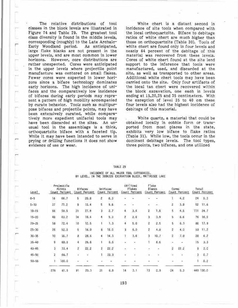
r
-
The relative distributions of tool classes in the block levels are illustrated in Figure 74 and Table 29. The greatest tool class diversity is found in the middle levels, corresponding (roughly) to the Late ArchaicEarly Woodland period. As anticipated, large flake blanks are not present in the upper levels, and are most common in lower horizons. However, core distributions are rather unexpected. Cores were anticipated in the upper levels where projectile point manufacture was centered on small flakes. Fewer cores were expected in lower horizons since a biface technology dominates early horizons. The high incidence of unifaces and the comparatively low incidence of bifaces during early periods may represent a pattern of high mobility accompanied by curate behavior. Tools such as multipurpose bifaces and projectile points, may have been extensively curated, while comparatively more expedient unifacial tools may have been discarded at the sites. An unusual tool in the assemblage is a thick, orthoquartzite biface with a faceted tip. While it may have been intended to serve in prying or drilling functions it does not show evidence of use or wear.
White chert is a distant second in incidence of site tools when compared with the local orthoquartzite. Biface to debitage ratios of white chert are much higher than those on orthoquartzite (Table 30). Tools of white chert are found only in four levels and nearly 64 percent of the debitage of this material was recovered from these levels. Cores of white chert found at the site lend support to the inference that tools were manufactured, used, and discarded at the site, as well as transported to other areas. Additional white chert tools may have been carried onto the site. Only four artifacts of the local tan chert were recovered within the block excavation, one each in levels ending at 15,20,25 and 35 centimeters. With the exception of level 35 to 40 em these four levels also had the highest incidence of debitage of this material.
White quartz, a material that could -be obtained locally in cobble form or transported from most places in the state, exhibits very low biface to flake ratios (Table 31). While low, the tools occur in the dominant debitage levels. The tool types, three points, two bifaces, and one ut ilized
TABLE 29
INCIDENCE OF ALL MAJOR TOOL CATEGORIES, BY LEVEL, IN THE 38BK226 EXCAVATION BLOCK , MATTASSEE LAKE
Proj ecti le Utilized Fl ake Points Bifaces Unifaces Flakes Blanks Cores Total
Level Count Percent Count Percent Count Percent Count Percent Count Percent Count Percent Coun t Percent
0-5 16 66 . 7 5 20 .8 2 8.3 4. 2 24 5.3
5- 10 37 71.2 8 15. 4 5 9.6 2 3.8 52 11.6
10- 15 66 59.5 31 27.9 3 2.7 4 3.6 2 1.8 5 4.5 111 24.7
15-20 48 63 .2 14 18. 4 4 5.3 2 2.6 3 3.9 5 6.6 76 16. 9
20-25 58 72 .4 10 12.5 1. 3 4 5. 0 2 2. 5 5 6.3 80 17 . 9
25-30 26 52. 0 9 18.0 8 16.0 3 6.0 2 4.0 2 4.0 so 11.2
30-35 10 35. 7 B 28.6 4 14.3 3. 6 3 10 . 7 2 7.0 28 6.2
35-40 9 60 .0 4 26. 8 6.6 6.6 15 3.3
40-45 3 33 . 4 2 22.2 2 22.2 2 22 . 2 9 2. 0
45-50 2 66. 7 33.3 3 0 . 7
50-55 100.0 0. 2 - - -- - --- --- - --- - --
276 61. 5 91 20.3 31 6.9 14 3. 1 13 2. 9 24 5.3 449 100.0
193

i.<au: Jo •.t8LE 31
CRT!lCOI.!ARTZ!7E AllO .;HiiE CHE.'lT iGOLS, 31FACES, .IHITE QUART! <NO ALL!NCALE CHEiH ""OOLS, 31i'~CES. .;110 JEalTAGE IN ilfE JBBKZ25 3LOC:< AND OE8ITAGE !N rriE 38BKZZ6 ~LCCK
!"ATERIALS ~EAR TllE SITE i"ATERIALS OF UNKIIO\IN ORIGi ~
A. ORTHOQUART!ITE .... '.!HIT<: QUART!
81fac.e to 3f #~Cf ~
Level 7otal 31ftct Ceoiuge Gebitaqe Level icn:a I 31face ;,eo!uqe Aoac in Centimeters ~ ~ ~ ~at10 fn Centimeters <ools ill.!.L ~ .2!.:.: 0-5 Cl1 22 20 774 1:38.7 0-5 c= I); 1. ~
5-10 c:n :4 48 2,JZ1 1 :48. ~ 5·10 em J: I. J
10-15 c:n 94 89 4,244 1 :47. 7 10-15 em 3 I:!.~
15-20 C1l 68 63 4,816 1 :76.4 15·20 Cll 10 1; 10. 20-25 C!l 70 63 4 , ~92 1: 71 .3 20·25 Cll 6 1 :S.~ 25- 30 C1l 44 32 3,587 1:112. 1 25·30 Cll a O:S.J 30·35 C!l 20 15 2,783 1:185.5 30·35 Clll 0:2.: 35-~ c::t 19 17 1,523 1:39.6 35-~ Cl1 J:J.: .:o-~s c:~ 11 9 981 1:109.0 ~-45 cm ): 1.: JS-50 em J 525 1:175.3 ~5·50 Cll ? :0.0 50-'iS em 396 1:396.0 50· 55 em O:J.C 55-60 em 28 0:28.0
50-65 Cll 0:1.0 TOTALS 38 1 :7.5
TOTALS .:07 360 25.~72 1: 73.5 INTERIOR CCASi'AL PLAllt
3. \IHITE CHERT 3. ALLENDALE CHERT
0-5 Cll 75 0:75.0 0-5 en ~: :.c
5·10 en 262 0:262.0 5-10 C!l 30 J:.JO. 10· 15 en 434 1:434.0 10-15 C!l 4 31 I :00. 15-20 c= 4 292 1:73.0 15·20 em 3 so :oo.J 20-zs c::t 6 6 283 1:47.2 20-25 Cll 2 2 36 1 ;¢3. 25- 30 Cl 1 .117 1:117.0 25-30 Cll J4 1 : .U.
10- 35 Cl 59 0:59.0 30-35 Cll JS I: 35. 35-~ em 53 0:53.0 35-~ an ~ ~:!O.J J0-..15 c:n 37 0:37.0 ~-45 an 19 u: 19. -15-SO en 29 0:29.0 45- SO en O::L: !0-55 en 112 J:112 . 0 so-ss en so J:SO. :5-oil c.'ll J:Z.O 55-60 em I J: 1. J
':OT.\LS 12 12 1, 765 1: 1 47.~ ~OTALS ;J .!61 :c.
TABLE 32
FLOW SAN OED AND PORPHYRITIC l!HYOLITE TOOLS, 61 FACES, AND DEBITAGE IN THE 3881(226 BLOCK
?IEOMONT .'lATERIALS
,\. FLOW 8ANOEO RHYOLITE 8. PORPHYRITtC RHYOLITE
S!face to Sfface : Level Total Sf face Oebitage Oebitage Levtt1 Total Slface Oebi tage :leo1tage
in Centimeters Tools Tools ~ Ratio In Centimeters Tools Tools Count ~at io
0-5 an 36 0:36.0 0-5 an 0: 5. 0 5-10 Cll n 1:77.0 5-to an l :S. J
10-15 em 113 1:113.0 i0-15 en 18 1:18. 0 15-20 an 3 2 198 1:99.0 15-20 on 37 1: 37. ~ 20-25 em 2 186 1:93.0 20-25 Q'l1 2 55 1:27. s 25-30 an 175 1:175.0 25-30 em 2 2Z 1: 11 .0 30-35 em 139 0:139.0 30-35 em 1 31 1:31 .0 35-~ an 64 0:64.0 35-~ an 3 J: J.O ~-45 em 39 0:39.0 ~-45 Cl1 J ):4.0 ~5-SO c:n 36 1:36.0 45-50 Cll J J:O.J 50-55 em 91 0:91.0 50-55 en a: 1.0
TOTALS 8 a 1,154 1:144.3 TOTALS 9 181 1:22.6
194

flake tend to support transport onto the site. However, a third of the white quartz debitage assemblage are decortication flakes, suggesting the reduction of local cobbles. In all probability both activities were occurring.
Extralocal chert tool and debitage distribution in the 38BK226 block unit levels is similar to the distributions observed for the local cherts. Allendale chert (Table 31) has an average bifacial tool to debitage ratio of 1:44.5 over five levels where tools were recovered. Unfortunately no tools were recovered in the deep level (50 to 55 em), where the debitage curve peaked (Figures 71,74). Since this is interpreted as an early level, where group mobility is assumed to be high and tools were extensively curated, their absence is not unanticipated. Only two Manchester chert tools were recovered within the block, one small Mississippian triangular (Group 1, level 0 to 5 em) and one Morrow Mountain (Group 19, level 20 to 25 em). Debitage counts for this material were low in the levels, ranging from 1 (0 to 5 em) to 6 (20 to 25 em). The absence of Allendale and Manchester chert cores or core fragments, coupled with the low debitage counts, supports the high mobility, curated tool interpretation.
Fall Line/Piedmont lithics have a broader distribution over the block unit levels than any other exotic raw material. Flow banded rhyolite tools (Table 32) were found in levels 5 to 10 em through 25 to 30 em, as well as one of the lowest levels 45 to 50 em. However, the debitage peak is in the lowest level. Prophyritic rhyolite tools (Table 32) have a similar distribution in the levels above and including 30 to 35 em. The incidence of debitage and subsequent biface to debitage ratios are lower for porphyritic rhyolite than for flow banded rhyolite, and there is no peak for this material in the lower horizons.
The 38BK226 Lithic Assemblage: A Summary
Materials recovered from site 38BK226 exhibit more diversity and sheer quantity than assemblages from either of the other two sites along Mattassee Lake.
6
8
9
10
TABLE 33
PROJECTILE PO!HTS AT AATIASSEE L.AK£: GROUP lDEilT!FlCATION AND ESTIMATED AGE, SY SIT£
Pe riod 38BK226 ~ ~
Hht onc/ Mlss l ssippl in - late lloodland
l ate ·~oodland/ M1ssfss1pp1an
24
24
11
Mi ddle/Early Woodland -
15
11 Early '.loodland/ Late Archa i c
34
39
11
12 12
13
14
15
16 l ate Archaic/ Mi ddle Archaic
17
18
19 Middl e Archai c
20 Ea rl y Archa ic
Examination of projectile point distributions (Table 33) reveals a stratigraphic sequence beginning with small Mississippian triangulars, a variety of Woodland types, Late Archaic Savannah River types, Middle Archaic Morrow Mountains, and Early Archaic Palmers. This represents the longest as well as best developed cultural sequence of all three sites.
Projectile point breakage patterns (Table 34) have similar distributions through time with the exception of the lowest horizons which had representative decreases. This suggests that point manufacture and use took place on the site throughout time. However, biface distributions (Table 35) illustrate a different pattern. Breakage types increase in number and occurrence with increasing time depth until all quantities decrease in the lowest horizons. Tool quantities and breaks are highest in the middle horizons, which correspond (roughly) to the Late Archaic through Early Woodland periods. During these periods biface manu-
195

TABLE 34
PROJECTILE POINT BREAKAGE PATTERNS, BY LEVEL, IN THE 38BK226 BLOCK, MATTASSEE LAKE
0> c: 0> c: 0 c:
"' .... "0 "' "01- "' u ~ c ~ "' c:cu ;: cu <00 <0"0 cu V'> S..·- :s :E:
0 I cu cu ... u cu :::> ., 0.. "0 "' .... u "' 0.. v>O "' .s:::; ;: "' "'"' .J:> <O.S:::: "' Total Level 3: I- a:l -' V') 0 I- a:l'l'l a:l
0-5 em 4 6 0 3 0 0 3 0 0 16 (5.8%)
5-10 em 4 18 2 5 0 5 0 2 37 ( 13. 4%)
10-15 em 9 32 5 4 0 3 11 0 2 66 (24.0%)
15-20 em 9 17 5 3 0 10 2 48 ( 17. 4%)
20-25 em 15 23 3 3 0 12 0 58 (21.0%)
25-30 em 5 14 0 0 0 5 0 26 (9. 4%)
30-35 em 2 4 0 0 0 3 0 0 10 (3.6%)
35-40 em 3 5 0 0 0 0 0 0 9 (3.3%)
40-45 em 0 0 0 0 0 0 3 ( 1. 1%)
45-50 em 0 0 0 0 0 0 0 2 ( 0. 7%)
50-55 em 0 0 0 0 0 0 0 0 1 (O.U)
COLUMN TOTAL 52 122 16 20 1 5 50 2 8 276 (18.8%) (44.2%) (5.8%) (7.2%) (0.4%) ( 1. 8%) (18.1%) (0. 7%) (2.9%) (100.0%)
TABLE 35
BJFACE BREAKAGE PATTERNS, BY LEVEL, IN THE 38BK226 BLOCK, MATTASSEE LAKE
c: 0> 0> c:
0 c: ·- "' ... "0 "' "' u ~c: ~ "' i: cu .. o ;: cu V') .... _
:::> 0 I cu cu ... u cu
0.. "0 Ill ... u "' 0.. "' Level s: ;: "' .. cu .J:>
~ "' Total 3: .... a:l _, V') 0 a:l
0-5 em 0 0 2 0 0 5 (4.5%)
5-10 em 4 0 0 0 8 (7. 2%)
10-15 em 5 6 3 4 5 6 31 (27. 9%)
15-20 em 10 0 2 2 3 2 0 20 { 18.0%)
20-25 em 6 2 0 2 14 (12.6i)
25-30 em 4 2 0 2 0 0 10 (9.0%)
30-35 em 2 0 4 0 0 9 (8.1\)
35-40 em 3 0 3 0 0 Q 8 (7.2~)
40-45 em 2 0 0 0 0 0 4 (3.61)
45-50 em 0 0 0 0 0 0 2 (1.8%)
COLUMN TOTAL 36 4 24 7 13 13 3 11 111 (32 . 4%) (3 . 6%) (21. 6%) (6.3%) ( 11. 7~ ) ( 11. 7%) (2. 7~ ) (9.9::) (100.0%)
196
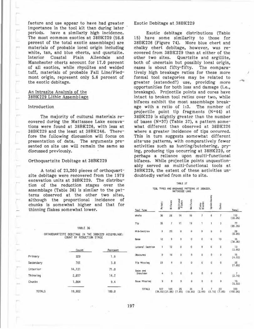
facture and use appear to have had greater importance in the tool kit than during later periods. have a similarly high incidence. The most common exotics at 38BK229 (56.6 percent of the total exotic assemblage) are materials of probable local origin including white, tan, and blue cherts, and quartzite. Interior Coastal Plain Allendale and Manchester cherts account for 17.0 percent of all exotics, while rhyolites and welded tuff, materials of probable Fall Line/Piedmont origin, represent only 5.6 percent of the exotic debitage.
An Intrasite Analysis of the 38BK229 Lithic Assemblage
In traduction
The majority of cultural materials recovered during the Mattassee Lake excavations were found at 38BK226, with less at 38BK229 and the least at 38BK246. Therefore the following discussion will focus on presentation of data. The arguments presented on site use will remain the same as discussed previously.
Orthoquartzite Debitage at 38BK229
A total of 23,200 pieces of orthoquartzite debitage were recovered from the 1979 excavation units at 38BK229. The distribution of the reduction stages over the assemblage (Table 36) is similar to the patterns observed at the other two sites, although the proportional incidence of chunks is somewhat higher and that for thinning flakes somewhat lower.
TABLE 36
ORTHOQUARTZITE OEBITAGE IN THE 38BK229 ASSEMBLAGE: COUNT BY REDUCTION STAGE
Count Percent
Primary 329 1.6
Secondary 761 3.8
Inter ior 14 , 131 71 .0
Thi nni ng 2,817 14.2
Chunks 1,864 9.4
TOTALS 19 ,902 100.0
Exotic Debitage at 38BK229
Exotic debitage distributions (Table 15) have some similarity to those for 38BK226 (Figure 74). More blue chert and chalky chert debitage, however, was recovered from 38BK229 than at either of the other two sites. Quartzite and argillite, both of uncertain but possibly local origin, cases is about fifty-fifty. The comparatively high breakage ratios for these more formal tool categories may be related to greater (extended?) use, providing more opportunities for both loss and damage (i.e., breakage). Projectile points and cores have intact to broken tool ratios over two, while bifaces exhibit the most assemblage breakage with a ratio of 1:3. The number of projectile point tip fragments (N=44) at 38BK229 is slightly greater than the number of bases (N=3·7} (Table 37), a pattern somewhat different than observed at 388K226 where a greater incidence of tips occurred. This in turn suggests somewhat different site-use patterns, with comparatively fewer activities such as hunting/butchering, prying, producing tips occurring at 38BK229, or perhaps a reliance upon rn ul ti- functional bifaces. While projectile points unquestionably served as multi-functional tools at 38BK229, the extent of these activities undoubtedly varied from site to site.
Tool r~ee
lnlole
Ttp
Mf d-Sectfon
Base
TABLE 37
TOOL TYPES AND 8RE."J<AGE PATTERNS AT 388K229, I'.ATTASSEE LAKE
~ .. "' .. > .. .. .. .. .. ~ ~ .... u ..
~
=~ .:! "' -" .21 c .:! .. , ~ ~
.. ... Q
"' ~ ...
~::; 0. ::> "'
36 26 14 16 6
35 11 19
20 0 0 0 0
12 0 0 0 0
Latera 1 Sect ion 12 0 0 0 0
Obscured 0 15 0 0
Tip Missing 21 0 0 0
Base •na Shoulder 0 0 0 0
Base Mfss f ng 9 0 0 0 0
TOTALS 127 105 25 35 8 7
i1 Q v
0
13
0
0
0
0
0
23
Tota l
112 ( 33.9~)
77 ( 2J. 3S)
29 (8.8S)
34 (10.3S)
13 (3. 9:)
15 ( 4.5S)
25 ( 7 .6:)
7 (2.1:)
18 (5.5:)
330 ( 38. 5:)(31.8:) (7. 6:) ( 10.6S) (2.4'!) ( 2.1";) (7.0S) (100.0:)
197

Stone Tools at 38BK229
Three hundred and thirty tools, representing 30.4 percent of all the tools recovered during the 1979 excavations, were recovered at 38BK229 (Table 37). Projectile points are the dominant tool class (38.5 percent) followed closely by bifaces comprising 31.8 percent of the tool assemblage. The projectile point to biface ratio is 1:1.2, over twice the figure observed at 38BK226 (1:0.46). Other tool classes recovered on the site, in order of frequency, are unifaces, utilized flakes, cores, flake blanks and spokeshaves. Spokeshaves or notches were found only at this site.
All of the tool classes at 38BK229 are dominated by orthoquartzite (Table 38). In fact this is the only material used in the unifacial tools and flake blanks recovered at the site. Projectile points and bifaces exhibit comparable raw material diversity, being manufactured of local orthoquartzite and four extralocal materials. Interior Coastal Plain material, represented by Allendale chert occurs in both the point and biface classes. Locally available white and blue cherts, occur within the point and biface classes, respectively. Rhyolite from the Fall Line or Piedmont is present in both the point and biface classes. One biface is made of a material of uncertain origin. The only other non-orthoquartzite tools in the assemblage are two white quartz cores, that probably represent local cobble reduction.
i'o•nu
31 faces
Ut 1l ueo , .... Jn1faces
Fhkt 31•·~·
Sookesnaves
~ ~
~ ~
f 0
120
100
25
35
8
TABLE 3B
TOOL TYPE BY AAW I'IATERfAL AT Sri£ 388J<229, MATTASSEE LAKE
"' u il .. -=~ ~= ... ~ .. ~ .,_ "'0
i " ... " .:: >. ... ·= ~ ;]! ~~ c-~ ~ .... so ;:"' 0 ~
"' '-' '"" 0
0 0
0 J 0
0 0 0 0
0 0 0 0 0 0
0 0 0
0 0 0 0
... ~ 0
0
0
0
raul
127 (3B.S!)
lOS \ 31.8~)
25 ( 7.6:)
JS (10.6:)
7 ( 2. 1 ~)
Breakage patterns over tool classes within the assemblage are given in Table 39. About one-third (33. 9 percent) of all the tools recovered at the site are broken. Breakage ratios (Table 39) show that flake blanks and spokeshaves are least likely to be broken. Since flake blanks are merely large flakes from which tools could be manufactured such a pattern might be expected. Spokeshaves could be discarded when edge loss or dulling occurred and simply replaced by a new flake. Utilized flakes and unifaces have breakage ratios approaching one and the chances of finding a complete or broken tool in either of these In summary, the debitage and tool assemblage at 38BK229 may be interpreted as representing varying degrees of site utilization throughout prehistory. Quality and quantity of the immediately available orthoquartzite probably varied, to some extent, over time. However, the quantities and types of both debitage and tools support the general argument of on-site orthoquartzite reduction strategies (Figure 71) proposed earlier. The diversity of lithic material types lends credence to the argument that mobile to semimobile groups are responsible for the site contents found at 38BK226.
Too I Class
Proj t ctfl t PointS
81facu
Ut i l I zed Flakes
Unlfaces
; lake Blanks
Cores
TABLE 39
BREAKAGE AATIOS OVER TOOL CATEGORIES ~T 388K229
~hole
36
25
14
16
112
91
i9
11
19
16
2!8
.lho le to 3ro<en <at io
I : 2.5
I : J. O
I :0.8
I: 1.2
1:0. 1
1:0. 2
l :Z.Z
1:1 .95
Basically, this site is seen as a "tooling up" station on a local geographical scale. Groups replenished their tool kits and conducted other maintenance chores necessarv for the survival of the group. Once thes~ tasks had been performed the inhabitants moved on in their normal course of seasonal
Corn 21 0 0 ( ~~o:> movement. -or~LS J16 J J 2 1 1 2 ~ 330
( 96 .1~) (0 . 9~) (0.9~) (0. 5:) (O.J:) (0.3:) (0 .5~) (0.6 '.) (IOO . O:)
198

TABLE 40
REDUCTION STAGE BY LEVEL, SITE 38BK229 BLOCK MATTASSEE LAKE
Level Primar:z: Secondar:z: Interior ...f!!E.L_ Chunks Total
0-5 an 14 22 279 66 79 460 (5.4:)
5-10 em 11 20 405 87 76 599 (6.9%)
10-15 an 13 65 779 167 171 1 ,195 (13. 9:1;)
15-20 em 15 70 844 161 154 1 ,244 (14.5%)
20-25 em 30 51 975 163 169 1,3B8 (16 . 1%)
25-30 em 18 31 716 158 119 1,042 (12 . 1%)
30-35 em 17 29 891 156 120 1 ,213 (14.1%)
35-40 em 4 21 416 68 B3 592 (6.9%J
40-45 em 12 23 321 62 76 494 (5 . 7%)
45-50 em 10 15 222 64 62 373 (4.3%)
TOTALS 144 347 5,848 1,152 1,109 8,600 ( 1.7%) (4.0%) (68.0%) (13.4%) (12.9%) (100.0%)
TABLE 41
KNOWN DOMINANT EXOTICS AND ORTHOQUARTZITE OEBITAGE AT SITE 38BK229 BLOCK, MATTASSEE LAKE
~ ·~ N
'-"0 u ... QJ ·~ QJ
~s.. QJ QJ QJ "OQJ ....... "'"' .... ~ ... c: .... .,...,... u"' ·~ "' "''"' .,.~ s.. ~
OCT N -o .... .2!~ =~ >,0 "0 ...J O ., .... .... .... .... c:t.. 0 .S::.>, ., ....
.s::. ...... ... QJ ... ... QJQJ u.s::. ): >, c..s::. "0 .... C: +-' ·~ QJ C:: QJ :J QJ "' ~.c:: C:<.J o.c:: '-"" ~ "' ...... .c::.c:: <O .C:: ~.s::. "' ~v "' ~ex 0 QJI-
Total Leve l 1-0 3'-' ..... u ""'-' 0 < :1: .... 0. 3
0-5 em 460 4 467
5-10 em 599 2 5 608
10-15 em 1,195 3 6 2 4 1,214
15-20 em 1,244 5 2 1,254
20-25 an 1,388 7 7 5 3 1,413
25-30 em 1,042 5 9 3 1,063
30-35 em 1,213 3 5 4 8 1,236
35-40 em 592 10 3 608
40-45 em 494 2 6 505
45-50 em 373 2 6 4 3 2 390
TOTALS 8,600* 26 12 52 17 21 12 13 4 158*/8,758
*Exot i e Tota 1 199

TABLE 42
TOOL CLASSES WITHIN SITE 38BK229 BLOCK AT MATTASSEE LAKE
Ill (IJ (IJ ..... > ·-Ill "0 Ill "' ........ Ill (IIIII (IJ .s::. uc: (IJ NCII u Ill Ill cu·- u
·- .¥ "' CU.¥ (IJ Ill ·.-.o "' ..... "' ~ .¥ c: .¥ (IJ OCL ~ ........... .... "'"' 0 ~ ~ ....... c: ~a; a. 0
Total Level CL CD ::I ::I Vl u
0-5 an 4 3 8
5-10 em 6 3 3 2 14
10-15 em 11 4 17
15-20 em 12 8 8 3 -2 35
20-25 on 13 18 2 4 2 2 42
25-30 an 5 7 6 21
30-35 em 4 7
35-40 em 3 4
40-45 em 2 3 4 9
45-50 em
TOTALS 54 50 4 30 7 7 8 158 (34.2%) (31. 6%) (2.5%) (19.0%) (4.4%) (4. 41) (5.1%) ( 100.0%)
TABLE 43
BIFACE TO OEB!TAGE RATIO, BY LEVEL, SITE 38BK229, ~ATTASSEE LAKE
(ORTHOQUARTZITE TOOLS ANO OEBITAGE ONLY )
Biface Level Tools Oebitage Ratio
0-5 em 460 1:65 . 7
5-10 em 9 599 1:66 .6
10-15 em 15 1, 195 1:79 .7
15-20 em 20 1,244 1:62. 2
20-25 em 32 1,388 1:43.4
25-30 em 12 1,042 1:86.8
30-35 em 4 1,213 1:303.3
35-40 em 0 592 0:592
40-45 em 4 494 1:123. 5
45-50 em 0 373 0:373
200

Lithic Debitage at 38BK229: The Block Unit Assemblage
Excavation units 11 through 17 at 38BK229 were combined in the block assemblage analysis. These seven, contiguous units were all excavated in arbitrary 5 em levels to a depth of 50 em. This block area is located at the eastern end of the site, in an area characterized by large orthoquartzite boulders some 75 meters north on the lower terrace slopes.
The orthoquartzite debitage recovered within the block (N=8600) included 37 percent of all this type of debitage recovered from the site. The distribution of this material, by level, is presented in Table 40. The distribution of the debitage follows a bell-shaped or battleship curve, with a peak in the 20 to 25 em level. This roughly corresponds to the Late Archaic and it appears that considerable reduction was occurring on the site during this period.
Exotic debitage (N=158) amounts to only 1.8 percent of all debitage within the block (Table 41), although it accounts for 72 percent of all the exotics recovered at the site. In comparative terms, nearly twice as much exotic debitage was recovered from the 388K226 block suggesting differences in site use. The comparatively lower incidence of exotic lithics at 38BK229 appears to be related to an absence of clearly recognizable Early and Middle Archaic components, which at 38BK226 are characterized by a high occurrence of these materials. Since most of the exotic percentages within the site levels were under one percent, histograms were not prepared as they had been for 38BK226. As at 38BK226, the percentage of exotics does tend to increase with depth, and may be interpreted as representing a greater use and/or preference for these materials during earlier periods. Blue chert was the only exotic material present in all levels with peaks in the lower levels (Table 41). Either Allendale or Manchester chert from the interior Coastal Plain occurs in all levels. Rhyolite debitage, one of the primary early materials at 388K226, was incidentally represented in the lower levels at 38BK229. The debitage analysis complements the projectile point evidence, namely that Early Archaic components do not appear to be present in this area.
Stone Tools at 38BK229: The Block Unit Assemblage
Nearly 48 percent of all tools recovered at 388K229 · occurred within the block excavations. Similarly seven, or 50 percent of all tools made from exotic lithic materials were recovered from within the block. Tool distributions within the block (Table 42) generally follow a bell curve with a peak in the 20 to 25 em level and a minor peak in the 40 to 45 em level. The greater assemblage diversity occurs in the middle levels where most of the utilized flakes, spokeshaves, and cores were recovered. Orthoquartzite biface to waste flake ratios (Table 43) while lower than at 38BK226, are higher than the tool to debitage ratios calculated for the exotic materials. Considering that the highest exotic debitage incidence in any level is ten, for blue chert, low ratios would be expected whenever tools were encountered. In fact, a blue chert biface in level 5 to 10 em, occurs with only one piece of debitage of that material, for a ratio of 1:1. Likewise a single flow banded rhyolite projectile point and one flake occur in level 20 to 25 em for a 1:1 ratio. These extraordinarily low tool to debitage ratios for exotic lithic materials suggest that at least some tools were carried onto the site, used, and then transported a way again.
The 38BK229 Lithic Assemblage: A Summary
The greatest diversity in tool forms at any of the three sites excavated in 1979 occurs at 388K229, although this is because spokeshaves were recovered only here. The tool diversity does suggest that a variety of activities were performed at the site. The projectile points recovered on the site (Table 33) represent cultural periods ranging from the Mississippian to the Late Archaic. These forms occur stratigraphically in the block, facilitating chronological placement and investigation. The presence of tools and debitage of exotic lithic materials suggests that comparatively mobile groups traveled through and used the site area. These tools were typically used, leaving debitage in the archeological record, but were then curated,
· or transported away, accounting for a low incidence of these forms.
201
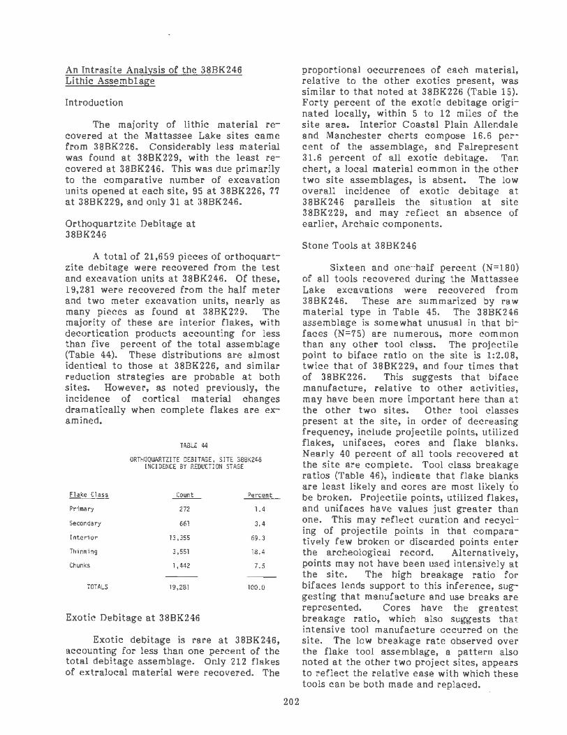
An lntrasite Analysis of the 38BK246 Lithic Assemblage
Introduction
The majority of lithic material recovered at the Mattassee Lake sites came from 38BK226. Considerably less material was found at 38BK229, with the least recovered at 38BK246. This was due primarily to the comparative number of excavation units opened at each site, 95 at 38BK226, 77 at 38BK229, and only 31 at 38BK246.
Orthoquartzite Debitage at 38BK246
A total of 21,659 pieces of orthoquartzite debitage were recovered from the test and excavation units at 38BK246. Of these, 19,281 were recovered from the half meter and two meter excavation units, nearly as many pieces as found at 38BK229. The majority of these are interior flakes, with decortication products accounting for less than five percent of the total assemblage (Table 44). These distributions are almost identical to those at 38BK226, and similar reduction strategies are probable at both sites. However, as noted previously, the incidence of cortical material changes dramatically when complete flakes are examined.
Flake Class
Primary
Secondary
Interior
Thinning
Chunks
TOTALS
TABLE 44
ORTHOQUARTZITE DEBITAGE, SITE 3BBK246 INCIDENCE BY REDUCTION STAGE
Count Percent
272 1.4
661 3.4
13,355 69.3
3,551 18.4
1,442 7.5
19,281 100.0
Exotic Debitage at 38BK246
Exotic debitage is rare at 38BK246, accounting for less than one percent of the total debitage assemblage. Only 212 flakes of extralocal material were recovered. The
202
proportional occurrences of each material, relative to the other exotics present, was similar to that noted at 38BK226 (Table 15). Forty percent of the exotic debitage originated locally, within 5 to 12 miles of the site area. Interior Coastal Plain Allendale and Manchester cherts compose 16.6 percent of the assemblage, and Falrepresent 31.6 percent of all exotic debitage. Tan chert, a local material common in the other two site assemblages, is absent. The low overall incidence of exotic debitage at 38BK246 parallels the situation at site 38BK229, and may reflect an absence of earlier, Archaic components.
Stone Tools at 38BK246
Sixteen and one-half percent (N=180) of all tools recovered during the Mattassee Lake excavations were recovered from 38BK246. These are summarized by raw material type in Table 45. The 38BK246 assemblage is somewhat unusual in that bifaces (N=75) are numerous, more common than any other tool class. The projectile point to biface ratio on the site is 1:2.08, twice that of 38BK229, and four times that of 38BK226. This suggests that biface manufacture, relative to other activities, may have been more important here than at the other two sites. Other tool classes present at the site, in order of decreasing frequency, include projectile points, utilized flakes, unifaces, cores and flake blanks. Nearly 40 percen.t of all tools recovered at the site are complete. Tool class breakage ratios (Table 46), indicate that flake blanks are least likely and cores are most likely fo be broken. Projectile points, utilized flakes, and unifaces have values just greater than one. This may reflect curation and recycling of projectile points in that comparatively few broken or discarded points enter the archeological record. Alternatively, points may not have been used intensively at the site. The high breakage ratio for bifaces lends support to this inference, suggesting that manufacture and use breaks are represented. Cores have the greatest breakage ratio, which also suggests that intensive tool manufacture occurred on the site. The low breakage rate observed over the flake tool assemblage, a pattern also noted at the other two project sites, appears to reflect the relative ease with which these tools can be both made and replaced.

TABLE 45
TOOL TYPE BY RAW MATERIAL AT 38BK246, MATIASSEE LAKE
Tool Tl~e Orthoquartzite Allendale Chert
Flow Banded Rhyolite Other Total
Points 35
Bifaces 74
Utilized Flakes 30
Unifaces 16
Flake Blanks 8
Cores 12
2
0 0
0 0
0 0
0 0
0 0
0
0
0
0
39 (21. 7%)
75 (41.7%)
30 (16.7%)
16 (8. 9%}
8 ( 4. 4%}
12 (6 .7%)
TOTALS 175 (97.2%)
l (0.6%)
2 (l.l %}
2 ( l. 1%)
180 (100.0%)
A low incidence of exotic lithic material characterizes the site tool assemblage (Table 45), a pattern similar to that noted over the debitage. Local orthoquartzite accounts for over 97 percent of all tools at site 38BK246. The only tools of exotic lithic materials recovered at 388K246 were one Allendale chert projectile point, two flow banded rhyolite points, one argillite projectile point and one white quartz biface.
The Block Unit Assemblage at 388K246
Excavation units 2 through 10 at 38BK246 were consistently excavated in 10 em levels and formed a uniform, contiguous block assemblage useful for the analysis of spatial and stratigraphic patterning. Only four ten centimeter levels were excavated at 38BK246 however, rendering direct comparison with the other two sites, where 5 em levels were used, somewhat difficult. The units were taken to sterile clay, however, and the site clearly lacked the depth noted at 38BK226 and 388K229.
Sixty six percent of all orthoquartzite debitage recovered from the site came from
the block unit assemblage (N=14,310; Table 47). Over 90 percent of this debitage was concentrated in the first 30 centimeters of the deposits with the higher incidence in the first level. Once again, a very low incidence of cortical material was observed (3.99 percent), indicating procurement and partial reduction from nearby outcrops rather than on the site or using cobbles.
TABLE 46
TOOL BREAKAGE RATIOS OVER TOOL CATEGORIES AT 38BK246
Tool Class
Projectile Points
Sifaces
Utili zed Flakes
Uni f aces
Flake Slanks
Cores
TOTALS
203
~hole
17
25
12
6
69
Broken Ratio
22 1:1.3
50 1 :2
18 1:1. 5
9 1:1.3
2 1:0. 33
10 1:5. 0
111 1:1.61

Level Primar.z:
0-10 em 85
10-20 em 50
20-30 em 54
30-40 em 15
TOTALS 204 ( 1. 4%)
QJ ., N c:.,
"'s.. I-tO ::I
•cr .-o QJ+-' <ti..C: +->S.. U+-' .,.. QJ OS.. .s::. ..c:
Level _J 0 3U
0-10 em 5,403 3
10-20 em 3,797
20-30 em 3,868
30-40 em 1,242
TOTALS 14,310 6 (99.3%) (0.04%)
TABLE 47
REDUCTION STAGE BY LEVEL, SITE 38BK246 BLOCK, AT MATTASSEE LAKE
Seeondar.z: Interior FBRs
157 3,730 978
100 2,578 792
85 2,631 778
25 810 280
367 9,749 2,828 (2.6%) ( 68. 1 %) (19.8%)
TABLE 48
DEBITAGE IN BLOCK ASSEMBLAGE AT 38BK246 MATTASSEE LAKE
"'0 u s.. QJ .,.. QJ QJ QJ QJ "'OQJ ., +-> +-> ,... ., c+-> .,....,.... QJ .,..
"' Vl+-' ,.,.,.. s.. ...- C'l N "'0 +-> QJ s.. co...- >,0 "' +-> c s.. ..C:QJ 0 ..c:>, .-- +-> s.. QJQJ u.s:::: 3 >, o....c: ,.,.,.. "' .- ..c: cu o.s:::: s..o::: ., .c ::I .-u "' .--0::: 0 OQJ 0' <: :::E u.. c. I- 0
4 8 22 5,440
5 15 3,819
7 3 17 3,897
9 2 1,255
11 25 1 56 2 14,411
Chunks
453
277
320
112
1,162 (8.1%)
Vl u .- .,.. ,.,...,
+->0 ox I- 1.1.1
37
22
29
13
101 (0.08%)(0.17%)(.007%)(0.39%)(0.014%)(100.0%)(0.70%)
204
Total
5,403 (37.8%)
3,797 (26.5%)
3,868 (27.0%)
1,242 (8.7%)
14,310 (100.0%)
..._ 0 ,...
tnQJ.._.,.... U>CtO ·- QJ Q) ~ +-'....IUO 0 S..l--XCQJ
1.1.1- c.
0.26
0 0 15
0.20
0.09
0.70

Only 101 pieces of exotic debitage (Table 48) were recovered in the block, accounting for less than one percent of all debitage . The distribution of the exotic materials within the levels was similar to that noted for the orthoquartzite debitage. The deepest level had the lowest percentage of exotics at the site; as at 38BK229 this is taken to imply an absence of early (Archaic) components.
About 79 percent of all tools found at 38BK246 occur within the. block excavation units (Table 49). The only tools made of exotic materials (N=5) were recovered within the block area. Tool quantity and diver sity decreases with depth. The proportion of bifaces relative to projectile points, however, increases with depth (Table 49). Both tool classes decrease markedly in incidence with depth, however, rendering interpretation of this relationship difficult. The over all biface to projectile point ratio, at 2 to 1, is the highest observed at any of the project sites.
Biface to debitage ratios increase markedly with increasing depth in the 38BK246 ·block (Table 50). These rat ios, furthermore, are considerably higher than at either of the other two sites along the ridge. The high frequency of bifaces, coupled with the similarly high projectile point to biface and bifacial tool to debitage ratios, suggests that biface manufacture may have been a particularly important task in this area. Based on Newcomer's (1971) experimental data, Earle and Ericson (1977) argue that it is possible, based on debitage counts, to postulate the number of bifaces manufactured at a site. This is simply obtained, according to Earle and Ericson (1977) by dividing the number of flakes recovered by 50, the experimentally derived number of reduction flakes (Newcomer 1971). If this calculation is carried out for the lowest level, after flakes for the bifacial tools have been subtracted, it is possible that 20.8 bifaces were manufactured and transported away from the site area. Although this calculation is avant garde, and by no means fully endorsed here, it, like the other ratios and comparisons, demonstrates rather dramatically the potential importance of biface manufacture at the site.
TABLE 49
TOOLS IN 38BK246 BLOCK AT MATTASSEE LAKE
Q) ~
0 ·~ <i1 -o <i1 ~ +-' <i1 Q)CJ1 Q) I-QJV1 uc: Q) NQ) u t/) uo QJ ·~ u ..... ""' "" QJ-"' t/) ......, ro·-
. .., 0 "" ~"" '+- -"'C: Q) C:'+-~
oa.. '+- ·~.-.,.... """" 1- .,... .,... ro
1- .,.... ....., 1..1- c: ,.... ,.... 0 occa:::
Level a.. co ::::> ::::> 1..1- co u Total
a..
0-10 em 16 22 7 3 6 7 61 1: l. 4 (43.0%)
10-20 em 7 21 5 3 2 2 40 1 :3.0 (28 . 2%)
20-30 em 6 14 6 4 31 1 :2. 3 (21.8%}
30-40 em 3 4 10 1:3.0 (7.0%)
TOTALS 30 60 22 11 8 11 142 (21. l %) {42 .3%) (15.5%) (7. 7%) ( 5. 7%} (7.7%) (100.0%}
(ALL EXOTIC TOOLS A~ SITE IN BLOCK)
205
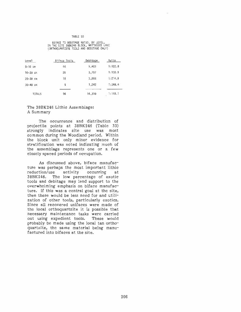
Level
0-10 em
10-20 em
20-30 em
30-40 em
TOTALS
TABLE 50
BIFACE TO OEBITAGE RATIO, BY LEVEL, IN THE SITE 388K246 BLOCK, MATIASSEE LAKE (ORTHOQUARTZITE TOOLS ANO OEBITAGE ONLY)
Biface Tools Oebitage Ratio
44 5,403 1:122.8
29 3,797 1:130.9
18 3,868 1:214.9
5 1,242 1:248.4
96 14,310 1:149.1
The 38BK246 Lithic Assemblage: A Summary
The occurrence and distribution of projectile points at 38BK246 (Table 33) strongly indicates site use was most common during the Woodland period. Within the block unit only minor evidence for stratification was noted indicating much of the assemblage represents one or a few closely spaced periods of occupation.
As discussed above, biface manufacture was perhaps the most important lithic reduction/use activity occurring at 38BK246. The low percentage of exotic tools and debitage may lend support to the overwhelming emphasis on biface manufacture. If this was a central goal at the site, then there would be less need for and utilization of other tools, particularly exotics. Since all recovered unifaces were made of the local orthoquartzite it is possible that necessary maintenance tasks were carried out using expedient tools. These would probably be made using the local tan orthoquartzite, the same material being manufactured into bifaces at the site.
206

CHAPTER 8
THE MATTASSEE LAKE CERAMIC ARTIFACT ASSEMBLAGE
INTRODUCTION
A total of 27,354 ceramic vessel fragments were recovered at Mattassee Lake in 1979. Count data for all sorting categories, by site and major excavation provenience, are given in Table 51. Approximately threequarters of the assemblage (N=20,194 sherds; 73.8 percent) came from the three major excavation blocks located at roughly 500 meter intervals along the terrace. The testing program had indicated that ceramics were not evenly distributed along the terrace, but instead tended to occur in concentrations. The locations of these concentrations were defined using computer density maps (SYMAPS) based on count data (for ceramics as well as for other artifact categories) from the systematically dispersed half meter units (Figure 75). Most of these concentrations were examined during the subsequent mitigation stage excavations, employing additional test units and, in three areas, large blocks. Taken collectively, the ceramic assemblage from Mattassee Lake includes material from the general scatter along the terrace and large, well-controlled samples from three major concentrations.
RESEARCH ORIENTATION OF THE CERAMIC ANALYSIS: TAXONOMIC CONSIDERATIONS AND SEQUENCE DEFINITION
The primary orientation of the Mattassee Lake ceramic analysis, as reported here, is toward questions of typology and. chronology. While technological and functional aspects of the pottery assemblage are examined, the description and documentation of a ceramic artifactual sequence fo r the lower Santee River area formed the basic goal of the investigations. As noted in the project research design (Chapter 4), although the general sequence for the region has been known for a long time, specific details, particularly in the South Carolina area, remain obscure. The Mattassee Lake excavations produced an
207
extensive sample of artifacts, the first major collection spanning the ceramic prehistoric from the lower Santee River area with reasonably secure stratigraphic and absolute chronological controls. A research orientation stressing sequence definition was, therefore, inevitable given the nature of the project data set.
The primary ceramic sequence currently in use in the South Carolina coastal plain comes from the mouth of the Savannah River, and is based on a series of large excavations dating from the WPA era (Caldwell and Waring 1939a,b; Waring 1968a; DePratter 1979). The mouth of the Savannah sequence has been expanded and modified through the years, and in its present form (DePratter 1979) serves as the primary taxonomic and chronological reference for the ceramic prehistoric throughout much of both the Georgia and South Carolina coastal plain (e.g., Caldwell 195 2; Williams 1968; South 1973; Anderson 1975a; Schnell 1975; Trinkley 1980a). The importance of this cultural sequence, from a larger regional perspective, has been noted:
the prehistory of the Savannah locality as it is now known presents one of the finest local sequences based on stratigraphic evidence that exists in Southeastern archaeology. It is comparable to the important sequence at the mouth of the Red River in Louisiana ... (Williams 1968:101).
Comparable sequences, solidly based on excavation data, have yet to appear from anywhere in South Carolina or from southern coastal North Carolina, although several tentative formulations have appeared, based on comparatively limited survey and excavation data (e.g., Waddell 1970; South 1973b, revised 1976; Loftfield 1976; Anderson, Lee, and Parler 1979; Trinkley 1980a,l981a, Phelps 1981).
In the absence of a secure local sequence, the classificatory framework for

TABLE 51
THE CERAMIC ASSEMBLAGE AT MATTASSEE LAKE: COUNT DATA FOR ALL CATEGORIES BY SITE AND MAJOR EXCAVATION PROVENIENCES
3881<226 38BK229 38BK246
Pottery Site Site Site Assemblage Type TU EU F Total TU EU F Total TU EU F Total Total
Stalling's Plain 4 {4) 1 1 5
{Total) {4) {4) ( 1) (1) (5) Thorn's Creek Plain 21 799 27 (847) 64 694 37 (795) ( 1) 1643 Reed L.S.P. 4 104 7 (11 5) 42 {43) {l) 159 Reed OSJ 2 49 6 (57) 8 (9) 66 She 11 Pun ct. 11 (ll) 11 Pinched (l) 2 11 (13) 14 Simple Stamp 39 (41) 11 (11) 52 Incised 10 19 {29) 2 {2) 1 1 {2) 33
{Total) {38){1011)(41){1090) { 68 ){ 779) { 37) { 884 ) {2) (2) {4) {1978) Refuge Dentate 3 96 6 {lOS) {2) {1) 108 Punctate 13 {13) { 1) 14 Allendale Punctate 10 { 12) 12
Plain 77 (77} 1 (1) 2 (2) 80 {Total) (4) {196) (7) (207) { 1) {2) (3) (2) {2) (4) (214)
Hilmington Fabric 1 79 1 {81) 5 (5) 148 1 ( 14g) 235 Loose { 1) {61) {1) {63) {115) {115) { 178) Rigid= (8) (8) {5) {5) {27) { 1) {27) {40) Rigid X {10) {10) {6) {6) {17)
Plain 40 ( 41) 41 Simple
Stamp { 1) Llnear Check 11 {11) 0 4 (4) 15
(Total) {1) (131) (2) {134) (5) {5) {152) ( 1) ( 152) (292) Deptford linear Check 16 788 64 {868) 13 80 5 {98) 39 {41) 1007 Simple Stamped 4 242 4 {250) 16 115 { 131) 41 3 {44) 425 Parallel {293}
<2 11111 (2) {73) (3) (78) (8) {41) ( 49) (34) {2) (36) (163) >2 11111 (1) {63) ( 1) (65) (6) (56) (62) (3) (3) (130)
Cross ( 132} <2 11111 (1) (87) (88) (2) (16) (18) (4) (1) (5) ( 111) >2 11111 (19) (19) (2) {2) ( 21)
Brushed 49 (49} 4 (4) 14 (15) 68 Incised so (50) 50 Linear Check Fabric 3 {3) 3
{Total) (20){1132) {68) (1220) ( 29 ) ( 199) ( 5) (233) {2) {94) (4) (100) (1553)
208

38BK226 38BK229 38BK246
Pottery Site Site Site Assemblage Type TU EU F Total TU EU F Total TU EU F Total Total
Woodland Plain 159 1303 121 ( 1583) 140 455 8 (603) 44 783 39 (866) 3052
Cape Fear - Fabric 70 1836 155 (2061) 62 61 (123) 13 381 20 (414) 2598 Unknown (21)(951 ) (47) (1 019) (28) (38) ( 66) (5) ( 182) (7) (194) ( 1279) Loose (41 )(613) (31) (685 ) (24) (20) (44) (6) (153) (10) (169) (898) Rigid= (6)(236) (70) (312) ( 10) (3) ( 13) (2) (36) (3) ( 41) (366) Rigid X (2) (36) (7) (45) ( 10) (10) (55)
Cord 8 29 (38) 4 3 (7) 4 (4) 49 Net 5 (5) 5
(Total) (78)(1870) (156) (2104) (66) (64) ( 130) ( 13)(385) (20) (418) (2652) Santee Simple Stamped 61 828 61 (950) 41 504 3 (548) 3 84 6 (93) 1591 Parallel ( 401) <2 mm ( 7) ( 1 03) ( 11) ( 121) (9) (126) ( 135) ( 2) ( 35) ( 1) (38) (294) >2 mm (4) (39) (4) (47) (3) (57) (60) ( 107) Cross (1190) <2 mm ( 50)(658) (46) (754) (29) (312) (3) (344) ( 1) ( 49) (5) (55) (1153) >2 mm (28 ) (28) (9) (9) (37)
(Total) (61 )(828) ( 61) (950) ( 41 ) ( 504) ( 3) (548) (3) (84) (6) (93) ( 1591) Yadki n-1 i Ice Plain (2) 3 (4) 12 42 (54) 60 Fabric 1 ( 1 ) 1 71 (73) 74 Cord 3 (3) 1 (1) 4 Linear Check 6 (6) 6
(Total) ( 1) (10) (11) (1) (4) (S) (13)(114) (1) (128) 144 Savannah Comp Stamp 2 30 2 (34) 5 (6) 40 Fine Cord 1 (2) 2 Check Stamp 6 2 (8) 1 .2 (3) 1 (1) 12
(Total) (3) (37) (4) ( 44) (2) (7) (9) (1) ( 1) 54 Pee Oee
Comp Stamp 6 (7) 28 (29) 36
Ashley Comp Stamp 4 (4) 7 24 (31) 35
Unknown Comp Stamp Curvi 1 i near 3 (4) 8 (8) (12) Rectilinear 1 ( 1) 5 (5) (6)
(Total) ( 1) (4) (5) (13) ( 13) 18 Mississi ppi Plain ( 1) (2) 30 (30) 33
Miscellaneous Wares 16 (16) 5 (6) 22
Nondiagnostic Over l/2 inch 71 2288 48 (2407) 125 846 27 (998) 23 323 11 (357) 3762
Under l/2 inch 289 6756 171 (7216) 378 2832 62 (3272) 63 1341 22 (1426) 11 ,914
..... (Total) (360)(9044)(219) (9623) (503)(3678) (89 )( 4270) ( 86 )( 1664) ( 33) ( 1783) 15,676 Grand - Totals 727 15,597 679 17,003 861 5769 142 6772 165 3311 103 3579 27,354 (Diagnostic) ( 367) ( 6553 )( 460) (7380) (358)(2091) (53) (2502) (79) (1647) (71) (1796) (11,678}
209

... ~:::;~:~ ~ - " - -· .. ~~:-~--
·-:_c_;_~: -~B-?:t~: .. ~--~ 4 _,.,_...., ~-:.~'!"- -""' .--::...:--~ ... -.. ~- -~·;: :- : .. -:~;:_: _;_~~.:;..--..~----:--->-
'~· • -. ~-~ ·--~-· ~ .-_. ,, , - • ·- ·- sANTEE RIVER :~:~~~-~ -~;~1i~~~r:~~~jL~~ .... -.
.... - -... ~ - ,.. ..... _ ~ . e. t.: .. --~ ::;.· :·:-:;=t~~~P-~~ ... o
~:·: ~ ~,o ''
/" /·,.,~~···::·~~ ... -~ . ..... ~- ...... _______ .... -
.... -- ...... '"tt".:C''"''f .. •••. · · -;·•"'• .•-·• .. ,
:~7·Jm~:!iii~ii~::~wnn·
0 100 200FEET
..: 4 - ~- .... t--~-~ :...-___ -;..~ ~ 4 -... - ___ + -
~·.:...~~ ...
FIGURE 71
SITE 38BK246 ALL EXCAVATION UNITf
DISTRIBUTION OF ALL DIAGNOSTIC CERAMIC! MATTASSEE LAKE EXCAVATION:...
U.S. Army Corps of Engoneers Cooper River Rediversion Canal Projec T

ceramic artifacts most widely used in the coastal plain of South Carolina is South's (1973b, 1976) "Indian Pottery Taxonomy for the South Carolina Coast". Developed using "a purely taxonomic approach" (Ferguson 1973:56), the framework is hierarchical in format, proceeding through three ascending orders of integrat ion: type, ware, and ware group. These taxonomic categories are linked together in an evolutionary framework, with major subdivisions (from earl iest to latest) including the Formative, Developmental, Climatic and Decline stages. The South taxonomy depends, to a large extent, on the mouth of the Savannah sequence for its chronology, although several radiocarbon dates from two sites near Charleston, Charles Town Landing and Fort Johnson, are incorporated into the framework (South 1976:29). While explicitly advanced as a taxonomy, and not meant to be used as a cultural/chronological sequence on other than a very general level, in practice the South framework is widely used to date ceramics (and sites) of all periods in South Carolina. Such a use goes well beyond the author's original intent and, in the absence of supporting data for at least parts of the sequence, beyond the capabilities of the framework itself:
This broad outline summary is being tested through present survey and excavation along the South Carolina coastal area. As details are worked out and new information added these ideas will be replaced by newer concepts (South 1976:2).
The South taxonomy is a useful model, however, and the baseline against which excavation data from the South Carolina coastal plain must be compared in the construction of local sequences.
In spite of an increasing number of local radiocarbon dates, and several attempts at taxonomic refinement (e.g., South and Widmer 1976; Dorian and Logan 1979; Lepionka 1981; Trinkley 1980a,b, 198la,b), the ceramic sequence for coastal South Carolina is still, to a large extent, based on sequences developed in Georgia and southeastern coastal North Carolina. Several problems limiting the usefulness of both the Savannah River and coastal North
Carolina ceramic sequences in coastal South Carolina have been noted in recent years (e.g., Trinkley 1980a,1981a; Anderson and Logan 1981), and an awareness of these problems, and an effort to accommodate them, is critical to local attempts at sequence definition. Before going further, however, it should be stressed that both the Georgia and coastal North Carolina sequences do work, on at least a general level, throughout much of coastal South Carolina. Wares clearly recognizable as Stallings, Refuge, Deptford, Wilmington, Savannah, and Irene, for example, occur on large numbers of sites in the Coastal Plain of South Carolina, and when recovered in excavation context occur with the same general temporal and typological associations noted at the mouth of the Savannah (e.g. , South 1971; Anderson, Lee, and Parler 1979; Trinkley 1980a,198la). Hanover and Cape Fear ceramics, categories established by South (1960,1976) using survey data from the southeastern North Carolina coast, are also widespread in South Carolina, and have (generally) been found to indicate Early and Middle Woodland components, respectively (e.g., South and Widmer 1976; Dorian and Logan 1979; Scurry and Brooks 1980). What is argued here is that these constructs are often applied rotely, without critical scrutiny, a procedure that can lead to serious errors of identification and inter pretation when these formulations break down. The order of the problem, it should be emphasized, is more towards sequence testing and refinement, than outright replacement.
The primary problem with the use of the mouth of the Savannah ceramic sequence throughout the coastal plain of South Carolina is that it fails to encompass all or even an appreciable portion of the variability present within local pottery assemblages. Fabric impressed finishes, for example, which were quite common at Mattassee Lake (N=2907 sherds, 24.9 per cent of the diagnostic assemblage), are rare to nonexistent in coastal Georgia, and are not represented in the Savannah sequence (c .f. Waring 1968c; DePratter 1979). When fabric impressed finishes are encountered on South Carolina sites -and they occur with increasing incidence the further northeast one travels in the coastal plain (Anderson
211

1975a) -they cannot be linked with periods or phases in the Savannah sequence. When fabric impressed ceramics are found in the coastal plain of South Carolina, they are generally subsumed under South's (1960, 1976) Cape Fear and Hanover taxa. The Cape Fear wares include sand tempered cord, fabric, and net impressed types, while the Hanover series includes sherd tempered cord and fabric impressed types. As with the mouth of the Savannah types, the Cape Fear and Hanover taxa have been applied throughout the South Carolina coastal plain. This application, however, has been over materials exhibiting a wide range of both physical (morphological) and apparent temporal variation, rendering the general utility of the types somewhat questionable (e.g., Anderson and Logan 1981; Trinkley 1981a: 5-6). The temporal relationships and typological separation of the Hanover and Wilmington wares is also poorly understood, and the source of considerable confusion at the present (i .e., Trinkley 1980a:325,387ff, 1981a:47-49; Anderson and Logan 1981).
A similar ambiguity pervades the identification and temporal placement of numerous other wares from the South Carolina coastal plain, particularly ceramics characterized by plain, simple stamped, cordmarked, brushed, and incised exterior surface finishes. While these finishes occur on fairly large numbers of sites in coastal South Carolina (see Anderson 1975b), many cannot be confidently equated with specific types in either the Savannah sequence or South's (1976) taxonomy. The South Carolina wares, in many instances, either differ from the classic types in one or more attributes or else, if comparable, sometimes occur in contexts which suggest different periods than expected. Deptford Simple Stamped, recently subsumed under Refuge Simple Stamped by DePratter (1979:121), for example, is characterized by the occasional presence of tetrapoda! supports. Tetrapods are rare to nonexistent in most simple stamped assemblages from coastal South Carolina, however, rendering this attribute of little sorting value. Simple stamped finishes, furthermore, appear to have a very long duration in the coastal plain of South Carolina, occurring from the Late Archaic through the Mississippian (e.g., Phelps 1968; South 1976; Anderson, Lee and
212
Parler 1979; Trinkley 1980a,198la,.b). Several separate simple stamped types would appear indicated: Thorn's Creek, Refuge, Deptford, Santee (this report), and Ashley. Effective sorting criteria for these wares has not previously been presented, however, and to (partially) accommodate some of the typological ambiguity DePratter (1979) subsumed Deptford Simple Stamped under Refuge Simple Stamped. Refuge Simple Stamped is now the only simple stamped type recognized in the Savannah sequence. As such, it is far too general a taxon to accommodate all of the simple stamped pottery occurring in the coastal plain of South Carolina.
Similar problems are evident with local plain, cordmarked, and fabric impressed wares. Long time ranges have been documented for these finishes, yet little is known about possible temporal variability. Since evidence is emerging that these finishes (including simple stamped) are the only wares present on large numbers of coastal South Carolina sites for the period from roughly 500 BC to AD 1000, the groble m is of considerable significance. A major emphasis of the Mattassee Lake ceramic analysis, therefore, has been to explore the variability in these (and other) finishes. As this report demonstrates, recognizable temporally sensitive sub-categories are present in local plain, simple stamped, and fabric impressed ceramics. This finding should have a profound effect on past analyses (and interpretations) predicated on assumptions about the period specificity of these wares (e.g., simple stamped equated with Early Woodland Refuge/Deptford components, or fabric impressed wares representing Middle/Late Woodland components). Furthermore, since plain ceramics are probably the most common finish found on sites in the coastal plain of South Carolina (e.g., Anderson 1975b), subdivision of this category should facilitate closer dating of many previously poorly documented sites.
A second major problem impairing the utility of the Savannah sequence in the coastal South Carolina area arises from the (spatially) limited distribution of many of the more temporally sensitive types. Several key wares, for example, Deptford Complicated Stamped, Walthour Check and
Walthour Complicated Stamped, and all of the St. Catherines and Altamaha types, are currently known to occur only near the lower Savannah River. These wares, the only diagnostic indicators for several phases in the Savannah sequence, (e.g., Deptford II, Wilmington I, St. Catherine's and Altamaha; DePratter 1979:111- 112), ar e absent throughout most of the remainder of coastal South Carolina (e.g., Trinkley 1980a; Anderson 1975b; Anderson and Logan 1981). The relationship of several other temporal diagnostics within the Savannah sequence with similar wares occurring in South Carolina also remains in doubt. The taxonomic and temporal equivalence of the coastal G~orgia St. Simons fiber tempered series (DePratter 1979:114-115) fo r example, with the Stalling's fiber tempered wares recovered in coastal South Carolina has yet to be addressed in any detail. Similar ly, the equivalence (or lack thereof) of the lower Savannah Refuge types, such as Refuge Punctate, Refuge Plain, Refuge Simple Stamped and Refuge Incised (DePratter 1979:115- 123), with possible counterparts in South Carolina - which occur in Thorn's Creek, Refuge and Deptford assemblages - remains to be explored. The description for Refuge Punctated (Waring 1968b:200; DePratter 1979:120-121) appears to be identical to that for Thorn's Creek Punctate (c.f. Griffin 1945; Waddell 1963; Phelps 1968; Trinkley 1980b), but the relationship of these two wares is not discussed. Similarly, DePratter's (1979:121) Refuge Incised type appears identical to what in South Carolina is referred to as Thorn's Creek Incised (c.f . Phelps 1968; Trinkley 1980b), although similar inc1smg also appears in South Carolina at apparently both the Refuge (Waring 1968b; Lepionka 1981) and Deptford (Waring and Holder 1968:140-141; Anderson, Lee and Parler 1979:78) time levels. Finally, the Refuge Plain and Refuge Simple Stamped types have a very long duration in the Savannah sequence -from roughly 1100 BC to AD 500 (DePratter 1979:121-122). As discussed previously, an even greater duration for these finishes is apparent in the South Carolina area, if the Thorn's Creek (c.f. Phelps 1968; Trinkley 1980b) and late prehistoric Pee Dee Plain (Reid 1967) and Ashley Simple Stamped (South 1976) types are considered.
213
These problems also apply to the use of coastal North Carolina sequences in South Carolina. Unlike the mouth of the Savannah sequence, however, the coastal North Carolina sequences that have appeared (e.g., South 1960, 1976; Phelps 1981) remain largely untested locally. Hanover ceramics (reported here as Wilming~on var. Hanover and Y!!!:· Berkeley types) are currently the only well documented and dated coastal North Carolina wares found in coastal South Carolina (e .g., South and Widmer 1976, Dorian and Logan 1979, Scurry and Brooks 1980). Even within this series questions about temporal extent remain to be answered (e .g ., Anderson and Logan 1981, 107-108). Trinkley (1981a, 1982) has recently argued that the northern coastal North Carolina Deep Creek/Mt. Pleasant succession of cord and fabric impressed wares (Phelps 1981, 1982) is applicable in coastal South Carolina. Such a success ion is not evident at Mattassee Lake, although it may well occur elsewhere in coastal South Carolina. Until a clear Deep Creek/Mt. Pleasant succession can be securely documented, via excavation and absolute dating, use of these taxa should proceed cautiously. If such a succession is found, the variability will need to be documented and equated with Phelps' type materials.
What is indicated by this review is that existing typological and taxonomic constructs are of limi ted utility in the analysis of ceramics recovered from sites in the South Carolina coastal plain. Clear, unambiguous typologies are needed to both describe and chronologically order local ceramic artifacts. What is also needed are more excavation and careful, quantative comparative analyses of existing collections. This need. is particularly acute over the plain, simple stamped, cordmarked and fabric impressed finishes that dominate Woodland period site assemblages in the central coastal plain. Until both the Savannah River and coastal North Carolina forumulations can be tested locally, they should only guide, and not dictate, local taxonomy and cultural historical identification.
Archeologists working in the central and northern coastal plain of South

Carolina, therefore, find both the mouth of the Savannah and the coastal North Carolina sequences useful but somewhat limited guide. While one group of investigators (Brooks et al. 1979:89-91) working near Charleston has claimed to be able to date central coastal South Carolina sites to within roughly 200 to 300 year intervals, using the Savannah sequence, this degree of precision has not been claimed by anyone else working in the area. Such a claim, it should be noted, cannot be supported even within much of the Savannah sequence, specifically for most of the interval from 2200 BC to AD 1000 (see DePratter 1979:1ll-112). In the absence of supporting data, and for the reasons discussed at length in this section, we argue that Brooks et als. (1979) inferences about the utility of the mouth of the Savannah sequence for dating central South Carolina coastal sites must be viewed as largely speculative.
RESEARCH ORIENTATION OF THE CERAMIC ANALYSIS: TECHNOLOGICAL AND FUNCTIONAL CONSIDERATIONS
Once moderate portions of the Mattassee Lake ceramic assemblage could be confidently placed within the local sequence, technological and functional (behavioral) analyses were possible. Concern with the nature and extent of pottery manufacture, use, and discard along the terrace followed from the project research design (Chapter 4), specifically questions about the intensity of settlement in the riverine zone. Comparing the incidence of specific wares, or minimum vessel estimates, for example, could provide a relative measure of occupational intensity, or minimally of ceramic use, along the terrace. Changes in the incidence of ceramic debris, accordingly, might be linked to changes in the use of the terrace area; greater debris would tend to suggest greater use, reflecting either more visits, or extended occupations; less debris might suggest less use, reflecting fewer visits, or shorter occupations. [nferences about site use based on the ceramics, of course, could be tested using other aspects of the assemblage (i.e., feature density, lithic reduction /manufacturing technologies).
214
Previous investigations in the general region suggested several directions for the ceramic analysis. The use of sherds as abraders, possibly for working shell or bone, has been noted at local Refuge (Waring 1968b:207; DePratter 1976; Thomas and Larsen 1979:44-49) and Mississippian (Ferguson 1975b:89) sites, prompting inspection for this category. Interior and exterior coloring was examined over all wares, for evidence about firing conditions (c.f. Sheppard 1956:76ff), depositional environments (c.f. Anderson, Lee and Parler 1979:7 4), and possible use over open fires. Carbon deposits on the exterior surfaces of a vessel, for example, might suggest cooking or food processing over a fire. While sherd color is clearly linked to clay sources and firing conditions, the post-depositional environment also appears to be important. Sherds in a well-drained matrix (permitting oxidation), for example, frequently tend to be lighter than sherds in compact, poorly drained soils (reducing environments), at least on sites in the South Carolina area (c.f. Anderson, Lee and Parler 1979: 74).
Evidence for pottery manufacture was also sought at Mattassee Lake, through an inspection of both the artifact and the feature assemblage. Replication experiments and archeological investigations associated with work at the Late WoodlandMississippian Zebree site in northeast Arkansas (Morse and Morse 1980; Million 1980) have documented the kinds of debris (e.g., squeezes, coils, and clay caches), tools (e.g., polishing stones, anvils, scraping implements), and features (e.g., large charcoal and sherd filled pits that occur when pottery is being made on a site. Archeological correlates of pottery manufacture and use have been variously presented, including a number of relevant studies from the Southeast (e.g., Holmes 1903; Million 1980; Million and Morse 1980; Steponai tus 1980; and Canouts, Haskell, and Pearson 1982). A microscopic analysis of paste inclusions was undertaken, to check for local as opposed to possible extralocally derived tempering agents (e.g., Novick and Cantley 1979b), which might in turn suggest manufacturing sources. The matrix composition was also considered relevant to functional interpretations; a number of studies have linked vessel shape, durability (i.e., use

-life and breakage patterns), and firing capabilities (i.e., resistance to thermal shock) to constituent tempering elements (e.g., Million 1975,1980; Million and Morse 1980; Braun 1980; Steponaitus 1980:82; Canouts, Haskell and Pearson 1982).
At 'the same time that the Mattassee Lake ceramic analysis was underway, archeologists at the Institute of Archeology and Anthropology were conducting a functional analysis of the Woodland and Mississippian ceramics recovered at two sites (38BK235,38BK236) they excavated in the Rediversion Canal (Canouts, Haskell and Pearson 1982). The research design for that project has been presented in detail (Brooks and Canouts 1980, 1982), and is briefly summarized here in Chapter 4. The focus, and basic operating assumption of the Institute's analysis, were explicitly stated:
The functional analysis of the ceramic assemblages at sites 38BK235 and 38BK236 was designed to examine the hypothesized differences between the subsistence strategies of MiddleLate Woodland and Mississippian populations. If Mississippian settlements in the coastal plain were more permanent and their inhabitants dependent upon a more diversified economic base than their Woodland predecessors, this should be reflected in a greater variety of functionally specialized vessels. The function of a ceramic vessel is assumed to relate to its form or appearance and/or the context of which it is used (Canouts, Haskell and Pearson 1982:62).
The approaches used to test this major hypothesis not only helped to guide the Mattassee Lake research, but were also, in several areas, amenable to independent examination using the Mattassee Lake data set. In particular, specific observations about rim form, vessel size and shape, paste constituents, color, and thickness were summarized in the Institute report, permitting (more or less) direct comparison. Major conclusions of the Institute's analysis, that (1) Mississippian vessels tended to be larger, and exhibited greater diversity in form than preceding Woodland assemblages, and (2) that all of the wares appeared to be locally
215
produced, with "little compositional variability due to technical manipulation of the clay" (Canouts, Haskell and Pearson 1982: 81), could also be at least generally addressed with the Mattassee Lake assemblage.
METHOD OF ANALYSIS AND CLASSIFICATION
The ceramic analysis focused on the classification and description of the Mattassee Lake assemblage. Casual inspection during the fieldwork and initial laboratory processing had indicated that a number of well-known types were present, including Thorn's Creek Reed Punctate, Thorn's Creek Shell Punctate, and Awendaw FingerPinched (Trinkley 1980b; see also Griffin 1945; Waddell 1963,1965a; Phelps 1968); Refuge Dentate Stamped (Waring 1968b; Peterson 197la, b; DePratter 1976,1979); Deptford Linear Check Stamped (Caldwell and Waring 1939a), and Pee Dee Complicated Stamped (Reid 1967). As the analysis progressed, however, it became apparent that identifiable types formed a distinct minority of the assemblage . Large numbers of sherds could not be readily subsumed under existing types, particularly sherds characte rized by plain, simple stamped, and fabric impressed exterior finishes, which were among the most common wares present. Other, comparative minority wares, that also could not be easily placed into existing types, were characterized by exterior brushing, incising, check stamping, cordmarking, and complicated stamping. A number of these categories exhibited considerable variability in paste, rim form, lip treatment, or other attributes, as well as moderate to extensive vertical distributions in the excavation units, suggesting that more than one ware or type might be present.
The Mattassee Lake assemblage appeared to offer the opportunity to resolve some of this variability. In two of the three excavation blocks, at 38BK226 and 38BK229, diagnostic artifac ts were recovered in a Logical superpositioning, indicating clear temporal stratification (Chapters 5, 7). In both of these blocks complicated stamped Pee Dee series pottery was

noted closest to the surface, in the uppermost levels, underlain at progressively deeper depths by Deptford, Refuge, and Thorn's Creek types. By comparing the characteristics and distributions of the unknown wares with those of the known groups, the construction of a taxonomy and a relative sequence was considered feasible. Temporal dimensions were further controlled by the presence of 15 radiocarbon dates, exhibiting a high degree of internal consistency, from ceramic bearing features (Chapter 11).
Prior to initiating detailed analyses, the entire excavation assemblage was inspected to get a better idea of the variation present, and to begin thinking about ways of exploring it. The ceramics in each provenience were counted and weighed, with tentative sorts using existing taxonomies attempted for most units. It was these initial attempts at classification, employing categories advanced by Caldwell and Waring (1939a), South (1976), and DePratter (1979), in fact, that in large measure prompted the taxonomic/classificatory orientation of the present study. It became quickly (and frustratingly) apparent that many sherds could not be appropriately subsumed under existing types, without considerable "stretching" of the descriptions; such a practice, while permitting the pigeon-holing of much of the assemblage, would not only defeat the purposes of the research design (which called for fine chronological controls), but also do considerable injustice to both the original descriptions and to the utility of the type concept itself (c.f. Ford 1954; Rouse 1960; Phillips 1970).
To effectively compare the Mattassee Lake ceramics with wares reported from elsewhere in the region, a detailed attribute analysis was considered and, after considerable trial and error, implemented. The entire assemblage was reinspected, and a special, judgemental sample of 1208 sherds was pulled. This sample, consisting of approximately 4.4 percent of all of the pottery from the excavation units, by count, included most of the large (i.e., over 8 em on a side) rim, body, and basal sherds recovered from the terrace. The sample, in fact, includes all of the basal fragments, and over 40 percent of the rimsherds, found
216
during the excavations. In addition, all sherds exhibiting unique or unusual paste, surface finish, rim, or other attributes were included in the sample, regardless of size. Selection additionally focused on pieceplotted sherds, and sherds from the block units and from the fill of features, since these artifacts offered the greatest potential for stratigraphic (relative) and absolute chronological placement. Use of judgmental, as opposed to random sampling was deliberate; due to the large size of the terrace assemblage (N=27,354 sherds), a prohibitively large sample would have had to have been drawn to encompass wares represented by only a few specimens (Table 51). Additionally, over half of the assemblage consisted of small (under 112 inch) or nondiagnostic sherds (typically also small), which were inappropriate for confident attribute analyses. The special sample, by including most of the large and/or unusual specimens, is believed to provide a fair picture of the ceramic variability occurring along the terrace.
The purpose of the attribute analyses was to facilitate classification and description, by providing an internally consistent, replicable series of measurements. Each sherd in the special ceramic sample was examined and coded against eleven attribute categories, including interior and exterior surface finish, primary and minor paste inclusions, interior and exterior color, portion of vessel represented (i.e., rim, body, or base), rim form, lip treatment, the orientation of the exterior finish with the rim, and thickness. Values employed within each category are given in the Appendix Volume (Anderson et al. 1982), together with the information coded for each sherd. This information is also summarized, by final sorting taxa, in various tables accompanying this chapter. Each sherd in the special sample was individually numbered for later resorting, and was additionally coded by type, if it resembled classic and/or unambiguous forms recognized in the general region.
Standardized measurement and recording procedures were used throughout the analysis of the special sample. Paste constituents were determined using a 30 x binocular microscope, and color values were

taken from a Munsell soil color book. Only one recorder was used for each attribute, with codings re-performed over portions of the assemblage after an interval of a few days, to ensure consistency and replicability. Coding for several of the attributes, it should be noted, went through a number of trials before final values were selected; deficiencies in (initially) selected values, typ ically omissions or overly general criteria, came to light as the analysis progressed.
Once the 1208 sherd special sample had been coded it was examined employing a variety of analytical procedures, to prepare a provisional taxonomy for the Mattassee Lake ceramics. Key attributes and attribute combinations useful for recognizing and sorting both known and suspected (i.e., previously unrecognized) types were initially resolved employing associational (crosstabulation) procedures. The incidence of all recorded attributes (e.g., paste, color, thickness, rim form) was computed for each exterior surface finish category over the special sample assemblage. Not altogether unexpectedly, exterior surface treatment and paste were found to be the most sensitive attributes for resolving known types; these are virtually the only criteria used (in practice) to differentiate local ceramics (c.f. Caldwell and Waring 1939a; South 1976; DePratter 1979), even though a wide range of other attributes (e .g., rim form, lip treatment , vessel shape) might also be relevant. The analyses also indicated, however, that rim form and lip treatment were critical sorting attributes for several wares where the use of paste and surface finish attributes, by themselves, lead to ambiguous or overly broad classifications; this was most apparent within the plain, simple stamped, and fabric impressed assemblages.
While the attribute bivariate crosstabulation procedures were fairly successful for resolving probable types, independent verification was desired. Using the rimsherds in the special ceramic sample (N=328 rims), a series of four monothetic subdivisive cluster analyses were performed, as an alternative method of partitioning the assemblage variability into a series of clusters or taxa (Chapter 6). Cluster analyses were run on all of the ri msherds
(N=328), and on the simple stamped (N=sa fabric impressed (N=86), and cordmarked (N=1 rims. The sherds within each cluster were inspected for congruence with existing or suspected types. Over the entire rim assemblage a number of the clusters were found to conform to existing types; within the simple stamped and fabric impressed samples lip shape (i.e., flat as opposed to rounded) and lip treatment (i.e., smooth as opposed to decorated) were found to partition each assemblage into two distinct groupings, which subsequent analyses (reported in the descriptions of the respective wares) have shown to be temporally based, reflecting changes in the occurrence of these attributes over t ime within these finish categories. The cluster analyses of the cordmarked rim assemblage, unlike that for the fabric and simple stamped rims, produced ambiguous results, probably because of the low sample size.
The provisional taxonomy · formed using the attribute based analyses describ.ed above was used to sort the entire Mattassee Lake ceramic assemblage (N=27,354 sherds). During this final sort, rim form, lip treatment and stamp orientation attributes were recorded for every diagnostic rimsherd encountered; this served to markedly increase the sample of rims, from 328 to 754. The stratigraphic and spatial distributions of all of the ceramics were then examined, to assess the integrity of the taxa, and to assign age estimates to them. The increased rim sample was also examined, using the same crosstabulation procedures employed on the partial sample, to examine the incidence of rim form and lip treatment by type. The stratigraphic distribution of rim attributes was also examined, using all of the sherds from the excavation blocks. As noted previously, this helped resolve changes in rim form and lip treatment over time in several categories, providing a basis for some subdivision. The data collected in the final sort was used to refine the provisional taxonomy where necessary, and provide the basis for the (category by category) descriptions of types in the subsequent sections of this chapter. Attribute measurements by individual artifact, for all of the sherds in the special sample (N=l208) and for all of the diagnostic ri msherds (N=754) from the terrace are
217
given in the Appendix Volume (Anderson et al. 1982), together with data and incidence of all final sorting categories (taxa) by specific pr"ovenience. This information is summarized in the tables and descriptions accompanying this chapter; researchers interested in further analyses should, however, refer to the Appendix Volume.
TEMPORAL ORDERING OF THE CERAMIC ASSEMBLAGE
Temporal ordering of the Mattassee Lake ceramic assemblage was accomplished using stratigraphic data, crossda ting with known types, and the results of radiocarbon determinations run from ceramic bearing features. While cross-dating formed a useful initial guide, stratigraphic/distributional analyses, and the 15 radiocarbon de term inations obtained along the terrace, proved essential to resolve much of the chronology, particularly for the later Woodland periods for which few useful types were known. The distributions of all major ceramic sorting categories in the levels of the three primary excavation blocks at Mattassee Lake are given in Tables 52 to 54. The units and levels defining these blocks are the same as used in the lithic analyses (Chapter 7), it should be noted, rendering the results of both analyses directly comparable. In addition to showing the incidence of the taxa in each level, the average depth for each category was calculated, and is given at the bottom of the tables. Average depth was calculated using the formula:
where; xD = average depth of the taxa
K = level (with N the total number of levels)
s = the number of sherds of the taxa in the level
d = the depth (in centimeters} of the base of the level
218
Simply put, the average depth of a taxa equals the number of sherds of that taxa· in a given level times that level's basal depth, summed over all levels, with the resulting figure divided by the· total number of sherds of that taxa in all levels.
Arranging the average depths of the taxa in the blocks, from lowest to highest, it is apparent that the ceramics in both the 38BK226 and 38BK229 excavation blocks exhibit a logical superposition or stratification. Stalling's and Thorn's Creek ceramics are the lowest (earliest), overlain by Refuge, then Wilmington (var. Berkeley}/ Deptford, then Cape Fear,and finally Santee wares. While some ambiguity is evident, notably in the placement of wares with low totals, such as the complicated stamped types, the general sequence appears sound and, furthermore, is largely duplicated in both blocks. At 38BK246, in contrast, the stratification is highly confused, indicating a considerable mixing of the deposits. The switch from 10 em levels at 38BK246, the first block excavated, to the use of 5 em levels in the final two blocks, may (partially) explain the somewhat more logical temporal ordering noted in the ceramics from these units.
While the stratigraphic information from the 38BK226 and 38BK229 blocks proved invaluable in the construction of a relative ceramic sequence, an absolute chronology was also derived, using crossdating and radiocarbon analyses. Crossdating operates on the assumption that dates and time ranges derived for distinctive artifact categories generally hold when these categories are found in undated context. The assumption is, of course, basic to archeological research, although the classifications and derived chronologies should be tested and refined whenever possible. At Mattassee Lake a number of wares were recovered that have been securely dated elsewhere in the region; these wares provided an initial temporal baseline which could then be inspected and refined using the excavation data. Specific temporally sensitive wares found at Mattassee Lake, and approximate time ranges, included Stalling's Plain (c. 2500-1000 BC; Stoltman 1974), Thorn's Creek Reed Punctate (c. 2300-1000 BC; Trinkley 1980a}, Awendaw Finger

lli:!L__
0-S co
S- 10 em
10-15 em
IS- 20 em
20- ZS co
25-lO co
lO- lS coo
JS-40 em
!S--50 c.
lOTAlS
16
57
129
151
155
94
IS
43
129
20
24
I)
IS
91
T.\BLE 52
STAATUiAAI'HIC OISTRIIUTIOII OF CEIWIIC ARTifAC!S. SY •AJO- SQjliJNG CATE~~I£5, IN ~£ SIT£ l88JC226 EXCAVATION ILOCX AT •ATTASSEE LAU
10
8
23
90
174
179
190
11)1
98
48
ll
16 921
21
31
27
II
12
IS
26
13
10 16
)5
50
60
21
16
191
10
21
12
24
16
II
a 10
Z1
13 90 24
24 169 8A
IS 209 46
25 i S5 ll
16
II 83 142 208
26.3 28.4 25.3 24.3 28.6 24.4 21.8 21.8 26.4 25.5 24.1 23.1 19.1 19.3 20.0 22.0 17.3 19.4 19.9 18.1
~
O- S c:n
; .. to Q!l
10-15 em
20-25 ca
J0-35 em
TOTAlS
Average Ototn:
~
O-S c•
3- 10 (a
10- IS c
IS-20 ca
Z0-25 c•
25-lO em
JO·l5 em
35-JO co
TOTAlS•
17
14
10
56
17
57
10
II
Z4
12
19 49
47
154
25 2S8
U6
198
102
70
25
22
SO Ill•
19.5 20.4 17.3 16.3 19. 1 17.9 20.6 113 15
20.0 17.1
18.3
! ~i .....
5.0
12
39
16.8
166
381
.:az 417
290
192
65
48
lO
11
2082
125
292
532
356
254
96
.,
10
1714
28
67
186
136 ,. l2
13
561
39
73
37
36
19
17
222 l6
,, 18A 25
10 265 28
158
37
IS
10
14
zs m sa
80
12 141
11 219
129
zc IC
36 620 21
17.6 18.4 18.4 18.6 17.7 14.1 13.6 14.9 14.8'16.1
373
1112
1565
1050
958
531
253
1)4
69
Zl
6072
539
1493
2047
1<67
1248
723
JIB
182
99
18
815<
liZ
609
IS<a
1212
96l
507
263
146
93
21
1918
851
2302
3575
UJ9
2211
1210
581
328
192
63
1<.012
2434.7
'195.2
IJ, II<.l
1).398.8
10 , 160.8
2796.3
149C,I
!88 . .:
Z75,5
18.675 .8
12< 648 14.0 " ·9
2.86
3.30
!.76
l.S9
<.EO
l.Sl
.:.ss
· ·cuh oo N)t tl'lth . .w Slltr~a '" futures. ':'ou ts also oo not •nc:IUC:t Ul sntt'Ot 45.5 ;r"act 'ro- o:fPtf" :n1n S Clll 1t-tll. or 13 tttt.rGS 2:42.6 gr~) "'r-oo :t1o- 5<) Ct'l 111 aeotn froa ago41,...nt otstureancn.
219
11
lO
16.7 1.0
AI\ Ponery Ohtnt-~o~tJon oy
..:ei nt
c:::::::::::J
c::::J
0
0
iJ
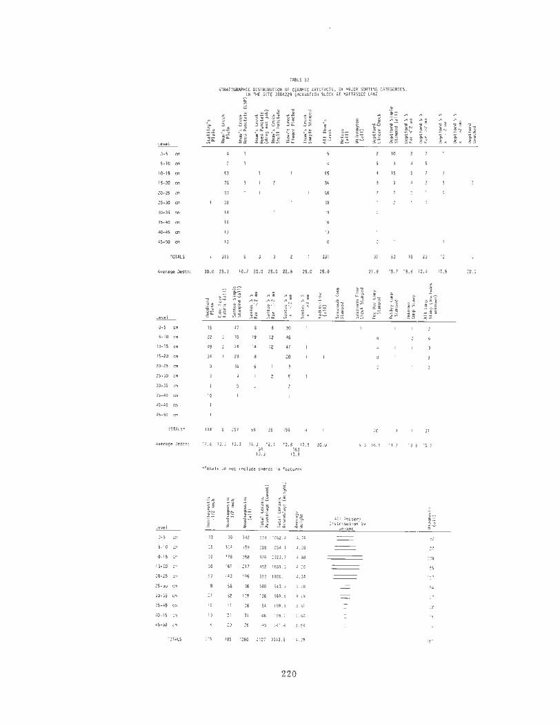
~
0-S em
5-10 e ..
10- 15 em
15-20 em
25-JO em
lO·lS em
lS-40 em
40-.tS em
.;s .. so 011
TOTALS
Averagl! Cepth:
o-s em
S-10 em
10·15 em
15-20 em
20-25 em
25-JO em
J0-35 011
JS-40
40-45 ""
45-50
TOTALS•
~verage Oepth :
10· 15 ca
15-20 ""
25-lO em
lO·lS em
35·40 cm
TOTALS
TABLE 53
STRATIGRAPHIC OISTRIBUTION OF CERAMIC .<RJ£Fi,CTS, BY ><AJOR SORTING CATEGORIES, Ill !liE SITE l8SK229 EXUVATIOII BLOCK AT 1'.\TTASSEt LAKE
53
18
Sl
JS
18
16
13
10
315
~
55
84
86
39
19
16
13
10
331
10
15
18 23
JO.O 25.3 16.7 20.0 25.0 22.5 25.0 25.0 21.9 15.7 15.8 12.4
IS
22
'9
34
10
144
41
76
" 29
16
251
19
14
59
12
12
JS
30
45
47
zo
159
17 .6 13.3 13.9 15.0 12.1 94
13.8 17.5 zo.o 163
13.9 13.9
•Totals -1.10 not rnclude shtrds tn feat~.tres
<3
56
5>
18
27
15
10
liS
19
104
Ja2 224 1062.4 ~. 74
159 286 125• . 1 .us
176 268 476 2323.7 4.88
161 211 402 1689.0 4.20
143 196 323 1401.1
68 86 140 543.3 3.88
az 1o9 136 ;,;9.6 •.19
II 16 Sd 189.8 J.;J
21 )I 46 l69. 1 3.68
20 26 3.54
885 1260 2127 7343. s l,l9
220
8
20
s.o 16.5 13.3
~ll :.'loc;.er)' Ols tr1DUtlon b)'
.. elaf'lt
31
13.8 1s.s
112
127
21l8
ISS
m
29
IS
14
12
17.5 20.0

TABLE 54
STRATIGRAPHIC DISTRIBUTION OF CERANIC ARTIFACTS, BY MAJOR SORTING CATEGORIES, IN THE SITE 3BSK246 EXCAVATION BLOCK AT MATTASSEE LAKE
~
0-10 Cll
10-20 Cll
20-30 ca
30-40 ca
TOTALS
.. ~
0 c: 0 o~-..... -E~ _ .. , ...
66 55
42 30
24 12
B
10
134 9a 27 6
... u
c: .. o-" ~'-'
~ .. ·- .. " .. - c: ;::
21
2
13
11
14
30 38
10
13
32
;:: .. 8
!i=. .fu 8."i .... ... ...
307 193 85
211 95 37
154 56 20
37
12 709 353 144
.. :. ... 0. ~E .!!v u .. .. ... ... 14
12
8
34 10
\.~ .... of~ .. ... 0.0 .. ... u
43 22 21
22 8 14
77 35 42
Average Depth: 17.2 15.B 21.5 16.7 20.0 13.7 20.3 20.9 15.0 17.5 17.5 18.9 16. 6 15.8 18.2 15.0 15.0 17.1 15.7 18.3
c: u u .!:! u ... .. - .c -.c ;; i .. ~ 1: 1: .. a. ~u ..... .. ~~
.. ., ~c: .. .... -u
o- ~- 0 .. ,.._ "'-01.., c: c:~
~·-- ~·-" ·- """ "'"' _.,. ..
.!:= ~ C:L ., .. ~~ .. .... ...... ~ -i& ..,_ ... .. .. _., :;;.a ;;i\ ~v ..... 0:: ..... :::"' ~- ~~ .., .. 8 .. o 0
Level ...... X z z
0-10 till 60 21 39 154 661
10-20 Cll 32 13 18 99 391
20-30 ca 16 37 177
30-40 Cll 45
TOTALS' 108 41 66 294 1274
Ave rage Depth 15.9 16.6 IS. 5 20.0
•Totals do not Include sherds In features
Pinched (c. 1900-900 BC; Waddell 1965a; Trinkley 1980a), Refuge Dentate Stamped (c. 1000-800 BC; DePratter 1979), Deptford Linear Check Stamped (c. 900 BC - AD 300; DePratter 1979), and three Mississippian period complicated stamped wares (Savannah, Pee Dee, and Ashley; c. AD 1200 - AD 1700; Ferguson 1971; South 1976; Trinkley 1980a).
Fifteen radiocarbon dates, all from ceramic bearing features, were collected at Mattassee Lake (Chapter 11). One sample (DIC-1844, 1160BC:185) dates what appears to be Thorn's Creek Plain; six samples, ranging from AD 520 to AD 720, date Cape Fear Fabric Impressed, var. St. Steohens and Cape Fear Cordmarked wares; and six samples, ranging from AD 810 to AD 1340. date Santee Simple Stamped ceramics. The remaining samples (DlC-1843; AD 1590:!:125; DIC-211-l; Modern) date plain, cordmarked, and simple stamped wares thought to belong
";;!if .,_ ~""~ 5
.... _ 0""' o .. z >-< -c
815 1526 6208.7
490 919 4047.8
214 486 1882.0
49 106 392.2
1568 3037 12,530.7
...., ...... .,_ ~~
4.07
4.40
3.87
3. 70
4.13
All Pottery Olstributfon by
wef ht
c:::J
0
711
429
272
57
1469
to the Cape Fear or Santee series; these potentially anomalous dates are discussed in detail in Chapters 5 and 11. Excluding these two determinations, the remaining 13 dates help to provide a reliable absolute chronology for portions of the ceramic assemblage.
Taken together, the radiocarbon dates, stratigraphic evidence, and cross-dating results are in close agreement and generally complement each other. The rep lacement of fabric impressed wares with simple stamped ceramics in the later Woodland, fo r example, is documented both by 12 radiocarbon dates and clear evidence for stratigraphic succession in the 38BK226 block, where a large sample of these wares (N=2486 sherds) was recovered . That these wares are temporally distinct is also suggested from the 38BK229 block unit assemblage, where little evidence for the fabric impressed ware was encountered (N=6 sherds), in spite of a (comparatively) large
221

sample of Santee Simple Stamped sherds (N=2 57 artifacts}.
In those portions of the sequence where it was not possible to obta in absolute dates, due to poor feature preservation, the stratigraphic evidence and the results of cross-dating appear to satisfactorily address the problem of chronology. The Late Archaic/Early Woodland sequence at 38BK226, for example, where Stalling's and Thorn's Creek wares are overlain by Refuge wares, which in turn are overlain by Wilmington and Deptford types (Table 52}, is in close agreement with the mouth of the Savannah sequence (DePratter 1979:111-112) and the expectations of the South (1976) taxonomy. The Mississippian complicated stamped wares in these two blocks, while generally not the latest (closest to the surface) stratigraphically, have distributions similar to that for Santee Simple Stamped (which dates from the eighth to fourteenth cen turies AD), suggesting some overlap of the categories is possible. Additional information on the Mattassee Lake ceramic sequence, particularly its relationship to other categories of artifacts, is included in the concluding chapter (Chapter 12}.
GENERAL PHYSICAL CHARACTERISTICS OF THE CERAMIC ASSEMBLAGE
The Mattassee Lake ceramic assemblage included examples of many of the pottery types currently recognized in the coastal plain of South Carolina (c.f. South 1976), and exhibited a fair degree of variability in general physical characteristics, or appearance. Colors over the assemblage (Table 55) ranged from very pale brown to black, although a majority of the assemblage was light colored. Gray firing clouds were present on a minority of the sherds, but the vast majority of the assemblage was characterized by uniform, unblemished very pale brown to reddish-brown surfaces, suggesting oxidizing firing conditions (Sheppard 1956:76, 88). A minority of the assemblage was gray to black in color over both the interior and exterior surfaces (Table 55), suggesting firing in a reducing environment. The slightly higher figures for dark interior surfaces might be due to the position of the pot during firing; if the vessel was inverted
222
(comparatively) less oxygen might reach the interior surface. Many of the gray to black colors appear due to post-breakage firing, and probably reflect sherds that fell into fires. Only one ware recovered on the terrace, Mississippian Burnished Plain (represented by only 33 sherds), was apparently intentionally fired in a reducing environment; the ware was uniformly characterized by a dark gray to black color over both interior and exterior surfaces.
Some variation in the color of the assemblage was noted over the terrace, in the differing excavation proveniences. Almost all of the sherds from 38BK246, for example, were reddish-yellow to reddishbrown in color, while most of the sherds from 38BK226 were lighter, either very pale brown or brown in color. Some of the color variation may be due to differences in the clays used to make the pottery found at each site, but the surprising uniformity of the assemblages in each area suggests that the (immediate) depositional environment is particularly important. The soils in the area of the 38BK226 block, for example, are sandy and well-drained, providing an environment conducive to (slow) oxidation. The soils in the site 38BK246 block unit, in contrast, are slightly lower in elevation, and hence more likely to be flooded, or flooded for longer periods, a factor (possibly) promoting comparatively slower oxidation.
Considerable variability characterized the pastes observed in the Ma ttassee Lake ceramics, and for a sizable minority of the terrace assemblage the attribute proved the only effective means of sorting otherwise similar wares. Major, traditional "temper" categories observed in the assemblage included fiber, fine sand, grit (coarse sand), clay/grog, and non-tempered; these ·categories have been previously defined (e .g., South 1976; Anderson 1975b,1979a: 46-48) and are discussed in detail, where relevant, under specific taxa in the descriptions that follow. The paste analysis at Mattassee Lake focused on macroscopically visible inclusions in the matrix and not on the clay itself. A detailed compositional analysis has been conducted, however, on a sample of Woodland and Mississippian sherds (N=96) from the area, by the staff of the Institute of Archeology and Anthropology's Cooper

TABLE 55
INTERIOR AND EXTERIOR COLOR, BY MAJOR SORTING CATEGORIES, IN THE MATTASSEE LAKE CERAMIC ASSEMBLAGE, USING THE 1208 SHERD SPECIAL SAMPLE
Very Reddish- Reddish - Gray-Dark Very Dark Pottery Pale Brown Brown Yellow Brown Gray Gray-Black Totals Type Ext. Int. Ext. Int. Ext. Int. Ext. Int. Ext. Int. Ext. Int. Ext. Int.
r-Thorn's Creek Plain 55 69 2 2 23 24 7 2 20 13 4 lll 111 Reed L. S. P. 31 32 3 3 1 3 4 39 39 Reed D & J 26 24 2 4 4 32 31 Shell Punctate 1 3 4 5 5 1 10 10 Finger Pinched 2 2 2 3 5 5
Simple Stamp 2 1 4 4 Incised 4 4 2 2 8 8
(Totals) ( 120) (135) (10) (6) (37) (36) (8) (2) (30) (28) (4) ( 1) (209) (208)
Refuge Dentate 25 28 12 4 4 38 38 Punctate 5 6 2 2 8 8 All endale Pun ctate 3 3 4 4
Plai n 3 3 5 4
(Tota ls) (36) (40) (2) ( 1 ) ( 13 ) (4) (2) (8) (2) (l) (55) (55)
\~i 1 mi ngton Fabric 10 14 2 8 7 8 21 10 40 40 Loose (9) (11) ( 1 ) (5) (6) (5) (11) (6) (27) (27) Ri gid = ( 1 ) (3) ( 1 ) ( 1 ) (3) ( 5) (2) (8) (8) Rigid X (3) (5) (2) (5) (5)
Linear Check 3 4 2 6 6
(Tota ls) ( 13) ( 18) (2) (9) (8) (8) (23) ( 11) (46) (46)
Deptford Li near Check 99 80 3 4 49 47 4 2 5 23 2 160 158 Simple Stamped 15 17 2 1 4 4 3 2 1 25 25 Parallel
<2 rrm (2) (2) (2) ( 1 ) ( 1 ) (l) ( 1 ) (5) (5) >2 mm (8) (7) (1) ( 1 ) (2) (3) ( 11) ( 11)
Cross <2 mm (3) (3) (3) (3) >2 rrm (2) (5) ( 1 ) (3) (l) ( 6) (6)
Brushed 8 8 3 3 4 3 2 2 17 17 Incised 8 9 9 9
(Totals) ( 130) ( 114) (5) ( 6) (56) (54) (8) (5) ( 11 ) (27) ( 1) (3) (211) (209)
223

TABLE 55 (Cont.)
INTERIOR AND EXTERIOR COLOR . BY MAJOR SORTING CATEGORIES. IN THE MATTASSEE LAKE CERAMIC ASSEMBLAGE. USING THE 1208 SHERD SPECIAL SAMPLE
Very Reddish- Reddish- Gray- Dark Very Dark Pottery Pale Brown Brown Yellow Brown Gray Gray-Black Totals Ti:Qe Ext. Int. Ext. Int. Ext. Int. Ext. Int. Ext. Int. Ext. Int. Ext. Int.
Woodland Plain 97 105 11 13 46 37 36 30 11 16 201 20.
Cape Fear Fabric 124 154 19 11 32 13 13 11 7 10 4 199 19 Unknown (6) (8) ( 1 ) (2) (4) ( 1 ) ( 1) ( 1) ( 12) (1 Loose (67) (80) (9) (4) ( 13) (6) (9) (7) (1) (4) (2) (101) (101) Rigid = (45) (58) (8) (3) (10) (4) (3) ( 3) (5) ( 4) ( 1) ( 72) (7 Rigid X (6) (8) ( 1) (2) (5) (2) ( 1) ( 1) (1) (1) ( 14) (1
Cord 11 10 2 4 3 2 18 17 Net 2 2
(Totals) ( 135) (166) (22) (11) (37) ( 16) ( 14) ( 12) (7) (12) (4) ( 1 ) (219) (218)
Santee Simple Stamp 77 92 22 11 71 69 4 3 12 11 2 2 188 181:1 Parallel
<2 mm (6) ( 11) (5) (2) (7) (8) ( 1 ) (3) (1) (22) (2
>2 mm (4) (2) (2) ( 1) (3) (3) (l) (8) ( Cross
<2 mm (67) (79) (15) (9) (63) (58) (3) (3) (9) (7) (1) (2) ( 158) ( 15.'" >2 mm
(Totals) (77) (92) (22) (11) ( 71) (69) (4) (3) (12) ( 11) (2) (2) ( 188) ( 18P'
Yadkin- like Plain 3 3 5 5 Fabric 5 2 7 4 11 1' Cord 1 1
(Totals) (2) (5) (2) (3) (2) (1) ( 11) (7) (1) ( 17) (1:
Savannah Camp Stamp 14 12 3 4 17 1:-Check Stamp 3 6 3 2 2 9
(Totals) ( 17) (18) (3) (1) ( 1) (3) (1) (2) (4) (2) (26) (2f'
Pee Dee Camp Stamp 7 6 2 2 9 9
Ashley Camp Stamp 4 5 2 2 10 1(
Burnished Plain 2 2
(Totals) 638 704 82 61 272 231 108 71 75 109 18 11 1193 1188
224

River Rediversion Canal team (Canouts, Haskell, and Pearson 1982). A major conclusion of that analysis was that "the clays and sherds appear to be basically similar in their mineralogical, structural, and technological dimensions" (Canouts, Haskell, and Pearson 1982:681). A slight difference in the size of temper inclusions between Woodland and Mississippian wares was, however, reported, due to: "a higher percentage of very coarse grains in the Middle-Late Woodland assemblage" (Canouts, Haskell, and Pearson 1982:6-87). These conclusions, it should be noted, are somewhat different than those reached in the present analysis; the differences in the results of the two analyses appear due, in part, to a greater diversity in the Mattassee Lake ceramics.
Unambiguous temporally and/or taxonomically sensitive inclusions in the Mattassee Lake assemblage included fiber lacunae (characteristic of Stalling's wares), clay/grog (characteristic of both Refuge and Wilmington wares along the terrace), and coarse sand/grit (characteristic of Yadkinlike wares). Differences in paste, in fact, proved to be the only reliable method for sorting the Wilmington, Cape Fear, and Yadkin-like wares recovered on the terrace, all of which were characterized by virtually identical fabric impressed and cordmarked surface finishes.
To further explore the possible temporal and/or taxonomic importance of aplastic paste inclusions, each sherd in the special sample was examined using a binocular microscope, and categorized according to the presence (or absence) of readily identifiable primary and minor inclusions (Table 56). Considerable variability was evident, and several wares (e .g., Refuge, Wilmington, Yadkin- like) were characterized by distinctive and/or uniform constituents. The Refuge assemblage, for example, was found to be highly uniform, with over 90 percent of the sherds in the sample falling under one primary inclusion category. The Wilmington wares, in contrast, while somewhat more variable, were the only ceramics recovered characterized by an appreciable incidence (N=24, 52.2 percent) of non-tempered sherds.
225
Some of the paste inclusions at Mattassee Lake, while rarely forming a majority over a given ceramic type, were often found restricted to one or a few wares. Among the primary inclusions, for example, rose quartz was noted in moderate incidence only over the Deptford Linear Check Stamped and Cape Fear Fabric Impressed types; this observation suggests the possibility of some temporal overlap in the two wares, something additionally supported by stratigraphic analyses (c.f. Table 52; see also Anderson, Lee, and Parler 1979:74-75). Similar patterning characterizes the incidence of some of the minor paste inclusions at Mattassee Lake; Deptford wares, for example, are characterized by a high incidence of hematite, while Thorn's Creek wares are nearly unique in having a high incidence of hornblende.
The paste analysis conducted over the Mattassee Lake assemblage documents a fair degree of variability in the local ceramics: much of this variability, furthermore, appears to be of considerable temporal and/or taxonomic importance. Resolving this observation with the conclusions of the other major Rediversion Canal ceramic analysis (Canouts, Haskell, and Pearson 1982), which saw little evidence for variability, can be done only if the temporal dimensions of the two assemblages are examined. The Mattassee Lake assemblage 1 spans the entire ceramic prehistoric, while IJ't.
the vast majority of the Institute's material appears to postdate the Early Woodland. Much of the paste variability noted at Mattassee Lake, therefore, would appear to occur over wares that are either not pre-sent, or are only minimally represented in the Institute's assemblage. Using only the Middle and Late Woodland and Mississippian wares found at Mattassee Lake, in fact, the paste analysis generally supports the two major conclusions of the Institute study noted previously. A higher incidence of coarse quartz inclusions, for example, is observed in the Cape Fear and Santee assemblages at Mattassee Lake (represent-ing the Middle and Late Woodland, respectively) than in the Savannah, Pee Dee, and Ashley complicated stamped wares (diagnos-tic indicators of the Mississippian period) (Table 56). Second, other than a higher incidence of coarse quartz inclusions, the
TABLE 56
PRIMARY AIID MINOR PASTE INCLUSIONS BY MAJOR SORTING CATEGORIES, IN TilE MATTASSEE LAKE CERAIIIC ASSEMBLA&E, USIMG TilE 1208 SI!ERD SPECIAL SAMPLE
PriNry Paste Inclusions Minor Paste Inclusions
Hom- Hom- He111a- Hom-Fine Fine Quartz Quartz Quartz Quartz blende blende t1te blende,
Pottery Sand Sand lmm 111111 1-2 IIIII 1-2 IIIII Rose Hom- Hema- and and and HEmatfte ...!le.L_ (dense) (few) (few) (dense) (few) (dense) Quartz Total blende Ute Mica Hematite Hica Hica and Mica Total
Thom's Creek Plain 29 28 23 26 1 111 14 6 48 0 35 lll
Reed l.S.P. 0 0 26 3 1 9 0 39 ll 0 0 14 0 s 31 Reed 0 l J 20 0 0 32 8 2 6 4 27 Shell Punctate 0 4 0 0 10 0 0 0
Finger Pinched 0 5 0 0 0 0 5 0 0 0 3 Simple Stamp 0 2 1 0 0 0 0 2 0 0 4
Incised 0 3 0 0 8 0 0 3 0 4 0 8
(Totals) (8) (7) (88) (32) (37) (36) (1) (209) (39) (3) (18) (8) (77) (1) (45) ( 191)
Refuge Dentate 0 38 0 38 3 2 25 34 Punctate 0 0 8 0 0 0 6 8 Allendale Punctate 0 4 0 0 1 0 0 0 1 4
Plain 2 2 0 0 1 0 2 0 5
(Totals) (2) (51) (1) (1) (55) (4) (1) (2) (S) (4) (35) (51)
Wfllllngton Fabric Loose 14 8 0 27 0 0 1 13 0 26 Rigid • 1 3 4 0 8 0 0 0 4 0 8 Rigid X 0 5 0 0 0 0 0 2 0 Linear Check 0 2 0 0 0
(Totals) {4) (24) (14) (3) (1) (46) (0) (1) (10) (1) {19) (2) (ll) (44)
Deptford Linear Check 74 54 24 159 49 8 4 14 49 126
Simple Stamped Parallel
<2..., 2 0 0 0 4 >2 ... 0 0 10 1 1 6 10
Cross <2 .. 0 3 0 2 0 >2m 0 5 0 6 2 2 0 2
Brushed 9 6 17 4 3 10 17 Incised 0 0 9 0 5
(Totals) (2) (12) (102) (63) (6) (24) (209) (2) (49) (17) (13) (15) (76) (172)
226

TABLE 56 (Cont. )
PIIIHARY AHD HIHOR PASTE INCLUSIONS BY HAJOR SORTING CATEGORIES, IH THE MATTASSEE LAKE CERAMIC ASSEMBLAGE, USING THE 1208 SHERD SPECIAL SAMPLE
Primary Paste Inclusions Minor Paste Inclusions
Hom- Hom- Heoa- HOm-Fine Fine Quartz Quartz Quartz Quartz blende blende tite blende,
Pottery Sand Sand lam 111111 1-2 '"" 1-2 IIIII Rose Hom- Hema- and and and Hematite .Jle.!_ (dense) (fe~t) (fe~<) (dense) (fw) (dense) Quartz Total blende tite Mica Hematite Mica Mica and Mica Total
Woodland Plain 73 35 56 25 201 22 84 0 82 199
Cape Fear F1bric lklknown 0 0 11 0 0 12 0 0 0 12
Loose 2 60 lB 0 16 101 13 47 0 37 100
Rigid • 4 3 49 11 1 4 72 0 6 30 2 33 71
Rigid x 0 0 9 0 14 0 3 3 0 8 14
Cord 3 1 18 B 10 18
Net 0 0 0 0 2
(Totals) (6) (15) (138) (36) (1) (23) (219) (3) (22) (95) (2) (95) (217)
Santee Simple Stillll
PArallel <2 ... 14 . 0 0 0 22 0 0 12 22
>2 IIIII 6 0 0 B 0 8
Cross <21!11 8 12 63 51 17 6 158 28 0 28 6 87 156
>2 1!111
(Totals) (12) (13) (83) (1) (56) ( 17) (6) (188) (3) (5) (36) (2) (31) (7) (102) (186)
Yadkin-like Plain 3
Fabric 10 1 11 0 9 2 11
Cord 0 1 0 0 0
(Totals) (1) (13) (3) (17) (1) ( 11) (5) (17)
Savannah Comp Stamp 14 0 0 17 9 17
Check StMp 0 0 9
(Tota 1 s) (1) (2) (21) (1) (1) (26) (6) (9) (1 1) (26)
Pee Dee Comp St. 0 0 0 0 9
Ashley Comp St. 0 4 10 10
8umhhed Plain 0 0 0 2 0
(Totals) 34 79 584 71 270 88 6S 1191 74 62 116 16 352 31 473 1124
227
Cape Fear, Santee, and Mississippian wares are quite similar, particularly in the incidence of minor paste inclusions. A major conclusion of the Mattassee Lake ceramic analysis remains, however, that considerable variability in paste occurs, and that this variability is of temporal and taxonomic importance.
Other general physical characteristics of the Mattassee Lake ceramic assemblage that were examined using the 1208 sherd special sample were interior surface finish (Table 57) and thickness (Table 58). These attributes are discussed, where important to sorting and hence taxonomic considerations, under each ware. A few general observations are in order, however. Inspecting Table 57, it is apparent that the vast majority of the sherds (78. 6 percent) in the site assemblage (as represented in the special sample) have plain, well smoothed interiors. Broad, somewhat irregular impressions resembling finger or dowel marks were noted in moderate incidence over several wares, particularly Cape Fear Fabric Impressed (N=43; 21.6 percent), Wilmington Fabric Impressed (N=14, 35.0 percent), Woodland Plain (N=22, 10.9 percent), and several of the Thorn's Creek wares. This form of interior treatment was almost completely absent over several other major categories, such as the Refuge, Deptford, Santee, and Yadkin-like wares. The Santee Simple Stamped sherds, in turn, were set apart by a high incidence of fine scraping marks on the interior (N=33, 19.6 percent), and an equally high incidence of interior simple stamping (roughly) perpendicular to the rim (Table 57). The results indicate that interior finish may be a useful attribute for taxonomic studies; possible functional or technological explanations behind the finish chosen for specific wares remain obscure. Irregular interior dowel or finger impressions appear to reflect hasty or sloppy manufacture, or a lack of concern for the interior appearance. The fine scraping marks, in contrast, may reflect smoothing while the paste was partially dry (c.f. Sheppard 1956), or the use of a slightly roughened smoothing tool such as hide rather than a polishing stone or anvil. These latter tool types may have been used to produce many of the "plain" interiors found on the site.
228
Several trends were also evident in the examination of sherd thickness by sorting category (Table 58). First, the earlier wares on the terrace (i.e . Thorn's Creek, Refuge) tended to be among the thinnest, while the latest wares (i.e. Santee, Pee Dee, Ashley) tended to be the thickest. Thickness appeared to be related to surface finish, and not (completely) to temporal considerations such as the series a particular category was in. The Wilmington and Deptford Linear Check Stamped sherds at Mattassee Lake, for example, exhibit a similar thickness (8.2-8.3mm) that is quite a bit different from the averages observed over the rest of both the Deptford and Wilmington assemblages. The unusual thickness of the Deptford Linear Check Stamped assemblage (x = 8.3), in fact, ran counter to the general trend noted over the other early wares; the ware was the thickest recovered along the terrace, considerably thicker than most of the other (pre-Late Woodland) ceramics.
This pattern, that sherd (and hence vessel) thickness may be related to surface finish, was noted by the Institute's Rediversion Canal analysis (Canouts, Haskell, and Brooks 1982); a conclusion of their study, that carved paddle stamped ceramics tend to be slightly thicker than plain wares, is ambiguously documented in the Mattassee Lake assemblage (Table 58). That is, while the observation is true for some carved paddle stamped wares (e.g., Deptford Linear Check Stamped, Pee Dee Complicated Stamped) when compared with some plain wares, it is not true in every case. Several carved stamp wares (e.g., Deptford Simple Stamped, Savannah Complicated Stamped, Savannah Check Stamped) are thinner at Mattassee Lake than plain wares that are assumed to be of roughly equivalent age (Table 58).
While the general observation advanced by Canouts, Haskell, and Pearson (1982), that exterior surface finish and vessel thickness are interrelated is probably correct, their further observation that carved stamped wares are thicker (on the average) than plain wares does not follow (at least at Mattassee Lake) in every case. Part of the difference may be due to the nature of the two analyses; at Mattassee Lake, several finishes (e.g., plain, simple

stamped, check stamped, and complicated stamped) were temporarily and taxonomically subdivided that were treated as single combined categories in the Institutes' study. From the results of the present analysis, it would appear that temporal control is essential to fine-grained functional interpretation.
Aside from functional considerations, thickness data recorded over the Mattassee Lake special sample tended to support the integrity of some of the taxa used to describe the assemblage. The Cape Fear and Santee ceramics, for example have considerably different average thicknesses, as do the Savannah and Pee Dee wares. This would minimally argue for (somewhat) differing technologies, related in turn to probable differences in vessel size, form and/or intended function. These distinctions are important. The Savannah and Pee Dee taxa, for example, can be easily confused when only small sherds (such as found at Mattassee Lake) are available for sorting; that the two categories were found to differ over a variable other than exterior finish was reassuring. The difference in thickness of the Santee and Cape Fear pottery was also of interest, since Trinkley (1981b, l981c, 198ld) has suggested that (Later Woodland) cord marked,fabric impressed, and simple stamped wares, like those reported here under the Cape Fear and Santee taxa, were contemporaneous and formed a single series. This series, which he called McClellanville (Trinkley 198lb, 1981c, 1981d), has been subdivided here into two taxa (Cape Fear and Santee) to accommodate the distinctive temporal and morphological characteristics of the wares, reflected here, in brief, in the thickness measurements.
Specific measurements of sherd thickness, by finish, were reported in the Institute's Cooper River Rediversion Canal ceramic analysis (Canouts, Haskell, and Pearson 1982); the data reported for the Mattassee Lake assemblage (Table 58) offers the opportunity for comparison over several categories. In general, the Institute's Woodland period plain wares are thinner (x = 7.0mm) than those at Mattassee Lake, while the fabric impressed wares (x = 7.7mm) are considerably thicker (Canouts,
229
Haskell and Pearson 1982: Table 6.5). In some cases, the thickness values noted over the two assemblages are quite similar; check and linear check stamped ceramics, for example, are the thickest Woodland period ware in both the Institutes' sample and at Mattassee Lake. The differences noted between the two assemblages may be due to respective sample sizes and taxonomic/temporal considerations, or possibly to differing functional activities (requiring different vessel sizes or forms) occurring over the two site groups.
The difference in plainware thickness noted between the Institute sites, where the average thickness was 7.0 mm (Canouts, Haskell and Pearson 1982:Table 6-5), and at Mattassee Lake, where the average thickness of Woodland Plain was 7.4 m m (Table 58), appears to be directly due to taxonomic considerations. It is apparent from the Institute report that all plainwares from their Middle Late Woodland site (388K236) were combined and examined as a single category. It is probable that this combined category includes at least some Thorn's Creek and Refuge plain sherds, since both punctated and dentate stamped ceramics are reported from the 388K236 assemblage (Canouts, Haskell, and Pearson 1982:Table 6-2). At Mattassee Lake considerable variability was evident in the average thickness of plainwares, with Thorn's Creek Plain (x = 7.1 mm) and Refuge Plain (x = 5.8 mm) somewhat thinner than Woodland Plain (x = 7.4 m m) (Table 58). The lower average thickness for Woodland period plainwares noted in the Institute's analysis is probably due to combining earlier (thinner) plainwares with the later, somewhat thicker (Woodland Plain) wares. Finer grained taxonomic and temporal controls, possible at Mattassee Lake due to the stratified nature of the deposits, permitted somewhat greater precision.
Other physical characteristics of the ceramic assemblage that were examined at Mattassee Lake included rim form and lip treatment and where relevant, the orientation of the exterior finish with regard to the rim (Tables 59-61). The significance of these attributes is examined in detail in the ensuing descriptions of specific ceramic taxa. Several major trends are evident,
TABLE 57
INTERIOR SURFAC£ FINISH BY MAJOR SORTING CATEGORIES IN THE KATTASSEE lAJ(£ CERAIIIC ASSEMBLAGE, USING THE 1208 SHERO SPECIAL SAMPlE
Stamped- finger/ Simple Pottery Simple 11ke Dowel Scraping Highly Stamped
Totals"1 ....lieL. ~ ~ Stamped ~ ~ ___!m2.:_ .....!l!!!L Irregular ~ ~
Thom' s Cr<!ek Plain 94 3 10 111
Reed l.S.P. 38 39
Reed 0 & J 29 32
Shell Punctate 10
Pinched Si11ple
Stamp 3
Incised 8 8
(Totals) (185) (1) (1) (3) (16) (1) (1) (208)
Refuge Dentate 38 38
Punctate 8 8 Allendale
Pllnctate Plain
(Totals) (53) (1 J (1) (55)
Wilmington Fabric 25 1 14 40
Loose (16) (1 ) (10) (27)
Rigid • (4) (4) (8)
Rigid x (5) (5) Linear Check 6
(Totals) (29) (1) (1 5) (1) (46)
Deptford linear Check 153 4 164 Simple Stamped 15 2 25 Parallel <2m (1) (1) (2) (1) (5) >2 .. (7) (1) (1) (1) (10)
Cross (1) (1)
< 2 mm (3) (3) >2 1!111 (4) (1) (1) (6)
Brushed 11 17 Incised 9
(Totals) (188) (8) (2) (4) (3) (5) (2) (2) (1) (215)
230

TABLE 57 (Cont.)
INTERIOR SURFACE FINISH BY MAJOR SORTING CATEGORIES IN THE HATIASSEE LAKE CERAMIC ASSDIBLAGE, USING THE 1208 SHERO SPECIAl SAMPLE
Sta~- Finger/ Sl11ple
Pottery St~~ple like Dowel Scraping Highly Stamped Totals-!
....!leL ..!!.!.!!L J.nf!.lli Stamped Exterior ~ ~ ~ Irregular l.!1L ~
Woodland Plain 167 22 201
Cape Fear Fabric 144 2 B 43 199
Unknown (9) (I) (2) (12)
Loose (84) (2) (14) ( 100)
Rigid • (44) (6) (20) (I) (I) (72)
Rigid X (7) (I) ( 7) ( 15)
Cord IS 17
Net 2
(Totals) (161) (2) (8) (43) (2) (I) ( 1) (218)
Santee Simple StaiiP 99 12 37 21 2 189
Parallel <2- (B) (3) (1) (1) (4) (1) (4) (22)
>2 ... (6) (1) (I) (B)
Cross <2 .. (85) (8) (6) (1) (4) (33) (4) (16) (2) (159)
>2 ...
(Totals) (99) (12) (7) (1) (1) (4) (37) (5) (21) (2) (189)
Yadkin-llke Plain 4
4
Fabric 9 II
Cord I I
(Totals) (14) (1) (1) (16)
S~J:;nah Stamp 17
17
Check Stamp
9
(Totals) (24) (I) (1) (26)
Pee Oee Comp St. 8
8
Ashley Comp St. 10
10
Bumlshed Plain
(Totals) 939 24 10 13 12 lOS so 13 24 1194
-1 Total excludes 14 ~o~~usual or nondiagnostlc sherds In the special s~~~ple
231
TABLE 58
POTTERY THICKNESS, BY MAJOR SORTING CATEGORIES, IN THE MATTASSEE LAKE CERAMIC ASSEMBLAGE, USING THE 1208 SHERD SPECIAL SAMPLE
Pottery Thickness (nm) SaJl!pl~l Average Tx11e 4 5 6 7 8 9 10 11 12 13 14 15 16 S1ze Thickness
Thorn's Creek Plain 2 11 25 23 34 14 2 111 7.1 nm Reed L.S. P. 2 8 14 8 6 39 6.3 nm
Reed 0 & J 2 11 13 4 2 32 6.8 nm
Shell Punctate 4 2 10 6.9 mm
~~R~Ii~d 2 3 5 6.6 nm Simple Stamp 3 6 6.3 mm
Incised 2 2 5 8.2 mm
(Totals) (5)(23)(56)(53)(48){21) (2) (208) 6.9 mm
Refuge Dentate 2 7 10 15 3 38 7.2 I1VTI
Punctate 2 2 3 8 6.4 mm Allendale Punctate 2 4 6.8 mm
Plain 2 2 5 5.8 mm
(Totals) (6){13)(15)(17) (3) (1) (55) 7.0 mm
Wilmington Fabric 3 8 19 6 3 1 40 7.0 nm Loose (3) (5)(13) (3) (2) (1) (27) 7.0 nm Rigid = (3) (1) (3) (1) (8) 7.3 mm Rigid X (5) ( 5) 7.0 mm
Linear Check 2 2 6 8.2 mm
(Totals) (3) (9)(21) (6) (4) (3) ( 46) 7.2 mm
Deptford Linear Check 5 9 23 55 42 18 6 160 8. 3 11111
Simple Stamped 6 8 6 2 25 7.1 mm Parallel
<2 mm (1) (2) (1) (1) (5) 6.2 mm >2 mm (3) (5) (3) ( 11 ) 7.0 mm
Cross <2 mm (1) ( 1) (1) (3) 7.3 nm >2 mrn (1) (2) (1) (1) (1) (6) 7.8 mm
Brushed 2 6 5 3 17 5.9 mm Incised 6 2 9 4.4 nm
(Totals) (9)(14)(21)(34){61)(44)(19) (7) (1) (1) (211) 7. 8 nm
232

TABLE 58 (Cont.)
POTTERY THICKNESS, BY MAJOR SORTING CATEGORIES, IN THE MATTASSEE LAKE CERAMIC ASSEMBLAGE, USI NG THE 1208 SHERO SPECIAL SAMPLE
Pottery Thickness (nm) Sampl~ 1 Average T:z:Qe 4 5 6 7 8 9 10 11 12 13 14 15 16 Size Thickness
Woodland Plain 8 12 41 59 44 18 7 5 4 2 201 7.4 ITT11
Cape Fear Fabric 2 18 55 74 33 14 2 1 199 6.9 ITT11
Unknown (l) (3) (2) (3) (1) ( l ) (l) ( 12) 7. 7 nm Loose (9)(24)(41 )(21) (6) ( 101) 6.9 rrm Rigid = (1) (6)(23)(29) (7) (5) (l) (72) 6.8 nm Rigid x (3) (5) (2) (2) (2) ( 14) 6.6 nm
Cord 3 2 4 5 3 18 6.5 ITT11
Net 2 7.5 rrm
(Totals) (5)(20)(60)(79)(36)(15) (2) ( l ) ( l ) (219) 6.9 ITI11
Santee Simple Stamp 1 21 27 30 38 32 12 18 5 187 8.0 ITT11
Parallel < 2 ITT11 (1) (9) (3) (3) (2) (3) ( 1 ) ( 22) 6.5 ITT11
. >2 ITT11 (2) (1) (1) (l) (3) (8) 7.3 mm Cross
<2 mm (10)(23)(26)(35)(26) (12) (17) (5) ( 1) (1) ( 1 ) (158) 8.2 mm > 2 mm
(Tota ls) (1)(21)(27)(30)(38) (32) (12) (18) (5) ( l ) ( 1 ) (l) ( 188) 8.0 ITT11
Yadki n-1 ike Plain 2 3 5 7.6 ITT11
Fabric 7 3 11 7.2 mm Cord 1 5.0 mm
(Tota ls) (1) (7) (5) (3) ( l ) ( 17) 7.2 ITT11
Savannah Camp St. 3 6 3 3 17 6.9 mm Check Stamp 2 4 3 9 7.1 mm
(Totals) (3) (8) (7) (4) (3) (l) (26) 7.0 rrm
Pee Dee Camp St. 5 9 8. 1 rrm
Ashley Camp St . 3 3 2 10 7.9 ITT11
Burnished Plain 2 8.0 ITT11
(Totals) 28 103 244 308 265 144 47 32 11 4 2 2 1191
-1 Total excludes 17 unusual or nondiagnostic sherds in the special sample
233

however, that cross-cut individual taxonomic categories. With regard to rim form (Table 59), for example, a clear shift from incurvate to excurvate vessel forms is evident from the Thorn's Creek to the Refuge assemblages, a change that is maintained throughout the ensuing Woodland and Mississippian wares. While incurvate rims dominate the Mattassee Lake Thorn's Creek assemblage (N=96, 54.9 percent), they are a distinct minority in Refuge (N=2, 11.8 percent), Deptford (N=3, 2.9 percent), and other succeeding wares. This shift in vessel form, occurring at the transition from the Late Archaic to the Woodland, is probably a direct expression of major changes in subsistence and settlement strategies hypothesized ' is occurring at this time (c.f. Stoltmen 1972, 1974; DePratter 1977; Trinkley 1980a).
Exactly what such a shift in vessel form means, however, is still unknown, it may reflect a change in food storage or preparation procedures, or in the nature of the foods processed themselves. The period appears to be characterized by (among other things) a marked decrease in shellfish exploitation and (possibly) an emphasis on a greater range of resources; the change in vessel form may be tied with a change in subsistence/settlement. New foodstuffs require new methods of preparation. Alternatively, the change in vessel form may reflect a shift from the use of "hot rock" or "boiling stone" food preparation procedures to the direct use of vessels over open fire. An incurvate rim might be better suited to stone boiling, since it would prevent food loss through splashing (when the cooking stone was dropped in) and from rapid boiling (which also produces splashing). An excurvate rim/vessel form in contract, might be better suited to use over an open fire . The flaring rim would prevent debris from the fire updraft from blowing into the vessel, and would additionally facilitate the placement and removal of the pot from the fire. Two poles, one on either side of the pot (supported by slight pressure inward and upward against the flaring rim form) would be all that would be needed to lift and move the vessel. The use of cooking stones, both perforated steatite objects and baked clay balls, decreases or is abandoned about this time throughout the southeast. This
234
phenomenon may, by this argument, be linked to the change in vessel forms, reflecting a major change in food preparation procedures. Population growth during this period is assumed by many investigators; cooking over an open fire or with an excurvate vessel may be a more efficient method of food preparation (for presumably larger groups) than stone boiling. All of these ideas, of course, are somewhat speculative, and are offered as subjects for further investigation.
Lip shape (Table 59) and lip treatment (Table 60) were also examined over all of the rim sherds recovered at Mattassee Lake. Lip shape categories included rounded, flat, thickened (or expanded) flat and thickened rounded, tempered, and "other." The "other" category was used to accommodate the few (N=l5, 2.0 percent) unusual lip shapes that were encountered; these unusual forms are described under the relevant categories (taxa). The most common forms were otherwise unmodified flat (N=329; 43.6 percent) or rounded (N=325; 43.1 percent) lips. Only a comparatively small fraction of the assemblage had thickened, tapered, or other unusual lip shapes, with little apparent temporal or taxonomic patterning noted among these forms. The occurrence of flattened and rounded lips in contrast, did vary considerably between wares, and these shapes appear to have considerable taxonomic significance. Few Deptford wares, for example, have rounded lips (N=17; 16.2 percent), though the shape is common among Thorn's Creek (N=103; 58.9 percent), Wilmington (N=ll, 64.7 percent), and Cape Fear (N=74; 48.7 percent) types. Flat rims, in contrast, are dominant among Refuge (N=13, 76.5 percent) and Deptford (N=70; 66.7 percent) wares. Woodland Plain and Santee Simple Stamped wares, in yet another contrast, exhibit approximately equal proportions of both rounded and flat lip forms. What should be evident as a result of this examination is that exterior surface finish and paste are not, by themself, the only useful criteria for distinguishing wares of different periods, at least along the lower Santee. Rim form and lip shape are also potentially significant attributes.
Besides shape, modification (decoration?) or treatment of the lip was also

examined over all rimsherds at Mattassee Lake (Table 60). Eight kinds of lip treatment were noted: smooth (otherwise unmodified); incised; dowel stamped (stamped with a wide - 2 mm or larger -smooth paddle edge or dowel to produce an undulating effect); three varieties of stamping with a smooth, narrow (under 2 mm wide) object (at 45 , 90 , and 135 to the rim); paddle stamped (stamped with the same finish as the exterior of the vessel), and punctated. As with rim form and lip shape, considerable variability in the occurrence of lip treatment was noted over the Mattassee Lake assemblage; some of thisvariability is unquestionably of taxonomic and/or temporal significance. An appreciable minority of the Wilmington (N=5; 29.4 percent), Cape Fear (N=46; 30.3 percent), and Yadkin-like (N=2; 40.0 percent) lips, for example, appear to have been stamped with the same paddle used on the exterior of the vessel. This pattern appears to be limited almost exclusively to wrapped paddle (i.e. fabric impressed, cordmarked) wares; few wares characterized by carved paddle stamping exhibited this form of lip treatment, although three Deptford rims were noted with linear check stamped lips (Table 60). The vast majority of the rims in most of the ceramic categories at Mattassee Lake had smooth (unmodified) lips. A few categories, however, were characterized by a high incidence of lip stamping: Thorn's Creek Simple Stamp (N=6; 60.0 percent), Thorn's Creek Incised (N=6; 85.7 percent); Deptford Simple Stamp (N=l2; 63.2 percent), and Santee Simple Stamped (N=60; 70.6 percent). Aside from the Thorn's Creek Incised category, the lip treatment over the other three wares is often similar (or identical) to that of the exterior finish, although cross stamping does not appear to have been employed. Additional detail on the significance of lip treatment (and other attributes) is provided, where relevant, in the descriptions of individual taxa.
Orientation of exterior surface finish with the rim was also examined over all sorting categories (Table 61 ). The angle the stamp or design motif (i.e. cord impressions, punctations, linear checks) made with the rim was recorded, using a series of measurements from 0 (parallel) to 160 . An orientation of 90 , under this system, would be
235
directly perpendicular to the rim. This attribute(like most of the others) was selected for possible temporal and/or taxonomic significance. Previous investigations had suggested this possibility; Wilmington Heavy Cord Marked, for example, has been described as separable from other cord marked wares (in part) by the orientation of the stamp:
The cord impressions are characteristically heavy and have a vertical parallel arrangement which is quite different from the purposefully crossstamping of Savannah Fine Cord marked. The cord impressions sometimes intersect the rim obliquely (Caldwell and Waring 1939a).
Separation of Wilmington Heavy Cord Marked from St. Catherines Fine Cord Marked may also be based, at least in part, on stamp orientation; the Wilmington ware is typically stamped in a vertical (900) orientation while the St. Catherine's ware is usually stamped at a 45 angle to the rim (DePratter 1979:129, 131).
Inspection of Table 61 does indicate some interesting patterning to exterior surface finish orientation at Mattassee Lake. On most of the decorated Thorn's Creek wares, for example, the finishing motif (i.e . rows of pinches or punctations) is parallel to the rim (N=35; 67.3 percent) a pattern also noted on many Thorn's Creek sherds from the sea-island area (Trinkley 1980b). While Deptford Simple Stamping is frequently parallel to the rim (N=7; 36.8 percent) a much different pattern is noted over the later Woodland Santee Simple Stamped ware, where a parallel stamp orientation is decided uncommon (N=2; 2.4 percent). Stamping parallel to the rim, or at low angles (30, 160) predominates (N=59; 74.7 percent) in the Mattassee Lake Deptford Linear Check Stamped assemblage. This is in marked contrast to the situation at the mouth of the Savannah River, where:
The design is invariably applied in such a manner that the longitudinal lands intersect the rim obliquely (DePratter 1979:124).

TABLE 59
RIH FORH ANO LIP SHAPE BY MAJOR SORTING CATEGORIES IN THE HATIASSEE lAKE CERAMIC ASSEMBlAGE, USING All O!AGNOSTIC RIMSHEROS
lncurvate Straight Excurvtte Other .::!
Pottery Thicken Thicken. Thf cken Thf cken Thicken Thicken ! 0
Tle• Rounded Flat Flat Rounded raeered Rounded Flat Flat Ro1.11ded Ta!!!red Rounded Flat Flat RO<.Wided Tal!! red ....
Stalling's Plain
Thorn's Creek Plain 45 16 8 25 13 6 123
Reed l.S.P. 6 2 5 3 17 Reed 0 & J 3 13 Shell Punctate 2
Pinched Simple Stamp 2 10 Incised 2 2
(Totals) (60) (25) (1) (2) (8) (34) (20) (2} (2) (9) (6) (3) (3) (115)
Refuge Oentate 7
Punctate 2 Allendale Punctate
Simple Stamp
?lain 2 2
(Totals) (1) (2) (2) (12) (17)
Wilmington Fabric
Loose 4 Rigid • 6 Rigid X 2
Sl11ple Stamp
linen Check
(Totals) (6) (1) (1) (5) (3) (1) (17)
Deptford Linear Check 2 8 40 11 4 79 Sioaple
SW.p 3 8 19 Parallel
<2 .. (1) (2) (1) (3) (7) >2- (1) {2) (4) (7)
Cross <2 tml {1) (1) (1) (1) (4) >2 111111 (1) (I)
Brushed
Incised
linear Check/ Fabric
(Totals) (1) (2) (6) (18) (1) (10) (50) (11) (2) (4) (lOS)
236

TABLE 59 (Cont.)
RIM FORM AHD LIP SHAPE BY MAJOR SORTING CATEGORIES IH THE MATTASSEE LAKE CERAMIC ASSE:HSLAGE, USING All DIAGNOSTIC RJMSHEROS
lncurvate Straight E.xcurvate Other .. Pottery Thicken Thicken , Thicken Thicken Thicken Thicken ! r~~e Rounded Flat Flat Rounded Taj!!red Rounded Flat Flat Rounded Taj!!red Rounded Flat Flat Rounded Ta~ered ~
lloodlanu Plain l5 19 23 25 30 29 10 181
Cape fear Fabric 4 5 31 24 6 33 31 3 1 143
Untnown (1) (6) (1) (2) (9) (6) (2) (1) (28)
loose (3) (3) (I) (21) (12 ) (3) (1) (IS) (12) (1) (72)
Rigid • (1) (I) (I) (3) (8) (1) (9) (g) (I) (34)
Rigid ~ (1) (3) (4) (1) (9)
Cord 9 ltet
(Totals) (6) (6) ( 1) (1) (32) (25) (6) (1) (36) (32) (2) (3) (1) ( 152)
Santee Simple Stamp Parallel
<2 ... 2 14
> 2 .. l
Cross <2 mm 11 16 10 17 68
>2 ...
(Total&) (7) (6) (1) (13) (18) (1) (13) (22) (3) (1) (85)
Yadkin· like Plain
Fabric
Cord
Linear Check
(Totals) (3) (2) (5)
Savannah Comp Stamp
Fine Cord Check Stamp
(Totals ) (1) (1) (2) (4)
Pee Dee Comp St.
Ashley C!IIIP St.
8umished Plain
(Totals) 102 61 13 116 109 12 106 160 30 12 15 754
181 242 316 15
23 7

TABLE 60
RIH LIP TREATMENT, BY MAJOR SORTING CATEGORIES, IN THE HATTASSEE LAKE CERAMIC ASSEMBLAGE, USING ALL DIAGNOSTIC RIHSHERDS
Pottery Fine 45° go• 135• Paddle ~ Smooth Incised Dowel ~ ~ St~ ~ Punctate Totals
Stalling • s Plain 2 4
Them's Creek Plain 109 5 2 1 2 2 2 123
Reed L.S.P. 14 I 2 17 Reed D & J 11 2 13 Shell Punctate 3 3
Pinched 2 2 Simple Stamp 4 3 2 10 Incised 3 7
{Totals) (143) (9) {5) (6) {5) {4) (2) (l) ( 175)
Refuge Dentate 6 7 Punctate 2 Allendale Punctate 2
Simple Stamp Plain 5 5
(Totals) ( 15} (1) (I) (17)
~r; lmington Fabric 10 5 15
Loose (4) (3) (7) Rigid • (4) {2} (6) Rigid X {2) (2)
Simple Stamp
Linear Check
(Totals) (12) (5) (17)
Deptford Linear Check 71 2 3 3 79 Simple Stamped 6 3 6 2 19 Parallel
<2 mm (2) ( 1) (1) (2} (1) (7) >2 mm (2) (3) (2) (7)
Cross <2 mm (2) (1) (1) (4) >2 mm (1) (1)
Brushed 2 3 6 Incised Linear Check/ Fabric
(Totals) (80) (I) (I} (8) (10) (2} (3) (105)
238

TABLE 60 (Coot.)
RIM LIP TREATMENT, BY MAJOR SORTING CATEGORIES, IN THE MATTASSEE LAKE CERAMIC ASSEMBLAGE, USING All DIAGNOSTIC RIMSHERDS
Pottery Fine 45° 90" 135° Paddle ....!1£L Smooth Incised Dowel ~ ...lli!!!l?... Stamp Stamp Punctate Totals
Woodland Plain 148 7 10 2 3 10 181
Cape Fear Fabric 88 2 2 5 45 143
Unknown (22) (2) (4) (28)
loose (SO) (2) (2) (1) (17) (72) Rigid = ( 14 ) (2) (1) ( 17) (34) Rigid X (2) (7) {9)
Cord 7 9 Net
(Totals) {95) (1) (2) (2) (5) (1) (46) (152)
Santee Simple Stamp 19 12 36 12 5 (85) Para 11 e 1
<2 mm (4) (2) (4) (3) (1) 14
>2 mm (2) (1) (3) Cross
<2 mm (13) (10) (31) (9) (4) ( 1) {68) >2 mm
(Totals) (19) (12) (36) (12) ( 5) ( 1) (85)
Yadki n-1 ike Plain Fabric 2 5
Cord Linear Check
(Totals) (1) (1) (1) (2) (5)
Savannah Comp Stamp Fine Cord Check Stamp 3
(Totals) (2) (1) ( 1} (4)
Pee Dee Comp St. 5 6
Ashley Comp St.
Burnished Plain 2 2
(Totals) 525 18 19 33 63 21 74 754
239
TABLE 61
ORIENTATION OF EXTERIOR FINISH WITH RIM, BY MAJOR SORTING CATEGORIES, IN THE ~~TTASSEE LAKE CERAMIC ASSEMBLAGE, USING ALL DIAGNOSTIC RIMSHERDS
Does Pottery Not .Il£L_ Parallel .1.Q:_ ~ 60° ~ ....!fQ:_ ...ill.:_ ~ A2el:r: Totals
Stalli ng's Plain 4 4
Thorn ' s Creek Plain 2 121 123 Reed L.S.P. 15 2 19
Reed 0 & J 12 13 Shell Punctate 3 3 Pinched 2 Simple Stamp 1 2 2 4 10 Incised 2 2 1 7
(Totals) (37) (2 ) (2) (3) (3) ( 128) ( 175 )
Refuge Dentate 2 2 3 Punctate 2 Allendale Punctate 2 2 Simple Stamp Plain 5 5
(Totals) (1) {l) {2) ( 2) (11) ( 17)
Wilmington Fabric Loose 1 1 2 2 Rigid = 2 2 1 6 Rigid X 1 2
Simple Stamp
Linear Check
(Totals ) (5 ) ( 3) (2} (4) ( 1) (2) (17)
Deptford Linear Check 26 9 3 8 4 3 24 79 Simple Stamped 7 3 2 2 2 19 Parallel
<2 mm (4) (l) (1) (1) (7) >211m (2) (1) (1) (l) ( 1) (1) (7)
Cross <2 mm ( 1) (1) ( 1 ) (l) ( 4) >2 11m (1 ) ( 1 )
Brushed 2 6 Incised Linear Check/ Fabric
(Totals ) (34 ) (12) (6 ) ( 11) (7) ( 1 ) (4) (26) (4) ( 105)
240

TABLE 61 (Cont. )
ORIENTATION OF EXTERIOR FINISH WITH RIM, BY MAJOR SORTING CATEGORIES, IN THE MATTASSEE LAKE CERAMIC ASSEMBLAGE, USING ALL DIAGNOSTIC RIMSHERDS
Ooes Pottery Not .!i:I!.L_ ?i!ra11el -1Q.:_ 45° 600 ~ ~ ~ ~ A(!!!1:t: Totals
Woodland Plain 5 176 181
Cape Fear Fabric 34 15 11 16 6 8 5 4 44 143 Unknown (4) (3) (4) (1) (1) (15 ) (28) Loose {14 ) (5) (7) (7) (6) (3) (2) (2·) (26) ( 72)
Rigid = (14) (8} (2) (6) (2} (1) (1) (34) Rigid X (2) (2) (2) (1) (2) (9}
Cord 5 2 9
Net
(Tota ls) {34) (1 5) (12) (16) ( 11) (10) (5) (5) (44) (152)
Santee Simple Stamp 2 10 20 32 4 2 85 Parallel
<2 mm {1) {2) {3) {6) (1) {1) (14) >2 rrm {2) ( 1) (3)
Cross <2 mm ( 1) (8) { 17) (26) (4) {6) {1) (3) {2) (68} >2 mm
(Totals) (2) (10 ) (20) (32) (7) (7) (1) (4) (2) (85)
Yadkin-li ke Plain Fabric 3 2 Cord Linear Check
(Tota ls) (3) (2) (5)
Savannah Comp Stamp Fine Cord Check Stamp 3
(Tot a Is) (1) (1) (1) (1) (4)
Pee Oee Comp St. 6 6
Ashley Comp St.
Burnished Plain 2 2
(Totals) 119 43 39 59 29 22 19 43 381 754
241

This suggests some variation in the manufacture of Deptford ceramics between the two areas. A general absence of tetrapods, another Deptford characteristic, has been noted from elsewhere within the South Carolina coastal plain (Anderson, Lee and Parler 1979:82), supporting this inference about at least some degree of regional variability in the ware.
A final physical characteristic examined over the Mattassee Lake ceramic assemblage was average sherd weight (Table 62) to examine the comparability of count data from differing excavation proveniences. Examining Table 62, it is clear that sherd size (as measured by average weight) is partially related to depositional environment. At two of the three Mattassee Lake sites, 38BK226 and 28BK246, for example, sherds in features are considerably larger than sherds in general excavation units. This is a somewhat logical expectation, since sherds falling into hearths or pits are unlikely to undergo the same degree of mechanical reduction (e.g., trampling, scattering) as sherds on the surface or in general midden levels (McPherron 1967:254; Brose 1970:46, Anderson 1980:13-21). Artifacts found within pit features in fact, might be expected to be in better condition, since post depositional filling would provide some protection from physical disturbance such as trampling. Once covered, these same artifacts might also undergo less chemical weathering than those directly exposed to surface conditions (e.g., rain, flooding, sunlight).
With the exception of sherds in features, the average size of most of the ceramics recovered at Mattassee Lake was roughly similar, regardless of major provenience (Table 62). Some confidence in the comparison of sherd counts between the three sites, or between differing block units, is therefore possible. Examining' the average size of ceramics in the excavation blocks, by level, furthermore, indicates that there is only minor stratigraphic or temporal variability in sherd size over the Mattassee Lake assemblage (Tables 52-54). At 38BK226 the sherds in the first two levels are somewhat smaller than those deeper in the deposits; this may be due to
242
TABLE 62
COMPARISON OF AVERAGE SHERO WEIGHT IN DIFFERING EXCAVATION PROVENIENCES AT KATIASSEE LAKE
lleigh:t Average llelgnt Provenience ~ ~ j grams I
SITE 388K226 0.5 ,. Test Units n1 3206.2 4.41
Block Unit 14,248 59,403.9 4.17
Other 2 m Units 1349 4822.5 3. 57
Features 697 5556.4 8.20
Tota 1s 17,003 n,999.o 4.29
SITE 38BK229
0.5 • Test Units 861 3510.5 4.08
Block Unit 2127 9343.5 4.39
Other 2 m Units 3642 11,471.9 3.14
Features 142 583.8 4.11
Totals 6772 24,909. 7 3.68
SITE 388K246
0.5 11 Test Units 165 769. 9 4.67
Block Unit 3037 12,530.7 4. 12
Othe r 2 m Units 274 1014.3 3. 70
Features 103 608.5 5.91
Tota h 3579 14,923.4 4. 17
Grand Totals 27,354 112.832. 1 4.12
clearing, logging, or some other agency likely to reduce sherds immediately below the surface. This is only apparent at 38BK226, however; at the other two Mattassee Lake sites, little change in sherd size with depth is apparent. The sherds in the lowest levels in the 38BK229 block are slightly smaller, on the average, than those in the upper levels, although the difference (about half a gram) is minor (Table 53). The difference may reflect the settling or disproportionate downward movement of smaller artifacts in the deposits. In general, there appears to be little difference in the size of the ceramic artifacts recovered along the terrace, suggesting fairly uniform post-deposi tiona! reduction/modification processes. This could not have been assumed without some effort at control, however, especially given the large and potentially varied excavation area. Understanding post-depositional modification processes permits more realistic estimates of original deposit contents, an essential prerequisite to accurate behavioral analyses.

SPECIFIC TAXONOMIC AND TEMPORAL CONSIDERATIONS
Introduction
The ceramic artifacts from the Mattassee Lake sites were classified using a modified type-variety system. Detailed and exemplified in the work of Philip Phillips (1970), the type variety system is seen here as perhaps the best method for streamlining and simplifying the typological morass characteristic of much of southeastern archeology, including (unfortunately) the southeastern Atlantic coastal area. When the names of otherwise identical or virtually indistinguishable wares (differing perhaps in one or a few minor attributes) change from state line to state line, or even from drainage to drainage or researcher to researcher, then some degree of clarification and simplification is necessary. Change need not imply criticis m or outright replacement, however, but rather the building upon, or tightening, of existing work. The typevariety system is ideal in this regard, since it "permits expansion and refinement of classification with the least amount of disturbance to existing formulations" (Phillips 1970:26). In the present analysis, for example, established type descriptions were used whenever possible or practical. Where these type descriptions were ambiguous or redundant, however, they were readily dropped or subsumed into what were considered more appropriate categories. In spite of a few departures from traditional terminology and format readers should have little trouble recognizing the taxa presented here.
Since the type-variety system is unfamiliar (or at least little used) in the southeastern Atlantic coastal area, some background, and a description of the system, is essential. Much of what follows is freely adapted and condensed from Phillips (1970: 23-36) "General Views on Ceramic Typology" and "Classification of Lower Mississippi Valley Pottery." Interested readers are directed to the original; Phillips views and method of presentation are both candid and incisive, and should be required reading for anyone attempting the description of ceramic assemblages. Detailed technical descriptions of the type-variety
system have been variously presented (Wheat, Gifford, and Wasley 1958; Phillips 1958; Smith, Willey and Gifford 1960), as have arguments and counter-arguments about the efficacy of the system (Sears 1960; Ford 1961, Sabloff and Smith 1969; Phillips 1970). Most of the argument has centered on the utility of the system; that is, its usefulness in analysis and research. Many archeologists felt, quite justifiably, that classification should be used to guide analysis, and not become an end in itself. Widespread adoption of a formal classificatory system, it was argued, could unduly restrict analysis and research. These arguments, fortunately, ground to a halt in the early 1970s, as archeologists increasingly realized that they could not only classify artifacts in the traditional sense, but also use them to address a wide range of research questions.
The primary goals of the type-variety system of ceramic classification are now seen as cultural-historical in orientation, that is, airected toward temporal and/or cultural identification. The division of types into varieties, basically, reflects a concern for greater precision, both in description and classification, and in culturalhistorical identification. Types, under this system, retain their traditional meaning:
a type represents an aggregate of visually distinct ceramic attributes already objectified within one or (generally) several varities that, when taken as a whole, are indicative of a particular class of pottery produced during a specific time interval within a specific region (Smith, Willey and Gifford 1960:333).
Varieties, in the type-variety system, reflect variability within the type that is itself of some cultural historical significance:
243
Varieties, on the other hand, are (hopefully) formulated to reflect specific areal and temporal variations in the norms of the type (Phillips 1970:25).
Prior to the advent of the type-variety system archeologists faced with subtle or

not so subtle regional variability had several taxonomic choices (1) they could ignore it, (2) they could create a new type name, or (3) they could describe it as a "variant" of the established type. The first two choices are not very satisfying and lead to confusion; the third choice, given some standardization, in effect represents use of the typevariety sy.stem.
A very real need for use of the typevariety system exists in the southeastern Atlantic slope, since local archeologists faced with the three choices outlined above, have almost invariably opted for choice one or two. Ceramic "types" like Deptford Check Stamped, for example, are used over such broad areas as to have little cultural historical specificity; the discreteness of "related" types like Cartersville Check Stamped or Deptford Check Stamp, furthermore, . appears to be as much a matter of geography as actual physical difference, given the similarity of the type descriptions. Developing new type names, perhaps the most popular form of ceramic analysis locally, does reflect an attempt to accommodate perceived artifactual variability. Unfortunately, this procedure too often suffers from the "state line effect:" the type names change from state to state but the artifacts remain essentially the same. We would argue that misuse of the type concept in this part of the southeast has resulted in a needless proliferation of taxa that could more readily and more appropriately be accommodated under variety categories.
Lest anyone doubt that senseless typological proliferation is occurring, one need only ask why, in an area roughly 300 miles on a side, f ive series of fiber tempered pottery are currently in use: Stallings, St. Simons, Wheeler, Norwood, and Orange (with the Orange series including both Tick Island and Orange types). All of these types are clearly varie.nts of a single theme, something that appears almost lost in the literature in each area. From inspection and detailed analyses (e.g., Shannon n.d.) there appear to be few significant differences between many of the types in these series, at least that can be recognized on a sherd-by-sherd basis (the criteria for the establishment of a separate type in the
244
type-variety system). William's (1968:105) made an early plea for the use of the typevariety system as "an amicable and useful solution" to the problem of proliferating fiber tempered terminology. In spite of this plea, new fiber tempered type descriptions continue to appear; the latest, the St. Simons series (DePratter 1979:113-115), is virtually indistinguishable from Griffin's (1943) Stalling's series descriptions, which were drawn, in part, from sherds collected near Beaufort, South Carolina, only 30 miles from the north of the Savannah, the source of DePratter's types (see also Stoltman 1974:19- 20).
The appropriateness or even usefulness of this series must be questioned; Waring himself (in Williams 1968:160) described the differences between St. Simons and Stallings as "minor variations." A similar "state line" effect occurs in the recent formalization of the type Refuge Punctate (DePratter 1979: 120-121) which appears to be indistinguishable from Thorn's Creek Punctate, previously described from both Georgia and South Carolina (Phelps 1968, Trinkley 1980b). Similar ambiguity occures in the use of Hanover and Wilmington types locally, as has been noted previously, and appears to pervade Mississippian period classification as well. That the GeorgiaSouth Carolina line, and not any apparent properties of the artifacts themselves, appears to be the attribute used to separate several pottery types (e.g., St. Simons and Stallings Punctate, Refuge and Thorn's Creek Punctate, and possibly, Lamar and Pee Dee Complicated Stamped), is an unfortunate situation that demands rectification. Fortunately, the type-variety system is designed to accommodate problems such as this: following Williams (1968:105), yet another plea for the use of varieties locally is advanced. Use of the terminology Stallings Punctate, ~· Stallings and Stallings Punctate, var. St. Simons would, in this light, effectively separate the coastal and interior fiber tempered wares. We would also urge that archeologists in the relevant areas (e.g., Florida, Alabama, etc.) give serious consideration to substituting variety nomenclature for their local fiber tempered assemblages. It would greatly simplify the regional literature if the numerous fiber tempered types now used

were reduced to varieties (e.g., Stallings Punctate ~· Orange, St. Simons, Wheeler, Stallings; Stallings Plain vars. Orange, St. Simons, Wheeler, Norwood, Stallings; Stallings Incised vars. Orange, Tick Island; etc.). Such a procedure, while undoubtedly appalling to specialists in each area, might create a change of perspective; hopefully one that could help overcome the provincial, "state-line" or state-oriented approaches that dominate many local attempts at archeological classification, analysis, and interpretation.
Until the type Refuge Punctated can be clearly . documented as separate from Thorn's Creek Punctage, use of the taxon as defined by DePratter (1979) should be abandoned, or (at the most) relegated to a variety of the type Thorn's Creek Punctate (e.g., ~- Refuge). Classification of Mississippian wares, where greater variability is evident (e.g., Reid 196 7), is a more difficult proposition; it is probable, however, that use of varieties (e .g., Lamer Complicated Stamped, vars. Pee Dee, McDowell, Fort Watson, etc.) would be at least as effective as the numerous types presently in use.
Using The Type-Variety System
Use of the type-variety system follows three basic ground rules; following Phillips {1970:26-27) these are: (1) sortability, (2) utility and, (3) continuity:
(1) Sortability. Types should be based primarily on criteria that can be identified on sherds of average size, i.e ., on features of paste, surface and decorative technique ... From this it follows that types are expected to be sortable. The outstanding characteristic of varieties, on the other hand, as local or temporal expressions of the type, is that they intergrade .. . The rule of sortability therefore does not apply to varieties . . .
(2) Utility. There is not sense in setting up varieties just to fill out the classification ...
(3) Continuity. No limits can be put on the areal and temporal distribution of pottery types. It is conceivable
245
that a given type might appear in widely separated areas ... The usefulness of varieties, on the other hand, depends on judicious limitations in both dimensions . .. This leads to the following rule: a typological unit having split distribution in space or in time, even though the pottery cannot be sorted, should be automatically separated into varieties. This is allowable because the rule of sortability does not apply to varieties. (Phillips 1970:26-27).
While use of this system may increase the number of varieties, it has the advantage of reducing and simplifying the number of types, and of maximizing their culturalhistorical usefulness.
Following Phillips (1970) example with Lower Mississippi Valley pottery, each variety at Mattassee Lake is described using the following headings: Background, Sorting Criteria, Distribution, Chronological Position, and Documentation. The strict outline format common to local ceramic description is not employed; the tables of attribute measurements, illustrations, and text are considered easily sufficient to document the assemblage:
One of the bad features about pottery descriptions organized in formal outlines is tiresome repetition, or slight differences in wording to avoid tiresome repetition, which is worse. Nine-tenths of the verbiage in any formal description would be found applicable to dozens of other units not necessarily even closely related (Phillips 1970:33).
A brief description of each of the descriptive categories follows, quoting directly from Phillips (1970:33-35) where relevant; again, readers are directed to the original for a more detailed presentation.
Background. Whatever one does on the way of typology builds upon, or compromises with, what has been done before. (The best thing that can be said about the type-variety system is that it permits such compromises to be made with a minimum of strain).

Some historical background is therefore necessary to an understanding of how things got where they are .. . in many cases, this is all the information the reader will need to identify the variety ... (Phillips 1970:33).
Sorting Criteria. The essential features that identify the type. These can usually be compressed into a brief statement (Phillips 1970:34).
Geographical Distribution and Chronological Position are self-explanatory categories, and common to tradition type descriptions (c.f., Ford and Griffin 1939).
Documentation. Listed under this heading are all descriptions and important textual references in the literature as well as any useful illustrations in miscellaneous publications that might be overlooked ... When the documents cited give their own references to illustrations, however, it seems unnecessary to repeat them here (Phillips 1970:35).
One additional section has been added to the five proposed by Phillips. Bet ween "Sorting Criteria" and "Distribution" a new section, "The Sample," has been added, to provide details on the collections from the terrace excavation units. This discussion is designed to supplement and, where necessary, elaborate upon the information in the summary data tables accompanying the text.
The ceramic artifacts recovered from Mattassee Lake are described, using these criteria, in the pages that follow. Chronological, rather than strict alphabetical order is employed, since sequence definition formed a major goal of project research.
CHRONOLOGICAL ROSTER OF TYPES AND VARIETIES IN THE MATTASSEE LAKE/LOWER SANTEE RIVER CULTURAL SEQUENCE
The ceramic sequence from the Mattassee Lake sites is given in Table 63. The position of specific wares over time is documented using a series of Period and
246
Phase categories. Period terminology and absolute chronology closely follow Griffin's (1967} overview article on eastern North American archeology, while the Phase designations accommodate perceived groupings of local sites, ceramics, and other artifacts and features that are inferred to reflect aboriginal cultural entities. Precise agreement with other local sequences (e.g., DePratter 1979, Phelps 1981) is not intended. The sequence specifically reflects artifacts and events along the lower Santee River, and should not be rigorously applied too far afield.
STALLINGS PLAIN, var. Stallings
Background. The type Stallings Plain was first formally described by Griffin (1943:169-160), based on a sample of 28 sherds collected from the Chester Field shell ring (38BU29) on Port Royal Island, near Beaufort, South Carolina. The hallmark of the type are the distinctive holes or vesicules in the paste, left when the plant fibers used (presumably) for tempering burned out during the vessel firing process. The recognition of fiber tempered ware dates from the nineteenth century, with the pioneering work of Jeffries Wyman along the St. John's River in Florida in the early 1870s. Sites characterized by fiber tempered ceramics have received considerable attention in the ensuing century, particularly in recent years as the great age and temporal priority of the ware has been recognized. Several sum maries of this work have appeared, and all review the taxonomic and classificatory efforts associated with the archeological examination of fiber tempered assemblages (e.g., Fairbanks 1942; Sears and Griffin 1950; Williams 1968:103-105; Stoltman 1972). The age of the ware has been securely dated to between 2500 and 1200 B.C. at a number of sites in both the Georgia and South Carolina area, the focus of this study (e.g., Griffin 1952; Bullen 1961; Stoltman 1966, 1972, 1974; Trinkley 1980b).
Several forms of decoration occur on fiber tempered pottery, including incising, punctation, and simple stamping, and typically these treatments have been accorded separate type names, both within the Stallings series (e.g., Stallings Punctate, Stall-

ings Incised, Stallings Simple Stamped) and in series defined for other areas (e.g., Orange Incised, Tick Island Incised, Wheeler Punctate). Plain types have been described for each of the five major fiber tempered series currently in the literature: Stallings Plain, Orange Plain, Norwood Plain, Wheeler Plain, and St. Simons Plain (Sears and Griffin 1950; Phelps 1965, DePratter 1979). In the Georgia - South Carolina area, there is some evidence, notably from the Bilbo site near Savannah, and the Sapelo shell ring on Sapelo Island, that plain fiber tempered pottery occurs prior to decorated forms (Williams 1968:180, 263-278). In the coastal plain of South Carolina plain fiber tempered pottery is classified as Stallings Plain; use of other type names, such as St. Simons Plain, recently proposed by DePratter (1979:113- 114) for north Georgia coastal assemblages, has not yet appeared.
The plain fiber tempered pottery recovered at Mattassee Lake was classified as Stallings Plain, var. Stallings since the shreds did not differ in any appreciable respect from the type materials described by Griffin (1943:159-160); Griffin's analysis of the Chester Field assemblage included a comparison with Stallings Island materials, and noted their basic similarity. Use of the ~· Stallings designation additionally separates these materials from other plain fiber tempered wares (e .g., St. Simons Plain; Wheeler Plain). At least some of these other types, parenthetically, might be more appropriately considered varieties of Stallings Plain (e.g., Stallings Plain, var. Wheeler; Stallings Plain, ~· St. Simons), since they are usually separable only on a vessel or assemblage basis and only rarely using individual sherds (e.g. , Griffin and Sears 1950; Waring 1968: 160; Shannon n.d.). This position is strongly advocated in the case of the St. Simon's series, the discreteness of which is open to some question (see Griffin 1945; Williams 1968a:l03-105; Stoltman 1974:19-20).
Sorting Criteria. Fiber vesicules throughout the paste, typically visible on both the interior and exterior vessel surface regardless of the extent of smoothing . This attribute must be carefully evaluated, since some later period wares exhibit apparent fiber inclusions; these (typically) are either
247
accidental inclusions or else impressions resulting when the wet vessel is set on fibers or other plant debris prior to firing. Plain surface finish.
The Sample. At Mattassee Lake only five Stallings Plain sherds were recovered, out of a total assemblage of 27,354 sherds (Table 51; Figure 76:a-c). All were very pale brown in color over both the interior and exterior surfaces. Fiber inclusions were relatively uncommon, and the paste was characterized by a fair amount of fine and medium sand; except for the fiber vesicules it was undistinguishable from the paste over much of the Woodland Plain assemblage. All five sherds had smooth interior; th ickness varied from 7-9mm (x = 7.6mm). Four rims were recovered, two exhibiting lip treatment in the form of faint incising and/or simple stamping (Tables 59,60). Three of the four rims were flattened, with fairly straight (vertical) profiles (Figure 77). The sample size at Mattassee Lake, and the sherds themselves, however, was too small to permit confident estimates of vessel size, shape, or even method of manufacture (i.e. coiled versus non-coiled). The assemblage is virtually identical to material recovered from Cal Smoak (Anderson, Lee, and Parler 1979:132-133) and Thorn's Creek (Griffin 1945:467; Michie 1969), other interior coastal plain sites.
Distribution. Found throughout the coastal plain and fall line areas of eastern Georgia, South Carolina, and extreme southeastern North Carolina. Infrequently noted above the fall line in these states, typically only along major drainages (Griffin 1943; Caldwell 1952; Williams 1968; Stoltman 1972; Anderson 1975a, 1975b: Phelps 1981).
Chronological Position. Late Archaic period, Stallings/Thorn 's Creek Phases (2500B.C.-1500 B.C.). At Mattassee Lake the ware is stratigraphically early, coeval with Thorn's Creek Phase wares (Tables 52, 53). The ware is assumed to drop out early in the Santee River area, by C.1500 B.C. or so. Very little Stallings Punctate has been reported along the drainage, and the type is not included in the sequence chart (Table 63).

Documentation. Claflin (1931:Plate 14); Fairbanks (1942); Griffin (1943, 1945); Sears and Griffin (1950); Williams (1968); Stoltman (1972, 197 4); South (1976:Figure 15); Widmer (1976a); Trinkley (1976c, 1980a, 1981a); Anderson, Lee and Parler (1979); Phelps (1981:77-78).
THOM'S CREEK PLAIN, Y!!!:· unspecified
Background. The type Thorn's Creek Plain was first formally described by Phelps (1968:21), based on a sample of 176 sherds from White's Mount (9RI4) and the Boy Scout site (9BK6) along the Savannah River drainage in Georgia. A second formal type description, based on a sample of 4369 sherds from 13 sites along the South Carolina coast, was prepared by Trinkley (1976a; 1980b: 1 7). The two descriptions serve to document variability in the ware along the central Savannah River and in the South Carolina sea island area, respectively. A thorough review of taxonomic and classificatory efforts associated with Thorn's Creek ceramics has been provided by Trinkley (1980b). The Thorn's Creek series, similar in several respects to the Stallings series, originated with Griffins's (1945) description of a non-fiber tempered punctated ware at the Thorn's Creek site on the upper Congaree River near Columbia, South Carolina. Thorn's Creek Punctate was the only ware recognized in the original type description, although Griffin (1945:470) noted that there were three plain sherds "probably belonging to the type called "Thorn's Creek Punctate;" this marked the first (informed) recognition of what would later be called Thorn's Creek Plain.
Although apparently postdating Stallings wares along the Savannah (e.g., Stoltman 1974:91; Phelps 1968; Trinkley 1980a: 45-48), stratigraphic and radiocarbon data from the South Carolina area indicates a long period of overlap or coassociation for the two series (Trinkley 1976a, 1980a, 1980b; Anderson 1975a, Anderson, Lee, and Parler 1979). Thorn's Creek wares have been securely dated to between 2000 and 1000 B.C. at a number of sites in coastal South Carolina, including several where Stallings wares are present in
248
apparent direct association; these sites include Daw's Island (38BU9: Michie 1973a, 1974), Spanish Mount (38CH62; Sutherland 1974), and Fig Island (38CH19; Hemmings 1970). In a review of the radiocarbon dates published through 1976, Trinkley noted:
although Stallings · Ware is, on the average , older than Thorn's Creek, the two are contemporaneous, and the two did indeed coexist (Trinkley 1980b: 19).
Changes in decorative treatment over these wares may foUow similar trajectories. Evidence for an early appearance of Thorn 's Creek Plain, predating the decorated Thorn's Creek types, is currently equivocal, but is suggested at a few sites (Trinkley 1980a:63, 287). An increase in plain finish with increasing excavation depth occurs at Fig Island (Trinkley 1980a:63), for example, and this pattern is also indicated in the 38BK226 and 38BK229 excavation blocks at Mattassee Lake (Tables 52, 53).
Using data from several coastal South Carolina Sites, Trinkley (1980a) has recently suggested that decorative variability between Thorn's Creek phase sites may reflect a temporal dimension:
it is possible to suggest that the pottery be seriated such that Thorn's Creek Plain is the oldest pottery (acknowledging that it will be found at all sites representing undecorated portions of decorated vessels) followed by Thorn's Creek Reed Punctate. At the time reed punctating was losing popularity, Thorn's Creek Shell Punctate was gaining popularity. Awendaw Finger Pinched appears to follow the shell punctate style. Based on the more prominent occurrence of the minority ware Awendaw Finger Impressed pottery from Lighthouse Point and Stratton Place, I am tempted to suggest that this pottery represents the last expression of the Thorn's Creek potters (Trinkley 1980a:287).
The primary geographic distributions of these decorative mofits - Thorn's Creek Reed Punctate in the interior and along the southwestern coast of South Carolina,
a . -~ 1•
. ~b a~
~ -r76§ c
g
..
;i.'
'
' -e
": .... -
. "
J
FIGURE 76. Stalling's Plain and Thorn's Creek Punctate ceramics from Mattassee Lake. a·c Stalling's Plain, var. Stalling's fiber tempered; d·o Thorn's Creek (Reed Separate) Punctate, var. Thorn's Creek; p-z Thorn's Creek (Reed Drag and Jab) Punctate, var. Spanish Mount. Sherd e is also incised.
CATALOG NUMBERS : a (38BK226.106F.1 ); b (38BK226.1000.6); c (38BK226.108F.3); d (38BK226.100G); e (38BK226.100F.4); f (388K226.95C.11); g (38BK229.108B.3); h (38BK226.51E.12); i (38BK226. 163.9); j (38BK226. 1070.13); k (38BK226.89F.4); L (38BK226.950.9); m (388K 226.88C. 11) ; n (38BK226.69H.1); o (38BK226.85B.6) ; p (38BK226.82C.3); Q (38BK226.100F.9); r (38BK226.87G.10); s (38BK226.91 E.5) ; t (38BK226.1070.4) ; u (388K226. 950.1 0); v (388K226.93H.3); w (38BK229.1 05G.2); >c (388K229. 101B. 19); y (38BK229.100C.12); z (388K226.103F. 13).
TABLE 63
A CERAMIC SEQUENCE FOR THE LOWER SANTEE RIVER BASED ON EXCAVATIONS AT THE MATTASSEE LAKE SITES & INTERSITE COMPARISONS
PERIOD PHASE DATES CERAMIC TYPE
PROTO- Ashley A.D. 1600- Ashley Complicated Stamped, var. unspecified HISTORIC 1715 Mississippian Plain. var. unspecified
LATE Pee Dee A.D. 1400- Pee Dee Com~licated Stamped. var. unspecified MISSISSIPPIAN 1600 Mississippian lain. var. unspecified
MIDDLE Savannah Complicated Stamped, var. Jeremy
Jeremy A.D. 1200- Savannah Check Stamped, var. unspecified
MISSISSIPPIAN 1400 Savannah Fine Cord Marked, var. unspecified Santee Simple Stamped. var. Santee Mississippian Plain, var. unspecified
EARLY A.D. 900-Santee Simttle Stamped. var. Santee
Santee II Woodland lain, var. unspecified MISSISSIPPIAN 1200 Wilmington Heavy Cord Marked. var. Wilmington
Wilmington Plain. var. unspecified
Santee Simttle Stamped, var. Santee
Santee I A.D. 1oo- Woodland lain, var. unspecified Cape Fear Fabric lm~ressed . var. St. Stephens
900 Cape Fear Cord Mar ed, var. unspecified Wilmington Heavy Cord Marked, var. Wilmington
LATE Wilmington Plain, var. unspecified
WOODLAND Cape Fear Fabric lm~ressed , var. St. Stephens-Cape Fear Cord Mar ed, var. unspecified
A.D. 500- Woodland Plain, var. unspecified McClellanville Yadkin Fabric Marked, var. Marion
700 Yadkin Plain, var. unspecified Yadkin Cord Marked. var. unspecified Wilmington Fabric Impressed. var. Berkeley Wilmington Plain. var. unspecified
Deptford Linear Check Stamped, var. Deptford Deptford Simple Stamped, var. Cal Smoak Deptford Incised, var. Alvin Deptford Brushed. var. unspecified Woodland Plain, var. unspecified Wilmington Fabric Impressed, var. Berkeley
Deptford Ill A.D . 200- Wilmington Fabric lm~ressed , var. Hanover 500 Wilmington Cord Mar ed, var. Hanover
Wilmington Plain. var. unspecified Wilmin~ton Check Stamped, var. Wadmacon
MIDDLE Cape ear Fabric lm~ressed , var. St. Stephens Cape Fear Cord Mar ed, var. unspecified
WOODLAND Yadkin Fabric Marked, var. Marion Yadkin Cord Marked. var. unspecified Yadkin Plain, var. unspecified Yadkin Linear Check Stamped. var. unspecified
Deptford Linear Check Stamped, var. Deptford Deptford Simple Stamped, var. Cal Smoak
200 B.C. Deptford Brushed, var. unspecified Deptford II Woodland Plain. var. unspecified
A.D. 200 Wilmington Fabric Impressed. var. Berkeley Wilmington Fabric Impressed. var. Hanover Wilmington Cord Marked. var. Hanover Wilmington Plain, var. unspecified Wilmington Check Stamped, var. Wadmacon
Deptford Linear Check Stamped. var. Deptford
600-Deptford Simple Stamped, var. Cal Smoak
Deptford I Woodland Plain, var. unspecified 200 B.C. Wilmington Fabric Impressed. var. Berkeley
Wilmington Fabric lm~ressed . var. Hanover Wilmington Cord Mar ed, var. Hanover Wilmington Plain. var. unspecified
EARLY Refuge Dentate Stamped, var. Mattassee
WOODLAND Refuge II 800- Refuge Plain. var. unspecified 600 B.C. RefuJle Simple Stamped. var. unspecified
Dep ord Linear Check Stamped, var. Deptford Woodland Plain, var. unspecified
Refuge Plain. var. unspecified
1000- Refuge Punctate. var. Moultrie Refuge I Refuge Punctate. var. Allendale
800 B.C. Refuge Dentate Stamped, var. Mattassee Refu~e Siomle Stamped. var. unspecified Woo land lain, var. unspecified
Them's Creek Plain. var. unspecified Thorn's Creek ~Reed Separate) Punctate, var. Thorn 's Creek
Thorn's 1500- Thom·s Creek Reed Drag & Jab) Punctate. var. Spanish Mount Them's Creek Shell) Punctate, var. Fig Island
Creek II 1000 B.C. Thorn's Creek imple Stamped, vRr. unspecified
LATE Thorn's Creek Incised, var. unspecified Them's Creek Finger Pinched, var. Awendaw
ARCHAIC Refuge Punctate, var. Moultrie
Creek I 2000- Stallings Plain, var. Stallings Them's Creek Plain, var. unspecified
Thorn's 1500 B.C. Them's Creek !Reed Separate) Punctate, var. Thorn 's Creek
2500- Them's Creek Reed Drag & Jab)Punctate, var. Spanish Mount Stallings 2000 B.C. Stallings Plain. var. Stallings

Thorn's Creek Shell Punctate in the central coastal area (to about Charleston Harbor), and Awendaw Finger Pinched in the northern coastal area (from Charleston Harbor to the Santee River) - additionally suggests to Trinkley (1980a:291, 314-315) a gradual population movement northward along the coast. Many of the Thorn's Creek sites in the interior of the coastal plain may, in this view, date to an early part of the Thorn's Creek phase, and may "represent part of an early seasonal cycle between the coast and the interior wh ich is not found as frequently later" (Trinkley 1980a:291). As one of the few attempts to examine the decorative variability in Thorn's Creek ceramics, this perspective deserves serious attention.
An alternative explanation for the observed distributions, based on inferences about Late Archaic sociopolitical organization, has been proposed by several investigators, notably Widmer (1976a:43), Michie (1979:49), and Anderson, Lee, and Parler (1979:94-95). In this view, the differential distributions of the Thorn's Creek wares may correspond to the territories of discrete sociopolitical entities:
It is suggested that late Archaic artifact distributions delimit the boundaries of relatively endogamous, probably tribal level social groups. At least two, and possibly three, such groups are hypothesized to exist in the Sea Island area of South Carolina, characterized by Stallings wares in the southwest and Awendaw ware in the northeast, with a possible third group between them... A separate group may have occupied much of the interior of the Coastal Plain, characterized by Thorn's Creek ceramics .. . group endogamy is inferred from the relatively discrete ceramic distributions. If exogamous spouse procurement and exchange occurred, greater intergradation and stylistic overlap might be expected (Anderson, Lee, and Parler 1979:94-95).
Precise ceramic analysis and classification is essential to the examination of both of these models, since pottery formed much of
251
the data used to advance them in the first place.
At Mattassee Lake, Thorn's Creek classification closely followed the typology proposed by Trinkley (1976a, 1980b), retaining his separation of the original Thorn's Creek Punctate type into Reed (Separate) Punctate, Reed Drag-and-Jab, and Shell Punctate, although here these taxa have been reduced to varieties. These types would appear, based on the above discussion, to be useful to basic research on Thorn 's Creek phase internal chronology and/or sociopolitical organization. Plain Thorn's Creek sherds recovered in the excavation units were classified as Thorn's Creek Plain, ~· unspecified. Although they closely resembled materials from the type site, variability within Thorn's Creek period plainwares is not currently well enough understood to permit confident variety classification. Many of the plain sherds at Mattassee Lake are from undecorated por tions decorated vessels, as evidenced by cross-mends. Identical in every respect but for the absence of the decorative motif, they can be readily sorted. Several attributes can be used, separately or in combination, in fact, to sort portions of the Thorn's Creek Plain assemblage at Mattassee Lake (see below). Strictly speaking, however, Thorn's Creek Plain can only be identified at the assemblage level, and not sherd by sherd. The ware tends to intergrade with later plain wares identified here as Woodland Plain. Following precise usage of the type-variety system, the ware should be considered a variety of this type (e.g., Woodland Plain, var. Thorn's Creek). This (logical) classificatory procedure was not adopted at Mattassee Lake, however, due to a reluctance to combine wares that were (more-or-less) discrete and separable, at least over appreciable port ions of the site assemblage. Adoption of variety terminology over local plainwares will, in all probability, prove necessary as viable cultural historical (i.e . temporal or geographic) subdivisions are recognized.
Sorting Criteria. Hard, compact paste; few inclusions over 1 mm in size (over most specimens). Plain surface finish; smoothing not as pronounced as on later plainwares. Most sherds are slightly sandy

to the touch, only rarely well smoothed or "soapy" in texture. Straight or incurvate rims with rounded or flattened lips (over most specimens). May be confused with Woodland Plain with which it tends to intergrade.
The Sample. A total of 1643 sherds were classified as Thorn's Creek Plain var. Thorn's Creek at Mattassee Lake (TableT!, Figure 78:a- h). All appear to be from coiled vessels; an appreciable minority of the sherds exhibit coil fractures. At least some of the sherds are from undecorated portions of decorated vessels, although enough large fragments are present to document plain vessels. Small, shallow straight-sided jars and open and/or incurvate bowls appear to be represented. No bases were found, and rounded bottoms are inferred; most vessels were about 30 to 35 em in diameter at the rim, with an estimated capacity of from four to six liters. The range of variation in color, thickness, paste consituents, rim and lip form, and interior finish is given in Tables 55-60. A considerable range of variation in color is evident, although a majority of the sherds are very pale brown (Table 55). The paste exhibits a fair degree of variability in the occurrence of primary and minor inclusions (Table 56); macroscopically, however, an appreciable proportion of the assemblage appears to be almost temperless, with inclusions larger than lmm present in only about one-quarter (Sample N=49; 25.6 percent) of the sherds. This aspect of the paste is somewhat unusual at the site, and a diagnostic attribute of the ware; conscious selection or milling of local clay sources may have been practiced. As noted in Table 56, an unidentified horneblende/mafic material was recorded as a minor inclusion in about one- fifth of all Thorn's Creek sherds (Sample N=39; 20.4 percent). This material was only infrequently observed outside of the Thorn's Creek assemblage suggesting another possible sorting attribute (although unfortunately one requiring a microscope).
The exterior surfaces of the Thorn's Creek Plain vessels were almost uniformly undifferentiated, although paratled scraping marks were noted on two sherds. (Table 61). Most of the interior surfaces were also well smoothed, like the exteriors, although a
252
small portion of the assemblage (N=7; 15.3 percent; Table 57) was characterized by (rarely) interior stamping, incising, or scraping marks or (more commonly) by finger or dowel impressions. Average thickness, at 7 .lmm, was the second greatest among the Thorn's Creek wares on the terrace (Table 58); this probably reflects the presence of at least some lower body sherds from decorated vessels (decoration, where present, is typically just below the rim). It may also reflect utilitarian concerns; plainwares may have been made thicker to make them more durable. The vast majority of the Thorn's Creek Plain rims at Mattassee Lake (Table 59, Figure 77) are incurvate (N=71; 57.7 percent) or straight (N=47; 38.2 percent); less than ten percent are excurvate in form (N=S; 6.5 percent). Lips are typically rounded or flattened, and only infrequently exhibit decorative treatment, usually narrow incising or stamping giving a slightly notched effect (Tables 59, 60). An examination of the incidence of lip treatment in the excavation levels suggested a slight increase in decoration over time; 15 percent (N=6) of the Thorn's Creek Plain rims below Level 5 (20-26 em) in the 38BK226 block exhibit decorative treatment, as opposed to 22 percent (N=7) of site rims above these levels (Sample size: 73 sherds). No such trends were noted at 38BK229; that assemblage exhibited a uniform, low incidence (2.9 percent, sample size: 35 sherds). The general absence of lip treatment in the 38BK229 block may indicate a date in the earlier portion of the Thorn's Creek phase, if the apparent pattern of an increase in lip treatment over time is indeed correct.
The Mattassee Lake Thorn's Creek Plain assemblage is similar in many respects to materials described by Phelps (1968) from the central Savannah River area; all of the sherds in Phelps (1968:Table 2) sample exhibit straight or incurvate rims, although a much higher incidence of lip treatment (N=14; 56 percent) is reported. The Mattassee Lake assemblage differs, however, from coastal Thorn's Creek Plain wares described by Trinkley ( 1980b: 1 7), where a "straight to outcurving; infrequently incurving" rim form is reported. Lip shape -so percent rounded or flat on the coastal wares (Trinkley 1980b:17) - is similar, although the coastal plainwares are

STALLINGS PLAIN
var. Stallings
THOM'S CREEK (REED DRAG & JAB) PUNCTATE
var. Spanish Mount
THOM'S CREEK INCISED var. unspecified
0 21NCHES
THOM 'S CREEK (REED SEPARATE) PUNCTATE var. Thom 's Creek
THOM'S CREEK FINGER
PINCHED var. Awendaw
- - ~-~-
THOM'S CREEK SHELL PUNCTATE
var. Fig Island
THOM'S CREEK SIMPLE STAMPED var. unspecified
THOM 'S CREEK PLAIN var. unspecified
-~-~-[D-
FIGURE 77 STALLING'S AND THOM'S
CREEK RIM PROFILES MATTASSEE LAKE EXCAVATIONS
U S Army Coros ot Engltlee" Coooer A1ver ReOJverstOn Canal Prqect
·:.,·· ·~ . · · ,_..;,, . ~··•lh - ... , ~~- ·:. · .. . . . .~ ' ., ' . ~-
·' s
•- - .~·;'
~~t -~ ... - t
o~-c::;;~;;;:c::.•?2 in. 0 5cm
FIGURE 78. Thom's Creek Plain, Thorn's Creek Incised, Thorn's Creek Simple Stamped, and Thorn's Creek Finger Pinched Ceramics from Mattassee Lake. a-h Thorn's Creek Plain, var. Unspecified; i-1 Thorn's Creek Incised, var. Unspecified; m-g, u Thorn's Creek Simple Stamped, var. Unspecified; r·t Thorn's Creek Finger Pinched, var. Awendaw. The fin ish on sherd o may be due to scraping with a shell.
CATALOG NUMBERS: a (38BK229.105E.1); b (38BK226.102E.12); c (38BK226.87G.4); d (38BK229.948.26); e 38BK229.105E.11); f (38BK229.36A.4); 9 (38BK226.100%.4); h (388K226.100E.4); i (388K246.148.3); j (38BK226. 930.2); k (388K229.1038.5); I (38B K226.82C.3) ; m (38B K226.102E.15) ; n (38BK229.100B.14) ; o (38BK226.93J.4); p I38BK226. 118.4) ; q (38BK226.1 060.6) ; r (38BK229.95C.25); s (38BK229.368.3); t (38BK229.368.3); u (38BK226. 87H. 7).

somewhat thicker (x = 8.4mm). The occurrence of excurvate vessel forms on coastal (sea-island) Thorn's Creek phase sites, and straight or incurvate vessel forms on interior sites, may reflect significant temporal and/or functional differences in the use of ceramics in these areas. As noted previously, the change from incurvate to excurvate vessel forms at Mattassee Lake occurs with Refuge ceramics; this, it was suggested, reflects changes in subsistence, cooking procedures, or even social organization (i .e. the size of the group using the vessel). These apparent differences between coastal and interior Thorn's Creek ceramics warrant attention; taxonomically, separate variety categories may eventually be appropriate, much as different types of fiber temporal pottery have been established (however appropriately) to accom medate coastal and interior assemblages in Georgia.
Distribution. Found throughout the coastal plain and fall line areas of South Carolina; uncommon in the sea island area south of Port Royal Sound. Infrequently noted in extreme eastern Georgia, southwestern North Carolina. Rarely found above the fall line, typically only along major drainages (Phelps 1968; Trinkley 1976a, 1980a, 1980b).
Chronological Position. Late Archaic period, Thorn's Creek Phases (2000 B.C.-1000 B.C.). At Mattassee Lake the ware is stratigraphically early in the 38BK226 excavation block, occurring at a greater average depth than most other types, including most of the (decorated) Thorn's Creek types (Tables 52, 53). Coeval with Stallings Plain, var. Stallings. A radiocarbon determination of 1160 B.C. ,: 185 (DIC-1844), from Feature 4 at site 38BK229, dates a Thorn's Creek Plain assemblage at Mattassee Lake. The date is in close agreement with most other Thorn's Creek dates from the region (c.f. Trinkley 1980a, 1980b).
Documentation. Griffin (1945}; Edwards ( 196 5; described as Awendaw Plain), Phelps (1968), Trinkley (1976a; 1980a, 1980b); Anderson, Lee, and Parler (1979:136-137).
255
THOM'S CREEK (REED SEPARATE) PUNCTATE, var. Thorn's Creek
Background. The type Thorn's Creek Punctate was initially defined by Griffin (1945:467), based on a sample of 19 sherds from the Thorn's Creek site (38LX2) on the upper Congaree River, Lexington County, South Carolina. A formal type description, employing the traditional format (c.f. Ford and Griffin 1939), was offered by Waddell (1963}; additional (detailed) descriptions of the ware have been presented by South (1960:47-49), Phelps (1968:20-21), DePratter, Jefferies,and Pearson (1973:45-52) and Anderson, Lee, and Parler (1979: 136-137). The type has been recently subdivided by Trinkley (1976a, 1980b) into Thorn's Creek Reed Punctate and Thorn's Creek Shell Punctate, with the Reed Punctate type further divided into Separate Punctate and Drag and Jab varieties. As noted previously, (in the Background discussion for Thorn's Creek Plain), these subdivisions appear to be of considerable utility, and for this reason have been adopted in the Mattassee Lake classification.
Thorn's Creek Reed (Separate) Punctate was formally defined as a variety of Thorn's Creek Reed Punctate by Trinkley (1976a, 1980b; 14-15), based on a sample of 1948 sherds from 14 shell ring and midden sites in the sea island area of South Carolina.
In the present study, Trinkley's various punctated types and varieties are subsumed back under the original Thorn's Creek Punctate type, using formal varieties to designate the different forms of surface finish (e.g., Thorn's Creek Reed Punctate, Separate Punctate Variety = Thorn's Creek Punctate var. Thorn's Creek; Thorn's Creek Reed Punctate, Drag and Jab Variety = Thorn's Creek Punctate, ~· Spanish Mount; Thorn's Creek Shell Punctate = Thorn's Creek Punctate, var. Fig Island). This simplifies the typology and offers room for expansion (without the need for new type names), while retaining a high leve l of classificatory utility. The Thorn's Creek variety terminology used is drawn from excavated sites where a high incidence of the variety is reported. At the Thorn's Creek type site, for example, linear

separate punctation is the dominant decorative finish, hence use of var. Thorn's Creek for separate, reed puncated Thorn's Creek sherds.
Sorting Criteria. Individual (separate) reed punctations, typically placed in rows parallel to the rim; random or geometric arrangements less common. Paste, general surface finish and rim and lip forms similar or identical to that noted for Thorn's Creek Plain. May be confused with punctated Mississippian wares on very small sherds (e.g. Figure 90:q, 9l :k).
The Sample. The excavation units at Mattassee Lake yielded 159 sherds of Thorn's Creek Punctate, var. Thorn's Creek, (Table 51; Figure 76:d-o). A variety of punctations were evident, including circular, square, and semicircular impressions, indicating a fair range of tools were used. Most of the sherds at Mattassee Lake were characterized by linear, parallel rows of punctations, although a small portion of the assemblage (about 15 percent) exhibited geometric, zoned, or seemingly random arrangements of punctations (e.g., Table 61; Figure 76:g, i, 1). One sherd (Figure 76:e) was also incised; this, and one sherd with shell and drag and jab punctations (Figure 79:b), were the only specimens in the terrace Thorn's Creek assemblage with more than one form of decoration present. The reed separate punctate assemblage is quite homogeneous in color (most sherds are very pale brown; Table 55), paste (Table 56), and interior surface finish (most sherds have plain, smoothed surface; Table 57). The ware is quite thin, averaging 6.3mm, well below the averages reported by Phelps (x = 10.2mm; 1968:20) and Trinkley (x = 8.0mm; 1980b:l4) from the central Savannah River and sea island areas, respectively. Incurvate and straight rim forms dominate the assemblage, with unmodified, rounded lips typical (Figure 77; Tables 59, 60). Small, round bottomed jars or bowls, like those noted for Thorn's Creek Plain are indicated. The material appears most similar to Thorn's Creek Punctate wares reported from Thorn's Creek (Griffin 1945: 467) and Cal Smoak (Anderson, Lee, and Parler 1979:136-137), and somewhat less similar to the punctated wares reported from the central Savannah (Phelps: 1968), and from the sea island
256
region of South Carolina {Trinkley 1980b). Areas of similarity or difference appear to be be thickness, rim form, and extent of lip treatment; these are fairly minor differences, yet point to some geographic variability in the ware.
Distribution. Found throughout the coastal plain and fall line areas of extreme eastern Georgia, South Carolina, and into southwestern North Carolina. Infrequently noted above the fall line, typically only along major drainages (Waddell 1963; Phelps 1968; Anderson 1975b; Anderson, Lee, and Parler 1979:139; Loftfield 1976:195; Trinkley 1976a, 1980b: 14-15). In eastern Georgia the ware is sometimes reported under the name Refuge Punctate (DePratter 1979:120-126).
Chronological Position. Late Archaic period, Thorn's Creek Phases(2000 B.C.-1000 B.C.). Recent research by Trinkley (1980a: 63-64, 287} suggests that the ware may date to the earlier part of the phase. At Mattassee Lake, the ware is stratigraphically early, coeval with the Stallings Plain and other Thorn's Creek types in the 38BK226 block (Table 52). A somewhat anomalous, later occurrence (x depth = 16.7 em, comparable with Deptford) is indicated in the 388K229 block (Table 53), although the sample size (N=6 sherds) is small.
Documentation. Griffin (1945); Caldwell (1952:315); South (1960, 1973b, 1976); Waddell (1963, 1970); Edwards (1965; described as Awendaw Punctated); Calmes (1967); Phelps (1968); Hemmings (1970, 1972); Sutherland (1973, 1974); DePratter, Jefferies, and Pearson {1973); Stoltman (1974); Trinkley (1974, 1975, 1976b, 1976c, 1980a, 1980b, 198la), Anderson (1975a, 1975b); Anderson, Lee and Parler (1979), Widmer (1976a), Loftfield 1976.
THOM'S CREEK (REED DRAG-AND-JAB) PUNCTATE; var. Spanish Mount
Background. Thorn's Creek (Reed Drag-and-jab) Punctate was formally defined as a variety of Thorn's Creek Reed Punctate by Trinkley (1976a, 1980b:l5), based on a sample of 687 sherds from 13 shell ring and midden sites from the sea

island area of South Carolina. The distinctive drag-and- jab decorative mode was noted in earlier descriptions of the Thorn's Creek Punctate type (e.g., Griffin 1945:467; Waddell 1965:Figure 1; Phelps 1968:20), but the incidence of the attribute (and that of the separate punctated mode) has not been consistently reported. Creation of separate varieties should help remedy this situation. The ware is reported here as Thorn's Creek Punctate, var. Spanish Mount, after the shell midden of Edisto Island (38CH62) where large quantities of this finish were reported (e.g. Trinkley 1976a, 1980b; Sutherland 1974).
Sorting Criteria. "Predominately linear rows of reed punctations formed by jabbing the reed tool into the plastic clay and then dragging to the next punctation. This forms lines of decoration which may resemble incis ing if the tool was small and the spacing of the jabs close together" (Trinkley 1980b:15). Typically applied in rows parallel to the rim; curvilinear or geometric arrangements less common. Paste, general surface finish, and rim and lip form similar or identical to that noted for Thorn's Creek Plain. May be confused with Thorn's Creek Incised.
The Sample. A total of 66 sherds of Thorn 's Creek Punctate, ~· Spanish Mount were recovered in the excavation units at Mattassee Lake (Table 51; Figure 76:p-z). Most of the punctations appear to have been made with split and cut reeds; less commonly, blunt reeds or sticks were used (e.g., Figure 76:q,v). The decoration was typically applied in rows parallel to the rim (e.g., Table 61), although curvilinear arrangements were noted on a small number of sherds (N=3; 4.5 percent) In some cases it appears that the decoration was restricted to the upper part of the vessel near the rim, or that it was isolated, occurring for one or a few rows (Figure 76:u, w). Like the var. Thorn's Creek assem blage, the ~· Spanish Mount sherds are fairly homogeneous in color, paste inclusions, interior surface finish, and thickness (Tables 55-58). Similar vessel forms are indicated, small bowls and/or jars about 30-35 em in diameter and with a capacity of from 4 to 6 liters. lncurvate or straight rims, with flattened or rounded unmodified lips predominate (Figure
257
77; Tables 59, 60), although an appreciable minority of the assemblage (N=5; 38.5 percent) exhibited slightly flaring, excurvate rims. In this regard the Mattassee Lake drag-and-jab ware is different from the coastal materials described by Trinkley (1980b:l5) where the rims are reported as "straight to slightly incurving, only rarely out curving"; while the differences between the two areas are minor, they are present, and may prove significant. Minimally, it appears that Thorn's Creek potte ry was made somewhat differently in the interior coastal plain then along the coast. The Mattassee Lake assemblage also differs slightly from Thorn's Creek drag-and-jab punctate pottery described by Phelps (1968; reported as "linear punctate") from the central Savannah River; Phelp's material is considerably thicker (x = 10.8mm) and has a much higher incidence of lip treatment (N= 12; 85.7 percent).
Distribution. Found throughout the coastal plain and fall line from extreme eastern Georgia to southeastern North Carolina. The ware is most com manly found in the area from the Savannah to the Santee Rivers, and occurs much less frequently els ewhere. Rarely noted above the fall line, typically only along major drainages (Waddell 1963; Phelps 1968; Anderson 197 5b; Anderson, Lee, and Parler 1979:138; Trink ley 1976a; 1980b: 15). In eastern Georgia, the ware is sometimes reported under the name Refuge Punctate (DePratter 1979:120-121).
Chronological Position. Late Archaic period, Thorn's Creek Phases(2000 B.C.-1000 B.C.). Recent research by Trinkley (1980a: 63-64, 287) suggests that Thorn's Creek Punctate, ~· Spanish Mount, may date to the earlier part of the phase. At Mattassee Lake the ware is stratigraphically early, coeval with the Stallings Plain and other Thorn's Creek types in the 38BK226 and 38BK229 excavation blocks (Tables 52, 53).
Documentation. See Thorn's Creek Punctate, var . Spanish Mount.

THOM'S CREEK (SHELL) PUNCTATE, ~· Fig Island
Background. The type Thorn's Creek Shell Punctate was for mally defined by Trinkley (1980b:15-16) based on a sample of 1095 sherds from 12 shell midden and ring sites from the sea island area of South Carolina. The diagnostic method of decoration is shell punctation, employing the tip of small gastropods (probably marsh periwinkle, Littorina ~- ) and, less commonly, shell edges. This attribute was initially noted by Waddell (1963: Figure 2) in his description of Thorn's Creek Punctate, but its occurrence has not been consistently reported in the literature. Similar shell punctations have been reported and illustrated within Stallings Punctate (e.g., Griffin 1945:161; Waring 1968a), highlighting the general similarity of the two series.
The shell punctate variety only rarely occurs outside of the sea-island area, a distribution that Widmer (1976a:43) has interpreted as reflecting a year round coastal adaptation by its makers. Trinkley (1980a:290-291) has offered two alternative explanations for the distribution, the first temporal (reed punctate is earlier than shell punctate) and the second related to manufacturing procedures (only readily available, expedient, punctating tools were used). Widmer (1976a:41) has argued that "the periwinkle could easily be incorporated into a tool kit" while Trinkley (1980a:290-291) has responded that the "Thorn's Creek Series does not strongly suggest or support the idea of a potter's tool kit, but rather suggests that readily available items were picked up and pressed into service." The almost exclusive occurrence of the ware to along the coast is of interest here, since the Mattassee Lake sites are located some 40 miles in the interior.
Sorting Criteria. Individual (separate) shell punctations, typically formed by the tip of a small gastropod. Typically placed in rows parallel to the rim, zoned, curvilinear, or random motif less common (Trinkley 1980b: 16). Paste contains substantial quantities of very fine, subrounded sand grains; few inclusions over 1.0 m m in size (over most specimens). General surface finish,
258
rim and lip form similar or identical to that noted for Thorn's Creek Plain.
The Sample. Eleven sherds of Thorn's Creek (Shell) Punctate, ~· Fig Island, were recovered at Mattassee Lake, all from the 38BK229 excavation block (Table 51; Figure 79:a-d). Decoration was typically in rows; one sherd was randomly punctated, however, and a second had alternate rows of shell and reed drag-and-jab punctations (Figure 79:b). The sample size is too small to permit confident discussion of vessel size, shape,or extent of decoration, although punctation parallel with the rim is apparent (Table 61), as well as some evidence for the occurrence of isolated groups of punctations (Figure 79:c). The ware differs from the Thorn's Creek Punctate,~· Thorn's Creek and~Spanish Mount wares on the terrace in both color (most sherds are brown or reddishyellow, instead of very pale brown; Table 55) and paste (the shell punctate sherds all exhibit substantial amounts of very fine sand; Table 56). The paste is similar to the "fine powdery friable. .. sandy paste" Trinkley (1980a:200) reported dominant at Lighthouse Point and other coastal shell middens. The shell punctate sherds found at Mattassee Lake could, in fact, be readily subsumed into collections from sea-island sites, and it is possible that they came from that area. Importation rather than local manufacture is suggested, although testing this inference will necessitate detailed compositional analyses that were beyond the means of the present study. Rims were straight to slightly incurvate, with unmodified flat or rounded lips (although the sample size is quite low) (Figure 77; Tables 59, 60).
Distribution. From the Savannah River to the Santee River in the sea-island area of South Carolina. Infrequent southwest of the South Edisto River and northeast of the Cooper River, only rarely noted in the interior (Trinkley 1976a, 1980a, 1980b; Widmer 1976a).
Chronological Position. Late Archaic period, Thorn's Creek II Phase (1500 B.C.-1000 B.C.). Recent research by Trinkley (1980a:63-64, 287) suggests that the ware may date to the later part of the phase. At Mattassee Lake the ware is stratigraphically
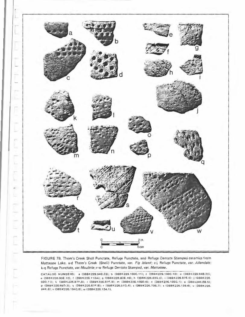
a
~u
• .
. 0
~· ~ p
FIGURE 79. Thorn's Creek Shell Punctate, Refuge Punctate, and Refuge Dentate Stamped ceramics from Mattassee Lake. a-d Thorn's Creek (Shel l) Punctate, var. Fig Island; e-j Refuge Punctate, var. Allendale; k-q Refuge Punctate, var. Moultrie; r-w Refuge Dentate Stamped, var. Mattassee.
----------------------------CATAL.OG NUMBERS: a (388K229.94B.32l; b (38BK229.1 00C.11) ; e (38BK229.100C.12l ; d (38BK229.94B.32) ;
e (38BK226.93E.10l. f (38BK226.113A); 9 (38BK226.93E. 10); h (388K226.93G.5l ; I (38BK226.87E.5); i (38BK226.
930.11 ) ; k (38BK226.87F.8) ; I (388K226.87F.8l: m (38BK226.1000.6); n (38BK226.1 06G.1) ; o (38Bk246.88.5);
P (38BK226.860.3 ) ; C! (38BK226.87F.8); r (38BK226.51G.4) ; s (38BK226.738.7); t (388K226.139.4) ; u (38BK226.
94K.6) ; v (38BK226.104 C.6) ; w (38B K 226.134.1 ).

early, coeval with other Thorn's Creek types in the 38BK229 excavation block (Table 53).
Documentation. Waddell Hemmings (1972), Sutherland Trinkley(1975, 1976a, 1980a, 1980b).
(1963), (1974),
THOM'S CREEK FINGER PINCHED, var. Awendaw
Background. The type Awendaw Finger Pinched (reported here as Thorn's Creek Finger Pinched) was formally defined by Trinkley (1976a, 1980b:13-14) based on a sample of 1095 sherds from 9 shell ring and midden si tes from the sea-island area of South Carolina. A second detailed description of Awendaw pottery, focusing in part on decorative variability, has been prepared by Michie (1979:40-44), based on materials from the Bass Pond shell midden (38CH124) on Kiawah Island, Charleston County, South Carolina. The diagnostic decorative motif, finger pinching, had been long noted by local archeologists (e.g. Williams 1968:331), but had not previously been incorporated into a formal type description. The type Awendaw Punctate was provisionally established by Waddell (1965:82), who associated it with the Thorn's Creek series; Waddell (1965:82) at that time noted that "a formal type description of Awendaw Punctate is (still) forthcoming." Waddell described the general physical characteristics of the ware, and documented its distribution in the seaisland area from the area of Beaufort to northern Charleston County. A brief description of an "Awendaw Punctated" ware was also provided by Edwards (1965:24), based on materials recovered from the Sewee shell ring (38CH45) in northern Charleston County, South Carolina; this description subsumed both reed punctated and finger-pinched motifs, however, and was too brief and general to be of much use. Several radiocarbon dates place Awendaw ware to between roughly 2000-1000 B.C.; this information, and stratigraphic excavation data from a number of coastal sites, has been examined and summarized by Trinkley (1980a, 1980b), who suggests that Awendaw Finger Pinched is the latest (and last) decorative motif in the Thorn's Creek series.
260
Like Thorn's Creek (Shell) Punctate, var. Fig Island, Awendaw Finger Pinched has only rarely been noted in the interior of the coastal plain; its presence at Mattassee Lake is the first reported occurrence along the Santee River, and the first occurrence noted well outside the immediate coastal area. The only other interior, non-shell midden site where Awandaw Finger Pinched pottery has been reported is at the Palm Tree site (38BK147) on the lower Cooper River drainage, some 30 miles to the south of Mattassee Lake. To streamline Thorn's Creek typology, and provide a consistent terminology for the series, substitution of Thorn's Creek Finger Pinched, ~· Awendaw is advocated here.
Sorting Criteria. Individual pinched impressions, typically placed in rows parallel to the rim; random pinching less common. Figer pinching may vary considerably in both size and depth of impression; shallow impressions may be indistinct, producing a ridged, or undulating appearance. May be confused with Thorn's Creek Plain or Thorn's Creek Simple Stamped if the pinching is particularly shallow or indistinct. Paste, general surface finish, and rim and lip form similar or identical to that noted for Thorn's Creek (Shell) Punctate, var. Fig Island.
The Sample. Fourteen sherds of Thorn's Creek Finger Pinched, var. Awendaw, were recovered in the excavation units at Mattassee Lake, 13 in the area of the main excavation block at 38BK229, and one from EU26 at 38BK226 (Table 51; Figure 78:r-t). Most of the sherds were too small and weathered, or indistinct, to permit confident evaluation, but linear arrangement of pinches parallel to the rim are indicated. The range of variation in color, paste inclusions, thickness, interior finish and rim and lip form are given in Tables 55-61; over these attributes the ware is quite similar to the other Thorn's Creek types from the site. The paste is most similar to that noted in the shell punctate (~. Fig Island) assemblage, and derivat ion from the same (coastal'?) clay sources is inferred. Rims tend to be straight-to-veryslightly incurving, with plain (unmodified) lips (Tables 59, 60; Figure 77); sherd and sample s.ize are too small, unfortunately, to

determine vessel form or volume. The Mat tassee Lake finger pinched sherds strongly resemble Awendaw ceramics recovered from the Stratton Place shell ring (38CH24), and from other northern Charleston County sites (Trinkley 1980a:259-260), and it is suggested that they originated in that area, some 40 miles to the south-southeast: If this inference can be substantiated, then it would indicate that pottery vessels were transported moderate distances during this period, and were incorporated into seasonal movements or resource procurement operations.
Distribution. From the Savannah River to the Santee River in the sea-island area of South Carolina. Infrequent southwest of the North Edisto River and northeast of Bulls Bay; only rarely noted in the interior. (Waddell 1965a; Anderson 1975b; Trinkley l976a, l980a, 1980b; Widmer 1976a; Michie 1979).
Chronological Position. Late Archaic period, Thorn's Creek II Phase (1500 B.C. to 1000 B.C.). Recent research by Trinkley (1980a:63-64, 287) suggests that the ware may date to the later part of the phase, postdating most other Thorn's Creek types. At Mattassee Lake, the ware is stratigraphically early, coeval with other Thorn's Creek types, in the 38BK229 excavation block (Table 53).
Documentation. Griffin (1943; notes the presence of fiber tempered, finger pinched ware at the Chester Field shell ring); Waring (in Williams, ed. 1968:331); Waddell (1965a); Edwards (1965); Calmes (1967); Hemmings (1970); Sutherland (1974); Trinkley (1975, 1976a, 1980a, l980b), Anderson (1975b), Widmer (1976a), Michie (1979).
THOM'S CREEK SIMPLE STAMPED, var. unspecified
Background. The type Thorn's Creek Simple Stamped was formally defined by Phelps (1968:21), based on a sample of 52 sherds from Whites Mound (9RI4) and the Boy Scout site (9BK6), two locations along the central Savannah River drainage in eastern Georgia. The ware has been occa-
261
sionally noted in site reports from the South Carolina area (e.g. Widmer 1976a, Michie 1979), but recognition has been hampered by the (apparent) close similarity of most simple stamped ceramics in the region. Typically, sherds are identified as Thorn's Creek Simple Stamped when they are found on sites where only the Thorn's Creek series ceramics are present (or where other series are only minimally represented). Trinkley (1980a:292) has noted that simple stamping occurs only infrequently in coastal Thorn's Creek sites, and has suggested that:
what other researchers and I are calling Thorn's Creek Simple Stamping is actually either Refuge or Deptford .. . ! also suspect that simple stamped sherds will occur only on late Thorn's Creek sites, and are part of the transition from Thorn's Creek to Refuge/ Deptford (Trinkley 1980a:292).
While what appears to be a Thorn's Creek Phase simple stamped ware has been noted in moderate quantities at the Bass Pond site (38CH124) on Kiawah Island (Michie 1979: 49), the low overall incidence of the finish on coastal Thorn's Creek sites, as reported by Trinkley, appears to be generally valid (see Anderson 1975b for a separate, corroborative analysis). Simple stamping is documented within the coeval Stallings series (e.g. Chaflin 1931; Fairbanks 1942; Phelps 1968; Stoltman 1974; Widmer 1976a), but it also appears to be a minority ware. Simple stamping on fiber tempered wares appears to be most common in the interior southeast (as in the Wheeler series of northern Alabama, Sears and Griffin 1950; see also Stoltman 1974:63); a similar pattern may occur within the Thorn's Creek series (Phelps 1968: 21). It is possible that simple stamping appears only near the end of the Late Archaic, and predominately in the interior, although this needs to be more thoroughly documented.
DePratter {1979:117) has discussed the evolution of north Georgia coastal ce-ramics, offering the following perspective:
At sometime around 1100 B.C., changes in the ceramic tempering materials began on the Georgia coast. Sand and grit were gradually added to

the fiber-tempered St. Simons ceramics, until eventually the sand and grit completely replaced the fibers. The resulting sand and grit tempered incised, punctated, and plain ceramics are now identified as Refuge I phase types. Refuge Punctated and Incised were made for only a brief period. A new type, Refuge Simple Stamped, was added to the ceramic assemblage prior to the disappearance of incising and punctation. Simple stamping occurs on fiber tempered Stallings Island ceramics inland on the Savannah River (Claflin, 1931; Phelps, 1968), and it is likely that simple stamping originated in that area (DePratter 1979:117).
DePratter is here clearly offering an evolutionary interpretation of changes in ceramic styles and technology along the north Georgia coast. One theme that needs to be better documented, however, is the evidence for a gradual admixture of sand and grit to the fiber tempered wares. This perspective would appear to be contradicted by references to a heavy incidence of sand or grit in fiber tempered pottery from both early and later sites (e.g., Griffin 1943:160; Waring 1968a:l59; Claflin 1931). The discussion is also marred by lack of reference to the Thorn's Creek series. Local adoption of Thorn's Creek wares (called Refuge I phase types by DePratter) would appear to be a more probable explanation for the observed phenomenon than gradual, in situ evolutionary change (see also Trinkley 1980a: 352-353). Ample evidence exists for a long cooccurrence of the two series (Stallings and Thorn's Creek). The appearance of Refuge I phase ceramics on the Georgia coast, in this view, may reflect the adoption of different manufacturing procedures, probably from groups living to the northeast, where a long tradition of this (Thorn's Creek) manufacture is documented. The appearance of simple stamping may be due, in part, to these changes in ceramic technology; the finish may reflect a greater need to malleate the coiled, as opposed to molded pottery. Use of paddles probably quickly led to a recognition of their potential for applying design; alternatively (or additionally), the stamping may have been
262
functional, to make the vessel easier to hold.
At Mattassee Lake, a number of simple stamped sherds were recovered that were similar in paste, color, general surface finish, and rim and lip form to recognizable Thorn's Creek types. These sherds were separated, and are reported here as a type within the Thorn's Creek series. Since the assemblage admittedly intergrades with later simple stamped wares (e.g., Deptford, Santee), strict compliance with the rules of the type-variety system decree establishment of the ware as a variety within a more general, inclusive simple stamped type . Establishment of new types and varieties has been deferred here, however, since the range of variation in this finish is only beginning to emerge.
Sorting Criteria. Paste, general surface finish, and rim and lip form similar or identical to that noted for Thorn's Creek Plain. Stamping includes both "v" and "u" shaped impressions, typically applied parallel to each other, and somewhat carelessly; cross-stamping infrequent. May be confused with Deptford and later simple stamped wares.
The Sample. A total of 52 Thorn's Creek Simple Stamped sherds were recovered in the excavation units along Mattassee Lake (Table 51; Figure 78:m-g, u). A range of stamps appear to have been used, with little consistency in size, depth, or width. Recognition of the type followed from general surface finish and paste, which were virtually identical to that noted over the Thorn's Creek Plain and Punctate types. Stamps ranged from both shallow and deep v-shaped grooves (e.g., Figure 77:m, n) to U-shaped grooves of varying width, typically about 2mm or so across (e.g., Figure 78;p, q). The v-shaped impressions were typically cruder, indicating less care in carving. In most cases the stamps were carelessly applied, with considerable impression overlap; most stamping was parallel or at an angle to the rim, with cross-stamping rare . Several sherds exhibited broad shallow grooves (Figure 78:u) that are similar to what Trinkley (1980a:260-261) has provisionally called Awendaw Finger Impressed. The
impressions on the sherds at Mattassee Lake appear to have been created by a smooth object with minimal drag, suggesting application with a paddle. While closely resembling the Thorn's Creek plain wares, the surface is irregular, and oblique lighting readily picks up the impressions, hence inclusion in the simple stamped assemblage. Rims tend to be straight-to-slightly excurvate, with the incurvate form less common than over the other Thorn's Creek types (Table 59; Figure 77). Lips tend to be flat or rounded, with a fair ly high incidence (N=6, 60 percent) of decorative treatment, invariably stamping at a 45 or 90 degree angle to the body plane (Table 60).
The moderate incidence of straightto-excurva te, flattened lips, and the high incidence of lip treatment, suggests that the ware is a late addition to the Thorn's Creek series. The flattened, straight-to-excurvate rims are typical of later wares, and there is also some evidence for an increase in lip decoration over time in the Thorn's Creek assemblage at Mattassee Lake. Over all the Thorn's Creek types in the 38BK226 excavation block for example, 20.0 percent of the rims (N=ll) below level 5 (20-25 em) exhibited decorative treatment, while 25.5 percent (N=13) of the rims above these levels were decorated, a slight increase (total sample = 106 rims). (See also Sample discussion for Thorn's Creek Plain). The ware appears generally similar to the Thorn's Creek Simple Stamped material described by Phelps (1968) from the Savannah River. A late appearance for the ware, in the interior, would support the inferences advanced by Trinkley and DePratter (discussed previously) about the age and origin of simple stamping in the general region.
Distribution. Poorly documented. Appears to occur throughout the coastal plain and fall line areas of South Carolina and adjoining portions of eastern Georgia and into southwestern North Carolina. Like most of the Thorn's Creek types, it is probably rare above the fall line. Appears to be more common in the interior than in the sea-island area (Phelps 1968; Michie 1979; DePra tter 1979; Trinkley 1980a).
Chronological Position. Late Archaic period, Thorn's Creek II Phase (1500 B.C. to
263
1000 B.C.). There is some evidence that the ware may date to the later part of the phase, post-dating most other Thorn's Creek types. At Mattassee Lake the ware is stratigraphically early, coeval with other Thorn's Creek types, in the 38BK226 excavation block (Table 52).
Documentation. Phelps (1968), Widmer (1976a), Michie (1979), DePratter (1979; see discussion of Refuge Simple Stamped type); Trinkley (1980a).
THOM'S CREEK INCISED, ~· unspecified
Background. The type Thorn's Creek Incised was formally defined by Phelps (1968:21), based on a sample of six sherds from the central Savannah River drainage. A second type description, based on a sample of 39 sherds from nine shell ring and midden sites, from the sea-island area of South Carolina, has been presented by Trinkley (1976a, 1980b:l6-17). Incising, by itself, appears to be a decidedly uncommon form of decoration, accounting for only 1.4 percent of the Thorn's Creek sherds in Phelps (1968:20) sample, and less than half a percent of the sherds in Trinkley's (1980b: Figure 5). The incidence of incising is only slightly higher in the coastal sample when its occurrence in combination with other decorative motif is included (0.61 percent; Trinkley 1980b:Figure 5). The ware would appear to be a distinct minority in local asemblages, and is only occasionally reported in descriptions of Thorn's Creek ceramics (e.g., Trinkley 1981b:8). Edwards (1965:24) briefly noted the presence of a type he called "Awendaw Incised" at the Seewee shell ring (38CH45) in northern Charleston County. No formal type description was offered, however, and the type has become established within the Thorn's Creek series.
Incising occurs infrequently on later period ceramics, in the Deptford series (e .g., Deptford Zoned-Incised Punctate, var. Cal Smoak; Deptford Incised; Anderson, Lee, and Parler 1979:140-141), and in the Mississippian period (e .g. , Irene Incised; Caldwell and Waring 1939). Waring (1968b: 200) briefly noted the presence of incising

on a few sherds from the Refuge site (38JA5) on the lower Savannah River, and named the material Refuge Incised. A formal description was provided by DePratter (1979:121), who noted that the ware occurred only in the "earliest portion of the Refuge I phase," or from about 1100 to 1000 B.C. Following the arguments raised in the Background discussion for Thorn's Creek Simple Stamped, we would suggest that the ware should be more appropriately identified and associated with the Thorn's Creek series.
Incising has been noted in the Stallings series (e.g., Sears and Griffin 1950), and appears to be a minority ware during the Late Archaic sand and fiber tempered pottery tradition. The finish is generally rare in the coastal plain of South Carolina; an examination of ceramics from 313 sites (Anderson 1975b; Sample = 18,961 sherds) recorded only 93 incised sherds, from 44 sites. Only about half of these sherds appear to be Thorn's Creek Incised; the remainder are either Stallings (N:::14) or later, post-Thorn's Creek wares. At Mattassee Lake the Thorn's Creek Incised sherds could be easily sorted from later incised wares, due to appreciable differences in paste, rim and lip form, and general surface finish. Subsuming local incised wares under a single type, with separate varieties for relevant series or periods was not considered necessary. Once larger samples of incised pottery are collected, however, the need for variety terminology will almost certainly arise.
Sorting Criteria. Fine incised lines typically arranged in rows parallel or at low angles to the rim; curvilinear and geometric designs, and incising perpendicular to the rim less common. Paste, general surface finish, and rim and lip similar or identical to that noted for Thorn's Creek Plain.
The Sample. Thirty-three Thorn's Creek Incised sherds were recovered in the excavation units at Mattassee Lake (Table 51; Figure 78:i-1). The incisions are typically narrow (0.5-2.0mm) and shallow (0.5-l.Omm), and from well-to-poorly or haphazardly applied. Parallel lines predominate; only one sherd with geometric incising was recovered (Figure 78:j). The ware is similar
264
in most regards to the other Thorn's Creek types (e .g., Tables 55- 61), differing only in being somewhat thicker and (like the type Thorn's Creek Simple Stamped) in having a moderately high incidence of straight to excurvate rims with flattened, decorated lips (Tables 59-60; Figure 77). This may suggest a later occurrence, towards the end of the Thorn's Creek Phase (see discussions for Thorn's Creek Plain and Thorn's Creek Simple Stamped). The materials from Mattassee Lake are quite similar to coastal Thorn's Creek Incised sherds described by Trinkley (1980b:l6-17), although lip shapes differ somewhat between the two samples. Close correspondence to Phelps (1968) interior Savannah River sample, and with DePratter's (1979:121) Refuge Incised type is also evident; while minor differences are probable, at the present time our sample size is too low to permit meaningful comparisons.
Distribution. Poorly documented. Appears to occur throughout the coastal plain and fall line areas of South Carolina and adjoining portions of eastern Georgia and southwestern North Carolina. Like most of the Thorn's Creek types, it is probably rare above the fall line. (Phelps 1968; Trinkley 1976a, 1980b; Anderson 1975b; DePratter 1976, 1979).
Chronological Position. Late Archaic period, Thorn's Creek II Phase (1500 B.C.-1000 B.C.). The ware may date to the later part of the phase. At Mattassee Lake the ware is stratigically early, coeval with other Thorn's Creek types in the 38BK226 excavation block (Table 52).
Documentation. Edwards (1965); Phelps (1968); Waring (1968b; Refuge Incised type); Trinkley {1976a, 1980a, 1980b, 1981b); DePratter (1976, 1979; Refuge Incised type); Lepionka (1980, 1981, nd; Refuge Incised type).
REFUGE DENTATE STAMPED, ~· Mattassee
Background. Refuge ceramics were recognized by Waring (1968b) as an intermediate series between Stalling's and Deptford, based on the excavation of four 5 foot

squares opened in 6 inch levels to a depth of seven feet into a small shell midden (38JA5) on the South Carolina side of the Savannah River. The site was located on the Savannah National Wildlife Refuge, hence the origin of the site and series name. Five Refuge types were identified and described by Waring (1968b:200)based on a sample of 683 sherds: Refuge Simple Stamped (N=200; 29.3 percent of Waring's sample); Refuge Plain (N=403; 59.0 percent); Refuge Dentate Stamped (N=45; 6.6 percent); Refuge Punct ated (N=33, 4.8 percent); and Refuge Incised (N=2, 0.3 percent). Recognition of Refuge Phase sites has been highly confused, however, primarily because most of the Refuge types (as defined) are similar or identical to established types in the Thorn's Creek and Deptford series. Only Refuge Dentate Stamped, of the five original Refuge types, for example, can be unambiguously sorted, primarily because the characteristic exterior finish does not occur on earlier or later wares in the immediate region.
New, formal type descriptions of Waring's five Refuge types have recently been offered by DePratter (1979:120-123), based on collections f rom the mouth of the Savannah River (including from the Refuge site). As noted previously (see the Background discussion for Thorn's Creek Si mple Stamped), however, this taxonomy is marred by a lack of reference to the Thorn's Creek series; DePratter's (1979:120-121) Refuge Punctated and Refuge Incised types, as defined, are indistinguishable from Thorn's Creek punctated and incised types described previously (e.g., Trinkley 1980a:353). We would suggest that what DePratter (1979: 113) calls the Refuge I phase (defined by plain, incised, simple stamped, and punctated types) actually reflects the adoption of Thorn's Creek wares and manufacturing technology on the north Georgia coast. Distinctive Refuge types, such as Refuge Dentate Stamped, and Refuge Punctate (vars. Allendale, Moultrie, as defined here) appear somewhat later, during what DePratter (1979:117) would call late Refuge I through Refuge II. Replacement of Refuge I with a Thorn's Creek phase, and/or substitution of appropriate ceramic terminology, would appear called for in the mouth-ofthe- Savannah sequence. Excavations con-
ducted in the interior along the Savannah River, at Groton Plantation in Allendale County, South Carolina, strongly support these interpretations (Peterson 1971 a, 1971b). At Clear Mount, and from other sites in the area, for example, Peterson documented the presence of a Thorn's Creek assemblage intermediate between Stallings and Refuge. Wares identifiable as Thorn's Creek (Reed) Punctate were replaced by distinctive Refuge types, with surface finishes characterized by dentate stamping, and by what Peterson (1971b:77) has called Irregular Punctate, which is similar or identical to Stoltman's (1974:276-277) Allendale Punctate. These Refuge Dentate Stamped and Refuge (Irregular) Punctate types are themselves gradually replaced by simple stamped wares at Groton Plantation, a trend also noted by DePratter (1979:117-118) from the mouth of the Savannah. The available evidence indicated that the Refuge series, as previously defined, included both Thorn's Creek and Refuge types; a more precise taxonomy is offered here.
Descriptions of Refuge Dentate Stamped have been offered by Waring (1968b:200), Peterson (1971a: 126-12 7), DePratter (1979:122-123), and Lepionka (n.d.), all based on materials recovered from along the lower Savannah River. The ware is characterized by (typically) linear arrays of small rectangular impressions, or dentates, that appear to have been applied with a toothed comb, roulette, or cog rocker. The type is very similar to Wheeler Dentate Stamped (Sears and Griffin 1950), and an origin from this interior, fiber tempered series is possible. Dentate stamping has been noted at a number of sites from eastern Georgia to southeastern North Carolina (e.g., Edwards 1965:24; Peterson 1971a, 1971b; Anderson 1975a, 1975b; DePratter 1976, 1977, 1979; Herold and Knick 1978, 1979a; Trinkley 1980a), and at present the finish is the only unambiguous referent or diagnostic for identify ing Refuge components. There is some evidence from the original Refuge sit e excavations (Waring 1968b:206) and f rom recent work at a second, nearby si t e (Lepionka 1980, 1981, nd), that dentate stamping occurs only during the early part of the Refuge phase, t his inference is also
265
suggested at Groton Plantation (Peterson 1971b:77).
Sorting Criteria. Linear arrays of small rectangular impressions, or dentates (typically); geometric arrangements (usually forming triangles) or random impressions less common. Temperless or tempered with small (O.S-2.0mm) lumps of aplastic clay (grog).
The Sample. A total of 108 sherds of Refuge Dentate Stamped, ~· Mattassee were recovered in the excavation units at Mattassee Lake (Table 51; Figure 79:rw; Figure 81:a- c). The striking thing about the assemblage, virtually forcing the creation of a new variety, was the occurrence of a temperless to clay-grog tempered paste, previously unreported within the Refuge series. Almost every sherd (N=102 of 108) of dentate stamped pottery recovered along the terrace exhibited this paste; the few exceptions were characterized by a fine sandy paste similar to that noted within the Thorn 's Creek wares. The occurrence of "grit and sand in considerable quantities" (DePratter 1979:121) characteristic of Refuge wares from the lower Savannah River is not at all evident. Because of these marked differences in tempering, the dentate stamped wares from the two areas have been assigned to separate varieties, var. Refuge (for the lower Savannah River material) and var. Mattassee (for the temperless to clay-grog tempered materials from the terrace and elsewhere along the Santee). The paste within the Mattassee Lake assemblage is surprisingly uniform (in most cases), an almost pure clay with comparatively few larger, quartz sand inclusions (Table 56; lumps of aplastic clay, or grog, were not recorded). Minor mineral inclusions occur in about the same incidence as within other site wares, suggesting the use of similar clay sources, although (perhaps) with conscious selection against larger quartz sands (Table 56). No abraders were noted in the Mattassee Lake Refuge sherd assemblage, unlike the situation along the lower Savannah where these tools are common (DePratter 1979); this absence may be due to the nature of the var. Mattassee paste, which (lacking sand) is not suitable for abrading.
266
Both interior and exterior surfaces are well smoothed with stamping (typically) oriented obliquely with respect to the rim (Table 61). Isolated single and double rows of dentates predominate (e.g. Figure 79:s,w), although a minority of the sherds exhibit stamping over their entire surface (e.g., Figure 79:r, t). Cross-stamping, creating overlapping diamonds or triangles, was also noted on several sherds; the design occurs around the vessel rim in a few cases (e.g., Figure 8l:a-c). Flat,excurvate rims are ubiquitous (Table 59, Figure 80); lips are typically undecorated although one dowel stamped specimen was observed (Table 60). Cylindrical, rounded-bottom, slightly flaring jars or bowls from 30 to 40 em in diameter are indicated. The type is clearly different from the earlier Thorn's Creek wares at Mattassee La:ke in a number of respects, notably paste, surface finish, and vessel form. Except for the difference in paste, however, the Mattassee Lake material appears quite similar to the dentate stamped variety from the lower Savannah. The paste in the Mattassee Lake dentate stamped sherds, it should be noted, is for all practical purposes identical to the paste in the Refuge and Hanover/Wilmington wares from the terrace, and a similar manufactur ing technology is evident. The series may be related, or "evolve" from one to the other. South (1976:1) has argued that the "Hanover Series pottery in the Cape Fear area south to Charleston was a phenomenon contemporary with the Deptford Series;" the present analysis supports this, and suggests that an even earlier origin or occurrence may be possible.
Distribution. The Refuge Dentate Stamped type is found throughout the coastal plain and fall line areas of eastern Georgia, South Carolina, and into southeastern North Carolina. Rarely noted above the fall line, the ware is uncommon northeast of the Santee/Black River drainages. Refuge Dentate Stamped, ~· Mattassee, has currently been observed only along the lower Santee River, in Berkeley and Clarendon Counties. Paste variability locally has only been very incompletely documented, and a more extensive range, comparable to that noted for the Wilmington (var. Hanover) series, may be possible

REFUGE DENTATE STAMPED REFUGE PUNCTATE var. Moultrie
WILMINGTON (?) SIMPLE
STAMPED
var. Mattassee REFUGE PUNCTATE
- IT U g TI v~!O~E o-~
REFUGE PLAIN var. unspecified UNKNOWN (HANOVER?)
PLAIN WITH WHITE CLAY
WILMINGTON CHECK
STAMPED var. Wadmacon
DEPTFORD SIMPLE STAMPED var. Cal Smoak -
DEPTFORD BRUSHED
var. unspecified
~ - -
DEPTFORD LINEAR CHECK STAMPED var. Deptford
DEPTFORD LINEAR CHECK STAMPED/
FABRIC IMPRESSED
\J -\j -uuTI --uuuu\\
u u~- u -TID \1 D u UD-UUUU -G
0 2 4 6 CENTIMETERS FIGURE 80
REFUGE, WILMINGTON, AND DEPTFORD RIM PROFILES 0 21NCHES
MATTASSEE LAKE EXCAVATIONS U S Army Coros of Eng1neers
Cooper R•ver ReOJvttS'On Canal Pro~c:
(Waring 1968b, 1968c; Anderson 1975a; DePratter 1976).
Chronological Position. Early Woodland period, Refuge I and II Phase (1000 B.C.-600 B.C.). Two radiocarbon dates from the lower Savannah River unambiguously date the ware to about 1000 B.C.: 970:!200 B.C. (M-267; Williams 1968:329) and 920 B.C. :!110 (GX0- 1752; Peterson 1971a:249). Two additional dates, from the second Refuge site (Lepionka 1981a:76), both support this early date, and suggest that the Refuge Phase lasted for several hundred years (1070 B.C., :!us, QC-784; 510 B.C. -110, QC-785). At Mattassee Lake Refuge Dentate Stamped stratigraphically postdates both Thorn's Creek and Refuge Punctate types (and all Thorn's Creek), and is slightly earlier than the Wilmington and Deptford types (Table 52).
Documentation. Edwards (1965:24); Waring (1968b, 1968c); Williams (1968); Peterson (197la, 197lb); Anderson 1975a, 1975b; DePratter (1976, 1977, 1979); Trinkley (1980a); Widmer 1976a; Herold and Knick (1978, 1979a).
REFUGE PUNCTATE, ~· Moultrie
Background. The type Refuge Punctated, as originally (Waring 1968b:200) and formally (DePratter 1979:120-121) defined, is indistinguishable from Thorn's Creek Punctate types (Trinkley 1980a:353; see also the discussions for Thorn's Creek Simple Stamped, Refuge Dentate Stamped types). Two kinds of punctation were observed at Mattassee Lake that did not resemble typical Thorn's Creek decorations, though, and could be subsumed under a Refuge Punctate type. Both finishes were characterized by the temperless to clay-grog paste noted in the Refuge Dentate Stamped sherds at Mattassee Lake. One punctated ware (var. Allendale) is identical to Stoltman's (1974: 276-277) Allendale Punctate type, called Irregular Punctate by Peterson (1971a, 197lb) and the other (var. Moultrie), previously undefined, wascharacterized by small, irregular circular punctations resembling rounded dentates. Refuge Punctate is apparently quite uncommon in the coastal South Carolina area; var. Allen-
268
dale having only been previously noted along the lower Savannah River on Groton Plantation (Peterson 197la, 1971b; Stoltman 1974), and var. Moultrie previously unrecognized. The surface finish on the Refuge Punctate, var. Moultrie closely resembles the many Wheeler Punctated sherds (e.g. Sears and Griffin 1950).
Sorting Criteria. Small (2.0-S.Omm), irregular, shallow (0.5-2.0mm) circular punctations; less commonly square or oval, randomly applied over the exterior surface. Paste highly variable, typically te mperless or tempered with small (0.5-2.0mm) lumps of aplastic clay (grog); less commonly with dense fine to coarse sand. May be confused with Thorn's Creek (Reed Separate) Punctate,~· Spanish Mount.
The Sample. Fourteen sherds of Refuge Punctate, ~· Moultrie were recovered in the excavation units (Table 51; Figure 79:k-q). A majority (N=9; 64.3 percent) had temperless to clay/grog tempered paste, hence assignment of the finish to the Refuge Punctate type. The remaining five sherds had somewhat more variable, sandy paste, two similar to that noted in the site Thorn's Creek Plain wares, and three (characterized by dense quartz sand from I.0-2.0mm in size) similar to that in some of the Deptford types. The sherds with the atypical sandy paste may belong to these earlier and later series, although these pastes are more representative of Refuge ceramics elsewhere in the region. The ware is quite thin (x = 6.4mm; Table 58), reminiscent of the punctated Thorn's Creek wares, but the paste and the excurvate, flattened rims (Table 59) both indicate a later,Refuge ware. So little is known about the occurrence of this ware that intersite comparison is not possible.
Distribution. Poorly documented. The variety may be a minority among Refuge ceramics, with a distribution comparable to that for the series (see Refuge Dentate Stamped). Currently known only from the Mattassee Lake sites.
Chronological Position. Early Woodland period. Refuge I Phase (1500 B.C.-800 B.C.). At Mattassee Lake Refuge Punctate, var. Moultrie occurs stratigraphically early,
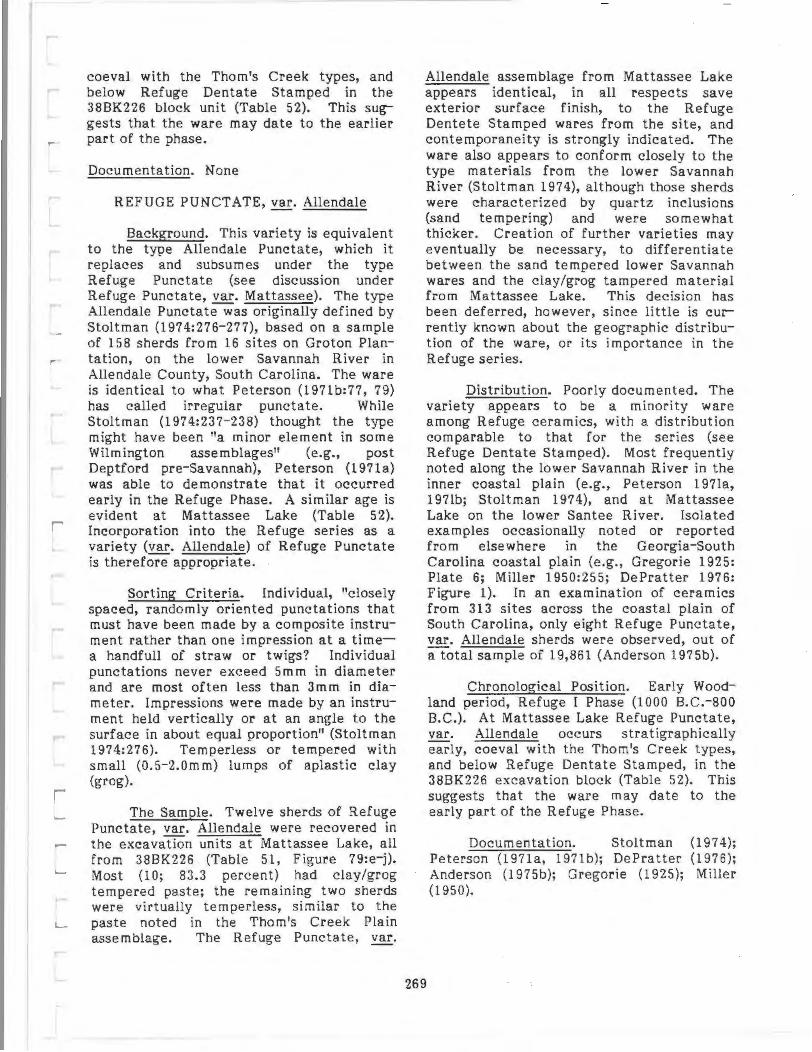
coeval with the Thorn's Creek types, and below Refuge Dentate Stamped in the 38BK226 block unit (Table 52). This suggests that the ware may date to the earlier part of the phase.
Documentation. None
REFUGE PUNCTATE, var. Allendale
Background. This variety is equivalent to the type Allendale Punctate, which it replaces and subsumes under the type Refuge Punctate (see discussion under Refuge Punctate, var. Mattassee). The type Allendale Punctatewas originally defined by Stoltman (1974:276-277), based on a sample of 158 sherds from 16 sites on Groton Plantation, on the lower Savannah River in Allendale County, South Carolina. The ware is identical to what Peterson (197lb:77, 79) has called irregular punctate. While Stoltman (1974:237-238) thought the type might have been "a minor element in some Wilmington assemblages" (e.g., post Deptford pre-Savannah), Peterson (1971a) was able to demonstrate that it occurred early in the Refuge Phase. A similar age is evident at Mattassee Lake (Table 52). Incorporation into the Refuge series as a variety (var. Allendale) of Refuge Punctate is therefore appropriate.
Sorting Criteria. Individual, "closely spaced, randomly oriented punctations that must have been made by a composite instrument rather than one impression at a timea handfull of straw or twigs? Individual punctations never exceed 5mm in diameter and are most often less than 3m m in diameter. Impressions were made by an instrument held vertically or at an angle to the surface in about equal proportion" (Stoltman 1974:276). Temperless or tempered with small (0 .5-2.0mm) lumps of aplastic clay (grog).
The Sample. Twelve sherds of Refuge Punctate, var. Allendale were recovered in the excavation units at Mattassee Lake, all from 38BK226 (Table 51, Figure 79:e-j). Most (10; 83.3 percent) had clay/grog tempered paste; the remaining two sherds were virtually temperless, similar to the paste noted in the Thorn's Creek Plain assemblage. The Refuge Punctate, var.
Allendale assemblage from Mattassee Lake appears identical, in all respects save exterior surface finish, to the Refuge Dentete Stamped wares from the site, and contemporaneity is strongly indicated. The ware also appears to conform closely to the type materials from the lower Savannah River (Stoltman 1974), although those sherds were characterized by quartz inclusions (sand tempering) and were somewhat thicker. Creation of further varieties may eventually be necessary, to differentiate between the sand tempered lower Savannah wares and the clay/grog tampered material from Mattassee Lake. This decision has been deferred, however, s ince little is currently known about the geographic distribution of the ware, or its importance in the Refuge series.
Distribution. Poorly documented. The variety appears to be a minority ware among Refuge ceramics, with a distribution comparable to that for the series (see Refuge Dentate Stamped). Most frequently noted along the lower Savannah River in the inner coastal plain (e.g., Peterson 197la, 197lb; Stoltman 1974), and at Mattassee Lake on the lower Santee River. Isolated examples occasionally noted or reported from elsewhere in the Georgia-South Carolina coastal plain (e.g., Gregorie 1925: Plate 6; Miller 1950:255; DePratter 1976: Figure 1). In an examination of ceramics from 313 sites across the coastal plain of South Carolina, only eight Refuge Punctate, var. Allendale sherds were observed, out of a total sample of 19,861 (Anderson 1975b).
269
Chronological Position. Early Woodland period, Refuge I Phase (1000 B.C.-800 B.C.). At Mattassee Lake Refuge Punctate, var. Allendale occurs stratigraphically early, coeval with the Thorn's Creek types, and below Refuge Dentate Stamped, in the 38BK226 excavation block (Table 52). This suggests that the ware may date to the early part of the Refuge Phase.
Documentation. Stoltman (1974); Peterson (1971a, 197lb); DePratter (1976); Anderson (1975b); Gregorie (1925); Miller (1950).

REFUGE PLAIN, var. unspecified
Background. The type Refuge Plain was first noted by Waring (1968b:Tables 12-16), in a description of ceramics recovered from his 1947 excavations at the Refuge type site (38JA5). No formal description of the type was offered, although it was implied that the plainwares came from the lower (undecorated) portions of Refuge Simple Stamped vessels (Waring 1968b:200). A formal description of Refuge Plain has recently been prepared by DePratter (1979: 122), using materials from the north Georgia coast and from the type site. Due to perceived ambiguities in the traditional approach to sorting Refuge from later plainwares, DePratter (1979) used the type Refuge Plain for all pre-Mississippian period sand tempered plain wares in the Savannah locality, much as he used the type Refuge Simple Stamped to accommodate all local simple stamped wares.
Separation of early (e.g., Refuge) from later (e.g., Deptford) plain and simple stamped wares in the Savannah sequence was traditionally based on "quality" or apparent manufacturing sophistication, with the earlier materials (typically) reported as cruder (e.g., Waring 1968b:200). As Stoltman (1974:22), DePratter (1976, 1979), and others have noted, these criteria are highly subjective, and not particularly useful for sorting ceramic assemblages. At Mattassee Lake, identification of Refuge Plain wares was greatly simplified by the distinctive temperless or clay-grog tempered paste, effectively circumventing this taxonomic problem. Separation of earlier and later plain and simple stamped wares remains a major challenge in the Georgia and South Carolina area, however, and both type and variety designations will undoubtedly be needed. The Refuge Plain assemblage at Mattassee Lake, although different from the traditional (sand tempered) Refuge Plain material, was not accorded a new variety designation. This is because the variation over most local plain wares is not well-enough documented to permit confident variety classifications.
Sorting Criteria. Plain, well smoothed exterior surface finish; temperless or tempered with small (O.S-2.0mm) lumps of
270
aplastic clay (grog). May be confused with Wilmington Plain.
The Sample. A total of 80 sherds of Refuge Plain, var. unspecified were recovered in the 1979 excavations at Ma ttassee Lake (Table 51). In paste, color, and general surface finish (excluding the decorative motif) many of the sherds were identical to the Refuge Dentate Stamped assemblage from the site, and at least some could have come from plain portions of dentate stamped vessels. Some manufacturing variability was evident, however, more than was observed over the other Refuge types from the terrace. A few of the sherds exhibited irregular interior smoothing, and the range of primary paste inclusions was greater (Tables 56, 57). Rim form and lip shape were also quite variable (although the sample size was small); only plain (unmodified) lips were observed (Tables 59, 60; Figure 80). Vessel forms similar to those for Refuge Dentate Stamped var. Mattessee are indicated. The Refuge Plain assemblage at Mattassee Lake differs from the original (type) assemblage both in paste (clay/grog versus grit) and surface finish (well as opposed to somewhat poorly smoothed) although similar vessel forms (simple jars or bowls) are indicated. Later formulations of the type (e.g., DePratter 1979) are too broad to perm it effective comparison; except for paste, all of the Mattassee Lake plain wares could be subsumed under the type Refuge Plain as defined in the Savannah River sequence.
Distribution. Poorly documented. The distribution of the type Refuge Plain is assumed to be the same as that for Refuge Dentate Stamped. Temperless or clay-grog tempered Refuge Plain like that found at Mattassee Lake has currently been observed only along the lower Santee River, in Berkeley and Clarendon Counties, at sites where otherwise identical, dentate stamped wares occur. Ceramics characterized by a plain surface finish and a temperless or clay-grog tempered paste are not uncommon in coastal North and South Carolina (e.g., Anderson 1975b; Loftfield 1976:57), although most occurrences appear associated with later series, such as Wilmington or what is referred to in North Carolina as Hanover.

Chronological Position. Early Woodland period, Refuge Phases (1000 B.C.-600 B.C.). At Mattassee Lake Refuge Plain occurs stratigraphically early, slightly after the Thorn's Creek types, and below Refuge Dentate Stamped in the 38BK226 block (Table 52).
Documentation. Waring (1968b); Peterson (1971a, 1971b); Anderson (1975b); DePratter (1976, 1977, 1979), Trinkley (1980a, 1981c).
WILMINGTON FABRIC IMPRESSED, ~·Berkeley
Background. Wilmington pottery was first recognized by Caldwell and Waring in 1939, with their description of a cordmarked, sherd or grit tempered ware from the mouth of the Savannah Initially defined by a simple type, Wilmington Heavy Cordmarked, and encompassing both sherd and grit tempering, the series has come to include a range of types, all characterized by clay/grog tempering (e.g., Caldwell 1952, 1971; Waring 1968c; DePratter 1979). Three phases characterized by clay/grog tempered ceramics are currently recognized in the mouth-ofthe-Savannah sequence, Wilmington I, Wilmington II, and St. Catherines (DePratter 1979). These phases span the period from roughly A.D. 500 to A.D. 1150, and in each the following types predominate: (1) Wilmington I (A.D. 500-A.D. 600) -Walthour Check Stamped, Walthour Complicated Stamped, Wilmington Plain, and Wilmington Heavy Cord-Marked; (2) Wilmington ri (A.D. 600-A.D. 1000) Wilmington Heavy Cord- Marked, Wilmington Plain, and Wilmington Brushed; and (3) St. Catherines (A.D. 1000- A.D. 1150). St. Catherine Plain, St. Catherines Burnished Plain, St. Catherines Fine Cord- Marked, and St. Catherines Net-Marked (DePratter 1979: 111). Wilmington and St. Catherines wares are differentiated primarily by temper size and quality of manufacture:
St. Catherines phase ceramics are characterized by finer clay tempering than that of preceding Wilmington types and by the increased care with which the ceramics were finished. The lumpy, contorted sur-
271
face of Wilmington types was replaced by carefully smoothed and often burnished interiors and exteriors. St. Catherines Burnished is characterized by careful exterior burnishing, whereas surfaces of St. Catherines Plain are simply smoothed. St. Catherines Fine Cord Marked has more carefully applied and more consistently spaced crossed cord impressions than did its predecessor, Wilmington Heavy Cord Marked. A new type, St. Catherines Net Marked, is also included in the St. Catherines series, but it is rare at most sites (DePratter l979:1l9).
A number of radiocarbon dates for Wilmington/St. Catherines components from the Georgia and South Carolina sea-island area support the posited time range of roughly A.D. 500 to A.D. 1150 for these wares, and stratigraphically the materials are clearly post-Deptford on the north Georgia coast (Waring 1968c; Caldwell 1971; DePratter 1979; Trinkley 1980a, 1981a).
A second sherd (clay/grog) tempered ware, the Hanover series, was reported by Stanley South in 1960, based on materials collected from (predominantly) coastal shell midden sites in southeastern North Carolina and northeastern South Carolina. The paste was described as:
Tempered with large lumps of aplastic clay. The majority of these tempering lumps appear to be crushed sherds. The smoothed interior of the original sherd can be frequently seen on some of the crushed tempering fragments. These large lumps of temper result in a rough, lumpy surface on the interior of the sherd, around which a series of small cracks are frequently seen. Occasionally a rounded quartz pebble can be seen in the paste, but this is more the exception than the rule (South 1976:16).
A sample of 1034 sherds of this ware were collected, from 68 sites, and two finishes were identified, cord-marked (N=251 sherds; 24.3 percent) and fabric impressed (N=783; 75.7 percent). While preparing his report South contac ted Waring and described the sherd tempered ware that he had found.

While recognizing the similarity with the . Wilmington series, they decided that separate terminology would be appropriate because of the geographic separation, and since the ceramics of the intervening area (i.e. coastal South Carolina) were then unknown (South 1960, personal com munication). Two types were identified within the series, Hanover Fabric Impressed and Hanover Cord-Marked, and these taxa have been widely adopted in the South Carolina archeological literature (e.g. South 1973b, 1976; South and Widmer 1976, Anderson 1975a; Widmer 1976a).
Clay/grog tempering has been reported from other localities in North Carolina (e.g., Haag 1958:69), and Loftfield (1976: 54-157; 175-182) has recently formally defined the clay-grog tempered Carteret series, based on materials from 83 sites in south central coastal North Carolina, predominantly from Onslow and Craven Counties. Three types were recognized in the Carteret series, Carteret CordMarked (N=415; 22.2 percent) Carteret Fabric-Marked (N=1384; 73.8 percent) and Care ret Plain (N=7 4; 4.0 percent) (Figures from Loftfield 1976: 175-182). An Early/ Middle Woodland age for the Carteret series was indicated (the ware follows the Thorn's Creek and New River series, and is succeeded by the Onslow, White Oak, and Adam's Creek series; see Phelps 1981:vii for chronology), but determining external relationships is difficult, especially since no attempt was made at comparison with South's (1960) coastal North Carolina typology. Similarity or identity with Crawford's (1966) Grifton series from Lenoir County, North Carolina, (immediately west of Loftfield's study area) is stated (Loftfield 1976:234), and the Carteret series is considered to be either a "purely local tradition,11 or one with external connections to the south (Loftfield 1976:234). Comparison of both the descriptions and type specimens for the Carteret and Hanover types indicates that the differences between the series are minor, rendering Loftfield's creation of new terminology somewhat questionable. In the present study, the Carteret series is dropped (due to a virtual identify with Hanover) and the types subsumed with Hanover as varities in the Wilmington series (e.g., var. Hanover).
272
The temporal and taxonomic relationships of southeast Atlantic coastal clay/grog tempered wares are currently somewhat ambiguously perceived, and appear to depend as much on geography or absolute dates as on distinctive attribut es of the wares themself (see also the discussions in Chapter 4, "Research Design" and Anderson and Logan 1981: 107- 108). Two major series of clay/grog tempered wares are currently established in the literature for the region (if we view, for the sake of convenience, the Wilmington and St. Catherines series as sequential parts of a local tradition). These are: (1) the Hanover series from coastal North Carolina and northern coastal South Carolina and, (2) the Wilmington/St. Catherines series from central coastal South Carolina south into the sea island area of Georgia. Sherd (clay-grog) tempered ceramics are, therefore, documented throughout most of the area from central coastal North Carolina to the sea islands of Georgia. The northern (Hanover) wares are earlier, and are dominated by fabric impressed surface finish; they are additionally found well into the interior of the coastal plain (e.g., South 1960, Anderson 1975a, Loftfield 1976). The southern wares (Wilmington, St. Catherines), in contrast, are dominated by cord marking, and appear restricted to the coast in the area south of Charleston Harbor, occurring only rarely in the interior (e.g., Caldwell 1952:317; Anderson 1975a:189). The southern wares occur later, although continuity through time and over space is apparent. A number of radiocarbon dates from the central South Carolina coast, in particular, document the length of this tradition, and the temporal overlap between the northern and southern margins (e.g. South 1971; South and Widmer 1976; Dorian and Logan 1979). A north-tosouth movement, or adoption, of this distinctive tempering/manufacturing technology is indicated.
The clay/grog tempered ceramics from the southeastern Atlantic coast comprise a distinctive local tradition whose geographic and temporal extent is only now becoming known. The similarities over this area appear to greatly outweigh the differences. While the incidence of specific finishes differs over the area, and assem-

blages can be sorted, individual sherds cannot:
Material from the Savannah River area called Wilmington is generally thicker, sandier, and somewhat more poorly made than material to the north (e.g., Hanover). The variation is slight, however, and can be detected only in assemblages from the northern and southern areas and not from the individual sherds; within these assemblages individual sherd-tempered sherds may be readily substituted in assemblages over the area (Anderson 1975a:189).
Separation of these wares into discrete ceramics series is not, therefore, defensible under the rules of the type-variety system, nor does it make good sense taxonomically. Nowhere is this more evident than in the central coastal area of South Carolina, where it could be argued that a major criteria used to classify wares as either Hanover or Wilmington appears to be the age of associated radiocarbon dates.
It is recommended there that all postRefuge clay/grog tempered ceramic types in the Georgia through North Carolina area be subsumed under the Wilmington series, with varieties established as necessary to accommodate perceived variability in the ware (e.g., ~· Hanover, Wilmington, St. Catherines). This would reduce (or at least acknowledge) the ambiguity inherent in attempting to sort the various types now in use (i.e., Hanover Cord Marked from Wilmington Heavy Cord Marked, or Wilmington Plain from St. Catherines Plain), while simultaneously providing a realistic and accurate method for accommodating the variability that does exist. Such a procedure would greatly streamline local typology (by eliminating redundant ceramic series) and help establish a much needed regional analytical perspective.
The clay-grog tempered, fabric impressed sherds recovered in the excavation units at Mattassee Lake were accordingly classified Wilmington Fabric Impressed, ~· Berkelev, since they did not fall within the range of variation of the established (e.g., Hanover, Wilmington) clay/grog tempered
types. Inspection of type sherds indicates, for example, that the clay/grog tempering particles in the Mattassee Lake assemblage are smaller, and less frequent, than in most of the coastal Georgia and North Carolina materials. Creation of a separate, local variety of Wilmington Fabric Impressed, var . Berkeley, is therefore warranted. It should be noted that the type Wilmington Fabric Impressed, as used here, has not been previously defined, although a net impressed ware is reported within the series (e.g. Wilmington Net Marked, Caldwell 1952:316; St. Catherines Net Marked, DePratter 1979:131-132), and the type Wilmington Fabric Impressed has seen occasional reference in the local literature (e.g., Scurry and Brooks 1980:27).
Sorting Criteria. Fabric impressions applied over the exterior surface of the vessel while the paste was plastic; occasionally smoothed somewhat after stamping. Tempered with small (0 .5-4.0mm) lumps of aplastic clay (grog); larger lumps (to c. lOmm) occasionally noted. Rims straight to excurvate, typically rounded.
The Sample. A total of 235 sherds of Wilmington Fabric Impressed, var. Berkeley were recovered in the excavation units at Mattassee Lake in 1979 (Table 51; Figure
. 81 :m-r). Most of the fabric impressions
273
(N=l78; 75.7 percent) were characterized by a poorly defined, or "loose" weave, where both the warp and weft elements were pliable, although a minority of the assemblage (N=57; 24.3 percent) was characterized by a rigid warp element (Table 51). Overstamping is fairly common, and about one-third (N=17, 29.8 percent) of the sherds exhibiting a rigid warp element were crossstamped. The stamping is typically parallel, or at low angles to the rim, and is only rarely perpendicular (Table 61; stamp orientation determined by the alignment of the warp element with the rim). Unlike most of the other wares from the terrace, the Wilmington Fabric Impressed, var. Berkelev assemblage is dominated by reddish-yellow and reddish-brown interior and exterior colors, although a fair degree of variability is evident (Table 55). Considerable variability in the size, color and incidence of the distinctive (grog) tempering is evident, although this typically occurs between, and
. . ·::r~f
0~-=ililiiii:=:ili-.;?2 1n 0 Scm
FIGURE 81. Refuge Dentate Stamped, Wilmington Plain, Wilmington (?) Simple Stamped, Wilmington
Check Stamped, and Wilmington Fabric Impressed ceramics f rom Mattassee Lake. a-c Refuge Dentate Stamped, var. Mattassee; d, e Wilmington Plain, var. Unspecified ; f Wilmington (?) Simple Stamped; g-j I Wilmington Check Stamped, var. Wadmacon; k, m-r Wilmington Fabric Impressed, var. Berkeley. Sherds
h, j, and I are linear check sta_.mped; sherd k is a fabric impressed (?) base.
CATALOG NUMBERS : a (388K226. 1040.13); b (38BK226. 1040.15) ; c (388K226.900.15 ) ; d (388K226.1 0 2E.8) ;
e (388 K226.93G.5) ; f (388 K 226. 1 06C.6) ; g (388 K 226.92B. 7) ; h (38BK226.95C.13) ; I (386K246 .306.8 ); j (38BK226.
1030); k (38BK226.828.2 ) ; I (38BK246.31A. 10); m (388K226.95C.11 ); n (388K226.900 .1 9); o (386K246.29C.9) ;
p (38B K246.328.3) ; q (388K246.25C.5) ; r (38BK24 6.25C.4).

not within individual sherds; this variability appears to reflect minor difference in paste preparation from vessel to vessel. The aplastic clay/grog inclusions range in color from whitishgray to very pale brown to reddish brown to black, with most pale to reddish brown. Temper density varies somewhat, although in most sherds it appears to constitute an appreciable portion of the paste (estimated at from 10 to 50 percent by volume). Quartz sand and other minor mineral inclusions are present in most sherds, although an appreciable percentage (N=24; 52.2 percent) are virtually "temperless" (excluding, of course, the grog), with little or no sand evident (Table 56). Interiors are poorly to well smoothed, and an appreciable minority of the sherds exhibit a lumpy, irregular surface with fine to coarse, wide scraping marks made with a comparatively soft implement (fingers?) while the paste was quite wet (Table 57). As noted by South (1976:16), the "large lumps of temper result in a rough, lumpy surface" over the interior of many of the less carefully smoothed sherds; it should be stressed, however, that a majority of the interiors were well-smoothed. Rims were invariably straight to excurvate and rounded, unmodified lips were most common, although about one third of the lips were flattened and stamped with the fabric wrapped paddle (Tables 59, 60; Figure 80). Several bases were recovered, and moderate sized conoidal jars roughly 40 em in diameter at the rim, and having a capacity of from 10 to 15 liters (calculated using procedures described by Million and Morse 1980), appear to be represented. The Mattassee Lake material more closely fits the Hanover and Carteret type descriptions than it does existing descriptions of Wilmington and St. Catherines material (e.g. DePratter 1979), particularly over rim form, lip shape, color, and interior finish. Closer affinities with assemblages to the northeast, rather than in the area to the southwest, in the GeorgiaSouth Carolina sea islands, are apparent.
Distribution. Wilmington Fabric Impressed occurs in the sea islands of Georgia and South Carolina and, from north of Charleston Harbor to the Pamlico River, is found both along the coast and in the interior to the fall line. The three recognized varieties have somewhat overlapping
distributions: ~· Wilmington is restricted to the sea island area of Georgia and South Carolina (becomingly increasingly uncommon from north to south); var. Hanover occurs along the coast from Charleston Harbor to the Pamlico Rivers in North and South Carolina, and in the interior from the Pee Dee to the Pamlico; and var. Berkeley is currently known from the central South Carolina coastal plain, along the Santee River drainage (Caldwell 1952; Waring 1968c:221; South 1960, 1976; Loftfield 1976; Anderson 1975a, 1975b; DePratter 1979).
275
Chronological Position. (var. Berkeley) Early/Middle Woodland periods, Deptford Phase (?600B.C.-A.D. 500?). Currently the range of the variety is poorly documented, although several dates from roughly 200 B.C. to A. D. 200 exist for material similar to var. Hanover, and the two wares may sharea similar range (e.g., South and Widmer 1976; Dorian and Logan 1979). In the 38BK226 excavation block at Mattassee Lake, the ware is stratigraphically coeval and probably contemporaneous with most of the recognizable Deptford types, occurring between the (presumably) earlier Refuge and later Cape Fear wares (Table 52). The stratigraphic data also suggests that stamping with a plaited fabric (characterized by a rigid warp element) preceded, or was more popular earlier than use of paddles wrapped with loosely woven fabric. The sample size is, however, small and additional confirmation of this point will be necessary.
Documentation. (1) var. Hanover: South (1960, 1976); South and Widmer (1976); Anderson (1975a, 1975b); Trinkley (1980a); Dorian and Logan 1979); Loftfield (1976); Phelps (1981); (2) var. Wilmington: Caldwell and Waring (1939a); Caldwell (1952, 1971); Caldwell and McCann (1941); Waring (1968c); Williams (1968); South (1971, 1976); Anderson (1975a, 1975b), DePratter (1979); Scurry and Brooks (1980); Trinkley (1980a, 1981a); (3) var. Berkeley: this report.

WILMINGTON CHECK STAMPED, var. Wadmacon
Background. This category subsumes earlier types developed for clay/grog tempered check and linear check stamped wares in the Georgia-South Carolina area, notably Caldwell's 1952:316) · Wilmington Check Stamped, recently renamed and formally described as Walthour Check Stamped by DePratter (1979:130). Two varieties have been established here, var. Wadmacon and var. Walthour, to accommodate minor differences in assemblages from the northern and southern ranges of the type, respectively. Var. Walthour replaces DePratter's (1979) Walthour Check Stamped type, and is a Late Woodland, Wilmington Phase ware in the sea island of Georgia and South Carolina north to Charleston Harbor. Var. Wadmacon, previously undescribed, occurs both along the coast and in the interior to the north of Charleston Harbor (probably into southern North Carolina), and is somewhat earlier, contemporaneous with the Hanover and Deptford Phases of the Early Woodland and early Middle Woodland. The type (encompassing both varieties) appears to be relatively uncommon in the coastal plain of South Carolina; a survey of ceramics on 313 sites recorded only 49 clay/grog tempered check and linear check stamped sherds, on 17 sites (Anderson 1975b). As with the Wilmington Fabric Impressed type, a north-to-south movement, or adoption, of this tempering/manufacturing technology is indicated. The variety designation, var. Wadmacon, is drawn from a tributary of the lower Santee along which sherds of this ware have been found (e.g., Anderson, Claggett, and Newkirk 1980).
Sorting Criteria. Check and linear check stamping over the exterior vessel surface; occasionally smoothed somewhat after stamping. Overstamping common. Tempered with small (0.5-2.0mm) lumps of aplastic clay (grog); larger lumps (to c. 10m m) occasionally noted.
The Sample. A total of 15 sherds of Wilmington Check Stamped, var. Wadmacon were recovered in the excavation units at Mattassee Lake (Table 51; Figure 81:g-j,l). Except for the exterior surface finish, the ware was virtually identical to the fabric
276
impressed clay/grog tempered ware from the site, Wilmington Fabric Impressed, var. Wadmacon. In paste, interior surface treatment, and color the two wares are indistinguishable although a slightly higher proportion of the check stamped rna terial is light colored (Tables 55-57). Both check (Figure 81:g,i) and linear check (Figure 81: h,j,l) stamped finishes were present in the Mattassee Lake clay/grog tempered assemblage, although most of the sherds (N= ll, 73.3 percent) exhibited linear check stamping. The only Wilmington Check Stamped, var. Wadmacon rimsherd that was recovered had a straight to slightly excurvate profile, a flattened, unmodified lip, with exterior stamping perpendicular to the rim (Figures 80, 81:h).
Distribution. Poorly documented; ~· Walthour appears restricted to the sea island area of Georgia and southeastern South Carolina; var. Wadmacon occurs both along the coastand in the interior from (roughly) the area of Charleston Harbor to the Cape Fear/ New River drainages in North Carolina (becoming increasingly uncommon from south to north) (Caldwell 1952; Waring 1968c; Anderson 1975b; DePratter 1979, Anderson, Claggett, and Newkirk 1980).
Chronological Position. (var. Wadmacon). Early/Middle Woodland periods, Deptford Phase (?200 B.C.-A.D. 500?). In the 38BK226 excavation block the ware is stratigraphically later than Wilmington Fabric Impressed, ~· Berkeley, and also (apparently) post-dates most of the site Deptford types. The average depth of the ware in the block unit (x = 17.3 em), in fact, suggests a contemporaneity with the succeeding Cape Fear series. If this is correct (although the sample size is low), the Mattassee Lake var. Wadmacon check stamped may be roughly contemporaneous with the var. Walthour material from the north Georgia coast, which DePratter (1979:111, 130) places at between A.D. 500 and A.D. 600.
Documentation. Caldwell 1971); Waring 1968c, Williams Anderson 1975b; DePratter (1979).
(1952, 1968;

[
[
[
[
[
DEPTFORD LINEAR CHECK STAMPED, var. Deptford
Background. The type Deptford Linear Check Stamped was formally defined by Joseph R. Caldwell and Antonio J. Waring, Jr. in 1939, based on materials recovered from the Deptford shell midden and several other sites in the vicinity of the ci ty of Savannah, Chatham County, Georgia (Caldwell and Waring 1939a). The ware was recognized as part of a series, including linear check, bold check, and simple stamped types, that were stratigraphically intermediate between the Stallings and Wilmington series in the Chatham County sequence (Caldwell and Waring 1939b). The principal attribute or decorative motif of the type, linear check stamping has since been reported in pottery assemblages over much of the southeastern Gulf and Atlantic slopes, from eastern Alabama and Florida, to throughout Georgia and South Carolina and into North Carolina (e.g., South 1960, Wauchope 1966, Milanich 1971, Smith 1971, Anderson, Lee, and Parler 197 9). Several formal type descriptions for Deptford Linear Check Stamped have appear ed (e.g., Caldwell and Waring 1939a; Willey 1949: 354-356; Griffin and Sears 1950; DePratter 1979:123-124), as well as a number of detailed descriptions of the ware from specific sites, localities, or regions (e.g., Griffin 1945-469, 472; Wauchope 1966:48-52; Waring and Holder 1968:135-144; Milanich 1971:161-169; Smith 1971; Anderson, Lee, and Parler 1979:145-150, Trinkley 1981a, to cite a few examples). In some cases the check and linear check stamped finishes have been subsumed under a single type name, usually Deptford Check Stamped (e.g., Griffin 1945; Wauchope 1966), but in most cases two or more discrete types (e.g., Deptford Linear Check, Deptford Check, Deptford Bold Check Stamped) have been used to categorize assemblages.
The difference between check and linear check stamping lies in the size of lands making up the grid, or design. In linear check sta mping:
The design consists of a repeated parallel arrangement of two longitudinal lands which contain a series of
finer transverse lands . .. The longi tudinal lands are invariably heavier and usually higher than the transverse lands (Caldwell & Waring 1939a).
The lands are formed by grooves carved in a wooden paddle; the thicker size of the longitudinal lands gives the stamp a linear appearance. On check stamped sherds, in contrast, the design consists of a lattice of evenly sized raised lands that intersect to form square, rectangular, or diamondshaped checks. The even size of the lands produces a regular grid, which distinguishes this design from linear check stamped. The original Deptford Bold Check Stamped type encompassed sherds with large (5.0-lO.Omm), well defined checks and may have been so designated and defined to permit effective separation from the Savannah Check Stamped type which was characterized by smaller, less well defined checks (Caldwell and Waring 1939a). Subsequent research has documented considerable variability in the size and application of Deptford period check stamping, and "Deptford Check Stamped" has replaced "Deptford Bold Check Stamped" as a more accurate descriptive taxon (e.g., DePratter 1979).
277
At Mattassee Lake all Deptford Linear Check Stamped and Deptford Check Stamped sherds were reported under a single type, Deptford Linear Check Stamped, var. Deptford. The Deptford variety designation was chosen because for all practical purposes, the Mattassee Lake assemblage was identical to descriptions of material from the type locality (e.g., Caldwell and Waring 1939a; DePratter 1979:1 23-124). The differences that do exist (described below under "The Sample") were so minor as to render the creation of a separate variety unwarranted. The check and linear check stamped types were combined because for appreciable portions of the terrace assemblage 10 to 20 percent) it was simply not possible to sort one finish fro m the other. Many sherds were too small, poorly stamped (or overstamped), or eroded to permit confident recognition of check as opposed to linear check stamping; even in cases where the sherds were large and the stamp welldefined, classification was often ambiguous, as the finishes tended to intergrade (e.g., Figure 82:1, n; Figure 83:c}. While a range

ol;iiiiic:i-iC:=iiiii~2 in. 0 Scm
FIGURE 82. Deptford Linear Check Stamped ceramics from Mattassee Lake. b Smoothed-over interior check stamping (obverse of a).
CATALOG NUMBERS: a, b (38BK226.97E.14); c (38BK226.160.1 ); d (38BK226.145.2); e (38BK226.105C.7);
f (38BK229.81A.3); g (38BK226.98C.19) ; h (38B K226.105E.4) i (38BK226.94K.6); j (38BK226.88C.H); k (38BK226.
101 F .21 ); I (38BK226.1 12C.3); m (38BK226.1040.5l; n (38BK226.97E.9) ; o (38BK226.1020. 10) ; p (38BK226.102E. 13); q (38BK226.1 020. 20l.
of attributes about check size and shape were recorded at Mattassee Lake (and are discussed below), these were not found to be particularly useful for either classifying or interpreting the assemblage; hence the finishes were combined.
The use of varieties to accommodate perceived regional variability in the Deptford ceramic series is advocated here. This is not, however, a particularly novel concept; arguments for using the type-variety system to classify Deptford Check and Linear Check Stamped ceramics have been advanced previously, by Charles Fairbanks (1962:10-12) and Betty Smith (1971:2 , 58-59):
Deptford, Cartersville, Booger Bottom, Wright Check Stamped, and McLeod Check Stamped ... go together... I think we have a constellation here of early check stamped types, generally involving a deep jar, rather small size, generally involving a strong tendency towards linerality, always associated with a granular temper, and almost always with sand temper, with the exception of Wright Check Stamped,which still seems to fall in the group ... I would suggest, that a valid way to look at these is with Deptford as a central type perhaps based only on its priority .. . Cartersville, Wright, and McLeod seem clearly strongly related, and I would put them in a variety status (Fairbanks 1962:11-12).
These observations, now almost twenty years old, were followed by a second plea some ten years later:
This paper recommends the use of the type-variety approach to pottery typology for Deptford tradition ceramics ... the Deptford, Cartersville, and limestone-tempered complexes of the period between roughly 610 B.C.-A.D. 490 should be considered variants of a basic type ... the differences exhibited between these complexes are here considered to be less significant than are the similarities between them (Smith 1971:2, 58).
These views are strongly supported here; it is argued that use of the type-variety system would provide a more rigorous and objective taxonomy of local and regional check and linear check stamped ceramics than the array of types currently in use. Minimally, it would acknowledge what is already tacitly known: that many of the current check stamped types cannot be reliably sorted from one another on a sherd by sherd basis. Formal designation and description of the range of possible varieties under the Deptford Check and Linear Check Stamped types has been deferred here, although the suggestions of Fairbanks (1962) and Smith (1971) make a good starting point . One variety is proposed, var. Deptford to accommodate assemblages (like those at Mattassee Lake) that closely resemble materials described from the type locality (e.g., Caldwell and Waring 1939a, DePratter 1979). This variety would appear to accommodate most if not all of the linear check stamped material from the coastal plain of South Carolina; this close identify has been noted in previous ceramic descriptions from the area (e.g., Anderson, Lee, and Parler 1979:78). Although not described here, a separate variety, var. Cartersville, will probably need to be eventually defined to accommodate check and linear check stamped wares from the Georgia-South Carolina piedmont.
279
Sorting Criteria. Check and linear check stamping over he exterior vessel surface; occasionally smoothed somewhat after stamping. Paste characterized by varying amounts of small (0.5-2.0mm), rounded clear, white, or rose quartz inclusions. Interior finish typically slightly sandy or gritty in texture . May be confused with Savannah Check Stamped.
The Sample. A total of 1007 Deptford Linear Check Stamped, var. Deptford sherds were recovered at Mattassee Lake in 1979 (Table 51; Figure 82:a- q, Figure 83:a-j). Although both check and linear check stamped finishes were incorporated under the type,these stamping attributes were recorded over the entire assemblage. Of the total sample, 804 sherds, or 79.8 percent, were characterized by linear check stamping (although many ambiguous, poorly defined specimens were included in this
figure). Only one-fifth of the total assemblage (N=203 sherds, 20.2 percent) could be unambiguously classified as check stamped; of these sherds 91 had checks 2mm in size or smaller, while 112 were characterized by checks larger than 2.0mm. This four to one ratio of check to linear check stamped finishes appears to reflect an incidence observed throughout the area of the South Carolina coastal plain; an examination of surface collections from 313 sites noted 1543 sherds with linear check stamping to 335 sherds with check stamping (out of a total sample of 19,861 sherds; Anderson 1975b). This ratio may reflect local or regional design preference; at Mattassee Lake no temporal or functional differences (i.e. differences in vessel form or size) were noted in the occurrence of the two finishes. In spite of considerable examination, no stratigraphic trends were noted in the occurrence of check as opposed to linear check stamping or by check size at Mattassee Lake. This (apparent lack of temporal trends) has also been noted by previous researchers (e.g., Milanich 1971: 167; Anderson, Lee, and Parler 1979:147-148). Considerable variability in the size, shape, and application of the stamping was evident; overstamping was common (e.g., Figure 82:g, q), and in some cases, the finish_ was badly smeared or even smoothed over (e.g., Figure 82:a,e,m). A few· sherds (N=26; 2.6 percent) exhibited what appeared to be single or double rows of linear checks (e.g., Figure 82:j,p,q), or large, diamond-shaped checks (e.g., Figure 83:g,h), but these somewhat unusual finishes were a distinct minority. Three sherds (reported separately in Tables 51, 59-61) were recovered with both linear check and fabric impressed finishes (Figure 83:i,j); such a combination was previously noted by Waring (reported in South 1976:40), and unequivocally documents the contemporaneity of the two finishes.
Deptford Linear Check Stamped, var. Deptford rims at Mattassee Lake were predominantly excurvate, with flattened, unmodified lips (Tables 59-60, Figure 80). Rounded lips were comparatively infrequent (N=l4; 17.5 percent), as was lip treatment (N=ta, 10.0 percent) which, if present, was characterized by simple or check stamping. The exterior finish was applied at a wide
280
range of angles to the rim (Table 61), with an appreciable proportion applied parallel (N=26; 32.5 percent) or at very low angles (N=33; 41.9 percent) to the rim. In this respect the ware differs significantly from materials recovered at the mouth of the Savannah, where "the design is invariably applied in such a manner that the longitudinal lands intersect the rim obliquely" (Caldwell and Waring 1939a; DePratter 1979: 124). This difference was not considered sufficient enough to warrant creation of a separate variety, although it does point to differences in manufacture between the two areas.
Colors were predominantly very pale brown to reddish yellow (Table 55), like those over most of the wares from the site. The interiors were typically fairly well smoothed, although most were slightly gritty in texture. A few sherds exhibited interior stamping or other treatment such as incising, scraping, or irregular fin ishing (Table 57; Figure 82:b). The paste within the assemblage varied somewhat although virtually every sherd exhibited varying quantities of small (0.5-2.0mm) rounded quartz inclusions; trad itionally the ware might have been considered ''sand tempered." Recent research by Canouts, Haskell, and Pearson (1982) suggests that these inclusions could occur naturally within local clay sources, and they clearly occur in the soils along the Mattassee Lake terrace (e.g., Figure 5). Most of the quartz (sand) inclusions were white or clear in color, but a small minority of the sherds (N=24; 19.0 percent) exhibited predominantly reddish, or rose colored quartz inclusions. These inclusions were distinctive, and were restricted almost exclusively to linear check, plain, and fabric impressed finishes along the ter race (Table 56). While the significance and occurrence of this 11temper" is currently unknown, it may eventually prove to be useful marker for Early/Middle Woodland pottery. Like the linear check/fabric impressed sherds, the occurrence of rose quartz inclusions argues for a contemporaneity of at least some of the linear check stamped and fabric impressed sherds on the terrace. Cylindrical to slightly conoidal jars and hemispherical bowls are represented, most from 25 to 35 em in diameter at the

rim. No tetrapods or sharp, V-shaped conoidal bases were recovered.
Distribution. Deptford Linear Check Stamped, var. Deptford occurs throughout the coastal plain and fall line areas of eastern Georgia and South Carolina, and is occasionally noted in the southeastern coastal plain of North Carolina. A similar, related ware, tentatively reported here as Deptford Linear Check Stamped, var. Cartersvi 11 e, occurs in the adjoining piedmont over this same general area, and the two varieties tend to intergrade (Caldwell and Waring 1939a; Caldwell 1952, Waring 196 8c; South 196 0, 197 6; Anderson 1975a, 1975b; Anderson, Lee, and Parler 1979).
Chronological Position. Early/Middle Woodland periods, Refuge-Deptford Phases (?800 B.C.-A.D. 500). A range for the type between roughly 800 B.C. and A.D. 500 has been documented by radiocarbon dates from a number of sites in the coastal plain of Georgia and South Carolina (e.g., Caldwell 1971; Smith 1971; Thomas and Larsen 1979, Anderson 1979a), and along the lower Savannah River the ware occurs between the Refuge and Wilmington (y_g. Wilming: ton) types (DePratter 1979). At Mattassee Lake the ware is stratigraphically coeval with Wilmington Fabric Impressed, var. Berkeley, and intermediate between the Refuge and Cape Fear types in the 38BK226 block unit (Table 52). In the 38BK229 block, the ware is stratigraphically intermediate between the Thorn's Creek and Santee series (Table 53); the sequences from the two blocks complement, and reinforce each other.
Documentation. Caldwell and Waring (1939a, 1939b); Griffin (1945); Griffin and Sears (1950); Caldwell (1952, 1958, 1971); South (1960, 1976); Waring 1955, 1968c); Williams (1968); Waring and Holder (1968); Peterson (1971); Stoltman (1974); Anderson (1975a, l975b, 1979); Anderson, Lee, and Parler (1979); Trinkley (1974, 1978, 1980a, 1981a, 1981b, 1981c, n.d. ); Widmer (1976a); DePratter (1979); Schnell (1975); Fish (1976); Michie (1969); Herold and Knick (1978, 1979a, 1979b).
281
DEPTFORD SIMPLE STAMPED, var. Cal Smoak
Background. The type Deptford Simple Stamped was originally defined by Caldwell and Waring in 1939,based on materials recovered from the Deptford site, and several other locations, in the vicinity of Savannah, Georgia (Caldwell and Waring 1939a). Like Deptford Linear Check Stamped, the ware has since been widely reported and described, both formally (e.g., Willey 1949: 357-358; Griffin and Sears 1950) and from large numbers of specific sites, localities, or regions (e.g. Griffin 1945:468; Wauchope 1966:47-48; Smith 1971; Milanich 1971; Stoltman 1974; Trinkley 1981a; to cite a few examples). A geographic range similar to that for Deptford Linear Check Stamped appears probable; like the linear check stamped finish, several regional simple stamped types have been recognized and named (e.g., Dunlap Simple Stamped, Mossy Oak Simple Stamped. Cartersville Simple Stamped, Pigeon Simple Stamped, Swannanoa Simple Stamped, etc.), each varying somewhat from the Deptford type, but all (approximately) coeval temporally, within the range for Deptford Simple Stamped. The differences between at least some of the types, like those between several of the check stamped types in the region, appear to be minor, and use of the type-variety system would probably be appropriate. Smith (1971 :58-59) has proposed such a taxonomy, using Deptford Simple Stamped as the primary type, with several varieties subsumed under it (e.g ., var. Mossy Oak, y_g. Cartersville, etc.). A type- variety approach to simple stamped pottery classification is used here, although it has been limited to perceived variability in the coastal Georgia/South Carolina Deptford type . The merits of adopting all of Smith's (1971) varieties, it is suggested, need to be carefully examined, since some of the proposed categories (e.g., var. Pigeon, var. Deptford III) are either quite different from the primary type, or else remain poorly defined.
In the original mouth-of-the-Savannah ceramic sequence, formulated in the late 1930s, only one simple stamped type, Deptfo rd Simple Stamped, was recognized (Caldwell and Waring 1939b). In 1947, Waring,

working at the Refuge site (38JA5) in Jasper County, South Carolina, resolved a postStallings, pre-Deptford series of pottery, characterized by plain, simple stamped, punctated, and dentate stamped finishes which he classified as Refuge. The Refuge types were formally incorporated into the Savannah River sequence in a paper Waring (1968c) gave at the 1955 Southeastern Archeological Conference and have seen in term it tent use since. Refuge Simple Stamped was separated from Deptford Simple Stamped primarily by quality of manufacture; the earlier (Refuge) type was characterized by a coarser, thicker paste, and sloppy, haphazard stamping (Waring 1968b:200). lntergradation between the types was noted, however, (e.g., Waring 1968b:200), rendering objective sorting difficult, and prompting some dissatisfaction among later researchers (e.g., DePratter 1976, 1979; Lepionka 1981; Trinkley 1980a; see also Background discussions for Refuge Dentate Stamped). To resolve this ambiguity, DePratter (1979) combined the Refuge and Deptford simple stamped wares into a single type, Refuge Simple Stamped. The type Deptford Simple Stamped was abolished, and Refuge Simple Stamped became the only simple stamped type recognized in the mouth-of-the Savannah sequence.
Use of type-variety classification is proposed here as an alternative method of accommodating varability in local simple stamped wares. While the difficulties in sorting Deptford Simple Stamped from Refuge Simple Stamped are acknowledged, it is argued that too much potential information (i.e. about culture-history and chronology) is lost by combining these wares into a single category. The differences between the Deptford and Refuge Simple Stamped types, which appear distinctive at the assemblage level, but are difficult to resolve or sort out on a sherd-by-sherd basis, are directly amenable to variety classification. Two varieties of Deptford Simple Stamped (the primary type based on priority) are proposed within the Savannah River sequence, var. Refuge and var. Deptford. The differences between these varieties remain those noted by Waring (1968b:200), and as briefly described by DePratter (1979:121-122). ln general, the
282
earlier variety is characterized by coarser paste and sloppier execution and (typically) a hemispherical vessel form, while the later variety is better made with (typically) a conoidal jar slope.
Because of minor differences between the Deptford Simple Stamped wares reported from the lower Savannah and those found in the coastal plain of South Carolina, a third variety of Deptford Simple Stamped, var. Cal Smoak, has been proposed, and is used here to classify the Mattassee Lake material. Deptford Simple Stamped, var. Cal Smoak was defined by Anderson, Lee, and Parler (1979:82, 153-155) based on a sample of 53 sherds from the Cal Smoak site along the central Edisto River, and in conjunction with an examination of pottery from throughout the South Carolina coastal plain (Anderson 1975b):
The ware was reported as Deptford Simple Stamped var. Cal Smoak, to indicate its general similarity to the type site material, but with the variety qualification to highlight the apparent lack of tetrapods. Tetrapods are extremely rare among South Carolina coastal ceramics ... (Anderson, Lee, and Parler 1971:82)
The variety was also reported as lighter in color than the Deptford site material, with a higher incidence of regular, parallel stamping. Simple stamping has a long occurrence in the South Carolina coastal plain, and some intergradation between the types recognized at Mattassee Lake is evident (see discussions for Thorn's Creek Simple Stamped, Y!!:· unspecified, and Santee Simple Stamped, var, Santee). Considerable refinement of those types is needed and, ultimately, reclassification as varities of a single simple stamped type may prove necessary.
Sorting Criteria. Parallel longitudinal U-shaped grooves over the exterior vessel surface; occasionally lightly to extensively smoothed after stamping. Stamping (typically) parallel, overstamping or cross stamping less common. Impressions (typically) narrow (about 2.0mm) shallow (0.5-2.0mm) and carefully applied. Lip treatment (stamping or incising) common. Paste and

h
6 .
' f
• 0
Fl GURE 83. Deptford Check and Linear Check Stamped, and Deptford Simple Stamped ceramics from
Mattassee Lake. a-e Deptford Check Stamped; f Deptford Linear (?) Check Stamped ; g, h Deptford (?)
Check Stamped; i, j Deptford Linear Check/ Fabric Impressed; k-u Deptford Simple Stamped, var. Cal
Smoak. Artifact v is a notched disc or gorget.
CATALOG N UMBERS: a (38BK226.1); b (38BK226.97F.12); c (38BK226.97E. 10) ; d (38BK226.132.1 0) ; e I38BK226.
980.8) ; f (38BK246.27A.21) ; 9 (38B K 226. 106E.5); h (38BK229.97A.6l ; l (38BK226.95C); I (38BK226.880.22); k
(38BK226.51 8.19); I (38BK226.91C.4l ; m (38BK226. 101C.9) ; n (38BK229. 104F.2) ; o (38BK226.93H.3) ; p (38BK226.
970.6); q (38BK226.1 020. 10); r (38BK226.940.13) ; s (38BK229.99B.6); t (38BK229. 1 050.8); u (38BK226.99E.10).

••... ~ -
, . . .. ~·- ....
0 p
. J 4. I
,r
O~iiiiil:=:i.c::::ijjj;~2 in. 0 Scm
FIGURE 84. Deptford Brushed, Deptford Incised, Yadkin (?) Plain, Yadkin (?) Cordmarked, Yadkin (?)
Fabric Marked, and Woodland Plain ceramics from Mattassee Lake. Sherds e, f appear to be smoothed-over Deptford Linear Check Stamped. a-g Deptford Brushed, var. Unspecified; h-1 Deptford Incised, var. Alvin; m, n Yadkin Plain, var. Unspecified; o, p Yadkin Cordmarked, var. Unspecified; q·t Yadkin Fabric Marked, var. Marion; u-y Yadkin Plain, var. Unspecified.
CATALOG NUMBERS : a (38BK226.108E.201 , b (38BK226.108E.13). c (38BK226.102C.11 ); d (38BK246.14B.31; e (38BK229. 1036.3); f (38BK226.87C.61 ; g (38BK226.92E.8J, h (38BK226.87C.6l ; k (38BK226.105C. 7); j (38BK226.
39C.7) ; k (38BK226.87C.17) ; I (38BK226.87F.8); m (38BK246.8A.4); n (38BK246.8B.5); o (38BK246.288.19}; p (38BK226.110B); q 38BK246.26A.181; r (38BK246.31 8.51; s (38BK246.24A. 1 61 ; t (38BK246.22B. 11; u (38BK226.
105C. 7) ; v (38BK226.86C.5); w (38BK226.1 09C.4) ; X (38BK246.24C.1 0); y (38BK226.11 OB-4).

interior finish identical to that for Deptford Linear Check Stamped, var. Deptford. May be confused with Thorn's Creek Simple Stamped, var. unspecified, and Santee Simple Stamped, Y..!!!:· Santee.
The Sample. A total of 425 Deptford Simple Stamped, var. Cal Smoak sherds were recovered in the 1979 excavation units at Mattassee Lake (Table 51; Figure 83:k-u). The ware is characterized by the regular application of parallel U-shaped impressions, suggesting use of a carved paddle. Parallel application predominates, with cross-stamping noted on less than a third (N=l32, 31.1 percent; Table 51) of the assemblage. Stamp width is typically just under 2.0mm, although a moderate incidence of somewhat broader stamping (roughly 2.0-4.0mm) is evident (N=l51; 35.5 percent; Table 51). Cross-stamped sherds tend to exhibit narrower impressions (Table 51), and occur somewhat later than parallel stamped material, at least in the 388K226 block since (Table 52), suggesting some intergradation, or development into the Santee Simple Stamped type. In the 388K229 block, in contrast, cross stamping is apparently earlier (Table 53), although it is uniformly narrow, like the pattern noted in the 38BK226 block. Given the much larger sample size at 38BK226, a gradual evolution from broad, parallel stamped wares to narrow, cross stamped finishes is inferred. In color and paste the ware is virtually identical to Deptford Linear Check Stamped (Tables 55, 56), although a much higher incidence (N=lO, 40.0 percent) of unusual (i.e., other than plain) interior sur face finish is evident (Table 57). Like the linear check stamped ware, the interiors over most specimens are slightly sandy or gritty to the touch. Rims are typically straight to excurvate with flattened, stamped or incised lips (Tables 59, 60; Figure 80). Also like the Deptford Linear Check Stamped material, the exterior finish is typically applied parallel or at low angles to the rim (Table 61). This is in marked contrast to the stamping on the Santee Simple Stamped type, which is commonly perpendicular or at high angles (i.e . near perpendicular) to the rim (Table 61). Deptford Simple Stamped, Y..!!!:· Cal Smoak differs from Them's Creek Simple Stamped, var. unspecified primarily in paste and rim form,
285
and from Santee Simple Stamped, var . Santee in the incidence of cross stamping, the narrowness and shape of the impressions ("U" as opposed to "V" shaped), and the orientation of the stamp with respect to the rim. Vessel forms similar or identical to those in the Deptford Linear Check Stamped assemblage appear represented; no tetrapods were observed.
Distribution. Throughout the coastal plain and fall line areas of South Carolina and into extreme southeastern North Carolina. Increasingly infrequent northeast of the Santee River drainage; only rarely noted in North Carolina (Anderson 1975b; Anderson, Lee, and Parler 1979:155).
Chronological Position. Early/Middle Woodland periods, Deptford Phases(?600 B.C.-A.D. 500). At Mattassee Lake the ware stratigraphically (slightly) post-dates Deptford Linear Check Stamped, a nd precedes the Cape Fear and Santee types (Tables 52, 53). An occurrence roughly coeval with Deptford Linear Check Stamped, ~· Deptford, is indicated, with some suggestion that the ware occurs slightly later (or is more popular later) in the phase (see also Trinkley 1981a:47).
Documentat ion. Caldwell and Waring (1939a, 1939b); Griffin (1945), Griffin and Sears (1950); Caldwell (1952, 1958, 1971); Wauchope (1966); Waring (1955; 1968b, 1968c); Williams (1968); Waring and Holder (1968); Peterson (1971a), Stoltman (1974); Anderson (1975a, 1975b); Anderson, Lee, and Parler (1979); Trinkley (197 4, 1978, 1980a, 1981a); DePratter (1976, 1979); Michie (1969).
DEPTFORD BRUSHED var. unspecified
Background. Not previously defined. Brushed sherds have been occasionally noted in Deptford assemblages from the Georgia and Florida area (Milanich 1971:170), and Caldwell and McCann's (n.d.) unpublished Deptford site manuscript included a Wilmington Brushed type, which has since been formally defined by DePratter (1979: 130). The Wilmington Brushed type from the Georgia coast is characterized by a clay/grog tempered paste, unlike the

brushed material found at Mattassee Lake, which has a paste like that in the terrace Deptford Linear Check Stamped sherds. Milanich (1971:170) reported finding brushed sherds with a Deptford paste in his excavation at Cumberland Island, Georgia, and Waring (1968b:200) noted that Refuge simple stamping was occasionally "so fine as to appear brushed." Occurrence of the finish as a minority ware within the Deptford series appears warranted although variety designation has been deferred until the nature and distribution of the ware is better understood.
Sorting Criteria. Haphazardly applied (typically) parallel brushed or combed impressions over the exterior vessel surface; occasional cross- brushing. Impressions (typically) shallow (0.5-l.Omm) and narrow (L0-2.0mm), with striations and smearing common. Paste identical to that for Deptford Linear Check Stamped, var. Deptford.
The Sample. A total of 68 Deptford Brushed sherds were recovered at Mattassee Lake (Table 51; Figure 84:a-g). The finish was characterized by narrow, smeared longitudinal impressions, reflecting haphazard brushing or combing while the paste was plastic. In a few cases, the brushing was over other finishes; two sherds were clearly brushed-over Deptford Linear Check Stamped (Figure 84:e,f), and some of the finishes may be a simple stamp that was dragged and/or smeared during application. Brushing striations characterize (and serve to identify) the ware. In color and paste the ware is like the Deptford Simple Stamped and Linear Check Stamped material from the terrace (Tables 55-56). Interior finish is somewhat more variable, however, with an appreciable minority (N=4, 23.5 percent; Table 57) characterized by an irregular or poorly smoothed finish. This may reflect less care in manufacture, something that might also be related to the haphazard exterior finishing. Rims were typically straight, with flattened lips (Table 59;Figure 80); stamped lips were common, something also noted on the Deptford Simple Stamped assemblage (Table 60). Close similarity with other Deptford types from the terrace is evident.
Distribution. Poorly documented. Probably similar to that or Deptford Linear Check Stamped or Deptford Simple Stamped (Milanich 1971), in the coastal plain and fall line areas of Georgia and South Carolina, and into extreme southeastern North Carolina.
Chronological Position. Early/Middle Woodland periods, Deptford Phases (?200 B.C.-A.D. 500). At Mattassee Lake the ware is coeval with the Deptford Linear Check Stamped, ~· Deptford, and Wilmington Fabric Impressed, var. Berkeley types, and intermediate between the Refuge and Cape Fear types in the 38BK226 block unit (Table 52).
Documentation. Caldwell and McCann (n.d.; Wilmington Brushed type); DePratter (1979; Wilmington Brushed type); Milanich (1971).
DEPTFORD INCISED,~· Alvin
Background. Not previously defined. Incising has been occasionally noted within the Deptford series, typically as an unusual interior finish, or as the zoning on Brewton Hill Zoned Stamped and Brewton Hill Zoned Punctate (Waring and Holder 1968: 141, 145). No Deptford wares characterized solely by exterior incising have been described, although incised sherds of unknown age and affiliation have been occasionally reported from the Georgia and South Carolina Atlantic coastal plain (e.g., Anderson 197 5b). The type Deptford Zoned Punctated was originally (briefly) described by Caldwell and McCann (n.d.) who suggested that the ware occurred later in the Deptford Phase; Milanich (1971 :170-171) has suggested that the finish is derived from the Weeden Island type Carabelle Punctated (Willey 1949:425) which it closely resembles. Sherds with this finish were recovered at the Cal Smoak site (38BM4) along the central Edisto drainage in South Carolina, and a formal description of Deptford ZoneIncised Punctate, var. Cal Smoak was offered by Anderson, Lee, and Parler (1979:78, 140-141). The Deptford Incised material from Mattassee Lake closely resembled the Cal Smoak material (save for an absence of punctations), suggesting that
286

the two types are related in some way. Use of var. Alvin sets this finish apart from previously described incised Deptford wares; Alvin is a small crossroads a few miles southeast of Mattassee Lake.
Sorting Criteria. Numerous fine, shallow straight incisions haphazardly applied over the exterior vessel surface. Hard, compact paste (similar to that for Deptford Linear Check Stamped), with very thin, highly smoothed vessel walls.
The Sample. Fifty Deptford Incised, var. Alvin, sherds were recovered at Mattassee Lake, all from the 38BK226 block unit (Table 51; Figure 84:h-l). Most of the sherds appear to be from a single small slightly conoidal bowl about 20 em in diameter, no basal or rim sherds were recovered, however, so precise estimates of vessel form cannot be made. The exterior incising is invariably fine, rarely exceeding l.Omm in width or depth. The incisions are typically quite short, rarely more than two or three centimeters long, and haphazardly applied (roughly) parallel to one another, with considerable overlap/intersection. The surface appears to have been repeatedly scratched with a fine instrument while the paste was still somewhat plastic, possibly with the edge of a flake . The paste itself contains a moderate quantity of small (0.5-2.0mm), rounded clear or white quartz inclusions, like that for much of the Deptford Linear Check Stamped assemblage. Both the interior and exterior surfaces were highly smoothed or "floated," giving them a smooth, waxy texture. The exterior incising was applied after smoothing, while the paste was still wet. Most of the sherds are very light colored (very pale brown), with some faint fire-clouding (Table 55). The ware was the thinnest on the terrace (x = 4.4m m; Table 58), although the paste was quite hard and compact. Incising occurs infrequently in coastal South Carolina ceramic assemblage over several periods (see Background discussion for Thorn's Creek Incised); as noted previously, the Deptford Incised material is quite similar to Deptford ZonedIncised pottery from the Cal Smoak site.
Distribution. Poorly doucumented. Probably similar to that for other Deptford types, occurring in the coastal plain and fall
line areas of eastern Georgia and South Carolina, and into extreme southeastern North Carolina (Milanich 1971; Anderson 1975b; Anderson, Lee, and Parler 1979).
Chronological Position. Poorly documented. Probably Middle Woodland period, Deptford III Phase (A.D. 200-A.D. 500). An occurrence later in the Deptford Phase has been suggested (for Deptford Zoned Punctated) by both Caldwell and McCann (n.d.) and Milanich (1971), and the Deptford Zoned - Incised Punctate ware at Cal Smoak appears roughly coeval with Deptford Linear Check Stamped sherds at that site (Anderson, Lee, and Parler 1979:74, 140-141). At Mattassee Lake the Deptford Incised assemblage appears to stratigraphically slightly postdate the other Deptford types, and slightly predate the Cape Fear series material in the 38BK226 excavation block (Table 52); this distribution suggests an appearance or greatest occurrence towards the end of the Deptford Phase.
Documentation. Caldwell and McCann (n.d., Deptford Zoned Puncta ted type); Waring and Holder (1968, Brewton Hill Zoned Punctated type); Milanich (1971; Deptford Zoned Punctated type); Anderson (1975b; general incidence of incising in the coastal plain of South Carolina); Anderson, Lee, and Parler (1979).
WOODLAND PLAIN, var. unspecified
287
Background. Not previously described. The type subsumes all plain finished sand tempered ceramics manufactured during the Woodland period (c. 1000 B.C. to A.D. 900 ) in the southeastern Atlantic coastal plain in the general vicinity of South Carolina. Previously described Woodland period types, such as Refuge Plain, Deptford Plain, or New River Plain, should be incorporated as varieties (e.g., ~· Refuge, var. Deptford, var. New River). It should be emphasized that use of the term "sand-tempered" refers only to sherds with appreciable quantities of sand or grit in their paste, and not to manufacturing procedure; the aplastic sand grains may be natural inclusions in the sources of clay that were exploited. These inclusions are distinct from the larger crushed quartz fragments characterizing the Yadkin and

Onslow series wares, it should also be emphasized (e.g., Coe 1952, 1964; Loftfield 1976). Finally, (probable) related plainware types from the piedmont of the Georgia through North Carolina area (e.g., Cartersville Plain) are excluded from the present discussion; separate varieties (under the type Woodland Plain?) may eventually be needed to effectively classify these wares.
The development of an effective taxonomy for sorting local plainwares is still in its infancy, and delimiting useful varieties will prove a major challenge to area researchers. The need for refinement is evident, however; sorting local assemblages on the basis of published plainware descriptions has almost invariably (it is argued here) produced classifications that are either ambiguous or overly general. These problems have, of course, been recognized by local archeologists, who have typically chosen one of three (alternative) solutions: ( 1) use the established types as best as possible, often with a disclaimer about potential ambiguities (e.g., Wauchope 1966: 52; Waring 1968c; Trinkley 1980a, 1981a); (2) lump the existing types into a single, inclusive type (e.g., DePratter 1979); or (3) use no type names, but instead provide detailed descriptions of the materials (e.g., Anderson, Lee, and Parler 1979). None of these solutions is very satisfactory, however, and only through finegrained, comparative analyses will a more effective terminology emerge.
Plainwares account for an appreciable proportion of the ceramics recovered from archeological sites in the vicinity of the South Carolina coastal plain, rendering effective classification a matter of some importance. At Mattassee Lake, for example, Thorn's Creek, Woodland, and Mississippian plainwares made up over forty percent of the total diagnostic assemblage (N=4728, 40.5 percent; Table 51). An analysis of surface collections from 313 sites in coastal South Carolina noted sand tempered plain sherds on 250 sites, and the category accounted for almost a third of all ceramics observed (N=5828 sherds, 29.3 percent of total; Anderson 1975b). Comparable figures have been reported from other excavation and survey reports in the region, at Groton Plantation (Stoltman 1974:64,
288
156, 209), the Pinckney Island midden (Trinkley 1981a:50), the AMOCO Plant survey (Brooks and Scurry 1978:24), and the Savannah River Plant area (Hanson, Most, and Anderson 1978), to cite a few of the more extensive studies.
Three major (sand tempered) Woodland period plainwares are currently in use in the Georgia to North Carolina Atlantic coastal plain, the Refuge, Deptford, and New River types. The first sand tempered plain pottery type described in the general South Carolina area was Deptford Plain, which was mentioned in Caldwell and McCann's (n.d.) unpublished report on the Deptford site, written about 1940. Use of the type has appeared in a number of manuscripts and papers since that time (e.g. Caldwell 1952:315; Wauchope 1966:52; Waring 1968a: 175; Williams 1968:252; Milanich 1971:164; Trinkley 1981a:50) although it has never been fully described. The second sand tempered plain type, Refuge Plain, was reported by Waring (1968c:200), based on his 1947 excavations at the Refuge site (38JA5) near Savannah (see Background discussion for Refuge Dentate Stamped). Descriptive information on the Refuge series did not reach print until the late 1960s, with the posthumous release of the Waring Papers (Williams, ed. 1968), although Waring had discussed the general nature and significance of the series with his colleagues, most notably in a 1955 SEAC paper on the cultural sequence at the mouth of the Savannah River (Waring 1968c). No formal or even detailed description of Refuge Plain was provided, however, and the distinctive attributes of the type had to be inferred from his general descriptions of the Refuge series (Waring 1968b:200). Sorting Refuge from Deptford plain thus proved difficult, something that prompted DePratter (1979) to recently combine them under a single, Refuge category (see Background discussion for Refuge Simple Stamped). In DePratter's (1979:22) formulation, Refuge Plain subsumes both the earlier Refuge Plain and Deptford Plain types (much as his Refuge Simple Stamped type subsumes previous Refuge and Deptford simple stamped types). Taxonomically, DePratter's approach is sound since the wares clearly intergrade and hence do not meet the primary criteria for the establishment of types, notably

sortability, or discreteness (e.g., Ford and Griffin 1939; Phillips 1970). The third major Woodland period sand tempered plainware currently in use in the region, New River Plain, was formally described by Loftfield (1976:152-153), based (in part) on a sample of 46 sherds from 19 sites in Craven and Onslow Counties, North Carolina (data from Loftfield 1976:175-182). Closely resembling South's (1960) sand tempered plain type from the southeastern North Carolina coast, the ware appears to be fairly early, and is probably contemporaneous with the Refuge or Deptford types to the south (e.g., Loftfield 1976:195-196; Phelps 1981).
The three Woodland period plainwares described here - Refuge, Deptford, and New River - are quite similar and, from their descriptions, clearly intergrade. Use of variety classification, rather than three separate type names, therefore, would appear warranted. The Mattassee Lake sand tempered plain assemblage accordingly, was classified under a single type, Woodland Plain. The material was designated Woodland Plain, to avoid the temporally limiting connotations of the three type names now in use, particularly Refuge and Deptford which, besides referring to to pottery series, have come to delimit phases and/or periods (e.g., Caldwell 1952; DePratter 1979). Sand tempered plainwares occur over a long time range in the region (1100 B.C. to A.D. 500 in the mouth-of-the-Savannah sequence; DePratter 1979:111-112), and use of Refuge or even Deptford terminology to cover materials over this entire span appears inappropriate and, minimally a source of potential (chronological) confusion.
Use of a single; inclusive sand tempered plainware category has been implicitly or explicitly advocated in a number of reports from the region (e.g., Stoltman 1974:64; Hanson, Most and Anderson 1978:107-109; Michie 1980b:Table 4; Scurry and Brooks 1980:58) and a few reports have gone so far as to informally classify such material "Woodland Plain" (e.g., Anderson, Lee, and Parler 1979:80). This has been formalized with the materials recovered at Mattassee Lake, with the additional suggestion that varieties be created once effective subdivision of the type (i.e. control for variation) is documented.
Waring's (1968b, 1968c) work, for example, points to at least two varieties of sand tempered (Woodland) plain in the Savannah River sequence, var. Refuge and var. Deptford and Lof tfields (1976) study suggests the possibility of a third (var. New River?) from the coastal North Carolina area-.--
Detailed analyses of local plain ware assemblages will be essential to taxonomic refinement. At Mattassee Lake there are clear differences between the Thorn's Creek and Woodland Plain types, and within the Woodland Plain type itself there is some evidence for change over time, particularly in rim and lip form. These changes may eventually warrant the creation of separate varieties; the data from Mattassee Lake was considered insufficient, by itself, however, to proceed with such a subdivision. In the present study, Thorn's Creek Plain was retained as a separate type; this may eventually prove untenable if considerable intergradation can be documented (some is apparent at Mattassee Lake). Eventually, a more inclusive type may need to be adopted, encompassing all local sand tempered plain wares.
Sorting Criteria. Plain surface finish.
289
Paste characterized by varying amounts of small (0.5-2.0mm) rounded clear, white, or rose quartz inclusions. Both the interior/ and/exterior finishes are typically well smoothed or "soapy" and only occasionally sandy or gritty in texture. Rims typically straight to excurvate, incurvate less common. May be confused with Thorn's Creek Plain, var. unspecified, with which it tends to intergrade.
The Sample. A total of 3052 sherds of Woodland Plain were recovered at Mattassee Lake, forming the largest single (diagnostic) ceramic category in the excavation units (Table 51; Figure 84:u-y). The large sample facilitated comparative analysis and, although the ware exhibits moderate variability, similarities with types in the Thorn's Creek, Deptford and Cape Fear series are apparent. ln color, the type is like many other wares on the site, exhibiting a fair range of variation (Table 55); this is probably due as much to differing depositional environments along the terrace as to manufacturing procedure. Paste is also

highly variable (Table 56), again like many of the other wares from the terrace. The interior and exterior surfaces of most Woodland Plain sherds were fairly well smoothed, however, and only slightly sandy or gritty in texture. Paste elements in many sherds, in fact, had to be determined by examining breaks; the highly smoothed, "floated" surfaces had few exposed inclusions. A small minority of the sherds (N=34; 16.9 percent; Table 57) exhibited poorly smoothed irregular interiors; in this respect the ware resembles the Thorn's Creek Plain and both the Wilmington and Cape Fear Fabric Impressed types. Woodland Plain rims at Mattassee Lake were also highly variable (Tables 59, 60; Figure 85), although straight to excurvate forms with undecorated lips predominated.
The large sample size and variable assemblage, with similarities to several major, early series, indicated a long occurrence for Woodland Plain at Mattassee Lake. A duration similar to the 1600 year span reported for Refuge Plain from the mouth of the Savannah (1100 B.C.-A.D. 500; DePratter 1979) was considered possible and, accordingly, considerable effort was expended looking for stratigraphic trends. Changes in rim form, lip shape, and lip treatment over time (i.e. level by level) were noted within the assemblage (Table 64). Unfortunately, these changes were comparatively minor, and need additional confirmation before they can be used to sort or date local assemblages. An increase in straight rims, coupled with a slight decrease in both incurvate and excurvate forms, characterized the 38BK226 block unit Woodland Plain assemblage (Table 64). The average depth of these forms also suggests that excurvate rims (x=22.9 em) were popular earlier than incurvate (x=21.9 em) or straight rims (x=21. 7 em), although the differences are minor. A slight decrease in rounded lips over time is also suggested, while flat lips peak both early and late; the distributions are approximately the inverse of each other. Lip decoration peaked early (x=23.6 em), while plain lips were more common later (x=21.5 em; see also Table 63).
The Woodland Plain assemblage at Mattassee Lake differed from the Thorn's
Creek Plain, var. unspecified sherds in several respects. Although macroscopic quartz inclusions were almost ubiguitous in Woodland Plain sherds, the surfaces were typically almost "soapy" in texture, reflecting careful smoothing. An appreciable quantity of the Thorn's Creek assemblage, in contrast, had sandy or gritty surfaces, suggesting less care in smoothing and/or differing tempering procedures or clay sources. Woodland Plain was slightly thicker, on the average N=20l; x = 7.lmm) (Table 57}, and minor differences in color and paste elements were also evident (Tables 55, 56). Rim form and lip treatment exhibit the greatest differences between the two wares (Tables 59-60): Thorn's Creek Plain rims are typically straight (N=41, 33.3 percent) or incurvate (N=71; 57.7 percent), and only rarely excurva.te (N=8; 6.5 percent). In contrast, Woodland Plain rims are characterized by excurvate (N=76; 42.0 percent) or straight (N=51; 28.2 percent) forms, with an incurvate profile less common (N=47, 26.0 percent) (see also Figures 77, 85). Woodland Plain lips are about evenly divided between flat (N=85; 47.0 percent) and rounded (N=82; 45.3 percent) forms, while Thorn's Creek Plain lips are more typically rounded (N=78; 63.4 percent). Finally, Woodland Plain lips tend to be decorated (i.e. stamped, incised, or notched) somewhat more (N=33, 18.2 percent) frequently than Thorn's Creek Plain lips (N=14; 11.4 percent).
Both shallow hemispherical bowls and larger flaring jars are represented at Mattassee Lake; incurvate rims appear to occur on the smaller bowl forms. The Mattassee Lake Woodland Plain assemblage is generally similar to DePratter's {1979: 122) Refuge Plain type, although it differs in at least three respects: (1) it lacks tetrapods, (2) it has (occasional) incurving rim forms and, (3) its surfaces are somewhat better smoothed. This latter point is of interest, since little evidence was noted at Mattassee Lake for "interiors and exteriors coarse and friable due to sand content" (DePratter 1979:122). While the Thorn's Creek Plain assemblage at Mattassee Lake is slightly sandy in texture, the Woodland Plain wares are (usually) quite smooth in comparison. Close similarities are apparent with South's (1960) "sand tempered plain" assemblage from southeastern coastal North
290

WOODLAND PLAIN var. unspecified
- -rr rr rr u-o-~ - - - -u ~-u u-u u G -a
o-u G- - -DD~tJU~- -~ ~ U
CAPE FEAR FABRIC IMPRESSED var. St. Stephens
0 2 4 6 CENTIMETERS
0 1 2 1NCHES
FIGURE 85
WOODLAND PLAIN AND CAPE FEAR FABRIC IMPRESSED RIM PROFILES
MATTASSEE LAKE EXCAVATIONS IJ S Army Corps or En;1neer.s
Coooer River Redw•rSIOO Can111 Pro1ecr

TABLE 64
CHANGES IN RIM AND LIP TREATMENT OVER TIME (AS REFLECTED BY ARTIFACT AND ATTRIBUTE STRATIFICATION) IN WOODLAND PLAIN, SANTEE SIMPLE
STAMPED, AND McCLELLANVILLE FABRIC IMPRESSED WARES IN THE EXCAVATION BLOCK AT SITE 38BK226, MATTASSEE LAKE
WOODLAND PLAIN Rim Form 0-10 em 10-20 em Below 20 em Totals
Incurvate 2 9 7 18 Straight 5 14 12 31 Excurvate 5 17 20 32
Up Form Flat 8 18 21 47 Rounded 4 21 16 41 Other 1 2 3
lip Treatment Plain 12 34 34 80 Decorated 6 5 11
TOTALS 12 40 39 91
CAPE FEAR FABRIC IMPRESSED Rim Form
Incurvate 3 3 7 Straight 13 18 8 39 Excurvate 18 22 14 54
Lip rorm Flat 20 16 12 48
Rounded 14 26 11 51 Other
lip Treatment Plain 23 22 16 61 Decorated 11 21 7 39
TOTALS 24 43 23 100
SANTEE SIMPLE STAMPED Rim Form
Incurvate 3 3 Straight 7 12 3 22 Excurvate 8 14 2 24
Lip Form Flat a 16 2 26 Rounded a 13 5 26 Other
Lip Treatment Plain 5 5 11 Decorated 11 24 42
TOTALS 16 29 8 53
292

Carolina, and Loftfield's (1976) New River Plain type from central coastal North Carolina; the described variability in wares can be readily subsumed within the Mattassee Lake Woodland Plain assemblage. The Mattassee Lake assemblage also resembles the plain wares recovered at the Cal Smoak site on the central Edisto River (Anderson, Lee, and Parler 1979:151-152). Well smoothed, otherwise nondescript "sandtempered" plain wares are extremely common in the coastal South Carolina area; the data from the Mattassee Lake sites, although limited, suggests that delimiting variability in rim and lip treatment offers the best hope for temporarily subdivid ing the ware.
Distribution. Found throughout the coastal plain and fall line areas from eastern Georgia to south central North Carolina (Anderson 1975b; Loftfield 1976; DePratter 1979). In eastern Georgia, the ware is sometimes reported under the types Deptford Plain or Refuge Plain (e.g., Waring 1968c; DePratter 1979); in south central North Carolina the ware is sometimes described as New River Plain (Loftfield 1976).
Chronological Position. Early/Middle Woodland periods, Refuge, Deptford, and McClellanville Phases (?1000 B.C.-A.D. 700). A range from 1150 B.C. to A.D. 500 for Refuge Plain (which includes Thorn's Creek Plain and Woodland Plain as defined here) has been reported from the north Georgia coast (DePratter 1979:111-112). Loftfield's (1976) New River series, which includes a sand tempered plain ware, is reported as "the earliest ceramics on the North Carolina coast that appear in any number"; contemporaneity with Thorn's Creek and Deptford ceramics is inferred (e .g., Loftfield 1976:234; Phelps 1981). At Cal Smoak, from central coastal South Carolina, "Woodland" plain wares are reported in "an Early-to-Middle Woodland context, coeval with or slightly post dating the Deptford material" (Anderson, Lee, and Parler 1979:74). At Mattassee Lake Woodland Plain is stratigraphically fairly early, coeval with the Refuge, Wilmington var. Berkeley, and Deptford Linear Check Stamped material in the 38BK226 block (Table 52); in the 28BK229 block, in con-
trast, it is stratigraphically intermediate between the Deptford and Santee (Table 53). A long occurrence for the ware is indicated, possibly up to the Mississippian period.
Documentation. Caldwell and McCann (n.d.; Deptford type); Griffin ( 1945:4 73-4 7 4}; Caldwell (1952, 1971); South (1960); Waring (1968a, 1968b, 1968c; Refuge, Deptford Plain types); Stoltman (1974; sand tempered plain), Anderson (1975b, 1979a; sand tempered plain), Anderson, Lee, and Parler (1979; "Woodland" plain); Trinkley 1980a, 1981a, 1981b, 1981c; Refuge, Deptford Plain types; DePratter (1979; Refuge Plain).
CAPE FEAR FABRIC IMPRESSED, var. St. Stephens
Background. The type Cape Fear Fabric Impressed was originally defined by Stanley South in 1960, based on a sample of 273 sherds from 59 (predominantly) coastal shell midden sites in southeastern North Carolina and northeastern South Carolina (South 1960:38-41; reprinted 1976:18-20). The Cape Fear series, or ware-group, as South (1973b) later termed it, was characterized by "a high percentage of sand" in the paste, and cord-marked, fabric impressed, and net impressed surface finishes. Of these three finishes, fabric impressed accounted for about a third of the sherds in South's sample (N=273, 36.2 percent), with the remainder cord-marked (N=439; 58.1 percent) and net impressed (N=43; 5. 7 percent) South 1976:47). The Cape Fear series has since come to be used by many local investigators (e.g., Anderson 1975a; South and Widmer 1976; Wood 1977; Brooks and Scurry 1978; Drucker and Anthony 1980b) to refer to almost all sand or nontempered cord, fabric, or net impressed sherds found in the South Carolina coastal plain (exclusive of the Mississippian period types Savannah Fine Cord-Marked and Pee Dee Textile Wrapped; Caldwell and Waring 1939, Coe 1952, Reid 1967). Recently, however, it has been suggested that the category is too broad (both temporally and physically) to be "an effective temporal indicator" (Trinkley 1981a:49; l981b:3, 11; see also Anderson and Logan 1981: 107-108), and Trinkley (198lb: 11) has "recommended that it be phased out of usage ." The present
293

analysis agrees with this assessment, but offers variety categories (rather than new types) as an effective remedy.
Four series of cord and fabric impressed wares have been suggested as possible replacements for the Cape Fear series. These are the New River/Deep Creek, Mount Pleasant, Adam's Creek, and (tentatively) McClellanville series (Trinkley 1981a, 1981b, 1981c), based on work in coastal North Carolina and central coastal South Carolina.
The Deep Creek and Mount Pleasant types have been briefly described by Phelps (1981:vi), and indicate Early (1000-300 B.C.) and Middle (300 B.C.-A.D. 800} Woodland period components, respectively, in northern coastal North Carolina. Coarse sand tempered cord, net, fabric, and single stamped wares are reported for the Early Woodland Deep Creek series (Phelps 1981: vi), which appears to be identical to Loftfield's (1976) coarse sand tempered New River series, reported from the central North Carolina coast. The New River series differs from the Deep Creek series in the addition of a plain ware, which in any event is quite infrequent in Loftfield's (1976:175-182; 45 sherds) sample. The northern coastal Mount Pleasant types are described as sand and pebble tempered, with cordmarked, fabric, and net impressed surface finishes (Phelps 1981: vi; Michael B. Trinkley: personal communication). No comparable ware is reported from the central North Carolina coast, and the Adam's Creek series, as defined by Loftfield (1976:164-166), appears to postdate the Mount Pleasant series. TlliLA_dam's Creek wares are characterized by a hard, compact, fine sand tempered paste, and cord and fabric impressed finishes. A late Woodland (post A.D. 800) even protohistoric age is inferred for the series (Loftfield 1976:200-201).
A detailed sequence for cord and fabric impressed ceramics would appear to be emerging for the central and northern North Carolina coastal plain, from the early New River/Deep Creek material to the later Mount Pleasant and final Adam's Creek series. This sequence has been corroborated by both survey and excavation data, and tied
294
down with several radiocarbon dates (Loftfield 1976, Phelps 1981). While a comparable sequence remains to be thoroughly worked out for the southern North Carolina coast, a Stallings-Thorn's Creek-Deptford/ New River/Hanover-Cape Fear-Oak Island succession appears probable (South 1960, 1976; Phelps 1981:vii). The variability documented in coastal North Carolina ceramics, it has been suggested (Trinkley 1981 b, 1981c), can be used to help partition South Carolina sand tempered cord and fabric impressed wares, which are currently subsumed under the Cape Fear series. In an attempt to refine coastal South Carolina cord and fabric marked typology, Trinkley (1981b, 198lc 198ld) has advanced the McClellanville series.
The McClellanville series was orlgmally described by Trinkley (1981 b: 11-15), based on a sample of 220 sherds from the Walnut Grove shell midden near Awendaw, in northern Charleston County, South Carolina. Four types were defined: McClellanville Simple Stamped, McClellanville Fabric Impressed, McClellanville CordMarked, and McClellanville Plain, and close similarities with Loftfield's (1976) New River series, and with the type Santee Simple Stamped (defined here) were noted. A date of about A.D. 1000 was initially suggested for the McClellanville series (Trinkley 1981 b: 15 ), although this has since been revised to about A.D. 500 to A.D. 800 (Trinkley 198lc:18; 198ld:10). Trinkley has questioned the relationship of the McClellanville Cord Marked and Fabric Impressed types to the plain and simple stamped wares since his original publication, however, stating that these finishes "cannot be associated positively with the McClellanville Series" (Trinkley 198lc: 18) and that "the association of both fabric and cordmarked surface treatments with the McClellanville Series is currently tenuous" (Trinkley 1981d:l0). The samples used to define the two types were small (McClellanville Cord-Marked, nine sherds; McClellanville Fabric Impressed, 15 sherds; Trinkley l981b:l6), and formal type designation appears to have been premature.
The McClellanville series,given these qualifications, is dominated by plain and simple stamped ceramics, with other

finishes (such as cord-marked or fabric impressed) possibly present as minority types. Trinkley has discussed external relationship of the McClellanville series, noting that.
It is closely related to the Middle Woodland Mount Pleasant Series (Phelps 1981) although the simple stamped motif is absent in Mount Pleasant. It appears that McClellanville is typologically midway between and bridges the Deep Creek and Mount Pleasant pottery types (Trinkley 198ld:l0).
While Trinkley's research indicates that a post-Deptford cord and fabric impressed, sand tempered series is present on the South Carolina coast, and that the material may be coeval with his McClellanville Plain and Simple Stamped types, his reported sample sizes, chronological controls, and descriptions are such that creation of new types, distinct from those currently in use (i.e. Cape Fear Cord-Marked Cape, Fear Fabric Impressed), cannot be justified. Since his original type descriptions, Trinkley ( 1982) has dropped the McClellanville cord and fabric types and incorporated them under Phelp's (1981, 1982) Mt. Pleasant series. A Deep Creek/ Mt. Pleasant cord and fabric impressed succession is advocated for the central South Carolina Carolina (Trinkley 1982).
While such a succession may eventually prove viable in the coastal plain of South Carolina, evidence for it was not found at Mattassee Lake. Representative fabric impressed sherds from the terrace, including material from radiocarbon dated features were, however, examined by Dr. David S. Phelps, who pronounced them within the range of variation of the Mt. Pleasant type (David S. Phelps; personnel communication August 1982). If a Deep Cr eek/Mt. Pleasant succession can be securely documented in the central South Carolina area, and the range of variation between North and South Carolina collections delimited, then the regional asse mblages should be reclassified. For the present, however, use of South's Cape Fear terminology has been ret a ined, with var. St. Stephens added as a qualifier. Use of
295
McClellanville has been used to delimit a Middle Woodland phase characterized by the var . St. Stephens pottery. Trinkley's (1981c) assessment of the temporal range of this ware, and the period of transition to assemblages dominated by simple stamping, was closely corroborated by the excavation data recovered at Mattassee Lake.
Documenting the variability in local cord marked and fabric impressed assemblages is essential to the development of viable sequences in the coastal South Carolina area. Use of variety designations within existing types, rather than the creation of new types, however, appears to be a more effective (and less confusing) approach, especially when many of the materials are similar. The Cape Fear and New River fabr ic impressed descriptions, for example, are quite similar, and should probably be considered varities of single ware, rather than separate types (e.g., Cape Fear Fabric Impressed, var. Cape Fear, Cape Fear Fabric Impressed, var. New River). Relationships with Phelp's (1981) Deep Creek Fabric Impressed types await detailed analyses and final descriptions; if the wares are indeed similar, as currently seems the case, then variety classification would again appear called fo r (e.g., Cape Fear Fabric Impressed, vars. Deep Creek, Mt. Pleasant). Such a classification would replace the four coarse sand tempered Early/Middle Woodland fabric impressed types currently in the literature for the North and South Carolina coastal plain with a single type, Cape Fear. The five varieties (var. St. Stephens, var. Cape Fear, ~· New River, var. Mount Pleasant, and var. Deep Creek) would accommodate perceived regional variability; similar unifying types and associated varieties may need to be developed for later fabric impressed wares. The relationship of the coastal types and varieties with piedmont taxa also needs to be addressed; the Cape Fear varieties, for example, are temporally roughly coeval with, and quite similar physically to Coe's (1964:28-29) Badin Fabric Impressed type. Creation of even larger, more inclusive taxa may eventually be warranted.
Sorting Criteria. Fabric impressions applied over the exterior surface of the vessel while the paste was plastic;

occasionally smoothed somewhat after stamping. Paste characterized by varying amounts of small (0.5-Z.Omm), rounded clear, white, or rose quartz inclusions. Interior finish slightly sandy or gritty in texture. Rims typically straight to excurvate, incurvate uncommon; lips rounded, flat, or less commonly slightly thickened. Lip treatment (simple stamping, or stamping with the fabric wrapped paddle) common.
The Sample. A total of 2598 sherds of Cape Fear Fabric Impressed, var. St. Stephens were recovered in the excavation units along Mattassee Lake in 1979 (Table 51; Figure 86:1-s, Figure 87; a-f). Most of the fabric impressions were either poorly defined (N=l279; 49.2 percent) or characterized by a "loose" weave (N=898, 34.6 percent), with both the warp and weft elements pliable (Table 51). A minority of the assemblage (N=421, 16.2 percent) was characterized by a rigid warp element; overstamping is comparatively uncommon, occurring on less than one sherd in seven with rigid warp elements evident (N=55, 13.1 percent; Table 51). The fabric impressions are applied at a wide range of angles to the rim (Table 61; stamp orientation determined by the alignment of the warp element with the rim), although stamping parallel or at low angles to the rim comprise a slight majority (N=53; 53.4 percent). The assemblage is dominated by light colored sherds (very pale brown) over both exterior and interior surfaces, although a moderate amount of variation is evident (Table 55). The paste varied somewhat, although almost every sherd exhibited varying quantities of small (0.5-2.0mm) rounded quartz inclusions (Table 56), most of which were clear or whitish in color. A small minority of the sherds (N=22, 11.2 percent), however, exhibited rose quartz inclusions, an incidence second only to that noted within the Deptford Linear Check Stamped assemblage. The occurrence of the rose quartz inclusions argues for a contemporaneity of at least some of the linear check stamped and fabric impressed sherds on the terrace.
Many of the interiors were well finished, although a fair minority (N=45; 22.6 percent) exhibited poorly smoothed, irregular surfaces; in this respect the ware resembled both the Woodland Plain and the
296
Wilmington Fabric Impressed, var. Berkeley assemblages from the terrace (Table 57). Cape Fear Fabric Impressed, var. St. Stephens rims at Mattassee Lake were typically either straight or excurvate, with both flat and rounded lips common (Table 59; Figure 85). Thickened rims were present, although a distinct minority form (N=13, 9.0 percent); the incidence of thickened rims is roughly comparable to that noted in the Deptford Linear Check Stamped, Wilmington Fabric Impressed, and Woodland Plain assemblages, indicating another area of similarity in these wares. An appreciable minority (N=55; 35.7 percent) of the Cape Fear Fabric Impressed, ~· St. Stephens lips exhibited same form of decorative treatment, either in the form of simple stamping or fabric impre-ssions (Table 60); most of the lips were, however, unmodified. Several conoidal bases were found, and the assemblage appears to derive from large jars from 30 to 40 em in diameter at the rim, and 40 or more centimeters deep.
The Cape Fear Fabric Impressed, var. St. Stephens assemblage at Mattassee Lake exhibited a fair degree of variability, which was carefully examined for possible chronological/typological significance. Stratigraphically, no trends were evident in the occurrence of rigid as opposed to loosely woven fabric impressions (Table 52), or over rim form, which kept a fairly constant proportion of both straight and excurvate forms in the levels (Table 64). Slight trends were evident in lip shape and treatment, however, and it may be possible to eventually partition local fabric impressed assemblages on the basis of these attributes. In the 38BK226 excavation block, there was a tendency for rounded lips (N=47; x depth = 17.2 em) to be slightly earlier than flattened (N=41; x depth = 16.6 em) and particularly thickened lips (N=ll; x depth = 14.5 em) (see also Table 64). Additionally, decorated lips tended to occur earlier than unmodified lips (Table 64), with fabric impressed lips (N=30; x depth = 17.3 c m) earlier than either stamped (N=9; x depth = 16.1 em) or plain (N=Gl; x depth = 16.3 em) lips. Although inconclusive, the Mattassee Lake data suggests that local fabric impressed assemblages dominated by rounded, fabric impressed lips may be earlier than assemblages

a b
• e
II • . c
g
o~iiiiiic::l•iiii::=:iiiiiiiiii~2 in. 0 Scm
FIGURE 86. Cape Fear Net Impressed, Cape Fear Cordmarked, and Cape Fear Fabric Impressed ceramics from Mattassee Lake. a·c Cape Fear Net Impressed, var. Unspecified; d-k Cape Fear Cordmarked, var. Unspecified; 1-s Cape Fear Fabric Impressed, var St. Stephens. Sherd k might be Savannah Fine Cord
marked.
CATALOG NUMBERS: a (38BK226.1060.6l; b (38BK226.85H.8); c (38BK226.103H); d (38BK229.75B.2); e (388K226.990 .9l; f (389K226. 71 8.3); g (38BK226.9300.3); h (38BK226.1058.5); I (389K226.97E.8); j (388K246.
25C.5) ; k (389K226.87E.5); ~ (38BK226.98C.21); m (389K226.698.4); n (38BK226. 117.7); o (38BK246.20B.1); p
(38BK226.89C.17) ; q (38BK226.105E.4); r (38BK226.108E.1) ; s (38BK226.142.19l.
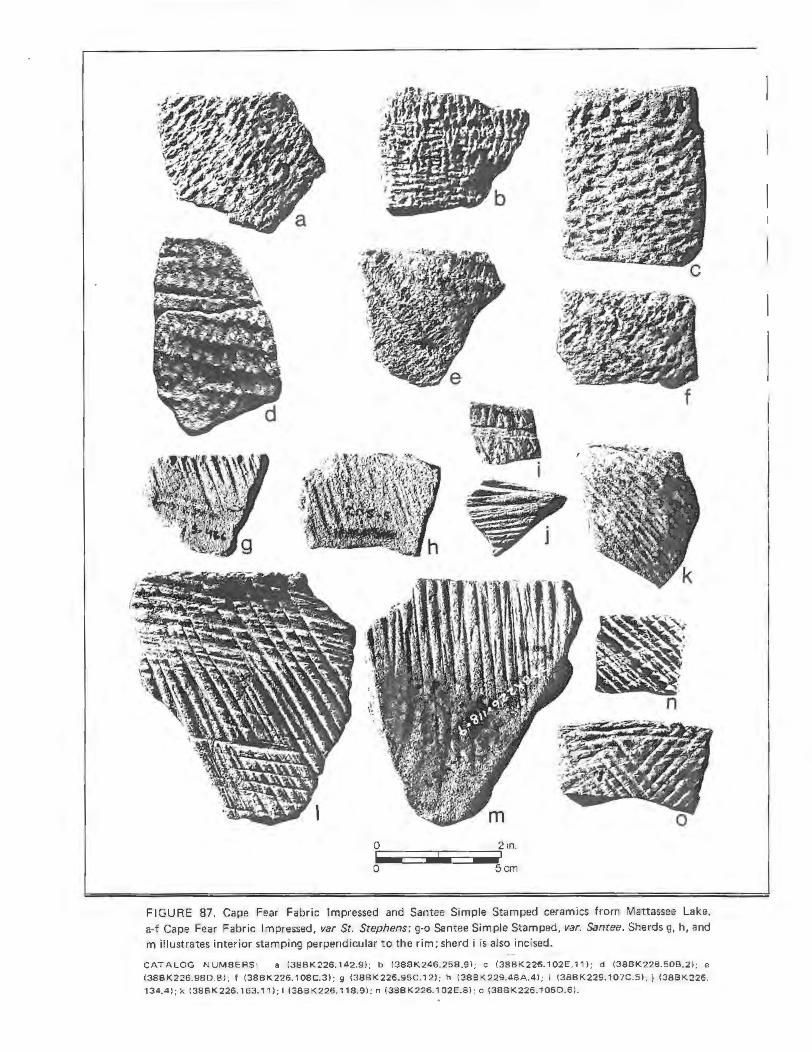
.. . s
I a
~o•-=::=illlilliC::i•~2 in. o Scm
11 •.. ~-
.:
~
n
FIGURE 87. Cape Fear Fabric Impressed and Santee Simple Stamped ceramics from Mattassee Lake. a·f Cape Fear Fabric Impressed, var St. Stephens; g-o Santee Simple Stamped, var. Santee. Sherds g, h, and m illustrates interior stamping perpendicular to the rim; sherd i is also incised.
CATALOG NUMBERS: a (38BK226. 142.9); b (38BK246.25B.9); c (38BK226.102E.11 ); d (38BK226.508.2); e {38BK226.98D.8); f (38BK226.108C.3); g (38BK226.95C.12); h (3BBK229.48A.4l ; I (38B K 229.1 07C.5) ; j (38BK226.
134.4) ; k (38BK226.163.11 ) ; I (3BBK226. 118.9) ; n (38BK226.1 02E.8); o (38BK226.1 060.6).

with flattened or thickened, undecorated or simple stamped rims. In partial support of this inference, it should be noted that the first (and highest) juncture in the monothetic subdivision cluster analysis performed over a sample of 86 of the fabric impressed rimsherds from the terrace was between fabric impressed and other (e.g., stamped, unmodified) lip treatment (Chapter 6; Figure 54). Eventually, creation of separate, early and later varieties of fabric impressed ceramics may be warranted.
The Mattassee Lake Cape Fear Fabric Impressed assemblage is quite similiar to South's (1960) type sample, particularly in having a moderate incidence of fabric impressed lips. The two assemblage descriptions are so similar, in fact, that retention of separate ~arieties (var. Cape Fear, var. St. Stephens) may not prove warranted; such a decision must await detailed comparison of assemblages from the two areas. Both South's (1960) sample and the Mattassee Lake Cape Fear assemblage differ from Loftfield's (1976:153-1 54) New River Fabric Impressed type in having a much higher inc idence of lip treatment, and separate variety status here may be appropriate (e.g., Cape Fear Fabric Impressed, var. New River). The Mattassee Lake material also differs somewhat from Trinkley's (1981b:14-15) McClellanville Fabric Impressed type (subsumed here under Cape Fear Fabric Impressed, var. St. Stephens) in having greater variability in both rim and lip form, and in the orientation of the stamp with the rim; Trinkley's sample size is small, however, precluding meaningful comparison.
Distribution. Cape Fear Fabric Impressed ceramics occur throughout the coastal plain and fall line areas of South Carolina and southeastern North Carolina, and may extend throughout the North Carolina coastal plain if Phelp's (1981) Deep Creek and Mount Pleasant types can be subsumed as varieties. The three proposed varieties have somewhat overlapping distributions: var. New River is found from the New River to the Pamlico in central coastal North Carolina; var. Cape Fear occurs in northeastern coastal South Carolina and southeastern coastal North Carolina; and ~· St. Stephens occurs in central coastal
South Carolina. The type becomes increasingly uncommon proceeding from northeast to southwest in the coastal plain, and is virtually nonexistant along the Savannah River (South 1960, 1976; Anderson 1975a, 1975b; Loftfield 1976; Trinkley 1980a, 1981a, 1981b; Phelps 1981).
Chronological Position. (var. St. Stephens) Middle/Late Woodland periods, Deptford and McClellanville Phases (A.D. 200-A.D. 700). In the 38BK226 excavation block the ware is stratigraphically intermediate between most of the Deptford types and Santee Simple Stamped (Table 52). Six radiocarbon dates from four features containing the ware were obtained at Mattassee Lake, all fro m the 388K226 block unit (see Chapter 11). The dates ranged from A.D. 520 to A.D. 710, with an average of A.D. 638. The dates are in rough agreement with South's (1976:1, 29) general placement of the ware, and fall within the A.D. 500-800 estimate for the McClellanville series (Trinkley 1981c: 18).
Documentation. (1) var. St. Stephens; Trinkley (1981b, 1981c, 1981d); Anderson (197 Sa, 1975b); Anderson, Lee, and Parler (1979), Anderson and Logan (198 1). (2) var. Cape Fear; South (1960, 1976). (3) var. New River; Loftfield (1976).
299
YADKIN FABRIC MARKED, var. Marion
Background. The type Yadkin Fabric marked was formally defined by Joffre L. Coe (1964:31-32), based on a sample of 269 sherds from the Doerschuk site on the lower Yadkin River in Montgomery County, North Carolina. The ware is characterized by large, angular fragments of quartz (averaging about 3.0mm in diameter) in the paste and finely woven, wicker fabric impressions (i.e . with a rigid warp element) over the exterior surface of most specimens. A minority of the sherds in the type sample (N=46; 17.1 percent) also had clay/grog inclusions in the paste (Coe 1964:31), suggesting some kind of ties with the makers of the Hanover/Wilmington wares to the south and east. The ware also appears related to the Onslow (Loftfield 1976:166-168) and Mount Pleasant (Phelps 198l :vi} series in the

central and northern North Carolina coastal plain, respectively; the former is tempered with crushed quartz and the latter with sand and small quartz pebbles. All three wares appear to occupy a Middle Woodland time level, succeeding earlier Badin, New River/ Carteret, and Deep Creek types. Yadkinlike ceramics (i.e. plain, cord-marked, fabric impressed, and linear check stamped wares characterized by extensive crushed quartz tempering) have been reported from a number of locations in South Carolina, mostly from fall line and piedmont sites in the eastern half of the state (e.g., Ferguson 1976; Cable and Cantley 1979: Trinkley 1980a:458, n.d.). The series is so infrequently reported from the South Carolina coastal plain, however, that it has not been referenced in previous typologies (e.g., Waddell 1970; South 1973b, 1976). Use of var. Marion terminology is offered to separ ate the Mattassee Lake assemblage from the type material (Yadkin Fabric Marked, var. Yadkin), and to permit the development of additional varieties (e.g., var. Onslow), if warranted.
Specimens of Yadkin Fabric Impressed, var. Marion, from Mattassee Lake were inspected by Dr. David S. Phelps (per sonnel communication 1982), who pronounced them within the range of variation for the northern coastal North Carolina Mt. Pleasant type. The Mattassee Lake Yadkinlike material was distinctive, however, both in appearance and distribution, from the Cape Fear Fabric Impressed, var. St. Stephens material Phelps also included in the Mt. Pleasant type range, and formal separation of the two wares was believed warranted. Use of Yadkin, as opposed to Mt. Pleasant terminology for the primary type reflects the relative proximity of the Doerschuk type site, and the close temporal equivalence of the two collections.
Sorting Criteria. Fabric impressions, characterized by a rigid warp element, applied over the exterior surface while the paste was plastic; occasionally smoothed somewhat after stamping. Paste character ized by large amounts of rounded and subrounded white and clear quartz gravel (L0-6.0mm; average about 3.0mm). Rims typically excurvate with flattened, decorated (i.e. simple stamped or fabric impressed)
300
lips. May be confused with Cape Fear Fabric Impressed, ~· St. Stephens on small sherds.
The Sample. A total of 74 Yadkin Fabric Marked, var. Marion sherds were recovered in the 1979 excavation units at Mattassee Lake, almost all from site 38BK246 (Table 51; Figure 84:q-t). The entire assemblage was characterized by rigid warp elements, with cross-stamping infrequent. The stamping is typically applied at high angles to the rim (Table 61; stamp orientation determined by the alignment of the warp element with the rim). The assemblage is dominated by reddishbrown exteriors, although interiors are more variable and tend to be lighter colored (Table 55). The paste is characterized by large amounts of rounded and subrounded quartz gravel; these inclusions are naturally weathered and have not been crushed, a primary difference between the Mattassee Lake assemblage and the Doerschuk type site material. The interiors are smooth and somewhat roughened, primarily because the extensive gravel in the paste results in a lumpy surface. Rims are typically excur vate, with flat or thickened, lips that are commonly decorated (Tables 59, 60; Figure 88). Lip treatment includes both simple stamping and fabric impressions. One large, thick (16.0mm) conoidal base fragment was found, and the assemblage appears to derive from large jars.
The Mattassee Lake Yadkin Fabric Marked material differs somewhat from Coe's (1969:31-32) type sample, primarily in paste (rounded versus crushed includ~ons), rim form (excurvate versus straight), and lip shape and treatment (flattened and decor ated opposed to rounded and plain). Separ ate variety designations would, therefore, appear appropriate . The paste differs in the same respect (rounded versus crushed inclusions) from Loftfield's (1976:166-168) Onslow series, although no fabric impressed finish was reported from that series. Phelp's (1981) Mount Pleasant series remains to be described in detail, although it appears quite similar, with rounded gravel inclusions and a fabric impressed exterior finish.
Distribution. Poorly documented. An occurrence in the coastal plains of both

North and South Carolina is indicated although the ware appears to be comparatively uncommon (or unrecognized) in coastal South Carolina (Ferguson 1976; Cable and Cantley 1979; Trinkley 1980a, n.d. ; Loftfield 1976; Phelps 1981).
Chronological Position. (~. Marion) Poorly documented. Middle/Late Woodland periods, Deptford and McClellanville Phases (A.D. 200-A.D. 700). At Mattassee Lake the ware was recovered in quantity only in the 38BK246 excavation block, where the deposits were mixed. Inspection of stratification in individual test pits suggests an occurrence coeval or slightly earlier than that for Cape Fear Fabric Impressed, var. St. Ste phens, although this will need additional confirmation.
Documentation. Coe (1952, 1964; Yadkin Fabric Marked type); Ferguson (1976; Yadkin-like ceramics); Cable and Cantley (1979; Yadkin- like ceramics); Trinkley (1980a; Yadkin ceramics); Loftfield (1976; Onslow series ceramics); Phelps (1981; Mount Pleasant series ceramics).
YADKIN PLAIN, var. unspecified
Background. Not previously defined. The Yadkin series as originally defined by Coe (1964:30-32) included three types, Yadkin Cord-Marked, Yadkin FabricMarked, and Yadkin Linear Check Stamped. Plain wares were not reported, and the only other finish noted within the series was dentate stamping, observed on a single sherd (Coe 1964:30). A number of cordmarked, fabric impressed, and linear check stamped sherds were recovered at Mattassee Lake that strongly resembled Coe's Yadkin types. These wares, characterized by large, angular and/or rounded fragments of quartz in the paste, were found with a fourth, plain finished ware that was otherwise identical to the other three. Description as a type within the Yadkin series was, therefore, considered appropriate. Poss ible related wares include Onslow Plain (Loftfield 1976: 168) from central coastal North Carolina, tempered with crushed quartz, and the Mount Pleasant series (Phelps 1981:vi) from northern coastal North Carolina, tempered with sand and gravel. All of these wares
301
occur on a Middle Woodland time level, in rough agreement with their placement at Mattassee Lake. Variety designation has been deferred until additional information about the occurrence of the ware can be collected.
Sorting Criteria. Plain surface finish. Paste characterized by large amounts of rounded and subrounded white and clear quartz gravel (l.0-6.0mm, average about 3.0mm). May be confused with Woodland Plain on small sherds.
The Sample. A total of 60 sherds of Yadkin Plain, var. unspecified were recovered at Mattassee Lake, most (as with the Yadkin Fabric Impressed type) from site 388K246 (Table 51; Figure 84:m, n). The interior: and exterior surfaces of most sherds are fairly well smoothed, more so than observed oyer the Yadkin Fabric Impressed assemblage, although most sherds are slightly sandy to the touch. The paste is characterized by large amounts of rounded and subrounded quartz gravel; these inclusions are naturally weathered, and not intentionally crushed. Also like the Yadkin Fabric Impressed, var. Marion assemblage, the ware is predominantly reddish- brown in color (Table 55), although some variation is evident. No rimsherds were recovered, making estimates of vessel size and shape difficult. The ware differs from both the Yadkin and Onslow series type materials (Coe 1964, Loftfield 1976) in having rounded as opposed to crushed quartz inclusions, although in this respect it is similar to Phelps (1981) Mount Pleasant series. Plain wares have not been described for either the Yadkin or Mount Pleasant series and (like the material described have as Yadkin Fabric-Marked, var. Marion), reclassification may eventually prove appropriate.
Distribution. Poorly documented. An occurrence in the coastal plains of both North and South Carolina is indicated, although the ware appears to be comparatively uncommon (or unrecognized) in coastal South Carolina (Cable and Cantley 1979; Trinkley 1980a; Loftfield 1976; Phelps 1981).
Chronological Position. Poorly docu-mented. Middle/Late Woodland periods,

Deptford and McClellanville Phases (A.D. 200-700). At Mattassee Lake the ware was recovered in quantity only in the 38BK246 excavation block, where the deposits were mixed. Inspection of stratification in individual test pits suggests an occurrence coeval or slightly earlier than that for Cape Fear Fabric Impressed, ~· St. Stephens, although this will need additional confirmation.
Documentation. Coe (1952, Yadkin series), Cable and Cantley Yadkin-like ceramics); Loftfield Onslow series ceramics); Phelps Mount Pleasant series ceramics).
SANTEE SIMPLE STAMPED, var. Santee
1964; (1979; (1976; (1981;
Background. Not previously defined. Until quite recently, sand tempered simple stamped wares in the southeastern Atlantic coastal plain were assumed to date fairly early, from the late Archaic to the Middle Woodland periods (excluding stamped Mississippian period wares). In the mouth-of-theSavannah sequence, for example, Refuge Simple Stamped, the only sand tempered simple stamped type in use, has a range of from roughly 1100 B.C. to A.D. 500 (DePratter 1979; see also Background discussions for Thorn's Creek Simple Stamped and Deptford Simple Stamped herein). In coastal North Carolina sand tempered simple stamped wares have also been reported from an Early Woodland context, in the New River (Loftfield 1976:149-150; described as New River Thong-Marked) and Deep Creek series (Phelps 1981:vi). In coastal South Carolina simple stamped ceramics have been widely reported, usually under the Thorn's Creek, Refuge, or Deptford type names (e.g., Caldwell and Waring 1939a, Caldwell 1952, Waring 1968b, 1968c; Stoltman 1974; Trinkley 1976a, 1980a, 1981a; Anderson, Lee, and Parler 1979; to cite a few examples), and somewhat less com manly using a general sand tempered category (e.g., BroQks and Scurry 1978; Anderson 1975b; 1979a); where a general category was used the finish was (almost invariably) assumed to be early in subsequent interpretations.
302
Virtually the only attempt to suggest a continuation of simple stamping into the late prehistoric in the coastal plain area of South Carolina was by George Stuart (1975), who defined what he called the Camden Ceramic Complex from the Middle Wateree Valley locality. This series, composed of sand tempered Camden Simple Stamped, Incised, and Check Stamped types, was based on a sample of "almost 80 sherds" (Stuart 1975: 85) recovered from the Guernsey or "Cut-Off Island" site, located on a small island in the Wateree River east of Lugoff, South Carolina. A small sample of sherds (N=42) from the site had been previously described by Griffin (1945; 971-475), who suggested that the simple stamped, cord-marked, and check stamped ceramics elements were post-Early Woodland in age, but prior to the introduction of complicated stamping (i.e . preMississippian). The Camden Series is generally similar to the Santee assemblage described here although precise chronological placement of the material is difficult. Unfortunately, all of the sherds in both Griffin and Stuart's samples were from surface collections, and the material from the Guernsey site itself was found washed out of the river bank on a sand bar. This lack of secure context and control for the chronological placement of the Camden Series has precluded its adoption and use.
The unambiguous stratigraphic placement of a sand tempered simple stamped ware in a late Woodland context (i. e. postDeptford/McClellanville phases) at Mattassee Lake, supported by a battery of 12 internally consistent radiocarbon dates (six each for the Cape Fear and Santee series), has forced a major reevaluation of the temporal occurrence of simple stamping in the South Carolina area.
Concurrent with the analysis of the Mattassee Lake assemblage, Michael Trinkley (198lb, 1981c, 198ld) iden~ified and described the McClellanville series, based initially on test excavations at the Walnut Grove shell midden (39CH260) in northern Charleston County (Trinkley 198lb). Four types were defined, McClellanville Simple Stamped, McClellanville Plain, McClellanville Fabric Impressed, and McClellanville Cord-Marked. Since that

time, Trinkley (1981c) has conducted excavations at the Awendow shell midden (38CH300), and has examined collections from elsewhere in northern Charleston County, gathering additional information on the occurrence of this series. Two formal descriptions of the McClellanville series types have been offered (Trinkley 1981b, 1981d), and an age for the series from roughly A.D. 500 to 800 has been posited (Trinkley 1981c:l8). The association of the cord-marked and fabric impressed types with the plain and simple stamped wares has recently been questioned by the author (Trinkley 1981c:18, 1981d:9; see also background discussion for Cape Fear Fabric Impressed and the McClellanville series, as currently defined, would appear to consist of the plain and simple stamped types. Close similarity with the late simple stamped ware found at Mattessee Lake was indicated (Trinkley 198lb: ll-12; 1981c:18; 1981d:10), although some differences were noted:
Also closely related is Anderson's Santee Series (David Anderson, personal communication) found from the Santee-Cooper Rediversion Project in Berkeley County. The Santee Series, however, has a variety of later features, such as excurvate rims, fine paste variation, and frequent interior rim stamping, which are not duplicated in the McClellanville Series (Trinkley 1981d:9).
Similarities with Stuart's (1975) Camden series of simple stamped pottery ware also noted; like the Mattassee Lake material the Camden material was also assumed to be later than the McClellanville type (Trinkley 1981c:18).
The extensive late prehistoric simple stamped assemblage recovered at Mattassee Lake and described here was classified Santee Simple Stamped, var. Santee. Close similarity with Stuart's (1975) Camden Simple Stamped and Trinkley's (1981b) McClellanville Simple Stamped types is acknowledged; these wares are subsumed as possible varieties of Santee Simple Stamped, vars. Camden and McClellanville. Use of Santee as opposed to McClellanville or Camden terminology follows from the
nature of the type samples themselves. Unlike either of the other two simple stamped type collections, the Santee Simple Stamped assemblage from Mattassee Lake is extensive (N=l591 sherds), and its relative and absolute temporal position well documented. The ware was recovered in over one hundred 0.5 and 2.0 meter excavation units along the terrace with temporal controls provided by both the assemblage stratification and a series of 12 internally consistant radiocarbon dates. A Late Woodland (post-Cape Fear, pre-Pee Dee) age for the ware is indicated. Stratigraphically, for example, the ware is higher, or more popular later, than the Cape Fear Fabric Impressed var. St. Stephens type in the 38BK226 block unit (Table 52). In the 38BK229 excavation block, where virtually no fabric impressed pottery was recovered, Santee Simple Stamped is clearly later than the Thorn's Creek and Deptford types found in the block; the virtual absence of fabric impressed sherds suggests that the finish is not temporally coeval with the Santee Simple Stamped type, at least over its entire range. Twelve radiocarbon dates from along the Mattessee Lake terrace support these stratigraphic inferences (see Chapter 11). Six dates, from four features with Cape Fear pottery present in the fill (all from the 38BK226 block), solidly place this series from A.D. 520 to 710; no Santee Simple Stamped sherds were foundTn any of these features. Another six samples, from six features with Santee Simple Stamped pottery present in the fill (four from 38BK226 and two from 38BK246), produced dates from A.D. 810 to A.D. 1340. Replacement of a cord and fabric impressed assemblage with an assemblage dominated by simple stamping is indicated; the available evidence suggests that this transition occurred about A.D. 700-800.
303
The temporal extent of the Santee Simple Stamped type would appear to be about 500 to 700 years, from roughly A.D. 750 to 1350. This is supported, at Mattassee Lake, by the assemblage stratification in the various units and by the six radiocarbon dates for the ware itself. The data indicate that contemporaneity with at least some of the terrace is at least possible, particularly with the Savannah/Jeremy and (early) Pee Dee

materials, which are believed to appear after about A. D. 1200 locally (c.f. Trinkley 1980a; 1981 b, 1981c). In both the 38BK226 and 38BK229 excavation block, for example, the Santee Simple Stamped type is stratigraphically (approximately) coeval with both the Pee Dee and Savannah types although the distribution of all of these later, complicated stamped types is somewhat mixed (Tables 52-53). A similar late date, around A.D. 1000, and possibly from circa A.D. 800 to 1400, is suggested by Stuart (1975:87, 138, 151-152) for his Camden Ceramic Complex; unfortunately this series remains to be found in secure context. Association of Santee Simple Stamped-like ware with Mississippian pottery types would also appear to be documented at the Walnut Grove and Awendaw shell middens (Trinkley 1981b, 1981c). At Walnut Grove, where fair assemblage stratification is evident in the levels of the six five foot squares excavated ('Trinkley 1981 b: Table 2), over 90 percent (N=142; 92.8 percent) of Trinkley's McClellanville Simple Stamped type is found in Level 1, which also yielded all of the Savannah and Pee Dee ceramics identified from the site. At the Awendaw midden, where four f ive foot squares were excavated, over 80 percent (N=48; 81.4 percent) of the McClellanville Simple Stamped sherds recovered came from Level 1, which also produced most of the (Mississippian period) complicated stamped wares; Trinkley (1981c:21) has cautioned, however, that the deposits at this site are "thoroughly mixed," with the two associated radiocarbon dates contradictory and hence unacceptable. 'The data from the Awendaw and Walnut Grove shell middens, in spite of some ambiguities, does tend to support a late occurrence for simple stamping, extending into the Mississippian period. It should be noted, however, that Tr inkley does not accept such a late extent, arguing instead that:
The McClellanville Series is known to postdate Deptford and predate Pee Dee, based on stratigraphic reconstructions from the Walnut Grove and Awendaw middens (Trinkley 1981c:l8).
A range of from A.D. 500 to A. D. 800 is instead suggested; these conclusions are not,
304
however, supported by the excavation data from these sites reported above.
What the data collected by Stuart, Trinkley, and at Mattassee Lake clearly indicate is that a previously unrecognized Late Woodland ceramic series, dominated by simple stamped pottery, is present in the central coastal plain of South Carolina along the Santee-Wateree drainage. At the present, simple stamping is the only finish that can be unambiguously attributed to this series, although research by Trinkley and Stuart suggests that plain, incised, cord, and fabric marked wares may also be associated; the data from Mattassee Lake supports an association of plainwares, and points to the presence of cord and fabric marking during the transition period when the use of these finishes was augmented by the addition of t he distinctive form of simple stamping characteristic of the Santee Simple Stamped type.
Sorting Criteria. Tapered, v-shaped longitudinal grooves over the exterior vessel surface. Impressions (typically) narrow (about l.0-2.0mm) and shallow (l.0- 2.0mm); v-shaped profile characteristic. Cross stamping at high angles to the rim (oblique to perpendicular) predominates, parallel stamping less common. Rims (typically) straight to excurvate, with both rounded and flattened lips; lip treatment (typically simple stamping) common. Interior simple stamping at or nearly perpendicular with the rim on a small minority of the sherds. Interiors well to poorly smoothed, fine scraping marks evident on a fair minority of the sherds. Paste characterized by fine sand and some (typically few) clear quartz inclusions from 0.5 to 2.0mm in size. May be confused with Thorn's Creek Simple Stamped, ~· unspecified, and Deptford Simple Stamped, var. Cal Smoak.
The Sample. A total of 1591 sherds of Santee Simple Stamped, var. Santee were recovered in the 1979 excavation units at Mattassee Lake (Table 51; F igure 87: g-o, Figure 88). 'The ware is characterized by the somewhat haphazard application of parallel, v-shaped impressions, suggesting use of a thong wrapped or possibly incised or gouged paddle. The regular, careful application of parallel, U-shaped impressions

-
.....
0
0 Scm
FIGURE 88. Santee Simple Stamped sherds fro m Mattassee Lake. Sherds j, k, and mare bases .
CATALOG NUMBERS: a (38BK246.7A.1 ); b (38BK226.107A. 15) ; c (3881<226.1078.19); d (3881<246.298. 12); e (388K229.90A.2); f (3881<226.1). g (3881<226.910.5); h (38BK226.107A.12); i (3881<226.1020.15); j (3881<229.
80A.3); k (3881<226. 1 17.1); I (3881<226.1 ); m (388K229.96A.11 ).
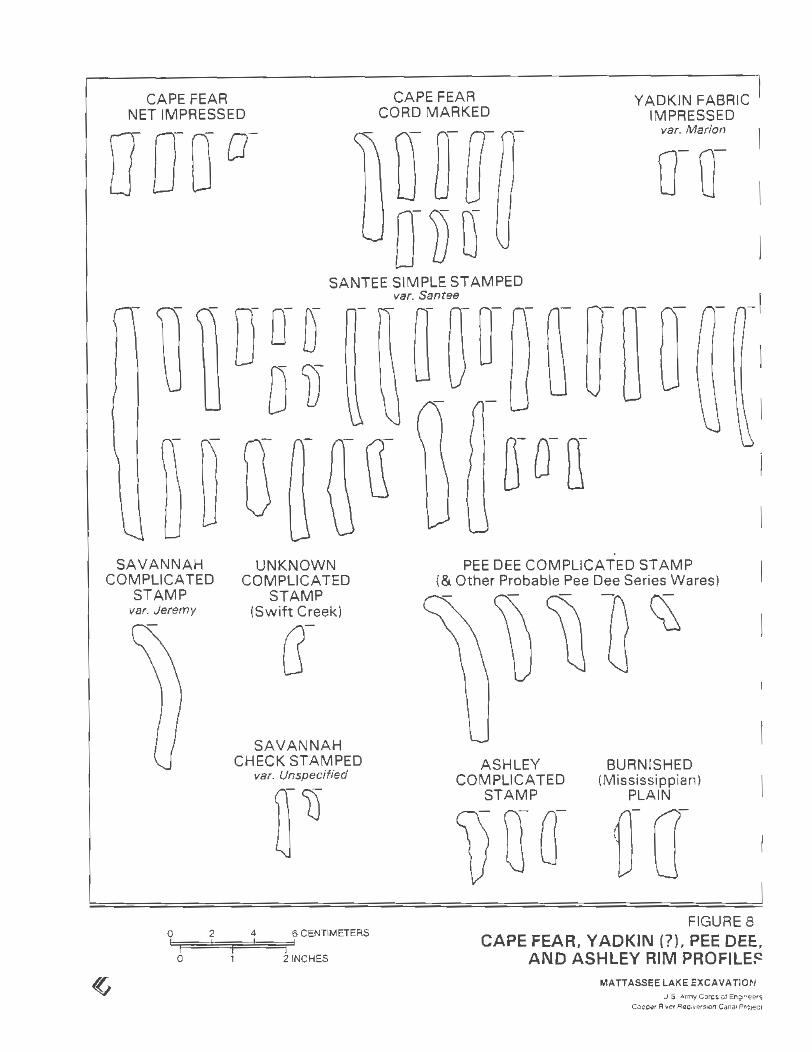
CAPE FEAR NET IMPRESSED
CAPE FEAR CORD MARKED
YADKIN FABRIC IMPRESSED
var. Marion
SANTEE SIMPLE STAMPED
SAVANNAH COMPLICATED
STAMP var. Jeremy
0 2
0
UNKNOWN COMPLICATED
STAMP (Swift Creek)
G-
SAVANNAH CHECK STAMPED
var. Unspecified
4 6 CENTIMETERS
21NCHES
var. Santee -I
I
PEE DEE COMPLICATED STAMP (&Other Probable Pee Dee Series Wares)
ASHLEY COMPLICATED
STAMP
BURNISHED (Mississippian)
PLAIN
FIGURE 8 CAPE FEAR, Y ADKIN (?), PEE DEE,
AND ASHLEY RIM PROFILE~ MATTASSEE LAKE EXCAVATION
U S Army CO<Cs ol En01neers Coooer R1vEtr Reot~~&ts/On Cana• ProJecl

characteristic of the Deptford Simple Stamped type are absent. Cross stamping dominates the Santee Simple Stamped assemblage (N=1190, 74.8 percent; Table 51); parallel stamping, common on both the Thorn's Creek and Deptford Simple Stamped types, is comparatively infrequent. Stamp width is typically narrow, from 1.0 to 2.0mm; wider impressions (roughly 20-4.0mm) were evident on only a small proportion of the assemblage (N=144, 9. 1 percent; Table 51). There is a suggestion that wider impressions occur somewhat earlier than narrow impressions in both the 38BK226 and 388K229 block (Tables 52, 53); no trends were noted in the occurrence of parallel as opposed to cross-stamping, suggesting a fairly consistant manufacturing procedure over time. The ware is dominated by very pale brown, brown, and reddish yellow colors (Table 55), while the paste (Table 56) is characterized by a moderate amount of fine sand, with comparatively few larger (l.0-2.0mm) quartz inclusions (alhough these are present in most sherds). Interior surface finish is quite variable, with a high incidence of unusual (i.e. other than plain) treatment (N=90, 47.6 percent; Table 57). Fine scraping marks are evident on a fair minority of the sherds (N=37; 19.6 percent), and slightly over a tenth of the assemblage (N=20; 10.6 percent) exhibited interior stamping or incising, typically perpendicular or at high angles to the rim (e.g., Figure 87:g, h). Santee Simple Stamped, var. Santee rims at Mattassee Lake were predominantly straight or excurvate, with other forms characterized by flattened and rounded (frequently) stamped lips (Tables 59, 60; Figure 89). Vessel lips are typically stamped; over three quarters (N=66; 77.6 percent) of the Santee Simple Stamped, var. Santee r ims exhibited simple stamping, with one sherd additionally punctated along the lip (Table 60). A few unusual, thickened lips were present in the assemblage (e.g. Figure 89), but most were the same thickness as the rim profile. Most of the sherds appear to come from large (c. 40 em in diameter at the rim), slightly tapering jars with rounded or faintly conoidal bases (cf Figure 88: j, k,). A few sherds with incurvate rims appear to come from small, hemispherical bowls between 20 and 30 em in diameter.
307
Some change in rim and lip form over time (i.e. level by level) is evident within the Santee Simple Stamped assemblage at Mattassee Lake, although these trends will require additional confirmation. In the 38BK226 excavation block, for example, incurvate rims are the lowest in the levels (N=7, x depth = 1.4 em), followed by straight (N=22, x depth = 15.8 em) and xcurvate (N=24, x depth = 15.2 em) forms (see also Table 64). In the same block rims with rounded lips (N=25, x depth = 17.4 em) tend to be slightly lower (earlier?) then rims with flattened lips (N=26, x depth = 15.4 em), this pattern is duplicated in the 38BK229 block where rounded lips (N=3, x depth = 16.7 em) are lower than flattened lips (N=l2, x depth = 15.4 em). In the 38BK229 block changes in rim form are somewhat different than at 38BK226, straight rims are the deepest (N=4, x depth = 20.0 em), followed by incurvate (N=6, x depth = 16.7 em) and finally excurvate (N=6, x depth = 9.2 em) forms. In both blocks excurvate forms are the most recent; the lower average depth of the incurvate forms may be due to some misidentification or confusion with Thorn's Creek Simple Stamped sherds, although this is unlikely over all cases. Lip treatment also varies over time, although the results from the t wo block un its are somewhat ambiguous . At 388K226, for example, decorated lips (N=42, x depth = 15.6 em) are lower than plain lips (N=ll, x depth = 13.6 em), while at 38BK229 the opposite is the case, with plain lips (N=4, x depth = 21.3 em) lower than decorated specimens (N=l2, x depth = 15.0 em).
The Santee Simple Stamped assemblage from Mattassee Lake differs somewhat from Stuart's (1975:174) Camden Simple Stamped type in having a higher incidence of excurvate rims, but otherwise the wares are quite similar. A number of the Camden Simple Stamped sherds also exhibited exterior incising (noted on only one Santee Simple Stamped sherd at Mattassee Lake); this treatment appears to be the primary difference beteen the two series, and may reflect greater manufacturing or decorative sophistication in the upper Wateree Valley locality, where major ceremonial centers were beginning to emerge. The Santee ware differs somewhat

from Trinkley's coastal McClellanille type in having a higher incidence of flattened lips, and in having lip treatment (i.e. stamping), which was not noted in Trinkley's (198lb, 198lc) samples. The high incidence of rounded, undecorated lips in the coastal sample suggests that the material is earlier than that at Matt assee Lake (based on the stratigraphic trends noted above). The ware is clearly much later in time than Loftfield's (1976:149-150), New River Thong-Marked type, although otherwise these wares are similar in description. Relationships with prehistoric simple stamped types farther removed in space (e.g., Connestee Simple Stamped; Keel 1976) remain to be determined, although the occurrence of simple stamping at a Late Woodland time level may be more common in the Southeast Atlantic slope than is currently assumed.
Distribution. Poorly documented. Assuming identity with the Camden and McClellanville types, Santee Simple Stamped occurs in the central coastal plain and fall line areas of South Carolina, specifically along the coast in northern Charleston County, and in the interior along the Santee-Wateree drainage (e.g., Trinkley 1981b, 1981c, 1981d; Stuart 1975).
Chronological Position. Late Woodland, Early/Middle Mississippian periods; Santee and Jeremy Phases (A.D. 700-A.D. 1400). At Mattassee Lake Santee Simple Stamped, !!!!:· Santee is stratigraphically later than the Deptford and Cape Fear types in the 38BK226 and 38BK229 excavation blocks (see Background discussion). A total of six radiocarbon determinations, four from 38BK226 and two from 38BK246, specifically date the ware at Mattassee Lake. The six dates range from A.D. 810 to A.D. 1340, with an average age of A.D. 1087 (uncorrected; see Chapter 11). The ware clearly succeeds the Cape Fear series at Mattassee Lake, which is dated by another six determinations to between A.D. 520 to A.D. 710 (x = A.D. 638). Possible contemporaneity with Mississippian period complicated stamped wares is indicated at the Walnut Grove and Awendaw shell mounds (Trinkley 1981b, 1981c) and at Mattassee Lake (see Background discussion).
308
Documentation. Griffin (1945); Stuart (1975); Trinkley (1981b, 1981c, 1981d).
SAVANNAH COMPLICATED STAMPED, Y.!!:· Jeremy
Background. The type Savannah Complicated Stamped was originally defined by Caldwell and Waring (1939a), based on materials recovered from a series of sites in and around the city of Savannah in Chatham County, Georgia. From excavations at the Deptford site, the Irene Mound, and other sites in the Savannah area, the ware was recognized as intermediate between the Wilmington and Irene series (Caldwell and Waring 1939b). Additional descriptive information on the ware, and on the Early/Middle Mississippian cultural complex of the same name, can be found in the (rene Mound report (Caldwell and McCann 1941 :42-48), where the complex was first formally defined. The chronological placement of the Savannah complex on the northern Georgia coast has been discussed in a number of papers (e.g., Caldwell 1952, 1971; Waring 196 8c; Williams 196 8; Stoltman 1974, DePratter 1979), and a range from A.D. 1150 to A.D. 1300 for the series, and from A.D. 1250 to A.D. 1300 for the Savannah Complicated Stamped type, has been advanced (DePratter 1979: 111). While possibly accurate for the mouth-of-theSavannah sequence, the 50 year range suggested for the complicated stamped type appears too limited, and a considerably broader range, from roughly A.D. 1200 to A.D. 1350-1400, is suggested here (c.f. Caldwell 1971). Savannah Complicated Stamped ceramics have been reported from a number of sites in coastal Georgia and South Carolina (e.g., Caldwell and Waring 1939a; Caldwell 1952, Williams 1968; Stoltman 197 4; Cook 1977), and the ware is also fairly common in northern Georgia (e.g. Wauchope 1966), where stratigraphic occurrence between the Etowah and Lamar series has been long documented (Wauchope 1948, 1966; Sears 1950).
Using material recovered from eight shell midden sites in northern Charleston County Trinkley (1980a, 198ld, 198le) has identified and described a complicated stamped ware that he has called Jeremy.
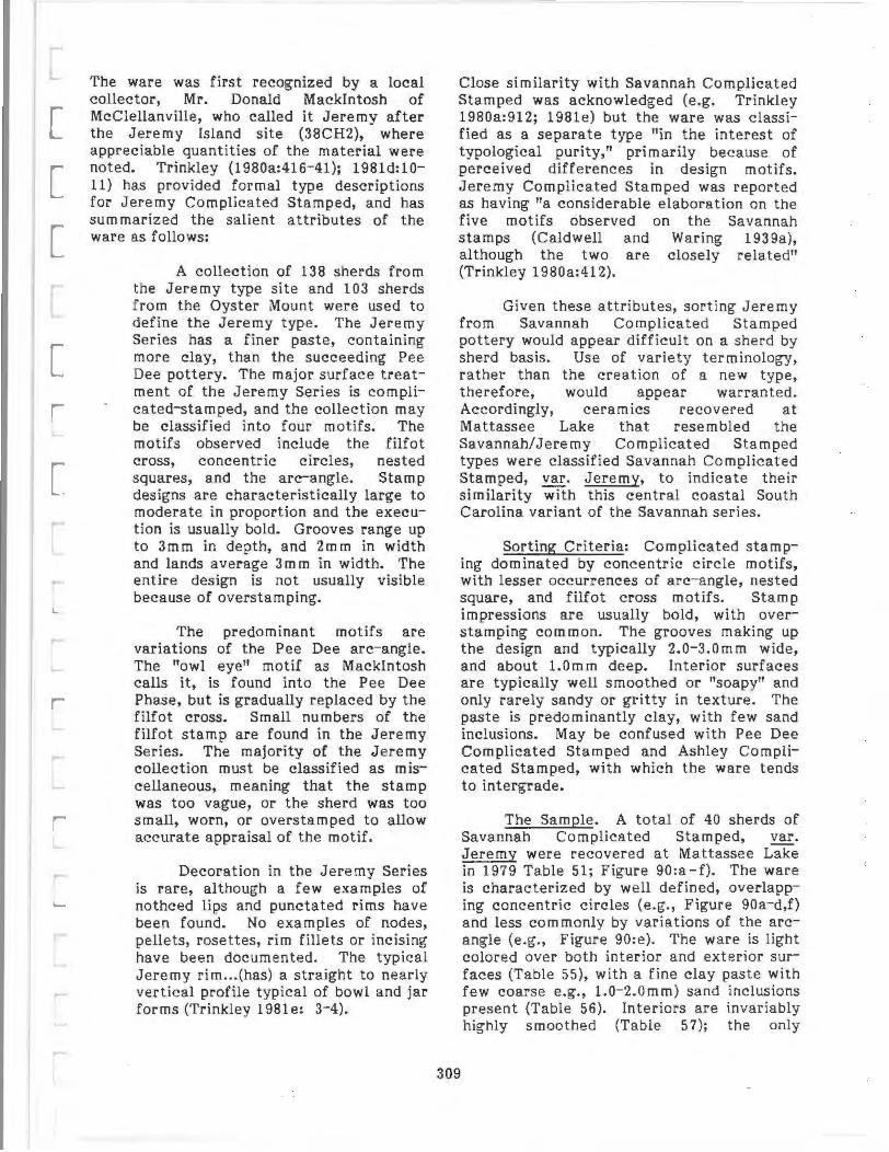
[
[
The ware was first recognized by a local collector, Mr. Donald Mackintosh of McClellanville, who called it Jeremy after the Jeremy Island site (38CH2), where appreciable quantities of the material were noted. Trinkley (1980a:416-41); 1981d:lOll) has provided formal type descriptions for Jeremy Complicated Stamped, and has summarized the salient attributes of the ware as follows:
A collection of 138 sherds from the Jeremy type site and 103 sherds from the Oyster Mount were used to define the Jeremy type. The Jeremy Series has a finer l?aste, containing more clay, than the succeeding Pee Dee pottery. The major surface treatment of the Jeremy Series is coml?licated-staml?ed, and the collection may be classified into four motifs. The motifs observed include the filfot cross, concentric circles, nested squares, and the arc-angle. Staml? designs are characteristically large to moderate in proportion and the execution is usually bold. Grooves range up to 3mm in depth, and 2mm in width and lands average 3m m in width. The entire design is not usually visible because of overstaml?ing.
The predominant motifs are variations of the Pee Dee arc-angle. The "owl eye" motif as Mackintosh calls it, is found into the Pee Dee Phase, but is gradually rel?laced by the filfot cross. Small numbers of the filfot stamp are found in the Jeremy Series. The majority of the Jeremy collection must be classified as miscellaneous, meaning that the stamp was too vague, or the sherd was too small, worn, or overstamped to allow accurate apl?raisal of the motif.
Decoration in the Jeremy Series is rare, although a few examples of nothced lips and punctated rims have been found. No examples of nodes, pellets, rosettes, rim fillets or incising have been documented. The typical Jeremy rim ... (has) a straight to nearly vertical profile typical of bowl and jar forms (Trinkley 1981e: 3-4).
Close similarity with Savannah Complicated Stamped was acknowledged (e .g. Trinkley 1980a:912; 1981e) but the ware was classified as a separate type "in the interest of typological purity," primarily because of perceived differences in design motifs. Jeremy Complicated Stamped was reported as having "a considerable elaboration on the five motifs observed on the Savannah stamps (Caldwell and Waring 1939a), although the two are closely related" (Trinkley 1980a:412).
Given these attributes, sorting Jeremy from Savannah Complicated Stamped pottery would appear difficult on a sherd by sherd basis. Use of variety terminology, rather than the creation of a new type, therefore, would appear warranted. Accordingly, ceramics recovered at Mattassee Lake that resembled the Savannah/Jeremy Complicated Stamped types were classified Savannah Complicated Stamped, var. Jeremy, to indicate their similarity with this central coastal South Carolina variant of the Savannah series.
Sorting Criteria: Complicated stamping dominated by concentric circle motifs, with lesser occurrences of arc-angle, nested square, and filfot cross motifs. Stamp impressions are usually bold, with overstamping common. The grooves making up the design and typically 2.0-3.0mm wide, and about l.Omm deep. Interior surfaces are typically well smoothed or "soapy" and only rarely sandy or gritty in texture. The paste is predominantly clay, with few sand inclusions. May be confused with Pee Dee Complicated Stamped and Ashley Complicated Stamped, with which the ware tends to intergrade.
309
The Sample. A total of 40 sherds of Savannah Complicated Stamped, ygr. Jeremy were recovered at Mattassee Lake in 1979 Table 51 ; Figure 90:a-f). The ware is characterized by well defined, overlapping concentric circles (e.g., Figure 90a-d,f) and less commonly by variations of the arcangle (e.g., Figure 90:e). The ware is light colored over both interior and exterior surfaces (Table 55), with a fine clay paste with few coarse e.g., l.0-2.0mm) sand inclusions present (Table 56). Interiors are invariably highly smoothed (Table 57); the only

d
-.
.
r •
_,r ·;
. q
o~iiiiC::::iiiii!ilil::=:;iiii?2 in. 0 5cm
FIGURE 90. Savannah/Jeremy (?) Complicated Stamped, Savannah/Jeremy (?) Check Stamped, Pee Dee Complicated Stamped, and Mississippian Burnished Plain ceramics from Mattassee Lake. a-f Savannah
Complicated Stamped, var. Jeremy; g-1 Savannah Check Stamped, var. Unspecified; .m. n Mississippian Burnished Plain; o-t Pee Dee Complicated Stamped. Sherd m has a row of rosettes parallel to t he rim,
sherd q is punctated, and r has an appliqued rim strip.
CATALOG NUMBERS: a (38BK229.1); b (38BK226.102C.13); c (38BK229.101 B. 13); d (38BK229.101A.13) ; e
(38BK229.46B.3) ; t (38BK226.1020.17); g (38BK226.163.5); h (38BK226.1 63.6); i l38BK246.25A.10); j (38BK229.
107A.1); k (38BK226.98B.5); I (38BK229.99B.8l ; m (38BK226.970.8) ; n (38BK229.65A.2); o (38BK226.108 E.7);
p (38BK226.960.5); q (38BK246.21 A.3); r (38BK229.99A.2) ; s (38BK229.107.2); t (38BK229.97 A. 7).
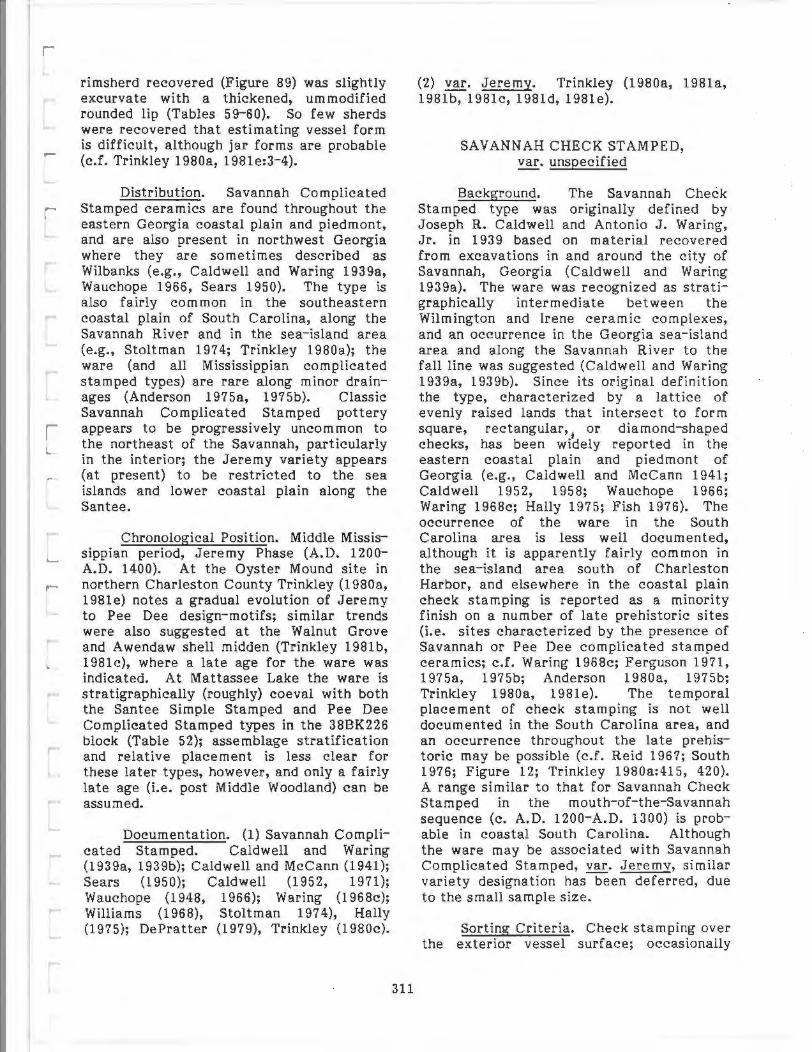
rimsherd recovered (Figure 89) was slightly excurvate with a thickened, ummodified rounded lip (Tables 59- 60). So few sherds were recovered that estimating vessel form is difficult, although jar forms are probable (c.f. Trinkley 1980a, 1981e:3- 4).
Distribution. Savannah Complicated Stamped ceramics are found throughout the eastern Georgia coastal plain and piedmont, and are also present in northwest Georgia where they are sometimes described as Wilbanks (e.g., Caldwell and Waring 1939a, Wauchope 1966, Sears 1950). The type is also fairly common in the southeastern coastal plain of South Carolina, along the Savannah River and in the sea-island area (e.g. , Stoltman 1974; Trinkley 1980a); the ware (and all Mississippian complicated stamped types) are rare along minor drainages (Anderson 1975a, 1975b). Classic Savannah Complicated Stamped pottery appears to be progressively uncommon to the northeast of the Savannah, particularly in the interior; the Jeremy variety appears (at present) to be restricted to the sea islands and lower coastal plain along the Santee.
Chronological Position. Middle Mississippian period, Jeremy Phase (A.D. 1200-A.D. 1400). At the Oyster Mound site in northern Charleston County Trinkley (1980a, 1981e) notes a gradual evolution of Jeremy to Pee Dee design-motifs; similar trends were also suggested at the Walnut Grove and Awendaw shell midden (Trinkley 1981b, 1981c), where a late age for the ware was indicated. At Mattassee Lake the ware is stratigraphically (roughly) coeval with both the Santee Simple Stamped and Pee Dee Complicated Stamped types in the 38BK226 block (Table 52); assemblage stratification and relative placement is less clear for these later types, however, and only a fairly late age (i.e. post Middle Woodland) can be assumed.
Documentation. (1) Savannah Complicated Stamped. Caldwell and Waring (1939a, 1939b); Caldwell and McCann (1941); Sears (1950); Caldwell (1952, 1971); Wauchope (1948, 1966); Waring (1968c); Williams (1968), Stoltman 1974), Hally (1975); DePratter (1979), Trinkley (1980c).
311
(2) var. Jeremy. Trinkley (1980a, 1981a, 1981b, 1981c, 1981d, 1981e).
SAVANNAH CHECK STAMPED, var. unspecified
Background. The Savannah Check Stamped type was originally defined by Joseph R. Caldwell and Anton io J. Waring, Jr. in 1939 based on material recovered from excavations in and around the city of Savannah, Georgia (Caldwell and Waring 1939a). The ware was recognized as s tratigraphically intermediate between the Wilmington and Irene ceramic complexes, and an occurrence in the Georgia sea- island area and along the Savannah River to the fall line was suggested (Caldwell and Waring 1939a, 1939b). Since its original definition the type, characterized by a lattice of evenly raised lands that intersect to form square, rectangular,
1 or diamond-shaped
checks, has been widely reported in the eastern coastal plain and piedmont of Georgia (e.g., Caldwell and McCann 1941; Caldwell 1952, 1958; Wauchope 1966; Waring 1968c; Hally 1975; Fish 1976). The occurrence of the ware in the South Carolina area is less well documented, although it is apparently fairly common in the sea-island area south of Charleston Harbor, and elsewhere in the coastal plain check stamping is reported as a minority finish on a number of late prehistoric sites (i.e. sites characterized by the presence of Savannah or Pee Dee complicated stamped ceramics; c.f. Waring 1968c; Ferguson 1971, 1975a, 1975b; Anderson 1980a, 1975b; Trinkley 1980a, 1981e). The temporal placement of check stamping is not well documented in the South Carolina area, and an occurrence throughout the late prehistoric may be possible (c.f. Reid 1967; South 1976; Figure 12; Trinkley 1980a:415, 420). A range similar to that for Savannah Check Stamped in the mouth-of- the-Savannah sequence (c. A.D. 1200-A.D. 1300) is probable in coastal South Carolina. Although the ware may be associated with Savannah Complicated Stamped, var. Jeremy, similar variety designation has been deferred, due to the small sample size.
Sorting Criteria. Check stamping over the exterior vessel surface; occasionally

smoothed somewhat after stamping. The checks are typically small (from 2.0 to 5.0mm) and faint, with overstamping common. Paste and interior surface finish are similar or identical to that noted for Savannah Complicated Stamped, var. Jeremy.
The Sample. A total of 12 sherds of Savannah Check Stamped were recovered in the 1979 excavation units at Mattassee Lake (Table 51; Figure 90:g-k). The ware was characterized by faint square-torectangular checks from 2.0 to 5.0mm on a side. Overstamping was common, and several of the sherds appear to have been lightly smoothed after stamping (e.g., Figure 90:g-h). The ware is characterized by a fair degree of variability in color, with interiors typically lighter than the exteriors (Table 55). Several of the sherds (N=4; 44.4 percent) exhibited gray to black exteriors, suggesting smudging or firing in a reducing atmosphere. The paste was identical to that in the Savannah Complicated Stamped, var. Jeremy assemblage, dominated by clay with few large sand inclusions. interiors were typically well smoothed, although two of the sherds exhibited scraping marks, one with incompletely compressed and smoothed coils. Rims were excurvate with rounded or flat lips; lip treatment included simple and check stamping (Tables 59, 60). Two pronounced shoulders (Figure 90:h, j) were among the 12 sherds of the type recovered; these sherds, and the rims, indicate a flaring jar with a short neck. Except for an apparent lower incidence of sand in the paste, the Mattassee Lake assemblage is identical to the type materials (Caldwell and Waring 1939a).
Distribution. Poorly documented in the South Carolina area. Common throughout eastern Georgia in the sea-islands, coastal plain, and piedmont (Caldwell and Waring 1939a; Caldwell 1952, 1958; Wauchope 1966). An occurrence in the seaisland area south of Charleston Harbor, and as a minority ware on sites with Mississippian period complicated stamped pottery is indicated (e.g., Caldwell 1952; Ferguson 1971; Stoltman 1974; Anderson 1975b; South 1976; Trinkley 1980a).
312
Chronological Position. Middle Mississippian period, Jeremy Phase (A.D. 1200-A.D. 1400). Temporal placement of the ware is drawn largely from its position in the mouth-of-the-Savannah sequence and along the Georgia coast (c.f. Caldwell 1971; DePratter 1979). At Mattassee Lake, the type is stratigraphically late, higher than all but the Ashley Complicated Stamped type in the 38BK226 block (Table 52), and above all of the types in the 38BK229 block (Table 53).
Documentation. Caldwell and Waring (1939a, 1939b); Caldwell and McCann (1941); Caldwell (1952, 1958, 1971}; Fairbanks (1950); Wauchope (1948, 1966); Sears (1950), Williams (1968); Ferguson (1971); Stoltman (1974); Hally (1975); Anderson (1975b; check stamping in coastal South Carolina); DePratter (1970} Trinkley (1980a, l981b, 1981c).
PEE DEE COMPLICATED STAMPED, Y!!· unspecified
Background. The type Pee Dee Complicated Stamped was formally defined by J. Jefferson Reid (1967:42-52) as part of a comprehensive description of the Pee Dee series ceramics from the mound at the Town Creek site, Montgomery County, North Carolina. The Pee Dee series was first identified and briefly described by Joffre L. Coe (1952), based on the extensive excavations at the Town Creek site. The ware is sand tempered (i.e. has moderate amounts of rounded quartz sand grains in the paste), and is characterized by carved paddle stamped designs which, in order of incidence in the type collection, included concentric circles, the filfot cross, arc angles, herring bone patterns, line blocks, quartered circles, and split diamonds (Reid 1967:5-8). Reid (1965, 1967:64 ff) noted similarities between the Pee Dee type and complicated stamped ceramics found throughout the South Appalachian area (e.g. Holmes 1903; Ferguson 1971), but concluded that they were most similar to ceramics found along the lower Savannah River and throughout much of South Carolina:
The ceramics of the Pee Dee people are very much like those found
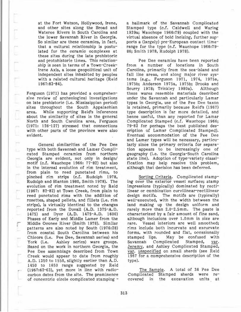
at the Fort Watson, Hollywood, Irene, and other sites along the Broad and Wateree Rivers in South Carolina and the lower Savannah River in Georgia. So similar are these ceramics, in fact, that a cultural relationship is postulated for the ceramic complexes at these sites during the late prehistoric and protohistoric times. This relationship is seen in terms of a Town-CreekIrene Axis, a loose geopolitical unit of independent sites inhabited by peoples with a related cultural heritage (Reid 1967:83-84).
Ferguson (1971) has provided a comprehensive review of archeological investigations on late prehistoric (i.e. Mississippian period) sites throughout the South Appalachian area. While supporting Reid's inferences about the similarity of sites in the general North and South Carolina area, Ferguson (1971: 126- 127) stressed that connections with other parts of the province were also evident.
General similarities of the Pee Dee type with both Savannah and Lamer Complicated Stamped ceramics from northern Georgia are evident, not only in design/ motif (c.f. Wauchope 1966: 77-82) but also in the internal evolution of rim treatment, from plain to reed punctated rims, to pinched rim strips (c.f. Rudolph 1978, Rudolph and Blanton 1980, Smith 1978). The evolution of rim treatment noted by Reid (1967: 82-82) at Town Creek, from plain to reed punctated rims with the addition of rosettes, shaped pellets, and fillets (i.e. rim strips), is virtually identical to the changes reported from the Duvall (A.D. 1375-A.D. 1475) and Dyer (A.D. 1475-A.D. 1600) Phases of Early and Middle Lamer from the Middle Oconee River (Smith 1978). Similar patterns are also noted by South (1976:28) from coastal South Carolina between his Chicora (i.e. Pee Dee, Savannah series) and York (i.e. Ashley series) ware groups. Based on the work in northern Georgia, the Pee Dee assemblage described from Town Creek would appear to date from roughly A.D. 1350 to 1550, slightly earlier than A.D. 1450 to 1650 range suggested by Reid (1967:62-63), yet more in line with radiocarbon dates from the site. The preminence of concentric circle complicated stamping -
a hallmark of the Savannah Complicated Stamped type (c.f. Caldwell and Waring 1939a; Wauchope 1966:79) coupled with the virtual absence of bold incising, further supports a (largely) pre-European contact timerange for the type (c.f. Wauchope 1966:79-86; Smith 1978, Rudolph 1978).
Pee Dee ceramics have been reported from a number of locations in South Carolina, primarily from the sea- island and fall line areas, and along major river systems (e.g., Ferguson 1971, 1974, 1975a, 1975b; Anderson 1975a, 1975b; Brooks and Scurry 1978; Trinkley 1980a). Although these wares resemble materials described under the Savannah and particularly Lamar types in Georgia, use of the Pee Dee taxon is retained, primarily because Reid's (1967) type description is far more detailed, and hence useful, than any reported for Lamar Complicated Stamped (c.f. Wauchope 1966; 79-82 for perhaps the best published description of Lamar Complicated Stamped). Eventual accommodation of the Pee Dee and Lamer types will be necessary, particularly since the primary criteria for separation appears to be increasingly one of geography (i.e. the Georgia-South Carolina state line). Adoption of type-variety classification may help resolve this problem, although that decision has been deferred.
313
Sorting Criteria. Complicated stamping over the exterior vessel surface; stamp impressions (typically) dominated by rectilinear or combination curvilinear-rectilinear design motifs. The motifs are (typically) well-executed, with the width between the land making up the design uniform and rarely more than 2.0-2.5mm. The paste is characterized by a fair amount of fine sand, although inclusions over l.Omm in size are rare. Vessel interiors are well smoothed; rims include both incurvate and excurvate forms, with rounded and flat, occasionally stamped lips. May be confused with Savannah Complicated Stamped, ~Jeremy, and Ashley Complicated Stamped, var. unspecified on small sherds (see Reid 1967 for a comprehensive description of the type).
The Sample. A total of 36 Pee Dee Complicated Stamped sherds were recovered in the excavation units at

Mattassee Lake in 1979 (Table 51; Figure 90:o-t). Most of the sherds were assigned to this type on the basis of carefully executed complicated stamps (typically variations of the arc-angle, filfot cross, concentric circles, or nested triangles; Figure 90:o, t, s, and p, respectively), although two specimens (Figure 90:q, r} were included by virtue of apparent "Pee Dee-like" rim treatment, reed punctations and an appliqued strip. The stamps were frequently faint or somewhat blurred or overstamped, rendering design motif identification difficult. The stamps were finer (i.e. narrower and more uniform in composition - (land and groove dimensions) than either the Savannah or Ashley Complicated Stamped types. The ware was predominantly light colored (Table 55), although a few sherds exhibited dark, possibly smudged exteriors. Few large quartz (sand) inclusions were present in the paste, although a higher incidence of fine sand than in the Savannah types was evident. Both incurvate and excurvate rims were recovered, with flattened and rounded (typically) unmodified lips; one stamped lip was present (Tables 59, 60; Figure 89, 90:t). Flaring and (possibly) incurvate jars appear represented, although the sample and sherd size was too small to permit confident vessel reconstruction. The Mattassee Lake material is similar to the Pee Dee ceramics described from the type site (Reid 1967), and is similar or identical to artifacts recovered from the Fort Watson (38CR1; Ferguson 1975a) and Mulberry (38KE12; Ferguson 1974) Mound sites upriver along the Santee/Wateree drainage. Trinkley (1980e) has noted a virtual identity of Pee Dee ceramics from northern Charleston County with materials from Town Creek; the Mattassee Lake assemblage, and other assemblages from along the Santee, would appear to conform to this pattern (c.f. Reid 1967; Ferguson 1975a, Anderson, Newkirk, and Carter 1979). The close similarity in manufacture tends to support Reid's (1967: 83-84) inference about close sociopolitical ties between late prehistoric groups or settlements within this general area.
Distribution. Along major drainages in the coastal plain and lower piedmont of South Carolina and extreme southeastern North Carolina, and throughout the seaisland area of South Carolina (Reid 1967;
314
Ferguson 1971, 1975b; 1975b; Anderson and Trinkley 1980a).
Anderson Claggett
1975a, 1979;
Chronological Position. Late Mississippian period, Pee Dee Phase (A.D. 1400-A.D. 1600). Many of the design motifs evident on Savannah Complicated Stamped ceramics are present or continue on the Pee Dee type, and separation of these wares can be difficult on a sherd by sherd basis, l?articularly if rims, or large portions of the design are lacking. Recent research (see Background discussion above} suggests a somewhat earlier range (e.g., A.D. 1350 to 1550), although this remains to be conclusively documented. At Mattassee Lake the Pee Dee Coml?licated Stamped ware is stratigraphically late in both the 38BK226 and 38BK229 blocks, although the average depth is lower than acceptable relative to other late l?rehistoric types. General contemporaneity with the Santee, Savannah, and (possibly) Ashley series is all that can be inferred from the data (Tables 52, 53).
Documentation. Coe (1952); Reid (1965, 1967}; Ferguson (1971, 1974, 1975a, 1975b); South (1973b, 1975); Anderson (1975a, 1975b); Anderson and Claggett (1979); Trinkley (1980a, 1981 b, 1981c, 1981e).
ASHLEY COMPLICATED STAMPED, ~· unspecified
Background. Not previously defined. South (1973b:54-55, reprinted 1976:28-29} noted the presence of an Ashley ware, or series, in his "Indian Pottery Taxonomy for the South Carolina Coast," based on material found at Charles Town Landing (c.f. South 1970, 1971). No descriptions of the Ashley types Ashley Complicated Staml?ed, Ashley Simple Stamped, Ashley Burnished Plain, and Ashley Corncob Impressed - have appeared, although they are in preparation as part of the final report on the excavations at Charles Towne Landing (South n.d.). The general attributes of the ware have been reported, however, and have been widely used to help identify late prehistoric and protohistoric wares (e.g., Taylor and Smith 1978:151; Rudolph 1978; Anderson and
0
0
~~-~~
~ -"" g
5cm
m
t
FIGURE 91. Ashley Complicated Stamped, Unusual Ceramic Artifacts, and Baked Clay Objects from
Mattassee Lake. a-i Ashley Complicated Stamped; j possible Swift Creek (7) sherd, k Thorn's Creek (?)
punctate; I, m unusual incised sherds; n perforated clay disk; o abraded sherd, possibly representing an
arrow point; p-t "Perforated Mellon" type Baked Clay Objects; u " Irregular Biscuit" type Baked Clay
Object; v, w "Perforated Disk" type Baked Clay Objects.
CATA LOG NUMBERS : a (38BK229.98A.10) ; b (388K229.94B.33) ; c (388K229.101B.13) ; d (388K229.101G.27) ;
e (38BK229, 100A.3 ); f (38BK229.53A. 10); g (38BK226. 1098.8); h (388K229. 798.3); i (388K226.978.2l; j (83BK226.
108F.3) ; k (388K229.368.3); I (38BK226. 1068.4 ); m (38BK226. 1078.6); n (38BK226. 147.6); o (388K246.298.4 );
p (38BK226.89E. 1 ) ; q (38BK226.69H. 11 ) ; r (38BK229.105E.4) ; s (38B K246.28C. 12); t (38BK246;270.8) ; u (388K246.
36A.4); v (388K246. 23E. 1 ); w (388K229. 1070.6).

Claggett 1979:39- 40; Trinkley 1980a to cite a few examples). These attributes included:
carved paddle stamped with enlarged motifs, carelessly applied decorative motifs, burnishing, finger punctated rims strips and folded rims, sloppy incising, corncob impressed type present (South 1976:28).
The use of rosettes, reed punctations, and punctated rim strips was attributed to earlier complicated stamped wares, such as the Pee Dee series (South 1976:28). A similar evolution, from reed punctated to finger pinched rims, has been demonstrated within Lamar ceramic ceramics from the Middle Oconee River in eastern Georgia (Rudolph 1978; Rudolph and Blanton 1980), and a comparable trend was also noted at the type site for the Pe·e Dee series, Town Creek (Reid 1967:82-83). Trinkley (1981d: 12-14) has recently provided general descriptions of two protohistoric series, Wachesaw and Catawba, that may be temporally coeval with South's Asley series. The absence of coiling over the Wachesaw series (e.g., Trinkley 1980d:12) differentiates this ware from the Ashley series, which is coiled (determination based on an examination of typical Ashley specimens shown the author by Stanley South in 1975). The description of Catawba Complicated Stamped (Trinkley 1981 d: 14) is too general to permit valid comparison, although a general similarity with the Ashley series is evident. Careful, quantitatively based comparative analyses. will prove essential to the discussion of late prehsitoric ceramics; what is currently needed are thorough descriptions backed by facts and figures and based on large sample sizes.
As used here, the type Ashley Complicated Stamped refers to those complicated Stamped ceramics (recovered at Mattassee Lake) that (1) fit South's (1976: 28) general criteria cited above and (2) did not fit either Savannah or Pee Dee sorting criteria. It should be stressed, however, that the Mattassee Lake sample is too small to serve as an adequate type collection, and that this description should eventually be modified or replaced.
316
Sorting Criteria. Complicated stamping over the exterior vessel surface; overstamping common. Stamp impressions are (typically) bold, with the space between the lands fairly wide (between 3.0 and 5.0mm). The stamp is often carelessly applied and smeared or overstamped; the design itself is often poorly carved and crude in apperance. Paste highly variable, typically with so me small (0.1- 1.-mm) sand inclusions present. Rim strips are common and tend to be folded and/or finger pinched. May be confused with both Savannah Complicated Stamped, var. Jeremy and Pee Dee Complicated Stamped.
The Sample. A total of 36 sherds were classified Ashley Complicated Stamped, var. unspecified from the 1979 excavation units at Mattassee Lake (Table 51; Figure 91:a-i). The category exhibited considerable variability in design, paste, and color, and the type tended to serve as a catch-all for sherds with crudely carved, sloppily applied complicated stamping that could not be conscionably subsumed under the Pee Dee and Savannah types. Interiors were typically well smoothed, but tended to be slightly gritty to the touch when the paste had a lot of sand present. Both color and paste, as noted, were highly variable (Table 55,56) and subdivision of the category will prove essential when larger samples can be obtained. The only well defined rimsherd recovered was excurvate with a plain, flattened lip; a pronounced, sloppily pinched rim strip was also present (Figure 91:h). A number of the sherds closely resemble Ashley ceramics recovered from Charles Towne Landing, although others could well be poorly executed Pee Dee or even Savannah complicated stamped. The integrity of the type, or at least support for its late occurrence, was evident from the assemblage stratification at Mattassee Lake (e.g., Tables 52, 53), where the ware was among the highest, or most recent types.
Distribution. Poorly documented. An occurrence in the seaisland area of South Carolina and in the interior along major river drainages appears likely. The ware resembles Stuart's (1975) McDowell II ceramics from the Middle Wateree, and large, poorly executed complicated stamped motifs are documented from along the
major drainages in the state (c.f. Anderson 1975b).
Chronological Position. Protohistoric period, Ashley Phase (A.D. 1600-A.D. 1715). South (1971) reported a date of A.D. 1780 (170 :so B.P.; GX2287) for the ware from Charles Towne Landing; this determination is probably a century too recent, although the standard deviation brings the date in line with the suspected range of the ware. The 1715 terminal date reflects the effective end of Indian occupation in the lower South Carolina coastal plain brough about by the Yemessee War. At Mattassee Lake, Ashley Complicated Stamped ceramics were stratigraphically the highest (i.e. most recent) of any of the types recovered in the 38BK226 block (Table 52), and the second highest type (second to the single sherd of Savannah Check Stamped) recovered in the 38BK229 block (Table 53).
Documentation South (197lb, 1973b, 1976: Ashley type reported): Wauchope (1966, Lamar Complicated Stamped type and assemblage descriptions); Trinkley (1980a, 1981d, 1981e; discussion of late prehistoric ceramics along the South Carolina coast); Anderson and Claggett (1979, "York" ware-group ceramics); Smith (1978), Rudolph (1978), Rudolph and Blanton 1980; evolution of Lamar ceramics); Ferguson (1971; overview of Mississippian adaptation/cultural evolution).
MINOR TYPES AND FINISHES
Background. A number of sherds were recovered at Mattassee Lake, as in any large excavation, that could not be comfortably subsumed within existing types, or used to develop new ones. Brief descriptions of the more common and/or unusual of these wares are provided below: information on the incidence, distribution, and technical attributes for most of these categories are given in Tables 51-61. Additional information on a particular series may be found in the Chronological Roster of Types.
Wilmington Plain, var. unspecified. Forty one sherds of a plain finished, claygrog tempered ware were recovered in the Mattassee Lake excavation units, all from
317
the 38.BK226 excavation block (Table 51; Figure 8l:d, e). The paste was characterized by a fair amount of sand and by numerous small (about l.Omm) very ~:>ale brown to reddish brown lumps of clay; some of the lumps were so light as to appear almost white in color. The ware was quite friable, and most of the sherds appeared to come from a single somewhat poorly manufactured vessel, possibly a manufacturing failure. Sherd surfaces were poorly smoothed and gritty in texture . Because of the temper, an association with the Refuge or Wilmington series is inferred; the ware is sufficiently unlike the Refuge ma terial in temper and finish to suggest a different, possibly later (e.g., Wilmington?) association. The ware is clearly a minority type at Mattassee Lake, although a roughly similar ware has been reported in quantity, and radiocarbon dated to the 200 B.C.-A. D. 200 range,from the Honey Hill site in Berkeley County (Dorian and Logan 1979). The association of plain, clay/grog tempered wares in a later Woodland context has also been demonstrated in the Savannah River sequence (e.g., DePratter 1979: 111), and a long occurrence for this kind of pottery (albeit as a minority type) is probable along the lower Santee.
Wilmington Simple Stamped, var. unspecified (?). A single sherd of what appears to be a simple stamped, clay-grog tempered ware was recovered at Mattassee· Lake that appears to belong to the Wilmington or possibly Refuge series (Table 51; Figure 8l:f). The stamp impressions are very faint, reflecting a fair amount of smoothing after stamping; it is possible that the finish may be due to a thong or even cord wrapped paddle. Small (l.Omm) lumps of clay/grog are present but infrequent in the paste, which is otherwise temperless. Clay/grog tempered simple stamped and cord-marked ceramics have been reported from along the Santee (e.g., Anderson 1975b), so the presence of the finish at Mattassee Lake is not altogether unexpected.
Yadkin Linear Check Stamped, ~· unspecified (?). Six sherds of linear check stamped pottery characterized by a moderate incidence of large (l.0-3.0mm) rounded quartz inclusions were recovered at

Mattassee Lake in 1979 (Table 51). While the paste may reflect the normal range of variation within the Deptford Linear Check Stamped type, an association with Coe's (1969:32) Yadkin Linear Check Stamped type is possible, especially given the presence of other probable Yadkin wares from the terrace.
Yadkin Cord-Marked, ~· unspecified (?). Four sherds of cord-marked pottery characterized by, a higher than usual incidence of fair-sized (l.0-3.0mm) quartz inclusions were recovered at Mattassee Lake that may belong to the Yadkin series (Table 51; Figure 84:o,p). . The sherds were all small, and characterized by fine (l.Omm) cord impressions. One of the sherds (the one from 388K246) closely resembles (in paste, color, and interior finish) the Yadkin Plain and Yadkin Fabric Marked wares from that site and a relationship is probable. The other three sherds, from 38BK226, may reflect an extreme in paste variation in the Cape Fear series. The sherds serve to suggest the possibility of the type in this area; Yadkin Cord-Marked ceramics are documented from the fall line area of northeastern South Carolina (Cable and Cantley 1979).
Cape Fear Cord Marked, ~· unspecified. A total of 49 sand tempered cordmarked sherds were recovered at Mattassee Lake in 1979, and are classified under the Cape Fear type (Table 51; Figure 86:d-k). Stratigraphically the ware is contemporaneous with the Cape Fear Fabric Impressed, var. St. Stephens type (Table 52), and the two finishes are assumed to be related. Considerable variation in the size and orientation of the cord impressions is evident, although most of the sherds are characterized by roughly parallel, thick (l.0-2.0mm) cord impressions (e.g., Figure 86:e, f, h). Similarities with both Deptford CordMarked (DePratter 1979: 126) Trinkley 1980a, n.d.) and Cape Fear Cord-Marked (South 1960:38-41) are apparent. Cordmarked ceramics characterized by sand inclusions in the paste are common throughout the coastal plain of South Carolina (e.g., Anderson 1975a, 1975b, Anderson, Lee, and Parler 1979), although little progress has been made in subdividing the finish into useful type or varieties. The sample from
318
Mattassee Lake was examined for possible temporally significant variability (including a cluster analysis; see Chapter 6), unfortunately unsuccessfully. The success in delimiting temporal trends in the Cape Fear Fabric Impressed wares from the terrace, however, suggest that similar trends will be resolved in local cord-marked ceramics, given a sufficiently large and well documented assemblage.
Cape Fear Net Impressed, var. unspecified. Five sherds of what appears to be net impressed sand tempered (i.e. sandy paste) pottery were recovered in the excavation units at Mattassee Lake (Table 51; Figure 86:a-c). In paste, color, and general surface finish (excluding the exterior stamp) the ware is quite similar to many of the Cape Fear Fabric Impressed, var. St. Stephens sherds, and the two wares are assumed to belong to the same series (although this will require additional confirmation). A loose netting with poorly defined knots characterizes the ware, which appears to be a distinct minority in this part of the coastal plain.
Savannah Fine Cordmarked, var. unspecified. Two sherds of virtually temperless, well smoothed fine cordmarked pottery (Figure 86:k} were recovered at Mattassee Lake that resembled the type description for Savannah Fine Cordmarked (Caldwell and Waring 1939a). The only major difference is in the incidence of sand inclusions in the paste; the Savannah type material is described as having a moderate amount of sand or grit. This distinction was also apparent in the Savannah Complicated Stamped sherds from the terrace, supporting an association of the types.
Mississippian Plain, var. unspecified. Thirty-three sherds of burnished plain pottery ware recovered at Mattassee Lake (Table 51; Figure 90 m, n) that are assumed to date to the Mississippian period. Burnishing is not reported from other periods in the general area, but is well documented in local Mississippian period assemblages (e.g. Caldwell and McCann 1941; Caldwell 1952; Ferguson 1971, 1974). Of two rims recovered, one had a row of rosettes, suggesting Pee Dee affiliation (c.f. Reid 1967; South 1976:28), and the other was sharply

incurvate near the lip, suggesting derivation from a bowl of some kind (Figures 88, 90).
Unusual or Unidentifiable Complicated Stamped. A number of complicated stamped sherds (N=l8) were recovered that could not be readily subsumed into any of the three primary types, Savannah, Pee Dee, or Ashley (Table 51). These were classified according to the dominance of either curvilinear or rectilinear design motifs, but are otherwise unreported. Most were fairly small sherds that appear to be of Mississippian period age, and probably could be identified to one of the major series given larger specimens.
Unusual Ceramic Artifacts. A total of 22 "miscellaneous" sherds were reported from the Mattassee Lake assemblage (Table 51), these included five sherds of unidentifiable incised pottery (e.g. Figure 91 :1,m); six sherds of temperless simple stamped and one sherd of temperless plain pottery that appear to be pipe bowl fragments; one Wilmington Fabric Impressed var. Berkeley sherd seemingly carved like a. stemmed biface (Figure 91:0); and eight unusual punctated sherds of indeterminate association (e.g., Figure 91:k). One sherd exhibited a very strange stamp, resembling small overstamped concentric circles that vaguely resembled some early Swift Creek motifs (c.f. Wauchope 1966:56); support for an inference about possible "Swift Creek" ceramics, or even early complicated stamping along the Santee must, however, await far better evidence than a single small sherd. Complicated stamped, Swift Creeklike ceramics are reported from within the Deptford series in the mouth-of-theSavannah sequence (DePratter 1979:126-127), and the (occasional) occurrence of similar wares in coastal South Carolina is not altogether improbable. A final unusual ceramic object recovered from the terrace, from Feature 34 in the 38BK226 block, was a punctated clay discoidal (Figure 91 :n). The object, which was 2.5 em thick, was punctated on only one side, with 56 small (c. 2.0mm) holes arranged in rows of from 12 to 14 holes each. Use as a gaming piece o~ toy may have been possible, although no sign of wear was evident, and the object appears somewhat fragile.
BAKED CLAY OBJECTS
A total of 231 baked clay object fragments were recovered from the Mattassee Lake sites in 1979. Fragments were found on all three sites, but the majority came from 38BK246 (Table 65). No intact specimens were found, and most of the fragments represented small fractions of the original mass. For this reason both count and weight were recorded, with weight considered a more reliable indicator of the categories occurrence. Three principal forms or types of objects were present in the Mattassee Lake assemblage, with a fair degree of variability within each form also evident. Following categories developed by South (1970:3ff) for specimens recovered at Charles Towne Landing, the three basic forms at Mattassee Lake were: the perforated melon shape; the perforated disc; and the irregular biscuit.
319
TABLE 65
BAKED CLAY OBJECT FRAG14EMTS, SY EXCAVATIO.~ AREA , ~ATTASSEE LAKE SITES : COlRIT, liEIGHT , ANO AVERAGE WEIGHT
SIJMMARY OATA
Si te/Area Count Weight (Grams )
Average \Ieight (Grams)
SITE 3881<.226
0.5 m Test Units 1 8.6 8.6
Block Unft 33 699. 1 21.2
Other 2 11 Units 0 0 .0 0.0
Features ( l/4" Mesh) 204.6 40 .9
Features (1116" Mesh ) 0 0.0 0 .0
TOTALS 39 91 2.3 23.4
SITE 3881(229 0.5 m Test Units 2.4 2.4
Block Unit 17 449.8 26.5
Ot her 2 11 Units 9 187.5 20.8 Featu res (1/4" Mesh ) 12. 9 12.9
Features (1 /16" Mesh ) 0 0.0 0.0
TOTALS 28 652.6 23 . 3
SITE 3881<.246 0. 5 m Test Units 4 79.8 20.0
Block Un it 147 2197.0 14. 9
Other 2 11 Uni t s 9 21 6.2 24.0
Features ( 1/ 4" Mesh) 83. 5 20 .9
Features ( l/16" Mesh) 0 0 .0 0.0
TOTALS 164 2576.5 15.7
GAAHO TOTALS 231 41 41 . 4 17.9
The perforated melon shaped disc (Figure 91:p-t) is similar to South's (1970:3-7) category. The fragments from this category were ellipsoidal solids, centrally per-

forated (through the minor axis), and typically punctated or indented with parallel finger impressions over their exterior surfaces. The irregular biscuit (Figure 91:u) was a flattened, irregular rectangular solid form, typically exhibiting parallel finger impressions over the surface. The fragments recovered at Mattassee Lake only rarely exhibited evidence for perforation, and the category appears to have included unperforated specimens. The perforated disc (Figure 91:v, w; Figure 92:a-c) was the most common form at Mattassee Lake, and was found at all three sites. Specimens were circular, roughly 10 em in diameter, and from 1.5 to 3.0 em thick with a central perforation. Most resembled cogwheels, similar to a specimen found by South (1970: Figure l:f) at Charles Towne Landing and like specimens reported from Jaketown (Ford, Phillips, and Haag 1955:44). The Mattassee Lake cogwheel shaped baked clay objects were almost always extensively
punctated, although a few exhibited parallel finger impressions. A few fragments in this category, all from site 38BK229, were smooth, lacking both the cog-like stamping around the perimeter and the punctations of stamping in the interior (e.g., Figure 9l:w).
The baked clay objects from Mattassee Lake are similar to some of the objects recovered at Charles Towne Landing (South 1970), and undoubtedly are of similar function. Stratigraphic analysis of their occurrence at Mattassee Lake (Table 66) suggest a Late Archaic-Early Woodland age for many of the specimens, since they tend to occur in greatest numbers in levels characterized by pottery of this age. Some of the specimens, however, particularly at 38BK246, appear to date to later in the Woodland. Generally, the perf ora ted disc form appears lower, and the perforated melon and irregular bisquit forms higher, on the average, in the levels.
TABLE 66
SITE 3881<226
Weight (Percent
Level Of Total
0-5 OD 00.0
5-10 em 42.3 0 (6.2%)
10-15 OD 100.8 D (14. 7%)
15-20 Cll 111.1 D (16. 3%)
20-25 em 234.3 (34.3%)
25-30 em 15.1 0 (2.2%)
30-35 em 58.4 0 (8.5S)
35-40 em 55.4 D (8.1S)
40-45 on 00.0
45-50 em 66.0 0 (9. 7%)
50-55 011 00.0
55-60 em 00.0
60-65 em 00.0
TOTALS* 683. 4*" (100.0:')
BAKED CLAY OBJECTS IH THE HATTASSEE lAI(£ BLOCK UNITS: WEIGHT BY LEVEL
SITE 388K229 SITE 388K246
Level
0-5 em
5-10 on
10-15 em
15-20 on
20-25 em
25-30 on
30-35 em
35-40 em
40-45 011
45-50 OD
TOTALS*
Weight (Percent Of Tota 1l
Weight (Percent
level Of Total)
00.0 0-10 em 410.6 (18. 7%)
00.0 10-20 Cll 550.3 (25.1S)
21.2 (4.7S) 0 20-30 em 1,088.4
(49.SS)
174.6 30-40 Clll 147.7 (38.8S) (6.7S)
172.0 TOTALS• 2,197.0 (38.2S) ( lOO.OS)
8.2 ( 1. SS) ~ 42.2 (9.4S) 0 00.0
00.0
31.6 (7.1S) 0
449.8 (100.0%)
*Totals do not Include baked clay objects In features.
**Excludes 15. 7 grams of baked clay object fragments from block In other than 5 em levels.
320
0

CONCLUSIONS
The analysis of ceramic artifacts from the Mattassee Lake sites was directed toward both techo-functional and culturalhistorical research goals. The most extensive effort was dircted towards questions of classification and chronology, necessitated by the absence of all but the most general of outlines for the identification and dating of many local ceramics. Detailed stratigraphic and classificatory analyses of the terrace assemblage were undertaken, and used to advance an initial sequence for the lower Santee River. Through the use of type-variety classification, coupled with extensive descriptive and comparative analyses, the terrace sequence was related to sequences defined from elsewhere in the region, most notably along the lower Savannah River and in coastal North Carolina. Functional and technological aspects of the Mattassee Lake assemblage were also examined. A major shift in vessel form appears to occur between the Thorn's Creek and Refuge Phases, for example, that may be related to the changes in subsistence and settlement strategies observed at this
time. A shift from predominantly carved paddle stamping to predominantly wrapped paddle stamping is evident during the Early and Middle Woodland, followed by a return to carved paddle stamping in the later Woodland and Mississippian periods. These shifts have often been interpreted as reflecting population movements, or intrusions, from areas to the north or south, although little about the dynamics of the situation are actually known. Cord and fabric impressed wares are clearly present at an early time, with the wrapped paddle Wilmington (~. Hanover, var. Berkeley) types coeval with the carved paddle stamped Deptford series. Sand tempered cord and fabric marked ceramics of the Cape Fear series are also found with Deptford ceramics, so it is probable that any intrusion was a slow process. What is clear, however. is that by the later Middle Woodland, sites along the lower Santee River are characterized by northern ceramic elements. The reemergence of the carved stamped tradition does not occur until the Late Woodland and Mississippian periods, with the appearance of Savannah and Pee Dee/Lamar ceramics across much of South Carolina.
321

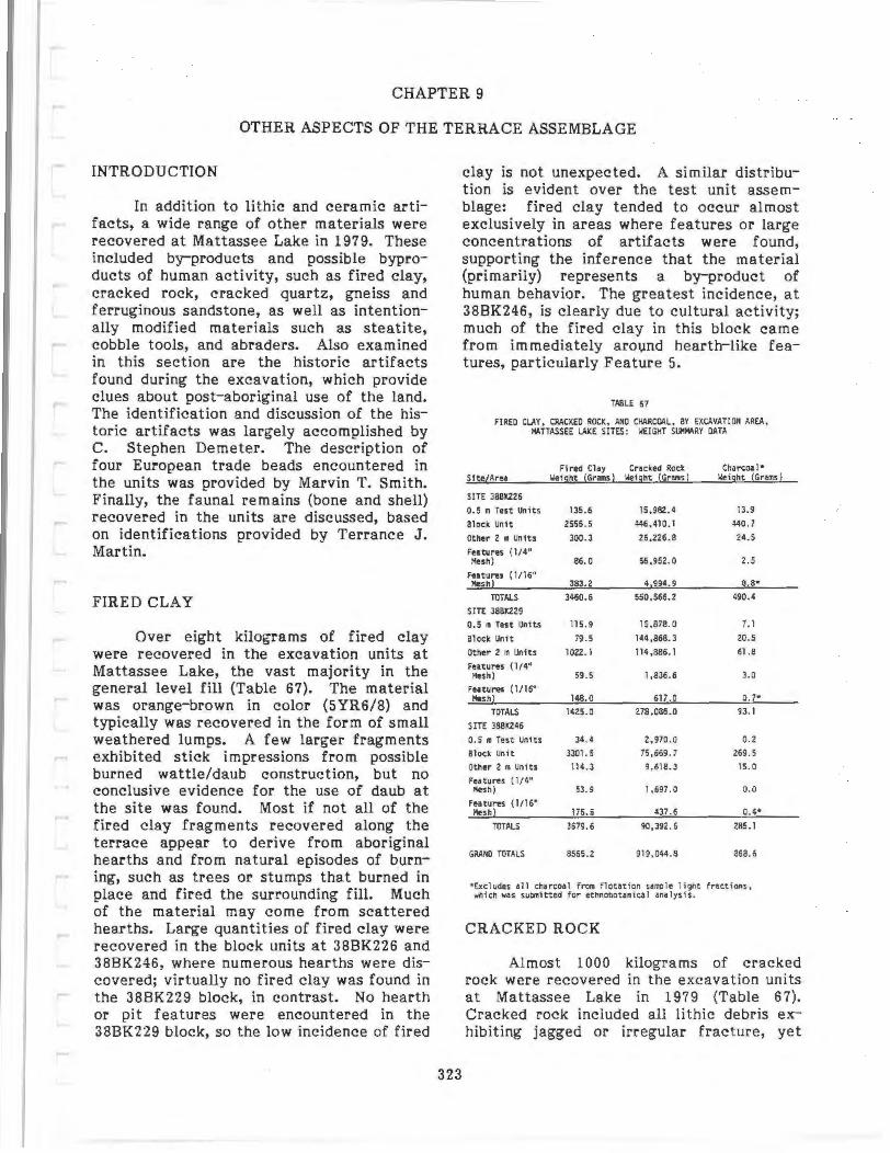
CHAPTER 9
OTHER ASPECTS OF THE TERRACE ASSEMBLAGE
INTRODUCTION
In addition to lithic and ceramic artifacts, a wide range of other materials were recovered at Mattassee Lake in 1979. These included by-products and possible byproducts of human activity, such as fired clay, cracked rock, cracked quartz, gneiss and ferruginous sandstone, as well as intentionally modified materials such as steatite, cobble tools, and abraders. Also examined in this section are the historic artifacts found during the excavation, which provide clues about post-aboriginal use of the land. The identification and discussion of the historic artifacts was largely accomplished by C. Stephen Demeter. The description of four European trade beads encountered in the units was provided by Marvin T. Smith. Finally, the faunal remains (bone and shell) recovered in the units are discussed, based on identifications provided by Terrance J. Martin.
FIRED CLAY
Over eight kilograms of fired clay were recovered in the excavation units at Mattassee Lake, the vast majority in the general level fill (Table 67). The material was orange-brown in color (5YR6/8) and typically was recovered in the form of small weathered lumps. A few larger fragments exhibited stick impressions from possible burned wattle/daub construction, but no conclusive evidence for the use of daub at the site was found. Most if not all of the fired clay fragments recovered along the terrace appear to derive from aboriginal hearths and from natural episodes of b_urning, such as trees or stumps that burned in place and fired the surrounding fill. Much of the material may come from scattered hearths. Large quantities of fired clay were recovered in the block units at 38BK226 and 38BK246, where numerous hearths were discovered; virtually no fired clay was found in the 38BK229 block, in contrast. No hearth or pit features were encountered in the 38BK229 block, so the low incidence of fired
323
clay is not unexpected. A similar distribution is evident over the test unit assemblage: fired clay tended to occur almost exclusively in areas where features or large concentrations of artifacts were found, supporting the inference that the material (primarily) represents a by-product of human behavior. The greatest incidence, at 38BK246, is clearly due to cultural activity; much of the fired clay in this block came from immediately arovnd hearth-like features, particularly Feature 5.
TA8LE 67
FIRED CLAY, CRACKED ROCK, AND CHARCOAL, BY EXCAVATION AREA, 144TIASSEE LAKE snES: WEIGHT SI.M."ARY DATA
Fired Clay Cracked Rock Cha rcoa 1* Site/Area \Ieicht (Grams ) \Ieight (Grams ) \Ieight (GraiiiS)
SITE 38BK226
0.5 m Test Units 135.6 15,982,4 13.9
Block Unit 2555.5 446.~10.1 440.7
Other 2 • ~)!its 300.3 26 .226.8 24.5
Features (1/4" Mesh) 86.0 56,952.0 2. 5
featurtS (1116" Mesh) 383.2 4,994. 9 8.8*
TOTALS 3%0.6 550,566.2 490.4
SITE 38BK229
0.5 m Test Units 115.9 15,878.0 7. I
Block Unit 79.5 144,868.3 20.5
Other 2 m Units 1022.1 114,886. 1 61.8
Features (1/4" Mesh) 59.5 1,836.6 3.0
futures ( 1116" Mesh) 148.0 611.0 0.7•
TOTALS 1425.0 278 ,086.0 93.1
SITE 388K246
0.5 • Tes t Units 34.4 2 , 970.0 0 .2
Block Unit 3301 . 5 75,669. 7 269.5
Other 2 m Units 114.3 9,618.3 15.0
futures ( 1/ 4" Mesh) 53.9 1,697.0 o.o
Features ( 1116" 11esh) 175.5 437.6 0.4*
TOTALS 3679.6 90,392.6 2B5.1
GRANO TOTALS 8565.2 919 ,()44.8 868.6
•ucludes all charcoa l from flotation sam1e light fractions , which was submitted for ethnobotantcal ana lysis.
CRACKED ROCK
Almost 1000 kilograms of cracked rock were recovered in the excavation units at Mattassee Lake in 1979 (Table 67). Cracked rock included all lithic debris exhibiting jagged or irregular fracture, yet
lacking any evidence (such as a bulb or negative bulb of percussion, or platform) of flaking, or of having been flaked (detached) from a larger mass (adopted from House 1975:68; House and Ballenger 1976:89). All of the material was bagged and examined in the laboratory, where it was sorted, weighed, and then discarded. All the rock from one excavation unit from each site block, however, was retained as a control, and is stored with the collections. The retention of the cracked rock in the field reflected project concern with lithic resource procurement and use, and with the effective documentation and inventory of the site assemblage (Chapter 4). Everything caught in the screens during the excavations was saved, washed, and then sorted in the field laboratory. This procedure had been followed during the testing, and at that time it became evident that at least some of the apparent "rocks" were in reality decortication flakes from initial cobble reduction, or tools, such as abraders or cores. The shear volume of rock itself in the screens often masked other, smaller artifacts, particularly after rains when the soil was wet and muddy, further obscuring the assemblage. Retention of all material was done, therefore, in an effort to minimize bias.
Virtually the entire cracked rock assemblage was irregularly cracked and often highly weathered sandstones {quartz arenite). Cracked quartz, which may have a different origin, was examined separately and is discussed later. The parent material or source appears to be cobbles within the Black Mingo formation, which immediately underlay the terrace soil horizons and in fact outcropped on the lower slopes (Chapter 2). The parent cobbles are naturally occurring on the sites; the cracked rock, however, appears to derive in part from the reduction of these cobbles by human groups. The unbroken materials on the terrace itself, including the larger cobbles on the lower slopes, are not in situ or actual exposed portions of the formation, but are instead weathered lag gravels and cobbles. That is, they reflect minimally transported debris, in a fluvial matrix, from the weathering of the underlying formation.
Rock fragments occurred in appreciable quantity along the terrace. The figures
reported in Table 67 are primarily for broken stone, yet include some small, highly weathered pieces (under 2- 3 em on a side) that may or may not have been cracked. The parent material, well to poorly cemented quartz arenite, was often extremely friable (and hence susceptible to considerable weathering), rendering the determination of both cortex and breakage scars difficult (as noted previously in Chapter 7). Only one exception was made to the complete collection strategy at Mattassee Lake, and this dealt with unmodified rock, rather than with cracked rock. Large, unmodified cobbles (i.e., those greater than 15-20 em on a side) were inspected in the field but were only rarely retained; these occurred in large quantities along the lower terrace slopes, and could not be readily transported. Few such cobbles were found in the blocks, however, which were higher on the terrace; when found they were weighed and plotted, and are noted on the level sheets.
The distribution of cracked rock in the excavation units parallels that of the artifactual assemblage, strongly indicating a cultural origin for the material. In all three of the block units examined at Mattassee Lake the vertical (stratigraphic) distribution of cracked rock is virtually identical to the distributions observed for pottery and orthoquartzite debitage, two major categories of artifacts. The distribution of cracked rock in the levels of the 38BK226 block, for example, is illustrated in Table 68; this distribution is similar to that noted for pottery (Table 52) from the same block. This stratigraphic patterning was additionally supported by the soils analyses (Figure 5); the incidence of gravel in the sampled profiles corresponded to the distribution of artifacts in these units. The incidence of gravels in the test units opened along the terrace also tended to parallel that of the artifacts in these units. That is, when a test unit had a high artifact density, it also tended to have a fairly high incidence of cracked rock present. This pattern, while generally viable on the higher terrace slopes did not, however, always follow near the terrace margins, where large quantities of apparently unmodified rock (with few associated artifacts) were sometimes encountered. The origin of the cracked rock, given
324
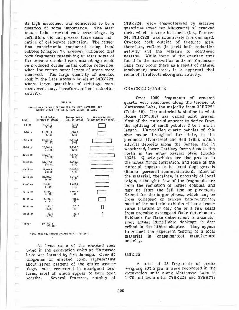
its high incidence, was considered t o be a question of some importance. The Mattassee Lake cracked rock assemblage, by definition, did not possess flake scars indicative of deliberate reduction. The reduction experiments conducted using local cobbles (Chapter 7), however, indicated that rock fragments resembling at least some of the t errace cracked rock asse mblage could be produced during initial cobble reduction, when the rotten outer layers of stone were removed. The large quantity of cracked rock in the Late Archaic levels at 38BK229, where large quantities of debitage were recovered, may, therefore, reflect reduction activity.
TABLE 68
CRACKED ROCK IN THE SITE 388K226 BLOCK UNIT , 11ATIASSF:E lAKE:
l eve l
D-5 em
5- 10 em
10- 15 Clll
15-20 em
20-25 CD
25-30 em
30- 35 Clll
35-40 on
40- 45 01
45-50 em
50- iS an
55-60 em
60- 65 em
TOTAL•
AVE.RAGE ~E IGHT ( PER UNIT), TOTAL WEIGHT, BY l EVEL
Total 'ol~lqht ~Percent of iota ll
10,403.9 (2.3~)
26,021 . 9 (5.9S)
60 , 336. 4 (1 3.6%)
77,040. 4 (17. 3:)
85,778.1 (19.3:: )
68, 179.6 ( 15. 3%)
56,406.8 (12.n)
28 ,086. 1 (6.3~)
18,631.1 (4.2S)
a. 101. o (2.0S)
4 ,901.4 ( 1.1::)
210 . 7 (0.0~)
42.5 (I) .OS)
444,747.3 ( loo.o::)
Averaqe lleiqht ~llo . of Units )
433. 5 (24)
1,084.2 (24)
2 , 51 4.1 (24)
3 , 210.0 (24)
3 , 574.1 (24)
2 . 964. 3 (23)
2,968. 8 (1 9)
1, 755.4 ( 16)
1,863. 2 (10)
1,088.5 (8)
980.2 (5)
210. 7 (1)
42.5 (1)
Average lle fqil t (Dist ri bution by l eve l!
D D
c=J CJ
0 0
• Total does not Include cr acked rock In features
At least some of the cracked rock noted in the excavation units at Mattassee Lake was formed by fire damage. Over 60 kilograms of cracked rock, representing about seven percent of the entire assemblage, were recovered in aboriginal features, most of which appear to have been hearths. Several features, notably at
38BK226, were characterized by massive quantities (over ten kilograms) of cracked rock, which in some instances (i.e., Feature 36, 38BK226) was extensively fire damaged. Cracked rock outside of features may, therefore, reflect (in part) both reduction activity and the remains of scat tered hearths. While some of the cracked rock found in the excavation units at Mattassee Lake may occur there as a result of natural (nonhuman) processes, it is apparent that some of it reflects aboriginal activi ty.
325
CRACKED QUARTZ
Over 1000 fragments of cracked quartz were recovered along the terrace at Mattassee Lake, the majority from 38BK226 (Table 69). The material is similar to what House (1975:68) has called spli t gravel. Most of the material appears to derive from the splitting of small pebbles 3 to 5 em in length. Unmodified quartz pebbles of this size occur throughout the state, in the piedmont (Overstreet and Bell 1965), within alluvial deposits along the Santee, and in weathered, lower Tertiary formations to the north in the inner coastal plain (Cooke 1936). Quartz pebbles are also present in the Black Mingo formation, and some of the material appears to be local (lag) gravels (Baum: personal communication). Most of the material, therefore, is probably of local origin, although a f ew of the fragments are from the reduction of larger cobbles, and may be from the fall line or piedmont. Except for the larger pieces, which may be from collapsed or broken hammerstones, most of the material exhibits either a transverse fracture or only one or a few scars from probable attempted flake detachment. Evidence for flake detachment is inconclusive; actual identifiable debitage is described in the lithics chapter. They appear to reflect the expedient t esting of a local material in knapp ing/tool manufacture activity.
GNEISS
A total of 28 fragments of gneiss weighing 232.5 grams were recovered in the excavation units along Matt assee Lake in 1979, all from sites 38BK226 and 38BK229
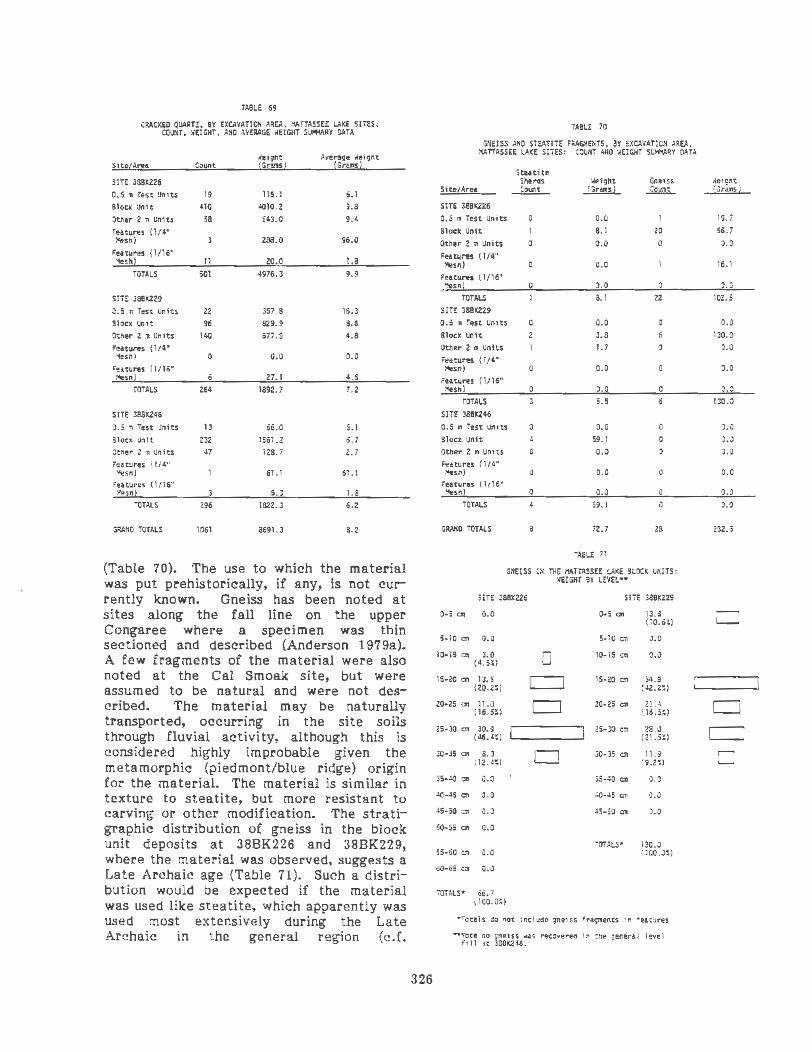
TABLE 69
CRACKED QUARTZ, BY EXCAVATION AREA. l'.ATTASSEE LAKE SITES: COUNT, '.lElGHT, AND AVERAGE ~EIGHT S~RY DATA
'.Ieight Average \Ieight Site/Area Count (Gra.ons l (G rams l
SITE 3881:226
O.S m Test Unlts 19 115. 1 6.1
Block Unit 410 4010 .2 9.8
Other 2m Units 58 543.0 9.4
Features ( l/4" Mesh) 288.0 96.0
Features ( 1/16" ~eshl 11 20 . 0 1.8
TOTALS 501 4976.3 9.9
SITE 3881:229
0.5 ra Ten Unlt.s 22 357.8 16.J
Block Unit 96 829.9 8.6
Other 2 m Units 140 677.9 4.8
Features {1/4" ~sn) 0 0.0 0.0
features (1/16" l'esnl 6 27.1 4.5
TOTA.LS 264 1892.7 7.2
SITE 388K246
0.5 " Test Units 13 66.0 5.1
aloe• Unit 232 1561.2 6. 7 Otner 2 m Units ~7 128.7 2. 7 Features (1/4" •esn) 61.1 61.1
Features ( 1116" !'.esn! S.J 1.8
TOTALS 296 1822.3 6.2
GRANO TOTALS 1061 8691.3 8.2
(Table 70). The use to which the material was put prehistorically, if any, is not currently known. Gneiss has been noted at sites along the fall line on the upper Congaree where a specimen was thin sectioned and described (Anderson 197 9a). A few fragments of the material were also noted at the Cal Smoak site, but were assumed to be natural and were not described. The material may be naturally transported, occurring in the site soils through fluvial activity, although this is considered highly improbable given the metamorphic (piedmont/blue ridge) origin for the material. The material is similar in texture to steatite, but more resistant to carving or other modification. The stratigraphic distribution of gneiss in the block unit deposits at 38BK226 and 38BK229, where the material was observed, suggests a Late Archaic age (Table 71). Such a distribution would be expected if the material was used like steatite, which apparently was used most extensively during the Late Archaic in the general region (c.f.
326
TA8L£ 70
G.~EISS .utO STEATITE FAAG.~ENTS, BY EXCAVATION AREA, AATTASSEE LAKE SITES: COUNT AND '.lEIGHT SUHIIARY DATA
Stut1U SherGs ••eight Gneiss
Slte/Aru ~ .li!:!!!!!.L ~ SITE 3881<226
0.5 II Test Units 0 0.0
!!lock Unit 8.1 20
Other 2 m Unl ts 0.0 0 Futures ( l/4" Hesh) 0 0.0
Futures (1/16" Mesh! 0 0 .0 0
TOTALS 8.1 22 SIT£ 3881:229
0.5 m Test Units 0.0
Blocx unit 3.8 6
Other 2 • Units 1. 7 0
Features (1/4" 1-leSh) 0 0. 0
Features (1!16" Mesh) 0 0.0 0
TOTALS 5. 5
SITE 388K246
0.5 • Test Units 0 0.0 0
Block Unit 4 59.1 0 Other 2 m Unl ts 0 0.0 0
Futures ( 1/4" 'lesn) 0 0.0 0
Features ( 1116" Mesh! 0 0.0 0
TOTALS 59.1 0
GRANO TOTALS a 72.7 28
TA8LE 11
GNEISS IN TliE AATTASSEE LAKE BLOCK UNITS: '.lEIGHT BY L"VEL••
511£ J8BK226 SITE 388K229
0·5 em 0.0 0·5 em JJ.a (10.6:)
5·10 Cll o.o 5·10 em 0.0
10·15 cm 3.0 ( 4.5:) 0 10·15 em o.o
15·20 Cll1 13.5 c:J 15·20 Cll1 54.9 (20.2~) (42.2:)
20·25 cm 11.0 c:::J 20.25 C:1l 21.4 ( 16.51) (16.51)
25·30 em 30.9 25·30 em 28.0 (46.4:) (21. 5:)
30·35 co 8.3 D 30-35 Cl1 11.9 ( 12.4:) (9.2:)
35-~ em o.o 35-~ em o.o .:o-•s "" o.o 40-'Sao 0.0
45·50 em 0.0 45 ·50 em 0.0
50·55 em o.o TOTALS' 130.0
55· 60 em 0.0 ( 100.0~)
o0·65 em o.o
TOTALS• 66. 7 ( lOO.Q:)
•Totals do not I nclude gneus f 'lc;c'.ellts I • 'eaturts
-m~ ~~ j&;m6 ~u recovereo 1 n tne general I eve 1
.le1gllt (Grams)
19. 7
66.7
0.0
16.1
0.0
102.5
0.0
130.0
0.0
0.0
0.0
130.0
0.0
0.0
0 .0
0.0
0.0
0.0
232.5
D
D
CJ 0
Anderson, Lee and Parler 1979:65- 68). None of the gneiss from Mattassee Lake, however, exhibits evidence for carving, incising, or other modification. All of the fragments are quite smooth, suggesting weathering, or possible use in gentle abrading functions. One possible use for the material might be the production of a dark pigment (upon grinding), and another might be to smooth steatite itself, since the gneiss is slightly harder.
STEATITE
Eight steatite sherds weighing 72.7 grams were recovered from the excavation units at Mattassee Lake in 1979 (Table 70). All were flattened on opposing faces and appeared to be from vessels, or possibly from perforated steatite objects. Perforation holes were not observed; these can occur both on vessels (as mending holes) and on perforated steatite objects (i.e., "cooking stones" or "net sinkers"). So few fragments were recovered that both function and temporal placement is difficult to ascertain, although a Late Archaic age for the material is possible, and generally supported by the stratigraphic evidence. Although only two pieces of steatite were found in the block at 38BK226, they occurred in the 20-25 em, and 30-35 em levels, suggesting a Late Archaic age. The three pieces of steatite recovered in the 38BK229 block occurred in 10-15 em, and 10-20 em levels, also suggesting an Early Woodland or Late Archaic age.
A possible steatite atlatl fragment (Figure 92:p) was also recovered, at a depth of 20-25 em in EU 10 of the 38BK226 block. The artifact, which measured 32 x 15 x 14 mm, and weighed 35.0 grams, would appear to be of Late Archaic age given the depth. Longitudinally grooved, with evidence for incising near an old break, the object appears to have been smoothed or reworked slightly after breaking. No other pieces of worked steatite were recovered nearby, and reuse after initial breakage may have occurred.
A single ground stone bead (Figure 92:k) was also recovered, in the 0-10 em level of EU 8 at 38BK246. The bead, which
measured 5 mm by 1.5 mm, with a 1.5 mm central perforation, was made of an unknown brown metamorphic material of probable Piedmont origin. The bead was recovered using 1/4 inch mesh, but it is probable that others like it could have been lost, passing through the screen. Given the mixed nature.of the 38BK246 deposits, little can be said about the artifact other than it is of probable Woodland age.
FERRUGINOUS SANDSTONE
Almost five hundred pieces of ferruginous sandstone were recovered in the 1979 excavation units at Mattassee Lake (Table 72). The fragments were typically poorly cemented sandstone ranging in color from dark red (10YR3/4) to brownish-yellow (10YR6/8). No evidence for modification was observed over any of the fragments, which were typically quite small and weathered. The material, which has been reported at the Cal Smoak site (Anderson, Lee and Parler 1979:68-69) and at prehistoric sites along the fall line (Anderson 1979a), may have served as either an abrader or a source of red pigment. Limonitic concretions are common in the region and this material may be a natural precipitate in the site soils. None of the material from Mattassee Lake exhibited evidence for modification, and aboriginal origin or use cannot be demonstrated.
327
ABRADERS
Five well-defined stone abraders were recovered in the excavation units at Mattassee Lake in 1979, together with a large number of grooved sandstone fragments that may or may not have served as tools. The five obvious tools, three of sandstone and two of siltstone, were characterized by multiple U or V-shaped grooves. All five had welldefined grooves, or abrader facets, on two or more faces, indicating fairly extensive use. Two of the tools, both of sandstone, came from the block unit at 38BK229, one from the 20-25 em level (Figure 92:d) and the other from the 30-35 em level (Figure 92:j). The abraders from the 38BK229 block were in the levels characterized by Late Archaic (Thorn's Creek) ceramics and extensive debitage, and may

FIGURE 92. Baked Clay Objects, Abraders, Aboriginal and European Trade Beads, and Cobble Tools from Mattassee Lake. a-c "Perforated Disk" type Baked Clay Objects; d-j abraders; k aboriginal bead; r-o European "trade" beads; p atlatl weight fragment; q pestle(?) r quartz hammerstone; s, t edge abraded cobbles; u small grainding basin. Artifacts e, i are siltstone, artifact g is a Woodland Plain sherd. Beads are 2 x scale.
CATALOG NUMBERS: a (388K226.106D.1 1) ; b (38BK229.48C.12) ; c (38BK226.132.6); d (388K229.108E.2) ; e (38BK226.107G.11); t (38BK226.88C.17); g (38BK246.21A.3); h (38BK246.26A.8); i (38BK226.94E.1) ; j (38BK229.
105G.1); k (38B K246.30A.21 ); I (38BK226.1 21.H1.7); m (388K226.128.H.5); n (38BK226.1118.7);o (38BK226.100F.
11); P (38BK226.95E.1); q (38BK246.28A.12); r (38BK226.107G.14) ; s (388K226.92C.13); t (38BK226.69G.14); u (38BK226.53A.1).

TABLE 72
FEJtRUGINOUS SAHOSTOiiE SY EXCAVATION AAEA. MATIASSEE LAX£ SITES : COUNT • WEIGHT. AHD AVERAGE ·~EIGKT SLWIARY DATA
Si te/ Area Count ·~eight Average llelght (Grams) (Grams)
SITE 38BX226
0. 5 • Test Units 123 339. 1 2.8
Block Unit 17 59.3 3.5
Other 2 m Units 13.1 3.3
Futures ( l/4" Hesh) 0 0.0 0.0
Features (1116'' Mesh) 21 1 210.9 1.0
TOTALS 355 6ZZ.4 1.75
SITE 38BX229
0. 5 m Test Uni ts 56.2 8.0
Block Unit 11. 6 11.6
Other 2 m Uni ts 18.5 6.2
Features ( 1/4" Hesn) 0 o.o 0.0
Features ( 1/1 6* Mesh) 12.4 3.1
TOTALS 15 98 .7 6.58
SITE 38BX246 0. 5 m Test Units 23 13.9 0.6
Block Unit S9 112.2 1.9
Other 2 m Units 10 26.3 2.5
Features ( 1/4" l!esh ) 0 o.o 0.0
Features ( 1/16" 11esh) 35 20.3 0.6
TOTALS 127 172.7 1.36
GRAHO TOTALS 497 893.8 1.80
have been used in stone tool manufacture (i.e., platform preparation). A single sandstone abrader was recovered from the 38BK246 block, in the highest level (0-10 em), and was of probable Woodland age (Figure 92:h). The final two abraders, both of siltstone, came from the 38BK226 block, one from the 20-25 em level (Figure 92:i) and the other from the 30-35 em level (Figure 92:e). Like the abraders from 38BK229, the two from 38BK226 also appear to be of Late Archaic age, given the depth at which they occur.
Over 100 pieces of rock were found in the units at Mattassee Lake with irregular, but suspicious-looking U or V-shaped grooves; these objects may also have served as abraders (e.g., Figure 92:f). Most of these "artifacts" were weathered, however, and clear, unambiguous wear could not be detected, even under magnification. At least some of these objects probably were tools; the lack of well-defined abrader facets may reflect expedient (short-term) use of the local sandstones, precluding the
development of well-defined or multiple facets. These objects, while admittedly of a questionable nature, suggest that consider ably more abrading activity may have been occurring along the terrace than indicated by the five clearly recognizable tools described above.
Several worn sherds were also recovered at 38BK226 that may have functioned as abraders. These typically occurred on plain or nondiagnostic pottery, suggesting only a probable Woodland age. All but one of these possible abraders were characterized by smoothed-over edges or breaks, and not by actual grooves. One Woodland(?) plain sherd was, however, a pronounced exception to this pattern, exhibiting a series of fine, overlapping vshaped grooves (Figure 92:g). The low incidence of sherd abraders may not be due to an absence 9f abrading functions during the Woodland, but more probably reflects the proximity of an excellent source of abrading material, the quartz arenite occurring on the lower terrace slopes. This is of some importance, since sherd abraders are fairly common in the coastal plain, particularly on coastal sites where stone substitutes are rare (e .g., Michie 1979a:64- 67; DePratter 1979:116). Ferguson (1975a:89) has suggested that sherd abraders found at Fort Watson, a Mississippian platform mound complex on the central Santee 30 miles upriver from Mattassee Lake, may have been used to work shell.
329
The function of the abrading tools at Mattassee Lake remains unknown, although use in a variety of functions, particularly stone, wood, or bone working, appears probable. The five formal abraders, and many of the questionable artifacts, are roughly 75-100 grams in weight, and 8-12 em on a side, conducive to hand-held use . The size and shape of many of the facets, roughly 3-4 em long and up to 1.5 em wide, suggests possible use as a whetstone, possibly to sharpen(?) wood or bone points, needles, or awls. Alternative functions include stone tool platform preparation or pigment reduction; the nature of the material, moderately friable sandstone, makes for excellent abraders but renders wear pattern preservation difficult.
COBBLE TOOLS
Several (N=9) cobble tools or tool fragments were recovered at Mattassee Lake in 1979. One intact quartz hammerstone (Figure 92:r) and five hammerstone fragments, four of quartz and one of diorite, a Piedmont metavolcanic material, were recovered. All exhibited heavy battering over much of their surfaces, from apparent use. Three probable grinding tools of diorite were also recovered. Two resembled manos (Figure 92:s,t) in general shape, although the only apparent wear was around the margin; these two artifacts conform to House's (1975:72) edge abraded cobble category, and may have been hammerstones or hide scraping tools (Sims 1971). The third diorite artifact, a small grinding basin (e.g., House 1975:72}, was found intact on the surface near TU34 at site 38BK226. The artifact was flat with concavities on opposing faces, and was probably used to grind plant foodstuffs. The final cobble tool recovered at Mattassee Lake was an apparent pestle (Figure 92:q}, of a green andesite(?); this artifact also had possible abrading striations at one end, and use in multiple functions is probable. The pestle and two hammerstone fragments came from 38BK226 and 38BK229, respectively; the other cobble tools were all from 38BK226.
The most surprising thing about the cobble tool assemblage at Mattassee Lake was its low overall incidence. Few welldefined hammerstone fragments were recovered, which was unexpected given the tremendous amount of reduction debris present on the terrace. While over 1000 pieces of cracked quartz were recovered in the excavation units (Table 69), few of these exhibit evidence for {possible) battering; interpretation as hammerstone fragments, therefore, was not considered likely. Several rounded cobbles that appeared ideal for use as hammerstone fragments were also recovered, but no battering or other wear was observed, and the cobbles were considered unmodified. Most were of sandstone, and appear to be local in origin; if manuports they may reflect cobbles brought into a camp but never used (for hammering/pounding functions). Extensive curation or recycling may explain the apparent absence of cobble tools at Mattassee Lake;
330
such a strategy would be expected in a comparatively stone-poor region like the lower coastal plain. The incidence of cobble tools, or cobble tool debris is still low, however, even assuming extensive curation. The amount of reduction/manufacturing debris on the sites, plus the numerous hearths, at least at 38BK226 and 38BK246, would appear to suggest fairly intensive visitation. The cobble tool assemblage is assumed to have been used to either process plant foods or to aid in stone working (reduction). Non-stone tools, such as wooden or antler batons may have been used to reduce the local orthoquartzites, reducing the need for cobble tools. It is also likely that wooden tools (i.e., motars and pestles) were used to process plant foods; this practice is well documented ethnohistorically (e.g., Hudson 1976; Waddell 1980). Only one of the cobble tools (Figure 92:t) appears to predate the Late Archaic, and most occur in probable Woodland (or later) period levels; little cobble tool use (for either stone working or plant processing) prior to the Late Archaic is indicated from the excavation assemblage.
HISTORIC ARTIFACTS
A total of 277 historic artifacts were recovered in the excavation units along Ma ttassee Lake in 1979, including 180 pieces of glass, 11 sherds, 82 pieces of metal, and four beads (Tables 73 and 74). Most of the material dates to the late nineteenth and early twentieth centuries, and reflects use of the terrace by hunting and fishing parties. Mr. Clarence Funk of Alvin, who lived in the area, indicated that fishing camps were present at the west end of 38BK229 in the 1920s. Some of the historic debris found along the terrace probably comes from hunting/fishing shacks; recreational activity is clearly suggested by the incidence of bottle glass at 388K229. Little evidence for permanent structures was found, although wire nails and other metal fragments from Excavation Units 27-29 at 388K226 suggest the presence of an early twentieth century shack of some kind in the general area. Two coins found with this debris, a 1902 Liberty head nickel, and a 1906 Indian head penny, provide fairly tight dating for this building. Four "trade"
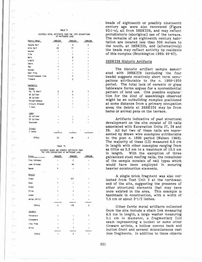
TABLE 73
HISTORIC METAL ARTIFAffi FROH THE 1979 EXC.\VATlOIIS AT IIATTASSEE l.AXE
Ferric Meta 1
S4uare Na i1
'.If._ Nafl
.#~sner
File Bolt
u-aolt
Chai n
'<ey
Button
Sea l Rfnq
~fsc;ellaneous Iron
Tinware
!!:!!!,.: No. 12 Shell
22 Caliber
38 Calf ber
:lfs ca ll aneous
Cfrcu1t Breaker
1 Cen t
~: 22 Caltber
2S Ca l tber
Sucks hot
~: ; Cents
TOTALS
20
1
__ 1 _
l3
TABLE 74
38BK229
17
HISTORIC GLASS AMO CERAMIC ARTIFAffi FROM THE 1979 EXCAVATIONS AT I'ATTASSEE LAKE
Gla ss
n at (llfnd"" )
lUll Chf.,ey
Sea as
Sot t i e
Clear
~uo
a~
Olive
Green
llht te (Kflk )
TOTALS
~
i>orcel a1n
Clay ~toe
Srtck
TOTALS
127
178 0
beads of eighteenth or possibly nineteenth century age were also recovered (Figure 92:1-o), all from 388K226, and may reflect protohistoric (aboriginal) use of the terrace. The remains of an eighteenth century habitation are located less than 300 meters to the south, at 38BK225, and (alternatively) the beads may reflect activity by residents of this complex (Brockington 1980: 60-67).
38BK226 Historic Artifacts
The historic a.rtifact sample associated with 38BK226 (excluding the four beads) suggests relatively short term occupations attributable to the c. 1900-1920 period. The total lack of ceramic or glass tableware forms argues for a nonresidential pattern of land use. One possible explanation for the kind of assemblage observed might be an outbuilding complex positioned at some distance from a primary occupation area; the debris at 38BK226 may be from barns or animal pens on the terrace.
Artifacts indicative of past structural development on the s ite consist of 23 nails associated with Excavation Units 27, 28 and 29. All but two of these nails are represented by drawn wire examples attributable to the post c. 1890 period (Nelson 1968). The majority of these (12) measured 6.5 em in length with other examples ranging from as little as 2.2 em to a maximum of 10.5 em in length. With the exception of three galvanized steel roofing nails, the remainder of the sample consists of nail types which would have been employed in securing heavier construction elements.
331
A single brick fragment was also collected from Test Unit 3 at the northwest end of the site, suggesting the presence of other structural elements that may have once existed in the area. This example is handmade in construction, with a width of 7.5 em or about 2-1/2 inches.
Other ferric metal artifacts collected from the site include a chain link measuring 6.5 em in length, a large washer measuring 5.1 em in diameter, a fragmentary fold seam representing a bucket or some other tinware article, a hollow convex back and button front and several miscellaneous cast iron fragments. In addition to these objects
a single double bitted flat steel key was recovered from Excavation Unit 28. This example is similar in design to padlock forms advertised in the Sears, Roebuck Catalogues of 1897 and 1902 (Israel 1976: 13888-9; Amory 1969:546).
Nonferric metallic objects associated with 38BK226 included a 1906 Indian Head penny and a 1902 Liberty Head or V nickel, two fragmentary No. 12 gauge shotgun shell bases exhibiting the legend "WINCHESTER/ RANGER/Made in U.S.A.," and a single spent short-round rim fire 22 caliber cartridge marked with an impressed "U." This latter item was a product of the Remington Arms Company of Bridgeport, Connecticut, while the two shotgun shells were produced by the Winchester Repeating Arms Company of New Haven (White and Munhall 1963).
Other artifacts collected from the site consisted of a fragmentary (eighteenth century?) white clay smoking pipe stem fragment exhibiting a 2.2 mm bore diameter, and two glass bottle sherds. One of the glass fragment examples represents a nondescript curved body sherd olive-green in coloration, while the other is an aqua colored neck sherd. The latter specimen exhibits a hand applied mouth and neck finish. The pipestem fragment could derive from Indian settlement; the small bore diameter argues for a later eigthteenth century date (cf. Binford 1962), although a much larger sample size should be used before any dates can be safely inferred.
Four glass beads were recovered at 38BK226, three from within the block unit, and the fourth from EU29 some 180 meters to the northwest. All four beads were manufactured by the hollow cane technique (see Good 1972; Kidd 1979 for complete description of bead making) in which a molten bubble of glass was stretched into a long tube which was cut into short segments for beads. One bead (from EU29) was further modified by cutting end facets upon a cane originally hexagonal in section (Figure 92:n). The other three were rounded by a tumbling process (Good 1972; Kidd 1979) and would be classified as tumbled cane beads.
332
The faceted bead is made up of two concentric layers of glass - a white core covered with a clear layer. It would thus be further classified as compound in construction. This bead, found away from the others, also represents a different time period. It is a type common on nineteenth century Indian, Black Slave, and EuroAmerican sites, and probably is associated with the early twentieth century debris noted in the same area. They also occur on southeastern Indian sites before removal, so they can predate the late 1830s.
The remaining three beads from the 38BK226 block are relatively nondescript, but appear to be types common in the eighteenth century. One, a white bead, is also of compound construction, having a thin clear layer on the exterior to produce more gloss (Figure 92:m). This is the common white bead of the eighteenth century and also occurs in the first third of the nineteenth century, and is type 107a in Good (1972}. This bead was found in the {ill of Feature 15, but is probably a later intrusion since all other evidence suggests an Early Woodland age for this provenience (Chapter 5). The other two beads, one navy blue and the other light blue, probably date to the eighteenth century. They would be classified as simple in construction, since they are made up of one layer of glass. The navy blue bead (Figure 92:o) came from the 25-30 em level in EU 18, and also appears to be intrusive; it is certainly unrelated to the Late Archaic assemblage characterizing this level. The final bead (Figure 92:1) came from the fill of Feature 8, a Woodland feature; like the other two beads from the block this artifact may be a later intrusion. The two smaller beads were recovered in . flotation samples (where 1/16 inch mesh was used); since 1/4 inch mesh was used to screen the general level fill, it is probable that other beads were present and were lost during recovery. None of the beads appear to predate the eighteenth century, and they may all derive from historic occupants of the area. They may have been left by historic Indians, who are recorded along the Santee until the early eighteenth century (Waddell 1980; Lefler 196 7), and may be responsible for the corn concentration in Feature 21 at 38BK226. Alternatively, they may have been left by workers or visitors
from nearby eighteenth or nineteenth century farm complexes, such as 38BK225.
38BK229 Historic Artifiacts
The historic artifact assemblage associated with 38BK229 was among the most extensive encountered along the terrace. As with site 38BK226, structural debris such as brick fragments (7), window glass (2) and both square cut (6) and wire (17) nails were encountered (Table 72). While a single possible eighteenth century yellow-gray salt glazed stoneware sherd was encountered, the majority of the vessel fragments associated with 38BK229 consisted of comparatively recent glass beverage bottle sherds. Since the west end of this site was used as a fishing camp earlier in the century, beverage bottles would be expected. Included within this latter category were 127 clear glass sherds representing at least 40 separate vessels, four olive-green colored sherds and a single light or german green colored bottle sherd. Additionally, a total of 44 thin clear glass sherds measuring from .9 to .2 mm in thickness, all apparently from a lamp chimney, were also recovered. Other artifacts collected amply express the utilitarian character of site use and include such items as tinware (2), miscellaneous sheet (3) and band (1) iron fragments, a broken file and Ubolt, and five half threaded flat head bolts.
The artifact assemblage already referred to suggests at least a post c. 1890 date for site use of 38BK229, an estimate that is additionally supported by the remaining assemblage. One item can be identified as an electrical circuit breaker consisting of a brass composition with the stamped legend "C.E./NIEHOFF /& CO./CHICAGO." Chicago City directories indentify the firm of Conrad E. Niehoff and Company as having been an automotive electrical manufacturer operating from at least 1935 to 1940 (Commerce 1935:11; Commerce 1940:13).
Spent ammunition casings recovered from the site include three 22 caliber rim fire shells marked with the "H" designation of the Winchester Repeating Arms Company and another 22 caliber rim fire shell marked with a "U" employed by the Union Metallic Cartridge Company and later by the Remington Arms Corporation. The amalga-
mation of these latter two firms in 1902 is further indicated through two additional shells collected from the site. These consisted of a 38 caliber brass shell marked with the legend "REM/UMC/38 S & W" and No. 12 gauge shotgun shell base marked "REMUMC/NITRO CLUB." The Nitro Club label under the U.M.C. Company designation had previously been advertised in the Sears catalogue of 1897 being identified as a smokeless powder round which had first been developed by the French chemist Viellie in 1885 (Israel 1968; Logan 1959:9). Another No. 12 gauge shell base recovered from the site is marked with the legend "PETERS/LEAGUE" identifying it as a product of the Peters Cartridge Company of Kings Mills, Ohio. This firm was in business from 1887 until being purchased by the DuPont-Remington Corporation in 1934 (Logan 1959:10; White and Munhall 1963:33). In addition to the shell casings, a spent .25 caliber projectile and a single buckshot pellet were also collected from the site.
333
38BK246 Historic Artifacts
The artifact assemblage recovered from 38BK246 provides a scanty picture of land use during the historic period. On the basis of the recovered data there is, in fact, little in the way of substantive information suggesting that the site was occupied for any significant length of time during the post contact period. At least three of the historic artifacts collected from the site would appear to indicate a pre c. 1890-1900 phase of land use. These consist of two square cut machine manufactured nails recovered from level 1 of Excavations Units 3 and 6; and a single blue pencil painted porcelain sherd. This latter example is decorated in a lined floral pattern and exhibits a bluish toned glaze over an off-white grey colored paste. The mode of decoration is consistent with the later grade of Chinese produced "Canton" wares offered in the North American market through at least the 1840s (Tindall 1975: Figure 5). An additional artifact not temporally associated with the above three items is represented by a fragmentary brass base 12 gauge shotgun shell marked with the partial script "12 .•. ./R.H.A. CO." This initialing denotes the manufacturer of the cartridge as the Robin Hood Ammunition Company of

Swanton, Vermont, which operated between 1906 and 1916 when it was absorbed by the Remington Arms-Union Metallic Cartridge Company (White and Munhall1963:33,171).
FAUNAL REMAINS
A total of 206 bone fragments weighing 55.1 grams were recovered from the excavation units at Mattassee Lake in 1979 (Table 75). All of the fragments were quite small and weathered, averaging 0.27 grams in weight, with no fragments recovered larger than 1.0 grams. Preservation conditions along the terrace appear to have been extremely poor. The principal recovery procedures employed in the Mattassee Lake excavations - dry screening with 1/4 inch mesh - undoubtedly resulted in the reduction and loss of some material (e.g., Roth et al. 1980). Flotation was used extensively to examine feature fill from the units, however, with 110 samples processed through 1/16 inch mesh. Given the comparatively gentle action of the flotation procedure, and an origin in aboriginal features, preserved bone would be most likely to occur in these samples if it occurred anywhere at all on the terrace. Virtually no bone was encountered in the flotation samples, however, in either the heavy or light fractions, strongly indicating that preservation is minimal in the site area.
All of the bone fragments were submitted to Terrance J . Martin at the Museum of Anthropology, Michigan State University, for zooarcheological analysis. Only six of the 206 fragments could be identified in any detail, all from the site 38BK226 block unit. The bulk of the sample appeared to be mammal bone, but poor preservation precluded positive identification. A few pieces of possible turtle carapace and/or plastron elements were also noted, although these were also too poorly preserved for definitive identifies tion.
Only one species could be positively identified at Mattassee Lake, the whitetailed deer (Odocoileus virginianus). This was represented by three fragments, a left patella in EU19, level 20-25 em, and two second plananx (Phalanx secunda) proximal fragments, one in EU23, level 15-20 em and
334
TABLE 75
BONE FAAGM£HTS, BY EXCAVATION AREA. I'ATIASSEE LAXE SITES: COIJH, WEIGHT, AHO AVERAGE \lEIGHT SIJ'MARY DATA
Site/Aru Count Weight (Grams)
Average lleight (Grams)
SITE J88K226
O.S 11 Test Units 12 J.l 0.26 Block Unit 126 36.0 0.29 Other 2 m Units 4 0.6 0.15
Featu res (1/4" l'lesh) 2.0 0.40
Features (1116" Mesh) 8 0 .9 0.11
TOTALS 155 42.6 0.27
SITE J88K229
0.5 m Test Un its 0.2 0.20 Block Unit 5 0.8 0 . 16 Other 2 m Units 16 5.5 0 .34
Features ( 1/4" l'lesh) 0.2 0 .20
Features (1/16" Mesh) 0 0.0 0.00
TOTALS 2J 6.7 0.29
SITE 38BK246
0. S m Tes t Units 0 0.0 0.00 Block Unit 28 5.8 0.21 Other 2 II Un1 ts 0 0 .0 0.00 Features ( 1/4" Mesh) 0 0.0 0.00
Fea tures (1116" Mosn) o 0.0 0 .00
TOTALS 28 5.8 0.21
GRANO TOTALS 206 55.1 0 .27
the other in EU12, level 15-20 em. Other animals tentatively identified included raccoon (Procyon 1otor), beaver (Castor canadensis), and turtle (species unknown), represented by one fragment each. A fragment of a left astragalus from a (probable) small raccoon was recovered in the 25 to 30 em level in EU5, and a radius shaft fragment from a (probable) immature beaver was recovered from the 15 to 20 em level in EU7. The single unambiguous turtle carapace or plastron fragment was recovered in the 40 to 45 em level in EU26, but could not be identified to species.
In addition to bone, small fragments from probable fresh water mussels (Elliptio sp.) were recovered at several locations along the terrace overlooking Ma ttassee Lake. Most of these fragments were quite small and weathered, ranging between 0.1 and 0.6 grams in weight. One feature in the 38BK246 block (Fll) was defined on the basis of a small pocket of shell fragments. Some 20 grams of shell were recovered in this feature, including one moderately

complete individual. Even given this comparative concentration, however, the 1979 excavations yielded little evidence for other than incidental shellfish utilization along this portion of the terrace.
The species recognized at Mattassee Lake are consistent with expectations developed from other excavations in the general region, and given the site environmental setting. The freshwater mussels prefer slow-moving water with a sand or mud substrate (Clench, in Stoltman 1974:138), conditions occurring both in Mattassee Lake and in portions of the Santee River swamp. The infrequent occurrence of shell in the 1979 excavation units was, in fact, somewhat disappointing since a large, well-defined shell midden is located some 1000 meters downstream, on the terrace overlooking the confluence of Mattassee Lake with the Santee (Asreen 1974). This midden, located at the Keller Site (38BK83), was tested by Robert Asreen and David Anderson during the original Rediversion Canal survey, and was found to contain well preserved faunal remains and an extensive Mississippian period ceramic assemblage. Comparable shell midden sites are virtually unknown from elsewhere along the Santee drainage in the interior (c.f. Michie 1980a; Anderson, Newkirk and Carter 1978; Anderson and Logan 1981); only one other interior shell midden near Camden, on the upper Wa teree, has been mentioned in the literature (Stuart 1970), and virtually nothing is known about this site. Given the intensive, systematically dispersed testing effort undertaken in 1979 it is highly improbable that a comparable midden was present along the stretch of the terrace examined here. The terrace margin was also inspected during the construction of the canal, after clearing operations had been completed, again with no evidence encountered for the presence of aboriginal shell middens and raccoon remains are common on archeological sites in the southeastern Atlantic coastal region, and are species well-suited to river swamp margins like that along Mattassee Lake (Larson 1980:57,166,175). At the Cal Smoak site, located on a terrace overlooking ..the Edisto River swamp in a setting like that at Mattassee Lake, Stephenson (1979:102ff) identified deer, rabbit, turtle, and bird
remains. The preservation encountered at the Cal Smoak site was very poor, as at Mattassee Lake, suggesting that in the absence of associ a ted shellfish little recoverable bone is likely to occur on terrace sites in the Coastal Plain. Many animal remains ordinarily expected from the exploitation of a cypress swamp environment, such as the bones of fish and birds, are comparatively fragile, and would not be represented in the site assemblage. Interpreting aboriginal subsistence practices at Mattassee Lake on the basis of the recovered faunal remains, therefore is not feasible.
It is probable that a variety of mammals, birds, reptiles, and fishes were exploited by the prehistoric populations visiting the Mattassee Lake terrace. Excavations by Stoltman (1974:137ff) and Peterson (1971a) at Clear Mount and Rabbit Mount, shell midden sites in the Savannah River swamp approximately the same distance inland from the ocean as the Mattassee Lake sites (although on a different drainage), for example, produced a wealth of wellpreserved faunal remains. At Rabbit Mount, for example, 12 species of mammals, seven genera of turtles, two species of birds, and four species of fish were identified (Stoltman 1974:Appendix K). The existence of a large, well preserved shell midden at the confluence of Mattassee Lake and the Santee River, at the Keller site, offers the opportunity for detailed investigation of local subsistence practices. Future excavations at that site, directed toward the recovery of subsistence (particularly faunal) remains, should produce information unavailable at the Mattassee Lake sites.
335


CHAPTER 10
ETHNOBOTANICAL ANALYSIS OF CARBONIZED PLANT REMAINS FROM THE MATTASSEE LAKE SITES
(COOPER RIVER REDIVERSION PROJECT ' BERKELEY COUNTY, SOUTH CAROLINA)
INTRODUCTION
Carbonized plant remains recovered from three prehistoric Cooper River Rediversion Project archeological sites (38BK226, 38BK229, 38BK246) were submitted to Suzanne E. Harris, Research Associate, Center for Archaeological Research, Southwest Missouri State University, Springfield, Missouri. The corn sample from Feature 21, 38BK226 was subsequently analyzed by Elizabeth Sheldon, Research Associate in Ethnobotany, Auburn University, Montgomery, Alabama. Ethnobotanical samples from four other Cooper Rediversion Project Archaeological Sites (38BK235, 38BK236, 38BK239, 38BK429) have been analyzed by Dr. Deborah M. Pearsall, Research Associ-ate, American Archaeology Division, University of Missouri Columbia, Columbia, Missouri, (Pearsall and Voigt 1980; Marquardt 1982), under contract to the Institute of Archaeology and Anthropology, South Carolina.
ENVIRONMENTAL SETTING
The Mattassee Lake environmental background is presented in a separate chapter (Chapter 2) and will be briefly summarized here. The three Mattassee Lake sites actually are arbitrary subdivisions of a continuous multicomponent site along a low river terrace overlooking the Santee River swamp. A major tributary of the Santee, Mattassee Lake, flows along the terrace base just north of the sites. Site 38BK226, the east end of the site complex, sets just east of the confluence of Mattassee Lake and an unnamed tributary and is about 40 m south of the swamp. Site 38BK229, located at the center of the site complex, is about 85 m south of the swamp. Site 38BK246, located at the east end of the site complex is about 15 m south of the swamp. A higher terrace sets just south of the Mattassee Lake sites. (The high terrace is similar to
337
the topographic setting of the archaeological sites analyzed by Pearsall). The low terrace vegetation during the Woodland period was likely similar to that of today: oak, sweetgum, cottonwood and sycamore (Chapter 2). The Santee swamp was (and is) a cypress swamp. The upland areas near the sites likely supported pine-hardwood (oak, hickory) forest.
CULTURAL AFFILIATION AND FEATURE TYPE OF SAMPLES
Ethnobotanical analysis of 70 samples from 39 provenience units was performed (Table 76). The provenience unit, sample number, cultural affiliation, feature type, radiocarbon date, priority and rough percent of feature fill analyzed are shown in this table.
The samples were rated into first, second and third priorities based on soundness of archaeological context and quantity of charred plant material present. First priority samples were the most promising and from them the radiocarbon samples were subsequently selected; all first priority samples were analyzed. Second priority samples were judged less promising than first priority; all were analyzed, but wood species identification were not made if this had been done for first priority sample(s) from the same provenience unit. Third priority samples, from poorly defined features or tree stains (not listed in this report), were not analyzed.
In most cases (except Features 8 and 29, 38BK226 and Feature 10, 38BK246) the entire feature was water separated and the botanical material recovered. Equal volume samples were not made, although most samples were approximately two gallons or larger. The estimate of percent of a provenience unit analyzed in Table 76 is based on the percent of samples from the

TABLE 76
ETHNOBOTANICAL SAMPLES ANALYZED FROM MATTASSEE LAKE SITES (3BBK226, 38BK229, 38BK246)
SITE 38BK226
Sample Feature Radiocarbon Approximate Percent Of Provenience Number Cultural Affiliation Type Date Priority Provenience Unit Analy.~j
Feature 1 Probable Late Pit 2 100 Woodland
2 2 Feature 5 late Woodland Sherd 100
Cluster (Stump?)
Feature 8 Probable Early Hearth 2 50 Woodland
3 2 Feature 14 Middle Woodland Rock lined 2 100
Hearth
2 AD 690!60
3 2 Feature 16 Questionable Late Pit 2 100
Archaic Feature 17 Probable Early
Woodland Pit 2 100
2 2 Feature 21 1 Late Woodland1 Sherd Modem 100
Cluster (Stump)
Feature 25 Probable fliddle Hearth 100 Woodland
Feature 26 Probable late Pit AD 81o!115 100 Woodland
Feature 28 Middle Woodland Rock Lined 2 100 Hearth
2 AD 1oo!55
65o!ss Feature 29 Middle Woodland Hearth 2 66
2 AD s2o!7o
560!155 Feature 31 late Woodland Hearth AD 82o!ss 100 Feature 32 Early Woodland Sherd Insufficient 100
Cluster Feature 33 Probable Late
lloodland Hearth AD 1590!125 100
Feature 34 Late Wood land Hearth AD 134o!s5 1 100 Feature 36 Middl e ~loodland Rock Lined
Hearth AD 110!60 2 100
2 2 3 AD no!6o
Feature 45 1 Late woodland Pit AD 1040!70 1 100 2 2
Feature 47 Probable Early or Middle Woodland
Rock lined 2 Hearth/Pit
100
Feature 48 Probable Middle Woodland
Hearth/Pit 2 100
2
Feature 49 Probable late Archaic/ Early ~/oodland
Pit(?) 100
Feature 50 Probab 1 e Late Woodland/ Nississippian
Vague Stain 2 100
2 Excav. Unit 19 Probable Middle 2 100
Woodland Excav. Unit 20 Probable Middle 2 100
Hood land
338
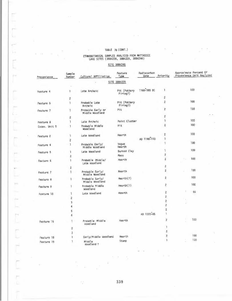
TABLE 76 (CONT. )
ETHNOBOTANICAL SAMPLES ANALYZED FROM MATTASSEE LAKE SITES (38BK226, 38BK229, 38BK246)
SITE 38BK246
Sample Feature Radiocarbon Approximate Percent Of
Provenience Number Cultura I Affiliation T;r:(1e Date Priorit:r: Provenience Unit Anal;r:zed
SITE 3BBK229
Feature 4 Late Archa ic Pit (Pottery Firing?)
1160!185 BC 100
2 2
Feature 5 1 Probable Late Archa ic
Pit (Pottery 2 100 Firing?)
Feature 7 Probable Early or Middle Woodland
Pit 2 100
2 2
Feature 8 Late Archaic Point Cluster 100
Excav. Unit 5 Probable Middle Woodland
Pit 2 100
Feature 2 Late Woodland Hearth 2 100
2 AD 1190!110
Feature 4 1 Probable Early/ Vague 100
Middle Woodland Hearth
Feature 5 Late Woodland Burned Clay 1 100
2 Mass 2
Feature 6 Probable l·li ddle/ Late tloodland
Hearth 2 100
2 2
Feature 7 1 Probable Early/ Middle Woodland
Hearth 2 100
Feature 8 Probable Early/ Hearth(?) 2 100
Middl e Woodland
Feature 9 Probable 11iddle Hearth(?) 2 100
Woodland
Feature 10 Late Woodland Hearth 2 66
2 2
3 2
4 2
5 2
6 AD 1320!65
Feature 15 Probable ~Iiddle Hood land
Hearth 2 100
2
3 2
Feature 18 Early/Middle Woodland Hearth 2 100
Feature 19 Middle Stump 100
Woodland ?
339
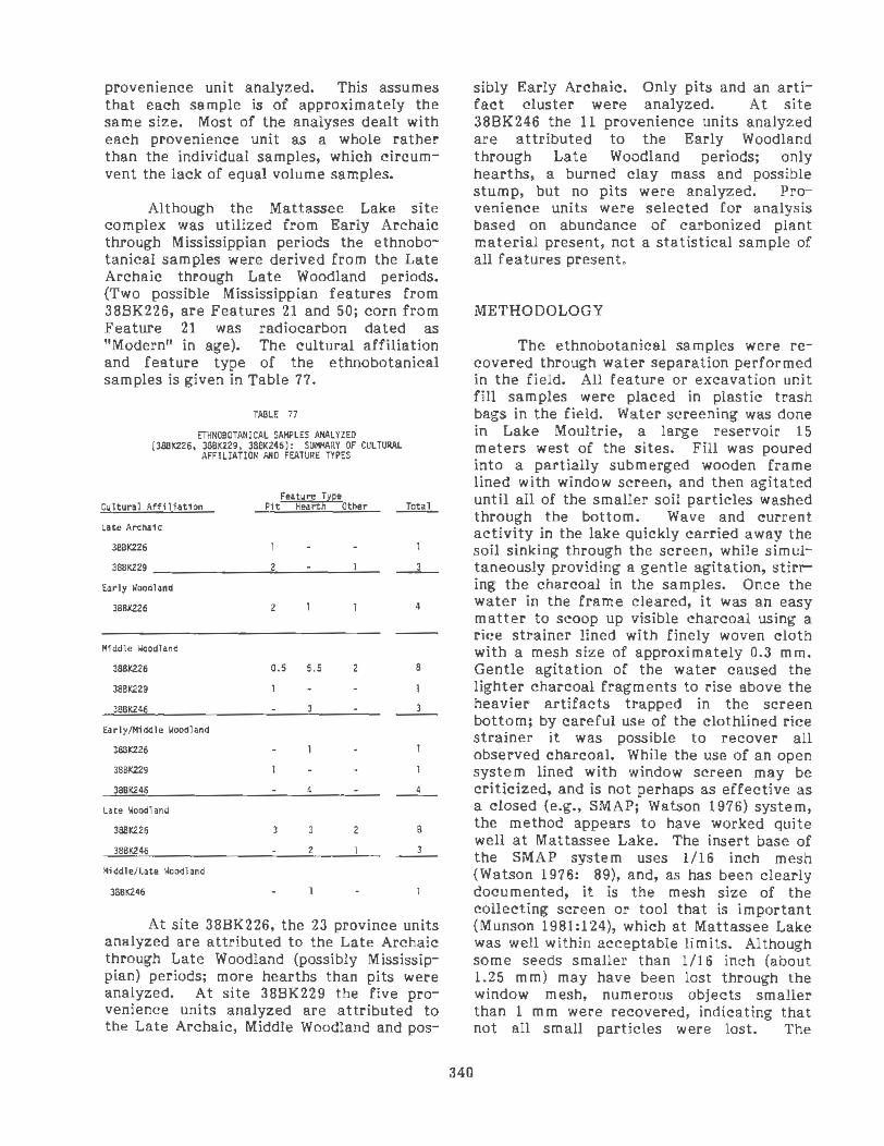
provenience unit analyzed. This assumes that each sample is of approximately the same size. Most of the analyses dealt with each provenience unit as a whole rather than the individual samples, which circumvent the lack of equal volume samples.
Although the Mattassee Lake site complex was utilized from Early Archaic through Mississippian periods the ethnobotanical samples were derived from the Late Archaic through Late Woodland periods. (Two possible Mississippian features from 38BK226, are Features 21 and 50; corn from Feature 21 was radiocarbon dated as "Modern" in age). The cultural affiliation and feature type of the ethnobotanical samples is given in Table 77.
TABLE 77
EniffOBOTANICAL SAMPLES ANALYZED (388K226, 38BK229, 388K246): SUI+lARY OF CULTURAL
AFFILIATION MO FEATURE TYPES
Feature Type Cultural Affiliation Pit Hearth Other
Late Archaic
388K226
38BK229 ______ ___,2,_ ___ __,__ __ 3_
Early Woodland
38BK226
Middle Woodland
388K226
38BK229
38BK246
Early/Middle Woodland
388K226
38BK229
38BK246
Late Woodland
388K226
3BBK246
Middle/Late Woodland
38BK246
2
0.5 5.5
3
4
3
2
2
2
4
8
4
8
3
At site 38BK226, the 23 province units analyzed are attributed to the Late Archaic through Late Woodland (possibly Mississippian) periods; more hearths than pits were analyzed. At site 38BK229 the five provenience units analyzed are attributed to the Late Archaic, Middle Woodland and pos-
340
sibly Early Archaic. Only pits and an artifact cluster were analyzed. At site 38BK246 the 11 provenience units analyzed are attributed to the Early Woodland through Late Woodland periods; only hearths, a burned clay mass and possible stump, but no pits were analyzed. Provenience units were selected for analysis based on abundance of carbonized plant material present, not a statistical sample of all features present.
METHODOLOGY
The ethnobotanical samples were recovered through water separation performed in the field. All feature or excavation unit fill samples were placed in plastic trash bags in the field. Water screening was done in Lake Moultrie, a large reservoir 15 meters west of the sites. Fill was poured into a partially submerged wooden frame lined with window screen, and then agitated until all of the smaller soil particles washed through the bottom. Wave and current activity in the lake quickly carried away the soil sinking through the screen, while simultaneously providing a gentle agitation, stirring the charcoal in the samples. Once the water in the frame cleared, it was an easy matter to scoop up visible charcoal using a rice strainer lined with finely woven cloth with a mesh size of approximately 0.3 mm. Gentle agitation of the water caused the lighter charcoal fragments to rise above the heavier artifacts trapped in the screen bottom; by careful use of the clothlined rice strainer it was possible to recover all observed charcoal. While the use of an open system lined with window screen may be criticized, and is not perhaps as effective as a closed (e.g., SMAP; Watson 1976) system, the method appears to have worked quite well at Mattassee Lake. The insert base of the SMAP system uses 1/16 inch mesh (Watson 1976: 89), and, as has been clearly documented, it is the mesh size of the collecting screen or tool that is important (Munson 1981:124), which at Mattassee Lake was well within acceptable limits. Although some seeds smaller than l/16 inch (about 1.25 mm) may have been lost through the window mesh, numerous objects smaller than 1 mm were recovered, indicating that not all small particles were lost. The

success of the method can best be viewed by the results, which at Mattassee Lake are reflected in the numerous unambiguous and internally consistent radiocarbon determinations and ethnobotanical assemblages that were recovered.
The samples were initially dry screened and rough sorted in the laboratory. Since the samples were strained through closely woven cloth, minute particles and seeds were recovered, as well as large chunks of charcoal and recent organic debris. The samples were screened through 2 mm mesh and the major contaminants were removed. Material greater than 2 mm was sorted into rough morphological categories (Table 78). Material less than 2 mm was sorted only for seeds since identification of minute fragments of charcoal or nutshell requires more sophisticated equipment and time than was available. (However, one South Dakota study found that identification of 1/16 inch specimens using an electron scanning microscope provided additional information on herbaceous plant and shrub utilization (Zalucha 1981). Such high level magnification likewise would be necessary for positive identification of some wood species such as the conifer, which may be cypress or juniper.
Preliminary rough sorting was accomplished using a 3X stand magnifier. A binocular microscope with 7-30X range was used to check the rough sorting and to perform the wood charcoal identifications.
The ethnobotanical samples from the three sites are comprised primarily of wood charcoal, but also include bark, hickory nut and acorn shell, and a shiny substance usually associated with pine charcoal and assumed to be carbonized resin (Table 78). A substance which appeared to be wood charcoal sufficiently carbonized for cellular structure to be gone was tabulated as "Ashy Charcoal" (Table 78); on at least one specimen (Feature 7, 38BK246) pine charcoal graded into this substance. Corn was recovered from Feature 21 (38BK226), and possibly from three other features, but these specimens were too fragmentary to permit positive identification. Likewise a few carbonized seeds are present but are fragmentary. Numerous small (1 mm or
less) carbonized and uncarbonized spores possibly are present.
Wood charcoal identifications were made for all first priority samples and those second priority samples from provenience units which did not have previously identified first priority samples (Tables 76 and 77). A standard 20 pieces per sample were identified to genus (Asch, Ford and Asch 1972:3) when the sample was large enough. For small samples (less than 20 pieces), the total number of identification pieces was noted.
WOOD CHARCOAL
341
Wood charcoal identifications and frequencies are shown in Table 79. Pine is the most frequent taxon, followed by oak, hickory and coniferous wood; minimally present are ash, hackberry, catalpa, cottonwood/willow, maple and dogwood. Mesic species, cottonwood/willow and maple are most abundant from 38BK246, the site closest to the Mattassee Lake margin. Cottonwood/willow is present in one sample from Site 38BK226, which is located between two swamp margins. The lack of cottonwood/willow at site 38BK229 may reflect the site's relatively greater distance from the swamp margin or simply the smaller number of samples and sample size from this site. In general these samples reflect utilization of the mixed pine hardwood forest which likely grew on uplands adjacent to the low terrace, or on the terrace itself, rather than the cypress swamp. (Note: While Feature 4, 38BK246, has a high carbonized white oak frequency, uncarbonized white oak wood was also present, indicating that the feature may not be prehistoric.)
No cypress (Taxodium distichum), which would indicate swamp utilization for firewood was positively identified. Some cypress may be included in the conifer category, but this could also be juniper (Juniperus spp.) or pieces of pine (Pinus sp.) which are too small to include the resin canals diagnostic of pine. The cypress and juniper both lack resin canals but could not be distinguished at the magnification available (Panshin and de Zeeuw 1970:435437).
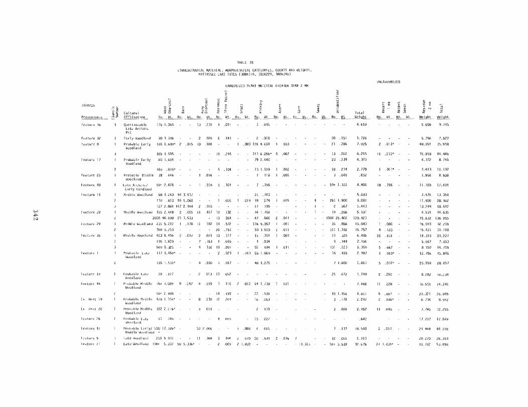
to) .,. ~
3U8K226
P.-oven i encu
ruture 16
rt1:u.ure lZ (f!lllure 8
Feoture 17
fc•tuf"f 25
ftoturt 49
fedture 14
Feoturt 28
htd lure 29
reuure 36
fte•tute I
fe.ture ll
fl!HUI'f 48
r •. u..a 19
r • . llnit 20
Fc.ttur·e 26
f~4tlufe 47
fe.slure S
h.•lllUI'C 21
~X
TABL£ 78
EIIUIOOOIAIUCAL 14AI£RIH., l«lRPllOl.OGICAL CAI£CORJ(S, COUIIIS AHO W£JGIIIS, 11ATIASSEE LAXE Sll(S (J8BK226, J8BK229, J88K246)
~ .. .. 1~ M
5 .:
8 ~~ ~5
CAR~Jl£0 PLMT ~T(RIAt GREATER IIlAH 2 191
~ ~ ., i: "' ~ t .. ~
""
..01 ~ c : ~ ~ E L - U 0 ~ . ~ ~
~ -'1
~ ·;;
8 5
~ ~ ~rn1~:: ion 110. Wl. Ito. Wt. No. Wt . Jfo. Wl. No. Wt. No. Wt. No. Wt. No. WL. NO. Wt. flO. Wt.
Quesuon•bl• LUe Arclwlc Pit
176 4.368 13 .23~ .Oil
Early WOodland 30 1.396
Prob.lble [orly 106 I. 600•
. 026
. 015 10 .406
.143
WOOdland
105 I. 585
Po·obab le £orly 80 I. 694 Woodland
103 . 919' -
Prob4ble lllddlt 39 .446 woodhnd
LU• Archalt/ SOt 2. 624 (orly 1-J•nd
Middle \loodl .. d 68 I. 243 94 l. 931
130 . Oi l 55 6.060
127 2. 081 147 2 . 994
14 .246
. 104 .016
.018 . 101
.020
.056 Htddlo Woodl•nd 15~ 2. 449 2 .06~ II . 457 10 132
2000 90.099 23 3. 533 - 13 . 064
Hlddle wood lond 235 5.222 I . 118 11 . 182 14 .522
700 9.253 - 20 .751 Hlddlt lloodlond 423 5.456 2 .012 2 .021 13 . 317
106 1.829 1 . 163 I .016
5005.325 4 . 102 19 .201
Proboble lHe 117 I. 458' -woodhnd
106 1.539'
Probable LHe JO • 977 Wood I .and
Prob•ble Hlddle 156 J.089 WOodland
50• 2. 983 Probable Moddl e 128 I. 358•
wooal•nd
Pro,.ble Hlddlt 122 2. 216' WOOdlct.nd
Prulllble l41t~ 21 • .1'16 Woodland
. 241
.OZJ
.030 .011
.Oil 13 .052
8 .599 3 . 110
14 . 192
8 .239 12 .204
091
. 069
Prob•ble hrly/ 500 11.JZ6' - SO 2.006 Hlddle Woodl•nd •
l•to IIOOdl•nd 251 5.035 II .360
Uto woodl•nd 100• 5. 337 50 9. 336• 104
.009
J .045
2 . 010
.003 126 4.684
213 6.255•
79 2.440
13 1.519
. 118
.185
25 . 703
.019 19 . 274
11 305
74 1.798
47 .560
116 9.057
50 3.920
IS • 351
I . 034
55 . 494
. 013 58 1.080
48 1.275
.012 44 1.730
22 .539
16 . 263
. 139
15 .221
.006 4 . 065
.009 20 .539
1.032
. 003
.007
.002
.005
.015
.Oil
.001
.Oil
.003
.Oil
.001
.016
13.323
20 .lSI
21 .284
ll .202
23 .239
28 .234
.048
- 50t 1.372
261 I. 900
2 . 007
14 .200
1000 25.406
31 . 856
311 1.702
23 • 326
. 144
131 .223
36 . 416
1 1.680
25 .672
18 1.156
3 .178
.016
. 137
12 . 050 - so• J. 639
Total Weiqht
4.659
I. 726 7.025
8.295
4.313
2. 778
.652
4.900
5.833
9.082
5.443
5.101
120. 423
16.043
15.757
6.486
2.186
6.356
2.997
2.861
1.740
I. 468
4.851 2.242
2.462
. 642
19. 540
6.113
32.676
UHCARBOHIZ£0
~! :1.
~ " ~ .. .., u .. :t -'1
! e :1.
: ~
NO. Wt. No. Wl. lie t 9ht Weight
.013'
16 .233• -
.001°
18 • 795
.ouo 4 .120
26 • 431
.667
.083' -
.037' -
. 292
17 .228
.667
.006' -
II .048
.011
21 1.036• -
5.086 9.745
5. 796 7.522
40.054 35.958
35.958 44.486
4. 312 8. 745
7.41l
7.956
10.192
8.608
11.789 17.484
7.475
11.900
13.249
9.5).4
13.358
20.962
18. 692
14.635
15.632 136.055
16.093 32 . 216
15.431
14.310
5.667
8.350
12.766
31.188
21.227
7.1153
14.706
15.846
25.959 28.857
8.202 IU.iJ4
16.550 24.246
21.321 26.845
6.734 6. 982
1. 745 10.255
17.207 17. 849
24.484 44.035
20.270 26.383
19.7112 53.496

~
"'" ~
~
Pt'Ovttn lcnce r .. ture 31
fe•ture 34 ru ture 4S
feliture 50
~ feuure 4
re.ture 8 feature $
h. Unit S
fci\ture 7
~ fe.uure 6
h:ttu~ 9
fcotunJ 19
htluf'e US
fcuure 4
l't:ttture 1
hll tut"e 8
r c•ture 2
I catul'e S
ft.:lillUf'C 10
lc.ture 1~
~~" ~
2
3
IABH 78 (COHI.)
Elll110601Aifl t Al MATERIAl, H()RPitOLOG ICAL CAIEGORI[S , COUNI ~ AIIO IIEIGIITS, MATIASSEE LAK[ SIHS (388K226, 388K229. 388K246)
CARBONilEO PLANt HA f£RI AL GREAIER IilAH 2 I'M
c
8 3 & i ~
~ ..
Cu ltu•·11l
~ ..I >.~ ~~ I ~ c: ~ _s .; £ ~ x • u .n 3 . ... ,., ~
~
~ c .. 0
i E ~
E 8
~ 0 .. .::
ill.!.l.lill!!!l. l~lt WOo414nd
110, Wt. 110. Wt, llo. Wt. llo •• lit. 110 . lit, NO. lit. 110, Wt . IIO. lit. 110. lit. 110. Ill. Weight
440 3.904 2 .030 I . 047 12 .272 30• .284 4.537
Lite WoodlonCI
li te Wood l•ud
190 2.664 2 . 116 I . 027 3 .205 II . 186 3.198
205 1.862 3 . 089 7 . 102 II .235 4 . 010 ? 19 . 168 2.377
195 2.736 I .002 10 . 158 30 .668 8 .117 I .001 17 . 183 3.864
Pr·obi)ble 100 4. 448 - 3 .027 3 . 107 6 .028 34 1. 164 6.374 Late wood land
Lott Archa i(
Late Al'chtt fc
Pr'Qb,ble t•teArth•lc
212 4 .845
35 .279
II . 11 8
.022
20 .309
Probibl e llld~ l • 52 .4ll Woodland
Pro114bl c E.rly/ 153 2.236' Hidd1e woodlind
Hlddle/l•te lloodland
195 5. 902
107 1.076
.099
.513
.273'
74 .777 12 . 108
Prolwble Hoddle 89 • 708• Woodhnd
Proboll le 2000 94. 149 100 4.960 Middle uoodland
hrly/Middle 152 I. 710 Woodl iuld
Prolwble l•rly/ 30• 1.257 Hiddl~ UOodl•nd
Po·ob•b1e h o•ly/ 91 .831 Hiddle IIOOd l•nd
. 094
.033
.024
.090
.037
. 021
.022
.050
.026
.045
12 . 441
. 016
.012 22 .636
.058
.050 .116
Prob.Oble 61 1.319 5 . 102 Mi ddl e ll<lodl•nd
Ute lloodl•rod 496 6.830 51 .981 8 . 148 . 16S
. 152 50• 1.888
lotc lloudl•ud 60• 8.391
600• 10.521
lotc woodl•tod 221 5. 107
252 5. S39
308 6. 262
174 3.4 16'
200 5. 114
266 6. 124
l'roiHI>Ie Hlddle IOl 1.861 WDocJI•nd
600 20.949
.049
. 101
.022
. 001
116 2.056 19 .204
I .023
23 . 46]
18 .363
Z2 , 489
IS .653 26 1.335
. 41 5
13 .601
.293 4 .222
.027
.025
. 025
.025
. 012
.286
75 1.541 ' -
23 .512
II . 325
.0 19
.019
39 . 556
.217
.093
. 019
. 025
8 . 068
. 049
. 024
. 234 • •
5 . 203
19 1. 122
. 178
. 173
. 006
.001
.059
.002
.Oi l
.006
9 . 447
40 . 4 10'
14 . 091
17 .017
12 . 200
. 002
. 019
29 . 189
31 . 462
35 . 216
30 . 578
28 . 145
25 . 297
25 . 136
.003
28 . 306
22 . 188
10• . 494
II . 182
16 • 104
IS .231
16 . 141
. 055
50 I. 567
IS . 093
IS .693
. 037
5. 794
2.280
. 747
.039
.867
. 418
2. 928
6.231
2. 321
1.584
1.054
99.726
2.528
1.612
1.227
1.535
8.460
2.228
8.908
11 .449
5.878
7. 416
8.391
3.8ll
5.948
8.379
1.994
21.661
2 . 344
UIICAR801UZEO
~
c
~ ~
~ ~ :t .!IC
e . ~
~
no. \It , Ho. Ill. lleight Wefglol 3 .026 20.334 24. 811
24 . 264 22 . 993 26. 191
60 . 647 4.997 8.021
29 . 403
20 I. 447
.063
- .046
.042'
. 087' -
IS . 101
2 .010' -
30 .231
2 1 . 286
.034
.001
62 . 649
21 . 291'
IS .039
13 .226
. 108
. 029 '
19 , 432
19 .232
12 . 106
14.325 18.592
29.650 37.504
16.752 22.609
17.606 19.886
7.291 8.038
.628 . 713
5. 129 6.024
s. 591 6.075
15 .36& 18.3])
3.380
4.459
5. 963
2. 927
9.698
6. 780
7.673
] , 991
2 1.111 120.837
5. 679 8. 438
9.820 11.7l2
1.619 2. 600
I. 939 l . 415
22. 085 31. 194
12.871
12.751
42.058
14.937
24.190
21.444
13.455
11. 910
23.299
17.049
15 . 138
21.660
53. 798
20. 854
31 . 832
29.841
17, 39&
23.887
32 . 110
19. 275
22.624 45.119
4 .952 1.402

?rovtnt"'ce
ie•u.re 16
futul"t ll
Ftltllrt I
Futurt 17
;:tltlil'l"t lS
f~atUI"t 49
;ut~o~tt 14
FutuN ze
ftUVrt 1
fettut't ••
Uuv. Unit \9
itUif,_ S
futu,.. 2-1 tutu,.. )1
:'ttWt't )I
Futlfrt t5
l!!Bll Futwrt t
t"fHiil1"t I Futwtt S Uuv Uttlt S
r~ll\ll"t 18
FUUH"t(
Ftuurt 10
H
":.tt.! ,
£THN080TAIHC.Ol SAMPl£S, '000 O!ARCO.Il ID£NTIF IC.Oli0N IY PERCENT 'IATTASS(£ L,U<E SHU ( l86l226, liBW9. liiKl<ll
Cvl tur.tl ~fflllltlon
PolS Hilt LUI ArCMIC 20
Urlr ltOoclluo lO
Problblt t.rly oiOO<IIIetto 20
20
~"robiblt EJrty ""*1111\11 20
20 'ttdOit 'wtooohnd 20
I.. !lrctlt1c/Eorly IJ0041.tftd20
Mtddlt W'OOd11nd
'4144lt wooc:~land
Mf0411 WOOOiltld
PrOO&blt l.Ut ~h1!141
?r-oNIIt 14t001t .iOOOhlld
?roo.olt .!nddle Joodlll\0
Proo.t~lt lAte ;.Aooc~htld
,.._.,,, hrly/ "liOOit !liOOOhftd
t..c.t !IOoal&no
Uu Woodl1no Utt Jooallli'IO
U.tt M*SIIft6
hu .-ooal1nd
\.Itt lf"(Mtt
20
20
20 20
20 lO
20
20
20
15
20
10
10
20
20
10
20
20
>roonlt Ute Arc.ne~c 11 ~troNOit Hflfdlt 20
.I0001&no
~ltlt (.&rly/"1dOh Z0 .iOoollnO
>rQOIOit ~tddle ~odllno
i'toN01t !itiGCStt ~1IIICI·St~)
• tcclt ;oool•.fld
i'rooul c £trf)l/ '1toellt Woool&nd
P~Oit llriy/ "lfdilllt 40olant
~roo.olt "tlOdlt ~OOllnd
U te '.toodt&no
10
20 20
20
10
20
20
10
20
a . j
95 so 25
15 IS 15 15 5 2S 10 10 IS
•s l5
•s <0
IS
IS
20 l5
60 •o lOIN'IFI£0
10 10 15 -.or IOEtcTtJI£0
>01 10£NfiFIID
100 "OT 10£NTIFI£0
SS lS
,'fQf tOE~Ttfl£0
,,or 10£Nr1rt£o
IS .IQ 10 I S
'5 15 20
lS 15 lS
70 15 10
75 10 10 85 10
ao 10
66 20
as 100 10 10
IS 25
•s lO
10
lO
10
20 20
"I 0 T I 0 £ 'i T I F t E 0 'I 0 • I 0 £'I • I ' I !' 0
60 10
20 20 25
• or 10£•'1'1£0
!6 " 12 18
.;5 lS
45
75
.as •o to 10 10 ss :s lO 10
100
IS 10 11 IS
15 5 70
lS !0
10 .1() 10
11
10
:o
10
'tOT l0£'fTI11EO
20 45 IS lS
lo1tt ..ooatand 20
20
n 20
10 10
zo
• 100
101 1nrnu~ro 60 lO 55 IS
:o 10 10 ss s zo 10
55 S IS
60 IS 10• J)E'Iflf: ! O
lS NOT tO!,..ltFt£0
344
1 r ;;;
IS
s
10
20
If
IS
IS
IO 10
5
10
10
so 10
IS
s
10
IS
18
·o 10
15

Pine charcoal is not only the most frequent taxon, but pine utilization appears to increase through time, as shown in Table 80.
TABLE 80
EiliNOBOTAHICAL SAMPLES: lrui1BER OF SAI!PLES BY CULTURAL PERIOD HAV ING PINE AS MOST FREQUENT \1000 CHARCOAL
MATTASSEE LAKE SITES (3881<226, 388K229, 388K246)
CUltural Period
Late Archaic
Early lloodland
lliddle Woodland
Ea rly/Middle Woodland
3
3
Late Woodland
Midd le /Late Woodland
1 Incl udes Other Coniferous llood
In general pine is the most frequent charcoal in the majority of Early, Middle and Late Woodland samples. By the Late Woodland period pine accounts for 50 percent or more of the charcoal in most samples (Table 80). By contrast, during the Early Woodland, pine accounts for 50 percent or more of the charcoal in only two of nine samples (although in other samples it is often still the most frequent single taxon). Conversely, higher frequencies o{ hickory (Carya spp.) and the infrequent taxa, cottonwood/willow (Popu1 us spp./Sal ix spp.), dogwood (Cornus spp.), and maple (Acer spp.) occur primarily in the EarlyMiddle Woodland.
The general preference for pine as fuel could be related to environmental or cultural factors. Increasing oceanicity during the Late Woodland may have resulted in a decline of the oak-hickory forest (Brooks and Canouts 1980). However, the proposed decrease in oak and hickory would not necessarily explain increased pine utilization. Cultural selection may also have operated. As fuel, pine burns more readily with a hotter fire than many other woods, while oak burns more steadily than pine and produces a more steady heat (Graves 1919:31). A combination of pine and oak could have produced the most efficient mix of fuels.
SUBSISTENCE
Possible subsistence remains, particularly carbonized hickory nutshell and to a lesser degree acorn shell, were recovered from all but four of the provenience units analyzed (Table 81). Hickory nutshell, partially due to its density, was the most abundant subsistence item, occurring also in all but four provenience units. Carbonized acorn shell was recovered from 16 provenience units (41 percent of the total provenience units analyzed).
In order to assess the possible changes in hickory utilization through time, the percent of provenience units with ten percent or more of the carbonized plant material by weight being hickory nutshell was calculated for each general cultural period: Late Archaic - 75 percent, Early Woodland - 50 percent, Middle Woodland - 31 percent, Late Woodland - 42 percent. This initially suggests a peak for hickory utilization during the Late Archaic with a decline in the succeeding Woodland periods. The occurrence of acorn by provenience units through time was similarly calculated, but using only presence or absence since all acorn weights were less than two percent of total carbonized plant material. The percent of provenience units with carbonized acorn remains were: Late Archaic - 0, Early Woodland - 50 percent, Middle Woodland -62 percent, Late Woodland - 92 percent. Unlike hickory nutshell, acorn apparently peaks in the Middle Woodland, then declines (Table 81).
345
At least two problems are associated with interpreting the nutshell frequencies. First, these sites represent only one element in the settlement system at any point in time and nut utilization might be carried out here during some cultural periods, such as the Early Woodland, and carried out elsewhere during other periods. Second, the context of three of four features with very high hickory shell percents is somewhat questionable. Features 1,8, and 29 (38BK226) occur within .5 to 1.5 m of each other, and have been assigned to three culture periods (Early, Middle, and Late Woodland; two, features 8 and 29 have recent hickory shell also, raising the question of whether the carbonized hickory nuts are all

TABlE 81
ETHNOBOTANICAL SAHPLES: TOTAL CARBONIZED HICKORY :ti.IT AHO ACORN ROIAIHS AS PERCENT Of TOTAL CARBONIZED PLANT
IIATERLAL BY PROVENIENCE UNIT
Hickory Acorn Sfte Provtni ence Feature Tm (Percent) jPercentl
L A T E ARCHAIC
388K226 Future 16 Pit 19.0 0.0
388K229 Feature 4 Pit (Pottery Firing?)
67.8 0.0
229 Feature 5 Pit (Pottery Firing?)
37.5 o.o
229 feature 8 Point Cluster 0.0 0 .0
E A R L Y WOODLAND
3881(226 feature 17 Pft 55.4 . 02
226 feature 49 Pit 16.0 o.o 226 future a2 Hearth 71.41 .06
226 Future 32 Sherd Cluster .6 o.o KIODLE WOODLAND
3881<226 Feature 14 Rock Hearth 6.3 .07
226 Feature 25 Hearth 18.0 .77
226 Feature Z8 Rock Hearth 1.9 • 01
226 Feature 292 Hearth 40.81 . 04
226 Feature 36 Rock Hearth 5.8 .09
226 Feature 48 Hearth/Pit 18.4 .01
226 Excav. Unit 19 11 .7 0.0
226 Excav. Unl t 20 5.6 o.o 388K229 Excav. Unl t 5 Pit 4.0 0.0
3881<246 Feature 8 Hearth 3.2 .13
246 Feature 9 Hearth 8.8 0.0
246 Feature 15 Hearth .02 .02 Feature 19 Hearth .02 0.0
EARLY/KIDDLE WOODLAND
388K226 Feature 47 Rock Hearth .3 0.0
3881<229 Feature 7 Pit .2 o.o l88K246 feature 18 Hearth 1.0 o.o
246 Feature 4 Hearth o.o 0.0
246 Feature 7 Hearth 7.1 0.0
L AT E WOOOLANO
3881<226 Feature 12 Pit 40.2 0.0
226 Feature 45 Pit 5.6 .18
226 Future 26 P1t 35.0 0.0
226 Feature 31 Hearth 6.0 o.o 226 Feature 33 Hearth 0.0 0.0
226 Feature 34 Hearth 6.4 o.o 226 fe1tur-e 5 Sherd Cluster 8.8 .26
226 Feature 21 3 Sherd Cluster o.o 0.0
226 Feature so3 Vague Stain 29.3 .24
3881<246 Feature 2 Hearth .2 0.0
246 Feature 10 Hearth 16.8 .05
246 Feature 5 Burned Clay 35.5 1.15
HI DOLE/LATE WOODLAND
3881<246 Feature 6 Hearth 19.8 1.5
1 Recent Hickory Shell Also Recovered
2 Features 1, 8 and 29 (388K226) are Located Betlfeen . 5 and 1. 5 Heters Apart.
3 Possible Hlsslsslpplan feature
346
prehistoric. In general however, the relatively greater frequency of nutshell during the Early Woodland and lesser frequency during the Late Woodland frequency is consistent with the hypothesized oak-hickory reduction during the latter period (Brooks and Canouts 1982). Corn (Zea ~ b) was recovered from Feature 21 at site 38BK226. The Feature 21 sample included eight measurable cob fragments and numerous cupules, all totaling 13.323 grams. The corn was analyzed by Elizabeth Sheldon of Auburn University, who found that the cob fragments were 88 percent (N=7) 10-rowed and 12 percent (N=l) a-rowed. She suggests that the corn is similar to the Northern Flint/Eastern Corriplex. (Sheldon's analysis is reported in the next section). The Eastern Complex had spread across most of the Eastern United States after about A.D . 1000 (Yarnell 1964:107).
Corn does not appear to have been an important subsistence item at 38BK226 and is absent from 38BK229 and 38BK246. The only feature containing corn has been assigned to the Late Woodland based on associated artifacts, but in all probability dates to a general Mississippian time level (post A.D. 1000). It is possible that 38BK226 (Feature 21) was briefly utilized by Mississippians who simply did not leave diagnostic artifacts associated with the features. A Mississippian site is located about 1000 meters east of 38BK226, site 38BK83. Other Mississipian sites, with structures present, were located about four kilometers west of 38BK246, and were investigated during the Rediversion Canal project (Brooks and Canouts 1982).
SEED IDENTIFICATIONS
The seed identifications are presented in Table 82. The seeds were identified using modern comparative collections belonging to the author (Suzanne E. Harris), to Dr. David Benn Center for Archaeological Research, Southwest Missouri State University) and to the Herbarium, Life Sciences Department, Southwest Missouri State University. Most of the carbonized seeds were very eroded and/or fragmentary, which often obscured the diagnostic features and hampered some identifications.

TABLE B2
ETHNOBOTANICAL SAMPLES : SEED IDENTIFICATIONS
co c
co co .... u
"' c. <:: "0 ~ 0. ~
<II 0 .,. :0 u co
E <II c. co <II co :> c. co <II ....
<II "' .... .,. a. a. c.. 0. "' .....
"' <II ~ a. 0 a. a. .,. <II .,. .... ... ..... <II u <II
~i~~~~~~n~ c "' "0 .... ~ <II E <II .... ·- VI c ·- .,... a. en c: --a "' c. c 0')., VI s...c-- e n::s~·-
PROVENIENCE ~ >, <II <II - <II co co 0 ~ c c TOTAL Q...~ 0.. d,_>::Z: .zoL. .!.2....!!...~ ~
38BK226 Probable Early Woodland
FS 1 1 Fl7(2) 2 1 3 F49 1 3 4
Middle Woodland
F25 1 F28( 1 )(1) 11 2 F29(2) 1
F48(2) 1 2 3
Probable Hiddle Woodland
F33 2? 3
Eul9 1 1 2 4
Late ~loodland
Fl(2) 11 1 2 F5 1 3 4 F31 1? 2 F34 5 1 1 8 F45(1) 1 11 1? 2 5 3 17 F50(2 ) 2 4 8
TOTALS 10 1? 1? 2 3 2? 2 1? 19 7 11 63
38BK229 Probable La te
Woodland
F5
Probable Early/ Middle Woodland
F7(1) 2 2 (2) 1? 3
TOTALS 1? 2 6
38BK246 Early/~liddle Woodland
F18 2 F4 2
Late Woodland
F2(?) 1 1 Fl0(6) 1? 2 2 6
TOTALS 1? 3 3 11
347

Fourteen ~axa were identified: GRAMINEAE (Grass family), CYPERACEAE (sedge family), Pentederia cordata (pickerelweed), Myrica spp. (bayberry), Chenopo~ spp. (goosefoot), Phytolacca americana (poke), Rubus spp. (blackberry), LEGUMICOSAE (Bean family), Vitis spp. (grape), Nyssa spp. (tupelo or black gum), Cernus spp. (dogwood), LABIATAE (Mint family), Galium spp. (bedstraw and COMPOSITAE (Daisy family). The majority of the unknown seeds are round, hollow, have an opening at the top and are 2-4mm in diameter. A number of round, hollow seeds about 1m m in diameter (probably Gal ium spp.) with uncarbonized interiors were frequent in virtually every sample. Other uncarbonized seed were also present, but were not tabulated. Likewise numerous small (less than 1m m) carbonized objects, probably the scleretia (fruiting bodies of fungus) identified by Pearsall and Voight 1981:37) were not tabulated.
Given the low occurrence of carbonized seeds, few comparisons may be made either among the three sites or among the cultural periods represented. The majority of the carbonized seeds were recovered from Middle and Late Woodland features at site 38BK226. Twelve of the 14 taxa identified were recovered here (exceptions are goosefeet and legume). Conversely at site 38BK229 only. two taxa (pickerelweed, legume) were identified. At site 38BK246 only four taxa (sedge, goosefoot, blackberry, dogwood) were identified. The taxa present suggest utilization of more than one habitat from each site.
No identified seeds were recovered from Late Archaic or definite early Early Woodland features. (One unidentified seed was recovered from the probable Late Archaic Feature 5 at site 38BK229) Early to Middle Woodland features at site 38BK229 yielded pickerelweed and legume, while those at site 38BK246 yielded sedge and Chenopodium. Middle Woodland and probable Middle Woodland features at 38BK226 yielded poke, blackgum, dogwood, and possibly mint, bedstraw and composite. Half of the taxa were recovered from Late Woodland features at site 38BK226: Grass, sedge, bayberry, grape, dogwood, bedstraw and possibly pickerel weed and blackberry. Late
348
Woodland features at site 38BK246 yielded blackberry and dogwood.
Several of the taxa were associated with the swamp or swamp margin, including sedge, pickerelweed, bayberry and possibly Nyssa spp. (if tupelo, N. sylvatica). Other species indicated disturbed habitats, such as the goosefoot, poke and blackberry. The other taxa may occur in a variety of habitats. However, all likely grew in the general vicinity of the sites.
Economic uses are suggested ethnographically for many of the identified taxa. Food sources include fruit or seeds of grape, chenopodium, blackberry, composite and possibly dogwood and black gum/tupelo. Other taxa can be used for greens (poke, mint), as starchy tubers (pickerelweed) or condiments (bayberry). Other species such as grasses and sedges could be used for constructing items such as baskets, mats and shelters.
The majority of these taxa fruit from about July to October. A few such as bedstraw, Nyssa spp. pickerelweed, the mints, grasses and sedges any fruit somewhat earlier. Whether the seeds represent human use or accidental incorporation into the archaeological deposits, their presence suggests that the features were open during the summer and fall.
Although these economic uses listed above (and undoubtedly various others) are possible for the taxa listed, it is likely that some if not most of the taxa represent unintentional inclusions in the features and cultural deposits. The higher frequency of seeds in the Middle and Late Woodland proveniences may reflect preservation of seeds in the more recent deposits. The large number of partially carbonized and fresh seeds present many of the samples (but not tabulated) also suggests this. Thus, as is the case with any ethnobotanical study dealing with low seed frequencies, it must be stressed that accidental inclusions within archaeological deposits, selective carbonization and selective preservation all bias our view of plant utilization by the site's prehistoric inhabitants.

CORN REMAINS FROM FEATURE 21, 38BK226
Due to the frag mentary nature of the specimens, only four cob measurements were possible. No entire cobs or kernels were recovered from Feature 21.
The following measurements were made, using sliding calipers;
1)
2)
Cob Diameter This was measured, in millimeters, from the center of the upper surface of the glume on one side of the cob to the corresponding point on the upper surface of a glume directly opposite.
Row Number
3) Width of the lower glume at its widest point. This estimates kernel width.
4) Distance between lower glumes in the same row. This estimates kernel thickness.
The results are presented in Table 83. The cob diameter varied between 12 and 16 mm with a mean of 14.6 mm. Eighty-eight percent of the cobs were 1 O-ro wed (N=7) and 12 percent were a- rowed (N=1); all exhibited strong row pairing. Lower glume width varied between 4 and 7 mm with a mean of 4.8 mm. Kernel thickness, as estimated from the distance between the lower glumes, varied between 3 and 4 m m with a mean of 3.8 mm.
When these four characteristics are considered, the 38BK226 maize resembles "Northern Flint" or "Eastern Complex" types. However, given this small sample of fragmentary cobs and a lack of kernels, it cannot be positively identified to race.
INTERSITE COMPARISONS
Ethnobotanical analyses have now been conducted at several South Carolina coastal plain sites. As noted in the Introduction, four additional Cooper River Rediversion Project sites, excavated by the Institute of Archeology and Anthropology,
349
TABLE B3
CORN COB MEASUREM£/ITS FROM FEATURE 21 , SITE 38BK226
Distance Cob No. Between ·~i dth Of ~ ..2!..._ Lown G 1u<nes Lower G1...e
16 .., 10 0.5 0.4
12 10 0. 7 0.4
17 10 0.5 0. 4
15 10 0.4 0. 4
13 0.4 0.4
17 10 0.4 0.4
14 10 0.4 0.3
13 10 0.4 0. 4
In add ition to these measurabl e cob f ragmen ts, the sample conta ined:
5.3 grams sing le cupules
2.2 grams joined cupules
University of South Carolina, (Brooks and Canouts 1982) have been analyzed by Pearsall (Pearsall and Voight 1981). (The two Cooper River ethnobotany projects were conducted independently and neither analyst knew of t he others' research until after the preliminary work had been done.) Another Berkeley County site, the Palm Tree site, was reported by Widmer (1976a). Several other coastal plain sites, particularly shell middens, have been reported by Trinkley (197Gb, 1979). These wil~ be discussed briefly.
The four Cooper River Rediversion project sites analyzed by archeologists from the Institute of Archeology and Anthropology were 38BK236, 38BK236, 38BK239, and 38BK423. Most of the identifiable floral material from t hese sites was recovered from 38BK235 (Mississippian) and 38BK236 (Late Woodland). While IAA's component assignments were based on somewhat different taxonomic assumptions than that of the Mattassee Lake sites, the periods in question, Mississippian and Woodland are roughly comparable. The eastern Mattassee Lake site (38BK246) is located about 1 km west of the westernmost Institute site, but is about 5.5 km west of 38BK235 and 38BK236. It is quite possible that the t wo sets of si tes r epresent components of the same settlement syste ms during some points in the prehistoric past , but this remains to be demonstrated. Contexts of

the samples for the two site series differ in that the Mattassee Lake samples are virtually all from features, while the Institute samples are predominately from midden deposits.
Ethnobotanical analyses for the two sets of sites not surprisingly yielded somewhat similar results, particularly for the wood and nut remains. Pine was the most important single taxon used for fuel, followed by oak and hickory. The Institute sites data does tend to confirm the pattern of increased pine utilization through time noted at Mattassee Lake (Brooks and Canouts 1982).
Frequencies of nut remains at the Mattassee Lake and Institute sites are also similar. Hickory is more abundant than acorn at both sets of sites. However, walnut was recovered from both Institute sites (Brooks and Canouts 1982), but not from the Mattassee Lake sites. Most interesting is the lower frequency of nut remains during the Late Woodland period relative to earlier or later periods at both sets of sites. Nut remains were most abundant during the Early and Middle Woodland periods at the Mattassee Lake sites and during the Mississippian period at site 38BK235 (Brooks and Canout 1982). The low Late Woodland nut frequency at both site series supports the hypothesis of Brooks and Canouts (1982) that the Late Woodland adaptation was diffuse and that the Woodland groups moved into the uplands away from the swamp during the fall.
Seven seed taxa were reported from both the Mattassee Lake sites and the two Late Woodland and Mississippian sites reported by Pearsall (Pearsall and Voight 1981): dogwood, grape, Chenopodium, blackberry, bedstraw, grass and legume. Most of these taxa are ones which were widely reported from prehistoric sites. Differences between the two site series are most easily attributable to the differences in site locations and associated vegetation zones. The Mattassee Lake sites, situated beside a large stream channel at the edge of the Santee swamp, yielded seed taxa associated with the swamp or swamp margin, including sedge, pickerelweed, bayberry and Nyssa spp. (if this is tupelo, N. sylvatica).
350
Conversely, the Institute sites are located at somewhat higher elevations. Site 38BK236, which is located about 300 m from the swamp margin, yielded relatively high frequencies of pine and dogwood, species associated with the drier topographic position. Seed taxa reported only from the Mattassee Lake sites include poke, mint and composite. Seed taxa reported only from the Institute sites include persimmon, sumac, polygenum and lily (Brooks and Canouts 1982). These taxa from both sets of sites represent ones which are of economic importance (judging from their frequency at prehistoric sites) and/or commonly occur. Their presence at one set of sites, but not the other, may reflect selective preservation, rather than differences in prehistoric plant utilization.
The Mattassee Lake seed taxa support the hypothesis proposed by Brooks and Canouts (1982), that a diffuse Late Woodland economy would be reflected by a higher number of seed taxa than the Mississippian one. Eight seed taxa were reported from the Mattassee Lake Late Woodland contexts, while five taxa were reported from the Institute Late Woodland site (38BK236) and only four were reported for the Mississippian site (38BK235) (Brooks and Canouts 1982).
No corn from a prehistoric context was reported from the Mattassee Lake sites. Corn was reported from the Mississippian site 38BK235 (Pearsall and Voight 1981: Table 2). This is consistent with the interpretation that corn agriculture was not practiced on southeastern Atlantic coastal plain sites until the Mississippian period.
Carbonized plant remains were recovered from the Palm Tree site (38BK147) (Widmer 1976a) located on a ridge crest overlooking a Cooper River swamp, a topographic setting similar to the Mattassee Lake sites. The ethnobotanical material was recovered from features apparently associated with the Thorn's Creek Phases of the Late Archaic. Carbonized nut fragments and seeds were reported: hackberry (Ce1 tis sp.), hickory nut, cherry or plum pit (Prunus sp.), crotolaria seed (Croto1aria spp. or Biplisia spp.}, and grape seed (Widmer 1976a:36). The seeds were interpreted as
suggesting a mid-sum mer to fall occupation at the site (Widmer 1976a:17).
Identical categories of carbonized plant material have been reported from two Late Archaic/Early Woodland coastal plain sites in different topographic settings: Cal Smoak (38BM4; Anderson, Lee and Parler 1979) and Albert Love (38AL10); Trinkley 1974b). The Cal Smoak site sets on a sandy ridge overlooking the Edisto River; ethnobotanical samples were recovered from two features. The Albert Love site is situated near a Carolina Bay; a single flotation sample from the midden was analyzed. The carbonized botanical remains recovered at both sites were hickory nutshell, and wood charcoal (pine, oak).
Other ethnobotanical analyses have focused on shell midden sites, where favorable preservation conditions has been reported. Trinkley (1976b) has provided a detailed analysis of paleoethnobotanical remains from three Late Archaic-Woodland transitional shell middens in the Sea Island area. The three sites include Daw's Island (38BU9; Michie 1973a), Spanish Mount (38CH62; Sutherland 1974), and the Sewee shell ring 38CH45; Edwards 1965). In general, the material from these sites reflected both the favorable preservation of charcoal in the alkaline midden dep9sits, and the highly varied environmental setting characterizing the marshland border. A high incidence of hickory and acorn nut shell in the middens was indicated, with on or both of these genera reported from almost every sample. Pine, hickory, and oak were the most common genera represented by the charcoal, at the three shell midden sites, a finding similar to that noted on at the Cooper River Rediversion Project sites. Several other wood species were recognized from the three coastal sites, maple (Acer sp.), QQfc wood (Cornus florida), water locust {"G''editsia aguatica), sweetgum (Liguidambar styracifl ua), willow (Salix sp.}, cypress Taxodium sp.) and an unidentified diffuse porous wood.
Preliminary ethnobotanical identifications have also been reported from other coastal shell midden sites. Trinkley (1975:31) reports the presence of carbonized hickory nutshell from deposits at the Late
351
Archaic/Early Woodland Lighthouse Point shell ring (38CH12). Two other coastal shell midden sites, both dating to the Woodland period, have also had preliminary ethnobotanical identification. At Jenkin's Island, Trinkley (1976c:l6) reported the presence of carbonized hickory nut shell fragments. At Fort Johnson (38CH275) South and Widmer (1976:56-57) report the tentative identification of acorn and hickory nut shell fragments, together with bedstraw (Gal ium sp.), chinkapin (Castanea sp.) plum or cherry seeds (Prunus sp.), bayberry (Myrica sp.), and arrowarum (Pel tandra virginicum). South and Widmer (1976:57) suggest that the presence of arrow-arum, a coastal marsh grass requiring extensive preparation to make edible, indicates the early occurrence of a highly specialized subsistence adaptational strategy known to have been common among protohistoric Indians in the region (Swanton 1946:272, 276).
In summary, most ethnobotanical reports of coastal plain sites, including both series of Cooper River Rediversion Project sites, list hickory nut shell remains as the most frequent subsistence item. Wood charcoal taxa most frequently reported are pine and oak. The repeated occurrence of these taxa reflects to a degree their relative abundance in the natural environment and selection by the sites' aboriginal inhabitants. However, selective preservation, particularly preservation of dense hickory nutshell, it also a major factor in determining presence and absence of carbonized plant material. Similarly, the wide variety of seed taxa reported both from the Cooper River Rediversion Project sites and other coastal plain sites may reflect differences in plant availability and aboriginal usage, but also reflects both accidental inclusion and selective preservation of these particular taxa. At each site the taxa listed undoubtedly represent only a small fraction of those plants actually used.


CHAPTER 11
RADIOCARBON DETERMINATIONS
INTRODUCTION
Sixteen radiocarbon samples were processed from features found along Mattassee Lake, 12 from site 38BK226, two from 38BK229, and two from 38BK246. These determinations, which spanned the Late Archaic through the late prehistoric period, are summarized in Table 84. Fourteen prehistoric or protohistoric dates are reported in the table. One sample (DIC-1842) was too small to give a reliable date, and one other (DIC-2115} produced a Modern dete~; mination. The table includes the sample's laboratory number, archeological provenience, and radiocarbon age in years before the present. A corrected, "true" determination, based on an analysis of tree ring dated samples, is also provided, employing the MASCA calibration (Ralph, Michael, and Han 1973). Finally, a brief description of the associated assemblage is provided, to indicate the significance of each date.
ANALYSIS PROCEDURES
All of the radiocarbon assays were conducted by Dr. Irene C. Stehli, Dicarb Radioisotope Company, 7711 S. W. 103rd. Avenue, Gainesville, Florida 32601. The determinations were run on wood and hickory nutshell charcoal obtained through flotation, from the fill of well-defined aboriginal pit or hearth features. Prior to submitting the samples for dating, the cha~; coal was examined and identified by an ethnobotanist. Descriptions of the features and associated material remains, including the context of the flotation samples, are given in Chapter 6, and ethnobotanical identifications are given in Chapter 10. The flotation samples typically were taken from the centers of the features, to help minimize possible contamination. Additionally, whenever possible, fill from immediately around the artifacts encountered in the features was collected, to provide as much spatial proximity as possible between the artifacts and the dated charcoal.
At Dicarb all of the samples were first examined and cleaned of obvious impurities. The samples were treated for humic acids with 2N NaOH at 100oc for 30 minutes, then decanted, filtered, washed, and picked for rootlets while wet. Free carbonates were then removed using 2N HCl at room temperature for approximately 48 hours. The sample was then decanted, filtered, and washed, and again picked for rootlets while wet. The samples were then dried at 9ooc and picked for a final time under 30X magnification. Rootlets were present in varying quantities of all of the Mattassee Lake samples, necessitating a considerable cleaning effort. No free carbonates were encountered. The samples were also carefully inspected for cotton fibers, since the flotation process employed fine cloth to catch the charcoal.
353
The cleaned samples were processed using the carbon dioxide combustion method. Counting time varied per sample, from, 1778.86 minutes (DIC-1843} to 3649.66 minutes (DIC-1837), averaging 2471.54 minutes, or 41.2 hours. The radiocarbon age was calculated using the original "Libby" half-life of 5568 years. The MASCA corrected date in Table 84 was taken using the more accurate recent half- life estimate of 5730 years. The radiocarbon (years BP) age was multiplied by the correction factor of 1.029 (Browman 1981: 244} and the resulting date was corrected using the 1973 MASCA tables (Ralph, Michael, and Han 1973).
THE ACCURACY OF THE SAMPLES
The radiocarbon dates from Mattassee Lake are considered important because of their number and internal consistency. Most of the determinations, additionally, fall into a period that has previously been poorly understood and only minimally documented, the Middle and Late Woodland period. The number of determinations, fourteen, is the largest from a single locality to date in South Carolina, and

DICARB RADIOCARBON RADIOISOTOPE AGE,
LAB NUMBER (YEARS BP)
2114 -
1843 360 ± 125
1838 610 ±55
1836 630 ± 65
1845 760 ± 1 10
1840 910 ± 70
1841 1130 ±55
2115 1140 ± 1 15
1837 1240 ± 60
1835 1250 ± 55
1839 1260 ± 60
1836 1300 ±55
1833 1390 ± 155
1834 1430 ± 70
1844 3110 ± 185
·From Ralph.Michael, and Han. 1973.
TABLE 84
RADIOCARBON DATES
RADIOCARBON MASCA SAMPLE AGE CORRECTED PROVENIENCE (AD/BC DATE) DATE••
- MODERN 38BK226,F21
A.D. 1590 A.D. 1 500· 38BK229,F2 A.D. 1460
A.D.1340 A.D. 1330 38BK226,F34
A.D.1320 A.D.1310 38BK246,F1 0
A.D.1190 A.D.1220· 38BK246,F2 A.D.1200
A.D.1040 A.D.1050 38BK226,F45
A.D.820 A.D.850 38BK226,F31
A.D.81 0 A.D.810 38BK226,F26
A.D.710 A.D.730· 38BK226,F36 A.D.700
A.D.700 A.D.720· 38BK226,F28 A.D.700
A.D.690 A.D.690 38BK226,F1 4
A.D.650 A.D.670- 38BK226,F28 A.D.650
A.D.560 A.D.600 38BK226,F29
A.D.520 A.D.570 38BK226,F29
1160B.C. 1460B.C.· 38BK229,F4 1480B.C.
ASSOCIATED MATERIAL REMAINS I
Santee Simple Stamped, I var. Santee ·Corn Cobs
Santee Simple Stamped. var. Santee I
Santee Simple Stamped. var. Santee
I ·Small Square Stemmed (Group 7) ·Small Contract1ng Stemmed
Santee Simple Stamped. var Santee
1 Santee Simple Stamped.
var. Santee
Santee Simple Stamped, var. Santee
l ·Eared Yadkin (?)(Group 4)
Santee Simple Stamped. 1 var. Santee
·Small Contracting Stemmed
Santee Simple Stamped. var. Santee I
Cafne Fear Fabnc mpressed. var St. Stephens I
Cape Fear Fabric Impressed. var. St. Stephens
I Cape Fear Cord Marked.
var. unspecified
Cafne Fear Fabric I mpressed. var. St. Stephens
Cafne Fear Fabnc mpressed. var. St. Stephens I
Cape Fear Fabnc Impressed. var. St. Stephens I
Thom·s Creek Plain. var. unspecified
-Gary·llke form (Group 14) I

represents one of the largest assemblages in the Southeast. More important than the number of determinations, however, is their internal consistency. Similar kinds of artifacts were repeatedly dated to within fairly narrow time ranges, even when the features came from locations up to almost 1000 meters apart along the terrace. The samples ranged in age from 1160 BC to AD 1590. The early date (DIC-1844, 3110:185BP) is for a probable Thorn's Creek feature, while the most recent sample (DIC-1843, 360:125BP) may date protohistoric site use. The remaining twelve dates fell between AD 520 and AD 1340.
Two discrete assemblages were defined by these twelve samples, one characterized by fabric impressed and cord marked pottery, and the other by (predominantly) simple stamped pottery. The earlier assemblage, corresponding to the Middle Woodland, was defined by six dates from four features that contained fabric impressed and/or cord marked pottery. The six dates (excluding DIC-1843, which was late) ranged from AD 520 to AD 710, for an average of AD 638. The later assemblage, corresponding to the Late Woodland/Early Mississippian time horizon, was defined by six dates from six features, four from 38BK226 and two from 38BK246. These features, characterized by simple stamped pottery, yielded dates ranging from AD 810 to AD 1340, for an average of AD 1046. Only minimal temporal overlap occurred between the two assemblages, while internally the dates exhibited fair clustering.
The radiocarbon dates were also stratigraphically consistent. The nine dates from 388K226, for example, became progressively older with increasing depth, although the determinations differed somewhat from one end of the block to the other. Seven dates run from the eastern half of the block illustrate this stratigraphic consistency. By level, the dates were: level 2 (5-10 em) - AD 1040; level 3 (10-15 em) - AD 820, AD 810, AD 650, and AD 700; and level 4 (15-20 em)- AD 690, AD 520 and AD 560. This patterning can be examined using the level sheets in Chapter 6, which include the radiocarbon results by dated features. Within individual units a similar stratigraphic patterning was evident. Four of the
355
dates came from two features in EU9, one of the two meter excavation units in the block. Feature 28, which began at a depth of about 12 em, yielded dates of AD 650 and AD 700. Feature 29, immediately to the west and beginning about 8 em deeper, yielded dates of AD 520 and AD 560.
Two dates from the western half of the 38BK226 block, in EU21, yielded similar results. Feature 34, appearing in level 4 (15-20 em), dated to AD 1340, while Feature 36, which began in the next level, dated to AD 710. The same stratigraphic patterning occurred over the samples run from both 38BK229 and 38BK246. The samples from 388K229, in EU1, came from 15 and 70 em, and dated to AD 1590 and 1160 BC, respectively, while the two sa mples from 38BK-246, from the same level, were within one standard deviation range of each other, at AD 1190 and AD 1320.
The independent stratigraphic evidence, coupled with the artifactual associations and the close agreement attained when samples were split (i.e., DIC-1833 - DIC-1836), suggest that the Mattassee Lake dates are generally reliable. The only dates within the assemblage that may be out of place are protohistoric (DIC-1843, AD 1590; DIC-2114, Modern). These features (F2, 38BK229; F21, 38BK226) were originally thought to date to the Woodland or Mississippian periods. Given the presence of trade beads elsewhere along the terrace, however, and the fact that both of the features began just below the root mat, the dates are plausible. Taken together, the Mattassee Lake radiocarbon determinations greatly augment the extant inventory of absolllte dates from South Carolina, particularly for the Middle and Late Woodland periods.


CHAPTER 12
CONCLUSIONS: THE MATTASSEE LAKE SITES IN PERSPECTIVE
INTRODUCTION
The excavations, analyses, and reporting efforts on the Mattassee Lake project were directed towards a wide range of research questions (Chapter 4), and employed a perspective that tried to be not merely site specific, but areal in scope. A major goal of the project was to cast light on the behavioral processes that left the components along Mattassee Lake. The approach taken, however, was first and foremost site specific, with every effort made to solidly link the research to the recovered data. While much of the report may seem like an overly-tedious exposition of data, we believe it reflects a realistic appreciation of both the limitations, and the potential, of the terrace assemblage.
The results presented here are by no means considered definitive. This work should and must be superceded; hopefully progress will be such that this will come quickly. Towards this end we have attempted to document as fully as possible our data collection and analysis methods; these results have been summarized in the present text and are detailed in the Appendix Volume (Anderson et al. 1982). The analysis records and the cataloged assemblage are accessible to future researchers, who are welcome to test the ideas presented here or explore other, differing research questions.
AN INTRA ASSEMBLAGE ANALYSIS OF THE MATTASSEE LAKE MATERIALS
In previous chapters, the analyses of cultural materials proceeded (largely) at the level of individual artifact categories. The present discussion focuses on the rationale for the use of artifact types in combination with other analytical categories fo r the formulation of artifact assemblages. The investigations focused on materials in two of the excavation blocks opened on the terrace, at sites 38BK226 and 38BK229, where large assemblages exhibiting a fair
degree of stratification were documented. The primary analytical method used to define these assemblages was a polythetic agglomerative cluster analysis.
Selection of Artifact Types for Analysis
Since the development of a cultural chronology and associated assemblage description was a major focus of our study it was only appropriate that the variables (artifact types) sensitive to the sort of questions being asked be integrated into the study. Since all researchers may not agree on the utility of each variable's contribution to the study, it is incumbent to state the rationale for such selections. The analysis reported here focused on lithic artifacts; ceramics, found in most upper levels, exhibited little discernible functional variability and served primarily as a means of dating the analysis output. The focus on chipped stone artifacts followed from a project emphasis on the resolution of prehistoric mobility and settlement strategies, which could be examined, in part, through patterning in the occurrence of local and extralocal raw materials. The chipped stone categories and the rationale for their inclusion in the study of assemblage definition at 38BK226 and 38BK229 are outlined below.
Debitage Frequency by Raw Material Type
In all, 16 separate categories of debitage, representing most of the raw materials recovered at the sites, were incorporated into the analysis. It is argued that variability should exist within and between the various raw material categories as prehistoric adaptations changed through time. Those components of a cultural system thought to be linked with observed changes in the raw material debitage profiles include group economic organizations, territorial explo itation patterns, and regional population movements (Reher and Frison 1980; Goodyear 1979; Judge 1973). For example, using Binford's (1980) hunter-gatherer
357

model, one might predict a low occurrence of exotic raw materials within cultural systems adapted to a foraging strategy. Following Binford (1980), a foraging adaptation would probably entail a high degree of residential mobility -frequent changes of residences within a locality, with an intensive coverage of land within a small catchment area. Conversely, a collector pattern, defined as the exploitation of a surrounding area by special task groups operating from a more permanent residence, would produce a much different pattern in the archeological record. One might expect, for example, that collectors would leave behind significantly higher quantities of exotic raw materials (i.e., debitage, exhausted tools) at a site (see Chapter 7).
Hafted Biface/Projectile Point Groups
Traditionally projectile points have played a significant role in the development of cultural chronologies throughout North America in general and the southeastern United States in particular. Unfortunately, much of the work in the southeastern Atlantic slope has focused on the refinement of projectile point typologies in relation to Paleolndian and Archaic adaptations (e.g., Coe 1964; Claggett and Cable 1982). Woodland and Mississippian chronologies, on the other hand, have relied more on ceramic typologies for temporal placement. To date, the most widely accepted typology for projectile points spanning the Early Archaic through European contact is Coe's (1964) sequence developed from the North Carolina piedmont physiographic region. While this sequence provides a broad baseline for studying changes in projectile point forms over time, it became apparent while excavating the Mattassee Lake sites that (using interior coastal plain data) additions to the 1964 sequence were necessary. Several projectile point forms not present in Coe's sequence, but commonly found in surface scatters on the South Carolina coastal plain, were discovered in excavated context at 38BK226 and 38BK229 (Chapter 7; see also Charles 1981). As noted earlier, the projectile points were subjected to a detailed attribute analysis and grouped into types based on a combination of the cluster analysis results as well as recognized typologies
(see Chapter 7). Many of the types described in previously published studies from the South Carolina coastal plain were represented in the Mattassee Lake assemblage. A few of these types were eliminated from the assemblage cluster analysis, however, due to extremely low numbers.
Unidentified Hafted Bifaces
This variable includes the fragments of hafted bifaces such as tips, lateral blade sections and haft element fragments. Assuming that cultural adaptations have changed through time on the Carolina coastal plain, it is not unreasonable to predict that variability should occur in the frequency of hafted biface use on the Mattassee Lake sites through time. For instance, following Cleland's (1976) focaldiffuse model, one might predict a high incidence of hafted bifaces in the assemblage of a focal economy based on the exploitation of deer, while a lower proportional occurrence of hafted bifaces might be expected in a diffuse economy where many different types of food resources are exploited. In this latter instance a greater variety of tool types would be anticipated in archeological assemblages.
Bifaces, Unifaces, and Utilized Flakes
Assuming that technological organization, measured by the differential disposal patterns of such items as personal gear, situational gear, and site furniture varies through time, it is necessary to quantify all the component parts that constitute the separate gear categories. Claggett and Cable (1982:87-89), using the concept of gear developed by Binford (1977, 1979), classified the Haw River lithic assemblage into two gear categories described below:
358
Personal gear is that part of the Nunamiut technological system which is generally carried by each individual in anticipation of future conditions or activities .... Personal gear was heavily curated (i.e., recycled, reused, heavily maintained) and was always replenished and in good condition before setting out on an expedition (Claggett and Cable 1982:87-89).

In terms of the Haw River lithic assemblage, four stone tool types were considered as personal gear. These were projectile points (and ancillary forms such as "drills"), hafted endscrapers, bifaces, and flake blanks. Applying this to the Mattassee Lake assemblage, only the hafted biface (i.e., projectile point) and biface categories were used to represent personal gear, since so few flake blanks and no classic endscrapers were recovered.
Situational gear is defined as follows:
Situational gear, as opposed to the other types of gear, is "responsive" in nature . That is, it is used in situations which are unanticipated or where the use of an item of personal gear would be inappropriate. The design of situational gear is constrained only by the available raw material which may be provided from a material cache, modified personal gear, material resources of the immediate environment, or scavenged material from previous occupations. Therefore, situational gear is very expediently designed, quite variable in morphology and directed toward the execution of single activities (Claggett and Cable 1982:88).
The artifact types associated with situational gear in the Haw River assemblage included all flake tools including unifaces. Similarly, the flake tools (i.e., unifaces, spokeshaves, and utilized flakes) represent the situational gear category for the Mattassee Lake sites.
The final category of items is called site furniture:
Site furniture consists of items which are left or cached at a site upon abandonment and which are intended to be reused upon subsequent occupations of the site (Claggett and Cable 1982:89).
The tool inventory classified as site furniture for the Haw River lithics included caches, hearth stones, hammerstones, pitted cobbles, anvils, grinding stones and
unaltered cobbles of knappable raw material. Little evidence for site furniture was found at Mattassee Lake, which is in itself significant, since it suggests that planned reuse may not have been a strategy.
Given the arguments presented above, the researcher need not base archeological interpretations solely on the frequency of individual artifact types on a site. Instead, it is possible to relate combinations of artifact types to models of prehistoric technological organization and group mobility, a more meaningful approach for the study of diachronic cultural adaptation.
Method of Assemblage Definition
As the excavation of the Mattassee Lake sites progressed it was observed that although no natural stratigraphic units were present to provide logical breaks in the cultural sequence, there seemed to be a direct relationship between the age of rna terials discovered and the depth of deposit. Given this overlapping characteristic of the data base, it was decided that a polythetic agglomerative clustering analysis would be most appropriate. Sneath and Sakal describe this clustering technique as:
Starting with a set of t separate entities agglomerative techniques group these into successively fewer than t sets, arriving eventually at a single set containing all t observational taxonomic units (Sneath and Sakal 1973:202).
Groups are mathematically derived by a formula or algorithm that measures the similarity or dissimilarity coefficients of the observed taxonomic un its (variables). In the present study Euclidean distance was selected as the best measure of resemblance between the variables in the columns of the data matrix. Using the Euclidian distance formula clusters, or pairs of excavation levels, were grouped together according to the complete linkage or farthest neighbor method. Sneath and Sakal in describing this method, state:
359
An observed taxonomic unit that is a candidate for admission to an extant cluster has a similarity to that

cluster equal to its similarity to the farthest member within the cluster. When two clusters join, their similarity is that existing between the farthest pair members, one in each cluster (Sneath and Sakal 1973:222).
Therefore, the complete linkage method is conservative in its formation of clusters, generally creating them at relatively low overall similarity values. One additional feature of this method is the near elimination of elongated single linkage clusters which can occur when a number of equidistant points are represented in the data matrix. Clusters formed in this fashion are often difficult to interpret.
One additional operation needs to be addressed before entering into a discussion of the results. Since the data matrix was constructed with the excavation levels as the cases and the artifact types as the variables the matrix had to be transposed. That is, the question addressed is: "What excavation levels cluster together given the types of artifacts found in that level?" In other words, it is the levels rather than the artifact types that will be clustered. Fortunately, the Clustan 1C program includes a Q mode analysis that studies the similarity between pairs of observed taxonomic units (excavation levels) as well as the traditional R mode analysis which studies the similarity between pairs of characters (variables). Consequently, the present study included a Q mode analysis.
The first step in the cluster analysis was the creation of a raw data matrix (In Anderson et al. 1982). This matrix was constructedby establishing the excavation levels as the cases and the artifact types as the variables. Therefore each cell in the matrix represented the frequency of occurrence of an artifact type for a particular excavation level. The excavation levels were numbered sequentially from 1 to 12 for site 38BK226 and 1 to 10 for site 38BK229. Each level represents a 5 centimeter increment; level 12, for example, represents a depth of 55 to 60 centimeters at the site. Before any additional operations were performed, all values in the data matrix were standardized to nullify the effects of extreme values.
360
Results of the Cluster Analysis: Site 38BK226 Block ~
The results of the cluster analysis performed on the artifactual materials recovered from 38BK226 are graphically illustrated in Figures 93 and 94. Of interest are the close similarities between the two dendrograms. This is important because the first dendrogram (Figure 93) presents the clustering analysis for the entire assemblage (e.g., chipped stone tool categories, debitage etc.), while the second dendrogram (Figure 94) is based exclusively on the projectile point/hafted biface groups. The similarity of the dendrograms can be interpreted as lending confirmation to the integrity of the projectile point groups (Chapter 7), derived in part by the monothetic subdivisive clustering method outlined in Chapter 6.
Since both dendrograms are so similar, the dendrogram and matrix coefficients illustrated in Figure 93 will be used for interpretive purposes. Three separate levels of cohesion are judged significant in interpreting assemblage composition at 38BK226. The first significant level of cohesion is at the . 710 mark. At this juncture, there exist two major clusters. The first cluster consists of excavation levels 1 and 2, which are Late Woodland to Mississippian in age. In these levels the frequency of raw materials in the debitage category is relatively low compared to other levels. Additionally, raw material diversity is extremely low. with a high percentage of the debitage accounted for by orthoquartzite (N=3095, 85.9 percent), white fossiliferous chert (N=33 7, 9.4 percent), and flow banded rhyolite (N=113, 3.1 percent) categories. Both levels load very highly on projectile point groups 1 and 2, representing small triangulars with straight and concave bases, respectively. The incidence of the unidentified hafted biface and biface category, and the uniface and utilized flake categories, are very low, however, when compared with the other clusters. Calculation of a curated tool index was accomplished by summing both the bifacial (curated) and unifacial (expedient) tools together and dividing the sum into the total number of bifacial tools found in the levels. The curated tool index for levels 1 and 2 equalled .90. In other words,

J
4.953
4.456
3.959
c: 0
3.462 'iii G)
2.965 .s:: 0
(.) ~
0 2.467 VI
~ > G)
...J 1.970
1.473
0.976
0.479
C YCLi: 1 '4 (lii l' lJ~= ~C!NTS
C.YCL< 2 r10w F U:>: "'0IIlTS C~CL~ 3 Ntl~ F(J••:: ~otr-aTS
FU~T .,~ S l 'ICl-HPr.UP. r;P. Cll F l 3 .. ·'i
FUFT1~q uE. rr. '"'~ o v ;.. ~~~~ cue:
1 1 ,, .. 5 FvRT-i:O ~T u: J G"?t•ui· u.:<ou;.
1 1 3 t. c;
FUI-!TH~!:>i t•c:.::r.!-= nt:·\ ..,.;:CliP
1 - 3 .. .;
f"Ut<T-i~~ T N~j: f~ro? CUe.: ,QUUP 1 t :! ' ~
F URT '<': ::>1 'f" ir."f-ll'H ,,f. cue :. 1 3 ,;
FUKl•-t:!.:f N~:i:G.-:R•:U~< r. ;: Cll C:
! 1 3 ~ .\ C YCl:: 1: uo·~ FU:i:: r olr:T :: Joe E~ U~
COE:FFIC~::NTS --r. T ·.rx
s 2 .3lo 9 s 3 2 . '-111 s .. :Z,ic:q
s s .. ,1 <;()
s & 1.7 .. 1)
s 7 2.:72 s 6 • 786 s 9 ,';f8 s 1C .~q~
s 1!. . ~23
s 12 ,34:.
•te: (Polythetic Agglomerative Cluster Analysis
1. 7 1'-2. 4 28 1, S5rl !.1 51.4 1..111n
• 77i' • &33 .6 .. 9 . !'f::J .7 26
l I I 1 2
2 r C'
LJ 12 !.ti 11
t 2 :. FUSE
5 7 ; FIISE
D ; :. FUSIO:
f) 7 7 FU'SE
6 e !\ ~'liS!:
f: E 3 FUSr;
1 1 .. ... FlJS~ 1 f l 3
2. 19~ :; .155 2 ... 'lE
3.:. s~ 2oci35 <:,7411 3. H:3 2 . %3 3.S1q
I I I I
8 9 10 12 11 6 7 3 4 5
Excavation Levels
S CLUSE'<~
A'i C:>EFF:::r.r ~T o2J!\ -iiT :;o EF F!.f.:i fiT • 313 -A7 COEFI":!:CT liT ,31<'1 -PO:IITS q g AT ~J!:F
f. q ~ 3 PO:"~TS II 9 r.r ::::EF
8 fl ~ 3 PC1~ tJT S ! d AT :::JEF
l ! 1 1 Po:roTS .; 7 AT :J£F
1 !. 1 1 l PCO~T S 3 4 AT -;:J:;F
1 1 1 1 1 PO:t•TS :. 6 AI ::J!:F
1 1 1 1 l P~1!NTS 3 s AT ~EF
1 ,_ 1 l I AT :::JEFF!(;! E:NT ... 72 7 -
2. ~97 z.~1:. ~ • • : 1 !' 3._ :.s 3.!3! 1.c,;; 2.n!!6 ~. 777 1.'-SS 2 nc:-. . ~ h,(\3 7 1.:.£:5 3.::~8 c. .... 31 1.3~1 3.:.75 ". !.1l• 1.753 3. 6C:3 "· 72 7 2. 2:4
1:. CL.IJSTF.P.S ~~~0 'fEW LUSH:R COOE IS 11! 1~ CLUS TF.P.S A'40 NEW LUS TER COOE IS 10
•• ClJ STF.~S AN:l 'fE\of L 'JSTER COOE lS 1 • ; o69 8 CLUST£~S
·• 7 1~ 7 CLUST~"S
• i 86 6 CLUSTE'S
1.o<Jo 5 cu:sre~s
2 .1.93 I. CLUST:;qs
2. 373 3 CLUS T E~S
3.155 2 r.LUSTE:.<.S
1 CLJSTEt-:S 4NO NEW ;LUSTER ~D O E IS 1
~. :; ! 5 1.2?6 L. s:-1 2.1?3 2. 37 3
.f>8C. • 589 .256 .'>35 .?69 • 313 • ,. ~0 • ~54 • 2l 1\ .272
FIGURE 93 SITE 38BK226 BLOCK UNIT
EXCAVATION LEVELS CLUSTERED USING ALL MAJOR VARIABLES
MATTASSEE LAKE EXCAVATIONS
U.S. Army Corps of Engineers Cooper River Rec:hversion Canal Protect

4.726
4.231
c 3.736 0 '(i;
<l> 3 .24 1 £ 0 u 2.746 '+-0 CJ) 2.250 a:; > <l> 1.755 .-1
1 .260
0.765
0.270
FURTH~ST ~£I~HSOUR
OUTPUT CLASSIFICATlCqS FJR
CYCLE 1 NOW FUSE PCI~T~ CYCLE ~ qo w FUSf FCI~TS CYCLE ! ~OW FUSE FOI~TS FUPTH<:ST N!IGHeOUR GRCUP
1 I ~ q 5 FU~TH~ST ~ElGHSOUR GRCUP
1 1 3 4 5 ~uPTHEST NEIGH20UR GROUP
1 1 3 4 ~ FURTHEST ~~IGH30UR G~CUP
l 1 3 4 5 FURT HfST ~EIGHEOUP GRCUP
1 1 ~ q '5 FURTHEST ~EiuH~CUR G~CUP
1 1 ~ ~ 5 FURTH~ST NEIGHBOUR GRCUP
1 1 3 ! 3 CYCLE 11 NOW FUSE PO:~TS JOe E\IOS
COEFFICICNTS ~ATP.l~
s ' • 3"2 s 3 2 · 211 2.173 s 4 2.104 2 • .!71 s s 3. 7 17 ~.413 ~ 1: 1.227 .520 s 7 2.!)75 1.71:4 s £1 . 966 .7R9 3 c; .q<J!: .)18 s 1C .495 o.!la <; 11 . .. as •. na s 1? .495 o318
Note: lPolythetic Agglomerative Cluster Analysis
I
.
I
I t I I I I
1 2 8 9 10 1 1 12 6 7 3 4 5
Excavation Levels
2 TO 8 CLUSTERS
9 1 0 AT COEFFICIEI>lT o. ooo -'J 11 AT COEFFICIE!H OoGOO -') 12 AT COEFFICIENT o.ooo -
4 FUSE POINTS 1 2 AT COEF ;; 7 8 9 9 9
5 FUSE POINTS 8 9 AT COEF :. 7 8 8 8 8
6 FUSE POINTS 1 S AT COEF 6 7 1 1 1 1
7 FUSE ?Oli'HS 1 6 AT COEF 1 7 1 ! 1 1
8 FU)E POIIITS 7 AT COEF 1 1 1 i 1 1
9 FUSE POINTS 3 4 AT COEF 1 1 1 1 1 1
10 FUSE POI tiTS 3 5 AT COEF 1 1 1 1 1 1 1 3 AT COEFFICIENT '! . SOl -
2. '3'+ 8 4.177 3 . 937 3.3 7'5 3 o3e7 4.337 4.'501 4.287 '!.441 2.433 3.7'36 3.447 4.346 1.459 3.324 2o975 3oll75 . <;87 3.324 2.975 3o875 . ')87 3.324 2 . 975 3.875 o987 3.'524 2.975 3. 8'75 .987
11 CL USTE ~S A NO NEIJ CLUSTER CCCE IS 9 10 CLUSTERS AND ~101 CLUSTER COO<: IS 9
9 C LU STE~S AND ~JEW CLUSTER CODE IS 9 .3J2 S CLUSTERS
9 .471 7 CLUSTERS
8 • 966 6 CLUSTERS
1 1.459 5 CLUSTERS
1 2.433 4 CLUSTERS
1 2.848 3 CLUSTERS
1 4o1 77 2 CLUSTERS
1 1
t. 0'1 1o 81 1. 81 1. 81 1· 81
CLUSTE~S AND NEll CLUSTER ccoe: IS
.411
.4 71 0 • C JO
.471 ::.ooo ().!!CO o471 c. c co 0. tOO IJoOJO
FIGURE 9
SITE 38BK226 BLOCK UNIT EXCAVATION LEVELS CLUSTERED USIN•
PROJECTILE POINT GROUP OAT
MATTASSEE LAKE EXCAVATIONS U.S. Army Corps of Eng•ner··
Cooper Rtver Red1version Canal PtOJI

9 out of 10 stone tools found in levels 1 and 2 could be classified into the personal gear category described earlier. This suggests that the late prehistoric use of the terrace along Mattassee Lake was by groups characterized by a highly curated technology. The nature of the overall assemblage in these levels (i.e. little more than debitage and projectile points), however, suggests fairly brief site visits, probably by task groups based elsewhere. This is something also indicated by the almost complete lack of Mississippian features (i.e., hearths) on the site. A large Mississippian site, 38BK83, is located a kilometer to the east, near the confluence of the lake with the river (see Chapter 2), and it is probable that at least some of the prehistoric material in the upper levels at Mattassee Lake reflects visits from that site. The high incidence of hafted bifaces (arrow points), when compared with the small amounts of Mississippian pottery found on the terrace, further suggest use of the area for hunting type activities.
The second cluster, also formed at the . 710 mark, consists of excavation levels 8, 9, 10, 11, and 12 in the 38BK226 block. These levels, representing the earliest (Early Archaic) occupation of the site, illustrate several trends. The debitage histograms, for example, show a significant propartional occurrence of chert, at least when compared to later levels (Chapter 7). Allendale, white fossiliferous, tan fossiliferous, and chalky cherts are all (proportionally) much more common than in later levels. All of these materials outcorp in the interior coastal plain of South Carolina. A similar pattern is evident for many of the litic raw materials originating in the fall line and piedmont. The overall debitage assemblage for this cluster is characterized by a comparatively high proportional occurrence of extralocal as opposed to local raw materials. This may suggest a fair degree of group mobility at this time level, particularly if raw material procurement is an embedded strategy, rather than the result of specific quarrying expeditions (c.f. Binford 1979; see also Goodyear, House, and Ackerly 1979:198- 199). In terms of projectile point groups only two specimens, both Palmers (Group 20), were present. Bifaces, unifaces, and utilized flakes were all low value
categories. The curated tool index calculated for this level was .83, slightly lower than that noted in the top two levels. The high curation index, like that for the Mississippian component, suggests a logistically based adaptation. Instead of reflecting specialized visits by task groups based elsewhere, however, at this time level what is more likely are brief visits by fully equipped, highly mobile groups. Extensive curation within a highly specialized toolkit form part of the strategy employed during the Early Archaic in the region (c.f. Goodyear 1979; Claggett and Cable 1982), and that appears to be what is represented at 38BK226.
The next interpretable cluster at 38BK226 occurs at the 1.696 level of cohesion and corresponds to the Middle and Late Archaic time level on the site. This cluster, formed from excavation levels 6 and 7, differs considerably from the previous cluster, which represented the earliest cultural horizons. In levels 6 and 7 piedmont/ fall line raw materials (N=426, 60 percent) are (preportionaly) somewhat more common in the assemblage than interior coastal plain chert types (N=310, 4.4 percent). The incidence of orthoquartzite almost doubles compared with the lower levels, while the frequency Allendale chert falls almost to half the level of use in the early horizons. Generally, there appears to be a significant increase in the quantity and diversity of raw material being used at the site. With regard to the other tool categories, this cluster had the second lowest incidence (next to the bottom levels) of hafted bifaces and the second highest incidence of situational gear (unifaces and utilized flakes). Only the Woodland cluster (levels 3, 4, and 5) had a higher incidence of unifical tools. The curated tool index for this cluster (levels 6 and 7) was . 7 5, the lowest in any of the clusters on the site. The decline in the importance of curated tools and technology, coupled with the increase in the use of local lithic materials (particularly orthoquartzite), suggests a change in the technological organization of the groups using the site. Following arguments developed by Binford (1980) and applied locally by Claggett and Cable (1982), the Mattassee Lake Archaic assemblages appear to suggest the replacement of a highly curated Early Archaic
363

technology (possibly associated with a highly mobile, collector-type adaptation) with a somewhat more expediently-based Middle and Late Archaic technology (characterized by a higher degree of residential mobility and a more generalized, foraging type of adaptation). Such a conclusion is, of course, only hinted at by the data and must be subject to considerable additional testing prior to acceptance.
Returning to Figure 93, the final cluster to be discussed for site 38BK226 is formed at the 3.155 level of cohesion. This cluster consists of excavation levels 3, 4, and 5, which circumscribe the Woodland components on the site. Overall, this cluster represents the most intensive occupations at the site. In almost every categoy the incidence of artifacts far exceeds the values in any of the other clusters. The debitage profiles are skewed toward the procurement of orthoquartizite and white fossiliferous chert, with flow banded, porphyritic rhyolite, and Allendale chert comprising a second preferred group of materials. These selection preferences may reflect generalized economy which exploited a wide range of lithic raw materials in response to the availability, and functional characteristics, of each material. As with the debitage profile, projectile point frequency (N=39) was high, and the diversity of types represented is also very large (see Table 10). A number of small triangular points occur in this cluster and possibly represent intrusions from later cultural groups into earlier occupation surfaces. Two Late Archaic and three Middle Archaic point forms also occurred in the levels. One of the Late Archaic and all three of the Middle Archaic forms, however, occur in level 5, the farthest neighbor in the cluster. The remaining point types include almost all of the Woodland point forms noted in Table 10. Although unifaces and utilized flakes are abundant in this cluster, their contribution is heavily outweighed by the personal gear categories (bifaces and hafted bifaces). The curated tool index for this cluster was .91, indicating a highly curated technology.
Given the large number of artifacts and features in these levels, fairly extensive use of the terrace area is indicated during this (Woodland) period. The absence of
364
conclusive evidence for structures, however, makes it difficult to argue for extended (i.e., year-round or multi-seasonal) occupation. The assemblage suggests fairly long term camps by task groups based elsewhere; alternatively, it may reflect the briefly occupied base camps of somewhat larger groups. At the time of European contact local Mississippian coastal groups dispersed into the interior in family-sized groups for much of the year: "for nine of the twelve months they wonder about without any fixed abode" (Rogel 15 70; cited in Waddell 1980: 47). A fair degree of residential mobility is suggested, precluding the construction of elaborate "fixed" structures. If (as is probable) a similar settlement/mobility strategy was used during the Woodland period, assemblages like those found at Mattassee Lake might be the result. The high curated tool index suggests a carefully planned (anticipatory) adaptive strategy, hardly the aimless wandering implied by Rogel.
Results of the Cluster Analyses: Site 38BK229 Block
The results of the cluster analyses for site 38BK229 are illustrated in Figures 95 and 96. Since the two dendrograms are, as at 38BK226, quite similar, the discussion that follows will be based on the results of the total assemblage analysis (Figure 95). The first significant juncture occurs at the 1.011 level of cohesion with three distinct clusters formed. The first cluster represents the grouping of levels 1 and 2 which are Mississippian and Late Woodland in age. These first two levels are characterized by light concentrations of a limited variety of raw materials. The debitage assemblage is dominated by orthoquartzite (N=1059;97.6 percent), with only minor quantities (N=26; 2.4 percent) of other material present, mostly local cherts or quartzite. The dominant projectile point group represented in these levels is Group 2, small trangular points having concave bases. With regard to the other tool types, the hafted bifaces are well represented (N=13) and comprise a majority of the specimens considered in the curated tool index. The number of other bifaces (N=16) and unifaces (N=3) in these levels is quite low and no utilized flakes were recovered. The curated tool index for these levels was .86, and the overall assem-

3.168
2.887
2.605
c 2.324 0 ·c;; Q)
~ 2.043 0 (.) -0 1. 761 Ill a; > 1.480 Q) ~
1.199
0.918
0.636
CYCLE NO,: FUS E F'URTHi:ST :O..E I :iHeOIJR
~ 1 ' FIJOTH:O:ST \EJG>;BI)l.'l
' ;=u~THEST 'IE I G~OI)U'l 1 1 ~
F IJ~Tf.I C: ST 'IE 1 uH90UR I 1 3
FU? THEST 'IE I .:i490UR 1 I 3
"UilTI-''CST \EIG'iBOUI' 1 l 3
r~~TfiEST '•EIGI-'8"UF
.:vCLE: . 1 q "; J•J Fus:
J1'l ~·:os
) ... .74 2 c; 5 2 . !''53 5 q 2 • .;39 s 1. !>7~ s " 1 o 1 ~ 9 s 7 l-J=3 s q ~a · . .. -0 s c • 7": ~ s 10 1 oll\ 9
ote: IPolythehc Agglomerative Ctoscer Analvs•sl
1 2
2 TO
FC I"H5 3 9 Gi'CUP 2 FUSE
4 5 ~ 7 GllCUO 3 FUSE
4 5 s 7 Gil.:UP 4 F'JSE
q :; :; 7 Gil CUP '5 FUS~
q 5 3 1 GROUP ; FUSE
" 3 5 1 G'lCUP 7 FUSE
~ 4 'I \ G~!'UP 3 FUSE
4 q 4 1 PCT'IIH 1 4
::.7'72 <.14'1 3.022 1.""+4 2 . 7,~ 1.71:1 2. Hd 1.2e13 2,4'l9 1o2t>2 2 . 2)6 1 • 1 "1 2 , I) •IS l.! e'l 2.732
l
I I 7 8 9 10 3 4 5 6
Excavation Levels
S CLUSTERS
H COE:FF!Ct~"'T o4S3 -POINTS 1 2 AT COEF 8 9 1:l
POINTS 8 10 AT COEF 8 8 3
POINTS 5 0 b.T CO£F 8 8 d .
POINTS 1 1 AT CO EF 8 8 ()
POI "'TS 1 s ~T COEF 1 1 1
POI'I TS 'I 5 AT COEF 1 l l
PO I~JT S 1 3 AT COEF 1 l 1
f<T COEFFICIE'IT 3.040 -
1. 689 2.257 1· 311 2.659 1. :02 1. 7<:> 2.~~~~~ l o f)'~ 1. 30 1.943 t. Bq lo '13 3.!l40 2.2t;l 1. 93
q CLUST£~S ANO ·lEW CLUSTER CO!l E IS s .74 2 8 CLUSTERS
1o\i03 7 CLUS TERS
1. 011 b CLUSTER~
1·288 5 CLUSTERS
1.3!>4 4 CLUSTERS
2.257 3 CLUST::RS
2· 792 2 CLUSTEP.S
1 CLUSTE~S •VHl •.:w CLUSTER CCOE IS
lo132 1e2!>5 1 .~11
• 4 '13 1.003 • S37
FIGURE 95 SITE 38BK229 BLOCK UNIT
EXCAVATION LEVELS CLUSTERED USING All MAJOR VARIABLES
MATTASSEE LAKE EXCAVATIONS U S Aomv Coops of Engoncers
Cooper RJVer Red•vers•on Canal Prot&ct

3.840
3.479
3.117
c 2.755 0 ·c;; Cl)
.J::. 2.394 0 (.) ... 0 1/)
2.032 ~ > 1.670 Cl)
..J
1.309
0.947
0.585
I 1
OUTPUT CL~SSIFTC4TIC~S FO~
CYCL:: 1 NOIJ FUSE PO!"JTS FU~THEST 'I( I GHBOIJII GRCUP
1 l 3 q 5 FURTHEST 'IEIG"iSOUR GROUP
1 1 3 4 5 fJI!TioiEST NEIGtiOOUR GRCUP
1 1 3 FU~THF.ST NEIG'"'80UR
' t ' FUIITH~ST •lEI :;11BOUR 1 1 3
F 1J~ THE:ST NEl~H90UR 1 1 ~
FURTHEST N(l GHSO•JR 1 1 3
CYCLE 9 NO·J FUSE J:lC EIICS
') 2 .62!3 s 3 2 . 029 ., 4 lo4! 9 s 5 2 • 7EO s 6 1.469 s 7 2.1'12 s !! 1o279 s 9 • :no s lC 1-~61
Note: IPolythetie Agglomerative Cluster Analysis)
4 5 GqcuP
4 4 GROUP
4 4 GRCUP
q q
3 GR CUP
3 FCINTS
2.515 1·2~1 2 .701 1.738 1o4C6 1·1~6 .926
1o539
I 2
2 TO
'3 9 2 FUSE
0 7 3 FUSE
5 7 4 FUSE ~ 7
5 FUSE 4 7
6 FUSE
" 7 7 F;.JSE
4 1 s F!.JSE
l 1 1 3
2o.HS 3 . I) ':IB 1.527 2.~:37 2e55.S 2.239 3.242
I
l
r I 8 9 10 7 3 4 5 6
Excavation levels
8 CLI..SH:RS
AT COEFFICIENT .38!! - 9 CLUSTE~S AN :I NEW CLUSTER CCOE IS 8 POINTS 1 2 AT COEF .628 8 CLUSTEilS
8 s 10 POINTS 5 6 AT COEF 1. 0 8\l 7 CLUSTEilS
8 8 10 POINTS 1 8 AT COEF 1o279 6 CLUSTERS
1 1 10 POINTS 4 5 AT COEF 1.292 5 CLUSTERS
1 1 1C POI"HS 1 10 AT COEF lo961 II CLUSTERS
1 1 1 POINTS 1 7 AT COEF 2·278 3 CLUSTERS
1 1 1 POINTS 3 " AT COEF 3.088 2 CLUSTER S
1 1 1 AT COEFFICIE:I:T 3-676 - 1 CLUSTERS lNO NEW CLUSTER CODE I S
1.2!10 1.292 2.399 le576 1.330 3.009
1.:180 2.53:! 2 .1 8 1 2o438 1.351 1o7'+0 2.490 1.199 1.972 .388 3.!>76 2 . 554 2 .27 s lo517 1.228
FIGURE 9t SITE 38BK229 BLOCK UNIT
EXCAVATION LEVELS CLUSTERED USING All DEBIT AGE ANr TOOL CATEGORIES EXCEPT PROJECTILE POINT GROUP DATI
MATTASSEE LAKE EXCAVATIONv U.S. Army Corps of Engtnoers
Cooper River Red1version Cenal PtOJU"""

blage is quite similar to that in the upper levels in the 38BK226 block. Relatively brief use of the area, by task groups based elsewhere, appears indicated.
The second cluster, levels 8, 9, and 10, includes the deepest levels at 38BK229 and as such represents the earliest occupations at the site. Although values are generally low for all categories, once again highly siliceous materials exhibit an unusual proportional occurrence in the debitage profile. The piedmont/fall line materials consist almost entirely of quartz, quartzite, and green siltstone, while of particular interest is a relatively high occurrence of blue fossiliferous chert. This cluster produced the largest single quantity (N=20) of this material found during the Mattassee Lake project. The two projectile point groups discovered in these levels fall into Groups 10 and 11 and represent Early Woodland types; these probably reflect instruction from above. The cluster had the lowest curated tool index (.53) of all the clusters on the terrace. This low value reflects a low number of biface forms (N=9) in relation to a relatively high number of unifaces (N=8). Although the assemblage is difficult to interpret (due to the small number of artifacts recovered), an Early Archaic age is infered for at least some of the material, based on the exotic debitage signature. Given the low artifact density and the low curated tool index, short term casual or expedient use of the area is indicated.
The third major cluster from the 38BK229 block consisted of levels 5 and 6, which correspond to the Late Archaic (Awendaw/Thorn's Creek) component. This cluster had the largest amount of artifactual material of any cluster in the block unit. Once again orthoquartizite (N=2430; 97.7 percent) dominates the debitage assemblage, with most of the remaining materials coastal plain cherts. In this respect the cluster differs from the Late Archaic cluster in the 38BK226 block, which was characterized by a somewhat greater incidence of piedmont materials. The absence of these piedmont materials is not altogether unexpected, since the component appears to have been formed by a group (or groups) originating in the sea-island area. The absence of these materials, in fact,
supports such an inference. Excluding orthoquartizite debitage, in descending order, the most commonly occurring lithic raw materials are blue fossiliferous chert, white fossiliferous chert, argillite (a probable piedmont rock), and Allendale chert. The projectile points include three Group 2 triangulars, one medium straight stemmed (Group 12) and one lanceolate form (Group 17). In constrast to the low diversity and frequency of extralocal materials in the assemblage, the hafted biface (N=20) and biface (N=30) categories, and the uniface (N=6) and utilized flake (N=S) categories, were well represented.
The curated tool index for the cluster was .82, slightly higher than that for the Late Archaic cluster at 38BK226. The comparatively high incidence of bifaces in the cluster (the only cluster from either block with more bifaces than hafted bifaces) probably reflects the apparent formation of much of the assemblage through specialized quarrying/reduction activity. Many of the bifaces appear to be discarded flake blanks or preforms (possibly) the result of knapping practice and/or that were considered unsuitable for transport. While a fair degree of casual, or expendient tool use is apparent, the moderate logistical character of the 38BK226 Late Archaic assemblage (reflected by the fairly high curated tool index) supports an assemblage formation by a logistically oriented task group based elsewhere, in this case from 40 or more units to the south, in the sea-islands.
Conclusions
What was reassuring about the cluster analyses, for both the 38BK226 and 38BK229 excavation blocks, was that the results mirrored the expectations from the regional sequence. Almost without exception clusters consistently fell out corresponding to the Mississippian (late prehistoric), the Woodland, the Late Archaic, and the prelate Archaic periods. While there are obvious differences between components of these periods (such as differing projectile point types), the cluster analyses indicate that there are discernible differences in the total flaked stone assemblages. These differences, it is argued, are the result of major sh ifts in technological organization;
367

shifts that have traditionally been recognized in other categories of material culture, such as site types, subsistence remains, or mortuary patterns, or over individual (and not grouped} classes of artifacts.
SPECIFIC RESEARCH QUESTIONS ADDRESSED AT MATTASSEE LAKE
Five specific research questions were posed at the start of the Mattassee Lake project, to help guide the excavations and ensuing analysis. These questions, listed in Ch_apter 4, are presented again here and are discussed in turn.
Question 1: What are the major periods of occupation?
Prehistoric aboriginal components spanning the entire interval from the Early Archaic through the later Mississippian periods were found at Mattassee Lake, together with historic components dating to the eighteenth and twentieth centuries, the former possibly from protohistoric (Contact era} aboriginal occupation. Diagnostic artifacts used to identify the various occupations - primarily hafted bifaces, decorated ceramics, and miscellaneous historic debris - are described in detail in Chapters 7 through 9 of this volume, together with the evidence for their dating. Periods and intensity of occupation, or more correctly site use, were found to vary over the terrace. Early Archaic materials, for example, were found only at the eastern end of 38BK226, in the block unit. These, furthermore, were few in number, suggesting fairly minor site use. Late Woodland artifacts, typified by Santee Simple Stamped pottery, in contrast, were found in large quantities over most of the terrace, suggesting much greater use of the area during this period.
If sheer numbers of diagnostic artifacts (i.e., sherds plus hafted bifaces} can be considered indicative of the intensity of past site use, then the major periods of occupation at Mattassee Lake are unquestionably the Middle and Late Woodland, followed (in decreasing order} by the Early Woodland, Late Archaic, Mississippian, Middle Archaic, and Early Archaic. Interpretation is complicated, however, by the virtual certainty that site use varied
considerably over time and by the vagaries of equating artifacts with people on a uniform basis. The ranking created by employing diagnostic artifact density is, however, additionally supported by spatial (distributional) evidence; the same order is maintained when the number of proveniences are examined.
Question II: Are discrete components/ behavioral events recognizable within the sites?
While it would be foolish to deny that there has been some mixing of the terrace deposits, it would be equally foolish to deny the presence of recognizable components and assemblages. Major diagnostic artifact categories exhibited a clear stratification in two of the three large blocks, and at least 13 viable radiocarbon dates were obtained from among the 60 probable and possible cultural features identified in the units. Many of the features, furthermore, were about as distinct and separable as any archeological manifestation can hope to be, particularly the rock-filled hearths from 38BK226. Some of the terrace components, in addition, were at least partially isolated either stratigraphically or spatially. Little later material intrudes the Early Archaic assemblage at 38BK226, for example, while in the 38BK229 excavation block much of the assemblage can be attributed to two more-or-less separable components, Late Archaic and Late Woodland in age.
The nature of specific components is also, to at least some degree, interpretable at Mattassee Lake. There can be little doubt, for example, that extensive quarrying and reduction of local orthoquartzites occurred in the area of the 38BK229 block during the Late Archaic. The number and age of the probable hearths from the excavation units document many separate visits to the terrace area in the past, even if uncertainty remains about the specific activities occurring during the formation of these features. The resolution of general trends in the use of the terrace area over time was examined previously, through the series of cluster analyses focused on assemblage variability in the levels of two of the three excavation blocks.
368
Question III: Is selection of particular raw materials indicated by functional categories of stone tools? By component?
This topic formed a major focus of the lithic artifact analyses, and was discussed at length in Chapter 7. While the vast majority of the chipped stone tools recovered at Mattassee Lake were made of orthoquartzite, some variability was evident in the raw materials chosen for specific tool types (e.g., Tables 25,38,45). Hafted bifaces typically exhibited considerable raw material variability, and a higher overall incidence (compared to most other tool types) on extralocally (i.e., nonorthoquartzite) derived stone. The stratigraphic distribution of all of the major lithic raw material categories was also examined, over both debitage and tool forms, in the excavation blocks (e.g., Figures 71, 73, 74). Clear trends were evident in the occurrence of several of the raw material categories, with peaks for many of the nonlocal materials occurring in the lower levels, corresponding to earlier Archaic times. This was also evident through an examination of source areas and procurement patterns; an unequivocal inverse relationship was found between flake size and distance to source (Figure 68), and a similar relationship was noted between raw material incidence and distance to source (Figure 67).
Question IV: Why was each site selected for occupation or use?
As noted in the discussion of the environmental background (Chapter 2), the Mattassee Lake sites were located in a setting highly favorable to the exploitation of a number of resources. Lithic raw materials (orthoquartzites) of value for the manufacture of chipped stone tools and abraders outcrop on the sites, and the outcrops appear to have seen extensive use. The Late Archaic component in the 38BK229 block, distinguished by Thorn's Creek (Shell) Punctate and Thorn's Creek Finger Pinched ceramics, for example, appears to reflect a quarrying/workshop station. While quarrying does not appear to have been the primary reason for site use
during most periods, expedient use of the locally occurring raw materials appears to have been common.
The terrace defining the sites over looks Mattassee Lake, a fairly unusual oxbow-like feature within the Santee River floodplain that appears to have been a rich source of food resources. The main channel of the Santee abuts the terrace only a kilometer to the east, offering ready access to the river; this is also somewhat unusual, since the Santee typically flows well within the floodplain swamp in the lower coastal plain. The terrace location is, therefore, particularly suited to the exploitation of the nearby la<;ustrine/riverine resources. The resources of the uplands, away from the river, are also fairly close at hand, and accessible from the terrace.
The artifact and feature assemblages found at the Mattassee Lake sites suggest fairly short-term site use over most if not all periods. Little evidence for structures was found, and for most periods site use could be considered little more than extended camping activity, with hearths the primary surviving feature. This does not mean that structures were absent; only that conclusive evidence for their presence was not found. It is possible that relatively impermanent structures, such as windbreaks or lean-tos, were present and left behind few traces. The entire nature of the assemblage points to fairly brief visits; such visits, however, may be the product of very different settlement systems. The apparent variability in technological organization over time at Mattassee Lake is examined in greater detail in the preceeding section on the cluster analyses; the general patterns noted are briefly summarized here.
369
The relatively abbreviated, highly curated tool assemblages characteristic of both the highest and lowest levels in the 38BK226 block, may reflect short-term extraction type activity (c.f. Binford and Binford 1966) by groups based elsewhere. The much more diverse, but largely expedient assemblages characteristic of the intervening periods (and comprising most of the components found along the terrace), suggest somewhat longer visits and a greater range of activities. While extended
(i.e., multi-seasonal or year-round) occupation is unlikely, short occupations, on the order of a few days to a few weeks, are probable. The density and uniform nature of much of the terrace assemblage points to fairly similar patterns of site use, particularly over much of the Woodland. What the assemblages may represent, it is argued, are the camps of fairly small, residentially mobile foraging groups. Even during the early contact era, when agriculture was supposedly at its height in importance in the southeastern diet, a residentially mobile settlement pattern was in operation much of the year, with group size- at or near the nuclear or, at best, the extended family level (Rogel 1570, reported in Waddell 1980:46-47). The terrace along Mattassee Lake appears to have been a favorable location for both camping and foraging, and was probably repeatedly visited by the prehistoric groups that are hypothesized to have moved up and down the drainage for at least part of the year.
Question V: What is the nature of subsistence activity for each site component?
Subsistence activity can be inferred either directly, through the study of preserved floral and faunal remains, or indirectly, through an examination of the site setting and associated artifactual assemblage. At Mattassee Lake most inferences about subsistence must be drawn indirectly, since only a limited floral and faunal assemblage was recovered. Bone was very poorly preserved, although hunting/foraging activity is suggested by the probable identification of deer, raccoon, turtle, beaver, and freshwater mussel (Chapter 9). Although a number of ethnobotanical samples were processed and yielded moderate amounts of material (Chapter 10), most of the identified charcoal was tree wood, with only minor amounts of subsistence debris, mostly hickory nutshell fragments, recovered. A few seeds, and corn from one (possibly historic period) feature, round out the preserved paleobotanical assemblage, offering a fairly limited basis for extrapolation.
The terrace artifactual assemblage, predominantly chipped stone tools, debitage,
and pottery, appears directed towards hunting/foraging activity. The chipped stone tool assemblage includes a large number of tools with fairly low edge angles, suggesting cutting (butchering?) functions. Few cobble tools, such as mauls, manos, or grinding basins were recovered, arguing against extensive plant processing, although these tasks could well have been accomplished using wooden tools. A diversity of plant and animal species were available from the terrace area (Chapter 2, see also Larsen 1980:47- 65), and it is probable that many were exploited even though there is little direct archeological evidence for this. A locally available resource that does not appear to have been extensively exploited, at least along the terrace, was shellfish (mussels). Only a few fragments of river mussel shell were recovered in t he excavation units, mostly from the 38BK226 block unit. It is virtually certain that these remains, if originally present in any quantity, would have been preserved along the terrace. This is particularly likely since a large shell midden occurs only a kilometer to the east, at 38BK83, the Keller site.
GENERAL RESEARCH QUESTIONS ADDRESSED AT MATTASSEE LAKE: EFFECTIVE INVENTORY FUNCTIONS
A major goal of the Mattassee Lake project was the effective documentation of the terrace archeological record. Towards that end this report contains an extensive body of descriptive information about the sites, their location, the field procedures used during the excavation, and analysis methods and results. Artifact categories have been illustrated wherever possible, with specimens tied to the curated assemblage through the use of catalog numbers accompanying the plates. The cataloging and curation of the assemblage is documented both in the text (Chapter 6) and in the Data Appendix Volume (Anderson et al. 1982). As noted in the introduction tothis chapter the project collections and analysis records are designed to be accessible and used with minimal effort by future researchers.
370
CULTURAL HISTORICAL RESEARCH: THE SANTEE RIVER "CULTURAL BOUNDARY" PROBLEM
The Mattassee Lake sites, located on the southwest side of the Santee River, are in an area generally thought to reflect the interface of two major cultural traditions represented during the early historic era by the Siouan-Muskhogean linguistic boundary (Chapter 4). The terrace assemblage, accordingly, was examined for evidence of possible cultural mixing, or overlap. While evidence from a single locality can hardly provide the · perspective needed to answer questions of this scale, it can help to refine our understanding of the problem, and the kinds of data that need to be brought to bear on it. At Mattassee Lake ceramics provided the best method, since the wares occurring further to the northeast and southwest in the region were generally known, and could be quickly spotted in the assemblage. Other artifact categories that were considered, however, included lithic raw material and projectile point types. No lithic raw material sources are known directly to the northeast of the Mattassee Lake area, however, and the only material in the assemblage known to come from the area to the southwest was Allendale chert, which was only a minor portion of the total lithic assemblage over most periods. Most of the litic artifacts found on the terrace, in fact, could have originated within the Santee drainage itself (including its extension in the piedmont). Taken collectively, the evidence from the examination of raw material sources does not indicate extensive procurement from areas to either the northeast or the southwest of the Santee. Projectile point types, while perhaps more sensitive temporally, are poorly documented locally, and stylistic distributions are only slightly better understood from a regional perspective, rendering this category (currently) of limited utility in the examination of this question.
A wide range of ceramics were recovered at Mattassee Lake, however, with wares common to both the northeastern and southwestern coastal plain present in the assemblage. The extensive quantity of fabric impressed pattern, from three different series (e.g. , Wilmington, Yadkin, and
Cape Fear), point to a northern influence, while the numerous carved-stamped wares (e.g., Refuge, Deptford, Santee, Pee Dee) support ties with the South Appalachian ceramic tradition. An interesting blending of these two traditions can be seen in Figure 83, where two combination linear check stamped-fabric impressed sherds are illustrated. On a larger scale, this effect is illustrated by the presence of several linear check and simple stamped sherds with a Wilmington paste (a presumably 'northern' attribute). The apparent contemporaneity in the excavation block levels, particularly at 38BK226, of both carved and wrapped paddle stamped wares also suggests a fair degree of overlap or mixing of the traditions; whether this actually reflects the overlapping movements of different groups is ]..tnknown. The degree of mixing appears greatest during the Early/Middle Woodland, specifically during the periods represented by Wilmington and Deptford ceramics. During the later Woodland wrapped paddle stamped wares predominate, with carved paddle stamping reassuming dominance only during the Mississippian. Whether this pattern of pottery manufacture actually reflects the ebb and flow of cui tural groups, first from both areas (during the Early/ Middle Woodland), than from the northeast (during the Middle/Late Woodland), and finally from the southwest (during the Mississippian), remains to be demonstrated.
To further explore this question, a sample of 49 archeological sites was examined, 25 from the northeast side of the Santee River in Georgetown County, and 24 from the southeast side, in Berkeley County (Table 85). The sites were found during two approximately 50 mile long powerline surveys conducted in 1978 (Anderson, Claggett, and Newkirk 1978,1980); the corridors examined ran parallel to the coast from the Cooper River drainage to near the vicinity of Winyah Bay, one 10 and the other 20 miles to the south of the Mattassee Lake area. The sample thus represents two northeast-southwest trending transects cutting across the Santee River, and extending for some distance beyond it.
371

TABLE 85
INCIDENCE OF PREHISTORIC CERAMIC ARTIFACTS BY TAXA, ON PROJECT ARCHEOLOGICAL SITES TO THE NORTHEAST
AHD SOUTHWEST OF THE SAHTEE RIVER
/lumber of Ceramic Taxa ~
SUlltng's 2
Tl\oal' s Creek
Refuge
Deptford LC 49
Deotfor"CC CS 10
Oel)tfoni/Santee SS 29
tape Fear Cord
tape Fur Fabric
H•nover Cord
Hanover Fabric
Coloo 1t ca ted Stamped
Sand Teml)ered Pl•tn
Sherd Tempered Plain
45
9
112
12
103
36
Number of ~
(1)
(1)
(2)
(4)
(3)
(5)
(3)
(10)
(2)
(6)
(3)
(20)
(6)
• Equals usually high Incidence suggested
N tqua ls number of sites in region
Southwest 11•24
Nllnber of Artifacts
37
12
26
10
63
45
137
(Oata completed from sites found a long the two project survey transects, Berkeley • Georgetown Countits, South Carolina). Sources : (Anderson, Claggett and Newkirk 1978,1980).
Number of Sites
(1')
(3)
(12)*
(6)
(11 )•
(6)
(13)
(1)
(11 )•
(I)
(21)
(3)
Little evidence was noted within the 49 site sample for artifact distributions constrained by the Santee River (Table 85)~ Only three finishes occurred with a somewhat higher incidence on one as opposed to both sides of the river. Deptford Linear Check Stamped, Santee and Deptford Simple Stamped, and Wilmington Fabric Impressed ceramics occurred on proportionally a much higher number of archeological sites to the southwest of the Santee, in Berkeley County, than to the northeast of that drainage (Table 85). This apparent patterning may, however, be an artifact of the sample size, both in terms of the total number of sites, and the number of artifacts collected from each site. The distributions of the linear check and simple stamped wares are plausible, however; previous research in the region has documented a decrease in the occurrence of these finishes proceeding from southwest to northeast in the coastal plain (Anderson 1975b), with few sherds with these finishes reported in southeastern coastal North Carolina (South 1960:72).
The distribution of Wilmington Fabric Impressed ceramics is the opposite expected. Previous research (Caldwell 1952:317; Anderson 1975a:189-190) had suggested that Wilmington ceramics were rare away from the coast to the southwest of the Santee River. The data indicate, however, that Wilmington wares are common in the interior of the lower coastal plain immediately to the south of the Santee, forcing some modification of this observation (see also Herold and Knick 1978:27). The fairly even distribution of most wares on both sides of the Santee, with no direct evidence for an attenuation effect, indicates moderate prehistoric cross river contact. While the general region may have been something of a boundary area, the river itself does not appear to have served as a major barrier.
CULTURAL HISTORICAL RESEARCH: THE EVALUATION OF EXISTING TAXONOMIC FRAMEWORKS
A major goal of the Mattassee Lake project research was the developm-ent of a local artifactual sequence to help resolve perceived deficiencies in local taxonomies and sequences (Chapter 4). Major sections of both the lithic and ceramic analyses (Chapters 7 and 8) document and describe the results of this research. Twenty projectile point groups and some 35 pottery types were recognized within the assemblage, and are extensively described and illustrated, and compared with existing taxa. While many of the categories closely fit existing taxa, a number of previously unrecognized and/or undescribed types were found, and have been documented. Highlights of these investigations include a recognition of the variability in local Woodland/Mississippian projectile point forms, and the establishment of a ceramic sequence for the Woodland period. Specific problem areas within existing taxonomies were addressed by the introduction of new categories where appropriate and the refinement of existing categories. The Mattassee Lake sequence (Figure 97), discussed at length throughout the report, is designed to complement, rather than replace, existing formulations. It is advanced, however, as a locally-derived sequence, the first taxonomy and chronology documented from the lower Santee River area.
372
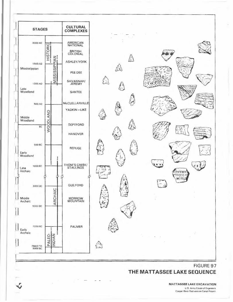
J STAGES CULTURAL
COMPLEXES
l 2000AD
r ,..._. 1500 AD
L Mississippian
1000AD
late I Woodland
l SOO AD
Middle I Woodland
BC
1 SOOBC
I Early Woodland
ll'"' Archaic
11 II Middle
Archaic
II
II Early Archaic
II
.,.. v
1000BC
3000 BC
SOOOBC
7000BC
PRIOR TO 9000BC
.,
AMERICAN u. NATIONAL
~~ zl
BRITISH COLONIAL
I: <t' ASHLEY/YORK
~a: f--a.. U5 (j) PEE DEE -(j) (j) - SAVANNAH/ : ~. . JEREMY
SANTEE
McCLELLANVILLE
0 YADKIN - LIKE
z <t .....J 0 0 DEPTFORD 0 ~
HANOVER
REFUGE
. . . : THOM'S CREEK/
STALLINGS
~ ~
GUILFORD
u <t I u MORROW a: MOUNTAIN <t
PALMER . . . z: 0 UJ <t .....J 0 <t a.. z -. .
A w
0 I . '
f 0 ~ ~
FIGURE 97
THE MATTASSEE LAKE SEQUENCE
MATTASSEE LAKE EXCAVATION U.S Armv Corps of Engoneers
Cooper R1ver Rtdlvtusaon Canal ProJect
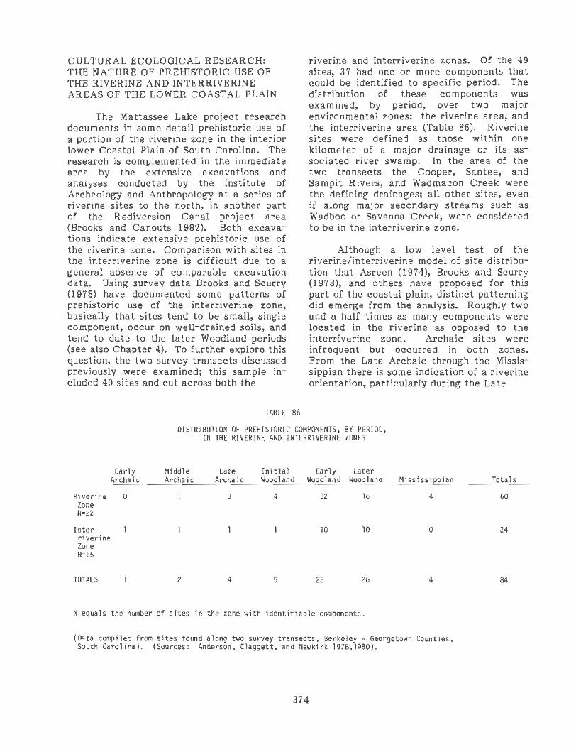
CULTURAL ECOLOGICAL RESEARCH: THE NATURE OF PREillSTORIC USE OF THE RIVERINE AND INTERRIVERINE AREAS OF THE LOWER COASTAL PLAIN
The Mattassee Lake project research documents in some detail prehistoric use· of a portion of the riverine zone in the interior lower Coastal Plain of South Carolina. The research is complemented in the immediate area by the extensive excavations and analyses conducted by the Institute of Archeology and Anthrop_ology at a series of riverine sites to the north, in another part of the Rediversion Canal project area (Brooks and Canouts 1982). Both excavations indicate extensive prehistoric use of the riverine zone. Comparison with sites in the interriverine zone is difficult due to a general absence of comparable excavation data. Using survey data Brooks and Scurry (1978) have documented some patterns of prehistoric use of the interriverine zone, basically that sites tend to be small, single component, occur on well-drained soils, and tend to date to the later Woodland periods (see also Chapter 4). To further explore this question, the two survey transects discussed previously were examined; this sample included 49 sites and cut across both the
TABLE 86
riverine and interriverine zones. Of the 49 sites, 37 had one or more components that could be identified to specific period. The distribution of these components was examined, by period, over two major environmental zones: the riverine area, and the interriverine area (Table 86). Riverine sites were defined as those within one kilometer of a major drainage or its associated river swamp. In the area of the two transects the Cooper, Santee, and Sampit Rivers, and Wadmacon Creek were the defining drainages; all other sites, even if along major secondary streams such as Wadboo or Savanna Creek, were considered to be in the interriverine zone.
Although a low level test of the riverine/interriverine model of site distribution that Asreen (1974), Brooks and Scurry (1978), and others have proposed for this part of the coastal plain, distinct patterning did emerge from the analysis. Roughly two and a half times as many components were located in the riverine as opposed to the interriverine zone. Archaic sites were infrequent but occurred in both zones. From the Late Archaic through the Mississippian there is some indication of a riverine orientation, particularly during the Late
DISTRIBUTION OF PREHISTORIC COMPONENTS, BY PERIOD, IN THE RIVERINE AND INTERRIVERINE ZONES
Early Middle Late Initial Early Later Archaic Archaic Archaic Woodland Woodland Woodland Mississippian
Riverine 0 3 4 32 16 4 Zone N=22
Inter- 10 10 0 riverine Zone N=lS
TOTALS 2 4 5 23 26 4
N equals the number of sites in the zone with identifiable components.
(Data compiled from sites found along two survey transects, Berkeley - Georgetown Counties, South Carolina). (Sources: Anderson, Claggett, and Newkirk 1978,1980).
374
Totals
60
24
84

Archaic, Early Woodland, and Mississippian periods. The later (Middle/Late) Woodland was the only exception to this patterning, with a moderate number of components (N=lO, 38.5 percent) in the interriverine zone. This patterning clearly supports the inferences advanced earlier. A closer examination of the component and artifact assemblages from these sites also documents a differential use of these areas prehistorically. Sites in the interriverine zone were smaller and produced far fewer artifacts, on the average, than sites in the riverine zone. Sites in the riverine zone tended to have more than one component, suggesting repeated use, or extended occupation of favored areas (Table 87). Sites in the interriverine zone, in contrast, tended to have only a single component, suggesting one period of use. When coupled with the relative artifact densities observed on sites in each area, the transect data suggest short- term use of the interior, perhaps in specialized extraction functions (hunting, firewood or nut collection, or other resource procurement), as opposed to a more extended use of the riverine zone. Many of the interrivesine sites, in fact, may represent the remains of special activity camps formed by task groups from more permanent (base) settlements along the primary drainages. Verification of such an inference will, of course, require considerable testing, including the comparison of assemblages from large numbers of sites in both areas.
TABLE 87
INCIDENCE OF SINGLE AHO MULTIPLE COMPONENT SITES IN THE RIVERINE AHO INTERRIVERINE ZONES : CH I-SQUARE
CONTINGENCY TABLE
Multi- Si ngle Corneon~nt corneonent Tota ls
Riverine Zone Sl tes 19 3 22
( 14.9) (7.1)
Interriverine Zone Sites 6 9 15
( 10.1 ) (4.9)
TOTALS 25 12 37
K • There i s no difference In the incidence of single and mul t i ple 0 coaopon~nt sites with respect to tile environiM!ntal zone i n the
proJect data u t.
.\loha (level of significance) • 0.05
x2 • a. 6 dt • 1 0 • 0.01 ( ) • expected f requenci es
K0
is rejected (a significant difference does occu r ).
(Data compiled fran sites found along the twO project survey transKU, Berkeley -Georgetown €ounties, South Caro li na ). (Sources: Anderson, Claggett, and Newki rk 1978,1980).
CULTURAL ECOLOGICAL RESEARCH: THE NATURE OF PREHISTORIC USE OF THE COASTAL AND INTERIOR AREAS OF THE LOWER COASTAL PLAIN
The Mattassee Lake sites included components spanning virtually the entire prehistoric era, indicating extensive, longterm if not continuous use of the riverine zone of the interior lower coastal plain. Most previous large-scale archeological research in the general area has focused on immediate coastal sites and little opportunity for comparison of coastal and interior sites has existed previously. Differences are evident; the most immediate being the almost total lack of shellfish remains on most interior sites. Shell middens along interior drainages throughout the southeastern Atlantic slope appear to be the unusual exception rather than the rule. The interior sites also appear to have a far higher incidence of stone tools and debitage (e.g., Trinkley 1980a), although the Mattassee Lake sites, serving as a quarry area, are an unusual case and render comparison difficult. It is evident that large sites are present in both the coastal and the interior riverine zones. Currently a question that should be addressed is, Are these sites contemporaneous? If so, Do they reflect different (season?) settlements of a single group or the remains of two separate groups, one occupying the coast and the other the interior (c.f. Widmer 1976a:45)?
To further explore this question, the incidence of major ceramic taxa was examined over 95 sites located in both the coastal zone and the interior (Table 88). The sample include the 49 prehistoric sites from the two powerline transects discussed previously (Anderson, Claggett and Newkirk 1978,1980), plus an additional 12 sites from the interior (Table 88) and 34 from the coastal zone (Table 90). The analysis focused on ceramic prehistoric components due to a low incidence of diagnostic Archaic projectile points in either zone. Coastal sites were those found in or within one kilometer of the estuary; the sample included all of the prehistoric sites between Charleston Harbor and Winyah Bay for wh ich detailed ceramic analyses, or accessible collections (i.e., at the IAA or the Charleston Museum), were available as of 1978.
375

The comparative analysis suggests that a number of ceramic taxa occur predominantly in either the coastal zone or the interior, but not in both areas. Among Late Archaic wares, for example, Stalling's Plain appears largely confined to the interior and Thorn's Creek Finger-Pinched, var. Awendaw, to the coast. In contrast, Thorn's Creek Punctate, vars. Thorn's Creek and Spanish Mount, appear to be (proportionately) evenly distributed between the two areas. The data for Stalling's Punctate suggests the same even distribution although the sample (N=2 sites) is too small to be meaningful. Close inspection indicates that var. Awendaw ceramics occur either in the immediate coastal ·zone near Charleston Harbor, or in the Wando and Cooper River drainages. No Y.!!!:· Awendaw ceramics had been reported from the lower Santee drainage prior to the work at Mattassee Lake, suggesting a very limited distribution for the ware.
Moving to the initial and Early Woodland, Refuge and Deptford ceramics were noted with a much higher incidence on interior as opposed to coastal sites (Table 88). This may indicate a relative depopulation of the coastal zone, coupled with movement into or increased exploitation of the interior during the Early Woodland. DePratter and Howard (1977) have presented evidence for a similar (infrequent) occurrence of Refuge sites along the Georgia coast; their research suggests, however, that a minor marine transgression between 3000 and 2000 BP drowned previously exploited estuarine areas and submerged large numbers of sites from this period (see also Brooks 1980; Brooks et al. 1979, 1980). In the South Carolina areait appears that by later Woodland times exploitation of coastal estuarine resources is at a considerably higher level than during the earlier Woodland (c.f. Brooks 1980); this may reflect sea level stabilization and the redevelopment or renewal of rich estuarine resources.
The Cape Fear and Hanover/ Wilmington ceramics exhibited highly unusual, complementary distributions by specific finish. Over both ware groups, cordmarking was restricted largely to the coast while fabric impressing occurred pre-
dominantly in the interior. Each finish did occur in both areas, but apparently with markedly different incidence. This is a local phenomenon, apparently restricted only to the general area of the lower Coastal Plain between the Santee and Cooper Rivers (see Trinkley 1980a:388-389). The pattern is strongly supported at Mattassee Lake, where Cape Fear Fabric Impressed sherds outnumbered cordmarked sherds by over a 50 to 1 ratio (Table 51), and where no Wilmington Cordmarked sherds were recovered, in spite of a moderate incidence of Wilmington Fabric Impressed (N=235 sherds). The distribution is unusual and warrants explanation, particularly if the cord and fabric impressed wares of each series are contemporaneous. Assuming a sampling error is not at fault, the patterning suggests the possibility of either different patterns of vessel use in the two areas (something possible anyway given the environmental differences), or perhaps the presence of differing cultural groups occupying the two zones. Finally, late prehistoric Chicora (Savannah and Pee Dee) and York (Ashley) ware group ceramics (after South, 1973b) were noted on sites in both areas. The prehistoric (South Appalachian Mississippian) Chicora wares appear to be evenly distributed; the protohistoric York wares are similarly distributed, although some emphasis towards the coastal zone is suggested.
CULTURAL ECOLOGICAL RESEARCH: PREHISTORIC LITHIC RAW MATERIAL PROCUREMENT AND USE IN THE LOWER COASTAL PLAIN
The analysis of the Mattassee Lake assemblage focused extensively on lithic raw material procurement and use (Chapter 7). The fact that the terrace defining the sites had outcrops of knapable stone, and served as a quarry prehistorically, prompted this orientation. From a regional perspective, the quarrying activity at Mattassee Lake was not particularly extensive; the extant and density of reduction debris does not begin to come close to the quantities of material observed at the chert quarries along the lower Savannah River (e.g. , Stoltman 1974). Major outcrops and quarry sites are rare in the South Carolina coastal plain, and the only large quarry known from
376

TABLE 88
COMPARISON OF THE INCIDENCE OF PREHISTORIC CERAMIC TAXA IN THE INTERIOR AND COASTAL REGIONS OF THE LOWER COASTAL PLAIN,
BERKELEY, CHARLESTON, AND GEORGETOWN COUNTIES, SOUTH CAROLINA '0 '0
s.. ~ ~ "<= "' "0 "' "' ~ ~'0 ~ "' "' "' .;.< -'>'.S::: c:~ Q. ~ ~ c:
~ ~u ·~ Q. E s.. s.. ~ VI .!' ~~ ~c: ...JE "' '0 Q. "0 Q. "' - S..+> S..·~ "' ... s.. ~ s..e ~ ~ "' en en~ <...>"' uo. "' .... .,
"'""" .,_ .,.
i: c: c: .... .... S..Vl ~~- ~ s..s.. s.. "' ·~ c: ·~ "' u>U u>S.. ~ 0 ~
:~ u.u ~"' ~ u s..
~ .... c: ~ en '+- """ .... QJ '[ ~.e >·~ 0
~"' ~u ~~ Ec:n "' .... u Q. 0 s.. u """ ~
"'~ «>C: oc: '+- Q.~ E c..s.. Q..O c:s.. c:.o ·~ s.. ~
.... 0. .... "' .s::; .s:::·~ ~ ~6 ·~ «>0 "'"' "'0 "'"' .s::; 0 .s::; ., ., 0. t- t- ..... 0:: ., <...><...> ..., ..... ::J:U ::J:U. u >- .,
Coastal ,..... N=34 2 1 12 10* 2 9 18 19* 9 9* 6 11 3* 25 (0.8) (0.4) (4.8) (4.0) (0.8) (3.6) (7.0) (7.5) (3.6) (3.6) (2.4)(4.4)(1.2)
Interior N"61 8* l 8 3 6* 21* 22 11 29* 4 18* 10 1 0
(3 .2) (0.4) {3.2) (1 .2) (2 .4)(8. l) (8.5) (4 .4) (11.5) (1.6)(7.0) (4.0)(0.4)
TOTALS 10 2 20 13 8 30 40 30 38 13 24 21 4 25 ,_ N=95 (4.0)(0.8) (8.0) (5.2) (3.2)( 11 .7) (15.5)(11.9)(15.1) (5.2)(9.4)(8.4) (1.6)
N equals the number of sites .
) equals percent of total incidence.
*equals an unusually high incidence suggested.
TABLE 89
OCCURRENCE OF PREHISTORIC CERAMIC TAXA AS REPORTED FROM OTHER INTERIOR ARCHEOLOGICAL SITES IN THE PROJECT AREA
-o s..
~ "' ~ ... ~'0 c: """ -'>'.S::: "' c:~ ~ ~ ~u .... ~ Q.
"' VI _VI ~ ~c: c: ...J1a -o -o -o .... - ~-~ 1-·~ (IJ'O ~-~ s.. (IJ ·~ c: en en<U ..., .... uo. O<U -o+> "'""" "' """ ::l:<U c: c: ... "' VIS..
Q. 1-Vl -o <US.. (IJ s.. s.. s.. "' VI ·~ c: ~ ... ., ... <UE 0 (IJ(IJ ........ u.u (IJ"' ~u s.. .... ~ ~ ... 0 (IJ en"' '+- """ ~ Q.
(IJ.e ·~ > E > ·~ 0
~ s.. ~"' ~o !5§ ea. "' .... .... 0 c.e (IJ s.. 0'0 0 s.. 0 ~
Site (IJO. "'~ ... c: oc: '+- ., Cl.(IJ e"' 0.1- c...o c: 1- c:.o :E 1-.s::; .... 0. .... "' .s::; 0. .s:::·~ (IJ <U.S: ·~ .... "'0 ......
"' 0 ... "' 0 Number ., ., ., 0. t- t- ..... 0:: au ., ., uu ..., ..... ::J: U ::J:U. <...> >-
38BK40 X 38BK45 X
38BK147 X X X X X X X X X X X X
38BK155 X X X
,_ 38BK156 X X X
38BK157 X X
38BK211 X X X 38BK269 X X X X X
38BK27l X X X X
38BK274 X X X
38GE24 X X X X X
38GE29 X X X X
TOTALS 0 7 6 3 5 6 2 6 6
377
Total Incidence
lll (44.1)
142 (55.9)
253 (100.0)
Sources
Anderson 1975b Anderson 1975b Widmer 1976a Wood 1977; Hartley and Stephenson 1975
\~ood 1977; Hartley and Stephenson 1975
Wood 1977; Hartley and Stephenson 1975
Widmer 1976b Wood 1977 Wood 1977 Wood 1977 Anderson 1975b Anderson 1975b

TABLE 90
OCCURRENCE OF PREHISTORIC CERAMIC TAXA REPORTED FROM COASTAL ARCHEOLOGICAL SITES IN THE PROJECT AREA
1-"0 <II "' <II ., <II "0
c .;,t; .;,t;.S:: "' C<ll <II <II <IIU .,
·- Q. "0 VI VI <II <IIC c ...JE "0 "0 "0., - S...(ll s...·- <11"0 "' S...(ll s... <II ·~ c:: "' 01<11 <->+' uo.. 0(11 "0 +' "'.;,t; "' .;,t; ::E:<II c::c C+' "' Q. S...Vl "0 (liS... <IIU S...l- s... "' VI ·-"' VI+' VIS- <liE: 0 <II <II ...... , ...... ·- <II"' <IIU s... ~<II ~, ,.... +' - u - <II "'tO .._ .;,t; ,.... Q.
<ll.e l- ~-8 >·- 0
~~- ~~ .-u 8§ EC11 ::;,., +'U a.e (11.0 OS... u .;,t;
Site (110... ,o.. roc:: c: c: .._ Vl Q.(lj E., Q.S... Q., Cl- c.o s... .s:: +' +>::;, .s:: 0.. .S::•.- <II (II.S:: ~ +' <tlO , ...... <tlO ,, .s:: 0
Number Vl Vl Vl 0.. t- t- u.. 0:: ou Vl Vl <-><-> <-> :z::u :z:: ...... <-> > Sources
38BK43 X X X X Anderson 5b 3881<265 X X Wood 1977 38BK266 X X Wood 1977 38BK267 X X X X X wood 1977 38CH2 X X Anderson 1~t5b
38CH3 X X X Anderson 1975b 38CH5 X X X X X Anderson 1 5b 38CH8 X X X X X X X X X X X X Anderson 1 :" 5b 38CH9 X X X X X X X X X Anderson 1975b 38CH23 X X X X X Anderson 1 5b 38CH24 X X Anderson 1 :71 5b 38CH26 X X Anderson 1975b 38CH27 X X X Anderson 1 5b 38CH30 X X X X Anderson 1.,,5b 38CH33 X X X X X X Anderson 1975b 38CH41 X X X Anderson 1 5b 38CH60 X X X X Anderson L.'5b 38CH173 X X X X X Trink1ey and
Carter 19 38CH174 X X X Trink1ey a
Carter 1975
38CH175 X X X Trink1ey < I Carter 1 ~ ;
38CH178 X X X X Trink1ey and Carter 1975
38CH179 X X Trink1ey < I Carter 1! ' 38CH180 X X Trink1ey and Carter 1 ~.,'i
38CH184 X X X X X Trink1ey < I Carter 1 ~~~ :.i
38CH212 X Anderson 1975b 38CH121 X X X Anderson 15b 38CH306 X X Wood 1977 38CH307 X X Wood 1977 38GE5 X X X X X X X X Anderson 75b 38GE12 X X X Anderson . _75b 38GE13 X X Anderson 1975b 38GE17 X X X X X X X Anderson 75b 38GE46 X X X X X X X X X Anderson 75b 38GE47 X Anderson l975b
TOTALS 24 2 12 10 2 9 18 19 9 9 6 11 3 (N=34) 378

along the Santee drainage, the Buyck's Bluff site, is some 75 miles upriver (Chapter 6). Small outcrops are (apparently) fairly common along the Santee; most, however, are characterized by fairly poor quality stone, and saw only limited exploitation prehistorically. A major goal of the Mattassee Lake analysis was the identification of raw material source areas; at least five different chert sources were documented along the Santee, together with (initial) criteria for separating materials from each. The use of thin sectioning, and micro-faunal analyses, are suggested as particularly valuable procedures for the resolution of lithic raw material source areas within the coastal plain.
CULTURAL ECOLOGICAL RESEARCH: THE EVIDENCE FOR AND AGAINST A TRANSHUMANTSETTLEMENTPATTERN BETWEEN THE COAST AND THE INTERIOR IN THE LOWER COASTAL PLAIN
The Mattassee Lake excavation assemblage leaves much to be resolved about the possibility of prehistoric transhumance between the coastal and interior areas of the lower coastal plain. If anything, the data set tends to refute the concept. Few artifacts demonstrably of coastal origin are present, and those that do occur (i.e., the Thorn's Creek (Shell) Punctate and Finger-Pinched wares at 38BK229) are exceptional occurrences both on the terrace and in the general region. The assemblage data from the terrace suggests relatively brief, short-term use of the area by residentially mobile foraging groups throughout much of the prehistoric era; some of these groups may have made use of the sea island (coastal) zone during their movements, although there is little direct evidence for this. The distributional information (Table 88), in fact, suggests that the occupation of the coastal zone was somewhat different than the occupation of the interior, and that interaction and/or movement between the two zones may have been less pronounced than traditionally (c.f. Milanich 1971, 1972) assumed, at least during some periods.
The distributions of several ceramic taxa (Table 88), as previously discussed, suggest group orientations towards either
the coastal area or the interior, but not toward both zones. There is fair evidence for major differences in the occurrence of several ceramic types over the two areas, particularly during the Late Archaic (the Stalling's-Awendaw-Thom's Creek distributions) and the later Woodland (the Wilmington/Cape Fear distributions, and the occurrence of cord and fabric marked finishes). The interior distribution of both the Refuge and Deptford wares may reflect a predominantly interior adaptation during the Early Woodland; alternatively, it may reflect sampling bias if coastal ·sites of this period have indee·d been submerged (c.f. DePratter and Howard 1977). Only sit es of the later prehistoric, Middle/Late Woodland and Mississippian period exhibit relatively even distributions over both areas, as might be expected given a model of transhumance. This suggests that Milanich's (1971) hypothesized "Coastal Tradition", a stable pattern of transhumance occurring continuously from the Late Archaic through the Mississippian, may not have been operating. In contrast, separate populations may have occupied the coastal and interior areas of central South Carolina coastal plain during at least some of the ceramic prehistoric.
A second distributional pattern observed in the area of the lower Santee and Cooper River drainages also tends to argue against models of coastal-interior transhumance. Generally, the immediate coastal zone in and within a few kilometers of the estuary is characterized by a high prehistoric site density (c.f . Trinkley 1980a). Back away from this zone in the interior, however, few sites have been recorded away from major streams or rivers. This pattern was particularly evident in the area several kilometers from the coast in the vicinity of one of the two powerline transects referenced earlier (Anderson, Claggett, and Newkirk 1980). Only with increased distance from the coast, in the vicinity of the second transect (Anderson, Claggett, and Newkirk 1978), and the area of the Cooper River Rediversion Canal (Brockington 1980), does site density pickup.
379
The apparent light prehistoric use of the area immediately back from the coast appears to be (in part) a reflection of localized environmental conditions. The terrain

immediately away from the estuary along the central South Carolina coast is low-lying and swampy, characterized by comparatively youthful Pleistocene beach and shoreline deposits (Colquhoun and Johnson 1968). Away from major streams drainage patterns are poorly defined, hindering both population movement and extended settlement (Brooks and Scurry 1979; Anderson and Logan 1981). The terrain further removed from the coast, in contrast, is older, higher, and more weathered, with somewhat better defined drainage patterns. Between the Cooper and the Santee there are no major drainages that run more than a few miles into the interior; the low-lying zone may thus act as something of a barrier, redirecting or constraining movement, and reducing the likelihood of transhumance, at least in or through this zone. Most population movement and settlement in the lower coastal plain, therefore, were along major river systems.
CONCLUSION
The excavations and analyses of the Mattassee Lake assemblage have been directed to a wide range of research topics. The results of the study include the development of a cultural/artifactual sequence for the lower Santee River area, which should serve as a baseline for future refinement. In addition, the investigations focused on lithic raw material source areas, procurement patterns, and reduction/manufacturing strategies. The analysis sought to examine the use of the terrace in terms of prehistoric technological organization. The settlement and mobility patterns advanced here for the various components present along the terrace can and should be subject to considerable testing. The discussion and descriptions recounted here, hopefully, can help guide investigations along those lines.
380

BmLIOGRAPHY
Adovasio, J . M., J. D. Gunn, J. Donahue and R. Stuckenrath 1977 Meadowcroft rockshelter: retrospect 1976. Pennsylvania Archaeologist, 47:2-3.
Agenbroad, Larry D. 1978 The Hudson-Meng site: An Alberta bison kill in the Nebraska High Plains. University Press of
America, Washington, D.C.
Ahler, Stanley A. 1971 Projectile point Corm and function at Rodgers Shelter, Missouri. Missouri Archaeological Society
Research Series. Number 8.
Albright, Alan B. 1980 Underwater archaeological survey of the Wando River. Research Manuscript Series 160, Institute of
Archeology and Anthropology, University of South Carolina.
Allen, R. 0 . 1975
Ames, F. E. 1906
The application of instrwnental neutron activation analysis to a study of prehistoric steatite artifacts and source materials. Archaeometry 1:69-83.
A report on loblolly pine lwnbering in South Carolina. Thesis, Yale University, School of Forestry. Manuscript on file USFS, Colwnbia, South Carolina.
Amory, Cleveland (ed.) 1969 The 1902 edition of the Sears Roebuck Catalogue. Bounty Books, New York.
Anderson, David G. 1975a Inferences from distributional studies of prehistoric artifacts in the coastal plain of South Carolina.
1975b
1977
1979a
1979b
1980
1982
Southeastern Archaeological Conference Bulletin 18:180-194.
The distribution of prehistoric ceramics in the Coastal Plain of South Carolina. Unpublished manuscript with appendices and data sheets. On file at the Institute of Archeology and Anthropology, University of South Carolina.
A history of prehistoric archeological investigations in the coastal plain of South Carolina. South Carolina Antiquities 9(2).
Excavation at four fall line sites: the southeastern Colwnbia beltway project. Commonwealth Associates, Inc. Report No. R-2008, Jackson, Michigan. (Jointly released by SC Department of Highways and. Public Transportation, Colwnbia, SC).
Prehistoric selection Cor intentional thermal alteration: tests of a model employing southeastern archaeological materials. Midcontinental Journal of Archaeology 4(2): 221-254.
Post depositional modification of the Zebree behavioral record. In: Zebree archeological project: excavation, data interpretation, and report on the Zebree homestead site, Mississippi County, Arkansas, edited by Dan F. Morse and Phyllis A. Morse. U.S. Army Corps of Engineers, Contract No. DACW 66-76-C-0006.
The cermaic sequence from the Mattassee Lake sites: towards a cultural sequence for the lower Santee River. Paper presented at the Coastal Carolina Aboriginal Pottery seminar, the Charleston Musewn, Charleston, South Carolina, August 21, 1982.
Anderson, David G. and Stephen R. Claggett 1979 Test excavations at two sites in the Cape Romain National Wildlife Refuge, Charleston County, South
Carolina. South Carolina Antiquities 11, (1):12-74.
Anderson, David G., and Trisha Logan 1981 Francis Marion National Forest: cultural resources overview. U.S.D.A., Forest Service.
Anderson, David G., Charles E. Cantley and A. Lee Novick 1980 The 1979 excavations at the Mattassee Lake sites. Paper presented at the 37th Annual Southeastern
Archaeological Conference, New Orleans, Louisiana, November 13, 1980.
Anderson, David G., Stephen R. Claggett and Judith A. Newkirk 1978 Technical report, cultural resources, Winyah-Jeffries 230kV transmission line rebuild. Commonwealth
Associates, Inc. Report 1910.
1980 Technical report, cultural resources, Winyah-Charity 230kV transmission line. Commonwealth Associates, Inc. Report 1934.
Anderson, David G., Sammy T. Lee and A. Robert Parler 1979 Cal Smoak: archeological investigations along the Edisto River in the Coastal Plain of South Carolina.
Archeological Society of South Carolina, Occasional Papers t.

Anderson, David G., Judith A. Newkirk and E. Suzanne Carter 1979 Archeological survey and cultural resources overview, Santee National Wildlife Refuge, Clarendon
County, South Carolina. Commonwealth Associates, lnc., Report 2024.
Anderson, David G., A. Lee Novick, Charles E. Cantley, JohnS. Cable, Randolph E. Donahue, William A. Lovis, Michael P. Katuna, and Irene C. Stehli 1982 Mattassee Lake: archeological investigations along the Lower Santee River in the Coastal Plain of
South Carolina: data appendix volume. Commonwealth Associates lnc., Report No, 2311A.
Anthony, Ronald W., and Lesley M. Drucker 1980 An archaeological reconnaissance of the proposed J. E. Locklear Memorial Airport, Dorchester
County, South Carolina. Carolina Archaeological Services Resource Study Series:l9.
Asch, Nancy B., Richard I. Ford, and David L. Asch 1972 Paleoethnobotany of the Koster site. Illinois State Musewn Reports of Investigations 24.
Asch, David L., K. B. Farnsworth, and N. B. Asch 1979 Woodland subsistence and settlement in west-central Illinois. ln: Hopewell Archaeology, edited by
DavidS. Bl'ose and N'omi Greber, pp. 80-85. Kent State University Press, Kent, Ohio.
Asreen, Robert C. 1974 An archeological reconnaissance of the proposed Cooper River rediversion project, Berkeley county,
South Carolina. Research Manuscript Series 67, Institute of Archeology and Anthropology, University of South Carolina.
1975 An archeological survey of proposed widening of U.S. 52 between Moncks Corner and Kingstree, South Carolina. Research Manuscript Series 74, Institute of Archeology and Anthropology, University of South Carolina.
Baker, Stephen G. 1974 Cofitachigue: fair providence of Carolina.
Unpublished Master's thesis, Department of History, University of South Carolina, Columbia, South Carolina.
1975 The historic Catawba peoples: exploratory perspectives in ethnohistory and archaeology. Department of History, University of South Carolina, Columbia, South Carolina.
Batson, W. T. and W. R. Kelly 1955 An ecological study of nora and fauna of the SRP area. Biology, Series m, 1 (5), University of South
Carolina Publications.
Baum, Gerald R. 1977 Strati a hie framework of the middle Eocene to lower Miocene formations of North Carolina. Ph.D.
dissertation, University o North Carolina, Chapel H1ll.
Baum, Gerald R., and R. J. Powell 1979 Correlation and tectonic framework of the middle and upper Eocene strata of the Carolinas (abs.).
Geological Society of America Abstracts with Programs 11(4):170.
Baum, Gerald R., Joan S. Collins, Richard M. Jones, Barbara A. Madlinger, and Richard J. Powell 1980 Correlation of the Eocene strata of the Carolinas. South Carolina Geology 24(1):19-27.
Bell, Robert E. 1958 Guide to the identification of certain American Indian projectile points. Oklahoma Authropological
Society, Special Bulletin, No. 1.
Binford, Lewis R. 1962 A new method of calculating dates from kaolin pipe stem samples. Southeastern Archaeological
Conference Newsletter 9(1):19-21.
1963 A proposed attribute list for the description and classification of projectile points. University of Michigan, Anthropological Papers No. 19:193-221.
1973 Interassemblage variability-the Mousterian and the 'functional' argument. In The explanation of culture change: models in prehistory, edited by Colin Renfrew, pp. 227-254.
1977 Nuniamiut ethnoarchaeology. Academic Press, N.Y.
1978 Dimensional analysis of behavior and site structure: learning from an Eskimo hunting stand. American Antiquity 43(3):330-361.
1979 Organization and formation processes: looking at curated technologies. Journal of Anthropological Research 35(3):255-273.
1980 Willow smoke and dogs' tails: hunter-gatherer settlement systems and archaeological site formation. American Antiguity 45:4-20.

Binford, Lewis R., and S. R. Binford 1966 A preliminary analysis of functional variability in the Mousterian of Levallois facies.
studies in paleoanthropology, edited by J. D. Clark and F. C. Howell, pp. 238-295. Anthropologist 68(2):Part 2.
In Recent American
Blanding, William 1848 Remains of the Wateree River, Kershaw District, South Carolina. In Ancient monuments of the
E. G. Squire and E. H. Davis,
Bordes, Francois
Mississippi Valley. Smithsonian Contributions to Knowledge, Vol. 1. Editors.
1968 The old stone age. McGraw-Hill, New York.
1972 A tale of two caves. Harper and Row, New York.
Bordes, Francois, and Denise de Sonneville-Bordes 1970 The significance of variability in Paleolithic assemblages. World Archaeology 2(1):62-73.
Bowen, William Rowe 1977 A reevaluation of Late Archaic subsistence and settlement patterns in the western Tennessee Valley.
Tennessee Anthropologist, 2:100120.
Bragg, Laura M. 1925 An Indian shell culture in South Carolina. Charleston Museum Quarterly, 1(2):3-7.
Brashier, Janet G. 1973 A formal analysis of prehistoric ceramics from the Fletcher Site. Unpublished M.A. Thesis,
Department of Anthropology, Michigan State University.
1981 Early Late Woodland boundaries and Interaction: Indian ceramics of southern lower Michigan. Michigan State University Museum, Anthropological Series, No. 3. East Lansing.
Braun, David P. 1977
1980
Braun, E. Lucy 1950
Brew, J. 0. 1946
Middle Woodland - (Early) Late Woodland social change in the prehistoric midwestern U.S. dissertation, Department of Anthropology, University of Michigan.
Experimental interpretation of ceramic vessel
Ph.D.
use on the basis of rim and neck formal attributes. In The Navaho project: archaeological investigations, Page to Phoenix 500 kV Southern Transmission Line, by D. Fiero, R. Munson, M. McClach, S. Wilson, and A. Zier, pp. 170-231. Museum of Northern Arizona Research Paper 11.
Deciduous forests of eastern North America. Hafner Publishing Company, New York, New York.
The archaeology of Alkali Ridge, southern Utah. Papers of the Peabody Museum of Achaeology and Ethnology 21:44~6.
Brockington, Paul E. Jr. 1971 A preliminary investigation of an early knapping site in southeastern Georgia. The Notebook 3(2),
Institute of Archeology and Anthropology, University of South Carolina .•
1980 Cooper River rediversion archaeological survey. Research Manuscript Series 169. Institute of Archeology and Anthropology, University of South Carolina.
Brooks, Mark J. 1980
1980
Late Holocene sea level variability and prehistoric human adaptations in the lower coastal plain of South Carolina. Master's thesis, Department of Anthropology, Arizona State University, Tempe, Arizona. Brooks, Mark J. and Veletta Canouts
Middle Late Woodland and Mississippian subsistence strategies in the interior lower coastal plain of South Carolina. Paper presented at the 37th Annual Southeastern Archaeological Conference, New Orleans, Louisiana. November 13, 1980.
Brooks, Mark J. and Veletta Canouts (editors) 1982 Modeling subsistence change in the late prehistoric period in the interior lower Coasta l Plain of South
Carolina. U.S. Army Corps of Engineers, Report No. C-54032(80).
Brooks, Mark J., and James D. Scurry 1978 An intensive archeological survey of Amoco Realty property in Berkeley County, South Carolina with a
test of two subsistence-settlement hypotheses for the prehistoric period. Research Manuscript Series 147, Institute of Archeology and Anthropology, University of South Carolina.
1980 Excavations at 38RD158: a multicomponent prehistoric site in Richland County, South Carolina. Research Manuscript Series 164, Institute of Archeology and Anthropology, University of South Carolina.
Brooks, Mark J., D. J. Colquhoun, R. R. Pardi, W. Newman and W. H. Abbott 1979 Preliminary archaeological and geological evidence for Holocene sea level fluctuation in the Lower
Cooper River valley, South Carolina. Florida Anthropologist, 32(3):85-103.

1980
Brose, David S. 1970
1975
Principles and problems in establishing a Holocene sea level curve for South Carolina. In Excursions in southeastern geology: The archaeology, geology of the Georgia coast, by James D. Howard, Chester B. DePratter, and Robert W. Frey. Guidebook 20, Geological Society of America, pp. 143-159.
The Summer Island site: a study of prehistoric cultural ecology and social organization in the northern Lake Michigan area. Case Western Reserve University Studies in Anthropology 1.
Functional analysis of stone tools: a cautionary note on the role of animal Cats. American Antiguit' 40:86-94.
Browman, David L. 1981 isotopic discrimination and correction factors in radiocarbon dating. In Advances in archaeologica
method and theory, Volume 4, edited by Michael B. Schiffer, pp. 241-295. Academic Press, Ne'l. York.
Broyles, Bettye J. 1971 Second preliminary report: the St. Albans site, Kanawha County, West Virginia. West Virginit
Geological and Economic Survey, Reports of Archaeological Investigations 3.
Bull, Elias B. 1969
Bullen, Ripley P.
The problem of the Cusabo. The Notebook, 1 (69):8-13, Institite of Archeology and Anthropology University o( South Carolina.
1961 Radiocarbon dates for southeastern fiber-tempered pottery. American Antiguity 27(1):104-106.
1968 A guide to the identification of Florida projectile points. Florida State :vtuseum, University of Florida, Gainesville.
Butler, William B. 1979 The no-collection strategy in archaeology. American Antiguity 44:795-799.
Cable, John S. and Charles E. Cantley (Assemblers) 1979 An intensive archaeological survey of the South Carolina 151 widening project. Manuscript on file a
the Institute of Archeology and Anthropology, University of South Carolina, Columbia, South Carolina.
Cable, JohnS. and James W. Mueller 1980 The cultural resources survey and evaluation of U.S. 421 from Siler City to Stanley, Chatham ano
Randolph Counties, North Carolina. Commonwealth Associates Inc., Report No. 2049.
Caldwell, Joseph R. 1952 The archaeology of eastern Georgia and South Carolina. In Archeolo!n' of eastern United States.
James B. Griffin, Editor University of Chicago Press, Chicago.
1958 Trend and tradition in the prehistory of the eastern United States. American Anthropologic8.! Association, Memoir 88.
1971 Chronology of the Georgia coast. Southeastern Archaeological Conference, Bulletin 13:88-92.
Caldwell, Hoseph R. and Catherine McCann 1941 Irene mound site, Chatham County, Georgia. University of Georgia Press, Athens, Georgia.
n.d. The Deptford site, Chatham County, Georgia. Unpublished manuscript on file at the Department o Anthropology, The University of Georgia.
Caldwell, Joseph R. and Antonio J. Waring, Jr. 1939a Some Chatham County pottery types and their sequence. Southeastern Archaeological Conferenc·
Newsletter 1:5-6.
1939b
Callahan, E. 1979
Calmes, Alan R.
The use of a ceramic sequence in the classification of aboriginal sites in Chatham County, Georgia. Southeastern Archaeological Conference Newsletter 2:6-7.
The basics of biface knapping in the eastern fluted point tradition: a manual for flint knappers and lithic analysts. Archaeology of Eastern Norht America 7 (1):1-179.
1967 Indian cultural traditions and European conguest of the Georgia-South Carolina coastal plain, 300v B.C. -1733 A.D.: a combined archaeological and historical investigation. Unpublished Ph.D. dissertation, Department of History, University of South Carolina.
Camp, W. J., W. E. Jones, R. P. Milford, and S. H. Hearn 1962 Soil survey of Saluda County, South Carolina. U.S.D.A., Soil Conservation Service.
Canouts, Veletta, Helen W. Haskell, and JoLee A. Pearson 1982 A functional analysis of the ceramic assemblages. In: Modeling subsistence change in the lat
prehistoric period in the interior lower Coastal Plain of South Carolina, edited by Ylark J. Brooks an Veletta Canouts. U.S. Army Corps of Engineers, Report No. C-54032(80).

Carrillo, Richard 1980 Green Grove Plantation: archaeological and historical research at the Kinlock Site (38CH109),
Charleston County, South Carolina. Report prepared for the South Carolina Department of Highways and Public Transportation, Columbia, South Carolina.
Chapman, Jefferson 1975 The Rose Island site and the bifurcate point tradition. Report of Investigations 14, Department of
Anthropolegy, University of Tennessee.
1976 The archaic period in the lower Little Tennessee River Valley: the radiocarbon dates. Tennessee Anthropologist 1 (1}:1-12.
Charles, Tommy C. 1981 Dwindling resources: an overture to the future of South Carolina's archeological resources. The
Notebook 13:1-85. Institute of Archeology and Anthropology, University of South Carolina, Columbia.""
Charlton, Thomas H. 1969 American Antiquity 34:176.
1978 Teotihuacan, Tepeapulco, and obsidian exploitation. Science 200:1227-1236.
Charlton, Thomas H., D. C. Grove, and P. K. Hopke 1978 The Paredon, Mexico, obsidian source and early Formative exchange. Science 201:807-809
Cheves, Landgon, ed. 1897 The Shaftesbury Papers and other records relating to Carolina and the first settlement on Ashley River
prior to the year 1676. Collections of the South Carolina Historical Society, V, Richmond, Virginia .•
Chom ko, S. A. 1977 Archaeological test excavations in the Harry S. Truman Reservoir, Missouri: 1975. Report submitted
to U.S. Army Corps of Engineers, Kansas City District.
Christenson, Andrew L. 1979 The role of museums in cultural resource management. American Antiquity 44:161-163.
Claflin, William H., Jr. 1931 The Stalling's Island mount, Columbia County, Georgia. Peabody Museum of American Archaeology
and Ethnology Papers 14(1).
Claggett, Stephen R., and JohnS. Cable (assemblers} 1982 The Haw River sites: archaeological investigation at two stratified sites in the North Carolina
piedmont. Commonwealth Associates Inc., Report No. 2386.
Cleland, Charles E. 1976 The focal-diffuse model: an evolutionary perspective on the prehistoric cultur'al adaptations of the
eastern Uni ted States. Midcontinental Journal of Archeology 1(1):59-76.
Clifford, H. T., and w. Stephenson 1975 An introduction to numerical classification. Academic Press. New York.
Cockran, David H. 1970 The Carolina Indian frontier. Tricentennial Booklet No. 6. University of South Carolina Press,
Columbia.
Coe, Joffre L. 1952
1964
The cultural sequence of the Carolina Piedmont. In Archaeology of eastern United States, James B. Griffin, Editor, University of Chicago Press, Chicago.
The formative cultures of the Carolina Piedmont. Transactions of the American Philosophical Society 54(5).
Colquhoun, Donald J. and H. S. Johnson 1968 Tertiary sea-level fluctuations in South Carolina. In Palaeogeography, Palaeoclimatology, Palaeoe
~. pp. 105-126. Elsevier Publishing Company, Amsterdam.
Commerce, The Chicago Association of (Pub.) 1935 Blue book of Chicago commerce. Chicago.
1940 The buyer's guide and industrial directory of Chicago. Chicago.
Cooke, C. Wythe 1936 Geology of the coastal plain of South Carolina. U.S. Geological Survey Bulletin 867.
Cook, Fred 1977
Crabtree, D. E.
The Kent mound: a study of the Irene phase on the lower Georgia coast. Unpublished master's thesis, Department of Anthropology, Florida State University.
1972 An introduction to flint working. ldaho State University Museum, Occasional Papers 28.

Crawford, Robert Guy Hodges 1966 An archaeological survey of Lenoir County, North Carolina. Unpublished master's thesis, Department
of Anthropology, University of Florida, Gainesville.
Dalberg, M. A. and D. C. Scott 1971 The distribution of freshwater fishes in Georgia. Georgia Academy of Science, 19(1).
DeJarnette, David L., Edward B. Kurjack and James W. Cambron 1962 Stanfield-Worley bluff shelter excavation, Journal of Alabama Archaeology, 8(1-2): 1-111.
DePratter, Chester B. 1976 The Refuge phase on the coastal plain of Georgia. Early Georgia, 4(1-2):1-13.
1977 Environmental changes on the Georgia coast during the prehistoric period. Early Georgia, 5:1-14.
1979 Ceramics. In the Anthropology of St. Catherines Island. The Refuge-Deptford mortuary complex, edited by D. H. Thomas and C. s. Larsen. Anthropological Papers of the American Museum of Naturai History, 56(1):109-132.
1980 Shellmound archaic on the Georgia coast. South Carolina Antiquities 11(2).
DePratter, Chester B., Richard W. Jeffries and Charles Pearson 1973 A review of early pottery from the South Carolina Coast. The Notebook, 5(2):45-53, Institute of
Archeology and Anthropology, University of South Carolina.
DePratter, Chester B. and J.D. Howard 1977 History of shoreline changes determined by archaeological dating; Georgia Coast, United States of
America, Transatlantic Gulfcoast Association Geology Society, XXVU:251-258.
DePratter, Chester B., Charles M. Hudson and Marvin T. Smith 1980 Juan Pardo's explorations in the interior southeast, 1566-1567. Paper presented at the 45th Annual
:vleeting of the Society for American Archaeology, Philadelphia, Pennsylvania.
Dickens, Roy S. Jr., 1976 Cherokee prehistory: the Pisgah phase in the Appalachian Summit region. University of Tennessee
Press, Knoxville.
Dickens, Roy S., Jr., and L. R. Carnes 1976 Preliminary investigations at Soapstone Ridge, DeKalb County, Georgia. Paper presented at the 1971
Southeastern Archaeological Conference, Tuscaloosa, Alabama.
Dickens, Roy S., Jr., L. R. Carnes, and J. McKinley 1981 Late Archaic soapstone procurement and reduction; some recent evidence from Soapstone Ridge
Georgia. Paper presented at the Southeastern Archeological Conference, Ashville, North Carolina.
Doar, David 1936
Dorian, Alan 1979
Rice and rice planting in the South Carolina. low country. Contributions from the Charleston Museurr 8:7-42.
An archaeological survey of TR106, Witherbee District, Francis Marion National Forest. Pores· Service Report No. 80-3.
Dorian, Alan and Trisha Logan 1979 Excavations at Honey HilL U.S. Forest Service, Columbia, South Carolina.
Drucker, Leslie M. 1980 A cultural resources inventory of selected areas of TheOaks and Laurel Hill Plantations, Brookgreeh
Gardens, Georgetown County, South Carolina. South Carolina Department of Archives and History Survey and Planning Grant No. 45-9787. Columbia, South Carolina.
Drucker, Leslie M. and Ronald W. Anthony 1978 Archaeological reconnaissance of the Lake City wastewater treatment improvements tJroject,
Florence County, South Carolina. Carolina Archaeological Services Resource Studies Series 6.
1979
1980a
1980b
The Spiers landing site: archaeological investigations ln Berkeley County, South Carolina. HCRS, lAS Atlanta, Carolina Archaeological Services, Columbia, South Carolina.
Cultural resources survey of the Pinckney Island National Wildlife Refuge, Beaufort County, South Carolina. Carolina Archaeological Services Resource Study Serires 12.
, South Carolina. U.~.
Earle, Timothy K. and Jonathon E. Ericson, editors 1977 Exchange systems in prehistory. Academic Press, New York.

Edwards, Robert 1964 The Ardea site: a preliminary report. Unpublished manuscript on file with the U.S. Forest Service,
Columbia, South Carolina.
Edwards, William E. 1965 A preliminary report on the Sewee mound shell ring, Charleston County, South Carolina. Unpublished
manuscript on file at the Institute of Archeology and Anthropology, University of South Carolina, Columbia.
Elliott, Daniel T. 1981 Soapstone use in the Wallace Reservoir; a tool for interpreting prehistory. Department of
Anthropology, University of Georgia. Wallace Reservoir Project Contribution 5.
Elliott, Daniel T., and Roy Doyon 1981 Archaeology and historical geography of the Savannah River noodplain near Augusta, Georgia.
University of Georgia Laboratory of Archaeology Series, Report 22.
Engelmayer, Reinhold 1976 Four years of archaeological research in the Grand Strand area. Paper presented at the Second Annual
Conference on South Carolina Archeology, Columbia, South Carolina, May 22, 1976.
1978
Evans, Clifford 1955
Archeological surveys in Horry-Georgetown-Williamsburg Counties 1976 to 1978. Paper presented at the Fourth Annual Conference on South Carolina Archeology, Columbia, South Carolina, April 15, 1978.
A ceramic study of Virginia archaeology. Bulletin 160, Bureau of American Ethnology, Smithsonian Institution.
Fairbanks, Charles H. 1942 The taxonomic position of Stalling's Island, Georgia. American Antiquity 7(3):223-231.
1950 A preliminary segregation of Etowah, Savannah, and Lamar. American Antiquity 16(2}:142-151.
1962 The check-stamped series. Southeastern Archaeological Conference Newsletter 8.
Fenneman, N. H. 1938 Physiography of eastern United States. McGraw-Hill, New York.
Ferguson, Leland G. 1971 South Appalachian Mississippian. Unpublished doctoral dissertation, Department of Anthropology,
University of North Carolina, Chapel Hill.
1973a
l973b
1974
1975a
1975b
1976
Pintail Island project. Research Manuscript Series 51, Institute of Archeology and Anthropology, University of South Carolina.
A reviewer's note. The Notebook 5(2):53-55, Institute of Archeology and Anthropology, University of South Carolina.
Archeological investigations at the Mulberry site. The Notebook, 6(3 and 4). Institute of Archeology and Anthropology, University of South Carolina.
Archeology at Scott's Lake exploratory research 1972, 1973. Research Manuscript Series 68, Institute of Archeology and Anthropology, University of South Carolina.
Mississippian artifacts and geography. Paper presented at the 1975 Meeting of the Southern Anthropology Society, Clearwater Beach, Florida.
An archaeological survey of a fall line creek: Crane Creek project, Richland County, South Carolina. Research Manuscript Series 94, Institute of Archeology and Anthropology, University of South Carolina.
Ferguson, Leland G., and Mary P. Luttrell 1973 Horse Range Swamp watershed survey. Research Manuscript Series 43, Institute of Archeology and
Anthropology, University of South Carolina.
Ferguson, T. A. 1976 Prehistoric soapstone procurement in north-western South Carolina. Unpublished Masters thesis,
University of Tennessee, Knoxville.
Fish, Paul Robert 1976 Patterns of prehistoric site distribution in Effingham and Screven Counties, Georgia. Series Report
11, Laboratory of Anthropology, University of Georgia, Athens.
Fitting, James E. 1968 Environmental potential and the postglacial readaptation in eastern North America. American
Antiquity 33(4).

Flannery, Kent V, 1967 Culture history vs. cultural process: a debate in American archaeology. Scientific American 217:119-
122.
1968 Archaeological systems theory and early Mesoamerica in Anthropological Archeology in the Americas, edited by Betty J . Meggers, pp. 67-78.
Flenniken, J. Jeffrey 1978 Reevaluation of the Lindenmeier Folsom: a replic.ation experiment in lithic technology. America ..
Antiquity 43:473-480.
Ford, James A. 1954 The type concept revisited. American Anthropologist 56:42-53.
1961 In favor of simple typology. American Antiquity 27:113-114.
1969 A comparison of formative cultures in the Americas. Smithsonian Contributions to Anthropology 11.
Ford, James A., and James B. Griffin 1939 (A proposal for a) Conference on pottery nomenclature for the southeastern United States. Newsletter
of the Southeastern Archaeological Conference 1.
Ford, James A., Phillip Phillips, and William D. Haag 1955 The Jaketown site in west-central Mississippi. American Museum of Natural History, Anthropological
Papers 45(1).
Ford, Richard L 1974 Northeastern archaeology: past and future directions. In Annual Review of Anthropology, 1973, pp.
385-413. Edited by Bernard J. Seigal, Alan R. Beals, and Stephen A. Tylor.
1979 Systematic research collections in anthropology: an irreplaceable natural resource. Harval' University, Cambridge, Massachusetts.
1980 A three-part system for storage of archaeological collections. Curator 23(1):55-62.
Frison, George C. 1978 Prehistoric hunters of the High Plains. Academic Press, New York.
Frison, George C. and Bruce A. Bradley 1980 Folsom tools and technology at the Hanson Site, Wyoming. University of New Mexico Pres
Albuquerque.
Frothingham, E. H. and R. M. Nelson 1944 South Carolina forest resources and industries. USDA Miscellaneous Publications, No. 552. Washing
ton, D.C.
Gardner, William H. 1974 The Flint Run Paleo Indian complex: a preliminary report 1971-1973 seasons. Occasional Publication,s
1, Archaeology Laboratory, Department of Anthropology, Catholic University of Amertca.
Garrow, Patrick H. 1980 Archaeological investigations of two slave quarter sites in Berkeley County, South Carolina. Paper
presented at the 37th Annual Southeastern Archaeological Conference, New Orleans, Louisiana.
Garrow, Patrick H., and Thomas Wheaton 1982 Cooper River rediversion canal project final contract report prepared for the National P.arks Service
and the U.S. Army Corps of Engineers.
Goad, Sharon I. 1979
Goggin, John 1952
Chert resources in Georgia: archaeological and geological perspectives. Series Report 21, Laborator_ of Archaeology, University of Georgia.
Space and time perspective in northern St. John's archaeology, Florida. Yale University Publicatior in Anthropology 47.
Goldstein, Lynne G. 1980 Mississippian mortuary practices: a case study of two cemeteries in the lower Illinois Valle:
Northwestern University Archaeological Program, Scientiiic Papers, No.4. Evanston.
Good, Mary Elizabeth 1972 Guebert site: a eighteenth century historic Kaskaskia Indian village in Randolph County, Ulinoi·
Central States Archaeological Societies. Memoir 2.
Goodyear, Albert C. ID 1974 The Brand site: a technofunctional study of a Dalton site in northeast Arkansas. Research Series 7.
Arkansas Archeological Survey.

1979 A hypothesis for the use of cryptocrystalline raw materials among Paleo Indian groups of North America. Research Manuscript Series 156, Institute of Archeology and Anthropology, University of South Carolina.
Goodyear, Albert C., John H. House, and Neal W. Ackerly 1979 Laurens-Anderson: an archeological study of the interriverine Piedmont. Anthropological Studies 4,
Institute of Archeology and Anthropology, University of South Carolina.
Gould, Richard A., Dorothy A. Koster, and Ann H. L. Sentz 1971 The lithic assemblage of the Western Desert aborigines of Australia. American Antiquity 36(2):149-
169.
Gould, Richard A. 1971 The archaeologist as ethnographer: a case from the Western Desert of Australia. World Archaeology
3:143-177.
(Editor) 1978
1980
Explorations in ethnoarchaeology. University of New Mex.ico Press, Albuquerque.
Living archaeology. Cambridge University Press, New York.
Gram ly, Richard Michael 1980 Raw materials source areas and "curated" tool assemblages. American Antiquity 45(4):823-833.
Gramly, Richard Michael and S. L. Cox 1976 A prehistoric quarry~workshop at Mt. Jasper, Berlin, New Hampshire. Man in the Northeast.
Graves, HenryS. 1919 The use of wood for fuel. USDA Bulletin 753.
Green, Stanton W. and Mark J. Brooks n.d. Archaeological investigations at the Huger site, Berkeley County, South Carolina. Research
Manuscript Series, in preparation, Institute of Archeology and Anthropology, University of South Carolina.
Gregorie, Anne K. 1925 Notes on Sewee Indians and Indian remains of Christ Church Parish, Charleston County, South
Carolina. Contributions from the Charleston Museum V. Charleston Museum.
Griffin, James B. 1943 An analysis and interpretation of the ceramic remains from two sites near Beaufort, South Carolina.
1945
(editor) 1952
1967
Bureau of American Ethnology Bulletin, 133:159-168.
Ceramic collections from two South Carolina sites. Papers of the Michigan Academy of Science, Arts, and Letters, 30:465-478.
Archaeology of the eastern United States. University of Chicago Press.
Eastern North American archaeology: a summary. Science, 156:175-191.
Griffin, James B., and William H. Sears 1950 Fiber-tempered pottery of the southeast. In: Prehistoric Pottery of the Eastern United States, James
B. Griffin, editor.
Griffin, John W. 1974 Investigations in Russell Cave. Publications in Archaeology, National Parks Service 13.
Haag, William 1956
Haggett, Peter
The archaeology of coastal North Carolina. Coastal Studies Institute, Louisiana State University, Technical Report 8.
1966 Locational analysis in human geography. Edward Arnold. London. Reprinted 1971.
Hally, David J. 1975 The Mississippi period. Early Georgia 3(1):37-52.
Hammond, Norman and A. Aspinall, Stuart Feather, John Hazelden, T. Gazard, and S. Agrell 1977 Maya jade: source location and analysis. In: T. K. Earle and J. E. Ericson, editors, Exchange systems
in prehistory, pp. 35-70. Academic Press, New York.
Hanson, Glen T., Rachel Most and David G. Anderson 1978 The preliminary archeologic.al inventory of the Savannah River Plant, Aiken and Barnwell Counties,
South Carolina. Research Manuscript Series 134, Institute of Archeology and Anthropology, University of South Carolina.
Hartigan, J. A. 1975 Clustering algorithms. Wiley-Interscience. New York.
Hartley, Michael 0. and Robert L. Stephenson 1975 The Grove and Flagg Plantation. Research Manuscript Series 72, Institute of Archeology and Anthro
pology, University of South Carolina.
Hawley, Norman R. 1946 Rice of the South Carolina Low Country. Manuscript on file at the South Carolina Library, University
of South Carolina, Columbia.
1966
Hay, Oliver P. 1923
Hayden, Brian M.
The ancient crops of naval stores, indigo, rice and other stories - Francis Marion National Forest South Carolina. Manuscript on file USFS, Columbia, South Carolina.
The Pleistocene of North America and its vertebrated animals from the states east of the Mississipp River and from the Canadian province east of Longitude 950, Carnegie Institute Publications, No. 322.
1977 Stone tool functions in the Western Desert. In: Stone tools as cultural markers: change, evolution an· complexity, edited by R.V.S. Wright. Humanities Press, Inc. New Jersey, pp. 178-188.
1979 Lithic use-wear analysis. Academic Press, New York.
Hemmings, E. Thomas 1970 Preliminary report of excavations at Fig Island, South Carolina. The Notebook 2(9-12). Institute o
Archeology and Anthropology, University of South Carolina.
1972 Emergence of formative life on the Atlantic coast of the Southeast. The Notebook, 4(3):59-64 Institute of Archeology and Anthropology, University of South Carolina.
Herold, Elaine B., and Stanley G. Knick, m 1978 An archaeologic.al survefl of the proposed Santee-Cooper power plant site, St. Johns Parish, Berkelev
County. Manuscript on ile at the Charleston Museum, Charleston, South Carolina.
1979a
1979b
An archaeological survey of the proposed railroad for the Santee-Cooper Cross generating plant, St. Stephens and St. Johns Parishes, Berkeley County. Manuscript on file at the Charleston Museum, Charleston, South Carolina.
An archaeological reconnaissance of pro~ed power transmission lines for the Santee-Cooper Cros generating plant. Manuscript on file at theharleston Museum, Charleston, South Carolina.
Herold, Elaine B., and Kay R. Scruggs 1975a An archaeological and historical survey of the Grove and Flagg plantations. Manuscript on file at th
Charleston Museum, Charleston, South Carolina.
1975b
1978
A general archaeological and historical survey of the proposed railroad route and alternate routes. Manuscript on file at the Charleston Museum, Charleston, South Carolina. Herold, Elaine B., Stanle: G. Knick and Allen Liss
An historical archaeological survey of the Boswell Tract, Berkeley County, South Carolina. Manuscript, Charleston Museum, Charleston, South Carolina.
Hill, James N., and Robert K. Evans 1972 A model for classification and typology. In Models in archaeology, edited by D. L. Clarke, pp. 231-274.
Methuen, London.
Holmes, William H. 1903 Aboriginal pottery of the eastern United States. In 20th Annual Report of the Bureau of America ..
House, John H. 1975
Ethnology: 1-201.
A functional typology for Cache project surface collections. In: The Cache River archeologics project-an experiment in contract archaeology, assembled by Michael B. Schiffer and John H. House. Arkansas Archaeological Survey Research Series 8:55-73.
House, John H., and David L. Ballinger 1976 An archeological survey of the Interstate 77 route in the South Carolina Piedmont. Researc
Manuscript Series 104. Institute of Archeology and Anthropology, University of South Carolina.
House, John H. and Albert C. Goodyear 1975 An archeological survey of a portion of the Charleston Innerbelt Freeway, Charleston County, Sout
Carolina.. Research Manuscript Series 83. Institute of Archeology and Anthropology, University o South Carolina.
House, John H., and Ronald W. Wogaman 1978 Windy Ridge: a prehistoric site in the interriverine piedmont in South Carolina .. Occasional Papers c
the Institute of Archeology and .-\nthropology, University of South Carolina. Anthropological Studies 3.
H uckell, Bruce 1978 Hudson-Meng chipped stone. In The Hudson-Meng Site: An Alberta bison kill in the Nebraska Hig
Plains, Larry D. Agenbroad, editor. pp. 153-192. University Press of America, Washington, D.C.

Hudson, Charles M. 1976 The southeastern Indians. The University of Tennessee Press, Knoxville.
Interagency Archeological Services-Atlanta 1978 Data rec·overy at three prehistoric sites, Cooper River Rediversion Canal, Berkeley County, South
Carolina, Scope of Work. Manuscript on file with the National Park Service, Atlanta. (Reprinted in Anderson et ~ 1982).
Irwin-Williams, Cynthia 1977 A network model Cor the analysis of prehistoric trade. In T. K. Earle and J. E. Ericson, editors,
Exchange systems in prehistory, pp. 141-152. Academic Press, New York.
Isaac, G. L. 1977 Olorgesailie. University of Chicago Press, Chicago.
Israel, Fred L. 1976 1897 Sears Roebuck catalogue. Chelsea House Publishers, New York.
Johnson, Gregory A. 1975 Locational analysis and the investigation of Uruk Local exchange systems. In Ancient civilization and
trade, Sabloff and Lamberg- Karlovsky, editors, pp. 285-340. University of New :'~texico Press, Albuquer que.
Judge, IV. James 1973 Paleoindian occupation of the Central Rio Grande Valley in New Mexico. University of New Mexico
Press, Albuquerque.
Keel, Bennie C. 1976 Cherokee archaeology, a study of the Appalachian Summit.
Knoxville. The University of Tennessee Press,
Keeley, Lawrence H. 1980 Experimental determination of stone tool uses: a microwear analysis. University of Chicago Press,
Chicago.
Kellar, Jana, Jack E. Bernhardt and Patrick H. Garrow 1979 Archaeological investigations at the Low Ridge (38BK372) and Dear Field (38BK373) sites, Cross
generating station, Berkeley County, South Carolina. Project Report ES-1259, Soil System, Inc., Marietta, Georgia.
Kidd, Kenneth E. 1979 Glass bead making from the middle ages to the early nineteenth century. Parks Canada History and
Archaeology Series 30.
Kirkby, A., and M. J. Kirkby 1976 Geomorphic processes and the surface survey of archaeological sites in semiarid areas. In:
Geoarchaeology, edited by D. A. Davidson and M. L. Schackley, pp. 229-253. Boulder, Colorado, Westview Press.
Koob, William L. 1976 The Anne King Gregorie collection. South Carolina Antiquities 8(2):19-24.
Kraft, Herbert C. 1973 The Plenge Site: a Paleo-Indian occupation site in New Jersey. Preliminary report. Seton Hall
University Musuem, South Orange, New Jersey.
Kronberg, Nathan and John C. Purvis 1959 Climates of the states: South Carolina. U.S. Department of Commerce. Weather Bureau,
Kuchler, A. W. 1964
Larson, Lewis H.
Climatograohy of the United States.
Potential natural vegetation of the coterminous United St.ates. Special Publication No. 36.
American Geographical Society
1980 Aboriginal subsistence technology on the southeastern Coastal Plain during the late prehistoric period. Ripley P. Bullen Monographs in Anthropology and History l'{o. 2. University Presses of Florida, Gainesville.
Lee, Richard Borshay 1979 The Kung San. Cambridge University Press, New York.
Lees, William and James L. Michie 1978 Reconnaissance survey of the proposed Berkeley county wastewater system plant site, Robert E. Lee
tract, Berkeley County, South Carolina. Research Manuscript Series 132, Institute of Archeology and Anthropology, University of South Carolina.
Lefler, Hugh T. (editor) 1967 A new voyage to Carolina bv John Lawson. The University of North Carolina Press, Chapel HiU.

1980 The second Refuge site, location 22, Savannah Wildlife Refuge, Jasper County, South Carolina. Paper presented at the Sixth Annual Conference on South Carolina Archaeology, Columbia, South Carolina, April 19, 1980.
1981 The second Refuge site: sea level, paleogeography, and cultural attributes. In: Variations in sea level on the South Carolina Coastal Plain, edited by Donald Colquhoun, The UNESCO International Geological Correlation Program 61, April 6, 1981 73-84.
n.d. The second Refuge site. Final contract report in preparation for the National Park Service, Interagency Archaeological Services, Atlanta.
Lewarch, Dennis E. and Michael J. O'Brien 1981 The expanding role of surface assemblages in archaeological research. In Advances in Archaeolog-icai
Method and Theory, Volume 4, edited by Michael B. Schiffer, pp. 297-342. Academic Press, Ne" York.
Lindsay, Alexander J . , Glenna Williams-Dean, and Jonathan Haas 1979 The curation and management of archaeological collections: a pilot study. American Anthropological
Association, Washington, D.C.
Loftfield, Thomas C. 1976 A brief and true report ... ; an archaeological interpretation of the southeastern coast of Nortt
Carolina. Unpublished Ph.D. dissertation, Department of Anthropology, University of North Carolina, Chapel Hill.
Logan, Herschel C. 1959 Cartridges: a pictorial digest of small arms ammunition. Bonanza Books, New York.
Logan, Trisha 1979a
1979b
1979c
1979d
1979e
1980a
1980b
1980c
l980d
1980e
l980f
1980g
1980h
1980i
n.d.
An archaeological survey of proposed road construction on the Wambaw District of the Francis Marior National Forest. Forest Service Report No. 79-8, July 1979. Columbia, South Carolina.
An archaeological survey of proposed projects in compartment 86, Witherbee District, Francis Marion National Forest. ForesrService Report No. 79-9, July 1979. Columbia, South Carolina.
An archaeological survey of proposed new construction projects on the Witherbee District of th( Francis Marion National Forest. Forest Service Report No. 79-10, August 1979. Columbia, South Carolina.
An archaeological survey of proposed recreational development on the Wambaw District of the Franci· :'llarion National Forest. Forest Service Report No. 79-14, September, 1979. Columbia, Soutl Carolina.
An archaeological survey of tract 39a, Wambaw District, Francis Marion National Forest. Fores· Service Report No. 79-17, November 1978. Columbia, South Carolina.
An archaeological survey of proposed road and log deck construction in compartment 161, Wambaw District, Francis Marion National Forest. Forest Service Report No. 80-2. Columbia, South Carolina.
An archaeological survey of tract 110 located at Honey Hill on the Wambaw District oC the France Marion National Forest. Forest Service Report No. 80-4. Columbia, South Carolina.
Preliminary archaeological survey of proposed Forest Service projects in compartment 48, Witherbe• District, Francis Marion National Forest. Forest Service Report No. 80-6. Columbia, South Carolina.
Archeological testing of the Big Ocean Bay site (38BK425) Witherbee District, Francis Marion National Forest. Forest Service Report No. 80-9. Columbia, South Carolina.
An archaeological survey of tract 2a, the McNair exchange, on the Witherbee District of the Franci Marion National Forest. Forest Service Report No. 80-12. Columbia, South Carolina.
A preliminary archaeological survey oC McConnell's Landing road, F. S. road 204-D, Wambaw District Francis '\1arion National Forest. Forest Service Report No. 80-13. Columbia, South Carolina.
Research design for an archaeological survey of compartment 191 on the Wambaw District of the Francis Marion National Forest. Forest Service Report No. 80-16. Columbia, South Carolina.
Data recovery and analysis plan for the Wambaw District of the Francis Marion National Forest Forest Service Report No. 80-21, July, 1980. Columbia, South Carolina.
An archaeological survey of Jerico Plantation in stand 4, compartment 70 on the Witherbee District of the Francis Marion National Forest. Forest Service Report No. 81-1, October 1980. Columbia, Soul Carolina.
Exam I nation of the Limerick rice trunk, (38BK389), Witherbee District, Francis Marion National Forest. Manuscript on file with the U.S. Forest Service, Columbia, South Carolina.

Long, Bobby M. 1980 Soil survey of Berkeley County, South Carolina.
Service, Washington, D.C. U.S.D.A. Soil Conservation Service and Forest
Lovis, William 1976 Quarter sections and forests: an example of probability sampling in the northeastern woodlands.
American Antiquity, 41, pp. 364-371.
Lowman, D. W., and S. L. Wheatley 1970 Archaic soapstone quarries in upper South Carolina. Notebook of the Institute of Archeology and
Anthropology, University of South Carolina 2(617):6-12.
Luckenbach, A. H., C. G. Holland, and R. 0. Allen 1975 Soapstone artifacts: tracing prehistoric trade patterns in Virginia. Science 187:57-58.
Luedtke, Barbara E. 1979 The identification of sources of chert artifacts. American Antiquity, 44(4):744-756.
Lunz, G. Robert Jr. 1933 Andersonville mound, Charleston County, South Carolina. Manuscript on file at the Charleston
Museum, Charleston, South Carolina.
MacDonald, George F. 1968 Debert: A Paleo-Indian site in central Nova Scotia. National Museums of Canada Anthropology
Papers, No. 16.
MacNauthton-smith, P. 1965 Some statistical and other numberical techniques for classifying individuals. Her Majesty's Stationary
Office. London.
MacNeish, RichardS. 1976 Early man in the new world. American Scientist, 64:316-327.
Malinowski, Bronislaw 1961 Argonauts of the Western Pac ific. E. P. Dutton and Co., Inc. New York. Reprint of 1922 edition.
Marquardt, William H. 1982 A summary of paleoecological research in the Cooper River project. In: Modeling subsistence change
in the late rehistoric eriod in the interior lower Coastal Plain of South Carolina, edited by Mark J. Brooks and Veletta Canouts. U.S. Army Corps of Eningeers, Report No. C-54032 80) .
. \1arrinan, Rochelle A. 1975 Ceramics, molluscs, and sedentism: the Late Archaic Period on the Georgia coast. Unpublished Ph.D.
dissertation, Department of Anthropology, University of Florida.
1976 Assessment of subsistence strategy evidenced by shell ring sites. Southeastern Archaeological Conference Bulletin 19, pp. 61-83.
Mathis, ~ark A. 1977 An analysis of lithic resource availability and procurement strategies in the Village Creek basin. In
Villiage Creek; an explicitly regional approach to the study of cultural resources. Manuscript on file, Arkansas Archeological Survey, Fayetteville and the Soil Conservation Service, Little Rock, Arkansas.
;"YicGimsey, Charles and Hester A. Davis (editors) 1977 The management of archeological resources: the Airie House Report. Society of American
Archaeology, Washington, D.C.
~I eM illan, Robert Bruce 1971 Biophysical change and cultural adaptation at Rodger's Shelter, Missouri. Ph.D. dissertation,
University of Colorado. University Microfilms, Ann Arbor, Ylichigan.
McPherron, Alan 1967 The Juntunen site and the late Woodland prehistory of the upper Great Lakes area. University of
Michigan Museum of Anthropology Antrhopological Papers 30.
Michie, James L. 1968 The Brier Creek lanceolate. The Chesopiean 6(3):76.
1969
1971
1973a
1973b
Excavations at Tom's (Thorn's) Creek. The Notebook, 1(10):2-16, Institute of Archeology and Anthropology, University of South Carolina.
Excavations at the Taylor site. Southeastern Archaeological Conference Bulletin, 13:47-<18.
Archeological indications for sea-level3,500 years ago. South Carolina Antiquities, 5(1):1-11.
A functional interpretation of the Dalton projectile point in South Carolina. South Carolina Antiquities: 5(2):24-36.

1974
1977
1978
1979
1980a
1980b
A second burial from the Daw's Island shell midden, 38BU9, Beaufort County, South Carolina. South Carolina Antiquities: 6(1):37-47. --
Early man in South Carolina.. Manuscript on file, Institute of Archeology and Anthropology, Universit. of South Carolina, Columbia, South Carolina.
An intensive archeological test of the Edenwood site 38LX135, Lexington County, South Carolina South Carolina Antiquities 10(2).
The Bass Pond Dam site: intensive archeological testing at a formative period base camp on Kiawah island, South Carolina. Research Manuscript Series 154, Institute of ArcheologY and Anthropology, University of South Carolina.
An archeological survey of Congaree swamp: cultural resources inventory and assessment of .. bottomland environment in central South Carolina. Research Manuscript Series 163, Institute of Archeology and Anthropology, University of South Carolina.
An intensive shoreline survey of archeological sites in Port Royal Sound and the Broad River estuary Beaufort County, South Carolina. Research Manuscript Series 167, Institute of Archeology ano Anthropology, University of South Carolina.
Milanich, Jerald T. 1971 The Deptford phase: an archaeological reconstruction. Ph.D. dissertation, University of Florida.
1972 The southeastern Deptford culture: a preliminary definition. Bureau of Historic Sites and Properties. Florida Department of State, Bulletin 4:1-.44.
Milanich, Jerald T., Carlos A. Martinez, Karl T. Steinen and Ronald L. Wallace 1976 Georgia origins of the Alachua tradition. Bureau of Historic Sites and Properties, Florida Department
of State, Bulletin 5:47-55.
Miller, Carl F. 1950
Miller, E. N. Jr. 1971
An analysis and interpretation of the ceramic remains from a number of sites in Harry County, South Carolina. American Antiquity 15:254258.
Soil survey of Charleston County, South Carolina. USDA Soil Conservation Service, Washington, D.C.
Milling, Chapman J. 1940 Red Carolinians. University of North Carolina Press, Raleigh.
Million, Michael G. 1975 Ceramic technology of the Nodena phase people. The Southeastern Archaeological Conference
Bulletin 18:201-208.
1980
Mills, Robert 1826
The Big Lake phase pottery industry. In: Zebree archeological project: excavation, data interpretation, and report on the Zebree homestead site, Mississippi County, Arkansas, edited by Dan F. Morse and Phyllis A. Morse. u.s. Army Corps of Engineers, Contract No. DACW 66-76-c-oo6.
Statistics of South Carolina. Hurlbul and Mill. Charleston, South Carolina.
Moore, Clarence B. 1898a Certain aboriginal mounds of the coast of South Carolina. Journal of the Academy of Natural Science
of Phuladelphia, Second Series, 2(2):146-162.
1898b
:VIorse, Dan F. 1975a
1975b
1977
Certain aboriginal mounds of the Savannah River. Journal of the Acedemy of Natural Sciences of Philadelphia, Second Series, 2(2):162-172.
Paleo-Indian in the land of opportunity: preliminary report on the excavations at the Sloan site (3GE94). In the Cache River archaeological project: an experiment in contract archaeology. Assembled and edited by Michael B. Schiffer and John H. House. Arkansas Archaeological Surve) Research Series 8:135-143.
Reply to Schiffer. In: The Cache River archaeological project: an experiment in contract archaeology, assembled by Michael B. Schiffer and John H. House. Arkansas Archaeological Survev Research Series 8:113-119.
Dalton settlement systems: reply to Schiffer (2). Plains Anthropologist 22:144-158.
:vlorse, D. F. and P. A. :>'lorse, (editors) 1980 Excavation, data interpretation, and report on the Zebree homestead site, \llississippi Count\
Arkansas. Arkansas Archeologtclil Survey, Omverstty ot' Arkansas :VIuseum , Fayetteville, Arkans8! U.S. Army Corps of Engineers, Contract No. DACW 66-76-C-Q06.
:Vlueller, James W. (editor) 1975 Sampling in archaeology. University of Arizona Press, Tucson.

Munson, Patrick J. 1981 Note on the use and misuse of water- separation ("flotation") for the recovery of small scale botanical
remains. Midcontinental Journal of Archaeology 6(1): 123-126.
Muse, Jenalee 1980a
1980b
1981a
1981b
1981c
Nelson, Lee H. 1968
An archaeological survey of proposed road and log deck construction in compartment 188 on the Wambaw District of the Francis Marion National Forest. Forest Service Report No. 80-17, June 1980. Columbia, South Carolina.
An archaeological survey of the Walnut Grove Plantation located in compartment 191, Wambaw District, Francis Marion National Forest. Forest Service Report No. 81-2, November 1980. Columbia, South Carolina.
An evaluation of 38BK408, the McConnell's Landing site. Forest Service Report No. 81-3, January 1981. Columbia, South Carolina.
An archaeological survey of proposed timber sales in compartments 200 and 135, and a proposed road in compartment 193 in the Wambaw District of the Francis Marion National Forest. Forest Service Report No. 81-4, January 1981. Columbia, South Carolina.
An archaeological survey of mechanical site preparation areas in the Wambaw District of the Francis Marion National Forest. Forest Service Report No. 81-5, January 1981. Columbia, South Carolina.
Nail chronology as an aid to dating old buildings. History News, 19(2). American Association for State and Local History Technical Leaflet 15.
Newcomer, M. H. 1971 Quantitative experiments in handaxe manufacture World Archaeology 3(1):85-93.
Nie, Norman et al 1970 - SPSS, statistical package for the social sciences, McGraw-Hill, New York.
Norris, Robert A. 1963 Birds of the AEC Savannah River Plant. Contributions from the Charleston Museum, No. XIV.
Novick, Andrea Lee 1978 Prehistoric lithic material sources and types in South Carolina: a preliminary statement. South
Carolina Antiquities, 10(1):422-437.
1980 The management of archaeological documentation. Curator 23(1):30-42.
Novick, Andrea L. and Charles E. Cantley 1977 Cultural resources survey Harry S. Truman dam and reservoir project, Volume vm. archaeological test
excavations: 1976. American Archaeology Division, Department of Anthropology, University of ~issouri, Columbia.
1979a
1979b
Oliver, Billy L. 1980
An archeological survey of a portion of the Bull Shoals Lake shoreline. Arkansas Archeological Survey Research Report No. 16.
A stratified rock shelter in the Carolina piedmont. 36th AMual Meeting of the Southeastern Archaeological Conference, Atlanta.
The piedmont archaic: reflections and perspectives. Paper presented at the Southeastern Archaeological Conference, New Orleans, Louisiana, November 14, 1980.
Orvin, Maxwell C. 1973 Historic Berkeley County, South Carolina 1671-1900. Comprint, Charleston, South Carolina.
Overstreet, William C. and Henry Bell III 1965 The crystalline rocks of South Carolina. U.S. Geological Survey Bulletin 1183.
Panshin, A. J . and Carl de Zeeuw 1970 Textbook of wood technology. McGraw Hill, New York.
Parler, A. Robert, and Sammy T. Lee 1981 A preliminary report on the Allen .'Vlack site (380R67). Paper presented at the seventh annual
conference on South Carolina archeology, Aprilll, 1982. Columbia, South Carolina.
Pearsall, Deborah M. and Eric E. Voigt 1981 Analysis of botanical remains from the Cooper River Rediversion Project. University of South
Carolina, Institute of Archeology and Anthropology, Research Manuscript Series.
Pearson, Charles 1977 Analysis of late Mississippian settlements on Ossabaw Island, Georgia. In: Mississippian settlement
patterns, edited by Bruce D. Smith 53-80. Academic Prel;s.

Peebles, Christopher S. 1972 Monothetic-dlvisive analysis of the Moundville burials: an initial report. Newsletter of Computer
ArchaeologY, 9{2):1-13. Tucson.
Penny, J. T. 1950
Percy, George 1976
Distribution and bibliography of the mammals of South Carolina. Journal of ~'lammalogy, 13{1):81-89.
Use of a mechanical earth auger as a substitute for exploratory excavation at the Torreya site {8Li8) Liberty County, Georgia. Florida Anthropologist 29{1):24-31.
Peterson, Drexel A. 197la Time and settlement in the archaeology of Groton Plantation, South Carolina. Unpublished doctor(j
dissertation, Department of Anthropology, Harvard University.
197lb The Refuge phase in the Savannah River region. Southeastern Archaeological Conference Bulletin 13:76-81.
Phelps, DavidS. 1968 Thorn's Creek ceramics in the central Savannah River locality. Florida Anthropologist, 21{1):17-30.
1981 Archaeological surveys of four watersheds in the North Carolina coastal plain. North Carolin Archaeological Council Publication 16.
1982 The cramic sequence from coastal North Carolina. Paper presented at the Coastal Carolina Aboriginal Pottery seminar, The Charleston Meseum, Charleston, South Caroline, August 20, 1982.
Phillips, Phillip 1958
1970
Application of the Wheat-Gifford-Wasley taxonomy to eastern ceramics. American Antiquity 24{2):117-125.
Archaeological survey in the lower Yazoo Basin, Mississippi, 1949-1955. Papers of the Peabod Museum of ArchaeologY and Ethnology 60.
Poplin, Eric C., John C. Norris, and Claudia B. Wolfe 1978 Archeological reconnaissance of the Mt. Holly plantation, Berkeley County, South Carolina. Researc
Manuscript Series 133, Institute of Archeology and Anthropology, University of South Carolina.
Powell, Richard J., and Gerald R. Baum 1981 Porosity controls of the Black Mingo and Santee carbonate aquifers, Georgetown County, Sour
Carolina. South Carolina Geology.
Prokopetz, Wayne 1978a An archaeological survey of roads and borrow pits on the Francis Marion National Forest, South
Carolina. Forest Service Report No. 78-5.
1978b
Quattlebaum, P.
An archaeological survey of roads on the Witherbee and Wambaw Districts, Francis Marion Nationtu Forest, South Carolina. Forest Service Report No. 79-1, October 1978.
1956 The land called Chicora. University of Florida Press, Gainesville, Florida.
Ralph, E. K., H. N. Michael, and M. C. Han 1973 Radiocarbon dates and reality, MASCA Newsletter 9{1).
Redman, Charles L. 1973 Multistage fieldwork and analytical techniques. American Antiquity 38:61-79.
Reher, Charles A. and George C. Frison 1980 The Vore Site, 48CK302, a stratified buffalo jump in the Wyoming Black Hills. Plains Anthropologi~
Memoir 16.
Reid, J. Jefferson 1965 A comparative statement on ceramics from the Hollywood and Town Creek mounds. Southern lndh
Studies 17:12-25.
1967 Pee Dee pottery from the mound at Town Creek. Unpublished master's thesis, Department of Anthropology, University of North Carolina, Chapel HilL
Renfrew, Colin 1973 The explanation of culture change: models in prehistory. Duckworth, Liverpool.
1975 Trade as action at a distance: questions of integration and communication. In Sabloff and Lamber Karlovsky, editors, Ancient civilization and trade 1-60. University of New Mexico Press, Albuquerqut
1977 Alternative models for exchange and spatial distribution. In Exchange systems in prehistorv, T. K. Earle and J. E. Ericson, editors, pp. 71-90. Academic Press, New York.

Ritchie, William A. 1961 A typology and nomenclature for New York projectile points. New York State Museum and Science
Service Bulletin 384. Albany.
Rouse, Irving 1960 The classification of artifacts in archaeology. American Antiquity 25(3):31~-323 .
Rudolph, James L. 1978 The exploitation of aquatic resources during the Lamar period. Paper presented at the 37th
Southeastern Archaeological Conference,, Knoxville, Tennessee.
Rudolph, James L. and Dennis B. Blanton 1980 A discussion of Mississippian settlement in the Georgia piedmont. Early Georgia 8{1-2):14-36.
Sabloff, J. A. 1980 Editor's corner. American Antiquity 45:3.
Sabloff, J. A. and C. C. Lamberg-Karlovsky, eds. 1975 Ancient civilization and trade. University of New Mexico, Albuquerque.
Sabloff, Jeremy A. and Robert E. Smith 1969 The importance of both analytic and taxonomic classification in the type-variety system. American
Antiquity 34:278-285.
Salley, Alexander S. {Editor) 1911 Narratives of early Carolina: 1650-1708. C. Scribners Sons, New York.
Schiffer, Michael B. 1975 An alternative to Morse's Dalton settlement pattern hypothesis. Plains Anthropologist 20:253-266.
1976 Behavioral archaeology. Academic Press, New York.
1978 Methodological issues in ethnoarchaeology. In Explorations in ethnoarchaeology. R. A. Gould, editor, pp. 229-247.
Schiffer, Michael B., and George Gummerman (editors) 1977 Conservation archeology: a guide for cultural resource management studies. Academic Press, New
York.
Schnell, Frank T. 1975 The Woodland period south of the fall line. Early Georgia 3(1):27-36.
Scurry, James D. and Mark J. Brooks 1980 An intensive archeological survey of the South Carolina State Port Authority's Belleview Plantation,
Charleston, South Carolina. Research Manuscript Series 158, Institute of Archeology and Anthropology, University of South Carolina.
Sears, William H. 1950 Preliminary report on the excavation of an Etowah valley site. American Antiquity 16(2):137-142.
1956 Excavations at Kolomoki, final report . University of Georgia Ser ies in Anthropology, No. 5.
1960 Ceramic systems and eastern archaeology. American Antiquity 25:324-329.
Sears, William H., and James B. Griffin 1950a Fiber-tempered pottery of the Southeast. ln: Prehistoric pottery of the eastern United States, James
B. Griffin, editor.
1950b
Seeman, Mark F.
Fabric-marked pot tery in the eastern United States. ln: Prehistoric pottery of the eastern United States, James B. Griffin, editor.
1975 The prehistoric chert quarries and workshops of Harrison County, Indiana. Indiana Archaeological Bulletin 1(3):47-61.
Semenov, S. A. 1976 Prehistoric technology. Barnes and Noble, New York.
Shannon, George W. n.d. The southeastern fiber-tempered ceramic tradition reconsidered. Unpublished manuscript on file at
the Museum of Anthropology, Michigan State University.
Sheets, Payson D. 1975 Behavioral analysis and the structure of a prehistoric industry. Current Anthropology 16{3):369-392.

Sheppard, Anna o. 1956 Ceramics for the archaeologist. Carnegie Institution of Washington Publication 609.
Sidrys, R. 1977
Sims, Cort 1971
Mass-distance measures for the Maya obsidian trade. In Earle and Ericson, eds. Exchange systems in prehistory 91-108. Academic Press, New York.
Edged cobbles in the Pacific Northwest. Tebiwa 14:21-30.
Singer, Clay A. and Jonathon E. Ericson 1977 Quarry analysis at Bodie Hills, Mono County, California: a case study. In Exchan~~:e systems ir
prehistory, T. K. Earle and Ericson, editors. pp. 171-187. Academic Press, New York.
Smith, Betty A. 1971 An analysis of regional variations of Deptford pottery. Unpublished master's thesis, Department of
Anthropology, University of Georgia.
Smith, Henry A. M. 1908 ''French James Town." Transactions of the Huguenot society of South Carolina, 9:220-225.
Smith, l:tobert E., Gordon R. Willey, and James C. Gifford 1960 The type-variety concept as a basis for the analysis of Maya pottery. American Antiquity 25(3):~30·
340.
Smith, Marion F., Jr. 1977 An archeological survey of the right of way for South Carolina Electric and Gas Company's propose<
Wateree-orangeburg 230kV transmission line, South Carolina. Research Manuscript Series 118, Institute of Archeology and Anthropology, University of South Carolina.
Smith, ~arvin T. 1978 The development of Lamar ceramics in the Wallace Reservoir: the evidence from the Dyar site, 9G35
Paper presented at the Southeastern Archaeological Conference, Knoxville.
Sneath, Peter H. A., and Robert R. Sokal 1973 Numerical taxonomy: the principles and practices of numerical classification. W. H. Freeman an<
Company, San Francisco.
Snow, F. H. 1975 Swift Creek designs and distributions: a south Georgia study. Early Georgia 3:38-59.
Solberger, J. B. and L. W. Patterson 1976 Prismatic blade replication. American Antiquity 41:517-531.
South, Stanley A. 1959 A study of the prehistory of the Roanoke Rapids basin. Unpublished master's thesis, Department o
Anthropology, University of North Carolina, Chapel Hill, North Carolina.
1960
1970
1971
1972
1973a
1973b
1974
1976
1977a
1977b
1979
An archaeological survey of southeastern coastal North Carolina. Unpublished manuscript on file a ' the Institute of Archeology and Anthropology, University of South Carolina, Columbia, South Carolina.
Baked clay objects from the site of the 1670 settlement at Charles Towne, South Carolina. The Notebook 2(1):3-16, Institute of Archeology and Anthropology, University of South Carolina. -
Archeology at the Charles Towne site (38CH1) on Albemarle Point in South Carolina. Researcl Manuscript Series 10, Institute of Archeology and Anthropology, University of South Carolina.
The unabridged version of tribes in the Carolina Lowlands: Pee Dee-Sewee-Winyaw-Cape FearCongaree-Wateree-santee. Research Manuscript Series 20, Institute of Archeology and Anthropology University of South Carolina.
An archeological survey of the area of a proposed industrial park located on the Byrd Trust lands in Florence County, South Carolina. Research Manuscript Series 41, Institute of Archeology and Anthr<' pology, University of South Carolina. ·
Indian pottery taxonomy for the South Carolina coast. The Notebook, 5(2):54-55, Institute of Archeology and Anthropology, University of South Carolina.
Palmetto parapets: exploratory archaeology at Fort ,\lloultrie, South Carolina, 38CH50. Anthrooologi cal Studies 1, Institute of Archeology and Anthropology, University of South Carolina.
An archeological survey of southeastern coastal North Carolina. The Notebook, 8:1-55, Institute c• Archeology and Anthropology, University of South Carolina.
Method and theory in historical archaeology. Academic Press, New York.
Research strategies in historical archaeology. Academic Press, New York.
The search for Santa Elena on Parris Island, South Carolina. Research Manuscript Series 150, Institut of Archeology and Anthropology, University of South Carolina.

-
1980 The discovery of Santa Elena. Research Manuscript Series 165, Institute of Archeology and Anthropology, University of South Carolina.
n.d. Man on Albemarle Point. Manuscript in preparation, Institute of Archeology and Anthropology, University of South Carolina.
South, Stanley A., and Randolph Widmer 1976 Archeological sampling at Fort Johnson, South Carolina (38CH275 and 38CH16). Research Manuscript
Series 93, Institute of Archeology and Anthropology, University of South Carolina.
Spaulding, Albert C. 1953 Statistical techniques for the discovery of artifact types. American Antiquity 18:305-313.
Speck, Frank G. 1935 Siouan tribes of the Carolinas as known from Catawba, Tuetle, and documentary sources. American
Anthropologist, 37(2):201-225.
1938 The question of matrilineal descent in the southeastern Siouan area. American Anthropologist 40:1-12.
Stephenson, Robert L. 1975 An archeological preservation plan for South Carolina. Research Manuscript Series 84, Institute of
Archeology and Anthropology, University of South Carolina .•
1979 Bone fragment identification and distribution at the Cal Smoak site. In: Cal Smoak: archeological investigations along the Edisto River in the Coastal Plain of South Carolina, by David G. Anderson, Sammy T. Lee, and A. Robert Parler, Jr. Occasional Papers 1, Archeological Society of South Carolina 102-106.
Steponaitis, V. 1980 Ceramics, chronology, and community patterns at Moundville, a late prehistoric site in Alabama,
Ph.D. disSertation, Department of Anthropology, University of Michigan.
Stoltman, James B. 1966 New radiocarbon dates for southeastern fiber-tempered pottery. American Antiquity 31(6):872-874.
1972 The late archaic in the Savannah River region. Florida Anthropologist 25(2):37-62.
1974 Groton Plantation: an archaeological study of a South Carolina locality. Monographs of the Peabody Museum 1.
Struever, Stuart 1968 Flotation techniques for the recovery of small scale archaeological remains.
33:353-362.
Stuart, George E.
American Antiquity
1970 Some archaeological sites in the middle Wateree Valley, South Carolina. Unpublished Master's thesis, Department ofAnthropology, George Washington University.
1975 The post-Archaic occupation of central South Carolina. Unpublished Ph.D. dissertation, Department of Anthropology, University of North Carolina, Chapel Hill.
Stuiver, M. and H. A. Polach 1977 Reporting of C14 data. Radiocarbon 19:355-363.
Sutherland, Donald R. 1973 Preliminary analysis of ceramic materials recovered from the Spanish Mount site, Edisto Island, South
Carolina. South Carolina Antiquities 5(2).
1974 Excavations at the Spanish Mount shell midden, Edisto Island, South Carolina. South Carolina Antiquities 6(1):25-36.
Swanton, John R. 1939 Final report of the United States DeSoto expedition commission. House Document No. 71, lst Session,
76th Congress, Washington, D.C.
1946 The indians of the southeastern United States. Bulletin No. 137, Bureau of American Ethnology, Smithsonian Institute.
1952 The Indian tribes of North America. Bulletin No. 145, Bureau of American Ethnology, Smithsonian Institute.
Taylor, Richard L., and Marion F. Smith 1978 The report of the intensive survey of the Richard B. Russell dam and lake, Savannah River, Georgia
and South Carolina. Institute of Archeology and Anthropology, University of South Carolina, Research ~1anuscriot Series 142.
Teague, George A. 1972 An archaic-woodland site (38CL4) in Calhoun County, South Carolina. The Notebook 4(5):131-133.
Institute of Archeology and Anthropology, the University of South Carolina.

Thomas, Cyrus 1894 Report of the mound explorations of the Bureau of Ethnology. 12th Annua.l Report of the Bureau or
Ethnology.
Thomas, David H. 1969 Great Basin hunting patterns: a quantitative method for treating faunal remains. American Antiquity
34:392-401.
Thomas, David Hurst, and Clark Spencer Larsen 1979 The anthropology of St. Catherines Island 2. The Refuge-Deptford mortuary complex. Anthropologi
cal Papers of the American Museum of Natural History 56(1).
Tindall, Hiram 1975 The Canton pattern. In Chinese Export Porcelain, Elinor Gordon (editor), pp. 157-64. Universe Book!>,
New York.
Natiom
Trinkley, Michael B. 1974a A report on the excavations at Marett mound, Edisto Island, South Carolina. South Carolin
Antiquities 6(1):1-24.
1974b
1975
1976a
197Gb
1976c
1978a
1978b
1979
1980a
1980b
1981a
198lb
1981c
1981d
1981e
1982
n.d.
H.eport of archaeological testing at the Love site (SoC240), South Carolina. Southern Indian Studies 26:3-18.
Preliminary report of archaeological excavations at Lighthouse Point shell ring, South Carolin~>. Southern Indian Studies 26:3-18.
A typology of Thom's Creek pottery for the South Carolina coast. Unpublished Master's thesi Department of Ant.hropology, University of North Carolina, Chapel Hill, North Carolina.
Paleoethnobotanical remains from Archaic-Woodland transitional shell middens along the South Carolina coast. Southeastern Archaeological Conference Bulletin 19:64-67.
Archeological testing of SoC 282, Jenkins Island, South Carolina. South Indian Studies., Vol. 28, pp. ~ 24.
Archaeological investigations in the vicinity of the S-84 bridge replacement. South Carolir. Department of Highways and Public Transportation, Columbia.
An archaeological survey of the proposed Mark Clark East Expressway corridor, Charleston and Berkeley Counties, South Carolina. South Carolina Department of Highways and Public Transportetion, Columbia, South Carolina.
Report on ethnobotanical samples from the Cal Smoak site. In Ca.l Smoak: archeological investigations along the Edisto River in the coastal plain of South Carolina, by David G. Anderson, Sammy T. Lee, and A. Robert Parler. Archeological Society of South Carolina, Occasional Papers, No. 1:100-101.
Investigation of the Woodland Period along the South Carolina coast. Ph.D. dissertation, Departmer.. of Anthropology, University of North Carolina. Chapel Hill, North Carolina.
A typology of Thom's Creek pottery for the South Carolina coast. South Carolina Antiquities 12(1):1 35.
Studies of Three Woodland Period Sites in Beaufort County, South Carolina. Manuscript on file with the South Carolina Department of Highways and Public Transportation, Columbia, South Carolina.
Archaeological testing of the Walnut Grove Shell ;".! idden, Charleston Countv. U.S. D.A., Fore~ Service.
Archaeological testing of the Awendaw Shell Midden, Charleston County. U.S.D.A., Forest Service.
McClellanville, Jeremy, Wachesaw, and Catawba series pottery from the central South Carolina coas •. COSCAPA Newsletter 2(2):8- 15.
The Jeremy-Pee Dee series along the South Carolina coast. South Carolina Antiquities 13(1).
Ceramics of the central South Carolina coast. Paper presented at the Coastal Carolina aborigin111 pottery seminar, the Charleston Museum, Charleston, South Carolina, August 21, 1982.
Additional investigations at site 38LX5. In Congaree Creek: prehistoric archeology on the Sou1 Carolina fall line, by David G. Anderson, Appendix !. Occasional Papers 4, Archeological Society < South Carolina. In preparation.
Trinkley, Michael B. and Jacqueline Carter 1975 Preliminary survey of the Charleston, South Carolina coastline. Paper presented at the First Annu1
Conference on South Carolina Archeology, Columbia, South Carolina.

-
-
-
Trinkley, Michael and Lee Tippett 1979 Archaeological Survey of the proposed Ladson-Goose Creek connector. Manuscript on file with the
South Carolina Departm ent of Highways and Public Transportation, Columbia, South Carolina.
1980 Archaeological Survey of the proposed Mark Clark Expressway, Charleston and Berkeley Counties, South Carolina. Manuscript on file with the South Carolina Department of Highways and Public Transportation, Columbia, South Carolina.
United States Department of Agriculture 1971 Soil survey of Charleston County South Carolina. Soil Conservation Service and Forest Service. U.S.
Government Printing Office, Washington, D.C.
1973 Santee river basin water and land resources, North Carolina-6outh Carolina. Washington, D.C.
Hl77 Francis Marion National Forest land management plan final environmental statement. U.S. Forest Service, Columbia, South Carolina.
1980 Soil survey of Berkeley County, South Carolina. Soil Conservation Service and Forest Service, U.S. Government printing Office, Washington, D.C.
Vayda, Andrew P. (editor) 1969 Environment and cultural behavior: ecological studies in cultural anthropology. The Natural History
Press, Garden City, New York.
Waddell, Eugene 1963 Thorn's Creek punctate. Newsletter, 9 (2):3-5, Southeastern Archaeological Conference.
1965a
1965b
1970
1980
A C-14 date for Awendaw punctate. Bulletin 3:82-85, Southeastern Archaeological Conference.
South Carolina fluted points. Bulletin, No. 2:52-54, Southeastern Archaeological Conference.
A ceramic sequence for the coastal plain of South Carolina. South Carolina Antiquities 3(1):7-27.
Indians of the South Carolina low country: 1562-1751. The Reprint Co., Spartanburg, South Carolina.
Wa.llace, David Duncan 1951 South Carolina: a short history: 1520-1948. University of South Carolina Press, Columbia.
Waring, Antonio J., Jr. 1961 Fluted points on the Sout.h Carolina coast. American Antiquity 26:550-552.
1968a
1968b
1968c
The Bilbo site, Chatham County, Georgia. In The Waring Papers, edited by Stephen Williams. Papers of the Peabody Museum of Archaeology and Ethnology 58:152-197.
The Refuge site, Jasper County, South Carolina. In The Waring Papers, edited by Stephen Williams. Papers of the Peabody Museum of Archeology and Ethnology 58:198-208.
The cultural sequence at the mouth of the Savannah River. In The Waring Papers, edited by Stephen Williams. Papers of the Peabody Museum of Archaeology and Ethnology, 58:216-221.
Waring, Antonio J., Jr., and Preston Holder 1968 The Deptford ceramic complex. In The Waring Papers, edited by Stephen Williams. Paoers of the
Peabody Museum of Archaeology and Ethnology 58:135-151
Watson, Patty Jo 1976 In pursuit of prehistoric subsistence: a comparative account of some contemporary methods. Midcon
tinental Journal of Archaeology 1(1):77-100.
Wauchope, Robert 1939 Fluted points from South Carolina. American Antiquity 4:344-346.
1948 The ceramic sequence in the Etowah drainage, northwest Georgia. American Antiquity 13(3):201-209.
1966 Archaeological survey of northern Georgia. Society for American Archaeology, Memoir 21.
Weinstein, Richard A., and Phillip G. Rivet 1978 Beau Mire: a late Tchula period site of the Tchefuncte culture, Ascension Parish, Louisiana.
Department of Culture, Recreation, and Tourism, Louisiana Archaeological and Antiquities Commission, Anthropological Report l.
Weisenfluh, Gerald 1978 Petrological analysis of chipped stone raw materials. In: Windy Ridge: a prehistoric site in the
interriverine piedmont in South Carolina. Institute of Archeology and Anthropology, University of South Carolina, Anthropological Studies 3:135-139.
Wells, B. W. 1942 Ecological problems of the southeastern Coastal Plain. Botanical Review 8:533,561.

Whallon, Robert 1971 A computer program for monothetic subdivisive classification in archaeology. University of Michigar
Museum of Anthropology, Technical Reports, No. 1. Ann Arbor.
1972 A new approach to pottery typology. American Antiguity 37:13-33.
Wheat, Joe Ben, James G. Gifford, and William W. Wasley 1958 Ceramic variety, type cluster, and ceramic system in southwestern pottery analysis.
Antiguity 24(1):34-47. America
Wheaton, Thomas R., Jr. 1980 Architecture at Yaughan and Curriboo Plantations, Berkeley County, South Carolina. Paper presente
at the 37th AMual Southeastern Archeological Conference, New Orleans, Louisiana, November 1: 1980.
White, Anta M. 1963
White, J. Peter 1968
Analytic description of chipped stone industry from Snyders site, Calhoun County, Illinois. In t~liscella neous studies in typology and classification by A. White, L. Binford and M. Papworth, pp. l-7l Anthropological Papers, 19. Museum of Anthropology, The University of Michigan.
Fabricators, outils ecailles or scalar cores? Mankind 6(12):658-666.
White, Carmel and Nicolas Peterson 1969 Ethnographic Interpretations of the Prehistory of Western Arnhem Land. Southwestern Journal of
Anthropology 25(2):45-67.
White, Henry P., and Burton D. Munhall 1963 Cartridge headstamp guide. H. P. White Laboratory, Bel Air, Md.
Widmer, Randolph J. 1976a Archeological investigations at the Palm Tree site, Berkeley County, South Carolina. Researc
)1anuscript Series 103, Institute of Archeology and Anthropology, University of South Carolina.
1976b
1976c
An archeological survey of the proposed East Cooper and Berkeley Railroad, Berkeley County, Sout' Carolina. Research Manuscript Series 100, Institute of Archeology and Anthropology, University o South Carolina.
An archeological survey and assessment of cultural resources of the Chicago Bridge and Iron Company's Victoria Bluff facility, Beaufort County, South Carolina. Research Manuscript Series 9J Institute of Archeology and Anthropology, University of South Carolina.
Wilcox, U. Vincent 1980 Collections management with the computer. Curator 23(1):43-54.
Willey, Gordon R. 1949 Archaeology of the Florida Gulf coast. Smithsonian )1iscellaneous Collections 113.
Williams, Stephen (Editor) 1968 The collected works of Antonio J. Waring, Jr., Peabody Museum of Archaeology and Ethnology 58.
Williams, Stephen and James B. Stoltman 1965 An outline of southeastern United States prehistory with particular emphasis on the Paleo-Indi.an era.
In The Quaternary of the United States, pp. 669-683, edited by H. E. Wright and David G. Fre:r Princeton University Press.
Williams, Ishmael and Patrick H. Garrow 1980 An intial investigation of the archaeological and historic resources which would be affected by the
continued operation and maintenance of the Atlantic Intracoastal Waterway, Little River to Por Royal Sound, South Carolina. Soil Systems, Inc., report to the Charleston District of the U.S. Arm· Corps of Engineers. Contract DACW 60-78-C-0025 Final report.
Wilmsen, E. N. 1974 Lindenmeier: a Pleistocene hunting society. Harper and Row, New York.
Wishart, David 1975 CLUSTAN 1C user manual. The Computer Centre, University College. London.
Wogaman, Ronald w., John H. House, and Albert C. Goodyear ill 1976 An archeological reconnaissance of the four proposed twelfth street extension routes, Lexington
County, South Carolina. Research Manuscript Series 160, Institute of Archeology and Anthrooology University of South Carolina.
Wood, Karen G. 1977 An archaeological survey of South Carolina Electric and Gas Company's Williams-Mount Pleasant
230kV transmission line project, Charleston County and Berkeley County, South Carolina. :\'lanuscript Laboratory of Archeology, University of Georgia, Athens, Georgia.

Wright, Newell 0., Jr. 1978 A cultural resource survey of the Cape Romain National Wildlife Refuge. New World Research Report
6, Valdosta State College, Georgia.
Yarnell, Richard 1964 Aboriginal relationships between culture and plant life in the upper Great Lakes region. University of
Michigan Museum of Anthropology Antropological Papers 23.
Yellen, John E. 1977 Archaeological approaches to the present: models for reconstructing the past. Academic Press.
Zalucha, Anthony L. 1981 Problems of sampling and interpretation of archaeological chaccoal: implications for past and present
studies. Paper presented at Fourth Ethnobiology Conference, University of Missouri-Columbia, Columbia, Missouri. March 1981.
Zierden, Martha 1980a
1980b
l980c
l980d
l980e
1980f
1980g
1980h
1980i
1980j
An archaeological survey of a portion of Santee swamp in compartments 8 and 10, Witherbee District, Francis ~arion National Forest. Forest Service Report No. 80-23, August 1980. Columbia, South Carolina.
An archaeological survey of selected timber stands in compartment 70 on the Witherbee District of the Francis Marion National Forest. Forest Service Report No. 80-24, August 1980. Columbia, South Carolina.
An archaeological survey of selected timber stands in compartment 64 on the Witherbee District of the Francis Marion National Forest. Forest Service Report No. 80-25, August 1980. Columbia, South Carolina.
An archaeological survey of a portion of compartment 85 on the Witherbee District of the Francis .\1arion National Forest. Forest Service Report No. 80-26, August 1980. Columbia, South Carolina.
An archaeological survey of selected timber stands in compartment 94 on the Witherbee District of the Francis Marion National Forest. Forest Service Report No. 80-27, August 1980. Columbia, South Carolina.
An archaeological survey of selected timber stands in compartment 65 on the Witherbee District of the Francis Marion National Forest. Forest Service Report No. 80-28, August 1980. Colum bia, South Carolina.
An archaeological survey of five proposed wildlife openings on the Witherbee District of the Francis Marion National Forest. Forest Service Report No. 80-29, August 1980. Columbia, South Carolina.
An archaeological survey of portions of compartment 3 on the Witherbee District of the Francis Marion National Forest. Forest Service Report No. 80-30, August 1980. Columbia, South Carolina.
An archaeological survey of the Boals land exchange on the Witherbee Ranger District of the Francis .~!arion National Forest. Forest Service Report No. 80-32, September 1980. Columbia, South Carolina.
An archaeological survey of proposed Forest Service roads on the Witherbee Ranger District of the Francis Marion National Forest. Forest Service Report No. 80-33, September 1980. Columbia, South Carolina.
--


[ r
r ....
[
[
[
[
[
[
[ .
[
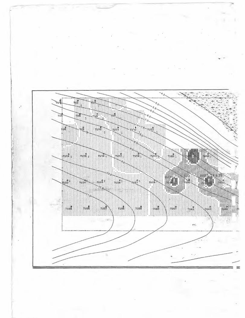
I l
I l l
... -