The maritime itinerary of the tax register of king Valdemar Sejr ...
52
www.ssoar.info The maritime itinerary of the tax register of king Valdemar Sejr of Denmark (1202-1241) Westerdahl, Christer Veröffentlichungsversion / Published Version Zeitschriftenartikel / journal article Empfohlene Zitierung / Suggested Citation: Westerdahl, C. (1990). The maritime itinerary of the tax register of king Valdemar Sejr of Denmark (1202-1241). Deutsches Schiffahrtsarchiv, 13, 325-375. https://nbn-resolving.org/urn:nbn:de:0168-ssoar-54126-4 Nutzungsbedingungen: Dieser Text wird unter einer Deposit-Lizenz (Keine Weiterverbreitung - keine Bearbeitung) zur Verfügung gestellt. Gewährt wird ein nicht exklusives, nicht übertragbares, persönliches und beschränktes Recht auf Nutzung dieses Dokuments. Dieses Dokument ist ausschließlich für den persönlichen, nicht-kommerziellen Gebrauch bestimmt. Auf sämtlichen Kopien dieses Dokuments müssen alle Urheberrechtshinweise und sonstigen Hinweise auf gesetzlichen Schutz beibehalten werden. Sie dürfen dieses Dokument nicht in irgendeiner Weise abändern, noch dürfen Sie dieses Dokument für öffentliche oder kommerzielle Zwecke vervielfältigen, öffentlich ausstellen, aufführen, vertreiben oder anderweitig nutzen. Mit der Verwendung dieses Dokuments erkennen Sie die Nutzungsbedingungen an. Terms of use: This document is made available under Deposit Licence (No Redistribution - no modifications). We grant a non-exclusive, non- transferable, individual and limited right to using this document. This document is solely intended for your personal, non- commercial use. All of the copies of this documents must retain all copyright information and other information regarding legal protection. You are not allowed to alter this document in any way, to copy it for public or commercial purposes, to exhibit the document in public, to perform, distribute or otherwise use the document in public. By using this particular document, you accept the above-stated conditions of use.
-
Upload
khangminh22 -
Category
Documents
-
view
0 -
download
0
Transcript of The maritime itinerary of the tax register of king Valdemar Sejr ...
www.ssoar.info
The maritime itinerary of the tax register of kingValdemar Sejr of Denmark (1202-1241)Westerdahl, Christer
Veröffentlichungsversion / Published VersionZeitschriftenartikel / journal article
Empfohlene Zitierung / Suggested Citation:Westerdahl, C. (1990). The maritime itinerary of the tax register of king Valdemar Sejr of Denmark (1202-1241).Deutsches Schiffahrtsarchiv, 13, 325-375. https://nbn-resolving.org/urn:nbn:de:0168-ssoar-54126-4
Nutzungsbedingungen:Dieser Text wird unter einer Deposit-Lizenz (KeineWeiterverbreitung - keine Bearbeitung) zur Verfügung gestellt.Gewährt wird ein nicht exklusives, nicht übertragbares,persönliches und beschränktes Recht auf Nutzung diesesDokuments. Dieses Dokument ist ausschließlich fürden persönlichen, nicht-kommerziellen Gebrauch bestimmt.Auf sämtlichen Kopien dieses Dokuments müssen alleUrheberrechtshinweise und sonstigen Hinweise auf gesetzlichenSchutz beibehalten werden. Sie dürfen dieses Dokumentnicht in irgendeiner Weise abändern, noch dürfen Siedieses Dokument für öffentliche oder kommerzielle Zweckevervielfältigen, öffentlich ausstellen, aufführen, vertreiben oderanderweitig nutzen.Mit der Verwendung dieses Dokuments erkennen Sie dieNutzungsbedingungen an.
Terms of use:This document is made available under Deposit Licence (NoRedistribution - no modifications). We grant a non-exclusive, non-transferable, individual and limited right to using this document.This document is solely intended for your personal, non-commercial use. All of the copies of this documents must retainall copyright information and other information regarding legalprotection. You are not allowed to alter this document in anyway, to copy it for public or commercial purposes, to exhibit thedocument in public, to perform, distribute or otherwise use thedocument in public.By using this particular document, you accept the above-statedconditions of use.

NAVIGATION
THE MARITIME ITINERARY OF THE TAX REGISTER OF
KING VALDEMAR SEJR OF DENMARK (1202-1241)
BY CHRISTER WESTERDAHL
Introduction
The present author has been expressing views on this sailing route description s ince at least 1975 (Westerdahl1978, 1 984). This time a more definite appraisal of i ts function wi l l be given.
I have ever since been comparing the character of the Danish i t inerary in the Liber Census Daniae with my principal theme, which is the reconstruction of a medieval sail ing route system in the north part of the Baltic Sea, i .e. Swedish Norrland ( cf. Westerdahl 1 986, Westerdahl 1987-89 etc . ) . The south part of my non-itinerary route coincides with the last point mentioned in the tax register at the Swed ish coast (fig. 1) before the sai l ing route leaves the Swedish lands for Aland and Finland. The very choice of survey area depends from the beginning on this fact. My route is to some extent to be regarded as a deviation from the great international route to the B ay of Finland, the theme of the Danish text, whichever other analytical opinions may prevail .
The itinerary of the tax register of King Valdemar Sej r is even in other aspects a most valuable source. Excepting the lapidary notes of the Anglo-Saxon k ing A lfred the Great c. AD 900 this itinerary is the first of its kind in northern Europe (cf. in this forum Sch nall 1 98 1 ) . The notes mentioned concern the j ourneys of two traveller merchants of the Viking Age, the northern Norwegian 6ttar (Anglo-Saxon Ohthere) and Wulfstan, another sailor of dubious extraction (possibly an Anglo-Saxon, since certain traits of the translation of this part indicate that A lfred - if the king indeed supervised the scribe or even made the work himself- had less problems to transcribe that part of the conversation and even turns to d irect speech [ cf. Fell in Lund 1 984:57). If transcribed from a Scandinavian form this name w ould originally read Ulfsteinn, which is not quite implausible). The background interest could possibly be the same in both cases. We are sure of Alfred's intention to know more on the geography of Europe. But although a related ambition may exist behind the account of the tax register i t inerary we can-
hoops
Schreibmaschinentext
Deutsches Schiffahrtsarchiv 13, 1990, S. 325–375
326
~ ~
<:<
q
~.~O ,~ ß d Q
,~ CI
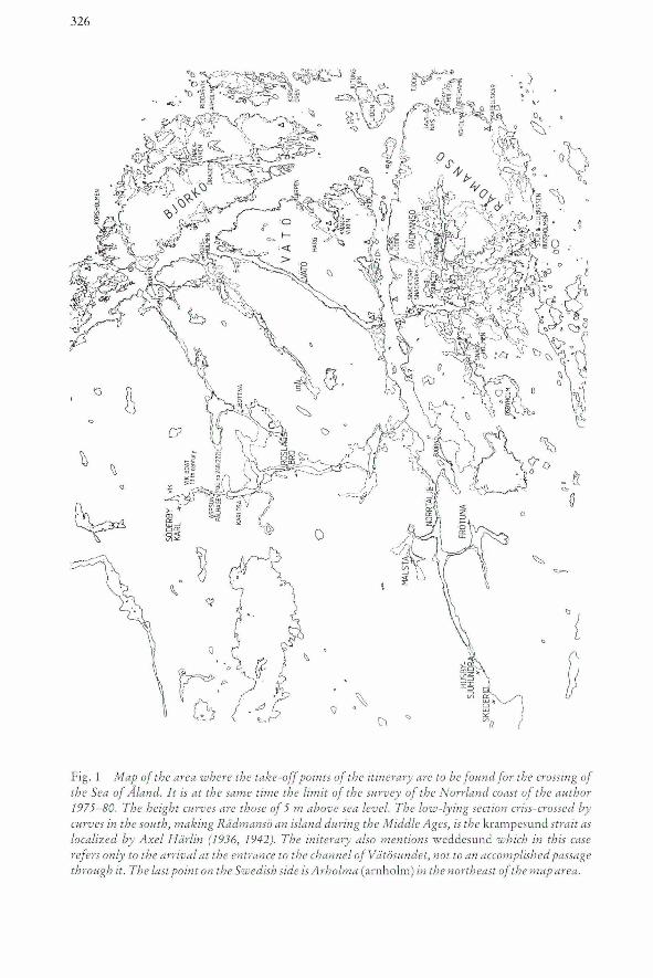
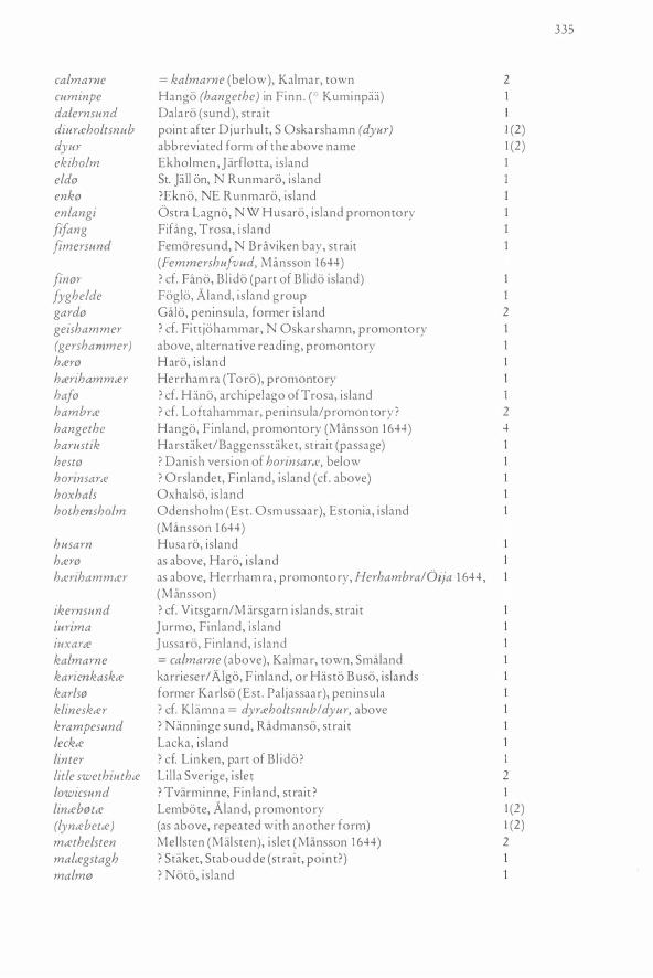
Fig. 1 M ap of the area where the take-off points of the itinerary are to be found for the crossing of the Sea of Aland. Jt is at the same time the limit of the survey of the Norrland coast of the author 7975- 80. The height cur·ves are those of 5 m above sea level. The 1000() -lying section criss-crossed by curves in the south, making RJdmansö an island du ring the Middle Ages, is the krampesund strait as localized by Axel Härlin (79]6, 7942). The initerary also mentions weddesund which in this case refers onl)' to the arrival at the entrance to the channel of V ätösundet, not to an accornplished passage through it. The last point on the Sw edish side is Arholma (arnho lm) in the northeast ofthe map area.
•
327
,.
~- -~ '-" ""t
... r 11J"l !lI flllnansm. 93 <I1ikflll IIdlfmlJ"t ~-t I ' }J 3,a,uf t y nolhlmf· ~~ anitftl iUI Pl'ol tll ar~am!l' ~.;'I ",,/!c'JUll~ dt IImml1111 tiIp~ Rn · ~~ uritr JiU!l1t .1 cfI- pn>((!{fu(' ithu ~ ~ ~~~ lrrM' nuth-um ,1 ~tmll ~(pt-öl III m-tltftnmam '1 ~,. tlll f.ImIum l>1ll!ll1!n\.jl1lt' !l3 f1h- lIJ''t!l fein ul
",htm ·~ :~uf ' l '!!l' noftU,uC .. J1k't 1D 'tdhdlrn~ j ~,drnr' 1 '!l ' noth1>u{ "I1llIItf qft- ttre Y"'mTm tbl~t1Jll'~ ''1:c1' 11u!h~ i omm-. 1) ~ ~ ~nar .J ("':1 .. , ;' '''''ff :t~ • _-'
,",q . '.!l.~..."...'t . t;J . notlil5 a~",,'tIn· tnWl' on<mUO ? llUIh'Uln.~~nR~ ~ t\rrtlip!tI · t§ .at~ . ~ .~· wtlibur· lh~ mm Ilqtü'lomm 'l 0IU'UWltl )1i 8~ '!ll\t·ts1t1!t · , · lh~ cmulM _ "llulonnn '! tni.n~. n~ VIlt"tllÜm.j\3 nuhiift · t·~tt':'I ·' llDtIe mv IIMuCl J'~tc=m. ~~ t1bmn p9l1tm !l3 ~ g~ ~ ~ .. mArftt{ ~mmh m('ttt~ l~i~,a".'t·';iJ llot
• 1Iib1l1'_ ~~ _ @VJ!ti 1 anftnI· ~I" 1>1C7n. tll!
6"ll"tm · ~ ~~.~1ImZIIm ~, Inm' omltmn l , Idtdh-um md;tC ~mCOUl~ l\3 "lIenmn . -:;.
~ ...
.~ 1 I
J' _____ .. ---'..:.:..:J
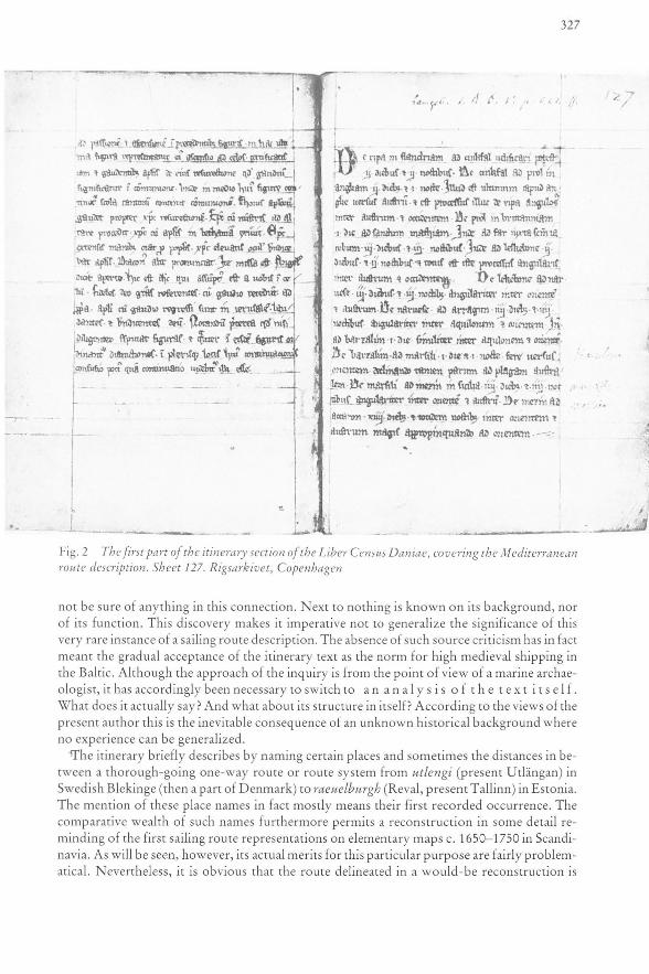
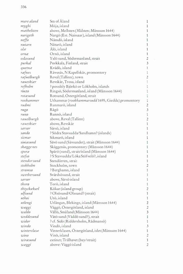
Fig. 2 The first part 0/ the itinerary section 0/ the Liber Census Daniae, covering the M edite1'1'anean route description. Sheet 127. R igsarkiv et, Copenhagen
no t be sure of any thin g in this conn ecti on. N ext to nothin g is kn own on its backgro und , nor of its fun ction. This discove ry makes it imperative not to generali ze th e significance of this very rare ins tance of a sailing route description. The absence of such source criticism has in fact meant the gradual acceptance of the itinerary text as the no rm fo r high medieval shipping in the Baltic. Although the approach of th e inquiry is from the point of view of a marine archaeologist, it has accordingly been necessary to switch to an an a I y 5 i so f t h e te x t i t s ei f . What does it actually say? And what about its structure in itself? According to the views of the present autho r this is the inevitable consequence of an unknown hi stori cal background where no experi ence can be generali zed .
iThe itinerary briefly desc ribes by naming certain places and sometimes the di stances in between a tho rough-go ing one-way route or route system from utlengi (present Utlängan) in Swedish Blekinge (th en a part of D enm ark) to raeuelb urgh (Reval, present Tallinn) in Estonia. The m ention of th ese place names in fact mostly means their first reco rded occurrence. The comparati ve wealth of such names furth ermore permits a reconstru cti o n in some detail reminding of th e first sailing route representations on elementary maps c. 1650- 1750 in Scandinavia. As will be seen, however, its actual merits for this particular purpose are fairly problemat ical. N evertheless, it is obvious that th e route delin eated in a wo uld-be reconstruction is
328
almost identical tO present traditional coastal sailing routes of which records reach back at least tO the 1 6th century. To this extent, therefore, some measure of general usage is implied.
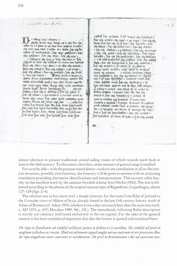
For us tO be able - with the purpose stated above - tO draw any conclusions at all on the interior structure, possibly even function, the itinerary wil l be given in extenso with an analyzing trans lation providing alternative identifications and interpretations . This account relies heavily on the excel lent work by the amateur Swedish scholar Axel Harlin ( 1 942). The text is followed according tO the photos of the original manuscripts of Rigsarkivet, Copenhagen, sheets 1 27-129 (figs. 2-4).
The relevant text in fact starts with a simple itinerary for the route from Ribe of Jutland tO the Crusader tOwn of Akkon of Syria, already found in the late 1 1 th century history work of Adam of B remen ( cf. Adam 1 978 : scholion from a date not much later than the main text itself, c. AD 1 075, p. 437; Morcken 1 989 : 56f., 73f . ) . The immediately following Baltic d escription i s strictly our itinerary and found exclusively in the tax register. For the sake of the general context it has been considered important that also the former is quoted and translated here:
De ripa in flandriam ad cinkfal uelificari potest ij die bus et ij noctibus. De cinkfal ad prol in angliam ij diebus et i nocte.lllud est ultimum capud anglie uersus austrum et est processus illuc de ripa angulosus inter austrum et occidentem. De prol in brittanniam i die ad sanctum ma-
I Z. 8
___ _.
l,...., - _..._ !-- -'
329
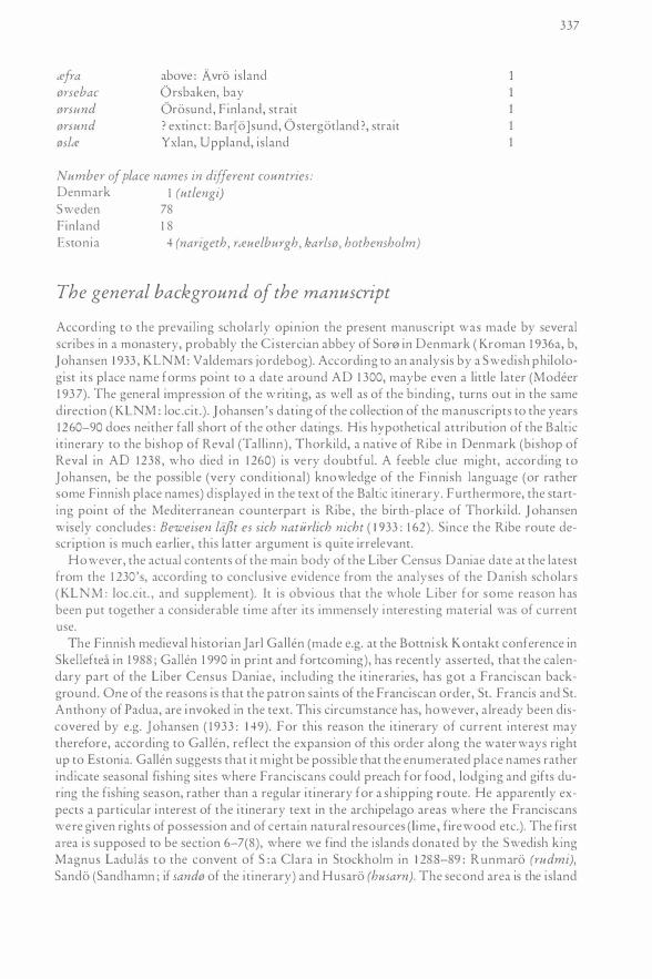
Figs. 3-4 The Baltic itinerary of the Libe1· Cens�-ts Daniae. Sheets 1281129. Rigsarkivet, Copenhagen
thiam. lnde ad far iuxta sanctum iacobum iij die bus et iij noctibus. Inde ad leskebone ij diebus et ij noctibus et totus est iste processus angularis inter austrum et occidentem.
De lekebone ad naruese iij diebus et iij noctibus angulariter inter orientem et austrum. De Naruese ad arragun iiij die bus et iiij noctibu.s, angulariter inter aquilonem et orientem. lnde ad barzalim i die. similiter inter aqu[i]lonem et orientem. De barzalim ad manili i die et i nocte. Jere uersus orientem. declinando tam en parum ad plagam australem. De marsili ad mezin in sicilia iiij die bus et iiij noctibus angulariter inter orientem et au.strum. De mezin ad accaron xiiij die bus et totidem noctibus. inter orientem et austrum magis appropinquando ad orientem.
De utlengi usque calmarne x uktesio. Deinde usque sktegge nes ii ukte. Hinc usque wald0 iiii et si placet ire per latus terre potest ire de waldrJ usque run@. queque distat a waldrJ ad i uktesio. Jnde usque klineskter uel diurteholtsnub i. Jnde usque geishammer i. Inde usque roxhammer i. Jnde usque tefra i. lnde usque win0 i.
[D]e kalmarne usque dyur ix. Hinc usque winrJ iii. Hinc usque sporte iii. Hinc usque hambrte ii et unum cum hambrte. Hinc usque askliJ i et per askrJ i et de ask0 usque quetnte i. Hinc usque 0rsund ii. Hinc usque wteggi i et per wteggi i. In de usque ulfsund i. Hinc usque rottesund i. In de usque alrecki ii. Hinc usque brawic i. Brawic durat in longum vi uktesio. Primo cum pertransitur trans brawic occurrit que dam insula winterclaste nomine. et tunc aler. Deinde rugliJ. Deinde
330
rinzo. deinde leckce. Deinde asko. deinde rceueskicer. Deinde thoro. Deinde hce1·ihammcer. De- usque mcethelsten ii. Inde usque alcesnap ii. !nde usque gardo ii. !nde usque windo i. et cum win do ii. et a win do uersus austrum iacet rudmi. In de uthoi. deinde mcethelsten. deinde nutarn. Deinde alee. deinde ornce. !nde- neffo. !nde rudmi. lnde stromso. Inde eldo. Jnde sando. Inde brunso. Inde enko. !nde hcero. Inde stefso. !nde myghi. !nde scersor. Inde husarn. Inde enlang. Inde linter. Inde sicmar. !nde finor. !nde oslce. Inde hoxhals. Inde widor. Inde rcefnes. !nde arnholm.
Et ultra brawic usq?te fimersund ii. In de usque orsebac usque rugo i et per rugo i. Inde usque stendor Sl4nd. Inde 14sq•te siuice sund i. Inde usque haj0 i. !nde usque fifang i. Inde 14sq14e swether sl4nd i. Jnde usque ekiholm i. !nde usq14e oslcesl4nd et per oslcesund i. In de 14sql4e ikernsund i. Inde usql4e gardo i. !nde usque dalernsl4nd i. Inde usque harustik i. lnde usque Litle swethiuthce i. Inde usque stokholm i. et de litlce swethiuthce usque wirtesl4nd i. Inde usque malcegstagh i. !nde usque krampe sund iii. Inde usql4e weddesund i. Inde usque arnholm ii. Atque notandl4m est quod processus de utlengi 14ersus arnholm magis habeat se ad aquilonem quam ad orientem.
[D]e arnholm transmare aland usque lyncebothce vi. !nde 14sque thiyckcekarl viii. Notandum est q14od inter thiyckcekarl et lincebotce multe iacent insl4le fyghelde nomine. !nde usque aspcesund vi et ibi sunt tres insule quarum una est aspo secl4nda refholm. iii: a malmo. et iurima iacet ultima ab eis uerms a/4stralem plagam et proxima mari. De asp0 usque 0rsund vi. Inde usque hangethe iij et notandum est quod de arnholm 14sque lyncebetce itur media inter orientem et aquilonem et si prosper est 14entus ab occidente potest 14elificari directa linea de arnholm 14sq14e hangethe et de hangethe q14e finnice dicitur cuminpe usque lowicsl4nd ii. !nde usq14e karienkaskce i. Inde usque il4xarce ii. In de horinsarce quod danice dicitur hesto ii. In de usque p14rkal iii. et ad hanc insl4lam de hangethe itur uersus orientem et aliquantulum tamen uersus aquilonem. Item de p14rkal usque narigeth ultra mare estonl4m vi. lnde usque karlso i et dimidia. !nde usql4e rcel4elbl4rgh dimidia. Et notandl4m quod de p14rkalce 14sque rceuelburgh uelificandum est inter australem plagam et orientalem. Prceterea notandl4m est quod si placet potest 14elificari de hangethe usque hothensholm c/4m uento aqudonis uersus australem plagam et orientalem. Atque ibi habet mare viii 14ktesio.
Translation by the present author, assisted by a specialist of medieval Latin , Dr. Gi:iran Baarnhielm, Stockholm :
From ripa (Ribe) to flandria (Flanders) and cinkfal (Zwin at Sluys) you can sail in two days and two nights . From cinkfal to prof (Prawle Point) in England two days and one ni ght. This is the utmost point of England to the south and i t comes forth of a peaked coastline in a direction between south and east. From prol in brittannia one day to sanctl4s mathias (S :t Mathieu) . Further on to the l ight (-house ;far at El Ferro!) close to sanctus iacobl4s (Santiago de Compostela, Galicia) three days and three nights. Further on to leskebon[ e J (Lisbon) two days and two nights and as a whole this voyage is in the angle between south and east.
From Leske bon[ e J (Lisbon) to narl4ese (Strait of Gibraltar, tariJa; the old Norse name is Njorvasund) three days and three nights in the direction between east and south. From naruese to arrag14n (Tarragona) four days and four nights, with a course angular between north and east. Further on to barzalim (Barcelona) one day in the same way between north and east. From barzalim to marsili (Marseille) one day and one n ight. Here you turn to the east and somewhat to the south. From marsili to mezin (Messina) in Sicily four days and four nights in direction between east and south. From mezin to accaron (Akkon) fourteen days and as many nights. Between east and south you now ought to approach against the east.

33 1
The Baltic itinerary proper
Section 1 From utlengi (Uthingan, an is land in the outer archipelago of the then Danish province Blekinge) to calmarne (the town of Kalmar, SmiUand, Sweden) 10 vikusjoar (in Swedish, which distance measure will henceforth be abbreviated vs. ; in fact this distance will rather add up to 1 1 vs . ) . From there to skceggenes (the promontory of Skaggenas, with the portage site Drager at the waist) 2 vs. From there to waldo (Vallo island) 4 vs. (in reality 5 ?). If you want to follow the coastline (cf. the comments on the ideas of Nils Blomkvist 1 979) you can go by way of wald0 to runo (the island of Runno), situated 1 vs . from waldo. From there to klineskcer (unknown as a present place name ; probably once Klamnaskar after Klamna, a farm S Oskarshamn) or diurceholtsnub 1 vs. From there to geishammer (or gershammer, unknown as a place name, obviously close to present Fittjehammar NE Oskarshamn) l vs. From there to roxhammer (present Uthammar promontory, on the nautical chart of Giedda in 1 695 called Rookhammarsudd) 1 vs. From there to cefra (Avro island) 1 vs. From there to wino (Vino island) 1 vs.
After this section the sailing route between Kalmar town and Bd\viken bay of Ostergotland is summarily described, with a sudden jump between Kalmar and di.trceholtsnub (cf. above), without following, as told above, the coastline : ire per latus terre. Accordingly, you are supposed to go in a straight northerly direction towards the promontory of this name, abbreviated dyur, or maybe, further on to e .g . geishammar or perhaps rather roxhammer (above, cf. comments below).
Section 2 From kalmarne (Kalmar) to dyur (diurceholtsnt4b above) 9 vs. From there to win0 (Vino island) 3 vs. (ought to be 4 vs . , cf. above).
From there to sporce (Spare island at the entrance of the town of Vastervik, Tjust, Smaland) 3 vs. From there to hambrce (unknown, but would at present be Hammar, i . e . Loftahammar, with the outer harbour basin called Hallmare skackel) 2 vs. and 1 vs. along hambrce (possibly into the haven and out?) . From there to asko (Stora Asko island) 1 vs. and past (or possibly through, meaning the inner route inside Stora Asko) ask0 1 vs. and from ask0 to quetnce (Kvado island) 1 vs. From there to orsund (unknown as a present p lace name, probably the straits Bar[o ]sund or Bussund; or possibly an unnamed strait between A rsviken, N the parish church of Gryt and the strait Farstrommen in the south, the latter improbable alternative being proposed by H arlin 1 942) 2 vs. From there to wceggi (Vaggo island) 1 vs. and past wceggi 1 vs. From there to ulfsund (Olsosundet strait or the route called O lsundsleden at present, in the later case in an inverted order) 1 vs. From there to rotcesund (Rotsundet strait) 1 vs. From there to alrecki (Arko[ sund] strait) 2 vs. From there to brawic (Bra vi ken bay, outer part) 1 vs. The length of brawic i s 6 vs .
Then follows what Harlin ( 1 942) calls the outer route to Runmaro :
Section 3 After having traversed brawic (Braviken bay) you first reach an island by name winterclasce (islet and sighting point Vinterklasen) and thereafter alor (Alo island). After that rug0 (Rago island), after that nnzo (Ringso island), after that leckce (Lacka island) . Thereafter asko (Asko islands) . Thereafter rceueskiter (Revskar island). Thereafter thorte (Toro island). Thereafter hterihammter (Herrhamra promontory on Toro island, inside Oja/Landsort island).
332
Section 4 From (hterihammter) to mtethelsten (Mellsten islet) 2 vs. Thereafter to altesnap (Alvsnabben, island with a protected haven basin) 2 vs. Thereafter to garde (present Gala, p eninsula, formerly island) . Thereafter to winde (Vindo island) 1 vs. (in reality 4-5 vs.) and past winde 2 vs. (possibly inside Vindo, which passage in that case refers to the old inner sailing route past Djurhamn/Djuro harbour to the northern approaches to Stockholm. Not until 1 6 1 6 the outer route by name of Kanholmsleden [the Kanholmen route] was established along the outer coast of Vindo ; Hedenstierna 1 949 : 267), to the south (rather the southeast) lies rudmi (Runmaro island) .
Farther on the route along the islands east of the sailing route Mellsten-Runmaro:
Section 5 Further comes uthei (Uta island), further mtethelsten (Malsten[Mellsten] islet), further nutarn (Nataro island). Further olte (Alo island), further ornte (Orno island) . Further neffe (Namdo island) . Further rudmi (Runmaro island, mentioned as the last above) .
Then comes the Husaro sailing route Runmaro-Arholma, the southern part:
Section 6 Further stremse (unknown place name, possibly present Berghamn?) . Further elde (Stora J allo, earlier Ella, the additive j- a normal dialectal pattern). Further sande (unknown, possibly the eastern part of Sodra Stavsudda island, or Sandon island at Sandhamn, one of the present entrances to Stockholm and to the archipelago from the outside, however in that case being misplaced in the order of place names). Further brunse (unknown, possibly Brunskar NE Trasko/Storo islands) .
Then follows, according to H arl in ( 1 942) an alternative, more easterly route. However, I rather believe that the route passes, as would be normal, inside of Runmaro-Moja:
Section 7
Further enke (metathesis of Ekno ?). Further htere (Haro island). Further stefse (Stefl a ? Stavsudda' Stofve lo/Lokao, NE Bocko?) . Further myghi (Moja island).
If my proposition above is taken to be correct this is no separate section. The two last "sections" appear funny, with their names of places situated - as it seems - unduly close to one another. However, I sti ll stick to H arlin 's sectional divisions :
The Husaro sail ing route Runmaro-Arholma, northern part :
Section 8 Further sterser (Sarso island) . Further husarn (Husaro island) . Further enlangi (Ostra Lagno promontory of Ljustero islands) . Further linter (at present unknown, cf. Linken, a farm on S B l ido island, possibly referring to a disappeared topographical name of the southern part of B lido ? ) . Further sicmar (Sikmaro island) . Further finer (unknown, cf . Fan a, an earlier name of the mansion of Blido, possibly referring, like Linken/linter above to a former topographical name denoting the central part of Bl ido ?) . Further eslte (Yxlan island) . Further hoxhals (Oxhalso island, with a dialectal initial h- cf. Jallo above, instead of Eldo). Further wider (unknown, cf. Sido, a mansion at Riddersholm, Radmanso, possibly from the outset a topograph-
333
ical name of the southern promontory of the once island of Radmanso). Further r<Rfnes (Ravsnas, promontory or point N Kapellskar). Further arnholm (Arholma island).
Then follows suddenly the route from Braviken bay to Stockholm on the inner s ide of the archipelago:
Section 9
And from this side of brawic to fimersund (Femoresund strait outside of Oxelosund) 2 vs. From there to emebac (Orsbaken bay) to rug0 (Rago island) 1 vs. and past rug0 1 vs. From there to stendor sund (Stendorren strait, at Krampo island, cf. krampe sund at Radmanso below and the discussion on identifications). From there to siui<R sund (Sav[ 6 J sundet, strait) 1 vs. From there to haj0 (unidentified, but could refer to Hano island outside of Trosa town) 1 vs. From there to fifang (Fifang island) 1 vs. From there to swether sund (Svard[ so]sund[ et] strait) 1 vs. From there to ekiholm ( Ekholmen is land) 1 vs . From there to osl<Rsund (Y xlosund strait) 1 vs. and through osl<Rsund 1 vs. From there to ikernsund (un identified; an unknown name of the straits of the islands of Vitsgarn or Marsgarn n 1 VS. From there to gard0 (Galo peninsula, once island) I vs. From there to dalerns1md (Dalaro strait) l vs. From there to harustik (Harstaket passage= Baggensstaket, cf. the l ast element stak, meaning blockage) 1 vs. (should be 3 vs).
From there to Litle swethiuth<R (Lilla Sverige or Sveriges holme islet at the entrance of the Stockholm harbour basin) l vs. From there to stokholm (Stockholm) l vs. Finally, on the Swedish side, from Sveriges holme islet to Arholma is land at the Sea of Aland :
Section 10 And from Litle swethiuth<R to wir<Rsund 1 vs. (wira?SJ,tnd being the entrance strait of the Uinghundraleden inner sailing route, once carrying far into the central parts of the province of Uppland. The mansions of Vathar I present Vada and Husa of Ossebygarn parish are in AD 1 274 rold to be s ituated at wir<Rsund strait; cf. Ambrosiani 1 964: 139, G ustavsson 1 967 : 1 6, Graslund 1 987 on the site of the battle at Helgea in AD 1026: this p l ace name must, however refer tO the entrance at the present bay of Tralhavet at Akersberga. The other, most improbable alternative, without any relevant p lace name, Tenosund or Vaxholm straits must be at least 2 vs. from the islet Sveriges holme, and from wir<Rsund 3 vs).
From there to mal<Rgstagh (not identified, the last element reminding of Stabo udde promontory, N Siaro/N Ljustero islands, or of Staker, S Helgo/N Vettershaga, which i s more probable, obs the stak element, referring to a sailing route blockage) 1 vs. (at any rate too short a distance, should be about 4 or 5 vs. ?) . From there to krampe sund (Nanninge sund strait, NL II map 33, now dry land, inside of Radmanso, cf. Krampii sund s trait, referred to as stendor sund in the above it inerary of Sodermanland, krampe sund is anyway not found as a present place name in this area : possibly a mistake of the scribe?) 3 vs. ( if earlie r identifications are accepted this distance would be at least 6 vs . ) . From there to weddesund 1 vs . (weddesund seems to refer to Vatii sund[ et] in a Danish form, in this case only marking the entrance, the route running henceforth d irectly to arnholm! Arholma. The improbable alternative would be that this item denotes a passage of the strait referred to which then undoubted ly would be the unrecorded strait Vaddo sund, now dry, in the present bays of Ungviken/Samnasfjarden/Grano strom, NL II map 34, but then the d istance is mistaken, which, however would be no wonder, s ince almost all the distances in this section are incorrect). From there to arnholm (Arholma island) 2 vs. (the distance ought w be at least double in any case) . To observe is that the voyage from utlengi (Utlangan of the archipelago of Blekinge, where we started) w arnholm runs more to the north than to the east.
334
In this area, accord ingly, the Norrlandsleden sai l ing route started (or fin ished).
The itinerary then crosses the Sea of Aland to the Gulf of Finland which is called the Sea of Estonia in this text :
Section 11 From arnholm traversing the Aland Sea to lynteb!Jta: (Lembote promontory) 6vs . (at least) . Thereafter to thiyckcekarl (Kokar is land group) 8 vs. To observe is that between thiycktekarl and lina:br:!tte lie many is lands, which are called fyghelde (Foglo ). From there to aspa:sund (Aspo island strait) 6 vs. and in this area there are three islands, of which one is called aspo (Aspo), the second refholm (un identified, perhaps a part of Bjorko or Lokskar: Zilliacus 1 989: 25) , the third malm0 (probably No to : Zi l l iacus op.cit . : 24£.) and iurima Q urmo) is the last of these, in a southerly direction and closest to the sea. From asp0 to orsund (Kyrksundet strait between Orskar and Oro of H itis and Rosala archipelagoes) 6 vs . Thereafter to hangethe (Hango promontory) 3 vs. and it ought to be observed that you go from arnholm to lyna:bette between east and north and if the wind is favourable from the west you can sail i n a straight l ine from arnholm to hangethe, which is called cuminpe (Finn. Kuminpaa, at present unknown) in Finnish to lowicsund (unknown : probably at Tvarminne) 2 vs . Further to karienkaska: ( Karrieser/Ellie/ Al go, Kerkkonen 1945 : 1 62ff. , cf. Granlund 1 962 and Zilliacus op.cit . : 27, who proposes Has to Buso) 1 vs . Further on to iuxarce Qussari:i island) 2 vs . Further on to horinsarte (unknown, possibly Orslandet island) which in Danish is called hest0 (unknown) 2 vs . Further on to purkal (Porkkala peninsula) 3 vs. and to this island you go from hangethe (Hangi:i) eastward but also somewhat northward. Thereafter from purkal(a:) to narigeth (Nargi:i, present Naisaar i sland) across the Estonian Sea (Gulf of Finland) 6 vs. Further on to karls0 (Karli:i, Kali:in, Karon, present Pal jasaar peninsula, west of Tall inn, Wieselgren 1 95 1 : 1 05). Further on to rceuelburgh (Reval =Tallinn) 1h vs .
And to observe is the fact that from purkal to uuelburgh you ought to sai l in a direction between south and east. Furthermore is it to be observed that - if you want to - you could sail from hangethe (Han go) to hothensholm (Odensholm = Osmussaar) with a northerly wind towards south and east. And there the sea is 8 vs. wide.
Place names of the itinerary
name :
tefra altesnap alrecki a lor arnholm ask0 ask0 aspa: sund asp a: a:fra brawic bruns!J
identification:
Avri:i, i sland Alvsnabben, i sland basin (Mansson 1 644) Arki:i (sund), 1 644 Areck1.an (Mansson), strait Alo (S Orsbaken), i s land Arholma, i s land Stora Aski:i, Tjust, Smaland, island Stora (Lilla) Aski:i, Trosa, Si:idermanland, island Aspo sund (SE Aland), strait Aspi:i (SE Aland), island above Braviken, bay ? brunskar (NW Moja), island
mentioned (times)
1 6 3 2
2
4
335
calma me = kalmarne (below), Kalmar, town 2 cuminpe Hango (hangethe) in Finn. C Kuminpaa) 1 dalernsund Dalaro (sund), strait 1 diur<Rholtsnub point after Djurhult, S Oskarshamn (dyur) 1(2) dyur abbreviated form of the above name 1 (2) ekiholm Ekholmen , Jarflotta, island 1 eld0 St. Jail on, N Runmaro, island enk0 ?Ekno, NE Runmaro, island enlangi Ostra Lagno, NW Husaro, island promontory fifang Fifang, Trosa, i sland fimersund Femoresund, N Bd\viken bay, strait
(Femmershufvud, Mansson 1644) jin01· ? cf. H. no, Bl ido (parr of B lido island) fyghelde Foglo, Aland, i s land group gard0 Gala, peninsula, former island 2 geishammer ? cf. Fittjohammar, N Oskarshamn, promontory (gershammer) above, alternative reading, promontory h<Rr0 Haro, island h<Rrihamm<Rr Herrhamra (T oro), promontory haj0 ? cf. Hano, archipel ago ofT rosa, island hambr<R ? cf. Loftahammar, peninsula/promontory? 2 hangethe Hango, Finland, promontory (Mansson 1 644) 4 harustik Harstaker/Baggenssraker, strait (passage) hest0 ? Danish version of horinsarce, below horinsarce ? Orslandet, Finland, island (cf. above) hoxhals Oxhalso, island hothensholm Odensholm (Est. Osmussaar), Estonia, island
(Mansson 1 644) husarn Husaro, island h<R1'0 as above, Haro, island h<Rrihamm<Rr as above, Herrhamra, promontory, Herhambra!Oija 1 644,
(Mansson) ikernsund ? cf. Vitsgarn/M arsgarn islands, strait lunma Jurmo, Finland, island 1uxar<R J ussaro, Finland, island kalmarne = calmarne (above), Kalmar, town, Smaland karienkaskce karrieser/ Alga, F inland, or Hasto Buso, islands karlsfl former Karlso (Est. Paljassaar), peninsula klinesk<Rr ? cf. Klamna = dyr<Rholtsnub!dyur, above krampesund ? Nanninge sund, Radmanso, strait leck<R Lacka, island linter ? cf. Lin ken, part of Bl ido? I Litle swethiuth<R Lilla Sverige, islet 2 lowicsund ? Tvarminne, Finland, strait ? 1 lin<Rbflt<R Lembote, Aland, promontory 1 (2) (lyn<Rbet<R) (as above, repeated with another form) 1(2) m<Rthelsten Mellsten (Malsren), islet (Mansson 1644) 2 mal<Rgstagh ? Staker, Staboudde (strait, point?) malm0 ? Nora, island
336
mare aland myghi mt!!thelsten narigeth neffe nutarn oft£ ornt!! osLesund purkal quetn.e rt!!fnes r.efuelburgh rt!!ueski.er refholm rmze rot.esund roxhammer rudmi ruge rune r.euelburgh 1·.eueski.er s.erser san de szcmar siui.esund sk.egge nes spor.e stefse stendor sund stokholm stremse swethersund s.erser thom thiyck.ekarl ulfsund uthei utlengi wt£ggz
·walde weddesund wider win de winterclast!! wzne wir.esund w.eggz
Sea of Aland Moja, island above, Mellsten (Miilsten; Mansson 1 644) Nargo (Est. Naissaar), is land (Mansson 1 644) Niimdo, isl and Nataro, island Alo, island Orno, island Yxlo sund, Sodermanland, strait Porkkala, Finland, strait Kviido, island Riivsniis, N Kapellskar, promontory Reval (Tall inn), town Revskiir, Trosa, island ? possibly B jorko or Lokholm, i slands Ringso, Sodermanland, isl and (Mansson 1 644) Rotsund, Ostergotland, strait Uthammar (rookhammarsudd 1 695, G iedda) promontory Runmaro, island Raga Runno, island above, Reval (Tallinn) above, Revskiir Siirso, island ? Sodra Stavsudda/Sandhamn? (islands) Sikmaro, island Siivo sund (Siivsundet), strait (Mansson 1 644) Skaggeniis, promontory (Mansson 1 644) Sparo (sund), strait/island (Mansson 1 644) ? S Stavsudda/Loka Stofvelo? , island Stendorren, strait Stockholm, town ? B erghamn, isl and Sviirdsosund, strait above, Sarso island Toro, island Kokar (is land group) ? Olsosund/Olssund ? (strait) Uto, island Utlangan, B lekinge, island (Mansson 1 644) Vaggo, Ostergotland, island Vallo, Smaland (Mansson 1 644) Vii to sund (Vaddo sund ?), strait ? cf. Sido (Riddersholm, Radmanso) Vindo, i sland Vinterklasen, Ostergotland, is let (Mansson 1 644) VinCi, island extinct ; T ralha vet (bay I strait) above : Vaggo island
2 3
1 2
2 3
2
2
2
2 2 3
1 3 1 2
2
.efra 0nebac (l)rSNnd (l)r5und 0Slc.e
above: Avro island Orsbaken, bay Orosund, Finland, strait ? extinct : Bar[o )sund, Ostergotland ?, strait Yxlan, Uppland, island
Number of place names in different cotmtries: Denmark 1 (utlengi) Sweden 78 Finland 1 8 Estonia 4 (narigeth, rteuelburgh, karlse, hothensholm)
The general background of the manuscript
337
Accord ing to the prevai l ing scholarly opin ion the present manuscript was made by several scribes in a monastery, probably the Cistercian abbey of Som in Denmark ( Kroman 1 936a, b, Johansen 1933 , KLNM : Valdemars jordebog). According to an analysis by a Swedish philologist its pl ace name forms point to a date around AD 1 300, maybe even a little later (Modeer 1 93 7). The general impression of the writi ng, as well as of rhe binding, turns our in the same direction ( KLNM: loc .cit .) . Johansen's dating of the collection of the manuscripts to the years 1260-90 does neither fall short of the other datings. His hypothetical attribution of the Baltic it inerary to rhe bishop of Reval (Tal l inn), Thorkild, a native of Ribe in Denmark (bishop of Reval in AD 1238 , who died in 1 260) is very doubtful. A feeble clue might, according to Johansen, be the possible (very conditional) knowledge of the Fin nish language (or rather some Finnish place names) d isplayed in the text of the Baltic itinerary. Furthermore, the starting point of the Mediterranean counterpart is Ribe, the birth-place of Thorkild. Johansen wisely concludes : Beweisen laflt es sich naturlich nicht (1933: 1 62) . Since the Ribe route description is much earlier, this latter argument is quite irrelevant.
However, the actual contents of the main body of the Liber Census Daniae dare at the latest from rhe 1 230's, according to conclusive evidence from the analyses of the Danish scholars (KLNM : loc.cit., and supplement). It is obvious that the whole L iber for some reason has been pur rogether a considerable time after irs immensely interest ing material was of current use.
The Finnish medieval h istorian Jar! Gallen (made e.g. at the Borrn isk Kontakr conference in Skelleftea in 1 988; Gallen 1 990 in prim and foncoming), has recently asserted, that the calendary pan of the Liber Census Daniae, including the i t ineraries, has got a Franciscan background. One of the reasons is that the patron saints of the Franciscan order, St. Francis and St. Anthony of Padua, are i nvoked in the text. This circumstance has, however, a lready been discovered by e.g. Johansen ( 1 933: 149). For this reason the it inerary of current interest may therefore, according ro Gallen, reflect the expansion of this order along the waterways right up ro Estonia. Gallen suggests that i t m ight be possible that the enumerated place names rather indicate seasonal fishing sites where Franciscans could preach for food , lodging and gifts during the fishing season, rather than a regular i t inerary for a shipping route. He apparently expects a particular interest of the it inerary text in the archipelago areas where the Franciscans were given rights of possession and of certain natural resources (l ime, firewood etc.). The first area is supposed to be section 6-7(8), where we find the islands donated by the Swedish king Magnus LaduLJ.s to the convent of S:a Clara in Stockholm in 1288-89: Runmaro (rudmi), Sando (Sandhamn; if sande of the it inerary) and Husaro (husarn). The second area is the island

338
group of Kokar (thiyckcekarl), SE of Aland with the i s lands of Aspo (aspce sund) and J urmo (iurima) in the east (Gallen 1990 : 3 1 , 32) .
The convent of Kokar, however, was not established before the middle of the 1 5th century (Gallen op.cit.: 33 ) . This must of course not exclude an earlier Franciscan interest, but it remains unproven by the current arguments. Besides, the original i tinerary most probably is of an earlier dating than even the 1 280's. Moreover, in no way this particular interest is shown by the text of the itinerary, if not in the confused section with unusually dense place names, which partly are unidentified, including sand0, which is referred to above (section 6-7). The two other island names, rudmi and husarn are in fact found in other sections, if we follow the divisions proposed . However, this rather improbable theory on the general character of the whole calendar part does not change the fundamental character of the it inerary as a sail ing route sequence .
Moreover, Cederlund ( 1 989a, b, 1990) has recently shown from the evidence of the ancient monuments sut·vey of Sweden, that although several mentioned sites may be seasonal fishing harbours, thi s i s by no means a consistent occurence. On the other hand, few of these remains are dated. To prove Cederlund's assertion that there are neither any reasons to surmise harbours, anchorages or havens (as earlier maintained by the present author, Westerdahl 1 978, 1 984 on place names and oral tradi tion on traditional usage) at the sites certainly requires more studies ( including underwater surveys) than i s possible during a moderate time of leisure sailing along the route. Maybe even the ancient monuments survey would not suffice on land, but only concentrated efforts in well-chosen local ities.
Moreover, there are - as we have already seen - t w o itineraries in the L iber Census, of which one, i .e . the M editerranean, certainly is inserted, apparently from other records, in the text, since we know of its existence since the later part of the 1 1 th century (ref. as of above, introduction). If this also is the case with the Bal tic version any reference of the Gallen kind would be irrelevant.
Except in the terms of this context we know next to noth ing on the background of the Balt ic itinerary. It is hi ghly improbable that the Som (if this is the place) scribes copied these and other texts, as has been proposed earlier, for the purpose of an exercise in writing, s ince the scribes seem to have been ful ly educated (KLNM : loc.cit . ) . Nor is i t very probable that the content to some extent was meant for and/or actually has been in the use of the Danish royal family as a k ind of educational material for the young crown prince (as mentioned by Johansen 1 933 ) .
The history of the manuscripts is fairly complicated . The Mediterranean itinerary belongs to another hand (called C) than the B altic one (D), the former copyist having written by far most of the two . The fate of the manuscripts after the Middle Ages is hazy. However, Kroman states that the uniform character of the sheets and their size shows that they were meant as a unity already at their conception . They were found and collected, and at least to some extent rearranged by a Swedish scholar in the 1 7th century (J acobowsky 1 932, 47£ . ) and remained in official Swedish ownership unti l the 1 920's, when an exchange was arranged with the National Archives (Rigsarkivet) of Copenhagen.
The s ignificance of this short summary on views expressed on the background of the it inerary text is thus in tended to drawing our attention to the fact that we have no right to found any definite opin ion s on its feeble basis . This concerns the generalization of its con.tents, as well as referring to its possibly unique and temporary character. The only information poss ible to extract must be found in the text i tself, on which to found further considerations.
339
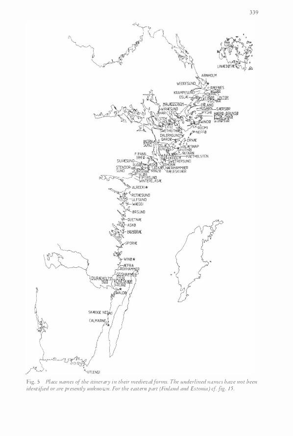
Fig. 5 Place names of the itinerary in their medieva.l forms. The 1-tnderlined names have not been identified or are presently unknown. For the eastern part (Finland and Estonia) cf fig. 15.
340
Discussion on the itinerary
As can thus be easily discerned in the text, nothing is explicitly mentioned on ports, noth ing at all on the possible attractions of the coastline run along, nothing except place names, some distances and general courses to be inferred from the sequence enumerated. I t appears as if the only interest of the text (or the scribe) would have been the transport from utlengi to ra?uelburgh.
The verbal d escription of this route accordingly comes out, simply expressed, as a sequence of places reached and/or sigh ted along the passage. Only one site, that of dalem sund (present Dalaro, at the southern entrance to the Stockholm area from the south) seems to be explicitly mentioned as a port in other medieval records. Later, however, Dalaro is one of the most important out-harbours of Stockholm, as well as a customs and pilot station.
There are a few relevant sources giving individual names of points along the Swedish east coast. Some are found in rhymed chronicles, such as Erikskronikan ("The Eric chronicle" , c . AD 1 335, on the l ife and times of prince Eric Magnusson, AD 1 3 1 8) and Karlskronikan ( "The Karl chronicl e " , on the correspondingly troubled times of King Karl Knutsson Bonde of Sweden, 1 408-70 (king in d ifferent periods, 1 448-57, 1 464-65, 1 467-70), being written around AD 1 452, abbreviated KK. In the latter are mentioned e.g. the harbours of cura hampn (present Karehamn ? KK 6604) on the east coast of the island of Oland in the south, i . e . facing the open sea, as opposed to the L iber Census i tinerary, and finally dalema (Dalaro, above ; KK 1 762).
On the othet- hand, there are quite a number of port sites in other waters than those of the east coast. The meeting place of iuncfruhafn ( in present form J ungfruhamn, " H arbour of the Virgin" or maybe j ust "Virgin H arbour " ?) is mentioned in KK strophe 1 765, p robably referring to a particular site, pointed out by Schi.ick ( 1 958) in lake Malaren, but in fact at least 3 "Jungfruhamn" sites exist at the present time in this lake (Westerdahl 1 989: 1 8 1 £.) .
The single s i te of dalern sund may, in the light of other experiences, be said to represent the character of some of the other s ites mentioned. The place name element sund, appearing in quite a number of s ites , means "strait" . It can moreover be shown th at some other s ites mentioned, although not expl icitly referred to as straits, topographically constitute important passages in straits, some at the same time tradi tional havens or port s ites, well known in later times. Before turning to the general character of the sites mentioned, however, we have to treat the distance measure of the it inerary.
The Nordic maritime measure of length, vika or vikusjo One of the characteristics of the itinerary of the Baltic is that certain, well-defined parts of i t are supplied with a particular Nordic unit of measure, vika or vikusjo (Dan. ugesliJS). The Mediterranean journey is on the contrary counted in days and n ights (just like Ottar and Wulfstan in the Viking Age) . The Danish scholar N E N0rlund ( 1 944) has measured al l 43 d istances of the itinerary and found an average for the vika or vikusjo used as of 8.3 kms with a margin of ± 0.22 km. The unnamed author of an article in "Rospiggen" 1 970 gives some examples of comparisons between his own assumed standard figure for the vika of 4 ' (c. 7.4 kms) and the measurements of the itinerary. There are clear problems. The 1 0 vikusjoar (henceforth abbreviated vs.) of the itinerary between utlengi and calmarne would rather correspond to 1 1 1/s vs. and the stretch sk£ggenes-wald0, given as 4 vs . , rather seems to approach 5 vs. This gives good support for N0rlund's calculations with a longer vika of 8 .3 kms. Furthermore, N0rlund has pointed out that the sea mile (Swed. sjomil) of 7.4 kms, or somewhat less, was introduced
34 1
during the later part of the 1 5th and the beginning of the 1 6th century, corresponded to the German (and geographical) mile of 7.420 ms ( 4 ' ) . The older vika has obviously been confused with this mil by Harlin ( 1 942) and by the author of the Rospiggen article on early pilotage ( 1 970). Probably this is anyway the measure of weeke sees of "Das Seebuch" (Koppmann 1 8 76). Even if N0rlund refers to a Danish context there is good reason to believe that it also applies to Sweden at this time (KLNM : uge sos; cf. the calculation of Adolf Schuck in 1 933, mentioned below in connection with the land rast) .
The Norwegian vika changes i n the same way, although the designation remains. During the 1 7th century the vika could be estimated as 9.25-1 4 .8 kms with an average of 1 3 .3 kms. Roald Morcken ( 1 970, 1 978) has, however, been able to sketch an o lder vika of 6 ' = 1 1 . 1 kms.
In medieval Iceland, almost excl usively applying distance measures of the open sea, a tylft sjdvar corresponded to 1 2 (a tylft) vikor, approximately one latitude, with a vika of 9 .25 kms (cf Norway above). Two tylfter is originally a passage of one day and one night (Schnall 1 975 : 134ff.), but already in this context it has, according to Morcken, become a fixed unit of measure. The average length of the Norse vika seems to match the Danish one of 8 .3 kms. The younger vika, on the contrary, is 1 0 .4 kms.
In Finland the vika during the 1 6th century appears to be very short, in this case according to the context. This vika is thus mainly applied to inner routes. Kustaa Vilkuna ( KLNM) has, on statements of Jacob Teitt of AD 1 555, found that it changed with the degree of difficulty of the rivers from 4.4-4.5 kms upstream, the rapid Kajana river even supplying a vika of 3.6 kms. Imagination assumes an aim of e .g . 1 000 ( rowing) strokes or something similar. Downstream, however, the Finnish vika may attain 6 kms. To compare with this, Ernvik ( 1 955), has calculated a vika of 5.3 kms in a lake of Varmland, west Sweden. In the open sea the Finnish vika during the 1 6th century corresponded neatly to a land mil, i .e. c . 6 kms . There is no proof of an earlier vika measure, but it is highly probable that such a vika has existed.
The same variations distinguish the corresponding units of land measure. The Ostgota law book of the early 1 4th century (Schlyter 1 830 : Drapa B. XI: p . 67, Holmback/Wessen 1 933 : 60) equalizes vika a t vatne ( i n the water) with rost a t Lande (on land) . A rast i s t h e standard distance covered without rest . In the same way i t has been assumed that one vika i s the average distance that could be rowed without relief/change of rowers. At the end of the vika, the old team vek (sig) "made way" for a new (relief) one. Plenty of rather recent place names in Swedish oral tradition still attest to this practice in rowing routes : Ombyteshallan, Skiftesgrundet, Bytet, etc., all meaning Change (Relief) Rock or Reef
Adolf Schuck states ( 1 933) that the Swed ish land rast would comprise c. 9 kms, the maritime vika c. 8 kms. This agrees well with the Danish vika measure as of N0rlund above.
Moreover, as well as there have existed several types of functional raster there might have been many different vikor. The styltingx rast ( "cripple[ d] or cripple's rast") of the H als inge law book (Schlyter 1 844 Wid XV: 78) is somewhat shorter than a regular land rast. When crossing difficult terrain (or in rivers upstream and possibly shallow waters ?) the measure normally becomes shorter, e.g. shown by other concepts, such as fjallmil ("mountain mi l") or skogsmil ("forest mil " ) . Ernvik digresses i l luminatingly on this subject ( 1 955) .
I t is easy to get the anachronistic view that the vika or the rast only was a functional and thus conditional unit of measure varying with the ci rcumstances . Such may have been the case on particular stretches and terrains, but then always consistently. It is probable, however, that both standards generally were well-defined and rather p recise. Morcken states convincingly that Norse degree measuring was well developed during the Middle Ages, possibly even working as an innovator in southern parts (Morcken 1 978). Half a Norse vika, 3 ' , i .e . 5 .6 kms, was, according to Morcken, taken over by southern sailors, as the I tal ian !ega, the French lieu and the English league.
342
For the existence of a fixed distance measure could appear to exist mi l itary or, rather, strategic reason. If the maritime vika, as assumed, mainly is derived from rowing, it may have had some original relationship to the organization of the levy fleet (Swed. ledung) system of the north, either for the constant supervision of the seaways by individual ships, or to provide an estimable length of time for the final rallying of the entire fleet (or squadron) unto a common thrust against the enemy (cf. Morcken 1 978 : 57). The un iversal acceptance of this unit of measure may presuppose a crown i nterest.
In Sweden, Schuck has stated the case of an ori ginal ledung (levy fleet) for guard and surveillance of the seaways ([far}led = "sailing route" as the fundamental element of the concept ledung: Schuck 1 950) rather than a primary attack fleet.
It would thus not be altogether surprising if there are fundamental crown interests and organizing powers at work in the sailing route. In fact it would perhaps be possible to find remains of a system in the route. Roald Morcken found such a system along the coast of Norway ( 1 970 : 27) :
The route here so often changes direction that it has not been possible to sail. This has exclusively been a route for rowing vessels, and it may be regarded in connection with the rowing traffic, which, apart from sailing ship traffic, seems to have been characteristic for the Norwegian coast from the earliest times. It can be noted that the route only passes a couple of hundred meters outside of the islands. From then on the route goes inside and henceforth in such narrow waters that it was not suitable for other than rowing craft. Possibly from the Middle Ages may have existed stage points and inns (taverner) for every old mil (Old Norse vika), which was approximately 6 nautical miles long. The division of the entire Norwegian coast into vikur probably dates back to a period before the Viking Age (translation by the p resent author).
As we can see from the it inerary the distance between the enumerated points very often (although not always) amounts to one vika (vikusjo ), and furthermore, that the distances, if stated at al l, are measured in units of the vika. This could of course just mean that the (assumingly Danish) sai lor(s) or p i lot(s) measured the sail ing routes of the Swedish and Finnish coasts just as he was used to do back home. However, there is a good case for a local background (below on p ilotage stretches) . If there was an easily identifiable island at the end of a vika he attached the name of this island to the sequence, if not he just went on to another character istic promontory or isl and profi le on the route, sometimes measuring the distance in vikusjoar.
But the obvious connections of this sai l ing route to the mil itary occupation, colonization and supply of the Estonian coast (AD 1 2 1 9 and henceforth) makes for an assessment of another possibil ity, that of a m ilitary function of the vika i n terms of the passage of a rowing fleet. However, this may require an intimate relationship between Danish and indigenous Swedish/Finnish interests, something that is hard to imagine. A n eventuali ty would be the current colonization of Swedes i n Estonia, possibly also papal instruction for the purpose of umty .
But there are indeed other s imple and practical functions of the vika. The need for an anchorage or a rest did certainly not arise for every vika covered. Under sail in favourable winds this would be quite unnecessary, l ikewise in rowing, i f you had recourse to a sufficient rel ief team.
The navigator, however, had a demand for elementary time and distance measures, e.g. in a memorized i tinerary. H e needed discernible bases in nature not to get lost. His use of the place names was certainly a contribution to this end. It would appear particularly valuable if he could discover the next sighting point on the route, whilst not having completely lost sight of the previous one. In clear weather a person at the height of one meter above the waterline can discern a low skerry at a d istance of about 2 ' . Taller i slands and skerries would be discernible
LIDEN
�· HOLMON !
4
• Skjutsstotmn ····· londtronsport
--- SJOfronsport
343
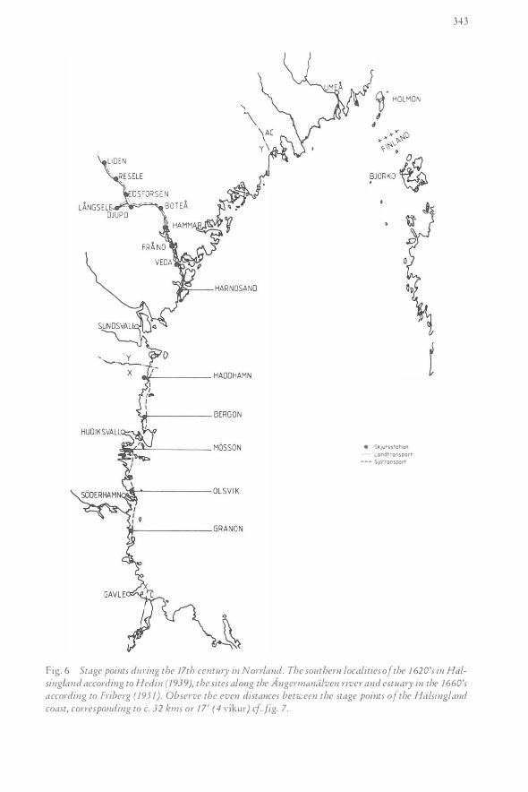
Fig. 6 Stage points d141·ing the 17th century in Non·land. The southern localities of the 1 620's in Halsing/and according to Hedin ( 1939), the sites along the Angermaniilven ri·ver and estuary in the 1660's according to hi berg (195 1 ) . Obser·ve the even distances bet·ween the stage points of the Halsingland coast, corresponding to c. 32 kms or 17 ' (4 vikur) cf fig. 7.
344
earlier. The sighting distance is moreover increased if you are raised to the top (mast) level . If the navigator thus would be in need of a measure that works well even in a l i tt le worse sighting conditions, the Swedish/Danish vika (vikusjo) of 4' may therefore supply a natural distance between points or local it ies to be remembered . This accordingly means that half-way between two locali ties within this d istance from each other the navigator would be able to see both the locality left and the next one. The time that he will have to wait for this favourable position, if keeping the correct direction, is not unduly long.
The Norwegian coast (or the Icelandic one) is mountainous, offering plenty of characteristical topographical features to an experienced navigator. Taking into consideration what has been said above on the height of the eye and the object above water it could be expected a somewhat longer d istance measure in the Atlantic than in the Bal tic (Denmark, Sweden). We have already established that thi s is the case.
As for a time measure, the vika may have been based on a not unreasonable rowing speed of e.g. 3 knots, which would give a pull of l 'h hours for a vika of 8.3 kms (4 ' ) , about two hours for a vika of c . 1 1 kms (6 ' ) . Noth ing is, however, known of any concept covering these amounts of t ime.
Nature permitting, the early medieval mariner may thus have chosen suitable s ighting points at a mutual distance of c. 1 vika for several concurrent reasons.
The unit of the vika (vikusjo) seems to have been applied in the stage point system for rowing transport of men and of goods for the crown (e.g. taxes in natura) in early histor ical times. I n Norrland this system can fragmentarily be studied i n the 1 7th century by way of Hedin 1 939 ( in the province of H alsingland) and Friberg 1 95 1 ( I : 3 1 4f. ; Angerman land, more particularly in the river valley of Angermanalven). It may be that th is appears just as faded remnants of a former system of medieval (or even earlier) dating, such as is normally the case in this survival area, especially obvious in the fie ld of transportation ( cf. e.g. Fj ellstri:im 1 9 78) .
The distances between these stage points are about equal and consti tute c. 32 kms, i .e . 4 vikur ( 1 7 ' ) . I n Hals ingland of the 1 620's this concerns the d istances between Granon (Skog parish, at the border to the province of Gastrikland in the south), Olsvik (Norrala parish, outside of Si:iderhamn), Masson of Njudnger parish, Bergan of Rogsta parish (the standard distance is kept, provided that the portage passage of Arnon is used) and Haddhamn of the parish of Gnarp in the north (fig. 6 lower part) . It could easily but hypothetically be extended into the province of Medel pad in the north by way of the other most important of the medieval centres of maritime culture. The same applies to the provinces in the south.
In the transport system of the crown in the 1 660's within the waters of the Angermanalven river and fiord mouth the d istance between the staging points (often documented as inn and ferry sites in later t imes) is mainly 2 vs. which may have something to do with rowing against the current, if the vika here would be assumed to represent a river measure. Upstream, on the other hand, we find an approximate standard of c. 3 vs. (22 kms) in the distance between Djupi:i and Botea (fig . 6 upper part) . It then appears a l ittle i l logical just to attribute this longer distance to the current carrying the rowers downstream. Perhaps the simple explanation l ies in the different conditions along the coastl ine and in the sheltered waters of a comparatively densely settled river valley. Since the stage points in the coastal area - as of H alsingland in the 1 620's - explicitly are fishing harbours, there might be a good reason for a de facto pilot attendance at precisely those sites where stage boats were available . And it should neither be forgotten in this context, that some of these fishing harbours are situated outside of inlets with a particular strategic importance, as attested by sai l ing route blockages, beacon sites, fortifications and in a few cases Snack-names ( indicating the once presence of ledung levy ship[s]) : Olsvik with Stackfjarden bay, Bergi:in with Stegsundet strait, the Sta(c)k- or Steg-element denoting an underwater blockage, Mi:issi:in opposi te Snackmor bay. I f not assumed to be just a
345
./ . t:4' . . �.
, ; .,
. �� -P
--BUSKOSUNDET KINNBACKSF JARDEN
Fig. 7 inn sites of the Non-batten coast in the 1 680's, mostly according to Hoppe 1 945. The distances correspond to those in fig. 6.

346
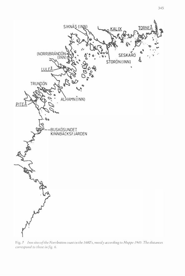
local feature of the province of Halsingland, which is most improbable, this may point to s imilar arrangements along other, more densely populated and central parts of the Swedish east coast during the Middle Ages, e.g. at rhe i tinerary route (cf. Schuck 1 950a, b). In the extreme north the same system may be reflected in the d istances between s ires of local maritime inns (Swed. sjokrogar). I n N orrborren this can be documented in the 1 680's (Hoppe 1 945 : 91 ) . The current s ires are Pitea (town), Trundon (hypothetical ), Alhamn (inn) , Lulea (town), Norrbrandon ( inn), Siknas ( inn), Staron ( inn), Seskaro (hypothetical) and Tornea (town), all with approximately equal d istances to the next sire (cf. fig. 7).
Standards of ·vika measures have also been proposed in the discussion on pi lotage d istances below.
Problems of identification and distances
There are several p lausible reasons for the variations of distances between the enumerated sires of the it inerary . The longest s ingle stretch, between utlengi (Utlangan of B lekinge) and calmarne (Kalmar of Smaland) has got no archipelago, and very few diffi cult passages to be negotiated. Moreover, few obvious sighting points are to be found on this shallow coastline. Since i t offers little shelter it ought to be passed as soon as possible. The fol lowing promontory after Kalmar, skcegge nes (Skaggenas) is such an important landmark that it can never be omitted in an itinerary of this coast, especially since there was an early passage for small craft inside the promontory (Draget, indicating a portage, later a canal dug in the 1 6th century).
On the other hand, i t is qui te a surprise not to find any mention of the famous rock of Bla Jungfrun (Swedish V i rgin), the equivalent of B locks berg in the H arz mountains. We wil l return to this remarkable fact a little later. I f this omission only concerned Bla Jungfrun we could even assume a magic reason. This is, however, not the case. Between waldo (V;'tllo) and wino (Vi no) there i s recorded a distance of j ust 1 vs. between no less than seven points, i . e . together 7 vs. (56-60 kms). This is only natural in such a rich and varied archipelago, where maneuvering in the route is fairly laborious. But i t is still rather puzzling that the continuous archipelago northward does not supply such dense sires. Four localit ies from hambrce (Hallmare, Loftahammar) to quetnce (Kvado) d isplay 1 vs. as distance measure. The following six points up to alrecki (Arko) are rather i rregularly chosen, although the d istances are approximately the same as the preceding ones . The distances between the points are only given continuously from utlengi (Utlangan) to winterclasce (Vinterklasen) of B raviken bay. With a vika of 8.3 kms this means 48 X 8.3 kms, i.e. c . 400 kms. The remainder of the itinerary sequences of the Liber Census only delivers sporadic d istance measurements, at least partly explained by the separate route parts put together in the manuscript.
The densest occurrence of place names is found in the Stockholm archipelago, where several sai l ing routes are indicated, not only the continuing route but also an extensive detour to Stockholm . The most i rregular system of enumerated points, i n the over-all light of the itinerary, seems to be found in F inland, where the d istances are great and where few measurements are given. However, some identifications may st i l l appear enigmatic.
The i tinerary or sai l ing description is enumerating a sequence of place names of the inner route. There i s a conspicuous absence of relationship to rhe mainland. Most p lace names of the i tinerary are, as can be discerned from the translation, easi ly identifiable, which i s rather surpris ing, considering the more than 700 years elapsed. The important work of site identification was already made, as has been pointed our above, by Axel H arlin ( 1 936, 1 942) for the Swedish part. The place names at the Finnish coastline had mostly been found already at that rime Gaakkola 1 933) . Only a few additions and minor corrections have been achieved since
347
then ( Kerkkonen 1 945, Granlund 1 962, Westerdahl 1 978, 1 979, 1 984, Ericsson 1 984, Zilliacus 1 989). Most unanswered questions remain relatively unimportant in this context.
There may still be topographical or other reasons s l ightly to change the order of the sequences or the distances mentioned. Sometimes, however, there i s not a trace of place names even faintly similar to or related to those of the it inerary in the suspected locality, even if one believes in the approximate distances given.
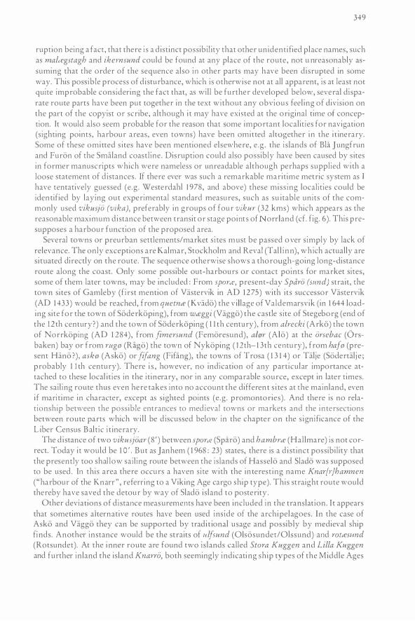
Concerning the place name krampe svmd (l iterally " the twisted strait " ) which Harlin wisely interprets and logically places at the present Nanninge sund (or Nanninge strom) inside Radmanso (parish and once island, fig. 1) some comments are justifiable as examples of possible ways of thinking. The present author does not, however, doubt Harlin's sequence of the route in this area. This part is furthermore included in my survey (Westerdahl 1 987 : map 35), which definitely establ ishes the existence of a former inner sai l ing route here. But there is no such place name as krampe sund or even remains of it . On the other hand there is in fact another important passage mentioned long before this part in the itinerary, stendor srmd, a strait inside the island of Krampo, situated c. 20 kms east of the present town of Nykoping, Soderman land. This passage has got its name from the gatelike sighting point Stendcn-ren obviously ( "The Stone Door"), which i s also mentioned by O laus Magnus in 1 555 (Lat. SteendmJ As the present author has pointed out elsewhere (e .g . Westerdahl 1 984, 1 989 I: 1 90; cf. Stahre 1 975 ) , the place name Stendiirren obviously is a migrant name along this coastal sai l ing route. Another instance of the name, wh ich is conventionally assumed to be referred to by Olaus Magnus (e .g. by Granlund in his commentary to Olaus Magnus in Swedish 1 95 1 , new edition 1 976 I :347) is found northeast of dalern svmd (Dalaro, S Stockholm) . A third occurrence was found in oral tradition by the present author and as Standorrskier, e .g . on a map from 1 732 in the same itinerary route sequence as above, between the points of wircesund and malcegstagh, of which only the former safely can be identified (Westerdahl 1 979 : 23) . Immediately to the east of this place name on the aforementioned map of the 1 8th century it is still possible to read the southernmost mention of "Niirrlandz !eden" (the Non·land sail ing route).
If, let us say, the copyist of this manuscript m ight have found two place names at the same point, e.g. stendor sund and krampe sund (i .e. Krampo sund, as above) he may have transferred the latter to its present place assuming that there was no place name to be found there, or maybe an unreadable name. After all, there was in the first instance (in 18th century form Standorrskierr) an identical place name on which to found the sequence at this spot. I t is also possible that this name appeared in a scholion entrance in the original manuscript, but with unclear reference tO its place in the sequence. Krampii sund is anyway not unknown tO this day as an alternative name of the passage west of the southernmost Stendorren. The present author would still avoid trying his readership's patience on this detail i f it could not be established that all distance measurements in this route part of the north Stockholm archipelago are incorrect, reflecting at least some kind of disruption or, as has been stated below, a separate entity. Besides, such a d iscovery carries certain obvious implications for the whole of the itinerary.
Moreover, the form 0slcesund, identified with the strait inside the is land Yxlan, in the southern part of the Stockholm archipelago (as a hypothetical present Yx[ e ]liisund could possibly instead refer to Oxlosund, at the present site of the rown of Oxelosund, in the it inerary approximately fimersund (present Femoresund). This site is known as a good harbour, mentioned e.g. by Johan Mansson in 1 644. The is land 0slce is , by the way, also another site ment ioned by the it inerary text, but situated in the north part oi the Stockholm archipelago, in the very part that we treated above in connection with krampe sund. The passage here is in fact also in traditional usage referred to as a strait (sund). Would it be possible, thus, that the route sequence precisely here d isplays a consistent d isruption )
This, anyway , approaches mere speculation, but it certainly must be pointed out, this dis-
348
I o I .. �STANGSKAREN I
I lo • I • G " I . I / 0 Cl�"':' , "/bKALLHAMN /
• • 'V ' c:l f • I / o • O •'f] /
� . " � · J 0 I I . • • <::> i' I
0 ,o (�b ){ .. ,'O'V / j � D / I o ()STORA/ · • •
��RJH10LMEN. \ , Q o
" B.�.Jt T'{!,K� . \ : •II � • "- . . {?KEDH)l�E�
� '- ARKO l lfi '-\ USSLE J K SHOLM� '\ HAMN n (:) / , X KROG 0 \ KUGGVIKEN •
Q ) ,r, -;- - Q / ./
/ '� ' - L 1 LL A DC H• STD.RA ./ _..- KUGGEN " I � o
0 / ' I / 0 • I I tt
0 / Q 0 ,•cf:J \l<NARRO o ' 0
I
/ 0 � I {\ • • 0 ' 1"1 X / I' BJ [<KSKAR ' ./ II I ' �� . ...
/ c JUNGFRUSALEN �V o v I �
0 c::. o I " � ,• � \ ' � Q
0b ( �mt);OJAA<0t OT�11 S I RKO �'I:) ' � (lr:? STO� �UGGE�\ • 0 �v : �� �j!LLA KUGG�N I \ r,8JIN S 0 Q � ' I \ o ' • ,SKRI VARHAMN 0• £:::;, <J / , (\\\) BRANNBOTE • o 0 ; v " 1\�a ..,.
oO' o /�TYRso o \' � sKW�stiTE • 'tJ 0 .v?o Cd I �� 6oo� ' (/ , o, . o o 0 C) • • I 0' (). \ I 1 �t::r llh •,o\ � "- � },�0 �'(Y. � . . j;•' \apA : • · 1'
0 \ �ARAOSSKAR KUGGEN • • I �D · � I o \ • ' 0 , , , \ 0 " ' · '
,, iJ I 0\ t-- STORA ocH• · ·· • I \ I \) Ll LLA KUGGEN • I • lo ·' • '
�/) " ·:· • :1 : • • • �<.,J \N, 0 �. II e,!l IJ• • : ,, � •• ·� .. 0
I NRE . . DC TTRE 0• 1l � O '• '• 1 OLSON 0 l:JI" • • I
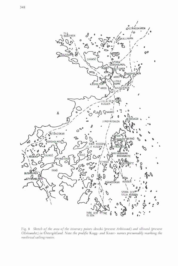
Fig. 8 Sketch of the area of the itinerary points alrccki (present Arkos1md) and ulfsund (present Olsosundet) in Ostergotland. Note the prolific Kugg- and Knarr- names presumably marking the medieval sailing routes.
349
ruption being a fact, that there is a d istinct possibil ity that other unident ified place names, such as maltegstagh and ikernsrmd could be found at any place of the route, not u nreasonably assuming that the order of the sequence also in other parts may have been disrupted in some way. This possible process of d isturbance, which is otherwise nor at all apparent, is at least not quite improbable considering the fact that, as wil l be further developed below, several disparate route pans have been put together in the text without any obvious feel ing of division on the part of the copyist or scribe, although i t may have existed at the original rime of conception. It would also seem probable for the reason that some important localities for navigation (sighting points, harbour areas, even towns) have been omitted altogether in the i t inerary. Some of these omitted s ires have been mentioned elsewhere, e .g . the is lands of BL't J ungfrun and Furon of rhe Smaland coastl ine. Disruption could also possibly have been caused by s ires in former manuscripts which were nameless or unreadable although perhaps supplied with a loose statement of d istances. If there ever was such a remarkable marit ime metric system as I have tentatively guessed (e .g . Wesrerdahl l 978, and above) these miss ing localities could be identified by laying out experimental standard measures, such as su itable units of rhe commonly used vikusjo (vika), preferably in groups of four vikur (32 kms) which appears as the reasonable maximum distance between transit or stage point s of orrland (cf. fig. 6). This presupposes a harbour function of the proposed area.
Several towns or preurban settlements/marker s ites must be passed o ver simply by lack of relevance. The only exceptions are Kalmar, Stockholm and Reval (Tal l inn), which actually are s i tuated directly on rhe route. The sequence otherwise shows a thorough-going long-distance route along the coast. Only some possible out-harbours or contact points for marker sires, some of them later rowns, may be included : From sparr�<, present-day Sparo (st-tnd) strait, rhe town sires of Gamleby (first mention of Vastervik in AD 1275) with irs successor Vasrervik (AD 1 433) would be reached, from quetnce (Kvado) the v illage of Valdemarsvik (in 1 644 loading site for the town of Soderkoping), from wceggi (Vaggo) rhe castle sire of Stege borg (end of rhe 1 2 th century?) and the town of Soderkoping ( 1 1 rh century), from alrecki (Arko) the town of Norrkoping (AD 1 284 ), from fimersund (Femoresund), alti�r (Ala) at the orsebac (Orsbaken) bay or from rt-tge (Raga) the town of Nykoping ( 1 2th-1 3th century), from hafe (present Hano ?), aske (Asko) or fifang (Fifang), the towns of Trosa ( 1 3 1 4) or Talje (Sodertalj e ; probably 1 1 th century). There i s , however, no indication of any particular importance attached ro these local it ies in rhe it inerary, nor in any comparable source, except in later rimes. The sail ing route thus even here rakes into no account the different s i tes at rhe mainland, even if marit ime in character, except as s ighted points (e .g. promontories) . And there is no relationship between the possible entrances to medieval towns or markers and rhe intersections between route parts which wi l l be d iscussed below in the chapter on the s ignificance of rhe L iber Census Baltic i t inerary.
The d istance of rwo vikusjoar (8 ' ) between sporce (Sparo) and hambrce (Hal lmare) is nor correct. Today it would be 1 0 ' . Bur as Jan hem ( 1 968: 23) states, there is a d i stinct possibility that the presently roo shallow sailing route between rhe islands of Hasselo and Slado was supposed to be used . In this area there occurs a haven sire with the in terest ing name Knar[l]hamnen ("harbour of rhe Knarr " , referring to a Viking Age cargo ship type). This straight route would thereby have saved the detour by way of Slado island to posterity .
Other deviations of distance measurements have been included in the translat ion. I r appears that sometimes alternative routes have been used inside of the archipelagoes. In the case of Asko and Vaggo they can be supported by tradi t ional usage and possibly by medieval ship finds. Another instance would be the straits of ulfsund (Oisosunder/Olssund) and rotcest-tnd (Rotsundet). At the i nner route are found rwo is lands called Stora Kuggen and Lilla Kuggen and further inland rhe island Knarro, both seemingly indicating ship types of the Middle Ages

350
0 . 1 BUSSV I KEN yx
Fig. 9 The area of the itinerary points waldo (Vallo) and rune (Runno) of Smaland (Paskallavik area). Note the place name clements Kugg-, Snack-, Knarr- and Buss-. This is the only area where all these four ship type names can be found in s11ch a concentrated space along the east coast of Sweden.
(Kugg- the "cog", Knarr- the Vik ing Age "knarr") . In the outer route, marked even today , occur three other Kugg-sites : Stora Kuggen and Lilla Kuggen once more and R o da Kuggen . Ar the confluence of these two routes at Arko (alrecki) appear st il l other Knarr- and Kugg-names. Altogether this area constitutes one of the most obvious concentrations of rh is k ind in Sweden (fig. 8). E lsewhere I h ave indicated a sim ilar concentration of all the older ship type place names on the mainland (Kugg-, Sniick-, Knarr- and Buss-) at Paskallavik , Smaland ( it inerary : rune!waldra, fig . 9, cf. rhe discussion on the expression si pla.cet ire per latus terre below).
As an example of carelessness on the part of the scribe or possibly as another s ign of separate route pans must be pointed our the d istance measurement between dyur (di11 1·teholtsnub) and wine. I r is recorded as 3 vs. Only just before this statement it is possible to add up : from there (dyur) to geishammer 1 vs. From there to roxhammer J vs. From there to tefra 1 vs. From there to wino J vs . . . Thereby it is possible to obtain the still correct measurement of four vikusjoar.
35 1
There are a couple o f other problems to exempl ify rhe manners of th inking applicable. For example, rhe unnecessary density of places names (islands) between rttdmi (Runmaro) and myghi (Moja) in rhe Stockholm arch ipelago, of which most are un ident ified : stromse, elde, sa11de, bmnsf:l, enke, hoere, stefse, must have a part icular reason. The natura l , wide and sheltered route could here s imply be described by naming mdmi and myghi, wirh the normal d istance measure. The present author has got no plausible explanation to present, except the existence of a separate route parr . This is obviously where Gallen ( 1 990 : 3 1 , 32) has gor his argument on the Franciscan i nterest (above).
When del ineating a route mgo - rinze - leckte - aske - rceueskicer - hterihammcer (Sodermanland), where all localities are safely identified, rhe general character appears to be of an outer route. Wou ld the it inerary navigators then be pass ing between present Ringso and Lacka islands s ince Harrso is not mentioned ) Or would it rather mean that the S�vosund strait passage (siui,esimd) in rhe inner route was chosen ) The latter passage is rhus mentioned in the other (later) sequence, where rinze is nor mentioned, but immediately before stendor s1md i s . This is perfectly possible, but in this case 1 also think we may be sure of a separate route parr.
A last problem accounted for here concerns the identification of a certain locality in Finbnd (Nyland) . From hangethe (Hango)!lowicsund, after which karienkask,e has been identified as an island ( Kerkkonen 1 945 : 1 62ff. , cf. Zil l iacus 1 989 : 27) at the entrance of a later much-used inner route (Barosundsleden) appears ittxarce. This is , however, clearly J ussaro, a paral l el outer i s land . Between this site and purka! (Porkkala) then lies horinsaree (Dan. hestr:J). This could be Orslandet at Barosund, which would indicate the inner route once more, but it could a l so point to a collective name for rhe whole is land group inside the outer skerries or a now extinct place name. In sp i te of the general character of the preceding coastal route on the Swedish s ide and in spite of the fact that there is an excel l ent inner route at the spot, we are forced to accept the outer route alternative at rhis j unction. Th is is probable also from the evidence of the preceding steps between small i s lands out in the open sea archipelago south and west of Aland.
What do the place names enumerated signify ?
As has been pointed out above, the it i nerary place names mainly s ignify points sighted and nothing else. This is the simplest way to regard the fundamental character of the itinerary or - as it appears - rather it ineraries (below). Only the most important local i t ies ro the sailors are mentioned. I f a locality is missed this might be entirely unintentional (e .g . a mistake of the copyist). The conspicuous absence of some obvious s ighting points, however, cannot but make us wonder at rimes. If we disregard these doubts in this immediate connection, there are a few comments to be made on the significance of mention.
At first it can be safely deduced from d istances given that rhe mere mention of a large island d o e s n o t i n c I u d e t h e p a s s a g e o f t h e e n t i r e i s I a n d (aske, weeggi), just the arrival tO- or sighting - of the tip. The wording cum aske, cum wceggi, pe1· oslcesttnd simply calculates the length of the islands or straits in question . Sometimes on ly a parr of a large island (or promontory) in a group i mentioned (e.g. finer, linter, widor, all p lace names which appear d ifferently or cannot be found today). \'(!hen a strait is mentioned this would normally mean a rather short passage, bur alternatively only rhe a r r i v a I a r t h e e n t r a n c e . In extreme cases, part icularly at wircesund and weddesund ( if present Vatosundet), we have good reason to believe that the arrival at the strait did not even mean that it was ever passed, only sighted . Thus the sund- (strait) prefix in place names need nor be taken as an absolute proof of an accomplished passage.
I t may also be pointed out that even if a "sund" or strait formerly had existed ir is not self-
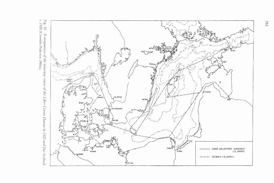
" � ._ (/Q "' . a .._. a o
Q ). � 8 §" � -a !'l � � · 3 ;:s � � :s -...... "'""" \0 "' � .,. ':--
;::;· ;; '"' $:1
� "' c ;; ;;: � S-'"' r-� "' "' () '"' � ;;; tJ .,. ;:; !:; • "' ;; ;:: 0 a .,. :s .,_ tJ .,. ·� V) "' "' <:;-li: S-
� \."'ll-"-" ).1. I , v \ 1 I t: " ' / ! \ / �--· /1 WINDAIJ
KONIG WAWEHARS "10RDE BOG"" I 13. JAHRH.I
SEEBUCH ( 15.JAHRH.i
"' "' N
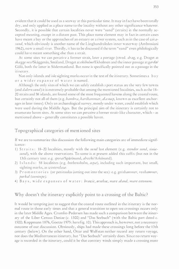
353
evident that it could be used as a seaway at this particular time. I t may in fact have been totally dry, and only applied as a place name to the locality without any other sign ificance whatever. Secondly, it is poss ib le that certain local it ies never were "sund" (straits) in the normally accepted meaning, except in a distant past. This place name element may in fact in certa in cases have meant a bay or the approaches of an estuary or a river system, such as in the case of wirte!sund, which obviously is another name of the U\nghundraleden inner waterway (Ambrosiani 1962), now a small ri ,·er. Th irdly, i t has to be d i scussed if the term " sund" even philologically could ha,·e meant something else than a strait.
At some sites we can percei,·e a former strait, later a portage (swed . drag, e .g. Drager at sktr!gge nes/Skaggenas, Smaland, Drager at ekiho/m/Ekholmen and the i nner passage at gard0/ Gali:i, both the latter in Si:iderm:mland. But none is specifically pointed out as a passage in the 1 t 1 11crary .
Not on! y islands and is le sighting marks occur i n the text of the i t inerary. Sometimes a b a y o r a w i d e r e x p a n s e o f w a t e r is named .
Although the only s i tes of which we can safely establish a port status arc the very few towns (and dalern sund) it is extremely probable that among the ment ioned localities, such as the 1 8-20 straits and 58 islands, are found some of the most frequented havens along the coastal route, but certa inly not all of them (e .g . hambl·te, h,erihammtf!r, a!tc:snap, known as excellent anchorages in later times). Only an archaeological survey, mostly under water, could establ ish which were used during the M iddle Ages. But the principal aim of the it inerary is certainly not to enumerate haven sites. At some sites we can perceive a former strait- l ike character, which - as ment ioned above - generally constitutes a possible haven .
Topographical categories of ment ioned s ites
If we are to summarize this discussion the following main categories are of immediate s ignifICance : l ) S t r a i t s : 1 8-20 localities, most! y with the su nd last element (e .g . stendor sund, siuitf!
sund), with the above reservat ions. To some is at present added this suffi x (but not in the 1 3th century text : e .g . sportr!/Spari:isund , alreckil Arki:isund).
2) I s I a n d s : 58 localitites (e .g . hothensholm, aspte) , including such important, but small, �ighting marks, as winterclasce.
3) P r o m o n t o r i e s (or pen i nsulas j utting out into the sea) : e .g . geisharn mer, roxharnrner, purkal (curninpe).
+) B a y s , w i d e e x p a n s e s o f w a t e r : brawtc, 0rseba.c, mare a/and, mare estonum.
Why doesn't the itinerary explicitly point to a crossing of the Baltic ?
I t would be tempting just to suggest that the coastal route outlined in the i t i nerary is the normal route in those early times and that a general transit ion to open sea crossings occurs only in the later Middle Ages. Crumlin-Pedersen has made such a comparison between the itinerary of the liber Census Dan iae (c . 1 300) and " Das Seebuch" (with the Baltic part dated c . 1 500 ; Koppmann 1 876, Goetze 1 975 : here f ig . I 0). This approach is, however, not a necessary outcome of our discussion. Obviously, ships had made these cross ings long before the 13th century (below). On the other hand, Ottar and Wulfstan neither record any return voyage, nor does the Mediterranean it inerary, but "Das Seebuch " certainly does. S ince no return voyage is recorded in the it inerary, could it be that contrary winds s imply made a crossing more
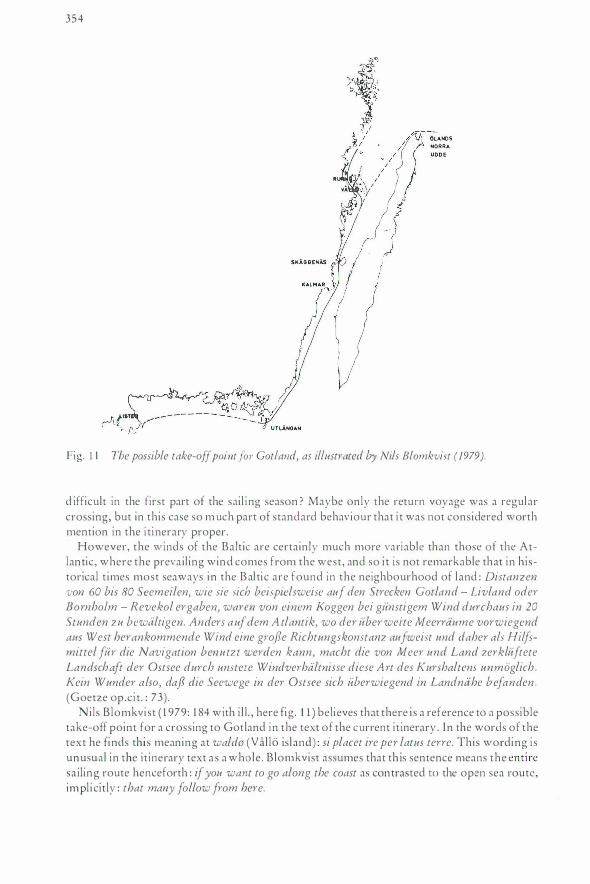
354
Fig. 1 1 The possible take-off point for Gotland, as illustrated by Nils Blomkvist (1979).
d ifficult in the first part of the sail ing season ? Maybe only the return voyage was a regular crossing, but in this case so m uch part of standard behaviour that i t was not considered worth mention in the i tinerary proper.
However, the winds of the Baltic are certainly much more variable than those of the Atlantic , where the prevailing wind comes from the west, and so i t is not remarkable that in historical t imes most seaways in the Bal tic are found in the neighbourhood of land : Distanzen von 60 bis 80 Seemeilen, wie sie sich beispielsweise auf den Strecken Gotland - Livland oder Bornholm - Revekol ergaben, waren von einem I<
.oggen bei gunstigem Wind durchaus in 20
Stun den zu bewaltigen. Anders auf dem A tlantik, wo der uber weite Meerrdume vorwiegend aus West herankommende Wind eine grofle Richtungskonstanz aufweist und daher a!s Hi!fsmittel fur die Navigation benutzt werden kann, macht die von Meer und Land zerkluftete Landschaft der Ostsee durch unstete Windverhaltnisse diese A rt des Kurshaltens unmoglich . Kein Wunder also, dafl die Seewege in der Ostsee sich uberwiegend in Landnahe befanden . (Goetze op .ci t. : 73).
N ils Blomkvist ( 1 979: 1 84 with i l l . , here fig . 1 1 ) believes that there is a reference to a possible take-off point for a crossing to Gotland in the text of the current it inerary . In the words of the text he finds this meaning at waldo (Vallo island) : si placet ire per latus terre. This wording i s unusual in the it inerary text as a whole . Blomkvist assumes that th is sentence means the entire sailing route henceforth : if you want to go along the coast as contrasted to the open sea route, implicitly : that many follow from here.
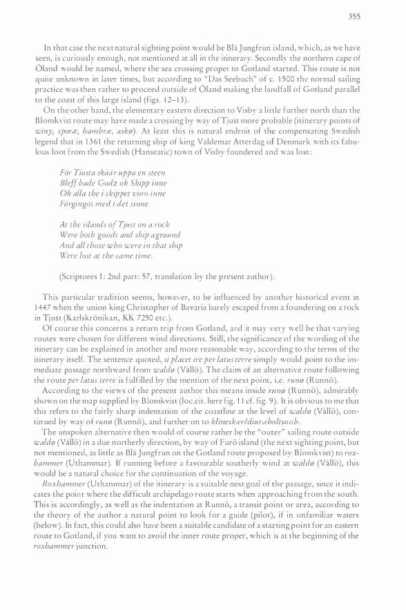
355
In that case the next natural s ighting point would be Bla J ungfrun is land, which, as we have seen, is curiously enough, not mentioned at all in the itinerary. Secondly the northern cape of Oland would be named, where the sea crossing proper to Gotland started. This route is not quire unknown in later rimes, bur accord ing to "Das Seebuch" of c. 1 500 the normal sailing practice was then rather to proceed ours ide of Oland making rhe landfall of G otland parallel to the coast of this large is land (figs . 1 2- 1 3) .
On the other hand, the elementary eastern direction to Visby a l i ttle further north than the Blomkvisr route may have made a cro sing by way of Tjust more probable (it inerary points of winy, sporeJ?, hambreJ?, ask0) . At l east this is natural endroit of the compensating Swedish legend that in 1 3 6 1 the returning ship of king Valdemar Atterdag of Denmark with irs fabulous loot from the Swedish (Hanseatic) town of Vis by foundered and was lost :
For TiHsta skaiir· uppa en steen Bleff bade Godz ok Skipp inne Ok alla the i skippet vom inne Forgingos med i det sinne.
At the islands of Tjust on a rock Were both goods and ship agmund And all those who were in that ship IV ere lost at the same time.
(Scriptores I : 2nd part : 57, translation by the present author) .
This particular tradit ion seems, however, to be influenced by another histOrical event in 1 447 when the union king Christopher of Bavaria barely escaped from a foundering on a rock in Tjust (Karlskronikan, KK 7250 ere.) .
Of course this concerns a return trip from Gotland, and it may very well be that varying routes were chosen for different wind directions . Sti l l , the s ignificance of the wording of the itinerary can be explained in another and more reasonable way, according to the terms of the itinerary itself. The sentence quoted, si placet ire per latus terre simply would point tO the immediate passage northward from wald0 (Vallo). The claim of an alternative route following the route per laws terre is fulfilled by the mention of the next point, i.e. run0 (Run no).
According to rhe views of the present author this means inside mmi! ( Runno), admirably shown on the map supplied by B lomkvist ( loc.cit . here fig. 1 1 cf. fig. 9) . It is obvious to me that this refers to the fairly sharp indentation of the coastline at the level of wald0 (Vallo), continued by way of mn0 (Runno), and further on ro k/inesk,a!diur,eholtsmtb.
The unspoken alternative then would of course rather be the "outer" sai l ing route outside wald0 (Vallo) in a due northerly direction, by way of Furo island (the next s ighting point, but not mentioned, as l ittle as Bla J ungfrun on the Gotland route proposed by Blomkvisr) to roxhammer (Urhammar). If running before a favourable southerly wind at wald0 (Vallo), this would be a natural choice for the continuation of the voyage.
Roxhammer (Uthammar) of the itinerary is a suitable next goal of the passage, since it indicates the point where the difficult archipelago route starts when approaching from the south. This is accordingly, as well as the indentation at Runno, a transit point or area, according to the theory of the author a natural point to look for a guide (pilot), if in unfami l iar waters (below). In fact, this could also have been a suitable candidate of a starting point for an eastern route tO Gotland, if you want to avoid the inner route proper, which is at the beginning of the roxhammer j unction.
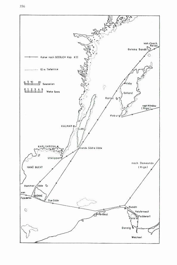
356
Kcrso noch SEEBUCH Kop. X I I
.. . . . . . . . . . · .. . . 10 m Tit>lenlini o
0 5 10 20
,·· ·····'' '•\ ..... ······\ r .. ·· .. . .
i ,! :..-·
S�emtilen
n a c h O o m e s n Q s
( R i g a )
Wtichael
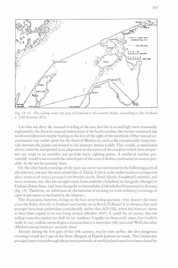
, .. V'
W.''��; .. ,;iB' . D o9trorl :..; ····-.. �·
�-- '· 0 0AAGG�6 6 10 \,.: \ . . V· u •
9' . . .J"'-1·� . .
�' ' 0 ; ;"
. -
. · \ \;,
\ '�, ' ': ,�,,/� . \.. "'0 Riga
357
Fig. 1 2- 1 3 The sailing routes by way of Gotland t o the eastern Baltic, according to Das Seebuch c. 1500 (Goetze 1 975 ).
I do thus not deny the unusual wording of the text, but this is accordingly most reasonably explained by the l ikewise unusual indentation of the local coast l ine, the former continued due northward direction maybe leading tO the loss of the sight of the mainland. Other textual circumstances may rather speak for the thesis of Blomkvist, such as the exceptionaLly long intervals between the points mentioned in the itinerary before wald0. This would, as mentioned above, rather be interpreted as an adaptation tO the nature of the coastl ine which does not permit any srops to an outs ider, nor provide many s ighting points. A medieval mariner presumably would want tO reach the central part of the strait at Kalmar (calmarne) as soon as possible. In the text he certainly does.
On the other hand, crossings of the open sea are in fact mentioned in the following parts of the itinerary, not just the mare aland (Sea of Aland, if this is tO be understOod as a compound place name as of today) passage from Sweden tO the Aland islands (linteb0tte!Lembote), and mare estonu m , but also the straight route from amholm (Arholma) to hangethe (Hango) in Finland directa linea, and from hangethe tO hotensholm (Odensholm/Osmussaar) in Esronia (fig . 1 4) . Therefore, no inhibition on the mention of existing (or even ord inary) crossings of open water seems to be found in the itinerary.
This d iscussion, however, brings tO the fore an irritating question : why doesn't the route cross the Baltic directly to Gotland and further on tO Reval (Tal l inn)? It is obvious that such passages have been undertaken considerably earl ier than AD 1 300, when the itinerary seems tO have been copied to its surviving version (Modeer 1 937). It could be, of course, that the ailing route description (or shall we say tendency ?) applies to those early times, but would it
really by any realistic terms depict a s ituation that it is more than 1 00 years o l d ? Well, the other (Mediterranean) itinerary certain ly does !
Already during the fi rst part of the 1 3 th century, maybe even earl ier, the first dangerous crossings round the Cape of the Skaw (Skagen) of Danish Jutland are made. The Limfjorden passage (inner route) through the present peninsula of north Jutland must have been closed by
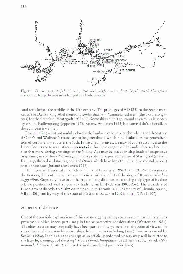
358
Fig. 1 4 The eastern part of the itin erary. Note the straight routes indicated by the stippled lines from arnholm to hangethe and from hangethe to hothensholm.
sand reefs before the middle of the 1 2 th century. The privileges of A D 125 1 to the Scania market of the Dani sh king Abel mentions wmlandsfarte = "ummelandsfarer" (the Skaw navigators) for the first time (Ventegodt 1 982 : 60). Some ships didn 't get round anyway, as i s shown by e.g. the Kollerup cog (Jeppesen 1979, Kohrrz Andersen 1 983) but some didn't, after all, in the 20th century either.
Coastal sai l ing - but not unduly close to the land - may have been the rule in the 9th century if Ottar's and Wulfstan 's routes are to be general ized, which is as doubtfu l as the general ization of our itinerary route in the 1 3th. I n the circumstances, we may of course assume that the Liber Census route was rather representative for the category of the l and lubber scribes, but also that more daring crossings of the Viking Age may be traced in ship loads of soapstones originating in southern Norway, and most probably exported by way of Skiringssal (present Kaupang, the end and starting point of Ottar), which have been found in some coastal (wreck) sites of northeast Jutland (Andersen 1 968) .
The important historical chronicle of Henry of Livonia i n 1 206 ( 1 975, X9 : 56-57) mentions the fi rst cog ships of the Bal ti c in connection with the rel ief of the s iege of Riga cum duobus coggonibus. Cogs may have been the regular long-d istance sea-crossing ship type of its time (cf. the positions of such ship wreck finds : Crumlin-Pedersen 1 983 : 234) . The crusaders of Livonia went d irectly to Visby on thei r route to Estonia in 1 203 (Henry of Livonia, op.c it . , V II : 1 , 25f.) and by way of the strait of Farosund (Sund) in 1 2 1 0 ( op .cit . , XIV: I , 1 07) .
Aspects of defence
One of the possib le explanations of this coast-hugging sailing route system, particularly in its presumably older, inner, parts, may in fact be protective considerations (Westerdahl 1 984). The oldest system may original ly have been partly mil i tary, seen from the point of view of the surveillance of the route by guard ships belonging to the ledung ( levy) fleet, as assumed by Schuck ( 1 950). In this case the concept of an officially endorsed seaway may well be related to the later legal concept of the King 's Route (Swed . kungsadl-a: or all men's route, Swed . aldra manna led, Norse pj6iileiii, referred to in the medieval provincial laws).
359
As the present author has pointed out elsewhere (op .c i t . ) , the sa i l ing route of the it inerary corresponds to the principal area of the Swedish ledung (levy fleet) system, and the outer guard and defence (the beacon chain) of the Swedish medieval realm . If this means that the route original ly was organized for the protection of these routes or possibly the other way round, the system of surveil lance created a regular sailing route, cannot be decided in this context.
Strictly speaking, there is no other way of passing along the east coast of Sweden than this route and its extensions, and there is at the same time no way of defending the realm at sea except in this coastal area with its archipelagoes. So this discussion necessarily at some point degenerates into an argumental chain running around in circles. At least i t could be surmised, as has been done above, that it would be remarkable i f the Swedish outer line of defence would have accepted the arrinl of rhe Danish leding fleet as of AD 1 2 1 9 to attack Estonia, if this is surmised to be the ultimate background of the Danish iti nerary . On the other hand, there may perhaps be a connection to the med ieval Swedish colonization of coastal Estonia? At any rate cargo ship crews would have found a couple of good reasons to follow the inner route to Eston ia.
I t i s in this context h ighly suggestive that we find the important border s ite of the ledung, in the H alsinge law book ( 1 4th century )) called aspa sund, along the itinerary route . B ur suggestive of what ?
Ganger lefmnger ifwer haff teller utt wm aspa sund pa waerz saklosir wm lepungxlamar (Schlyter 1 844 : 245) .
. . . if the ledung goes ova the sea or outside of aspa sund there is no obligation to pay the war cont?"ibution (ledungslama; in the place of provisions, implicit ly : henceforth the levy fleet must l ive on contributions from other parts of the realm or on plunder in enemy territory).
Aspa sund of the Halsinge law book must be situated on the Liber Census route whichever identification is suggested . There are thus two present island localities in the Stockholm archipelago called Asp a: 1 ) at the border between the provinces of Uppland and Sodennanland and close to the itinerary sites of rudmi (Runmaro) and neffltJ (Namdo ), 2) just south of Dalaro (da.lern sun d) at the class i cal entrance to or exit from Stockholm to the south . Moreover, there is 3) Aspo island (asp,efsund) of the itinerary, si tuated in Finland, southwest of the Aland archipelagoes.
Kumlien ( 1 933 : 38, notes 44, 46) has identified no. 2 as the place of reception of the union king Eric of Pomerania in AD 1 435 (aspa sund, Karlskronikan : KK 1 759). Th is sounds plausible but it does certainly not follow, as Kumlien suggests, that this site is identical to the aspa sund of the Hals inge law book . No. I seems to be mentioned as aspa mnd in the general town law of king Magnus Eriksson in AD 1 350 as the l imit of the jurisdiction of Stockholm (Radzstuffw B, Schlyter 1 865 : 262, Holmback/Wessen 1 966 : 1 75, note 74, p. 1 94f., the latter authors proposing that this is the site of the Halsinge law book and identical to no. 1 , with the borderl ine of the provinces) . Hafstrom ( 1 949 : 72), on the other hand, suggests that aspa sund of the Halsinge law book is aspte!sund (Aspo) of the it inerary, an excel lent out-harbour in an island strait (sund) of the open sea. A l ready Schlyter ( 1 844 : 472, i ndex 1 92) sensibly rejects the improbable identification with Aspo, a large settled is land in the approaches to Karls krona town, Blekinge (inside 14t!engi, Utlangan, the first point of the it inerary : cf. Schi.ick 1 950b : 472, who revives this argument).
To the halsings or other Bothnians (and some of the Finns), for whom the H alsinge law was originally codified, the ledung route, which invariably led eastward during the H igh Middle Ages, must have run by way of Signilsskar or Arholma (arnholm) to rhe Aland islands. Aspo (aspce) of the it inerary then appears to be a much more natmal locality than this comparatively insignificant island in the south part of the Stockholm archipelago, even if they both may be
360
well-known to the scribes of this city. The only real asset of the second al ternative seems to be its name and the fact that it i s s ituated close to the border of the two provinces. As has been pointed out, the i t inerary in this area only mentions other sites (above) .
If aspa surzd of the H alsinge law book is supposed to be the meeting-place or take-off point of the ledung fleet there are a few other comments to make . I t would i n this case not be su itable to let everybody know when the king or jar! (earl) gathered his fleet for an overseas strike. At Dalaro there is no chance to remain in hiding while the squadrons of the provinces were summoned . At Aspo, on the Fin l and route, you would at least be at a far-off p lace to informers on the mainl and. Sti l l, however, you would be on the main sail ing route . On the other hand, there are al so local defensive aspects (guard duties, supervis ion of the routes) . This agrees well with the assumed connection between routes upheld and p rotected by the king and the ledung system. Unfortunately, it is hard to prove.
If this protect ive aspect is accepted as an alternative interpretation of the general character of the route, it must at the same time point to a rather early part of the 1 3th century, probably before AD 1 227, when the power of sea p irates was defini tely broken in the Estonian area, the last stronghold being Osel (Saaremaa) with the collapse of Estonian pagan independence. In fact, as late as AD 1 226 arrives a whole fleet loaded with Swedish slaves, mostly captured females, at the coast of the Estonian islands. This raid is the immediate impetus to the last and decisive crusade against these i slands . In the beginning of th is century there are st i l l attacks from the area as far south as the Lister peninsula (Listerby: or is the p resent p arish of L isterby referred to?) of Danish Blekinge, i nside utlengi (Utlangan), the first point mentioned in the itinerary . The record by Henry of L ivonia concerns the year AD 1 203 (op . VI I , 1 : 25) The Swedes sometimes retali ated but had not yet reached their ful l strength . Their reaction belongs to a later epoch, when it is mainly d irected further east, towards Russia and Carelia (Novgorod). I t is very doubtful that the iti nerary would dep ict a situation before 1 227, but still poss ib le . After all, the main body of the Liber Census Dan iae, the tax register, is dated to the 1 230's . The p lace name for Reval!Tal li nn, rteuelburgh, i ndicates an existing castle (burg), which cannot h ave been in existence before the 1 220's (the assumed predecessor, th,e native Eston ian fort on the Toompea h i l l has not yet been found) . The fi rst mention of Stockholm town in a medieval source excepting the i tinerary is , moreover, in AD 1 252. Stokholm of the route descript ion may of course refer to an ear li er site than the town proper (the remains of such a precursory settlement have, however, not been found i n the recent large excavations at Helgeandsholmen [Danlback 1 982, Odman 1 988]) . But would it be in teresting then, to an it inerary, where almost no other mainland sites are of interest ? Kalmar obviously dates from c. AD 1 200 (Biomkvist 1 9 79) .
In a l l probabi l ity, however, no serious maritime danger could have existed from the Estonian s ide when the it inerary was wri tten down in its present form (c. 1 3 00) .
On the other hand, there might have been other dangers than Estonian p irates worth observation after A D 1 22 7 i n the area. For example, Carelians may have been active for all that we know, which indeed is scarce. Their great period would have been during the first two decades of the 1 4th century.
The protective explanation i s fairly doubtful in the circumstances, but certainly not quite impossible. However, the explanation offered by the B alt ic winds seems to be a better p rimary answer to the q uestion of the heading.
36 1
What relevance would t h e L i b e r Census route have to t h e Norrland sailing route and vice versa?
A simple answer to this question is that both routes are thorough-go ing and running along the coast in archipelagoes. Besides, they together cover almost the ent ire length of the Swedish east coast.
As has been pointed out above, the survey of the Non·land sailing route finished southward at the junction of this route and it inerary routes of King Valdemar's Land Register. This was intentional from the very start of the survey. An implicit observation was that the latter route was the most important in a North European perspective, the former being more of a local character, if local i s an apt epithet for a coast l ine of altogether a couple of thousand kms. On the other hand, the route to and from the sparsely populated north - even if comprising parts of present Finland - certainly is no main route, and the prerequis i tes of economy are quite d ifferent from the south.
I t has to be kept in mind, however, that dur ing the Middle Ages a cons iderable colonization process has been assumed to take place in the Bothnian coastlands. To some extent this colonization may have been internal, but parts of i t required shipping of coloni zers from the south, either from other parts of the coast of Non·land or further southward. This colon ization was encouraged and partly organi zed by the church, the crown and the leading lords, presumably to counteract the movement of the Greek-Orthodox Novgorodian Carelians on the opposite side of the Bothnian bay. This could apparently mean that the measures taken by these forces to ensure safe shipping ( in the field of sea marks, pilotage or supervis ion of the route, e .g . in the case of wrecks) may have been as advanced and as modern as along the main routes - if not even more so.
ln the far north there are obvious s igns of West-Finnish and Carelian exploitation and settlement, most of which i s certa inly of a maritime nature. Fur hunting and trade were reasonably the greatest attraction to the outside, where the interest was ris ing all through the epoch. Together with northern Russia the Scandinavian north constituted the most important resource area in Europe for the finest winter-dependent fur animals.
The possible contribution of an it inerary route to the interpretat ion of a non- it inerary route or vice versa would appear sl ight. But s ince we can safely surmise that the development of navigation in general largely depends on d iffusion from the principal routes to the local ones, at least the over-all character of the it inerary may give some hints. Do we have any such materia l ? Obviously we do have. The sequence of the sites mentioned shows a sheltered route, reasonably employing anchorages in natural havens for the night. Probably these havens were si tuated in straits between is lands along the route - not necessari ly on the route i tself, which i s unduly risky - of which the princ ipal i nd ication i s topography and the place name element sund ( " strai t " ) . Experimental sai l ing and topographical studies in the route area confirm the strait theory of the out-ports (e.g. Linn man 1 95 1 , Westerdahl 1 978, 1 984 ). In Non·land the meagre historical material offers a few examples of journeys, undertaken by the archbishops of Uppsala 1 346 and 1 3 74, where even meetings take place in havens of a sund character (H:wsen 1 890 : l 53ff., Diplomatarium Norvegicum 3 no. 395) : Companasundh (parish of Kalix, Norrbotten, localized on a map of AD 1 647 by the author and i ndependently by dr Erik Wahlberg, Soukoloj arvi, cf . Pell i jeff 1967: note 14, p. 85), Harnosun d ( later in 1 585, the town site of Hiirnosand), Ragnholmssundh (present Raholmen, parish of Alno, Medel pad with the sund presently on land) and Swartasund (present Svartsundet, Non·ala parish, erroneously localized by Ahnlund 1 920). Moreover, whilst the commonly assumed character of the main route slowly changed during the 1 5th and 1 6th century to include open sea passages as a major alternative, local traffic stil l stuck to the i t inerary route, which in its essence partly still is iden-
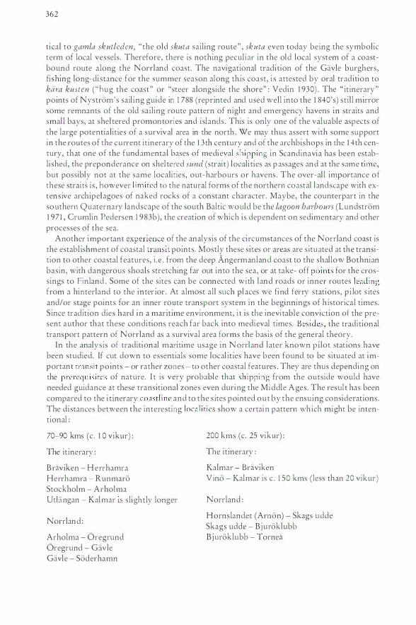
362
tical to gamla skutleden, "the old skuta sail ing route" , skuta even today being the symbolic term of local vessels. Therefore, there is nothing pecul i ar in the old local system of a coastbound route along the Norrland coast. The navigational tradi tion of the Gavle burghers, fi shing long-di stance for the summer season along th is coast, i s attested by oral tradition to kara kusten ( "hug the coast " or "steer alongside the shore" : Vedin 1 930) . The " itinerary" points of Nystrom's sail i ng guide in 1 788 (reprinted and used well into the 1 840's) st i l l mirror some remnants of the old sai l ing route pattern of night and emergency havens in straits and smal l bays, at shel tered promontories and islands . This is only one of the valuable aspects of the large potentialities of a survival area in the north . We may thus assert with some support in the routes of the current it inerary of the 1 3th century and of the archbishops in the 1 4th century, that one of the fundamental bases of medieval shipping in Scandinavia has been establi shed, the preponderance on shel tered sund (strait) locali ties as p assages and at the same time, but possibly not at the same localities, out-harbours or havens . The over-al l importance of these straits i s , however lim ited to the natural forms of the northern coastal landscape with extens ive archipelagoes of naked rocks of a constant character. Maybe, the counterpart in the southern Quaternary landscape of the south Baltic would be the lagoon harbours (Lundstrom 1 97 1 , Crumlin Pedersen 1 983b ), the creat ion of which is dependent on sedimentary and other processes of the sea.
Another important experience of the analysis of the ci rcumstances of the Norrland coast is the establ ishment of coastal transi t points. Mostly these si tes or areas are s i tuated at the transition to other coastal features, i . e . from the deep Angermanland coast to the shallow Bothnian basin, with dangerous shoals stretching far out into the sea, or at take- off points for the crossings to Finland . Some of the sites can be connected with land roads or inner routes leading from a hinterland to the inter ior . At almost all such pl aces we find ferry stations, p i lot s ites and/or stage points for an inner route transport system in the beginnings of h istorical times. S ince tradit ion dies hard in a maritime environment, i t is the inevi table conviction of the present author that these condi tions reach far back into medieval times. Besides, the traditional transport pattern of N orr! and as a survival area forms the basis of the general theory.
In the analysis of traditional maritime usage in Non·land later known p i lot stat ions have been studied. If cut down to essentials some local it ies have been found to be situated at important transi t po ints - or rather zones - to other coastal features . They are thus depending on the prerequi si tes of nature. I t is very probable that shipp i ng from the outside would have needed guidance at these transitional zones even during the Middle A ges. The resul t has been compared to the i t inerary coastline and to the s ites pointed out by the ensuing considerat ions . The di stances between the interesting locali ties show a certai n pattern wh ich might be intentional :
70-90 kms (c . 1 0 vikur) :
The it inerary :
B raviken - Herrhamra Herrhamra - Runmaro Stockholm - Arholma UtL:ingan - Kalmar i s slightly longer
Norrland :
Arholma - Oregrund Oregrund - Gavle Gavle - Soderhamn
200 kms (c. 25 vikur) :
The it inerary :
Kalmar - Braviken V ino - Kalmar is c . 1 50 kms (less than 20 vikur)
Norrland :
Hornslandet (Arnon) - Skags udde Skags udde - Bjuroklubb Bjuroklubb - Tornea
CD WIN0 liFRA ROXHAMMER GEIIRJSHAMMER KliNESKiiR RUN0 WAL00
SKI{GGENES
I (ALMARNE 1 0 ; _
" l UTLENGI
cv
}"� ' -BRAWl(
ALRECKI
ROTI{SUNO ULFSUNO
WliGGI 0RSUNO
OUETNI{
ASK0 HAMBRI{
SPORI{
�ALMARNE
HliRIHAMMI{R THOR/i RI{UESKIIiR ASKm LECK/i RINZ0 RUG0 ALmR WINTER(LAS/i BRAWl(
flWII>IJm !RUOMII , WIN00 1 GAR00
AlliS NAP
MliTHELSTEN
i3·HiiRIHAMMiiRI
® ARNHOLM RI{FNES WI00R HOXHALS OSLI{ FIN�R SIC MAR liNTER ENLANG HUSARN
- - - - - - - - - - - - SI{RS0R
RUOMI NEFFm
ORNI{
Oll{ NUTARN
MI{THELSTEN UTHml
I ���;�
m
f.1\ HliR0 W ENK0
j BRUNS0 ® SAN00 6 ELOm STR0MSm
Fig. 1 5 The structure of the Swedish part of the itinerary text.
i STOKHOLM LITLE SWETHIUTHI{
t r
��:.TIC IHARICSTill
OALERNSUNO GAR Om IKERNSUNO
}8�t����g EKIHOLM SWET�ERSUNO F I FANG HAF0 SIUII{SUNO S TENOOl SUNO
!}��
0RSE BAC F IMERSUNO
BRAWl(
364
This may be coincidence but the reasonable far-range pilot stretches would be found within these distances. They were anyway seldom longer, according to records of the late 1 6th century (e.g. Wirsen 1 968) . But the study of such distances certainly requires more attention than hitherto devoted to i t .
The significance of the Liber Census itinerary
It is thus important to remember that the experiences of the study of the itinerary route cannot safely be general ized s ince we know next to nothing of its background . Unfortunately, it is easy to argue in a c ircle, most wou ld-be descriptions of medieval sai l i ng practices in Sweden being founded on this very it inerary. Anyway, in the circumstances the anxiously coastbound journey seems to be the only possible one in the l ight of the sequence of identified place names that have been enumerated . Travelling was reserved for day-time. At n ight the sailors slept on board or on land in wel l-sheltered harbours with good anchorages (cf. e.g. Erik Jonsson in Lybeck [ ed.J 1 945 : part I : 332) above al l protected from the northeast, which presumably al -· ready was the prevail ing storm direction i n the Balt ic, and as well the general direction of the i tinerary route. This contention could easi ly be confirmed by later traditional practices in local shipping.
But let us now try to get the own particular character out of the itinerary text. First and foremost, the i tinerary is a sequence of place names and some distance measurement in between . These sites appear to be meant to supply general informat ion on the passages accompl ished . Some important s ighting points, such as Bla Jungfrun and Furo is land, are, however, missing for unknown reasons . I n the north (particularly in Finland) and the extreme south, the lacunae are a-plenty . No harbours are explic itly mentioned . The itinerary is , accordingly, next to worthless to a navigator. I t is thus possible that the i t inerary was made up purely for fun - or rather to supply information on the geography of the route, in the same way as the journeys of Ohthere and Wulfstan were once used by king Alfred . But the structure of the notes may sti l l reveal more on the practices of sail ing than hitherto surmised . The most important observations are the following :
1 ) B y way of a careful analysis of the identified si tes i t is obvious that the i t inerary, particularly on the Swedish side, consists of several more or less self-contained and overlapping sections of the sai ling route or sequence.
2) Moreover, it can be deduced that these sections al so contain stretches with and without distance measurements expressed i n vika (vikusjo)lvikor. A certain d ifference i s also detectable in the variations between the words usque- ( de)inde, most clearly in the fi rst sections .
3) The sailing route has got one goal except Reval (Tallinn), i . e . Stockholm, where one route section starts anew, significantly enough with consistently erroneous d istance measurements (and some attendant problems concerning the identification of the si tes , as we have expounded above).
Less decisive, but equally remarkable, would be the following : 4) There are m.uch longer distances between some points mentioned on parts o f the sail ing
route, particularly in the south and in Finland, than what i s the case in the central section. 5) Some places are mentioned more often than others, possibly reflecting some kind of transit
function .
There is, I believe, only one simple expl anation to this pattern in the i t inerary text. The separate route parts or sections may most reasonably be explained by assuming that they had been recounted by navigators who were special ized in those parts. The differing records have later
365
been collected by a scribe, who did not know much of the detai ls but certainly knew the general l ayout of the route, and who placed these fragments in a sequence without any significant complementary addition or attempts at coordination. In an earl ier treatment on the itinerary of the Liber Census Daniae I have mentioned this possibi l ity but never developed it further (Westerdahl 1 978 : 39). I suggested that the navigators in question were pilots, presumably local or even Danish far-range p i lots .
The structure of the it inerary text is i l lustrated schematical ly by fig . 1 5 . The following route parts are either without distances or supplied with distances :
a) utfengi - brawic, sections 1 -2 , with distances. b) b1·awic - ht.erihammcer, section 3, without distances. c) hcerihammcer - rudmi, section 4, with distances. d) uth0i - rudmi, section 5 , without distances, and : e) continuing in the same way in sections 6-7, but the ensuing p lace names are much more
dense and are in fact to a surprising degree unident ified or at least unknown today, suggesting a different pattern, without distances.
f) the continuing rome since section 5, but on the other side of the border between section 5 and sections 6-7 : scengr-arnholm, section 8, without distances.
g) brawic - stokholm, section 9, with distances, which moreover seem to be unusually standardized and to some extent underestimated.
h) stokholm - amholm, section I 0 , with consistently erroneous distances and quite a few unidentified place names.
g) arnholm - rt.euelburgh, section 1 I , with distances, but with much greater intervals between most of the enumerated points than on the Swedisch side (except in the extreme south).
There are a coup le of other s ignificant traits . Interruptions in the text are thus found in three ectional sequences :
a) utlengi - win0, section I . b) calma me - ( dyu.r) - brawic, section 2 . c) brawic - wind0 (rudmi), sections 3-4.
Furthermore a division may be found at stokholm, between section 9 and 1 0, possible also at calma.rne.
I f the theory is extended to reasonable distances of independent pilotage the following stretches are of current interest, where mostly not a single intermediary point is mentioned :
a) utlengi - calma me, section I . b) arnholm - [email protected] (or directly to hangethe), section 1 1 . c) lynt.eb@tte - thiyckcekarl, section 1 1 . d) thiyckcekarl - aspt.e (sund), section 1 1 . e) aspte (sund) - 0rsund, section I I . f) 0rsund - hangethe, section I I . g) hangethe - purkal (or directly to hothensholm ) , section 1 1 . h) purkal - rceuelbvtrgh, section I I .
Of course the theory could also be inversely appl ied. I f we apply the above references outside of the it inerary text, i . e . on possible entrances to towns, the following places would be mteresnng :
Kalmar Soderkoping (alternative entrance to Norrkoping at ab-eckilhawic)
366
Norrkoping (alreckilbrawic) Nykoping (fimersund!al(ln) Trosa (askolhafe) Stockholm Reval!Tal li nn
Finally the number of mentions may be considered :
amholm asko (Tjust) brawic (probable thought of as identi cal with alrecki) klineskter! dyH r! diurteholtsnHb hangethe lyntebrt!tte rugo (not relevant?) pHrkal waldo win do
6 3 4 3 4 3 3 3 3 (with its neighbour mno 1 ) 3 (with rHdmi 2)
The study of marit ime place names with an obvious medieval tinge point out e .g . the following maritime cul tural centres along the i tinerary route (Westerdahl 1 978 : 39ff. , cf. Westerdahl 1 989 : 1 43ff. , pass im) : Vallo (waldo!Runno (runo) area, here fig . 9, Vino (wino), Arko (alrecki).
By combinatory measures we can thus deduce that the fol lowing points were particularly important as - what I have called - t r a n s i t p o i n t s during the conception of the itinerary . The mosx obvious ones according to the analysis of the text are marked out by ital ics :
1 ) utlengi (Utbngan, B lek inge), the start ing point of the iti nerary . Since we know noth ing of what came before it may appear doubtful . However, at this very site the coastal route starts, i . e . it marks a transition to a new stage of the journey.
2) calrnarne ( Kalmar, town). Besides being important as a point of division in the itinerary text, Kalmar as a town would certainly have recourse to official p ilots. Interruption in the text.
3) waldo!rHne (Vallo-Runno, Smaland) - the unusual mention of alternat ive routes. 4) wino (Vi no, Smaland) - interruption of i tinerary . 5) sporte (Sparo/sund, Smaland) - possibl e recourse to town pi l ots at Vasrervik. 6) alrecki and brawic (Arko, Bdiviken, Ostergorland), as the same s i re . Beside the general
i nterest accorded these si tes i n the it inerary, possible recourse to Norrkoping and Soderkoping town pi lots .
7) fimersundl alor (Femoresund/ Alo , Sodermanland) - possible recourse to town pilots of Nykoping .
8) askolhafo (Stora Asko/Li l la Asko, Hano[ '] , Sodermanland) . Possible recourse to pi lots of Trosa town area.
9) hteriharnrn,er (-Hthoi; Herrhamra, Uto, Sodermanland) starting point of route part. 1 0) rHdmilwindo (Runmaro/Vindo, Sodermanland/Uppland) - end and starting point of
route parts . 1 1 ) stokholm (Stockholm) - point of divi s ion, recourse to town pilots. 1 2) stersor (Sarso, Uppland) - starting point after a confused section of the itinerary with a
seri es of un ident ified or wrongly arranged place names. 1 3) arnholrn (Arholma, Uppland) - end and starting point of d ifferent sections, the take-off
point for the crossing of the Sea of A land or d irectly to hangethe of the Finnish mainland .
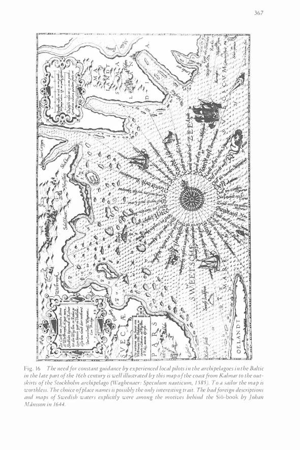
367
Fig. 16 The need for constant guidance by experienced local pilots in the archipelagoes in the Baltic in the late part of the 16th century is well illustrated by this map of the coast from Kalmar to the outskh·ts of the Stockholm archipelago (\Vaghenaer: Speculum nauticum, 1 585 ). To a sailor the map is worthless. The choice of place names is possibly the only interesting trait. The bad foreign descriptions and maps of Swedish waters explicitly were among the motives behind the Sio-book by ]ohan Mansson in 1644.
368
14 ) lynteb0tte (Lembote, Aland) - route part end and start ing point) 1 5) thiyckr-ekarl ( Kokar) - route part end and starting point? 1 6 ) aspte (Aspo) - route part end and starting point ) 1 7) orsund (Orosund/Kyrksundet, Hitis) - route part end and starting point ? 1 8) hangethe (Han go) - route part end and starting point ? 1 9) purkal (Porkkala) - route part end and starting point ? Two route parts, one directly to
hothensholm (Odensholm, Osmussaar) . 20) rtevtelburgh (Reval!Tal linn) - recourse to town p ilots, end of itinerary .
I t is a remarkable fact that all of these si tes/areas have had pilot stations in historical rimes, except Sarso in the Stockholm archipelago. But many others along the route also have (Lihtenooja 1 948, Medin 1 952, Wirsen 1 968). The most interesting points are, besides, marked out by the structure of the text, transit points, situated at the transitions to other topographical features (Vallo/Runno, Arko, A rholma etc.), a tendency which has found an obvious counterpart in the analy si s on the possible pilot sites of the Norrland coast.
Is it probable that a p i lotage system existed during the Middle Ages ?
In the absence of any kind of maps or other navigational aids , such as regular sail ing handbooks, the demand for local expertise must have been considerable. Part icularly the archipelago pans of the northern coasts are extremely difficu lt and very risky to navigate in on one's own . Al ready Dahlgren ( 1 896) stated the need for pi lots in the most d ifficult parts of the itinerary route. Wirsen ( 1 96 8 : 14 ), who describes life in an island pi lot station of Smaland, southwestern Sweden, carried this argument further by suggesting that precisely in those places which are mentioned by the itinerary were waiting "knowledgeable " men to lead the ships onward. This seemingly presupposes the existence of settlements during the 1 3th century i n the area, at least seasonal, and mainly meant for fishing, and at least a few permanently resid ing farmers on is lands, who may be paid for their assistance during the sai l ing season .
Let us assume a possible scenario : With their rowing boat in tow the piloted ship would go only so far that the pi lot would be able to return by rowing back to his abode in a reasonable rime (e .g . 4 vs. 32 kms ?) . Long d istance pi lotage would perhaps have been poss ib le up to ·1 0 v s . (70-90 kms) or a l ittle less . Almost any able-bodi ed fisherman could do th is service in his own area. A few might be able to go further .
The question is , however, not just restri cted to the p i lotage proper. Firstly, one of the most contested areas of medieval law concerned the ownership of shipwreck. Church and crown had an obvious interest in the supervis ion of the routes from this point of view (cf. KLNM : strandriitt). Secondly, there are obvious s igns of a consistent sai l i ng mark system put up during the Middle Ages (remains of cairns and place names) . This system was probably revived, not introduced, duri ng the reign of Gustav Vasa ( 1 52 1-60) . Even if it is anachronistic to refer to the fact that pi lots were responsible for th is work in later r imes, it does not sound preposterous to suppose that the coastal population was instructed to work for the interests of society in this respect. In return they might have been accorded certain privileges, poss ibly even encouraged by these privi leges to settle in the area chosen.
The supposition of Wirsen on pilotage from every mentioned site is on the other hand highly questionable, since nothing in the itinerary text indicates any relevant reference to such a system (the same idea is taken up by Cederlund 1 989a etc . ) . But the d ivis ion of the itinerary certainly does, even if it could only have meant a number of long-range Danish p ilots travelling with the ships, who had specialized in certain stretches of the Swedish and Finnish coasts.
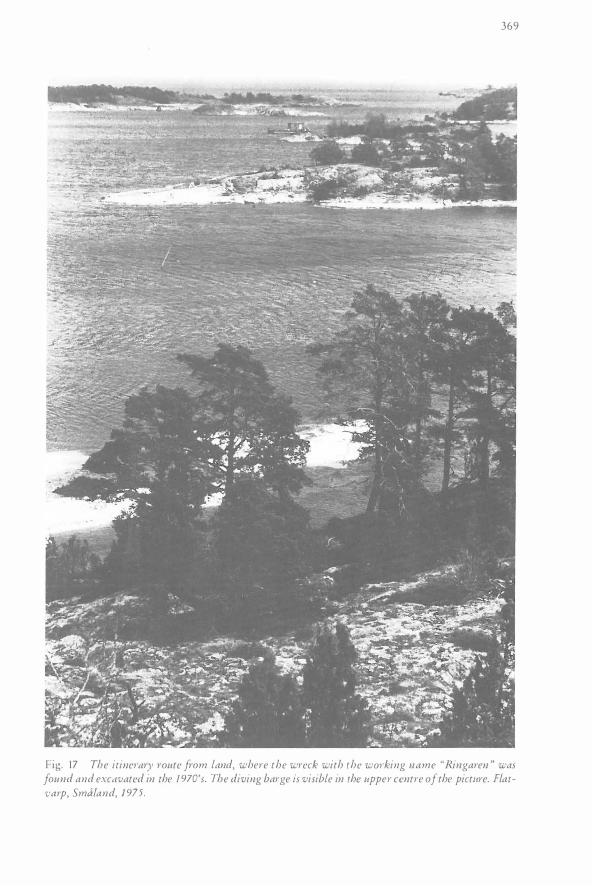
369
Fig. 17 The itinerary route from land, where the wreck with the w01·king name "Ringaren " was found and excavated in the 1 970's. The diving barge is visible in the upper centre of the pictitre. Flatvarp, Smaland, 1 975.
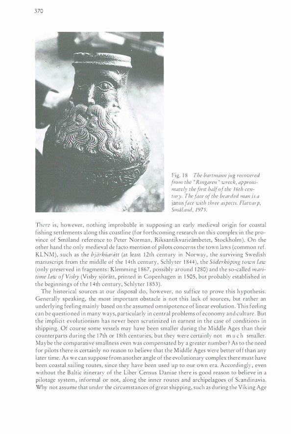
370
Fig. 1 8 The bartmann jug recovered from the "Ringaren " wreck, approximately the first half of the 1 6th century. The face of the bearded man is a janus face with three aspects. Flatvarp, Smaland, 1975.
There i s , however, nothi ng improbable in supposing an early medieval origin for coastal fishing settlements along this coastline (for forthcoming research on thi s complex in the province of Smaland reference to Peter Norman, Riksantikvarieambetet, Stockholm) . On the other hand the only medieval de facto mention of pi lots concerns the town laws (common ref. KLNM), such as the bjarkoa1·att (at least 1 2th century in Norway, the surviving Swedish manuscript from the middle of the 1 4th century, Schlyter 1 844) , the Soderkoping town law (only preserved in fragments : Klemming 1 867, possibly around 1 280) and the so-called maritime law of Visby (Vi sby sjoratt, prin ted in Copenhagen in 1 505, but probably established in the beginnings of the 1 4th century, Schlyter 1 853) .
The h istorical sources at our d isposal do, however, no suffice to prove this hypothesis . Generally speaking, the most important obstacle is not this lack of sources, but rather an underlying feel ing main ly based on the assumed omnipotence of linear evolution . Thi s feel ing can be questioned in many ways, particularly in central problems of economy and culture . But the impli ci t evolutionism has never been scrutin ized i n earnest i n the case of condi tions i n sh ipping. Of course some vessels may have been smal l er during the M iddle Ages than their counterparts during the 1 7th or 1 8th centuries, but they were certa inly not m u c h smaller. Maybe the comparative smal lness even was compensated by a greater number? As to the need for pi lots there is certain ly no reason to bel ieve that the M iddle Ages were better off than any l ater time. As we can suppose from another angle of the evolutionary complex there must have been coastal sai l ing routes, s ince they have been used up to our own era. Accord in gly , even without the Balt ic iti nerary of the Liber Census Daniae there i s good reason to bel ieve in a pi lotage system , informal or not, along the inner routes and archipelagoes of Scandinavia. Why not assume that under the circumstances of great shipping, such as during the Viking Age
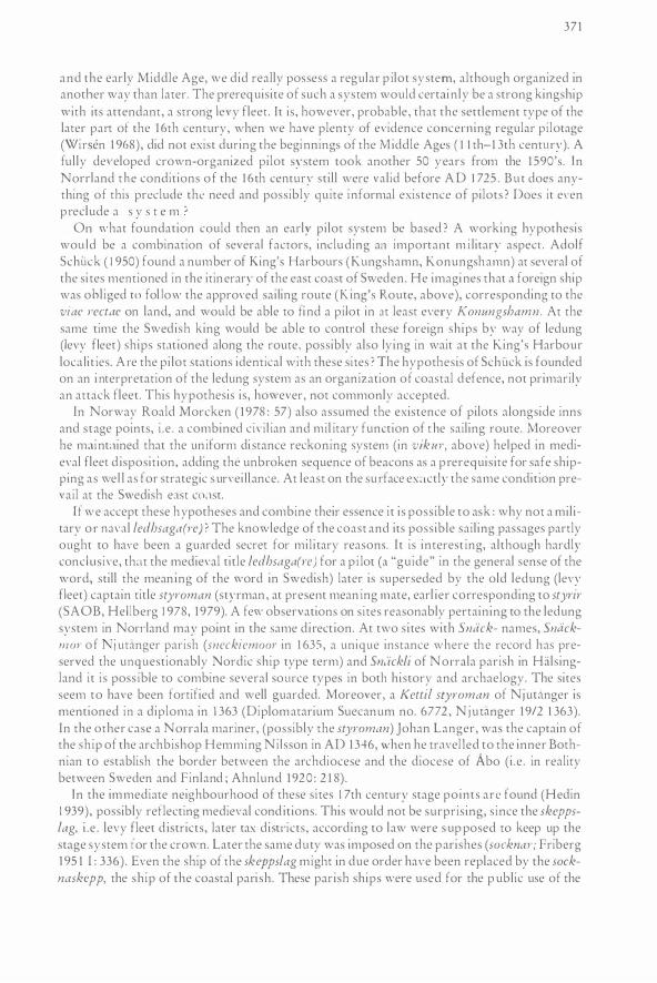
371
and the early Middle Age, we did really possess a regular p ilot system, although organized in another way than later. The prerequisite of such a system would certainly be a strong kingship with its attendant, a strong levy fleet. I r is, however, probable, that rhe settlement type of the later parr of the 1 6th century, when '"'e have plenty of evidence concerning regular pilotage (Wirsen 1 968), did nor exist during the beginnings of the M iddle Ages ( I I rh-1 3rh century). A fully de,·eloped crown-organized pilot system rook another 50 years from the 1 590's. In Norrland the conditions of the 1 6th century stil l were valid before A D I 725 . But does anything of this preclude the need and possibly quite informal existence of pilots ? Does it even p reclude a s y s r e m )
On what foundation could then an early pilot system be based ? A working hypothesis wou ld be a combination of several factors, including an important m i litary aspecr. Adolf Schtick ( 1 950) found a number of King's Harbours (Kungshamn, Konungshamn) at several of the si tes mentioned in rhe itinerary of the east coast of Sweden. He imagines thar J foreign ship was obl iged ro fol Jo,v rhe approved sailing route (K ing's Route, above), corresponding ro the viae rectae on land, and would be able ro find a pi lot in at least every Konungshamn. At the same time the Swedish king would be :tble ro control these foreign ships by way of ledung (levy fleer) ships st:tt ioned along rhe roure, possibly also lying in wait ar rhe King's Harbour loc:t l i r ies. A re the pi lot stations identical with these si res ) The hypothesis of Sch tick is founded on an i nterpretation of the ledung system as an organization of coastal defence, nor primarily an attack fleet. This hypothesis is, however, nor commonly accepted.
In Norway Roald Morcken ( 1 978 : 57) also assumed the existence of pilots alongside inns and stage points, i . e . a combined civi l ian and mil itary function of the sailing route. Moreover he maint:tined that the un iform di stance reckoning system (in vikur, above) helped in medieval fleer d isposition, adding the unbroken sequence of beacons as a prerequis ite for safe shipping as wel l as for strategic survei l lance. At least on the surface ex:tctly the same condition prevail ar the Swedish east co:tsr.
If we accept these hypotheses and combine their essence it is possible ro ask : why nor a military o r naval ledhsaga(J·e) ? The knowledge of the coast and irs possible sail ing passages partly ought ro have been a gu:trded secret for mil itary reasons. I r is interest ing, although hardly conclusive, th:tt the medieval title ledhsaga(re) for a p i lot (a "guide" in the general sense of rhe word, still the mean ing of the word in Swedish) later is superseded by the old ledung (levy fleer) captain title styroman (sryrman , at present mean ing mate, earl ier corresponding ro styrir (SAOB, Hel lberg 1 978, 1 979). A few observations on sites reasonably pertaining to the ledung system in Non·land may point in the same direct ion. At two sires with Snack- names, Sncickm o J· of j utanger parish (sneckiemoor in 1 635, a unique instance where the record has preserved rhe unquestionably Nordic ship rype rerm) and Sncickli of Non·ala parish in Halsingland it i s poss ible to combine several source types in both history and archaelogy. The sites seem to have been fortified and well guarded. Moreover, a Ketti! styroman of Njud\nger is mentioned in a diploma in 1 363 (Diplomatarium Suecanum no. 6772 , N ju ranger 1 9/2 1 363). In the other case a Non·ala mariner, (possibly the styroman) Johan Langer, was the captain of the ship of rhe archbishop Hemming Nil sson in AD 1 346, when he travel led to the inner Bothnian to establish rhe border between the archdiocese and the diocese of Abo ( i .e . in reality between Sweden and Finland ; Ahnlund 1 920 : 2 1 8) .
In rhe immediate neighbourhood of rhese si res 1 7rh century stage points are found (Hedin 1 939), possibly reflecting medieval cond itions. This would not be surprising, s ince the skeppslag, i . e . levy fleet d istricts, later tax disn·icrs, according to law were s up posed tO keep up rhe srage system for the crown. Later rhe same duty was imposed on the parishes (socknm·; Friberg 1 95 1 I : 336) . Even the ship of the skeppslag might in due order have been replaced by the socknaskepp, the sh ip of rhe coastal parish . These parish ships were used for the p ublic use of the
372
inhabitants in trade and poss ible tax transports. They could sti l l certain ly be put at the disposal of the crown during a war.
It could be assumed that the general change of meaning of the title styr(o)man occurred in the 1 5th century when the ledung system disappeared. Styroman is already in the 1 6th century synonymous with pi lot, but the new term lots is also brought in at this time from German. The master pilot ( 1 644) Johan Mansson, nicknamed "Styr-Jan", author of the famous guide of the Baltic, carried the title styrman. The pi lot system, as i t developed later, was mi l i tari ly organized, but altogether of a different character than this former assumed system. From 1 67 1 and up to present time the official title of a Swedish pilot is lots.
As to the spati::d distribution of the p ilot " stations" it must be pointed out that the system could have been intended for long-distance pilots, aged and wel l-experienced skippers, probably navy ( levy fleet) men. They would mostly have been in the pay of convoys, ei ther following the whole journey or special i zing in parts of the official route. Some arguments for approximate d istances have already been given .
In a more local sense, the system of pilotage could be based on the same places where you could h ire a boat (the stage points), if you d id not use the same boat all the way . The standard distance for such a local service would then be fairly short. To some extent this would only concern the local, inner routes, possibly intended for smaller vessels, which could be hauled across isthmuses, to avoid d ifficult passages in the open sea.
Several colonization processes took place in Swedish waters during the Middle Ages, in Non·land, Finland and Estonia. They were mostly maritime in character. It is reasonable to assume that h is expansion established or even presupposed a demand for pi lotage.
When considering the supposition that there may have existed a developed system of p ilotage during the Middle Ages, there are thus a couple of relevant facts concerning the it inerary of the Land Register of King Valdemar Sej r which may reflect such a system .
Firstly : l ) By way of a careful analysis of the identified s i tes, i t is obvious that the it inerary route con
s ists of several more or less self-contained and overlapping sections of the sai l ing route or sequence.
2) Moreover, i t can be deduced that these sections differ from each other ; some contain d istance measurements in vikur, some do not.
3) The route has got one goal except Reval (Tall inn) : Stockholm. Here the route description starts anew, s igni ficantly enough with consistently erroneous distance measurements .
Secondly : 4) At parts of the route, especially in Finnish \Vaters, the distances between the enumerated
s ites are much longer than otherwise. 5) Some localities are mentioned more often than others . 6) Th is could be explained most reasonably by presuming that the sai l ing route sequence had
been put together from different fragments and originally recounted by p i lots who were specialized precisely in those parts. The background of this process is, however, completely unknown. The pilots may have been professional Danish sai lors, but there is also a strong case for local expertise along the coast. The sites of the medieval towns have - on the other hand - no relationsh ip to these interruptions in the itinerary text. Accordingly, town pilots seem to be most improbable as the origin of the different route pans.
References : (ALhm von B remen :) Magistri Adam B remcnsis G esta H ammaburgcnsis ecclcs i ac pontificu m . I n : Quellen
des 9. und 1 1 . J ahrhundens zur Geschichtc der hamburgischen Kirche und des Reiches . Darmstadt 1 975 .
373
Ahnlund, i l s : 1 920 . Rannsakningar om srifrsgransen i Norra barren 1 37-1 . I n : Histori k Tidskrifr -!0 : 2 1 1 -22-1. Stockholm.
Ambrosiani, B jorn : 1 962. Langhundraleden. I n : A rsbokcn Uppland 1 96 1 : 7- 1 96. Uppsala. Andersen, Hans H el lmuth : 1 968. Grydesrenens vejc. I n : Skalk no. 5 : -1-8. Hejb jerg. Blomkvi>t, Ni l s : 1 979. Kalmar' uppkomsr och :ildsra rid. i n : Ham marsrrom, I. (eeL ) : Kalmar srads historia
[ : 1 67-308. Kalmat· . Ccderlund, Cad Olof: 1 989a. Den mcdclrid.1 beskrivningen av sjovagar v id svenska och i inska kusren i err
ir inerariu m i der danska riksarki,·er. I n : Sander, A . (eeL ) : Borrnisk Konrakr I V . Marir imhistorisk konfcrcns 1 98 8 : 2-1-29. Skel lefrea.
Ccderlund, Cad Olof : 1 989b. Sjoviigar vid svenska osrersjokusren pa 1 200-taler I . I n : Marinarkeologisk ridskrifr/Medd/M A S no. 3 1 989 : 8- 1 5 . Stockholm.
Cedcdund, Carl O lof: 1 990. S joviigar v id svenska osrersjokusren pa 1 �00-raler lT . I n : Mari narkeologisk r idskrifr/ Mcdd/M AS no. -! 1 989 : 7- 1 7. Stockholm.
Crumlin-Pcdcrsen, Ole : 1 98Ja. S.:hiife unci Seehandelsrouren im Osrseeraum 1 050- 1 350 - von der schiiisarchaologischcn forschung .ws geschcn. I n : Lcibccker Schrifren 7Ur Archaologie unci Kulrurgeschichre (LSAK) B.md 7: 229-237 . Bonn.
Crumlin-Pcdcrscn, Ole : 1 983b. Ski be, sc j lads og rurer hos Orrar og Wulfsran. I n : Lund (eel.) 1 98 3 : 32-4-1. Roskilde.
Crumlin-Pederscn, Ole: 1 98-1. Ships, navigation and routes in the reports of Ohrhere and Wu lfsran. English translation of Crumlin-Pedcrscn 1 983b. I n : Lund (eel.) 1 98-1 : 3:J--12. York.
D.1hlback, Goran (ed ) : 1 982. Hclgeandsholmen. 1 000 ar i Stockholms strom. = Monograficr u rgi,·na a,· Stockholms komm u n -18 . Stockholm.
Dahlgren, E .W . : 1 896. Fornrida scglingsbeskrivningar for de nordiska farvarrnen. Stockholm. A lso i n : Nordenskiold, A . E . : 1 897. Peri p lus . Urkast ri l l s jokortcns och sjobockernas aldsra h is toria . Stockholm.
Diplomararium N orvegicum 3: I , eels. Chr. A . Lange/Cad R . U nger. Krisr iania 1 85 5 . Ericsson, Chrisroffer H . : 1 98-1. Danska ir ineraricr i finliindsk forskning. I n : K.1rlsson, M . (eeL ) : Borrnisk
Konrakt I I : 5-1-57. Mariehamn Erikskronikan (Die Eriks-Chron i k). I n : Svcnska Mcdclridens Rim- K ronikor I-V I I . = Samlingar urgifn.1
av s,·enska Fornskrifr-Siillskapct 1 865-67. Stockholm. l:.nwik, Arvid : 1 955 . Olof den hcl ige och Eskolcia. Srudicr i Viirmlands medelt idsh istoria. = Skriftcr
utgi,·na av Viirmbncls m useum 2. Karlstad. Fell, Christine: 1 98-1. Some Questions of language. I n : Lund (ed.) 1 98-1 : 56-63. York. Fjellstrom, Phebe: 1 978. Att bind a sk innbunke. En senrida metod a,· ,· ik ingarida u rsprung for transport pa
,·atten. I n : H uggert, A. (ed . ) : Norrlandsk forntid. Till Ernst Westerlund 9 n ovember 1 975. = Act.l Borhniensia Occidcnta l i s . Skriftcr i vasterbottnisk kulturhistor ia I : -1-1-58 . Umea.
Friberg, N i ls : 1 95 I . Vagarn a i Vasternorrlands Jan I-I I . = Meddelanden fran Geografiska insti tuter v id Stockholms hogskola. Stockholm and Harnosand.
Gal len, Jar! : 1 989. Kokar, klostcrbroderna och haver. I n : J ungfrusund 2 . M arit ima medelridsstudier : I S-57. Abo.
Gal len, J arl : 1 990 i n preparation. Der danska itincrariers bakgrund (working tit le) . Goetze, Jochcn : 1 975 . H a nsi,che Schiffahnswegc in dcr Ostsec. I n : Hansischc Gcsch ichtsb larrcr Vol. 93:
7 1 -88 . Koln/Wicn. Granlund, Akc: 1 962. Nylandsdelen av danska itineraricr. I n : N am n och B y gd : 7 1-88. Uppsala. Griis lund, Bo : 1 987. K n u r den store och sveariket. Slager vid H elgea i ny belysning. I n : Scandia, B and 52 :
2 . 1 986 : 2 1 1-238 . L u n d . G usra,·sson, Edv i n : 1 967. Roslagen under medel riden. = Roslagsh istoriskr I II . Tierp. Harl in, Axel : 1 936. M a laegstagh och Krampesund. I n : avis I I h 2 . Stockholm. Harl in , Axel : 1 9-12 . Var aldsra seglingsbeskrivning . I n : Ti l l Rors no . 1 0. Srockholm. Hausen, R. (eel . ) : 1 890. Rcgisrrum Ecclesiae Aboen sis. Abo domkyrkas svanbok. Hcls ingfors. Hcdcnstierna, Bert i ! : 1 949. Srockholms sbrgard. Kul ru rgcografiska undcrsokningar i Varmdo gam Ia
skeppslag. = Gcogt·afiska annalcr 1 9-1 8 : 1 -2 . Stockholm. H edin , A if : 1 939. H alsinglands alsta srarl igt ordnade kommu nikacionsled. I n : Gamma! hals ingckulrur : 58-
7 1 . H u d i ksval l . Heinrich \'On Lett lan d : 1 975. Cronicon Livoniae. Liv landische Chronik (Ubersetzung aus dem Lareini
schen ,·on A. Bauer). Darmstadt. Hel lberg, Lat·s : 1 978 . Schwedische Ortsnamen und alrwestnordische Dichrersprache. I n : The Vikings.
= Acta Uni ,wsiratis Upsal iens i s : Symposia 8: 67-77. Uppsala.
3 74
H e llberg, Lars: 1 979. Forn-Kalmar. Ortnamnen och stadens forhistori a. I n : Hamnursrrom , I . (cd . ) : Ka lm ar stads h i s tori a I : 1 1 9- 1 66 . Kalmar.
Holm back, Ake/Wessen, El ias : 1 933 . Ostgotalagen och Upplands lagen . = Svensb l andsbpsbgar I . Uppsala.
Holm back, A ke/Wessen, El ias : 1 966. M agnus Erikssons stadslag i nusvensk tolkning . = Skrifrer mgivna av ins ti tuter for rattshistorisk forsk ni n g, serie I : 7. Stockholm.
Hoppe, Gunnar : 1 945. Vagarna inurn Non·bottens li:in . = Geographica no. 1 0 . U ppsala . Jaakkola, J almari : 1 93 3 . Fi nlands vagar och samfi:irds lcder under medclriden . I n : Nordisk Kulrur X VI :
H andel och samfardscl : 256-265. Stockh ol m/Oslo/Kobenhavn. Jacobowsky, C. Vilh . : 1 932 . ] . G. Sparwenfel d - bid rag ri l l en biografi (diss .) . Stockh olm. Jeppesen, Hans : 1 979. Kollerupkoggen - er v ragfu nd i en ralgrav. In : H andels- og Sjofartsmuseer pa
Kronborg. A rbog : 65-74. H els i ngor. J oh ansen, Paul : 1 933 . Die Esrlandsli sre des Liber Census Daniae. Kobenhavn and Reval . Karlskronikan (Die Kads-Chronik ; KK) . In : Svenska Medelr idcns Rim- Kronikor 1-V f l . = Samli ngar ur
gifna av Svcnska Fornsk rifr-Sal lskaper 1 865-67. Stockholm. K crkkonen, Gunvor. 1 945 . Vi:isrnylandsk kusrbcbyggelse under medelriden. = Skrifter utgivna : w Svcnska
Li tteraru rsal l skapet i Fin land (SL S) 30 1 . Helsi ngfors/H clsi nki . Klemming, G . E . : 1 867. U pplysn ingar och anmcrkni ngar om en for Sveriges lagh isroria vii'\ r ig urku nd, den
forloradc Sodcrkopings-Ratten . = Vi tt . Hisr . Antikv . Akadem. Hand ! . part 2 5 . Stockholm. KLNM = Kulrurhisroriskr lex ikon for nordisk medel t id . Kohrtz Andersen, Per: 1 983. Kollerupkoggen. = Museer for Thy og Vester Hanherred. Th isted . Kopp mann, Karl : 1 876 . Das Seebuch. M i t ciner naurischen Einleirung von Arth ur B reusing. Mit G lossar
l'on C hristof Walter. Bremen . Kroman, Er ik : 1 936a . Kong Valdemars j ordebog. Rigsarkiver . Kobenhavn. Kroman, Eo·ik : 1 93 6b. D ie H andschrifr des Liber Census Daniae. Die Herkunfr und Geschichre dcr Hand
schrifr . l n : Acta Phi lologica Scandinavica, fasc. IX: 29f. Kopenhagen unci Le ipzi g. Kulrurhistoriskt lexikon for nordisk medeltid (KLNM) 1 -2 1 . Ugesos, Valdemars jordcbog ere. 1 956-78,
new pri nting 1 980-82 . K0benhavn. Kuml icn , Kjcl l : 1 93 3 . Karl Knurssons pol it iska vcrksamhct 1 4 34- 1 448 . Stockholm . Lang, A . W . : 1 986. Die "Caerte van oostlant" des Cornel is Anthonisz. 1 543 (= Schriften des Deutsch en
Schiffahrrsm useums 8) . Hambu rg. L i n n man, N i ls : 1 95 1 . Med h usbat pi\ 1 200-ral s led . I n : STFs arsskrift 1 95 1 : 1 53- 1 7 1 . Stockholm. Lund, Niels (erl . ) : 1 983 . Orear og Wulfsran - to rejsebesk rivelser fra vikingcridc n. Roski ldc . Lund, Niels (ed . ) : 1 984 . Two voyagers at the court of king A tired. The ventures of Ohthere and Wulfstan
together with the Description of Northern Europe from rhe Old Engl i sh Orosi us. York. L u ndstrom, Per: 1 9 7 1 . Lagunham narnas t id. I n : Sj ofartshisrori sk Arbolc foreningen 1.\ergcns S jofarrs-
museum 1 970: 4 1-52 . Bergen. Lybeck, Otto (eel . ) : 1 9-15. Svenska Florrans H isroria I. Malmo. L ih tenooja, A . : 1 9-18 . Lots- och fyrvas endets h istoria i Finland. Tid en in ti l l 1 808 . Helsingiors/Hcls inki . Medin , B . : 1 952 . Svensk och finsk kronolotsn ing ri l l omkring 1 640 . Svenskr lotsv:isen 1 640- 1 680, parts of
an unpublished l ie. d i ssertation . Srarens sj iih isrori ska museum/U niversi rctsb ibliorcker. Srock h olm . M odecr, l var: 1 937 . Nagor om namnfonnerna i kung Valdemars jordebok. I n : Namn och Bygd : 88-98.
U ppsala. Morcken, Roald : 1 970. Europas el dsre s jemerlw-l l n : Sjofarrshisrorisk arbok 1 969 : 7- 1 08. Bergen. M o rcken, Roald : 1 978 . V iki ngeti dens disransetabel l l angs den norske kyst fra svens kcgrcnscn rill H vitc
haver. I n : Sjohisrori sk arbok 1 977 : 2 1 9-296. Bergen. Morcken, Roal d : 1 989. Old Norse D istance Tables in the Mediterranean Sea. l n : The Mariner's M irror.
Vol . 75. No I . Febr 1 989 : 53-78 . London. M ansson, J ohan : 1 644. Een Sio-Book Sum innehaller Om Siofarren i Oster- Sion. Stockholm. German
translations from 1 669 (W ismar etc) . Norlund, N. E. : 1 944. De gamle danske La::ngdeenheder (p 64-69). Kobenhavn. Nystrom, L. : 1 78 8 . ( En l itcn) M innesbo k ofver de iornamsre hamnar och l andkanningar pa Norrbottni ska
Wiken. Stockholm. Odman, Anders : 1 988 . Srockholms tre borgar. Fran vikingarida sparrfasre ri l l mcdclrida bsrcl lborg. Diss .
Stockholm. Olaus M agnu s : 1 539. Carta marina. M i t ErkLirungen . U ppsala 1 964.
3 75
Olaus Magnu s : 1 555. H i storia de gentibus septentrional ibus. Venedig. Several edit ions and translations, facsimile . Copcnbgen 1 972 .
Pell i j cff, G unnar: 1 967. Kal ixbygdens orrnamn. l n : Hvarfner, H . (ed . ) : Kalix del 1 . Namn och spra k : 9-93. U ppsala.
SAOB = Svenska A k adem iens O rdbok 1 898-. Lund . Schlyter, C.J . : 1 830. bsrgora-Lagen . = Samling av Sweriges Gamla Lagar I I . Codex J uris Osrrogorici.
Stockholm. Schlyreo·, C .J . : 1 844. H els inge- Lagen, Krisrnu- Balkcn af Smalands-Lagen och B jarkoarattcn . Codex ! uris
Hels ingici . Codicis ! ur i s Smalandici pars de t·e ecclcsiasrica ct !uris urbici codex anr iquio r. Lund. Schlyrer, C.j . : 1 853 . Visby sradslag och sjoratt. = Sam l ing af Swerigcs Gam Ia La gar V I I I . Codices Jur is Vis
byensis Urbici et Mari r imi . Lund. Schlyrer, C.J . : 1 865. Konung M agnus Erikssons Sradslag. = Samling af Sweriges Gamla La gar XI . Codex
Juris Urbicis Magnaeanu s . Lund. Schnal l , Uwe: 1 975. Navigation der Wikingcr. Naurische Probleme der Wik ingerzeit im Spiegel der schrifr
l ichen Quel len. (= Schrifrcn des Deurschen Sch iffahrrsmuseums 6). Oldenburg/Hamburg. Schnall , Uwe: 1 98 1 . Ocr Sch iifahrrsweg von Skiringssai/Kaupang nach Hairhabu in der friihcn Wikinger
zeir. I n : Deurschcs Sch i ffahrrsarchiv 4: 1 69- 1 82 . B remerhavcn. Schuck, Adolf: 1 933 . Sveriges vagar och s joledcr under fornrid och medelr id . 1 n : N ordisk Ku l rur X V I .
Stockholm etc. Schuc k, Adolf: 1 950a. ledung och konungshamn. I n : Sjohistorisk &rsbok : 97- 1 28 . Stockholm. Schuck, Adolf: 1 950b. (Review of Hafsrrom, G : Ledung och marknads indelning, Uppsala 1 949). I n :
Historisk Tidskrifr : 464-488 . Stockholm. Schuck, Adolf : 1 958 . H erredagar i J ungfruham n . l n : H istorisk Tidskrifr: 47-5 8 . Stockholm. Scriptores rerum succicarum medi i aevi (ed . A nnerstedr cr. a ! . ) l-1 1 1 . Uppsalo 1 8 1 8-76. Das Seebuch (see Koppmann) . Srahre, Nils Gustaf: 1 975. V indasen och Srcndorren . l n : Namn och Bygd 96- 1 07. Uppsala . Vedin , P.j. : 1 930. Ocr fomrida f isker , - id Not-rlandskusrcn. Gcivle. Vcnregodt, Ole: 1 982 . Skibe og sefarr i danske farvande i det 1 2 .-1 4 . arhundrede. I n : Maririm Konrakt 3 :
46-92. Kebenhaven. \XIesterdahl, Chrisrer: 1 978 . Mcdelr ida sjolcder och orrnamn. l n : Tjusrbygdcn : 2 1 -48 . Vasrervik. Wesrerdahl, Chrisre r : 1 979. Valdemarsleden och i r inerarier. I n : Mcddelanden fran Marinarkcologiska
Sallskaper 3/2 : 1 9-24 . Stockholm. Westerdahl, Christer: 1 984 . l t inerarieleden B lekinge-Reval. Nagra synpunkrcr. I n : Karlsson, M. (eel . ) :
Borrnisk Konrakt l l : 36-46. M ariehamn. \'(lesrerdahl, Chrisrer: J 986. Die maritime Kulrurlandschafr. Schiffe, Schiffahrrswege, H cifen. Oberlegun
gen zu einem Forschungsansatz. I n : Deutsches Schiffahrrsarchiv 9: 7-58 . \XIesrcrdahl, Chrisrer: 1 987. Norrlandsledcn f l . T h e Non·land Sai l ing Route I l . B eskrivning a v det mari
tima kulrurl andskaper. Description of the maritime cultural landscape. Rapport fr�n en itwcnrering i Non·land och norra Roslagcn 1 975- 1 980. = Arkiv for norrlandsk hembygdsforskning X X I I ! , 1 987. Harnosand.
\XIesrerdahl, Christer: 1 989. Norrlandsleden l . The Non·land Sailing Route I. Kallor rill dcr maritima kulrurlandskapcr. Sout·ccs o f the maritime cultural landscape. En handbok i marinarkcologisk inventering. A h andbook of marine archaeological survey. = Arkiv for norrlandsk hcmbygdsforskning X X I V , 1 988-89. Harnosand.
Wieselgren, Per : 1 95 1 . Orrnamn och bebyggelse i Esrlands forna och hirr i l l svarande svenskbygder. Osrharrien med Nargo- = S krifrer u tgivna av Kg!. Gustav Adolfs A kadem ien 22/Srudier rill en svensk orrn amnsarlas 7. Uppsala.
Wirsen, Ragnar: 1 968. Kring en lorsgards h istoria. = Nordiska museets H andl ingat· 70. Lund. Zil l iacus, Kurt : 1 989. Skarg�rdsnam n . = Skrifrcr urgivna av Svenska L itteraru rs;illskapet i Finland no. 558 .
Hclsingfors.
Authors ' address : Christer Westerdahl brnskoldsviks M useum S-89 1 33 brnskoldsvik Sweden