The Lost Wheel Map of Ambrogio Lorenzetti
26
The Lost Wheel Map of Ambrogio Lorenzetti Author(s): Marcia Kupfer Source: The Art Bulletin, Vol. 78, No. 2 (Jun., 1996), pp. 286-310 Published by: College Art Association Stable URL: http://www.jstor.org/stable/3046176 . Accessed: 23/05/2013 19:17 Your use of the JSTOR archive indicates your acceptance of the Terms & Conditions of Use, available at . http://www.jstor.org/page/info/about/policies/terms.jsp . JSTOR is a not-for-profit service that helps scholars, researchers, and students discover, use, and build upon a wide range of content in a trusted digital archive. We use information technology and tools to increase productivity and facilitate new forms of scholarship. For more information about JSTOR, please contact [email protected]. . College Art Association is collaborating with JSTOR to digitize, preserve and extend access to The Art Bulletin. http://www.jstor.org This content downloaded from 152.3.102.242 on Thu, 23 May 2013 19:17:47 PM All use subject to JSTOR Terms and Conditions
-
Upload
independent -
Category
Documents
-
view
0 -
download
0
Transcript of The Lost Wheel Map of Ambrogio Lorenzetti
The Lost Wheel Map of Ambrogio LorenzettiAuthor(s): Marcia KupferSource: The Art Bulletin, Vol. 78, No. 2 (Jun., 1996), pp. 286-310Published by: College Art AssociationStable URL: http://www.jstor.org/stable/3046176 .
Accessed: 23/05/2013 19:17
Your use of the JSTOR archive indicates your acceptance of the Terms & Conditions of Use, available at .http://www.jstor.org/page/info/about/policies/terms.jsp
.JSTOR is a not-for-profit service that helps scholars, researchers, and students discover, use, and build upon a wide range ofcontent in a trusted digital archive. We use information technology and tools to increase productivity and facilitate new formsof scholarship. For more information about JSTOR, please contact [email protected].
.
College Art Association is collaborating with JSTOR to digitize, preserve and extend access to The ArtBulletin.
http://www.jstor.org
This content downloaded from 152.3.102.242 on Thu, 23 May 2013 19:17:47 PMAll use subject to JSTOR Terms and Conditions
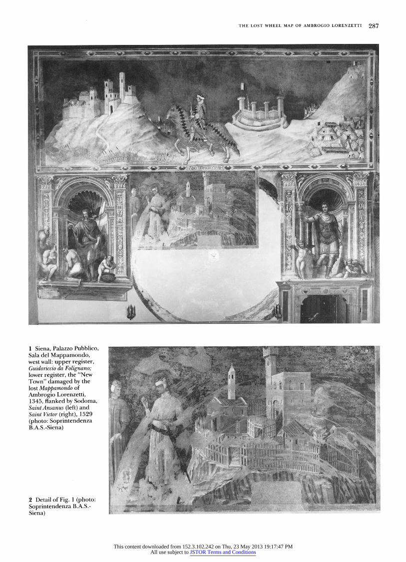
The world map that Ambrogio Lorenzetti painted in 1345 for the communal palace of Siena has long since vanished, but not without leaving spectacular traces of its unique design (Figs. 1, 2) A rotating wheel, the work scratched a series of great concentric rings into the surface of the wall on which it hung, thereby damaging a prior layer of painting concealed beneath. These rings and other aspects of its installation were discovered in 1980-81 when the fresco of Guidoriccio da Folignano was subjected to technical exami- nation. In the middle register of the wall just below the image of the war captain, conservators exposed to view a previously unknown trecento fresco of the highest quality. The newly revealed scene, two men in the act of surrendering a town (hereafter referred to as the "New Town"), bears the imprint of the revolving map that superseded it. A fresco border painted in black around the circumference of the wheel, and serving to integrate it into a system of monumental mural decoration, was also partially recovered. As far as the carto- graphic image itself is concerned, a scarred patch of earlier painting admittedly amounts to an empty cipher. Yet the visible signs of the work's display and use, exceptional in the fragmentary history of medieval cartography, mitigate the absence of the monument that gave to the council hall its popular name, the Sala del Mappamondo.
To date, study of Lorenzetti's map has focused on recon- structing its intriguing pictorial content. Several generations of scholars have sought to visualize the lost image by mining archival sources, glossing apparently conflicting descrip- tions, and identiting later works for which it may have served as model.l Since the recent restoration campaign, attention has been given to how physical evidence of the map's installation may bear upon the superposition, and hence relative dating, of the paintings on the Guidoriccio wall. In what follows, I shall attempt to open the discussion to broader issues raised by the map's enigmatic relation to
An outsider to the field of Italian trecento painting, I could never have begun to navigate the unfamiliar not to say treacherous waters of the Sienese canon were it not for the kindness and assistance of two colleagues at the National Gallery of Art, Washington, D.C., David Brown and Gretchen Hirschauer. Thanks to Dr. Brown's intervention, Sr. Alessandro Bagnoli of the Sopraintendenza per i Beni Artistici e Storici di Siena made possible my study of Lorenzetti's Mappamondo. Professor Hayden Maginnis generously furnished me with copies of articles pertaining to the Guidoriccio debate from the Notizie d'arte, which proved otherwise impossible to obtain, at least from research libraries in this hemisphere. Because Peter Barber, Jerome Baschet, Paul Binski, Evelyn Edson, and Patrick Gautier Dalche shared their insights with me, this article is far richer than it would otherwise have been. Finally, I owe a deep debt of gratitude to the Art Bulletin's anonymous reviewers for their incisive comments on an earlier draft. Translations are mine unless otherwise noted; Bibllcal texts are cited in Latin from the Vulgate and in English translation from the Douay-Rheims version.
1. Bargagli Petrucci; W. Braunfels, Mittelalterliche Stadtbautunst in der Toskana (1953), 4th ed., Bcrlin, 1979, 197; G. Rowley, Ambrogio Lorenzetti, 2 vols., Princeton, N.J., 1958, 1, 98; C. Ragghiante, "Mappamundus volubilis,"
known cartographic traditions, its location in the Palazzo Pubblico, and its rotary operation.
The first part of the study reviews the documentation concerning the map in order to clarit its physical nature. Here, the tradition of medieval display maps puts into new perspective the minimal clues about the Lorenzetti with which we are now sadly left. With regard to the cartographic image itself, the second part considers the crucial problem, not heretofore adequately addressed, of how the wheel's rotation would have been implicated in the formal depiction of the world.2 For the revolving map to have worked visually, its pictorial composition, including any writing, must have met the demands of a shifting orientation. With this in mind, it may be possible to single out a specific class of maps as Lorenzetti's most likely point of departure. The develop- ment of a particular cartographic genre, I am proposing, underlay the very possibility of the commission. We cannot hope, nor perhaps should we try, to reconstruct the "look" of Lorenzetti's painting. But the artistic context that enabled the con(re)ception of such an extraordinary work can be interrogated.
Parts three and four explore the work's production of meaning as a function of its place within a constellation of framing images. Surrounding pictorial material activated the signiting potential of both the cartographic image and its performance as a wheel. On these two levels also, Loren- zetti's painting reciprocally engaged earlier decoration in the hall to new ends. Just as the wheel map revised or expanded on ideas previously articulated in the Sala del Consiglio, so also it was in turn incorporated into a continu- ously evolving ensemble. Recalling the role of mappaemundi both in ecclesiastical and royal settings, the Sienese treat- ment of the theme displaced age-old traditions to further the secular ideology of the commune. Lorenzetti's map contrib- uted to the elaboration of a civic agenda by appropriating competing discursive "regimes."3 Finally, I suggest in part
Critica d'Arte, XLVI, 1961, 46-49; M. Testi, "Ambrogio Lorenzetti et San Miniato," Critica d'Arte, XLVI, 1961, 37-45; A. Cairola and E. Carli, 11 Palazzo Pubblico di Siena, Rome, 1963, 139-40; E. Carli, "Luoghi ed opere d'arte senesi nelle prediche di Bernardino del 1427," in Bernardino predicatore nella societa del suo tempo, Convegni del Centro di Studi sulla spiritualita medievale XVI, Todi, 1976, 153-82, esp. 172-74; C. Sterling, "Le Mappemonde deJan van Eyck," Revue de l'art, XXXIII, 1976, 69-82, esp. 82, n. 174; Southard, 237-41; Feldges, 65-68; G. Borghini, in Brandi et al., 223-24; and Strehlke, no.32a, 193-97, esp. 196.
2. How to pursue this avenue of investigation became apparent to me only after stimulating conversations with Paul Binski, who deserves much of the credit for clarifying the formal problems posed by Lorenzetti's revolving map and none of the blame for any errors in the solution I propose.
3. I am here borrowing a concept articulated by R. Starn, "The Republican Regime of the 'Room of Peace' in Siena, 1338-40," Representations, XVIII,
1987,1-32, esp.3, and further developed in R. Starn and L. Partridge, Arts of Power: Three Halls of State in Italy, 1300-1600, Berkeley,1992,9-80,261-66, esp.14.
The Lost Wheel Map of Ambrogio Lorenzetti
Marcia Kupfer
This content downloaded from 152.3.102.242 on Thu, 23 May 2013 19:17:47 PMAll use subject to JSTOR Terms and Conditions
THE LOST WHEEL MAP OF AMBROGIO LORENZETTI 287
1 Siena, Palazzo Pubblico, Sala del Mappamondo, west wall: upper register, Guidoriccio da Folignano; lower register, the "New Town" damaged by the lost Mappamondo of Ambrogio Lorenzetti, 1345, flanked by Sodoma, SaintAnsanus (left) and Saint Victor (right), 1529 (photo: Soprintendenza B.A.S.-Siena)
2 Detail of Fig. 1 (photo: Soprintendenza B.A.S.- Siena)
This content downloaded from 152.3.102.242 on Thu, 23 May 2013 19:17:47 PMAll use subject to JSTOR Terms and Conditions
288 ART BULLETIN JUNE 1996 VOLUME LXXVIII NUMBER 2
five that the Mappamondo may have been part of a program-
matic transformation of the Sala del Consiglio itself.
The Cartographic Artifact Scholars agree on some basic features of Lorenzetti's map.
The great majority of specialists visualize it as a rotating disk
located on the Guidoriccio wall below the equestrian figure,
where the scoring is now visible. Predictably, Gordon Moran
and Michael Mallory, who deny the authenticity of the
Guidoriccio, arglle a different view. But holding the Map-
pamondo hostage to the Guidoriccio, as Moran and Mallory do,
will not help advance understanding of either work.4
The written evidence may be easily summarized. The date
of the commission and its attribution to Ambrogio are first
recorded in the chronicle of Agnolo di Tura del Grasso at the
end of a series of miscellaneous entries for the year 1345: "E1
Napamondo, che e in palazo de' segnori di Siena fu fatto in
questo anno; fecelo maestro Ambruogio Lorenzetti dipen-
tore da Siena."5 The Concistoro authorized the restoration
of the Mappamondo in 1393.6 The substantial sum paid then
to three painters for their colors, including azure, suggests a
pictorial surface of monumental proportions.7 A glass win-
dow was ordered to be made "iuxta mappamundum" in
1413.8 When preaching in the Campo in 1427, Saint Bernar-
dino of Siena reminded his audience of the image of Italy
"nel Lappamondo."9 Ghiberti called Lorenzetti's work in the
Palazzo Pubblico a cosmografia a term he used both as a
synonym for a map of the inhabited world and as the title for
Ptolemy's Geography. lO Remarking on what could only be the
same work, the Sienese antiquarian Sigismondo Tizio (1455-
1528) retained the term mappamundi entrenched in local
tradition,ll whereas later in the sixteenth century Vasari
followed Ghiberti in referring to the Lorenzetti as a
cosmograf a. 12
So far as I am aware, Tizio, writing in the mid-1520s,
provides the earliest description of the map's rotation and
location: "Hoc vero anno [1344] mappamundum volubilem
rotundumque in aula secunda balistarum publici palatii ille
Vir [Ambrosius Laurentii] fecit. Pinxerat quoque aulam
primam in scalarum primarum vertice, quae aula pacis
4. On the controversy over the Guidoriccio, see the following (in chronologi-
cal order): G. Moran, "An Investigation regarding the Equestrian Portrait of
Guidoriccio da Fogliano in the Sienese Palazzo Pubblico," Paragone, XXVIII,
no.333, 1977, 81-88; M. Mallory and G. Moran, "Guido Riccio da Fogliano: A
Challenge to the Famous Fresco Long Ascribed to Simone Martini and the
Discovery of a New One in the Palazzo Pubblico in Siena," Studies in
Iconography, VII-VIII, 1981-82, 1-13; G. Moran, "Guido Riccio da Fogliano: A
Controversy Unfolds in the Palazzo Pubblico in Siena," Studies in Iconography,
VII-VIII, 1981-82, 14-20; Seidel; J. Polzer, "Simone Martini's Guidoriccio da
Folignano: A New Appraisal," Jahrbuch der Berliner Museen, xxv, 1983,
103-41; News from RILA, II, Feb. 1984, 1, 3-5; Polzer, 1985; C. Frugoni and
O. Redon, "Accuse Guido Riccio de Fogliano, defendez-vous!" Me'die'vales, IX,
1985, 119-31; M. Mallory and G. Moran, "New Evidence Concerning
'Guidoriccio,' " Burlington Magazine, CXXVIII, no. 997, 1986, 250-59; Martin-
dale, 1986; Polzer, 1987; P. Toritti, letter, Burlington Magazine, CXXXI, no.
1036, 1987, 485-86; C. B. Strehlke, "Niccolo di Giovanni di Francesco
Ventura e il 'Guidoriccio,' " Prospettiva, L, 1987, 4548; L. Bellosi, "Ancora
sul 'Guidoriccio,' " Prospettiva, L, 1987, 49-55; Martindale, 1988, ?09-1 1; P
Torriti, "La parete del 'Guidoriccio,' " in Simone Martini: Atti del convegno
Siena, 27, 28, 29 marzo 1985, ed. L. Bellosi, Florence, 1988, 87-97; and
Maginnis. Additional bibliography is cited in n. 25 below.
5. Cronache Senesi, ed. A. Lisini and F. Iacometti, in Rerum Italicarum
scriptores, ed. L. A. Muratori, n.s. 15, VI, Bologna, 1935, 547. On problems
concerning the date of the chronicle's compilation, see Martindale, 1986,
nuncupatur" (In the year 1344 Ambrogio Lorenzetti made a
turning, circular map of the world in the second hall of
armaments in the Palazzo Pubblico. He also painted the first
room [of armaments] at the top of the stairs, which is called
the hall of peace). 13 Two chambers on the second floor of the
Palazzo Pubblico displayed armaments: the Sala del Con-
siglio and the adjoining Sala dei Nove, or meeting room of
the ruling oligarchy, which had come to be called the Sala
della Pace after Lorenzetti's famous Good Government. Both
rooms were sometimes alternatively designated "Sala delle
Balestre.''l4 Tizio distinguishes them in the order of their
proximity to the stairs and further indicates that it is the
second such room, i.e., the Sala del Consiglio, as opposed
to the first or Sala della Pace, which contains the mappa-
mundus volubilis.l5 In a volume of addenda to his history,
Tizio moreover specifies that the Mappamondo hung on the
Guidoriccio wall below the equestrian image: "Hic ille [Guido
Riccius] est, qui in aula Dominorum Senensium pictus est in
Capite Mappe Mundi rotunde, ubi Montis Massici picta est
obsidio" (Here is Guidoriccio, who is painted in the hall of
the Sienese lords above the circular world map, where the
siege of Montemassi is painted).lfi The placement of the
Mappamondo below the Guidoriccio is reiterated in an early
seventeenth-century source.l7 Where Tizio saw the Map-
pamondo, we now see the pattern of concentric rings scored
into the wall. The Mappamondo so dominated its spatial setting that it
eventually dictated the name of the hall. Although I have
been unable to find the appellation "Sala del Mappamondo"
in official records before 1534,l8 it may have become a
popular term of reference at an earlier date. The object now
silhouetted on the Guidoriccio wall, measuring about 15 feet
10 inches (4.83 m) in diameter, l9 was sufficiently imposing in
size to have been the Mappamondo. By Tizio's day, the
Mappamondo may have already been cut down to make way
for the current doorway between the Sala del Mappamondo
and Sala dei Nove. Certainly by 1529 it was reduced in size to
accommodate Sodoma's fresco of Saint Victor at right.20
Eighteenth-centuly descriptions introduce new elements,
but the discontinuity is not strong enough to warrant the
261-62; Mallory and Moran, 1986 (as in n. 4), 251 n. 11 with bibliography;
and Maginnis, 141. 6. G. Milanesi, Documenti per la storia dell'arte senesi, 3 vols. (Siena, 1854),
rpr. Soest, 1969, II, 37, citing the Libro del Camarlingo of the Biccherna, chap.
56, for Dec. 11, 1393: "Deliberaverunt, quod Bartalus magistri Fredi,
Cristofanus magistri Bindocci et Meus Petri, pictores, habeant ab operario
Camere Comunis Sen: quatuor flor: auri in auro pro eorum salario et labore,
eo quod pinxerunt et reactaverunt Mappamundum Item det et solvat eis
quas spenderunt (sic) in azuro et aliis coloribus in dicto aconcimine dicti
Mappamundi: in totum libras duodecim." The vernacular summary of this
authorization is cited by U. Morandi, in Brandi et al.,423, no.231.
7. Polzer, 1985, 147 n. 17; and Polzer, 1987, 25 n.55.
8. For Dec. 31, 1413, as cited in Bargagli Petrucci, 14: "Camerarius
Consistorii qui habet de den. Comunis circa XLVII lib. deponat dictos den.
penes Bartholomeum Iohannis Cecchi, et quod de dictis den. debeat fieri una
finestra del vetro que est iuxta mappamundum cum salario alias declarato."
Reference to the archival source is cited in full by Feldges, 124 n.221.
9. Le prediche volgari de San Bernardino da Stena, ed. L. Banchi, 3 vols.,
Siena, 1880-88, III, 259, glossing Ps. 57 (58): "Erraverunt ab utero: Eglino
hanno errato dal ventre,-dice David ai Taliani. Doh, dimmi: hai tu veduta
Italia come ella sta nel Lappamondo? Or ponvi mente: ella sta propio propio
come uno ventre. Eglino hanno errato tutt'i Taliani."
10. I commentarii, ed. J. von Schlosser, 2 vols., Berlin, 1912, I, 41 (with notes
This content downloaded from 152.3.102.242 on Thu, 23 May 2013 19:17:47 PMAll use subject to JSTOR Terms and Conditions
THE LOST WHEEL MAP OF AMBROGIO LORENZETTI 289
conclusion that they refer to a different work. G. A. Pecci, G. Faluschi, and G. della Valle, it is true, depart from the vocabulary used by earlier witnesses: they speak of a "carta topografica nella quale appariva delineato tutto lo Stato di Siena.''2l I shall address the import of their description in the following section. My point here is that their similar accounts of the object's rotation confirm they were looking at the same mappamundus volubilis as Tizio. Using slightly varying phrases, all three writers compare the map to a turning wheel: "si vede un' avanzo molto lacero di carta topografica . . . fatta a guisa di ruota da potersi muovere e girare."22
The 1980-81 restoration campaign provided incontrovert- ible physical evidence that the circle imprinted on the Guidoriccio wall was occupied by a revolving disk.23 As specified in the eighteenth-century sources, it indeed turned on a single pivot, or stylus, by which it was affixed to the wall. The height at which the disk was installed suggests that its rotation could be effected manually from the floor. In his Lettere Senese of 1785, della Valle echoes Pecci (1730, 1752) and Faluschi (1784) in reporting "un awanzo molto lacero di carta topografica," but adds that it was painted "in tela, di cui ora non resta che qualche piccolo cencio."24 Evidently eighteenth-century witnesses had before them merely a scrap of the map. The topographic depiction of the Sienese state then visible could thus have been but a small fragment of the whole.
The cumulative evidence leads to the conclusion that the rotating disk beneath the Guidoriccio was Lorenzetti's Map- pamondo. In contrast, the argument put forward by Moran and Mallory is rather weak. They believe that the rings scratched into the intonaco of the "New Town" and circular border in fresco correspond not to the Lorenzetti work of 1345, but rather to a representation of the Sienese state commissioned in 1424. Based on his reading of a mid- fifteenth-century inventory of mobile objects in the Palazzo, Moran situates the Lorenzetti instead in the Sala dei Nove.25 This double proposition strikes me as a desperate attempt at obfuscation for the sake of sustaining an attack on the traditional attribution of the Guidorzccio.
A commission for the representation of the Sienese state was contemplated in December 1424, but its terms could
II, 144): "Evi una Cosmogrofia cioe tutta la terra abitabile. Non c'era allora notitia della Cosmogrofia di Tolomeo, non e da maraviglare se'lla sua non e perfetta." On Ghiberti's visits to Siena in 1416 and 1417, see Strehlke,35.
11. "Historiarum senensium," 10 vols., Siena, Biblioteca Communale MSS B.III. 15. The two passages concerning the map (vols. II, fol. l 82 and x, fol. 99) are quoted in full in Maginnis, 140-41, esp. nos. l 6, 17.
12. Le vite de' piu eccellente pittori, scultori e architettori, texts of 1550 and 1568, ed. R. Bettarini, commentary P. Barocchi, Florence, 1966, II, 180-81.
13. The Latin text is cited by Maginnis, 140. 14. On the names for the Sala del Consiglio and the Sala della Pace, see
Southard, esp. 213, 271; and idem, "Ambrogio Lorenzetti's Frescoes in the Sala della Pace: A Change of Names," Mitteilungen des Kunsthistorischen Institutes in Florenz, xxrv, no.3, 1980,361-65.
15. Maginnis, 142. 16. The Latin is cited by Maginnis, 140-41, no. l 7. 17. A 16th-century Sienese history, G. Tommasi's Dell'historie di Siena,
which was published posthumously in 1625-26, similarly indicates the location of the Mappamondo; see Martindale, 1986, 261 and n. l 6.
18. Morandi, in Brandi et al.,428, no.406. 19. Seidel, 22. 20. Ibid. The doorway between the two rooms was ordered to be remade in
1466; see Morandi, in Brandi et al., 428, no. 379. 21. G. A. Pecci, "Raccolta universale di tutta l'inscrizioni, arme, e monu-
menti antiche esistente in Siena," 3 vols., 1730, Siena, Biblioteca Communale
suggest a series of topographic views as easily as a map, and the place of display is unclear: "Deliberatum etiam quod pingantur sive designentur ad bazeum omnes terre acquisite et recuperate tempore presentis regiminis in sala balistarum, sive in sala magna Consilii, prout alias per eos deliberabitur" (It was also deliberated that all lands acquired and retaken at the time of the present government be painted or repre- sented at/on [?] in the Sala delle Balestre, or the great hall of the Council, accordingly others [other lands] as it will be deliberated by them).2fi
Was this image of the Sienese state executed? In any event, it could not have replaced the Mappamondo om which Saint Bernardino recalled an image of Italy, a work still visible in 1427. Moreover, the inventory of mobile objects cited by Moran merely places the Mappamondo in a "sala delle balestre" of which there were two on the second floor. Given the explicit distinction Tizio makes between the room of the map's location and the Sala della Pace, Moran's interpreta- tion of the ambiguously worded inventory seems gratuitous. Thus, despite Moran's and Mallory's objections, the schol- arly consensus concerning the installation of the Map- pamondo is not seriously challenged.
However, the material of the work's support has remained a matter of confusion.27 Many scholars have assumed that Lorenzetti's work of 1345 was painted either on panel or vellum.28 As a result, some have brushed aside della Valle's statement that the map was painted on cloth; others have pointed to his remark as an indication that the Lorenzetti was eventually replaced with a later work. Yet there is no good reason to doubt della Valle.
Given the size of Lorenzetti's map and the manner of its installation, a wood panel would have been impractical; a tondo of just under 16 feet (4.83 m) in diameter would have been far too heavy to rotate on a single pivot. Vellum, on the other hand, is nearly as light and perhaps even more durable than cloth, but would hardly have provided an elegant solution. To yield a surface the size and shape of Lorenzetti's map, numerous skins would have had to be stitched together and cut into a circle. Easily nine deer hides, about the size of the late thirteenth-century Hereford and Duchy of Cornwall maps (respectively 5 ft. 2 in. x 4 ft. 4 in. [1.58 x 1.30 m] and 5
MS C. III. 9, II, fol. 140v, cited by Southard, 238; idem, Relazione delle cose piu notabili della citta di Siena, Siena,1752, 75-76; G. Faluschi, Breve relazione della cose notabili della Citta di Siena, Siena, 1784 (rev. ed. of Pecci, 1752), 109; and G. della Valle, Lettere Senesi, 3 vols., Rome, 1782-86, facsimile, Ann Arbor, 1975, II, 222.
22. Pecci,1730 (as in n. 21), cited by Southard, 238. 23. Seidel,21-22. 24. DellaValle (as in n.21), 222; for Pecci and Faluschi, see n. 21. 25. G. Moran, "Studi sul Mappamondo," Notizie d'arte, x, Feb. 1982, 6-7;
M. Mallory and G. Moran, "Aggiornamenti sulla controversia su Guido Riccio ed il ciclo di castelli dipinti nel Palazzo Pubblico di Siena," Notizie d'Arte, XI, May-June 1983, 50-54, esp.52; eidem, "The Border of the 'Guido Riccio,77' letter, Burlington Magazine, CXXIX, no. 1008, 1987, 187; Polzer, 1985, 147; and Polzer, 1987, 25.
26. The Latin is published by Morandi, in Brandi et al., 425, no. 289. 27. Seidel, 22, speaks of a "disco di legno," which probably led Polzer,
1987, 24, to think of the map as "painted on wood." Polzer, 1983 (as in n. 4), 104, however, rightly envisaged a cloth "mounted on a wooden frame," as does Borghini, in Brandi et al., 224. Rowley (as in n. 1), I, 98, had already deduced that scratches visible on the wall were "caused by the stretchers of the circular wooden frame."
28. Bargagli Petrucci, 6; Cairola and Carli (as in n. 1), 139-40; Carli (as in n. 1), 173; and Moran, 1982 (as in n. 25), 6.
This content downloaded from 152.3.102.242 on Thu, 23 May 2013 19:17:47 PMAll use subject to JSTOR Terms and Conditions
290 ART BULLETIN JUNE 1996 VOLUME LXXVIII NUMBER 2
ft. 5 in. [1.64 m] square), would have been required.29
Indeed, the giant Ebstorf map of around 1300 (11 ft. 9 in.
[3.57 m] square) was painted on thirty goatskin panels sewn
together.30 The necessarily patchwork quality of the result-
ing pictorial surface seems unlikely to have appealed aestheti-
cally to Lorenzetti or his patrons. Moreover, how would
vellum have been mounted on a rotating frame? Cloth, not
vellum, could have been stretched over an open wooden
framework necessary to minimize the weight of the artifact.
The concentric rings scratched into the fresco beneath the
map would seem logically to reflect either the construction of
such a stretcher or perhaps a series of spaced rollers attached
to the back of the framework. Rollers may have served to
hold the frame parallel to the wall; otherwise, the wheel map,
handled from below, could have been prone to tilting.3l
Furthermore, the use of cloth as the support of choice for
display maps is well documented. Around 1299-1300, a
mappamundi painted on cloth was inventoried in the posses-
sion of King Edward I of England; of this lost object, nothing
else is known.32 Fabric appears to have become an increas-
ingly common support for cartographic images in the fif-
teenth century, and Rene of Anjou (1409-1480), king of
Hungary, Jerusalem, Naples, and Sicily, had many such
items.33 In 1493, the Sienese cardinal Francesco Todeschini
Piccolomini gave to Siena Cathedral a circular map of the
world painted on cloth ("Cosmographiam Ptolomei, quam
Mappam Mundi appellant, lintea tela depictam . . . in forma
rotunda"); it had originally been made in the early 1460s for
Piccolomini's uncle Pope Pius II by the Venetian Antonio
Leonardi.34 Might this commission have on some level
played offthe Mappamondo in the Palazzo Pubblico?
The disk silhouetted on the Guidoriccio wall conforms to
the expected shape for the genre of image, a mappamundi or
mappamondo, specified in the earliest references to Loren-
zetti's work. Yet this structural coincidence between physical
artifact and cartographic image already begins to reveal the
remarkable character of the commission. In the medieval
period, the representation of the world as circular rarely
extended to the shape of the support. Such a correspon-
dence between circular map image and an artifact's physical
form occurs, for example, with metalwork tables recorded in
the treasuries of secular rulers,35 but not usually in the case of
wall maps. The few large vellum mappaemundi that survive
from the thirteenth centuly, indicative of a widely dissemi-
nated tradition, adopt a quadrilateral format (the Hereford
29. N. Morgan, Early Gothic Manuscripts: II. 1250-1285, London, 1988, no.
188, 195-200 (with bibliography); G. Haslam, "The Duchy of Cornwall Map
Fragment," in Getographie du Monde au moyen age et a la Renaissance, ed. M.
Pelletier, Comite des travaux historiques et scientifiques, Memoires de la
section de geographie xv, Paris, 1989, 33-44; and Kupfer, 271-76.
30. For a description and reproductions of the Ebstorf map, see B.
Hahn-Woernle, Die Ebstorfer Welttarte, Stuttgart, 1986, 7-12. Additional
bibliography accompanies my discussion of the monument; see Kupfer,
27 1-72. 31. The use of rollers is the ingenious idea of one of the anonymous
reviewers for the Art Bulletin, who generously shared an explanation of how
such a device would work. In incorporating this reader's valuable insight into
my essay, I bear responsibility for any misconceptions in the proposed
reconstruction of the cartographic artifact.
32. O. Lehmann-Brockhaus, Lateinische Schriffquellen zur Kunst im England,
Wales und Schottland vomJahre 901 bis zumJahre 1307, III, Munich, 1956, 302,
no. 6201 (from Liber quotidianus contrarotulatoris garderobae anno regni regis
Edwardi Primi vegisimo octavo, A.D. 1299-1300, London, 1787): "Unus
retains the neck of the hide) in which the circular image of
the world is inscribed. One possible exception that springs to
mind, however, is significant for what it suggests about the
aims of the Lorenzetti commission. The lost mappamundi
painted in 1239 for the great hall of Winchester Castle could
well have been a circular object, for it was conceived in all
likelihood as a pendant to a Wheel of Fortune installed three
years earlier on the wall above the royal dais.3fi The Loren-
zetti map more than eliminated the structural distinction
between cartographic image and artifact. Its rotaty mo-
tion to my knowledge unprecedented in the histoty of
medieval cartography actually, and not merely metaphori-
cally, assimilated the image of the world to a wheel.
At this point, some discussion of the physical relationship
between the Mappamondo and the Guidoriccio proves unavoid-
able. Two different types of circular markings, which are not
concentric, have been observed on the wall below the war
captain. An incised outermost arc, traced over with sinopia,
intersects the inscription of the date in the lower border of
the Guidoriccio; the incision cuts into the intonaco. All the
other circles are grooves gouged into the fresco of the "New
Town"; they are centered on a point 6 inches (15 cm) to the
right and 10 inches (25 cm) lower down on the wall.37
Needless to say, the interpretation of the marks is a matter of
dispute between Malloty and Moran on the one hand and
those responsible for the restoration on the other.38 Malloty
and Moran date the upper set of marks the incised arc and
the sinopia tracing to 1912-14 (i.e., when F. Bargagli
Petrucci proposed unsuccessfully to "reconstruct" the lost
Lorenzetti by reproducing on the wall a copy of the map-
pamundi by Pietro de Pucci da Orvieto in the Camposanto,
Pisa). In addition, they claim that the lower set of furrows
extended beneath a narrow red band in the border of the
Guidoriccio that was wrongfully removed during the restora-
tion. This would mean that the Guidoriccio was painted after
the installation of the rotating object, whether it was Loren-
zetti's Mappamondo or, as they prefer, a 1424 representation
of the Sienese state.39 Piero Torriti has vigorously refuted
their assertions.40 He has identified the narrow red band as a
mid-nineteenth-centuly restoration painted after yet an-
other layer of whitewash was applied to hide the damaged
middle zone of the wall. The grooves do not otherwise
interfere with the border of the Guidoriccio. Obviously, the
compasslike incision and sinopia brush line cannot date from
pannus regi datus ad modum mappe mundi."
33. F de Dainville, "Cartes et contestations au XVe siecle," Imago Mundi,
XXIV, 1970, 99-121, esp. 102 and n. 7 for a description of the process by
which a local painter was hired in 1423 to make a map on cloth of the
counties of the Valentinois and Diois for the dauphin; C. de Merindol, Le Roi
Rene et la seconde maison d'Anjou, Paris, 1987, 185-87; and A. Lecoy de la
Marche, Extraits des comptes et metmoriaux du Roi Rene', Paris, 1873,270.
34. Cited by R. Gallo, "Le mappe geografiche del Palazzo Ducale di
Venezia, Archivio veneto, LXXIII (ser.5, XXXII-XXXIII), 1943,47-89,50.
35. Most notably the silver tables of Charlemagne and Roger II; see
Kupfer, 268, 283 nn.51,52. 36. Ibid.,279 (with bibliography). 37. Seidel,21-22. 38. Maginnis, 139.
39. Bargagli Petrucci, 13. Mallory and Moran, 1987 (as in n.25), 187.
40. Torriti, 1987 (as in n.4), 485-86.
41. Bellosi, 1987 (as in n.4), 51-52,55 n. 7.
42. Seidel,22.
This content downloaded from 152.3.102.242 on Thu, 23 May 2013 19:17:47 PMAll use subject to JSTOR Terms and Conditions
THE LOST WHF.EL MAP OF AMBROGIO LORENZETTI 291
1912-14 if they appeared only after the removal of nine- teenth-century repainting.4l
As I accept Torriti's explanation, I am prepared to consider Max Seidel's argument that the two sets of circular markings correspond to different installations of the revolv- ing disk. Two points of insertion for the pivot were recovered during the 1980-81 campaign.42 In Seidel's view, the inci- sion traced in sinopia indicates the object's experimental first position at 5 feet 7 inches (1.70 m) from the lowest point of the disk to the pavement; once the map was seen to cover the inscription, it was then moved to its second and definitive position 4 feet 9 inches (1.45 m) from the lowest point of the disk to the pavement. Seidel's hypothesis, although not unbiased (he champions the traditional attribution and dating of the Guidoriccio), is at the very least plausible. This reading of the physical data would make the 1345 map the terminus ante quem for the Guidoriccio, to which I have no objections on other grounds. Attribution and a more specific dating are not my concerns. True, nagging ambiguities surround the relationship of the Guidoriccio intonaco to that of the fresco of about 1364 by Lippo Vanni on the adjacent wall.43 Nevertheless, I am satisfied that the physical record as it now stands supports the following relative chronology of frescoes on the Guidoriccio wall: (1) the "New Town"; (2) Guidoriccio; (3) the Mappamondo; (4) a quattrocento repaint- ing of Montemassi; (5) Sodoma's paintings of Saints Victor and Ansanus.
My interpretation of the role of Lorenzetti's work in the Sala del Mappamondo depends only to a limited extent on the strong presumption that the equestrian image was already in place by 1345 when the Mappamondo was installed. Should the Guidoriccio eventually prove to postdate the Mappamondo or even the Lippo Vanni, aspects of my argu- ment may be modified without substantially altering what I consider its main points. In any case, I am convinced that the fresco of the horseman is trecento; frankly, I do not see what else it could be.
The Cartographic Image Theories concerning the map's representational scheme hinge on differing interpretations of mappamundi and cosmografia and on how these terms can be reconciled with eighteenth-century descriptions of a carta topografica showing the Sienese state. If these theories are scrutinized in relation to medieval traditions of cartographic representation, specu-
43. Maginnis, 142. See, however, Martindale, 1986, 266; Polzer, 1987, 25-26; and Torriti, 1988 (as in n. 4), 87-88. On the Battle of the Val di Chiana, see S. Dale, "Lippo Vanni: Style and Iconography," Ph.D. diss., Rutgers University, 1984, 13644.
44. For an extensive discussion of the medieval evolution of the term mappamundi, see D. Woodward, "Medieval Mappaemundi," in The History of Cartography, 286-370, esp. 287-88; and P. Gautier Dalche, La 'Descriptio mappae mundi' de Hugues de Saint-Victor, Paris, 1988, 89-95. K. Lippincott, "Giovanni di Paolo's 'Creation of the World' and the Tradition of the 'Thema Mundi' in Late Medieval and Renaissance Art," Burlington Magazine, CXXXII,
no. 1048, 1990, 460-68, esp. 464, holds to a narrow definition of the term in order to distinguish (quite rightly in my view, see n 51 below) between the particular iconography of the Creation panel and world maps per se.
45. Libellus de formatione arche, ed. P. Sicard, Corpus christianorum continuatio medievalis CLXI, Turnhout, forthcoming. On Hugh's drawing see P. Sicard, Diagrammes me'die'vaux et exe'gese visuelle: Le Libellus de formatione arche de Hugues de Saint-Victor, Paris/Turnhout, 1993, esp. 34-85.
46. Chronica Maiora, Cambridge, Corpus Christi College MS 26, fol. vii
lation on the content of Lorenzetti's painting may receive new focus.
Ordinary usage of the Latin mappamundi and its vernacular derivates throughout the Middle Ages discloses just how semantically unstable the term was. It had evolved to desig- nate a geographic representation of the earth's surface either in the form of a planimetric depiction or in that of textual description; other terms were used as well.44 Yet mundus also means "universe," and mappaemundi were frequently embed- ded in (or implied) cosmological schemes. These brought the immobile earth into harmony with the revolution of the heavens which determined the annual round of months and seasons. In describing his own cosmological diagram, Hugh of St.-Victor distinguished the mappamundi from the surround- ing macchina universitatis.45 But it is unclear whether casual viewers, when referring to images of the geocentric universe, would have systematically drawn the technical distinction between the geographic image of the orbis terrae and its
* n
cosmlc tramlng.
At the same time, the term mappamundi was applied to quite different types of maps of the terrestrial world. Mat- thew Paris used it in what seems to be a caption for a sketch of the European continent extracted from a world map.46 When the earliest textual references to nautical, or portolan, charts appear in the late twelfth and the thirteenth century, these maps of the Mediterranean coastline are called mappae- mundi, an appellation which continued in use along with others.47 In the early fifteenth century, the term accompa- nied by a qualifying phrase could indicate topographic maps of particular regions or locales: "unam figuram ad modum mappaemondi" describes the commission for a map of two counties in the Dauphine in 1423 ("plan ou mapemonde des comtes de Valentinois et Diois" also appears in an account of the expenses incurred).48 A long-familiar expression was thereby adapted to novel attempts at chorography, or the large-scale representation of small areas.
F. Bargagli Petrucci first advanced the proposition, taken up by some later scholars, that Lorenzetti's map represented the entire geocentric cosmos.49 Observing incised rings through successive coats of whitewash, he believed that the work comprised a stationary central disk representing the terraqueous earth and, surrounding this, separable moving rings representing air, fire, and the planetary spheres. The
verso; this point is made by S. Lewis, The Art of Matthew Paris in the Chronica Majora, Berkeley, 1987,372-74, fig.222, and 509 nn. 117, 119.
47. P. Gautier Dalche, "D'une technique a une culture: Carte nautique et portulan au XIIe et au XIIIe siecle," in L'uomo e il mare nella civilta occidentale: Da Ulisee a Cristoforo Colombo, Atti del Convegno, Genoa, 1992, 285-312, esp. 298-99, 307; and idem, Carte marine et portulan au XIIe siecle: Le Liber de existencia riveriarum etforma maris nostri Mediterranei, Rome, 1995, 23-30, 116. See also more generally, T. Campbell, "Portolan Charts from the Late Thirteenth Century to 1500," in The History of Cartography, 371-463, esp. 375,439 on terminology.
48. De Dainville (as in n. 33), 102. Among the possessions of King Rene in 1473 was "a mappemonde on cloth of Tours" "une mapemonde en toille du tour." On this item, see Lecoy de la Marche (as in n. 33), 270; and F. de Dainville, "Cartographie historique occidentale," Annuaire de l'e'cole pratique des hautes e'tudes, sciences historiques et philologiques, CI, 1968-69, 397-403, esp. 403. Whether the inventory entry refers to a world map on cloth showing an image of Tours or rather a world map on cloth from Tours is unclear.
49. Bargagli Petrucci, 7-13; Braunfels (as in n. 1), 197; and Strehlke, 196.
This content downloaded from 152.3.102.242 on Thu, 23 May 2013 19:17:47 PMAll use subject to JSTOR Terms and Conditions
292 ART BULLETIN JUNE 1996 VOLUME LXXVIII NUMBER 2
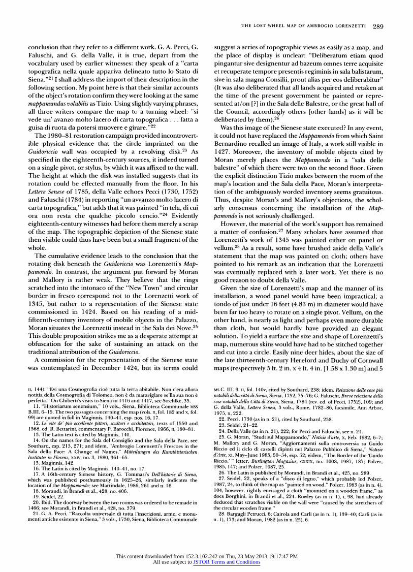
manual rotation.5l As the map was cut back over time, this component would have no longer been visible in the eigh- teenth century. Alternatively, the painting could originally have portrayed the terrestrial world alone. The blue em- ployed in the 1393 restoration could, after all, just as easily have gone for the depiction of ocean and seas.
With or without some iconographic allusion to the cosmos, Lorenzetti's map presented an image of the earthly world that was immediately familiar to its viewers. Saint Bernardino spoke of Italy, Ghiberti of la terra abitabile. Eighteenth- century writers saw on the extant fragment of the cloth disk the topography of the Sienese state. If the city and its contado could still be seen on the remaining interior portion of the disk surrounding the pivot, then the republic must have been positioned toward, though not necessarily exactly at, the center of the map. It is occasionally assumed that map- pamondo and carta topografica are incompatible, indeed mutu- ally exclusive, terms; the eighteenth-century description is then either taken to refer to a later replacement, judged the more reliable guide to the nature of the lost image, or discounted altogether.52 However, the initial premise under- lying these conclusions is by no means valid. All the elements gleaned from the written sources could have been integrated in a single, and what is more, revolving map.
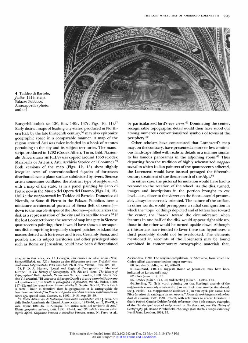
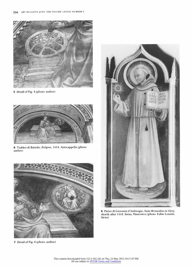
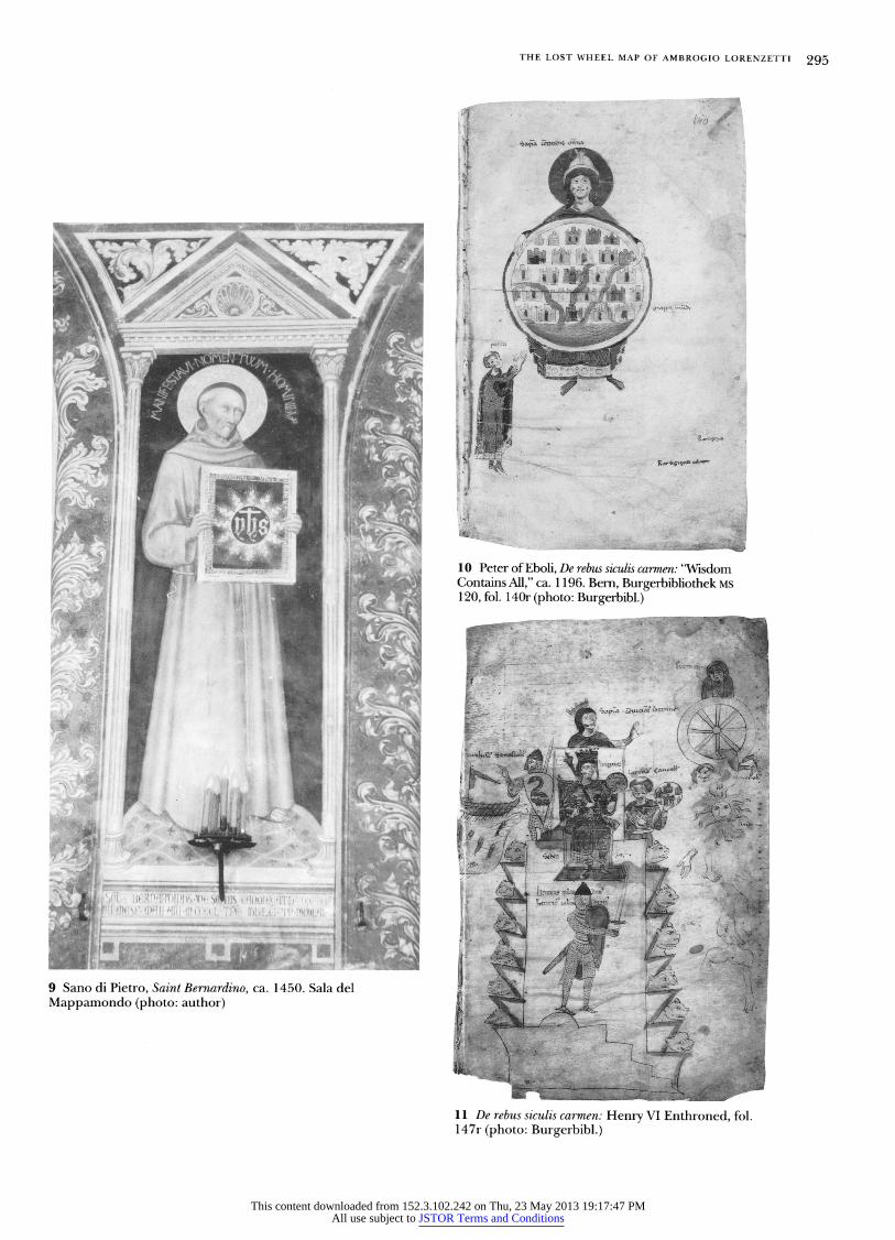
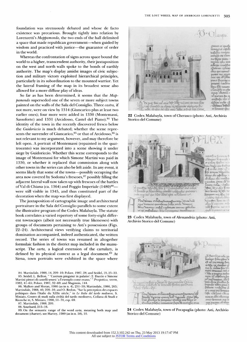
Some scholars have suggested that Lorenzetti's Map- pamondo may have served as the model for schematic world maps by quattrocento artists known to be dependent on the trecento master.53 Examples abound in the Palazzo Pubblico itself. Taddeo di Bartolo painted mappaemundi as attributes of Justice in the Cappella (1406-7) and of Justice and Religion in the Antecappella ( 1414) (Figs. 3-7).54 Two terrestrial globes and a cosmological diagram containing a world map illustrate the Creed in Domenico di Niccolo's intarsia choir stalls ( 1415-28) in the Cappella.55 Later painters placed a world map beneath the feet of Saint Bernardino in portrait icons of the saint in glory (e.g., Fig. 8), a convention adopted by Sano di Pietro for his fresco in the Sala del Mappamondo (Fig. 9).56
When limited to showing the world as a collection of towns, such schematized representations of the earth ultimately belong to an ideographic tradition of medieval origin. In this respect, fifteenth-century Sienese variants recall mappae- mundi illustrating the poem De rebus siculis composed about 1 196 by Peter of Eboli in honor of Emperor Henry VI (Bern,
52. Schlosser (as in n. 10), II, 144; Bargagli Petrucci, 5-6; Cairola and Carli (as in n. 1), 139; and Southard, 239-40.
53. Southard, 239; Feldges, 67; and Seidel, 22. 54. On the cycle in the Antecappella, see D. Hansen, "Antike Helden als
'causae': Ein gemaltes Programm im Palazzo Pubblico von Siena," in Belting and Blume,133-48. Her remarks, l 37, on the world map as symbol of Justice are especially pertinent to the interpretation I develop below.
55. On the intarsia panels, see Southard, 341, 345-46; M. Cordero, in Brandi et al., 83, 89-91, esp. figs. 102, 105; and Strehlke, 194-96. The best reproductions are to be found in F. Boespflug, Le Credo de Siena, Paris, 1985, pls. 2, 3, 7
56. R. L. Mode, "San Bernardino in Glory," Art Bulletin, LV, no. l, 1973, 58-76, esp. 72-73; P. Torriti, La pinacoteca nazionale di Siena: I dipinti dal XII al XVsecolo, Genoa, 1977, 268, no. 253, 300-1, no. 203.
57. Petrus Ansolini de Ebulo, De rebus siculis carmen, ed. E. Rota, Rerum italicarum scriptores XXXI, no. 1, Citta di Castello, 1904. On cartographic
3 Taddeo di Bartolo,Justice, 1406-7. Siena, Palazzo Pubblico, Cappella (photo: Soprintendenza B.A.S.-Siena)
Mappamondo could then have functioned as an astrological/ calendrical device. At least part of this ingenious theory, however, has to be scuttled on account of the technical evidence. Even if it is assumed that such a device could have been constructed as an open framework (although this is hard to imagine), how could the single pivot by which the map was affixed to the wall have anchored a central disk in place while allowing multiple separable rings to revolve around it?50
A modified version of Bargagli Petrucci's idea, involving the representation of the universe on a single disk, could nevertheless still be contemplated. Inclusion of cosmological material at the outer rim of the map may gain support from the restoration document of 1393. The use of blue, for which the painters were reimbursed a considerable sum, could be taken to indicate that the heavens were depicted on the portion of the disk most susceptible early on to damage from
50. As Feldges, 67 and 124 n. 234, has moreover observed, the spacing of the marks scored into the mural surface suggests the whole rotated of a piece; her point remains valid whether the marks were caused directly by the stretcher itself or by rollers attached to the back of it.
51. Borghini, in Brandi et al., 223. Cosmological diagrams that appear in scenes of the world's creation are sometimes cited as possible reflections of the Lorenzetti: e.g., frescoes by Bartolo di Fredi in the Chiesa della Collegiata, S. Gimignano (1367), Giusto da Menabuoi in the Baptistery of the Padua Duomo (1376-78) and Pietro de Pucci da Orvieto in the Camposanto of Pisa (1380-90); an intarsia panel of the choir stalls in the Cappella of the Palazzo Pubblico by Domenico di Niccolo (1415-28; see Strehlke, 194-96, fig. 2); the predella panel by Giovanni di Paolo now in the Metropolitan Museum of Art, New York (ca. 1445; see Strehlke, 193-97). In my view, however, the iconographic specifity of such images Creation scenes with particular doctrinal implications (see Lippincott, as in n. 44) and the greater importance given to their heavenly as opposed to their terrestrial components argue against a direct link to the Lorenzetti Mappamondo.
This content downloaded from 152.3.102.242 on Thu, 23 May 2013 19:17:47 PMAll use subject to JSTOR Terms and Conditions
THE LOST WHEEL MAP OF AMBROGIO LORENZETTI 293
4 Taddeo di Bartolo, Justice, 1414. Siena, Palazzo Pubblico, Antecappella (photo: author)
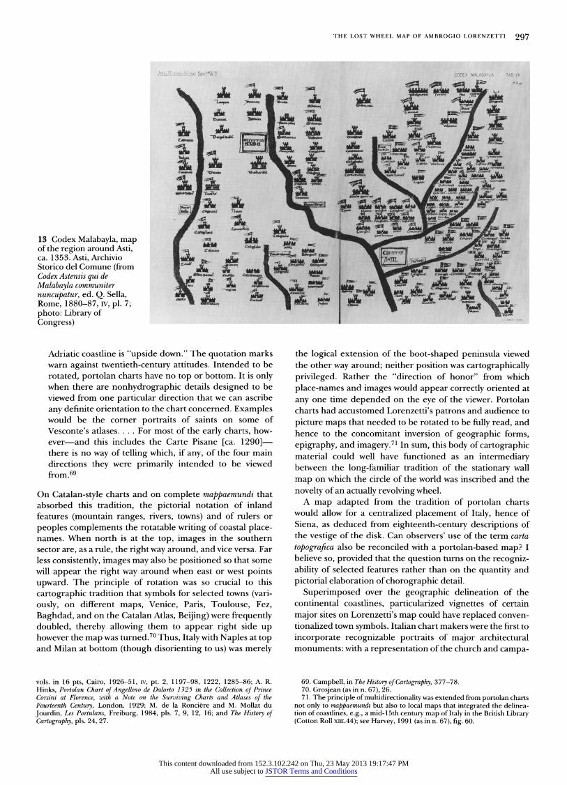
Burgerbibliothek MS 120, fols. 140r, 147r; Figs. 10, 11).57 Early district maps of leading city-states, produced in North- ern Italy by the late thirteenth century,58 may also epitomize geographic space in a comparable manner. A map of the region around Asti was twice included in a book of statutes pertaining to the city and its subject territories. The manu- script produced in 1292 (Codex Alfieri, Turin, Bibl. Nazion- ale Universitaria MS F.II.9) was copied around 1353 (Codex Malabayla or Astensis, Asti, Archivio Storico del Comune).59 Both versions of the map (Figs. 12, 13) show slightly irregular rows of conventionalized faSades of fortresses distributed over a plane surface subdivided by rivers. Sienese artists sometimes conflated the abstract type of mappamundi with a map of the state, as in a panel painting by Sano di Pietro now in the Museo del Opera del Duomo (Figs. 14, 15). Unlike the mappaemundi by Taddeo di Bartolo, Domenico di Niccolo, or Sano di Pietro in the Palazzo Pubblico, here a miniature architectural portrait of Siena (left of center) down to the marble stripes of the Duomo particularizes the disk as a representation of the city and its satellite towns.60 If the lost Lorenzetti were the source of map imagery in Sienese quattrocento painting, then it would have shown a terraque- ous disk comprising irregularly shaped patches or islandlike masses dotted with fortresses and trees. Certainly Siena, and possibly also its subject territories and other privileged sites such as Rome or Jerusalem, could have been differentiated
imagery in this work, see H. Georgen, Das Carmen de rebus siculis (Bern, Burgerbibliothek, ms. 120): Studien zu den Bildquellen und zum Erzahlstil eines illustrierten Lobgedichts des Peter von Eboli, Ph.D. diss., Vienna, 1975, 123-40.
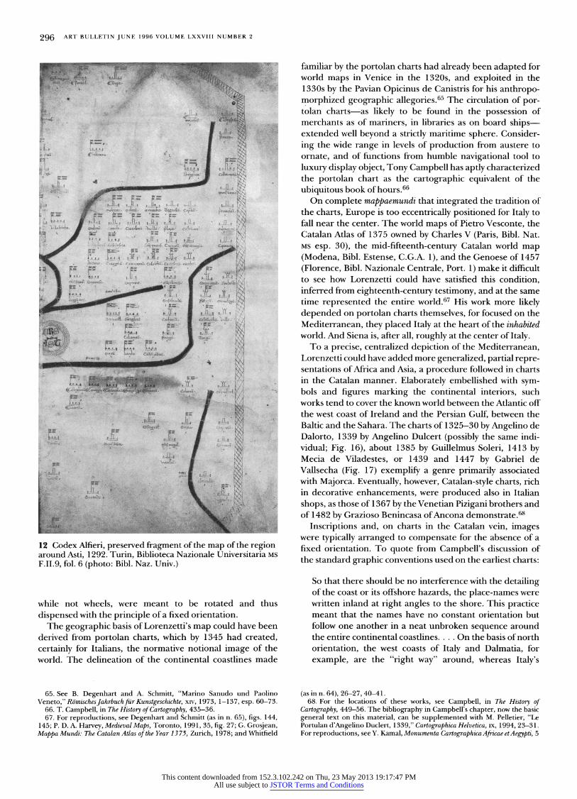
58. P. D. A. Harvey, "Local and Regional Cartography in Medieval Europe," in The History of Cartography, 478-82; and idem, The History of Topographical Maps: Symbols, Pictures and Surveys, London, 1980, 58-65. See also V. Lazzarini, "Di una carta diJacopo Dondi e di altre carte del Padovano nel quattrocento," in Scritte di paleografia e diplomatica, 2d ed., Padua, 1969, 117-22; and the remarks on this material by P. Gautier Dalche, "De la liste a la carte: Limite et frontiere dans la geographie et la cartographie de l'occident medievale," in Frontiere et peuplement dans le monde me'diterrane'en au moyenage, specialissue, Castrum, IV, 1992, 19-31, esp. 28-29.
59. Codex Astensis qui de Malabayla communiter nuncupatur, ed. Q. Sella, Atti della Reale Accademia dei Lincei, Anno CCLXXIII, 1875-76, ser. 2, IV-VII, 4 vols., Rome, 1880-87; R. Almagia, "Un antica carta del territorio di Asti," Rivista geografica italiana, LVIII, 1951, 43-44; and Gli antichi chronisti astesi: Ogerio Alfieri, Guglielmo Ventura e secondino Ventura, trans. N. Ferro et al.,
by particularized bird's-eye views.6l Dominating the center, recognizable topographic detail would then have stood out among numerous conventionalized symbols of towns at the periphee, 62
Other scholars have conjectured that Lorenzetti's map may, on the contrary, have presented a more or less continu- ous landscape filled with realistic details in a manner similar to his famous panoramas in the adjoining room.63 Thus departing from the tradition of highly schematized mappae- mundi to which Italian painters of the quattrocento adhered, the Lorenzetti would have instead presaged the fifteenth- century treatment of the theme north of the Alps.64
In either case, the pictorial formulation would have had to respond to the rotation of the wheel. As the disk turned, images and inscriptions in the portion brought to eye level i.e., closer to the viewer on the floor would presum- ably always be correctly oriented. The nature of the artifact, in other words, would presuppose a radial configuration in which the "tops" of things depicted and of letters face toward the center, the "bases" toward the circumference: when features in one half of the disk would appear right side up, those in the other would be turned upside down. Although art historians have tended to favor these two hypotheses, a third possibility should not be overlooked. The elements mentioned in accounts of the Lorenzetti may be found combined in contemporary cartographic materials that,
Alessandria, 1990. The original compilation, or Liber vetus, from which the Codex Alfieri was transcribed no longer survives.
60. See also Strehlke, no. 46, 268-69. 61. Southard, 240-41, suggests Rome or Jerusalem may have been
indicated on Lorenzetti's map. 62. Carli (as in n. 1), 173. 63. Rowley (as in n. 1), I, 98; and Sterling (as in n. 1), 82 n. 174. 64. Sterling, 72. (It is worth pointing out that Sterling's analysis of the
mappemonde commonly attributed to Jan van Eyck must now be abandoned; see J. Paviot, "La Mappemonde attribuee a Jan van Eyck par Facio: Une Piece a retirer du catalogue de son oeuvre," Revue des arche'ologues et historiens d'art de Louvain, xxtv, 1991, 57-62, with references to recent literature. I thank Patrick Gautier Dalche for this reference.) For 15th-century examples of the "landscape" type of mappamundi in Northern art, see The History of Cartography, pl. 12; and P. Whitfield, The Image of the World: Twenty Centuries of World Maps, London, 1994, 15.
This content downloaded from 152.3.102.242 on Thu, 23 May 2013 19:17:47 PMAll use subject to JSTOR Terms and Conditions
294 ART BULLETIN JUNE 1996 VOLUME LXXVIII NUMBER 2
5 Detail of Fig. 4 (photo: author)
6 Taddeo di Bartolo, Religion, 1414. Antecappella (photo: author)
7 ;: lS s
8 Pietro di Giovanni d'Ambrogio, Saint Bernardino in Glory, shortly after 1444. Siena, Pinacoteca (photo: Fabio Lensini, Siena)
7 Detail of Fig. 6 (photo: author)
This content downloaded from 152.3.102.242 on Thu, 23 May 2013 19:17:47 PMAll use subject to JSTOR Terms and Conditions
THE LOST WHEEL MAP OF AMBROGIO LORENZETTI 295
10 Peter of Eboli, De rebus siculis carmen: "Wisdom Contains All," ca. 1 196. Bern, Burgerbibliothek MS 120, fol. 140r (photo: Burgerbibl.)
9 Sano di Pietro, Saint Bernardino, ca. 1450. Sala del Mappamondo (photo: author)
11 De rebus siculis carmen: Henry VI Enthroned, fol. 147r (photo: Burgerbibl.)
This content downloaded from 152.3.102.242 on Thu, 23 May 2013 19:17:47 PMAll use subject to JSTOR Terms and Conditions
296 ART BULLETIN JUNE 1996 VOLUME LXXVIII NUMBER 2
familiar by the portolan charts had already been adapted for
world maps in Venice in the 1320s, and exploited in the
1330s by the Pavian Opicinus de Canistris for his anthropo-
morphized geographic allegories.65 The circulation of por-
tolan charts as likely to be found in the possession of
merchants as of mariners, in libraries as on board ships-
extended well beyond a strictly maritime sphere. Consider-
ing the wide range in levels of production from austere to
ornate, and of functions from humble navigational tool to
luxury display object, Tony Campbell has aptly characterized
the portolan chart as the cartographic equivalent of the
ubiquitous book of hours.66 On complete mappaemundi that integrated the tradition of
the charts, Europe is too eccentrically positioned for Italy to
fall near the center. The world maps of Pietro Vesconte, the
Catalan Atlas of 1375 owned by Charles V (Paris, Bibl. Nat.
MS esp. 30), the mid-fifteenth-century Catalan world map
(Modena, Bibl. Estense, C.G.A. 1), and the Genoese of 1457
(Florence, Bibl. Nazionale Centrale, Port. 1) make it difficult
to see how Lorenzetti could have satisfied this condition,
inferred from eighteenth-century testimony, and at the same
time represented the entire world.67 His work more likely
depended on portolan charts themselves, for focused on the
Mediterranean, they placed Italy at the heart of the inhabited
world. And Siena is, after all, roughly at the center of Italy.
To a precise, centralized depiction of the Mediterranean,
Lorenzetti could have added more generalized, partial repre-
sentations of Africa and Asia, a procedure followed in charts
in the Catalan manner. Elaborately embellished with sym-
bols and figures marking the continental interiors, such
works tend to cover the known world between the Atlantic off
the west coast of Ireland and the Persian Gulf, between the
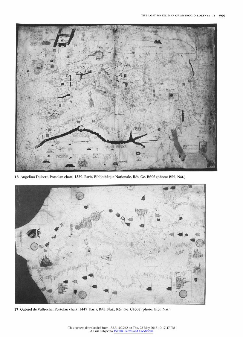
Baltic and the Sahara. The charts of 1325-30 by Angelino de
Dalorto, 1339 by Angelino Dulcert (possibly the same indi-
vidual; Fig. 16), about - 1385 by Guillelmus Soleri, 1413 by
Mecia de Viladestes, or 1439 and 1447 by Gabriel de
Vallsecha (Fig. 17) exemplify a genre primarily associated
with Majorca. Eventually, however, Catalan-style charts, rich
in decorative enhancements, were produced also in Italian
shops, as those of 1367 by the Venetian Pizigani brothers and
of 1482 by Grazioso Benincasa of Ancona demonstrate.68
Inscriptions and, on charts in the Catalan vein, images
were typically arranged to compensate for the absence of a
fixed orientation. To quote from Campbell's discussion of
the standard graphic conventions used on the earliest charts:
So that there should be no interference with the detailing
of the coast or its offshore hazards, the place-names were
written inland at right angles to the shore. This practice
meant that the names have no constant orientation but
follow one another in a neat unbroken sequence around
the entire continental coastlines.... On the basis of north
orientation, the west coasts of Italy and Dalmatia, for
example, are the "right way" around, whereas Italy's
(as in n. 64), 26-27, 40-41. 68. For the locations of these works, see Campbell, in The History of
Cartography, 449-56. The bibliography in Campbell's chapter, now the basic
general text on this material, can be supplemented with M. Pelletier, "Le
Portuland'AngelinoDuclert,1339,"CartographicaHelvetica,Ix,1994,23-31. For reproductions, see Y. Kamal, Monumenta Cartographica Africae et Aegypti, 5
12 Codex Alfieri, preserved fragment of the map of the region
around Asti, 1292. Turin, Biblioteca Nazionale Universitaria MS
F.II.9, fol. 6 (photo: Bibl. Naz. Univ.)
while not wheels, were meant to be rotated and thus
dispensed with the principle of a fixed orientation.
The geographic basis of Lorenzetti's map could have been
derived from portolan charts, which by 1345 had created,
certainly for Italians, the normative notional image of the
world. The delineation of the continental coastlines made
65. See B. Degenhart and A. Schmitt, "Marino Sanudo und Paolino
Veneto," RomischesJahrbuchfurKunstgeschichte, xrv, 1973, 1-137, esp. 60-73.
66. T. Campbell, in The History of Cartography, 435-36.
67. For reproductions, see Degenhart and Schmitt (as in n. 65), figs. 144,
145; P. D. A. Harvey, Medieval Maps, Toronto, 1991, 35, fig. 27; G. Grosjean,
Mappa Mundi: The Catalan Atlas of the Year 1375, Zurich, 1978; and Whitfield
This content downloaded from 152.3.102.242 on Thu, 23 May 2013 19:17:47 PMAll use subject to JSTOR Terms and Conditions
THE LOST WHEEL MAP OF AMBROGIO LORENZETTI 297
13 Codex Malabayla, map of the region around Asti, ca. 1353. Asti, Archivio Storico del Comune (from Codex Astensis qui de Malabayla communiter nuncupatur, ed. Q. Sella, Rome, 1880-87, IV, pl. 7; photo: Library of Congress)
Adriatic coastline is "upside down." The quotation marks warn against twentieth-century attitudes. Intended to be rotated, portolan charts have no top or bottom. It is only when there are nonhydrographic details designed to be viewed from one particular direction that we can ascribe any definite orientation to the chart concerned. Examples would be the corner portraits of saints on some of Vesconte's atlases.... For most of the early charts, how- ever and this includes the Carte Pisane [ca. 1290]- there is no way of telling which, if any, of the four main directions they were primarily intended to be viewed from.69
On Catalan-style charts and on complete mappaemundi that absorbed this tradition, the pictorial notation of inland features (mountain ranges, rivers, towns) and of rulers or peoples complements the rotatable writing of coastal place- names. When north is at the top, images in the southern sector are, as a rule, the right way around, and vice versa. Far less consistently, images may also be positioned so that some will appear the right way around when east or west points upward. The principle of rotation was so crucial to this cartographic tradition that symbols for selected towns (vari- ously, on different maps, Venice, Paris, Toulouse, Fez, Baghdad, and on the Catalan Atlas, Beijing) were frequently doubled, thereby allowing them to appear right side up however the map was turned.70 Thus, Italy with Naples at top and Milan at bottom (though disorienting to us) was merely
vols. in 16 pts, Cairo, 1926-51, tV, pt. 2, 1197-98, 1222, 1285-86; A. R. Hinks, Portolan Chart of Angellino de Dalorto 1325 in the Collection of Prince Corsini at Florence, with a Note on the Surviving Charts and Atlases of the Fourteenth Century, London, 1929; M. de la Ronciere and M. Mollat du Jourdin, Les Portulans, Freiburg, 1984, pls. 7, 9, 12, 16; and The History of Cartography, pls. 24, 27.
the logical extension of the boot-shaped peninsula viewed the other way around; neither position was cartographically privileged. Rather the "direction of honor" from which place-names and images would appear correctly oriented at any one time depended on the eye of the viewer. Portolan charts had accustomed Lorenzetti's patrons and audience to picture maps that needed to be rotated to be fully read, and hence to the concomitant inversion of geographic forms, epigraphy, and imagery.7l In sum, this body of cartographic material could well have functioned as an intermediary between the long-familiar tradition of the stationary wall map on which the circle of the world was inscribed and the novelty of an actually revolving wheel.
A map adapted from the tradition of portolan charts would allow for a centralized placement of Italy, hence of Siena, as deduced from eighteenth-century descriptions of the vestige of the disk. Can observers' use of the term carta topografica also be reconciled with a portolan-based map? I believe so, provided that the question turns on the recogniz- ability of selected features rather than on the quantity and pictorial elaboration of chorographic detail.
Superimposed over the geographic delineation of the continental coastlines, particularized vignettes of certain major sites on Lorenzetti's map could have replaced conven- tionalized town symbols. Italian chart makers were the first to incorporate recognizable portraits of major architectural monuments: with a representation of the church and campa-
69. Campbell, in The History of Cartography, 377-78. 70. Grosjean (as in n. 67), 26. 71. The principle of multidirectionality was extended from portolan charts
not only to mappaemundi but also to local maps that integrated the delinea- tion of coastlines, e.g., a mid- 1 5th century map of Italy in the British Library (Cotton Roll XIII.44); see Harvey, 1991 (as in n. 67), fig. 60.
This content downloaded from 152.3.102.242 on Thu, 23 May 2013 19:17:47 PMAll use subject to JSTOR Terms and Conditions

298 ART BULLETIN JUNE 1996 VOLUME LXXVIII NUMBER 2
15 Detail of Fig. 14 (photo: Soprintendenza B.A.S.-Siena)
nile of St. Mark's the Pizigani brothers indicated their native
city on their 1367 chart; Francesco Pizigano similarly epito-
mized Venice and, by depicting cathedral and lighthouse,
Genoa in the calendar of his 1373 Atlas.72 Not surprisingly,
though, architectural portraits were at times more evocative
than rooted in observation: on the 1367 chart, for instance, a
cathedral similar to that marking Santiago de Compostela
also appears at St. Catherine's in the Sinai, and the interior
rotunda of a mosque recalling the Dome of the Rock is
transposed to Mecca. By substituting for standard picto-
graphic notation real or imagined likenesses of buildings
with which places were identified, Italian cartographers
modified the Catalan tradition in the direction of greater
local specificity. Conceivably, then, a miniature view of Siena
as in Figure 15, though perhaps larger than other towns,
could have been accommodated within the format of a map
based on the portolan tradition (see, e.g., Fig. 17) as it could
have been within the two sorts of radial composition (the
schematic terraqueous disk or continuous landscape) dis-
cussed above. Although in the end the particular solution adopted by
Lorenzetti remains an open question, the hypothesis of an
artistic link to portolan charts allows his Mappamondo to be
more easily situated within a horizon of expectations defined
by the prehumanist and merchant culture then flourishing in
Italian cities. Rather than insist on the precise geographiccov-
erage of the lost work, perhaps it is best to visualize
Lorenzetti's map as belonging somewhere between two
benchmarks: at one end, the totality of geographical knowl-
14 Sano di Pietro, Saint Bernardino in Glory, ca. 1450. Siena,
Museo del Opera del Duomo (photo: Soprintendenza B.A.S.-
Siena)
72. Campbell, in The History of Cartography, 397, 398 fig. 19.8, and
Degenhart and Schmitt (as in n. 65), 69, 110 fig. 147. Kamal (as in n. 68), tv
pt. 2j 1286, provides a good-size reproduction of a 19th-centuty copy of the
This content downloaded from 152.3.102.242 on Thu, 23 May 2013 19:17:47 PMAll use subject to JSTOR Terms and Conditions
THE LOST WHEEL MAP OF AMBROGIO LORENZETTI 299
16 Angelino Dulcert, Portolan chart, 1339. Paris, Bibliotheque Nationale, Res. Ge. B696 (photo: Bibl. Nat.)
17 Gabriel de Vallsecha, Portolan chart, 1447. Paris, Bibl. Nat., Res. Ge. C4607 (photo: Bibl. Nat.)
This content downloaded from 152.3.102.242 on Thu, 23 May 2013 19:17:47 PMAll use subject to JSTOR Terms and Conditions
300 ART BULLETIN JUNE 1996 VOLUME LXXVIII NUMBER 2
18 Simone Martini, Maesta, 1315. Sala del Mappamondo, east wall (photo: Fabio Lensini, Siena)
19 Sala del Mappamondo, east and north walls (photo: Fabio Lensini, Siena)
This content downloaded from 152.3.102.242 on Thu, 23 May 2013 19:17:47 PMAll use subject to JSTOR Terms and Conditions

THE LOST WHEEL MAP OF AMBROGIO LORENZETTI 301
1. Guidoriccio wall with the lost Mappamondo
2. Maesta
3. Battle of Val di Chiana
4. Battle of Poggio Imperiale
5. Panorama of ideal city and countryside
20 Siena, Palazzo Pubblico, second floor, plan (courtesy: Reena Racki, A.I.A.)
edge that Brunetto Latini evoked when he treated the subject of the mappamundi in his popular encyclopedia LiLivres dou Tresor (early 1260s);73 at the other, the picture teeming with figures, ships, and banners that the Florentine merchant Baldassare degli Ubriachi desired when he commis- sioned four mappaemundi from a Majorcan cartographer and Genoese artist in Barcelona in 1399.74 "Cioe tutta la terra abitabile" was perhaps all that Ghiberti could, or needed to, say. Paradoxically, a portolan-based map may have had special appeal in the communal palace of land-locked Siena. The panoramic sweep of the Sienese contado that Lorenzetti painted in the Sala dei Nove reached the sea at Talamone, a town duly inscribed, by the way, on portolan charts.75 A portolan-based map on the other side of the same wall would have translated this dream-vision into cartographic terms.
The Pictorial Environment If the Mappamondo represented Italy and Siena near the middle of the world, its framing environment in the Palazzo
73. Li Livres dou Tresor, 1.121-24, ed. F. O. Carmody, University of California Publications in Modern Philosophy 22, Berkeley,1948,109-21; or The Book of the Treasure, trans. P. Barrette and S. Baldwin, Garland Library of Medieval Literature, ser. B., xc, New York, 1993, 85-98. On Latini's use of the term mapamunde, see P. A. Messelaer, Le Vocabulaire des idees dans le 'Tresor' de Brunetto Latini, Assen, 1963, 96, 225, 333, 366. See also Latini's II tesoretto, 11. 927-1098, ed. and trans. J. Bolton Holloway, Garland Library of Medieval Literature, ser. A, II, New York, 1981, 49-57. On the prehumanist culture of professional rhetoricians, and Brunetto Latini in particular, as an interpre- tive framework with which to approach Lorenzetti's paintings in the Sala dei Nove, see Q. Skinner, "Ambrogio Lorenzetti: The Artist as Political Philoso- pher," Proceedings of the British Academy, LXXII, 1986,1-56; and Starn, 1992 (as in n. 3), esp. 35-38,4045.
Pubblico suggested the converse, that the world was encom- passed by Siena. The surrounding pictorial decoration in the Sala del Consiglio glorified the city by celebrating its spiritual and earthly power. Since the completion of the building in 1310, the artistic embellishment of the hall proceeded by accretion.76 From the great Maesta to the depiction of subject towns and military triumphs, images added seriatim over time were loosely associated by their shared purpose to exalt the commune.77 Though an ad hoc intervention, the Map- pamondo of 1345 thematically refocused already existing material, and in so doing, created a framework into which subsequent commissions could be integrated. Even if neither the cartographic form nor the geographic content of the map is known for certain, this dynamic process can be explored.
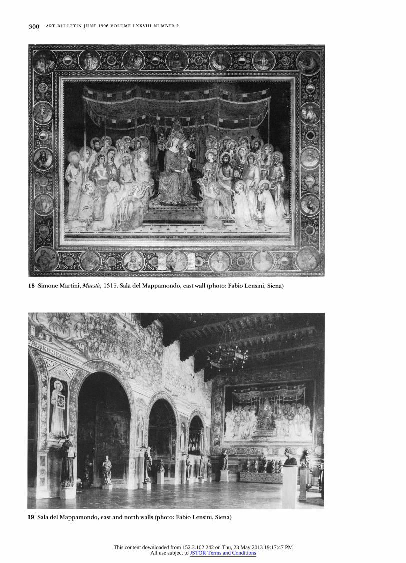
Confronting Simone Martini's Maesta (ca. 1315) on the opposite wall (Figs. 18-20), the Mappamondo took on mean- ing in relation to an inscription in the earlier work. The scroll held by Simone's Christ Child is inscribed with the impera-
74. R. A. Skelton, "A Contract forWorld Maps at Barcelona, 1399-1400," Imago Mundi, xxIIs 1 968, 1 07-1 3; and J. Schulz, "Jacopo de' Barbari's View of Venice: Map Making, City Views, and Moralized Geography before the Year 1500,"ArtBulletin, LX, no.3, 1978, 425-74, esp. 452.
75. With the acquisition in 1303 of the coastal town of Talamone, Siena hoped to win access to the sea. On efforts to make Talamone into a genuine port, derided by Dante (Purg. 13.151-53), see W. Bowsky, A Medieval Italian Commune: Siena under the Nine, 1287-1355, Berkeley, 1981, esp. 175-76, 194,216-17. A plan of Talamone harbor exists from 1306; see Harvey, in The History of Cartography, 46F501, esp.488, 491, fig.20.27.
76. Surveyed in Southard, 213-70. 77. Martindale,1988, 14-15.
This content downloaded from 152.3.102.242 on Thu, 23 May 2013 19:17:47 PMAll use subject to JSTOR Terms and Conditions
302 ART BULLETIN JUNE 1996 VOLUME LXXVIII NUMBER 2
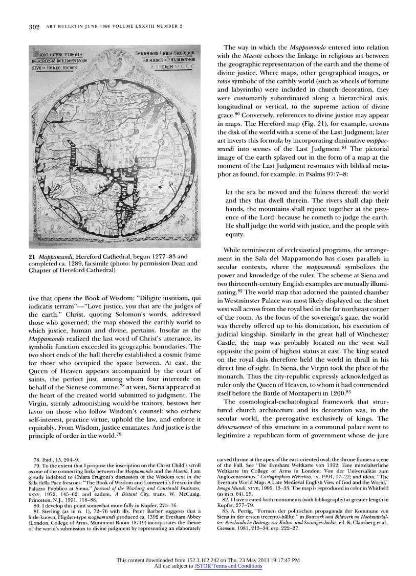
The way in which the Mappamondo entered into relation with the Maesta echoes the linkage in religious art between the geographic representation of the earth and the theme of divine justice. Where maps, other geographical images, or rotae symbolic of the earthly world (such as wheels of fortune and labyrinths) were included in church decoration, they were customarily subordinated along a hierarchical axis, longitudinal or vertical, to the supreme action of divine grace.80 Conversely, references to divine justice may appear in maps. The Hereford map (Fig. 21), for example, crowns the disk of the world with a scene of the LastJudgment; later art inverts this formula by incorporating diminutive mappae- mundi into scenes of the Last Judgment.8l The pictorial image of the earth splayed out in the form of a map at the moment of the Last Judgment resonates with biblical meta- phor as found, for example, in Psalms 97:7-8:
let the sea be moved and the fulness thereof: the world and they that dwell therein. The rivers shall clap their hands, the mountains shall rejoice together at the pres- ence of the Lord: because he cometh to judge the earth. He shall judge the world with justice, and the people with equity.
While reminiscent of ecclesiastical programs, the arrange- ment in the Sala del Mappamondo has closer parallels in secular contexts, where the mappamundi symbolizes the power and knowledge of the ruler. The scheme at Siena and two thirteenth-century English examples are mutually illumi- nating.82 The world map that adorned the painted chamber in Westminster Palace was most likely displayed on the short west wall across from the royal bed in the far northeast corner of the room. As the focus of the sovereign's gaze, the world was thereby offered up to his domination, his execution of judicial kingship. Similarly in the great hall of Winchester Castle, the map was probably located on the west wall opposite the point of highest status at east. The king seated on the royal dais therefore held the world in thrall in his direct line of sight. In Siena, the Virgin took the place of the monarch. Thus the city-republic expressly acknowledged as ruler only the Queen of Heaven, to whom it had commended itselfbefore the Battle of Montaperti in 1260.83 The cosmological-eschatological framework that struc- tured church architecture and its decoration was, in the secular world, the prerogative exclusively of kings. The de'tournement of this structure in a communal palace went to legitimize a republican form of government whose de jure
carved throne at the apex of the east-oriented oval; the throne frames a scene of the Fall. See "Die Evesham Weltkarte von 1392: Eine mittelalterliche Weltkarte im College of Arms in London: Von der Universalitat zum Anglozentrismus," Cartographica Helvetica, IX, 1994, 17-22; and idem, "The Evesham World Map: A Late Medieval English View of God and the World," Imago Mundi, XLVII, 1995, 13-33. The map is reproduced in color in Whitfield 82. I have treated both monuments (with bibliography) at greater length in 83. A. Perrig, "Formen der politischen propaganda der Kommune von Siena in der ersten trecento-halfte," in Bauwerk und Bildwerk im Hochmittelal- ter: Anschauliche Beitrage zur Kultur-und Sozialgeschichte, ed. K. Clausberg et al., Giessen, 1981, 213-34, esp. 222-27.
(as in n. 64), 25.
21 Mappamundi, Hereford Cathedral, begun 1277-83 and completed ca. 1289, facsimile (photo: by permission Dean and Chapter of Hereford Cathedral)
tive that opens the Book of Wisdom: "Diligite iustitiam, qui iudicatis terram" "Love justice, you that are the judges of the earth." Christ, quoting Solomon's words, addressed those who governed; the map showed the earthly world to which justice, human and divine, pertains. Insofar as the Mappamondo realized the last word of Christ's utterance, its symbolic function exceeded its geographic boundaries. The two short ends of the hall thereby established a cosmic frame for those who occupied the space between. At east, the Queen of Heaven appears accompanied by the court of saints, the perfect just, among whom four intercede on behalf of the Sienese commune;78 at west, Siena appeared at the heart of the created world submitted to judgment. The Virgin, sternly admonishing would-be traitors, bestows her favor on those who follow Wisdom's counsel: who eschew self-interest, practice virtue, uphold the law, and enforce it equitably. From Wisdom, justice emanates. And justice is the principle of order in the world.79
78. Ibid., 15, 204-9. 79. To the extent that I propose the inscription on the Christ Child's scroll as one of the connecting links between the Mappamondo and the Maesta, I am greatly indebted to Chiara Frugoni's discussion of the Wisdom text in the Sala della Pace frescoes: "The Book of Wisdom and Lorenzetti's Fresco in the Palazzo Pubblico at Siena," Journal of the Warburg and Courtauld Institutes, xxxv, 1972, 145-62; and eadem, A Distant City, trans. W. McCuaig, Princeton, NJ ., 1991, 118-88. 80. I develop this point somewhat more fully in Kupfer, 275-76.
Kupfer, 277-79.
81. Sterling (as in n. 1), 72-76 with ills. Peter Barber suggests that a little-known, Higden-type mappamundi produced ca. 1392 at Evesham Abbey (London, College of Arms, Muniment Room 18/19) incorporates the theme of the world's submission to divine judgment by representing an elaborately
This content downloaded from 152.3.102.242 on Thu, 23 May 2013 19:17:47 PMAll use subject to JSTOR Terms and Conditions
THE LOST WHEEL MAP OF AMBROGIO LORENZETTI 303
foundation was strenuously debated and whose de facto existence was precarious. Brought tightly into relation by Lorenzetti's Mappamondo, the two ends of the hall delimited a space that made republican government when guided by wisdom and practiced with justice the guarantor of order in the world.
Whereas the confrontation of signs across space bound the world to a higher, transcendent authority, theirjuxtaposition on the west and north walls spoke to the bonds of earthly authority. The map's display amidst images of civic subjec- tion and military victory exploited hierarchical principles, particularly in its subordination to the mounted warrior. Yet the lateral framing of the map in its broadest sense also allowed for a more diffuse play of ideas.
So far as has been determined, it seems that the Map- pamondo superseded one of the seven or more subject towns painted on the walls of the Sala del Consiglio. Three castra, if not more, were on view by 13 14 (Giuncarico plus at least two earlier ones); four more were added in 1330 (Montemassi, Sassoforte) and 1331 (Arcidosso, Castel del Piano).84 The identity of the town in the recently discovered fresco below the Guidoriccio is much debated; whether the scene repre- sents the surrender of Giuncarico,85 or that of Arcidosso,86 is not relevant to my argument, however, and may therefore be left open. A portrait of Montemassi (repainted in the quat- trocento) was incorporated into a scene showing it under siege by Guidoriccio. Whether this scene corresponds to the image of Montemassi for which Simone Martini was paid in 1330, or whether it replaced that commission along with other towns in the series can also be left aside. In any event, it seems likely that some of the towns possibly occupying the area now covered by Sodoma's frescoes,87 possibly filling the adjacent lateral wall now taken up with frescoes of the battles of Val di Chiana (ca. 1364) and Poggio Imperiale (1480)88- were still visible in 1345, and thus constituted part of the decoration when the map was first displayed.
The juxtaposition of cartographic image and architectural portraiture in the Sala del Consiglio parallels to some extent the illustrative program of the Codex Malabayla. The statute book correlates a varied repertory of some forty-eight differ- ent townscapes (albeit not necessarily true likenesses) with groups of documents pertaining to Asti's possessions (Figs. 22-24). Architectural views verifying claims to territorial domination accompanied, indeed authenticated, the written record. The series of towns was resumed in altogether formulaic fashion in the district map included in the manu- script. The carta, a logical extension of the cartulary, is defined by its physical context as a legal document.89 At Siena, town portraits were exhibited in the space where
84. Martindale, 1988, 14, 209-10; Polzer, 1987,28; and Seidel, 19,25-33. 85. Seidel; L. Bellosi, " 'Castrum pingatur in palatio': 2. Duccio e Simone
Martini pittori di castelli senesi 'a l'esemplo come erano,' " Prospettiva, XXVIII,
1982,41-65; Polzer, 1987, 32-69; and Maginnis, 144. 86. Mallory and Moran, 1986 (as in n. 4), 251-59; Martindale, 1986, 265;
Martindale, 1988, 40,209-10; and O. Redon, "Sur la perception des espaces politiques dans l'Italie du XIIIe siecle," in Le Italie del tardo medioevo, S. Miniato, Centro di studi sulla civilta del tardo medioevo, Collana di Studi e Ricerche III, S. Miniato, 1990, 51-70, esp. 69.
87. Martindale, 1988, 209. 88. Southard, 215-16. 89. On the semantic range of the word carta, meaning both map and
document (charter), see Harvey, 1980 (as in n. 58), 10.
22 Codex Malabayla, town of Cherasco (photo: Asti, Archivio Storico del Comune)
23 Codex Malabayla, town of Alessandria (photo: Asti, Archivio Storico del Comune)
24 Codex Malabayla, town of Pocapaglia (photo: Asti, Archivio Storico del Comune)
This content downloaded from 152.3.102.242 on Thu, 23 May 2013 19:17:47 PMAll use subject to JSTOR Terms and Conditions
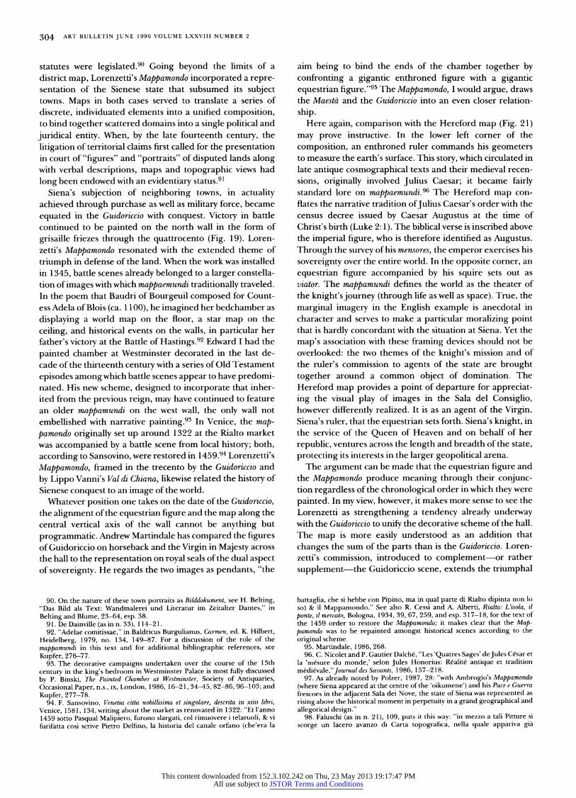
304 ART BULLETIN JUNE 1996 VOLUME LXXVIII NUMBER 2
statutes were legislated.90 Going beyond the limits of a district map, Lorenzetti's Mappamondo incorporated a repre- sentation of the Sienese state that subsumed its subject towns. Maps in both cases served to translate a series of discrete, individuated elements into a unified composition, to bind together scattered domains into a single political and juridical entity. When, by the late fourteenth century, the litigation of territorial claims first called for the presentation in court of "figures" and "portraits" of disputed lands along with verbal descriptions, maps and topographic views had long been endowed with an evidentiary status.9l
Siena's subjection of neighboring towns, in actuality achieved through purchase as well as military force, became equated in the Guidoriccio with conquest. Victory in battle continued to be painted on the north wall in the form of grisaille friezes through the quattrocento (Fig. 19). Loren- zetti's Mappamondo resonated with the extended theme of triumph in defense of the land. When the work was installed in 1345, battle scenes already belonged to a larger constella- tion of images with which mappaemundi traditionally traveled. In the poem that Baudri of Bourgeuil composed for Count- ess Adela of Blois (ca. 1 100), he imagined her bedchamber as displaying a world map on the floor, a star map on the ceiling, and historical events on the walls, in particular her father's victory at the Battle of Hastings.92 Edward I had the painted chamber at Westminster decorated in the last de- cade of the thirteenth century with a series of Old Testament episodes among which battle scenes appear to have predomi- nated. His new scheme, designed to incorporate that inher- ited from the previous reign, may have continued to feature an older mappamundi on the west wall, the only wall not embellished with narrative painting.93 In Venice, the map- pamondo originally set up around 1322 at the Rialto market was accompanied by a battle scene from local history; both, according to Sansovino, were restored in 1459.94 Lorenzetti's Mappamondo, framed in the trecento by the Guidoriccio and by Lippo Vanni's Val di Chiana, likewise related the history of Sienese conquest to an image of the world.
Whatever position one takes on the date of the Guidoriccio, the alignment of the equestrian figure and the map along the central vertical axis of the wall cannot be anything but programmatic. Andrew Martindale has compared the figures of Guidoriccio on horseback and the Virgin in Majesty across the hall to the representation on royal seals of the dual aspect of sovereignty. He regards the two images as pendants, "the
90. On the nature of these town portraits as Bilddokament, see H. Belting, "Das Bild als Text: Wandmalerei und Literatur im Zeitalter Dantes," in Belting and Blume,23-64, esp.38.
91. De Dainville (as in n.33), 114-21. 92. "Adelae comitissae," in Baldricus Burgulianus, Carmen, ed. K. Hilbert,
Heidelberg, 1979, no. 134, 149-87. For a discussion of the role of the mappamundi in this text and for additional bibliographic references, see Kupfer,276-77.
93. The decorative campaigns undertaken over the course of the 13th century in the king's bedroom in Westminster Palace is most fully discussed by P. Binski, The Painted Chamber at Westminster, Society of Antiquaries, Occasional Paper, n.s., lx, London,1986, 16-21,34-45,82-86,96-103; and Kupfer, 277-78.
94. F. Sansovino, Venetia citta nobillisima et singolare, descrita in xiiii libri, Venice, 1581, 134, writing about the market as renovated in 1322: "Et l'anno 1459 sotto Pasqual Malipiero, furono slargati, col rimuovere i telaruoli, & vi furifatta cosi scrive Pietro Delfino, la historia del canale orfano (che'era la
aim being to bind the ends of the chamber together by confronting a gigantic enthroned figure with a gigantic equestrian figure."95 The Mappamondo, I would argue, draws the Maesta and the Guidoriccio into an even closer relation- ship.
Here again, comparison with the Hereford map (Fig. 21) may prove instructive. In the lower left corner of the composition, an enthroned ruler commands his geometers to measure the earth's surface. This story, which circulated in late antique cosmographical texts and their medieval recen- sions, originally involved Julius Caesar; it became fairly standard lore on mappaemundi.96 The Hereford map con- flates the narrative tradition of Julius Caesar's order with the census decree issued by Caesar Augustus at the time of Christ's birth (Luke 2:1). The biblical verse is inscribed above the imperial figure, who is therefore identified as Augustus. Through the survey of his mensores, the emperor exercises his sovereignty over the entire world. In the opposite corner, an equestrian figure accompanied by his squire sets out as viator. The mappamundi defines the world as the theater of the knight's journey (through life as well as space). True, the marginal imagery in the English example is anecdotal in character and serves to make a particular moralizing point that is hardly concordant with the situation at Siena. Yet the map's association with these framing devices should not be overlooked: the two themes of the knight's mission and of the ruler's commission to agents of the state are brought together around a common object of domination. The Hereford map provides a point of departure for appreciat- ing the visual play of images in the Sala del Consiglio, however differently realized. It is as an agent of the Virgin, Siena's ruler, that the equestrian sets forth. Siena's knight, in the service of the Queen of Heaven and on behalf of her republic, ventures across the length and breadth of the state, protecting its interests in the larger geopolitical arena.
The argument can be made that the equestrian figure and the Mappamondo produce meaning through their conjunc- tion regardless of the chronological order in which they were painted. In my view, however, it makes more sense to see the Lorenzetti as strengthening a tendency already underway with the Guidoriccio to unit the decorative scheme of the hall. The map is more easily understood as an addition that changes the sum of the parts than is the Guidoriccio. Loren- zetti's commission, introduced to complement or rather supplement the Guidoriccio scene, extends the triumphal
battaglia, che si hebbe con Pipino, ma in qual parte di Rialto dipinta non lo so) & il Mappamondo." See also R. Cessi and A. Alberti, Rialto: L'zsola, il ponte, il mercato, Bologna, 1934, 39, 67, 259, and esp. 317-18, for the text of the 1459 order to restore the Mappamondo; it makes clear that the Map- pamondo was to be repainted amongst historical scenes according to the original scheme.
95. Martindale, 1986, 268. 96. C. Nicolet and P. Gautier Dalche, "Les 'Quatres Sages' deJules Cesar et
la 'mesure du monde,' selon Jules Honorius: Realite antique et tradition medievale,"Journal des Savants, 1986, 157-218.
97. As already noted by Polzer, 1987, 28: "with Ambrogio's Mappamondo (where Siena appeared at the centre of the 'oikumene') and his Pace e Guerra frescoes in the adjacent Sala dei Nove, the state of Siena was represented as rising above the historical moment in perpetuity in a grand geographical and allegorical design."
98. Faluschi (as in n. 21), 109, puts it this way: "in mezzo a tali Pitture si scorge un lacero avanzo di Carta topografica, nella quale appariva gia
This content downloaded from 152.3.102.242 on Thu, 23 May 2013 19:17:47 PMAll use subject to JSTOR Terms and Conditions

THE LOST WHEEL MAP OF AMBROGIO LORENZETTI 305
message beyond the local and incidental.97 The equestrian image secures Siena's rightful (central) place as a sovereign state in the world rotating beneath. At once submitted to the divine gaze of Christ and his mother and dominated by the war captain, the Mappamonzlo assumes a thematically subordi- nate position within the programmatic framework it created. Yet as the painting to which the meaning of the Maestd and the Guidoriccio had to respond, the map co-opts their signifying potential, and with it the space of the chamber itself. Regardless of subsequent decorative campaigns, the hall remained what Lorenzetti's work made it the Sala del Mappamondo.
The Turning World Lorenzetti's map gained added significance from the rotary action of the disk. By turning the wheel, a viewer would have been able to inspect the edges of the inhabited world without losing track of Italy and Siona at its core.98 The ideological implications of this kind of cartographic performance are eloquently summed up in a few verses on the lessons of geography by G. K. Chesterton ( 1874-1936):
The earth is a place on which England is found, And you find it however you twirl the globe round; For the spots are all red and the rest is all grey, And that is the meaning of Empire Day.99
The turning wheel replaced the fixed eastward orientation of a stationary wall map with a series of continually changing orientations; yet at each point along the 360-degree revolu- tion, constant relationships between Siena and the rest of the world came into focus. The novel physical format of Loren- zetti's map facilitated visual mastery of the cartographic image.
At the same time, I would argue that the map's pictorial environment elevated the assimilation of world and wheel to a higher order of meaning. Portolan charts had prepared Lorenzetti's contemporaries to accept rotation as a function of map reading, certainly not as a physical property of the terrestrial world portrayed. The turning of the earthly world could not possibly have been taken literally. But it could have been understood allegorically. To rehearse the rich medieval elaboration of the wheel as a metaphor for the time-bound world would be tedious.l°° Suffice it to say that by the mid-fourteenth century, the figure of the wheel had become a commonplace, in diverse iconographic contexts, for symbol-
delineato tutto lo stato senese. Rimane questa Topografia incassata in cerchio rotundo, che appesa in mezzo ad uno stile a guisa di Ruota rigirando intorno intorno dimostra da vicino cio, che ciascuno desidera vedere."
99. "Songs of Education: II. Geography," in The Collected Poems of G. K Chesterton, New York, 1980, 93-94. J. B. Harley, "Maps, Knowledge and Power," in The Iconography of Landscape, ed. D. Cosgrove and S. Daniels, Cambridge, 1988, 277-312, esp. 295, quotes this poem as a reminder that "In the articulation of power the symbolic level is often paramount in cartographic communication and it is in this mode that maps are at their most rhetorical and persuasive."
100. See the now classic study of E. Kitzinger, "World Map and Fortune's Wheel: A Medieval Mosaic Floor in Turin," in The Art of Byzantium and the Medieval West: Selected Studies, ed. W. Eugene Kleinbauer, Bloomington, Ind., 1976, pp. 327-56, esp. 348-52. Two recent additions to the enormous bibliography on the symbolism of the wheel are particularly relevant in the context of the current discussion, and may also be referred to for a discussion of primary sources and the secondary literature: M. M. Donato, "Un ciclo
izing the dual aspect of temporality itself, change and repetition. The rota constituted an ubiquitous compositional principle applied to represent both the cosmic action of time (the yearly round of months and attendant signs of the zodiac) and its moral effects (the transience of power, riches, honors, or youth).
Mappaemundi traditionally referred to the grip of time on the terrestrial sphere in a variety of ways. Moralizing inscrip- tions (MORS in the case of the Hereford map) or pictorial devices (the ages of man in the Duchy of Cornwall fragment) might frame the cartographic image. The Wheel of Fortune that Henry III had ordered for the great hall of Winchester Castle in 1236 surely modified the import of the mappamundi added in 1239. While the king gazed upon the map, the Wheel of Fortune displayed above the dais served as a humbling reminder of the necessarily ephemeral nature of earthly dominion. In some iconographic contexts, map- pamundi and Wheel of Fortune were equivalent terms. On the west faSade of S. Zeno at Verona, a scene of the Last Judgment in the gable surmounted a Wheel of Fortune, for which the Hereford map substitutes a cartographic image. Most pertinent to the case at hand, life's temporal and spatial dimensions could be fially integrated in a single image by conflating world map and Fortune's Wheel, a solution adopted in a late twelfth-century mosaic pavement from S. Salvatore in Turin. l0l The Mappamondo in the Palazzo Pubblico went further than the Romanesque mosaic to concretize the topos ut rota mundus.
The motif of Fortune's Wheel did not have to be explicitly represented for Lorenzetti's revolving map to evoke the vanity of earthly achievement. Maria Monica Donato has shown that as a latent concept, the Wheel gave thematic structure to a multifaceted, eclectic allegory painted in the second half of the fourteenth century at Asciano, a depen- dency of Siena, in what was probably the residence of the podesta.l02 Though not in fact depicted, Fortune's Wheel articulated an apologue from the popular legend Barlaam andJosaphat, the exemplary tale of a young prince (Josaphat) inspired by a hermit (Barlaam) to embrace an ascetic life. While the central medallion epitomized Barlaam's parable of a worldly youth chased by death, an outer ring of eight smaller medallions contained paradigms from biblical and ancient history on the ignoble end of the powerful. Yet the Asciano rota of Barlaam did not retain the hierarchic compo- sition of Fortune's Wheel in which top signifies dominance, albeit transitory. Beginning at the lowest point of the circle
pittorico ad Asciano (Siena), Palazzo Pubblico e l'iconografia 'politica' alla fine del medioevo," Annali dell scuola normale superiore di Pisa, Classe di lettere e filosofia, ser. 3, XVIII, no. 3, 1 988, 11 05-272, esp. 11 33-4 1 on the representation of the seasons in the Casa Corboli at Asciano and the medieval concept of the circularity of time, and 1235-64 on the unusual scheme Donato has called the "Rota di Barlaam"; and E. Beretz, "Fortune Denied: The Theology against Chance at St.-Etienne, Beauvais," Ph.D. diss., Yale University, 1989 (UMI no. 90-11886), e.g. 111 for the topos of the world compared to a turning wheel.
101. See Kitzinger (as in n. 100). The comparison between the Turin mosaic and Lorenzetti's wheel map was first suggested by Chiara Frugoni, "La figurazione bassomedioevale dell'Imago Mundi," in "Imago Mundi". La conoscenza scientifica nel pensiero bassomedioevale, Convegni del centro di studi sulla spiritualita medievale, Universita degli studi de Perugia, XXII, Todi, 1983, 223-69, esp. 261-64.
102. Donato (as in n. 100), 1 235-64.
This content downloaded from 152.3.102.242 on Thu, 23 May 2013 19:17:47 PMAll use subject to JSTOR Terms and Conditions
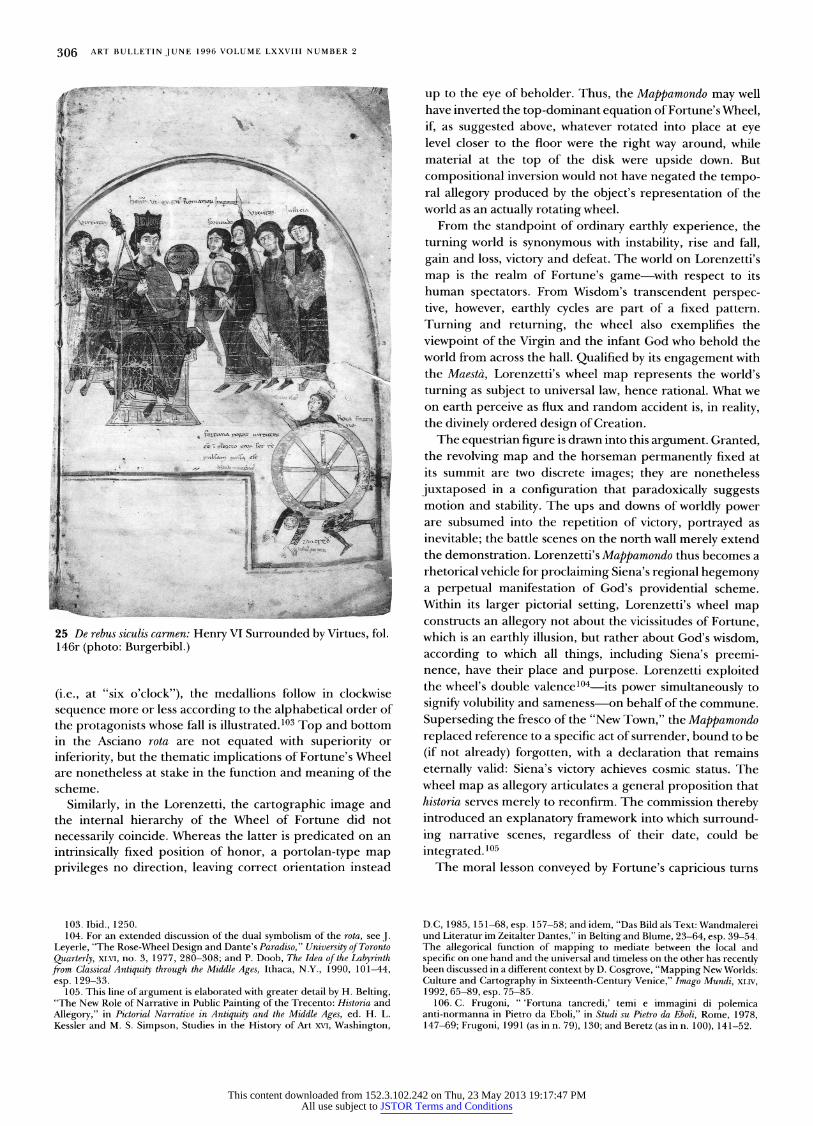
306 ART BULLETIN JUNE 1996 VOLUME LXXVIII NUMBER 2
up to the eye of beholder. Thus, the Mappamondo may well have inverted the top-dominant equation of Fortune's Wheel, if, as suggested above, whatever rotated into place at eye level closer to the floor were the right way around, while material at the top of the disk were upside down. But compositional inversion would not have negated the tempo- ral allegory produced by the object's representation of the world as an actually rotating wheel.
From the standpoint of ordinary earthly experience, the turning world is synonymous with instability, rise and fall, gain and loss, victory and defeat. The world on Lorenzetti's map is the realm of Fortune's game with respect to its human spectators. From Wisdom's transcendent perspec- tive, however, earthly cycles are part of a fixed pattern. Turning and returning, the wheel also exemplifies the viewpoint of the Virgin and the infant God who behold the world from across the hall. Qualified by its engagement with the Maestd, Lorenzetti's wheel map represents the world's turning as subject to universal law, hence rational. What we on earth perceive as flux and random accident is, in reality, the divinely ordered design of Creation.
The equestrian figure is drawn into this argument. Granted, the revolving map and the horseman permanently fixed at its summit are two discrete images; they are nonetheless juxtaposed in a configuration that paradoxically suggests motion and stability. The ups and downs of worldly power are subsumed into the repetition of victory, portrayed as inevitable; the battle scenes on the north wall merely extend the demonstration. Lorenzetti's Mappamondo thus becomes a rhetorical vehicle for proclaiming Siena's regional hegemony a perpetual manifestation of God's providential scheme. Within its larger pictorial setting, Lorenzetti's wheel map constructs an allegory not about the vicissitudes of Fortune, which is an earthly illusion, but rather about God's wisdom, according to which all things, including Siena's preemi- nence, have their place and purpose. Lorenzetti exploited the wheel's double valencel04 its power simultaneously to signify volubility and sameness on behalf of the commune. Superseding the fresco of the "New Town," the Mappamondo replaced reference to a specific act of surrender, bound to be (if not already) forgotten, with a declaration that remains eternally valid: Siena's victory achieves cosmic status. The wheel map as allegory articulates a general proposition that historia serves merely to reconfirm. The commission thereby introduced an explanatory framework into which surround- ing narrative scenes, regardless of their date, could be integrated. 105
The moral lesson conveyed by Fortune's capricious turns
D.C, 1985, 151-68, esp. 157-58; and idem, "Das Bild als Text: Wandmalerei und Literatur im Zeitalter Dantes," in Belting and Blume, 23-64, esp. 39-54. The allegorical function of mapping to mediate between the local and specific on one hand and the universal and timeless on the other has recently been discussed in a different context by D. Cosgrove, "Mapping New Worlds: Culture and Cartography in Sixteenth-Century Venice," Imago Mundi, XLIV, 1992, 65-89, esp. 75-85.
106. C. Frugoni, " 'Fortuna tancredi,' temi e immagini di polemica anti-normanna in Pietro da Eboli," in Studi su Pietro da Eboli, Rome, 1978, 147-69; Frugoni, 1991 (as in n. 79), 130; and Beretz (as in n. 100), 141-52.
25 De rebus siculis carmen: Henry VI Surrounded by Virtues, fol. 146r (photo: Burgerbibl.)
(i.e., at "six o'clock"), the medallions follow in clockwise sequence more or less according to the alphabetical order of the protagonists whose fall is illustrated. 103 Top and bottom in the Asciano rota are not equated with superiority or inferiority, but the thematic implications of Fortune's Wheel are nonetheless at stake in the function and meaning of the scheme.
Similarly, in the Lorenzetti, the cartographic image and the internal hierarchy of the Wheel of Fortune did not necessarily coincide. Whereas the latter is predicated on an intrinsically fixed position of honor, a portolan-type map privileges no direction, leaving correct orientation instead
103. Ibid., 1250. 104. For an extended discussion of the dual symbolism of the rota, see J.
Leyerle, "The Rose-Wheel Design and Dante's Paradiso," University of Toronto Quarterly, XLVI, no. 3, 1977, 280-308; and P. Doob, The Idea of the Labyrinth from Classical Antiquity through the Middle Ages, Ithaca, N.Y., 1990, 101-44, esp. 129-33.
105. This line of argument is elaborated with greater detail by H. Belting, "The New Role of Narrative in Public Painting of the Trecento: Historia and Allegory," in Pictorial Narrative in Antiquity and the Middle Ages, ed. H. L. Kessler and M. S. Simpson, Studies in the History of Art XVI, Washington,
This content downloaded from 152.3.102.242 on Thu, 23 May 2013 19:17:47 PMAll use subject to JSTOR Terms and Conditions
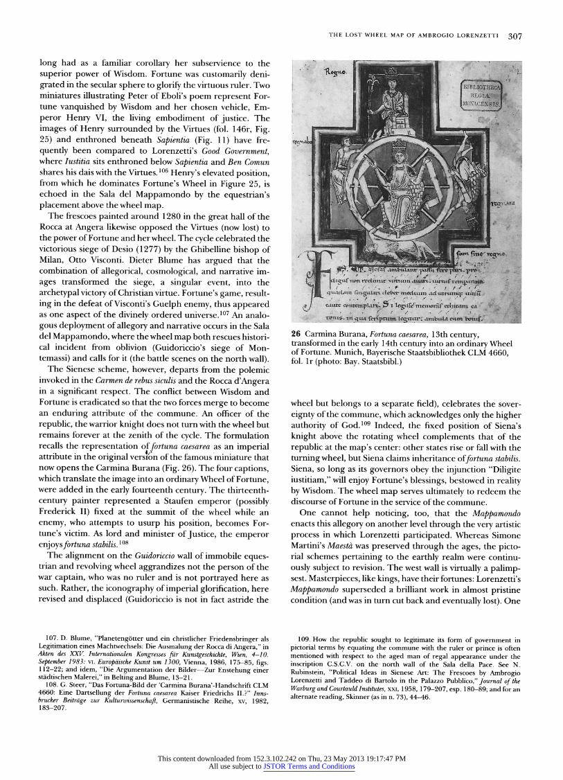
THE LOST WHEEL MAP OF AMBROGIO LORENZETTI 307
long had as a familiar corollary her subservience to the superior power of Wisdom. Fortune was customarily deni- grated in the secular sphere to glorify the virtuous ruler. Two miniatures illustrating Peter of Eboli's poem represent For- tune vanquished by Wisdom and her chosen vehicle, Em- peror Henry VI, the living embodiment of justice. The images of Henry surrounded by the Virtues (fol. 146r, Fig. 25) and enthroned beneath Sapientia (Fig. 11) have fre- quently been compared to Lorenzetti's Good Government, where Iustitia sits enthroned below Sapientia and Ben Comun shares his dais with the Virtues. 106 Henry's elevated position, from which he dominates Fortune's Wheel in Figure 25, is echoed in the Sala del Mappamondo by the equestrian's placement above the wheel map.
The frescoes painted around 1280 in the great hall of the Rocca at Angera likewise opposed the Virtues (now lost) to the power of Fortune and her wheel. The cycle celebrated the victorious siege of Desio (1277) by the Ghibelline bishop of Milan, Otto Visconti. Dieter Blume has argued that the combination of allegorical, cosmological, and narrative im- ages transformed the siege, a singular event, into the archetypal victory of Christian virtue. Fortune's game, result- ing in the defeat of Visconti's Guelph enemy, thus appeared as one aspect of the divinely ordered universe.l07 An analo- gous deployment of allegory and narrative occurs in the Sala del Mappamondo, where the wheel map both rescues histori- cal incident from oblivion (Guidoriccio's siege of Mon- temassi) and calls for it (the battle scenes on the north wall).
The Sienese scheme, however, departs from the polemic invoked in the Carmen de rebus siculis and the Rocca d'Angera in a significant respect. The conflict between Wisdom and Fortune is eradicated so that the two forces merge to become an enduring attribute of the commune. An officer of the republic, the warrior knight does not turn with the wheel but remains forever at the zenith of the cycle. The formulation recalls the representation oftortuna caesarea as an imperial attribute in the original vers4>on of the famous miniature that now opens the Carmina Burana (Fig. 26). The four captions, which translate the image into an ordinary Wheel of Fortune, were added in the early fourteenth century. The thirteenth- century painter represented a Staufen emperor (possibly Frederick II) fixed at the summit of the wheel while an enemy, who attempts to usurp his position, becomes For- tune's victim. As lord and minister of Justice, the emperor enjoystortuna stabilis. 108
The alignment on the Guidoriccio wall of immobile eques- trian and revolving wheel aggrandizes not the person of the war captain, who was no ruler and is not portrayed here as such. Rather, the iconography of imperial glorification, here revised and displaced (Guidoriccio is not in fact astride the
107. D. Blume, "Planetengotter und ein christlicher Friedensbringer als Legitimation eines Machtwechsels: Die Ausmalung der Rocca di Angera," in Akten des XXV. Internationalen Kongresses fur Kunstgeschichte, Wien, 4-10. September 1983: vI. Europaische Kunst um 1300, Vienna, 1986, 175-85, figs. 1 12-?2 and idem, "Die Argumentation der Bilder-Zur Enstehung einer stadtischen Malerei," in Belting and Blume, 13-21.
108. G. Steer, "Das Fortuna-Bild der 'Carmina Burana'-Handschrift CLM 4660: Eine Dartsellung der Fortuna caesarea Kaiser Friedrichs II.?" Inns- brucker Beitrage zur Kulturwissenschaft, Germanistische Reihe, xv, 1982, 183-207.
26 Carmina Burana, Fortuna caesarea, 1 3th century, transformed in the early 1 4th century into an ordinary Wheel of Fortune. Munich, Bayerische Staatsbibliothek CLM 4660, fol. lr (photo: Bay. Staatsbibl.)
wheel but belongs to a separate field), celebrates the sover- eignty of the commune, which acknowledges only the higher authority of God.l09 Indeed, the fixed position of Siena's knight above the rotating wheel complements that of the republic at the map's center: other states rise or fall with the turning wheel, but Siena claims inheritance offortuna stabilis. Siena, so long as its governors obey the injunction "Diligite iustitiam," will enjoy Fortune's blessings, bestowed in reality by Wisdom. The wheel map serves ultimately to redeem the discourse of Fortune in the service of the commune.
One cannot help noticing, too, that the Mappamondo enacts this allegory on another level through the very artistic process in which Lorenzetti participated. Whereas Simone Martini's Maesta was preserved through the ages, the picto- rial schemes pertaining to the earthly realm were continu- ously subject to revision. The west wall is virtually a palimp- sest. Masterpieces, like kings, have their fortunes: Lorenzetti's Mappamondo superseded a brilliant work in almost pristine condition (and was in turn cut back and eventually lost). One
109. How the republic sought to legitimate its form of government in pictorial terms by equating the commune with the ruler or prince is often mentioned with respect to the aged man of regal appearance under the inscription C.S.C.V. on the north wall of the Sala della Pace. See N. Rubinstein, "Political Ideas in Sienese Art: The Frescoes by Ambrogio Lorenzetti and Taddeo di Bartolo in the Palazzo Pubblico," Journal of the Warburg and Courtauld Institutes, xxI, 1958, 179-207, esp. 180-89; and for an alternate reading, Skinner (as in n. 73), 44-46.
This content downloaded from 152.3.102.242 on Thu, 23 May 2013 19:17:47 PMAll use subject to JSTOR Terms and Conditions
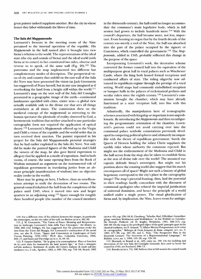
308 ART BULLETIN JUNE 1996 VOLUME LXXVIII NUMBER 2
great painter indeed supplants another. But the city in whose honor they labor withstands the blows of time.
The Sala del Mappamondo Lorenzetti's frescoes in the meeting room of the Nine pertained to the internal operation of the republic. His Mappamondo in the hall named after it brought into view Siena's relation to the world The representations of the ideal state (the city and contado of Siena) and the ideal world (with Siena at its center) in fact constituted two sides, obverse and reverse so to speak, of the same wall (Fig 20) 1l° The panorama and the map implemented two different but complementary modes of description The perspectival vis- tas of city and country that unfold on the east wall of the Sala dei Nove may have presented the vision (as Jack Greenstein has suggested) of Peace herself, but in any case imagined as if overlooking the land from a height still within the world l 1 l Lorenzetti's map on the west wall of the Sala del Consiglio presented in a geographic image of the earth-continental landmasses speckled with cities, entire seas a global view actually available only to the divine eye that sees all things everywhere at all times The commission drew on the medieval concept of the mappamundi as mirroring to the human spectator the plenitude of reality observed by God, a hermeneutic tradition that neither attached to any particular cartographic form nor required the application of optical theory l 12 Lorenzetti's Mappamondo offered up to the Virgin and Child a vision of the republic and the world order that in turn received their sanction The painter repeated in his project for the Sala del Mappamondo pictorial strategies that he had earlier exploited in the Sala dei Nove Not only did he make the painted figures of the Madonna and Child the viewers of the map; he also gave literal expression to allegory that he applied as a mode of exposition. And in both rooms, of course, the same opening lines from the Book of Wisdom sustained an argument on the instrumental role of republican government in translating justice from an ab- stract principle (manifestation of wisdom) into an objective reality (order in the world).
More may be going on here, I believe, than an unselfcon- scious attempt to unify the decoration of two rooms The general council inhabited the hall from the completion of the palace until 1343, when it moved into new and larger quarters in an adjoining wing ll3 Space enough for roughly three hundred people (the number of the council members
110. For a different view of the relation between the images, in particular the townscapes, on the two sides of the wall, see Redon (as in n. 86), 69.
111. J. M. Greenstein, "The Vision of Peace: Meaning and Rerpresenta- tion in Ambrogio Lorenzetti's Sala della Pace Cityscapes," Art History, xI, 1988, 492-510. Feldges, 64, has suggested that the panoramas evoke the view from the Torre del Mangia. For Lorenzetti's construction of the aerial view, see also K. Crum, "Space and Convention in Landscapes of Early Tuscan Painting, 1250-1350," Ph.D. diss., Columbia University, 1984, 204-17; and Starn and Partridge (as in n. 3), 48-50.
112. P. Gautier-Dalche, "De la glose a la contemplation: Place et fonction de la carte dans les manuscrits du haut moyen age," in Testo e immagine nell'alto medioevo, Settimane di studio del Centro italiano di studi sull'alto medioevo XLI, 2 vols., Spoleto, 1994, II, 693-764, esp. 758-64; Sicard, 1993
in the thirteenth century), the hall could no longer accommo- date the commune's main legislative body, which in fi session had grown to include hundreds more.ll4 With the council's departure, the hall became more, not less, impor- tant. From housing an organ that by the fourth decade of the century was merely a tool of the Nine, the hall was absorbed into the part of the palace occupied by the signory or Concistoro, which controlled the government.ll5 The Map- pamondo, added in 1345, probably reflected this change in the purpose of the space
Incorporating Lorenzetti's work, the decorative scheme converted the former council hall into the equivalent of the multipurpose great hall in royal palaces such as Winchester Castle, where the king both hosted formal receptions and conducted aSairs of state. The ruling oligarchy now ad- vanced its republican regime through the prestige of a royal setting. World maps had commonly embellished reception or banquet halls in the palaces of ecclesiastical prelates and secular rulers since the eighth century.ll6 Lorenzetti's com- mission brought the chamber, which may have already functioned as a state reception hall, into line with this tradltlon.
Admittedly, the manipulation here of iconographic schemes associated with kingship or imperium is not unprob- lematic. By introducing the Mappamondo and thus reconfigur- ing the programmatic orientation of the chamber, Loren- zetti's patrons could not avoid carrying over into the communal palace symbolic connotations previously devel- oped in competing political spheres and ultimately incompat- ible with the theory of republican government. Surely the Queen of Heaven holding the infant Christ supplants the earthly ruler whose authority the commune rejected. But might not the enthronement of the Madonna and Child in the hall across from the map also be taken to establish Siena as the seat of divine rule over the world? The mounted war captain defends Siena's sovereignty. But might not his position above the rotating world also suggest that his march encompasses all of space? Might not such a fantasy of global hegemony correspond to the city's place in the cartographic image? The map's pictorial framing, then, had the potential to elicit readings hardly concordant with the discourse of communal apologists who refuted the imperial justification of universal dominion, and hence the principle of a world unified under a single power. The visual glorification of Siena and, by implication, the Nine, leaves room for ambigu-
(as in n.45), esp.236-38; K. Clausberg, "Scheibe, Rad, Zifferblatt: Grenzuber- gange zwischen Weltkarten und Weltbildern," in Ein Weltbild vor Columbus: Die Ebstorfer Welttarte, ed. H. Kugler, Weinheim, 1991, 260-313, esp. 260-80. On the map as the privileged object of the gods' panoptic gaze in the classical tradition, see P. Arnaud, "L'Affaire Mettius Pompusianus ou le crime de cartographie," Melanges de l'ecole fran,caise de Rome, antiquite, xcz, no. 2, 1983, 677-99, esp. 691-92; and L. Nuti, "The Perspective Plan in the Sixteenth Century: The Invention of a Representational Language," Art Bulletin, LXXVI, no. l,1994,105-28, esp.126-28.
113. Morandi, in Brandi et al., 422, entry no. 193. On the building and decoration of the new Sala del Consiglio Generale, first used to house the council in 1343, see Southard, 20S13.
1 14. Bowsky (as in n. 75), 100, believes that in full session the council would
This content downloaded from 152.3.102.242 on Thu, 23 May 2013 19:17:47 PMAll use subject to JSTOR Terms and Conditions
THE LOST WHEEL MAP OF AMBROGIO LORENZETTI 309
ity: Lorenzetti's project for the Sala del Mappamondo undermined even as it elaborated the ideological construct that the republic sought to project.
Sienese beholders of the Mappamondo simultaneously en- joyed two points of view: inside the depicted world they were located near the pictorial center, while outside in real space they occupied a center from which they controlled the wheel's revolution Thus, the representation of Siena's geo- graphic position and the citizen's subjective experience of world domination were made to coincide. The privileged situation of the Sienese, however, would have in no way diminished the map's appeal for potential third-party specta- tors whose native city could have been rotated into correct alignment with respect to their particular viewpoint from the floor. Seizing on the cartographic implications of rotation, Lorenzetti's map transformed the operative principle at stake in portolan charts into a tool of diplomacy. 117
The role of geographic description in various rhetorical contexts sheds light on how Lorenzetti's cartographic image would have served as an interpretive framework for those who governed. Political and economic decisions, after all, are predicated on a notional image of the world, which the Mappamondo clearly articulated. Crystallizing relationships between self, neighbor, and the distant fringes, the work would have provided a means of orientation with which to approach policy making and diplomacy, or of integrating knowledge of the differences between universal and custom- ary law
The propadeutic value of the world map in the Palazzo Pubblico can be gauged from that in Brunetto Latini's Tresor. To introduce his discussion of the science of good speaking in government (book 3), Latini explored the connection between language, the mouth, and the world order that he had previously mapped out (book 1):
To tell the truth, before the tower of Babel was built, all men had one language naturally, which was Hebrew; but after a diversity of languages had arisen among men, three were more sacred than the others: Hebrew, Greek and Latin. We see that through nature those who live in the Orient speak in their throats, as the Hebrews do; those who are in the middle of the earth speak with their palates, as the Greeks do; and those who live in the western parts speak with their teeth, as the Italians do.l 18
His mappamundi further set up a mental structure within
easily have numbered about 500 members; Southard, 22, cites a figure of 800 in 1368.
115. Bowsky (as in n. 75), 23,55-102. 116. Kupfer, 265-68. 117. I am especially indebted to Peter Barber tor this idea. 118.Li Livres dou Tresor (as in n. 73), 3.1: Carmody, 317-19; trans.
Barrette and Baldwin, 279. 1 19. Li Livres dou Tresor (as in n. 73),3.73: Carmody, 391-92; Barrette and
Baldwin, 350-51. 120. Edited by A. Evans as La pratica della mercatura, Cambridge, Mass.,
1936; Pegolotti's own title for his treatise is Libro di divasamenti di paesi e di misure di mercatantie. On this work, see J. K. Hyde, Society and Politics in Medieval Italy, New York, 1973, 158-64. On the education of medieval Italian
which to assess the (superior) government of the Italian cities among the multiplicity of different peoples and forms of rule.ll9 Lorenzetti's map, while acknowledging the coexist- ence of many states, demonstrated the preeminence of Siena.
Along other lines, the Florentine merchant Francesco Balducci Pegolotti made geography the organizing principle for a handbook he compiled around 1340 that outlined business practices from the British Isles to Cathay l20 The spatialization of the world established a grid for the descrip- tion of goods, weights and measures, currencies, exchange rates, tariffs, and so forth Such manuals and Patrick Gautier Dalche has made this point with respect to nautical charts were chiefly valuable not to agents who traded in the field, but to those at home who strategized the ventures.l2l
The function of Lorenzetti's map as a cognitive tool for ordering knowledge of the world in its broadest sense is made clear by Saint Bernardino's reference to the work in his sermon of 1427.l22 Preaching in the Campo on the evils of sodomy, the Franciscan invoked the Mappamondo to connect Italy in the present, hence his audience, with the biblical story of Sodom and Gomorrha, and to castigate his compatri- ots for a sin that he declared was more rampant among them than among any other peoples in the whole world. 123
Bernardino engaged memory of the cartographic image to facilitate the visualization of historical and geographical relationships To conclude, he recalled the eternal punish- ments that awaited sodomites on the Day of Judgment Rhetorically, at least, the civic commission that had sub- verted the iconographic practices of the Church and of monarchy was thus reinscribed in the old religious order.
Frequently Cited Sources
Bargagli Petrucci, F., "I1 mappamondo di A(mbrogio) L(orenzetti) nel Palazzo Pubblico di Siena," Rassegna d'Arte Senese, x, 1914,3-14.
Belting, H., and D. Blume, eds., Malerei und Stadttultur in der Dantezeit, Munich,1989.
Brandi, C., et al., Palazzo Pubblico di Siena, Milan, 1983. Feldges, U., Landschaft als topographisches portrat: Der Wiederbeginn der euro-
paischen Landschaftsmalerei in Siena, Bern, 1980. The Histo7y of Cartography: I. Cartography in Prehistoric, Ancient, and Medieval
Europe and the Mediterranean, ed. J. B. Harley and D. Woodward, Chicago, 1987.
Kupfer, M., "Medieval World Maps: Embedded Images, Interpretive Frames," Word SImage, x, no.3, 1994, 262-88.
Maginnis, H., "The 'Guidoriccio' Controversy: Notes and Observations," RACAR, xv, no.2, 1988, 137-44.
merchants in the field of geography, see P. Gautier Dalche, "Une Geographie provenant du milieu des marchands toscans (debut XIVe siecle)," in Societa, istituzioni, spiritualita: Studi in onore di Cinzio Violante, Spoleto, 1994, I, 433-43.
121. Gautier Dalche (as in n. 47), 311; and U. Tucci, "Manuali di mercatura e pratica degli aSari nel medioevo," in Fatti e idee di storia economica nei secoil XII-XX: Studi dedicati a Franco Borlandi, Bologna, 1977,215-31.
122. See n. 9 above. 123. For a discussion of sodomy in the writings of Saint Bernardino, see
M. J. Rocke, "Sodomites in Fifteenth-Century Tuscany: The Views of Bernardino of Siena," in The Pursuit of Sodomy: Male Homosexuality in Renaissance and Enlightenment Europe, ed. K. Gerard and G. Helima, New York, 1989, 7-31.
This content downloaded from 152.3.102.242 on Thu, 23 May 2013 19:17:47 PMAll use subject to JSTOR Terms and Conditions

310 ART BULLETIN JUNE 1996 VOLUME LXXVIII NUMBER 2
Martindale, A., 1986, "The Problem of'Guidoriccio,' " Burlington Magazine, cxxvIII no. 997,259-73. ,1988, Simone Martini, Oxford.
Polzer, J., 1985, "The Technical Evidence and the Origin and Meaning of Simone Martini's 'Guidoriccio' Fresco in Siena," RACAR, xII no. 2, 143q8. , 1987, "Simone Martini's Guidoriccio Fresco: The Polemic Concern- ing Its Origin Reviewed, and the Fresco Considered as Serving the Militaly Triumph of a Commune," RACAR, xm, nos. l-2,1 S69. Seidel, M., " 'Castrum pingatur in palatio': 1. Ricerche storiche e iconogra- fiche sui castelli dipinti nel Palazzo Pubblico di Siena," Prospettiva, xxv 1982,17I1.
Southard, E. C., The Frescoes in Siena's Palazzo Pubblico, 1289-1539: Studies in Imagery and Relations to Other Communal Palaces in Tuscany, New York, 1979. Strehlke, C. B., in K. Christiansen, L. B. Kanter, and C. B. Strehlke, Painting in Renaissance Siena, 1420-1500, exh. cat., Metropolitan Museum of Art,
NewYork,1988,33-60,192-99,268-69.
Marcia Kupfer works in the two, not always separate fields of medieval monumental painting and cartography. Her book, Ro- manesque Wall Painting in Central France: The Politics of Narrative, was published in 1993; articles on mappaemundi have appeared in Speculum (1991) and Word & Image (1994) [3611 Patterson Street, N.W., Washington, D.C. 20015/.
This content downloaded from 152.3.102.242 on Thu, 23 May 2013 19:17:47 PMAll use subject to JSTOR Terms and Conditions


![The lost world [microform]](https://static.fdokumen.com/doc/165x107/6328d632051fac18490eebfd/the-lost-world-microform.jpg)