The longest voyage: Tectonic, magmatic, and paleoclimatic evolution of the Indian plate during its...
30
GR Focus Review The longest voyage: Tectonic, magmatic, and paleoclimatic evolution of the Indian plate during its northward flight from Gondwana to Asia Sankar Chatterjee a, ⁎, Arghya Goswami b , Christopher R. Scotese b a Department of Geosciences, Museum of Texas Tech University, Lubbock, TX 79409‐3191, USA b Department of Geology, University of Texas, Arlington, TX 76019‐0049, USA abstract article info Article history: Received 1 February 2012 Received in revised form 18 June 2012 Accepted 9 July 2012 Available online 28 July 2012 Handling Editor: M. Santosh Keywords: Tectonic evolution Gondwana Northward motion Rifting and collision Flood basalt volcanism Himalaya–Tibetan origin Monsoon The tectonic evolution of the Indian plate, which started in Late Jurassic about 167 million years ago (~167 Ma) with the breakup of Gondwana, presents an exceptional and intricate case history against which a variety of plate tectonic events such as: continental breakup, sea-floor spreading, birth of new oceans, flood basalt volcanism, hotspot tracks, transform faults, subduction, obduction, continental collision, accretion, and mountain building can be investigated. Plate tectonic maps are presented here illustrating the repeated rifting of the Indian plate from surrounding Gondwana continents, its northward migration, and its collision first with the Kohistan–Ladakh Arc at the Indus Suture Zone, and then with Tibet at the Shyok– Tsangpo Suture. The associations between flood basalts and the recurrent separation of the Indian plate from Gondwana are assessed. The breakup of India from Gondwana and the opening of the Indian Ocean is thought to have been caused by plate tectonic forces (i.e., slab pull emanating from the subduction of the Tethyan ocean floor beneath Eurasia) which were localized along zones of weakness caused by mantle plumes (Bouvet, Marion, Kerguelen, and Reunion plumes). The sequential spreading of the Southwest Indian Ridge/Davie Ridge, Southeast Indian Ridge, Central Indian Ridge, Palitana Ridge, and Carlsberg Ridge in the Indian Ocean were responsible for the fragmentation of the Indian plate during the Late Jurassic and Cretaceous times. The Réunion and the Kerguelen plumes left two spectacular hotspot tracks on either side of the Indian plate. With the breakup of Gondwana, India remained isolated as an island continent, but reestablished its biotic links with Africa during the Late Cretaceous during its collision with the Kohistan–Ladakh Arc (~85 Ma) along the Indus Suture. Soon after the Deccan eruption, India drifted northward as an island con- tinent by rapid motion carrying Gondwana biota, about 20 cm/year, between 67 Ma to 50 Ma; it slowed down dramatically to 5 cm/year during its collision with Asia in Early Eocene (~50 Ma). A northern corridor was established between India and Asia soon after the collision allowing faunal interchange. This is reflected by mixed Gondwana and Eurasian elements in the fossil record preserved in several continental Eocene formations of India. A revised India–Asia collision model suggests that the Indus Suture represents the obduction zone be- tween India and the Kohistan–Ladakh Arc, whereas the Shyok-Suture represents the collision between the Kohistan–Ladakh arc and Tibet. Eventually, the Indus–Tsangpo Zone became the locus of the final India–Asia collision, which probably began in Early Eocene (~50 Ma) with the closure of Neotethys Ocean. The post-collisional tectonics for the last 50 million years is best expressed in the evolution of the Himalaya–Tibetan orogen. The great thickness of crust beneath Tibet and Himalaya and a series of north vergent thrust zones in the Himalaya and the south-vergent subduction zones in Tibetan Plateau suggest the progressive convergence between India and Asia of about 2500 km since the time of collision. In the early Eohimalayan phase (~50 to 25 Ma) of Himalayan orogeny (Middle Eocene–Late Oligocene), thick sediments on the leading edge of the Indi- an plate were squeezed, folded, and faulted to form the Tethyan Himalaya. With continuing convergence of India, the architecture of the Himalayan–Tibetan orogen is dominated by deformational structures developed in the Neogene Period during the Neohimalayan phase (~21 Ma to present), creating a series of north-vergent thrust belt systems such as the Main Central Thrust, the Main Boundary Thrust, and the Main Frontal Thrust to accom- modate crustal shortening. Neogene molassic sediment shed from the rise of the Himalaya was deposited in a nearly continuous foreland trough in the Siwalik Group containing rich vertebrate assemblages. Tomographic imaging of the India–Asia orogen reveals that Indian lithospheric slab has been subducted subhorizontally beneath the entire Tibetan Plateau that has played a key role in the uplift of the Tibetan Plateau. The low-viscosity channel flow in response to topographic loading of Tibet provides a mechanism to explain the Himalayan–Tibetan orogen. From the start of its voyage in Southern Hemisphere, to its final impact with the Asia, the Indian plate has experienced changes in climatic conditions both short-term and long-term. We present Gondwana Research 23 (2013) 238–267 ⁎ Corresponding author. Tel.: +1 806 742 1986; fax: +1 806 742 1136. E-mail address: [email protected] (S. Chatterjee). 1342-937X/$ – see front matter © 2012 International Association for Gondwana Research. Published by Elsevier B.V. All rights reserved. http://dx.doi.org/10.1016/j.gr.2012.07.001 Contents lists available at SciVerse ScienceDirect Gondwana Research journal homepage: www.elsevier.com/locate/gr
Transcript of The longest voyage: Tectonic, magmatic, and paleoclimatic evolution of the Indian plate during its...

Gondwana Research 23 (2013) 238–267
Contents lists available at SciVerse ScienceDirect
Gondwana Research
j ourna l homepage: www.e lsev ie r .com/ locate /gr
GR Focus Review
The longest voyage: Tectonic, magmatic, and paleoclimatic evolution of the Indianplate during its northward flight from Gondwana to Asia
Sankar Chatterjee a,⁎, Arghya Goswami b, Christopher R. Scotese b
a Department of Geosciences, Museum of Texas Tech University, Lubbock, TX 79409‐3191, USAb Department of Geology, University of Texas, Arlington, TX 76019‐0049, USA
⁎ Corresponding author. Tel.: +1 806 742 1986; fax:E-mail address: [email protected] (S. Chatte
1342-937X/$ – see front matter © 2012 International Ahttp://dx.doi.org/10.1016/j.gr.2012.07.001
a b s t r a c t
a r t i c l e i n f oArticle history:Received 1 February 2012Received in revised form 18 June 2012Accepted 9 July 2012Available online 28 July 2012
Handling Editor: M. Santosh
Keywords:Tectonic evolutionGondwanaNorthward motionRifting and collisionFlood basalt volcanismHimalaya–Tibetan originMonsoon
The tectonic evolution of the Indian plate, which started in Late Jurassic about 167 million years ago(~167 Ma) with the breakup of Gondwana, presents an exceptional and intricate case history againstwhich a variety of plate tectonic events such as: continental breakup, sea-floor spreading, birth of newoceans, flood basalt volcanism, hotspot tracks, transform faults, subduction, obduction, continental collision,accretion, and mountain building can be investigated. Plate tectonic maps are presented here illustrating therepeated rifting of the Indian plate from surrounding Gondwana continents, its northward migration, and itscollision first with the Kohistan–Ladakh Arc at the Indus Suture Zone, and then with Tibet at the Shyok–Tsangpo Suture. The associations between flood basalts and the recurrent separation of the Indian platefrom Gondwana are assessed. The breakup of India from Gondwana and the opening of the Indian Ocean isthought to have been caused by plate tectonic forces (i.e., slab pull emanating from the subduction of theTethyan ocean floor beneath Eurasia) which were localized along zones of weakness caused by mantleplumes (Bouvet, Marion, Kerguelen, and Reunion plumes). The sequential spreading of the Southwest IndianRidge/Davie Ridge, Southeast Indian Ridge, Central Indian Ridge, Palitana Ridge, and Carlsberg Ridge in theIndian Ocean were responsible for the fragmentation of the Indian plate during the Late Jurassic andCretaceous times. The Réunion and the Kerguelen plumes left two spectacular hotspot tracks on either sideof the Indian plate. With the breakup of Gondwana, India remained isolated as an island continent, butreestablished its biotic links with Africa during the Late Cretaceous during its collisionwith the Kohistan–LadakhArc (~85 Ma) along the Indus Suture. Soon after the Deccan eruption, India drifted northward as an island con-tinent by rapid motion carrying Gondwana biota, about 20 cm/year, between 67 Ma to 50 Ma; it slowed downdramatically to 5 cm/year during its collision with Asia in Early Eocene (~50 Ma). A northern corridor wasestablished between India and Asia soon after the collision allowing faunal interchange. This is reflected bymixed Gondwana and Eurasian elements in the fossil record preserved in several continental Eocene formationsof India. A revised India–Asia collision model suggests that the Indus Suture represents the obduction zone be-tween India and the Kohistan–Ladakh Arc, whereas the Shyok-Suture represents the collision between theKohistan–Ladakh arc and Tibet. Eventually, the Indus–Tsangpo Zone became the locus of the final India–Asiacollision, which probably began in Early Eocene (~50 Ma) with the closure of Neotethys Ocean. Thepost-collisional tectonics for the last 50 million years is best expressed in the evolution of the Himalaya–Tibetanorogen. The great thickness of crust beneath Tibet and Himalaya and a series of north vergent thrust zones in theHimalaya and the south-vergent subduction zones in Tibetan Plateau suggest the progressive convergencebetween India and Asia of about 2500 km since the time of collision. In the early Eohimalayan phase (~50 to25 Ma) of Himalayan orogeny (Middle Eocene–Late Oligocene), thick sediments on the leading edge of the Indi-an platewere squeezed, folded, and faulted to form the TethyanHimalaya.With continuing convergence of India,the architecture of the Himalayan–Tibetan orogen is dominated by deformational structures developed in theNeogene Period during the Neohimalayan phase (~21 Ma to present), creating a series of north-vergent thrustbelt systems such as the Main Central Thrust, the Main Boundary Thrust, and the Main Frontal Thrust to accom-modate crustal shortening. Neogene molassic sediment shed from the rise of the Himalaya was deposited in anearly continuous foreland trough in the Siwalik Group containing rich vertebrate assemblages. Tomographicimaging of the India–Asia orogen reveals that Indian lithospheric slab has been subducted subhorizontallybeneath the entire Tibetan Plateau that has played a key role in the uplift of the Tibetan Plateau. Thelow-viscosity channel flow in response to topographic loading of Tibet provides a mechanism to explain theHimalayan–Tibetan orogen. From the start of its voyage in Southern Hemisphere, to its final impact with theAsia, the Indian plate has experienced changes in climatic conditions both short-term and long-term.Wepresent
+1 806 742 1136.rjee).
ssociation for Gondwana Research. Published by Elsevier B.V. All rights reserved.

239S. Chatterjee et al. / Gondwana Research 23 (2013) 238–267
a series of paleoclimatic maps illustrating the temperature and precipitation conditions based on estimates ofFast Ocean Atmospheric Model (FOAM), a coupled global climate model. The uplift of the Himalaya–TibetanPlateau above the snow line created two most important global climate phenomena—the birth of the Asian mon-soon and the onset of Pleistocene glaciation. As the mountains rose, and the monsoon rains intensified, increasingerosional sediments from theHimalayawere carried downby theGangaRiver in the east and the Indus River in thewest, andwere deposited in two great deep-sea fans, the Bengal and the Indus. Vertebrate fossils provide addition-al resolution for the timing of three crucial tectonic events: India–KL Arc collision during the Late Cretaceous,India–Asia collision during the Early Eocene, and the rise of the Himalaya during the Early Miocene.
© 2012 International Association for Gondwana Research. Published by Elsevier B.V. All rights reserved.
Contents
1. Introduction . . . . . . . . . . . . . . . . . . . . . . . . . . . . . . . . . . . . . . . . . . . . . . . . . . . . . . . . . . . . . 2392. Continental breakup and dispersal . . . . . . . . . . . . . . . . . . . . . . . . . . . . . . . . . . . . . . . . . . . . . . . . . . . 240
2.1. Supercontinent cycle . . . . . . . . . . . . . . . . . . . . . . . . . . . . . . . . . . . . . . . . . . . . . . . . . . . . . . 2402.2. Rifting and dispersal of continents . . . . . . . . . . . . . . . . . . . . . . . . . . . . . . . . . . . . . . . . . . . . . . . 2402.3. Plate tectonic forces and continental rifting . . . . . . . . . . . . . . . . . . . . . . . . . . . . . . . . . . . . . . . . . . . 2412.4. Mantle plume and continental rifting . . . . . . . . . . . . . . . . . . . . . . . . . . . . . . . . . . . . . . . . . . . . . . 2412.5. Active and passive continental rifting . . . . . . . . . . . . . . . . . . . . . . . . . . . . . . . . . . . . . . . . . . . . . . 2412.6. Mesozoic Gondwana flood basalts . . . . . . . . . . . . . . . . . . . . . . . . . . . . . . . . . . . . . . . . . . . . . . . . 243
3. Chronology of the breakup of the Indian plate from Gondwana and its collisions . . . . . . . . . . . . . . . . . . . . . . . . . . . . . 2443.1. Sequential breakup of India from Gondwana and associated flood basalts . . . . . . . . . . . . . . . . . . . . . . . . . . . . . 2443.2. Collisions during India's northward journey . . . . . . . . . . . . . . . . . . . . . . . . . . . . . . . . . . . . . . . . . . . 245
4. Material and methods . . . . . . . . . . . . . . . . . . . . . . . . . . . . . . . . . . . . . . . . . . . . . . . . . . . . . . . . . 2455. Evolution of the Indian plate during the Jurassic Period . . . . . . . . . . . . . . . . . . . . . . . . . . . . . . . . . . . . . . . . . 246
5.1. Tectonic setting of the Indian Ocean . . . . . . . . . . . . . . . . . . . . . . . . . . . . . . . . . . . . . . . . . . . . . . . 2465.2. Separation of East Gondwana from West Gondwana (~167 Ma) . . . . . . . . . . . . . . . . . . . . . . . . . . . . . . . . . . 246
6. Indian plate motion and climate change . . . . . . . . . . . . . . . . . . . . . . . . . . . . . . . . . . . . . . . . . . . . . . . . 2466.1. Jurassic climate . . . . . . . . . . . . . . . . . . . . . . . . . . . . . . . . . . . . . . . . . . . . . . . . . . . . . . . . 247
7. Evolution of the Indian plate during the Cretaceous Period . . . . . . . . . . . . . . . . . . . . . . . . . . . . . . . . . . . . . . . 2487.1. Separation of India from Antarctica–Australia (~130 Ma) . . . . . . . . . . . . . . . . . . . . . . . . . . . . . . . . . . . . . 2487.2. Limited separation of Sri Lanka from India (~130 Ma) . . . . . . . . . . . . . . . . . . . . . . . . . . . . . . . . . . . . . . 2487.3. Rifting of Madagascar from India (~90 Ma) . . . . . . . . . . . . . . . . . . . . . . . . . . . . . . . . . . . . . . . . . . . 2487.4. Collision of India with the Kohistan–Ladakh (KL) Island Arc (~85 Ma) . . . . . . . . . . . . . . . . . . . . . . . . . . . . . . . . 2487.5. Limited separation of Seychelles–Laxmi Ridge from India (~75–68 Ma) . . . . . . . . . . . . . . . . . . . . . . . . . . . . . . 2517.6. Separation of the Seychelles from India (~65 Ma) . . . . . . . . . . . . . . . . . . . . . . . . . . . . . . . . . . . . . . . . 2537.7. Acceleration of the Indian plate during the Late Cretaceous–Early Eocene and the subduction of the Neotethys . . . . . . . . . . . . 254
8. Cretaceous climate . . . . . . . . . . . . . . . . . . . . . . . . . . . . . . . . . . . . . . . . . . . . . . . . . . . . . . . . . . 2549. India–Asia collision and Cenozoic evolution of the Himalayan–Tibetan orogeny . . . . . . . . . . . . . . . . . . . . . . . . . . . . . . 254
9.1. India–Asia collision and the evolution of the Indus–Tsangpo Suture Zone (~50 Ma) . . . . . . . . . . . . . . . . . . . . . . . . . 2559.2. Himalaya: post-collisional tectonics (~50 Ma to Holocene) . . . . . . . . . . . . . . . . . . . . . . . . . . . . . . . . . . . . 2569.3. Tectonic evolution of the Himalaya . . . . . . . . . . . . . . . . . . . . . . . . . . . . . . . . . . . . . . . . . . . . . . . 2579.4. Tectonic evolution of the Tibetan Plateau . . . . . . . . . . . . . . . . . . . . . . . . . . . . . . . . . . . . . . . . . . . . 260
10. Cenozoic climate . . . . . . . . . . . . . . . . . . . . . . . . . . . . . . . . . . . . . . . . . . . . . . . . . . . . . . . . . . . 26111. Conclusion . . . . . . . . . . . . . . . . . . . . . . . . . . . . . . . . . . . . . . . . . . . . . . . . . . . . . . . . . . . . . . 263Acknowledgments . . . . . . . . . . . . . . . . . . . . . . . . . . . . . . . . . . . . . . . . . . . . . . . . . . . . . . . . . . . . . . 264
Appendix A. Supplementary material . . . . . . . . . . . . . . 264Appendix A. . . . . . . . . . . . . . . . . . . . . . . . . . . . . . . . . . . . .
References . . . . . . . . . . . . . . . . . . . . . . . . . . . . . . . . . . . . . . . . . . . . . . . . . . . . . . . . . . . . . . . . . . 264. . . . . . . . . . . . . . . . . . . . . . . . . . . . . . . . . . . . . . . . . . . 264
1. Introduction
The tectonic evolution of the Indian plate from its original location inthe Gondwana supercontinent during Permian through Middle Jurassictime, its sequential separation from other Gondwana continents, its con-tinual fragmentation, its northwardmotion as an island continent, and itssuccessive collisions, first with the Kohistan–Ladakh Arc and then withAsia, represents one of the longest journeys of all continents, about9000 km in 160 million years (Dietz and Holden, 1970; Chatterjee,1992; Chatterjee and Scotese, 1999, 2010). India has had one of themost complicated tectonic histories of all of the Gondwana continents.This tectonic history was shaped by complex breakup and dispersalevents, and modified by flood basal volcanism and collision events.
The rifting events of the Indian plate can be reconstructed fromthe magnetic anomalies of the Indian Ocean floor. The Indian Ocean
is one of the most diverse oceans on the face of the globe, both in re-lief and origin of seafloor features, and contains every type of plateboundary. The origin and evolution of the Indian Ocean is the resultof the breakup of the Gondwana supercontinent from Early Jurassiconwards (~167 Ma), and by the northward movement of the Indianplate, which began colliding with Asia about 50 Ma. Its formationinvolves the drifting of the Gondwana fragments of various sizesincluding Africa, India, Australia, Antarctica, Arabia as well as severalsmaller continents such as Sri Lanka, Madagascar, Seychelles, and theLaxmi Ridge. Although it opened some 125 Ma, the Indian Ocean hadtaken on its present configuration by 36 Ma (Royer and Coffin, 1992;Reeves and de Wit, 2000).
The tectonic development of the Indian Ocean is complex, but wellunderstood (McKenzie and Sclater, 1973; Reeves and de Wit, 2000).On India's passage to the north during the Cretaceous, its eastern

240 S. Chatterjee et al. / Gondwana Research 23 (2013) 238–267
and westernmargins were marked by two long, linear, hot spot tracks(Duncan, 1981). The successive eruptions of the Rajmahal Traps cov-ered part of eastern India in the Early Cretaceous and the DeccanTraps at the Cretaceous–Tertiary transition covered much of westernand central India (Courtillot, 1999). Environmental catastrophes in-duced by Deccan volcanism may be linked to the mass extinction at65 Ma (Keller et al., 2011). The Indian plate underwent an unusualsudden acceleration during its northward journey from Late Creta-ceous (67 Ma) to Early Eocene (50 Ma), about 20 cm/year, and thendramatically slowed to 5 cm/year during its collision with Asia(McKenzie and Sclater, 1971; Patriat and Achache, 1984; Lee andLawver, 1995). The collision of India with Asia is perhaps the mostprofound tectonic event of the Cenozoic, and is responsible for theuplift of the Himalayan–Tibetan Plateau.
India provides an elegant natural laboratory for the study of conti-nental rifting and continental collision. The present-day configurationof the coastal margins of India is the consequence of five episodes ofsequential rifting events since the Early Jurassic (~167 Ma) time.Each rifting event is associated continental flood basalt volcanism.India became smaller and smaller during its rifting, leaving behindseveral smaller continents such as Sri Lanka, Madagascar, LaxmiRidge, and Seychelles. In this paper we bring together recent dataon the spatial association and temporal sequence of rifting of the In-dian plate from Gondwana, the recurrent eruption of flood basaltsthrough time and space, and reconstruct the thermal history of theevolving continental margins of India. We review the repeated riftingevents of the Indian plate frommagnetic anomalies, paleomagnetism,and hot spot tracks.
During its long journey, the Indian plate underwent both diver-gent and convergent tectonic regimes and the fragments werewelded to form a larger continent. The collision of India with theKohistan–Ladakh Arc, and then with Asia, contributed to the develop-ment of the Eurasian supercontinent. The popular model of subduc-tion of the Neotethyan ocean floor along the Indus-Suture Zone isoversimplified. The recognition of two subduction zones within theNeotethys suggests that India first collided with the Kohistan–LadakhArc at the Makran–Indus Trench and then to Asia at the Shyok–Tsangpo Trench (Reuber, 1986; Allègre, 1988; Van der Voo et al.,1999; Ali and Aitchison, 2008; Jagoutz et al., 2009a, 2009b;Chatterjee and Scotese, 2010; Burg, 2011). We have proposed amodel for the evolution of the Indus–Tsangpo Suture as the finalzone of collision between the Indian plate and the Lhasa terrane.
The Himalayan–Tibetan orogen is an ideal place for the study ofcontinent–continent collision because this orogen is seismically ac-tive and has produced a variety of geologic features such as subduc-tion, large-scale thrust, strike-slip and normal faults, magmatism,channel flow, and regional metamorphism (Gansser, 1964; Molnarand Tapponnier, 1977; Hodges, 2006a, 2006b; Aitchison et al., 2011;Zhu et al., 2012). New seismic tomography provides a snapshot ofthe deep earth structure beneath the Himalayan–Tibetan Plateauand suggests that subduction of the Indian lithosphere under Asiaplayed an important role in the tectonic evolution of the Himalaya–Tibetan Plateau and surrounding regions (Van der Voo et al., 1999;Kind et al., 2002; Li et al., 2008; Replumaz et al., 2010).
We have used a dynamic climatic model (Fast Ocean AtmosphericModel or FOAM) to illustrate the paleoclimatic evolution of India duringits northward journey. The FOAM is a fully coupled mixed-resolution,general circulationmodel designed to address climate science questionswith high-throughput (simulated years/day) while still providing agood simulated mean climate (Jacob et al., 2001). Examples of otherwidely used Atmosphere–OceanGeneral CirculationModels (AOGCMS)include CCSM (from the National Center for Atmospheric Research),CGSM (from the Canadian Center for Climate Modeling and Analysis),GFDL (from the Geophysical Fluid Dynamics Laboratory of NationalOceanic and Atmospheric Administration), HadCM (from the MetOffice, UK's National Weather Service) etc. We have discussed how
the uplift of the Himalaya–Tibetan Plateau has greatly influenced theNeogene climate of Asia and created the monsoons (Hodges, 2000;Kent and Muttoni, 2008; Zhisheng et al., 2011) and triggered Pleisto-cene glaciation (Kuhle, 2002).
2. Continental breakup and dispersal
2.1. Supercontinent cycle
Throughout the Earth's history, the continents have undergone aprocess of collision and rifting several times in an episodic fashion.Smaller continental blocks collide and merge into larger superconti-nents, which then later break apart. There have been approximatelysix major continental assembly and breakup events, about 300–500 million years apart, which have caused dramatic sea levelchanges, destroyed and recreated ecological niches, and affected theglobal climate and evolution of life. These supercontinents beganwith Ur (3.0 Ga), followed by Kenorland (2.7–2.5 Ga), Columbia(1.9–1.8 Ga), Rodinia (1.1 Ga), Pannotia/Gondwana (0.54 Ga), andPangea (0.25 Ga). Other postulated supercontinents such as Valbaara(3.2 Ga) lack critical evidence to support their existence (Santoshet al., 2009).
Currently the Earth is in a collision cycle in which Africa, Arabia,and Australia are in collision with Eurasia. Our geologic record ofsupercontinent cycles is only well documented for the last two cycles:Rodinia and Gondwana–Pangea. The Proterozoic supercontinentRodinia broke apart to form smaller continents during the Early Pa-leozoic, which were then reunited to form the supercontinent Pangeain the Late Paleozoic. Similarly, Pangea began to disintegrate intosmaller plates during the Late Jurassic, which drifted apart to formthe modern ocean basins. The plate motions are still continuing. Con-tinental collision makes supercontinents, while rifting makes numer-ous, smaller continents with intervening new oceans. Throughoutgeologic history, the lithosphere has been dynamic and has remainedcontinuously in a state of flux. The supercontinent cycle must havechanged the configuration of continents and oceans episodically,renewed the lithosphere, and influenced the climatic and biologicalevolution.
2.2. Rifting and dispersal of continents
Since the tectonic evolution of the Indian plate is largely a story ofcontinual breakup from Gondwana and its dispersal through time, atthe beginning we may address this issue of intra-continental riftingby asking, “Why do the continents break up and drift apart?” Earthhistory is punctuated by recurrent episodes of continental assemblyand continental breakup, but the causes of continental rifting and dis-persal are still debated (Storey, 1995; Segev, 2002). Wegener's(1915) theory of continental drift is one the greatest paradigm shiftsof the Earth Sciences. He envisaged the continents were movingthrough the oceanic crust and proposed that the cause of the conti-nental rifting might be the centrifugal force of the Earth's rotation.This driving mechanism was criticized by physicists of that timewho believed that these centrifugal forces were much too weak tomove the continents. No doubt Wegener's inability to provide aconvincing mechanism for continental drift contributed to the rejec-tion of his theory. Though plate tectonic theory has been acceptedtoday the mechanism that causes plates to break apart is not widelyknown and misconceptions still exist concerning the role the mantleplays in plate motions.
Some have suggested that the rotation of Earth and its oblate ellip-soidal shape may be a contributing factor (Doglioni, 1990). When itwas shown by plate tectonics that continents and ocean floor movetogether, not separately, and that new lithosphere forms at spreadingridges by rising magma, and that volcanoes are common alongthe trench boundaries, most geologists accepted that some type of

241S. Chatterjee et al. / Gondwana Research 23 (2013) 238–267
convective flow—in which subducting slab of cold, oceanic litho-sphere sinks, and upwelling of mantle plume rises—might be res-ponsible for surface plate motion (Condie, 2001). The question stillremains, however, “What exactly drives the plates?” Both plate-driving forces (Forsyth and Uyeda, 1975) and plume-assisted forces(Morgan, 1981) have been proposed for rifting and drifting of thethick continental lithosphere.
2.3. Plate tectonic forces and continental rifting
The relationships between ridges, trenches, transform faults, andcontinents continuously change on a sphere, thereby changing theboundary conditions and the interplate stresses (Anderson, 1994). Itis generally believed that some type of convective flow driven bythe sinking of the cooler, denser oceanic lithosphere (slab pull) isthe principal driving force of plate tectonics. In the slab-pull mecha-nism, the cold subducting slab of oceanic lithosphere, being denserthan the surrounding warmer asthenosphere, pulls the rest of theplate with it as it descends into the asthenosphere. A number ofother lithospheric forces such as, the push from the mid-ocean ridges(ridge-push), slab suction towards trench, basal drag, and collisionalresistance at plate boundaries also have been proposed (Forsyth andUyeda, 1975; Kearey and Vine, 1990).
At ocean ridges the ridge-push forces act on the edges of therifting plate. As a result of rising magma, the oceanic ridges are higherthan the surrounding oceanic floor, and acting on an incline, forcesthe oceanic lithosphere away from the higher spreading ridges andtoward the trenches. This force may be two or three times greater ifa mantle plume underlies the ridge. Both slab-pull and ridge-pushare gravity driven but still depend on thermal differences within theEarth. Although slab-pull cannot initiate subduction, once a slab be-gins to sink, the slab-pull force rapidly becomes the dominant forcefor continuing subduction. Thus the plate moves like a conveyorbelt, where the push is created at a ridge, while the pull occurs atthe trench boundary (Forsyth and Uyeda, 1975; Kearey and Vine,1990; Condie, 2001).
Along with the slab-pull mechanism, another force arises from thedrag of a subducting slab on the adjacent mantle. The result is an in-duced mantle circulation that pulls both subducting and overridingplates toward the trench. Because mantle flow tends to draw in near-by plates it is called the slab-suction force (Forsyth and Uyeda, 1975;Kearey and Vine, 1990).
2.4. Mantle plume and continental rifting
A mantle plume is a narrow cylindrical thermal diapir of low-densitymaterial that originates deep in the mantle, either from the mantle–coreboundary (at a depth of about 2900 km), or from the 670 kmdiscontinu-ity at the base of the uppermantle. Amantle plumemay be stable for sev-eral hundred million years (Morgan, 1981; Davies, 1999). Some plumesmay act as fixed reference frames for plate motion. A second type ofplume, also originating from the core–mantle boundary, can be bentand moved relative to the global circulation of the mantle. Courtillot etal. (2003) identified three kinds of plume, namely: 1) primary or deepplumes, originating from the core–mantle boundary; 2) secondaryplumes, originating from the top of the large domes of deep plumes;and 3) tertiary shallowplumes, originating near the 670 kmdiscontinuityand linked to tensile stresses in the lithosphere.
Continental rifting and flood basalts are linked to upwellings of deepmantle plumes. Mantle plumes impinge on the base of the Earth's lith-osphere in all plate tectonic settings, thus producing domal uplift of500–1000 m, lithospheric thinning, extensional stress fields, and a ther-mal anomaly centered on plume (Condie, 2001). The surface upliftoccurs a fewmillion years before the eruption of flood basalt volcanism.Heating the base of the lithosphere by mantle plumes may lead to par-tial melting and the formation of mafic magma. When a rising plume
head arrives at the Earth's surface, massive volcanic eruptions spewout voluminous lavas thatmay promote the breakup of supercontinentsand often result in the formation of volcanic margins (Fig. 2A).
Morgan (1981) championed the idea that mantle plumes mayplay an important role in the breakup of continents. However, someplumes do not result in continental breakup, as in the case of Colum-bia River flood basalt or the Siberian Traps. When continents rift toform new ocean basins, the rifting is sometimes accompanied by mas-sive igneous activity. Along many continental rift margins, huge areasof flood basalts are often extruded onto the surface at the same time,as the continents break apart. Many researchers have argued thatthere is a close temporal and the causal link between mantle plumes,flood basalts and continental breakup (Morgan, 1981; Storey, 1995;Courtilot et al., 1999; Tackley, 2000; Segev, 2002).
Magma frommantle plumes may be extruded as lava flows on theEarth's surface to form continental flood basalts that represent thelargest outpourings of lava flows in the Earth's history. Flood basaltsare often referred to as “large igneous provinces” or “LIPs,” whichare known for marked thinning of lithosphere, often ending with acontinental breakup (Coffin and Eldholm, 1994). These large erup-tions create a series of separate overlapping lava flows that givemany exposures a terrace-like appearance, called traps. A characteris-tic feature of flood basalt volcanism is that it takes place quickly, oftenin less than a million years. Eruptions of flood basalts are often asso-ciated with rifting, but establishing the relative timing of the two phe-nomena is often difficult.
Subaerial flood basalt rocks (~3 to 6 km thick) that usually charac-terize the volcanic rifted margins are found on opposite shores ofIndia. These rifted margins formed when India began to break awayfrom Gondwana.
2.5. Active and passive continental rifting
The rifting of the continents and evolution of ocean basins are fun-damental components of plate tectonics, yet aspects of the process ofcontinental breakup remain controversial. The rigid continental litho-sphere comprising the crust and upper mantle is about 200–300 kmthick. By comparison, the oceanic lithosphere is only 100 km thick.It is interesting to note that though the continental lithosphere isthicker than the oceanic lithosphere, it is considerably weaker. Thisis due to the fact that the continental lithosphere has a lower averagemelting temperature than the oceanic lithosphere. Therefore, at100 km, the continental lithosphere is closer to its melting tempera-ture. Also the thick continental keel is very weak because of thegreat temperatures and pressures at depth.
During the breakup of a continental tectonic plate, the lithospherethins, weakens, ruptures, and eventually is replaced by a new oceaniclithosphere. There is a debate about the cause and consequences ofthe rifting. Some models suggest that lithospheric extension andmagmatism occur in response to subduction (Storey et al., 1995),plate tectonic reorganization (Anderson, 1994, 2001), convective par-tial melting (Mutter et al., 1988), or the mantle plumes (Morgan,1981; White and McKenzie, 1989; Courtilot et al., 1999).
Clearly, for rifting to take place, there has to be extension. The con-tinental plate has to be stretched and thinned, allowing the buoyantmantle material to rise toward the surface and occupy the newly cre-ated space. Does extension come first, initiating volcanism? or is it athermal anomaly in the mantle that promotes both volcanism and ex-tension? Some active rifts are sites of major underlying plumes as ev-ident by extrusion of flood basalts associated with considerableextension; others are not. There are non-volcanic or passive riftswith moderate extension, initiated by plate forces acting over largedistances.
There are two mechanisms for breaking up continental litho-sphere: active rifting and passive rifting (Sengor and Burke, 1978;Turacotte and Emerman, 1983). In the active rifting model (Richards

Fig. 1. Evolution of the Indian plate during the Late Mesozoic and Cenozoic periods associated with plate tectonic and magmatic events showing 9 major stages.
242 S. Chatterjee et al. / Gondwana Research 23 (2013) 238–267
et al., 1989), the buoyant material of a hot plume, which probablyoriginated at the core–mantle boundary, rises through the mantlelike a thermal diapir and impinges on the base of the continental lith-osphere, where it spreads laterally against the barrier. The plume un-dergoes widespread decompression melting to form large volumes ofbasaltic magma and forces the lithosphere to dome upwards (Fig. 2A).This explains why rifts often occupy broad topographical rises, likethe Rio Grande and Baikal Rifts.
The arriving head of the plume, whichmay be as large as ~1000 kmin diameter, flattens to a disk at the base of the lithosphere, causing ex-tension. It thins, weakens, and cracks the lithosphere. The head thenmelts and erupts rapidly onto the surface as continental flood basaltsover an area of 2000–2500 km in diameter. The sequence of events dur-ing the development of an active rift is doming, followed by flood basaltvolcanism, and then finally continental rifting (Campbell and Griffiths,1990; Condie, 2001).
In the passive rifting model (White and McKenzie, 1989), platetectonic forces stretch, thin, and ultimately rupture the lithosphere,thereby allowing the underlying mantle to rise by decompressionmelting of the asthenosphere, triggering volcanism. In this model,rifting is the controlling force and is driven by extensional processeswhere the lithosphere is stretched laterally rather than vertically(Fig. 2B). Passive rifting precedes the associated volcanism. Here con-tinental breakup is commonly preceded by a series of extensional ep-isodes, which have an effect on the subsequent volcanic nature of therifted margin. The lithosphere is stretched, thinned, and finally rup-tured because of regional stresses related to plate boundary forcesand geometry. The ultimate force of lithosphere thinning andstretching comes from the plate tectonic forces such as slab pull. Inpassive rifting, the rifting event precedes the volcanism.
The relative timing of rifting and rift-related volcanism is generallyused to discriminate between these two basic types of rifting (Sengorand Burke, 1978). In active rifting, flood basalt volcanism predatesbreakup event. There may be a time lag of 10–20 Myr between initialphase of volcanism and subsequent continental breakup as revealedby the oldest ocean magnetic anomalies (Hill, 1999). In the passiverifting model, rifting events predate volcanism. The passive mode ofrifting appears to bemore common in the geological record than the ac-tive rifting.
The passive and active riftingmechanisms have been recently polar-ized into two opposing camps: plate vs. plume paradigms (Foulger,2010). The plate hypothesis endorses exclusively the passive riftingmodel and is thus conceptually inverse of the plume hypothesis. It attri-butes volcanism to shallow, near-surface processes associated withplate tectonics, rather than active processes arising at the core–mantleboundary (Anderson, 2001).
The resolution of the debate lies in the recognition that “passiverifting” versus “active rifting” is a false dichotomy. The answer is nei-ther “passive rifting”, nor “active rifting”, but rather a combination ofboth. There will always be mantle plumes and hot spots, but theirgeographic location and timing is largely independent of plate mo-tions. Similarly, there will be times when plate motions cause stresseswhich cause rifting and extension of the continental lithosphere. It isclear that when continental lithosphere is put under extension it willbreak along pre-existing zones of weakness. The most conspicuouszones of weakness are: 1) old continental collision zones where thelithosphere is still relatively warm, and 2) areas recently weakenedby mantle plumes and hot spots. Plumes and hotspots are associatedwith continental rift margins because they represent fundamentalzones of weakness in the lithosphere. The thermal uplift associated

Fig. 3. Distribution of Mesozoic flood basalts and their ages implicated for the sequentialrifting of the Indian plate from Gondwana; locations of flood basalts are shown in a LateTriassic reconstruction of the Gondwana map (~220 Ma).
Fig. 2. Two possible mechanisms for continental breakup. (A) In the active rifting model,uprising plume causes doming of the lithosphere that triggers flood basalt volcanism andsubsequent rifting; flood basalt predates the rifting event. (B) In the passive riftingmodel,plate tectonic forces stretch, thin, and ultimately rupture the lithosphere, that could leadto partial melting of the underlying asthenosphere to rise and trigger volcanism; riftingprecedes the flood basalt volcanism. In our view, the “passive rifting” versus “activerifting”debate appears to be a false dichotomy. It is clear that if the continental lithosphereis put under extension it will break along pre-existing zones of weaknesses. Plumes andhotspots are associatedwith continental rift margins because they represent fundamentalzones of weakness in the lithosphere.
Fig. 4. Paleogeographic reconstruction of Gondwana during the Late Triassic (~220 Ma)showing the future locations of mantle plumes and the ages of breakup of easternGondwana. 1, Bouvet plume (~180 Ma); 2, Kerguelen plume (~118 Ma); 3, Marionplume (~88 Ma); and 4, Reunion plume (~65 Ma). Abbreviations: Af, Africa; An, Antarcti-ca; Au, Australia; CIR, Central Indian Ridge; DLE, Davie and Lebombo–Explora transforms;PR, Palitana Ridge; Sa, South America; SEIR, South East Indian Ridge, and SWIR, SouthwestIndian Ridge.
243S. Chatterjee et al. / Gondwana Research 23 (2013) 238–267
with a plume also adds a deviatoric force, similar to ridge push, thathelps the rift propagate in the direction of least stress. For these rea-sons, it is clear that though plumes are associated with rifting events,they do not cause rifting, but rather mantle plumes and hot spots pro-mote and accelerate the rifting process driven by plate tectonic forces.
2.6. Mesozoic Gondwana flood basalts
Mesozoic continental flood basalts dominate the landscapes of theGondwana continents. Flood basalts are found on opposite sides ofSouth Atlantic in Brazil and South Africa (Storey, 1995; Courtilot etal., 1999). Similar volcanic rift margins can be seen on oppositesides of the Indian Ocean, between South Africa and Antarctica, be-tween East India and Australia, and between West India and Mada-gascar. On the two sides of the Indian peninsula, the Rajmahal andDeccan traps covered a significant fraction of India's land surface(Figs. 3, 5). In both cases the eruption of continental flood basalts oc-curred at the same time as rifting along the margins of the Indianplate. Therefore, India is a unique natural laboratory for investigatingrifting mechanisms associated with plumes and plates. The breakupof East Gondwana from West Gondwana, beginning some 167 Maas revealed from ocean floor anomalies, followed by repeated riftingof India provides a crucial framework for testing the timing and
relative roles of plumes vs. intraplate stresses for continental breakup.The breakup was complete by 65 Ma when India separated from theSeychelles and migrated northwards on a collision course with Asia.

Fig. 5. Major tectonic and magmatic features of the Indian Ocean that provide clues to the tectonic evolution of the Indian plate. Abbreviations: CIDG, Central Indian DeformationZone; CIR, Central Indian Ridge; CR, Carlsberg Ridge; SEIR, South East Indian Ridge; and SWIR, Southwest Indian Ridge. Compiled from McKenzie and Sclater (1973), Powell (1979),Schlich (1982), Chatterjee (1992), Royer and Coffin (1992), and Bouysse et al. (2004). Two spectacular hotspot trails, the Rajmahal–Kerguelen trail on the east side of the Indianplate (blue line) and the Deccan–Reunion trail on the west side of the Indian plate (red line) are shown. West of the Deccan Trap exposure, the offshore Somnath volcanic platform(green) is shown north of the Laxmi Ridge that erupted about 5 million years earlier than the Deccan.
244 S. Chatterjee et al. / Gondwana Research 23 (2013) 238–267
3. Chronology of the breakup of the Indian plate from Gondwanaand its collisions
3.1. Sequential breakup of India from Gondwana and associated floodbasalts
During the Mesozoic, there were enormous volcanic outpouringsof continental flood basalts in Gondwana. The continental breakupand dispersal of Gondwana is marked by a series of mantle plumesor hotspots (Storey, 1995). As Gondwana began to break up into sep-arate continents during the Jurassic and Cretaceous periods, extensiveintra-continental rifting took place in association with catastrophicflood basalt events.
The role of India in the dispersal of Gondwana is well constrained bylinear magnetic anomalies from the ocean floor and numerous paleo-magnetic poles (Seton et al., 2012). The distribution of Mesozoic volca-nism in the Indian plate is the surface expression of the underlying
mantle plume activity. Both the eastern and western coasts of India arevolcanic rifted margins, characterized by subaerial volcanic rocks.
The two major hotspots in the Indian Ocean, the Réunion and theKerguelen hotspots, have left behind an unusually complete record ofmantle plume activity (Duncan, 1981). The present day configurationof coastal margins of the Indian peninsula is the consequence of fiveepisodes of continental flood volcanism and sequential rifting eventssince the early Jurassic time. In the following section we review theassociation of flood basalts, mantle plumes, and rifting events of theIndian plate through time and space and reconstruct the thermal his-tories of the evolving Indian margins.
The breakup and dispersal of the Indian plate from Gondwana il-lustrates the varied temporal and spatial relationships that exist be-tween continental rifting and magmatism. The great event thattriggered the breakup of the supercontinent Gondwana into Africa,Antarctica, Australia, and India about 167 Ma, and consequently theopening of the Indian Ocean, is thought to have been plate tectonic

245S. Chatterjee et al. / Gondwana Research 23 (2013) 238–267
events related to subduction of the Tethyan ocean floor beneath thesouthern margin of Eurasia (Scotese, 1991).
Following the breakup of Gondwana during the Early Cretaceous,the Indian craton was subject to several major rifting events. The Bou-vet, Marion, Kerguelen, and Réunion plumes all would leave theirmarks on the Indian plate (Fig. 6). Plume activities continued for115 million years as India became smaller and smaller, trimming itsrifted continental margins, and shedding several smaller continentalblocks such as Sri Lanka, Madagascar, Seychelles, and Laxmi Ridge.Madagascar and Seychelles were stranded in oceanic crust, whereasSri Lanka and Laxmi Ridge were accreted and traveled with India dur-ing its long northward journey.
We have identified five time-progressive flood basalt volcanic ep-isodes that affected the Indian peninsula (Fig. 2). These include:(1) Karoo–Ferrar basalts (Bouvet plume, ~182 Ma); (2) Kerguelen–Rajmahal basalts (Kerguelen plume, ~118 Ma); (3) Morondava–St.Mary basalts (Marion plume, ~88 Ma); (4) Somnath Ridge basalt(~70 Ma), and (5) Deccan–Reunion basalts (Reunion plume, ~65 Ma)(Figs. 3, 4). We believe mantle plumes and hotspots do not breakapart continents. They just make the job easier. The prime reason forcontinental rifting is stretching and thinning of the lithosphere by slabpull forces that can lead to partial melting of hot, ductile rock of themantle, whichwells up and erupts as spectacularflood basalt volcanism(White and McKenzie, 1989). Thus plate forces combine opportunisti-cally with pre-existing mantle plumes to produce massive, flood basaltvolcanism.
3.2. Collisions during India's northward journey
Other than rifting, the Indian plate shows two successive collisionevents that shaped its northern margin: (1) collision of India with theKohistan–Ladakh Arc during Late Cretaceous (~85 Ma) along theIndus Suture; and (2) collision of India with Asia during Early Eocene
Fig. 6. Summary of nine major tectonic evolutionary stages of the Indian plate during its 900diagrammatic cross-sectional views of plates and microplates, which originally comprisedsubsequent collisions with the Kohistan–Ladakh Arc (KL Arc) and Asia.
(~50 Ma) along the Shyok–Tsangpo Suture, followed by post-collisionalshift to Indus–Tsangpo Suture. The India–Asia collision led to the rise ofthe Himalayan mountain range and the uplift of the Tibetan Plateau.
4. Material and methods
We have used the pre-breakup configuration of Gondwana duringthe Late Triassic (~220 Ma) as the starting point to trace the tectonicevolution of India in space and time (Chatterjee and Scotese, 1999,2010) (Fig. 3). We show the probable extent of the “Greater India”subcontinent, which rifted away from the westernmargin of Australiaduring the Early Cretaceous (Powell et al., 1988; Ali and Aitchison,2005). As discussed by Powell and Conaghan (1973), Greater Indiawas subducted beneath Asia during the initial phases of collision,and now lies buried beneath the Tibetan Plateau.
The dating of the breakup of Gondwana and separation of its frag-ments can be approached several ways. Linear magnetic anomaliesand deep sea drilling data provide fairly accurate information aboutthe continental breakup, but there are no anomalies during the longLate Cretaceous Quite interval (83–119 Ma). Information from differ-ent fields of continental geology and paleomagnetism also provideadditional evidence. For example, the eruption of melt-dating floodbasalts along the continental rift margins may help to constrain thetiming of rifting. The plate tectonic model described in this paper isbased on the on-going work of the PALEOMAP Project (Scotese,2011a, 2011b, 2011c, 2011d, 2011e, 2011f) and can be best under-stood by reviewing the computer animation http://www.scotese.com or the iPad application “Ancient Earth” (Moore and Scotese,2012).
For dynamic climatemodeling to very long time scaleswe have usedthe Fast Ocean–Atmosphere Model (FOAM) (Scotese et al., 2007, 2008,2009, 2011; Goswami, 2011).
0 km-voyage from Gondwana to Asia (see Fig. 1 for explanation). Rectangles representGondwana. They show sequential rifting of the Indian plate from Gondwana and its

Fig. 7. Paleogeographic reconstruction showing the initial breakup of East GondwanafromWest Gondwana around ~160 Ma and the location of Bouvet plume. Abbreviations:DLE, Davie and Lebombo–Explora transforms.
246 S. Chatterjee et al. / Gondwana Research 23 (2013) 238–267
5. Evolution of the Indian plate during the Jurassic Period
5.1. Tectonic setting of the Indian Ocean
The seafloor of the Indian Ocean is dominated morphologically bya system of active midocean ridges: the Carlsberg Ridge (CR), CentralIndian Ridge (CIR), Southwest Indian Ridge (SWIR), and SoutheastIndian Ridge (SEIR) (McKenzie and Sclater, 1973). The spreadingrates of these ridges, corresponding to the quantity of magma sup-plied at their axes during a same period of time, are very different(Bouysse et al., 2004). These spreading ridges converge midocean atthe Rodriguez Triple Junction located at 70°E and 26°S, which resem-bles an inverted Y. The ridges form the boundaries of three plates: theNubia/Somalia (or Africa) plate to the west, the India–Australia plateto the east, and the Antarctica plate to the south. One arm of theinverted Y, the Southwest Indian Ridge (SWIR) separates Africa andAntarctica and connects with the Mid-Atlantic Ridge. It is characterizedby a very slow spreading rate, less than 2 cm/year. The other arm, theSoutheast Indian Ridge (SEIR) separates the Indo-Australian platefrom Antarctica and joins with the East Pacific Rise. It is the fastest ofthe three ridges, with a spreading rate of 7 cm/year. North of the triplejunction, the Central Indian Ridge (CIR) runs almost due north as aseries en echelon spreading centers and fractures zones before turningto the northwest as the Carlsberg Ridge (CR). Its spreading rate is3 cm/year. The Owen Fracture Zone offsets the northern end of theCarlsberg Ridge and the Sheba Ridge about 300 km. The Sheba Ridge isthe plate boundary between India and Arabia and extends for hundredsof kilometers in a north-northeast—south-southeast direction and con-nects with Chaman strike-slip fault along the Baluchistan Arc (Fig. 5).
Since the closure of the Neotethys Ocean around 50 Ma, India andAustralia moved as a single plate (Scotese et al., 1988). Around 8 Ma,the Indian and Australian plates began to break into two plates dueprimarily to stresses induced by the collision of the “Indo-Australianplate” with Asia (Van Orman et al., 1995). The Indo-Australian plate—long identified as the single plate on which both India and Australialie—appears to be divided by a diffuse plate boundary, the CentralIndian Deformation Zone (CIDZ).
The modern Indian Ocean has the fewest trenches of any of theworld's oceans. The narrow (~80 km) volcanic, and seismically activeJava trench (~6000 km long) runs from southwest Java and continuesnorthward as the Sunda trench along the southern rim of the SundaIsland Arc (Indonesia) and the Andaman and Nicobar Islands. A smallersubduction zone, theMakran Trench (~900 km long) is located south ofthe shores of Baluchistan (Bouysse et al., 2004).
There are three important areas ofmantle plume activity in the Indi-anOcean, namely, Kerguelen,Marion, and Reunion hotspots. The break-up of Gondwana and dispersal of several of its component continentalfragments—Africa, India, Australia, and Antarctica—created the IndianOcean (Reeves and deWit, 2000). In most cases, extensive flood basaltsaccompanied these rifting events. Two linear, aseismic submarine ridges,the Ninety East Ridge and the Chagos–Maldive–Laccadive Ridge, lie oneither sides of the Indian plate (Fig. 5). These islands and seamountsare traces of Kerguelen and Reunion hotspots, and were formed duringthe rapid northward movement of India during Cretaceous and Tertiarytime (Duncan and Pyle, 1988).
The Indian Ocean had begun to open by the time of magneticanomaly M25 (~156, Late Jurassic), which is the oldest anomaly be-tween Africa and East Gondwana. It has experienced, along withthree main phases of seafloor spreading, two major plate reorganiza-tions from the Late Jurassic to Present. The first phase of spreadingstarted with India's movement away from Antarctic–Australia duringthe Early Cretaceous. This separation created the Early Cretaceousoceanic crust with Mesozoic anomaly sequence M11 through M0.During the Late Cretaceous (118–84 Ma), the Indian plate movednorthward across the Indothethys to collide with the Kohistan–LadakhArc (Khan et al., 2009).
5.2. Separation of East Gondwana from West Gondwana (~167 Ma)
The configuration of the Indian plate changed dramatically duringthe Late Jurassic (Figs. 4, 7). During the Late Jurassic (~167 Ma),Gondwana began to rift apart into two roughly equal, smaller conti-nents separated by the Southwest Indian Ridge (SWIR) (betweenSouth Africa and Antarctica) and the Davie and Lebombo–Explora(DLE) transforms (between North Africa and Madagascar–India), pro-ducing a narrow seaway between West and East Gondwana. This isthe first rifting event in Gondwana along the SWIR-DR spreading cen-ter separating Africa from India–Antarctica (Reeves and deWit, 2000)(Fig. 7).
West Gondwana consisted of Africa and South America, and EastGondwana composed of Madagascar, India, Australia, and Antarctica(Coffin and Rabinowicz, 1987). The oldest ocean floor separating thewestern Gondwana from eastern Gondwana is Late Jurassic, approx-imately 167 Ma (Lawver et al., 1991) (stage 1, Fig. 6). The first oce-anic crust appeared in the Late Jurassic as the Africa–South Americaplate moved northward relative to the India–Sri Lanka–Seychelles–Madagascar–Australia–Antarctica plate. The initial phase of rifting wassignaled by the eruption of widespread flood basalts in Gondwana,such as Karoo Group in South Africa, Ferrar Group in Antarctica, andTasman Group in Australia (Duncan et al., 1997; Fig. 2A).
6. Indian plate motion and climate change
A meteorologist by profession, Alfred Wegener was particularly in-terested in ancient climates. One impressive line of evidence presentedbyWegener (1915) in support of his continental drift theory is the pastdistribution of climatic indicators. During the Late Carboniferous Period,a continental ice sheet covered parts of South America, southern Africa,India, southern Australia, and Antarctica. Such a huge ice sheet couldonly mean that southern continents were joined together in cold lati-tudes surrounding the South Pole. With the advent of plate tectonics,it became clear that the Earth's climate has varied throughout geologicaltime as a result of the movement of the continents through the Earth'sclimatic belts, as well as global climatic change.

247S. Chatterjee et al. / Gondwana Research 23 (2013) 238–267
Plate motions reconfigure continents and oceans over the courseof million years, shift latitudinal position, and generate new topogra-phy and relief, which can affect both local and global patterns of cli-mate and atmosphere–ocean circulation. The horizontal and verticaldisplacements associated with plate tectonics play a fundamentalrole in climate change over a wide range of time scales.
Since India drifted about 9000 km from its Gondwana home inSouthern Hemisphere to Asia in Northern Hemisphere, it has experi-enced different types of climatic regimes during its northern journey.As tectonic plates move, so do the subaerial continents, which controlthe geometry of the oceans. These changes of the configurations oflands and seas have an important effect on the transfer of heat andmoisture across the globe, and therefore, in determining globalclimate.
Tectonic uplift is often cited as an important contributor to long-termclimate change, and the Himalayan–Tibetan orogen has been implicatedas primary contributors to the onset of monsoon, and Cenozoic coolingand Northern Hemispheric glaciation. The flight of the Indian plate fromsouthern tropical zone to northern tropical zone via the equatorial beltand the orographic barrier of the Himalayan–Tibetan Plateau provides aunique model to study plate motion and its effect on climate changes.
We have used FOAM to better understand the paleoclimatic changesof the Indian plate during its long latitudinal trek from its Gondwana
Fig. 8. Mean annual precipitation and mean annual temperature m
abode to its final destination in Asia (Scotese et al., 2007, 2008, 2009,2011; Goswami, 2011).
6.1. Jurassic climate
During Early Jurassic (~167 Ma) as the Pangea started to breakup,the Indian subcontinent was situated in the southern Subtropical AridBelt (30°S). Consequently, the climatic conditions were very warmand dry across all of India. As estimated by the Fast Ocean Atmospher-ic Model (FOAM), except for the distant northwestern province of theIndian subcontinent the overall mean annual precipitation was lessthan 2 cm/month (Fig. 8). The eastern part of the peninsular India,as well as the eastern part of India (including Bangladesh and partof Burma), were relatively cooler with annual mean temperature ofabout 7.5 °C–10 °C. The temperature gradually increased from east-ern to western parts of India and ranged between 10 °C and 17 °Cas estimated by FOAM (Scotese et al., 2007, 2008, 2009, 2011;Goswami, 2011).
The Late Jurassic (~160 Ma) climate of India was little differentthan the Early Jurassic (~180 Ma). As part of East Gondwana, the cen-ter of the Indian subcontinent was located near 32°S and 32°E. Theoverall precipitationwas still less, and thewestern part of the then pen-insular India was very dry. As FOAM estimates (Scotese et al., 2007,
aps of the Indian plate during Early Jurassic (~180 Ma) time.

248 S. Chatterjee et al. / Gondwana Research 23 (2013) 238–267
2008, 2009, 2011; Goswami, 2011), the mean annual precipitationgradually increased to the northwestern and northeastern directionand ranged between 3 cm/month and 7 cm/month. The mean annualtemperature for the peninsular and eastern India was around 10 °C–15 °C and the northwestern part was even warmer (16.5 °C–25.0 °C)(Fig. 8).
7. Evolution of the Indian plate during the Cretaceous Period
7.1. Separation of India from Antarctica–Australia (~130 Ma)
During the second phase of Gondwana breakup history in EarlyCretaceous time (~130 Ma), East and West Gondwana separated intotwo nearly equal halves. In East Gondwana, the conjoined Antarctica–Australia rifted from the smaller Sri Lanka–India–Laxmi Ridge–Sey-chelles–Madagascar (SL–I–LR–S–M) fragment, opening the CentralIndian Ocean from northeast to southwest (stage 2, Fig. 6) by spread-ing along the SEIR (Fig. 9). The rifting created the modern coastlineof eastern India. By the mid-Cretaceous, seafloor spreading in theSomali Basin had stopped, and India became fixed to the Africanplate. The uplift at the India–Antarctic boundary reached a maxi-mum in the Early Cretaceous, when a variety of flood basalts wereemplaced: Rajmahal–Sylhet basalts in eastern India, Bunbury basaltsin Australia, and Kerguelen basalts in Kerguelen Island, all producedby the Kerguelen plume that commenced at 118 Ma and continuedthroughout the Cretaceous and Cenozoic (Kent et al., 1997). TodayRajmahal flood basalts in eastern India are exposed over an area ofmore than 4000 km2 and occur in the subsurface beneath the BengalBasin. All of these basaltic rocks weremost likely contiguouswith theBengal and Sylhet traps, and therefore may have originally coveredan area of at least 200,000 km2 (Baksi et al., 1987). The Kerguelenplume left a 4500 km-long hotspot track along the Ninety EastRidge, Broken Ridge to the Kerguelen Archipelago in the eastern In-dian Ocean beneath (Duncan, 1981; Morgan, 1981) (Fig. 5).
The timing of the separation of India from Antarctica/Australia isnot well constrained. Anomaly M10 in the Perth and Cuvier Basin in-dicates that rifting between Australia and India began around 133 Ma
Fig. 9. Paleogeographic position of Gondwana showing the separation of India fromAntarctica–Australia (~130 Ma) along the Southeast Indian Ridge and the location ofthe Kerguelen plume. For abbreviations, see Fig. 4.
(Johnson et al., 1980). Recently Mesozoic magnetic anomalies in theEnderby basin of Antarctic margin indicate that the India–Antarcticaand India–Australia rifting events were nearly contemporaneous,ranging from 124 to130 Ma (Gaina et al., 2007). This correspondencebetween magnetic anomalies and flood basalt volcanism suggeststhat early breakup event between India and Antarctica occurred, atleast 6 Myr prior to the surface expression at the Rajmahal Trap(Figs. 3, 5).
7.2. Limited separation of Sri Lanka from India (~130 Ma)
The similarity of the geology of Sri Lanka with that of South India haslong been recognized. Katz (1978) used the pre-Cretaceous boundaryfault along the eastern margin of South India and western margin of SriLanka to reassemble these two Gondwana fragments in the closingof the Gulf of Mannar and Palk Strait. He believed that the India–SriLanka rift might be contemporaneous with the separation of India fromEast Antarctica in the Early Cretaceous (~130 Ma). Recently Desa et al.(2006) identified the oldest Mesozoic magnetic anomaly as M11(~134 Ma), thus supporting the idea that separation of Sri Lanka oc-curred simultaneously with the rifting of India from Antarctica. Appar-ently, it was a failed rift that was aborted around ~125 Ma. Since then,Sri Lanka has become an integral part of the Indian plate (SL–I–LR–S–M).
7.3. Rifting of Madagascar from India (~90 Ma)
In the third phase of Gondwana breakup, starting in Late Creta-ceous time, Gondwana fragmented into four parts: Seychelles/GreaterIndia and Africa/Madagascar broke apart, as did Australia and Antarc-tica. The Seychelles and Laxmi Ridge were originally “sandwiched”between Madagascar and India prior to the breakup of Gondwana.During the Late Cretaceous, the Sri Lanka–India–Laxmi Ridge–Seychelles (SL–I–LR–S) block rifted away from Madagascar (M),opening the Mascarene Basin (stage 3, Fig. 6). Madagascar driftedsouthward in relation to India. This right-lateral strike-slip motioncreated a long, relatively straight, rifted passive margin. As with therifting of Antarctica–Australia from eastern India, the Madagascarrifting event was preceded by uplift, which reoriented the fluvial sys-tems on the subcontinent (Gombos et al., 1995). This event was asso-ciated with significant flood basalt volcanism in Madagascar inducedby the Marion plume underlying southern Madagascar during theLate Cretaceous (Albian and Turonian) around 93 Ma (Storey et al.,1995; Bardintzeff et al., 2010).
The Morondava flood basalts must have covered the entire surfaceof the Madagascar Island at the time of rifting from Greater India.Today, these volcanics occur along the east and west coasts of Mada-gascar (Fig. 3). The St. Mary flood basalts along the western coast ofIndia that have yielded ages between 84 and 93 Ma (Storey et al.,1995; Torsvic et al., 1998; Bardintzeff et al., 2010) are linked to theinitial breakup (Fig. 10). Seafloor spreading in the Mascarene basinstarted at about 88 Ma (White and McKenzie, 1989). Thus, there isa minor gap in time between the earlier flood basalt volcanism andlater continental fragmentation.
One of the striking features of thefit between India andMadagascar isthe linearity of the coastline of Madagascar (>1500 km). It seems likelythat this linearity is due to strike-slip movements prior to rifting in theMascarene basin. In this model, approximately 600 km of right-lateralstrike-slip movement took place between India and Madagascar, asIndia, together with Madagascar, slid southwards away from Somalia(180 Ma–120 Ma).
7.4. Collision of India with the Kohistan–Ladakh (KL) Island Arc (~85 Ma)
The collision and accretion of numerous crustal fragments to thesouthern margin of Asia and northern margin of India preceded theIndia–Asia collision event as the Neotethyan Ocean contracted by a
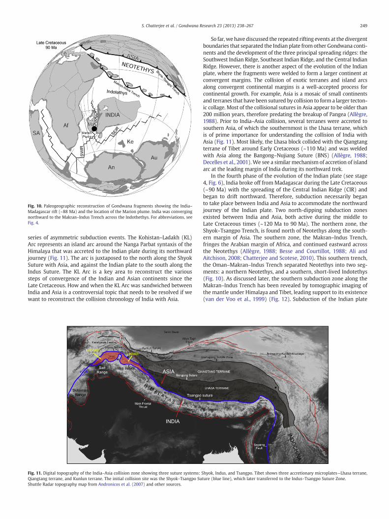
Fig. 10. Paleogeographic reconstruction of Gondwana fragments showing the India–Madagascar rift (~88 Ma) and the location of the Marion plume. India was convergingnorthward to the Makran–Indus Trench across the Indothethys. For abbreviations, seeFig. 4.
249S. Chatterjee et al. / Gondwana Research 23 (2013) 238–267
series of asymmetric subduction events. The Kohistan–Ladakh (KL)Arc represents an island arc around the Nanga Parbat syntaxis of theHimalaya that was accreted to the Indian plate during its northwardjourney (Fig. 11). The arc is juxtaposed to the north along the ShyokSuture with Asia, and against the Indian plate to the south along theIndus Suture. The KL Arc is a key area to reconstruct the varioussteps of convergence of the Indian and Asian continents since theLate Cretaceous. How and when the KL Arc was sandwiched betweenIndia and Asia is a controversial topic that needs to be resolved if wewant to reconstruct the collision chronology of India with Asia.
Fig. 11. Digital topography of the India–Asia collision zone showing three suture systems: SQiangtang terrane, and Kunlun terrane. The initial collision site was the Shyok–Tsangpo SuShuttle Radar topography map from Andronicos et al. (2007) and other sources.
So far, we have discussed the repeated rifting events at the divergentboundaries that separated the Indian plate from other Gondwana conti-nents and the development of the three principal spreading ridges: theSouthwest Indian Ridge, Southeast Indian Ridge, and the Central IndianRidge. However, there is another aspect of the evolution of the Indianplate, where the fragments were welded to form a larger continent atconvergent margins. The collision of exotic terranes and island arcsalong convergent continental margins is a well-accepted process forcontinental growth. For example, Asia is a mosaic of small continentsand terranes that have been sutured by collision to form a larger tecton-ic collage. Most of the collisional sutures in Asia appear to be older than200 million years, therefore predating the breakup of Pangea (Allègre,1988). Prior to India–Asia collision, several terranes were accreted tosouthern Asia, of which the southernmost is the Lhasa terrane, whichis of prime importance for understanding the collision of India withAsia (Fig. 11). Most likely, the Lhasa block collided with the Qiangtangterrane of Tibet around Early Cretaceous (~110 Ma) and was weldedwith Asia along the Bangong–Nujiang Suture (BNS) (Allègre, 1988;Decelles et al., 2001).We see a similar mechanism of accretion of islandarc at the leading margin of India during its northward trek.
In the fourth phase of the evolution of the Indian plate (see stage4, Fig. 6), India broke off from Madagascar during the Late Cretaceous(~90 Ma) with the spreading of the Central Indian Ridge (CIR) andbegan to drift northward. Therefore, subduction necessarily beganto take place between India and Asia to accommodate the northwardjourney of the Indian plate. Two north-dipping subduction zonesexisted between India and Asia, both active during the middle toLate Cretaceous times (~120 Ma to 90 Ma). The northern zone, theShyok–Tsangpo Trench, is found north of Neotethys along the south-ern margin of Asia. The southern zone, the Makran–Indus Trench,fringes the Arabian margin of Africa, and continued eastward acrossthe Neotethys (Allègre, 1988; Besse and Courtillot, 1988; Ali andAitchison, 2008; Chatterjee and Scotese, 2010). This southern trench,the Oman–Makran–Indus Trench separated Neotethys into two seg-ments: a northern Neotethys, and a southern, short-lived Indotethys(Fig. 10). As discussed later, the southern subduction zone along theMakran–Indus Trench has been revealed by tomographic imaging ofthe mantle under Himalaya and Tibet, leading support to its existence(van der Voo et al., 1999) (Fig. 12). Subduction of the Indian plate
hyok, Indus, and Tsangpo. Tibet shows three accretionary microplates—Lhasa terrane,ture (blue line), which later transferred to the Indus–Tsangpo Suture Zone.

250 S. Chatterjee et al. / Gondwana Research 23 (2013) 238–267
beneath the Indus Trench would give rise to the Kohistan–Ladakh(KL) Arc associated with spectacular obduction of deep oceaniccrust onto the Indian subcontinent (Tahirkheli, 1979).
The KL Arc now lies between the Indian and Asian plates, and isbounded by the Shyok Suture (SS) to the north and by the Indus Su-ture (IS) to the south (Fig. 11). The timing of the collision of the KLArc with India and with Asia, however, is controversial. Two hypoth-eses have been proposed for the origin of the KL Arc. Some authorshave suggested that the KL Arc first collided with Asia around95–75 Ma, well before its collision with India (Coward et al., 1987;Clift et al., 2002). In this model, Neotethys stretched in a north–south direction from India's northern (passive) margin to the Tethyantrench of the Asian margin in southern Tibet. It consisted of a singleNeotethyan oceanic plate that lay between India and Asia (Powelland Conaghan, 1973).
However, most of the researchers suggest that the KL Arc first collid-ed with India during the late Cretaceous (95–65 Ma) before India'sterminal collision with Asia (Reuber, 1986; Allègre, 1988; Van der Vooet al., 1999; Ali and Aitchison, 2008; Jagoutz et al., 2009a, 2009b;
Fig. 12. Cartoon showing continent–arc collision in cross-section and possible sequencestomographic imaging (Van der Voo et al., 1999). (A) During the Late Cretaceous the teczones when Neotethys comprises two oceanic plates, Indotethys and Neotethys. (B) AroIndotethys. (C) India moved northward with accreted KL Arc in its leading edge towards AEarly Eocene (~50 Ma), India collided with Asia with the disappearance of Neotethys andabout 2500 km crustal shortening with the rise of the Himalaya and Tibetan plateau. Tetrevealed from tomographic imaging of the mantle.Panel A–D was modified from Van der Voo et al. (1999), Allègre (1988) and Burg (2011).
Chatterjee and Scotese, 2010; Burg, 2011). In the early collision modelof the KL Arc, the Tethyan Ocean between India and Asia is split intotwo oceanic plates by the Indus Suture: the northern Neotethys, andthe newly identified southern, short-lived Indotethys. Both subductionzones, the Makran–Indus Trench and Shyok–Tsangpo Trench were ac-tive during the middle to Late Cretaceous (Besse and Courtillot, 1988)(Fig. 10).
Combined evidence from geochronology, paleomagnetism, tomo-graphic imaging, and paleontology along the Makran–Indus SutureZone suggests that India first collided with the Kohistan–Ladakh Arcduring the Late Cretaceous. The Kohistan–LadakhArc represents a com-plete section of an oceanic arc, with rocks frommantle to upper crustalvolcanic and sedimentary levels exposed (Burg, 2011). Sedimentary se-quences (Yasin group) of Aptian–Albian age (b120–99 Ma) indicatethat formation of this arc began in the Early Cretaceous (Pudsey,1986). The bulk of igneous framework of the arc formed in the LateCretaceous (90–100 Ma) (Petterson andWindley, 1985). Recent paleo-magnetic data suggests that in Late Cretaceous time, the KL Arc occu-pied a position close to the Equator not far from the Indian plate
of plate tectonic events in the evolution of the Kohistan–Ladakh arc (A–D) based ontonic setting of the Kohistan–Ladakh arc lay between two north-dipping subductionund ~85 Ma, India collided with the Kohistan–Ladakh arc with the disappearance ofsia during the Late Cretaceous–Paleocene time at a superspeed of 15 cm/year. In thethe speed was slowed down to 5 cm/year. (D) Subduction of India under Asia causedhyan subduction zone remnants from the Neotethys and Indothethys (I and II) were

Fig. 13. Paleogeographic map showing the collision of the Indian plate with theKohistan–Ladakh island arc during the Late Cretaceous time along the Indus Trench(~80 Ma). For abbreviations, see Fig. 4.
251S. Chatterjee et al. / Gondwana Research 23 (2013) 238–267
(30°S). On the other hand, the Lhasa block was more than 3000 kmnorth (20°N) (Khan et al., 2009). This geographic proximity of the KLArc with India clearly supports that the arc was sutured to India first(~85 Ma), and then welded to Asia later (~50 Ma). This early collisionmodel of the KL Arcwith the India is consistentwith tomographic imag-ing of the mantle (down to ~2000 km) under the India–Tibet collisionzone, which identified the obducted oceanic slabs of the Indotethys(Van der Voo et al., 1999) (subduction zone II in Fig. 12). The continuityof the KL Arc ophiolite westward with contemporaneous Semailophiolite in Oman points to the existence of a continuous,Tethys-wide intraoceanic subduction zone during the Cretaceous.Arabia and India collided with the Oman–KL arc approximately 85 Mawith consequent ophiolite obduction and slab break off (Powell, 1979;Besse and Courtillot, 1988; Dilek and Furnes, 2009; Chatterjee andScotese, 2010).
Radiometric (Jagoutz et al., 2009a, 2009b) and paleontologic (Baxteret al., 2010) ages from theKLArc support an earlier collision event. EarlyCretaceous radiolarians have been recovered from the Indotethyansediments associated with the Ladakh volcanic activity, indicating thatIndotethys was in existence for most of the Cretaceous (Baxter et al.,2010).
If India were isolated as an island continent as the late collisionmodel predicts, India should have produced a highly endemic LateCretaceous vertebrate assemblage during its long isolation. To thecontrary, Late Cretaceous Indian vertebrates are cosmopolitan andshow close faunal similarities with those of other Gondwana frag-ments such as Africa and South America. We prefer the early collisionmodel, because dinosaur biogeography supports its existence. The KLArc restored the long isolation of India temporarily as reflected by thehomogenous Maastrichtian fossil vertebrates. The KL Arc formed acorridor for migration of several groups of Maastrichtian dinosaurssuch as abelisaurs and titanosaurs between India and Africa thatclearly indicates that India reestablished its contact with Africa duringthe Late Cretaceous time (Chatterjee and Scotese, 2010).
A synthesis of the possible tectonic evolution of the Kohistan–Ladakh collision zone is shown in Fig. 12 (Allègre, 1988; Van derVoo et al., 1999; Ali and Aitchison, 2008; Jagoutz et al., 2009a,2009b; Burg, 2011). Prior to the collision of the KL Arc, the northwardmovement of India with respect to Asia reflects the subduction zonealong the Makran–Indus Trench at about 120 Ma (Schettino andScotese, 2005). As India (SL–I–LR) moved northward, subduction ofthe Indotethyan ocean floor beneath the KL Arc and its marginalbasin, was followed by the collision, obduction, and suturing of thearc with the Indian continent during the Late Cretaceous (~85 Ma).
The KL Arc evolved as an obducted intra-oceanic island arc above anorth-dipping subduction during the Late Cretaceous time (~85 Ma)in the equatorial area of the Neotethys Ocean (Tahirkheli, 1979;Reuber, 1986; Allègre, 1988; Van der Voo et al., 1999; Burg, 2011).The subduction of the Indotethys lithosphere along the Indus Sutureunderwent a rifting episode to produce the voluminous Chilas–Ladakhintrusion (Khan et al., 1989; Schaltegger et al., 2002). The KL Arc is char-acterized by remnants of an intraoceanic arc magmatic rock formedduring Late Cretaceous times. These magmatic rocks range in age from110 to 90 Ma, based on radiometric data both in Ladakh (Honegger etal., 1982) and Kohistan (Treolar et al., 1989). These oceanic terranesare mainly remnants of an arc-series, reflecting intra-oceanic subduc-tion of the Indotethys. Continuing subduction resulted in complete con-sumption of the leading oceanic edge of the Indian plate, ultimatelyresulting in obduction of the arc onto the Indian continent at the siteof the Indus Suture (Burg, 2011) (Fig. 12A).
The KL Arc was accreted to the Indian plate around 70 Ma andformed a biotic dispersal corridor for the migration of Gondwana di-nosaurs during the Maastrichtian (Fig. 13) (Chatterjee and Scotese,2010). It preserves a geochemical record that spans arc inception,arc thickening, and subsequent uplift (Jagoutz et al., 2009a, 2009b;Burg, 2011). It is an eastward extension of the Makran Arc, and its
Cretaceous ophiolites represent remnants of the lost ocean of theIndotethyan seaway (Besse and Courtillot, 1988; Dilek and Furnes,2009; Chatterjee and Scotese, 2010). Subsequently, the KL Arc wassplit from the Markran Arc during the KT boundary time along theChaman Transform Fault and moved northward at a rapid rate withrespect to Asia. The KL Arc collided and sutured against the Indianplate in the Late Cretaceous with the result that the arc was thenconverted into the leading edge of the Indian plate, the future NWsyntaxis or indenter that would play a major role in the evolution ofthe Himalaya–Tibet orogeny (Fig. 12C–D).
7.5. Limited separation of Seychelles–Laxmi Ridge from India(~75–68 Ma)
Recent identification of seafloor spreading magnetic anomalies inthe Laxmi and Gop basins lying between the Laxmi Ridge in the Ara-bian Sea and the Indian continent necessitates a change in the recon-structions of the western margin of the Indian plate (Bhattacharya etal., 1994). Associated with a spreading center, a major pre-Deccanvolcanic center was located in the Laxmi and Gop basins, north ofthe Laxmi Ridge. This 7-km-thick plateau of extrusive basalt, calledSomnath volcanic platform or Somanth Ridge, fills the basementof the offshore Indus Basin around the Saurasthra Arch, which isinterbedded with Late Cretaceous–Paleocene marine sediments(Fig. 14A) (Carmichael et al., 2009; Yatheesh et al., 2009). Becauseof its offshore location, the Somnath flood basalt is poorly knownwhen compared to the nearby Deccan Traps. The chronology ofthese two spatially and temporally linked rifting and volcanic eventsalong the western margin of the Indian plate during the KT transitionis highly complex and needs to be untangled. This is especially impor-tant if we are to reconstruct the early opening of the Arabian Sea.
Around 75 Ma, the Arabian Sea opened in two phases of rifting andflood basalt volcanism within a period of less than 10 Ma (Fig. 14B, C)(Collier et al., 2008;Minshull et al., 2008). The first brief phase of riftingformed the failed Gop Rift at some time between 71 and 64 Ma, whenthe Laxmi Ridge–Seychelles (LR–S) fragment separated from India(SL–I–KL) (Talwani and Reif, 1998). This rift occurred just prior to theeruption of the flood basalts of Deccan Traps associated with Somnath

Fig. 14. (A) Location of the Laxmi Ridge, a continental sliver that separated from India around 70 Ma, probably induced by the Somnath volcanism. The spreading center, thePalitana Ridge was short-lived, created the Gop/Laxmi basin and the Laxmi Ridge was accreted to India. (B) Cartoon showing the first phase of rifting, the separation of LaxmiRidge–Seychelles block from India around 70 Ma; it was a failed rift; (C) around 65 Ma, the second rifting took place between Seychelles and Laxmi Ridge–India, which was linkedto Deccan–Reunion plume.Panel A was modified from Chatterjee et al. (2006), Calves et al. (2008), and Carmichael et al. (2009). Panels B and C were modified from Minshull et al. (2008).
252 S. Chatterjee et al. / Gondwana Research 23 (2013) 238–267
volcanism (Fig. 5). However, the spreading between the Laxmi Ridgeand India was short-lived and the Laxmi Ridge remained attached toIndia. A second rifting event created a sea-floor between the Seychelles(S) and the Laxmi Ridge–India (SL–I–LR–KL) block starting at 63.4 Ma.The Laxmi Ridge–Seychelles rift occurred around the time of the forma-tion of the Deccan flood basalts (~65 Ma), and the two events are gen-erally causally linked. Though the Gop rift margins show extensivemagmatism, the Seychelles–Laxmi Ridge rift margins are largelyamagmatic.
The Laxmi Ridge is an enigmatic NW–SE trending basement highin the Arabian Sea, about 700 km long and 100 km across, which isburied beneath the sediments of the Indus Fan. It is located about500 to 700 km off the west coast of India, continues northwards buttapers and bends to the west (Fig. 14A). Although the origin ofLaxmi Ridge is controversial, gravity and seismic data indicate thatit is a rifted micro-continental fragment that was separated fromthe Indian plate by an early phase of spreading (Talwani and Reif,1998). Between the Laxmi Ridge and the Indian continental shelf isa wide region, called Gop Basin and its southern extension Laxmi
Basin, whose genesis is important concerning the geodynamic evolu-tion of the Arabian Sea.
Magnetic anomalies indicate that Gop Basin opened between73 Ma to 68 Ma, which is older than the initial phase of the Deccanvolcanism (Malod et al., 1997; Collier et al., 2008). The PalitanaRidge has been identified as the extinct spreading center that createdthe Gop–Laxmi Basin (Yatheesh et al., 2009). A large pre-Deccan igne-ous province, the buried Somnath volcanic platform is composed ofdifferent volcano-stratigraphic edifices, which were formed around75–68 Ma in the offshore segment of western India north of thePalitana Ridge. The Somnath volcanics appear to be causally linkedwith the rifting of the Laxmi Ridge from India (Calves et al., 2011)(Fig. 14A). Most likely the rifting and spreading of the Gop Basinpredated the nearby emplacement of the Deccan Traps and wasshort-lived. The seafloor spreading died at the Gop Basin around68 Ma, when the Seychelles–Laxmi Ridge microplate became part ofIndia for a brief time. Subsequently, during the outburst of the Deccanvolcanism around 65 Ma, a new spreading center, the Carlsberg Ridgewould develop southwest of the Laxmi Ridge that would separate the

253S. Chatterjee et al. / Gondwana Research 23 (2013) 238–267
Seychelles microcontinent from India, while the Laxmi Ridge remainedattached to India (SL–I–LR–KL complex).
7.6. Separation of the Seychelles from India (~65 Ma)
The abortive phase of rifting between the Laxmi Ridge and Indiawas soon followed by the second phase of rifting and seafloor spread-ing between the Seychelles (S) and India (SL–I–LR–KL) complex,which was coeval with the main phase of the Deccan Trap eruption(Fig. 14C). The Deccan volcanic province is one of the largest volcaniceruptions in Earth history and has received global attention for its pos-sible role in KT boundary mass extinction. The outpouring of the enor-mous continental flood basalts of the Deccan Trap, spreading over vastareas of western and central India and the adjoining Seychelles, covermore than 1,500,000 km2, with the greatest thickness of about 3.5 kmalong theWestern Ghats escarpment (Figs. 5, 15) (Baksi, 1994). Recentworks (Chenet et al., 2007; Keller et al., 2011) recognize three districtpulses of Deccan volcanism: the initial pulse of eruption (phase-1) oc-curs in the late Maastrichtian base of C30n (~68.5 Ma), and is repre-sented by Sarnu–Dandali volcanics in Barmer District and Mundwaravolcanics in Sirohi District. Both occur as isolated outcrops in Rajasthanin northern India (Basu et al., 1993). Khan et al. (1999) suggested thatthe Parh Group of volcanics of northeastern Baluchistan (Pakistan)might represent the earliest (~67.5–75.9) and northernmostmanifesta-tion of the phase-1 of Deccan volcanism. The first phase of volcanismwas small, initiated on the Neotethyan floor of Parh and continuedsouthward with sporadic eruptions in Rajasthan, which was followedafter a quiescence of 2 to 3 Myr by the main phase of Deccan volcanismspanning the KT transition.
Themain pulse of volcanism occurs in chron 29R and ending at theKT boundary (~65 Ma) in the main Deccan volcanic province in thewestern and central part of the Indian shield. The main phase of Dec-can volcanics accounts for about ~80% of all the traps. In Jhilmili re-gion of central India, a planktic foraminifer assemblage of EarlyDanian age has been encountered above the lower Deccan basalticflow. The last pulse erupted in the upper part of chron 29R andended within chron 29N in the Early Danian (~62.3 Ma). The expo-sures of the last phase of Deccan volcanism have been traced east-wards to the Rajahmundry area of the Krishna–Godavari Basin and
Fig. 15. Paleogeographic reconstruction of India–Seychelles at the KT boundary(~65 Ma) time. India–Seychelles separation is generally linked to the Reunion plume(Chatterjee et al., 2006). For abbreviations, see Fig. 4.
out into the Bay of Bengal. These traps were overlain by Early Danianage of planktic foraminifera (Keller et al., 2011). The intercanyonflows of the Deccan lava along the interconnected rift basins of Son–Narmada, Cambay, and Godavari drainage systems may explain theenormous areal distribution of Deccan Traps (Chatterjee and Rudra,1996).
Themain pulse of the Deccan basalts erupted very rapidly—probablywithin 1 Myr—at the KT boundary (~65 Ma), when western India layabove the Réunion hotspot, which is now located east of Madagascar(Courtillot, 1999; Chenet et al., 2007). It was a major tectonic event,which produced one of the largest flood basalt provinces on the Earth'ssurface. However, the relationship of the India–Seychelles rift and Dec-can volcanism is far more complex than the traditional explanation.
When the Deccan Traps erupted, active seafloor spreading wasgoing on in the Mascarene basin, as the Seychelles–Laxmi Ridge–India block drifted away from Madagascar (Fig. 14). Consequently,the plume–rift interaction is thought to have given rise to the rapideruption of prodigious volumes of Deccan basalt (~106 km3;Courtillot et al., 1986; White and McKenzie, 1989). At the KT bound-ary time, major reorganization and a rift jump occurred in the IndianOcean shortly after the emplacement of the Deccan Traps (Malod etal., 1997). During the eruption of the Deccan basalts, spreading diedout at the Mascarene basin at the time of chron 28, when the CentralIndian spreading ridge in the Mascarene basin jumped 500 km north-ward to a new location between the Seychelles and the Laxmi Ridgeto form the Carlsberg Ridge (Schlich, 1982). At the same, the PalitanaRidge became extinct in the Gop Basin and probably jumped west-ward to the Carlsberg Ridge (Calves et al., 2011). The beginning ofseafloor spreading at the Carlsberg Ridge is well constrained by mag-netic anomalies at 63.4 Ma (Collier et al., 2008). Thus the eruption ofthe Deccan basalts coincided with the separation of the Seychellesfrom the Laxmi Ridge–India block and followed by rapid seafloorspreading (White and McKenzie, 1989). As a result of this ridgejump, the Seychelles was transferred to the African plate (Fig. 16).
The Deccan flood basalts were formed along the two sides of therifted margins, western India and eastern Seychelles and its submergedSaya de Malha bank and were implicated for the India–Seychelles rift
Fig. 16. Paleogeographic reconstruction of India in relation to other Gondwana continentsduring the Cretaceous–Tertiary boundary (~65 Ma). The Reunion plume (~65 Ma), isgenerally linked to the separation of the Seychelles from the Laxmi Ridge–India block.For abbreviations, see Fig. 4.

254 S. Chatterjee et al. / Gondwana Research 23 (2013) 238–267
(White and McKenzie, 1989). The age of this magmatism in Seychellesis coeval with Deccan Traps, ranging from 66 Ma (Croxton et al.,1981) to 64 Ma (Duncan and Hargraves, 1990). As the breakup be-tween Seychelles and India progressed and India moved northward, ahotspot track formed underlying the Laccadive, Maldive, and Chagosislands; the Mascarene Plateau; and the youngest volcanic islands ofMauritius and Réunion (Duncan, 1981) (Fig. 5).
In spite of close temporal association between Deccan Traps andthe Seychelles–Laxmi Ridge rifting, the lack of volcanism at the op-posing continental margins of Laxmi Ridge and Seychelles is anoma-lous. Moreover, the continental rift between Seychelles and Indiawas approximately 1000 km from the Reunion hotspot at the timeof breakup, and the oceanic crust seaward of the Seychelles andLaxmi Ridge is thinner than expected. The separation of the Seychellesfrom the Laxmi Ridge provides a new twist that when two parts ofcontinents break apart, there are not always accompanying massivevolcanic eruptions. Perhaps, the Seychelles–Laxmi Ridge separation isa passive rift lying above melt-depleted mantle that led to non-volcanic (magma-poor)margins (Armitage et al., 2010).Most likely, vo-luminousmagmatism in the neighboring Gop rift 6 million years earlierpartially exhausted the supply of magma. When the rifting migrated tothe new spreading center at the Laxmi Ridge–Seychelles basin at 63 Ma,the thermal anomaly had cooled down, and the mantle was depleted.These factors may explain why the Seychelles–Laxmi Ridge rifting wasnot associated with magmatism. Despite the apparent proximity ofthis rift margin to a thermal plume, thin oceanic crust can be generatedby stretching and rifting before the arrival ofmantle plume (Armitage etal., 2010). After the ridge jump, Seychelles became fixed to Africa,resulting in a shift of the spreading axis as India (SL–I–LR–KL) separatedfrom the Seychelles.
7.7. Acceleration of the Indian plate during the Late Cretaceous–EarlyEocene and the subduction of the Neotethys
Duringmost of the Cretaceous, the Indian platemoved northward ata rate of 3–5 cm/year. Plate reconstructions based on paleomagneticdata suggest that the Indian plate suddenly accelerated to 20 cm/yearfrom Late Cretaceous (~67 Ma) to Early Eocene (~50 Ma) (Fig. 15).During this time interval India moved rapidly northward between twogreat transform faults, the Ninety East Ridge on the east and Owen–Chaman Fault on the west. Some 52 million years ago India slowed to5 cm/year during the initial stage of collision with Asia and maintainedthis slow speed throughout its convergence (McKenzie and Sclater,1971; Patriat and Achache, 1984; Copley et al., 2010).
The rapid acceleration of India during the Late Cretaceous–Paleoceneinterval makes India unique among the fragments of Gondwana, but thecause of this rapid motion remains unclear. Negi et al. (1986) suggestedfrom heat flow data that the Indian lithosphere was greatly thinned(about one third the thickness of other Precambrian shields), abnormallyhot, and lighter during this interval of acceleration, probably triggered bythe Deccan volcanism, which had important consequences for mantlerheology. It reduced the drag of the lithosphere against the astheno-sphere, resulting in faster northward movement of the Indian plate.According to these authors, the Indian plate decoupled itself from thedeeper interior to become more mobile. A similar model for a thinnerlithosphere of the Indian plate, about 100 km deep, has been suggestedrecently that may account for its rapid drift (Kumar et al., 2007). In thismodel, the Indian plate was thinned by the plume activities (such asMarion, Kerguelen, and Reunion). The loss of the lithospheric rootsmight have been the reason for its rapid acceleration. India's lithosphereis only half as thick as other Gondwana continents, which is the reasonfor its high-speed collision with Asia. Recently, Cande and Stegman(2011) suggested the push force of the Reunion plume head mighthave caused the sudden acceleration of the Indian plate.
After the KT extinction, the Indian plate continued to move north-ward, carried the accreted Kohistan–Ladakh Arc along its northern
edge, severed its connection with the Oman arc along the Quetta–Chaman fault, and became an island continent. It carried its endemicbiota like a “Noah's Ark” (McKenna, 1973; Chatterjee and Scotese,2010). India continued to move northward with the accreted KL Arc(SL–I–LR–KL) across the Neotethys (Fig. 16). Subduction of theNeotethyan ocean floor beneath Asia was followed by an initial colli-sion of the arc with Karakoram along the Shyok Suture in EarlyEocene time (~50 Ma). Continuing convergence led to complete su-turing of accreted India with Asia along the Shyok–Tsangpo SutureZone (Figs. 12B–C, 18). The KL Arc was wedged between India andAsia as a result of the closure of the Neotethys (Bard, 1983). Today,the KL Arc is located on the northern edge of the Indian subcontinenton either side of the Nanga Parbat and is bounded by two suturezones: the Shyok Suture (SS) to the north and the Indus Suture (IS)to the south (Bouihol et al., 2011; Burg, 2011) (Fig. 11).
8. Cretaceous climate
The Early Cretaceous was a mild “Ice House” world. There wassnow and ice during the winter seasons, and cool temperate forestscovered the polar regions. During the Late Cretaceous the global cli-mate was warmer than today's climate, where the average annualtemperatures at the Equator topped 38 °C. No ice existed at thepoles. During the much of the Cretaceous India resided in the South-ern Hemisphere as an island continent, encircled by the ocean. Muchof the Tethyan oceanic crust advancing with India from the SouthernHemisphere was covered by a thick carbonate platform deposit,which at the subduction zones released a large flux of CO2 in the at-mosphere to trigger global warming (Kent and Muttoni, 2008).
During the Early Cretaceous (~140 Ma) the center of the Indiansubcontinent was situated at 40°S and was rotated 90° clockwisewith respect to the present orientation. Situated in between the Sub-tropical Arid and Temperate Climate Belt, the overall precipitationwas low to medium (1.5 cm/month to 12 cm/month). According toFOAM paleoclimate simulations (Scotese et al., 2007, 2008, 2009,2011; Goswami, 2011) (Fig. 17A), the western part of the presentsubcontinent India was relatively dry, while the eastern part hadhigher precipitation. The mean annual temperature ranged between17 °C (presently in the western part of the Indian subcontinent)and −3 °C (eastern India).
During the Cenomanian–Turonian time (~90 Ma), which isthought to be one of the warmest of all geologic periods, the Indiansubcontinent was located at 35°S. The annual mean temperatureranged between 12 °C in the south and 28 °C in the northeast. Meanannual precipitation ranged between 5 cm/month and 13 cm/month.The present day northwestern province of the Indian subcontinentwas strictly in the Subtropical Arid Belt and had very low annual precip-itation (Fig. 17B).
In the latest Cretaceous (~70 Ma), the Indian subcontinent haddrifted northward to 25°S (Fig. 15B). India lay between the EquatorialRainy Belt and Subtropical Arid Belt, the mean annual temperatureranged between 17 °C and 26 °C (Scotese et al., 2007, 2008, 2009,2011; Goswami, 2011). The eastern flank of the subcontinent wasfor the first time drier than the western part. The average mean annu-al precipitation was estimated to be between 20 cm/month (in thewestern part of the subcontinent) and 6 cm/month (in the easternpart of the subcontinent).
9. India–Asia collision and Cenozoic evolution of theHimalayan–Tibetan orogeny
After the KT extinction, India had become an island continent mov-ing at a rapid rate of ~20 cm/year in relation to Africa. It enjoyed itssplendid isolation during the Paleocene until it collided into Asia inEarly Eocene and slowed down to 5 cm/year (Copley et al., 2010). Thecollision of India with Asia has been extensively studied and refined

Fig. 17. Mean annual precipitation and mean annual temperature maps of the Indian plate during the Cretaceous time. (A) Early Cretaceous map (~140 Ma). (B) Late Cretaceousmap (~90 Ma).
255S. Chatterjee et al. / Gondwana Research 23 (2013) 238–267
during the past 40 years; yet many of the complexities of the evolutionof this orogenic system remain poorly understood. A synopsis of the ini-tial collision and post-collisional events is summarized below.
Fig. 18. Paleogeographic reconstruction showing the position of India and other Gondwanacontinents during the Early Eocene (~50 Ma)when India made the initial collisionwith Asiaon its northward journey with the closure of the Neotethys. The Kohistan–Ladakh arc madethe first contact with Asia. For abbreviations, see Fig. 4.
9.1. India–Asia collision and the evolution of the Indus–Tsangpo SutureZone (~50 Ma)
The most spectacular example of continental collision event is theconvergence of India with Asia that occurred in Early Eocene (~50 Ma)(Molnar and Tapponnier, 1977; Allègre et al., 1984). This collisionresulted in the closure of Neotethys and ended the rapid northwardflight of India (Fig. 18). The collision between India and Asia took placealong three suture zones: the Indus, Shyok, and Tsangpo (Fig. 11). Thesouthern margin of Tibet maintained relatively stable northern hemi-sphere paleolatitudes during the Early Cenozoic (Achache et al., 1984).Since Asia was more or less stationary, the Neotethyan seafloorsubducted along a northward dipping Shyok–Tsangpo Suture Zonealong the south shore of Lhasa block, which ultimately led to the forma-tion of the Gangdese batholith in the Transhimalayan belt (Allègre et al.,1984). It has been estimated that at least 4000 to 7000 km of theNeotethyan oceanic lithosphere was subducted beneath the southernmargin of Asia during the Cretaceous and early Cenozoic (Van der Vooet al., 1999).
Does the Indus–Tsangpo or the Shyok–Tsangpo Suture Zone markthe site of the final India–Asia collision? The relative and absolutetiming of the formation of these sutures—the Indus, Shyok, andTsangpo—has been discussed and debated for decades. Much of thedebates center on the sequence and timing of the collision of theKohistan–Ladakh Arc with India and Asia respectively. If the KL arccollided with India first around 85 Ma along the Indus Suture, asdiscussed earlier (Reuber, 1986; Allègre, 1988; Van der Voo et al.,1999; Ali and Aitchison, 2008; Jagoutz et al., 2009a, 2009b;Chatterjee and Scotese, 2010; Burg, 2011), the Shyok Suture becomesthe northern branch of the Indus–Tsangpo Suture Zone, that is to say,the initial locus for the collision (Jagoutz et al., 2009a, 2009b)(Fig. 11). The Shyok Suture is generally considered to be the collisionzone between the Kohistan–Ladakh Arc and the Karakoram Moun-tains that formed during the collision of India with Asia in Eocene

256 S. Chatterjee et al. / Gondwana Research 23 (2013) 238–267
(around ~50 Ma). In the south, the KL Arc is attached to the Indiancontinent by the Indus Suture Zone. However, the Shyok SutureZone has no lateral equivalent east of the Karakoram fault zone. Thesubduction at the Shyok–Tsangpo Suture (STS) continued as Indiacame into contact with Asia around ~50 Ma.
In our view, the Shyok–Tsangpo Suture Zone marks the initial siteof the India–Eurasia collision, which later shifted to the Indus–Tsangpo Suture Zone with intracontinental subduction along thisreactivated suture. Geological evidence from Karakoram suggeststhat the Shyok subduction zone was locked after the closure of theNeotethys so the leading edge of continental parts of India began tosubduct along the reactivated Indus–Tsangpo Suture Zone duringthe post-collisional phase (Burg, 2011). The orogenic deformationfront has moved southward from the initial collision contact at theShyok Suture to the Indus Suture. The Indus–Tsangpo Suture Zone de-fines the areas of final collision between the Indian plate and the Ti-betan Lhasa block, and marks the zone along which the NeotethysOcean was consumed by subduction processes. In the west, with theclosure of the Neotethys, the Kohistan–Ladakh arc was carried tothe Shyok Trench, and was added to the overriding Lhasa block(Burg, 2011). With the closure of the Neotethys, the buoyant Indianplate could not be subducted. As a result subduction slowed, and sodid the associated igneous activity along the southern margin of theTibet. As India collided with Tibet, these two continents were weldedtogether along a zone marking the former site of subduction.
The Indus–Tsangpo Suture (ITS) zone reveals more complexitythan previously recognized and contains two superimposed subduc-tion events: the earlier event (~85 Ma) marks the origin of theKohistan–Ladakh Arc; the latter tectonic event defines the zone ofcollision between the Indian and Eurasian plates (~50 Ma). The ITScan be traced discontinuously for over 3000 km from Kohistan inPakistan in the west to the NE frontier region of India–Myanmar(Gansser, 1964, 1966, 1980). It crops out in the upper valleys of theIndus and Tsangpo (Brahmaputra) rivers, and is composed of deep-sea and flysch sedimentary rocks, ultrabasic and submarine volcanicrocks, and plutonic intrusions (Fig. 11). The structure of the ITS is com-plex and contains three distinct components from north to south: theChilas and Dras volcanics, the relicts from the Kohistan–Ladakh arc;the ophiolite mélange from the Neotethys oceanic crust; and the6-km-thick Indus molasses of the Siwalik group along the foredeep ofthe rising Himalaya, which are post-collisional continental clasticsequences derived mainly from the Ladakh batholith (Dezes, 1999).
The age of the Tsangpo Suture remains uncertain, with recentestimates ranging from 70 to 35 Ma, while the age of the Indus Sutureis well constrained to ~50 Ma, and coeval with the end of marine sed-imentation south of the Tsangpo Suture (Jagoutz et al., 2009a, 2009b).This corresponds to the marked slowdown in the northward migra-tion of the Indian plate (5 cm/year) because of buoyancy resistanceat this time (Klootwjik et al., 1985). The timing of the closure of theNeotethys along the Indus–Tsangpo Suture and the India–Asia colli-sion is well constrained by paleomagnetic, sedimentologic, and pale-ontologic data at ~50 Ma (Molnar and Tapponnier, 1977; Allègre etal., 1984; Molnar, 1986). The rapid deceleration of the Indian platefrom 20 cm/year to 5 cm/year is normally suggested as the initialtiming for the onset of the India–Asia collision due to combinationof orogeny-related increased trench resistivity and decreased slabpull due to continental subduction (Copley et al., 2010; Douwe etal., 2011). As the Neotethyan Ocean contracted, marine transgressionwas widespread. This is witnessed by the presence of EoceneNummulitic Limestone (~54 Ma) far south of the Neotethys (Powelland Conaghan, 1973).
The closure of the Neotethys is marked by the change from marineto terrestrial conditions displayed by sediments in the ITS zone between54 and 50 Ma. The northward movement and counter-clockwise rota-tion of the Indian plate slowly closed the Neotethys around 50 Ma. InLadakh the youngest marine sediments are Paleocene to Lower Eocene
limestones, which are succeeded by continental red sandstones,suggesting that the Neotethys Ocean must have closed by 50 Ma withsouthward obduction of the Indus–Tsangpo Suture Zone (Searle, 1991).
Vertebrate fossils provide an independent clue to the initial timingfor the India–Asia collision event in Early Eocene (~50 Ma) time,when India had established subaerial contact with the Asian main-land leading to a dispersal corridor between the two landmasses. Agreat faunal interchange took place between India and Asia duringthe initial collision and coincided with the Paleocene–Eocene Ther-mal Maximum (PETM). This is reflected by the start of terrestrial de-position in several regions of Indo-Pakistan including the CambayFormation of Gujarat, coal-bearing Ghazij Formation of Baluchistan,and Subathu Formation in Jammu and Kashmir region, which haveyielded prolific vertebrate fossils. These sediments were derivedfrom a mixture of sedimentary, volcanic and ophiolite rocks fromthe Indus–Tsangpo Suture during the Early Eocene indicating thetiming of the collision and development of foreland basin (Najmanand Garzanti, 2000). A biotic corridor between India and Asia wasestablished that enabled hordes of Asian vertebrates (such as turtles,crocodiles, and a variety of marsupials, placental mammals) to sweepinto India in the Early and Middle Eocene time. Similarly, other groupof vertebrates of Gondwanan origin (such as squamates and crocodil-ian reptiles, and marsupial and placental mammals) migrated to Asiafrom India during this time (Chatterjee and Scotese, 2010). The sub-stantial faunal exchange of Eocene vertebrates between Asia andIndia supports the timing of the initial collision event.
9.2. Himalaya: post-collisional tectonics (~50 Ma to Holocene)
The plate reconstruction at the time of collision (~50 Ma) placesthe Indian subcontinent ~2500 km south of its current position(Besse et al., 1984). Three mechanisms have been suggested to ex-plain the 2500 kmmissing “gap” between India and Asia: (1) subduc-tion of the continental Indian plate (Greater India) below the TibetanPlateau; (2) crustal shortening of the leading edge of the Indian plateby thrusting and folding with the rise of the Himalaya; and (3) extru-sion tectonics in east-central Asia, where Indochina and China blockswere squeezed eastwards (Gansser, 1966; Molnar and Tapponnier,1977; DeCelles et al., 2001).
Continental collision between India and Asia, from Eocene to Ho-locene, resulted in profound crustal shortening and thickening thatproduced the Himalaya and Tibetan Plateau. The Himalayan orogenis the type example of continent–continent collision (Dewey andBird, 1970; Molnar and Tapponnier, 1977; Molnar, 1986). TheHimalaya, the most stunning mountain range in the world, forms aspectacular arc of 2500 km along the leading margin of the Indianplate and are bounded by the Nanga Parbat syntaxis in the northwestand the Namche Barwa syntaxis in the northeast, with an averagewidth of 250 km (Fig. 11). The Himalaya was uplifted, folded, andcomplexly thrusted in response to the India–Asia collision duringthe Cenozoic. It comprises a series of lithologic and tectonic terranesthat run parallel to the mountain belt (Gansser, 1964, 1966). Fromnorth to south they are as follows: (1) the Trans-Himalayan batho-liths; (2) the Indus–Tsangpo Suture Zone; (3) the Tethyan (TibetanHimalaya); (4) the Higher (Greater) Himalaya; (5) the Lesser(Lower) Himalaya; and (6) the Sub-Himalaya (Fig. 19).
After the Eocene closure of Neotethys, deformation spread south-ward across the Tibetan–Tethys Zone into the Higher Himalaya. Themain Himalayan range has not developed from the Neotethyan geo-syncline, but rather is of intracratonic origin. It is only in the TibetanHimalaya that Neotethyan sediments are preserved. The TibetanHimalaya is about 40 km wide at an altitude of 4000 m, consistingof fossiliferous shallow-water marine sediments of Proterozoic toEocene age. Due to continuing convergence of India with Asia, thenorthern edge of the Indian plate was fractured, thrusted, anduplifted, resulting in the formation of the Himalaya and the associated

Fig. 19. Himalayan orogen. (A) Morphotectonic zones of the Himalayan arc, showing its asymmetric plan pattern in relation to India and associated suture and thrust zones fromnorth to south: ITS, Indus–Tsangpo Suture; STDS, South Tibet Detachment System; MCT, Main Central Thrust; MBF, Main Boundary Fault; MFT, Main Frontal Thrust. (B) Schematiccross-section of the Himalaya showing different morphotectonic zones and thrusts.After Chatterjee (1992).
257S. Chatterjee et al. / Gondwana Research 23 (2013) 238–267
structure. The higher, lesser, and Sub-Himalayas are thus slices of theold Indian shield that have stacked over each other by transfer along aseries of southward verging thrusts.
The post-collisional tectonics is best expressed along the HigherHimalaya region (or Central Crystalline axis), which is about140 km wide, forming the backbone of the Himalayan orogen. It con-sists of snowcapped peaks comprising all 10 of world's highest peaksincluding Mount Everest (8840 m) and K2 (8611 m). The HigherHimalaya consists of Precambrian gneiss overlain by Early Paleozoicand Mesozoic sediments of Tethyan origin, which were originally lo-cated on the northern margin of India (Gansser, 1964). The contactbetween the Tethys Himalaya and the Higher Himalaya is markedby a series of north-dipping faults and shear zones called the SouthTibetan Detachment System (STDS), which probably formed duringthe Miocene time and a played critical role in the Neogene evolutionof the Himalayan orogen (Burchfiel et al., 1992). The STDS extends~2500 km along strike from Zanskar in NW India to ArunachalPradesh in NE India.
South of the Higher Himalaya, the Lesser or Lower Himalayastretches in parallel with an average height of 3900 m to 4500 m, anda width ranging from 32 to 80 km. The Lesser Himalaya consists mainlyof Late Proterozoic to Early Cambrian detrital sediments derived fromthe passive Indianmargin intercalated with some granites and acid vol-canics of Early Proterozoic age (Frank et al., 1977). These sedimentswere thrust over along theMain Boundary fault (MBT) and often appearas tectonic windows (Gansser, 1964, 1966) (Figs. 19, 20).
South of the Lesser Himalaya lies the Sub-Himalaya that forms thefoothills of the Himalayan range with an average height of 900 m to1200 m, and width ranging from 8 to 80 km. The sediments containthe Eocene Sabathu Limestone, followed by the Miocene to Pleistocene
molasse deposits, known as the Muree and Siwalik formations, whichare rich in vertebrate fossils. Sub-Himalayan rocks have been overthrustby the Lesser Himalaya along the Main Boundary fault (MBF) that de-veloped during the Pliocene time. In turn, the Sub-Himalaya is thrustalong the Main Frontal Thrust (MFT) over the Holocene alluvium ofthe Ganga Basin deposited by the Himalayan river system (Fig. 20A).
9.3. Tectonic evolution of the Himalaya
The tectonic evolution of the Himalaya has been reconstructedthrough painstaking fieldwork spanning a century by a group of inter-national earth scientists, integrating mapping, structural geology,plate tectonics, and aided by satellite imageries. However, in recenttimes, tomographic imaging has provided a new dimension to the in-terpretation of the subsurface structure of the Himalaya–Tibetanorogen that reveals a cross-sectional view of the crust and theupper mantle. Seismic tomography is an imaging technique thatuses seismic waves generated by earthquakes and explosions to cre-ate computer-generated 3-D images of Earth's interior. Since theHimalaya–Tibetan orogen is seismically active, tomography has pro-vided an important tool in interpreting the subsurface structure.
Two models have been proposed to explain the tectonics of theHimalaya: (1) a traditional thrust belt model that typically developsduring plate collisions inwhich folding and faulting in the upper crust ac-commodate deformation and localized ductile shear in the lower crust(Gansser, 1964, 1966; Dewey and Bird, 1970; Powell and Conaghan,1973; Molnar and Tapponnier, 1977; DeCelles et al., 2001); and (2) achannel-flow model revealed from tomographic imaging of the mantleunder India and Tibet in which the subducting Indian plate underneathTibet undergoes partial melting and flows southward, directly in the

Fig. 20. (A) Tectonic interpretation of the Himalayan orogeny using high-resolution seismological and tomographic data showing north-vergent thrust systems in the Himalayasuch as MFT, MBT, and MCT producing a series of continental slices and moving southward in relation to Indian mantle; the lower part of the Indian lithosphere along the MainFrontal Thrust underplates the Himalaya and Tibet up to 31°N, and almost extends to the middle part of the Lhasa block. However, the faulting at STDS is anomalous; it is a normalfault dipping northward below the Tibet and undergoes melting. Both MCT and STDS facilitated the channel flow extrusion of the Higher Himalaya; (B) five main stages in theevolution of the India–Tibet collision.Panel A was simplified from Hodges (2006b) and Nabalek et al. (2009). Panel B was modified from Klootwjik et al. (1985).
258 S. Chatterjee et al. / Gondwana Research 23 (2013) 238–267
direction of least resistance, toward the Himalayan mountain front(Beaumont et al., 2001; Hodges, 2006a, 2006b). Here we discuss thethrust belt model first, followed by a discussion of the channel flowmodel.
The collision of the Indian plate with Asia is the reason for the riseof the Himalaya and the uplift of the Tibetan Plateau. Several modelshave been proposed for the evolution of the Himalaya that are basedon collision tectonics (Gansser, 1964, 1966; Le Fort, 1975; Molnar andTapponnier, 1977; Patriat and Achache, 1984). Let us start from theIndus–Tsangpo Suture, the collision zone between India and Asia.South of the ITS, virtually all of the sedimentary rock of the TethysHimalaya appears to have been part of the Indian subcontinent orits northern continental margin from the time of its deposition untilthe collision with Asia. Continued convergence of the Indian plate at5 cm/year since the Eocene has led to the progressive developmentof a series of thrusts in the Himalaya accompanied by some2500 km of crustal shortening (Patriat and Achache, 1984). Thereseems to be a steady southward progression of thrust faulting, begin-ning at the Indus–Tsangpo Suture (ITS) when collision occurred inEarly Eocene time. Subsequently, the Main Central Thrust (MCT),the Main Boundary Fault (MBT), and the Main Frontal Thrust (MFT)occurred farther and farther south of the ITS (Allègre et al., 1984).All these thrusts are subparallel and form a NNE–SSW arcuate trend,pushing up the Himalaya in front of each of them. North–south
vertical cross sections through Himalaya show that the MCT, theMBF, and the MFT fault systems merge at a depth to become the Hi-malayan Sole Trust fault (Fig. 20A). Crustal material above thesefaults is moving southward relative to the northward-subductinglithosphere of the Indian plate; it may mark the top of the fluidlower crustal channel below Tibet (Hodges, 2006b).
It is generally believed that thrusting within the Himalaya is a rela-tively late stage response in overall accommodation of India's collisionwith Asia during Neogene time (Gansser, 1964, 1966). Extensive crustalshortening took place along the entire 2400 km long northern edge ofthe Himalaya, along these thrust planes, which decrease in age south-wards (Gansser, 1964; Powell and Conaghan, 1973; Le Fort, 1975;Molnar and Tapponnier, 1977). Thrust faulting and major uplift of theHimalaya is an obviousmanifestation of the India–Asia collision. In addi-tion to thrusting, the NNE motion of the Indian plate, accompanied bycounterclockwise rotation, may explain the pronounced asymmetricalpattern plan and the apparent oroclinal bending of the Himalayan arcduring the last 10 Myr (Klootwjik et al., 1985) (Fig. 19).
Klootwjik et al. (1985) recognized five stages of collision chronol-ogy during the evolution of the Himalaya, which are slightly modifiedhere with new data and addition of two stages (Hodges, 2006a):(1) initial collision in Early Eocene (~50 Ma); (2) complete of sutur-ing in Early Eocene (~50 Ma); (3) sediments on the leading marginof the Indian plate squeezed up and subduction ceases along the ITS

259S. Chatterjee et al. / Gondwana Research 23 (2013) 238–267
during Middle Eocene–Late Oligocene with the development of theTethyan Himalaya; (4) onset of underthrusting of the continental In-dian plate in Early Miocene (~21 Ma) along the Main Central Thrustwith synchronous development of South Tibet Detachment Systembetween Higher and Tethys Himalaya, resulting in channel flow ex-trusion of Higher Himalaya; (5) continued underthrusting of Indiaalong the MCT and indentation of Tibet as India rotated counterclock-wise in the Late Miocene (~10 Ma) in relation to Asia, causing south-ward extrusion of Indochina; and (6) oroclinal bending of theHimalayan arc in the last 10 Myr in response to continued conver-gence, and the development of the Main Boundary Fault. To thismay be added the most recent stage: (7) the morphotectonic rise ofthe Himalaya during the last 2–3 Ma (Gansser, 1964) (Fig. 20B).
Seismic tomography provides a snapshot of the 3-D cross-sectionalstructure of the crust and upper mantle beneath the Himalaya and thesouthern Tibetan Plateau as expressed by its seismic properties andhas been combined with plate tectonic models to reconstruct the sub-surface structure at the India–Asia collision zone. The tomographicimage indicates that the Indian lithospheric slab has been subductedhorizontally beneath nearly the entire Tibetan Plateau to depths of165–260 km (Kind et al., 2002; Zhou and Murphy, 2005; Li et al.,2008; Nabalek et al., 2009; Replumaz et al., 2010) (Fig. 20A). The tem-poral progression of deformational episodes of the Himalaya duringthe past 50 million years soon after the India–Asia collision is synthe-sized below.
In post-collisional stages, two broad phases of deformation in theHimalayan orogen can be identified: Eohimalayan phase (MiddleEocene–Late Oligocene) and Neohimalayan phase (Early Miocene–Holocene) (Hodges, 2000). In the Eohimalayan phase, the Indian platecollided with Tibet, but India was too buoyant to be subducted intothe mantle. The collision slowed India's northward motion from20 cm/year to 5 cm/year, but the indenter continued to drive intoAsia (Tapponnier et al., 1982). With continuing convergence, an accre-tionary wedge developed on the leading edge of the Indian plate,whichwas squeezed up along the ITS zone, grew upward, folded, imbri-cated, and weakly metamorphosed to form the Tethys Himalaya. TheTethys Himalaya is about a 100-km-wide synclinorium that contains al-most complete fossiliferous marine sequences from the Proterozoic toEocene, which were deposited on the shelf and slope of the Indiancontinental margin, and squeezed during the collision (Gansser,1964). The Tethys Himalaya would eventually break away from therest of the Indian craton by a huge normal fault, the South Tibet Detach-ment System (STDS) during the Miocene.
The Neohimalayan phase spanning from Early Miocene to Holo-cene is the most active mountain building event of the Himalayawith the development of a series of south-vergent shortening struc-tures in the form of thrust systems that separate the Higher Himala-yan, Lesser Himalayan, and Sub-Himalayan zones from one another(Gansser, 1964; Hodges, 2000). As the collision continued, India'snorthward motion was taken up along a new thrust fault, the MainCentral Thrust (MCT) south of the ITS, where a slice of Indian crustand shelf sediments began to wedge beneath Tibet and stacked onthe oncoming subcontinent (Molnar and Tapponnier, 1977; Molnaret al., 1993). Movement along this fault thickened the Tibetan crust,deformed the accretionary wedge of the Tethyan Himalaya, and cre-ated mountainous terrane of the Higher Himalaya, which was formedfrom overthrust slices of the old Indian craton, stacked one atop an-other. The widespread folding and thrusting of older rock on top ofyounger rock that occurred in making the Himalaya attest to horizon-tal compression and thickening of the crust.
Continued convergence led to the separation of the TibetanHimalaya from the northern margin of Indian craton along the SouthTibetan Detachment Thrust (STDS). The genesis of the STDS is highlycontroversial because unlike other thrust fault systems in the Himalaya,the STDS is normal, moved northward relative to the rocks below in op-posite direction, and is the stimulus for the “channel flow” theory. Such
fault systems, which are known as detachment systems, are common inextensional tectonics where the crust spreads and thins such as theBasin and Range province of North America but unusual in collisionzone tectonics (Bird, 1991; Hodges, 2006a). As the Tibetan Himalayaconsisting of sediments and underlying continental crust broke awayfrom India toward the north, the remaining Indian craton then slid be-neath the margin of Asia for at least 100 km along a huge thrust fault,the Main Central Thrust (MCT).
The presence of South Tibetan Detachment System (STDS) is anom-alous in the collision zone of the Himalaya. The basic architecture of theHimalayan orogen is dominated by a series of south vergent thrust faultsystems such as MCT, MBT, and MFT as expected in a collision zone(Gansser, 1966). However, STDS is a normal fault, and its relationshipwithMCT is complex (Burchfiel et al., 1992) and led to the developmentof the channel flow-extrusionmodel in Himalayan orogeny (Bird, 1991;Beaumont et al., 2001; Hodges, 2006a, 2006b). The average thickness ofcontinental crust is about 30 km, but Tibetan crust is about 70 km thickwith a deeper root in the underlying hot, dense mantle as a result ofsubhorizontal subduction and heating of the Indian lithosphere that isseparated from the Tibetan lithosphere by a thin channel of moltenma-terial (Zhou andMurphy, 2005). Various geophysical observations havebeen interpreted as evidence for a channel of weak, partially molten,middle crust beneath southern Tibet sandwiched between two rigidlayers that flow southward, directly toward the Himalayan mountainfront. Evidence for the existence of such melts comes from high geo-thermal gradient and INDEPTH seismic data (Harris, 2007). Accordingto channel flow model, as the Indian plate subducted horizontallybelow Tibet during Early Miocene along the MCT, the lower crust ofthe overriding southern Tibet was sufficiently hot and thick to enablelateral flow. To the north and east this flow resulted in the expansionof the Tibetan Plateau. To the south, the lower crustal channel floweddirectly toward the Himalayanmountain front in the Higher Himalayansector pushing it to the surface. This is possible because two shear zoneswith opposite sense of movement border the Higher Himalaya: in thenorth by the STDS normal faulting, and in the south by the MCT thrustfaulting. Both fault systems dip shallowly northward, such that theHigher Himalayan sequence forms an inclined channel bound on topand at the base by the two fault systems (Fig. 20A).
The STDS and MCT shear zones were simultaneously active, andtogether they accommodated the southward extrusion and rapid up-lift of the Greater Himalaya. Because both STDS and MCT were coevaland active during Early Miocene (22–16 Ma), and because the HigherHimalaya contains high-grade crystalline sheared rocks, it has beeninterpreted as the surface manifestation of viscous channel flowingsouthward through the lower/middle crust of Tibet (Godin et al.,2006). In the channel flow model, the increased erosion of thehigh-elevation of the Higher Himalaya creates the least resistantpathway to the surface for the flowing crustal channel below the oro-genic system. As more erosion occurs, the area becomes less and lessresistant to the flow of crustal material to the surface (Fig. 20A).
Crustal compression, folding, and thrusting continued throughoutthe Neogene Period, with widespread metamorphism and tectonismalong the Higher Himalaya. The paleomagnetic record suggests thatin the Late Miocene India has continued to impinge into Tibet witha significant counterclockwise rotation (Gansser, 1964; Carey, 1976;Patriat and Achache, 1984; Klootwjik et al., 1985). The rotationabout the Nanga Parbat syntaxis has produced spectacular Punjaborocline in the Sulaiman–Salt Range on the western Himalayan region(Fig. 11). Indian continental crust began to underthrust Tibet as con-vergence continued. The Nanga Parbat syntaxis formed a pivot asIndia moved anticlockwise while Greater India subducted along theIndus–Tsangpo Suture. Rotational underthrusting and oroclinal bend-ing led to the disappearance of Greater India by continental subduc-tion. Most likely the collision took place at different times along theITS from west to east like the closing of a zipper because of the anti-clockwise motion (>20°) of the Indian plate (Fig. 20B).
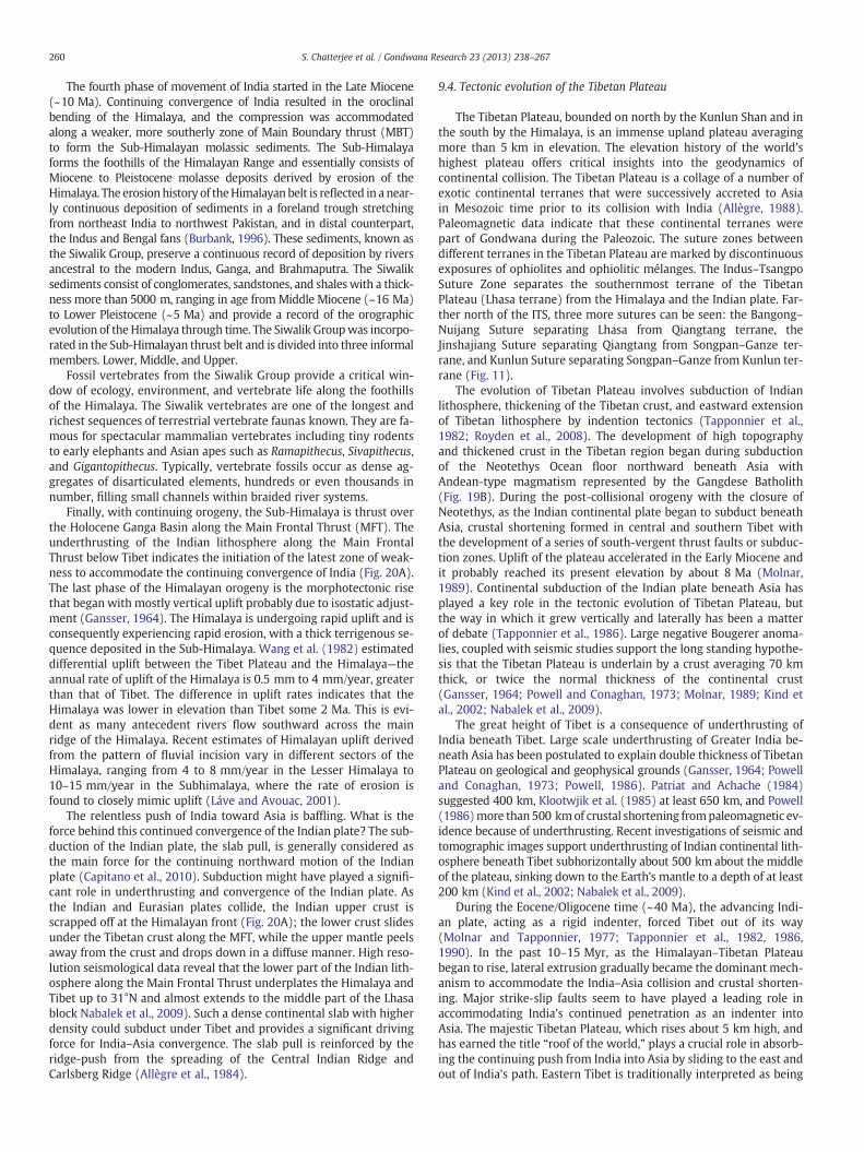
260 S. Chatterjee et al. / Gondwana Research 23 (2013) 238–267
The fourth phase of movement of India started in the Late Miocene(~10 Ma). Continuing convergence of India resulted in the oroclinalbending of the Himalaya, and the compression was accommodatedalong a weaker, more southerly zone of Main Boundary thrust (MBT)to form the Sub-Himalayan molassic sediments. The Sub-Himalayaforms the foothills of the Himalayan Range and essentially consists ofMiocene to Pleistocene molasse deposits derived by erosion of theHimalaya. The erosionhistory of theHimalayan belt is reflected in a near-ly continuous deposition of sediments in a foreland trough stretchingfrom northeast India to northwest Pakistan, and in distal counterpart,the Indus and Bengal fans (Burbank, 1996). These sediments, known asthe Siwalik Group, preserve a continuous record of deposition by riversancestral to the modern Indus, Ganga, and Brahmaputra. The Siwaliksediments consist of conglomerates, sandstones, and shales with a thick-ness more than 5000 m, ranging in age fromMiddle Miocene (~16 Ma)to Lower Pleistocene (~5 Ma) and provide a record of the orographicevolution of the Himalaya through time. The Siwalik Groupwas incorpo-rated in the Sub-Himalayan thrust belt and is divided into three informalmembers. Lower, Middle, and Upper.
Fossil vertebrates from the Siwalik Group provide a critical win-dow of ecology, environment, and vertebrate life along the foothillsof the Himalaya. The Siwalik vertebrates are one of the longest andrichest sequences of terrestrial vertebrate faunas known. They are fa-mous for spectacular mammalian vertebrates including tiny rodentsto early elephants and Asian apes such as Ramapithecus, Sivapithecus,and Gigantopithecus. Typically, vertebrate fossils occur as dense ag-gregates of disarticulated elements, hundreds or even thousands innumber, filling small channels within braided river systems.
Finally, with continuing orogeny, the Sub-Himalaya is thrust overthe Holocene Ganga Basin along the Main Frontal Thrust (MFT). Theunderthrusting of the Indian lithosphere along the Main FrontalThrust below Tibet indicates the initiation of the latest zone of weak-ness to accommodate the continuing convergence of India (Fig. 20A).The last phase of the Himalayan orogeny is the morphotectonic risethat began with mostly vertical uplift probably due to isostatic adjust-ment (Gansser, 1964). The Himalaya is undergoing rapid uplift and isconsequently experiencing rapid erosion, with a thick terrigenous se-quence deposited in the Sub-Himalaya. Wang et al. (1982) estimateddifferential uplift between the Tibet Plateau and the Himalaya—theannual rate of uplift of the Himalaya is 0.5 mm to 4 mm/year, greaterthan that of Tibet. The difference in uplift rates indicates that theHimalaya was lower in elevation than Tibet some 2 Ma. This is evi-dent as many antecedent rivers flow southward across the mainridge of the Himalaya. Recent estimates of Himalayan uplift derivedfrom the pattern of fluvial incision vary in different sectors of theHimalaya, ranging from 4 to 8 mm/year in the Lesser Himalaya to10–15 mm/year in the Subhimalaya, where the rate of erosion isfound to closely mimic uplift (Láve and Avouac, 2001).
The relentless push of India toward Asia is baffling. What is theforce behind this continued convergence of the Indian plate? The sub-duction of the Indian plate, the slab pull, is generally considered asthe main force for the continuing northward motion of the Indianplate (Capitano et al., 2010). Subduction might have played a signifi-cant role in underthrusting and convergence of the Indian plate. Asthe Indian and Eurasian plates collide, the Indian upper crust isscrapped off at the Himalayan front (Fig. 20A); the lower crust slidesunder the Tibetan crust along the MFT, while the upper mantle peelsaway from the crust and drops down in a diffuse manner. High reso-lution seismological data reveal that the lower part of the Indian lith-osphere along the Main Frontal Thrust underplates the Himalaya andTibet up to 31°N and almost extends to the middle part of the Lhasablock Nabalek et al., 2009). Such a dense continental slab with higherdensity could subduct under Tibet and provides a significant drivingforce for India–Asia convergence. The slab pull is reinforced by theridge-push from the spreading of the Central Indian Ridge andCarlsberg Ridge (Allègre et al., 1984).
9.4. Tectonic evolution of the Tibetan Plateau
The Tibetan Plateau, bounded on north by the Kunlun Shan and inthe south by the Himalaya, is an immense upland plateau averagingmore than 5 km in elevation. The elevation history of the world'shighest plateau offers critical insights into the geodynamics ofcontinental collision. The Tibetan Plateau is a collage of a number ofexotic continental terranes that were successively accreted to Asiain Mesozoic time prior to its collision with India (Allègre, 1988).Paleomagnetic data indicate that these continental terranes werepart of Gondwana during the Paleozoic. The suture zones betweendifferent terranes in the Tibetan Plateau are marked by discontinuousexposures of ophiolites and ophiolitic mélanges. The Indus–TsangpoSuture Zone separates the southernmost terrane of the TibetanPlateau (Lhasa terrane) from the Himalaya and the Indian plate. Far-ther north of the ITS, three more sutures can be seen: the Bangong–Nuijang Suture separating Lhasa from Qiangtang terrane, theJinshajiang Suture separating Qiangtang from Songpan–Ganze ter-rane, and Kunlun Suture separating Songpan–Ganze from Kunlun ter-rane (Fig. 11).
The evolution of Tibetan Plateau involves subduction of Indianlithosphere, thickening of the Tibetan crust, and eastward extensionof Tibetan lithosphere by indention tectonics (Tapponnier et al.,1982; Royden et al., 2008). The development of high topographyand thickened crust in the Tibetan region began during subductionof the Neotethys Ocean floor northward beneath Asia withAndean-type magmatism represented by the Gangdese Batholith(Fig. 19B). During the post-collisional orogeny with the closure ofNeotethys, as the Indian continental plate began to subduct beneathAsia, crustal shortening formed in central and southern Tibet withthe development of a series of south-vergent thrust faults or subduc-tion zones. Uplift of the plateau accelerated in the Early Miocene andit probably reached its present elevation by about 8 Ma (Molnar,1989). Continental subduction of the Indian plate beneath Asia hasplayed a key role in the tectonic evolution of Tibetan Plateau, butthe way in which it grew vertically and laterally has been a matterof debate (Tapponnier et al., 1986). Large negative Bougerer anoma-lies, coupled with seismic studies support the long standing hypothe-sis that the Tibetan Plateau is underlain by a crust averaging 70 kmthick, or twice the normal thickness of the continental crust(Gansser, 1964; Powell and Conaghan, 1973; Molnar, 1989; Kind etal., 2002; Nabalek et al., 2009).
The great height of Tibet is a consequence of underthrusting ofIndia beneath Tibet. Large scale underthrusting of Greater India be-neath Asia has been postulated to explain double thickness of TibetanPlateau on geological and geophysical grounds (Gansser, 1964; Powelland Conaghan, 1973; Powell, 1986). Patriat and Achache (1984)suggested 400 km, Klootwjik et al. (1985) at least 650 km, and Powell(1986)more than500 kmof crustal shortening frompaleomagnetic ev-idence because of underthrusting. Recent investigations of seismic andtomographic images support underthrusting of Indian continental lith-osphere beneath Tibet subhorizontally about 500 km about the middleof the plateau, sinking down to the Earth's mantle to a depth of at least200 km (Kind et al., 2002; Nabalek et al., 2009).
During the Eocene/Oligocene time (~40 Ma), the advancing Indi-an plate, acting as a rigid indenter, forced Tibet out of its way(Molnar and Tapponnier, 1977; Tapponnier et al., 1982, 1986,1990). In the past 10–15 Myr, as the Himalayan–Tibetan Plateaubegan to rise, lateral extrusion gradually became the dominant mech-anism to accommodate the India–Asia collision and crustal shorten-ing. Major strike-slip faults seem to have played a leading role inaccommodating India's continued penetration as an indenter intoAsia. The majestic Tibetan Plateau, which rises about 5 km high, andhas earned the title “roof of the world,” plays a crucial role in absorb-ing the continuing push from India into Asia by sliding to the east andout of India's path. Eastern Tibet is traditionally interpreted as being

261S. Chatterjee et al. / Gondwana Research 23 (2013) 238–267
part of a broad accommodation zone. Avouc and Tapponnier (1993)suggested that as much as 50% of the convergence between Indiaand Asia has been absorbed by extrusion of south-eastern Asia.Others disagree about the role of lateral extrusion; they believedthat lateral extrusion has not contributed more than 250 km shorten-ing to the India–Asia convergence (Dewey et al., 1989).
After collision (~50 Ma), the crust was shortened in western andcentral Tibet along the Gangdese Thrust system, while large frag-ments of lithosphere moved from the collision zone toward westernPacific and Indonesia. On the north side of the Tibetan Plateau,where the continental collision reaches the farthest, the Tibetan Pla-teau is compressing the adjacent blocks northward and eastwardresulting in a series of major active faults. Molnar and Tapponnier(1977) recognized various east–west trending strike-slip faults suchas Altyn Tagh and Red River faults north of the Himalaya in CentralChina from earthquake seismology and satellite imagery (Fig. 21).Much of the collisional shortening, which is not absorbed in theHimalaya or underthrusting beneath Tibet, apparently is convertedinto horizontal movements along these faults, predominantly to theeast.
These left-lateral faults operated sequentially at two stages duringthe Cenozoic to absorb the push from India (Tapponnier et al., 1986,1990). In the first stage, Indochina escaped along the Red RiverFault, which can be traced from southeastern Tibet through Yunnanto the South China Sea. The Asian blocks west of 70°E remainedmore or less undeformed but the Indochina block pushed to theeast at least 500 km southeastwards relative to South China duringthis stage. Extrusion of the Indochina block during the Indo-Chinacollision has long been speculated on the basis of laboratory experi-ments with plasticine (Tapponnier et al., 1982).
The movement of the Red River Fault began soon after the initialcollision (50 Ma), but stopped around 17 Ma. Cenozoic structures innorthern Tibet are dominated by the Altyn Tagh Fault system thatbounds more than 1200 km and bounds the rather rigid Tarim basinto the northwest and themore deformable Tibetan Plateau to the south-east. India has been convergingwith Tibet since the cessation of motionalong the Red River Fault. The second strike-slip movement, measuring3 cm/year, began along the Altyn Tagh Fault approximately 17 Ma. As a
Fig. 21. Schematic map illustrating extrusion tectonics in Tibet and Indochina by twogreat strike-slip faults, the Red River and Altyn Tagh that allowed Indochina andTibet to slide eastward; the complex plate boundary of India is demarcated by a redline.After Tapponnier et al. (1986).
result, the Tibetan Plateau is slowly being pushed to the east toward thePacific. It has been estimated that about a 270 kmnorth–south shorten-ing has been accommodated along the Altyn Tagh Fault, causing Tibet toslip out dextrally along the fault line.
Because the crust of Tibetan Plateau is twice the normal thicknessof the continental crust, it has a deep root that floats on underlyinghot and dense mantle. The bottom layer of lightweight crust is unusu-ally hot and soft and flows easily. Channel flow model has been usedto explain the orogeny and uplift of the Tibetan Plateau (Beaumont etal., 2001; Hodges, 2006a). As discussed earlier, the middle and lowercrust beneath the Tibetan Plateau might be partially molten, whichmay explain why the plateau is so flat. The Tibetan fluid layer of themiddle crust is sufficiently weak to support large variations of surfacetopography and it simply flows laterally under the influence of grav-ity (Bird, 1991; Hodges, 2006a).
An important prediction of the channel flow theory is that the up-lift of the Tibetan Plateau would develop initially during the EarlyMiocene time proximal to the ITS zone. Since then, the eastern mar-gin of Tibetan Plateau is marked by elevation and crustal thicknessgradients and has grown eastward. Most likely, the channel flowhad spread laterally to the north and east, and resulted in the topo-graphic rise and expansion of the Tibetan Plateau. Unlike HigherHimalaya, there is little evidence of this channel flow in the surfacestructural geology of Tibet (Beaumont et al., 2001; Hodges, 2006a).However, surface wave tomography and receiver function analysisfrom the eastern and south central plateau of Tibet supports the pres-ence of the middle and lower crustal network of hot channel flow(Kind et al., 2002; Royden et al., 2008; Nabalek et al., 2009).
A recent model relates the uplift, growth, and crustal shorteningof the Tibetan Plateau to a plate-like behavior including sequentialintracontinental subduction zones along the three main suturezones, namely the Bangong–Nuijang Suture, Jinshaijang Suture, andKunlun Suture (Fig. 11) (Tapponnier et al., 2001). These south-vergent subduction zones in Tibet and north-vergent thrust zonesof the Himalaya occur on either side of the Indus–Tsangpo SutureZone, both represent post-collisional convergent deformation (Fig. 20B).In Tibet, they decrease in age northward ranging from Eocene to Plioceneand may accommodate the crustal shortening after the collision. Theseslabs of Asian mantle subducted en echelon under ranges north of theHimalaya. Subduction was oblique and accompanied by lateral extrusionof SE Asia, facilitated by the lateral flow of the middle and lower fluidcrust of Tibet.
10. Cenozoic climate
From Paleocene to Early Eocene the Indian plate moved north-ward and entered the equatorial humid belt. The continuing erosionof the Deccan Traps removed much of the CO2 from the atmosphere,thus starting a cooling trend over the Eocene–Oligocene boundary(Kent and Muttoni, 2008). During the Oligocene (~30 Ma), the Indiansubcontinent was very close to its present day position. The TethysHimalaya rose, and the center of the subcontinent was located at10°N. The southern part of the subcontinent was in the EquatorialRainy Belt whereas the northern part was extended into the Subtrop-ical Arid Belt (Fig. 22A). Annual mean temperature ranged between27 °C (southern part) and −5 °C (northern part) (Scotese et al.,2007, 2008, 2009, 2011; Goswami, 2011). Though the northernareas along the line of collision were experiencing a drier climaticcondition, the peninsular part was having significant precipitation ofabout 10 cm/month to 26 cm/month. It is important to mentionthat the southern tip and the mid-section of eastern Indian peninsulawere relatively dry (6–8 cm/month). The collision of India with Asiaand the resulting disappearance of Tethys may have provoked strongglobal warming.
The uplift of the Himalayan–Tibetan Plateau with an average ele-vation of 5 km above the snow line forms a climatic divide between
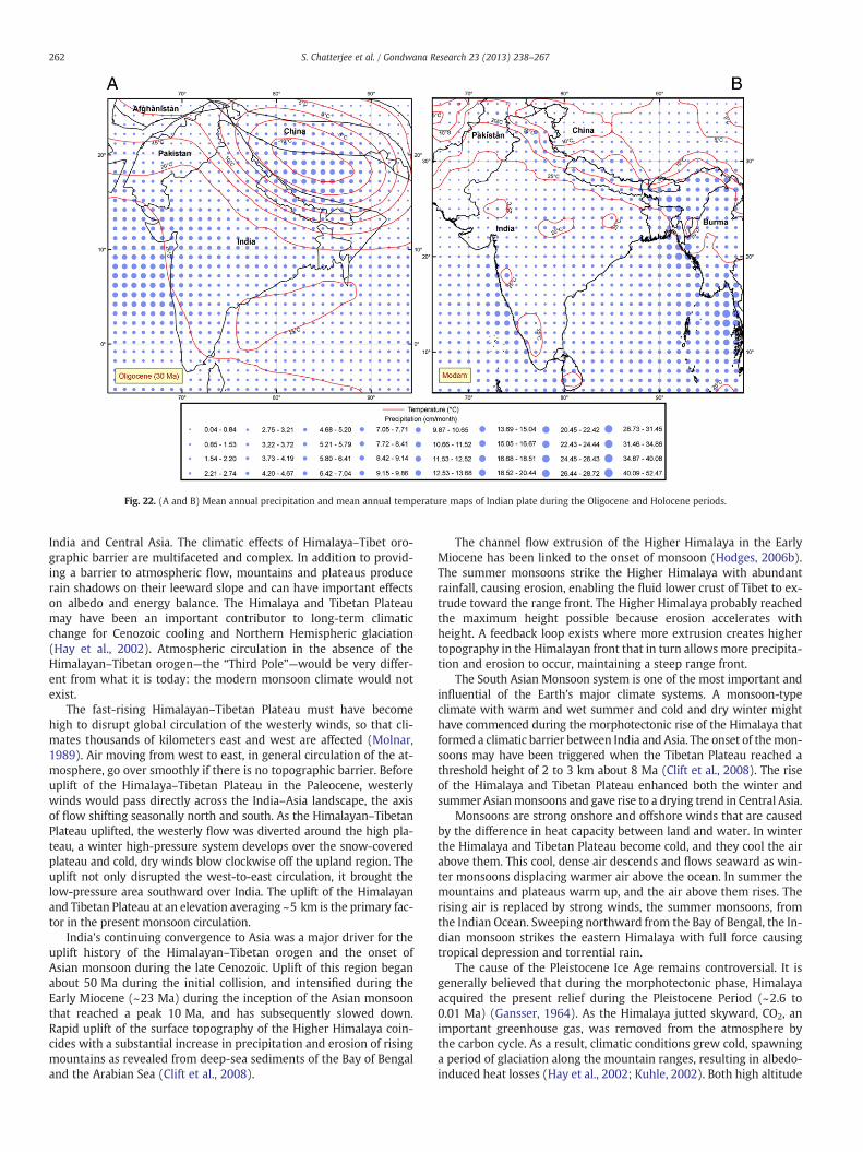
Fig. 22. (A and B) Mean annual precipitation and mean annual temperature maps of Indian plate during the Oligocene and Holocene periods.
262 S. Chatterjee et al. / Gondwana Research 23 (2013) 238–267
India and Central Asia. The climatic effects of Himalaya–Tibet oro-graphic barrier are multifaceted and complex. In addition to provid-ing a barrier to atmospheric flow, mountains and plateaus producerain shadows on their leeward slope and can have important effectson albedo and energy balance. The Himalaya and Tibetan Plateaumay have been an important contributor to long-term climaticchange for Cenozoic cooling and Northern Hemispheric glaciation(Hay et al., 2002). Atmospheric circulation in the absence of theHimalayan–Tibetan orogen—the “Third Pole”—would be very differ-ent from what it is today: the modern monsoon climate would notexist.
The fast-rising Himalayan–Tibetan Plateau must have becomehigh to disrupt global circulation of the westerly winds, so that cli-mates thousands of kilometers east and west are affected (Molnar,1989). Air moving from west to east, in general circulation of the at-mosphere, go over smoothly if there is no topographic barrier. Beforeuplift of the Himalaya–Tibetan Plateau in the Paleocene, westerlywinds would pass directly across the India–Asia landscape, the axisof flow shifting seasonally north and south. As the Himalayan–TibetanPlateau uplifted, the westerly flow was diverted around the high pla-teau, a winter high-pressure system develops over the snow-coveredplateau and cold, dry winds blow clockwise off the upland region. Theuplift not only disrupted the west-to-east circulation, it brought thelow-pressure area southward over India. The uplift of the Himalayanand Tibetan Plateau at an elevation averaging ~5 km is the primary fac-tor in the present monsoon circulation.
India's continuing convergence to Asia was a major driver for theuplift history of the Himalayan–Tibetan orogen and the onset ofAsian monsoon during the late Cenozoic. Uplift of this region beganabout 50 Ma during the initial collision, and intensified during theEarly Miocene (~23 Ma) during the inception of the Asian monsoonthat reached a peak 10 Ma, and has subsequently slowed down.Rapid uplift of the surface topography of the Higher Himalaya coin-cides with a substantial increase in precipitation and erosion of risingmountains as revealed from deep-sea sediments of the Bay of Bengaland the Arabian Sea (Clift et al., 2008).
The channel flow extrusion of the Higher Himalaya in the EarlyMiocene has been linked to the onset of monsoon (Hodges, 2006b).The summer monsoons strike the Higher Himalaya with abundantrainfall, causing erosion, enabling the fluid lower crust of Tibet to ex-trude toward the range front. The Higher Himalaya probably reachedthe maximum height possible because erosion accelerates withheight. A feedback loop exists where more extrusion creates highertopography in the Himalayan front that in turn allows more precipita-tion and erosion to occur, maintaining a steep range front.
The South Asian Monsoon system is one of the most important andinfluential of the Earth's major climate systems. A monsoon-typeclimate with warm and wet summer and cold and dry winter mighthave commenced during the morphotectonic rise of the Himalaya thatformed a climatic barrier between India and Asia. The onset of themon-soons may have been triggered when the Tibetan Plateau reached athreshold height of 2 to 3 km about 8 Ma (Clift et al., 2008). The riseof the Himalaya and Tibetan Plateau enhanced both the winter andsummer Asianmonsoons and gave rise to a drying trend in Central Asia.
Monsoons are strong onshore and offshore winds that are causedby the difference in heat capacity between land and water. In winterthe Himalaya and Tibetan Plateau become cold, and they cool the airabove them. This cool, dense air descends and flows seaward as win-ter monsoons displacing warmer air above the ocean. In summer themountains and plateaus warm up, and the air above them rises. Therising air is replaced by strong winds, the summer monsoons, fromthe Indian Ocean. Sweeping northward from the Bay of Bengal, the In-dian monsoon strikes the eastern Himalaya with full force causingtropical depression and torrential rain.
The cause of the Pleistocene Ice Age remains controversial. It isgenerally believed that during the morphotectonic phase, Himalayaacquired the present relief during the Pleistocene Period (~2.6 to0.01 Ma) (Gansser, 1964). As the Himalaya jutted skyward, CO2, animportant greenhouse gas, was removed from the atmosphere bythe carbon cycle. As a result, climatic conditions grew cold, spawninga period of glaciation along the mountain ranges, resulting in albedo-induced heat losses (Hay et al., 2002; Kuhle, 2002). Both high altitude

263S. Chatterjee et al. / Gondwana Research 23 (2013) 238–267
and availability of moisture from the monsoon favored the initiationof glaciation in the Himalayan–Tibetan Plateau. The glaciers spreadfar and wide in the Potwar, Kashmir, Ladakh, and Tibetan regions.New data show that the glaciations were not synchronous through-out the region. In some areas they were most extensive during60–32 Ka and in other places during the global maximum at18–20 Ka (Benn and Owens, 1998). After the end of the Pleistoceneice age around 20 Ka, the southwest monsoon weakened its intensity,bringing about climate change. Heavy rains gave away to spells ofcold-dry conditions. As the temperature became warmer, there wasoscillation of dry–cold and wet–warm climates. The melting of theice sheet covering the Himalayan ranges and Tibetan Plateau mighthave contributed a large amount of melt water to the oceans and asignificant rise of the eustatic sea level. The Himalaya and Tibet arethe most glaciated regions outside the polar regions. These glaciersare the source of innumerable rivers that flow across the Indus–Ganga Plain and the Central and East China.
The uplift of the Himalaya continues today, as evident from activeseismicity along the major boundary-thrust faults and dislocation anddeformation of Pleistocene and Holocene landforms and deposits. Thevery fast uplift in the northwestern part of the Himalaya is manifest inrapid erosion, about 2–12 mm/year, which is determined on the basisof different bedrock uplift and incision made by the Indus River(Burbank, 1996). The Himalaya is so high and the monsoon rainfallupon it is so immense that erosion is very extensive. In the Indianplains, as the intensity of the monsoon rains increased, the rapid up-lift of the Himalaya induced rapid erosion of the mountains, and thevast amount of sediments were carried downward by two glacier-fed rivers, the Indus on the west, and the Ganga–Brahmaputra inthe east. These two rivers dumped sediments to the Indian Oceanthat created two great deep-sea fans, the Bengal and the Indus.
The Himalaya forms a formidable rain shadow to the monsoon,preventing moisture from reaching to Tibetan Plateau, which helpedcreate the Gobi and Mongolian deserts. This drying trend created
Fig. 23. Linking rise of the Himalaya–Tibetan Plateau and the birth of the monsoon. India's cand from the sea toward land in the summer. (A) During the summer, the winds carry moistuwinter the monsoon winds blow from the northeast and carry little moisture. The temperatuthe subcontinent.
enhanced aridity in the Asia interior and was manifested in Chinaabout 2.5 million years ago in the form of extensive eolian deposits.Fine dust, eroded by strong winds from desert basins north of theHimalaya, began accumulating widely over central and easternChina (Zhisheng et al., 2011).
Today, the majority of the peninsular India falls within the Equato-rial Rainy Belt, whereas the central and western part is in the Sub-tropical Arid Belt (Fig. 22B). The Indian plate at its present location,with the center at 22°N latitude, extends through three broad latitu-dinal climatic belts (Figs. 22B, 23). The northern part is representativeof the Warm Temperate Belt climate.
Themodern climatic condition of the Indian Subcontinent is great-ly influenced by the monsoon. The western part of the Indian penin-sula (up to 25 cm/month) and eastern India (up to 30 cm/month) hasthe maximum annual precipitation (Legates and Willmott, 1990a).The central part has 5–10 cm/month annual precipitation whereasthe northern part gets up to 15 cm/month (Fig. 23). Except for thenorthern part of the Indian subcontinent, the mean annual tempera-ture (Legates and Willmott, 1990b) ranges between 29 °C and23 °C. In the northern part the annual mean temperature ranges15 °C to 20 °C.
11. Conclusion
The tectonic evolution of the Indian plate, which represents one ofthe most remarkable journeys of all the continents (about 9000 km in160 million years), is largely the story of the breakup of Gondwanathrough time and its subsequent collision with the Kohistan–LadakhArc and Asia. The tectonic history of India plays a central role in thedispersal of Gondwana. Though complex, this story can now be toldusing evidence from linear magnetic anomalies, paleomagnetismand hot spot tracks. Information from different fields of continentalgeology and deep sea drilling also provide useful information to con-strain India's journey. Both the eastern andwestern coasts of India are
limate is dominated by monsoon. Monsoons blow from the land toward sea in winter,re from the Indian Ocean and bring heavy rains from June to September. (B) During there is high because the Himalaya forms a barrier that prevents cold air from passing into

264 S. Chatterjee et al. / Gondwana Research 23 (2013) 238–267
rifted margins, characterized by sub-aerial volcanic rocks. The age offlood basalts along the continental rift margins help to constrain thetiming of major tectonic events.
The present day configuration of passive margins of the Indian pen-insula is the consequence of seven episodes of continental flood volca-nism and sequential rifting events since the Jurassic. By reviewingspatial association of flood basalts, mantle plumes, and rifting eventsof the Indian plate through time and space and reconstructing the ther-mal history of the evolving continental margins, these events can besummarized as:
a) Separation of East Gondwana from West Gondwana duringMiddle Jurassic time (Karoo–Ferrar flood basalts, Bouvet plume,182 Ma),
b) India separated fromAntarctica–Australia during the Late Cretaceous(Kerguelen–Rajmahal basalts, Kerguelen plume, 118 Ma),
c) India separated from Madagascar during the Late Cretaceous(Morondava–St. May basalts, Marion plume, 88 Ma),
d) An island arc, the Kohistan–Ladakh Arc, formed on the northern sideof the Indothethys and became trapped between India and Asia. Thisallowed for two stages of deformation. The first consisted of a collisionof the arc with India, followed by the collision with Asia. India rapidlydrifted northward as an island continent across the Indotethys andcollided with the Kohistan–Ladakh arc in Late Cretaceous (~85 Ma),
e) The eruption of the Deccan traps as the Reunion plume breaches thelithosphere (65 Ma),
f) The breakup of the western margin of the Indian subcontinent con-tinued in the Late Cretaceous as the Seychelles separated fromLaxmi Ridge and the western Indian margin (70–65 Ma),
g) Eohimalayanphase: India–Asia collision began in Early Eocene alongthe Shyok–Tsangpo Suture Zone, which later transferred to theIndus–Tsangpo Suture Zone with the closure of the Neotethys(~50 Ma).
h) Neohimalayan phase: the architecture of the Himalayan–Tibetanorogen is dominated by deformational structures developed in theNeogene Period (b23 Ma), dominated by the channel flow extru-sion of the higher Himalaya with the onset of Asian monsoon.India–Asia collision and intracontinental deformation resulted inlarge crustal shortening and uplift of the Himalaya and Tibetan Pla-teau above the snow line that might have triggered the Pleistoceneglaciation in Northern Hemisphere.
During its tectonic evolution from Gondwana to Asia, India be-came smaller and smaller, trimming its rifted continental margins,and leaving behind several continental terrances such as Madagascar,Seychelles, and Laxmi Ridge, stranded in oceanic crust as India driftedaway from Africa opening the Indian Ocean. With the complete sub-duction of Neotethys at the Shyok–Tsangpo Suture, the northernone-third part of the Indian plate was subducted beneath Asia duringthe initial phases of collision (50 Ma), and now lies buried beneaththe Tibetan Plateau.
Starting northward at a rate of 3–5 cm/year during the Mesozoic,the Indian plate attained a sudden acceleration of 20 cm/year fromLate Cretaceous (~67 Ma) at the KT boundary, which has been amajor tectonic puzzle. This accelerated northward migration of theIndian plate during the Late Cretaceous–Early Eocene makes Indiaunique among the fragments of Gondwana. India slowed down con-siderably 5 cm/year at Early Eocene (~50 Ma) during its convergencewith Asia and the closure of the Neotethys. India–Asia collision ismarked by indentation, channel flow extrusion of Higher Himalaya,rotational underthrusting, and oroclinal bending of the Himalaya.With the rise of the Himalaya and Tibetan Plateau, the onset of theAsian monsoon began dramatically, changing the climatic regime ofAsia. During its long northward journey, the climatic and biotic re-gime of the Indian plate changed gradually with the onset of mon-soon and Pleistocene glaciation during the Neohimalayan phase.
Acknowledgments
The theme of the paper was presented at the “Gondwana 14” sym-posium at Buzios, Rio de Janeiro, Brazil. Ismar de Souza Carvaloh kindlyinvited one of us (SC) at the meeting and offered generous hospitalityand financial support. We thank two anonymous reviewers for provid-ing useful comments and insights. We thank Bill Mueller and MichaelW. Nickell for assistance in preparing some illustrations, andM. Santoshand T. Horscroft for inviting us to prepare this review article. Texas TechUniversity and PALEOMAP Project supported this research.
Appendix A. Supplementary material
Supplementary materials related to this article can be found on-line at 10.1016/j.gr.2012.07.001.
References
Achache, J., Courtillot, V., Zhou, Y.X., 1984. Paleogeographic and tectonic evolution ofsouthern Tibet since Middle Cretaceous time; new paleomagnetic data and synthe-sis. Earth and Planetary Science Letters 233, 87–102.
Aitchison, J.C., Xia, X., Baxter, A.T., Ali, J.R., 2011. Detrital zircon U–Pb ages along theYarlung–Tsangpo Suture zone, Tibet: implications for oblique convergence andcollision between India and Asia. Gondwana Research 20, 691–709.
Ali, J.R., Aitchison, J.C., 2005. Greater India. Earth-Science Reviews 72, 169–188.Ali, J.R., Aitchison, J.C., 2008. Gondwana to Asia: plate tectonics, paleogeography and
the biological connectivity of the Indian sub-continent from the Middle Jurassicthrough latest Eocene (166–35 Ma). Earth-Science Reviews 88, 145–166.
Allègre, C.J., 1988. The Behavior of the Earth. Harvard University Press, Cambridge, USA.272 pp.
Allègre, C.J., 34 authors, 1984. Structure and evolution of the Himalaya–Tibet orogenicbelt. Nature 307, 17–19.
Anderson, D.L., 1994. Superplumes or supercontinents? Geology 22, 39–42.Anderson, D.L., 2001. Top-down tectonics. Science 293, 2016–2018.Andronicos, C.L., Velasco, A.A., Hurtado, J.M., 2007. Large-scale deformation in the
India–Asia collision constrained by earthquakes and topography. Terra Nova 19,105–119.
Armitage, J.J., Collier, J.S., Minshull, T.A., 2010. The importance of rift history for volcanicmargin. Nature 465, 913–917.
Avouc, J.P., Tapponnier, P., 1993. Kinematic model of active deformation in central Asia.Geophysical Research Letters 20, 895–898.
Baksi, A.K., 1994. Geochronological studies of the whole-rock basalts, Deccan Traps,India: evaluation of the timing of volcanism relative to the K–T boundary. Earthand Planetary Science Letters 121, 43–56.
Baksi, A.K., Ray Barman, T., Paul, D.K., Farrar, E., 1987. Widespread Early Cretaceous floodbasalt volcanism in eastern India: geochemical data from the Rajmahal–Bengal–Sylhet Traps. Chemical Geology 63, 133–141.
Bard, J.P., 1983. Metamorphism of an obducted island arc: example of the KohistanSequence (Pakistan) in the Himalayan collided range. Earth and Planetary ScienceLetters 65, 133–144.
Bardintzeff, J.M., Liegois, J.P., Bonin, B., Bellon, H., Rasamimanna, G., 2010. Madagascarvolcanic provinces linked to the Gondwana break-up: geochemical and isotopeevidences for contrasting mantle sources. Gondwana Research 18, 295–314.
Basu, A.R., Renne, P.R., Dasgupta, D.K., Teichmann, F., Poreda, R.J., 1993. Early and latealkali igneous pulses and a high — 3He plume origin for the Deccan Flood Basalts.Science 261, 902–906.
Baxter, A.T., Aitchison, J.C., Ali, J.R., Zyabrev, S.V., 2010. Early Cretaceous radiolariansfrom the Spontang massif, Ladakh, NW India. Journal of the Geological Society ofLondon 167, 511–517.
Beaumont, C., Jamieson, R.A., Nguyen, M.H., Lee, B., 2001. Himalayan tectonicsexplained by extrusion of a low-viscosity crustal channel coupled to focusedsurface denudation. Nature 414, 738–742.
Benn, D.I., Owens, L.A., 1998. The role of the Indian summer monsoon and the mid-latitude westerlies in Himalayan glaciation: review and speculative discussion.Journal of the Geological Society of London 155, 353–363.
Besse, J., Courtillot, V., 1988. Paleogeographic maps of the continents bordering theIndian Ocean since the Early Jurassic. Journal of Geophysical Research 93,11791–11808.
Besse, J., Courtillot, V., Pozzi, J.P., Westphal, M., Zhou, Y.X., 1984. Palaeomagnetic esti-mates of crustal shortening in the Himalayan thrusts and Zangbo suture. Nature311, 621–626.
Bhattacharya, G.C., Chaubey, A.K., Murty, G.P.S., Srinivas, K., Sarma, K.V.L.N.S.,Subrahmanyam, V., Krishna, K.S., 1994. Evidence for seafloor spreading in theLaxmi Basin, northeastern Arabian Sea. Earth and Planetary Science Letters 125,211–220.
Bird, P., 1991. Lateral extrusion of lower crust from under high topography, in the iso-static limit. Journal of Geophysical Research 96, 10,275–10,286.
Bouihol, P., Jagoutz, O., Dudas, F.O., Hanchar, J.M., 2011. Dating the India–Asia collisionthrough arc magmatic records. 2010. Geophysical Research Abstracts EGU,2011–1662.

265S. Chatterjee et al. / Gondwana Research 23 (2013) 238–267
Bouysse, P., Mendel, V., Menschy, K., Sgoufin, J., 2004. The map of the Indian Ocean.Physiographic and structural mapping of an ocean. Bilingual French–English, 1–6.CGMW edition, Paris.
Burbank, D.W., 1996. The Himalayan foreland basin. In: Yin, A., Harrison, T.M. (Eds.),The Tectonics of Asia. Cambridge University Press, New York, pp. 205–226.
Burchfiel, B.C., Chen, Z., Hodges, K.V., Liu, Y., Royden, L.H., Deng, C., Xu, J., 1992. The southTibetan detachment system, Himalayan orogen: extension contemporaneous withand parallel to shortening in a collisional mountain belt. Geological Society ofAmerica Special Paper 269, 1–41.
Burg, J.P., 2011. The Asia–Kohistan–India collision: review and discussion. In: Brown, D.,Ryan, P.D. (Eds.), Arc–Continent Collision, Frontiers in Earth Sciences. Springer-Verlag, Berlin, Germany, pp. 279–309.
Calves, G., Schwab, A., Husse, M., Clift, P.D., Giana, C., Jolley, D., Tabrezm, A.R., Inam, A.,2011. Journal of Geophysical Research 116, 1–28.
Campbell, I.H., Griffiths, R.W., 1990. Implications of mantle plume structure for theevolution of flood basalts. Earth and Planetary Science Letters 99, 79–93.
Cande, S.C., Stegman, D.R., 2011. Indian and African plate motions driven by the pushforce of Reunion plume head. Nature 475, 47–52.
Capitano, F.A., Morra, G., Goes, S., Weinberg, R.F., Mores, L., 2010. India–Asia conver-gence driven by the subduction of the Greater Indian continent. Nature Geoscience3, 136–139.
Carey, W.W., 1976. The Expanding Earth. Elsevier, Amsterdam.Carmichael, S.M., Akhter, S., Bennet, J.K., Fatimi, M.A., Hosein, K., Jones, R.W., Longacre,
M.B., Osborne, M.J., Tozer, R.S., 2009. Geology and hydrocarbon potential of theoffshore Indus Basin, Pakistan. Petroleum Geoscience 15, 107–116.
Chatterjee, S., 1992. A kinematic model for the evolution of the Indian plate since theLate Jurassic. In: Chatterjee, S., Hotton, N. (Eds.), New Concepts in Global Tectonics.Texas Tech University Press, Lubbock, USA, pp. 33–62.
Chatterjee, S., Rudra, D.K., 1996. KT events in India: impact, volcanism and dinosaurextinction. Memoirs of the Queensland Museum 39, 489–532.
Chatterjee, S., Scotese, C.R., 1999. The breakup of Gondwana and the evolution andbiogeography of Indian plate. Proceedings of Indian National Science Academy65A, 397–425.
Chatterjee, S., Scotese, C.R., 2010. The wandering Indian plate and its changing bioge-ography during the Late Cretaceous–Early Tertiary period. In: Bandopadhyay, S.(Ed.), New Aspects of Mesozoic Biogeography. Springer-Verlag, Berlin Heidelberg,Germany, pp. 105–126.
Chatterjee, S., Guven, N., Yoshinobu, A., Donofrio, R., 2006. Shiva structure: a possibleKT boundary impact crater on the western shelf of India. Special Publications,Museum of Texas Tech University 50, 1–39.
Chenet, A.L., Quidelleur, X., Fluteau, G., Courtillot, V., 2007. 40K/40Ar dating of the mainDeccan Large Igneous Province: further evidence of KTB age and short duration.Earth and Planetary Science Letters 263, 1–15.
Clift, P.D., Hannigan, R., Bluszatin, J., Drut, A.E., 2002. Geochemical evolution of theDras–Kohistan arc during collision with Eurasia: evidence from the LadakhHimalaya, NW India. The Island Arc 11, 255–271.
Clift, P.D., Hodges, K.V., Heslop, D., Hannigan, R., Van Long, H., Calves, G., 2008. Correla-tion of Himalayan exhumation rates and Asian monsoon intensity. Nature Geosci-ence 1, 875–880.
Coffin, M.F., Eldholm, O., 1994. Large igneous provinces: crustal structure, dimensions,and external consequences. Reviews of Geophysics 32, 1–36.
Coffin, M.F., Rabinowicz, P.D., 1987. Reconstruction of Madagascar and Africa: evidencefrom the Davie fracture zone and western Somali basin. Journal of GeophysicalResearch 92 (b), 9385–9406.
Collier, J.S., Sansom, V., Ishizuka, O., Taylor, R.N., Minshull, T.A., Whitmarsh, R.B., 2008.Age of the Seychelles–India break-up. Earth and Planetary Science Letters 272,264–277.
Condie, K.C., 2001. Mantle Plumes and their Record in Earth History. CambridgeUniversity Press, UK. 303 pp.
Copley, A., Avouac, J.P., Royer, J.Y., 2010. India–Asia collision and the Cenozoic slowdownof the Indian plate: implications for the forces driving plate motions. Journal of Geo-physical Research 115, B03410. http://dx.doi.org/10.1029/2009JB006634 (1–14).
Courtillot, V., 1999. Evolutionary Catastrophes. Cambridge University Press, Cambridge,UK. 173 pp.
Courtillot, V., Besse, J., Vandamme, D., Montigny, R., Jaegger, J.J., Capetta, H., 1986.Deccan flood basalts at the Cretaceous–Tertiary boundary? Earth and PlanetaryScience Letters 80, 361–374.
Courtillot, V., Davaille, A., Besse, J., Stock, J., 2003. Three distinct types of hotspots inEarth's mantle. Earth and Planetary Science Letters 295, 295–308.
Courtilot, V., Jaupart, C., Manighetti, I., Tapponnier, P., Besse, J., 1999. On causal linksbetween food basalts and continental breakup. Earth and Planetary Science Letters166, 177–195.
Coward, M.P., Butler, R.W.H., Khan, M.A., Knipe, J.A., 1987. The tectonic history ofKohistan and its implications for Himalayan structure. Journal of the GeologicalSociety of London 144, 377–391.
Croxton, C.A., Hitchings, V.H., Marshall, P.R., 1981. The biostratigraphy andpalaeoenvironments of the interval 1400'–12790', with petrography, X-ray diffrac-tion and Potassium/Argon age dating of selected samples, from the Amoco Sey-chelles Petroleum Co. Rieth Bank-I well, offshore Seychelles. Robertson ResearchInternational Report p/F, p. 61.
Davies, G.F., 1999. Dynamic Earth—Plates, Plumes and Mantle Convection. CambridgeUniversity Press, Cambridge, UK. 458 pp.
DeCelles, P.G., Robinson, D.M., Zandt, G., 2001. Implications of shortening in the Himalayanfold-thrust belt for uplift of the Tibetan Plateau. Tectonics 20, 487–509.
Desa, M., Ramana, M.V., Ramprasad, T., 2006. Seafloor spreading magnetic anomaliessouth off Sri Lanka. Marine Geology 229, 227–240.
Dewey, J.F., Bird, J.M., 1970. Mountain belts and the new global tectonics. Journal ofGeophysical Research 75, 2625–2647.
Dewey, J.F., Cande, S., Pitman, W.C., 1989. Tectonic evolution of the India/Eurasiacollision zone. Eclogae Geologicae Helvetie 82, 717–734.
Dezes, P., 1999. Tectonic and metamorphic evolution of the central Himalayan domain insouthwest Zanskar (Kashmir, India). Memoires de Geologie of Lausanne 32, 1–160.
Dietz, R.S., Holden, S.C., 1970. The breakup of Pangaea. Scientific American 223, 30–41.Dilek, Y., Furnes, H., 2009. Structure and geochemistry of Tethyan ophiolites and their
petrogenesis in subduction rollback system. Lithos 113, 1030.Doglioni, C., 1990. A global tectonic pattern. Journal of Geodynamics 12, 21–38.Douwe, J., Van Hinsbergen, J., Steinberger, B., Doubrovine, P.V., Gassmoller, R., 2011.
Acceleration and deceleration of India–Asia convergence since the Cretaceous:roles of mantle plumes and continental collision. Journal of Geophysical Research116, BO6101. http://dx.doi.org/10.1029/2010JB008051.
Duncan, R.A., 1981. Hotspots in the southern oceans—an absolute frame of referencefor motion of the Gondwana continents. Tectonophysics 74, 29–42.
Duncan, R.A., Hargraves, R.B., 1990. 40Ar–39Ar geochronology of basement rocks fromthe Mascarene Plateau. Proceedings of the ODP Science Results 115, 43–51.
Duncan, R.A., Pyle, D.G., 1988. Rapid eruption of the Deccan flood basalts at theCretaceous/Tertiary boundary. Nature 33, 841–843.
Duncan, R.A., Hooper, P.R., Rehacek, J., Marsh, J.S., Duncan, A.R., 1997. The timing andduration of the Karoo igneous event, southern Gondwana. Journal of GeophysicalResearch 102, 18127–18138.
Forsyth, D., Uyeda, S., 1975. On the relative importance of driving forces of platemotion. Geophysical Journal of the Royal Astronomical Society 43, 163–200.
Foulger, G.R., 2010. Plates vs. Plumes: A Geological Controversy. Wiley-Blackwell,Chichester, UK.
Frank, W., Gansser, A., Trommsdorff, V., 1977. Geological observations in the Ladakharea (Himalayas); a preliminary report. Schweizerische Mineralogische undPetrographische Mitteilungen Bulletin 57, 89–113.
Gaina, C., Müller, R.D., Brown, B., Ishihara, T., Ivanov, S., 2007. Breakup and earlyseafloor spreading between India and Antarctica. Geophysical Journal Internation-al. http://dx.doi.org/10.1111/j.1365-246X.2007.03450.x.
Gansser, A., 1964. The Geology of the Himalaya. Interscience, New York, USA.Gansser, A., 1966. The Indian Ocean and the Himalayas—a geological interpretation.
Ecologae Geoligische Helvetae 59, 831–848.Gansser, A., 1980. The significance of the Himalayan Suture zone. Tectonophysics 62,
37–52.Godin, L., Grujic, D., Law, R.D., Searle, M.P., 2006. Channel flow, ductile extrusion, and
exhumation in continental collision zones: an introduction. Geological Society,London, Special Publications 268, 1–23.
Gombos, A.M., Powell, W.G., Norton, I.O., 1995. The tectonic evolution of western Indiaand its impact on hydrocarbon occurrences: an overview. Sedimentary Geology 96,119–129.
Goswami, A., 2011. Predicting the geographic distribution of ancient soils with specialreference to the Cretaceous. Doctoral Dissertation, University of Texas at Arlington,Texas.
Harris, N., 2007. Channel flow and the Himalayan–Tibetan orogen: a critical review.Journal of the Geological Society of London 164, 511–523.
Hay, W.W., Soeding, E., DeConto, R.M., Wold, C.C., 2002. The Late Cenozoic uplift —climate paradox. International Journal of Earth Science 91, 746–774.
Hill, R.I., 1999. Starting plumes and continental breakup. Earth and Planetary ScienceLetters 104, 398–416.
Hodges, K.V., 2000. Tectonics of the Himalaya and southern Tibet from two perspec-tives. Geological Society of America Bulletin 112, 324–350.
Hodges, K.V., 2006a. A synthesis of the channel-flow-extrusion hypothesis as devel-oped for the Himalayan–Tibetan orogenic system. Geological Society, LondonSpecial Publications 268, 71–90.
Hodges, K.V., 2006b. Climate and the evolution of the mountains. Scientific American295 (2), 54–61.
Honegger, K., Dietrich, V., Frank, W., Gansser, A., Thoni, M., Trommsdorff, B., 1982.Magmatism and metamorphism in the Ladakh Himalayas (the Indus–TsangpoSuture zone). Earth and Planetary Science Letters 60, 253–292.
Jacob, R.C., Schafer, C., Foster, I., Tobias, M., Anderson, J., 2001. Computational designand performance of the Fast Ocean Atmosphere Model. Proceedings of the Interna-tional Conference on Computer Science, San Francisco, CA, May. Lecture Notes inComputer Science, vol. 2073. Springer-Verlag, Berlin, pp. 175–184.
Jagoutz, O.E., Bouihol, P., Upadhyay, R., 2009a. Geology of the Kohistan–Ladakh arc andits relation to the main Himalayan belt. American Geophysical Union, Fall Meeting,abstract #T41D-02.
Jagoutz, O.E., Burg, J.P., Hussain, S., Dawood, H., Pettke, T., Iizika, T., Maruyama, S., 2009b.Construction of the granitoid crust of an island arc part I: geochronological and geo-chemical constraints from the plutonic Kohistan (NW Pakistan). Contributions toMineralogy and Petrology 158, 739–755.
Johnson, B.D., Powell, C. McA, Veevers, J.J., 1980. Early spreading history of the IndianOcean between India and Australia. Earth and Planetary Science Letters 47, 131–143.
Katz, M.B., 1978. Sri Lanka in Gondwanaland and the evolution of the Indian Ocean.Geological Magazine 115, 287–316.
Kearey, P., Vine, F.J., 1990. Global Tectonics. Blackwell Science, Cambridge, USA. 333 pp.Keller, G., Bhowmick, P.K., Upadhya, H., Dave, A., Reddy, A.N., Jaiprakash, B.C., Adatte, T.,
2011. Deccan volcanism linked to the Cretaceous–Tertiary boundary mass extinc-tions: new evidence from ONGC wells in the Krishna–Godavari Basin. Journal Geo-logical Society of India 78, 399–428.
Kent, D.S., Muttoni, G., 2008. Equatorial convergence of India and early Cenozoicclimate trends. Proceedings of the National Academy of Sciences 105,16065–16070.

266 S. Chatterjee et al. / Gondwana Research 23 (2013) 238–267
Kent, R.W., Saunders, A.D., Kempton, P.D., Ghose, N.C. (Eds.), 1997. Rajmahal Basalts,Eastern India: Mantle Sources and Melt Distribution at a Volcanic Rifted Margin.Geophysical Monograph (AGU), Washington, DC. 145–182 pp.
Khan, M.A., Jan, M.Q., Windley, B.F., Tarneym, J., Thirwall, M.F., 1989. The Chilasmafic–ultramafic igneous complex: the root of the Kohistan island arc in theHimalaya of northern Pakistan. Geological Society of America Special Paper 232,75–93.
Khan, W., McCormick, G.R., Reagan, M.K., 1999. Parh group basalts of northeasternBalochistan, Pakistan: precursors to the Deccan Traps. Geological Society ofAmerica Special paper 328, 59–74.
Khan, S.D., Walker, D.J., Hall, S.A., Burke, K.C., Shah, M.T., Stockli, L., 2009. Did Kohistan–Ladakh island arc collide first with India? Geological Society of America Bulletin121, 366–384.
Kind, R., Yuan, X., Saul, J., Nelson, D., Sobolev, S.V., Mechie, J., Zhao, W., Kosarev, G., Ni, J.,Achauer, U., Jiang, M., 2002. Seismic images of the crust and upper mantle beneathTibet: evidence of Eurasian plate subduction. Science 298, 1219–1221.
Klootwjik, C.T., Conaghan, P.J., Powell, C.M., 1985. The Himalayan arc: large-scale con-tinental subduction, oroclinal bending and back-arc spreading. Earth and PlanetaryScience Letters 75, 167–183.
Kuhle, M., 2002. A relief specific model of the ice age on the basis of uplift-controlledglacier areas in Tibet and the corresponding albedo increase as well as theirpositive climatological feedback by means of global radiation geometry. ClimaticResearch 20, 107.
Kumar, P., Yuan, X., Kumar, M.R., Kind, Rainer, Li, X., Chadha, R.K., 2007. The rapid driftof the Indian plate. Nature 449, 894–897.
Láve, J., Avouac, J.P., 2001. Fluvial incision and tectonic uplift across the Himalayas ofcentral Nepal.
Lawver, L.A., Roger, J.Y., Sandwell, D.T., Scotese, C.R., 1991. Evolution of the Antarcticcontinental margins. In: Thomson, M.R., et al. (Ed.), Geological Evolution of Antarc-tica. Proceedings 5th International Symposium on the Antarctic Earth Sciences.Cambridge University Press, Cambridge, UK, pp. 533–539.
Le Fort, P., 1975. Himalayas: the collided ranges; present knowledge of the continentalarc. American Journal of Science 275A, 1–44.
Lee, T.Y., Lawver, L.A., 1995. Cenozoic plate reconstruction of Southeast Asia.Tectonophysics 251, 85–138.
Legates, D.R., Willmott, C.J., 1990a. Mean seasonal and spatial variability in gauge-corrected, global precipitation. International Journal of Climatology 10, 111–127.
Legates, D.R., Willmott, C.J., 1990b. Mean seasonal and spatial variability in globalsurface air temperature. Theoretical and Applied Climatology 41, 11–21.
Li, C., van der Hilst, R.D., Meltzer, A.S., Engdahl, E.R., 2008. Subduction of the Indianlithosphere beneath the Tibetan Plateau and Burma. Earth and Planetary ScienceLetters 274, 167–168.
Malod, J.A., Droz, L., Mustafa, B.K., Patrait, P., 1997. Early spreading and continental tooceanic basement transition beneath the Indus deep-sea fan. Marine Geology141, 221–235.
McKenna, M.C.C., 1973. Sweepstakes, filters, corridors, Noah's Ark, and beached Vikingfuneral ships in paleobiogeography. In: Tarling, D.H., Runcorn, S.K. (Eds.),Implications of Continental Drift to Earth Sciences, vol. 1. Academic Press, London,pp. 295–398.
McKenzie, D.P., Sclater, J.G., 1971. The evolution of the Indian Ocean since the Late Cre-taceous. Journal of the Royal Astronomical Society 25, 437–528.
McKenzie, D.P., Sclater, J.G., 1973. The evolution of the Indian Ocean. Scientific Ameri-can 228 (5), 63–72.
Minshull, T.A., Lane, C.I., Collier, J.S.,Whitmarsh, R.B., 2008. The relationship between riftingand magmatism in the northeastern Arabian Sea. Nature Geoscience 1, 463–467.
Molnar, P., 1986. The geologic history and structure of the Himalaya. AmericanScientist 74, 144–154.
Molnar, P., 1989. The geologic evolution of the Tibetan Plateau. Scientific American 77,350–360.
Molnar, P., Tapponnier, P., 1977. The collision between India and Asia. ScientificAmerican 236 (4), 30–41.
Molnar, P., England, P., Martinod, J., 1993. Mantle dynamics, uplift of the TibetanPlateau, and the Indian monsoon. Reviews of Geophysics 31, 357–396.
Moore, T.L., Scotese, C.R., 2012. Ancient Earth: Breakup of Pangea, version 1.0, iOSMobile Application, retrieved from http://itunes.apple.com.
Morgan, W.J., 1981. Hotspot tracks and the opening the Atlantic and Indian oceans.In: Emiliani, C. (Ed.), The Sea. Wiley, New York, USA, pp. 443–487.
Mutter, J.C., Buck, W.R., Zehnder, C.M., 1988. A model for the formation of thick basalticsequences during the initiation of the spreading. Journal of Geophysical Research93 (B2), 1031–1048.
Nabalek, J., Hetenyi, G., Vergne, J., Sapkota, S., Kafle, B., Jiang, M., Su, H., Chen, J., Huang,B.S., Hi-CLIMB Team, 2009. Underplating in the Himalaya–Tibet collision zonerevealed by the Hi-CLIMB experiment. Science 325, 1371–1374.
Najman, Y., Garzanti, E., 2000. Reconstructing early Himalayan tectonic evolution andpaleogeography from Tertiary foreland basin sedimentary rocks, northern India.Geological Society of America Bulletin 112, 435–449.
Negi, J.G., Pandey, O.P., Agarwal, P.K., 1986. The super-mobility of hot Indian litho-sphere. Tectonophysics 131, 147–156.
Patriat, P., Achache, J., 1984. India–Asia collision chronology has implications for crustalshortening and driving mechanism of plates. Nature 311, 615–621.
Petterson, M.G., Windley, B.F., 1985. Rb–Sr dating of the Kohistan arc abtholith in theTrans-Himalaya of N. Pakistan and tectonic implications. Earth and PlanetaryScience Letters 74, 45–75.
Powell, C. McA, 1979. A speculative tectonic history of Pakistan and surroundings:some constraints from the Indian Ocean. In: Farah, A., DeJong, K.A. (Eds.),Geodynamics of Pakistan. Geological Survey of Pakistan, Quetta, Pakistan, pp. 5–24.
Powell, C. McA, 1986. Continental underplating model for the rise of the Tibetanplateau. Earth and Planetary Science Letters 81, 79–94.
Powell, C. McA, Conaghan, P.J., 1973. Plate tectonics and the Himalayas. Earth andPlanetary Science Letters 81, 79–94.
Powell, C. McA, Roots, S.R., Veevers, J.J., 1988. Pre-breakup continental extension inEast Gondwanaland and the early opening of the eastern Indian Ocean.Tectonophysics 155, 261–283.
Pudsey, C.J., 1986. The Northern Suture, Pakistan: margin of a Cretaceous island arc.Geological Magazine 123, 405–423.
Reeves, C.V., deWit, M.J., 2000. Making endsmeet in Gondwana. Retracing the transforms ofthe Indian Ocean and reconnecting continental shear zones. Terra Nova 12, 272–282.
Replumaz, A., Negredo, A.M., Villasenor, A., Guillot, S., 2010. Indin continental subduc-tion and slab break-off during Tertiary collision. Terra Nova 22, 290–296.
Reuber, I., 1986. Geometry of accretion and oceanic thrusting of the Spontang ophiolite,Ladakh-Himalaya. Nature 321, 592–596.
Richards, M.A., Duncan, R.A., Courtillot, V.E., 1989. Flood basalts and hot-spot tracks—plume heads and tails. Science 246, 103–107.
Royden, L.H., Burchfiel, B.C., Van der Hilst, R.D., 2008. The geological evolution of theTibetan Plateau. Science 321, 1054–1058.
Royer, J.Y., Coffin,M.F., 1992. Jurassic to Eocene plate tectonic reconstruction of the Kergue-len Plateau region. Proceedings of the Ocean Drilling Scientific Results 120, 917–924.
Santosh, M., Maruyama, S., Yamamoto, S., 2009. The making and breaking of supercon-tinents: some speculations based on superplumes, super downwelling and the roleof tectosphere. Gondwana Research 15, 324–341.
Schaltegger, U., Zellinger, G., Frank, M., Burg, J.P., 2002. Multiple mantle sources duringisland arc magmatism: U–Pb and Hf isotopic evidence from the Kohistan arccomplex, Pakistan. Terra Nova 14, 461–468.
Schettino, A., Scotese, C.R., 2005. Apparent polar wander paths for the major continents(200 Ma to the present day): a paleomagnetic reference frame for global tectonicreconstructions. Geophysical Journal International 163, 727–759.
Schlich, R., 1982. The Indian Ocean: aseismic ridges, spreading centers, and oceanicbasins. In: Nairn, A.E.M., Stehli, F.G. (Eds.), The Ocean Basins and Margins(vol. 6), The Indian Ocean. Plenum Press, New York, USA, pp. 51–147.
Scotese, C.R., 1991. Jurassic and Cretaceous plate tectonic reconstructions. Palaeogeography,Palaeoclimatology, Palaeoecology 87, 493–501.
Scotese, C.R., 2011a. The PALEOMAP Project PaleoAtlas for ArcGIS, Volume 1, CenozoicPaleogeographic and Plate Tectonic Reconstructions. PALEOMAP Project, Arlington,Texas.
Scotese, C.R., 2011b. The PALEOMAP Project PaleoAtlas for ArcGIS, Volume 2, Creta-ceous Paleogeographic and Plate Tectonic Reconstructions. PALEOMAP Project,Arlington, Texas.
Scotese, C.R., 2011c. The PALEOMAP Project PaleoAtlas for ArcGIS, Volume 3, Triassicand Jurassic Paleogeographic and Plate Tectonic Reconstructions. PALEOMAPProject, Arlington, Texas.
Scotese, C.R., 2011d. The PALEOMAP Project PaleoAtlas for ArcGIS, Volume 4, Late Pa-leozoic Paleogeographic and Plate Tectonic Reconstructions. PALEOMAP Project,Arlington, Texas.
Scotese, C.R., 2011e. The PALEOMAP Project PaleoAtlas for ArcGIS, Volume 5, EarlyPaleozoic Paleogeographic and Plate Tectonic Reconstructions. PALEOMAP Project,Arlington, Texas.
Scotese, C.R., 2011f. The PALEOMAP Project PaleoAtlas for ArcGIS, Volume 6,Neoproterozoic Paleogeographic and Plate Tectonic Reconstructions. PALEOMAP Pro-ject, Arlington, Texas.
Scotese, C.R., Gahagan, L.M., Larson, R.L., 1988. Plate tectonic reconstructions of theCretaceous and Cenozoic ocean basins. Tectonophysics 155, 27–48.
Scotese, C.R., Illich, H., Zumberge, J., Brown, S., 2007. The GANDOLPH Project: Year One Re-port: Paleogeographic and Paleoclimatic Controls on Hydrocarbon Source Rock Deposi-tion, A Report on the Methods Employed, the Results of the Paleoclimate Simulations(FOAM), and Oils/Source Rock Compilation for the Late Cretaceous (Cenomanian/Turonian; 93.5 Ma), Late Jurassic (Kimmeridgian/Tithonioan; 151 Ma), Early Permian(Sakmarian/Artinskian; 284 Ma), and Late Devonian (Frasnian/Femennian; 372 Ma),Conclusions at the End of Year One, February, 2007. GeoMark Research Ltd., Houston,Texas. 142 pp.
Scotese, C.R., Illich, H., Zumberge, J., Brown, S., Moore, T., 2008. The GANDOLPH Pro-ject: Year Two Report: Paleogeographic and Paleoclimatic Controls on Hydrocar-bon Source Rock Deposition, A Report on the Methods Employed, the Results ofthe Paleoclimate Simulations (FOAM), and Oils/Source Rock Compilation for theMiocene (10 Ma), Early Cretaceous (Aptian/Albian; 120 Ma and Berriasian/Barremian (140 Ma), Late Triassic (220 Ma), and Early Silurian (430 Ma), Con-clusions at the End of Year Two, July, 2008. GeoMark Research Ltd., Houston,Texas. 177 pp.
Scotese, C.R., Illich, H., Zumberge, J., Brown, S., Moore, T., 2009. The GANDOLPH Project:Year Three Report: Paleogeographic and Paleoclimatic Controls on HydrocarbonSource Rock Deposition, A Report on the Methods Employed, the Results of thePaleoclimate Simulations (FOAM), and Oils/Source Rock Compilation for theEocene (45 Ma), Early/Middle Jurassic (180 Ma), Mississippian (340 Ma), andNeoproterozoic (600 Ma), Conclusions at the End of Year Three, August, 2009.GeoMark Research Ltd., Houston, Texas. 154 pp.
Scotese, C.R., Illich, H., Zumberge, J., Brown, S., Moore, T., 2011. The GANDOLPH Project:Year Four Report: Paleogeographic and Paleoclimatic Controls on HydrocarbonSource Rock Deposition, A Report on the Methods Employed, the Results of thePaleoclimate Simulations (FOAM), and Oils/Source Rock Compilation for the Oligo-cene (30 Ma), Cretaceous/Tertiary (70 Ma), Permian/Triassic (250 Ma), Silurian/Devonian (400 Ma), and Cambrian/Ordovician (480 Ma), Conclusions at the Endof Year Four, April 2011. GeoMark Research Ltd., Houston, Texas. 219 pp.
Searle, M.P., 1991. Geology and Tectonics of the KarakoramMountains.Wiley, Chichester.
267S. Chatterjee et al. / Gondwana Research 23 (2013) 238–267
Segev, A., 2002. Flood basalts, continental breakup and the dispersal of Gondwana:evidence for periodic migration of upwelling mantle flows (plumes). EGU StephanMuller Special Publication Series 2, 171–191.
Sengor, A.M.C., Burke, K., 1978. Relative timing of rifting and volcanism on Earth and itstectonic application. Geophysical Research Letters 5, 419–421.
Seton, M., Mueller, R.D., Zahirovic, S., Gaina, C., Torsvik, T., Shepard, G., Talsma, A.,Gurnis, M., Turner, M., Chandler, M., 2012. Global continental and ocean basinreconstructions since 200 Ma. Earth-Science Reviews. http://dx.doi.org/10.1016/j.earscirev.2012.03.002.
Storey, B.C., 1995. The role of mantle plumes in continental breakup: case historiesfrom Gondwanaland. Nature 377, 301–308.
Storey, M., Mahoney, J.J., Sanders, A.D., Duncan, R.A., Kelley, S.P., Coffin, M.F., 1995.Timing of hot spot-related volcanism and the breakup of Madagascar and India.Science 267, 852–855.
Tackley, P.J., 2000. Mantle convection and plate tectonics: towards an integrated andphysical and chemical theory. Science 288, 2002–2007.
Tahirkheli, R.A., 1979. Geology of Kohistan and adjoining Eurasian and Indo-Pakistancontinents. Pakistan Geological Bulletin, University of Peshawar 11, 1–30.
Talwani, M., Reif, C., 1998. Laxmi Ridge — a continental sliver in the Arabian Sea.Marine Geophysical Research 20, 259–271.
Tapponnier, P., Peltzer, G., Le Dann, A.Y., Armijo, R., Cobbold, P., 1982. Propagating ex-trusion tectonics in Asia: new insights from simple experiments with plasticine.Geology 10, 611–616.
Tapponnier, P., Peltzer, G., Armijo, R., 1986. On the mechanics of the collision betweenIndia and Asia. In: Coward, M.P., Ries, A.C. (Eds.), Gondwana and Tethys. GeologicalSociety, London, pp. 115–157.
Tapponnier, P., Lacassin, R., Leloup, P.H., et al., 1990. The Ailao Shan/Red Rivermetamorphic belt: tertiary left-lateral shear between Indochina and South China.Nature 343, 431–437.
Tapponnier, P., Xu, Z., Roger, F., Meyer, B., Arnaud, N., Wittlinger, G., Yang, J., 2001.Oblique stepwise rise and growth of the Tibet Plateau. Science 294, 1671–1677.
Torsvic, T.H., Tucker, R.D., Ashwal, L.D., Eide, E.A., Rakotosolfo, N.A., de Wit, M.J., 1998.Late Cretaceous magmatism in Madagascar: palaeomagnetic evidence for astationary Marion hotspot. Earth and Planetary Science Letters 164, 221–232.
Treolar, P.J., Rex, D.C., Guise, P.G., Coward, M.P., Windley, B.F., Peterson, M.G., Jan, M.Q.,Luff, I.W., 1989. K/Ar and Ar/Ar geochronology of the Himalayan collision in NWPakistan: constraints on the timing of suturing, deformation, metamorphism, anduplift. Tectonics 8, 881–909.
Turacotte, D.L., Emerman, S.H., 1983. Mechanisms of active and passive rifting.Tectonophysics 94, 39–50.
Van der Voo, R., Spakman, W., Bijwaard, H., 1999. Tethyan subducted slabs under India.Earth and Planetary Science Letters 171, 7–20.
Van Orman, J., Cochran, J.R., Weissel, J.K., Jestin, F., 1995. Distribution of shorteningbetween the Indian and Australian plates in the central Indian Ocean. Earth andPlanetary Science Letters 133, 35–46.
Wang, C.Y., Shi, Y., Zhou, W.S., 1982. Dynamic uplift of the Himalaya. Nature 198,553–558.
Wegener, A., 1915. The Origin of Continents and Oceans. Methuen, London.White, R.S., McKenzie, D.P., 1989. Volcanism at rifts. Scientific American 261 (1),
62–71.Yatheesh, V., Bhattacharya, G.C., Dyment, J., 2009. Early oceanic opening off western
India–Pakistan margin: the Gop Basin revisited. Earth and Planetary Science Letters284, 399–408.
Zhisheng, A., Kutzbach, J.E., Prell, W.L., Porters, S.C., 2011. Evolution of the Asianmonsoon and phased uplift of the Himalaya–Tibetan plateau since Late Miocenetimes. Nature 411, 62–66.
Zhou, H.W., Murphy, M.A., 2005. Tomographic evidence for wholesale underthrustingof India beneath the entire Tibetan plateau. Journal of Asian Earth Sciences 25,445–457.
Zhu, D.-C., Zhao, Z.-D., Niu, Y., Dilek, Y., Hou, Z.-Q., Mo, X.-X., 2012. The origin and pre-Cenozoic evolution of the Tibetan Plateau. Gondwana Research. http://dx.doi.org/10.1016/j.gr.2012.02.002.
Sankar Chatterjee is a Paul Whitfield Horn Professor ofGeosciences and Curator of Paleontology at Texas Tech Uni-versity. He receivedhis Ph.D. inGeology fromCalcuttaUniver-sity (1970), and worked as a Post Doc at the SmithsonianInstitution. He was a Visiting Professor at the University ofCalifornia, Berkeley, and George Washington University be-fore he moved to Texas Tech University. He led several expe-ditions to Antarctica, China, American Southwest and India insearch of dinosaurs and early birds. His research focuses onplate tectonics, macroevolution, animal flight, mass extinc-tion, Mesozoic vertebrates, Shiva crater, and a pterosaur-inspired flying robot. He received several awards and honorsin recognition of his achievements in original research.
Arghya Goswami received his B.Sc. and M.Sc. degrees inGeology from the Presidency College, Kolkata, India. He re-ceived his Ph.D. in Earth and Environmental Sciences fromthe University of Texas at Arlington, USA in 2011. He wasan adjunct professor of geology at Tarrant County Collegeand Dallas County Community College. Presently he is apost-doctoral fellow at the Johns Hopkins University.His research involves investigating near and deep-timepaleoclimate especially using paleosols, vegetation, Koppen–Geiger climate zones and Global Climate Models (GCM). Hiscurrent research centers on the Cretaceous “hothouse”world.
Christopher R. Scotese is director of the PALEOMAP Projectand iswell known for his plate tectonic, paleogeographic andpaleoclimatic reconstructions. He received his Ph.D. from theDepartment of Geophysical Sciences, University of Chicagoin 1985, and has pursued an active research and teachingcareer that has included positions at the Institute of Geo-physics, University of Texas, (Austin), Shell DevelopmentCompany (Houston), and the Department of Earth and Envi-ronmental Sciences, University of Texas at Arlington. Recent-ly retired, he plans to return to Chicago and work on hisbook, “The Evolution of the Earth System: The Plate Tectonic,Paleogeographic and Paleoclimatic History of the Earth dur-ing the last Billion Years”. Together with Thomas Moore he
has recently co-authored the app, “Ancient Earth”which dis-plays hismaps in an interactive and dynamic format. A consortiumof international oil andminerals companies has supported the research work of the PALEOMAP Project for thepast two decades.