The Last Naturally Active Delta Complexes of the Mississippi River (LNDM): Discovery and...
18
33 The Last Naturally Active Delta Complexes of the Mississippi River (LNDM): Discovery and Implications Richard E. Condrey, Paul E. Hoffman and D. Elaine Evers J. W. Day et al. (eds.), Perspectives on the Restoration of the Mississippi Delta, Estuaries of the World, DOI 10.1007/978-94-017-8733-8_4, © Springer Science+Business Media Dordrecht 2014 Abstract The most ambitious ecological restoration project yet attempted is just getting started to re- naturalize the Mississippi River Deltaic Plain. All the channeling, leveeing, lumbering, dam- ming, dredging, and polluting of this system over the past 300 + years make it difficult to envision today how a more natural ecosystem might look and function. Our hope is that an awareness of the protohistoric deltaic plain may help guide the modern restoration program. To accomplish this, we explore the historic record for a description of the last naturally active delta complexes of the Mississippi River (LNDM) as the most appropriate restoration model for Louisiana’s coast. The LNDM is our reconstruction of this system as it was encountered by the first Europeans to navigate it. To accomplish this, we focus on Alonso de Chaves’ ca. 1537 manuscript. We find Chaves’ latitude estimates accurate (R 2 = 0.99), his league to equal 6.3 km, and his location of the LNDM consistent with the most authoritative first-hand ac- counts of the protohistoric and colonial period (Barroto, Iberville, Evía, and Dumain). We find the LNDM was a vast seaward-advancing arc that occupied, through four distributaries, all of the five most recent delta complexes of the Mississippi River and extended across all of coastal Louisiana east of the Chenier Plain. It was characterized by plumes of freshwater that extended for more than 10 km into the Gulf of Mexico (GoM) during the spring flood of the Mississippi River and by a vast offshore oyster reef covering > 2,000 km 2 , impeding navigation, and functioning as an offshore harbor near the reef’s western end. Our findings support “reconnecting the river to the deltaic plain via … the reopening of old distributaries” (Day et al., Science 315:1679–1684, 2007) and the desirability of “a fully revised delta-lobe- scale chronostratigraphy” (Kulp et al., Soc Sediment Geol Special Publ, 83:279–293, 2005). Implications of our findings are discussed in light of what we view as fundamental errors in Louisiana’s coastal restoration plan and the “Berms to Barriers”/post Deepwater Horizon oil spill efforts. Here we find that many of Louisiana’s coastal restoration benchmarks— diversions restricted to the lower regions of coastal Louisiana (i.e., the Birdsfoot and the Atchafalaya delta complex); oyster reefs confined to estuarine environments; brackish-water R. E. Condrey () · D. E. Evers Retired from the faculty of the Department of Oceanography and Coastal Sciences, Louisiana State University, Baton Rouge, LA, USA e-mail: [email protected] D. E. Evers e-mail: [email protected] P. E. Hoffman Department of History, Louisiana State University, Baton Rouge, LA, USA e-mail: [email protected]
Transcript of The Last Naturally Active Delta Complexes of the Mississippi River (LNDM): Discovery and...
33
The Last Naturally Active Delta Complexes of the Mississippi River (LNDM): Discovery and Implications
Richard E. Condrey, Paul E. Hoffman and D. Elaine Evers
J. W. Day et al. (eds.), Perspectives on the Restoration of the Mississippi Delta, Estuaries of the World, DOI 10.1007/978-94-017-8733-8_4, © Springer Science+Business Media Dordrecht 2014
Abstract
The most ambitious ecological restoration project yet attempted is just getting started to re-naturalize the Mississippi River Deltaic Plain. All the channeling, leveeing, lumbering, dam-ming, dredging, and polluting of this system over the past 300 + years make it difficult to envision today how a more natural ecosystem might look and function. Our hope is that an awareness of the protohistoric deltaic plain may help guide the modern restoration program. To accomplish this, we explore the historic record for a description of the last naturally active delta complexes of the Mississippi River (LNDM) as the most appropriate restoration model for Louisiana’s coast. The LNDM is our reconstruction of this system as it was encountered by the first Europeans to navigate it. To accomplish this, we focus on Alonso de Chaves’ ca. 1537 manuscript. We find Chaves’ latitude estimates accurate (R2 = 0.99), his league to equal 6.3 km, and his location of the LNDM consistent with the most authoritative first-hand ac-counts of the protohistoric and colonial period (Barroto, Iberville, Evía, and Dumain). We find the LNDM was a vast seaward-advancing arc that occupied, through four distributaries, all of the five most recent delta complexes of the Mississippi River and extended across all of coastal Louisiana east of the Chenier Plain. It was characterized by plumes of freshwater that extended for more than 10 km into the Gulf of Mexico (GoM) during the spring flood of the Mississippi River and by a vast offshore oyster reef covering > 2,000 km2, impeding navigation, and functioning as an offshore harbor near the reef’s western end. Our findings support “reconnecting the river to the deltaic plain via … the reopening of old distributaries” (Day et al., Science 315:1679–1684, 2007) and the desirability of “a fully revised delta-lobe-scale chronostratigraphy” (Kulp et al., Soc Sediment Geol Special Publ, 83:279–293, 2005). Implications of our findings are discussed in light of what we view as fundamental errors in Louisiana’s coastal restoration plan and the “Berms to Barriers”/post Deepwater Horizon oil spill efforts. Here we find that many of Louisiana’s coastal restoration benchmarks—diversions restricted to the lower regions of coastal Louisiana (i.e., the Birdsfoot and the Atchafalaya delta complex); oyster reefs confined to estuarine environments; brackish-water
R. E. Condrey () · D. E. EversRetired from the faculty of the Department of Oceanography and Coastal Sciences, Louisiana State University, Baton Rouge, LA, USAe-mail: [email protected]
D. E. Everse-mail: [email protected]
P. E. HoffmanDepartment of History, Louisiana State University, Baton Rouge, LA, USAe-mail: [email protected]

34 R. E. Condrey et al.
Louisiana’s Chenier Plain (CPRA 2007, 2012). The Plan is an evolving document (e.g., CPRA 2011, 2012) which builds on the analyses found in the Coast 2050 Plan, here-after ‘Blueprint’ (LCWCRTF and WCRA 1998) (e.g., CPRA 2007, p. 36).
Engineered diversions of the Mississippi River are a criti-cal component of the Plan’s efforts to restore the Mississippi River Deltaic Plain (e.g., Blum and Roberts 2009). The ques-tion is: Where should they be placed?
The Mississippi River Deltaic Plain is composed of a series of overlapping delta complexes formed over thousands of years in response to changes in the River and sea level. Each delta complex is the result of a series of somewhat consecutive delta lobes (Fig. 1). A delta lobe advances seaward when it is active and “dominated by fresh, turbid water” from the Mississippi River. The cycle
begins when an upstream diversion directs a distributary…toward some low lying area of the coast… Sediment is depos-ited to form bars and shoals… [which] gradually emerge as land…[that] becomes colonized by wetland vegetation [which] captures sediment to accelerate… build up… [T]he shore advances seaward and the delta [lobe] builds coastal wetlands… [W]ith natural [or anthropogenic] closure of distributary feeder channels at their heads… [t]he supply of fresh water and trans-ported sediments is cut off… The newly deposited deltaic sedi-ments subside rapidly and marine processes become dominant. (LCWCRTF and WCRA 1998, p. 19–22)
Given expected rates of sea level rise and anthropogenic reductions in Mississippi River sediment supply, Blum and Roberts caution that “significant drowning [of coastal Loui-siana] is inevitable… [and that] even the most prudent se-lection of diversion sites can only slow the overall rate of submergence” (Blum and Roberts 2009, p. 488–490). They advocate upstream over downstream diversions, as the for-mer “have the virtue of mirroring geological processes that build deltas [i.e., delta complexes] from the top down” and should “build or sustain more land-surface area with the available sediment supply” (Blum and Roberts 2009, p. 490).
dominated estuaries in the spring; deepwater shipping channel inlets; and artificial levees—are incompatible with a sustainable coast and that recent data are consist with a constant rate of land loss in coastal Louisiana of 69.1 km2/yr (1.47 football fields/hr) for 1932 through 2010. We also find that the “Berms to Barriers” concept is necessarily going to fail unless the natural flows of the Mississippi through and across the LNDM are sufficiently restored so as support Louisiana’s barrier islands and coastline against the forces of the GoM. Our findings support Lamb’s (Separata du Revista da Universidale de Coimbra 24:9, 1969) argument that Chaves (ca. 1537) provides our earliest comprehensive view of the coasts of the Americas and Ovieda’s (1851) argument that De Soto’s men sailed out the mouth of Río del Espíritu Santo (River of the Holy Spirit)—which we conclude flowed through the Atchafalaya/Vermilion Bay complex and not the Birdsfoot.
Keywords
Forensic ecology · Protohistoric and colonial delta record · Diversion positioning · Coastal restoration · Oyster reefs
Introduction
Our paper is an exercise in forensic ecology in which we use navigation records from the sixteenth century to reconstruct the lay-out of and extract clues about the ecological function-ing of the LNDM. This is done not merely to establish a start-ing point for the largely man-made destruction of this critically important ecosystem, but to provide insights for current efforts to restore at least a portion of the Mississippi River Deltaic Plain (defined in Fig. 1) to a sustainable condition.
Our use of the terms ‘Mississippi River Deltaic Plain’, ‘delta complex’, and ‘delta lobe’ is based on Frazier (1967), who discusses the theoretical “development of a typical delta complex” (p. 288–291), river shifting between delta complex-es, and simultaneously prograding delta lobes (p. 306). We define the LNDM as all emergent delta complexes in which at least one delta lobe was occupied by a Mississippi River dis-tributary delivering a ≥ 1 km plume of fresh water into the Gulf of Mexico (GoM) during the protohistoric and colonial period.
In this paper, history is understood to be the preserved, human-recorded record (written or illustrated) of human-ob-served events; the protohistoric period begins with the earli-est preserved written record of coastal Louisiana (ca. 1519) and ends with its first continuous occupation by European settlers (1699); the colonial period immediately follows the protohistoric period and ends with the advent of Louisiana statehood (1812); and the historic period begins ca. 1519 and extends to the present.
The Critical Discrepancy in Louisiana’s Coastal Restoration Plan
Louisiana’s Comprehensive Master Plan for a Sustainable Coast (Plan) seeks to reverse Louisiana’s catastrophic rates of wetland loss in the Mississippi River Deltaic Plain and
35The Last Naturally Active Delta Complexes of the Mississippi River (LNDM): Discovery and Implications
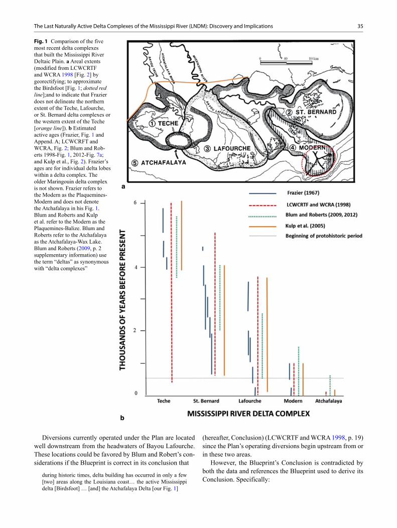
Diversions currently operated under the Plan are located well downstream from the headwaters of Bayou Lafourche. These locations could be favored by Blum and Robert’s con-siderations if the Blueprint is correct in its conclusion that
during historic times, delta building has occurred in only a few [two] areas along the Louisiana coast… the active Mississippi delta [Birdsfoot] … [and] the Atchafalaya Delta [our Fig. 1]
(hereafter, Conclusion) (LCWCRTF and WCRA 1998, p. 19) since the Plan’s operating diversions begin upstream from or in these two areas.
However, the Blueprint’s Conclusion is contradicted by both the data and references the Blueprint used to derive its Conclusion. Specifically:
Fig. 1 Comparison of the five most recent delta complexes that built the Mississippi River Deltaic Plain. a Areal extents (modified from LCWCRTF and WCRA 1998 [Fig. 2] by georectifying; to approximate the Birdsfoot [Fig. 1; dotted red line];and to indicate that Frazier does not delineate the northern extent of the Teche, Lafourche, or St. Bernard delta complexes or the western extent of the Teche [orange line]). b Estimated active ages (Frazier, Fig. 1 and Append. A; LCWCRFT and WCRA, Fig. 2; Blum and Rob-erts 1998-Fig. 1, 2012-Fig. 7a; and Kulp et al., Fig. 2). Frazier’s ages are for individual delta lobes within a delta complex. The older Maringouin delta complex is not shown. Frazier refers to the Modern as the Plaquemines-Modern and does not denote the Atchafalaya in his Fig. 1. Blum and Roberts and Kulp et al. refer to the Modern as the Plaquemines-Balize. Blum and Roberts refer to the Atchafalaya as the Atchafalaya-Wax Lake. Blum and Roberts (2009, p. 2 supplementary information) use the term “deltas” as synonymous with “delta complexes”
36 R. E. Condrey et al.
1. The Blueprint’s Fig. 2 and Frazier (1967) present data that suggest more than two delta complexes may have been active during historic times. The Blueprint’s Fig. 2 suggests four—the Teche, Atchafalaya, Lafourche, and Modern—while Frazier (who does not consider the Atch-afalaya in his Fig. 1) suggests the possibility of three—the Lafourche, Modern, and St. Bernard (Fig. 1b).
2. Russell (1936) observed that active delta building was occurring during historic times in St. Bernard Parish as a result of the overflow of the Mississippi River into the St. Bernard delta complex (Fig. 1a). Delta building ceased with the construction of artificial levees, which were ap-parently destructive to that landscape. He notes:
Most of St. Bernard Parish is a subdelta of the first order. It is inactive at present but has functioned within rather recent times …. Since the building of the artificial levees … there has been practically no sediment carried into St. Bernard Parish by streams. With the cessation of land extension and upbuilding, the forces of destruction have had full sway. Few regions are undergoing more rapid topographical change than this flat terri-tory. (Russell 1936, p. 12, 49)
The Blueprint’s Fig. 2, Frazier’s data in our Fig. 1b, and Russell’s observations all suggest that the Plan’s diversions should have begun above the headwaters of Bayou La-fourche if they are to mirror “geological processes that build deltas [delta complexes] from the top down” and “build or sustain more land-surface area with the available sediment supply” (Blum and Roberts 2009, p. 490).
Our Objectives and Hypotheses
Given the questionable basis for the Blueprint’s Conclusion, our objectives are to locate a candidate LNDM based on the earliest written authority (which we assume is Chaves ca. 1537) and to test our candidate LNDM for consistency with the most authoritative first-hand accounts of the protohis-toric and colonial periods. Our hypotheses are:1. Chaves’ estimates of latitude reflect reality.2. The definition of Chaves’ “league” can be derived from
his data.3. Chaves’ descriptions are sufficient to suggest the most
likely locations of coastal areas associated with an active delta complex (or complexes) of the Mississippi River (Candidates).
4. Chaves’ Candidate-associated vectors can be used to lo-cate the LNDM.
5. Chaves’ LNDM is consistent with the most authoritative first-hand accounts of the protohistoric and colonial peri-ods (Barroto, Iberville, Evía, and Dumain).
6. Our view of the LNDM is consistent with the most au-thoritative chronostratigraphic model of the evolution of late Holocene (~7 kyBP) Mississippi River delta lobes and complexes into the current Mississippi River Deltaic Plain
Chaves’ Authority
In 1503 Queen Isabella established the Casa de la Contratación (House of Trade) at Seville to run a navigation school, collect and synthesize data on new nautical discover-ies, and (beginning in 1508) produce and update its secret Padrón Real (Master Map) from the logs and sworn testi-mony of the pilots and masters of ships returning from the Americas. In 1528, Charles V appointed Alonso de Chaves to the Casa and in 1552 Chaves became its Piloto Mayor (Chief Pilot; Lamb 1969).
Though no Padrón Real by Chaves is known to exist, his “Cosmografía práctica y moderna llamado Espejo de Navegantes” ( Practical and Modern Cosmography called the Mariners’ Mirror, hereafter Cosmografía) (Chaves ca. 1537) is an undated manuscript in the Real Academia de La Historia (Royal Academy of History) in Madrid. A “rutter” or coastal pilot forms “Book Four” of the Cosmo-grafía. A transcription of Book Four was first published as Chaves (1977), the Cosmografía as Chaves (1983). Book Four treats “The Indies of the Ocean Sea, their parts and both their individual and general navigations” in 25 chap-ters. Chapter 1 describes the Atlantic crossing. Each of the remaining chapters begins with a summary which lists major coastal features (such as harbors and capes) and the compass directions and distances between them. Each of these chapters then continues with a geographically orga-nized, more detailed coastal pilot subdivided by sequen-tially numbered place names where each place (herein des-ignated by its book, chapter and entry number in Chaves’ Cosmografía) is normally referenced to other named places by distance-direction vectors. A note describing relevant sailing-related features of each named place usually com-pletes each numbered entry. Lamb (1969, p. 3–4) suggests that the Cosmografía
was the depository of the material taught in Seville, especially to the pilots of the Carrera de Indias (Indies Trade) and … con-tains the earliest preserved example of part of a Padrón Real…the Casa’s most important scientific enterprise.
Chaves’ authority during the 1500s is reflected in Gonzalo Fernández de Oviedo’s rendition of Rodrigo Rangel’s ac-count of the De Soto’s expedition:
When that river [of their escape] comes forth to the sea, the navigation chart states and indicates that it is the Río del Espíritu Santo; which, according to the charts of the cosmogra-pher Alonso de Chaves, enters in a great bay, and the mouth of this river, in the salt water, is at 31˚ on this side of the equator. (Oviedo y Valdés 1851 1:562; Rangel 1993 1:281)
Frazier’s Authority and Deficiencies
Though Frazier’s (1967) chronostratigraphic model of the evolution of late Holocene (~ 7 kyBP) delta com-plexes into the current Mississippi River Deltaic Plain is
37The Last Naturally Active Delta Complexes of the Mississippi River (LNDM): Discovery and Implications
considered the most comprehensive study currently avail-able (i.e., H. Roberts, personal communication 2012; Kulp et al. 2005, p. 282), it contains deficiencies in experi-mental design, aging techniques, and data reporting (i.e. Kidder 1996; Törnqvist et al. 1996). Additional deficien-cies which we find are a failure to consider the possibility that Bayou Plaquemine had been a naturally active Mis-sissippi distributary supporting its own delta lobe(s) (Fra-zier 1967, Fig. 5) and to test Frazier’s assumption that the Atchafalaya River had never been more than “a modern, man-induced distributary of the Mississippi River” (Fra-zier 1967, p. 296). Combined, these deficiencies under-score the desirability of “a fully revised delta-lobe-scale chronostratigraphy” (Kulp et al. 2005) based on current radiocarbon aging techniques, a more holistic approach, and improved experimental design which includes testing the LDMR model.
Even as our most comprehensive model, Frazier’s (1967) estimates of the ages of delta lobes within a delta complex often result in periods of inactivity within the rel-evant delta complex (e.g., our Fig. 1). However, authors who rely on Frazier normally discuss their estimates of delta complex ages as if each complex was continuously active before becoming permanently inactive. An under-standing of how these transformations occur is almost al-ways difficult especially as the transformations often result in a precision which does not accurately reflect Frazier’s data (Box 1).
Materials and Methods
Translation and Examination of Chaves
We used a digital image of Chaves ca. 1537 to check for and correct transcription errors in Chaves (1977). We used all site-specific, GoM-associated vectors and latitude estimates in Book 4. Where the manuscript contained an imprecise, but directional, deviation from the compass rose such as “just N of NW”, we somewhat arbitrarily adjusted the compass read-ing by 1.15° in the direction indicated. Though we could not
Box 1 Aging Delta Complexes: Do Precise Patterns in Longevity Accurately Reflect the Temporal Data?As an example of the difficulty in understanding how some authors transform Frazier’s often discontinuous delta complexes of varying lifespans into continuous complexes with similar delta-complex lifespans, con-trast Frazier’s (1967, Appendix A) delta lobe ages with Blum and Roberts’s (2009, 2012) delta complex ages, both summarized in our Fig. 1. Despite Blum and Rob-erts’s partial dependence on Frazier’s Appendix A data, their estimates of the onset of delta complex activity, B (in kyBP), conform to a quadratic of the form:
(1)
(R2 = 0.999) where N = number of the delta complex (from oldest [1 = Maringouin] to youngest [6 = Atcha-falaya]). In a similar fashion, their estimates of the end of delta complex activity, E, (where N is confined to the pre-colonial period and excludes the Modern and Atchafalaya) conform to a linear relationship of the form:
2B 9.66 kyBP – 2.30* N 0.013* N= +
(2)
(R2 = 1.000). As a result, in Blum and Roberts (2009, 2012) the Maringouin delta complex is predicted to have had an active life of 2,500 y, while the Teche, St. Bernard, and Lafourche each had an active life of 2,000 y. These remarkably precise predictions of the longevities of Mississippi River delta complexes which were not theoretically affected by colonial and post-colonial modifications (in the Blum and Rob-erts treatment) do not accurately reflect Frazier’s data (e.g., our Fig. 1). The unexplained differences call into question the usefulness of Blum and Roberts pattern as hind- and forecasters of delta complex lifespans.
This is not the case with Kulp et al. (2005, their Fig. 2). Here it appears that these authors used three modifications to Frazier’s data. First, they apparently portioned Frazier’s discontinuity in activity between the Maringouin and Teche by assuming the transition in activity between the two deltas complexes occurred at 6 kyBP. Next, they apparently disregarded (as an active delta lobe) Frazier’s short lived lobe 3 within the St. Bernard delta complex. And, finally, they appar-ently disregarded all other periods of inactivity between active delta lobes within a delta complex, thus making each complex continuous between the remaining lobes.
In the resulting Kulp et al. pattern, the Teche was naturally active for ~ 2.1 ky (~3.9 to ~ 6 kyBP) and the St. Bernard, ~ 3.4 ky (~ 0.6 to ~ 4 kyBP), while the Lafourche and Modern became active ~ 3.6 and ~ 1.0 kyBP (respectively) and remained naturally active until they came under human control. The Kulp et al. pattern is visibly compatible with Frazier’s data and suggests that, barring human control, a delta com-plex may have been naturally active > 3.5 ky; two delta complexes may be contemporaneously active from ~ 0 to ~ 3 ky; while three may be contemporaneously active from ~ 0 to ~ 0.5 ky.
E 6.5 kyBP –1.5* N=
38 R. E. Condrey et al.
correct non-directional deviations such as “almost NW”, we did not exclude these from our analyses.
Statistical Test of Hypothesis 1 (Chaves’ Latitudes)
We used Analysis of Covariance (ANCOVA) to test the rela-tionship between Chaves’ estimates of latitudes versus those determined using Google Earth 5.1 for two types of geo-graphical positions: certain and likely (our class variables in the ANCOVA). Positions which had been continuously known since Chaves’ time were considered “certain”. Other positions which we felt reasonably confident in identifying were considered “likely”. All statistical analyses were con-ducted using Proc GLM and Proc REG in SAS 9.1©.
Statistical Test of Hypothesis 2 (Chaves’ League)
To estimate Chaves’ definition of league, we used plane geometry to compute the north to south (NS) distance (b) implicit in his geographical vectors. To accomplish this, we used all of his geographical vectors between points for which he also provided estimates of latitude (Lc) and calculated b using the cosine function,
(3)
where θ = the acute angle which describes the NS compo-nent of Chaves’ compass heading and c = Chaves’ estimate of sailing distance in leagues. Here our assumptions were that Chaves was using a standard league and data generated with plane rather than spherical geometry, though both were known in Spain at the time.
We then regressed b against the latitudinal difference, d (where d = Lc1 – Lc2),
(4)
where i is the intercept and r is the slope. We chose to use parametric rather than nonparametric regression procedures under the assumption that the errors associated with latitude were much less than those associated with sailing distances.
Test of Hypothesis 3 (Chaves’ LNDM Candidates)
We examined Book 4 for areas associated with major riv-erine outflows (e.g., substantial discharges of fresh water, sediment, and/or drift trees; extensive offshore shoals; etc.) into the GoM under the assumption that these would indicate possible Candidates.
( )b cos *cq=
b i r *d= +
Test of Hypothesis 4 (Locating Chaves’ LNDM)
We converted Chaves’ leagues to km using Eq. 4 (Results) and then used two related procedures to locate the position of our Candidates.
In the first, we took all of Chaves’ vectors associated with our Candidates and created an array of vectors radiating from these Candidates (Array). Within the Array, we created an axis (Axis) by fixing the relative positions of the Candidates to each other using the appropriate vectors. We transposed the Array onto a current map of the GoM and adjusted its fit by eye to the current GoM coastline.
In the second, we took the subset of Candidate vectors that were associated with at least one of several continu-ously known positions. We independently projected each of these vectors from its known position towards that of its Candidate.
Test of Hypothesis 5 (Conformity of Record)
For the post Chaves’ protohistoric-colonial period, we con-sider Barroto (Weddle 1987; Condrey in prep.), Iberville (McWilliams 1981; Condrey in prep), Evía (Hackett 1931; Condrey in prep), and Dumain (1807; Condrey in prep) as the most authoritative first-hand accounts. Chavez’ descrip-tions of Candidates and their locations were compared with information in these later accounts about these locations.
Test of Hypothesis 6 (Conformity to Chronostrati-graphic Model)
With one exception, we accept Frazier (1967) as the current au-thority for comparing ages of the Mississippi River delta lobes and Kulp et al.’s (2005) treatment of Frazier as the author-ity for comparing ages of its delta complexes. As previously discussed, that exception occurs with Bayou Plaquemine and the Atchafalaya River. Here, Frazier fails to explore the role of Bayou Plaquemine as a naturally active distributary of the Mississippi River (i.e., his Fig. 5) and considers the Atchafa-laya River as “a modern, man-induced distributary of the Mis-sissippi River” (his p. 296). Neither assumption is supported by the pre-1900 post-colonial record.
Results
Within Book Four, we found 57 named places which are as-sociated with the GoM and for which Chaves gives estimates of latitude. Of these 57, 10 have been continuously known since Chaves’ time: (from S to N) Río Grijalva, Río de San Pablo (currently Río San Pedro y San Pablo), Veracruz,
39The Last Naturally Active Delta Complexes of the Mississippi River (LNDM): Discovery and Implications
Río Tuxpan ( Río Tuspan), Cabo Rojo, Río Pánuco, Cabo de San Antonio, Havana, Tortugas, and Bahía de Miruelo (Apalachee Bay). We felt comfortable in linking five oth-ers to current locations: (following the coast from Yucatan to Florida) La Desconocida (Celestún, Yucatan), Villa Rica ( Río de la Antigua), Río de las Palmas ( Río Soto la Ma-rina), Cabo Bajo (Cape San Blas) and the southern point of La Florida (Cape Sable). These 15 positions are located be-tween 17.75 °N and 30.67 °N.
We found 148 sailing-direction vectors linking these 57 named places to each other. Thirty-eight of these 148 vec-tors were associated with the three positions we identified as Candidates—Río de Flores (River of Flowers), Río del Espíritu Santo, and Cabo de Cruz (Cape of the Cross)—(Results, Hypothesis 3). Seven of the Candidate-associated vectors were associated with any one of several continuously known positions. One of the Candidates (Río de Flores) did not have a vector linking it to a known position.
Hypothesis 1 (Chaves’ Latitudes)
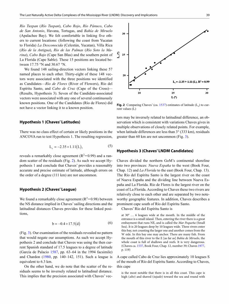
There was no class effect of certain or likely positions in the ANCOVA run to test Hypothesis 1. The resulting regression,
(5)
reveals a remarkably close agreement (R2 = 0.99) and a ran-dom scatter of the residuals (Fig. 2). As such we accept Hy-pothesis 1 and conclude that Chaves’ provides a reasonably accurate and precise estimate of latitude, although errors on the order of a degree (111 km) are not uncommon.
Hypothesis 2 (Chaves’ League)
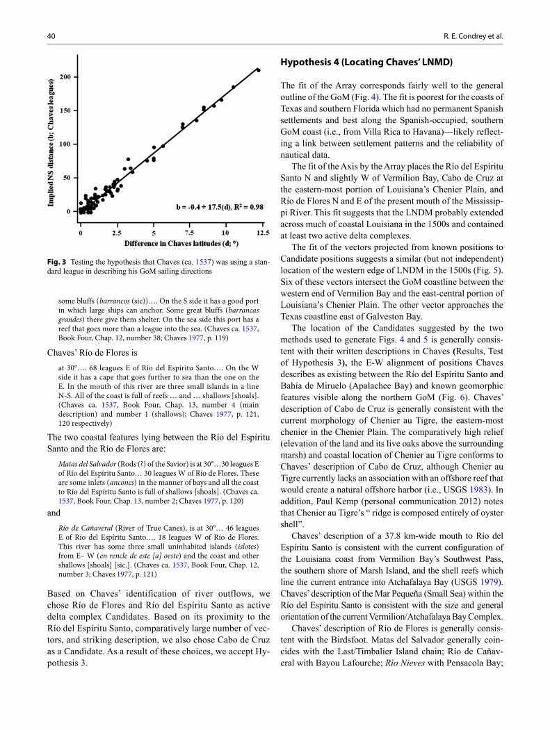
We found a remarkably close agreement (R2 = 0.98) between the NS distance implied in Chaves’ sailing directions and the latitudinal distances Chaves provides for these linked posi-tions,
(6)
(Fig. 3). Our examination of the residuals revealed no pattern that would negate our assumptions. As such we accept Hy-pothesis 2 and conclude that Chaves was using the then cur-rent Spanish standard of 17.5 leagues to a degree of latitude (García de Palacio 1587, pp. 63–64 in the 1994 facsimile) and Chardon (1980, pp. 140–142, 151). Such a league is equivalent to 6.3 km.
On the other hand, we do note that the scatter of the re-siduals seems to be inversely related to latitudinal distance. This implies that the precision associated with Chaves’ vec-
( )cL 2.35 1.11 L ,= − +
( )b 0.4 17.5 d= − +
tors may be inversely related to latitudinal difference, an ob-servation which is consistent with variations Chaves gives in multiple observations of closely related points. For example, when latitude differences are less than 3° (333 km), residuals greater than 60 km are not uncommon (Fig. 3).
Hypothesis 3 (Chaves’ LNDM Candidates)
Chaves divided the northern GoM’s continental shoreline into two provinces: Nueva España to the west (Book Four, Chap. 12) and La Florida to the east (Book Four, Chap. 13). The Río del Espíritu Santo is the largest river on the coast of Nueva España and the dividing line between Nueva Es-paña and La Florida. Río de Flores is the largest river on the coast of La Florida. According to Chaves these two rivers are relatively close to each other and are separated by two note-worthy geographic features. In addition, Chaves describes a prominent cape south of Río del Espíritu Santo.
Chaves’ Río del Espíritu Santo isat 30° … 6 leagues wide at the mouth. In the middle of the entrance is a small island. Then, entering the river there is a great embayment that runs NE, and is called the Mar Pequeña (Small Sea). It is 20 leagues deep by 10 leagues wide. Three rivers enter this bay, not counting the larger one and another comes from the W side. In this bay one may anchor. There are many fish. From the mouth of this river to the E [as far as] Bahía de Miruelo, the whole coast is full of shallows and reefs. It is very dangerous. (Chaves ca. 1537, Book Four, Chap. 12, number 39; Chaves 1977, p. 119)
A cape called Cabo de Cruz lies approximately 10 leagues S of the mouth of Río del Espíritu Santo. According to Chaves, this cape
is the most notable that there is in all this coast. This cape is high ( alto) and shaved ( tajado) toward the sea and round with
Fig. 2 Comparing Chaves’ (ca. 1537) estimates of latitude (Lc) to cur-rent values (L)
40 R. E. Condrey et al.
some bluffs ( barrancos (sic))…. On the S side it has a good port in which large ships can anchor. Some great bluffs ( barrancas grandes) there give them shelter. On the sea side this port has a reef that goes more than a league into the sea. (Chaves ca. 1537, Book Four, Chap. 12, number 38; Chaves 1977, p. 119)
Chaves’ Río de Flores isat 30°…. 68 leagues E of Río del Espíritu Santo…. On the W side it has a cape that goes further to sea than the one on the E. In the mouth of this river are three small islands in a line N-S. All of the coast is full of reefs … and … shallows [shoals]. (Chaves ca. 1537, Book Four, Chap. 13, number 4 (main description) and number 1 (shallows); Chaves 1977, p. 121, 120 respectively)
The two coastal features lying between the Río del Espíritu Santo and the Río de Flores are:
Matas del Salvador (Rods (?) of the Savior) is at 30°…30 leagues E of Río del Espíritu Santo… 30 leagues W of Río de Flores. These are some inlets ( ancones) in the manner of bays and all the coast to Río del Espíritu Santo is full of shallows [shoals]. (Chaves ca. 1537, Book Four, Chap. 13, number 2; Chaves 1977, p. 120)
andRío de Cañaveral (River of True Canes), is at 30°… 46 leagues E of Río del Espíritu Santo…. 18 leagues W of Río de Flores. This river has some three small uninhabited islands ( islotes) from E– W ( en rencle de este [a] oeste) and the coast and other shallows [shoals] [sic.]. (Chaves ca. 1537, Book Four, Chap. 12, number 3; Chaves 1977, p. 121)
Based on Chaves’ identification of river outflows, we chose Río de Flores and Río del Espíritu Santo as active delta complex Candidates. Based on its proximity to the Río del Espíritu Santo, comparatively large number of vec-tors, and striking description, we also chose Cabo de Cruz as a Candidate. As a result of these choices, we accept Hy-pothesis 3.
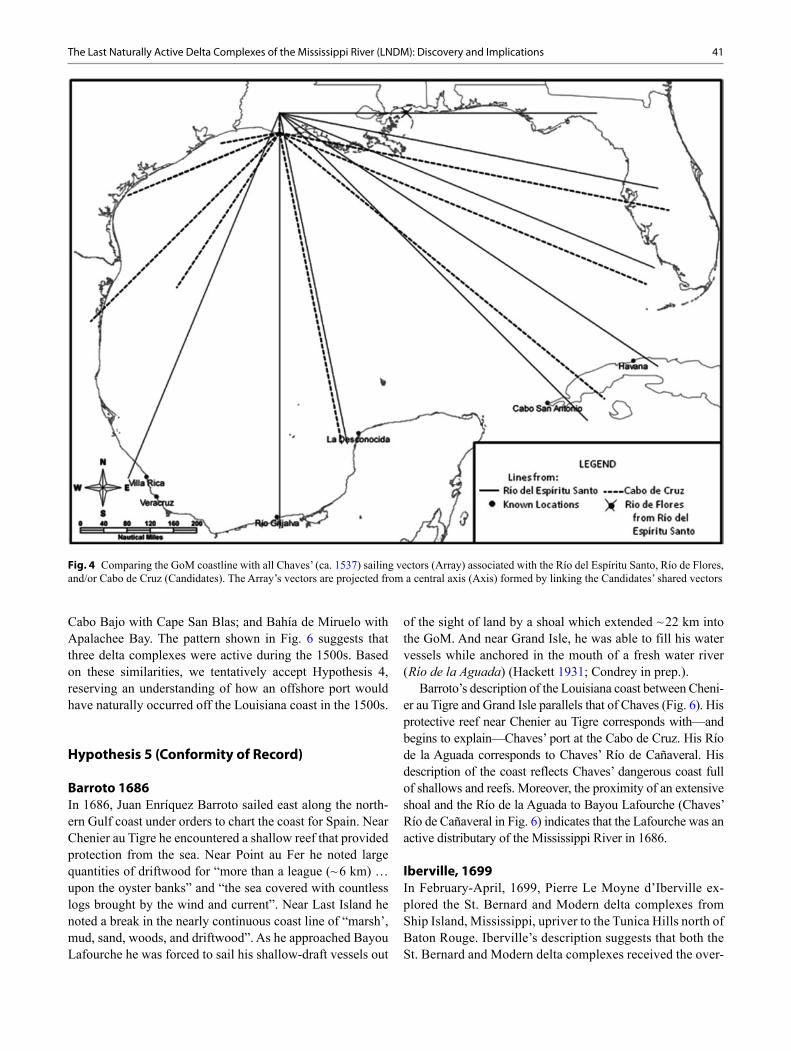
Hypothesis 4 (Locating Chaves’ LNMD)
The fit of the Array corresponds fairly well to the general outline of the GoM (Fig. 4). The fit is poorest for the coasts of Texas and southern Florida which had no permanent Spanish settlements and best along the Spanish-occupied, southern GoM coast (i.e., from Villa Rica to Havana)—likely reflect-ing a link between settlement patterns and the reliability of nautical data.
The fit of the Axis by the Array places the Río del Espíritu Santo N and slightly W of Vermilion Bay, Cabo de Cruz at the eastern-most portion of Louisiana’s Chenier Plain, and Río de Flores N and E of the present mouth of the Mississip-pi River. This fit suggests that the LNDM probably extended across much of coastal Louisiana in the 1500s and contained at least two active delta complexes.
The fit of the vectors projected from known positions to Candidate positions suggests a similar (but not independent) location of the western edge of LNDM in the 1500s (Fig. 5). Six of these vectors intersect the GoM coastline between the western end of Vermilion Bay and the east-central portion of Louisiana’s Chenier Plain. The other vector approaches the Texas coastline east of Galveston Bay.
The location of the Candidates suggested by the two methods used to generate Figs. 4 and 5 is generally consis-tent with their written descriptions in Chaves (Results, Test of Hypothesis 3), the E-W alignment of positions Chaves describes as existing between the Río del Espíritu Santo and Bahía de Miruelo (Apalachee Bay) and known geomorphic features visible along the northern GoM (Fig. 6). Chaves’ description of Cabo de Cruz is generally consistent with the current morphology of Chenier au Tigre, the eastern-most chenier in the Chenier Plain. The comparatively high relief (elevation of the land and its live oaks above the surrounding marsh) and coastal location of Chenier au Tigre conforms to Chaves’ description of Cabo de Cruz, although Chenier au Tigre currently lacks an association with an offshore reef that would create a natural offshore harbor (i.e., USGS 1983). In addition, Paul Kemp (personal communication 2012) notes that Chenier au Tigre’s “ ridge is composed entirely of oyster shell”.
Chaves’ description of a 37.8 km-wide mouth to Río del Espíritu Santo is consistent with the current configuration of the Louisiana coast from Vermilion Bay’s Southwest Pass, the southern shore of Marsh Island, and the shell reefs which line the current entrance into Atchafalaya Bay (USGS 1979). Chaves’ description of the Mar Pequeña (Small Sea) within the Río del Espíritu Santo is consistent with the size and general orientation of the current Vermilion/Atchafalaya Bay Complex.
Chaves’ description of Río de Flores is generally consis-tent with the Birdsfoot. Matas del Salvador generally coin-cides with the Last/Timbalier Island chain; Río de Cañav-eral with Bayou Lafourche; Río Nieves with Pensacola Bay;
Fig. 3 Testing the hypothesis that Chaves (ca. 1537) was using a stan-dard league in describing his GoM sailing directions
41The Last Naturally Active Delta Complexes of the Mississippi River (LNDM): Discovery and Implications
Cabo Bajo with Cape San Blas; and Bahía de Miruelo with Apalachee Bay. The pattern shown in Fig. 6 suggests that three delta complexes were active during the 1500s. Based on these similarities, we tentatively accept Hypothesis 4, reserving an understanding of how an offshore port would have naturally occurred off the Louisiana coast in the 1500s.
Hypothesis 5 (Conformity of Record)
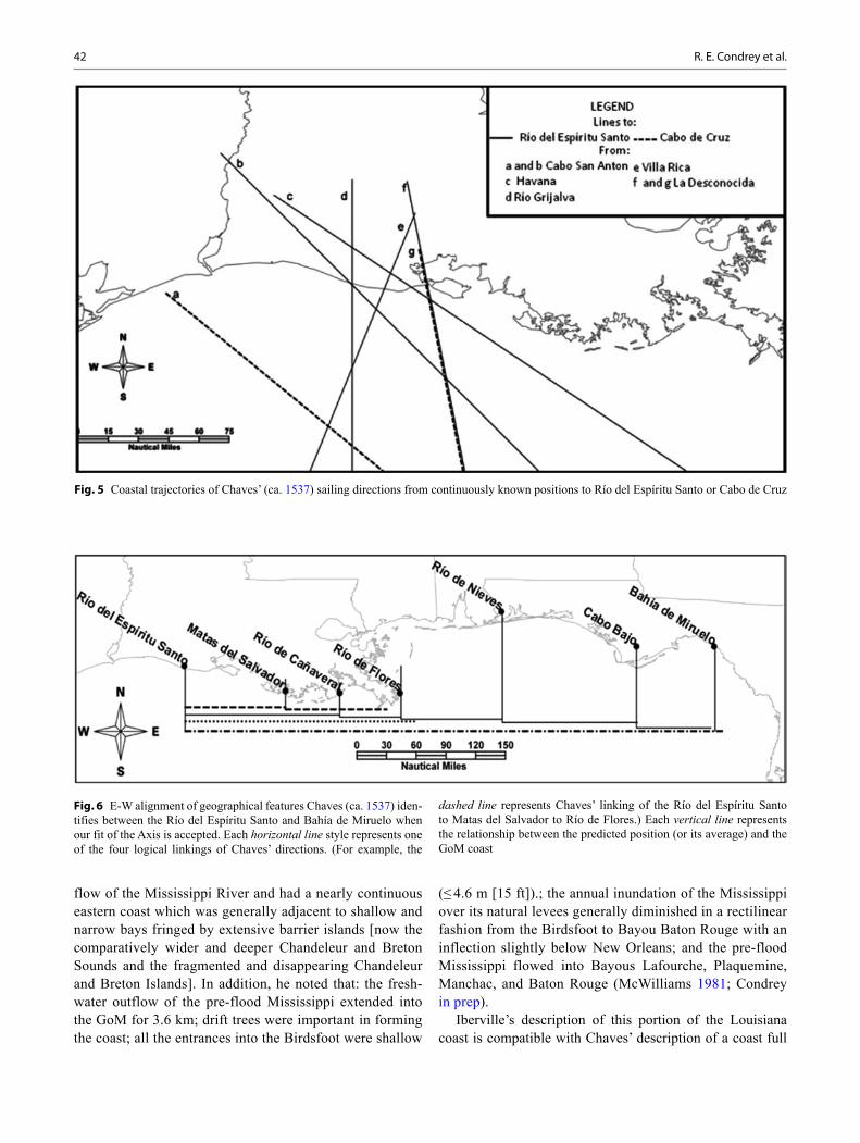
Barroto 1686In 1686, Juan Enríquez Barroto sailed east along the north-ern Gulf coast under orders to chart the coast for Spain. Near Chenier au Tigre he encountered a shallow reef that provided protection from the sea. Near Point au Fer he noted large quantities of driftwood for “more than a league (~ 6 km) …upon the oyster banks” and “the sea covered with countless logs brought by the wind and current”. Near Last Island he noted a break in the nearly continuous coast line of “marsh’, mud, sand, woods, and driftwood”. As he approached Bayou Lafourche he was forced to sail his shallow-draft vessels out
of the sight of land by a shoal which extended ~ 22 km into the GoM. And near Grand Isle, he was able to fill his water vessels while anchored in the mouth of a fresh water river ( Río de la Aguada) (Hackett 1931; Condrey in prep.).
Barroto’s description of the Louisiana coast between Cheni-er au Tigre and Grand Isle parallels that of Chaves (Fig. 6). His protective reef near Chenier au Tigre corresponds with—and begins to explain—Chaves’ port at the Cabo de Cruz. His Río de la Aguada corresponds to Chaves’ Río de Cañaveral. His description of the coast reflects Chaves’ dangerous coast full of shallows and reefs. Moreover, the proximity of an extensive shoal and the Río de la Aguada to Bayou Lafourche (Chaves’ Río de Cañaveral in Fig. 6) indicates that the Lafourche was an active distributary of the Mississippi River in 1686.
Iberville, 1699In February-April, 1699, Pierre Le Moyne d’Iberville ex-plored the St. Bernard and Modern delta complexes from Ship Island, Mississippi, upriver to the Tunica Hills north of Baton Rouge. Iberville’s description suggests that both the St. Bernard and Modern delta complexes received the over-
Fig. 4 Comparing the GoM coastline with all Chaves’ (ca. 1537) sailing vectors (Array) associated with the Río del Espíritu Santo, Río de Flores, and/or Cabo de Cruz (Candidates). The Array’s vectors are projected from a central axis (Axis) formed by linking the Candidates’ shared vectors
42 R. E. Condrey et al.
flow of the Mississippi River and had a nearly continuous eastern coast which was generally adjacent to shallow and narrow bays fringed by extensive barrier islands [now the comparatively wider and deeper Chandeleur and Breton Sounds and the fragmented and disappearing Chandeleur and Breton Islands]. In addition, he noted that: the fresh-water outflow of the pre-flood Mississippi extended into the GoM for 3.6 km; drift trees were important in forming the coast; all the entrances into the Birdsfoot were shallow
(≤ 4.6 m [15 ft]).; the annual inundation of the Mississippi over its natural levees generally diminished in a rectilinear fashion from the Birdsfoot to Bayou Baton Rouge with an inflection slightly below New Orleans; and the pre-flood Mississippi flowed into Bayous Lafourche, Plaquemine, Manchac, and Baton Rouge (McWilliams 1981; Condrey in prep).
Iberville’s description of this portion of the Louisiana coast is compatible with Chaves’ description of a coast full
Fig. 6 E-W alignment of geographical features Chaves (ca. 1537) iden-tifies between the Río del Espíritu Santo and Bahía de Miruelo when our fit of the Axis is accepted. Each horizontal line style represents one of the four logical linkings of Chaves’ directions. (For example, the
dashed line represents Chaves’ linking of the Río del Espíritu Santo to Matas del Salvador to Río de Flores.) Each vertical line represents the relationship between the predicted position (or its average) and the GoM coast
Fig. 5 Coastal trajectories of Chaves’ (ca. 1537) sailing directions from continuously known positions to Río del Espíritu Santo or Cabo de Cruz
43The Last Naturally Active Delta Complexes of the Mississippi River (LNDM): Discovery and Implications
of shallows and reefs and with the association in Fig. 6 of Chaves’ Río de Flores with the Birdsfoot.
Evía and Dumain, 1785–1807In 1785, the Spanish surveyor José Antonio de Evía was charged with charting the shoals that lined the Louisiana coast. Sailing west from the Birdsfoot, he described the coast to Last Island as flat, subject to overflow, full of drift logs from the Mississippi, and containing passes that could only be entered by pirogues. Once he reached Last Island, he anchored on an extensive set of offshore oyster reefs which were generally under 0.9–1.2 m of water and pro-vided coastal protection from southerly and southwesterly winds The reefs extend laterally along the coast from Last Island to Chenier au Tigre and into the GoM for 18.5 km (at their eastern edge) to 9.3 km (at their western edge). Near Chenier au Tigre, he observed the coastal protection provided by the reefs from land-ward advancing squalls and that fresh water extended > 11.1 km into the GoM. He noted that the spring flood of the Mississippi through the Atchafa-laya River, Bayou Lafourche, and Barataria Pass sent plumes of fresh water 16.7 km into the GoM where they joined the downstream current carrying the discharge of the Birdsfoot (Hackett 1931; Condrey in prep).
In 1806 Louis Dumain surveyed a portion of the Louisi-ana coast for the United States. His report parallels Evía’s description of an extensive offshore oyster reef and the Atch-afalaya as a distributary of the Mississippi River. Specifi-cally Dumain reports that oyster reefs extended ~ 27–33 km into the GoM from the mouth of the Atchafalaya and that the annual flood of the Mississippi did not cause the lower Atchafalaya River to rise more than 0.9 m (Dumain 1807; Condrey in prep.).
Evía mirrors Chaves’ and Barroto’s description of the Louisiana coast between Chaves’ Cabo de Cruz (Evía’s Chenier au Tigre) and Río de Flores (Birdsfoot), Barroto’s description of the offshore oyster reef, and our interpreta-tion of Chaves (Fig. 6). Dumain mirrors Evía’s estimate of the seaward extent of the offshore oyster reef south of the Atchafalaya Bay. The westward limit of the Evía/Dumain oyster reef is consistent with the necessity to enter Chaves’ Río del Espíritu Santo from the west and explains why Cabo de Cruz (Evía’s Chenier au Tigre), in conjunction with the reef’s westward end, functioned as an offshore port. Evía’s measurements of the freshwater discharge of the Atchafa-laya River/Bayou Plaquemine and Bayou Lafourche/Bara-taria Pass qualify these streams as active distributaries of the Mississippi River by our definition. Moreover, Evía’s descriptions of the Mississippi’s vast freshwater outflows begin to suggest how the LNDM nurtured an extensive off-shore oyster reef.
General Consistency of the Protohistoric and Colonial RecordThere is a remarkable consistency in the protohistoric and colonial record and our interpretation of Chaves (Figs. 4, 5, and 6).
Chenier au Tigre is an ideal candidate for Chaves’ Cabo de Cruz. There is no other elevated area on the Louisiana or Texas coast that approaches its proximity to our location of Chaves’ Cabo de Cruz; a river containing a mouth greater than 2 km in width; and extensive, historic offshore oyster reefs. In the early 1500s the comparatively high relief and coastal proximity of Chenier au Tigre would have provided some protection to ships at anchor from northerly and west-erly winds, while the vast oyster reefs would have provided similar protection from southerly and easterly winds (as Evía noted).
Vermilion Bay’s Southwest Pass and the Vermilion/Atchafalaya Bay complex is the most logical candidate for Chaves’ Río del Espíritu Santo and its Mar Pequeña. Its di-mensions conform to Chaves’ description of a river having a 38 km wide mouth and a 63 by 127 km, NE-oriented embay-ment. The vast offshore oyster reef described by Evía would have impeded entrance into the Vermilion/Atchafalaya Bay complex from the S and E, while encouraging a western en-trance through Vermilion Bay’s Southwest Pass. As a promi-nent oak covered chenier, Chenier au Tigre (our estimation of Cabo de Cruz) would serve as a visual guide to vessels approaching from the sea. Once into the system, Marsh Is-land would serve as a southern land border until one reached the mouth of present day Atchafalaya Bay, where the oyster reef would continue as an impediment to a southerly exit and provide protection from storms from the S and E.
The current mouth of the Mississippi River is the most logical candidate for Chaves’ Río de Flores. Its present and historic descriptions closely mirror that given in Chaves, es-pecially when viewed in light of Figs. 4, 5, and 6.
Given these considerations, we accept Hypothesis 5.
Hypothesis 6 (Conformity to Chronostratigraphic Model)
There is general consistency of our view of the LNDM with Frazier’s (1967) for the beginning of the protohistoric pe-riod. The Modern and Lafourche delta complexes were both active. There was no unobstructed free flow of water be-tween the Atchafalaya and Mississippi Rivers. The St. Ber-nard delta complex had recently become inactive: Frazier finds the St. Bernard’s Bayou Sauvage delta lobe became inactive ~ 200 years before the advent of the protohistoric period; while Iberville’s 1699 observations suggest that the St. Bernard delta complex continued to receive the annual overflow of the Mississippi, though the complex had no
44 R. E. Condrey et al.
active delta lobe. Additional studies which expand Frazier’s approach to include Bayou Plaquemine and a humanly unal-tered Atchafalaya’s River are required before a comparison of our view of the LNDM with the Deltaic Plain chronology of these streams can be accomplished.
Given these considerations, we accept Hypothesis 6.
Viewing the LNDM
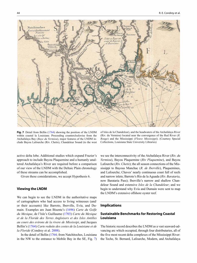
We can begin to see the LNDM in the authoritative maps of cartographers who had access to living witnesses (and/or their accounts) like Barroto, Iberville, Evía, and Du-main. Examples are Juan Bisente’s (1696) Carte du Golfe du Mexique, de l’Isle’s Guillaume (1703) Carte du Mexique et de la Floride des Terres Angloisers et des Isles Antilles au cours des evirons de la rivere de Mississipi, and Jacques Bellin’s (1764) Carte reduite des costes de la Louisiane et de la Floride (Condrey et al. 2008).
In the detail of Bellin (1764; from Natchitoches, Louisiana in the NW to the entrance to Mobile Bay in the SE, Fig. 7)
we see the interconnectivity of the Atchafalaya River ( Riv. du Vermiou), Bayou Plaquemine ( Riv Plaquemine), and Bayou Lafourche ( Riv. Chetis); the all season connections of the Mis-sissippi to Bayous Manchac ( R. de Iberville), Plaquemines, and Lafourche; Chaves’ nearly continuous coast full of reefs and narrow inlets; Barroto’s Río de la Aguada ( Riv. Barataria, now Barataria Pass); Iberville’s narrow and shallow Chan-deleur Sound and extensive Isles de la Chandeleur; and we begin to understand why Evía and Dumain were sent to map the LNDM’s extensive offshore oyster reef.
Implications
Sustainable Benchmarks for Restoring Coastal Louisiana
The historic record describes the LNDM as a vast seaward-ad-vancing arc which occupied, through four distributaries, all of the five most recent delta complexes of the Mississippi River: the Teche, St. Bernard, Lafourche, Modern, and Atchafalaya
Fig. 7 Detail from Bellin (1764) showing the position of the LNDM within coastal la Louisiane. Proceeding counterclockwise from the Atchafalaya Bay ( Baye du Vermiou), major features of the LNDM in-clude Bayou Lafourche (Riv. Chetis), Chandeleur Sound (to the west
of Isles de la Chandeleur), and the headwaters of the Atchafalaya River (Riv. du Vermiou) located near the convergence of the Red River ( R. Rouge) and the Mississippi ( Fleuve Mississippi). (Courtesy Special Collections, Louisiana State University Libraries)
45The Last Naturally Active Delta Complexes of the Mississippi River (LNDM): Discovery and Implications
(Figs. 1, 4, 5 and 6). During the annual spring flood, much of the LNDM carried plumes of freshwater out into the GoM for > 10 km. Overbank flooding of the Mississippi’s natural le-vees in the Modern and St. Bernard delta complexes began as far north as Bayou Baton Rouge. The eastern shore of the St. Bernard and Modern delta complexes was low and subject to overflow; occupied much of what is now open water in Chan-deleur and Breton Sounds; and abutted shallow bays filled with islands. The portion of the LNDM west of the Birdsfoot received the outflows and overflows of the Mississippi’s four distributaries. This coast was also low and subject to overflow; nearly continuous; and characterized by reefs, shoals, drift trees, and shallow inlets. The network of distributaries associ-ated with the western portion of the LNDM nurtured a network of offshore oyster reefs which covered ~ 2,000 km2 of the US GoM and extended along the US coast for > 150 km (Condrey in prep). From 1500–1800, this offshore oyster reef restrict-ed safe access to the Mississippi’s western-most distributary (Chaves’ Río del Espíritu Santo). Here, in combination with Louisiana’s eastern-most coastal cheniers (Chaves’ Cabo de Cruz), the reef produced a natural harbor that was evidently of great importance to Spanish sailors caught in storms along the northern GoM during the 1500s and 1600s. Given Oviedo’s interpretation of Rangel (Introduction), Chaves’ descriptions (Results, Hypothesis 3), and the desire of De Soto’s men to reach Mexico, it is more reasonable to conclude that De Soto’s men rode the spring flood out of the Vermilion/Atchafalaya Bay complex than the Birdsfoot.
Louisiana’s Blueprint for coastal restoration is based upon its Conclusion that the LNDM was restricted to the Birdsfoot and the Atchafalaya delta complex (Fig. 1). The Blueprint then continues with a statement that “massive coastal ero-sion… began around 1890 and peaked during the 1950s and 1960s” (LCWCRF and WCRA 1998, p. 31). It then targets estuarine conditions generally encountered in the 1950s–1980s as benchmarks for coastal restoration.
Our analysis finds that the Blueprint’s Conclusion is based upon an incomplete and incorrect consideration of the histor-ic record. Because of this, the Blueprint underestimates both the magnitude of the LNDM and the magnitude and onset of anthropogenically induced land loss in coastal Louisiana. Our analysis suggests that much of Louisiana’s coast was advancing into the sea at the onset of European colonization, that colonial and post-colonial modification of the Missis-sippi resulted in a cumulating loss of much of this potential, and that Louisiana’s total land loss (measured not just in loss of existing land but also in potential land gains) peaked long before the Blueprint’s 1950s−1960s estimate. In partial sup-port of this argument we offer Iberville/Russell’s Chandeleur Sound, Barroto/Evía/Dumain’s vast offshore oyster reef, and Chaves’ coast, all of which suggest the potential, as well as the actual, land that has been lost.
As a consequence, many of the Blueprint’s coastal res-toration benchmarks are incompatible with a sustainable coast. Among these benchmarks are: diversions (similar to the Birdsfoot and the Atchafalaya delta complex) restricted to the lowest regions of coastal Louisiana; oyster reefs con-fined to estuarine environments; brackish-water dominated estuaries in the spring; deepwater shipping channel inlets; and artificial levees.
Benchmarks which describe the vibrant and sustainable coast the early Europeans encountered include: four active distributaries; freshwater-dominated estuaries in the spring; and a nearly continuous, seaward-advancing coastline char-acterized by shallow inlets, a vast offshore oyster reef, and overland flow of floodwaters throughout most, if not all, of Louisiana’s coast east of the Chenier Plain. The historic re-cord strongly suggests that these benchmarks will only be obtained with multiple, large-scale diversions of freshwa-ter and sediment which begin at or above the headwaters of the Atchafalaya River, Bayou Plaquemines, and Bayou La-fourche and reconnect the Mississippi River to its Deltaic Plain in a manner which reflects the connectivity of the river and its LNDM. As such, our analysis supports Day et al.’s (2007, p. 1681) recommendation for “reconnecting the river to the deltaic plain via … the reopening of old distributaries”, as well as the desirability of “a fully revised delta-lobe-scale chronostratigraphy” (Kulp et al. 2005, p. 282).
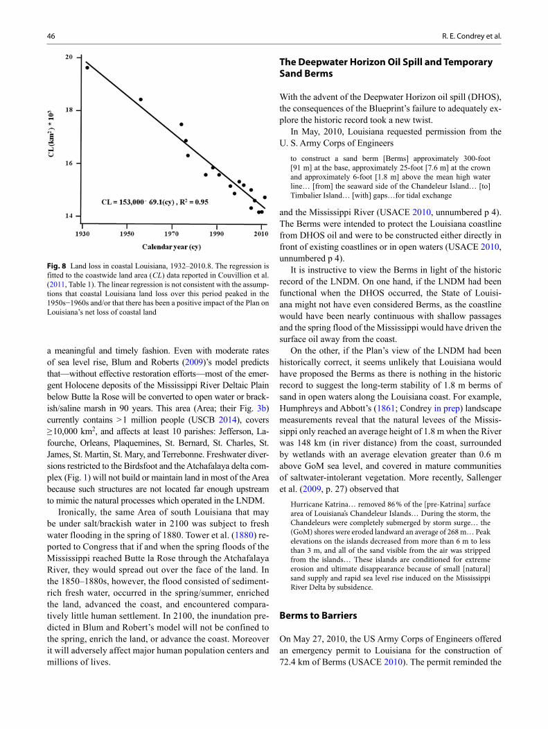
Given the Plan’s limited consideration of the historic re-cord and the incompatibility of many of its benchmarks with a sustainable coast, it is not surprising that the most com-prehensive recent estimates of “land area change in coastal Louisiana” (Couvillion et al. 2011) are consistent with a con-stant rate of land loss of 69.1 km2/yr (Fig. 8; 1.47 football fields/hr; NFL 2011, p. 1) for the period 1932 through 2010.
For some of Louisiana’s renewable resources that thrive under the current and naturally unsustainable conditions, a replacement of the Blueprint’s unsupported benchmarks with those supported by the historic record may result in a decline in their current and unsustainable productivity. In other cases, they may not. For example the Blueprint advo-cates the position that the fragmented coastline of a brackish, decaying estuary supports the greatest fishery productivity. This is not true for one of Louisiana’s two most valuable historic fisheries—that on white shrimp which peaked in the 1940s (LDWF 1992, p. 50; Condrey and Fuller 2005)—and may not be true for the other—that on oysters (i.e., Evía). The historic record suggests that coastal restoration efforts that restore the fresh-water conditions of Louisiana’s estuar-ies shown by the LNDM should eventually enhance the pro-ductivity of Louisiana’s white shrimp and oyster resources.
Fishery considerations pale, however, when one consid-ers the catastrophic consequences of the Blueprint’s failure to explore the historic record and restore Louisiana’s coast in
46 R. E. Condrey et al.
a meaningful and timely fashion. Even with moderate rates of sea level rise, Blum and Roberts (2009)’s model predicts that—without effective restoration efforts—most of the emer-gent Holocene deposits of the Mississippi River Deltaic Plain below Butte la Rose will be converted to open water or brack-ish/saline marsh in 90 years. This area (Area; their Fig. 3b) currently contains > 1 million people (USCB 2014), covers ≥ 10,000 km2, and affects at least 10 parishes: Jefferson, La-fourche, Orleans, Plaquemines, St. Bernard, St. Charles, St. James, St. Martin, St. Mary, and Terrebonne. Freshwater diver-sions restricted to the Birdsfoot and the Atchafalaya delta com-plex (Fig. 1) will not build or maintain land in most of the Area because such structures are not located far enough upstream to mimic the natural processes which operated in the LNDM.
Ironically, the same Area of south Louisiana that may be under salt/brackish water in 2100 was subject to fresh water flooding in the spring of 1880. Tower et al. (1880) re-ported to Congress that if and when the spring floods of the Mississippi reached Butte la Rose through the Atchafalaya River, they would spread out over the face of the land. In the 1850–1880s, however, the flood consisted of sediment-rich fresh water, occurred in the spring/summer, enriched the land, advanced the coast, and encountered compara-tively little human settlement. In 2100, the inundation pre-dicted in Blum and Robert’s model will not be confined to the spring, enrich the land, or advance the coast. Moreover it will adversely affect major human population centers and millions of lives.
The Deepwater Horizon Oil Spill and Temporary Sand Berms
With the advent of the Deepwater Horizon oil spill (DHOS), the consequences of the Blueprint’s failure to adequately ex-plore the historic record took a new twist.
In May, 2010, Louisiana requested permission from the U. S. Army Corps of Engineers
to construct a sand berm [Berms] approximately 300-foot [91 m] at the base, approximately 25-foot [7.6 m] at the crown and approximately 6-foot [1.8 m] above the mean high water line… [from] the seaward side of the Chandeleur Island… [to] Timbalier Island… [with] gaps…for tidal exchange
and the Mississippi River (USACE 2010, unnumbered p 4). The Berms were intended to protect the Louisiana coastline from DHOS oil and were to be constructed either directly in front of existing coastlines or in open waters (USACE 2010, unnumbered p 4).
It is instructive to view the Berms in light of the historic record of the LNDM. On one hand, if the LNDM had been functional when the DHOS occurred, the State of Louisi-ana might not have even considered Berms, as the coastline would have been nearly continuous with shallow passages and the spring flood of the Mississippi would have driven the surface oil away from the coast.
On the other, if the Plan’s view of the LNDM had been historically correct, it seems unlikely that Louisiana would have proposed the Berms as there is nothing in the historic record to suggest the long-term stability of 1.8 m berms of sand in open waters along the Louisiana coast. For example, Humphreys and Abbott’s (1861; Condrey in prep) landscape measurements reveal that the natural levees of the Missis-sippi only reached an average height of 1.8 m when the River was 148 km (in river distance) from the coast, surrounded by wetlands with an average elevation greater than 0.6 m above GoM sea level, and covered in mature communities of saltwater-intolerant vegetation. More recently, Sallenger et al. (2009, p. 27) observed that
Hurricane Katrina… removed 86 % of the [pre-Katrina] surface area of Louisiana’s Chandeleur Islands… During the storm, the Chandeleurs were completely submerged by storm surge… the (GoM) shores were eroded landward an average of 268 m… Peak elevations on the islands decreased from more than 6 m to less than 3 m, and all of the sand visible from the air was stripped from the islands… These islands are conditioned for extreme erosion and ultimate disappearance because of small [natural] sand supply and rapid sea level rise induced on the Mississippi River Delta by subsidence.
Berms to Barriers
On May 27, 2010, the US Army Corps of Engineers offered an emergency permit to Louisiana for the construction of 72.4 km of Berms (USACE 2010). The permit reminded the
Fig. 8 Land loss in coastal Louisiana, 1932–2010.8. The regression is fitted to the coastwide land area ( CL) data reported in Couvillion et al. (2011, Table 1). The linear regression is not consistent with the assump-tions that coastal Louisiana land loss over this period peaked in the 1950s−1960s and/or that there has been a positive impact of the Plan on Louisiana’s net loss of coastal land
47The Last Naturally Active Delta Complexes of the Mississippi River (LNDM): Discovery and Implications
State that permission would be required before federal sands on Ship and St. Bernard Shoals could be mined for sand. Though not mentioned in the permit, pre-DHOS Ship Shoal had recently been found to be a biodiversity hotspot (Dubois et al. 2009) and nationally important blue crab ( Callinectes sapidus) spawning ground (Gelpi et al. 2009)—characteris-tics hypothesized to be shared by the biologically unstudied St. Bernard Shoals (Condrey et. al. 2010). Nothing in the permit referenced concerns that these shoals might support endangered sea turtles such as loggerheads ( Caretta caretta; i.e., Stone et al. 2009, p. 242) seeking blue crab (e.g. Seney and Musick 2007) or that the DHOS might be impacting the ecology of the shoals and threatening the blue crab fishery (Condrey et al. 2010; Leibach 2010; Box 2).
In November, 2010, the Office of the Louisiana Governor reported
plans to fortify the temporary sand [B]erms for oil protection so that they become barrier islands [Barriers] that both block oil and help to restore and protect Louisiana’s coast….against the threat of submerged oil before the next hurricane season….[making this] the largest barrier island restoration project in Louisiana history. (OG 2010).
On the surface, this seems like a wise decision as “Louisiana’s barrier shoreline is one of the fastest eroding shorelines in the world” (CPRA 2011, unnumbered p. 24 of Appendix C).
On closer inspection it is not clear how the effort, which will cost ~ 9 % of the $ 1.1 billion 2012–2014 budget (CPRA 2011; Table ES-2, p. x), will lead to sustainability as previ-ous restoration projects have only increased barrier island life spans by ~ 10 to 16 years:
The good news is that restoration efforts … have shown benefits. Timbalier Island … restoration… added approximately 10 years of life to the island. [Restoration projects on] the Isles Dernieres … have increased their life span by approximately 16 years….
the State plans to utilize the [B]erm material and approxi-mately $ 100 million… to convert the temporary [B]erm fea-tures into the more resilient barrier island features that were designed as CWPPRA projects. CPRA 2011, unnumbered p. 24 of Appendix C)
A recent USGS study of the Berm constructed along the Chandeleur Islands suggests that it may not remain long enough to allow for its conversion to a Barrier. One year after its construction, Flocks et al. (2012, pp. 5–6) report that
erosion of the [Chandeleur B]erm is being influenced by the island chain. The northernmost segment of the [B]erm… has the highest remaining elevation… [T]he central [B]erm is rolling over into the manmade trough … The southernmost segment of the [B]erm exhibits the highest reduction in elevation. Along this reach, islands and dunes are fewer, and overwash splays and inlets are wider. Virtually all of the [B]erm along this reach has been overwashed and eroded and in places has been completely removed.
At best, then, Berms to Barriers may provide some limited and short-lived protection of the Louisiana coast. Toward the worst, it will divert money from more effective coastal restoration projects and prove a negative tipping point for Louisiana’s blue crab fishery.
The Plan is not an Exception
The Plan is not alone in its failure to carefully consider the historic record. For example, Galtsoff (1954a) in the intro-ductory chapter to the first major effort to synthesize our understanding of the ecology of the GoM (Galtsoff 1954b) misleads the casual reader to believe that Alonzo Alvarez de Pineda left a first-hand, written description of the ecology of the Mississippi River and Mississippi Sound. He writes that in 1519 Alvarez de Pineda
discovered the mouth of the Mississippi River which he called “Río del Espíritu Santu” [sic] and described the body of water E of the delta as “Mar Pequeña” or a small sea, the name of the present Mississippi Sound which persisted on many charts for nearly two centuries. Pineda noted the physiographical charac-ter of the shoreline, recorded the positions of dunes, low-lying sand spits, bays, knolls, marshes, and oyster banks ( ostiales) which abounded in the Mississippi Sound and in the delta of the Mississippi River. He realized that the majestic freshwater stream that he ascended for several miles must originate on a large land area, and other observations convinced him that he was exploring the coast of a great continent. (Galtsoff 1954a, p. 12)
Box 2 Berms, Sand Mining, and Sea Turtle Mortality The 2010 sand mining efforts for the Chandeleur Islands Berm produced two “very alarming observa-tions”: extremely high catch rates and unprecedented mortalities of loggerheads (Bernhart 2010, p. 3). Creef (2010, p. 12; consistent with Bernhart 2010, p. 3) sug-gested that these sea turtles may have beenadversely affected by [DHOS] oil and dispersants… [leaving them] less able to avoid entrainment by hopper dredges and…less able to physically tolerate the stresses of capture by trawl-ing efforts.
If sand mining on Ship and/or St. Bernard Shoals results in a precipitous decline in blue crab abundance, the decline may cause “loggerheads to forage in nets or on discarded fishery bycatch” (Seney and Musick 2007, p. 478). If diet-displaced loggerheads are less able to “tolerate the stress of capture by trawling” (Creef, above), their mortality in the US GoM shrimp fishery should increase. This could reignite the 1989 conflicts between shrimpers and regulators (e.g. Con-drey and Fuller 2005, p. 110–111) though the underly-ing problems arose from a combination of sand mining and the lingering impacts of the DHOS.
48 R. E. Condrey et al.
Galtsoff provides no citation that supports this vivid and in-correct description. Indeed, there is no firsthand account of Alvarez de Pineda’s expedition along the northern GoM coast other than what Chaves seems to record and no secondhand account that supports Galtsoff’s description. Despite these glaring inadequacies, Galtsoff’s unverifiable description of Alvarez de Pineda’s findings continue to influence scientific understanding of the GoM (e.g., GulfBase.org. 2010).
Re-evaluating Our Basic Understanding of the Americas
This limited study of Chaves has given us our first view of the last naturally active delta complexes of North America’s largest river, a blue print for restoring the Nation’s wet-lands, and new insight into the exit used by the first Europe-ans who penetrated North America. Given the discrepancies we have found, we suggest that a careful reappraisal of the protohistoric and colonial record of the Americas is war-ranted. As the challenge is to separate scientist from charla-tan, we suggest Chaves as a starting point. Here we follow Lamb’s (1969) insightful argument that “Chaves’ undated manuscript… contains the earliest preserved example of part of a Padrón Real”, and thus our earliest recorded view of the Americas. Our analyses lead us to suggest that the written coastal descriptions of the early cartographers and surveyors may be far more valuable than even the most au-thoritative protohistoric or colonial map—especially as we try to build a better tomorrow based upon our understanding of the past.
Epilogue: Barrier Island Restoration: Are the Plan’s efforts working?
While this book was in the final stages of preparation, Loui-siana issued the 2015 fiscal year Plan update (Update; CPRA 2014). The Update’s Section 2, “Progress to Date: Results on all Fronts”, is the Plan’s “report card on results achieved and in the works” (CPRA 2014 p. 11). The Report Card con-tains 12 pages of discussion followed by five pages of tables and maps. Approximately 60 % of the Report Card’s dis-cussion highlights barrier island/GoM shoreline restoration projects—suggesting in it’s before and after pictures that the projects are succeeding.
The scientific basis for the Report Card’s evaluation of the Plan’s > 20 barrier island projects is contained in Appen-dix C of the Update.
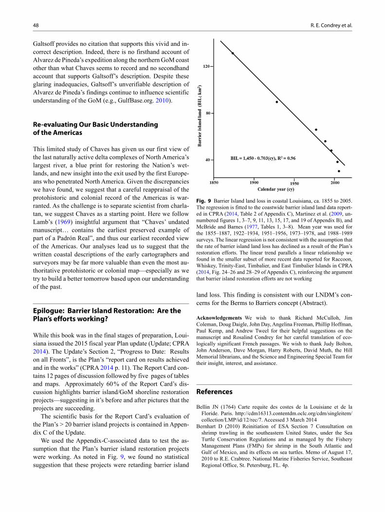
We used the Appendix-C-associated data to test the as-sumption that the Plan’s barrier island restoration projects were working. As noted in Fig. 9, we found no statistical suggestion that these projects were retarding barrier island
land loss. This finding is consistent with our LNDM’s con-cerns for the Berms to Barriers concept (Abstract).
Acknowledgements We wish to thank Richard McCulloh, Jim Coleman, Doug Daigle, John Day, Angelina Freeman, Phillip Hoffman, Paul Kemp, and Andrew Tweel for their helpful suggestions on the manuscript and Rosalind Condrey for her careful translation of eco-logically significant French passages. We wish to thank Judy Bolton, John Anderson, Dave Morgan, Harry Roberts, David Muth, the Hill Memorial librarians, and the Science and Engineering Special Team for their insight, interest, and assistance.
References
Bellin JN (1764) Carte requite des costes de la Louisiane et de la Floride. Paris. http://cdm16313.contentdm.oclc.org/cdm/singleitem/collection/LMP/id/12/rec/7. Accessed 3 March 2014
Bernhart D (2010) Reinitiation of ESA Section 7 Consultation on shrimp trawling in the southeastern United States, under the Sea Turtle Conservation Regulations and as managed by the Fishery Management Plans (FMPs) for shrimp in the South Atlantic and Gulf of Mexico, and its effects on sea turtles. Memo of August 17, 2010 to R.E. Crabtree. National Marine Fisheries Service, Southeast Regional Office, St. Petersburg, FL. 4p.
Fig. 9 Barrier Island land loss in coastal Louisiana, ca. 1855 to 2005. The regression is fitted to the coastwide barrier island land data report-ed in CPRA (2014, Table 2 of Appendix C), Martinez et al. (2009, un-numbered figures 1, 3–7, 9, 11, 13, 15, 17, and 19 of Appendix B), and McBride and Barnes (1977, Tables 1, 3–8). Mean year was used for the 1855–1887, 1922–1934, 1951–1956, 1973–1978, and 1988–1989 surveys. The linear regression is not consistent with the assumption that the rate of barrier island land loss has declined as a result of the Plan’s restoration efforts. The linear trend parallels a linear relationship we found in the smaller subset of more recent data reported for Raccoon, Whiskey, Trinity-East, Timbalier, and East Timbalier Islands in CPRA (2014, Fig. 24–26 and 28–29 of Appendix C), reinforcing the argument that barrier island restoration efforts are not working
49The Last Naturally Active Delta Complexes of the Mississippi River (LNDM): Discovery and Implications
Bisente J (1696) Carte du Golfe du Mexique. Bibliothèque Nationale de France, France http://visualiseur.bnf.fr/CadresFenetre?O=IFN-5906255&M=notice. Accessed 3 March 2014
Blum MD, Roberts HH (2009) Drowning of the Mississippi Delta due to insufficient sediment supply and global sea-level rise. Nat Geosci 2:488–491, 18p. supplementary information. doi:10.1038/NGE0553
Blum MD, Roberts HH (2012) The Mississippi Delta region: past, pres-ent, and future. Annu Rev Earth Pl Sci 40:655–683
Chardon R (1980) The linear league in North America. Ann Assoc Am Geogr 70:129–153
Chaves A de (1537) Cosmografía práctica y moderna llamado Espejo de Navegantes. Real Academia de la Historia, Madrid, MS 9/2791
Chaves A de (1977) Alonso de Chaves y el libro IV de su “Espejo de navegantes.” In: Castañeda Delgado P, Cuesta Domingo M, Hernán-dez Aparicio P (eds) Introduction. Industrias Graficas España, Madrid
Chaves A de (ca. 1983) In: Castañeda Delgado P, Cuesta Domingo M, Hernández Aparicio P (eds) Alonso de Chaves. Quatri partitu en cos-mografía práctica, y por otro nombre, Espejo de navegantes. Instituto de Historia y Cultura Naval, Madrid
Condrey RE (in prep) The last natural delta of the Mississippi river, 1687–1880. Louisiana Academy of Sciences
Condrey RE, Fuller D (2005) The US gulf shrimp fishery. In: Glantz MH (eds) Climate variability, climate change, and fisheries. Cam-bridge University Press, p. 89–119, 450 pp
Condrey RG, DeMay R, Pond L (2008) The historic ecology of the Barataria Terrebonne National Estuary. The 2008 Barataria-Terre-bonne tidal graph calendar. Barrataria-Terrebonne National Estuary Program, Thibodaux, Louisiana. 30 p
Condrey, Fleeger J, Portier R, Stone G, Gelpi C, Evers DE, Jose F, Dubois S, Grippo M (2010) Blue crab, sand mining for berms, and the deepwater horizon oil spill: assessing ecological impacts on nationally important spawning grounds. Proposal submitted to U.S. Bureau of Ocean Energy Management, Regulation, and Enforce-ment. Department of Oceanography and Coastal Sciences, Louisiana State University, Baton Rouge, Louisiana. 52p. and attachments
Couvillion BR, Barras JA, Steyer GD, Sleavin W, Fischer M, Beck H, Trahan N, Griffin B, Heckman D (2011) Land area change in coastal Louisiana from 1932 to 2010: pamphlet to accompany Scientific Inves-tigations Map 3164. U.S. Geological Survey, Reston Virginia. 12 pp. http://pubs.usgs.gov/sim/3164/downloads/SIM3164_Pamphlet.pdf. Accessed 3 May 2014
CPRA (2007) Integrated ecosystem restoration and hurricane protec-tion: Louisiana’s comprehensive master plan for a sustainable coast. Coastal Protection and Restoration Authority, Baton Rouge, Loui-siana. CD-ROM. 117 pp. and 12 appendices. http://www.coastal.la.gov/index.cfm?md=pagebuilder&tmp=home&nid=82&pnid=76&pid=28&catid=0&elid=0. Accessed 3 May 2014
CPRA (2011) Draft fiscal year 2012 annual plan: integrated ecosystem restoration and hurricane protection in coastal Louisiana. Coastal protection and restoration authority of Louisiana. Baton Rouge, LA. 54 pp. and 5 appendices. http://www.lacpra.org/assets/docs/2012%20ANNUAL%20PLAN/FINAL%20ANNUAL%20PLAN%20FROM%20KARIM%20FEB%2021.pdf. Accessed 3 March 2014
CPRA (2012) Louisiana’s comprehensive master plan for a sustainable coast: committed to our coast, draft Jan 2012. Coastal protection and restoration authority of Louisiana. Baton Rouge, LA. 170 pp. and appendices. http://www.coastalmasterplan.louisiana.gov/2012-mas-ter-plan/overview/. Accessed 3 May 2014
CPRA (2014) Fiscal year 2015 annual plan: Integrated ecosystem resto-ration and hurricane protection in coastal Louisiana. Coastal Protec-tion and Restoration Authority of Louisiana. Baton Rouge, Louisiana. 234 pp http://coastal.la.gov/annualplan/. Accessed 13 March 2014
Creef ED (2010) Project report endangered species monitoring State of Louisiana Emergency Barrier Berm Project. 16 pages. Attached to November 10, 2010, letter from E. D. Creef to R. Crabtree. US Army Corps of Engineers, New Orleans District
Day JW Jr, Boesch DF, Clairain EJ, Kemp GP, Laska SB, Mitsch WJ, Orth K, Mashriqui H, Reed DJ, Shabman L, Simenstad CA, Streever
BJ, Twilley RR, Watson CC, Wells JT, Whigham DF (2007) Restora-tion of the Mississippi Delta: lessons from hurricanes Katrina and Rita. Science 315:1679–1684
de l’Isle G (1703) Carte du Mexique et de la Floride des Terres Anglois-ers et des Isles Antilles du cours des evirons de la riviere de Missis-sipi. Paris http://www.loc.gov/resource/g3300.np000057/. Accessed 3 April 2014
Dubois S, Gelpi C, Condrey R, Grippo MA, Fleeger JW (2009) Diver-sity and composition of macrobenthic community associated with sandy shoals of the Louisiana continental shelf. Biodivers Conserv 18:3759–3784. doi:10.1007/s10531-009-9678-3
Dumain L (1807) Letter of July 20, 1807, to A. Gallatin. American State Papers. Documents, legislative and executive, of the Congress of the United States, from the first session of the first to the third session of the thirteenth Congress, inclusive: Commencing March 3, 1799 and ending March 3, 1815. W. Lowrie and M St. C. Claire eds. Gales and Seaton, Washington. American State Papers 1832. vol VII. Class IV. Commerce and Navigation. p 841
Flocks J, Smith C, Miselis J (2012) USGS scientists study an oil-spill-mitigation sand berm in the Chandeleur Islands, Louisiana. Sound Waves: Coastal and marine research news from across the USGS. July/August 2012:1–6. http://soundwaves.usgs.gov/2012/08/SW201208.pdf. Accessed 3 March 2014
Frazier DE (1967) Recent deltaic deposits of the Mississippi river: their development and chronology. Gulf Coast Assoc Geol Soc Transac-tions 27:287–315
Galtsoff PS (1954a) Historical sketch of the explorations in the Gulf of Mexico. Gulf of Mexico its origin, waters, and marine life. U.S. Fish and Wildlife Service. Fishery Bulletin 89. Fish Bull Fish Wildl Serv 55:1–604 (pp. 3–36)
Galtsoff PS (1954b) Gulf of Mexico its origin, waters, and marine life. U.S. Fish and Wildlife Service. Fishery Bulletin 89. Fish Bull Fish Wildl Serv 55:1–604
García de Palacio D (1587) Instrucción nautica para navegar. 1944 fac-simile. Ediciones Cultura Hispanica, Madrid
Gelpi CG Jr, Condrey R, Fleeger JW, Dubois S (2009) Discovery, eval-uation, and implications of blue crab, Callinectes sapidus, spawning/hatching/foraging grounds in federal (US) waters offshore of Louisi-ana. Bull Marine Sci 85:203–222
GulfBase.org (2010) Exploration history. http://www.gulfbase.org/exploration/. Accessed 3 May 2014
Hackett CW (1931) Pichardo’s treatise on the limits of Louisiana and Texas, vol 1. University of Texas Press, Austin, 630 pp
Humphreys AA, Abbott HL (1861) Report upon the physics and hydraulics of the Mississippi river; upon the protection of the alluvial region against overflow; and upon the deepening of the mouths… Submitted to the Bureau of Topographical Engineers, War Depart-ment, 1861. J.B. Lippincott & Co., Philadelphia, 456 pp
Kidder TR (1996) Perspectives on the geoarchaeology of the lower Mississippi Valley. Engineering Geology 45:305–323
Kulp M, Fitzgerald D, Penland S (2005) Sand-rich lithosomes of the Holocene Mississippi river Delta Plain. In: Giosan L, Bhattacharya JP (eds) River deltas-concepts, models, and examples. Soc Sediment Geol Special Publ 83:279–293
Lamb U (1969) The Quarti Partitu en Cosmographia by Alonso de Chaves: an interpretation. Separata du Revista da Universidale de Coimbra 24:9
LCWCRTF, WCRA (1998) Coast 2050: toward a sustainable coastal Louisiana. Louisiana coastal wetlands conservation and restoration task force and the wetlands conservation and restoration author-ity. Louisiana Department of Natural Resources, Baton Rouge, La, 161 p. http://www.coast2050.gov/report.pdf. Accessed 3 March 2014
LDWF (1992) A fisheries management plan for Louisiana’s Penaeid shrimp fishery. Louisiana Department of Wildlife and Fisheries. Office of Fisheries, Baton Rouge, 231 p. http://www.lsu.edu/sea-grantfish/pdfs/ShrimpPlan.pdf. Accessed 3 March 2014
50 R. E. Condrey et al.
Leibach J (2010) Oil spill wildlife spotlight: blue crab and shrimp. Audubonmagazine.org. http://magblog.audubon.org/oil-spill-wild-life-spotlight-blue-crab-and-shrimp. Accessed 3 March 2014
Martinez L, O’Brien SO, Bethel M, Penland S, Kulp K (2009) Louisi-ana barrier island comprehensive monitoring program (BICM) vol-ume 2: shoreline changes and barrier island land loss 1800’s–2005. University of New Orleans, Pontchartrain Institute for Environmental Sciences, New Orleans, Louisiana. 32 pp and two appendices. ftp://ftp.dnr.state.la.us/BICM/Vol2—Shoreline-Change/BICM_volume2_Shoreline%20Changes%20and%20Barrier%20Land%20Loss.pdf. Accessed 6 March 2014
McBride RA, Byrnes MR (1977) Regional variations in shore response along barrier island systems of the Mississippi River Delta Plain: his-torical change and future prediction. Journal of Coastal Research, 13(3):628–655
McWilliams RG (1981) Iberville’s gulf journals. Tuscaloosa: Univer-sity of Alabama Press, 195 p
NFL (2011) 2011 official playing rules and casebook of the National Football League. National Football League. 113 p. http://www.nfl.com/static/content/public/image/rulebook/pdfs/2011_Rule_Book.pdf. Accessed 3 March 2014
Oviedo y Valdés GF de (1851) Historia general y natural de las Indias vol1. Madrid: Imprenta de la Real Academía de la Historia. http://archive.org/details/generalynatural01fernrich. Accessed 3 March 2014
OG (2010) Governor Jindal announces agreement with BP for seafood safety, coastal restoration & tourism funding. Office of the Governor, State of Louisiana, Baton Rouge, Louisiana, press release of Novem-ber 1, 2010. http://www.gov.state.la.us/index.cfm?md=newsroom&tmp=detail&articleID=2565. Accessed 3 March 2014
Rangel R (1993) Account of the northern conquest and discovery of Hernando de Soto. In: Clayton LA, Knight VJ Jr, Moore EC (eds) The De Soto Chronicles, The expedition of Hernando de Soto to North America in 1539–1543. Tuscaloosa: University of Alabama Press. 1:247–306
Russell RJ (1936) Physiography of lower Mississippi River Delta. Lou-isiana Department of Conservation, Louisiana Geological Survey. Geol Bull 8:3–199
Sallenger AH Jr, Wright CW, Howd P, Doran K, Guy K (2009) Extreme coastal changes on the Chandeleur Islands, Louisiana, during and after Hurricane Katrina. In: Lavoie D (ed) Sand resources, regional geology, and coastal processes of the Chandeleur Islands coastal
system—an evaluation of the Breton National Wildlife Refuge. U.S. Geological Survey Scientific Investigations Report 2009–5252. pp. 27–36, 180 pp. http://pubs.usgs.gov/sir/2009/5252/. Accessed 3 May 2014
Seney EE, Musick JA (2007) Historical diet analysis of loggerhead sea turtles ( Caretta caretta) in Virginia. Copeia 2007(2):478–489. Accessed 3 May 2014
Stone GW, Condrey RE, Fleeger JW, Khalil SM, Kobashi D, Jose F, Evers E, Dubois S, Liu B, Arndt S, Gelpi C, Grippo MA, Luo Y, SiadatMousavi SM, Chen Y, Alavillamo M, Reynal F (2009) Environmental investigation of long-term use of Ship Shoal sand resources for large scale beach and coastal restoration in Louisiana. U.S. Dept. of the Interior, Minerals Management Service, Gulf of Mexico OCS Region, New Orleans, LA. OCS Study MMS 2009–024, 278 pp
Törnqvist TE, Kidder TR, Autin WJ, van der Borg K, de Jong AFM, Klerks CJW, Snijders EMA, Storms JEA, van Dam RL, Wiemann MC (1996) A revised chronology for Mississippi River subdeltas. Science 273(5282):1693–1696
ower ZB, Newton JN, Abbot HL (1880) Report of the Board of Engi-neers (to Brigadier General H. G. Wright, Chief of Engineers, USA). Office of Board of Engineers for Fortifications and for River and Har-bor Improvements, &c. New York, April 20, 1880. pp. 1284–1288. In Annual report of the Chief of Engineers, United States Army, to the Secretary of War for the year 1880. In three parts. Part II. Appen-dixes to the report of the Chief of Engineers, United States Army. (continued) Appendix O. Government Printing Office. Washington DC. 46th Congress, 3d Session, House of Representatives. Ex. Doc. 1, pt 2, v II
USACE (2010) Corps decision on state’s emergency permit request. U.S. Army Corps of Engineers News Release for immediate release: May 27, 2010. US Army Corps of Engineers, New Orleans, Loui-siana. 112 unnumbered pages. http://www.mvn.usace.army.mil/Por-tals/56/docs/PAO/EmergPermitDoc.pdf. Accessed 3 March 2014
USCB (2014) State and County Quickfacts. U.S. Census. http://quickfacts.census.gov/qfd/states/22000.html. Accessed 3 March 2014
USGS (1979) New Orleans, LA. 1:250,000. U.S. Geological Survey, Washington D.C.
USGS (1983) White Lake, LA. 1:100,000. U.S. Geological Survey, Washington D.C.
Weddle RS (1987) La Salle, the Mississippi, and the gulf: three primary documents. Texas A&M University Press, College Station, 328 p