
The HK Smart City Blueprint - Hong Kong Institute of Urban ...
105
1 URBANIE URBANUS & HKIUD JOURNAL JULY 2021 ISSUE 5. SMART CITY? Reading a news article with smart phone Taking picture with the phone Surf the Internet with the phone Surf the Internet & Listen to the music with the phone
-
Upload
khangminh22 -
Category
Documents
-
view
2 -
download
0
Transcript of The HK Smart City Blueprint - Hong Kong Institute of Urban ...

1
URBANIEURBANUS
&
HKIUD JOURNAL
JULY 2021
ISSUE 5.SMART CITY?
Reading a news article with smart phone
Taking picture with the phone
Surf the Internet with the phone
Surf the Internet & Listen to the music with the phone

2
Urbanie & Urbanus
ISSUE 5, July 2021
TABLE OF CONTENTS
SMART CITYEditor’s Note
Uncertainties in the Provision of Electric Vehicle (EV) Charging Facilities in Hong Kong: Implications on Public and Private Realm Assets and ResourcesBarry D Wilson
Smart Heritage as a Design ToolDavid Batchelor and Marc Aurel Schnabel
A Framework for Virtual Co-Urban DesignShuva Chowdhury and Marc Aurel Schnabel
Cognitive Cities: the Synthesis of Artifical Intelligence and the Urban EnvironmentMansoor Hanif, Joan Anton Sanchez, and Maysho Prashad
Hacking Kowloon East: Technology for Activating Urban lifeSunnie S.Y. Lau and Brent D. Ryan
AI-powered Feedback Loop in Driving Efficient Urban PlanningWu Ka Chung Kane, Sung Wai Yin Gemma, and Hui Tsz Ho Jonathan
Smart Cities: Overview, Open Data, Privacy and Management Issues, Standards and SolutionsAlexander C. Ngai Siu
The HK Smart City Blueprint: an Assessment in Relation to International Smart City Performance StandardsDr. Hee Sun (Sunny) Choi
Urban Design Book Introduction
4
6
20
30
38
48
69
78
91
103
Front Cover image:Dr Hee Sun(Sunny) Choi
Urbanie & Urbanus
ABOUT U + U
How can you read the city where you live and work? Let’s start from a blank page and draw, write, read and share how we feel and dream it can be.
Urbanie and Urbanus (U+U) is a periodic journal and communication tool to develop a dialogue between the institute members, related professions, decision makers and the local community. Commencing with a focus on the city and community of Hong Kong, from this local perspective it outreaches to China, Asia and Internationally. With the limitless reach an online resource can offer, the e-journal offers learned critique to increase participation and engagement through understanding and ‘below-the-line’ debate on issues large and small, from state-building to street furniture.
The core aim is to develop a better understanding of our cities in their varied and multiple scales and aspects, written by and considered for the widest range of users and key actors possible. We associate with universities, the building profession and the public, with articles combining the scope and immediacy of serious everyday dialogues and communication with anyone who wants to participate in the precision and depth of debate. As such the expected outcome and purpose of the publication is to raise awareness of the potential for updated design tools and methods, particularly within Hong Kong, China, and the broader Asia region.
Established 2019, HKIUD, Hong Kong
Editor: Dr. Hee Sun (Sunny) Choi
Editorial Board: Barry Wilson Charles Li Joel Chan Dr. Peter Cookson Smith Sunnie Lau
Graphic Design: Zhantong Wang
ISSN No: 978-988-75425-4-4
ISSUE 5, July 2021 3

Urbanie & Urbanus
ISSUE 5, July 2021
PREFACE
Dr. Hee Sun (Sunny) ChoiU+U Journal Editor
ARE SMART CITIES THE FUTURE?
The idea of a ‘smart city’ emerged in various ways during the twentieth century.
As a conurbation of clever people, Bletchley Park in the UK, the code-breaking capital of the Allied War efforts founded in 1941, is considered to be the first ‘smart city’. The growth of Silicon Valley during the 1970s in San Francisco, as a hub for computing start-ups born from the pioneering research work of nearby Stanford University, can be viewed in a similar way.
This growth in ICT in California in the 1970s also led to pioneering work in the state in the development of ‘smart’ city infrastructure networks, such as parking meters and street lights, programmed to gather data on function and usage that could be assessed and then fed back in to update the system to improve efficiency. Embedding a city’s infrastructure in this way with networks that have the ability to think and learn can be argued is the clearest example of a ‘smart city’, but it wasn’t referred to in this way at that time. The smart city term infact grew in usage as cities around the world saw the benefit of the term from a place marketing perspective in creating new IT oriented business communities. In this way Smart Cities the world over were born, and a Google search today of ‘Smart Cities’ offers 739 million pages of related material in response.
However, at a human level, following a generation of exposure to the internet and all it is capable of, we have passed the awe phase and a degree of scepticism has arrived. With search engines and social media platforms ’smart’ enough to monitor and seek to influence thoughts
4

Urbanie & Urbanus
and actions, the realisation that the access to knowledge and information is a two way street begins to feel manipulative.
It is from this contested position that this issue seeks to offer a series of perspectives and critique on where smart city developments are heading. Contemporary thinking on smart cities is given in the aggregate, through a collection of papers relating to the particular components that will make our future cities smart. Including E-Vehicle parking, the usage of AI data in urban planning, how the augmented city and digital tools can help migrants settle and integrate, a smart approach to heritage and a framework for virtual co-urban design.
References
Neubert, H, 2019. Dialogue 33: Designing City for People, Gensler Research Institute, https://www.gensler.com/doc/dialogue33 (Accessed 13 June 2021)
Ferrer, J.R., 2017, Barcelona’s Smart City Vision: an opportunity for transformation, Journal of field actions: Field actions science reports, Issue 16, p70-75
Grand View Research, 2018, Smart Cities Market Size Worth $2.57 Trillion by 2025, CISION PRNewswire, https://www.prnewswire.com/news-releases/smart-cities-market-size-worth-257-trillion-by-2025--cagr-184-grand-view-research-inc-675971763.html (Accessed 13 June 2021)
ISSUE 5, July 2021 5

6
Urbanie & Urbanus
ISSUE 5
Barry D Wilson
By Barry D Wilson
Founding Director of Barry Wilson Project Initiatives, Adjunct Assistant Professor at the University of Hong Kong Faculty of Architecture, Vice President of the Hong Kong Institute of Urban Design
Uncertainties in the Provision of Electric Vehicle (EV) Charging Facilities in Hong Kong: Implications on Public and Private Realm Assets and Resources
Abstract
The transition to electric vehicles (EVs) is coming, faster in some places than others, but the change is inevitable. Some governments are starting to embrace the shift and rapidly work to develop new opportunities, whilst others choose to smooth the road with more cautious approaches. The potentials and implications of dealing with the resultant changes remains uncertain and largely unresearched whilst the impacts upon manufacture, supply chains, user behaviour, and the physical environment may be significant. The Hong Kong Government recently announced its own Roadmap of transition to an electrified vehicle future, following a decade of stuttering ambition. What can be expected?

7
The Road Ahead
The Hong Kong Government announced the ‘Hong Kong Roadmap on Popularisation of Electric Vehicles’ (The Roadmap) in March 2021, setting out long-term policy objectives and plans to promote the adoption of electric vehicles (EVs) and their associated supporting facilities in Hong Kong. Announcing The Roadmap, Secretary for the Environment, Mr Wong Kam-sing, declared that "We have formulated our first Hong Kong Roadmap on Popularisation of EVs, which will guide Hong Kong's future direction to attain zero vehicular emissions before 2050.
This acts in concert with our other target to strive for carbon neutrality in the same time frame, and forges ahead with the vision of 'Zero Carbon Emissions‧Clean Air‧Smart City” (HKSAR Information Services, 2021a).
Electrification it seems then, is set to reshape the global automotive market over the current decade, as governments urgently need to address both the carbon goals required to meet international 2030 climate targets, as well as the serious health impacts of urban pollution. Whilst the issues of
Urbanie & Urbanus
ISSUE 5
Barry D Wilson

8
the climate emergency are increasingly shaping national policies globally, the longstanding health impacts of air pollution have been continually side-lined. Vehicle exhaust emissions include particulates from diesel engines, nitrogen oxides (NOx), volatile organic compounds (VOC), carbon monoxide and benzene, whilst metals such as copper, iron, and manganese interact with acidic sulphate-rich particles already in the air, to produce a toxic aerosol (Harrison et al., 2012). A World Health Organization study found that diesel fumes directly cause an increase in lung cancer (IARC, 2012), whilst among children, air pollutants are associated with increased acute respiratory illness, increased incidence of respiratory symptoms and infections, respiratory episodes of longer duration, and lowered lung function. A statistical study in California of children with cancer under 6 years old found that living near smog resulted in a 5% to 11% increase in cancer risk (Heck et al., 2013).
Almost thirty years ago it was known that Asthma, the most common chronic disorder of childhood, was on the rise in the United States and in other industrialised nations, where the prevalence of childhood asthma increased nearly 40% during the 1980s (Weitzman et al., 1992). Many different factors have been associated with asthma, but several studies have linked particulate air pollution with exacerbations of asthma in children afflicted with the disease, with research indicating that infants whose mothers were exposed to higher levels of ultra-fine particles (UFPs) during pregnancy are much more likely to develop asthma (Wright et al., 2021). Young children
generally spend more time low to the ground by virtue of both their shorter stature and the nature of their typical physical activity and therefore experience greater exposure to pollutants emitted close to the ground, such as automobile exhaust and high-density pollutants brought downward by gravity. In addition, when the sources of air pollutants such as automobiles are close to playgrounds and other areas where children play, children and infants in strollers may be heavily exposed (International Programme on Chemical Safety et al., 1986). Notably, brake dust, tire fragments and even tiny bits of road also get into the air and these make up a similar proportion of the airborne particulate matter resulting from vehicle use as do exhaust emissions (Harrison et al., 2012). Whilst brake pad dust may come to be reduced through the regenerative braking systems of EVs, which don’t use brake pads most of the time, tyre and road dust will endure, and as a result, so will roadside air pollution.
Hong Kong government has been targeting roadside air quality improvements primarily though regulating the exhaust emissions of commercial vehicles, whereby they consider that 90% of roadside emissions result from this sector (HKSAR LegCo, 2019a). Meanwhile the number of registered vehicles (including commercial vehicles) in Hong Kong has rapidly increased, from just over 690,000 to more than 878,000 in the 8 years from 2011 to 2019 (Statista, 2021); a shocking rise of almost 30% that seems hard to justify or substantiate in terms of meeting declared air quality targets, reducing traffic congestion and promoting public transport as the cornerstone
Urbanie & Urbanus
ISSUE 5
Barry D Wilson
9
of transport policy. The Roadmap states that the government now want to stop people buying new cars that run on petrol by 2035, what Wong Kam-sing, called “the most progressive target in Asia” (HKSAR Information Services, 2021b).
By way of comparison, Germany plans to ban all internal combustion engines from the whole country of 82 million people by 2030, and the Netherlands plans to ban all gasoline and diesel car sales by 2025. Norway, a similar sized population to Hong Kong but far less compact, also aims to have 100% of its cars be either an electric or plug-in hybrid unit by 2025 (Nicholas & Lutsey, 2020). The UK, as a means to achieve its stated climate, air quality, and energy security ambitions, brought its previous targets forward by ten years in 2020, in order to phase-out the sale of new petrol and diesel cars and vans by 2030. It has also set a goal of 50% to 70% of the new car market being ultra-low emission by 2030 (UK. Government, 2020a). China, which already has almost half the global EV stock, and where 1.1 million EVs were sold in 2018, signalled a shift in policy away from subsidies while implementing quotas. In its 15-year EV draft plan, Beijing set a target for EVs to account for 25% of annual new light-vehicle sales and 20% of new car sales by 2025 (Berman, 2020). The Hong Kong targets may be the most ambitious in Asia but are far from ambitious in a worldwide context.
Former vice chairman and head of product development at General Motors, Bob Lutz, has for some time been predicting huge stranded assets in conventional motor vehicles by 2025, as
manufacturers become rapidly switched towards electric production and municipalities automate public fleet systems (Lutz, 2017). The global EV market demand was estimated at over 2.3 million units in 2019, boosting the existing stock to 7.2 million vehicles, but equal to only about 2.6% of global car sales. It’s currently a tiny part of a huge global vehicle market, but one that is about to explode under a set of new market drivers. As technological progress in the electrification of two and three-wheelers, buses, and trucks advances and as the market for them grows, the range of EVs are expanding significantly (IEA, 2020). The market transition is likely to come much faster than governments are allowing for, with manufacturers already retooling and repositioning to gain market share within the new order, which is certain to hit a rapid tipping point once EVs are close to price parity with conventional vehicles.
Predictions are for average battery pack prices to fall to US$101/kWh by 2023, it is around this price point that automakers in some markets should be able to produce and sell mass market EVs at the same price and with the same margin as comparable internal combustion vehicles, and they are expected to fall to $58/kWh by 2030 (Henze, 2020). How many manufactures will continue to be bullish in developing new models of traditional vehicles; at least 10 of the largest automakers are promising to make only electric options, including General Motors, Toyota, and Volvo, with the earliest full transitions slated for as soon as 2025 (McKerracher et al., 2020). Perhaps more tellingly how many potential vehicle purchasers in developed markets would
Urbanie & Urbanus
ISSUE 5
Barry D Wilson

10
remain determined to stick to obsolete technology that will rapidly have limited resale value? The purchasing of a conventionally powered vehicle becomes an increasingly risky business month by month as various markets teeter on the brink of a rapid conversion, to one where EVs simply become identified as regular ‘vehicles’, whilst fossil fuel powered vehicles become adversely branded as ‘fuel vehicles’ (FVs).
So, the transition to EVs is already starting to snowball in certain markets, yet Hong Kong’s “progress ive 2035 target” appears to be underwhelming and its watch and wait approach fails to demonstrate the conviction necessary to tackle both the chronic roadside pollution situation and overwhelming burden and cost of urban traffic volumes. Regrettably no intermediate transition targets are provided for 2025 or 2030 to guide the ambition of The Roadmap. Furthermore, the original target of 30% of vehicles to be EVs or hybrid by 2020, which was originally included in the Hong Kong Planning Standards and Guidelines, was diluted in 2011 towards just recommending that 30% of private parking spaces in new buildings to be installed with charging facilities for EVs. This goal has subsequently been rejected by the Secretary for the Environment as “merely representing a vision" (HKSAR LegCo, 2019b).
The writing is on the wall for conventional vehicle models it appears, and the transition may happen far more rapidly than the government anticipates. A perfect opportunity is provided at this moment to be proactive, rather than reactive,
Urbanie & Urbanus
ISSUE 5
to look holistically at the number of vehicles desirable in the city, to visualise how streets might be transformed to create cleaner and better places for living, to use the limited and costly public space more efficiently, and to improve health and safety outcomes. Cities globally are intensively reviewing the part private vehicles have to play in dense urban areas. Their presence is increasingly contentious and looks particularly threatened in London, Paris, Milan, Madrid, and other leading urban centres. The renaissance of these cities’ is being led by Mayoral departments with a strong collective vision for across-the-board environmental progress. How can Hong Kong, run by the siloed departments of civil service, be expected to achieve similar significant vision for widespread change? How can the Environmental Protection Department alone, be expected to form, shape, and champion such planning and transport policy?
The Hong Kong Formula
Hong Kong’s slow transition to EVs has indeed mimicked that of other developed Asian economies such as Singapore, Korea, and Japan, however this watch and wait approach could mean that these cities are now all able to move forward more rapidly on the knowledge development coattails of early adopting countries. According to the Environmental Protection Department, there were about 15,200 EVs on the road in Hong Kong at the end of June 2020. However, there were only 3,125 charging stations
Barry D Wilson

11
Urbanie & Urbanus
ISSUE 5
available, meaning one charger for almost five EVs in the city. As EVs usually take a few hours to charge, their owners often encounter long queues and sometimes become frustrated by the complexity of the charging stations (Ho, 2020). Lack of charging infrastructure has been well documented as one of the biggest roadblocks to EV expansion, along with variations in charging load and lack of standardisation being further drawbacks. Over half of the drivers in UK surveyed by the Department for Transport, indicated that charging concerns were preventing them from purchasing EVs (UK. Government, 2020b). Different countries have their own standards such as CCS (Europe, the U.S., and Korea), CHAdeMO (Japan), and GB/T (China). Some electric manufacturers such as Tesla, have focused on overcoming this obstacle by having their own charging network. The UK is one of the few governments that actually has a comprehensive strategy for electrification, with both an official Office for Low Emission Vehicles (OLEV) and an electrification strategy called the Road to Zero strategy. This anticipates that the vast majority of drivers will choose to charge at home, however the strategy aims to provide further charging options to the remaining one-third of households that don’t have off-street parking available, by adding public, street-charging pillars and integrated lighting poles (UK. Government, 2018). This street deployment will not only have significant implications for the visual quality of the urban fabric and street environment but would also seem to continue to encourage the long-term use of private vehicles in urban locations, as against broader policies encouraging
transitions to more sustainable transport modes including public transport, walking and biking. In so doing, inefficient use of valuable public space is further promoted, whilst the negative impacts of deaths, injuries, stress, air and noise pollution, along with the economic losses of social cohesion are ignored. These generally fall most heavily on the poorest and most vulnerable in society, those that don’t own private vehicles (Douglas et al., 2011).
Worryingly, the Hong Kong government is studying approximately ten on-street locations for installing charging facilities (HKSAR Information Services, 2019a). The US is adopting a different approach, put t ing emphasis on charging opportunities being made available at stations, workplaces and public destinations and letting utility providers and the market provide suitable locations for other service provision. These have developed along interstate highways and public parking lots across the country (US. NREL, 2020), and locations can be pinpointed by using the Alternative Fueling Station Locator app tool from the U.S. Department of Energy's Alternative Fuels Data Center (Alternative Fuels Data Center). With charging availability in mind, the central government of China launched its Guidelines for Accelerating the Plug-in Electric Vehicle Charging Infrastructure Deployment back in in 2015, to create an adequate charging infrastructure network to meet the nat ionwide goal of introducing 5 million EVs by 2020 (Ji & Huang, 2018; Wang & Ke, 2018), as outlined by the State Council in its 2012 Development Plan (CN. State Council, 2012). By the end of 2020, 4.92 million
Barry D Wilson

12
Urbanie & Urbanus
ISSUE 5
new energy vehicles (NEVs), including battery electric, plug-in hybrid, and fuel cell vehicles, were operating on China’s roads. China’s success in developing the EV market has been built on a clearly articulated vision, consistent planning, coordinated action, city-level innovation and leadership, policy implementation, and the continued adaptation of policy tools to meet the changing market (He & Jin, 2021).
The current HKSAR Government EV strategy is enshrined within Chapter 4 of The Roadmap (HKSAR 2021). The policy rationale behind it remains somewhat opaque, yet looks primarily towards overnight home charging in the private sector for both cars and commercial transport, whereas for the public transport sector, provision is intended to be located at depots and transit hubs. The government looks to provide support to transition through financial assistance in developing home based charging infrastructure rather than construction of public facilities. Fees for EV charging at government car parks are intended to be introduced from around 2025 however “to promote marketisation of EV charging services”. The key measures relating to charging infrastructure under The Roadmap cover various aspects including notably: -
• expanding the EV charging network on all fronts and marketising charging services progressively;
• striving to legislate a producer responsibility scheme for retired EV batteries in the next few years, and promoting green technologies of
Barry D Wilson
second-life applications of EV batteries; and
• adopting a multi-pronged approach in creating a conducive environment for the popularisation of EVs. This includes: -
1. establishing a task force to examine the high-end development of new decarbonisation technology globally,
2. the $200 million Green Tech Fund to fund the research and development of green technologies,
3. making good use of development in technologies including the Internet of Things, big data and artificial intelligence, and
4. seizing opportunities to be brought about by the EV technological development in the Guangdong-Hong Kong-Macao Greater Bay Area, etc
"As EV technologies are rapidly evolving, we will review the various strategies and targets of The Roadmap around every five years. Taking into account new technological, environmental, social and economic development and situations, we will adjust in time Hong Kong's policies and measures in promoting EVs, ensuring that we keep up with the times” Wong Kam-sing has stated (HKSAR Information Services, 2021b). The Chief Executive meanwhile announced in the 2019 Policy Address the preparation of a $2 billion pilot subsidy scheme to promote the installation of EV charging-enabling infrastructure

13
Urbanie & Urbanus
ISSUE 5
in car parks of existing private residential buildings, enabling EV owners to install chargers at car parks of their residences according to their own needs in the future. The EV-charging at Home Subsidy Scheme (EHSS), which financially assists car parks of private residential buildings to install (EV) charging-enabling infrastructure subsequently opened for application from October 2020. Apart from launching the EHSS, other promotional measures include granting gross floor area (GFA) concessions for the installation of EV charge-enabling infrastructure in car parks of new buildings, as well as intending to install more than 1000 public chargers in government car parks in the three years starting from 2019 (HKSAR Information Services, 2020).
The Method Behind the Strategy
So just how was The Roadmap formulated? Whilst Hong Kong has a strong track record of growth planning through harnessing census information to anticipate future requirements, there has been little or no EV data to work with up to this point, and as with any emerging technology, few studies have been published to date. Whilst a plethora of research can be expected in the next few years, little exists before 2018 and this may lack usefulness due to the pace of global change in the sector. Local research has focused primarily on energy management and software techniques related to grid capacity (Hu et al., 2018; Song et al., 2017), whilst studies analysing the framework conditions for the medium to long-
Barry D Wilson
term demand for charging infrastructure remain rare globally. This means that the question of how much public charging infrastructure is needed cannot be answered equally for all countries (Funke et al., 2019). Meanwhile the speed of battery development and the unique development landscape of individual nation states, has made for hugely differing approaches to EV adoption and rollout of battery charging facilities. There are significant unanswered questions about the deployment of EV charging infrastructure and the associated policies that will need to be addressed to help pave the way for electrification (Hall & Lutsey, 2017), not just in Hong Kong but globally. Moreover, 2-wheel EVs and other electric mobility devices (EMDs) which are increasingly popular globally, whilst already classified as “motor vehicles”, are in fact currently illegal on Hong Kong’s roads and pavements (HKSAR Information Services, 2019b), and are therefore completely overlooked in The Roadmap. For Hong Kong, this dearth of information appears to be particularly significant due to space constraints and high land costs, making decision making critical.
In fact, a Steering Committee for Promotion of Electric Vehicles (SCPEV) had been established in Hong Kong as long back as 2009, chaired by the Financial Secretary, however since then there has been extremely limited progress on adopting EVs, either for the private and commercial sectors, or for public transport use. The Productivity Council launched a two-year, HK$10.8 million, Plug-in Hybrid Electric Vehicle (PHEV) technology project in 2010 (Guo, 2010) and subsequently developed the first-ever 'Made by Hong Kong' electric bus

14
Urbanie & Urbanus
ISSUE 5
Barry D Wilson
in 2015, as being the R&D outcome of a close to $40 million, government funded project intended to cater to the unique traffic conditions and operation model of local franchised bus companies. The Government fully subsidised the companies to procure thirty-six, single-deck, electric buses for trials to assess their operational efficiency and performance. Undersecretary for the Environment, Tse Chin-wan, told lawmakers in 2019 however, that the high population density and uneven terrain made it difficult to use electric buses on a large scale in Hong Kong. Meanwhile, a two-year trial utilising forty-five, BYD manufactured, ‘e6’ taxis started in 2013, but was halted by the Government after a lack of support provided both to and from the industry. Shenzhen contrastingly, had already converted its entire fleets to 6,000 Electric Buses and 22,000 Electric Taxis by 2019, whilst at least 95% of newly procured civic fleet vehicles were electric, including goods delivery, buses and coaches, logistics, construction and sanitation vehicles as well as vehicles for warehousing, port, airport and mining operations (HKSAR LegCo, 2020).
So, what happened to the government’s initially bold and advanced intentions of steering towards an EV economy? As reported in the 2016 Policy Address, the number of EVs had grown from 96 in 2010 to a paltry 4198 by end 2015, with the government stating that “private EVs should normally be charged at their owners’ home or workplace. The public charging network is to provide primarily opportunity charging to extend their travel range when needed” (HKSAR LegCo, 2016a). Members of the Legislative
Council Panel on Environmental Affairs expressed repeated concern that the insufficiency of EV charging facilities, citing that they were critical in promoting a wider adoption of EVs in Hong Kong, and further providing multiple suggestions on how to improve the network, including increasing public EV charging facili t ies, introducing roadside, multi-purpose, metered parking spaces, development of mobile apps to share real-time availability, and means of restricting non-EV parking in charging spaces (HKSAR LegCo, 2016b). Yet no studies or research data was undertaken or shared to substantiate these “multi-pronged approaches” and no clear vision, targets or framework have been established by the SCPEV.
By the time of the 2017 Policy Address, just 7231 EVs were registered on Hong Kong’s roads and no new policies initiated (HKSAR LegCo, 2017a). The key promotion measures remained as: the ‘first registration tax’ (FRT) waiver which had been in place since 1994 (HKSAR Information Services, 2015); GFA concessions to encourage developers to put in place EV charging infrastructure in the private car parks of new buildings, introduced in 2011; company profits tax deductions, lower annual licence fees and the research initiatives under the Pilot Green Transport Fund (PGTF), also of 2011, along with the subsidy financing of the thirty-six, franchise buses detailed above (HKSAR LegCo, 2017d). One of the major barriers outlined at this time was the difficulty in installing EV chargers in existing private housing estates, requiring permissions from reluctant owners' corporations or property management

15
Urbanie & Urbanus
ISSUE 5
Barry D Wilson
companies. The solution applied to address these problems was the establishment of a dedicated team and a hotline provided by Environmental Protection Department (EPD) to share relevant information and give technical support to parties and individuals who were interested in installing EV charging facilities (HKSAR LegCo, 2017b). Then, in a somewhat astonishing and confusing about-turn, the Government abolished the FRT waiver on EVs as of April 2017, replacing it with a cap and rejecting a motion from the Panel on Environmental Affairs for its retention, by suggesting that the waiver was contributing significantly to the huge rise in private vehicle registration and the roadside pollution that went with that (HKSAR LegCo, 2017c). A significant drop in EV registrations immediately followed.
The Ombudsman was subsequently appointed to investigate whether the government’s planning for ancillary facilities, to encourage growth of the sector, was in line with policy, and reported in 2019 that inadequacies on the part of EPD and Environment Bureau existed in seven identified areas, noting that the Government had: - changed its policy and measures without clearly explaining to the public the reasons and justifications behind them; made no significant increase in the number of public charging facilities since 2014; seriously underestimated their demand; held inadequate data on the utilisation of public charging facilities at non-government public car parks; managed public charging facilities poorly; and failed to formulate clear, fee-charging policies. Most importantly a lack of long-term support measures was lacking. The Ombudsman
recommended fifteen recommendations for improvement. Subsequently a Legislat ive Council Subcommittee was established in April 2020 in order to Study Issues Relating to the Development of Electric Vehicles, whilst receiving input from various institutions and public interest groups. A review of international case studies, specifically of Seoul, Shenzhen, Singapore and Tokyo, as providing immediate context, along with California and Norway, for reference of early adopters, was undertaken following the production of a factsheet sharing the findings of a very short study undertaken by the Research Office of the Legislative Council Secretariat (HKSAR LegCo, 2020). The Subcommittee, after four meetings, subsequently made five key recommendations: the need for setting targets for promoting the use of EVs; making the incentives of FRT concession more effective; extending the further FRT concessions under the "One-for-One Replacement" Scheme introduced in 2018; reviewing the requirements for granting GFA concessions for charging-enabling infrastructure; and expediting the launch of the pilot scheme to subsidize installation of charging-enabling infrastructure in private residential buildings (EHSS). The Roadmap has essentially been formed out of this subcommittee reveiw process. Having not being able to adopt the usual evidence based planning, and unwilling or unable to formulate a strong visionary policy, Hong Kong has chosen rather more of a business-as-usual approach with slightly tweaked incentives. No sticks are included to assist the new carrots provided.

16
Urbanie & Urbanus
ISSUE 5
Barry D Wilson
Potentials of Storage
What is however becoming clear, is that the transformation of the vehicle sector to electrification appears heavily tied to progress in the energy storage and battery sector, and particularly in the immediate term, is reliant upon the capacity for Li-ion batteries to make further progress on cost reduction, energy density, and cycle life. The world’s largest maker of rechargeable batteries, Shenzhen based BYD, has developed its ‘blade battery’, a type of lithium iron phosphate battery (LFP) which is said to be safer and cheaper than many EV batteries as it doesn’t include the costly element cobalt. LFP technology is not new but the battery architecture has improved its energy density, which makes it more acceptable for wider use. This battery type is ideal for forklifts, bicycles and cars and is also gaining popularity as a home storage option. Even Tesla is using LFP batteries from Chinese maker Contemporary Amperex Technology (CATL) for its Shanghai-made Model 3. Whilst the industry outside of China has been continually pushing for longer-range performance for EVs and moving to more expensive nickel-rich chemistries in order to achieve that, China has not seen the same imperative and has focused on technologies more suited to urban travel modes with shorter operational distances and repeated performance characteristics, including bus and taxis fleets and municipal service vehicles. These don’t require to travel ultra-long distances on one charge but do need low price points to make them accessible to markets and their pack prices at US$80/kWh
are far more competitive than those technologies using more expensive elements.
Battery storage may also be expected to have profound implications on home charging power utilisation. In-home batteries have in fact become increasingly popular in recent years. The United States Energy Storage Association reported a 10% increase in residential storage deployments from the final quarter of 2019 to the first quarter of 2020. The earliest adopters were largely interested in backup power, but now there’s growing interest in the potential of home batteries as a tool to manage solar panels, EV charging and demand response (U.S. Energy Storage Association, 2020). Tesla have brought standardisation to the high-end domestic market with their ‘Powerwall’, a large scale, heavy duty power bank offering 7kW of power and standing more than 1 metre tall, with similar market products being offered by competitors Sonnen, LG Chem and Enphase; all tapping into the emerging grid services opportunities. Stored electricity can power an EV, run daily power needs such as lights, components and refrigerators and can reduce family energy consumption, but more importantly it can smooth electricity supply loads at peak periods.
The problem with lithium batteries is they only hold enough energy to power an average home for a couple of hours rather than days, so scaling the size to fit exact needs becomes important. Connecting storage directly to a fixed grid means energy can be purchased at low peak tariffs, and then utilised at peak hours, when in fact it

17
Urbanie & Urbanus
ISSUE 5
Barry D Wilson
is most needed. That could lower the need for increased sources of peak power demand such as expensive ‘peaker plants’ or a costly upgrade in transmission capacity. Two energy companies in Australia, the government-owned Western Power, along with private supplier Synergy, have utilised Tesla’s bigger solution, the 105kW (420kWh) ‘Powerpack and inverter system’, which is more generally reserved for commercial and utility applications, on a residential scale application. The energy storage capacity has been adopted in order to create a shared community ‘powerbank’ as a alternative to individual Powerwalls, and is available to fifty-two families with solar installations in Meadow Springs in the City of Mandurah. The Energy Minister, Ben Wyatt, commented at the project launch that “At a cost of $1 per day, each customer participating in the 24-month trial will be able to ‘virtually’ store up to 8 kWh of excess power generated during the day from their solar PV systems in the battery. They will then be able to draw electricity back from the PowerBank during peak time without having to outlay upfront costs for a behind the meter battery storage system” (Lambert, 2018).
In this scenario, every single urban dweller, building, community or institution, even those without access to any energy generating source at all, could be able to part-own, or have access to, a large scale, domestic powerbank; charged from the grid overnight at low peak cost and then used during high demand peaks or resold back to the energy grid as a revenue stream. The product becomes a mass market application and, in this way, the whole population can become peak
demand smoothers’ rather than ‘peak demand users’ and smart applications can allow power utilities to optimise the power supply needs, putting power storage capacity into both the private sector and the ‘commons’ whilst leaving individual citizens as micro-power suppliers; thus, avoiding the need for municipal scale capital investment in battery storage.
The Changing Environment
So, whilst The Roadmap might eventually prove to be the perfect solution for Hong Kong, a current lack of clarity exists in regards to almost all aspects of the provision of charging mechanisms associated with the emerging EV economy. This is true not just for Hong Kong, but globally, and with extremely little empirical data existing in this disrupted and ever-changing sector, there exists huge risk potential for inappropriate or inefficient development in the EV charging environment. The HKSAR Government’s intention to undertake a review of The Roadmap within five years is critical and provides a clear opportunity for the undertaking of concurrent research into the progress of EV charging roll-out, not just with the Special Administrative Region, but globally, and also particularly within the context of Hong Kong’s place within in the Greater Bay Area. This can help frame and guide future government decision making. However, critics suggest the time frames under The Roadmap are too slow and more immediate action is needed to avoid just ‘kicking the can down the road’. Specific areas of further research are urgently needed along with pilot actions to investigate issues including: - the

18
Urbanie & Urbanus
ISSUE 5
Barry D Wilson
Biography
Barry D Wilson is certified in urban design, landscape arch i tec ture and commerc ia l mediation. As founding director of Barry Wilson Project Initiatives he is an award winning practitioner in the field of urban development planning, and acts as advisor to the public and private sectors in sustainable solutions related to urbanisation. Adjunct Assistant Professor at the University of Hong Kong and Vice President of the Hong Kong Institute of Urban Design, he is appointed to the HKSAR Government Common Spatial Data Advisory Committee and was honoured in 2012 by the China International Urbanization Development Strategy Research Committee for outstanding achievements in relation to urbanisation in China. In 2016 he presented the TEDx talk “When Fantasy Becomes Reality” in Guangzhou and received the 2019 Reed & Mallik Medal from the Institution of Civil Engineers for his paper ‘An Outline To Futureproofing Cities With Ten Immediate Steps’. His book, “Futureproof City : Ten immediate Paths to Urban Resilience” is to be published by Routledge in September 2021.
lack of standardisation in the sector; implications of battery innovation; further sector disruption; who should pay for infrastructure development - a public investment or private initiative; sources of electricity supply; grid burden; scales of provision in quantitative and qualitative terms; provision of ‘right charging in the right place’; and implications for space development and the urban realm.
The next five years will be critical in focusing the priorit ies of investment into charging infrastructure, meanwhile so much of the urban environment is physically and visually shaped by the automotive and energy sectors, with the presence of pylons, petrol filling stations and overhead power cables, and in the future, it may be further augmented by street charging pillars, power banks and supply depots. Decision making needs to take account of the urban design implications and in fact the future character of both urban and rural environments is significantly linked to the progress of battery development and energy dispersal. Power storage is likely to bring somewhat unforeseen changes to the physical environment, which could be significant depending upon how they are integrated and regulated by national governments. Yet the role of energy storage should rapidly touch the lives of all and can further empower urban economies to move away from their fossil fuel sources in the immediate future, whilst generating new revenue streams for the masses by allowing storage and supply to be provided by everyone.

19
Urbanie & Urbanus
ISSUE 5
Barry D Wilson
HKSAR Information Services. (2021b). Electric car supply key to transition. Environment. http://www.news.gov.hk/eng/2021/02/20210226/20210226_110054_233.html
HKSAR LegCo. (2016a). 2016 Policy Address, Policy Initiatives of Environment Bureau: Environmental Protection. Hong Kong: Legislative Council, Panel on Environmental Affairs Retrieved from https://www.legco.gov.hk/yr15-16/english/panels/ea/papers/ea20160125cb1-459-3-e.pdf
HKSAR LegCo. (2016b). Minutes of policy briefing cum meeting held on Monday, 25 January 2016. Legislative Council, Retrieved from https://www.legco.gov.hk/yr15-16/english/panels/ea/minutes/ea20160125.pdf
HKSAR LegCo. (2017a). 2017 Policy Address, Policy Initiatives of Environment Bureau: Environmental Protection. Hong Kong: Legislative Council, Panel on Environmental Affairs Retrieved from https://www.legco.gov.hk/yr16-17/english/panels/ea/papers/ea20170123cb1-451-1-e.pdf
HKSAR LegCo. (2017b). Minutes of meeting held on Monday, 27 February 2017. Legislative Council, Retrieved from https://www.legco.gov.hk/yr16-17/english/panels/ea/minutes/ea20170227.pdf
HKSAR LegCo. (2017c). Panel on Environmental Affairs Follow-up to meeting on 27 February 2017. Hong Kong: Legislative Council, Retrieved from https://www.legco.gov.hk/yr16-17/english/panels/ea/papers/ea20170227cb1-725-1-e.pdf
HKSAR LegCo. (2017d). Promoting the Use of Electric Vehicles. Hong Kong: Legislative Council, Panel on Environmental Affairs Retrieved from https://www.legco.gov.hk/yr16-17/english/panels/ea/papers/ea20170227cb1-574-4-e.pdf
HKSAR LegCo. (2019a). Overall strategy for improving air quality. https://www.legco.gov.hk/yr19-20/english/panels/ea/papers/ea20191216cb1-233-3-e.pdf
HKSAR LegCo. (2019b). Minutes of meeting held on Monday, 28 October 2019. Hong Kong: Legislative Council, Retrieved from https://www.legco.gov.hk/yr19-20/english/panels/ea/minutes/ea20191028.pdf
HKSAR LegCo. (2020, June 10). Policies and measures on promoting the use of electric vehicles in selected places https://www.legco.gov.hk/research-publications/english/1920fs01-policies-and-measures-on-promoting-the-use-of-electric-vehicles-in-selected-places-20200610-e.pdf
References
CN. State Council. (2012, 10 July 2012). Energy saving and new energy vehicles industry development plan (2012-2020). China State Council,. Retrieved 23 May from http://www.nea.gov.cn/2012-07/10/c_131705726.htm
Douglas, M. J., Watkins, S. J., Gorman, D. R., & Higgins, M. (2011). Are cars the new tobacco? Journal of Public Health, 33(2), 160-169.
Guo, J. (2010, 25 March). New hybrid green system planned for city minibuses. China Daily. http://www.chinadaily.com.cn/hkedition/2010-03/25/content_9638117.htm
He, H., & Jin, L. (2021). How China put nearly 5 million new energy vehicles on the road in one decade. https://theicct.org/blog/staff/china-new-energy-vehicles-jan2021
Heck, J. E., Wu, J., Lombardi, C., Qiu, J., Meyers, T. J., Wilhelm, M., Cockburn, M., & Ritz, B. (2013). Childhood cancer and traffic-related air pollution exposure in pregnancy and early life. Environmental health perspectives, 121(11-12), 1385-1391. https://doi.org/10.1289/ehp.1306761
Henze, V. (2020). Battery Pack Prices Cited Below $100/kWh for the First Time in 2020, While Market Average Sits at $137/kWh. BloombergNEF. Retrieved 16 December 2020, from https://about.bnef.com/blog/battery-pack-prices-cited-below-100-kwh-for-the-first-time-in-2020-while-market-average-sits-at-137-kwh/
HKSAR Information Services. (2015, Nov 4). LCQ9: Exemption of payment of first registration tax for electric vehicles https://www.info.gov.hk/gia/general/201511/04/P201511040377.htm
HKSAR Information Services. (2019a, Dec 4). LCQ16: Charging facilities for electric vehicles https://www.info.gov.hk/gia/general/201912/04/P2019120400350.htm
HKSAR Information Services. (2019b). Regulation of e-scooters and electric mobility devices https://www.legco.gov.hk/research-publications/english/essentials-1920ise05-regulation-of-e-scooters-and-electric-mobility-devices.htm
HKSAR Information Services. (2020, 21 October). EV-charging at Home Subsidy Scheme open for application https://www.info.gov.hk/gia/general/202010/21/P2020102100244.htm
HKSAR Information Services. (2021a). Government announces Hong Kong Roadmap on Popularisation of Electric Vehicles (with photos) https://www.info.gov.hk/gia/general/202103/17/P2021031700597.htm

20
Abstract
Smart Heritage enables urban designers and planners to reimagine historical narratives within cities through the untethered perspectives of smart technology. Smart Heritage is the convergence between the smart city and heritage disciplines that intertwines the autonomous and automatic capabilities and innovation of smart technologies with the contextual and subjective interpretation of the past. It is an emergent and distinct discourse in the academic literature that positions technology as the lead-curator of historical narratives. It is comparable with similar smart discourses, such as Smart Mobility and Smart Infrastructure, and contrasts with the human-led and archival focused Digital Heritage discourse. Through Smart Heritage, urban designers and planners are not physically, intellectually, and locationally limited in retelling and deploying culturally and socially powerful historical narratives. Instead, experts can draw online and personal data to produce powerful and novel experiences in cities. This article introduces Smart Heritage as a tool for urban designers and planners. It discusses how Smart Heritage can reimagine historical narratives within cities.
By David Batchelor1, Marc Aurel Schnabel2
1. PhD Candidate, Wellington School of Architecture, Victoria University of Wellington2. Dean of the Wellington Faculty of Architecture and Design Innovation, Victoria University of Wellington
Smart Heritage as a Design Tool
Urbanie & Urbanus
ISSUE 5
David Batchelor, Marc Aurel Schnabel

21
Urbanie & Urbanus
ISSUE 5
Introduction
Urban designers and planners are embracing smart technologies as tools to respond to global urbanisation. Smart technologies are automated and autonomous software and hardware, operating independently from constant human direction or oversight. Cities and their respective professions are deploying these technologies because traditional tools, such as human-led decision making and operations, fail to maintain pace with urbanisation demands. Many notable cities have adopted smart technologies in coordinated programs, such as Smart London Together (Greater London Authority, 2018),
Mar et al. (2018) deploy Smart Heritage in tourism and historic site management mobile applications in Avila, Spain (pictured)
Amsterdam Smart City (Amsterdam Economic Board, 2020), and the Quayside project in Toronto (Waterfront Toronto, 2020). The UN-Habitat (2020) and Organisation for Economic Co-operation and Development (Matsumoto et al., 2019) also encourage governments to deploy smart technologies to address rapid urbanisation challenges. As a result, urban designers and planners now seek innovative new technological capabilities to survey, manage, and reimagine cities, including heritage.
The adoption of smart technologies began at the start of the 21st century. Growing out of proto-smart city disciplines like the ‘wired
David Batchelor, Marc Aurel Schnabel

22
city’ and the ‘digital city’, urban designers and planners envisioned cities that automatically and autonomously served people (Dutton, 1987; Ishido, 2002). Early researchers highlighted how technology operates daily administrative duties. For example, Partridge (2004) discussed how ‘information communication technology’ provides access to public information and services. Bowerman et al. (2000) describe “a city that monitors and integrates conditions of all of its critical infrastructures”. However, the advancement of technology drove urban designers and planners to remove people further, seek additional technological applications, and enable technology’s ascension as the primary civic arbiter rather than the server. Instead of delivering rudimentary tasks, cit ies became dist inct entities that actively engaged with society, made decisions, and held agendas through automated and autonomous technologies. In short, cities were ‘smart ’ . The most recent prominent understanding of the ‘smart city’ is a self-regulating technologically-driven civic system that delivers productivity, sustainability, accessibility, well-being, liveability, and governance outcomes (Yigitcanlar et al., 2018; Shamsuzzoha et al., 2021; Mozuriunaite & Sabaityte, 2021).
S t e m m i n g f r o m t h e a d o p t i o n o f s m a r t technologies are innovative smart discourses, such as Smart Mobility and Smart Infrastructure and others. These discourses converge traditional disciplines, like mobility and infrastructure, with smart technologies into frameworks where commentators can dually engage them (Streitz, 2019; Nikitas et al., 2020). Therefore, these
discourses are applying smart technologies to resolve issues in the traditional discipline’s focus. For example, Smart Mobility includes using sensors in road corridors to monitor congestion so an intelligent system can augment traffic signal phrasing and road speeds to improve vehicle flow and safety (Flugge, 2017). Smart Infrastructure includes a technological system that monitors power, water, or data networks for outages and schedules repairs automatically (Mehmood et al., 2019). Many other examples of both discourses exist in the literature and practical instances. An important distinction between the smart discourse and its traditional counterpart is the smart discourse’s ability to automate and autonomously manage processes free from the humans’ physical, intellectual, and locational limitations through its access to online information and capabilities. This unique ability unlocks innovative conceptualisations of issues and solutions. For urban designers and planners, Smart Mobility and Smart Infrastructure are commonplace. They often hold dedicated sections in local government strategic documents and specific staff and financial resourcing. There are also specialised professional and research forums, such as the Smart Infrastructure Conference 2021 hosted at the Hong Kong University of Science and Technology.
Building on the success of these smart discourses and the ongoing advancement of technology, urban des igners and planners seek new disciplines to converge with smart technologies that address urbanisation pressures further. An emergent smart discourse in the academic
Urbanie & Urbanus
ISSUE 5
David Batchelor, Marc Aurel Schnabel

23
literature is Smart Heritage. Smart Heritage is the convergence between the smart city and heritage disciplines that intertwines the autonomous and automatic capabilities and innovation of smart technologies with the contextual and subjective interpretation of the past. It converges the heritage discipline with smart technologies to deliver solutions regarding social and cultural narratives in cities. With further development, urban designers and planners can deploy Smart Heritage alongside existing smart discourses to enhance cities. This article introduces Smart Heritage as a tool for urban designers and planners. It discusses how these experts can utilise Smart Heritage to reimagine historical narratives within cities.
Smart Heritage as a Design Tool
The academic literature depicts Smart Heritage as a tool for urban designers and planners to innovatively deliver historical narratives. Since Smart Heritage’s inception a decade ago, researchers theoretically and practically explored its design applications in museums then later expanded to cities. Its development illuminates how smart technology can disrupt and innovate historical perspectives, opening opportunities for designers to reimagine narratives. This section introduces Smart Heritage as a tool for urban designers and planners by detailing its development over the past decade.
The first reference to Smart Heritage in the academic literature was made by Thwaites
(2013). Thwaites described Smart Heritage as “hybrid virtual-real worlds rich in detail, interpretation, and aesthetic impact” that delivers immersive experiences based on historical and personal data. These experiences pivoted on technology blending authorised historical and personalised data, delivering fictional ‘fantasy’ narratives in some cases. In 2013, Thwaites recognised the immediate design opportunities for such blending, for example, providing access to remote or closed heritage sites and enabling interaction with international, lost or archived spaces through virtual or augmented technologies. However, Thwaites also identified that future technologies would more comprehensively blend new narratives into daily experiences and realise greater immersion. As a result, future technologies would dissolve the clear boundaries between technologically-generated narratives and authorised historical narratives. Thwaites understood that it would produce misrepresentations, contested and fake histories, and privacy and data sharing concerns. As a solution, Thwaites pointed to establishing institutional practices for deploying public historical data and building awareness of the cultural responsibilities in online contexts. While nascent and mainly hypothetical at the time, Thwaites illuminated a theoretical path for how researchers can deploy Smart Heritage to deliver innovative narratives.
The next prominent advancement of Smart Heritage as a design tool was by Chianese and Piccialli (2014). They conceptualised then tested the discourse in a museum context.
Urbanie & Urbanus
ISSUE 5
David Batchelor, Marc Aurel Schnabel
24
They conceptualised a “museum of smart objects” where intelligent technological sensors communicated with each other, the visitor, and an online data source to design and deliver historical yet personalised experiences. The technology was based on the Internet of Things architecture consisting: a sensing layer that transfers and acquires data, including hardware nodes on short-range and local networks; a system layer that transfers data across different local networks; and an application layer that converge the multiple networks onto a unified Internet of Things network with middleware functionalities and access to an online data source. They term the visitor the “end-user”, and their enjoyment was a paramount outcome, demarcating the user’s consumption role in contrast with the smart system’s curatorial role. In the test phase, Chianese and Piccialli installed the technologies in a sculptural exhibition within the Maschio Angioino castle in Naples, Italy. The researchers provided end-users with a mobile phone that collected their data and engaged with the Smart Heritage network. The test’s purpose was to verify the ‘smartness’ underlying the design of the technological architecture. Chianese and Piccialli concluded that Smart Heritage is “a powerful tool to address the design of the complex connection between new technologies, knowledge to be transmitted and visitors of Cultural Heritage environments”. They identified that smart technology bridges between the physical world and the information-dense online world. When combined as Smart Heritage, it amplifies the end-users enjoyment through pairing them with engaging narratives based on authorised and
online data. For designers, the blending of these data theoretically enables limitless narratives to exist in an exhibition. Designers can also simultaneously deploy different or competing narratives through curating personal experiences with minimal physical changes to an exhibition. The conceptualisation of Smart Heritage’s technological architecture by Chianese and Piccialli substantially advanced Smart Heritage as a design tool, and the testing initiated its practical application.
Chianese and Piccialli later added another notable contribution to Smart Heritage through editing a journal section titled ‘The Internet of Cultural Things: Towards a Smart Cultural Heritage’ in the Future Generation Computer Systems (Piccialli & Chianese, 2018). They stated that Smart Heritage “is a novel concept integrating intelligent objects, sensors, services and applications within static cultural places such as museums, monuments, exhibitions and so on”. The special section contained numerous contributions to the discourse, which theoretically developed Smart Heritage’s technological architecture and applied it to additional museum contexts.
Notably, Vassilakis et al. (2018) presented theoretical and practical insights into its design application in the journal. Vassilakis et al. stated that museum visitors rarely experience all the curator’s intended narratives in an exhibition, and exhibitions often contain various primary, secondary, and unintended narratives. Traditional audio guides and printed interpretative materials
Urbanie & Urbanus
ISSUE 5
David Batchelor, Marc Aurel Schnabel

25
nudge users towards the intended storylines, but their effectiveness relies on the user and can be poorly adopted. Also, the reduction of exhibits to singular narratives to improve their clarity narrows the exhibition’s audience base and can be historically misleading or incomplete. As a theoretical solution, Smart Heritage reframes the museum as an open data source where a multiplicity of narratives co-exist, stem from, and evolve within, instead of the curator nudging users and suppressing alternative interpretations. In their practical application, Vassilakis et al. detailed the exhiSTORY system where smart technology automatically curates novel heritage exhibitions from an expansive cultural collection database and the users’ personal data. The system involves geolocation sensors, exhibit trackers, the semantics and media engines, a story finder and a story maker. It forms a user profile for each visitor by connecting to their Facebook account or collecting preferences through a short game. The system exploits the data inside the museum to pair each user with the stories that resonate with their profile. Therefore, the system considers the user’s style, social preferences, background, online history and real-time data to present tailor-made experiences. Vassilakis et al. found that Smart Heritage enables richer storytellings that exploit the full extent of the exhibit’s semantic information. They identified that further research into the most efficient profiling tools would improve their system and detect which narrative designs maximise information retainment and trigger deeper user reflection for greater narrative resonance. Their article explicitly highlighted smart technology as the sole lead curator in
Smart Heritage experiences and added significant theoretical and practical design advances.
M a r e t a l . ( 2 0 1 8 ) p r o v i d e d t h e m o s t comprehensive design application to date of Smart Heritage through their Smart Heritage City project in Avila, Spain; see Figure One. The project featured a system called ‘SHCity-Manager’ that diagnosed heritage assets and attractions’ issues for site managers and tourism operators. The project also featured a mobile application called ‘SHCity-Tourist’, which designed personalised tours of the city based on a short questionnaire of personal preferences, such as accessibility restraints and interest. It then compared wait times at attractions across the city, the user’s location, and the distance to the attraction. Its purpose was to maximise the time spent at the attractions and the user’s enjoyment. This contribution offered the first comprehensive practical deployment of Smart Heritage on a city scale. In addition, the mobile application showed consideration of the technologies’ user interface through attractive designs and scalability, which are relevant for large urban areas and multi-city deployment, and an economic benefit through its application for tourism. For urban designers and planners, the Smart Heritage City project is the foundational case on how Smart Heritage can deliver historical narratives within cities.
Urbanie & Urbanus
ISSUE 5
David Batchelor, Marc Aurel Schnabel

26
Smart Heritage Reimagining Cities
The academic literature discusses how Smart Heritage reimagines historical narratives in cities by challenging dominant historical accounts and introducing dynamic storylines. Urban designers and planners should consider incorporating Smart Heritage in their initiatives to deliver cultural and social change and innovation in their designs. This section discusses how Smart Heritage reimagines historical narratives within cities.
Brusaporci (2020) identified that Smart Heritage challenges the dominant historical narratives in cities by removing human limitations. Brusaporci stated that Smart Heritage is “a useful tool for a critical knowledge of reality, and for model analysis, design and validation” as the technology disregards authorised heritage narratives and personal and cultural reluctances. Instead, the technology can view all the data equally, if programmed, including where the “contrast between physical reality and digital reality ceases to exist”. As such, Brusaporci indicates that Smart Heritage can be a tool to reimagine revised, ignored, or non-dominant historical narratives, delivering cultural and social change in urban communities. Brusaporci specifically noted that Smart Heritage presents a significant challenge to the Built Heritage, museum, and government sectors, as these sectors are active purveyors of authorised heritage narratives and human-led curatorships. The desire to challenge dominant narratives aligns with the prominent criticism concerning the socio-cultural structures in the heritage discipline by Smith (2006). Smith
argues that western organisations often dictate dominant historical narratives and gatekeep revised, ignored, and non-dominant histories from accessing social and cultural capital. These organisations and their followers place less value on intangible heritage forms, such as spirituality and cultural practice, central to these histories. They instead favour physicality, aesthetics, and age. The organisations and dominant narratives resultingly discriminate against non-western histories as they do not meet western standards of heritage value. Therefore, Smart Heritage offers a pathway for urban designers and planners to reimagine historical narratives in cities by uplifting revised, ignored, and non-dominant histories through smart technologies and serve their communities.
Batchelor and Schnabel (2021) recognised that Smart Heritage introduces dynamic historical narratives in cities through its unique ability to engage online information continuously. In their research of Smart Heritage in Australian local governments, they described Smart Heritage is planned to deliver a ‘mediatised environment’ in the City of Newcastle, Australia, where public cultural and heritage sites across the city communicate in real-time to improve the user experience. Similar to the exhiSTORY system by Vassilakis et al. (2018), this environment would utilise and analyse personal and big data but on a city-wide scale and inform the local government’s design of public historical spaces and sites. The outcome of such an installation would be the ability for historical narratives to continuously evolve and reflect on trends,
Urbanie & Urbanus
ISSUE 5
David Batchelor, Marc Aurel Schnabel

27
audiences, and remembrance occasions. History would, therefore, not be static but be a fluctuating narrative that more accurately serves those who engage with it. The dynamic historical narrative outcome aligns with heritage researchers who stress the heritage discipline’s ongoing interpretative and valuing processes. Winter (2012) argues that “heritage is both enmeshed in, and constituted by, complex, entangled and contradictory processes”, including social, political, governance, individual, collective, and economic processes. Janssen et al. (2017) state that heritage is “constantly in flux and whose substance and meaning are continuously being redefined by society”. The dynamic narratives in Smart Heritage compete with the authorised perspective that heritage is fixed, complete, and true (Harrison, 2009). Smart Heritage, therefore, presents an opportunity for urban designers and planners to adopt heritage narratives as moving and reflective to tell the stories of the cities’ inhabitants continuously.
Urban designers and planners can leverage Smart Heritage to reimagine historical narratives in the city by firstly being aware that smart technology can challenge dominant discourses and introduce dynamic narratives, and secondly incorporating Smart Heritage into their initiatives. For challenging dominant discourses, it requires a conscious effort to realise the polit ical privilege of western historical narratives and the resulting cultural and social impact in cities on marginalised communities, and their ability to consider new, revised, or non-dominant histories that may fall outside authorised narratives.
Therefore, urban designers and planners should engage ignored or less dominant communities and not rely solely on authorised organisations for sourcing historical narratives. A Smart Heritage initiative that delivers this outcome is a lighting or visualisation installation that depicts local and recent histories not officially classified as ‘historic’. Or deploying publically-projected mixed reality that reimagines lost indigenous characters on a colonial streetscape who protest or mourn the present-day activities, highlighting the cultural loss and dichotomy. For introducing dynamic narratives in cities, urban designers and planners should capture, engage with, and deploy public data feeds. It also requires engaging the smart city sector to understand the possibilities and the technological architectures and incorporate them into their designs. Urban designers and planners could, for example, adopt the aforementioned ‘mediatised environment’ in public space initiatives.
Conclusion
Smart Heritage is an emergent smart discourse that enables urban designers and planners to reimagine historical narratives within cities through the untethered perspectives of smart technology. Its development over the past decade highlights its ability to design historical narratives through automated and autonomous technologies for museums and city-scale applications. These technologically curated historical narratives introduce innovative design
Urbanie & Urbanus
ISSUE 5
David Batchelor, Marc Aurel Schnabel

28
Urbanie & Urbanus
ISSUE 5
David Batchelor, Marc Aurel Schnabel
opportunities for urban designers and planners. They challenge dominant historical narratives and introduce dynamism into cities, improving overall livability through adding heritage value. Importantly, through Smart Heritage, the past becomes less beholden to authorising heritage organisations as technology enables divergent and underrepresented narratives. The constant data stream in a smart city also enables freeform narratives rather than static histories such as interpretative plaques and passive audio guides. Smart Heritage, therefore, offers an array of new possibilities for urban designers and planners to incorporate the past into their initiatives innovatively.
Smart Heritage requires further efforts to install it alongside Smart Mobility and Smart Infrastructure in professionals’ minds and find its way onto regulatory processes. Smart Heritage currently lacks the professional conferences and research centres that benefit these earlier discourses. However, its development indicates a trajectory to become the new vanguard discourse at the intersection of technology and the past. The researchers of this article predict it will surpass Digital Heritage as the prominent discourse in this area. The bulwarks of professionalism and academia will materialise as it rises in eminence. These researchers recommend that future-focused urban designers and planners become aware of Smart Heritage and consider its ability to influence their designs and incorporate it into their initiatives.
Biography
David Batchelor is a PhD Candidate in the Wellington School of Architecture at Victoria University of Wellington. His research produces Smart Her i tage Pr inciples that converge smart technologies with heritage within local government strategic documents and operations.
Professor Marc Aurel Schnabel is the Dean of the Wellington Faculty of Architecture and Design Innovation, Victoria University of Wellington, New Zealand. Trained as an Architect, he is leading research in architectural technology. He has taught and worked in Germany, Australia, and Hong Kong for thirty years. He is recognised for his research in computational design, virtual reality, digital heritage, parametric design learning and intelligent cities. He has been the President of both ANZAScA and CAADRIA, and established the 'Digital Architecture Research Alliance'– www.DARA.digital – and the social network 'Urban Digitalics' connecting professionals and researchers in innovative digital spatial design.

29
Urbanie & Urbanus
ISSUE 5
David Batchelor, Marc Aurel Schnabel
Mozuriunaite, S., & Sabaityte, J. (2021). To what extent do we understand smart cities and characteristics influencing city smartness. Journal of Architecture and Urbanism, 45(1), 1–8.
Nikitas, A., Michalakopoulou, K., Njoya, E., & Karampatzakis, D. (2020) Artificial Intelligence, Transport and the Smart City: Definitions and Dimensions of a New Mobility Era. Sustainability, 12(7), 2789–2808.
Partridge, H. (2004). Developing a Human Perspective to the Digital Divide in the Smart City. In Australian Library and Information Association Biennial Conference.
Piccialli, F., & Chianese, A. (2018). Editorial for FGCS Special Issue: The Internet of Cultural Things: Towards a Smart Cultural Heritage. Future Generation Computer Systems, 81(April), 514–515.
Mehmood, R., See, S., Katib, I., & Chlamtac, I. (2019). Smart Infrastructure and Applications: Foundations for Smarter Cities and Societies. Springer International Publishing.
Shamsuzzoha, A., Nieminen, J., Piya, S., & Rutledge, K. (2021). Smart city for sustainable environment: a comparison of participatory strategies from Helsinki, Singapore and London. Cities, 114, 1–13.
Smith, L. (2006). Uses of Heritage. Routledge.
Streitz, N. (2019). Beyond ‘smart-only’ cities: redefining the ‘smart-everything paradigm. Journal of Ambient Intelligence and Humanized Computing, 10, 792–812.
Thwaites, H. (2013). Digital Heritage: What Happens When We Digitise Everything?. E. Ch’ng & V. Gaffney & H. Chapman (Eds.), Visual Heritage in the Digital Age (pp. 327–348). Springer London.
UN-Habitat. (2019). People-Centered Smart Cities. https://unhabitat.org/programme/people-focused-smart-cities
Vassilakis, C., Poulopoulos, V., Antoniou, A., & Lopez-Nores, M. (2018). ExhiSTORY: Smart exhibits that tell their own stories. Future Generation Computer Systems, 81(April), 542-556.
Waterfront Toronto (2020). Quayside. https://quaysideto.ca/
Winter, T. (2012). Clarifying the Critical in Critical Heritage Studies. International Journal of Heritage Studies, 19(6), 532–545.
Yigitcanlar, T., Kamruzzaman, M., Buys, L., Loppolo, G., Sabatini-Marques, J., da Costa, E., & Yun, J. (2018). Understanding ‘smart cities’: Intertwining development drivers with desired outcomes in a multidimensional framework. Cities, 81(November), 145-160.
References
Amsterdam Economic Board. (2020). Amsterdam Smart City. https://amsterdamsmartcity.com/
Batchelor, D. & Schnabel, M.A. (2021). Opportunities and Recommendations for Local Governments Delivering Smart Heritage. In Projections, Proceedings of the 26th International Conference of the Association for Computer-Aided Architectural Design Research in Asia (CAADRIA) 2021 (pp. 749–758).
Bowerman, B., Braverman, J., Taylor, J., Todosow, H., & Wimmersperg, U. (2000). The vision of a smart city. In 2nd International Life Extension Technology Workshop.
Brusaporci, S. (2020). Towards Smart Heritage: Cultural Challenges in Digital Built Heritage. In G. Pavlidis (Ed.), Applying Innovative Technologies in Heritage Science (pp. 271-296). IGI Global.
Chianese, A., & Piccialli, F. (2014). Designing a Smart Museum: When Cultural Heritage Joins IoT. In 2014 Eighth International Conference on Next Generation Mobile Apps, Services and Technologies (pp. 300–306).
Dutton, W.H. (1987). Wired Cities: Shaping the Future of Communications. Macmillan.
Flugge, B. (2017). Smart Mobility – Connecting Everyone: Trends, Concepts and Best Practices. Springer.
Greater London Authority. (2018). Smart London Together. Greater London Authority.
Harrison, R. (2012). Heritage: Critical Approaches. Routledge.
Ishido, T. (2002). Digital city Kyoto. Communications of the ACM, 45(7), 78–81.
Janssen, J., Luiten, E., Renes, H., & Stegmeijer, E. (2017). Heritage as Sector, Factor and Vector: Conceptualising the Shifting Relationship between Heritage Management and Spatial Planning. European Planning Studies, 25(9), 1654–1672.
Mar, A., Monteiro, F., Pereira, P., & Martins, J. (2018). An Application to Improve Smart Heritage City Experience. In M. Ioannides, J. Martins, R. Žarnić & V. Lim (Eds.), Advances in Digital Cultural Heritage (pp. 89–103). Springer International Publishing.
Matsumoto, T., Crook, J., & Tanaka, K. (2019). Trends for smart city strategies in Emerging Asia (OECD Regional Development Working Papers No. 2019/10). OECD Publishing.

30
Urbanie & Urbanus
ISSUE 5
Shuva Chowdhury, Marc Aurel Schnabel
Abstract
Traditionally, professionals’ urban design methods and tools do not allow users to be active in the design process. On the contrary, participatory design processes build the citizen’s capacity of traditionally omitted city building procedures. The participants act as individual actors in the participatory design process, and a social hierarchy exists among them. The visual information adheres to the design artefacts used in the process stay in assumptions and leads to an unsolved conclusion with an expense of time. The article argues that immersive virtual reality equipped with producing instantaneous design artefacts and design engagement set-up brings conclusion at the early stage of an urban design process. The design task, the perceptual understanding of the virtual environment and the feeling of affiliation are the catalysts to keep the flow of the conversation. The design experts set design tasks understanding the capacity of the virtual tools and the need for the design problem. The paper presents a conceptual framework to develop a virtual tool based on participatory mindsets and principles experimented with earlier. It discusses how virtual media leverage citizens of a neighbourhood in the design process. In the end, the article puts light on the scope of using collaborative virtual reality tools on a shared understanding of collective design discussion in regenerating and developing urban spaces.
Keywords: Virtual Reality, Urban Design, Co-design, Participatory Design, Civic Engagement
By Shuva Chowdhury1, Marc Aurel Schnabel2
1. Southern Institute of Technology, Invercargill, New Zealand2. Victoria University of Wellington, Wellington, New Zealand
A Framework for Virtual Co-Urban Design
31
Urbanie & Urbanus
ISSUE 5
Shuva Chowdhury, Marc Aurel Schnabel
1. Introduction
Decades of studies on urban design are looking into the democratic involvement of stakeholders in a wide range of collaborative and participatory design approaches, as public participation brings accountability to stakeholders (Healey, 1998; Murray et al., 2009). Mostly, participatory design techniques dealing with urban issues have, to date, often used paper-based methods (Al-Kodmany, 2001) and depended on digitally produced images or three-dimensional artefacts (Bannon et al., 2018). However, the lack of ability to understand the implications of different design decisions and tools in the design process hinders non-experts from actively designing the environments they inhabit. Furthermore, conventional urban design processes do not allow laypeople to take part in the design ideation and generation stage easily. So, the research speculates that a Virtual Environment (VE) facilitated instrument enables laypeople to take part actively as designers in the early stage of an urban design process.
Methods like design charrettes and planning workshops already have shown acceptable ways; however, the processes compromise the act of unified design units, where the participants could progress in design discussion as a team, communicate with explicit assumptions and produce meaningful outcomes. The tools and techniques that adhere to the traditional participatory design process primarily allow the participants to act individually. The design ideas also stay hidden in assumption (Chowdhury,
2020). A social hierarchy exists in the discussion process. The lack of perceptual understanding of the design artefacts does not allow those assumptions to visualise in meaningful ways.
So, the need for a conclusive design decision as a unit, we speculate that advanced immersive instrument with the feeling of affiliation of each other activities can bring concrete outcomes in the design decision making process. The flexible nature of virtual artefacts would lose them a bit from the social hierarchy and real-world obligation. This nature of freedom in the design process leverage them to think differently as creative agents. In that line, in this article, we present an already experimented research framework on how to integrate end-users in such a manner that they produce meaningful design outcomes as a team. The framework has been tested in a low-density suburb in Wellington. It shows the robust quality to modify accordingly to any urban design situation.
2. Participatory Goals, Objectives, Tools and Techniques
In the participatory process, it is necessary to identify goals and objectives in planning for participation (Sanoff, 1988). It is also essential to analyse the techniques that are available with the resources they require. Techniques such as surveys, review boards, neighbourhood meetings, conferences, task forces, workshops and interviews, represent a few of the multiple options

32
Urbanie & Urbanus
ISSUE 5
Shuva Chowdhury, Marc Aurel Schnabel
of participatory planning. Techniques get purpose with the goals and objectives. The goals and objectives of participation allow the participants to perceive the type of participation. It also depends upon the kinds of issue and people involved in the process. The people interested in participation need the feeling of control in their decision-making process. In that regard, design participation is the only way that can consider their needs and values.
Participatory design approach comes with a varied set of toolboxes (Brandt et al., 2012; Sanoff, 2000). The selection of tools and techniques brings ownership of the participants on the results. Participatory designers pioneered new approaches to designing with users, such as prototyping, future workshops and design games that have become widely accepted and used within the design community at large. In the early year, participation tools and techniques were seen as an essential means to remedy the professional process of systems design. Today the tools and techniques are brought forward the practices of design participation as integral parts of the activities of involved people. However, the design approach gets criticism on mainstream design and technological integration for not accommodating the multiple voices of users.
Participatory design refers to a coherent set of organising principles and general guidelines for carrying out a design process from start to finish (Bratteteig et al., 2012). The guideline must be carefully selected, adapted and appropriated to the specific project and situation at hand.
Techniques may be used independently to plan the design project (Bødker et al., 2009). In this sense, prototyping may be the technique that Sanders and Stappers (2008) suggested as ‘make tools’ with a participatory mindset. According to Brandt et al., this way of conceiving tools and techniques is slightly deceptive as they can be applied irrespectively to a specific project’s purpose and values. What is essential is that tools and techniques are appropriated in a design practice while concerning the problem. It means that choosing tools and adopting participatory mindsets is less one of doing things right and more a question of being aware of what can be accomplished by those particular tools and techniques as parts of the design process.
3. The Framework
A series of surveys and experiments were set up to investigate stakeholder’s active design ideation, generation, and collaboration. The framework incorporates a preliminary questionnaire survey to define the design task, development of the instrument, design experiment, and expert evaluation (figure 1). Steps like feedback survey and protocol analysis had been reported in (Chowdhury, 2020; Chowdhury & Schnabel, 2019).

33
Urbanie & Urbanus
ISSUE 5
Shuva Chowdhury, Marc Aurel Schnabel
3.1 Preliminary Survey and Design Task
At the beginning of the process, a questionnaire can help to define the design task. After understanding the design task, the experts develop the virtual instrument and design the experiment set-up. The essential part of virtual instrument development is identifying the quality of the instrument’s perceptual affordance and customising the instrument with the design task. The design task can be developed according to the interest of the users. In that case, the expert has to speculate what kind of design task can involve the participants in the design discussion.
For our recent experiment, we set the design tasks after addressing the future development plan of the Wellington City Council and the interest of
Figure 1. The Framework
the local community (Chowdhury & Schnabel, 2020; Chowdhury & Schnabel, 2019). The design task was to generate ideas of urban form on an empty lot in the neighbourhood centre.
3.2 Instrument Development
Involving non-experts and their responses to the design task require an intuitive, immersive instrument with a low threshold interface and minimum training requirement. The instrument’s perceptual affordance supports the flow of generating design ideas during the collaboration. Sanders (2002) mentions that “Make Tools” are becoming a new language for co-design, which serve as a common ground for connecting the thoughts and ideas of people from different disciplines and perspectives. At first, we explored

34
Urbanie & Urbanus
ISSUE 5
Shuva Chowdhury, Marc Aurel Schnabel
instruments like ‘Fuzor,’ ‘Grasshopper3D,’ ‘VR sketch,’ ‘Unity3D,’ and ‘Hyve3D’, which have features that require expert knowledge to operate. Thus, we had to develop a customized interface responding to the design task and can easily involve laypeople in the design process.
3.3 VE Design Experiment
The recruitment procedure of the design participants happens by invitation through social media, circulating posters, and personal soliciting in public spaces. An introduction to the design task and training starts at the beginning of every session. For the Wellington case, we organised our experiment in the local community.
3.4 Design Experiment Set up and Design Task
The design experiment starts after an introduction to the virtual instrument. The experiment follows by giving the task to the designers and requesting them to explicitly convey their opinions through verbal conversations.
In our t e s ted f ramework , an immers ive experiment set-up developed to leverage non-experts designers to participate together in an urban design discussion with the help of the representation of 3D artefacts (Chowdhury & Schnabel, 2019). Designer A sees the VE immersed through a Head-Mounted Display (HMD) and as a first-person point of view, he interacts with the 3D artefacts via a controlling device to generate, delete and alter the Design. Designer B sees the 3D artefacts through an 80-
inch display screen and as a third-person point of view, he interacts with the artefacts through instructing Designer A to execute his design vision. The experiment set-up brings the generated ideas of Designer A to Designer B. Figure 2 shows a diagram of a design unit. The diagram is triadic as they are closely related entities and depending on each other actions. They follow a conversation protocol during their design sessions. Designer A generates design action and seeks verbal feedback from Designer B. The IVE instrument and design task can establish communication between Designer A and Designer B. The process follows a sequence of actions from Designer A to Designer B through the representation of 3D artefacts in the display screen.
Figure 2. One unit of ‘Enhanced Communication”

35
Urbanie & Urbanus
ISSUE 5
Shuva Chowdhury, Marc Aurel Schnabel
The 3D artefacts are communicated through the HMD, and the display screen, where Designer A is immersed in VE and Designer B is partially immersed through the large screen, a screen-based immersed. As the 3D artefacts are generated in a virtual urban environment, they represent an urban form in the environment. The perceptual quali ty of VE facil i tates such an abstract understanding of the urban form. Designer A generates 3D artefacts as a representation of urban form as input in VE and the output from VE goes to Designer B. Designer B can be a group of persons. The experiment set-up can bring a feeling of affiliation with each other activities during the design sessions. The communication process may let the designers Design together as a team rather than acting as individual actors. The collected data from the design experiments can reflect on design collaboration.
3.5 3D Models & Evaluation
The generated 3D models are saved for expert evaluations and record the proposed functions on the case site. Experts assessed the design communication by evaluating the meaning of design proposals—a detailed report published in Chowdhury (2020).
4. Discussion & Conclusion
The results from the design experiment in Wellington showed us that the community people proposed different design alternatives for the same lot (Chowdhury, 2020; Chowdhury & Schnabel, 2020). Designing with virtual instrument offers new opportunities for them to engage in the urban design discussion. They acted as design units, rather than individual actors in the participatory process. The perceptual awareness of the instrument encourages laypeople to engage in design communication and collaboration. The employed media acts as an extension of perception, which allows pre-conceived design ideas to be visualised fully. The collaboration activities happen in various design stages through verbal communication, presence, and co-presence with the generation of 3D artefacts. The value of affording non-experts contributes to an authentic urban design collaboration that generates bottom-up information for stakeholders.
Like civic engagement, the conceptual models deal with the issues of rational ignorance, which help the laypeople come to a consensus in a short period. The experimental set-up enables the citizen to immerse and involve themselves in design situations to the point of “being there”, bringing the sense of walking in the neighbourhood. The framework demonstrates that integrating a suitable virtual instrument minimises the distance between the non-experts’ collective design imagination and its representation during the initial stage of urban design. The straightforward nature of design

36
Urbanie & Urbanus
ISSUE 5
Shuva Chowdhury, Marc Aurel Schnabel
creation, communication, and collaboration offers an opportunity for experts and non-experts to collaborate in the early stage of urban design. Therefore, it re-establishes a new direction to include stakeholders in the design process. The intuitive design communication empowers non-experts to participate in a spatial discussion on designing future neighbourhoods.
Biography
Shuva Chowdhury i s a PhD scho la r i n Architecture at Victoria University of Wellington (VUW), New Zealand and a Lecturer o f Architecture at Southern Institute of Technology (SIT) Invercargill, New Zealand. His work focuses on spatial innovation in architecture and urban design, and computer-aided design collaboration and generation. He is a member of the American Institute of Architects (AIA), Architectural Designer New Zealand (ADNZ) and the Institute of Architects Bangladesh (IAB). He is a collaborative research member in Digital Architecture Research Alliance (DARA). Prior to his study at VUW, Shuva has practised architecture in Bangladesh and taught at American International University-Bangladesh (AIUB). He holds a professional degree in architecture from the Bangladesh University of Engineering and Technology (BUET), an M. Arch in Digital Design Pathway from Mackintosh School of Architecture (GSA), Glasgow, UK, and a post-professional degree in architectural design from Barcelona Institute of Architecture (affiliated by UPC and UPF), Barcelona, Spain.
Professor Marc Aurel Schnabel is the Dean of the Wellington Faculty of Architecture and Design Innovation, Victoria University of Wellington, New Zealand. Trained as an Architect, he is leading research in architectural technology. He has taught and worked in Germany, Australia, and Hong Kong for thirty years. He is recognised for his research in computational design, virtual reality, digital heritage, parametric design learning and intelligent cities. He has been the President

37
Urbanie & Urbanus
ISSUE 5
Shuva Chowdhury, Marc Aurel Schnabel
References
Al-Kodmany, K. (2001). Visualization tools and methods for participatory planning and design. Journal of Urban Technology, 8(2), 1-37.
Bannon, L., Bardzell, J., & Bodker, S. (2018). Reimagining par t ic ipatory des ign. In teract ions , 26(1) , 26-32. doi : 10.1145/3292015
Bødker, K., Kensing, F., & Simonsen, J. (2009). Participatory IT design: designing for business and workplace realities: MIT press.
Brandt, E., Binder, T., & Sanders, E. B.-N. (2012). Tools and techniques: ways to engage telling, making and enacting Routledge international handbook of participatory design (pp. 165-201): Routledge.
Bratteteig, T., Bødker, K., Dittrich, Y., Mogensen, P. H., & Simonsen, J. (2012). Methods: Organising principles and general guidelines for participatory design projects Routledge international handbook of participatory design (pp. 137-164): Routledge.
Chowdhury, S. (2020). Virtual Environments as Medium for Laypeople’s Communication and Collaboration in Urban Design.
Chowdhury, S., & Schnabel, M. (2020). Virtual environments as medium for laypeople to communicate and collaborate in urban design. Architectural Science Review, 1-14.
Chowdhury, S., & Schnabel, M. A. (2019). Laypeople's Collaborative Immersive Virtual Reality Design Discourse in Neighborhood Design. Frontiers in Robotics and AI, 6(97).
Healey, P. (1998). Collaborative planning in a stakeholder society. Town planning review, 69(1), 1.
Murray, M., Greer, J., Houston, D., McKay, S., & Murtagh, B. (2009). Bridging top down and bottom up: Modelling community preferences for a dispersed rural settlement pattern. European Planning Studies, 17(3), 441-462.
Sanders, E. B.-N. (2002). From user-centered to participatory design approaches Design and the social sciences (pp. 18-25): CRC Press.
Sanders, E. B.-N., & Stappers, P. J. (2008). Co-creation and the new landscapes of design. Co-design, 4(1), 5-18.
Sanoff, H. (1988). Participatory design in focus. Architecture and Behavior, 4(1), 27-42.
Sanoff, H. (2000). Community participation methods in design and planning: John Wiley & Sons.
of both ANZAScA and CAADRIA, and established the 'Digital Architecture Research Alliance'– www.DARA.digital – and the social network 'Urban Digitalics' connecting professionals and researchers in innovative digital spatial design.
38
By Mansoor Hanif1, Joan Anton Sanchez2, Maysho Prashad3
1. Executive Director Emerging Technology, Tech and Digital Sector, NEOM 2. Director Amenities & Public Services, Urban Development, NEOM3. Design Coordination Manager, The Line Proponent, NEOM
Cognitive Cities: The Synthesis of Artificial Intelligence and The Urban Environment
Urbanie & Urbanus
ISSUE 5
Mansoor Hanif, Joan Anton Sanchez, Maysho Prashad

39
Introduction: Towards the Cognitive City
Digital transformation and the advancement of Artificial Intelligence (AI) are rapidly disrupting many facets of human life through emerging technologies, such as in computer vision, natural language processing, speech recognition, augmented and virtual reality (AR/VR), robotics and autonomous systems. COVID-19, while disrupting entire economies, has also propelled innovation in digital services for employment (remote working), health care (clinical networks), public transportation (self-driving cars), logistics (autonomous systems), and leisure (entertainment platforms) around the world, building upon technological megatrends of the last decades. However, despite this rapid progress, these technological advances have been randomly applied to the improvement of city living and of the human-digital user experience in urban spaces.
Traditional digital and smart city concepts still rely on retrofitting existing assets and services with smart technology (smart grids and sensors connected through IoT platforms), to overcome contemporary urban challenges and ageing legacy infrastructure (Townsend, 2012 and Picon, 2015). Smart city strategies, as pioneered by cities like Singapore, Seoul, London, Barcelona, or Helsinki, have recently demonstrated the promise of a more interconnected, data-driven, and optimized urban environment that promotes a better quality of life and liveability for its citizens (Eden Strategy Institute, 2021). However, specific behaviours and processes that both residents and visitors of cities
can experience are often ambiguous, repetitive, or tedious, as they rely on isolated data silos that are not fully interconnected.
Additionally, the networks upon which smart cities are built are simply not yet fast, robust, or reactive enough to keep up with the world’s evolving pace. While nascent 5G networks are already revolutionising the smart city environment, future 6G connectivity will truly lay the groundwork for ubiquitous wireless intelligence by 2030 (Latva-aho, Matti and Leppanen, Kari, 2019). Creating zero-latency urban environments where autonomous robots will be able to transmit and receive data without delay and where remote communication and collaboration will become instantaneous and immersive. Infrastructure, for example, can lead to seamless telepresence.
To respond to this unprecedented advancement of technology and its future integration into the design and management of cities, we must overcome traditional concepts of smart cities and enter the realm of synthetic urban intelligence to facilitate the evolution toward the cognitive city. The concept of cognitive city is influenced by the construct of “human intelligence,” the uncanny ability of humans to connect and socialize dynamically, resulting in the exchange of information or knowledge. Evolving and expanding from the smart city concept with its more functional biases, the cognitive city promises to connect citizens to services more efficiently, increasing the cognition and “learning” of the city itself. Smart cities are fitted with
Urbanie & Urbanus
ISSUE 5
Mansoor Hanif, Joan Anton Sanchez, Maysho Prashad

40
Urbanie & Urbanus
ISSUE 5
Mansoor Hanif, Joan Anton Sanchez, Maysho Prashad
sensors to collect information from citizens and infrastructure that improves efficiency and cost of resources. A cognitive city, however, is more resilient, efficient, and sustainable, able to sense, understand, and respond to challenges in its environment, and to learn and adapt its behaviours, operations, and services based on analysis and contextualization of past experiences (Portmann and Fingers eds., 2016 and Portmann et al., 2019).
NEOM, a new region in northwest Saudi Arabia on the Red Sea, is building a first of a kind cognitive city from the ground up as a cornerstone of Saudi Vision 2030. In January
2021, NEOM announced THE LINE (fig.1), an innovative approach to urbanization, where world-class technology uses real-time data and intelligence to provide a higher quality of life and shorten the time from idea to viable business for enterprises (NEOM, 2021).
THE L INE i s a 170km-long l inear urban development model that improves liveability with full-realised three-dimensional urban design (fig.2). Through early deployment of robotics, human-machine symbiosis, AI, and augmented urban interfaces, THE LINE will ignite the growth and facilitate the adoption of leading-edge digital solutions. While smart cities around the
Figure 1: NEOM, THE LINE (source: NEOM)

41
Urbanie & Urbanus
ISSUE 5
Mansoor Hanif, Joan Anton Sanchez, Maysho Prashad
world focus on retrofitting and connecting their assets to offer better quality of life and services, NEOM is in a position to build a truly cognitive city digitally from the ground up, one that will be predictive in nature and allow humans and machines to harmonize by design to create a new future. As a cognitive city, NEOM will sense, understand, and respond to urban challenges, learning and adapting operations based on analysis and contextualization of past experiences stored in vast pools of Big Data.
This article outlines the components of this synthesis between AI and the urban environment that underpins the concept of the cognitive city. This includes the design of a future-proofed urban development model where urban design and digital technology work together to foster innovation and address the critical challenges of our age, like climate change, social inclusion, and sustainable economic growth.
Artificial Intelligence and the Urban Environment
THE LINE reshapes the traditional concept of urban life, enabling NEOM to become an economic engine powered by 100% renewable energy, where cities and communities will be built around people, not cars, and connected by a seamless physical and digital infrastructure layer. NEOM is planned to be a home to more than 1 million people from all over the world. A living urban laboratory, powered by AI, the city will
continuously learn predictively to make life easier for both residents and businesses. An estimated 90% of data will be harnessed at NEOM, augmenting infrastructure capabilities beyond the 1% typically available in existing smart cities.
The master planning work at NEOM is focused on the development and implementation of specific urban design innovations like:
• Multi-layered vertical structures merging live, work and play environments
• Self-sufficient modular neighborhoods with shared assets and services
• Walkable and safe communities connected through seamless mobility systems
• Cognitive technologies and automation to make people’s life easier and more convenient
• Advanced urban systems and robotics to revolutionize connectivity, logistics and delivery
Synthetic Intelligence is a term that better represents a genuine form of AI based on cognitive, heuristic principles of learning from previous experience and adapting and improving over time. Applied to the city, Synthetic City Intelligence will help refine and build on urban innovation and adaptation, generating continuously new neural pathways for NEOM as the first truly cognitive city in the world. A deeper understanding of the application of this Synthetic City Intelligence will unleash advancements in

42
Urbanie & Urbanus
ISSUE 5
Mansoor Hanif, Joan Anton Sanchez, Maysho Prashad
sustainable urban design that will measurably improve and evolve current smart technology and digital city strategies.
The urbanization of AI requires the development of a synthetic approach between technology and a specific urban intelligence. Urban AI has been defined as the ability of certain artifacts to acquire and make sense of information about the surrounding urban environment to act rationally according to pre-defined set of goals (Cugurullo, 2020). The operations of these city systems are intended to be autonomous, able to learn from experience and to make predictions that can optimize performance. The integration of robots and autonomous systems into urban spaces, including self-driving cars, delivery robots, drones, etc., are essential parts of this new urban ecosystem, their deployment already sparking disruption in urban spaces (Tiddi et al., 2020).
NEOM is actively pioneering the development of some of these human-machine applications interfaces within its urban fabric to establish a new foundation as the world’s first cognitive city. Three core, synthetic principles enable the integration physical and digital infrastructure and the digital experience of residents and visitors in NEOM: bridging the public and the private domains; merging the physical and digital worlds; and mixing real-life with virtual reality experiences
Bridging the public and the private domains
The built environment is too often defined by the
rigid definition of specific human activities being confined to the domains of public or private spaces. This subdivision has a lasting impact on human behaviour and liveability, restricting the innovative use of cities and urban spaces in the 21st century. Emerging digital technologies offer the opportunity to overcome these limitations and to re-imagine the spatial and symbolic boundaries of the built environment at the scale of the individual, the home, the neighborhood, the workplace, and the city, while reconsidering and safeguarding aspects of privacy, ownership, sustainability, and inclusion. Single-purpose buildings or public spaces are becoming more and more obsolete, while emerging technologies and advanced construction materials are enabling more modular, adaptable, and flexible urban structures.
New concepts which bridge the public and private domains to increase safety and well-being such as city-wide clinical networks are being considered. Dynamic, cognitive adaptation of the public rights of way strengthen human interactions, reduce congestion and CO2 emissions, and enhance human health and mobility. In particular, the predictive public realm should support a high degree of resilience in the case of external shocks, including future pandemics. An advanced cognitive framework of data infrastructure is required to perform the synthesis between AI and the urban environment. To facilitate this innovation, the NEOM-wide Operative System (NEOS) is currently being developed as the cognitive foundation that fulfills NEOM’s needs for data storage, analytics,

43
Urbanie & Urbanus
ISSUE 5
Mansoor Hanif, Joan Anton Sanchez, Maysho Prashad
and future applications. NEOS is designed to support innovation emerging from residents and businesses, including future, un-imagined digital and cognitive experiences that will bridge public and private urban spaces.
Merging the physical and digital worlds
Merging the physical and digital worlds in urban design can improve liveability, encourage socialization, and foster connectedness. Social integration and community participation can be encouraged through enhanced physical and digital interactions within urban spaces.
NEOM is transforming the relationship between humans and machines, empowering a completely new and integrated approach to the built environment. As an essential part of urban design at NEOM, robots and autonomous systems are integrally master planned into the productivity and operation of THE LINE. Whether humanoid, wheeled, air or water-borne, the planned use of urban robots at NEOM are to facilitate easy and secure operations, mobility, and seamless interaction with humans.
Additional concepts such as “gamification” and the “playable city” must be considered during the urban design process to promote an active and healthy lifestyle (Active Digital Living) and to enhance the relationship between people and the urban environment. Liveability and active digital lifestyles and mindsets will be built around work, play and leisure for residents and visitors. Human-centered urbanism that revolves around work/life
balance, interconnectedness, urban environment gamification, and active healthy lifestyles is a guiding NEOM principle and will harmonise the human experience between physical and digital spaces.
The digital experience of urban spaces must also facilitate new dimensions of communication and interaction between those physically present and those connecting remotely. Mixed-reality capabilities should be seamlessly embedded into all public and private spaces, becoming an intrinsic aspect of this convergence between the physical and the digital worlds for limitless collaboration, whether it be for work or for leisure.
Mixing real-life with virtual reality experiences
Designing and developing a new cognitive city provides a groundbreaking opportunity for the development of a 1-to-1 physical-to-digital urban representation of NEOM to support the convergence of physical reality with this new digital cognitive city in new and currently unthinkable ways. This region-wide digital twin model is currently being developed as part of NEOM Digital Master Plan.
Experientially, the digital twin will allow residents and visitors at NEOM to be able to interact, manipulate, and experience multiple, highly personalized virtual worlds as immersive as in the physical world. This opens the possibility to a fully new era for remote presence and interaction. Limitless experiences in gaming, entertainment,

44
Urbanie & Urbanus
ISSUE 5
Mansoor Hanif, Joan Anton Sanchez, Maysho Prashad
exploration, education, and work thus become visible on the NEOM horizon. As unexpected combinations and connections were born from the Internet of 30 years ago, so too will new digital paradigms expand as the boundaries between real life and virtual reality become increasingly mixed.
Allowing people to focus on the environment and the task at hand versus the interface itself requires processes to interface with augmented and virtual reality that mimic the real world human behaviours from familiar computer or mobile interactions. Anchor points for virtual or augmented elements and holograms should be embedded into the entire physical environment. Multi-modal inputs and outputs, including text, speech or gestures must be optimized, so the need to touch screens, door handles and other objects in daily life is minimized by the responsiveness of urban interfaces. To achieve these goals, the technology should be humanized. This human-centric design should be the basis for the technology powering the augmented urban interfaces.
NEOM as a cognitive urban platform will unleash the power of Artificial Intelligence, Machine Learning and Big Data to analyze and transform everything and every place. This digital transformation will open new human possibilities, with new challenges that must be considered and addressed, and most importantly, provide new opportunities for prosperity, trust, transparency, privacy, ethics, and business.
Synthetic City Intelligence
NEOM will develop an advanced framework for data transparency, privacy, and consent, ensuring personal data ownership and protection. At the heart of this data collection and connectivity is the individual. While cognitive cities bring the power of data analytics to decision making in new, unique ways, respect for citizens’ privacy is equally at the forefront.
NEOM’s cognitive city data infrastructure will also understand and adapt to people’s needs and allow residents and visitors to better understand usage patterns, energy consumption and transportation needs, and act when there are issues. Urban AI machine learning practices will provide better data that empowers communities to develop better strategies to become more resilient to climatic, economic and cultural uncertainties.
Advanced connectivity will be ubiquitous at NEOM, with 5G/6G, fibre, satellite, and wireless solutions offering low-latency connectivity with the ability to process high volumes of data with minimal delay, reducing or eliminating the digital divide. NEOM will also push the boundaries of neural networks, AI, quantum computing and supercomputing, building synthetic city intelligence across three pillars; connecting citizens and enterprises digitally to physical things, computing or analysing those interactions, and contextualising that connectivity to drive new decision-making.

45
Urbanie & Urbanus
ISSUE 5
Mansoor Hanif, Joan Anton Sanchez, Maysho Prashad
Connecting citizens and enterprises digitally to physical things
Building a precise cognitive framework and processing language for the city so that it can learn about itself and exchange information among citizens and enterprises, and with other cities.
Computing and analysing urban interactions
Increasing computational capacity and Big Data processing with cloud, edge computing, and new, powerful data centers will allow NEOM to analyze these interactions.
Contextualising connectivity to drive new decision-making
O n c e p r o c e s s e d , N E O M d a t a w i l l b e contextualised and layered seamlessly into NEOM’s cognitive infrastructure, to bring the power of data analytics to city life and decision-making through the development and commercialization of new urban tech applications.
NEOM ushers in the age of cognition to urban design to advance the promise of AI-powered Synthetic City Intelligence. Sensors, augmented interfaces, and other enabling digital technologies
Figure 2. Illustrative three-dimensional urban design principles (source: NEOM)

46
Urbanie & Urbanus
ISSUE 5
Mansoor Hanif, Joan Anton Sanchez, Maysho Prashad
Biography
Mansoor Hanif is the Executive Director of Emerging Technology in the Technology & Digital sector at NEOM, where he oversees NEOM’s initiatives on emerging technologies such as space, satellites, advanced robotics, and human-machine interfaces. He also leads the development of the NEOM Digital Masterplan and research collaborations with leading global universities and thinktanks. Previously, Mansoor spent over 25 years in the telecoms industry, most recently at EE and BT in the UK where he was Director of the Converged Networks Research Lab, and at Ofcom, the UK telecoms and media regulator, where he was CTO.
Joan-Anton Sanchez de Juan is Director Amenities & Public Services at NEOM Urban Development department, with more than twenty years’ experience in the public and the private sectors specialising in the design and implementation of urban strategies within the fields of smart cities, urban innovation, and liveability. Trained as a geographer and anthropologist, he holds a PhD from the European University Institute in Florence. He was previously director of strategic analysis at the Mayor’s Office, Barcelona City Council (2011-2015) and coordinator of strategic development policies at the President’s Cabinet Office, Government of Catalonia (2001-2004). Author of several articles and essays on strategic planning, social innovation and urban governance.
Maysho Prashad is a Design Coordination Manager for The Line at NEOM. An accredited planner and trained architectural designer with over 16 years of
will be embedded throughout the physical realm of NEOM by design, invisibly and seamlessly integrated into the urban environment. New approaches to urban design will include such features as adaptive urban furniture that can be digitally reconfigured, or dynamic street shading, lighting, or social distancing solutions. These technologies will also form the digital canvas on which completely new digital user experiences will be drawn, mixing the physical and digital domains through Augmented Reality (AR) and holographic overlays.
Through collaboration with a wide range of partners and stakeholders, NEOM plans to convene future research programs to expand the agenda on future cognitive city development. Synthetic Intelligence is a newer term that better represents a genuine form of AI based on cognitive, heuristic principles of learning from previous experiences and adapting and improving over time. Applied to urban design, Synthetic City Intelligence opens a new paradigm wherein urban innovation can be better planned into the design of the cognitive city, encouraging the growth of continuously new neural urban pathways. A deeper study, understanding and application of this Synthetic City Intelligence can unleash advancements in sustainable urban design that will measurably enhance and evolve current and future smart technology and digital city frameworks.

47
Urbanie & Urbanus
ISSUE 5
Mansoor Hanif, Joan Anton Sanchez, Maysho Prashad
References
Cugurullo, Federico (2020) “Urban Artificial Intelligence: From Automation to Autonomy in the Smart City”. Frontiers in Sustainable Cities, Volume 2
Eden Strategy Institute (2021) Top 50 Smart City Governments. Singapore: Eden Strategy Institute
Latva-aho, Matti and Leppanen, Kari, eds. (2019) Key Drivers and Research Challenges for 6G Ubiquitous Wireless Intelligence. Oulu (Finland): University of Oulu
NEOM (2021) THE LINE: A Revolution in Urban Living. https://neom.com/en-us/whatistheline
Picon, Antoine (2015) Smart Cities: A Spatialised Intelligence. London: John Wiley & Sons, Ltd
Portmann, Edy and Finger, Matthias eds. (2016) Towards Cognitive Cities: Advances in Cognitive Computing and its Application to the Governance of Large Urban Systems. Springer International Publishing Switzerland
Portmann, Edy et al. (2019) Designing Cognitive Cities. Springer International Publishing Switzerland
Tiddi, Ilaria et al. (2020) “Robot-City Interaction: Mapping the Research Landscape – A survey on the interaction between robots and modern cities”. International Journal of Social Robotics 12, 299-334
Townsend, Anthony M. (2012) Smart Cities: Big Data, Civic Hackers, and the Quest of a New Utopia. New York, W.W. Norton & Company
international experience gained in the United States, Asia, Middle East, and Africa. His expertise extends to upstream concept development and strategies, business development, client management, project management and delivery of large scale mixed-use, planning, urban design, and city development projects. He previously coordinated and supervised UN Habitat (United Nations Human Settlements Program) Riyadh Urban Lab for the Future Saudi Cities Program.

48
Urbanie & Urbanus
ISSUE 5
Sunnie S.Y. Lau, Brent D. Ryan
By Sunnie S.Y. Lau1, Brent D. Ryan2
1. Director of Smart City Research and Industry Collaborations – MIT Hong Kong Innovation NodeAdjunct Assistant Professor (HKU)2. Head of the City Design and Development GroupAssociate Professor of Urban Design and Public Policy in Department of Urban Studies and Planning, Massachusetts Institute of Technology
Hacking Kowloon East: Technology for Activating Urban Life

49
Urbanie & Urbanus
ISSUE 5
Sunnie S.Y. Lau, Brent D. Ryan
Background
MIT established the Hong Kong Innovation Node in 2016 to bring Hong Kong to MIT and MIT to Hong Kong. Recently, MIT Associate Professor Brent D. Ryan from MIT’s School of Architecture + Planning and MIT Node’s Sunnie Lau, Director of Smart City Research and Industry Collaboration, brought together MIT graduate students and field research assistants in a Spring 2021 MIT course, to contribute to phase 2 of the Kowloon East Inclusive Innovation and Growth research initiative. The interdisciplinary academic group analysed barriers to inclusive economic growth in this second Central Business District (CBD) of Hong Kong -- Kowloon East – identifying in the process many projects and ingredients that may lead to inclusive economic growth in this unique area of the city.
The Kowloon East Inclusive Innovation and Growth research initiative continues earlier MIT efforts such as the 1997 book, “Made by Hong Kong”, and is complementary to the recent creation of the HKUST-MIT Research Alliance Consortium funded by the HK Innovation and Technology Commission.
Introduction
Hack ing Kowloon Ea s t (HKE ) , a sp r ing course jointly launched by MIT’s School of Architecture + Planning (SA+P) and MIT Hong Kong Innovation Node, focuses on utilising
Urban Design to increase resident equity and enhance participation in the digital economy. Six students working in four team groups have examined different aspects of the relationship between social justice and digital innovation. Each group has proposed a project idea that can be implemented in Kowloon East (Kwun Tong District), ranging from a strategic plan for increasing access, to public art infrastructure that addresses health.
Kowloon East (Figure 1), Hong Kong’s poorest and most densely populated district, is currently undergoing a post-industrial transition to become the 2nd CBD of the city. Since the Energising Kowloon East Office (EKEO) was inaugurated in 2012, Kowloon East has been a work-in-progress, dynamic, one-of-a-kind urban redevelopment project in Hong Kong (Figure 2). Kowloon East was also identified by the government as a “smart city pilot area”, the first test bed exploring the feasibility of developing a smart city in Hong Kong.
Figure 1. Scope of Kowloon East Inclusive Innovation & Growth Project (©MIT Hong Kong Innovation Node)

50
Urbanie & Urbanus
ISSUE 5
Sunnie S.Y. Lau, Brent D. Ryan
Figure 2. Boundary of Kwun Tong District and the different Business Areas defined by Energizing Kowloon East Initiative (©MIT Hong Kong Innovation Node)
Figure 3. Socio-economic challenges in Kwun Tong District (©MIT Hong Kong Innovation Node)
The MIT Hong Kong Innovation Node’s research findings of Kowloon East Inclusive Innovation and Growth project phase 1 conducted from 2019 to 2020 (Sunnie S.Y. Lau et al., 2020) identified a set of socio-economic challenges faced by the underprivileged individuals during this urban regeneration process (Figure 3). On one hand, Kowloon East is getting more and more ready to welcome the influx of a new working population, living up to the vision of a vibrant premier business district in Hong Kong. On the other hand, there is a genuine concern of whether long-time residents in this district are connected to this grand vision.
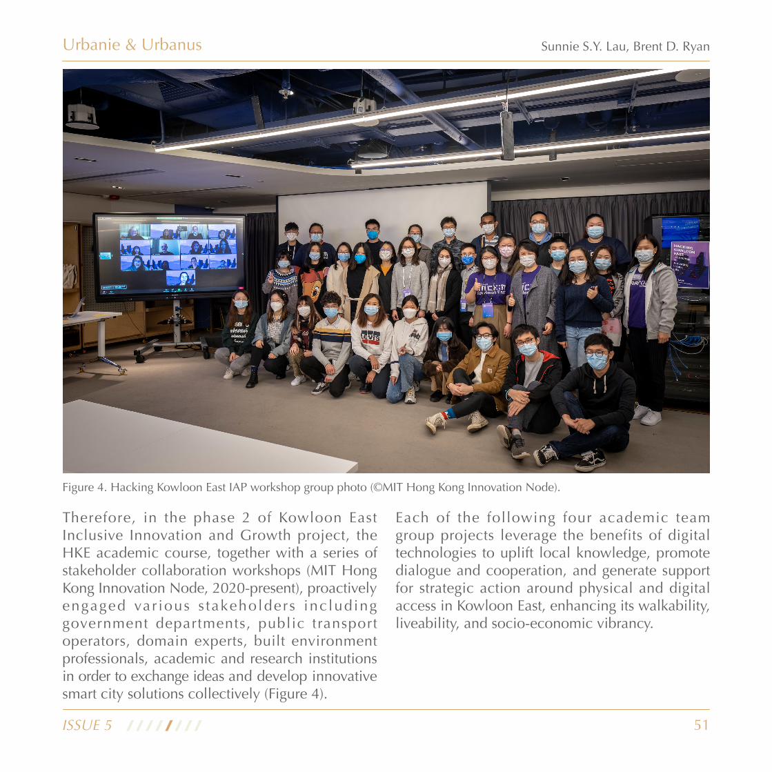
51
Urbanie & Urbanus
ISSUE 5
Sunnie S.Y. Lau, Brent D. Ryan
Figure 4. Hacking Kowloon East IAP workshop group photo (©MIT Hong Kong Innovation Node).
Therefore, in the phase 2 of Kowloon East Inclusive Innovation and Growth project, the HKE academic course, together with a series of stakeholder collaboration workshops (MIT Hong Kong Innovation Node, 2020-present), proactively engaged var ious s takeholders inc luding government departments, public transport operators, domain experts, built environment professionals, academic and research institutions in order to exchange ideas and develop innovative smart city solutions collectively (Figure 4).
Each of the following four academic team group projects leverage the benefits of digital technologies to uplift local knowledge, promote dialogue and cooperation, and generate support for strategic action around physical and digital access in Kowloon East, enhancing its walkability, liveability, and socio-economic vibrancy.

52
Urbanie & Urbanus
ISSUE 5
Sunnie S.Y. Lau, Brent D. Ryan
Afloat – The Co-Health Multi-Dimensional Bridge
Kwun Tong has the largest number and proportion of elderly, as well as the largest number of retirees, in the city. As Figure 5 shows, next to Hong Kong Children’s Hospital (HKCH), the first and only children’s hospital in Hong Kong, a new acute hospital is expected to open in 2025. As one of the largest hospitals in Hong Kong, the arrival of the new acute hospital would double the number of hospital beds in the entire Kowloon east district and help meet rising healthcare demands driven by the growing and ageing population of Kowloon.
This hospital cluster will attract a constant flow of citizens with a wide spectrum of health conditions. From the perspective of urban planning and design, there is a tremendous opportunity to transform this hospital cluster from a disease-centric atmosphere to a more holistic, health-building social hub. Most importantly, urban design holds the potential to foreground interests of hospital users while also accommodating the need of a greater community.
Amongst the different health drivers under the World Health Organisation’s framework of Health Impact Assessment (HIA), a key parameter of environmental determinants of health is the accessibility to medical care (Brown, Spickett, and Katscherian 2014), yet poor accessibility remains a territory-wide issue in Kowloon East. In March 2021, a legislative councillor described the Kai Tak district as being as “desolate as the
Siberian area”, blaming this condition on the area’s weak connection to main transportation networks.
The Afloat project, designed by Kwan Queenie Li and Joel Cunningham, is anchored in a “co-health” concept. It is built on top of the Meikirch Model of Health (Bircher and Hahn 2016), with aims to reinforce the health of both humans and surrounding environment, especially the water body.
Afloat is a multi-dimensional bridge situated at the opening of the Kai Tak Channel connecting the former runway to South Apron Corner, which is now the site of HKCH and will soon be home to a new large acute hospital (Figure 5). The new hospital cluster, shown in orange on the axonometric drawing (Figure 5), is currently a 1.4 km walk away from Kai Tak’s major green spaces, making a return journey unfeasible for many
Figure 5. Location analysis of Afloat (designers: Kwan Queenie Li, Joel Cunningham)

53
Urbanie & Urbanus
ISSUE 5
Sunnie S.Y. Lau, Brent D. Ryan
physically disabled persons or parents with young children. Therefore, the proposed bridge spans the channel at its intersection with the typhoon shelter, a location that does not hinder existing boat moorings or water taxi routes. Afloat reduces the distance from the hospitals to the green spaces of Kai Tak by 0.5km, and provides a connection to Kwun Tong’s existing waterfront promenade by creating a more accessible walking route from the schools and housing of Ngau Tai Kok Estate.
Afloat takes an incremental approach. The only permanent component of the proposal is a footbridge that offers a new 200m walking route between the green spaces of the Kai Tak runway and the centre of Kowloon Bay (Figure 6). The meandering form of the bridge creates a series of pockets that can host a series of flexible and economically constructed floating structures (Figure 7). These installations can be specified
to host a panoply of functions under a collective goal of improving the district’s health. These include human-oriented spaces that promote an active lifestyle, enriching our collective cultural quests and re-channelling the calming power of water for meditation and reflection.
The floating structures also feature elements which look to improve the health of the natural environment and connect the local community together. This connectivity can be achieved through devices that monitor and cleanse the water quality through biological intervention, and via an art- tech element that visually communicates the monitoring of the water below with distant viewers, creating an inspiring atmosphere that extends to the residents of the broader neighbourhood, especially those located in the district’s hospital (Figure 8).
Figure 6. Incremental approach used in Afloat (designers: Kwan Queenie Li, Joel Cunningham)

54
Urbanie & Urbanus
ISSUE 5
Sunnie S.Y. Lau, Brent D. Ryan
Figure 7. The proposal of Afloat (designers: Kwan Queenie Li, Joel Cunningham)
Figure 8. Viewing the sensing circle from the hospital (designers: Kwan Queenie Li, Joel Cunningham)
Afloat’s design development benefited from six in-depth interviews with domain experts in healthcare, public space, and environmental conservation. To contextualize Afloat, i ts designers studied related regulations and guidelines to understand local frameworks and to ensure its alignment with the larger development plan of the Hong Kong government for further implementation. Ultimately, Afloat is a work of civic infrastructure, art, and urbanism: a proposal for public connectivity to maximize health, enhancing Kwun Tong resident life while reimaging the Hong Kong waterfront.

55
Urbanie & Urbanus
ISSUE 5
Sunnie S.Y. Lau, Brent D. Ryan
The Universal Access Fest – A Toolkit for Collaborative Experimentation
The Universal Access Fest, or festival, is an event-based toolkit for collaborative experimentation that leverages community networks, popular education, participatory planning, and technology to bring visibility to local challenges and mobilize support for accessibility projects (Figure 9).
Figure 9. Concept illustration of the Universal Access Fest (designer: Ava Hoffman)
The Universal Access Fest envisions strategic pop-up interventions into public spaces surrounding public housing estates to spur local dialogue and action around issues of physical and digital access in Kwun Tong. Festival programming would feature a range of opportunities to learn, plan, and play — from intergenerational technology tutoring and community mapping, to empowering design games and inclusive art, food, and music (Figure 10).

56
Urbanie & Urbanus
ISSUE 5
Sunnie S.Y. Lau, Brent D. Ryan
Figure 10. Three pillars of the Universal Access Fest (designer: Ava Hoffman)

57
Urbanie & Urbanus
ISSUE 5
Sunnie S.Y. Lau, Brent D. Ryan
“World Cafe” roundtable — a social technology for engaging neighbours in guided conversation around important issues to them and their communities (Figure 12). Another option is that residents could join a community mapping session — highlighting community strengths, identifying shared challenges, defining priorities, and targeting resources through a visual and tactile, hands-on media.
Once challenges are identified, a game of “solutions four-square” could be a forum for brainstorming how to tackle these challenges at an individual, local, city-wide, and global level (Figure 12). Alternatively, attendees might simply want to enjoy the event as a social experience, partaking in the food, music, and inclusive art from local groups and vendors.
To realize the festival, activities would be spread across the estate’s grounds, with thematic nodes corresponding to the Learn-Plan-Play pillars (Figure 11). In each of the three nodes, participants are invited to join a variety of programs.
For instance, in the learning node, attendees might stop by the “Update Centre” to learn about the latest tech interventions and connect to resources for accessing these tools. Or they might stop by the tech clinic — a space for training and troubleshooting that connects youth tutors and older adult tech ambassadors with residents seeking assistance — realized in collaboration with existing Information and Communication Technology (ICT) training initiatives.
In the planning node, the welcoming environment of a teahouse, an important neighbourhood institution, could transform into the setting of a
Figure 11. The concept map of the Universal Access Fest (designer: Ava Hoffman)

58
Urbanie & Urbanus
ISSUE 5
Sunnie S.Y. Lau, Brent D. Ryan
Figure 12. Festival Programming (designer: Ava Hoffman)
In a broader sense, the Universal Access Fest, a pop-up event that can happen throughout Kwun Tong, will equip residents with the guidance to voice concerns and aspirations about civic,
social, and economic issues as they navigate, lead, and contest processes of neighbourhood change.

59
Urbanie & Urbanus
ISSUE 5
Sunnie S.Y. Lau, Brent D. Ryan
Blue Bird & xyZ – Digital Solutions to The Post-Industrial Transition
The two projects Blue Bird and xyZ examine the intersection between urbanism, society and technology in Kwun Tong Business Area (Figure 13). Many industrial buildings are concentrated in this area because of the flourishing of manufacturing industry in Kwun Tong since the 1950s. Following the relocation of the manufacturing industry to mainland China, many such buildings were left underutilized. The government then introduced a series of revitalization policies, ranging from rezoning industrial land to permissions on commercial use. As a result, many industrial buildings became
an agglomeration of a wide range of functions, including creative studios, fitness centres, restaurants, in addition to traditional industrial activities.
The conversion of industrial buildings gave rise to problems of functional misalignment. Industrial buildings were designed as functional spaces for efficient manufacturing and transportation of goods. Therefore, features important for other purposes such as wayfinding were missing from their original design (Figure 14). Furthermore, multiple ownerships, common among industrial properties in Hong Kong, today prohibit a systematic reprogramming of spaces and improvement of infrastructure.
Figure 13. Existing industrial buildings in Kwun Tong Business Area (©MIT Hong Kong Innovation Node)

60
Urbanie & Urbanus
ISSUE 5
Sunnie S.Y. Lau, Brent D. Ryan
Through virtual site visit, and with assistance from student ambassadors from HKU, students found that Kwun Tong, though the poorest district in Hong Kong, is also perceived as one of the “coolest” neighbourhoods because of its arrays of old industrial buildings weaving the fabric of compelling narratives, remaining as part of many generations’ precious collective memory. Social fabrics are strong. Many shopkeepers have close relationships with their neighbours, and creative studios and boutiques have injected new life into Kwun Tong (Figure 14).
Through a survey and 12 interviews with local customers and business owners, students identified the most critical challenges faced by the small and medium-sized enterprises (SMEs),
the principal tenants of the industrial buildings. SMEs have taken advantage of cheap rent, as well as of customers. Business owners have expressed unmet demand and the difficulty of having a stronger public presence. Businesses feel that they need to further to promote their business and that they have a lack of connection with their potential customers. Wayfinding is challenging not only because of the buildings’ “old and plain” exteriors, concealing their interior plural functions, but also because unstructured business information and the crudely retrofitted interiors make the buildings difficult to navigate both on the street, and inside. As a result, customers reported a negative wayfinding and exploration experience because of convoluted spatial layouts and lack of clear directory guidance.
Figure 14. Virtual site visiting at Kwun Tong Business Area (photo credit: Tiange Wang, Geunhee Lee, Yoonjae Oh, Adolphus Lau)

61
Urbanie & Urbanus
ISSUE 5
Sunnie S.Y. Lau, Brent D. Ryan
xyZ and BlueBird aim to increase the exposure of “local gems”- small and innovative, yet unknown businesses - hidden inside industrial buildings. These projects expose these businesses to the public, and enhance the experience of navigation and exploration in dense vertical neighbourhoods for locals and visitors, through the use of smart technologies.
Despite the similarity of their overall goal, Blue Bird and xyZ take markedly different approaches to their scopes of study, ways to engage the users, and understandings of urban heritage in Kwun Tong. BlueBird focuses on outdoor navigation on the street (Figure 15); xyZ, in contrast, pays more attention to indoor wayfinding (Figure 16). xyZ encourages visitors to interact with physical elements within industrial building to localize themselves, while BlueBird enhances accessibility by allowing both visual and audio interactions. Regarding urban heritage, BlueBird offers an option for fictional time travel through old industrial buildings, inspired by ongoing planning efforts valuing and promoting the historical narratives and the “Spirit of Creation” in Kwun Tong. XyZ, on the other hand, perceives the shopkeepers’ livelihood itself as urban heritage and creates a playful experience in industrial buildings, facilitating the communication between the business owners and their customers.
Figure 15. Concept illustration of BlueBird (designers: Tiange Wang, Geunhee Lee)
Figure 16. Concept illustration of xyZ (designer: Yoonjae Oh)

62
Urbanie & Urbanus
ISSUE 5
Sunnie S.Y. Lau, Brent D. Ryan
Below we introduce the concept and design of each project, then analyse their potential social impacts briefly.
BlueBird brings together existing scattered information (business profiles, promotions, and customer reviews) in social media platforms together based on their shared geo-locations, creating a virtual online collective, a counterpart to its physical clustering (Figure 17). This virtual cluster collects everything from social media promotion, experience sharing and rating apps, and event helpers, to help foster a dynamic business district online and offline.
BlueBird serves as a promotional channel for business owners, an information platform for customers, and a spatial narrative device for customers or visitors. The main features designed for business owners are an Augmented Reality
(AR) advertisement that integrates social media contents and supports in-app content creation, and a statistics dashboard that helps businesses better understand their customers, selling and stock items and better connect with their clients (Figure 18).
The second key feature of BlueBird is an “information platform” for customers. This includes AR routing and AR promotion. AR routing is an experience that could not only be augmented by vision, but also by sound, based on the customer’s choice (Figure 19). For AR promotion, when walking on the street, the customers will encounter vicinity-based pop-up promotion, increasing the exploratory aspect of the experience and heightens the chance for customers to use the coupons because it is physically close to them (Figure 20).
Figure 17. The virtual online collective (BlueBird - designers: Tiange Wang, Geunhee Lee)
Figure 18. Business dashboard (BlueBird - designers: Tiange Wang, Geunhee Lee)

63
Urbanie & Urbanus
ISSUE 5
Sunnie S.Y. Lau, Brent D. Ryan
Figure 19. AR routing (BlueBird - designers: Tiange Wang, Geunhee Lee)
Figure 20. AR promotion (BlueBird - designers: Tiange Wang, Geunhee Lee)
Figure 21. Time machine (BlueBird - designers: Tiange Wang, Geunhee Lee)
(AR) advertisement that integrates social media contents and supports in-app content creation, and a statistics dashboard that helps businesses better understand their customers, selling and stock items and better connect with their clients (Figure 18).
The second key feature of BlueBird is an “information platform” for customers. This includes AR routing and AR promotion. AR routing is an experience that could not only
be augmented by vision, but also by sound, based on the customer’s choice (Figure 19). For AR promotion, when walking on the street, the customers will encounter vicinity-based pop-up promotion, increasing the exploratory aspect of the experience and heightens the chance for customers to use the coupons because it is physically close to them (Figure 20).
A third feature of BlueBIrd is called “spatial narrative” for customers. On top of navigating through space, the time machine feature enables customers to navigate through time, discovering the rich history, culture, and hidden stories of the district (Figure 21).

64
Urbanie & Urbanus
ISSUE 5
Sunnie S.Y. Lau, Brent D. Ryan
The concept of xyZ is an indoor wayfinding app that uses an AR character to guide users to facilitate interaction between small business owners and visitors of industrial buildings. Beyond strengthening the connection between locals and SMEs, xyZ also aims to provide a social, inclusive, and enjoyable experience to the locals with features such as store search, indoor navigation, real-time store news centre, and chat service (Figure 22). With xyZ, city dwellers will be the co-creators of Kwun Tong’s evolution and be part of the journey of preserving its urban heritage, the shopkeeper’s neighbourhood.
Figure 22. Functions and design of xyZ (designer: Yoonjae Oh)
Figure 23. Hoi Luen Industrial Centre Block A (xyZ - designer: Yoonjae Oh)

65
Urbanie & Urbanus
ISSUE 5
Sunnie S.Y. Lau, Brent D. Ryan
Take Hoi Luen Industrial Centre Block A as an example. This is a 14-floor industrial building built in 1985 and estimated to hold approximately 510 businesses (Figure 23). The team creatively used AR as a device to help users as a wayfinding guide. By sorting out the common elements of the indoor environment of many industrial buildings in this area, the team selected six indoor infrastructures, using 3D scanning techniques to scan these infrastructures and apply techniques to detect the current location of users.
Another important feature of xyZ is the AR character, or personality in the form of a cartoon, that enables a more playful interaction between human and building infrastructure. The character
has two roles. For new visitors, this character will be user’s navigation guide and a friend helping to find stores the user is looking for (Figure 24). Also, it will give some suggestions based on the user’s interest. For frequent visitors, this character will be a virtual friend notifying all store news that are sent out in real time. This is especially designed for people who already know the path to their destination but would like to know minor store news such as waiting lines or out of stock notice.
Compared with other services available in the market (e.g., Google Maps, Yelp, Openrice), both projects adopt an experience-driven approach for users and maximize the strength of 3D information for an urban discovery experience.
Figure 24. New visitor mode demo (xyZ - designer: Yoonjae Oh)

66
Urbanie & Urbanus
ISSUE 5
Sunnie S.Y. Lau, Brent D. Ryan
By providing experience to the visitors, both projects can gain data patterns of consumers’ behaviour. Establishing a comprehensive store database of Kwun Tong could be possible as more and more stores would register business profiles on the platforms through crowdsourcing. Building property owners can have business insights with these two datasets, such as tenant satisfaction, overall space usage, amenity demand, and more. Consequently, owners can better monetize the building and drive long-term retention and revenues. These data could also attract real estate agents in terms of building asset analysis.
Moreover, by taking a flaneur approach to urban navigation and urban technologies, future versions of BlueBird and xyZ have great potential to reconnect disconnected urban fabrics, building a unique pedestrian culture among vertical spaces. The industrial buildings and associated businesses of Kwun Tong are a significant cultural, economic, and social recourse. Technology can connect customers and owners, emphasizing the district’s “cool” quality while enhancing livelihood for vulnerable residents and owners. BlueBird and xyZ are diverse and innovative means of realizing this enhancement of industrial buildings’ activity.
Conclusions
In the diverse projects of Hacking Kowloon East (HKE), MIT students provided a platform for communication and collaboration among stakeholders for a common goal – to rethink the concept of the smart city to enhance social justice for underserved populations, to enhance the visibility, popularity and utility of the existing built environment, and to improve civic life, health, and well-bring. All the student projects leverage current public initiatives in Kowloon East by better using emerging digital technologies to help connect residents to each other and to economic opportunities. With a fine level of background research, spatial analysis, and through extensive dialogue with local domain experts and communities, each project carefully considered of how urban design, planning and technology will address stakeholders’ concerns, improve social equity and community well-being in Kowloon East. The ensemble of projects showcases the potential for integration of both urban design and digital strategies into a feasible implementational framework. In short, HKE shows how inclusive innovation can improve quality of a place and provide many more benefits at every level.
As a paradigm of high-density urbanism, Hong Kong also provides an opportunity to rethink how physical spaces can be integrated with digital technologies, addressing opportunities to improve local liveability, resilience, health and environmental sustainability. All HKE projects envisaged Kowloon East leading to a human-
67
Urbanie & Urbanus
ISSUE 5
Sunnie S.Y. Lau, Brent D. Ryan
oriented, methodologically derived matrix that is sound, workable, and most importantly, transferrable for other neighbourhoods within Hong Kong and other cities as well. There is only one Kowloon East, but the HKE project team quickly realized that every neighbourhood out there in the City could be another Kowloon East, awaiting care and attention in the pursuit of an equitable society. Last but not least, HKE reminds us that a ‘smart city’ is a place where a city is highly inclusive, adaptive, flexible, resilient and with equal opportunity – in other words, a better city.
Biography
Sunnie S.Y. Lau is Director of Smart City Research and Industry Collaboration at MIT Hong Kong Innovation Node and Adjunct Assistant Professor at the HKU. As an international associate member of AIA, UK Chartered Member and Hong Kong Registered Architect, she has been a regular design critic and instructor at architecture and urban design programmes at various schools.
As an active council member of both HKIA and HKIUD; she has also taken the post of Chairing the Board of Education Affairs at the HKIA in 2021; Co-Chair of HKIA, HKIUD Young Members Committee since 2019 as well as HKIA representative in UIA Commission and Work Programmes. She has been keen in participating in competitions and exhibitions in various capacities ranging from curator, steering committee member, to exhibitor. In 2017, she was invited to be the Co-Curator & Exhibitor of the Hong Kong Shenzhen Bi-City Biennale Of Urbanism\Architecture (Hong Kong).
Brent D. Ryan is Head of the City Design and Development Group and Associate Professor of Urban Design and Public Policy in MIT’s Department of Urban Studies and Planning. His research focuses on the aesthetics and policies of contemporary urban design, particularly with respect to pressing issues like deindustrialization and climate change. Professor Ryan’s first book Design After Decline: How America rebuilds shrinking cities, was one of Planetizen’s ten best urban planning books of 2012, and his second

68
References
Bircher, Johannes, and Eckhart G. Hahn. 2016. ‘Understanding the Nature of Health: New Perspectives for Medicine and Public Health. Improved Wellbeing at Lower Costs’. F1000Research 5 (February): 167. https://doi.org/10.12688/f1000research.7849.1.
Brown, Helen, Jeffery Spickett, and Dianne Katscherian. 2014. ‘A Health Impact Assessment Framework for Assessing Vulnerability and Adaptation Planning for Climate Change’. International Journal of Environmental Research and Public Health 11 (12): 12896–914. https://doi.org/10.3390/ijerph111212896.
MIT Hong Kong Innovation Node. 2021. ‘Industry Collaboration Workshop’. Kowloon East Inclusive Innovation and Growth (blog). April 2021. https://hkinnovationnode.mit.edu/workshops/industry-collaboration-workshop/.
Sunnie S.Y. Lau, Theodora Karamanlis and et. al. 2020. ‘Kowloon East Inclusive Innovation & Growth’. Hong Kong: MIT Hong Kong Innovation Node. https://hkinnovationnode.mit.edu/smart-city/kowloon-east-inclusive-innovation-growth/.
Sunnie S.Y. Lau, 2020. ‘A SMART CITY – SYNTHESIZING INNOVATIVENESS AND INCLUSIVITY FROM THE BOTTOM-UP: KOWLOON EAST’. Hong Kong: MIT Hong Kong Innovation Node. https://hkinnovationnode.mit.edu/smart-city/
Urbanie & Urbanus
ISSUE 5
Sunnie S.Y. Lau, Brent D. Ryan
book The Largest Art: A measured manifesto for plural urbanism, was published by MIT Press in 2017. Professor Ryan has contributed chapters to other books and has published widely in periodicals relating to urban design and planning.
Professor Ryan conducts urban design research and practice around the world, including China, Ukraine, Russia, India, and the United States. Current research includes a study of sustainability in Siberian cities funded by the U.S. National Science Foundation, and a study of riverfront industrial redevelopment in Kolkata, India.

69
Urbanie & Urbanus
ISSUE 5
Wu Ka Chung Kane, Sung Wai Yin Gemma, Hui Tsz Ho Jonathan
By Wu Ka Chung Kane1, Sung Wai Yin Gemma2, Hui Tsz Ho Jonathan3
1. Co-founder and Lead Data Scientist, ThinkCol Transform Limited, HK2. AI and Data Project Manager, ThinkCol Transform Limited, HK3. Data Scientist, ThinkCol Transform Limited, HK
AI-powered Feedback Loop in Driving Efficient Urban Planning

70
With the advent of Artificial Intelligence (AI), more and more organisations are incorporating this into their business processes to make better decisions. The field of urban planning is not excluded in this realm of technology. In fact, although urban planners and AI developers operate in different disciplines, they both share the same goal: creating a more livable future. With technological advancement, AI technology can be incorporated into urban plans, facilitating the development of a “Smart City”.
Yet, while members of the public might only take note of the infrastructural changes within the city to make the city “smarter”, such as smart lamp posts, increase of digital registers on different outlets and modes of transportation, increase in Wifi hotspots etc., more could be done to understand the true impact of urban planning decisions and the public’s sentiment. This can help gauge feedback to be used as one of the success metrics and as a case study for future similar urban planning cases.
As is common in the implementation of AI applications, a feedback loop is an important element in engaging users and increasing usage of the intended application. Given the all-encompassing nature of urban planning, AI, with a particular focus on social listening, can help to bridge gaps in consultation, gauge feedback, and help perfect future plans. The advantages introduced from social listening and constructing an efficient feedback loop is beneficial regardless of the type of urban planning, from land use to revitalisation, as well as the multiple facets it
entails, especially its social impacts and public engagement.
A feedback loop can be applied to any process where the outputs are plugged back in and used as iterative inputs. A feedback loop, originally a concept in systems theory, is commonly used in AI or data-related solutions to help identify areas for improvement and assess the effect of these improvements in the next loop. Since users’ expectations and the world are ever-changing, it is difficult to maintain and utilise the same model or system used 10 years ago. With a feedback loop, the system can continuously retrain through a process of interaction, understand new demands and provide more accurate and suitable outputs. A feedback loop can also be easily implemented in businesses. For instance, the practice of acquiring customer feedback (which is the output of a service that the business provides), and using the feedback to improve future services, can be considered a feedback loop (Newman, 2016).
While different organisations may create feedback loops with traditional methods such as in-person qualitative interviews, surveys, and observational studies. The process is usually lengthy and costly. Traditional methods also do not take into account the online social world that we currently live in where many people choose to voice their opinions. Traditional qualitative interviews, while in-depth, can also only focus on the points of view of the interviewees and may not be able to represent all stakeholders. This points to the direction that traditional methods may not be comprehensive enough in acquiring effective
Urbanie & Urbanus
ISSUE 5
Wu Ka Chung Kane, Sung Wai Yin Gemma, Hui Tsz Ho Jonathan

71
feedback (Decort et al., 2019).
Such ineffectiveness is coupled with the vast fields that urban planning and smart city entail. The understanding of urban planning has moved from the traditional focus on the physical form of the building, to the economic functions and social impacts of them. They also draw upon concerns for the political, leisure, transportation, and ability of the community to make decisions. These aspects include continuous review and consultation to fully take into account different points of view.
With Smart City ini t iat ives involving the government, private institutions, and individuals (Smartcity.gov.hk, 2020), urban planning, planned or unintentional, involves many stakeholders. It is difficult to solely utilise conventional methods to reach out to stakeholders such as residents, community groups, developers, government workers (and the agencies they represent), business owners , neighborhood leaders , commission members and other groups.
There have been efforts from both private and public companies to try to understand public sentiment through collating news articles and periodicals. However, much of the research or feedback is on the impact for the organisation as a whole, but rarely on specific initiatives. With a social listening tool, organisations can track and analyse conversations on social media, alleviating traditional challenges of vast topics and failure to take into account online feedback. A social listening tool can trawl
contents of websites in real time, or at specific intervals and then summarise and present them for acquiring useful information. This is a crucial component of audience research as through the monitoring of social media channels for specific keywords, organisation name, and relevant hashtags, organisations can acquire information about their initiatives in a fraction of the time needed to undertake consultation (Digitalmarketingphilippines.com, 2021). Of course, social listening would not be able to fully replace the importance of other means of consultation methods, yet the efficiency of it allows organisations to gain rapid insights when it comes to quick-to-change technology like AI and the implementation of smart city design. It can be used as an efficient methodology for garnering insights before and after a project and is a quick step in creating a feedback loop.
An AI centered social listening platform can further expedite the process of uncovering risks or opportunities in the social media landscape. The adoption of AI technology has enabled an ability to sift through large amounts of data (news articles, social media posts etc.) with the option to filter irrelevant conversations based on user specification. More importantly, AI enables the ability to categorise every social media post or detect conversation patterns without the reliance on a defined set of complex keyword rules, but instead analyse the entire context of a social media post. A common use case for wealth management professionals in the fin-tech industry is leveraging social media data to translate data into well-informed investment decisions. Without
Urbanie & Urbanus
ISSUE 5
Wu Ka Chung Kane, Sung Wai Yin Gemma, Hui Tsz Ho Jonathan

72
AI to simulate human-like interpretation of online conversations, the social listening system may not be able to derive insights from social media data at a scale that meets commercially viable performance.
Management of urban plans and infrastructure systems do not and should not only rely on pr inc ip les . P roduc t ive u t i l i sa t ion o f advanced resources through information and communication technologies should be included in a variety of applications and strategies to improve the city’s operations. Hence, the consultation and feedback strategy should take into account public opinions that are often fluid and ever-changing.
Case Study: Kwun Tong Town Centre project
To demonstrate how social listening, as a feedback mechanism of Smart City, can be applied to urban planning to inform constructive or corrective actions, the example of the Kwun Tong Town Centre Redevelopment project is used. Originally announced in 1998, the Kwun Tong Town Centre project is the largest urban renewal project in the history of Hong Kong. Undertaken by the Urban Renewal Authority (URA), the project is divided into five development areas (DA). DA 1 was completed in 2014 while DAs 2 and 3 are finishing up in 2021 (Urban Renewal Authority, 2021). The development of DAs 4 and 5 is still ongoing and is expected to be completed
in 2026 (ibid.). DAs 1, 2 and 3 consist of the construction of new residential buildings and the largest public transport interchange in Hong Kong which opened in April 2021 (Yeo, 2021). Occupying a site area of 53,500 square meters, the renewal project affects about 1,653 property interests and about 4,763 people (URA, op. cit.). The iconic Yue Man Square, which is situated at the town centre of Kwun Tong, as well as the neighbouring Yuet Wah Street are both in the scope of the renewal area.
With different components of this project now in the public realm, it is important for related authorities to monitor the public perception towards the project and the impacted district. Opinions from both established media entities, such as news agencies, and regular netizens need to be considered when assessing public perception.
With the help of a Hong Kong-based social analytics platform, Lenx.ai (2019), we are able to scrape news articles, social media posts and comments from the web to perform analysis and extract insights using natural language processing (NLP) techniques. The AI social listening tool includes data sources such as online versions of local newspapers, popular online forums as well as Hong Kong-based social media groups. The platform’s vast coverage of local online channels makes it an appropriate tool for our analysis.
Lenx.ai allows users to pick a primary language for analysis. We ensured that we focused on the main language used online by the local
Urbanie & Urbanus
ISSUE 5
Wu Ka Chung Kane, Sung Wai Yin Gemma, Hui Tsz Ho Jonathan
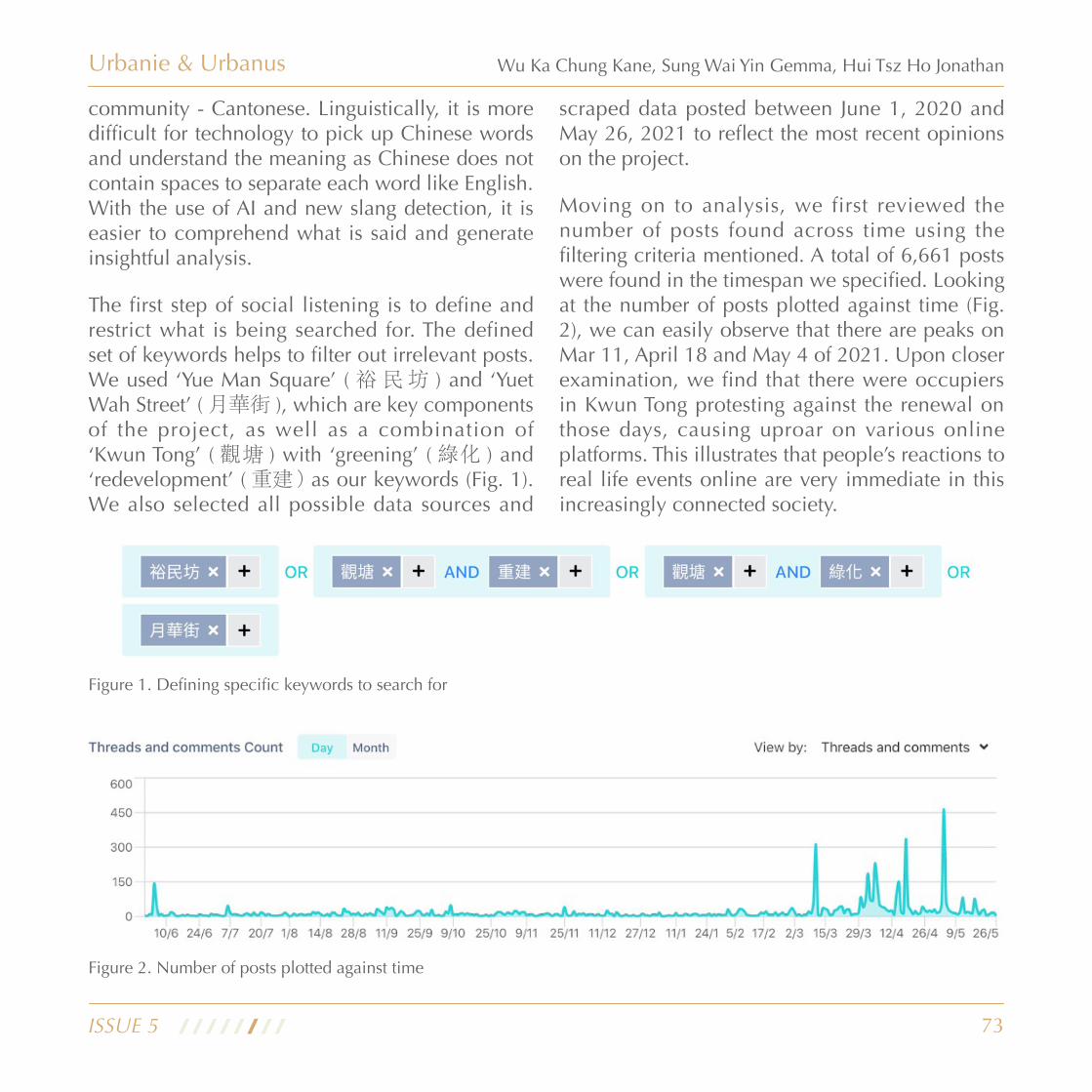
73
community - Cantonese. Linguistically, it is more difficult for technology to pick up Chinese words and understand the meaning as Chinese does not contain spaces to separate each word like English. With the use of AI and new slang detection, it is easier to comprehend what is said and generate insightful analysis.
The first step of social listening is to define and restrict what is being searched for. The defined set of keywords helps to filter out irrelevant posts. We used ‘Yue Man Square’ ( 裕 民 坊 ) and ‘Yuet Wah Street’ ( 月華街 ), which are key components of the project, as well as a combination of ‘Kwun Tong’ ( 觀塘 ) with ‘greening’ ( 綠化 ) and ‘redevelopment’ ( 重建 ) as our keywords (Fig. 1). We also selected all possible data sources and
Urbanie & Urbanus
ISSUE 5
Wu Ka Chung Kane, Sung Wai Yin Gemma, Hui Tsz Ho Jonathan
Figure 1. Defining specific keywords to search for
Figure 2. Number of posts plotted against time
scraped data posted between June 1, 2020 and May 26, 2021 to reflect the most recent opinions on the project.
Moving on to analysis, we first reviewed the number of posts found across time using the filtering criteria mentioned. A total of 6,661 posts were found in the timespan we specified. Looking at the number of posts plotted against time (Fig. 2), we can easily observe that there are peaks on Mar 11, April 18 and May 4 of 2021. Upon closer examination, we find that there were occupiers in Kwun Tong protesting against the renewal on those days, causing uproar on various online platforms. This illustrates that people’s reactions to real life events online are very immediate in this increasingly connected society.

74
Urbanie & Urbanus
ISSUE 5
Wu Ka Chung Kane, Sung Wai Yin Gemma, Hui Tsz Ho Jonathan
A word cloud is generated using a keyword extraction algorithm from the filtered posts (Fig. 3). The size of the words in the cloud correspond to their prevalence in the posts. Taking out the searched keywords like Kwun Tong and Yue Man Square, we observe the appearances of some interesting keywords. For instance, words related to the renewal process appear, such as ‘resumption’ ( 收 回 ), ‘occupation’ ( 佔 用 ) and ‘compensation’ ( 賠 償 ). Words hinting at traffic issues in the district such as ‘waiting for cars’ ( 候車 ), ‘tail end of traffic jam’ ( 龍尾 ) also show up. From this word cloud, we can identify topics and themes associated with the renewal project, some of which are concerns that Hong Kong people have regarding the renewal or the district itself.
Finally, it is useful to look at individual posts to see what specific concerns are raised. We want to locate posts that might have something negative to say about the renewal project in order to review the potential consequences renewal might have on the community. An AI model is used to infer the expressed sentiment of each post. Overall, we see that most posts express a positive rather than a negative sentiment (Fig. 4), but it is also important to note that many scraped posts are advertisements for activities in the area, therefore skewing the distribution of sentiments because advertisements in general have a positive tone.
Figure 3. Word Cloud showing commonly used words

75
Urbanie & Urbanus
ISSUE 5
Wu Ka Chung Kane, Sung Wai Yin Gemma, Hui Tsz Ho Jonathan
After inferring sentiment for each post, we can then focus on posts with negative sentiments (Fig. 5). One negative post writes, ‘The traffic jam, narrow sidewalk, and the lack of greening significantly affects emotions’ ( 塞 車, 行 人 路窄,冇綠化 非常影響情緒 ). In just one comment, three issues related to urban planning are raised about the district. Another post writes, ‘will constructing luxury residential buildings improve the overcrowding in Kwun Tong?’ ( 起 D 超 高 層豪宅,會改善到觀塘擠迫情況 ?) Again, concerns regarding the overcrowding of the area are raised. Another post, ‘Yue Man Square is like a void. The glamour of the commercial buildings juxtapose the poverty of the grassroots who reside below’ ( 裕民坊留下一個大洞,看到了繁華的商 廈, 腳 底 卻 是 貧 困 的 街 坊 ). This poetically expresses the concerns about the gentrification and displacement of old residents following the renewal.
The above analys i s sugges ts that onl ine postings have a close correlation with real-life occurrences. First of all, the number of posts generated on a topic correlates temporally with the key events of the redevelopment. The keywords extracted from the posts also uncover subtopics and themes that people associate with Kwun Tong or the redevelopment project. Sentiments people hold towards the project can be gauged through inferring sentiment using an AI model. Finally, we can zero in on posts of interest to understand concretely what the stakeholders are saying. These are just some of the ways social listening can help the urban planning process; deeper and more detailed analysis can be
Figure 4. Sentiment analysis of the project
Figure 5. Online posts about the Kwun Tong urban renewal project

76
Urbanie & Urbanus
ISSUE 5
Wu Ka Chung Kane, Sung Wai Yin Gemma, Hui Tsz Ho Jonathan
conducted on the posts using advanced AI to find more granular insights.
Authorities in charge of the renewal project can utilise social listening and the accompanying analyses to understand the concerns and criticisms people have towards the project and the district. As online postings are not limited by the framework established by traditional interviews and surveys, the expression of ideas online is usually more unrestricted and honest. Hence, social listening provides a more direct way to probe into what people think. Authorities can use this new understanding to inform their next steps for the renewal, in terms of improving components that are already built and creating better designs for components that are in the pipeline.
Conclusion
While AI social listening cannot fully replace the benefits of interviews, surveys and other traditional public consultation methods, AI social listening greatly improves the accuracy of feedback as results can be acquired within a matter of a few hours. Social listening also helps acquire more data to understand how the public views the issue at hand. This is especially important when urban planning and Smart City plans have to incorporate technologies that are changing rapidly. Not only can this reduce the likelihood of mismatch between urban policies and public sentiments, it can also assist urban planning, resulting in a win-win situation for planners, citizens, and other stakeholders.
Social listening is likely to play an increasing role in monitoring online behaviour. It can be adopted by different industries, including urban planning, to further understand public sentiment. Empowered by AI, urban planning can be even more inclusive towards users with an efficient feedback loop - from planning of building constructions to the impacts brought by gentrification, as well as the many elements it encompasses, particularly in terms of social implications and public participation. AI-powered feedback loops can bring us an unprecedented level of efficient planning and help to build smarter and more inclusive cities.

77
References
Decort, T., Malm, A., Sznitman, S., Hakkarainen, P., Barratt, M.J., Potter, G.R., Werse, B., Kamphausen, G., Lenton, S., and Frank, V.A., 2019. The challenges and benefits of analyzing feedback comments in surveys: Lessons from a cross-national online survey of small-scale cannabis growers. Methodological Innovations, [e-journal] Available at: <https://doi.org/10.1177/2059799119825606> [Accessed 28 May 2021].
Digitalmarketingphilippines.com. 2021. Social Listening – Its Importance and How it Works? | Digital Marketing Philippines. [online] Available at: <https://digitalmarketingphilippines.com/social-listening-its-importance-and-how-it-works/> [Accessed 28 May 2021].
Lenx.ai. 2019. [online] Available at: <https://www.lenx.ai/howitworks> [Accessed 28 May 2021].
Newman, D., 2016. How Well Does Your Organization Use Feedback Loops?. [online] Forbes. Available at: <https://www.forbes.com/sites/danielnewman/2016/08/02/how-well-does-your-organization-use-feedback-loops/?sh=7d351092594b> [Accessed 28 May 2021].
Smartcity.gov.hk. 2020. HKSmart City Blueprint | Smart City. [online] Available at: <https://www.smartcity.gov.hk/node/1.html> [Accessed 28 May 2021].
Urban Renewal Authority. 2021. Kwun Tong Town Centre Project (K7) (Park Metropolitan - DA1, Grand Central - DAs 2&3). [online] Available at: <https://www.ura.org.hk/en/media/press-release/20210401> [Accessed 28 May 2021].
Yeo, R., 2021. Hong Kong’s largest public transport interchange, with city’s first air-conditioned bus depots, to open at Kwun Tong on April 2. South China Morning Post, [online] 21 March. Available at: <https://www.scmp.com/news/hong-kong/transport/article/3126340/hong-kongs-largest-public-transport-interchange-open-kwun> [Accessed 28 May 2021].
Urbanie & Urbanus
ISSUE 5
Wu Ka Chung Kane, Sung Wai Yin Gemma, Hui Tsz Ho Jonathan
Biography
Wu Ka Chung Kane is the co-founder of ThinkCol Transform Limited and Lenx.ai. After working in one of the largest accounting firms in the world, Kane and his business partner, Sam Ho, realized the potential of AI and data science in business. Within 5 years of the company’s establishment, Kane led his team to help over 10 industries and 13 publicly listed firms. Kane is also the Vice-chairman of the Data Analytics Committee for IFTA, a Certified Information Privacy Professional, Certified Public Accountant, and a New York Attorney.
Sung Wai Yin Gemma has managed and led AI, data science and innovation projects for property conglomerates, the world’s largest health and beauty retailer, a world leading aircraft distributor and logistics multinational organization. She is also the co-author of The State of Ethical AI in Hong Kong published by the Hong Kong Data Science Society.
Hui Tsz Ho Jonathan has conducted researches on psychology in UC Davis Center for Mind and Brain and on EEG signals in UCSD Hillcrest Medical Center. He has also led multiple AI and data initiatives involving different AI technology, such as predictive analytics, customer segmentation, computer vision, and Natural Language Processing.

78
Urbanie & Urbanus
ISSUE 5
Alexander C. Ngai Siu
By Alexander C. NGAI SIU
Architect and Senior Urban Designer, EUASIA Limited
Smart Cities - Overview, Open Data, Privacy and Management Issues, Standards and Solutions

79
The definition of a Smart City by the Smart Cities Council is: “A smart city is one that uses technology and data to enhance its liveability, workability and sustainability. Or in short - tech and data for good.” Technology and data is understood as the use of digital technology and the exchange of data from the network of physical objects that are embedded with sensors, software and other technologies interconnected over the internet, also known as the “Internet of Things” (IoT). Importantly, it must be stressed that the ultimate goal is to achieve the improvement of the quality of life in cities (or more abstractly the built environment in which we live).
How is Open Data published and used?
Open Data is the process of making datasets (information gathered by cities, public entities and private sector companies within the public domain) available to the public (citizens) to use and reuse. This data constantly gathered is considered “OPEN” (as defined by the World Bank) when it is available in a machine-readable standard format, being able to be retrieved and meaningfully processed by a computer application (Technically Open) and when the data is explicitly licensed so that commercial and non-commercial use is permitted and is reusable without restrictions (Legally Open).
Urbanie & Urbanus
ISSUE 5
Figure 1. Screenshot of DATA.GOV.HK (Source: Internet screenshot by the author)
Alexander C. Ngai Siu

80
Governments typically coordinate and release data from multiple agencies through a central, secure, read-only location such as “data.gov” that facilitate users to find and use data. This location where data are published is called an open data portal. There are a range of platform options from cloud-based open sourced portals or built by their own cities. In Hong Kong, through the Public Section Information (PSI) Portal DATA.GOV.HK, anyone can access freely and harvest the datasets (covering from demographic, economic, geographical and meteorological data) through API for commercial and non-commercial purposes.
Priority of published data can be based on availability or by community feedback. Countries benefit from the release of government data in many ways, some common examples include:
Promoting transparency and accountability
When budget and expenditure data are released, designers often visualize them to make them understandable to the general public. Citizens can also see which programs, services and agencies are getting funding and how money is being spent.
Releasing social and commercial value
Geospatial, transport and weather data are often used by companies to build new services. These services benefit citizens and create economic value and often lead to more efficient ways of doing things.
Increasing citizen participation and engagement
Releasing data often opens the door to feedback and engagement – parents are interested in the performance of schools, citizens want to report issues with public services and governments can become more responsive to national needs.
The Community factor and Data Privacy concern
There is a strong feeling of fear on the amount of data that citizens are giving away for the sake of making their cities more efficient. The decision to change in 2021 and back away from the original futuristic plan for Quayside, Toronto has become a landmark on how far citizens (and governments) want to go in the application of a “technology-based gated community, where everything was monitored behaviour, personal data is collected by thousands of cameras”. Some even comment that this move reflects a growing skepticism over technology’s role in urban planning decisions.
Further to the economic impact (and potential benefit) of open data and technology-enabled transparency, benefits for societies through increasing state or institutional responsiveness, reducing levels of corruption, building new democratic spaces for citizens, empowering local and disadvantaged voices or enhancing service delivery and effective service utilization. The study by the Sunlight Foundation: “In the Social Impact of Open Data” (by Julia Keseru, James
Urbanie & Urbanus
ISSUE 5
Alexander C. Ngai Siu

81
Kin-sing Chan, 2015), Open Data initiatives are defined as projects using data that can be freely used, reused and redistributed by anyone. The project collected more than 100 examples (outputs, outcomes and impact) of open data and digital technology projects.
Three case studies from the Global South were thoroughly assessed, considering theory of change for open data and digital transparency initiatives. As part of the conclusions, the research identified (potential benefit) categories for project outcome in open government space as the following:
1) Educate or inform citizens so that they can make more informed choices,
2) Promote direct vivid engagement and increase citizen participation in democratic processes
3) Gather feedback for policy-makers and/or the private sector, and
4) Monitor and hold officials and/or the private sector accountable
Urbanie & Urbanus
ISSUE 5
Figure 2. Rendering of proposed waterfront development for Quayside Toronto featuring a pair of futuristic high-rises linked by a curved structure. The overall planning of the project included state-of-the-art automation of many urban services and infrastructure, thus creating a very efficient built-environment. However the expected data that may be gathered from the users eventually created a backslash on how the project was received by the citizens and the local government. (Image Courtesy of Snøhetta.)
Alexander C. Ngai Siu

82
Smart City Development in Hong Kong - Common Spatial Data Infrastructure and the Built Environment Application Platform
As seen before , the t rend of Smar t Ci ty development is usually under the initiative of governments, finding that the benefits of better managed resources at the macro-urban level is achieved at quantitative and qualitative dimensions. Hong Kong is not an exception, and so far it has been at the top of its priorities to keep up with the technology for a constant improved management of i ts common services and resources (infrastructure, planning and utilities). In Hong Kong’s 2030+ Smart, Green and Resilient City strategy. Looking to integrate the amount of information and data in between bureaus and departments for a seamless coordination under a core data management, a Common Spatial
Urbanie & Urbanus
ISSUE 5
Figure 3. A conceptual sketch of Quayside showing all the Smart solutions proposed incorporating a lot of automation of many urban services and infrastructure. (Source: Planetizen - Smart Urbanism: The Potential and Criticism of Smart Cities, 2020)
Figure 4. Sketch of Quayside showing a cross section of the city showing the separation of systems which includes delivery and recycling systems underground separated from a cleaner and greener public realm. (Source: Planetizen - Smart Urbanism: The Potential and Criticism of Smart Cities, 2020)
Alexander C. Ngai Siu

83
Data Infrastructure (CSDI) was proposed. Under the strategy, it was defined that Users (planners, engineers, architects, surveyors, government, academia. business and general public) would cooperate, collaborate and co-create Applications to analise, visualise and get informed about Planning and Land use, Infrastructure and Engineering and Landscape, Environment and Conservation using data from the CSDI (consisting in 2D/3D data, images and real-time data), thus
developing a Built Environment Application Platform (BEAP).
In the Feasibility Study carried out by ARUP for the Hong Kong Government’s Planning Department in 2020, there is a thorough review of international cases, giving a comprehensive view and analysis of the systems in practise in Singapore (Virtual Singapore), Australia (AURIN) and the city of Portland (CGIS) in the United
Urbanie & Urbanus
ISSUE 5
Figure 5. Common Spatial Data Infrastructure initiative - BEAP Study (Source: ARUP, Planning Department, 2020)
Alexander C. Ngai Siu

84
States. there were identified four Key Building Blocks needed to implement a successful Built Environment Application Platform:
1) Applications Development - This block refers to the web-based portal, its related applications tasked to address specific built environment requirements and Application Programming Interfaces (APIs) for applications
2 ) “A c t i o n a b l e D a t a ” f o r A p p l i c a t i o n Development - Data that is ready to be used, to be acted on, relevant to the query that is being made of. Actionable data is considered as a fundamental element of an application platform.
3) Technology Infrastructure - Hardware and softwares where the BEAP applications and data reside and operate and related Security Infrastructure.
4) Business Architecture - This comprises the services provided by the BEAP, basically the different applications provided to different user communities such as bureaus and departments, academia and the general public. It also requires a Governance and Operating Model which ensures the platform operates efficiently and effectively and devivers value.
The study not only presents the means to develop the BEAP but also includes proof of concept test cases for different scenarios on how the BEAP can be used, e.g.: Land use monitoring and analytics, Site Search, Scenario for Planning and Development, GIC Facilities and Open
Space Analysis, Visualization and Analysis of underground space and utilities, etc.
Quot ing the conclus ion: “The BEAP has great potential to be further developed as the collaborative platform for Government, business, academia and research institutes to foster interdepartmental and multilateral co-operation, as well as to serve as a foundation of various types of spatially and digitally enabled built environment applications for planning and design formulation, decision making, resource management, statistical analysis as well as the delivery of high quality services to the public. Through the application development, the BEAP would also enhance innovation, knowledge and value creation for different segments of the populace starting from within the Government in the years to come.”
The Built Environment Application Platform is a powerful tool for the city of Hong Kong, however it is clearly focused on its usability by highly specialized users (technical persons with specific skills to understand and manipulate the data available) which is good (but maybe not good enough), however it would be interesting to see the application of the available data for users a different levels, making it more user-friendly, practical (or commercial) and also there is the opportunity that it can become a strong and powerful educational tool for students, from simply creating thematic maps for assignments to looking for historical records and photos and understanding the complexity of the infrastructure and how the city works.
Urbanie & Urbanus
ISSUE 5
Alexander C. Ngai Siu

85
Data movement through the Internet of Things
“Smart ci t ies have numerous sustainable implications for advancing human development, improving societal processes, and reducing environmental costs. IoT technology merges i n t e r d i s c i p l i n a r y f i e l d s o f t e ch n o l o g y, environmental resources and urban systems development to enhance human capital and create a sustainable future.”(Drepaul, 2020) The implementation of IoT technology allows smart cities to link objects, information and people through intelligent computer networks. IoT technology allows the facilitation of data acquisition to guide future processes, improving the architectural sector by transferring data efficiently in order to improve decision-making on policies and projects related to housing, development, and the maintenance of public spaces. The sustainability implication is that, by improving our decision, IoT technology will lead to better housing and transportation designs, improved construction processes, and healthier lifestyles in cities.
S t ruc tura l changes in pol icy and fu ture governmental regulations can be enabled by the use of IoT technology. Within the multiple tiers of planning of smart cities, examination of IoT’s structure and application, policy making, urban planning and sustainable practices can be improved. The first bottom tier is responsible for IoT sources, data generations and collections; the second intermediate tier consists of data management and processing; and the top tier
is responsible for the application and usage of the aggregated data (Rathore, 2016) This tiered framework model supplements data aggregation, filtration and computing data which helps in future decision-making processes. IoT technology is implemented in three levels: the physical level which consists of data sets; the intermediate level which consists of statistical measurements or correlation chi-square, probability calculation and graphical analyses; and the upper level which relates to future planning derived from data collected. Its application has the capability of improving traffic, environmental pollution, surveillance, smart parking, weather tracking, water monitoring, and more.
Towards a Standard for the ideal Smart City
As it is understood and as we can observe in the practice, the Smart Cities approach can be very helpful addressing issues at citywide level. In some cases the emphasis of the application of the use of technology as part of managing a “Smart City” becomes an efficient way of managing citizens behaviour within the public realm (e.g.: regulation of smoking in forbidden zones by the Singapore government, crowd densities and manage cleanliness); management of city services (e.g.: Dubai’s internet application, Dubai Now which centralizes the information and payment of utilities, traffic speeding tickets handling, call taxi services, track deliveries, visa status, etc.); and efficient management of energy utilization (e.g.: Barcelona’s use of smart street lamps, parking
Urbanie & Urbanus
ISSUE 5
Alexander C. Ngai Siu

86
sensors, garbage sensors and compacting system or the air quality and pollution management in Darmstadt, Germany).
Despite many cities becoming “smarter” in one way or the other, most solutions tend to deal with partial “smartification”. The European Triangulum project (part of the European Community’s Horizon 2020 framework programme) aims to transform urban planning into a multidisciplinary effort with the latest of the technology available. At the moment, three main cities: Eindhoven in the Netherlands, Stavanger in Norway and Manchester in the United Kingdom, are making use of smart city solutions which integrate energy, mobility and information & communication technologies (ICT) in their district.
The goal is to reduce energy use and carbon emissions, enhance quality of life and stimulate economic development. The project wil l demonstrate that this model, integrating existing technologies in the field of energy, transport and ICT can be replicated throughout Europe based on a compilation of best practice scenarios. This will be put on testing in Leipzig (Germany), Prague (Czech Republic) and Sabadell (Spain). Tianjin city acts as an observer and eventually will put the best practice scenarios into practice.
Since initial use of the term in the 1990s, the concept of Smart Cities has evolved into a truly interdisciplinary approach: one that not only smartens up the living conditions of its citizens but also the environment, the mobility, governance and the economy. This kind of city
must be active and independent in its decisions made by well-informed residents, using resources at hand. Thus efficiency of urban and social infrastructure can be constantly improved by advanced technology.
The question and objectives are clear: the search for the “Smart City best practice scenarios across Europe”, however in the practice, it can be noticed that cities tend to focus on issues that in many cases may be specific to their particular geographical or social setting.
In E indhoven, the government col lected frustrations and worries from their citizens, the focus was on public safety for one their busiest districts: Stratumseind, using smart lamp-posts fitted with Wi-Fi trackers, cameras and microphones. It also considered diffusing oranges smell into the air to create a calming effect. Eindhoven also addressed smart issues into smart mobility and traffic management and developed shared urban spaces, encouraging citizens towards healthier lifestyles and increased participation in governance.
Different drivers were the focus for Stavanger, Norway: the need for more sustainable business and its population’s demographic change. Based on this premise, the city deployed technological solutions to improve the digital skills and well being of its citizens. On the environmental front, the objective is to facilitate the choice of climate-friendly alternatives for transportation by the citizens, in order to reduce local greenhouse gases emissions.
Urbanie & Urbanus
ISSUE 5
Alexander C. Ngai Siu

87
As stated in the publication “Smart Urban Planning starts with interdisciplinary thinking and action” (Zsuzsanna Balasz, Euroscientist, 2020) : “In order for an urban area to become smart, the “smartification” of the citizens as well is of utmost importance.”
An Alternative Benchmark for Smart City Solutions
As part of the Smart Cities Framework proposed by the Smart Cities Council, the first step is setting up the “Outcomes” (goals and targets for the city, based on recognised frameworks (eg. UN Sustainable Development Goals) which has been localised and informed by community engagement. “Repeat” is the fourth step of the Smart Cities Framework. Social engagement in order to review the process and targets and build transparency and trust with the community is of utmost importance. Based on this, the community develops a unique Smart City which has specific needs and solutions.
Based on the application of this framework globally and the development of a market for Smart Solutions, five main vertical categories were identified in the “Smart Cities: Opportunities for the UK” (ARUP, 2013): water, waste, energy, transport and assisted living.
Smart solutions across the verticals become beneficial when:
1) where resources are being consumed (better monitoring and management + users can be better informed in their use and how to lower consumption).
2) This reduces utility costs and extends the operating life of the related infrastructure.
“Smart city solutions apply digital technologies to address social, environmental and economic goals. Smart city solutions can combine physical and digital infrastructure or can be based on digital infrastructure alone. This confusion is a barrier to growth of this market as confused customers find it difficult to justify investment.”
The study focused in the following five main verticals by Smart Cities:
Smart Energy Management - Smart energy management technologies can help utilities and distributors to forecast and manage loads better, reduce the need for costly infrastructure expansion, and improve service quality and customer satisfaction. Meanwhile consumers bene f i t f rom se rv ice qua l i t y r e l i ab i l i t y improvements, new tariff options, the ability to reduce their energy bills. However, the full benefits to all parties will not accrue unless the whole energy system is made smart end-to-end.
Latest market and technology trends include: Smart Distribution Networks, Advanced Metering
Urbanie & Urbanus
ISSUE 5
Alexander C. Ngai Siu

88
Infrastructure (AMI), Smart (domestic) appliances, microgeneration management, and Building Engineering and Management (BEM).
Smart Water Management - Smart water management solutions are a means by which water companies use technology to optimise performance, minimise disruptions and conserve water.
Water management systems worldwide have an inherently ineffective nature, so there is a need to develop and use technology and smart water management in order to enable reductions to the present capital and operational running costs currently incurred by the utilities.
Smart Transport Management - Increasing urbanisation means cities are facing more congestion and associated carbon emissions, while still needing to provide good quality of life. … The growing demand for smart transport solutions to address congestion from city authorities and commuters means that the global ‘Smart Transport’ market, including digital and physical infrastructures, and associated design and advisory services, is expected to be worth over $100 billion by 2018.
Recent technologies that reduce congestion, improve quality of life, reduce emission from traffic, improve safety and optimise traffic flow include: Transport Information Application development, Intelligent traffic features, Digital City features.
Waste Management - Waste is a by-product of economic activity and the smart management of waste will have economic implications, however waste has never seen the same level of research, innovation, product development or investment as the water or energy sector. Human behaviour towards waste, its generation and treatment, plays a significant role in explaining why the uptake in smart waste management is lagging behind those of other smart sector.
Most of the “smart” technology used for waste management enhances the efficiency of waste collection and separation, while looking for cost reduction and improvement of the recycling performance by cities. Smart technologies developed include: Smart public realm bins, RFID tagging (use of pay-by-weight mechanisms) and Refuse Collection Vehicle GPS Tracking, Automated waste Collection and Mechanical Separation of Waste.
Assisted Living - Healthcare and social care systems around the world are seeing increasing demand as populations increase and more people live longer with long term conditions, disabilities, or the difficulties that come with age. There is an increasing need to help people live at home or in their communities longer.
Assisted Living Technologies (ALT) are becoming rapidly a mature market given the change in the demographics globally with an expected population aged 65 years or older of 1 billion people by 2030, feeding into a growing “silver” economy. Adoption of more affordable,
Urbanie & Urbanus
ISSUE 5
Alexander C. Ngai Siu
89
innovative and technologically advanced alternatives to traditional solutions support the development of a more strategic approach to ALT. Enhanced visibility in the value chain, with less fragmentation , improved collaboration between suppliers and information transparency are the growing trends in ALT. There is a rapid progress towards wearable and skin-contact devices using mobile and wireless technology to collect vital signs data and keep up with the health status of the users.
The study recommended that “large scale trials of whole systems shall be implements, with a focus on business models and deployment, rather than just technology.” Deployment of innovative products and services shall be made easier by cities and utility companies. Attraction of capital and creation of organisational structures which have the authority and capacity to deliver innovative programmes shall be main priorities for cities to achieve.
While the 5 verticals above may sound generic and quite logical and clear to common sense, the possibilities to benefit from the growing technological advancement by standardizing this into the professional practice and cities’ management could be exponential.
Urbanie & Urbanus
ISSUE 5
Biography
Alexander C. Ngai Siu is an Architect and Urban Designer with wide experience in physical planning and conceptual sustainable design often in the context of tourism planning and master planning. He obtained the Bachelor Degree in Architecture at the Ricardo Palma University in Lima, Peru, subsequently he has taken postgraduate studies on Landscape Design and was awarded the Master Degree on Urban Design at the University of Hong Kong. He is a professional member of the Hong Kong Institute of Urban Design.
Mr. Ngai has over 20 years of professional experience, having acted as project manager and designer for residential, institutional, mixed-use and community-oriented developments. In the last decade, he has been involved in tourism development projects in Asia by international agencies such as UNWTO and ADB. He also participated in urban design studies related to major urban infrastructure improvement projects in Hong Kong, mainland China, Saudi Arabia and Qatar.
Alexander C. Ngai Siu

90
References
Smart Cities Fact Sheet No.1 - Definition of the Smart City, Smart Cities Council, Nov. 2020 (smartcitiescouncil.com)
Smart Cities Fact Sheet No.2 - The Core Function of the Smart City, Smart Cities Council, Nov. 2020 (smartcitiescouncil.com)
Smart Cities Fact Sheet No.3 - The Smart Cities Framework, Smart Cities Council, Nov. 2020 (smartcitiescouncil.com)
Smart Cities Fact Sheet No.4 - The Smart Cities Enablers, Smart Cities Council, Nov. 2020 (smartcitiescouncil.com)
Smart Cities Fact Sheet No.5 - The Open Data Fundamentals, Smart Cities Council, Nov. 2020 (smartcitiescouncil.com)
Managing Sustainable Development (Michael Carley & Ian Christie, 2000)
'Irrelevant': report pours scorn over Google's ideas for Toronto smart city (Leyland Cecco, The Guardian, Sep. 2019) 'Irrelevant': report pours scorn over Google's ideas for Toronto smart city | Cities | The Guardian
Toronto swaps Google-backed, not-so-smart city plans for people-centred vision (Leyland Cecco, The Guardian, Mar.2021) Toronto swaps Google-backed, not-so-smart city plans for people-centred vision | Canada | The Guardian
The Smart City Market: Opportunities for the UK (Department for Business and Innovation & Skills & ARUP, October 2013)
Smart Cities: Solutions for China’s Rapid Urbanization (Bruce Appleyard, Yeqing Zheng, Rob Watson, Laura Bruce, Rachel Sohmer, Xuanyi Li, Jingjing Qian, Natural Resources Defense Council, Dec., 2007)
Development of a Common Spatial Data Infrastructure - Built Environment Application Platform - Feasibility Study - Final Report (Planning Department of Hong Kong and ARUP, March, 2020)
Urban Development Policy in Smart Cities, Zigurat Global Institute, Oct. 2019
Technology for Smart Cities: The Pillars of Urban Planning of the Future (Tomorrow City, Jaime Ramos, Feb. 2021)
Smart Urban Planning starts with Interdisciplinary thinking and Action (Euroscientist/ European science and Media Hub, Zsuzsanna Balasz, 2020)
Sustainable Cities and the Internet of Things (IOT) Technology: IOT technology improves the development of smart cities’ infrastructures and reduces over-population stresses. Drepaul, N. (2020). Consilience, (22), 39–47. https://doi.org/10.7916/consilience.vi22.6742
Development of a Common Spatial Data Infrastructure (CSDI) - Built Environment Application Platform (BEAP) - Feasibility Study (Final Report) HK SAR - Planning Dept. (by ARUP, 20 March 2020)
The Social Impact of Open Data, (Sunlight Foundation, Julia Keseru, James Kin-sing Chan, 2015 (A new approach to measuring the impact of open data : Sunlight Foundation)
Urbanie & Urbanus
ISSUE 5
Alexander C. Ngai Siu

91
Urbanie & Urbanus
ISSUE 5
Dr. Hee Sun (Sunny) Choi
Key words: smart city, smart city index, smart city urban design strategies
By Dr. Hee Sun (Sunny) Choi
School of Design, The Hong Kong Polytechnic University, Hong Kong
The HK Smart City Blueprint: an Assessment in Relation to International Smart City Performance Standards

92
Introduction
In December 2017 the Hong Kong Government launched the Smart City Blueprint (www.smartcity.gov.hk). In this, a series of 76 objectives for Hong Kong were announced under six themes; “Smart Mobility”, “Smart Living”, “Smart Environment”, “Smart People”, “Smart Government” and “Smart Economy”.
Concurrent with this initiative has been the development by a number of international bodies, including the International Standards Organization (ISO), the European Committee for Standardization (CEN) and the British Standards (BSI) for formulated standards in ‘smart’ urban development (SSCC-CG 2015).
This paper provides a critique of the Smart City Blueprint for Hong Kong in relation to these international standards that have been developed, using international case studies to assess and offer alternatives to the design strategies and methodological approaches in place.
Meaning of Smart City
It is common in contemporary urban place making and phraseology to use aspirational titles such as ‘Liveable City’, ‘Sustainable City’ and ‘Innovative City’. ‘Smart City’ proposals can be considered in this context and one of the most popular directions for contemporary place marketing (Moir, Moonen, and Clark 2014). Many definitions and characteristics for smart cities have been put forward (Albino, Berardi, and
Dangelico 2015). These include -Integrated information and communications technology (ICT) infrastructure (BSI 2014c) for improving city functioning (Hollands 2008) and achieving the digital transformation of urban systems. -The development of human capital (Hollands 2008; Caragliu, Del Bo, and Nijkamp 2011) through ICT-enhanced governance to support sustainable urban development driven by the knowledge, creativity, innovation and entrepreneurship of city actors (Hollands 2008). -Central to the smart city concept is the inclusion of tools with which to gather and process big data (Fujitsu 2012) concerning the day to day running of the city, from water and waste resource management to traffic systems, with a feedback loop in place to finetune and improve efficiency.
Completed Smart City developments have included newly built cities on greenfield sites, including Masdar (UEA) and Songdo (S. Korea), and urban regeneration and retrofit projects, including Rio de Janeiro and Barcelona (Batty et al. 2012; Shelton, Zook, and Wiig 2015).
As these projects and policies are put in place a series of counter arguments and concerns have also been raised in relation to the ethical position of harvesting and using data gathered from urban residents for political and commercial gain (Hollands 2008; Townsend 2013; Kitchin 2014; Vanolo 2014). The risk of panoptic surveillance and control of citizens (Townsend 2013; Kitchin 2014); and public-sector marginalization through public-private city partnerships (Vanolo 2014)
Urbanie & Urbanus
ISSUE 5
Dr. Hee Sun (Sunny) Choi

93
has also been raised. As such, there is a need for more evidence of the benefits and drawbacks for cities and citizens.
Smart City Blue Paper in Hong Kong
From the Smart City Blueprint (smartcity.gov.hk) the policy objectives are:
1) Make use of innovation and technology (I&T) to address urban challenges, enhance the effectiveness of city management and improve people’s quality of living as well as Hong Kong’s sustainability, efficiency and safety;2) Enhance Hong Kong’s attractiveness to global businesses and talents; and3) Inspire continuous city innovation and sustainable economic development
The ‘Mission’ is described as being:
(a) To make people happier, healthier, smarter and more prosperous, and the city greener, cleaner, more livable sustainable, resilient and competitive;(b) To enable the business to capitalize on Hong Kong’s renowned business-friendly environment to foster innovation and transform of the city into a living lab and test bed for development,(c) To provide better care for the elderly and youth and foster a stronger sense of community. To make the business, people and government more digitally enabled and technology savvy; and(d) To consume fewer resources and make Hong Kong more environmentally friendly, while maintaining its vibrancy, efficiency and livability.
In December 2020, an update to the Blueprint was issued, including smart city solutions to Covid virus containment and prevention. These include a focus on achieving cashless and contactless payment and ticket processing in commercial outlets and at the airport, an increase in online commerce and an increase in the use of robots for such services as airport baggage handling and robot floor cleaners.
At this stage there is a question as to whether the smart city objectives can have a more profound effect on the way urban residents live and relate to the contemporary city. Whilst the ambitious proposals point towards this, the current outcome is primarily focused on payment methods and online service systems. The application of ‘smart city thinking to the healthcare system, education, public transport, elderly care, are more limited.
Standard-setting and Smart city indices at an international level
Presuming there will be further updates to the HK Blueprint, what can be learned from the international development of smart city thinking and standards? The standards developed by the ISO, CEN and BSI include performance metrics for smart urban development (SSCC-CG 2015), standards for ‘Smart Community Infrastructures’ (for example, ISO/TR 37150:2014 and ISO/TS 37151:2015) (see iso.org) and the Smart City Framework, Publicly Available Specification PAS181 (BSI 2014c). Government-led research includes a European Commission (EC) EUROCITIES initiative entitled CITYkeys
Urbanie & Urbanus
ISSUE 5
Dr. Hee Sun (Sunny) Choi

94
(citykeys-project.eu), which has the goal of developing valid city performance measurement frameworks, Key Performance Indicators (KPIs) and standardized data collection
Two example outputs are the ESCR Model and The Smart City Index Master Indicators (SCIMI). The ESCR Model includes a framework with s ix ci ty character is t ics /dimensions; Smart Governance, Economy, People, Living,
Environment and Mobility, and includes both development and performance indicators, building on data collected at local, regional and national spatial levels. The Smart City Index Master Indicators (SCIMI) framework is a Smart Cities Council initiative to enable ranking cities in terms of liveability, workability and sustainability indicators (smartcitiescouncil.com/resources/smart-city-index-master-indicators-survey).
Urbanie & Urbanus
ISSUE 5
Dr. Hee Sun (Sunny) Choi

95
Urbanie & Urbanus
ISSUE 5
Dr. Hee Sun (Sunny) Choi
Table 1. Smart City (SC) development models
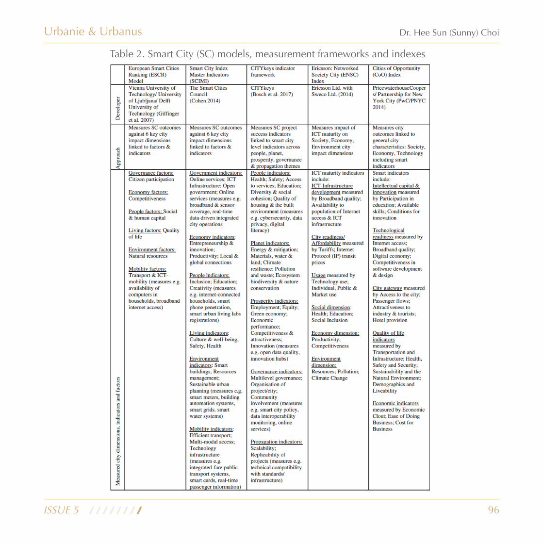
96
Urbanie & Urbanus
ISSUE 5
Dr. Hee Sun (Sunny) Choi
Table 2. Smart City (SC) models, measurement frameworks and indexes

97
Another index recently published is the first edition of the IMD Smart City Index 2019, which ranks 102 cities worldwide, published by the IMD World Competitiveness Center’s Smart City Observatory, in partnership with Singapore University of Technology and Design.
The index shows the ranking position of the city amongst the 102 cities measured, based upon the rating and its components. Each city is assigned to one of four groups, based upon its UN Human Development Index (HDI, 2019). values are calculated from the city’s performance relative to
Urbanie & Urbanus
ISSUE 5
Dr. Hee Sun (Sunny) Choi
the other cities within the group. The IMD Smart City Index as an international level, focuses on how citizens perceive the scope and impact of efforts to make their cities ‘smart’, balancing “economic and technological aspects” with “humane dimensions”.
Table 3 shows the detail of the components of assessment in relation to City ‘Structure’ and ‘Technologies’, with 5 categories and the score measurements for Singapore. The scoring system is a relative measurement to the other cities within the measurement group in the study.
Table 3. Smart City Structures and Technologies (source: IMD Smart City Index, IMD World Competitiveness Centre, 2019)

98
From the Index, the top 10 smartest cities in 2019 are: Singapore (1st), Zurich (2nd), Oslo (3rd), Geneva (4th), Copenhagen (5th), Auckland (6th), Taipei City (7th), Helsinki (8th), Bilbao (9th) and Dusseldorf (10th). And Hong Kong is ranking 37 out of 102 countries.
From this table the main strengths of Hong Kong in its Smart City structure are the easily accessible public services, institutes and hospitals, and a stable and safe online access to work and
Urbanie & Urbanus
ISSUE 5
Dr. Hee Sun (Sunny) Choi
Figure 1. Overview of UK smart city case studies
education. In order for a city to improve its ranking on this form of measurement list requires a comprehensive and holistic approach, not just to the technological infrastructure but to the complete virtual and physical service network in the city, linking up the involvement of the public and private stakeholders. This raises the question: what does Hong Kong need to do to establish a holistic approach to smart city development and design in the city and governance system?
99
For instance, as shown on the map, the case studies in UK showed that the cities were at the early stages of developing plans to evaluate the city-level impacts of smart city developments and were working in partnerships, mainly with local universities, to address evaluation challenges. Although most were not advanced with evaluation plans, Birmingham has made progress in developing a city-level evaluation framework, aligned with their smart city strategy and Roadmap. Manchester’s progress includes the development of an Impact Assessment Framework for their Triangulum project and a plan to assess city-level impacts. Other cities, including Milton Keynes and Peterborough, have developed many measures through their city programmes to contribute to a smart city evaluation framework, although this work was at an early stage.
Some cities were unconvinced of the need for an overarching, standardized smart city framework, which might not be sufficiently relevant to their unique city challenges, strategies, circumstances and projects. Moreover, cities already have statutory obligations to measure and report numerous Key performance indicators (KPIs )against city strategies and actions. For example, Bristol authorities in UK mentioned that there are approximately 150 KPIs that the Council report on annually, which they considered burdensome. Rather than developing new smart city KPIs, some city authorities would prefer to measure the contribution of smart city projects and programmes against existing city KPIs in establishing city-level impacts.
Smart city policy development in Hong Kong
The main evaluation challenges identified by cities centred on choosing suitable methodologies to measure the causal impacts of their smart city work on city outcomes, and how to prove the value for cities and citizens. A synthesis of the Council authority recommendations suggests that the design of smart city evaluation should be appropriate to the project, programme or city level, and to the innovation development maturity and scale of city projects. Evaluation approaches should reflect strategic city objectives and be open to improvement and evolution (as recommended by EIP-SCC 2013). Evaluation frameworks should be flexible, relevant and adaptable to different city challenges and circumstances. Some city authorities also considered that evaluation should have a diagnostic utility, helping cities identify both gaps in their smart city development and emergent innovation opportunities.
Rather than focusing on arbitrary or easily-measured indicators, the choice of measures should include quantitative and qualitative, meaningful and comprehensive indicators that reflect the multi-faceted nature of smart cities and the complexity of urban systems. Overall, evaluation design should build on city data intelligence to support development of future city visions and strategies, which some authorities noted should be based more on a vision of liveable cities with embedded smart technologies rather than simply a digital city vision.
Urbanie & Urbanus
ISSUE 5
Dr. Hee Sun (Sunny) Choi

100
Further enhancement of Hong Kong’s develop-ment as a smart city by 2030, KPMG China (2020) noted with eleven options, 47 percent of respondents identified development of technology infrastructure as critical. Forty-one percent say that they believe physical infrastructure will be adequate to keep pace with smart city development, and industry players say the situation could improve with the rollout of 5G technology.
According that report, the GBA is viewed by Hong Kong’s larger corporates as the preferred destination for outbound direct investment including R&D. Meanwhile, small and medium-sized enterprises, including start-ups, plan to prioritise trade and investment with ASEAN countries, but also collaboration between industry and university. As well as, it would be important to acting as drivers for growth and the creation of future employment opportunities for Hong Kong citizens in details with consideration of local needed and programs, indications, and assessment tools.
Conclusion
Although the Hong Kong government has prepared and published a vision for a ‘smart city’, there seems to be a more limited understanding and approach to achieving this in a holistic way that is broader than the digitization of payments and certain services. There are no case models and case studies to conduct the design strategic with detailed design guideline for smart city in multiple levels of built environment. Whilst smart mobility and infrastructure have been developed using big data and a vision for AI, there are no holistic criteria and indices to evaluate the smart city at a street, public realm and neighbourhood level.
Looking back at the ‘U-City’s urban planning and strategies in early 2000s, there was no clear platform to share its investigation and construction between planners, and public and private sectors’ involvement, as well as citizens’ participation. The next steps to optimise Hong Kong’s development as a smart city can include greater connectivity between individual government departments, best practices for effective governance, improving community participation, as well as increased collaboration between the public and private sectors. Corporates should also expand their partnerships with universities, start-ups and other companies, while focusing on sustainability and talent development. This would help not just at a local level within Hong Kong, but also for the Greater Bay Area and within the international network of cities that share similar ambitions.
Urbanie & Urbanus
ISSUE 5
Dr. Hee Sun (Sunny) Choi

101
Urbanie & Urbanus
ISSUE 5
Dr. Hee Sun (Sunny) Choi
Dr. Hee Sun (Sunny) Choi's Biography
Fo l lowing h igher educa t ion a t RMIT in Melbourne, the AA School and UCL in London, Dr Sunny Choi completed her PhD in urban design at Oxford Brookes Universi ty and conducted Post-doctoral research at Oxford University. A specialist in digital infrastructure, cultural identity and environmental sustainability, she has practiced as an urban designer and architectural designer in the UK, Hong Kong and in Seoul, South Korea, and within the design and master planning department of the United Nations Headquarters in New York. Currently she is working as an editor of the HKIUD U+U journal, teaching at Polytechnic University of Hong Kong and founding partner at Choi-Comer Asia, an architecture and urban design practice and research lab in Hong Kong.
References
Bris, A., Chee, C.H., and Lanvin, B., Smart City Index, IMD World Competitiveness Centre, Centre for Innovative Cities, IMD Smart City Observatory, Singapore University of Technology and Design
Caird, Sally P. and Hallett, Stephen H. (2019). Towards evaluation design for smart city development. Journal of Urban Design, 24(2) pp. 188–209.
Hong Kong Planning Department, 2016, Planning and Urban Design for a Liveable High-Density City, Hong Kong 2030+ Available from: www.hk2030plus.hk
Hong Kong Government, 2017, Smart Hong Kong: Embarking a New Journey, Innovation and Technology Bureau, December, 2017, [Accessed from: www.smartcity.gove.hk]
HK Treasury, 2018, The Green Book: central government guidance on appraisal and evaluation, OGL: London, Available from: www.gov.uk/government/publications
Leonidas G. Anthopoulos and Athena Vakali, 2012, Urban Planning and Smart Cities: Interrelations and Reciprocities, FIA, LNCS 7281, pp178-189, available from: www.springerlink.com
Lima, E.G., Chinelli, C.K., Guedes, A.L.A, Vazquez, E.G., Hammad, A.M.A, Haddad, A.N, and Soares, C.A.P., 2020, Smart and Sustainable Cities: the main guidelines of city status for increasing the interlligence of Brazilian Cities, Sustainability 2020, 12 (1025), pp1-26
Maciejewski Ada, 2019, Smart Cities should look ‘Smart’: Innovating Policy towards more Liveable Telecommunications Infrastructure, MDes thesis, York University, Toronto, Canada, unpublished.
Mircea Ermia, Lucian Toma, and Mihai Sanduleac, 2017, The Smart City Concept in the 21st century, 10th International Conference Interdisciplinarity in Engineering, Procedia Engineering 181, pp12-19, Available from: www.sciencedirect.com
National League of Cit ies, 2016, Trends in Smart City Development, NLC Centre for City Solutions and Applied Research, Available from: https://www.nlc.org/resource/smart-city-development/
102
Naydenov, K., 2018, Smart Cities: the future of urban planning, 5th International Multidisciplinary Scientific Conference on Social Science & Art SGEM 2018, Available from: https://www.researchgate.net/publication/333058533_SMART_CITIES_-THE_FUTURE_OF_URBAN_PLANNING
Sally P. aird and Stephen H.Hallett, 2019, Towards evaluation design for smart city development, Journal of Urban Design, 24:2, pp188-209
Selada, C., Silva, C., and Almeida, A.L., 2016, Urban Indicators and te Smart City Agenda, POCACITO Policy Brief No.5, December 2016, POCACITO European post-carbon cities of tomorrow.
Shahrour Isam, Alileche Lyes, and Al Furjani, A.M., 2017, Smart cities: system and tools used for the digital modelling of physical urban systems, Conference Paper, September, 2017 Sensors Networks Smart and Energing Technologies, Available from: https://www.researchgate.net/publication/321412825_Smar t_ci t ies_Sys tem_and_tools_used_for_ the_dig i ta l_modell ing_of_physical_urban_systems?enrichId=rgreq-939c3dc929fc4e9deabf47c3f583562c-XXX&enrichSource=Y292ZXJQYWdlOzMyMTQxMjgyNTtBUzo1NzUwMTMzNDQwOTIxNjBAMTUxNDEwNTI3MjI0MQ%3D%3D&el=1_x_2&_esc=publicationCoverPdf
Takeshi Kobayashi and Shinki Ikaruga, 2015, Development of a smart city planning support tool using the cooperative method, Frontiers of Architectural Research, Vol 4, pp277-284, Elsevier
Urbanie & Urbanus
ISSUE 5
Dr. Hee Sun (Sunny) Choi

103
Urbanie & Urbanus
Urban Design Book Introduction
Smart Cities: Introducing Digital Innovation to Cities, 2019By Oliver Grassmann, Jonas Bohm, Maximilan PalmieEmerald Publishing Limited,
Smart Cities: Introducing Digital Innovation to Cities offers answers, with clarifying examples, to questions that have remained unanswered for many cities. The book identifies and addresses the core elements and potential of smart cities, best practice methods and tools to be implemented, as well as how diverse stakeholders might be effectively integrated. Based on perennial international research in the field of smart cities, this book brings together the authors' collective experience in practice-based political, administrative, and economic projects to provide a common framework to guide and engage key stakeholders in the transformation and realization of smart cities.
The Smart Enough City: Putting Technology in Its Place to Reclaim Our Urban Future, 2019By Ben GreenMIT Press: London, England,
In a technology-centric smart city, self-driving cars have the run of downtown and force out pedestrians, civic engagement is limited to requesting services through an app, police use algorithms to justify and perpetuate racist practices, and governments and private companies surveil public space to control behavior. Green describes smart city efforts gone wrong but also smart enough alternatives, attainable with the help of technology but not reducible to technology: a livable city, a democratic city, a just city, a responsible city, and an innovative city. By recognizing the complexity of urban life rather than merely seeing the city as something to optimize, these Smart Enough Cities successfully incorporate technology into a holistic vision of justice and equity.
ISBN: 978-1-78769-614-3
ISBN: 978-0-262-03967-3
ISSUE 5, July 2021

104
Urbanie & Urbanus
Digital and Smart Cities, 2017By Katherine S. Willis and Alessandro AurigiRoutledge Press
The book starts out with definitions and sets out the various interpretations and aspects of what constitutes and defines digital cities. The text then investigates and considers the range of factors that shape the characteristics of digital cities and draws together different disciplinary perspectives into a coherent discussion. The consideration of the different dimensions of the digital city is backed up with a series of relevant case studies of global city contexts in order to frame the discussion with real world examples.
Smart City Barcelona: the Catalan Quest to Improve Future Urban Living, 2018By Antoni Vives, Translated by David Thomas ClarkSussex Academic Press
Barcelona's transformation into the world's leading smart city is explained by one of its chief protagonists. SMART CITY Barcelona provides an essential guide for innovation and leadership for all those who participate in the design of cities in the 21st century. The Barcelona municipality is a driving force in the creation of city employment, well-being and opportunity. Based on the author's experience as deputy mayor of urbanism, housing, infrastructures, environment, energy, ICT, and innovation in Barcelona City Council, as well as a consultant and lecturer to cities across the world (Singapore, Ho Chi Minh City, Mumbai, Delhi, Pune, Doha, Dubai, Oslo, Prague, Moscow and Bogota, to name a few), SMART CITY Barcelona presents twelve theoretical and practical lessons for all citizens, civil servants, politicians, architects, city planners and businessmen who wish to contribute to the design of 21st century cities.
Urban Design Book Introduction
ISBN: 1317494989, 9781317494980
ISBN-13: 978-1845199180
ISSUE 5, July 2021

105
Urbanie & Urbanus
Next Issue: Call for Papers
Invitation to Submit Your Paper and Join Our JournalWe welcome submissions for our sixth issue, which will be published in December 2021, with the topic of ‘URBAN REGENERATION’.
Submitted papers must be original and not under consideration by any other journal.Academic papers (preferably not exceeding 4000 words, with an abstact in less than 200), practice papers, conference reports, book reviews and notices of forthcoming events will be considered.
You can send your manuscripts directly via email to: [email protected](E-mail Subject Format: U+U_article title)For any inquiries, please do not hesitate to contact with us via this email.
Dr. Hee Sun (Sunny) ChoiEditorUrbanie and Urbanus
SPONSORS
Next Issue Topics
Invitation to Submit Your Paper and Join Our Journal
We welcome submissions for our third issue, which will be published in January, 2020 with the topic of ‘Sustainable Cities’
Submitted papers must be original and not under consideration by any other journal.Academic papers (preferably not exceeding 4000 words, with an abstract in less than 200), practice papers, conference reports, book reviews and notices of forthcoming events will be considered.
You could send your manuscripts directly via e-mail to: [email protected](E-mail Subject Format: U+U_article title)For any inquiries, please do not hesitate to contact with us via this [email protected]/ [email protected]
Dr Hee Sun (Sunny) ChoiEditorUrbanie and Urbanus
SPONSORS
-
Urbanie and Urbanus
ISSUE 5, July 2021