The hazard potential of the western segment of the Makran subduction zone, northern Arabian Sea
21
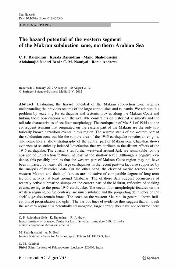
ORIGINAL PAPER The hazard potential of the western segment of the Makran subduction zone, northern Arabian Sea C. P. Rajendran • Kusala Rajendran • Majid Shah-hosseini • Abdolmajid Naderi Beni • C. M. Nautiyal • Ronia Andrews Received: 3 January 2012 / Accepted: 10 August 2012 Ó Springer Science+Business Media B.V. 2012 Abstract Evaluating the hazard potential of the Makran subduction zone requires understanding the previous records of the large earthquakes and tsunamis. We address this problem by searching for earthquake and tectonic proxies along the Makran Coast and linking those observations with the available constraints on historical seismicity and the tell-tale characteristics of sea floor morphology. The earthquake of Mw 8.1 of 1945 and the consequent tsunami that originated on the eastern part of the Makran are the only his- torically known hazardous events in this region. The seismic status of the western part of the subduction zone outside the rupture area of the 1945 earthquake remains an enigma. The near-shore shallow stratigraphy of the central part of Makran near Chabahar shows evidence of seismically induced liquefaction that we attribute to the distant effects of the 1945 earthquake. The coastal sites further westward around Jask are remarkable for the absence of liquefaction features, at least at the shallow level. Although a negative evi- dence, this possibly implies that the western part of Makran Coast region may not have been impacted by near-field large earthquakes in the recent past—a fact also supported by the analysis of historical data. On the other hand, the elevated marine terraces on the western Makran and their uplift rates are indicative of comparable degree of long-term tectonic activity, at least around Chabahar. The offshore data suggest occurrences of recently active submarine slumps on the eastern part of the Makran, reflective of shaking events, owing to the great 1945 earthquake. The ocean floor morphologic features on the western segment, on the contrary, are much subdued and the prograding delta lobes on the shelf edge also remain intact. The coast on the western Makran, in general, shows indi- cations of progradation and uplift. The various lines of evidence thus suggest that although the western segment is potentially seismogenic, large earthquakes have not occurred there C. P. Rajendran (&) K. Rajendran R. Andrews Indian Institute of Science, Centre for Earth Sciences, Bangalore 560012, India e-mail: [email protected] M. Shah-hosseini A. N. Beni Iranian National Center for Oceanography, Tehran 1411813389, Iran C. M. Nautiyal Birbal Sahni Institute of Palaeobotany, Lucknow 226007, India 123 Nat Hazards DOI 10.1007/s11069-012-0355-6
Transcript of The hazard potential of the western segment of the Makran subduction zone, northern Arabian Sea
ORIGINAL PAPER
The hazard potential of the western segmentof the Makran subduction zone, northern Arabian Sea
C. P. Rajendran • Kusala Rajendran • Majid Shah-hosseini •
Abdolmajid Naderi Beni • C. M. Nautiyal • Ronia Andrews
Received: 3 January 2012 /Accepted: 10 August 2012! Springer Science+Business Media B.V. 2012
Abstract Evaluating the hazard potential of the Makran subduction zone requiresunderstanding the previous records of the large earthquakes and tsunamis. We address thisproblem by searching for earthquake and tectonic proxies along the Makran Coast andlinking those observations with the available constraints on historical seismicity and thetell-tale characteristics of sea floor morphology. The earthquake of Mw 8.1 of 1945 and theconsequent tsunami that originated on the eastern part of the Makran are the only his-torically known hazardous events in this region. The seismic status of the western part ofthe subduction zone outside the rupture area of the 1945 earthquake remains an enigma.The near-shore shallow stratigraphy of the central part of Makran near Chabahar showsevidence of seismically induced liquefaction that we attribute to the distant effects of the1945 earthquake. The coastal sites further westward around Jask are remarkable for theabsence of liquefaction features, at least at the shallow level. Although a negative evi-dence, this possibly implies that the western part of Makran Coast region may not havebeen impacted by near-field large earthquakes in the recent past—a fact also supported bythe analysis of historical data. On the other hand, the elevated marine terraces on thewestern Makran and their uplift rates are indicative of comparable degree of long-termtectonic activity, at least around Chabahar. The offshore data suggest occurrences ofrecently active submarine slumps on the eastern part of the Makran, reflective of shakingevents, owing to the great 1945 earthquake. The ocean floor morphologic features on thewestern segment, on the contrary, are much subdued and the prograding delta lobes on theshelf edge also remain intact. The coast on the western Makran, in general, shows indi-cations of progradation and uplift. The various lines of evidence thus suggest that althoughthe western segment is potentially seismogenic, large earthquakes have not occurred there
C. P. Rajendran (&) ! K. Rajendran ! R. AndrewsIndian Institute of Science, Centre for Earth Sciences, Bangalore 560012, Indiae-mail: [email protected]
M. Shah-hosseini ! A. N. BeniIranian National Center for Oceanography, Tehran 1411813389, Iran
C. M. NautiyalBirbal Sahni Institute of Palaeobotany, Lucknow 226007, India
123
Nat HazardsDOI 10.1007/s11069-012-0355-6
in the recent past, at least during the last 600 years. The recurrence period of earthquakesmay range up to 1,000 years or more, an assessment based on the age of the youngest datedcoastal ridge. The long elapsed time points to the fact that the western segment may haveaccumulated sufficient slip to produce a major earthquake.
Keywords Makran subduction zone ! Hazard potential ! Earthquake recurrence !Tsunami ! Tectonics
1 Introduction
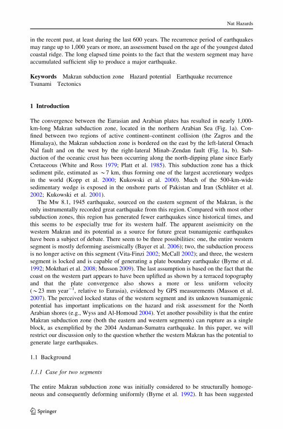
The convergence between the Eurasian and Arabian plates has resulted in nearly 1,000-km-long Makran subduction zone, located in the northern Arabian Sea (Fig. 1a). Con-fined between two regions of active continent–continent collision (the Zagros and theHimalaya), the Makran subduction zone is bordered on the east by the left-lateral OrnachNal fault and on the west by the right-lateral Minab–Zendan fault (Fig. 1a, b). Sub-duction of the oceanic crust has been occurring along the north-dipping plane since EarlyCretaceous (White and Ross 1979; Platt et al. 1985). This subduction zone has a thicksediment pile, estimated as *7 km, thus forming one of the largest accretionary wedgesin the world (Kopp et al. 2000; Kukowski et al. 2000). Much of the 500-km-widesedimentary wedge is exposed in the onshore parts of Pakistan and Iran (Schluter et al.2002; Kukowski et al. 2001).
The Mw 8.1, 1945 earthquake, sourced on the eastern segment of the Makran, is theonly instrumentally recorded great earthquake from this region. Compared with most othersubduction zones, this region has generated fewer earthquakes since historical times, andthis seems to be especially true for its western half. The apparent aseismicity on thewestern Makran and its potential as a source for future great tsunamigenic earthquakeshave been a subject of debate. There seem to be three possibilities: one, the entire westernsegment is mostly deforming aseismically (Bayer et al. 2006); two, the subduction processis no longer active on this segment (Vita-Finzi 2002; McCall 2002); and three, the westernsegment is locked and is capable of generating a plate boundary earthquake (Byrne et al.1992; Mokthari et al. 2008; Musson 2009). The last assumption is based on the fact that thecoast on the western part appears to have been uplifted as shown by a terraced topographyand that the plate convergence also shows a more or less uniform velocity(*23 mm year-1, relative to Eurasia), evidenced by GPS measurements (Masson et al.2007). The perceived locked status of the western segment and its unknown tsunamigenicpotential has important implications on the hazard and risk assessment for the NorthArabian shores (e.g., Wyss and Al-Homoud 2004). Yet another possibility is that the entireMakran subduction zone (both the eastern and western segments) can rupture as a singleblock, as exemplified by the 2004 Andaman-Sumatra earthquake. In this paper, we willrestrict our discussion only to the question whether the western Makran has the potential togenerate large earthquakes.
1.1 Background
1.1.1 Case for two segments
The entire Makran subduction zone was initially considered to be structurally homoge-neous and consequently deforming uniformly (Byrne et al. 1992). It has been suggested
Nat Hazards
123
that the large amount of unconsolidated and water-saturated overpressured sediments mayresult in a low apparent friction on the detachment—a reason for relative aseismicity of thewestern Makran (Byrne et al. 1992; Bayer et al. 2006; Pacheco et al. 1993; Bilek and Lay
Fig. 1 a Tectonic features around the Makran subduction zone (MAF Makran accretionary front, SF Sonnefault, MZF Minab–Zendan fault, ONF Ornach Nal fault, OFZ Owen fault zone, OMP Ormara microplate,DT Dalrymple trough, MR Murray ridge, LMR little Murray ridge, EM Eastern Makran, WM: WesternMakran). White arrow denotes direction of plate motion NW–SE trending; arrows indicate the trend of apossible active transverse fault coincident with the suture zone of the Lut Block and Helmand Block (twoPre-Eocene accreted terrains). Inset A map of the region showing the study area. b. Structural elements ofthe region encompassing the North Arabian Sea. Abbreviations: AP accretionary prism, MAF Makranaccretionary front, LMR little Murray ridge, OP Ormara microplate, WM western segment, EM easternsegment. Solid arrows show GPS horizontal velocities for JASK, CHAB, MUSC sites (Vernant et al. 2004)
Nat Hazards
123

2002). There are some compelling structural and geometrical considerations that suggestthe segmented nature of the Makran tectonic province.
Segmentation is implied by the existence of the Sonne fault, the NW-trending, left-lateral strike-slip fault, whose offshore extension is traced from swath bathymetry surveys(Kukowski et al. 2000). The apparent geometrical considerations, therefore, suggest thatthe Sonne fault possibly divides the Makran subduction front into western and easternsegments (Fig. 1b). The patterns of seismicity and the structural setting of the MurrayRidge suggest a separate microplate on the eastern part of the subduction zone (calledOrmara microplate). This triangular-shaped microplate occurs between the NNW-trendingleft-lateral Sonne fault on the western side and NNE-trending Ornach Nal fault on theeastern side (Kukowski et al. 2000). The Sonne fault accommodates the differentialmovement between the Ormara microplate (driven northward by the Murray Ridge) andthe Gulf of Oman (driven by the Sheba Ridge).
The Sonne fault makes such a distinctive boundary that a single event, breaking throughboth the segments of Makran, is considered improbable (Musson 2009). Aside from thepresence of a transverse bounding structure, strength contrast of mid-level decollementbetween the eastern and western Makran has also been inferred (Byrne et al. 1992) thatmight inhibit a segment breaking full rupture.
Seismicity, GPS and offshore morphology data suggest that the eastern and the westernMakran segments have distinctive characteristics. Recent efforts have generated anextensive GPS database for the Zagros–Makran zone (Vernant et al. 2004; Bayer et al. 2006;Masson et al. 2007). GPS data from Iran suggest that Arabia converges toward southeasternIran at velocity of 23 ± 2 mm year-1 near the western termination of the Makran sub-duction (Vernant et al. 2004), less than the time-averaged velocity of 36.5 mm/year basedby the NUVEL 1 model (DeMets et al. 1990). GPS data also shows significant differentialmovement between Oman and Iran, with shortening of the order of 1.95 cm/year, thusconfirming the active subduction process that is underway along the entire stretch of Makrantectonic belt (Masson et al. 2007). Variations in convergence rate between the eastern andwestern segments of the Makran subduction zone have also been observed.
GPS studies also infer an eastward increase in convergence rate, from 11 ± 2 mm/year, atJask to 19 ± 2 mm/year at Chabahar (Vernant et al. 2004). Later studies affirmed this greaterconvergence rate at easterly located Chabahar comparedwith Jask on thewestern side (Bayeret al. 2006). Apel et al. (2006), however, estimate a much greater convergence of30 mm year-1 on the eastern segment, a convergence rate betweenArabian andAsian plates.The presence of a nearby spreading center (Ormara microplate driven northward by theMurray Ridge) on the eastern segment probably generates a much larger convergence on thispart (Musson 2009). An intriguing velocity of 21 ± 3 mm/yr observed at a semi-permanentpoint in Ormara (relative to Indian plate) was interpreted as due to steady-state post-1945aseismic slip (Bilham et al. 2009). The general easterly increase in plate convergence ratesobserved from recent GPS data, the structural features such as the sinistral Sonne fault and thehigher level of current seismicitymake the easternMakran distinct from thewestern segment.
1.1.2 The 1945 earthquake and ground deformation: a template for western Makran
The 1945 earthquake (Mw 8.1) is the only major earthquake known to have occurred alongthe Makran Coast in the historical times. The rupture due to this earthquake is believed tohave occurred on the segment between Pasni and Ormara in Pakistan (Byrne et al. 1992;Fig. 1a). Thrust mechanism with focal depth of 27 ± 3 km, and a rupture length of100–150 km and a down dip width of 100 km, on a gently north-dipping (5") fault has
Nat Hazards
123
been suggested by Byrne et al. (1992). The dislocation model of Byrne et al. (1992)suggests that the up-dip limit of rupture along the trench axis emerges offshore about30 km from the coast and that the uplift is confined to a narrow region.
Large-scale coseismic ground deformation was observed in the onshore parts of thePakistan coast. The coasts at Pasni and Ormara were reported to have risen by 4.8 and 2 m,respectively (Snead 1967; Page et al. 1979). The possibility for greater coseismic uplift,which must have subdued later, has been implied (Page et al. 1979; Vita-Finzi 2002), butthere is no direct evidence to suggest a greater coseismic uplift and a post-seismicrelaxation. The 2-m coseismic uplift of the Ormara tombolo, located east of Pasni, and thereactivation of mud volcanoes on the eastern part of the rupture (Fig. 1a) might suggest aunilateral eastward directivity of the rupture (Byrne et al. 1992).
Intense coseismic liquefaction and sand blow formations were also reported from Pasniand Ormara (Page et al. 1979). Coseismically raised water table causing shallow floodingof the epicentral area (Ambraseys and Melville 1982) must have resulted from the massivesqueezing out of ground water. Further, the earthquake must have also generated large-scale submarine slides, which caused multiple breakages of transoceanic cables in eightplaces (Byrne et al. 1992). The coastal part of the town of Pasni is reported to have movedwith one of the submarine slide, shifting the coast 100 m landward (Byrne et al. 1992).Independent support for submarine slides has come from the seismic reflection data, dis-cussed later in this paper. Other coseismic changes include reactivation of some previouslyexisting mud volcanoes and creation of four new islands (Sondhi 1947; Fig. 1a), possibly amanifestation of the release of high pressured fluids from sediments.
1.1.3 The 1945 tsunami: complex processes
The 1945 Makran earthquake also generated a tsunami (with a maximum wave height of10 m) that impacted the coasts of Iran, Oman, Pakistan and the northwest India, which wasrecorded by tide gages maintained by the Survey of India in Aden, Karachi and Bombay(Pendse 1948; Murty and Rafiq 1991; Heidarzadeh et al. 2008). The farthest location wherethe tsunami was reported is Seychelles, 3,400 km to the southeast of Makran, where awave height of 0.5 m was reported. The Bombay edition of the Indian newspaper Times ofIndia dated November 29, 1945, reported that the tidal waves had inundated the MaladCreek of Bombay and drowned three people (Rajendran et al. 2008).
The tsunami is reported to have arrived as multiple surges, the second and fourth wavesbeing the largest at Pasni and Karachi, respectively (Pendse 1948). Reports indicate thatthere was a substantially long pause between the time of the earthquake and arrival of thetsunami sequence. Other workers who have examined this event have also commented onthis disparity in time (Bilham et al. 2007; Rajendran et al. 2008). The tsunami is reported tohave arrived as multiple surges, the second and fourth waves being the largest at Pasni andKarachi, respectively (Pendse 1948). Reports indicate that there was a substantially longpause between the time of the earthquake and arrival of the tsunami sequence. Ambraseysand Melville (1982) indicate that two damaging waves arrived 90 and 120 min after themain shock at Pasni. Although the accounts conflict to some extent, it appears that thelargest pulse of tsunami at Pasni was delayed by 2–3 h.
Rajendran et al. (2008) suggested that submarine landslides could have caused the delayin tsunami arrivals. In an alternate model, the generation of delayed, high waves has beenattributed to excitation of trapped modes on the continental shelf (Neetu et al. 2011). Thelong delay in arrival of the second wave at the epicentral region (second wave arrivedKarachi coast, located to the east of Pasni, at 7 a.m.) and the localization of its impact were
Nat Hazards
123
considered as other factors that favor a tsunami generation mechanism that is not directlyrelated to coseismic faulting.
1.1.4 The western Makran Coast: the unresolved question of hazard potential
A major question is whether the western segment is indeed aseismic or it has ever expe-rienced any major earthquakes in the past. The historical data represent a very limitedinterval, and the data published by Ambraseys and Melville (1982) seem equivocal on sizeand location of earthquakes. Exploring the coastal geological archives offers an alternateway of assessing the potential hazard. The coastal stratigraphy may preserve evidence ofpast earthquakes mainly in the form of layers liquefied sediments formed due to groundshaking. But not much paleoseismological work from this region has been published, asyet. Aim of our study is to evaluate the seismic potential of the western segment throughthe study of such proxies. We explored the near-shore coastal parts of western Makran intwo field seasons in November 2008 and October 2010 to identify sedimentary proxies thatwould point to past earthquakes or tsunamis.
2 Methods
Both modern and historical earthquake data are analyzed to study the seismicity of theregion. Epicentral data of events occurred prior to 1918 are adopted from Quittmeyer(1979) and Musson (2009). Other data sources are the International Seismological Sum-mary (1918–1963), except for the 1945 event for which we used relocated epicentral datafrom Quittmeyer (1979); Bulletin of the International Seismological Centre (1964–1972);and National Earthquake Information Center of USGS (1973–2011). Events from alldepths are considered. Focal mechanisms of earthquakes are constructed from the sourceparameters determined by Byrne et al. 1992, Chandra 1984, Jackson and McKenzie 1984and Quittmeyer and Kafka 1984, and the centroid moment tensor solutions provided by theGlobal CMT catalog. The data from NEIC have been used to develop the seismicitydistribution of the region.
The shallow stratigraphy of the region consisting of alternating layers of silty clay andsand with shallow ground water table of the Makran Coast provided ideal condition forsediment liquefaction in the event of a major earthquake. Assuming uniform lithologic andwater table conditions, the absence of liquefaction features in an area (negative evidence)can also be used to assess whether the region has been affected by previous earthquakes(Obermeier 1996). Wherever these features are present, the shallow sedimentary sectionscan be used to estimate the recurrence interval and magnitude of strong earthquakes(Obermeier 1996). The negative evidence, however, may not be used universally as it ispossible that deeper levels of the sections may preserve evidence of earthquake-triggeredsedimentary structures of much older events. We made shallow trenches (2 m long, 1 mwide and 2 m deep) in near-shore areas, and the walls were scrapped and cleaned up tomake the sedimentary structures visible. These sections were logged after the trench wallswere square gridded at 1-m interval using strings. Our previous experience in regions likeRann of Kachchh in India located beyond the eastern tectonic boundary of Makran sug-gests that the shallow sedimentary sections (1.5 m deep) may provide information onearthquakes occurred during the last 1,000 years (Rajendran and Rajendran 2001).
We have also estimated the average long-term uplift rate of a marine terrace at onelocation where the stratigraphic evidence of uplift has been unequivocal by applying the
Nat Hazards
123

relation elevation U = Y1 - Y2/t (U is the rate of uplift in meters per 1,000 years, Y1 is thepresently measured elevation of the coast, and Y2 is the elevation of the paleo-high levelstand during which time (t) the terrace was formed. The effect of eustatic sea-level changehas to be subtracted using the general sea-level curves available for this region (e.g.,Lambeck 1996). Shells were collected for radiocarbon dating from terrace deposits. Theshells were chosen only after it was made sure that there is no effect of recrystallization,generally shown by chalky or powdery appearance. The problems of interpretations shelldates are further discussed elsewhere. The details of age data processing and calibration aregiven under footnote in Table 1.
Here we first discuss the historical and current seismicity patterns on the eastern andwestern Makran. We also reassess the existing database on the offshore morphology tobring out the differences in earthquake impacts on the western and eastern Makran. Then,we present the coastal sedimentary sections and their features (Beris to Bander Abbas;
Table 1 Calibrated radiocarbon ages of samples from the western Makran coast
Lab code Sample code/location 14C BP (years) Marinecarbon(percentage)b
Calibrated ages(years BP)
NZA30852 F-1A; Free Trade ZoneN25"25.410/E60"35.880
856 ± 20 100 140–340 (0.98)240 ± 100
S-3935BS-3089
P-3/M; Free Trade ZoneN25"23.350/E60"37.520
3170 ± 100 81 2,600–3,130 (0.99)2,865 ± 265
S-3938S-3092
BA-2/M; Baluchi Industrial CenterN25"24.730/E60"38.030
3,980 ± 130 62 3,640–4,270 (0.99)3,955 ± 315
S-3937BS-3091
BA-3/M; Baluchi Industrial CenterN25"24.730/E60"38.030
7,260 ± 120 52 7,570–7,997 (1)7,785 ± 215
NZA30858 BL-1A: BerisN25"12.950/E61"00.070
7,361 ± 25 100 7,530–7,675 (1)7,605 ± 75
S-3936BS-3090
INCO-2/M; sea shore side of IranianOceanographic Institute
N25"14.360/E60"51.520
18,460 ± 130 89 20,790–21,990 (0.94)21,390 ± 600
S-3939BS-3083
Calcareous sediment; PasabanderN25"04.80/E61"21.120
23,910 ± 260 98 27,550–28,680 (0.98)28,115 ± 565
S-3928BS-3082
INCO-1/M; sea shore sideof Iranian Oceanographic Institute
N25"16.630/E60"41.280
25,700 ± 320 94 29,350–30,580 (1)29,965 ± 615
S-3974BS-3030
STO-3/A/M; PasabanderN25"054770/E60"18.4440
26000 ± 320 82 29,570–30,900 (1)30,235 ± 665
S-3976BS-3032
PB-1/M; PasabanderN25"04.120/E61"24.900
46,050 ± 4250 60 42,260–50,000a (1)46,130 ± 3870
All dates have been calibrated using the CALIB Radiocarbon Calibration (version 6.0.1) and the marine09 data set(Stuiver and Reimer 1993). Two sigma (r) ranges with the largest area under probability distribution curve (valuesin parenthesis) are listed. At 24.83"N and 65.92"E off the coast of Makran in the Arabian Sea, two values of D Rhave been empirically estimated: 249 ± 23 and 212 ± 25. The value used here is the average of the two(232 ± 26), taken from http://www.calib.qub.ac.uk/marine
Samples with ‘‘NZA’’ tag were analyzed at Rafter Radiocarbon Laboratory, New Zealand. Other samples weredated at Birbal Sahni Institute of Palaeobotany, Lucknow, Indiaa 2 sigma (r) ranges are suspect due to impingement on the end of the calibration data setb Percentage of CO2 obtained from the sample. Dead CO2 has been added to the sample to make it up to 100 %,leading to higher uncertainty in the calibrated ages
Nat Hazards
123
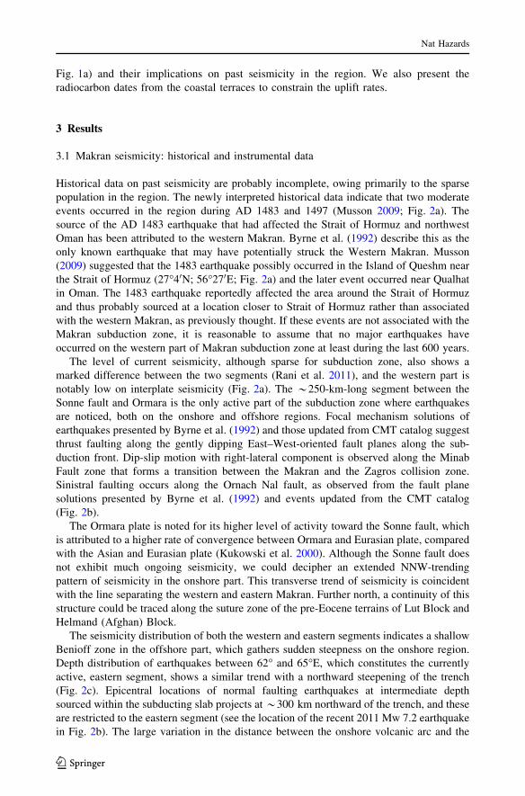
Fig. 1a) and their implications on past seismicity in the region. We also present theradiocarbon dates from the coastal terraces to constrain the uplift rates.
3 Results
3.1 Makran seismicity: historical and instrumental data
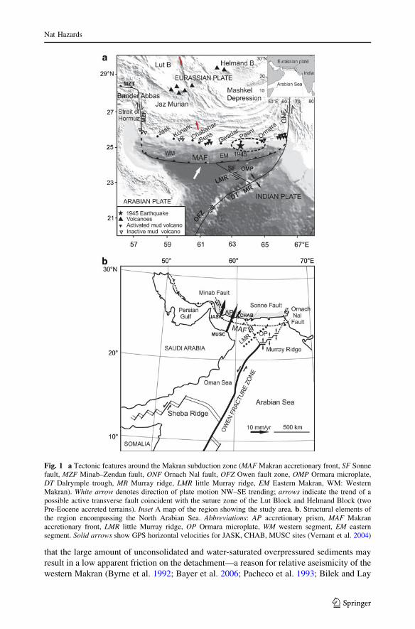
Historical data on past seismicity are probably incomplete, owing primarily to the sparsepopulation in the region. The newly interpreted historical data indicate that two moderateevents occurred in the region during AD 1483 and 1497 (Musson 2009; Fig. 2a). Thesource of the AD 1483 earthquake that had affected the Strait of Hormuz and northwestOman has been attributed to the western Makran. Byrne et al. (1992) describe this as theonly known earthquake that may have potentially struck the Western Makran. Musson(2009) suggested that the 1483 earthquake possibly occurred in the Island of Queshm nearthe Strait of Hormuz (27"40N; 56"270E; Fig. 2a) and the later event occurred near Qualhatin Oman. The 1483 earthquake reportedly affected the area around the Strait of Hormuzand thus probably sourced at a location closer to Strait of Hormuz rather than associatedwith the western Makran, as previously thought. If these events are not associated with theMakran subduction zone, it is reasonable to assume that no major earthquakes haveoccurred on the western part of Makran subduction zone at least during the last 600 years.
The level of current seismicity, although sparse for subduction zone, also shows amarked difference between the two segments (Rani et al. 2011), and the western part isnotably low on interplate seismicity (Fig. 2a). The *250-km-long segment between theSonne fault and Ormara is the only active part of the subduction zone where earthquakesare noticed, both on the onshore and offshore regions. Focal mechanism solutions ofearthquakes presented by Byrne et al. (1992) and those updated from CMT catalog suggestthrust faulting along the gently dipping East–West-oriented fault planes along the sub-duction front. Dip-slip motion with right-lateral component is observed along the MinabFault zone that forms a transition between the Makran and the Zagros collision zone.Sinistral faulting occurs along the Ornach Nal fault, as observed from the fault planesolutions presented by Byrne et al. (1992) and events updated from the CMT catalog(Fig. 2b).
The Ormara plate is noted for its higher level of activity toward the Sonne fault, whichis attributed to a higher rate of convergence between Ormara and Eurasian plate, comparedwith the Asian and Eurasian plate (Kukowski et al. 2000). Although the Sonne fault doesnot exhibit much ongoing seismicity, we could decipher an extended NNW-trendingpattern of seismicity in the onshore part. This transverse trend of seismicity is coincidentwith the line separating the western and eastern Makran. Further north, a continuity of thisstructure could be traced along the suture zone of the pre-Eocene terrains of Lut Block andHelmand (Afghan) Block.
The seismicity distribution of both the western and eastern segments indicates a shallowBenioff zone in the offshore part, which gathers sudden steepness on the onshore region.Depth distribution of earthquakes between 62" and 65"E, which constitutes the currentlyactive, eastern segment, shows a similar trend with a northward steepening of the trench(Fig. 2c). Epicentral locations of normal faulting earthquakes at intermediate depthsourced within the subducting slab projects at*300 km northward of the trench, and theseare restricted to the eastern segment (see the location of the recent 2011 Mw 7.2 earthquakein Fig. 2b). The large variation in the distance between the onshore volcanic arc and the
Nat Hazards
123

Fig. 2 a Earthquake (M[ 5.0)distribution of the region(sources: Quittmeyer 1979; ISS(1918–1963), ISC (1964–1972)and NEIC (1973–2011)). Opencircles: M[ 6.0; closed circles:M 5.0–6.0; two moderateearthquakes occurred in AD 1483(Island of Qeshm, off BanderAbbas, Iran) and 1497 (Qalhat inOman) are also shown (source:Musson 2009). AA0 representsthe line along which allearthquakes between 62 and 65"Eare projected (c). b Focalmechanism solutions compiledfrom CMT catalog (1977–2011);Byrne et al. 1992; Chandra 1984;Jackson and McKenzie 1984;Quittmeyer and Kafka 1984. TheNW–SE-trending suture zonebetween the Lut block and theHelmand block is identified byarrows. c Hypocentral locationsof the earthquakes between 62and 65"E projected along A–A0
as shown in (a)
Nat Hazards
123
subduction front in the western and eastern segments (*450 and *600 km, respectively;Fig. 1a) is another manifestation of the slower subduction along the western segment.
3.2 Seismic imprints: features of offshore morphology
As the sediment input into the Makran subduction zone is very high, a thick sediment pile(*7 km thick) occurs at the deformation front. The large sedimentary cover and feeblecontrasts between the accreted and overlying sediment mask distinct morphologicalexpression of a trench as observed in most other subduction zones. However, the long periodof shortening and the abundant sediment supply have led to the formation of a 350-km-wideaccretionary prism (Platt et al. 1985, Kukowski et al. 2001). Wide-angle and seismicreflection data indicate that the sedimentary wedge is comprised of stack of five uniformlyspaced packages, thrust along a northward-steepening decollement (Kopp et al. 2000).
The swath bathymetry data and echo sounding profiles reveal topographic details of theMakran offshore (Kukowski et al. 2000, 2001; Uchupi et al. 2002). The continental shelfoff coastal Makran is 10–40 km wide, and its edge reaches up to a depth of about 100 m.The shelf is succeeded by 70–110-km-wide continental slope that reaches to a depth of700 m. The continental slope is divided into upper and lower zones (Uchupi et al. 2002):the upper slope is smooth with a gentle terrace, but several east–west- and north–south-trending ridges, gullies and canyons characterize its seaward edge (Fig. 3a and b). Theseeast–west ridges and the depressions are the resultant topography created during the wedgeformation and, therefore, considered to have a tectonic origin (White and Ross 1979). Thenorth–south features are attributed to erosion and mass wasting (Kukowski et al. 2000,2001; Kopp et al. 2000; Uchupi et al. 2002; Bourget et al. 2010).
Three major north–south-trending turbidity systems that cut through the ridgesincluding the 700–1,000-m-high Makran escarpment (the frontal fold) are identified on theMakran sea floor (Fig. 3a). The largest of these, namely the ‘‘Save Canyon’’ and the‘‘Shadi Canyon,’’ are more than 100 km long and are located close to the source zone of the1945 earthquake. It is remarkable that the greater depth and steepness on the upper part ofthe Shadi Canyon, which have been identified by Kukowski et al. (2001), are also in thevicinity of the 1945 source. Highly dissected by clear topographic expressions, the shelfedges here are also characterized by major slumping (Fig. 3a). Distinct mid-slope terraceson the canyon walls, indicating possible episodic vertical movement, have also beenreported by Kukowski et al. (2001).
The seafloor segment west of Sonne Fault, however, shows relatively smooth and lessdissected morphology. One major through-going, north–south-flowing turbidity channelhas been identified west of the Sonne fault; this forms a large deep-sea fan around 59"300E(Uchupi et al. 2002). It appears to be topographically much smoother than the turbiditychannels to the east of the fault. The shelf break on the western segment shows aeriallywell-defined relict delta formations. Many of the submarine channels originate in thesedeltas (Uchupi et al. 2002; Fig. 3b). The smoother walls of the turbidity channels and thebetter preservation of deltas at the shelf edge may indicate that no shaking events may haveoccurred for sometime on this part, unlike the eastern Makran.
3.3 Coastal sedimentary sections and constraints on past earthquakes
The Chabahar bay is located along the coast of Sistan province in southeastern Iran(Fig. 4). This region has undergone sea-level changes in the late Quaternary, which isreflected in the coastal sedimentary sequences and also by the presence of paleo-shorelines
Nat Hazards
123

(Gharibreza and Motamed 2006). It is suggested that a major marine transgression mayhave occurred around 4,000–5,000 years BP, and the coastal stratigraphy suggests thatChabahar bay area has been above the MSL ever since and is continuing to be uplifted(Gharibreza and Motamed 2006). The bay area may have been turned into intertidal zoneever since, as shown by the stratigraphy. Here we discuss the observations from foursections at the Chabahar bay.
3.3.1 Site-1 at Chabahar bay free trade zone
Chabahar bay area is an accretionary coast and twenty beach ridges have been identified inthis area by Gharibreza and Motamed (2006). The farthest strandline is *3 km away fromthe present shoreline and 15 m above the MSL (Fig. 4 for location). The oldest ridge wasdated at 4690 ± 40 yr BP (4655 ± 145 cal year BP), and the youngest beach ridge, about200 m away from the present shoreline, was dated at 1250 ± 145 year BP
Fig. 3 a 3-D visualization of the bathymetry of the east central part of the Makran accretionary wedgeshowing the submarine canyons and channels (after Kukowski et al. 2001; reprinted with permission fromElsevier Publishing Company). The location of the 1945 earthquake is shown. Note the major slumping offPasni. b Morphological features of the Makran offshore (after Uchupi et al. 2002; reprinted with permissionfrom Springer Publishers). Note the curved shelf edge with intact delta lobes on the western Makran
Nat Hazards
123

(622 ± 266 cal year BP). These authors suggest that the Chabahar bay region was under aregressive phase for the last 5,000 years. Lambeck (1996) suggested that the sea level forPersian Gulf region at 6,000 years BP was about 2–4 m high with respect to the present sealevel. The general trend of elevation of beach can be explained only if we factor in thelocalized uplift of the coast by tectonic forces.
The sections that we independently examined are located on the eastern side of theChabahar bay, 500–600 m inland from the swash zone (Site 1 in Table 1, and Fig. 4). The1-m-thick section, *3 m above the present shoreline, is constituted mostly by intertidalmud and marine sediments with gastropod and brachiopod shells. We obtained a calibratedage of 2,865 ± 265 years BP for the shell sample, which may represent the youngest ageof the raised intertidal deposit preserved on this part of the bay (Table 1).
3.3.2 Site 2 at Chabahar bay free trade zone
The sedimentary sections at site 2 in the Free Zone area (Site 2 in Fig. 4) showed 50–cm-to 1-m-thick, reddish sand, which unconformably overlies the sticky grayish intertidal siltyclay (Fig. 5a–d). We dug four shallow pits, and all of them showed similar stratigraphy—atop layer of dune sand over the silty clay. The cross-laminations within the reddish sandsuggest that they may have been deposited by wind. This sequence is clearly indicative ofthe switching over of the environmental conditions from a tidal flat to continental influ-ence, which possibly signifies the ongoing uplift of the coast. If any past earthquakes havecaused liquefaction in this area, the emplaced material would make abrupt cross-cuttingcontact with the dune sand. Thus, we considered this area as a potential site to search forliquefaction events.
Fig. 4 Satellite image showing the Chabahar bay and the study sites. Sites numbered 1–10 are listed inTable 1. Abbreviations: FZ free zone, BL Baluchi Industrial Center, INCO Unit of the Iranian NationalCentre for Oceanography at Chabahar. Unnumbered site is from Gharibreza and Motamed (2006). Source ofthe image: MDA Federal (2004), Landsat GeoCover ETM? 2000 Edition Mosaics Tile N-41-25.ETM-EarthSat-MrSID, 1.0 USGS
Nat Hazards
123

A typical section shown consists of a 10-cm-thick layer of black to grayish clay overlainby reddish to yellowish sand (Fig. 5a). The top 10 cm of this exposure shows emplacedgrayish mud overlying the dune sand, sourced from blackish silty clay at the bottom. A thinlayer (*10 cm) of silty clay forms a sill within the dune sand just above the layer of stickyintertidal mud. This layer is discontinuous and is not observed in all the trenches. Sills andfunnel-shaped dikes through which grayish silty clay intruded at different levels, into thereddish sand, were observed as in other trenches (Fig. 5a–d). These features representevidence for widespread and intense liquefaction of the underlying silty clay due to intenseground shaking.
An obvious question is how we could explain the liquefaction of silty clay as fluidizationof silty clay is considered to be rare (Obermeier 1996). The observations, however, showthat clay and silt-rich deposits are capable of breaking down and ‘‘flow’’ under strongground shaking (Updike et al. 1988). The liquefaction of silty clay observed in the MakranCoast is comparable to the liquefaction of cohesive soil occurred during the Haicheng(1975) and the Tangchen (1976) earthquakes in China and several other events in Japan andTurkey (e.g., Prakash and Puri 2010). The earlier studies, mostly focused on liquefactionphenomenon of sands and fine-grained soils, never considered that silts, clayey silts andeven sands with fines are liquefiable during earthquake loading. It is now established thatnot only sands but silts and clays can also liquefy, and plasticity index (PI\ 7) was found tobe a key criterion for liquefaction susceptibility of silts and clays (Prakash and Puri 2010).
We obtained a single radiocarbon date from this section. A shell obtained from thebottommost grayish mud yielded calibrated age of 240 ± 100 year BP (Fig. 4a; Table 1).
Fig. 5 a Sedimentary section near Free Trade Zone, Chabahar, showing the liquefied layer and the locationthe shell sample. b Sketch of the section shown in (a). c Section from an adjacent trench showing emplacedlayers of liquefied silty clay. d Sketch of the section shown in (c)
Nat Hazards
123
Based on the stratigraphic relation, this may correspond to the maximum age of theliquefaction event. It is important to note that the age is based on a single shell and needs tobe corroborated with additional data. Another point to be noted is that in the absence ofwell-constrained marine correction values, the age data may not very reliable. Thus, thelarge deviation between the uncalibrated age of 856 ± 20 year BP and the calibrated age(Table 1) may indicate the uncertainties in the marine corrections available for this region.The calibrated age suggests that the Chabahar liquefaction features may represent thedistant effect of the 1945 Pasni earthquake on the eastern part of the Makran subductionzone.
3.3.3 Site at Baluchi Industrial Center
The sections of this area near Baluchi Industrial Center, Chabahar bay area, exposedsimilar sedimentary units as described above. As in the case of earlier sites, thin layers(*10 cm) of greenish clay were found to have been intruded into the brownish sand(Fig. 6a, b). Vertical pipes and vents of greenish silty mud with broken shells occur withinthe reddish sand (Fig. 6a). At some locations, the greenish clay has been emplaced onto thetop part of the section, which occurs as a mixed layer of clay and sand (Fig. 6b). At somelocations, they occur as 10–20-cm-thick lenses. Pockets of reddish sand within this grayishclay and the assorted layer of sand, shells and clasts of clay within the contact zone aresuggestive of intense ground shaking. Combinations of features such as vertical pipescontaining emplaced greenish clay with broken shells suggest sudden forceful ejectionfrom the underlying clay layer as generally expected during cyclic loading. As observed inthe earlier site, the liquefaction event may be related to the distant 1945 earthquake, theonly event that is known to have disturbed the area historically.
The calibrated shell date of 3955 ± 315 year BP obtained from greenish mud, a marine/intertidal unit, may represent the age of the deposit (Table 1). The published sea level ofthe area suggests that the last marine transgression took place around 4690 ± 40 yr BP(Gharibreza and Motamed 2006). The calibrated date reported in this study, however,suggests a younger age for the last transgressive event.
3.3.4 Sedimentary sections around Jask
Jask, located *300 km west of Chabahar, is the westernmost site that we examined (seeFig. 1a for locations). We logged about 12 trenches with a maximum depth of 1.5 maround Jask (Fig. 7a). In terms of the number of exposures available to us for ourexamination, it was similar to what was available at Chabahar. The shallow coastal sed-imentary sections located at distances of 20–50 m from the preset shoreline exposedalternate sequences of white silty sand and greenish mud, typical of an area that hasundergone changes from tidal flat to intertidal sedimentation. A typical section nearMaidani Creek is shown in Fig. 7b. The sections (maximum depth 1.25 m) mostly bot-tomed on blackish intra tidal sequences succeeded by grayish supratidal facies, overlain bybeach/dune sands. None of the sections showed any characteristics of emplacement (likediking or venting) of lower level sediments onto the grayish upper level supratidal sedi-mentary units. Unlike the sections at Chabahar, the shallow stratigraphic sections aroundJask are devoid of any sedimentary features that are indicative of fluidization due to groundshaking. However, it should be noted that this does not rule out the potential occurrence offluidization features at deeper levels or in the vicinity. The section thickness of 1.5–2 mmay be representative of processes that took place during the last 1,000 years, assuming a
Nat Hazards
123

conservative sedimentation rate of 1–2 mm/year. However, it should be noted that many ofthe sections (from Chabahar to Jask) show a facies change from tidal flat environment tointertidal sedimentation, which, among other possibilities, suggest a gradual ongoing uplift.
3.4 Cliff section at Beris: constraint on coastal uplift
The site we examined at Beris is the easternmost, and it is about 80 km east of Chabahar(Figs. 1a and 3). Located about 15 m from the present shoreline, the site is about 10 mabove the MSL (Fig. 8a). The morphology represents a retreated shoreline consisting ofcalcareous marl and assorted beach rocks. The section we examined is topped by a *1-m-thick sequence of assorted mix of beach rocks. The boulders are pierced by burrows madeby Lithophaga, a genus of marine bivalve mollusks, which bore into the calcareous rocks(Fig. 8b). Association with this genus suggests that the boulders were initially at the swashzone close to MSL. The calibrated AMS age of Lithophaga collected from the rocks is7605 ± 75 cal year BP, which is taken to be the depositional age of boulder deposits.
Fig. 6 a A section near Baluchi Industrial Centre showing lenses of fluidized silty clay within the reddishsand. b Section from an adjacent trench showing thicker zone of emplaced silty clay at the top. Dotted linesmark the boundaries of various litho-units
Nat Hazards
123
The global sea level during circa 7,000 years ago was generally assumed to be 3 mabove the current sea level (Woodroffe and Horton 2005), although this may vary at anyparticular coast. For example, the sea-level curve from Malay–Thai peninsula suggests thatin this part, the sea was 6 m below the current level (Horton et al. 2005). According toLambeck (1996), sea level in the Persian Gulf (our area of interest) at 6,000 years BP wasabout 2–4 m above the current level, and between 8,000 and 7,000 years, it was relativelylower or probably similar to the current level (Gharibreza and Motamed 2006). Theaverage uplift rates are calculated after applying the Lambeck’s correction (2 m above thecurrent level) and also assuming that no change in sea level has occurred during the last6,000 years. The estimated uplift rates at this site range between 0.17 and 0.25 cm/year.These rates are comparable to what was reported by Page et al. (1979) from Pasni(0.2–0.3 cm/year), the site closest to the epicenter of the 1945 earthquake.
Some of the age data reported here are also indicative of the Pleistocene or older sea-level stands ([20,000 year BP; Table 1) and are not useful to reconstruct the Holocenetectonic history. Further, any shell date greater than 20,000 years is considered as
Fig. 7 a Google Image showing the study sites around Jask located *300 km west of Chabahar.b Sedimentary section near Maidani Creek (see a for location, at the first site from the right), showing faciesvariations
Nat Hazards
123
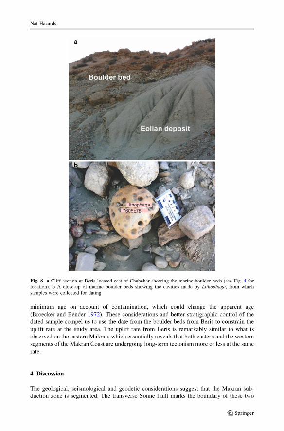
minimum age on account of contamination, which could change the apparent age(Broecker and Bender 1972). These considerations and better stratigraphic control of thedated sample compel us to use the date from the boulder beds from Beris to constrain theuplift rate at the study area. The uplift rate from Beris is remarkably similar to what isobserved on the eastern Makran, which essentially reveals that both eastern and the westernsegments of the Makran Coast are undergoing long-term tectonism more or less at the samerate.
4 Discussion
The geological, seismological and geodetic considerations suggest that the Makran sub-duction zone is segmented. The transverse Sonne fault marks the boundary of these two
Fig. 8 a Cliff section at Beris located east of Chabahar showing the marine boulder beds (see Fig. 4 forlocation). b A close-up of marine boulder beds showing the cavities made by Lithophaga, from whichsamples were collected for dating
Nat Hazards
123
segments. The eastern and western segments not only show variations in seismic pro-ductivity but may also differ in recurrence period of large earthquakes. Unlike the easternMakran, the western segment is noted for a long-term quiescence in terms of largeearthquakes. The recently uplifted coastal terraces around Chabahar, however, imply thatthe western segment, like its eastern equivalent, is also subjected to episodic movementsassociated with large earthquakes and the youngest beach ridge at Chabahar is*1,000 years old.
Considering the coastal uplift in the epicentral area during the 1945 earthquake thatoccurred on the eastern segment as typical of a great subduction zone earthquake on thisplate boundary, and using the long-term uplift rate of 1–2 mm/year at Ormara (near theepicenter of the 1945 earthquake), Page et al. (1979) suggested that the recurrence of suchearthquakes in the eastern segment is 1,000–2,000 years. From the data from Konark andJask, the uplift rate of the Makran was estimated to be much slower (1–6 mm/year), andthey suggested a longer recurrence interval of 3,000–20,000 years for the western Makran.Our estimates obtained for the western segment at Beris near Chabahar (1.7–2.5 mm/year),however, are remarkably closer to the uplift rates obtained by Page et al. (1979) for theeastern segment, the source zone of the 1945 earthquake. This suggests that the recurrenceperiod of earthquakes for both the segments may be comparable.
The shallow geology and depth to water table seem to be prone to liquefactionthroughout the Makran Coast. But the shallow pits farther west, such as Konarak and Jask,did not reveal any evidence for ground liquefaction, whereas such evidence was abundantat sites closer to Chabahar. The evidence for liquefaction and fluidization observed aroundChabahar (*200 km) from the source suggests that the west central coastal Makran wasgreatly affected by ground shaking during the 1945 earthquake. Based on the absence ofsuch features further west of Chabahar, we place this region as the farthest western limit ofthe meizoseismal zone of the 1945 rupture. It is also likely that the 1945 rupture may havepropagated much further to west up to Sonne fault.
The bathymetric features of the Makran sea floor and the seismic reflection data suggestthat the eastern Makran was subjected to massive submarine slumping, most probablydriven by the Mw 8.1, 1945 earthquake. The major difference is that the relief of thesebathymetric features is sharper on the eastern side, indicating their recent activation duringthe 1945 earthquake. Like the eastern segment, the western part also shows large north–south-trending turbidity channels, but their relief is subdued. Further, the offshore deltaformations also remain intact on the western segment and had not been subjected to recentbreakages. Such fan build-up on the eastern segment shows only remnants of such deposits.The curved shelf edge on the western Makran is shaped due to the undisturbed progradingdelta formations, in comparison with the straight-faced shelf edge on the eastern Makran.One obvious reason for sharp edge of the morphological features on the eastern part is thelarge-scale caving in or faulting during the 1945 earthquake.
Trenches with abundant supply of sediments are much more prone to slumping andtriggering submarine slides along the continental slope, which occur as a consequence ofthe ground shaking. The submarine landslide triggering appears to be one plausiblemechanism to explain the late arrival of the 1945 tsunami (Rajendran et al. 2008). Suchearthquake and tsunami mechanisms are highly probable for the western part of theMakran trench as well. Previous large tsunami events on the western Makran have beenproposed on the basis of the occurrence of transported coastal boulders in the region (Shah-hosseini et al. 2011), indicating that the western Makran also holds equal potential fortsunami hazard.
Nat Hazards
123
5 Conclusions
1. The boundary between the eastern and western Makran is defined by the transverseSonne fault. Although the eastern segment is seismically more active currently, thecoastal sites near Chabahar on the west show comparable long-term uplift ratesindicating that western segment or at least part of it is also tectonically equally active,capable of generating large earthquakes.
2. The 1945 earthquake resulted in large-scale onshore liquefaction, and westernmostlimits of the 1945 liquefaction field lie around Chababhar. The shallow coastalsedimentary sections on the western segment beyond Chabahar showed no evidence ofliquefaction generated by near-field large earthquakes, precluding historically recentoccurrences of earthquakes on the western segment. Non-occurrence of largeearthquakes in the recent past is also evidenced by the subdued offshore morphologicalfeatures on the western Makran. The recurrence period of earthquakes in the westernMakran can be[1,000 years.
3. The long elapsed time shown by the western Makran may indicate that this segment iscurrently locked and it must have accumulated enough strain to generate a massiveearthquake and a consequent tsunami. The example of 1945 tsunami suggests that thepresence of large amount of sediments along the continental slope itself providessufficient condition that could promote submarine slumping and tsunami generation.
4. Considering the earthquake and the tsunamigenic potential of the western Makran andthe complicated mechanisms involved in the tsunami generation, the hazard scenarioof the region needs further studies. A focused attention on the ramifications of apossible locked status of the seismogenic zone on the western Makran is required,considering the higher hazard risk owing to its location in the vicinity of coastalstretches of Persian Gulf countries that are most extensively modified.
Acknowledgments We thank the Vahid Chengini, Director, Iranian National Oceanographic Institute,Tehran, for the help and logistics to conduct fieldwork along the Makran Coast. CPR thanks the Departmentof Science and Technology, New Delhi, for the Ramanujan Fellowship scheme for the financial support tovisit Chabahar (Iran) during November 2008. The Indian Ocean Commission, UNESCO, funded thefieldwork during October 2010. We are thankful to Jane Cunneen and Brian Atwater for all their help. Wethank Eduard Reinhardt, McMaster University, for his help during our first phase of fieldwork in Chabahar,and Razyeh Lak and Ali Mohamadi of the Geological Survey of Iran and Eko Yulianto of IndonesianInstitute of Sciences (Lembaga Ilmu Pengetahuan Indonesia) for their help during the second phase offieldwork around Jask and Bandar Abbas. CPR and KR thank the Ministry of Earth Sciences, Government ofIndia, and Indian National Centre for Ocean Information Services, Hyderabad, India, for supportingearthquake and tsunami research at the Centre for Earth Sciences at the Indian Institute of Science. Themanuscript improved much from the comments of three anonymous reviewers and the editor Thomas Glade.
References
Ambraseys NN, Melville CP (1982) A history of Persian earthquakes. Cambridge University Press, Cam-bridge, p 219
Apel E, Burgmann R, Bannerjee P, Nagarajan B (2006) Geodetically constrained Indian plate motion andimplications for plate boundary deformation. EOS Trans AGU 85(52):T51B-1524
Bayer R, Chery J, Tatar M, Vernant Ph, Abbassi M, Masson F, Nilforoushan F, Doerflinger E, Regard V,Bellier O (2006) Active deformation in Zagros–Makran transition zone inferred from GPS measure-ments. Geophys J Int 165:373–381. doi:10.1111/j.1365-246X.2006.02879
Bilek SL, Lay T (2002) Tsunami earthquakes possibly widespread manifestations of frictional conditionalstability. Geophys Res Lett 29. doi:10.1029/2002GL015215
Nat Hazards
123
Bilham R, Lodi S, Hough S, Bukhary S, Murtaza Khan A, Rafeeqi SFA (2007) Seismic hazard in Karachi,Pakistan: uncertain past, uncertain future. Seismol Res Lett 78:601–613
Bilham R, Lodi S, Bendick R, Molnar P (2009) Aseismic slip on the Makran Coast? In: 2008–2012UNAVCO proposal: geodesy advancing Earth science research, pp 3–10
Bourget J, Zaragosi S, Ellouz-Zimmermann S, Ducassou E, Prins MA, Garlan T, Lanfumey V, SchneiderJ-L, Rouillard P, Giraudeau J (2010) Highstand vs. lowstand turbidite system growth in the Makranactive margin: imprints of high-frequency external controls on sediment delivery mechanisms to deepwater systems. Mar Geol 274:187–208
Broecker WS, Bender ML (1972) Age determinations on marine strandlines. In: Bishop WW, Miller JA(eds) Calibration of hominoid evolution. Scottish Academic Press, Edinburgh, pp 19–35
Byrne DE, Sykes LR, Davis DM (1992) Great thrust earthquakes and seismic slip along the plate boundaryof the Makran subduction zone. J Geophys Res 97:449–478
Chandra U (1984) Focal mechanism solutions for earthquakes in Iran. Phys Earth Planet Inter 34:9–16DeMets C, Gordon RG, Argus DF, Stein S (1990) Current plate motions. Geophy J Int 101:425–478Gharibreza M, Motamed A (2006) Late Quaternary paleoshorelines and sedimentary sequences in Chabahar
Bay (southeast Iran). J Coast Res 22:1499–1504Heidarzadeh M, Pirooz MD, Zaker NH, Yalciner AC, Mokhtari M, Esmaeily A (2008) Historical tsunami in
the Makran subduction zone off the southern coasts of Iran and Pakistan and results of numericalmodeling. Ocean Eng 35:774–786. doi:10.1016/j.oceaneng.2008.01.017
Horton BP, Gibbard PL, Milne GM, Morley RJ, Purintavaragul C, Stargardt JM (2005) Holocene sea levelsand paleoenvironment, Malay-Thai Peninsula, Southeast Asia. Holocene 15:1199–1213
Jackson J, McKenzie D (1984) Active tectonics of the Alpine-Himalayan belt between Turkey and Pakistan.Geophys JR Astron Soc 77:185–264
Kanamori H (1972) Mechanism of tsunami earthquakes. Phys Earth Planet Int 6:246–259Kopp C, Fruehn J, Flueh ER, Reichert C, Kukowski N, Biala J, Klaeschen D (2000) Structure of the Makran
subduction zone from wide-angle and reflection seismic data. Tectonophysics 329:171–191Kukowski N, Schillhorn T, Flueh ER, Huhn K (2000) Newly identified strike-slip plate boundary in the
northwestern Arabian Sea. Geology 28:355–358Kukowski N, Schillhorn T, Huhn K, von Rad U, Husen S, Flueh ER (2001) Morphotectonics and mechanics
of the central Makran accretionary wedge off Pakistan. Mar Geol 173:1–19Lambeck K (1996) Shore line reconstructions for the Persian Gulf since the last glacial maximum. Earth
Planet Sci Lett 142:43–57Masson F, Anvari M, Djamour Y, Walpersdorf A, Tavakoli F, Daignieres M, Nankali H, Van Gorp S (2007)
Large-scale velocity field and strain tensor in Iran inferred from GPS measurements; new insight forthe present-day deformation pattern within NE Iran. Geophys J Int 170:436–440. doi:10.111/j.1365-246X.2007.03477.x
McCall GJH (2002) A summary of the geology of the Iranian Makran. In: Clift PD, Kroon D, Craig J (eds)The tectonic and climatic evolution of the Arabian Sea Region. Geol Soc Lond Spec Publ 195:147–204
Mokthari M, Fard IA, Hessami K (2008) Structural elements of the Makran region, Oman Sea and theirpotential relevance to tsunamigenesis. Nat Hazards 47:185–199
Murty T, Rafiq M (1991) A tentative list of tsunamis in the marginal seas of the north Indian Ocean. NatHazards 4:81–83
Musson RMW (2009) Subduction in the western Makran: the historian’s contribution. J Geol Soc Lond166:387–391
Neetu S, Suresh I, Shankar R, Nagarajan B, Sharma R, Shenoi SSC, Unnikrishnan AS, Sundar D (2011)Trapped waves of the 27 November 1945 Makran tsunami: observations and numerical modeling. NatHazards. doi:10.1007/s11069-011-9854-0
Obermeier SF (1996) Using liquefaction-induced features for paleoseismic analysis. In: PaleoseismologyMcCalpin J (ed). Academic Press, New York, p 588
Pacheco JF, Sykes LR, Scholz CH (1993) Nature of seismic coupling along simple plate boundaries of thesubduction typ. J Geophys Res 98:14133–14159
Page WD, Alt JN, Cluff LS, Plafker G (1979) Evidence for the recurrence of large-magnitude earthquakesalong the Makran coast of Iran and Pakistan. Tectonophysics 52:533–547
Pendse CG (1948) A short note on the Makran earthquake of the 28 November 1945. J Sci Ind Res5:106–108
Platt JP, Legget JK, Alam S (1985) Large-scale sediment underplating in the Makran accretionary prism.Southwest Pakistan. Geology 13:507–511
Prakash S, Puri VK (2010) Recent advances in liquefaction of fine grained soils. In: 5th internationalconference on recent advances in geotechnical earthquake engineering and soil dynamics, San Diego,California, pp 1–6
Nat Hazards
123
Quittmeyer RC (1979) Seismicity variations in the Makran region of Pakistan and Iran: relation to greatearthquakes. Pageoph 117:1212–1228
Quittmeyer RC, Kafka AL (1984) Constraints plate motions in southern Pakistan and the northern ArabianSea from the focal mechanisms small earthquakes. J Geophys Res 89:2444–2458
Rajendran CP, Rajendran K (2001) Characteristics of deformation and past seismicity with the 1819 Kutchearthquake, northwestern India. Bull Seism Soc Am 91:407–426
Rajendran CP, Ramanamurthy MV, Reddy NT, Rajendran K (2008) Hazard implications of the late arrivalof the 1945 Makran tsunami. Curr Sci 95:1739–1743
Rani VS, Srivastav K, Srinagesh D, Dimri VP (2011) Spatial and temporal variations of b-value and fractalanalysis for the Makran Region. Mar Geol 34:77–82. doi:10.1080/01490419.2011.547804
Schluter HU, Prexl A, Gaedicke Ch, Roese H, Reichert Ch, Meyer H, von Daniels C (2002) The Makranaccretionary wedge: sediment thickness and ages and the origin of mud volcanoes. Mar Geol185:219–232
Shah-hosseini M, Morhange C, Naderi Beni A, Marriner N, Lahijani H, Hamzeh M, Sabatier F (2011)Coastal boulders as evidence for high-energy waves on the Iranian coast of Makran. Mar Geol290:17–28
Snead RE (1967) Recent morphological changes along the coast of West Pakistan. Ann As Am Geogr57:550–565
Sondhi VP (1947) The Makran earthquake 28th Nov. 1945. The birth of new islands. Indian Miner4:147–158
Stuiver M, Reimer PJ (1993) Extended 14C database and revised CALIB 3.0 14C age calibration program.Radiocarbon 35:215–230
Uchupi E, Swift SA, Ross DA (2002) Morphology and late quaternary sedimentation in the Gulf of OmanBasin. Mar Geophys Res 23:185–208
Updike RG, Egan JA, Moriwaki Y, Idriss IM, Moses TL (1988) A model for earthquake-induced translatorylandslides in Quaternary sediments. Geol Soc Am Bull 100:783–792
Vernant Ph, Nilforoushhan F, Hatzfeld D, Abbassi MR, Vigny C, Masson F, Nankali H, Martinod J,Ashtiani A, Bayer R, Tavakoli F, Chery J (2004) Present-day crustal deformation and plate kinematicsin the Middle East constrained by GPS measurements in Iran and Northern Oman. Geophys J Int157:381–398
Vita-Finzi C (2002) Neotectonics on Arabian Sea coasts. In: Clift PD, Kroon D, Craig J (eds) The tectonicand climatic evolution of the Arabian Sea Region. Geol Soc Lond Spec Publ 195:87–96
White RS, Ross DA (1979) Tectonics of the western Gulf of Oman. J Geophys Res 84:3479–3489Woodroffe SA, Horton BP (2005) Holocene sea-level changes in the Indo-Pacific. J Asian Earth Sci
25:29–43Wyss M, Al-Homoud AS (2004) Scenarios of seismic risk in the United Arab Emirates, an approximate
estimate. Nat Hazards 32:375–393
Nat Hazards
123