Regional Inventory of Economic Assets - Town of Pima - az.gov
Upload
khangminh22Category
view
1download
0
The following file is part of the Doug K. Martin Mining Collection
ACCESS STATEMENT
These digitized collections are accessible for purposes of education and research. We
have indicated what we know about copyright and rights of privacy, publicity, or
trademark. Due to the nature of archival collections, we are not always able to identify
this information. We are eager to hear from any rights owners, so that we may obtain
accurate information. Upon request, we will remove material from public view while we
address a rights issue.
CONSTRAINTS STATEMENT
The Arizona Geological Survey does not claim to control all rights for all materials in its
collection. These rights include, but are not limited to: copyright, privacy rights, and
cultural protection rights. The User hereby assumes all responsibility for obtaining any
rights to use the material in excess of “fair use.”
The Survey makes no intellectual property claims to the products created by individual
authors in the manuscript collections, except when the author deeded those rights to the
Survey or when those authors were employed by the State of Arizona and created
intellectual products as a function of their official duties. The Survey does maintain
property rights to the physical and digital representations of the works.
QUALITY STATEMENT
The Arizona Geological Survey is not responsible for the accuracy of the records,
information, or opinions that may be contained in the files. The Survey collects, catalogs,
and archives data on mineral properties regardless of its views of the veracity or
accuracy of those data.
CONTACT INFORMATION Mining Records Curator
Arizona Geological Survey 416 W. Congress St., Suite 100
Tucson, Arizona 85701 602-771-1601
http://www.azgs.az.gov [email protected]
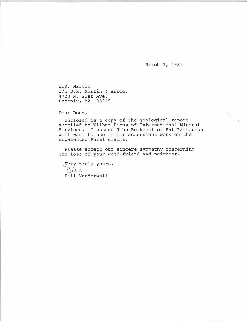
D.K. ~1artin c/o D.K. Martin & Assoc. 4728 N. 21st Ave. Phoenix, AZ 85015
Dear Doug,
March 3, 1982
Enclosed is a copy of the geological report supplied to Wilbur Dicus of International Mineral Services. I assume John Rothemal or Pat Patterson will want to use it for assessment work on the unpatented Rural claims.
Please accept our sincere sympathy concerning the loss of your good friend and neighbor.
Very truly yours,
'1;~ Bill Vanderwall
[PACIFIC
D. K. MAlmN " ASSOC. 31~ N. rt1iJNl r ku$~
ttKUIX, ARlz",.A i~na
illEGIONAL
(Q)PERATIONS, INC. P.O. Box 716 • Scottsdale, Arizona 85252 • (602) 994-3147
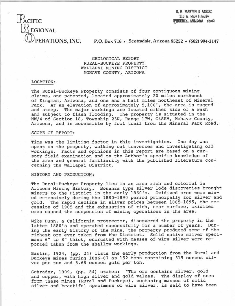
LOCATION:
GEOLOGICAL REPORT RURAL-BUCKEYE PROPERTY
WALLAPAI MINING DISTRICT MOHAVE COUNTY, ARIZONA
The Rural-Buckeye Property consists of four contiguous m1n1ng claims, one patented, located approximately 20 miles northwest of Kingman, Arizona, and one and a half miles northeast of Mineral Park. At an elevation of approximately 5,100', the area is rugged and steep. The major workings are located either side of a wash and subject to flash flooding. The property is situated in the NW/4 of Section 18, Township 23N, Range l7W, G&SRM, Mohave County, Arizona, and is accessible by foot trail from the Mineral Park Road.
SCOPE OF REPORT:
Time was the limiting factor in this investigation. One day was spent on the property, walking out traverses and investigating old workings. Facts and opinions in this report are based on a cursory field examination and on the Author's specific knowledge of the area and general familiarity with the published literature con~ cerning the Wallapai District.
HISTORY AND PRODUCTION:
The Rural-Buckeye Property lies in an area rich and colorful in Arizona Mining History. Bonanza type silver lode discoveries brought miners to the District in the early 1860's. Oxidized ores were mined extensively during the 1880-1890 period principally for silver and gold. The rapid decline in silver prices between 1885-1895, the recession of 1905 and the exhaustion of rich, near surface, oxidized ores caused the suspension of mining operations in the area.
Mike Dunn, a California prospector, discovered the property in the latter 1880's and operated successfully for a number of years. During the early history of the mine, the property produced some of the richest ore ever taken from the District. Solid native silver specimens 6" to 8" thick, encrusted with masses of wire silver were reported taken from the shallow workings.
Bastin, 1924, (pp. 24) lists the early production from the Rural and Buckeye mines during 1886-87 as 152 tons containing 315 ounces silver per ton and 5.68 ounces gold per ton.
Schrader, 1909, (pp. 84) states: "The ore contains silver, gold and copper, with high silver and gold values. The display of ores from these mines (Rural and Buckeye), contaning masses of solid silver and beautiful specimens of wire silver, is said to have been
awarded the silver medal at the Louisiana Purchase Exposition." And he continues, "The production is reported to be considerable and much good ore is left in the (Rural and Buckeye( mines. "
Bastin, 1924, (pp. 24) states all the workings were inaccessible in 1913.
During the late 1920's, M. B. Dudley and Associates attempted to reopen the Rural and Buckeye mines and reportedly produced some ore from the upper workings. The shaft was increased to a depth of 200 feet and miners remarked that good ore was exposed when the property closed. No attempts have been made since to reopen the workings.
In 1943, the Tennessee Mine, 3 miles northwest of the Rural-Buckeye Property, and mining in the same vein system, was producing 150 tons of ore per day which averaged 20 ounces of silve:r; per ton. Total production from the Tennessee Mine is reported to be in excess of 500,000 tons. (Dings, 1941, pp. 147).
The value of metals produced from the Wallapai District during the years 1904-1948, U. S. Bureau of Mines, 1948 Annual Report was about 22.5 million dollars at 1948 prices (nearly half a billion dollars at today's prices). Values were principally in lead and zinc but with sUbstantial amounts of copper, silver "and gold.
Currently inactive, Duval's Mineral Park open pit copper-molybdenum operation located one mile south of the Rural-Buckeye Property, is capable of producing 18,000-20,000 tons per day of .5% copper and .045% molybdenum ore.
GEOLOGY AND ORE DEPOSITS:
The Cerbat Mountains constitute one of the many north-south trending, !ault-block ranges of the southwest desert. They consist primarily of metamorphosed pre-Cambrian igneous and sedimentary rocks, cut by later intrusions of Mesozoic (?)granite and monzonite porphyries, known locally as the Ithaca Peak Granite, and by Tertiary volcanic dykes. Centering around the Ithaca Peak intrusive, mineralization is typically copper and molybdenum sulfides, which were mined by Duval. Surrounding the intrusive is a zone several miles wide of Lead-zinc-silver bearing veins which gradationally change into veins of intense silver-lead mineralization.
The vein type ore deposits occur in clefts or cracks in the country rock in which the mineral material precipitated from aqueous solution (hydrothermal fissure veins). It is probable that these fissures formed from forces accompanying the implacement of the Ithaca Peak intrusive. With the intrusive acting as a heat engine, a convecting hydrothermal system developed that set up a hypogene enrichment process which deposited ore and gangue minerals near the top of the convecting cell and extracted metals and sulfur from sources at depth. Conceivable, as the solution approached the fissure level, it boiled, thereby distilling the acid forming constituants C02 and H2S. Cooling and a slight pH rise of the residual liquids, due to
-2...;.
D. K. MARTIN & ASSOC. 315 W. MONTEROSA
PHOENIX, ARIZONA 85013
loss of acid forming constituants, may be regarded as a mechanism of sulfide precipitation. Exposure of the veins to normal weathering processes oxidized the ore and, to a point, enriched it by the downward migration of slightly acidic rainwater carrying metals in solution.
Many veins, occuring in nearly vertical fault fissures, strike northwest and outcrop for considerable distances. The fault fissures are largely occupied by breccia with abundant shearing and some gouge. Ore lenses, or shoots, though not continuous are numerous and tend to have greater vertical rather than horizontal extent. Concentrations of extremely high-grade ore appear to favor vein junctures. These concentrations are attributable to chemical and physical changes which enhanced mineral deposition at the fissure level of the convecting cell.
The main vein on the Rural-Buckeye Property strikes approximately N60 o W, it is apparently faulted between the Rural and Buckeye mines since the Rural portion of the vein dips about 80 0S while . the Buckeye portion dips 70 o N. The two mines are located on either side of a wash which is probably the trace of the fault with lateral throw. The country rock in the vacinity of the vein is a medium grained, granite gneiss of pre-Cambrian age. The gneiss is intruded by dykes of granite porphyry which are associated with the Ithaca Peak Granite of Mineral Park.
The underground workings are inaccessible but Schrader, 1909, (pp. 84), describes the underground features as follows: "The vein is two to four feet in width in the Rural and attains a maximum of eight feet in width in the Buckeye. In both mines it is associated with a dyke of granite porphyry. The gangue is quartz and is generally frozen to the walls. It shows ore shoots (in 1909) ranging from 4 to 20 feet in width ••• The principal developments in the Rural consist of 200 feet of shaft and 100 feet of drift and in the Buckeye 750 feet of drift."
The primary mineralization is one of chalcopyrite, pyrite, arsenopyrite and oxides of manganese. Silver cloride, native silver and native gold are present in the oxidized portion of the vein.
ORE RESERVES:
The Rural-Buckeye Property contains base-metal silver veins, oxidized silver-gold veins and possibly a zone of enrichment in between. Data from past developments, publications and reports are insufficient or unavailable, to completely delineate the orebody.
Considering the extent and mineralized nature of the Rural-Buckeye vein, and its association with the dyke of granite porphyry which would provide a sizable locus for ore deposition, it is possible to anticipate considerable ore at depth, below the present workings.
The mine dumps may carry precious metal values amenable to cyanidation. This possibility should not be overlooked.
-3-
O. K. MARTIN & ASStlC. 315 W. MONTEROSA
PHOENIX, ARIZONA 85013
CONCLUSION:
On the basis of surface observations and facts provided in the published literature it is the Author's conclusion the property contains a well developed structure with strong base-metal silver mineralization. It is also the Author's conclusion that the results of detailed geologic mapping and diamond drilling could justify initiating a mining venture.
Respectfully submitted,
PACIFIC REGIONAL OPERATIONS, INC.
~. Qc~vO~ William C. Vanderwall Arizona Technical Registration No. GIT 34
Bibliography:
Bastin, E. S., 1924, Origin Of Certain Rich Silver Ores Near Cloride and Kingman, Arizona: USGS Bulletin 750, pp. 17-39
Lingren, W. & Hayes, C. W., 1907, Contributions To .Economic Geology: USGS Bulletin 340, pp. 66
Schrader, F. C., 1909, Mineral Deposits Of The Cerbat Range, Black Mountains And Grand Wash Cliffs, Mohave County, Arizona: USGS Bulletin 397, pp. 83-84
-4-
D. K. MARTIN & ASSoc. 315 W. MONTEROSA
PHOENIX. ARIZONA 85013

June. 1919.
finest ailver ore which the district baa ever yielded. Late reports indicate that the three minm. propertiea recently operated under the
management of Mr. J. B. Hughea bave been eonlOlidated, and that active development of the entire iTOUP will be commenced at once.
The Emerald Isle Copper Company baa recently ahut down to make alteration a in it. electrolytic plant. Thia company haa a large body of oxidized copper ore, occurinc aa a con4'lomerate. and it baa already .. ched the production of two tona of Metallie copper.
W..t of Chloride, in the flat country, the Tllcka~e is inltanine ' a heavy duty .mkfDC pump, with the intention of link· .. to the 1000-foot level; their ore u deYeloped .howing fine values in ailver and gold with much lells lead and zinc than ia found in the orea of the main nJlI'e. It ia expected that the Diana will mOJtly reau.me work, as well .. the Golden Gro." Metall Co. Both of these propertJiI carry fine-grained pJ'ritic COld orea in a quarts matrix, especially well adapted to ..." coneentzation.
1 and u en mines in Min• a ve 88n purcbased by a aynltieate represented by Mr. M. B. Dudley, and are beine rapidly developed. The RaraJ ia a. old property which baa not bea worked in many yean, but wllich hall formerly filled the cabinets of Mohave Cowlty with tha most macnificent I~i__ of native ailver. After unwaterine ~ ahtft, conditions have been found of a mveh bett.r character than could have b-.ra upefttd. of! there ill little doubt bot the tw. propertiee will very aoon bec08le heavy silver producers.
The Wuhington mine, alao in Mineral Park. II belnc rA,ilTy broueht to the produetlon ~ u the mill ia practically ftftiIhed, and has already palll!ed the expeimental atage. The property abowa sev.aral very intereBtine veinl, with eertain ore-chutea carrying hia'h values in ruby Ii1ver. It b being operated by a ayndiClUe, with )(1'. F. E. G. Berry in char~.
Beside theM Jlropertiea, many othen are ihowinc activity with the advent of many ubatantial opera ton, and new finda are requently reported. Many of the former
!WIdents of Chloride, who left the camp rtly after the war conditiona became
c ti, are returning ; all expressing their vallt IA tisfaction at their ability to resume life in "the finest mining camp they ever
THE ARIZONA GEM MINES (Special Correspondence)
Located at Mineral Park, 20 miles orth of Kingma n, Arizona, is perhaps the
;Teateat producing turquoia minea in the "'orld. A large percentage of the stone a, bowever, 0' the poorer grade consisting· )f quartz UIff blended with turquoise anrl s called "" the trade "matrix"; whil e luit e attra('tl'~ and h88 a large IInle. it s never mtt4 in price with the clear tone. The ,.., I'H prevailing up to 1907 ranged f rOla $2.~0 to $12.50 per pound n the rough. but lIince that time price~ ave mater ialJ y di"opped, until for seveTII! 'un put thMe min ell have been closed own.
The largest producing compnny. with be larj:!'cst acr eage, is that of the A7tec urquoise Company of New York . This omplUlY was the pioneer, being followed
ARIZONA MINING JOURNAL
by the SoutbWMt TurquoiM CompaJiy of Los Angelea, the Lo. Ancel.. Oem Company and the Arisona Turquoiae Company of New York.
There is evidence that the alinel weN worked in the atone .,. u D\Ufteroul atone hammers and halld dtDIrinc ston .. were found there. The .... -1 ... W. Bau ..,.. the oricinal c1iKoy_ ., tIM turquoise at Mineral Park, 0 ....... tIM old Montesuma mine in the T • oiM mountaina southwest of Itbica ~ but Qpotl findinC tbe later min. .. eM hWea Peak eountry the old x..... aine ..,.. abandoned.
Another _,-ortant ....... .. that of Chrysopiuue In tIM ...... ~. 101M 18 miles north of OatlUa. ...... fI'O~ are of late diaeonl'7 ...... ex~d to rival the famoQl oW .. ~ 0 ...... u it ia of more e,.. wcia1 value .41 very rare. This IetII ........ !1l1 of tlae remoteat antiquity; a liard lIIIIli-tI'aMluacent lrI'een atone ~ --'pel aad colored with niek;J. ... ,.. the o.q operatinc mine of tItIa ..... N> AID ..... today il located at Po .......... , f aliforat&, arid owned In New York.
Owing to its hieb ..n. ·'alUf'. all cradel are used; comp........ • -'lIzen fIIferent grade. from eo ....... clear. aN values run all the ..,.y ,... • (8"N ~ to around ,.00 a po1UlCi.
STANDARD MINEaALI D"'L~ A strike of COld a.eI .... ~ ... h ...... n
made on one of tIM ekeIIu .t Ute ~. ard Mineral. compall7, ....." ail.. tut of Kincman. ne ~y .. be_ .-nk-ing • abaft on tU ~ fIlUm .... at a depth of thirty feet IIUl .... ON .... t gave results of lrea ..... .. ten ~ gold and 825 OUDUI .... .
The vein In wbi~ u.. .u.. WIllI .... il about five feet iD wW6, .... rid! ...... havine a width of f~ ~eft ...... to thirty ineh.. The wIIole .idU. ., .. ore-bearina Itreak .. per.
The Standard )(iMNla _ ... , haf been opeNtin, a aill _ ... mol,weDite properti .. and _ ... ~ ~nc .. ore bodiea on t.lae ....... The _ill baa b£en doinc aoe4 work.. • ,..."ct of about sixty per ent -.I7~ite Woc lee.red. The com,.n, • ud.... to bave contracts co~ aD .. eoncentrat.ea the mill can pro41In.
The mill .. ~r the directloD .f I. S Jon.., who ia .... eolllWtlq eaci." fOf the eOlllpa",.. IIr. JOD_ il one of fu be .. mintnc enaineen and meta1lqiata ia tM country and tIM Standard !l(iner"W COll\ pany ill to be concratulated on .... .ari his .ervke.. George Williaton, • 'ou,., engineer IIInd metallurrst, is asaWt6nt \II Mr. Jones In the mil work snri G8r~ StilDpllon Ii ceneral man ......
Tn rOUllh the hospital lyakm . .. ., W I>'''' men /If the Warren distrit-t ge1 ... 1 rn- ( (,.1 ("a re and ~ u.rgical utt.ntion .. cet-_ . f"r ~I( kness and accident. and " fa r». ... nf the workmen get all .. edie,. ttl'''''
The rai lroad from \/,Ioa,. G,,,,,- to ' .~~ ... . dal e. the t<melt .. r t< .wn "I t ht> .. ted ... • Ie Coppe r c\)mpa ll ~ rur,. thr ' .' n u-t Uff G ran d C"I" ol1: .. ha· .)t b IId-ve rt illed to an y .'x l .. t. bu It i;; rare Bcenic attractin"
76
1 The Chloride Queen] The Chloride Queen )linina Co. haa fh'. claims and two fraction&, over one bundHcl
and twenty acne of ground in one bloek aide-linin, on the north aide of the Cerbat SUver Klnea Co. (ImOYD .. the Illkhart mine) and end-lim.. tM "pire property northeast of Cbloria. about one and one-1salf .U ...
ne eq.ipment ooJUdata of one 12-H. P. hoist eomplet., o.e 60-H. P. oil b\U1liq Beaemer engiDa, Claicaco Pneumati'e __ -prellOr witlt ca,ecitJ of 417 cubic feet. blaekanith mop fu1l7 eqaipped, eha .... room l ON bina, and Jarce pIY&Ilized iron buildIng coveriq aU the aaac:hinery.
The main abaft II tbabered down Ito feet, with man..,.y and worl. iq abaft, with a drift na at the forty leYel. 100-foot drift at lOt knl, and at the 100 leyel tile drift • iB two kundzed fMt pine under the laJU, which wilen in abo., 100 feet more will elve a depth of about 100 feet. Cl'MlCtltI ha.e bean run oa tWI level 21 feet *- the aoath and 22 f--' to eM north withowt encounterlDr either ..u. 4 cood vein of ore at tim.. ,ndeniac te .;"y inebes haa bMa eontinUOQ.l for oy. 1.. feet, with valli" at ti_ rwnullC 0.- $160 a ton ill ail.-, b-ut. valuee ba ... d ud COld. TIIre drift • belle p"''' __ ~ -..t on the ... and ..,. yeIA .1 &lite '"~, aM well ...... fnina .en .. , ta.at tile C~I\' will lure b.... • VNJ l&rp M4y of ON ....,. the hiD ~ III _die.... Oae dUne noticeable ... .... tM ..n ill MinIr "De on the ... aM ".. ...ma, wIIIeh .. 10 rich, -Ybla tile ~ ad .... y", to be opened 1Ip later. 1'b.e ............ Taina haft ......n .p aIDiou ...... -. to Iudl .... bown c~. ~ Idd, • ~_ .. tile .. bart. _\iii..""" ~~-~~ in .... 0(" ma ....... to na .. drift __ .. Illn ........ up t"'~.nd" OD. ~nc~. . In fact. tint au of .... wUJ be ahiIIMd to the ..... ~ a mODth. ~ lhiNt ..... of ... mUe ... a rood JtOa4I fro. ..-.n to ......... a& ... TertD" see ... hi a. ~ ,..... of low poctuc~ ~ te .... eoa_,. TIM Chloride Qu_ "iJli~ 0.. ......... of f _ nf .t..--~ trOll ... l6O.foot len! up """""C nett .. alu .... .over .rea, M-,i_ hu ...... of t.K .f croond "low __ levl'l wlUeh will " opeDed lIP .. tM ....... rt, • develoted, aDd wlaielll it as~"" by the GII&rt and Te..,.. see ,...erti. a.ve pIOTell, '1Il! MpMMlDJ' tho Weer ....... hal a deptb of 1400 1~ WlUl raluabk .re ~cally all the ..,.y, am' .. repo~ prodation in the put of 80 ing ' $18,100.000. On .. must n '.~ __ Sllf"t v i the t&et that Ute E , ..., ..... ,. lid e f}"WII tIM <-1aloride Queen' s. I.... is I <lI'ted to have produced oyer or .1111 .... -'-Uan with dee,.. workings r... -,opt
m.I'~In.l.1l of the Chl de Qu~n " ... c (.. IS "enlident that titeir prop
) with .,rop(>r development ka t he next - .. year • ..,i\1 ,..-.duee it.'I mil nl in rich
' H or ..... a nd with present Jlrices of ail_. th .. <l ut ll)ok for t he compta , to CO on •. di\ 1I1(' /Hl I.aring basis in very near
tKure I I of til. but.
D. K. MARTIN & ASSOC. 315 W. Mot 0$'\
PHOENIX. ARIZ r·'80013

~'==~==-~~~~r=~-~~~~~--~~~~~~~~~~~
~,~l:'o~~.~VENUE . \~ Wucohs J\uul! ®ffice .~ ~.-.,,~ ... --'
~.m:~: o:o~~ t4n Val~~;~ ton O~.L~~!n ~?;:e~~ P~;~~t 'p'~~"(k~t' 'p~~"C'~~t' 'p~~"C;~t' ar ore It ore· ore W~t Ana, Wet A ... , Wet A~y Wet A~u.y W~t Asuy
ilk rt /I,....,;.. nfn / "" ~ S? # Sr- I M/Y(D
. U (, /(,./ /10 II - -,,,. -I - ------ ..-....... - .... -- ,- " . - " . . . -
- - - :-'"
.. , ', - ' . . :-\ : )~.... .. ... : .
•• • ' 1 ." :
"': :. • • f
1~~--~~~-4----~--~--~--~--~--;---4---~---r--~---+--~r-~----r--- ,
" ' . .. 7'-1 !/ 'f
6 DO bt{S YS 10'"- ~S
S/LV6.1t: (f/fJ.1D
• Gold P'lpr.d , 100.00 ~ •• Tro)'-
Cba~ , ••. 6~:f:~.CC@~
/
Sample GOLD t-' GOLD
Marked O%.ll. pert4n Value per ton
ore 1$ ore •
fA .-.Iv (, 1/ V :C:
X (../ (0
SILVER 0%5. per t4n
ore
rc ..1/ v-I 1110
~~J&L£(lz.~d_~ __ .. ~=.l
COPPER LEAD Per Cl!nt Per cent
Wet Anay Wd Asuy
-, ~'r I d
.. ' .
.- /
'p'~~"O~~t' Wet A!.Say
------ :--
e
............• ;.~.... I Per C~~.t i
Wet A~IIY
.,
.,..
---------+----~----~_--------~+~~-~ .. ~ .. ~ .. ~.~-+' ~-.~-~~.-:~ .. ~ .. ~-.;----.~.-_-. --. rr_----1. --... -.. -... ~. r.--.--r.~ .. -~-. ~--~----~---. '
.. ::
; .
I :,
, . .-- .
"...
.. -.-/ 0' ", ... ", "
' ::. - .': ... ..... .
------~_+L7~~-~--~--_+----~--+_--~--~----~--_+----+_--~----+_--f_--_i----r_--_r----
• Gold rll'Urtd $ 100.00 p.r oz. Tror
.<-So .,lli:;' :· Charges $ .. ~ ... : .... .::.~ ........ _ . .' __
U. K. MARTIN & ASSoc. 315. W .. MONTfROSA - ' _ .. ,....
fHO£NIX, ARIZONA 85013
I
I I
:..
~ .. \i!"l.
~ ' .. ... ~ MINERAL DEPOSITS OJ,' NOllAYf: COliNT¥, AHIZl);A. 82
by Charles E. Sherman, a well-known pioneer, in 18.0. . Its face ores were very rich and carried high vahle;; in gold as well as silver, .by reason of which it soon became the first important its ~ being shipped to Swansea, 'Vales. It was later worked the Mineral Park lIining Company, and the ore was locally milled the Keystone mill. Later it was owned by .Tames Uncapher, Mineral Park, by whom it was sold to the present owner, the stone Mining Company, of Greensburg. Pa. The production of mine to dau is reported to be a~ut $50,000.
The mine is developed mainly by Ii shaft 450 feet deep and 500 of drifts, mostly down to the 150-foot level, above which 'the great~ part of the ore is worked out. The principal surface equipments are a steam hoist and a 5-stamp mill. . .
The principal rock at the mine is the granite porphyry. 'J,'her. are two veins. The vein on which the mine is located strikes N. 60° W. and dips about 80° NE. The gangue is quartz in which the ore shoots occur mainly in the form of lenticular streaks about a foot thick. The ore contains pyrite, chalcopyrite, and zinc blende, with silver and some gold. The silver is present as argentite, in part. better grade of ore runs about 200 ounces of silver to the ton, 21 cent of cOpper, 8 to 10 per cent of. zinc, and 12 per cent of Toward the outside of the lenses it is irregularly and c1()!';ely banded. It is richest where the vein pinches. Elsewhere it may be distributed in a thickness of 3 feet of quartz gangue, but it i~ good concentrating ore and is said to average $12 to $15 u ton, and by rellson of its low grade should be milled on the ground. Some of the ore~ how· ever, runs considerably hight'r. That averaging $20 or more n too is now shipped to the Humbohlt smelter. None lower than $20 ore is now handled. The present rate of output is about 20 tons a month.
About 50 feet northeast of the vein on which the mine is si1 ~d lying about parallel with it is a second or smaller vein, which·" looks ",'ell and whose ore is reported to be nearly all of .. . ~ grade.
TYLER WINE.
The Tyler mine is situated in tht' southeastern part of the district,. 21 miles southeast of Mineral Park, nesr the summit of the ra~ on a steep northeastern slope, at an elevation of about 5,300 feet, or about 1,200 feet above Mineral Park. A good wagon road extends nearly to the mine, with which connection is made by a good trail of easy grade. The mine was discovered by Stephen A. Tyler, the , owner, in 1901. It began to ship ore in 1905, but only necessar1
l1
lesessment work is now done.
KIN}}RAL PARK DISTRICT.
t: 1'be mme is ueveloped mainly by two crosscut tunnels ad drifts, ~y situMed within a vertical range of 100 feet, priacipaUy on
Gold Eagle claim. The country rock is pn-C.mbrian mediwn~ .. ined gne .... biotit.l
The vein strikes N. 31° 'V. and dips about 76° ·SW., j JPOUDtaias. It has a wictth of about 40 feet and 8e8ID8 to C8JIIitrt,
of all altered and partly replaced crushed aDd fteeIIleoted ~iDIitie dike. The entire width is claimed to be low-grade ore, but
values occur chiefly in the first 6 or 7 feet of the hangiDg-wall of the dike and Ilre ~ near its contact with the granite. The
~~ wall also carries 6 inches to 2 feet of slickensided gouge, IfItwfell which and the country rock occurs quartz breccia containing
0I'e.
The mine produces gold-sHyer-lead ore. The principal ore min(: ... 18 consist of galena and cerusite. The last carload shipped at the· time of the writer's visit averaged gold 3.16 ounces to the ton, silver
.oonces to the ton, -and lead 11.5 per cent. At last accounts the mine reported to be sold to a Los Angeles company.
LADY BUO WINE.
Lady Bug, an old mine, is about half a mile southeast of the mine, close to the Tyler camp, at an elevation of about 5,000 It was located in 1886 by Isaac Conkey, the owner, now resiJ·
at Mineral Park. It is developed principally by a 63-foot shaft, or more feet of drifts, and a number.of surface openings on tbe
vein. The country rock is pre-Cambrian biotite granite, the same as lit
Tyler mine, and it is to a considerable extent intruded by the ~ite porphyry of Mineral Park. The ,'ein is reported to be 7 to
thick. It lies nearly parallel with the Tyler vein. but differs it in being composed of a gangue which is mainly quartz. The
contains principally silver chloride and gold with a little galena. considerable portion of the ore mined is reported to have aVt'.rtlged
to $500 a ton. Th~mdnctjQD is reported to be $6,000.
.u..u. A!I'D BUCKETJ: WIl'I'D.
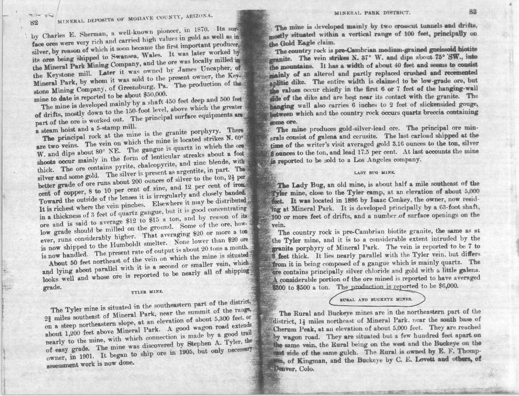
The Rural and Buckeye mines are in the northeastern part of the .,. district, Ii miles northeast of Mineral Park, near the south base of
ACherum Peak, at all elevation of about 5,000 leet. They are reached wagon road. They are situated but a few hundred feet apart on same vein, the Rural being on the west and the Buckeye on the side of the same gulch. The Rural is owned by E. F. Thompof Kingman, and the Buckeye by C. E. Loveu. and otlaIn, of
Colo.
..
:.. ~
8o! MINERAL DEPOSITS OF MOHAVE CUl' NTY, ARIZONA.
The Rural is developed principally by· a 2OO-foot shaft, about 100 ft'et of drift, and Il winze. The drift extends westward, its face being about 110 feet distant from the shaft. The shaft contaillB some woter. The Buckeye is. developed principally by about no :feet of drift, ext.8nding in an easterly direction. Toward the face of the drift the vein is faulted of to the northeast by a lAteral throw of
about 75 feet, . The {'onntry rock is medium-grMincd gneiSE;Oid biotite granite and associated schist. It is intruded. by dikes of grllDite porphyry. The de~sits occlir in a fissure vein which is 2 to -1 feet in width in the Rural and attains a maximum of 8 feet in the Buckeye. In the Rural it dips about 80° S. and in the Buckeye about 70° N. In both minM it is associated with a dike of the granite porphyry, masses of which OCCllr to the northeast near by. The gangue is quartz and is Plerally " fro1.en " to the walls. It shows ore shoots ranging from 4 to 20 fl'Ct in width, which consist mostly of pyrite and chalcopyrite, with parallel streaks of a rsP-nopyritc, black oxide of " manganese, gray chert, and quurtz. the quartz being more prominent in the Buckeye than in the Rurnl mine. .
Th(' ore contains silver, gold, and copper, with high silver and golet ,"alues. The display of ores from these mines, containing ID888eS
solid silver and beautiful specimens of wire. silver, is said to been awarded the silver medal at the Louisiana Purcha~ ~,..,..,..~ tion.
The production. eXllct figures of ",'hich are not available, is reportM "! to mount w('l1 into thousands of dollars in silver and gold, and ~"'OO<i oro is said to be avuilable in the mines.
WljlDY I'Ol1l'r lIIUIE.
The Windy Point mine is in the nortbeutern part of tlae diItrieCI about n mile northeast of Mineral Park, on 'open slopm, or ground, at an elevation of about. 4,800·feet. It is owoed by Arizooa Gold lIining aDd lIetalluqjc.al Company, with heacIqaartet! at K.iBgm.n.. It is de'f8loped n.aildy by a 100-foot sI",1t ,Uld a .mount of drift.. The shaft stIdB ill pM-, bat !1IOCm ...
granite. The mine. Dewly equippd with a gasoline hoist 'aDd tric drills.
The eouutry J"OCk is the pre-£ambrian tnei8lOid biotite graaite ... hlack amphi.bolite schi-;t. The gr&ilite is J.s. ti.ark and micaceoul', than at the Rural and Buckeye mi... The stru~un '01' sheetiDI. ,;tnU8 N. 16° W. nd dips at>c.t 710 S. Botll tbe .... .ad l!(,:b_ 1lft more or less ~zed and impr .. ~ .:trith pyriti, ~,.m. Jal' the ~ Abeut. t.t ~ ,~::vein,-
M UI£kAL PARK DISTRICT. 85
foot-wall side, the country rocks are cut by R pt'CuliMr greenish-grllY porphyritic dike rock, wllich ReeIJlS to be minette, and is apparently y()u~r than the intnll!li"", graanite porphyry. The latter is also ~t in outcrOJ» near by, and some of it was recognized in the damp debris derived from the mine.
'I1Ie deposits occur ill a fitISUl"f' vein wbich strikes N. 42° 'V. and dips about 77° NE. It is 2 to 4 feet wide, and the pay streak or ore ~ ranges from 3 to 24 inches in widt.h and favors the hanging
side. The values are in silver, gold, and copper. The minerals are principal1y pyrite, arsenopyrite, and chalcopyrite. The last ship
of the ore is reported to have averaged 3 ount'es of gold and 486 ounces of silver to the ton and 2* per cent of copper.
()C)U)El( IIT.A.B 1II1l":.
The Golden Star (formerly Lone Star) mine is in the northeastern part of the district, about a mile northeast of Mineral Park, a short distance below the Windy Point mine, Itt an elevation of about 4,700
- feet. It is situated on open, sloping, somewhat hilly ground. The was located in 1870 and 800n became an important producer of
ore. It continued to be prominent till 1902, when the ore seems ha~ fallen off in grade. The mine is now dismantled of all surface
Its output during much of this period is said to have the larpIt in the region.
mine .as first owned by W. F. Grounds, now of Hackberry, tGok out much rich ore. It wu later owned by }4"'red Harter and
Conkey, of Mineral Park. "The present owners, besides Mr. o.Dy, are W. O. BltbIy, C. D. M. Gaddis, and Doc. Hamilton, all "'~Ul.
mine is develeped principally by D. 300-foot shaft and two each coataining about 800 feet of drift, and the ore is Mid to ".....,..out from the IIDI'faee dOwn to the first level. alUBtry nek is prineipally black amphibolite schist, mica
_.tad peaoid biotite pnile. 'The fissure containing the ia 9 to " feet in width, all of whieh is said to consist of low-
4ft. It ttri_ ill ~ WMt nortbwflBt and dips about 65° S. ... tIIaft the Ikib is aut .... 'ftfIt, bat a short d:i8taDoe east of abaft ·the 'ftin canes to the north and is said to split. At the
_'II;: ..t ....... .. ". of the shaft it is 2* to 3 feet thick, is dark and ironem 'I " is panllel .trMked O'r baaded, aDd, lib the Windy Point is Yery 1U'IIeIlieal. ..., like that of the W"mdy Point, is sulphWla on. It OOD
,~ ..... tit8, ,., silver, _tiTe 1Iil .... , gold, and a trace of lead, ; __ will! ....."i ite.ad pyrite. 11Ie ON shoot raJI&'l!B ... " >11- ... to • iDeMt ill tlai.... 1M OR is mOlltlJ of
••
............ ;. : J
,l
~- ... December, 1919.
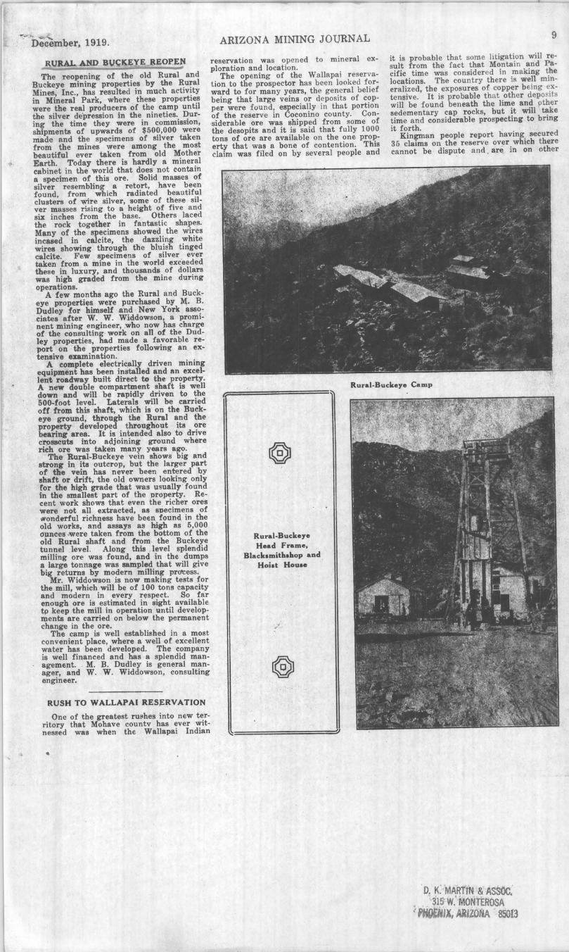
R.tJRAL MID .Q\l~~E'yE.....REOPEN
The reopening of the old Rural and B.uckeye mining properties by the Rural Mines, Inc., has resulted in much activity in Mineral Park, where these properties were the real producers of the camp until the silver depression in the nineties. During the time they were in commission, shipments of upwards of $500,000 were made and the specimens of silver taken from the mines were among the most beautiful ever taken from old Mother Earth. Today there is hardly a mineral cabinet in the world that does not contain a specimen of this ore. Solid masses of silver resembling a retort, have been found, from which radiated beautiful clusters of wire silver, some of these silver masses rising to a height of five and six inches from the base. Others laced the rock together in fantastk shapes. Many of the specimens showed the wires incased in calcite, the dazzling white wires showing through the bluish tinged calcite. , Few specimens of silver ever taken from a mine in the world exc'eeded these in luxury, and thousands of dollars was high graded from the mine during operations.
A few months ago the Rural and Buckeye properties were purchased by M. B. Dudley for himself a'nd New York associates after W. W. Widdowson, a prominent mining engineer, ,who now has charge of the consulting· work on all of the Dudley properties, had made a favorable report on the properties following an extensive examination.
A complete electric.ally driven mining equipment has been installed and an excellent roadway built direct to the property. A new double compartment shaft is well down and will be rapidly driven to the 500-foot level. Laterals will be carried off from this shaft, which is on the Buckeye ground, through the Rural and the property developed throughout its ore bearing area. It is intended also to drive C~88Cuta into adjoining ground where rich ore was taken many years ago.
The RUf8I-Buckeye vein shows big and strong in . its outcrop, but the larger part of the vein has never been entered by shaft or drift, the old owners looking only Cor the high grade that was usually ' found in the smallest part of the property. Recent work shows that even the richer ores were not all extracted, as specimens of IoVondetful richness have been found in the old works, and assays as high as 5,000 opnces .were taken from the bottom of the old Rural shaft and from · the Buckeye tunnel level . Along this . level splendid milling ore was found, and in the dumps a large tonnage was sampled that will give big returns by modern milling prdCess.
Mr. Widdowson is now making tests for the mill, which will be of 100 tons capacity and modern in every r~spect. So far enough ore is estimated in sight available tp keep the mill in operation until developq)ents are carried on below the permanent change in the ore.
The camp is well established in a most convenient place, where a well of excellent water has been developed. The company is well financed and has a splendid management. . M. B. Dudley is general manager, and W. W. Widdowson, consulting engineer.
RUSH TO WALLAPAI RES~RVATION
One of the greatest ru~hes into new territory that ' Mohave countv has ever witnessed was when the Wallapai Indian
ARIZONA MINING JOURNAL
reservation was opened to mineral exploration and location.
The opening of the WalJapai reservation to the prospector has been looked forward to for many years, the general belief being that large veins or deposits of copper were found, especially in t hat portion of the reserve in Coconino county. Con·siderable ore was shipped from some of the desopits and it is said that fully 1000 tons of ore are available on the one property that was a bone of contention. This claim was filed on by several people and
9
it is probable that some litigation will r esult from the fact t hat Montain and Pacific time was consider ed in making the locations. The country there is well mineralized, the exposures of copper being extensive. It is probable that other deposits will be found beneath the lime and pther sedementary cap rocks, but it will take time and considerable prospecting to bring it forth.
Kingman people report having secured 35 claims on the reserve over which there cannot be dispute and . are in on other
Rural-Buckeye Camp r.
Rural-Buckeye Head Frame,
Black.mitla.laop and . Hoiat Hou ••
.., #1" ••••
'I
D. K. MAinm & ASSOC: • _ g15~ w: ri10NTEROSA ~ "Jx, ARJZONA 85013

--- - ~ 34 ARIZONA MINING JOURNAL
Modernl,. EquipP*i Electric Pow.r Hou .. , With Compr ... or and Electric Hoi.t at Rural-Buck.,.. Min.
December, 1919.
properties that may be in dispu te. W. K. Ridenour, who acted as head of the Kingman party, is of the opinion that the property secured is of great importance. It was estimated that the copper showing in the outcrops and on the dumps had a value of approximately $800,000 net.
Indians were called in and made many locations, the r.ed men staying with their claims for some time back. Just what the status of the Indians will be held to be is yet to be decided by the Interior Department, which has to be applied to to give them proper standing in the matter of making mineral locations. Some of these Indians have gone into the Diamond Creek section, where they are said to have made locations on excellent copper outcrops.
COPPER AGE
Paul ' White, in charge of the Copper ' Age, near Chloride, has had several men at work on that property this week cleaning Up and fixing up some timbers in the tunnels. It is reported that the Copper Age will reopen at an early date. The mine has been a big producer.
Globe-Miami District ARIZONA COMMERCIAL
No mining company operating in the Globe-Miami district has made more satisfactory progress this year in developing its property than the Arizona Commercial Mining company, and at the same time. has maintained producti6n at about 250 tons daily.
The mine shows a greater tonnage of ore blocked out thfln ever before, and production is corning from every level from the seventh to the fifteenth, inclusive.
Rapid progress is being made in opening the new shaft, which when completed and equipped will be the main production shaft. A depth of more than 700 feet has been reached in sinking and the openjng of the shaft is being expedited by raising from several levels. It is expected that the new shaft including skip pockets, will be completed and fully equipped by next March.
SUPERIOR AND BOSTON The stockholders of the Superior and
Boston Copper company of Globe, met recently for the election of five directors to serve for the ensuing year.
The directors chosen are: Garret Mott, J. B. Hardon, W. F. Fitzgerald, J. F. Barry and T. R. Drummond. They will meet in Boston at an early date to choose their officers. . .
Very satisfactory progress was made during the past year in the development of the company's mining property in this district, under the personal direction of Manager T. R. Drummond. The scheme embraced diamond drilling and other extensive exploration work.
An important strike of ore was made recently in the foot wall vein, on the 400- . foot level. This vein where crosscut. is seven feet wide, and carries four feet of glance ore assaying 24 per cent copper and 92 ounces of silver.
IRON CAP COPPER CO. In a bulletin to the stockholders of the
O. K. MARTIN & ASSOC. 315 W. MONTEROSA
,PHOENIX, ARIZONA 85013
•. ,

It is ........ by ...-cut tunnels at~' 4riftA. ITIo"..,ly within a verti-tal ... ., 100,. 'The country ~ if' lIbellred · pre-Cambrian ~..... The vein has a widUl ",f .bout fO ftoJet. and dips ....,., lIOafJnrestward into the mountain: It se.!I1l !'1 to ransi,c mainly of an altered and replaced crushed aplitic granite ur rhyotite, dike. ". values fnor the foot-wall side of the vein, heing pat.st near _ OOJltaot 1tith the pnite. This mine produoes gold-silftr-Iead ... 'l"t.e lu& earl<*! Iblpment made at the time of the writer's, " '''* a~: Gold 3.18' ounces and silver 8 ounces per ton, 'and
_ .' ~.lTJi P. <st. . ," , -X: "" .... ,. B~ ....... -:-These two mines are located in the
~,: :.,, : . ...... ... ..,.t of .. lIiDeral Park district, at an ele~atiOll of ~>'. ~~J,oOo~ J.eet. 'l'blJAIn .but a few hundred feet apart and are , :,' ,~.ti&ated_lM aame.., the RuralMing on the west and the Buck
,.' ~ , . • ~ ~ .. aide of t¥ ame gulch. The principal deveJopmen~ 'Ia ............ ~ of. a iOO-foot shaft and about 100 f.t of drift;,
; ....... ~ of·nof. of dri~ toward the face of whien
'~~:' :'. "'''' '~~. ' ~: to ~ north by a la~rt:1 ~row 01 about.n ;;.:."'t:~ '~ t4 "",~ tbaa _taiDlwater. The velD 10 the aural rome , • ~.p.qicaid _ ... of &boat 80°, but in the Bucbyl it dips " ," V." .... a& up. ttl iIbout 70°. It is 2 to 8 feet tIUck and is
: 1 •. ~Jf:. •. dike of ~ apliti~ pnite intruded into the ~untry • ~. , ·1It,pn-Cambrian IChUit. It locally shows. 4-1Och to , .' ........ ....., 18OItl1 .iron and copper pyrites, with streaks of . .. I 1.'-.: ...... xida of manpneee, and lI0II). ct.t and quart&,
, .... ............ IMft pnmilM!l1t in the Buckeye tbaD in the Rural : . ~ .. "waDi .. ..-..n,1raeeD. The on 0011~ ailftl", gold, and ,,~ " '\,I iippir, wkll .. ~al ....... in. ,old. . l\ ' ~"" tiM.w.-'l'Ia. Golden Star (formerfy l..oae *ar) mine
ie.IocIItitd:wW • .w.,,8IDI!t.Iaeut of Mineral part, Oft o,*, ground. lit,. • .., .. t .ridt .tpliidel of lilver, containing gold and leftd, from
.... aca, -beD the CII"e seems to have fallen off in rrade and ...... , ... llllld nfract.ory. The mine is developed priDcipally by .. t .... " . W in dep&b and two levels, with 600 feet of drift on 1MIa" -The ore it *'I*i down to the tOO-foot level The vein ""~1 to the eoath. ,It is 2 to 4 feet in width, and the ore
,~ :". it'. Ilnw..... The t.otaJ production is st&tM to be $375,000. . ' :~; ' , f _~"""AtatoRio ~.-The Ark mine, located about ~ mil~
, ..... ~ ... J6Mnal pan at the west base of the mountams, IS
~ 'bi a IIiO-foo& aft and three levels, comprising about 1,300 '*" of ~ It produces oonsiderablewater. The vein, which is 'J., . ' .. ill width, dipe iMep)y to the northeast. The ore is of a .... MIa'~~ and 0Imfains gold, silver, and copper. It runl IiIIDat '1\'1 ...... of lit,.. and 8.15 ounces of gold per ton. The JiVdIdMe it about '160,000. Adjacent to the Ark mine is the San .b~ wIateh has produced $76,000.
I
" .
~, ... ~'. ~ ~
.~ . :.~
; l ,
MOHAn The new abaft of the U.uted American.
0 .... ., i. hOW Gown a26 feet and aver..rIna about 4 feet a day. A recent lur\ter. of the property showed that the fint velD to the BOuth of the shaft. providing ita-dip ia the DIlle .. the other ledg .. of the aeries, should be cut by the' lhaft at a . eepth of betweell 400- aDd 500 feet. InUlUCh u this ledge has not yet been pre.peeted it is not known what value it e&n'lee. At the present rate of sinkin« __ 500 should be r~ched between the middle of MarcJa and the fint of April ud the croYCut run OD the 500 to the hie ledge by about the fint of May.
DevelopMent work on the "'tDlirt lac .. is progrelilring rapidl~ ne: 0 Ie compartment workfJ"lga being BUnk on the BocR!%! clatia ia nearihg a depth ~' .200 teet' ~. . . . ,
Fred Beuble ja, undentood to have, a t~of men at work,en the AaaalpmatH pro~ . at O_ .. n. They He' einking the mam sbaft to about '00. and 'are' new down about 160 feet. ~iI property bas been ~e fM' two ,ean and' ~ took -eon~'le 'be " and ·.money to- put tM Iliift. . .... eliiner): and' buUd",gII in ; eiape for minuw.. Th~ expect to .lio ... ~ut.tiiiC O'D ·the· 400, an" it Iboqlcl be v~ interesting .. the lhatt ia dOwn it a J1Inetioti of Wbieh' ....... , to be & c~~. tinuation of the Gold B.o&da IedP: 'l'be Ameil &ted .o~· ave!' ."to' aer .. " in bIMIII .9bidl they· .. , operaUna. ".'. 'S··i.'hutllib "11~ ... 'baa ' i"ee"eDtly ~' ~ 320' eubie-toot ChietiJO' Pile1l~ ~e c ~..P.1'eSllOr U ' .n a1DiHary ~ tile _ ~ o~. the p:oubd: A~1o .. ·.1fJ ~1rer enlUle bai been put i~. . ~,. 1. '10 ''soon lIIlwater the 014, ·COl0:!i· ' . iIaaft ~h iJ cknm to a "deptH 91' '. teet after wtijeh ·e.xteJilt:ve ~~I~p • ~ -";0,,,. ,qJl .,. don. in ~ ~ .. :. . ,:' ,
,;. ':~ ........ . 8 .. .t-4 /M~ ~ • ",-_ , ~~ of «*lCfttratea ,,~ -t17 nidi will .v ...... abotlt '.1~ · to the ta.,., "pt. fl'9a tM coDCJIl,Watiq ..... lftlId 12.24 ouee8liW .. and"62 ,. .. lead, ad a;eO~ sample It~ , aiIv ... aJld ·68 per .eent leai. · It II- ..... toM t1la~ . the tw~ ~. tab_
.. ' add" wtdell will iGe~ the ..m to abo,t {; tona of concentratella da,. . .. ..
'!be , .-adrin.,. ill DOW M~ .. 1n.taUed ita the. . .,.. 181.. The caPMit7 of tile J!IiInt will be .boei: 'OO toM' in 24 h01U'II, ~ Gibao:K ill Iiriar at the· IlliDe- -aM" p.ag·his u.e to· the dieftlopm .. t of the .-ojec&. . .' . . . "
C. B. ".T;and C. 11; 8cIiIoeD~ were~ tit IaDamaa "~ftt1,. ~ the 'intAtfelrt . of the ... UiI.... '!'her rfpot:t that .they will at once 8tart IIbikin&, ' '9n the IIhaft from 105 to the 60.0, Iriel on 'dle footWall 'of tM ';em. and then commence ~. ~ dle SO,. . .......... .
Two abitta were atUted' at' tile' .~ 0... ...... O.tman, recently anC! tlibip are ~. Uftcler '!'9 for a 'gOod lind "'e ent eampaip,' ander 'tire diree-< ~ 0 10e Onetta. · .
Reeent;lY a deal ... "CoJSaummatecJ ' wh~eb..f .. the To • . Sic~ group 1>f IriX elauu .... ~ OTer b,. a ~p of eastern men. '!'he dear .... ,bandled ·]iy 1. S. WItbera .who Yill be Identified with , the D.. comJl'&Dy. '11118 Pf'OPern- ' ia " 10-eated in the WaDapal mountlLinll'~ and ball a. (IOOd ahQYinr ,of rol4 and silver. IIUTer predommattnc. ~ o~terop' a~d . sri~ · d.velopment work al ba. been' done makft' the property look verY pI'Omiainc. · It
AJUZOHA MINING 1 UIlNAL
is understood that development work win be started soon.
The Mohave Miner says the work of retimbering the old shaft of the Q.aiaet Miae was completed recently, and the company ill now sinking from the 300 lenl to deepen the Bump. After this is done the 800 level will be cleaned up and timbered where th~e il caving, after which the drift will be continued to intersect the ore bod,- opened in the west drift.
It is said that work at the Hiplaad CIIief in the Oatman district, is moving along · in a satisfactory manner. The quartz ledge in the lower tunnel has been eut through and drifting is being done along the niB to a point where the high valUe were di8!:overed in the Old High land Chief claims. .
."ft ' iI r.eported that the T~ mine at OJUman. 18 at work on a new abaft. going 10.0 feet de,err. The ore found in the drift north 0 this llhait jUltifies sinking deeper and crollSCutting again. In the ero88Cut on the 350, the vein is wider at the bottom of the drift than at the top. Jack McIver is president and directing head of tIM. property. .
. 'If' ~ '.undeNtood tliat J. A. Mamm. was In K;inlUl4D reeeDtl~ arranging for the ~nJ. up of f;he J. C. mine which has ~ takeli ov .. b7 the CoLi Butte Miaia, Cilla
d pua~. of" 1Wbich. lie iI general manager
ana prelDcI~ .. Breth~r has been secured as mme IUperintendent, • Fairbanks ~ ill on the JrOund ad a compressor ltI . O'fl ~e way. Luinber for the 'buildinp and ttinberine ill also beiJijr hauled. A double-eompartment will be sunk to tile 2~O. l~vel froID which level drifting will be done bo~~,... Former ownetB of t!t~ J. C. not !onc &go shipped three carIS Qf ore a~n& ,,0 per ton. This ore WIll tahn frOm . tile bqttom of the 50-foot abaft now on the proJert:v. " A. C. WardeD ..... ill Xi~an reeend~ ~d reporie4 tiaat the c.w Ore. Oatman, Will ~ OperatieBlI acain BOon. While Ute mUle lias .,.. .. ot down. a eave on the 50 leMl 11M upOMd three feet of $100 ore. <in the 260 level in the ' dis~"",. abaft. Ilr. Werden saYII ten feet ot~ .... eXJ)OHd b,. tJUs cave. It is the ~ef of lack 4efferiell, & mining man ...... reeeatly1Ude an 8UJDinatioft of thia property for Loa Angeles people, that thili ~!e bad bl'Dk~ into the old ore shoot, uw.t .Mr. Werden ' had been trying to tap oil the .lower level .for the past few Ye&n!.
N. 8ic1er~.of the ,. CatM Ajar Millin, c.....-y. AJnc-J!, retllrned recently fna O~ldand ed Bait. Lake City, where !ae' ~ HI eeaferenee with llIen interested 1ft thil PI'.,.t,. One of the stockholdert!l of the ~y returned to Mohave county wi~ bia f •• etay of a month or 110. Mr. Bigley ~,.. • lareer force will be ~ut on at the JD1De .ad the work of drivIng the tauel Will be puabed ' futer than heretofON. . The tDqnel il now 856 feet, on the veiD wbich .t pre8ent is 9 % feet wide with four fNt of cpaartz.
~t. ill rqoried tbt splendid progrees i. belDg made at the DeaD Mi_ .I: Mm. The 'OO-foot crosscut tunnel and tile drift of' 226 feet, OD ~e yein, bave been cleaned . oat . and tile track laid to the face of the drift,. where ~e up-raille begins. The extraction of ~ will .. be ~n Boort17 and tile fint· mining will be ilone on the in-
. ta'muiate ·le .. 1. A tel't · run recently of DiI~,!d . J_' ore
th!ough Ute Arizona MOly enutir' mill sllowed an 82 per cent extraetion and re-
suited in f ive tons of 300-oun centrates. The solu tion is grOUt the ore in the ball mill.
Colonel Aagaaz'd visited the T mine recently and was well plea <.
~he progress being made. The minmg well managed and is showing re development. The Tuckahoe is n~ ing to the 500 level after whic will drift on the vein which sho good ore on the 300.
The annual meeting of the stock of the Arizona M_back Compaa)" man, was held recently. The report offken showed the company to-be cellent condition; the work of year, which has been wholly""·' ''''' ''' has been most satisfactory.
At a special of the Quart. stockholders the "_" __ ~ __ were elected. R. H. L. Harpending, Bryant, aeeretary Frank Champion, dirfM!t;ol'. Mr. ing' will be located at Oatman.
Some good loojcing si1ver 88lI~. been brought in from the tion, from stlyer -Coia Pete White and E: G. about a mile beyond the Koadlsictle • sample. were taken about eigbti' the surface. ... '
A 2~horaepower . hoist has' chased by the I. lhL and · will ground shortlY . . xner the in.ltal~;ij the maellinery the abaft deptA of 800 feet, when on the ledce both north and the old lltop~s from ~hieh the ote 'W&8 Bhipped In the" early days:
It is reported that a merger jjf Meats of the ' alid "f!be Easter!).' is propos. ._
. The new shaft iD the west ore the Emeralcl ' .. I.. near Oatman; i. to the depth of 50 fe'lt:
The (:.rhat !lilft!'-Mia •• .I: MiI~flI paD)". Chloride. 'put _ .aliift of el~ning up' the mir.ellinery a1) engine to operate the blower If. Borriman. until recently with ne8l!ee. is foreman o.f the wotk. :
, PIMA , . AnDouncement ia made by A. W •
weD of Gunaidrt. th.t ·be and tiea .have pure_ed the GUDHaht T_,atea MWq Co.paay·. mill eqaipment that goea with it as .eU W_ .... No. 1 millin« claim. apon. the mill is ereeted. Thil property membered &8 one upon, wltich , ... ---the form of aebeelite was ";"'.,,,, ..... ;,1 a yeaJ; and a half aao and.-from shipment of scbeellte wat! made at that time. The ore wu .rrade in tungstetl but tile mine
. doObt have mede an important of tungsten had it been "i.'''\~'_'' opened up when -the pric:e of tuJl~;w. high. In. addition to tanpteJi the ries gold. The gBngtle ia a white
The Ariaoaa-T_opah MiDia. eperating a poup of claims lIOuthwest of Tucson. near the Tu"_ C.pp.r Co.paa,.. made of blgla grade silver ore at of 100 feet in the new shaft. or.e W~II unexpectedly encountered a station w~ being cut" in the sb&ft.
Application to place the Mile-Wide per Co.paa,.. Tuea... in the hands reeeiver was filed recently. The i. Ralph W. Lancworthy. who against the eompany upon which
(Continued on Page 44.)
\
· . •
AS~AY ~
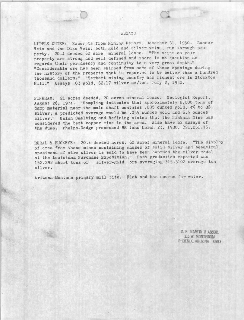
LITTLE CIIIEF: Excerpts from 11.inine; Report, December 31, 1950. Danner Vein and the Dike Vein, both gold and silver veins, run through property. 20.4 deeded 60 acre mineral louse. "Tho veins on your property are strong and well defined and there i s no question as regards their permanency and continuity to a very great depth." "Considerable ore has been shipped from some of these openings during the history of the property that is reported to be better than a h~ndred thousand dollars." "Serbart mining count'ry has richest ore in Stock ton Hill." Assays .03 gold, 62.17 silver oz/ton. July 2, 1930.
PINKHAM: 21 acres deeded, 20 acres mineral lease. Geologist Report, August 26, 1974. "Sampling indicates that approximately 8,000 tons of dump material near the main shaft contains .0)5 ounces cold, 4% to ~~ silveri a predicted average would ~e .035 ounces gold and 6.5 ounces silver." Union Smelting and Refining states that the Pinkham LUne was considered the best copper mine in the area. Also have 62 assays of the dump. Phelps-Dodge processed 88 tons March 2), 1980, .~21,252.75.
RUl'U~L &: BUCKEYE: 20.4 deeded acres, 60 acres mineral 1 eO-se • "The tl i s pluy of ores from these mines containing masses of so1iu sIlver and beautiful specimens of wire silver is said to have been awarded the silver medal at the Louisiana Purchase Exposition." Past prod~ction reported was 152.282 short tons of silver-cold are avera[;inL~ 315. )102 averac c ton silver.
Arizona-l.1ontana prilllary olill site. Flat and has source for Vlater.
D. K. MARTIN & ASSOC. 315 W. MONTEROSA
PHOENIX, ARIZONA 85013
Oi~tritt
ClaimD:
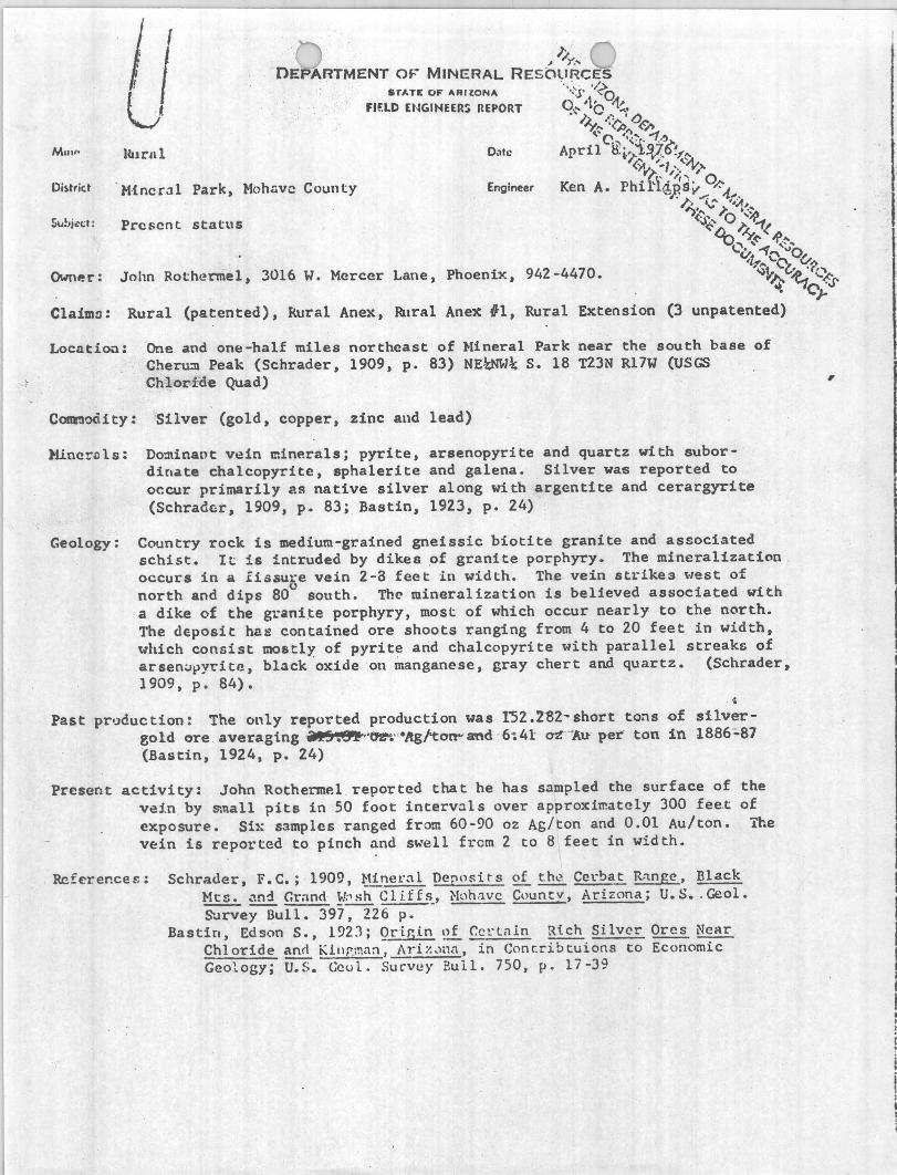
Hurlll
J:.' - " /Y, ...
DEPARTMENT OF' MINERAL RESOURCES STATE OF "ALtONA -·<'S· ·~O
FIf.LD £NGIHEERS REPORT o.~ ,tC' ~~ •
O"'c
.• I: ,1 I ()
~,.. "('J)" «'~ \'C ...... -1.'1
April tr.;fV:?tl'~ <~ ~~1; .. \'\t1'
-M·{ncroll Park, !-1ohnvc County Engineer ~\' ',,, 0
Ken A. Phil'l(i;Sv V-'-t ....
Prescnt status
John Rothermel, 3016 W. Mercer Lane, Phoenix, 942-4470.
I:c ,." '~ I)',,\.: I; , .~ .. <a' O'~ '(-~ l>y.-1( '·b .... ~"'1 ~~ ..
v,~ (' 0v. '~h"v.p ~1t~
,. -l' "'7C'~a'
Rural (patented), Rural Anex, ~lral Ane~ 11, Rural Extension (3 unpatented)
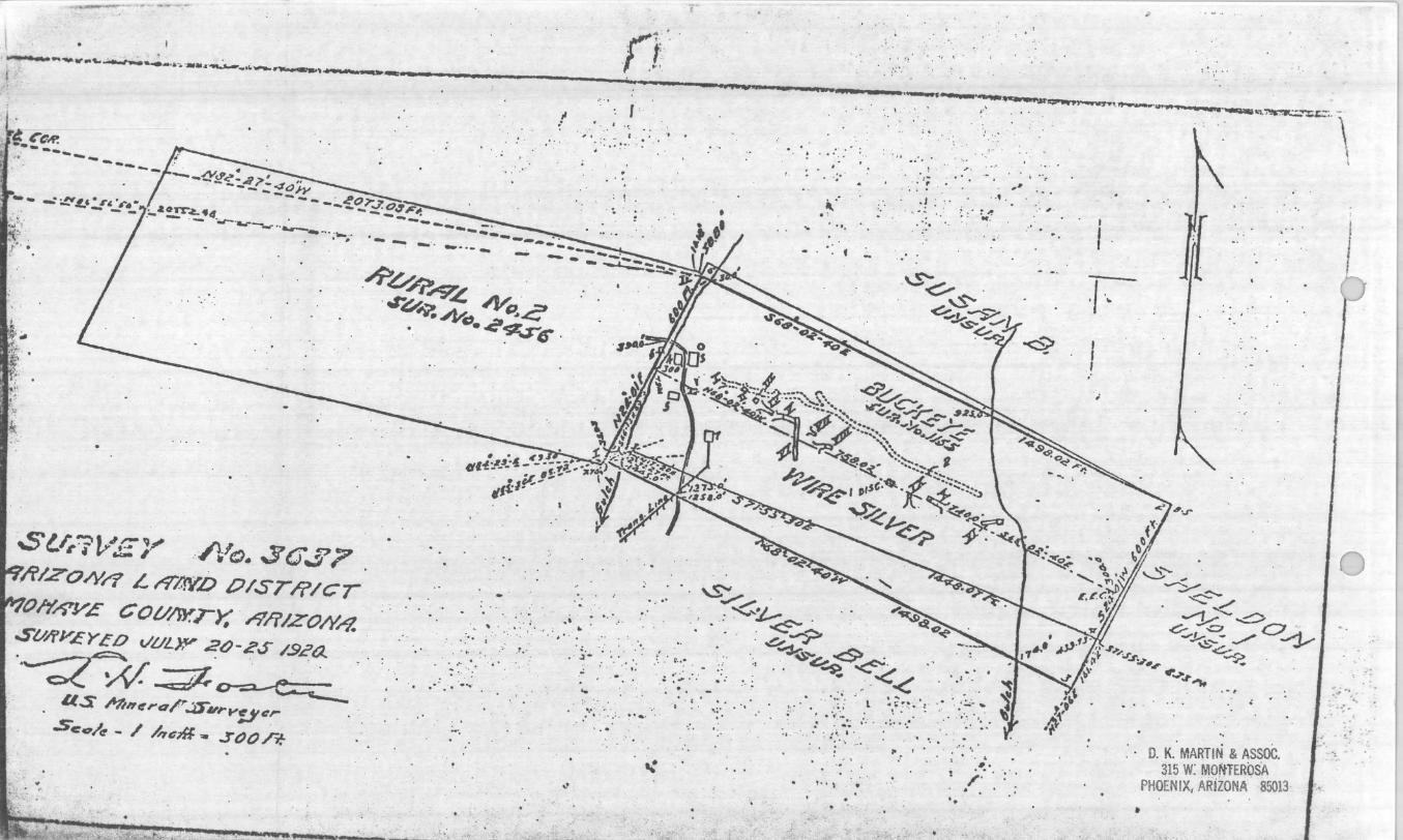
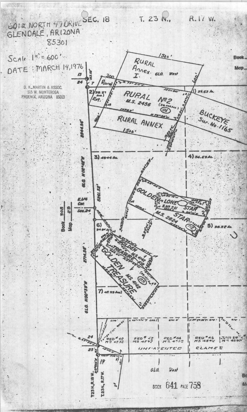
Loc~ltiou: One and one-half miles northeast of ~lineral Park near the south base of Cher~ Peak (Schrader, 1909, p. 83) NE~~ S. 18 T23N R17W (USGS ehlor-fde Quad) ,
COIII'Jooity: Silver (gold, copper, zinc aud lead)
~ner~ls: Dominaot vein minerals; pyrite, arsenopyrite and quartz with subordinate chalcopyrite, sphalerite and galena. Silver was reported to occur primarily as native silver along with argentite and cerargyrite (Schrad~r, 1909, p. 83; Bastin, 1923, p. 24)
Geology: Country rock is medium-grained gneissic biotite granite and associated schist. It is intruded by dikes ~f granite porphyry. The mineralization . occurs in a fissure vein 2-8 feet in width. The vein stl'ikes '"lest of o north and dips 80 south. The mineralization is believed associated with a dike of the g1.-ani .te porphyry, most of which occur nearly to the n<.'rth. The deposit ha~ contained ore shoots ranging from 4 to 20 feet in width, 'Jhich consist mostly of pyrite and chalcopyri te with parallel streaks of arsen:Jt>Yt'ite, black 'oxide on manganese, gray chert and quartz. (Schrader, 1909, p. 84).
. ., Past pr·.)duction: The only repo\-ted production was 1"52 .ZSZ- short tons of silver
gold ore _ averaging ~.8IP·~·- ·ltgl'tolt"'lmd 6-:41 ~- ·.,.u per ton in 1886:.87 (Bastin, 1924, p. 24)
Present activity: John Rothermel reported that he has sampled the surface of the vein by small pits in 50 foot interv~ls over approximately 300 fee.t of exposure. Six samples ranged from 60-90 oz As/ton and 0.01 Au/ton. The vein is reported to pinch and swell frem 2 to 8 feet in width.
Reference~: Schrader, F.e. ; -1909, l-tinel':ll De~nsits of th~ Cel.·bat R;mge, Black ~lts • .ln~ (;r:100 ¥;'sh Cliffs., Noh:1VC Count v , Arizona; U.S •. Geo!. ~~rvey Bull. 397, 226 p.
Bastin, Edson S., 1923; Qrir,.i.n ~ CC!.'lnln Rich Si Iver Orcs Near Chloride ann Killr,:na:1, Al-i%_'nn, in Conc:ribtuions to Economic Geology; ii:S. Ccol. Survl!)' Eull. 750, p. 17-39
I I
I I
I I I I I I

'.
. . ' .. .. . .. . . .. '
~ " . "~":"': :'".:': ~ ~ ,~ ~ ,: . . ' . . . ' ..... "; ..... :. '. ~ ' "
,:: .. : :. ~:· :·; ··::': : ·":;~~:.;i': ( }/ ' ...... ] .'. ~. ' , . . . . ' ". .... : " , :-; :,
.. : .. :-,::.: ; ..•. ~ ... : :/:?:: :.:: " :'. '~ ..... :'.~ :.~ ... ~: .. '. " ...
. . '.
. ' .... , ...
, ' . . . .. . . "
• " . : r
"
' .. . " , cs
. . . '. " .. .. :a . &".," ~
., ~ . .-
T. 2.3
: . • -Jol •
. :,' ,", , ' .. .
'. ; . ~. '.
-----
~I~I~M M . . e-~--
8 t , ".
•
",
... : m :a .
. " " . . . . ." : ,;'(,~. : r
.... . : . . .. ': . ', . . " ' . : : 'f .: ... " . ..
. . ', '
" . ,
. K. M.AR:rI~ ~ .A~ c. 116 W. 'MONTERO. '
HIX .. A iZ~A 85013 r ,'~ r II, . J. ~. " . • •
t--~-~-r-';;::.",.-;.&;r -;;.--; -lrv~~~-:;.w~P."-"; :. I II I .... .,!~
I I I '- ~. ,.'£o'! ':2 :::>I!.c, ~44 RI!U .~1. I-"'t:!';r, .,,:.1 ~:; "~';? I ""'.;. ~"'.::: ,.,3 45~:': ,., ot ..,r,~:,,""'
U"''''A TE'NT~-C CLA,...,E t:' .1
I , . '
8CC~ 641 p~GE 758 ' • ~_. _. __ • • _ ., A'" . .....

: .
~ I .
"
0,0 j ~ IJO l<J M ~1 ·/.t)K/ vC
6LENOA~E, AR{'2.0~A ~'530 J
: ~ ..
S CA (~ .. 111. ._ =. ·.boe ' . .
DATE · :: .MARc·H ,llf,1976, - ". 1$
. . ... ... '. .. . '.~ '
- . ," .
14
: \ .
. :." .: . ' .. . ,
... "
. ::' . . . ~ . .
.. . -.
.. .
\t .
.1'
. . . : . . - -
. . ~ . . :. .. . ~ - - .. . .::
- •. I -.
. , . .... -'. ~ . ' . . ~ .
..... ' ..
D. K. MARTIN & ASSOC. 315 w: MONTEROSA
PHOENIX, ARIZONA 85013
T. 23
-----
Ii. 1 / w. . .
-+-.~~~ I I
I .-
eGCX 641 ~~GE 758 . --~. _ ...... . '-
. . : . .... ,. L - _ , .... .... --.., ..... .........,.....~ ... I . ..... _ ................ _''"~~, ...........
t "
reo¥. -~ ... ~ .....
-- ~ " ~ ... -' -- -~ -- '-;---.. -~ .. --' - \' :-~:--q,~~c.;. -\ I . ~ , ,.. , '0;
, ' , " .- .. .',
.(Y · .. .. . ' ,
. . '
: ~ / ..
- , ~01T~.4 .- - . - • .;,r-..... -,..,.. •• ___ -•• ;_,.
....
~
~V;?~ N",.G' .rv-.: ."y ... .... ~CS" _ . ,
. ,
S'1;.7l>-~;-" .. A'a. scr..:;?? , ii'/ZON/1 L t"7'"L.cv.o P/ST/?/cr
Ih'~£ COU/FY.rr: i'$'/j'/ZOIY,-?
St//fYEYEO vUL»' 2()-ZS- /.9~a.. ,.~~#.~ ~.~ ... " . .
. , . I . . as M"t!"QP .:tS'"urV!j't:,
S'c"'/ct - / /",;1fi. .. J()t) /r.-
' .
.' • .. . a
,. . . .... . ~" , . ' ~'"
... .... . ' ,,' . '" , . . .., ..
,.' ', .. . ' .. ... - ',
, ,.
"
1.
"
t ,
.;. '
" . : • .. "
.' ~ :.,....-" ...... :t,.-"'-, ,
" . ~J> . ,
. : '; • J .... . ".
~.~ :-! ." ...
. \S"" ____ _ ~~
"
. . .::;,. ~ -$>' -J..-~ -"'l
<:.--.
~~~~~..;, " ~ .,,-< "
~ : .. - .. : :'':'' :: ','
-, .', ~ .. ' .' 'c ';".
· ,,7'-'-.l ~J,~~. ! , , :~~,~, ;:: " ,;:~ , . ..':. , ~'" ': ',' " . .. . I', •. ':.
' "
a: ' .. ,. , I
, I. " ,
'. '0 ,.
'.
, . , .. , . . ,
/'
, .
·I ·~ I I
.1
i
•
. ',
. ;
'V'
0"" ~~ ~/
-1"-...c> J.S O~ ~J...-....... - ../ '-="'<::-~
. ' ,
0, K, MARTIN & ASSOC. 315 W: MOrtTEROsA
PHOENIX; ARiZONA 85013
I
}
~ . # " .. .. ~
"
t ,
. _ . fA. .r.AI_.~ !":~~' L .. '-- -.'- - ----.- - .- ... -~-.--D.K...MAAtIN~ .. II~C: -1 •• ' ~ 7\~~V ~
. .OfJU. __ _ 3;) .. "J()D_'_ O 7.-~. I(~ . . __ 11 t,;' __ ._ .. _ -~ ... -_. __ -.. -----fH~:A~~:J~~~-. /
). ~_'f~I. .... _ _ .~ /. ... "'" 70~ _~ .. T~"'~ .. r ____ w.t"_ .. 4.P_*'-"~s,_ .. !9~_.W~!\ ~ _ _ . _ .. __ . _____ ...
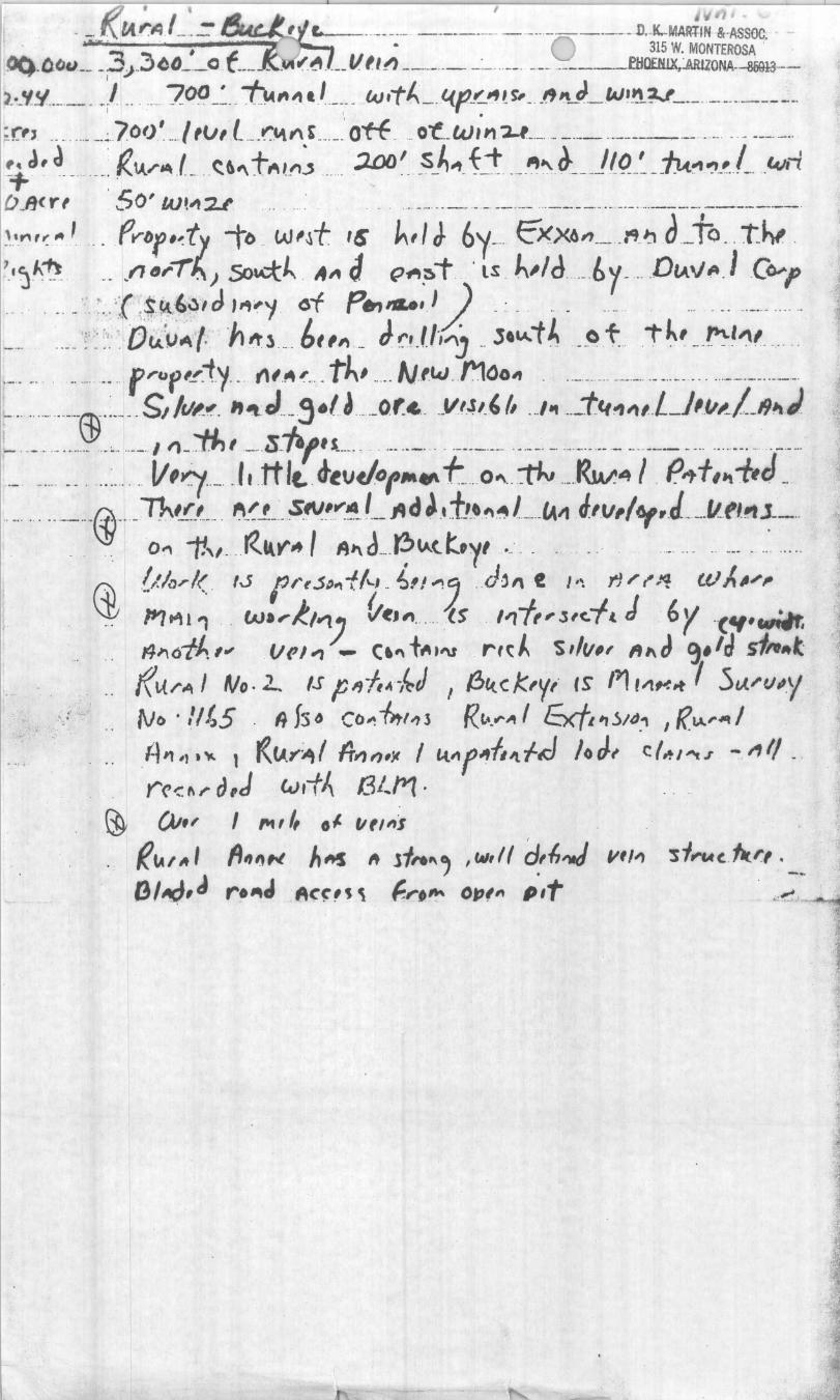
;r', ... .... __ .:.. .70()~ .... I'tJ, 1_ ... _~~t\, .... _.'. Off .. _O"t.W;,,';l..f .. _. __ . __ ______ ---..- __ ...... ____ ._ .. ~ J, a _ _ _; R. !J,.rll) L <:. 6" t M'l~ _ . ::;J.aJ I §._~", t j" __ "''' ~ __ j I f). _~ _ :/JA."'I "J_,_L . wd D.J1CYt 50' w,~u ... . .. ~ ... . . . ____ "'_' _. __ . __ ... _____ .. ..... _ ...... _ _ ._. _____ . __ . ~.",~ .. I _ ft'"D'f,dy -to w~t 1& ~, I J 6y- CXX6"~ "1J tLtQ_1:ht . " J"~ __ .n ~,.-rf:..) So..:tJ.. .. " J <'1'I~T' lS . lv/d _b y- DlAv,,/Co;-l' _. _ . __ ,- '" ;( ,Si.I,&.ll J ,,,",, OT p.., ..... I) _ .. _. .. _ _. . .. _. _____ ., ... _ _ ". . __ .. I( :' . . Ot.J..~UA· f:" 'n Itl ._. 61,,, _ J ~~ .l,.,~ .. ,ov.. t ~ __ ~ .t .. .1"~' . __ ~~~, ..... " .-.. -" . ... -.. .. · .. f'bf'-~· .. ty -- r1'.~I.' .... thl "'" N.'lcJ .. f'1oo~ ... -.-. -.. --.-.... -.. -. ...... --.. --.. -- --. __ '__ __ $" ___ . s, ~~- ""l J _ ~ .(J __ 0 r... Y/J" f" .. __ t41 " ,L],t/,..ll9 .. J. _ .. _ . ........... .. ~ _ .... - . /I1_ .. "t#,' ._-.~_.,."s.. .. _ ... ..... _ .. .. ---_. __ ... __ . _ ..... _ .... ___ .. ____ ......... ___ .. . _ .. .. . __ _ __ , ", ., V'Y:'/-_ J Itt It. d-tVdOr,.eI\ t o .... :tIY ,_,Rsv .. / . p" t, >t -f,J _ _ ... ___ __ @ __ _ 7J...I!',L _ ~, _ .sfV'-~~ ,_ 14 d ~,tl'"'' LfA", J'v,I6f.J- _-"--tll1l.1~
.. ". 0", 1!" . . ~kt" .. 1 A" J_. f:>tA.t t.y' .. :. . . . .. ' .- ... .. -_ . ..... ... .. ~ {I.ID'/< IS f r dD"t Ht- ~I! ,., 'J. d,"e I ... rl ;' (' J'l W !. ~",. ,.' 1'7t'1l'1 ' . W."},I*1J Vf:M lS . I"f"l/c.!, J ·6y -c".wf¥.
t4".oiA I" . . Vi'/" .- c." t",.'U rtt. ~ 'S "v" "t\ J '3./~ sf,.,.t f( UI"A I No· L IS P "ftlt 'i~J ,f!J1.I.. c k,y" IS' ''1 ,;t",-I't 7 5tJ./·tjl.Y Nt> 'l/~5 . It fs~ CO"'.-b,.'''l R,,· . .,."'/ &fl~~/d.1 I {(IA" ... I . ~l" #J • ~ 1 « IJ..Y'~ I It", ",j( I tt" flffllt. ftd J 0 Jf C (" I "t J . -.. '" 1/ -' ("('~ tt r a,J w,-t~ (31 ... 1"1.
~ ()Jf' I ft11 ~ 01- IIt'''~ .. ~fA/ltl (i"I1N AIt! It 1j,.. .... ' ,IM,lf ~,{,,.,J II"~ "Sj,..,.c. . 'ht~,. O/~,d r~".d Acr,~ \ ~r,~ OtJ,,, PIt
•
:
• I
• of · ' ~~:rH Lr..:.. ·v .. ··c··v,-. SE.. C. J8 bC.r ~ .. IV::-' . r:---~' . /./ " "J c.., . '. , 6LEN·DA~~ , · AR.r-2.0.~~ .; " .. "
'. .' . cg-530 l ' . , ..
. .' ., : " ~ ... ' ' :. ., . S C,A (f ' .. t I!.>:;:, ,.690 . ,~.< .
o A T'E .:::;, rr)'f1 ~cj-l',! if /1976, , ::':. a
. . D. K,.MARTIN & ASSOC.
'315 W. MONTEROSA . ~HOENIX, ARizONA 850i3'
~ . . .
,. .. . : . . . "
"
• 0" •• • ••.
. 't
" • • :t . !
.' ~ . 1./;tI . '1
~ ' . " . " " l\t .• ," ' ~I"I~M
'· 1 t ', '. &-~--, . . - ' .: . . ~
.~ ' CD:a "
.' ", . . . ' .• :. '" . ...\:; ~I'· ·
• '. . ' J • t . '" • \
. . .", '. . ,. .... .. : . ' . ~, -. ;', :'.: ::;' . . ~. : : ' ', . ..'.. .. ' . . '. "
• . I' . ' ~ . * : f ' "
'0,, ' ••• • • ' . ~ . • 0 ' _ . . - ' .. '. ' ,' . . ','
- ' .
; '
T. 2.:5 R .. r, w.
. ., ' .. ... ,',' .
I" ::·v' . . •. ~ ' <~;' ! : ,.~' :. '? .:;: .'
I . .' . -----+~~~~
I 1 '. .'.
1---"""-~-1~.";::.,",,, -;'.&i) - ;z, 7;' -f~ ... ~~ ~ ~ 1' •. - ~ .-I . II I .... ."
I I I'- •• ,,'co'! J:'z .:;>~r;, ~# REU "·ft I,:l"'m, .,,';~
. ,..,,:1. ... ~.,:? I /'i '.;, "~' .. ;:: /'1:) 04!S~;': I'f -, .:s~:-
:-.... . , --UN"A TE"'.JTE.:C
. 1
- - .
I
eoc~ 641 PAGE 758 . - - .' .. . - ,'
'R1CH SHOOT Of OHE II
: .r:11 .nnd Cud:c)'c \It'rc enh'
. . ::., ", ~~,,(· .. /i\:ia' tJ.:,,!h Lv tI.;. ::C':',I, but thenr W~. t::kcn a
,.:.~~ .. (It "'lIlIth'dully .-io.:h "ih·~,.
, · .... tl" "t n' • i\"1~ ,.iIY~r vi'" "'01.1
: ;11 \ ·:ldClt.J- I'llrt:. 01 llll' Ini,,~~
o'!:" e,l ::cn!>;,tiolll C,"h . r.mvlI,.
"'~·It wi ... WI" 'e \I~~d t" , . ...-i" ... ; , •. ':. ",.~ ... "'ur lIl':lUly and .:\Iu~
·,:im~: ... t:":C'n f .. orn th.1e min.
" "·\""r &,.",1\ d""lit04h,.t, :Ull' w. ',\iL ,., %'lIljwbt'.1 tn ::C'~ the p,. .. s.
1I 1 :'''~I:1,~at bringlniC in duplic:ntf'
,'ll:\ (0/ t:'i. vld timlt "fl'. TI,t
("ul,.1 tt. w larlre ;",,1 tl: .. ~ i.
:!:::1',,' ton:.,,:!,. II( ... ;11 (,rr. nClW ~
~, }:Y,!r" day brin~. t(l li¥:.t J :;' a'."1 .~\·lI .. n th4! JIrI'J.trt" i .•
• ;:t ll~e. lI(lU lC'vd We 1ll:1)' ,~xP""ct
.J,,' lnltlj(' "'om it.
l:. DII.il,,)' nr.d hiJi IIs:toci:.tu IIr •
. '!":llIl'd win. the tatW "I'e IIwli ......
. ' ·:a~~ht h' lieh1 :2nd lire ',,,,·;n.' .. I,c,1 with ;.11 )"'uiMtt dj.";tk~
I :' .1",·,:Ir',""CA1 1" l he ,tr,oclll("' j,.C'
l:'n,.,. tile, ,,\:'" OTO: "".1, lihil"
,., .':; nuw Lt'1II1:' II:ICk.,,1 :l, .. 1 "hi.,. "' ~II J,rob;''''r 'III';" b~ m;ulc: l.t
';""":-:0. -v--__
_._-------_ .. ..... _ • • _ •• 0 HO •
r:ltn,I.llt:rLiy., )Ii, .... · ~il\;~.n;'n, Arb .. " .. ill 1 ... :.,1(,,;11111",
' 111; . " ..... ;a: Iyr ~U II ...... ;,,"1 ,,,',', ."olv,' I ru,.a: 1'11:1" (I'l.n; :\'ill'
,:,' I~H1;, :,lIcJ iUl,l:.II ... 1 c''''dl"i''allr .,,.h·,·" 1".;:,&. ,."'"i.ri·"':,,". . ~... ." I ..,
1/:,", ,1,.,11 1·'lllrltN,,·r. ; - ." \ .' .. ".
"
0, k. MMrt~ ~ ASSOC. 315 W, .MONTER()SA
PHOENIX, ARliQNA 85013 ,
' I
• I
, ,
.' .. '
, .... ..... ~.- .~ .. .... .. .. .. . .. . ..
, ~

!
--
,.
I
\ ! I I
i
-
AR ZONA lE S "r ' NG LABO , A 'TO~IES
A O I V SION ' r C LAU r>' F.. ~~ cL£AN ,. SON Lr IO H .. r\l" ' E '~ .e .
for RotheD Mines 301n West Mercer Lan ! Phoe nix, Arizona 850 ~ 9
[)(Jte
ASSAY CERTIFICATE
l\pril 7 , 19 7G
1==-+-- '-- "--O-Z-" -r>E-R-T-O-N---rrp--------P-EI ~~J~-G-I:,,-C - ------.
_LI ._B N O. __ I_D_EN_r_IF._I_CA_T_'O_ N__ GOLD ~;LVER ~~;;,;;"-;-- ---- --r--- l ----
!.J.f,42 i R. ra1 Hill Vein O. 01 64~ 5-1! ~- - -- - --- - -·--r .. _-
I . I
I I I I
I ! \ I
I I
\
I
L ____ _
D. K. MARTI N & ASSOC. 315 W. MONTEROSA .
i
! J
ARI Z() ' TESTII'J( ~ .f\i3 ) ~AT ~)n lt: S
PHOENIX, ftRILONA gS013 ,
. /
" /
C:"ll ide Mc Le <l n ,
V ALLEY ASSAY 0 E AND ORE TESTING LABORATORY
MEMORANDUM OF ASSAY
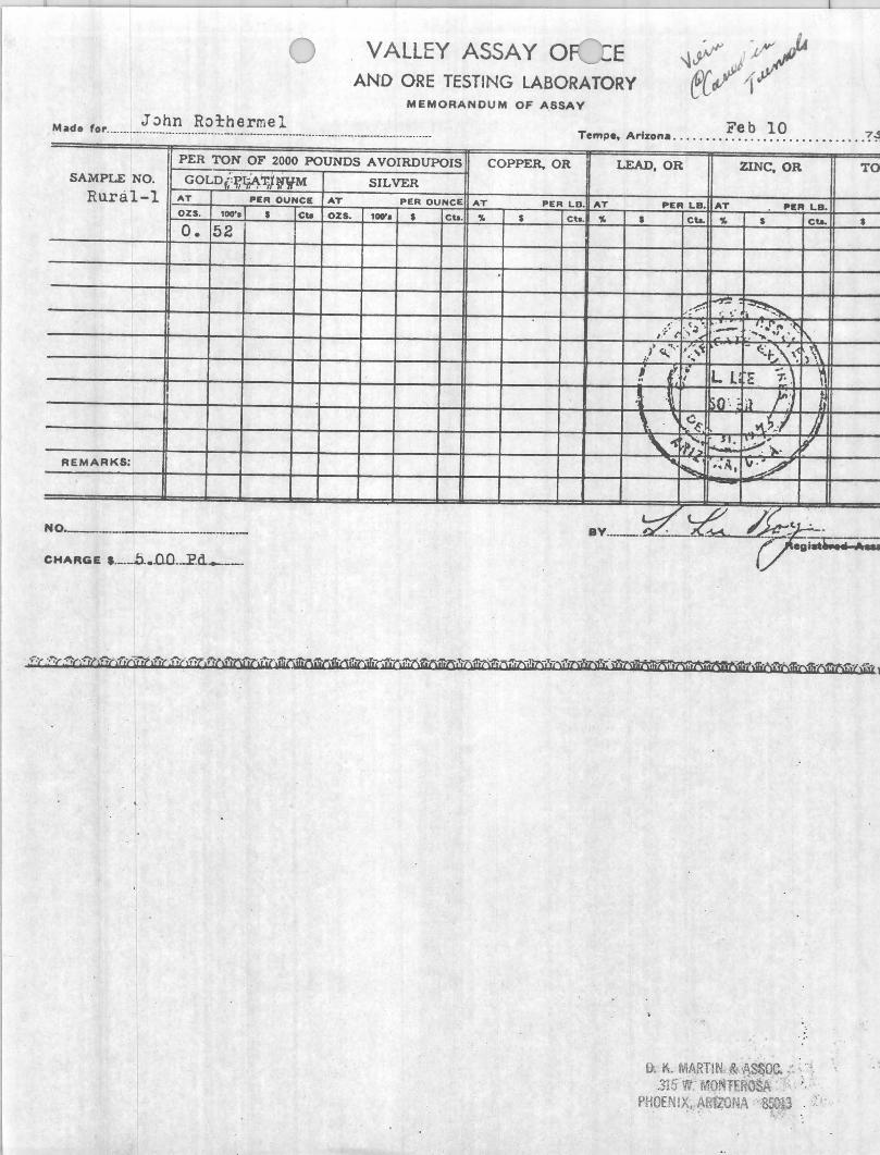
M d J :>hn Rorherme 1 Fe b 10 7 .5 a • for ............................ _ ...... _ .. _ ... ___ ._. __ . __ ._ .. _. __ . ___ . ____ .... _ ...... .... _ Tempe, Arizona .... . •.• •. '" ... .. _. , . . •• .•. . . . . ,
PER TON OF 2000 POUNDS AVOIRDUPOIS COPPER, OR
SAMPLE NO. GOLDl;~~~IWM SILVER Rural-l AT ~~ .. OUNeE AT PER OUNCE: AT ~ER LD.
OZ5. 100'. a eta OZI. lor. a Cta. 'Yo a ct..
o. 52
REMARKS:
NO _ __ _ ----------CHARGE 1 . __ ..b .• 'O'O_..P_d_---
LEAD,OR ZINC, OR
AT ~IE" LB. AT ~E" LB.
'1. I eta. .. I eta.
:~ ~ ~ ,. ":0
{; . (~', .- .' . .[" .~ ~ I · . :' -~ L' l'
...... . , ~~ . . ...\~ I ',~ - ~f:/\'. ,\ }~ .~
! (Ii l L ... l . I E ;.
~ ., 50 '· -,jl f::
\. . , a~ .~tl iJ '\..'" ,;; ~': . .;...;~;. . ,
.... ~ ,',A, \I~
(. ~~ /j' -BY ____ · _ -
0: ~. MARTIN. «: ·~S~Oc. . ", .315 W' MO T' ROSA
PHOENIX, A :1ZO ~A 850'.3 , .,~' , . '.
TO
I
--&

, .
. . • ~! . ~ : ~.
" , " f .J
(
I I
'~ , I
, I
/ : .. f.
·:r < .' : ~ . ., . ...
/ " -' c:.- .. .".
•
I: s~
i~ ~q .. '" " .. -
~ ".;
"
D. K. MARTIN & ASSOC, 315 W. MONTERO,SA
PHOENIX, ARIZONA 85013
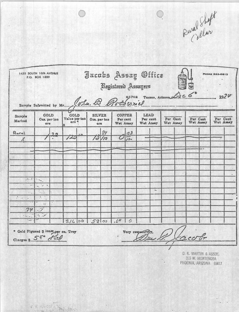
1435 SOU1l1 lO:h AV~i: P.O, BOX 1889
Ssmpl. Su!lmitted by
&m~J. GOLD
Marked OD, pert.on ore
R .. f"4.\ I,,,,, ,;( / .
... -~ . ': ' " . ..... .... -
:' .. :>.
··7'/ < 'j' '"
GOLD SIL YER COPPER LEAD Value per ton OD. per ton Per cent P .. r c.n~ P~r Oent 'Per Cant "P.;Cei\
.s or~ ~ ore Wet Assay Wet .A5aay Wet Assay Wet AsM.y Wet Ataay
. "J /.cJVlo? U/i ..
1# ....
7 O. K. MARTIN & ASSOC.
315 W. ~ONTEROSA PHOENIX,ARIZONA 85013
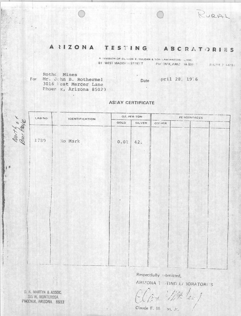
A llZONA TESTING. ABC R J... T ,) R I :: 5 A fl lVISION OF CV,U DE 1:. McLEAN & SOl'< l. I\H()HAT OHI " INC. 81 WESl MADIS i 'i" ST/!ErT
Rothe Mines For Mr. J ( hn B. Rothermel
3016 ' est Mercer Lane Phoer x, Arizona 85021
Date
AS~:AY CERTIFICATE
PH! ' :NIX, flRll IA 850 "
.pril 28, 19 -, 6
':.. ~ ~ II --L_A_B_N_:r_ ---I O-E-'N-T-I F-' C-A-T-IO-N---T"_-~·-o-:-~-· P-E-R-:-:-~~-~--n-rr-c-o-'-P-F:R'---'-~' -lC-EN;~~_;-'_ES'---- - - ----
~ ~ -r ------------j-·---1-----if-,- - -- -- - ------1
" '-- I I ~ ~ I rise) i .'IIo iv1ark 0.01 42.
,
\
\ \ I
I
I , I
I
! I \
I
I I I _ •. _ __ ._ L .. _ ___ ..... _________ J __
0, it MARTIN & ASSOC. 315 W. MONTEROSA
PHOENIX, ARIZONA 85013
I
II I
I il
Ii II
I
I II Ii I , ,
I I --. - ,--_._ .... ,
Respectfully ,', Ib ~nil ted,
I\HI 70NA 1
Clrlude E. rJL
,liNG iJ
) h. " I "'/ I /'~JZ":' 0 / " II/.- '-.
,111, Jr,
I I I
, I ..1 --- ___ I ._. ___ J
30RJ\TORI -S
I j -f -, / ~,' /
I I
Di~tric;t
Subject :
Owner:
Claims!
j I (. I
I; V
Hu r.1l1
DE ARTMENT os:.- MINERAL STATE OF ARI.C:ONA.
FJELD ENGINEER:> REPORT
O;ttc
Nincr.:ll Park, Noh .. vc County Engineer
Present status
John Rothennel, 3016 l.J. Mercer Lane, Phoenix, 942-4470.
LocatioL}! One and one-half miles northeast of Nineral Park near the south base of Cheru~ Peak (Schrader, 1909, p. 83) NE~~~ S. 18 T23N R17W (USGS Chloride Quad)
Commoai ty: Silver (gold, copper, zinc and lead)
l-11ncr~ls: Dominant vein minerals; pyrite, arsenopyrite and quartz with subordinate chalcopyrite, sphalerite and galena. Silver was reported to occur primarily as native silver along with argentite and cerargyrite (SchraciGr, 1909, p. 83; Bastin, 1923, p. 24)
Geology: Country rock is medium-gr.ained gneissic biotite granite and associated schist. It is intruded by dikes .of granite porphyry. The mineralization. occurs in a £is;:;u::e vein 2-3 feet in tvidth. The vein strikes Hest of north and dips 80° south. The mineralization is believed associated with a dike of the granite porphyry, most of vlhich occur nearly to the north. The deposit ha~ contained are shoots ranging from 4 to 20 feet in Width, \.]hich consist mostly of pyrite and chalcopyrite ,-lith parallel streaks of arsen;.Jpyrite, black oxide on manganese, gray chert and quartz. (Schrader, 1 909, p. 84).
. .;
Past pr·je.uc tion: The only reput'ted production was 1'52.2'82:- short tons .<>£ s±lvergold ore . averaging ~;'~" "Agftbn""cmd -' 6i Llt cn-:-Au' per tOll- in 1886~87 (Ba_tin) 1924, p. 24)
Present activitX: John Rothermel reported that he has sampled the surface of the vein by small pits in 50 foot interval s over approximately 300 fee.t of exposure. Six samples ranged fr om 60-90 oz Aglton and 0.01 Au/ton. The vein is repartee. to pinch and swell from Z to 8 feet in width.
References: Schrader, F.C. ; · 1909, Nineral Deposits of t.h~ Cerba~ Range, Black }its .... nd Graml ~,I;1sh Cliffs_, N~)havc County, Arizona; U.S • . C.eol. ~Jrvey Bull. 397, 226 p.
Bastin, Edson S., 1923; Q.!:~in ~~ C:c!,'taln Rich SilvC'r Ores Near Chloride and iZill ,r; ;na:1 . Ari :~,)i1a, in Conr.ribtuions to Economic Geol ogy; U. S . Ceu l. Survey Eull. 750, p. 17-39
..
f
I ! I
I I
i I I 1 t t
f.
I I f i .. ~ , I (
• I
I· I
I I i t I ! i :
- - .. i 'l !)!-i, PART I. ~,
~ n formed has yet ~
'h for the parent n wrnl from whiela It '( lbellum sulphide ~
as outa i ued from ! t . Cornu's short ' !lnd lea~'es much
,lerial wus reall v • It he supposed t~ ~ us. such as those I minernl belt, but
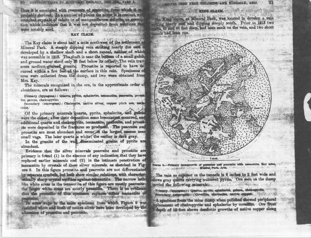
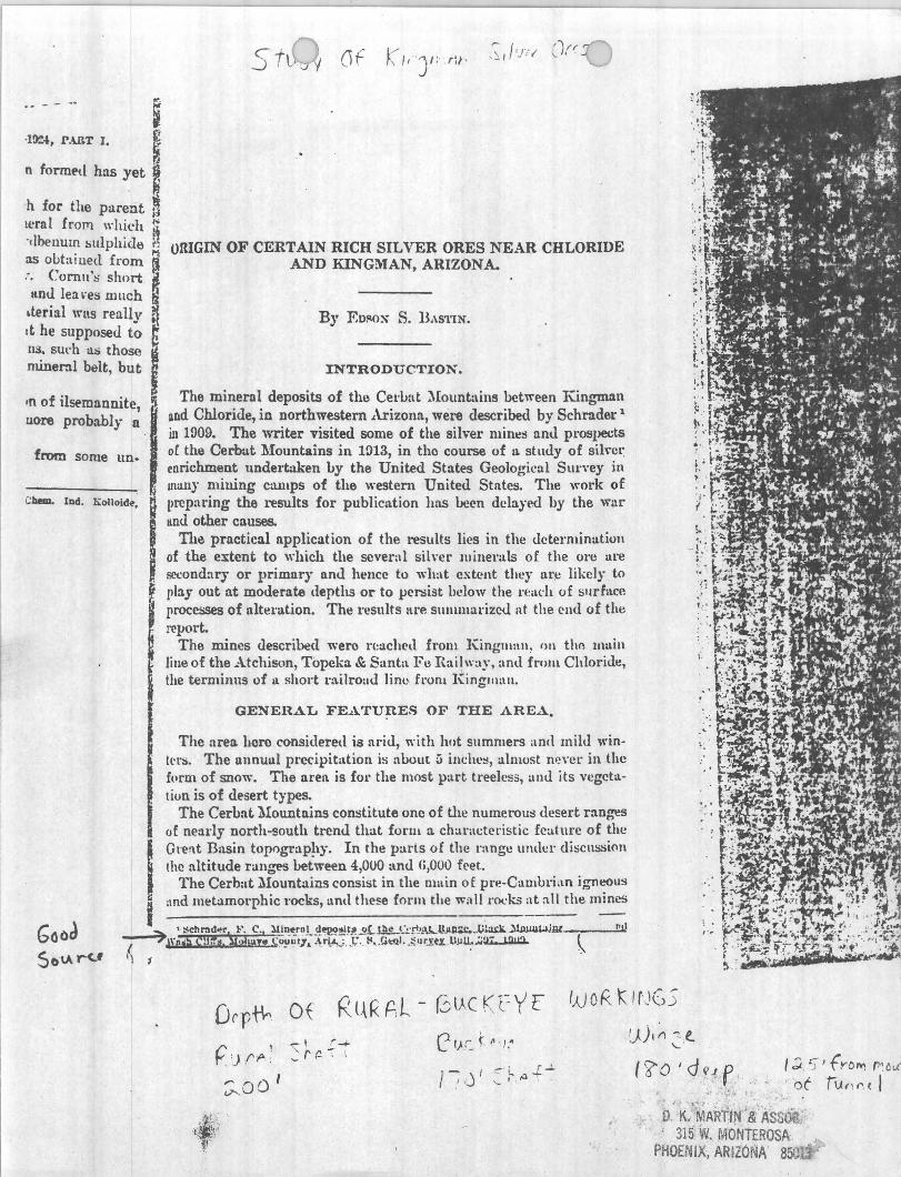
oRIGIN OF CERTAIN RICH SILYE~ ORES NEAR CHLORIDE AND KINGl\YAN, ARIZONA.
By F.D~OX S. BAS'l'lN.
INTRODUCTION.
,n of ilst>mannite, !i uore probabJy a
The mineral deposits of the Cel"bat :\Iount~\ins between Kingman and Chloride, in northwestern Arizona, were described by Schrader 1
ill 1909. The writer visited some of the silver mintls anll prospects
from some un.
C:~ IDd, Kolloid~.
, oC the Cerout Mountains in 1913, in the course of u. study of sil\,cl: enrichment undertaken by the United States Geological SUl"vey ill muny mining camps of the westenl United States. The work of preparing the results for publicntion has been delayed by the war Imd other causes.
The practical application of the results lies in the uetermination of the eJi:tent to which the several silver minerals of the orc are F.CCondary or primnry nnd hence to what extent they Ul',C likely to f pby out at moderate (lepths or to per:;i3t below the l"E:adl of surf:lce
I processes of ultel'ation. The results are slIlIllllul"izeu at the end of the
I report. '
The mines described were rl::lched from Kinglllan~ 1111 tho mllin line of the Atchison, Topeka & Santa Fu l{ai!way, (lnd fr'om Chloride, the terminns of Ii short railroad linL' from Kingman.
GENERAL FE,A.'rU~ES OF THE AREA.
The area here considered is arid, with hot sllmmers amI mild wintl' ['S. The I1nnuul precipitation is about a incitl'!!, almost nl! \"I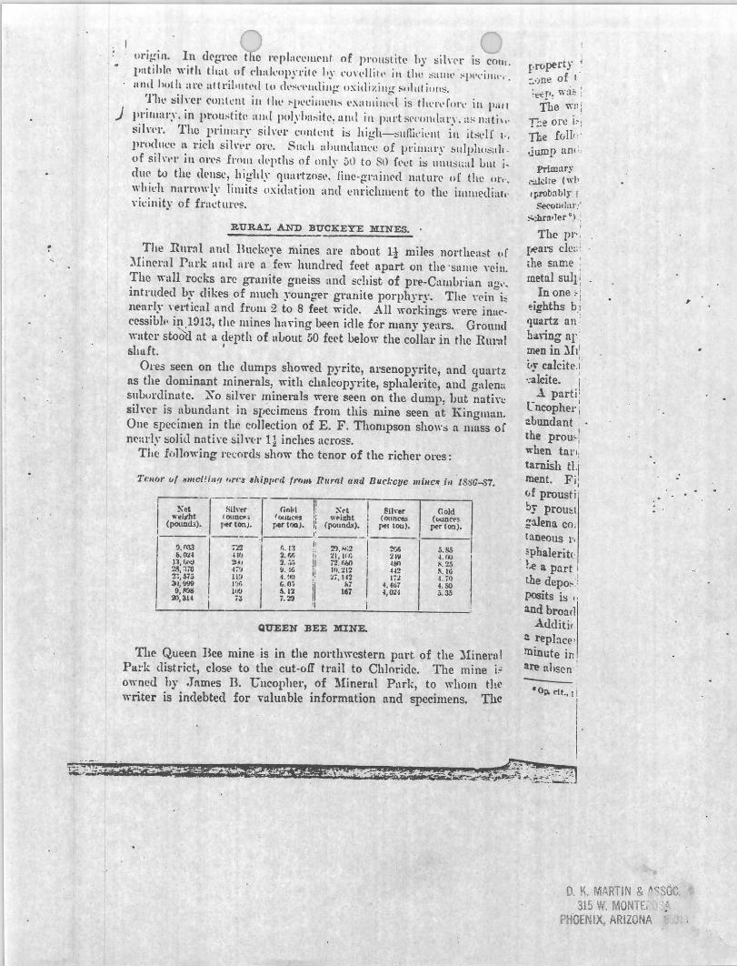
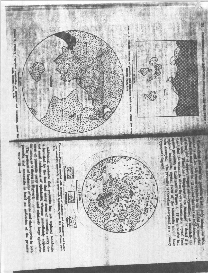
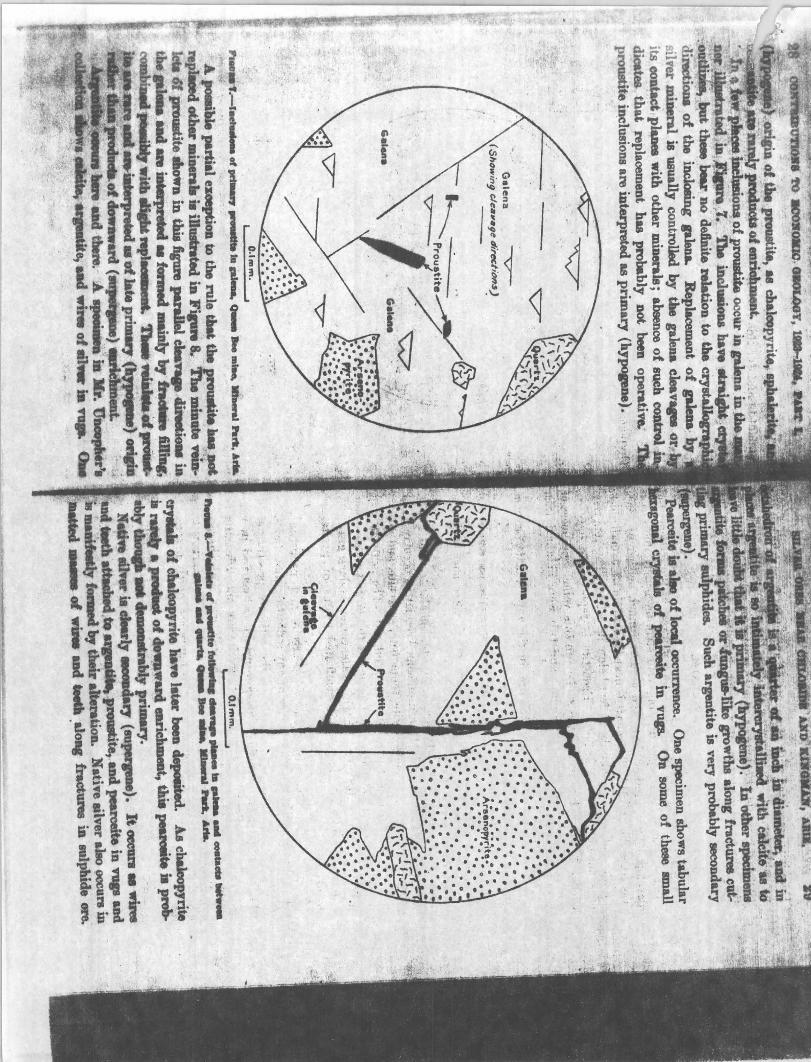
ol'j~in. In d('g1'cr. t \0 l'<'placclll('nt of pmllstitc hy tiilwl' is COlli .
1'IItihln with tlwl· uf ("hakop'yl"il(, \,y cun,lIitl' ill thl! sallll' :'Pl'l'illll" . IIllll hoth art' attri\'lItl'd to cll'~I' I ' 1ll1iJl~ OXillizillg' !'"llIlill!l:-;.
Thl" !SiI\'Cl' cunll'lll ill 1 he :-l'l't:iilllms l'X:llllilll'll is tlll' rl' rlll\' ill pall ) prilliary. in prol1:'titt~ :IIII[ p(J)~ · J,a"ite~ allll in part s('('onlbrY.;ls 11atil,'
::;iln'1'. The prilll:ll'~' siln'r cllllh:nt I:; high-:iIIfiil'il'1I1 in jt~l'lf 1-,
lll'(ldlll'e :\ rich siln'l' orc. SlIl'h a!,ullllalll'c of prilllary ~1I1phll::iall of sil\'1'\' in Ot'l':'; Imll\ lIt-pths of only ~l) to 81) fl,et i!S 1I11I1::;l:al Ulli j_
due to the dl'nsc, highly ' qU:ll'tZO.5l'. iille-gl';tinNI naturl' of the 01". "
wh il'h nal'l'(lwl~' linlits oxidatiou ant! l'1ll'ichllll'lIt to the illlllledial,' \'icillit~, of fradlll'('5.
RURAL AND BUCKEYE MINES. '
The nnr:tl nnd Buck('ye mines :tre nbout Ii miles northe;t::;t ld'
:\Iin(,1'al Park and arc n few hundred feet npart on the 'slime will. The wall rocks arc granite gneiss and schist of pre-C:Ullbriun :lg,'. intruded b~- dikes of much youn~er granite porphyr~'. The win i~ nearly yertical and frum 2 to 8 feet wid<.>. All workings ,,"ere iml<.·cessibll\ i~I!)l~, th(' lllines h;l\-ing been idle for mnny years. Grollnd wuter stood at a depth of aLout 50 feet below the collar in the RumI shuft. '
Ores seen on the clumps showed pyrite, arsenopyrite, and quartz ns the dominant minernls: with chnlcopyrite, sphalerite, and galen .. slIb()nlinnte. So silnl' minera1s ~el'e seen on the dump: hut nati\ .. c silwr is nbundant in specimens from this mine seen ut Kingman. Oue specimen in the collection of E. F. Thompson show:; a lUllSS oC nearl.,· solid nati"e siln~r 11 inches acr05S.
TIle following records !Sho~ the tenor of the richer ores:
Tuwr III 3111t:I!illfl ',rt '8 ,/&iPI,(',l ''''111. Ill/ml (tlld Bucl.-cve millelf .ill lS8C-87 ..
I ~et 1 Sil\'er ' I (;,,1<1 I! :\rt I @lh'.r Cold " I ,,·.i,dlt (OtlD~:; ((JilJUCf!J !i ,,'.illht I (otln~ (IIUncn
(pounw). r~r ton). rAr trAl). I, (p(lllndll). i pel too). per lOll). I I: ! ---- -----·1
II I ~.m.1 ';Z! r. , I~ :' 2':). Nj2 ~ 5.85 ",(U~ lJl, 2. 'A Ii ~I,I(.I; 21V ~ , 1l0 I
n,(j,"<I :!I" 2 .. ;.:. n.rM I l811 K ~5 2'1, am 47~J ~. u; I! .ff, ~12 H! ~, IU Z::, .57J 11:, ... ~I(I ~i,112
I Ii~ 4, ,0
311,II'JIl I ~lti
I G, O.j
II h7 ~, 4ti7 4, so
0,l19li l.fJ ~. 12 167 -I,O'lol '>'35 ~,3H
, iJ 7.2'J " :1 i :
QUEEN BEE MINE.
TIle Queen Bee mine is in the north~estern part of the lIinernl PUl'k district, close to the cut-off trail to Chloride. TIle mine j,.:
owned hy .Jnmes D. 'C'ncopltel', of !\linerlll Park, to whom the writer is indebted for yulunble information nnd specimens. The
[,roperty ::'jne of 1 . i ' , :rif': w;:: I
The ~~n l
T~e orc I' : The full t "
Jump an( :,
Primary .:-..:ldte (\1'1' ,probably I
Se<'oud;\I',' .
~~:I'ler<) : , The PI" ,
pears de:; ! .he snme ' metal sulI ;
In one =- l ~jghths h,; f}uartz an : hol\ing nr: IntD in lI11
I
('l' calcite,l ·:;lcite. ;
..!. pnrti ! Cncophel'i :lbundant the prow.: when tU1'I i tarnish tl.j rnent. Fii fJf prousti ' by prou~t ;alena co; taneQus 1',
~pbalerit(: ~..e a part the depo<: posits b (, and brond
Additi( :l replace. minute in :t~ allsen ':
...
O. K. MARTIN & ~<:SOC, 315 W, MONTE,
PHOENIX, ARIZONA
't ~ ' " ,).,,:. r .. . .. '-
.. II
" .
.. , '.
"
" . " ,' ,
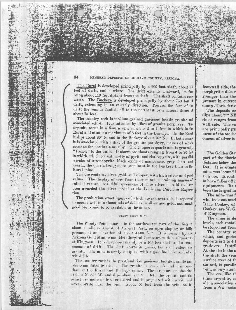
84 MINERAL DEPOSITS OF MOHAVE COUNTY, ARIZONA.
The Rural is dcveloped principally by n 200-foot shaft, about 100 f('et of drift, and Il winze. The drift extends wl'stward, jts ill"
being about 110 feet distant from· the shaft. The shaft contains SOIIII'
water. The Buckexe is developE.'d principally by nbout ;50 feet IIf drift, extending in an , easterly direction. Toward the face of til .. drift the vein is fuult~ off to the northeast by a lateral throw o(
about 75 feet. The country rock i~ medinm-grnincd gneis.-;oid biotite granite IIIItI
as.~int-ed schist. It. is intrlllled hy dikes of grnnitc porphyry. 11 .. dl'posit~ occllr ill Il fisslIl'c ,'eiu which is ~ to -:l ft.'Ct. in width in tbl' Ruml uml nUn ius 11 maxim 11m of 8 f('('t in the Bllckcyc. In the RUr.\1 it dips ubout 800 H. Illld in the Ruckcyt' UOOllt 700 N. In both mintos it is associutetl with It dike of thc grnuitc porphyry, mns.-;es of whirl. ()ccllr to the uortlwllst nCllr hy. The ganglle is quartz aud is generall~'
'" fro7.cn " to the Willis. It shows Ol't' ~h()ots l':lllging from 4 to 20 ft~'l in width, whid. consist mostly of p~'rih' and chalcopyrite, with parnlM ~trea~s of nl~nopYl'itc, hlack oxid(' of mangnnese, gray chert. II nil (1'IIlrtl':, tlu~ qunl'tl'. 1It.'ilig 1II0nl pl"Omillcllt. ill the Bucl.;eye thun in tb .. HUl"ltl minco
Tilli Ol't! I"IIlItaills l'ilwr, gold, allll CUP}>PI', with hi~h sih'cl' Ilnd ~''UIII nlluC:4. TIlt! display of (In'S fl"om tlH':-t, mines, ~!ontuilling IIlnsse:; ur ~olicl Milwl" alltl 1)(,lIl1tiflll spl'einwlls of wil"e !iih·er. is snirl to huw beeu Ilwurded the silver medal ut thc LouisillllU Purchasc ExpO!'i. tiOll.
The productioll, exact figllrt's of which an' 1I0t. IIYllilahl(', is I'cporh'll to lIIount, \wJl illto tllllusllllds (If dollnl'" ill silnr 1I1111 b'llld, and mudl good oro iH suid to Uo 1I~'lIilabll' ill th~' millcs.
WI~II\, 1'()1~'l' lIlNE.
Thc Windy Point lIlin(' i" in tIll' 1I00·tlt('ast(,rIl pnrt of tit(' (li.c;trid. IIbo"t II IIlile 1I0rth{,lIst of Milll'l"nl P:I1'k, 011 Opt'll "Iopillg 01' hill.\' ~I'Ulllld, lit 1111 l,ll"'ntion (If abo1lt -!.~()O Cl'et. It is oWlll,d hy . till' .\i·il':ona Gold Millill~ nnd ~I~,tulllll'gil'al Company. with hl';1l1quurll'", nt. KinbrtlHlIl. It is dl'\"l'loped mainly hy a 10;1-(001 :-haft :\1111 a !'m:,11 1I11101lllt of (Irift. The slutft "tarts ill gtlt'i"". bllt :-Ollll l'lItel'S th., ~rallitc. The mille is Iwwly l'l)llipPt'ti with a gasolille hoi:-t allIl ell,,"
tl'ic drill!i. I The cOlllltr)' rocI.: is Illl' (lI'l'-ClIlIlll'iall l!lll·i:-soiti "iotite ~I':lnitc alll\
hlll('''' ' IIl11phiholilt' "l"hi . ..;t. 'I'h(' l!r:tllih' i" It,,..,.; dnrk and tllil':Il'COII'; Ihull at th~' Hllntl alld Bllt'kl'Yl' lIIim's, The stl'lldill'l' 01' "h('l'till~ ,..tl'ik"" X. H;i " ,,-, alld dip" ahollt j.-, ' ~. Botlt till" l!1':lIIitl' alld (1)1' I ",,'hist aI'" III()n~ or It,~" "cri"ilizl'd alld illl(lI'l'l.!'lIatl'd with p.'"ritl' :111.1 ;1l1;CllopYl'ite IICUl' the n:iu. _\lJout 50 feet frulll the vein, on it,;
[.
foot-wall side, the porphyritic dike J'I
yc;unger than the lll'esent in outcrop .lump debris deriY!
The deposits 0Cf
dips ubout 77° NE ~h()ot rllnges from wall side. The va: Ilru principally PYI lIIent of the ore is 1
ounces of silver to
The GoMen Stat part of the distriCi distance below the ft'et. It is situate mill" was located j ric'h oro. It contil t () hu \'1.' fa lIen off u ,'quipments. Its Cl
lleen the largest in The mine was Ii
who took out mud Isaac Conkey, of Conke~-. are 'V. G. ,,( Kingmlln_
The mine is de len-Is, each contnit lie ~toped out from
The country to
schist, and gneiM cleposits is 2 to -:l f ~rn<1c ore. It stril _\t th~ Hhaft the 81
the shaft the ,".-in surftlce w~t of th stained, is p:tralle "cin, is ,"ery arseni
The ore. like til taius argl'lItitc, n1 1111 in as;.;ociation \1
{l'OIH u few inche!
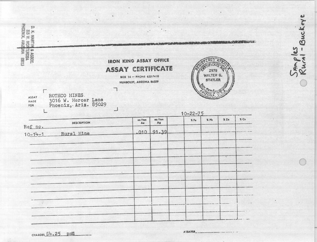
." ::J: 0 o 0
mc...~ 2~o
?<~~ ~::~ £j~2 ___ s ... wuu.-....-ttm_I. ·_' ... ' *..--~,
2mQc >::a>
Ocn
~~cn t:; ~ IRON KING ASSAY OFFICE
ASSAY CERTIFICATE
ASSAY
MADE
fOR
!f no. Re
10 -14-1
--
_. .
- - - -
r
L
ROTReo HINES . 3016 W. Hercer Lane Phoenix,- Ariz. 85029
DESCRIPTION
Rural Hine
CHA'(G,s ~~4. 25 pati
-,
.J
lOX 14 - PHONE 632-7.clO
HUM.OLDT. AltiIOHA 163.2'
o:r/_ oz/to" A. Ag
010 Jl1 ~Q
I -.
-.- - .L
" F. "Ph Sl" Cv
I
.
E---··-···-·-
---
\ -
_.0--_1=-. ~-... ~. ±-j:---- ~ .. -.
A~TU__ _. ___ _ 0
~ .,.. .., ~
~ (!J
~, --~~ ~~
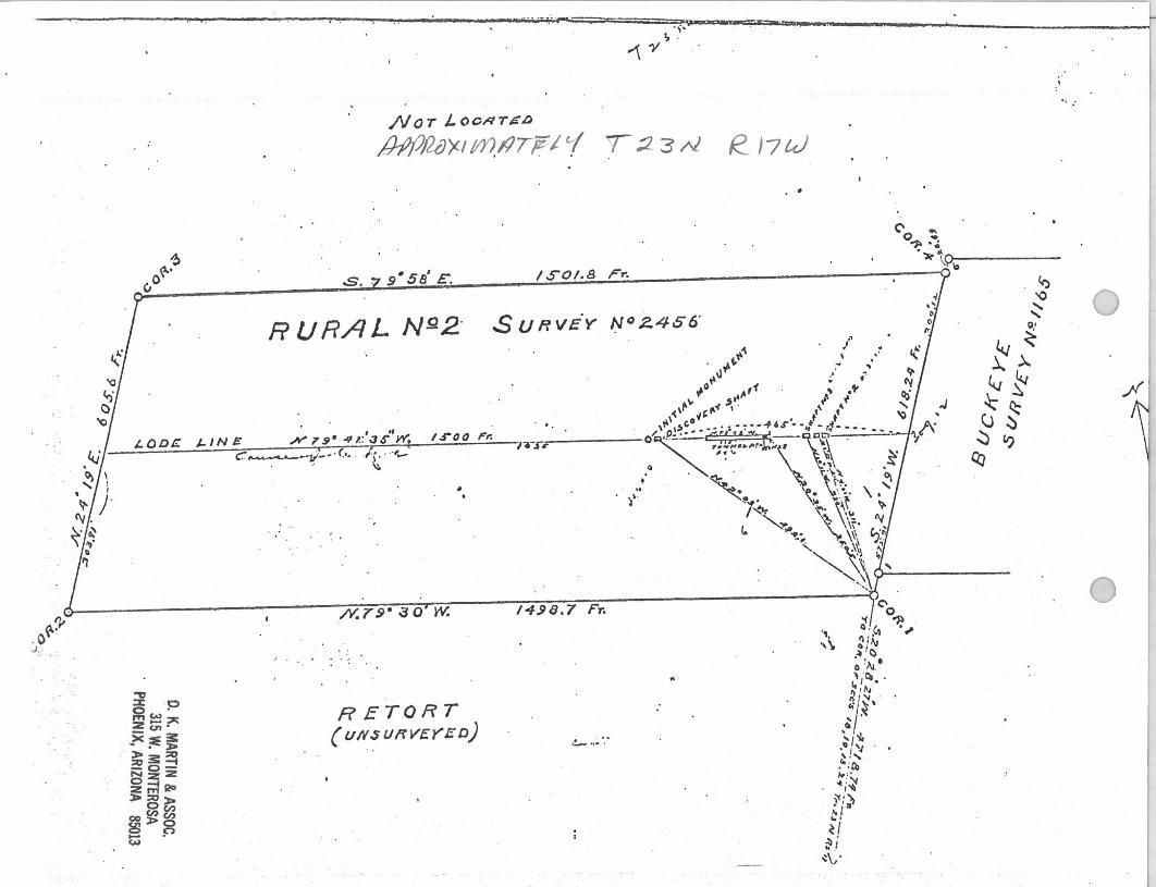
. i r '. -- ~ ... . ,.. ===::::--: ., .. "_wPa: IiII -,=...."" ~,,' .. . . , - ~
' .
NOT '- 0 Cttl T $ ~
fh?IJ/2IJX//t??/lTjF' i T:2 3 At e J7tJ
. . A
~ ~ ';1
"1> ....
O~· .')r ....
?U s. Z 9' 58' E. /$'01.8 Fr. . ?~b-----~ '0
RURAL N9.2' $ U fl VE'y N° 2.456' .'
J-IN E .N' 1'9- 41.:'03-.r!'W. I.rOO I"'r.
" " f,'i' \ . ~ .. " ... 11 .. •
0"" ; f
.,. ,.,.,1 " ." ~,r , ~
,,\ t:"-(' ' \ ~
.. \ 0" . .' .t ''"I'''' 'l-"-""S'-'~- of
'I-'-r~ O/~P.::"" - - ,";;, ;~! " "". ~, \" tI.!='~r~_-",:,~_--' ...;,.-~. ~ ' .. "' .. "'.),;1'1\ . '~.. \i ~.
Q •• ~ ~ . ' . ~ ~ ';; \, . . • ~ '» ,.'j.., ~
/ ~~ . \\~ ~":'=' \. ' ,,,~ ~. \\~\O ~
""" ~ \\;. ry I. .. ~;.. "-., \~ ,,:~
" ' ~~ ~
(::';"""""-"""'--11:-:' : (.~ . /; , .. ,,-' • \:0
..
~ o· ~
~).. 4J~
J ~ ~ (;$ ~ '?
Q:J
j "" \~~~' J- '.~\ ------~. ---------------------/Y.~.~7~9~·~~
~O~j~~~.~--~/4~~~8~.~7~F;~~----------------------- j
~ . . 0 .;
~ .p ~~~ :z en • ><:E~ - • l> l>3:~ :::0
0_
NZ:Z
~~Qc> l>:::o»
0(1:) (1:)(1:)
00»0 g p ~
RETORT ( U/lSUflV£YED)
'- "- .
..
'1 ., Q 1("
'\ ~ :~ .~ '0 Q :AJ. I , ·CO "I . I) ,~. n' 'I
~"j-~ \ , . '/~
.- 'I , I, ."';cq 1# "
"i~ r:~
,~ I .. . ~I ~i -:~.
- ; .:
fi
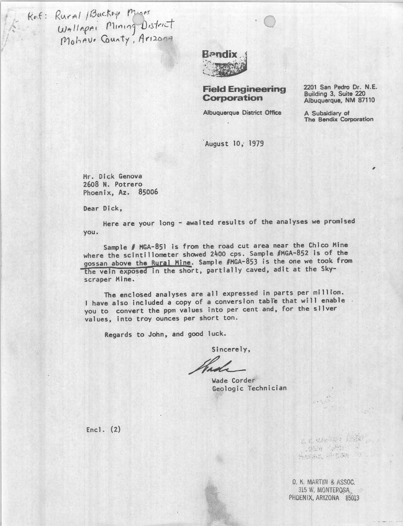
R. v.. t' A f / r3f.lC K,1' r" Wit 1I1''fp. ,. rl, fl t 'lJ IS -f".,,--t r10 J"l f! \J, ('0"1\ t 1 I A t"I:1o 'l"f
Field Engineering COrporation
2201 San Pedro Dr. N.E. Building 3, Suite 220 Albuquerque, NM 87110
Albuquerque District Office A Subsidiary of The Bendix Corporation
Hr. Dick Genova 2608 N. Potrero Phoenix, Az. 85006
Dear Dick,
August 10,. 1979
Here are your long - awaited results of the analyses we promised you.
Sample I HGA-8Sl is from the road cut area near the Chico Hine where the scintillometer showed 2400 cps. Sample #HGA-8S2 is of the gossan above the Rural Hin~. Sample #HGA-aS3 is the one we took from the vein exposed in the short, partially caved, adit at the Skyscraper Hine • .
The enclosed analyses are all expressed in parts per million. have also ineluded a copy of a conversion table that will enable
you to convert the ppm values into per cent and, for the sllver values, into troy ounces per short ton.
Regards to John, and good luck.
Encl. (2)
Sincerely,
~~ Wade Corder Geologic Technician
.; " -.
D. K. MARTIN & ASSOC. 315 W. MONTEROSA
PHOENIX, ARIZONA · 85013
,
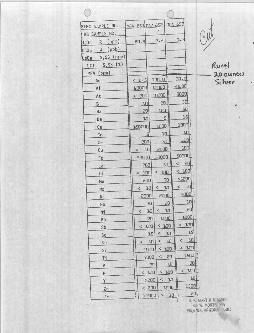
BFEC SAI1PlE NO.
I'-AB SAMPLE NO.
~30a R (ppmJ
!thO a W (ppb)
U30a S,SS (ppm)
LOI S,SS (%)
MEA (ppm)
Ag
Al As B Ba
Be
Ca Co
Cr Cu
Fe
La Li
Mn
Mo Na Nb Ni Pb Sb
Sc Sn
Sr Ti V
w Y
Zn Zr I ,
MGA 851 MGA 852
~ 80.4 7.2 1.
. < 0·'5 700.0 ' 30.(
bOOOO 10000 I 30000
< 200 10000 I 3000
10 20 I 50
20 100 ,
50 : :
10 5 15 I
150000 1000 100oi !
5 10 I
10 ;
200 50 500 :
< 10 2000 100
50000 150000 50000 :
700 50 < 20
< 100 < 100 < 100
200 70 >5000
< 10 < 10 < 10 I
2000 2000 5000 ! I
70 20 10 i
< 10 < 10 20 i
70 1000 1000 ,
< 100 < 100 < 10 01
15 < 10 151
< 10 < 10 < 10 1
, 1000 < 100 < 100 :
7000 < 20 1500 '
30 10 30 .
I < 100 < 10n < 100 '
1>200 < 10 10
< 200 1000 1500
,
VU
«u,." ,,"OOCA"CtJ s; IV~f'
,
>1000 '_L-._._ < 10 20
0, K. MARTIN &: ac, 315 W, MONTf" '0,
PHOENIX, ARIZO~,... 35013

JFACIFIC
illEGIONAL
(Q)PERATIONS, INC. P.O. Box 716 • Scottsdale, Arizona 85252 • (602) 994-3147
March 3, 1982
International Mineral Services Wilbur A. Dicus, President 5919 E. Charter Oak Road Scottsdale, Arizona 85254
Dear Wilbur:
Enclosed please find the Geological Report Pacific Regional Operations, Inc. agreed to provide to you as partial payment for the bulldozer work done on the Chico Property January 27, 1982.
The balance of the dozer charge will be forthcoming as we are awaiting receipt of funds from our client in the matter.
I wanted to get this report to you in a timely fashion. .Enclosed, also, is a copy of our Corporate Profile. If you should have need of additional services, please call.
Sincerely,
Pacific Regional Operations, Inc.
~.QA~~ William C. Vanderwall
WCV:dah
Enclosures (2)
O. K. MARTIN & ASSOC. 315 W. MONTEROSA
PHOENIX, ARIZONA 85013
WACIFIC
O. J(. MART'N & ASSOC 315 W. MONTEROSA .
fHOEN/X, ARIZONA 85013
illEGIONAL
(Q)PERATIONS, INC. P.O. Box 716 • Scottsdale, Arizona 85252 • (602) 994-3147
LOCATION:
GEOLOGICAL REPORT RURAL-BUCKEYE PROPERTY
WALLAPAI MINING DISTRICT 1010HA VE COUNTY, ARI ZONA
The Rural-Buckeye Property consists of four contiguous mlnlng claims, one patented, located approximately 20 miles northwest of Kingman, Arizona, and one and a half miles northeast of Mineral Park. At an elevation of approximately 5,100', the area is rugged and steep. The major workings are located either side of a wash and subject to flash flooding. The property is situated in the NW/4 of Section 18, Township 23N, Range 17W, G&SRM, Mohave County, Arizona, and is accessible by foot trail from the Mineral Park Road.
SCOPE OF REPORT:
Time was the limiting factor in this investigation. One day was spent on the property, walking out traverses and investigating old workings. Fact~ and opinions in this report are based on a cursory field examination and on the Author's specific knowledge of the area and general familiarity with the published literature concerning the Wallapai District.
HISTORY AND PRODUCTION:
The Rural-Buckeye Property lies in an area rich and colorful in Arizona Mining History. Bonanza type silver lode discoveries brought miners to the District in the early 1860's. Oxidized ores were mined extensively during the 1880-1890 period principally for silver and gold. The rapid decline in silver prices between 1885-1895, the recession of 1905 and the exhaustion of rich, near surface, oxidized ores caused the suspension of mining operations in the area.
Mike Dunn, a California prospector, discovered the property in the latter 1880's and operated successfully for a number of years. During the early history of the mine, the property produced some of the richest ore ever taken from the District. Solid native silver specimens 6" to 8" thick, encrusted with masses of wire silver were reported taken from the shallow workings.
Bastin, 1924, (pp. 24) lists the early production from the Rural and Buckeye mines during 1886-87 as 152 tons containing 315 ounces silver per ton and 5.68 ounces gold per ton.
Schrader, 1909, (pp. 84) states: "The ore contains silver, gold and copper, with high silver and gold values. The display of ores from these mines (Rural and Buckeye), contaning masses of solid silver and beautiful specimens of wire silver, is said to have been

awarded the silver medal at the Louisiana Purchase Exposition." And he continues, "The production is reported to be considerable and much good ore is left in the (Rural and Buckeye( mines. "
Bastin, 1924, (pp. 24) states all the workings were inaccessible in 1913.
During the late 1920's, M. B. Dudley and Associates attempted to reopen the Rural and Buckeye mines and reportedly produced some ore from the upper workings. The shaft was increased to a depth of 200 feet and miners remarked that good ore was exposed when the property closed. No attempts. have been made since to reopen the workings.
In 1943, the Tennessee Mine, 3 miles northwest of the Rural-Buckeye Property, and mining in the same vein system, was producing 150 tons of ore per day which averaged 20 ounces of silve~ per ton. Total production from the Tennessee Mine is reported to be in excess of 500,000 tons. (Dings, 1941, pp. 147).
The value of metals produced from the Wallapai District during the years 1904-1948, U. S. Bureau of Mines, 1948 Annual Report was about 22.5 million dollars at 1948 prices (nearly half a billion dollars at today's prices). Values were principally in lead and zinc but with substantial amounts of copper, silver and gold.
Currently inactive, Duval's Mineral Park open pit copper-molybdenum operation located one mile south of the Rural-Buckeye Property, is capable of producing 18,000-20,000 tons per day of .5% copper and .045% molybdenum ore.
GEOLOGY AND ORE DEPOSITS:
The Cerbat Mountains constitute one of the many north-south trending, fault-block ranges of the southwest desert. They consist primarily of metamorphosed pre-Cambrian igneous and sedimentary rocks, cut by later intrusions of Mesozoic (?) granite and monzonite porphyries, known locally as the Ithaca Peak Granite, and by Tertiary volcanic dykes. Centering around the Ithaca Peak intrusive, mineralization is typically copper and molybdenum sulfides, which were mined by Duval. Surrounding the intrusive is a zone several miles wide of lead-zinc-silver bearing veins which gradationally change into veins of intense silver-lead mineralization.
The vein type ore deposits occur in clefts or cracks in the country rock in which the mineral material precipitated from aqueous solution (hydrothermal fissure veins). It is probable that these fissures formed from forces accompanying the implacement of the Ithaca Peak intrusive. With the intrusive acting as a heat engine, a convecting hydrothermal system developed that set up a hypogene enrichment process which deposited ore and gangue minerals near the top of the convecting cell and extracted metals and sulfur from sources at depth. Conceivable, as the solution approached the fissure level, it boiled, thereby distilling the acid forming constituants C02 and H2S. Cooling and a slight pH rise of the residual liquids, due to
-2-
loss of acid forming constituants, may be regarded as a mechanism of sulfide precipitation. Exposure of the veins to normal weathering processes oxidized the ore and, to a point, enriched it by the downward migration of slightly acidic rainwater carrying metals in solution.
Many veins, occuring in nearly vertical fault fissures, strike northwest and outcrop for considerable distances. The fault fissures are largely occupied by breccia with abundant shearing and some gouge. Ore lenses, or shoots, though not continuous are numerous and tend to have greater vertical rather than horizontal extent. Concentrations of extremely high-grade ore appear to favor vein junctures. These concentrations are attributable to chemical and physical changes which enhanced mineral deposition at the fissure level of the convecting cell.
The main vein on the Rural-Buckeye Property strikes approximately N600W, it is apparently faulted between the Rural and Buckeye mines since the Rural portion of the vein dips about 80 0 S while . the Buckeye portion dips 700N. The two mines are located on either side of a wash which is probably the trace of the fault with lateral throw. The country rock in the vacinity of the vein is a medium grained, granite gneiss of pre-Cambrian age. The gneiss is intruded by dykes of granite porphyry which are associated with the Ithaca Peak Granite of Mineral Park.
The underground workings are inaccessible but Schrader, 1909, (pp. 84), describes the underground features as follows: "The vein is two to four feet in width in the Rural and attains a maximum of eight feet in width in the Buckeye. In both mines it is associated with · a dyke of granite porphyry. The gangue is quartz and is generally frozen to the walls. It shows ore shoots (in 1909) ranging from 4 to 20 feet in width ••• The principal developments in the Rural consist of 200 feet of shaft and 100 feet of drift and in the Buckeye 750 feet of drift."
The primary mineralization is one of chalcopyrite, pyrite, arsenopyrite and oxides of manganese. Silver cloride, native silver ~nd native gold are present in the oxidized portion of the vein.
ORE RESERVES:
The Rural-Buckeye Property contains base-metal silver veins, oxidized silver-gold veins and possibly a zone of enrichment in between. Data from past developments, publications and reports are insufficient or unavailable, to completely delineate the orebody.
Considering the extent and mineralized nature of the Rural-Buckeye vein, and its association with the dyke of granite porphyry which would provide a sizable locus for ore deposition, it is possible to anticipate considerable ore at depth, below the present workings.
The mine dumps may carry precious metal values amenable to cyanidation. This possibility should not be overlooked.
-3-
CONCLUSION:
On the basis of surface observations and facts provided in the published literature it is the Author's conclusion the property 'contains a well developed structure with strong base-metal silver mineralization. It is also the Author's conclusion that the results of detailed geologic mapping and diamond drilling could justify initiating a mining venture.
Respectfully submitted,
PACIFIC REGIONAL OPERATIONS, INC.
l~ , l~c~vO~ William C. Vanderwall Arizona Technical Registration No. GIT 34
Bibliography:
Bastin, E. S., 1924, Origin Of Certain Rich Silver Ores Near Cloride and Kingman, Arizona: USGS Bulletin 7 50, pp • 1 7 - 3 9
Lingren, W. & Hayes, C. W., 1907, Contributions To Economic Geology: USGS Bulletin 340, pp. 66
Schrader, F. C., 1909, Mineral Deposits Of The Cerbat Range, Black Mountains And Grand Wash Cliffs, Mohave County, Arizona: USGS Bulletin 397, pp. 83-84
-4-
O. K. MARTIN & ASSOC. 315 W. MONTEROSA
PHOENIX, ARIZONA 85013
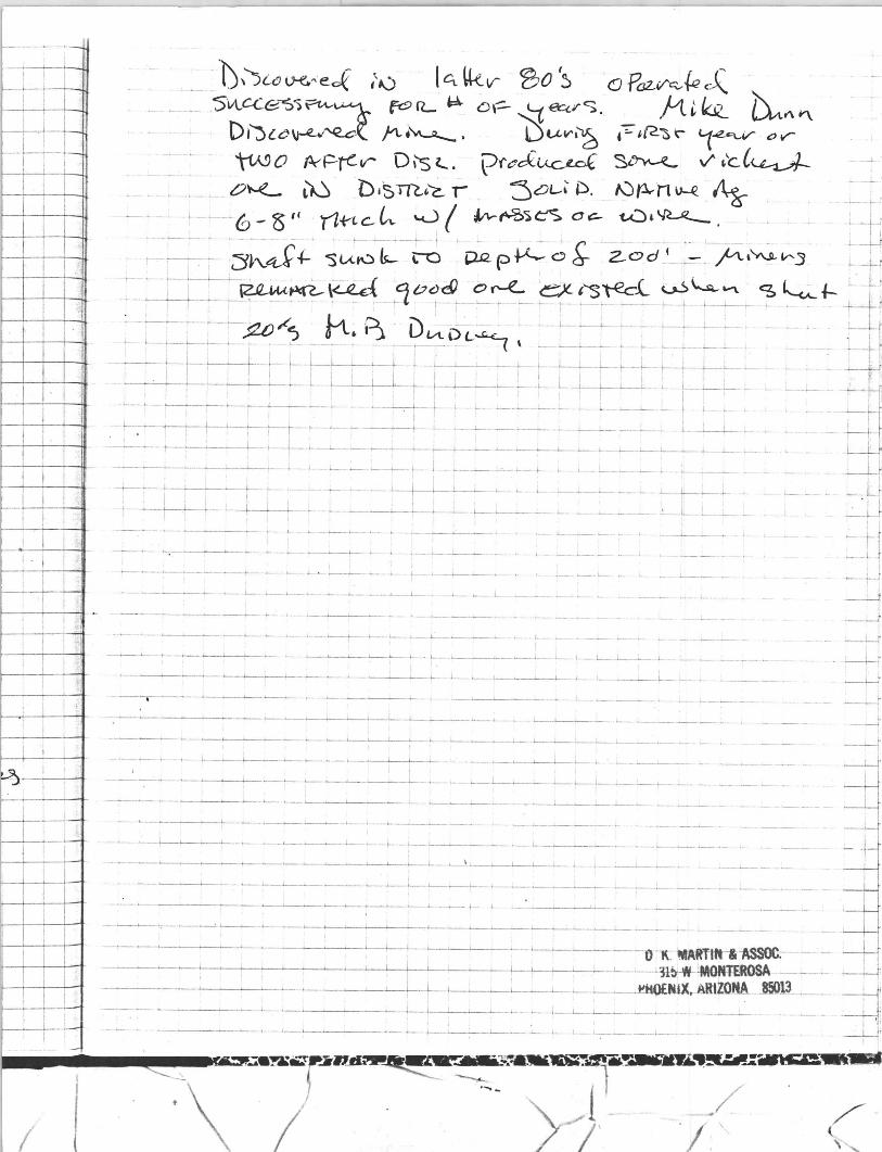
-
=-.:~=t I I
- '
I
I
i i
I-I I
i
I I i
I
I I
i ~-
: Iii
:;1
i I I.
I j
I ! ! I I I
- ., -
-"1)\)[6 ~"eck ,\.) 14 U-e.v- ~O (~ -0 PQ2,~~ J::. 5'VlCCe-S)~~ fc9fL.. ~ o\- ~~~c:;. /1.~~ Liv\~ Dtjl~~~{ ~.~. L5t.LV'I~ ,:;..~~~~ '1~v oV-
11A90 P<t=--j<:v- D\"sl.... \?ft:Jcf~ ~ vi" ,~C~ O~ ~ bjtm~~ r :SOL' P. f.Jp.-n~ ~ --J-."
,_~". L "6-0 '1 '(It-'(.ck v( ~~')~ O~ t..Ul~ -+: '_:-~:- ;~J+- su::~--~ ~ ~p~';~ -i-od' >' .1"''''-'-'''3 ~f _+-_~._~~,~ :10~~~ ~r:-e--~~~~ ~~~ __ ~~f- _~.:
~-.-~~=-=-=--~:! -- tt~ ')_ l)UOL-s ... : : =-~ ~ ~:=- ~- ~ '---Ii --I--'--~-f- i- f- L_L-_, _----....l-_I- -~- ~ _I -, '~-'- r--.!..~ - - -t--h': '
_ 1,.1 ~t I , I L..--_1o .-~- t---- ~-<----L- - -~ L .i.---!....- L--_I '-- ~- ._.1.-_
--~~- ~~---~ ,_--1-._ - - -- - - - - ~ ~ - l I' if L_ _ L..-i--I--_ -'----t-- &-.. - i_ I-. L -:..- - .. ---'-- .... ~ ~ -.- - -- L.-L..-L - t
---t-~-'---.-.L.... __ .. - _ .,....---~---- L---_~_...L._ __ ... ~l...- I- ;... ~ 1
i-- L--....l.--- __ L-.....- j '
-----~-h_ .... _ ~_ I ..... _ 4- _.... .... _ _ ~_ ---L __ .
I I
- _;: -+--.1.---I _ ~ _---+---_____ ~_ 1...---__ <-- L 2- _L- __
~_I· _ ..... _ l-- _I.-...- I--_~_, .... _ 0- ~
.... - --I-- ________ 1-___ '--. ___ *- __ j.. ___ _
__ ~ ___ L L __
l ___ <_ _ _ "-- o.----1-__ --J....-_ ._ -__
, " __ . __ ~ _..0.- __ . ____ . ~~~_'_ ____ t..-L ___ , __ _
I
--~--~- I.--~.~---'- ~ _~_~_. - '--- ___ . __ _
_.~ ___ ~-'--___ '---- 4--1--J..-_~_-"--_._ .. _____ '- _'---. ___ ,
, ____ ~~~_~_,,--_______ ~ __ ..l-. _______ • ____ 0 ___ • ___ ,~ __
-~-----'--'-----.~~--"~---
____ '---~, _---'-___ • __ ~_.1._______+___~l__' __ ~ ____________ _
--------~------~-~-'---'---'-,- - ' .----' --' -~- - - -~ - -~~_,---.I...--.!- L-.-_'---___ ~_ __ __ _ __ .__ 0 ______ ~
___ 1_ 1-
-IC ~ART1" "ASSOC.-____ '--~~~I L_~'___L_~L_~L--~'---L-L-'--'---~'----~~1'1~~O~-
__ ~___"_;___.J.___.J.~ __ '__~~ _ ---1!t.touux. 8RtZOJtA. ..85013
-,--~-----
____ -~. ___ ,_l_~ ___ • __ _l_-'-----.-l.-. ~ _' -._~ ._ .• --..
' : I
__...J -' -w -+-,
_G
---w
__f
~I~_"_~~_-.u~;.r __ )l / ::

MINERAL DEPOSITS OF MOHAVE C01:NTY, ARTZONA.
The Rural is developed principally by a :!OO-foot. shaft, about 100 fret of drift, and a winze. The drift extends westwal'd, its face being about 110 feet distant. from the shaft. The shaft. contains some wat~r, The Buckeye is developed principally by about 750 feet of drift. cxtending in an easterly direction. Toward the face of the drift the vrin is fault('cl off to the northeast by a lateral throw of about. 75 fr('t.
The country rock i~ Illediul1l-graim'd g"1l<:,issoitl biotite granite and associated schist. It is intruded by dikes of granite porphyry. The deposits occur in a fissure vein \yhich is ~ to -l feet. in width in the Rural and attains a maximum of S feet in the Buckeye. In the Rural it dips about SO° S . and in the Buckeye about 70° N. In both mines it is associated ,,,i th a dike of the granite porphyry, masses of which occur t.o the northeast near by. The ga ngue is quartz and is generally " frozen" to the walls. It shows ore shoob rangi ng from 4: to 20 feet in width, \yhich consist mostly of pyrite and chalcopyri te, \yith parallel ~trf'aks of arsl'llopyrite. black oxide of manganesr. gray chert, and f]nartz. the qllartz being mom prominent in t.he Buckeye than in the Hund mine.
The ore conta ins silver, gold. and copper, \\'ith high sih'c l' and gold ntlues, The display of orcs from these mines. containing masses of solid s ilver ;111(1 beautiful specimens of \vire. silver, is said to have been a warded the sil vel' medal at the Louisiana Purchase Exposition.
The production. exact figures of which are-not a\-ailaLle, is rcported to mount \yell into thousands of dollar" in !-'ih'er and gold , and much good ore is said to be available in the mines.
\I' I)'WY l'OINT MINK
The 'Yin<1y Point minr is in th(' northeastrrn part of thc cli ;;trict, about a mile northeast of Mineral Park, on open sloping or hilly ground, at an elevation of about 4 .S00 'feet. It is ownpcl by the Arizona Gold Mining and Metallurgical Compa ny. with headquarters at Kingman. It is developed mainly by a 105-foot shaft and a timall amount of drift. The shaft starts in gneis.-;, but suon enters the -granite. The mine is new ly equipped with a gasoline hoist and electric drills,
The country rock is the pre-Cambrian gneissoid biotite granite and black amphibolite schist. The granite is less dark and micaceous than at the Rural and Buckeye mines. The strnctllre or sheeting strikes N. 8:') 0 W. and dips about 75° S. Doth the granite and the "chist are more or less sericitized and imprcgnated with pyrite and ,Irscnopyrite ncar the vein. Abou~ 50 feet from the vein , on its
j T.!
I
...
v
wli(-wall SILlt', rile country rock" are el lt by :\ peculiar greenish-gray porphyritic dike rock, whieh seems to be minette, und is apparently youngel' than tlw intrusi\'e granite porphyry. The latter is also pre"wllt, in outcrops near by, and some of it was recognized in the du mp dpbris derived from the mine.
The deposib occur in a fi:-::mre yein which strikes N. 42 ° 'V. and (lips about 77 0 NE. IL is 2 tu 4: feet wide, and the pay streak or ore ~hoot. l'Hnge~ from ;1 Lu 24 in ches ill width and fa\'()!',.; the hangingwall side. The val il es are in s ilver, gold, and copper, The minerals are lJrincipally pyrite. arsenopyrite, and chalcopyrite. Thr last shipIlwnt of the ore is reported to have :Iycr:lged :3 ounces of gold and 4S() ounces of ;;ilver to the ton and 21 per cent of copper.
GOLDEN STAR MINE,
The Golden Star (formcrly Lone Star) mine is in the northeastern part of the district, about a mile northeast of l:Iincl'al Park, a short distance below the 'Vindy Point mine, at an elevation of about +,700 fpet. It is situated on open, sloping, somewhat hilly ground. TIH' Illilln wa;; located in 1870 and soon became an important prodllcer of ri ch ure. It (;ontinlll'd to hn prominent til l 1!l0:2, wrwll the ore seems to ha\'e falleJl off in grade. The minc is now dismantled of all surface equipments. Its output during much of this periou is said to ha\'e been the largest in the region.
The mill\' was first o\\'Jled by 'V. F . Grounds, now of Hackberry, \\'ho took Ollt much rich ore. It was later owned by Fred Harter and Isaac Conkey, of Mineral Parle Thfl ]1l'espnt o',ners, besides ~fr. Conkry. are ",V. G. Blakely, C. D. 11. Gaddis, anti Do(~. Hamilton. all of Kingman .
The min e is developcd principally by a 300-foot shaft and two leyels, cach containing a.bout 300 feet of drift, and the ore is said to be ~toped out from the surface down to the first level.
The country rock is principally black amphibolite schist, mica >,C'hist , and gneissoid biotite granite. Thc fi ssure containing the deposits is 2 to 4 feet in width, a ll of whi ch i,.; saiel to consist of lowgrade ore. It strikes in general \\'est northwest and dips about 65° S. At the shaft. the strike is east and ,,'est, but a short distance east of the shaft the \'Cin curves to the north and is sa. id to split. At the surface wcst of the shaft it is 2t to 3 feet thick, is dark and ironstained, is parallel streaked or banded, and, like the Windy Point vein, is very arsenical.
The Ol'e, like that of the 'Vindy Point, is sulphide ore. It contains argentite, ruby si lver, native silver, gold, and a trace of lead, all in associatioll \\'ith arsenopyrite and pyrite. The ore shoot ranges from a few inches to 20 inches in thickness. The ore is mostly of
-------,n ZI ihirr.r:lt7\~ Cf"osr u
by Charles· E. ~he rllJan . . 1 ',ve n -knuwn j)ion,·", l'. :n : 870. Its " UT"
fa ce ores were very rich and carried high values in gold as 'well as in silver, by reason of \,hich it soon became the first important producer, its ores being shipped to Swansea, 'Yales. It \\'as later worked by the :Mineral Park ~lining Company, and the ore was 1ol:ully llIilled in the Keystone mill. Later it wa ~ o,yned hy .Trlllwf: U licapher, of Mineral Park, by whom it was sold to the present owner, the Ke~'stone Mining Company. of Greensburg. Pa. The production of the mine to date is reporter! to be :l bout. $50.000.
The mine is deYeloped mainly by a shnft ·\.!,)O feet deep and :500 feet ot d rifts, mostly down to the lS0-foot Jevel, above which 'the grealer part of the ore is worked out.. The principal surface <'quipments are a steam hoist and a 5-stamp mill.
The principal r ock at the mine is the granite porphyry. There are two veins. The vein on which the mine is located strikes N. 60° W . and dips about 80° XE. The gangue is quartz in \yhich the ore shoots occur mainly in the form of lenticular streaks about a foot thiclc The ore contains pyrite, chalcopyrite, all(1 zinc blende, with sih'er and some gold, The silver is present as argentite, in part. The bettcr graue of ore runs about 200 ounces of silH'r to the tOll , 2} P('I' cent of copper, 8 to 10 per cent of zin c:, and 1:! per (,Cllt of iroll. Toward the outside of the lenses it is irrelptlarly and closely banded . It is richest where the vein pinches. Elsewhere it may be distributed in a thickness of 3 feet of quartz gangue, but it is goo(1 concentrating ore and is said to a "erage $12 to $15 a ton, and by reason of its low grade should be milled on the ground. Some of the ore: however, 1'1111S considerably higher. That a n~rnging $20 0 1' more a. ton is now shipped to the Humboldt smelter. None lo\ypr than $20 ore is now handled. The present rate of output is a bout 20 tons a month.
About 50 feet northeast of the vein on \vhich the mine is situated and lying about parallel with it is a second or smaller vein, which looks well and whose ore is reported to be nearly all of shipping
grade. TYLER MIXE.
The Tyler mine is situated in the southeastern part of the district, 2~ miles southeast of Mineral Park, near the summit of the range, on a steep northeastern slope, at an elevation of about. 5,300 feet, or about 1,200 feet above Mineral Park. A good wagon road extends nearly to the mine, with which connection is made by a good trail of easy grade. The mine was discovered by Stephen A . T yler , the owner, in 1901. It began to ship ore in 1905, but only necessary
a~sessment work is now done.
I
,
Ii
MINERAL PARK DISTRICT. 83
ille mine is \Lc \-elopeci lIl<lmly by t ",0 crO"til!lIt tUllnels allLl urifts. 1I1ost ly sitllated within a veeticaJ range of 100 feet, principally on the Gold Eagle claim.
The cOllntry rock is pre-Cambrian medium-grained gneissoid biotite gnlllitt' . The vein ~trikes N. 37° 'Y. and dips :lbollt T!J ° ·S'V. , into the mountains. It has a, width of about +0 feet and seems to consist mainly of an altered and part ly rppla cecl crll"hed and r ecel1lented aplitic dike. The entire width is claimeo to be low-grade ore. bllt tlte values OCClll' L:hiefly ill the first G ot' 7 t eet of the hanging-wall si de of the d ike and are be:;;t near its contact with the granile. The hanging wall also carries G inches to 2 feet of slickensided gonge, uetween which and the country rock occurs quartz breccia containing ~ome ore.
The mine produces gold-silver-lead ore. The principal ore minI:'rab consist of galena and cerusite, The last carload shipped at the time of the writer's visit averaged gold 3.16 ounces to the ton , silver 8 ounces to the ton, and lead 17.5 per cent . .\t last accounts the mine is reported to be sold to a Los Angeles company.
LAIJY UL' O MINE.
The Lady Dug, an old mine, is about half a mile southeast of the Tyler mine, close to the Tyler camp, at an elevation of about 5,000 feet. It was located in 1SSG by Isaac Conkey. the 0\\11('1', now residing at Mineral Pnrk. It is developed principally by a G3- toot shaft, 100 or more feet of drifts, and a number of surface openings on the \'em.
The country rock is pre-Cambrian biotite granite, the sa me as at the Tyler mine, and it is to a considerable extent intruded by the granite porphyry of Mineral Park. Tlw nin is repo rted to be 7 to 8 feet thick. It lies nearly parallel wilh the Tyler vein. but differs from it in being composed of a gangue which is mainly quartz. The ore contains principally silver chloride and gold with a littl e galena . . \ considerable portion of the ore mined is reporter!. to have averaged ~:300 to $500 a ton. The production is reported to be $u,OOO.
RURAL AND BUCKEYE MINI::S.
The Rural and Buckeye mines nre in the northeastern part. Ot the district, 11 miles northell st of Mineral Park, nf'ar the south base of Cherum Peak, at an elevation of about 5,000 feet. They are reached by wagon road. They are situated but. a few hundred feet apart on the same vein, the Rural being on the west llnd the BlIckeye on the pac;t side of the sa me gulch. The Rmal is own<,d by E. F. Thomp~I)n. of Kingman, and the Buckeye by C. K Lovett and others, of Denver. Colo.
llG CIlNTlUBUTlONS TO ECONOMTC GEOLOGY, 1007, PART 1.
It is den'loped uj' crosscut tunnels and drifts. 1ll0::i tly within :1 vertical range of 100 .feeL The country rock is sheared pre-Cambrian biotit-e gr..mite. Tlu", ,-ell) 11,,:, , t- ",iuth 0[- ai)oar -tv [eee, :,U1ct uips steeply sOllthwestward into the mountain. It seems to consist mainly of an altered and replaced cru,.:hed aplitic granite or rhyolite dike. The values fayor the foot-waU side of the vein, being greatest ncar its contact ,,,ith the granite. Thi s Illill\~ produce::; gold-siln· r-ll'ar1 ore. The last carluad shipmellt mao" at, the time of the "Titer'~ visit a veragecl: Gold 3.16 ounces and siher 8 ounces per ton, and lead 17.5 per cent.
R umZ and Buckeyc mirw-s.-These two mines are locat.ed in the northeastern part of the Mineral Park district. at an elevation of about 5,000 fert. They are but a few hundred feet apart ancl are ~itllatp(l on thr salllC vein , the Uural being on the west and the Buckeye on th e east side of the same gulch. The principal developments ill the Rural consist of a :200-foot shaft and about 100 feet of rlrift, :lnc1 in th e Duckeye of 7:)0 feeL of d ri ft, toward the face of which the nill is falllted off to the north by a lat.eral throw of abollL 75 feet. The Rural shaft contains water. The nill in the Rllral mine dips soutlw;arcl at angles of abo1lt SOO ~ but in the Buckeye it (lips to the north at angles of about 70°. It is 2 to 8 feet thick ancl is associated with a dike of the aplitic granite intruded into the country rock, which is pre-Ca mhrian schist. It locally shm\"s a 4-inch to :W-inch ore f' hoot, mostly iron and copprr pyrite;:: , ,yith streaks of arsenopyrite. black oxide of manganese. a ncl some chert and quartz, the quart% being more promillellt ill the Buckeye than in the Rural. The walls are generally frozen. The ore contains silver. gold, and copper. with the values high in gold .
r"';o ldcl! 8 ta1' min e.-The Golden Star (formerl y Lone Star) mine is located ahout a mile northeast of Mineral Park, 011 open ground. It pl"Oduced rich sulphides of si lver, containing gold find lead, from 18iO until 1902. when the ore seems to hn\'e fallrn off in grade an(I become base and rdractory. The mine is developed principall:v by a "haft 300 f('et in depth and two levels. wi th (iOO feet of drift on each IHe!. The ore is stoped do\m to the 100- foot len'I. The \'ci II dips steeply to the sOllth. It is 2 to -~ feet ill wid th. and the ore is all low grade. The total production is stated to be :)i31.)~000 .
Ark and San ~1ntonio minc8.-The _-\.rk mill e, 10cateLl about :2 milt's sonthwest of Mineral Park :1t the ,vest base of the 11l0Ilntain":, i...; developed by u 2!:!0-foot shaft :lnd three len,ls, comprising about L'\OO feet of workings. It produces considerable' water. The vrin. which is 5 or 6 feet in width. dips steeply to the northeast. The ore is of :1,
sulphide character and contains gold, silYer , and copper. It rllns about 175 ounces of silver ancl :U:; ilqJl('E',;;: of gol.J per ton. The production is about S150.000. Adjacent Lo th e ,\rk mine is the :--ian Antonio, which has produced $75.000.
:1 --~ ~
M1Nb~AL O~~PO~1TS OF MOHAVE C01; NTY. Altl:t:. 07
CERBAT DISTRICT.
fiPll.l!r fl Z (Jlltl-il1c.-The Cerbat district. an area aboHt, 4: miles ill diameter. is situated south of the Minera.l Pa.rk lli:::itrid. in the foothills at an eleyution of 3,500 to 5,000 feet. :~ miles ('fist of the Arizom~ and Utah Railroad. It has producec1 more than $2.000.000. It is drained principally by CCl"bat. 'Vnsh, \\'hich leads westward into :->nc:ramento Valley. The mines north of this wash are gold bea ring; those to the sOllth yield si 1 ver Hml !call. The princi pal mines a re the Golden Gem. Vanc1erbilL, Champion. Oro Plata. Paymaster. Cerhflt, New London, St. Louis, Flores, and Twins, the three first named being among the most important present producers.
Golden Gern minl'.-The Golden Gem mine, loca tl:'d on CerbaL Wash, is developed principally by a 430-foot shaft and fOil!" level,: eomprising 1.200 feet of drift and stopes. The stoping is on the 130-foot level, and extends 166 feet horizontally and from 62 to 81 feet \"e rti call~' . This mine yields considerable water. , The vein dip" ":(erply to the north east. It ranges from 6 to 1-1: feet in width, and l1Sllall? carries 2 to (i,} feet of pay ore running from $10 up\\'ard per tOil. The nInes favor the foot wall. The gangue is quartz, The ore is gold ore and carries also silver, locally liO ounces per ton, lead ;) to G per cent, antimony and zinc a trace , and some iron pyrites. The production to date is $190,000. A 40-ton mill is no',\" turning out about $350 worth of concentrates a day from ore formerly left, on the
dump. Idaho mine.-The Idaho mine adjoins the Golden Gem on the
iYest, and the ore is similar to the c;.olden Gem ore. The mine has been ,yorked in a small way since 1871, and the total production is reported to be about $200,000.
Gel'bat mine.-The Cerbat mine, located about a mile northeast of the c;.olden Gem mine, is 200 feet in depth. The vein is 4 to 10 feet thick. a nd the total production is stated to be about $300,000 in gold
and silver. PaY1na8te1' mine.- In the Paymaster mine, about it miles north-
east of the Golden Gem mine, the vein dips steeply to the north. The Ol'f> contains silver and ~old. runs high in valnes, and carries milch rllb," sil ver. The prodllction to date is said to be $200,000. Con,.: iderable water is found in this mine.
01'0 Plata rnil1e .- The Oro Plata mine, located about a mile northl':tst of the Paymaster mine, is 280 feet deep and is developed by ahollt 1,000 feet of underground work. It produces consideraulp
\\"at,cr, The pre-Cambrian country rock is here intruded by the aphrir. granite. The ore valu~s are chiefly in gold and sulphide of sl1\-et' . with locally some lead. They run about $37 per ton. The t"'"I' , t' . ' "' -0" 00 "'v \.u lJ1"Ut t ue 1011 is gl v e l L as G"i) v,O, .
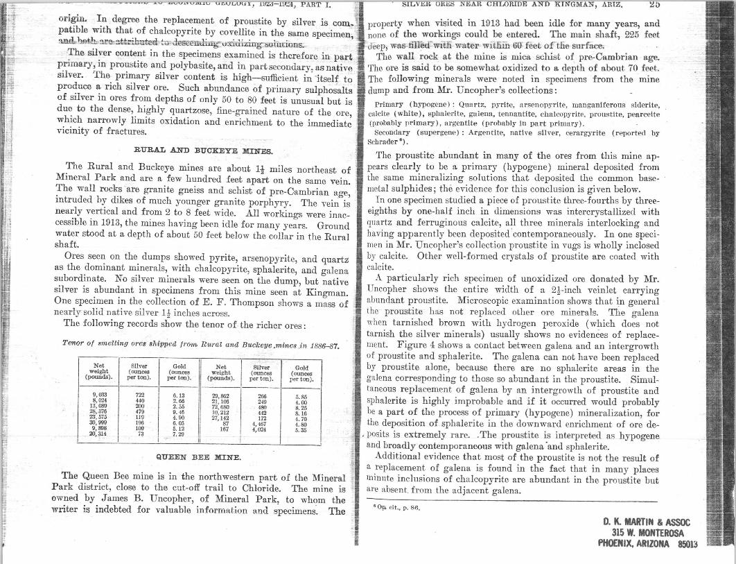
~ i!
t . 1
r : hi fii
ongm. In degree the replacement of proustit.e by 8ilver is com. patible with that of chalcopyrite by covellite in the same specimen, :md. bst:1:L :lJ:'C'::l:ttrilmted: tu clesc~nJ:i.rrg-v:ridi zing:::;.olurions~
The silver content in the specimens examined is therefore in part primary, in proustite and polybasite, and in part secondary, as native silver. The primary silver content is high-sufficient in 'itself to produce a rich silver ore. Such abundance of primary sulphosalts of silver in ores from depths of only 50 to 80 feet is unusual but is due to the dense, highly quartzose, fine-grained nature of the ore, which narrowly limits oxidation and enrichment to the immediate vicinity of fractures.
RURAL AND BUCKEYE MINES.
The Rural and Buckeye mines are about 11 miles northeast of Mineral Park and are a few hundred feet apart on the same vein. The wall rocks are granite gneiss and schist of pre-Cambrian age, intruded by dikes of much younger granite porphyry. The vein is nearly vertical and from 2 to 8 feet wide. All workillo<TS were inaccessible in 1913, the mines having becn idle for many years. Ground water stood at a depth of about 50 feet below the collar in the Rural shaft.
Ores seen on the dumps showed pyrite, arsenopyrite, and quartz as the dominant minerals, with chalcopyrite, sphalerite, and galena subordinate. No silver minerals were seen on the dump, but native silver is abundant in specimens from this mine seen at Kingman. One specimen in the collection of E. F. Thompson shows a mass of nearly solid native silver Ii inches across.
The following records show the tenor of the richer ores:
Teno·r of smelting ores shipped tra.l/1, Rm'al and Buckeye ,mines .in 1886-87.
Net Silver Gold Net Silver Gold weight (ounces (ounces weight (ounces (ounces
(pounds) . per ton). per ton). (pound.). per ton). per too).
9,033 722 G.13 211, 862 266 5.85 8,024 440 2. 116 21,100 249 4.00
13,089 200 2.55 72,680 480 8.25 28,376 479 9. 46 10,212 442 8.16 23,575 119 4.90 27,142 172 4.70 30,999 196 6.05 87 4,467 4.80 9,898 109 5.12 167 4,024 5.35
2O,3H 73 7.29 -J II I
QUEEN BEE MINE.
The Queen Bee mine is in the northwestern part of the Mineral Park district, close to the cut-off trail to Chloride. The mine is owned by James B. Uncopher, of Mineral Park, to whom the writer is indebted for valuable informat.ion and specimens'. The
l)l'operty when visited in 1913 had been idle for many years, and none of the workings could be entered. The main sha.ft, 225 feet
C deep, was tilled-=-willi w.ater witliill 00 feet of the surrace. The wall rook at the mine is mica. schIst of pre-Cambrian age.
The ore is said to be somewhat oxidized t.o a depth of about 70 fe.et. The following minerals were noted in specimens from the mine dump and from Mr. Uncopher's collections:
Primary (hypogene): Quartz. pyrite, arsenopyrite, manganiferous giderite, calcite (white), sphalerite, galena, tennantite. chalcopyrite, proustite, penrcelte (probahly primary), argentite (probably in part primary).
Secondary (supergene) : Argentite, native silver, cerargyrite (reportPfl by Schrader 0) •
The proustite abundant in many of the ores from this mine appears clearly to be a primary (hypogene) mineral deposited from the same mineralizing solutions that deposited the common basemetal sulphides; the evidence for this conclusion is given below.
In one specimen studied a piece of proustite three-fourths by threeeighths by one-half inch in dimensions was intercrystn.llized with quartz and ferruginous calcite, all three minerals interlocking and having apparently been deposited 'contemporaneously. In one specimen in Mr. Un copher's collection proustite in vugs is wholly i.nclosed by calcite. Other well-formed crystals of proustite are coated with calcite.
1\.. particularly rich specimen of unoxidized ore donated by Mr. Uncopher shows the entire width of a 2i-inch veinlet carrying abundant proustite. Microscopic examination shows that in general the proustite has not replaced other ore minerals. The galena when tarnished brown with hydrogen peroxide (which does not tarnish the silver minerals) usually shows no evidences of replacement. Figure 4: shows a contact between galena and an intergrowth of proustite and sphalerite. The galena can not have been replaced by proustite alone, because there are no sphalerite areas in the galena corresponding to those so abundant in the prollstite. Simultaneous replacement of galena by an intergrowth of proustite and sphalerite is highly improbable and if it occurred would probably be a part of the process of primary (hypogene) mineralization, for the deposition of sphalerite in the downward enrichment of ore de-
. posits is extremely rare . . The proustite is interpreted as hypogene and broadly' contemporaneous with galena 'and sphalerite.
Additional evidence that most of the proustit~ is not the result of a replacement of galena is found in the fact that in many places minute inclusions of chalcopyrite are abundant in the proustite but are absent. from the adjacent galena.
• op. cit~ p. 86.
D. It MARTIN & ASSOC 315 W. MONTEROSA
PHOENJX. ARIZONA 8~)la
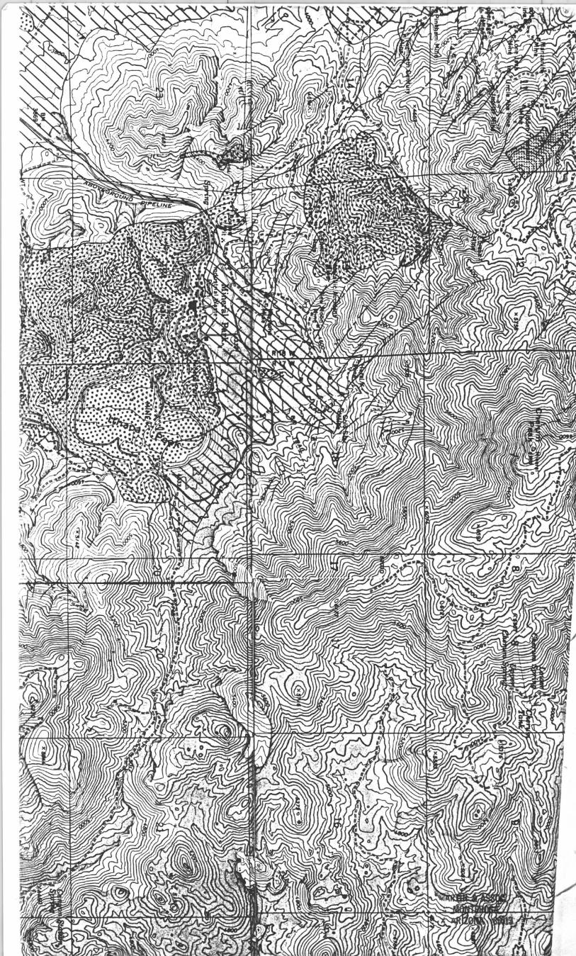
Copyright © 2022 FDOKUMEN