The End of Desertification? - Food and Agriculture ...
556
Disputing Environmental Change in the Drylands Springer Earth System Sciences Roy H. Behnke Michael Mortimore Editors The End of Desertification?
-
Upload
khangminh22 -
Category
Documents
-
view
0 -
download
0
Transcript of The End of Desertification? - Food and Agriculture ...

Disputing Environmental Change in the Drylands
Springer Earth System Sciences
Roy H. BehnkeMichael Mortimore Editors
The End of Desertification?

Springer Earth System Sciences
Series editors
Philippe Blondel, Bath, UKEric Guilyardi, Paris, FranceJorge Rabassa, Ushuaia, ArgentinaClive Horwood, Chichester, UK

More information about this series at http://www.springer.com/series/10178

Roy H. Behnke • Michael MortimoreEditors
The End of Desertification?Disputing Environmental Changein the Drylands
123

EditorsRoy H. BehnkeOdessa CentreGreat Wolford, Shipston-on-StourUK
Michael MortimoreDrylands ResearchMilborne PortUK
ISSN 2197-9596 ISSN 2197-960X (electronic)Springer Earth System SciencesISBN 978-3-642-16013-4 ISBN 978-3-642-16014-1 (eBook)DOI 10.1007/978-3-642-16014-1
Library of Congress Control Number: 2015952050
Springer Heidelberg New York Dordrecht London© Springer-Verlag Berlin Heidelberg 2016This work is subject to copyright. All rights are reserved by the Publisher, whether the whole or partof the material is concerned, specifically the rights of translation, reprinting, reuse of illustrations,recitation, broadcasting, reproduction on microfilms or in any other physical way, and transmissionor information storage and retrieval, electronic adaptation, computer software, or by similar or dissimilarmethodology now known or hereafter developed.The use of general descriptive names, registered names, trademarks, service marks, etc. in thispublication does not imply, even in the absence of a specific statement, that such names are exempt fromthe relevant protective laws and regulations and therefore free for general use.The publisher, the authors and the editors are safe to assume that the advice and information in thisbook are believed to be true and accurate at the date of publication. Neither the publisher nor theauthors or the editors give a warranty, express or implied, with respect to the material contained herein orfor any errors or omissions that may have been made.
Printed on acid-free paper
Springer-Verlag GmbH Berlin Heidelberg is part of Springer Science+Business Media(www.springer.com)

Acknowledgments
In May 2013, the contributors to this volume were invited to attend a meeting inrural Somerset, UK, to present early drafts of their chapters and discuss the orga-nization of this book. This meeting was instrumental in sustaining enthusiasm forwhat became a long process leading to eventual publication. Two organizations—the International Institute for Environment and Development (IIED), in UK, and theFeinstein International Center of Tufts University, in USA—provided the fundingthat made our meeting possible. In particular, we thank Ced Hesse and CamillaToulmin of IIED and Helen Young of Tufts for their personal encouragement andgenerous institutional support. The meeting was hosted by the Odessa Centre Ltd.,directed by Carol Kerven, who also recorded the results of our meeting and lateredited a number of the chapters in the book. Cara Kerven and Tristam Barrettprovided the logistical support and practical hospitality that made the meeting apleasant as well as intellectually gratifying experience. Countless scholars, infor-mants, and assistants have contributed in different ways to the work recorded in thechapters of this book, whose completion represents a truly collaborative effort. Toall these individuals and institutions we owe our deepest thanks.
v

Contents
1 Introduction: The End of Desertification? . . . . . . . . . . . . . . . . . . . 1Roy Behnke and Michael Mortimore
Part I Lessons from the Sahel
2 Desertification in the Sahel: Local Practice Meets GlobalNarrative . . . . . . . . . . . . . . . . . . . . . . . . . . . . . . . . . . . . . . . . . . . 37Camilla Toulmin and Karen Brock
3 Changing Paradigms for People-Centred Developmentin the Sahel . . . . . . . . . . . . . . . . . . . . . . . . . . . . . . . . . . . . . . . . . 65Michael Mortimore
4 Does Climate Change Lead to Conflicts in the Sahel? . . . . . . . . . . 99Tor A. Benjaminsen
5 The Map Is not the Territory: How Satellite Remote Sensingand Ground Evidence Have Re-shaped the Image of SahelianDesertification . . . . . . . . . . . . . . . . . . . . . . . . . . . . . . . . . . . . . . . 117Stefanie M. Herrmann and Tene Kwetche Sop
6 Desertification, Adaptation and Resilience in the Sahel:Lessons from Long Term Monitoring of Agro-ecosystems . . . . . . . 147Pierre Hiernaux, Cecile Dardel, Laurent Kergoat and Eric Mougin
7 Land and Natural Resource Governance: Development Issuesand Anti-Desertification Initiatives in Niger . . . . . . . . . . . . . . . . . . 179Yamba Boubacar
Part II Global Issues
8 Deserts and Drylands Before the Age of Desertification . . . . . . . . . 203Diana K. Davis
vii

9 Where Does Desertification Occur? Mapping DrylandDegradation at Regional to Global Scales . . . . . . . . . . . . . . . . . . . 225Stephen D. Prince
10 40 Years of Climate Modeling: The Causesof Late-20th Century Drought in the Sahel . . . . . . . . . . . . . . . . . . 265Alessandra Giannini
11 The Tragedy of the Common Narrative: Re-tellingDegradation in the American West . . . . . . . . . . . . . . . . . . . . . . . . 293Lynn Huntsinger
Part III Regional and Country Case Studies
12 Pastoral System Dynamics and Environmental Changeon Ethiopia’s North-Central Borana Plateau—Influencesof Livestock Development and Policy . . . . . . . . . . . . . . . . . . . . . . 327D. Layne Coppock
13 Humans Cause Deserts: Evidence of Irreversible Changesin Argentinian Patagonia Rangelands . . . . . . . . . . . . . . . . . . . . . . 363Gabriel Oliva, Juan Gaitan and Daniela Ferrante
14 Interpreting Environmental Changes in the SouthernBolivian Andes: Rural Responses and Political Actions . . . . . . . . . 387David Preston
15 Media Perceptions and Portrayals of Pastoralists in Kenya,India and China. . . . . . . . . . . . . . . . . . . . . . . . . . . . . . . . . . . . . . 407Mike Shanahan
16 Much More than Simply “Desertification”: UnderstandingAgricultural Sustainability and Change in the Mediterranean . . . . 427Mark Mulligan, Sophia Burke and Andrew Ogilvie
17 Land Degradation in Central Asia: Evidence, Perceptionand Policy . . . . . . . . . . . . . . . . . . . . . . . . . . . . . . . . . . . . . . . . . . 451Sarah Robinson
18 Rangeland Degradation Control in China: A Policy Review . . . . . . 491Wenjun Li, Yanbo Li and Gongbuzeren
19 Taking Down the “Great Green Wall”: The Science and PolicyDiscourse of Desertification and Its Control in China. . . . . . . . . . . 513Hong Jiang
Part IV Overview
20 Desertification: Reflections on the Mirage . . . . . . . . . . . . . . . . . . . 539Mark Stafford Smith
viii Contents

Chapter 1Introduction: The End of Desertification?
Roy Behnke and Michael Mortimore
Abstract The opening chapters of this book examine something that neveroccurred but was widely believed to have existed—the late 20th century deserti-fication crisis in the Sahel. Recent advances in climatology and changing weatherpatterns have effectively terminated further scientific debate about the existence ofwidespread Sahelian desertification, providing us with an opportunity to take stockand draw lessons. The logical and empirical shortcomings of the concept ofdesertification have been known for decades but the idea has been institutionalizedat the global level and is remarkably resilient. The middle section of this bookpresents new reasons for concluding that the concept of desertification is no longeranalytically useful and that we should instead struggle to better define and measuredryland degradation. The closing chapters of the book provide case studies fromaround the world that examine the use and relevance of the desertification concept.Despite an increasingly sophisticated understanding of dryland environments andsocieties, the uses now being made of the desertification concept in parts of Asiaexhibit many of the shortcomings of earlier work done in Africa. It took scientistsmore than three decades to transform a perceived desertification crisis in the Sahelinto a non-event. This book is an effort to critically examine that experience andaccelerate the learning process in other parts of the world.
Keywords Desertification � Dryland degradation � UNCCD � Sahel � ChinaIn The End of Nomadism? Humphrey and Sneath (1999) questioned the future ofpastoralism in Inner Asia and challenged the analytical categories routinely used tocharacterize the world’s mobile pastoral systems. The question in the title of thepresent book draws attention to the shortcomings of another, related scientific
R. Behnke (&)Odessa Centre Ltd., 2 the Ridgeway, Great Wolford CV36 5NN, UKe-mail: [email protected]
M. MortimoreDrylands Research, Cutters Cottage, 8 Glovers Close, Milborne Port, Sherborne DT9 5ER,UKe-mail: [email protected]
© Springer-Verlag Berlin Heidelberg 2016R.H. Behnke and M. Mortimore (eds.), The End of Desertification?Springer Earth System Sciences, DOI 10.1007/978-3-642-16014-1_1
1

concept, that of desertification, which has become a political tool of globalimportance even as the scientific basis for its use grows weaker. We shall argue thatthe concept of desertification has ceased to be analytically useful and distorts ourunderstanding of social-environmental systems and their sustainable development,particularly in poor countries with variable rainfall and persistent poverty. In theinterests of better policy and governance, we need to reconsider the scientificjustification and the institutionalized promotion of attempts to combatdesertification.
There are three parts to our indictment:Part I of this book examines something that never occurred but was widely
believed to have existed—the late 20th century desertification crisis in the Sahel—the affair that ushered in the modern ‘Age of Desertification’ (Davis, Chap. 8).Science advances by failing as well as succeeding, and understanding the aetiologyof a misconception can help to prevent its repetition. Recent advances in clima-tology and changing weather patterns in the Sahel have effectively terminatedfurther scientific debate about the existence of widespread desertification in thatregion in the late 20th century, providing us with an opportunity to take stock anddraw lessons. The chapters in Part I also exemplify the methodological sophisti-cation and care with which current research investigates social, political, economicand environmental change in the Sahel, including the politicized nature of thedesertification concept (Chap. 2), the changing paradigms in understandingsocial-environmental systems (Chap. 3), the relations between degradation andconflict (Chap. 4), re-greening through on-farm afforestation (Chap. 5), the com-bination of earth satellite data with ground observations (Chap. 6) and adaptation orresilience of agro-ecosystems (Chap. 7). This work has dispelled the very notion ofwidespread, catastrophic environmental degradation in the region, altered the rec-ommended approach to environmental management, and underscored the need forscientifically informed governance.
The logical and empirical shortcomings of the concept of desertification havebeen known for decades (Chaps. 2 and 3; Mortimore 1989; Thomas and Middleton1994; Warren and Agnew 1988; Swift 1996) but the idea has been institutionalizedat the global level and is remarkably resilient. Part II of this book presents newreasons for concluding that the concept of desertification is no longer analyticallyuseful and that we should instead struggle to better define and operationalize theadmittedly difficult concept of dryland degradation.1 The main planks in ourargument are the pre-scientific and now indefensible set of ideas that generated theterm ‘desertification’ (Chap. 8), the undefined and unquantifiable nature of the
1Drylands receive relatively low precipitation in the form of rainfall or snow and have an aridityindex of <0.65. The aridity index is a measure of the ratio between average annual precipitationand total annual potential evapotranspiration. Drylands can be subdivided into: hyper-arid deserts(<0.05 index of aridity), arid (0.05–0.20 index of aridity), semi-arid (0.2–0.5 index of aridity) anddry sub-humid (0.5–0.65 index of aridity). A further defining characteristic of many (but not all)drylands is a strongly seasonal and sharply variable distribution of precipitation, both within andbetween rainy seasons (UN Environment Management Group 2011).
2 R. Behnke and M. Mortimore

concept on a global or regional scale (Chap. 9), the need and opportunity to sub-sume desertification within a larger framework of global change (Chap. 10), and ourcurrent understanding of rangeland dynamics, which contradicts important aspectsof desertification theory (Chap. 11).
Part III presents regional case studies that document dryland degradation andassess the efficacy of state policies to control degradation in different semi-aridenvironments. Chapters 12–14 and 16 examine the environmental impact of live-stock production and crop agriculture in East Africa, South America and theMediterranean. Chapter 15 looks at how journalists in three countries depict pas-toralists, who are often viewed as one of the main agents of desertification. The finalthree chapters of the book, Chap. 17–19, document a worrying disconnectionbetween policy formulation and environmental research on dryland issues inCentral Asia and China. The use now being made of the concept of desertificationin parts of Asia exhibits uncomfortable parallels to the history of the concept in theSahel, suggesting that a reappraisal of Sahelian desertification is of more thanregional or historical interest.
A final overview, Chap. 20, evaluates the contents of this book in terms of the‘drylands development paradigm’, a recent and authoritative guide to investigatingthe complexities of dryland environments and societies.
1.1 Part I: Desertification in the Sahel: The Meaningof a Non-event
Given the complexity, imprecision and methodological opacity of desertification,the concept has lost its analytical utility for science and practice. Our argumentbegins in the Sahel, where a large literature has developed surrounding the wide-spread use of the concept, where the term itself was popularized, and wheremainstream desertification orthodoxy has now been effectively dismantled by newscientific knowledge.
1.1.1 Crisis Versus Evolution
If desertification denotes an environmental crisis consisting of irreversible degra-dation on a sub-continental scale, then the most significant thing about desertifica-tion in the Sahel is that it never happened. Localized, even severe land degradationcertainly exists in the region. Widespread, long-term degradation of some compo-nents of the environment may also be occurring (Herrmann and Sop on trees,Chap. 5), or not (Hiernaux et al. Chap. 6 on herbaceous and shrub vegetation in thenorthern Sahel). But the care with which researchers now work indicates the subtletyof these long-term environmental trends (Miehe et al. 2010) and, on occasion, thedebatable nature of their existence (Hein and de Ridder 2006; Prince et al. 1998,
1 Introduction: The End of Desertification? 3

2007). While degradation is certainly a reality in the Sahel at some localities or withrespect to certain components of the environment, there is no evidence of a catas-trophic regional environmental crisis: ‘Existing data do not support the claim that theAfrican Sahel is a desertification hotspot’ (Lepers et al. 2005: 122).
In the last century there was a Sahelian crisis, but not one of desertification.Beginning in the 1970s, a prolonged and severe drought caused tremendous humansuffering. This drought was initially seen as ‘a catalyst which exposed the delete-rious effects of long-term degradation by people’ (Thomas and Middleton 1994:27). Recent shifts in rainfall patterns have witnessed the re-greening of much of theSahel (Seaquist et al. 2009; Bégué et al. 2011; Olsson et al. 2005; Anyamba andTucker 2005; Herrmann et al. 2005), and in retrospect it now seems that the mostlyreversible effects of a persistent drought were simply confused with long-termdegradation.
1.1.2 Blame and Response
Destructive land use practices by peasants and pastoralists—primarily primitivefarming techniques and overgrazing—were blamed for causing Sahelian droughtand desertification. In the late 1970s a renowned expert on the Sahel listed thecauses of desertification as: overgrazing, overcultivation, uprooting woody species,borehole drilling and livestock vaccination campaigns (Le Houérou 1977); theUNCOD in 1977 identified overcultivation, overgrazing, deforestation and mis-management of irrigated cropland (Thomas and Middleton 1994). It was arguedthat by removing vegetation, traditional agriculture exacerbated erosion andincreased the reflectivity of the earth’s surface, permanently shifting the regionalclimate towards more arid conditions (Charney et al. 1975). This argument waseventually refuted by climatological research summarized and discussed in detail byGiannini in Chap. 10. Climatological research demonstrated that the immediatecause of the great Sahel droughts had not even been terrestrial in origin, but resultedfrom variations in sea surface temperatures, and to the extent that these oceanictemperature anomalies had terrestrial causes, these could be traced to the changingcomposition of the air pollutants emitted in the northern hemisphere. Residents ofthe Sahel had not, as previously asserted, been the agents of their own misery.
The conclusive scientific demise of the Sahelian desertification paradigm onlycame about in the last decade or so, but serious reservations about the standardnarrative emerged in the late 1980s (Mortimore 1989; Toulmin and Brock, Chap. 2).In the intervening decades this counter narrative coalesced into a compelling alter-native explanation of the evolution of Sahelian landscapes and society (Mortimore,Chap. 3), and—in some parts of the Sahel—provided the rationale for innovativetechnical and political responses to the challenge of combining conservation witheconomic development (Boubacar, Chap. 7).
4 R. Behnke and M. Mortimore

1.1.3 Institutionalization
Of the many things that the history of desertification in the Sahel can teach us, alesson about the interaction between science and public policy is possibly the mostimportant. The protracted Sahel drought that began in the early 1970s promotedwidespread concern about desertification and sparked a global political response.As discussed in Chap. 2 by Camilla Toulmin and Karen Brock, desertification hasfor nearly half a century been a formal institutional process, a topic of occasionaljournalistic attention and the subject of an international convention and of envi-ronmental policy in individual nation states. Commitment to the concept ofdesertification goes beyond the scientific community and this has, in retrospect,complicated the attempt to objectively assess its status.
As a global institutional phenomenon, desertification has gone through two mainphases. In the first phase, the United Nations Conference on Desertification(UNCOD), was convened in Nairobi in 1977 in the wake of the Sahel drought ofthe early 1970s, and gave rise to the nonbinding PACD or Plan of Action toCombat Desertification, coordinated by the United Nations Environment Program(UNEP). In the second phase, the PACD, which was supposed to run until 2000 butwas widely perceived to be ineffective, was supplanted at a second UN conference,the Conference on Environment and Development (UNCED) or ‘Earth Summit’held in Rio de Janeiro in 1992. The Rio conference set in motion negotiations tocreate a binding international convention on desertification, which eventually cameinto force in 1994 and continues to operate, the UNCCD or the Convention toCombat Desertification (Toulmin and Brock, Chap. 2).
In neither of these two time periods—from 1977–92 or from 1992 to the present—has the relationship between science and the international desertificationbureaucracy been close or productive. In the initial phase under PACD, UNEPessentially ran an advocacy campaign that exaggerated the extent, severity andthreat posed by desertification, making the official version of desertification a targetfor informed scientific criticism (Thomas and Middleton 1994; Helldén 1991;Tucker et al. 1991):
UNEP limited the scope of knowledge communicated to policy makers through itsexclusive choice of experts and having final say on how knowledge was presented….-favouring the policy domain over the science domain….The casualty of this trade-off wasthe credibility of scientific knowledge (Grainger 2009: 417).
As a result, “when the United Nations finally created the Convention to CombatDesertification (UNCCD) in 1994, policy was seriously disconnected from science”(Toulmin and Brock, Chap. 2, citing Andersson et al. 2011: 306).
If scientists require clarity in the concepts they employ, the politicians andadministrators who create and manage large institutions have other, very pragmaticrequirements. In the search for money and support, they need a problem that isdramatic enough to command immediate attention, simple enough to be quicklygrasped, and general enough to satisfy diverse interest groups; they need what
1 Introduction: The End of Desertification? 5

Jeremy Swift has called a development narrative—a powerful story line with clear,broadly applicable policy implications and urgent funding needs (Swift 1996).
In Chap. 2 Toulmin and Brock explain how such a crisis narrative for the Sahelwas assembled and subsequently challenged. The mainstream interpretation ofdesertification in the UN era initially replicated earlier colonial concerns about therapid expansion of the Sahara as a result of native agricultural practices (Stebbing1935, 1937). These predictions of environmental disaster were sufficiently apoca-lyptic to mobilize money, and the proposed solutions were technical enough toavoid the appearance of political involvement by international or bilateral devel-opment agencies in the affairs of newly independent African states. By the early1990s scientific critiques were effective in blunting some of the more egregiouselements of the crisis narrative, such as inflated estimates of the geographicalexpansion of the Sahara or the confounding of drought with permanent landdegradation (Tucker et al. 1991; Helldén 1991; Olsson 1993). Following the EarthSummit in 1992, the definition of desertification adopted by the UNCCD reflectedthese adjustments. Dropping the desert metaphor and the insistence on either humancausation or permanence, the official definition was sufficiently vague to encompassall kinds of environmental decline—including changes that did not mimic the onsetof desert conditions or were only transitory—by almost any imaginable cause—natural or human:
Desertification is land degradation in arid, semi-arid and sub-humid areas resulting fromvarious factors, including climatic variations and human activities. (United NationsConvention to Combat Desertification, Bonn, Germany: Convention text).
In the decades since ratification, the broad UNCCD definition of desertificationhas permitted the perceived purpose of the Convention to evolve in step withchanging policy concerns and shifts in development theory. In the 1990s officialthinking on desertification began to reflect the fashion for participatory orbottom-up development, and to distance itself (though not entirely consistently, asdiscussed by Toulmin and Brock in Chap. 2) from the older rhetoric of coercion andcentralization (Stiles 1995). Post-2000, desertification has been depicted as apotential security threat, reflecting the emergence of terrorism, state failure andforced migration as international policy concerns (Benjaminsen, Chap. 4). With theincreasing prominence of climate change, desertification has recently been reframedas one part of land degradation ‘in any climatic zone—not just in drylands’ andlinked to wider issues of resilience and adaptation in response to global warming(Reed and Stringer 2015: 27). Finally, as the only legally binding internationalagreement with ‘a dual focus on environmental and developmental concerns’, theUNCCD has also been depicted as a useful mechanism for promoting pro-pooreconomic growth (Middleton et al. 2011: 2).
In sum, the institutionalization of desertification within the UN system hasfostered the conviction that the concept must be relevant to something important.Unconstrained by a precise definition of the phenomenon or by a credible system ofscientific oversight (Grainger 2009) and driven by competition for international
6 R. Behnke and M. Mortimore

funding (Toulmin and Brock, Chap. 2), what this relevance might be has been opento multiple interpretations.
1.1.4 Learning from the Sahel
Part I of this book provides an opportunity to reassess the utility of the concept ofdesertification from the perspective of contemporary research on the Sahel. Becauseit acted as the catalyst for the modern ‘Age of Desertification’ (Davis, Chap. 8), theSahel has been subjected to unusually high levels of scientific scrutiny for a pro-longed period of time. The focus of our argument is not, however, strictly on theSahel itself but on learning from a protracted period of interaction between scienceand environmental policy, in order to make sense of what is happening now in partsof the world that may not be as intensively studied. It took science more than threedecades of work on the Sahel to transform a perceived desertification crisis into anon-event. This book is an effort to critically examine that experience and acceleratethe learning process.
Michael Mortimore (Chap. 3) provides an overview of what we now know aboutthe state of the Sahel environment. He argues that there is little evidence across abroad range of indicators—forest cover, rangeland condition, soil fertility or overallbiological productivity—for an irreversible decline in the Sahelian environmentsince the middle of the 20th century. There is, on the other hand, ample evidence forhigh and occasionally destructive levels of environmental variability, a reality thatresidents of the Sahel have adapted to with remarkable success despite poverty,political marginality and rapid population growth.
A reappraisal of the relationship between Sahelian society and its environment istherefore required, what Mortimore characterizes as a shift from a desertification toa resilience paradigm. In the desertification paradigm, humans cause irreversibledegradation by disturbing the inherent stability of their natural environment. Inresponse, technical solutions are externally imposed on local communities, whichare perceived to be the source of the problem, and biophysical variables are used tomeasure success or failure. Alternatively, in the resilience paradigm, local resourceusers adapt to a variable environment that they cannot control, and their responsesprovide temporary solutions to a shifting set of problems and opportunities.Mortimore closes with a plea for a decentralized approach to development thatrespects the ingenuity and effectiveness of these responses and seeks to build onthem.
Yamba Boubacar (Chap. 7) provides a concrete example of how Niger adoptedand then implemented just such a decentralized approach. Innovation in Niger’scase was a response to multiple crises—an extended drought (1972–84) thatundermined the livelihoods and destroyed the working capital of rural households,accompanied by government indebtedness and currency devaluation. In response,in the 1980s government abandoned a centralized forestry strategy that was mod-elled on colonial policy and ‘switched from protecting forest reserves to the overall
1 Introduction: The End of Desertification? 7

management and use of plant resources’. The technical centrepiece of this effort wasa new method for clearing farmers’ fields that encouraged the retention and naturalregeneration of indigenous trees. Equally essential, however, were political changesat the national level, new land laws that recognized the property rights of ruralpeople, and programmes to enhance the capacity of local institutions to managenatural resources.
Instead of a purely environmental crisis, the real challenge is to manage linkedprocesses of political, social and environmental change. Chapters 5 and 6 provideexamples of the methodological care with which current research addresses thischallenge in the Sahel.
Stefanie Herrmann and Tene Sop (Chap. 5) document trends in Sahelian woodyvegetation from multiple perspectives: satellite data, ethnobotanical studies, his-torical vegetation surveys, and the analysis of the size class distributions of currenttree populations. While recent remote sensing studies suggest a regreening of theSahel and a general increase in bio-productivity, the field studies reviewed in thischapter document the opposite trend for woody vegetation, including the loss oflarge trees, trees that require wetter conditions, or species that are economicallyvaluable to local inhabitants. In contrast to the general trend, the good news abouttrees comes from farmers’ fields where they are more intensively managed and havebecome more dense and diverse than before the great droughts, a consequence ofthe political processes detailed by Boubacar in Chap. 7:
As farmer-managed natural regeneration has shown, human population growth and agri-cultural intensification do not have to entail losses in vegetation productivity and envi-ronmental degradation …. On the contrary, where sound management is practised, farmers’fields stand out by improved vegetation cover and diversity, while unprotected woodlandsand unmanaged fields continue to degrade (Chap. 5).
Pierre Hiernaux, Cecile Dardel, Laurent Kergoat and Eric Mougin (Chap. 6)present an equally complex picture based on decades of ecosystem monitoring attwo study sites, a sparsely populated pastoral area in Mali and a more denselysettled agro-pastoral region in Niger. In the more arid pastoral study site, vegetationdynamics were erratic, complex, and unpredictable—largely driven by fluctuationsin rainfall and unresponsive to the impact of grazing. At the more humidagro-pastoral site, the expansion of cropland and high concentrations of livestockincreased the spatial heterogeneity of the ecosystem, pushed rangeland resilience toits limits, and left a long-lasting imprint on the landscape, an outcome that someobservers might interpret as ‘degradation’. Long-term monitoring in specific loca-tions—Mali versus Niger, pastoral versus agro-pastoral areas—demonstrates theinadequacy of sweeping generalizations about the Sahel; ecological change is asvaried and locally specific as the heterogeneous social and physical environments inwhich it takes place.
Tor Benjaminsen (Chap. 4) reveals, nonetheless, a continuing appetite in somequarters for broad generalizations—in this instance an alleged connection betweenincreased conflict levels and a scarcity of natural resources. Benjaminsen arguesthat lack of evidence for widespread desertification in the Sahel makes it an unlikely
8 R. Behnke and M. Mortimore

cause of conflict. In two case studies from Mali, he demonstrates that there was alsono correlation between the timing of episodes of conflict and drought periods,making it unlikely that drought directly provoked increased levels of conflict. Therewere, on the other hand, compelling alternative political and historical explanations:state-sponsored agricultural encroachment on pastoral grazing resources,rent-seeking by government officials, the embezzlement of emergency aid, thetemporary retreat of state control over rural areas, and the perceived para-militarysuppression of pastoral regions.
Stepping back from the individual chapters, a common message emerges fromPart I. In considerable measure, science grows by making mistakes, acknowledgingthem, and moving on. With respect to the science on desertification in the Sahel,this process of rejection, invention and rejuvenation has been complicated becausedesertification is not simply a scientific concept. It also provides a basis for publicpolicy and for the funding of global institutions, and concepts that are useful for thispurpose often do not provide a convenient platform for the conduct of impartialscience. Publicists, administrators and politicians active in the public arena thriveon crises and on unequivocal prescriptions for addressing crises. Careful sciencetends to deflate and moderate this rhetoric: Crisis degrades into evolution, envi-ronmental collapse becomes a problematic process of environmental change, localresource users are transformed from environmental villains into potential collabo-rators in conservation and development. There would seem to be an inherent ten-sion, well illustrated by the history of ideas about desertification in the Sahel,between science that is flamboyant enough to be politically influential and yetcautious and complex enough to withstand scrutiny. Walking this tightrope is arecurrent challenge for research conducted in the service of public policy.
1.2 Part II: Challenging the Desertification Model
Several papers in this collection raise new questions about the continued relevanceof the concept of desertification, both for the Sahel and for drylands more generally.
1.2.1 If You Can’t Define It You Can’t Measure It,and if You Can’t Measure It You Can’t Map It
Diana Davis (Chap. 8) and Stephen Prince (Chap. 9) address the same questionfrom very different perspectives—‘What is desertification?’ Davis answers thisquestion historically; Prince argues that the concept remains vague and cannot bedefined operationally. Taken in combination, these chapters suggest that, despite aplethora of definitions and decades of discussion, we still do not know—and maynever know—exactly what we mean by desertification.
1 Introduction: The End of Desertification? 9

The concept of desertification is not a 20th century invention; it was a product ofearly European scientific and prescientific thinking that survived virtuallyunchanged into the 20th century. Desertification is a variant of desiccation theory,‘the idea that deforestation causes the climate to dry out and diminishes rainfall’, atheory that was widely accepted in European scientific and philosophical circles inthe 18th and 19th centuries (Chap. 8). It was the French in their North Africancolonies who first applied desiccation theory to semi-arid environments andinvented the concept and term ‘desertification’—the creation or expansion ofdeserts by people. In North Africa the French colonial authorities invoked deser-tification to explain the impoverished condition of the natives in what appeared tobe a degraded landscape. Avoidable environmental mismanagement by the nativeshelped rationalize the need for French imperial rule, for the reallocation of land toEuropean settlers, and for the criminalization of native agricultural practices (Davis2007). From their North African possessions, French administrators and scientistscarried the desertification concept across the Sahara into West Africa. Chapter 8traces these historical linkages, step by step, showing how colonial experts even-tually provided the basis in the 1950s for UNESCO’s Arid Zone Program, which inturn provided the background for the UN Conference on Desertification convenedin 1977, and ultimately for the UNCCD, ratified in 1996.
As Davis makes clear in Chap. 8, the mid-20th century image or metaphor ofdesertification was perfectly clear, widely shared, and centuries old: It referred towhat Bovill (1921) called the encroaching Sahara, a human-created desert where adesert did not naturally occur, ‘a living environment becoming irreversibly sterileand barren’ (Nicholson 2002: 51). The problem with this metaphor was that it hadbecome scientifically indefensible by the early 1990s (Toulmin and Brock, Chap. 2).Driven by political expediency, the response to this impasse was not to abandon theconcept as untenable, but to expand it. The negotiations that created the UNCCDwere dominated by differences between developed and developing countries con-cerning the purpose of the new Convention (Corell 1999). Political support for theConvention ‘rested on the diplomatic artifice of ambiguity’ predicated on ‘a con-sensus definition of the problem agreed in negotiations at UNCCD …[that]formalized the ambiguous roles of environmental degradation and drought [in thedesertification concept]’ (Grainger 2009: 419). If artful compromise trumped sci-entific clarity in the construction of the Convention, it continued to do so with itsimplementation. Writing in 2009, Grainger’s estimation of the chances forimproving scientific inputs into the official desertification regime was poor: ‘Socialorder between developed and developing country Parties [is maintained] by meansof [a]… combination of narratives compatible with both sets of discourses….Betterscientific inputs could puncture the ambiguity on which the political viability of theCCD depends’ (Grainger 2009: 425). As late as 2012, the UNCCD remained theonly ‘Rio Convention’ without a functioning or proposed independent intergov-ernmental scientific body ‘to guide policymakers’ considerations of scientific evi-dence that is credible, relevant and legitimate’ (Thomas et al. 2012: 123).
In Chap. 9 Stephen Prince documents the lingering scientific consequences ofthis political process: our inability to quantify and map either the global extent or
10 R. Behnke and M. Mortimore

severity of desertification. In the mid-1990s desertification was characterized as a‘blanket term for a whole range of specific biological, chemical and physicalchanges in the environment’ whose ‘breadth rendered its actual use impractical, forexample in terms of attempts to quantify desertification’ (Thomas and Middleton1994: 9). In Chap. 9 Prince argues that little has changed: Desertification remains ‘anebulous, all-encompassing concept’ that ‘is not a single phenomenon … and istherefore incapable of simple measurement’ (Chap. 9). As a result, existing globalmaps of desertification are often based on subjective assessments by experts andcannot be replicated or used for monitoring. Moreover, there is no general agree-ment between different global map sets and there are no strong correlations betweenthe levels of desertification depicted in the maps and the environmental variablesthat are generally thought to cause degradation: ‘Consequently, unsupportedstatements about the extent and severity of desertification abound,’ (Chap. 9).Prince concludes that ‘Progress will be difficult unless the unitary concept ofdesertification is abandoned’ in favour of measuring aspects of land degradation—changes in vegetative biomass, the responsiveness of the vegetation to rainfall, orrates of soil erosion, for example—that are each susceptible to quantification(Chap. 9). These scientific advances are, however, dependent on institutionalreform, including ‘independent organizations at national, regional and global scalesto undertake routine monitoring’ and ‘technically credible leadership, free fromexternal pressures … to address the issues of degradation at international-globalscales and to harmonize policy-relevant research, monitoring and interpretation’(Prince, Chap. 9). As ever, desertification research remains enmeshed in globalpolitics.
1.2.2 From Regional Desertification to Global ClimateChange
Given the centuries of desiccation theory that preceded the ‘Age of Desertification,’it may have been ‘intuitive,’ as Alessandra Gianinni notes in Chap. 10, forresearchers in the 1970s to look to regional land use to explain regional climatechange. At that time the attractiveness of a desiccationist interpretation was alsoreinforced by the emergence of a new mechanism that purported to explain howdesiccation worked: the albedo effect. According to this theory, by reducing veg-etation cover, desertification altered the reflectivity of the earth’s surface and causeddrought, which further reduced the vegetation cover, causing more drought—adegenerative biophysical feedback process (Charney 1975; Charney et al. 1975). Atthe bottom of this spiral of causation were the usual suspects—expanding numbersof local land users who were denuding the landscape—which set the stage for thestandard remedies—population control, afforestation (Xue and Shukla 1996), andthe reduction of livestock numbers (Otterman 1974). Desiccation theory had, in itsessential features, been updated for the 20th century.
1 Introduction: The End of Desertification? 11

As Gianinni observes in Chap. 10, since the early work of Charney and hisassociates, regional models of land-atmosphere interactions have become increas-ingly sophisticated with the inclusion of more variables (such as soil moisture) anda more realistic depiction of these variables (Taylor et al. 2002). As a result, ‘It hasbecome increasingly clear that the processes by which anthropogenic land usechange can reduce precipitation are physically plausible, and consistent with anatural positive feedback response of the land surface to precipitation’ (Gianinni,Chap. 10). What the regional land-surface models could never explain, however,was the magnitude of the Sahel droughts, which were simply too big to be causedby observable levels of land use change in the region. A resolution to this impasseonly occurred when climatologists turned to simulating the timing rather than theamplitude of rainfall fluctuations, and did so by looking at the Sahel climate from aplanetary rather than a regional perspective.
As Gianinni explains, over the last century in the Sahel, alternating periods ofhigh and low rainfall—such as the wet 1950s and 1960s followed by persistentlydry conditions at the end of the 1960s, or the regreening currently taking place—areall correlated with global variations in sea surface temperatures. Dry periods in theSahel are the consequence of elevated sea surface temperatures in the tropicaloceans combined with cooler conditions in the north Atlantic (Palmer 1986; Follandet al. 1986). In the case of the great Sahel droughts at the end of the 20th century,the warming of the equatorial Indian Ocean and south Atlantic was caused bygreenhouse gas emissions, while the cooling of the northern oceans was, aside fromnatural variation, caused by sulphate aerosol pollutants from the northern hemi-sphere (Gianinni, Chap. 10). Air pollution from greenhouse gasses continues, andso does the warming of the world’s oceans; pollution from sulphate aerosolsincreased until the mid-1980s and has declined since the introduction of legislationaimed at controlling acid rain in North America and Europe. Both the great Saheldrought and current regreening trends reflect these pollution-driven shifts in oceanictemperature:
As warming of the tropical oceans began to emerge in the 1970s, the reduced warming ofthe North Atlantic … starved the African continent of the moisture needed to trigger deepconvection, causing persistent drought. Now that the North Atlantic has reversed its trendand is warming, a wetter Sahel has become possible, as manifest in a “partial recovery” ofthe rains since the mid-1990s (Gianinni, Chap. 10).
Droughts in the Sahel are primarily caused by oceanic temperatures, but may besuppressed or amplified by land use changes in the Sahel itself. This conclusionshifts the primary blame for the great 20th century Sahel droughts from local toglobal anthropogenic influence:
In response to our best estimates of global sea surface temperature, state-of-the-art atmo-spheric models require no information on human-induced land cover/land use change toreproduce Sahelian drought. These simulations lead to the conclusion that drought wascaused by large-scale, if subtle, shifts in oceanic temperatures, not by local anthropogenicpressure on the environment (Gianinni, Chap. 10).
12 R. Behnke and M. Mortimore

1.2.3 Beware the Charismatic Story
Managed grazing systems—i.e., pastoralism broadly conceived—occupy about aquarter of the earth’s land surface and are the most widespread form of land use onthe planet, and dryland biomes—savannahs, grasslands, shrublands and deserts—contribute over three quarters of the world’s total grazing area (Asner et al. 2004).Given the global importance of drylands and of grazing in drylands, if the conceptof desertification is to have any utility, it must contribute to a better understandingof the impact of extensive livestock production on these environments. Reflectingthis imperative, seven chapters in this book—Chaps. 6, 11–18—focus on range-lands and various forms of pastoralism and livestock farming.
In Chap. 11 Lynn Huntsinger re-examines the ‘founding narrative’ of therangeland management profession in America—the widely accepted story of howhuman greed and uncontrolled resource exploitation degraded the ‘pristine’ range-land ecosystems of the American West. Huntsinger argues that this ‘declensionist’reading of Western history as a process of decline has been reinforced by an equallydeclensionist interpretation of Western range ecology, and that both are flawed.
Huntsinger limits her social and biological critique to a re-examination of theAmerican experience, but her analysis has wider implications. In the 1970s whendesertification was institutionalized globally, classical American rangeland man-agement of the sort discussed by Huntsinger was influential far beyond the bordersof the United States. In its classical form, the discipline was predicated onClementsian theories of plant succession leading to climax vegetation, concepts ofrangeland condition that identified good and bad plants, a paramilitary commitmentto fire suppression, and an authoritarian approach to resource management. If theseideas have now been found inappropriate in their homeland, as Huntsinger suggestsis the case, then a reappraisal of their global significance is overdue.
Effective story telling has been part of the problem. Stories, Huntsinger argues,are dangerous because they are such a powerful form of communication. Thetheories of rangeland ecology that dominated North American and much of the restof the world for most of the 20th century were essentially stories—powerful sim-plifying narratives with moral implications. These stories were persuasive becausethey contained a considerable element of truth, but they were fundamentally mis-leading because their clear story lines excluded the complications, qualificationsand exceptions that litter more balanced but less exciting accounts of reality. By thelate 1980s, however, complications, qualifications and exceptions finally over-whelmed the simple Clementsian succession story, resulting in a more accurate andeffective model of vegetation change—the states and transition format based onnonequilibrium theory. Alas, as Huntsinger emphasizes, this was an explanatoryframework without a plot:
Unfortunately, the “multiple stable states” model of vegetation change does not have thesame simple, moralistic and appealing story as linear succession—there really isn’t abeginning, end, or moral lesson. There is a site, it rains and things change or it doesn’t rain
1 Introduction: The End of Desertification? 13

and things change. Changes may be permanent. Rainfall is unpredictable and not influencedby human actors. We need to watch, experiment, and record to learn what is going on.
The role of grazing in this scenario is one of many interacting dramatic changes, andchanges without directionality. Removal of grazing may have little or no impact, andthreshold dynamics may result in multiple stable states that have little to no relation to a“climax” or previously identified “potential” vegetation. There is no simple story here.
The state and transition format may be scientifically robust but it creates, inHuntsinger’s words, a ‘narrative vacuum,’ a natural world populated by plants thatlack a ‘moral compass’, plants without a human story to tell. In North America,Huntsinger argues that commercial interests purveying a mixture of story-tellingand pseudo-science have filled the narrative vacuum created by the retreat of theClementsian consensus.
If science is to regain the initiative and influence public policy, it must providean interpretation of rangeland dynamics that is empirically adequate and yet simpleenough to engage non-scientists. Drawing on research that provides the backgroundto the present book, the following section argues that range science is movingtowards such a synthesis.
1.2.4 Contemporary Range Science and the DesertificationParadigm
The following discussion examines the intellectual equipment—the concepts, the-ories and some of the field evidence—that can now be brought to bear on questionsabout the impact of extensive livestock production on rangeland environments.There are at least three practical questions that a non-specialist policy maker wouldwant answered about the relationship between livestock and desertification:
• When livestock change vegetation, what kinds of changes should be characterized as‘degradation’ or desertification?
• Under what circumstances is livestock grazing likely to cause changes in rangelandvegetation?
• How can rangelands be managed to limit degradation?
Contemporary range science provides answers to these questions that are dif-ferent from those that prevailed in the 1970s and 1980s when desertification wasfirst institutionalized in the UN system. In part these differences reflect scientificprogress. Equally important, however, are the changes that have happened on therangelands in the succeeding decades, particularly to pastoralists in developingareas. Subsistence-oriented livestock producers have been incorporated into com-mercial markets, increasingly adopting husbandry practices dependent upon pur-chased inputs and orientated to the production of commodities for sale. In someareas traditional migratory systems of livestock production are also in decline, for avariety of reasons including conversion of key pastoral resource areas to otherforms of land use, the fragmentation and privatization of communal lands, theimportance of markets and services that anchor families to settlements, and the
14 R. Behnke and M. Mortimore
availability of new technologies—from water development, to feed supplementa-tion or disease prevention—that render some kinds of movement unnecessary.These developments have blurred one of the standard dichotomies of desertificationorthodoxy—the contrast between the primitive nomad and the modern, sedentarylivestock producer. Taken in combination with advances in our understanding ofrangeland ecology, these changes suggest new answers to the practical resourcemanagement questions enumerated above, answers that fundamentally challengethe concept of desertification.
The following three sections of this introduction outline some contemporaryanswers to our three management questions. We focus on grazing and rangelandissues because they have been central to the desertification debate since its incep-tion, and clearly illustrate the relationship between science and environmentalpolicy. It is important to note, however, that livelihood systems based on croppingor on mixed crops and livestock, routinely support larger human and animal pop-ulations than specialized livestock production and deserve consideration in theirown right. With increasing market integration, dryland farming, like pastoralism, isalso undergoing a transition to different and potentially higher levels of acceptedrisk. The land changes associated with these processes have been characterized asdesertification in reports and publications targeted at policy makers and generalreaders. Equally, however, some recent policy-oriented analyses simply forgo theuse of the term desertification, preferring to employ less prescriptive frameworkssuch as soil fertility management, resilience and agricultural intensification. Whilenot reviewed here, these trends are fully discussed in a number of recent UNpublications and development reports (Mortimore et al. 2009; UN EnvironmentManagement Group 2011; UNCCD/UNDP 2011; Davies et al. 2012).
1.2.4.1 When Is Vegetation Change Degradation?
‘Desertification’ connotes harmful environmental change, which implies an abilityto distinguish between harmful and beneficial changes. In the 1970s, late successiongrasses, especially perennials, represented both good livestock feed and the naturalclimax vegetation, and loss of such plants was routinely construed as evidence ofdegradation. Contemporary research suggests a more complicated situation inwhich the history of grazing in a region has an important influence on degradationprocesses (Milchunas et al. 1988). In areas that were not exposed to high levels ofungulate grazing prior to the introduction of livestock, such as parts of thesouth-western United States or Australia, degradation is often an unambiguousprogression in which the later stages of environmental disruption become ever moreexpensive or time-consuming to reverse, or are irreversible (Schlesinger et al. 1990;Ludwig et al. 2004). But the situation is not always this clear-cut.
In much of Eurasia, Africa and North America, grazing by large hoovedmammals—either domestic or wild—has contributed to creating the existing veg-etation, and it would be misleading to characterize grazing as an unnatural dis-turbance. In these circumstances, the attributes that might be used to identify
1 Introduction: The End of Desertification? 15

rangeland condition—particular kinds of plants, high levels of plant productivity,livestock productivity or biodiversity—are not consistently linked to one another, orto grazing intensity. Three case studies from regions with a long evolutionaryhistory of grazing—the rangelands of South Africa, the North American prairie, andthe Mediterranean Basin—illustrate the complexities of environmental change inthese environments.
In South Africa, a nation-wide study concluded that heavy grazing altered thecomposition of plant communities by increasing the proportion of annuals andfavouring opportunistic, grazing-resistant species with low palatability and foragequality—weedy, grazing-induced degradation from the perspective of climaxvegetation. Despite these changes in species composition, at none of the veryheavily utilized communal rangeland sites was there a decline in species richness—degradation defined in terms of the loss of plant biodiversity (Rutherford andPowrie 2013).
The maintenance of an imagined ‘climax’ vegetation may also conflict withwildlife biodiversity. In the United States the most rapidly declining kinds of birdsare those associated with rangelands, and these declines coincided with nationwideimprovements in rangeland condition and health, as defined by Clementsian suc-cession theory (Fuhlendorf et al. 2012). Many of the bird species that suffered werethose that required disturbed ground and low vegetation structure caused by heavygrazing or fire. In terms of the habitat requirements of North American semi-arid birdpopulations, there was no single livestock stocking rate or type of vegetation that metthe needs of all species. Instead what was beneficial was a diversity of differenthabitats—a high level of local, botanical variability caused by different levels ofgrazing intensity (Fuhlendorf et al. 2006, 2012; Fuhlendorf and Engle 2001).
In a wide-ranging review, Seligman and Perevolotsky concluded that ‘grazing bydomestic ruminants is seldom irreversibly destructive to landscape values’ for winterrainfall regimes of the Mediterranean Basin (Seligman and Perevolotsky 1994: 93–4;Perevolotsky and Seligman 1998). Animal output per unit area was also higher underheavy grazing and primary production was not reduced (Crespo 1985; Gutman et al.1990). As in South Africa, the herbaceous plant community formed under veryintensive grazing was no less diverse or rich in species than less disturbed vegeta-tion, but the composition was substantially altered (Hadar et al. 1999).
The preceding cases illustrate the difficulties of identifying botanical indicatorsof degradation in environments long exposed to grazing. In South Africa and theMediterranean Basin heavy grazing produced changes in the composition of pas-tures as grazing-tolerant plants replaced ones that were grazing intolerant, but withno loss in diversity or species richness, and, at least in the Mediterranean, with noloss of livestock productivity. In North America, intense but localized grazing thatwould traditionally constitute overgrazing was essential to the survival of certainspecies of wildlife. Cases like this suggest that degradation cannot be identified withparticular kinds of plants or assessed according to a single metric—be it biodi-versity, primary or secondary production. A more realistic measure of environ-mental resilience may instead be the maintenance of diverse landscapes capable ofsustaining different production systems, species and environmental services. Instead
16 R. Behnke and M. Mortimore

of asking how drylands can be managed to limit desertification, we might insteadask how they can be managed to maximize this heterogeneity.
1.2.4.2 Under What Circumstances Is Grazing Likely to CauseVegetation Change?
The threat posed by spreading deserts or ‘desert edge displacement’ (Veron et al.2006) was a central component of the early desertification literature (Lamprey1988; Aubréville 1949), as was the perception that drylands were fragile environ-ments especially prone to degradation.
The non-equilibrium theory of grazing systems dramatically reversed thisassessment (Ellis and Swift 1988). Part of the resilience of semi-arid rangelands canbe attributed to the characteristics of the plants themselves. Some semi-arid grassesare robust to grazing because the evolutionary adaptations that promote survival todrought also equip them to evade, resist or tolerate large herbivores (Coughenour1985). More important, however, is the response of livestock populations to severedroughts, which occur frequently in regions of low rainfall. Following droughts,herd sizes recover slowly and the vegetation has an opportunity to rebound in theabsence of significant grazing pressure (Ellis and Swift 1988).
In areas subject to low and erratic rainfall, recurrent livestock population crashesalso suppress livestock numbers over the long term. As a result, in the absence offeed supplementation, herbivore biomass per unit of plant biomass—i.e., the her-bivore load relative to primary production—increases exponentially with averageannual rainfall (Oesterheld et al. 1998; McNaughton et al. 1989; Fritz and Duncan1994). Subjected to both more constant and increased grazing pressure, vegetationin high rainfall areas is more exposed than in low rainfall areas to the effects ofgrazing (Coppock, Chap. 12).
This conclusion is supported by a global meta-analysis that discovered noinstances of widespread or zonal vegetation change—i.e. change on a spatial scalethat might qualify as desertification—in non-equilibrium rangelands with suffi-ciently high levels of rainfall variability (von Wehrden et al. 2012). The samepattern emerges when grazing systems are examined along a rainfall gradient in asingle region. As Hiernaux et al. explain in Chap. 6, grazing leaves little imprint onthe vegetation in more arid areas of Mali but has a significant impact under morehumid conditions in Niger.
Mongolia provides another well-researched example. In Mongolia, grazingpressure was of minor importance and weather conditions determined vegetationcharacteristics at the arid end of the rainfall gradient, but differences in grazingpressure had an increasingly marked effect on vegetation under more humid con-ditions (Fernandez-Gimenez and Allen-Diaz 1999, 2001; Zemmrich et al. 2010),and degradation became more of a concern as the level and reliability of rainfallincreased (Wesche et al. 2010; Stumpp et al. 2005; Khishigbayar et al. 2015).
1 Introduction: The End of Desertification? 17

Similar results emerged from a long-term study in Senegal that substituted atemporal for a spatial rainfall continuum (Miehe et al. 2010). In an area that hadexperienced shifts in weather conditions, fluctuations in precipitation drove vege-tation change and masked the effects of grazing during a run of dry years withvariable rainfall. However, in a wetter phase when rainfall variability had declined,grazing caused changes in the species composition of the vegetation that might beconstrued as degradation (Miehe et al. 2010). Contrary to the anxieties about‘desertification’ that typically emerge in times of drought, in Senegal the risk ofgrazing-induced vegetation change coincided with periods of higher rainfall.
There are exceptions to the association between aridity and reduced grazingimpacts. Some of these exceptions can be attributed to the susceptibility of certaintypes of vegetation to grazing (Oliva et al. Chap. 13; Todd and Hoffman 2009;Hacker et al. 2006). Problems also occur when mobility is too successful atbuffering migratory livestock populations from feed shortages. This possibilityarises when mobile herds have access to large areas of grazing that are insensitive toheavy use during periods of feed scarcity—extensive marshes or floodplains, forexample. The reliable food supplies available in these areas can mitigate the effectsof an erratic climate and sustain livestock populations that are large enough todamage vegetation that is vulnerable to grazing in adjacent areas (Illius andO’Connor 1999).
By far the most common exceptions to the nonequilibrium model are caused bydifferences in the way livestock are managed (Briske et al. 2003; O’Connor 1995).With access to feed supplementation, water development and markets, commercialranchers have an enhanced ability to suppress fluctuations in livestock populationscaused by variable weather conditions, removing the periods of low grazing pres-sure that buffer arid rangelands from the impact of livestock. Under these condi-tions, episodic fluctuations in rainfall may produce the most visible vegetationresponses, ‘but these changes are unlikely to be directional provided there is nolong-term rainfall trend. In contrast, the response of a species to heavy grazing is …generally unidirectional … and although year-by-year changes due to grazing aresmall, they are cumulative (O’Connor 1995: 59). While the immediate effects ofgrazing may not be dramatic, managers with sufficient resources at their disposalcan override the climatic constraints that would otherwise protect arid rangelandsfrom livestock-induced degradation (Ellis and Lee 2003).
Most livestock owners would like to reduce their exposure to climatic variabilityand there is increasing evidence that producers in developing areas are nowacquiring industrial inputs that make this possible. The most important of theseinputs are purchased or home-grown feed supplements, the construction of artificialwater points, and enhanced disease prevention—all of which suppress livestockpopulation crashes and increase livestock productivity. Unless these interventionsare combined with management practices that ensure the periodic resting ofrangelands, they also increase the risk of long-term resource degradation (Vetterand Bond 2012; Vetter 2005; Hary et al. 1996; Miehe et al. 2010; Müller et al.2007; Li et al. Chap. 18).
18 R. Behnke and M. Mortimore

Arid rangelands are not the fragile, degradation-prone environments of theorthodox desertification paradigm, but they are currently under stress, not from thenomadic menace of the older narrative, but from intensification and commercial-ization processes that are at once economically attractive and environmentallychallenging.
1.2.4.3 New Approaches to Managing Extensive Grazing Systems
Since the 18th century, proponents of desertification have identified nomadism withenvironmental destruction (Davis, Chap. 8). By the 20th century, the standardantidote to nomadism, modelled on commercial ranching in developed countriesand promoted by numerous donor-financed livestock development projects, wassettled ranching and rotational grazing.
Designed to move livestock on a predetermined schedule through a sequence offenced paddocks, rotational grazing schemes were promoted as the modern, orderly,and scientifically endorsed alternative to the presumed randomness and environ-mental destructiveness of migratory movement. Despite the lingering popularity ofrotational systems among some commercial ranchers and rangeland professionals,research has repeatedly demonstrated that fenced systems of grazing rest androtation do not reliably increase plant or livestock production in arid and semi-aridrangelands (Heady 1961; O’Reagain and Turner 1992; Briske et al. 2008). Asscientific confidence in rotation grazing systems has eroded, there has been a steadyadvance in the understanding of the ecological processes that underpin wild animalmigrations, which sustain some of the greatest concentrations of animal biomass onearth. Migration also has a measurable impact on the productivity and viability offree-ranging animal populations, both domesticated and wild, and on the state of theresources that they use (Milner-Gulland et al. 2011).
For our understanding of desertification, the significance of these findings lies ina revaluation of the implications of rangeland heterogeneity. By forcing livestockon a predetermined schedule through a sequence of relatively small fenced areas,often at high densities and for short periods of time, rotational systems attempted tosuppress selective grazing and distribute animals evenly across a landscape, andmade little attempt to exploit the temporal and spatial variability in forage qualityand quantity that is an inherent feature of many dryland environments (Fynn 2012).Migratory systems—both in developing (Behnke et al. 2011; Butt 2010; Butt et al.2009; Moritz et al. 2013) and industrial settings (Huntsinger et al. 2010; Hubandet al. 2010; Baena and Casas 2010; Abreu et al. 2010)—take a different approach,seeking to exploit rather than suppress rangeland heterogeneity. These systemsencourage livestock to track the best grazing areas available on a seasonal basis, torespond to unpredictable episodic variations in the location of favourable andunfavourable areas, and to exploit the distinctive features of individual localities.Benefits derived from this kind of movement include higher growth rates for mobileherbivore populations (Wang et al. 2006), the creation of grazing-induced lawns ofhighly nutritious forage (Hempson et al. 2014); mitigation of the effects of drought
1 Introduction: The End of Desertification? 19
(McAllister et al. 2006); higher sustainable stocking rates (Boone and Hobbs 2004);and facilitation of the co-existence of wildlife and livestock (Western et al. 2009).
Different criteria are also relevant for identifying harmful vegetation changes inmigratory systems. The grazing gradients that occur around water points and set-tlements have for decades been central to the argument that pastoralism is a majorcause of desertification (Sinclair and Fryxell 1985). Herbaceous plants in theheavily used ‘sacrifice zones’ adjacent to water points or settlements tend to beshort, quick-growing annual species well adapted to defoliation and trampling, butproviding small quantities of forage—unattractive grazing weeds in terms of atraditional Clementsian classification. However, these heavily grazed plant com-munities often provide forage of high nutritional quality (García et al. 2014; Vetterand Bond 2012), albeit for short periods of time (Anderson et al. 2010; Andersonand Hoffman 2007). While the ephemeral nature of these feed sources may renderthem unsuitable for permanent use, their transitory productivity is well suited tomobile systems that exploit resources during periods of optimal productivity andthen move on to new areas and other kinds of resources (Bollig and Schulte 1999;Thomas and Twyman 2005). Increased spatial scale facilitates these migratorysystems but is not an absolute requirement. Recent work has extended the principleof heterogeneous resource exploitation to private properties in which movementtakes place over shorter distances (Fynn 2012; Bailey and Brown 2011; Hempsonet al. 2014).
Mobile livestock production is not suited to all natural environments or to theneeds of all producers. In some regions mobility is not a realistic alternative becauseresources are evenly distributed in space or fluctuations in their productivity areinappropriately timed. In other settings, the pressures of population growth or theadvantages of agricultural intensification may render mobility impossible or make itunattractive. At the extensive margins, however, there are and will remain largedryland areas suitable only to low-input livestock production. Contrary to thedesertification paradigm, for these marginal drylands, the scientific rationale for theenvironmental and economic benefits of mobility is stronger than ever.
1.2.5 Summing up the Challenge to Desertification
Nearly a decade ago Veron, Paruelo and Oesterheld undertook an assessment ofdesertification (2006). Their review noted many of the difficulties highlighted in thisbook—exaggerated journalistic accounts of the extent of the desertification threat, aplethora of competing definitions, and flawed attempts to measure the extent orseverity of the problem. Despite these shortcomings, their appraisal concluded onan optimistic note:
20 R. Behnke and M. Mortimore

There are no reasons to believe that desertification ecology faces harder challenges thanother disciplines (e.g. the definition of invasive species in invasion ecology, or of endan-gered species in conservation ecology) (Veron et al. 2006: 760).
According to this passage, desertification studies are like any other scientificsub-discipline: Growing pains are inevitable and temporary setbacks are to beexpected and overcome. We are sceptical of this conclusion and the chapters in thisbook explain why.
When it comes to understanding and controlling desertification, scientists havenot been the only interested party. From its inception to the present, desertificationresearch has been targeted at and deeply involved in the formulation of publicpolicy. The idea of desertification that was broadly accepted until the late 20thcentury labelled a clearly defined process: desert encroachment caused bydestructive land use practices and population growth in dryland areas. This visionwas sufficiently apocalyptic to capture the interest of policy makers, and had theadded attraction of justifying the imposition of imperial control and pandering toEuropean conceptions of their own technical superiority (Davis, Chap. 8). By thelate 1980s, however, this portrayal of desertification had become difficult to defendagainst contrary scientific evidence and was replaced by a UNCCD definition thatequated desertification with dryland environmental decline, irrespective of its per-manence, cause, or similarity to desert conditions (Toulmin and Brock, Chap. 2 andMortimore, Chap. 3). This omnibus definition has been effective in holding theUNCCD together institutionally, but the vagueness that made it institutionallyeffective has also rendered it unworkable as a basis for the objective quantificationand mapping of desertification on a global scale (Prince, Chap. 9).
It is also becoming increasingly difficult for observers to attribute dryland envi-ronmental change to regional land use alone, as the concept of desertification implies,or to distinguish confidently between the effects of local and global influences. Ourevolving understanding of the Sahel drought of the 1970s and 1980s is indicative ofthis shift in perspective. Unbeknownst to observers at the time, these droughts were amanifestation of global climate change, so much so that the ability of current climatemodels to replicate this event ‘now constitutes a litmus test of our confidence in thesemodels’ (Gianinni, Chap. 10). But the Sahel is not an isolated case. Recent changes inthe rangeland vegetation of Mongolia, for example, have been attributed to excessivegrazing pressure or to rising temperatures associated with climate change, or to anunknown combination of these factors (Khishigbayar et al. 2015). Similar uncertaintysurrounds the extent to which bush encroachment is caused by elevated levels ofCO2, changing rainfall patterns associated with global warming or by land usevariables, such as the intensity of grazing or the suppression of fire (Buitenwerf et al.2012; Lohmann et al. 2012; O’Connor et al. 2014). From Patagonia to Central Asia,the case studies in this book frequently cite a new source of uncertainty: the impact ofclimate change at local or regional levels. The pervasiveness of global change callsinto question the concept of desertification as a distinct, regional form of drylanddegradation that can be understood or managed in isolation from changes that arenow rapidly taking place on a planetary scale.
1 Introduction: The End of Desertification? 21

The concept of desertification also contradicts current understandings of thecomplexities of dryland degradation. The UNCCD definition of land degradationassumes that a decline in biodiversity is consistently associated with declines in theeconomic and biological productivity of the land:
Land degradation is defined by the United Nations Convention to Combat Desertification asthe ‘reduction or loss of the biological or economic productivity and complexity’ of ter-restrial ecosystems (our emphasis). That no provision is made in this definition for ‘pro-ductivity or complexity’ reflects a common negation of the possibility of finding an inverseor part-inverse relationship between the two… (Rutherford and Powrie 2010: 692).
The assumptions that underpin the UNCCD definition of degradation makesense in a simple Clementsian framework in which climax vegetation is assumed tobe uniformly good; they make little sense in a state and transition framework inwhich different measures of degradation such as biodiversity, primary and sec-ondary productivity are free to vary independently of one another, and have beenshown to actually do so in numerous field studies. Field research also questions theattempt to identify and maintain uniformly good environments, however ‘good’might be defined. Heterogeneous landscapes sustain diverse plants, animal speciesand environmental services, and the attempt to create homogenous environmentscan have negative consequences both for conservation and for mobile productionsystems that exploit heterogeneity.
The problems of evaluating vegetation change in positive or negative terms areindicative of a broader ambiguity. This dilemma corresponds to what AndrewWarren has called the contextual nature of degradation: ‘simple, universal systems ofjudging land degradation … for precise criteria, or criteria based on economicperformance are in vain. The evaluation of land degradation cannot be reduced tonutrient budgets, soil depth, soil water holding capacity, to economics or to politics’(Warren 2002: 457). If ‘degradation’ is situationally dependent, then desertificationstudies cannot characterize the condition of the earth’s dryland environments byapplying a uniform system of evaluation. At global and regional scales, a morerealistic goal is the construction of maps or data sets, now heavily dependent onremote sensing, that summarize what we know about different measures of change insemi-arid environments: estimates of biomass production or rain use efficiency,changes in land cover, biodiversity or plant species richness, erosion rates, soilcarbon levels, etc. (Prince, Chap. 9). Evaluation of the positive or negative impli-cations of these attributes will remain, as the case studies in in this book demonstrate,subject to field documentation and local (sometimes contested) interpretation.
1.3 Part III: Regional and Country Case Studies
The opening chapters of Part III continue the discussion of pastoralism andrangeland issues, but pose additional questions about the broader socio-economiccontext in which environmental change takes place.
22 R. Behnke and M. Mortimore

Chapter 13 by Gabriel Oliva, Juan Gaitan and Daniela Ferrante illustrates thecaution that is required when generalizing about the impact of livestock on theenvironment. The area examined in Chap. 13, the Patagonian highlands ofArgentina, fits the definition of a low rainfall, highly variable nonequilibriumenvironment in which grazing might be expected to have a minimal effect onvegetation. In fact, unlike the more arid pastoral areas of the Sahel discussed inChap. 6, the pastoral exploitation of Patagonia has left a lasting imprint on theenvironment. The rangelands of Patagonia were slow to collapse following theintroduction of domestic sheep at very high stocking densities at the end of the 19thcentury, but once collapsed have been equally slow to recover their formercondition:
Some vegetation changes documented in Patagonia have resulted in desert-like conditions,and they have not shown clear signs of recovery thereafter, even with careful, conservativemanagement of the land and in a unchanging or slightly positive rainfall scenario (Chap. 13).
The difficulties of managing rangelands ‘that change slowly and more or lesspermanently at a time-scale that is difficult to perceive’ (Chap. 13) are compoundedby the alternative botanical and economic criteria that can be invoked to identifypreferred management options. Officially recommended stocking rates do notquickly regenerate lost grazing capacity, but they are sufficient to prevent furtherchange. In economic terms, these botanically sustainable rates maximize meatoutput but lead to declines in wool output, which is also an economically importantproduct for local ranchers. Unfortunately, wool production is maximized by themuch heavier stocking rates that caused the vegetation to change in the first place.Given their marginal economic situation and the unresponsiveness of the range-lands to destocking, Oliva et al. doubt the willingness and ability of smallerranchers to adhere to recommended stocking levels.
Layne Coppock (Chap. 12) documents another instance of grazing-induceddegradation, the Borana plateau of southern Ethiopia. For a pastoral area, theBorana plateau experiences relatively high levels of rainfall and low levels ofinter-annual rainfall variability. In this relatively constant environment, cattlenumbers have increased steadily over recent decades. Combined with the sup-pression of fire and reduced herd mobility, increased grazing pressure has causederosion and major changes in the vegetation, including a shift from grasslands toshrublands, the spread of exotic plants, and the loss of preferred forage species—degradation as defined both by Coppock and by local pastoralists. Coppock iden-tifies the root cause of this degradation as a rapidly expanding human populationwith few non-pastoral livelihood opportunities. As long as farming techniques andlevels of on-farm investment remain unchanged, cultivation is possible only infavoured parts of the plateau. The Ethiopian economy also has a very limitedcapacity to gainfully employ rural immigrants from pastoral areas. In the absence ofsignificant non-pastoral sources of income, more people need more livestock, whichthen make unsustainable demands on the environment—a classic instance ofdesertification driven by population pressure.
1 Introduction: The End of Desertification? 23

Writing about the southern Bolivian Andes, David Preston (Chap. 14) docu-ments an optimistic alternative to the downward economic and environmental spiraldescribed by Coppock. Despite huge differences in natural environment and socialorganization, the income diversification, commercial engagement and adaptationdescribed by Preston for the Andes conforms to the resilience paradigm presentedby Mortimore in Chap. 3 for the Sahel. In both settings, outmigration has helpedhouseholds adjust to periods of environmentally induced stress, and provided theincome and markets that have made agricultural innovation possible. In Bolivia,outmigration has also led to declines in rural human and livestock populations,relieving pressure on natural resources. As in the Sahel, government officials anddevelopment agencies perceived the region in terms of environmental degradation,based on exaggerated estimates of overgrazing and erosion, for which there waslittle evidence: ‘Current soil and vegetation degradation processes observed arelargely associated with climatic and geomorphological factors’ (Chap. 14). Whilecrops and livestock have certainly left an imprint on the Andean landscape,Preston’s analysis suggests that this was a price worth paying, because farming andherding have helped rural households exploit changing economic opportunities andmaintain a satisfactory quality of life.
Read in combination with one another, Chaps. 12–14 probe the structural asopposed to the immediate or proximate causes of environmental degradation. Localcommunities certainly have the capacity to overexploit their natural resources, butwhat equips some to adapt to changing circumstances and avoid negative outcomes,while others fail? The history of adaptation to drought in the Sahel (Mortimore,Chap. 3) suggests that rural households are adept at discovering pathways thatminimize environmental damage and maximize their chances for survival, but theresult is not under their control:
The speed of such strategies, and their flexibility or competence for managing multiplestresses and opportunities, is determined by macroeconomic rather than local factors. At theregional scale, economic integration facilitates adaptive strategies in the remotest villages ofthe Sahel. It appears that it is economic development, not adaptive capacity, that may be tooslow (Mortimore 2010: 137).
From this perspective, different outcomes in Patagonia, the Bolivian Andes andEthiopia—relative success in resource conservation and economic welfare versusfailure—may own less to obvious differences in local circumstances than to thewider economic situation: Bolivian agro-pastoralists have employment and emi-gration opportunities that are unavailable to Ethiopian Boran; in Patagonia eco-nomic incentives undermine resource conservation for poorer ranchers. Asexemplified in Patagonia, the desertification paradigm does, on occasion, accuratelyidentify the immediate causes of degradation—on the ground at the local levelwhere the hoe or hoof meets soil and plant. It is less well equipped to address thebroader political and economic factors that both motivate and circumscribe thesematerial encounters.
Mark Mulligan, Sophia Burke and Andrew Ogilvie (Chap. 16) present ananalysis of social and environmental change in the Mediterranean that has
24 R. Behnke and M. Mortimore

nonetheless succeeded in avoiding these limitations. In the 1990s, European con-cerns about desertification began, as is often the case, after a multi-decadal droughtattracted media and political attention to a simplistic notion of large-scaledesert-like degradation. As Mulligan and his co-authors note, desertification is an‘umbrella term’—make of it what you will. With a rich database at their disposaland long-term governmental support, European researchers have exploited theopen-ended nature of the desertification concept to build an increasingly sophisti-cated picture of the interaction between Mediterranean environment and society. Todo this, researchers have progressively expanded the kinds of causal processes thatthey have incorporated into computerized models of environmental change. Asdescribed in Chap. 16, these models initially portrayed environmental degradationin simple pressure-response terms—apply increasing pressure to a resource and theenvironmental response is a problem. A subsequent generation of models incor-porated the possibility of negative feedback—people notice a developing problemand act to mitigate the pressures that are causing it—a pressure-response-feedbacksystem. Finally, current modelling—characterized as ‘tipping points and com-plexity’—depicts the compromises between human welfare and environmentalconservation that arise in seeking to sustain ‘ecosystem service provision whilstmaintaining and increasing agricultural production’ in a complex industrial econ-omy. The outcome, aptly summarized in the title of Chap. 16, is ‘much more thansimply “desertification”’. Indeed, the positive contribution of the concept ofdesertification to this impressive research effort is difficult to identify, aside fromthe alarming misconceptions about desertification that were instrumental in gen-erating political and financial support in the first place.
Sarah Robinson (Chap. 17) examines land degradation in five Central Asianrepublics—Kazakhstan, Kyrgyzstan, Tajikistan, Turkmenistan and Uzbekistan—from the late Soviet period to the present. With the exception of the disappearingAral Sea—an unmitigated and well-documented environmental disaster—Robinsondocuments a high level of uncertainty regarding the state of the Central Asianenvironment. Irrespective of this uncertainty, among regional officials and scientists‘the belief that [land degradation] must be getting worse is almost universal’(Robinson, Chap. 17). Why? How does a consensus emerge from a flawed, partialand equivocal body of evidence?
Robinson links the pervasive belief in environmental decline to the institutionalarrangements that currently fund environmental science in the region. Generouslysupported in the Soviet period, scientists must now seek external funding, both tosupplement salaries and produce new research. While significant internationalfunding is targeted at combatting land degradation, only a minute fraction of thismoney goes to support basic environmental research on the extent of the problem.The reasonable conclusion for national scientists to draw from this arrangement isthat the donors already know what they want to hear: Degradation exists and weneed to stop it.
Overall, international funding has rarely resulted in improved quality or availability of thoseprimary data which drive the allocation of funds. The ambiguity and complexity of the
1 Introduction: The End of Desertification? 25

evidence for different types of land degradation discussed here are not reflected in the greyliterature associated with the dispersal of funds to combat degradation (Robinson, Chap. 17).
In Central Asia, the perception of widespread environmental degradation is whatWarren and Agnew, following Thompson and Warburton (1985), have character-ized as an institutionalized fact—defined as a fact ‘that an institution wanted tobelieve, one that served its purposes’ (Warren and Agnew 1988). In this instance inCentral Asia, the ‘fact’ of degradation is sustained by the congruent interests of acombination of institutions, both national and international.
Strictly national institutions govern the creation of environmental perceptions inChina, as described by Hong Jiang in Chap. 19. In China, one governmentalorganization, the State Forestry Administration (SFA) controls all aspects ofdesertification work—policy, research, control and monitoring—to the extent that,in Jiang’s estimation, ‘Desertification control is trapped in the institutional interestof the SFA’. Decades after the great Sahel droughts, the SFA programmes bear anuncanny resemblance to UNEP’s earlier efforts to combat desertification in Africa.The main culprits are the same—local people who farm, overgraze and collect toomuch firewood—as is the top-down, technical response, dominated by officials andexperts, while local cultural practices, particularly pastoralism, are disregarded.Even the names are the same: Great Green Walls now march, or are set to march,across both China and West Africa. Another unwelcome similarity is the discon-nection between policy and science. Being a forestry organization, the SFA pro-motes trees. Trees are good, irrespective of their limited ability to survive in aridclimates, or the demands they place on limited water supplies. As Jiang shows,there is robust scientific evidence against unrestrained tree planting, but this evi-dence has little impact on policy because of the dominant institutional position ofthe SFA. Mindful of the implications of speaking out, environmental scientists willsay things in private that they hesitate to say in public.
The social organization of information is also the focus of Chap. 15, MikeShanahan’s analysis of the journalistic portrayal of pastoralists, one of the keyprotagonists in desertification theory. Shanahan describes how the media depictspastoralism in Kenya, India and China, and in each country the message is different:‘In Kenya, pastoralists feature mostly in ‘bad news’ stories of conflict anddrought… In China, the media presented pastoralists as the cause of environmentaldegradation and as (generally happy) beneficiaries of government investment andsettlement projects. In India, newspapers portrayed pastoralists … as vulnerablepeople whose livelihoods were at risk.’ (Shanahan, Chap. 15). In no country wasthere discussion of the environmental rationale behind pastoral mobility or of theeconomic benefits derived from pastoralism, and in all three countries the mediaimage of pastoralism was self-reinforcing because journalists depended on otherjournalists as their most common source of information. In all three countriesjournalists expressed personal opinions at variance with their own public pro-nouncements, and in China these personal opinions were also at variance with statepolicies:
26 R. Behnke and M. Mortimore

[M]ost journalists (71.5 %) felt that herding did not cause damage to the environment, andmore than two-thirds (67.8 %) even felt that herding had a positive effect on the envi-ronment. Among these journalists 71.4 % disagreed that herders need to settle instead ofherding livestock… As one journalist commented: “Their lives are strongly impacted by thepolicy to make them settle down for reason of keeping stability, [and this] damagesalready-vulnerable ecology ….” (Shanahan, Chap. 15).
It would appear that professional assessments, both scientific (Jiang, Chap. 19)and journalistic (Shanahan, Chap. 15) are more sceptical of Chinese environmentalpolicy than the public record might suggest.
Wenjun Li, Yanbo Li and Gongbuzeren provide further evidence in Chap. 18 forthe plurality of views in China on environmental issues. Their analysis examinesthe opinions of three groups of stakeholders—the government, academic evalua-tors, and pastoralists—on the state’s rangeland degradation policies, which favoureither the confinement or complete removal of livestock from many rangelandareas. Though they express their positions differently, both government and aca-demic observers tend to endorse the environmental effectiveness of these pro-grammes, while recognizing that ecological benefits are achieved at a cost tolivestock production and household economic welfare. Herders go further, con-demning the programmes as uniformly destructive—environmentally, socially andeconomically. The official programmes, Li et al. argue, have failed because they donot recognize the interdependent relationship between the rangeland environmentand pastoral communities. In destroying pastoral communities and their way of life,government is unknowingly destroying the means to achieve its environmentalobjectives.
Li et al.’s conclusions pertain directly to Inner Mongolia, but environmentalresearch elsewhere in China suggests a wider relevance. The Quinghai-TibetanPlateau is a vast, high-altitude grassland and desert that stretches across parts of fiveautonomous regions or provinces in China and is the source of some of Asia’smightiest rivers—the Mekong, Yellow, Yangzte, upper Indus and Brahmaputra.Official statistics and Chinese state policies depict the Qinghai-Tibetan Plateau, asseverely degraded as a result of ‘backward’ pastoral land use practices, particularlyoverstocking, and a large body of scientific literature purports to sustain this con-clusion. A recent comprehensive literature review nonetheless argues that the extentand magnitude of rangeland degradation on the Plateau is unknown due to poordocumentation and subjective monitoring programmes (Harris 2010). A commonthread running through the Chinese degradation literature is the assumption that theTibetan Plateau is a natural ecosystem disturbed by grazing, an assumption that hasbeen challenged by advances in the archaeological interpretation of pollen andcharcoal records. Archaeological research suggests that the vegetation of theTibetan highlands is a pastoral creation that began about 8800 years ago with theconversion of forests into high-yielding pastures through the human use of fire tocontrol woody vegetation and the replacement of wild herbivores with much largernumbers of domestic livestock. According to this interpretation, the present speciescomposition and plant morphology of the area are a response to the selectiveforaging of free-ranging livestock and are remarkably resilient to grazing pressure
1 Introduction: The End of Desertification? 27

(Miehe et al. 2009). Far from damaging the vegetation, there is evidence thatgrazing in this environment increases pasture productivity and improves its nutritivequality, ‘results [that] call into question the prevailing opinion on the TibetanPlateau, that grazing decreases the productivity of the rangelands’ (Klein et al.2007: 553). At least in Inner Mongolia and on the Tibetan Plateau, it would appearthat China’s grasslands need their pastoralists and livestock.
This book begins in Africa and concludes in Asia. In between it documents thediversity of meanings that different people have attached to the concept of deser-tification. It also describes a sobering continuity.
The official version of desertification that currently prevails among policymakersin Central Asia and China is hardly different from the one that was commonlyaccepted when UNCOD was convened in Nairobi in 1977. The perceived agents ofenvironmental destruction—local land users—are unchanged, as are the autocraticand technical solutions that are officially advocated, despite contrary scientificevidence. What has changed is the ability of some national governments to enforcetheir will. For Sahelian states in the late 20th century, desertification was a usefultool for leveraging the international assistance that they needed if they were toexercise control and extract profit from peripheral rural communities. The limitedinternational support that these states received and their own constrained means setlimits to what they could do. The local level resilience, adaptation, and environ-mental recovery that has been subsequently documented, and the awakening ofsome Sahelian governments to the advantages offered by these processes, are anunintended consequence of the inability of national administrations and interna-tional agencies to enforce their will on rural Africa.
But things are different in much of Central and Inner Asia. Quite apart fromenvironmental concerns, the Chinese state has its own political and economicreasons for exerting unqualified control over its peripheral ethnic minorities, and ithas ample administrative and financial resources to do so. If flawed environmentalpolicies are part of the means of this control, the concept of desertification could yetbe implicated in the wholesale destruction of environmental values and rurallivelihoods. It has taken decades to set the record straight in the Sahel; in China, theenvironmental and human sciences do not have decades to moderate potentiallydestructive policies. Hopefully, the global case studies, the scientific advances, andthe reappraisal of Sahel history reported in this book will alert Asian policy makersto options that they have not previously considered.
A final overview, Chap. 20 by Mark Stafford Smith, assesses the key messagescontained in this book. Looking back over the history of the desertification debate,Stafford Smith emphasizes the role of power and narrative—the power of nationaland international centres relative to remote and often marginal dryland populations,and the role of simplifying narratives like desertification in guiding the interactionsbetween centre and dryland periphery. Stafford Smith then asks ‘What next?’ Hisanswer is both optimistic and a challenge to scientists and others concerned aboutthe future of drylands and the people who live in them: Create a ‘new and appealingnarrative of drylands … that is strong enough to rebut (or evade) the apparentinevitability of centralized power dynamics, and to respond to the inexorable
28 R. Behnke and M. Mortimore

realities of global change.’ Maybe the most effective response to the desertificationnarrative is to simply move on.
Acknowledgements We would like to thank Carol Kerven, Mark Stafford Smith, and CaraKerven for reading and providing helpful comments on the various multiple drafts of thisintroduction.
References
Abreu, U. G. P., McManus, C., & Santos, S. A. (2010). Cattle ranching, conservation andtranshumance in Brazilian pantanal. Pastoralism: Research, Policy and Practice, 1(1), 99–114.
Anderson, P. M. L., & Hoffman, M. T. (2007). The impacts of sustained heavy grazing on plantdiversity and composition in lowland and upland habitats across the Kamiesberg mountainrange in the Succulent Karoo, South Africa. Journal of Arid Environments, 70(4), 686–700.
Anderson, P. M. L., Hoffman, M. T., & O’Farrell, P. J. (2010). Above ground perennial plantbiomass across an altitudinal and land-use gradient in Namaqualand, South Africa. SouthAfrican Journal of Botany, 76(3), 471–481.
Andersson, E., Brogaard, S., & Olsson, L. (2011). The political ecology of land degradation.Annual Review of Environment and Resources, 36, 295–319.
Anyamba, A., & Tucker, C. J. (2005). Analysis of Sahelian vegetation dynamics usingNOAA-AVHRR NDVI data from 1981–2003. Journal of Arid Environments, 63(3), 596–614.
Asner, G. P., Elmore, A. J., Olander, L. P., Martin, R. E., & Harris, A. T. (2004). Grazing systems,ecosystem responses, and global change. Annual Review of Environment and Resources, 29,261–299.
Aubréville, A. (1949). Climats, Forêts et Désertification de l’Afrique Tropicale. Paris: Sociétéd’Éditions Géographiques, Maritimes et Coloniales.
Baena, P. M., & Casas, R. (2010). Past, present and future of transhumancia in Spain: Nomadismin a developed country. Pastoralism: Research, Policy and Practice, 1(1), 72–90.
Bailey, D. W., & Brown, J. R. (2011). Rotational grazing systems and livestock grazing behaviorin shrub-dominated semi-arid and arid rangelands. Rangeland Ecology and Management, 64(1), 1–9.
Bégué, A., Vintrou, E., Ruelland, D., Claden, M., & Dessay, N. (2011). Can a 25-year trend inSoudano-Sahelian vegetation dynamics be interpreted in terms of land use change? A remotesensing approach. Global Environmental Change, 21(2), 413–420.
Behnke, R. H., Fernandez-Gimenez, M. E., Turner, M. D., & Stammler, F. (2011). Pastoralmigration: Mobile systems of livestock husbandry. In E. J. Milner-Gulland, J. M. Fryxell, & A.R. E. Sinclair (Eds.), Animal migration: A synthesis (pp. 144–171). Oxford: Oxford UniversityPress.
Bollig, M., & Schulte, A. (1999). Environmental change and pastoral perceptions: Degradationand indigenous knowledge in two African pastoral communities. Human Ecology, 27(3), 493–514.
Boone, R. B., & Hobbs, N. T. (2004). Lines around fragments: Effects of fencing on largeherbivores. African Journal of Range and Forage Science, 21(3), 147–158.
Bovill, E. W. (1921). The encroachment of the Sahara on the Sudan. Journal of the Royal AfricanSociety, 1, 259–269.
Briske, D. D., Derner, J. D., Brown, J. R., Fuhlendorf, S. D., Teague, W. R., Havstad, K. M., et al.(2008). Rotational grazing on rangelands: Reconciliation of perception and experimentalevidence. Rangeland Ecology and Management, 61(1), 3–17.
Briske, D. D., Fuhlendorf, S. D., & Smeins, F. E. (2003). Vegetation dynamics on rangelands: Acritique of the current paradigms. Journal of Applied Ecology, 40(4), 601–614.
1 Introduction: The End of Desertification? 29

Buitenwerf, R., Bond, W. J., Stevens, N., & Trollope, W. S. W. (2012). Increased tree densities inSouth African savannas: 50 years of data suggests CO2 as a driver. Global Change Biology, 18(2), 675–684.
Butt, B. (2010). Pastoral resource access and utilization: Quantifying the spatial and temporalrelationships between livestock mobility, density and biomass availability in southern Kenya.Land Degradation and Development, 21(6), 520–539.
Butt, B., Shortridge, A., & WinklerPrins, A. M. (2009). Pastoral herd management, drought copingstrategies, and cattle mobility in southern Kenya. Annals of the Association of AmericanGeographers, 99(2), 309–334.
Charney, J. G. (1975). Dynamics of deserts and drought in the Sahel. Quarterly Journal of theRoyal Meteorological Society, 101(428), 193–202.
Charney, J., Stone, P. H., & Quirk, W. J. (1975). Drought in the Sahara: A biogeophysicalfeedback mechanism. Science, 187, 434–435.
Corell, E. (1999). The negotiable desert: Expert knowledge in the negotiations of the convention tocombat desertification, Linköping Studies in Arts and Sciences (Vol. 19). Linköping, Sweden:Linköping University.
Coughenour, M. B. (1985). Graminoid responses to grazing by large herbivores: adaptations,exaptations, and interacting processes. Annals of the Missouri Botanical Garden, 1, 852–863.
Crespo, D. G. (1985). Importance of grazing trials in determining the potential of rainfedMediterranean pastures. FAO-European Cooperative Network on Pasture and Fodder CropProduction. Bulletin, 4, 85–92.
Davies, J., Poulsen, L., Schulte-Herbruggen, B., Mackkinnon, K., Crawhall, N., Henwood, W. D.,et al. (2012). Conserving dryland biodiversity. Nairobi: IUCN.
Davis, D. K. (2007). Resurrecting the granary of Rome: Environmental history and Frenchcolonial expansion in North Africa. Athens: Ohio University Press.
Ellis, J., & Lee, R.-Y. (2003). Collapse of the Kazakstan livestock sector: A catastrophicconvergence of ecological degradation, economic transition and climatic change. In C. Kerven(Ed.), Prospects for pastoralism in Kazakstan and Turkmenistan: From state farms to privateflocks (pp. 52–74). London: RoutledgeCurzon.
Ellis, J. E., & Swift, D. M. (1988). Stability of African pastoral ecosystems: Alternate paradigmsand implications for development. Journal of Range Management Archives, 41(6), 450–459.
Fernandez-Gimenez, M. E., & Allen-Diaz, B. (1999). Testing a non-equilibrium model ofrangeland vegetation dynamics in Mongolia. Journal of Applied Ecology, 36(6), 871–885.
Fernandez-Gimenez, M., & Allen-Diaz, B. (2001). Vegetation change along gradients from watersources in three grazed Mongolian ecosystems. Plant Ecology, 157(1), 101–118.
Folland, C. K., Palmer, T. N., & Parker, D. E. (1986). Sahel rainfall and worldwide seatemperatures, 1901–85. Nature, 320(6063), 602–607.
Fritz, H., & Duncan, P. (1994). On the carrying capacity for large ungulates of African savannaecosystems. Proceedings of the Royal Society of London B: Biological Sciences, 256(1345),77–82.
Fuhlendorf, S. D., & Engle, D. M. (2001). Restoring heterogeneity on rangelands: Ecosystemmanagement based on evolutionary grazing patterns. BioScience, 51(8), 625–632.
Fuhlendorf, S. D., Engle, D. M., Elmore, R. D., Limb, R. F., & Bidwell, T. G. (2012).Conservation of pattern and process: Developing an alternative paradigm of rangelandmanagement. Rangeland Ecology and Management, 65(6), 579–589.
Fuhlendorf, S. D., Harrell, W. C., Engle, D. M., Hamilton, R. G., Davis, C. A., & Leslie, D. M, Jr.(2006). Should heterogeneity be the basis for conservation? Grassland bird response to fire andgrazing. Ecological Applications, 16(5), 1706–1716.
Fynn, R. W. (2012). Functional resource heterogeneity increases livestock and rangelandproductivity. Rangeland Ecology and Management, 65(4), 319–329.
García, C. A., Schellberg, J., Ewert, F., Brüser, K., Canales-Prati, P., Linstädter, A., et al. (2014).Response of community-aggregated plant functional traits along grazing gradients: Insightsfrom African semi-arid grasslands. Applied Vegetation Science, 17(3), 470–481.
30 R. Behnke and M. Mortimore

Grainger, A. (2009). The role of science in implementing international environmental agreements:The case of desertification. Land Degradation and Development, 20(4), 410–430.
Gutman, M., Seligman, N. G., & Noy-Meir, I. (1990). Herbage production of Mediterraneangrassland under seasonal and yearlong grazing systems. Journal of Range Management, 1, 64–68.
Hacker, R. B., Hodgkinson, K. C., Melville, G. J., Bean, J., & Clipperton, S. P. (2006). Deathmodel for tussock perennial grasses: Thresholds for grazing-induced mortality of mulgaMitchell grass (Thyridolepis mitchelliana). The Rangeland Journal, 28(2), 105–114.
Hadar, L., Noy-Meir, I., & Perevolotsky, A. (1999). The effect of shrub clearing and grazing on thecomposition of a Mediterranean plant community: Functional groups versus species. Journal ofVegetation Science, 10(5), 673–682.
Harris, R. B. (2010). Rangeland degradation on the Qinghai-Tibetan plateau: a review of theevidence of its magnitude and causes. Journal of Arid Environments, 74(1), 1–12.
Hary, I., Schwartz, H. J., Pielert, V. H., & Mosler, C. (1996). Land degradation in African pastoralsystems and the destocking controversy. Ecological Modelling, 86(2), 227–233.
Heady, H. F. (1961). Continuous vs. specialized grazing systems: a review and application to theCalifornia annual type. Journal of Range Management, 1, 182–193.
Hein, L., & De Ridder, N. (2006). Desertification in the Sahel: A reinterpretation. Global ChangeBiology, 12(5), 751–758.
Helldén, U. (1991). Desertification: Time for an assessment? Ambio, 1, 372–383.Hempson, G. P., Archibald, S., Bond, W. J., Ellis, R. P., Grant, C. C., Kruger, F. J., et al. (2014).
Ecology of grazing lawns in Africa. Biological Reviews,. doi:10.1111/brv.12145.Herrmann, S. M., Anyamba, A., & Tucker, C. J. (2005). Recent trends in vegetation dynamics in
the African Sahel and their relationship to climate. Global Environmental Change, 15(4), 394–404.
Huband, S., McCracken, D. I., & Mertens, A. (2010). Long and short-distance transhumantpastoralism in Romania: Past and present drivers of change. Pastoralism: Research, Policy andPractice, 1, 55–71.
Humphrey, C., & Sneath, D. (1999). The end of nomadism? Society, state and the environment ininner Asia. Durham: Duke University Press.
Huntsinger, L., Forero, L. C., & Sulak, A. (2010). Transhumance and pastoralist resilience in thewestern United States. Pastoralism: Research, Policy, and Practice, 1(1), 1–15.
Illius, A. W., & O’Connor, T. G. (1999). On the relevance of nonequilibrium concepts to arid andsemiarid grazing systems. Ecological Applications, 9(3), 798–813.
Khishigbayar, J., Fernández-Giménez, M. E., Angerer, J. P., Reid, R. S., Chantsallkham, J.,Baasandorj, Y., & Zumberelmaa, D. (2015). Mongolian rangelands at a tipping point? Biomassand cover are stable but composition shifts and richness declines after 20 years of grazing andincreasing temperatures. Journal of Arid Environments, 115, 100–112.
Klein, J. A., Harte, J., & Zhao, X. Q. (2007). Experimental warming, not grazing, decreasesrangeland quality on the Tibetan Plateau. Ecological Applications, 17(2), 541–557.
Lamprey, H. F. (1988). Report on the desert encroachment reconnaissance in northern Sudan: 21October to 10 November 1975. Desertification Control Bulletin.
Le Houérou, H. N. (1977). The nature and causes of desertization. In M. Glantz (Ed.),Desertification: environmental degradation in and around Arid Lands (pp. 17–38). USA:Westview Press, Boulder, CO.
Lepers, E., Lambin, E. F., Janetos, A. C., DeFries, R., Achard, F., Ramankutty, N., & Scholes, R.J. (2005). A synthesis of information on rapid land-cover change for the period 1981–2000.BioScience, 55(2), 115–124.
Lohmann, D., Tietjen, B., Blaum, N., Joubert, D. F., & Jeltsch, F. (2012). Shifting thresholds andchanging degradation patterns: climate change effects on the simulated long-term response of asemi-arid savanna to grazing. Journal of Applied Ecology, 49(4), 814–823.
Ludwig, J. A., Tongway, D. J., Bastin, G. N., & James, C. D. (2004). Monitoring ecologicalindicators of rangeland functional integrity and their relation to biodiversity at local to regionalscales. Austral Ecology, 29(1), 108–120.
1 Introduction: The End of Desertification? 31
McAllister, R. R., Gordon, I. J., Janssen, M. A., & Abel, N. (2006). Pastoralists’ responses tovariation of rangeland resources in time and space. Ecological Applications, 16(2), 572–583.
McNaughton, S. J., Oesterheld, M., Frank, D. A., & Williams, K. J. (1989). Ecosystem-levelpatterns of primary productivity and herbivory in terrestrial habitats. Nature, 341, 142–144.
Middleton, N., Stringer, L., Goudie, A., & Thomas, D. (2011). The forgotten billion: MDGachievement in the drylands. New York and Bonn: United Nations Development Programmeand UNCCD Secretariat.
Miehe, S., Kluge, J., Von Wehrden, H., & Retzer, V. (2010). Long-term degradation of Sahelianrangeland detected by 27 years of field study in Senegal. Journal of Applied Ecology, 47(3),692–700.
Miehe, G., Miehe, S., Kaiser, K., Reudenbach, C., Behrendes, L., Duo, L., & Schlütz, F. (2009).How old is pastoralism in Tibet? An ecological approach to the making of a Tibetan landscape.Palaeogeography, Palaeoclimatology, Palaeoecology, 276(1), 130–147.
Milchunas, D. G., Sala, O. E., & Lauenroth, W. (1988). A generalized model of the effects ofgrazing by large herbivores on grassland community structure. American Naturalist, 1, 87–106.
Milner-Gulland, E. J., Fryxell, J. M., & Sinclair, A. R. E. (Eds.). (2011). Animal migration: Asynthesis. Oxford: Oxford University Press.
Moritz, M., Scholte, P., Hamilton, I. M., & Kari, S. (2013). Open access, open systems: Pastoralmanagement of common-pool resources in the Chad Basin. Human Ecology, 41(3), 351–365.
Mortimore, M. (1989). Adapting to drought. Farmers, famines and desertification in West Africa.Cambridge: Cambridge University Press.
Mortimore, M. (2010). Adapting to drought in the Sahel: Lessons for climate change. WileyInterdisciplinary Reviews: Climate Change, 1(1), 134–143.
Mortimore, M., Anderson, S., Cotula, L., Davies, J., Faccer, K., & Hesse, C. et al. (2009). Drylandopportunities: A new paradigm for people, ecosystems and development. Gland, Switzerland:IUCN; London: International Institute for Environment and Development; Nairobi: UnitedNations Development Programme.
Müller, B., Frank, K., & Wissel, C. (2007). Relevance of rest periods in non-equilibrium rangelandsystems—A modelling analysis. Agricultural Systems, 92(1), 295–317.
Nicholson, S. E. (2002). What are the key components of climate as a driver of desertification.In J. Reynolds & D.M. Stafford Smith (Eds.), Global desertification: Do humans cause deserts(pp. 41–57). Berlin: Dahlem University Press.
O’Connor, T. G. (1995). Transformation of a savanna grassland by drought and grazing. AfricanJournal of Range and Forage Science, 12(2), 53–60.
O’Connor, T. G., Puttick, J. R., & Hoffman, M. T. (2014). Bush encroachment in southern Africa:Changes and causes. African Journal of Range and Forage Science, 31(2), 67–88.
Oesterheld, M., DiBella, C. M., & Kerdiles, H. (1998). Relation between NOAA-AVHRR satellitedata and stocking rate of rangelands. Ecological Applications, 8(1), 207–212.
Olsson, L. (1993). On the causes of famine: Drought, desertification and market failure in theSudan. Ambio, 1, 395–403.
Olsson, L., Eklundh, L., & Ardö, J. (2005). A recent greening of the Sahel—Trends, patterns andpotential causes. Journal of Arid Environments, 63(3), 556–566.
O’Reagain, P. J., & Turner, J. R. (1992). An evaluation of the empirical basis for grazingmanagement recommendations for rangeland in southern Africa. Journal of the GrasslandSociety of Southern Africa, 9(1), 38–49.
Otterman, J. (1974). Baring high-albedo soils by overgrazing: a hypothesized desertificationmechanism. Science, 186(4163), 531–533.
Palmer, T. N. (1986). Influence of the Atlantic, Pacific and Indian oceans on Sahel rainfall. Nature,322, 251–253.
Perevolotsky, A., & Seligman, N. G. (1998). Role of grazing in Mediterranean rangelandecosystems—Inversion of a paradigm. Bioscience, 48, 1007–1017.
32 R. Behnke and M. Mortimore

Prince, S. D., Colstoun, D., Brown, E., & Kravitz, L. L. (1998). Evidence from rain-useefficiencies does not indicate extensive Sahelian desertification. Global Change Biology, 4(4),359–374.
Prince, S. D., Wessels, K. J., Tucker, C. J., & Nicholson, S. E. (2007). Desertification in the Sahel:A reinterpretation of a reinterpretation. Global Change Biology, 13(7), 1308–1313.
Reed, M.S., & Stringer, L.C. (2015). Climate change and desertification: anticipating, assessingand adapting to future change in drylands. UNCCD Third Scientific Conference ImpulseReport. Cancun, Mexico.
Rutherford, M. C., & Powrie, L. W. (2010). Severely degraded rangeland: implications for plantdiversity from a case study in Succulent Karoo, South Africa. Journal of Arid Environments,74(6), 692–701.
Rutherford, M. C., & Powrie, L. W. (2013). Impacts of heavy grazing on plant species richness: Acomparison across rangeland biomes of South Africa. South African Journal of Botany, 87,146–156.
Schlesinger, W. H., Reynolds, J. F., Cunningham, G. L., Huenneke, L. F., Jarrell, W. M., Virginia,R. A., & Whitford, W. G. (1990). Biological feedbacks in global desertification. Science, 247(4946), 1043–1048.
Seaquist, J. W., Hickler, T., Eklundh, L., Ardö, J., & Heumann, B. W. (2009). Disentangling theeffects of climate and people on Sahel vegetation dynamics. Biogeosciences, 6(3), 469–477.
Seligman, N., & Perevolotsky, A. (1994). Has intensive grazing by domestic livestock degradedMediterranean Basin rangelands? In M. Arianoutsou & R. H. Groves (Eds.), Plant-animalinteractions in Mediterranean-type ecosystems (pp. 93–103). Netherlands: Springer.
Sinclair, A. R. E., & Fryxell, J. M. (1985). The Sahel of Africa: Ecology of a disaster. CanadianJournal of Zoology, 63(5), 987–994.
Stebbing, E. P. (1935). The encroaching Sahara: the threat to the West African colonies.Geographical Journal, 1, 506–519.
Stebbing, E. P. (1937). The threat of the Sahara. Journal of the Royal African Society, 1, 3–35.Stiles, D. (1995). Social aspects of sustainable dryland management. Chichester, England: Wiley.Stumpp, M., Wesche, K., Retzer, V., & Miehe, G. (2005). Impact of grazing livestock and distance
from water source on soil fertility in southern Mongolia.Mountain Research and Development,25(3), 244–251.
Swift, J., (1996). Desertification: Narratives, winners and losers. In M. Leach & R. Mearns (Eds.),The lie of the land: Challenging received wisdom on the African environment (pp. 73–90).Martlesham: James Currey Ltd.
Taylor, C. M., Lambin, E. F., Stephenne, N., Harding, R. J., & Essery, R. L. (2002). The influenceof land use change on climate in the Sahel. Journal of Climate, 15(24), 3615–3629.
Thomas, R. J., Akhtar-Schuster, M., Stringer, L. C., Marques, M. J., Escadafal, R., Abraham, E., &Enne, G. (2012). Fertile ground? Options for a science–policy platform for land.Environmental Science & Policy, 16, 122–135.
Thomas, D. S., & Middleton, N. J. (1994). Desertification: Exploding the myth. Chichester,England: Wiley.
Thomas, D. S., & Twyman, C. (2005). Equity and justice in climate change adaptation amongstnatural-resource-dependent societies. Global Environmental Change, 15(2), 115–124.
Thompson, M., & Warburton, M. (1985). Uncertainty on a Himalayan scale. Mountain Researchand Development, 1, 115–135.
Todd, S. W., & Hoffman, M. T. (2009). A fence-line contrast reveals effects of heavy grazing onplant diversity and community composition in Namaqualand, South Africa. Plant Ecology, 142(1), 169–178.
Tucker, C. J., Dregne, H. E., & Newcomb, W. W. (1991). Expansion and contraction of the SaharaDesert from 1980 to 1990. Science, 253(5017), 299–301.
UN Environment Management Group. (2011). Global drylands: A UN system-wide response. NewYork: Environment Management Group of the United Nations.
1 Introduction: The End of Desertification? 33

UNCCD/UNDP. (2011). The Forgotten Billion: MDG achievement in the drylands. New York:United Nations Development Programme; Bonn, Germany: United Convention to CombatDesertification.
Veron, S. R., Paruelo, J. M., & Oesterheld, M. (2006). Assessing desertification. Journal of AridEnvironments, 66(4), 751–763.
Vetter, S. (2005). Rangelands at equilibrium and non-equilibrium: recent developments in thedebate. Journal of Arid Environments, 62(2), 321–341.
Vetter, S., & Bond, W. J. (2012). Changing predictors of spatial and temporal variability instocking rates in a severely degraded communal rangeland. Land Degradation andDevelopment, 23(2), 190–199.
von Wehrden, H., Hanspach, J., Kaczensky, P., Fischer, J., & Wesche, K. (2012). Globalassessment of the non-equilibrium concept in rangelands. Ecological Applications, 22(2), 393–399.
Wang, G., Hobbs, N. T., Boone, R. B., Illius, A. W., Gordon, I. J., Gross, J. E., & Hamlin, K. L.(2006). Spatial and temporal variability modify density dependence in populations of largeherbivores. Ecology, 87(1), 95–102.
Warren, A. (2002). Land degradation is contextual. Land Degradation and Development, 13(6),449–459.
Warren, A., & Agnew, C. (1988). An assessment of desertification and land degradation in aridand semi-arid areas. London: IIED Drylands Programme, Drylands Paper (2).
Wesche, K., Ronnenberg, K., Retzer, V., & Miehe, G. (2010). Effects of large herbivore exclusionon southern Mongolian desert steppes. Acta Oecologica, 36(2), 234–241.
Western, D., Groom, R., & Worden, J. (2009). The impact of subdivision and sedentarization ofpastoral lands on wildlife in an African savanna ecosystem. Biological Conservation, 142(11),2538–2546.
Xue, Y., & Shukla, J. (1996). The influence of land surface properties on Sahel climate. Part II.Afforestation. Journal of Climate, 9(12), 3260–3275.
Zemmrich, A., Manthey, M., Zerbe, S., & Oyunchimeg, D. (2010). Driving environmental factorsand the role of grazing in grassland communities: A comparative study along an altitudinalgradient in Western Mongolia. Journal of Arid Environments, 74(10), 1271–1280.
34 R. Behnke and M. Mortimore

Part ILessons from the Sahel

Chapter 2Desertification in the Sahel: Local PracticeMeets Global Narrative
Camilla Toulmin and Karen Brock
Abstract For nearly a century, crisis narratives about desertification have dominatedpolicy discourse on the Sahelian drylands. This chapter looks at some of the ways inwhich these have shaped policy interventions in the drylands over the decades, andhow contemporary development thinking offers better options for resilient drylandlivelihoods. We argue that solutions to the environmental and economic problemsfaced by dryland systems—especially in the context of climate change—need to bemore firmly rooted in a nuanced understanding of ecological change and the linksbetween climate, vegetation and people. They must also involve a shift in power tolocal people, recognizing the value of marrying modern science with indigenousknowledge systems. Dryland peoples are more likely to prosper when governmentsreverse heavy-handed attempts to manage these areas. Greater promise lies withdecentralizing power and decision-making to local institutions, and recognizing localtenure rights and systems for securing access to land.
Keywords Drylands � Policy � Discourse � Livelihoods � Decentralization andresilience
For many generations, the people of the Sahel have lived with consistently unre-liable rainfall and long-term cycles of periodic drought. This is the nature of theirdryland climate; it is the backdrop to their lives and livelihoods, and it has been thesetting within which they have developed social and environmental strategies tosupport their prosperity. But for nearly a century, crisis narratives about desert
C. Toulmin (&)International Institute of Environment and Development, 80-86 Gray’s Inn Road, LondonWC1X 8NH, UKe-mail: [email protected]
K. BrockGreen Ink, Hawson Farm, Buckfastleigh, Devon TQ11 0HX, UKe-mail: [email protected]
© Springer-Verlag Berlin Heidelberg 2016R.H. Behnke and M. Mortimore (eds.), The End of Desertification?Springer Earth System Sciences, DOI 10.1007/978-3-642-16014-1_2
37

advance, and a broader desertification of the region’s resources—forged in theaftermath of drought—have dominated policy discourse on the Sahelian drylands.The attitudes and arguments behind these narratives have remained remarkablytenacious, despite being “stuck within poorly researched data on degradation anddesertification” (Hesse et al. 2013: 64) and systematically excluding the views,lived experience and practices of Sahelian people.1
Many ‘solutions’ to the problems of the drylands, mostly led by international aidagencies and governments, have featured large-scale projects with top-downplanning, including human resettlement and large-scale irrigation, all aimed atchanging and transforming nature. These interventions, and the scientific researchthey draw on to frame their design, have frequently misunderstood the highlyvariable and uncertain resource availability that characterizes this region. They havealso disregarded the knowledge of Sahelian people and downplayed the importanceof the practices and institutions that underpin their livelihoods in the face of thisuncertainty. Although the range of interventions has altered over time, the positionsof many international development agencies and national governments in the regioncontinue to reflect the idea that mastery over nature is a better option than under-standing and living with the uncertain conditions of the Sahel.
Alongside the mainstream narrative, several counter-narratives—which question‘desertification’—have emerged from the social, economic and political as well asthe biophysical sciences. We locate ourselves in this tradition, alongside otherproponents who argue that the biophysical manifestations of desertification anddrought in the Sahel are inseparable from their underlying social, political andeconomic causes, consequences and remedies (e.g., Stamp 1940; Behnke andScoones 1992; Sendzimir et al. 2011; Andersson et al. 2011). We concur with theview that a policy focus on technical solutions, to the detriment of social andpolitical considerations, runs the risk of failure (Keeley and Scoones 2003), and thata much better balance between science and the knowledge and experience ofSahelian people should form the basis for future interventions in the drylands(Hesse et al. 2013).
Questioning the mainstream narrative is not a denial of the environmental andeconomic problems faced by dryland systems; on the contrary, we argue that it iscritical to understand the ecology, instability and links between climate, vegetationand people, if solutions are to be found that fit within existing institutions andknowledge systems. Looking forward, this recognition of diversity and the sig-nificance of local knowledge is particularly important, as dryland people mustcontinue to adapt to the extreme climatic events and hotter temperatures predictedfor their ecosystems. Concerted support will be needed, recognizing the knowledgeand agency of local people, offering partnership and shared learning, to maintain theresilience of dryland ecosystems within a wider social and geographic landscape(Hesse et al. 2013).
1In contrast with the rest of the chapters in this volume, our use of the term ‘Sahel’ and ‘Sahelian’also includes the drylands of eastern Africa, and includes Ethiopia and Kenya.
38 C. Toulmin and K. Brock

From this perspective, resilient livelihoods in the Sahel can best be strengthenedby interventions that support farmers, pastoralists and fishers through decentralizedgovernmental and nongovernmental institutions that recognize them as citizens withrights to natural resources and valid knowledge that can be harnessed. Localmanagement and control are key attributes in building the resilience, diversity andproductivity of pastoral, mixed farming and agricultural livelihood systems in theface of climate change.
In this chapter, we look at how the desertification discourse has shaped policyinterventions in the drylands over the decades, and ways in which contemporarydevelopment discourse may offer better opportunities to support resilient drylandlivelihoods. We highlight key historical shifts in the evolution of the narratives andcounter-narratives of desertification discourse, and their relationship with bothscientific research and the livelihoods of Sahelian people. We trace the developmentof the ‘received wisdom’—that a combination of inappropriate land use practices,rising population and periodic drought mean that Sahelian dryland ecosystems arebeing rapidly and permanently degraded by desertification—from its origins incolonial West Africa through the major Sahelian droughts of the 1970s and 1980s.We discuss its subsequent manifestations in the international policy architecturethat has framed many interventions in the region.
We go on to examine how policy has responded to other key shifts in thelanguage of development policy—climate change adaptation and mitigation, andpoverty reduction—as well as better grounded scientific analysis. We describe arange of development interventions from across dryland Africa associated withdifferent aspects of these narratives on dryland change. We discuss the opportu-nities presented for successful interventions to strengthen livelihood resilience inthe face of climate change.
2.1 Desiccation and Blame—The Crisis Narrative
The ideas behind the term ‘desertification’ have been traced to the 1920s and 1930s,when colonial administrators, scientists and foresters began to describe the apparentdrying out of their West African territories (Davis—this volume, Mortimore 1989;Swift 1996).
Given the long-held concern of the colonial authorities about desiccation, fromDecember 1936 to February 1937, a joint Anglo-French Commission made its waythrough northern Nigeria and southern Niger to assess “the extent to which desertconditions are being created, and what is causing these conditions”. While recognizingthat 1936 had been a particularly wet rainy season, they concluded that there was noevidence to support a general desiccation of the region. Among their counter-intuitivefindings they discovered that tree cover was reduced in the more southerly, wetterdistricts, due to higher population density, while the long-established farming areasfurther north were well-wooded due to farmers keeping numerous trees on theirfarmlands, and using living hedges as field boundaries. They saw abundant natural
2 Desertification in the Sahel: Local Practice Meets Global Narrative 39

regeneration of tree and shrub cover, but also acknowledged that while there was noapparent danger of desiccation, there was “unquestionably an impoverishment of thesylvan conditions of the country … due almost entirely to uncontrolled expansion ofshifting cultivation”. They proposed a solution entailing “permanent farmlands,properly demarcated, regularly manured, adequately timbered with trees of localeconomic importance and with an assured supply of water.”
Despite the conclusions of the Anglo-French Commission, other views of theencroaching Sahara came to dominate the story of desertification in the 1930s, asdiscussed in detail by Davis (this volume). This included the work of the Britishforester Stebbing, who travelled widely in the region in 1937, and concluded thatthe southern boundary of the Sahara was indeed expanding. Stebbing’s view cameto form the foundations of a powerful story of a vicious cycle of desertification:human misuse and population increase cause desiccation, which causes the desert tomove south; and rainfall becomes more variable as a result of erosion and vege-tation degradation. To counter this cycle, Stebbing proposed the extension ofgovernment authority over agricultural practices, an approach that resonated wellwith French efforts to establish a centralized natural resource managementbureaucracy in their colonies, particularly through their Eaux et fôrets departments,under which elaborate regulations enforced by a paramilitary force served to con-strain the natural-resource use rights of rural people and enrich a small, mostlyurban elite (Ribot 2001).
Stebbing’s narrative of the causes and effects of desertification, and the type ofinterventions needed to stop its destructive effect, were early versions of a blueprintfrom which many top-down approaches to governing dryland natural resourcessubsequently stemmed. The “desert advance” story has been replicated and rein-terpreted many times since the 1930s by actors with different interests in the Sahel.As an early example of a development narrative (Roe 1991), this story of deser-tification vastly simplified complex dryland ecological systems, and helped toestablish consensus for state intervention to manage resources (Krätli and Enson2013). It was also associated closely with scientists of particular disciplines—in thiscase, soil scientists, foresters and physical geographers—and perspectives fromother disciplines were marginal (Andersson et al. 2011).
Despite its critics, the desertification narrative became an enduring storylinebecause it was particularly effective in the service of the ruling political classes ofthe region, both colonial and post-colonial. Key to this success was its framing ofdesertification as a crisis, not only generating consensus and giving legitimacy toauthoritarian interventions, but also allowing the attribution of blame. The narrativecasts Sahelian farmers and, to an even greater extent, pastoralists in the role ofculprits in the desertification process (Hesse and Odhiambo 2006; Sendalo 2009).In this framing, their poverty and ignorance are responsible for making them theconsequent victims of its impacts.
To really take hold, however, a crisis narrative needs a real crisis (Krätli andEnson 2013). Historically rooted in the droughts of the 1920s, the desertificationcrisis narrative was used less in the 1950s and 1960s. During this period, althoughthere were still periodic droughts (Mortimore 1989), wetter years in the Sahel
40 C. Toulmin and K. Brock

brought greater yields and fewer pressures on scarce water and pasture (Swift1996); the preoccupations of colonial government became more keenly focused onsoil erosion. But when major droughts began to hit the region in the late 1960s,reaching their peak in 1972–74, the desertification crisis narrative found newresonance.
In addition to a large-scale famine relief effort across much of the region,international preoccupation with desertification in the Sahel grew throughout the1970s, part of a wider growth in concerns about human impacts on the environmentwhich started with the United Nations Educational, Scientific and CulturalOrganization’s (UNESCO) first Biosphere Conference in Paris in 1968. Theinternational political and institutional response to the drought was spearheaded byof a set of United Nations (UN) reviews of the state of scientific knowledge aboutthe causes and effects of desertification in drylands across the world (see, forexample, Lamprey 1975; UN 1977). This period, culminating in the UNConference on Desertification (UNCOD) in 1977, can be characterized by theconsolidation of what Hajer (1995) describes as a ‘discourse coalition’—a group ofactors, usually with a bureaucratic base, who share a similar set of stories thataccount for why a particular phenomenon exists and what should be done about it.In this case, a discourse coalition formed, with its centre around the United NationsEnvironment Programme (UNEP), receiving support from a range of actors withinAfrican governments which together reinforced the storyline of an “apocalypticvision” of desertification as “an inexorable and almost contagious process” (Swift1996: 80).
Just as the received wisdom had served the implicit interests of the colonialproject of centralized administration over natural resources 40 years previously, soin the 1970s it dovetailed with the agenda of many independent African govern-ments to strengthen control over their dryland regions. This was especially the casefor governments with a significant nomadic pastoral population, who were per-ceived as a threat to national unity because of their ability, through movement withtheir herds, to evade registration and taxation by the central state (Fratkin 2001;Niamir-Fuller 1998).
The UN General Assembly endorsed the Global Plan of Action to CombatDesertification that emerged from the UNCOD in 1977,2 and the DesertificationBranch of UNEP was charged with its implementation. Proposed activities includedestablishing a Sahelian green belt that revived Stebbing’s proposal of the 1930s, aswell as five large-scale transnational projects to manage the region’s aquifers, and aregional livestock project aimed at controlling rangeland degradation throughcontrol of stocking levels, perceived to be excessive (UNCOD 1978).
Despite these project activities, when UNEP reviewed progress in 1984, itconcluded that the land lost to desertification had continued to rise steadily at thesame rate that had been reported in 1977 (Mabbutt 1984; UNEP 1984). Butquestions must be asked about the quality of the data used to support these
2Resolution 32/172 of 19 December 1977.
2 Desertification in the Sahel: Local Practice Meets Global Narrative 41

assessments. Swift (1996) notes that, in some cases, national government estimatesof population and land use change were based on very limited survey data andheavily reliant on expert opinion or assessment. Despite questions raised about dataquality (Berry 1983), these estimates were aggregated and translated into globaldesertification indicators. These indicators were used to produce figures thatbecame the new headlines for the received wisdom on desertification,3 and thenwidely used by a broad range of policy actors trying to raise the profile of envi-ronmental change on international policy agendas.
In contrast to these aggregate assessments, a growing number of researchersworking in the Sahel were finding that the desertification narrative was not borneout on the ground. Their studies showed that the science behind the desertificationnarrative was poorly understood, and use of the term often confuses three relatedbut distinct ecological processes: drought, desiccation and land degradation.However, their views, along with those of the farmers and herders they studied,were side-lined (Swift 1996). Many such researchers—from a range of disciplinesincluding anthropology, ecology, economics and range science—went on to try andfill the knowledge gap that arose from a lack of primary research on the processes ofdryland degradation in the 1970s and 1980s. Often funded by bilateral aid agencies,such research sought to gain recognition for the diverse people, livelihood systems,and settings across the Sahelian region, and their remarkable ability to survive andprosper in often harsh, uncertain conditions.4 Nonetheless, Andersson et al. (2011)argue that there was a growing disconnection between the desertification discourseand scientific understanding of land degradation, which meant that “when theUnited Nations finally created the Convention to Combat Desertification (UNCCD)in 1994, policy was seriously disconnected from science” (2011: 306).
By their very nature, mainstream narratives have their detractors, and desertifi-cation is no exception. A further upsurge of research into land degradation andSahelian livelihood systems during the 1980s and 1990s challenged some of theconceptual foundations of the desertification story, allowing the forging of a sig-nificant counter-narrative that framed dryland degradation as the outcome ofcomplex interactions between climate, ecosystems and social systems in inherentlydynamic environments (Behnke and Scoones 1992). This strand of thought alsoemphasized the importance and value of local knowledge and institutions fordeveloping the drylands, framing interventions in support of the adaptive capacitiesof local people (Rochette 1989).
The Earth Summit at Rio in 1992, and the UN conventions that resulted—ondesertification, biological diversity and climate change5—aimed to establish a newera of international environmental policy and associated frameworks. The two
3“Desertification threatens 35 % of the Earth’s land surface and 20 % of its population; 75 % ofthreatened area and 60 % of the threatened population are already affected” (Swift 1996: 81).4See, for example Haramata, a research bulletin about the drylands published by IIED between1987 and 2010.5UN Convention to Combat Desertification (1994), UN Convention on Biological Diversity(1992), and UN Framework Convention on Climate Change (1992).
42 C. Toulmin and K. Brock

broad perspectives on desertification—the received wisdom describing an inex-orable spread driven by poor land management practices, and the counter-narrativeemphasizing the long-term rhythms of climate variability and complex social andenvironmental dynamics—co-existed uneasily while the new institutional archi-tecture was shaped and solidified.
The received wisdom, embedded in existing international and domesticbureaucratic structures, maintained its dominant position. The alternative narrativefound resonance in a set of policy spaces outside those officially labelled as dealingwith desertification, and amongst a set of actors who were not part of formalbureaucratic processes, including NGOs. Questioning the value of global processesto address essentially local problems of marginalization, its advocates increasinglysought to fit the science of dryland degradation into national and local policyprocesses on agriculture, poverty reduction and climate change adaptation.
2.2 The Earth Summit and the UN Convention to CombatDesertification
While UNCOD and the Plan of Action to Combat Desertification (PACD) raisedthe profile of desertification on international environmental agendas during the1970s and 1980s, the issues of climate change and biodiversity loss were growingin prominence more quickly. Some African states were concerned that this wouldlead to desertification being ignored, and first proposed a UN convention ondesertification in the run-up to the 1992 Earth Summit in Rio (Stringer 2006). Theirrallying cry was for resources to support the victims of desertification. Althoughdiscouraged by several European countries at the summit—who argued thatdesertification did not have the same global dimensions as biodiversity and climatechange—a commitment was eventually made to establish negotiations on adesertification convention. This decision was seen as a concession to Africanleaders who needed to show some return from the Rio conference in terms ofresources to distribute through their governments.
The process of negotiating the UNCCD opened in May 1993. Burkinabèpolitician and diplomat the late Hama Arba Diallo was appointed head of a tem-porary secretariat, and an International Panel of Experts on Desertification6 wasconvened. Government representatives were presented with a draft text drawn fromdocuments agreed at Rio and, five negotiation sessions later, the UNCCD inter-national treaty was signed by governments and adopted. Following ratification by195 states, it entered into force at the end of 1996. Despite lobbying from a numberof multilateral organizations which wanted to become the seat of this new con-vention, an independent Permanent Secretariat was established in Bonn; Diallobecame the first Executive Secretary of the UNCCD. A Conference of the Parties
6Which included Camilla Toulmin, one of the authors of this chapter.
2 Desertification in the Sahel: Local Practice Meets Global Narrative 43

(CoP), held every two years, oversees implementation and reviews progress, whilea science conference meets to review desertification science and local knowledge.
The principal objective of the UNCCD is to “combat desertification and mitigatethe effects of drought, particularly in Africa”. It defines desertification as “landdegradation in arid, semi-arid and dry sub-humid areas resulting from variousfactors, including climatic variations and human activities” (www.unccd.int). Thelanguage of the convention frames local communities as the main managers ofdrylands, and appears to reject top-down approaches in favour of involving localcommunities in interventions to combat desertification. Nonetheless, it operatesthrough a series of National Action Programmes, which identify the main causesand consequences of desertification at the country level and define a programme ofpriority responses very similar to those of the earlier UN-PACD.
While the Permanent Secretariat administers the UNCCD, it has no powers toenforce the convention. The UNCCD has its own funding institution, the GlobalMechanism, but this channels existing financial support, rather than establishingand allocating new resources. New funding comes through the Global EnvironmentFacility (GEF), but “desertification must compete with other GEF issues, and isoften a low priority” (Stringer 2006: 1). This has led to the UNCCD becoming the“poor relation” among the three Rio conventions (Tollefson and Gilbert 2012: 1); in2011, for example, GEF funding to UNCCD was only 10 % of that directed to theUN Convention on Biological Diversity (UNCBD). It has proved difficult to raisefunds for the diffuse and poorly described set of problems that comprise deserti-fication, and funding for dryland interventions has increasingly tended to bechannelled through non-CCD interventions focused on soils and land management,such as the World Bank’s Sustainable Land Management programme.
A range of other international organizations have recognized the importance ofdryland regions, their people and resources for achieving broader global goals,whether it be biological diversity, the MDGs, or livelihood security (IUCN 2009,2012; UNDP 2011; UN 2011). For some, the drylands are seen as a great untappedresource, where increased investment would yield substantial returns. For others,the drylands need to be addressed because their current low-income status andmarginalization puts at risk global campaigns around the MDGs, or achievement ofanti-polio campaigns.
The UNCCD competes for recognition and funding with the UNCBD and theUN Framework Convention on Climate Change by trying to get the attention ofglobal audiences. Current documents emphasize the connection between desertifi-cation, conflicts and crises. In a 2014 document, the UNCCD Secretariat asserts that12 million hectares of land become barren each year, and conflicts over land lead tocivil war, sexual violence and genocide (UNCCD 2014a). Despite the arrival of anew, dynamic Executive Secretary in 2014, there remain longstanding questionsabout whether the international convention model is really the right strategy foraddressing drylands development. Furthermore, Stringer (2006: 3) notes that “theUNCCD relies on only a small number of scientists relative to the amount ofresearch done on desertification issues […] so the views of many experts areoverlooked”. Over a decade ago, Toulmin (2001) observed that the convention “has
44 C. Toulmin and K. Brock

tied people into a series of CoP performances which demonstrate no linkage withreal problems on the ground.” By framing land degradation as an issue for action atthe global level, the UNCCD lets national governments off the hook for decades ofneglect of land, soils and farming systems. It is perhaps too much to expect of astructure created by and answerable to national governments—and thereforeaccountable at the national level—that it should make a strong case for local peopleto be at the heart of development.
Below we present two interventions in the Sahel that are related to the UNCCD.The first, the Desert Margins Program (DMP), was conceived when the CGIAR wasinvited to join the negotiations for the UNCCD in 1993; it was part-funded by theUNCCD through UNEP. The second, the Great Green Wall for the Sahara and theSahel Initiative (GGWSSI), has been driven by African governments and has alsobeen part-funded by the UNCCD, through the Global Mechanism, with additionalsupport from the European Union (EU). Both illustrate the way that approaches todesertification enshrined in the UNCCD have been translated into interventions,through the new institutional architecture established after Rio.
These two examples illustrate how the international political framework fordesertification has been translated into concrete initiatives, and some of the chal-lenges that have ensued from implementation. These include the strong managerialapproach to intervention which often overlooks how people actually live in thedrylands, and a continued assumption that technology-based solutions to naturalresource management problems will trickle down effectively to local peoplethrough government and national agricultural research bureaucracies.
2.2.1 The Desert Margins Program—Putting Researchinto Practice7
The idea of an international programme to address the problems of Africa’s desertmargins was tabled in 1993 when CGIAR member, the International CropsResearch Institute for the Semi-Arid Tropics (ICRISAT), joined the internationaldiscussions to elaborate the UNCCD. By 1997, the idea had crystallized into theDesert Margins Program (DMP). A five-year pilot phase was launched to identifythe causes of land degradation in nine countries on the margins of the Sahara andKalahari deserts. This provided the basis for the full DMP, a multi-partner pro-gramme headquartered at ICRISAT in Niamey, Niger implemented by UNEP, andfunded by GEF and nine member countries. Three two-year cycles ofresearch-for-development were planned, commencing in 2002.
The DMP was positioned at the overlap of the CCD and the CBD mandates,resting on the assumption that “desertification can be avoided or reversed byadopting technologies and practices that simultaneously strengthen biodiversity and
7Unless otherwise indicated, the material in Sect. 2.2.1 is drawn from Koala et al. (2013).
2 Desertification in the Sahel: Local Practice Meets Global Narrative 45

improve farmers’ livelihoods” (Koala et al. 2013: 1). Acknowledging the impor-tance of indigenous knowledge, DMP researchers set out to “source traditionalmethods for regenerating land and managing it sustainably” (Op. cit. p. 3).
DMP involved a network of different funding and implementing organizationsthat crossed many levels and spaces. In addition to ICRISAT and UNEP, four otherCGIAR centres, four international research organizations, and national agriculturalresearch systems from each of the nine countries joined forces in this programme.
The first phase identified benchmark sites and selected key land managementand livelihood diversification strategies. These included the establishment of treenurseries and market gardens, mechanized construction of half-moon planting pits,pasture reseeding, and community-based rangeland monitoring. The second phaseused the benchmark sites as hubs for demonstrating these options and training localpeople in their application, with a declared focus on using participatorymethodologies.
Despite claiming considerable achievements—including more than 1500 ha ofland under improved management in Burkina Faso, Mali, Niger and Senegal, and apart in shifting perceptions about African drylands among national policymakers—funds for the third phase of the DMP, which would have involved the scaling up ofsuccessful approaches beyond the demonstration hubs, were “deferred” after a“change in donor funding policies” (Op. cit. p. iii). This was publicly attributed topoor communication of programme outputs, and a “lack of demonstrated impactfrom the investments made so far” (Op. cit. p. 76)—a potential problem flagged upby a UNEP technical review of the original project proposal in 2001 (UNEP 2001).Privately, some of those involved also highlighted internal communication prob-lems; top-heavy, bureaucratic processes of programme management; and atokenistic approach to local people’s participation.
2.2.2 The Great Green Wall—Reconstructing a TenaciousAnti-Desertification Project
Championed by former President Obasanjo of Nigeria and proposed to the AfricanUnion (AU) Assembly in July 2005, the Great Green Wall for the Sahara initiativeoriginally aimed to arrest the southwards advance of the Sahara desert and improvelivelihoods (AUC 2006). The Great Green Wall for the Sahara and the SahelInitiative (GGWSSI) was formally launched by the AU in 2007 (FAO 2013). Therhetorical roots of the Great Green Wall lie firmly in the received wisdom ondesertification. An early concept note for the initiative (AUC 2006: 2) states that“the threat of desertification is real” and that the erosion of livelihoods by the“continuous encroachment of desert areas” is “a source of grave concern”.
The idea of a continuous process of forest degradation has a long history in WestAfrica stretching back to the colonial period, when it was popularized by foresters(e.g., Aubréville 1949; see Davis, this volume), as does the view that “some age-old
46 C. Toulmin and K. Brock

deleterious farming and cultural practices would need to be addressed with the viewto changing them, while more appropriate ones are introduced or promoted wherethey exist” (AUC 2006: 6).
In the years following the launch, the EU and the Food and AgricultureOrganization of the United Nations (FAO) developed country strategies and projectportfolios, assessed capacity needs and implemented pilot projects. During thisperiod, the narrative of the project shifted from its original emphasis on large-scalereforestation—literally, a great green wall of trees to “stop the spread of thedesert”—to reflect more contemporary objectives, such as climate resilience andcarbon sequestration. In 2010, eleven countries signed a convention to create theGreat Green Wall Agency. The GGWSSI was re-launched in Addis Ababa in 2011as a priority project of the Africa–EU partnership, with resources also provided byFAO and the Global Mechanism of the CCD.
The GEF became involved in 2011, with a ministerial consultation to agree onpriority areas it could address with its resources. This led to the development, withthe World Bank, of the Sahel and West Africa Program in Support of the GreatGreen Wall Initiative (SAWAP) (World Bank 2013a). This US$1 billion portfolioof projects in 12 countries8 is implemented by the New Partnership for Africa’sDevelopment (NEPAD), through TerrAfrica, a partnership whose members includemultilateral agencies, regional organizations and national governments (TerrAfricaet al. 2011). Its headline aim is to expand sustainable land and water management intargeted landscapes and climate-vulnerable areas.
By the time of the 2011 re-launch, much of the promotional and operationallanguage of the GGWSSI had changed. Its headline aim was reported as “tacklingthe detrimental social, economic and environmental impact of land degradation anddesertification in the Sahara and Sahel region, in particular by supporting localcommunity efforts in sustainable management and use of natural resources” (EU2011: 1) to achieve “a mosaic of actions contributing to a variety of sustainablerural development and natural resource management programmes” (FAO 2013: 1).
The complex institutional architecture of the initiative makes it difficult to findpublic accounts of the GGWSSI, and assess how successful it has been in thesustainable management and use of natural resources by local communities.A two-page information sheet on GGWSSI produced by the Africa–EU Partnershipreports on a 600-ha pilot site in the north of Senegal where reforestation with gumarabic trees started in 2009, and which is being used to “educate local farmers” andsupply them with “resilient seeds, technical assistance and a forum to shareinformation with other villages” (Africa-EU partnership nd: 2). But there is littleevidence as yet of tangible, local-level outcomes from the first phases of theGGWSSI.
Implementation of the SAWAP is now in progress. Many of the programmecomponents include investment in resilient and carbon-smart natural resource
8Benin, Burkina Faso, Chad, Ethiopia, Ghana, Mali, Mauritania, Niger, Nigeria, Senegal, Sudan,Togo.
2 Desertification in the Sahel: Local Practice Meets Global Narrative 47

management—actions to address land degradation, biodiversity conservation, cli-mate change and sustainable forest management—and are consistent with the hostof national action plans to combat desertification drawn up under the UNCCD.Although there is strong emphasis on strengthening the capacity of in-countryinstitutions, in line with the aim of supporting the implementation of the UNCCDthrough building effective partnerships between national and international actors,there is relatively little mention of the local institutions of farmers and pastoralistswho are actually managing resources on the ground, day to day. Nor is there anysense that the most effective forms of dryland development could be achieved byrecognizing and empowering local people and their institutions.
2.3 Looking Beyond Desertification: Other PolicyNarratives for Dryland Livelihoods
While the UNCCD has succeeded in maintaining the profile of desertification oninternational policy agendas, its weaknesses include a failure to create policysynergy with the other Rio conventions, despite the scientific overlap betweendesertification, climate change and biodiversity loss (Andersson et al. 2011).Consequently, many research and development actors are looking beyond the labelof ‘desertification’ in their search for effective, people-centred solutions to theproblems of the drylands.
In the decades following the Rio Summit of 1992, two major growth areas ininternational development policy—climate change and poverty reduction—haveoffered new spaces and opportunities for making progress in achieving more sus-tainable livelihoods in the Sahel. While desertification has not been central to eitherissue, key ideas from climate change and poverty debates have overlapped with andcross-fertilized the work of many researchers and development practitioners in thedrylands.
International policy responses to climate change have generated new buzzwordsin development policy (Cornwall and Brock 2006), such as ‘adaptation’ and ‘re-silience’. They have also created new modes of intervention in natural resourcemanagement, such as the Clean Development Mechanism (CDM) and the REDD+9
mechanism. Based on the concept of payment for ecosystem services throughcarbon markets, these mechanisms were intended to open up new ways of pro-moting sustainable land management by putting a price on soil and forest carbon.This frames the maintenance and ‘repair’ of nature as a tradable commodity(Fairhead et al. 2012), and offers farmers and herders a crucial potential role in
9REDD+ is an effort under the UN Framework Convention on Climate Change to provide financialincentives for developing countries to reduce CO2 emissions from deforestation and forestdegradation, and to conserve, manage and enhance existing forest carbon stocks. The CleanDevelopment Mechanism provides for emission reduction projects that generate CertifiedEmission Reduction units which can be traded in emission trading schemes.
48 C. Toulmin and K. Brock
managing carbon stocks in vegetation and soils, and therefore climate changemitigation. Section 2.3.1 discusses an example of a REDD+ project in Kenya whichdemonstrates the promise of applying such approaches in the drylands.
International policy responses to poverty, crowned by the project to achieve theMillennium Development Goals (MDGs), include an increased recognition ofpoverty as a multidimensional phenomenon (e.g., World Bank 2000; Alkire andFoster 2009), comprising far more than lack of income, but also including socialexclusion and political marginalization. Since the food price crises of 2007–2008,there has also been a radical reassessment of agriculture’s importance in develop-ment, with many arguing that in sub-Saharan Africa, where the majority of poorpeople depend on agriculture for their livelihood, the achievement of the MDGsmust hinge on agriculture-led growth (Cabral and Scoones 2007). In the rest of thissection, we discuss five cases that illustrate how dryland interventions have beenshaped by these broader shifts in narrative: the Kasigau project in Kenya(Sect. 2.3.1), the Ethiopian Productive Safety Net Programme (Sect. 2.3.2), changesin post-drought reforestation in Niger (Sect. 2.3.3), two decades of pastoralist waterdevelopment in Chad (Sect. 2.3.4) and a devolved fund for climate change adap-tation in dryland Kenya (Sect. 2.3.5).
2.3.1 Carbon-Funded Development in Dryland Kenya—TheKasigau Project
The Kasigau project, the first accredited REDD+ project in Africa to issue carboncredits, conserves a 200,000-ha dryland forest in Kenya’s coastal region, which isan important wildlife corridor. In 2013, it was one of 15 REDD+ projects in Kenya,only one other of which is located in the drylands. Atela’s (2013) study of theKasigau project, on which this section is based, presents information on projectactors and narratives, community and state engagement, land tenure and livelihoodimpacts gathered through interviews and focus group discussions with participatinghouseholds, CBO leaders, project staff and government personnel.
The project is a commercial venture, developed by a private US company,Wildlife-Works, specializing in wildlife conservation and ecotourism, which gen-erates carbon through managing a protected forest area, as well as engagingcommunity members in activities meant to reduce pressure on the protected forest.Its activities are designed to reduce greenhouse gas emissions and sequester carbonin soils and vegetation. The project developers have implemented a carbonaccounting system and used it to claim carbon payments through the REDD+mechanism. Ranch shareholders receive some of this revenue, and some goes tofund community projects.
The Kasigau project land was initially classified as government trust land, butwas reclassified in the 1970s and allocated to private ranches. Both Somali pas-toralists and Taita farming communities held rights in these ranches. By the 1990s,many were dissatisfied by the lack of income-generation opportunities offered by
2 Desertification in the Sahel: Local Practice Meets Global Narrative 49

land ownership, and many sold their shares to immigrants, and to Wildlife-Works,which has become a major shareholder in one of the communal ranches. Othershareholders have leased their shares to the project. Prior to the REDD+ project, theranch areas were not generating significant incomes for their owners, shareholdersor neighbouring local communities, and were thus perceived to be ‘valueless’. Theproject design argues that conserving the dryland forest for carbon increases theland’s value to local people.
In contrast to most REDD+ projects in Kenya, the Kasigau project is beingimplemented in a dryland area where poverty levels are high and access to water andother livelihood assets is very limited. The project earned US$180,000/year incarbon revenue for its first five years of conservation activities in the protected areas.One third of this goes into a REDD+ project trust fund, the majority of which hasbeen spent on classroom rehabilitation, bursaries for schoolchildren, and communitywater projects in almost equal proportions. So although local people do not engagein the management of carbon production and accounting, which is carried out by theproject, they can apply to the trust fund for local development resources.
Because of the way the project links carbon benefits to specific local vulnera-bilities, such as low-value land productivity, water scarcity and illiteracy, it hasbeen favourably perceived among the Kasigau people, appearing to reverse theirlong history of exclusion from resources by centralized state-based resource man-agement regimes. The success of this project in its early stages rests partly on theunusual mixture of private and communal land tenure systems that prevails in thearea. This has allowed those local people who already have formal tenure rights tobecome shareholders in the carbon-financed enterprise, and those without landrights to benefit from the project in other ways.
But broader changes in national land tenure systems may have an impact on thisearly success. Kenya established a National Land Commission (NLC) in 2012, oneof a range of reforms introduced under the 2010 constitution, with the task ofrecommending a National Land Policy to parliament. Since its establishment, therehas been an ongoing power struggle at the national level between the NLC and theMinistry of Lands. It remains to be seen exactly what the outcome of this highlypoliticized process will be, but there is a fear that if the new policies favourindividual private ownership over communal land tenure, the livelihood opportu-nities that currently result from the Kasigau project may be lost.
During interviews and focus group discussions, participating households, leadersof community-based organizations, and project and government staff all identifiedsome encouraging signs of success in the Kasigau project. But successfulcarbon-financed development interventions in the drylands are relatively rare, and itis important to locate them within a broader national context of climate changepolicy. Ochieng Odhiambo (2013) examines the intersection between climatechange and dryland development narratives in Kenya, noting that while climatechange debates have fed a traditional storyline which blames pastoral land use fordegradation, there is also now a strong counter-narrative. The latter is drawn frommany decades of research in dryland agriculture, and it articulates clearly thevariability and resilience of the drylands. This latter narrative has been used to
50 C. Toulmin and K. Brock

support mobile pastoralism as the best use of marginal drylands, and “views the aridand semi-arid lands as resilient rather than vulnerable, and pastoralists as activeproducers equipped with traditional knowledge and experience and having in placeinstitutions capable of harnessing the resilience of the arid and semi-arid lands forimproved productivity and livelihood security even in the face of climate change”(Ochieng Odhiambo 2013: 22). This approach to the drylands has gained groundwithin the country’s national climate change response strategy, greatly helped bythe active engagement of former Minister for Northern Kenya, Mohamed Elmi,himself from a pastoral background, in advocating this shift in approach.
Hesse et al. (2013) identify the importance of resilience as a key concept inunderstanding how complex socio-ecological systems react to the bio-physicalchallenges of climate change. Socio-economic factors—such as the operation ofmarkets, social networks and land tenure—are crucial for building or erodingresilience to the biophysical risks of climate change. The next section discusses asimilar recognition of socio-economic factors in increasing or diminishing thepossibility of poverty reduction.
2.3.2 Social Protection for the Drylands? Lessonsfrom the Ethiopian Productive Safety Net Programme
Food aid for drought relief has been an important mode of international interventionin the drylands which, while saving lives, failed to save livelihoods (Hesse et al.2013). Recent alternatives to this approach include a range of social protectioninterventions, designed as an integrated set that simultaneously supports livelihoodsand strengthens resilience to climate change (Béné et al. 2012). Social protectionhas not yet been widely applied in the Sahel. In Mali, for example, social safety netsremain very limited in scope, are heavily dependent on external financing, and arepoorly targeted. A high proportion of revenue fails to reach the poorest households(Bastagli and Toulmin 2014). Nonetheless, there are lessons to be learned fromelsewhere in dryland Africa, such as the experience of extending Ethiopia’sProductive Safety Net Programme from the country’s highlands to its drylands. Thechallenges of this process highlight the importance of understanding complexdryland livelihoods.
The Productive Safety Net Programme (PSNP), one of the largest social pro-tection programmes in sub-Saharan Africa, was initiated by the Government ofEthiopia in 2004. With the support of a group of donor agencies, implementationbegan in 2005, targeting 5 million chronically food-insecure people, mostly inhighland agricultural regions. The PSNP has now spread to the predominantlydryland, pastoral regions, reaching 8 million beneficiaries in about 1.5 millionhouseholds (Béné et al. 2012).
Under the PSNP, chronically food-insecure households receive support forseveral months of the year, and for a period of up to five years, building theirresilience until they are better able to cope with moderate shocks. Drought is one of
2 Desertification in the Sahel: Local Practice Meets Global Narrative 51

the most commonly reported household-level shocks in both highland and lowlandEthiopia (Van Domelen et al. 2010).
Targeted households receive cash and food in two ways: either unconditionally(direct support), or in exchange for contributions to labour-intensive public worksthat are selected through a public consultation process. A World Bank evaluation oflessons learned from the first phase of implementation notes a strong tendency toselect natural resource management projects that could “reverse the severe degra-dation of watersheds, a major constraint on food production” (Van Domelen et al.2010: 70). Public works activities included building soil and water conservationstructures, water harvesting, sustainable farming, and rehabilitating and reclaimingmarginal lands.
The first phase of the PSNP was predominantly focused on the densely popu-lated highland agricultural zone of the country, and was designed to respond to therisks and vulnerabilities faced by people living there. Dryland people, whoselivelihoods include pastoralism, face different risks and experience different vul-nerabilities from farmers in highland ecosystems. Research on the expansion of thePSNP to the dryland Afar and Somali regions highlights the complexity of theirlivelihoods, pointing out that, “contrary to received wisdom, only a small propor-tion of lowland populations pursue a purely ‘pastoralist’ livelihood in the way ofkeeping and moving livestock across the rangeland to access fodder and water”(Sabates-Wheeler et al. 2011: 11). Livelihood strategies include a combination ofpastoralism and agriculture, participation in cross-border markets, and the com-mercial harvest of natural resources. The opening of the pastoral lowlands, par-ticularly for plantation agriculture and irrigation schemes, is an important recentdevelopment, posing major challenges to pastoral livelihoods.
Although from the outset the PSNP design envisaged the need for a “pastoralPSNP”, with “public works and transfer payment mechanisms tailored to the needsof pastoralists” (Van Domelen et al. 2010: 26), there is little evidence that thecomplexity of dryland livelihoods has been well understood. A process to designand implement a pilot programme to tailor the PSNP to pastoral livelihoods waslaunched in 2006, and the PSNP was extended to the Afar Region in 2006 and tothe Somali Region in 2008. But the implementation manual was the same as thatused in the highland regions (Sabates-Wheeler et al. 2011). This suggests a lack ofunderstanding of the need for a different design to accommodate the constraints andcomplexities of a dryland existence. The programme’s instruments need to bere-designed better to respond to the problems of a fluctuating food-insecure pop-ulation, and the tendency of the poorest people in dryland areas to spend much oftheir time in peri-urban settings.
2.3.3 Farmers and Dryland Re-Greening in Niger
Much of the new agricultural development discourse, shaped by the push and pullbetween different ideas and agencies, favours large-scale, irrigated farming, and
52 C. Toulmin and K. Brock

market-driven processes of agricultural modernization. But these approaches haveseldom been successfully applied to the small-scale, rainfed crop farming that is at thecentre of many dryland livelihood strategies. Krätli and Enson (2013) argue that asystems approach is needed, covering awider landscape, to illuminate the larger-scalefunctions of livestock-farming systems at the regional level, which are key tounderstanding how farmers and herders have managed the efficient cycling of nutri-ents in the Sahel. Equally, Hesse et al. (2013) highlight the importance of learningfrom many success stories of dryland crop production in the Sahel to understand thefactors that help maintain sustainable land management under variable market, socialand climatic conditions. Two decades of positive change in landmanagement inNigerhave occurred despite such variable conditions (Boubacar, Chap. 7).
In the last 30 years of the 20th century, drought and famine resulted in livestocklosses and human migration on an immense scale in Niger. High levels of soilerosion and tree mortality fuelled the story of a relentless advance of the Saharadesert. Since the mid-1990s this story has been challenged by the reforestation ofmore than 5 million hectares in Maradi and Zinder Regions, estimated to involve200 million trees and to have had a positive influence on the livelihoods of4.5 million people (Sendzimir et al. 2011).
Most regions of the Sahel have experienced increased rainfall since the late1980s, but few have witnessed the extent of re-greening evident in the Maradi–Zinder region, or the rates of increase in tree density since the drought of 1984–85.By examining the interaction of biophysical, livelihood and governance parametersunderlying these changes, the analysis shows that forest decline was reversed whencertain interventions were able to change vicious cycles to virtuous ones.
International response to the intense Sahelian drought of the early 1970s led tointernationally funded projects for food security and reforestation, but tree plantingschemes failed to reforest any significant area. The first successful experiments inreforestation were prompted in the early 1980s by the identification of a deep rootsystem that allowed “shrubs” to regrow into trees when pruned in a particular way.An international NGO, Serving in Mission, experimented with and formalized theseinsights as a set of practices now known as ‘farmer-managed natural regeneration’.They were influenced by a donor-prompted review of existing agricultural prac-tices, undertaken after the widespread failure of post-drought reforestationinterventions.
When another severe drought in 1984–85 devastated the livelihoods of hundredsof thousands of farmers, Serving in Mission offered a food-for-work programme,with labour invested in farmer-managed natural regeneration. When the rainsreturned, enough farmers continued to apply this approach that news of itspromising results spread throughout the Maradi–Zinder region.
Growth in these methods coincided with national political changes triggered bythe death of Niger’s president in 1987, which led to a decade of political vacuum.While it deprived the Maradi–Zinder region of central government resources, it alsomeant that forestry officers—“a quasi-paramilitary force that on occasion couldperversely interpret the law so as to extract prohibitive fines” (Sendzimir et al.2011: 6)—no longer determined tree management on farmers’ fields.
2 Desertification in the Sahel: Local Practice Meets Global Narrative 53

New-found opportunities for farmer autonomy were reinforced by an increasingdonor emphasis on self-reliance, partly in response to the failure of earlier inter-ventions. An International Fund for Agricultural Development (IFAD) projectsupported the development of oversight committees to enable local people to decidehow and when to apply farmer-managed natural regeneration, aided by NGOoutreach campaigns. From the late 1980s, IFAD also worked with regional officesof the agriculture and environment ministries to support the introduction of farminginnovations, and also the establishment of monitoring and learning organizations.
Sendzimir et al. conclude that “systems analysis also shows why there was nosingle silver bullet to restore the integrity of agro-ecosystems or the communitiesthat relied on them. A number of interventions at different scales and at differenttimes combined to foster successful woodland regeneration…. Interventionscatalysed the shift from vicious to virtuous circles, and it is this multi-layeredpattern of reinforcement that has sustained re-greening…. The failure ofsingle-issue policies becomes more understandable when one recognizes that thepattern of interactions was more important to the sustained success of re-greeningthan any single factor or process” (Op cit: 17).
This case serves as powerful illustration of the possibilities for change that liebeyond the boundaries of single projects, programmes and policies, but arenonetheless influenced by each. Discussing this case alongside several otherwell-documented accounts of resilient agro-sylvo-pastoral systems in the Sahel,Hesse et al. (2013) conclude that there are many different ways to support drylandcrop and livestock farming, including strengthening customary land tenure, pro-tecting livestock corridors, identifying and sharing innovations in crop and foragemanagement to generate high-value residues for fodder, sharing soil and waterconservation practice, and strengthening local seed networks for circulating localvarieties more resilient to drought.
Nonetheless, the contrast between this agenda and current policy approaches toagriculture in the Sahel remains stark. The World Bank’s 2013 draft regionalapproach to the Sahel (World Bank 2013b) places the expansion of irrigation at thetop of its list of priorities for the region, making no direct mention of dryland cropfarming, and illustrating that considerable work remains to be done to shift thenarrative in key agencies. There is no evidence of the World Bank having learnedany lessons from previous dryland interventions, especially poor performance inlarge scale irrigation schemes. Nor is there any acknowledgement that local people,their knowledge and institutions constitute a great asset in developing more resilientlivelihood systems.
2.3.4 Pastoral Water Development in Chad
In many sub-Saharan African countries, pastoralism is still portrayed in publicopinion as an outdated practice rather than a major contributor to national
54 C. Toulmin and K. Brock

economies; Shanahan (2013), for example, notes that pastoralists remain invisiblein the press, unless there is a story to be told about conflict between pastoralists andfarmers. Yet a recent evaluation of two decades of work on pastoral water devel-opment funded by the Agence Française de Développement (AFD) in pastoral areasof Chad (Krätli et al. 2013), illuminates what can be done to overcome suchpersistent stereotypes.
Between 1993 and 2013, the AFD implemented a series of water sector inter-ventions in pastoral areas of Chad, comprising 11 projects in three regions andrepresenting two decades of uninterrupted support for the pastoral economy. Theevaluation of these interventions found that, although they were not withoutproblems, they represent an innovative approach to pastoral development, firmlybased on the new understandings of pastoralism that emerged in the 1980s and1990s. The approach has been widely praised for its support for water infrastruc-ture, set within a political and institutional arena within which to manage conflict.
The received wisdom on pastoralism, embedded in orthodox desertificationnarratives, labels it as illogical, archaic, subsistence-based, with pastoralists andtheir hungry livestock as the major culprits in generating irreversible desertification(Herskovits 1926; Murdock 1959; FAO 1980). The first AFD projects were laun-ched in an era when the Government of Chad was still following the colonial policyof trying to settle (and thereby control) nomadic people, and to encourage them totake up different forms of livestock rearing, especially ranching. The basic principleof the early AFD projects—which were innovative, especially in Francophone WestAfrica—was to recognize the importance of pastoral mobility, and find ways tosafeguard it. This principle was derived from research evidence which in 1993 wasstill marginal and countercultural: that livestock mobility was a key strategy in thesuccessful and sustainable exploitation of inherently unpredictable Sahelianrangelands (Behnke et al. 1993).
Applying this principle to the provision of water meant shifting from a sectoralapproach—which for 40 years had restricted livestock movement by ignoring tra-ditional water use rights—to a pastoral water development approach, which useswater as an entry point for interventions aimed at supporting pastoral mobility. Theend goal of AFD’s pastoral water development intervention was not water provisionper se, but instead, “water provision as a means of safeguarding pastoral systems,governing pastoral spaces and achieving peace, and a strategic decision to operateon a scale that encompasses the main north–south transhumance routes” (Krätliet al. 2013: iv).
So, although the AFD projects resulted, for example, in the rehabilitation ofwells, the construction of seasonal ponds, the marking of transhumance corridorsand creation of new water points, they did so using methods that prioritized socialconsensus, and developing tools for dialogue. They also worked on the basis of freeaccess to pastoral water, to be managed by a set of local institutions. In a regionwhere water-related conflicts between pastoralists and farmers are not uncommon,the evaluation notes that “what is most striking is that in 20 years there have beenno violent conflicts over the works funded” (Op cit: iv). This case study demon-strates the importance of investing in both physical infrastructure, and intangible
2 Desertification in the Sahel: Local Practice Meets Global Narrative 55

institutions which, though invisible to the eye, a critical to building effective sys-tems for managing dryland resources.
2.3.5 A Devolved Fund for Climate Change Adaptationin Kenya
A long history of marginalization has left many dryland areas with weak institutionsto plan and govern resources, ineffective services, and higher levels of poverty thanother regions. Climate change will exacerbate these existing causes of inequality.A pilot project in Kenya’s Isiolo County (IIED 2014) has developed and tested amodel for climate change adaptation in a dryland environment which is charac-terized by high mobility and variability. It has established a devolved CountyAdaptation Fund (CAF) to finance investments in public goods, which have beenprioritized by communities as critical to climate change adaptation.
Kenya’s 2010 constitution grants county governments authority over social andeconomic development within their county, to be planned according to local pri-orities. This legal framework for decentralized governance has provided theopportunity to develop the Isiolo CAF.
The first phase of the process was funded by grants from the UK Department forInternational Development and the Catholic Organization for Relief andDevelopment Aid, and has been supported by the Government of Kenya. Beforeestablishing the CAF, capacity-development and institution-building initiativeswere implemented, an important part of which was building a common under-standing of dryland ecology, livelihoods and climate change. This was achievedthrough workshops for community members and government personnel on climateand ecology; community-led resilience assessments, to understand factors thatstrengthen or undermine capacity to address climate variability; and the productionof digital resource maps for planning (Hesse 2014).
The CAF is managed by adaptation planning committees, appointed followingan information campaign and public selection process. Together with governmentplanners and local organizations, the committees conduct participatory livelihoodand resilience assessments. They then use the findings to design investments thatwill promote climate resilient growth and adaptive livelihoods, based on agreedcriteria.
In its first round, the CAF invested in: the rehabilitation, fencing and con-struction of dams, wells and tanks, and accompanying water governance activities;funding the operational costs of traditional range management institutions; reha-bilitation of a livestock laboratory; a vaccination programme and livestock survey;and a radio station transmitter. The second round followed the pattern of the first,but also saw increased engagement with county government, legislature, and donors—with strong interest in the workings of the fund expressed by groups from dry-land areas in other countries.
56 C. Toulmin and K. Brock

To date, the CAF has been run as a pilot for local level adaptation planning, withrevisions to the procedure manual for the second round based on lessons from thefirst. But broader lessons are relevant for the successful adaptation of this bottom-upcommunity-led approach to planning.
While bottom-up development planning initiatives like the Isiolo CAF haveimportant technical lessons, they are also fundamentally political processes insupport of devolution. As such, they need continual support from existing gov-ernment institutions and local communities, and ways found to demonstrate clearlythe benefits of community-led approaches. This demands leadership from a team ofpeople from the community who understand the issues and process, and whocommand respect. In Isiolo, this was initially provided by government staff andlocal organizations, and is now increasingly being provided by local people who aremembers of the adaptation planning committees.
Development partners and implementing organizations need to strike the rightbalance between ensuring genuine control by local communities over decisionmaking, and guaranteeing sound financial management in a context of high risk.This means good communication, transparency, and timely and regular provision ofinformation to government and development partners.
The final aim of this process is to mainstream this kind of approach into localgovernment, by building local ownership of the process, and seeking everyopportunity to integrate leadership and accountability with local institutions.
These examples show how success can be achieved in dryland areas, whenproper attention is given to local people, institutions and knowledge systems. Insome cases, the introduction of new measures has been key, such as establishmentof new markets, as in the dry forests of Kasigau, Kenya, and of safety nets inEthiopia. In other cases, it has been the removal of government constraint that hasunleashed energy and innovation, such as in Niger and Chad. In the case ofnorthern Kenya, it has been the political recognition of local voices and priorities ascentral to decision-making and allocation of resources. The new Constitution of2010 has been central to achieving this turn-around, which reverses many decadesof neglect, and offers new space for local people to take charge of their owndecision-making structures.
2.4 Conclusions: A New Profile for the Sahel
A new paradigm for drylands development has been in the making for more than adecade, drawing on evidence of what works, in a range of settings. While recog-nizing that there is no ideal recipe for unqualified success, its key elements involvea shift in power to local people, and removing attempts at bureaucratic control. Thisshift in the politics of development includes marrying modern science withindigenous knowledge systems, decentralizing power and decision-making to localinstitutions, and recognizing local tenure rights and systems for securing access toland. Recent debate around how to support adaptation to climate change, and build
2 Desertification in the Sahel: Local Practice Meets Global Narrative 57

resilience to climatic shocks, has focused on the importance of community-basedadaptation (e.g., Bryan and Behrman 2013). Alongside the decentralization ofdecision-making, there have been trials with local funding models, aiming todemonstrate that ‘good governance’ at local levels offers an alternative system fordelivering funds, better tailored to local circumstances, than control and allocationsmade at national level.
This new paradigm has also been supported by landmark work on pastoralecology from the early 1990s. This helped shift thinking away from classicalanalysis based on the concept of equilibrium towards seeing dryland grazing sys-tems as inherently unstable, driven by fluctuations in rainfall, and with noassumption of some state of equilibrium to which they tend to return (Westoby et al.1989; Behnke et al. 1993). Drawing on complexity theory, revisions to pastoralecology have led to very different prescriptions for policy and project interventions.Such changes in approach need to become embedded in university courses andtraining programmes to ensure the next generation of professionals and governmentadministrators are properly prepared for the reality of the systems they study andadminister. A start has been made on this with a series of training materialsdeveloped, tested and implemented in West and East Africa, which have beenadapted into a 2–3 week course on pastoralism that is being taught at undergraduateand postgraduate level at the universities of Jigjiga, Bule Hora and Samara inEthiopia (C. Hesse, pers. comm.).
Looking back over 35 years of engagement in drylands research and develop-ment, there has been a constant tug-of-war between those who advocate a rooteddecentralized approach, drawing on local knowledge and perspectives, and thosewho assert their power and expertise through planning large-scale schemes andmobilizing big investments. At times, the bottom-up paradigm seems to be in theascendant, with vocal champions in key positions able to argue the case. At othertimes, the top-down planners seize back the initiative, using a crisis narrative—suchas the urgency of addressing climate change—to retake the initiative and regaincontrol of budgets. In the most recent bout of wrestling, the World Bank and EUhave put more than US$8 billion on the table for major investments in irrigatedagriculture and livestock development in the Sahel, to address both security andclimate change concerns (World Bank 2013c). Plans are to develop ‘growth poles’which will offer prospects for economic development and jobs for people who mightotherwise be tempted to take up arms. The big official funding agencies have beenjoined in this modernization agenda by a range of new actors, such as agribusinessesseeking land, and investors in large-scale infrastructure, such as dams. These newactors are much less ready to listen to hard-won evidence for local approachesworking best. They want to establish control, make big investments, and see results.
Reversing this imbalance in knowledge, political power and funding is thus anongoing political battle. Scientists whose work challenges the equilibrium modelsheld so dear by proponents of ranching and sedentarization continue to engage inpolicy debates to shift attitudes. NGOs and researchers help demonstrate therationale for indigenous knowledge and land use practice by learning from, com-municating the experiences of, and advocating on behalf of farmers and pastoralists.
58 C. Toulmin and K. Brock

But the power of interests often pushes in favour of large scale investments,regardless of suitability, and heavy-handed management by government when localpeople are much better placed to make sound decisions about land and water use.
In some cases, central government has found it increasingly difficult to maintainits administrative hold on distant dryland regions, and consequently has relin-quished effective bureaucratic control. This welcome reversal of centralized powerwas at the root of the re-greening of the Sahel in the 1980s, when the government ofNiger ceded control to local communities in part due to limited resources, and inpart through a formal process of establishing decentralized government (Boubacar,Chap. 7). Elsewhere, a shift in the politics and power can help dryland regions andtheir populations achieve greater voice, as has been the case in Kenya. Followingthe 2003 elections, in which the ruling party lost power for the first time sinceindependence, a new Ministry for the Development of Northern Kenya wasestablished, and drylands development was made an integral part of Kenya’smedium-term development plan ‘Vision 2030’ (Government of the Republic ofKenya 2007). A new constitution was adopted in 2010, which pledged greaterpowers to decentralized local government, and two years later was launched thenational policy for the sustainable development of northern Kenya and other aridlands, bringing to an end their historic marginalization.
But offering clear evidence of the benefits of more participatory approaches andthe use of indigenous knowledge and practice is not the only factor at work inshaping the balance of power in dryland regions. There is an innate political andbureaucratic urge to master and control. Governments are usually keen to maintainor re-establish an administrative or military presence, especially in border lands,and there are growing interests keen to push big schemes that can mobilizelarge-scale resources, especially for irrigation.
Setting dryland regions within the broader global picture, there is growingrecognition that we must re-design our economic system if we are to live within theresources of our single planet. Agreement in 2015 of a set of SustainableDevelopment Goals is the clearest global manifestation of this at present, alongsidethe goal of agreeing a set of targets to limit greenhouse gas emissions, and therebykeep projected climate change within what is hoped will be non-catastrophic levels.While we might seek to master nature, there are limits we must understand andrespect if we are to maintain a prosperous society for all. For generations, localcommunities in the drylands have known the importance of living within theirmeans, but it is only gradually that their expertise has been called upon by thosedesigning policy and practice.
The picture of dryland futures has become further complicated in the last decadeby a crisscrossing of new opportunities and growing conflicts. In sub-SaharanAfrica, groundwater reserves appear much larger than had been thought(MacDonald et al. 2012), offering new possibilities for livestock and cropping.Solar energy has transformed options for millions of people ‘off-grid’, and couldgenerate large-scale supplies if challenges in technology and transmission can beresolved. The search for oil, gas and other minerals has increased interest andinvestment in formerly neglected regions. Mobile phones have been a tremendous
2 Desertification in the Sahel: Local Practice Meets Global Narrative 59

boon in linking formerly marginal areas into mainstream communication, marketsand information sources. Under favourable circumstances, urbanization and marketdevelopment provide an extension of livelihood options for rich and poor alike. Butat the same time, growing conflict and occupation of large desert spaces by militantgroups—in Libya, Mali, Niger, northern Nigeria, northeast Kenya and Somalia—are driving a stronger security interest in managing these large arid areas. A strongmilitary presence now blocks the transit of goods, movement of herds and man-agement of water and grazing in several former pastoral zones, and herdersthemselves have become caught in the crossfire.
UNCCD (2014b) makes an explicit link between land degradation, poverty,migration and conflict. It argues that land degradation, if unchecked, will bringfurther extremism, radicalization and resource-driven crises, as people seek ways toassure their survival. In its latest strategy, UNCCD states that “our failure to act isbringing issues that were once imagined to be domestic problems into matters ofglobal instability” (UNCCD 2014b: 4). Decentralized management of land andresources, which recognizes the role of Sahelian farmers and herders in decisionsthat shape their livelihoods, is being squeezed out in favour of top-down securityconcerns. While climate change is adding greater uncertainty to rainfall and tem-perature patterns, and setting new parameters within which people must organizetheir lives. Let us try to learn from evidence and experience, and put drylandpeople, their knowledge, institutions and priorities at the centre of plans for thesevariable and uncertain regions.
References
Africa-EU Partnership. (n.d.) Reducing vulnerability to climate change, land degradation anddrought: The Great Green Wall for the Sahara Initiative. http://www.africa-eu-partnership.org/sites/default/files/success-story-files/ggwssi_en_fin.pdf. Accessed March 22, 2014.
Alkire, S., & Foster, J. (2009). Counting and multidimensional poverty measures. OPHI WorkingPaper Series 7. Oxford: Oxford Poverty and Human Development Initiative.
Andersson, E., Brogaard, S., & Olsson, L. (2011). The political ecology of land degradation.Annual Review of Environment and Resources, 36, 295–319.
Atela, J. O. (2013). Governing REDD+: Global framings versus practical evidence from theKasigau Corridor REDD+ Project, Kenya. STEPS Working Paper 55. Brighton: STEPSCentre.
Aubréville, A. (1949). Climats, forêts et désertification de l’Afrique tropicale. Société d’Edition deGéographie Maritime et Coloniale, Paris.
AUC. (2006). The Green Wall for Sahara Initiative: A concept note. Addis Ababa: Commission ofthe African Union, Rural Economy and Agriculture Department.
Bastagli, F., & Toulmin, C. (2014). Mali: Economic factors behind the crisis.EP/EXPO/B/DEVE/2013/13. Brussels: European Parliament, Directorate-General forExternal Policies, Policy Department.
Behnke, R., & Scoones, I. (1992). Rethinking range ecology: Implications for rangelandmanagement in Africa. Dryland Networks Programme Issue Paper No. 33. London:International Institute for Environment and Development and Overseas Development Institute.
60 C. Toulmin and K. Brock

Behnke, R., Scoones, I., & Kerven, C. (1993). Range ecology at disequilibrium: New models ofvariability and pastoral adaptation in African savannas. London: Overseas DevelopmentInstitute.
Béné, C., Devereux, S., Sabates-Wheeler, R. (2012). Shocks and social protection in the Horn ofAfrica: Analysis from the Productive Safety Net Programme in Ethiopia. IDS Working Paper395. Brighton: Institute of Development Studies.
Berry, L. (1983). Assessment of progress in the implementation of the Plan of Action to CombatDesertification in the Sudano-Sahelian Region 1977–1984. New York: UN Sudano-SahelianOffice.
Bryan, E., & Behrman, J. (2013). Community-based adaptation to climate change. CAPRiWorking Paper 109. Washington, DC: International Food Policy Research Institute.
Cabral, L., & Scoones, I. (2007). Donor policy narratives: What role for agriculture? Futureagricultures policy brief 16. Brighton: Institute of Development Studies.
Cornwall, A., & Brock, K. (2006). The new buzzwords. In P. Utting (Ed.), Reclaimingdevelopment agendas: Knowledge, power and international policy making (pp. 43–72).Basingstoke: Palgrave Macmillan and United Nations Research Institute for SustainableDevelopment.
EU. (2011). Great Green Wall for Sahara and Sahel—Combat desertification, improving foodsecurity and climate change adaptation. Delegation of the European Union to the AfricanUnion. http://eeas.europa.eu/delegations/african_union/press_corner/all_news/news/2011/20110929_01_en.htm. Accessed May 22, 2014.
Fairhead, J., Leach, M., & Scoones, I. (2012). Green grabbing: A new appropriation of nature?Journal of Peasant Studies, 39(2), 237–261.
FAO. (1980). Natural resources and the human environment for food and agriculture.Environment Paper 1. Rome: Food and Agriculture Organization of the United Nations.
FAO. (2013). Forging innovative partnerships for the implementation of the Great Green Wall forthe Sahara and the Sahel Initiative. Rome: Food and Agriculture Organization of the UnitedNations. http://www.fao.org/partnerships/great-green-wall/news-and-events/news-detail/en/c/210633/. Accessed May 22, 2014.
Fratkin, E. (2001). East African pastoralism in transition: Maasai, Borana, and Rendille Cases.African Studies Review, 44(3), 1–25.
Government of the Republic of Kenya. (2007). Kenya: Vision 2030. Nairobi: Government of theRepublic of Kenya.
Hajer, M. (1995). The politics of environmental discourse: Ecological modernization and thepolicy process. Oxford: Clarendon Press.
Herskovits, M. J. (1926). The cattle complex in East Africa. American Anthropologist, 28(1), 230–272.
Hesse, C. (2014). Harnessing pastoral knowledge for climate change adaptation in the drylands:Participatory digital mapping in the drylands of Kenya and Tanzania. International Institute forEnvironment and Development, London and GEODATA Institute, University of Southampton.
Hesse, C., & Odhiambo, M. (2006). Strengthening pastoralists’ voice in shaping policies forsustainable poverty reduction in ASAL regions of East Africa. In Paper Presented atConference on Pastoralism and Poverty Reduction in East Africa: A Policy ResearchConference. Nairobi, Kenya, June 27–28, 2006.
Hesse, C., Anderson, S., Cotula, L., Skinner, J., & Toulmin, C. (2013). Managing the boom andbust. Supporting climate resilient livelihoods in the Sahel. IIED Issue Paper. London:International Institute for Environment and Development.
IFAD. (n.d.) IFAD’s strategy in Niger. Rome: International Fund for Agricultural Development.http://operations.ifad.org/web/ifad/operations/country/home/tags/niger. Accessed February 15,2015.
IIED. (2014). Isiolo County Adaptation Fund: Activities, costs and impacts after the 1st investmentround. Kenya National Drought Management Authority Project Report. London: InternationalInstitute for Environment and Development.
2 Desertification in the Sahel: Local Practice Meets Global Narrative 61

IUCN. (2009). Dryland opportunities: A new paradigm for people, ecosystems and development.Gland, Switzerland: International Union for the Conservation of Nature.
IUCN. (2012). Conserving dryland biodiversity. Nairobi: International Union for the Conservationof Nature.
Keeley, J., & Scoones, I. (2003). Understanding environmental policy processes: Cases fromAfrica. London: Earthscan.
Koala, S., Tabo, R., Gandah, M., Sessay, M., O’Connell, E., Chater, S., et al. (2013). Biodiversityand livelihoods: New ways forward for Africa’s desert margins. Niamey: International CropsResearch Institute for the Semi-Arid Tropics.
Krätli, S., & Enson S.-J. (2013). A review of global public policy narratives on the drylands.Climate Change Group Working Paper. London: International Institute for Environment andDevelopment.
Krätli, S., Monimart, M., Jallo, B., Swift, J., & Hesse, C. (2013). Evaluation of AFD Groupinterventions in pastoral water development in Chad over the last 20 years. Final report.London: International Institute for Environment and Development.
Lamprey, H. F. (1975). Report on the desert encroachment reconnaissance in Northern Sudan, 21October to 10 November 1975. Desertification Control Bulletin, 17, 1–7.
Mabbutt, J. (1984). A new global assessment of the status and trends of desertification.Environmental Conservation, 11(2).
MacDonald, A. M., Bonsor, H. C., Dochartaigh, B. E. O., & Taylor, R. G. (2012). BritishGeological Survey—Quantitative maps of groundwater resources in Africa. EnvironmentalResearch Letters, 7(2), 546–556.
Mortimore, M. (1989). Adapting to drought: farmers, famines and desertification in West Africa.Cambridge: Cambridge University Press.
Murdock, G. P. (1959). Africa: Its peoples and their culture history. New York: McGraw-Hill.Niamir-Fuller, M. (1998). The resilience of pastoral herding in Sahelian Africa. In F. Berkes & C.
Folke (Eds.), Linking social and ecological systems: Management practices and socialmechanisms for building resilience (pp. 250–284). Cambridge: Cambridge University Press.
Ochieng Odhiambo, M. (2013). The unrelenting persistence of certain narratives: An analysis ofchanging policy narratives about the ASALs in Kenya. Position paper prepared for the globalworkshop of the New Perspectives on Climate Resilient Drylands Development Project.
Ribot, J. (2001). Science, use rights and exclusion: A history of forestry in Francophone WestAfrica. Drylands Issue Paper E104. Edinburgh: International Institute for Environment andDevelopment.
Rochette, R. M. (1989). Le Sahel en lutte contre la désertification. Eschborn: Gesellschaft fürTechnische Zusammenarbeit.
Roe, E. (1991). “Development narratives” or making the best of blueprint development. WorldDevelopment, 19(4), 287–300.
Sabates-Wheeler, R., Lind, J., & Hoddinott, J. (2011). Implementing social protection inpastoralist areas: How local distribution structures moderate PSNP outcomes in Ethiopia.Available at SSRN: http://ssrn.com/abstract=1997339 or http://dx.doi.org/10.2139/ssrn.1997339.
Sendalo, D. S. C. (2009). A review of land tenure policy implications on pastoralism in Tanzania.Dar-es-Salaam: Department of Livestock Research, Training and Extension. http://www.unpei.org/sites/default/files/e_library_documents/A_Review_of_Land_Tenure_Policy_Implications_on_Pastoralism_in_Tanzania.pdf.
Sendzimir, J., Reij, C. P., & Magnuszewski, P. (2011). Rebuilding resilience in the Sahel:Regreening in the Maradi and Zinder regions of Niger. Ecology and Society, 16(3), 1. doi:10.5751/ES-04198-160301.
Shanahan, M. (2013). Media perceptions and portrayals of pastoralists in Kenya, India andChina. IIED Gatekeeper 154. London: International Institute for Environment andDevelopment.
Stamp, L. D. (1940). The southern margin of the Sahara: Comments on some recent studies on thequestion of desiccation in West Africa. Geographical Journal, 85, 506–524.
62 C. Toulmin and K. Brock

Stebbing, E. P. (1937). The forests of West African and the Sahara: A study of modern conditions.London: Chambers.
Stringer, L. (2006). The UN Convention to Combat Desertification. http://www.scidev.net/global/desert-science/policy-brief/the-un-convention-to-combat-desertification.html. Accessed May27, 2014.
Swift, J. (1996). Desertification: Narratives, winners and losers. In M. Leach & R. Mearns (Eds.),The lie of the land: Challenging received wisdom on the African environment. Oxford: JamesCurrey.
TerrAfrica, World Bank, GEF. (2011). Sahel and West Africa program in support of the GreatGreen Wall Initiative—To expand sustainable land and water management in targetedlandscapes and climate-vulnerable areas. Washington, DC: World Bank.
Tollefson, J., & Gilbert, N. (2012). Earth Summit: Rio report card. Nature, 486, 20–23. doi:10.1038/486020a.
Toulmin, C. (2001). Lessons from the theatre: Should this be the final curtain call for theConvention to Combat Desertification?. London: International Institute for Environment andDevelopment.
UN. (1977). Desertification: Its causes and consequences. Oxford: Pergamon Press.UNCCD. (2014a). Desertification: The invisible frontline. Bonn: Secretariat of the UN Convention
to Combat Desertification.UNCCD. (2014b). The UNCCD: laying the groundwork for future security (2014–2015). Bonn:
Secretariat of the UN Convention to Combat Desertification.UNCOD. (1978). Round-up, plan of action and resolutions. New York: United Nations. http://
www.ciesin.org/docs/002-478/002-478.html.UNDP. (2011). The forgotten billion: MDG achievement in the drylands. New York: United
Nations Development Programme and UN Convention to Combat Desertification.UNEP. (1984). General assessment of progress in the implementation of the Plan of Action to
Combat Desertification 1978–1984: Report of the Executive Director. Governing Council,twelfth Session, UNEP/GC.12/9. Nairobi: UN Environment Programme.
UNEP. (2001). Desert Margins Program. Project review from UNEP. Nairobi: United NationsEnvironment Programme.
United Nations. (2011). Global drylands: A UN system-wide response. New York: United NationsEnvironment Management Group.
Van Domelen, J., Coll-Black, S. et al. (2010). Designing and implementing a rural safety net in alow income setting: Lessons learned from Ethiopia’s Productive Safety Net Program 2005–2009. Addis Ababa: Productive Safety Net Program. http://siteresources.worldbank.org/SAFETYNETSANDTRANSFERS/Resources/EthiopiaPSNPLessonsLearnedLite.pdf.Accessed May 23, 2014.
Westoby, M., Walker, B., & Noy-Meir, I. (1989). Opportunistic management of rangelands not atequilibrium. Journal of Range Management, 42, 266–274.
World Bank. (2000). World development report 2000/2001: Attacking poverty. Washington, DC:The World Bank and New York: Oxford University Press.
World Bank. (2013a). Sahel and West Africa Program (SAWAP) in support of the great greenwall. [Working Paper 82293]. Washington, DC: The World Bank. http://documents.worldbank.org/curated/en/2013/10/18456494/sahel-west-africa-program-sawap-support-great-green-wall. Accessed June 18, 2014.
World Bank. (2013b). Regional approach to the Sahel. Unpublished draft policy document.Washington, DC: The World Bank.
World Bank. (2013c). http://www.worldbank.org/en/news/press-release/2013/11/04/global-leaders-pledge-billions-of-dollars-for-africas-Sahel. Accessed December 1, 2014.
2 Desertification in the Sahel: Local Practice Meets Global Narrative 63

Chapter 3Changing Paradigms for People-CentredDevelopment in the Sahel
Michael Mortimore
Abstract Key paradigm changes are discernible in the science of desertification orland degradation in the West African Sahel. These have been characterized as ashift from a ‘desertification’ to a ‘resilience’ paradigm. The first of these positions,based on an equilibrial model of social-ecological systems, refers to a range ofmeasurable changes which are unilinear with a strong likelihood of irreversibility.The second is based on a disequilibrial model which begins with evidence forsustainable practices under local knowledge and management of variability.Whereas the desertification paradigm attempts to correct misuse through exogenousinterventions, designed to transform natural resource management by improvedtechnologies, the resilience paradigm, based on optimizing endogenous capacities,offers an evolutionary trajectory of development adapted to the constraints ofsmall-scale farming and pastoralism. Guided by this distinction, the complexity andvariability of the social-environmental systems in the Sahel are disaggregated underthe following headings: bio-productivity changes as reflected in remote sensing;rangeland management; deforestation (the expansion of cultivation, burning, fuel-wood cutting and the transition to sustainable practice); and soil nutrient manage-ment. Against the backdrop of rapid demographic change, poverty reduction andadaptive capacity are briefly reviewed. An ‘escape from Malthus’ is beingattempted through a smallholder intensification pathway in situ and an incomediversification pathway that extends to non-local opportunities. Governments,donors, and other agencies can use these as a platform for policies andinterventions.
Keywords Adaptation � Desertification � Dryland farming � Sahel � Variability
M. Mortimore (&)Drylands Research, Cutters Cottage, 8 Glovers Close, Milborne Port,Sherborne DT9 5ER, UKe-mail: [email protected]
© Springer-Verlag Berlin Heidelberg 2016R.H. Behnke and M. Mortimore (eds.), The End of Desertification?Springer Earth System Sciences, DOI 10.1007/978-3-642-16014-1_3
65

3.1 Change and Complexity in the Sahel
A conception of drylands as a major global biome has now emerged as a policypriority, against a background of the Millennium/Sustainable Development Goals,recognizing that in view of the drylands’ spatial extent (41 % of global land surface)and demographic weight (35 % of global human population), the Goals will not beachieved without making substantial progress in the drylands. The global drylandshave recently been unwrapped in a series of policy-oriented studies published byinternational organizations (IUCN 2009; UNDP/UNCCD 2011; UN/EMG 2011;Davies et al. [IUCN] 2012). All place emphasis on natural resource (or ecosystem)management and all draw attention to Sahelian local experience and knowledge.
Relations between society and environment in the West African Sahel region areintimately bound up with the variable rainfall, in space as well as time. They arehighly complex in terms of the heterogeneous and interactive nature of social andenvironmental systems. And they are dynamic, in the sense that subtle andmulti-dimensional changes—some slow, some fast—have taken place in the past,and still continue. This ecological and social diversity overlays the deceptive reg-ularity of the moisture gradient from southern (sub-humid) through semi-arid andarid to northern (hyper-arid) biomes.
In terms of the theme of this book, this characterization presents a major chal-lenge to development policy, debate and practice. For a long time, debate has beendominated by global diagnostics such as desert advance, irreversible land degra-dation, or deforestation. The persistence (and influence) of what we term here the‘desertification paradigm’ in scientific, policy and international discourse on theSahel has hitherto tended to prefer diagnostic-prescriptive framings imposed‘top-down’ by governments and external actors. Yet while research studies atmicro-scale have presented nuanced analyses of environmental intimacy, com-plexity and dynamics in specific social-ecological systems, they have not ade-quately informed the design of policies and interventions at macro-scale, whichtend to reflect the viewpoint of the state, informed by science rather than localpeople (Scott 1998).1
3.2 The Desertification Paradigm
Desert advance in regions bordering the southern Sahara is an idea that goes back toearly 20th century perceptions (Davis, this volume; Mortimore 1998):‘desséchement’ (Hubert 1920); desiccation (Bovill 1921), desert advance (Stebbing
1The literature is too large to review. For examples, Raynaut et al. (1997) set out the interactionsbetween social and agro-ecological systems in the Sahel region, Mortimore and Adams (1999)show the complexity of these relations at micro-scale, and Cour and Snrech (1994) identified thelong-term regional dynamics and predicted future trajectories of change up to 2020.
66 M. Mortimore

1935), desertification (Aubréville 1949), progressive aridity and ‘ensablement’(Chevalier 1950). ‘Misuse’ of the land by local people (Timberlake 1986) hastransformed the less arid into more arid woodland and thus to move the latitudinalvegetation zones southwards over time, with negative implications for productivity.Estimates were made of the rate of desert advance (USAID 1972; Lamprey 1975;Ibrahim 1978). The idea is not yet dead (UNEP 2007).
The seeming culpability of humans was endorsed by the United NationsConference on Desertification (UNCOD 1977: 3) and according to the (then)Director General of UNEP, six million hectares of land were lost ‘totally’ each yearand, in a further 21 million hectares, productive capacity was ‘reduced to the pointof zero economic productivity’ (Tolba 1986). However, under fire from critics, theinclusion of natural causes (rainfall and drought) and a preference for the lessemotive expression ‘land degradation’ resulted in the definition published in thefirst edition of the World Atlas of Desertification (Thomas and Middleton 1992)being adopted at its inception by the UN Convention to Combat Desertification(UNCCD 1993):
Desertification is land degradation in arid, semi-arid and sub-humid areas resulting fromvarious factors, including climatic variations and human activities
which included soil erosion caused by wind and/or water; deterioration of thephysical, chemical, and biological or economic properties of soil; and long-termloss of natural vegetation (UN Convention to Combat Desertification, Part 1(Introduction), Article 1, Use of terms).
Popular perceptions are still framed by the first edition of the Atlas, and itssuccessor, the second edition (Middleton and Thomas 1997). A fundamental chal-lenge is encountered in separating natural-induced from human-induced processes orcauses (Thomas and Middleton 1992, p. 11; Reynolds and Stafford Smith 2001).
The assessment of global land degradation employed in both editions of theWorld Atlas of Desertification relied heavily on GLASOD (Global Assessment ofHuman-induced Soil Degradation), a survey of homogeneous landscape unitscompiled from subjective reports by 250 soil scientists (Oldeman and Hakkeling1990). This assessment concluded that soil degradation affected 224 million hec-tares of drylands, at four levels of severity (light, moderate, strong and extreme)(Table 3.1). Degradation includes wind and water erosion, chemical, and physical
Table 3.1 GLASOD data on the Sahel (millions of hectares)
Watererosion
Winderosion
Soil nutrientdepletion
Physicaldeterioration
Human induced soildegradation
Light 97.5 156.2 25.6 18.7 109.8
Moderate 24.7 99.5 8.8 8.7 80.3
Strong 18.2 4.9 5.0 3.1 30.8
Extreme 2.2 0.8 0 0 3.1
Source Middleton and Thomas (1997)Note Figures relate to the continental Sahel and include Sudan and parts of eastern Africa (total802.3 million hectares)
3 Changing Paradigms for People-Centred Development in the Sahel 67

deterioration, superimposed on a global vegetation index (GVI) derived fromsatellite radiometer data (averaged from 1983 to 1990).
The expert assessmentswere delivered at a point in time, rather than being based onchange in key variables over a known period. The severity categories thus indicatestates rather than rates of change. The ‘global maps are designed to give an overall, ifexaggerated, impression of the scale of the soil degradation problemworld-wide’ (ibid1997: 17). GLASOD defined soil degradation as ‘human-induced phenomena whichlower the current and/or future capacity of the soil to support human life’ (ibid, 1: 11).According to Middleton and Thomas (1997: 71), the main causes of soil degradationin the Sahel are: overgrazing (118.8 million hectares), agriculture (34.8), “overex-ploitation” (54.2), and deforestation (16.3 million hectares).
Over a period of eight decades (1920s–1990s), desertification was consolidated,in an influential expert orthodoxy, as a product of misuse of the land by indigenousfarmers and pastoralists, factoring in a changeable climate and underlying popu-lation growth (Eckholm and Brown 1977). The implicit basis of the desertificationparadigm (WRI 2005: Chap. 22) is the idea of an ecosystem at equilibrium in whicha perturbation is normally followed by a natural readjustment back to a stable state.Within this frame, the ‘advancing Sahara’ hypothesis implied a risk of an irre-versible form of land degradation which (if caused by humans) called for urgentinterventions with the aim of arresting unsustainable practices and restoring anecosystem to its baseline state.
The UNCCD has consistently addressed this theory of change in the globaldrylands, and its current goal is
to forge a global partnership to reverse and prevent desertification/land degradation and tomitigate the effects of drought in affected [arid and sub-humid] areas in order to supportpoverty reduction and environmental sustainability (www.unccd.int).
The desertification paradigm adopted a diagnostic of human agency (Garcia andEscudero 1982; Garcia and Spitz 1986) in a crisis scenario, a prioritization ofscientific (as opposed to local) knowledge, a prescription of urgent technicalinterventions to transform land use practices, and (to achieve this) the mobilizationof resources on a grand scale. Its institutionalization in the form of the UNCCD andfunding channels for ‘desertification control’ raised the profile of counter-measuresat the expense of independent scientific analysis. However, science and practice arenow achieving better convergence in some areas of natural resource management indrylands.2
2Reynolds et al. (2007). Work on ‘desertification indicators’ commissioned from an independentpanel of scientists by the UNCCD for the Buenos Aires Conference of the Parties (2009) ispublished in ‘Special Issue on Understanding Dryland Degradation Trends’ Land Degradationand Development (2011), vol 22/2. Subsequently work on economic issues is ongoing.
68 M. Mortimore

3.3 Questioning the Dominant Paradigm: Resilience
In contrast to the ‘desertification paradigm’, which asserts degradation in the naturalecosystem, and its consequences for the social system, and advocates changes inpractice based on science, an alternative view focuses on the evidence of adaptivecapacities based on local knowledge of small-scale farming and pastoralism. Thisview points to the failure of many development interventions and yet to the ‘successstories’ of transitions to sustainable practices based on full participation andbuilding on local experience (Safriel et al. 2005). Given the environmental vari-ability with which farmers and pastoralists have to contend, their ‘repertoire’ oflivelihood strategies and technologies enables them to adapt to change not neces-sarily by returning to the status quo (as predicted in an equilibrium model), but tomanage state-changes in the social-environmental system (a non-equilibrial model)(Hesse et al. 2013).
Originating in ecological science, the idea of resilience in this usage recognizesthat the natural ecosystems in drylands are not characteristically at equilibrium. Astheir productivity depends directly on variable rainfall, they are better understood asin a state of non-equilibrium and uncertainty. Extreme events—droughts, or floods—may lead to species loss and replacement. But the ecosystem retains its structureand functional integrity (Holling 1973, 2001)—it is said to be unstable but resilient.
The resiliencemodel has been applied to nomadic pastoralismwhere herdmobilityis the principal (but not the only) response to variability in the natural environment(Benhke et al. 1993). Evidence from interviewing Sahelian farmers suggests that sucha view fits the strategies employed to manage their livelihoods under conditions ofuncertainty. Such flexibility is driven in the first place by drought (Adams andMortimore 1997) and expressed in an inventory of adaptive strategies for dealingwithrainfall variability (Table 3.2): in agronomy, crop selection, wild food sources, timberand non-timber forest products for sale, manufacturing, processing, services andlabour hiring within the community ormigration on a seasonal or longer term basis forearning incomes further afield. For pastoralists the essence of adaptation is still herdmobility, in response to spatial and temporal variability in pastures and fodder. Theadvantages of adaptive range management, spatial mobility, herd management andbreeding is apparent in every study of Sahelian pastoralism from the past(e.g., Stenning 1959; Dupire 1962) to the present (e.g., Krätli 2008).
In an extension of the model, it is contended that resilient adaptation is alsodriven by the need to maintain productive resources—soils, woodland, animals—inthe longer term (Table 3.3). Managing variability is not always easy to distinguishfrom sustainable use of natural resources: the first is episodic, the second longerterm (‘combating desertification’). But adaptation in the longer term includes ameasure of labour intensification, which is a response both to necessity (as ‘satu-ration’ gradually overwhelms ‘free land’ in the economy of colonization) and togrowing market opportunities for staple and niche foods and animal products (in aneconomy of urbanization). These changes amount to investments—at a micro-scale—in smallholder intensification.
3 Changing Paradigms for People-Centred Development in the Sahel 69

Table 3.2 An inventory of adaptive strategies to variability
Elements of thesocial-ecologicalsystem
Activity change Beyond thehousehold
Outside the area
Crop farming(rainfed orirrigated)
Re-plantingBuy borrow or begseedReduce fertilizationChange crop mixtures(drought resistant ortolerant varieties)Increase or reduceweedingCultivate morewetlandsMake do with lessfarm labour
Transfer farmlabour to anothersystemHiring out ownlaboursell assets (land)
Hiring out own labourthrough migration tourban or more humidareas
Livestockbreeding/keeping
Optimize herdmobility to accessspatial-temporalvariability of pastureManage animal healthSell surplus bulls andvulnerable cowsMake do with lesslabourPurchase water
Plant and growcrops(agro-pastoralists)Herding contractswith farmers’livestockSellbreeding/producingstock
Hiring out own labourthrough migration tourban areasTranshumance
Fishing (wheresurface water)
More or lessdepending on theresource
Absorb farm labour(at harvest time)
Set up camps nearseasonal floodsUrban sales
Forestry/treemanagement
Protect regeneratinguseful trees on farmsIncrease trimmingand lopping forfuelwoodPlant shade and fruittrees, tree lots,boundaries
Absorb additionallabourcutting/sellingfuelwood
Sell fuelwood totraders from otherareas
Harvestingnon-timberforest/wildproducts
Conserve knowledgeof wild foodsIncrease intensity ofcollectionExtend collectingfrom more to lesspreferred edible plantpartsProcess and cookwild foods
Absorb additionallabour
Sell high value wildproducts to traders
(continued)
70 M. Mortimore

A recent study by the IUCN argues that the key to sustainable dryland developmentis to reverse the status of drylands as ‘investment deserts’ (IUCN 2009). This theme istaken up in an analysis of dryland investment opportunities in a UN System-wideResponse (UN 2011), and reiterated in a new report from UNDP-UNCCD (2011).Responses to perceived land degradation, at the smallholder level, are constrained bycapital scarcity and for this reason consist of incremental, small-scale processes,whether assisted by donors and governments or autonomously financed using privatesavings. A large part of the value added may come from family labour, analyticallyindistinguishable from current operations, though with time an increasing access tofinancial capital is visible in drylands as in more favoured biomes.
Adaptation can go wrong. Among such strategies there lurk possibilities ofmaladaptation or dysfunctional adaptation, which leads to increased vulnerability toclimate variability or change, including for other stakeholders (Magnan et al., inprep.). Maladaptation is a real possibility where external actors misjudge the impactof interventions by the state and its partners (Scott 1998); or on a local scale, whererights to resources are contested between stakeholders, for example betweenfarmers and graziers. The resilience model accords higher status to local knowl-edge, practice and capacity in managed dryland ecosystems.
Evidence of such incremental growth into greater resilience in farmingecosystems of the West African Sahel is provided in meso- and micro-scale studies,for example: Senegal (Faye et al. 2001), Burkina Faso (Mazzucato and Niemeijer2000; Reij and Thiombiano 2003), Niger (Mortimore et al. 2001) and northernNigeria (Mortimore 1993; Mortimore and Adams 1997). Resilience does not mean
Table 3.2 (continued)
Elements of thesocial-ecologicalsystem
Activity change Beyond thehousehold
Outside the area
Manufacturinglocal materials
harvest raw materials,especially dum palmfrondsincrease output ofmarketable products
absorb additionallabourmaking/sellingmats, ropes, baskets
sell manufactures totraders
Service provision Increase sale of readyfoods, confectioneriesVisit more localmarkets
Begging,patron-clientrelationships
Visit markets outsidethe areaUnskilledemployment in towns(e.g., guards)Begging in urbancentres
Paid employment Send more people tofind jobs elsewhere
Trading Bulking localproducts for export
Absorb additionallabour
Transport and selllivestock or othercommodities in urbancentres
Sources Various
3 Changing Paradigms for People-Centred Development in the Sahel 71

universal improvements in well-being. In the Kano region of northern Nigeria,signs of pressure, some negative, have accompanied the evolution of thesocial-ecological system (Maconachie 2007). Nor does it offer certainty in pre-dicting the future. Development indicators across a range of householder activitiesare needed to assess resilience and adaptive capacity. In the Sahel as a whole, adegree of resilience is implied in the evidence that average food production percapita has not fallen below (though it has struggled to keep up with) growth in thehuman population, despite very high rates of human fertility.3
Table 3.3 Adaptation to land degradation
Elements of thesocial-ecological system
Incremental adaptations through autonomous investments
Crop farming (rainfed orirrigated)
Increase irrigated wetland cultivation (engineering, watermanagement, negotiated use rights)Obtain livestockIncrease nutrient cycling through livestock or compostingIncrease weeding frequencyIntercrop grain with legume (N-fixing) cropsReduce plant spacingSoil and water conservation (ridging, terracing)Grazing/manuring contracts with herdersPurchase fertilizers (incl. manure)Protect natural regeneration of on-farm trees
Livestock breeding orkeeping
Breed for optimal performance in variable conditions (not formaximum milk)Increase mobility/transhumance where better grazingopportunities allowCut-and-carry feeding during growing seasonMaximize use of crop residues (own, purchased or contracted)Purchase feedstock
Forestry/tree management Protect regenerating trees on farmland, boundaries and cattletracksCommunity reservation of woodlands and controlled grazingCommunity managed tree lots
Harvesting non-timberforest/wild products
Community protection of valuable natural resourcesCommunity control of exported scarce natural products,esp. fuelwood
Manufacturing localmaterials
Community protection of valuable natural resources
Paid employment Send more children to school for qualificationsExtend education to higher agesSend more people to find jobsDiversify employment sourcesUse migrant remittances for productive investments
Trading Invest in buying and selling
Sources Various
3FAOSTAT, Rome: Food and Agriculture Organization of the UN.
72 M. Mortimore

In order to progress this argument, in the following sections, the desertificationdebate is disaggregated into discourses on bioproductivity (using remote sensingindicators), rangeland management, deforestation (agricultural expansion and bio-diversity, burning, and fuelwood cutting), soil nutrient conservation and fertility,and demographic issues (poverty and adaptation).
3.4 Bio-Productivity: The View from Space?
Declining bio-productivity, often claimed to be irreversible, has been central toclaims of desertification from the beginning. But empirical, in situ measurements ofproductivity based on field surveys are limited to small areas and when they arescaled up to larger areas, ecosystems, countries or region, reliability has to be thrownto fortune especially where change over time is targeted. On the other hand, earthsatellite data—repeated at regular intervals—offer a compatible basis for estimatingenvironmental change, using the key parts of the spectrum as proxy indicators ofbiological productivity. Applying this principle, using the Normalized DifferenceVegetation Index (NDVI), or ‘greenness index’, to the African Sahel, has producedsurprising counter-evidence to the view of progressive degradation. A stronglysignificant increase was observed between 1982 and 2006 (Fig. 3.1), a trend that isongoing and has been confirmed in numerous studies (Knauer et al. 2014).4 Themethodology and documentation of these analyses are reviewed by Herrmann andSop (this volume), Prince et al. (this volume) and Mbow et al. (2015).
Following the Sahel Drought (1972–74), a second major drought cycle (1984–85), and a decline in average annual rainfall of 25 % or more (from the 1960s to the1990s), the region became (and remains) an archetype of dryland challenges. Manyearly interventions in natural resource management (e.g., afforestation) failed. Toooften they were imposed ‘top-down’ and only inadequately addressed the systemiccontext (e.g., rainfall variability, mobility in pastoral systems, flexibility in farmingsystems). Development planning grew naturally from humanitarian relief andassumptions of technology transfer and authoritarian government.
These regional data confirm early findings on the oscillation of the desert edgesince the 1980s (Tucker et al. 1991), and confirm a positive correlation betweengreening and rainfall. Average annual rainfall recovered from an all-time low in thedrought cycle of 1984–85 (Eklundh and Olsson 2003; Herrmann et al. 2005; Olssonet al. 2005). The consensus on this recovery—though incomplete and highlyvariable, between years and seasons (Anyamba and Tucker 2005; Nicholson 2005)
4Remote sensing data has wide-ranging applications including estimating plant parameters (pho-tosynthetically active radiation, leaf area index, plant biomass and primary productivity, evapo-transpiration and water content), the assessment of phenology, and crop yield assessment as wellas the analysis of vegetation trends since 1982 and of evidence for climate versus managementagency (Knauer et al. 2014).
3 Changing Paradigms for People-Centred Development in the Sahel 73

confirms the possibility of resilience in Sahelian vegetation in the long term(Hiernaux, this volume; Fig. 3.1). Global trends also appear to be positive (Bai et al.2008), perhaps reflecting enhanced CO2 emissions, which would increase biomassproduction where or when rainfall is not the limiting factor. If this hypothesis issubstantiated, the biological productivity of the Sahelian ecosystems, together withthe flora, fauna and human communities they support, are globally integrated, inparallel with the linkages discovered between ocean temperatures and Sahelianrainfall (Gianinni, this volume).
The relations between rainfall and vegetation greening are directly affected bythe seasonal movements of the West African Monsoon, which vary from year toyear, in terms of several parameters including monthly distribution, soil nutrientsand moisture, and rainfall use efficiency (RUE: in agriculture, ‘crop per drop’).5
These considerations illustrate the complexity and variability of rainfall-greeningrelationships (Figs. 3.2 and 3.3).
Fig. 3.1 NDVI trend in the West African Sahel, 1982–2006. Monthly NDVI and cumulativerainfall of the same plus the two preceding. Source Hermann in IUCN (2009). Technical Note:Linear trends in the NDVI (Normalized Difference Vegetation Index) are shown in percentages.Trends were computed from monthly 8 km resolution AVHRR NDVI time series produced by theGIMMS group, NASA Goddard Space Flight Center, USA, extended from previous work reportedin Herrmann et al. (2005) Representations of the ‘greenness index’ vary in detail depending on theyears included and differences in data processing methodology.
5This is believed to increase with rainfall until a point is reached where other factors (such as soilnutrients) reduce the RUE of total rainfall. In Senegal, according to official statistics, millet andgroundnut yields per mm of rainfall RUE increased from 1960 to 1995 against a decline in therainfall (Faye et al. 2001).
74 M. Mortimore

Fig. 3.2 An abandoned millet harvest in north-east Kano State, Nigeria, November 1973 (secondyear of the Great Sahel Drought).
Fig. 3.3 Bringing in a successful harvest (millet, sorghum, cowpea), eastern Kano State, Nigeria,September 1996 (Note on-farm trees. A year of above-average rainfall).
3 Changing Paradigms for People-Centred Development in the Sahel 75

The positive correlation found between rainfall trends and trends in the green-ness index does not necessarily invalidate the thesis of degradation resulting fromhuman activities (including deforestation, grazing, or cultivation). In the regionalpattern, regressive relationships are also found locally, possibly reflecting man-agement impact, or soil type. It is likely that some forms of degradation (such asloss of biodiversity, invasion of unwanted species, or declining crop yields) werenot picked up by the remote sensing products used or were disguised by the positiveeffects of increasing rainfall (Knauer et al. 2014)—‘net’ greening. Much moreneeds to be done to disentangle the effects of management from those of climate.“What these findings imply in terms of vegetation changes on the ground, however,remains mostly unaddressed in these satellite-based studies” (Herrmann and Sop,this volume). “Many uncertainties exist in regression models” (Mbow et al. 2015).
The use of data from earth satellites offers the possibility of detecting degra-dation (or sustainability) at landscape scale and monitoring its progression, not onlywith repeated remote sensing, but by means of integrated social and economicindicators (Nkonya et al. 2010). Remotely sensed data is also useful for monitoringinterventions at this scale, and over a long period, such as soil and water conser-vation in the central plateau of Burkina Faso (stone lines and zaï planting holes);and protected natural regeneration in Maradi and Zinder regions of Niger (Reij et al.2005; Sendzimir et al. 2011). Determining agency for such transformations at alandscape scale is not a simple matter of attributing ‘success’ to a single inter-vention. Multiple drivers of change are responsible, including local andscience-based knowledge. In Maradi and Zinder, 500,000 ha are claimed to havebenefited from protected natural regeneration.
The use of satellite data to estimate bio-productivity has three major drawbacks.First, plant biomass may offer only an imperfect proxy for economic value: forexample where invasive plants, useless for grazing, affect the observed values;where standing stocks of timber which grow incrementally may be under-estimated;or where fallow cycles are interspersed with cultivation. On Sahelian farms, bio-mass production per year (including grain, residues, weeds and compost)—pro-duced in only 3–4 months—may be comparable to that in bush fallows (Mortimoreand Turner 2005); so extending agricultural clearance may not be accurately rep-resented as degradation. Second, there is little understanding of what plant for-mations yield a given NDVI value at a micro-scale, impeding the assessment ofchange. Third, the history of land use in a given pixel is not known and would becostly to find out; but necessary for the complete understanding of the trendsobserved. This is relevant to understanding local exceptions to the overall greeningtrend.
Herrmann (this volume) uses collective recall of pastoralists to build a profile oftree degradation in Senegal; Hiernaux (this volume) finds vegetational resiliencethrough long-term monitoring of grazing land in Burkina Faso and western Niger;and Hof et al. (2006), using ground measurements in conjunction with remote
76 M. Mortimore

sensing in a grazing reserve in northwest Nigeria, found no evidence of widespreadland degradation. Thus, more research is needed to align remotely sensed trendswith in situ land use histories.6
3.5 Rangeland: Blame the Rain?
Received wisdom from observers of the Sahel Drought of 1969–74 had it thatdesertification was primarily caused by over-exploitation of natural ecosystems(Mensching and Ibrahim 1977; Garcia 1981; Dregne 1983). By this logic, grazingincreasing numbers of animals on a fixed amount of land encounters abio-productivity threshold and thereafter destroys or modifies pasture communities,resulting in reduced carrying capacity. The dramatic increase in animal mortalityand loss of condition that accompanies or follows major drought events in Sahelianrangelands is thus held to indicate ‘overgrazing’ or ‘over-stocking’. Indicators ofdesertification were considered important from the beginning (Reining 1978). Onrangeland, they may include: removal or thinning of grassland communities leavingbare soil surfaces open to erosion; formation of sand dunes or re-activation ofstabilized dunes; localized damage around wells and boreholes; changes in thespecies composition of grasslands in favour of less palatable or preferred species,reducing the supply of fodder per unit area; and the loss of biodiversity (indigenoustrees, shrubs or grasses) from savanna.
Such a view was questioned on the ground that insufficient weight was given tohydrological factors, in particular a declining trend in rainfall from the 1960s to the1990s (Hulme 1992; Hess et al. 1995; Tiffen and Mortimore 2002). If rainfallvariability is taken fully into account, it follows that land use was not solely toblame. On the contrary, crop and livestock production systems proved more sus-tainable than expected: they did not ‘collapse’ (a word commonly used). Sincerainfall cannot be manipulated, but land use systems can be, this divergence of view(which is still debated) has important implications for policy. ‘Useful’ moisture(that which contributes to the growth of crops or fodder in a given cropping orgrazing system) can be and is manipulated by choices of crop landraces, plantingtimes, and weeding regimes (in dryland farming) or of mobility decisions favouringpatches of good growth, desired species and access to water (in pastoralist practice).Rainfall measured in millimeters is only a proxy for moisture that contributes toeconomic production (see Krätli and Schareika 2012).
Linking degradation exclusively with overstocking and mismanagement side-steps the impact of rainfall variability (with a coefficient of variability character-istically over 25 %). Carrying capacity is not stable but violently variable.Pastoralism in arid and semi-arid rangelands is based on herd mobility, and is
6The use of an increasing number of different remote sensing products and analytical processing ofdata is controversial beyond the scope of this discussion.
3 Changing Paradigms for People-Centred Development in the Sahel 77

opportunistic in responding to this variability (Sandford 1983). The condition oflivestock depends on fodder successfully accessed, thus indirectly on rainfall, ratherthan the status of pastures depending on grazing pressure. Animals are lost duringand after drought, but herds are rebuilt during wetter years. Debates on this theme(Benhke et al. 1993; Scoones 1994), have given recognition to opportunisticmanagement of non-equilibrial resources, based on systematic seasonal mobility ofthe herds, as the most gainful strategy for livestock-dependent peoples. Increasinglivestock densities in response to good rainfall, and accepting losses in the badyears, does not necessarily lead to degradation. Pastoralism may be understood as asystem for conserving, rather than destroying rangeland resources, described as‘living off uncertainty’ (Krätli and Schareika 2012).
Governments have been very slow to recognize the ecological and economicrationale of pastoral mobility and its implication—that over-grazing is caused byimpeding movements with barriers, boundaries and regulation, rather than byallowing moving herds to redistribute grazing pressure and thereby better conservethe ecosystems (WISP 2007). Mobile grazing, though essential, may cease to beviable when pastures are appropriated by other land users (e.g., government pro-jects, farmers, plantations), especially where riverine ‘reserve pastures’ are lost.Straight lines on maps (Scott 1998) cannot reflect the complexity, variability anddynamics of range management as practised by small scale herders (Hof et al.2006). There is urgent need for land use policies to take account of this reality.
3.6 Deforestation: Destruction or Transition?
This term covers four interlinked dimensions which require separate analysis. Eachdepends on major data sets whose evolution has driven the perceptions and policiesin this sector. The first is the expansion of cultivation at the expense of drywoodland. The second is woodland management and in particular the disputedpractice of burning. Third is the energy sector’s reliance on the fuelwood industry.Fourth is the transition to sustainable woodland management.
3.6.1 Expansion of Cultivation
Air photography (since the 1940s) and earth satellite data (since the 1980s), haveprovided a basis for quantifying land use conversions up to half a century(Table 3.4, Figs. 3.2 and 3.3).
Maradi (Niger) is representative of the Sahel, and the period covered includesthe historical peak in rural migration and settlement. Since the end years shown inthe table, semi-arid and dry sub-humid zones have approached ‘saturation’—whereall cultivable land (unless restrained by forest reserves) is claimed. This, moreover,is accompanied by a significant decline in the average size of holdings. Expanding
78 M. Mortimore

smallholder agriculture, as recorded in these data sets, and extending throughout theSahel, is sufficiently widespread to play a role not only locally but also in globaltransformations (climate change, food security and poverty).
The high visibility of agricultural transformation ensured that deforestationfigured large in perception and in policy. The colonial forestry departments per-ceived their mandate as the protection of trees and woodland from recklessindigenous practices, basing their regulatory strategies on ‘scientific’ knowledgeheld in opposition to presumed native understanding (Cline-Cole 1997; Ribot1995). This was to be achieved by reserving forests, banning burning, and requiringpermission to fell trees, even on farms, and enforcing its rules with quasi-militaryforest guards. From natural woodland (or even secondary forest) to open treelessfarmland is still commonly equated with reduced biomass and biodiversity, expo-sure to wind or water erosion, and low crop yields under smallholder ‘subsistence’farming. A hostile policy environment—rather than one informed by localknowledge and needs—has not yet completely disappeared from governmentagendas.
The authoritarian heritage of forest regulatory systems stands in contrast to thepolicies inherited from colonial governments with regard to access to land itself.Faced with the growth of rural populations, the need to supply export and (later)urban markets, and the functional efficiency of existing institutions, the colonialregimes adopted a dualistic approach to land administration, with formal statutorylaws for urban, corporate and government land but customary tenure that recog-nized local ‘custom’ administered by locally recognized authorities within theirrespective territories (e.g., Mortimore 1997).
Customary law is now under pressure from increasing demand (Cotula 2007).Access to land has become a burning issue (Lavigne-Delville et al. 2002).Legislative reform in virtually every West African country since independence hasstrengthened central control and reduced safeguards against the mis-use of landlaws to grant title to commercial or private interests at the expense of smallholders(for example Nigeria’s Land Use Act of 1978). Meanwhile resistance againstcodifying rights to family land, traditionally responsive to changing social realities,has led to a plethora of informal contracts which may actually increase the effi-ciency of labour to land ratios, both in the forest zone (Berry 1993), and the Sahel
Table 3.4 Expansion of cultivated land, mid-late 20th century
Area Baseline year Percent End year Percent
Djourbel, Bambey Departments, Senegal 1954 82.2 1999 93.3
Maradi Department, Niger 1975 59.0 1996 73.0
Kano State, Nigeriaa 1950 77.6 1981 88.4
Jigawa State, Nigeriaa 1950 35.6 1981 54.6
Yobe State, Nigeriab 1950 18.9 1990 16.1aOne Village AreabAverage of two Village AreasSources Ba et al. (2001), Mahamane (2001), Mortimore et al. (2001, 2005)
3 Changing Paradigms for People-Centred Development in the Sahel 79

(Chauvaux et al. 2006). These contracts include cultivation of land under tree crops,rights to plant tree crops on village lands, rights to lend land and guardians’ rights tovalued common land (Cotula et al. 2006). In many places (such as Senegal: Lo andDione 2000), customary contracts continue in defiance of central legislation.
While adaptive change—in the form of spontaneous, informal contracts—re-sponds to economic and social pressures, a simple market model oversimplifies thecomplexity at the village level (Benjaminsen and Lund 2003). The remainingforests have come under new pressure from large-scale capital, as, using the mythof unused or unoccupied spaces, central governments have issued leases to foreigncorporations or indigenous entrepreneurs for large-scale commercial agriculture.These are justified in terms of national economic priorities (fuels such as Jatropha,export agriculture such as sugar, meat and grain to new markets). A rapidlyexpanding literature follows the global ‘land grabbing’ trend especially in Africa. InWest Africa, however, the expansion of smallholder agriculture still poses a greaterthreat to the livelihoods of pastoralists (Hof et al. 2006; Ariyo and Mortimore 2012;Mortimore 2001).
These tensions form the context of agricultural expansion and the managementof remaining woodlands in the Sahel. However, negotiated conventions betweenstakeholders in forest areas offer a solution to persistent conflicts of interest. TheTakiéta Joint Forest Management Project helps local people to manage a commonresource in an inclusive way. It covers an area of 6,720 ha in SE Niger (Vogt andVogt 2000). The aim is to create an effective local management structure andstrategy through facilitation and genuine participation. Forest boundaries were firstredefined. Legal residents were subjected to agreed conditions of access. Dialoguewas commenced between user groups on the future of the reserve and costs ofmanagement. A Local Management Structure was created with consensual support.Maps (including soils, pastures and vegetation), inventories and knowledge of theresource were put together. Rules for forest use were agreed and user feedback tothe draft planning document were taken into account. Following a workshop,management commenced in 2000. The Takiéta experience has since beenreplicated.
3.6.2 Burning
This practice was the principal method used in clearing forest for agriculture, andalmost universally regarded as destructive in ecological and value terms. The his-tory of attempts to control or prevent burning by West African farmers is a vividexample of the clash between indigenous and external knowledge systems thatoriginated in authoritarian colonialism (Cline-Cole 1997).
Burning—which is done to control spontaneous regeneration on farmland or toclear away unwanted vegetation on new fields or after a fallow cycle—has beenaccused of causing wind and water erosion, reducing soil moisture and organiccarbon, and damaging biodiversity. Little attention was paid to the rationale for
80 M. Mortimore

burning, which was and still is the core technology for transforming woodland intofarmland in rotational cultivation systems where labour is limiting and financialcapital scarce. Foresters called burning ‘indiscriminate’. Colonial forestry depart-ments tried hard to stop burning, and notwithstanding the ineffectiveness of bans,most governments still try to regulate, if not to prevent, the practice.
Such efforts are wasted. In the sub-humid region of south-west Mali, recentresearch shows that up to 57 % of the landscape may be burned in a year (Laris andWardell 2006). Draconian regulations to limit burning have been challenged on thebasis of work in the subhumid zone of Guinea (Fairhead and Leach 1996). Burningis less damaging if done early in the dry season. It is a management strategy—andnot ‘indiscriminate’—most common in woodland areas with low population den-sities, and least common where densities are high and aridity greatest. The differ-entiation amongst more and less fire-resistant species may contribute to the spatialand temporal diversity of the ecosystem. Burn-scar mapping shows that burningoccurs in patches, and it has been argued that the resulting mosaic of burnt andunburnt patches benefits biodiversity, conserving a mix of species. Recognizing thevalue of indigenous knowledge, a decentralization to local communities of powersand policy on burning practice has been tried with good effect (Laris and Wardell2006).
3.6.3 Fuelwood Cutting
More than 90 % of energy used for cooking and domestic use in rural areas, and asubstantial (though variable) fraction in urban areas, depends on fuelwood orcharcoal. Overall densities of trees on farms, the availability of preferred fuelwoodspecies, and the rate of natural germination and regeneration of indigenous treeswere all expected to decline to vanishing point on the basis of ‘projections’ madearound mid-century (Trevallion 1966; Moss and Morgan 1981). Beneficial prop-erties of trees in re-fertilizing soil and protection from wind erosion would be lost,while exponential growth of urban consumers would inflate prices and create anever-expanding ‘desert’ aureole surrounding growing towns. This scenario wascommonly promoted across the African Sahel. Colonial and post-colonial forestrydepartments used it as a justification for centralizing the control of forest resources(Cline-Cole et al. 1990b).
Statistics of fuelwood cutting and consumption are difficult to compile.Exaggeration has been rife. For example, estimates of the future impact of woodcutting on the dry forests surrounding Bamako were found to be unjustifiablypessimistic (Foley 2001). Revisions changed the expected impact by an order ofmagnitude. Methods used to estimate natural forest regeneration are underdevel-oped though regeneration is robust. A lack of knowledge on standing stock, meanannual increment and inter-specific variability in dry forests impeded the findings ofa major study of wood supply and demand in northern Nigeria (Silviconsult 1991).
3 Changing Paradigms for People-Centred Development in the Sahel 81

In northern Nigeria, a dual sector model is best placed for understanding thefuelwood industry (Cline-Cole et al. 1990a, b). In rural areas, reckless deforestationfor fuelwood cutting is a myth wherever an individual’s land rights are recognized.Studies conducted at the micro-scale have confirmed that farmers (and settledagro-pastoralists) conserve the trees they own. Every tree is selected for the eco-nomic value of its non-timber forest products (IUCN 2009), as well as thebranchwood, which is used by householders for cooking and heating. This ‘ruralconsumption model’ is self-supporting—or aims to be so—but wood may be soldwhen income is urgently needed.
An ‘urban consumption model’, on the other hand, is supported by markets andtakes no thought for the future. In northern Nigeria, the fuelwood demand forcooking and heating escalated during the twentieth century (Hyman 1993). It fol-lows demographic trends (increasing populations and rapid urbanization), andcompetes with alternative energy sources (kerosene, bottled gas and electricity)whose uncompetitive prices, and irregular supplies, are major constraints on theiruptake. However, rates of household consumption tend to decline with increasingprice, especially in urban areas (Cline-Cole et al. 1990a; Hyman 1993). Higherprices should incentivize the purchase of improved stoves, which have receivedlarge promotion from World Bank funded projects in Niger and other countries(Noppen et al. 2004).
In closely settled areas with farm trees, the opportunity costs of foregoing thevalue of non-timber forest products, and the environmental value of standing stock(e.g., shade, soil nutrients) ensure that urban demand for fuelwood is transferred toresidual natural forests. In Nigeria, weakly regulated or illegal woodcutting takesplace in vulnerable natural forests, including state forest reserves. Rather than a‘fuelwood desert’ the patterning of fuelwood landscapes is better characterized as a‘fuelwood perimeter’ located in the woody interstices between villages.
Instead of enforcing regulations which are seen as antithetical to local interests,recent reforms in governance institutions (decentralization) have moved forestpolicy towards local participation. Sustainable futures now rest, in place of privi-leging access for favoured entrepreneurs and taxing trade movements, in thetransfer of ownership, policing and sales quotas to local community organizations(Noppen et al. 2004). Expected benefits are poverty reduction (cash in hand), forestconservation (community monitoring), local development (forest managementfunds), private sector development, and planning capacity. However, decentral-ization has failed so far to deliver the expected benefits (Hesse et al. 2013).
3.6.4 Sustainability
The use of the term ‘deforestation’ commonly implies irreversible destruction orloss of value. A vast literature surrounds the subject at the global scale. Howeverfrom a dryland smallholder’s perspective, the conversion of woodland (most oftenalready degraded secondary woodland) to small-scale farming creates a productive
82 M. Mortimore

asset for multiple cropping which also includes NTFPs of a wide range of fruit,fodder, food, medicinal and other useful plants, as well as capturing synergies fromindigenous agroforestry (e.g., complementary shade regimes, nitrogen fixation, andsoil fertilization through animal droppings)(Davies et al. 2012).7 Such capitalizationis achieved largely through labour investments over long periods, enabling smallbut significant nutritional and economic benefits in small-scale farming livelihoods.Interviews in northern Nigeria and southern Niger bear out the value in whichbiodiversity is held (Mortimore et al. 2008), and biodiversity conservation is seen asa poverty reduction strategy (Roe et al. 2013), in which burning may yet have aplace, and in which tree pollarding preserves wanted species without impeding thegrowth of crops.
Farmed parkland is not a new feature. It was observed in Kano in the mid-19thcentury (Barth 1857), in Senegal in the 1950s (Pelissier 1953), in Zaria in the 1970s(Pullan 1974), and in Kano in the 1980s (Cline-Cole et al. 1990a). Its impact on thelandscape is visually impressive and apparently permanent. The density of maturetrees on farmland (12–15/ha) was maintained throughout two major drought epi-sodes (1973–74 and 1984–85), when pressure of food insecurity threatened toreduce tree stocks through fuelwood cutting for sale in nearby urban markets. It issustained by protecting natural regeneration of native species, and supplemented byplanting exotic shade and fruit trees on private farms and inside compounds. In theKano region, 75 tree species are preserved under an average annual rainfall of600 mm. Under an average annual rainfall of 360 mm, 135 useful tree, shrub, grassand herb species were inventoried, including 67 wild food varieties (Mohammed1994 cited in Harris and Mohammed 2003).
Ecological sustainability in the Sahel must make economic sense to farmers andpastoralists, and a condition for this is secure access and enjoyment rights. Even so,with price inflation, fuelwood cutting could become irresistibly profitable in theKano markets, overwhelming the value of biodiversity (Maconachie 2007). This isnot a new suggestion, and in the absence of longitudinal data, the sustainability ofdryland ecosystems may easily be underestimated. However, while overall treedensities may be sustained, the age or species structure of the trees may indicateimbalances significant for regeneration. For example, in the Serer villages ofSenegal, the unwanted shrub Guiera senegalensis accounts for 57 % of theregenerating individuals, and the loss of more valued species is reported (Sadioet al. 2000; Lericollais 1999).
Recently, eastern Niger has witnessed a dramatic growth in protected regener-ation of indigenous trees on farms, especially Faidherbia albida whose leaves andpods become available in the dry season while falling in the wet, when growing
7This view would be difficult to demonstrate in measured economic terms because a wide range ofnon-marketed benefits and costs is involved in both space and time. Environmental economicsprovides methods for turning many costs and benefits into monetary terms. However, combiningmonetary and non-monetary items in the same equation must overlook the fact that decisions aboutresource use may not be made either in ‘cash’ or ‘non-cash’ terms, but on social, cultural or otherqualitative grounds.
3 Changing Paradigms for People-Centred Development in the Sahel 83

crops can make use of their nitrogen-enhancing effect on the soil (Boubacar, thisvolume; Sendzimir et al. 2011; Reij et al. 2009; WRI 2008). This trend wasfacilitated by a conjunction of drivers including the reform of land and tree own-ership rights under the Rural Code. Large numbers of farmers are claimed to benefitfrom this Farmer-Managed Natural Regeneration. While an institutional frameworksupporting tenure security of land and trees is a necessary condition of sustainabletree management, local factors such as market incentives and livelihood opportu-nities are the sufficient conditions for its realization. The impact of motivated andconsistent extension through NGOs and donor programmes in supporting andimproving traditional practice may have been critical (Jouet et al. 1996; Reij et al.2005). With regard to its future, the impact of very high densities of regeneratingtrees on the farming system, and the beneficial impact on poverty in Niger (Gubbels2011), need research.
The mature farmed parklands suggest a theory of transition that proceeds frominitial clearance of farmland from forest, through toleration of selected volunteerspecies along farm boundaries, to their active protection on cropland. If marketshave driven conservation in highly valued farmed parklands, the same forces putpressure on remaining areas of natural forest and on forest reserves which aresurrounded by competing stakeholder interests (e.g., hunting, wood cutting, grazingand farming incursions, often illegal). A process view of deforestation challengessome orthodoxies of forest management. But smallholders’ impact, while consid-erable, is now small, slow and incremental; most of the colonial waves of migrationin search of new lands are completed and the exhaustion of the supply of free land(saturation) is driving a new logic of smallholder intensification, in which increasedinputs of labour, capital and fertilization conjoin with the protection of treeregeneration.
3.7 Soil Nutrient Depletion—Man-Made Deserts?
The biological productivity of an ecosystem depends on the health of its soils andon soil moisture during the growing period. Although the management of fertilitystatus in soils is often presented in terms of key chemical nutrients (nitrogen, N,phosphorus, P and potassium, K), being easily manipulated in the short termthrough inorganic fertilizer amendments, other properties are vitally important inthe longer term, including some trace elements, salinity, physical attributes (texture,depth and structure), and organic carbon content (C). In Africa, a dominant nar-rative of soil degradation and erosion has been influential in debates about drylandmanagement, a key theme being nutrient depletion on farmland.
Early surveys claimed that 332 million hectares (25.8 % of the continent’ssurface) are affected by soil degradation in the arid, semi-arid and dry sub-humidagro-ecological zones.This work, carried out by ISRIC (Oldeman and Hakkeling1990) and the Winrand Staring Centre (Stoorvogel and Smaling 1990), was used bythe First Edition of the World Atlas of Desertification (UNEP 1992). Extended
84 M. Mortimore

estimates were later published of the annual depletion of chemical nutrients(Stoorvogel and Smaling 1990), which were promoted by the World Bank andother agencies. These put net combined N, P and K losses at 60–100 kg/ha/yr andincreasing (Henao and Banaante 1999; World Bank 2001). All but three Africancountries were said to be losing >30 kg of N, P and K/h/yr.
This narrative continues to guide policy makers, for example at the AbujaFertilizer Summit, at which governments committed themselves to higher targetsfor fertilizer procurement and distribution (African Union 2006). According to thisnarrative, chemical fertilizers assume the role of palliatives for under-productiveAfrican agriculture, though their acquisition is highly dependent on internationaltrade, expensive quarrying and processing, or high consumption of non-renewableenergy. Fertilizer use has to be subsidized to make it economically viable; conse-quently the political economy of fertilizer distribution may be an obstruction to itsequitable use.
Critiques of the nutrient depletion scenario focused on the conceptualization andmethodologies used in measuring, scaling up and projecting from micro-scale siteobservations to regional and continental scales (Scoones and Toulmin 1998; Faergeand Magid 2004). Key chemical nutrients cannot alone (that is, without essentialmicro-nutrients) recreate a sustainably fertile soil, or replenish the criticallyimportant stock of organic carbon. What solutions can be found for soildegradation?
The Sahel falls behind more humid regions in its agricultural productivity(Breman and de Wit 1983). But a paradox of Sahelian agricultural systems is theirpersistence over decades under conditions of population growth and unreliablerainfall. The achievements of small-scale farmers challenge the grand theory offailing African agriculture, and provide a platform for current advances in pro-ductivity supported by science and policy (Djurfeldt et al. 2011). Nutrient cycling isthe key to soil fertility in relatively closed systems supporting a subsistencehousehold economy (Drinkwater et al. 1998). Mixed crop-livestock systems rotatecultivated fields with fallows and transfer nutrients to cultivation through grazinganimals (Powell et al. 2004; Thomas et al. 2006). Where land scarcity eliminatesfield rotation, crop residues, dry composting, inter-cropping and multiple weedingstrategies bolster the supply of organic matter (Harris 1999; Mortimore and Harris2005). In some more intensive systems, with higher rainfall, crop residues cansupport higher stocking densities even without rangeland (Harris and Yusuf 2001).
Farmers recognize that organic as well as inorganic fertilization is necessary toapproach the potentials shown on research stations. But there is never enough,giving rise to sharp differences between plots. These are shown in micro-scale casestudies. At four locations in Maradi (Niger), field sampling showed that byinvesting in a mix of organic manure and dry compost, and very small doses ofinorganic fertilizer (when affordable), a farmer can restore organic matter to levelscomparable to uncultivated soil (Issaka 2001). This implies that cultivation has notirreversibly degraded the soil.
Research-based soil fertility strategies build on indigenous knowledge andpractices. Scarce and costly inorganic fertilizers can be optimized by mixing
3 Changing Paradigms for People-Centred Development in the Sahel 85

‘micro-doses’ with organic matter (building on local practice) and ‘hill placement’on the individual stands (Dimes et al. 2005; Aune et al. 2005). Crop rotations andmixtures (especially of grain and legumes) also mimic indigenous practices. Whereconditions are suitable, water harvesting with ridges and basins improves moistureconditions, notably the successful uptake of the zaï technique for concentratingscarce surface water and nutrients (Traoré et al. 2005; Mando et al. 2006).Nitrogen-fixing trees are promoted on farms (Thomas et al. 2006).
Conservation agriculture, based on zero or minimum tillage (Aune et al. 2005;Milder et al. 2011) and a range of sustainable land management(SLM) technologies (see WOCAT 2007) is largely unproven under Sahelian con-ditions of low bio-productivity and integrated crop-livestock systems. Claims that itincreases yields, reduces labour requirements, improves soil fertility and reduceserosion have been challenged on the basis of weak or inconsistent evidence (Gilleret al. 2009). The need for agrochemical inputs is also unclear in many accounts.
‘Ecological intensification’—which includes intercropping systems, integratedpest management, and organic farming—has broadened the scope of extensionefforts globally, estimated to have benefited 40 million smallholders (Pretty et al.2011). ‘Sustainable intensification’ is an imperative across ecological, genetic andsocio-economic spheres (Montpellier Panel 2013). Currently, increasing attention isbeing paid to biological attributes, soil organisms and the carbon cycle (Uphoffet al. 2006). This new (or ‘second’) paradigm advocates ‘more knowledge of andreliance on biological processes’ (Uphoff et al. 2006, pp. 12, 693, 698). It replacesdependence on external inputs—a paradigm characterized as ‘Overcome soil con-straints through the application of fertilizers and amendments to meet plantrequirements’—with ‘Rely more on biological processes by adapting germplasm toadverse soil conditions, enhancing soil biological activity, and optimizing nutrientcycling to minimize external inputs and maximize the efficiency of their use’. Themost striking feature of the change proposed is a shift from relying on exogenousinputs to an emphasis on endogenous processes within the system—and this nolonger the perceived closed system of ‘subsistence farming’ but a system open toenvironmental change and the political economy.
A shift from sectoral (commodity-based) research and development to systemsapproaches translates integrated soil fertility management (ISFM)—no longerperceived mainly in terms of affording chemical amendments—into part of a‘complex adaptive system’ (Schiere et al. 2006). It includes a range of interactingdrivers and components such as soil and water conservation, ecosystem services,markets, fertilization (organic plus inorganic), integrated pest management, mar-kets, institutions and policy (Bationo et al. 2005; Vanlauwe et al. 2006). Such achange challenges the scientist to integrate research-based knowledge with that ofthe Sahelian farmer. In place of a policy strategy built on averages and assuminghomogeneity in the farmers’ response, the system offers space for multiple path-ways (Scoones and Wolmer 2000), and variance becomes a virtue, not a nuisance(Schiere et al. 2006).
The management of soil processes—whether sustainable or degrading—iscentral to desertification, and justifies this excursion into the changing narratives
86 M. Mortimore

that link people, their knowledge, and environment. Soil bio-productivity is literallya matter of life and death, and the challenges for technology are plain for all to see:invest through participatory research on organic matter management, dry com-posting, rain-water harvesting, conservation agriculture, crop rotations and mix-tures, micro-dose fertilization and other strategies. Nutrient cycling is site-specific.
3.8 Conclusion: Escaping Malthus?
In the preceding sections of this chapter a case is made for revising the conventionalwisdom that supports a desertification paradigm for the Sahel. If a new paradigm ofadaptive resilience is justified by the science, what should be concluded aboutpoverty, population growth and the future?
3.8.1 Poverty
The six countries of the Sahel (Nigeria must be excluded here because half its areaand population lie outside the ecological Sahel) score behind others, even in Africa,on indicators of poverty, vulnerability and well-being (Dobie and Goumandakoye2005). In these six (The Gambia, Senegal, Mali, Burkina Faso, Niger and Chad), anaverage 44 % of their populations live below the international poverty line (US$1.25/day). The UNDP’s Multi Dimensional Poverty Index gives them an averagevalue of 0.473, which can be compared with South Africa (0.057), Ghana (0.144)and Kenya (0.229) (UNDP 2011).
The Sahel has a combination of increasing rural population densities, erraticrainfall, infertile soils, deforestation and poverty which appears, on the face of it, topose a classic neo-Malthusian crisis and, given a population doubling-time as lowas 22 years (on recent fertility rates), an extremely urgent one. Furthermore, there isevidence that the demographic transition to lower fertility is faltering in someAfrican countries including those of the Sahel (Economist 2014; for Niger, seeBoubacar, this volume). For many observers, an intuitive barrier struggles toaccommodate a projected 500 million Sahelians. In the Horn of Africa, the case fora neo-Malthusian crisis in pastoralism, and its dependent human populations, isprovocatively argued by Sandford (2011). In western Africa, the Sahel has beenshedding its pastoral population for generations (Baier 1980). Following the greatSahel famine of 1972–74, many observers were quick to conclude such a crisis, notonly for pastoral populations but also for farmers (Mortimore 1998).
Overall, per capita food production in Sahelian countries has stagnated(according to FAO statistics (Mortimore 2003; FAOSTAT 2014). But according tothese data, neither did it decline (1961–2001), and a virtual doubling of ruralpopulation indicates that total production increased substantially. The answer to thisanomaly appears to lie in economic differentiation which condemns a third of the
3 Changing Paradigms for People-Centred Development in the Sahel 87

population, lacking enough land, labour or capital, to chronic food insecurity(Gubbels 2011). They depend on food commodity markets even in years of goodrainfall. Under conditions of variable rainfall, yields and harvests, weak demand onaccount of poverty leaves no space for building reserves for the bad year whenprices ‘sky-rocket’. The most vulnerable of this population are young children. Theco-existence of poverty with evidence of adaptive resilience suggests that povertydepresses demand and restricts the investment necessary to achieve sustainableNRM.
Using earth satellite data and population projections, Abdi et al. (2014) modeledincreases or decreases in net primary production (NPP) ‘supply’ and ‘demand’during the period 2000–2010 for 22 Sahelian and neighbouring countries. NPP isproduced not only on cropland, where production is estimated using FAO cropyield statistics in conjunction with land use classes, but also in woodland, forest(absent in some countries), and savanna grassland. Given a rate of natural increaseof 2.8 % per year, the regional population grew from 367 million in 2000 to 471million in 2010. Assuming that 80 % of crop calories are used for food, estimatedNPP ‘demand’ per capita increased from 19 to 41 % of the ‘supply’, suggesting athreat to food security. However, only two countries saw negative change in totalNPP, which registered significant increases in cropland, woodland and grasslandoverall, probably due to improved rainfall.
3.8.2 Adaptation
Variability characterizes both the ‘given’ elements of the Sahelian environments andthe adaptive responses documented by many observers. In a new and fundamentalargument for a shift in paradigm (Krätli 2015), a case is made for ‘valuing vari-ability’ as an asset of smallholder farmers as well as pastoralists adept in managingincumbent risk through applying local environmental knowledge. Such a model canresolve the contradictions between ‘top-down’ and ‘bottom-up’ developmentstrategies and capitalize on the tenacity evident in these social-environmentalsystems.
Given the variability of a non-equilibrial environment, as shown in the droughtsof 1972–74 and 1983–84, the adaptive capacities of Sahelian peoples wereunderestimated (Mortimore 1989, 2001, 2010). Early projections of mortality inhundreds of thousands—there are no statistics—were not realized (Caldwell 1975),and notwithstanding food security crises in subsequent years, and persistent callsfor food aid, the Sahelian farming systems have not collapsed but today support(though inadequately) twice as many people (Tiffen and Mortimore 2002).Adaptation (for farming families) took place at four levels:
• Adjustment of labour on-farm (sowing, weeding, harvesting) to short-termvariability of rainfall (Fig. 3.4)
• Use of famine foods from wild plants to supplement or replace cereal grains
88 M. Mortimore

• Searching for alternative income sources locally• Migration (short term) seeking employment or trade in towns
Excepting the first, these strategies were also employed by WoDaaBe pas-toralists, whose herd’s survival depended on the speed and distance of theirmovements (Bernus 1977a, b). Flexibility, diversity and mobility enabled suchadaptation which took most observers by surprise. They are documented over thelong term and notwithstanding setbacks and contradictions, they suggest a processof economic and social development through adaptation and diversification as inSenegal and Niger (Faye et al. 2001; Mortimore et al. 2001). It is not possible toconsider adaptation to desertification separately from adaptation to drought, sinceactions taken in the context of short-term food insecurity aggregate over time into amanagement process.
These capacities, demonstrated at the local level, suggest that a two-step escaperoute from a Malthusian outcome has been exploited by households in Saheliansocial-ecological systems: first a ‘smallholder labour-intensification’ pathway fromrotational subsistence farming to multiple purpose crop-livestock-tree cultures, andsecond an income diversification pathway that exploits regional income opportu-nities as well as local. For pastoralists, the first step is to protect the right to do whatis already known well. Mobile herding and breeding systems are labour-intensive.Many pastoralists embark on the second step, which may evolve intosedentarization.
For the first step, research and practice based on labour intensification needs toinclude the stated goal of strengthening capacities to manage non-equilibrialenvironments, whether those exploited by pastoralists or those cultivated by farmers
Fig. 3.4 Adapting farm labour inputs to planting, weeding and harvesting under variable rainfallin Kano, Nigeria (units of one week). Source Mortimore and Adams 1999.
3 Changing Paradigms for People-Centred Development in the Sahel 89

and agro-pastoralists.8 This goal must include negotiating rights of access andbenefits among contesting stakeholders, and strategies for sustainable use of naturalresources. Insurance schemes against risk of loss (of crops or animals) are attractingattention (Hesse et al. 2013), and lessons are being learnt including the need forindex-linked insurance to be embedded in a wider portfolio of credit, inputs and riskmanagement. They may also offer social protection for those whose adaptiveoptions have run out (Hazell and Hess 2007). Insurance is becoming more of apriority with contemporary changes such as land ‘saturation’, market penetration,state interventions in land and water, and conflict.
For the second step, barriers to movement (whether of herds or of migrants) needremoval and such regulation as necessary to guarantee mobility when and whereneeded. This is not always in the forefront of government’s concerns. Its necessityarises from increasing regional economic integration, both national and interna-tional. Both rural-urban and cross-border movements will increase. Short termmovements and circulation are on the increase. Dryland inhabitants have a stake inurbanization as well as their right of cross-border movement under the terms of theEconomic Union of West African States (ECOWAS).
Conventional development theory and practice perceives non-equilibrial envi-ronments—especially those of the West African Sahel—as a management chal-lenge, subject to increasing demographic, climatic and economic pressures. Public,private and external investment holds the key to reversing poverty and—in time—rebalancing the Sahelian social-environmental systems. Such a view returns to anequilibrial understanding of change. Knowledge systems offer new investmentoptions and scope (UN/EMG 2012).
However, a non-equilibrial model urges that greater attention be paid to local, aswell as science-based, knowledge and social capital in engaging realistically withvariability and uncertainty in adaptive food production systems, multiple riskmanagement options, mobility, and other parameters at the small or household scale—in essence ‘giving small-scale producers a second chance’ (Krätli 2015).
This chapter has traced the evolution of development practice and the beginningof a paradigmatic shift towards a better match between environmental change andits management in the West African Sahel. Many questions remain unanswered.Meanwhile the challenge intensifies.
References
Abdi, A. M., Seaquist, J., Tenenbaum, D. E., Eklundh, L., & Ardö, J. (2014). The supply anddemand of net primary production in the Sahel. Environmental Resarch Letters, 9(9). http://topscience.iop.org/1748-9326/9/9/094003/article
8The options for widening the scope of farming and agroforestry systems in drylands are devel-oped in Omanya and Pasternak (2003).
90 M. Mortimore

Adams, W. M., & Mortimore, M. (1997). Agricultural intensification and flexibility in the NigerianSahel. The Geographical Journal, 163, 150–160.
African Union. (2006). Abuja Declaration on Fertilizer for the African green revolution. AfricanUnion Special Summit of the Heads of State and Government, Abuja, Nigeria, June 13, 2006.
Anyamba, A., & Tucker, C. J. (2005). Analysis of Sahelian vegetation dynamics usingNOAA-AVHRR NDVI data from 1981–2003. Journal of Arid Environments, 63(3), 596–614.
Ariyo, J. A., & Mortimore, M. (2012). Youth farming and Nigeria’s development dilemma: theShonga experiment. IDS Bulletin [Institute of Development Studies], 43(6), 58–66.
Aubréville, A. (1949). Climats, forȇts et désertification de l’Afrique tropicale. Paris: Sociétéd’Editions Géographiques, Maritimes et Coloniale.
Aune, J. B., Berthe, A., & Doumbia, M. (2005). Conservation agriculture as an approach toagricultural development in dryland areas of Mali. In: G.O. Omanya & D. Pasternak (Eds.),Sustainable systems for the drylands. Proceedings of the International Symposium forSustainable Dryland Agriculture Systems (pp. 239–248), December 2–5, 2003, Niamey, Niger.Niamey: International Crops Research Institute for the Semi-Arid Tropics.
Ba, M., Mbaye, M., Ndao, S., Wade, A., & Ndiaye, L. (2001). Région Diourbel: cartographie deschangements d’occupation-utilisation du sol dans la zone agricole du Sénégal occidentale.Drylands Research Working Paper 21. Crewkerne, UK: Drylands Research.
Bai, Z. G., Dent, D. L., Olsson, L., & Schaepman, M. E. (2008). Global assessment of landdegradation and improvement: 1, Identification by remote sensing. World Soil InformationReport 2008/01. Rome/Wageningen: FAO/ISRIC.
Baier, S. (1980). An economic history of central Niger. Oxford: The Clarendon Press.Barrow, E. G. C. (1996). The drylands of Africa. Local participation in tree management. Nairobi:
Initiatives Publishers.Barth, H. (1857). Travels and discoveries in North and Central Africa (Vol. 3). London:
Longman.Bationo, A., Tabo R., Kihara J., Kimeta J., Adamou A., & Koala S. (2005). In G. O. Omanya & D.
Pasternak (Eds.), Sustainable systems for the drylands. In Proceedings of the InternationalSymposium for Sustainable Dryland Agriculture Systems, Niamey, Niger (pp. 100–128).Niamey: International Crops Research Institute for the Semi-Arid Tropics, December 2–5,2003.
Benhke, R. H., Scoones, I., & Kerven, C. (Eds.). (1993). Range ecology at disequilibrium: newmodels of natural variability and pastoral adaptation in African savannas. London: OverseasDevelopment Institute.
Benjaminsen, T. A., & Lund, C. (Eds.). (2003). Securing land rights in Africa. London: FrankCass.
Bernus, E. (1977). Case study on desertification. The Eghazer and Azawak region, Niger. UNConference on Desertification. Nairobi: United Nations Environment Programme.
Bernus, E. (1977b). Les tactiques des eleveurs face à la sécheresse: le cas du sud-ouest de l’Aïr,Niger. In J. Gallais (Ed.), Stratégies pastorales et agricoles des sahéliens durant la sécheresse(pp. 1969–1974). Bordeaux: CEGET/CNRS.
Berry, S. (1993). No condition is permanent. The social dynamics of agrarian change inSub-Saharan Africa. Madison, Wisconsin: University of Wisconsin Press.
Bovill, E. W. (1921). The encroachment of the Sahara on the Sudan. Journal of the AfricanSociety, 20(174–85), 259–269.
Breman, H., & de Wit, C. T. (1983). Rangeland productivity and exploitation in the Sahel.Science, 221, 1341–1347.
Caldwell, J. C. (1975). The African drought and its demographic implications. New York: ThePopulation Council.
Chauvaux, J.-P., Colin, J.-P., Jacob, J.-P., Lavigne Delville, P., & Le Meur, P.-Y. (2006). Changesin land access and governance in West Africa: Markets, social mediations and public policies.Results of the CLAIMS research project. International Institute for Environment andDevelopment: London.
3 Changing Paradigms for People-Centred Development in the Sahel 91

Chevalier, A. (1950). La progression de l’aridité, du desséchement et de l‘ensablement et ladécadence des sols en Afrique Occidentale française. Comptes Rendu Hebdomadaires desSéances de l’Academie des Sciences, 230, 2140–2142.
Chevalier, A. (1952). La décadence des sols et de la végétation en Afrique Occidentale française etla protection de la nature. Bois et Foréts des Tropiques, 16, 335–353.
Cline-Cole, R. A. (1997). Promoting (anti-) social forestry in northern Nigeria. Review of AfricanPolitical Economy, 74, 515–536.
Cline-Cole, R. A., Falola, J. A., Main, H. A. C., Mortimore, M., Nichol, J. E., & O’Reilly, F. D.(1990a). Wood fuel in Kano. Tokyo: United Nations University Press.
Cline-Cole, R. A., Main, H. A. C., & Nichol, J. E. (1990b). On fuelwood consumption, populationdynamics and deforestation in Africa. World Development, 18(4), 513–527.
Cotula, L., Toulmin, C., & Quan, J. (2006). Better land access for the rural poor. Lessons fromexperience and challenges ahead. London: International Institute for Environment andDevelopment.
Cotula, L. (Ed.). (2007). Changes in “customary” land tenure systems in Africa. London:International Institute for Environment and Development.
Cour, J. M., & Snrech, S. (1994).West Africa long term perspective study: Vision of West Africa inthe year 2020. Paris: OECD.
Davies, J., Poulsen, L., Schulte-Herbrüggen, B., Mackinnon, K., Crawhall, N., Henwood, W. D.,et al. (2012). Conserving dryland biodiversity. Nairobi: International Union for theConservation of Nature.
Derrick, J. (1977). The Great West African Drought, 1972–74. African Affairs, 76, 537–586.Dimes, J., Twomlow, S., Rusike, J., Gerard, B., Tabo, R., Freeman, A., & Keatinge, J. D. H.
(2005). Increasing research impacts through low-cost fertility management options for Africa’sdrought-prone areas. In G.O. Omanya & D. Pasternak (Eds.), Sustainable systems for thedrylands. Proceedings of the International Symposium for Sustainable Dryland AgricultureSystems, Niamey, Niger, (pp. 82–92). Niamey: International Crops Research Institute for theSemi-Arid Tropics, December 2–5, 2003.
Djurfeldt, G., Aretey, E., & Isinika, A. (Eds.). (2011). African smallholders: Food crops, marketsand policy. Wallingford, UK: CABI International.
Dobie, P., & Goumandakoye, M. (2005). The Global Drylands Imperative: achieving theMillennium Goals in the drylands of the world. Nairobi: United Nations DevelopmentProgramme Drylands Development Centre.
Dregne, H. E. (1983). Desertification in arid lands. Advances in desert and arid land technologyand development 3. USA: Hardwood Academic Publishers.
Drinkwater, L. E., Wagoner, P., & Sarrantonio, M. (1998). Legume-based cropping systems havereduced carbon and nitrogen losses. Nature, 396, 262–265.
Dupire, M. (1962). Peuls nomade: Etude descriptive des Wodaabe du Sahel Nigérien. Paris:Institut d’Ethnologie.
Eckholm, E., & Brown, L. (1977). Spreading deserts: The hand of man. Worldwatch Paper 13.Washington DC: Worldwatch Institute.
Eklundh, L., & Olsson, L. (2003). Vegetation index trends for the African Sahel 1982–1999.Geophysical Research Letters, 30(8), 143.
Faerge, J., & Magid, J. (2004). Evaluating NUTMON nutrient balancing in Sub-Saharan Africa.Nutrient Cycling in Agro-ecosystems, 69(2), 101–110.
Fairhead, J., & Leach, M. (1996). Misreading the African landscape: Society and economy in aforest savanna land. Cambridge: Cambridge University Press.
Faye, A., Fall, A., Tiffen, M., & Nelson, J., (2001). Région de Diourbel: Synthesis. DrylandsResearch Working Paper 23e. Crewkerne, UK: Drylands Research.
Foley, G. (2001). Sustainable wood fuel supplies from the dry tropical woodlands. ESMAPTechnical Paper 013. Washington DC: The World Bank.
FAOSTAT. (2014). UN Food and Agriculture Organisation Statistics. http://faostat3.fao.org/faostat-gateway
92 M. Mortimore

Garcia, R.V. (Ed.) (1981). Drought and man. The 1972 case history (Vol. 1). Nature pleads NotGuilty. Oxford and New York: Pergamon.
Garcia, R. V., & Escudero, J. C. (Eds.) (1982). Drought and man. The 1972 case history (Vol. 2),The constant catastrophe—malnutrition, famines and drought. Oxford and New York:Pergamon.
Garcia, R. V., & Spitz, P. (Eds.) (1986). Drought and man. The 1972 case history (Vol. 3), Theroots of catastrophe. Oxford and New York: Pergamon.
Giller, K. E., Witter, E., Corbeels, M., & Tittonell, P. (2009). Conservation agriculture andsmallholder farming in Africa: The heretics’ view. Field Crops Research, 114, 23–34.
Gubbels, P. (2011). Escaping the hunger cycle: pathways to resilience in the Sahel. Sahel WorkingGroup, CAFOD and 8 other agencies.
Harris, F. (1998). Farm-level assessment of the nutrient balance in northern Nigeria. Agriculture,Ecosystems and Environment, 71, 201–214.
Harris, F. (1999). Nutrient management strategies of small-holder farmers in a short-fallowfarming system in north-east Nigeria. The Geographical Journal, 165(3), 275–285.
Harris, F., & Yusuf, M. A. (2001). Manure management by small farmers in the KanoClose-Settled Zone, Nigeria. Experimental Agriculture, 37, 319–332.
Harris, F., & Mohammed, S. (2003). Relying on nature: Wild foods in northern Nigeria. Ambio,32(1), 24–29.
Hazell, P. B. R., & Hess, U. (2007). Drought insurance for agricultural development and foodsecurity in dryland areas. Food Security, 2(4), 395–405.
Henao, J., & Banaante, C. (1999). Estimating rates of nutrient depletion on soils of agriculturallands of Africa. Alabama, USA: International Fertilizer Development Centre.
Herrmann, S. M., Anyamba, A., & Tucker, C. J. (2005). Recent trends in vegetation dynamics inthe African Sahel and their relationship to climate. Global Environmental Change, 15, 394–404.
Herrmann, S. M., & Hutchinson, C. F. (2005). The changing contexts of the desertification debate.Journal of Arid Environments, 63(3), 538–555.
Hess, T. M., Stephens, W., & Mariah, U. M. (1995). Rainfall trends in the north-east arid zone ofNigeria 1961–90. Agricultural and Forest Meteorology, 74, 87–97.
Hesse, C., Anderson, S., Cotula, L., Skinner, J., & Toulmin, C. (2013). Building climate resiliencein the Sahel. Paper Presented to the DFID Consultation Workshop on Building Resilience inthe Sahel and Planned Building Resilience and Adaptation to Climate Extremes and Disasters(BRACED) Programme—17th July 2013. London: International Institute for Environment andDevelopment.
Hof, A., Malami, B. S., & Rischkowvski, B. (2006). The use of geoinformation processing toilluminate the dimensions of land cover change in the Zamfara Reserve, northwest Nigeria.Available online http://ubt.opus.hbz-nrw.de/voltexte/2006/362/
Holling, C. S. (1973). Resilience and stability of ecological systems. Annual Review of Ecologyand Systematics, 4, 1–23.
Holling, C. S. (2001). Understanding the complexity of economic, ecological and social systems.Ecosystems, 4, 390–405.
Hubert, H. (1920). Le desséchement progressif en Afrique Occidentale. Bulletin du Comitéd’Etudes Historique et Scientifiques d’AOF, 401–67
Hulme, M. (1992). Rainfall changes in Africa 1931–60 and 1961–90. International Journal ofClimatology, 12, 685–699.
Hyman, E. (1993). Forestry policies and programmes for fuelwood supply in northern Nigeria.Land Use Policy, 10(1), 26–43.
Ibrahim, F. (1978). Anthropogenic causes of desertification in western Sudan. GeoJournal, 2(3),243–254.
Issaka, M. (2001). Evolution à long terme de la fertilité de sol dans la Région de Maradi. DrylandsResearch Working Paper 30. Crewkerne, UK: Drylands Research.
IUCN. (2009). Dryland opportunities: A new paradigm for people, ecosystems and development.Gland, Switzerland: International Union for the Conservation of Nature.
3 Changing Paradigms for People-Centred Development in the Sahel 93

Jouet, A., Jouve, P., & Banoin, M. (1996). Le défrichement amelioré au Sahel. Une pratiqueagroforestiére adopté par les paysans. In P. Jouve (Ed.), Gestion des terroirs et des ressourcesnaturelle au Sahel (pp. 34–42). Montpellier: CNEARC.
Knauer, K., Gessner, U., Dech, S., & Kuenzer, C. (2014). Remote sensing of vegetation dynamicsin West Africa. International Journal of Remote Sensing, 35(17), 6357–6396.
Krätli, S. (2008). Cattle breeding, complexity and mobility in a structurally unpredictableenvironment: the WoDaaBe herders of Niger. Nomadic Peoples, 12(1), 11–41.
Krätli, S. (2015). In H. de Jode (Ed.), Valuing variability: New perspectives on climate resilientdrylands development. London: International Institute for Environment and Development.
Krätli, S., & Schareika, N. (2012). Living off uncertainty: the intelligent animal production ofdryland pastoralists. In L. Mol & T. Sternberg (Eds.), Changing deserts: Integrating peopleand their environment (pp. 154–75).
Lamprey, H. S. F. (1975). Report on the desert encroachment reconnaissance in northern Sudan:21 October to 10 November, 1975. Nairobi: United Nations Environment Programme.
Land Degradation & Development. (2011). Special Issue on understanding land degradationtrends, 22/2.
Laris, P., & Wardell, D. A. (2006). Good, bad or “necessary evil”? Reinterpreting the colonialburning experiments in the savanna landscapes of West Africa. The Geographical Journal,172(4), 271–290.
Lavigne-Delville, P., Toulmin, C., Colin, J.-P., & Chauveau, J.-P. (2002). Negotiating access toland in West Africa: a synthesis of findings from research on derived rights to land. London:International Institute for Environment and Development.
Lericollais, M. (Ed.). (1999). Paysans Sereer: Dynamiques agraire et mobilités au Sénègal. Paris:Editions de l’IRD.
Lo, H., & Dione, M. (2000). Région de Diourbel: évolution des régimes fonciers. DrylandsResearch Working Paper 19. Crewkerne, UK: Drylands Research.
Maconachie, R. (2007). Urban growth and land degradation in developing cities. Change andchallenges in Kano, Nigeria. Aldershot: Ashgate.
Magnan, A., Schipper, E. L. F., Gemenne, F., Bharwani, S., Burkett, M., Burton, I.,…& Singh, H.Reframing maladaptation to climate change. In Proceedings of a Workshop held at theRockefeller Centre, Bellagio, Italy, November 6–9, 2012 (in preperation).
Mahamane, A. (2001). Usages des terres et évolution végétales dans le Département de Maradi.Drylands Research Working Paper 27. Crewkerne, UK: Drylands Research.
Mando, A., Fatondji, D., Zougmore, R., Brousard, L., Bielders, C. L., & Martius, C. (2006).Restoring soil fertility in semi-arid West Africa: assessment of an indigenous technology. In N.Uphoff, A. S. Ball, E. Fernandes, H. Herren, O. Husson, M. Laing, C. Palm, J. Pretty,P. Sanchez, N. Sanginga, & J. Thies (Eds.), Biological approaches to sustainable soil systems(pp. 391–400). CRC/Taylor & Francis: Boca Raton (USA).
Mazzucato, V., & Niemeijer, D. (2000). Rethinking soil and water conservation in a changingsociety. Tropical Resource Management Paper 32. Wageningen: Wageningen University andResearch Centre.
Mbow, C., Brandt, M., Ouedraogo, I., de Leeuw, J., & Marshall, M. (2015). What four decades ofEarth observations tell us about land degradation in the Sahel? Remote Sensing, 7, 4048–4067.
Menshing, H. G. (1980). The Sahelian zone and the problems of desertification. Climatic andanthropogenic causes of desert encroachment. Paleoecology of Africa and the SurroundingIslands, 12, 257–266.
Mensching, H., & Ibrahim, F. (1977). The problem of desertification in and around arid lands.Applied Sciences and Development, 10, 7–43.
Middleton, N., & Thomas, D. G. (1997). World atlas of desertification (2nd ed.). Nairobi/London:Edward Arnold for United Nations Environment Programme.
Milder, J. C., Majanen, T., & Scherr, S. J. (2011). Performance and potential of ConservationAgriculture for climate change adaptation and mitigation in Sub-Saharan Africa. Nairobi:Rural Futures Initiative, WWF/CARE.
94 M. Mortimore

Montpellier Panel. (2013). Sustainable intensification: a new paradigm for African agriculture.A 2013 Montpellier Panel Report. Montpellier Panel: Montpellier/London.
Mortimore, M. (1989). Adapting to drought: Farmers, famines and desertification in West Africa.Cambridge: Cambridge University Press.
Mortimore, M. (1993). The intensification of peri-urban agriculture: The Kano Close-Settled Zone,1964–1986. In B. L. Turner, R. W. Kates, & G. Hyden (Eds.), Population growth andagricultural change in Africa (pp. 358–400). Gainesville: University Press of Florida.
Mortimore, M. (1997). History and evolution of land tenure and administration in West Africa.Issue Paper 71, Drylands Network. London: International Institute for Environment andDevelopment.
Mortimore, M. (1998). Roots in the African dust: Sustaining the Sub-Saharan drylands.Cambridge: Cambridge University Press.
Mortimore, M. (2001). Hard questions for “pastoral development’: A northern Nigeria perspective.In E. Tielke, E. Schlecht, & P. Hiernaux (Eds.), Elevage et gestion de parcours au Sahel,implications pour le développement (pp. 101–115). Stuttgart: Verlag Grauer.
Mortimore, M. (2003). The future of family farms in West Africa: what can we learn fromlong-term data? Drylands Programme Issue Paper 119. London: International Institute forEnvironment and Development.
Mortimore, M. (2010). Adapting to drought in the Sahel: Lessons for climate change. WileyInterdisciplinary Reviews Climate Change, 1(1), 134–143.
Mortimore, M., & Adams, W. M. (1999). Working the Sahel. Environment and society in northernNigeria. London: Routledge.
Mortimore, M., Tiffen, M., Boubacar, Y., & Nelson, J. (2001). Synthesis of long-term change inMaradi Department, Niger, 1960–2000. Drylands Research Working Paper 39e. Crewkerne,UK: Drylands Research.
Mortimore, M., & Harris, F. (2005). Do small farmers’ achievements contradict the nutrientdepletion scenarios for Africa? Land Use Policy, 22, 43–56.
Mortimore, M., & Turner, B. (2005). Does the smallholder’s management of woodland, farm trees,rangeland support the hypothesis of human-induced desertification? Journal of AridEnvironments, 63, 567–595.
Mortimore, M., Ba, M., Mahamane, A.,Rostom, R.S., Serra del Pozo, P., & Turner, B. (2005).Changing systems and changing landscape: measuring and interpreting land use transforma-tions in African drylands. Geografisk Tidsskrift (Danish Journal of Geography), 105(1), 101–118.
Mortimore, M., Ariyo, J., Bouzou, I.M., Mohammed, M., & Yamba, B. (2008). Niger and Nigeria:The Maradi-Kano region. A dryland case study of local natural resource management. In:Shepherd, G. (Ed.), The ecosystem approach. Learning from experience. Gland (Switzerland):Commission for Ecosystem Management, World Conservation Union.
Moss, R. P., & Morgan, W. B. (1981). Fuelwood and rural energy production and supply in thehumid tropics. Tokyo: United Nations University.
Nicholson, S. (2005). On the question of the “recovery’ of the rains in the West African Sahel.Journal of Arid Environments, 63(3), 615–641.
Nkonya, E., Winslow, M., Reed, M. S., Mortimore, M., & Mirzabaeve, A. (2010). Monitoring andassessing the influence of social, economic and policy factors on sustainable land managementin drylands. Land Degradation and Development, 22(2), 24–247. doi:10.1002/ldr.v22.2/issuetoc
Noppen, D., Kerkhof, P., & Hesse, C. (2004). Rural fuelwood markets in Niger. An assessment ofDanish support to the Niger Household Energy Strategy 1989–2003. London/Copenhagen:International Institute for Environment and Development/Danida.
Oldeman, R., & Hakkeling, R. (1990). World map of the status of human-induced soildegradation: An explanatory note. Nairobi: United Nations Environment Programme.
Olsson, L., Eklundh, L., & Ardö, J. (2005). A recent greening of the Sahel—trends, patterns andpotential causes. Journal of Arid Environments, 63(3), 556–566.
3 Changing Paradigms for People-Centred Development in the Sahel 95

Pelissier, P. (1953). Les paysan de Sénégal: les civilisations agraires du Cayor à la Casamance.Saint-Yrieix: Imprimerie Fabregue.
Powell, J. M., Pearson, R. A., & Hiernaux, P. H. (2004). Crop-livestock interactions in the WestAfrican drylands. Agronomy Journal, 96, 469–483.
Pretty, J., Toulmin, C., & Williams, S. (2011). Sustainable intensification in African agriculture.International Journal of Agricultural Sustainability, 9(1), 9–24.
Pullan, R. A. (1974). Farmed parkland in West Africa. Savanna, 3(2), 119–152.Raynaut, C., Grégoire, E., Janin, P., Koechlin, J., & Lavigne Delville, P. (1997). Societies and
nature in the Sahel. London: Routledge.Reij, C., Tapan, G., & Belemvire, A. (2005). Changing land management practices and vegetation
on the central plateau of Burkina Faso (1968–2002). Journal of Arid Environments, 63(3),642–659.
Reij, C., & Thiombiano, T. (2003). Développement rural et environnement au Burkina Faso: laréhabilitation de la capacité productive des terroirs sur la partie nord du Plateau Centralentre 1980 and 2001. Amsterdam: CIS, Vrije Universiteit.
Reining, P. (1978). Handbook on desertification indicators. Washington DC: AmericanAssociation for the Advancement of Science.
Reynolds, J. F., & Stafford Smith, D. M. (Eds.). (2001). Global desertification: do humans causedeserts?. Berlin: Dahlem University Press.
Reynolds, J. F., Stafford Smith, M., Lambin, E. F., Turner, B. L., Mortimore, M., Batterbury, S.P. J., …& Walker, B. (2007) Global desertification: building a science for drylanddevelopment. Science, 316, 847–851 (with supporting online material. 2007, May 11, 2007).
Ribot, J. C. (1995). From exclusion to participation: Turning Senegal’s Forestry Policy around.World Development, 23(9), 1587–1599.
Rippstein, G., Peyre de Fabregues, B., et al. (1972). Modernisation de la zone pastorale du Niger,2 vols., Etude Agrostologique 33. Maison-Alfort: Institut d’Elevage et de Médecine Vétérinairedes Pays Tropicaux.
Roe, D., Elliott, J., Sandbrook, C., & Walpole, M. (Eds.). (2013). Biodiversity conservation andpoverty alleviation. Exploring the evidence for a link. Chichester: Wiley.
Sadio, S., Dione, M., & Ngom, M. S. (2000). Région de Diourbel: gestion des ressourcesforestières et de l’arbre. Drylands Research Working Paper 17. Crewkerne (UK): DrylandsResearch.
Safriel, Z., Niemeijer, D., & White, R. (2005). Ecosystems and human well-being. Desertificationsynthesis: a report of the Millennium Ecosystem Assessment. Washington, DC: WorldResources Institute.
Sandford, S. (1983). Management of pastoral development in the Third World. Chichester: Wiley.Sandford, S. (2011). Pastoralists and irrigation in the Horn of Africa: Time for a rethink?. Paper
Future Agricultures Consortium: University of Sussex.Schiere, H. (JB), Baumhardt R. L., Van Keulen, H., Whitbread, H. M., Bruinsma, A. S.,
Goodchild, T. (AV), Gregorini, P., Slingerland, M. (MA), & Wiedemann-Hartwell, B. (2006).Mixed crop-livestock systems in semi-arid regions. In G. A. Peterson (Ed.), DrylandAgriculture, 2nd ed. Agronomy Monograph 23. Madison, USA: American Society ofAgronomy, Crop Science Society of America, Soil Science Society of America.
Scoones, I. (Ed.). (1994). Living with uncertainty: New directions in pastoral development inAfrica. London: Intermediate Technology Publications.
Scoones, I., & Toulmin, C. (1998). Soil nutrient balances. What use for policy? Agriculture,Ecosystems and Environment, 71, 255–267.
Scoones, I., & Wolmer, W. (Eds.). (2000). Pathways of change: crops, livestock and livelihoods inAfrica. Lessons from Ethiopia, Mali and Zimbabwe. Falmer, Brighton: Institute ofDevelopment Studies, University of Sussex.
Scott, J. J. (1998). Seeing like a state: How certain schemes to improve the human condition havefailed. Yale University Press, New Haven.
Sendzimir, J., Reij, C. P., & Magnuszewski, P. (2011). Rebuilding resilience in the Sahel:Regreening in the Maradi and Zinder regions of Niger. Ecology and Society.
96 M. Mortimore
Silviconsult. (1991). Household energy demand and supply, Northern Nigeria. Report to theNigerian Federal Forestry Evaluation and Coordinating Unit, World Bank ForestryProgramme. Thame(UK): Silviconsult Ltd.
Stebbing, E. P. (1935). The encroaching Sahara: The threat to the West African colonies. TheGeographical Journal, 85, 506–524.
Stebbing, E. P. (1937). The forests of West Africa and the Sahara. A study of modern conditions.Edinburgh: Chambers.
Stenning, D. J. (1959). Pastoral nomads. A study of the Wodaabe pastoral Fulani of westernBornu Province, Northern Region, Nigeria. Oxford: Oxford University Press.
Stoorvogel, J. J., & Smaling, E. M. A. (1990). Assessment of soil nutrient depletion inSub-Saharan Africa: 1983–2000 (Vol. 1). Main Report (2nd edn.). Report 28. Wageningen,The Netherlands: Winand Staring Centre.
Thomas, D., & Middleton, N. (1992). World Atlas of Desertification. London: Edward Arnold forUNEP.
Thomas, R. J., El-Dessougi, H., & Tubeileh, A. (2006). Soil system management under arid andsemi-arid conditions. In N. Uphoff, A. S. Ball, E. Fernandes, H. Herren, O. Husson, M. Laing,C. Palm, J. Pretty, P. Sanchez, N. Sanginga, & J. Thies (Eds.), Biological approaches tosustainable soil systems (pp. 41–58). CRC/Taylor & Francis: Boca Raton (USA).
Tiffen, M., & Mortimore, M. (2002). Questioning desertification in dryland sub-Saharan Africa.Natural Resources Forum, 26(3), 218–233.
Timberlake, L. (1986). The encroaching desert. The consequences of human failure. A Report forthe Independent Commission on International Humanitarian Issues. London: Zed Books.
Tolba, M. K. (1986). Desertification. World Meteorological Organisation Bulletin, 35, 17–22.Traoré, K., Hien, F. G., & Hien, V. (2005). Durabilité du système zaï dans la zone nord du Burkina
Faso. Etude des flux de matière organique dans l’exploitation. In G. O. Omanya & D.Pasternak (Eds.), Sustainable systems for the drylands. Proceedings of the InternationalSymposium for Sustainable Dryland Agriculture Systems, Niamey, Niger (pp. 50–58). Niamey:International Crops Research Institute for the Semi-Arid Tropics, December 2–5, 2003.
Trevallion, B. W. (1966). Metropolitan Kano twenty year development plan. Kano, Nigeria:Greater Kano Development Authority.
Tucker, C. J., Dregne, H. E., & Newcombe, W. W. (1991). Expansion and contraction of theSahara Desert from 1980 to 1990. Science, 253(5017), 299–301.
UNCCD. (1993). United Nations convention on combatting desertification. Bonn, Germany:UNCCD.
UNCOD, (UN Conference on Desertification). (1977). Nairobi: UNEP.UNDP/UNCCD. (2011). The forgotten billion: MDG achievement in the drylands. New York:
United Nations Development Programme; Bonn, Germany: United Nations Convention toCombat Desertification.
UNEP. (2007). Sudan post-conflict environmental assessment. Nairobi: United NationsEnvironment Programme.
UN/EMG. (2011). Global drylands: A UN system-wide response. United Nations EnvironmentManagement Group.
Uphoff, N., Ball, A. S., Fernandes, S., Herren, H., Husson, O., Laing, M., et al. (Eds.). (2006).Biological approaches to sustainable soil systems. Boca Raton, USA: CRC Press.
USAID. (1972). Desert encroachment on arable lands: Significance, causes and control.Washington DC: USAID.
Vanlauwe, B., Ramisch, J. J., & Sanginga, N. (2006). Integrated soil fertility management inAfrica: From knowledge to implementation. In N. Uphoff, A. S. Ball, S. Fernandes, H. Herren,O. Husson, M. Laing, C. Palm, J. Pretty, P. Sanchez, N. Sanginga, & J. Thies (Eds.), Biologicalapproaches to sustainable soil systems (pp. 257–272). Boca Raton, USA: CRC Press.
Vogt, G., & Vogt, K. (2000). Hannu biye ke Tchuda Juna—strength in unity. Shared managementof common property resources. A case study from Takieta, Niger. Securing the commonsNo. 2. London: International Institute for Environment and Development/SOS Sahel.
3 Changing Paradigms for People-Centred Development in the Sahel 97

WISP. (2007). Pastoralism as conservation in the Horn of Africa. Nairobi: World Initiative forSustainable Pastoralism.
WOCAT. (2007). Where the land is greener: case studies and analysis of soil and waterconservation initiatives worldwide. In H. Liniger & W. Critchley. Wageningen: CTA.
World Bank. (2001). World Development Report for 2003. Washington, DC: The World Bank.WRI. (2005). Millennium ecosystem assessment. Washington, DC: World Resources Institute.WRI. (2008). World resources 2008: Roots of resilience—growing the wealth of the poor.
Washington, DC: World Resources Institute.
98 M. Mortimore

Chapter 4Does Climate Change Lead to Conflictsin the Sahel?
Tor A. Benjaminsen
Abstract A dominant narrative in international politics and media presentationsholds that there is a close connection between climate change and conflicts, espe-cially conflicts involving pastoralists in the Sahel. The narrative consists of twoelements: (1) Global climate change leads to drought and desertification, which inturn lead to resource scarcity; (2) This scarcity leads to migration and the emer-gence of new conflicts, or it triggers existing, latent conflicts. This chapter is acritical assessment of these claims based on two case studies from Mali and areview of international research. The narrative is attractive to politicians andbureaucrats, in particular, and is championed by some influential scholars. In bothcase studies, the drought in the 1980s only played a minor role in explaining theconflict, while the root causes were political and historical. In addition, there doesnot seem to be any clear link between resource scarcity in the Sahel in the 1980sand global climate change. An association between scarcity and increased conflictlevels cannot, however, be dismissed, even if empirical results from internationalresearch question the validity of such a correlation. The causes of conflicts in theSahel are in general associated with state policies, which result in the marginal-ization of pastoralists. In areas where pastoralism and farming overlap as the mainforms of land use, there are continuous conflicts of varying scale and intensity.These conflicts are primarily caused by politics, not climate change.
Keywords Climate change � Conflicts � Sahel � Mali � Tuareg rebellion �Farmer-herder conflicts
T.A. Benjaminsen (&)Department of International Environment and Development Studies, Norwegian Universityof Life Sciences, PO Box 5003 1432 Ås, Akershus, Norwaye-mail: [email protected]
© Springer-Verlag Berlin Heidelberg 2016R.H. Behnke and M. Mortimore (eds.), The End of Desertification?Springer Earth System Sciences, DOI 10.1007/978-3-642-16014-1_4
99
4.1 Introduction
With climate change becoming a leading global political issue, the idea that there isa close link between global warming and violent conflicts has also caught inter-national attention. The Sahel, in particular, is pointed out as the clearest examplewhere there are climate-driven conflicts. Many politicians and international civilservants in particular seem attracted to this idea. For instance, in a newspaper articleUN Secretary-General Ban Ki-Moon made a connection between global warmingand the Darfur conflict (Ki-Moon 2007). The idea was also at the crux of thedecision to award the 2007 Nobel Peace Prize to former US Vice President Al Goreand the Intergovernmental Panel on Climate Change (IPCC). According to theNorwegian Nobel Committee, human-induced climate change is one of the maincauses of violent conflict and war in the world today. In his presentation speech atthe award ceremony in Oslo, chair of the committee Professor Ole Danbolt Mjøssaid:
The consequences (of climate change) are most obvious, however, among the poorest of thepoor, in Darfur and in large sectors of the Sahel belt, where we have already had the first“climate war”. The wind that blows the sand off the Sahara sets people and camels movingtowards more fertile areas. The outcome is that nomads and peasants, Arabs and Africans,Christians and Muslims from many different tribes clash in a series of conflicts. There aremany dimensions to this, but it is growing increasingly obvious that desertification is acentral underlying factor. The pattern from Darfur has now spread to Chad and the CentralAfrican Republic. Large parts of the Sahel belt, from the Sudan to Senegal, are coming underthreat (http://nobelpeaceprize.org/en_GB/laureates/laureates-2007/presentation-2007/).
This is the essence of a narrative about the climate-conflict link in the Sahel thatconsists of two elements:
1. Global climate change leads to drought and desertification, which in turn lead toresource scarcity.
2. This resource scarcity leads to migration and the emergence of new conflicts, orit triggers existing, latent conflicts.
This chapter takes a critical look at both these claims and assesses them on thebasis of available international research. But before assessing these two claims, abrief review the climate security literature on the Sahel will be presented.
4.2 The Climate Security Debate: Theories, Politicsand Missing Evidence
The idea that climate change leads to violent conflicts in general can be regarded asa continuation or revised version of the Malthusian concept of scarcity of resourcesas a cause of environmental degradation, poverty and an escalating struggle for
100 T.A. Benjaminsen

resources. Thomas Homer-Dixon is the best-known proponent of the so-calledenvironmental security school. According to Homer-Dixon, resource scarcity canbe caused by population growth, environmental degradation or social inequality(Homer-Dixon 1994, 1999). He also believes that arid regions in Africa are par-ticularly prone to scarcity-induced conflicts. More recently, he has also focused onclimate change as a cause of resource scarcity and war (Homer-Dixon 2007).
A team of Swiss researchers associated with the Swiss Peace Foundation havealso been prominent representatives of the environmental security school. Theyhave had an even more pronounced focus on the Sahel as a crisis area (Bächler andSpillmann 1996; Bächler 1998). According to Bächler (1998), the Sahel is a typicalexample of an area where conflicts are caused by environmental degradation. In thisregion, animal husbandry and farming have led to erosion of the landscape (p. 69),population growth has led to deterioration of the vegetation (pp. 67 and 70), andlivestock herding has led to general overgrazing (p. 69). Bächler (1998) presents alist of 11 conflicts that allegedly demonstrates the link between environmentaldegradation, socio-economic change and violence in the Sahel.
The concept of scarcity as a cause of war and violence has taken root in themedia and popular scientific publications too. The American journalist RobertKaplan has been particularly influential. In a well-publicized article from 1994, heclaimed that the conflicts in Liberia, Rwanda and Somalia were unequivocally theresult of overpopulation and subsequent environmental crisis in Africa (Kaplan1994).
Since then, a range of journalists and popular-science writers have played asignificant role in spreading a Neo-Malthusian message to politicians and thegeneral public (e.g. Diamond 2005). The scarcity perspective has also been pro-mulgated in a special edition of National Geographic Magazine focusing on Africain September 2005 (see Moseley 2005 for a critical commentary).
A major criticism of the environmental security school is that the term ‘resourcescarcity’ is defined so vaguely and broadly that it loses all meaning (Gleditsch1998; Fairhead 2001; Richards 2005). Since armed conflicts are almost withoutexception about control over land, such conflicts will necessarily have a resourcedimension. However, it does not follow that this dimension explains the conflicts. Itis also misleading when such different processes as environmental degradation,increased population pressure and inequitable access to resources are forced toge-ther into a single concept of resource scarcity. In this way, the concept loses itsanalytical power, critics argue.
Peluso and Watts (2001) also hold that conflicts cannot be understood on thebasis of a simple chain of events triggered by resource scarcity, via reduced eco-nomic activity and migration, to a violent outcome. Instead, violence iscontext-specific, and at the same time it is a result of overarching power andproduction relations.
Elinor Ostrom, who received the Nobel Prize in economics in 2009, also rep-resents a perspective that stands in contrast to the environmental security school.She and her collaborators have shown how scarcity of resources might just as well
4 Does Climate Change Lead to Conflicts in the Sahel? 101

lead to cooperation and sustainable use instead of conflicts (Ostrom 1990; Poteeteet al. 2010).
Some critics claim that population growth can actually serve to increase theresource base and lead to sustainable agricultural intensification in keeping with theDanish agricultural economist Ester Boserup’s theory (Boserup 1965). There are infact examples from Africa of increases in population combined with favourablegovernment policies that have led to increased investments per unit area in the formof work and capital and thus an improved resource base (e.g. Tiffen et al. 1994;Mortimore 1998; Benjaminsen 2001).
While until recently, the focus in the scarcity literature was on ‘overpopulation’and the associated ‘overuse’ of renewable natural resources, climate change hasbeen increasingly in focus as a prime cause of conflicts during the last few years. Asalready mentioned, the Darfur conflict is then often presented as the best example ofthe correlation between climate and conflict. For example, Sachs (2007: 24) statesthat
Darfur’s extreme poverty, rising population, growing water stress and desertification are allimportant contributors to the Darfur crisis. (…) extreme poverty, falling incomes andfailing rains… are the crucial drivers of conflict in less developed countries; much less solidevidence implicates political repression.
This is a good example of how Malthusian factors and climate change are mergedinto one story to explain conflicts. Homer-Dixon has also claimed—withoutundertaking any empirical studies of the politics, climate or ecology in Darfur—thatclimate change is one of the causes of this conflict: ‘There is evidence thatwarming’s effect on crops and pastureland is a cause of the Darfur crisis’(Homer-Dixon 2007). In an online discussion forum, however, he refuses to go sofar as to say that climate change is the main cause of the conflict in Darfur (‘In thecase of Darfur, it’s pointless to ask about, or to argue over, the relative importanceof climate change as a cause of the violence. But based on the evidence available,we can say with considerable confidence that any adequate description or expla-nation of the crisis must include climate change as a causal factor’ http://www.ssrc.org/blogs/darfur/2007/08/02/cause-and-effect/).
A report published by the United Nations Environmental Programme (UNEP) in2007, which received extensive media coverage and obtained political influence,also claims that there is a close link between climate change, desertification and theconflict in Darfur (UNEP 2007). The report attaches a great deal of importance tothe fact that the average rainfall in some parts of Darfur has decreased by 16–34 %,if the periods 1946–1975 and 1976–2005 are compared. However, the report fails tomention that since the mid-1980s, rainfall has increased again. For example, if welook at the 30-year period prior to the conflict breaking out in 2003 there is nodecreasing trend (Kevane and Gray 2008). In fact, there is no evidence of a fallingor a rising trend in rainfall in Darfur in the period 1972–2002 (Fig. 4.1).
This fact, however, does not impress Mazo (2010) who insists that Darfur is ‘thefirst modern climate change conflict’. He argues that although climate change wasnot a necessary or sufficient condition for the conflict, it was ‘a critical factor
102 T.A. Benjaminsen

underlying the violence’ and that ‘to say that other factors were equally, or evenmore, important politically or morally is not to deny that Darfur was aclimate-change conflict’ (Mazo 2010: 85–86). He supports this argument primarilyby using the above-mentioned UNEP report as well as an article by Burke et al.(2009). The latter study focused on temperature instead of rainfall and reported astrong correlation between annual temperature and the incidence of civil war inSub-Saharan Africa during 1981–2002. However, according to Buhaug (2010),there are reasons to be sceptical about the results of Burke et al. (2009). The studyapplies an unconventional definition of civil war, studying only years that generatedat least 1000 battle deaths and failing to distinguish between lesser war episodesand peace. This restricted sample implies that many relatively large conflicts areexcluded from the analysis. In addition, Buhaug shows that the original findings areeasily influenced by small changes in the climate parameters and model specifi-cation. Finally, he pointed out that since 2002, the final year of the sample, civil warhad decreased in incidence and severity in Africa while warming had persisted.
The idea that climate change leads to more violent conflict had earlier beencriticized, for instance by Barnett (2003), Nordås and Gleditsch (2007), Theisen(2008) and Salehyan (2008), who did not find any evidence for scarcity being adriver of conflicts. Nordås and Gleditsch (p. 628) also remark that ‘even the IPCC,which prides itself on being a synthesis of the best peer-reviewed science, has fallenprey to relying on second- or third-hand information with little empirical backingwhen commenting on the implications of climate change for conflict’.
Finally, to look beyond the aggregate level and the general concepts usually usedin this debate, Buhaug et al. (2010) operationalized the hypothesized link between
Fig. 4.1 Rainfall in the Sahel. Source Climate Research Unit, University of East Anglia,reproduced with permission.
4 Does Climate Change Lead to Conflicts in the Sahel? 103

climate change and conflicts. They identified three main processes that this linkcould potentially consist of: intensification of natural disasters, increasing resourcescarcity, and sea-level rise. These processes could then cause destruction ofinfrastructure, increased health risk, and loss of livelihood. It should be stressed,however, that these are hypothesized links that find little support in the empiricalliterature, whether based on qualitative case studies or quantitative studies.
4.3 Does Climate Change Lead to Desertification?
Claims about desertification in the Sahel are as old as European presence in theregion. Already in the early 1900s, there were debates about whether desertificationin French-occupied West Africa was a man-made process or caused by desiccation(Benjaminsen and Berge 2004). With time, however, the view that it was created bylocal overuse of natural resources prevailed and even during the droughts of the1970s and 1980s this view dominated in research, policy and media presentations.
From the late 1980s, claims of widespread degradation and desertification in theSahel have been undermined by a number of studies. For instance, scientists at theNational Aeronautics and Space Administration (NASA) in the USA have studiedsatellite images of the southern limits of the Sahara and concluded that the edge ofthe desert moves back and forth as a direct result of annual rainfall (Herrmann andSop, this volume; Tucker et al. 1991; Tucker and Nicholson 1999).
Furthermore, a number of studies published from the late 1980s led researchersincreasingly to question the idea of desertification in the Sahel. Some of thisresearch was reported in a New Scientist article entitled ‘The myth of the marchingdesert’ (Forse 1989). This research led to what has been termed a paradigm shift indrylands research (Warren and Khogali 1992; Behnke and Scoones 1993;Benjaminsen 1997). It recognizes the resilience and variability of drylands andstresses the need for flexibility in coping with a highly unstable environment. Theseideas have led to the questioning of ecological theory based on notions of equi-librium, carrying capacity, succession and climax as applied to tropical drylands.Instead, non-equilibrial ecological theory states that the vegetation in drylandsvaries with the annual rainfall and that external factors such as climate, rather thanlivestock numbers, tend to determine the vegetation composition and cover (Ellisand Swift 1988; Behnke et al. 1993). Moreover, unavailability of forage in badyears may depress livestock populations to the point where the impact of grazing onvegetation is minimal (Sullivan and Rohde 2002). Therefore, in areas of fluctuatingclimates, rainfall rather than density-dependent factors related to herbivore numbersmay ultimately be the most significant variable determining herbivore populations.Wet season pastures such as in the West African Sahel, with its short rainy season,domination of annual grass species, and high resilience, is a good example of anon-equilibrial system (Hiernaux 1993; Turner 1993). The herders’ use of pasturesis adapted to the seasonal changes in these drylands. During the rainy season, when
104 T.A. Benjaminsen

the grass grows, herders often move, and therefore exercise little pressure on thevegetation.
Since it is largely rainfall that drives the Sahelian ecosystem, global warmingmight in the long run lead to desertification—if it reduces rainfall. However, asdemonstrated by Buontempo et al. (2010), there is currently considerable uncer-tainty about current rainfall trends and projections in the Sahel. Not only are thereuncertainties about future scenarios, but there are also some disagreements abouthow to read available climate data. For instance, Hulme (2001) and Chappell andAgnew (2004) disagree on how to interpret rainfall data from the Sahel for theperiod 1930–1990. While Hulme holds that there was a 20–30 % decline, Chappelland Agnew argue that this decline was largely produced by historical changes in theclimate station network.
Climate modellers in general stress that there is uncertainty as to how globalwarming will affect the climate in the Sahel. This is underlined by the IPCC in itsFourth and Fifth Assessments (Boko et al. 2007: 444; Niang and Ruppel 2014). Theformer points out that the various models do not concur concerning future climatescenarios for the Sahel. While some models support the theory that this region willbecome drier, other models suggest that it may rain more in the future (e.g. Haarsmaet al. 2005; Odekunle et al. 2008).
Buontempo et al. (2010) also highlight the inability of current generation climatemodels to capture processes driving Sahelian climate in the 21st century, precipi-tation in particular. They advise against basing assessments of future climate changein the Sahel on the results from any single model in isolation. Until the processesresponsible for the projected changes can be understood and constrained, the longterm future will remain uncertain. However, Biasutti (2013) finds that most modelsconclude that the rainy season will be ‘more feeble at its start’ and ‘more abundantat its core’. Hence, the overall trend seems to be towards wetter conditions, but withrainfall more concentrated in time and with higher average temperatures. Of 20models only four are outlier models coming to other conclusions. But theFifth IPCC Assessment accords low to medium confidence in these projectedchanges of heavier rainfall (Niang and Ruppel 2014).
Throughout the Sahel, there has been a partial recovery of rainfall over the last20 years. Research on the Sahel is thus no longer discussing desertification, but thefact that the Sahel has become greener. For instance, in November 2005, the Journalof Arid Environments published a special issue on ‘The Greening of the Sahel’(Hutchinson et al. 2005; Olsson et al. 2005).
Hence, climate change may lead to drier conditions and desertification in thelong term if rainfall declines. But it is problematic to conclude that current rainfalltrends are on the decline. Uncertainty remains characteristic of climate scenarios forthe Sahel (Giannini, this volume).
4 Does Climate Change Lead to Conflicts in the Sahel? 105

4.4 Do Sahelian Droughts Lead to More Conflicts?
There is not a lot of research to build on in order to answer this question. As alreadymentioned, there is some disagreement in how to interpret the role of drought inexplaining the case of the conflict in Darfur. In order to illustrate the potential roleof drought in such conflicts, I will, in this section, dwell on two cases from Malitaken from my own research (Benjaminsen and Ba 2009; Benjaminsen 2008).
The first case deals with a conflict between settled farmers and migrating pas-toralists in the inland delta of the Niger River (see also Benjaminsen et al. 2012).The other example is the Tuareg rebellion in northern Mali during 1990–1996,which was a major conflict that escalated to civil war proportions.
4.4.1 A Farmer-Herder Conflict in the Inland Deltaof the Niger River in Mali
Historically, the delta is one of West Africa’s richest regions, in terms of farming,herding and fishing. The Niger and its delta allow farmers to grow crops farthernorth than anywhere else in the West African Sahel. At the same time, the deltarepresents an essential resource for pastoralists in the dry season. Herders and theirlivestock congregate in the delta region in the dry season from December to June,while in the rainy season (July to September) and in the early part of the dry season,they migrate up to several hundred miles north-east and north-west to reach goodpastures in the savanna (Fig. 4.2).
In addition to being a source of drinking water for livestock, nutrient-rich pas-tures called ‘burgu’ grow in the water here. These various water plants are found indeeper water than rice. During the last few decades, paddy fields have beenextended, at the expense of burgu. It is reckoned that roughly a quarter of the burguareas have been turned into paddy fields since the 1950s (Kouyaté 2006). This ispartly the result of reduced water levels in the river during the droughts in the 1970sand 1980s (see Fig. 4.3), when the paddy fields dried out and new ones wereestablished in burgu areas. In addition, the development of a hydroelectric dam inSélingué in southern Mali, which was completed in 1982, is a major cause of thelower water levels downstream (Turner 1992; Cotula and Cissé 2006).
Over the last few decades, there has been a large number of conflicts about whohas control of the land in the delta (Barrière and Barrière 2002; Ba 2008). In orderto understand the current resource management regime and the ensuing conflicts,we need to look at the history of the region.
In 1818, Islamic Marabouts mobilized a Jihad and conquered the delta regionunder the leadership of Cheikou Amadou. This resulted in the establishment of anIslamic theocratic state, the Dina, based in Hamdallahi, south of Mopti. The Dinaformalized many of the customary resource management principles and rights in the
106 T.A. Benjaminsen

Fig. 4.2 Mali with the inland delta of the Niger River. Source Benjaminsen et al. (2012).
Fig. 4.3 Niger River flow variability in Mopti, 1922–2006. The graph shows maximum annualflood level of the Niger River in Mopti. Several years are missing in the early period. The dottedline represents the mean value for all years. Data received from Direction Nationale del’Hydraulique et de l’Energie in Bamako.
4 Does Climate Change Lead to Conflicts in the Sahel? 107

delta region. As part of this formalization, the delta plain was divided up intoadministrative units called ‘leyde’ (singular: ‘leydy’). Traditional village chiefs,called ‘Jowros’ were authorized to manage these units, and all users of the burgupastures had to pay a fee to the local Jowro. This is still the basis of the currentsystem. Today there are 31 leyde in the delta region.
The Jowros, who are noble Fulani pastoralists (‘Rimbé’), were to manage thepastures, while responsibility for allocating farmland was delegated to a ‘Bessema’,who was the chief of the low-caste ‘Rimaybé’. Both the Rimbé and Rimaybé areFulani, but while the former are traditionally pastoralists and thus have high status,the latter are primarily farmers and have low social status.
When this area came under French rule in 1895, the French retained many of theadministrative principles of the Dina regime. For example, the Jowro were allowedto continue to operate as ‘masters of the pastures’ and collect fees from users ofthese pastures. Then, in 1960, Mali became independent under a socialist gov-ernment led by Modibo Keita. The new government viewed ‘development’ in termsof industrialization and modernization of farming. Pastoralism was regarded as anobstacle to this kind of modernization. Nomadic herding was also seen as counter torational resource management. Modibo Keita said that settlement of all nomads wasone of the most important tasks of the new state. Only then could herders becomeproductive citizens (Benjaminsen and Berge 2004). The socialist government alsoregarded the Jowros as feudal lords and generally tried to undermine their authority.
In 1968, Lieutenant Moussa Traoré led a coup that resulted in a military gov-ernment, which eventually to some extent reinstated the Jowros. By the next coupd’état in March 1991, which introduced democratic elections, the Jowros had onceagain become powerful local actors through alliances with the cadres in the onlypermitted political party.
The sample village Saremala is located in Kounary leydy in the heart of thedelta. In the village live the local Jowro and a small number of Rimbé, while thevast majority of the villagers are Rimaybé. The Office Riz Mopti (ORM)—the stateorganization for the promotion of rice cultivation—is active in this region. Since thestate formally owns all the land in Mali, the ORM can confiscate land at will. Inparticular, much of the burgu pasture controlled by the Jowro has been confiscatedand turned into paddy fields. These fields have been divided up into equal-sizedparcels of land and leased out to people who have applied to the ORM for land. Inaddition, there has been widespread random cultivation of burgu pastures by localRimaybé farmers. The massive loss of burgu pastures, which constitute the powerbase and main source of income for the local Jowro, is leading to a gradual transferof local power from the Jowro to the Bessema. A positive aspect of this is that thepreviously underprivileged Rimaybé now have more power and a higher standardof living. A negative aspect is that important pastures used in the dry season aredisappearing and being replaced by paddy fields. These are the pasturelands onwhich the entire pastoral system in the delta region depends.
In the wake of the transition to democracy in 1991, the state’s presence in ruralareas was reduced for a period. This was in general a time of great uncertainty about
108 T.A. Benjaminsen

the future direction of the political and administrative system in Mali. State bodieswere reorganized, and plans were laid for a new, major decentralization reform.Many local actors took advantage of the power vacuum that arose in the early phaseof the decentralization process, by taking possession of land in various ways. Thisalso happened in Saremala. Farmers extended their fields into pasturelands, whilethe Jowro tried to regain control over the lost burgu areas that had been convertedinto cultivated farmland. Farmers usually give a small symbolic share of the harvest(usually about 5 kg) in recognition of the person who owns the land according tocustomary law. However, the political changes and the state’s temporary with-drawal since 1991 had whetted the Jowro’s appetite, and he decided to try to takecontrol of the cultivated land and introduce a clearer tenant farming system with alarger share of the yield for the owner of the land. This strategy failed, however,because of strong resistance from the Rimaybé.
Frustrated at his loss of power and the loss of the burgu pastures, the Jowrodecided to take the Rimaybé to court in 1994. On 25 August 1994, the local court inMopti ruled in favour of the Jowro, establishing that he had customary rights overall the land in Saremala, not just the pastureland. However, the Rimaybé appealedthe case to the Appeal Court in Mopti, which ruled on 31 May 1995 that while theJowro had customary rights, the Rimaybé had usage rights to the same land. Whileboth parties interpreted this ambiguous ruling in their own favour, the Jowroappealed the case to the Supreme Court. At the same time, the Jowro of Saremalastarted acting as if his ownership rights had been finally confirmed by the legalsystem, banning Rimaybé farmers from cultivating the land. At the harvest inDecember 1995, he announced a general ban on harvesting rice, stating that allharvested rice would be confiscated by force. The Rimaybé (farmers) then paid 18armed guards to protect them while they harvested their crops. Despite the guards,there was an armed confrontation between the Rimbé (herders) and the Rimaybé on23 January 1996 resulting in two dead and 16 injured farmers and herders. Thevillage chief, a Rimaybé, claims that the Jowro had bribed the guards to lookanother way and not intervene when the Rimbé tried to force the Rimaybé to stopharvesting the rice.
On 18 February 1997, the Supreme Court declared that the Appeal Court’sdecision was invalid and sent the case back to that court, which upheld its earlierdecision on 2 July 1997. Indeed, it even increased the ambiguity of its former rulingby ascribing to the Jowro all three aspects of ownership under French law: usus,fructus and abusus. Usus is the right to use, fructus is the right to enjoy the fruits of(harvest, rental income, etc.) and abusus is the right to get rid of the property bygiving it away or selling it. This judgment actually gave the Jowro more extensiverights than any reasonable interpretation of customary rights might ascribe to him. Itis also self-contradicting in another way, because according to Malian law, only thestate has the abusus rights to land without deeds. To top it all, the Appeal Courtgranted the farmers usage rights to the land they have been cultivating for severaldecades. This means that the farmers are ascribed the rights of usus and fructus. Inpractice, this means that the Jowro and the Rimaybé farmers were granted basicallyidentical rights (usus and fructus), which both parties interpreted as a victory.
4 Does Climate Change Lead to Conflicts in the Sahel? 109

However we can probably conclude that the Rimaybé have more to celebratebecause the court granted them rights they would otherwise have had little chanceof establishing under the customary system.
It seems that the legal wrangling back and forth and the court’s ambiguousrulings are the result of both parties having paid bribes to the judges and theirentourage. Bringing a conflict before a court of law is often a final desperate attempton the part of one of the parties. Prior to this, the parties have usually already spentvast sums of money on trying to influence the administration.
This case study reviewing the political and economic context of a herder-farmerconflict in Mali shows that the drought in the 1980s was one of several factors thatcontributed to the loss of burgu pastures and marginalization of pastoralists—andthus indirectly to more conflicts. The drought contributed temporarily to theshrinking of available burgu pastures for pastoralists. With less pastoral spaceavailable, herders and livestock will more easily trespass and damage agriculturalcrops, and conflicts might emerge. However, since the end of the 1980s, there hasbeen more rain and the water levels in the Niger River have increased. Yet, thenumber of conflicts in the delta has continued to be high due to a continued politicaland economic marginalization of pastoral space and pastoralists. So, while theo-retically general resource scarcity might lead to more conflicts, the state’s policy,which led to marginalization of pastoralists—and in turn to increased scarcity ofpastoral land—plays a far larger part in explaining the increase in the number ofconflicts in the inland delta region of Mali.
Hence, this case study together with the study by Benjaminsen et al. (2012) alsocarried out in the delta region conclude that land-use conflicts in the area areprimarily shaped by political and economic factors rather than climate variability.These factors include first agricultural encroachment on productive key resourcesfor pastoralism and on livestock corridors, obstructing the necessary mobility ofherders and animals. This trend is primarily caused by agricultural policies and lawspromoting farming at the expense of pastoralism. Second, decentralization from theearly 1990s caused a political vacuum that led rural actors to follow opportunisticstrategies to claim ownership of land and natural resources. Third, rent-seekingamong government officials has undermined rural people’s trust in governmentinstitutions and the willingness and interest of officials to solve conflicts. This lackof trust may have contributed to some actors taking action on their own, includingusing violence to lay claim to resources. Climate variability may only play a sec-ondary or tertiary role in increasing or decreasing the conflict level.
4.4.2 The Tuareg Rebellion in Mali
The second Tuareg rebellion in northern Mali after independence took placebetween 1990 and 1996, and resulted in several thousand deaths and a quarter of amillion refugees fleeing to neighbouring countries. This is a conflict that advocatesof the environmental security school explain through desertification and an ensuing
110 T.A. Benjaminsen

scarcity of natural resources. For example, Kahl (2006: 234) claims that in northernMali, the combination of ‘population pressures, poor land use practices, and afragile ecology… made soil erosion, desertification, and freshwater scarcity seriousproblems.’ He also claims that what he calls ‘demographic and environmentalstress’ were important causes of the Tuareg rebellion, without presenting anydocumentation to back up these claims.
It is, however, difficult to demonstrate any ‘desertification’ in northern Mali.Since rainfall has increased over the last 20 years, the forests have grown back andthere has therefore been a reversed desertification process or ‘greening’ in this areaas in the Sahel in general (see Hiernaux, this volume, for a more detaileddescription of recent environmental change in northern Mali; Hiernaux et al. 2009;Mougin et al. 2009).
A brief look at the political history of this part of the Sahel allows us to assessthe variables that have played a role in the conflict dynamics. After Mali’s inde-pendence in 1960, the new government initiated, as mentioned earlier, a policy tomodernize agriculture. This policy was associated with the nomadic lifestyle beingregarded as old-fashioned and unproductive. The new President, Modibo Keita,argued, for instance, that sedentarization of nomads was important in order todevelop the new nation and to convert nomads into ‘productive’ citizens by havingthem take up farming (Benjaminsen and Berge 2004). Hence, the nomadic way oflife was considered backward, unproductive and undesirable, and the enormousgrasslands in northern Mali were referred to as the ‘useless’ part of the country(Benjaminsen and Berge 2004). The main implication of this policy for pastoralistswas that many important dry season wetland pastures in flooded areas close to theNiger River would be converted to rice fields through state intervention.
Many Tuareg regarded the anti-pastoral policy of the Malian government as aform of neocolonialism—only this time by the authorities in southern Mali, insteadof Europe. The policy led to further marginalization of nomads such as the Tuareg.According to Ag Baye (1993), through frequent confiscations, humiliations andviolence the new Malian administration was even more hostile to the Tuareg thanthe French administration had been. One of the results of this policy was that manyTuareg did not develop a feeling of being Malian (Poulton and Ag Youssouf 1998).This marginalization, including the taxes nomads had to pay without receiving anybenefits, precipitated the revolt of 1963 (Ag Baye 1993; Lecocq 2004), which tookplace during a wet period in the Sahel. The uprising was suppressed by the Malianarmy using fighter planes and public executions.
After the coup d’état in 1968, the new government continued the agriculturalpolicies of the previous government. Nomadic groups in northern Mali had littleinfluence on national or local policy, and in practice, the region was governed by amilitary governor throughout the whole period until the rebellion started in 1990.Many Tuareg experienced this as a form of military occupation (Poulton and AgYoussouf 1998).
The drought in the 1970s and 1980s also played a role in the uprising, but not inthe way the argument about the correlation between climate and conflict assumes.Firstly, the droughts led many Tuareg to move to Algeria and Libya. Many of them
4 Does Climate Change Lead to Conflicts in the Sahel? 111

became politically radicalized by Gaddafi’s ideology—a melange of Islam andsocialism. A large number of the Tuareg who moved to Libya also ended up asprofessional soldiers in Gaddafi’s army and gained practical experience in warfarein Palestine, Lebanon and Chad. It was these soldiers that started planning a newuprising in Mali in the 1970s (Lecocq 2004).
Secondly, the droughts led to Mali receiving large amounts of emergency aid.Much of this relief aid intended for northern Mali was allegedly embezzled bygovernment officials. The rumours of corruption further stoked the anger of manyTuareg at the Malian authorities (Klute 1995).
There is also increasing competition between the Tuareg and the settled Songhayover land along the Niger River in northern Mali. The Tuareg, who are primarilypastoralists, are dependent on access to the burgu pastures along the river as animportant resource in the dry season, while the Songhay want to cultivate as muchland as they can to grow rice. The situation is parallel to the one described earlier inthe delta further south. The ensuing competition for land is a constant source ofminor conflicts, some of which are violent. However, these types of conflicts hadnothing to do with the uprising, which was started by people with roots in Kidaldeep in the Sahara a long way from the river. In fact the uprising came as much of asurprise to the Tuareg further south along the river as it did to everyone else(Poulton and Ag Youssouf 1998).
Thus the main cause of the Tuareg rebellion that started in 1990 was a modern-ization policy that led to the marginalization of nomads, combined with anger at whatwas perceived as a predatory state. The first Tuareg uprising took place in 1963 (in anunusually wet period) against what was seen as a new form of colonization—this timenot from Europe but from the south. The uprising was severely suppressed by theMalian army and increased the Tuaregs’ bitterness and animosity towards the state.The droughts of the 1970s and 80s led many young Tuareg to move to Algeria andLibya where they became further radicalized and many also gained practical trainingand experience in warfare in the Libyan army. It was these professional soldiers thatstarted the rebellion in 1990. Hence, this case also shows how political factors are theroot causes of the conflict, while climate factors only play a minor role.
4.5 Conclusions
A dominant narrative in international politics and media presentations says thatthere is a close connection between climate change and conflicts, especially in theSahelian zone in Africa. In this chapter, I have presented a critical review of thisnarrative. It consists of two elements:
1. Global climate change leads to drought and desertification, which in turn lead toresource scarcity.
2. This resource scarcity leads to migration of ethnic groups and new conflicts, or ittriggers existing, latent conflicts.
112 T.A. Benjaminsen
Contrary to the assumptions behind the first narrative element, rainfall in theSahel has increased since the drought in the 1980s. Most climate models alsopredict a wetter, although more concentrated, rainfall pattern in the future. TheSahel has actually become greener and richer in renewable resources over the last25–30 years. In both case studies presented from Mali, the drought in the 1980sonly played a minor role in explaining the conflict level. In both cases, however, theroot causes of the conflicts are political and historical. In addition, there is no clearlink between resource scarcity in the Sahel in the 1980s and global climate change.An association between resource scarcity and increased conflict levels cannot,however, be dismissed, even if empirical results from international research ques-tion the validity of such a correlation. Quantitative studies undermine the validity ofa general link between climate and conflict, while case studies in central parts of theSahel—such as the two cases I have presented here—indicate that the conflicts haveother causes.
The main cause of the two conflicts in Mali is therefore not related to climatechange; it has much more to do with the state’s policies and legislation, which resultin the marginalization of pastoralists. In the dry parts of Africa where pastoralismand farming overlap as the main forms of land use, there are continuous conflicts ofvarying scale and intensity. These conflicts are primarily caused by politics, notclimate change.
But if climate change in the long term leads to drier conditions in the Sahelcontrary to what most climate models predict, more scarcity of resources in someareas will follow. If water levels in the Niger River decrease, this will lead tocontinued loss of burgu pastures. In addition, drier conditions in the wet seasonpastures might lead to further increased dependency on the burgu areas. This mightagain increase conflict levels depending on the policies of the state. But again, sucha scenario goes against most current predictions for climate change in the Sahel.
References
Ag Baye, C. (1993). The process of a peace agreement. Between the movements and the UnitedFronts of Azawad and the government of Mali. In H. Veber, J. Dahl, F. Wilson & E. Wæhle(Eds.), “…Never drink from the same cup”. Proceedings of the conference on indigenouspeoples in Africa (pp. 247–256). Tune, Denmark. IWGIA Document no. 74.
Ba, B. (2008). Pouvoirs, ressources et développement dans le delta central du Niger. Paris:L’Harmattan.
Bächler, G. (1998). Violence through environmental discrimination. Causes, Rwanda arena, andconflict model. Dordrecht/Boston/London: Kluwer Academic Publishers.
Bächler, G., & Spillmann, K. R. (Eds.). (1996). Environmental degradation as a cause of war.Country studies of external experts. Chur-Zürich: Rüegger.
Barnett, J. (2003). Security and climate change. Global Environmental Change, 13, 717.Barrière, O., & Barrière, C. (2002). Un droit à inventer. Foncier et environnement dans le delta
intérieur du Niger. Editions IRD, collection “A travers champs”. Paris: Institut de Recherchepour le Développement (IRD).
4 Does Climate Change Lead to Conflicts in the Sahel? 113

Behnke, R., & Scoones, I. (1993). Rethinking range ecology: Implications for rangelandmanagement in Africa. In R. Behnke, I. Scoones & C. Kerven (Eds.), Range ecology atdisequilibrium. New models of natural variability and pastoral adaptation in Africansavannas. London: Overseas Development Institute and International Institute for Environmentand Development.
Behnke, R., Scoones, I., & Kerven, C. (Eds.). (1993). Range ecology at disequilibrium. Newmodels of natural variability and pastoral adaptation in African savannas. London: OverseasDevelopment Institute and International Institute for Environment and Development.
Benjaminsen, T. (1997). Natural resource management, paradigm shifts and the decentralizationreform in Mali. Human Ecology, 25(1), 121–143.
Benjaminsen, T. A. (2001). The population-agriculture-environment nexus in the Malian cottonzone. Global Environmental Change, 11(4), 27–39.
Benjaminsen, T. A. (2008). Does supply-induced scarcity drive violent conflicts in the AfricanSahel? The case of the Tuareg rebellion in northern Mali. Journal of Peace Research, 45(6),831–848.
Benjaminsen, T. A., Alinon, K., Buhaug, H., & Buseth, J. T. (2012). Does climate change driveland-use conflicts in the Sahel? Journal of Peace Research, 49(1), 97–111.
Benjaminsen, T. A., & Ba, B. (2009). Farmer-herder conflicts, pastoral marginalisation andcorruption: a case study from the inland Niger delta of Mali. The Geographical Journal, 174(1), 71–81.
Benjaminsen, T. A., & Berge, G. (2004). Une histoire de Tombouctou. Arles: Actes-Sud.Biasutti, M. (2013). Forced Sahel rainfall trends in the CMIP5 archive. Journal of Geophysical
Research: Atmospheres, 118, 1613–1623.Boko, M., Niang, I., Nyong, A., Vogel, C., Githeko, A., Medany, M., et al. (2007) Africa. Climate
change 2007: Impacts, adaptation and vulnerability. In M. L. Parry, O.F. Canziani,J. P. Palutikof, P. J. van der Linden & C. E. Hanson (Eds.), Contribution of working groupII to the fourth assessment report of the intergovernmental panel on climate change (pp. 433–467). Cambridge: Cambridge University Press.
Boserup, E. (1965). The conditions of agricultural growth. London: Earthscan.Buhaug, H. (2010). Climate not to blame for African civil wars. Paper presented at the ‘Climate
Change and Security’ conference, Trondheim, June 21–24, 2010. http://climsec.prio.no/papers/Climate%20wars%20DKNVS2010.pdf
Buhaug, H., Gleditsch, N. P., & Theisen, O. M. (2010). Implications of climate change for armedconflict. In R. Mearns & A. Norton (Eds.), Social dimensions of climate change: Equity andvulnerability in a warming world (pp. 75–101). World Bank, Washington, DC: New Frontiersof Social Policy.
Buontempo, C., Booth, B., & Moufouma-Okia, W. (2010). The climate of the Sahel. In P. Heinrigs& M. Trémolières (Eds.), Global security risks and West Africa. Development challenges(pp. 58–71). Paris: OECD.
Burke, M. B., Miguel, E., Satyanath, S., Dykema, J. A., & Lobell, D. B. (2009). Warmingincreases the risk of civil war in Africa. Proceedings of the National Academy of Sciences, 106,20670–20674.
Chappell, A., & Agnew, C. (2004). Modelling climate change in West African Sahel rainfall(1931–90) as an artifact of changing station locations. International Journal of Climatology,24, 547–554.
Cotula, L., & Cissé, S. (2006). Changes in ‘customary’ resource tenure systems in the inner Nigerdelta, Mali. Journal of Legal Pluralism and Unofficial Law, 52, 129.
Diamond, J. (2005). Collapse. How societies choose to fail or survive. London: Allen Lane.Ellis, J. E., & Swift, D. M. (1988). Stability of African pastoral ecosystems: Alternate paradigms
and implications for development. Journal of Range Management, 41(6), 450–459.Fairhead, J. (2001). International dimensions of conflict over natural and environmental resources.
In N. L. Peluso & M. Watts (Eds.), Violent environments (pp. 213–236). Ithaca and London:Cornell University Press.
Forse, B. (1989). The myth of the marching desert. New Scientist, 4, 31–32.
114 T.A. Benjaminsen

Gleditsch, N. P. (1998). Armed conflict and the environment: A critique of the literature. Journalof Peace Research, 35(3), 363–380.
Haarsma, R. J., Selten, F., Weber, N., & Kliphuis, M. (2005). Sahel rainfall variability andresponses to greenhouse warming. Geophysical Research Letters, 32, L17702. doi:10.1029/2005GL023232.
Hiernaux, P. (1993). The crisis of Sahelian pastoralism: Ecological or economic? Addis Ababa:International Livestock Centre for Africa.
Hiernaux, P., Mougin, E., Diarra, L., Soumaguel, N., Lavenu, F., Tracol, Y., et al. (2009). Sahelianrangeland response to changes in rainfall over two decades in the Gourma region, Mali.Journal of Hydrology, 375(1–2), 114–127.
Homer-Dixon, T. (1994). Environmental scarcities and violent conflict. Evidence from cases.International Security, 19(1), 5–40.
Homer-Dixon, T. (1999). Environment, scarcity, and violence. Princeton: Princeton UniversityPress.
Homer-Dixon, T. (2007). Terror in the weather forecast. The New York Times, April 24.Hulme, M. (2001). Climatic perspectives on Sahelian desiccation: 1973–1998. Global
Environmental Change, 11(1), 19–29.Hutchinson, C. F., Herrmann, S. M., Maukonen, T., & Weber, J. (2005). Introduction: The
‘Greening’ of the Sahel. Journal of Arid Environments, 63, 535–537.Kahl, C. H. (2006). States, scarcity, and civil strife in the developing world. Princeton: Princeton
University Press.Kaplan, R. D. (1994). The coming anarchy: How scarcity, crime, overpopulation, and disease are
rapidly destroying the social fabric of our planet (pp. 44–76). Atlantic Monthly, February.Kevane, M., & Gray, L. (2008). Darfur: Rainfall and conflict. Environmental Research Letters, 3,
034006. doi:10.1088/1748-9326/3/3/034006.Ki-Moon, B. (2007). A climate culprit in Darfur. Washington Post 16 June.Klute, G. (1995). Hostilités et alliances. Archéologie de la dissidence des touaregs au Mali.
Cahiers d’Études Africaines, 137(XXXV-1), 55–71.Kouyaté, S. (2006). Etude des enjeux nationaux de protection du basin du fleuve Niger. Report to
Groupe de Coordination des Zones Arides (GCOZA). Bamako: GCOZA.Lecocq, B. (2004). Unemployed intellectuals in the Sahara: The teshumara nationalist movement
and the revolutions in Tuareg society. IRSH, 49, 87–109.Mazo, J. (2010). Climate conflict. How global warming threatens security and what to do about it.
London: Routledge.Mortimore, M. (1998). Roots in the African dust: Sustaining the sub-Saharan drylands.
Cambridge: Cambridge University Press.Moseley, W. G. (2005). Reflecting on National Geographic Magazine and Academic Geography:
The September 2005 special issue on Africa. African Geographical Revie, 24, 93–100.Mougin, E., Hiernaux, P., Kergoat, L., Grippa, M., De Rosnay, P., Timouk, F., et al. (2009). The
AMMA-CATCH Gourma observatory site in Mali: Relating climatic variations to changes invegetation, surface hydrology, fluxes and natural resources. Journal of Hydrology, 375(1–2),34–51.
Niang, I. & Ruppel, O. C. (Coordinating Lead Authors). (2014). Africa, in IPCC 5th assessmentreport (Chapter 22).
Nordås, R., & Gleditsch, N. P. (2007). Climate change and conflict. Political Geography, 26, 627–638.
Odekunle, T. O., Andrew, O., & Aremu, S. O. (2008). Towards a wetter Sudano-Sahelianecological zone in twenty-first century Nigeria. Weather, 63(3), 66–70.
Olsson, L., Eklundh, L., & Ardö, J. (2005). A recent greening of the Sahel—Trends, patterns andpotential causes. Journal of Arid Environments, 63, 556–566.
Ostrom, E. (1990). Governing the commons: The evolution of institutions for collective action.New York: Cambridge University Press.
Peluso, N. L., & Watts, M. (Eds.). (2001). Violent environments. Ithaca & London: CornellUniversity Press.
4 Does Climate Change Lead to Conflicts in the Sahel? 115
Poteete, A. R., Janssen, M. A., & Ostrom, E. (2010). Working together. Collective action, thecommons, and multiple methods in practice. Princeton: Princeton University Press.
Poulton, R. E., & Ag Youssouf, I. (1998). A peace of Timbuktu. Democratic governance,development and African peacemaking. New York and Geneva: UNIDIR.
Richards, P. (Ed.). (2005). No peace, no war: An anthropology of contemporary armed conflicts.Oxford: James Currey.
Sachs, J. (2007). Poverty and environmental stress fuel Darfur crisis. Nature, 449, 24. September6, 2007.
Salehyan, I. (2008). From climate change to conflict? No consensus yet. Journal of PeaceResearch, 45(3), 315–326.
Sullivan, S., & Rohde, R. F. (2002). On non-equilibrium in arid and semi-arid grazing systems.Journal of Biogeography, 29, 1–26.
Theisen, O. M. (2008). Blood and soil? Resource scarcity and internal armed conflict revisted.Journal of Peace Research, 45(6), 813–830.
Tiffen, M., Mortimore, M., & Gichuki, F. (1994). More people, less erosion. Environmentalrecovery in Kenya. Chichester: Wiley.
Tucker, C., Dregne, H. E., & Newcomb, W. W. (1991). Expansion and contraction of the Saharadesert from 1980 to 1990. Science, 253, 299–301.
Tucker, C., & Nicholson, S. (1999). Variations in the size of the Sahara Desert from 1980 to 1997.Ambio, 28(7), 587–591.
Turner, M. (1992). Living on the edge: Fulbe herding practices and the relationship betweeneconomy and ecology in the inland Niger Delta of Mali. Ph.D. dissertation, University ofCalifornia, Berkeley.
Turner, M. (1993). Overstocking the range: A critical analysis of the environmental science ofSahelian Pastoralism. Economic Geography, 69(4), 402–421.
UNEP. (2007). Sudan: Post-conflict environmental assessment. Nairobi: UNEP.Warren, A., & Khogali, M. (1992). Assessment of desertification and drought in the
Sudano-Sahelian region 1985–1991. New York: UNSO.
116 T.A. Benjaminsen

Chapter 5The Map Is not the Territory:How Satellite Remote Sensing and GroundEvidence Have Re-shaped the Imageof Sahelian Desertification
Stefanie M. Herrmann and Tene Kwetche Sop
Abstract Satellite remote sensing, in particular the analysis of coarse resolutiontime series of vegetation indices, has played an important role in challenging earlierassumptions of widespread desertification in the Sahel. Findings of such analysesshow a greening trend in much of the region since the early 1980s, which seems tosuggest a positive development. On the other hand, a growing number of fieldstudies of vegetation dynamics across the Sahel offer a more fine-scaled andnuanced picture of changes. Of particular interest with respect to degradation andrehabilitation is the woody component of the vegetation cover, which is lessaffected by short-term fluctuations in precipitation than the herbaceous component.We synthesized findings from published field studies on changes in the abundanceand diversity of woody vegetation across the Sahel and spatially compared themwith the remotely sensed greenness trends. Many field sites reported a decline in theabundance of woody vegetation since before the great droughts, in particular oflarge trees. In addition, the woody vegetation shifted from a diverse species com-position towards fewer and more drought tolerant species in the majority of sites.However, some success stories of agroforestry management stood out as well,where formerly degraded farmlands were rehabilitated and in some cases havereached even higher tree densities than in the 1960s. The discrepancy betweensatellite-observed greening trends and changes in woody vegetation on the ground
“The Map is not the Territory” is an aphorism that goes back to the Polish-American scientistAlfred Korzybski and emphasizes that a representation of reality (=map) must not be confusedwith reality itself (=territory). Thus, maps and graphical data convey images that risk developinga life of their own, with the map preceding and even becoming the territory.
S.M. Herrmann (&)The University of Arizona, 1955 E. Sixth St., Tucson, AZ 85719, USAe-mail: [email protected]
T.K. SopBiocentre Klein Flottbek and Botanical Garden, Research Unit “Biodiversity Evolution andEcology of Plants”, University of Hamburg, Ohnhorststr. 18, 22609 Hamburg, Germany
© Springer-Verlag Berlin Heidelberg 2016R.H. Behnke and M. Mortimore (eds.), The End of Desertification?Springer Earth System Sciences, DOI 10.1007/978-3-642-16014-1_5
117

—in both directions—emphasizes the need of integrating multiple perspectives andscales in the interpretation of greening trends with respect to desertification.
Keywords Remote sensing � Time series � (Re-)greening � Tree cover � Groundtruthing � Longitudinal studies � Size class distributions � Local knowledge
5.1 Introduction: Putting Desertification on the Map
The West African Sahel region has been characterized as a ‘hotspot’ of desertifi-cation since it was afflicted by a series of drought years from the late 1960s throughthe 1980s, following a decade of above-average rainfall years (Raynaut et al. 1996;Reynolds and Stafford Smith 2002; Middleton and Thomas 1997). The amount ofhuman suffering that resulted from the droughts, as well as the perceived degra-dation of the environment, triggered much political and scientific interest in thephenomenon of desertification. In the late 1970s, a study commissioned by theUnited Nations to assess the spatial extent of the problem had estimated that theSahara desert was expanding southward at the startling pace of 5–6 km annually(Lamprey 1988) (Fig. 5.1). A decade later, the expert opinion-based GlobalAssessment of Soil Degradation (GLASOD) provided a new official perspective onthe extent of degradation (Oldeman et al. 1991), in which the entire Sahel regionwas classified as severely degraded (Fig. 5.2). GLASOD also formed the basis oftwo editions of UNEP’s World Atlas of Desertification (Middleton and Thomas1992, 1997).
The lingering imprecision of the desertification concept and the lack of mea-surable criteria, however, fueled debate and controversy among scientists (Pearce1992; Thomas and Middleton 1994; Herrmann and Hutchinson 2005). Subjects ofthe debate have been the spatial extent of desertification, its reversibility, as well asthe relative contributions of climatic (i.e., drought) and anthropogenic (i.e., over-grazing, deforestation) driving forces of desertification.
Despite the controversy, the notion of regional desertification in the Sahel waswidely accepted without question until several remote sensing-based studies chal-lenged the mainstream paradigm of irreversible degradation by documenting agreening trend across much of the Sahel over the past 30 years (Hutchinson et al.2005). This greening trend, which suggests a possible recovery of the vegetation,was derived from time series of the Normalized Difference Vegetation Index(NDVI) computed from reflectance measurements by a series of Advanced VeryHigh Resolution Radiometer (AVHRR) sensors since 1981. The Land DegradationAssessment in Drylands (LADA) global project, which superseded GLASOD in2006, adopted the analysis of time series of NDVI as part of their strategy todetermine status and trends of land degradation and rehabilitation (Bai et al. 2008).A third edition of the World Atlas for Desertification is currently being compiled,
118 S.M. Herrmann and T.K. Sop

Fig. 5.1 Lamprey’s report on desert encroachment in the northern Sudan, based on areconnaissance survey to map the desert boundary and its comparison with a previously publishedvegetation map (Harrison and Jackson 1958), became one of the most widely cited references forthe rate of southward expansion of the Sahara desert. Different interpretations of the desertboundary, owing in part to differences in rainfall conditions in the years of assessment, led to themisnomer that the desert was advancing. Figure adapted from Lamprey (1988).
Fig. 5.2 Map of the severity of soil degradation as an indicator of desertification, compiled by theGlobal Assessment of Soil Degradation (GLASOD) (Oldeman et al. 1991). GLASOD has beenone of the most influential global appraisals of land degradation and has majorly contributed to theperception of widespread degradation in the Sahel. For a more in-depth discussion of theGLASOD suite of maps, see Prince (this volume).
5 The Map Is not the Territory: How Satellite Remote Sensing … 119

the mapping of which is also built on this satellite-based vegetation greenness dataset (Joint Research Centre of the European Commission 2015).
While the ever lengthening time series of NDVI data constitute an invaluableand irreplaceable archive of land cover information (Tucker et al. 2005; Dardelet al. 2014a), their interpretation with respect to the nature of vegetation changes isnot straightforward. In order to be useful for assessing and monitoring landdegradation and rehabilitation, the synoptic overview provided by satellites needs tobe related to the physical realities on the ground. The process of “ground truth-ing”1—gathering field data to complement remote sensing data and to establish alink between the radiometric characteristics of a surface and the information desiredby a particular application or study—is an integral part of every remote sensingproject (Steven 1987). Although the need for field data appears self-evident, thereare a number of practical and conceptual challenges, ranging from the timing of thefield data collection to coincide with the satellite overpass to the decision of whatvariables to collect and at what spatial scale. Relating remote sensing data to groundobservations is further complicated when working with historical or time series ofremote sensing data, as field visits allow direct assessment only of the current stateof the environment.
In the case of the satellite-observed NDVI trends in the Sahel, simply visiting anumber of locations on the ground and taking stock of the current state of the landcover alone cannot confirm or dispute that greening has taken place. Nor does itinform about the nature of the greening in the sense of a rehabilitation or recoveryof the vegetation cover. Inter-comparison between NDVI trends derived fromdifferent satellite sensors has been used to verify the direction of trends (e.g.,Fensholt et al. 2009; Fensholt and Proud 2012). For some sites, historical field dataon woody and herbaceous vegetation are available from prior studies, which giveinsights into the land cover and vegetation conditions in the past (e.g., Herrmannand Tappan 2013; Dardel et al. 2014a). Although those earlier studies had notnecessarily been designed as baselines for longitudinal studies and might not havecollected the most desired variables, they present a valuable resource for charac-terizing vegetation changes on the ground and relating them to satellite-observedtrends. In addition, the knowledge of the local inhabitants on changes in vegetationcover over time has been used to support findings from ground surveys and remotesensing data (Herrmann et al. 2014).
In the following, we will outline how regional-scale remote sensing-basedfindings have shaped the image of Sahelian desertification over past two decades(Sect. 5.2). We will then review different approaches using field data to reconstructvegetation changes, focusing on the woody component of the vegetation (Sect. 5.3),and synthesize findings from published field studies across the Sahel region
1Although the term “ground truth” is widely used in the remote sensing community to describefield observations that help interpret remote sensing imagery, it is disliked by many remote sensingscientists, because it might imply that satellite data are erroneous in some way and becausereference data can come from sources not necessarily involving ground investigations. Despite itsshortcomings, we use this term here for lack of a better and equally short alternative.
120 S.M. Herrmann and T.K. Sop
(Sect. 5.4). Finally, we will discuss agreement and discrepancies betweencoarse-resolution regional scale remote sensing-based observations of trends invegetation greenness (NDVI) and local scale findings from field studies of woodyvegetation dynamics (Sect. 5.5).
5.2 Remote Sensing Perspectives on Regional Greening
Remote sensing products, such as air photos and early Landsat images, were used inearly mapping of the formation of desert patches around villages (Ibrahim 1978)and the southward expansion of the Sahara desert (Lamprey 1988) (Fig. 5.1).However, this early use of remote sensing was limited to local scales and did nottake into account the seasonality and interannual variability of rainfall and vege-tation cover. Based on spatial extrapolation of such studies, often without disclosureof methodologies employed or presentation of primary data, widespread degrada-tion in the Sahel was largely treated as an established fact in the 1970s. A few casestudies on the ground (Warren and Agnew 1988; Mortimore 1989) and usingremote sensing (e.g., Hellden 1991) had begun questioning the extent of deserti-fication as early as the 1980s. At a regional scale, however, it was not until the1990s that sufficiently long time series of high frequency, coarse resolution remotesensing observations became available, the analyses of which shed new light onvegetation dynamics and desertification (National Research Council 2008).
These analyses have been based on the Normalized Difference Vegetation Index(NDVI), a greenness index derived from the red and near infrared spectral bands,which is strongly correlated with photosynthetically active biomass (Rouse et al.1973; Tucker 1979). Time series of bi-weekly NDVI at a spatial resolution of 8 km,derived from reflectance measurements by the Advanced Very High ResolutionRadiometer (AVHRR) sensors (James and Kalluri 1994; Tucker et al. 2005), beginin 1981. This series is the longest continuous data record of its kind, and has formedthe basis of several influential research studies on vegetation trends in West Africa:
Tucker et al. (1991) were the first to show the high interannual variability ofNDVI in the Sahel zone, which directly responds to precipitation. Their findingshelped refute the hypothesis of a continuous expansion of the Sahara desert to thesouth. In a follow-up study, Tucker and Nicholson (1999) confirmed the variabilityof NDVI over an extended time period as well as the interannual movements of thecritical 200 mm precipitation isohyet. Both studies show the close link betweenprecipitation and bio-productivity, contesting the existence of man-madedesertification.
Prince et al. (1998) used rain-use efficiencies—the ratio of satellite-derived netprimary production (NPP) to precipitation—as an indicator of vegetation degra-dation, postulating that degrading lands would be marked by declining rain-useefficiencies. However, their analysis showed locally variable rain-use efficiencieswith overall upward trends over the period studied, and thus did not demonstratewidespread Sahelian desertification.
5 The Map Is not the Territory: How Satellite Remote Sensing … 121

Eklundh and Olsson (2003) found strong increases in seasonal NDVI over largeareas of the Sahel and Sudan ecological zones from 1982 to 1999, which theyinterpreted as a vegetation recovery after the drought years of the 1980s. Thispositive trend was confirmed by Anyamba and Tucker (2005), who described twodistinct periods of NDVI patterns, with below average NDVI in the 1980s andabove average NDVI in the 1990s and 2000s, in agreement with temporal patternsof rainfall anomalies. Since the AVHRR NDVI time series happens to begin in avery dry period in the Sahel, when the vegetation was arguable in its most desic-cated state, it is not too surprising that the positive trend in precipitation since then(which has not canceled out the secular negative trend in precipitation) is accom-panied by a greening trend over the same period (Fig. 5.4; Giannini, in thisvolume).
Herrmann et al. (2005) analysed linear trends in the residual NDVI after removalof the precipitation signal and concluded that precipitation is indeed an importantcausative factor for the positive NDVI trend, but not the only one, leaving room forinterpretations of a potential anthropogenic factor. Seaquist et al. (2009) used amodeling approach to test the hypothesis that humans have had a measurableimpact on vegetation dynamics in the Sahel. Their model, which included coarseresolution demographic, pasture and cropping data, suggested that land use pres-sures do not have a significant influence on the observed NDVI dynamics in theSahel.
Investigating vegetation phenology—the characteristics of the seasonal vegeta-tion cycle—Heumann et al. (2007) differentiated between two types of greeningtrends. In the Sudanian zone, where perennial grasses and woody cover are com-mon, greening was associated with an increase in the length of the growing period;in the Sahel zone, where annual grasses predominate, greening was associated withan increase in NDVI at the peak of the growing season.
More recent studies using a new and extended AVHRR NDVI time series havecorroborated earlier findings of the close link between vegetation dynamics andprecipitation variability. They show positive trends in rain use efficiencies in mostof the Sahel, confirming once more that land degradation unrelated to precipitationis not widespread (Fensholt et al. 2013). In addition to the increased precipitationduring the period of observations, CO2 fertilization (the enhancement of photo-synthesis due to rising CO2 levels) may have played an important role in thegreening across the warm drylands globally, including the Sahel (Donohue et al.2013).
In one of the few studies that compare NDVI trends with long-term field datacollection of herbaceous biomass, Dardel et al. (2014a) attributed the greening trendto a large-scale increase in herbaceous production over the time period 1981–2011,spurred by increasing rainfall. While greening dominates across the Sahel, theirstudy also found a smaller occurrence of decreasing NDVI in southwestern Niger,taking only the months of August and September into consideration. Although theyfound bio-productivity had increased and rain-use efficiencies were stable—bothindicators of recovery or resilience rather than degradation—Dardel et al. (2014b)also noted an increase of runoff coefficients over the same period, which can be
122 S.M. Herrmann and T.K. Sop

interpreted as a sign of degradation. They concluded that degradation in a small partof the landscape, in particular on shallow soils, is counteracted by resilience on themore productive sandy soils.
Some differences between studies in the reported greening trends may be due toslight differences in the calibrated time series developed from the AVHRR data(McCloy et al. 2005), in the length of the time series (Dardel et al. 2014a), in theinclusion or exclusion of particular months and in trend analysis proceduresemployed (Fensholt et al. 2013).2 Despite disagreements on best methodologicalapproaches, underlying assumptions, and interpretation of results (Hein and DeRidder 2006; Prince et al. 2007), two findings have emerged as rather robust acrossall studies: (1) It seems indisputable that parts of the Sahel and Sudan zones havebecome greener since the early 1980s, at least from the perspective ofcoarse-resolution satellite-derived NDVI data (Fig. 5.3). (2) This greening trend hasbeen paralleled by and is closely related to an increase in rainfall amounts over thesame time period (Fig. 5.4).
What these findings imply in terms of vegetation changes on the ground,however, remains mostly unaddressed in these satellite-based studies. The landcover of this semi-arid environment is characterized by a fine mosaic of woodyvegetation, annual and perennial herbaceous cover, agricultural crops, and bareground. Virtually all pixels at the 8-km AVHRR resolution are mixed pixels, madeup of those components in varying proportions. The proportions of woody andherbaceous vegetation are difficult to extract from the integrated satellite signal, astheir seasonal greening cycles are very similar in this region (Akpo 1997).Global-scale efforts to estimate proportions of woody, herbaceous, and bare soilcover per pixel, while adequate for regions with medium to high tree cover, haveproven notoriously unreliable for semi-arid regions where tree cover is low andinterannual variability of the underlying grass cover high (Hansen and DeFries2004; Schwarz et al. 2004). Hence, the relative contributions of woody andherbaceous vegetation, let alone different species compositions, to the observedgreening trend cannot be assessed by means of remote sensing alone. Yet, suchchanges in the vegetation composition can be as important indicators of degradationor rehabilitation as changes in bio-productivity. Regional scale remote sensingobservations have contributed to uncovering the interannual variability of
2Since the NOAA AVHRR NDVI time series from 1981 to present combines observations fromtwo different sensors flown on a series of fourteen satellites, inter-sensor calibration and biascorrection for orbital drifts are prerequisites for the creation of long term stable NDVI time series(Pinzon and Tucker 2014). Much of the time series development has been done by the GlobalInventory Modeling and Mapping Studies (GIMMS) group. As calibration and correction algo-rithms have evolved over time, each generation of the GIMMS NDVI time series shows slightdifferences from the previous one. One of the authors of this chapter compared trends of the mostrecent 3rd generation GIMMS NDVI with trends of the previous 2nd generation and foundconsiderable differences in the spatial patterns of those trends for West Africa over an identicaltime period. Such differences, which are explained by data preprocessing alone, call into questionthe interpretability of NDVI trends from the NOAA AVHRR time series with respect to landdegradation and desertification.
5 The Map Is not the Territory: How Satellite Remote Sensing … 123

Fig. 5.3 Regional trends in a mean annual NDVI and b mean growing season (July–October)NDVI, derived from the NOAA AVHRR time series 1982–2011 (GIMMS 3G dataset) (Pinzonand Tucker 2014), show predominantly positive trends in the Sahel and Sudan zones. Note thedifferences in spatial patterns of greening depending on inclusion of annual or seasonal NDVI.
-4
-3
-2
-1
0
1
2
3
4
1900
1910
1920
1930
1940
1950
1960
1970
1980
1990
2000
2010
Sta
ndar
dize
d an
omal
ies
Precipitation
NDVI
Fig. 5.4 Standardized June–October Sahel precipitation anomalies (10°–20°N and 20°W–10°E)from 1900 to 2011 (doi: 10.6069/H5MW2F2Q) and standardized NOAA AVHRR NDVIanomalies for the same region from 1982 to 2011. Both indices show a similar temporal pattern(Pearson’s linear correlation coefficient: 0.82) for the three decades of overlap, illustrating thestrong link between rainfall and vegetation greenness. Temporal trends in both variables arepositive since 1982; at a secular timescale, however, the rainfall trend is negative.
124 S.M. Herrmann and T.K. Sop

vegetation cover in the Sahel and to refuting exaggerated claims of the extent ofdesertification. But longitudinal ground studies remain indispensable for providinga more detailed understanding of the nature of vegetation changes, and their eco-logical and livelihood implications. Of particular importance in this respect areassessments of changes in the woody vegetation cover, which as a slow variable is amore robust indicator of ecosystem health than the highly dynamic herbaceouscover.
5.3 Approaches and Challenges of “Ground Truthing”
When the AVHRR NDVI data first became available, there were no adequateground observations of vegetation productivity against which the new index couldbe directly compared, prompting the establishment of a new field data collectionprogramme in the Sahelian grasslands of Senegal (Prince 1991a). The studiesemerging from this programme all indicated a positive correlation between inte-grated growing season NDVI and total dry biomass collected at the end of eachgrowing season for a range of dry and wet years of the 1980s. This positivecorrelation suggested that the NDVI could be used for monitoring the spatial andtemporal variability of biomass production over large areas (Tucker et al. 1983;Tucker et al.1985; Prince 1991a)—a promising technical advance of great interest forthe desertification and global change communities.
Analogous studies in the dry grasslands of the US-Mexican border region,however, found that the NDVI failed to capture significant differences in biomassbetween sites (Beck et al. 1990; Huete and Jackson 1987). They warned of theindiscriminate use of the NDVI in every grassland and called for more research intothe appropriate interpretation of NDVI for biomass parameters. A study by Prince(1991b) established that the relationship between biomass production and NDVI isnot static but is also influenced by variable factors such as incident radiation,temperature and water stress of plants. Despite the obvious inconsistencies anddocumented need for more research on the interpretation of the NDVI and its trendsover time, longitudinal studies linking NDVI time series data and ground obser-vations of vegetation cover, let alone degradation status, are few and far between(e.g., Milich and Weiss 2000; Dardel et al. 2014a, b).
Even if the relationship between NDVI and biomass were assumed perfect,desertification remains difficult to assess, as the relationship between biomass andecosystem health is complex: increasing biomass in the Sahel does not necessarilyindicate continued improvement (Warren 2002; Warren and Olsson 2003). In thefollowing sections, we will review three ways in which vegetation changes andtrends in the Sahel, assessed in the field, could be used for “ground-truthing” NDVItrends with respect to land degradation: comparison of current with historical veg-etation data (Sect. 5.3.1); assessment of regeneration potential of woody vegetationfrom current size class distributions (Sect. 5.3.2); and ethnobotanical knowledge(changes in vegetation perceived by local inhabitants, Sect. 5.3.3) (Fig. 5.5).
5 The Map Is not the Territory: How Satellite Remote Sensing … 125

Fig. 5.5 Location of field sites of published studies (see Sects. 5.3.1–5.3.3) of woody vegetationchange in the Sahel and Sudanian zones: a sites of studies using historical data, b sites of studiesusing size class distributions, c sites of studies using ethnobotanical knowledge, d sites of studiesusing high resolution remote sensing imagery.
126 S.M. Herrmann and T.K. Sop

5.3.1 Comparison of Current with Historical VegetationData
The availability of repeatedly collected historical field data of vegetation coverobviously presents the ideal case for “ground-truthing” remote sensing-derivedtrends. However, only for few locations throughout the area of interest are suchhistorical datasets available. While some observations may have been made byenvironmental, forestry or livestock agencies during past decades, not all recordswere systematically archived or made accessible to researchers. Moreover, theavailable and accessible vegetation data were not necessarily collected with the goalof longitudinal studies of land degradation in mind, and may not have focused onthe most pertinent variables for this type of study, nor did sampling designs anddata collection always follow rigorous quantitative research protocols.
A few notable field studies in the semi-arid Sahel and Sudanian zones havenonetheless contributed to land cover change and desertification research.Long-term controlled grazing experiments were carried out at a field site in theSenegalese Ferlo region (Wendou Thiengoly), where quantitative field data onherbaceous biomass, composition of the herb layer and rainfall were recordedannually over a period of 27 years starting in 1981 (Miehe et al. 2010). Herbaceousbiomass data were also collected annually in sites along an aridity gradient in theMalian Gourma region over 28 years. These data collections were carried out firstby the International Livestock Research Institute (Hiernaux and Turner 1996), toassess the impact of droughts on fodder resources, and then as part of the AfricanMonsoon Multidisciplinary Analysis (AMMA) project (Mougin et al. 2009;Hiernaux et al. 2009a, b) to better understand ecosystem functioning and dynamics.Another well studied field site is located in southwestern Niger (Fakara), wherefield observations of vegetation in a set of 24 sites began in 1994 (Hiernaux andAyantunde 2004) and were carried on until 2010 (Cappelaere et al. 2009). Thetemporal trends in herbaceous biomass data from the field sites in Mali and Nigerwere later re-analysed by Dardel et al. (2014a) and compared with thesatellite-observed NDVI trends.
Woody plant population dynamics were assessed in the Malian Gourma region(Hiernaux et al. 2009a, b; this volume). In this study, patterns of changes in woodyplant population density, size, foliage and woody biomass and species compositionwere documented between 1984 and 2006. Vincke et al. (2010) analysed thetemporal dynamics of the woody vegetation in the Senegalese Ferlo and exploredspatial differences in regeneration. Herrmann and Tappan (2013) repeated aninventory of woody vegetation in 18 field sites in central Senegal after 25 years,albeit with the challenge of reliably replicating the expert-driven, semi-quantitativemethod used in the baseline assessment. In addition to estimating relative abun-dance by woody species and overall woody cover densities, the authors used repeatphotography to document vegetation cover changes. In a similar fashion, Ganabaand Guinko (1995) compared the abundance and diversity of woody species tohistorical data in the Mare d’Oursi region of Burkina Faso.
5 The Map Is not the Territory: How Satellite Remote Sensing … 127
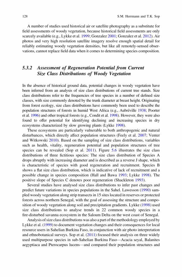
A number of studies used historical air or satellite photography as a substitute forfield assessments of woody vegetation, because historical field assessments are onlyscarcely available (e.g., Lykke et al. 1999; Gonzalez 2001; Gonzalez et al. 2012). Airphotos and very high resolution satellite imagery resolve enough spatial detail forreliably estimating woody vegetation densities, but like all remotely-sensed obser-vations, cannot replace field data when it comes to determining species composition.
5.3.2 Assessment of Regeneration Potential from CurrentSize Class Distributions of Woody Vegetation
In the absence of historical ground data, potential changes in woody vegetation havebeen inferred from an analysis of size class distributions of current tree stands. Sizeclass distributions refer to the frequencies of tree species in a number of defined sizeclasses, with size commonly denoted by the trunk diameter at breast height. Originatingfrom forest ecology, size class distributions have commonly been used to describe thepopulation structures of forests in humid West Africa (e.g., Aubréville 1938; Poorteret al. 1996) and other tropical forests (e.g., Condit et al. 1998). However, they were alsofound to offer potential for identifying declining and increasing species in dryecosystems characterized by slow growing plants (Lykke 1998).
These ecosystems are particularly vulnerable to both anthropogenic and naturaldisturbances, which directly affect population structures (Feely et al. 2007; Venterand Witkowski 2010). Based on the sampling of size class distributions, variablessuch as health, vitality, regeneration potential and population structures of treespecies can be revealed (Sop et al. 2011). Figure 5.6 illustrates the size classdistributions of three fictitious species: The size class distribution of Species Adrops abruptly with increasing diameter and is described as a reverse J shape, whichis characteristic of species with good regeneration and recruitment. Species Bshows a flat size class distribution, which is indicative of lack of recruitment and apossible change in species composition (Hall and Bawa 1993; Lykke 1998). Thepositive slope of Species C denotes poor regeneration (Shackleton 1993).
Several studies have analysed size class distributions to infer past changes andpredict future variations in species populations in the Sahel. Lawesson (1990) sam-pled woody vegetation along strip transects in 15 sites located in reserves or protectedforests across northern Senegal, with the goal of assessing the structure and compo-sition of woody vegetation along soil and precipitation gradients. Lykke (1998) usedsize class distributions to analyse trends in 22 common woody species in afire-disturbed savanna ecosystem in the Saloum Delta on the west coast of Senegal.
Analysis of size class distributionswas also a part of themethodology employed byLykke et al. (1999) to document vegetation changes and their consequences for localresource users in Sahelian Burkina Faso, in conjunction with air photo interpretationand ethnobotanical surveys. Sop et al. (2011) focused their analysis on three widelyused multipurpose species in sub-Sahelian Burkina Faso—Acacia seyal, Balanitesaegyptiaca and Pterocarpus lucens—and compared their population structures and
128 S.M. Herrmann and T.K. Sop

regeneration patterns. Traoré et al. (2013) carried out a similar study in the Sudanianphytogeographical zone of western Burkina Faso, focusing on the Sudanian speciesDiospyros mespiliformis, Prosopis africana and Sterculia setigera, with the goal ofevaluating the effectiveness of protected areas in conserving these species.
The analysis of size class distributions is not without limitations for estimatingpotential trends in past and future vegetation compositions: (1) Size class distributionsof trees in a stand are static representations of the population composition at a certaintime and inferring rates of change from them can be problematic (Sokpon and Biaou2002). (2) Size class distribution curves depend not only on population health but alsodiffer between fast growing species with higher survival rates and slow growing specieswith lower survival rates (Condit et al. 1998). Notwithstanding these shortcomings, theanalysis of size class distributions has made important contributions to our under-standing of changes in vegetation structure and species compositions in the Sahel, inparticular in combination with ethnobotanical knowledge.
5.3.3 Ethnobotanical Knowledge
In contrast to researchers, who might visit field sites only infrequently and over alimited time period, local populations are permanently present in specific sites or
0
40
80
120
Fre
quen
cy
Dbh classes (cm)
Species A
0
40
80
120
Fre
quen
cy
Dbh classes (cm)
0
50
100
150
Fre
quen
cy
Dbh classes (cm)
Species B
Species C
Fig. 5.6 Size class distributions (Dbh = diameter at breast height) illustrate high regenerationpotential (Species A), lack of recruitment with possible decline (Species B) and no regenerationleading to extinction (Species C).
5 The Map Is not the Territory: How Satellite Remote Sensing … 129

areas and as plant resource users have a strong interest in the fate of the vegetation.Thus, while they do not make systematic vegetation assessments as researcherswould do, their observations and recollections provide invaluable evidence ofstability and changes in vegetation. Ethnobotanical knowledge has been shown tobe a relatively accessible and reliable source of information on historical distribu-tion ranges of species, especially rare or endangered species which are generallydifficult to assess using classical ecological methods (Lykke et al. 2004). In the pasttwo decades, scientists have increasingly taken account of the local knowledge ofrural farmers to reconstruct vegetation dynamics in the Sahel, particularly incombination with other botanical assessment and analysis methods (e.g., Lindskogand Tengberg 1994; Lykke 1998; Lykke et al. 1999, 2004; Wezel and Haigis 2000;Wezel and Lykke 2006; Ayantunde et al. 2008; Sop et al. 2011, 2013; Sop et al.2012; Herrmann and Tappan 2013).
A number of qualitative and quantitative social science methods have been usedto elicit information on the status and the cultural importance of plant species in theSahel from informants, including structured and semi-structured interviews andfocus group discussions. Typically, informants are asked to list woody plantsoccurring in their communities, rank them by their use value, and identify thoseperceived as increasing or declining in abundance or that need priority for con-servation initiatives (Fig. 5.7).
Fig. 5.7 Local informants—pastoralists of the Peulh ethnic group—use illustrated cards of woodyspecies as visual aids in a discussion of changes in vegetation composition in the Senegalese Sahel(Herrmann et al. 2014).
130 S.M. Herrmann and T.K. Sop

Lindskog and Tengberg (1994) used local knowledge as part of their multidis-ciplinary case study of land degradation in Sahelian Burkina Faso. They solicitedvillagers’ perceptions on environmental deterioration by means of in-depthhousehold interviews and used this qualitative information in support of assess-ments of degradation of the vegetation cover from air photos and a satellite image.Also in Sahelian Burkina Faso, Lykke (1998) and Lykke et al. (2004) assessed theuse preferences and dynamics of woody species using a quantitative ethnobotanicalmethod based on structured interviews. In the context of the much reportedsatellite-observed greening trend in the Sahel, Sop and Oldeland (2013) conductedsemi-structured interviews with 87 groups of informants from twenty villagesbelonging to the Mossi, Fulani and Samo ethnic groups in order to sample theperceptions of local people on vegetation dynamics in the sub-Sahel of BurkinaFaso. They compared the information obtained on usage, abundance, conservationstatus and priority as well as ranking of socio-economic importance of all thewoody plants listed by the informants with an analysis of size class distributions ofkey species (Sop et al. 2011, 2012).
In semi-arid Niger, Wezel and Haigis (2000) solicited observations of past andpresent species occurrence and abundance from men and women and exploredpreferences for leaving certain species on cultivated fields. Wezel (2005)re-analysed local knowledge on changes in woody vegetation species from five caststudies in Burkina Faso, Senegal and Niger, which had been obtained in householdinterviews and focus group discussions. Wezel and Lykke (2006) extended thescope of the re-analysis to seven case studies.
Gonzalez (2001) conducted an extensive study in northwestern Senegal, inwhich he systematically sampled villages in an area of 7600 km2 and recordedelders’ recollections on the presence and absence of each of a predefined set of 126woody species around 1945 and 1993. Biomass estimates made by the author aswell as quantification of tree densities from air photos complemented the percep-tions of the local inhabitants. In a study spanning 15 research sites in Senegal, Mali,Burkina Faso, Niger and Chad, a similar methodology was employed to obtainperceptions of species abundance in 1960 and 2000, which were analysed inconjunction with changes in tree densities estimated from air photos and very highresolution satellite imagery (Gonzalez et al. 2012). Herrmann and Tappan (2013)included local perceptions of occurrence, abundance and trends of woody species ina study which compares ground evidence of woody vegetation change in sites thatappear to have greened up according to coarse resolution satellite observations withchange in sites that appear not to have greened up.
Although a good correlation between local knowledge and the physical reality ofthe environment has been documented (e.g., Lindskog and Tengberg 1994; Reedet al. 2007), some challenges associated with the use of such knowledge in eth-nobotanical assessments should not be ignored: People’s perceptions reflect theinformants’ subjective experience of environmental change, which may be subjectto biases and exaggerate or mask trends (Daw 2010). Informants tend to focus onthe species most useful to them, while overlooking rare and less used species.Environmental knowledge also depends on the age of the informants (Hanazaki
5 The Map Is not the Territory: How Satellite Remote Sensing … 131

et al. 2013). The absence of standardized data collection protocols to assess localperceptions and knowledge can make data integration problematic. Despite theseshortcomings when judging ethnobotanical knowledge by scientific standards, thefirst-hand experience of local land users is an invaluable source of information, andlarge sample sizes can at least in part make up for these shortcomings.
5.4 Synthesis of Ground-Based Vegetation Studies Acrossthe Sahel
The vegetation studies reviewed in this chapter followed various methodologicalapproaches and data collection protocols and they do not cover identical timeperiods, which precludes quantitative, statistical meta-analysis. On the other hand,the qualitative synthesis of these studies offers a more reliable picture of vegetationchanges across the Sahel than any single study could. The consistency of thefindings, despite the different approaches—the comparison of current with historicaldata, the analysis of size class distributions, and people’s perceptions—addsvalidity to the changes we document. A total of 301 field sites from 20 of thestudies reviewed could be located precisely in space (Fig. 5.5) and interpreted withrespect to changes in abundance and/or diversity of woody vegetation. By abun-dance, we mean any indication of the number of trees, density or percent cover; bydiversity, we mean any indication of the number of different species present at asite. We summarized the changes in woody vegetation at each site into the threesimple categories of “increasing”, “stable” or “decreasing” over time, in order toobtain a general representation of change and to allow for comparison with remotesensing-based trends over time (Figs. 5.8, 5.9 and 5.10).
This synthesis documents findings on the changes in woody vegetation at a pointin time (May 2014), which will continue to be revised as new studies are carried outin this very dynamic field.
5.4.1 Long Term Changes in the Abundance of WoodyVegetation
Most of the studies across the region comparing historical to current vegetation datapoint to an overall decline in the abundance of woody vegetation between thepre-drought period and the late 1990s or early 2000s (e.g., Gonzalez 1997, 2001;Lykke et al. 1999; Vincke et al. 2010; Gonzalez et al. 2012; Herrmann and Tappan2013; Herrmann et al. 2013) (Fig. 5.8a). Local inhabitants also observed a sub-stantial reduction of woody vegetation with the disappearance or decreasingabundance of many species (e.g., Lykke et al. 1999; Wezel and Haigis 2000;Gonzalez 2001; Sop et al. 2011) (Fig. 5.8b). Analyses of size class
132 S.M. Herrmann and T.K. Sop

distributions generally confirmed the lack of rejuvenation of many, but not allwoody species (e.g., Lykke 1998; Lykke et al. 1999; Bognounou et al. 2009; Sopet al. 2013) (Fig. 5.8c).
The observed changes are not uniform. At finer scales, the magnitude of thedecline appears to vary depending on the location of the site within the landscape.Lykke et al. (1999) found that valley sites in Sahelian Burkina Faso were mostseverely affected by the loss of trees. In contrast, Ganaba and Guinko (1995) andVincke et al. (2010) found that regeneration of the vegetation was better indepressions and along valleys, where runoff induces greater accumulation of water,fine soil particles and organic matter, than on the plateaus.
Exceptions to the general reduction in the abundance of the woody vegetationcover were found in the shrub layer, which, as opposed to the tree layer, hasincreased in some sites studied in central Senegal (Herrmann and Tappan 2013) and
Fig. 5.8 Proportion of field sites showing increasing, stable and decreasing abundance anddiversity of woody vegetation as assessed by a studies based on historical ground data, b studiesbased on people’s perceptions of vegetation change, c studies based on very high resolutionimagery, d studies based on size class distributions. N is the number of sites included in the countfor each variable. The number of sites per study ranged from only one to 135, meaning thatfindings from some studies are more heavily represented in this assessment than from others.
5 The Map Is not the Territory: How Satellite Remote Sensing … 133

in the Gourma region of Mali (Hiernaux et al. 2009a, b). Expansion of fruit treeplantations have also accounted for localized increases in tree densities over the pastfour decades, particularly in the vicinity of the urban centers of Dakar and Thies(Herrmann et al. 2013). The most noteworthy exceptions to the general decline intree cover, however, are the success stories of farmer-managed natural regeneration(Reij et al. 2009; see Sect. 5.4.3).
5.4.2 Long Term Changes in Woody VegetationComposition
With the exception of farmer-managed natural regeneration, virtually all groundstudies point to a progressive impoverishment of the woody vegetation cover inseveral respects: overall species diversity has been decreasing; a shift towards morexeric species has taken place; and the species most valued by the local inhabitantshave declined most dramatically.
For example, studies comparing current and historical woody vegetation docu-mented reductions in or disappearance of a number of woody species at sites in theSenegalese Ferlo (Vincke et al. 2010), central Senegal (Herrmann and Tappan2013), and the Mare d’Oursi in northern Burkina Faso (Ganaba and Guinko 1995),leading to a less diverse woody cover. These findings are corroborated by eth-nobotanical studies, in which informants listed more decreasing than increasingspecies at a majority of sites. Even parkland species such as Parkia biglobosa andVitellaria paradoxa, which are traditionally protected on farmers’ fields for soilfertility management and fruit production, were decreasing in some villages inNiger (Wezel and Haigis 2000). The only exceptions were villages where treeplanting had been promoted by development projects, mostly of fast growing exoticspecies, including Azadirachta indica (neem), Mangifera indica (mango) andEucalyptus camaldulensis (Wezel and Haigis 2000; Wezel and Lykke 2006). Whilethose newly planted species provided some wood and other tree products for ruralhouseholds, they were not able to compensate for the cutting of the natural vege-tation (Wezel and Haigis 2000).
Among the most dramatically declining tree species were the more mesic andless drought-resistant Sudanian and Guinean species (Ganaba and Guinko 1995;Gonzalez 2001; Vincke et al. 2010; Sop et al. 2011; Herrmann and Tappan2013). The more drought-resistant Sahelian woody species were left to dominatenot only in the Sahel but increasingly also in the Sudanian zone, indicating apossible shift of the vegetation belts southward (Gonzalez 2001). The mesic speciesbeing lost include large canopy trees, characterized by hard wood and edible fruits,which makes them highly valued. The most severely declining species listed in astudy of 25 villages in Burkina Faso, Niger and Senegal are Acacia ataxacantha, A.senegal, A. seyal, A. ehrenbergiana, Adansonia digitata, Boscia senegalensis,Ceiba pentandra, Dalbergia melanoxylon, Ficus gnaphalocarpa, Grewia bicolor,
134 S.M. Herrmann and T.K. Sop

Khaya senegalensis, Maerua crassifolia, Pterocarpus lucens, Sclerocarya birreaand Tamarindus indica (Wezel and Lykke 2006). This list includes highly valuedspecies that are relied upon for food, fodder, medicines, construction and craftmaterials, and as energy sources (Sop et al. 2012).
Size class distribution analyses show a mixed picture, with good regenerationpotential, i.e., higher frequency of young individuals, in some sites (Bognounouet al. 2009; Sop et al. 2012, 2013). Rejuvenation was however limited to a single orvery few hardy species per site, indicating that the reduction in species diversityseen in the past is likely to continue into the future. Some examples includeincreasing dominance of Acacia raddiana in the Mare d’Oursi (Ganaba and Guinko1995), of Calotropis procera, Boscia senegalensis and Balanites aegyptiaca in theSenegalese Ferlo (Lawesson 1990; Vincke et al. 2010), of Acacia tortilis andLeptadania pyrotechnica around Gorom-Gorom in Sahelian Burkina Faso (Lykkeet al. 2004), and of Combretum glutinosum and Guiera senegalensis in theSudanian domain of central Senegal (Herrmann and Tappan 2013).
As shown by the good agreement between historical vegetation surveys, eth-nobotanical studies and analyses of size class distributions, the degradation of thewoody vegetation cover does not appear to be a localized problem, but has beendocumented at sites throughout the Sahel and Sudanian zones.
5.4.3 The Case of Farmer-Managed Natural Regeneration
In contrast to the widespread negative changes in the woody vegetation cover, two“success stories” stand out: (1) farmer-managed soil and water conservation in thecentral plateau of Burkina Faso, where vast stretches of degraded and barrenfarmland have been rehabilitated and (2) farmer-managed natural regeneration ofagroforestry parklands in southern Niger (Reij et al. 2009). Both practices began tobe implemented at the height of the environmental crisis in the early 1980s, wheninnovative farmers and non-governmental organizations experimented with tradi-tional planting pits and stone bunds to reclaim severely degraded farmland (Reijet al. 2005) and protected on-farm trees to reduce wind speeds, improve soil fertilityand provide fodder for livestock (Tougiani et al. 2009).
Reportedly large in scale—an estimated 200,000–300,000 ha rehabilitated inBurkina Faso (Botoni and Reij 2009) and an area of nearly 5 million ha underfarmer-managed natural regeneration in Niger (Reij et al. 2009)—these develop-ments have not been rigorously quantified for such large areas. However, evidencefrom air photography and high resolution satellite imagery in 30 sample locations inthe Mirriah-Magaria-Matameye triangle of Niger show that average field tree cover,after having dropped from 2.8 % in 1957 to 1.5 % in 1975, had almost tripled to4.4 % in 2005, with local concentrations of up to 16 % (Reij et al. 2009). Thus, thepractice of farmer-managed natural regeneration seems to have allowed tree den-sities in the parkland to reach higher levels than in 1957. With a high percentage ofyoung trees among the current field tree population, the percent cover is expected to
5 The Map Is not the Territory: How Satellite Remote Sensing … 135

continue to increase significantly over the next decade. Mahamane et al. (2012)confirm the regenerative potential of field tree cover in three village territories in theMaradi region.
In the Central Plateau of Burkina Faso, Belemviré (2003) counted an average of126 trees per ha on rehabilitated fields, compared with 103 trees per ha in controlfields. Trees in rehabilitated fields were also larger and of higher species diversitythan those in the control fields. Species that persisted through the environmentaldegradation crisis include Combretum glutinosum, Guiera senegalensis andPiliostigma reticulatum. These species continue to be dominant, while species thathad been severely decimated or lost—such as Diospyros mespiliformis, Anogeissusleiocarpus, Sclerocarya birrea, Butyrospermum parkii and Lannea sp.—havere-appeared in rehabilitated fields (Reij et al. 2005).
As farmer-managed natural regeneration has shown, human population growthand agricultural intensification do not have to entail losses in vegetation produc-tivity and environmental degradation (Mortimore et al. 1999). On the contrary,where sound management is practised, farmers’ fields stand out by improvedvegetation cover and diversity, while unprotected woodlands and unmanaged fieldscontinue to degrade.
5.5 Linking Remote Sensing Observations to GroundEvidence
With few exceptions, regional-scale trends of vegetation productivity in the Sahel,observed from satellite data, and local-scale changes in the vegetation cover on theground have so far mostly been addressed separately and by different researchers.The findings from those two perspectives have led to differing and sometimesconflicting conclusions on the nature and extent of degradation/desertification in theSahel.
The simplified three-class summarization of changes in the abundance anddiversity of woody vegetation as “increasing”, “stable” or “decreasing” (seeSect. 5.4) was spatially overlaid with an equally simplified interpretation of thesatellite observed greening trends, (binary data layer of “greening” versus “notgreening”). “Greening” denotes a significantly (p < 0.05) positive slope of the linearfit of a trend line to the time series of AVHRR NDVI from 1982 to 2011 for each8 km pixel, disregarding the magnitude of the trend; “not greening” is the absenceof such a trend. No significantly negative trends in vegetation greenness werepresent at the field sites. While trends in both integrated annual and growing season(July-October) NDVI were considered, only trends in growing season averages areshown here, as their spatial patterns appear to be more consistent across differentversions of the NDVI dataset and across different studies. Figure 5.9 illustrates thedifferences between the two types of information in just one 100 × 100 km subset in
136 S.M. Herrmann and T.K. Sop

central Senegal, as the clustered distribution of field sites (Fig. 5.5) precludes alegible display of changes at a small scale over the entire Sahel and Sudan zones.
Whereas positive trends in vegetation greenness prevail—65 % of the full set offield sites are associated with significant greening according to growing seasonNDVI trends—ground evidence shows that a perceived degradation of the woodyvegetation cover is predominant. In 85 % of the field sites, a majority of which wasassociated with positive greening trends, a decrease in woody vegetation densitywas noted (Fig. 5.10). In 10.5 and 4.5 % of the field sites, woody vegetation coverwas stable and increasing respectively. Paradoxically, more than half of the siteswith increasing woody vegetation cover did not show significant greening insatellite observations. This is in line with earlier observations that the areas offarmer-managed natural regeneration in southern Niger, where field tree cover issaid to have improved, do not stand out in the satellite-derived greenness trendmaps (Reij et al. 2009). It has to be noted that in our comparison of remote sensingobservations and ground evidence, farmer-managed natural regeneration is not wellrepresented, as very little data on increases in tree cover have been reported in thespatially explicit way necessary for a direct comparison with NDVI trends. Anotherlimitation and potential source of bias in the comparison is introduced by the
Fig. 5.9 Spatial overlay of the direction of changes in woody vegetation abundance as observedon the ground and of a binary map of satellite-observed greenness trends (greening vs. notgreening) for a subset of study sites in central Senegal. Ground observations of decreasing woodyvegetation cover appear to dominate throughout the area, whether coinciding with thesatellite-observed greening trend or not.
5 The Map Is not the Territory: How Satellite Remote Sensing … 137

constraint that the start and end dates of the various field studies and the period overwhich NDVI trends were computed correspond only approximately.
Diversity in the woody vegetation cover was reported to have decreased evenmore dramatically than its abundance. A majority of the 95 % of field sites thatreported decreasing species diversity are associated with significant greening trendsaccording to satellite observations. There is no reason to expect a causal linkbetween the two variables; rather, they are independent indicators of degradation ordesertification. However, what these findings tell is that any increase inbio-productivity was generally accomplished by very few species at the expense ofspecies diversity.
Discrepancy between the two indicators (woody vegetation changes observed inthe field and satellite observations of bioproductivity) can be explained by the factthat much of the biomass production in the Sahel and Sudan zones is made up ofherbaceous vegetation, which responds fast to precipitation variability (Anyambaand Tucker 2005; Hiernaux, this volume). Precipitation has increased over the pasttwo decades (Nicholson 2013), triggering a growth response of the herbaceousvegetation and consequently an increase in biomass production (Anyamba et al.2014). This increase, however, is not to be mistaken for a recovery from degra-dation and a return to pre-drought vegetation conditions, as shown by the simul-taneous impoverishment of the woody vegetation cover. In an environment wheretrees form a small, yet ecologically and economically crucial, fraction of the overallgreen vegetation cover, the coarse spatial resolution of long time series of NDVIhas proven insufficient for capturing the woody component of vegetation dynamics.Thus, in the absence of ancillary data that allow for more intricate analyses but arerarely available at regional to global scales, NDVI time series alone are of limiteduse for identifying or monitoring desertification or land degradation (Prince, thisvolume).
4
20
119
6
3
68
0%
10%
20%
30%
40%
50%
60%
70%
80%
90%
100%
Increase Stable Decrease
Pro
port
ion
of fi
eld
site
s
Woody vegetation abundance
Not greening
Greening
Fig. 5.10 Proportion and number of field sites with increasing, stable and decreasing woodyvegetation abundance that spatially coincide with satellite-observed greening and not greeningrespectively. Satellite-observed greening—represented by growing season (July–October) trendsin NDVI from 1982 to 2011—dominates by 65–35 %, whereas on the ground increase in woodycover was observed in only 10 sites compared to decrease in 187 sites.
138 S.M. Herrmann and T.K. Sop

5.6 Conclusions
Satellite remote sensing has given us an unprecedented synoptic perspective onglobal vegetation dynamics by providing consistent, repeatable observations. As theonly source of long term vegetation greenness data, the NDVI time series derivedfrom the NOAA AVHRR satellite sensors (Tucker et al. 2005; Pinzon and Tucker2014) have played an important role in uncovering the interannual variability ofvegetation cover in the Sahel and have helped refute exaggerated claims of theextent of desertification (e.g., Prince et al. 1998). Based on NOAA AVHRR NDVIdata, a growing number of satellite-based studies has documented a greening trendin the Sahel since the early 1980s.
While these findings indicate that biomass production has likely increased inresponse to a moderate recovery in rainfall since the great droughts, it can be arguedthat bio-productivity is not the only indicator of the state of desertification orrehabilitation. Rain use efficiencies and trends in residual NDVI have been used tobetter distinguish between the effects of rainfall variability and degradation onbiomass production, neither of them suggesting regional-scale degradation.
A number of field studies, however, have painted a less positive picture ofvegetation changes at local scales. Focusing on the woody vegetation, a keycomponent of the savanna ecosystem and of the livelihood system of rural popu-lations, the prevailing story is one of degradation. The abundance of woody veg-etation has declined in many sites. Most importantly, the loss of large trees isubiquitous, while shrub cover was observed to have increased in some locations.The remaining woody cover has shifted towards fewer and more drought tolerantspecies, with a few dominating and replacing a more diverse vegetation. This trend,which is not incompatible with increases in bio-productivity as measured by theNDVI, has been observed in longitudinal botanical field studies and in ethnob-otanical studies alike. An important exception has emerged where field trees areexplicitly protected and diversity promoted in farmer-managed natural regenerationinitiatives. Such successes have been documented mainly in the Central Plateau ofBurkina Faso and in southern Niger, with positive impacts on soil fertility, cropproductivity, and food security. However, these positive developments on theground, able to halt or reverse degradation, do not stand out above other areas bytheir NDVI trend.
While the satellite-observed, region-wide greening trend is encouraging in theface of earlier claims of widespread desertification in the Sahel, it is based on rathercoarse resolution data and masks developments at finer scales, both negative andpositive. The contrasting interpretations of findings from the field and of remotesensing observations with respect to desertification illustrate that the availability ofremote sensing data does not ultimately remove the need for ground-based data.The perspective from the field remains indispensable in order to provide “groundtruth” for the NDVI data and to put desertification and land rehabilitation on themap. The divergent findings also highlight the need for more research that bridgesscale differences and takes account of both physical and social science perspectives.
5 The Map Is not the Territory: How Satellite Remote Sensing … 139

In particular, field studies explicitly targeting greening and control areas should beencouraged. Individual field studies are spatially confined, so sharing regionalarchives, field data and collection protocols from different studies across the regionwould benefit our understanding of NDVI trends and derivative metrics in thecontext of land degradation and rehabilitation.
References
Akpo, L.-E. (1997). Phenological interactions between tree and understory herbaceous vegetationof a Sahelian semi-arid savanna. Plant Ecology, 131, 241–248.
Anyamba, A., Small, J. L., Tucker, C. J., & Pak, E. W. (2014). Thirty-two years of Sahelian Zonegrowing season non-stationary NDVI3 g patterns and trends. Remote Sensing, 6, 3101–3122.
Anyamba, A., & Tucker, C. J. (2005). Analysis of Sahelian vegetation dynamics usingNOAA-AVHRR NDVI data from 1981–2003. Journal of Arid Environments, 63, 596–614.
Aubréville, A. (1938). La forêt coloniale. Annals of the Academy Science Colon, 9, 1–245.Ayantunde, A. A., Briejer, M., Hiernaux, H., Henk, M., Udo, J., & Tabo, R. (2008). Botanical
knowledge and its differentiation by age, gender and ethnicity in south western Niger. HumanEcology, 36, 881–889.
Bai, Z. G., Dent, D. L., Olsson, L., & Schaepman, M. E. (2008). Global assessment of landdegradation and improvement 1: Identification by remote sensing. Report 2008/01,FAO/ISRIC—Rome/Wageningen.
Beck, L. R., Hutchinson, C. F., & Zauderer, J. (1990). A comparison of greenness measures in twosemi-arid grasslands. Climatic Change, 17, 287–303.
Belemvire, A. (2003). Impact de la conservation de l’eau et des sols sur la régénération naturelleassistée. Développement rural et environnement au Burkina Faso: La réhabilitation de lacapacité des terroirs sur la partie Nord du Plateau central entre 1980 et 2000. Rapport de travailno. 1. .Ouagadougou, Burkina Faso: Conseil National pour la Gestion de l’Environnement.
Bognounou, F., Thiombiano, A., Savadogo, P., Boussim, J. I., Oden, P. C., & Guinko, S. (2009).Woody vegetation structure and composition at four sites along a latitudinal gradient inWestern Burkina Faso. Bois et Forêts des Tropiques, 300, 29–44.
Botoni, E., & Reij, C. (2009). La transformation silencieuse de l’environnement et des systèmes deproduction au Sahel: L’impacts des investissements publics et privés dans la gestion desressources naturelles. Amsterdam, the Netherlands: Comité Permanent Inter-Etats de LutteContre la Secheresse dans le Sahel (CILSS) and Vrije University Amsterdam.
Cappelaere, B., Descroix, L., Lebel, T., Boulain, N., Ramier, D., Laurent, J. P., et al. (2009). TheAMMA-CATCH experiment in the cultivated Sahelian area of south-west Niger: Investigatingwater cycle response to a fluctuating climate and changing environment. Journal of Hydrology,375, 34–51.
Cherlet et al. (2015). World atlas of desertification (3rd edn.). http://wad.jrc.ec.europa.eu/. Lastaccessed April 28, 2014.
Condit, R., Sukumar, R., Hubbell, S. P., & Foster, R. B. (1998). Predicting population trends fromsize distributions: A direct test in a tropical tree community. American Naturalist, 152, 495–509.
Dardel, C., Kergoat, L., Hiernaux, P., Grippa, M., Mougin, E., Ciais, P., & Nguyen, C.-C. (2014a).Rain-use-efficiency: What it tells us about the conflicting Sahel greening and Sahelian paradox.Remote Sensing, 6, 3446–3474.
Dardel, C., Kergoat, L., Hiernaux, P., Mougin, E., Grippa, M., & Tucker, C. J. (2014b).Re-greening Sahel: 30 years of remote sensing data and field observations (Mali, Niger).Remote Sensing of Environment, 140, 350–364.
140 S.M. Herrmann and T.K. Sop

Daw, T. M. (2010). Shifting baselines and memory illusions: What should we worry about wheninferring trends from resource user interviews? Animal Conservation, 13, 534–535.
Donohue, R. J., Roderick, M. L., McVicar, T. R., & Farquhar, G. D. (2013). Impact of CO2fertilization on maximum foliage cover across the globe’s warm, arid environments.Geophysical Research Letters, 40, 3031–3035.
Eklundh, L., & Olsson, L. (2003). Vegetation index trends for the African Sahel 1982–1999.Geophysical Research Letters, 30: 13-11–13-14.
Feely, K. J., Davies, S. J., Noor, N. S., Kassim, A. R., & Tan, S. (2007). Do current stem sizedistributions predict future population changes? An empirical test of intraspecific patterns intropical trees at two spatial scales. Journal of Tropical Ecology, 23, 191–198.
Fensholt, R., & Proud, S. R. (2012). Evaluation of earth observation based global long termvegetation trends—Comparing GIMMS and MODIS global NDVI time series. Remote Sensingof Environment, 119, 131–147.
Fensholt, R., Rasmussen, K., Kaspersen, P., Huber, S., Horion, S., & Swinnen, E. (2013).Assessing land degradation/recovery in the African Sahel from long-term earth observationbased primary productivity and precipitation relationships. Remote Sensing, 5, 664–686.
Fensholt, R., Rasmussen, K., Nielsen, T. T., & Mbow, C. (2009). Evaluation of earth observationbased long term vegetation trends—Intercomparing NDVI time series trend analysisconsistency of Sahel from AVHRR GIMMS, Terra MODIS and SPOT VGT data. RemoteSensing of Environment, 113, 1886–1898.
Ganaba, S., & Guinko, S. (1995). Etat actuel et dynamique du peuplement ligneux de la région dela Mare d’Oursi (Burkina Faso). Etudes sur la Flore et la Végétation du Burkina Faso et desPays Avoisinats, 2, 3–14.
Gonzalez, P. (1997). Dynamics of biodiversity and human carrying capacity in the Senegal Sahel.PhD dissertation, University of California, Berkeley.
Gonzalez, P. (2001). Desertification and a shift of forest species in the West African Sahel. ClimateResearch, 17, 217–228.
Gonzalez, P., Tucker, C. J., & Sy, H. (2012). Tree density and species decline in the African Sahelattributable to climate. Journal of Arid Environments, 78, 55–64.
Hall, P., & Bawa, K. (1993). Methods to assess the impact of extraction of nontimber tropicalforest products on plant populations. Economical Botany, 47, 234–247.
Hanazaki, N., Herbst, D.F., Marques, M.S. & Vandebroek, I. (2013). Evidence of the shiftingbaseline syndrome in ethnobotanical research. Journal of Ethnobiology and Ethnomedicine, 9.
Hansen, M. C., & DeFries, R. S. (2004). Detecting long-term global forest change usingcontinuous fields of tree-cover maps from 8-km advanced very high resolution radiometer(AVHRR) data for the years 1982–99. Ecosystems, 7, 695–716.
Harrison, M. N., & Jackson, J. K. (1958). Ecological classification of the vegetation of Sudan.Forests Bulletin 2 and Vegetation Map of Sudan printed by Sudan Survey Department,Khartoum, Topo No. S. 625–40.
Hein, L., & De Ridder, N. (2006). Desertification in the Sahel: a reinterpretation. Global ChangeBiology, 12, 751–758.
Hellden, U. (1991). Desertification—time for an assessment? Ambio, 20, 372–383.Herrmann, S. M., Anyamba, A., & Tucker, C. J. (2005). Recent trends in vegetation dynamics in the
African Sahel and their relationship to climate. Global Environmental Change, 15, 394–404.Herrmann, S. M., & Hutchinson, C. F. (2005). The changing contexts of the desertification debate.
Journal of Arid Environments, 63, 538–555.Herrmann, S. M., Sall, I., & Sy, O. (2014). People and pixels in the Sahel—A study linking
coarse-resolution remote sensing observations to land users’ perceptions of their changingenvironment in Senegal. Ecology and Society (under revision).
Herrmann, S. M., & Tappan, G. G. (2013). Vegetation impoverishment despite greening: A casestudy from central Senegal. Journal of Arid Environments, 90, 55–66.
5 The Map Is not the Territory: How Satellite Remote Sensing … 141

Herrmann, S. M., Wickhorst, A. J., & Marsh, S. E. (2013). Estimation of tree cover in anagricultural parkland of Senegal using rule-based regression tree modeling. Remote Sensing, 5,4900–4918.
Heumann, B. W., Seaquist, J. W., Eklundh, L., & Joensson, P. (2007). AVHRR derivedphenological change in the Sahel and Soudan, Africa, 1982–2005. Remote Sensing ofEnvironment, 108, 385–392.
Hiernaux, P., & Ayantunde, A. A. (2004). The Fakara: a semi-arid agro-ecosystems under stress.Report of research activities of International Livestock Research Institute (ILRI) in Fakara,South-western Niger, between 1994 and 2002, Desert Margins Program. ICRISAT, Niamey.
Hiernaux, P., Diarra, L., Trichon, V., Mougin, E., Soumaguel, N., & Baup, F. (2009a). Woodyplant population dynamics in response to climate changes from 1984 to 2006 in Sahel(Gourma, Mali). Journal of Hydrology, 375, 103–113.
Hiernaux, P., Mougin, E., Diarra, L., Soumaguel, N., Lavenu, F., Tracol, Y., & Diawara, M.(2009b). Sahelian rangeland response to changes in rainfall over two decades in the Gourmaregion, Mali. Journal of Hydrology, 375, 114–127.
Hiernaux, P., & Turner, M. D. (1996). The effect of clipping on growth and nutrient uptake ofSahelian annual rangelands. Journal of Applied Ecology, 33, 387–399.
Huete, A. R., & Jackson, R. D. (1987). Suitability of spectral indices for evaluating vegetationcharacteristics on arid rangelands. Remote Sensing of Environment, 23, 213–232.
Hutchinson, C. F., Herrmann, S. M., Maukonen, T., & Weber, J. (2005). Editorial: Introduction:The “Greening” of the Sahel. Journal of Arid Environments, 63, 535–537.
Ibrahim, F. (1978). The problem of desertification in the Republic of the Sudan with spacialreference to Northern Darfur Province. SRC Monograph Series 8.
James, M. E., & Kalluri, S. N. V. (1994). The Pathfinder Avhrr land data set—An improved coarseresolution data set for terrestrial monitoring. International Journal of Remote Sensing, 15,3347–3363.
Joint Research Centre of the European Commission. (2015). World atlas of desertification http://wad.jrc.ec.europa.eu/. Last accessed February 7, 2015.
Lamprey, H. F. (1988). Report on desert encroachment reconnaissance in Northern Sudan: 21October to 10 November 1975. Desertification Control Bulletin, 17, 1–7.
Lawesson, J. E. (1990). Sahelian woody vegetation in Senegal. Vegetatio, 86, 161–174.Lindskog, P., & Tengberg, A. (1994). Land degradation, natural resources and local knowledge in
the Sahel Zone of Burkina Faso. GeoJournal, 33, 365–375.Lykke, A. M. (1998). Assessment of species composition change in savanna vegetation by means
of woody plants’ size class distributions and local information. Biodiversity and Conservation,7, 1261–1275.
Lykke, A. M., Fog, B., & Madsen, J. E. (1999). Woody vegetation changes in the Sahel of BurkinaFaso assessed by means of local knowledge, aerial photos, and botanical investigations.Geografisk Tidsskrift (Danish Journal of Geography), 57–68.
Lykke, A. M., Kristensen, M. K., & Ganaba, S. (2004). Valuation of local use and dynamics of 56woody species in the Sahel. Biodiversity and Conservation, 13, 1961–1990.
Mahamane, L., Iro, D. G., Matig, O. E., & Idrissa, I. A. (2012). Farmer managed tree naturalregeneration and diversity in a Sahelian environment: Case study of Maradi region, Niger.Continental Journal of Agricultural Science, 6, 38–49.
McCloy, K. R., Los, S., Lucht, W., & Højsgaard, S. A. (2005). A comparative analysis of threelong-term NDVI datasets derived from AVHRR satellite data. EARSeL Proceedings, 4, 52–69.
Middleton, N., Thomas, D., & United Nations Environmental Programme. (1992). World atlas ofdesertification (1st edn). London: Arnold.
Middleton, N., Thomas, D., & United Nations Environmental Programme. (1997). World atlas ofdesertification (2nd edn). London: Arnold.
Miehe, S., Kluge, J., von Wehrden, H., & Retzer, V. (2010). Long-term degradation of Sahelianrangeland detected by 27 years of field study in Senegal. Journal of Applied Ecology, 47, 692–700.
142 S.M. Herrmann and T.K. Sop

Milich, L., & Weiss, E. (2000). GAC NDVI interannual coefficient of variation (CoV) images:Ground truth sampling of the Sahel along north-south transects. International Journal ofRemote Sensing, 21, 235–260.
Mortimore, M. (1989). Adapting to drought. Farmers, famine and desertification in West Africa.Cambridge: Cambridge University Press.
Mortimore, M., Harris, F. M. A., & Turner, B. (1999). Implications of land use change for theproduction of plant biomass in densely populated Sahelo-Sudanian shrub-grasslands innorth-east Nigeria. Global Ecology and Biogeography, 8, 243–256.
Mougin, E., Hiernaux, P., Kergoat, L., Grippa, M., de Rosnay, P., Timouk, F., et al. (2009). TheAMMA-CATCH Gourma observatory site in Mali: Relating climatic variations to changes invegetation, surface hydrology, fluxes and natural resources. Journal of Hydrology, 375, 14–33.
National Research Council. (2008). Earth observations from space: The first 50 years of scientificachievements. Washington, D.C.: National Academy Press.
Nicholson, S. E. (2013). The West African Sahel: A review of recent studies on the rainfall regimeand its interannual variability. ISRN Meteorology, 1–32.
Oldeman, L. R., Hakkeling, R. T. A., & Sombroek, W. G. (1991). World map of the status ofhuman-induced soil degradation: An explanatory note, second revised edition. ISRIC/UNEP.
Pearce, F. (1992). Mirage of the shifting sands. New Scientist, 136, 38–42.Pinzon, J. E., & Tucker, C. J. (2014). A non-stationary 1981–2012 AVHRR NDVI3 g time series.
Remote Sensing, 6, 6929–6960.Poorter, L., Bongers, F., van Rompaey, R. S. A. R., & de Klerk, M. (1996). Regeneration of
canopy tree species at five sites in west African moist forest. Forest Ecology and Management,84, 61–69.
Prince, S. (1991a). Satellite remote sensing of primary production: Comparison of results forSahelian grasslands 1981–1988. International Journal of Remote Sensing, 12, 1301–1311.
Prince, S. D. (1991b). A model of regional primary production for use with coarse resolutionsatellite data. International Journal of Remote Sensing, 12, 1313–1330.
Prince, S. D., Brown de Colstoun, E., & Kravitz, L. L. (1998). Evidence from rain-use efficienciesdoes not indicate extensive Sahelian desertification. Global Change Biology, 4, 359–374.
Prince, S. D., Wessels, K. J., Tucker, C. J., & Nicholson, S. E. (2007). Desertification in the Sahel:A reinterpretation of a reinterpretation. Global Change Biology, 13, 1308–1313.
Raynaut, C., Gregoire, E., Janin, P., Koechlin, J., & Lavigne Delville, P. (1996). Societies andnature in the Sahel. London: Routledge.
Reed, M. S., Dougill, A. J., & Taylor, M. J. (2007). Integrating local and scientific knowledge foradaptation to land degradation: Kalahari rangeland management options. Land Degradation &Development, 18, 249–268.
Reij, C., Tappan, G., & Belemvire, A. (2005). Changing land management practices andvegetation on the Central Plateau of Burkina Faso (1968–2002). Journal of Arid Environments,63, 642–659.
Reij, C., Tappan, G., & Smale, M. (2009) Agroenvironmental transformation in the Sahel: Anotherkind of “Green Revolution”. In: IFPRI Discussion Paper 00914: International Food PolicyResearch Institute.
Reynolds, J. F., & Stafford Smith, D. M. (2002) Do humans cause deserts? Global desertification:Do humans cause deserts? In J. F. Reynolds & D. M. Stafford Smith (Eds.) Berlin: DahlemUniversity Press.
Rouse, J. W., Haas, R. H., Schell, J. A., & Deering, D. W. (1973) Monitoring vegetation systemsin the great plains with ERTS. In: Third Earth Resources Technology Satellite-1 Symposium,(Greenbelt: NASA) (pp. 309–317).
Schwarz, M., Zimmermann, N. E., & Waser, L. T. (2004). MODIS based continuous fields of treecover using generalized linear models. IEEE Transactions on Geoscience and Remote Sensing,4, 2377–2380.
Seaquist, J. W., Hickler, T., Eklundh, L., Ardo, J., & Heumann, B. W. (2009). Disentangling theeffects of climate and people on Sahel vegetation dynamics. Biogeosciences, 6, 469–477.
5 The Map Is not the Territory: How Satellite Remote Sensing … 143

Shackleton, C. M. (1993). Demography and dynamics of the dominant woodyspecies in acommunal and protected area of the eastern Transvaal Lowveld. South African Journal ofBotany, 59, 569–574.
Sokpon, N., & Biaou, S. H. (2002). The use of diameter distributions in sustained-use managementof remnant forests in Benin: case of Bassila forest reserve in North Benin. Forest Ecology andmanagement, 161, 13–25.
Sop, T. K., & Oldeland, J. (2013). Local perceptions of woody vegetation dynamics in the contextof a ‘greening Sahel’: A case study from Burkina Faso. Land Degradation & Development, 24,511–527. doi:10.1002/ldr.1144
Sop, T. K., Oldeland, J., Bognounou, F., Schmiedel, U., & Thiombiano, A. (2012). Ethnobotanicalknowledge and valuation of woody plants species: A comparative analysis of three ethnicgroups from the sub-Sahel of Burkina Faso. Environment, Development and Sustainability, 14,627–649.
Sop, T. K., Oldeland, J., Schmiedel, U., Ouedraogo, I., & Thiombiano, A. (2011). Populationstructure of three woody species in four ethnic domains of the sub-sahel of Burkina Faso. LandDegradation & Development, 22, 519–529.
Steven, M. D. (1987). Ground truth—An underview. International Journal of Remote Sensing, 8,1033–1038.
Thomas, D. S. G., & Middleton, N. J. (1994). Desertification. Exploding the myth. Chichester:Wiley.
Tougiani, A., Guero, C., & Rinaudo, T. (2009). Success in improving livelihoods through tree cropmanagement and use in Niger. GeoJournal, 74(5), 377–389.
Traore, L., Sop, T. K., Dayamba, S. D., Traore, S., Hahn, K., & Thiombiano, A. (2013). Doprotected areas really work to conserve species? A case study of three vulnerable woodyspecies in the Sudanian zone of Burkina Faso. Environment, Development and Sustainability,15, 663–686.
Tucker, C. J. (1979). Red and photographic infrared linear combinations for monitoringvegetation. Remote Sensing of Environment, 8, 127–150.
Tucker, C.J., Vanpraet, C.L., Sharman, M.J. and van Ittersum, G. (1985). Satellite Remote Sensingof Total Herbaceous Biomass Production in the Senegalese Sahel: 1980–1984. Remote Sensingof Environment, 17, 233–249.
Tucker, C. J., Dregne, H. E., & Newcomb, W. W. (1991). Expansion and contraction of the SaharaDesert from 1980 to 1990. Science, 253, 299–301.
Tucker, C. J., & Nicholson, S. E. (1999). Variations in the size of the Sahara Desert from 1980 to1997. Ambio, 28, 587–591.
Tucker, C. J., Pinzon, J. E., Brown, M. E., Slayback, D. A., Pak, E. W., Mahoney, R., et al. (2005).An extended AVHRR 8-km NDVI dataset compatible with MODIS and SPOT vegetationNDVI data. International Journal of Remote Sensing, 26, 4485–4498.
Tucker, C. J., Vanpraet, C. L., Boerwinkel, E., & Gaston, A. (1983). Satellite remote sensing of totaldry matter production in the Senegalese Sahel. Remote Sensing of Environment, 13, 461–474.
Venter, S. M., & Witkowski, E. T. F. (2010). Baobab (Adansonia digitata L.) density, size-classdistribution and population trends between four land-use types in northern Venda, SouthAfrica. Forest Ecology and Management, 259, 294–300.
Warren, A. (2002). Land Degradation is Contextual. Land Degradation and Development, 13,449–459.
Vincke, C., Diedhiou, I., & Grouzis, M. (2010). Long term dynamics and structure of woodyvegetation in the Ferlo (Senegal). Journal of Arid Environments, 74, 268–276.
Warren, A., & Agnew, C. (1988). An assessment of desertification and land degradation in aridand semi-arid areas. In: International Institute for Environment and Development paper no. 2,(London: Ecology and Conservation Unit, University College).
144 S.M. Herrmann and T.K. Sop

Warren, A., & Olsson, L. (2003). Desertification: Loss of credibility despite the evidence. Annalsof Arid Zone, 42, 271–287.
Wezel, A. (2005). Decline of woody species in the Sahel. In Huber, B.A., Sinclair, B.J. & Lampe,K.-H. (eds.) African Biodiversity, New York: Springer.
Wezel, A., & Haigis, J. (2000). Farmers’ perception of vegetation changes in semi-arid Niger.Land Degradation and Development, 11, 523–534.
Wezel, A., & Lykke, A. M. (2006). Woody vegetation change in Sahelian West Africa: Evidencefrom local knowledge. Environment, Development and Sustainability, 8, 553–567.
5 The Map Is not the Territory: How Satellite Remote Sensing … 145

Chapter 6Desertification, Adaptation and Resiliencein the Sahel: Lessons from Long TermMonitoring of Agro-ecosystems
Pierre Hiernaux, Cecile Dardel, Laurent Kergoat and Eric Mougin
Abstract The desertification paradigm has a long history in the Sahel, fromcolonial to modern times. Despite scientific challenge, it continued to be influentialafter independence, revived by the dramatic droughts of the 1970s and 1980s, andwas institutionalized at local, national and international levels. Collaborative effortswere made to improve scientific knowledge on the functioning, environmentalimpact and monitoring of selected agricultural systems over the long term, and toassess trends in the ecosystems, beyond their short term variability. Two casestudies are developed here: the pastoral system of the arid to semi-arid Gourma inMali, and the mixed farming system of the semi-arid Fakara in Niger. The pastorallandscapes are resilient to droughts, except on shallow soils, and to grazing, fol-lowing a non-equilibrium model. The impact of cropping on the landscape is largerand longer lasting. It also induces locally high grazing pressure that pushesrangeland resilience to its limits. By spatial transfer of organic matter and mineral,farmers’ livestock create patches of higher fertility that locally enhance the system’sresilience. The agro-pastoral ecosystem remains non-equilibrial provided that inputsdo not increase stocking rates disproportionately. Remote sensing confirms theoverall re-greening of the Sahel after the drought of the 1980s, contrary to theparadigm of desertification. Ways forward are proposed to adapt the pastoral andmixed farming economies and their regional integration to the context of humanand livestock population growth and expanding croplands.
Keywords Sahel � Desertification, ecosystem resilience � Pastoral management �Non-equilibrium dynamics
P. Hiernaux (&) � C. Dardel � L. Kergoat � E. MouginGeoscience Environment Toulouse (GET), 14 Av. E. Belin, 31400 Toulouse, Francee-mail: [email protected]
© Springer-Verlag Berlin Heidelberg 2016R.H. Behnke and M. Mortimore (eds.), The End of Desertification?Springer Earth System Sciences, DOI 10.1007/978-3-642-16014-1_6
147

6.1 Introduction
The desertification paradigm took shape in the Sahel, a 500 km wide strip of landstretching 6000 km along the southern edge of the Sahara desert (Fig. 6.1). It containsan estimated 80 million people in 10 states. It is a bioclimatic zone under the reach ofthe West African Monsoon with a short rainy season peaking in August (Nicholson2013). Rainfall is variable and occurs from May to October in the south, and in thenorth for only a few weeks between July and September (Le Houérou 1989).
The first objective of this chapter is to bring some results of long term moni-toring of agro-ecosystems to the debate about desertification in the Sahel. The Sahelbelt is very wide and diverse with different geologies, people, histories, economiesand political institutions. However, the same bioclimatic gradient is found all alongthe belt with pastoral systems towards the more arid edge and mixed farmingtowards the semi-arid. After justifying a long term monitoring approach, results arepresented for two case studies: one from the arid pastoral system (Gourma, in Mali)and one for a mixed farming system (Fakara, in Niger). Up-scaling these casestudies to a regional level is then attempted, using remote sensing data. The regionalcontext in human demography, land use and livestock population changes is thenreviewed, and the chapter concludes with a discussion of ways to adapt Sahelpastoral and mixed farmers economies.
The desertification paradigm has a long history in the Sahel (Davis, Mortimore,Toulmin and Brock, this volume). It derived from the desiccation theory in vogue inthe 19th century (Grove 1995) but widely developed as part of the colonial ideologyin the first half of the 20th century (Hubert 1920; Stebbing 1935; Aubréville 1949).Scientific basis for the paradigm was provided in the then widely accepted vegeta-tion climax theory (Clements 1916; Trochain 1940). Although questioned by a fewscientists (De Gironcourt 1912; Chudeau 1921; Jones 1938), the desertificationparadigm reinforced a colonial deprecation of local farming and pastoral practices asbackward, inefficient, resource wasting and culpable for environment degradation
Fig. 6.1 The Sahel. Location of the two case studies, the Gourma region in Mali and theDantiandou district (Fakara) in Niger, in the Sahel delineated by the 600 and 100 mm rainfallisohyets, south of the Sahara. Google Earth image, isohyets after Morel (1991).
148 P. Hiernaux et al.

(Fairhead and Leach 1990). In pastoral zones, ‘over-grazing’ became the ordinaryculprit for rangeland degradation attributed to the ‘tragedy of the commons’ (Dodd1994) and the ‘livestock accumulation syndrome’ (Warren 1995). The paradigmjustified land set aside as forest and game reserves, the banning of fire and restrictionof pastoralist mobility (Hubert 1920). Initially developed in the context of low ruralpopulation densities, the paradigm gained strength from the rapid increase in pop-ulation, and its impact on natural resources, with the growing concern about satu-ration of the carrying capacity of the land (Harroy1944).
Later, following independence, the aspiration for agricultural modernity sus-tained the paradigm in the 1960s and 1970s. The overall failure of agriculturalmodernization (Dumont 1962) and the extent of the humanitarian and environ-mental catastrophe that hit the Sahel during the 1968–73 drought (followed by the1983–84 drought), re-energized the paradigm. ‘Desertification‘became a part of allnarratives and was institutionalized, from local NGOs to international agencies,with the creation of UNEP and UNCCD. More recently still, prospects of globalwarming and desiccation have been linked to desertification in spite of growingdoubts about the evidence. Indeed, research efforts devoted to understanding thebiology and ecology of Sahelian ecosystems (Penning de Vries and Djiteye 1982),to analyzing the environmental impact of evolving farming systems (Osbahr 2001;Raynaut 2001) and the long term monitoring of ecosystem dynamics both in thefield and by remote sensing (Herrmann, this volume; Hiernaux, this Chapter) allquestion the pertinence of the desertification paradigm.
6.1.1 Why Are Long Term Monitoring and Multi-ScaleSampling Needed to Assess Ecosystem Dynamicsin the Sahel?
The large inter-annual variability in rainfall amounts (Fig. 6.2), in rainfall distri-bution within rainy seasons (Frappart et al. 2009; Lebel and Ali 2009; Nicholson2013), and in the patchiness of the rainfall events (Ali et al. 2003) justify the use oflong term monitoring to identify trends beyond large temporal variations and spatialheterogeneities in vegetation attributes (Hiernaux et al. 2009a, b). The long-termperspective is also justified by the ‘slow’ pace of change of some ecosystemcomponents such as woody populations (Hiernaux et al. 2009b; Herrmann and Sop,this volume) and soil fertility parameters (Pieri 1989). Even the increasing pressureon land resources triggered by the human demography (Tabutin and Schoumaker2004; Guengant et al. 2002) is a slow driver (Walker et al. 2012). Moreover, theagrarian production systems in the Sahel being highly adaptive (Raynaut 2001;Thébaud and Batterbury 2001), long term monitoring is required to separate con-junctive variations from long term evolution of the farming systems. Finally, thetrends in global climate change, with the progressive rise of air temperature and
6 Desertification, Adaptation and Resilience in the Sahel … 149

concentration in CO2 (Giannini et al. 2003; Giannini this volume; IPCC 2013)support an even longer term perspective in ecosystem dynamics.
More difficult still, spatial heterogeneity is particularly high in Sahel ecosystemsdriven by the redistribution of rainfall through run-off (Breman and de Ridder1991). The rain water redistribution interacts with the pattern of soil texture and soilfertility (Brouwer et al. 1993; Voortman et al. 2004). Soil texture itself reflectsco-evolution with past climatic fluctuations during Tertiary and Quaternary periods(Brooks 2004; Grimaud et al. 2011). Soil fertility also relates to land use history(Turner 1998; Le Drézen et al. 2010). The patterned heterogeneity of the ecosystemthus requires an integrated multi-scale approach, from local site to topographicsequences, watersheds, and natural regions (Ludwig and Tonway 1995).
Among the adaptations to both temporal variability and spatial heterogeneity,agrarian systems have adopted a range of diversification strategies, with croplanddispersion in the landscape (Akponikpe et al. 2010), crop associations within a field(Ntaré and Williams 1992), local and regional mobility of grazing livestock (Turneret al. 2014) and crop-livestock association strategies either between specializedcommunities or increasingly within farms (Powell et al. 1996). This again justifiesboth long term and multi-scale approaches.
Fig. 6.2 Annual rainfall anomalies in Hombori (Mali) and Niamey (Niger). Histogram of annualrainfall expressed in anomalies (differences from the mean) in mm. Positive anomalies, rainfallsuperior to the mean are filled bars, negative anomalies, rainfall inferior to the mean are in dottedbars. Rainfall data from the National Meteorological Services DNM in Mali, DMN In Niger.
150 P. Hiernaux et al.

6.2 Two Case Studies: Pastoral in the Gourma (Mali)and Agro-pastoral in the Fakara (Niger)
The Gourma region in Mali extends over 80,000 km2 to the south of the large loopmade by the course of the Niger River between Mopti and Gao down to the borderwith Burkina Faso (Fig. 6.1), cutting across most of the Sahelian bioclimatic gra-dient from 100 mm in the north to 550 mm in the south (Frappart et al. 2009). TheGourma is lightly populated (4.9 persons km−2), with an economy that is mostlypastoral, though associated with some staple millet cropping in the south and rice inthe narrow valley of the Niger River (Gallais 1984; Ag Mahmoud 1992). A set of40 field sites were sampled along the bioclimatic gradient on the main soil typesand with different levels of grazing pressure, first to assess available fodderresources under drought during the 1983 dry season (details on site sampling arefound in Hiernaux et al. 2009b). These have since then been monitored underdifferent research projects documenting the long term dynamics of pastoral sites.Some of these sites were also selected during and after the previous major droughtof 1972–1973 (Boudet 1972, 1979) adding historical depth to the study ofecosystem dynamics.
The district of Dandiandou extends to 846 km2, 80 km to the east of the capitaltown, Niamey (Fig. 6.1). The district territory stands on the Fakara, a low sandstoneplateau dissected by a web of fossil valleys infilled with sands, extending over8000 km2 in the interfluve between the Niger River and the Dallol Bosso valleys.The district is relatively densely populated (42.5 persons km−2) with an economyrelying on staple crops (millet, sorghum, cowpea, sorrel) and livestock husbandry(zebu cattle, sheep and goats, a few donkeys, horses and camels). The district isrepresentative of the southern Sahel environments with a mean annual rainfall of492 ± 89 mm (at Banizoumbou, 1990–2013), and dominant infertile sandy soils(Hiernaux and Ayantunde 2004).
The site was selected because of the large available data base from previousstudies including Hapex-Sahel (Goutorbe et al. 1994), and the ongoing network ofmeteorological stations EPSAT (Le Barbé and Lebel 1997; Lebel et al. 2009).Further research was carried out on atmosphere-surface exchanges, hydrology andhydrogeology, wind erosion, vegetation physiology and phenology within thedistrict under the AMMA (African Monsoon Multi-disciplinary Analysis)1 project
1In collaboration with IER (Mali Institute for Rural Economy) ILCA (International LivestockCentre for Africa, Addis Ababa, Ethiopia) first launched a multi-disciplinary assessment of theshort term impact of the 1982-83 drought on pastoral systems in the Gourma region, then funded aten years monitoring of the sites to assess the drought impact over the longer term. After 5 yearswith few observations, the site monitoring was resumed in 1999 under the African MonsoonMulti-disciplinary Analysis, AMMA project till 2009 (Redelsperger et al. 2006), it continued thenunder the AMMA-CATCH observatory (Mougin et al. 2009) but was scaled down since 2011because of civil insecurity. From 2009 on, the monitoring also benefited from the research contextprovided by a series of ANR (French Research National Agency) funded research project: ECliS(‘Livestock Climate and Society’ between 2009 and 2012; http://eclis.get.obs-mip.fr/), ESCAPE
6 Desertification, Adaptation and Resilience in the Sahel … 151

untill 2009, afterwards prolonged by the monitoring of some of the studied pro-cesses under the AMMA-CATCH observatory (Cappelaere et al. 2009). In theframework of the crop-livestock farming system study initiated in 1994 by ILRI,(International Livestock Research Institute), 54 sites (1 or 2 ha each, half incroplands and half in fallows or rangelands) were sampled from the main topo-graphic and soil types, in order to assess seasonal fodder availability and use at adistrict scale. Except for an interruption in 2007–2008, the sites have been moni-tored continuously under successive research projects. The crop-livestock farmingsystem study led by ILRI ended in 1998, and was followed by complementaryexperiments and surveys till 2006. Meanwhile experimental research on options tointensify millet cropping (fertilizer micro-dose, selected breeds of millet andcowpea, animal traction) as well as surveys of societal and economic issues weredeveloped under the leadership of ICRISAT (International Council for Research inthe Semi-Arid Tropics).2
6.3 The Pastoral Ecosystem Dynamics
6.3.1 The Large Sensitivity of the Vegetation to Rainfall
The Sahel vegetation, called either steppe or savanna (Le Houérou 1989, 2009) iscomposed of a herbaceous layer of annuals dominated by C4 grasses, and a scat-tered population of C3 woody plants in which leaf phenology varies from ephemeralto evergreen (Hiernaux et al. 1994). The seasonality of the vegetation phenologyand growth is controlled by the West African Monsoon. Seasonality is thus regularwith herbaceous annuals germinating with the first rains from May to July, growingin a few weeks, setting flowers in September and wilting just after maturation in
(Footnote 1 continued)
(‘Environmental and social changes in Africa: past, present and future’ from 2012 onwards; http://www.locean-ipsl.upmc.fr/*ESCAPE/) and CAVIARS (‘Climate, agriculture and vegetation:impacts on aeolian erosion in the Sahel’ from 2013 onwards).2In collaboration with INRAN (Niger National Institute for Agronomy Research), ILRI(International Livestock Research Institute, Nairobi, Kenya) started in June 1994 amulti-disciplinary diagnostic of mix crop-livestock production systems in Southern Sahel. Theseasonal monitoring of 54 field sites was part of the farming system study and continued underdifferent ILRI research projects till 2006. After two years’ interruption the site monitoring wasresumed under the ECLiS (http://eclis.get.obs-mip.fr/) project and the AMMA-CATCH observa-tory. The Dantiandou district provided one of three sites retained by the international researchproject on the West African monsoon, AMMA (Cappelaere et al. 2009). In the meantime,ICRISAT (International Crops Research Institute for the Semi-Arid-Tropics, Hyderabad, India)developed in Dantiandou, in collaboration with INRAN and the University of Louvain-la-Neuve(Belgium), experimental research on options to intensify millet crop (fertilizer micro-dose, selectedbreeds of millet and cowpea, animal traction) as well as surveys on societal and economic issues(Saqali et al. 2010).
152 P. Hiernaux et al.

September or October (Penning de Vries and Djiteye 1982). On an average of 287site-years observed between 1984 and 2011, across 25 rangeland sites in theGourma, 84 ± 21 % (mean ± standard deviation) of the herbaceous production isachieved during the rapid growth phase that lasts 38 ± 16 days, at a mean rate of2.6 ± 2.1 g m−2d−1, 3.7 ± 2.0 when bare soil patches are excluded (Hiernaux et al.2013).
The large inter-annual variations in herbaceous production are largely explainedby the volume and distribution of rainfall, at least on the dominant sandy soils(Fig. 6.3). However, primary production models, such as STEP (Mougin et al. 1995),run with daily rainfall data are quite successful in predicting the growth pattern, butpoor in predicting the yield unless they are calibrated for the particular site and floracomposition (Tracol et al. 2006). Indeed soil fertility is not accounted for by themodel, and annual species composition may change drastically from one year to thenext on the same site in relation to seed dispersion and germination ecology (Cissé1986; Carrière 1989; Seghieri 1996; Hérault and Hiernaux 2004). On upland shallowsoils, and lowland fine textured soils, the vegetation structure and production onlyrelate indirectly to rainfall, as the balance between run-off and run-on modifies thesoil moisture regime. On shallow soil, the herbaceous yields also depend on theextent of bare soil patches that may vary from year to year. However, the rate ofgrowth on the sole vegetated patches, during the rapid growth phase when soilmoisture is not limiting (180 site-years in the Gourma monitoring), reaches5.2 ± 2.3 g m−2d−1 on shallow soils, above the loamy soils at 4.5 ± 1.7 g m−2d−1 andthe sandy soils at 3.8 ± 1.4 g m−2d−1, and below the clay soils at 6.6 ± 2.6 g m−2d−1.This was expected from their respective biochemical fertility (Hiernaux et al. 2013).
0
500
1000
1500
2000
2500
3000
3500
4000
1984
1985
1986
1987
1988
1989
1990
1991
1992
1993
1994
1995
1998
1999
2000
2001
2002
2003
2004
2005
2006
2007
2008
2009
2010
2011
kg DM ha-1
clay soil
Shallow soils
sandy soils
Fig. 6.3 Herbaceous yield dynamics in Gourma rangeland (1984–2011). Histogram of meanmaximum standing mass of the herbaceous layer of Gourma rangelands grouped by soil types(deep sandy soils, deep clay soils, shallow sandy loam soils). Overall linear regressions of themean maximum standing mass (M kg Dry Matter ha−1) are poor: M = 22.5*Yr + 717 (r2 = 0.20)on sandy soils; M = 36.7*Yr + 1070 (r2 = 0.15) on clayed soils; M = 8.2* Yr + 215 (r2 = 0.15) onshallow soils. Data source AMMA CATCH observatory.
6 Desertification, Adaptation and Resilience in the Sahel … 153

The inter-annual dynamic of the vegetation interacts in contrasting ways with themain edaphic components of the landscape as follows:
• The strong resilience of the vegetation on sandy soils. Even when the consec-utive drought years in 1972–73 or 1983–84 had wrecked the herbaceous layerand decimated the soil seed stock, it took only a couple of years for theherbaceous layer to recover on most sandy soils (Fig. 6.5 left), though withsuccessive steps in species composition (Boudet 1990; Hiernaux and LeHouérou 2006). The woody population was also decimated by the droughts(with some lag in time) and it took much longer for the populations to rebuild,often starting with pioneer fast growing shrubs such as Leptadenia pyrotech-nica,3 Calotropis procera and Acacia ehrenbergiana (Hiernaux et al. 2009a).The density and aggregated canopy cover of the woody plants measured in 2009are larger than in 1984, though woody plants which died that year were included(Fig. 6.4).
• The collapse and profound mutation of the vegetation on shallow soils. Bycontrast with the sandy soils, the patchy herbaceous layer and patterned woodyvegetation did not recover from the major droughts between 1985 and 2007(Fig. 6.6). The main reason is a co-evolution of the vegetation with the run-offsystem that becomes progressively concentrated with the opening of the vege-tation cover. The sheet run-off prevailing on the long gentle slopes of the erosionsurfaces (rocky peneplains, ferralitic hardpans), feeding the ‘tiger bush’ pat-terned vegetation with dense and narrow woody thickets set perpendicular to theslope (d’Herbès et al. 2001), is progressively replaced by a concentrated run-off
Fig. 6.4 Dynamics of woody canopies in Gourma rangelands (1985–2005). Change over time ofthe mean canopy cover (%) measured in Gourma rangeland sites, grouped by type of soil: deepsandy soils, deep clay soils, shallow sandy loam soils (Hiernaux et al. 2009b).
3All plant species are named after the flora of West Tropical Africa by Hutchinson and Dalziel(1954–1972).
154 P. Hiernaux et al.

in a web of gullies, depriving the remaining patches of vegetation of water andnutrient resources, and thus aggravating the degradation of the vegetation cover(Hiernaux and Gérard 1999).
• The erratic dynamics of the vegetation in fine textured soils in low- lands, whichfollowed the changes in the water run-on regime on which their growth depends.
Fig. 6.5 Year to year changes of rangeland vegetation in the Gourma: sandy and clay soils. Seriesof photos taken from same point and direction in two monitored rangeland in the Gourma: LeftAouli, open savanna on fixed sand dune (N 16.01933°–W 1.50327°), Right Kelma Acacia seyalstand in a low land clayed soil, seasonally flooded (N 15.21875°–W 1.58810°). Photos Hiernauxand Soumaguel (2011).
6 Desertification, Adaptation and Resilience in the Sahel … 155

Successive drought years without flooding lead to the collapse of the herbaceouslayer which is dominated by grasses adapted to seasonal flooding, such asPanicum laetum and Echinochloa colona. After one year’s lag the dense standsof woody plants were in turn decimated, especially those of Acacia seyal, A.nilotica and Anogeissus leiocarpus. Then, depending on the restored floodregime, resulting from the increase and concentration of the run-off on theshallow upland soils, the vegetation in the lowlands either re-established(Fig. 6.5 right) or failed to re-establish. The increased volume of run-off from theshallow soils largely modified the web of gullies and wadis. Pond outletsenlarged markedly and new ones became established (Gardelle et al. 2010),either killing previous vegetation by asphyxia or promoting the development ofnew vegetation at the pond edges, especially pioneer shrubs such as Acaciaehrenbergiana.
Thicket cover :4.2%
Thicket cover:0,4%
Fig. 6.6 Year to year changes of rangeland vegetation in the Gourma: shallow soils. Series ofthree photos taken from same point and direction at Ortondé (N 15.15503°–W 1.56292°) showingvery open ‘tiger bush’ on ferralitic hard pan (top 25 Sept 1986; centre 30 Sept 2007; bottom 12Sept 2011). The woody plant thickets reduce in number and cover over time as shown on the two1 km long transect maps established by supervised classification of landsat scenes in 1985 (left)and 2007 (right) (Trichon et al. 2009). Photos Hiernaux and Soumaguel (2011).
156 P. Hiernaux et al.

6.3.2 The Impact of Grazing Livestock
Comparing time series of vegetation data collected in sites under contrasted grazingpressure (Fig. 6.7) helps in assessing the impact of grazing livestock on thedynamics of the Sahel biotopes. On sandy soils and lowland clay soils there is noevidence of losses in herbaceous productivity with increasing grazing pressure(Hiernaux et al. 2009a). While a repeated cutting regime during the growing seasonmay seriously affect the production of herbaceous annuals—depending on thetiming and frequency of the cuts (Hiernaux and Turner 1996)—the impact of heavygrazing around livestock concentration points does not systematically translate intoa loss of productivity (Hanan et al. 1991). Indeed, depending on the species pro-moted by heavy grazing (Ayantunde et al. 1999), accompanied by higher tramplingand excretion deposition, the productivity is usually enhanced, not only becauseunpalatable species such as Sida cordifolia, Acanthospermum hispidum, or Sennaobtusifolia get promoted but also, with good forage species such as Cenchrusbiflorus and Dactyloctenium aegyptium (Hiernaux 1998). In other sites, the speciespromoted by heavy grazing are short cycle types, and thus less productive, but maybe high quality livestock fodder such as Zornia glochidiata, Tribulus terrestris andTragus berteronianus (Valenza 1984).
On 14 sandy soil sites (180 site-years) monitored between 1984 and 2011 in theGourma, the average growth rates during rapid growth slightly increased withgrazing pressure from 3.0 ± 0.8 g m−2d−1under moderate grazing pressure to3.9 ± 1.5 g m−2d−1under high and 4.0 ± 1.3 g m−2d−1under intense grazing(Hiernaux et al. 2013). Moreover, the density of herbaceous perennials and woodyplants on sandy soils does not necessarily decrease with increasing grazing pres-sure. Large tussock perennials such as Aristida sieberiana and Panicum turgidumare often more dense near livestock concentration points (camps, pools, livestock
Fig. 6.7 Wet and dry season grazing in Gourma rangelands. Zebu cattle grazing during the wetseason (lowland with Acacia seyal, Panicum laetum, Echinochloa colona; Kelma), and grazingstanding straw and litter during the late dry season (Acacia raddiana, Balanites aegyptiaca,Cenchrus biflorus, Aristida mutabilis; Aouéli). Photos P. Hiernaux.
6 Desertification, Adaptation and Resilience in the Sahel … 157

paths), in the northern edge of the Sahel, but less often in the southern Sahel withAndropogon gayanus and Cymbopogon shoenanthus. The same observation appliesto woody plants, with dense stands of Acacia spp., Balanites aegyptiaca, or Bosciasenegalensis in the vicinity of wells. However, competition between perennialherbaceous and woody plants has been observed in the northern Sahel (Anthelmeet al. 2006).
On lowland fine textured soils, extremely high browsing pressure close to waterpoints and settlements does not impede woody plant populations from recoveringthrough successive cohorts of seedlings, as observed in lowland clay soils nearWami, or surrounding Gossi lake where a strong regeneration of Acacia ehren-bergiana, A. seyal and A. nilotica followed the 1983–84 drought.
On the other hand, heavy trampling on loamy and sandy loam shallow soils maycontribute to the concentration of run-off, and thus accelerate vegetation degrada-tion (De Wispelaere 1980; Leprun 1992). However, the collapse of herbaceouspatches and woody populations observed on shallow soils also occurs under verylight grazing pressure where there is a lack of permanent water resources forlivestock.
6.3.3 What Would Explain the Minor Impact of GrazingLivestock on Pastoral Ecosystem Dynamics?
There are a number of ecosystem peculiarities that moderate the impact of livestockgrazing on the pastoral ecosystem.
• First, the effect of grazing on the herbaceous production is limited by the shortgrowth duration of annuals. A large fraction of herbaceous growth (84 %) takesplaces in three weeks or less, and synchronically over the region, except in thelarge alluvial plains whose flood regime is also determined by rainfall but faraway upstream, such as in the Inland Niger Delta (Gallais 1967).
• Heavy grazing pressure during the few weeks of rapid growth is transient and canonly occur locally. The same animals have to survive the remaining 40 or moreweeks on the forage produced during the short growing season. On the otherhand, the impact of grazing livestock on the herbaceous layer during the dryseason is limited by the mediocre capacity of livestock to pick up straw and litter.Indeed, controlled experiments and surveys (Hiernaux et al. 2012) demonstratedthat, at most, one third of the standing straw vegetation at the end of the growingseason is potentially ingested by livestock because of the concomitant losses bytrampling, insect and rodent herbivory and organic decomposition.
• Moreover, livestock recycle about half of the organic matter and more than 80 %of the main nutrients through urine and faeces excretions (Schlecht et al. 2004).
• With the most palatable species, the ability of livestock to browse leaves, twigsand fruits of woody plants is limited by access, even for specialized browserssuch as goats and camels. Livestock browsing is only detrimental to a woody
158 P. Hiernaux et al.

plant population at an early stage of development (germination, seedlings), or tolow shrubs.
• Continuous high grazing pressure in the vicinity of water points and settlementshas not impeded the regeneration of Acacia seyal stands in the Wami area nearHombori, nor of Acacia erhenbergiana and Balanites aegyptiaca near Gossi(Hiernaux et al. 2009a).
At broader spatial scales and between years, the impact of livestock on the Sahelpastoral ecosystem is limited by the overall control of the fodder resources onlivestock numbers. This control either manifests itself in catastrophic losses ofanimals during droughts (Toulmin 1987), floods, or other extreme events on top oflosses from epidemics, war and cold rainfall in winter. It also manifests itself byaffecting the reproduction parameters of animals living in conditions of chronicunder-nutrition (Fernandez-Rivera et al. 2005). Statistics of livestock losses duringthe major droughts of 1972–73 and 1983–84 are poor, but animal losses were large,as shown in case studies documented in the Gourma just after the drought for sheepand goats (Peacock 1983) and retrospectively for cattle (Dawalak 2009). This laststudy also indicates that recovery of animal numbers takes several decades, andmay never occur for pastoral families who are pushed out of the pastoral economy.Indeed, the rates of herd growth (taking account of offtake) rapidly decline to verylow figures, even negative, when parameters such as the age of first calving, or themean time between consecutive calving, increase to the point where the reconsti-tution of a herd may not be feasible in a herder’s life time (Lesnoff et al. 2012).
This overall limitation of the livestock population by the low points of Sahelianrangeland resources (a late dry season in a poor rainfall year) reduces the risks ofecosystem degradation through overgrazing, unless livestock are confined to con-centration points on the most fragile shallow soils. Provided that the stocking rate isnot artificially maintained by imported feed, the large seasonal impact of livestockgrazing on vegetation cover has very limited impact on the longer term dynamics ofthe Sahel ecosystem, in that regard behaving as a non-equilibrial system (Ellis andSwift 1988; Vetter 2005).
6.4 Agro-pastoral Ecosystem Dynamics
6.4.1 The Land Cover Diversified by Clearing and CroppingPractices
Clearing land for cropping affects the woody population in the longer term (Fig. 6.8).In extensive cropping systems, fallows alternate with a few years of cropping,allowing for the sprouting of coppices (mostly Guiera senegalensis, Combretumglutinosum, Piliostigma reticulata at Dantiandou) and the regeneration from seed ofsome woody plants. The flora of the herbaceous layer evolves progressively as thefallow ages from weed dominance to savanna species (Achard et al. 2001).
6 Desertification, Adaptation and Resilience in the Sahel … 159

Successive crop and fallow cycles progressively shape the woody population in anagro-forestry parkland, where tree composition depends on the climate, soil texture,fertility and moisture regime. In the sandy soils of Dantiandou, it is dominated byCombretum glutinosum, Prosopis africana, Faidherbia albida, Detarium micro-carpum, and Parinari macrophylla. In addition individual plots are often delineatedby living hedges made up of trees, shrubs and the perennial grasses Andropogongayanus and Aristida sieberiana. None of the hedge components are planted; theyare spontaneous but protected to delineate the field.
Cropping practices determine the sensitivity of the cropland to wind or run-offerosion, including: soil tillage (mostly with hand tools—animal traction is rare);sowing times and densities, organic fertilization (animal corralling, manuring, wasteapplication); mineral fertilization; weeding times and frequency; and harvestingmethods (sole panicles or whole plants (Osbahr 2001; Bielders et al. 2004). Themanagement of cereal stalks following grain harvest is particularly important forwind erosion. Leaving only 500 kg ha−1 of millet or sorghum stalks laid on the soilduring the dry season controls most of the erosion (Michels et al. 1998). However,cereal stalks are increasingly harvested, which is justified by their private use aslivestock feed and construction material, increasing the risks of wind erosion oncrop fields (Bielders et al. 2004).
6.4.2 The Impact of Livestock on Semi-aridAgro-ecosystems
The spatial distribution of grazing pressure is organized seasonally to avoid live-stock presence in croplands during the growing season: this implies close herdingand seasonal migration out of the cropland areas (Turner et al. 2005). It alsostructures the distribution of livestock in the landscape, with extremely high
Fig. 6.8 Fallow and millet crop field in Dantiandou (Fakara). Left Cattle grazing a heavily grazedenclave fallow during the wet season (Guiera senegalensis, Zornia glochidiata, Sida cordifolia).Right Non-manured farmer’s field in Tigo Tegi with associated crops of millet (Pennisetumglaucum) and cowpea (vigna unguinculata) prior to harvest in September, 2009 (trees in the fieldedge are Combretum glutinosum). Photo P. Hiernaux.
160 P. Hiernaux et al.

concentration along the livestock paths, around water points, resting camps and inrangeland enclaves (Turner and Hiernaux 2002). This increasing grazing pressureresults in a decreasing trend of fallows and rangeland herbage yield (Fig. 6.9) that isnot explained by the trend in rainfall (Fig. 6.2). These local high stocking rates,associated with soil trampling, favor short cycle species resistant to repeatedgrazing, such as Zornia glochidiata and Dactyloctenium aegyptiacum on sandysoils, or Microchloa indica and Eragrostis pilosa on sandy loams. Heavy tramplingduring the wet season may also open bare soil patches. The two processes (highstocking rates and trampling) contribute to lower herbaceous production andincrease the risks of local wind and water erosion. In other places the high con-centration in livestock excretion, together with intense grazing and trampling, favorthe local proliferation of nitrophilous unpalatable species such as Ipomoea asari-folia, Sida cordifolia or Acanthospermum hispidum. Herbaceous production inthese patches remains high in spite of the high grazing pressure.
The transfer of organic matter and nutrients by livestock within theagro-ecosystem prevails as a consequence of the spatio-temporal distribution ofanimal grazing time on one hand, and walking-resting-ruminating time on the otherhand (Schlecht et al. 2004). The transfer is effective both to uncropped areas along
Fig. 6.9 Yield trends in fallows, rangelands and crop fields at Dantiandou, Fakara (1994–2011).Histograms of mean annual yields (M) in kg ha−1 in: top herbaceous layer from 24 fallows andrangelands sites; bottom 24 millet crop fields and associated weeds, monitored from 1994 to 2011in the Dantiandou district. Yield trends over years (Yr): M = −333 Ln(Yr) +1467 (r2 = 0.65) infallows and rangelands; M = −34.2* Yr +1780 (r2 = 0.18) for millet crop (from Hiernaux et al.2009c).
6 Desertification, Adaptation and Resilience in the Sahel … 161

livestock paths and around water points, and to cropland, either by corrallinglivestock in the fields during the dry season and on fallows in the wet season, or elseby transporting and applying manure collected in paddocks or yards (Fig. 6.11).Whatever the method, manure application improves or maintains soil fertility on asmall fraction of the land cropped in the Dantiandou district from 3 to 8 %depending on the density of the population (Hiernaux and Turner 2002). However,the high level of manure application practised in corralling expands the effect ofmanuring to about a fifth of the land cropped, considering that the residual benefitof manure application on crop yield is significant for at least 4 years (Gandah et al.2003), moderating yield decline (Fig. 6.9). Moreover, cattle, donkeys and camelsalso contribute to the intensification of the cropping system, via animal traction,rarely used for soil tillage (ploughing, weeding, sowing, fertilizer application) butcommonly used for transportation (manure, yields, stalks, haulms… and people).
6.4.3 Do Cropping Practices Attenuate the EcosystemSensitivity to Rainfall Variations?
Crop phenology differs from that of rangeland and fallow plants. There is an initialdelay in growth due to the farmer’s choice of a sowing date, most often later thanthe first rainy day. The phenology of field crops also differs from that of sponta-neous vegetation in its lower density and regular distribution of the planted seeds,and by the weeding done to reduce competition from weeds. However, crop lan-draces have been selected for their capacity to grow fast, to tiller or branch pro-fusely (provided that soil moisture and nutrients are not limiting), so that at the endof the season, primary production is often higher in fields than in surroundingfallows or rangelands, even when these have been protected from grazing (Hiernauxet al. 2009c). This higher yield is also explained by the longer cycle of many cropbreeds, remaining green after September while the rangeland and fallow annualshave wilted soon after seeding, due to sensitivity to the photoperiod. In spite of thehigh adaptation of millet and cowpea landraces, crop yield remains more sensitiveto dry spells in rain distribution than fallow and rangeland herbaceous productionalthough less so on manured fields.
The crop harvest subtracts a large export of organic matter and nutrients inconsumable grains, beans or seeds. This is aggravated by the export of all of thehaulms of cowpea, groundnut, Bambara nuts, sesame and sorrel, and that of anincreasing fraction of the cereal stalks (millet, sorghum) and straw (Andropogongayanus, Ctenium elegans). When that export is not compensated by mineral fer-tilization and organic amendments, the biochemical fertility of cropland soils slowlydegrades, with losses in organic matter content and cation exchange capacity, andloss in the concentration of nutrients (mostly nitrogen and phosphorus), oftenaggravated by acidification with the risk of triggering aluminum toxicity (Bationoet al. 2012).
162 P. Hiernaux et al.

The loss in soil fertility weakens vegetation growth rates, leading to lower yieldsand also higher sensitivity to dry spells and irregular rainfall patterns (Rockströmand de Rouw 1997). Fallowing a field cropped for a series of years is a passive wayto restore the soil fertility through the rebuilding of biological activity triggered bythe recycling of more organic matter to the soil, also by reducing soil losses througherosion, and eventually by trapping dust and sands blown from the neighboringcrop fields (Bielders et al. 2002). In this process, a major role is played by the rapidregrowth of shrubs kept coppiced during the cropping period (Dick et al. 2010). Thedegradation of soil fertility is unequal in the landscape, depending on the land-usehistory of each field and its fertilization (Warren et al. 2001). Within fields, thenutrient balance is mediated by the run-off/run-on balance, which in turn is influ-enced by the topography, and the presence and density of woody plants, resulting inmicro-heterogeneity in crop yields (Brouwer et al. 1993; Rockström et al. 1999).
Finally, in extensive cropping with little or no fertilizer or manure application,crop yields are low and more sensitive to rainfall variability than herbaceous pro-duction in fallows and rangeland, while more intensive cropping systems withsystematic application of manure and fertilizer, and anti-erosive designs, havehigher yields and tend to better resist poor rainfall and dry spells. A reason for betteradaptation is the faster and larger root growth, allowing the plant to exploit a largervolume of soil for water and nutrients (Akponikpe 2008). However, better adap-tation of crops to dry spells in more fertile soil is debated, and contradicted by someexperimental results elsewhere in the Sahel (Affholder 1995).
At the landscape scale, the association of staple crops and pastoral livestock inthe semi-arid Sahel increases spatial heterogeneity, first because of the dynamicmosaic of crop fields, fallows and rangelands, and second, because of the organicmatter and nutrient transfers within the landscape, resulting in an overall reductionin soil fertility except in small high fertility spots. As in the arid pastoral Sahel, theecosystem dynamic is of a non-equilibrial nature, but the capacity to respond torainfall vagaries is affected by the impact of very high stocking rates, locally andseasonally, only sustainable because livestock partially feed on inputs from tran-shumance and purchased agro-industrial livestock feeds.
6.4.4 Up-Scaling with Satellite Remote Sensing:Desertification and ‘Greening’ Trends in the Sahel?
Assessing the expanse of cropland with high resolution satellite data looks like astraightforward task, as most crop fields are visible on high resolution panchromaticor infra-red aerial photographs, as well as high resolution multispectral satelliteimagery, given their sensitivity to seasonal contrasts between the phenology ofcropland and neighboring fallows or rangelands. However, attempts to systemati-cally map land use, for example by supervised classification of multispectralsatellite images, is fraught with difficulties (Begue et al. 2011). In Dantiandou, part
6 Desertification, Adaptation and Resilience in the Sahel … 163

of the challenge comes from the small size of the cropped fields, the presence oftrees and shrubs within and around crop fields, the no-tillage practice, the diversitybetween fields in crop phenology due to the array of breeds and cropping practices,and to the heterogeneity of organic matter distribution between and within fields.
Nevertheless, photo-interpretation of 1950, 1975 and 1992, and carefullysupervised classification of a series of SPOT scenes over the Dantiandou district,confirms the rapid increase in areas cropped. Cropland expanded at a decreasingrate, but still averages 3 % annually, close to the rate of increase of the ruralpopulation (Hiernaux and Ayantunde 2004). Savanna had already disappeared fromdeep sandy soils by 1975, owing to the expansion of both cropland and fallows.Since then, areas in fallow have also been shrinking to balance the continuingexpansion of croplands (Table 6.1).
Mapping land use over larger regions is less successful and the few globalproducts available compare poorly amongst themselves and with maps establishedlocally (Vintrou et al. 2012). As a consequence their precision is not sufficient toassess trends in land use over time. The same restriction applies to other categorizedmapping of soil degradation and desertification for which definition and indicatorsoften differ (UNEP 1992).
‘Sahel greening’ is a term introduced by remote sensing scientists to name anoverall increasing trend in the Normalized Difference Vegetation Index (NDVI)(Eklundh and Olsson 2003; Anyamba and Tucker 2005; Hutchinson et al. 2005;Herrmann et al. 2005; Olsson et al. 2005; Hickler et al. 2005). First proposed byTucker (1979), it was observed over a series of growing seasons by 1991 (Tuckeret al. 1991). The series starts in 1981 for the more widely used satellite data set overAfrica, GIMMS (Global Inventory Modeling and Mapping Studies, Tucker et al.2005) produced by NASA from the AVHRR (Advanced Very High ResolutionRadiometer) recordings. Similar and consistent trends have been established withthe MODIS NDVI product from 2002 onwards and SPOT VGT data (Fensholt et al.2006; Dardel et al. 2014b). The general increase—and a few local decreases—inNDVI statistics (Fig. 6.10) have been interpreted as increases of the vegetation
Table 6.1 Land use changes in Dantiandou (1950–2011). Mean annual rates of changes in landuse (Crop field/fallow/rangeland) assessed by remote sensing from 1950 to 2011 over the districtof Dantiandou (Niger)
Periods Annual rates of changes in area over the periods %
Crop fields Fallows Rangelands
1950–1975 +7.7 +5.8 −3.6
1975–1994 +3.3 +0.0 −4.5
1986–2008 +3.0 −2.0 +0.2
2008–2011 +3.3 −3.5 +0.6
Land use maps in 1950, 1975 and 1994 are established by stereoscopic photointerpretation ofexisting aerial photo coverages, land use maps in 1986, 2008 and 2011 are established bysupervised classification of multispectral SPOT images (Hiernaux, unpublished data)
164 P. Hiernaux et al.

cover and production over the decades that followed the last major drought in theSahel (1983–84). This contradicts the dominant narrative on desertification, and hasbeen much discussed in relation to the dynamics of rainfall, population density andland use (Fensholt et al. 2006; Heumann et al. 2007; Hellden and Tottrup 2008;Fensholt and Rasmussen 2010; Herrmann and Tappan 2013).
The relationship between the mean (or the NDVI integral) over the vegetationalgrowing season and vegetation production (or the seasonal maximum standingmass, as proxy) have long been studied on individual site-year data (Tucker et al.1985; Hiernaux 1988; Myneni et al. 1995; Fensholt et al. 2006). It is only recentlythat NDVI time series have been compared to long term field monitoring data(Dardel et al. 2014b; Herrmann, this volume). Good agreement was found betweentrends in maximum herbaceous standing mass, measured in the field, and trends ofmean NDVI over the growing season, both in the Gourma region (where trendsfrom 1981 to 2011 are positive) and in the Dantiandou district where the trends arenegative (Dardel et al. 2014b). Moreover, the positive NDVI trends observed in theGourma are significant over the whole period, and are mostly due to the positivetrends prevailing on sandy soils, while trends on shallow soils are not significant
(a)
(b)
Fig. 6.10 Sahel vegetation greening or degrading. Maps of mean GIMMS-3g NDVI trends (linearincrement) from 1981 to 2011 over: a the Sahel belt, b the Gourma (large left box) and theDantiandou (small right box) areas. The more dark green is a pixel the more positive is thesignificant trend (at the 95 % level), the more dark red the more negative is the significant trend;the scale is on the left. Trends in dark grey areas are not significant, while light grey are areaswhere NDVI standard deviation is lower than 0.015 NDVI units (desert). From Dardel et al.(2014b).
6 Desertification, Adaptation and Resilience in the Sahel … 165

(no trends could be assessed on clay soil because of the coarse resolution ofGIMMS data). The overall negative NDVI trends in Dantiandou includes howevera positive trend from the 1980s to the 1990s, followed by a negative trend that is notconsistent with the improving trend in rainfall since the mid 1990s.
At both sites, the positive and negative trends are not due to changes in theseasonality of growth, but to its intensity, reflected in the seasonal amplitude ofNDVI. The dominant positive trend observed on deep soil in the Gourma region islargely explained by a positive trend in the rainfall, while the negative trendsobserved on the shallow soils and croplands in the Fakara (including Dantiandou)are not explained by a decreasing trend in rainfall (Dardel et al. 2014b).
Trends in rain use efficiency (RUE)—defined as the ratio of above ground netprimary production (ANPP) over annual rainfall—have been controversiallyinterpreted (Prince et al. 1998, Hein and de Ridder 2006; Prince et al. 2007; Heinet al. 2011). When RUEs are assessed from field data (herbaceous ANPP and raingauge data) aggregated over large areas, or from satellite data (NDVI curve integralover the wet season, rainfall estimates) averaged over the same large areas, thetrends are not significant (Dardel et al. 2014a).
The integral value of NDVI over the growing season only (unlike the mean overthe year cycle as used by Brandt et al. (2014)) varies in good agreement with theherbaceous layer yield. Its overall and robust increase since 1981 thus indicates anoverall increasing trend in herbaceous vegetation production, largely explained bythe concomitant increase in rainfall. This trend confirms the overall resilience of theSahel ecosystem both to the drought of the early 1980s and the increased pressureon resources. It denies general desertification. Yet the signal does not tell us muchabout the trend in woody plant populations (Herrmann, this volume), and theresolution of the satellite data does not exclude local decreasing trends in herba-ceous vegetation yields, especially in darker soil enclaves (either shallow soils onhard pans or rock outcrops, or lowland clay soils). In the mosaic of cropland andrangelands, the differential NDVI signal for crops (lower NDVI values at equivalentvegetation mass) and for rangelands, together with expanding croplands could alsoaffect the trend towards lower NDVI values without evidencing real decrease in theherbaceous yield. Caution should thus be taken in interpreting the negative NDVItrends observed locally, as in the Dantiandou district.
6.5 Adapting Crop-Livestock Production Systemsto a Fast Evolving Context
The Sahel ecosystems have so far demonstrated their high resilience to droughtsand growing pressure on resources, denying a general process of desertification.However, agricultural productivity is low and rural people are poor, encouragingemigration to fast growing cities. In a context of high rural population growth,expanding cropland and increasing livestock populations, the challenge for the
166 P. Hiernaux et al.

coming decades is to find adaptations to enhance agricultural productivity and ruralwelfare without disrupting this resilience.
In a context of active demographic growth, population density tends to decreasewith aridity along the Sahel bioclimatic gradient, with a mean of 42.5 persons/km2 inthe Dantiandou district to 5.9 in the Hombori district in central Gourma. In spite of thegaps and weaknesses of the national population censuses, the rural population hasgrown at both sites at sustained rates over recent decades—3.2 % annually inDantiandou (1988–2001) and 1.9 % in Hombori (1950–2009)—in spite of acceler-ating out-migration from rural areas to towns and coastal countries in the region(Hampshire 2002). These sustained growth rates result from high fertility rates anddecreasing infant mortality rates (Guengant et al. 2002). As a result, rural populationsare very young with high child dependency ratios, enhanced by the emigration ofyoung men. Detailed analysis of recent population dynamics between surveys atDantiandou in 1994 and 2008 reveals contrasted family changes, with small netincreases in population reduced by migration, and a trend toward smaller familiescaused by splitting of the patriarchal family units (Saqalli et al. 2013). The pastoralpopulation also increased, but more slowly because of locally negative net migration.
Seasonally mobile pastoral populations have settled widely, but especially in theyears following the main drought events. They settled in the vicinity of permanentwater points, often adjacent to existing villages and small towns, or in new set-tlements set along the main roads, claiming community rights to land. This set-tlement of pastoral populations does not impede the seasonal mobility of the herdswhich are conducted by herdsmen or shepherds, and facilitates income diversifi-cation within pastoral families, especially in trade (Tuner et al. 2014).
6.5.1 A Context of Large and Rapid Changes in Land Use
In the absence ofmajor technological intensification, Sahel agriculture responds to thelarge and rapid increase in market demand for food, triggered by the demographicupsurge and fast urbanization, by expanding the area cropped in parallel with popu-lation increase. Cash crops such as groundnut and cotton have developed in thesouthern Sahel. An initial phase of rapid cropland expansion was followed byintensification through the use of fertilizers and pesticides, or by the adoption ofanimal traction for land preparation and weeding. This provides the cash needed toinvest in these technologies in an increasingly supportive environment: more effectiveaccess to technical and extension services, loans and insurance (Dufumier 2005).
The expansion of cropland is first made at the expenses of the remaining pristinesavannas and forests, away from settlements in areas difficult of access (rocky hills,swamps). Then, when all the possible arable lands have once been claimed andcleared (described as saturation), the expansion is continued at the expense offallows, now shrinking to extinction. Finally all arable land becomes permanentlycropped, which is only sustainable by depending on organic and mineral amend-ments. Crop expansion is not confined to the local scale. Even before reaching
6 Desertification, Adaptation and Resilience in the Sahel … 167

saturation, the need for new land to clear has been the motivation for large scalerural migration from densely populated areas toward ‘pioneer fronts’, such as thewestward migration from the Mossi plateau in central Burkina Faso (Chauveauet al. 2006), and that from the old groundnut belt in Senegal (‘bassin arachidier’) tothe new groundnut belt to the south-east, and northward movement from the Hausastates on the Niger-Nigerian border.
6.5.2 A Context of Increasing Livestock Populations
Livestock numbers have increased as a result of the enhanced investment capacitiesof the farmers involved in cash crops, and some urban traders and civil servants.Statistics on livestock numbers are unreliable (Lesnoff et al. 2012). However,national statistics often indicate a larger increase of sheep and goats than of cattle,and (locally in the northern Sahel), a rapid increase in the camel population (Touréet al. 2012).
These trends have been interpreted as strategies of adaptation to the reduction ingrazing resources. This is debated however. Increasing numbers of small ruminantscould also reflect the first step in a strategy of livestock reconstitution after the largelosses due to droughts, or reflect the changes in livestock ownership (Turner 1999),or else adaptation to changes in the market demand (Wane et al. 2009). Moreover,from regional and national policies to local arrangements, very little considerationwas given to the implications of this increase for access to pastoral resources. Atbest, the main routes used by herds in their local and regional migrations wereprotected from clearing for cropping, and the herds’ access to the main water pointswas kept free. However, access to rangeland results mainly from the sum of indi-vidual farmers’ decisions to crop, and from public policies on infrastructure orconservation. Contrary to Eastern and Southern Africa, attempts to privatizerangelands are unusual and have generally failed in the Sahel (Boutrais 1990).External funding and the efforts of technical services, N.G.O.s and municipalitieshave been committed to the protection of livestock routes and regulating the use ofthe remaining pastoral resources within and between communities (Bonnet et al.2005; Ibrahim et al. 2014).
6.5.3 Adapting the Pastoral Economy
There is a contradiction between a supporting and expanding market for younganimals, especially for small ruminants, and locally for dairy products, and thedegrading access of pastoralists to rangeland resources, water and social services.Among the possible adaptations the most common consists in diversifying economicactivities by adding cropping or trade to pastoralism. In both cases the diversificationimplies that part of the family settle, which reduces the freedom of movement of the
168 P. Hiernaux et al.

herds. There is a large range of options for diversification, from seasonal activitiestargeting additional income or the satisfaction of part of the family needs in cereals,with a livestock production system that remains largely pastoral, to a transitiontoward a sedentary, mixed crop-livestock system. The risk is to progressively worsenaccess to good quality grazing feed by reducing herding and herd mobility, therebydecreasing herd reproductive performances to marginal viability (Turner et al. 2014).An alternative adaptation strategy consists in investing in equipment and inputs tofree pastoral livestock from the resource constraints. This implies investing in thedigging of private wells or in tankers to transport water to remote herd camps, andinvesting in large fodder inputs and the means to bring them to the herds to sup-plement their diet in the late dry season. Contrary to a persisting paradigm of‘prestige husbandry’, the pastoral systems in the Sahel have always been integratedwith the regional livestock trade (Wane et al. 2009). The recent spread of cell phonecommunication networks has improved herder information on market conditions andboosted their reactivity as traders. Furthermore, improvement of the road network,cross-border customs, administrative and financial regulations on the livestock trade,and better adapted insurance and banking systems should enhance the efficiency ofthe livestock trade in Western Africa.
6.5.4 Adapting the Crop Farming Economy
Agriculture intensification which is targeting a jump in productivity per unit ofcultivated land is achieved by investing in inputs, technology, infrastructure andknowledge. Cash crops have locally been catalyzers of such intensification(Dufumier 2005). The development of mixed crop-livestock production systems is acomplementary pathway of agricultural intensification (Blanchard 2010). In live-stock production, labour is the limiting factor: to conduct the herd to water andgrazing, to care for animal health, to supply supplementary feed and and tonegotiate grazing rights. Mixed systems are becoming more widely distributed—although unequally between families—but are largely undervalued by the gov-ernment and the international development agencies. Livestock play many roles inmixed farming systems, for example through the diversification of income earningactivities, as recycling agents: organic matter, nutrients, crop by-products (Hiernauxand Diawara 2014), as part of social processes (labor, knowledge, networks) and infinancial systems (investment, cash, capital) (Fig. 6.11). Mixed crop-livestockfarming is not just a merging of the pastoral with crop farming systems. If mostlivestock continue to be fed by grazing on rangeland, fallows and stubble, theynevertheless become increasingly fed with harvested crop residues, andagro-industrial feed (groundnut and sesame cakes, cotton seed, and cereals).
6 Desertification, Adaptation and Resilience in the Sahel … 169

6.5.5 Adaptive Regional Integration of the AgriculturalSector
The development of mixed crop-livestock farming offers an opportunity to stratifylivestock production at a regional scale. The pastoralists provide young animals, amajority of males, to the settled crop- livestock farmers who either breed them asdraught animals or fatten them to trade on the meat market. Less often they breedfemales for dairy production. This regional stratification establishes a dependenceof the crop-livestock farming system on the pastoral system. At the same time,however, it increases the competition for grazing resources. The regional stratifi-cation of livestock production is not new (Jahnke 1982) but the socio-economicalcontext is changing. The capacity of the local actors, and also the technical services,national and regional policies, is key to supporting and mediating the integrateddevelopment of both systems at local and regional scales. This is a condition foragricultural intensification in the Sahel, to enhance productivity, improve thepeople’s welfare and maintain the resilience of the ecosystem.
Fig. 6.11 Livestock in mixed farming system at Dantiandou. Examples of livestock contributionsto agricultural intensification in integrated crop-livestock farms at Dantiandou: top cattle corrallingin the dry season, bottom left morning milking for family consumption, bottom right sheep grazingand recycling millet stubble.
170 P. Hiernaux et al.

Acknowledgements The authors are indebted to many colleagues and collaborators for the datacollected and analysed over several decades both in Mali and Niger under a series of researchprojects and funding agencies listed in the endnotes. Among them they would particularly like tothank the main actors of the long term monitoring and production system studies: late MohamedIdrissa Cissé, late Lassine Diarra, Youssouf Maiga and Nogmana Soumaguel in Mali, AdamouKalilou, Oumar Moumouni and Seybou Garba in Niger. Among the colleagues whose works wereparticularly useful in this chapter, the authors would like acknowledge the works of MatthewTurner from University of Wisconsin, Augustine A. Ayantunde from ILRI, Manuela Grippa fromthe GET laboratory in Toulouse, Valérie Trichon from the University Paul Sabatier in Toulouse.The remote-sensing analyses are borrowed from Cécile Dardel PhD thesis and Mamadou Diawaracontributed to the results on the livestock impact. The authors are grateful to Layne Coppock forhis thorough review and to Mike Mortimore who has kindly edited the text in proper English. Thispublication was made possible through the support provided by the research project‘Environmental and social changes in Africa: past, present and future (ESCAPE,ANR-10-CEPL-005) funded by ANR (French National Research Agency).
References
Achard, F., Hiernaux, P., & Banoin, M. (2001). Les jachères fourragères naturelles et amélioréesen Afrique de l’Ouest. In C. Floret & R. Pontanier (Eds.), La jachère en Afrique tropicale. Dela jachère naturelle à la jachère améliorée. Le point des connaissances (pp. 201–240). Paris:John Libbey Eurotext.
Affholder, F. (1995). Effect of organic matter input on the water balance and yield of millet undertropical dryland condition. Field Crops Research, 41, 109–121.
Ag Mahmoud, M. (1992). In E. Le Floc’h (Ed.), Le haut Gourma Central (2nd Edn.). Montpellier,France: CEFE/CNRS.
Akponikpe, P. B. I. (2008). Millet response to water and soil fertility management in the SahelianNiger: Experiments and modelling (168p). Ph.D. Dissertation, Université catholique deLouvain, Louvain-la-Neuve, Belgium.
Akponikpe, P. B. I., Minet, J., Gérard, B., Defourny, P., & Bielders, C. L. (2010). Spatial fields’dispersion as afarmer strategy to reduce agro-climatic risk at the household level in pearl milletbased systems in the Sahel: A modeling perspective. Agricultural and Forest Meteorology.doi:10.1016/j.agrformet.2010.10.007.
Ali, A., Lebel, T., & Amani, A. (2003). Invariance in the spatial structure of Sahelian rain fields atclimatological scales. Journal of Hydrometeorology, 4, 996.
Anthelme, F., Waziri Mato, M., de Boissieu, D., & Giazzi, F. (2006). Dégradation des ressourcesvégétales au contact des activités humaines et perspectives de conservation dans le massif del’Aïr (Sahara, Niger). VertigO, 7, 2.
Anyamba, A., & Tucker, C. J. (2005). Analysis of Sahelian vegetation dynamics usingNOAA-AVHRR NDVI data from 1981-2003. Journal of Arid Environment, 63(3), 596–614.
Aubréville, A. (1949). Climats, Forêts et Désertification de l’Afrique Tropicale. Paris, Sociétéd’Editions Géographiques, Maritimes et Coloniales.
Ayantunde, A. A., Hiernaux, P., Fernandez-Rivera, S., van Keulen, H., & Udo, H. M. J. (1999).Selective grazing by cattle on spatially and seasonally heterogeneous rangelands in the Sahel.Journal of Arid Environment, 42, 261–279.
Bationo, A., Waswa, B., Kihara, J., Adolwa, I., Van Lauwe, B., & Koala, S. (2012). Lessonslearned from long-term soil fertility management experiments in Africa. Dordrecht: Springer.
Begue, A., Vintrou, E., Ruelland, D., Claden, M., & Dessay, N. (2011). Can a 25-year trend inSoudano-726 Sahelian vegetation dynamics be interpreted in terms of land use change? A remotesensing approach. Global Environmental Change-Human Policy Dimensions, 21, 413–420.
6 Desertification, Adaptation and Resilience in the Sahel … 171

Bielders, C. L., Rajot, J.-L., & Amadou, M. (2002). Transport of soil and nutrients by wind in bushfallow land and traditionally managed cultivated fields in the Sahel. Geoderma, 109, 19–39.
Bielders, C. L., Rajot, J.-L., & Michels, K. (2004). L‘érosion éolienne dans le Sahel nigérien:influence des pratiques culturales actuelles et méthodes de lutte. Sècheresse, 15(1), 19–32.
Blanchard, M. (2010). Gestion de la fertilité des sols et rôle du troupeau dans les systèmescoton-céréales-élevage au Mali sud (306p), Université Paris-Est Créteil, PhD, Paris, France.
Bonnet, B., Marty, A., & Demante, M.-J. (2005). Hydraulique et sécurisation des systèmespastoraux au Sahel. Appui à la gestion locale (28p). Paris: IRAM, démarches et méthodes.
Boudet, G. (1972). Désertification de l’Afrique t r o p i c a l e sèche. Adansonia, sér . 2, 12(4),505–524.
Boudet, G. (1979). Quelques observations sur les fluctuations du couvert végétal sahélien auGourma Malien et leurs conséquences pour une stratégie de gestion sylvo-pastorale. Bois etForêts des Tropiques, 184, 31–44.
Boudet, G. (1990). Désertification ou remontée biologique au Sahel. Cahiers ORSTOM, sériebiologie, 12, 293–300.
Boutrais, J, 1990. Derrière les clôtures… Essai d’histoire compare de ranchs africains. ORSTOMCahiers des sciences humaines, 26(1–2), 73–95.
Brandt, M., Verger, A., Diouf, A. A., Baret, F., & Samimi, C. (2014). Local vegetation trends inthe Sahel of Mali and Senegal using long time series FAPAR satellite products and fieldmeasurements (1982-2010). Remote Sensing, 6, 2408–2434.
Breman, H., & de Ridder, N. (1991).Manuel sur les pâturages des pays sahéliens. Paris: Karthala.Brooks, N. (2004). Drought in the African Sahel: Long term perspectives and future prospects.
Tyndall Centre Working Papers. Anglia, UK: U. O. E.Brouwer, J., Fussell, L. K., & Herrmann, L. (1993). Soil and crop growth micro-variability in the
West African semi-arid tropics: A possible risk reducing factor for subsistence farmers.Agriculture, Ecosystem & Environment, 45, 229–238.
Cappelaere, B., Descroix, L., Lebel, T., Boulain, N., Ramier, D., Laurent, J.-P., et al. (2009). TheAMMA-CATCH experiment in the cultivated Sahelian area of south-west Niger—Investigating water cycle response to a fluctuating climate and changing environment.Journal of Hydrology, 375(1–2), 34–51.
Carrière, M. (1989). Les communautés végétales sahéliennes en Mauritanie (Région de Kaédi);analyse de la reconstitution annuelle du couvert herbacé. Maisons-Alfort: IEMVT-CIRAD.
Chauveau, J. P., Colin, J.-P., Jacob, J.-P., Lavigne Delville, P., & Le Meur, P.-Y. (2006). Modesd’accèsz à la terre, marchés fonciers, gouvernance et politiques foncières en Afrique del’Ouest (97p). Résultats du projet de recherche CLAIMS. London: IIED.
Chudeau, R. (1921). Le problème du desséchement en Afrique Occidentale. Bulletin du Comited’Etudes Historiques et Scientifiques de l’AOF, 4, 353–369.
Cissé, A. M. (1986). Dynamique de la strate herbacée des pâturages de la zone sud-sahélienne.PhD Thesis, Agricultural University. Wageningen, The Netherlands.
d’Herbès, J. M., Valentin, C., Tongway, D., & Leprun, J. C. (2001). Banded vegetation patternsand related structures. In Banded vegetation patterning in arid and semiarid environments:Ecological processes and consequences for management (pp. 1–19), Ecological studies 149,New York, USA: Springer.
Dardel, C., Kergoat, L., Hiernaux, P., Grippa, M., Mougin, E., Ciais, P., & Nguyen, C. C. (2014a).Rain-Use Efficiency: What it tells about conflicting Sahel greening and Sahelian paradox.Remote Sensing, 6, 3446–3474.
Dardel, C., Kergoat, L., Mougin, E., Hiernaux, P., Grippa, M., & Tucker, C. J. (2014b).Re-greening Sahel: 30 years of remote sensing data and field observations (Mali, Niger).Remote Sensing of Environment, 140, 350–364.
Dawalak, A. (2009). Effet des crises climatiques sur le cheptel bovin et mise au point d’uneméthode de calcul sur le taux de croît dans la commune de Hombori (Mali) (69p). Katibougou,Mali: Mémoire IPR/IFRA.
De Gironcourt, G. (1912). Le sommet de la boucle du Niger. La Géographie XXV, 3, 153–172.
172 P. Hiernaux et al.

De Wispelaere, G. (1980). Les photographies aériennes témoin de la dégradation du couvertligneux dans un géosystème sahélien sénégalais. Influence de la proximité d’un forage. Cah.OSRTOM, série Sc. Hum., 17(3–4), 155–166.
Dick, R. P., Sene, M., Diack, M., Khouma, M., Badiane, A., Samba, S., et al. (2010). The NativeShrubs Philiostigma reticulatum and Guiera senegalensis: The unrecognized potential toremediate degraded soils and optimize productivity of sahelian agroecosystems. In Le projetmajeur africain de la Grande Muraille Verte: Concepts et mise en œuvre. Montpellier, France:IRD Éditions.
Dodd, J. L. (1994). Desertification and degradation in Sub-Saharan Africa—The role of livestock.Bioscience, 44(1), 28–34.
Dufumier, M. (2005). Étude des systèmes agraires et typologie des systèmes de productionagricole dans la région cotonnière du Mali. Paris: INAPG Paris-Grignon.
Dumont, R. (1962). L’Afrique noire est mal partie. Paris: Editions du Seuil.Eklundh, L., & Olsson, L. (2003). Vegetation index trends for the African Sahel 1982-1999.
Geophysical Research Letters, 30, 1430–1433.Ellis, J. E., & Swift, D. M. (1988). Stability of pastoral ecosystems: Alternate paradigms and
implications for development. J. Range Management, 41, 450–459.Fensholt, R., & Rasmussen, K. (2010). Analysis of trends in the Sahelian ‘rain-use efficiency’
using GIMMS NDVI, RFE and GPCP rainfall data. Remote Sensing of Environment, 115, 438–451.
Fensholt, R., Sandholt, I., &Stisen, S. (2006). Evaluating MODIS, MERIS, and VEGETATION—Vegetation indices using in situ measurements in a semiarid environment. IEEE Transactionson Geoscience & Remote Sensing, 44, 1774–1786.
Fernandez-Rivera, S., Hiernaux, P., Williams, T. O., Turner, M. D., Schlecht, E., Salla, A., et al.(2005). Nutritional constraints to grazing ruminants in the millet-cowpea-livestock farmingsystem of the Sahel. In A. A. Ayantunde, S. Fernandez-Rivera, & G. McCrabb (Eds.), Copingwith feed scarcity in samllholder livestock systems in developing countries (pp. 157–182).Nairobi, Kenya: ILRI.
Frappart, F., Hiernaux, P., Guichard, F., Mougin, E., Kergoat, L., Arjounin, M., et al. (2009).Rainfall regime over the Sahelian climate gradient in the Gourma, Mali. Journal of Hydrology,375(1–2), 128–142.
Gallais, J. (1967). Le Delta intérieur du Niger, étude géographique régionale, Dakar: Mémoire del’IFAN, 79, 621.
Gallais, J. (1984). Hommes du Sahel. Espaces-temps et pouvoirs (289p). Paris: Flammarion.Gandah, M., Bouma, J., Brouwer, J., Hiernaux, P., & Van Duivenbooden, N. (2003). Strategies to
optimize allocation of limited nutrients to sandy soils of the Sahel: A case study from Niger,west Africa. Agricultural Ecosystem & Environment, 94(3), 311–319.
Gardelle, J., Hiernaux, P., Kergoat, L., & Grippa, M. (2010). Less rain, more water in ponds: Aremote sensing study of the dynamics of surface waters from 1950 to present in pastoral Sahel(Gourma region, Mali). Hydrology and Earth System Sciences, 14, 309–324.
Giannini, A., Saravanan, R., & Chang, P. (2003). Oceanic forcing of Sahel rainfall on interannualto interdecadal time scale. Science, 302(5647), 1027–1030.
Goutorbe, J. P., Lebel, T., Tinga, A., Bessemoulin, P., Brouwer, J., Dolman, A. J., et al. (1994).HAPEX-Sahel—A large-scale study of land-atmosphere interactions in the semiarid tropics,Annalae Geophysicae—Atmospheres Hydrospheres and Space Sciences, 12(1), 53–64.
Grimaud, J.-L., Chardon, D., Beauvais, A., & Christophoul, F. (2011). Cenozoic drainageevolution of West Africa: Spatial and temporal constraints from the lateritic record.Geophysiacal Research Abstract, 13, 4308.
Grove, R. H. (1995). Green imperialism: Colonial expansion, tropical island edens and theorigins of environmentalism, 1600–1800. Cambridge, UK: Cambridge University Press.
Guengant, J. –P., Banoin, M., & Quesnel, A. (2002). Dynamique des populations, disponibilité enterres et adaptation des régimes fonciers: le cas du Niger (155p). Roma: FAO.
Hampshire, K. (2002). Fulani on the move: Seasonal economic migration in the Sahel as a socialprocess. The Journal of Development Studies, 38(5), 15–36.
6 Desertification, Adaptation and Resilience in the Sahel … 173

Hanan, N. P., Prevost, Y., Diouf, A., & Diallo, O. (1991). Assessment of desertification arounddeep wells in the Sahel using satellite imagery. Journal of Applied Ecology, 28, 173–186.
Harroy, J. P. (1944). Afrique, terre qui meurt. La dégradation des sols africains sous l’influence dela colonisation. Marcel Hayez Office International de la Librairie, Bruxelles.
Hein, L., & de Ridder, N. (2006). Desertification in the Sahel: A reinterpretation. Global ChangeBiology, 12, 751–758.
Hein, L., de Ridder, N., Hiernaux, P., Leemans, R., de Wit, A., & Schaepman, M. (2011).Desertification in the Sahel: Towards better accounting for ecosystem dynamics in theinterpretation of remote sensing images. Journal of Arid Environment, 75, 1164–1172.
Hellden, U., & Tottrup, C. (2008). Regional desertification: A global synthesis. Global & Planet.Change, 64, 169–176.
Hérault, B., &Hiernaux, P. (2004). Soil seed bank and vegetation dynamics in Sahelian fallows: Theimpact of past cropping and current grazing treatments. Journal of Tropical Ecology, 20, 1–9.
Herrmann, S. M., Anyamba, A., & Tucker, J. C. (2005). Recent trends in vegetation dynamics inthe African Sahel and their relationship to climate. Global Environmental Change-Human &Policy Dimensions, 15(4), 394–404.
Herrmann, S., & Tappan, G. G. (2013). Vegetation impoverishment despite greening: A case studyfrom central Senegal. Journal of Arid Environments, 90, 55–66.
Heumann, B. W., Seaquist, J. W., Eklundh, L., & Jonsson, P. (2007). AVHRR derivedphenological change in the Sahel and Soudan, Africa, 1982-2005. Remote Sensing ofEnvironment, 108(4), 385–392.
Hickler, T., Eklundh, L., Seaquist, J. W., Smith, B., Ardo, J., Olsson, L., et al. (2005). Precipitationcontrols Sahel greening trend. Geophysical Research Letters, 32, L21415.
Hiernaux, P. (1988). Vegetation monitoring by remote sensing: Progress in calibrating aradiometric index and its application in the Gourma, Mali. ILCA Bulletin, 32, 14–21. Availablefrom http://www.ilri.org/InfoServ/Webpub/fulldocs/Bulletin32/vegeta.htm.
Hiernaux, P. (1998). Effects of grazing on plant species composition and spatial distribution inrangelands of the Sahel. Plant Ecology, 138, 191–202.
Hiernaux, P., & Ayantunde, A. A. (2004). The Fakara: A semi-arid agro-ecosystem under stress.Report of research activities, First phase (July 2002-June 2004) of the DMP-GEF Program(GEF/2711-02-4516), ILRI, Nairobi, Kenya.
Hiernaux, P., Ayantunde, A. A., Adamou, K., Mougin, E., Gérard, B., Baup, F., et al. (2009a).Resilience and productivity trends of crops, fallows and rangelands in Southwest Niger: Impactof land use, management and climate changes. Journal of Hydrology, 375(1–2), 65–77.
Hiernaux, P.,Cissé, M. I., Diarra, L., & de Leeuw, P. N. (1994). Fluctuations saisonnières de lafeuillaison des arbres et des buissons sahéliens. Conséquences pour la quantification desressources fourragères. La Revue d’Elevage et de Medecine Vétérinaire des Pays Tropicaux, 47(1), 117–125.
Hiernaux, P., Diarra, L., Trichon, V., Mougin, E., Soumaguel, N., & Baup, F. (2009b). Woodyplant population dynamics in response to climate changes from 1984 to 2006 in Sahel(Gourma, Mali). Journal of Hydrology, 375, 103–113.
Hiernaux, P., & Diawara, M. O. (2014). Livestock: Recyclers that promote the sustainability ofsmallholder farms. Rural, 21(04), 9–11.
Hiernaux, P., & Gérard, B. (1999). The influence of vegetation pattern on the productivity,diversity and stability of vegetation: The case of ‘brousse tigree’ in the Sahel. Acta ecologica,20, 147–158.
Hiernaux, P., & Le Houérou, H. N. (2006). Les parcours du Sahel. Sècheresse, 17(1–2), 51–71.Hiernaux, P., Mougin, E., Diarra, L., Soumaguel, N., Lavenu, F., Tracol, Y., & Diawara, M. O.
(2009c). Rangeland response to rainfall and grazing pressure over two decades: Herbaceousgrowth pattern, production and species composition in the Gourma, Mali. Journal ofHydrology, 375(1–2), 114–127.
Hiernaux, P., Mougin, E., Diawara, M., Soumaguel, N., & Diarra, L. (2012). How much doesgrazing contribute to herbaceous decay during the dry season in Sahel rangelands? (23p)
174 P. Hiernaux et al.

Toulouse, France: ECliS Deliverable 3.4, GET. http://eclis.get.obsmip.fr/index.php/eng/scientificproductions/delivrable.
Hiernaux, P., Mougin, E., Soumaguel, N. ,Diawara, M. O., Auda, Y., & Le Dantec, V. (2013). Doseasonal maximum growth rates explain the large variations in annual yields of theherbaceous in Sahel rangelands? Toulouse, France: ECliS Deliverable 2.7. http://eclis.get.obs-mip.fr/index.php/eng/scientificproductions/delivrable.
Hiernaux, P., & Turner, M. D. (1996). The effect of clipping on growth and nutrient uptake ofSahelian annual rangelands. Journal of Applied Ecology, 33, 387–399.
Hiernaux, P., Turner, M. D/. (2002). The influence of farmer and pastoralist management practiceson desertification processes in the Sahel. In J. F. Reynolds & M. D. Stafford Smith (Eds.),Global desertification: Do humans cause deserts? (pp. 135–148). Berlin: Dahlem UniversityPress.
Hubert, H. (1920). Le dessèchement progressif en Afrique occidentale. Bulletin du Comitéd’études historiques et scientifiques de l’Afrique occidentale française, 3, 401–467.
Hutchinson, J., & Dalziel, J. M. (1954–1972). In R. W. J. Keay & F. N. Hepper (Eds), Flora ofwest Tropical Africa (2nd Edn.). London: Crown Agents for Overseas Government andAdministration.
Hutchinson, C. F., Herrmann, S. M., Maukonen, T., & Weber, J. (2005). Introduction: The“Greening” of the Sahel. Journal of Arid Environment, 63, 535–537.
Ibrahim, H., Mormont, M., & Yamba, B. (2014). Local innovations and initiatives in themanagement of conflicts and health risks in agro-pastoral zones: The SAREL and PASELprojects in the Dakoro department in Niger. Fields Actions Science Reports, 11, 8p.
IPCC. (2013). Climate Change 2013: The Physical science basis. Summary for policymakers(36p). IPCC 5th assessment report.
Jahnke, H. E. (1982). Livestock production systems and livestock development in tropical Africa(253p). Kiel, Germany: Kieler Wissenschaftsverlag.
Jones, B. (1938). Desiccation and the West African Colonies. The Geographical Journal, 91, 401–423.
Le Barbé, L., & Lebel, T. (1997). Rainfall climatology of the HAPEX-Sahel region during theyears 1950-1990. Journal of Hydrology, 189(1–4), 43–73.
Le Drézen, Y., Lespez, L., Rasse, M., Garnier, A., Coutard, S., Huysecom, E., & Ballouche, A.(2010). Hydrosedimentary records and Holocene environmental dynamics in the Yamé Valley(Mali, Sudano-Sahelian West Africa). Comptes Rendus Geoscience, 342, 244–252.
Le Houérou, H. N. (1989). The grazing land ecosystems of the African Sahel (282p). Ecologicalstudies 75. Berlin: Springer.
Le Houérou, H. N. (2009). Bioclimatology and Biogeography of Africa. Berlin Heidelberg:Springer-Verlag.
Lebel, T., & Ali, A. (2009). Recent trends in the Central and Western Sahel rainfall regime(1990-2007). Journal of Hydrology, 375(1–2), 52–64.
Lebel, T., Cappelaere, B., Galle, S., Hanan, N., Kergoat, L., Levis, S., et al. (2009).AMMA-CATCH studies in the Sahelian region of West-Africa: An overview, Journal ofHydrology, 375(1–2), 3–13.
Leprun, J. C. (1992). Etude de quelques brousses tigrées sahéliennes: structure, dynamique,écologie. In E. Le Floc’h, M. Grouzis, A. Cornet & J. C. Bille (Eds.), L’aridité une contrainteau développement (pp. 221–244). Paris: Editions de l’ORSTOM.
Lesnoff, M., Corniaux, C., & Hiernaux, P. (2012). Sensitivity analysis of the recovery dynamics ofa cattle population following drought in the Sahel region. Ecological Modelling, 232, 28–39.
Ludwig, J. A., & Tonway, D. J. (1995). Spatial organization of landscapes and its function insemi-arid woodlands, Australia. Landscape Ecology, 10, 51–63.
Michels, K., Lamers, J. P. A., & Buerkert, A. (1998). Effects of windbreak species and mulchingon wind erosion and millet yield in the Sahel. Experimental Agriculture, 34, 449–464.
Morel, R, (1991). Atlas agroclimatique des pays de la zone du CILSS. Notice et commentaire(161p). Niamey, Niger: Centre Agrhymet.
6 Desertification, Adaptation and Resilience in the Sahel … 175

Mougin, E., Hiernaux, P., Kergoat, L., De Rosnay, P., Grippa, M., Timouk, F., et al. (2009).The AMMA Gourma observatory site in Mali: Relating climatic variations to changes invegetation, surface hydrology, fluxes and natural resources. Journal of Hydrology, 375(1–2),14–33.
Mougin, E., Lo Seen, D., Rambal, S., Gaston, A., & Hiernaux, P. (1995). A regional Saheliangrassland model to be coupled with multispectral satellite data. I: Model description andvalidation. Remote Sensing of Environment, 52, 181–193.
Myneni, R. B., Hall, F. G., Sellersand. P. J., & Marshak, A. L. (1995). The interpretation ofspectral vegetation indexes. IEEE Transactions on Geoscience & Remote Sensing, 3, 481–486.
Nicholson, S. E. (2013). The West African Sahel: A review of recent studies on the rainfall regimeand its interannual variability. ISRN Meteorology, 2013, Article ID 453521. doi10.1155/2013/453521.
Ntaré, B. R., & Williams, J. H. (1992). Response of cowpea cultivars to planting pattern inintercrops with pearl millet in Niger. Expl. Agric., 28, 41–48.
Olsson, L., Eklundh, L., & Ardo, J. (2005). A recent greening of the Sahel—Trends, patterns andpotential causes. Journal of Arid Environment, 63(3), 556–566.
Osbahr, H. (2001). Livelihood strategies and soil fertility at Fandou Beri, southwestern Niger(414p). PhD thesis, University of London.
Peacock, C. P. (1983). Phase exploratoire d’une étude des systèmes de production animale dans leGourma malien: données de base sur le cheptel caprin et ovin. Document de programme N°92c. Bamako, Mali: CIPEA.
Penning de Vries, F. W. T., & Djiteye, M. A. (Eds.). (1982). La productivité des pâturagessahéliens, une étude des sols, des végétations et de l’exploitation de cette ressource naturelle.Wageningen, The Netherlands: Pudoc.
Pieri, C. (1989). Fertilité des terres de savanes. Bilan de trente ans de recherche et dedéveloppement agricol au Sud du Sahara (444p). Montpellier: Min.de la Coopération etCIRAD-IRAT.
Powell, J. M., Fernandez-Rivera, S., Hiernaux, P., & Turner, M. D. (1996). Nutrient cycling inintegrated rangeland/cropland systems of the Sahel. Agricultural System, 52, 143–170.
Prince, S. D., de Colstoun, E. B., & Kravitz, L. L. (1998). Evidence from rain-use efficiencies doesnot indicate extensive Sahelian desertification. Glob Change Biology, 4, 359–374.
Prince, S. D., Wessels, K. J., Tucker, C. J., & Nicholson, S. E. (2007). Desertification in the Sahel:A reinterpretation of a reinterpretation. Glob Change Biology, 13, 1308–1313.
Raynaut, C. (2001). Societies and nature in the Sahel: Ecological diversity and social dynamics.Global Environmental Change, 11, 9–18.
Redelsperger, J. L., Thorncroft, C. D., Diedhiou, A., Lebel, T., Parker, D. J., & Polcher, J. (2006).African monsoon multidisciplinary analysis—An international research project and fieldcampaign. Bulletin of the American Metereological Society, 87(12), 1739–1746.
Rockström, J., Barron, J., Brouwer, J., Galle, S., & de Rouw, A. (1999). On-farm spatial andtemporal variability of soil and water in pearl millet cultivation. Soil Science Society ofAmerica Journal, 63, 1308–1319.
Rockström, J., & de Rouw, A. (1997). Water, nutrients and slope position in on-farm pearl milletcultivation in the Sahel. Plant Soil, 195, 311–327.
Saqalli, M., Bielders, C. L., Defourny, P., & Gérard, B. (2013). Reconstituting family transitionsof Sahelian western Niger 1950-2000: An agent-based modelling approach in a low datacontext. Cybergeo: European Journal of Geography, 634, 1–19.
Saqalli, M., Gérard, B., Bielders, C. L., & Defourny, P. (2010). Simulating rural environmentallyand socio-economically constrained multi-activity and multi-decision societies in a low-datacontext: A challenge through empirical agent-based modeling. Journal of Artificial Society &Social Simulation, 13, 2.
Schlecht, E., Hiernaux, P., Achard, F., & Turner, M. D. (2004). Livestock related nutrient budgetswithin village territories in western Niger. Nutrient Cycling in Agroecosystems, 68, 199–211.
Seghieri, J. (1996). Rythmes saisonniers d’une savane soudano-sahélienne en relation avecl’hydrodynamique du sol. Ecologie, 27(2), 67–78.
176 P. Hiernaux et al.

Stebbing, E. P. (1935). The encroaching Sahara: The threat to the west African Colonies.Geographical Journal, 85, 506–524.
Tabutin, D., & Schoumaker, B. (2004). La demographie de l’Afrique au sud du Sahara des années1950 aux années 2000. Synthèse des changements et bilan statistique. Population, 59(3–4),521–622.
Thébaud, B., & Batterbury, S. (2001). Sahel pastoralists: Opportunism, struggle, conflict andnegotiation. A case study from eastern Niger. Global Environmental Change, 11, 69–78.
Toulmin, C. (1987). Drought and the Farming Sector: Loss of animals and post-droughtrehabilitation. Development Policy Review, 5(2), 125–148.
Touré, I., Ickowicz, A., Wane, A., Garba, I., & Gerber, P. (2012). Atlas of trends in pastoralsystems in Sahel. Montpellier, France: FAO & Cirad. 36p.
Tracol, Y., Mougin, E., Jarlan, L., & Hiernaux, P. (2006). Testing a sahelian grassland functioningmodel against herbage mass measurements. Ecological Modelling, 193, 437–446.
Trichon, V., Walcker, R., Hiernaux, P., & Mougin, E. (2009). 50 years of woody plant populationdynamics in Sahel (Gourma, Mali): A survey based on aerial photographs. In AMMAInternational Conference, Ouagadougou, July 20–24.
Trochain, J. (1940). Contribution à l’étude de la végétation du Sénégal (433p.), Larose, Paris.Tucker, C. J. (1979). Red and photographic infrared linear combinations for monitoring
vegetation. Remote Sensing of Environment, 8, 127–150.Tucker, C. J., Dregne, H. E., & Newcomb, W. W. (1991). Expansion and Contraction of the
Sahara Desert from 1980 to 1990. Science, 253, 299–301.Tucker, C. J., Pinzon, J. E., Brown, M. E., Slayback, D. A., Pak, E. W., Mahoney, R., et al. (2005).
An extended AVHRR 8-km NDVI dataset compatible with MODIS and SPOT vegetationNDVI data. International Journal of Remote Sensing, 26, 4485–4498.
Tucker, C. J, Vanpraet, C. L., Sharman, M. J., & van Ittersum, G. (1985). SatelliteRemote-Sensing of 741 total herbaceous biomass production in the Senegalese Sahel—1980-1984. Remote Sensing of Environment, 17, 233–249.
Turner, M. D. (1998). Long-term effects of daily grazing orbits on nutrient availability in SahelianWest Africa: 1. Gradients in the chemical composition of rangeland soils and vegetation.Journal of Biogeography, 25, 669–682.
Turner, M. D. (1999). Merging local and regional analysis of land-use change; the case oflivestock in the Sahel. Annals of the Association of American Geographers, 89(2), 191–219.
Turner, M. D., & Hiernaux, P. (2002). The use of herders’ accounts to map livestock activitiesacross agropastoral landscapes in Semi-Arid Africa. Landscape Ecology, 17, 367–385.
Turner, M. D., Hiernaux, P., & Schlecht, E. (2005). The distribution of grazing pressure in relationto vegetation resources in semi-arid west Africa: The role of herding. Ecosystems, 8, 668–681.
Turner, M. D., McPeak, J. G., & Ayantunde, A. A. (2014). The role of livestock mobility in thelivelihood strategies of rural peoples in semi-arid west Africa. Human Ecology, 1, 1–17.
UNEP. (1992). World Atlas of desertification, Middleton NJ and DSG Thomas. London: EdwardArnold.
Valenza, J. (1984). Surveillance continue des pâturages naturels sahéliens sénégalais. Résultatsde 10 années d’observation. Agrostologie 44. Dakar: ISRA-LNERV.
Vetter, S. (2005). Rangeland at equilibrium and non-equilibrium recent developments in thedebate. Journal of Arid Environment, 62, 321–341.
Vintrou, E., Desbrosse, A., Begue, A., Traore, S., Baron, C., & Lo Seen, D. (2012). Crop areamapping in West Africa using landscape stratification of MODIS time series and comparisonwith existing global land products. International Journal of Applied Earth Observation andGeoinformation, 14(1), 83–93.
Voortman, R. L., Brouwer, J., & Albersen, P. J. (2004). Characterization of spatial soil variabilityand its effect on Millet yield on Sudano-Sahelian coversands in SW Niger. Geoderma, 121(1–2), 65–82.
Walker, B. H., Carpenter, S. R., Rockstrom, J., Crépin, A. S., & Peterson, G. D. (2012). Drivers,“slow” variables, “fast” variables, shocks, and resilience. Ecology & Society, 17(3), 30.
6 Desertification, Adaptation and Resilience in the Sahel … 177

Wane, A., Touré, I., & Ancey, V. (2009). Pastoralisme et Recours aux marchés - Cas du Sahelsénégalais (Ferlo). Cah. de l’Agric., 19(1), 14–20.
Warren, A. (1995). Changing understandings of African pastoralism and environmentalparadigms. Transactions of the Institute of British Geographers NS, 20(2), 193–203.
Warren, A., Batterbury, S. P. J., & Osbahr, H. (2001). Soil erosion in the West African Sahel: Areview and an application of a ‘local political ecology’ approach in South West Niger. GlobalEnvironmental Change—Human and Policy Dimensions, 11, 79–95.
178 P. Hiernaux et al.

Chapter 7Land and Natural Resource Governance:Development Issuesand Anti-Desertification Initiativesin Niger
Yamba Boubacar
Abstract Desertification in Niger is set in a context of poverty and rapid popu-lation growth, but significant advances have been achieved in natural resourcemanagement, in particular the wide and growing adoption of assisted naturalregeneration of woody vegetation on farmland (régénération naturel assisté, orRNA). Some 250,000 ha of degraded land have been rehabilitated, from 3 to5 million hectares may be within the reach of improved management, and earthsatellite images show ‘regreening’. The evolution of Niger’s anti-desertificationstrategy since 1960 is summarized. The 1980s were pivotal years in which powerwas decentralized to local communities and institutions. The governance of naturalresources in central southern Niger is reviewed and the results of surveys in ZinderRegion are presented. The linkages between RNA and development are exploredand the findings of the study contextualized in the dynamics of regional growth. Itis concluded that while the new techniques have potential for reducing poverty andfor sustainable natural resource management (NRM), they cannot alone solve thechallenge of a rapidly growing population.
Keywords Desertification � Governance � Niger � Regeneration
7.1 Introduction
The African continent can only move forwards if there is synergy between itsdevelopment plans and efforts to take account of environmental issues. ‘Combatingdesertification’ is a common thread linking a range of serious political,socio-economic and cultural problems. The governance of natural resources is a keyelement.
Y. Boubacar (&)Université Abdou Moumouni, Niamey, Nigere-mail: [email protected]
© Springer-Verlag Berlin Heidelberg 2016R.H. Behnke and M. Mortimore (eds.), The End of Desertification?Springer Earth System Sciences, DOI 10.1007/978-3-642-16014-1_7
179

According to one estimate, there were 22 million km2 of usable land in Africa in1992: 15 million km2 arable and 7 million km2 non-arable (Pontié and Gaud 1992).According to the World Atlas of Desertification, the soils of 320 million hectares inthe arid, semiarid and dry subhumid zones of Africa are lightly, moderately orhighly degraded (Thomas and Middleton 1992).
Niger’s land law (Code Rural Niger 2008) defines desertification as “the degra-dation of land in arid, semi-arid and dry sub-humid areas as a result of variousfactors, including climatic variations and human activity”. Human pressure on landis intensifying as demographic growth (which stood at 3.9 % in 2012) increases thedemand for cultivable land and fuelwood, which is the only source of energy for thevast majority of the population. The loss of forest lands, which official statisticsestimate shrank by around 8 million hectares between 1970 and 1999, is under-mining biological diversity, genetic resources and soil fertility, and reducing theability to sequester carbon. Areas vulnerable to drought, desertification and the mostintense human use of natural resources coincide with areas of primary concernregarding food security and domestic energy needs. Official figures claim that sev-eral hundreds of thousands of hectares of land lose their productive potential eachyear due to various forms of erosion. Natural forest shrank by 60 % between 1981and 1994; 40 % of officially reserved forests disappeared between 1970 and 2003.
This chapter focuses first on environmental policy, which centred on forest andtree management, seen as the first priority in combating desertification especiallyafter the impact of the 1972–73 drought cycle. This policy was fundamentallyrevised when a second major drought cycle hit the region in 1983–84, in favour ofdevolved governance and the promotion of local practices. After examining theunderlying reasons for success in reversing the desertification process in centralsouthern Niger, this chapter identifies the main constraints and prospects for thefuture.
7.2 Evolution of an Anti-Desertification Strategy in NigerSince 1960
Niger’s harsh climatic conditions include very low levels of rainfall (700 mm in thesouth of the country but less than 100 mm in the north) and average annualtemperatures of 27–29 °C. The country had 17 million inhabitants in 2012. If thepopulation continues to grow at its current rate, it will reach nearly 78 million by2050 (Guengant and Banoin 2003). Nearly 80 % live in rural areas, with just under75 % occupying 12 % of the national territory. This puts intense pressure on anenvironment where degradation is a well-known and longstanding phenomenon.
Nearly 90 % of the population rely on agriculture and livestock rearing for theirlivelihoods, although Niger produces uranium and recently moved into oil. Only12 % of the 1,267,000 km2 of land in Niger is usable for agriculture, and many
180 Y. Boubacar

regions with high population densities have reached saturation point as agriculturalareas have expanded (where ecological conditions allow).
Early strategies. Environmental protection strategies have evolved over time.The strategy during the colonial period and early years of independence in the1960s was strongly influenced by the legacy of the Centre Technique ForestierTropical, a colonial structure whose programmes, guidelines and actions werecharacterized by a coercive style of forest administration. The newly establishedpublic sector, which was supposed to drive the modernization of the economy, paidlittle attention to environmental considerations and pushed groundnut production tosuch extremes that the entire State budget was covered by revenues from groundnutexports at the end of the 1960s (Hamadou 2000).
Combating desertification first became a national priority in the early 1970s assevere climatic conditions and successive droughts left the population highly vul-nerable to food insecurity. The State had hoped that revenues from its new uraniumexport sector could be used to moderate food insecurity, but was tipped into a cycleof debt by falling prices on the international market.
Consequently, as part of a new policy on food self-sufficiency, the State allo-cated thousands of hectares to large traders and senior civil servants in the stateapparatus, working on the assumption that placing agriculture in the hands of thosewith the resources to invest in it would produce enough surplus grain to affect theprice of basic foodstuffs. In reality, however, this policy led to land-grabbing andpoor agricultural practices (such as using tractors on fragile soils) that destroyed theenvironment and increased erosion.
Power to the people. A landmark debate in Maradi in May, 1984 broke with thetechnical approach of the 1970s by supporting an environmental policy whose mainstrategy was to make local people responsible for anti-desertification initiatives.A consensual document known as the ‘Maradi Commitment’ was adopted, settingout a programme of actions structured into 11 sub-programmes (République duNiger 1984). This dynamic would subsequently result in a national policy, whichwould not only emphasize improving production systems to achieve foodself-sufficiency, but would also entail multisectoral and multidisciplinary inter-ventions by all rural development actors, with interdependent components toaddress the forestry, agricultural and pastoral dimensions of the process.
Until 1984, state policies for managing rural areas in Niger looked like anextension of the colonial forestry strategies that had focused on plantations,maintaining and restoring soils, and protecting forest resources by classifying gum(Acacia senegal) and kapok (Ceiba pentandra or Bombax spp.) forests and huntingreserves. This line of action was strengthened as a succession of droughts between1972 and 1984 weakened rural areas and previously unaffected regions of Niger.Many forest plantations were established as interventions by NGOs, the state forestadministration and numerous forestry programmes which were extended into publicwoodlands.
The droughts disrupted ecological balances across the country, forcing the Stateto rethink its environmental policy. In order to protect natural resources it modifiedthe Forest Code in 1974, and legislative and regulatory texts were formulated to
7 Land and Natural Resource Governance … 181

create new classified forests (especially gum trees), planted trees in urban centres(roadsides, public buildings), and in rural and urban concessions, schools, marketsand other public spaces. These so-called ‘first generation’ projects included theForest Project, the Gum Project, the first projects to create green belts around urbanareas, promotion of trees on farms, including gums and Borassus palms, creation ofvillage woodlots, dune stabilization, and soil and water conservation.
The results of reforestation initiatives were disappointing. This led to criticism of‘overly expensive and unsustainable’ sectoral policies. However the relative successof grassroots agroforestry operations suggested that the way forward was tomobilize the general population and encourage them to participate in reforestationinitiatives.
The severe drought of 1984 showed the limitations of these state forestry poli-cies and raised questions about accepted forestry dogma. As new guidelines weregradually introduced, the focus switched from protecting forest reserves to theoverall management and use of plant resources. The drive to raise awareness andmobilize communities around anti-desertification efforts was helped by the fact thatmost rural people’s living standards had been seriously affected by this drought, andactions to develop woodland resources were therefore designed to take account oflocal needs. This important turning point was marked by a new style of environ-mental project, which managed woodland resources through forestry cooperativesand local organizations, and started to address the problem of fuelwood con-sumption in urban centres.
Fuelwood markets. These interventions were structured around an approachthat encouraged local people to manage local fuelwood resources themselves, andwhich promoted alternative sources of energy. In 1991 this Household EnergyStrategy led to the introduction of rural wood markets as part of the effort to meetthe energy needs of large urban centres, and to reorganize the supply chain so that itbenefited rural areas, fed into the tax base and was controlled by local structures thatorganized the collection and marketing of fuelwood (Noppen et al. 2004; WorldBank 1988).
The creation of rural fuelwood markets was partly driven by the desire to involvelocal people in woodland management strategies, and partly to help reverse theenvironmental damage caused by the uncontrolled exploitation of timber resources.This would be done through selective cutting, introducing quotas for given parcels,and using woodlands in rural concessions registered in the name of local man-agement structures in accordance with their capacity for natural regeneration.Another reason why the State wanted to encourage popular participation in pro-grammes to combat desertification was that it no longer had the resources to tacklethis problem itself, due to the draconian spending cuts imposed by the structuraladjustment programme and the worsening economic recession triggered by thedevaluation of the franc CFA (1994).
Projects and interventions. Conservation and development are understood tobe interdependent. Recent studies show that Niger has made considerable efforts in
182 Y. Boubacar

the last few decades.1 The statistics in Niger’s national anti-desertification and naturalresource management action plan show that international, non-governmental andprivate organizations as well as public sector projects have conducted a range ofinitiatives including 40 forest management projects, 35 soil and water conservation(SWC) and soil defence and restoration (SDR) projects, 26 live hedge plantingprojects, 26 windbreak planting projects, 18 village woodland projects, 36 naturalregeneration projects, 17 river bank (kori) stabilization projects, 44 forest plantationprojects, 13 bushfire prevention initiatives, 13 dune stabilization actions, 21 set-asideprojects and 14 improved stove projects.
But it is essential to look beyond the statistics of technical interventions toconsider how natural resources are governed and managed. In Niger it is commonfor natural resources in a particular space to be used for different, overlappingpurposes, with various rights determining the diverse ways in which each resourcemay be exploited. These systems have to take account of many factors, includingsocial changes whose depth and breadth vary from region to region. While somecultural elements remain stable, even apparently immutable social systems andinstitutions evolve over time and adapt to socio-economic change, as local com-munities constantly develop rules and adapt their production strategies to theproblems they need to resolve.
Taking account of context. Niger’s strategy links combating desertificationwith drought mitigation, in order to (i) prevent and reduce land degradation;(ii) rehabilitate partially degraded land; (iii) restore desertified land; (iv) strengthendrought early warning systems; (v) strengthen the mechanisms for preventing andmanaging drought situations; and (vi) put in place and strengthen food securitysystems.
In addition, Article 88 of Law No. 98-056 on environmental management statesthat protecting forests, livestock corridors and pastures helps combat the desertifi-cation caused by overexploitation, overgrazing, unauthorized clearances, fires,slash-and-burn and the introduction of inappropriate species. The survival of manyrural households now hinges on the implementation of this directive as Niger facesthe challenge of combating desertification in order to safeguard its future. Effectivesolutions are needed to tackle the serious constraints that desertification presents todevelopment, to implement the national strategy for poverty reduction, and toimprove people’s living conditions.
This strategy now needs to address a number of major social, spatial, environ-mental, economic and financial issues that have arisen since it was first introduced.Efforts to combat desertification are no longer seen in isolation, but treated as partof the overall quest for sustainable development. Therefore, the drive to createfavourable conditions to improve food security, resolve the domestic energy crisisand improve local health and economic development ultimately involvedstrengthening existing initiatives to reduce poverty.
1Undertaken by the Universities of Niamey and Amsterdam in collaboration with the CILSS(Comité Inter-Etats de Lutte contre la Sécheresse dans le Sahel) and other partners.
7 Land and Natural Resource Governance … 183

This realization marked a break with the old habit of regarding it as a purelytechnical issue requiring a technical solution. Combating desertification requiresconcerted efforts by different rural actors, and consensus around shared rules ofmanagement. This is particularly challenging in rural communities that haveundergone profound social as well as physical changes in recent decades, and haveseen their traditional social frameworks for managing and using land and itsresources start to lose their relevance as productive logics and relationships,becoming increasingly individualized (Boubacar 2000).
Over the last four decades environmental strategies have been strongly influ-enced by the international and national context: at the international level by UnitedNations conferences on the Human Environment (at Stockholm in 1972) and onEnvironment and Development (at Rio de Janeiro in 1992); and at the national levelby the formulation and subsequent adoption (in January, 2000) of the StrategicFramework for Poverty Reduction and the National Environmental Plan forSustainable Development, as well as the promulgation of various texts relating tothe environment, most notably the framework law on environmental management.In 1996, Niger set up the National Environmental Council for SustainableDevelopment to implement, monitor and evaluate the national environmental pol-icy, which would be put into effect through a Poverty Reduction StrategyProgramme (PRSP), Niger’s National Environmental Plan for SustainableDevelopment. This was to include (i) strengthening grassroots participation;(ii) developing partnerships; (iii) improving the articulation and synergy betweenintervening agencies; and (iv) putting in place effective and sustainable fundingmechanisms.
7.3 The Challenge of Land Resource Governancein Central Southern Niger
Land in central southern Niger used to be freely available, and agriculture andlivestock rearing were well integrated until the 1970s, when ecological systemswere disrupted by a combination of climatic, socio-economic and demographicfactors. These imbalances (which sometimes resulted from agricultural practicesintended to tackle the growing pressure on land from humans and livestock) wereexacerbated by successive droughts, often with dramatic social consequences.
Agricultural transformation. The performance of most production systems inNiger largely depends on farmers’ capacity to maintain the fertility of their naturallyvery fragile soils, and their ability to make the most of what little rain falls on theirfields. Precipitation is low and highly variable in both spatial and temporal terms.
In the past producers could restore soil fertility by leaving land fallow for periodsthat varied according to how much land the household had at its disposal. Fallowserved the dual purpose of restoring soil fertility and providing fodder for thelivestock. Livestock produce manure, and soils were replenished through customary
184 Y. Boubacar

contracts that allowed transhumant herds to graze the crop residues on cultivatedland.
Nowadays land saturation in densely populated areas has reached unprecedentedlevels, and demand for land is so high that crop rotation is impossible and fallowvirtually non-existent. Plots have been extended wherever possible, oftenencroaching onto pastoral lands. This not only creates conflicts over land, but alsoreduces the quantity and quality of fodder resources, affecting farmers’ ability tomaintain and restore soil fertility. Yields have declined so much that manyhouseholds now only produce enough cereal to cover their needs for 4–6 months ofthe year. Continuous cultivation has reduced soil fertility, and there is insufficientmanure to compensate for the nutrients removed by cropping. This has disruptedthe efficiency of the agricultural production system and upset its previously bal-anced relationship with the physical environment.
The severe droughts of the 1970s and 1980s are burned into the memories ofproducers all over the Sahel, and especially those in Niger. The death of so manytrees and livestock left them extremely poor and vulnerable, eliminating most oftheir productive capital and contributing to the impoverishment of soils on agri-cultural land.
Woodfuel resources. The fact that rural communities in Niger are highlydependent on natural resources for their livelihoods has serious implications for theenvironment and people’s capacity to produce and cook food. Data gathered by theenvironmental services show that the need for fuelwood is rising each year due togrowing demand in urban and semi-urban areas. The statistics derived from sectoralconsultations on the environment and anti-desertification initiatives show that everyperson in Niger requires 250–300 kg of wood to meet their annual fuel require-ments. Given the low natural productivity of forested areas, this means that thecountry has already been eating into its resource capital for some time. Some peoplehave been reduced to using crop residues and animal manure for fuel rather than assoil improvers, causing soils to degrade more quickly and reducing the productivityof their land.
Soil productivity. There is no doubt that the expansion of cultivated lands andhigh demand for fuelwood is impoverishing soils and undermining efforts to protectnatural resources, forcing rural communities to find other means of ensuring thatagricultural and livestock production systems can co-exist (such as aerial fodder(tree browse) and crop residues).
Producers identified farm size and the extent to which agriculture and livestockrearing are integrated as the two main differentiating factors between farms.Maintaining soil fertility is a key concern for most farmers, who rely on organicmanure to maintain a minimum level of productivity. The fact that soils with a loworganic matter content are less able to retain moisture has become increasinglyproblematic as rainfall has declined over the last few decades, making productionsystems less resilient and increasingly vulnerable to climatic hazards. Agriculturalproduction can no longer fulfil the dual role of covering the food needs andfacilitating the social and material reproduction of most rural households.
7 Land and Natural Resource Governance … 185

7.4 Transformation in Central Southern Niger
The critical situation just described has prompted numerous initiatives to tackledeclining soil fertility, with joint efforts by the authorities, technicians and pro-ducers to find alternative solutions that can reverse the process of desertification andsafeguard their survival. One of the more successful methods promoted by exten-sion agents is assisted natural regeneration (RNA), which involves improvedclearing techniques and maintaining and protecting the natural regeneration ofcertain species on farmland. Many producers in central southern Niger haveadopted these practices in order to rehabilitate the environment and create morefavourable ecological conditions in their locality.
Although it is generally agreed that deforestation leads to the decline and possiblyirreversible loss of soil fertility, there is a need for amore nuanced understanding of theprocess that takes account of recovery periods. The evidence shows that reforestationcan reverse the loss of tree cover and help restore soil fertility, and that the medium-and long-term resilience of natural ecosystems depends on certain types of humanintervention that can enhance the recovery process in reforested or set-aside areas.
Despite the pessimistic assessment of natural resource management (NRM) inNiger, a series of studies undertaken in 20062 made the astonishing finding thatdespite a huge drive to plant trees in Niger over the past three decades, producers’efforts to protect natural regeneration in their fields far outperformed artificialplantations in terms of their coverage and impact (Bonkano 2006; Nassirou 2006;Boubacar and Nassirou 2010). Numerous reports on environmental degradationhave overlooked some remarkably positive developments, despite drought yearssuch as 2004/2005. For example:
– at least 250,000 ha of severely degraded land in the study area have beenrehabilitated and regeneration is taking place over three million hectares.Satellite images show that a re-greening process is now well under way in areasaffected by long-term wind and/or water erosion after being cleared for crops.This is a unique achievement, and is particularly significant in the denselypopulated areas of central and southern Niger (Reij et al. 2009);
– a significant increase in irrigated fields and the amount of land underflood-recession crops has resulted in a spectacular upsurge in market gardenproduce, which provides both food and incomes;
– after the ecological crisis in the 1970s and 1980s, producers started encouragingnatural regeneration in their fields and developing more complex productionsystems that are less vulnerable to drought;
– investments in NRM by producers and the government and its technical andfinancial partners have had an impact on several Millennium Development Goals,particularly Objective 1 (Reduce extreme poverty and hunger) and Objective 7
2Undertaken by the Universities of Niamey and Amsterdam in collaboration with the CILSS(Comité Inter-Etats de Lutte contre la Sécheresse dans le Sahel) and other partners.
186 Y. Boubacar

(Ensure environmental sustainability). People from villages that have invested inNRM report that household food security has improved since these initiativesbegan.
– to the uninitiated observer, producers have an astonishing capacity to adapt toecological and economic crises. Their hard work and creativity in protecting andmanaging natural regeneration has not only increased their output, but alsoimproved their environment. Various projects provided vital technical and/ormaterial support in rehabilitating degraded land and extending the area underirrigated crops;
– from an economic viewpoint, it is demonstrably rational to invest in naturalresource management in order to reduce rural poverty, improve the environmentand accelerate economic growth.
7.5 Assisted Natural Regeneration (RNA)
Tree felling has been a major contributing factor to desertification in Niger as itexposes the already fragile soils to all kinds of erosion. The good news is that it ispossible to halt this process by planting trees in degraded areas, and that mostindigenous woody species in the Sahel have strong regenerative capacities, pro-ducing vigorous regrowth after cutting. Woodlands help enrich local ecosystemsand improve the performance of local agrarian systems by enhancing soil fertilityand providing firewood and timber.
In the early 1990s, local people started restoring woody vegetation that hadvirtually disappeared as a result of the droughts of 1973 and 1984 and the over-exploitation of resources (in the sense of exceeding the ecosystems’ natural capacityto regenerate). With support from various projects and the state technical services,simple improved clearing techniques were used to encourage natural regeneration.
RNA is a simple, inexpensive technique that consists of protecting any regrowththat appears on cultivated land. It entails not uprooting, burning or cutting bushes orshrubs when preparing or hoeing fields where crops are grown, and managingregrowth at the base of woody vegetation that has been protected—in other words,allowing them to reproduce naturally from seed or the regrowth from stumps.
RNA did not become widespread, supported by government, until the late1980s, when farmers were struggling to adapt their production systems to cope withthe ecological crisis triggered by the latest drought. Having previously regardedtrees as an exploitable common resource, farmers started retaining them in theirfields to act as windbreaks, help stabilize the soil, provide fuelwood and timber andenable them to recapitalize their operations. The appropriation of trees started as anindividual response to the local environmental conditions, the disappearance ofcommon lands and increasing demographic pressure, and developed into a localdynamic that was subsequently taken up by extension agents as part of the drive tore-green Niger.
7 Land and Natural Resource Governance … 187

This began with a large agro-forestry initiative that was implemented as part ofthe national RNA strategy. Agro-forestry parklands covered 157,950 ha in ZinderDepartment (now Region) in 1990 (Energie 2 Project). By 2006 they covered anestimated one million hectares, dominated by Faidherbia albida (Larwanou andAdam 2006). The scale of these operations is clearly visible in satellite images,which can be used to monitor the increase in vegetative cover and changes in landuse (but not to assess the quality of the vegetation).
In the past, farmers would remove all trees from their fields in order to stop theirshade from hindering crop growth, deprive seed-eating birds of perches and toincrease their social capital, as clearing large expanses of land demonstrated theircapacity to work hard and mobilize a large labour force. They usually only retainedtrees whose fruit had some nutritional value, or which marked the edges of theirfields. Nowadays, farmers use naturally occurring woody species to fulfil a range ofobjectives, selectively planting, cutting and pruning them in order to create mixedstands of young and mature trees in single fields or across several plots.
This new practice of using a certain density of trees to reconstitute and maintainthe vegetative cover on cultivated land has created significant ligneous resources inseveral parts of Niger, especially in southern Maradi and Zinder, where recorddensities of nearly 150 different-sized trees per hectare have been observed. Such ahigh density is confined to Faidherbia albida, which is well known for its ability toimprove soil fertility, enabling producers to double or even triple their output. Inaddition to this, it has a reverse seasonal cycle (leafing in the dry season) that doesnot impede crop growth (in the rains), produces pods that can be used as animalfodder in the hungry season, and provides timber. Surveys of 197farmers/households conducted in 2010 in four villages in southern Zinder Regionshow that the practice is widespread (Fig. 7.1; Table 7.1). Species selection islargely determined by the availability of land. Farmers with little land (the majority)try to diversify the species on each plot in order to increase biodiversity, while thosewith large fields grow more Faidherbia albida in order to maintain and improvesoil fertility—which is always a problem as organic and mineral fertilizers are inshort supply.
Parcels with lower densities of Faidherbia albida tend to contain a wider rangeof species, especially in smaller and more vulnerable holdings where producershave to exploit every opportunity by allowing several types of tree to grow onlimited land. Some farmers have reintroduced species that had previously disap-peared, especially those that can be used for nutritional purposes. They can also usethis more intensive form of production to increase their income by planting specieswith a high economic value, such as baobab (Adansonia digitata). This helpsreduce household food insecurity even when rainfall is very low, as they can selltimber products and sub-products that are less vulnerable to climatic hazards.
Figure 7.2 shows satellite images of terroirs (village lands) north and south of theNiger-Nigeria border. The contrasting densities of tree canopies indicate the effectof farmers’ differing priorities under their respective agricultural extension andregulatory regimes. The southern terroir represents a control case for estimating theimpact of RNA in Niger.
188 Y. Boubacar

Producers have also developed various techniques to ensure that young plants inbadly degraded areas have sufficient water, using anti-erosion measures to collectand minimize runoff and encourage rainwater absorption. Central southern Nigercan be seen as a symbol of successful synergy between research and developmentoperations that can help reverse desertification.
Figure 7.3 shows (albeit on different soils and at different times of the year) thecontrasting landscapes at Illela in 1984 and in 2004, after two decades of treeprotection on farmlands.
RNA fulfils multiple functions. In ecological terms, it protects the soil from winderosion and prevents young plants from being dried out by the wind, traps particularorganizms, reduces the risk of attacks by crop pests and helps reconstitute the soil
Fig. 7.1 Location of 12 terroirs used for comparing tree density across the Niger-Nigeria border.
Table 7.1 Density of Faidherbia albida (Gao) on village lands in the region of Zinder
Number of Gao per hectare Number of respondents Percentage
0 5 2.5
1–10 79 40.1
11–20 42 21.3
21–30 21 10.7
31–40 16 8.1
41–50 11 5.6
51 and over 23 11.7
Total 197 100.0
Source Boubacar and Nassirou (2010)
7 Land and Natural Resource Governance … 189

organic matter content. It also changes the chemical composition of the soil as treesincrease or maintain the soil fertility of cultivated plots, improve their carryingcapacity, act as windbreaks, create a favourable micro-climate for crops, and enrichthe plant composition and thus the biodiversity of village lands (Table 7.2).
In addition to improving food security, nutrition and human and animal health,RNA also has an economic impact as it helps households broaden their sources ofincome. Researchers in the Zinder region found that nearly 40 % of households usethe fruit and leaves of certain trees as an additional source of food; 11 % rely onthem in the hungry season; and nearly 39 % see them as a key element of their foodsecurity strategy, using the income generated to help cover their food needsthroughout the year. All in all, nearly 90 % of the households surveyed dependdirectly or indirectly on RNA, either through direct consumption or by using theincome it generates to buy foodstuffs.
While the primary motivation for RNA is to improve soil fertility (82 % ofusers), it also plays a very important role in improving household food security byincreasing crop yields, providing products and sub-products for domestic
Fig. 7.2 Terroirs 8.5 km N(upper) and 1.5 km S (lower)of the Niger-Nigeria border.
190 Y. Boubacar

consumption, and generating other sources of income (Table 7.2). Different parts ofthe tree are used as human and animal food complements or supplements, accordingto local habits and the vulnerability of the households concerned.
Women sometimes keep the pods, leaves or fruit of certain species (such asbaobab) and sell them in the hungry season when prices are usually higher. This canprovide an extra 10,000–50,000 francs CFA (approximately $20–$100 USD in2010). Beekeeping is another potentially lucrative source of revenue. Farmers whowere interviewed for one study (Boubacar and Nassirou 2010) reported that RNAgenerates enough money to enable them to cover certain costs and avoid having tosell their grain, which would make them more food insecure. They also save ontheir medical costs by treating themselves with products of the natural
Fig. 7.3 Illela (near Birnin Konni on the Niger-Nigeria border) in 1984 (early rains—clay soilspre-planting) and 2004 (after the rains—sandy soils post-harvest).
7 Land and Natural Resource Governance … 191

pharmacopoeia. All agree that RNA has become an essential part of their lives andthey would be worse off without it. It plays a key role in sustaining and improvingtheir production systems, enables them to engage in various economic activities(Table 7.3), and improves resilience to food insecurity by directly and indirectlycontributing to the household economy.
Table 7.3 shows that most farmers (93.9 %) make well under 40,000 francs CFA(approximately $80 USD in 2010) from RNA, which represents about a third of anaverage farmer’s annual income. Many households get through bad years by sellingtimber and non-timber forest products (NTFP), and RNA has become an importantfactor in economic differentiation. It enables producers to cope with the increasingscarcity of cultivable land (Tables 7.4 and 7.5).
Table 7.6 shows the importance of RNA within the wider framework ofresponses to food insecurity, cited by respondents in the study sites.
Table 7.2 The intended objectives of RNA users
Intended objectives of RNA (most protectedspecies)
Number ofusers
Percentage ofusers
Human consumption 17 8.6
Animal feed 7 3.6
Soil fertility 160 81.2
Fuelwood 19 9.6
Traditional medicine 6 3.0
Timber and lumber 13 6.6
Combating desertification 6 3.0
Sale (income generation) 9 4.6
Shade 5 2.5
Other 6 3.0
Source Boubacar and Nassirou (2010)
Table 7.3 Total revenuesgenerated from woody speciesby RNA users
Francs CFA Number ofusers
Percentage ofusers
0–19,999 172 87.3
20,000–39,999 13 6.6
40,000–59,999 4 2.0
60,000–79,999 4 2.0
80,000–99,999 3 1.5
100,000 andabove
1 0.5
Total 197 100.0
Note $1.00 US dollar equalled approximately 500 francs CFA in2010Source Boubacar and Nassirou (2010)
192 Y. Boubacar

Livestock rearing practices have shifted away from extensive grazing asrangeland has disappeared. Many farmers keep their livestock in pens for much ofthe year, supplementing cut and carried herbage with the seeds, pods, branches,leaves and shoots of naturally regenerating trees. Some 98.5 % of respondents citedthis practice. This ‘aerial fodder’ is important in maintaining the nutritional qualityof their diet before the grass develops and during critical hungry periods. It issupplemented with crop residues after the harvest. A growing number of smallruminants are tethered and reared on ANR products all year round. The goodcondition of the animals observed in the study sites is a testimony to this intensivefeeding system.
Table 7.4 The role of RNA in a year of normal rainfall
Role of RNA Number of respondents Percentage
No response 4 2.0
Additional source of food 78 39.6
Hungry season food 21 10.7
Food security 76 38.6
Meet other needs 18 9.1
Total 197 100.0
Source Boubacar and Nassirou (2010)
Table 7.5 Impact of RNA on household living standards following poor rains
Estimated improvement in living standards (percent) Number of respondents Percentage
No response 27 13.7
10–20 17 8.6
21–30 37 18.8
31–40 73 37.1
41–50 41 20.8
51 and over 2 1.0
Total 197 100.0
Source Boubacar and Nassirou (2010)
Table 7.6 Solutions for coping with cereal shortages
Solutions Number of respondents Percentage
No reply 22 11.2
Use RNA products 66 33.5
Leave the area 34 17.3
Income-generating activities 57 28.9
Reduce the number of livestock (sale) 18 9.1
Total 197 100.0
Source Boubacar and Nassirou (2010)
7 Land and Natural Resource Governance … 193

People rely on livestock to help reduce their vulnerability, and to maintain themin good condition they protect certain species in order to compensate for shortagesof crop residues and grass. They also note that the herbaceous plants they use forfodder during the rainy season grow better near trees.
These plants become increasingly scarce as the dry season progresses, makinglivestock vulnerable to malnutrition. This is when the fruits and leaves of speciessuch as Guiera senegalensis, Piliostigma reticulatum and Faidherbia albida, whichis one of the very few trees in the Sahel whose leaves stay green during the dryseason, come into their own. In addition to enabling herders to get through thehungry season when plant biomass disappears, these trees also play a strategic rolein transhumance, creating favourable conditions for stopping-off points in theherds’ seasonal movements. Overall, RNA is reported to have reduced the distancesthat cattle cover on transhumance.
7.6 Assisted Natural Regeneration (RNA) in SustainableLand Management (SLM) and Development
Niger’s environment and sustainable development policy aims to create thefavourable conditions needed to improve food security, resolve the domestic fuelcrisis and improve local sanitation and economic development. Much of the currentthinking on combating desertification focuses on sustainable land management(SLM). This willingness to combine theory with practice represents a significantpolicy development, since treating RNA as a key component of SLM can enablehouseholds to turn their situation round from being in a structural deficit to pro-ducing more cereal—although this is still extremely difficult for the very poor inareas where land is increasingly fragmented.
The Government of Niger and its partners agreed on a roadmap for SLM, whichwas developed on the basis of several in-country missions undertaken by theTerrAfrica platform and its partners (www.terrafrica.org) at the government’srequest. The two main activities identified are (i) setting up a national SLM com-mittee, and (ii) defining a national vision and strategy for implementing the SLMagenda, with a strategic framework for investment that identifies priorities,strengthens the strategy, and defines mechanisms for coordination, consultation andevaluation.
Niger has gained a good deal of experience in rehabilitating agro-sylvo-pastorallands in recent decades. Some communities have significantly increased theiravailable land. Yet the SLM activities have only benefited 8 % of the villages inNiger, mainly in the regions of Dosso, Tillaberi and Tahoua (Pender and Ndjeunga2007).
The most commonly used land management practices are tassa or zaï (plantingpits), semi-circular bunds, stone dikes, tree planting and mulching. These tech-niques are most widespread in project and programme intervention areas, especially
194 Y. Boubacar

among households that have been given technical training and support.Comparative results from identical plots show that using zaï can increase agricul-tural production by an average of 24 %. Composting and plain or enclosed ridgingare also simple, inexpensive methods of managing sandy soils, but their use ishighly localized. More needs to be done to disseminate these effective practices andextend them beyond a limited number of villages or producer groups.
The many agricultural development programmes implemented over the lastdecade have had mixed results. This is often because they did not target the poorestand most vulnerable sectors of the population, improve the technical conditions forproduction, or create a strong enough dynamic to encourage beneficiary commu-nities to take charge of their own development. In order to improve uptake ofresearch-driven technologies, a collaborative agro-forestry research programme, runin parallel with development operations, is testing participatory techniques thatbuild on grassroot agro-forestry initiatives. This has proved successful, and hasinvolved far more rural people in RNA practices that help restore and protect theproductive potential of the land.
The spontaneous uptake of RNA referred to earlier (Larwanou and Adam 2006),even though no funded project has ever involved plantations on this scale, can beincorporated into agro-forestry systems, partly due to changing attitudes and partlyto a change in the status of naturally regenerated woody vegetation, which is nowappropriated for exclusive private use (CT/PIIP 2003). The increasingly privatenature of RNA initiatives is shown by holding inter-village meetings, setting upsurveillance brigades to protect trees and introducing rules to sanction offenders. Inorder to make better use of their natural spaces and build on their investments, localpeople have rehabilitated livestock corridors, extended the mandate of existingstructures to include the management of sylvo-pastoral areas, and invited theircustomary and administrative authorities to local meetings of grassroot institutionsin order to give them a certain legitimacy.
One of the most innovative aspects of this process has been the creation of alocal institutional base as a catalyst for organized action, rather than as a mechanismfor distributing the benefits of State- or project- managed improvements. Thismarks a shift from the logic of ‘benefit-sharing’, long used by central governmentsto obtain local people’s cooperation, to ‘power sharing’ that aims to transferresponsibility to local communities.
This approach appeals to local people who no longer want to be treated as thepassive recipients of project assistance. It uses a flexible procedure with no fixedguidelines, major financial costs or fixed quantitative objectives, which local actorscan adapt and shape to their particular circumstances. The effectiveness of thestrategy is largely due to the emphasis on making the best use of existing resourcesand local creativity, rather than identifying problems and trying to use pre-existingsolutions to resolve them. This marks a fundamental change in both the technicaland socio-organizational aspects of the approach, which encourages villagers to askwhy and how actions are being taken and how best to organize themselves.
This dynamic of experimentation and reflection is conducive to development inthe sense that it is not simply a matter of improving difficult situations, but also of
7 Land and Natural Resource Governance … 195

making changes at the individual level, in people’s capacities, attitudes and col-lective and individual behaviour.
Rather than being carried out in isolation, efforts to combat desertification areseen as part of the overall drive to reduce poverty. Niger has one of the lowestHuman Development Index ratings in the world, and its poor economic perfor-mance is compounded by a chronic food deficit. The official statistics indicate thatnearly 20 % of the rural population are in a critical food situation in normal (i.e.drought-free) years. RNA techniques enable people to use the land in ways that helpcombat desertification and manage their natural resources sustainably. As part of itsdecentralization policy and in order to promote sustainability, the government isgiving communes the right to manage natural resources at the local level. Variouslocal planning tools have been developed to help them do this, such as CommunalDevelopment Plans. These include assessments by elected local officials, whichconsistently identify environmental degradation as a major problem—yet envi-ronmental issues are rarely prioritized because mayors tend to focus on developinginfrastructures in order to keep voters onside. There have been cases where Stateland has been allocated to city dwellers who are more concerned about productionlevels than about tackling desertification.
7.7 New Issues and Challenges in CombatingDesertification
How does this environmental dynamic fit into current efforts to find the best way ofmanaging natural resources? Although RNA has flourished in central southernNiger, the major socio-economic changes that have taken place in this part of thecountry in recent years have created a new set of challenges. There has certainlybeen an overall improvement in natural resource management practice, but theprospects for the future will be affected by a range of positive and negative factors,not least the capacity for conceptual planning and practical and financialforecasting.
Increasing individualization in production systems has triggered a crisis infamily models, and created households whose members may have very differenteconomic objectives and trajectories, and greater freedom to pursue their ownactivities and initiatives. The desire to “retain social networks and their key func-tions of social protection and facilitating access to resources, while trying to reshapethem to accommodate the constant trade-off between personal projects and socialobligations” (Réseau ENDA 2005) inevitably creates tension. Increased opportu-nities for trade and growing interdependence with other actors have altered people’sframes of reference, as they engage in joint projects and develop functional rela-tions that often transcend family structures, which gradually become less relevantand effective.
196 Y. Boubacar

New forms of local, regional and international interdependence have emergedwith the advent of new structures, such as agricultural supply chains, the NEPADenvironmental programme (New Partnership for Africa’s Development), UMOA(West African Monetary Union) and the Integrated Ecosystem Management ofShared Catchments between Nigeria and Niger (NNJC 2006). Rural communitiesare also having to adapt to increasing appropriation of natural resources, and tothink in broader terms of common land that requires different management struc-tures and rules, and new forms of consensus around locally shared land andresources.
Working on the basis that the fight for development can only succeed if bene-ficiaries are actively involved in the process, Niger started a process of adminis-trative reform to improve its social and economic development programmes. Thechosen way forward was decentralization, through consultation and participation,taking account of local needs and giving communes the power to consult withstakeholders and make decisions about the environment and natural resourcemanagement.
This reconfiguration of public spaces creates a new set of problems and chal-lenges, as the current legislative and regulatory arrangements do not take fullaccount of the state powers that will be transferred to local governments, or of theirland-related competences in the decentralization process. Article 12 of LawNo. 2002-013 of 11 June 2002, regarding the transfer of powers to the regions,departments and communes, specifies the environmental and NRM responsibilitiesthat are to be transferred to the communes, namely: (i) environmental protectionand conservation; (ii) preparing local environmental and NRM action plans (inaccordance with departmental plans); and (iii) assessing and authorizing alldevelopments in the commune that are classified as dangerous, unhealthy orinconvenient, and continuing previous initiatives to set up monitoring committeesto tackle bush fires.
Most new communes are unclear about the exact extent of the land and landmanagement powers that have been transferred to them. Reflections at the nationallevel, led by the Permanent Secretariat for the Rural Code in 2007, identified:(1) the need for land law specifically designed to deal with decentralization; (2) aneed to establish an agreed system of land management; and, above all, (3) a needto define and put to use the modalities of land development. National and local landadministrations are now in place, and there is growing consensus over the need forland use plans as a tool for sustainable land management, as well as tools to regulatethe productive use of resources and security of tenure.
7.8 Conclusion: The Need to Build on Experience in Niger
The diverse experiences and ongoing constraints to environmental management inNiger make it more important than ever to develop multi-faceted strategies that willhelp safeguard what has been achieved, while redefining environmental policies in
7 Land and Natural Resource Governance … 197

general and efforts to combat desertification in particular. These studies show theneed to invest in environmental conservation and management as a sound basis fordevelopment.
This will involve rethinking the underlying procedure for actions in certainregions of Niger, to ensure that environmental management policies value and buildon local practices and contribute to rural development. Successful policies requireclear guidelines, appropriate technical choices and, crucially, popular support. It isworth noting that the most innovative feature of the highly effective RNA strategywas the creation of a local institutional base as a catalyst for organized actions and amechanism for transferring responsibilities to local communities.
The results so far suggest that anti-desertification policies should focus onencouraging farmers to promote natural regeneration in their fields as this is cheaperand more effective than planting trees. However, it is important to recognize thatwhile RNA techniques have proved highly effective, they will be of limited value inaddressing the worrying demographic trends in Niger. The latest data from theNational Institute for Statistics show that the population is increasing by 3.9 % eachyear, and will double in less than 20 years if it continues at this rate. In this context,it is legitimate to ask how much room for manoeuvre local people will have, evenwith RNA. It is true that this practice has helped increase the productivity ofagricultural and pastoral systems, but it cannot be relied upon as the sole solution totheir problems. There is an urgent need to significantly increase investment inagriculture, livestock rearing and NRM in order to create the conditions to tackledesertification effectively. Ultimately, this can only be done by accelerating eco-nomic growth, reducing rural poverty, sustainably increasing the productivity ofnatural resources and reducing living costs, finally winning the fight againstdesertification.
References
Bonkano, BH. (2006). Etude de la régénération naturelle dans les champs cultivés: cas du villagede Dan Gamdji. Mémoire Ingénieur des Techniques Agricoles. Niamey: Université AbdouMoumouni.
Boubacar, B. (2000). Evolution des régimes de propriété et d’utilisation des ressources naturellesdans la région de Maradi. Drylands Research Working Paper 29. Crewkerne, UK: DrylandsResearch. (www.drylandsresearch.org.uk)
Boubacar, B., & Nassirou, S. M. (2010). L’étude de la régénération naturelle dans le sud de larégion de Zinder. Niamey: Université de Niamey/Université d’Amsterdam.
Code Rural Niger. (2008). Rapport Général sur l’Atelier National des Commissions Foncières(ANACO V), Niamey du 1er au 3 juillet 2008. Niamey: Secrétariat Permanant du Code RuralNiger.
CT/PIIP. (2003). Expérience du departement d’Aguié (Niger) en matière de protection et degestion des ressources naturelles: Contribution de la CT/PIIP à l’atelier sur l’impact de lareglémentation forestière sur les systèmes forestiers, Ségou (Mali) du 8 au 10 décembre 2003.Aguié: CT/PIIP
198 Y. Boubacar

Guengant, J. P., & Banoin, M. (2003). Dynamique des populations, disponibilités en terres etadaptation des régimes fonciers: Le Niger. Rome: UN Food and Agriculture Organisation.
Hamadou, S. (2000). Evolution à long terme des productions agricoles, du système decommercialisation et des prix des produits dans la zone de Maradi. Drylands ResearchWorking Paper 32. Crewkerne, UK: Drylands Research (www.drylandsresearch.org.uk)
Larwanou, M., & Adam, T. (2006). Impacts de la régénération naturelle assistée au Niger- Etudesde quelques cas dans les régions de Maradi et Zinder. Niamey/London: Centre Régionald’Etude spécialisée en Agriculture Niamey/International Institute for Environment andDevelopment
Nassirou, M. S. (2006). Impacts de la régénération naturelle assistée des ligneux sur la réductionde la vulnérabilité des ménages: cas du terroir de Kirou Haussa dans la commune urbaine deMatameye (région de Zinder). Mémoire DEA: Université de Niamey.
NNJC. (2006). Integrated Ecosystem Management of Shared Catchments between Nigeria andNiger. EGEF Council Document, MFA Regional Annex. Niamey: Niger-Nigeria JointCommission for Development
Noppen, D., Kerkhof, P., & Hesse, C. (2004). Rural fuelwood markets in Niger: An assessment ofDanish support to the Niger household energy strategy 1989–2003. Copenhagen: Danida.
Pender, J., & Ndjeunga, J. (2007). Evaluation des impacts des programmes de gestion durable desterres sur la Gestion des Terres et la Pauvreté au Niger. Washington DC: TerrAfrica (WorldBank).
Pontié, G., & Gaud, M. (1992). L’environnement en Afrique. Afrique Contemporaine, Trimestrieln°161 janvier-mars 1992
Reij, C., Tappan, G., & Smale, M. (2009). Agroenvironmental transformation in the Sahel;another kind of “Green Revolution”. IFPRI Discussion Paper 00914. Washington, DC:International Food Policy Research Institute
République du Niger. (1984). Le débat National sur la Lutte contre la Désertification (Maradi,1984). Niamey: Ministère de l’environnement.
Réseau ENDA Graf Sahel. (2005). Changement politique et social: Eléments pour la pensée etl’action. Dakar: ENDA intermonde.
Thomas, D., & Middleton, N. (1992). World atlas of desertification. London/Nairobi: EdwardArnold for United Nations Environment Programme.
World Bank. (1988). Programme Conjoint PNUD/Banque Mondiale d’Assistance à la Gestion duSecteur de l’Energie Rapport d’Activité No 082/88. Washington DC: The World Bank.
Annex: Additional Sources
Adam, T., & Reij, C. (2006). Impacts des investissements dans la GRN: Etude Sahélienne.Niamey/Amsterdam: Université de Niamey/Free University of Amsterdam.
Adamou, D. (1998). Contribution à l’étude des potentialités et contraintes d’exploitation desressources forestières de la vallée de Goulbi N’Kaba dans le canton de Kanan Bakaché(Mayahi). Mémoire Ingénieur des Techniques Agricoles. Niamey: Eaux et Forêts/UniversitéAbdou Moumouni.
Amoukou, A. I., Marichatou, H., Yamba, B., & Yayé, A. D. (2007). Vulnérabilité et innovationspaysannes: L’expérience d’Aguié au Niger. Louvain/Niamey: Presse Universitaire deLouvain/Université Abdou Moumouni.
Banoin, M., Aristid, J., & Jouve, P. (1998). Le défrichement amélioré au Sahel. Une pratique agroforestière adoptée par les paysans. Bois et forêt des tropiques N° 225(1), 31–43
Boubacar, O. A. (1995). Caractérisation et gestion des ressources naturelles dans la zoned’intervention du projet de développement rural—Mayahi. Niamey: Université AbdouMoumouni.
7 Land and Natural Resource Governance … 199

Ciblé (PIC). (2007). Consolider les relations entre recherche universitaire et opérations dedéveloppement en renforçant les synergies entre savoirs scientifiques et savoirs paysans. ProjetInteruniversitaire Ciblé, 2B, 102–220.
Dadi, C. (2000). La protection de la régénération naturelle dans la zone du développementcommunautaire de Baban Rafi: Pratiques paysannes et impacts socio économiques. MémoireCentre Régional d’Etude spécialisée en Agriculture. Niamey: Université Abdou Moumouni.
De Miranda, E. (1979). Etude des déséquilibres écologiques et agricoles d’une région tropicalesemi-aride au Niger: le problème de l’utilisation des ressources naturelles dans trois villageshaoussa. Bordeaux: DGRST/ACC, Université de Bordeaux II
Direction Départementale de l’Agriculture Niger. (2009). Rapport d’activité agricole 2008.Niamey: Direction départementale de l’Agriculture.
Djiwa, O. (2003). Pratique agricoles et gestion de l’arbre dans les Parcs agro forestières en zoneouest et la région des savanes au Togo. Mémoire du Centre Régional d’Etude spécialisée enAgriculture. Niamey: Université Abdou Moumouni
Hamadou, G. I. (2005). Etude de la filière des ressources du doum (Hyphaene thebaica) dans laperspective de mise en place d’un marché dans la grappe de El-Geéza (département d’Aguié).Mémoire Ingénieur des Techniques Agricoles/Protection de Végétaux. Niamey: UniversitéAbdou Moumouni.
Hamissou, A. (2005). Etude de faisabilité technique, économique et organisationnelle d’unmarché de bois issu de la RN dans la grappe de Dan Saga à Aguié. Mémoire Centre Régionald’Etude spécialisée en Agriculture. Niamey: Université Abdou Moumouni.
Laouali, A. (1998). Etude de la croissance des ressources Forestières dans le cadre del’aménagement intégral du territoire (UTE de Karkamatt). Centre Régional d’Etudespécialisée en Agriculture. Niamey: Université Abdou Moumouni.
Larwanou, M., Abdoulaye, M., & Reij, C. (2009). Etude de la régénération naturelle assistée dansla région de Zinder (Niger): Revue. Washington, DC: United States Agency for InternationalDevelopment.
Malam Kime, M. (2000). Impact de la régénération naturelle sur la protection de l’environnementet la production agricole dans la zone d’intervention du projet PRIVAT. Mémoire CentreRégional d’Etude spécialisée en Agriculture. Niamey: Université Abdou Moumouni.
N’Dao, S. (2001). Pratique Agricoles et gestion de l’arbre dans les Parcs Agro forestier en milieusoudano sahélien (Sine- Saloum, Sénégal). Centre Régional d’Etude spécialisée enAgriculture. Niamey: Université Abdou Moumouni.
N’Garbaroum, T. (1994). Evaluation de l’effet de Faidherbia albida sur les sols: Les incidencespour les cultures des zones tropicales semi- aride (cas du Mil, Sorgho, et du Mais). CentreRégional d’Etude spécialisée en Agriculture. Niamey: Université Abdou Moumouni
PDRAA. (2000). Evaluation interne finale du PDRAA: la régénération des ressources naturelles,base de production agropastorale. Aguié, Niger: Projet de Développement Rural del’Arrondissement d’Aguié.
PNUE. (2003). Consultation sectorielle sur l’environnement et la lutte contre la désertification.Rapport final. Niamey: Ministère de l’Environnement Niger/Programme des Nations Uniespour l’Environnement
Raynaut, C. (1980). Recherches multidisciplinaires sur la région de Maradi. Rapport de synthèse:Lutte contre l’aridité en milieu tropical. Bordeaux: DGRST/ACC, Université de Bordeaux II
Raynaut, C. (Ed.). (1997). Sahels. Diversité et dynamiques des sociétés-nature. Paris: KartalaSalissou, A. (2004). Valorisation des produits et sous produits ligneux dans la partie Nord du
département d’Aguié: Cas du terroir villageois de Dan Saga. Niamey: Université AbdouMoumouni. Mémoire Ingénieur des Techniques Agricoles/Faculté d’agronomie.
Soko, D. (2003). Caractérisation de la biodiversité agro forestière dans les terroir de Dakala etBoussourou, Segou, Mali. Centre Régional d’Etude spécialisée en Agriculture. Niamey:Université Abdou Moumouni.
Boubacar, B. (1993). Ressources ligneuses et problèmes d’aménagement forestier dans la zoneagricole du Niger. Thèse de doctorat, Tome I, Université Michel Montaigne, Bordeaux.
200 Y. Boubacar

Part IIGlobal Issues

Chapter 8Deserts and Drylands Before the Ageof Desertification
Diana K. Davis
Abstract This chapter analyses the deep and complex history of western thinkingabout deserts and desertification in the centuries before the word desertification wascoined in 1927 by a French colonial forester. It shows that a relatively benign viewof the drylands dominated in western thinking until the early colonial period whennotions of deforestation causing desiccation began to take shape. During the periodof 19th century colonialism, particularly British and French colonialism in Africa,deserts, drylands, and their degradation became a particular focus of colonial sci-entific research as well as practical policy formulation. It was during this period thatindigenous peoples, primarily but not only nomads, were blamed most often forwhat later came to be called desertification. French colonial experiences, first inNorth Africa, and later in West Africa were especially influential in the formation ofmuch of our contemporary mainstream understandings of desertification, and thusour management of the drylands, today. A great deal of our thinking about dry-lands, as well as many policies for developing them, derive from the colonial periodand were carried into the contemporary mainstream in large part by several UNagencies. The chapter concludes by suggesting that desertification is a (neo)colonialconcept that would benefit from careful reconsideration.
Keywords Desiccation � Colonialism � Development � Nomads � Environmentalhistory
The word desertification (désertification) was first used by the French colonialforester Louis Lavauden in 1927, and has since been associated strongly withnotions of spreading deserts and of human culpability for deforestation, overgrazingand arid land degradation. Lavauden, following an old Anglo-European tradition ofthinking about arid lands and nomads, wrote that “desertification is uniquely the actof humans…[T]he nomad has created what we call the pseudo-desert zone”
D.K. Davis (&)UC Davis, Davis, CA, USAe-mail: [email protected]
© Springer-Verlag Berlin Heidelberg 2016R.H. Behnke and M. Mortimore (eds.), The End of Desertification?Springer Earth System Sciences, DOI 10.1007/978-3-642-16014-1_8
203

(Lavauden 1927, p. 267). From its very first use, then, the word desertification hasbeen politically and ideologically laden with many preconceptions and miscon-ceptions that date back long before the “Age of Desertification” during the 20thcentury. This chapter traces this long history of thinking about desertification in thecenturies before the word desertification was coined and demonstrates the keyimportance of the colonial period, especially of French colonial experiences inAfrica, for the formation of many of the ideas that buttress the mainstream conceptof desertification today. In doing so, it suggests that this long history of thinkingabout deserts and indigenous peoples contributes significantly to the tenacity of theperception of a “crisis of desertification” despite the convincing evidence to thecontrary in much of the world.
8.1 Desert Wastes Take Shape: Exploration, Desiccationand Improvement
Most deserts including the Sahara, the Namib, the Kalahari and the Gobi have beenwhere they are today for about 65 million years, shrinking and expanding withglobal climate conditions (Goudie 1986). They were largely formed in the currentlocations and extent by the time Greek civilization began to produce geographicaland historical works.
From the classical period to the middle ages, deserts were not conceived as ruinedor deforested spaces, nor regions where crops should be grown. That is, deserts werenot considered the degraded or undeveloped wastes that they have been for the lastcouple of centuries. From antiquity to the age of European exploration, deserts andtheir edges were primarily considered by Europeans to be naturally dry, sometimessandy features that presented difficulties for traveling and were thought to producestrange and exotic people like the Ethiopians who were believed to be “scorched” bythe torrid climate and its burning sun. Although parts of the Bible identified the desertas the home of the devil, many early Christians held the desert in Egypt sacred as thesite of ascetic perfection where the Desert Saints went to prove their piety. For some,then, the desert represented a heaven on earth. For travelers, like Marco Polo, desertssuch as those in Central Asia, were strange and wonderful, but also sometimes hometo threatening peoples and frightening spirits.1
It is after the so-called “Columbian Exchange” that Western perceptions andunderstandings of deserts and drylands begin to change in significant ways. TheAge of Exploration, when Europeans “discovered” the New World, brought newknowledge of very different environments, especially the tropics and tropicalislands. The 16th century witnessed the development of early capitalism and
1See, for example, Hugh Murray, The Travels of Marco Polo (New York: Harper & Brothers,Publishers, 1858). For more details and further analysis of the history of western thinking aboutand action in the drylands, see (Davis forthcoming).
204 D.K. Davis

colonialism, and also the beginnings of an articulation of desiccation theory whichforged the long-lasting link between deserts and forests. Desiccation theoryincluded the idea that deforestation causes the climate to dry out and diminishesrainfall and also, the corollary, that reforestation restores lost rainfall and creates agenerally more humid and healthful atmosphere (Grove 1995).
The earliest scientific work on desiccation theory, like that of Edmund Halley,John Woodward, and Stephen Hales, primarily focused on the beneficial effects ofdeforestation and desiccation.2 This late 17th and early 18th century work tended tohighlight the benefits to health and agriculture of clearing forests in cool, humid,continental climates like eastern North America. It did not mention any dangers ofdeforestation causing desert-like conditions. By the mid-18th century, however, thisbegan to change and by the 1760s and 1770s connections began to be drawn bycolonial officials like Pierre Poivre and Joseph Banks between deforestation,apparent desiccation, and the creation of desert-like conditions, particularly intropical island settings such as Mauritius and St. Helena. Poivre, a physiocrat, wasnamed Commissaire-Intendant of Mauritius in 1766 and his work and writings onthis island have been very influential (Grove 1995). Shortly after his arrival, heoutlined his plans for reforestation and for creating forest reserves in order toaddress the problems he perceived of deforestation and desiccation. He warned thatif the deforestation were not stopped, in just a few years Mauritius “will not behabitable any longer; it would have to be abandoned” (Poivre 1797, p. 211).
European experiences in the 17th and 18th centuries mostly of colonial plan-tation agriculture in tropical island settings including the Caribbean, the SouthPacific, and the Indian Ocean, had revealed serious consequences in the wake ofdeforestation such as soil erosion (Grove 1995, 1997). As Grove has argued, theimage of the tropical island with its lush vegetation and association with the Gardenof Eden, came to represent an idealized landscape during the 18th century with verypositive moral connotations. The fear that anthropogenic deforestation and over-grazing was causing desiccation in such settings therefore took on an urgency itmight not have otherwise. Those concerned with the effects of deforestation wereworried not only about desiccation and erosion but also, and perhaps more sig-nificantly, about these Edenic islands becoming worthless desert wastes.3 In thewords of Joseph Banks, who visited some of these tropical islands in 1771, “theparadise” of St. Helena had been allowed, through deforestation and overgrazing, to“become a desert” (Grove 1997, p. 52). After the late eighteenth century, desic-cation theory became dominant in Europe, especially in Britain and France.
During the 18th century and into the 19th, another transformation took place thathas direct bearing on Western notions of drylands and their value. With the furtherdevelopment of capitalism and the rise of economic liberalism and the related
2See John Woodward, “Some Thoughts and Experiments Concerning Vegetation,” PhilosophicalTransactions 21, no. 1 (1699): 193–227, for example.3About this time, deserts came to be more strongly associated with “evil” just as forests were beingstrongly associated with “good” (Grove 1997).
8 Deserts and Drylands Before the Age of Desertification 205

influence of the agricultural improvement movement, the meaning and use ofcommons and other “waste land” changed in profound ways. Before the late18th century, these common lands, governed by a variety of customary land userules, were primarily perceived as “a productive remainder,” as land that was notbeing used for direct cultivation but that was still valuable in a number of differentways to many different people (Goldstein 2013). By the end of the 18th century,conceptions of agricultural improvement had progressed to such a degree, influ-enced strongly by the rise of liberal economic thought during the century, that bythe beginning of the 19th century, waste or common land was no longer perceivedas the “productive remainder,” or uncultivated but still valuable land. Rathercommon and waste land came to be widely understood as wasted land that had thepotential to be profitable but that was either not being used efficiently or wasactually being degraded by improper use or overgrazing, etc. (Goldstein 2013).
The notion that all land, even common or waste land, held potential agriculturalvalue bolstered the enclosure movement already well underway in England andparts of Europe. Enclosure, the process of removing common rights to land,essentially privatizing it, was strengthened by this transformation because it helpedto make the argument that “the entire edifice of common right was itself a wastageof the improvers’ economic right—presented as a natural [divine] right—to realizethe maximum productive potential of all things, at all times, and in all ways”(Goldstein 2013, p. 12).
In France, despite the Physiocrat movement which advocated agriculturalimprovement, enclosure of waste land took much longer by nearly a century than ithad in England for complicated reasons. One of these was that due to the system ofagriculture and land tenure in France at this time, the rights of common pasture(vaine pâture) and right of way (parcours) strongly shaped agricultural productionand prevented enclosure on any significant scale in most of the country (Rozental1956). For this reason, the French improvers tried repeatedly to enact legislation tocurtail and abolish common pasturage and right of way. Opposition was intensefrom many quarters and no success was achieved until 1889 when right of way, butnot common pasturage, was finally abolished (Rozental 1956, p. 70). The longbattle of the improvers led to the development of very negative perceptions ofgrazing livestock in many sectors of French society (Davis 2007; Whited 2000).Accusations of environmental degradation, overgrazing, deforestation, torrents anddesiccation grew increasingly common in France throughout the late 18th andthrough the 19th century.
These changing conceptions of waste land, commons, and herding/grazinginfluenced the ways in which British and French colonial agents interpreted andunderstood arid regions and pastoral peoples in their overseas territories and thusshaped colonial agricultural and environmental policies for development (im-provement) in significant ways during the 19th century. For the agriculturalimprovers, deserts were the ultimate wastes and the drylands and their inhabitantsneeded the most reform and improvement. France was one of the earliest colonialpowers to put these ideas into action at a significant scale.
206 D.K. Davis

8.2 The Desert Within: France and Arid Lands at Homeand Abroad
Of the three most important Western colonial powers active in the drylands ofAfrica and Asia, England, France and Germany, only France contained semi-aridregions. Thus, only France had any experience with trying to manage semi-arid,dryland environments, primarily in the southern, Mediterranean region of thecountry, but also along parts of the Atlantic coast. This likely has much to do withthe fact that the French also have one of the longest histories of thinking and writingabout arid lands and their presumed ruination. Influenced by the still powerful ideasof environmental determinism, for example, Charles Louis de Secondat, the Baronde Montesquieu, wrote about “Oriental despotism” in the arid lands of what we nowcall the Middle East in his influential 1748 Spirit of the Laws. In this volume,though, he also states that the nomadic Tartars, a “nation of herdsmen and shep-herds, … have destroyed Asia from India even to the Mediterranean; and all thecountry which forms the east of Persia they have rendered a desert” (Montesquieu1949 [1748], pp. 279–280).4 This is one of the earliest iterations of what wouldbecome common wisdom in France regarding arid lands and the impact of nomadsover the following two centuries.
Not long after Montesquieu condemned the Tartars for rendering much of SWAsia a desert, Voltaire pronounced the French Landes region comparable to the Sinaidesert in his 1769 Dictionnaire philosophique (Traimond 1986, p. 221). This is thesandy coastal region in southwestern France known as the Landes de Gascogne (thewastelands of Gascony). It was commonly believed during the 18th century and laterthat the area had been deforested due to fire and overgrazing.5 With roughly400 square miles of littoral producing mobile sand dunes that had engulfed fields andvillages, it was widely feared from the late 18th century that France itself would beinvaded and turned to desert by the menacing dunes of the Landes. It was alsofrequently compared to the desert of Arabia and to the Sahara desert, and called “theSahara of France” during the early 19th century (Traimond 1986). Important forlong-term French thinking about how to deal with sand dunes and spreading deserts,the Landes dunes were stabilized with massive plantings of maritime pines, a projectbegun under the direction of Nicolas Bremontier in 1787 (Blanchard 1926). Within acentury, the dunes were stabilized and the Landes had been successfully transformedinto a 2,000,000 acre pinery and become a major producer of turpentine.
Notions of deforestation, threatening sand dunes and deserts had therefore beencombined in the French mind since the late 18th century with the home-grownexample of the Landes. Such thinking began to be combined with notions of
4By Tartars he is referring to the Turkic and Mongol peoples who inhabited central and northernAsia.5More recent research indicates, however, that there may have been a severe freezing period in theearly 18th century that lasted for 5 months and killed up to 80,000 ha of forest. See Traimond(1986, p. 222).
8 Deserts and Drylands Before the Age of Desertification 207

deforestation and desiccation during the late 18th century. This is reflected in theinfluential writings of George Louis Leclerc, le Comte de Buffon. Buffon believedthat the climate could be modified by humans, especially that it could be warmedand dried by clearing forests. Although Buffon noted that it was easier to warm theclimate than to cool it by human action, he believed that deserts could be trans-formed, could be cooled, humidified, and made more habitable. He wrote in 1778,for example, that in Arabia “a single forest [planted] in the middle of these burningdeserts would be adequate to temper them, by leading the rain to them, [and] give tothe earth all the elements of its fertility” (Buffon 1865, p. 100). Buffon thus broughttogether key elements of desiccation theory and the notion of improvement andapplied them directly to what he considered emblematic desert wastes.
Within a decade, the romantic writer and utopianist, Jacques Henri Bernardin deSaint Pierre had published his influential Studies of Nature (1784–88). Bernardin deSaint Pierre had worked closely with Pierre Poivre on Mauritius for several years.Much of Poivre’s desiccationist thinking is strongly reflected in Bernardin de St.Pierre’s works, especially ideas of deforestation and desiccation leading todesert-like conditions. In the closing years of the 18th century, a constellation ofevents focused the attention of many in France on questions of climate change,deforestation, desiccation and the decline of civilizations. The French revolution of1789 had loosened state control over the forests leading to an increase in forestclearance about the time the Landes were beginning to be planted with pines.Napoleon’s campaign in Egypt from 1798 to 1801 maintained French attention ondeserts and dunes. Indeed, the French experience in Egypt as chronicled in themonumental Description de l’Egypte (1809–1829) reveals a fascination for themany centuries of “devastation” and the burial in sand of so many ancientmonuments.
In the middle of Napoleon’s invasion of Egypt, during the summer of 1800, asevere heat wave and drought hit France which further stoked the fears that weregrowing over deforestation and desiccation in the country. The prominent Frenchagronomist Cadet de Vaux, for instance, wrote during that hot, dry summer, in theMoniteur Universel, that due to deforestation “we are devoured by drought…. Byaltering Earth’s surface we have changed the atmosphere and seasons … [ourexistence] is linked to the fate of the forests.”6 The late 18th century publications ofPoivre, Buffon and Bernardin de Saint-Pierre, in combination with works like thoseof Horace-Bénedict de Saussure on deforestation and the lowering of Lake Geneva(Saussure 1779) and Jean Antoine Fabre on deforestation and torrents in the FrenchAlps (Fabre 1797) set the stage for desiccation theory to develop more rapidly andwidely in France than anywhere else in Europe at this time.
In 1802, the influential French geographer and engineer, F. A. Rauch, broughtthese ideas together to proclaim that “in the provinces of Asia, anciently coveredwith people and woods, which assured the balance of the elements, and thedestruction of which has since transformed [the provinces] into vast deserts, …
6Cadet de Vaux quoted in (Fressoz 2007, p. 338).
208 D.K. Davis

emanates to the present all the elements of a rapid and premature death” (Rauch1802, p. 47). He was discussing here the “antique plains of Ninevah, Babylon,Chaldee, and nearly all of Asia Minor and old Egypt… the Orient” which had, withthe “disappearance of their protective forests,” lost their rains, their undulatingrivers and the rich fertility of their soils to become nothing but scorched deserts(Rauch 1802, p. 44). Rauch had read extensively in the literature on desiccation andrelated subjects and cited Poivre, Bernardin de St. Pierre, Hales, Halley, and othersin his provocative discussions.
Over the course of the seventeenth, and into the 18th century, Europeans’notions of the “decline” of the Ottoman empire, and its “despotism,” weakness anddeterioration, had grown to be quite common. Many French thinkers in particularbegan to worry that France might decline in very similar ways and it stimulatedmuch writing on the subject (Lockman 2009, pp. 45–48). Rauch, however, appearsto be one of the first to put together these common fears of political/economicdecline with fears of environmental decline. Thus he may be one of the earliestthinkers to develop the declensionist narrative of civilizational decline, deforesta-tion and desertification.
A few years later, in 1819, Alexander von Humboldt published the fourth vol-ume of his Personal Narrative of Travels to the Equinoctial Regions of the NewContinent During the Years 1799–1804, in which he concluded that the level ofLake Valencia (Venezuela) had dropped precipitously due in large part to defor-estation of the hills and mountains that surrounded the lake’s basin (Humboldt et al.1819, pp. 364–379). Having lived in Paris from 1808, Humboldt had read widely incontemporary French literature on deforestation and desiccation and was clearlyinfluenced by the writings of Bernardin de Saint Pierre and others whom he cites inhis many publications. Humboldt’s work on Lake Valencia is widely accepted as“proving” the link between deforestation and desiccation, but he was clearlystrongly influenced by a long tradition of French thinking about the subject.7 Theseideas were further extended and popularized by the work of Jean-BaptisteBoussingault, the agricultural chemist who elaborated on Humboldt’s work ondeforestation and desiccation (Boussingault 1837).8
By mid-century, notions of deforestation/desiccation and desertification werewell established in France and elsewhere in Europe, including in Germany andEngland. Major figures from Jean-Baptiste Lamarck to Edward Balfour to MatthiasSchleiden subscribed to these ideas and wrote about them (Balfour 1849; Lamarck1820; Schleiden 1848). The eminent French scientist Antoine Becquerel summedup the prevailing logic in 1853 when he answered the question: “to what cause dowe attribute the formation of these vast deserts of the interior of Africa?Deforestation” (Becquerel 1853, p. 254).
7The increase of irrigation using water from the streams which fed this lake, however, likely hadmuch more to do with the lowering of Lake Valencia that did deforestation in the region. SeeDavis (2007, p. 217 note 173) for details.8Boussingault’s paper was translated and published in English and had a significant impact in Indiawhere it was read by influential actors including Edward Balfour (Grove 1995, pp. 328, 379, 443).
8 Deserts and Drylands Before the Age of Desertification 209

French agronomists and foresters were particularly struck with the idea thatdeforestation had caused desiccation and the creation of deserts in the Middle Eastand North Africa. The influential agronomist Jean-Baptiste Rougier de la Bergerielamented, in 1817 for instance, the deforestation of Mount Lebanon, the “pride ofthe Orient” and the “fertility of the Euphrates,” that had become “nothing more thanthe king of ruins and of deserts,” its famous cedars having disappeared (Rougier dela Bergerie 1817, p. 10). Similarly, the powerful forester Jacques-Joseph Baudrillartcautioned in 1823 that due to deforestation France would become a “vast desertcomparable to that which is today Asia Minor, Judea, Egypt, Greece and manyother countries formerly flourishing and only recognizable today by their ruins”(Baudrillart 1823, p. 27). It was Baudrillart’s plan that led to the creation of theFrench Forestry School in 1824 and this way of thinking was written into theforestry curriculum from its earliest days (Guyot 1898).
When France invaded Algeria in 1830, then, French thinking about deforestationand desertification was already well formed and it took only a short period of timefor these notions to be applied to the new territorial acquisition. By the time Algeriawas declared an official province of France in 1848, no longer a mere colony, theFrench had learned that their new territory was largely desert. Algeria thus became“the desert within” France with very interesting, far-ranging, and complexconsequences.
8.3 Colonial Crisis Narratives and the ThreateningSahara
The French arrived in Algeria armed with the belief, derived primarily from readingancient classical sources, that North Africa had been the granary of Rome, a lushenvironment with thick forests and rich soils, expecting a fertile and productiveland. The arid and semi-arid landscapes they encountered in 1830s Algeria, espe-cially beyond the more humid coastal and mountain zones, though, soon made themrealize that they had acquired mostly desert territory and their perceptions began tochange rapidly. Within just a few years of the occupation, pastoralists, especiallynomads, were blamed for deforesting Algeria over the centuries and for creatingdesert-like conditions, a trend that continued for over a century (Davis 2007).
Nomads began to be blamed for destroying the environment as early as 1834, theyear the French government fully committed to colonial occupation, following aFrench tradition of thinking dating back to at least Montesquieu. M. Poinçot, theleader of a cavalry troop in Algeria explained that “during all the time that you haveoccupied the soil, it [the soil] has been destroyed because you are nomads. If we wantto, we can take your lands” (Nouschi 1961, p. 161). Such accusations were notlimited to government personnel or “experts” but were also common in the popularpress. The new popular French magazine, L’Illustration, reported in 1843, forinstance, that Algeria was deforested and largely desert, and that “the nomads who
210 D.K. Davis

range over the country are the cause of this desolation. The Arabs … constantlydestroy [it] by the grazing of their livestock and the burning of pastures” (Anon 1843,p. 124). Such claims of degradation and desiccation were used to justify expropriatingland and forests, and for sedentarizing nomads from this point onward during thecolonial period. Although contested by several figures throughout the colonial period,the desiccation/degradation narrative became increasingly influential as the colonialperiod wore on, finally becoming dominant by the 1870s.
In the first decade of the colonial period, the view of the land as ruined by the“natives” began to be written into laws and policies governing agricultural, forest andenvironmental management in Algeria (and later Tunisia and Morocco). A primeexample is the 1838 law outlawing “the burning, for any cause, of wood, scrub,copse, brush, hedges … [and] standing grasses and plants” (Marc 1916, p. 208)passed the same year as the creation of the Algerian Forest Service. Burning had beenan important livelihood tool for the Algerians in managing pastures and fields. As thecolonial period progressed, the condemnations of Algerians, and especially nomads,became more vitriolic and the accusations of deforestation/desertification becamemore pointed and widespread. In 1865, for example, a powerful French doctor andpolitician in Algeria, August Warnier, voiced the common opinion that due to theArabs’ destruction, Algeria, “long ago a sort of terrestrial paradise covered ingroves…is [now] a sterile desert, bare and without water, that all call the land ofthirst” (Warnier 1865, p. 28). Warnier was responsible for writing and passing intolaw extensive legislation which contained this narrative in the 1870s that destroyedindigenous communal (tribal) land tenure and instituted private property rights. Theseland tenure laws severely handicapped nomadic pastoralism as they dramaticallyreduced grazing territories, which was part of their purpose.
From the 1870s to the end of the colonial period, increasingly draconian forestrylaws and calls for reforestation were justified with the deforestation/desiccationnarrative. Indeed, this desertification narrative was actually written into many of theselaws and related policies. The most important of these was the 1903 AlgerianForestry Law (Davis 2007). The influential physician, Dr. Paulin Trolard, was theprimary force leading to the development and passage of this law. Trolard blamed thedesert on deforestation and overgrazing by the indigenous populations, fiercelyadvocated the criminalization of their traditional land uses and the implementation ofaggressive reforestation (Trolard 1891, 1893). If no action were taken, he warned,“the Sahara, this hearth of evil, stretches its arms toward us every day; it will soonenclose us, suffocate us, annihilate us” (Reboisement 1883, p. 2). Fear of thenorthward spread of the Sahara was widespread in French Algeria for many decades.In passing the comprehensive 1903 forestry law, the French institutionalized thedesiccation/desertification narrative with far-reaching effects, primarily to the detri-ment of the indigenous populations.9 Combined with the land laws of the 1840s
9The Algerian Forest Code formed the basis of the Forest code in Tunisia and in Morocco where ithad many similar negative effects on the indigenous populations, especially nomads and otherpastoralists. See Davis (2007) for details.
8 Deserts and Drylands Before the Age of Desertification 211

which defined land not being “productively used” as vacant/available and theproperty laws of the 1870s, these restrictions on the use of areas defined as forest(including “deforested” areas deemed reforestable), pastoralists were forced tosedentarize in large numbers.
Contributing to the plight of the pastoral nomads were the range managementand veterinary policies developed outside of the official forest and agriculturalareas. Much of Algeria south of the coastal region was arid and semi-arid range-land. From the first decades of French occupation in Algeria, a programme ofencouraging sedentarization and the ‘rationalization’ of livestock production wasimplemented (Davis 2008). This included the genetic improvement of livestock, therestoration of pastures and the provision of more water points (Bernis 1855, 1856).In his influential 1906 book, L’Évolution du Nomadisme in Algérie, the eminentgeographer Augustin Bernard made clear why such measures were necessary whenhe explained that “nomadism, with its herds, tends to enlarge its domain unceas-ingly, to sterilize bigger and bigger regions… the nomad must disappear before theagriculturalist” (Bernard and Lacroix 1906, p. 5, 7).
French veterinarians were responsible for these programmes and they developedsedentary, ranching-like livestock projects in many places. Most of these measuresdiscouraged mobility as they required inputs of time, money and/or work in a singlelocation. They encouraged, and sometimes enforced, sedentarization because thesemen, too, perceived the nomads as causing overgrazing, burning, and deforestation.Even more vigorous policies to enforce sedentarization and limit pastoral migrationwere implemented in Morocco during the French Protectorate (1912–1956) wherethe government stated in 1939 “that the goal to attain is the progressive extinctionof transhumance” (Ruet 1952, p. 6). In fact, controlling nomads was a seriousconcern across the French colonial world and the former chief of the central live-stock and range service for the French colonies has explained that many suchprogrammes in zones of pastoral nomadism were designed specifically to obtain “areduction in the amplitude of seasonal migrations, the progressive sedentarizationof errant populations” (Larrat 1965, p. 483).10
A substantial part of the reason that so many people working in colonial settingsin the drylands, including veterinarians, botanists, and foresters, believed that theenvironment was deforested, degraded and desertified is found in 19th and early20th century plant ecology. Beginning with Humboldt, the dominant mode of
10As a result, in Algeria the nomadic population, which had comprised over 60 % of the totalpopulation in 1830, was reduced to only 5 % of the population by the early 20th century(Boukhobza 1992). In Tunisia basically all the nomads were sedentarized and in Morocco theywere reduced to about 16 % of the population by independence. However, the standard pre-scriptions for “restoring” dryland environments that emerged from the French experience inAlgeria (limiting or eliminating grazing and burning, destocking and sedentarization of nomads,pasture improvement and reforestation) had negative impacts on the majority of indigenousAlgerians, not only on nomads. Most of these policies were later applied to Tunisia and Moroccoas they were occupied with very similar results. By the mid-twentieth century, the vast majority ofNorth Africans had been disenfranchised of their lands, forests and livestock and many werereduced to wage labour and deep poverty (Davis 2007).
212 D.K. Davis

determining plant associations was by identifying the one or two “characteristic”species of the region.11 Called phytosociology in France, this was a subjectiveexercise and depended on the expertise of the botanist conducting the study. Thisapproach defined natural (or potential) vegetation by a dominant species (nearlyalways trees) that was presumed to have existed in an earlier “natural,” undisturbed,state. It became the dominant approach throughout Europe, was closely related toboth Tansley’s work on ecosystems and Clement’s work on succession and “cli-max” vegetation. It was codified by Josias Braun-Blanquet and his “relevé method”of deducing the natural or “potential” vegetation of a region by expert opinion.
In the French Maghreb, Louis Emberger used this method to construct hisinfluential potential vegetation maps of Morocco and Algeria.12 Actual landscapesthat did not look like these maps were assumed to be degraded: deforested anddesertified. Analyses utilizing paleoecological research have demonstrated just howproblematic and ideologically informed this type of plant ecology and its maps canbe (Davis 2007). Although criticized by many over the years for being too sub-jective, this phytosociological relevé method remained the most widely used,except in North America, until the close of the 20th century (Barbour et al. 1999). Itis in the complex context of this long legacy of scientific and cultural thinking aboutand action in deserts and drylands that ideas of desertification should be considered.
Most colonial officials, French and otherwise, by the turn of the 20th century,understood desertification as tightly allied to deforestation and as a problem causedprimarily by indigenous populations, most of all nomads and other migratorygroups. Most did not regard the expansion of agriculture into marginal areas orover-irrigation to be significant contributors to desertification. This resulted in fairlystandardized policies for arid lands “development” that restricted and criminalizednative grazing, burning and agriculture, promoted reforestation, encourageddry-farming, and built irrigation works for sedentary farming, that spread across thecolonial world from the Maghreb to S. Africa to the Middle East to India. Theenvironmental and social damage of many of these policies is made clear elsewherein this volume.
Britain and France were the two colonial powers who controlled the most ter-ritory in arid and semi-arid lands during the 19th and early 20th centuries. Theunderstandings of arid lands that developed in France and Britain while adminis-tering their imperial territories, have been, therefore, especially influential in globalthinking about drylands and desertification. During the 20th century, thisAnglo-European dominance of knowledge and policy in the drylands grew. It cameto bear in particularly important and influential ways on Sub-Saharan Africa,especially in the Sahel region.
11For details, see Davis (2007, pp. 144–149).12Emberger defined all five of his vegetation zones for Morocco by their “dominant” trees and healso later based his bioclimatic map of the Mediterranean basin on Morocco which he consideredto be the best and most complete example of Mediterranean climate and vegetation (Davis 2007).His work thus significantly influenced later work on the entire Mediterranean basin.
8 Deserts and Drylands Before the Age of Desertification 213

8.4 Desertification Comes of Age: The 20th Century
The southern edge of the Sahara desert, the Sahel, has been a focal point fordesertification fears for much of the 20th century. Ideologies of desertification andthe policies they produced, though, have rarely been analysed in the long-standingAnglo-European context detailed above. The French imperial context of NorthAfrica was, however, especially important for both thinking about and action in thedrylands of the Sahel. It was within this context that the French colonial foresterLouis Lavauden, working in southern Tunisia, coined the term “desertification” in1927 and pronounced that desertification was the result of the improvidence ofnomads and the overgrazing of their livestock (Lavauden 1927).13 This Frenchtradition of thinking about drylands and their inhabitants strongly influencedenvironmental policies in the roughly 3/4 of the Sahel controlled by the French inthe first half of the 20th century. It also likely influenced the eastern zone underBritish control due to the close relationships amongst French and British colonialscientists and administrators.
For most French colonial officials, as they were conquering and occupyingwestern Africa at the turn of the 20th century, the Sahel was frequently envisionedand understood as part of a single zone that also included the northern edges of theSahara, namely, south central Algeria and southern Tunisia. The northern zone andthe southern zone together were called the “Saharan confines” (confins du Sahara)as explained by the influential colonial botanist Auguste Chevalier (Chevalier 1932,p. 677).14 Although the vegetation and climate regimes were recognized to besomewhat different, their similarities were highlighted and they were both believedto contain good regions for dry-farming. Both zones received between 250 and500 mm annual average rainfall by these accounts (Chevalier 1932). The steppesand Hauts Plateaux of Algeria and sections of southern Tunisia had long beenconsidered as forming a transition zone with the northern Sahara, but the Sahelregion (zone sahélienne) was defined only in 1900 as the southern edge of theSahara forming a transition zone with the more tropical areas further south(Chevalier 1932, p. 676).
The French aimed to unite their North African and West African possessions andmany of the experts sent to French West Africa (AOF, l’Afrique OccidentaleFrançaise) were well versed in the environmental literature on the French Maghreb,they frequently cited the most prominent botanists, foresters and other expertsworking in Algeria, and they were actively looking for similarities between the two
13I am grateful to the late Henry Noel Le Houérou for sharing his knowledge of arid lands anddesertification with me and for pointing out that it was Lavauden who first used the worddesertification. See Le Houérou (2002).14Auguste Chevalier was trained as a botanist. He rose to the very influential position of deputydirector (1907) and then director (1912) of the Colonial Agriculture Laboratory (Laboratoired’agronomie coloniale). In 1929 he was made professor at the Museum of Natural History and waslater elected to the French Academy of Sciences.
214 D.K. Davis

regions. In the words of one outspoken military advocate of African colonization,“is it not natural to extend to the Sahara [and Sahel] the conclusions taken from theanalysis of Algeria and neighboring countries?” (Lahache 1907, p. 182). In factAlgeria, and later Morocco, were held up as models of colonial installation andemulated in many ways (Chevalier 1930). Colonial officials were also very familiarwith the desiccationist literature of the last 150 years, all the way back to PierrePoivre (Chevalier 1909, p. 44). Despite some heated debate during the first twodecades of the 20th century over whether desiccation was climatic or anthropogenic(Ballouche and Taibi 2013), by the late 1920s when Lavauden first used the worddesertification, the consensus had grown among French colonial officials and manyBritish colonial officials that desiccation was taking place and that humans and theirlivestock were to blame.15
Chevalier summed this up succinctly in 1932 when he wrote that “all the Saharais nothing more than a vast pasture devastated by man and mowed down by hisanimals, above all the camel… not only is Saharan vegetation the residue of an agewhen the region was a steppe, it represents at the same time the last stage ofdegradation of the plant cover caused by the abuse of chaotic exploitation”(Chevalier 1932, p. 682).16 Moreover, the long-standing concern that the Saharawas encroaching to the north was expanded to include the fear that it was alsogrowing to the south. One of the earliest to raise the alarm was Chevalier who wasconvinced before 1907 that the Sahara was spreading south towards French Soudan(Ballouche et al. 2013, p. 5; Lahache 1907, p. 160). This concern about the spreadof the Sahara to the south was shared by many French colonial officials and lateralso by many British colonial officials (Aubréville 1938, 1949; Harroy 1944;Lavauden 1927, 1931). British authors who rang alarm bells about the Saharaspreading southwards, such as Edward Bovill and Edward Stebbing, interestingly,relied heavily on French sources and clearly were influenced by the discussions inthe French colonial and metropolitan literature on deforestation and anthropogenicversus climatic desiccation.17 Moreover, Bovill esteemed the French example of
15The late 19th century and early 20th century debates about whether non-anthropogenic climaticdesiccation was occurring were global in scope with evidence marshalled from every continent andincluded notable figures such as prince Kropotkin and Ellsworth Huntington. For an excellentoverview from the time, see Gregory (1914a, b). There were also vigorous debates about whetherdesiccation was anthropogenic or natural or whether the real question was anthropogenic degra-dation and not desiccation. Amidst all this, there were also those who dissented with the prevailingviews, as there had been in French Algeria, and championed much of the local populations’knowledge and environmental management skills. For more detailed discussion of the Saheliancontext, see Benjaminsen and Berge (2004).16Chevalier had been trained in phytosociology and thus he deduced “natural” vegetation fromwhat he considered dominant species, even when these were “relicts.” This approach is veryevident in many of his publications and was just as problematic in the AOF as it had been in theFrench Maghreb. See Chevalier (1920) for a representative example which contains a copy of thebotanical, agricultural and forestry map of AOF which he had made in the late 1890s.17More than half (16/28 or 57 %) of the sources that Bovill cited, for example, were French whileStebbing also discussed many French authors and colonial officials he had interviewed on his tour
8 Deserts and Drylands Before the Age of Desertification 215

dealing with nomads (Bovill 1921, p. 268) and Stebbing also admired much of thework done by the French in AOF (Stebbing 1937).
Just as they had looked to the example of North Africa in their analysis of thevegetation and climate of the Sahel, many French colonial officials also looked inlarge part to forestry, pastoral management, and agricultural policies used Algeria(and later Morocco) for inspiration.18 Deforestation and overgrazing along with theuse of fire in agricultural and pastoral settings were identified as the biggestproblems leading to desertification in the Sahel, just as they had been in NorthAfrica. Chevalier suggested as early as 1909 that the forest administration inAlgeria was the model that would achieve success in stopping deforestation inFrench West Africa (Chevalier 1909, p. 49). This was followed in 1924 with adetailed analysis of the problem and plan of action by Maurice Mangin, a prominentFrench forest inspector who had been charged by the French government to conducta study on AOF (AIGREF 2001, p. 203). Mangin extolled both the 1903 AlgerianForest Code as a legal model to be followed in AOF and Lyautey’s MoroccanForest Service as a bureaucratic and research model to be emulated (Mangin 1924,pp. 634, 636, 647, 653).19
Meaningful and effective forest legislation, however, was very slow to come toAOF and the most important legal instrument did not appear until the 1935 ForestLaw was passed on 4 July 1935 (AIGREF 2001; Montagne and Bertrand 2006;Ribot 2001). This forest law was modeled on the Madagascar forest law of 1930(GGAOF 1935, p. 599) which itself was modeled on the Algerian Forest Code of1903 (Madagascar 1913, p. 1203).20 The resemblances between the AOF 1935forest law, the Algerian Forest Code and the Moroccan Forest Code are striking(Davis 2007; Montagne and Bertrand 2006). In this legal way, too then,long-standing French ideas regarding deforestation, desiccation and desertificationas well as the solutions to these perceived problems were carried from French NorthAfrica to French West Africa.
Livestock production, l’élevage, was considered one of the riches of AOF,although not as rich as timber production in the southern, more tropical regions. Inthe Sahel, where timber production was impossible, improved livestock production
(Footnote 17 continued)
(Bovill 1921; Stebbing 1935, 1937). The influence of French thinking about environmental changeduring the 19th and 20th century on British thinking and action in the colonial environmentalrealm has not yet been well explored and deserves further academic scrutiny especially given that84 British foresters sent to India between 1867 and 1885 (4.5 per year) had been trained at theFrench forestry school at Nancy, France (AIGREF 2001, p. 195).18In the more tropical parts of West and Central Africa, the French looked to other examples likethose in India, Indochina and Madagascar for models of forest management.19The Moroccan Forest Law of 1917 was based closely on the Algerian 1903 Forest Code (Davis2007).20The Madagascar forest law of 1930 was a revision of the 1913 forest law which had beendeliberately based on the 1903 Algerian forest Code. In both cases, there were other influences: forthe AOF forest law of 1935, inspiration was also derived from the Indochina forest law and for the1913 Madagascar forest law, metropolitan French forest law was also influential.
216 D.K. Davis

was one the main goals of French administration. Early in the colonial period,improving livestock production was perceived primarily as a civilizing mission andan effort to raise the level of development of the indigenous populations. Raisingthe number of animals and their condition was seen as an answer to both theproblem of slavery (animals could provide a capital investment with good returns asslavery had done) and also the problem of cannibalism which was alleged to occur(animals could provide meat for human consumption) (Pierre and Monteil 1905,pp. 54–55). Working towards the improvement of livestock production would also,in this colonial view, eventually lead to production for market export and improvethe environment if done “rationally.” It was widely believed that the Sahelianenvironment needed improvement and hard work or it would revert “again todenudation and the sterility of the desert” (Pierre 1906, pp. 16–17).
The “traditional” techniques of raising livestock by the indigenous populations,especially the nomads, were usually seen as primitive, wasteful, and destructive byFrench pastoral technicians. They explained that the long migrations exhausted thelivestock, made them more susceptible to disease, prevented them from gainingweight properly, and led to overgrazing. Moreover, the livestock were hardy butscrawny and did not gain weight well or quickly, two attributes needed to marketmeat. The transformations sought by the French were oriented to market productionof meat and later of wool, whereas the indigenous peoples were oriented moretowards subsistence production and hardy stock that could better survive envi-ronmental changes wrought by the frequent droughts and unreliable rainfall. FrenchAlgeria was often held up as the model to follow, especially for sheep production(Pierre 1906, pp. 168–169).
The policies for pastoral management in AOF mirrored those developed inAlgeria during the 19th century quite closely. This “rational” management inclu-ded, on the animal side, selection of the best stock according to French standards,mandatory castration of inferior stock, cross-breeding with superior animalsimported from France or Algeria (already “improved”), and provision of veterinarycare (l’Armée 1931, p. 63). On the environment side, rational pastoral improvementincluded the creation of forage reserves, increasing the plane of nutrition withcertain forage crops and agricultural crop residues, providing more frequentwatering points and the creation of model pastoral farms where better techniquescould be demonstrated to the locals (l’Armée 1931, p. 64). All of these techniquesmade it more likely if not necessary for livestock movements to be shortened andlessened, which was one of the primary goals of the French administration.
The twin sets of policies adopted in AOF, in the sectors of forestry and pastoraldevelopment were emblematic of colonial policies in most of the drylands of theworld in the first half of the 20th century. Sedentarizing nomads, controlling oreliminating grazing, livestock and pasture improvement, fire suppression, forestreserves and reforestation, and increasing dry-farming and irrigated agriculture invarious combination were found in the great majority of colonial territories withdrylands, and in the USA. Alarmist publications in the 1930s by Stebbing andothers about the spread of the Sahara and the international debates raised with theAnglo-French Forestry Commission, which concluded that the Sahara was not
8 Deserts and Drylands Before the Age of Desertification 217

spreading to the south, drew international attention to the problems of drylands.21
The American Dust Bowl of the 1930s further heightened knowledge of andconcern with what was becoming known as desertification, and with it, focusedattention on soil erosion in dryland environments.
The events of the 1930s thus led to the internationalization of the idea of a “crisisof desertification” that raised the profile of environmental change in the drylands toa global level. The American Dust Bowl raised concern with erosion which wastaken up in many Western colonial territories in Africa and Asia withAmerican-inspired policies to curb erosion in ways that were often ecologicallyinappropriate. The new erosion policies, along with more well-establishedanti-desertification policies, though, frequently, led to socially repressive pro-grammes and the execution of political goals in the name of environmental pro-tection (Adams 2009; Anderson 1984; Showers 2005). In Mandate Palestine, forinstance, such thinking led the British-run forest department to report, incorrectly,that half of the habitable area of Palestine had become an artificial desert due toovergrazing, and to implement reforestation programmes and grazing restrictionswith the help of Zionist interest groups (Davis 2011).
Momentum for believing in a crisis of anthropogenic desertification continued togrow and become popularized in the late 1930s and throughout the 1940s withpublications like The Rape of the Earth and Climate, Forests and Desertification inTropical Africa (Aubréville 1949; Jacks and Whyte 1939). André Aubréville’sbook on forests and desertification in tropical Africa was particularly influential andhe has been frequently cited as the first to use the word desertification, although hehad actually read and cited Lavauden’s (1927) article where the word was first usedand almost certainly got it from him (Aubréville 1938, 1949). Aubréville wastrained as a botanist and as a forester and he attained the high and influential rank ofInspecteur Général des Eaux et Forêts des Colonies by the time he published his1949 tome on forests and desertification. He was most concerned with the savannahzones, though, rather than the more arid northerly zones of West Africa. TheAmerican Walter C. Lowdermilk helped to spread fears of desertification to theheart of the Middle East with his 1944 book Palestine: Land of Promise which wasreplete with the deforestation, desiccation, desertification narrative and pointedlyblamed Arab nomads for most of the presumed environmental destruction downthrough the centuries (Lowdermilk 1944).
Lowdermilk was later chair of UNESCO’s natural sciences department’s com-mittee of experts which established the Arid Zone Program in 1949 (Selcer 2011).Following WWII, as many former colonial territories were gaining, or about togain, independence, the newly created United Nations framed their Arid ZoneProgram as “Man’s battle against the desert.” The programme grew in size, funding,and influence and by 1956 it had been renamed the Arid Lands Major Project, withpermanent seats held by Great Britain, France and the United States (Selcer 2011).
21The Commission did, however, agree that anthropogenic environmental degradation was aserious concern in the regions studied (Niger and Nigeria) (Mortimore 1998, p. 20).
218 D.K. Davis

This programme incorporated the vast majority of earlier Anglo-European thinkingand policies on arid lands and threatening deserts and further spread these ideas andpolicies globally with conferences, training and education programmes, and withpublications.
The programme targeted the belt of arid and semi-arid lands from Morocco toIndia for research and training, using a neo-Malthusian rationale that aimed to makearid lands productive for more people in a crowded world. It recruited and incor-porated many European “experts” from key positions in former colonies, like thephytosociologist Louis Emberger and Saharan expert Théodore Monod. It alsobrought together scholars and scientists from post-colonial countries withAnglo-European experts, including Soviet and American, to create an internationalnetwork of scholars working on arid lands around the world. Although the moreapplied part of the programme itself (especially training seminars) targeted NorthAfrica, the Middle East to Pakistan, and India, the basic science research andrecommendations developed from this work became widely accepted, disseminated,and later applied to many different arid lands around the globe.
Although it had, at it’s end in 1962, “neither shrunk the deserts nor stoppederosion,” (Batisse 2005, p. 77) the Arid Lands Program had succeeded in spreading,promoting and popularizing the old (colonial) Anglo-European notion of deserti-fication of the drylands “which man himself has reduced to a desert-like state byirrational exploitation of the soil and vegetation, but whose present economy couldbe improved.”22 It also trained many officials and scholars from the target countriesin methods like phytosociology which spread the very scientific methods which hadhelped to form and reinforce the declensionist narrative.
Perhaps more problematically, the Arid Lands Program also helped to legitimizethe sedentarization of nomads in the Middle East in the name of environmentalprotection while elites in these countries were actually interested in social controland nation building (breaking down tribal affiliations and controlling nomads).23
Many policy recommendations issued by UNESCO included the sedentarization ofnomads and/or “rationalization” of pastoral production. In fact, the great majority ofpolicy prescriptions in UNESCO literature strongly reflected colonial policy pre-scriptions for arid lands and included destocking and sedentarization, fire sup-pression, provision of water and irrigation of fodder crops, pasture ameliorationincluding pasture reserves and reseeding, and reforestation (White 1956, pp. 179–188). Although it was subsumed under the International Hydrological Program inthe 1960s, and focused primarily on the Middle East and North Africa, the AridLands Program set the stage in several ways for the UN Conference onDesertification (UNCOD) a decade later.
22Final quote from “UNESCO and the Arid Zone,” 24 January 1958, UNESCO/NS/AZ/334, Paris,p. 1. See also the chapter on “Evolution of Land Use in South-Western Asia” by R. O. Whyte inStamp (1961, pp. 57–118) for a 50 page treatise on how humans and livestock have desertified theMiddle East (Stamp 1961, pp. 57–118).23See, for example the chapter by the Egyptian Mohammed Awad, chairman of UNESCO'sexecutive board in (UNESCO 1962, pp. 325–340). See also (Selcer 2011, pp. 232–233).
8 Deserts and Drylands Before the Age of Desertification 219

8.5 Conclusion
When the prolonged drought in the early 1970s hit the Sahel with spectacularlyhigh human and animal mortality, global concern with desertification exploded andresulted in a bureaucracy, research agenda and policy prescriptions for desertifi-cation still influential (and problematic) today, as detailed in Camilla Toulmin andKaren Brock’s chapter in this volume. Many involved in UNCOD were familiarwith and drew information and inspiration from UNESCO’s Arid Lands Program.UNESCO had published 30 volumes in its Arid Zone Research Series with con-tributions from 600 authors totaling 7600 pages (Batisse 2005, p. 77). One of theprimary organizers of the UN’s World Conference on Desertification held inNairobi in 1977 was Mohamed Kassas who “repeatedly confirmed that all or nearlyall had already been studied and stated on the subject of desertification in the seriespublished by UNESCO” (Batisse 2005, p. 78).
Thus many of the old, colonial ideas about deserts and desertification werecarried over from UNESCO’s Arid Lands Program to UNCOD and later toUNCCD. The dominant perceptions of deserts and desertification embraced byUNESCO, UNCCD, and many other institutions, governments and scholars,though, is deeply flawed. As is now widely recognized by a large number ofscholars, “it seems to have triggered many problems, of understanding and ofaction, that manifested themselves in the ways in which desertification [has been]conceptualized, represented and approached as an environmental, social andpolitical issue” (Thomas and Middleton 1994, p. 49). A substantial number of thesemisunderstandings have been caused by the long and influential history of Westernthinking about deserts and desertification detailed above, particularly during thecolonial period. This includes not only our flawed notions of deserts as ruinedformer forests that are inexorably spreading, but also our beliefs that arid landsshould be made (more) productive. Why should the desert bloom? The answers tothis question are at once scientific, economic, ideological and political and thequestion deserves much more scrutiny. Desertification is in many ways a (neo)-colonial concept in need of revision.
References
Adams, W. M. (2009). Green development: Environment and sustainability in a developing world(third ed.). London: Routledge.
AIGREF. (2001). Des Officiers royaux aux ingénieurs d’état dans la France rurale (1219-1965).Paris: Éditions Technique et Documentation.
Anderson, D. M. (1984). Depression, dust bowl, demography and drought: The colonial state andsoil conservation in East Africa during the 1930s. African Affairs, 83, 321–344.
Anon., (1843). Algérie: Description géographique. L’Illustration, 1(8), 124–125.Aubréville, A. (1938). La Forêt coloniale: Les forêts de l’Afrique Occidentale Française. Annales
d’Académie des Sciences Coloniales (Vol. IX). Paris: Société d’Éditions Géographiques,Maritimes et Coloniales.
220 D.K. Davis

Aubréville, A. (1949). Climats, Forêts et Désertification de l’Afrique Tropicale. Paris: Sociétéd’Éditions Géographiques, Maritimes et Coloniales.
Balfour, E. (1849). Notes on the influence exercised by trees in inducing rain and preservingmoisture. The Madras Journal of Literature and Science, 15(36), 400–448.
Ballouche, A., & Taibi, A. N. (2013). Le “Dessèchement”de l’Afrique sahélienn. Un Leitmotiv dudiscours d’expert revisité. Autrepart, 65(1), 47–66.
Barbour, M. G., Burk, J. H., Pitts, W. D., Gilliam, F. S., & Schwartz, M. W. (1999). Terrestrialplant ecology (3rd ed.). Menlo Park, CA: Addison, Wesley, Longman.
Batisse, M. (2005). The UNESCO water adventure from desert to water, 1948–1974. Paris:UNESCO.
Baudrillart, J.-J. (1823). Traité général des eaux et forêts, chasses et pêches (10 vols. Vol. 1).Paris: Chez Madame Huzard.
Becquerel, A. C. (1853). Des Climats et de l’influence qu’exercent les sols boisées et non boisées.Paris: Firmin Didot Frères.
Benjaminsen, T., & Berge, G. (2004). Myths of Timbuktu: From African El Dorado todesertification. International Journal of Political Economy, 34(1), 31–59.
Bernard, A., & Lacroix, N. (1906). L’Évolution du nomadisme en Algérie. Alger: AdolpheJourdan.
Bernis, J. (1855). Sur l’espèce ovine de l’Algérie. Bulletin de la société impériale zoologiqued’acclimatation, 2, 597–613.
Bernis, J. (1856). Sur l’espèce ovine de l’Algérie, deuxième et troisième lettre. Bulletin de lasociété impériale zoologique d’acclimatation, 3(63–76), 108–123.
Blanchard, W. O. (1926). The landes: Reclaimed waste lands of France. Economic Geography, 2(2), 249–255.
Boukhobza, M. H. (1992). Monde rural: Contraintes et mutations. Alger: Office des PublicationsUniversitaires.
Boussingault, J.-B. (1837). Mémoire sur l’influence des défrichements dans la diminuition descours d’eau. Annales de Chimie et de Physique, 64(1), 113–141.
Bovill, E. W. (1921). The encroachment of the Sahara on the Sudan. Journal of the Royal AfricanSociety, 20(79), 174–185, 259–269.
Buffon, C. (1865). Oeuvres choisies de Buffon (Vol. premier). Paris: Librairie de Firmin DidotFrères, Fils et Cie.
Chevalier, A. (1909). Les Végétaux utiles de l’Afrique tropical française: Première étude sur lesbois de la Côte d’Ivoire. Études Scientifiques et Agronomiques (Vol. fascicule V). Paris: A.Challamel.
Chevalier, A. (1920). Exploration botanique de l’Afrique Occidentale Française. Paris: PaulLechevalier.
Chevalier, A. (1930). L’Agronomie coloniale et le Muséum National d’Histoire Naturelle:Premieres conférences du cours sur les productions coloniales végétales & l’agronomietropicale. Paris: Laboratoire d’Agronomie Coloniale.
Chevalier, A. (1932). Les Productions végétales du Sahara et de ses confins Nord et Sud: Passé -présent - avenir. Revue de Botanique Apliquée & d’Agriculture Tropicale, 12(133–134), 669–710.
Davis, D. K. (2007). Resurrecting the granary of Rome: Environmental history and Frenchcolonial expansion in North Africa. Athens: Ohio University Press.
Davis, D. K. (2008). Brutes, beasts and empire: Veterinary medicine and environmental policy inFrench North Africa and British India. Journal of Historical Geography, 34(2), 242–267.
Davis, D. K. (2011). Scorched Earth: The problematic environmental history that defines themiddle East. In A. Amanat, M. Bonine, & M. Gasper (Eds.), Is there a middle East: Theevolution of a geopolitical concept. Stanford: Stanford University Press.
Davis, D. K. (forthcoming). The Arid Lands: History, Power, Knowledge. Cambridge, MA: MITPress.
Fabre, J. A. (1797). Essai sur la théorie des torrens et des rivières. Paris: Chez Bidault.
8 Deserts and Drylands Before the Age of Desertification 221

Fressoz, J.-B. (2007). Beck back in the 19th century: Towards a genealogy of risk society. Historyand Technology, 23(4), 333.
GGAOF, G. G. d. l. A. O. F. (1935). Arrêté promulguant en Afrique occidentale française le décretdu 4 juillet 1935, sur le régime forestier de l’Afrique occidentale française. Journal Officiel deSénégal, 24 July 1935:599–606.
Goldstein, J. (2013). Terra Economica: Waste and the production of enclosed nature. Antipode, 45(2), 357–375.
Goudie, A. S. (1986). The search for Timbuktu: A view of Deserts. Oxford: Clarendon Press.Gregory, J. W. (1914a). Is the Earth drying up? Part I. The Geographical Journal, 43(2), 148–172.Gregory, J. W. (1914b). Is the Earth drying up? Part II. The Geographical Journal, 43(3), 293–
313.Grove, R. H. (1995). Green imperialism: Colonial expansion, tropical Island Edens and the
origins of environmentalism, 1600–1860. Cambridge: Cambridge University Press.Grove, R. H. (1997). Ecology, climate and empire: Colonialism and global environmental history
1400–1940. Cambridge: The White Horse Press.Guyot, C. (1898). L’Enseignement forestier en France: L’école de Nancy. Nancy: Crépin-Leblond.Harroy, J.-P. (1944). Afrique terre qui meurt: La dégradation des sols africains sous l’influence de
la colonisation. Bruxelles: Marcel Hayez.Humboldt, A. D., & Bonpland, A. (1819). Personal narrative of travels to the equinoctial regions
of the new Continent, 1799–1804 (Vol. IV). Translated by Williams, Helen Maria. London:Printed for Longman, Hurst, Rees, Orme and Brown.
Jacks, G. V., & Whyte, R. O. (1939). The rape of the Earth: A World survey of soil erosion.London: Faber and Faber.
Lahache, J. (1907). Le Dessechement de l’Afrique française est-il Démontré? Bulletin de la Sociétéde Géographie et d’Études Coloniales de Marseille, 31(1), 149–185.
Lamarck, Ml C. (1820). Système analytique des connaissances positives de l’homme. Paris: A.Belin.
l’Armée, L. I.d. S. V.d. (1931). Le Service vétérinaire et le service de la remonte aux colonies.Paris: Imprimerie Nationale.
Larrat, R. (1965). L’Oeuvre des vétérinaires français dans le monde: Introduction. In J.-G. Tridon(Ed.), Vétérinaires de France. Paris: Service de Propagande et Édition, Information.
Lavauden, L. (1927). Les Forêts du Sahara. Revue des Eaux et Forêts, 65(6), 265–277, 329–341.Lavauden, L. (1931). Le Problème forestier colonial. Paris: Éditions Berger-Levrault.Le Houérou, H. N. (2002). Man-made deserts: Desertization processes and threats. Arid Land
Research and Management, 16(1), 1–36.Lockman, Z. (2009). Contending visions of the middle East: The history and politics of orientalism
(2nd ed.). Cambridge: Cambridge University Press.Lowdermilk, W. C. (1944). Palestine: Land of promise. New York and London: Harper &
Brothers Publishers.Madagascar, G. G. D. (1913). Arrêté promulguant dans la colonie de Madagascar et Dépendences
le décret du 28 août 1913, établissant le régime forestier applicable à Madagascar. JournalOfficiel de Madagascar et Dépendences, 18 Octobre 1913:1202–1209.
Mangin, M. (1924). Une Mission forestière en Afrique Occidentale Française. La Géographie, 42(4), 449–483, 629–654.
Marc, H. (1916). Notes sur les forêts de l’Algérie. Alger: Typographie Adolphe Jourdan.Montagne, P., & Bertrand, A. (2006). Histoire des politiques forestières au Niger, au Mali et à
Madagascar. In A. Bertrand (Ed.), L’État et la gestion locale durable du forêts en Afriquefrancophone. Paris: CIRAD.
Montesquieu, B. D. (1949 [1748]). The spirit of the laws (T. Nugent, Trans.). New York: HafnerPublishing Co.
Mortimore, M. (1998). Roots in the African dust: Sustaining the Sub-Saharan drylands.Cambridge: Cambridge University Press.
Nouschi, A. (1961). Enquête sur le niveau de vie des populations rurales constantinois de laconquête jusqu’en 1919. Paris: Presses Universitaires de France.
222 D.K. Davis

Pierre, C. (1906). L’Élevage dans l’Afrique Occidentale Française. Paris: A. Challamel.Pierre, C., & Monteil, C. (1905). L’Élevage au Soudan. Paris: A. Challamel.Poivre, P. (1797). Oeuvres complètes de P. Poivre. Paris: Chez Fuchs.Rauch, F. A. (1802). Harmonie hydro-végétale et météorologique, ou recherehces sur les moyens
de recréer avec nos fôrets la force des températures et la régularité des saisons, par desplantations raisonnées. Paris: Chez les frères Levrault.
Reboisement, Ld. (1883). La Forêt: Conseils aux indigènes. Alger: Imprimerie de l’AssociationOuvrière P. Fontana.
Ribot, J. (2001). Science, use rights and exclusion: A history of forestry in francophone WestAfrica. London: IIED.
Rougier de la Bergerie, J.-B. (1817). Les Forêts de la France. Paris: Chez Arthus Bertrand.Rozental, A. A. (1956). The enclosure movement in France. The American Journal of Economics
and Sociology, 16(1), 55–71.Ruet, C. (1952). La Transhumance dans le moyen Atlas et la haute Moulouya. CHEAM:
Unpublished report.Saint-Pierre, J. H. B. D. (1786). Études de la nature (2 vols. Vol. 2). Paris: Chez P. F. Didot.Saussure, H. -B. D. (1779). Voyage dans les Alpes. Neuchatel: Chez Samuel Fauche.Schleiden, M. J. (1848). The plant; A biography. London: Hippolyte Bailliere.Selcer, P. (2011). Patterns of science: Developing knowledge for a World community at UNESCO.
Dissertation, History of Science Department, University of Pennyslvania.Showers, K. B. (2005). Imperial gullies: Soil erosion and conservation in lesotho. Athens: Ohio
University Press.Stamp, D. L. (Ed.). (1961). A history of land use in Arid regions. Paris: UNESCO.Stebbing, E. P. (1935). The encroaching Sahara: The threat to the West African colonies.
Geographical Journal, 85(6), 506–524.Stebbing, E. P. (1937). The forests of West Africa and the Sahara: A study of modern conditions.
London: W. & R. Chambers.Thomas, D. S. G., & Middleton, N. (1994). Desertification: Exploding the myth. West Sussex:
John Wiley & Sons Ltd.Traimond, B. (1986). Le Voyage dans les Landes de Gascone ou la traversée du Sahara français.
Études Rurales, 103–104, 221–234.Trolard, P. (1891). La Colonisation et la question forestière. Alger: Imprimerie Casabianca.Trolard, P. (1893). Bréviaire du ligeur. Alger: Imprimerie Casabianca.UNESCO. (Ed.). (1962). The problems of the Arid Zone: Proceedings of the Paris symposium.
Paris: UNESCO.Warnier, A. (1865). L’Algérie devant l’empereur, pour faire suite à L’Algérie devant le sénat, et à
L’Algérie devant l’opinion publique. Paris: Challamel Ainé.White, G. F. (Ed.). (1956). The future of Arid lands: Papers and recommendations from the
international Arid lands meetings. Washington, DC: American Association for theAdvancement of Science.
Whited, T. L. (2000). Forests and peasant politics in modern France. New Haven: YaleUniversity Press.
8 Deserts and Drylands Before the Age of Desertification 223

Chapter 9Where Does Desertification Occur?Mapping Dryland Degradationat Regional to Global Scales
Stephen D. Prince
Abstract To make sense of the controversies about Sahelian desertification, wemust be able to assess objectively the processes, their location and level of threat todrylands and those who inhabit them. Surprisingly, after the United NationsConference on Desertification (UNCOD) was set up in 1977, there still are noreliable maps or means of monitoring desertification at the sub-national to globalscales, even in the iconic Sahel region. These are the scales needed to formulateinstitutional policies for prevention and remediation and for Earth system science.While there are a few maps that do extend to larger areas, they mostly have seriousshortcomings. This void is partly because suitable metrics have not been availableand those that have been proposed can be difficult or impossible to apply over largeareas. One of the most basic problems is the lack of comparison withnon-desertified sites and an absence of validation, without which statements aboutmore or less desertification are misleading. Furthermore, existing maps are mostlybased on subjective assessments by experts, and therefore cannot be applied else-where or by different observers, nor can they be used in future for monitoring.Consequently, unsupported statements about the extent and severity of desertifi-cation abound. This chapter reviews the existing global maps and sets out principlesfor more rigorous mapping and proposes methods that adhere to these. Decades ofwork have improved our understanding of individual components of the desertifi-cation processes, but have not answered the three fundamental questions at theregional to global scales: What is degraded? Where does it occur? How severe isthe degradation?
Keywords Methods for mapping desertification � Drylands � Global � GLASOD �GLADA � USDA NRCS
S.D. Prince (&)University of Maryland, College Park, USAe-mail: [email protected]
© Springer-Verlag Berlin Heidelberg 2016R.H. Behnke and M. Mortimore (eds.), The End of Desertification?Springer Earth System Sciences, DOI 10.1007/978-3-642-16014-1_9
225

9.1 Introduction
Desertification processes have causes and impacts at country, provincial and countyscales (administrative divisions 1, 2 and 3) in addition to the household to com-munity scales which have been studied in depth (e.g. Mortimore and Adams 2001;Reynolds et al. 2011). Data covering large areas are needed for many purposes(Table 9.1). For example Vogt et al. (2011) list 11, large user communities withneeds for data on degradation beyond the local scale on which to base investmentsfor prevention and remediation. Other applications include the effect of degradationon the declining agricultural land base needed for an increasing population (Gibbsand Salmon 2015); to determine the size of investment required—for exampleSpain spent €12 × 106 on actions against soil erosion from 2004 to 2007(Martín-Fernández and Martínez-Núñez 2011); and policy support systems fordegradation control (Mulligan 2015). Several new United Nations agencies withglobal spheres of activity have been established (Safriel 2007) culminating in theUnited Nations Convention to Combat Desertification (UNCCD 1994) with 194signatory states. Furthermore, the need for information at the larger scale is nowrecognized by the Conventions on Biodiversity and Climatic Change, Agenda 21(UNCED 1992), the Millennium Goals, and the Sustainable Development Goals(United Nations General Assembly 2013).
Yet, after 40 years of research and despite the existence of UNCCD, comprisinga Committee on Science and Technology (CST), the Group of Experts (GoE),National Action Programmes (NAP), Action Programmes for Sub-regional (SRAP),the Regional groups (RAP), a large and accelerating output of scientific journal andpopular articles, and particularly unpublished reports (“grey literature” Lobell2010), there is a dearth of reliable observations on the spatial extent, location andseverity, and current monitoring of degraded and susceptible lands is manifestlyinadequate for sub-national to global needs (Herrick et al. 2010; Verón et al. 2006).
Assessments are critically dependent on objective data, but development ofappropriate measurements has proved difficult. Scaling-up local data to larger areasis often impossible because some phenomena are restricted to particular scales(Prince 2002). For example, field observations of gulley erosion around cattlewatering points due to local factors such as livestock number cannot be applieddirectly to the national scale because of lack of data and anyway different issues,such as policy, become the most influential factors, however, at the local scale,policy is an invariant state-variable (UNCED 1992, parag. 12.28). There are alsodifferences in timescales: most existing studies of degradation are of processes thatmanifest themselves over one or a few years, but there are also changes thattransform land to the extent that long-term loss of productivity occur (Prince 2002).Long-term losses require very large investments to reverse (Abella et al. 2015), andare therefore effectively permanent, at least within one generation. Clearly datacollected over a few years cannot detect this condition.
226 S.D. Prince

Table 9.1 Examples of applications of current maps to different aspects of global degradation
Topic Application Findings Source ofdata ondegradation
Author(s)
Sustainability Land degradation inthe developingworld: implicationsfor food, agriculture,and the environmentto 2020
Land degradation is a seriousthreat to food production andrural livelihoods withpotentially severe effects bythe year 2020
GLASOD(in part)
Scherr andYadav(1996)
Soilconservation
Assessment ofdegradation-inducedloss of global soilproductivity
Average degradation-inducedloss of global soil productivitywas approximately 0.1–0.2 % year−1 during the period1945–1990. 1.6 billion hectareof land are affected by erosionglobally, 1.1 billion by waterand 0.5 billion hectare by winderosion
GLASOD Dregne andChou(1992),Oldemanand vanLynden(1996),Batjes et al.(2012)
Global soil watererosion
A model of degradationvalidated with GLASOD
GLASOD Batjes(1996)
Soil carbon Soil carbonsequestration inovergrazed grassland
Widespread rehabilitation ofovergrazed grasslands couldsequester approximately45 Tg C year−1, most of whichcan be achieved by cessationor moderating grazing
GLASOD Conant andPaustian(2002)
Salinization Assessment ofsignificance ofhuman-inducedsalinization
Anthropogenic salinizationaccounts for only 10 % ofAfrica’s non-irrigated salinesoils: nutrient depletion is a fargreater constraint on foodproduction
GLASOD Thomas andMiddleton(1993)
Carbonsequestration
Impact ofhuman-induceddegradation on netprimary productionin Zimbabwe
Only 16 % of Zimbabwe wasat its potential production andthe total loss in productivitydue to degradation was about17.6 Tg C year−1, that is 13 %of the entire national potential
LNS Prince et al.(2009)
Agriculture Effects of soilerosion on cropyields
Production loss of0.3 % year−1 by six crops atthe global level. Economicloss $523.1 million year−1
NRCS denBiggelaaret al. (2004)
Number of peopleaffected by globaldesertification
11.9 million square kilometrewith 1.4 billion inhabitants atvery high risk ofdesertification
NRCS Eswaranet al. (2001)
(continued)
9 Where Does Desertification Occur … 227

Table 9.1 (continued)
Topic Application Findings Source ofdata ondegradation
Author(s)
Global agriculturalproductivity and soildegradation
Productivity of some lands hasdeclined 50 % due to soilerosion and desertification. InAfrica, past soil erosion hasreduced yield 2–40 % (mean8.2 %). In South Asia, annualloss in productivity is36 × 106 tons of cereal valuedat US$5.4 × 10⁹ by water andUS$1.8 × 10⁹ by winderosion. Total annual cost ofyield loss in USA is $44 × 109
per year and $247 per ha ofcropland and pasture. At theglobal-scale annual loss is75 × 109 tons of soil, costingUS$400 × 109 per year, orapproximately US$70 perperson per year
NRCS Beinrothet al. (2001)
Losses in globalproductivity
Declining rain-useefficiency-adjusted NDVI wasapproximately 24 % of theglobal land area, mainly inAfrica south of the equator,South-East Asia and southChina, north-central Australia,the Pampas and swaths of theSiberian and north Americantaiga
GLADA Bai et al.(2008)
Global net primaryproduction lossescaused byhuman-induceddryland degradation
Global dryland degradation is4–10 % of the potentialNPP. Losses amount to 20–40 % of the potential NPP ondegraded agricultural areasand >55 % in some worldregions. Total humanappropriation of NPP indrylands is close to the overallannual harvest
GLASOD Zika and Erb(2009)
Carbonsequestration
Changes in globalproductivity
NE Europe, N China, N India,the mid-western part of USAand southern Australia tend tohave been positivelyinfluenced by humaninterventions despite the factthat weather conditionsreduced the productivity
GLADA Bai et al.(2012)
(continued)
228 S.D. Prince

At present, there are just four maps of degradation with global coverage. Thereare others (Safriel 2007) but their spatial resolutions are too low for use at a regionalscale. The four maps are actually suites, since they include maps of differentthemes. They are: the Global Assessment of Soil Degradation (GLASOD, Oldemanet al. 1991); the United States Natural Resource Conservation Service, Major LandResource Stresses and Conditions (NRCS, Beinroth et al. 2001); GlobalAssessment of Land Degradation and Improvement (GLADA, Bai et al. 2008); andthe Global Land Degradation Information Systems (GLADIS, Nachtergaele et al.2011). The inputs, methodologies for assessment of the extent, trends, and severityof desertification, and the results, shown by these maps differ dramatically(Table 9.2). Furthermore there has been strong criticism of their data andmethodologies, so it is not surprising that they have led to skepticism and, ulti-mately, to a delay of effective actions (Verón et al. 2006; Wessels 2009).
Making maps and global assessments is difficult, partly due to the lack ofrecognition that “desertification” is not a single phenomenon (Gibbs and Salmon2015), and is therefore incapable of simple measurement (e.g. Adeel et al. 2005;Vogt et al. 2011). Another source of confusion is whether maps show existingdegradation, degradation that is in progress, or risk of degradation. While there is aplethora of broad, but non-specific definitions, propositions, and conceptual dia-grams (Reynolds and Stafford Smith 2002), they do not lead to measurable vari-ables. A recent special issue of a well-regarded, scientific journal on drylanddegradation has 12 papers filling 167 pages in which there are 17 conceptualdiagrams but no mention of actual data! The seemingly endless semantics anddiagrams published on desertification have had little demonstrable, practical,influence on research, prevention or remediation.
Table 9.1 (continued)
Topic Application Findings Source ofdata ondegradation
Author(s)
Climate Link betweendesertification andglobal warming
Soil degradation has had asignificant impact on localwater resources over a 30 yearperiod (1950–1980)
GLASOD Feddema(1999)
Policy Management of land Understanding of land use atthe landscape level is essential
GLASOD Bossio et al.(2010)
GLADA Global Assessment of Land Degradation and Improvement; GLASOD Global Assessment ofSoil Degradation; LNS Local Net Production Scaling; NRCS US Natural Resource Conservation Service;NPP Net Primary Production; NDVI Normalized Difference Vegetation Index, which is remotely-sensedand often used as a surrogate for NPP
9 Where Does Desertification Occur … 229

Tab
le9.2
Areas
ofdegraded
land
inselected
coun
tries,Africaandworld-w
idefrom
threeglob
aldegradationmaps;GLASO
D,N
RCS,
andGLADA.E
ach
map
hasdifferentmetrics
ofdegradation
Landarea
(km
2×10
6 )GLASO
DNRCS
GLADA
Mod
ified
from
Nachtergaeleet
al.(20
11)
Reich
etal.(200
1)Bai
etal.(200
8)
Total
severe
andvery
severe
(km
2×10
3 )%
severe
and
very
severe
Highandvery
high
vulnerability
(km
2×10
3 )%
high
andvery
high
vulnerable
Affectedarea
(km
2×10
3 )%
area
affected
Cou
ntry
Burkina
Faso
0.27
333
.45
1213
6.0
509.25
53
Chad
1.25
112
.00
139
2.0
3152
.735
4
Mali
1.22
018
.93
226
7.0
2235
.637
3
Mauritania
1.03
09.58
167
.07
6.30
11
Niger
1.26
627
.67
221
7.0
1722
.563
2
Nigeria
0.91
026
.38
328
9.0
3291
.443
10
Senegal
0.19
220
.17
1112
6.0
6634
.655
18
Sudan
2.37
617
.71
148
0.0
2016
6.03
17
Africa
Not
degraded
––
83–
54–
Light-m
oderate
––
6–
14–
24
Mod
erate
––
––
16–
High
––
––
11–
Veryhigh
––
11–
5–
Globa
lNot
degraded
––
87–
33–
Light-m
oderate
––
5–
11–
15
Mod
erate
––
––
10–
High
––
––
5–
Veryhigh
––
8–
6–
230 S.D. Prince

9.2 Chapter Aims
The aim of this chapter is to assess the current knowledge about degradation atSahelian and global scales and from years to decades. Answers to three fundamentalquestions are explored: What is degraded? Where does it occur? How severe is it?While the discussion is limited to global maps, there are numerous regional and localscale maps, but few of these are for the Sahel which is the main focus of this book.The sources, strengths and limitations of the maps are considered with respect to theuses for which they were intended and for which they are often used. The basicprinciples of mapping degradation are discussed and some suggestions are made thatshould lead to much improved answers to the three fundamental questions.
The terms “desertification” and “dryland degradation” are frequently used syn-onymously, as is implicit in the UNCCD definition (UNCCD 1994). The two terms,however, are used differently here since one theme of this chapter is that “deser-tification”, is more a concept than a single, measurable condition. It consists ofdifferent aspects of land degradation, operating at different scales, and with differenteffects, for example loss of soil organic carbon, loss of productivity, reduced coverof vegetation, loss of palatable species, wind and water erosion. Thus “desertifi-cation” is used here for the overall concept, while “degradation” refers to individualprocesses.
9.3 Current Maps
9.3.1 Global
Before embarking on an examination of the strengths and weaknesses of currentmapping and monitoring desertification, a selection of existing maps are describedbriefly in order to illustrate some of their characteristics and to provide a context forfurther discussion (Gibbs and Salmon 2015). The maps selected include all fourglobal maps (but one, GLADIS, is still in preparation) that provide information atsub-national scales. Safriel (2007) analysed the degree and severity of degradationshown in four global maps, including some not discussed here. The maps areconsidered with an emphasis on the “where” question. While this chapter is con-fined to the global and Sahel scales, there are maps of smaller areas but, unfortu-nately, many of these are not available other than in the original figure in thepublication or, worse, only in grey literature (Lobell 2010). Beyond the mapsdiscussed here, there are few archives or data-bases, still fewer in digital formats.Moreover, the mapping methods are not always specified, and most are based onsubjective assessment by experts, and are therefore effectively non-repeatable andnot useful for the purposes listed in Table 9.1 or similar applications.
9 Where Does Desertification Occur … 231

1. GLASOD and the World Atlas of Desertification
The most widely used global map of types of desertification, locations andseverity, is the World Map of Desertification (Oldeman et al. 1991) also known asGLASOD, later published in modified form (UNEP 1997) (Figs. 9.1 and 9.2).Given the acknowledged need for a map of desertification, both now and especiallyat the time of its publication, the title itself, its global coverage, and lack ofalternatives, have led to its widespread but often uncritical use.
Four types of degradation were mapped in GLASOD; water erosion, winderosion, chemical deterioration and physical deterioration, each shown by a dif-ferent color in Fig. 9.3. Thus GLASOD consists of much more than the presence orabsence of “desertification”, incorporating, as it does, information on the type, thearea affected, its severity and causes, albeit subject to severe criticisms that arediscussed later in this Chapter. Areas that were degraded by natural processes orwere considered stable were omitted.
2. U.S. Natural Resource Conservation Service (NRCS)
The U.S. NRCS published a series of global maps of themes related to degra-dation (Beinroth et al. 2001) (Figs. 9.1, 9.2, and 9.4). These consist of maps of“Vulnerability” to degradation, salinization, physical damage, water and winderosion. Vulnerability is the estimated cost of remediation of each of the stresses.Each of these conditions is coupled with a map of “Risk”, calculated by weightingthe Vulnerability by human population density (Deichmann 1994).
3. Global assessment of land degradation and improvement (GLADA)
The International Soil Reference and Information Center (ISRIC) and FAO havepublished global suites of maps of degradation as a part of the Global LandDegradation Assessment (GLADA) programme (Figs. 9.1 and 9.2) (Bai et al.2008). The maps consist of the means of 25-years of satellite measurements ofannual normalized vegetation index (NDVI) which were used as a surrogate for netprimary production (NPP). In addition to the temporal trends of NDVI, a ratio ofannual NDVI and rainfall (RUE), as first introduced for dryland degradation byPrince et al. (1998), and residual trends (RESTREND) (Wessels et al. 2007b) inwhich the gradient of annual deviations (residuals) of each pixel’s value from theregression of annual NDVI on rainfall were plotted in a time-series. In all threecases the coefficients of a linear regression of the time-series were mapped inGLADA: negative values indicating a downward trend, interpreted as degradation,and a positive value, recovery. Three of the several maps derived from these dataare considered here (Figs. 9.1 and 9.2).
4. Global Land Degradation Information System (GLADIS)
GLADIS is being developed by FAO using the concept of “ecosystem goods andservices” to assess degradation (Nachtergaele et al. 2011). Because services aremore concepts than specific metrics, indices of biomass, soil, water, biodiversity,economics and social factors are calculated from existing data. The basic data used
232 S.D. Prince

Fig. 9.1 Extant global maps of desertification; NRCS, GLASOD and two GLADA products.Colors show the degree of degradation and, in the case of GLASOD, also the type.
9 Where Does Desertification Occur … 233

in the indices can be difficult to measure, therefore indirect modeling was used totranslate stressors and processes to indices. At the time of writing, no suitableindicator exists for some services, such as economic, so the system is designed to beready to add these as soon as suitable data become available. GLADIS outputs areunder reconstruction and not available at the time of writing but they will include adatabase of global maps of the status and trends of the six ecosystem goods andservices. Thus the GLADIS database will contain a compendium of data for thebiophysical and socio-economic factors that are judged to be relevant and areavailable.
Fig. 9.2 Extracts from three global maps of desertification (Fig. 9.1) for the Sahelian, Sudanianand Dry-Subhumid eco-climatic zones. Colors show the degree of degradation and, in the case ofGLASOD, also the type.
234 S.D. Prince

9.4 Assessment of Techniques Used in Mapping
The global maps outlined above and many of their regional counterparts raisecritical issues that have not previously been considered in respect of mappingdegradation. Moreover, none of the existing maps meet all or, in fact, many of thesecriteria.
1. Fundamental issues
There are some basic principles and issues that apply to most degradationmapping that are all too often overlooked. Some of these are listed with briefexplanations in Table 9.3.
2. Subjective and objective data and interpretation
Subjective assessments, especially by multiple observers (e.g. GLASOD), evenif they are experts, are subject to errors in consistency and reproducibility.Monitoring using repeated expert assessments is subject to even larger errors whichcan easily be greater than any real changes that might have occurred. Sonneveld and
Fig. 9.3 GLASOD, its four components and severity (Oldeman et al. 1991).
9 Where Does Desertification Occur … 235

Dent (2009) found that the GLASOD maps were only moderately consistent andhardly reproducible, and concluded that they are “not very reliable”. The NRCSmaps avoid some of the worst consistency problems of GLASOD by using a single,small group of experts, but assignment of values of severity to the soils and climatedata was still subjective and therefore could not be repeated by others with adequateaccuracy for monitoring.
3. Meteorological and environmental normalization
Removing the effects of variations caused by short-term fluctuations in theenvironment, such as interannual variation in rainfall (Holm et al. 2003), is essentialto detect underlying degradation (Prince et al. 1998). Where NPP is only limited byannual rainfall, a simple index such as the rain use efficiency (RUE), that is the ratio
Fig. 9.4 Five NRCS themes, each showing four levels of Vulnerability (Beinroth et al. 2001).
236 S.D. Prince

Table 9.3 Four fundamental principles of degradation mapping
1. Five different degradation statesthat are often confused
Comments Citations
(i) Appearance of degradation Land with low resourceavailability in its natural state oftenappears to be similar to degradedland
Safriel (2009),Castro et al. (1980)
(ii) Susceptible to degradation Susceptible land owing to itsenvironment, but not actuallydegraded
UNEP (1997),Beinroth et al.(2001)
(iii) Land recovers when stressorsremoved
Land apparently degraded, butwithin its range of resilience.When stressors removed (e.g.drought, overstocking), the landreturns to its initial, non-degradedcondition
Olsson et al. (2005),Tucker et al. (1991)
(iv) Temporal trend of increase indegradation
The degradation persists whenstressors (e.g. drought,overstocking) are removed—andthere is a temporal trend ofincreasing degradation
Wessels et al.(2007a)
(v) Stable, degraded state Degraded land in static conditionthat does not change whenstressors (e.g. drought,overstocking) are removed
Milton et al. (1994)
2. Degradation is not absolute,rather it is determined by theexpectation of the land manager
Ecologically potential vegetationis not the baseline for assessmentof degradation, rather theexpectations of the land manager;i.e. the “utilitarian approach” ofthe Millennium EcosystemAssessment. Comparisons withparks and other areas that areprotected are not appropriate
MillenniumEcosystemAssessment (2005),Warren (2002)
3. Reference sites, in anon-degraded condition, areessential before land can be saidto be degraded
A logical necessity for theidentification of degraded land isan explicit, standard, base-line, orreference condition with which thesite in question can be compared.Otherwise naturally low potentialland could be mapped as degraded.Qualitative judgment ofdegradation by experts usually hasan implicit notion of a reference,non-degraded condition, albeitsubjective, based on the opinion ofthe assessor
Boer andPuigdefábregas(2003)
4. Point data from field plotscannot be used to make mapswithout explicit spatial samplingdesign
If spatial continuity ofobservations cannot be achieved,appropriate sampling schemes areneeded to interpolate between fieldsamples
Herrick et al. (2010)
9 Where Does Desertification Occur … 237

of NPP (i.e. NDVI) to rainfall, can identify degraded sites since their NPP per unitrainfall is lower than non-degraded sites. However, NPP is usually affected by morethan rainfall alone so additional factors (e.g. temperature, humidity) must beaccounted for (Rishmawi 2013). Furthermore, if applied over several years, RUE issubject to wild fluctuations since productivity, and any other environmental factorsthat may be included, usually change much more slowly than rainfall, but annualrainfall in drylands characteristically varies markedly between years; thus the ratioof productivity and rainfall varies even without any change in degradation. In theshort term, RUE says more about rainfall fluctuation than about land degradation(Wessels 2009). RUE calculated for averaged productivity and rainfall over anumber of years (e.g., 5 years, Prince et al. 1998) reduces, but does not eliminate,this problem but at the cost of reduced temporal resolution.
4. Comparison with non-degraded reference sites
Fundamentally, the term “degradation” implies a comparison, and no measure of“degradation” is useful unless the condition in the absence of degradation is knownwith which to compare putative degraded sites (Table 9.3). Without this compar-ison, the causes of differences in condition could be differences in factors notrelated to degradation (e.g. soil fertility, climate). However, rarely is it knownwhich sites are not degraded. The US Department of Agriculture’s (USDA) NaturalResources Conservation Service (NRCS) (Herrick et al. 2010) used the data fromfield study plots which were rated by Natural Resource Inventory (NRI) localexperts and land managers by comparison with close-by reference plots selected bythem which had similar soil, climate, plant communities and NPP, however this isonly possible at a field site scale and could never be applied globally. The com-munal lands of southern Africa (Zimbabwe, South Africa) provide an unusualcircumstance where degraded and non-degraded areas are adjacent and easilyidentified on the ground (Prince et al. 2009; Wessels 2009; Wessels et al. 2008).
A method designed to be used for large areas has been developed called LocalNet production Scaling (LNS) (Prince et al. 2009) which detects reference sitesobjectively. So far, results have been published for the whole of Zimbabwe (Princeet al. 2009), northern South Africa (Wessels et al. 2008) and the entire northern andsouthern Great Plains of the U.S.A. (Reeves and Baggett 2014). However, there isno limitation on the size of area of application, only practical considerations. Bastinet al. (1993) and Pickup and Chewings (1994) devised a technique similar inconcept to LNS called the grazing gradient method. The measure of degradationwas the steepness of the gradient of vegetation cover from more distant, less grazedparts of a paddock towards the typically bare area at a watering point. However,grazing gradients only exist in single paddocks. In theory, process modelling couldalso be used to estimate the non-degraded condition (Bai et al. 2012), but currentlimitations of the models, including the absence of the necessary inputs, restricttheir use.
238 S.D. Prince

5. Synthesis of multiple measurements of degradation
Anthropogenic land degradation generally consists of multiple conditions and soassembly of a number of different measurements is often used (e.g. Symeonakis andDrake 2004; Zucca and Biancalani 2011). To derive indices of degradation, UNCCDuses 11 key conditions (Berry et al. 2009), WOCAT 57 (Liniger et al. 2008) andGLADA 132 (Nachtergaele and Licona-Manzur 2008). Such indices, however, haveseveral flaws. A single index hides which of the component processes are affected—it may be several or just one—and so the condition in need of remediation cannot beknown. Furthermore, combination of measurements, either implicitly or explicitly,weights the measurements of the properties by different amounts, thus emphasizingsome aspects more than others (Kosmas et al. 2012). Cai et al. (2010) optimized thecombinations of conditions, but the result is still an index, based on the subjectiveselection of inputs. Weightings based on some knowledge of the processes would bebetter, but this is rarely done and indices are often more recipes than objectivesummarizations based on the process (e.g. GLADIS).
6. Process modeling and monitoring
Mechanistic models simulate the processes of interest using mathematical rep-resentations. Many such models exist, relevant to different aspects of degradation(e.g. Izaurralde et al. 2007; Kirkby et al. 2008; Tamene and Le 2015). Processmodels are attractive since they are designed to behave according to the same rulesthat determine the underlying production and degradation processes. Model resultscan be very accurate when the fundamental vegetation characteristics, the localenvironment, and the biophysical processes are known. However, the more realisticmodels are, the greater their complexity and their need for data. The demand fordata and parameters can be prohibitive and often default values have to be usedwith consequent reduction of accuracy. On the other hand, simple process modelssacrifice realism (e.g. Bai et al. 2012). As with all modeling, calibration with fielddata is critical. Hybrid observation/model systems exist, such as a nationalprogramme on soil erosion in Spain. Remote sensing can also be used to add thespatial dimension to point process models (e.g. Izaurralde et al. 2007).
7. Explicit data on socioeconomics
In many cases mapping degradation is a step towards understanding the driversof anthropogenic processes. At the global scale, socioeconomic and institutionalindicators are available, although often highly aggregated. A number of mapsrelevant to human livelihoods (e.g. agriculture, population, land use) exist that havethe necessary characteristics of resolution, coverage, accuracy and repeatability, butmany based on field surveys are not frequently repeated. Nevertheless, progress isbeginning to be made by linking socioeconomic models with remote sensing (e.g.GLADIS, Nachtergaele et al. 2011) thereby enabling spatial representation of thehuman causes and effects of degradation.
9 Where Does Desertification Occur … 239

8. Inventories
Many inventories of factors presumed to be caused by degradation have beencreated by extracting country- or regional-scale data from global maps (e.g. Reichet al. 2001; Bai et al. 2008). However, those derived from desertification maps canbe no better than the individual maps used to create them. Others are based oncountry statistics (e.g. den Biggelaar et al. 2004).
9. Syndromes
Syndromes of degradation that describe “archetypical, dynamic, coevolutionarypatterns of human-environment interactions” have been proposed and applied atlimited scales (Petschel-Held et al. 1999; Geist 2005). They are derived fromqualitative studies of the physical and human aspects of selected desertification casestudies. Syndromes have been used in relation to degradation and its socioeconomiceffects (Ibáñez et al. 2008) and in a predictive model (Sietz et al. 2006). While notapplied to global mapping, Geist (2005) has provided an inventory of types ofdesertification. While attractive as summaries of the nature of specific degradationprocesses, the selection of types of syndromes was not based on any objectivescheme.
10. Remote sensing
Land cover mapping is frequently undertaken using a wide range of types ofsatellite data and analytical methods. Suitable remote sensing data are now avail-able over most of the Earth, at regular intervals, consistently and with definedaccuracy. Some measurements at scales of <1 m are available thus spanning therange between local anthropogenic, sub-national to global scales. Furthermore,instruments carried on satellites can measure more properties than those used forland cover (Hill 2001; Ustin et al. 2009; Bai et al. 2012) and there are manyemerging techniques (Dewitte et al. 2012) that have application to drylands(Table 9.4) (Zucca et al. 2012; Ustin et al. 2009) such as wildfires, actual evapo-transpiration, woody biomass, species types, grassland and crop production,standing dead vegetation, dust generation, human population density, crop yieldsand others. However, remote sensing cannot measure directly many of the tradi-tional indicators of degradation, such as changes in vegetation species composition(Mbow et al. 2013) but, for some indicators, they can provide proxies—that isspectral correlates of the desired metric (e.g. the use of NDVI as a proxy for NPP,Seaquist et al. 2009). Most remote sensing techniques yield quantitative measure-ments that allow severity to be assessed objectively. The high temporal frequencyenables the use of time-series of vegetation properties that can measure, forexample, productivity of natural vegetation and crop yields and the timing of fires,distinguishing late season fires which are more destructive and those earlier in thedry season. Remote sensing data are useful in their own right but more often as aninput to analyses that include other types of data (e.g. Tamene and Le 2015). Recentdevelopments are expanding the range and several are being developed thatincorporate socioeconomic conditions (Brown et al. 2014).
240 S.D. Prince

Remote sensing, however, is no panacea; the data themselves may suffer fromuncontrolled factors, such as cloud cover and haze that may prevent acquisitions oncritical dates, also technical issues that degrade the signal, such as differences in theillumination and view angles in successive orbits. Notwithstanding its limitations,remote sensing remains the only available way to address the sub-national to globalscales (Prince 2002), despite the limited range of types of measurements.Surprisingly, remote sensing methods for mapping and monitoring degradation arestill resisted by some (Reynolds pers.com.). This opinion would, of course, beunderstandable where the variables that can be measured by remote sensing are notrelevant to a specific application, such as some socio-economic processes, althoughthese too are beginning to use remotely sensed inputs (Brown et al. 2014).
Table 9.4 New and emerging remote sensing technologies for mapping land degradation
(i) Optical Addition of wave bands, improved calibration,corrections for atmosphere and bidirectionalreflectance effects, enhanced accuracy
(ii) High spatial resolution opticaldata
20 to <1 m spatial resolution is appropriate forobservation of anthropogenic surface features. Manysystems have a limited spectral range, but this ischanging. Google Earth is publically available butonly suitable for visual analysis. Data are currentlyexpensive but some companies will provide data freefor research and development
(iii) Hyperspectral (imaging)spectrometers
Increasing number of surface conditions can bemeasured using more wavelengths or finer spectralband widths. Mostly on aircraft, few and limitedcoverage with satellite-borne sensors at this time
(iv) Thermal Land surface temperature and energy balance areclosely related to the water balance and soil moistureincluding actual evapotranspiration. There are manysatellite-borne thermal sensors and new instrumentsand several analytical techniques, with more underdevelopment
(v) RADAR Topography, surface roughness, surface soil moisture,vegetation cover
(vi) LiDAR Topography, slope and aspect, vegetation height(accuracy is very high—often much less than 1 m),biomass and canopy structure. Elevation
(vii) Integrated field data collectionand computer-aided analysis
A powerful combination of portable instruments arenow available which increase the quality and quantityof field data and its numerical analysis. These includeruggedized computers that can run GIS and imageprocessing software on remotely sensed data in thefield, linked to Global Positioning Systems, digitalcameras and digital entry of field observations
9 Where Does Desertification Occur … 241

9.5 Assessments of Maps of Global Dryland Degradation
9.5.1 Overview
As discussed above, there are just four sets of maps of degradation or major aspectsof degradation that have global coverage and are available in digital form (GLADISwas under review at the time of writing). Unfortunately independent data andespecially field observations with which to assess the accuracy of the maps arealmost completely lacking, thus most maps of degradation are not validated andtheir value is therefore unknown. GLADA has been assessed qualitatively in threecountries (China, Kenya, South Africa) with mixed results (e.g. Wessels 2009), butdetailed assessments are not available for NRCS or GLASOD.
9.5.2 Methods Used to Make Maps
An assessment of the validity and hence utility of the desertification maps must startwith an examination of the methods and data that were used in their creation.
1. GLASOD
GLASOD maps (Figs. 9.1, 9.2, and 9.3) were created using “structured informedopinion”: “structured”, in that a unified, global scheme of description was used and“informed”, in that the information was provided by regional experts. The worldwas divided into 21 regions, each of which had its own team of experts led by a“Correlator”. In the first step in each region the main physiographic units wereestablished by the regional team using their knowledge of geology, topography,soils, climate and vegetation. These 21 units were compiled into a single worldmap. The physiographic units differed greatly in size, which affects the appropriatescale of use of the maps. According to the authors, they should only be used forcontinental—global applications (Oldeman and van Lynden 1996), nevertheless,there are many cases of country-scale uses.
The percentage of each mapping unit affected was simplified into five intervalsand the degree of degradation in four levels, giving 20 classes for each of the fourdegradation types (water erosion, wind erosion, chemical deterioration and physicaldeterioration). These 20 classes were summarized into five which combine area andseverity, each shown by a different density of the same color as in Figs. 9.1, 9.2 and9.3. For each polygon only the color of the class with the highest score is shownand, if a second is also present, its score is given in text annotations. In addition,each unit has notes that summarize the main characteristics of the degradation. Allpolygons except areas considered stable were placed in one of the four types, evenif as little as 1–5 % of the polygon’s area was actually affected, so the extent ofdegradation shown on the map is visually exaggerated.
242 S.D. Prince

2. NRCS
The U.S. NRCS maps (Figs. 9.1, 9.2, and 9.4), as noted above, show“Vulnerability” to degradation, salinization, physical damage, and water and winderosion (Beinroth et al. 2001). Each of these conditions is coupled with a map of“Risk”, calculated by weighting the Vulnerability by human population density(Deichmann 1994). The sources of the classification units were the Suborders of theFAO/UNESCO Soil Map of the World (FAO/UNESCO 1991), a pedoclimate mapcompiled by the authors using a water-balance model and data from 25,000 weatherstations. The quality of the climate data is unknown since the data base has not beenpublished or assessed against other climatologies. The 1991 U.N. Food andAgriculture Organization (FAO) soils map shows only taxonomy, not physicalproperties, and so to assign Vulnerability, the authors used the available fieldmeasurements of erosivity, extrapolated to entire soil units.
The criterion of land quality was its ability to sustain grain production—as ameasure of food security—and the estimated cost of remediation of each of thestresses. The main factors considered were the coefficient of variability in rainfall,depth, extreme levels of chemical and physical condition, resilience and generalinformation on each soil type. The locations of serious human conflicts as definedby the International Peace Research Institute (IPRI) were also included. 24 stressconditions were defined, based mainly on properties associated with the soil types.These conditions were summarized into nine land quality classes and each of theseinto four levels of Vulnerability to wind, water, physical damage and salinity. Themaps were gridded at 0.033° (16 km2 at the equator). The authors compared theirmap with GLASOD and plot data from India at specific sites but not the classboundaries.
3. GLADA NDVI, RUE and trends
The GLADA programme (Bai et al. 2008) used NOAA AVHRR NDVI satellitedata to estimate the amount of vegetation in each pixel. 25 years (1981–2006) ofNDVI data were obtained from the NASA GIMMS group (Tucker et al. 2005). Thedata (pixels) have 0.05° × 0.05° resolution (approximately 36 km2 at the equator)but several technical characteristics of the sensor system (not noted by the authors)reduce this to about 324 km2. Monthly rainfall data at 0.5° resolution (3136 km2 atthe equator) were obtained from VASClimO and CRU TS (Harris et al. 2014), andtemperature from CRU alone. Pixels were eliminated from the analyses if theirrainfall was not correlated with NDVI.
The principal analytical technique was to examine temporal trends of annualNDVI, RUE, and RESTREND (Wessels et al. 2007b; Bai et al. 2008) to detectnegative trends (degradation) and positive trends (recovery). The differencebetween RUE and RESTREND is that the RESTREND results are expressed in thetime dimension so trends can be detected, whereas RUE displays changes in therainfall dimension, giving only a snap-shot.
The main drawback of NDVI alone is that it is not normalized for interannualmeteorological variations, which therefore dominate the results. In the case of RUE
9 Where Does Desertification Occur … 243

and RESTREND another problem is that it is not known a priori which sites aredegraded and which are not, so there is no standard with which to compare. Usuallythe average (or best–fit of a regression of NPP on rainfall) of all RUE values is usedas an estimator of the non-degraded RUE but, since the average or regression linesinclude both degraded and non-degraded pixels, the relationship is usually anunderestimate. Other difficulties have also been noted (Rishmawi 2013; Wesselset al. 2012). However, RUE and RESTREND have an important advantage, whichis the ratios are for individual pixels so the effects of between-pixel variation in theenvironment (e.g. soil, meteorological variables, topography) are eliminated.
Elaborations of both RUE and RESTREND have been developed, including theuse of improved methods of estimating the potential NPP, such as using additionalmeteorological variables (e.g. temperature, humidity) which, together, give a moreaccurate measure of short-term meteorological variation (Rishmawi 2013) andsimple models of production (Bai et al. 2012), however, estimation of the potentialNPP still remains a source of inaccuracy.
Pickup and Chewings (1994) suggested that degradation should be assessed inwet years when the contrast between reference and other locations are most evident.However, Wessels et al. (2008) found that the proportional difference betweendegraded and a non-degraded reference remained the same irrespective of therainfall in their study region.
9.5.3 Geographical Review of Maps and Their Relationshipswith Environment
Strong correlations of areas of degradation and environmental factors related todegradation would be expected in any map of degradation. Since GLASOD andNRCS were published, many data sets of environmental factors and aspects ofhuman utilization have become available. Here the relationships are analysedqualitatively and quantitatively.
Digital versions of the global and Sahel GLASOD, NRCS, GLADA NDVI trendand GLADA RUE maps were coregistered with five maps showing environmentaland human factors (Table 9.5). The GLADA RUE trend map was omitted since it isessentially the same as the NDVI trend. Masks were used to remove areas whereeither of each pair of maps had no data. A numerical comparison of the degradationand environmental maps was carried out using a “fuzzy numerical” version(Hagen-Zanker et al. 2006) of the original kappa (j) test (Cohen 1960) (Table 9.6).Kappa varies from 0, if there is no agreement, to 1 indicating complete agreement.The similarity of the 25 year mean environmental variable for single pixels (j) weremapped allowing visual interpretations of the spatial patterns of agreement anddisagreement. The overall similarity of each map pair (�j) was also calculated.
244 S.D. Prince
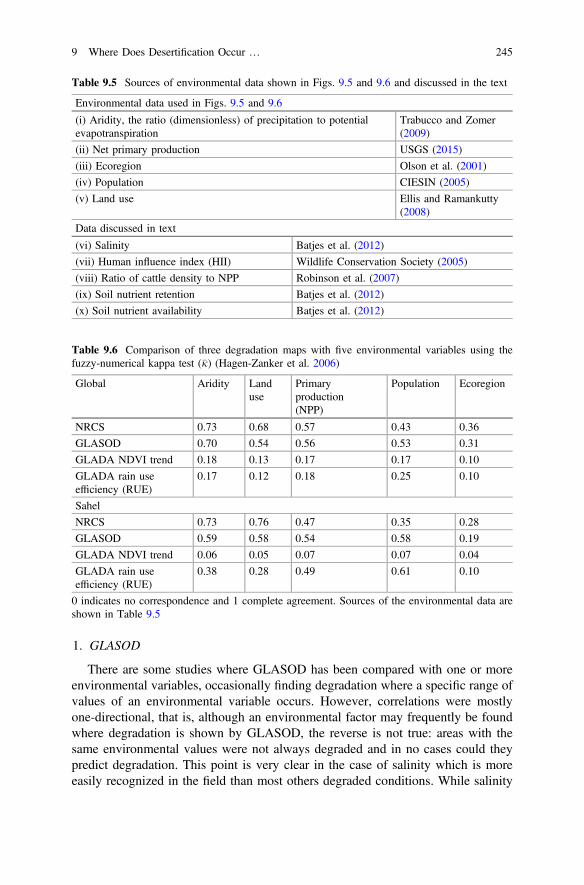
1. GLASOD
There are some studies where GLASOD has been compared with one or moreenvironmental variables, occasionally finding degradation where a specific range ofvalues of an environmental variable occurs. However, correlations were mostlyone-directional, that is, although an environmental factor may frequently be foundwhere degradation is shown by GLASOD, the reverse is not true: areas with thesame environmental values were not always degraded and in no cases could theypredict degradation. This point is very clear in the case of salinity which is moreeasily recognized in the field than most others degraded conditions. While salinity
Table 9.5 Sources of environmental data shown in Figs. 9.5 and 9.6 and discussed in the text
Environmental data used in Figs. 9.5 and 9.6
(i) Aridity, the ratio (dimensionless) of precipitation to potentialevapotranspiration
Trabucco and Zomer(2009)
(ii) Net primary production USGS (2015)
(iii) Ecoregion Olson et al. (2001)
(iv) Population CIESIN (2005)
(v) Land use Ellis and Ramankutty(2008)
Data discussed in text
(vi) Salinity Batjes et al. (2012)
(vii) Human influence index (HII) Wildlife Conservation Society (2005)
(viii) Ratio of cattle density to NPP Robinson et al. (2007)
(ix) Soil nutrient retention Batjes et al. (2012)
(x) Soil nutrient availability Batjes et al. (2012)
Table 9.6 Comparison of three degradation maps with five environmental variables using thefuzzy-numerical kappa test (�j) (Hagen-Zanker et al. 2006)
Global Aridity Landuse
Primaryproduction(NPP)
Population Ecoregion
NRCS 0.73 0.68 0.57 0.43 0.36
GLASOD 0.70 0.54 0.56 0.53 0.31
GLADA NDVI trend 0.18 0.13 0.17 0.17 0.10
GLADA rain useefficiency (RUE)
0.17 0.12 0.18 0.25 0.10
Sahel
NRCS 0.73 0.76 0.47 0.35 0.28
GLASOD 0.59 0.58 0.54 0.58 0.19
GLADA NDVI trend 0.06 0.05 0.07 0.07 0.04
GLADA rain useefficiency (RUE)
0.38 0.28 0.49 0.61 0.10
0 indicates no correspondence and 1 complete agreement. Sources of the environmental data areshown in Table 9.5
9 Where Does Desertification Occur … 245

shown in GLASOD generally agreed with the Harmonized World Soil Database(HWSD, Batjes et al. 2012) map, many saline areas in the HWSD were not shownin the GLASOD salinity map.
In the GLASOD maps severity was higher in more arid areas (Table 9.6) butgenerally stopped short of the Hyperarid zone. By far the largest contributions tooverall degradation were wind and water erosion; salinity and physical deteriorationdominated in only a very small parts of the maps. Many of the GLASOD maps hadareas in which the types of degradation and their severity coincided with putativecausal factors (compare Figs. 9.1 and 9.5) and had moderate to high �j (Table 9.6).Thus it seems that GLASOD coincides with a set of environmental conditions, notdistinguishing these from actual degradation. For example, in drylands with low(but not zero), productivity, low nutrient retention, low nutrient availability, usedfor livestock production, and where human impacts are large, had greater severity,suggesting that the maps are more a statement of susceptibility than of actualdegradation. There were, however, some notable exceptions, such as the large areashown as degraded in Argentina, in South Africa and in E. China that differed fromthe environmental patterns with which they were compared.
GLASOD mostly shows degradation in the zone between Hyperarid and DrySub-humid (except for the most northerly steppes) but many large areas within thisaridity range are not mapped as degraded (e.g. much of South America). Somecorrelations with soil characteristics might have been expected, given thatGLASOD was largely based on soils, but no strong ones were found—at least withsoil nutrient status. Only moderate correlations with population were found (but thedates of GLASOD and population differ). The productivity in areas mapped withhigh severity was almost always in the 0–0.3 gm−2 year−1 range, except in tem-perate regions where it was sometimes above this range. Surprisingly the similaritywith ecoregion was lower.
When limited to the Sahel region (Figs. 9.2, 9.3 and 9.6), the patterns weresimilar to and more clear than at the global scale. �j values were very similar for allfactors (0.59 − 0.54, Table 9.6) except ecoregion.
2. NRCS
NRCS Vulnerability was highly correlated with aridity and land use(�j = 0.73 − 0.68, Table 9.6), moderately with NPP (�j = 0.57) and least withecosysyem (�j = 0.36). In the Arid and Dry-Subhumid zones, the map (Figs. 9.1 and9.5) was essentially the same as aridity zones and low NPP (Table 9.6). In-between,in the Semi-Arid zone, the NRCS map showed mainly High with smaller invagi-nations of the Moderate class. The Risk maps had a higher correlation with pop-ulation, which is not surprising because population is one of its ingredients. TheMediterranean, Central Asia, India and the Sahel had largely High to Very HighRisk, of which much was related to human activities, while drylands in the rest ofthe world were mostly Moderate to Low. The strong correlation between populationand Risk is probably also responsible for the positive correlations with the HumanInfluence Index (HII) and cattle density per unit NPP (Table 9.5).
246 S.D. Prince

High degradation in tropical Arid and Semi-Arid zones was almost exclusivelyin grasslands, dry woodland, savannas and scrub. At a regional scale, however,there were some unexpected features. For example, in USA, it was shown as Highin the wetter, eastern Great Plains, but declined westwards to Low even as aridityincreased. Beyond the Front Range of the Rocky Mountains, degradation was againpositively related to aridity. A similar pattern occurred in E. Australia and China. Ifthe USA feature has any meaning, it may reflect the more intense land utilization inthe least arid (eastern) part of these drylands associated with higher degradation,
Fig. 9.5 Global patterns of five variables related to degradation. See Table 9.5 for sources.
9 Where Does Desertification Occur … 247

followed by reduced degradation in the rangelands of the High Plains to the westand high again in the mountainous West.
The NRCS maps of overall desertification were closely related to NPP. In India,Moderate was associated with human activities almost exclusively, but it is sur-prising that the densely populated Ganges valley was shown High, rather than Very
Fig. 9.6 Sahel, Sudanian and Dry-Subhumid zone patterns of five variables related to degradation.See Fig. 9.5 for color scales and Table 9.5 for sources.
248 S.D. Prince

High; maybe this reflects the high NPP which offsets heavy utilization. In N. Africa,while Vulnerability increased southwards, Risk was the reverse, presumably owingto the higher population along the Mediterranean coast. The highest values ofsaline-induced degradation in the NRCS map correlated quite closely with theHWSD salinity map.
Wind erosion was largely zonal, like overall degradation, increasing with aridityup to the boundary of the Semi-Arid and Arid zones, and then decreasing into theArid zone. However, large areas within the drylands are not shown in the NRCSmap. In China human causes were mainly at the wetter margins, while in India, vastareas were attributed to human action. Central Asia is shown as Very High andmost of this, too, can be associated with human action. Only small areas ofanthropogenic wind erosion were shown in Australia and South America. The DustBowl region of the USA was mapped with a Low Risk of wind erosion in spite ofsigns of a return of the erosion of the 1930s (Romm 2011). In the Sahel, where allthe erosion was attributed to human action, most of the high values of wind erosionwere in the Semi-Arid zone and decline to the north and south.
Most parts of the world’s drylands are mapped as High and Very High for watererosion. High values occurred particularly in the Arid zone, but not in the most Aridareas, except for the high plains of the USA where, once again, along the east towest gradient of increasing aridity, water erosion was first high, then fell in the HighPlains and increased into the western mountains. Southern Africa and Australiawere generally Low to Moderate for water erosion.
In the Sahel, the north-south zonal patterns dominated the NRCS maps and theenvironment. Once again, the differences between Vulnerability and Risk reflectedthe population distribution, shown clearly by the similarity of their arithmetic dif-ference and population. The measures of similarities (Table 9.6) were high foraridity and land use (�j = 0.73 − 0.68, Table 9.6), but only moderate for NPP andpopulation (�j = 0.47 − 0.35, Table 9.6). Ecoregion was low, as with GLASOD,possibly because of the coarse resolution of the ecoregion map compared with thedegradation maps.
3. GLADA
GLADA (Bai et al. 2008) undertook detailed analyses of NDVI trends and foundnegative values in most Arid zones and also widespread, but less-coherent, patchesin Dry-Subhumid zones. Large positive trends were mainly in the Semi-Arid zonein-between, but all three zones had small, scattered areas with positive trends.However, when the patterns were compared quantitatively there were effectively nosimilarity with any of the environmental factors (�j = 0.10 − 0.18, Table 9.6) andeven less so when restricted to the Sahel (�j = 0.07 − 0.04, Table 9.6). This suggeststhat the NDVI trend was insensitive to any of the environmental factors associatedwith degradation—a surprising finding. In the time-series of single pixels, bothnegative and positive trends occurred, and so it must be questioned whether, inview of such rapid changes and reversals, they constitute degradation in the sensewhere the time scale of recovery from true desertification is often longer than25 years.
9 Where Does Desertification Occur … 249

The global pattern of RESTREND was similar to the NDVI trend but moreintense and widespread. Exceptions occurred, for example the Gedaref (Al Qadarif)province of eastern Sudan which was positive with NDVI trend and negativenegative with RESTREND. The Sahel Semi-Arid belt had large positive NDVItrends, but smaller areas of RESTREND were positive and all had low values.About half of the Sahel had negative RESTREND values. Thus RESTREND, withits rainfall normalization, suggests large areas of degradation even though NDVIwas increasing. The RUE pattern was similar to RESTREND, but more coherent.Taken together GLADA suggest that the well-known “greening” of the Sahel(Olsson et al. 2005) is masking underlying degradation of productivity, in contrastto Rishmawi (2013) who used similar methods and found only isolated patches ofdegradation in the region.
Unlike NRCS and GLASOD, both of which used qualitative, expert judgment,GLADA products are derived from numerical measurements. However, a seriousdrawback is the uncertainty in interpretation—do negative trends indicate degra-dation? The finding here of effectively zero correlation with causative factors is notencouraging. Assessments of GLADA products carried out in partner countries(Dijkshoorn et al. 2008) gave mixed results (Wessels 2009).
9.5.4 Inter-comparisons of Degradation Maps
Since there were no strong correlations of any of the maps with the selectedenvironmental variables, a comparison of each map with the others was carried outto see if there is any consistency of mapping of degraded areas. While agreementsbetween maps are of interest, of course they do not indicate validity: on the con-trary, given that GLASOD has been found to have serious shortcomings (Sonneveldand Dent 2009; Nachtergaele et al. 2011; UNCED 1992), any agreements withother maps could be because they agree in their invalidity.
Both the overall global and Sahel comparison results (Figs. 9.7, 9.8 and 9.9)revealed two groups of maps that were similar amongst themselves, but very dif-ferent between. The first set consisted of the GLADA maps (NDVI Trend,RESTREND, and RUE) all of which had �j values greater than 0.6. The similaritywas greatest for the NDVI Trend v RESTREND comparison, probably becauseboth are linear fits to temporal trends of the satellite data. However, the level ofagreement suggests that the rainfall normalization had rather little effect onRESTREND, at least at a global scale. The lesser agreement with RUE is probablybecause RESTREND expresses the changes in NDVI through time, while RUEshows the degree of degradation with respect to rainfall. The maps of j for eachpixel (Figs. 9.8 and 9.9) were not random but had geographically coherent areas ofsimilar values.
The second group of maps with internal similarity was GLASOD and NRCS.Unlike the NDVI-derived maps which are global, less of the world is covered bythese, and an even smaller area jointly, but they do include most of the Arid,
250 S.D. Prince

Semi-Arid and Dry-Subhumid regions. Their relatively high similarity (�j = 0.667)may be because properties related to soils were the most important inputs used inboth maps. Again, the areas of agreement and disagreement tended to be in distinctpatches with sharp boundaries.
Although the three maps derived from NDVI have overall low similarities withGLASOD (also reported by Gibbs and Salmon 2015) and NRCS, the kappa for bothNRCS and GLASOD with RUE in the Sahel were higher than the other compar-isons between the two groups. This is most likely a result of the similarity ofGLASOD and NRCS, so both have similar correlations with RUE. Gibbs andSalmon’s (2015) results for two of the maps included here were very different,probably because they included all parts of the Earth, not just drylands, and areaswhere one or more maps had no data.
9.6 Discussion
The general lack of agreement between the degradation maps and the lack ofadherence to basic principles of detection leads to the conclusion that the questions,“What?”, “Where?” and “How severe?”, at the global and Sahel scales, are largelyunanswered, and the maps that exist are unsuitable for most of the applications forwhich they are used. There are many reasons for this, including the followingissues.
Fig. 9.7 Comparisons of all10 pairs of five globaldegradation maps. Kappa (�j)indicates the degree ofagreement of map pairs.Global results are shown inblack and Sahelian, Sudanianand Dry-Subhumid zones(labelled Sahel+) in grey.
9 Where Does Desertification Occur … 251

9.6.1 Pursuit of the Undefinable “Desertification”
It was only in the immediate aftermath of the Sahelian droughts that maps werepublished of a unitary property of “desertification” (e.g. Dregne 1983), and thesewere, in fact, oriented to a particular set of conditions (similar to the “Sahelian”syndrome of Geist 2005) rather than the overall concept enshrined in the “WorldAtlas of Desertification”. It is surprising, therefore, that the idea of a singularproperty of “desertification” is still held. In the special case of GLASOD, because
Fig. 9.8 Comparisons of all 10 pairs of five global degradation maps. Individual pixel Kappa (j)shown in color: 1 total agreement, 0 total disagreement. Global summary comparisons (�j) aregiven on each panel. Black areas indicate areas that are not Arid, Semi-Arid or Dry-Subhumid ornot shown in one or both maps.
252 S.D. Prince

there is no overlap of causes and severities between mapped units (Fig. 9.3), themaps of each type of degradation can be shown together in one image (Figs. 9.1 and9.2), but this does not imply that it is a map of desertification in the holistic sense.Similarly, the several NRCS maps each show the Risk and Vulnerability of aseparate condition, not all together. The GLADA maps are all based on a surrogatefor NPP, again, not an overall “desertification” metric. It has been proposed byPrince (2002) that, because several factors associated with degradation result in lossof productivity, NPP can be regarded as a surrogate for these in addition to pro-ductivity itself; however, this is an integration of processes that control produc-tivity, not a candidate for an all-encompassing metric of desertification. Whether theuse of production as an integrator is adequate or not, the result is a study of impactson productivity, not on “desertification”.
The notion of a process of “desertification” has recently returned in the rejectionof individual degradation processes in favor of an index that attempts to link allfactors that lead to human loss (Bridges and Oldeman 1999; Reynolds and StaffordSmith 2002; Nachtergaele et al. 2011). However, there are good reasons not tocombine metrics: all variables cannot be measured with equal accuracy; an indi-vidual process may be of interest, such the soil carbon balance, rather than “de-sertification”; and a synthetic index requires the use of arbitrary weightings of theindividual processes. Nevertheless, it has been suggested that the degrees ofinteractions vary, some are stronger than others, and so some simple variables maybe adequate in some cases (Reynolds et al. 2007).
Fig. 9.9 Comparisons of all 10 pairs of five Sahel degradation maps. Individual pixel Kappa (j)shown in color: 1 total agreement, 0 total disagreement. Summary comparisons for the whole maps(�j) are given on each panel. Black areas indicate areas that are not Arid, Semi-Arid orDry-Subhumid or are not shown in one or both maps.
9 Where Does Desertification Occur … 253

Progress will be difficult unless the unitary concept of desertification is aban-doned in favor of mapping the drivers, processes and outcomes.
9.6.2 Limited Measurement Techniques
While a large number of objective metrics of degradation can be used in the field(DESIRE 2008), upscaling of most of these is generally not possible beyond thelocal site scale because spatial variations between field sites cannot be taken intoaccount. More fundamentally, local measurements often cannot be used for largerareas because of the incongruity of data at different scales. Similarly, qualitativeexpert opinions, while not to be dismissed, particularly in view of the critical role ofhumans in the designation of degradation, are severely limited when spatially andtemporally extensive coverage is needed. Furthermore, maps based on opinion,whether “expert” or not, are qualitative and therefore cannot be used for monitoring.
Satellite data and their derivatives, while expanding rapidly in type, precision andresolution, are not substitutes for field measurements. They can provide only a few ofthe properties often measured in the field, moreover, even measurements of the samevariable (e.g. vegetation cover) differ owing to the differences in measurementtechniques. Nonetheless, there is an expanding inventory of remotely-sensed vari-ables that can be used directly or as proxies, and the fact remains that there is nosubstitute for the intrinsic spatial- and temporal-continuity of remotely-sensedmeasurements. New satellite measurements with local to global coverage, highspatial resolution and long-term archives are emerging and these, coupled withrapidly improving global meteorological data and continuing improvements of mapsof critical properties such as soil fertility, warrant some optimism.
9.6.3 Lack of Comparison with Non-degraded Sites
An incontrovertible reality for any measurement system is that it requires a refer-ence standard. Without this, statements about more or less degradation or “deser-tification” are meaningless. Despite obvious difficulties, comparisons within areasthat are not degraded are essential.
9.6.4 Slow Degradation and Fast Changes in Weather
In most cases, degradation is a gradual process and its presence is often obscured byhigher temporal frequency variations in the environment. The most obvious case israinfall; no two growing seasons are the same and neither are the responses of thevegetation. Without being able to normalize these factors, any supposed
254 S.D. Prince

measurement of degradation is only suggestive at best. Where there are recogniz-able cycles of these other factors, degradation may be revealed by averaging overthe period of the cycle (Prince et al. 1998). However, such regularities are rare(Wessels et al. 2007b).
9.7 Conclusions
The What? question, if in reference to “desertification”, is meaningless. On theother hand, if applied to specific conditions and processes, such as losses of pro-ductivity, biomass, soil fertility, or erosion, and can be measured quantitatively,“degradation” can be defined rigorously. Thus, if specific degradative processes areselected, rather than a nebulous, all-encompassing concept of “desertification” andobjective measurement techniques exist, progress can be made.
The Where? question can only be answered for a specific “What” answer. Evenif the condition is well-defined, a limitation can be the lack of an appropriatemethod for mapping and monitoring at scales useful to the application.
How severe? Given the current narrow selection of measurable variables (theWhat?) and the constraints of adequate spatial coverage (the Where?), assessmentsof severity are limited and generally not adequate beyond the local, and certainlynot the global scale. An exception is the precision of satellite-borne instruments but,with these, the challenge is the interpretation of the data to obtain information onthe specific conditions and processes of degradation.
The current situation is well summarized by Nachtergaele et al. (2011)
Global assessments of soil and land degradation have started more than 35 years ago buthad until now not achieved a clear answer on where land degradation takes place, whatimpact it has on the population and what the cost to governments and land users would be ifthe decline in soil, water and vegetation resources continued unabated. Although institu-tional, socio-economic and biophysical causes of land degradation have been identifiedlocally in many case studies, these have not been inventoried systematically at district,national or regional level. Much of the investment in land reclamation and rehabilitationduring recent years has been driven by donor interest to fund action rather than research andunderstanding of the problem. Even the impact of what works and what does not incombating land degradation is hardly known nor investigated (modified from Nachtergaeleet al. 2011).
But what of the future? Is the objective of mapping what, where and severitybeyond the local scale, totally quixotic? On the contrary—there are some reasonsfor optimism, including the following.
(i) While all methods for mapping degradation have intrinsic limitations, remotesensing not only has important capabilities with its present data and analyticalmethods but also is in a phase of rapid expansion. Some highlights ofnear-term developments of satellite remote-sensing include (Table 9.4): radarmeasurement of soil water and rainfall; LiDAR data of biomass; highspectral-resolution radiometers (hyperspectral) for detection of plant species
9 Where Does Desertification Occur … 255

and functions (Ustin et al. 2009); and increasing accuracy and spatial reso-lution of global weather data.
(ii) While digital versions of degradation maps and their input data are rarelymade available, access via Internet to data on Earth properties is advancingrapidly. For example: the Oak Ridge National Laboratory Distributed ActiveArchive Center (ORNL DAAC 2015) has over 1134 data sets for biogeo-chemical dynamics; the Global Change Master Directory (GCMD 2015) hassix relevant categories, containing over 18,000 records, including compre-hensive data relevant to dryland degradation; the Socioeconomic Data andApplications Center (SEDAC 2015) which focuses on human interactionswith the environment, has data in 163 subject areas; and the FAO GlobalInformation and Early Warning System (GIEWS 2015) which issues reportson the world food situation and provides early warnings of impending foodcrises.
(iii) Notwithstanding these new tools and improved data access, a fundamentalneed is for independent organizations at national, regional and global scales toundertake routine monitoring. The United Nations Environment Program(UNEP 2015) and FAO GLADIS have limited, but very relevant activities ofthis sort. However, at present, even existing data are not easily available—aglaring example is the paucity of free, easily available, basic meteorologicalstation data such as rainfall. However these issues are being overcome bysome agencies, for example, the Centre de Suivi Ecologique in Senegal (CSE2015) and the USAID Famine Early Warning System (FEWS Net 2015;Brown 2008).
(iv) Finally, technically credible leadership, free from external pressures, is neededto address the issues of degradation at international-global scales and to har-monize policy-relevant research, monitoring and interpretation. Unfortunatelygovernmental agencies are often not well-informed of appropriate techniques,they are subject to political pressures and have no incentive to participate at theinternational scale. While GIEWS has an on-going programme of harmo-nization of data collection, the interpretation step is not included. In the case ofclimate change, the Intergovernmental Platform on Climate Change (IPCC2015) provides a blueprint and it is to be hoped that the new IntergovernmentalPanel on Biodiversity and Ecosystem Services (IPBES 2015), which includesthe UNCCD, will develop into this role.
Credible answers to the what, where and how severe questions are possible ifbetter fundamental principles are developed and applied. There is hope that suchprogress will not be long in coming.
Acknowledgments Dr. K. Rishmawi, Jeremy Stanfield and Hasan Jackson assisted with the mapcomparisons.
256 S.D. Prince

References
Abella, S. R., Chiquoine, L. P., Newton, A. C., & Vanier, C. H. (2015). Restoring a desertecosystem using soil salvage, revegetation, and irrigation. Journal of Arid Environments, 115,44–52.
Adeel, Z., Safriel, U., Niemeijer, D., & White, R. (Eds.). (2005). Millennium ecosystemassessment. Ecosystems and human well-being: Desertification synthesis. Washington, D.C.:World Resources Institute.
Al-Bakri, J. T., Taylor, J. C., & Brewer, T. R. (2001). Monitoring land use change in the Badiatransition zone in Jordan using aerial photography and satellite imagery. The GeographicalJournal, 167, 248–262.
Asner, G. P., & Heidebrecht, K. B. (2002). Spectral unmixing of vegetation, soil and dry carboncover in arid regions: Comparing multispectral and hyperspectral observations. InternationalJournal of Remote Sensing, 23, 3939–3958.
Bai, Z. G., Conijn, J. G., Bindraban, P. S., & Rutgers, B. (2012). Global changes of remotelysensed greenness and simulated biomass production since 1981. Towards mapping global soildegradation Report 2012/02. Wageningen: ISRIC.
Bai, Z. G., Dent, D. L., Olsson, L., & Schaepman, M. E. (2008). Proxy global assessment of landdegradation. Soil Use and Management, 24, 223–234.
Bastin, G., Pickup, G., Chewings, V., & Pearce, G. (1993). Land degradation assessment in centralAustralia using a grazing gradient method. Rangeland Journal, 15, 190–216.
Batjes, N. H. (1996). Global assessment of land vulnerability to water erosion on a 1/2 by 1/2 grid.Land Degradation and Development, 7, 353–365.
Batjes, N., Dijkshoorn, K., van Engelen, V., Fischer, G., Jones, A., Montanarella, L., et al. (2012).Harmonized world soil database: Version 1.2. FAO, Rome, Italy and IIASA, Laxenburg,Austria: FAO/IIASA/ISRIC/ISSCAS/JRC.
Beinroth, F. H., Eswaran, H., & Reich, P. F. (2001). Global assessment of land quality. In D.E. Stott, R. H. Mohtar & G. C. Steinhardt (Eds.), Sustaining the global farm: Selected papersfrom the 10th international soil conservation organization meeting (pp. 569–574). PurdueUniversity and the USDA-ARS National Soil Erosion Research Laboratory.
Berry, L., Abraham, E., & Essahli, W. (2009). UNCCD recommended minimum set of impactindicators. UNCCD.
Boer, M. M., & Puigdefábregas, J. (2003). Predicting potential vegetation index values as areference for the assessment and monitoring of dryland condition. International Journal ofRemote Sensing, 24, 1135–1141.
Bossio, D., Geheb, K., & Critchley, W. (2010). Managing water by managing land: Addressingland degradation to improve water productivity and rural livelihoods. Agricultural WaterManagement, 97, 536–542.
Bowker, M. A., Belnap, J., & Miller, M. E. (2006). Spatial modeling of biological soil crusts tosupport rangeland assessment and monitoring. Rangeland Ecology and Management, 59, 519–529.
Bridges, E. M., & Oldeman, L. R. (1999). Global assessment of human-induced soil degradation.Arid Soil Research and Rehabilitation, 13, 319–325.
Brown, M. E. (2008). Famine early warning systems and remote sensing data. Berlin: Springer.Brown, M. E., Grace, K., Shively, G., Johnson, K. B., & Carroll, M. (2014). Using satellite remote
sensing and household survey data to assess human health and nutrition response toenvironmental change. Population and Environment, 36, 48–72.
Cai, X., Zhang, X., & Wang, D. (2010). Land availability for biofuel production. EnvironmentalScience and Technology, 45, 334–339.
Castro, J. M., Salomone, J. M., & Reichart, R. N. (1980). Estudio de los focos de erosión en el SOde la Provincia de Chubut. In Informe Técnico (p. 68). Trelew, Argentina: Instituto Nacional deTecnología Agropecuaria.
9 Where Does Desertification Occur … 257

Cerdan, O., Govers, G., Le Bissonnais, Y., Van Oost, K., Poesen, J., Saby, N., et al. (2010). Ratesand spatial variations of soil erosion in Europe: A study based on erosion plot data.Geomorphology, 122, 167–177.
CIESIN. (2005). Gridded Population of the World (GPW), v3. Socioeconomic Data andApplications Center (SEDAC), http://sedac.ciesin.columbia.edu/. Accessed February 7, 2015.
Cohen, J. (1960). A coefficient of agreement for nominal scales. Educational and PsychologicalMeasurement, 20, 37–46.
Conant, R. T., & Paustian, K. (2002). Potential soil carbon sequestration in overgrazed grasslandecosystems. Global Biogeochemical Cycles, 16, 1143.
Cook, B., & Pau, S. (2013). A global assessment of long-term greening and browning trends inpasture lands using the GIMMS LAI3 g dataset. Remote Sensing, 5, 2492–2512.
Coppin, P., Jonckheere, I., Nackaerts, K., Muys, B., & Lambin, E. (2004). Digital changedetection methods in ecosystem monitoring: A review. International Journal of RemoteSensing, 25, 1565–1596.
CSE. (2015). Centre de Suivi Ecologique (Ecological Monitoring Center), http://www.cse.sn.Accessed February 6, 2015.
Dawelbait, M., & Morari, F. (2012). Monitoring desertification in a Savannah region in Sudanusing landsat images and spectral mixture analysis. Journal of Arid Environments, 80, 45–55.
Deichmann, U. (1994). A medium resolution population database for Africa: Technical paper anddigital database. Santa Barbara: National Center for Geographic Information and Analysis.
del Valle, H. F., Blanco, P. D., Metternicht, G. I., & Zinck, J. A. (2010). Radar remote sensing ofwind-driven land degradation processes in Northeastern Patagonia. Journal of EnvironmentalQuality, 39, 62–75.
den Biggelaar, C., Lal, R., Wiebe, K., Eswaran, H., Breneman, V., & Reich, P. (2004). The globalimpact of soil erosion on productivity II: Effects on crop yields and production over time.Advances in Agronomy, 81, 1–48.
DESIRE. (2008). Manual for describing land degradation indicators. Athens: AgriculturalUniversity of Athens.
Dewitte, O., Jones, A., Elbelrhiti, H., Horion, S., & Montanarella, L. (2012). Satellite remotesensing for soil mapping in Africa: An overview. Progress in Physical Geography, 36, 514–538.
Dijkshoorn, J. A., van Engelen, W. W. P., & Huting, J. R. M. (2008). Global Assessment of LandDegradation Soil and landform properties for LADA partner countries (Argentina, China,Cuba, Senegal and The Gambia, South Africa and Tunisia). ISRIC report 2008/06 and GLADAreport 2008/0. Wageningen: ISRIC—World Soil Information Center and FAO.
Dregne, H. E. (1983). Desertification of arid lands. In F. El-Baz & M. H. A. Hassan (Eds.), Physicsof desertification (p. 242). Chur, Switzerland; New York: Harwood Academic Publishers.
Dregne, H. E., & Chou, N. T. (1992). Global desertification dimensions and costs. In H. E. Dregne(Ed.), Degradation and restoration of arid lands. Lubbock, Texas: International Center forArid and Semiarid Land Studies, Texas Tech. University.
Ellis, E. C., & Ramankutty, N. (2008). Putting people in the map: Anthropogenic biomes of theworld. Frontiers in Ecology and the Environment, 6, 439–447.
Eswaran, H., Almaraz, R., van den Berg, E., & Reich, P. (1997). An assessment of soil resourcesof Africa in relation to productivity. Geoderma, 77, 1–18.
Eswaran, H., Lal, R., & Reich, P. F. (2001). Land degradation: an Overview. In E. M. Bridges, I.D. Hannam, L. R. Oldeman, F. W. T. Pening de Vries, S. J. Scherr, & S. Sompatpanit (Eds.),Responses to land degradation. Khon Kaen, Thailand: Oxford Press.
FAO/UNESCO. (1991). The digitized soil map of the world. In World Soil Resources Report,Rome.
FAOSTAT. (2015). Food and agriculture organization of the United Nations, statistics division.http://faostat.fao.org. Accessed February 7, 2015.
Feddema, J. J. (1999). Future African water resources: Interactions between soil degradation andglobal warming. Climatic Change, 42, 561–596.
258 S.D. Prince

FEWS Net. (2015). Famine early warning network. http://www.fews.net. Accessed February 7,2015.
Furby, S., Caccetta, P., & Wallace, J. (2010). Salinity monitoring in Western Australia usingremotely sensed and other spatial data. Journal of Environmental Quality, 39, 16–25.
Gao, J., & Liu, Y. (2010). Determination of land degradation causes in Tongyu County, NortheastChina via land cover change detection. International Journal of Applied Earth Observationand Geoinformation, 12, 9–16.
GCMD. (2015). Global change master directory. http://gcmd.nasa.gov. Accessed February 6,2015.
Geist, H. (2005). The causes and progression of desertification. Abingdon Oxon, UK: AshgatePublishing.
Gibbs, H. K., & Salmon, J. M. (2015). Mapping the world’s degraded lands. Applied Geography,57, 12–21.
GIEWS. (2015). Global information and early warning system. http://www.fao.org/giews/english/index.htm. Accessed February 15, 2015.
GLADIS. (2015). Global land data information system. http://www.fao.org/nr/lada. AccessedFebruary 8, 2015.
Hagen-Zanker, A., Engelen, G., Hurkens, J., Vanhout, R., & Uljee, I. (2006).Map Comparison Kit(MCK). 3.0. Maastricht, The Netherlands: Research Institute for Knowledge Systems (RIKSbv).
Harris, I., Jones, P. D., Osborn, T. J., & Lister, D. H. (2014). Updated high-resolution grids ofmonthly climatic observations—the CRU TS3.10 dataset. International Journal ofClimatology, 34, 623–642. doi:10.1002/joc.3711.
Herrick, J. E., Lessard, V. C., Spaeth, K. E., Shaver, P. L., Dayton, R. S., Pyke, D. A., et al.(2010). National ecosystem assessments supported by scientific and local knowledge. Frontiersin Ecology and the Environment, 8, 403–408.
Hill, J. (2001). Remote sensing of surface properties. In S.-W. Breckle, M. Veste & W. Wucherer(Eds.), The key to land degradation and desertification assessments. Sustainable land use indeserts (pp. 243–254). Springer, Berlin.
Holm, A. M., Cridland, S. W., & Roderick, M. L. (2003). The use of time-integratedNOAA NDVI data and rainfall to assess landscape degradation in the arid shrubland ofWestern Australia. Remote Sensing of Environment, 85, 145–158.
Ibáñez, J., Martínez Valderrama, J., & Puigdefabregas, J. (2008). Assessing desertification riskusing system stability condition analysis. Ecological Modelling, 213, 180–190.
IPBES. (2015). Intergovernmental panel on biodiversity and ecosystem services. http://www.ipbes.net/. Accessed June 9, 2015.
IPCC. (2015). Intergovernmental panel on climate change. http://ipcc.ch/. Accessed February 7,2015.
Izaurralde, R. C., Williams, J. R., Post, W. M., Thomson, A. M., McGill, W. B., Owens, L. B., &Lal, R. (2007). Long-term modeling of soil C erosion and sequestration at the small watershedscale. Climatic Change, 80, 73–90.
Kirkby, M. J., Irvine, B. J., Jones, R. J. A., & Govers, G. (2008). The PESERA coarse scaleerosion model for Europe. I.—Model rationale and implementation. European Journal of SoilScience, 59, 1293–1306.
Kosmas, C., Karavitis, C., Kairis, O., Kounalaki, A., Fasouli, V., & Tsesmelis, D. (2012). Usingindicators for identifying best land management practices for combating desertification.DESIRE Scientific reports. Deliverable 2.2.3. Agricultural University of Athens.
Lambin, E. F., & Ehrlich, D. (1997). Land-cover changes in sub-saharan Africa (1982–1991):Application of a change index based on remotely sensed surface temperature and vegetationindices at a continental scale. Remote Sensing of Environment, 61, 181–200.
Liniger, H., Schwilch, G., Gurtner, M., Studer, R.M., Hauert, C., van Lynden, G., et al. (2008).WOCAT degradation categorization system. WOCAT—World Overview of ConservationApproaches and Technologies.
9 Where Does Desertification Occur … 259

Lobell, D. B. (2010). Remote sensing of soil degradation: Introduction. Journal of EnvironmentalQuality, 39, 1–4.
Martín-Fernández, L., & Martínez-Núñez, M. (2011). An empirical approach to estimate soilerosion risk in Spain. Science of the Total Environment, 409, 3114–3123.
Mbow, C., Fensholt, R., Rasmussen, K., & Diop, D. (2013). Can vegetation productivity bederived from greenness in a semi-arid environment? Evidence from ground-based measure-ments. Journal of Arid Environments, 97, 56–65.
Millennium Ecosystem Assessment. (2005). Millennium ecosystem assessment synthesis report.Ecosystems and human well-being: A framework for assessment. Concepts of ecosystem valueand validation approaches. Washington, DC: Island Press and World Resources Institute.
Milton, S. J., Dean, W. R. J., du Plessis, M., & Siegfried, W. R. (1994). A conceptual model ofarid rangeland degradation. Bioscience, 44, 70–76.
Mortimore, M. J., & Adams, W. M. (2001). Farmer adaptation, change and ‘crisis’ in the Sahel.Global Environmental Change-Human and Policy Dimensions, 11, 49–57.
Mulligan, M. (2015). Computational policy support systems for understanding land degradationeffects on water and food security for and from Africa. Land restoration: Reclaiminglandscapes for a sustainable future, Elsevier (p. 400). ILLP Publication.
Mulligan, M., Burke, S., & Ogilvie, A. (2015). Much more than simply “desertification”:understanding agricultural sustainability and change in the Mediterranean. In R. Benkhe (Ed.),(pp. x–xx). doi:10.1007/978-3-642-16014-1_8. Berlin: Springer.
Nachtergaele, F. O. F., & Licona-Manzur, C. (2008). The land degradation assessment in drylands(LADA) project: Reflections on indicators for land degradation assessment. In C. C. Lee & T.Schaaf (Eds.), The future of drylands (pp. 327–348). Rome, Italy: UNESCO, Food andAgriculture Organization of the United Nations (FAO).
Nachtergaele, F. O., Petri, M., Biancalani, R., van Lynden, G., van Velthuizen, H., & Bloise, M.(2011). An Information database for land degradation assessment at global level. In Globalland degradation information system (GLADIS).
Oldeman, L. R., Hakkeling, R. T. A., & Sombroek, W. G. (1991). World map of the status ofhuman-induced soil degradation: An explanatory note. Global Assessment of Soil Degradation(GLASOD) (2nd ed.). Wageningen Winand Staring Center, International Society for SoilScience, FAO, International Institute for Aerospace Survey and Earth Science.
Oldeman, L. R., & van Lynden, G. W. J. (1996). Revisiting the GLASOD methodology. ISRICreport 1996/03. Wageningen: ISRIC World Soil Information.
Olson, D. M., Dinerstein, E., Wikramanayake, E. D., Burgess, N. D., Powell, G. V. N.,Underwood, E. C., et al. (2001). Terrestrial ecoregions of the world: A new map of life onearth. Bioscience, 51, 933.
Olsson, L., Eklundh, L., & Ardö, J. (2005). A recent greening of the Sahel—trends, patterns andpotential causes. Journal of Arid Environments, 63, 556–566.
ORNL DAAC. (2015). Oak Ridge National Laboratory Distributed Active Archive Center, http://daac.ornl.gov/index.shtml. Accessed February 15, 2015.
Petschel-Held, G., Block, A., Cassel-Gintz, M., Kropp, J., Lüdeke, M. K. B., Moldenhauer, O.,et al. (1999). Syndromes of global change: A qualitative modelling approach to assist globalenvironmental management. Environmental Modeling and Assessment, 4, 295–314.
Pickup, G., & Chewings, V. (1994). A grazing gradient approach to land degradation assessmentin arid areas from remotely-sensed data. International Journal of Remote Sensing, 15, 597–617.
Prince, S. D. (1991). Satellite remote sensing of primary production: Comparison of results forSahelian grasslands 1981–1988. International Journal of Remote Sensing, 12, 1301–1311.
Prince, S. D. (2002). Spatial and temporal scales of measurement of desertification. In M.Stafford-Smith & J. F. Reynolds (Eds.), Global desertification: Do humans create deserts?(pp. 23–40). Berlin: Dahlem University Press.
Prince, S. D., Becker-Reshef, I., & Rishmawi, K. (2009). Detection and mapping of long-term landdegradation using local net production scaling: Application to Zimbabwe. Remote Sensing ofEnvironment, 113, 1046–1057.
260 S.D. Prince

Prince, S. D., De Colstoun, E. B., & Kravitz, L. L. (1998). Evidence from rain-use efficienciesdoes not indicate extensive Sahelian desertification. Global Change Biology, 4, 359–374.
Reeves, M. C., & Baggett, L. S. (2014). A remote sensing protocol for identifying rangelands withdegraded productive capacity. Ecological Indicators, 43, 172–182.
Reich, P. F., Numbem, S. T., Almaraz, R. A., & Eswaran, H. (2001). Land resource stresses anddesertification in Africa. Responses to Land Degradation. Proceedings of the 2nd InternationalConference on Land Degradation and Desertification, Khon Kaen, Thailand. New Delhi,India: Oxford Press.
Reynolds, J. F., Grainger, A., Stafford Smith, D. M., Bastin, G., Garcia-Barrios, L., Fernández, R.J., et al. (2011). Scientific concepts for an integrated analysis of desertification. LandDegradation and Development, 22, 166–183.
Reynolds, J. F., & Stafford Smith, M. (Eds.). (2002). Global desertification: Do humans createdeserts? Berlin: Dahlem University Press.
Reynolds, J. F., Stafford-Smith, D. M., Lambin, E. F., Turner, B. L, I. I., Mortimore, M.,Batterbury, S. P. J., et al. (2007). Global desertification: Building a science for drylanddevelopment. Science, 316, 847–851.
Rishmawi, K. (2013). Spatial patterns and potential mechanisms of land degradation in the Sahel.Unpublished PhD, University of Maryland.
Robinson, T. P., Francescini, G., & Wint, W. (2007). The Food and Agriculture Organization’sgridded livestock of the world. Veterinaria Italiana, 43, 745–751.
Romm, J. (2011). The next dustbowl. Nature, 478, 450–451.Safriel, U. (2007). The assessment of global trends in land degradation. In M. V. K. Sivakumar &
N. Ndiang’ui (Eds.), Climate and land degradation (pp. 1–38). New York: Springer.Safriel, U. (2009). Deserts and desertification: Challenges but also opportunities. Land
Degradation and Development, 20, 353–366.Scherr, S. J., & Yadav, S. (1996). Land degradation in the developing world: Implications for
food, agriculture, and the environment to 2020. In Food, agriculture, and the environment.International Food Policy Research Institute.
Seaquist, J. W., Hickler, T., Eklundh, L., Ardo, J., & Heumann, B. W. (2009). Disentangling theeffects of climate and people on Sahel vegetation dynamics. Biogeosciences, 6(3), 469–477.
SEDAC. (2015). Socioeconomic Data and Applications Center, http://sedac.ciesin.columbia.edu/about. Accessed February 15, 2015.
Sietz, D., Untied, B., Walkenhorst, O., Ludeke, M. K. B., Mertins, G., Petschel-Held, G., &Schellnhuber, H. J. (2006). Smallholder agriculture in Northeast Brazil: Assessing heteroge-neous human-environmental dynamics. Regional Environmental Change, 6, 132–146.
Singh, G., Bundela, D. S., Sethi, M., Lal, K., & Kamra, S. K. (2010). Remote sensing andgeographic information system for appraisal of salt-affected soils in India. Journal ofEnvironmental Quality, 39, 5–15.
Sonneveld, B. G., & Dent, D. L. (2009). How good is GLASOD? Journal of EnvironmentalManagement, 90, 274–283.
Symeonakis, E., & Drake, N. (2004). Monitoring desertification and land degradation oversub-Saharan Africa. International Journal of Remote Sensing, 25, 573–592.
Tamene, L., & Le, Q. B. (2015). Estimating soil erosion in sub-Saharan Africa based on landscapesimilarity mapping and using the revised universal soil loss equation (RUSLE). NutrientCycling in Agroecosystems, 101, 1–15. doi:10.1007/s10705-10015-19674-10709.
Thomas, D. S. G., & Middleton, N. J. (1993). Salinization: new perspectives on a majordesertification issue. Journal of Arid Environments, 24, 95–105.
Trabucco, A., & Zomer, R. J. (2009). Global Aridity Index (Global-Aridity) and Global PotentialEvapo-Transpiration (Global-PET) Geospatial Database. Published online, available from theCGIAR-CSI GeoPortal at: http://www.csi.cgiar.org
Tucker, C. J., Dregne, H. E., & Newcomb, W. W. (1991). Expansion and contraction of the Saharadesert from 1980 to 1990. Science, 253, 299–301.
Tucker, C. J., Justice, C. O., & Prince, S. D. (1986). Monitoring the grasslands of the Sahel 1984–1985. International Journal of Remote Sensing, 7, 1571–1581.
9 Where Does Desertification Occur … 261

Tucker, C. J., Pinzon, J. E., Brown, M. E., Slayback, D. A., Pak, E. W., Mahoney, R., et al. (2005).An extended AVHRR 8-km NDVI dataset compatible with MODIS and SPOT vegetationNDVI data. International Journal of Remote Sensing, 26, 4485–4498.
UNCCD. (1994). Elaboration of an international convention to combat desertification in countriesexperiencing serious drought and/or desertification, particularly in Africa (p. 58). UnitedNations General Assembly, 93rd plenary meeting, New York.
UNCED. (1992). Managing fragile ecosystems: combating desertification and drought. In Agenda21: Earth summit. Rio de Janerio: United Nations Conference on Environment andDevelopment.
UNEP. (1997). World Atlas of Desertification. (2nd ed.). London, New York: Arnold & Wiley, onbehalf of UNEP.
UNEP. (2015). United Nations Environment Programme, http://www.unep.org/. AccessedFebruary 7, 2015.
United Nations General Assembly. (2013). Future we want—Outcome document. In Resolutionadopted by the General Assembly. United Nations Department of Economic and Social Affairs(DESA).
USGS. (2015). The Land Processes Distributed Active Archive Center (LP DAAC), https://lpdaac.usgs.gov/. Accessed February 7, 2015.
Ustin, S. L., Palacios-Orueta, A., Whiting, M. L., Jacquemoud, S., & Li, L. (2009). Remotesensing based assessment of biophysical indicators for land degradation and deserlification.In R. Hill (Ed.), Recent advances in remote sensing and geoinformation processing for landdegradation assessment (pp. 15–44). London: Taylor & Francis Group.
Verón, S. R., Paruelo, J. M., & Oesterheld, M. (2006). Assessing desertification. Journal of AridEnvironments, 66, 751–763.
Vogt, J. V., Safriel, U., Von Maltitz, G., Sokona, Y., Zougmore, R., Bastin, G., & Hill, J. (2011).Monitoring and assessment of land degradation and desertification: Towards new conceptualand integrated approaches. Land Degradation and Development, 22, 150–165.
Warren, A. (2002). Land degradation is contextual. Land Degradation and Development, 13, 449–459.
Wessels, K. J. (2009). Comments on ‘Proxy global assessment of land degradation’ by Bai et al.(2008). Soil Use and Management, 25, 91–92.
Wessels, K. J., Prince, S. D., Carroll, M., & Malherbe, J. (2007a). Relevance of rangelanddegradation in semiarid northeastern South Africa to the nonequilibrium theory. EcologicalApplications, 17, 815–827.
Wessels, K. J., Prince, S. D., Malherbe, J., Small, J., Frost, P. E., & VanZyl, D. (2007b). Canhuman-induced land degradation be distinguished from the effects of rainfall variability? Acase study in South Africa. Journal of Arid Environments, 68, 271–297.
Wessels, K. J., Prince, S. D., & Reshef, I. (2008). Mapping land degradation by comparison ofvegetation production to spatially derived estimates of potential production. Journal of AridEnvironments, 72, 1940–1949.
Wessels, K. J., van den Bergh, F., & Scholes, R. J. (2012). Limits to detectability of landdegradation by trend analysis of vegetation index data. Remote Sensing of Environment, 125,10–22.
Whitlow, R. (1988). Land degradation in Zimbabwe. Harare: Department of Natural Resources,Government of Zimbabwe/Department of Geography, University of Zimbabwe.
Wildlife Conservation Society (WCS) and Center for International Earth Science InformationNetwork (CIESIN). (2005). Last of the Wild Project, (LWP-2): Global Human Influence Index(HII) Dataset. Palisades, NY: NASA Socioeconomic Data and Applications Center (SEDAC),Columbia University.
Zika, M., & Erb, K. H. (2009). The global loss of net primary production resulting fromhuman-induced soil degradation in drylands. Ecological Economics, 69(2), 310–318.
262 S.D. Prince

Zucca, C., & Biancalani, R. (2011). Guidelines for the use of the LADA QM DB in the frame ofthe “National Piloting of provisional UNCCD impact indicators” (p. 24), LADA FAO.
Zucca, C., Della Peruta, R., Salvia, R., Sommer, S., & Cherlet, M. (2012). Towards a worlddesertification atlas. Relating and selecting indicators and data sets to represent complex issues.Ecological Indicators, 2012, 157–170.
9 Where Does Desertification Occur … 263

Chapter 1040 Years of Climate Modeling: The Causesof Late-20th Century Drought in the Sahel
Alessandra Giannini
Abstract This chapter reviews the evolution of our understanding of the causes ofthe late 20th century Sahel drought in the context of global climate model devel-opment. In describing, in coherent and holistic fashion, physical arguments for localand global influences on regional rainfall variability and change, it aims to makesense of current trends and future projections in the context of the recent past.
Keywords Sahel � Drought � Climate modeling � Seasonal prediction � Climatechange � Attribution
10.1 Introduction
The interpretation of drought in the Sahel as a consequence of local environmentaldegradation fundamentally rooted in rapid population growth arose in the 1970s—the time of the “population bomb” (Ehrlich 1968) and “limits to growth” (Meadowset al. 1972). It may have been intuitive in that context, and with little directexperience of local conditions, to embrace the notion that mismanagement ofnatural resources could have an influence beyond local land degradation, and leadto self-perpetuating drought and occasional widespread famine. Perhaps the con-ception persisted because an explanation centered on local causes also meant thatlocal solutions could be implemented. However, in the decades since the early1970s, understanding of the global interconnectedness of physical climate hasadvanced, as is apparent in the development of dynamical models to predict the ElNiño-Southern Oscillation (Cane et al. 1986), and in the demonstration that humansare indeed capable of influencing the global climate system through emissions fromfossil fuel burning (Intergovernmental Panel on Climate Change 2007, 2014).Therefore, the popular notion of the influence of local land degradation on rainfall
A. Giannini (&)International Research Institute for Climate and Society, The Earth Institute,Columbia University, 61 Route 9W, Palisades, NY 10964-8000, USAe-mail: [email protected]
© Springer-Verlag Berlin Heidelberg 2016R.H. Behnke and M. Mortimore (eds.), The End of Desertification?Springer Earth System Sciences, DOI 10.1007/978-3-642-16014-1_10
265

and the more recent realization of global anthropogenic influence on climatedemand a review to make sense of the scientific debate that has surrounded thecause of drought in the Sahel over the last 40 years.
In broad climatic terms, the Sahel represents the fluctuating semi-aridgrassland-savanna boundary between desert and tropical rainforest, runningacross Africa from the Atlantic coast of Mauritania and Senegal to the Red Seacoast of Sudan and Eritrea. In reality there is a gradation in the ecosystems that spanannual mean rainfall between *200 and *1000 mm from north to south, and fromdesert to tropical rainforest, usually referred to as Sahelian, Sahelo-Sudanian andSudanian (Nicholson 1979), as well as great variation in population density, inpatterns of land use, in human settlement and in livelihood strategies, not only inthe north-south, but also in the east-west direction (Raynaut 1997; Cour and Snrech1998; Leach and Mearns 1996). However, the coarse resolution of global climatemodels, where one spatial unit or “grid box” has a dimension of *100 km, justifiesreferring to the Sahel as the strip of land occupying the latitudinal belt between 10°N and 20°N, i.e. covering *1000 km in the north-south direction, and *6000 kmin the east-west direction.
In this latitudinal belt climate is defined by the northernmost annual reach of theAfrican monsoon, which is attained in northern hemisphere summer. This climaticregime is characterized by the alternation of a relatively brief rainy season with thelonger dry season. Climate is susceptible to significant variation in precipitation onall time scales, from years to centuries to millennia and longer (Nicholson 2000a;Shanahan et al. 2009; de Menocal et al. 2000; Petit-Maire 2002; Gasse et al. 1990;Gasse 2000; Braconnot et al. 2007a, b). Conversely, temperature does not vary asdramatically as in temperate latitudes, for well understood dynamical reasons(Polvani and Sobel 2002). However, on the time scale of a person’s lifetime nothingquite compares, in abruptness, magnitude and severity of human impact, with theshift to persistently dry conditions that manifested itself in the Sahel at the end ofthe 1960s (Lamb 1982; Nicholson 1983; Katz and Glantz 1986; Hulme 2001; Daiet al. 2004; Trenberth et al. 2007; Greene et al. 2009). This shift was an extremephenomenon physically—worldwide, no region of similar extent has witnessedsuch magnitude of change during the 20th century—as well as societally—withrecurrent food security crises and talk of irreversible land degradation, or deserti-fication. For this reason, the cause of drought in the Sahel has been hotly debatedsince the inception of its last episode, in the late 1960s, with repercussions indevelopment practice, as further explored in this book.
In this chapter I seek to reconcile through an examination of physical factors thealternative views on the cause of the persistence of late 20th century drought1 in theSahel, and to define the context in which to situate 21st century climate change in
1For definitions of drought—meteorological, hydrological, agricultural—the reader is referred e.g.to Glantz (1994) and Wilhite (2001). Here drought is synonymous with deficient, or below-averagerainfall, where the average is computed on a sufficiently long period, with 30 years being thestandard implemented by the UN World Meteorological Organization.
266 A. Giannini

the region. In simplified terms, the debate in the climate science community pittedtwo alternative interpretations of the genesis of drought against each other, which, bynature of one being internal, the other external to the region (Brooks 2004) appearedto be mutually exclusive. In fact, I will show that elements of the physical argumentsunderlying the two interpretations—one to do with the impact of local humanactivity on the physical properties of the land surface and its purported regional orglobal consequences on climate, the other with the remote influence of the oceans onthe climate of this margin of the monsoon—are recurrent in explanations of pastchange, e.g. stretching to the paleo-climate reconstructions and modeling interpre-tation of the “African humid period” which ended around 6000 years ago (Kutzbachand Liu 1997; Patricola and Cook 2007), and of future change, e.g. the apparentdisagreement among global climate models in projections of regional rainfall. Forthis reason, it is important to make sense of them holistically.
Therefore, the goal of this chapter, which is organized in two sections andconclusions, is to review the competing explanations of drought to highlight thepossibility of consistency between them, and to find convergence in explanations ofclimatic change in the Sahel in a way that is meaningful to the development ofresilient livelihood strategies. The first section is about the past. It reviews theinternal/local/land and external/remote/ocean interpretations of physical climatechange in the Sahel, highlighting their strengths and weaknesses, and proposes atheoretical framework, largely based on the work of Held, Neelin, Sobel and col-laborators (e.g. Held and Soden 2006; Neelin 2007; Zeng and Neelin 1999; Neelinet al. 2003; Chou and Neelin 2004; Chiang and Sobel 2002; Sobel 2007) in whichto make sense of the parts. The second section is about the present and future—howdo we interpret current trends and projections of future change in a way that isconsistent with the recent past, i.e. the last century of direct, instrumental records, tobegin to communicate meaningfully policy and practice implications?
10.2 The Climate Science Behind Understanding Droughtin the Sahel
10.2.1 An Interpretive Lens: Bottom–Up and Top–DownProcesses Affecting Rainfall of Relevance to Localand Remote Influences
Why does it rain? If a parcel of air rises, it expands in the lower pressure, cools, andtherefore condenses moisture in the parcel, producing cloud, and ultimately, rainfall – orperhaps snowfall. So a key ingredient is certainly the many and varied mechanisms forcausing air to rise. (Trenberth et al. 2003)
A parcel of air will rise against gravity if it has the energy, if it is buoyant, orvertically unstable, with respect to the environment air surrounding it (Fig. 10.1).Therefore, one way to cause instability and rain is to make a parcel lighter, hencemore buoyant or unstable than the air surrounding it, by making it warmer and/or
10 40 Years of Climate Modeling: The Causes of Late-20th Century … 267
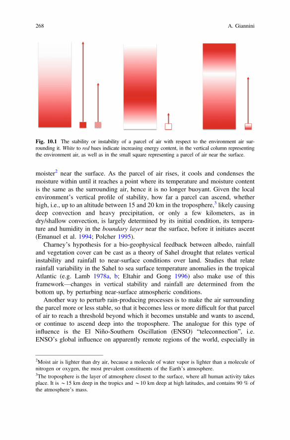
moister2 near the surface. As the parcel of air rises, it cools and condenses themoisture within until it reaches a point where its temperature and moisture contentis the same as the surrounding air, hence it is no longer buoyant. Given the localenvironment’s vertical profile of stability, how far a parcel can ascend, whetherhigh, i.e., up to an altitude between 15 and 20 km in the troposphere,3 likely causingdeep convection and heavy precipitation, or only a few kilometers, as indry/shallow convection, is largely determined by its initial condition, its tempera-ture and humidity in the boundary layer near the surface, before it initiates ascent(Emanuel et al. 1994; Polcher 1995).
Charney’s hypothesis for a bio-geophysical feedback between albedo, rainfalland vegetation cover can be cast as a theory of Sahel drought that relates verticalinstability and rainfall to near-surface conditions over land. Studies that relaterainfall variability in the Sahel to sea surface temperature anomalies in the tropicalAtlantic (e.g. Lamb 1978a, b; Eltahir and Gong 1996) also make use of thisframework—changes in vertical stability and rainfall are determined from thebottom up, by perturbing near-surface atmospheric conditions.
Another way to perturb rain-producing processes is to make the air surroundingthe parcel more or less stable, so that it becomes less or more difficult for that parcelof air to reach a threshold beyond which it becomes unstable and wants to ascend,or continue to ascend deep into the troposphere. The analogue for this type ofinfluence is the El Niño-Southern Oscillation (ENSO) “teleconnection”, i.e.ENSO’s global influence on apparently remote regions of the world, especially in
Fig. 10.1 The stability or instability of a parcel of air with respect to the environment air sur-rounding it. White to red hues indicate increasing energy content, in the vertical column representingthe environment air, as well as in the small square representing a parcel of air near the surface.
2Moist air is lighter than dry air, because a molecule of water vapor is lighter than a molecule ofnitrogen or oxygen, the most prevalent constituents of the Earth’s atmosphere.3The troposphere is the layer of atmosphere closest to the surface, where all human activity takesplace. It is *15 km deep in the tropics and *10 km deep at high latitudes, and contains 90 % ofthe atmosphere’s mass.
268 A. Giannini

the tropics. During a warm ENSO or El Niño event, ocean and atmosphere in thecentral equatorial Pacific interact in a positive feedback loop that extracts energyfrom the system: a reduction in wind speed reduces evaporation, warming thesurface of the ocean, and the atmosphere responds with increased instability,increased convection and rainfall, which further weakens the winds and warms theoceans (Cane 1991; Bjerknes 1969). In the source region of the central equatorialPacific increased energy extraction from the surface of the ocean and more abun-dant rainfall go hand in hand. This local increase in energy is first communicatedupward by rising parcels of air in deep convection, and then around the globaltropics by atmospheric waves that spread the increase in temperature at upper levelsof the troposphere, i.e. at*15–20 km of altitude (Polvani and Sobel 2002). Aroundthe tropics, outside of the tropical Pacific, warmer environmental air at upper levelstranslates into a higher instability/energy threshold for a parcel that wants to ascend,and a more stable vertical profile. Consequently the rain-producing process isinhibited, and tropical drought spreads wide in the months that follow the onset of awarm ENSO episode in regions remote from the ENSO source, e.g. in the SouthAsian and West African monsoons (Chiang and Sobel 2002; Yulaeva and Wallace1994; Lyon 2004).
Similar arguments have recently been invoked in studies that discuss the role ofwarming of the Indian Ocean in the persistence of drought in the Sahel and Horn ofAfrica (Held et al. 2005; Funk et al. 2008), or of generalized warming of the oceansin future projections of drought (Neelin et al. 2003, 2006), with an increase ingreenhouse gases leading to a transient warming of upper levels in the troposphere(Chou and Neelin 2004; Yang et al. 2003; Sugi and Yoshimura 2004).
10.2.2 Complementary Theories on the Cause of Late-20thCentury Sahel Drought
10.2.2.1 Charney’s Local/Land Bio-Geophysical Feedbackfor the Persistence of Drought
Charney’s original formulation of a bio-geophysical feedback (Charney et al. 1975)states that:
A decrease in plant cover may be accompanied by an increase in the surface albedo.4 Thiswould lead to a decrease in the net incoming radiation and an increase in the radiativecooling of the air. As a consequence, the air would sink to maintain thermal equilibrium byadiabatic compression, and cumulus convection and its associated rainfall would besuppressed.
4The albedo is the reflectivity of the Earth’s surface to solar radiation. It is a unitless numberbetween 0 and 1. Surfaces that reflect a high proportion of the incoming insolation have highalbedo.
10 40 Years of Climate Modeling: The Causes of Late-20th Century … 269

The fundamental elements of Charney’s mechanism to explain the persistence ofdrought in a semi-arid desert border region such as the Sahel are: (1) the rela-tionship between increase in surface albedo, decrease in precipitation, and conse-quent further decrease in vegetation cover and increase in albedo—a reinforcing, orpositive feedback, (2) the role of surface albedo in defining the local net surface andatmospheric energy budgets, and (3) though not explicitly stated in this specificparagraph, the role of human activity in disturbing surface albedo through sys-tematic modification of the land cover.
Charney and collaborators (1975, 1977) were the first to test this mechanism ingeneral circulation models of the atmosphere (Schneider and Dickinson 1974), thesame class of computational tools in use to make weather forecasts and projectionsof future climate change, albeit in their primordial stages.5 Using the modeldeveloped at NASA’s Goddard Institute for Space Studies (Somerville et al. 1974),they compared “control” and “perturbation” simulations. In the control, the value ofsurface albedo in the Sahel and in similar semi-arid margins of monsoons in NorthAmerica and South Asia is prescribed to be the same as all other land points, i.e.0.14. For comparison, albedo is set to a low value, equal to 0.07, for oceanic gridpoints, which reflect very little incoming solar radiation, and to a high value, equalto 0.70, for ice points, which reflect a lot (Charney et al. 1977). In the perturbation,the land value for albedo is doubled to 0.35 only in semi-arid margins of monsoonssuch as the Sahel. In the comparison, the perturbed simulations, those withincreased albedo values at the desert border, always display drier conditions in theseregions, and significantly so, despite the small sample size.
Charney et al. (1977) comment on two points of interest to ensuing develop-ments. First of all, they acknowledge that “As better general circulation models aredeveloped, the experiments described in this article [should] be repeated”. Thiscomment stems out of a specific concern about their model’s simulation of evap-oration, which, whether too high or too low, was unrealistic. Secondly, Charneyet al. note that “the perturbation will remain until external counteracting climato-logical forces become large enough to overcome the local feedback effect and returnthe system toward the old equilibrium”. In other words, while the impact of land
5In this general class of models, also known as GCMs, for “general circulation models” or “globalclimate models”, the surface of the Earth is divided into squares, or grid boxes, of dimensionscurrently of the order of*100 km. In each grid box the evolution of the atmosphere only, initially,and of the coupled ocean-atmosphere system, more recently, is derived from the equations ofmotion—the motion of fluids, the atmosphere and ocean, on a rotating sphere heated by an externalsource of energy. In the atmosphere only case, the surface temperature of the oceans is prescribed,either to monthly climatological values, or to monthly varying values derived from observations[or from seasonal predictions], while the exchange between land surface and atmosphere isdescribed by empirical relations referred to as parameterizations. In the simplest coupledocean-atmosphere case, the sole external source of energy is the sun, insolation at the top of theatmosphere is kept constant in time, and the system is let to adjust to the spatial variation in heatingthat derives from the planet’s own geometry and rotation around its axis, and that of its revolutionaround the sun. The circulations that ensue in the atmosphere and oceans are manifestations of theinherent “internal” variability in the system as it redistributes heat from warmer to cooler regions.
270 A. Giannini

surface change is not negligible, Charney et al. fully expect that in longer modelruns the dominant role of the large-scale circulation should be restored.
Follow-up studies to Charney’s seminal work focused on his recommendation toreproduce their perturbation simulations as the complexity and internal consistencyof the physical processes described by models improved. Sud and Fennessy (1982)repeated the same numerical experiments and came to the same conclusions withthe GLAS (Goddard Laboratory for Atmospheric Sciences) model. Laval and Picon(1986) did the same with the model developed at the Laboratoire de MétéorologieDynamique (LMD) in Paris. Xue and Shukla (1993) introduced a vegetationparameterization in the COLA (Center for Ocean-Land-Atmosphere Studies)model, which permitted them to characterize the sensitivity of the model to vege-tation change, through its effect on net surface energy budget and hydrology. Bychanging vegetation cover in a more realistic way compared to the idealizedincrease in albedo used in prior studies, Xue and Shukla recovered the decrease inprecipitation, as well as the changes in the regional atmospheric circulation con-sistent with a weakened monsoon. These modeled changes described a decrease inthe south-westerly flow of moist, monsoonal air, a weakening in the tropicaleasterly jet aloft, and in the mid-level African easterly jet—all features described byNewell and Kidson (1984) to be typical of dry years. They also highlighteda *2-week delay in the onset of the rainy season in their ‘desertification’ inte-grations. This facet of Xue and Shukla’s simulations is particularly interesting vis-à-vis the current state-of-the-art in interpretation of climate change projections.Studies have consistently shown a delay in the onset of the West African (Biasuttiand Sobel 2009; Biasutti 2013) and global monsoons (Seth et al. 2011, 2013) inresponse to global warming, despite the uncertainty in the direction of the seasonalor annual average change in precipitation.
Many more studies have been carried out since Charney et al.’s simulations tocheck the consistency of improved model versions, e.g. moving from the simplisticconsideration of a uniform surface albedo change to the more involved consider-ation of soil moisture feedbacks and dynamic vegetation. The work of Taylor et al.(2002) provides an end point, because it summarizes the modeling sophisticationachieved, and at the same time epitomizes the limits reached by sensitivity studies.These are studies in which the hypothetical cause of a change in the real world isidentified. In this case, the change in land surface conditions is hypothesized to bethe cause of the change in observed precipitation between wet and dry decades.Simulations are then run with and without the cause, and the two sets, a “perturbed”and a “control” case, are compared. In Taylor et al. (2002) land use change iscomputed based on an independent equilibrium model developed by Stephenne andLambin (2001). This model takes into account the competing human activitiesmodifying the rural landscape—agricultural and livestock production, and fuel-wood extraction—going so far as to postulate that extensification of agriculturalproduction should occur before intensification. Land use change is then translatedinto a change in the parameters that describe vegetation cover in a general circu-lation model. The end result is the expected decrease in rainfall between conditionsas simulated appropriate for the 1960s and 1990s. However, the simulated decrease,
10 40 Years of Climate Modeling: The Causes of Late-20th Century … 271
4.6 %, is only a fraction of the estimated *10–20 % reduction in regional rainfallobserved between the wet and dry decades of the 20th century.
In sum, we can synthesize as follows. Over the past *40 years model devel-opment has led to increased sophistication in the treatment of land-atmosphereinteraction processes, which started with imposing a simple albedo change, andevolved through consideration of interactive soil moisture and dynamic vegetation,and more realistic patterns of land use change. It has become increasingly clear thatthe processes by which anthropogenic land use change can reduce precipitation arephysically plausible, and consistent with a natural positive feedback response of theland surface to precipitation. On the other hand, prescribing a change in local landsurface conditions without allowing for the system to react, to verify whether thedynamics of the global climate system will allow the amplification of the initialperturbation, is only half of the story.
10.2.2.2 The Remote Influence of the Oceans on the Climateof the Sahel
The other half of the story is the influence of climatic factors external to the region,most notably the oceans, the source of most moisture in this semi-arid region.Oceanic influence on Sahelian drought was first quantified empirically, in studiesthat pointed to the coincidence of warm sea surface temperature (SST) anomalies inthe equatorial Atlantic Ocean during dry years in the Sahel, and related them toanomalies in the atmospheric circulation (Hastenrath and Lamb 1977; Lamb 1978a,b; Lamb and Peppler 1992).
The first modeling studies were conducted at the UK Meteorological Office(Folland et al. 1986; Palmer 1986), in a control-perturbation set-up similar to thatutilized to demonstrate sensitivity to land cover change. In this case, a controlsimulation, run with climatological sea surface temperature conditions, was com-pared to a perturbation simulation, where SST anomalies typical of dry years aresuperimposed on the same climatology (Fig. 10.2). The response was a decrease inrainfall in the Sahel in the perturbation compared to the control simulation. Thesestudies were the first to dynamically demonstrate the sensitivity of Sahel rainfall toworldwide sea surface temperatures. Why, then, were the climate science commu-nity and the broader community of scholars and practitioners of drylands develop-ment, not convinced that the cause of Sahel drought lay in the oceans, not over land?
Almost 10 years later, Rowell et al. (1995) confirmed Folland et al.’s (1986)results. They also reported that Owen and Folland (1988) had not been able toreproduce them as cleanly and convincingly with the subsequent version of the UKMet Office model, pointing out that the difference between the two generations ofmodels lay in the representation of clouds. The model employed by Folland et al.(1986) prescribed cloud cover to follow climatology at each location, avoiding thecomplexity of dynamically modeling the evolution in cloud cover. In contrast, thesubsequent version employed a prognostic cloud scheme, i.e. attempted to modelthe evolution of cloud cover within the model. As had already been noted by
272 A. Giannini

Charney et al. (1977), cloud cover is a potential negative feedback on thehypothesized bio-geophysical feedback, i.e. it can potentially weaken or disable it.An increase in surface albedo causes a reduction in solar radiation absorbed at thesurface and in energy potentially available to the atmospheric column. If this isfollowed by a decrease in precipitation, such a decrease also implies a decrease incloud cover and in cloud albedo, hence an increase in solar radiation that can reachthe surface. Therefore, in terms of atmospheric energy budget, the cloud albedoresponse can potentially cancel the initial surface albedo anomaly, andre-equilibrate the system. In Folland et al.’s model, cloud cover would not havechanged as a consequence of the albedo-precipitation change, therefore eliminatingthe potential to cancel out the effect of the initial surface albedo change. In thesubsequent set-up, where clouds varied in concert with precipitation, it could havecancelled the effect of surface albedo change. It should be noted that the dominanceof this potential negative feedback is physically unrealistic in semi-arid regionssuch as the Sahel. In such regions, a reduction in precipitation translates into areduction in soil moisture. Regardless of how much radiation reaches the surface,evaporation is limited by water availability, not by the energy required to extract itthrough evaporation (Koster et al. 2003, Koster et al. 2006). In the real world, if thebalance between surface and cloud albedo were to result in an increase in radiationinto the surface, in the absence of soil moisture that increase in radiation would nottranslate into an increase in evaporation that could fuel an increase in humidity andvertical instability.
We may ask why the Folland et al. results did not have the broader impactwarranted by their significance to the dominant discourse of human-induceddesertification (Bullock et al. 1995). While it may have been reasonable for thedevelopment community to wait until climate scientists had reached a consensus,why did the latter take so long to agree amongst themselves? Ten years afterFolland et al. (1986), Sud and Lau (1996) expressed skepticism at the Rowell et al.
Fig. 10.2 The pattern of sea surface temperature associated with late 20th century Sahel drought.Notable features are: the warming of the tropical and southern oceans, including the South Atlanticand Indian Oceans, and the relative cooling of the northern hemisphere mid-latitude oceans,especially the North Atlantic Ocean.
10 40 Years of Climate Modeling: The Causes of Late-20th Century … 273
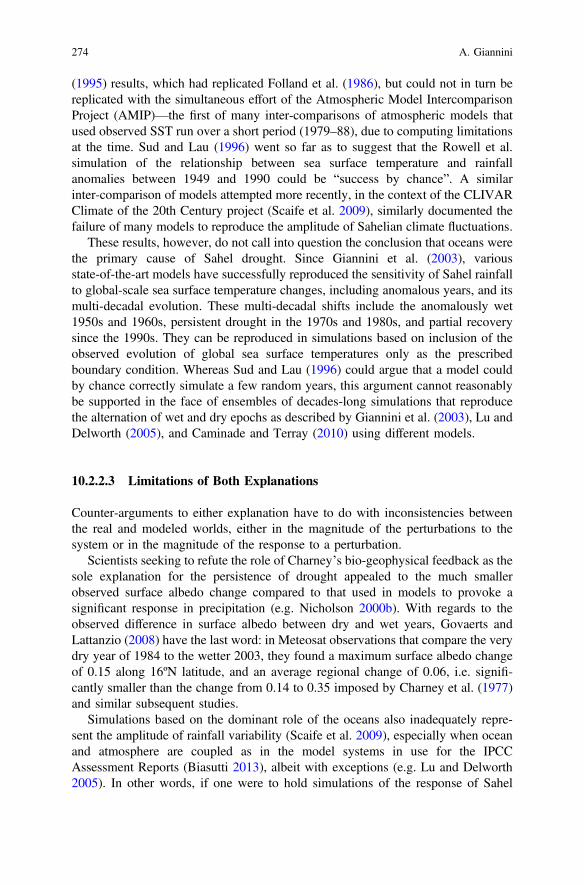
(1995) results, which had replicated Folland et al. (1986), but could not in turn bereplicated with the simultaneous effort of the Atmospheric Model IntercomparisonProject (AMIP)—the first of many inter-comparisons of atmospheric models thatused observed SST run over a short period (1979–88), due to computing limitationsat the time. Sud and Lau (1996) went so far as to suggest that the Rowell et al.simulation of the relationship between sea surface temperature and rainfallanomalies between 1949 and 1990 could be “success by chance”. A similarinter-comparison of models attempted more recently, in the context of the CLIVARClimate of the 20th Century project (Scaife et al. 2009), similarly documented thefailure of many models to reproduce the amplitude of Sahelian climate fluctuations.
These results, however, do not call into question the conclusion that oceans werethe primary cause of Sahel drought. Since Giannini et al. (2003), variousstate-of-the-art models have successfully reproduced the sensitivity of Sahel rainfallto global-scale sea surface temperature changes, including anomalous years, and itsmulti-decadal evolution. These multi-decadal shifts include the anomalously wet1950s and 1960s, persistent drought in the 1970s and 1980s, and partial recoverysince the 1990s. They can be reproduced in simulations based on inclusion of theobserved evolution of global sea surface temperatures only as the prescribedboundary condition. Whereas Sud and Lau (1996) could argue that a model couldby chance correctly simulate a few random years, this argument cannot reasonablybe supported in the face of ensembles of decades-long simulations that reproducethe alternation of wet and dry epochs as described by Giannini et al. (2003), Lu andDelworth (2005), and Caminade and Terray (2010) using different models.
10.2.2.3 Limitations of Both Explanations
Counter-arguments to either explanation have to do with inconsistencies betweenthe real and modeled worlds, either in the magnitude of the perturbations to thesystem or in the magnitude of the response to a perturbation.
Scientists seeking to refute the role of Charney’s bio-geophysical feedback as thesole explanation for the persistence of drought appealed to the much smallerobserved surface albedo change compared to that used in models to provoke asignificant response in precipitation (e.g. Nicholson 2000b). With regards to theobserved difference in surface albedo between dry and wet years, Govaerts andLattanzio (2008) have the last word: in Meteosat observations that compare the verydry year of 1984 to the wetter 2003, they found a maximum surface albedo changeof 0.15 along 16ºN latitude, and an average regional change of 0.06, i.e. signifi-cantly smaller than the change from 0.14 to 0.35 imposed by Charney et al. (1977)and similar subsequent studies.
Simulations based on the dominant role of the oceans also inadequately repre-sent the amplitude of rainfall variability (Scaife et al. 2009), especially when oceanand atmosphere are coupled as in the model systems in use for the IPCCAssessment Reports (Biasutti 2013), albeit with exceptions (e.g. Lu and Delworth2005). In other words, if one were to hold simulations of the response of Sahel
274 A. Giannini

rainfall to oceanic change to the same standard applied by Taylor et al. (2002) in thecase of the land use/land cover change, one would fail in many instances to recoverthe amplitude of the observed change, a 15–20 % decrease in rainfall with respect tothe long-term average. However, as discussed later in this chapter, the strength ofthe explanation based on a remote/oceanic forcing of Sahel drought lies in thefaithfulness of the simulation of the century-scale evolution of regional rainfallanomalies (Giannini et al. 2003) more than in its magnitude.
10.2.3 Synthesis: Oceans Lead and Land Amplifies
In the 1990s and early 2000s most attempts made to compare the relative roles ofsea surface temperature anomalies or land use change did not yield firm conclusions(e.g. Diedhiou and Mahfouf 1996; Douville et al. 2001; Douville 2002). Maynardand Polcher (2003) correctly pointed to the complexity of balancing remote oceanicinfluence with continental response mediated by land surface-atmosphere feedbacksthat could either enhance, through evaporation, or cancel out, through clouds, theinitial ocean-forced perturbation. However, when Zeng et al. (1999) and Gianniniet al. (2003) revisited the issue, the time was ripe for stronger conclusions. In anidealized modeling context, and in a global general circulation model context,respectively, they showed that the slow, but steady refinement of climate modelshad enabled them to conclusively identify the oceans as the primary cause ofdrought. State-of-the-art models similar to those used for climate change projectionscan reproduce the 20th century evolution of Sahelian climate given only the his-torical evolution of sea surface temperatures (Fig. 10.3, from Giannini et al. 2003;Lu and Delworth 2005). Inclusion of vegetation dynamics in an idealized model(Zeng et al. 1999), and of land surface-atmosphere coupling in a global generalcirculation model (Giannini et al. 2003) lead to amplification of the ocean-drivenrainfall anomalies, testament to the fact that a positive bio-geophysical feedback isindeed in place.
Fig. 10.3 The evolution of Sahel rainfall, as averaged from station records, in red, and from theensemble of simulations analysed in Giannini et al. (2003) (reproduced from Giannini et al. 2003).
10 40 Years of Climate Modeling: The Causes of Late-20th Century … 275

Giannini et al. (2003) took their inspiration from seasonal climate forecasts thatpredict shifts in the probabilities of a season being warmer or wetter than normal afew months ahead of time. Seasonal climate prediction relies on the influence thatslowly evolving surfaces of the earth, such as the oceans or soil moisture, have innudging the atmosphere into preferred states, affecting the probability of theirrecurrence. Using the model developed by Suarez and collaborators at NASA’sGoddard Space Flight Center (Bacmeister et al. 2000), they described Sahel rainfallvariability as a result of well-defined global SST anomalies, and hence as poten-tially predictable given a prediction of the SST anomalies.
The novelty in the Giannini et al. (2003) study with respect to the Folland et al.(1986) and Rowell et al. (1995) was what it tried to simulate. What was simulatedwas not the magnitude of the Sahel rainfall response to sea surface temperatureanomalies associated with drought. Rather, it was the 20th century evolution ofSahel rainfall patterns that was reproduced accurately in its interannual and inter-decadal modulations. As in Folland et al. (1986), the analysis highlighted thesensitivity of Sahel rainfall to global tropical SST. The El Niño-SouthernOscillation (ENSO) dominates on interannual time scales, but it is warming ofthe oceans around Africa, especially the equatorial Indian Ocean and south Atlantic,that can be directly related to the multi-decadal persistence of drought.
10.2.3.1 How the Influences of the Atlantic and Indian Oceans Work
The Atlantic and Indian Oceans influence Sahel rainfall on longer time scales thaninterannual, because their variations occur on these longer time scales, as in theAtlantic Multidecadal Oscillation (Kushnir 1994; Enfield and Mestas-Nuñez 1999;Mann and Emanuel 2006) and the pronounced warming trend in the Indian Oceansince the 1970s (Du and Xie 2008). In addition to the literature discussed in greaterdetail below, the patterns of oceanic influence affecting the Sahel have been thor-oughly dissected in the modeling component of the recent Euro-African researchendeavor known as AMMA—African Monsoon Multidisciplinary Analyses(Hourdin et al. 2010; Ruti et al. 2011; Rodríguez-Fonseca et al. 2011; and refer-ences therein).
The influence of the Atlantic Ocean on Sahel rainfall has historically beenconceived of as a continental extrapolation of the association between maximumsea surface temperature (SST) and deep convection over the adjacent AtlanticOcean (Zeng 2003). Over the oceans, the latitudinal location of the IntertropicalConvergence Zone (ITCZ), the east-west belt of deep convection and precipitation,coincides with the warmest surface temperatures (Lindzen and Nigam 1987). Thenorth-south, or meridional gradient in SST, i.e. the temperature difference betweenthe north and south tropical Atlantic, affects the displacement of the ITCZ (Hurrellet al. 2006; Knight et al. 2006). In the Atlantic basin, a warmer south than northwould attract the ITCZ southward, compared to its climatological mean location(Moura and Shukla 1981).
276 A. Giannini

Eltahir and collaborators extended these considerations to view theocean-atmosphere-land as a coupled system via the “meridional gradient inboundary-layer entropy” (Eltahir and Gong 1996). Entropy is a variable directlylinked to the meridional overturning circulation in the atmosphere, also known asthe Hadley cell. A positive north-south gradient in near-surface entropy is associ-ated with more vigorous deep convection and precipitation when the ascendingbranch of the Hadley cell is in the northern hemisphere (Kang et al. 2009). In theatmosphere entropy is synonymous with equivalent potential temperature—ameasure of the temperature and humidity contributions to the energetic content of aparcel of air near the surface. Considering the geography of ocean and land in WestAfrica, the meridional gradient in boundary layer entropy is enhanced if land heatsup, as in traditional theories of the monsoon, leading to a vigorous on-shore cir-culation, and attendant increase in moisture convergence. It is weakened if theequatorial Atlantic Ocean heats up, as in the observational work of Lamb (1978a, b)and Nicholson (1980, 1981), and modeling work of Fontaine et al. (1998), Vizy andCook (2001, 2002), and Losada et al. (2010) which link drought in the Sahel towarming along the Gulf of Guinea.
The influence of the Indian Ocean had already been noted by Shinoda andKawamura (1994), but it is with Giannini et al. (2003) and Bader and Latif (2003)that warming of the equatorial Indian Ocean took on prominence in explanations ofSahel drought (e.g. Kerr 2003). The influence can be conceptualized as a verticalstability argument akin to that behind the influence of ENSO on the global tropics(Chou et al. 2001; Neelin et al. 2003). A warmer than normal equatorial IndianOcean favors oceanic deep convection. It is this oceanic deep convection that setsthe energy threshold for vertical instability by warming the upper troposphere andraising the threshold for convection. If the threshold is too high for a continentalparcel of air to attain it, e.g. because over land the moisture required to make theparcel lighter is not readily available, then land gets drier. A more involveddynamic explanation invokes the westward propagation of Rossby waves to carryover Africa the atmospheric adjustment to enhanced deep convection in theequatorial Indian Ocean (Hagos and Cook 2008; Lu 2009). This atmosphericadjustment bears all the circulation features typical of dry years in the Sahel,starting from north-easterly near-surface wind anomalies, which oppose the cli-matological south-westerly flow, and express a weakening of the moist, on-shoremonsoonal flow (Giannini et al. 2005).
10.2.4 Conclusion on Understanding the Recent Pastof Sahelian Climate
Regarding the cause of 20th century drought in the Sahel, the explanation linkingdrying to changes in the oceans is more inclusive than the alternative explanationwhich links drought to human-induced baring of the soils. If one accepts that the20th century drought had its origin in the oceans, this conclusion does not exclude
10 40 Years of Climate Modeling: The Causes of Late-20th Century … 277

the possibility that an ocean-forced reduction of rainfall may be amplified by naturalland surface-atmosphere feedbacks, and exacerbated (or countered) byhuman-induced land use change. Conversely, at present there is no evidence thatcorroborates the purported global influence of the climatic consequences of landcover/land use change. To the contrary, the latest model comparison of the scales ofinfluence of sea surface temperature anomalies and land cover change supports theconclusion that the latter is local (Findell et al. 2009).
10.3 Current and Future Change
10.3.1 Simulating Climate Change with Coupled Models
Climate change projections are made with global, coupled ocean-atmosphere-landmodels—the direct descendants of the models that began to be developed in the late1960s (Le Treut et al. 2007) starting with the atmosphere only. To simulate theclimate of the 20th century, the whole suite of “external influences” that can affectthe internal variability of the ocean-atmosphere system is described according tohistorical reconstruction. These influences include natural factors such as volcaniceruptions and variations in insolation at the top of the atmosphere related to cyclesin solar activity, and anthropogenic factors, such as concentrations of pollutants—gases like carbon dioxide and methane, or aerosols like sulfur dioxide. In someinstances land use change is also prescribed in addition to natural variations invegetation due to climate. The goal here is to faithfully reproduce the response ofthe climate system to all the external influences it has experienced, natural oranthropogenic. This exercise has been most successful in explaining global meantemperature. The observed evolution of global mean temperature falls within theuncertainty envelope of the multi-model average of simulations that includeanthropogenic influences. In late-20th century, it falls outside of the multi-modelrange of simulations that only include natural influences (Stott et al. 2006; Hegerlet al. 2007 and references therein). Attribution of the warming to anthropogeniccauses follows.
In these global coupled models of the climate system the equations of motion arederived directly from first principles. They constitute the “dynamical core” ofmodels. They are complemented by parameterizations, which describe processesthat take place at scales—from molecular to tens of kilometers—that cannot berepresented explicitly given the coarse spatio-temporal resolution of the models.Many of these processes—surface-atmosphere exchange of energy and water, clouddevelopment, and especially convection—exert a stronger influence on the climateof the tropics than on that of middle and high latitudes, where the large-scaledynamics of the circulation dominate. It is therefore likely that the significantvariation, indeed the discrepancy, in projections of regional precipitation changeover tropical land is caused by the inter-model variation in the representation ofthese processes.
278 A. Giannini

The Sahel is a case in point. In the face of remarkable agreement in the models’simulation of late 20th century drought, 21st century projections of precipitationchange diverge, i.e. some models project a drier future, others a wetter future, andperhaps the majority anticipate no significant change (Biasutti and Giannini 2006;Cook and Vizy 2006; Douville et al. 2006; Joly et al. 2007; Biasutti 2013).
10.3.1.1 Climate Change and the Late 20th Century Sahel Drought
The magnitude, and the spatial and temporal extent of late 20th century Saheldrought naturally raise questions about its potential association with global climatechange. Section 10.2.3 detailed the history of the successful simulation of Saheldrought in atmosphere-only models, when the observed evolution of global seasurface temperatures is prescribed as a boundary condition. It also provided anindirect attribution argument, whereby Sahel drought could be tied to anthropogenicemissions from fossil fuel burning via their influence on sea surface temperatures.Late 20th century drying is also reproduced among the approximately 20 coupledocean-atmosphere models contributed to the 4th Assessment Report of theIntergovernmental Panel on Climate Change (IPCC AR4), where anthropogenicinfluences are directly included. Here, no model simulates wetter Sahelian condi-tions at the end of the 20th century, that is, with the external influences typical ofthe end of the 20th century, compared with a “pre-Industrial” control, that is,simulations where external influences are constant and fixed to “pre-Industrial”values. Under these constraints, a considerable number of models actually simulatestatistically significantly drier conditions (Biasutti and Giannini 2006). Thisagreement is remarkable because in the IPCC models the oceanic influenceeffecting late 20th century drought is one step removed compared to the simulationsthat initially detected this relationship. In the IPCC simulations, the 20th-centuryevolution of sea surface temperature is not directly imposed; rather it is simulated inresponse to external influences applied to the coupled ocean-atmosphere-landsystem. It is these external influences that consistently cause the sea surface tem-perature change associated with drought in the Sahel. This is further proof that theprotracted 20th century climate anomaly in the Sahel was indeed a manifestation ofinfluences at play much larger than the Sahel itself.
Biasutti and Giannini (2006) fall short of attributing the Sahel drought solely toglobal anthropogenic influences from industrialization, because most global changesimulations combine natural and anthropogenic influences. When anthropogenicinfluences are isolated from natural factors, as in Zhang et al. (2007), there is a late20th century reduction in precipitation in the latitudinal belt that comprises theSahel, but the results obtained from such “single-forcing” simulations are not fullyconvincing. For example, the model currently in use by the UK Met Office/HadleyCentre simulates drying of the Sahel in response to aerosols, but wetting in responseto greenhouse gases (Ackerley et al. 2011).
Global anthropogenic causes of Sahelian drought can nonetheless be demon-strated in a more general sense, by the link between greenhouse gases and sulfate
10 40 Years of Climate Modeling: The Causes of Late-20th Century … 279

aerosols with changes in the surface temperatures of the Indian and Atlantic andOceans respectively. The pattern of sea surface temperature change associated withSahel drought in IPCC simulations broadly reproduces observed changes(Fig. 10.2). The warming of the Indian Ocean is recognized to be part of the generalwarming trend in the oceans, and has been attributed to the direct influence ofgreenhouse gases on the heat content of the ocean (Barnett et al. 2005). Specifically,Indian Ocean warming has been shown to evolve as a small imbalance between thedirect warming influence of greenhouse gases augmented by the water vaporfeedback, and cooling through an increase in evaporation (Du and Xie 2008). Incontrast, the North Atlantic does not warm as much as the tropical and southernoceans, including the equatorial Indian Ocean. The relative lack of warming of theNorth Atlantic Ocean compared to the South Atlantic is likely a combination ofnatural and anthropogenic effects. A multi-decadal “oscillation” in the surfacetemperature of the North Atlantic has been shown to be a manifestation of internalvariability of the coupled ocean-atmosphere in IPCC models (Ting et al. 2009),distinguishable from the externally forced warming trend. Separate from thismulti-decadal variability, it is possible to distinguish a secular trend that is asso-ciated with northern hemisphere sulfate aerosol emissions—increasing until themid-1980s and abating since the introduction of legislation aimed at controllingpollution and acid rain in North America and Europe (Chang et al. 2011; Boothet al. 2012). Sulfate aerosols cool the surface by increasing the albedo of theatmosphere (Liepert 2002; Stanhill and Cohen 2001; Rotstayn and Lohmann 2002).The sulfate aerosol particles themselves reflect solar radiation. They also act ascloud condensation nuclei, and by facilitating cloud formation, indirectly increasethe portion of solar radiation that is reflected by the atmosphere. The influence ofaerosols on surface temperature is more localized in the northern hemispherebecause their lifetime is much shorter than that of greenhouse gases.
In sum, warming of the Indian Ocean and reduced warming of the North Atlanticcompared to the South Atlantic both had a part in late 20th century Sahel drying,and are consistent with a partial attribution of Sahel drought to greenhouse gasesand aerosols, respectively.
10.3.1.2 Projections of Future Precipitation Change in the Sahel
The dominant role of the oceans in effecting late 20th century drought suggests thatthe same sea surface temperature-precipitation relationships should emerge in themodels used for IPCC assessments (Meehl et al. 2007; Taylor et al. 2012; Biasuttiet al. 2008; Rowell 2013), and that differences in projected Sahel precipitationchange may be the consequence of differences in projected sea surface temperaturechange. Biasutti et al. (2008) examined this possibility using two oceanic indices,one for the tropical Indo-Pacific and the other for the Atlantic. This approachsuccessfully reproduced the 20th century behavior of Sahel rainfall, but failed inpredicting end of 21st century patterns.
280 A. Giannini
Giannini et al. (2013) modified this approach by representing oceanic influencein one index—the relative warming of the sub-tropical North Atlantic with respectto the global tropical oceans—instead of the two used in Biasutti et al. (2008). Thisre-interpretation also distinguished the oceanic Inter-tropical Convergence Zone(ITCZ) in the Atlantic from the continental rainbelt over Africa (Nicholson 2013).This re-formulation was sufficient to both predict the future and reconcile pastrainfall patterns with the theory of precipitation change due to global warming(Fig. 10.4). It was also consistent with current interpretations of trends in hurricaneactivity in the Atlantic sector (Vecchi et al. 2008). These hypothesize that warmingof the tropical oceans in response to greenhouse gases “ups the ante” for deepconvection, in an expression popularized by Neelin et al. (2003; also see Chou andNeelin (2004) and Sobel (2010)), and that the higher threshold to trigger verticalinstability, deep convection and precipitation can be met if sufficient moisture issupplied from the Atlantic, in monsoonal flow. Assuming no change in the strengthof the atmospheric circulation, i.e. in near-surface winds and vertical velocity, therole of a warmer North Atlantic Ocean is seen not so much as attracting conver-gence northward, rather as effecting an increase in atmospheric moisture content,and in the moisture that can be converged over land (Pu and Cook 2012). Aswarming of the tropical oceans began to emerge in the 1970s, the reduced warmingof the North Atlantic, in part due to the cooling effect of sulfate aerosols (Rotstaynand Lohmann 2002; Chang et al. 2011; Chiang et al. 2013), in part due to naturalvariability in the oceanic circulation (Knight et al. 2006; Ting et al. 2009), starvedthe African continent of the moisture needed to trigger deep convection, causingpersistent drought. Now that the North Atlantic has reversed its trend and iswarming, a wetter Sahel has become possible, as manifest in a “partial recovery” ofthe rains since the mid-1990s (Nicholson 2005; Ali and Lebel 2009; Salack et al.2011). It is interesting to note that this recovery, to the extent that it is driven by anincrease in the mean or median intensity of daily rainfall rather than by an increasein the number of rainy days, is qualitatively different from the driest years, whichwere characterized by fewer rainy days (Lebel et al. 2003). Further, it is inagreement with farmers’ perceptions of a more variable climate, which includeshighly disruptive extreme events (West et al. 2008; Lodoun et al. 2013).
10.4 Conclusions
In the 40 years since the devastating Sahelian drought and famine of 1972–73,climate models have developed to a point that simulation of the abrupt shift fromthe wet 1950s and 1960s to the persistently dry 1970s and 1980s now constitutes alitmus test of our confidence in these models. In response to our best estimates ofglobal sea surface temperature, state-of-the-art atmospheric models require noinformation on human-induced land cover/land use change to reproduce Saheliandrought. These simulations lead to the conclusion that drought was caused bylarge-scale, if subtle, shifts in oceanic temperatures, not by local anthropogenic
10 40 Years of Climate Modeling: The Causes of Late-20th Century … 281

pressure on the environment. Even in the face of significant uncertainty in pro-jections of future tropical precipitation change, coupled ocean-atmosphere modelsof the kind used in Assessment Reports of the Intergovernmental Panel on ClimateChange (IPCC), when forced with our best estimate of late 20th century influenceson the climate system, natural and anthropogenic, are capable of simulating dryingof the Sahel at the end of the 20th century.
Ultimately, it should not come as a surprise that the oceans play such animportant role in the climate of this semi-arid, desert margin region, since the onlysource of moisture for a system with alternation between a short rainy season and aprolonged dry season must be the moisture imported from the surrounding oceans.However, the discourse explaining Sahel drought as a local positive feedbackbetween human-induced baring of the soil and reduction in precipitation hasexerted, and still exerts such dominance in environment and development discus-sions at regional and global levels that it has warranted inclusion of a climatescience chapter in a book on desertification, and warrants briefly summarizing therelationship between endogenous and exogenous hypotheses of drought causationonce more. In sum, there needs to be no contradiction between the two. Theendogenous hypothesis linking baring of the soils to drought fits within the contextof the exogenous hypothesis, linking oceanic warming to drought. Landsurface-atmosphere interaction has a secondary role, nevertheless an amplifyingrole, as posited by Charney in his bio-geophysical feedback. On the one hand, whilewe do not know the exact spatial extent of the human-induced land cover changehypothesized to have triggered persistence of drought, it is highly unlikely that landdegradation may have occurred uniformly at the scale required to effect a
Fig. 10.4 The relationship between change in Sahel rainfall, on the horizontal axis, and change inthe difference between sub-tropical North Atlantic and global tropical SST, on the vertical axis.Green and blue dots refer to the late 20th century change compared to pre-Industrial or beginningof the 20th century, while yellow and red dots refer to mid- and late-21st century compared to theend of the 20th century (reproduced from Giannini et al. 2013).
282 A. Giannini

large-scale climatic change spanning the entire Sahelian belt, from the AtlanticOcean to the Red Sea. On the other, if oceanic conditions translate into less pre-cipitation than normal, then the consequences of drought for land surface proper-ties, whether increased albedo or reduced soil moisture, act as amplifiers.Anthropogenic disturbance of the land surface can further exacerbate such drought,whereas efforts to remedy desertification may alleviate its local impact.
In the decades since the abrupt onset of persistent drought in the Sahel ourunderstanding of the dynamics of tropical climates has advanced significantly. Wenow understand that land use/land cover change may be a reasonable way to changethe vertical stability of the atmosphere from the surface up, and consequently theoccurrence of deep convection and precipitation, as are changes in sea surfacetemperature in the tropical Atlantic. We also understand that there is an alternativeway to change vertical stability and the occurrence of precipitation that invokeschanges in upper tropospheric temperature effected by changes in the strengthand/or location of deep convection over the oceans. As has become increasinglyapparent in the age of El Niño and global warming, the climate is interconnected ata planetary scale, such that changes in remote oceans, particularly the tropicalPacific, can actually have significant impact, through “teleconnections”.
It is now widely recognized not only that changes in the oceans caused drought,but that these changes in the oceans are qualitatively consistent with the influence ofemissions of aerosols and greenhouse gases. Recognition that emissions fromindustrialization may have played a role in Sahel drought obviously shifts the blamefrom local to global anthropogenic influence.
Relating past drought to global anthropogenic influence does not imply thatanthropogenic influences will continue to cause drought into the future. Whethermaking seasonal predictions of relevance to early warning systems and disaster riskreduction, or near-term climate change projections of relevance to adaptation policyand planning, it helps to cast dynamical understanding of regional change in termsof oceanic influence. Warming of the remote tropical oceans—in the case of theSahel, the Pacific and Indian Oceans—may “up the ante” for convection, butwarming of the local oceans—in the case of the Sahel, the Atlantic—may be able toprovide sufficient moisture to meet the upped ante. Past, persistent drought lay in animbalance in warming in the oceans around Africa. As long-term warming of theIndian Ocean emerged, the cooling effect of aerosols greatly reduced warming ofthe North Atlantic. Now that warming has begun to emerge in the North Atlantic,too, the Sahel has been getting wetter, but with large year-to-year variations inoutcome.
What is of greater practical relevance is how the Sahel is getting wetter, andwhether these emerging trends are consistent with the expectation that with climatechange precipitation events may become more intense, but less frequent. Whileinitial research, qualitative and quantitative (West et al. 2008; Salack et al. 2011;Lodoun et al. 2013), seems to point in this direction, more should be invested inelucidating these trends. At the same time, as we move in the direction of a warmer,and likely more variable climate on all time scales, from intra-seasonal tomulti-decadal, it is imperative that we learn from coping with past climatic stress.
10 40 Years of Climate Modeling: The Causes of Late-20th Century … 283

As is manifest in other chapters contributed to this volume, strategies in adaptationthat spurred individuals and communities to pro-actively re-think environmentalmanagement seem to have effected positive change. With the caveat that the role ofa recovery in precipitation in the “re-greening” of the Sahel still needs to be sep-arated from the impact of agro-forestry, soil and water conservation,“farmer-managed natural regeneration” etc., mechanisms to favor the uptake ofthese very same interventions should be given full consideration in global negoti-ations around adaptation to climate change.
Acknowledgements The author was supported by the National Oceanic and AtmosphericAdministration through Office of Global Programs grant NA07GP0213, and by the NationalScience Foundation through Division of Atmospheric and Geospace Sciences grant 0955372. Theauthor wishes to acknowledge the invaluable comments received from the reviewer (Stephen D.Prince) and the editor (Roy Behnke), which have helped clarify, focus and streamline the originalmanuscript.
References
Ackerley, D., Booth, B. B. B., Knight, S. H. E., Highwood, E. J., Frame, D. J., Allen, M. R., &Rowell, D. P. (2011). Sensitivity of 20th century Sahel rainfall to sulfate aerosol and CO2
forcing. Journal of Climate, 24, 4999–5014.Ali, A., & Lebel, T. (2009). The Sahelian standardized rainfall index revisited. International
Journal of Climatology, 29, 1705–1714.Bacmeister, J. T., Pegion, P. J., Schubert, S. D., & Suarez, M. J. (2000). Atlas of seasonal means
simulated by the NSIPP1 atmospheric GCM. NASA Tech. Memo-2000-104606. 100 ppBader, J., & Latif, M. (2003). The impact of decadal-scale Indian Ocean sea surface temperature
anomalies on Sahelian rainfall and the North Atlantic Oscillation. Geophysical ResearchLetters, 30, 2169. doi:10.1029/2003GL018426.
Barnett, T. P., Pierce, D. W., AchutaRao, K. M., Gleicker, P. J., Santer, B. D., Gregory, J. M., &Washington, W. M. (2005). Penetration of human-induced warming into the world’s oceans.Science, 309, 284–287.
Biasutti, M. (2013). Forced Sahel rainfall trends in the CMIP5 archive. Journal of GeophysicalResearch, 118, 1613–1623.
Biasutti, M., & Giannini, A. (2006). Robust Sahel drying in response to late 20th century forcings.Geophysical Research Letters, 33, L11706. doi:10.1029/2006GL026067.
Biasutti, M., & Sobel, A. H. (2009). Delayed Sahel rainfall and global seasonal cycle in a warmerclimate. Geophysical Research Letters, 36, L23707. doi:10.1029/2009GL041303.
Biasutti, M., Held, I. M., Sobel, A. H., & Giannini, A. (2008). SST forcings and Sahel rainfallvariability in simulations of 20th and 21st centuries. Journal of Climate, 21, 3471–3486.
Bjerknes, J. (1969). Atmospheric teleconnections from the equatorial Pacific. Monthly WeatherReview, 97, 163–172.
Booth, B. B. B., Dunstone, N. J., Halloran, P. R., Andrews, T., & Bellouin, N. (2012). Aerosolsimplicated as a prime driver of twentieth-century North Atlantic climate variability. Nature,484, 228–232.
Braconnot, P., Otto-Bliesner, B., Harrison, S., Joussaume, S., Peterchmitt, J.-Y., Abe-Ouchi, A.,et al. (2007a). Results of PMIP2 coupled simulations of the Mid-Holocene and Last Glacialmaximum part 1: Experiments and large-scale features. Climate of the Past, 3, 261–277.
Braconnot, P., Otto-Bliesner, B., Harrison, S., Joussaume, S., Peterchmitt, J.-Y., Abe-Ouchi, A.,et al. (2007b). Results of PMIP2 coupled simulations of the Mid-Holocene and last Glacial
284 A. Giannini

maximum part 2: Feedbacks with emphasis on the location of the ITCZ and mid- and highlatitudes heat budget. Climate of the Past, 3, 279–296.
Brooks, N. (2004). Drought in the African Sahel: Long term perspectives and future prospects.Tyndall Centre for Climate Change Research, Working paper 61.
Bullock, P., Le Houérou, H., Hoffman, M. T., Rounsevell, M., Sehgal, J., & Várallyay, G. (1995).Land degradation and desertification. Vol. Climate change 1995. Impacts, adaptation andmitigation of climate change: scientific-technical analyses. Contribution of Working Group IIto the Second Assessment Report of the Intergovernmental Panel on Climate Change.Cambridge University Press. (chapter 4).
Caminade, C., & Terray, L. (2010). Twentieth century Sahel rainfall variability as simulated by theARPEGE GCM, and future changes. Climate Dynamics, 35, 75–94.
Cane, M. A., Zebiak, S. E., & Dolan, S. C. (1986). Experimental forecasts of El Niño. Nature, 321,827–832.
Cane, M. A. (1991) Forecasting El Niño with a geophysical model. pp. 345–369. In M. H. Glantz(Ed.), Teleconnections linking worldwide climate anomalies (pp. 345–369). Cambridge:Cambridge University Press.
Chang, C.-Y., Chiang, J. C. H., Wehner, M. F., Friedman, A., & Ruedy, R. (2011). Sulfate aerosolcontrol of tropical Atlantic climate over the 20th century. Journal of Climate, 24, 2540–2555.
Charney, J. G., Stone, P. H., & Quirk, W. J. (1975). Drought in the Sahara: A biogeophysicalfeedback mechanism. Science, 187, 434–435.
Charney, J., Quirk, W. J., Chow, S.-H., & Kornfeld, J. (1977). A comparative study of the effectsof albedo change on drought in semi-arid regions. Journal of the Atmospheric Sciences, 34,1366–1385.
Chiang, J. C. H., & Sobel, A. H. (2002). Tropical tropospheric temperature variations caused byENSO and their influence on the remote tropical climate. Journal of Climate, 15, 2616–2631.
Chiang, J. C. H., Chang, C.-Y., & Wehner, M. F. (2013). Long-term behavior of the Atlanticinterhemispheric SST gradient in the CMIP5 historical simulations. Journal of Climate, 26,8628–8640.
Chou, C., & Neelin, J. D. (2004). Mechanisms of global warming impacts on regional tropicalprecipitation. Journal of Climate, 17, 2688–2701.
Chou, C., Neelin, J. D., & Su, H. (2001). Ocean-atmosphere-land feedbacks in an idealizedmonsoon. Quarterly Journal of the Royal Meteorological Society, 127, 1869–1891.
Cook, K. H., & Vizy, E. K. (2006). Coupled model simulations of the West African monsoonsystem: 20th century simulations and 21st century predictions. Journal of Climate, 19, 3681–3703.
Cour, J. -M., & Snrech, S. (1998). Preparing for the future: A vision of West Africa in the year2020. West Africa long-term perspective study. Sahel and West Africa Club, Organisation forEconomic Cooperation and Development, Paris.
Dai, A., Lamb, P. J., Trenberth, K. E., Hulme, M., Jones, P. D., & Xie, P. (2004). The recent Saheldrought is real. International Journal of Climatology, 24, 1323–1331.
de Menocal, P., Ortiz, J., Guilderson, T., Adkins, J., Sarnthein, M., Baker, L., & Yarusinskya, M.(2000). Abrupt onset and termination of the African Humid Period: Rapid climate responses togradual insolation forcing. Quaternary science reviews, 19, 347–361.
Diedhiou, A., & Mahfouf, J. -F. (1996). Comparative influence of land and sea surfaces on theSahelian drought: A numerical study. Annales Geophysicae, 14, 115–130.
Douville, H. (2002). Influence of soil moisture on the Asian and African monsoons. Part II:Interannual variability. Journal of Climate, 15, 701–720.
Douville, H., Chauvin, F., & Broqua, H. (2001). Influence of soil moisture on the Asian andAfrican monsoons. Part I: Mean monsoon and daily precipitation. Journal of Climate, 14,2381–2403.
Douville, H., Salas-Melia, D., & Tyteca, S. (2006). On the tropical origin of uncertainties in theglobal land precipitation response to global warming. Climate Dynamics, 26, 367–385.
10 40 Years of Climate Modeling: The Causes of Late-20th Century … 285

Du, Y., & Xie, S.-P. (2008). Role of atmospheric adjustments in the tropical Indian Oceanwarming during the 20th century in climate models. Geophysical Research Letters, 35,L08712. doi:10.1029/2008GL033631.
Ehrlich, P. R. (1968). The population bomb (pp. 223). New York: Ballantine Books.Eltahir, E. A. B., & Gong, C. (1996). Dynamics of wet and dry years in West Africa. Journal of
Climate, 9, 1030–1042.Emanuel, K. A., Neelin, J. D., & Bretherton, C. S. (1994). On large-scale circulations in
convecting atmospheres. Quarterly Journal of the Royal Meteorological Society, 120, 1111–1143.
Enfield, D., & Mestas-Nuñez, A. (1999). Multiscale variabilities in global sea surface temperaturesand their relationships with tropospheric climate patterns. Journal of Climate, 12, 2719–2733.
Findell, K. L., Pitman, A. J., England, M. H., & Pegion, P. J. (2009). Regional and global impactsof land cover change and sea surface temperature anomalies. Journal of Climate, 22, 3248–3269.
Folland, C. K., Palmer, T. N., & Parker, D. E. (1986). Sahel rainfall and worldwide seatemperatures, 1901–85. Nature, 320, 602–607.
Fontaine, B., Trzaska, S., & Janicot, S. (1998). Evolution of the relationship between near globaland Atlantic SST modes and the rainy season in West Africa: Statistical analyses andsensitivity experiments. Climate Dynamics, 14, 353–368.
Funk, C., Dettinger, M., Michaelsen, J., Verdin, J., Brown, M., Barlow, M., & Hoell, A. (2008).Warming of the Indian Ocean threatens eastern and southern African food security but could bemitigated by agricultural development. Proceedings of the National Academy of Sciences, 105,11081–11086. doi:10.1073/pnas.0708196105.
Gasse, F. (2000). Hydrological changes in the African tropics since the Last Glacial maximum.Quaternary Science Reviews, 19, 189–211.
Gasse, F., Tehet, R., Durand, A., Gibert, E., & Fontes, J.-C. (1990). The arid-humid transition inthe Sahara and the Sahel during the last deglaciation. Nature, 346, 141–146.
Giannini, A., Salack, S., Lodoun, T., Ali, A., Gaye, A. T., & Ndiaye, O. (2013). A unifying viewof climate change in the Sahel linking intra-seasonal, interannual and longer time scales.Environmantal Research Letters, 8, 024010.
Giannini, A., Saravanan, R., & Chang, P. (2003). Oceanic forcing of Sahel rainfall on interannualto interdecadal time scales. Science, 302, 1027–1030. doi:10.1126/science.1089357.
Giannini, A., Saravanan, R., & Chang, P. (2005). Dynamics of the boreal summer Africanmonsoon in the NSIPP1 atmospheric model. Climate Dynamics, 25, 517–535. doi:10.1007/s00382005-0056-x.
Glantz, M. H. (1994). Drought follows the plow: Cultivating marginal areas. Cambridge:Cambridge University Press.
Govaerts, Y., & Lattanzio, A. (2008). Estimation of surface albedo increase during the eightiesSahel drought from Meteosat observations. Global and Planetary Change, 64, 139–145.
Greene, A. M., Giannini, A., & Zebiak, S. E. (2009). Drought return times in the Sahel: A questionof attribution. Geophysical Research Letters, 36, L12701. doi:10.1029/2009GL038868.
Hagos, S., & Cook, K. H. (2008). Ocean warming and late 20th century recovery. Journal ofClimate, 21, 3797–3811. doi:10.1175/2008JCLI2055.1.
Hastenrath, S., & Lamb, P. J. (1977). Some aspects of circulation and climate over the easternequatorial Atlantic. Monthly Weather Review, 105, 1019–1023.
Hegerl, G., Zwiers, F., Braconnot, P., Gillett, N., Luo, Y., Marengo Orsini, J., Nicholls, N.,Penner, J. E., & Stott, P. (2007). Understanding and attributing climate change. In S. Solomon,D. Qin, M. Manning, Z. Chen, M. Marquis, K. B. Averyt, M. Tignor & H. L. Miller (Eds.),Climate change 2007: The physical science basis. Contribution of working group I to thefourth assessment report of the intergovernmental panel on climate change. Cambridge,United Kingdom and New York, NY, USA: Cambridge University Press.
Held, I., & Soden, B. (2006). Robust responses of the hydrological cycle to global warming.Journal of Climate, 19, 5686–5699.
286 A. Giannini

Held, I. M., Delworth, T. L., Lu, J., Findell, K., & Knutson, T. R. (2005). Simulation of Saheldrought in the 20th and 21st centuries. Proceedings of the National Academy of Sciences of theUnited States of America, 102, 17891–17896. doi:10.1073/pnas.0509057102.
Hourdin, F., Musat, I., Guichard, F., Ruti, P. M., Favot, F., Filiberti, M.-A., et al. (2010).AMMA-Model intercomparison project. Bulletin of the American Meteorological Society, 91,95–104.
Hulme, M. (2001). Climatic perspectives on Sahelian dessication: 1973–1998. GlobalEnvironmental Change, 11, 19–29.
Hurrell, J. W., & Co-authors. (2006). Atlantic climate variability and predictability: A CLIVARperspective. Journal of Climate, 19, 5100–5121.
Intergovernmental Panel on Climate Change. (2007) Climate Change 2007 Synthesis Report.Available at: http://www.ipcc.ch/pdf/assessment-report/ar4/syr/ar4_syr.pdf.
Intergovernmental Panel on Climate Change. (2014). Climate Change 2014 Synthesis Report.Available at: http://www.ipcc.ch/pdf/assessmentreport/ar5/syr/SYR_AR5_SPMcorr1.pdf.
Joly, M., Voldoire, A., Douville, H., Terray, P., & Royer, J.-F. (2007). African monsoonteleconnections with tropical SSTs: Validation and evolution in a set of IPCC4 simulations.Climate Dynamics, 29, 1–20.
Kang, S. M., Frierson, D. M. W., & Held, I. M. (2009). The tropical response to extratropicalthermal forcing in an idealized GCM: The importance of radiative feedbacks and convectiveparameterization. Journal of the Atmospheric Sciences, 66, 2812–2827.
Katz, R. W., & Glantz, M. H. (1986). Anatomy of a rainfall index. Monthly Weather Review, 114,764–771.
Kerr, R. A. (2003). Warming Indian Ocean wringing moisture from the Sahel. Science, 302, 210–211.
Knight, J. R., Folland, C. K., & Scaife, A. A. (2006). Climate impacts of the Atlantic multi-decadal oscillation. Geophysical Research Letters, 33, L17706. doi:10.1029/2006GL026242.
Koster, R. D., Suarez, M. J., & Schubert, S. D. (2006). Distinct hydrological signatures inobserved historical temperature fields. Journal of Hydrometeorology, 7, 1061–1075.
Koster, R. D., Suarez, M. J., Higgins, R. W., & Van den Dool, H. M. (2003). Observationalevidence that soil moisture variations affect precipitation. Geophysical Research Letters.doi:10.1029/2002GL016571.
Kushnir, Y. (1994). Interdecadal variations in the North Atlantic sea surface temperature andassociated atmospheric conditions. Journal of Climate, 7, 141–157.
Kutzbach, J. E., & Liu, Z. (1997). Response of the African monsoon to orbital forcing and oceanfeedbacks in the middle Holocene. Science, 278, 440–443.
Lamb, P. J. (1978a). Case studies of tropical Atlantic surface circulation patterns during recentsub-Saharan weather anomalies: 1967 and 1968. Monthly Weather Review, 106, 482–491.
Lamb, P. J. (1978b). Large-scale tropical Atlantic surface circulation patterns associated withsub-Saharan weather anomalies. Tellus, 30, 240–251.
Lamb, P. J. (1982). Persistence of Sub-Saharan drought. Nature, 299, 46–48.Lamb, P. J., & Peppler, R. A. (1992). Further case studies of tropical Atlantic surface atmospheric
and oceanic patterns associated with sub-Saharan drought. Journal of Climate, 5, 476–488.Laval, K., & Picon, L. (1986). Effect of a change of the surface albedo of the Sahel on climate.
Journal of the Atmospheric Sciences, 43, 2418–2429.Leach, M., & Mearns, R. (1996). The lie of the land: Challenging received wisdom on the African
environment. Oxford: James Currey, Ltd.Lebel, T., Diedhiou, A., & Laurent, H. (2003). Seasonal cycle and interannual variability of the
Sahelian rainfall at hydrological scales. Journal of Geophysical Research,. doi:10.1029/2001JD001580.
Le Treut, H., Somerville, R., Cubasch, U., Ding, Y., Mauritzen, C., Mokssit, A., Peterson, T., &Prather, M. (2007). Historical overview of climate change. In S. Solomon, D. Qin, M.Manning, Z. Chen, M. Marquis, K. B. Averyt, M. Tignor & H. L. Miller (Eds.), Climatechange 2007: The physical science basis. Contribution of working group I to the fourth
10 40 Years of Climate Modeling: The Causes of Late-20th Century … 287

assessment report of the intergovernmental panel on climate change. Cambridge, UnitedKingdom and New York, NY, USA: Cambridge University Press.
Liepert, B. G. (2002). Observed reductions in surface solar radiation in the United States andworldwide from 1961 to 1990. Geophys: Research Letters. doi:10.1029/2002GL014910.
Lindzen, R. S., & Nigam, S. (1987). On the role of sea surface temperature gradients in forcinglow-level winds and convergence in the tropics. Journal of the Atmospheric Science, 44, 2418–2436.
Lodoun, T., Giannini, A., Traoré, P. S., Somé, L., Sanon, M. M. V., & Millogo-Rasolodimby,J. (2013). Changes in the character of precipitation in Burkina Faso associated with late-20thcentury drought and recovery in the Sahel. Environmental Development, 5, 96–108.
Losada, T., Rodríguez-Fonseca, B., Polo, I., Janicot, S., Gervois, S., Chauvin, F., & Ruti,P. (2010). Tropical response to the Atlantic equatorial mode: AGCM multi-model approach.Climate Dynamics, 35, 45–52.
Lu, J. (2009). The dynamics of the Indian Ocean sea surface temperature forcing of Sahel drought.Climate Dynamics, 33, 445–460. doi:10.1007/s00382-009-0596-6.
Lu, J., & Delworth, T. L. (2005). Oceanic forcing of late 20th century Sahel drought. GeophysicalResearch Letters, 32, L22706. doi:10.1029/2005GL023316.
Lyon, B. (2004). The strength of El Niño and the spatial extent of tropical drought. GeophysicalResearch Letters, 31, L21204. doi:10.1029/2004GL020901.
Mann, M. E., & Emanuel, K. A. (2006). Atlantic hurricane trends linked to climate change. EOS,87, 233–244.
Maynard, K., & Polcher, J. (2003). Impact of land-surface processes on the interannual variabilityof tropical climate in the LMD GCM. Climate Dynamics, 20, 613–633.
Meadows, D. H., Randers, J., & Behrens, W. W, I. I. I. (1972). The limits to growth: A report tothe club of Rome (1972). New York: Universe Books.
Meehl, G. A., Covey, C., Delworth, T., Latif, M., McAvaney, B., Mitchell, J. F. B., et al. (2007).The WCRP CMIP3 multi-model dataset: A new era in climate change research. Bulletin of theAmerican Meteorological Society, 88, 1383–1394.
Moura, A. D., & Shukla, J. (1981). On the dynamics of droughts in northeast Brazil: Observations,theory and numerical experiments with a general circulation model. Journal of the AtmosphericSciences, 38, 2653–2675.
Neelin, J. D. (2007). Moist dynamics of tropical convection zones in monsoons, teleconnections,and global warming. In T. Schneider & A. H. Sobel (Eds.), The global circulation of theatmosphere (pp. 267–301). Princeton: Princeton University Press. (chapter 10).
Neelin, J. D., Chou, C., & Su, H. (2003). Tropical drought regions in global warming and El Niñoteleconnections. Geophysical Research Letters, 30, 2275. doi:10.1029/2003GL0018625.
Neelin, J. D., Munnich, M., Su, H., Meyerson, J. E., & Holloway, C. E. (2006). Tropical dryingtrends in global warming models and observations. Proceedings of the National Academy ofSciences, 103, 6110–6115.
Newell, R. E., & Kidson, J. W. (1984). African mean wind changes between Sahelian wet and dryperiods. Journal of Climatology, 4, 27–33.
Nicholson, S. E. (1979). Revised rainfall series for the West African subtropics. Monthly WeatherReview, 107, 620–623.
Nicholson, S. E. (1980). The nature of rainfall fluctuations in subtropical West Africa. MonthlyWeather Review, 108, 473–487.
Nicholson, S. E. (1981). Rainfall and atmospheric circulation during drought periods and wetteryears in West Africa. Monthly Weather Review, 109, 2191–2208.
Nicholson, S. E. (1983). Sub-Saharan rainfall in the years 1976–1980: Evidence of continueddrought. Monthly Weather Review, 111, 1646–1654.
Nicholson, S. E. (2000a). Land surface processes and Sahel climate. Review of Geophysics, 38,117–139.
Nicholson, S. E. (2000b). The nature of rainfall variability over Africa on time scales of decades tomillennia. Global and Planetary Change, 26, 137–158.
288 A. Giannini
Nicholson, S. E. (2005). On the question of the “recovery” of the rains in the West African Sahel.Journal of Arid Environments, 63, 615–641.
Nicholson, S. E. (2013) The West African Sahel: A review of recent studies on the rainfall regimeand its interannual variability. ISRN Meteorology, 453521, 32.
Owen, J., & Folland, C. K. (1988). Modelling the influence of sea surface temperatures on tropicalrainfall. In S. Gregory (Ed.), Recent climate change—a regional approach. London: BelhavenPress.
Palmer, T. N. (1986). Influence of the Atlantic, Pacific and Indian Oceans on Sahel rainfall.Nature, 322, 251–253.
Patricola, C. M., & Cook, K. H. (2007). Dynamics of the West African monsoon under mid-Holocene precessional forcing: Regional climate model simulations. Journal of Climate, 20,694–716.
Petit-Maire, N. (2002). Sous le sable … des lacs. Un voyage dans le temps. Paris: CNRS Editions.Polcher, J. (1995). Sensitivity of tropical convection to land surface processes. Journal of the
Atmospheric Science, 52, 3143–3161.Polvani, L. M., & Sobel, A. H. (2002). The Hadley circulation and the weak temperature gradient
approximation. Journal of the Atmospheric Science, 59, 1744–1752.Pu, B., & Cook, K. H. (2010). Dynamics of the West African westerly jet. Journal of Climate, 23
(23), 6263–6276.Raynaut, C. (1997). Societies and nature in the Sahel: rethinking environmental degradation
(pp. xxiii, 351). UK: Routledge/SEI Global Environment and Development Series.Rodríguez-Fonseca, B., Janicot, S., Mohino, E., Losada, T., Bader, J., Caminade, C., & Voldoire,
A. (2011). Interannual and decadal SST‐forced responses of the West African monsoon.Atmospheric Science Letters, 12(1), 67–74.
Rotstayn, L., & Lohmann, U. (2002). Tropical rainfall trends and the indirect aerosol effect.Journal of Climate, 15, 2103–2116.
Rowell, D. P. (2013). Simulating SST teleconnections to Africa: What is the state of the art?Journal of Climate, 26, 5397–5418.
Rowell, D. P., Folland, C. K., Maskell, K., & Ward, M. N. (1995). Variability of summer rainfallover tropical North Africa (1906–92): Observations and modeling. Quarterly Journal of theRoyal Meteorological Society, 122, 669–704.
Ruti, P. M., Williams, J. E., Hourdin, F., Guichard, F., Boone, A., Van Velthoven, P., et al. (2011).The West African climate system: A review of the AMMA model inter-comparison initiatives.Atmospheric Science Letters, 12, 116–122.
Salack, S., Muller, B., & Gaye, A. T. (2011). Rain-based factors of high agricultural impacts overSenegal. Part I: Integration of local to sub-regional trends and variability. Theoretical andApplied Climatology, 106, 1–22.
Scaife, A. A., Kucharski, F., Folland, C. K., Kinter, J., Brônniman, S., Fereday, D., et al. (2009).The CLIVAR C20C project: Selected twentieth century climate events. Climate Dynamics, 33,603–614. doi:10.1007/s00382-008-0451-1.
Schneider, S. H., & Dickinson, R. E. (1974). Climate modeling. Review of Geophysics, 12, 447–493.
Seth, A., Rauscher, S. A., Biasutti, M., Giannini, A., Camargo, S. J., & Rojas, M. (2013). CMIP5projected changes in the annual cycle of precipitation in monsoon regions. Journal of Climate,26, 7328–7351.
Seth, A., Rauscher, S. A., Rojas, M., Giannini, A., & Camargo, S. J. (2011). Enhanced springconvective barrier for monsoons in a warmer world? A letter. Climate Change, 104, 403–414.
Shanahan, T. M., Overpeck, J. T., Anchukaitis, K. J., Beck, J. W., Cole, J. E., Dettman, D. L., et al.(2009). Atlantic forcing of persistent drought in West Africa. Science, 324, 377–380.
Shinoda, M., & Kawamura, R. (1994). Tropical rainbelt, circulation, and sea surface temperaturesassociated with the Sahelian rainfall trend. Journal of the Meteorological Society of Japan, 72,341–357.
10 40 Years of Climate Modeling: The Causes of Late-20th Century … 289

Sobel, A. H. (2007). Simple models of ensemble-averaged tropical precipitation and surface wind,given the sea surface temperature. In T. Schneider & A. H. Sobel (Eds.), The global circulationof the atmosphere (pp. 219–251). Princeton : Princeton University Press (chapter 8).
Sobel, A. H. (2010). Raised bar for rain. Nature Geoscience, 3, 821–822.Somerville, R. C. J., Stone, P. H., Halem, M., Hansen, J. E., Hogan, J. S., Druyan, L. M., et al.
(1974). The GISS model of the global atmosphere. Journal of the Atmospheric Sciences, 31,84–117.
Stanhill, G., & Cohen, S. (2001). Global dimming: A review of the evidence for a widespread andsignificant reduction in global radiation with discussion of its probable causes and possibleagricultural consequences. Agricultural and Forest Meteorology, 107, 255–278.
Stephenne, N., & Lambin, E. F. (2001). A dynamic simulation model of land-use changes inSudano-Sahelian countries of Africa (SALU). Agriculture Ecosystems and Environment, 85,145–161.
Stott, P. A., Mitchell, J. F. B., Allen, M. R., Delworth, T. L., Gregory, J. M., Meehl, G. A., &Santer, B. D. (2006). Observational constraints on past attributable warming and predictions offuture global warming. Journal of Climate, 19, 3055–3069.
Sud, Y. C., & Fennessy, M. (1982). Study of the influence of surface albedo on July circulation insemiarid regions using the GLAS GCM. Journal of Climatology, 2, 105–125.
Sud, Y. C., & Lau, K.-M. (1996). Comments on ’Variability of summer rainfall over tropical northAfrica (1906-92): observations and modelling’ by D. P. Rowell, C. K. Folland, K. Maskell andM. N. Ward (April A, 1995, 121, 669-704). Quarterly Journal of the Royal MeteorologicalSociety, 122, 1001–1006.
Sugi, M., & Yoshimura, J. (2004). A mechanism of tropical precipitation change due to CO2
increase. Journal of Climate, 17, 238–243.Taylor, C. M., Lambin, E. F., Stephenne, N., Harding, R. J., & Essery, R. L. H. (2002). The
influence of land use change on climate in the Sahel. Journal of Climate, 15, 3615–3629.Taylor, K. E., Stouffer, R. J., & Meehl, G. A. (2012). An overview of CMIP5 and the experiment
design. Bulletin of the American Meteorological Society, 93, 485–498.Ting, M., Kushnir, Y., Seager, R., & Li, C. (2009). Forced and internal 20th century SST trends in
the North Atlantic. Journal of Climate, 22, 1469–1481.Trenberth, K. E., Dai, A., Rasmussen, R. M., & Parsons, D. B. (2003). The changing character of
precipitation. Bulletin of the American Meteorological Society, 84, 1205–1217.Trenberth, K., Jones, P. D., Ambenje, P., Bojariu, R., Easterling, D., Klein Tank, A., Parker, D.,
Rahimzadeh, F., Renwick, J. A., Rusticucci, M., Soden, B., & Zhai, P. (2007). Observations:Surface and atmospheric climate change. In S. Solomon, D. Qin, M. Manning, Z. Chen, M.Marquis, K. B. Averyt, M. Tignor & H. L. Miller (Eds.), Climate change 2007: The physicalscience basis. Contribution of working group I to the fourth as- sessment report of theintergovernmental panel on climate change (pp. 235–336). Cambridge, United Kingdom andNew York, NY, USA: Cambridge University Press.
Vecchi, G. A., Swanson, K. L., & Soden, B. J. (2008). Whither hurricane activity? Science, 322,687–689.
Vizy, E. K., & Cook, K. H. (2001). Mechanisms by which Gulf of Guinea and eastern NorthAtlantic sea surface temperature anomalies can influence African rainfall. Journal of Climate,14, 795–821.
Vizy, E. K., & Cook, K. H. (2002). Development and application of a mesoscale climate model forthe tropics: Influence of sea surface temperature anomalies on the West African monsoon.Journal of Geophysical Research Atmospheres,. doi:10.1029/2001JD000686.
West, C. T., Roncoli, C., & Ouattara, F. (2008). Local perceptions and regional climate trends ofthe Central Plateau of Burkina Faso. Land Degradation and Development, 19, 289–304.doi:10.1002/ldr.842.
Wilhite, D. (2001). Drought: A global assessment. Routledge hazards and disasters series:Routledge.
Xue, Y., & Shukla, J. (1993). The influence of land surface properties on the Sahel climate. Part I:Desertification. Journal of Climate, 6, 2232–2245.
290 A. Giannini

Yang, F., Kumar, A., Schlesinger, M. E., & Wang, W. (2003). Intensity of hydrological cycles inwarmer climates. Journal of Climate, 16, 2419–2423.
Yulaeva, E., & Wallace, J. M. (1994). The signature of ENSO in global temperature andprecipitation fields derived from the microwave sounding unit. Journal of Climate, 7, 1719–1736.
Zeng, N. (2003). Drought in the Sahel. Science, 302, 999–1000.Zeng, N., & Neelin, J. D. (1999). A land-atmosphere interaction theory for the tropical
deforestation problem. Journal of Climate, 12, 857–872.Zeng, N., Neelin, J. D., Lau, K.-M., & Tucker, C. J. (1999). Enhancement of interdecadal climate
variability in the Sahel by vegetation interaction. Science, 286, 1537–1540.Zhang, X., Zwiers, F. W., Hegerl, G. C., Gillett, N. P., Solomon, S., Stott, P. A., & Nozawa, T.
(2007). Detection of human influence on twentieth-century precipitation trends. Nature, 448,461–466. doi:10.1038/nature06025.
10 40 Years of Climate Modeling: The Causes of Late-20th Century … 291

Chapter 11The Tragedy of the Common Narrative:Re-telling Degradation in the AmericanWest
Lynn Huntsinger
Abstract Stories—with a beginning, middle and end, and a moral message, havehad a major role in how desertification, and range condition, have been understoodon western rangelands in the United States. Stories that attempt to make sense outof vegetation change, whether the bad guy is the self-interested human exploiter orthe low-statured ruderal species, take hold in the scientific and public imaginationand influence interpretation of policy and management outcomes. The developmentof policy and management for western grazing lands was shaped by a declensionistnarrative of human greed and unrestrained self interest that developed in a paralleland an eventually mutually reinforcing way with a similarly declensionist ecolog-ical narrative, creating a story that is deeply embedded in existing institutions forrangelands. This narrative underpins retention of half of the American West ingovernment ownership, how grazing resources are allocated to graziers, and theway that rangeland conditions, including indicators of desertification or degrada-tion, are assessed and monitored. Once such stories take hold, new ideas aboutecological dynamics that have a non-linear story and more complex characters havea hard time supplanting or even augmenting old paradigms. This in turn supportspolicy and management decisions. The reader is warned against charismatic sto-ries–stories encourage and conceal deep-rooted, untested assumptions, simplifycomplex relationships, and universalize truths that may hold true only in a singletime and place.
Keywords Succession � Public land policy � Forestry � Holistic resource man-agement � State and transitions � Equilibrium � Rangeland ecology
The arid rangelands of the western United States include cold desert steppe fromeastern California to the base of the Rockies, Mediterranean rangelands along thePacific Coast, and southwestern deserts down to the border with Mexico (Fig. 11.1).The Rocky Mountains cut the continent in half north to south. Rain-fed agriculture is
L. Huntsinger (&)University of California, Berkeley, USAe-mail: [email protected]
© Springer-Verlag Berlin Heidelberg 2016R.H. Behnke and M. Mortimore (eds.), The End of Desertification?Springer Earth System Sciences, DOI 10.1007/978-3-642-16014-1_11
293

found mostly to the east of the range; to the west, farming takes place on irrigableplots near water or where irrigation projects bring water to fields, capturing snowmelt from the many mountain ranges or dipping into groundwater. The geographerJohn Wesley Powell, considering the possible development of this western country,recognized in 1878 that here “the lands without water have no value” (Powell 1879).This land with no value has been used for grazing and mining since the 16th century.
Historical concerns about what was termed rangeland degradation or desertifi-cation in the nineteenth century gave impetus to the development of the currentsystem of federally administrated and managed western rangelands. Changingtheoretical paradigms explaining the causes and processes of degradation anddesertification have shaped management and policy on the federal lands since 1900.Livestock grazing was introduced into North America a little over 400 years ago,concurrent with sweeping changes in environment, culture, and economy. Givensuch a history, how can the role of livestock and other factors in shaping conditionson U.S. rangelands be determined? Introductions of new plants and animals, sup-pression of traditional peoples and their management practices, political and sci-entific cultures that have shaped the definition and interpretation of degradation, andthe institutions governing arid lands have each played a part.
In his essay “A Place for Stories” the environmental historian Bill Cronon(1992) points out that historians interpret and report the past through stories thathave a beginning, middle and end, present a moral message, and feature a change inthe main protagonist(s)—whether environmental or human. His argument thatstories are innately appealing ways to transmit complex information also sheds lighton the development of policy and management for western grazing lands, where a
Fig. 11.1 The continental United States. West of the 100th Meridian, rainfed agriculture isgenerally no longer feasible. Figure 11.2 presents climate graphs for each town listed.
294 L. Huntsinger

declensionist narrative of human greed and unrestrained self interest developed in aparallel and an eventually mutually reinforcing way with a similarly declensionistecological story, creating the justification for how rangelands have been allocated,assessed, and managed for more than one hundred years.
Deconstructing the founding narrative of western rangelands, and the use of theconcept of degradation or desertification, is important because it underpins retentionof half of the American West in government ownership, how grazing resources areallocated to graziers, and the way that rangeland conditions, including indicators ofdesertification, are assessed and monitored. This in turn supports policy andmanagement decisions. The story is a key component in the education of thosespecializing in the management and ecology of western arid lands. This chapterexplores the origins of the concept of rangeland degradation as a result of livestockgrazing, how degradation has been identified, the attempted remedies, and thecomplications of livestock grazing as simultaneously a cause and a cure. Aninterplay of ecological science and social norms evolves through time in the aridwest. Outcomes are illustrated with the story of fire and invasive species as agentsof desertification in the Great Basin.
11.1 The Geographical Setting of Western Rangelands
There are more than 3.25 m km2 of arid rangelands in the United States (Lal et al.2004), encompassing a diverse geology, vegetation, topography, and climate.Internal variation in physiography is pronounced: elevations ascend from a low inDeath Valley at 86 m below sea level to alpine zone summits and volcanic peaks ofsome 4000 m. Western montane regions are an important element in livestockmobility patterns (Huntsinger et al. 2010).
The morphology and physiography of the North American west ranges from theglacially-eroded continental shield in central Canada and the slowly westwardupward-ramping Great Plains of the United States to a massive cordillera thatextends from mid-Mexico through the Rocky Mountains of the United States intothe Canadian Rockies (Fig. 11.1). The 100th longitudinal meridian bisects thecontinent: To the west, the landscape is distinguished by fault-shaped landforms,often-dramatic relief, and aridity (Fig. 11.2). A transect from west to east can helpput this geomorphology into perspective (Huntsinger and Starrs 2006) (Fig. 11.3).
Land ownership along the transect is linked to ecological regions and topogra-phy. At the Pacific Coast, in California, the land is about 50 % publicly owned,montane areas mostly managed by the federal United States Forest Service (USFS),and lowland deserts by the federal Bureau of Land Management (BLM). There is asignificant amount of land in other forms of public ownership, and also in largeprivate ranches. Continuing east, traversing the mountains of the Sierra Nevada tothe Great Basin’s cold desert steppe, most land is under government management,with small private landholdings along rivers and streams. From the Pacific to theRocky Mountains, no state in the United States has less than 30 % government
11 The Tragedy of the Common Narrative … 295

land, and some, like Nevada in the cold desert steppe, are more than 80 % ownedand administered by federal agencies. East across the Rocky Mountains are theGreat Plains and Midwest, where as the climate becomes wetter and the shortgrassprairie gives way to the mixed and then tall grass prairie, rainfed agriculture prevailsand most lands are in private hands. The tallgrass prairie is now almost entirelyconverted to crop production.
Livestock use of federal lands in the western states today is declining, but still isaround 15 million animal unit months annually (AUMs, where one AUM representsforage use by a cow and nursing calf, one horse, or five sheep for one month),controlled through grazing permits that require an annual fee per AUM and specifythe timing, amount, and location of grazing. Permitted grazing occurs on approxi-mately 63 m ha managed by the BLM, 38 m ha managed by the (USFS), and onmuch less of the land managed by the National Park Service (NPS) and the US Fishand Wildlife Service (FWS) (BLM 2015a, BLM 2015b, USFS 2015). Department ofDefense lands, Indian Reservations, state lands, and the holdings of municipalities,
Fig. 11.2 Climate in selected areas identified in Fig. 11.1 (adapted and augmented fromHuntsinger and Starrs 2006).
296 L. Huntsinger

utility districts, and small public agencies are also sometimes grazed by livestock, onmore than an additional 10 million ha.
11.2 Framing the Ecological Setting for Livestock Grazing
In 1998, Perevolotsky and Seligman posited that ecosystem conditions on range-lands adjacent to the Mediterranean Sea were changed sharply with the advent ofanimal domestication, then reached a relatively stable situation subject to the upsand downs caused by drought, and changes in land use and human populations(Fig. 11.4). Their figure presents the traditional view of degradation in theMediterranean Basin (1-solid line) compared with the model presented in theirpaper (2-dashed line). The y-axis represents a descriptive conceptual measure ofecosystem status that “integrates soil characteristics, productivity, and diversity.”The authors point out that in the last 50 years, there has been mounting concernamong ecologists and range scientists that technological and demographic devel-opments have accelerated the process of environmental degradation on manyrangelands worldwide. This view, when applied to the Mediterranean Basin,assumes that local ecosystems were relatively stable until the 1950s and have beenintensively degraded since then (model 1).
In contrast, the authors argue that any major changes that may have occurred tothe “pristine” ecosystems of the Mediterranean Basin and the Near East are relatedto the domestication revolution that took place between 5000 and 10,000 years ago(1). Subsequently, the state of local ecosystems declined initially but then began to
Fig. 11.3 A transect across the continent, west-east on the 40th parallel (adapted from Huntsingerand Starrs 2006). The 100th Meridian runs perpendicular to the transect through the short andmixed-grass prairie.
11 The Tragedy of the Common Narrative … 297

fluctuate in a cycle between relatively stable limits. The domain A-B indicates theassumed change in ecosystem state following domestication and evolution ofpastoralism, while B-C (shaded area) indicates the domain of ecosystem fluctua-tions within a relatively stable limit cycle.
In North America, livestock were not introduced into the West until 1598 in theSouthwest, and 1769 on the Pacific coast. Yet Native populations have beenshaping ecosystems since the Pleistocene, primarily by using fire, hunting, andcultivation. Fire was used to open up forests, clear brush, drive game, improvegame habitat, reduce pests, and increase the production of foods and other usefulplants (Blackburn and Anderson 1993; Anderson 2005). The ecosystem state washeavily influenced by frequent burning, perhaps achieving a B-C domain foranthropogenic fire.
Yet the managed and shaped ecosystem that European colonists confronted isthe one long thought of by many ecologists as the “pristine” backdrop againstwhich the settlement of the United States took place. Restoration projects today stilllook to this ecosystem as the goal, although it was shaped and maintained by humanactivities beginning thousands of years ago, a product of cultures that no longerhave the opportunity to manage most U.S. lands. Rather than thinking in terms of avalue-laden directionally downward shift to a “degraded” state on the y-Axis, a“distancing” without inherent positive or negative connotations from thepre-anthropogenic landscape might be a better conceptualization.
With the introduction of livestock, the massive re-allocation and use of waterthat began in the 19th century, and suppression of fire beginning in the 20thcentury, a period of huge change in western arid ecosystems was inaugurated. Itseems very likely that current ecosystems have as yet not reached any sort of
Fig. 11.4 The 2 models contrasted in Perevolotsky and Seligman (1998) for ecosystem change inthe Mediterranean Basin.
298 L. Huntsinger

stability in response to these changes, even in the sense of the domain B-C inFig. 11.4.
Yet it is in this context that government rangeland managers, assigned to managethe arid lands of the United States for grazing and a variety of other uses, havestruggled for nearly a hundred years to assess the ecological status of westernrangelands, deliberating how grazing should be managed to maintain or improveecological conditions and forage productivity. Answers to these questions areneeded to identify the existence of desertification or degradation, and to understandthe human role in it, yet in fact huge gaps in knowledge are often filled by solelytheoretical assumptions.
11.3 The Story of Government Management
The federal government manages more than 1.44 m km2 of public lands in the 11western states exclusive of Alaska, nearly half the total land area (Gorte et al. 2012).A simple version of the narrative that supported government retention of rangelandshas all the characteristics of a story as defined by Cronon. The story begins with apristine wilderness exploited by rapacious settlers. A failure to privatize mostwestern rangelands, due to inappropriate policies and impracticality, left them opento abuse by avaricious miners, speculative grazing enterprises, and railroads thatdistributed land-hungry settlers willy-nilly. According to the story, public concernabout damage to watersheds and a growing interest in nature made it essential forthe government to step in. The story concludes, in the “happily ever after” sense,when the government removes the abuse, restores the land, and maintainsproductivity in the interest of all the people, unleashing the power of science andtechnology. A typical statement appears in a 1982 federal report on desertification:“overgrazing in the United States occurred previous to the 1930s, but it has sincebeen largely controlled due to regulatory control and better grazing managementsystems by livestock producers… in 1977 range condition was improving in 13 ofthe 17 major range states, remaining static in three, and declining in one” (Sabadellet al. 1982).
That livestock grazing brought about great changes in western ecosystems islikely (Mack and Thompson 1982; Cole et al. 1997; Lal et al. 2004), but the ideathat overgrazing and threats to the U.S. natural endowment were driven by irre-sponsibility and greed, as well as an influx of transient immigrants, fits a bit tooconveniently into the founding narrative. In the nineteenth century, much of theWest was part of the “public domain,” land resulting from the acquisition by theUnited States of a large part of the North American continent, but as yet notallocated, according to the stated goal of the government, to private citizens forfarming and private enterprise. Public domain was used freely by settlers forgrazing, mining, and woodcutting. Observing some the of the environmental con-sequences, in 1895, soon-to-be President Theodore Roosevelt wrote:
11 The Tragedy of the Common Narrative … 299

It is almost needless to say that this country needs a thoroughly scientific and permanentsystem of forest management in the interests of the people of to-day, and, above all, in theinterests of their children and grandchildren… Many of the people in these imperiledregions are not permanent inhabitants at all; they are mere nomads, with no intention ofremaining for any great length of time in the locality where they happen to be for themoment, and with still less idea of seeing their children grow up there. They, of course, carenothing whatever for the future of the country; they destroy the trees and render the landbarren, often from sheer brutal carelessness, often for a pecuniary reward which is abso-lutely trivial in comparison with the damage done; yet their selfish clamor is allowed tostand in the way of a great measure intended to benefit the whole community. (Bowers et al.1895)
In 1891, the Forest Reserves began to be set aside for government management inorder to provide for the “protection and improvement of forests for the purpose ofinsuring a permanent supply of timber and the conditions favorable to a continuouswaterflow” for the people of the United States (Roth 1901). This came on the heels ofa period known for the overstocking of western rangelands, and grazing was initiallyhalted in the Reserves. Stockmen argued that these montane ranges had been grazedfor decades and the industry was dependent on them, and after 1897 policy provi-sions began to be made to allow for livestock grazing where it did not do injury toforest growth or water supply (Roth 1901). Eventually, grazing was constrained tospecific districts at specific times, and the number of animals was limited. In gettingpermits, residents had precedence over “tramp owners” from other states. As isapparent from Roosevelt’s remarks, immigration, transience, selfishness, and greedwere common arguments at the time for why unrestricted use was degrading the land.
The majority of Forest Reserves were established early in the 20th century. Atthe time, grazing enterprises were of several kinds, ranging from small familyhomesteads to massive speculative operations fueled by foreign investment. Thedevelopment of large herds on western rangelands was abetted by an enormousover-supply of imported financial capital, which until the 1893 trans-Atlanticdepression enabled aspiring producers to increase herds rapidly on credit (Sayre andFernandez-Gimenez 2003). Family ranches on small areas of private land foundthemselves competing for the surrounding rangelands with widely roaming herds ofcattle and sheep. Unable to control grazing on the public domain, many rancherscalled for government oversight, with the American National Livestock Associationpassing resolutions asking that public lands be protected from overgrazing as earlyas 1884. Congress heard a report from the Public Land Commission in 1906lamenting overgrazing on the public grazing lands, and a survey of stockmen usedfor the report found 78 % favored some sort of government control of grazing(Fleischner 2002). The Dust Bowl of the 1930s, though quite different in origins,lent further support to a movement for government oversight and control of aridlands (Cronon 1992; Worster 1979), and in 1934 the Taylor Grazing Act created asystem of regulation for the arid rangelands that would eventually come under theaegis of the BLM.
Although generally portrayed in the canon of rangeland science as the savior ofrangelands from private greed, closer examination makes it clear that the federalgovernment was far from innocent in creating a system that fostered abuse. As early
300 L. Huntsinger

as the 19th and into the 20th century, government policy contributed to the lack ofcontrol of grazing in the arid west by deliberately maintaining an open accesssystem on rangelands (Starrs 1998; Nelson 1995). Two main aspects of this werefirst, a settlement policy that restricted the allocation of rangelands to unsustainablysmall parcels for ranching, and second, quashing efforts at the range managementand control efforts of ranching communities (Starrs 1998; Nelson 1995). A reviewof the history of the introduction of grazing and settlement highlights theseinfluences.
11.4 The Introduction of Grazing and the Homestead Act
A general history of livestock grazing in the western United States begins with theimplantation of livestock in the Southwest. In 1598, Spanish settlers brought cattle,sheep and goats into what is now New Mexico. For about 200 years, Spanish andMexican land grants, thousands of hectares in size, were given to individuals andcommunities for farming, grazing, and woodcutting. Tribes such as the Navajoadopted livestock grazing very early on (Bailey 1980). In California, a short-livedSpanish colonization began in 1769, and as in the Southwest, was superseded byMexican control in 1822, and finally by the United States in 1848.
In the mid-19th century settlers from eastern regions moved rapidly into the aridwestern territories, drawn by the California Gold Rush and other mineral finds, andby abundant open land available for settlement. Once Native Americans weredisplaced, land allocation policies were implemented that, beginning with the 1862Homestead Act, limited settler land claims to first 64 and then 256 ha. These claimswere generally made in the rare areas with decent soils and water for irrigation,leaving arid and mountainous land in the public domain. In the Southwest andCalifornia, under American governance, the majority of community and individualgrants given out by the Spanish and Mexican governments were abrogated by thecourts by the late 1860s, ceded to clever entrepreneurs and lawyers, or returned tothe federal or state governments for back taxes, and only rarely remained in thehands of grantees (de Buys 1985). Yet these old claims remain responsible for someof the larger ranches in the arid west.
Powell estimated it would take more than 1000 ha to support a ranchingenterprise in the arid regions (1879). He proposed selling irrigable parcels, butallocating rangelands and timberlands to communities based on watersheds to bemanaged as a common resource. By the time his report made it to Congress, toomuch was at stake in development and speculation schemes, and in timber interests,to make Powell’s suggestions palatable to politicians. In addition, surveying andassessing land potential before allocating it for homesteading would have led todelays that many settlers found unacceptable (Hutchinson 2000).
Instead, the U.S. government pursued a policy of fragmentation based on notionsof farmland use from wetter climes. With rangeland allocation limited to smallparcels, ranchers throughout the West claimed land near water and then grazed the
11 The Tragedy of the Common Narrative … 301

non-arable surrounding public domain. They created patterns of livestock mobilitythat suited local geographies, moving stock from arid lowlands in the winter tomontane meadows in the summer in some areas, or using crop aftermath or irrigatedpastures during forage short seasons in others. In an effort to piece together areasonably large private ranch, various strategies of subverting the Homestead Actwere employed, including hiring people to make false claims, but also, purchasingthe homesteads of failed claimants—a not uncommon occurrence (Raban 1996).The majority of ranchers practicing extensive grazing in the arid regions todayremain dependent on the use of federal lands that were never successfully trans-ferred to private owners.
11.5 Community Control Attempts
A strategy of “control of the range by control of the water” emerged in much of theWest in the nineteenth century. In ranching communities, absent a nationalprogramme for managing access to rangelands in the public domain, informal rulesand practices evolved that helped control grazing, including legal fencing of privatehome properties, illegal fencing of public domain range, grazing agreements amongmembers of a community, and extra-legal threats and pressures to fend off outsideintruders (Nelson 1995; Starrs 1998). An informal 19th century rule in Arizona heldthat the owner of a water source had the rights to graze the public domain halfwayto the next water source (Sayre 2002). Common gathers where livestock weresorted, with reciprocal labor and herding, and brands to monitor cattle ownership,reflected a nascent pastoral culture as well as Hispano influence (Farquhar 1930;Starrs 1998).
An influx of speculative money in the 19th century fueled the rapid developmentof a commercial livestock industry based on access to low-cost, uncontrolled land,with few ties to local communities. The patenting of barbed wire in 1867, and itsproliferation in the 1870s, changed the face of open range grazing across much ofthe west. Barbed wire dramatically reduced the cost of restricting free-rangingcattle. Conflicts erupted between sedentary farmers and ranchers, and the graziers offree-ranging herds who came across newly constructed barbed wire fences and cutthem. The resulting excess of animals on the range contributed to the impact ofsevere winters late in the nineteenth century.
In the early 1880s, livestock prices dropped. Livestock producers who hadaccumulated debt were reluctant or unable to sell off their herds at low prices,because that meant defaulting on their loans (Sayre and Fernandez-Gimenez 2003).This augmented an excess of animals on the range. Following on decades of rel-atively abundant grass, the mid– to late–1880s had droughts and some particularlysevere winters. It has often been reported that in places 85 % of cattle were lost(Fleischner 2002), sometimes found piled up against fences that prevented themfrom migrating south. While this has become known as “the Big Die-Off” and ispart of range lore, economic research has recently challenged the actual severity and
302 L. Huntsinger

impact of these events on the cattle business, arguing that the industry continued toincrease into the 1890s when financial upheaval finally constricted the enterpriseand rancher net earnings dropped (McFerrin and Wills 2013).
Congress forbade stretching barbed wire across the public domain in 1885.Unfortunately this enforcement of the open access character of governmentrangelands fostered continued tensions over pasture use between settled commu-nities and ‘outsiders’ such as widely roaming shepherds, in-migrant homesteadersand speculative cattle enterprises (Nelson 1995). John Muir describes a race toCalifornia’s Sierra Nevada every year by sheep herders trying to be the first intohigh elevation range in the late 1800s when the mountains were largely open accesspublic domain (1911). He wrote in 1895:
Incredible numbers of sheep are driven into the California forest pastures every summer,and their courses are marked by desolation. Not only the moisture absorbing grasses aredevoured, but the bushes also are stripped bare. Even the young conifers, which are noteaten by sheep when they can find anything else to stay hunger, are greedily devoured intheir famishing condition; and to make destruction doubly sure, fires are set during the dryautumn months to clear the ground of fallen trunks and underbrush in order to facilitate themovements of the flocks and to improve the pastures by letting in the sunshine. (Bowerset al. 1895)
He continues, stating that:
One soldier in the woods, armed with authority and a gun, would be more effective in forestpreservation than millions of forbidding notices. I believe that the good time of the sufferingforests can be hastened through the War Department… (Bowers et al. 1895)
A failed settlement policy for open public range that restricted private claims tosmall areas, and laws that limited community control, were major factors in theheavy livestock grazing of the time. Typical in open access tenure of a commonpool resource, when users are prevented from organizing and controlling use,whoever can access the resources first gets them. The chosen solution,well-described by the “leviathan” model defined by Ostrom (1990), was to turn tothe government for increased control of grazing lands.
While the open range of the late nineteenth and early 20th centuries was an openaccess system rather than a community managed resource, Hardin’s Tragedy of theCommons (1968) is often used to support the need for government retention andmanagement of most of the arid rangelands in the United States. The foundingnarrative as it has persisted in the history of the rangeland management professionblames a destructive period of overgrazing on the Homestead Act and its subver-sion; the failure to privatize and divide the range and the subsequent lack ofaccountability; the influence of outside investment; ignorance or discounting ofrange carrying capacity; and human greed (Holechek et al. 2010), but neglects thericher story that includes the destruction of emerging local management institutions,the loss of indigenous management, and the impact of financial interests lobbyingCongress. This shaping of the founding narrative reflects the formative role offederal management in creating the field of rangeland management itself.
11 The Tragedy of the Common Narrative … 303

11.6 The Origins and Shaping of Rangeland Managementand Science
In 1905 management of the Forest Reserves was transferred from the Department ofthe Interior to the Department of Agriculture, to be managed by the United StatesForest Service. The number of reserved forests grew rapidly during this period.Gifford Pinchot was the first Chief Forester of the agency, under the administrationof President Theodore Roosevelt. The Forest Service began charging a fee tograziers in 1906 to support the management of grazing. Grazing “allotments” werecreated with more specific boundaries than before. They were designated for use bya certain number of animals, for a specified time period, by an individual rancher. Itwas believed that allotting a well-defined area to each grazier would “would inducethe stockman to care for his range, to protect it against fire, and to improve it byseeding or otherwise, and would prevent heedless overgrazing” (Roth 1901,p. 348). A defined a carrying capacity was sought for each allotment, designed toprevent an overabundance of animals that might over-use the range. A set carryingcapacity also gave the allotment an indirect market value that could be exchanged inthe market along with private lands (Merrill 2002; Sayre and Fernandez-Gimenez2003). Setting fees, establishing carrying capacities, monitoring range impacts, andmapping allotment boundaries became the tools of a national-scale administrationfor grazing.
The grazing allocation process on Forest Service lands was highly contentious.Nearby and sedentary ranchers were given precedence in obtaining allotments.Reflective of Roosevelt’s 1895 remarks about the abuse of the forests, an implicitgoal was the exclusion of foreign-born and “outsider” herders and their “tramp”herds. An explicit social goal was to promote the development of the West bysupporting family industry. In addition to determining who would get allotments,deciding on the appropriate carrying capacity was sometimes a contested and dif-ficult process, as it was obviously an issue crucial to the financial welfare ofgraziers. Ranchers might use different criteria or have a different view of appro-priate stocking than foresters, or Forest Service range managers. An authoritativebasis for making grazing decisions was needed.
Range science “did not grow out of ‘pure’ scientific inquiry,” but was “domi-nated from the beginning by government institutions” (Sayre andFernandez-Gimenez 2003). Study of grasses and forage plants was encouraged byCongress in 1895 through the creation of the Division of Agrostology (Sayre 2002).Early grassland science was adopted for the purposes of the agency within aninstitutional setting dominated by a cadre of foresters educated in accordance withthe vision of Gifford Pinchot, the first chief of the Forest Service, and that of hisGerman-trained mentor Bernhard Fernow. Amid the faith in science and inventioncharacteristic of the Progressive Era, a scientific method was developed for themanagement of forests. Highly simplified, forest management was driven by abelief in the need for a sustainable, maximized, supply of timber to support thedevelopment of the United States (Fairfax et al. 1999). The premise of a coming
304 L. Huntsinger

“timber famine,” which was a driver of the development of practices oriented to“maximum sustained yield,” is well challenged—and indeed the U.S. has yet toexperience a timber famine of any sort. However, under scientific management thesalient features of policy were an absolute focus on maximizing sustainable pro-duction, trees and technology as a solution to social problems, science and technicalexpertise as the basis for decision making, and large scale comprehensive planning(Fortmann and Fairfax 1989). These rapidly became professional norms in theForest Service, a lens through which forest related issues were viewed and filtered.
These tenets of scientific management are reflected in the development ofrangeland management and science. If timber was considered the goal for forests atthe time, it followed that “food and fiber” were the appropriate goals for rangelands—with productivity and efficiency the key to community and national development.Local or traditional goals were pushed aside for those of a central authority, in theinterests of protecting the range from ill-informed, self-interested graziers. The roleof the Forest Service and BLM in enforcing forest and range policies and regula-tions is exemplified in the pseudo-military uniforms that were and are standardissue for Forest Service personnel working with the public. Science and technologyneeded to be developed to replace out-moded and inefficient local practice.However, though the science of silviculture was well developed in France andGermany (Schama 1996) by the nineteenth century, and was promulgated byFernow and Pinchot in the new Forest Service, there was no similar northernEuropean science to be adopted for arid rangelands. North African andMediterranean grazing knowledge was ignored by the East Coast-oriented nationaladministration (Davis 2007). A scientific management approach for evaluatinggrazing and setting a sustainable carrying capacity, close to the heart of Pinchot andhis professional management cadre, was called for.
11.7 The Succession Story
In 1916 a professor of botany at the University of Nebraska named FrederickClements published Plant succession, an analysis of the development of vegetation.Based on observations of vegetation patterns on Midwestern tallgrass prairie thathad been plowed in different time periods, he created a model for plant communitychange after a “disturbance” like plowing. This “secondary succession” predicted alinear, predictable development of the plant community through seral stages orstates, from post disturbance weedy species to a final, “climax,” assemblage that hesuggested was an equilibrial, steady state. The plant community was like a livingorganism, proceeding from infant to maturation. Some disagreed with theClementian view (e.g. Gleason 1917), but as is well discussed by the environmentalhistorian Worster (1994) Clements’ account became the plant ecology story of thecentury, with the vegetation as an organism-like protagonist. First, it allowed thecharacterization of a disturbance that changes the ecosystem away from the climaxassemblage as a setback, and even further, a bad thing. As the plant community
11 The Tragedy of the Common Narrative … 305

develops over time, initial colonizers, or weedy species, are considered subsidiary,temporary interlopers that disappear with “recovery” or restoration to the final state,where nature is in balance. The final state is conferred with positive value by thismodel. This “story” was not only easily understood, with its beginning, middle, endand moral message, it provided a scientific foundation for rangeland management,and a model that foresters could apply to predict forest growth after harvest or fire.
The norms of scientific forestry were incorporated into Forest Service policy andpractice. One of the major “disturbances” foresters and reserve managers sought tocontrol was fire. Because in this view fire reduces climax forest to weedy, earlysuccessional species, consumes valuable timber, and can cause erosion, fire wasquickly brokered to the role of a major evil, ignoring its valuable place in NativeAmerican management, and its use by early ranchers and farmers to clear woodyvegetation for cultivation and grazing. Huge fires in the western U.S. in 1910contributed to an anti-fire sentiment (Pyne 2008). Along with a focus on producingtimber, the Clementian model, with its implicit devaluation of “disturbed” vege-tation and high valuation of climax stages, fit well with efforts to control and stopall fire in the forest in the 20th century, and to manage post-harvest to maximizeforest regrowth. In an 1895 published letter on how to manage Yosemite NationalPark, where native Californians had burned regularly for centuries, Pinchot wrotethat “There is no doubt that forest fires encourage a spirit of lawlessness and adisregard for property rights.” Bernhard Fernow explained that “the whole firequestion in the United States is one of bad habits and loose morals. There is noother reason for these frequent and recurring conflagrations” (Bowers et al. 1895).
Ranchers using fire to clear the understory on Forest Service ranges wereaccused not only of damaging the forest, but of being unpatriotic. In 1918 theShasta Trinity Forest Supervisor sent letters to local stockmen quoting PresidentWilson:
Preventable fire is more than a private misfortune. It is a public dereliction. At a time likethis of emergency and manifest necessity for the conservation of national resources, it ismore than ever a matter of deep and pressing consequences that every means should betaken to prevent this evil. (Morrow 1918; Forero 2002)
The Forest Supervisor goes on to imply that, with World War I ongoing, thecrime of burning is especially heinous. He states that it took the equivalent of 400men working every day for four months to suppress human-caused fires, and thesemen were needed at the front. It was therefore the patriotic duty of stockmen toprevent fire (Morrow 1918; Forero 2002; Huntsinger et al. 2010).
Yet the role of fire in western ecosystems was not invisible to those looking fromoutside the perspective of scientific forestry. In 1890, Powell, who spent consid-erable time exploring the western frontier and spoke several Indian languages,wrote on indigenous use of fire and the impacts of the fire suppression:
…[U]nder conditions of civilization, the great forests of the arid lands are being swept fromthe mountains and plateaus. Before the white man came the natives systematically burnedover the forest lands with each recurrent year as one of the great hunting economies. By thisprocess little destruction of timber was accomplished; but, protected by civilized men,
306 L. Huntsinger

forests are rapidly disappearing. The needles, cones, and brush, together with the leaves ofgrass and shrubs below, accumulate when not burned annually. New deposits are madefrom year to year, until the ground is covered with a thick mantle of inflammable material.Then a spark is dropped, a fire is accidentally or purposely kindled, and the flames haveabundant food. (Powell 1890)
Once again, Powell’s ideas were badly timed and largely ignored in the face ofthe Progressive Era conservation mandate.
In fact the widespread suppression of indigenous, rural, and natural burning thatbegan in the 20th century is credited with increasing the density of trees anddrought stress to forests. Together with climate change, increased tree density hascontributed to pest outbreaks devastating millions of ha of US forests (Taylor 2000;Gallant et al. 2003; Raumann and Cabik 2008), and to increasingly massive andintense wild fires. Compared to the average year in the 1970s, in the past decadethere were seven times more fires with an extent greater than 10,000 acres each year(Climate Central 2012). Suppression has also led to the invasion of montanegrasslands and meadows by shrubs and trees, drying formerly moist habitats, astrees consume and transpire soil moisture (Raumann and Cabik 2008).
11.8 Development of Range Condition Assessment
On Forest Service and then BLM rangelands, the positive values attributed to theclimax state were put to use to evaluate grazing impacts and management. ArthurSampson, a grassland ecologist with the Forest Service (1909), adapted the modeldeveloped by Frederick Clements for understanding grazing effects on rangelands.Like Clements, Sampson accepted the idea that there is a single climax or equi-librium state for grasslands of a particular climate (i.e. “climatic climax”), and thatthis was the ideal state. He explicitly added excessive livestock grazing in theequilibrium-based model as the cause of “range retrogression” away from the cli-max state, and that the reduction or removal of livestock would allow for compe-tition and other biotic processes internal to the system to drive succession backtowards the climax state. The existing state relative to the climax was used toevaluate the “condition” of the range (Spiegal et al. 2015).
In the late 1940s, E.J. Dykesterhuis, a U.S. Soil Conservation Service rangescientist who eventually became a professor of range science at Texas A&MUniversity, emphasized the importance of explicitly delineating sites by theirinherent edaphic and topographic characteristics (1949). Dyksterhuis posited that arange landscape had a “polyclimax.” Each “range site,” defined by its climatic andphysical features, had its own climax. Grazing remained the primary reason for arange site’s departure from climax. This work represented a step forward in definingsite potential not with current vegetation, but with soils, climate, and physiographicfactors. Plant species were grouped and identified as “decreasers,” “increasers,” and“invaders” depending on their response to herbivory, with climax species often in
11 The Tragedy of the Common Narrative … 307

the decreaser category, as they are by definition the least adapted to disturbance(Humphrey 1947; Dykesterhuis 1949).
Reinforcing the Clementian model as used in management, the climax speciesbecame the presumptively “good” species and those most sensitive to grazing, sothe presence of these species could be used to gauge the quality of the livestockmanagement. Too much grazing caused “retrogression” toward the “bad” earlysuccessional conditions, while an absence of grazing would lead to recovery of theequlibiral condition of the “climax” vegetation believed to dominate grasslandsprior to the introduction of livestock. “Range Condition Classes” were developedbased on the proximity of the vegetation on a specific kind of site to the climaxcommunity believed to represent its potential. The BLM adopted range conditionassessments and allocation practices similar to those of the Forest Service,including the succession based method of assessing range condition.
The ecological story that was forged in the crucible of scientific managementproved compelling, stubborn, and adaptable. Despite a long series of ecologists whoattempted to modify or better explain vegetation change, the organism-like,beginning-middle-end characteristics of the linear succession model has provedintractable to this day. With this model, managers found that degradation in thebiotic sense could be defined as the distance from the steady state, balanced,equilibrium endpoint termed “climax.” Like degradation, desertification in thismodel is considered the distancing of vegetation from the ideal state in arid lands.Maintenance of the climax community was also assumed to protect soils fromerosion and maximize biodiversity. Armed with this conceptual tool, governmentmanagers believed they now had specific, measurable goals for rangelands thatcould be used to set numbers of livestock and other parameters “scientifically,”evaluate the efficacy of management, and determine where restoration was neededand how to get there. Recovery, or restoration, required the reduction or removal ofdisturbance, according to the evolving story, and it became gospel.
11.9 Lost in the Story
The convergence of succession-based science, government management andauthority needs, and a narrative of heedless destruction by early settlers created abig story with good and bad actors and moral lessons. It starts with a pristine naturalworld, in balance, with climax plant communities supporting climax wildlife spe-cies. Then the settlers arrive on stage, and driven by competition, need, and greed,begin to disturb and upset the virtuous native ecosystems. Bad plants start toincrease at the expense of good plants. Soil washes away. Biodiversity declines.Fires destroy native plant communities. Finally, in this story, the government whitehats arrive, with the mandate of science and eternal, sustained production of goodsfor human society.
While it took time to tease out, it has become apparent that there are thingswrong with this story. Foremost, perhaps, is that despite continual reductions in
308 L. Huntsinger

stocking, rangeland “recovery” has been slow and unpredictable on U.S. arid lands.The data show that after decades of effort, massive areas of rangeland have not yetrecovered to the former, supposedly, pristine state or “potential plant community.”The long-held notions of “pristine state” are easily challengeable because the stateof rangelands prior to the introduction of livestock was the outcome of indigenousmanagement and native grazers. This context had been lost to the Clementianworld.
The preamble to the 1978 Public Lands Improvement Act (3 U.S.C. §§1901–1908) states that “(1) vast segments of the public rangelands are producing less thantheir potential for livestock, wildlife habitat, recreation, forage, and water and soilconservation benefits, and for that reason, are in unsatisfactory condition;…(3)unsatisfactory conditions on public rangelands present a high risk of soil loss,desertification, and a resultant underproduction….” The legislation defines “rangecondition” as “the present state of vegetation of a range site in relation to thepotential plant community for that site,” among other measures, includingproductivity.
Livestock production on government ranges is in decline, with public landssupporting far fewer livestock than when government management began. After apeak during WWI, the amount of grazing on public range has declined everysubsequent decade, due to a combination of thickening trees and other woodyplants, removal of livestock for restoration, and changing uses and policies forpublic lands. Uncounted ranchers and sheep herders have left the business. Thedeterministic linear succession model has proven a weak predictor of response tograzing, and efforts to remove disturbance and restore the climax remain largelyunrealized. The model simply does not fit most rangelands outside of mesicMidwestern grasslands, with ecosystems neither “succeeding” or “retrogressing”reliably in response to grazing management.
It is important to remember that models are not reality, and ecosystems do notconform perfectly to any model. Managers have developed ways of simplifyingcomplex systems using models to identify critical components and processes and tolink those processes to possible interventions. Clements’ model is one example, butit proved to be of low utility for predicting the consequences of management on aridrangelands.
11.10 New Models for Arid Lands
In the 1930s, A.G Tansley from Oxford took issue with the concept of climaxconditions as a management goal, and a measure of environmental quality. Henoted that in a given zone there may be many apparently permanent types ofvegetation that could be termed climaxes, including those maintained by soils,heavy grazing, or recurrent fires. He contested the underlying assumption thathuman activities were an external factor that inevitably had the effect of under-mining an ideal, pristine, climax and degrading an ecosystem. He promoted the
11 The Tragedy of the Common Narrative … 309

concept of an “anthropogenic” climax instead, one that was not automaticallyinferior (Tansley 1935; Worster 1994; van der Valk 2013).
In 1988, Ellis and Swift challenged the notion that arid rangelands in Africa canbe modeled as equilibrial systems that can be managed by assigning a set “carryingcapacity” for grazing animals. Shortly thereafter, Westoby et al. (1989) had majorimpact on U.S. range management by publishing an article in the Journal ofRangeland Management arguing that arid rangelands are not well-described bymodels based on equilibrium systems, and comparing management using modelsbased in equlibrial versus non-equilibrial ecological dynamics. The non-equilibrialmodel holds that instead of developing in a linear, progressive pattern, andresponding to grazing with directional shifts along a continuum from ruderal toclimax conditions as grazing influences plant competitive relations, rangelandvegetation in arid lands at a given site can develop into more than one “stable state”depending on abiotic factors, such as rainfall and temperature, and the history of thesite with respect to fire, floods, and so forth. Grazing, as a factor, is under this modeloften a relatively minor influence compared to the influence of abiotic factors,especially rainfall on arid lands, and removing grazing does not necessarily changethe state or change it back to a state that existed before livestock grazed it, achallenge to traditional paradigms for rangeland management worldwide (Behnkeet al. 1993). In fact, certain constellations of factors with or without grazing couldcause irreversible, or difficult to reverse change, something termed a thresholdeffect. Based on this, livestock management has to be opportunistic, rather thanstrategic, to take advantage of irregular rainfall, and vegetation response is to somedegree “decoupled” from grazing effects. Rather than focusing on establishing andenforcing a set carrying capacity, in this conceptualization, management shouldfocus on conserving and developing pastoral systems that can cope with and adaptrapidly to unpredictable conditions.
Instead of relying on a linear map to potential vegetation change on a specifictype of site following disturbance, a map of this type of model has many stablestates. A “states and transition” model identifies such states and lists drivers thatcause transitions leading to different states—these drivers are not termed “distur-bances,” but factors that shape vegetation. In other words, fire is not a disturbancethat sets vegetation back, but an occurrence that under some conditions causestransitions or serves to maintain states (Fig. 11.5). For a specific site, livestockgrazing can act as a driver, but at moderate levels may not have any affect on thevegetation state, because the state is most strongly influenced by rainfall. Anotherway to say it is that while deterministic succession is based on competition andother plant-plant interactions as the major driver of vegetation change, on arid landsplants are competing with the environment, rather than each other. There is nosingle, predictable end state, particularly one that inherently optimizes ecological“goods” like native climax species diversity or protection from erosion. Each statehas differing implications for biodiversity, soils, and forage production.
State and transition models take many of the value judgments out of assessingvegetation change. They require the manager to decide what the goal is and why.This is politically less useful than having the decision made for you in the linear
310 L. Huntsinger

succession paradigm, but it does allow the collection, use, and testing of data inbuilding models for specific sites. Rather than a story that drives how vegetationchange is seen, it provides a framework for documenting and eventually explaininghow vegetation changes in response to various events. Unfortunately, the “multiplestable states” model of vegetation change does not have the same simple, moralisticand appealing story as linear succession—there really isn’t a beginning, end, ormoral lesson. There is a site, it rains and things change or it doesn’t rain and thingschange. Changes may be permanent. Rainfall is unpredictable and not influenced byhuman actors. We need to watch, experiment, and record to learn what is going on.This is in fact very like Cronon’s version of a “non-story” (1992).
Non-equilibrium models make it obvious that the terms degradation anddesertification are subjective, and based on criteria set by the manager or scientist.Perevolotsky and Seligman (1998) discuss the concept of degradation as follows:
“degradation” refers to a change of state with a negative value assessment that is related tosubjectively chosen criteria. A shift in the nutrient status of soil may increase biodiversityor the persistence of rare species; the result would then be judged as improvement if higherbiodiversity or longer persistence of certain species were the criterion. However, if theshifted nutrient status resulted in decreased primary production, the same phenomenoncould be judged as degradation. Assessment of vegetation damage also depends on man-agement goals: A forester or environmentalist may regard the domestic ruminant as a pestthat degrades the woodland, whereas a herder is more likely to regard the woodland as asource of livestock forage. That is, for the herder, an oak grazed down to a dense dwarfshrub is simply a well-used forage plant.
In the multiple steady states model, the manager must make the decision aboutwhich are desirable and undesirable states. This includes being explicit about what
Fig. 11.5 A simplified state and transition model for a semi-arid grassland with potential forincrease in shrubs presented by Westoby et al. (1989). Vegetation types stable in a managementrelevant timeframe and the transitions among them are identified. Researchers, managers, andpractitioners work to understand the causes and effects of transitions, the feedbacks that stabilizestates, and the nature of the thresholds between them. Thresholds maintain state stability. Forexample, transition 3 (T3) does not occur without fire, while transition 1 (T1) has a low threshold,requiring only time to occur. State III might be optimal for some bird species, while states I, II, andIV might be better for livestock and wildlife grazing.
11 The Tragedy of the Common Narrative … 311

constitutes degradation or desertification. It may be change to a state with lowerproductivity, or with accelerated erosion. To define desertification in this modelthen, it is necessary to be clear about causes and outcomes, rather than relying onvalue judgments, or narrative flow. Assumptions can be made visible and tested.
11.11 Degradation/Desertification
As in much of the world, in the U.S. it is difficult to sort out the effects of variationsin aridity, climate change, and human influences. The role of livestock grazing, as itinterweaves with other factors, is complex. Federal management has led to largereductions in livestock grazing, but there are processes of what could be termed“degradation” that have been exacerbated by government policy and the land tenureinstitutions that place vast areas of arid lands under “one size fits all” governmentmanagement, most notably suppression of natural and anthropogenic fires. Therelationships among wildfire, invasive plants, and grazing illustrates the interactionsthat may lead to devastating forms of undesirable vegetation change, how states andtransition models are a better fit than linear succession models, and why landallocation and management institutions may ultimately be in large part responsiblefor causing desertification.
Evidence is accumulating that in the forests of the western United States, as drymaterial has built up and vegetation thickened due to fire suppression, wildfires arebecoming more intense and extensive, converting forests and shrublands tograsslands for an unknown period of time (Hagman et al. 2013; Miller and Safford2012; Miller et al. 2009; Goforth and Minnich 2008). It is likely that eventuallyshrubs and trees will regrow on most of these areas, though this is by no meanscertain. In some cases the new conditions, and unfortunately efforts to reintroduceburning or treat vegetation to reduce the probability of wildfire, benefit invasiveplants and contribute to their spread (Keeley 2006). Some of these plants maysupport more frequent fires, or change moisture dynamics on the site. In themeantime, fire releases methane and carbon in the short term, and over a longerperiod, carbon storage is reduced, contributing to climate change. There is greaterrisk of erosion following severe fires, with soil loss potentially reducing the pro-ductive capacity of the site—also a form of desertification. Desirable habitats andtimber production will be reduced. This could be considered degradation.
Invasive species are new actors on the stage in the fire drama that can interactwith fire and grazing in ways that result in what might be termed “desertification.”The advent of colonization from Europe began a process of wave after wave ofinvasive species arriving in North America from around the globe. In addition, withchanges in fire and fauna, native species that have undesirable impacts on soils andvegetation may expand their known ranges and become more dominant in regionsformerly occupied by grasslands, acting as native invasives. In some rangelandsystems, invasives have changed ecosystem dynamics in ways that could be arguedto be a form of desertification, with species of less value to wildlife as well as
312 L. Huntsinger

livestock becoming dominant. Occupation by invasive annual species may mean aless complex or shallower root structure that is subject to more erosion, a longerperiod of dry vegetation conditions that once were buffered by perennial plantsdrawing moisture from greater depth, and greater risk of wildfire.
The case of the invasive non-native annual grass known as cheatgrass, Bromustectorum, in the cold desert is a useful example of interactions among fire, livestockgrazing, and invasive species. The cold desert steppe of the Great Basin regionstarts in the rain shadow of California’s Sierra Nevada, extends east into Utah, northinto Idaho, and northeast as far as parts of Wyoming and Montana (Fig. 11.1).Several subspecies of sagebrush (Artemisa spp.) intermix with perennial bunch-grasses (Pseudoroegneria, Achnatherum, Poa, Leymus, Oryzopsis spp. and others).Much of the region has now been invaded by cheatgrass. Cheatgrass creates an evengrass cover, rather than the “bunched” grass cover with spaces between the grassplants that prevailed previously. It is fine stemmed, and dries out every summer assoil moisture declines, creating excellent conditions for the ignition and spread ofwildfire. Cheatgrass has substantially altered the regional fire regime, supportinglarger and more frequent fires (Balch et al. 2013). Cheatgrass was a major fuelcontributor to the six most significant wildfire seasons since 1960, all of which haveoccurred since 2004 (NIFC 2015). Studies have found a shortening of fire returnintervals from 30–110 years to 3–5 years (Brooks et al. 2004; Chambers et al. 2007;Baker 2011).
Accidentally introduced from southwestern Asia in contaminated grain in the1890s (Mack and Pyke 1983), with seeds that can be carried by livestock, theBureau of Land Management (BLM 1991) estimated in 1991, that of the lands itmanaged, 3.6 million hectares contained cheatgrass as the dominant understory, andit had the potential to dominate 16.2 million acres of BLM land in the future (BLM1991). The National Science and Technology Center mapped 12.4 million hectaresof cheatgrass in the Great Basin in 2000 (Menakis et al. 2000). Although grazingand cultivation facilitated the spread of the grass (Young and Clements 2009),rangelands never cultivated and ungrazed since 1944 have been invaded by it(Brandt and Rickard 1994). Daubenmire, in a classic paper in plant communityecology, argued that cheatgrass could invade native perennial grass communitiesthat never had been grazed and were in excellent ecological condition (1940). Oncecheatgrass was introduced, for him it was only a matter of time until virtually allsagebrush plant communities in the Great Basin were invaded.
Ironically, in the 1970s and 80s government ecologists were concerned with anincrease in sagebrush, and chain dragging to uproot shrubs and herbicides wereused to control it (Sabadell et al. 1982). Now cheatgrass invasion, together withincreased fire, has led to the loss of woody vegetation and deep-rooted perennialgrasses, and reduced forage capacity. Along with declining forage production,frequent fires that cause the loss of perennial grass and shrub species, and thecreation of a moisture regime that is annual, with rapid use of water in early springand senescence and death of the plant life in mid summer and fall, the changes maybe seen as a form of desertification. If climate change leads to more aridity, andmore frequent wildfire, cheatgrass invasion is likely to expand. Many ecologists
11 The Tragedy of the Common Narrative … 313

believe that a threshold is crossed once cheatgrass is common on a site, and onlyexpensive treatments and reseeding have a chance of restoring the nativeshrub-grass complex (Young and Clements 2009) (Fig. 11.6).
In one of the few studies that used long term data to examine vegetation changesin the bluebunch wheatgrass-sagebrush steppe of southern Oregon, Allen-Diaz andBartolome (1998) found that in the absence of fire, grazing practices had no effecton transitions to or away from dominance by cheatgrass. Weather and time seemedto be most closely related to this transition, supporting Daubenmire’s observations.Other studies failed to show a link between grazing and vegetation change, exceptperhaps at very intensive levels of grazing (Laycock 1987; Eckert and Spencer1987). Bagchi et al. (2013), assessing historical records of cheatgrass invasions,found no relationship with grazing regime and the frequency of transitions amongstates in the absence of fire. Cheatgrass establishment was related to periods ofaverage to below-average annual rainfall, and its growth and fecundity related topatterns of infrequent rain in fall and early spring. Both Bagchi et al. (2013) andAllen-Diaz and Bartolome (1998) found that transitions away from cheatgrassdominance may occur over time in the absence of fire without any relation tograzing, though in the Bagchi et al. study, reversibility was more common at the sitewith grazing. Young and Clements (2007) argue that under rest-rotation grazingcheatgrass benefits from deferral of grazing until after seed ripe, or complete restfrom grazing. These types of findings lead some to argue that grazing, once afacilitator to invasion, may be a way to control the impacts. The problem has notproved amenable to the default approach of reduced stocking.
Fig. 11.6 An “expert” states and transition model for sagebrush steppe vegetation dynamics(adapted from Bagchi et al. 2013). The three sagebrush and perennial grass-dominated states areoften referred to as “phases” that do not have strong thresholds between them, while the transitionto cheatgrass (T1) is often argued to be irreversible, because of the difficulty of crossing the strongthreshold leading back to perennial grass and sagebrush types (T2). While researchers generallyagree that T1 is strongly facilitated by fire (Young and Clements 2009), the role of grazing today isless clear. Two studies using long term data have found that T2 does sometimes occur over time inthe absence of fire (Allen-Diaz and Bartolome 1998; Bagchi et al. 2013). Fires are one way thecheatgrass state is maintained.
314 L. Huntsinger

The role of grazing in this scenario is one of many interacting dramatic changes,and changes without directionality. Removal of grazing may have little or noimpact, and threshold dynamics may result in multiple stable states that have littleto no relation to a “climax” or previously identified “potential” vegetation. There isno simple story here.
11.12 Holistic Resource Management: A New Story
The states and transition format, based on non-equilibrium theory, lacks the direc-tionality and purpose of a good story— lacks a moral compass, as it were. Instead, astates and transition model is a set of boxes representing vegetation states and a“catalogue of transitions,” a simple listing of what drives change from one box toanother. While it may be possible to see a moral message in some transitions, it is notas simple or compelling as the linear, Clementian succession story. Perhaps ananalogy to the succession story is a story with stereotypical characters that “makesense” to the reader, like an old style western pulp novel, or a bodice-ripping romance:In a states and transition model, on the other hand, things just happen. Within thisnarrative vacuum, the concept of Holistic Resource Management has flourished.
“Holistic Resource Management” is a package of rangeland management con-cepts and practices with origins in the early 1980s, oriented around a central,powerful, story. As the most well known promoter of the programme puts it,livestock grazing should mimic the herds of wild grazers that once wandered thegrassland (Savory and Butterfield 1999). The wildlife mimicry carries a positivemoral loading: this must be a better, “natural” way of doing things. Livestock aremoved regularly from one pasture to another, in what has been termed a “rotational”grazing scheme, attempting to emulate, though at a much smaller scale, the way awild herd moves from one grazing ground to another, allowing plants that havebeen grazing to “recover” before the next visit. Part of the HRM canon is that thesoil surface should be broken by hooves, allowing seeds to be worked into the soil.In fact, the first range research carried by the USFS was a test of Sampson’s theorythat you could rest or sow seed, then run sheep through to plant seeds. It failedwhen he tried it in Oregon in 1908 and has never been shown to work since(Sampson 1909; Skovlin et al. 2000).
Typical of ecological or environmental stories, the wild herd narrative that isused to support HRM has if nothing else been over-extended to ecosystems that notonly have a different climate, but that never had such animals. Perhaps moreimportant, scientific review has shown a lack of ecological benefits from rotationalgrazing in arid systems (Heady 1961, Bartolome 1993; Briske et al. 2008).However, the herd management aspect comes with a variety of other interventionsthat may or may not be effective in improving management. For one example,encouraging the manager to spend more time observing and working with the stockis probably beneficial (Briske et al. 2011), and ranchers mention other benefits,including that it makes stock more gentle because of frequent human contact.
11 The Tragedy of the Common Narrative … 315

Implementing the required grazing system can be costly to ranching enterprises,while fencing and rotational grazing may be detrimental to some ecosystem ser-vices. But the story is so compelling that it continues to attract adherents in thelivestock and management communities. Holistic resource management might evenbe seen as a story that helps a producer communicate good intentions, and acommitment to protecting the environment, to agency regulators and managers.
Both Clementian succession models and HRM are based on compelling storiesthat overshadow the need for evidence, particularly on arid lands.
11.13 Conclusions
Desertification is an ill-defined term that has been used sporadically to discussgrazing issues in the United States. Unlike in many parts of the world, it is not a partof everyday discourse about grazing. The terminology of rangeland condition usedwidely on public rangelands has seemingly supplanted the language of desertifi-cation. A review of journal articles reporting research in the United States withdesertification in the title according to the Web of Science shows only about adozen published in the last 10 years, and they use differing definitions of the term. Ithas mostly been applied in the Southwest, in research on the causes of shrubencroachment, usually mesquite (Propsopis sp.), into warm desert grasslands, andthe possible roles and inter-relationships of grazing, fire, warming temperatures, andrainfall in that encroachment. There are more papers with “desertification” as akeyword term, but a cursory review reveals that many of these do not actuallymention desertification within the paper.
Despite the difficulties of identifying and defining desertification, estimates ofthe amount of “desertification” for North America have been published a number oftimes. In 1976 a symposium on the topic was held at the University of Arizona inTucson (Paylore and Haney 1976). In the introduction, the definitional problems arediscussed, and the following definition adopted, stating that desertification is aprocess that:
…deals with the extension of typical desert landscapes and landforms to areas where theydid not occur in the recent past, one taking place for our purposes in marginal arid zonesbordering deserts under average annual rainfalls of approximately 50–300 mm, areascharacterized by increasing aridity and intensification of distinct geomorphological pro-cesses, desiccation and increasing salinity of soils, and a manifest degradation of vegetativecover. The term implies a change, whether by the long term (in the geologic sense) climaticchange or by short term climatic fluctuation, or by man’s intervention through carelessextension of agricultural developments, burning, overgrazing, urbanization, and increasingpopulation pressures.
The purpose of the symposium is stated to be to contribute to the development ofmeasures for reversing desertification. It is implied that the most important measureis population control, and the document calls for the establishment of reserves bythe government, with compensation for those excluded. The author of the lead
316 L. Huntsinger

article provides a map of desertification in North America (Fig. 11.7; Dregne 1976).Desertification is attributed to the combined impacts of “man’s activities anddrought.” The symposium includes a paper on the Papago Indians of the southwest,
Fig. 11.7 Map of desertification in the United States from the United Nations published in a 1982BLM report on desertification (Sabadell et al. 1982). Aside from a few spots, degree ofdesertification seems cartographically strongly linked to prevailing temperatures and aridity.
11 The Tragedy of the Common Narrative … 317

but only to discuss their livestock grazing practices. Their use of fire, once a featureof the hunting economy (Stewart et al. 2002), is not mentioned.
In 1982 the federal agency managing the largest area of U.S. arid rangelands, theBureau of Land Management, published a document titled “Desertification in theUnited States: Status and issues” (Sabadell et al. 1982). The document states that“an assessment of the problem at the national and regional levels has been rec-ognized by world and national organizations as a first priority in combating andpreventing desertification.” Desertification is defined as “the sustained declineand/or destruction of the biological productivity of arid and semiarid lands causedby man-made stresses sometimes in conjunction with natural extreme events. Suchstresses, if continued or unchecked, over the long term may lead to ecologicaldegradation and ultimately to desert-like conditions.” Range condition is defined as“The present productivity on a range site as related to the potential natural plantcommunity for that site. Range condition is expressed as excellent, good, fair, orpoor, on the basis of how much the present plant community has departed from thepotential.”
Several factors were identified in the report as contributing to desertification,including farming, grazing, herbivore population growth, mining, energy produc-tion, urbanization, recreation—particularly the use of off road vehicles, and ingeneral, competition for the land base among diverse uses. The loss of indigenousmanagement is not mentioned. For grazing, the report argues that a balance must bemaintained between livestock numbers and the land’s carrying capacity, and thatduring drought years, grazing must be reduced and shifted to feed or other pastures.The report states that the Agricultural Research Service in 1974 estimated that morethan 71 percent of the rangelands in the 17 Western States were in only fair to poorrange condition, and that there is a high correlation of range condition to degree oferosion. The report comments that although conditions are improving under federalmanagement, “the damage done by excessive grazing prior to the turn of thecentury is still largely present.”
In 2004, Lal et al. estimated that about 2.75 m km2 or about 85 % of arid U.S.rangelands have moderate to severe desertification. The authors used a 1992 UNEPdefinition of desertification stating that it is “land degradation in arid, semiarid, anddry subhumid areas resulting mainly from adverse human impact.” They argue thatthe degradation of rangeland vegetation is primarily caused by excessive prolongedgrazing and removal of vegetation by anthropogenic perturbations. Changes inbiodiversity, especially the species mix leading to the predominance of undesirablespecies, and use of irrigation water with a high mineral content in areas with poordrainage, among other things, are also mentioned as causal factors. It is interestingthat three of the U.S. studies published in the last 10 years with desertification in thetitle found by this author evaluated some type of faunal diversity and two foundhigher or equivalent species diversity on the “desertified” sites (Kerley andWhitford 2000; Bestelmeyer 2005; Klass et al. 2012).
None of these papers and documents considers the role of the suppression ofindigenous practice in desertification. Aggressive, nearly paramilitary fire sup-pression, accompanied by the criminalization of indigenous burning and the
318 L. Huntsinger

destruction of native cultures, has a complex role in processes of desertification thathave vast implications for western rangelands and forests. Rather than leading to the“recovery” of a “climax” state, the removal of grazing and fire suppression canmutually reinforce the frequency and intensity of conflagrations. In some climatezones shrublands and woodlands may become more fire prone in the absence ofgrazing. Dried grasses on ungrazed grasslands make fire starts more common. Onrangelands, some invasive species were introduced and spread as part of livestockgrazing and cultivation. Livestock dispersed seed, and disrupted native vegetation,creating opportunities for invasives. How much livestock continue to influenceerosion, species introductions, and species change is the subject of debate, and nodoubt varies place to place and time to time, but in many cases they remain brandedas the bad actors behind it all.
The changes in ecosystems that are occurring as a result of all these factors areoften irreversible and widespread. The science of “novel ecosystems” has devel-oped to study such unprecedented assemblages of vegetation (Seastedt et al. 2008).In some cases livestock grazing is a tool used to control non-native species that arethe new actors in desertification, prevent fires like those in cheatgrass, or to controlthe encroachment of shrubs and trees that once were constricted by indigenousburning. However, the “deviation from pristine” model for evaluating rangelandconditions, and the mythology of the “untouched” American wilderness, has fedinto a still powerful ideology of avoiding management interventions and relying onnatural “recovery” that challenges rangeland managers today as they attempt tocope with changing species and climatic conditions. Doing nothing often becomesthe most viable alternative for government land managers faced with lawsuits andcontroversy over management practices. There is little institutional accountabilityfor the results of “hands off” management.
Against the background of vast changes on rangelands, climate change is afactor today. In fact, in rangeland management discourse, climate change or thespecter of climate change has begun to overshadow the recognition of a legacy ofmismanagement of western ecosystems. The story is perhaps shifting away fromcorrecting past management to laying most of the blame at the foot of a situationbeyond the manager’s control. Yet the lessons learned from the past should not beforgotten as we move forward. In particular here we find a warning againstcharismatic stories—somewhat as Elinor Ostrom warns against policies rooted incompelling metaphors (1990). Stories encourage and conceal deep-rooted, untestedassumptions, simplify complex relationships, and universalize truths that may holdtrue only in a single time and place.
Aknowledgements Thank you to Paul Starrs, Roy Behnke, and Sarah Robinson for their reviewsof this manuscript.
11 The Tragedy of the Common Narrative … 319

References
Allen-Diaz, B., & Bartolome, J. W. (1998). Sagebrush-grass vegetation dynamics: Comparingclassical and state- transition models. Ecological Applications, 8, 795–804.
Anderson, K. (2005). Tending the wild: Native American knowledge and the management ofCalifornia’s natural resources. Berkeley, CA: University of California Press.
Bagchi, S., Briske, D. D., Bestelmeyer, B. T., & Wu, X. B. (2013). Assessing resilience andstate-transition models with historical records of cheatgrass Bromus tectorum invasion in NorthAmerican sagebrush-steppe. J Appl Ecol, 50, 1131–1141.
Bailey, L. R. (1980). If you take my sheep: The evolution and conflicts of Navajo pastoralism,1630–1868. Pasadena, CA: Westernlore Publications.
Baker, W. L. (2011). Pre-Euro-American and recent fire in sagebrush ecosystems. Berkeley, CA:University of California Press.
Balch, J. K., Bradley, B. A., D’Antonio, C. M., & Gomez-Dans, J. (2013). Introduced annual grassincreases regional fire activity across the arid western USA (1980-2009). Glob Change Biol,19, 173–183.
Bartolome, J. W. (1993). Application of herbivore optimization theory to rangelands of thewestern United States. Ecological Applications, 3, 27–29.
Behnke, R. H., Scoones, I., & Kerven, C. (Eds.). (1993). Range ecology at disequilibrium:New models of natural variability and pastoral adaptation of African savannas. London:Overseas Development Institute/International Institute for Environment and Development/Commonwealth Secretariat.
Bestelmeyer, B. T. (2005). Does desertification diminish biodiversity? Enhancement of antdiversity by shrub invasion in south-western USA. Diversity and Distributions, 11, 45–55.
Blackburn, T. C., & Anderson, K. (Eds.). (1993). Before the wilderness: Environmentalmanagement by native Californians. Norman, OK: University of Oklahoma Press.
BLM [Bureau of Land Management]. (1991). Final environmental impact statement for vegetationtreatment on BLM lands in thirteen western states. Washington, D.C: Bureau of LandManagement.
BLM [Bureau of Land Management]. (2015a). Public Lands Statistics. Washington, D.C: UnitedStates Department of the Interior, http://www.blm.gov/public_land_statistics/pls14/pls2014.pdf.Accessed Jan 10, 2015.
BLM [Bureau of Land Management]. (2015b). Fact Sheet on the BLM’s management of livestockgrazing. http://www.blm.gov/wo/st/en/prog/grazing.html. Accessed Jan 10, 2015.
Bowers, E. A., Fernow, B. E., Olmstead, F. L., Rothrock, J.F., Colvin, V., Roosevelt, T., Pinchot,G., Shaler, N. S., Riordan, D. M., Muir, J., Abbe, C., Palmer, W. J., Anderson, G. S. (1895).Comments on professor Charles S. Sargent’s scheme of forest preservation by military control.Century Magazine [Cornell University Library, Making of America Archive] 49, 626–634.
Brandt, C. A., & Rickard, W. H. (1994). Alien taxa in the North-American shrub-steppe 4 decadesafter cessation of livestock grazing and cultivation agriculture. Biological Conservation, 68,95–105.
Briske, D. D., Derner, J. D., Brown, J. R., Fuhlendorf, S. D., Teague, W. R., Havstad, K. M., et al.(2008). Rotational grazing on rangelands: Reconciliation of perception and experimentalevidence. Journal of Range Management, 61, 3–17.
Briske, D. D., Sayre, N. F., Huntsinger, L., Fernandez-Gimenez, M., Budd, B., & Derner, J. D.(2011). Origin, persistence, and resolution of the rotational grazing debate: Integrating humandimensions into rangeland research. Rangeland Ecology & Management, 64, 325–334.
Brooks, M. L., D’Antonio, C. M., Richardson, D. M., Grace, J. B., Keeley, J. E., DiTomaso, J. M.,et al. (2004). Effects of invasive alien plants on fire regimes. Bioscience, 54, 677–688.
Climate Central. (2012). The age of western wildfires. Princeton, N.J.: Climate Central.org, http://www.climatecentral.org/wgts/wildfires/Wildfires2012.pdf. Accessed Jan 1, 2015.
Chambers, J. C., Roundy, B. A., Blank, R. R., Meyer, S. E., & Whittaker, A. (2007). What makesGreat Basin ecosystems invisible by Bromus tectorum? Ecological Monographs, 77, 117–145.
320 L. Huntsinger

Clements, F. (1916). Plant succession, an analysis of the development of vegetation. CarnegieInstitution of Washington Publication, 242, 1–512.
Cole, K. L., Henderson, N., & Shafer, D. S. (1997). Holocene vegetation and historic grazingimpacts at Capitol Reef National Park reconstructed using packrat middens. Great BasinNaturalist, 57, 315–326.
Cronon, W. (1992). A place for stories: Nature, history, and narrative. The Journal of AmericanHistory, 78, 1347–1376.
Daubenmire, R. F. (1940). Plant succession due to overgrazing in the Agropyron bunchgrassprairie of southeastern Washington. Ecology, 21, 55–64.
Davis, D. (2007). Resurrecting the granary of Rome: Environmental history and French colonialexpansion in North Africa. Athens, OH: Ohio University Press.
de Buys, W. (1985). Enchantment and exploitation: The life and hard times of a New Mexicomountain range. New Mexico: University of New Mexico Press.
Dregne, H. E., (1976). Desertification: Symptom of a crisis. In P. Paylore & R. A. Haney (Eds.),Desertification: Process, problems, perspectives (pp. 11–24). Tucson, AZ: Office of Arid LandsStudies, University of Arizona.
Dykesterhuis, E. J. (1949). Condition and management of range land based on quantitativeecology. Journal of Range Management, 2, 104–115.
Eckert, R. E, Jr, & Spencer, J. S. (1987). Growth and reproduction of grasses heavily grazed underrest-rotation management. J Range Manag, 40, 156–159.
Ellis, J. E., & Swift, D. M. (1988). Stability of African pastoral ecosystems—Alternate paradigmsand implications for development. Journal of Range Management, 41, 450–459.
Fairfax, S. K., Huntsinger, L., & Adelburg. C. (1999). Lessons from the past. Forum for AppliedResearch and Public Policy (Summer), 85–89.
Fleischner, T. L. (2002). Land held hostage: A history of livestock and politics. Washington, D.C.:Island Press.
Farquhar, F. P (1930). Up and Down California in 1860–1864: the Journal of William H. Brewer.New Haven, CN: Yale University Press.
Forero, L. C. (2002). Grass, graziers and tenure: A case study on the Shasta-Trinity NationalForest. Ph.D. dissertation. Berkeley, CA: University of California, Berkeley. http://oskicat.berkeley.edu/record=b21322700*S1 Accessed January 1, 2015.
Fortmann, L. P., & Fairfax, S. K. (1989). American forestry professionalism in the third world:Some preliminary observations. Economic and Political Weekly 12, 18–24.
Gallant, A. L., Hansen, A. J., Councilman, J. S., Monte, D. K., & Betz, D. W. (2003). Vegetationdynamics under fire exclusion and logging in a Rocky Mountain watershed, 1856–1996. EcolAppl, 13, 385–403.
Gleason, H. A. (1917). The structure and development of the plant association. Bulletin of theTorrey Botanical Club, 43, 463–481.
Goforth, B. R, & Minnich, R. A. (2008). Densification, stand-replacement wildfire, and extirpationof mixed conifer forest in Cuyamaca Rancho State Park, southern California. Forest Ecologyand Management, 36–45.
Gorte, R. W., Vincent, C. H., Hanson, L.A., & Rosenblum, M. R. (2012). Federal LandOwnership: Overview and Data. Report for Congress 7-5700; R42346. Washington D.C.:Congressional Research Service.
Hagmann, R. K., Franklin, J. F., & Johnson, K. N. (2013). Historical structure and composition ofponderosa pine and mixed conifer forests in south-central Oregon. Forest Ecology andManagement, 492–504.
Hardin, G. (1968). The tragedy of the commons. Science, 162, 1243–1248.Heady, H. F. (1961). Continuous vs. specialized grazing systems: A. review and application to the
California annual type. Journal of Range Management, 14, 182–193.Holechek, J. L.,Pieper, R. D., & Herbel, C. H. (2010). Range management: Principles and
practices (6th Edn.). New Jersey: Prentice Hall.Humphrey, R. R. (1947). Range forage evaluation by the range condition method. J Forest, 45,
10–16.
11 The Tragedy of the Common Narrative … 321

Huntsinger, L., Forero, L. C., & Sulak, A. (2010). Transhumance and pastoralist resilience in thewestern United States. Pastoralism: Research, Policy, and Practice, 1, 1–15.
Huntsinger, L., & Starrs, P. F. (2006). Grazing in arid North America: A biogeographicalapproach. Secheresse, 17, 219–233.
Hutchinson, C. F. (2000). John Wesley Powell and the New West. Cosmos 2000. Washington D.C.: Cosmos Club. http://www.cosmosclub.org/web/journals/2000/hutchinson.html. AccessedMay 2014.
Keeley, J. E. (2006). Fire management impacts on invasive plants in the western United States.Conserv Biol, 20, 375–384.
Kerley, G. I. H., & Whitford, W. G. (2000). Impact of grazing and desertification in theChihuahuan Desert: Plant communities, granivores and granivory. American MidlandNaturalist, 144, 78–91.
Klass, J. R., Peters, D. P. C., Trojan, J. M., & Thomas, S. H. (2012). Nematodes as an indicator ofplant-soil interactions associated with desertification. Applied Soil Ecology, 58, 66–77.
Lal, R., Sobecki, T. M., Livari, T., & Kimbell, J. M. (2004). Chapter 10: Desertification In SoilDegradation in the United States: Extent, Severity, and Trends, 150–154. Boca Raton, FL:Lewis Publishers-CRC Press.
Laycock, W. A. (1987). Grazing management systems and tactics in the sagebrush ecosystem.In J. A. Onsager (Ed.), Integrated pest management: State of the art in the sagebrushecosystem. Washington, D.C.: US Agricultural Research Service ARS-50.
Mack, R. N., & Thompson, J. N. (1982). Evolution in steppe with few large hooved animals. TheAmerican Naturalist, 119, 757–773.
Mack, R. N., & Pyke, D. A. (1983). The demography of Bromus-tectorum—variation in time andspace. J Ecol, 71, 69–93.
McFerrin, R., & Wills, D. T. (2013). Searching for the big die-off: An event study of the 19thcentury cattle markets. Economics and Business History Journal, 31, 33–52.
Menakis, J. P., Keane, R. E., & Long, D. G. (2000). Mapping ecological attributes using anintegrated vegetation classification system approach. Journal of Sustainable Forestry, 11, 245–263.
Merrill, K. R. (2002). Public lands and political meaning: Ranchers, the government, and theproperty between them. Berkeley, CA: University of California Press.
Miller, J, D., & Safford, H. D. (2012). Trends in wildfire severity: 1984 to 2010 in the SierraNevada, Modoc Plateau, and southern Cascades, California, USA. Fire Ecology, 41–57.
Miller, J. D., Safford, H. D., Crimmins, M., & Thode, A. E. (2009). Quantitative evidence forincreasing forest fire severity in the Sierra Nevada and southern Cascade Mountains, Californiaand Nevada, USA. Ecosystems, 16–32.
Morrow, J. O. (1918). Letter to Pete Hufford, Whitmore, CA. from the Forest Supervisor’s office,United States Forest Service, Shasta-Trinity National Forest, April 12. Hufford FamilyArchives, Red Bluff, CA.
Muir, J. (1911). My first summer in the Sierra. Boston and New York: Houghton Mifflin.Nelson, R. H. (1995). Public lands and private rights. Lanham, MD: Rowman and Littlefield.NIFC [US National Interagency Fire Center]. (2015). Wildfire statistics. Boise, ID:National
Interagency Fire Center. www.nifc.gov/fireInfo/fireInfo_stats_totalFires.html. AccessedJanuary 1, 2015.
Ostrom, E. (1990). Governing the commons: The evolution of institutions for collective action.Cambridge; New York: Cambridge University Press.
Paylore, P., & Haney, R. A. (1976). Desertification: Process, problems, perspectives. Tucson, AZ:Office of Arid Lands Studies, University of Arizona.
Perevolotsky, A., & Seligman, N. G. (1998). Role of grazing in Mediterranean rangelandecosystems—Inversion of a paradigm. Bioscience, 48, 1007–1017.
Powell, J. W. (1879). Report on the lands of the arid region of the United States, with a moredetailed account of the lands of Utah. With maps. Washington, D.C.: U.S. GovernmentPrinting Office.
322 L. Huntsinger

Powell, J. W. (1890). The non-irrigable lands of the arid region. Century Magazine [CornellUniversity Library, Making of America Archive] 39, 915–922.
Pyne, S. J. (2008). Year of the fires: The story of the great fires of 1910. Missoula, Montana:Mountain Press Publishing Company.
Raban, J. (1996). Bad land: An American romance. New York: Random House.Raumann, C. G., & Cabik, M. E. (2008). Change in the forested and developed landscape of the
Lake Tahoe basin, California and Nevada, USA, 1940–2002. For Ecol Manage, 255, 3424–3439.
Roth, F. (1901). Grazing in the forest reserves [Reprint from the Yearbook of Department ofAgriculture for 1901]. Washington, D.C.: Government Printing Office.
Sabadell, J. E., Risley, E. M., Jorgensen, H. T., & Thornton. B. S. (1982). Desertification in theUnited States. Status and issues. Final report. Washington, D.C.: Bureau of Land Management.
Sampson, A. W. (1909). Natural revegetation of depleted mountain grazing lands. Circular, 169,28. Washington, D.C.: U.S. Department of Agriculture, Forest Service.
Savory, A., & Butterfield, J. (1999). Holistic management: A new framework for decision making.Covelo, CA: Island Press.
Sayre, N. F. (2002). Ranching, endangered species, and urbanization in the Southwest. Tucson,AZ: University of Arizona Press.
Sayre, N. F., & Fernandez-Gimenez, M. (2003). The genesis of range science, with implicationsfor current development policies. In Proceedings of the 7th International RangelandsCongress, 26 July-1 Aug Durban, South Africa:1976–1985.
Schama, S. (1996). Landscape and memory. New York NY: Vintage.Seastedt, T. R., Hobbs, R. J., & Suding, K. N. (2008). Management of novel ecosystems: Are
novel approaches required? Frontiers in Ecology and the Environment, 6, 547–553.Skovlin, J. M., Strickler, G. S., Peterson, J. L., & Sampson. A. W. (2000). Interpreting landscape
change in high mountains of northeastern Oregon from long-term repeat photography. F.S. U.S. Department of Agriculture, Pacific Northwest Research Station. Albany, CA:PNW-GTR-505.
Spiegal, S., Huntsinger, L., Hopkinson, P., & Bartolome. J. W. (2015). Chapter 37, Rangeecosystems. In Zavaleta, E., & H. Mooney (Eds.) Ecosystems of California, 835–864.Berkeley, CA: University of California Press.
Starrs, P. F. (1998). Let the cowboy ride: Cattle ranching in the American West. Baltimore, MD:Johns Hopkins University Press.
Stewart, O. C., Lewis, H. T., & Anderson, M. K. (2002). Forgotten fires: Native Americans andthe transient wilderness. Norman, OK: University of Oklahoma Press.
Tansley, A. G. (1935). The use and abuse of vegetation concepts and terms. Ecology, 16, 284–307.Taylor, A. H. (2000). Fire regimes and forest changes in mid and upper montane forests of the
southern Cascades, Lassen Volcanic National Park, California. USA. Journal of Biogeography,27, 87–104.
USFS [United States Forest Service]. (2015). Grazing statistical summary. Washington (DC).http://www.fs.fed.us/rangelands/ftp/docs/GrazingStatisticalSummaryFY2014.pdf. AccessedJan 10, 2015
van der Valk, A. G. (2013). From formation to ecosystem: Tansley’s response to Clements’climax. Journal of the History of Biology, 47, 293–321. doi:10.1007/s10739-013-9363-y).
Westoby, M., Walker, B., & Noymeir, I. (1989). Opportunistic management for rangelands not atequilibrium. Journal of Range Management, 42, 266–274.
Worster, D. (1979). Dust Bowl: The southern plains in the 1930s. Oxford: Oxford UniversityPress.
Worster, D. (1994). Nature’s economy: A history of ecological ideas. Cambridge: CambridgeUniversity Press.
Young, J. A., & Clements, C. D. (2007). Cheatgrass and grazing rangelands. Rangelands, 29, 15–20.Young, J. A., & Clements, C. D. (2009). Cheatgrass: Fire and forage on the range. Reno, NV:
University of Nevada Press.
11 The Tragedy of the Common Narrative … 323

Part IIIRegional and Country Case Studies

Chapter 12Pastoral System Dynamicsand Environmental Change on Ethiopia’sNorth-Central Borana Plateau—Influences of Livestock Developmentand Policy
D. Layne Coppock
Abstract The Borana Plateau is a heavily studied pastoral ecosystem. Knowledgegenerated with respect to the history and politics of the region, pastoral systemdynamics, and patterns of environmental change is instructive in understandinghow environmental degradation is linked to pastoral development priorities andpolicies. Despite decades of research and development efforts, the Borana pastoralsystem is characterized by increasing poverty, wealth stratification, and foodinsecurity. The condition and trend for rangelands in the north-central portion of theplateau is deemed generally poor due to chronically intense pressure from largenumbers of livestock in support of a growing human population. Particularlynoteworthy is the emergence of extensive gullying and bush encroachment inseveral locations; in both cases the productivity of the pastoral system has beenreduced. This trend is attributed to decades of development priorities and policiesthat have failed to provide incentives for surplus pastoralists to discover alternativelivelihoods, or for herd owners to adopt resource management tactics that couldpromote environmental stewardship. The way forward is to dispense with laissezfaire attitudes regarding condition and trend of natural resources and forge newcollaborative partnerships among pastoral communities, researchers, and develop-ment agents to reverse environmental degradation where possible. This requires atransformation of local governance so that stocking rates can be better managed andinnovative land-management systems can be adopted to better accommodate theincreasing population pressure and more frequent droughts. Over the longer term,assisting those who wish to leave pastoralism can reduce demands on naturalresources and promote system sustainability.
D.L. Coppock (&)Department of Environment and Society, Utah State University,Logan, UT 84322-5215, USAe-mail: [email protected]
© Springer-Verlag Berlin Heidelberg 2016R.H. Behnke and M. Mortimore (eds.), The End of Desertification?Springer Earth System Sciences, DOI 10.1007/978-3-642-16014-1_12
327

Keywords Pastoral population � Pastoral governance � Natural resource man-agement � Food security � Pastoral development � Pastoral land use � Landdegradation � Bush encroachment
12.1 Introduction
Background. As will be described, the north-central Borana Plateau (henceforthcalled the “plateau”) is now one of the most studied pastoral regions in Sub-SaharanAfrica. The Borana pastoral system has undergone at least three distinct periods ofdevelopment, socioeconomic change, and research observation. The first periodoccurred before 1970 when the pastoralists were relatively isolated from the outsideworld. Development investment was limited and research documentation was rare.The second period covered the 1970s and 1980s. This was a time when large, ruralinfrastructure-development projects began, a few non-governmental organizations(NGOs) arrived—largely to distribute food aid—outside interest grew concerning themarketing of highly-valued Boran cattle, and research became more common—although most studies were conducted by investigators representing only a fewinstitutions. The third period covers the 1990s–2014. Particularly since 1995, this hasbeen a time of rapid change for much of Ethiopia as well as for the plateau.1 At thenational level there have been expanded investments in rural infrastructure as well asdevolution of development resources from the federal capital of Addis Ababa to theOromia Regional State and local districts. Locally many rangeland towns and set-tlements have grown. All-weather roads are being upgraded and transportation hasimproved. International and local NGOs have proliferated and their mandates nowinclude more pastoral development activities. The pastoralists have become moreconnected to the outside world via enhanced livestock marketing and improvedaccess to mobile phones, formal education, and other services. In some cases pastorallivelihoods have begun to diversify away from a sole reliance on livestock to includemore small-business activities. Research activity continues to expand and thediversity of investigators and research institutions has markedly increased. Researchin many cases has shifted from purely observational to more participatory in nature.Major demographic, ecological, and political factors underpin this backdrop ofchange. Major droughts have occurred in the north-central region of the Boranaplateau about once every five to six years since 1985, a time when researchersbegan to keep records. Livestock mortality rates during droughts are high—espe-cially for cattle—the key livestock species in the system. The cattle populationtherefore regularly undergoes a “boom-and-bust” dynamic where periods of rapid
1Economic growth in Ethiopia has averaged 10.6 percent per annum from 2004 to 2012 http://www.worldbank.org/en/country/ethiopia/overview. Change is most evident in large cities as evi-dent from urban construction activities. There has also been considerable infrastructure develop-ment (primarily roads) nationwide.
328 D.L. Coppock

herd growth are followed by precipitous herd crashes. The human population hassteadily grown over the past 30 years; this is due to internal reproduction as well asimmigration. Despite improvement in marketing and service provision, marketedofftake rates for livestock remain modest. Food insecurity and the incidence ofpoverty appear to be increasing. While certain rangeland landscapes exhibit a highdegree of resilience in response to chronically heavy use by livestock, there are alsoareas suffering from pronounced environmental degradation.
The Borana pastoral system has existed under several national governments inthe modern era.2 Prior to 1974, it was the Imperial regime of Emperor HaileSelassie. From 1977 to 1991 it was the military socialist Derg regime under ColonelMengistu Haile Mariam. From 1991 to 1994 it was the Transitional Government ofEthiopia. From 1994 to the present it has been the Federal Democratic Republic ofEthiopia (FDRE) which has embraced a mixed (i.e., capitalist and socialist)economic-development model. This has been largely led by Mr. Meles Zenawi(from 1995 to 2012) and subsequently by Mr. Hailemariam Desalegn. Shifts indevelopment priorities and approaches with each regime have dramatically affectedcitizens in both the urban and rural sectors. The current regime created a federalizedsystem of nine regional states, each largely based on distinctions of ethnicity andlanguage. The Oromia Regional State—home to over 27 million people living inurban and rural settings in both the moist highlands and dry lowlands—is where theplateau is located.
Objectives. The first objective of this chapter is to provide a concise overview ofpastoral system dynamics so readers can grasp the context of the plateau. Detailswill provide evidence for points already made. The second objective is to describepatterns of environmental degradation, altered land use, and environmental resi-lience in the north-central region with a focus on how degradation has beencaused by chronic grazing pressure; mechanisms of change are illuminated by anunderstanding of pastoral system dynamics over several decades. The thirdobjective is to propose the extent that environmental degradation is linked topastoral development priorities and policy frameworks. The fourth objective is todescribe a way forward for development agents, policy makers, and local com-munities so they can make better decisions that promote the sustainability of thepastoral system.
12.2 Overview of Pastoral System Dynamics
The Borana Plateau (aka the plateau) is located in southern Ethiopia and it isroughly 95,000 km2 in size. It is bounded by the Kenyan border (to the South), theSomali Ogaden (East), the lower Omo Valley (West), and the southern highlands
2Details concerning Ethiopian governments can be found at http://www.ethioembassy.org.uk/fact%20file/a-z/history.htm.
12 Pastoral System Dynamics and Environmental Change … 329

(North). The region has been occupied by the Borana pastoralists for centuries. Ithas been the subject of several rangeland development projects and numerousscientific investigations over the past 50 years. The history of pastoral development,research, and social change in the region up through 1991 is summarized inCoppock (1994).
While there is a significant level of continuity in some aspects of the researchconducted on the plateau, most studies only contribute “snapshots” at certain pointsin time or space. For topics related to rangeland ecology and livestock dynamics,high-quality data at varied spatial and temporal scales remain rare. For rangelandecology in particular, differences in where and how studies have been conducted—as well as a lack of long-term protected sites that could serve as benchmarks toassess vegetation change—make rigorous assessments problematic. Despite suchchallenges, however, it is argued that the overall trends for vegetation, livestock,and people in this system are clear.
12.2.1 Environment and Pastoral Society
Climate. This review is largely limited to a discussion of the north-central plateau,a 16,000-km2 area bisected from North to South by the main tarmac road that runspast the outskirts of Yabelo town to Moyale town on the Kenya border (Fig. 12.1).Climate patterns for the 1980s are described in Coppock (1994). The elevationvaries from 1200 to 1500 m. The climate is semi-arid. Precipitation on thenorth-central plateau has traditionally ranged from 400 to 850 mm per year andincreases from South to North as well as at higher elevations. The coefficient ofvariation for annual precipitation is about 12 % in warmer, drier locations versus6 % in cooler, wetter locations. The rainfall distribution is bimodal, with about60 % received between March and May and 30 % received between September andNovember. Annual air temperatures are relatively cool, with daily maxima andminima on the order of 28 and 15 °C, respectively. The interaction of rainfall andtemperature results in four distinct seasons (Coppock 1994). The long rainy season(March to May) is followed by a cool dry season (June to August), a short rainyseason (September to November), and a warm dry season (December to February).Climate change has been recently implicated for Ethiopia overall as well as for theplateau (Funk et al. 2012). The prognosis for the nation is that it is graduallybecoming warmer. The prognosis for the plateau is that it is gradually becomingdrier from East to West.3
3Climate change has been strongly implicated for sub-Saharan Africa (Thornton et al. 2011) andEthiopia (Funk et al. 2012; Evangelista et al. 2013). Pastoralists on the Borana Plateau report thattheir environment is becoming warmer and drier with shifts in precipitation (Coppock, unpub-lished observations). Funk et al. (2012) documents that Ethiopia is exhibiting a warming trendoverall, with growing-season rainfall declining nationally by 15–20 %. The 250-mm contours forthe long rainy season of March to June in the southern rangelands have shifted westward between
330 D.L. Coppock

Vegetation and soils. Vegetation and soils are described in Coppock (1994). Thevegetation is typified by mixed savanna dominated by perennial grasses, shrubs,and trees. Net primary productivity for herbaceous plants in a near-average rainfallyear has been estimated to vary from 1.5 to 2.7 tons of dry matter per hectare peryear for drier or wetter locations, respectively. Well-drained upland soils dominate88 % of the landscape in the north-central region. They vary in color from red tobrown or gray and are composed of sand (53 %), clay (30 %), and silt (17 %).Upland soils are often relatively shallow, erodible, and low in nutrient content.Common plants on upland soils include valuable perennial grasses such asCenchrus sp. and Chrysopogon sp., while woody plants include Acacia and
Somal i Region
Legend
Asphalt RoadRegion BoundaryStudy AreaBorana ZoneGuji Zone
0 30 60 9015Kms
Horn of Africa
Kenya
MoyaleMoyale
Add isAbaba
CityCapital
E th iop ia
Somal ia
Su
da
n
Kenya
Moyale Dis t r ic t
O romia R
eg ion
Oromia R
eg ionGuj i ZoneGuj i Zone
North
Borona ZoneBorana Zone
Fig. 12.1 Map showing the southern Ethiopian rangelands as demarcated by regional state andzones within the Oromia Regional State. The study area germane to this chapter is located in thenorth-central Borana Plateau. It is where much of the research related to pastoral households andenvironment has been conducted by the International Livestock Center for Africa (ILCA) in the1980s as well as by USAID-supported projects from 1997 to the present. The land-cover changework by Mesele (2006) also occurred here. The four pastoral associations referred to in recentinvestigations are roughly coincident with four quadrants of the study area; namely Harweyu (tothe northeast), Dikale (northwest), Medecho (southeast), and Denbala Badana (southwest) (SourceD. Layne Coppock).
(Footnote 3 continued)
1960 and 2009, a pattern that will continue for the next 25 years. In sum, the plateau is becomingdrier from East to West (Funk et al. 2012).
12 Pastoral System Dynamics and Environmental Change … 331

Commiphora spp. Valley bottoms, in contrast, occur across 12 % of the landscape.Soils in these sites typically consist of poorly drained black or brown Vertisols witha high clay-content (>60 %). Common plants on Vertisols include perennial grassessuch as Pennisetum spp. and small trees (A. drepanolobium). Traditionally, valleybottoms have been important dry-season grazing areas because deep-rootedPennisetum plants have persistently green leaves. In recent decades, however—withthe advent of maize cultivation—many valley bottoms have been cultivated,especially to the North (see below).
Water resources, pastoral mobility, and governance. In sum, the area is ahigh-elevation rangeland environment where livestock production has been pri-marily limited by a scarcity of surface water (Coppock 1994). During the warm dryseason water is lifted from deep (tula4) wells to livestock troughs by people(Fig. 12.2). Small, leather buckets of water are passed along chains of laborers whostand on narrow ledges in the well shafts. Tula wells are hundreds of years old.They have had profound effects on the social organization of the Borana pastoralistsbecause hundreds of people must be coordinated to provide water on a regularschedule for thousands of livestock. Clusters of tula wells also help define 29 unitsof traditional resource allocation called madda. Madda contain villages orencampments (olla) and grazing locations for resident (e.g., milking) herds (warra)that forage locally and satellite herds (forra) that forage at distant locations. The ollasupply the labor to operate the tula wells in dry periods. Ponds provide water duringand soon after rainy periods. Ponds vary widely in capacity but most are ephemeral.Some were hand-dug by pastoralists, while others have been excavated with heavymachinery during infrastructure-development projects in the 1970s and 1980s(Coppock 1994). In the 1960s a few very large ponds were excavated with heavymachinery near the northern edge of the plateau. These became perennial water
Fig. 12.2 Trough area for adeep tula well on the centralBorana Plateau. These wellshave provided water forpastoral livestock overhundreds of years (Photocredit D. Layne Coppock).
4Henceforth in the text local terms for various entities on the Borana Plateau—such as wells,villages, types of cattle herds, political leadership structures, spatial units of territoriy, etc., arereferred to in the regional language called Oromifa.
332 D.L. Coppock

sources, allowing pastoralists who had left the well-based madda system to theSouth to permanently settle. This matters because this northern area was a tradi-tional grazing reserve for cattle prior to the 1960s. People did not live there then, soforage supplies could be conserved for future use during a drought, for example.Once people began to settle, the area could no longer serve as a grazing reserve(Coppock 1994).
In general, the traditional pastoral system is best described as semi-nomadic(Coppock 1994). The relatively high and consistent levels of forage productivityhere have reduced the need for a truly nomadic lifestyle where pastoral householdspick up and move on a monthly (or even weekly) basis as they search for adequatesupplies of forage and water. On the plateau—while forra herds can be highlymobile—the associated warra herds and pastoral households can be relativelysedentary. In the past an olla could re-locate perhaps a couple of times per year. Aswill be shown, however, this is rarely the case today. Pastoral mobility has beendeclining for decades in response to many factors.
The customary (informal) system of pastoral governance [i.e., the hierarchicaland generational Gumi Gaayo of the Gaada system (Legesse 1973)] that is con-nected to the traditional social organization of madda has been augmented over thepast 40 years by a formal governance structure called Pastoral Associations (PAs).5
Pastoral Associations provide an interface between local people and the regionaland national governments. The PA had a strong socialistic or collective characterduring the Derg regime, but with subsequent political change after 1991 it hasbecome more market-driven and diverse in terms of socioeconomic functions. Insome cases the area governed by a PA is coincident with boundaries of a madda,but in others one large madda may contain several PAs.
The PA has reportedly gradually eroded Gumi Gaayo authority on the plateau(Homann et al. 2008; Mellisse 2014; Wassie 2014). The increased authority of PAshas allowed for recent trends that include less control over general access to pondwater, de facto privatization of plots by wealthy elites for use in cultivation and asfodder banks, and less regulatory oversight for grazing management (reviewedbelow).
The Gumi Gaayo has recently been assuming more of an advisory role to thestate and oversees cultural ritual ceremonies. On the positive side, PAs haveimproved access of their communities to services such as education, health care,and markets (Coppock, unpublished observations).
5The PA administers the local community on behalf of the national and regional governments. Thisincludes taxation, providing community political leadership and policing, arbitrating local con-flicts, controlling resource use and trespass, assisting in the targeting of food aid, and serving as theinterface between the community and development agents. Each PA has a chairperson, manager,secretary, a governing council of advisors, and one or two government extension agents. There arealso subcommittees that deal with specific issues such as water, grazing, and social safety nets. Insome cases subcommittees invoke hybrid governance (Coree) between PA and Gumi Gaayoelements. The PA manager is a literate, government employee who oversees political matters. Theother positions are unpaid. Power relations between chairpersons and managers are idiosyncraticacross PAs depending on personalities involved.
12 Pastoral System Dynamics and Environmental Change … 333

Human population, livestock marketing, and the Boran cattle breed. Duringthe late 1980s the pastoral population of the north-central region was estimated ataround 325,000 with an annual net growth rate of 2.5 % in non-drought years(Coppock 1994). In subsequent decades census taking has become more systematic.In the early 1990s the total human population of the region (including the pastoraland non-pastoral sectors) was estimated at about 1.4 million by CSA (1994). By theearly 2000s the total human population was estimated at over 2 million with 12 %residing in towns and settlements, representing an increase of 44 % within a decade(CSA 2007). Although the CSA figures are only rough estimates, it is obvious thatthe number of people has increased at a high rate. This is due to internal recruitmentas well as migration originating from elsewhere in Ethiopia as well as Kenya andSomalia (Coppock, unpublished observations).6
Local expansion of livestock marketing opportunities began around 2005. Thiswas largely a result of privatization of Ethiopia’s agro-industries, growth in urbandemand, and opening of export markets to the Gulf States (Desta et al. 2006). TheBoran have also needed to sell more animals (e.g., males) to buy food in recent years, aconsequence of a declining ratio of cattle to people (Desta and Coppock 2004).
The Borana pastoralists have largely depended on the Boran cattle breed for milkand asset accumulation (Coppock 1994, Fig. 12.3). The Boran breed is highlyregarded for its productivity and tolerance to drought and local diseases. Borancattle have been in high demand—both domestically and abroad—and thus thebreed has provided a key incentive for range-livestock market developmentbeginning in the 1970s. As will be shown, small ruminants, equines, and camelshave tended to play much smaller roles in the traditional livestock economy of theBoran when compared to that for Boran cattle, but recently the species diversifi-cation of herds in some locations has increased.
Ratios of cattle to people. During the 1980s the peak cattle population across theentire Borana Plateau was estimated to be on the order of 1 million head. Whencombined with the 350,000 figure for pastoralists (above) this gives a ratio of cattleto people of 2.85 on average (Coppock 1994). Such a low ratio requires householdsto secure food via non-pastoral options such as maize cultivation, food relief, andselling animals or animal products to purchase grain. This is because the traditionaldietary mainstay—milk—has been declining on a per capita basis, and the ratio ofcattle to people is an indicator of this process. Desta and Coppock (2004) found thatnumbers of cattle per person were dropping for all pastoral wealth classes in thenorth-central region. The declining number of cattle per capita is a fundamentaldriver of change in this system. It pushes pastoralists to become agro-pastoralistsand it is an indicator of increasing poverty and famine risk. The ratio slowly ratchetsdownward over time as a function of a growing human population in combination
6The population is also increasingly spatially confined. Population sizes of neighboring groups aregrowing (CSA 2007) and the landscape is becoming more crowded. Rigorous demarcation of theborder between the Oromia and Somali Regional States has resulted in losses of key ecologicalresources for the Boran (Coppock et al. 2011).
334 D.L. Coppock

with a boom-and-bust pattern for cattle numbers. If it assumed that: (1) At least 10cattle per person would be required to sustain one person on a traditionalmilk-based diet (Coppock 1994); and (2) the carrying capacity in an average rainfallyear is about 30 head of cattle per square kilometer (Coppock 1994), this impliesthat about 3 people per square kilometer could be reliably supported. Scenariosdescribed by Coppock (1994) indicated that the number of people actually living onthese rangelands in the 1980s could have been as high as 11 per square kilometer.The population was then projected to double by 2018 given the 2.5 % rate of netannual growth (Coppock 1994). Hence the growing need on the plateau to findother food sources besides livestock.
Spatial variation in human population density. Table 12.1 displays informationcollected from four Pastoral Associations (PAs) in the north-central region of theplateau during 2013. These data illustrate high spatial variation in human populationdensity and cattle per person even across a relatively small area—the maximumdistance between any two PAs is less than 30 km. The data provide an inadequate testof predictions in Coppock (1994) because the land area represented is only 13 or 2 %,respectively, of the north-central region or the entire plateau. Despite this, it is notablethat the data do not support extreme scenarios of a human population on pace toexceed 22 persons per square kilometer by 2018 or a ratio of cattle to people
Fig. 12.3 Boran cattle. This breed is known for productivity and adaptability to dry conditionsand is in high demand for export (Photo credit Brien E. Norton).
12 Pastoral System Dynamics and Environmental Change … 335

Tab
le12
.1Po
pulatio
nandland
statisticscovering
four
pastoral
associations
ontheno
rth-centralBoranaPlateau20
13(Sou
rceCop
pock
etal.(201
4a)a)
Pastoral
association
Area
(km
2 )Hum
anpo
pulatio
nCattle
Cam
els
SheepandGoats
Cattle:p
erson
Hum
ansper
km2
Cattle
per
km2
No.
TLUb
No.
TLUb
No.
TLUb
No.
TLUb
Dikale
315
4409
25,420
17,794
671
671
22,460
2246
5.8
4.0
14.0
81
Harweyu
567
3067
8700
6090
900
900
11,400
1140
2.8
2.0
5.4
15
Medecho
392
3763
12,484
8739
594
594
16,480
1648
3.3
2.3
9.6
32
Denbala
Badana
767
4229
6245
4372
671
671
23,740
2374
1.5
1.0
5.5
8
Average
510
3867
13,212
9249
709
709
18,520
1852
3.3
2.3
8.6
34a V
ariatio
nin
human
andliv
estock
numbers
largelyreflect
localvariationin
ecolog
ical
site
potential.The
maxim
umdistance
separatin
gthesePastoral
Associatio
nsis90
km2(betweenDikaleandMedecho
).Higheror
lower
cattlenu
mbersforDikaleandHarweyu,
forexam
ple,reflect(in
part)ahigh
erdegree
ofbu
shencroachmentand
less
herbaceous
forage
prod
uctio
nin
thelatter.EachPastoralAssociatio
nprov
ides
mosto
fthe
water
andforage
forresidenth
erds
inmostyears;du
ring
drou
ghtyearsallliv
estock
speciesmay
seek
forage
andwater
away
from
theho
mepastoral
association
b TropicalLivestock
Units(TLU)basedon
relativ
evariationin
theliv
eweigh
tsof
adultanim
als,where
cattle=0.70
TLU,cam
els=1.0TLU,and
sheepor
goats=0.10
TLU
(Jahnk
e19
82)
336 D.L. Coppock

appreciably different from the 2.85 value observed in the late 1980s. This could reflectdata inadequacy. Or, if we assume the numbers are accurate, they could indicate thatthe pastoral system has “bottomed-out,” with either surplus people finding the meansto secure non-pastoral livelihoods, or that fertility rates have been in decline. Otherinterview data in the same PAs, however, support the idea of a persistent and largefood deficit even in near-average rainfall years. For example, households designatedas poverty-stricken by relief agencies in 2013 are eligible to receive up to 100 kg offree food grain per month (Bedasa Eba, OARI, personal communication). Food aid isreportedly pervasive in the system today (Coppock et al. 2014a)
Boom-and-bust dynamics of the regional cattle herd. Desta and Coppock(2002) focused on cattle population dynamics and concluded that major crashes ofthe regional cattle herd occurred at an interval of 5 to 6 years between 1980 and2001. These crashes killed from 37 to 62 % of all cattle. This analysis indicated thatmortality spikes were caused by high stocking rates combined with drought con-ditions. The pattern was thus a dynamic, oscillating equilibrium where cattle den-sity and precipitation level jointly affected forage supplies. The key was the regularinterval in the cycle; the 5 to 6 year period is the time required for the cattlepopulation to recover from the previous drought and achieve a density of about 30head per square kilometer. Attaining such a density then makes the regional herdvulnerable to even modest dips in seasonal precipitation. When combined with aslowly degrading natural resource base (see below) and the loss of traditional,drought-grazing reserves due to overpopulation (in the northern portion of theplateau, as above), the cattle production system essentially has become a viciouscycle characterized by a boom-and-bust.
Desta and Coppock (2002) predicted that the next herd crash would occur by 2005.This was verified by subsequent observations (Coppock et al. 2008) and the overalltime series is shown in Fig. 12.4. A fifth major herd crash occurred in 2011–12, stillroughly fitting the predicted pattern (Solomon Desta and Getachew Gebru, MARIL,
700
11001070
590
400
580 570 580
780 800 780
600680
600 580 590 630
846
340 370
530 540
850
520
820
630 620
0 100200300400500600700800900
100011001200
An
nu
al R
ain
fall
(mm
)
Year
Average Annual Rainfall Across Four Meteorological Stations
Fig. 12.4 Periodicity of crashes in the cattle population in relation to annual rainfall totals on thecentral Borana Plateau, 1980–2007. Average rainfall was calculated across 4 meteorologicalstations at Yabelo, Negele, Mega, and Arero. Yellow bars denote years when a major crashoccurred (Source D. Layne Coppock).
12 Pastoral System Dynamics and Environmental Change … 337

personal communications). This most recent crash has not been included in the timeseries, however, because the rainfall data collected by government at the four rep-resentative stations has been very spotty—and thus unanalyzable—since 2008.
Considered over several sources, the database is inadequate to assess whether theregional cattle population is growing or shrinking over time, despite the oscillation.It is reasonable to speculate, however, that further growth in cattle numbers isunlikely. This is because the grazing resources for cattle have dramatically declineddue to land cover changes (below).
Spatial variation in cattle density. Data in Table 12.1 illustrate that the cattledensity per unit area varied widely among four PAs in 2013, from 8 to 81 head perkm2. Each PA experienced the drought-related herd crash during 2011–12, so 2013was early in the subsequent recovery process (Coppock et al. 2014a). If it isassumed that the relative impact of drought was similar for each PA—given theirclose proximity—this information again illustrates the large effect of local eco-logical variation on base livestock numbers. The rule of thumb that considers 30cattle per km2 as a threshold for herd vulnerability to variation in precipitation isthus only useful as a crude generalization at very large spatial scales. Sites likeDikale PA are relatively favorable overall given its position at the northern edge ofthe plateau, hence the higher densities of cattle and people there.
High variation in cattle density among the four PAs probably reflects localvariability in grass production, the preferred forage for cattle. A critical factor is thesteep rainfall gradient from North to South in this area (Coppock 1994). Forexample, Dikale PA to the North (with 81 head per km2) has the highest annualrainfall, and hence higher grass productivity. Similarly, Denbala Bedana to theSouth (with 8 head per km2) is more arid with less grass productivity. Despite beingnear Dikale in a relatively mesic location, Harweyu PA (with 15 head per km2)suffers from a very high degree of bush encroachment, with concomitant reductionsin grass production (Coppock 1994; Forrest et al. 2014).
Shifts in livestock composition. The database is also inadequate to assess whetherthere have been significant alterations in the sex composition of the regional cattleherd. Estimates for the 1980s and 1990s are similar at 71 % females and 29 % males(Desta and Coppock 2004). We would expect the proportion of cows to increaseover time as the marketing of bulls increases and pressures on grazing resourcesescalate, but there is no evidence of such a trend.
Recent observations suggest that livestock species composition in the centralplateau has undergone a shift over the past 30 years. In the 1980s, for example,cattle comprised about 90 % of the total livestock biomass, while camels comprisedonly 3 % (Coppock 1994). Ethiopian government data sampled for 10 districtsacross the plateau in 2011 indicate that cattle now comprise 77 % of livestockbiomass, while camels comprise 16 %. Small ruminants and donkeys make up theremainder—there are no discernible shifts for these species (Coppock, unpublishedobservations). Boru et al. (2014) have detected similar trends. The reasons for therelative increase in camels are now under study. There are several possibleexplanations, one being that an increased emphasis on camels reflects a need to
338 D.L. Coppock

make better use of increasing browse resources relative to grass (below). Another isthat camels can provide more milk than cattle during dry periods and droughts. Andyet another is that camels can now bring exceptionally high prices in the market-place compared to cattle; camels have also been exported from Ethiopia over thepast decade (Desta et al. 2006). Multiple explanations for increasing adoption ofcamels may thus be anticipated.
The cattle-keeping Borana have wanted more camels in their livestock holdingsfor many years. Figure 12.5 illustrates interview data showing actual versus desiredpercentages of livestock species in the holdings of Borana pastoralists in 1988. Whyhas it taken them so long to acquire more camels? Camels reproduce much moreslowly than cattle and offer new management challenges to producers less accus-tomed to camel husbandry (Coppock 1994; Megersa et al. 2008). Camels have alsotraditionally been held by Muslim groups in this region. The Borana are largelynon-Muslim. This difference in religion may have contributed to cultural ormarket-related barriers in camel acquisition (Desta and Coppock 2004).
12.3 Environmental Degradation, Altered Land Use,and Environmental Resilience
The focus in this section is on patterns of environmental degradation and resiliencein the rangelands. Degradation is defined here as a reduced capacity of the system tosupport livestock (e.g., cattle) and people in a sustainable and equitable fashion;reduction in capacity is judged relative to a previous time when human and live-stock populations were lower. The system components subject to degradationinclude soils, preferred forage plants, and water (both quantity and quality).Resilience here refers to the ability of the system to endure heavy use and thenrecover from at least a superficially degraded state. Although long-term benchmarks
Cattle 70%
Goats24%
Sheep 5%
Camels 1%
Cattle42%
Goats 14%
Sheep13%
Camels 31%
(a) (b)
Fig. 12.5 (a, b) Actual versus desired composition of livestock holdings as expressed by 24Boran herdowners during 1988 in the north-central region of the Borana Plateau. (a) Actual herdcomposition; (b) Desired herd composition (Source D. Layne Coppock).
12 Pastoral System Dynamics and Environmental Change … 339

are lacking, it is very reasonable to believe—based on 30 years of observations—that the north-central plateau has become markedly degraded in terms of its abilityto sustain cattle and people. In some respects, the pastoral system has alreadycollapsed—as evidenced by the volume of food aid that now routinely enters theregion (Coppock et al. 2014a).7
12.3.1 Bush Encroachment
The central and western portions of the plateau have experienced large-scalechanges in the dominant vegetation communities. By the mid-1980s, 40 % of thisregion was determined to be affected by bush encroachment, with 19 % affected bytopsoil erosion. These trends were coincident and most apparent in semi-arid siteshaving hilly relief in the vicinity of permanent water development. Both bushencroachment and topsoil erosion have long-been postulated to occur because ofover-grazing by pastoral livestock (J.C. Billé et al. cited in Coppock 1994). This hasalso been repeatedly confirmed when pastoralists are interviewed about their per-ceptions concerning the cause and effects of ecological change (Oba et al. 2000;Angassa and Beyene 2003; Solomon et al. 2007; Coppock et al. 2014a).
In an earlier era of fewer pastoralists and livestock, the grazing system is pos-tulated to have resembled a patch dynamic (J.C. Billé et al. cited in Coppock 1994).Namely, people and animals regularly moved around the landscape and intensivelygrazed the same parcels of land for relatively short periods of time. Then theymoved on—not to return for several years—thus allowing local forage resources torecover. The herbaceous standing crop also provided sufficient fuel that allowed themanaged use of fire by the pastoralists to treat the landscape. These fires weretolerated by the perennial grasses that can re-sprout from roots and rhizomes in thesoil, but fires inhibited the establishment and growth of woody plants, hencemaintaining a mixed-savanna mosaic. Growth in human and livestock populations—accompanied by the development of permanent water—gradually promotedlonger-term pastoral settlement. This, in turn, has contributed to chronically heavygrazing of local landscape parcels. This pressure has not allowed herbaceous for-ages to recover from previous use. The reduced standing crop also markedly
7A series of Participatory Rural Appraisals (PRAs) in 2013 clearly and independently revealed theexistence of a significantly large, “very poor” class of pastoralists having few livestock whoroutinely rely on food aid for survival. Food aid is distributed by the leadership of the PastoralAssociations (PAs) where these people reside. Food aid has been part of local developmentprogrammes here for a number of years. Calculations of food energy budgets based on populationsizes for people and livestock, and productivity of livestock, for Harweyu PA also indicate a foodenergy gap for the people that is not being met by either livestock production or purchased food;food relief is thus a likely contributor (Forrest 2014). This situation may be unlike what has beenpreviously reported where food aid only makes a small or irregular contribution to the diets ofpastoral households in southern Ethiopia or northern Kenya, as evidenced by survey researchconducted during 2000–2002 (McPeak et al. 2012).
340 D.L. Coppock

lowered fuel loads, which has undermined the use of fire and thus allowed woodyplants to establish and proliferate.
About 16 woody species have been implicated as encroachers here. They havevaried effects on the environment; some are positive, but most are negative. SomeAcacia bush species suppress herbaceous production by 50 % or more in theirunderstories by out-competing grasses or forbs for light, water, and nutrients(Coppock 1994; Forrest et al. 2014). Figure 12.6 illustrates the dramatic effects ofbush removal on herbaceous forage yield following the long rainy season of 2013 inHarweyu PA. A few encroaching species (e.g., A. brevispica, Commiphora spp.)can offer nutritious browse for small ruminants or camels. Typically, however,these forages are either physically inaccessible due to tree height or thorniness ofstems, or their leaves and stems have low nutritive value because of high con-centrations of toxic secondary compounds (Coppock 1994).
A more recent study of land-cover change for a 400-km2 section in thenorth-central region used remotely sensed images over a 30-year period, from 1973to 2003; associated work was conducted on soil properties of sites representing the
Fig. 12.6 (a, b, c) Comparison of rangeland sites at Harweyu Pastoral Association during May,2013: (a) Site occupied by mature specimens of the invasive bush species Acacia reficiens—notethe scanty herbaceous understory; (b) an adjacent site cleared by pastoralists using hand tools afew months previously—note the recovery of herbaceous plants; and (c) close up of native grassesin bush-cleared sites that included high-value Chloris, Cenchrus, and Pennisetum species (Photocredits Brien E. Norton).
12 Pastoral System Dynamics and Environmental Change … 341

main land-cover types (Mesele 2006). Dramatic shifts among grassland, bushland,and cultivated land are evident. Overall, the grasslands declined from 173 to 24 km2
while the bushed sites increased from 214 to 326 km2 and cultivation expandedfrom 13 to 50 km2 (Table 12.2; Fig. 12.7). Data for soil texture, bulk density, andsoil compaction across site types indicated that the bushed sites had soils that werethe least permeable to water infiltration when compared to soils at grassland sites.There was also a sequential decline in soil organic-matter content from grassland(3.44 %) to bushed grassland (2.16 %) and bushland (1.36 %) sites. In sum, the soilchanges associated with bush encroachment (a higher degree of soil compactionand less herbaceous biomass) were determined to be detrimental to sustainedherbaceous productivity (Mesele 2006).
Bush encroachment has been recently shown to have important implications forfood security. In an integrated linear programming analysis for Harweyu PA—a sitewhere 95 % of the land suffered from bush encroachment—Forrest et al. (2014)found that a 30 % reduction in bush cover could lead to a similar-sized reduction infood aid requirements for the resident population of over 3000 people. Given largereductions in forage yields caused by invading bush, the consequences of bushencroachment include reductions in milk production from cattle—the traditionaldietary staple. Food aid, in part, occurs to help make up deficits in traditional foodsources such as cattle milk.
Table 12.2 Percent change in land cover for Yabelo District between 1973 and 2003 asinterpreted from LandSat images
Land cover class Area in 1973 Percent change in land cover
(km2) % 1973–1986 1986–2003 1973–2003
Bushlands 80 20.0 +25.0 +15.0 +43.8
Bushed-grasslands 134 33.5 +20.1 +23.0 +47.8
Grasslands 173 43.3 −38.7 −77.4 −86.1
Croplands 13 3.3 +153.8 +84.8 +384.6
Source Mesele (2006)
Bushland20%
Bushed Grasslands
34%
Grasslands43%
Croplands 3%
Bushland 29%
Bushed Grasslands
49%
Grasslands6%
Croplands16%
(a) (b)
Fig. 12.7 (a, b) Land-cover composition based on LandSat imagery for 400-km2 in the YabeloDistrict in the north-central region of the Borana Plateau in (a) 1973 and (b) 2003 (Source Mesele2006).
342 D.L. Coppock

Forrest et al. (2014) noted that the costs of bush clearing are high and unlikely tobe borne by pastoral communities themselves. Rather, it is recommended thatdevelopment agents target donor resources to create endowments of cleared land thatare subsequently maintained by the local people. In such cases bush clearing couldbe combined with fenced fodder banks to assist in a process of grazing managementthat hinders the rapid return of bush seedlings. Re-introduction of prescribed firealong with bush clearing via human labor with axes and machetes would provide amore cost-effective management strategy (Pratt and Gywnne 1977), but theever-present challenge is the lack of sufficient fine fuels in dry seasons to carry fireshot enough to kill troublesome bush species (LaMalfa and Coppock 2005).
It has long been known that some encroaching bush species on the plateau canyield valuable charcoal (Coppock 1994). Although charcoal use is pervasive inEthiopia, charcoal making has been illegal for decades. Officially sanctionedcharcoal production has reportedly begun in north-eastern Ethiopia to help controlthe invasive woody species Prosopis juliflora (Kebede 2009), and it can be con-sidered as an option in Borana. The challenge is to adequately regulate charcoalproduction once it is underway at a suitable scale. Regulations should promote theuse of noxious woody species for charcoal production and prohibit the use ofvaluable species, but enforcement could be a serious problem. In 2014 a pilotproject began in Harweyu PA whereby a private firm from Addis Ababa wasgranted a license to make charcoal. However, this operation closed in less than ayear, and the reason is unclear. Combining revenue generation from charcoalproduction with manual bush clearing and use of fire could be an effective devel-opment package for managing the landscape in places like Harweyu PA.
12.3.2 Soil Erosion
Gullying. Currently, there is extensive surface erosion and gullying for the dom-inant red upland soils in Dikale PA (Fig. 12.8). Gullying has become a seriousproblem that restricts livestock mobility. It can also lead to a permanent reductionof herbaceous forage production by drying out the upper layers of the soil profile.Gullying reportedly began in Dikale in the late 1990s (Coppock et al. 2014a). Whilegullying has not yet been carefully studied here, it is postulated that heavy con-tinuous grazing at the local level—combined with severe rainfall events—havebeen important contributing factors.
Dikale is one of several PAs located in the northern zone of the Borana Plateau.As previously noted, pastoralists first began to reside in the north after large pondswere constructed using heavy machinery in the 1960s. In part, this initiative wasintended to expand the settlement area because the central region had becomeover-populated. The northern zone had previously been a drought fallback area;hence by allowing settlement the utility of the zone as a grazing reserve was lost(Coppock 1994). Dikale PA is thus atypical in that the dry-season water resourcesare founded on permanent ponds rather than deep wells (described above). It is
12 Pastoral System Dynamics and Environmental Change … 343

Fig. 12.8 (a, b) Gully erosion in the Dikale Pastoral Association in May 2013, with examples of(a) early stages of gully formation and (b) a deep gully with cattle foraging (Photo credits Brien E.Norton).
344 D.L. Coppock

postulated that the availability of pond water keeps more livestock in the localvicinity year round compared to the situation for the deep wells. Grazing pressure istherefore more chronically intense, contributing to land denudation and the vul-nerability of top soil to wind and water erosion.
Pond siltation. Use of Participatory Rural Appraisal (PRA) among the residents offour PAs in 2013 revealed that the most critical need of communities was improvedaccess to drinking water for both people and livestock (Coppock et al. 2014a, b).One intervention priority was to improve the water quantity and quality held insmall- to medium-sized ponds that have been traditionally maintained by humanlabor. The means to achieve this was to reduce excessive pond siltation by pro-tecting catchments from indiscriminate livestock use with bush fencing. Thefencing would exclude livestock from all parts of the catchment except for certainentry points to the pond edge where trampling effects on soil would be minimized(Coppock et al. 2014b). Recovered vegetation in protected catchments can helpfilter sediment in runoff; this should extend pond life by reducing siltation andimprove water quality for human consumption (Coppock et al. 2014b). An exampleof a typical denuded pond catchment is shown in Fig. 12.9, and illustrates anotherfacet of the challenges that arise from excessive soil erosion. Denuded pondcatchments and heavily silted ponds are the rule rather than the exceptionthroughout the north-central plateau.
Fig. 12.9 Denuded pond catchment at Dikale Pastoral Association (Photo credit Brien E. Norton).
12 Pastoral System Dynamics and Environmental Change … 345

12.4 Altered Use of Communal Grazing Land
Cultivation. The emergence of small-scale cultivation and chronic, localizedgrazing pressure on the plateau in the 1970s and 1980s has led to important,contemporary challenges for land management. These challenges concern a trendtowards increasingly restricted access of many pastoralists to what were oncecommon-pool resources. Cultivated fields—largely planted to maize—have beenexpanding to provide more human food given the growing imbalance in the ratiobetween cattle and people (previously noted above). Cultivation can also helpreduce the need for the pastoralists to sell animal assets to buy food. Given that cropproduction here is non-irrigated and dependent on rainfall, it is a high-riskendeavor. For example, the probability of crop failure for a typical plot is about40 % in non-drought years (Desta and Coppock 2004).
Most cultivated fields occur in valley bottoms and other moist locations. Thefields are typically bush-fenced. While definitive research remains to be doneconcerning who has access to cultivated fields, it has been speculated that primefarming sites tend to be controlled by wealthier pastoralists (Solomon Desta,MARIL, personal communication). It is clear—regardless of ownership—that oncecultivation is established it precludes the use of valley bottoms for dry-seasongrazing by livestock (Coppock 1994). Although crop residues can be consumed byanimals, residues have a lower nutritive value than perennial grasses such asPennisetum mezianum, a valuable species typically found on valley bottoms. Inaddition, crop residues tend to be sparse in quantity and are often depleted beforethe height of the warm dry season (i.e., January and February), the bottleneck whenforage is most needed (Coppock 1994).
Cultivated fields now obstruct livestock travel routes in some cases, hinderingherd mobility and contributing to landscape fragmentation (Desta and Coppock2004). This situation is highly variable throughout the area, however; some sitessuch as Dikale PA have a sizable area (556 ha) devoted to cropland, while in threeothers it varies from virtually nil to 143 ha (Coppock, unpublished observations).On a relative basis, the land area covered for each PA is small (less than 2 %), butthe location may be important in relation to livestock travel routes or key resources.Communities in general are concerned about the proliferation of cultivation (Destaand Coppock 2004; Coppock et al. 2014a).
Dry-land cultivation has long-been known as a major source of soil degradation—whether via soil nutrient depletion or soil erosion (Holecheck et al. 2001).Importantly, this has never been carefully studied on the plateau. Because manycropping plots are confined to valley bottoms, negative effects on soil properties areassumed to be modest. If plots occur on hillsides or other highly erodible sites thiscould be problematic, but evidence for this is rare.
How best to manage cultivation has been debated by pastoralists and policymakers here for at least 15 years; a laissez faire approach has prevailed with respect
346 D.L. Coppock

to the control of cultivation given the pastoral system is under pressure and localmaize production has been perceived as important for food security and herd assetpreservation. Recently, however, a comprehensive land use plan has been approvedby government and this may lead to land use regulations (see below). Besidespolicy, another major factor that could control cultivation is climate change.A warmer, drier climate on the plateau (Funk et al. 2012) could increase rates ofcrop failure and hence gradually eliminate cultivation as a livelihood option inmany locations.
Fodder banks (kalo). In addition to cultivation, there has been an emergence ofprotected forage sites on the plateau called kalo (Coppock 1994). Atsedu (1990)studied kalo and found them to be very common across six madda that he surveyed.Averaging 12 hectares in size—with a range of 1–80 ha—kalo were typicallylocated on prime grazing sites near olla where they could be supervised. Smallerones were bush-fenced and larger ones were simply protected by decree. Thepurpose of kalo is to provide a fodder bank for local calves and sickly cows duringthe hot dry season. This is a system of deferred grazing, as the plants are allowed togrow unhindered during growing periods. Use of kalo is determined by localleaders in conjunction with community members. Kalo, however, represent achange in traditional land tenure in that the forage resources are annexed from thecommon property system.
At the time of Atsedu’s research, kalo averaged 6.4 years of age. Six years ofseasonal protection at that time was enough to cause a shift in composition of theherbaceous layer from forb to grass dominance, which can improve cattle dietsgiven their preference for grasses (Atsedu 1990). The occurrence of kalo hasprobably expanded here over the past 20 years. Some are now hundreds of hectaresin size, and in a few cases managed fire has been implemented to improve foragequality (Fig. 12.10).
Although kalo have important implications for improved land management—and some communities that have developed kalo have been recognized with gov-ernmental land-stewardship awards—there is concern about who ultimately con-trols the largest kalo, and what this portends for broader community access to land.For example, there is evidence that a few wealthier, more powerful pastoral leadersmay use kalo to augment forage supplies for commercial livestock production(Napier and Desta 2011). The specter of poorer people being gradually displaced isa concern. The poor now comprise about 56 % of the pastoral population in fourrecently studied PAs, and yet they control only 31 % of the livestock. The verywealthiest households, in contrast, comprise about 7 % of the population andcontrol at least 20 % of the livestock (Coppock et al. 2014a). The trend is for morehouseholds to slide into poverty and food insecurity (Desta and Coppock 2004;Coppock et al. 2014a). At present, however, the numbers and cumulative acreagesfor kalo across the north-central plateau—while reportedly growing—is anticipatedto still be modest (Coppock et al. 2014a).
12 Pastoral System Dynamics and Environmental Change … 347

Fig. 12.10 (a, b) Adjacent range sites in Dikale Pastoral Association, May 2013, showing (a) alarge, decades-old kalo where restricted and deferred grazing has been practiced and (b) a typicallocation that has been continuously grazed (Photo credits Brien E. Norton).
348 D.L. Coppock

12.4.1 Indicators of Environmental Resilience
We have been unable to conduct a systematic assessment of rangeland conditionand trend throughout the north-central Borana Plateau over the past 30 years. Ourrecent observations in four PAs, however, have revealed high spatial variation inecological conditions across a relatively small study area (2041 km2). Somegrassland sites—especially in Medecho PA—appear relatively stable in response tointensive grazing by pastoral herds, so it is incorrect to assume that the study area isuniformly degraded. The Dikale PA is one that appears to be the most prone to soilerosion, while the Harweyu PA has been overwhelmed by bush encroachment. Inaddition to supporting its own local livestock herds, Denbala Bedana PA enduresvery heavy livestock traffic from across the region during the warm dry seasonbecause this PA contains a large cluster of tula wells. All four PAs suffer fromdenuded pond catchments and high rates of pond siltation. In other words, each PAhas unique attributes with respect to environmental condition and trend.
This diversity of observations supports studies by other investigators that haveprimarily sought to characterize rangeland condition and trends for certain sites andbetter understand how the Boran perceive environmental change (Dalle et al. 2006;Angassa and Oba 2008). In our case, results from community participatory activ-ities clearly show that the four communities recognize major problems in theirproduction system and are discouraged by the high human and livestock popula-tions in their respective PAs (Coppock et al. 2014a, b). They readily understand thatpopulation pressures restrict options to manage natural resources and thus under-mine the scope for improvements in their livelihoods (Coppock et al. 2014a). Thisgeneral picture is bleak.
Despite such findings we have also noticed some surprising elements of rapidecological recovery and resilience in the plant communities. Research concerningsite restoration is in progress (Brien Norton et al., unpublished observations), butinitial observations are enlightening. For example, heavily bush-encroached sites atHarweyu—once cleared and protected from continuous grazing—yield impressivestands of perennial grasses (Fig. 12.6). Badly degraded, hard-pan sites north ofDikale—once protected from grazing, lightly tilled with hand tools, and plantedwith native and appropriate exotic species—show remarkable levels of forageproduction after just one rainy season (Fig. 12.11). Gullies—once protected fromgrazing and subject to physical interventions such as check dams and sieve dams—begin to heal (Fig. 12.12). Pond catchments—once protected from grazing—exhibitremarkable recovery patterns for native herbaceous material, especially in the lowerportions near the water’s edge where soil moisture is readily available (Fig. 12.13).The north-central plateau has outstanding perennial forage grasses, and it seeminglydoes not require too much intervention to facilitate their re-establishment.
Another local grass species has recently caught our attention, Cynodon dactylon(Brien Norton et al., personal observations). This species has a prostate, creepinggrowth form and is reliably green in a wide variety of field situations (Fig. 12.14).Originally from the Middle East, the species is widespread across the plateau
12 Pastoral System Dynamics and Environmental Change … 349

(Coppock 1994). It is known worldwide as being tolerant to drought, trampling, andgrazing. Perhaps most impressive in our case is that we have seen C. dactylonproliferating at high-traffic locations in Borana such as livestock holding grounds,entry points for tula wells, and in the immediate vicinity of olla. Cynodon dactyloncould prove to be an effective, indigenous technology for ecological site restorationhere.
12.5 Development Priorities, Policy Frameworks,and Environmental Degradation
12.5.1 Sequence Leading to Environmental Degradationand Land Use Change
It is useful to remind ourselves that the north-central plateau has been grazed bypastoral livestock for centuries. That the system still shows signs of ecologicalresilience today in several respects is nothing less than remarkable. The key is how
Fig. 12.11 Adjacent sites at a hard-pan site north of our study area at Jegesa as studied by OARIstaff showing (to the right) a denuded site prior to intervention, and (to the left) effects of siteprotection from grazing for one year with plantings of local and introduced forage species (Photocredit Brien E. Norton).
350 D.L. Coppock

Fig. 12.12 (a, b) Pond catchment sites in Dikale PA where vegetation is recovering followingprotection from grazing and installation of (a) sieve dams on smooth overflow areas or (b) checkdams in gullies. (Photo credits Brien E. Norton).
12 Pastoral System Dynamics and Environmental Change … 351
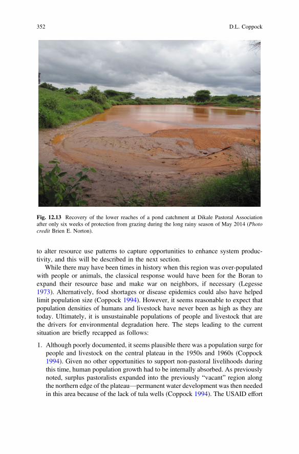
to alter resource use patterns to capture opportunities to enhance system produc-tivity, and this will be described in the next section.
While there may have been times in history when this region was over-populatedwith people or animals, the classical response would have been for the Boran toexpand their resource base and make war on neighbors, if necessary (Legesse1973). Alternatively, food shortages or disease epidemics could also have helpedlimit population size (Coppock 1994). However, it seems reasonable to expect thatpopulation densities of humans and livestock have never been as high as they aretoday. Ultimately, it is unsustainable populations of people and livestock that arethe drivers for environmental degradation here. The steps leading to the currentsituation are briefly recapped as follows:
1. Although poorly documented, it seems plausible there was a population surge forpeople and livestock on the central plateau in the 1950s and 1960s (Coppock1994). Given no other opportunities to support non-pastoral livelihoods duringthis time, human population growth had to be internally absorbed. As previouslynoted, surplus pastoralists expanded into the previously “vacant” region alongthe northern edge of the plateau—permanent water development was then neededin this area because of the lack of tula wells (Coppock 1994). The USAID effort
Fig. 12.13 Recovery of the lower reaches of a pond catchment at Dikale Pastoral Associationafter only six weeks of protection from grazing during the long rainy season of May 2014 (Photocredit Brien E. Norton).
352 D.L. Coppock

Fig. 12.14 (a, b) The low-stature and creeping habit of Cynodon dactylon—along with itsresistance to grazing, drought, and trampling—makes it an ideal species for restoring cover forexposed soil on the Borana Plateau: (a) Close up and (b) situation at a high-traffic location (Photocredits Brien E. Norton).
12 Pastoral System Dynamics and Environmental Change … 353

to construct Beke Pond and other large water sources in this area during the1960s was the critical step to address acute humanitarian needs, but it was alsothe trigger for widespread settlement that eventually led to the pronouncedenvironmental degradation evident today in places like Dikale. Settlement of thenorthern region also removed a vital drought fallback resource, undermining herdstability in response to future droughts and setting the stage for theboom-and-bust dynamics of the regional cattle herd after 1984. In the 1960s therewere also regional vaccination campaigns—it is likely that such campaigns had apositive effect on encouraging growth in animal numbers here (Coppock 1994);
2. By the 1970s and 1980s, bilateral projects like the Third LivestockDevelopment Project (TLDP) were involved in rangeland development thatfocused on building roads, expanding access to veterinary inputs, and creatingthe initial elements of cattle markets (Coppock 1994). A key intervention at thispoint was the use of heavy machinery that was primarily tasked to build roads.This machinery was informally enlisted, however, to assist the Boran to createmore medium- and large-sized ponds (Coppock, unpublished observations).This further alleviated seasonal water constraints for livestock throughout theregion. Herds could continue to grow, and incentives to market animals werefew because the ratio of cattle to people was higher than it is today and there wasless need for regular cash income. More milk per capita, for example, translatedinto less demand to purchase non-pastoral foods. Indiscriminate water devel-opment was deemed to be the fundamental cause of increased pastoral settle-ment and bush encroachment (J.C. Billé et al. cited in Coppock 1994). Bushencroachment has also been encouraged by national policies that were inter-preted by local administrators to prohibit the use of managed fire on therangelands (LaMalfa and Coppock 2005);
3. Food relief initially became common in Borana during the mid-1980s, coinci-dent with the widespread drought in Ethiopia that received worldwide attention.Unlike the famine-stricken farming regions in the northern highlands, however,the pastoral regions to the south suffered much less. One relief camp was locatedin the north-central plateau. Human mortality from starvation was almostcompletely mitigated by the timely arrival of food aid (Coppock 1994). Foodrelief is reportedly pervasive today in our four PAs under study (Coppock et al.2014a). Food relief is obviously a vital safety net given the surplus pastoralistswho have few options to find employment outside of the system. However,another view is that food relief provides disincentives for other forms ofproblem solving;
4. Cultivation began to proliferate after the 1984-1985 drought when pastoralistshad lost most of their animals and needed another source of food; it wascommon to see maize planted in vacated livestock corrals (Coppock 1994).A laissez faire attitude of government towards cultivation then encouragedcultivation to expand; the driver for this trend has been the declining ratio of
354 D.L. Coppock

cattle to people (i.e., increasing poverty and food insecurity.) Although it iscommon that the Boran complain about the negative implications of farming forpastoralism, PAs differ greatly in the extent of cultivation and it’s impacts(Coppock et al. 2014a);
5. Kalo have proliferated in response to a growing perception that adequate accessto local forage resources in dry periods is uncertain. This is also a symptom ofincreasing population pressure from livestock and people; and
6. In the last decade more resources have been directed towards expanding some ofthe tula-well complexes (Coppock, unpublished observations). While develop-ment agents have always attempted to help the Boran rehabilitate existing wells,digging new wells has been a more recent activity. This may lead to additionalgrowth in livestock numbers.
12.5.2 Development Priorities and Policy Frameworks
Discerning development priorities and policy frameworks that affect pastoralists inEthiopia is challenging (Desta and Coppock 2002). This is because there is a lack oftransparency in official documentation, as well as bureaucratic inertia, spatial andtemporal variation in policy application and implementation, and shifts in nationalpolitical strategies. And pastoralists have never been a priority for any Ethiopiangovernment.
Empirical observations over the past 30 years (Coppock, unpublished observa-tions) suggest several themes that constitute the broadest and most consistentdevelopment priorities and policies for the Borana Plateau: (1) Maintaining physicalsecurity and political conformity among the citizenry; (2) promotion of commercialcattle trading, especially trade that generates hard currency from livestock exports;and (3) protection of natural resources, especially with regards to the conservationof remnant wildlife populations and residual patches of woodlands. These themesmarkedly vary in terms of the level of investment and implementation—the first isby far the most important. The themes also have tended to be top-down in origin.
The fundamental development and policy errors that have undermined theintegrity of the natural-resource base—and eventually damaged livelihoods—on theplateau are neither unique to Ethiopia nor to pastoralists. They relate to the gov-ernment’s inability to manage the human population in positive ways.
Lack of economic development. The historically low levels of economic devel-opment across Ethiopia have greatly hindered the provision of public services andjob creation in all sectors. A generally low level of human-capital development isattributable to poor educational systems, especially prevalent in rural areas (Tekeste1996). Confronted with the decision of whether or not to leave the Boran pastoralsystem because traditional livelihoods are largely inaccessible, most pastoralists
12 Pastoral System Dynamics and Environmental Change … 355

have little choice but to stay amid poverty and despair. This is due to lack of otheroptions, and this in turn is caused by a lack of employment and little exposure toformal education. Human overpopulation has been the fundamental driver ofunsustainable patterns of natural-resource use on the plateau, and this is ultimatelylinked to a lack of personal choice.
Proliferation of livestock. A second error has been to allow livestock numbers toproliferate. There have been no systematic programmes to provide creative incen-tives for herd owners to periodically destock by marketing animals and diversifyingtheir income sources and capital assets. The situation has led to unsustainable levelsof grazing that gradually undermine the productive basis of the pastoral system. Thishas resulted from laissez-faire attitudes towards the condition and trend of forage,soil, and water resources as well as an inability to regulate resource use. The growthin livestock numbers has been driven by human population growth in tandem withunfettered water development over the past 40 years. Larger herds may promoteprosperity for a minority of herd owners when buffeted by drought and othercalamities, but for most households the outcome is a downward spiral because theregional forage base is simply insufficient to support the current densities of people.
Importantly, government per se is not proposed here as an agent that hasattempted to phase out traditional pastoralism via aggressive settlement plans orland-annexation policies, as has been observed in other settings (FAO 2001).Perspectives from district-level government8 indicate that population and socialfactors are the major reasons as to why pastoralists have settled. However, despitethat more pastoral households are settling, it is notable that in most cases theirlivestock can still be highly mobile. Part of a household, for example, can reside intown and take advantage of public services while other family members herdanimals to remote locations to find feed and water (Coppock and Desta 2013). Therole of government has been to assist pastoralists to adapt to their settled circum-stances, as possible. Government does not have a sedentarization policy on theplateau.
In recent years—the district government in collaboration with NGOs—hasre-configured or re-sited some olla to achieve more efficient use of local grazing andwater resources. For example, some olla that are too close to key water points havebeen moved further away. Paddocks have been established to support communityconcepts for grazing rotations. Such settlement patterns are thus being “rational-ized” in 14 of 23 PAs in Yabelo District (Coppock, unpublished observations.)
After many years of debate, a national land-use plan was finalized in 2011. Nowa land-use plan for Yabelo District has also been finalized in 2013, but it is not yetreleased. The plan for Yabelo District is focused on natural resource conservationand settlement patterns (Coppock, unpublished observations). The land-use planwill be implemented by the district office, and it will provide a basis for theregulation of cultivation in collaboration with PA leaders, as one example. In places
8Mr. Indaalee Haptee, Yabelo District Office for Land Use Planning and Environmental Protection,personal communication 2014.
356 D.L. Coppock

where cultivation is a sound and sustainable option, it will be strengthened. Wherecultivation should be discontinued, it will be stopped; if a warming and drying ofthe plateau continues (Funk et al. 2012) rain-fed cultivation may slowly vanish,regardless. The land-use plan also can help in conflict management amongneighbors based on competition for dwindling natural resources. This should reduceambiguities in the rights and responsibilities among adjacent PAs. Essentially, theplanning tools are an effort to improve pastoral governance.
12.6 Is Environmental Degradation Reversible?
The question of whether patterns of rangeland degradation can be slowed orreversed is important, but any positive effects of technical intervention will ulti-mately be constrained by continued population growth and persistent poverty. Thisbecomes a vicious cycle. Attention therefore needs to be given to providing edu-cation and opportunities for pastoralists to leave the pastoral sector, if given achoice. This is an important means to increase the ratio of cattle to people given thelimits on cattle numbers, and release more food to those who remain in the system.
The other means to increase the ratio of cattle to people is to boost herbaceousforage productivity. Evidence previously reviewed suggests that much of therangelands in the north-central region are ecologically resilient—grass forage forcattle can be recovered in some cases via deferred grazing (kalo), bush clearing, andrenovation of eroded locales. In tandem, this could be all regarded as a form ofsustainable intensification for increased productivity (Pretty et al. 2011). While it ispromising that we have observed a positive and rapid response of some foragegrasses to grazing protection, equally important is the question as to whetherinnovative management systems could be adopted by the pastoralists.
While the gradual decline of herd mobility has been well documented for over30 years and it is an important concern, it remains unclear what can be done aboutit. Herd mobility and access to key resources are affected by population growth aswell as local, regional, and international politics. For example, herd mobility can beultimately constrained by enforcement of national borders (i.e., between Ethiopiaand Kenya) as well as enforcement of state boundaries (i.e., between the OromiaRegional State and the Somali Regional State in southern Ethiopia.) Such factorsare typically beyond the control of the Ethiopian Boran or their advocates. Thereare, however, other efforts underway to restore traditional rights of grazing accesson the plateau at spatial scales of resolution that greatly exceed those of madda orthe PAs. These units are referred to in the Oromifa vernacular as deedha and reera.How the rights and responsibilities of users have become eroded for deedha andreera is unclear, but the value of re-establishing traditional patterns of grazingaccess at such scales is a key priority of the recently initiated PRIME project(Solomon Desta, MARIL, personal observation).
12 Pastoral System Dynamics and Environmental Change … 357

12.7 The Way Forward: How Should This Region BeManaged?
The Borana Plateau has a storied history of being the homeland for a highlyorganized pastoral society that has exhibited wise stewardship of the naturalresources over many generations. Recent evidence, however, indicates that portionsof the rangeland environment have changed for the worse and that a growinghuman population is the ultimate driver. The fundamental challenge for the propermanagement of common property regimes is over-population (Hardin 1968), an oldlesson that still holds here.
Management of this system should therefore embrace a holistic perspective thatfundamentally places people and their needs at the forefront. In other words, changeagents need to help empower pastoralists to better control their own destiny. Thiswas recognized over 20 years ago by Coppock (1994) but has yet to take hold in awidespread fashion. Similar proposals have been advanced under the banner of“endogenous livestock development” whereby indigenous knowledge is combinedwith modern insights and technologies as a basis for progress (Homann et al. 2008).The steps of such an approach would include the following:
1. Assist pastoralists to leave the rangelands where possible. Some people willprefer to stay in the traditional system, but some will rather depart. Developmentis about providing choices for people. There is a fundamental need to provideappropriate education, skills training, and job opportunities that allow somepeople to leave the system and thus reduce the demand on natural resources. Inrecent years we have increasingly seen pastoral youths enroll in school and evenattend university. Until such processes are aggressively underway, attempts toimprove natural resource management will eventually be negated by theever-growing pressure to overharvest the rangelands;
2. Similarly, promote diversified livelihoods among pastoralists where possible.There are exciting examples where pastoralists have cleverly diversified theirlivelihood activities to include pastoral and non-pastoral income streams andassets (Coppock et al. 2011; Coppock and Desta 2013). Often all that is neededis for people to receive some careful mentoring, role modeling, and seed capitalto begin new endeavors;
3. One part of diversified livelihoods also involves improving the access of pas-toralists to livestock markets. More options to buy and sell stock is always agood thing—it can help promote wise destocking when the environment is lessable to support grazing livestock;
4. Assist pastoral communities in diagnosing their natural-resource managementproblems at a local and regional scale, and empower them to create (or recreate)enforceable rules and regulations that underpin sustainable resource use. Todaywe see Borana society in flux—ultimately as a result of population pressure.There are emerging trends that appear to pit wealthier herd-owners versus poorerherd-owners, or commercially-oriented producers versus traditional producers.
358 D.L. Coppock

This primarily involves aspects of land privatization and control, much of whichwould never have been sanctioned by traditional leaders decades ago. The pas-toral society may benefit from the wise input of third parties that can helparticulate problems and codify solutions that promote equity and wise resourceuse. Traditional leaders and policy makers can be engaged in this process. Obaand Kotile (2001) contend that indigenous ecological knowledge among theBoran gives highly correlated results with range condition and trend assessmentsfrom rangeland professionals, thus indigenous knowledge can be a useful inputwhen devising landscape-level rehabilitation plans;
5. Actively strengthen local governance. This can include revitalization of cus-tomary institutions (e.g., Gumi Gaayo) along with better integrating these withPA structures to better solve problems. Both forms of governance must co-existin the modern world. This can include facilitating group access to key tech-nologies and training, developing group constitutions and bylaws, and evenbusiness plans. We and others have been engaged in such efforts on a pilot basiswhere community groups are being empowered to deal with bush clearing,rangeland restoration, gully management, and pond de-siltation; and
6. Promote restoration of herd mobility where possible, primarily by relaxing orremoving barriers for livestock use of key water points and neighboring terri-tories having strategic grazing resources. This will continue to be a formidablechallenge, however, for reasons previously mentioned.
In sum, the current need to improve natural resource management in pastoralareas will not be markedly affected by more conventional research—or conven-tional development tactics, for that matter. Rather, the need is for change agents toform complementary partnerships and help empower pastoralists so they can betterfend for themselves. However, research can still document empowerment efforts,success stories, and reflect on lessons learned. This research needed is bestdescribed as participatory action research (Whyte 1989), “research for develop-ment” (Ashby 2003), or innovation systems research (Coppock et al. 2009) whereresearchers and development agents collaborate closely with pastoralists in a pro-cess of stepwise problem-solving and mutual learning.
Acknowledgements The author appreciates support for field research provided from the fol-lowing sources: (1) The International Livestock Center for Africa (1980-91); (2) Utah StateUniversity (1991-2014 on a discontinuous basis); (3) The Rockefeller Foundation (1995-1997);(4) the Global Livestock Collaborative Research Program (GL-CRSP) of the US Agency forInternational Development (USAID) Global Bureau (Grant no. PCE-G—00-98-00036-00;1997-2009); and (5) the Feed the Future Innovation Laboratory: Adapting Livestock Systems toClimate Change of USAID Global Bureau (Grant no. EEM-A-00-10-00001; 2012-2015).Professional colleagues and pastoral community members who contributed to the work describedin this chapter are warmly acknowledged. Dr. Brien E. “Ben” Norton is especially thanked forproviding his excellent photographs and his important insights regarding rangeland degradationand resilience. This publication was made possible through support provided by the Bureau forEconomic Growth, Agriculture, and Trade, USAID, under the terms of the two grants listed above.The opinions expressed herein are those of the author and do not necessarily reflect the views ofUSAID or the US government.
12 Pastoral System Dynamics and Environmental Change … 359

References
Angassa, A., & Beyene, F. (2003). Current range condition in southern Ethiopia in relation totraditional management strategies: The perceptions of Borana pastoralists. TropicalGrasslands, 37, 53–59.
Angassa, A., & Oba, G. (2008). Herder perceptions on impacts of range exclosures, crop farming,fire ban, and bush encroachment on the rangelands of Borana, southern Ethiopia. HumanEcology, 36, 201–215.
Ashby, J. (2003). Introduction: Uniting science and participation in the process of innovation—research for development. In B. Pound, S. Snapp, C. McDougall, & A. Braun (Eds.),Managingnatural resources for sustainable livelihoods—uniting science and participation (pp. 1–19).London: Earthscan Publications Ltd.
Atsedu, M. (1990). Ecology of calf pastures and supplementary feeding by Borana pastoralists ofsouthern Ethiopia. Master’s thesis. Fort Collins: Department of Range Science, Colorado StateUniversity.
Boru, D., Schwartz, M., Kam,M., &Degen, A. (2014). Cattle reduction and livestock diversificationamong Borana pastoralists in southern Ethiopia. Nomadic Peoples, 18(1), 115–145.
Coppock, D. L. (1994). The Borana plateau of southern Ethiopia: Synthesis of pastoral research,development and change, 1980–91. Systems Study No. 5. Addis Ababa: InternationalLivestock Centre for Africa. https://books.google.com/books?hl=en&lr=&id=TeLRgwQU1HEC&oi=fnd&pg=PR10&dq=Coppock+Borana+Plateau+&ots=0r1Gs3pWdW&sig=flHKtzvRUe9KwG9rhpAjGt3s6F8#v=onepage&q=Coppock%20Borana%20Plateau&f=false
Coppock, D. L., & Desta, S. (2013). Collective action, innovation, and wealth generation amongsettled pastoral women in northern Kenya. Rangeland Ecology and Management, 66, 95–105.
Coppock, D. L. Gebru, G., Mesele, S., & Desta, S. (2008). Are drought-related crashes in pastoralcattle herds predictable? More evidence of equilibrium dynamics from the southern Ethiopianrangelands. In Multifunctional grasslands in a changing world (Vol. II). OrganizingCommittee of the 2008 International Grasslands Congress/International RangelandsCongress (IGC/IRC), 1090. Beijing: Guagdong People’s Publishing House.
Coppock, D. L., Desta, S., Tezera, S., & Gebru, G. (2009). An innovation system in therangelands: using collective action to diversify livelihoods among settled pastoralists inEthiopia. In A. Waters-Bayer, C. Wettasinha, J. Njuki, P. Sanginga, & S. Kaaria (Eds.),Innovation Africa: Enriching farmer’s livelihoods (pp. 104–119). London: EarthscanPublications.
Coppock, D. L., Desta, S., Tezera, S., & Gebru, G. (2011). Capacity building helps pastoralwomen transform impoverished communities in Ethiopia. Science, 334(6061), 1394–1398.
Coppock, D. L., Tezera, S., Eba, B., Doyo, J., Tadele, D., Teshome, D., Husein, N., & Guru, M.(2014a). Preliminary results from participatory rural appraisals (PRAs) and follow-upinvestigations held at four pastoral associations on the north-central Borana Plateau,Ethiopia. Logan: Department of Environment and Society, Utah State University. http://digitalcommons.usu.edu/envs_facpub/900
Coppock, D. L., Tezera, S., Eba, B., Doyo, J., Tadele, D., Teshome, D., Husein, N., & Guru, M.(2014b). Sustainable pastoralism in Ethiopia: Preliminary results from participatorycommunity assessments on the north-central Borana Plateau. Research Brief-16-2014, Feedthe Future—Adapting Livestock Systems to Climate Change, Colorado State University, FortCollins, CO, USA. 4 pp. http://digitalcommons.usu.edu/envs_facpub/902
CSA (Central Statistical Agency of Ethiopia). (1994). National Census. www.csa.gov.etCSA (Central Statistical Agency of Ethiopia). (2007). National Census. www.csa.gov.etDalle, G., Maass, B., & Isselstein, J. (2006). Rangeland condition and trend in the semi-arid
Borana lowlands, southern Oromia, Ethiopia. African Journal of Range & Forage Science,23(1), 49–58.
Desta, S., & Coppock, D. L. (2002). Cattle population dynamics in the southern Ethiopianrangelands, 1980–97. Journal of Range Management, 55, 439–451.
360 D.L. Coppock

Desta, S., & Coppock, D. L. (2004). Pastoralism under pressure: Tracking system change insouthern Ethiopia. Human Ecology, 32(4), 465–486.
Desta, S., Gebru, G., Tezera, S., & Coppock, D. L. (2006). Linking pastoralists and exporters in alivestock marketing chain: Recent experiences from Ethiopia. In J. McPeak & P. Little (Eds.),Pastoral livestock marketing in eastern Africa: research and policy challenges (pp. 109–127).Rugby: ITDG Publishing.
Evangelista, P., Young, N., & Burnett, J. (2013). How will climate change spatially affectagricultural production in Ethiopia? Case studies of important cereal crops. Climatic Change.doi:10.1007/s10584-013-0776-6
FAO (Food and Agricultural Organization of the United Nations). (2001). Pastoralism in the NewMillennium. Animal Production and Health Paper No. 150. Rome: UNFAO. http://www.fao.org/docrep/005/y2647e/y2647e00.HTM.
Forrest, B. (2014). Analysis of building resiliency in an Ethiopian pastoral system: Mitigating theeffects of population and climate change on food insecurity. MS thesis. Logan: Department ofApplied Economics, Utah State University.
Forrest, B., Bailey, D., Ward, R., & Coppock, D. L. (2014). Can bush-clearing, deferred grazing,or camels help mitigate climate-change and population effects for Borana pastoralists? AnEconomic Analysis of Potential Interventions. Research Brief-19-2014, Feed the Future—Adapting Livestock Systems to Climate Change, Colorado State University, Fort Collins, CO,USA. 4 pp. http://digitalcommons.usu.edu/envs_facpub/901/
Funk, C., Rowland, J., Eilerts, G., Kebede, E., Biru, N., White, L., & Galu, G. (2012). A climatetrend analysis of Ethiopia. Fact Sheet 2012–3053. Published by the United States GeologicalSurvey in collaboration with the Rolla Publishing Service Center.
Hardin, G. (1968). The tragedy of the commons. Science, 162, 1243–1248.Holecheck, J., Pieper, R., & Herbel, C. (2001). Range management—principles & practices (4th
ed.). Upper Saddle River: Prentice Hall.Homann, S., Rischkowsky, B., Steinbach, J., Kirk, M., & Mathias, E. (2008). Towards
endogenous livestock development: Borana pastoralists’ responses to environmental andinstitutional changes. Human Ecology, 36, 503–520.
Jahnke, H. (1982). Livestock production systems and livestock development in tropical Africa.Kiel: Kieler Wissenschaftsverlag Vauk.
Kebede, A. (2009). Sustaining the Allideghi grassland of Ethiopia: Influences of pastoralism andvegetation change. Ph.D. Dissertation. Logan: Department of Wildland Resources, Utah StateUniversity.
LaMalfa, E., & Coppock, D. L. (2005). Rebuilding the capacity to burn: Community developmentand rangeland productivity. Pages 8–11 in the Spring Issue of Ruminations—Newsletter of theGlobal Livestock Collaborative Research Support Program. University of California, Davis.
Legesse, A. (1973). Gada—three approaches to the study of African society. New York: The FreePress.
McPeak, J., Little, P., & Doss, C. (2012). Risk and social change in an African rural economy:livelihoods in pastoralist communities. New York: Routledge.
Megersa, B., Regassa, A., Kumsa, B., & Abunna, F. (2008). Performance of camels (Camelusdromedarius) kept by pastoralists with different degrees of experience in camel-keeping inBorana, southern Ethiopia. Animal Science Journal, 79(4), 534–541.
Mellisse, B. (2014). Implications of constrained mobility on livestock production and pastorallivelihoods of the Borana Plateau, southern Ethiopia. TIRI Research Brief-02-2014, Feed theFuture—Adapting Livestock Systems to Climate Change, Colorado State University, FortCollins, CO, USA. http://www.vivo.colostate.edu/lccrsp/briefs/TIRI%20RB-02-2014.pdf
Mesele, S. (2006). Land use dynamics and impact on selected physiochemical properties of soilsin Yabelo woreda of the Borana lowlands, southern Ethiopia. Master’s thesis. Harer: Facultyof Rangeland Management, Alemaya University.
Napier, A., & Desta, S. (2011). Review of pastoral rangeland enclosures in Ethiopia. Boston:Feinstein International Center Publications. http://fic.tufts.edu/publication-item/review-of-pastoral-rangeland-enclosures-in-ethiopia/
12 Pastoral System Dynamics and Environmental Change … 361

Oba, G., & Kotile, D. (2001). Assessments of landscape level degradation in southern Ethiopia:Pastoralists versus ecologists. Land Degradation and Development, 12, 461–475.
Oba, G., Post, E., Syvertsen, P., & Stenseth, N. (2000). Bush cover and range conditionassessments in relation to landscape and grazing in southern Ethiopia. Landscape Ecology, 15,535–546.
Pratt, D., & Gywnne, M. (1977). Rangeland management and ecology in east Africa. London:Hodder and Stoughton.
Pretty, J., Toulmin, C., & Williams, S. (2011). Sustainable intensification in African agriculture.International Journal of Agricultural Sustainability, 9(1), 5–24.
Solomon, T., Snyman, H., & Smit, G. (2007). Cattle-rangeland management practices andperceptions of pastoralists towards rangeland degradation in the Borana zone of southernEthiopia. Journal of Environmental Management, 82(4), 481–494.
Tekeste, N. (1996). Rethinking education in Ethiopia. Uppsala: Nordiksa Afrikainstitet.Thornton, P., Jones, P., Ericksen, P., & Challinor, A. (2011). Agriculture and food systems in
sub-Saharan Africa in a 4 C+ World. Philosophical Transactions of the Royal Society A,.doi:10.1098/rsta2010.0246.
Wassie, Y. (2014). Impacts of change in customary rangeland governance institutions on pastorallivelihoods of the Borana Plateau, southern Ethiopia. TIRI Research Brief-05-2014, Feed theFuture—Adapting Livestock Systems to Climate Change, Colorado State University, FortCollins, CO, USA. http://www.vivo.colostate.edu/lccrsp/briefs/TIRI%20RB-05-2014.pdf
Whyte, W. (1989). Advancing scientific knowledge through participatory action research. SociolForum, 4, 367–385.
362 D.L. Coppock

Chapter 13Humans Cause Deserts: Evidenceof Irreversible Changes in ArgentinianPatagonia Rangelands
Gabriel Oliva, Juan Gaitan and Daniela Ferrante
Abstract Argentinian Patagonia is a 750,000 km2 semi-arid region. Sheep wereintroduced there in the late 19th century, peaked at about 20 million head in 1960and fell sharply thereafter reaching 8 million at present. Decline in productivecapacity was blamed on overgrazing or climate change alternatively, but maps in1998 indicated that 34 % of the region was severely desertified. We analysed theregional FPAR in the GIMMS NDVI dataset from NOAA satellite imagery in thelast 30 years, a period in which the land has been destocked and under generallyimproved management. The trend of FPAR does not show a generalized “green-ing”, or recovery process, even when the rainfall trend was removed. A case studyin Los Pozos Farm in the south shows that total stock has fallen monotonicallysince 1930 under a rainfall regime that remained constant. Variable stocking ratesthat tracked the productivity introduced in 1990 stabilized grazing capacity but didnot induce a clear recovery in forage production. The erosion of unstable soils anddamage to perennial vegetation probably explain the farm production losses, andmanagement rather than climate change is the most probable cause. Productionanalysis shows that stocking rates that maximize short-term income in wool are toohigh and will probably damage the land. Good management has the potential tostabilize and maybe slowly revert long-term mismanagement effects on these colddesert ecosystems, but under the present market economy and land tenure system itseems unlikely that producers will give up profits to avoid possible long-termdegradation.
Keywords Desertification � South America � Patagonia � Semiarid � Grazing �Livestock � NDVI � AVHRRG. Oliva (&) � D. FerranteINTA EEA Santa Cruz, Mahatma Gandhi 1322, 9400, Río Gallegos Santa Cruz, Argentinae-mail: [email protected]
G. Oliva � D. FerranteUniversidad Nacional de la Patagonia Austral, Unidad Académica Río Gallegos. Av.Gregores y Piloto “Lero” Rivera—CP (Z9400KVD), Santa Cruz, Argentina
J. GaitanINTA EEA Bariloche, Modesta Victoria 4450, 8400, Río Negro Bariloche, Argentina
© Springer-Verlag Berlin Heidelberg 2016R.H. Behnke and M. Mortimore (eds.), The End of Desertification?Springer Earth System Sciences, DOI 10.1007/978-3-642-16014-1_13
363

13.1 Introduction
Argentinian Patagonia is a 750,000 km2 region in south Argentina (Fig. 13.1). It ismostly semi-arid and covered by shrub or grass steppes. Pastoral use of theserangelands is relatively recent and even today there are less than 2.3 inhabitants persquare kilometer (INDEC 2001).
Colonization of this vast land took place in the late 1880s, after military cam-paigns and mainly with Argentine and Chilean ‘criollos’, locally born people ofSpanish ancestry but also to settlers of European or Middle-Eastern descent. Nativepeoples were severely reduced in number after colonization and nowadays con-stitute about 1.4–3.5 % of the residents. Early colonization (1880–1900) gaveaccess to pastoral leases in large areas of the most productive or readily accessibleland. At the beginning of the 20th century, poorer settlers took part in the colo-nization of arid or inaccessible areas. The land was divided geometrically intoparcels of about 10–20 thousand hectares (Barbería 1995), and freehold rightsconsolidated land tenure of most of the big stations, locally called ‘estancias’.Poorer settlers, including some indigenous people, occupied small areas thatremained mostly under informal or traditional land use, a great number of them
Desertification
% Area
Low 9.3
Intermediate
to severe 52.6
Severe to
very severe 31.9
Other areas:
Forests 4.4
Water bodies 1.3
Ice sheets 0.6
Fig. 13.1 Location of the Argentinian Patagonia in South America (left) and desertificationdegrees based on Del Valle et al. (1998) map.
364 G. Oliva et al.

unfenced, and mostly located in Northern Patagonia. A good description of the areaand the sheep industry may be found in (Cibils and Borrelli 2005) (Photo 13.1).
Concurrently with the well-known land degradation crisis in Africa’s Sahel, inthe late 1970s Patagonia experienced a crisis that reduced sheep numbers drasticallyaffecting the base of the economy of rural areas, and impacting the livelihoods ofpeople. The causes of the loss of production capacity and degradation of rangelandshave been debated (DHV-SWEDFOREST 1998). As in the Sahel case, somestakeholders emphasized that overgrazing was to blame, and others pointed out thatclimate had triggered the process. In 1990, Argentina joined the internationalprogrammes to evaluate desertification, and focused mainly on the Patagonianregion (Goergen 1995). A desertification map of Patagonia shown in Fig. 13.1 wasproduced following the FAO guidelines. Desertification is defined in this work asthe degradation of land due to several factors including climate and management. Itwas assessed by means of indicators of water and wind erosion, salinization of soilsand modification of vegetation (Photo 13.2). An extrapolation of detailed 1:250.000scale maps that were made throughout the region reached the conclusion that 34 %of the region was severely affected (Photo 13.3) (Del Valle et al. 1998).
Sheep numbers, that had reached a maximum of about 20 million head around1950 (Mendez Casariego 2002) fell steadily starting in 1978, and dropped by half in20 years (Fig. 13.2). A small increase in cattle numbers was registered at that time,but it did not compensate the losses in sheep.
Photo 13.1 Sheep are tended in the Magellan Steppes, south Patagonia (Horacio Cordoba).
13 Humans Cause Deserts … 365

Photo 13.2 Sand dunes associated with coarse textured quaternary deposits and clay dunes in theCentral Plateaus are common and poor management often makes them active.
Photo 13.3 Sand dunes affecting Magellanic steppe.
366 G. Oliva et al.

The decreasing number of sheep at regional scale was mostly the consequence oflow weaning rates that prevented farmers from replacing ageing animals. Losseswere heavier in some areas such as Santa Cruz province, that at the turn of the 20thcentury had a very low herbivore stocking rate that was equivalent to 0.16 sheepha−1year−1 (one sheep per 6 ha), while Neuquén in the north and Tierra del Fuego inthe south had 0.64 and 0.83 sheep ha−1year−1 respectively (one sheep per1.5–1.2 ha) (Fig. 13.3). The grazing pressure of guanacos, the only large nativeherbivore was negligible at that time (Fig. 13.3). Differences in remaining stock inFig. 13.3 reflect the effects of the crisis on different types of producers: while those inSanta Cruz are mostly commercial with a mean flock size of about 4000 sheep andfreehold rights to the land, typical small rural producers of Neuquén aresubsistence-type, with a flock of 200–300 sheep and goats. When faced withdwindling animal production and natural disasters such as volcanic ashes or verysevere snowfalls, producers of big stations simply walked off the land, which stillremains ungrazed by domestic herbivores. In contrast, those in small allotmentsresponded to hardships with other types of strategies and remained on the land,tending their small flocks. Big stations in Tierra del Fuego with a mean of 10,000sheep and moister climate did not suffer comparable land degradation at this timeand retained their stock.
Concerns about overgrazing and degradation led government agencies todevelop range evaluation methods to estimate forage biomass and adjust stockingrates (Borrelli and Oliva 1999; Siffredi and Becker 1999; Borrelli 2001; Borrelli andOliva 2001; Elissalde et al. 2002). They were applied widely in desertificationprogrammes in the early 90s and have become mandatory for stations that requested
15000
20000
25000
30000
Sh
eep
un
its
x 10
00Sheep
Cattle
Goats
0
5000
10000
1880 1900 1920 1940 1960 1980 2000 2020
Goats
Horses
Total
Fig. 13.2 Evolution of livestock in Patagonia in the 1890–2002 period in Sheep Units(SU) Herbivore equivalences were 1 cattle unit = 6 SU, 1 goat = 1 SU, 1 horse = 6 SU. The full,bold line indicates the cumulative total. Drawn from data of Mendez Casariego (2002).
13 Humans Cause Deserts … 367
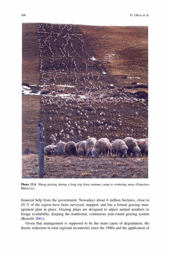
financial help from the government. Nowadays about 6 million hectares, close to10 % of the region have been surveyed, mapped, and has a formal grazing man-agement plan in place. Grazing plans are designed to adjust animal numbers toforage availability, keeping the traditional, continuous year-round grazing system(Borrelli 2001).
Given that management is supposed to be the main cause of degradation, thedrastic reduction in total regional inventories since the 1980s and the application of
Photo 13.4 Sheep grazing during a long trip from summer camp to wintering areas (FranciscoMilicevic).
368 G. Oliva et al.

better management plans should have stopped the process and possibly triggeredrecovery of the land, somewhat like the “greening of the Sahel” that has beenreported after the desertification events in the 1960s (Herrmann et al. 2005). Animportant difference in this case is that climate changes for Patagonia in the lastthree decades have been variable throughout the region: According to the GlobalPrecipitation Climatology Project (GPCP) data-set (Adler et al. 2003), southPatagonia showed positive rainfall trends in the 1980–2010 period, no change wasregistered in the center and a reduction was experienced in the Andean NW(Fig. 13.4).
The objective of this paper is to review rangeland trends in the last three decadesat two distinct scales: regional and local. At the regional scale, satellite data wereused to detect “greening” or “browning” processes. Due to the different trends inrainfall over the period and considering its impact on vegetation growth, an attemptwas made to remove the precipitation signal from the satellite data time series. Thistype of analysis highlights areas that displayed a negative or positive trend inde-pendently of the local climate (Evans and Geerken 2004). At the local scale, a sheep
Fig. 13.3 Total estimated herbivore stocking rates in the year 2000 across the provinces of theRegion in sheep units (SU) ha−1. Herbivore equivalences as in Fig. 13.2, guanaco numbers fromAmaya et al. (2001). The circle indicates the location of Los Pozos station, our study case at astation-scale.
13 Humans Cause Deserts … 369

station case study was analysed. The station had been gradually reducing animalnumbers since 1930 and the managers decided to adjust management drastically inthe late 1980s, lowering stocking rates and adjusting them annually thereafter,tracking the grazing capacity of the rangelands. Given that the station keptunusually detailed productive and climatic records since 1930, a description of thelong-term trends and the response to management was possible.
The study area was the Argentine portion of Patagonia, South America between39 and 55°S (Fig. 13.1).
13.1.1 Regional Analysis from Remotely-Sensed Data
Regional trends were studied using vegetation indices (VIs) that relate to ecosystemstructure and function, particularly biomass (e.g. Tucker et al. 1985), leaf area index(e.g. Steltzer and Welker 2006), net primary productivity (e.g. Paruelo et al. 1997)and vegetation cover (e.g. Gaitán et al. 2013). In particular, the NormalizedDifference Vegetation Index NDVI (Tucker 1979), based on red and near-infraredreflectance was used. The trends in NDVI have been used as a proxy for greening or
Fig. 13.4 General trends in rainfall in Patagonia. Data from the Global Precipitation ClimatologyProject (GPCP) data-set (Adler et al. 2003).
370 G. Oliva et al.

browning (de Jong et al. 2011), and Gaitán et al. (2013) found that they are asuitable tool to estimate functional and structural ecosystem attributes in Patagonia.
Remotely sensed data were obtained from “Advanced Very High ResolutionRadiometer” (AVHRR) sensors, on board of the “National Oceanic andAtmospheric Administration” (NOAA) satellites that provide one of the mostextended time series of remotely-sensed data for long-term observations. The maindifficulties of the NOAA-AVHRR series stem from navigation uncertainties, sensordegradation and calibration, atmospheric contamination, orbital drift and limitedspectral and directional sampling. In order to improve data quality, NDVI dataseries that follow different processing streams are available. One of the mostcommonly used long-term NDVI data sets was processed by the Global InventoryModeling and Mapping Studies (GIMMS). The latest version of GIMMS, termedthe Third Generation NDVI Data Set (NDVI3g) has been recently produced withAVHRR sensor data from NOAA’s 7–18 satellites, and is available at 8 km hori-zontal resolution every 15 days from July 1981 to December 2011. GIMMS pro-cessing includes corrections for sensor calibration, volcanic aerosols, and othersensor degradation and contamination issues. It is the only continuous andup-to-date global NDVI dataset that is continually assessed and validated (Fensholtet al. 2012). GIMMS is generally considered the best dataset to use for the analysisof long-term trends (Beck and Goetz 2011). The GIMMS NDVI product has beenused previously to diagnose and detect land degradation and greening trends (e.g.Herrmann et al. 2005).
A product derived from NDVI3g: the Fraction of Photosynthetically ActiveRadiation absorbed by vegetation (fPAR) data set (Zhu et al. 2013) was used. ThefPAR is a relative measure of the vegetation-absorbed radiation in the 0.4–0.7 μmspectral region of solar radiation, and hence, characterizes the energy that ispotentially used in the process of photosynthesis. The derived fPAR product isgenerated based on a neural network algorithm that uses the NDVI3g and animproved version of Collection 5 Terra MODIS fPAR, the MODIS BNU product(Beijing Normal University version). The fPAR can be readily interpreted within anecological context, while NDVI itself is a ratio of spectral reflectances that is aproxy for vegetation activity.
The growing season (October to March) mean fPAR (fPAR mean) was analysedin order to describe temporal trends in green biomass. A linear regression betweentime (years) and fPAR mean was estimated for each pixel per decade (1981–82 to1990–91, 1991–92 to 2000–01 and 2001–02 to 2010–11) and for the entire period(1981–82 to 2010–2011) (Fig. 13.5). The positive or negative slope of this line isconsidered to reflect an increase or decrease in green biomass.
Rainfall measurements from rain gauge stations are conventionally consideredthe most accurate and reliable source of rainfall data, but in Patagonia rain gaugesare sparse and of varying reliability. For climate data we therefore used griddedsatellite precipitation estimates instead. They combine satellite observations fromdifferent sources and ground measurements: the Global Precipitation Climatology
13 Humans Cause Deserts … 371

Negative trend
No trend
Positive trend
(a) (b)
(c) (d)
Fig. 13.5 Overall trends in vegetation greenness throughout the decades 1981–82 to 1990–91 (a),1991–92 to 2000–01 (b), 2001–02 to 2010–11 (c) and the whole period (1981–82 to 2010–2011)(d) based on growing season mean fPAR (October to march) of AVHRR GIMMS fPAR3g timeseries. Significant trends: p < 0.05.
372 G. Oliva et al.

Project (GPCP) data-set (Adler et al. 2003). The GPCP data-set consists of globalmonthly precipitation estimates produced in a 2.5° latitude-longitude grid for theperiod 1979–present. We obtained the cumulative rainfall (from July to June) foreach growing season. These data were interpolated using the Kriging method inorder to match the 8 km resolution of fPAR data-set.
A linear regression analysis through the time series for each pixel was carried outwith fPARmean as the dependent variable and cumulative rainfall (from July toJune) as the independent variable. The regression equations allow the calculation ofpredicted values of fPARmean for each growing season and each pixel from theestimated precipitation values. The fPARmean residuals (difference betweenobserved and predicted fPARmean) were then computed for each growing season.The residuals represent the portion of the observed fPARmean value which is notexplained by precipitation. Any significant temporal trends in the residuals could beinterpreted as long-term human-induced effects on vegetation: greenness orregeneration (positive trend) or land degradation (negative trend). Residual trendsfor each pixel were computed on the entire time series (1981–82 to 2010–11) andsignificant trend slopes were mapped in order to assess spatial patterns (Fig. 13.6).
Fig. 13.6 Overall trends inthe residual fPARmeanthroughout the period 1981–82 to 2010–11 based onregression of vegetationgreenness (AVHRR GIMMSfPAR3g) on cumulativerainfall (July–June) (GPCPestimate). Significant trends:p < 0.05.
13 Humans Cause Deserts … 373

13.1.2 Station Scale Case Study
Los Pozos station, described in detail in Oliva et al. (2012) was used as a case study.The station is located in the south of the region, 30 km north of Río Gallegos, SantaCruz, Argentina (69° 19′W, 51° 9′S) and close to the Magellan Strait. The climate ismaritime with 239 mm mean annual rainfall and 12.7 °C mean temperature insummer and 1.4 °C in winter. The station occupies 27,200 ha of terraces of theGallegos River and sedimentary plateaus, 150 m above sea level. Vegetation consistsof perennial tussock steppes ofFestuca gracillima,with an array of short high-qualitygrasses (Faggi 1985). The station has ten large management units and a number ofsmaller paddocks and produces lambs and wool mostly from Corriedale ewes.
The Santa Cruz range assessment method (Borrelli and Oliva 1999; Borrelli andOliva 2001) was used to estimate available forage. Herbage availability was esti-mated by clipping short grasses, graminoids and forbs in 0.2 m2 frames at peakherbage mass (January) at predetermined sites distributed across a paddock. Theseplants have the highest nutritive value and constitute most of the sheep diet (Posseet al. 1996). Sampling of herbage was performed annually at three permanentsampling sites in each paddock, with three quadrats harvested from each site. Thesamples were oven dried for 48 h at 40 °C and weighed. Grazing capacity wasestimated from total herbage mass of short grasses, graminoids and forbs andadjusted yearly based on the estimated grazing capacity of each paddock using anallowance of 513 kg dry matter of forage for each sheep equivalent per year (Borrelli2001). The sheep equivalent used covers the energy requirements of a 49-kg eweshorn in spring (September) that weans a 20-kg lamb after 100 days of lactation.
Sheep production data were obtained from the historic records of the station.Flock numbers included all categories of sheep remaining on the station afterlambing and selling. Lambing rate (%) was estimated from lambs marked (January)and ewes mated (May of the previous year). Total clean wool weight sold wasestimated from greasy wool weight multiplied by the percentage of clean wool. Therelationships between stocking rate, lamb marking rate and clean wool productionwere explored using linear regressions included in SAS/Stat v9.0 statistical package.
13.2 Results
The fPAR trends for pixels in the northern extra-Andean Patagonia were mostlynegative in the first decade 1981–82 to 1990–91 (Fig. 13.5a). South of the region, asmall number of pixels showed a positive trend. The Andes, west of the region andmostly covered with Nothofagus forests and high altitude grasslands, showed aclear positive trend. In the 1991–92 to 2000–01 decade (Fig. 13.5b), few pixelsshowed a clear trend, and in the extra-Andean area they were mostly positive. In the2001–02 to 2010–11 decade (Fig. 13.5c), a negative trend was evident in about40 % of the region, mostly in the North-East. The trend for the entire 30-year
374 G. Oliva et al.

period, form 1981–82 to 2010–2011 (Fig. 13.5d) shows red spots in the Rio Negroprovince in the north, and in Tierra del Fuego at the south.
13.2.1 Station Case Study
Mean annual rainfall in Rio Gallegos airport, close to Los Pozos was 235 mm. Nosignificant trend in the mean annual rainfall was observed throughout the 80-yearrecord, although a dry period was evident during the 1960s, when the mean annualrainfall was only 160 mm.
High stocking rates with about 18,000 sheep (0.70 sheep ha−1year−1) were usedin the 1930s, but a steep downward trend was observed from 1945 until 1989. Inthat year, the first range evaluation was performed and the stock further reduced to12,000. During this 60-year period the flock was maintained above the grazingcapacity of 10,600 that was estimated through yearly forage evaluations from 1990to 2010.
From 1990 to 2010, the adaptive management period, animal numbers wereadjusted to forage availability, following a tracking strategy (Campbell et al. 2006),and the flock fluctuated around 8000 sheep (0.35 sheep ha−1year−1), with half theinitial stocking rates (Photo 13.5).
Mean annual herbage mass in the adaptive management period was 194 kg Drymatter ha−1 that corresponds to a mean grazing capacity of 0.38 sheep ha−1year−1.
Photo 13.5 The Magellanic tussock steppe in a well-conserved plot close to the study case area.
13 Humans Cause Deserts … 375

The annual herbage masses were generally well above the value of 100 kg DryMatter ha−1 that was suggested by Borrelli and Oliva (1999) to prevent restriction inintake by the sheep (Photo 13.6). Exceptions were the dry years of 1998 and 1999when some of the paddocks only reached 70 kg Dry Matter ha−1 (data not shown).
The slope of the regression of Grazing Capacity in relation to time was notsignificantly different from zero, indicating that the station has not lost productivityin this period (Fig. 13.10).
Lamb marking rates increased from 72 to 87.3 % with the adaptive management.Although the total stock numbers on the station were halved, a similar number(about 4000) sheep were sold. Wool production on a per animal basis also increasedfrom 2.21 to 2.82 kg wool sheep−1year−1, but this increase did not compensate forthe lower number of animals at shearing, and total wool production of the stationfell from 36,102 to 26,771 kg wool year−1 (Oliva et al. 2012).
Lamb marking rate (%) showed a linear negative relationship with stocking rate.When the stocking rates used were close to the estimated grazing capacity of thestation, lamb marking rate was above 80 % (Fig. 13.11). Clean wool production ona per area basis showed a quadratic relationship with SR and the inflexion point ofthis curve is 0.65 sheep ha−1year−1, where the station obtained about 2.5 kg woolha−1year−1. With stocking rates close to the grazing capacity, wool productionranged between 1 and 2 kg wool ha−1year−1 (Fig. 13.11).
Photo 13.6 Degraded Magellanic Steppe with dominance of subshrubs after years of overgrazing.
376 G. Oliva et al.

13.3 Discussion
The overall trend in annual mean fPAR was zero or negative over a large portion ofthe Patagonian region (Fig. 13.5d). This trend may be partly explained by climatechange, as rainfall is closely correlated to fPAR. The long- term patterns in rainfallfor this period vary across Patagonia, with no change in the central areas, a smallincrease in the south and a decrease in the north-west (Fig. 13.5). This patterncannot be observed clearly in the 30-year fPAR trends (Fig. 13.5d). Some“greening” is observed in southern Santa Cruz province, but south of this, the Tierradel Fuego steppes have a negative trend that appears unrelated to rainfall data. Thecentral-north area of Rio Negro and Chubut provinces show a negative trend despiterainfall remaining stable in this area. At a decadal scale, localized droughts mayhave generated the clear negative trend in fPAR in central-north Chubut and RioNegro provinces during the 2001–02 to 2010–11 period (Fig. 13.5c). Drought in thelast decade and the high stocking rates that still applied in these northern Patagonianprovinces may have interacted to show the negative trends in the north-center areaof this region.
Trends in the fPAR residuals were analysed in an attempt to separate the climatesignal from other factors, as in Archer (2004). In these maps, large areas mostly inthe south show no significant trends (Fig. 13.6) indicating that vegetation greennesscorresponds closely to what is expected from rainfall dynamics. There is still aconsiderable proportion of areas of negative residual trends, i.e. areas in which thevegetation has been losing vigor at higher rates than would be expected by rainfallalone, and they are mostly concentrated in the north-east of Patagonia and in thesouthern Magellanic steppes of Tierra del Fuego (Fig. 13.6). Both areas are stillgrazed at comparatively high stocking rates (Fig. 13.2).
The widespread “browning” trends indicate that land degradation is still active insome areas, and the prevalence of no-trend pixels shows that land recovery has nothappened. This could point to ongoing unsustainable management even when thesethree decades have seen a significant reduction in domestic animal numbers in someareas of Patagonia. Explanations other than overgrazing may be a mosaic of localfactors that have influenced different parts of the region in this 30 year-period:Volcanic eruptions in vast areas of Santa Cruz in 1992 and central-north provinces ofChubut in 2008 and Rio Negro and Neuquén in 2011 that may have reduced fPARsignal through ash deposition. Relocation of stock has increased grazing pressure insome areas because crops are now grown on former animal production areas of thePampas and cattle have been moved to marginal areas, affecting especially thenorthern Rio Negro province. Unsustainable dry land farming for annual cropsfollowed by intense erosion also affected this north-east area. The central plateau ofSanta Cruz, where sheep have been excluded from an area of about 10 million ha isprobably too degraded to recover, and native guanacos have probably managed tocompensate sheep losses, reestablishing the total grazing stock and slowing downthe recovery of rangelands. Overall, the areas that were desertified in the 1998 mapof Fig. 13.1 show no signs of recovery or a negative trend in our 1980–2010 analysis
13 Humans Cause Deserts … 377

of Fig. 13.6, and those that were classified as intermediate or low, such as NE RioNegro and the Magellan Steppes of SW Santa Cruz and N of Tierra del Fuego appearto have a negative trend in the residual fPAR.
The remotely sensed data provide valuable insights into the last 30 years, butsheep were introduced into the region over a century ago and presumably most ofthe degradation of rangelands would have taken place in the early stages of landsettlement. Our southern Patagonia case study allows better analysis of the effectsof management by focusing both on a smaller area and a longer time scale usingmore precise rain-gauge records and production data for the 1930–2010 period.Additional information from yearly forage availability was also available for the1990–2010 period. Mean rainfall in the last 80 years showed no clear trend in thissouthern location, although the variability increased in the last 20 years (Fig. 13.7).Regardless of rainfall, the station has been reducing animal numbers at aclose-to-linear rate since the introduction of sheep, when over 20 thousand animalswere raised, falling to 12 thousand head by the and the end of the 1980s (Fig. 13.8).This pronounced negative trend during the 20th century is typical of the Patagonianstations, and agrees with Golluscio et al. (1998b) who showed five other long-termexamples in the region.
In 1989, a range survey of Los Pozos indicated that a 30 % stock reduction wasnecessary to match the forage on offer with animal demand (Fig. 13.8). Carefulyearly adjustments in stocking rates thereafter tracked the forage availabilityresulting in about half the maximum historical numbers (Fig. 13.9). Grazingcapacity of the rangeland varied in relation to rainfall and did not show an overallnegative trend in these twenty years (Fig. 13.10). Adaptive management was
300
400
500
0
100
200
1930
1935
1940
1945
1950
1955
1960
1965
1970
1975
1980
1985
1990
1995
2000
2005
2010
Rai
nfa
ll (m
m.)
Fig. 13.7 Yearly rainfall in the Rio Gallegos airport, close to the Los Pozos station from 1930 to2010. Solid line is a 5-year moving mean and dashed line a linear regression y = 0.377x + 223.3R2 = 0.0202 P = 0.220. The shaded bar indicates the adjusted management period.
378 G. Oliva et al.

therefore able to halt the negative historical trend and preserve the capacity of theland to convert rainfall into forage over two decades, and is sustainable by defi-nition (Pickup and Stafford Smith 1993). The downside is that no clear recovery ofthe grazing capacity was evident during this period. Similar results have beendescribed in continuous grazing experiments with flexible stocking rates close toLos Pozos (Oliva et al. 1998) and in different locations in Patagonia (Escobar et al.2011). Some researchers regard the lack of recovery as a consequence of contin-uous grazing schemes that do not enable regeneration even at low stocking rates,and recommend short duration grazing (Savory and Parson 1980), butwell-documented case studies of short duration, rotational schemes, also fail toclearly regenerate the land (Golluscio et al. 1998a).
The reasons for a persistent, irreversible change in Patagonia’s rangelands areunclear. The classical studies of Milchunas et al. (1988) and Milchunas andLauenroth (1993) suggested that the sensitivity of the vegetation communities inPatagonia may be explained by a short evolutionary history of grazing, but laterpapers acknowledged that the vegetation shows herbivory defenses and thatguanacos, that have been present and abundant since the Miocene (Raedeke 1979),may have exerted a high herbivory pressure in evolutionary times (Lauenroth1998). Given these evidences, Patagonia was even used as an example of theopposite: a long history of grazing in Adler et al. (2005), so that the issue remainsunresolved.
15000
20000
25000
Sh
eep
nu
mb
er
0
5000
10000
1930
1935
1940
1945
1950
1955
1960
1965
1970
1975
1980
1985
1990
1995
2000
2005
2010
Years
Fig. 13.8 Number of animals (sheep units) in the Los Pozos station from 1930 to 2010. The graybar indicates the 1990–2010 adaptive grazing period and the dashed line the mean estimatedgrazing capacity of the station in the same period.
13 Humans Cause Deserts … 379

Climate variability is lower in Patagonia than in other deserts and this may haveactually favored the degradation: in our Los Pozos example the mean rainfall is 239(63 SD) mm with a coefficient of variation of only 26 %, that is clearly in the lower
10000
12000
14000
16000
18000
0
2000
4000
6000
8000
1985 1990 1995 2000 2005 2010 2015
Gra
zin
g c
apac
ity
(sh
eep
)
Years
Fig. 13.10 Trend of grazing capacity (GC) estimated by range evaluation (solid line) from 1990to 2013. Regression is GC = 56.0 year – 101437 (R2 = 0.0213; P = 0.497).
Fig. 13.9 Grazing capacity (sheep ha−1year−1) estimated by range evaluation (solid line) andactual stock in the station (dashed line) from 1990 to 2010. From Oliva et al. (2012).
380 G. Oliva et al.

range of deserts of the world (von Wehrden and Wesche 2007). Thenon-equilibrium concept suggests that rangeland degradation is more likely to occurwhere rainfall variability is low, because highly variable climates regulate herbivorenumbers through drought-related deaths (Illius and O’Connor 1999). A thresholdvalue of the coefficient of variation of rainfall of 33 % was suggested by (Ellis andSwift 1988), and the non-equilibrium concept states that below this value, degra-dation can occur if animal numbers are high enough, as in the case of Patagonia.
A number of state and transition models (Westoby et al. 1989), that catalog theexisting vegetation communities and hypothesize the mechanisms that are involvedin the shifts, have been compiled for Patagonia (Paruelo et al. 1993), and most ofthem include non-reversible transitions (Bertiller and Bisigato 1998). They areassociated to the dominance of long-lived, perennial grasses of Festuca, Poa andStipa (Leon et al. 1998), the lack of annuals and colonizer plants (Soriano 1990),and the structure of soil that is particularly prone to wind erosion (Chartier andRostagno 2006). High stocking rates also interfere with the regeneration of domi-nant cool-season grasses that grow slowly and mostly vegetatively in these steppes(Oliva et al. 2005). Low variability rainfall and the fact that plants can depend on areliable water pulse originated in winter rains or snow that thaws in springtimeenable perennial life forms to dominate. Long-lived grasses usually devote only amoderate amount of resources to seed forming (Fenner 1985; Folland et al. 1986;Bertiller and Coronato 1994) as their main reproduction is through tillering. Theirpropagules also lack specific dormancy mechanisms that would enable long termsoil seed banks (Soriano 1960; Bertiller and Coronato 1994). Aridisol-type soilsdominate the region, with most of the organic matter and nutrients in superficiallayers, and concentrated in patches associated with shrubs or tussocks (Rostagnoand Del Valle 1988). When the dominant tussock grasses and big shrubs are lost tograzing, they are easily eroded exposing abundantly pebbled clay layers that arepartially occupied by dwarf shrubs of genus Nassauvia or Larrea (Bisigato andBertiller 1997a). Regeneration of degraded rangelands in this context has to rely onthe establishment of grasses through seed of the few remaining perennial grassesthat colonize cracks and crevices in desert pavements, which is likely to be a slowprocess regardless of the grazing system used.
The most important management challenge in Patagonia seems clear inFig. 13.11. The vertical line indicates the sustainable stocking rate as estimated with20-years of range surveys, and the points are yearly stocking rates used during the80-year period. A smaller number of better-fed animals showed weaning rates over80 % and overall the 8000-sheep station sold as many animals (lambs, rams andwethers) as the historical flock of 20 thousand (Oliva et al. 2012). Wool production,on the other hand was not closely related to animal condition and its decrease wasproportional to the reduction of animal numbers. The optimal stocking rate for woolproduction appears to be 0.65 sheep ha−1year−1, close to the historical rates thatwere used in the early years of land settlement. This level of grazing would surelydamage the rangeland in the long term (Oliva et al. 2005), a conflict that is evidentin other systems where economic optimal stocking rates are higher than grazingcarrying capacity (Cingolani et al. 2008).
13 Humans Cause Deserts … 381

13.4 Conclusions
Do humans cause deserts? Patagonia gives a different insight into the dilemma thatReynolds and Stafford Smith (2002) pointed out. In the Sahel example, climateappears to have been the main cause both of degradation and recovery (Evans andGeerken 2004), with little effect of management (Seaquist et al. 2009). In Patagonia,land use has triggered a general degradation effect that is evident in sheep pro-duction records and in remotely sensed data. In other examples of non-sustainableuse of grazing lands in the world, as in the Western Division of New South Walesin Australia, the loss of grazing capacity seems to have been faster, and in less thantwo decades the wool industry collapsed (Condon 1976). There are also examplesof remarkable recoveries elsewhere such as the Sahel case that show that the landhas resilience (Herrmann et al. 2005). In comparison, Patagonian systems enduredover eight decades of high stocking rates until the generalized losses of the early1980s. Some vegetation changes documented in Patagonia have resulted indesert-like conditions (Bertiller and Bisigato 1998), and they have not shown clearsigns of recovery thereafter, even with careful, conservative management of theland and in a unchanging or slightly positive rainfall scenario. This delay in
Lam
b m
arki
ng(%
)W
ool p
rodu
ctio
n (
kg h
a-1 .
year
3.5
3.0
2.5
2.0
100
90
80
70
60
50
40
-1)
1.5
1.0
0.5
0.0
0.20 0.40 0.60 0.80
Stocking rate (sheep.ha-1.year -1)
Fig. 13.11 Stocking rate (SR) in sheep ha−1 year−1 in relation to wool production (WP) inkg ha−1 year−1 and lamb marking (LM) rate (number of lambs obtained from 100 mated ewes in%). Regression lines are linear for LM = 1.08−0.60 SR (R2 = 0.47; P < 0.01), and quadratic forWP = −2 + 14 SR−10 SR2 (R2 = 0.76; P < 0.01). Vertical line indicates the mean grazing capacityof the station between 1990 and 2010. From Oliva et al. (2012).
382 G. Oliva et al.

revealing signs of degradation and the fact that recovery seems to be difficult, slow,or absent, point to the existence of rangelands with stable states, that change slowlyand more or less permanently at a time-scale that is difficult to perceive (Oliva et al.1998). Well-documented conservative management examples such as the LosPozos station indicate that it is possible to stop the downward trend but at the costof foregoing short-term income. It is unlikely that producers will decide to give upprofits in order to avoid possible future degradation, as this requires an under-standing of the problems that overstocking causes that are slow and not evident inthe manager’s experience (Stafford Smith et al. 2007). It also requires a soundfinancial status that is not the case in most of the smaller Patgonian stations thatstruggle to make ends meet or have subsistence-type economies. Promises ofshort-term transformation via grazing pulses seem unlikely, and will at any casetake a long time to regenerate some of the lost grazing capacity. Overall, theprospects under good management seem at best to be those of stabilization. Theold-timer’s description of rich Patagonian meadows with grasses that reached thebelly of the horses may not be easily seen again, after over a century of unsus-tainable pressure on the natural resources of these unique cold deserts.
Acknowledgments The authors wish to recognize Edward Halliday and Silvina Puig, who gaveaccess to all the historic information of the Los Pozos Station. INTA (Instituto Nacional deTecnología Agropecuaria/Argentina) financed the farm study. David Preston contributed review-ing the manuscript.
References
Adler, R. F., Huffman, G. J., Chang, A., Ferraro, R., Xie, P., Janowiak, J., et al. (2003). Theversion-2 global precipitation climatology project (GPCP) monthly precipitation analysis(1979–present). Journal of Hydrometeorology, 4, 1147–1167.
Adler, P. B., Milchunas, D. G., Sala, O. E., Burke, I. C., & Lauenroth, W. K. (2005). Plant traitsand ecosystem grazing effects: Comparison of US sagebrush steppe and Patagonian steppe.Ecological Applications, 15, 774–792.
Amaya, J., von Tüngen, J., & de Lamo, D. (2001). Informe preliminar del Proyecto deRelevamiento y Distribución de guanacos en la Patagonia. Resultados sobre la densidad deguanacos en las diferentes provincias patagónicas. INTA-GTZ-TÖB. Area de RecursosNaturales. fauna. INTA EEA Bariloche., Bariloche.
Archer, E. R. (2004). Beyond the “climate versus grazing” impasse: Using remote sensing toinvestigate the effects of grazing system choice on vegetation cover in the eastern Karoo.Journal of Arid Environments, 57, 381–408.
Barbería, E. (1995). Los dueños de la tierra en la Patagonia Austral. Universidad Federal de laPatagonia Austral, Buenos Aires.
Beck, P. S., & Goetz, S. J. (2011). Satellite observations of high northern latitude vegetationproductivity changes between 1982 and 2008: Ecological variability and regional differences.Environmental Research Letters, 6, 045501.
Bertiller, M., & Coronato, F. (1994). Seed bank patterns of Festuca pallescens in semiaridPatagonia: A possible limit to bunch reestablishment. Biodiversity and Conservation, 3, 57–67.
Bertiller, M. B., & Bisigato, A. (1998). Vegetation dynamics under grazing disturbance. Thestate-and-transition model for the Patagonian steppes. Ecología Austral, 8, 191–199.
13 Humans Cause Deserts … 383

Bisigato, A. J., & Bertiller, M. (1997). Grazing effects on patchy dryland vegetation in northernPatagonia. Journal of Arid Environments, 36, 639–653.
Borrelli, P. (2001). Planificación del pastoreo. In P. Borrelli & G. Oliva (Eds.), Ganadería ovinasustentable en la Patagonia Austral (pp. 183–196). Buenos Aires: INTA.
Borrelli, P., & Oliva, G. (1999).Managing grazing: experiences from Patagonia (pp. 441–447). InVth International Rangeland Congress. Townsville: Australia.
Borrelli, P., & Oliva, G. (2001). Evaluación de Pastizales. In P. Borrelli & G. Oliva (Eds.),Ganadería ovina sustentable en la Patagonia Austral: Tecnología de manejo extensivo(pp. 163–168). Buenos Aires: INTA.
Campbell, B., Gordon, I. J., Luckert, M., & Pehterama, L. (2006). In search of optimal stockingregimes in semi-arid grazing lands: One size does not fit all. Ecological Economics, 60, 75–85.
Cibils, A., & Borrelli, P. (2005). Grasslands of Patagonia. In J. M. Suttie, S. G. Reynolds, & C.Batello (Eds.), Grasslands of the world (pp. 121–170). Rome: Food and AgricultureOrganization of the United Nations.
Cingolani, A., Imanual, N.-M., Renison, D., & Cabido, M. (2008). La ganadería extensiva, ¿escompatible con la conservación de la biodiversidad y de los suelos? Ecología Austral, 18, 253–271.
Condon, R. W. (1976). History and administration of the Western Division. Agricultural Gazzette,87, 2–5.
Chartier, M. P., & Rostagno, C. M. (2006). Soil erosion thresholds and alternative states innortheastern Patagonian rangelands. Rangeland Ecology and Management, 59, 616–624.
de Jong, R., de Bruin, S., de Wit, A., Schaepman, M. E., & Dent, D. L. (2011). Analysis ofmonotonic greening and browning trends from global NDVI time-series. Remote Sensing ofEnvironment, 115, 692–702.
Del Valle, H., Elissalde, N., Gagliardini, D., & Milovich, J. (1998). Status of desertification in thePatagonian Region: Assessment and mapping from satellite imagery. Arid Soil Research andRehabilitation, 12, 95–122.
DHV-SWEDFOREST. (1998). Diagnóstico, estrategias y acciones propuestas para el usosostenible de los recursos naturales en la Patagonia. Secretaria de agricultura, ganadería, pescay alimentación. Buenos Aires: República Argentina.
Elissalde, N., Escobar, J., & Nakamatsu, V. (2002). Inventario y evaluación de pastizalesnaturales de la zona arida y semiarida de la Patagonia. Trelew: Instituto Nacional deTecnología Agropecuaria. Centro Regional Patagonia sur. EEA Chubut.
Ellis, J. E., & Swift, D. M. (1988). Stability of African pastoral ecosystems: Alternate paradigmsand implications for development. Journal of Range Management, 41, 6.
Escobar, J. M., Beloqui, A., Buono, G., Massara Paletto, V., La Torraca, A., & Nakamatsu, V. B.(2011). Effects of flexible stocking rates strategies on rangeland dynamics and sheepproduction performance in Patagonian steppe. In S. RO, G. Feldman, & M. Sacido (Eds.), IXInternational Rangeland Congress (p. 384). INTA- AAMPN-IRC: Rosario, Argentina.
Evans, J., & Geerken, R. (2004). Discrimination between climate and human-induced drylanddegradation. Journal of Arid Environments, 57, 535–554.
Faggi, A. (1985). Las comunidades vegetales de Rio Gallegos, Santa Cruz. In O. Boelcke, D.Moore, & F. Roig (Eds.), Transecta Botánica de la Patagonia Austral (pp. 592–633).CONICET Instituto de la Patagonia (Chile) Royal Society (Gran Bretaña): Buenos Aires.
Fenner, M. (1985). Seed ecology. London, New York: Chapman and Hall.Fensholt, R., Langanke, T., Rasmussen, K., Reenberg, A., Prince, S. D., Tucker, C., Scholes, R. J.,
Le, Q. B., Bondeau, A., & Eastman, R. (2012). Greenness in semi-arid areas across the globe1981–2007—An Earth Observing Satellite based analysis of trends and drivers. RemoteSensing of Environment, 121, 144–158.
Folland, C., Palmer, T., & Parker, D. (1986). Sahel rainfall and worldwide sea temperatures, 1901–85. Nature, 320, 602–607.
Gaitán, J. J., Bran, D., Oliva, G., Ciari, G., Nakamatsu, V., Salomone, J., et al. (2013). Evaluatingthe performance of multiple remote sensing indices to predict the spatial variability ofecosystem structure and functioning in Patagonian steppes. Ecological Indicators, 34, 181–191.
384 G. Oliva et al.

Goergen, J. (1995). Lucha contra la desertificación en Patagonia con ayuda de un sistema demonitoreo ecológico (SME). In H. Del Valle, G. Eiden, H. Mensching, & J. Goergen (Eds.),Lucha contra la desertificación en la Patagonia. Cooperación técnica argentino - alemana.Instituto Nacional de Tecnología Agropecuaria y GTZ: Bariloche.
Golluscio, R., Deregibus, A., & Paruelo, J. (1998a). Sustainability and range management in thePatagonian Steppes. Ecología Austral 8, 265–284.
Golluscio, R., Giraudo, C., Borrelli, P., Montes, L., Siffredi, G., Cechi, G., et al. (1998b).Utilización de los recursos naturales en la Patagonia. In C. DHV/SWEDFOREST (Eds.),ECOSISTEMAS DESÉRTICOS PATAGÓNICOS (p. 80). Secretaría de Agricultura,Ganadería, Pesca y Alimentación. República Argentina: Buenos Aires.
Herrmann, S. M., Anyamba, A., & Tucker, C. J. (2005). Recent trends in vegetation dynamics inthe African Sahel and their relationship to climate. Global Environmental Change, 15, 394–404.
Illius, A., & O’Connor, T. (1999). On the relevance of nonequilibrium concepts to arid andsemiarid grazing systems. Ecological Applications, 9, 798–813.
INDEC. (2001). Censo Nacional de Población, hogares y viviendas 2001. Serie 5: Grupospoblacionales N°2: Jóvenes, hogares y población. In I. N. d. E. y. Censos (Ed.), INDEC,Buenos Aires.
Lauenroth, W. (1998). Guanacos, spiny shrubs and the evolutionary history of grazing in thePatagonian steppe. Ecología Austral 8.
Leon, R., Bran, D., Collants, M., Paruelo, J., & Soriano, A. (1998). Grandes unidades devegetación de la Patagonia extra andina. Ecología Austral, 8, 125–144.
Mendez Casariego, H. (2002). Sistema de soporte de decisiones para la producción ganadera yforestal de la provincia de Neuquén. INTA EEA Bariloche: Bariloche.
Milchunas, D. G., & Lauenroth, W. K. (1993). Quantitative effects of grazing on vegetation andsoils over a global source. Ecological Monographs, 63(4), 328–366.
Milchunas, D. G., Sala, O. E., & Lauenroth, W. K. (1988). A generalized model of the effects ofgrazing by large herbivores on grassland community structure. The American Naturalist, 132,87–106.
Oliva, G., Cibils, A., Borrelli, P., & Humano, G. (1998). Stable states in relation to grazing inPatagonia: A 10-year experimental trial. Journal of Arid Environments, 40, 113–131.
Oliva, G., Collantes, M., & Humano, G. (2005). Demography of grazed tussock populations inPatagonia. Rangeland Ecology and Management, 58, 466–473.
Oliva, G., Ferrante, D., Puig, S., & Williams, M. (2012). Sustainable sheep management usingcontinuous grazing and variable stocking rates in Patagonia: A case study. The RangelandJournal, 34, 285–295.
Paruelo, J. M., Bertiller, M. B., Schlichter, T. M., & Coronato, F. R. (1993) Secuencias dedeterioro en distintos ambientes patagónicos (p. 109). Su caracterización mediante el modelode estados y transiciones.
Paruelo, J., H. E. Epstein, W. K. Lauenroth, & I. C. Burke. (1997). ANPP estimates from NDVIfor the central grassland region of the US. Ecology.
Pickup, G., & Stafford Smith, D. (1993). Problems, prospects and procedures for assessing thesustainability of pastoral land management in arid Australia. Journal of Biogeography, 20,471–487.
Posse, G., Anchorena, J., & Collantes, M. (1996). Seasonal diets of sheep in the steppe region ofTierra del Fuego, Argentina. Journal of Range Management, 49, 24–30.
Reynolds, J. F., & Stafford Smith, D. (2002). Do humans cause deserts. Global desertification: Dohumans cause deserts (pp. 1–21).
Rostagno, C. M., & Del Valle, H. F. (1988). Mounds associated with shrubs in aridic soils ofnortheastern Patagonia: Characteristics and probable genesis. Catena, 15, 347–359.
Savory, A., & Parson, S. (1980). The Savory grazing method. Rangelands, 2, 234–237.Seaquist, J., Hickler, T., Eklundh, L., Ardö, J., & Heumann, B. (2009). Disentangling the effects of
climate and people on Sahel vegetation dynamics. Biogeosciences 6.
13 Humans Cause Deserts … 385

Siffredi, G. L., & Becker G. F. (1999). Pastoreo de veranadas. Cordillera del Neuquén. Guía derecomendación de carga animal para pampas de coirón blanco.
Soriano, A. (1960). Germination of twenty dominant plants in patagonia in relation to theregeneration of vegetation (pp. 154–158). In 8th International Grassland Congress.
Soriano, A. (1990). Missing strategies for water capture in the patagonian semidesert. AcademiaNacional de Ciencias Exactas Fisicas y Naturales, 5, 135–139.
Stafford Smith, D. M., McKeon, G. M., Watson, I. W., Henry, B. K., Stone, G. S., Hall, W. B., &Howden, M. S. (2007). Learning from episodes of degradation and recovery in variableAustralian rangelands. PNAS, 104, 20690–20695.
Steltzer, H., & Welker, J. M. (2006). Modeling the effect of photosynthetic vegetation propertieson the NDVI-LAI relationship. Ecology, 87, 2765–2772.
Tucker, C. J. (1979). Red and photographic infrared linear combinations for monitoringvegetation. Remote Sensing of Environment, 8, 127–150.
Tucker, C. J., Townshend, J. R., & Goff, T. E. (1985). African land-cover classification usingsatellite data. Science, 227, 369–375.
von Wehrden, H., & Wesche, K. (2007). Relationships between climate, productivity andvegetation in southern Mongolian drylands. Basic and applied dryland research, 1, 100.
Westoby, M., Walker, B., & Noy-Meir, I. (1989). Opportunistic management of rangelands not atequilibrium. Journal of Range Management, 42, 266–274.
Zhu, Z., Bi, J., Pan, Y., Ganguly, S., Anav, A., Xu, L., et al. (2013). Global data sets of vegetationleaf area index (LAI) 3g and Fraction of Photosynthetically Active Radiation (FPAR) 3gderived from Global Inventory Modeling and Mapping Studies (GIMMS) NormalizedDifference Vegetation Index (NDVI3g) for the period 1981 to 2011. Remote Sensing, 5, 927–948.
386 G. Oliva et al.

Chapter 14Interpreting Environmental Changesin the Southern Bolivian Andes: RuralResponses and Political Actions
David Preston
Abstract Rural people in the southern Andes mountains of Bolivia may choose toplant different crops, to keep livestock under different conditions and to diversifytheir livelihood strategies in ways that involve less investment of time in farmingand more involvement in commercial activities. These changes are in response tochange in both physical and cultural environments and are examined here. Policiesand activities by local and national government that are intended to reduce theimpact of a range of environmental changes on people and their physical envi-ronments are considered and evaluated. We conclude that there is limited evidencethat changes in the natural environment such as soil erosion and degeneration ofvegetation in the Altiplano and adjacent valleys in western Tarija are more rapidthan in the recent past. Changes in the use of different areas for livestock and cropsreflect accommodation to culturally-determined household preferences for cattleover other ruminants. Farmers are used to change and readily modify their use ofdifferent areas of land to ensure that livestock can survive and necessary crops canbe harvested. With respect to local political responses to environmental issues, thehistory of action that started in 1930 is notable. We conclude that such action hadonly limited environmental consequences in the Tarija valleys. There is no evidenceto suggest that recent regional governments have been adequately informed orpolitically motivated to take remedial action to help those suffering from extremeclimatic events or other environmental stresses.
Keywords Environmental change � Household livelihoods � Landscape evolution
D. Preston (&)Latin American Centre, University of Oxford, Oxford, UKe-mail: [email protected]
© Springer-Verlag Berlin Heidelberg 2016R.H. Behnke and M. Mortimore (eds.), The End of Desertification?Springer Earth System Sciences, DOI 10.1007/978-3-642-16014-1_14
387

14.1 Introduction
Environmental changes have affected people in Andean America since long beforethe arrival of Europeans in the continent. Such changes occur as a consequence ofmany factors; changes in climate resulting in a gradual change in vegetation, instream flow in the rivers as well as the ways in which native and introducedlivestock consume a range of resources. Many other changes took place in southernBolivia following the development of mining during the colonial period, as we shallshow.
At the present time, rural people in southern Andean Bolivia may choose to plantdifferent crops, to keep livestock under different conditions and to diversify theirlivelihood strategies in ways that involve less investment of time in farming andmore involvement in commercial activities to best ensure the wellbeing of house-hold members. These changes are in response to change in both physical andeconomic environments. We shall also seek to identify what sorts of changes can beobserved in the physical landscapes in three distinct parts of southern Bolivia—highplateaux, a deep valley in the mountains and the temperate valleys on the easternmargins of the Andes. Actions by local and national government that are intendedto reduce the impact of a range of environmental changes on people and theirphysical environments will also be considered and evaluated. This will enable anassessment of the extent to which natural environmental changes are an importantpart of the broad range of changes affecting people, plants and animals.
This chapter will review the range of environmental changes in one part of thesouthern Andes of Bolivia on the basis of our research in the Department of Tarijasince 1993 and in the broader context of relevant research in the Central Andes ofPeru and Bolivia as well as north-western Argentina. Many of our conclusions havebeen strongly influenced by what we have learnt from women and men, childrenand old people in formal interviews, discussions in community meetings andinformal conversation in a wide range of rural communities. We have also bene-fitted from participation in meetings with scientists and policy makers at theadministrative Departmental level (Fig. 14.1).
Changes in the weather, such as rainfall, frost, floods and storms, inevitablyaffect farmers although they have many customary ways of coping with such sit-uations. Changes in the vegetation in some areas have occurred, through clearancefollowing burning, or elimination of some plants by selective grazing by livestockbut also as a result of plant invasion, and the introduction of new species to serveparticular purposes—for example eucalypts or pines for timber.
Characterizing environmental change by a single term such as desertification issimplistic, because from a land user’s point of view, it is imperative to consider thewhole range of medium to long-term changes in both human and physical envi-ronments. Rural people are very conscious that weather is constantly variable andalso that free-ranging livestock roam according to their perception of where goodgrazing may be found. For example introducing new types of livestock, often raisedelsewhere, presents new challenges for pastoralists who may have to introduce such
388 D. Preston

animals to the particular grazing behaviour of long-established sheep, cattle orgoats. In the course of our field work our team has helped people in severalcommunities to introduce new breeds of goats that provide more milk and are largerand worth more when sold; however their inability to search for and find palatablegrazing initially proved challenging.
When asked about changes in the weather, rural people cite extreme events—such as floods, hail and frost—as most worrying. This has emerged from interviewsconducted during our research in rural communities in southern Bolivia over thepast twenty years and is also reported in the northern Bolivian Altiplano (Chaplin2007; Valdivia et al. 2013). However it is essential to place contemporary changesin the context of the 4000–5000 years of change in the use which humans havemade of the Andean environments; this starts from their first use and subsequentdomestication of native animals and plants and their adaptation to long-term climatechanges which are well-documented in scientific literature, discussed later.
Some recent changes in Andean environments have occurred as a consequenceof where people now prefer to live, particularly the increasing proportion ofregional populations living or working in urban areas. Labour scarcity was fre-quently mentioned in interviews in rural communities, reflecting periodic migration,mainly to nearby Argentina, but also to nearby urban areas. However, changes inthe rhythms of the long-established climatic variations—most notably the ElNiño-Southern Oscillation (ENSO)—also affect human populations. Such changesare increasingly commented on in local and national media.
Fig. 14.1 Western Tarija.
14 Interpreting Environmental Changes in the Southern Bolivian Andes … 389

Actions by policy-makers in response to environmental changes need evaluation,although there have been limited actions in southern Andean Bolivia. The origins ofactivism in relation to environmental issues in the administrative Department ofTarija can be traced back to the 1930s; some 40 years later a well-funded technicalorganization was created—PERTT (Programa ejecutivo de rehabilitación de tierrasen el departamento de Tarija)—which lasted 16 years and employed a team ofnatural scientists from Bolivia together with overseas consultants, seeking ways ofcombatting land degradation in the western part of the Department of Tarija. Someof the results of their work are considered and the apparent absence of importancegiven by policymakers to environmental conservation is outlined.
14.2 Human and Physical Landscape Evolutionin Southern Bolivia
The central high plateaux (altiplano) of south-western Bolivia are just one part of anextensive physiographic feature which extends from southern Peru to northernArgentina. The valleys to the east of the altiplano have a very different but com-plementary environment and people living in the valleys and the high plateaux havetraded and moved between highlands and lowlands since long before the arrival ofEuropeans (Lathrap 1973; Saignes 1995; Murra 1972). Inter-montane valleys, suchas that of the Río San Juan del Oro, which forms the boundary between theDepartments of Tarija and Potosí offer a third environment influenced by riverwater which offers both opportunities for crop farming and threats from seasonalflooding.
In order to place the discussion in a clear geographical context it should be notedthat the western part of Tarija department comprises three distinct environmentzones, in which the research that provides much of the basis of this review ofnatural and human environmental changes has taken place.
The Tarija Altiplano lies at about 3500 m mean altitude and is bordered on bothwest and east by rolling mountainsides whose slopes rise to more than 4200 mbefore dropping firstly to a gently-sloping shelf at a similar altitude to the altiplanoand then fall sharply to the north-south valley of the Río San Juan del Oro at around2600 m above sea level. The slopes on the sides of the Rio San Juan include bothextensive near-level areas and steep, and eroded valley sides but livestock canreadily reach areas where grazing is attractive. To the east of the Altiplano,mountainsides drop steeply to the network of temperate valleys at about 1900 m. inthe northern part of which lies the largest urban centre and political capital, the cityof Tarija. The passage of animals and people between the altiplano, the mountainsand the temperate valleys presents few difficulties and there is ample evidence ofthis movement having occurred for over 600 years.
Moist air brings rain and cloud formations from the east and, accordingly,precipitation varies from around 600 mm in the temperate eastern valley to just
390 D. Preston

300 mm in the more level land of the altiplano and also in the deep valley of the RíoSan Juan. Figure 14.2 presents a cross-section of the three regions in which ourresearch has been centred (Fig. 14.3).
14.2.1 Natural Environmental Histories Related to PresentLandscapes
Natural environmental history in the Andes has long been influenced by the activityof the human population, in particular during the past 5000 years during which thepeople, domesticated plants and animals have transformed livelihoods and land-scapes. Alongside the changes in human land use have been variations in climate,so that it is crucial to understand that the natural environment is ever-changing.Early human settlement was associated with the cultivation of different varieties ofpotatoes and chenopods (such as quinoa) as well as the domestication of wildllamas and alpacas. One result was that already by 4000 years ago, much forestcover in many parts of the Andes had been cleared and both agriculture andlivestock became important for human livelihoods (Chepstow-Lusty et al. 1998). At
Fig. 14.2 Cross-section of western Tarija Department.
Fig. 14.3 Landscapes in western Tarija Department. (a) Río San Juan del Oro valley. (b) Altiplano.(c) Temperate valleys.
14 Interpreting Environmental Changes in the Southern Bolivian Andes … 391

lower altitudes, maize was also introduced, probably from Central America, andthere seems to have been continuous contact between the altiplano and valley areas.This contact, associated with trading produce from contrasting ecological zones, hascontinued until quite recently. During fieldwork in the valleys of Tarija in the early1990s, columns of llamas still descended from the altiplano, many days’ travel tothe west. They were loaded with products such as salt (from the salt lakes) and driedmeat that were traded for maize and other goods produced in the lower altitudevalleys (Fig. 14.4).
With the arrival of Europeans some 400 years ago, new types of livestock,particularly sheep, cattle and goats were introduced as well as European cereals,particularly wheat. The appropriation of areas of land from the native population bythe invading Europeans transformed the landscape in temperate valleys and thealtiplano. The founder of the town of Tarija in 1574 described the surrounding areaas fertile, in a broad valley with plenty of water, with many fish in the rivers,abundant wild animals and well capable of growing grape vines, olives and crops towhich the Spanish were accustomed (Corrado and Comajuncosa 1990, p. 11).
Very soon after the establishment of the Spanish in the Andes, mining for arange of minerals, highly prized in Europe, became an important activity in manyparts of the Andes and the mines of Potosí, to the north of Tarija, grew until thetown was one of the most important economic centres in the continent in the 17thand 18th centuries. The urban and industrial population created a demand for a
Fig. 14.4 Llamas from the highlands carrying produce for exchange in the Tarija valleys, Alisos,1992.
392 D. Preston

range of produce for both food and clothing. Agriculture in the temperate valleysflourished to supply such markets and trade routes were established along whichmining goods and labour moved. The historical changes in what is now Tarija andresulting changes in the natural landscape have been documented by Presta (2001).When Luiz de Fuentes, the founder of the town of Tarija, died in 1598 just 38 yearsafter his arrival, his will lists, among his possessions, 2000 cattle in the nearbyhighlands and 4000 sheep in what is now San Lorenzo in the valleys adjacent toTarija (Preston 1998).
The extension of great estates during the colonial period undoubtedly affectedthe vegetation of the grazed areas but such changes can only be inferred. Using datafrom the early 20th century, some changes in farming may be detected but it isimportant to note that there were still areas of the highlands and hillsides in thetemperate valleys that were only occasionally used (Preston 1998). Wild vicuña(camelids) can still be observed in isolated parts of the Tarija altiplano and oldpeople remember people going hunting wild animals on the altiplano in the early20th century. Small areas in the valleys and highlands of Tarija Department stillhave woodlands with native tree species dominant and to the east of the Tarijavalleys where there is higher rainfall, the more luxuriant vegetation is seasonallygrazed by transhumant livestock from the valleys of Tarija.
Large estates dominated many areas of Tarija Department until the land reformof 1953. After agrarian reform, most of the former estates became autonomouscommunities and former serfs had better access to larger areas of land and thereforea wider range of resources. Changes noted during the past 30 years in these areasinclude a continued loss of population in rural areas, both numerically and pro-portionately as more people move to urban centres or to other rural areas, partic-ularly in nearby Argentina where wages were much higher. Excellent data from twocommunities in the Camacho valley using household registers for school attendanceand interviews with older people showed that over the 23 year period 1975–98 inAlizos, 29 % of those living in the community had left to work in Argentina. InJuntas 43 % had gone to Argentina over the period 1969–93 (Preston and Punch2001).
14.3 Environmental Change in the Bolivian Andes
The current preoccupation with environmental change (or global warming) in themedia and reflected in popular perceptions of weather patterns, makes it necessaryto review scientific evidence of changes in the long-term patterns of weather. Inaddition, changes in the environment, in particular vegetation, erosion and depo-sition in hillsides and fields, should be understood in order to assess the influence ofhuman causation of environmental change through modification of vegetation byexpansion of crop production areas as well as the introduction of more grazinglivestock. This assessment is based on our recent work in Tarija which focussed onthe temperate valleys around and to the south of the city of Tarija, the highland
14 Interpreting Environmental Changes in the Southern Bolivian Andes … 393

(altiplano) areas to the west and the valley of the Río San Juan del Oro to the westof the Altiplano. We have conducted many interviews with farmers in each of theseareas in order to identify their perceptions of weather/climate changes that they feltaffected livelihoods. In conclusion we review the existing evidence of climaticchanges in this part of highland Bolivia.
14.3.1 Change in the Tarija Valleys
Recent work in catchments in Tarija Department using detailed field mapping,lichenometric and 14C dating and clast size measurement concluded that alluviationwas concentrated during wet La Niña phases of the Southern Oscillation. Floodmagnitude may have been greater during the Little Ice Age (c.1450 to c.1850) whena reduced vegetation cover would have increased weathering and sediment supplyand decreased after about AD1880 (Maas et al. 2001). It is suggested that con-temporary degradation is probably less than it was a century ago, although therecent greater frequency of dry El Niño-related periods will have contributed to adecrease in vegetation cover and the likelihood of erosion acceleration during thefollowing wetter years.
Striking areas of badlands occur in some parts of the central valleys of Tarija.They result from the erosion by wind and water-borne sediments. It is generallybelieved that erosion is widespread, despite the absence of any thorough scientificexamination of the extent of erosion in the Tarija area. The national governmentestablished an agency (PERTT) specifically to combat erosion in Tarija. The beliefthat there is an environmental crisis in Tarija is related to exaggerated estimates ofthe areas subject to erosion. A report from the German government agency GTZ in1988 asserted that 75 % of the Central Valley was eroded and that 800 ha. offarmland in the valleys was being lost annually (GTZ 1988). It was apparentlybased on a study [uncited] by W D Beattie although no definitions of ‘eroded’ or ofthe methods by which such data were calculated are indicated. These statistics arewidely and uncritically quoted in a range of Bolivian and other publications (e.g.Freeman 1980) and form part of the image of what Zimmerer has claimed to be ‘thecountry’s catastrophic erosion’ (Zimmerer 1996, p. 111).
The extent of active erosion seems to us to be much less than the statistic quotedby GTZ would suggest. Our work in the Alizos catchment in the Río Camachovalley suggests that probably no more than 10 % of the surface is subject to activeerosion and visits to other parts of the central valleys of Tarija have suggested thatthis lower figure may be true of the region as a whole. Further detailed field studiesare needed to determine more exactly the extent of active erosion. We found noevidence to support the view that erosion has increased during the present centuryand, on the contrary, it may be neither rapid nor as widespread as previouslyasserted.
One of the possible causes of erosion could be livestock grazing, which remainsan important component of household livelihoods. Research in a number of
394 D. Preston

communities in the valleys to the south of Tarija, and including one above thevalley floor level on the mountain slopes 1000 m higher at 2900 m found that theflexible use of common areas on nearby hills as well as transhumance was a criticalpart of the community’s grazing management. This management minimizes thelikelihood that vegetation would become permanently degraded, which wouldreduce its capacity for feeding grazing animals.
Before the agrarian reform of the 1950s, some farmers in the Tarija valleys usedto send sheep and some goats during the wet season to graze some little-used areasin the adjacent altiplano, with the acquiescence of the estate owners, and also somesmall stock were sent across the altiplano and down to the higher grazing areasabove the Río San Juan valley. Following the formation of new communityself-government organizations (sindicatos) after the land reform, highland peoplewished to exclude other livestock and the practice of such transhumance ceased(Preston et al. 2003, p. 146). The increasing numbers of cattle and declining sheepnumbers may have been partly in response to this change, as cattle were easilymanaged with minimum labour input when left to graze freely on the highermountainsides above the Tarija valleys.
Our research on changes in livestock numbers during the 20th century in threecommunities in the Tarija altiplano suggests that numbers may have increased inthe first half of the century (although data for the beginning of the century areunreliable) but, following the land reform, livestock densities may have fallen by asmuch as 30 % (Preston 2000). A comparison of the species structure of livestockpopulations for the Camacho valley to the east of the mountain slopes suggests thatduring the 20th century the proportion of sheep decreased from around 62 % to just33 % while the importance of cattle increased from 18 % to almost 40 % (Preston1998). This may be related to the fact that sheep demand more supervision whilecattle ownership confers a degree of social status. Changes in livestock numbersduring the decade of the 1990s, as reported by farmers in a series of communities inwhich we have recently worked, are discussed later.
14.3.2 Change in the Highlands
On the Tarija altiplano, farming depends on the cultivation of suitable areas forpotatoes and broad beans as well as raising sheep, llamas, donkeys and cattle. Theeffects of grazing are seen in the composition of the flora. The consequences oftrampling and compaction of the soil, as well as close grazing of selected plants hasled to the elimination of some palatable species from certain areas, particularly closeto settlements where livestock pass daily. For instance, the swards of annual gra-mineae of Poa and Agrostis, and perennials such as Deyeuxia and Festuca seem tohave been replaced in some areas by hardier and less palatable species such as Stipaleptostachya, Festuca orthophylla, and Tetraglochin cristatum (Beck et al. 2001).
Conclusive evidence is lacking that the rangelands of the Tarija altiplano arechronically overgrazed as a result of current management practices. The use of
14 Interpreting Environmental Changes in the Southern Bolivian Andes … 395

multiple ecological zones and practices of transhumance and zone management hasto be included in any assessment of the sustainability of current practices (Fairbairnet al. 2000).
Altiplano households depend on a combination of livestock and arable farmingas well as work outside the community. They engage in activities such as spinning,weaving and basket-making as well as the collection and sale of fuel wood andsheep manure. Informants repeatedly commented that they depended on all theiractivities to get by; difficulties resulting from drought or the loss of sheep throughdisease are readily compensated by migration to work in nearby Argentina—onlytwo hours by vehicle from the Tarija altiplano—in order to earn enough to get byduring a period when household resources are reduced. Because households are nottotally dependent on their livestock, they are not tempted to put pressure on grazingresources by keeping more sheep so as to insure against the effect of drought orhigh animal mortality. This resilience allows other resources to be used until thelocal environment has recuperated (Preston el al. 2003).
14.3.3 Change in the Río San Juan del Oro Valley
The Río San Juan valley is characterized by fertile valley bottom land, often irri-gated, producing a range of fruit, maize, beans and vegetables. The valley sides areoften steep with limited grazing potential but a few goats, donkeys and sheep arekept there by some families. Farming is sensitive to regular droughts but in badyears people go to work in nearby Argentina for short periods until better weatherallows a resumption of farming to satisfy their daily needs. People in the com-munities mentioned that the greatest environmental stresses that they faced werefrom the occasional droughts and hail storms. Surpluses of maize, fruit and veg-etables are traded in regional fairs and informally with people from the altiplano.Livestock grazing is of secondary importance but some households with largernumbers of sheep send them to graze high up on the nearby altiplano in the care ofindividuals in altiplano communities who have access to ample pastures, in returnfor payment of fruit, sugar and a bit of cash (Fairbairn 1999). Erosion is limited andmost noticeable on the steepest slopes but there is little evidence that it ishuman-induced (Coppus et al. 2003).
14.3.4 Summary of Environmental Changes
This review of evidence of environmental changes in one area of southern highlandBolivia has indicated that the evolution of the physical landscapes has beeninfluenced by a number of factors. While changes in vegetation have undoubtedlyoccurred, it is over-simplistic to conclude that such changes could reasonably besaid to signify land degradation. Grazing by both domesticated and wild animals
396 D. Preston

inevitably modifies the vegetation in comparison with its pristine state.A widespread assumption exists in parts of the scientific community and in Bolivianlocal government that a form of grazing exists that damages the environment andcan be labelled ‘overgrazing’. Such a term is misleading because any grazingremoves plants that would otherwise be undisturbed and thus might constituteovergrazing. A number of papers have questioned the validity of the term whoseuse is rarely supported by evidence. Human-induced factors clearly play a part inreducing and/or changing vegetation cover in rangelands; however few studiesquantify the influence of grazing on erosion and loss of productivity. Those thathave made such an attempt highlight the complexity of vegetation cover changesafter intensive grazing. Wilson and MacLeod (1991) for example, comment on thelack of concrete evidence to back up broad claims that the rangelands of the world,(particularly in Australia, USA and Africa) are ‘overgrazed’.
14.4 Old and New Vegetation Components of TarijaVegetation
Grazing and trampling may have led to the loss of palatable components of thevegetation as had the collection of some bushes for fuel. Rotation of grazinglivestock seasonally has reduced the loss of some plants and the growing of foddercrops for livestock has had positive effects in some areas. In a study of livelihoodstrategies in the Altiplano and the Rio San Juan del Oro, Fairbairn (1999)emphasized the wide range of livestock movements that are undertaken to ensurethat livestock feed adequately and grazing areas maintain their capacity to feedgrazing animals. However it is important to note that informants repeatedly com-mented that vegetation cover is less than one or two generations ago, in particularnearer the villages, because of clearance for fuel and also on account of the frequentdroughts.
Very considerable variations in vegetation occur over the Altiplano, according topatterns of human use, but the most isolated areas still have comparatively abundantnatural vegetation cover, including parts of the altiplano above the east bank of theRío San Juan.
It should also be noted here that many small areas of woodland with native trees,such as alders (Alnus acuminata) survive in some hillsides in the temperate valleysand Pino del cerro (Podocarpus parlatorei) and Keñua (Polylepis crista-galli) alsooccur on some higher mountain slopes. These species are particularly prized sincethey can grow on steep slopes not necessarily suitable for grazing and serve toprevent soil erosion (Fig. 14.5).
The leguminous Tipa (Tipuana tipu) survives well in poorer valleys and is usedfor fuel, for fencing and its leaves are grazed by more agile livestock. It is believedto have been much more widespread before the increase in human population andassociated livestock. It has in part been replaced by the Churqui Acacia caven, but
14 Interpreting Environmental Changes in the Southern Bolivian Andes … 397

Fig. 14.5 Surviving alder woodlands near Alisos.
Fig. 14.6 Tipa (Tipuana tipu) tree surviving erosion.
398 D. Preston

its ability to survive in areas subject to extensive erosion indicates its importance(Fig. 14.6).
Churqui (Acacia caven) has colonized the temperate valleys over more than400 years, with its foliage consumed by cattle and its seed pods consumed by goatswhich assists its advance in the valleys. It is notable that a good grass cover growsbeneath the trees as a result of the shade provided; this is favoured by small stock.Its wood is also valued for construction and for fuel, while its rapid spread is theresult of deliberate propagation (Fig. 14.7).
Detailed studies of erosion features, soil surface characteristics and biomass ofpalatable species in 36 sites in 15 representative physiographic units in the Rio SanJuan, the altiplano and the Tarija valleys concluded that current soil and vegetationdegradation processes observed are largely associated with climatic and geomor-phological factors (Coppus et al. 2003).
14.5 Climatic Changes in Bolivia
A number of papers have reviewed the accumulating evidence of recent climaticchanges taking place in highland Bolivia but much less have been published onchanges in areas to the east of the Andes. Such changes need to be taken account ofand placed in the context of rural peoples’ perceptions of and response to change.The timing of rainfall is now later in the year as well as more frequent and moreintense throughout the central Andes. The impact of decreasing springtime soilmoisture on crops will present challenges to farmers (Thibeault 2010; Seiler et al.2013; Valdivia et al. 2013). Research with farmers in the northern BolivianAltiplano near Lake Titicaca and in the highlands east of the altiplano in Oruro
Fig. 14.7 Churqui (Acacia caven), a recent colonist.
14 Interpreting Environmental Changes in the Southern Bolivian Andes … 399

Department confirm these changes, while farmers report unreliable crop yields andsmaller numbers of sheep being kept (Chaplin 2007). There is therefore little doubtthat climate changes are occurring and being detected by farmers.
Relatively little has been published seeking to identify climatic changes in thevalleys east of the Andes and the eastern lowlands, although Nordgren (2011) hascarried out a simple study using local meteorological data and matching these withrural people’s perceptions of changes. In this work, studies were carried out in thealtiplano, the upper valleys of Cochabamba, the Chaco and Amazonia. He foundvarying degrees of accord between rural people’s perceptions of changes in climaticevents and local meteorological data, but it may reasonably concluded that there iswidespread perception of a range of climatic changes that rural people have noticedin the past 20 years. Our research in Tarija communities has shown that peopleperceive a range of challenges presented by weather extremes, that are sometimeslinked to their perceptions of climate change.
14.6 Contemporary Rural Household Livelihoodsin Relation to Environmental Resources
Although changes in farming systems have occurred in response to the opportu-nities available in different locations, such as water for irrigation, ample areas forgrazing animals and fields with fertile soils for growing potatoes, maize or beans,other changes also occur as a result of labour shortage as more children attendschool for longer, people go to work in Argentina and others combine a job in anearby town with farming in their spare time. Such changes occur widely in manyparts of the world and are placed in a convincing theoretical framework by van derPloeg (2008).
Arable farming is for both subsistence and also for sale but growing crops for saleis more common in the temperate valleys where there is better access to urbanmarkets. Livestock are kept for subsistence use but also for sale of wool, milk and/orcheese when there is access to markets: in many ways cattle serve as a savings bankand sudden need for an important ceremony or to survive an economic crisis can besatisfied by the sale of an animal. Cattle grazing on mountains demand less care andtaking cattle to the humid valleys to the east and leaving them to be cared for by localfarmers also reduces demands on the owners. On the Altiplano, sheep provide meat,wool, dung/fertilizer, but need daily care. Access to grazing land is variable butincludes common land and use of tenuous rights to hillsides in all three areas studiedin Tarija. Being able to leave cattle for weeks or months unvisited on mountainsidesis an attractive option for households short of labour power.
Detailed studies of vegetation and pasture use in Tarija suggest that householdsmanage some degree of control of the pastures but their limited understanding ofcarrying capacity of different vegetation types has led to a sub-optimal use andoccasional gradual degradation of some vegetation types. The use of differentmicro-ecological areas for grazing according to the season (or the actual weather) is
400 D. Preston

important for reducing the impact of grazing by livestock (Paniagua and Yevara2000).
Our most recent research in Tarija included the collection of data from a sampleof 40 households in the temperate valleys and on the eastern mountainsides (Prestonet al. 2011). This enabled an assessment of changes in the livelihoods of householdsin the 10 year period 2000–2010. Lack of access to grazing areas does not seem tobe a common problem. Environmental changes were seldom mentioned and only10 % of households mentioned weather changes such as increased frost and haillosses and also lower crop yields.
These findings can usefully be compared with those of the work by Fairbairn(1999) ten years earlier, on households living on the altiplano and in the Rio SanJuan valley. Households were asked about the relative importance of the variousactivities in which household members were engaged and also about how theyresponded to challenges presented by extreme weather. In addition they were askedabout how grazing was managed to ensure livestock well-being. It is clear from theresponses from many households that a wide range of grazing patterns wereemployed to ensure that pastures in different locations are used in order to provideadequate grazing for the animals, whether sheep, goats, cattle or camelids, and toallow time for plants in each grazing location to recover (Fairbairn 1999). Livestockand agriculture were clearly the most important activities but, in both areas, workaway from home was also important. The people are for ever travelling to one placeor another, or to distant workplaces or with their livestock seeking areas of goodgrazing. Improvements in transport over the past 40 years make seasonal migrationeasier while a series of factors encourage migration—climatic hazards such asdroughts or floods, the increasing need to afford secondary education for thechildren and, among young people, the perception that farming is difficult andunproductive.
Research in neighbouring northern Argentina in association with an earlierEU-funded international programme suggested that, in the altiplano, many similarchanges have occurred with no inference of associated environmental degradation.People moving away from the area have led to flocks becoming smaller and thereseemed a greater reliance on subsistence production. Some areas that used to becultivated are now grazed but grazing has intensified nearer to settlements and thereis a balancing improvement of vegetation in the more distant areas that are now lessused (Arzeno 2000).
14.7 Political Interpretations of and Responsesto Environmental Situations
We have indicated that a range of environmental changes are occurring in theBolivian Andes and that these are viewed in different ways by farmers and scien-tists. Change is ever-present and a feature of natural and human environments. For
14 Interpreting Environmental Changes in the Southern Bolivian Andes … 401

example, foods that are widely consumed in Europe and North America, such as thepotato, maize and, most recently, quinoa, are known to have originated in this partof South America.
Concern with the negative effects of environmental change on the human pop-ulation in Bolivia is relatively recent. This concern has not often been translatedinto political actions to try to identify those environmental changes that affect largepopulations negatively and to develop policies that minimize negative environ-mental change. Such actions would enable local populations to benefit fromhuman-induced change. It was notable that, on first planning research on envi-ronmental change in southern Bolivia, we realized that a well-funded governmentagency existed in Tarija specifically charged with ‘rehabilitating land in theDepartment of Tarija (Programa ejecutivo de rehabilitación de tierras en el depar-tamento de Tarija—PERTT). The history of this organization indicates how such anorganization can be created, the nature of the funding that it received and thelimitations on what it has achieved (Ruíz Martínez 2001).
Action relating to environmental issues is likely to originate in the main city andpolitical heart of effective activism. The first organization created in Tarija that wasconcerned with the conservation of natural resources was the Defenders of TarijaNaturalResources (Losdefensores de los recursos naturalesdeTarija) founded in1930by Jorge Paz Rojas. He believed that what he saw as the problem of erosion in thebadlandsclose tosomepartsof thecity shouldbe tackledby theplantingof trees, largelyofforeignorigin, such as the eucalyptus, andbycontrolling grazing.Therewas nopriorscientific study of soil erosion and gullying, or of the role of existing native trees incontrolling run-off in the area around thecity.A further organization to ‘save’ theTarijavalleyswas started in1977; this encouraged thecreationof aneworganization,with thecooperation of the national Ministry of Rural Affairs, the Prefecture of TarijaDepartment and theCentre for Forestry aswell as themainTarija university. The resultwasthecreationofPERTTin1978.ThiswasthefirstorganizationinBoliviaspecificallycharged with erosion control. At the time there was no national government agencycharged with soil conservation or river basin management. PERTT obtained financialsupport from United States aid agencies (USAID), World Food Programme and theGerman government development aid.These agencies were concerned with creatinglocal level support for remedial work in the countryside, irrigation programmes, riverbasin management and agricultural development.
A report in 1993 indicated that the main achievements of PERTT included treeplanting—eucalypts, cypresses and pines—in a series of small catchments, allprobably within an hour’s drive of the city. In addition some fruit trees, soft fruitand fruit-bearing cacti were also planted and 14 irrigation systems benefitting450 households were established (PERTT 1993). There was only limited follow-upof the work done and no post-project evaluation of any sort. It was concluded by awell-qualified person who had worked with the organizations mentioned that theresults of the work by PERTT over a decade and a half between 1978–94 were verylimited, considering the US$9.7 million budget covering this period (Ruíz Martínez2001).
402 D. Preston

The benefits of a keen interest in environmental issues by a politicallywell-placed person such as Paz Rojas in the 1930s were limited by the absence of ascientific study that could identify the main environmental and social issues in theTarija valleys and ways in which these issues might be overcome. The need forsuch a study was not appreciated at that time. Political authorities viewed it nec-essary to plan remedial action that could benefit households living in areas whoseprogress was impeded by environmental problems. At the same time, takingremedial actions such as irrigation and flood control could readily be seen by urbanpeople as worthwhile, as produce from these rural areas was reaching city markets.
Based on a limited number of meetings with PERTT staff in the early 2000s, itappeared that their work with some communities was part of a logical approach tohelp make farmers aware of the opportunity to change some of their existingpractices in order to better maintain the potential of farming areas. However PERTTseemed to be undertaking little community-focussed action which might havehelped diffuse broader knowledge of alternative resource conservation practices.
During the time our team was working in Tarija there was little evidence ofpublic debate about environmental issues. It was obvious that the GuadalquivirRiver which passes through the city of Tarija received water contaminated invarious ways but public opinion on such matters seemed rarely expressed in themedia. One environmental activist with whom we have maintained contact now hasa television programme and will shortly be publishing a magazine dedicated toenvironmental issues. The existence of such opportunities for environmental debateindicates at least some degree of awareness that such issues are relevant to con-temporary life in urban as well as rural areas.
14.8 Conclusions
There is limited evidence that changes in the natural environment, soil loss orerosion in the altiplano and adjacent valleys in the western part of Tarija, are morerapid than in the recent past, or that vegetation is more sparse. Flexibility in the useof different areas in rural communities for livestock and crops facilitates accom-modation to preferences for cattle over other ruminants. Farmers are used to changeand, to a certain extent, can modify their use of different areas of land to ensure thatlivestock survive and some crops can still be harvested. The research conducted inthree very different parts of western Tarija Department over more than a decadeoffers an insight into how rural people have managed their environmental resourcesin such a way as to permit the maintenance of a satisfactory quality of life forhouseholds, despite both cultural and environmental changes.
In the valleys not far from the city of Tarija, in spite of dramatic evidence ofextensive erosion in certain areas, we concluded that degradation is probably lessthan a century ago. The areas of active erosion seemed to be much less than wasreported 20 years ago. Livestock remain important for rural households and theflexible use of nearby hills and of adjacent high mountainsides allows satisfactory
14 Interpreting Environmental Changes in the Southern Bolivian Andes … 403

rearing of cattle and sheep. Data on livestock holdings over a number of decadessuggest that overall livestock numbers have decreased but that cattle have becomemore numerous.
On the altiplano to the west of the Tarija valleys livestock are important but theygraze a variety of micro-ecological locations according to the season. A range ofcomplementary activities such as weaving, using wool from their own sheep,collecting livestock manure for sale to farmers in the valleys as well as the sale offuel wood allow people to get by. Particularly importance is attached also to theproximity of Argentina where seasonal earnings can help households overcomeshortages caused by weather extremes.
In the Río San Juan valley, to the west of the altiplano, farmers have even betteraccess to Argentina for occasional work when necessary but also their agriculturalproduce from land in the well-watered valley fields can readily be traded at regionalfairs and purposive visits to Tarija or even Tupiza on the border with Argentina.Relatively few livestock use the higher hillsides and this allows some households tomake seasonal use of such areas.
We have suggested, on the basis of many discussions with rural people in theareas of Tarija where we have worked over two decades, that rural people areconscious of noteworthy changes in weather patterns. However, as we have indi-cated, it is expected that farming needs to take account of irregular patterns ofweather as well as animal disease and fluctuating prices of farm produce. Theexistence of areas where some degree of communal access to grazing is possibleallows flexibility on use of grazing resources.
Particular extreme weather events such as floods, droughts and unusual seasonalweather are widely commented upon, perhaps as popular awareness of climatechange increases. Clearly visible evidence of change such as the remarkabledecrease in snow accumulation on Mount Chacaltaya in La Paz, where once touristswere taken to watch skiing, is an indication of different weather patterns. In Tarija,occasional extensive flooding affecting major highways is treated in the media asevidence of climate change and there is now widespread coverage in the Boliviannews media of such events throughout the country. This results in a relativelywidespread awareness of climate change and studies in different parts of highlandBolivia demonstrate some degree of recognition of this in rural communities.
Many changes in land use are the result of the ways households manage theirlives rather than the deterioration of environmental resources. For example, greatermobility and the widespread use of modern communication technology improve theawareness of prices paid for some rural products in urban markets.
In respect of a local political response to environmental issues, the history ofaction is notable that was started in 1930 and was partly instrumental in thefoundation of an environmentally aware regional agency in the 1970s. We haveconcluded that this had only a limited impact on the environment in the Tarijavalleys. There is no evidence to suggest that recent regional governments have beenadequately informed or politically motivated to take remedial action to help thosesuffering from extreme climatic events. National government policies in respect ofenvironmental protection for those affected by extreme events (storms, droughts
404 D. Preston

etc.) seem to have had little effect in Tarija. However, it is remarkable that recentlegislation offering social protection through state pensions and financial support forparents of schoolchildren, although minimal, is appreciated and may contribute tosome rural households believing that their quality of living is maintained, even if ata lower level than that of urban people.
References
Arzeno, M. (2000). Desestructuración de la economía campesina y problemáticas ambientales enun área de la Quebrada de Humahuaca. Informe Técnico, Proyecto Ambiente y Sociedad en losAndes: Estrategias y Políticas, Instituto de Geografía, Universidad de Buenos Aires. https://sites.google.com/site/dpresearch36/home/bolivia/tarija.
Beck, S., Paniagua, N., Yevara, M., & Liberman, M. (2001). La vegetación y uso de la tierra delaltiplano y de los valles en el oeste del departamento de Tarija. In S. Beck, N. Paniagua & D.Preston (Eds.), Historia, ambiente y sociedad en Tarija, Bolivia (pp. 47–93). La Paz: Institutode Ecología, Universidad Mayor de San Andrés.
Chaplin, A. (2007). Percepciones de comunarios y comunarias del altiplano Boliviano sobre loscambios en el clima y sus efectos. La Paz: CIPE, CIPCA and Christian Aid.
Chepstow-Lusty, A. J., Bennett, K. D., Fjeldsa, J., Kendall, A., Gallano, W., & Tupyachi Herrera,A. (1998). Tracing 4000 years of environmental history in the Cuzco area, Peru, from thepollen record. Mountain Research and Development, 18, 159–172.
Coppus, R., Imeson, A., & Sevink, J. (2003). Identification, distribution and characteristics oferosion sensitive areas in three different Central Andean ecosystems. Catena, 513, 315–328.
Corrado, A., & Comajuncosa, A. (1990). El colegio franciscano de Tarija y sus misiones (Vol. 1).Tarija: Editorial Franciscana.
Fairbairn, J. (1999). Estrategias de sobrevivencia de hogares en el altiplano tarijeño y el valle delrio San Juan del Oro, Bolivia, Documento de Trabajo 99/01 School of Geography, Universityof Leeds. https://sites.google.com/site/dpresearch36/home/bolivia/tarija.
Fairbairn, J., Preston, D., Paniagua, N., & Maas, G. (2000). Grazing and environmental change onthe Tarija altiplano, Working Paper 00/04, School of Geography, University of Leeds. https://sites.google.com/site/dpresearch36/home/bolivia/tarija.
Freeman, P. H. (1980). Bolivia. State of the environment and natural resources. A field study.McLean, Va.: JRB Associates.
Gesellschaft für Technische Zusammenarbeit (GTZ). (1988). Bolivia, desarrollo agroforestal en elvalle de Tarija. Relato Final. La Paz: GTZ.
Lathrap, D. W. (1973). The antiquity and importance of long-distance trade relationships in themoist tropics of pre-Columbian South America. World Archeology, 5, 170–186.
Maas, G., Macklin, M., Warburton, J., Woodward, J., & Meldrum, E. (2001). A 300-year historyof flooding in an Andean mountain river system: the Río Alizos, southern Bolivia. In D.Maddy, M. Macklin, & J. Woodward (Eds.), River basin sediment systems: Archives ofenvironmental change (pp. 297–323). Rotterdam: Balkema.
Murra, J. V. (1972). El control vertical de un máximo de pisos ecológicos en la economía de lassociedades andinas, In I Ortiz de Zúñiga, Visita a la provincia de León de Huánuco [1562](Vol. 2, pp. 429–476). Huánuco: Universidad Nacional Hermilio Valdizan.
Nordgren, M. (2011). Cambios climáticos. Percepciones, efectos y respuestas en cuatro regionesde Bolivia. La Paz: CIPCA.
Paniagua, N., & Yevara, M. (2000). Caracterización de las pastures y el pastoreo en lascomunidades de Tojo (Cuenca del río San Juan del Oro) y Juntas (Cuenca del Río Camacho),Tarija, Bolivia. Informe Técnico 2000/02. https://sites.google.com/site/dpresearch36/home/bolivia/tarija.
14 Interpreting Environmental Changes in the Southern Bolivian Andes … 405

van der Ploeg, J. D. (2008). The new peasantries. Struggles for autonomy and sustainability in anera of empire and globalization. London: Earthscan.
Presta, A. M. (2001). ‘Hermosos, fértiles y abundantes’. Los valles centrales de Tarija y supoblación en el siglo XVI. In S. Beck, N. Paniagua & D. Preston (Eds.), Historia, ambiente ysociedad en Tarija, Bolivia (pp. 25–39). La Paz: Instituto de Ecología, Universidad Mayor deSan Andrés.
Preston, D. (1998). Postpeasant capitalist graziers: The 21st century in southern Bolivia. MountainResearch and Development, 18, 93–122.
Preston, D. (2000). Pastoreo en el altiplano Tarijeño: cambios 1906–1999, EU Project WorkingPaper 00/02, School of Geography, University of Leeds. https://sites.google.com/site/dpresearch36/home/bolivia/tarija.
Preston, D., Montaño, R., & Cano, M. I. (2011). Trajectories of change: household livelihooddynamics in rural communities in southern Bolivia, Research Report, Proyecto HEDECOM,Tarija. https://sites.google.com/site/dpresearch36/home/bolivia/tarija.
Preston, D., & Punch, S. (2001). Estrategias de vida del hogar, sistemas de producción y medioambiente: el valle Camacho, Bolivia. In S. Beck, N. Paniagua & D. Preston (Eds.), Historia,ambiente y sociedad en Tarija, Bolivia (pp. 95–122). La Paz: Instituto de Ecología,Universidad Mayor de San Andrés.
Ruíz Martínez, J. (2001). Lucha contra la erosión en el Valle de Tarija, un acercamiento a la visióndel trabajo institucional. In S. Beck, N. Paniagua & D. Preston (Eds.), Historia, ambiente ysociedad en Tarija, Bolivia (pp. 217–230). La Paz: Instituto de Ecología, Universidad Mayorde San Andrés.
Saignes, T. (1995). Indian migration and social change in 17th century Charcas. In B. Larson & O.Harris (Eds.), Ethnicity, markets and migration in the Andes (pp. 167–195). Durham: DukeUniversity Press.
Seiler, C., Hutjes, R. W. A., & Kabat, P. (2013). Likely ranges of climate change in Bolivia.Journal of Applied Meteorology and Climatology, 52, 1303–1317.
Thibeault, J. -M. (2010). Changing climate in the Bolivian Altiplano, PhD, University ofConnecticut. http://digitalcommons.uconn.edu/dissertations/AAI3415565/.
Valdivia, C., Thibeault, J., Gilles, L., Garcia, M., & Seth, A. (2013). Climate change trends andprojections for the Andean Altiplano and strategies for adaptation. Advances in Geosciences,33, 69–77.
Wilson, A. D., & MacLeod, N. D. (1991). Overgrazing: Present or absent? Journal of RangeManagement, 44, 475–482.
Zimmerer, K. S. (1996). Discourses on soil loss in Bolivia. Sustainability and the socioenviron-mental ‘middle ground’. In R. Peet & M. Watts (Eds.), Liberation ecologies. Environment,development and social movements (pp. 110–124). London: Routledge.
406 D. Preston

Chapter 15Media Perceptions and Portrayalsof Pastoralists in Kenya, India and China
Mike Shanahan
Abstract Resilient food systems require policies that let people use their ownadaptive capacity. Pastoralists use mobility to take advantage of pasture and waterthat are patchily distributed in space and time. Pastoralism can therefore strengthenfood security, livelihoods and economic prosperity. However, policy makers,donors and the public rarely acknowledge these benefits. This is partly becausedevelopment and media narratives paint pastoralism as something bad that mustchange. This paper explores how the media portrays pastoralism in Kenya, Chinaand India. In Kenya, pastoralists feature mostly in ‘bad news’ stories of conflict anddrought. They appear vulnerable and lacking in agency. Stories rarely mention thebenefits that pastoralists bring. In China, the media presented pastoralists as thecause of environmental degradation and as (generally happy) beneficiaries ofgovernment investment and settlement projects. In India, newspapers portrayedpastoralists with more pity, as vulnerable people whose livelihoods were at risk.Overall coverage of pastoralism in India was rare, however. Journalists surveyedthere said pastoralists are “invisible” to editors. In each country, important topicssuch as climate change, the economic value of pastoralism and the links betweenmobility and resilience, were under-reported. Most articles about pastoralists failedto quote these people. Improved media coverage of pastoralism is part of theinstitutional capacity that is needed to support resilient food systems. Improvedeco-literacy among journalists and editors can help strengthen the resilience ofvulnerable communities and national food systems alike, and will become moreimportant as climate change takes hold.
Keywords Media narratives � Development narratives � Kenya � India � China �Pastoralism � Drylands � Climate change
M. Shanahan (&)International Institute for Environment, 80-86 Gray’s Inn Road, London WC1X 8NH, UKe-mail: [email protected]
© Springer-Verlag Berlin Heidelberg 2016R.H. Behnke and M. Mortimore (eds.), The End of Desertification?Springer Earth System Sciences, DOI 10.1007/978-3-642-16014-1_15
407

15.1 Introduction
Mobile pastoralism—in which herders move livestock across landscapes so theycan exploit resources such as pasture and water that are patchy in space and time—is an ancient livelihood that contributes to food security, plays a vital role in theecology of drylands, and provides pastoralists with flexible strategies for dealingwith uncertainties, such as a variable climate. But development narratives havetended to disagree. Development narratives are strategic simplifications that help inthe face of situations whose complexity can paralyse policy making (Roe 1991).They generate consensus around major policies and make political action possible.But they can also be problematic. As simplifications, narratives are fundamentallydifferent from scientific theories. While scientific facts are falsifiable, narratives arenot. They escape the checks and balances of science—such as publication of evi-dence, peer review and replication. Narratives need the support of scientificauthority but at the same time they need to avoid the complexity and conditionalnature of scientific knowledge and this is why they exist. Narratives can be fairlyrelevant representations of the situation they are designed to address. But likewide-angle camera lenses that capture a huge range of variety, the scenarios theyproduce are increasingly distorted at the edges. One area of public policy wherenarratives have been contentious is in relation to pastoralism and other forms offood production in the world’s drylands. The nature of such narratives—andwhether they can be modified or improved—will only grow in importance withclimate change. This is not only because climate models predict more extreme andmore variable climatic patterns, but also because knee-jerk policy responses to thethreats posed by climate change can create new problems for food production in thedrylands, such as investments in large-scale irrigated agriculture that are not wellsuited to a more variable climate.
Krätli and Enson (2013) have reviewed current and recent public policy narra-tives on the drylands, promoted by various global institutions. Their review pro-vided the basis for discussion among researchers working in Kenya, China andIndia who met in September 2012 at a workshop in Kenya (Shanahan 2012).Participants at the workshop agreed that dominant policy narratives cast pastoralismas a backward, wasteful and irrational livelihood that takes place in fragile,degraded and unproductive ecosystems and creates a catalogue of problems fornon-pastoralists. The narratives frame pastoralism as something that should bereplaced, because it is uneconomic, archaic and ungovernable. They frame pas-toralists as lazy, poor and at times criminal and dangerous. And they portray themobility that makes pastoralism possible as problematic, random, unproductive anda cause of conflict and disease. There is more nuance to these narratives at anational and subnational level. In China, for instance, the dominant policy narrativeframes nomadic herding as a livelihood that damages grasslands, and says thatwhen herders settle in towns they will have a better, more economically productivelife.
408 M. Shanahan

Pastoralists themselves might of course disagree. And a growing body of recentresearch shows that the dominant narratives are far from accurate, that mobility isan asset (see de Jode 2009) and that pastoralism is an economic powerhouse. In theHorn of Africa alone, the informal livestock trade is estimated to be worth morethan US$1 billion each year (Catley et al. 2012). A modified narrative could showthat pastoralism has inbuilt adaptability and can harness environmental variabilityin a positive way—something that will be critical as our climate changes. It couldenable pastoralism to meet its potential to increase equity, environmental sustain-ability and economic output in the drylands. As part of a larger project that aims toidentify ways to influence policy narratives around pastoralism (Hesse 2013), Iexamined the role of the media in reinforcing dominant narratives and asked howjournalistic coverage of the sector could improve. To assess media perspectives onpastoralism I analysed media reports from Kenya, China and India—and askeddozens of journalists in those countries to complete an online survey.
15.2 Media Content Analysis
The project aimed to understand how journalists portray pastoralists and pastoral-ism, who speaks for and about pastoralists in the media, and in what contexts themedia reports on pastoralism. I used the LexisNexis newspaper database(LexisNexis 2006) and the websites of individual newspapers to find articles thatmentioned any of the following terms: pastoralist, pastoralists, pastoralism, herding,herder, herders. For China, I searched the China Daily and People’s Daily websites.For India, I searched the Times of India, The Hindu and Hindustan Times websites.I scored each article for the presence or absence of 106 content types (e.g. “Articlerefers to meat or milk”; “Article refers to drought”; “Article quotes governmentofficial”). For this, I used a binary coding system that I based on the one used byBillett (2010) in his study of Indian newspaper coverage of climate change. I hadalready tested the coding system on a sample of articles from The Guardian(UK) newspaper and refined it accordingly before using it in this study.
Readers should note that the study covered only English language media. In thecase of India, this meant missing vernacular language press in pastoral regions infavour of articles in the national media. In the case of China, this meant that thestudy largely focused on articles in state-owned media that are aimed atEnglish-speaking (i.e. foreign and urban elite) audiences. I analysed 100 mediaarticles from Kenya, 50 from China and 20 from India (Tables 15.1 and 15.2).These numbers reflect the relative abundance of stories about pastoralism in themedia sources searched in each country. Tables 15.3, 15.4, 15.5, 15.6, 15.7, 15.8and 15.9 present some of the main trends and inter-country differences in mediacoverage that our content analysis revealed. This showed how the media in eachcountry portrayed pastoralism in a very different way, and that in each case, theportrayal was close to that of the dominant policy narratives.
15 Media Perceptions and Portrayals of Pastoralists in Kenya, India and China 409

Tab
le15
.1Tim
edistribu
tionof
media
articleson
pastoralism
analysed
1982
1985
1998
1999
2000
2001
2002
2003
2004
2005
2006
2007
2008
2009
2010
2011
2012
Total
Kenya
52
46
717
35
158
244
100
China
31
21
11
76
105
1350
India
15
11
42
620
410 M. Shanahan

15.2.1 What’s the Story in Kenya?
In Kenya, pastoralists tend to star only in bad-news stories—93 % of those analysedhere referred to conflict or drought. Otherwise, the media tends to ignore pas-toralists. This sentence, from a 2006 article in The Nation, encapsulates the overallnarrative: “Banditry, robberies, infiltration of small arms, poaching in the region’sgame reserves and national parks and frequent outbreak of livestock diseases arenow being attributed to the uncontrolled movement of pastoralists and their ani-mals.” While 51 % of stories that mention conflict presented pastoralists as a causeof problems, only 5.7 % suggested that pastoralists might be the victims of theactions (or inactions) of others (e.g. farmers or government policies). While 28 % ofarticles reported efforts to evict or move pastoralists, in only one-fifth of them didthe journalist describe where the pastoralists might go—and in every case it wasback to where they had come from, back to the problems they left behind. Anastonishing 22 % of all articles referred to pastoralists as “invaders” or as having“invaded” land. Pastoralists clearly have an image problem in the Kenyan media.Stories of pastoralists achieving, contributing or leading are extremely rare. Forexample:
Isiolo North MP Dr Mohamed Kuti yesterday called on the security agents to mobilize allits resources in its disposal to ensure that the raiders were arrested and prosecuted for theoffence. He regretted that pastoralists have continued to embrace outfashioned culture ofcattle rustling and banditry and reminded that cattle raids are a thing of the past and thatthey must grow and change with the changing world. (Salesa 2011)Mr Warfa urged pastoralists to discard retrogressive cultural practices like cattle raids.(Kipsang 2012)“It’s very hard to convince uneducated person to stop cattle rustling. To them, it is like ahobby. They participate in the raid to achieve respect and dignity in their communities,”explains Mr Joseph Lekolua, a local politician. (Letiwa 2008).
Table 15.2 Sources of media articles from each country
Kenya China India
The Nation 65 People’s Daily 21 The Times of India 7
Nairobi Star 15 Xinhua NewsAgency
12 The Hindu 6
The East AfricanStandard
13 China Daily 11 DNA (DailyNews + Analysis)
2
The Star 3 Global Times 5 The Indian Express 2
The East African 2 Shanghai Daily 1 Indo-Asian NewsService
1
East African BusinessWeek
1 Press Trust of India 1
Business Daily 1 Tehelka 1
Hindustan Times 1
Total 100 50 20
15 Media Perceptions and Portrayals of Pastoralists in Kenya, India and China 411

Half of all stories depicted pastoralists as poor and vulnerable. For Kenyannewspaper readers, this persistent narrative must seem depressingly familiar. Andwhile it illustrates a failure of government to tackle the causes of conflict, it alsoreveals a failure of journalism to explore why this is the case. Kenyan media stories
Table 15.3 The most common themes in each country, by percentage of articles in which theyappear
Kenya Percentage (%)
Conflict/disputes over resources 70
Drought (in general) 51
Specific drought 47
Violence (or threat of violence) 43
Portrays pastoralists as vulnerable/needing help 43
Quotes pastoralist 41
Conflict between pastoralists and non-pastoralists 38
Portrays pastoralists as source of problems 37
Describes pastoralists as trespassing/encroaching 35
Dead livestock linked to climatic extreme (drought) 35
China
Government acting to help pastoralists 86
Quotes government official 82
Refers to resettlement/sedentarization 52
Refers to land/soil degradation or to desertification 44
Implies pastoralism contributes to degradation 36
Refers to grassland restoration/conservation 36
Quotes pastoralist 36
Describes government investment in grassland areas 32
Puts currency value on government investment 30
Describes houses built for pastoralists to live in 30
India
Portrays pastoralists as victims of external problems 60
Quotes Indian civil society organization 50
Refers to pastoralist rights or empowerment 45
Describes threats to the survival of livestock breeds 35
Refers to the mobility of pastoralists 35
Refers to scientific assistance to pastoralists(e.g. veterinary/improved grass or livestock)
30
Pastoralists portrayed as vulnerable/needing help 30
Quotes Indian scientists 30
Portrays pastoralism as having been marginalizedby government
25
Refers to dwindling pasture 25
Quotes pastoralist 25
412 M. Shanahan

Table 15.4 Comparisonamong countries bypercentage of articlesincluding each theme
Kenya China India
Conflict 70 4 2
Climatic extremes 51 20 5
Climate change 3 8 10
Overgrazing/degradation 16 36 0
Pastoralists cause problems 37 12 5
Pastoralists are victims ofproblems
23 10 60
Food security 1 4 10
Pastoralist rights 2 6 45
Table 15.5 Sources quoted(percentage of articles)
Kenya China India
Government/officials 70 82 15
Pastoralists 41 36 25
Scientists 7 26 30
National NGO/CSO staff 13 2 50
International NGO/CSO 9 0 10
Private sector 4 0 0
UN agency 5 0 15
Table 15.6 Percentage ofarticles with special referenceto women and children inpastoralist communities (%)
Kenya China India
Women 6 0 15
Children 16 8 5
Table 15.7 Differentportrayals of mobility (% ofarticles)
Content type Kenya China India
Refers to mobility ofpastoralists
67 12 35
States that problems arose or areanticipated after movement ofpastoralists
47 0 5
Includes statement thatexplicitly supports (or calls forsupport to) mobility as a waypastoralists can overcomeresource scarcity
6 0 0
Table 15.8 Percentage ofarticles that mention climatechange
Content type Kenya China India
Refers to extreme climatic event(drought or flood)
51 20 5
Refers to climate change 3 8 15
15 Media Perceptions and Portrayals of Pastoralists in Kenya, India and China 413

make virtually no mention at all of specific government policies and only a smallproportion report on initiatives that could improve the lives of pastoralists, reduceconflict and promote sustainable development.
15.2.2 What’s the Story in China?
In China, by contrast, pastoralists tend to feature in ‘good news’ stories in theEnglish language publications. The media narrative is made up largely of storiesabout herders who have settled in towns and are largely happy with the change.These stories highlight government investments in housing and infrastructure toimprove the wellbeing of poor communities. They often quote pastoralists who tellhow they have gained materially since abandoning their nomadic lifestyle.
“Practices have shown that settlement of local herders helps develop animal husbandry in alarge scale and promote cultural, technological and educational undertakings in the pastoralareas,” Qi Jingfa said. The way of settling down is also the best option for herders in needto become better off or become affluent, he noted. (Xinhua News Agency 1998)
“I have never dreamed of living in such a nice place. The water and electricity are soconvenient. I even can watch television,” Nyima, a 70-year-old herder in Yushu prefectureof northwest China’s Qinghai province, said Thursday. (Xinhua News Agency 2012a)
In his cosy, furnished home, Dorjie recalled the nomadic lifestyle he lived just two yearsago. At that time, he lived with his family in a shabby adobe structure on the pasture about9 km away from his new home. “Raising 100 sheep and 30 heads of cattle, I earned onlyhalf of what I do now,” Dorjie said. (Xinhua News Agency 2012b)
Although some articles describe support for pastoralism, they don’t explainmuch about why nomads move in the first place. Many (36 %) articles blamedpastoralists for degrading grasslands.
Over the years, nearly 1 million herders across the Qinghai-Tibet Plateau have settled orrelocated to prevent the ecological degradation of the grassland. (Xinhua News Agency2012c)
Decades of global warming combined with over-grazing have degraded 90 percent of thegrassland, forcing the government to push forward a series of environmental protectionmeasures, including a massive human migration to preserve the region’s delicate ecologicalbalance. (Zou 2010)
Long-term overgrazing has caused severe degradation of the grassland and a markeddecline in its herd-carrying capacity. (Wei 2011)
Table 15.9 Percentage of articles that mention aspects of food security
Content type Kenya China India
Mentions meat/milk 17 14 15
Refers to ways pastoralism contributes to food security beyondpastoralists
1 4 10
414 M. Shanahan

15.2.3 What’s the Story in India?
In India, the media narrative is quite different. It tends to present the pastoralistcommunities as victims (60 % of articles) who have lost access to grazing landbecause of the growth of industrial agriculture, the dominance of more powerfulsocial groups, and limits to grazing in forested land, among others. Examplesinclude a 2007 story in The Hindu, which stated that:
The changing pattern of land use, rapid expansion of the irrigation area and privatisation oftenancy in the rain-fed areas are some of the factors responsible for erosion of livelihoodsecurity of pastoral people, whose way of life has come under threat from the mainstreamdevelopment paradigm. Experts called upon the policy planners to recognize the potentialof pastoralists to contribute to the growth process and look beyond the “rigid developmentmodel” which they said was only promoting the sedentary life. (Anon 2007).
…and a 2010 article in Tehelka, a weekly political magazine, which included thisquotation from a herder:
“In Mehsana district our grazing lands were encroached by upper castes. When we migrate,we are forced to live in cremation grounds outside village boundaries. Schools do not wantto enrol our children. They think if we move, it will reflect in their school’s dropout rates,”says Hirabhai Bharwad, a Bharwad community leader. (Yadav 2010).
The concept of pastoralist rights appears often in the Indian articles (45 % ofthose analysed), as in this Indian Express story about the pastoral Gujjar people inJammu and Kashmir, which included this quotation from Dr Javaid Rahi, Secretaryof the Tribal Foundation:
We have already written to the Prime Minister to intervene into the matter as forest rightswere available to Gujjars even before independence. In erstwhile Dogra rule, Gujjars wereenjoying forest rights, which were later snatched from them through legislations after theestablishment of forest department in 1950s, (Anon 2010).
A relatively common theme in the Indian coverage, featuring in 35 % of articles,was about threats to local breeds of livestock and efforts to conserve geneticdiversity. An example is an article published in 2012 in The Hindu, which includedthe following paragraph:
Globalisation has led to a situation where the traditional role of pastoralists as custodians ofanimal genetic resources is on the wane. These indigenous breeds, which were maintainedafter a meticulous process of selection and breeding, could withstand local environmentconditions. They are disease-resistant and culturally and religiously are part of our socialimagination as property resource. The traditional herdsmen followed this process overcenturies but they are all fading into memory, says Mr. Vivekanandan. (Karthikeyan 2012)
Indian articles were more likely (compared to Kenya and China) to describe howpastoralism can be a source of resilience to environmental change, and said morethan those from the other countries about the value of pastoralism—to both theenvironment and the economy. As Sudha Passi wrote in a story for the Press Trustof India:
15 Media Perceptions and Portrayals of Pastoralists in Kenya, India and China 415

Pastoralists or herders have traditionally never owned land, but have utilized forestresources judiciously and have significantly contributed to economy, ecology and pre-serving biodiversity. (Passi 2004).
But such framing was still relatively rare overall (see below).
15.2.4 Missing Voices
The voices of pastoralists feature in less than half of the articles about them (41 %of articles in Kenya, 36 % in China and 25 % in India; Table 15.3). If pastoralists asa whole are missing, the perspectives of pastoralist women and children are evenmore so (Table 15.6). Government representatives dominate the articles in China(quoted in 82 % of articles) and Kenya (71 %), but in India only 15 % of the articlesincluded a quotation from an official. There, civil society organizations had thebiggest say (quoted in half of the stories, compared to 21 % in Kenya and just 2 %in China). Scientists had a quote in few Kenyan stories (7 %) compared to China(26 %) and India (30 %). While there is no ideal mix of voices in a story, there aremarked differences between each country and this will influence the overall nar-rative that emerges from media coverage.
15.2.5 Missing Money
In both Kenya and India, the reports made rare mention of what governmentinvestment in pastoralist communities could mean. By contrast, one-third of theChinese articles mentioned investment and in 94 % of these, there was a hardcurrency value attached. Very few articles in any of the three countries referred tothe economic importance of pastoralism (4 % in Kenya, 12 % in China and 15 % inIndia).
15.2.6 Missing Mobility
Mobility is the key that pastoralists use to unlock the scattered riches of arid lands.The landscape may appear barren, extreme and risky to city-based journalists butthe pastoralists have the knowledge and skills to take advantage of the land’svariability and diversity. Stories that presented mobility in a positive light were rare.Just 6 % of Kenyan stories included a statement that explicitly supported mobilityas a way pastoralists can access resources that vary in space in time. None of thearticles in either China or India did. This is despite mobility itself being a commontheme in the articles (Table 15.7). Indeed, in Kenya, nearly half of all the stories
416 M. Shanahan

linked mobility to problems. This contributes to a false narrative, one that is blind tothe true nature of the lands the pastoralists move across, and to the knowledge theydraw upon to take advantage of resources that are distributed there in an unpre-dictable way.
15.2.7 Missing Climate Change
The media also fail to cover climate change in the context of pastoralism and theextreme climatic conditions that pastoralists face, and which their mobility can helpovercome. In Kenya, although 51 % of stories mentioned drought, only 3 %referred to climate change. The topic got slightly more coverage in China (8 %) andIndia (15 %) (Table 15.8). When the media did mention climate change, it was tohighlight the vulnerability of pastoralists, as in this example.
The pastoralists are running out of ideas. They have exhausted every known copingmechanism. […] The current situation gives urgency to the question of whether nomadicpastoralism is viable in an overpopulated environment and with worsening climate change.(The East African 2009).
15.2.8 Missing Meat and Milk
Very few articles mentioned how pastoralism contributes to food security outside ofpastoralist communities (Kenya: 1 %; China 4 %; India: 10 %, see Table 15.9).
15.3 Surveys of Journalists
To complement the content analysis, I invited several hundred of the InternationalInstitute for Environment and Development’s media contacts in Kenya, India andChina to complete a short survey. The questions asked what journalists think andknow about pastoralists and pastoralism, and about how the media covers thissubject.
In Kenya, 42 out of 250 invited journalists responded (response rate 17 %). Theywork for media outlets that include print (e.g. The Nation, The East African, TheStandard, The Star), broadcast (Baraka FM radio, Kenya Broadcasting Corporation,BBC World Service) and both domestic and international news agencies (KenyaNews Agency and China’s Xinhua news agency). Three of the journalists whoresponded were themselves from pastoralist communities (including Turkana andBorana) and two more had married pastoralists. These journalists had a combined477 years of experience of journalism (average 11.4).
15 Media Perceptions and Portrayals of Pastoralists in Kenya, India and China 417

In India, 61 out of 207 invited journalists responded (response rate 29 %). Theirmedia outlets include print (e.g. The Economic Times, Times of India, The Hindu,Hindustan Times, India Today, Deccan Chronicle), broadcast (UTV Bloomberg,ABP Majha) and both domestic and international news agencies (Press Trust ofIndia, Inter Press Service). These journalists had a combined 790 years of experi-ence of journalism (average 12.9).
In China, 16 out of 130 invited journalists responded (response rate 12 %). Theirmedia outlets include print (e.g. South China Morning Post, NewsChina Magazine,Environmental Protection magazine, Private Economy News, China Daily,Southern Weekly), broadcast (China Central Television) and both domestic andinternational websites (Caixin Online, chinadialogue.net, SciDev.Net). Thesejournalists had a combined 173 years of experience of journalism (average 10.8).
Figures 15.1, 15.2 and 15.3 show word-clouds created from what the journalistswrote when asked which five words or phrases they associated with nomadicherders or herding in general. In each figure, the most commonly mentioned wordsappear largest. The commonest words described environmental and social dangersin Kenya, poverty in India and a somewhat more romantic vision of nature inChina.
In the online survey, journalists were given an opportunity to say anything theywould like to about media coverage of pastoralism. In India, 33 (67 %) of the 49journalists who answered this question chose to say that the media has “neglected”,“ignored”, “forgotten” or otherwise under-reported the issues that affect pastoralistcommunities. They explained that this was because urban media consumers (andeditors) are not interested in rural affairs. “They do not get the attention theydeserve,” said one journalist. “The media highlights only negative news likenomads selling girl children”. Another commented: “rather little coverage andmostly as ‘the other’ or ‘the untrustworthy’”.
Fig. 15.1 Words Kenyan journalists associate with pastoralists; commonly mentioned wordsappear largest.
418 M. Shanahan

Likewise in China, 55 % of the journalists who answered this question said thatthe media should report more on pastoralism. One noted that they could hardlyrecall a single Chinese media article on the subject. Another commented that “Thisis not a quite hot topic in media coverage in China. However, sporadic reports onclimate change or nature reserves have indicated that desertification invades manyparts of the grassland regions—including in Qinghai Tibetan Plateau and the InnerMongolia regions—which affected the lives of herders in those regions.”
Journalists in Kenya confirmed the way their media outlets connect pastoralismwith conflict and woe. “The media only gives special attention to pastoralists orpastoralism when there is a crisis, like a major drought or famine where largenumbers of people and animals have died,” commented one. Another said:“Pastoralism is generally ignored. It only makes headlines when there is cattlerustling and scores of people are killed.” Journalists pointed to neglect as a critical
Fig. 15.2 Words Indian journalists associate with pastoralists; commonly mentioned wordsappear largest.
Fig. 15.3 Words Chinese journalists associate with pastoralists; commonly mentioned wordsappear largest.
15 Media Perceptions and Portrayals of Pastoralists in Kenya, India and China 419

factor. “Pastoralism is misunderstood. Government and media have neglectedpastoralist communities over the years,” said one, while another stated: “The mediahas neglected pastoralism since its takes place in far flung areas of northern Kenyawhich the government has neglected for years.”
Another Kenyan journalist put it bluntly: “Pastoralism is seen as a less glam-orous beat. Very few journalists cover it.”
When asked more specific questions, the journalists in all three countriesrevealed knowledge and opinions (Tables 15.10 and 15.11) that seem to contradictthe dominant narrative presented in the national media.
Most (91 %) Kenyan journalists acknowledged, for instance, the importance ofpastoralism to the national economy, with more than half of them stating that this ismajor. This is surprising given that this theme was invisible in the stories analysed.Only 4 % the Kenyan articles mentioned it, and not one published a figure such as ashilling, dollar or GDP value. Other things the journalists said suggest that there is
Table 15.10 Percentage of journalists in online survey who agreed with each statement
Disagreestrongly
Disagreesomewhat
Don’tknow
Agreesomewhat
Agreestrongly
Pastoralists are toblame for conflictover resourcessuch as land andwater
Kenya 41.5 22.0 0.0 24.4 12.2
China 20.0 40.0 6.7 26.7 6.7
India 54.1 24.6 4.9 6.6 9.8
Pastoralists arepoor, vulnerableand need help
Kenya 12.5 30.0 0.0 17.5 40.0
China 0.0 6.7 20.0 46.7 26.7
India 6.6 4.9 1.6 34.4 52.5
Pastoralism isbackward and notsuited to themodern world
Kenya 57.1 21.4 0.0 11.9 9.5
China 40.0 40.0 0.0 20.0 0.0
India 39.3 39.3 4.9 11.5 4.9
The governmenthas neglectedpastoralists
Kenya 10.3 15.4 0.0 23.1 51.3
China 7.1 35.7 21.4 35.7 0.0
India 4.9 8.2 4.9 37.7 44.3
Pastoralists needto settle and farmland instead ofherding livestock
Kenya 46.3 22.0 2.4 22.0 7.3
China 14.3 57.1 14.3 14.3 0.0
India 16.7 16.7 8.3 35.0 23.3
Pastoralism helpsto maintain ahealthyenvironment
Kenya 19.5 31.7 4.9 31.7 12.2
China 7.1 21.4 14.3 42.9 14.3
India 6.7 6.7 26.7 43.3 16.7
Pastoralists causeenvironmentalharm, e.g.overgrazing, landdegradation,threats to species
Kenya 15.0 22.5 7.5 42.5 12.5
China 28.6 42.9 7.1 14.3 7.1
India 41.7 31.7 5.0 16.7 5.0
420 M. Shanahan

an opportunity for a new narrative to emerge in the Kenyan media, one that doesnot ignore the social, economic and environmental benefits pastoralists provide:
• “There’s a lot that the media can do to better the lives of the pastoral com-munities and integrating them in the modern economy without losing theessence of pastoral lives.”
• “Pastoralism has a chance to become a key growth sector for Kenya’s economyif supported by media and policy makers alike.”
• “Pastoralists, if well harnessed, can play a bigger role in Kenya.”• “Livestock can contribute in a big way to the economy if properly nurtured.
Kenyan media are not giving adequate coverage.”
In China, most journalists (71.5 %) felt that herding did not cause damage to theenvironment, and more than two-thirds (67.8 %) even felt that herding had apositive effect on the environment. Among these journalists 71.4 % disagreed thatherders need to settle instead of herding livestock, and 42.8 felt that the governmenthad neglected herders. As one journalist commented: “Their lives are stronglyimpacted by the policy to make them settle down for reason of keeping stability,[and this] damages already-vulnerable ecology (herders could no longer graze inareas rich in grass).” Another said “In my heart, I know nomadic herders are goodfor the environment.” These views contrast the dominant narrative in theEnglish-language stories analysed here.
The answers from Indian journalists diverged from the media narrative most inthe cases of a minority of respondents who expressed doubts about the value of anomadic lifestyle.
Table 15.11 Percentage of journalists in online survey who agreed with each statement
Kenya China India
Pastoralism is highly vulnerable to climate change 81.0 64.3 44.1
Pastoralism is somewhat vulnerable to climate change 9.5 14.3 28.8
Pastoralism is no more or less vulnerable to climate change thanother sectors
4.8 14.3 18.6
Pastoralism is somewhat resilient to climate change 4.8 7.1 3.4
Pastoralism is highly resilient to climate change 0.0 0.0 5.1
Pastoralism creates a major barrier to food security 4.8 0.0 3.4
Pastoralism creates a partial barrier to food security 4.8 7.1 10.2
Pastoralism has no overall effect on food security 7.1 57.1 39.0
Pastoralism makes a partial contribution to food security 45.2 35.7 35.6
Pastoralism makes a major contribution to food security 38.1 0.0 11.9
Pastoralism is a major burden to the economy 2.4 0.0 5.1
Pastoralism is a minor burden to the economy 0.0 21.4 1.7
Pastoralism is neither a burden nor a contributor to the economy 7.1 50.0 33.9
Pastoralism is a minor contributor to the economy 38.1 28.6 40.7
Pastoralism is a major contributor to the economy 52.4 0.0 20.3
15 Media Perceptions and Portrayals of Pastoralists in Kenya, India and China 421

• “Media often looks at them as a public nuisance. The idea that people have tomigrate because of poverty is not something that often gets attention. On pas-toralism itself, I think most people who are nomads here are not doing it bychoice.”
• “Media give no attention to these people because they are lesser and don’tcontribute to society.”
• “They need to be made part of a respectable living system.”• “Pastoralism cannot go on forever. It’s simply too archaic to make economic
sense.”
Such strong viewpoints were absent in the Indian articles analysed, which ingeneral portrayed pastoralists in a more sympathetic light.
The survey also asked journalists to identify their main sources of informationabout nomadic pastoralists and their lifestyle. In each country, the media was themost frequent answer and few journalists counted researchers among their sources(Table 15.12).
15.4 Toward New Narratives
A modified policy narrative around pastoralism might show how governments canmake sensible decisions in the face of climate change and population growth byinvesting in pastoralism and, critically, in pastoralists on their own terms. Theanalysis of media articles presented here suggests that a modified media narrativewould have a role to play, while the comments from surveyed journalists suggestthat great potential for change exists. But there is still much work to be done.
In 1999, Saverio Krätli and Jeremy Swift wrote a report on pastoralism in Kenyain which they said:
Table 15.12 Wherejournalists get theirinformation on pastoralism(%)
Kenya India China
Media 47.5 36.8 69.2
Pastoralists 35 29.8 53.8
NGOs 20 7.0 15.4
Internet 15 14.0 7.7
Government 17.5 7.0 0
Journals 10 7.0 0
Researchers 7.5 1.8 0
Books 2.5 1.8 0
UN reports 2.5 0 0
Policy brief 2.5 0 0
Aid agencies 2.5 0 0
422 M. Shanahan

“The way pastoral conflict is reported [by the media…]—as a relatively unimportant,backward, tribal activity—is part of the problem. There is a need to improve press reporting[…]. This should include working with the editors of major newspapers in order to promotebetter coverage and more accurate and up-to date reporting about the logic of pastoralsystem. Positive images […] must be circulated to combat the widespread view that pas-toralism is backward and must change into sedentary, more agriculture-based, activities.Journalists who understand about pastoral districts must be identified and supported.”(Krätli and Swift 1999).
A decade and a half later these recommendations still apply, not only in Kenya,but also in India and China. In each country, the media present pastoralism througha very narrow lens, one that is likely to create barriers to sustainable development.Opportunities to reframe pastoralism abound. In Kenya, for instance, an alternativenarrative could show how the new constitution could work best for the drylands andtheir communities. In India, an alternative narrative could show how herding is partof the wider dryland agriculture system that can increase food security in thecontext of climate change. In China, an alternative narrative can relate how supportfor pastoralism can increase food security and better manage rangelands for eco-nomic benefits.
This analysis highlights what is missing. It points to areas that journalists andeditors can pursue in creating a more balanced, more nuance and more accuratenarrative around pastoralism. That will involve reporting on the economics ofpastoralism, as well as on the other values of pastoralism that are harder to price. Itwill involve a better understanding of mobility and markets, of resilience andvulnerability. It will require journalists and researchers to communicate bettertogether and it will require the media to give more voice to the pastoralists them-selves. Donors and development agencies can act to encourage more accurate,relevant and useful media coverage of pastoralism by supporting training pro-grammes, opportunities for journalists to travel to areas where pastoralists live, andinitiatives that bring together journalists, pastoralists, dryland researchers andpolicymakers. Ultimately, though, it is editors not reporters who decide how amedia outlet will cover an issue. Any effort to improve the media narratives aroundpastoralism will need to engage these gatekeepers as well as the journalists withstories to tell. If media narratives fail to improve, pastoralists and their advocateswill need to take advantage of new media tools and other communication tactics tobypass these intermediaries and speak more directly with policymakers, fellowcitizens and other audiences.
Acknowledgements This research was undertaken when the author was employed at theInternational Institute for Environment and Development (IIED). The chapter here is an adaptationof Shanahan (2013). As such, the chapter benefits from discussions between the author and thefollowing participants in a workshop in Kenya in 2012: Jeremy Swift, Saverio Krätli, Ced Hesse,Gongbuzeren, Hu Jingping, Li Wenjun, Srijit Mishra, Ravindra Adusumilli Wassan, KamalKishore, Ilse Koehler Rollefson, Lila Buckley, Victor Orindi, Izzy Birch and Michael O.Odhiambo. Ria Sen assisted with the initial testing of coding system used in the article contentanalysis. The research presented here, and the writing that explains it, were funded by the FordFoundation within the context of the IIED project ‘New perspectives on climate resilient drylandsdevelopment’. The views expressed do not necessarily reflect the views of the Ford Foundation.
15 Media Perceptions and Portrayals of Pastoralists in Kenya, India and China 423

References
Anon. (2007). Experts call for recognition of Rajasthan as a pastoral region. The Hindu (India).November 25, 2007. www.thehindu.com/todays-paper/tp-national/tp-otherstates/article1955447.ece. Accessed April 22, 2013.
Anon. (2010). J-K: Muslim Gujjars demand extension of Forest Rights Act 2006. Indian Express.September 12, 2010. www.indianexpress.com/news/jk-muslim-gujjars-demand-extension-of-forest-rights-act-2006/680679/0. Accessed April 22, 2013.
Billett, S. (2010). Dividing climate change: Global warming in the Indian mass media. ClimaticChange, 99, 1–2.
Catley, A., Lind, J., & Scoones, I. (Eds.). (2012). Pastoralism and development in Africa:Dynamic change at the margins. London: Routledge.
de Jode, H. (Ed.). (2009). Modern and mobile. The future of livestock production in Africa’sdrylands. London: IIED and SoS Sahel.
Hesse, C. (2013). New perspectives on climate resilient drylands development. London: IIED.Karthikeyan, D. (2012). Pulikulam cattle approved as indigenous breed. The Hindu. July 18, 2012.
www.thehindu.com/news/cities/Madurai/article3652470.ece. Accessed April 22, 2013.Kipsang, W. (2012). Give up arms, PC orders herders. The Nation (Kenya). February 10, 2012.
LexisNexis newspaper database. Accessed April 22, 2013.Krätli, S., & Enson, S. J. (2013). New perspectives on climate resilient drylands development:
Refining the arguments. London: IIED.Krätli, S., & Swift, J. (1999). Understanding and managing pastoral conflict in Kenya. A literature
review. Institute of Development Studies. Brighton: University of Sussex.Letiwa, P. (2008). Why herders won’t surrender their firearms just yet. The Nation (Kenya). April
30, 2008. LexisNexis newspaper database. Accessed April 22, 2013.LexisNexis. (2006). LexisNexis newspaper database. http://web.lexis-nexis.com. Accessed April
22, 2013.Passi, S. (2004). Cattle farmers seek rights to graze on forest land. Press Trust of India. August 20,
2004. LexisNexis newspaper database. Accessed April 22, 2013.Roe, E. (1991). Development narratives, or making the best of blueprint development. World
Development, 19, 287–300.Salesa, H. (2011). Ten people shot dead in Isiolo as raiders strike. Nairobi Star (Kenya). June 27,
2011. LexisNexis newspaper database. Accessed April 22, 2013.Shanahan, M. (2012). What’s in a narrative? In policy, everything or nothing. IIED blog.
September 28, 2012. www.iied.org/what-s-narrative-policy-everything-or-nothing. AccessedApril 22, 2013.
Shanahan, M. (2013). Media perceptions and portrayals of pastoralists in Kenya, India and China.Gatekeeper, 154, 1–25.
The East African. (2009). Taking stock of drought. The East African. October 12, 2009.LexisNexis newspaper database. Accessed April 22, 2013.
Wei, S. (2011). Herders face five year ban on grazing. China Daily. August 1, 2011. LexisNexisnewspaper database. Accessed April 22, 2013.
Xinhua News Agency. (1998). Vice-minister says all nomads expected to settle by 2000. March18, 1998. LexisNexis newspaper database. Accessed April 22, 2013.
Xinhua News Agency. (2012a). Tibetan nomads settle down in residential communities. March 1,2012. LexisNexis newspaper database. Accessed April 22, 2013.
424 M. Shanahan

Xinhua News Agency. (2012b). China exclusive: nomads on Qinghai-Tibet plateau bid farewell tolife on plains. March 16, 2012. LexisNexis newspaper database. Accessed April 22, 2013.
Xinhua News Agency. (2012c). Xinhua Insight: Settled Tibetan nomads pin hopes on children’sMandarin studies. June 28, 2012. LexisNexis newspaper database. Accessed April 22, 2013.
Yadav, A. (2010). Migrant communities. The Hindu (India). July 24, 2010. http://www.thehindu.com/todays-paper/tp-national/tp-otherstates/article1955447.ece Accessed April 22, 2013.
Zou, L. (2010). Fenced out. Global Times (China). August 9, 2010. LexisNexis newspaperdatabase. Accessed April 22, 2013.
15 Media Perceptions and Portrayals of Pastoralists in Kenya, India and China 425

Chapter 16Much More than Simply “Desertification”:Understanding Agricultural Sustainabilityand Change in the Mediterranean
Mark Mulligan, Sophia Burke and Andrew Ogilvie
Abstract In the socio-economic and climatic complexity of a Mediterraneanenvironment, desertification involves many processes and is much morespatio-temporally sophisticated than is often suggested by both the policy andacademic communities. Here we examine the spatial variability of theMediterranean environment and its agriculture—a supposed key driver of deserti-fication in the region. We examine trends in agricultural production and climate inthe region and the differences between north and south. We review the recenthistory of Mediterranean desertification research and its changing policy context. Inparticular, we examine the evidence for Mediterranean desertification, and what wenow understand of it, with the hindsight of three decades of research and having‘come out of the other side’ of decadal drought events that prompted large-scaleconcern over the desertification of Mediterranean Europe in the 1990 s. We focusparticularly on the spatial heterogeneity of the Mediterranean and the implicationsof this heterogeneity for understanding perceived desertification in the region, andexplore implications for land use and management policy-making, indicating theneed for a much more locally nuanced approach.
Keywords Desertification � Land degradation � Europe � Mediterranean �Heterogeneity � Policy
M. Mulligan (&) � A. OgilvieDepartment of Geography, King’s College London, Strand, London WC2R 2LS, UKe-mail: [email protected]
S. BurkeAmbioTEK Community Interest Company, London, UK
A. OgilvieInstitut de Recherche Pour Le Développement (IRD), UMR G-eau, Montpellier, France
© Springer-Verlag Berlin Heidelberg 2016R.H. Behnke and M. Mortimore (eds.), The End of Desertification?Springer Earth System Sciences, DOI 10.1007/978-3-642-16014-1_16
427

16.1 Introduction
Desertification is an umbrella term that is used to represent a range of biophysicaland socio-economic processes that may combine to reduce the biological potentialof the land in arid and semi-arid agricultural areas. In contrast, at the edges of truedeserts, desertization can be a simple process of desert encroachment by migratingdunes. In the socio-economic and climatic complexity of a Mediterranean envi-ronment, desertification involves many more processes than desertization and ismuch more spatio-temporally sophisticated than is often suggested by both thepolicy and academic communities. Here we examine the Mediterranean environ-ment and its agriculture—a supposed key driver desertification in the region—andlook into the recent history of Mediterranean desertification research. In particular,we examine the evidence for Mediterranean desertification, and what we nowunderstand of it, with the hindsight of three decades of research and, moreoverhaving ‘come out of the other side’ of decadal drought events that promptedlarge-scale concern over the desertification of Mediterranean Europe in the 1990s.We focus particularly on the spatial heterogeneity of the Mediterranean and theimplications of this heterogeneity for understanding perceived desertification in theregion in the 1990s and now, having access to much more detailed spatial data.
16.2 The European Mediterranean: Environmentsand Agriculture
The Mediterranean is characterized by a semi-arid to sub-humid climate that ishighly seasonal for both solar radiation (and thus temperature) and for cloud gen-eration (and thus rainfall). The long, hot and dry summer ‘drought’ followed byheavy October rainfall provides both a constraint to vegetation production andconditions of low cover and intense rainfall which favour soil erosion and degra-dation. Degradation is variously attributed to overgrazing, poor soil management,poor drainage on irrigated land, and the over-abstraction of woodland for fuel wood.
Over the long-term the Mediterranean climate has combined with the region’sgeology to create rugged, highly dissected landscapes with sparse vegetation andpoor, stony soils. Traditional agriculture is well adapted to this environmentthrough sparse cropping of hardy species (Almond, Prunus dulcis; Olive, Oleaeuropea; Fig, Ficus carica) combined with careful management of water through:runoff capture; mulching of soils; terracing and occasional irrigation. However,recent trends include larger fields, mechanized ploughing, significant soil move-ments (Ramos and Mulligan 2005; van Wesemael et al. 2005), and intensivelyirrigated crops including greenhouse vegetables, rice, wheat and citrus. These maynot be so well adjusted to both the seasonal water shortages and inter-annual andlonger-term climate variability that characterize the region. Agricultural change inthe Mediterranean is driven by: complex changes in population distribution
428 M. Mulligan et al.
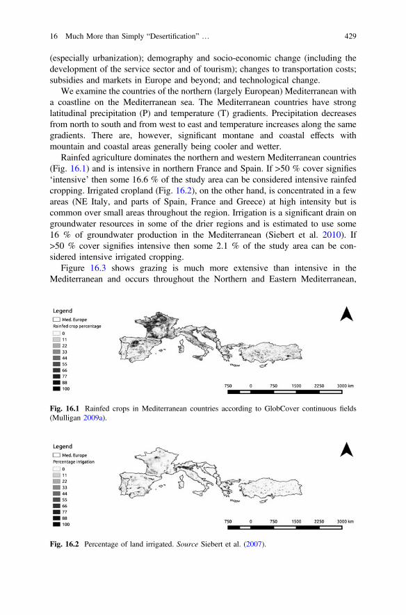
(especially urbanization); demography and socio-economic change (including thedevelopment of the service sector and of tourism); changes to transportation costs;subsidies and markets in Europe and beyond; and technological change.
We examine the countries of the northern (largely European) Mediterranean witha coastline on the Mediterranean sea. The Mediterranean countries have stronglatitudinal precipitation (P) and temperature (T) gradients. Precipitation decreasesfrom north to south and from west to east and temperature increases along the samegradients. There are, however, significant montane and coastal effects withmountain and coastal areas generally being cooler and wetter.
Rainfed agriculture dominates the northern and western Mediterranean countries(Fig. 16.1) and is intensive in northern France and Spain. If >50 % cover signifies‘intensive’ then some 16.6 % of the study area can be considered intensive rainfedcropping. Irrigated cropland (Fig. 16.2), on the other hand, is concentrated in a fewareas (NE Italy, and parts of Spain, France and Greece) at high intensity but iscommon over small areas throughout the region. Irrigation is a significant drain ongroundwater resources in some of the drier regions and is estimated to use some16 % of groundwater production in the Mediterranean (Siebert et al. 2010). If>50 % cover signifies intensive then some 2.1 % of the study area can be con-sidered intensive irrigated cropping.
Figure 16.3 shows grazing is much more extensive than intensive in theMediterranean and occurs throughout the Northern and Eastern Mediterranean,
Fig. 16.1 Rainfed crops in Mediterranean countries according to GlobCover continuous fields(Mulligan 2009a).
Fig. 16.2 Percentage of land irrigated. Source Siebert et al. (2007).
16 Much More than Simply “Desertification” … 429

especially in mountains, coastal areas and river margins. If >200 head per squarekm signifies intensive then some 4.9 % of the study area can be consideredintensive grazing land.
The greatest cereals producers in the EU and southern Mediterranean countriesin 2007 (an average year for the decade) according to EUROSTAT were France(59.4 million tonnes), Germany (40.6 million tonnes) and Poland (27.1 milliontonnes). These are followed by Spain (23.8 million tonnes), UK (19.4 milliontonnes) and Italy (18.8 million tonnes). Non-EU southern Mediterranean countries,on the other hand, have lower cereal production, most countries producing 5 milliontonnes of cereal annually or less, with the exception of Egypt which produced asmuch as 15.3 million tonnes of cereal in 2007 (Petit 2007). Though statistics for thesouthern Mediterranean countries are not as comprehensive, productivity remainslower than for the EU. Fruit and vegetable production is also very variable acrossthe Mediterranean, with Spain, Italy and Egypt having the highest production in thelast decade according to EUROSTAT. The European Union is by far the largestproducer of olives, producing about 75–80 % of the world’s supply (Muller 2004).Greece, Spain and Italy are the top olive producers; followed by Portugal, Algeria,Egypt, Argentina, Lebanon, Libya, Morocco, Palestine, Tunisia and the USA.Production of olives has greatly benefited from EU subsidies. Italy, Spain, andFrance are the top grape and wine producers in the world, followed by the USA andChina. Of the top twelve global producers, the EU producers (Italy, Spain, Franceand Germany) account for about 67 % of wine production (Patterson and Josling2005, using FAOSTAT data).
Population is distributed throughout the north and east Mediterranean land-masses with some significant urbanizations also present in those areas (Fig. 16.4).In the southern Mediterranean there are large areas with very low or no populations,people being highly concentrated in the coastal fringe and the major river valleys.This reflects the distribution of climatic and agricultural suitability and alsodetermines the demand for water and the human pressure (directly and throughagriculture) on the environment.
The northern Mediterranean is highly urbanized (Fig. 16.5) with these urban-izations being dense (in population terms), extensive and highly concentratedaround coasts (e.g. Spain, Italy) and major rivers (e.g. Egypt).
Fig. 16.3 Total grazers (headcount/km2). Source Wint and Robinson (2007).
430 M. Mulligan et al.

Figures 16.1, 16.2 and 16.3 indicate that the Mediterranean landscape is bothextensively and intensively agriculturalized, whilst Fig. 16.6 shows dry matterproductivity for the Mediterranean. This measure is for all plant systems, not only forcrops and shows strong gradients with the highest observed values in the northernareas (of Italy, Sardinia, northern Spain, Greece) and a strong decline towards thesouthern areas (especially of Spain, Turkey). Towards the South and East, waterbecomes limiting because of the gradient of decreasing precipitation in this direction.
Overall, the north and west Mediterranean is productive and extensively used fordryland or irrigated agriculture or grazing. Despite this intensive, extensive andproductive agricultural situation, the Mediterranean has long been considered an
Fig. 16.4 Population (persons/km2). Source Landscan (2007).
Fig. 16.5 Urban areas. Source CIESIN (2004).
Fig. 16.6 Dry matter productivity (Dg/ha/day) for the Mediterranean. Source Mulligan (2009b).
16 Much More than Simply “Desertification” … 431

area under threat of desertification and land degradation driven by unsustainableexploitation of water resources, abandonment and subsequent degradation ofmanaged farmland and significant changes to farming practices over the last dec-ades (Brandt and Thornes 1996; Puigdefábregas and Mendizabal 1998; Geesonet al. 2003; Briassoulis 2004; Rubio and Recatalá 2006; Safriel 2009).
16.3 Recent Drivers for “Mediterranean Desertification”
Here we review some of the reasons that Mediterranean desertification has receiveda great deal of scientific, political and media attention over the last three decades.Some of the reasons are biophysical whilst others are socio-economic in origin.These drivers include agricultural land use change, change to grazing lands,changes in agricultural policy, climate variability and change and, finally, changesto human exposure to land degradation.
16.3.1 Agricultural Land Use Change in the Mediterranean
Agricultural production in the Mediterranean has significantly increased over thepast fifty years. Since 1961, production increased 3-fold for cereals, 2.5-fold forvegetables and 5-fold for citrus fruits and these crops account for over 85 % of thetotal agricultural production in the Mediterranean (Plan Bleu 2009). The growthrate in agricultural production has started to fall in recent years in all Mediterraneancountries with the exception of Egypt, which showed remarkable increases in theperiod 1961–1983 and still grew (but at a much slower growth rate) in the period1984–2007 (Plan Bleu 2009). This has affected trade balances and Mediterraneancountries are becoming increasingly dependent on foreign food imports.Nevertheless, southern Europe exports much of its produce.
Although rain-fed agriculture predominates in the Mediterranean, it is on irri-gated land that the greatest productivity and productivity gains have been achievedin recent decades (Montgomery 2009), as is also the case outside the Mediterranean(Siebert and Döll 2010). The total irrigated area in the Mediterranean countriesdoubled in the previous 40 years to exceed 26 million hectares in 2005, possiblyrepresenting over 20 % of the land under cultivation (Plan Bleu 2009). The areaunder arable and permanent cropping has not increased alongside annual agricul-tural production, indicating a trend for intensification rather than extensification,again replicating the global trend. In fact, since 1961, arable land per capita in boththe north and south of the Mediterranean has halved (Plan Bleu 2009) as land that issuitable for cultivation is lost to urbanization and abandonment every year, largelybecause of migration to coastal urban areas but also in response to EU set-asidepolicy.
432 M. Mulligan et al.

16.3.2 Recent Changes to Grazing Lands
In the European Mediterranean—there has been a major shift in land use fromlivestock that grazed on extensive rangelands to intensively farmed cereals andintensive grazing systems. This is partly driven by markets and regional agriculturalpolicies, in particular subsidies designed to increase biodiversity but also as a moresustainable method of management (Roeder et al. 2008). Taking animals to graze isa hard and time-demanding job (Ruiz et al. 2001) with low economic rewardscompared with many others. Intensification necessitates the utilization of supple-mentary feedstuffs, either on-farm (cultivated pastures and crops) or most fre-quently off-farm through concentrates and forages (Riedel 2007).
In the Southern Mediterranean, cultivation has encroached onto rangelands,driven by population growth and national policies, often resulting in land degra-dation (Safriel 2009). In the south and the east (from Morocco to Turkey), despiterural to urban migration, the agricultural population increased by 10 million (16 %)within 40 years, reaching 71 million in 2000 (Thivet 2007). This can be contrastedwith the Northern Mediterranean where, from Spain to Greece, the agriculturalpopulation decreased from 46 million to 12 million over the same period (Thivet2007).
16.3.3 Recent Changes in Agricultural Policy
Much of the rise in productivity in the EU has been encouraged by the CommonAgricultural Policy (CAP), which was set up initially with the treaty of Rome(1957) to control food production across Europe and latterly focuses on environ-mental concerns. Through the provision of incentives and a number of accompa-nying policies, the CAP is a key driver of agricultural change in the EU. The impactof the CAP on Mediterranean land use has been well-documented (Shucksmithet al. 2005; van Meijl et al. 2006; Verburg et al. 2008; Serra et al. 2008). The effectof the CAP also needs to be seen alongside other drivers, such as the substantiallevel of national funding for agriculture, the fluctuations on world markets for foodproducts and the negotiations taking place within the World Trade Organization(Gay et al. 2005). In particular the CAP has provided support (via interventionbuying and storage) for a few Mediterranean products such as olive oil, tobacco andcotton, although this no longer takes place. Increased interest in energy efficiencyand climate change is increasingly raising questions about the relevance of currentCAP objectives (Cooper and Arblaster 2007). The likely continued futureenlargement of the Union will also necessitate significant change to future CAPpolicy. The Mediterranean will also be affected by the establishment of aMediterranean Free Trade Zone (MFTZ), which will encompass 12 non-EU nationsof the Mediterranean region as well as the entire European Union. This wasexpected to be completed by now but has been delayed by: foreseen negative social
16 Much More than Simply “Desertification” … 433
and environmental consequences; the Sarkozy initiative to set up a Union for thecountries that border the Mediterranean sea; and questions as to the relationshipbetween this and the EU-GCC (Gulf Cooperation Council) free trade initiative.
16.3.4 Recent Climate Variability, the Prolonged 1990sDrought and Climate Change Scenarios
The climate of the Mediterranean region is characterized by hot, dry summers andcool, wet winters (Conacher and Conacher 1998) with December, January andFebruary precipitation (DJF) a major contributor to the annual total. It is a region ofsignificant climate variability, both spatially and temporally. This climate variabilityis due to the Mediterranean’s location in a transitional zone between the competing“marine west coast climate” and the “subtropical desert climate” (Lionello et al.2006). The Mediterranean climate is exposed to the South Asian Monsoon insummer and the Siberian high pressure system in winter. Variability is expressed aschanges in annual total rainfall (both inter-annually and on decadal time scales) andchanges in rainfall seasonality and the frequency and magnitude of extreme rainfallevents and seasonal drought episodes. Rainfall records since 1900 indicate strongmulti-decadal variations in regional precipitation (meteorological drought) coupledwith a long term trend in the Palmer Drought Severity Index (PDSI) suggestive ofincreased land surface aridity associated with observed long term temperatureincrease since the 1960s (Mariotti 2010). DJF precipitation in the Mediterraneanshowed a striking decrease during the 1960–1990s which may result from circu-lation changes in the North Atlantic climate Oscillation (NAO). This meteorologicaldrought has been realized as hydrological drought with river discharge for majorMediterranean rivers such as the Ebro, Jucar and Arno showing a considerabledecline over the 20th Century. Current rainfall trends in the region continue theclear downward trend during the second half of the 20th Century (de Luis et al.2009; García-Ruiz et al. 2011) but much less dramatically than during the 1990s.This drying is experienced in the form of more frequent and intense drought,especially in the winter with 10 of the 12 driest winters since 1902 occurring from1992–2012 (Hoerling et al. 2012).
Future climate change scenarios for the Mediterranean are also complex.Generally, a change in circulation patterns is expected for the Mediterranean regionas a result of increases in sea level pressure, a northward shift of the Atlantic stormtrack and a deflection of storms north of the Mediterranean into higher latitude areas(Giorgi and Lionello 2008). These changes in circulation are expected to lead to ageneral reduction in precipitation for the Mediterranean regions and an increase forthe northern European regions. Changes in variability of precipitation and tem-perature are also expected. Schar et al. (2004) concluded that as a result of anincrease in inter-annual variability of temperature along with mean long-termwarming, the Mediterranean region might experience a much more frequent
434 M. Mulligan et al.

occurrence of extremely high temperature events and heat waves. As a region withalready marginal climate for some types of agriculture, the Mediterranean isexpected to be affected significantly by climate change.
Giorgi (2006) analysed IPCC SRES AR4 simulations to calculate a climatechange index based on precipitation and temperature means and variation. TheMediterranean was amongst a small number of climate change ‘‘hot-spots’’ glob-ally. Weib et al. (2007) considered socio-economic and climate changes as indi-cated by the IPCC SRES A2 and B2 scenario forcing the ECHAM4 GCM. Underthis scenario a current 100-year drought would likely occur 10 times more fre-quently in the Northern Mediterranean while in North Africa, a current 100-yeardrought will occur less frequently. There is thus the expectation of significantnegative effects of climate change in the Mediterranean. According to Giorgi andLionello (2008), climate change scenarios from general circulation models (GCMs)indicate a “pronounced decrease in precipitation, especially in the warm season,except for the northern Mediterranean areas (e.g. the Alps) in winter”. Theseeffects are projected to lead to a progressive decline in streamflow (García-Ruizet al. 2011).
Using the more recent Coupled Model Intercomparison Project Phase 5 (CMIP5)data, Peleg et al. (2014) compared current climate with projected mid-21st centuryclimate based on Representative Concentration Pathway (RCP) RCP4.5 andRCP8.5 scenarios using four of the available CMIP5 models. The models projecteda decreasing frequency of rainfall in the region with a 10–22 % reduction in wetevents. Also using CMIP data, Diffenbaugh and Giorgi (2012) indicate theMediterranean as one of a few hotspot areas for prominent climate change using amulti-variable metric including rainfall and temperature.
However, a large source of uncertainty in projections for the Mediterraneanregion derives from unrealistic modelling of the climate influence of theMediterranean Sea (Somot et al. 2008; Lionello et al. 2008). Furthermore, partic-ularly for regional models, uncertainties in future land use and land cover changeadds considerably to uncertainty in climate projections. Uncertainties in climatesimulations with RCMs for Europe were addressed in the PRUDENCE project(http://prudence.dmi.dk/) which found that, particularly for temperature, uncertaintyin boundary forcing plays a greater role than the RCM used (Déqué et al. 2007). Inaddition to these climate changes, the future of the Mediterranean environment willalso be determined by changes in population, technology, agriculture and thus landuse and cover.
16.3.5 Changing Exposure: Population Growthand Economic Development
Spatial projections for population and GDP are publicly available in map form onlyfor the Special Report on Emissions Scenarios (SRES) B2 scenario (Fig. 16.7).
16 Much More than Simply “Desertification” … 435

Under SRES B2, population increases by 2025 are expected to be greatest in thesouth and east of basin, concentrated in coastal areas. De-population is expected tooccur in parts of the north Mediterranean (especially Spain, Italy and Greece).
16.3.6 The Water Resources Situation
In addition to the observed low productivity in some areas of the Mediterranean(and expectation that this will reduce further with land degradation and climatechange), water resources are also a key constraint on productivity and sustainableland management in this environment. We have calculated water balance as rainfall(Hijmans et al. 2005) minus actual evapotranspiration (Mu et al. 2011) on a 1 kmresolution basis with negative local water balances (representing areas whereevapotranspiration is supported by lateral surface or subsurface inflows) set to zero.The results of this analysis are shown in Fig. 16.8a. Dark areas have plenty ofwater, whereas those in lighter shades show progressively lower water balance. Themost water stressed areas are in the southern Mediterranean, in the easternMediterranean and in coastal northern Mediterranean. Water stress can lead toover-cultivation and to the negative effects of irrigation in drylands. Note that thiswater balance does not include inflows of water from rivers nor unsustainable use offossil water but focuses on the locally produced renewable water resources (thewater balance) since this will be critical for sustainable agricultural production.Some 8 % of the area has a local water balance of zero, indicating all local rainfallconsumed by local evapotranspiration. Figure 16.8b shows the same data averagedover watersheds, indicating clearly the more water stressed catchments. Only 0.3 %of basin area experiences basin closure (all rainfall evaporated within the basin) onan annual basis under current conditions. Though a positive water balance will leadto the generation of runoff and thus river flow, this analysis does not explicitlyaccount for available water in rivers and groundwater that is used to supplement thelocal water balance at the pixel scale in some regions, though these are determinedentirely by water balance at the basin scale.
Fig. 16.7 Population projection for 2025 (persons/km2, SRES B2). Source CIESIN (2002).
436 M. Mulligan et al.

We carry out an analysis of evapotranspiration though the different types ofvegetation cover in the region (Table 16.1), calculated using WaterWorld1 andbased on the actual evapotranspiration (AET) dataset of Mu et al. (2011), theirrigated cropland dataset of Siebert et al. (2007) and the cropland and pasturedataset of Ramankutty (2008). Results indicate that, some 0.41 % of actual evap-otranspiration in the region occurs through irrigated croplands, 26.8 % through allcroplands, 16.1 % through pastures and 56.1 % through natural vegetation, with the
Fig. 16.8 a Water balance (rainfall-ET) (mm/yr). b Water balance (rainfall-ET) (mm/yr) bycatchment.
Table 16.1 Evapotranspiration by different land covers and as a percentage of rainfall ascalculated by WaterWorld
All vegetation Irrigatedcroplands
Croplands Pastures Naturalvegetation
Actual evapotranspiration (percentof total)
0.41 26.8 16.1 56.1
Actual evapotranspiration(percentage of rainfall)
0.2 15.3 9.2 31.9
1WaterWorld is a modelling platform containing a range of global databases and the capacity torun detailed algorithms at scales from local through to continental. It is available free fornon-commercial use from www.policysupport.org.
16 Much More than Simply “Desertification” … 437
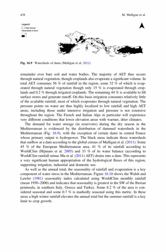
remainder over bare soil and water bodies. The majority of AET thus occursthrough natural vegetation, though croplands also evaporate a significant volume. Intotal AET consumes 56 % of rainfall in the region, some 32 % of which is evap-orated through natural vegetation though only 15 % is evaporated through crop-lands and 0.2 % through irrigated croplands. The remaining 44 % is available to fillsurface stores and generate runoff. On this basis irrigation consumes relatively littleof the available rainfall, most of which evaporates through natural vegetation. Thepressure points on water are thus highly localized to low rainfall and high AETareas, including those under intensive irrigation and pressure is not extensivethroughout the region. The French and Italian Alps in particular will experiencevery different conditions that lower elevation areas with warmer, drier climates.
The demand for water storage (in reservoirs) during the dry season in theMediterranean is evidenced by the distribution of dammed watersheds in theMediterranean (Fig. 16.9), with the exception of certain dams in central Francewhose primary output is hydropower. The black areas indicate those watershedsthat outflow at a dam according to the global census of Mulligan et al. (2011). Some45 % of the European Mediterranean area, 41 % of its rainfall according toWorldClim (Hijmans et al. 2005) and 33 % of its water balance (according toWorldClim rainfall minus Mu et al. (2011) AET) drains into a dam. This representsa very significant human appropriation of the hydrological fluxes of this region,supporting irrigation, industrial and domestic use.
As well as the annual total, the seasonality of rainfall and evaporation is a keycomponent of water stress in the Mediterranean. Figure 16.10 shows the Walsh andLawler (1981) seasonality index calculated using WorldClim monthly rainfall(mean 1950–2000) and indicates that seasonality is greatest in the SW of the Iberianpeninsula, in southern Italy, Greece and Turkey. Some 8.2 % of the area is con-sidered seasonal and some 0.7 % is markedly seasonal using this metric. In theseareas a high winter rainfall elevates the annual total but the summer rainfall is a keylimit to crop growth.
Fig. 16.9 Watersheds of dams (Mulligan et al. 2011).
438 M. Mulligan et al.

16.4 The Scientific Response to Perceived MediterraneanDesertification
Concern over desertification in the European Mediterranean has led to the fundingof a range of field and modelling based assessments in the region. The field pro-grammes aimed to understand the processes operating and assess desertification atvarious sites whereas the modelling projects aimed to provide a detailed analysis ofcauses and consequences in a spatially explicit manner, at the landscape scale. Wewill focus here on the modelling projects since they operate at more policy relevantscales than the field programmes, though they are—of course—informed by dataand knowledge from the field. A series of models have been developed at scalesfrom the hillslope to the continent. The MEDALUS I project developed and appliedmodels for soil erosion at the hillslope scale (Thornes et al. 1996), MEDALUS IIcombined these soil erosion models with models for vegetation growth anddevelopment as well as soil hydrology and MEDALUS III culminated in thedevelopment of the MEDRUSH model for forecasting hydrology, soil erosion andsediment yield in catchments of up to 2000 km2 in a spatially explicit fashion usingthe GRASS GIS (Kirkby et al. 2002). The MODMED project (1995–1999,Mazzoleni and Legg 1998) built predictive models for understanding natural veg-etation dynamics and their response to changes in grazing and burning pressureresulting from developments in agricultural policy. The MODULUS project (1998–1999) led by the Research Institute for Knowledge Systems (RIKS) took models
Fig. 16.10 The Walsh and Lawler (1981) seasonality index for the Mediterranean.
16 Much More than Simply “Desertification” … 439

and datasets developed in a range of previous EC projects (in particular EFEDA1988–1991 (Bolle 1995), MEDALUS and MODMED 1995–1999) and combinedthem in an integrated model for climate, hydrology, plant growth and vegetationdevelopment, soil erosion and socio-economic processes as an operational decisionsupport system (DSS) aimed at regional policy-makers and applied in the MarinaBaixa, SE Spain and the Argolid of Greece (Oxley et al. 2004). The hydrology, cropgrowth, climate and erosion models were based on the PATTERN model (Mulligan1996, 1998) which was developed alongside the EFEDA project.
MODULUS was a technical experiment in that it took existing models that hadbeen developed in previous projects, left them in their native code and wrappedthem with a software ‘layer’ to permit their integration as a single model capable ofrunning simulations for scenarios of land use and climate change and providedresults as graphics and maps. The project showed that models developed for sci-entific purposes could be integrated together to tackle policy-relevant questions andthen supported by a sophisticated but user-friendly interface and thus approach therequirements for policy application. MedAction (2001–2004) further developed theMODULUS DSS into a Policy Support System (PSS) capable of advising policy.This required the engagement of end users at the start of the project, the definitionof clear policy goals with them and the re-engineering of models from the bottomup for careful integration into an integrated model. The PSS was applied to land useand water management issues in the Guadalentin basin (SE, Spain) (van Deldenet al. 2007). In the DESURVEY project (2005–2010), the MedAction PSS wasfurther developed for application across Europe and North Africa as theDESURVEY surveillance system. It was enhanced through the incorporation ofmulti-scale modelling with a simpler model, based on PESERA (Kirkby et al. 2003)being applied for application at the pan-European scale (1 km resolution) and amore complex and data demanding model based on PATTERN (Mulligan 1998)—as implemented in MedAction—used for application for local scale analyses (at 1hectare resolution). New process descriptions, policy options and datasets necessaryfor application to North Africa were also developed alongside much more extensivetraining and application throughout Europe.
Throughout this period of model building, the models have become more andmore sophisticated both in terms of the processes represented, the degree of feed-back between processes, the degree of integration and inclusion of biophysical andsocio-economic processes, and the degree of spatial detail and spatial heterogeneityincorporated. This evolution reflects our improved understanding of the complex-ities of processes that are grouped together under the umbrella of desertification.Later projects built upon these efforts to interface and adapt models for use inadvising policy—driven by increasing pressure from the EC to connect its sciencewith its policy agendas, though there is little evidence that such tools are used insupporting policy at the EC.
440 M. Mulligan et al.

16.5 Revisiting Mediterranean “Desertification”
With 20 years of hindsight we now revisit the science on Mediterranean deserti-fication with a view to understanding better the current thinking around this issue.
16.5.1 Where Actually Desertified?
According to the literature, land degradation is said to affect 80 % of the arid anddry areas of the Mediterranean, especially pasturelands and rain-fed croplands, buteven irrigated land is considered under threat (Thivet 2007). Degradation is vari-ously attributed to overgrazing, poor soil management, poor drainage on irrigatedland, and the over-abstraction of woodland for fuel wood. This has been linked topopulation migration in the past, for example the Thessaly Plain was grazed forcenturies by transhumance flocks and herds but after significant immigration in theearly 1920s these areas were converted for wheat cultivation (Kosmas et al. 1999).For sure groundwater resources in the region have declined significantly, largelyreflecting increasing agricultural abstraction (Iglesias et al. 2007).
Yet, agricultural production has continued to increase in the EuropeanMediterranean (Leetmaa et al. 2004; Montgomery 2009) at the same time that muchland has been returned to nature. Moreover, the rainfall-use-efficiency correctednegative NDVI (normalized difference vegetation index) analysis of Bai et al.(2008) indicate negative trends in vegetation cover (possibly reflecting degradation)over only 1 % of the study region, largely in the intensive agricultural areas of SWSpain, NE Italy and Montenegro—which are likely the result of major land usechanges rather than actual land degradation. Coastal parts of North Africa and of theeastern Mediterranean are also considered to be degrading (García-Ruiz et al.2011). Therefore developments so far in agricultural practices and technology seemto be keeping pace with any degradation so that ‘desertification’ appears not to behaving large-scale societal impacts in the region. Increasingly fewer familiesdepend on agricultural livelihoods, especially in the EU; agriculture is generallylarger scale and more ‘commercialized’; and much of the population lives andworks in an urban setting. The land degradation picture is thus more heterogenerousand complex than the large scale ‘desertification’ of the region that was anticipatedin the 1990s.
16.5.2 What Did We Really Mean by Mediterranean“Desertification”?
Desertification is a term used to cover a ‘multitude of evils’ and can fairly wellincorporate any socio-economic or biophysically-driven problem in a dryland
16 Much More than Simply “Desertification” … 441

context from the multiple impacts of climate change, through land degradation,through application of over-intensive methods to overgrazing, water resource stressand other issues associated with poor management of common pool resources. Sowhat did (do) we really mean by Mediterranean desertification? We can identifythree different lenses that have been used.
16.5.2.1 The Land Degradation Lens (Pressure-Response)
In the land degradation phase, desertification is considered to be the response of thelandscape to the application of pressure (drought, overcropping, overgrazing,over-extraction of groundwater). As the pressure increases, the environment reactsto create a problem (agricultural drought, soil exhaustion and erosion, grazing-landdegradation, salinization of groundwater), see for example Catalinas and Cantón2012). The system is seen as a pressure response system and the kinds ofpressure-response tools (models) used suggested continued progressive degradationinto the future (see Mulligan 2009a, b, c). Each element of the system is consideredindependently as an independent pressure response system and research is usuallyfocused on one set of processes e.g. soil erosion, ignoring the links between dif-ferent pressure-response systems. The focus is on land degradation as the outcome(to be avoided) rather than as we might see it today: as a driver itself that will act toreduce economic and agricultural pressure in a negative feedback cycle (wherealternatives to agricultural livelihoods exist).
16.5.2.2 The Sustainability Lens (Pressure-Response-Feedback)
With this approach the focus is on understanding the limits of environmentalsystems and the likely impacts once these limits are reached. This approachexamines desertification in a more integrated manner looking into a range of pro-cesses and systems and focusing on the changes to socio-economic systems thatwould be required to achieve sustainability. The focus is thus on sustainability asthe outcome (to be achieved), see Laraus (2004), Perry (2006) and Turner et al.(2007).
16.5.2.3 The Ecosystem Services (ES) Phase (Tipping Pointsand Complexity)
With this approach the focus is on maintaining the ES that are critical to localpopulations. This involves understanding how and where ES are delivered, the roleof natural environments and of agriculture in delivery, and who benefits from them.The science concentrates on highlighting the pressures on ecosystems that are likelyto result in degradation of the ecosystem functions that provide these ES and seeksto maintain these pressures at levels below those tipping points that would lead to
442 M. Mulligan et al.

significant impact on humanity. Maintenance of ecosystem service provision whilstmaintaining and increasing agricultural production is the outcome sought (see forexample Schröter et al. 2005; Benayas et al. 2007; Bugalho et al. 2011; Willaartset al. 2012).
16.6 The Importance of Policy, Place, Spaceand Variability in Assessing and ManagingDesertification
As Figs. 16.1, 16.2, 16.3, 16.4, 16.5, 16.6, 16.7, 16.8, 16.9 and 16.10 highlight, theEuropean Mediterranean shows significant spatial variability in the biophysical andsocio-economic factors that might influence land degradation. This variabilitycombines with the policy context to determine the impact of policies on desertifi-cation. Farming policy in Mediterranean Europe is dominated by the CAP. Currenttrends in the CAP could lead to further abandonment of production in zones of highnature conservation value (Caraveli 2000) and this may lead to reduced landdegradation (Ruecker et al. 1998) or increased land degradation especially on steepslopes (e.g. Koulouri and Giourga 2007) in the areas abandoned. Mediterraneanwater policy is largely focused on drought management. According to Iglesias et al.(2007) water management in the region works best when carried out at the basinscale and when institutional responsibilities are clear but they argue that allcountries in the region show weak inter-institutional cooperation and gaps the rolesof the state, the region and the river basin authorities. This situation impairs theimplementation of legislation. The European Water Framework Directive(2000/60/EC) does attempt to develop legislation and institutions for water man-agement and planning at the basin level. However, key issues in implementation ofthe WFD include the difficulties of transboundary cooperation (across regions aswell as countries) and lack of provision for water quality management duringdrought conditions (Iglesias et al. 2007). Indeed monitoring, early warning andmanagement of drought, including the provision of contingency sources needsmuch further development throughout the Mediterranean region. Legislation aroundthe management of groundwater pumping for irrigation also requires a much moreadaptive and locally nuanced approach that takes better account of varying climaticand hydro-geological conditions over time and space.
According to WDPA (2013) some 18 % of the area studied here is at leastnominally protected with 0.06 % of this with RAMSAR designation as wetlands ofinternational importance. Protected areas cover 13.75 % of the rainfall of the regioncalculated with WorldClim data (Hijmans et al. 2005) and 17.25 % of the waterbodies calculated with SRTM SWBD (lakes, rivers, USGS 2006) data. To theextent that protected area designation is effective at reducing pressure on theground, these represent an important mechanism to manage land degradation.
16 Much More than Simply “Desertification” … 443

South of the Mediterranean Sea, a large divide exists between national deserti-fication policy objectives and their local implementation, notably as a result ofinstitutional complexity and inadequacies. Institutions suffer from weak resourcesand capacities, as well as the legal pluralism generated by the overlap of traditional,state and project-led institutions which can undermine the effective regulation ofpractices (Briassoulis 2004). Though the success of these policies hinge largely onchanging end user practices, consultation of these stakeholders in the design andimplementation of policies remains low, leading to weak participation and concernfor desertification issues. Degradation of resources (overgrazing, over-abstractionetc.) often ensues with officials and traditional authorities turning a blind eye tosupport smallholder’s agricultural practices in the absence of alternative livelihoods(Le Goulven et al. 2009).
Past policies also suffered from ministries addressing complexsocio-environmental problems from an isolated, single perspective, leading tounexpected results such as reducing aquifer recharge as a result of local irrigationefficiency improvements (Molle 2009). Concepts such as green, blue and virtualwater accounting (Allan 1998) or payment for ecosystem services have started tofilter into policies (Besbes et al. 2010) and further holistic methods are required forresearchers and stakeholders to understand the mutual interactions betweenhydrological and agricultural processes as well as wider socio-economic influences(subsidies, land tenure, water pricing, etc.) on land degradation. Data scarcity (bothabsolute and as a result of deficient data sharing) on the spatial and temporal gravityof desertification also currently impedes the targeting of resources towards local,site specific strategies.
16.7 Conclusions: If the Problem Is Complex, the SolutionIs Complex
Change in agricultural policy is often not tested for long-term sustainability in theface of soil degradation and long-term climate variability and this has the potentialto lead to severe degradation that may render short term economic gains as longterm losses. To be of real benefit, land use strategies and incentives for theMediterranean must be sustainable and profitable in the long term and land man-agement options must also be effective for the long-term. The impacts of both landuse and land management strategies must also be understood for the range ofsocio-economic and biophysical conditions that exist in the region of influence ofthe proposed policy, since response will not be uniform across variable landscapesand those applying policy should not assume it will. The legislative and institutionalframework must recognize this need for spatio-temporal sophistication to buildrobust and sustainable agriculture.
444 M. Mulligan et al.

Policies that need to be tested in this way include:
(a) investment or incentivization of particular crop choices or land managementtechniques including irrigation, terracing, contour ploughing, ploughing andslope reforming,
(b) infrastructural investments such as dams, water transfers, desalinizationfacilities,
(c) conservation and protection schemes such as designation of protected areas,deforestation, buffer strips, check dams.
All of these have complex interactions with biophysical processes and thusstores and fluxes of water, sediment, soil and plant productivity and on humanbehaviour such as crop choice and land management.
It is clear that the desertification narrative of the 1990s was not representative ofthe spatial complexity and subtlety of land degradation processes in theMediterranean (see Geeson et al. 2003; Mulligan et al. 2004) and the spatialheterogeneity that is clear in Figs. 16.1, 16.2, 16.3, 16.4, 16.5, 16.6, 16.7, 16.8, 16.9and 16.10 here. The significant declines in rainfall throughout the region in thisdecade provoked concerns about large-scale desertification that then never mate-rialized. Even under current intensive agriculture, much of the rainfall in the regionstill evaporates through natural vegetation rather than agriculture and there is littleevidence (for example in agricultural or economic output) of large scale degradationin the region. In fact the abandonment of agricultural land is generally reducing soiland water degradation (Ruecker et al. 1998), except in areas of very steep slopeswhere terraces are now breaking down (Koulouri and Giourga 2007) but willrevegetate and recover in time. Over spatially and temporally explicit landscapesthe kinds of large scale desertification mapping efforts of the 1990s (e.g. UNEP1997) do not capture this spatial heterogeneity at all. An effective way to managesuch complexities and test policies in silico before they are applied in vivo isthrough the application of data and process-based, spatially detailed modelling ofthe type used here but also to ensure that such modelling is accessible in apolicy-support context (cf. Mulligan 2009a, b, c) and is well supported by extensivefield and remote sensing datasets.
References
Allan, J. A. (1998). Virtual water: A strategic resource. Ground Water, 36(4), 545–546.Bai, Z. G., Dent, D. L., Olsson, L., & Schaepman, M. E. (2008). Global assessment of land
degradation and improvement 1. Identification by remote sensing.GLADAReport 5. Version 5.Benayas, J. R., Martins, A., Nicolau, J. M., & Schulz, J. J. (2007). Abandonment of agricultural
land: An overview of drivers and consequences. CAB Reviews: Perspectives in Agriculture,Veterinary Science, Nutrition and Natural Resources, 2(57), 1–14.
Besbes, M., Chahed, J., Hamdane, A., & de Marsily, G. (2010). Changing water resources andfood supply in arid zones: Tunisia. Water and Sustainability in Arid Regions (pp. 103–121).Netherlands: Springer.
16 Much More than Simply “Desertification” … 445

Bolle, H. J. (1995). Identification and observation of desertification processes with the aid ofmeasurements from space: Results from the European Field Experiment inDesertification-threatened Areas (EFEDA). Environmental Monitoring and Assessment, 37(1–3), 93–101.
Brandt, C. J., & Thornes, J. B. (1996). Mediterranean desertification and land use. Hoboken:Wiley.
Briassoulis, H. (2004). The institutional complexity of environmental policy and planningproblems: The example of Mediterranean desertification. Journal of Environmental Planningand Management, 47(1), 115–135.
Bugalho, M. N., Caldeira, M. C., Pereira, J. S., Aronson, J., & Pausas, J. G. (2011). Mediterraneancork oak savannas require human use to sustain biodiversity and ecosystem services. Frontiersin Ecology and the Environment, 9(5), 278–286.
Caraveli, H. (2000). A comparative analysis on intensification and extensification in Mediterraneanagriculture: Dilemmas for LFAs policy. Journal of Rural Studies, 16(2), 231–242.
Catalinas, M. A. R. T. A., & Cantón, Á. G. (2012). Relationships between anthropogenic pressuresand ecological status in a Mediterranean river basin district in Spain. In 9th InternationalSymposium on Ecohydraulics 2012 Proceedings. ISBN: 978-3-200-02862-3.
Center for International Earth Science Information Network (CIESIN). (2002). Country-levelPopulation and Downscaled Projections based on the B2 Scenario 1990–2100 [digitalversion]. Palisades NY: CIESIN Columbia University. Available online at http://www.ciesin.columbia.edu/datasets/downscaled
Center for International Earth Science Information Network (CIESIN). (2004). International FoodPolicy Research Institute (IFPRI), and Centro Internacional de Agricultura Tropical (CIAT):Global Rural-Urban Mapping Project (GRUMP). Socioeconomic Data and Applications Center(SEDAC) Alpha Version: Urban Extents Palisades, NY: CIESIN, Columbia University.
Conacher, A. J., & Conacher, J. (1998). Introduction. In A. J. Conacher & M. Sala (Eds.), Landdegradation in Mediterranean environments of the World. Chichester, UK: Wiley.
Cooper, T., &Arblaster, K (2007).Climate change and the rural environment in a European context:Implications for land use and land use policy. Background Paper for the LUPG/BfN Conferenceon ‘Future Policies for Rural Europe. 2013 and Beyond’, held in Brussels, 19–20 September2007. Available online at http://www.ieep.eu/publications/publications.php?pub=68412
de Luis, M., González-Hidalgo, J. C., Longares, L. A., & Štepánek, P. (2009). Seasonalprecipitation trends in the Mediterranean Iberian Peninsula in second half of 20th century.International Journal of Climatology, 29(9), 1312–1323.
Déqué, M., Rowell, D. P., Lüthi, D., Giorgi, F., Christensen, J. H., Rockel, B., et al. (2007). Anintercomparison of regional climate simulations for Europe: Assessing uncertainties in modelprojections. Climatic Change, 81(1), 53–70.
Diffenbaugh, N. S., & Giorgi, F. (2012). Climate change hotspots in the CMIP5 global climatemodel ensemble. Climatic Change, 114(3–4), 813–822.
Florke, Weib M., Menzel, L., & Alcamo, J. (2007). Model-based scenarios of Mediterraneandroughts. Advances in Geosciences, 12, 145–151.
García-Ruiz, J. M., López-Moreno, J. I., Vicente-Serrano, S. M., Lasanta–Martínez, T., &Beguería, S. (2011). Mediterranean water resources in a global change scenario. Earth-ScienceReviews, 105(3–4), 121–139.
Gay, S. H., Osterburg, B., Baldock, D., & Zdanowicz, A. (2005). Recent evolution of the EUCommon Agricultural Policy (CAP): State of play and environmental potential. Report fromMEACAP project n°SSPE-CT-2004-503604, Document number: MEACAP WP6 D4b,Institute of European Environmental Policy. Available onlione at: http://www.ieep.eu/publications/pdfs/meacap/WP6/WP6D4B_CAP.pdf
Geeson, N. A., Brandt, C. J., & Thornes, J. B. (Eds.). (2003). Mediterranean desertification: Amosaic of processes and responses. Hoboken: Wiley.
Giorgi, F. (2006). Climate change hot‐spots. Geophysical Research Letters, 33(8).Giorgi, F., & Lionello, P. (2008). Climate change projections for the Mediterranean region. Global
and Planetary Change, 63(2), 90–104.
446 M. Mulligan et al.

Hijmans, R. J., Cameron, S. E., Parra, J. L., Jones, P. G., & Jarvis, A. (2005). Very high resolutioninterpolated climate surfaces for global land areas. International Journal of Climatology, 25,1965–1978.
Hoerling, M., Eischeid, J., Perlwitz, J., Quan, X., Zhang, T., & Pegion, P. (2012). On the increasedfrequency of Mediterranean drought. Journal of Climate, 25(6), 2146–2161.
Iglesias, A., Garrote, L., Flores, F., & Moneo, M. (2007). Challenges to manage the risk of waterscarcity and climate change in the Mediterranean. Water Resources Management, 21(5), 775–788.
Kirkby, M. J., Abrahart, R. J., Bathurst, J. C., Kilsby, C. G., McMahon, M. L., Osborne, C. P.,et al. (2002). MEDRUSH: A basin-scale, physically based model for forecasting runoff andsediment yield. In N. A. Geeson, C. J. Brandt, & J. B. Thornes (Eds.), MediterraneanDesertification: A mosaic of processes and responses (pp. 203–229). Chichester: Wiley.
Kirkby, M. J., Jones, R. J. A., Irvine, B., Gobin, A, Govers, G., Cerdan, O.,…. & Van Lynden, G.(2003). Pan-European Soil Erosion Risk Assessment: The PESERA Map, Version 1 October(2003). Explanation of Special Publication Ispra 2004 No.73 (S.P.I.04.73). European SoilBureau Research Report No. 16, EUR 21176, 18 pp. Office for Official Publications of theEuropean Communities, Luxembourg.
Kosmas, C., Kirkby, M. J., & Geeson N. (1999). Manual on key indicators of desertification andmapping environmentally sensitive areas to desertification. European CommissionPublication EUR 18882, 87 pp
Koulouri, M., & Giourga, C. (2007). Land abandonment and slope gradient as key factors of soilerosion in Mediterranean terraced lands. Catena, 69(3), 274–281.
LandScanTM Global Population Database. (2007). Oak Ridge, TN: Oak Ridge NationalLaboratory. Available online at http://www.ornl.gov/landscan/
Laraus, J. (2004). The problems of sustainable water use in the Mediterranean and researchrequirements for agriculture. Annals of Applied Biology, 144(3), 259–272.
Le Goulven, P., Leduc, C., Bachta, M. S., & Poussin, J.-C., (2009). Sharing scarce resources inMediterranean river rasin: Wadi Merguellil in Central Tunisia. In F. Molle & F. Wester (Eds.),River Basin Trajectories: Societies, environments and development (pp. 147–170). CABInternational.
Leetmaa, S. E., Arnade, C., & Kelch, D. (2004). A comparison of US and EU agriculturalproductivity with implications for EU enlargement. Leetmaa: US-EU Food and AgricultureComparisons. Mary Anne Normile and Susan E. 33.
Lionello, P., Malanotte-Rizzoli, P., & Boscolo, R. (Eds.). (2006). Mediterranean climatevariability. Amsterdam: Elsevier.
Lionello, P., Platon, S., & Rodo, X. (2008). Trends and climate change in the Mediterraneanregion. Global and Planetary Change, 63, 87–89.
Mariotti, A., (2010). Recent changes in Mediterranean water cycle: A pathway toward long-termregional hydroclimatic change? Journal of Climate, 23(6), 1513–1525.
Mazzoleni, S., & Legg, C. (1998). Modmed: Modelling vegetation dynamics and degradation inMediterranean ecosystems. In P. Mairota, J. B. Thornes, & N. Geeson (Eds.), Atlas ofMediterranean environments in Europe—the desertification context (pp. 14–18). Chichester:Wiley.
Molle, F. (2009). Water scarcity, prices and quotas: A review of evidence on irrigation volumetricpricing. Irrigation and Drainage Systems, 23(1), 43–58.
Montgomery, R. (2009). Crop production in the Mediterranean Partner Countries continues toincrease. Statistics in Focus, Eurostat, Office for Official Publications of the EuropeanCommunities. Available online at http://www.pcbs.gov.ps/Portals/_PCBS/Documents/KS-SF-09-012-EN.pdf
Mu, Q., Zhao, M., & Running, S. W. (2011). Improvements to a MODIS global terrestrialevapotranspiration algorithm. Remote Sensing of Environment, 115, 1781–1800. doi:10.1016/j.rse.2011.02.019.
Muller, K. (2004). California and the Global Olive Oil Industry.
16 Much More than Simply “Desertification” … 447

Mulligan, M. (1996). Modelling the hydrology of vegetation change in a degraded semi-aridenvironment. Unpublished Ph.D. Thesis, King’s College London, University of London.
Mulligan, M. (1998). Modelling the geomorphological impact of climatic variability and extremeevents in a semi-arid environment. Geomorphology, 24(1), 59–89.
Mulligan, M. (2009a). Vegetation continuous fields by land cover class based on GLOBCOVER.Available online at http://www.ambiotek.com/vcfclasses. Source Data: © ESA/ESA GlobcoverProject, led by MEDIAS-France/Postel
Mulligan, M. (2009b). Global mean dry matter productivity based on SPOT-VGT (1998–2008).http://www.ambiotek.com/dmp
Mulligan, M. (2009c). Integrated environmental modelling to characterise processes of landdegradation and desertification for policy support. In J. Hill & A. Roeder (Eds.), Remotesensing and geo information processing in the assessment and monitoring of land degradationand desertification. UK: Taylor and Francis.
Mulligan, M., Burke, S. M., & Ramos, M. C. (2004). Climate change, land use change and the‘desertification’ of Mediterranean Europe. In S. Mazzoleni, G. di Pasquale, M. Mulligan, P. diMartino, & F. Rego (Eds.), Recent dynamics of the Mediterranean vegetation and landscape(pp. 259–279). Chichester: Wiley.
Mulligan, M., Saenz, L., & van Soesbergen, A. (2011). Development and validation of ageoreferenced global database of dams. Available online: http://www.ambiotek.com/dams
Oxley, T., Winder, N., McIntosh, B. S., Mulligan, M., & Engelen, G. (2004). Integrated catchmentmodelling & decision support tools: A Mediterranean example. Environmental Modelling andSoftware, 19(11), 999–1010.
Patterson, L. A., & Josling, T. E. (2005). Mediterranean agriculture in the global marketplace: Aproject comparing policy approaches in California and the Southern EU States. Report onStage 1. European Forum Institute for International Studies, Stanford University. Availableonline at http://aic.ucdavis.edu/research1/patt_jos_med_ag_glob_mkt.pdf
Peleg, N., Bartov, M., & Morin, E. (2014). CMIP5 predicted climate shifts over the EastMediterranean: Implications for the transition region between Mediterranean and semi aridclimates. International Journal of Climatology. Early View.
Perry, A. (2006). Will predicted climate change compromise the sustainability of Mediterraneantourism? Journal of Sustainable Tourism, 14(4), 367–375.
Petit, M. (2007) Interactions between the Euro/Med liberalization process: World markets andInternational negotiations. Deliverable D25 of Impacts of agricultural trade liberalizationbetween the EU and Mediterranean countries (EU-MED AGPOL), Project no.SSPE-CT-2004-502457. Available online at: http://eumed-agpol.iamm.fr/html/publications/prj_report/d25.pdf
Plan Bleu. (2009). State of the Environment and Development in the Mediterranean. Athens:UNEP/MAP-Plan Bleu.
Puigdefábregas, J., & Mendizabal, T. (1998). Perspectives on desertification: WesternMediterranean. Journal of Arid Environments, 39(2), 209–224.
Ramankutty, N., et al. (2008). Farming the planet: 1. Geographic distribution of global agriculturallands in the year 2000. Global Biogeochemical Cycles, 22, GB1003. doi:10.1029/2007GB002952.
Ramos, M. C., & Mulligan, M. (2005). Spatial modelling of the impact of climate variability onthe annual soil moisture regime in a mechanized Mediterranean vineyard. Journal ofHydrology, 306(1–4), 287–301.
Riedel. (2007) Dairy goat grazing systems in Mediterranean regions: A comparative analysis inSpain, France and Italy. Small Ruminant Research, 85(1), 42–49.
Roeder, A., Udelhoven, Th, Hill, J., et al. (2008). Trend analysis of Landsat-TM and -ETM+imagery to monitor grazing impact in a rangeland ecosystem in Northern Greece. RemoteSensing of Environment, 112(6), 2863–2875.
Rubio, J. L., & Recatalá, L. (2006). The relevance and consequences of Mediterraneandesertification including security aspects. In Desertification in the Mediterranean region.A security issue (pp. 133–165). Netherlands: Springer.
448 M. Mulligan et al.

Ruecker, G., Schad, P., Alcubilla, M. M., & Ferrer, C. (1998). Natural regeneration of degradedsoils and site changes on abandoned agricultural terraces in Mediterranean Spain. LandDegradation and Development, 9(2), 179–188.
Ruiz, F. A., Mena, Y., Castel, J. M., Guinamard, C., Bossis, N., Caramelle-Holtz, E., et al. (2001).Typology of cereal-sheep farming systems in Castile-La Mancha (South-Central Spain). Agr.Syst., 68, 215–232.
Safriel, U. N. (2009). Status of desertification in the mediterranean region. In J. L. Rubio, U.Safriel, R. Daussa, W. Blum & F. Pedrazzini (Eds.), Water scarcity, land degradation anddesertification in the mediterranean region (pp 33–73). Proceedings of the NATO AdvancedResearch Workshop on Water Scarcity, Land Degradation and Desertification in theMediterranean Region DEC 10-11, 2007 Valencia, SPAIN. Book Series: Nato Science forPeace and Security Series C—Environmental Security.
Schar, C., Vidale, P. L., Lüthi, D., Frei, C., Häberli, C., Liniger, M. A., & Appenzeller, C. (2004).The role of increasing temperature variability in European summer heatwaves. Nature, 427,332–336.
Schröter, D., Cramer, W., Rik Leemans, I., Prentice, C., Araújo, M. B., Arnell, N. W., et al.(2005). Ecosystem service supply and vulnerability to global change in Europe. Science, 310(5752), 1333–1337.
Serra, P., Pons, X., & Saurí, D. (2008). Land-cover and land-use change in a Mediterraneanlandscape: A spatial analysis of driving forces integrating biophysical and human factors.Applied Geography, 28(3), 189–209.
Shucksmith, M., Thomson, K. J., & Roberts, D. (Eds.). (2005). The CAP and the regions: Theterritorial impact of the common agricultural policy. CABI.
Siebert, S., Burke, J., Faures, J. M., Frenken, K., Hoogeveen, J., Döll, P., & Portmann, F. T.(2010). Groundwater use for irrigation–a global inventory. Hydrology and Earth SystemSciences Discussions, 7(3), 3977–4021.
Siebert, S., & Döll, P. (2010). Quantifying blue and green virtual water contents in global cropproduction as well as potential production losses without irrigation. Journal of Hydrology, 384(3), 198–217.
Siebert, S., Döll, P., Feick, S., Frenken, K., & Hoogeveen, J. (2007). Global map of irrigationareas version 4.0.1. Germany, and FAO, Rome, Italy: University of Frankfurt (Main).
Somot, S., Sevault, F., Déqué, M., & Crépon, M. (2008). 21st century climate change scenario forthe Mediterranean using a coupled atmosphere-ocean regional climate model. Global andPlanetary Change, 63, 112–126.
Thivet, G. (2007). Towards rural revival in the Mediterranean. Blue Plan Notes No. 5. UnitedNations Environment Programme—Mediterranean Action Plan, Plan Bleu.
Thornes, J. B., Shao, J. X., Diaz, E., Roldan, A., Hawkes, C., & McMahon, M. (1996). Testing theMEDALUS hillslope model. Catena, 26, 137–160.
Turner, B. L., Lambin, E. F., & Reenberg, A. (2007). The emergence of land change science forglobal environmental change and sustainability. Proceedings of the National Academy ofSciences, 104(52), 20666–20671.
UNEP (United Nations Environment Programme). (1997). World atlas of desertification (2nd ed.).London: UNEP.
USGS. (2006). Shuttle radar topography mission water body dataset. Available online at: http://edc.usgs.gov/products/elevation/swbd.html
van Delden, H., Luja, P., & Engelen, G. (2007). Integration of multi-scale dynamic spatial modelsof socio-economic and physical processes for river basin management. EnvironmentalModelling and Software, 22(2), 223–238.
van Meijl, H., Van Rheenen, T., Tabeau, A., & Eickhout, B. (2006). The impact of different policyenvironments on agricultural land use in Europe. Agriculture, Ecosystems & Environment, 114(1), 21–38.
van Wesemael, B., Rambaud, Xavier, Poesen, Jean, Mulligan, Mark, Cammeraat, Erik, & Stevens,Antoine. (2005). Spatial patterns of land degradation and their impacts on the water balance ofrainfed treecrops: A case study in South East Spain. Geoderma, 133, 43–56.
16 Much More than Simply “Desertification” … 449

Verburg, P. H., Eickhout, B., & van Meijl, H. (2008). A multi-scale, multi-model approach foranalyzing the future dynamics of European land use. The Annals of Regional Science, 42(1),57–77.
Walsh, P. D., & Lawler, D. M. (1981). Rainfall seasonality: Description, spatial patterns andchange through time. Weather, 36, 201–208.
Weib, M., Florke, M., Menzel, L., & Alcamo J. (2007). Model-based scenarios of Mediterraneandroughts.Advances in Geosciences, 12, 145–151.
Willaarts, B. A., Volk, M., & Aguilera, P. A. (2012). Assessing the ecosystem services supplied byfreshwater flows in Mediterranean agroecosystems. Agricultural Water Management, 105,21–31.
World Database on Protected Areas. (WDPA). Annual Release. (2013). (web download version),November 2013. Available online at: http://www.protectedplanet.net
Wint, G. R. W., & Robinson, T. P. (2007). Gridded livestock of the world 2007. Rome: Food andAgricultural Organization of the United Nations, 131pp.
450 M. Mulligan et al.

Chapter 17Land Degradation in Central Asia:Evidence, Perception and Policy
Sarah Robinson
Abstract The introduction of communism into Central Asia brought agriculturaltransformation on a massive scale. Irrigation projects, expansion of livestocknumbers and ploughing of the northern steppe modified vegetation and soils.Despite initial censorship, in the late Soviet period resources available for the studyof land degradation processes were substantial and large scale mapping projectsdefined uniform criteria for degradation type and severity. Scientists found thatdegradation of vegetation cover from grazing was widespread, although produc-tivity losses were slight in many areas. Tighter regulation led to stabilization offorest cover. Perhaps the most acute form of degradation was soil salinization, andthe related Aral Sea disaster. Independence brought economic crisis: privatizationturned salaried workers into subsistence farmers, dependant on local resources forsurvival. The early years were characterized by ploughing of marginal land in themountains; abandonment of steppe fields for want of machinery; collapse in live-stock inventories; and increasing reliance on wood for fuel. These changes led to anew mixture of degradation and recovery processes. Yet these were poorly docu-mented, as funding for science collapsed and trained personnel migrated or retired.Institutes came to depend on environment-focussed development projects, soincentives to keep degradation on the agenda became strong. Such projects fundlittle basic science—so most statistics used to justify them were based on data fromthe 1980s or on more recent national data unaccompanied by documentation ofmethodology. Some research funding became available through international sci-entific collaborations, which have improved our understanding of specific processessuch as grazing, soil erosion and deforestation. But much of this research iscase-study based and cannot be scaled up. Studies at the national or regional scaleoften involve time-series analysis of remotely sensed vegetation indices. Thesehave revealed responses to climatic factors, but so far have provided only specu-lative documentation of anthropogenic degradation processes over large areas.
S. Robinson (&)Division of Ecology and Evolution, Imperial College London, London, UKe-mail: [email protected]; [email protected]
© Springer-Verlag Berlin Heidelberg 2016R.H. Behnke and M. Mortimore (eds.), The End of Desertification?Springer Earth System Sciences, DOI 10.1007/978-3-642-16014-1_17
451

Keywords Central asia � Land degradation � Science policy � Soviet union
This chapter reviews research on land degradation in the former Soviet republics ofKazakhstan, Kyrgyzstan, Tajikistan, Turkmenistan and Uzbekistan. The chapterexamines the degradation processes which have been described in the region, andhow both the scientific evidence for these processes and related public policies havechanged since the countries became independent in 1991.
A set of physical characteristics specific to Central Asia largely determines thetypes of degradation processes that are important there (Fig. 17.1). Firstly, theclimate is both arid and continental, having extremely cold winters and hot drysummers. Precipitation averages around 150 mm or less in the Karakum andKyzylkum deserts of Turkmenistan and Uzbekistan respectively, increasingnorthwards to around 400 mm in the steppes of northern Kazakhstan. Desert-likeconditions prevail in the Pamir Mountains of eastern Tajikistan, whilst the TienShan Mountains of Kazakhstan may receive over 800 mm per year, most of it assnow. The bulk of precipitation falls in winter and early spring, followed by avirtual absence during the rest of the growing season and for this reason, in thesemi-arid southern areas, irrigated agriculture is dependent on snow and glaciermelt from the mountains. It is this locally abundant and predictable water supply,combined with very high temperatures in the plains, which favours soil salinization.
Fig. 17.1 Key physical features of the Central Asian Region (shaded relief—ESRI 2014. Notesnames in black italics are mountain ranges, names in grey italics refer to deserts.
452 S. Robinson

The second important characteristic of the Central Asian climate is its stability.Inter-annual variation in precipitation is low; for example the coefficient of variation(CV) varies between 34 and 25 % in desert and semi-desert areas of Kazakhstan andUzbekistan (Robinson 2000; Gintzburger et al. 2005).1 Due to this stability,numbers of livestock and wild ungulates have historically been little affected bycatastrophic droughts [with the exception of Turkmenistan (Fedorovich 1973;Babaev 1996)]. Instead, mass mortality events were caused by severe winters andextreme snowfall events known as dzhut, occurring approximately every 10–12 years (Alekseevna 2004; Sludskii 1963). It is possible that such events haveprevented the type of density-dependant feedback effects which might be expectedof herbivore-plant relationships in equilibrium environments (Robinson andMilner-Gulland 2003).
High levels of aridity mean that crop agriculture is limited mostly to irrigableareas; thus arable land covers a small percentage of the territory of each republic(see Table 17.1). The exception is Kazakhstan, where arable land is concentrated inthe wetter north; only 10 % of the cultivated area of the country is irrigated.Elsewhere, this percentage ranges from 68 % (Tajikistan) to 99 % (Turkmenistan)(Gintzburger et al. 2005). For the same reason, forest cover is also low (seeTable 17.1), consisting of thin strips of Tugai forest along rivers or in deltas, areasof Haloxylon spp. and other large desert shrubs, or open walnut or juniper forests.Only in the wettest areas of the Tien Shan and Altai do closed canopy pine forestsexist (Plate 17.1 shows photos of a number of the ecosystems described here).Overwhelmingly the region is dominated by vast rangelands, which cover over60 % of its total area, or 90 % of land classified usable for agricultural purposes.
The introduction of communism by the Russian Bolshevik state began in the1920s, when Central Asian society was still pre-industrial. The transformations inland use which were to follow were extraordinary both in rapidity and magnitude.Three in particular stand out. Firstly, vast areas of northern Kazakhstan wereploughed up during the ‘Virgin Lands’ campaign of 1954–1960. Secondly, acrossthe remaining pastoral rangeland regions, livestock numbers rose to historical highsas supplies of winter feed provided by the state removed the limits to growthpreviously imposed by winter conditions, and well construction opened areas ofpreviously unused desert pastures. Lastly, the area of irrigated land was expanded—gigantic canal construction projects resulted in the almost total diversion of thewaters of the Pamir and Tien Shan mountains to irrigated agriculture in the AmuDarya and Syr Darya basins of Turkmenistan and Uzbekistan.
A survey of research from the Soviet period shows how different processes ofland degradation were categorized and measured. The collapse of communism inthe 1990s led to a second rapid transformation of land use patterns and to the partialloss of the scientific establishment in the region. The question is raised whether
1Note that the CV of primary productivity may be higher than that of rainfall (Ash and Melvor2005).
17 Land Degradation in Central Asia: Evidence, Perception and Policy 453

Tab
le17
.1Statisticson
land
degradationin
Central
Asian
Repub
lics(and
2011
statisticson
land
usetype
aspercentage
oftotala
reain
each
repu
blic
from
FAOST
AT)
Total
area
ofeach
republic
km2
% arable
% pasture
% Forest
Source
ofdegradation
statistic
Total
%area
degraded
(and
total
area
affected
inkm
2 )
Degradatio
nof
vegetatio
ncover
Salin
ization
caused
bysea
levellowering
(%)
Salin
ization
ofarable
land
‘Technogenic
degradation’
(see
p.458)
(%)
Windandwater
erosion
ofsoils
Kazakhstan
2,724,900
968
111985
degradation
map
a
59.9
%of
arid
area
(632,931
km2 )
45%
6.9
0.6%
5.6
–
Kazakhstan
NAPb
66%
ofnatio
nal
territo
ry14
%of
pastures
(severely)
–20
%of
irrigated
land
11%
ofnatio
nal
territo
ry
Kyrgyzstan
199,949
746
5Kyrgyzstan
NAPc
40%
ofagricultu
ral
land
(pasture
and
arable)
74%
ofpastures
(30%
severely)
––
–60
%of
ploughed
land
Tajikistan
142,550
727
3Tajikistan
NAPd
–90
–95
%of
pastures
–15
%of
irrigated
land
––
Turkm
enistan
488,100
463
81985
degradation
map
a
66.5
%of
arid
area
(277,220
km2 )
40.4
%2.8
5.4%
3.1
11.5
%winderosion
2.8%
water
erosion
Turkm
enistan
NEAPe
100%
ofallusable
land
(446,287
km2 )
76.8
%2
3.0
96%
ofirrigated
land
3
0.2
1.8%
winderosion
1.4%
water (c
ontin
ued)
454 S. Robinson

Tab
le17
.1(con
tinued)
Total
area
ofeach
republic
km2
% arable
% pasture
% Forest
Source
ofdegradation
statistic
Total
%area
degraded
(and
total
area
affected
inkm
2 )
Degradatio
nof
vegetatio
ncover
Salin
ization
caused
bysea
levellowering
(%)
Salin
ization
ofarable
land
‘Technogenic
degradation’
(see
p.458)
(%)
Windandwater
erosion
ofsoils
Uzbekistan
447,400
1049
71985
degradation
map
a
59.2
%of
arid
area
(163,277
km2 )
35.7
%4
2.9
1.4%
15.2
4%
winderosion
Uzbekistan
NAPf
–73
%of
pastures
5–
53%
ofirrigated
land
–73
%winderosion;
18%
water
erosion(of
agricultu
ralland)
NoteIn
the‘total’column,
thoseland
categories
included
inthecalculationof
degraded
areasaregiven(e.g.natio
nalterrito
ry,usable
land,agricultu
ralland
etc.).Percentagesgivenin
subsequent
columns
areallcalculatedouto
fthose
land
categories
specified
inthe‘total’column,
unless
otherw
isespecified.W
here
land
categories
used
tocalculatepercentagesof
land
affected
byeach
degradationtype
differ
across
columns,thesum
will
notaddup
to100%.In
thecase
ofrow
1,figuresdo
notquite
addup
dueto
smallerrors
intheoriginal
citeddataset
a KharinandKiril’tseva1988
;Babaeva
1999
;Babaev1985.T
hese
figuresareforarid
landsonly
andexcludemountainareas.The
category
concerning
degradationof
vegetatio
ncoverincludes
both
areasexhibitin
ggeneraldegradationandareaswith
localdegradationaround
wells
b Ministryof
EnvironmentalP
rotectionof
theRepublic
ofKazakhstan2005
(Sim
ilarfigureswith
additio
nalinformationaregivenin
Kulov
andZhooshov(2007)
andappear
also
intheKyrgyz
2007
Natural
ResourceSector
Study(A
sian
DevelopmentBank2007a)
c Ministryof
Agriculture
andWater
Resources
oftheRepublic
ofKyrgyzstan2000
d Ministryof
NatureConservationof
theRepublic
ofTajikistan2001
e NationalEnvironmentalActionPlan
(Governm
entof
Turkm
enistan2002
)[The
1997
NAPcurrently
ontheUNCCD
website
was
notused
asitdoes
notincludedata
onthestatus
ofland
degradation.
The
2002
NationalEnvironmentalActionPlan
ofTurkm
enistan(N
EAP),includes
areview
ofland
degradationbasedon
data
sourcedfrom
themapsof
Hum
anInduced
Degradatio
nin
Turkm
enistan(unavailablebutd
escribed
inBabaev1996)andof
Soils
intheAralS
eaBasin
(Kharinetal.1
993).T
hefiguresarebasedon
athreeclassscaleof
desertificatio
n(slig
ht,m
oderatesevere)with
nobase
year.A
llusablelandsof
therepublic(91%
oftotalarea)
areclassedas
degraded
insomeway.D
atacollectionperiodsforthesemapswerenotg
iven
intheabovesources,butthey
probably
originatein
the1980s.These
figurescontinue
tobe
citedin
manyreportsandpublications
(e.g.Saigal
2003a)]
f UNEP/GLAVGID
ROMET1999
1 ThisFA
OST
ATfigure
probably
represents
thearea
ofclosed
canopy
forestsalone.
‘Other
woodedland’;as
definedby
FAO
Forest
Resources
Assessm
ents
(2005tables)may
coveran
additio
nal7
%of
thecountry.
The
KazakhstanNAPrecordsthesetwotypesof
forestas
covering
atotalo
f4.6
%of
thecountry,
ofwhich
justover
halfistrue
forest;sim
ilarfiguresaregivenin
data
from
theKazakhstanStatistical
Agency(2011).Differencesbetweenfigures,sourcesanddefinitio
nsconstituteobstaclesto
thetask
ofmeasuring
change.
2 Thisfigure
includes
1.5%
ofusableland
(mostly
pasture)
which
hasbeen
swam
pedby
drainage
water.T
heremaining
75.3%
oflandssubjecttodegradationof
vegetatio
ncovercanbe
broken
downas
follo
ws:66.2
%isslightly
degraded,10
%moderately,
0.1%
severely.
3 The
figure
of8.3%
givenas
apercentage
ofusablenatio
nalterritory
affected
bysalin
izationof
irrigatedland
cannot
beinterpretedas
only
around
3.5%
ofnatio
nalterritory
(17,000km
2 )is
irrigated,
sowehave
notincluded
thisfigure
inthetable.
The
NEAPstates
that
68%
ofirrigatedland
ismoderatelyor
severely
salin
ized
and28
%isslightly
affected.
4 Inarelatedstudy(K
harinet
al.1993),outof
214,480km
2of
rangelands
andforestsin
theUzbek
Aralbasin,
100%
weredegraded:58
%slightly,37
%moderately,
5%
severely.
5 Ofabout220,000km
2of
pastureland,
vegetatio
non
about63
%haslost20–40
%of
itsproductiv
ity;vegetatio
non
10%
ofthearea
haslostmorethan
40%
ofits
productiv
ity.
17 Land Degradation in Central Asia: Evidence, Perception and Policy 455

Plate 17.1 Photographs (a) Haloxylon areas, Moiynkum desert, Kazakhstan © Carol Kerven.(b) Tugai forest, Pamir region of Tajikistan. (c) Coniferous forests in the Tien Shan mountains.(d) Solonchak, central Kazakhstan. (e) Orto Syrt—abandoned grazing areas in Kyrgyzstan.(f) Teresken (Ceratoides papposa) collection, Pamirs. (g) The Aral Sea in 1986, 1996 and 2003(University of Maryland, JAXA). (h) Dust storms from the Aral sea, 2010 (NASA) (note theUzbek-Kazakh border which runs through the sea).
456 S. Robinson

Plate
17.2
Map
ofhu
man-ind
uced
desertificatio
nof
AridLands
oftheUSS
R(A
dapted
from
Babaev19
85).
17 Land Degradation in Central Asia: Evidence, Perception and Policy 457

recent research has been able to demonstrate changes in degradation processesassociated with current economic and environmental conditions.
17.1 Land Degradation During the Soviet Period
17.1.1 A Regional Overview: Land Degradation Mapping
A major attempt to describe and quantify Soviet-era land degradation processes isthe 1985 map of Human-Induced Desertification in Arid Regions of the USSR,which covers Turkmenistan, Uzbekistan and southern Kazakhstan and was pro-duced by researchers at the Institute of Deserts in Turkmenistan (Babaev 1985). Thebase year for change detection was 1965 and changes were recorded into themid-1980s. The map is described in detail in a number of publications (Kharin et al.1986; Kharin and Kiril’tseva 1988; Kharin 2002) and is reproduced here inPlate 17.2.2 The types of land degradation covered by the map were: change invegetation state; wind and water erosion, localized loss of vegetation cover causedby activities such as construction, quarrying and road building (known as‘technogenic degradation’) and salinization of irrigated lands. Some of the criteriaused to measure these processes are given in Box 1.
Box 1. Criteria for production of the 1985 map of desertification of aridlands of the USSRDegradation was classified into five classes: none, weak, moderate, severe,and very severe. The state of the environment in 1985 was determined bysatellite images, whilst for the 1960s aerial photos, thematic maps andquestionnaires were used (Kharin and Kiril’tseva 1988). Criteria for mea-surement of degradation are described in Kharin et al. (1986), Kharin (2002)and Babaev and Kharin (1999).3 Degradation of vegetation cover was mea-sured by finding actual productivity as a percentage of potential productivity,and species composition indicators. The categories of severe and very severedegradation are characterized by low productivity (<60 and <30 % ofpotential respectively) and a high proportion of non-palatable species. Areasin this category are relatively small according to some estimations, concen-trated mainly around wells and settlements (Kharin et al. 1986). Moderate
2A related Desertification Map of the Drylands of Asia (Kharin et al. 1999) was based on a landcover classification using NDVI and surface temperature values from the AVHRR instrument.These values were related to land degradation types using existing desertification maps, whichprobably explains why this map bears a strong resemblance to the original 1985 map.3Various criteria for measurement of vegetation degradation are given in these sources; thequantitative criteria used here are those listed in Babaev and Kharin (1999) as these seem to be theones most likely to have been used for the map under discussion.
458 S. Robinson

degradation involves the presence of more or less stable associations thathave been productive at 80–90 % of their potential for long periods butinclude weed species, whilst weak degradation refers to slight changes inspecies composition only. Wind erosion is measured by the presence ofdeflation scars and moving sands; and water erosion by the percentage of baresoil, number of rills and gullies per unit area. ‘Technogenic’ degradation ismeasured by the disturbance of vegetation (% of total area). In fact, wind,water and technogenic degradation can be considered as types of soil erosioncombined with extreme forms of vegetation cover degradation, so separationof these from the broader vegetation cover category must be somewhatartificial. Salinization indicators include both cotton yields and chemicalmeasures of soil and water salinity. In addition to mapping the actual state ofdesertification, the authors also produced maps of desertification rate and risk(Kharin and Kiril’tseva 1988; Babaev and Kharin 1999).
Remote sensing was used to produce the map, but detailed information on sampling,ground truthing or accuracy assessment could not be found. The definitions of ‘po-tential’ productivity and methods for separation of human induced degradation pro-cesses from climatic factors are also undescribed in accompanying publications.
The 1985 map is a frequently cited source of key land degradation statistics in thearid and semi-arid lands of Central Asia. Some of these are summarized in Babaeva(1999) and reproduced here in Table 17.1. The ‘headline’ figure from the map is that60 % of the arid land area of Central Asia was considered to be some stage ofdesertification in 1985. All five republics signed the UN Convention to CombatDesertification (UNCCD) and Table 17.1 also presents figures from the NationalAction Plans (NAPs) and related documents submitted to this body. These figures are auseful starting point for our investigation because they (i) cover the total area of eachnational republic; (ii) represent officially endorsed or publically acknowledged figureson desertification; and (iii) are usually derived from work by the national scientificcommunity of each republic. Although the NAPs were produced between 2000 and2005, they are reviewed in this section as many of the statistics they present are basedon Soviet-era research. The plans are of varying quality; the Uzbek and Turkmendocuments present national statistics with references, the Tajik plan presents quanti-tative results from local studies without references, whilst the others make mostlygeneral statements with some non-referenced statistics. The next sections discuss someof the figures presented Table 17.1 together with a review of the Soviet-era scientificliterature, bearing in mind that some of the Russian sources upon which statistics arebased could not be identified or were unobtainable.4
4We focus primarily on processes affecting degradation of vegetation cover and soil salinization.Wind and water erosion are not treated specifically as these processes act to exacerbate theploughing, grazing or cutting activities initiated by people.
17 Land Degradation in Central Asia: Evidence, Perception and Policy 459

The figures in Table 17.1 suggest that the most widespread type of desertifica-tion in all republics was the degradation of vegetation cover, defined as a decreasein vegetation productivity combined with a reduction in proportion of palatablespecies. It was considered to be caused primarily by cutting of shrubs for fuelfollowed closely by overgrazing (Kharin 2002; Zonn et al. 1981). Related factorsinclude “technogenic” disturbances, concentrated along the Karakum canal and theeastern shore of the Caspian sea (Zonn et al. 1981) and conversion of steppe tocropland in Kazakhstan during the Virgin Lands campaign. This led to a loss oftopsoil and an increase in dust storms [see references in Pryde (1991)]. Large areasof degraded soils have been recorded in this region and some steppe plant asso-ciations were virtually eradicated (Rachkovskaya et al. 1999). An additional con-sequence was the loss of summer pastures for livestock, increasing grazing pressureelsewhere (Baitulin and Karibaeva 1999). Here we focus in more detail at theliterature on impacts of grazing and wood cutting on vegetation cover in the latterSoviet period.
17.1.2 Degradation of Grazing Lands
As mentioned, livestock numbers increased enormously during the Soviet period(for example in Kazakhstan from around 65 million sheep equivalents in 1916 toover 90 million by 1991). Although previously nomadic tribes were settled and theamplitude of long latitudinal livestock migrations decreased, some form of seasonalmovements persisted, supported by collective and state farms (Alimaev and Behnke2008). Vertical transhumance continued in the mountains, and large scale move-ments of animals were organized between mountains and plains, crossing republicboundaries in many cases. Despite these migrations, the spatial distribution ofgrazing pressure remained variable.
In the deserts and steppes, grazing damage can be related to spatial patterns ofsoil type and water availability and was most severe in sandy massifs traditionallyused for winter grazing. Kazakh scientists emphasized serious deflation in theMoiynkum and Taukum sandy deserts, amongst others (Dzhanpeisov et al. 1990;Zonov 1974; Zhambakin 1995).5 Clay deserts were less affected, as these repre-sented transit pastures with few water points. In Kazakhstan, the creation of spe-cialized sheep-raising state farms (sovkhoz) in the 1960s concentrated largenumbers of animals in pastures which were formerly used briefly during migratoryperiods, whilst the best summer pastures in the north were ploughed up. This,according to Kazakh scientists, was a cause of degradation across a much broaderrange of pasture types (Asanov and Alimaev 1990).
5In contrast, Bizhanova (1999) notes that despite intensive use, a relatively small area of sandydeserts in Kazakhstan could be classified as severely degraded.
460 S. Robinson

Scientists in Kyrgyzstan were also concerned about degradation of vegetationcover, again focusing on overgrazing. It has been estimated that small stocknumbers rose from around 1 million head in 1935, to perhaps 10 million in 1987(Rozanov 1990). The State Institute for Land Management (Giprozem) consideredin that in 1985 about 24 % of all pastures were degraded (Kyrgyz Giprozem inAsian Development Bank 2007a); figures in the NAP suggest a total of 74 % ofpastures affected; 30 % severely. We shall return to the derivation of these figures inthe next section. Most estimates stress that summer pastures were worst affected(e.g. Rozanov 1990). There is also anecdotal evidence to suggest that the pastureswere heavily grazed. Accounts of serious pasture damage during the Soviet periodwere recorded in interviews with herders by the author of this paper (Robinson et al.2001) and by respondents in a study by Leichti (2012).
The figures provided by Uzbekistan and Tajikistan to the UNCCD also seem toindicate high levels of degradation, although the original scientific studies uponwhich these are based could not be obtained. Tajik mountains are arid and extre-mely steep and accordingly the Tajik NAP stresses vegetation degradation com-bined with serious soil erosion on slopes. Most estimates in the literatureconcerning Turkmenistan can be traced back to either the 1985 Map of the PresentState of Desertification in Turkmenistan or the 1993 Map of Anthropogenic LandDegradation in the Aral Sea Basin, both by the Institute of Deserts. The figures inthe Turkmen National Environmental Action Plan (NEAP) in Table 17.1 suggestthat around 75 % of the usable area of the republic is affected by degradation ofvegetation cover, yet there are significant differences between sources bothregarding the total degraded area and the proportion which is severely degraded.6
This illustrates the importance of documentation of both methodology and defini-tions of severity class. As we have seen in Box 1, certain criteria used to identifyweak or moderately degraded vegetation suggest little reduction in the ability ofecosystems to support livestock; using production-related definitions, suchecosystems would not be described as degraded at all.
Many Soviet-era studies aimed to describe the impact of degradation processeson vegetation, without attempting to map them. Long-term studies comparingvegetation at varying distance from wells or between protected and grazed areaswere conducted in a number of republics (e.g. Kurochkina and Shabanova 1990;Nechaeva et al. 1979). Such studies are important as they give us some idea of therelationships between grazing pressure and resource condition—for exampleNechaeva’s study at two wells in the Central Karakum, demonstrates how ediblebiomass of certain desert associations drops by over 50 % between 1 and 5 km from
6According to the source data (Babaev 1996), all usable land in Turkmenistan is degraded in someway. Of this area, around 75 % are classed as having degraded vegetation cover; but only 10 % aresaid to be moderately or highly degraded, having productivity losses over 25 %. Conversely,another set of figures presented both in Kharin (2002) and elsewhere in the NEAP (which suggest acomparable total area of degraded vegetation) state that 50 % of this area is moderately or severelydegraded. Lastly, figures derived from the USSR Arid Lands map suggest that 40 % of arid landsin Turkmenistan have been affected by some form of degradation since the 1960s.
17 Land Degradation in Central Asia: Evidence, Perception and Policy 461

the water source. A focus on forage quality meant that the studies cited here werealso able to demonstrate the impact of grazing on the protein and energy content ofpastures. Whilst methodologies here are far better documented than those of themaps, they only apply to small geographical areas.
What of the impact of vegetation degradation on the livestock sector itself? InKazakhstan, Asanov and Alimaev (1990) noted that towards the end of the 1980s,sheep mortality and lambing rates began to be affected. An analysis of Soviet-eralivestock statistics for Kazakhstan (Robinson and Milner-Gulland 2003) found asignificant positive correlation between death rates and livestock inventories and anegative relationships between animal numbers and both birth rate and live weight.We cannot say for certain whether these decreases in sheep condition were due toincreasing competition for natural forage, decreasing quality or quantity of winterfood provision, or other reasons. Figures suggest that winter fodder provision keptpace with growing animal numbers, but the cost of meat production more thandoubled between 1971 and 1987.
17.1.3 Degradation of Forest Cover
Although forests cover a very small proportion of land, they are disproportionallyimportant to livelihoods as they provide firewood and represent key seasonalgrazing resources. The direction and extent of forest cover degradation during theSoviet period is difficult to assess. Both Babaev (1996) and Zonn et al. (1981),suggest that the 1920s were characterized by very high levels of felling in desertareas, leading to the invasion of moving sands on a large scale in the Bukhararegion and lower Amu Darya basin. In Kyrgyzstan, deforestation was reported to bemassive up to the late 1950s (Asian Development Bank 2007a; Ministry ofAgriculture and Water Resources of the Republic of Kyrgyzstan 2000); Tajikistan’sforests, which may have covered 25 % of the country at the beginning of the 20thCentury, were decimated for cotton production (Kirchhoff and Fabian 2010). Allthese authors describe how protection and afforestation programmes then led tostabilization and even improvements from the 1950s up to 1990. Most forests cameunder protection of the State Forestry Department, which was responsible forprevention of illegal cutting. At the same time, incentives for cutting wood musthave been considerably reduced as the state provided electricity and cheap coal.
Yet Kharin (2002) recounts that corruption of low paid officials meant that someillegal cutting continued; many Haloxylon stands under administration of the for-estry departments continued to be grazed, whilst others were transferred as grazingareas to departments of agriculture, which presumably afforded even less protection.A highly critical study by the USSR State Forestry Department (Sukhikh 1991)suggests that both the area and productivity of juniper, walnut, tugai forests andconiferous stands decreased across the region due to heavy grazing. Kharin (2002)
462 S. Robinson

presents national statistics for the last six years of the Soviet Union (1983–1989)which suggest negative trends in all republics except Kazakhstan, and a region-widedecrease in forest area of just under 8 % during that period alone. Thus we are leftwith an impression of both protection and afforestation measures taken by the Sovietadministration, mixed with continued illegal cutting and heavy grazing pressure. Theoverall trends emerging from these conflicting processes appear to be negative, butdetailed studies with well-documented methodologies could not be obtained.
17.1.4 Soil Salinization
Other than the forms of vegetation degradation described above, the second majortype of desertification in Central Asia is soil salinization, both of irrigated agri-cultural land and of adjacent rangeland, as salty irrigation water is dumped intopoorly drained areas, which develop a system of salt pans or solonchaks (Zonn et al.1981). During the period from 1965 to 1978 alone, the irrigated area inTurkmenistan and Uzbekistan grew by around 35 % through huge engineeringprojects such as the irrigation of the previously arid Golodnaya and Karshai steppesin Uzbekistan, and the construction of the Karakum canal in Turkmenistan (Zonnet al. 1981). It also appears that water use increased at a far greater rate than the areaof irrigated land (Kolodin and Rabochev 1999).7
Almost all irrigation in the region was by open furrow and the preferred cropwas cotton, which has high water requirements, yet the level of in-field drainage toremove excess water was low—only 58 % of irrigated lands in Turkmenistan weredrained at the beginning of the 1990s (O’Hara 1997). These factors, combined withapplication of excessive water and seepage from poorly lined irrigation infras-tructure, led to rising water tables, waterlogging, and accumulation of salt whichrises to the surface through capillary action. Zonn et al. (1981) have estimated thatin the 1980s nearly 60 % of irrigated lands in Uzbekistan were affected by salinityto varying degrees. A synthesis of the situation in Turkmenistan at the end of theSoviet Period by O’Hara (1997) gives us some idea of the consequences foragricultural production: in 1992 around 50 % of irrigated land in that republic wasaffected by medium levels of soil salinity (>8 Ece ds/m8). At such levels, yields ofalmost all crops (especially fruit and vegetables) are reduced. At high salinity levels(>16 Ece ds/m) only a very small selection of crops can be grown (essentiallybarley, wheat and cotton) and at much reduced yields. Over 15 % of irrigated landin Turkmenistan exhibited these kinds of salinity levels in 1992 and the statisticsgiven here do not include the amount of land which had to be abandoned.
7In 1960 the area of irrigated lands in Turkmenistan was 496,000 ha with a drainage flow of0.1 km3—by 1994 this had climbed to an irrigated area of 1.7 million ha, with a drainage flow of6.6 km3.8Electrical conductivity in decisiemens per metre.
17 Land Degradation in Central Asia: Evidence, Perception and Policy 463

17.1.5 The Aral Sea
The loss of the Aral Sea has been described as one of the greatest ecologicalcatastrophes caused by man, but is treated only briefly here as the problem has beenextensively documented elsewhere. Prior to the 1960s, although irrigation expan-sion was large, the sea level (which was then around 50 m above sea level) was notaffected, as withdrawals were partially compensated by reduced evaporation andflooding in the delta downstream. Shrinkage started during the 1960s, when thiscompensation reached its limits and irrigation expanded into more marginal desertareas which required more water per hectare (Micklin 1994). By 1987 water losswas such that the Sea split into two separate lakes known as the small sea (in thenorth and fed by the Syr Darya) and the large sea (in the south fed by the AmuDarya), and water levels continued to drop—reaching 37 m at the beginning of the1990s (see Plate 17.1h). By this time, the unique ecosystems of the Amu Daryariver delta were practically destroyed and the tugai forests and reed communitieshad shrunk by 85 %. Irrigated agriculture, practised in the delta for millennia wasdamaged by salinization (Micklin 1994). The consequences have been severe: thefishing industry, which supported around 60,000 people, was wiped out. Theaverage air temperature rose by around 1.5–2°C whilst humidity levels dropped(Zonn et al. 2009). Dust storms originating in the dry sea bed carried salt deposits asfar as 400 km, reducing the fertility of surrounding soils and affecting pastures (seePlate 17.1i). The worst affected area was Karakalpakistan, the Uzbek province inwhich the southern part of the sea is situated, and in which 96 % of lands are nowsaline to varying degrees. In this region, which has a population of 1.5 millionpeople, renal ailments related to saline drinking water high concentrations of toxiccompounds in breast milk and blood have been recorded (Crighton et al. 2011).
17.1.6 Science and Soviet Policy
The funding allocated to degradation research, publication of maps and the detailed1981 USSR desertification report to UNEP (Zonn et al. 1981) appear to indicate awillingness by government to acknowledge the issue and to support its researchersto engage with the international scientific community. Yet insistences that deser-tification was under control, combined with internal censorship (for example ofreferences to the Aral Sea) were also features of the Soviet system (Saiko 1995).Much of the literature thus focusses on solutions, most of which were technical innature. Strategies employed to mitigate the effects of heavy grazing includedmassive use of artificial fertilizers and herbicides. Dune fixation methods and othertypes of sustainable desert improvement were heavily researched, although notalways applied over large areas (Zonn et al. 1981; Micklin 1995). A grandiose planwas developed to save the Aral Sea through diversion of water from Siberian rivers,but these ideas were dropped in 1986 amid media criticisms. The new openness
464 S. Robinson

which appeared around this time under glasnost’ allowed public campaigns (forexample against ‘cotton at any price’ in Uzbekistan to flourish) and led to politi-cization of environmental issues (Pryde 1991). Goskompriroda (the state environ-mental protection agency) was created to enforce compliance with environmentallaws and to improve sustainable management of ecosystems, but only in 1990 was aresolution passed which might have given it sweeping powers (Robinson 1989).The presence of both scientists and Goskompriroda during the 1991 ForestDepartment expedition to evaluate the state of forest resources in Central Asia(Sukhikh 1991) illustrates a new relationship between science and policy in whichresource management organizations became subject to independent oversight byexperts and regulators. However following the collapse of the Soviet Union,widespread impoverishment led to a decrease in public concern about environ-mental issues and the loss of state funding to study them.
17.2 Drivers of Land Degradation in the Post-sovietPeriod
The 1990s were a period of severe hardship in Central Asia—the GDP of the newrepublics shrank abruptly9 and food security became a priority. Although bothcollective farm structures and government funding for the agricultural sector con-tinued initially in Turkmenistan and Uzbekistan, levels of support were much lowerthan before. In Kyrgyzstan, Tajikistan and Kazakhstan subsidies and salaries dis-appeared, leading to the use of livestock as currency. Collective structures collapsedin some areas; in others they were broken up more slowly as land reform processesintroduced individual user rights or even private ownership of land.10 Formersalaried workers suddenly found that they had become peasant farmers, dependanton local soil and water resources for survival. In the 2000s a greater individuali-sation of farming has also been observed in Uzbekistan and Turkmenistan, althoughstate controls are tighter and security of tenure is low. Some of the new states,which previously benefitted from gas and electricity produced by neighbouringrepublics, suffered severe shortages as those republics, now sovereign states, cut offsupplies. Those changes likely to have the greatest impacts on land use are sum-marized below, in the following sections the implication of these changes fordegradation processes are discussed.
Livestock numbers: Decreases in livestock inventories of between 50 and 70 %were recorded in Kazakhstan, Kyrgyzstan and Tajikistan, where the state withdrewfrom livestock production. Since around 2000, the livestock sector has recovered to
9Year on year GDP change was still negative across Central Asia in 1995, but by 1999 it waspositive in all five republics (Babu and Sengupta 2006).10With exceptions including cotton growing areas of Tajikistan and the large arable farmingcorporations which appeared in arable areas of Kazakhstan.
17 Land Degradation in Central Asia: Evidence, Perception and Policy 465

varying extents (see Fig. 17.2). In Turkmenistan and Uzbekistan initial changeswere slight, followed by sharp increases in Turkmenistan, although there has beensome controversy over these figures (Suleimenov et al. 2006).
Spatial patterns of pasture use: Trends towards a reduction in livestock mobilityand abandonment of remote pastures have been observed in all five republics(Robinson et al. 2012). These are related to collapse of state support for livestockmovement and the loss of economies of scale needed for mass migration associatedwith individualization of livestock ownership (Kerven et al. 2004). These changeswere less marked in Turkmenistan, where state ownership of livestock meant thatSoviet-era herd sizes and pasture allocations persisted.
Cropping patterns: Food security concerns resulted in a switch from cotton andfeed crops, to wheat, a change driven by the state in Turkmenistan and Uzbekistanand by individual farmers in other republics. Subsidized feed from elsewhere in theUSSR was also no longer available, resulting in a ‘winter fodder crisis’ for livestockand drop in animal productivity (Suleimenov et al. 2006; Sedik 2010).11
Irrigated land: A virtual cessation of canal maintenance and lack of fuel or spareparts for pumps led to a steep reduction in the proportion of irrigable lands whichcould actually be watered in some republics. Statistics are difficult to interpret asthese often give only the area of irrigable land, but it appears that Turkmenistan, incontrast with other republics, has increased its irrigated area (Lerman and Stanchin
Fig. 17.2 Trends in livestock numbers (sheep equivalents) since 1992. All figures given aspercentages of 1992 numbers. Source FAOSTAT. Note in some republics (namely Turkmenistan)livestock numbers may be overestimated, in Kyrgyzstan inventories are estimated to beunderreported by 25–30 % (Bedunah 2006; Robinson 2007).
11For example, in Kyrgyzstan the area planted to fodder crops dropped from 48 % of total croppedarea in 1991 to 18 % in 2003; in Uzbekistan from 25 % of cropped land area in 1991, to 7 % in2003 (Suleimenov et al. 2006).
466 S. Robinson

2006). The decrease in maintenance also applies to drainage systems, which hasconsequences for salinization.
Rainfed land: In Tajikistan, land shares allocated to private households wereoften too small for subsistence requirements; this led to the development of shiftingcultivation of rainfed pastures in the mountains. Meanwhile, institutional collapseand fuel shortages led to widespread land abandonment in arable areas of northernKazakhstan.
Fuel and fertilizer: There has been an increase in extraction of shrubs and treesfor fuel, especially in republics such as Tajikistan where electricity supply is nowvery poor. This also has implications for agriculture—the use of mineral fertilizersin Central Asia declined steeply since 1991, and may have contributed to decliningcrop yields (in particular cotton) in the 1990s (Goletti and Chabot 2000;Gintzburger et al. 2005). Lack of fertilizer has increased the importance of manurefor soil fertility maintenance; but demands for manure as a fuel for heating andcooking have also increased, exacerbating the fertilizer deficit in some areas.
The magnitude of these changes is such that the nature, extent and severity ofland degradation is likely to have changed over the last 20 years. The belief that itmust be getting worse is almost universal, as exemplified by the following quote:“There are no modern data on the condition of land, vegetation and water but it isbelieved that all of these indicators have declined further and that the rate ofchange is increasing” (Turkmenistan UNCCD National Working Group 2006).Here we ask whether there really are no recent data which we can use to assess landdegradation trends.
17.3 Research in the Post-soviet Period
Unfortunately, one of the consequences of the Soviet collapse was the reduction inbudgets for science. In most republics rangeland monitoring systems broke downcompletely (e.g. Schillhorn-van-Veen et al. 2004), although large scale pastureassessments have recently resumed in Kazakhstan. Many of the best scientistsemigrated and salaries fell too low to attract young people, leaving most republicswith an acute shortage of specialists. In contrast, scientists from outside the USSRwere able to study Central Asian environments for the first time, resulting in anumber of collaborative projects. Development assistance enabled the continuationof some national monitoring work.
17.3.1 Rangeland Recovery and Degradation
In Kazakhstan, a number of international scientific projects in the late 1990s doc-umented the retraction of livestock from remote seasonal pastures in AlmatyProvince and parts of southern and central Kazakhstan. This loss of livestock
17 Land Degradation in Central Asia: Evidence, Perception and Policy 467

mobility led to heavy grazing around settlements and barns particularly in winterareas, whilst summer pastures were abandoned (Alimaev et al. 2008; Alimaev andBehnke 2008). Work by Kerven et al. (2006) showed that as households accumulatelivestock over time, they usually resume mobile or partially mobile managementstrategies, resulting in improved livestock performance (measured in terms of sheeplive weight) relative to their sedentary neighbours. In some desert areas poor wellcondition and high repair costs may hamper the return to abandoned pastures.12
Concerning vegetation recovery, an expedition to central Kazakhstan in 1998 bythe Kazakh Institute of Botany found that areas previously described as degradedwere in good condition (Sadvokasov 2000; Robinson 2000). Stogova (1999) foundthat both vegetation cover and species composition in summer pastures in the AssyValley of the Tien Shan mountains, monitored from 1979 to 1990 and then in 1999,had recovered. In Almaty oblast, Alimaev (2003) suggested that pasture produc-tivity had increased across a number of pasture types, contrasting data for the years1974–1986 with 1998–1999. Studies using NDVI and Rainfall Use efficiency (seeBox 2) showed similar patterns for the same area (Ellis and Lee 2003; Coughenour2008). However, no evidence of range degradation or recovery was found in centralKazakhstan using these methods (Coughenour 2008). At the local scale, Karnieliet al. (2008) used Landsat imagery to study vegetation change between 1970 and2000 around wells on the Ustyurt Plateau and Kyzylkum desert in Kazakhstan. Atboth sites bare areas, around wells disappeared as rangeland recovery progressed,whilst on the Ustyurt plateau other sources of vegetation removal related toexploitation of gas and oil appeared. Kazakhstan is now funding vegetationassessments once again, but published studies comparing results of current workwith past data are not yet available.
Box 2. Rainfall Use EfficiencyRainfall Use Efficiency (RUE) is the annual aerial biomass production fromrainfall produced per mm of annual rainfall or the ability of an ecosystem toproduce above ground biomass from rainfall (Le Houérou 1984). It providesus with a way of measuring vegetation change which ‘corrects’ forinter-annual variation in precipitation. However RUE itself exhibits relation-ships with rainfall13 because plants are more efficient at using rainfall toproduce biomass in dry years. This compensatory response has been used asan indicator of the sensitivity of vegetation to rainfall, which in turn is related
12In Kazakhstan a total of 147 m ha (or 80 %) of rangeland depends on man-made facilities usingsubsurface water. Most of the boreholes do not function (partially due to disintegration of theirconstruction and partially due to lack of electricity) and about half of shaft-wells are also out ofservice (Schillhorn-van-Veen et al. 2004).13Le Houérou (1984) suggests that, when compared between different sites, RUE is inverselyrelated to aridity since the proportion of inefficient rainfall increases with aridity (i.e. evaporationand runoff are relatively more important). The same has been noted for the steppes of Central Asia(Gilmanov 1995). Conversely, higher RUE values are associated with lower rainfall at single sitesbecause, at a given location, plants are more efficient at using rainfall in dry years.
468 S. Robinson

to pasture condition. Using such methods Ellis and Lee (2003) and Robinson(2000) found significant differences between sites in Kazakhstan and Ellis andLee detected change between the periods before and after 1991 in some places.
In Uzbekistan and Turkmenistan, continued engagement of the state in agricul-ture prevented a collapse in livestock inventories in the 1990s, but as elsewherelimits to private ownership of animals were removed, so inventories rose from a veryhigh base. Yet pasture availability has declined. In Uzbekistan, 40 % of pasturepreviously belonging to agricultural enterprises has been returned to the state,suggesting possible abandonment (Yusupov et al. 2010). Dekhkan farms, a form ofhousehold-based holding which own most of the national livestock inventory, do nothold formal entitlement to pastures and must use lands of state enterprises on aninformal (and often sedentary) basis; meanwhile many wells have fallen into dis-repair effectively taking large areas of pasture out of production (Robinson et al.2012). In Turkmenistan, many animals continue to be located at desert wells ratherthan grouped around settlements and mobility is relatively high, but many pasturescan only be used if sweet water is trucked in and the cost of this has made it difficultto access some areas (Behnke et al. 2005, 2008; Jumardurdyev 2010). These factors,combined with rising livestock numbers, may explain why a set of five case recentcase studies found that many livestock owners are experiencing an acute shortage ofusable pastures (Robinson et al. 2015). Yet evidence for recent change in pasturecondition is thin; statistics in the country NAPs are based on Soviet-era data.Kapustina (2001) reports a rough halving in vegetation productivity in the CentralKyzylkum between the period 1960–1979 and some unspecified later date (probablyin the late 1990s) but it is not clear how these changes relate to changing grazingpatterns and no methodological detail is given. In Turkmenistan, a comparison ofstocking rates and edible pasture biomass on one former state collective farm esti-mated that vegetation offtake rates by livestock were well above sustainable levels(Gintzburger et al. 2005). Yet, negative changes in pasture condition over time at thissite (and at one other site also) were not detected when trends in Rainfall UseEfficiency between 1989 and 2003 were inspected (Coughenour 2008). A studyusing spectral unmixing of time series Landsat imagery found increases in vegeta-tion cover in desert pastures of the northern Karakum desert (Kaplan et al. 2006).Another study in the Karakum detected increases in biogenic crusts14 which areindicators of undergrazing (Orlovsky et al. 2004); and may reflect abandonment ofsome areas. There is some speculation that these may now be widespread in theKarakum and Kyzylkum deserts, affecting NDVI signals (Lioubimtseva 2007).
In both mountainous republics—Tajikistan and Kyrgyzstan—livestock numbersfell steeply. The concentration of livestock around settlements and in winter areascombined with a reduced use of remoter pastures has been remarked both in
14Karakharsangs, consisting of the moss Tortula desertorum, lichens and cyanobacteria.
17 Land Degradation in Central Asia: Evidence, Perception and Policy 469

Tajikistan (Ludi 2003; Haslinger et al. 2007) and Kyrgyzstan (Farrington 2005;Steimann 2011). Whilst vertical transhumance movements over short distancesquickly resumed, longer migrations between provinces are taking longer to re-emerge(Robinson et al. 2010). Reasons for this include the lack of economies of scalerequired to support movement, as well as pasture access issues and broken infras-tructure such as bridges, roads and water supply (Farrington 2005; Robinson 2007).The winter feed deficit is particularly extreme in Tajikistan (Sedik 2010) but is also aproblem in Kyrgyzstan and has led to extended grazing periods on autumn pastures.Lack of winter fodder may limit livestock numbers as it did in pre-Soviet times—many households now slaughter animals in the autumn as they cannot feed themthrough the winter (Ur-Rahim et al. 2014). Yet statistics suggest that overall inven-tories are still growing in both countries. These observations suggest that vegetationon village pastures and other wintering areas may be heavily affected by grazing,whilst other pastures are improving. We now look at evidence for these patterns.
In Tajikistan, the majority of research has been conducted in the Pamir mountainregion, and particularly on the high plateau of the Eastern Pamir (Murghab district).Vanselow et al. (2012a) mapped livestock distributions and forage resources andconcluded that, although the pasture resources cover the needs of all livestock at 2012numbers, the distribution of camps combined with limited daily range of livestockmeans that some areas are overused and others underused. Due to severely reducedavailability of supplementary winter feed, marginal or risky winter pastures withinconsistent weather conditions are no longer used, putting pressure on remainingwinter areas; easily accessible pastures are used for longer periods. The productivity ofthese pastures has been measured over time, but the literature does not include sufficientmethodology for evaluation.15 In the Western Pamir, Breckle and Wucherer (2005)consider that any grazing at all must be categorized as overgrazing and describenegative developments in pasture condition,16 but it is not clear whether theseassessments were made during the Soviet period or subsequently. As expected, the
15Aknazarov (2003) presents data for the Eastern Pamir suggesting a steep decline in vegetationproductivity between 1965 and 2000, but it is not clear whether the bulk of this change occurredduring the Soviet period or afterwards. It is not clear how precipitation is accounted for in thestudy, which appears to depend on a comparison of two single years. Literature on the Pamirsuggests that biomass may fluctuate from year to year by several orders of magnitude. In theEastern Pamir the coefficient of variation in precipitation was 53.4 % for the years from 1939 until1953 (Domeisen 2002). In the nearby Western Pamir it was found that estimated that peak annualbiomass of teresken pasture varied between 240 and 590 kg/ha over a period of just 6 years in asingle study area (Agakhanyants and Yusufbekov 1975). This illustrates the significant problem ofinterpreting studies by Central Asian institutes which are based on changes in vegetation pro-ductivity alone.16The authors state that the percentage of ruderal plant species in mountain meadows can reach50–70 % of biomass whilst cushion thorns (Acantholimon spp.) have replaced primaryArtemisia-dominated plant communities. The proportion of edible biomass reported by Sovietauthors was extremely low (around 20 %) and may indicate the result of heavy grazing at that time(Agakhanyants and Yusufbekov 1975). Pasture regeneration times of 20–30 years given byBreckle and Wucherer (2005) combined with recent increases in livestock numbers suggest thatthese areas may be under heavy pressure.
470 S. Robinson

difference between estimated values of forage supply and livestock demand is muchgreater on wintering areas than on those used in other seasons (Robinson et al. 2011).
The author of this paper visited pastures at four localities in Kyrgyzstan17 withscientists from the Kyrgyz Institute of Pasture and Fodder (Robinson et al. 2001).These workers found that the pastures visited were in better condition than anypastures of those types monitored by the Institute during the 1980s, although thoseclose to settlements still showed evidence of heavy grazing. This study was basedon expert opinion and the pastures were judged mainly in terms of their ability tosupport livestock populations. In contrast, Borchardt et al. (2011) employed abotanical and quantitative approach to a study of pastures in another region ofKyrgyzstan. Those communities less exposed to grazing had a higher proportion ofendemic and regionally specific species whilst higher grazing pressure was asso-ciated with large proportions of ruderal or weedy vegetation. Pastures in that studyarea were thus botanically affected by grazing, but it is not clear to what extentforage availability for livestock has been affected.
Some research in Kyrgyzstan has focussed on perceptions of degradation—onestudy undertaken for the Asian Development Bank (ADB) Land Reform ProjectBedunah (2006) found that, of 500 herders questioned, the majority believed thatthere had been no recent deterioration of pasture. Leichti (2012) also found thatpasture degradation is not a major concern of its primary users, many of whombelieve that overgrazing was serious during the Soviet period but is of littleimportance today. These impressions seem to be at odds with national monitoringdata on pasture condition described in Box 3.
Box 3. Unreliable data, policy making and international assistance—anexample from KyrgyzstanA number of Kyrgyz institutions, including the State Land ManagementAgency (Giprozem) and the Institute of Irrigation, generate datasets on pas-ture condition. The data suffer from inconsistences both between and withinorganizations (Table 17.2). All data in the table were taken from reportscommissioned by international organizations and published in 2007. Thefigures are bewilderingly variable and also differ from those given in theKyrgyz NAP shown in Table 17.1 (which reflect figures from the Institute ofIrrigation—see Kulov and Zooshev (2007)). Giprozem has also producedtime series data on pasture productivity which are widely published in donorreports (see Fig. 17.3)18. These figures represent a 26% drop in productivitysince 1948 (37% on spring-autumn pastures, 18% on summer pastures and50% on winter pastures). There is no evidence that they do not correctly
17In four districts and two provinces. Each locality corresponded to one aiyl okmotu, the smallestadministrative unit in Kyrgyzstan. These are equivalent to one Soviet-period sovkhoz and all thepastures used by this entity.18Equivalent figures presented by the Asian Development Bank (2007a) show the same trends, butthe absolute biomass numbers are exactly half those provided to this author by Giprozem.
17 Land Degradation in Central Asia: Evidence, Perception and Policy 471

portray the situation of pasture condition in Kyrgyzstan, yet the 50% decreasein livestock numbers during the 1990s might have been expected to lead torecovery, at least on summer pastures. Moreover, it appears that the mostrecent data point in Fig. 17.3 is in fact based on data for the year 2000 alone(Giprozem, Pers comm.).
For all these datasets, documentation of the number and location of plots,sampling methodology and correction for precipitation and offtake19 areavailable only in internal manuals. Data are never presented with levels ofmethodological detail required for an international scientific publication.Thus, in a circular process, policy is based on evidence that does not meetminimum scientific standards, reinforcing a perception of degradation that isnever actually examined rigorously.
To summarize, a number of post-Soviet studies describe the spatial influence ofgrazing on vegetation, in particular around wells (Kanchaev et al. 2003; Alimaev 2003;Alimaev et al. 2008; Rajabov 2009) but there are few that convincingly demonstratechange over time. Temporal change is usually investigated by measuring trends in
Table 17.2 Extent of degradation in 1985 and 2002 as percentage of pasture area
Report AsianDevelopmentBank(2007a)a
WorldBank(2007a)
Asian DevelopmentBank (2007b)
USAID (2007)
Source of data Giprozem Giprozem Institute of Irrigation Gosregister
Degradationcategory
All categories(% of pasturearea)
Allcategories(% ofpasturearea)
Allcategories(% ofpasturearea)
Seriouslydegraded(% ofpasturearea)
Allcategories(% ofpasturearea)
Seriouslydegraded(% ofpasturearea)
Summerpastures
29 35 36 11 – –
Spring-Autumnpastures
26 47 50 15 – –
Winter pastures 16 83 70 21 – –
Total 25 – 49 15 79 30aThese figures are also cited in United Nations Development Programme (2007) and World Bank(2007b)
19Biomass in Kyrgyz mountain pastures varies by 2–3 times from year to year depending onrainfall (Korneva 1959), thus fluctuations specific to the year of the survey must be removed. Inaddition, whilst the effect of grazing in previous seasons on long term productivity will be detectedthrough current edible biomass levels, it is important that biomass has not been removed byanimals in the year of the actual cut.
472 S. Robinson

vegetation productivity, but information on sampling, control of factors other than thedegradation processes under investigation, and protocols for measurement of produc-tivity itself are rarely reported with the findings (see also Vanselow 2011). Theseobservations must not be taken to imply that the conclusions of vegetation studiesundertaken by Central Asian institutes are incorrect—there is a wealth of data, mapsand know-how in the region today which must urgently be preserved and used. Onereason for the lack of methodological detail was that some of the documents reviewedhere constitute summaries or secondary materials and not the original research papers,or that methodologies are taken from manuals not published along with the findings.
17.3.2 Changes in Cropping Practises
The regeneration of steppe pastures in the southern USSR has been widely docu-mented (Hölzel et al. 2002). In Kazakhstan, by 1998 the sown area of all crops haddecreased by 38 % (Suleimenov and Oram 2000). By 2000 12.8 million ha had fallenout of production (Schillhorn-van-Veen et al. 2004). Although this abandonmentinitially resulted in poorly productive pastures dominated by weeds (Rachkovskayaet al. 1999), if undisturbed, steppe associations similar to those of the original ‘virgin’steppe may reappear within 20 years (Rachkovskaya and Bragina 2012). In themeantime, the most productive land will probably be brought back into production:in the provinces of Akmola, Kostanai, and North-Kazakhstan, in which 80 % ofKazakhstan’s wheat is produced, agricultural land use increased by about a thirdbetween 2003 and 2010 bringing five million ha of cropland back under the plough(Petrick et al. 2012). This new production is conducted largely by agribusiness firmsusing modern technology such as zero tillage equipment, so it remains to be seenwhat the environmental impact of these new styles of farming will be.
The opposite trends can be seen in mountainous areas of Central Asia, wheremany households started to plough pasture on steep rainfed lands, some havingmean annual rainfall as low as 200–300 mm. Such cultivation results in very high
Fig. 17.3 Time series data showing pasture productivity since 1948. Source Giprozem.
17 Land Degradation in Central Asia: Evidence, Perception and Policy 473

levels of erosion. The authors of the Tajikistan NAP suggest that slopes greater than10–12° should be reserved for perennial cultivation such as vineyards, yet manysuch areas were converted to annual crops such as wheat. Under such conditions,soil losses may reach 175 tonnes/ha (Ministry of Nature Conservation of theRepublic of Tajikistan 2001).20 In Tajikistan, fertilizer is almost never applied toannual crops on rainfed land (Robinson et al. 2008); and the land can only be usedin this way for two to three years before it must be abandoned. Even then soilquality remains low, as illustrated in a remote sensing study by Wolfgramm et al.(2007) which measured and mapped levels of soil organic carbon at two sites inTajikistan. Conversion of pasture to rainfed agriculture should be readily visibleusing remote sensing, but no studies have yet quantified the areas which wereploughed. There is anecdotal evidence that such land may already have beenprogressively abandoned as alternative income sources, such as remittances fromRussia, increased in importance in the 2000s.
17.3.3 Fuelwood Extraction and Changes in Forest Cover
In the mountainous republics, electricity provision was severely disrupted at the endof the Soviet Union; in much of rural Tajikistan there is little electricity supply inthe winter during which temperatures may fall below −20°C (Droux and Hoeck2004; Hoeck et al. 2007). The resulting fuelwood crisis has been extensivelystudied and various attempts to quantify its impacts have been made in theGorno-Badakhshan region of Tajikistan (see Box 4).
Box 4. The teresken syndromeIn rural areas of Tajikistan, dried dung and small shrubs known as teresken(Ceratoides papposa), mixed with other woody species have becomeimportant sources of fuel. In the Pamirs, Breu (2006) estimated that shrubscovered 80 % of energy needs; the unsustainable removal of these shrubs wascouched in terms of an ecological catastrophe (e.g. Breckle and Wucherer2005) and became a focal point for aid and development interventions.Vanselow et al. (2012b) mapped the actual extent of teresken pastures usingclassification of satellite images. They found that seriously degraded areas donot exceed 6 % of the analysed area of more than 8000 km2 and are limited toland close to main roads and villages. They concluded that the severity of theproblem had been somewhat exaggerated (Kraudzun et al. 2014).
20To put this figure in context, average rates for soil loss have been estimated at 17 tons/ha/year inthe US and Europe, and 30–40 tons/ha/year in Asia, Africa, and South America (Pimental et al.1995).
474 S. Robinson

The Tajik NAP of 2001 includes some descriptions of forest destruction outsidethe Pamirs but there are no studies which have actually measured forest losses at anational level. Instead, reports present estimates based on secondary sources. Oneof these suggests losses of 2 % per year since 1991, a decrease from 3 to 1.75 %total percentage forest cover in the country (Kirchhoff and Fabian 2010). Lowerdepletion rates have been estimated for Kyrgyzstan (Asian Development Bank2007a; USAID 2011) but again do not appear to be based on hard data. Elsewhere,estimates of forest loss could not be found, but felling of Haloxylon shrubs inKazakhstan certainly became a problem and was banned in 2002(Schillhorn-van-Veen et al. 2004). In Turkmenistan gas provision in rural areas islikely to reduce shrub cutting and there is already some evidence of recovery(Kaplan et al. 2006). The FAO global Forest Resources Assessment of 2010 esti-mated that forest areas across the region have increased since 1990, by about 7 %(FAO 2011). The figures are based on government statistics and methodologies arenot given. One explanation for the mismatch between these figures and the generalperception that forests have deteriorated over the last 20 years, could be that theFAO statistics concern areas designated as forest, and do not actually reflect actualplant cover or wood stocks in those areas; for example in Kyrgyzstan some pro-portion of the increase is recorded as due to changes in forest land definitions(Burhanov 2005), but FAO figures also show increases in wood stock per ha since1990 for all republics except Tajikistan.21 Thus, as for the Soviet period, we areagain left with a lack of hard evidence to fully evaluate the direction and extent offorest degradation since 1990.
17.3.4 The Aral Sea Since 1991
Plans by the USSR to return water to the sea and stabilize its level at 41 m by 2010were interrupted by political collapse. After this time, efforts to save the Aral weredependant on cooperation between the new independent states which now share theAral Sea basin, and to which the irriated agriculture which led to its demise makesand important economic contribution. Today, the small Aral Sea has recovered tosome extent due to a dam completed in 2005 which prevents water losses to thelarger sea to the south (Zonn et al. 2009). Its depth had risen to 42 m by 2008 andsome fishing has again become possible. The large Aral Sea has been more or lessabandoned to its fate (see Plate 17.1i); indeed Turkmenistan has even increased itsirrigated area and withdrawals from the Amu Darya. This part of the Aral Sea todayhas a depth of just 29 m and the sea as a whole is just 10 % of its original size. A newdesert, the Aral Kum, now covers 2 million hectares in its place (Zonn et al. 2009).
21Both excel spreadsheets with country statistics, and national reports are available for the latest(2010) Forest Resources Assessment on http://www.fao.org/forestry/fra/fra2010/en/. The 2005data were used here because they disaggregate areas into true forests and other wooded areas,which is useful for Central Asia. The 2010 statistical sheets did not include this distinction.
17 Land Degradation in Central Asia: Evidence, Perception and Policy 475

17.3.5 Trends in Salinization Since the End of the SovietPeriod
The major driver of recent change outside the Aral Sea area is the deterioration ofirrigation canals and drainage systems. In Uzbekistan it was reported that by 2003 50 %of vertical drainage systems were no longer operating (FAO/AGLL 2003) and thatrepair work was not able to keep pace with requirements (Tashmatov and Tashmatova2006). Government ministries continued to publish salinization statistics after inde-pendence. However, given reduced monitoring capacity and equipment it is not certainhow reliable these figures are (FAO/AGLL 2003).22 Some recent figures are given inTable 17.3, and are all ultimately from government sources. Some are similar to thosegiven in the NAPs or are even taken from them in the case of Turkmenistan.
Given the amount of land which was abandoned after 199123 (or brought intoproduction in the case of Turkmenistan), the statistical issues of separating irrigableand irrigated land, and lack of access to primary research data, it is difficult to saywhether the figures in the table indicate more or less salinization (in terms ofabsolute area or proportion of irrigated land) than that recorded for at the end of theSoviet period. There have been reports that deterioration of drainage systems led toan increase in salinization and waterlogging during the 1990s (Bucknell et al.2003). Although certain figures are contradictory,24 globally there is little to suggestthat salinization has become less of a problem since 1991.
17.3.6 Change Detection at the Regional Level
Regional studies tend to be based on remote sensing and use two types of approach:one of these is to classify the data into land cover types and to then examinechanges in class between periods. The other approach is to use NDVI as a proxy forNet Primary Productivity (NPP) and to study long term trends, on the assumption
22In 2003 a map of soil salinity of Uzbekistan was published using the FAO-LADA methodology(FAO/AGLL 2003). Data from this map suggests the area of salt affected soils in Uzbekistan is47 % of the total area; about 20 % is characterized with high degree of soil salinization. The worstaffected areas are located mainly in the Syrdarya, Djizak and Central Fergana regions of Syr DaryaRiver basin; in the Karakalpakstan and Khorezm regions close to the Aral Sea, over 90 % of land isaffected. These figures are not directly comparable with published MAWR data, which are forirrigated land only.23Bucknell et al. (2003) estimate that 600,000 ha of irrigate cropland were abandoned across theregion, due to a mixture of water scarcity, lack of inputs and environmental problems such assalinity.24In Kyrgyzstan, figures from the Department of Irrigation given in Kulov and Zhooshov (2007)suggest that the area of salinized land doubled between 1985 and 2002 whilst waterlogged landarea increased by 400 %. On the other hand, the 2000 estimate of 12 % for irrigated lands affectedby salinity is lower than equivalent state figures for 1985 (Braden 1995).
476 S. Robinson

Tab
le17
.3Salin
izationof
soils
inCentral
Asia
Republic
Areairrigatedland
(th.
ha)
Areaaffected
(th.
ha)
%affected
Severity
cSo
urce
Yearof
statistics
Slight
(%)
Moderate(%
)Heavy
(%)
Kyrgyzstan
1077
124
12–
––
Bucknellet
al.(2003)
2000
Tajikistana
742
124
1710
52
Toderichet
al.(2008)
2004
Kazakhstanb
2620
940
3619
125
Toderichet
al.(2008)
2005
Uzbekistan
4275
2112
4931
185
FAO/AGLL(2003)
1999
Turkm
enistan
1744
1673
96–
––
Bucknellet
al.(2003)
2000
a Kulyab,
Kiurgan
Tiube,Su
ghdandGissarprovinces
b Alm
aty,
Dzham
bul,Kyzylorda
andS.
Kazakhstanprovinces
c The
measurementscalehere
is(inEC,dS
/m):nonsalin
e<2–
4;slightly
2–4to
8;moderate8–
16;severe
>16
17 Land Degradation in Central Asia: Evidence, Perception and Policy 477

that change in NPP is a general indicator of a loss of ecosystem function and mayresult from overgrazing, forest removal or salinization.25
The second type of study included the FAOGlobal Land Degradation Assessment(GLADA) which used the 1981–2003 GIMMS 8 km resolution NDVI dataset toinvestigate change in NPP since 1981 using indices based on RUE (Bai et al. 2008).26
Globally, the GLADA study showed very little NPP change in those drylands typi-cally associated with land degradation. The authors suggest this is because “mostareas of historical land degradation have become stable landscapes—with a stub-bornly low level of productivity”. But for the Central Asian context GLADA isinteresting, because it spans the period of rapid change which we hope to examine.
Plate 17.3 GLADA residual trend in annual sum NDVI between 1981 and 2003 (Bai et al. 2008).Note Those areas with extremely low rainfall (the Karakum and Kyzykum deserts and PamirMountains) are excluded from the dataset, either due to lack of sensitivity of NDVI to change inthose areas or because changes in NPP were attributed to precipitation alone.
25Declining trends in NPP, even allowing for climatic variability, may be unrelated to landdegradation (for example a change in crop type, expansion or reduction in irrigated areas and urbangrowth) but in Central Asia enough is known about changes in land use to allow informedspeculation about the likely processes behind trends in NPP.26Firstly those pixels in which annual productivity is related rainfall were identified (in tropicalareas rainfall is so high that there is no relationship). Where productivity declined but RUEincreased, the decline was attributed to drought and those areas are masked. NDVI trends arepresented for the remaining areas as RUE-adjusted NDVI. To correct for relationships betweenRUE and rainfall itself between sites, statistical associations between observed sum NDVI andrainfall were found. The residuals of sum NDVI (i.e. differences between the observed andpredicted sum NDVI) for each pixel were calculated, and the trend of these residuals(RESTREND) was analysed by linear regression. RESTREND points in the same direction asRUE: a negative RESTREND may indicate land degradation. Data are available at http://www.fao.org/geonetwork/srv/en/main.search?any=glada. Because the results from positive and negativeRUE-adjusted NPP and RESTREND were very similar, only the latter is presented here.
478 S. Robinson

The map representing residual trend in annual sum NDVI is shown in Plate 17.3.Positive changes are concentrated around rivers, deltas and canals and in mountainranges such as the Tien Shan and Altai. Increases in primary productivity of irri-gated agricultural areas have also been described in Uzbekistan and Turkmenistanby Kariyeva and Leeuwen (2012) and are attributed by these authors to increases inwheat production (negative trends were observed in uncultivated delta and riverineareas). Another explanation given for increases in NDVI at irrigated sites (inKazakhstan) is altered land management practices linked to privatization (de Beursand Henebry 2004). These studies tend to find human-induced reasons for changein cultivated areas and climatic ones for other areas.
Other observed changes in NPP visible in Plate 17.2 include negative trends inmixed cropping and grassland areas of northern and central Kazakhstan. A general‘browning’ trend in this area has also been observed by a number of authorsworking with NDVI data and has accelerated over the last decade (de Beurs et al.2009; de Jong et al. 2012; Mohammat et al. 2013). These authors generallyattributed these changes to climatic factors including precipitation decreases (par-ticularly in summer) and a recent cooling trend in spring.
For many rangeland areas outside northern Kazakhstan, trends have not beenconsistent; several studies found increases in NDVI up to the 1990s followed bydeclines (Lioubimtseva 2007; Mohammat et al. 2013). It has been speculated thatNDVI increases some desert areas during the 1990s may be linked to decliningstock numbers combined with appearance of biogenic crusts (Lioubimtseva 2007),but causality could not be demonstrated. Another study attributed increased NDVIin Central Kazakhstan between 1989 and 2003 to changes in precipitation(Coughenour 2008). Over the last decade NDVI has been decreasing over largeareas of Central Asia, particularly in western areas of Kazakhstan, Uzbekistan andTurkmenistan, probably due to climatic factors (Mohammat et al. 2013).
Overall, the results of regional remote sensing studies using low resolution imageryremain ambiguous; studies do not always identify the same trends, and explanationsremain speculative. There is a discrepancy between the scale at which degradationprocesses are acting, and the resolution of images used to detect them. Most of theNDVI studies cited above use imagery having a maximum resolution of 250m. But onlymedium resolution imagery (with a pixel size of 15-30m) can be used to identify andmeasure specific processes at the local level such as vegetation change around wells andappearance or disappearance of ploughed areas on steep slopes (Karnieli et al. 2008;Wolfgramm et al. 2007). Scaling up of such studies to large areas by mosaickingmultiple images is rarely attempted in arid ecosystems (Strand et al. 2007).27
27Ji (2008) has recommended regional monitoring using MODIS vegetation indices, combinedwith Landsat-based monitoring of sample sites.
17 Land Degradation in Central Asia: Evidence, Perception and Policy 479

17.3.7 Policy, Funding and Science
In contrast with the latter Soviet period, there are now clear incentives for bothcountries and individuals to keep land degradation on the agenda. Outside Kazakhstan,government funding now covers only basic running costs of research institutes andminimal salaries. Scientists must look for external funding, both to supplement salariesand produce new work. Around $750 million of official donor assistance were dis-bursed for sectors related to agricultural land use, water resources and the environmentacross the region from 2003 to 2012, mostly to Kyrgyzstan, Tajikistan and Uzbekistan(see Fig. 17.4). Funds earmarked for combatting land degradation over this periodconstituted a significant proportion of international funding. For example, $44 millionof Global Environment Facility (GEF) funds (and associated co-financing) were listedfor projects targeting land degradation in Kyrgyzstan alone (including those underimplementation, completed or approved).28 Data in Fig. 17.4 suggest that funds tar-geting environmental research were few, although additional resources for monitoringand institutional capacity building were made available to scientists under other
50
100
150
200
250
Mill
ion
US
D
Regional Turkmenistan Uzbekistan
Tajikistan Kyrgyzstan Kazakhstan
0
Fig. 17.4 Official development assistance for sectors related to environment and agriculture2003–2012 Central Asia (source OECD Creditor Reporting System).
28GEF website: http://www.thegef.org/gef/gef_projects_funding.
480 S. Robinson

categories. Overall, international funding has rarely resulted in improved quality oravailability of those primary data which drive the allocation of funds.29
The ambiguity and complexity of the evidence for different types of land degra-dation discussed here are not reflected in the grey literature associated with the dispersalof funds to combat degradation. Soil mining and overgrazing were included amongstthe top four problems in a major review of land degradation in Central Asia by ADB(Saigal 2003b). This report stated that “[pasture] lands are now in various stages ofland degradation and unable to support livestock production to their full potential”.Yet the evidence reviewed here presents a far more nuanced picture. The GEF web-site30 implies that the drop in agricultural yields of 20–30 % across the region sinceindependence is related to land degradation, yet the sudden disappearance of inputs andmachinery at the end of the Soviet period must also be partly to blame.
Despite the lack of good evidence for certain types of degradation, attempts tocontrol or ameliorate it may have brought about positive change. Suggested policiesto reduce soil mining have included support for arable land reform and inputmarkets, which are important for a broad range of reasons (Saigal 2003b). Fewwould dispute that irrigation and draining systems are in need of improvement.Ideas such as collaborative forest management and community pasture management(implemented in various forms in a number of republics), have their roots in globalexperience and arose from a mixture of concerns about environmental degradation,poverty and access to natural resources. On the other hand there are dangers inoverstating the issue. As pointed out in Kraudzun et al. (2014), exaggeration ofshrub depletion could results in bans, and the loss of a vital resource for people withfew alternatives. Central Asian forests are a key resource for livestock in criticalseasons and their overuse should be convincingly shown before action is taken toreduce grazing. The perception of widespread environmental damage combinedwith a penchant for top-down control has resulted in land legislation with clauseswhich allow land to be seized by governments due to ‘environmental degradation’.
17.4 Conclusion
In the last years of the Soviet Union there were serious and systematic efforts tounderstand, document and map land degradation processes. However, many publica-tions emerging from this work did not include enough methodological detail for otherssubsequently to fully interpret the results. Upon independence, information coming outof Central Asian institutions was often presented as part of applications for internationaldevelopment assistance. Although sweeping economic change had altered both the
29In Kyrgyzstan, funding was provided for an SLM information system including collation anddigitization of existing data and maps in Russian. However, no published material appears to haveemerged from this exercise and, as noted in the project completion document, the system has notmade its way into a searchable internet database on the internet (Asian Development Bank 2007b).This example is typical of a number of similar projects in the region.30http://www.thegef.org/gef/projects/CACILM.
17 Land Degradation in Central Asia: Evidence, Perception and Policy 481

drivers and nature of land degradation, many key figures continued to be based onSoviet-era data, presented with even less context or methodology than before. Recentinternational collaborations have resulted in a number of processes beingwell-documented locally, but trends on the national and regional scale have been lessconvincingly demonstrated. Some types of degradation, such as salinization anddeforestation, may have worsened in many areas, but actual field data to quantify thisare either lacking or presented in reports with no accompanying information on col-lection methods. Trends in pasture condition appear mixed, with both positive andnegative change recorded locally. The assumption that degradation of all types is gettingworse across the region is thus not fully supported by the material reviewed here.
17.4.1 The Future
Lastly, what of prospects? These appear to be rather poor for irrigated agriculture. Effortsto rehabilitate the Aral Sea are now confined to measures designed to protect what is leftof the Amu Darya delta (Micklin 2007). Globally, it has been found that salinization canonly be brought under control by establishment of institutions and pricing systems whichencourage efficient use of water (see references in Wichelns 1999); in Central Asianrepublics the task of creating local water management bodies and financing mechanismsfor sustainable irrigation and drainage has only just begun (Tashmatov and Tashmatova2006). In the early 2000s, the World Bank suggested that World Bank suggested that,whilst irrigation improvements appeared profitable in some areas, over a million peoplein Uzbekistan and Tajikistan lived in areas where large scale restoration of any kind ofirrigation infrastructure, let alone infrastructure which supplied environmentally sus-tainable services,was unlikely to be economically viable (Bucknell et al. 2003).
Climate change models are also not particularly encouraging. All predictincreases in temperature, but there is far less agreement on expected changes inprecipitation, with very small increase or decreases predicted by different models.However, decreases in rainfall appear most likely, particularly in spring and sum-mer and in western parts of Central Asia, with possible winter increases, particu-larly in northern Kazakhstan (Lioubimtseva and Henebry 2009). Although, as wehave seen, northern Kazakhstan is currently experiencing NDVI decreases, itscereal producing areas are eventually expected to benefit from warmer springs andincreased winter precipitation; Uzbekistan and Turkmenistan, which may becomeboth hotter and drier, are likely to be negatively affected (IPCC 2014).
Irrigated agriculture is largely dependant on water supply from mountain ranges;short term increases in river flow are predicted in some sources as glacier melt accel-erates, but over the longer term deficits will emerge as ice cover disappears (Robinsonand Engel 2008).31 Population growth alone is continuously eroding the quantities ofwater and irrigated land per person (Tashmatov and Tashmatova 2006).
31Current trends in flow are hard to assess due to high inter-annual variation, but it appears thatnegative trends in precipitation in the Amu Darya basin since 1978 have been linked to decreaseddischarge in that river, whilst the Syr Darya has remained stable (Nezlin et al. 2004).
482 S. Robinson

The outlook for rangelands may be somewhat brighter; financial resources arebadly needed to rehabilitate desert wells, but less costly changes in managementand land tenure arrangements may also make a difference (see review by Robinsonet al. 2012). Growth in livestock numbers may reproduce the economics of scalerequired for re-colonization of remote pastures, taking pressure off heavily stockedareas. However, availability of quality winter pastures will limit growth—if thelivestock sector is to flourish, improved winter fodder supplies will be needed,much of which must be produced on irrigated land. The National Communicationsof Central Asian countries to the UNFCCC all predict negative impacts of highertemperatures on pastures, with the desert belt moving to the north in Kazakhstan,but these changes have yet to be observed.
Acknowledgements I would like to acknowledge Elmar Mamedov, who helped to obtain someof the literature reviewed here, and Carol Kerven for proof reading. The Leverhulme Trust fundedmy Research Associateship during the period over which this paper was written.
References
Agakhanyants, O. E., & Yusufbekov, K. I. (1975). Vegetation of the Western Pamirs andexperiences in its reconstruction [Rastitel’nost’ Zapadnovo Pamira I Opyt ee Rekonstruktsii].Donish: Dushanbe.
Aknazarov, K. A. (2003). The present situation of pasture land in Eastern Pamir. BielefelderÖkologische Beiträge, 18, 30–32.
Alekseevna, G. T. (2004). Influence of drought on pasture productivity and the effectiveness ofphytomelioration in the plains of Turkmenistan [Vliyanie Zasukhi na Produktivnost’ Pasbishchi Effectivnost’ ikh Fitomelioratsii v Pavninnom Turkmenistane]. Thesis submitted for title ofCandidate of Science, All Russian Scientific Research Institute for Forest Improvement.
Alimaev, I. I. (2003). Transhumant ecosystems: fluctuations in seasonal pasture productivity. In C.Kerven (Ed.), Prospects for pastoralism in Kazakhstan and Turkmenistan: From state farms toprivate flocks. Oxford: Routledge Curzon.
Alimaev, I. I., & Behnke, R. (2008). Ideology, land tenure and livestock mobility in Kazakhstan.In K. Galvin, R. Reid, R. Behnke, & N. Hobbs (Eds.), Fragmentation in semi-arid and aridlandscapes. Heidelberg, Germany: Springer.
Alimaev, I. I., Kerven, C., Torekhanov, A., Behnke, R., Smailov, K., Yurchenko, V., et al. (2008).The impact of livestock grazing on soils and vegetation around settlements in SoutheastKazakhstan. In R. Behnke (Ed.), The socio-economic causes and consequences of deserti-fication in Central Asia. Berlin: Springer.
Asanov, K. A., & Alimaev, I. I. (1990). New forms of organisation and management of aridpastures of Kazakstan. Problems of Desert Development, 5, 42–49.
Ash, A. J., & Melvor, J. G. (2005). Constaints to pastoral systems in marginal environments.In J. A. Milne (Ed.), Pastoral systems in marginal environments. Wageningen.
Asian Development Bank. (2007a). The Kyrgyz republic natural resource sector study.Asian Development Bank. (2007b). TA 6357: Central Asian countries initiative for land
management mulitcountry partnership framework support project. Technical CompletionReport.
Babaev, A. G. (1985). Map of anthropogenic desertification of arid zones of the USSR. Ashgabat:Institute of Deserts.
Babaev, A. G. (1996). Problems of arid land development. Moscow: Moscow University Press.
17 Land Degradation in Central Asia: Evidence, Perception and Policy 483

Babaev, A. M., & Kharin, N. G. (1999). The monitoring and forecast of desertification processes.In A. G. Babaev (Ed.), Desert problems and desertification in Central Asia. Berlin: Springer.
Babaeva, T. A. (1999). The mapping of desertification processes. In A. G. Babaev (Ed.), Desertproblems and desertification in Central Asia. Berlin: Springer.
Babu, S. C., & Sengupta, D. (2006). Policy reforms and agriculture development in Central Asia:An overview of issues and challanges. In S. C. Babu & S. Djalalov (Eds.), Policy reforms andagriculture development in Central Asia. Berlin: Springer.
Bai, Z. G., Dent, D. L., Olsson, L., & Schaepman, M. E. (2008). Global assessment of landdegradation and improvement. 1. Identification by remote sensing. Report 2008/01, ISRIC—World Soil Information, Wageningen. LADA technical Report no. 12.
Baitulin, I. O., & Karibaeva, K. N. (1999). Preconditions and trends of desertification inKazakhstan [Predposylki i tendentsii opustynivaniya v Kazakhstane]. In I. O. Baitulin, N.P. Ogar & T. M. Bragina (Eds.), Transformation of natural ecosytems and their componentsduring desertification [Transformatsiya Prirodnykh Ekosistem i ikh Komponentov priOpustynivanii]. Almaty.
Bedunah, D. J. (2006). Impact of land reform on Pastureland. Consultant report to ADB under TA2208.
Behnke, R., Davidson, G., Jabbar, A., & Coughenour, M. (2008). Human and natural factors thatinfluence livestock distributions and rangeland desertification in Turkmenistan. In R. Behnke(Ed.), The socio-economic causes and consequences of desertification in Central Asia. Berlin:Springer.
Behnke, R., Jabbar, A., Budanov, A., & Davidson, G. (2005). The administration and practice ofleashold pastoralism in Turkmenistan. Nomadic Peoples, 9, 147–169.
Bizhanova, G. K. (1999). An estimation of the extent of desertification of psammophyticvegetation of Kazakhstan [Otsenka stepeni opustynivaniya psammofitnovo rastitel’nostiKazakhstana]. In I. O. Baitulin, N. P. Ogar & T. M. Bragina (Eds.), Transformation of naturalecosytems and their components during desertification [Transformatsiya PrirodnykhEkosistem i ikh Komponentov pri Opustynivanii]. Almaty.
Borchardt, P., Schickhoff, U., Scheitweiler, S., & Kulikov, M. (2011). Mountain pastures andgrasslands in the SW Tien Shan, Kyrgyzstan—floristic patterns, environmental gradients,phytogeography and grazing impact. Journal of Mountain Science, 8, 363–373.
Braden, K. (1995). Kyrgyzstan. In P. R. Pryde (Ed.), Environmental resources and constraints inthe former Soviet republics. USA: Westview Press Inc.
Breckle, S. W., & Wucherer, W. (2005). Vegetation of the Pamir (Tajikistan): Land use anddesertification problems. In E. M. Spehn, M. Liberman, & C. Körner (Eds.), Land use changeand mountain biodiversity. UK: Taylor and Francis.
Breu, T. (2006). Sustainable land management in the Tajik Pamirs: The role of knowledge forsustainable development. Doctoral Thesis, Bern: University of Berne.
Bucknell, J., Klytchnikova, I., Lampietti, J., Lundell, M., Scatasta, M., & Thurman, M. (2003).Irrigation in Central Asia. Social, economic and environmental considerations. Europe andCentral Asia region environmentally and socially sustainable development. Washington, DC:World Bank.
Burhanov, A. (2005). Kyrgyzstan. Global forest resources assessment country reports. Rome:FAO Forestry Department.
Coughenour, M. (2008). Forage distributions, range condition, and the importance of pastoralmovement in Central Asia—a remote sensing study. In R. Behnke (Ed.), The socio-economiccauses and consequences of desertification in Central Asia. Berlin: Springer.
Crighton, E. J., Barwin, L., Small, I., & Upshur, R. (2011). What have we learned? A review of theliterature on children’s health and environment in the Aral Sea area. International Journal ofPublic Health, 56, 125–138.
de Beurs, K., & Henebry, G. M. (2004). Land surface phenology, climatic variation, andinstitutional change: Analyzing agricultural land cover change in Kazakhstan. Remote Sensingof the Environment, 89, 497–509.
484 S. Robinson

de Beurs, K. M., Wright, C. K., & Henebry, G. M. (2009). Dual scale trend analysis for evaluatingclimatic and anthropogenic effects on the vegetated land surface in Russia and Kazakhstan.Environmental Research Letters, 4, 1–11.
de Jong, R., Verbeselt, J., Schaepman, M. E., & Bruin, Sd. (2012). Trend changes in globalgreening and browning: Contribution of short-term trends to longer-term change. GlobalChange Biology, 18, 642–655.
Domeisen, M. (2002). Marginalised by the impacts of transformation. A study of post-Sovietlivestock breeding in the high mountains of the Eastern Pamirs. Bern: University of Bern.
Droux, R., & Hoeck, T. (2004). Energy for Gorno-Badakhshan: hydropower and the cultivation offirewood. Joint Diploma Thesis, Bern: University of Bern.
Dzhanpeisov, R., Alimbaev, A. K., Minyat, V. E., & Smagulov, T. A. (1990). Degradation of soilsof mountain and desert pastures in Kazakhstan. Problems of Desert Development, 4, 19–26.
Ellis, J., & Lee, R. Y. (2003). Collapse of the Kazakhstan livestock sector. In C. Kerven (Ed.),Prospects for pastoralism in Kazakhstan and Turkmenistan: From state farms to private flocks.Oxford: Routledge Curzon.
FAO. (2011). State of the World’s forests.FAO/AGLL. (2003). Land degradation assessment in drylands (LADA), Technical Report,
Republic of Uzbekistan. Uzbekistan Ministry of Agriculture and Water Resources.Farrington, J. D. (2005). De-development in Eastern Kyrgyzstan and persistance of semi-nomadic
livestock herding. Nomadic Peoples, 9, 171–197.Fedorovich, B. A. (1973). Natural conditions of the arid zones of the USSR and ways of
development of their livestock sectors. [Prirodnye usloviya aridnykh zon SSSR i puti razvitiyav nikh zhivotnovodsva]. In: Abramov, S. M. & Orazov, A. (eds.) Essays on the agriculturalhistory of the peoples of Central Asia and Kazakhstan [Ocherki po Istorii KhozyaistvaNarodov Srednei Asii i Kazakhstana]. Leningrad: Nauka.
Gilmanov, T. G. (1995). The state of rangeland resources in the newly independent states of theformer USSR. In Fifth international rangelands congress (pp. 10–13), Salt Lake City, Utah.
Gintzburger, G., Le Houérou, H. N., & Toderich, K. N. (2005). The steppes of Middle Asia:Post-1991 agricultural and rangeland adjustment. Arid Land Research and Management, 19,215–239.
Goletti, F., & Chabot, P. (2000). Food policy research for improving the reform of agriculturalinput and output markets in Central Asia. In S. Babu & A. Tashmatov (Eds.), Food policyreforms in Central Asia: Setting the research priorities. Washington, DC: International FoodPolicy Research Institute.
Government of Turkmenistan. (2002). National environmental action plan [Natsional’nyi PlanDeisctvii Prezidenta Turkmenistana Po Okhrane Okruzhaiushei Sredy).
Haslinger, A., Breu, T., Hurni, H., & Maselli, D. (2007). Opportunities and risks in reconcilingconservation and development in a post-Soviet setting: The example of the Tajik NationalPark. International Journal of Biodiversity Science and Management, 3, 157–169.
Hoeck, T., Droux, R., Breu, T., Hurni, H., & Maselli, D. (2007). Rural energy consumption andland degradation in a post-Soviet setting—an example from the west Pamir mountains inTajikistan. Energy for Sustainable Development, XI, 48–57.
Hölzel, N., Haub, C., Ingelfinger, M. P., Otter, A., & Pilipenko, V. N. (2002). The return of thesteppe—large-scale restoration of degraded land in southern Russia during the post-Soviet era.Journal for Nature Conservation, 10, 75–85.
IPCC. (2014). Climate change 2014: Impacts, adaptation, and vulnerability. Part B: Regionalaspects. Contribution of Working Group II to the Fifth Assessment Report of theIntergovernmental Panel on Climate Change, Cambridge University Press, Cambridge, UK,NY, USA.
Ji, C. Y. (2008). Land degradation in Central Asia. Asian Development Bank, Mandaluyong.Jumardurdyev, D. (2010). Socio-economic survey of the Karakum Pilot region. Unpublished
report for GIZ.
17 Land Degradation in Central Asia: Evidence, Perception and Policy 485

Kanchaev, K., Kerven, C., & Wright, I. A. (2003). The limits of the land: Pasture and waterconditions. In C. Kerven (Ed.), Prospects for Pastoralism in Kazakhstan and Turkmenistan:From state farms to private flocks. Oxford: Routledge Curzon.
Kapustina, L. (2001). Degradation of the vegetation in the Central Kyzylkym desert (Uzbekistan).In S. W. Breckle, M. Veste, & W. Wucherer (Eds.), Sustainable land use in deserts. Berlin:Springer.
Kariyeva, J., & Leeuwen, W. J. D. V. (2012). Phenological dynamics of irrigated and naturaldrylands in Central Asia before and after the USSR collapse. Agriculture, Ecosystems andEnvironment, 162, 77–89.
Karnieli, A., Gilad, U., Ponzet, M., Svoray, T., Mirzadinov, R., & Fedorina, O. (2008). Assessingland-cover change and degradation in the Central Asian deserts using satellite imageprocessing and geostatistical methods. Journal of Arid Environments, 72, 2093–2105.
Kazakhstan Statistical Agency. (2011). Kazakhstan in 2010. Astana.Kerven, C., Alimaev, I. I., Behnke, R., Davidson, G., Franchois, L., Malmakov, N., et al. (2004).
Retraction and explansion of flock mobility in Central Asia: Costs and consequences. AfricanJournal of Range and Forage Science, 21, 91–102.
Kerven, C., Alimaev, I. I., Behnke, R., Davidson, G., Malmakov, N., & Smailov, A., et al. (2006).Fragmenting pastoral mobility: Changing grazing patterns in post-Soviet Kazakhstan. USDAForest Service Proceedings RMRS-P-39, 99–110.
Kharin, N. (2002). Vegetation degradation in Central Asia under the impact of human activities.New York: Springer.
Kharin, N. G., Kalenov, G. S., & Kiril’tseva, A. A. (1993). Explanatory note to the map ofhuman-induced land degradation in the Aral Sea basin, scale 1:2,500,000. Ashgabat: DesertResearch Institute.
Kharin, N. G., & Kiril’tseva, A. A. (1988). New data on areas of desertified lands in the arid zoneof the USSR. Problems of Desert Development, 4, 3–8.
Kharin, N. G., Orlovskii, N. S., Kogai, N. A., & Makulbekova, G. B. (1986). Contemporary statusof and prognosis for desertification in the USSR arid zone. Problems of Desert Development, 5,58–68.
Kharin, N. G., Tateishi, R., & Harahsheh, H. (1999). Degradation of the drylands of Asia &desertification map of the drylands of Asia, scale 1:10,000,000. Japan: Chiba University.
Kirchhoff, J. F., & Fabian, A. (2010). Forestry sector analysis of the Republic of Tajikstan.German Federal Ministry for Economic Cooperation and Development (GTZ).
Kolodin, M. V., & Rabochev, G. I. (1999). The use of drainage water. In A. G. Babaev (Ed.),Desert problems and desertification in Central Asia. Berlin: Springer.
Korneva, I. G. (1959). Geobotanical studies of the Susamyr valley. Frunze: Academy of Sciences.Kraudzun, T., Vanselow, K., & Samimi, C. (2014). Realities and myths of the Teresken syndrome
—an evaluation of the exploitation of dwarf shrub resources in the Eastern Pamirs ofTajikistan. Journal of Environmental Management, 132, 49–59.
Kulov, K. M., & Zhooshov, P. M. (2007). Desertification processes in Kyrgyzstan [Protsessyopustynivania v Kyrgyzstane]. Problems of Desert Development, 2, 7–10.
Kurochkina, L. Y., & Shabanova, L. V. 1990. Characteristics of pasture zones of Kazakhstan[Kompleksnaya Kharakteristika pastbishch zony Kazakhstana].Almaty, Nauka.
Le Houérou, H. N. (1984). Rain use efficiency, a unifying concept in arid land ecology. Journal ofArid Lands, 7, 213–247.
Lerman, Z., & Stanchin, I. (2006). Agrarian reforms in Turkmenistan. In S. C. Babu & S. Djalalov(Eds.), Policy reforms and agriculture development in Central Asia. Berlin: Springer.
Liechti, K. (2012). The meanings of pasture in resource degradation negotiations: Evidence frompost-socialist rural Kyrgyzstan. Mountain Research and Development, 32, 304–312.
Lioubimtseva, E. (2007). Possible changes in the carbon budget of arid and semi-arid Central Asiainferred from land-use/landcover analyses during 1981–2001. In R. Lal, M. Suleimenov, B.A. Stewart, D. O. Hansen, & P. Doraiswamy (Eds.), Climate change and terrestrial carbonsequestration in Central Asia. UK: Taylor and Francis.
486 S. Robinson

Lioubimtseva, E. & Henebry, G. M. (2009). Climate and environmental change in arid CentralAsia: Impacts, vulnerability and adaptations. Journal of Arid Environments, 73, 963–977.
Ludi, E. (2003). Managing high pastures in the Eastern Pamirs. In T. Breu & H. Hurni (Eds.), TheTajik Pamirs. Bern, Switzerland: Centre for Development and Environment (CDE).
Micklin, P. P. (1994). The Aral Sea problem. Proceedings of the Institution of Civil Engineers—Civil Engineering, Vol. 102, pp. 114–121.
Micklin, P. (1995). Turkmenistan. In P. R. Pryde (Ed.), Environmental resources and constraintsin the former Soviet republics. USA: Westview Press Inc.
Micklin, P. (2007). The Aral Sea disaster. Annual Review of Earth and Planetary Sciences, 35,47–72.
Ministry of Agriculture and Water Resources of the Republic of Kyrgyzstan. (2000). Nationalaction plan for combating desertficiation in the Kyrgyz republic [Natsional’nyi Plan DeistviiPo Bor’be s Opustyvaniem V Kyrgyzskoi Respublike].
Ministry of Environmental Protection of the Republic of Kazakhstan. (2005). The program oncombating desertification in the Republic of Kazakhstan for (2005–2015). Astana.
Ministry of Nature Conservation of the Republic of Tajikistan. (2001). National action plan forcombatting desertification in Tajikistan [Natsional’naya Programma Deistvii Po Bor’be cOpustynivaniem v Tadhzikistane]. Dushanbe.
Mohammat, A., Wang, X., Xu, X., Peng, L., Yang, Y., Zhang, X., et al. (2013). Drought andspring cooling induced recent decreases in vegetation growth in Inner Asia. Agricultural andForest Meteorology, 178, 21–30.
Nechaeva, N. T., Antonova, K. G., Karshenas, C. D., Mukhammedov, G., & Hurberdiev, M.(1979). Vegetation productivity in the Central Karakum and implications for user regimes[Produktivnost’ rastitel’nosti Tsentral’nykh Karakumov v sviazi s razlichnym rezhimomispol’zovaniia]. Moscow: Nauka.
Nezlin, N., Kostianoy, A., & Lebedev, S. (2004). Internannual variations of the discharge of AmuDarya nad Syr Darya estimated from global atmospheric precipitation. Journal of MarineSystems, 47, 67–75.
O’Hara, S. L. (1997). Irrigation and land degradation: Implications for agriculture inTurkmenistan, Central Asia. Journal of Arid Environments, 37, 137–165.
Orlovsky, L., Dourikov, M., & Babaev, A. (2004). Temporal dynamics and productivity ofbiogenic soil crusts in the central Karakum desert, Turkmenistan. Journal of AridEnvironments, 56, 579–601.
Petrick, M., Wandel, J., & Karsten, K. (2012). Rediscovering the virgin lands: Agriculturalinvestment and rural livelihoods in a Eurasian frontier area. World Development, 43, 164–179.
Pimental, D., Harvey, C., Resosudarmo, P., Sinclair, K., Kurz, D., McNair, M., et al. (1995).Environmental and economic costs of erosion and conservation benefits. Science, 267, 1117–1123.
Pryde, P. R. (1991). Environmental management in the Soviet union. Cambridge: CambridgeUniversity Press.
Rachkovskaya, E. I., & Bragina, T. M. (2012). Steppes of Kazakhstan: Diversity and present state.In M. J. A. Werger & M. A. Van Staalduinen (Eds.), Eurasian steppes. Ecological problemsand livelihoods in a changing world. Berlin: Springer.
Rachkovskaya, E. I., Bragina, T. M., Bragin, E. A., & Evstifeev, I. G. (1999). Influence ofploughing on vegetation cover and wildlife of Kostanai Oblast [Vlianie raspashki zemel’ narastitel’nosti i zhivotnyi mir Kostanaiskoi oblasti].In I. O Baitulin, N. P. Ogar & T. M. Bragina(Eds.), Transformation of natural ecosytems and their components during desertification[Transformatsiya Prirodnykh Ekosistem i ikh Komponentov pri Opustynivanii]. Almaty.
Rafikov, V. A. (2007). On the map of desertification of arid zones of Uzbekistan [KarteOpustynivaniya Aridnoi Zony Uzbekistana]. Problems of Desert Development, 10–14.
Rajabov, T. (2009). Ecological assessment of spatio-temporal changes of vegetation in response topiosphere effects in semi-arid rangelands of Uzbekistan. Land Restoration TrainingProgramme Final Project. Complex Research Institute of Regional Problems, SamarkandDivision of the Academy of Sciences of Uzbekistan.
17 Land Degradation in Central Asia: Evidence, Perception and Policy 487

Robinson, N. A. (1989). Soviet environmental protection: The challange for legal studies. PaceEnvironmental Law Review, 7, 117–150.
Robinson, S. (2000). Pastoralism and land degradation in Kazakhstan, PhD thesis. Coventry:University of Warwick.
Robinson, S. (2007). Report of the pasturelands ecologist for ADB agricultural land improvementproject. Asian Development Bank: Kyrgyzstan.
Robinson, S., & Engel, E. (2008). Climate change and land degradation in Central Asia: Scenarios,strategies and funding opportunities. Report for GTZ CCD.
Robinson, S., Higginbotham, I., Guenther, T., & Germain, A. (2008). Land reform in Tajikistan:Consequences for tenure security, agricultural productivity and land management practices.In R. Behnke (Ed.), The socio-economic causes and consequences of desertification in CentralAsia. Amsterdam: IOS and Dordrecht; Heidelberg, Germany: Springer.
Robinson, S., Karasartov, S., Bobukeeva, M., Gorborukova, L. P., Bush, G., & Fitzherbert, A.(2001). Pasture and land tenure in Kyrgyzstan Report for DFID project ‘SustainableLivelihoods for Livestock Producing Communities’.
Robinson, S., & Milner-Gulland, E. J. (2003). Political change and factors limiting numbers ofwild and domestic ungulates in Kazakhstan. Human Ecology, 31, 87–110.
Robinson, S., Safaraliev, G., & Muzofirshoev, N. (2011). Carrying capacity of pasture and fodderresources in the Tajik Pamirs. Rome: FAO.
Robinson, S., Whitton, M., Biber-Klemm, S., & Muzofirshoev, N. (2010). The impact of landreform legislation on pasture tenure in Gorno-Badakhshan: From common resource to privateproperty? Mountain Research and Development, 30, 4–13.
Robinson, S., Wiedemann, C., Michel, S., Zhumabayev, Y., & Singh, N. (2012). Pastoral tenure inCentral Asia: Theme and variation in the five former Soviet republics. In V. Squires (Ed.),Rangeland stewardship in Central Asia. Balancing improved livelihoods, biodiversityconservation and land protection. Berlin: Springer.
Robinson, S., Gardashev, A., Atahanov, G., Akiniyazov, A., Mamedov, E., Abdurasulova, G. &Durikov, M. (2015). Building the resilience of Turkmen pastoralists to environmentalvariability. Presented at the Conference on Resilience, Research and Innovation. Djibouti,26–28 October 2015.
Rozanov, A. B. (1990). Soil degradation of Tian-Shan high mountain pasture grounds.Transactions of the 14th International Congress of Soil Science. Kyoto, Japan.
Kaplan, S. Orlovsky, L., Blumberg, D. G., & Mamedov, E. (2006). Assessment of pasturedegradation in Turkmenistan using remote sensing. In M. Ehlers & U. Micheleds (Eds.), SPIEProceedings: Remote Sensing for Environmental Monitoring, GIS Applications and GeologyIV. Bellingham: SPIE.
Sadvokasov, R. (2000). The current state of the northern deserts, a case study of Betpak Dala.Seventh Conference of Young Botanists. Saint Petersburg.
Saigal, S. (2003a). Turkmenistan: Issues and approaches to combat desertification. Combatingdesertification in Asia. Mandaluyong: Asian Development Bank.
Saigal, S. (2003b). An overview: A regional synthesis report on issues and approaches to combatdesertification. Mandaluyong: Asian Development Bank.
Saiko, T. A. (1995). Implications of the disintegration of the former Soviet union for desertificationcontrol. Environmental Monitoring and Assessment, 37, 289–302.
Schillhorn-van-Veen, T. W, Alimaev, I. I., & Utkelov, B. (2004). Kazakhstan: Rangelands intransition; the resource, the users and sustainable use. World Bank Technical Paper: Europeand Central Asia Environmentally and Socially Sustainable Development Series. Washington,DC: World Bank.
Sedik, D. (2010). The feed-livestock nexus in Tajikistan: Livestock development policy intransition. Policy Studies on Rural Transition No. 2010-1. FAO Regional Office for Europe andCentral Asia.
Sludskii, A. A. (1963). Dzhut in Eurasian steppes and deserts. Trudii Instituta Zoologii ANKazSSR[Proceedings of the Zoological Institute of the Kazakstan Academy of Sciences], Vol. 20,pp. 5–88.
488 S. Robinson

Steimann, B. (2011). Making a living in uncertainty. Agro-pastoral livelihoods and institutionaltransformations in post-Soviet rural Kyrgyzstan. Bishkek and Zurich. University of Zurich.
Stogova, L. L. (1999). Vegetation recovery in high mountain pastures under new socio-economicconditions [Vosstanovlenie rastitel’nosti vysokogornykh pastbish v novykh sotsial’no-eko-nomicheskikh usloviakh]. In I. O. Baitulin, N. P. Ogar, & T. M. Bragina (Eds.),Transformation of natural ecosytems and their components during desertification[Transformatsiya Prirodnykh Ekosistem i ikh Komponentov pri Opustynivanii]. Almaty.
Strand, H., Leimgruber, P., & Mueller, T. (2007). Trends in selected biomes, habitats andecosystems: Dry and sub-humid lands. In H. Strand, R. Höft, J. Stritthold, L. Miles, N.Horning, E. Fosnight & W. Turner (Eds.), Sourcebook on remote sensing and biodiversityindicators. Secretariat of the Convention on Biological Diversity, NASA-NGO BiodiversityWorking Group, World Conservation Monitoring Centre of the United Nations EnvironmentProgramme.
Sukhikh, V. I. (1991). Problems of forestry in Central Asia and Kazakhstan [Problemy lesnogokhozyaistva v Tsentral’noi Azii i Kazakhstana]. Lesnoe Khozyaistvo [Forestry], 6, 2–7.
Suleimenov, M., Iniguez, L., & Musayeva, M. (2006). Policy reforms and livestock developmentsin Central Asia. In S. C. Babu & S. Djalalov (Eds.), Policy reforms and agriculturedevelopment in Central Asia. Berlin: Springer.
Suleimenov, M., & Oram, P. (2000). Trends in feed, livestock production and rangelands duringthe transition period in three Central Asian countries. Food Policy, 25, 681–700.
Tashmatov, A. A., & Tashmatova, D. A. (2006). Irrigation systems and sustainable naturalresource use under economic reforms in Uzbekistan. In S. C. Babu & S. Djalalov (Eds.), Policyreforms and agriculture development in Central Asia.
Toderich, K., Tsukatani, T., Shoaib, I., Massino, I., Wilhelm, M., Yusupov, S., et al. (2008).Extent of salt affected land in Central Asia: Biosaline agriculture and utilization of thesalt-affected resources. Kier Discussion Paper Series [Online]
Turkmenistan UNCCD National Working Group. (2006). Central Asian countries initiative forland management: National planning framework (Draft).
United Nations Development Programme (2007). Kyrgyzstan environment and natural resourcesfor sustainable development. Bishkek: In partnership with the Kyrgyz State Agency forEnvironmental Protection and Forestry.
UNEP/GLAVGIDROMET. (1999). National action programme to combat desertification in theRepublic of Uzbekistan. Tashkent: Cabinet of Ministers, Main Administrators ofHydrometeorology.
Ur-Rahim, I., Maselli, D., Rueff, H., & Bonfoh, B. (2014). Market access and herder’s strategies topass through lean winter periods in post-Soviet Kyrgyzstan. APCBEE Procedia, 8, 323–328.
USAID. (2011). Kyrgyzstan. USAID country profile: Property rights and resource governance.USAID.
Vanselow, K. (2011). The high-mountain pastures of the Eastern Pamirs (Tajikistan): Anevaluation of the ecological basis and the pasture potential. Doctoral thesis,Freidrich-Alexander University.
Vanselow, K., Kraudzun, T., & Samimi, C. (2012a). Grazing practises and pasture tenure in theEastern Pamirs. Mountain Research and Development, 32, 324–336.
Vanselow, K., Kraudzun, T., & Samimi, C. (2012b). Land stewardship in practise: An examplefrom the Eastern Pamirs of Tajikistan. In V. Squires (Ed.), Rangeland stewardship in CentralAsia. Balancing improved livelihoods, biodiversity conservation and land protection. Berlin:Springer.
Wichelns, D. (1999). An economic model of waterlogging and salinization in arid regions.Ecological Economics, 30, 475–491.
Wolfgramm, B., Seiler, B., Kneubühler, M., & Liniger, H. (2007). Spatial assessment of erosionand its impact on soil fertility in the Tajik Foothills. EARSeL eProceedings 6, 1/2007.
World Bank. (2007a). Kyrgyz republic country review volume II. Integrating environment intoagriculture and forestry. Progress and prospects in Eastern Europe and Central Asia.
World Bank. (2007b). Kyrgyz republic livestock sector review: Embracing the new challenges
17 Land Degradation in Central Asia: Evidence, Perception and Policy 489

Yusupov, Y. B., Lerman, Z., Chertovitskiy, A. S., & Akbarov, O. M. (2010). Livestock productionin Uzbekistan: Current state, issues and prospects. Tashkent, Nasaf.
Zhambakin, Z. A. (1995). Pastures of Kazakhstan [Pastbisha Kazakhstana]. Almaty, Kainar.Zonn, I., Glantz, M., Kostianoy, A., & Kosarev, A. (2009). The Aral Sea encyclopedia. Berlin:
Springer.Zonn, I. C., Nikolaev, V. N., Orlovskii, N. C., & Svinstov, I. P. (1981). Combating desertification
in the USSR. UNEP.Zonov, A. G. (1974). Wind erosion in grazing lands north of Betpak-dala. Problems of Desert
Development, 3, 38–42.
490 S. Robinson

Chapter 18Rangeland Degradation Control in China:A Policy Review
Wenjun Li, Yanbo Li and Gongbuzeren
Abstract In order to prevent rangeland degradation and to recover the ecologicalservices provided by the rangeland ecosystem, China has implemented a series ofecological policies (EPs) since the beginning of the 21st century. Nevertheless, theimpacts of these policies are greatly debated in terms of ecosystem, herders’livelihoods, animal husbandry and pastoral social development. This chapter willanalyse the narratives employed by different stakeholders, including academiccircles, decision-makers and herders, to explain the success or failure of ecologicalpolicies for rangelands. For government narratives, we analyse the original policyreports and key relevant government official speeches. We present how the gov-ernment perceives ecological restoration polices and what narratives are used toportray the impacts on ecological condition and herders’ livelihood. Regardingacademic narratives, we conduct bibliometric analysis on research articles byacademic researchers and published in Chinese academic journals. Some criticalfindings are summarized. Based on these findings, we will argue that the problemsof these policies may be ultimately due to one root cause: failure to understand thelinkages and feedbacks between interconnected social and ecological systems(SES). We conclude that the problems of EPs are not the result of improper policyimplementation, as most scholars believed, but instead are due to misunderstandingthe SES of pastoral areas.
Keywords Rangeland degradation � Retire livestock to restore rangeland � Socialecological system
W. Li (&) � Y. Li � GongbuzerenCollege of Environmental Sciences and Engineering, Peking University, Beijing, Chinae-mail: [email protected]
© Springer-Verlag Berlin Heidelberg 2016R.H. Behnke and M. Mortimore (eds.), The End of Desertification?Springer Earth System Sciences, DOI 10.1007/978-3-642-16014-1_18
491

18.1 Background
Rangelands cover 41.7 % (400 million ha) of China’s total territory, and supportaround 17 million herders and agro-herders (ECOCAHYB 2011) who depend onnatural resources of the ecological systems. Before the 1990s, rangeland use inChina was orientated to supporting animal husbandry. Since the 1990s, whenBeijing was severely affected by dust storms, the central government has started toadopt different views about the function of rangelands and decision-makers haveshifted rangeland services from animal husbandry to provision of ecological ser-vices. For instance, new narratives are applied for the rangelands of Inner Mongoliaas the “green screen” for north China, whereas the Qinghai-Tibet Plateau is namedas the “water tower” for all of China.
In order to prevent rangeland degradation and to recover the ecological servicesprovided by the rangeland ecosystem, China has implemented a series of ecologicalpolicies (EPs) since the beginning of the 21st century. The major policy is called“retire livestock to restore rangeland” (RLRR) which started in 2003 and includesfencing rangeland, year-round or seasonal removal of grazing livestock, encour-aging intensive animal husbandry instead of extensive grazing, encouraging pas-toralists move out from degraded rangelands etc. As year-round grazing bans andseasonal grazing resting greatly constrained livestock husbandry, the main liveli-hood of herders, the government provided subsidies to the herders to encouragethem to switch to practicing intensive animal husbandry based on pen-raising andfeeding systems, or to move away from their pastures to engage in alternativelivelihoods, such as crop farming or urban wage work. The objectives of RLRR areto reduce overall grazing pressure, because it is believed among decision-makersthat overgrazing is the fundamental cause of rangeland degradation. From 2003 to2011, the Chinese central government invested 2.5 billion USD (1USD = 6.2CNY)in the RLRR programmes (MOA 2012). Under this policy, 26 million ha ofrangeland has been fenced to exclude year- round grazing and 28 million ha fencedfor seasonal grazing rest (MOA 2012). In 2012, to continue pursuing the aboveobjectives, a follow-up programme “Ecological Subsidy and Award System” wasinitiated and the central government decided to dramatically increase investment inrangeland restoration, with an annual budget of 2.2 billion USD, which is nearly thetotal expenditure of the past 8 years. The actual expenditure was 2.4 billion USD in2012 (MOA 2013), even more than the budget allocation.
Nevertheless, the impacts of these policies are greatly debated. Although manyscholars believe that the RLRR programmes have had positive impacts on restoringrangeland ecosystems (Liu et al. 2003; Xin et al. 2005; Gaowa et al. 2006; Chenand Luo 2007; Zhao et al. 2007), others argue that the programmes have generatednegative impacts on the larger scale ecosystem (Li et al. 2007; Wang 2009). Theypoint out that grazing pressures are shifted to non-project areas, thus increasingdegradation in non-project regions and that long-term grazing exclusion is harmfulto vegetation regeneration (Wang 2009; Zhao et al. 2009; Alatandalai et al. 2011;Wang and Qiao 2011). Particularly in terms of impacts on herders’ livelihood,
492 W. Li et al.

many scholars criticize the greatly increased costs of livestock production, becauseherders have to buy more forage during the periods when grazing is forbidden (Tian2011; Siyiti et al. 2012; Zhao et al. 2012). Additionally, for those areas where ayear-round grazing ban is implemented, the pastoralists were moved out from therangelands and resettled in towns where they are facing many difficulties in findingalternative sustainable livelihoods (Xue and Jiang 2006; Chen 2008; Nie et al.2008; Zhao and Jia 2009). However, some other academic positions argue thatgovernment subsidies have increased herders’ income and along with the shift intointensive animal husbandry and more non-pastoral employment (especially forthose who emigrated from pastoral areas into towns), herders’ income would beincreased in the long-term. The same debates are taking place about the impacts ofRLRR programmes on pastoralist culture and social development (Chen and Luo2007; Chen and Su 2008; Guo and Qia 2008).
This chapter will analyse the narratives employed by different stakeholders,including academic circles, decision-makers and herders, to explain the success orfailure of ecological policies for rangelands. Some critical findings will be sum-marized. Based on these findings, we will argue that the problems with thesepolicies may be ultimately due to one root cause: failure to understand the linkagebetween social and ecological systems (SES) as interconnected sets with feedbackmechanisms. We conclude that the problems of EPs are not the result of improperpolicy implementation, as most scholars believed, but instead are due to misun-derstanding the SES of pastoral areas.
18.2 Methodology
For government narratives, we will analyse the original policy reports as follows:Annual National Grassland Monitoring Reports from 2008, 2009, 2010, 2011,2012, 2013; Ministry of Agriculture (MOA) reports on rangeland managementpolicies; and key relevant government official speeches. We present how thegovernment perceives ecological restoration polices and what narratives are used toportray the impacts on ecological condition and herders’ livelihoods.
Regarding academic narratives, we conduct bibliometric analysis on researcharticles by academic researchers published in Chinese academic journals. All therelevant and qualified articles are collected from China Academic NetworkPublishing Database, the largest journal database in China (http://epub.cnki.net/kns/default.htm). We carry out three types of analysis for each paper: impacts analysis,cause-of-failure analysis and reliability-of-conclusion analysis.
In impacts analysis, the impacts of the RLRR policy are categorized into fouraspects: (1) rangeland ecosystem; (2) herder income; (3) animal husbandry; and(4) pastoral culture and social development. For each aspect, we categorize theauthors’ into positive, negative, and ineffective impacts. Positive means that thepolicy achieved its planned improvement in the above four aspects; negative means
18 Rangeland Degradation Control in China: A Policy Review 493

that the policy directly caused negative impacts; while ineffective means that thepolicy failed to reach its expected objectives.
In cause-of-failure analysis, academic narratives about the causes of RLRRpolicy failures are analysed into two groups: (1) improper policy implementation,where the narratives are convinced the policy was reasonable but attributed theirnegative impacts or ineffectiveness to flaws in policy design or implementationprocedures; and (2) improper policy, where the narratives perceived the policy itselfwas unreasonable and thus caused failures.
In addition, as the methods used in these research studies were quite diverse andthe rigorousness of these methods directly affected the reliability of the studyconclusions, we carried out a reliability-of-conclusion analysis for each of the fouraspects. Here we mainly focus on the validity of data collection methods andreasoning. If the evidence supporting the conclusion were directly based on primarydata from case studies and field samplings, we classify the research as most reliableversus not very reliable for evidence based on secondary data. Finally we classify asnot reliable the papers based on no evidence, or lack of data sources and datarepresentativeness.
For herders’ narratives, we use data from our household survey in Alax LeftBanner (ALB) of Inner Mongolia from 2009 to 2011 (Fig. 18.1). We did fieldworkin the middle and southern area of ALB (the grazing ban area) where the herderslived and also in the resettlement areas (Luanjing Tan, Yaoba Tan andBayanhuode). We interviewed herder households to understand their perceptionsabout changes in rangeland brought by the EPs. In each area, the interviews wereconducted with randomly selected households. We interviewed 30 households inBayanhuode from June to July of 2009, and revisited in 2010 and interviewedanother 9 households and the government officials. In 2011, we interviewed 16households in Luanjing Tan and Yaoba Tan, and 17 households in Tengger desertwhere grazing exclusion was implemented.
Fig. 18.1 Topographic information on ALB and the location of resettlement sites (LJT-LuanjingTan, YBT-Yaoba Tan and BYHD-Bayanhuode) and grazing exclusion areas (Tengger desert andHelan mountain).
494 W. Li et al.

18.3 Results
18.3.1 Government’s Perspectives
According to the “Annual National Grassland Monitoring Report” developed byMOA in recent years (see Table 18.1), the EPs had effectively restored the degradedgrassland.1 Taking the RLRR as an example, the report found that the policyachieved improvements in the aspects of grassland coverage, height andabove-ground biomass production in the project areas comparing with non-projectareas and pre-project grassland condition (see Table 18.1).
However, as to overall grassland conditions (see Table 18.2), even though EPshave been implemented for years, the MOA acknowledged “the rangeland degra-dation, desertification, and salinization have not been controlled effectively (MOA2013).”
According to government perspectives, problems with the RLRR are due to itsfocus on restoring grassland condition without considering the effects on herders’livelihoods and without providing the means to improve livestock productionthrough artificial grass reseeding and the construction of livestock sheds. Herders
Table 18.1 Impacts of “retire livestock to restore grassland” (RLRR) on vegetation, from AnnualNational Grassland Monitoring Reports (2007–2011)
Compare with non-project area (increased %) Compare with pre-projectcondition (increased %)
Year Coverage(%)
Height(%)
Above-groundbiomass (%)
Coverage(%)
Above-groundbiomass (%)
2007 15 47 58 9 26
2008 14 60 68 – –
2009 12 36 75 6 18
2010 12 38 44 3 8
2011 10 43 50 4 11
Data sources Annual National Grassland Monitoring Report (MOA 2008, 2009, 2010, 2011,2012)
1In the national standard (GB 19377–2003), “Parameters for Degradation, Sandification andSalinization of Rangelands”, issued by General Administration of Quality Supervision, Inspectionand Quarantine of the People’s Republic of China (AQSIQ) in 2003, rangeland degradation isdefined as a process in which rangeland ecological conditions deteriorated, forage biomass andquality decreased, the utilization performance decreased or was even lost due to adverse naturalinfluences such as drought, sand storms, flooding, salinization, underground water table changesand etc., or by unseasonal animal husbandry such as overgrazing and hay overcutting, or bydestructive human activities such as unregulated mining, medicine digging and firewood col-lecting. In this Guo Biao (national standard), the degree of rangeland degradation is classified as 4levels: non-degraded, minor degraded, moderate degraded and severe degraded, based on moni-toring changes in plant community characteristics, plant community composition, indicator spe-cies, above-ground biomass and measures of soil erosion.
18 Rangeland Degradation Control in China: A Policy Review 495

lack forage supplies and the means to engage in intensive animal husbandry afterthe implementation of grazing bans and grazing rests, so their long-term livelihoodsare in trouble. The majority of the programme areas are located in remote and poorareas. Besides the subsidies from central government, local governments havelimited financial capacities to supply the supporting funds needed for the EPs.According to the No. 1 Document of Central Government in 2011(State Council2011) and Inner Mongolia No. 1 Document of 2010 (IMARG 2010), due toimplementation of the grazing ban and grazing rest, the herders have had to sacrificeto achieve grassland protection because of the high costs of alternative systems oflivestock management. As a result, herders’ income is lower than the average levelof farmers’ income in crop production areas. Therefore in 2012, the InnerMongolian Autonomous Region council dramatically increased subsidies to herderswhen they initiated a new project of the Ecological Subsidy and Award System, afollow-up to RLRR. This policy aims to maintain the ecological programme whileimproving herder livelihoods through: (1) providing 6 yuan (about $0.95 USD in2012) per μ (1 ha = 15 μ) for the year-round “grazing-ban” area; (2) providing 1.5yuan (about $0.23USD in 2012) per μ for “forage-livestock balance” area; (3) in-creasing subsidies for the livestock production system, including livestock breedimprovement, artificial grassland improvement, purchase of production tools, andinfrastructure improvement; and (4) developing education and providing vocationaltraining to facilitate diversification of herders’ livelihoods.
Several key findings can be summarized from the government narratives. First,rangeland degradation in the project areas has been partially controlled andrangelands have been partially restored. Secondly, China’s rangeland conditions arecontinuing to degrade overall. Thirdly, the central government is realizing theproblems with previous EPs caused by prioritizing rangeland ecological conditionswhile failing to consider the financial burdens on herder livelihoods and pastoralproduction.
Table 18.2 Government narratives on the evaluation of overall rangeland conditions
Year Narratives of overall evaluation
2007 Ecological conditions in project areas have been improved, though overall rangelandconditions are tending to worsen. Degradation is exacerbated in certain areas
2008 Obvious restoration is observed in project areas, though overgrazing is still serious andoverexploitation and illegal expropriation of the rangelands, continued. The task ofgrassland restoration remains a big challenge
2009 The trend of increasing grassland degradation has been controlled to some extent.Obvious improvements are observed in some areas
2010 The trend of increasing grassland degradation has been effectively controlled, although“local conditions improved while overall situation deteriorated”. The task of grasslandrestoration remains a big challenge
2011 Overgrazing is still serious. The overall grassland conditions are still in a tensesituation. Grassland restoration projects are getting to a crucial stage
Data source Annual National Grassland Monitoring Report (MOA 2008, 2009, 2010, 2011, 2012)
496 W. Li et al.

18.3.2 Academic Perspectives
The first academic study of EPs was published in 2002 (Liu and Feng 2002), and bythe end of 2012 in total 136 such studies were found in the China AcademicNetwork Publishing Database. Among them, 103 papers study policy impacts,while the rest focus on policy design and the implementation process withoutmentioning the policy impacts. Among the 103 papers, 98 papers discuss ecologicalimpacts, 65 papers discuss the impacts on herder income, 57 papers discuss animalhusbandry, and 17 papers are related to cultural and social development.
In terms of project impacts, the majority of papers present positive findings onthe ecosystem, while negative findings are dominant on aspects of herder incomeand pastoral social development (see Fig. 18.2). Regarding ecological impacts,72 % of the academic perspectives present positive impacts, reflected in theincreased height of the vegetation, coverage and biomass production; increasedpercentage of perennial vegetation; decreased frequency of dust storms; increasedbiodiversity and lastly, improved water storage functions. However, around 13 % ofthese papers argue that the projects generated negative impacts on the ecosystem.Their main arguments include: grazing pressures were shifted to non-project areas,thus increasing degradation in non-project regions; planting artificial foragedestroyed original natural vegetation and exhausted ground water and soil fertility;and long-term exclusion of grazing is harmful to vegetation regeneration. Inaddition, around 14 % of the academic papers directly demonstrate that EPs did notachieve the expected objectives, since illegal grazing activities were very common,while grazing bans and grazing rests were not strictly implemented.
Regarding the impacts on herder income, 60 % of the academic papersdemonstrate decreasing incomes. Researchers found that in the seasonal grazingrest areas, the costs of livestock production were greatly increased because herdershad to buy more cultivated forage during the months when grazing was forbidden.Additionally, in those areas where year-round grazing exclusion was implemented,
0%
10%
20%
30%
40%
50%
60%
70%
80%
Ecosystem Income Animal Husbandry
Society development
Perc
enta
ge o
f pe
rspe
ctiv
es
Positive Negative IneffectiveFig. 18.2 Percentages offindings of ecological projectimpacts on each aspect.
18 Rangeland Degradation Control in China: A Policy Review 497

the pastoralists were moved out from the rangeland and resettled in towns, wherethey faced many difficulties in finding alternative sustainable livelihoods. Theymerely depended on government subsidies for their support, while living costs weremuch higher in the towns than previously in the pastoral area. Poverty wasincreasing among the resettled herders.
Of the academic papers, 38 % demonstrate that EPs have generated positiveimpacts on herder income. These academic perspectives argue that governmentsubsidies have increased herders’ income. Besides, along with shifting into inten-sive animal husbandry and increasing non-pastoral employment (especially thosewho emigrated from pastoral areas into towns), it is argued that herders’ incomeshould increase in the long-term. In addition, improvement of the natural envi-ronment under EPs also helped to improve local people’s living conditions.
Regarding animal husbandry, 47 % of the academic papers present positiveimpacts. These state that EPs promoted shifts from extensive pastoralism intointensive animal husbandry through improvements in productive infrastructure, aswell as animal breeding and shelter conditions. On the other hand, the developmentof intensive livestock feeding systems inevitably increased production costs (in-creased inputs for forage purchase, labour requirements and buildings), and thusreduced the net benefit from animal husbandry. This is the reason why 46 % of theacademic findings state that the EPs generated negative impacts on animal hus-bandry. In addition, 7 % of the findings show that the policy was not able to achievethe expected objectives because herders encountered diversified challenges oftransferring into modern intensive animal husbandry, particularly given the poorconditions of current pastoral production.
On social development, only 24 % of the academic papers hold positive views.These views include the improvement of income and development of intensiveanimal husbandry which facilitated “harmonious development of pastoral societyand reformed the backward traditional concepts of the herders”. In addition, theimplementation of EPs facilitated a rangeland transfer system, so that the poorcould generate income through leasing their pastures. EPs promoted urbanizationthrough resettlement of herders, thus the educational and medical services forpeople were improved. However, 76 % of the papers argue that EPs generatedobvious negative impacts on pastoral society. The increasing conflicts betweenlocal governments and herders were the most direct negative impacts, which led tocritical challenges for local governance, as herders under EPs were generallyinvolved in illegal grazing to reduce their production costs. Illegal grazing activitiesalso caused conflicts among herders over grazing lands. In addition, grazing bansincreased risks for the livelihood of marginalized people (e.g. the poor, theundereducated, elders, women and those living in harsh environments). Due to clearfamily income reductions after the initiation of grazing bans, the main workforce ofpastoral families left the rangeland areas to search for employment, leaving the oldand children uncared for at home, which weakened family ties. The shift intointensive animal husbandry and self-interested competition under market conditionsaffected social relationships and caused changes in cultural customs and identities.
498 W. Li et al.

Furthermore, as herders who resettled under EPs were unable to find proper jobs,some of them became involved in criminal and gambling activities.
It is important to note that according to the reliability analysis (Table 18.3), thepositive impacts of EPs on the above four aspects—ecological, herder income,animal husbandry and social development—might be overrated. Regarding eco-logical impacts, 62 % of the papers that provide evidence for positive impacts werebased on case studies or direct ecological monitoring. However, among these 71papers, the majority cited indicators that only reflected short-term changes invegetation, including aboveground biomass (42 papers), cover (40 papers), height(31 papers) and proportion of perennial grasses in vegetation communities (22papers). The three former indicators are very sensitive to short-term precipitationchanges in drylands, as well as grazing, and thus are unreliable for reflecting thelong-term ecological impacts of grazing bans and grazing rests. In addition, as thegrazing pressure within programme areas was often transferred to non-programmeareas, monitored conditions within the project areas did not necessarily representthe overall grassland condition.
Among the papers that assert the existence of positive EP impact on herderincome, less than half (44) studies were based on primary data. In contrast, 70 % ofthe papers that assert negative impacts and 100 % of papers arguing ineffectiveimpacts are based on primary data from field surveys. Similarly for research onanimal husbandry impacts, only 37 % of papers that claim positive impacts werebased on case studies and 26 % did not provide enough evidence or presentedunrepresentative data. Regarding social development, 100 % of papers arguing forpositive impacts supplied no convincing evidence.
The majority of the papers argue that the flaws, failures and emerging issues arethe result of the improper implementation of EPs, while few papers considered thepossibility that these failures were caused by improper design of the policy itself.Thus, in response to the declining livelihoods and livestock husbandry, most aca-demic studies suggest shifting herders into intensive livestock production systemsand/or alternative livelihood approaches, with increased technical inputs and gov-ernment subsidies, in order to increase pastoral production and income generation.
In general, the bibliometric analysis of academic studies shows that EPs haveachieved effective impacts on grassland restoration (at least in the short term withinproject areas), while generating obvious negative impacts on herder livelihoods andpastoral society. While arguing that EPs have produced positive ecological, thesestudies focus only on short-term changes in vegetation indicators, and the absence ofinformation on vegetation in non-project areas weakens the reliability of theirconclusions. Regarding socio-economic impacts, the academic studies find thatnegative impacts on herder livelihoods have overridden demonstrated positiveimpacts, and most studies found serious negative impacts on pastoral societyresulting from EPs. According to the results of these academic studies, it can beconcluded that EPs prioritized ecological protection and failed to pay enoughattention to herders’ livelihoods, society and culture. Consequently, even though thepolicy improved grassland condition in the project areas, it worsened herders’livelihoods, increased social conflict in pastoral areas and weakened pastoral culture.
18 Rangeland Degradation Control in China: A Policy Review 499

Tab
le18
.3Reliabilityanalysisof
theacadem
icstud
ieson
theim
pactsof
EPs
(Percentageof
papers
that
applieddifferentdata
resources)
Datasources
Ecosystem
Herders’income
Animal
husbandry
Social
developm
ent
Positiv
e(%
)Negative
(%)
Ineffective
(%)
Positiv
e(%
)Negative
(%)
Ineffective
(%)
Positiv
e(%
)Negative
(%)
Ineffective
(%)
Positiv
e(%
)Negative
(%)
Ineffective
(%)
Prim
arydata
from
case
studiesandfieldsamplings
6023
4644
70100
3781
500
54–
Secondarydata
3569
5420
280
3715
500
31–
Noevidence,lack
ofdata
sourcesand/or
data
representativ
eness
58
036
20
264
0100
15–
500 W. Li et al.

18.3.3 Herders’ Perceptions: Case Study from InnerMongolia
The Alax Left Banner (ALB) region is located in the west of Inner Mongolia andlies along western Helan mountain (Fig. 18.1). The banner is an administrativeregion used in Mongolian pastoral areas, similar to a county in the agricultural areasof China. The region covers 80,412 km2, of which 42.5 % is desert (ChorographyCompiling Committee of Alax Left Banner 2000). The climate is extremely arid,with annual precipitation of 64–208 mm, annual evaporation of 2317–3993 mm,and an annual average temperature of 7.4 °C (Chorography Compiling Committeeof Alax Left Banner 2000). The banner contains 46,000 km2 of usable rangeland,mainly steppe desert and desert, but it is reported that 59.6 % of useable rangelandhas degraded (Wu et al. 2005). Vegetation coverage has decreased by 30–50 %since the 1950s (Wu et al. 2005), and biomass (dry matter) production decreased by53.9 %—from 570.03 kg per ha in the 1960s to 262.82 kg per ha in the 1990s (Pei2011).
This area is sparsely populated. The population was 173,000 in 2012, of which19 % were Mongolian and 73 % were Han (Statistic Bureau of ALB 2013). About20,000 people were relying on animal husbandry in 2013 (Zhang et al. 2013). Thepeople in the northern area are mostly Mongolians who raise goats and camels. Inthe southern part of the banner, Han people predominate, with their main livelihooddepending on crop agriculture or a combination of cropping and animal husbandry.There were 1.2 million livestock in the banner in 2013, of which 0.65 million wereraised in intensive systems and the others grazing on natural rangeland over most ofa year (Wei 2013).
Since 2002, a series of EPs have been implemented in the southern and middleareas of ALB. The basic model for such projects is exclusion of grazing fromrangelands and the relocation of local herders into resettlement villages in LuanjingTan, Yaoba Tan and Bayanhuode development zones. The first two sites areagricultural development areas founded in the 1970s, while the last site is a newlyestablished agricultural zone near Bayanhot, the capital of ALB (Fig. 18.1). In thenew settlement, the ex-pastoralists are supposed to adopt crop cultivation, intensiveanimal husbandry and employment in service sectors. During the process, thosepastoralists who formerly were entirely supported by pastoralism receive paymentsequal to $1198 USD in cash per year per person and in addition the governmentprovides infrastructure in the resettlement villages, including houses, livestockpens, hay fields and irrigation systems. For those agro-pastoralists who formerlydepended on crop farming as well as animal husbandry, the government providesonly the infrastructure mentioned above, but no annual cash payments. For theolder resettled people, males older than 54 years and females older than 49 yearsreceive from the government an annual pension but no cash subsidies. According tothe Poverty Alleviation Office of ALB, 7319 working age people were resettledbetween 2002 and 2010, among whom 6300 switched to crop production or
18 Rangeland Degradation Control in China: A Policy Review 501

intensive animal husbandry and 1019 got employment in secondary and tertiaryindustries.
Regarding the perceptions of herders on changes in rangelands brought about bythe EPs, according to 28 herders interviewed, only 7 % reported grass beingimproved after the imposition of the grazing ban. Of the herders interviewed, 63 %told us that rangeland conditions are much more influenced by rainfall than grazingand therefore the EPs did not have any impact on rangeland restoration. Nearly athird, 30 % of households even believed that rangelands degraded further aftergrazing bans; Some examples of observations from herders are listed in Table 18.4.
Among reasons given why the EPs had failed to restore rangeland conditions,65 % of herders pointed out that many forage plants would not grow withoutgrazing, and 60 % of herders believed that the accumulated plant litter due to lackof grazing prevented grass germination or renewal (see Fig. 18.3). Also someherders thought that lack of livestock dung as fertilizer, as well as increased rodenthazards, were reasons causing unexpected ecological changes (Table 18.5).
On the livelihood aspects, we found that crop planting and intensive animalhusbandry could not provide feasible livelihoods for the ex-pastoralists. Forexample, Bayanhuode resettlement village, where government has provided themost financial and material inputs among all the resettlements, received more than300 in-migration households from 2007 to 2008. The government provided eachhousehold with a house, a greenhouse for vegetable planting (Fig. 18.4), and alivestock shelter for keeping animals. Elders reaching the qualified age could getpensions of $92 USD per month. According to the government plan, plantingvegetables in the greenhouses would provide subsistence for those in-migrants after
Table 18.4 Herders’ perceptions of effects of grazing ban on rangeland restoration (N = 27)
Percentage ofinterviewees
Example of herders’ observations
No obvious change 17 (63 %) Nothing changes after grazing ban, neither better norworse. This is the characteristic [of ecosystem] inthis place. If there’s no rain, then no forage. It hasnothing to do with grazing
Rangeland degradedafter grazing ban
8 (30 %) Grass would grow better if grazed by goats. It didnot grow well after the grazing ban. Now, after theban, the new grass shoots are white and without thegoats grazing, the shoots gradually die
Grass began to die in the second year after grazingban. Grass is not as dense as before. If there werelivestock grazing, the grass wouldn’t be dead blockby block like this
Desertification is more obvious after the grazingban. Before the ban, we could ride bicycle in thedesert steppe, but now, even a motorcycle could notrun due to the sand
Vegetationrecovered obviously
2 (7 %) Vegetation in Helan mountain areas is much betterafter grazing ban. The shrubs are growing up
502 W. Li et al.

they give up pastoralism in the rangelands. Nevertheless, the resettled families werepastoralists who used to be engaged in herding animals in rangelands, so the skill ofgreenhouse cultivation is a big challenge for them. Among the 22 householdsinterviewed, by 2010 after being resettled for 3 years, only 6 households were stillengaged in vegetable production in greenhouses, 5 households continued to rely onpastoralism (the older members and children moved to the resettlement villagewhile young family members still herded animals in the pastoral areas), 8 house-holds relied on casual jobs (such as drivers, construction workers etc.) and 3households had no employment and lived solely on the money from the govern-ment. By 2012 when we revisited this site, all the resettled households had given up
Fig. 18.3 The pictures were taken in July 2010 after 8 years of a grazing ban. The left one withgreen and growing vegetation is in a grazing area outside the project fence, while the right onewith grey and withered vegetation is within project area without grazing for 8 years.
Table 18.5 Herders’ perceptions about why rangeland failed to restore after grazing ban (N = 20)
Percentageofinterviewees
Example of herders’ observations
Lack of compensatoryregrowth
13 (65 %) The length of re-grown shoots is gettingshorter after the ban. Some particularspecies like R. soongorica will not growwithout grazing
Accumulation of litterprohibits plants fromgermination or renewal
12 (60 %) Litter is accumulates without grazing,which prohibits the renewal of the grass.For example, R. soongorica could re-growin the next year if it was grazed, but if it isnot grazed this year, it will not grow wellnext year
Lack of livestock dung asfertilizer
4 (16 %) Shrubs grow better with manure. Therewould be no fertilizer without grazing
Increased rodent hazard 2 (10 %) Rodent-caused disaster increased aftergrazing exclusion
18 Rangeland Degradation Control in China: A Policy Review 503

greenhouse vegetable growing, due to water shortages. Water crisis is one of themajor threats to crop agriculture in Yaoba Tan and Luanjing Tan as well.
Moving herders away from the rangeland is the government’s aim to solve theovergrazing problem. However, the rangeland is now facing other seriousover-exploitation of natural resources. Since the 1990s, collecting of wild plants,such as “fat choy”, Cistanche deserticola, Cynomorium songaricum has beendestroying rangeland vegetation. In recent years, collecting scorpions for medicinalmarkets has become a new destructive activity. In 2007, ALB Forestry Agencysanctioned more than 2000 outsiders who came to rangelands to dig Boschniakiarossica, a medical plant which parasites R. soongorica on its root (Shi 2007). In thesummer of 2011, almost one thousand outsiders came to collect scorpions on therangeland along Helan mountain and Luanjing Tan and killed some 0.2 millionscorpions every day (Agency of Agriculture of Alax League 2007). In addition,more and more mineral explorations have taken place in the rangeland after localherders were moved out.
Such activities, generally illegal, are destructive to the ecosystem. As predatorson several harmful insects, scorpions play an important role in controlling andpreventing insect hazards. Collecting of scorpions threatens ecosystem functions bydestroying food webs. Digging plants and exploration of minerals directly disturbsvegetation and soil. Due to the extreme arid climate, growth of shrubs is very slowand, once damaged, it is difficult for the vegetation to recover. Supervision andcontrol of illegal activities is critical to rangeland conservation.
Local herders are not only rangeland users, but also protectors of rangelands forgenerations. When herders made a living on the rangeland, they were motivated toprotect their rangeland. In our survey, we found that herders spontaneously formedpatrols to monitor, report and stop the above-mentioned destructive activities.However, after herders left rangelands due to the EPs, the burden of rangelandprotection was loaded entirely on government agencies. For example, by June 2011,local governments have punished more than 7000 cases of scorpion collection, with
Fig. 18.4 The greenhouses provided by EPs in Bayanhuode resettlement village. The picture onthe left was taken in the summer of 2008 when resettled herders were starting to learn vegetablecultivation, and the picture on the right was taken in summer of 2010, showing most greenhouseshad been abandoned.
504 W. Li et al.

high enforcement costs of vehicles and policemen involved (Agency of Agricultureof Alax League 2007). As the rangeland is extensive in area and the governmentagencies have human and material resource constraints, such illegal activities couldnot be effectively controlled. The scorpion collectors always come to rangelands onmotorcycles as night falls and have left before dawn. Such high mobility made itrather difficult for government to monitor. Our interviewees reported that “therangeland was destroyed by people from neighbouring provinces who came to digCong Rong (C. deserticola) and scorpions and sell to the medicine market. Thesepeople came in flocks. They dig the rangeland with shovels and even explosives,leaving the land with pits everywhere. In this case, how could the ecosystem beprotected as EPs expected?” Even worse, we noticed that due to lack of sustainablelivelihoods, some of the ex-pastoralists have come back from resettlement sites tojoin the scorpion collecting, plant digging and rare stone collecting.
18.4 Discussion and Conclusion
Both government and academic findings show that EPs have had a positive impacton grassland restoration (at least in the short-term within project areas), whilegenerating obvious negative impacts on herder livelihoods, livestock productionand pastoral society. Our case study in Alax Left Banner shows that most herdersbelieve rangeland conditions are more influenced by rainfall than grazing, in whichcase the EPs would have had no impact on rangeland restoration. Some herderseven think that the rangeland becomes further degraded after banning grazing, andthey consider that the alternative livelihoods and production systems supported byEPs do not work well. The other case studies by our research group in differentprecipitation regions of Inner Mongolia, covering Hulunbuir (Gu and Li 2013),Xinlingol (Lai 2012), and Chifeng (Wang 2011) have reached the same conclusionsas this Alax case study.
Here we are not going to try to decide which conclusions are right or wrong,because different stakeholders have different management goals for the ecosystemand apply different criteria to evaluate ecosystem health. Taking vegetation speciesas an example, ecologists use dominant species as important indicators to evaluateecosystem condition, while herders believe that more palatable species, which arenot necessarily dominant, indicate a healthier rangeland. Particularly in terms oftemporal scale, ecosystem changes should be assessed in the long run and thus itmay be too early to judge the effectiveness of China’s rangeland EPs.
We need, nonetheless, to analyse the mechanisms of what has already happenedand what will likely happen to the target ecosystem following project interventions.A non-equilibrium theory of rangeland functioning could explain some of theprocesses occurring in China’s rangeland (Li and Zhang 2009), particularly in termsof precipitation variability and its impacts on biomass production. Butnon-equilibrium theory does not fit all cases. In Africa overgrazing might not be themajor contribution to rangeland degradation compared with rainfall variability, but
18 Rangeland Degradation Control in China: A Policy Review 505

in parts of China overgrazing does exist. This is because the social ecologicalsystem of pastoral areas in China is no longer closed, particularly after the 1980swith the growth of the market economy. While the number of livestock may stillfluctuate in response to variable precipitation, now livestock numbers are alsoheavily influenced by the availability of forage markets, by the demand for livestockproducts, and the availability of micro-credit. For example, if the market price ofmeat is high enough to cover the cost of buying forage from outside the livestockproduction ecosystem, herders can maintain and even increase their herd sizes indrought years through obtaining micro-credit to purchase forage.
Given the limited applicability of new rangeland ecology in China, here weconsider the logic behind the EPs formulation, which may help to understand thecurrent issues in China’s rangelands.
It is accepted that government EPs aim to improve ecosystem conditions. Thelogic behind the projects is that too many people and thus too many livestock havecontributed to rangeland degradation and that decreasing the population of both willimprove environmental conditions. However, most ecosystems have a long historyof human management, as is the case of grazing systems in arid and semi-arid areasof China, where the human system utilizes natural resources and at the same timemaintains the ecosystem. In fact, some ecosystems can only be sustained throughhuman management practices (Liu et al. 2007). In such cases the two systems—human and natural resources—are adapted to each other and have evolved into ahighly integrated social-ecological system (SES). SES is neither a social systemembedded in an ecological system, nor an ecological system embedded in a socialsystem. It has its unique characteristics (Walker et al. 2006), and cannot be man-aged through focusing solely on an ecological or a social component.
If we treat a pastoral community and the rangelands as an integrated system, it isclear that EPs have driven this system from an extensive grazing state characterizedby reciprocal ecological-social feedbacks into another state characterized by iso-lated social and ecological systems. During this transformation, key processes thatcontrol system dynamics have been changed or terminated in ways that may beirreversible without external interventions.
In the Mongolian plateau, the extensive grazing system was formed by nearly athousand years of co-evolution with its natural conditions, and livestock and veg-etation have become mutually interdependent. In this system a degree of grazingdisturbance is critical to maintaining the vigor of plants while grazing is also a formof natural resource utilization adapted to the local environment. During this process,local people have developed a body of indigenous ecological knowledge about theinteractions between grass, livestock and the abiotic environment, and have man-aged the rangeland based on this knowledge. They have also protected the range-land from destructive exploitation by outsiders.
After the EPs were implemented and these herders were moved out, the inter-actions between the ecological system and the social system were cut off. Removalof grazing disturbance makes plants lose their vigour, and may lead finally to death.Meanwhile, emigration of herders weakened supervision and protection of therangeland, leaving pasture vulnerable to exploitation by outsiders, which caused
506 W. Li et al.

serious damage to vegetation and soil. Under the arid climate in ALB, growth ofperennial vegetation and the formation of soil are extremely slow processes andonce interrupted they are difficult to restore. In addition, when herders moved offthe rangeland, they sold their herds for slaughter, reducing the gene pool of live-stock, especially that of the unique species of Alax double-hump camel which ishighly adapted to the local environment. Finally, pastoralism is founded onindigenous knowledge and when herders gave up pastoralism this knowledge wasno longer useful or valued. As time goes by, it will be lost as the carriers of suchknowledge disappear. Loss of vegetation, the eroding of the livestock gene pool andthe loss of indigenous ecological knowledge will make it nearly impossible torevive the pastoral system.
Depending on rangeland for a living, herders have greater incentives than thegovernment to protect rangeland for sustainable livelihoods. Nevertheless, herdersare perceived by EPs as destroyers of the environment and are removed from therangeland, leaving all the responsibility for protection to the government. Limitedby insufficient human and material resources, the government is not able to enforceeffective monitoring and, as a result, the rangeland is left without adequatesupervision.
Irrigated crop cultivation has further worsened the current water shortage crisis,due to its high dependency on water resources and low water use efficiency, in aridareas where water resources are critical to the maintenance of local ecological andsocial systems. Over-exploitation of water resources has resulted in a watershortage, a decline in the water table and land salinization in Yaoba Tan, LuanjingTan and Bayanhot. In some resettlement areas, cultivated sites have been aban-doned due to salinization of the land caused by the overwatering of irrigated crops(Water Authority of Alax Left Banner 2004). It therefore seems that crop cultiva-tion is ecologically infeasible in such and arid environment, and is unlikely togenerate sustainable livelihoods for resettled herders. Ex-pastoralists, who lackskills for other livelihood activities and have no resources to return to pastoralismare very likely to engage in activities that exploit the environment in destructiveways, creating a vicious feedback loop.2
Considering the ecological characteristics of arid rangelands, even in terms ofproviding the ecosystem services expected by government, it is necessary tomaintain a SES based on grazing. Polices that aim to improve ecosystem servicesthrough rehabilitation should therefore focus on maintaining pastoralism byenhancing the resilience of grazing systems. At present, pastoralism in China isfacing huge internal and external pressures and changes, such as rangeland priva-tization, decreased livestock mobility (Li and Huntsinger 2011), intensive animalhusbandry, decoupling of social systems from ecological systems (Li and Li 2012),
2Realizing this problems, local governments are now starting to change strategies. As stated inofficial documents, the strategy of “pastoralism transfer to agriculture farming” is supposed to bestopped and gradually replaced by “pastoralists transfer to employment in industry or servicesectors”. But in practice it is not easy to provide appropriate employment opportunities forunskilled ex-pastoralists within a reasonable time.
18 Rangeland Degradation Control in China: A Policy Review 507

the influence of commercial markets on traditional knowledge of animal husbandry,and expansion of the mining and manufacturing sectors. All these factors arecausing damage and pollution to rangeland, while EPs are moving herders out ofthe rangeland and pastoralism is declining. There are many challenges to be met ifpastoralism is to adjust successfully to these pressures. Taking market influences asan example, as mentioned previously, livestock populations no longer fluctuatenaturally to match the variability of precipitation, which may lead to overgrazing onnatural pasture. Nevertheless, the response to overgrazing should not simply be theseparation of the human system from the ecological system by removing herdersfrom the rangelands, which has been proven not to work. We are not arguing thatmarket forces are bad or should not influence pastoralists, since nobody can stopmarkets spreading in this globalized world. What we need to explore more fully ishow to integrate market mechanisms with traditional society, instead of simplyreplacing the latter. In sum, our discussion has argued that the problems of EPs arenot due to improper implementation of policy, as most scholars have believed, butare instead due to misunderstanding the SES of pastoral areas.
Acknowledgements Our research was supported by the National Natural Science Foundation ofChina (41171428) and a Ford Foundation grant. Alax Camel Association and Alax WhiteCashmere Goat Association provided precious assistance in data collection. We thank all thestudents in our team for their contributions to the case study analysis and for their discussionduring our weekly group meeting. Special thanks go to all the hospitable Mongolian herders, whowere always patient with our numerous questions. Last but not least, thanks must go to Dr. RoyBehnke and Dr. Carol Kerven for their editing for the manuscript which improves this chaptergreatly.
References
Agency of Agriculture of Alax League. (2007). Illegal collecting of scorpions is out of control inAlax League, Inner Mongolia. (Chinese: NeiMengGu Alashan Meng CaoYuan YeSheng XieZiLuanBu LanCai WeiFa XingWei LvJingBuZhi). http://nc.mofcom.gov.cn/articlexw/xw/dsxw/201107/18090226_1.html. Publish date: July 22, 2011, Access date: January 16, 2014.
Alatandalai, Z., Bao J. F., & Dahuerbayaer, G. (2011). Impacts of long-term grazing ban on desertrangeland of Alxa Left Banner (Chinese: ChangQin JinMu Dui Alashan ZuoQi HuangMoCaoYuan De YingXiang). Inner Mongolia Prataculture [NeiMengGu CaoYe], 23(1), 56–58.
Chen, J. (2008). Review of canceling herds and returning to grassland policy in SanjiangyuanRegion in Qinghai Province: Based on survey of Maduo County (Chinese: QiangHai ShenSanJiangYuan TuiMuHuanCao He ShengTai YiMing KaoCha: JiYu MaDuo Xian DeDiaoCha FenXi). Mationalities Research in Qinghai [Chinese: QingHai MinZu YanJiu], 1,110–115.
Chen, J., & Luo, D. (2007). Survey report on grassland restoration and poverty allivation in SonidRight Banner, Inner Mongolia (Chinese: NeiMengGu SuNiTe YouQi CaoYuan ShengTaiZhiLi Yu MuQu FanPingKun DiaoCha BaoGao). Northern Economy, 11, 29–35.
Chen, J., & Su, Y. L. (2008). Impacts of grazing ban on farmers’ production and livelihoods inagro-pastoral area: A survey to 80 households of 4 villages in 2 townships in Yanchi county,Ningxia (Chinese: JinMu Dui NongMu JiaoCuo Dai NongHu ShengChan He ShengJi De
508 W. Li et al.

YingXiang: Dui NingXia YanChi Xian 2 Xiang 4 Cun 80 Ge NongHu De DiaoCha).Agricultural Economic Problems [Chinese: NongYe JingJi WenTi], 6, 73–79.
Chorography Compiling Committee of Alax Left Banner (Chinese: Alashan ZuoQi Zhi BianZuanWeiYuanHui). (2000). Chorography of Alax Left Banner (Chinese: Alashan ZuoQi Zhi 2000).Huhhot: Inner Mongolia Education Press [Chinese: NeiMengGu JiaoYu ChuBan She], InnerMongolia, China.
ECOCAHYB (Compiling Committee of Chinese Animal Husbandry Year Book (ZhongGuoXuMuYe NianJian BianZhuan WeiYuanHui). (2011). Chinese Animal Husbandry Year Book(ZhongGuo XuMuYe NianJian). Beijing: Chinese Agricultural Publish.
Gaowa, S. X. W., Li, C.G., & Liu, Z. L. (2006). Effects of grazing rest in spring on naturalgrassland of Xilingol League (Chinese: XiLin GuoLe Meng TianRan CaoYuan ChunJi XiuMuXiaoGuo JianCe FenXi). Inner Mongolia Prataculture (Chinese: NeiMengGu CaoYe) InnerMongolia Prataculture (Chinese: NeiMengGu CaoYe), 18(3), 42–50.
Gu, Y. C., & Li, W. J. (2013). Research on the grazing ban policy’s effect to grassland quality:analysis on the scale of herdersman households. Acta Scientiarum Naturalium UniversitatisPekinensis, 49(2), 288–296.
Guo, J. J., & Qia, G. X. (2008). Survey and suggestions on perfecting grazing ban and pen-raisingpolicy (Chinese: GuanYu WanShan CaoYuan “JinMu SheSi” ZhengCe De DiaoCha YuJianYi). Journal of Chongqing Institute of Technology (Social Science) (Chinese: ChongQingGongXueYuan XueBao(SheHui KeXue Ban), 22(12), 1–6.
IMARG (Inner Monogolia Automatous Region Government). (2010). Opinions on facilitatingherders income increase by inner mongolia autonomous region government (NeiMengGuZiZhiQu RenMin ZhengFu GuanYu CuJin ZengJia MuMin ShouRu De ShiShi YiJian).Document of IMARG (NeiMengGu ZiZhiQu RenMin ZhengFu GongBao).
Lai, Y. P. (2012). Impact of pasture transfer and cooperation management systems on Herders’ability to benefit: A comparative study of pasture re-aggregation strategies after theimplementation of grassland contract policy (Chinese: LiuZhuan he HeZuo Duiyu GanHanBanGanHanQu MuMin HuoYi NengLi YingXiang de BiJiao YanJiu-CaoChang ChengBaoBeiJing Xia de CaoChang ZhengHe LuJing BiJiao). M.S. Thesis, Peking University.
Li, W. Q., Hu, Z. Z., Long, R. J., Gao, X. C., & Li, F. D. (2007). The application effect of theproject of restoring grassland from over- grazing in Gansu and the ways for its sustainabledevelopment (Chinese: GanSu Sheng TuiMu HuanCao GongCheng ShiSHi JiXiao, CunZaiWenTi He DuiCe). Pratacultural Science (Chinese: CaoYe KeXue), 24(1), 1–6.
Li, W. J., & Huntsinger, L. (2011). China’s grassland contract policy and its impacts on herderability to benefit in Inner Mongolia: tragic feedbacks. Ecology and Society, 16(2), 1.
Li, W. J., & Li, Y. B. (2012). Managing rangeland as a complex system: How governmentinterventions decouples social systems from ecological systems. Ecology and Society, 17(1), 9.
Li, W. J., & Zhang, Q. (2009). Unscrambling the dilemma on rangeland: cognitions on someproblems of arid and semi-arid rangeland utilization and management (Chinese: JieDuCaoYuan KunJing: DuiYu GanHan BanGanHan CaoYuan LiYong He GuanLi RuoGan WenTiDe RenShi). Beijing: Economic Science Press.
Liu, J. G., Dietz, T., Carpenter, S. R., Alberti, M., Folke, C., Moran, E., et al. (2007). Complexityof coupled human and natural systems. Science, 317(5844), 1513–1516.
Liu, L., & Feng, W. L. (2002). The necessity of grazing rest in natural rangeland (In Chinese:TianRan CaoYuan JiJieXing XiuMu De BiYaoXing). Inner Mongolia Prataculture(NeiMengGu CaoYe), 14(4), 18–19.
Liu, A. J., Xin, Q., Surina Wang, J. J., & Guo, G. F. (2003). Monitoring of the effects of grazingban and grazing rest on Xilingol Grassland (Chinese: XiLin GuoLe CaoYuan JinMu XiuMuXiaoGuo JianCe YanJiu). Inner Mongolia Prataculture (Chinese: NeiMengGu CaoYe), 15(3),1–4.
MOA (Ministry of Agriculture). (2008). Annual National Grassland Monitoring Report (QuanGuoCaoYuan JianCe BaoGao).
MOA (Ministry of Agriculture). (2009). Annual National Grassland Monitoring Report (QuanGuoCaoYuan JianCe BaoGao).
18 Rangeland Degradation Control in China: A Policy Review 509

MOA (Ministry of Agriculture). (2010). Annual National Grassland Monitoring Report (QuanGuoCaoYuan JianCe BaoGao).
MOA (Ministry of Agriculture). (2011). Annual National Grassland Monitoring Report (QuanGuoCaoYuan JianCe BaoGao).
MOA (Ministry of Agriculture). (2012). Annual National Grassland Monitoring Report (QuanGuoCaoYuan JianCe BaoGao).
MOA (Ministry of Agriculture). (2013). Annual National Grassland Monitoring Report (QuanGuoCaoYuan JianCe BaoGao).
Nie, X. M., Shi, H. X., &d Zhao, C. Z. (2008). Investigation of present situation and achievementsof grazing withdrawal project in source region of Yellow River (Chinese: HuangHe YuanQuTuiMu HuanCao GongCheng ShiShi XianZhuang Ji JiXiao De DiaoCha YanJiu). Grasslandand Lawn (Chinese: CaoYuan Yu CaoPin), 2, 59–63.
Pei, H. (2011). Ecological Characteristics and Environment protections in Alax Desert (Chinese:Alashan HuangMo Qu ShengTai HuanJing TeZheng Yu HuanJing BaoHu). Beijing:Meteorology Press (QiXiang ChuBanShe).
Shi, W. S. (2007). Illegal digging of Boschniakia Rossica seriously damaged ecosystem (Chinese:LanWa CaoCongRong Zhi Alashan CaoYuan ShengTai Zao YanZhong PoHuai). Legal Daily(Chinese: FaZhi RiBao). http://news.sohu.com/20071113/n253213825.shtml. Publish date:November 13, 2007, Access date: January 16, 2014.
Siyiti, H., Zhu, M. L., & Jiang, Z. Q. (2012). Problems in implementing grassland grazing banpolicy and counter measures: Cases of Xinjiang (Chinese: CaoDi JinMu ZhengCe ShiShiZhong CunZai De WenTi Yu DuiCe JianYi: Yi XinJiang WeiLi). Agricultural EconomicProblems (Chinese: NongYe JingJi WenTi) 3, 105–109
State Council. (2011). Some opinions of the State Council on promoting good and fastdevelopment in pastoral areas (GuoWuYuan GuanYu CuJin MuQu YouHaoYouKuai FaZhanDe RuoGan YiJian). http://www.gov.cn/zwgk/2011-08/09/content_1922237.htm. Publish date:August 9, 2011. Access date: November 27, 2012.
Statistic Bureu of Alxa Left Banner. (2013). Bulletin of main statistics of the sixth populationcensus of Alax Left Banner (Chinese: Alashan ZuoQi DiLiuCi RenKou PuCha ZhuYao ShuJuGongBao).
Tian, X. Y. (2011). The influence of policies of returning grazing land to forage land on thenomads’ living (Chinese: TuiMu HuanCao ZhengCe Dui WoGuo MuMin ShengHuo DeYingXiang). Chinese Journal o f Grassland (Chinese: ZhongGuo CaoDi XueBao), 33(4), 1–4.
Walker, B., Gunderson, L., Kinzig, A., Folke, C., Carpenter, S., & Schultz, L. (2006). A handful ofheuristics and some propositions for understanding resilience in social-ecological systems.Ecology and Society, 11(1), 13.
Wang, L. Q. (2009). Some thoughts on the performance and sustainability of retire livestockrestore grassland projects (Chinese: GuanYu TuiMu HuanCao GongChen JiXiao KeChiXuXing De SiKao). Journal of Inner Mongolia Agricultural University (Social Science Edition)(Chinese: NeiMengGu NongYe DaXue XueBao (SheHui KeXue Ban)), 11(2), 116–119.
Wang, Y. H., & Qiao, Y. L. (2011). Problems in implementing retire livestock, restore grasslandprojects and counter measures (TuiMu HuanCao GongCheng ShiShi Zhong De WenTi YuDuiCe). Agricultural Economic Problems (Chinese: NongYe JingJi WenTi), 2, 99–103.
Water Authority of Alax Left Banner. (2004). Report of irrigation works and water resource surveyin Alax Left Banner (Title translated from the Chinese: Alashan ZuoQi Shui ZiYuan Ji ShuiGongCheng PuCha BaoGao). Publication restricted.
Wei, B. (2013). Governmental Report of Alax Left Banner in 2013Wu, Y. J., Zhang, X. Z., Duan, Z. H., Liu, S. J., Ren, Y. L., Luo, H. C., & Xie, S. Z. (2005).
Causes of rangeland degradation in Alax and countermeasures for sustainable development(Chinese: Alashan CaoDi TuiHua YuanYin Ji KeChiXu FaZhan DuiCe). Pratacultural Science(Caoye KeXue), 9, 20–22
Xin, Q., Liu, A. J., Liu, Y. Z., & Gaowa. (2005). Study on Change Rangeland Vegetation, ChangeUsing MOD IS-NDV I in Xilinguole Grassland (Chinese: YingYong MODIS-NDVI Dui
510 W. Li et al.

CaoYuan ZhiBei BianHhua JianCe Yanjiu: Yi XiLin GuoLe Meng WeiLi). Acta AgrestiaSinica (Chinese: CaoDi XueBao), 13(Supplement), 15–19.
Xue, F. R., & Jiang, D. M. (2006). Study on problems in implementing retire livestock, restoregrassland projects and counter measures (TuiMu HuanCao GongCheng ShiShi Zhong DeWenTi Yu DuiCe YanJiu). Northern Economy (Chinese: BeiFang JingJi), 11, 77–78.
Zhang, J. L., Bao, G. X., Wu, W. J., & Zhang, Y. C. (2013). Emerging problems andcountermeasure in pastoralism of Alax Left Banner (Chinese: Alashan ZuoQi CaoYuanXuMuYe FaZhan XingShi ChuXian De WenTi Ji DuiCe). Inner Mongolia Forestry Surveyand Design (Chinese: NeiMengGu LinYe DiaoCha SheJi), 5, 120–123
Zhao, C. H., Cao, Z. Z., & Rong, Z. J. (2009). Social-economic influences of retire livestock,restore grassland projects in Alxa Left Banner, Inner Mongolia (Chinese: TuiMu HuanCaoGongCheng Dui NeiMengGu ALaShan ZuoQi JingJi SheHui XiaoYi De YingXiang). ActaAgrestia Sinica (Chinese: CaoDi XueBao), 17(1), 16–21.
Zhao, C. Z., & Jia, L. H. (2009). Ecological performance and sustainable problems with thegrazing forbidden project in the resource regions of the Yellow River (Chinese: HuangHeYuanQu TuiMu HuanCao GongCheng JiXiao Yu WenTi). Journal of Lanzhou University(Natural Sciences) (Chinese: LanZhou DaXue XueBao (ZiRan KeXue Ban)) 45(1), 37–41.
Zhao, H., Wang, R. Y., Guo, N., Liu, H. Y., Zhang, K., & Wang, H. L. (2007). Ecology effect ofretrieving grassland from grazing on desertif ication grassland vegetation in Anxi (Chinese:TuiMu Dui AnXi HuangMoHua CaoYuan ZhiBei De ShengTai XiaoYing). PrataculturalScience (Chinese: CaoYe KeXue), 24(5), 83–88.
Zhao, Y. J., Zhang, Y. Q., Wu, B., Qin, S. G., Shi, H. S., & Zhao, J. H. (2012). Farmers’perceptions of rangeland enclosure policy and influencing factors (NongMu Min Dui JinMuZhengCe De YiYuan Ji XiangYing YinSu FenXi). Bulletin of Soil and Water Conservation(Chinese: ShuiTu BaoChi TongBao), 32(4), 307–311.
18 Rangeland Degradation Control in China: A Policy Review 511

Chapter 19Taking Down the “Great Green Wall”:The Science and Policy Discourseof Desertification and Its Control in China
Hong Jiang
Abstract Desertification is a serious problem in China and various research studiesand surveys have been conducted to address the issue. The Chinese government haslaunched the ambitious “Great Green Wall” tree-planting programme to controldesertification. But problems abound. This chapter reviews the scientific studies ofdesertification in China, and highlights their many inconsistencies, connecting themwith political control and policy discourses. I point out that the State ForestryAdministration, the institution in charge of desertification study and control, hasadopted an ineffective tree-focused approach through the “Great Green Wall”programme. Even though the programme has included the establishment of shrubsand other vegetation types in addition to tree planting, the underlying aggressiveattitude toward the environment remains, rendering it difficult for the problem ofdesertification to be addressed fundamentally. This chapter calls for the Chinesegovernment to abandon the dominating relationship with the environmentembodied in the “Great Green Wall” programme.
Keywords Desertification � Policy � Science � “Great Green Wall”, China
Assessing the current situation of desertification in China is not a simple matter.The following two contradictory stories are typical in describing China’s deserti-fication—both are from Minqin county in Gansu province in the Hexi Corridor,northwest China.
One story is about serious and on-going desertification induced by humanactivities. Situated between the Badain Jaran and Tengger deserts, Minqin is adryland with 110 mm annual rainfall, and water resources are crucial to its eco-logical health. Minqin sits at the lower reaches of the Shiyang River, whose water,coming from the melting glacier of the Qilian Mountain to the south, has nurturedmuch of Minqin’s oases. In recent years, water overuse in the upper reaches hasresulted in reduced water available to Minqin. To compensate, with government
H. Jiang (&)University of Hawaii, Manoa, USAe-mail: [email protected]
© Springer-Verlag Berlin Heidelberg 2016R.H. Behnke and M. Mortimore (eds.), The End of Desertification?Springer Earth System Sciences, DOI 10.1007/978-3-642-16014-1_19
513

encouragement, the people of Minqin dug many wells—from zero in 1964 to over11,000 by 2007—to sustain its agriculture (Zhang et al. 2007a, b). This has led tolowering of the groundwater table from 6 m in 1986 to 20 m in 2006. Natural andplanted trees and shrubs have been dying off, the oases are swallowed by sand thatadvances at 8–10 m each year, and the sand-covered area is as high as 94.5 % (Niet al. 2013). Oasis expansion into new areas cannot match their reduction fromdesertification, and increased human activity threatens to worsen the environment(Ning and Yang 2013).
Another, opposing, story line tells of heroic actions in desertification control,with victorious outcomes. The same Minqin has been named a “sand control andtree planting model” and a “tree planting and greenification model” by the Chinesenational and Gansu provincial government. Research and news reports (e.g. Jin2013; Ma and Zhang 2012) claim increasing tree cover in Minqin helped reversethe trend of desertification. Heroic individuals, such as Shi Shuzhu, ChenYongming and Liu Shizeng, have been touted by the government as “sand controland tree planting” models. In the case of Shi Shuzhu, he has led his Songhe Villageto plant over 10,000 mu (or 667 ha) of trees to control sand. “Shi Shuzhu relied onhis belief and used his life to build up greenery on the desert, and build a beautifulhomeland,” said a newspaper report; and his village has been transformed from a“beggar village” to a “rich village” (Tang 2013).
These two conflicting stories from Minqin exemplify the challenges to achievingan accurate understanding of desertification in China. Is desertification expanding orretreating? What are the sources of these conflicting stories? More generally, what isthe current trend in desertification, and what has China been doing to control landdesertification? This article addresses broad issues implicated in the Minqin stories.
The first part of this chapter assesses scientific research on desertification inChina, pointing out many problems and inconsistencies. The second part examinesChinese desertification control efforts—or measures to improve and restore deser-tified land. Here, I focus on policy discourses and how they trap desertificationcontrol into relying on human-dominated measures, especially planting treesthrough the “Great Green Wall” programme, resulting in wasted resources andcontinuing desertification. This paper concludes with a call to take down the “GreatGreen Wall,” referring both literally to the tree-planting programme, and symbol-ically to policy discourses of human domination underlying the programme. Onlyby shifting to an attitude of respect for both nature and culture can we betterunderstand and address desertification.
19.1 Part 1: Science of Desertification—Problemsand Confusions
China faces serious desertification, or dryland degradation—all studies confirm this.But just how severely is China affected? Research from different sources shows arange from 4 to 27.9 % of China’s land area as desertified in 2000. How does this
514 H. Jiang

huge discrepancy come about? Below I examine two major sources of desertificationresearch—their definitions, academic/institutional lineages, and findings. Problemsand confusions emerge, hampering a clear view of desertification in China.
19.1.1 Institute of Desert Research Under the ChineseAcademy of Sciences
Prior to 2000, systematic research on desertification was conducted by the LanzhouInstitute of Desert Research under the Chinese Academy of Sciences. Publicationsfrom this research have mostly been led by Zhu Zhenda and Wang Tao (e.g. Wangand Zhao 2005; Wang 2008; Zhu 1985, 1989, 1997).
According to Zhu (1985), desertification refers to the conversion fromnon-desert to desert-like conditions on arid, semi-arid, and sub-humid areas due to acombination of human activities and natural factors. This includes primarily landchanges involving sand movement driven by wind. As such, their conception ofdesertification is narrowly defined (Shi 1983). Later, China joined the UnitedNations Convention to Combat Desertification (UNCCD) in 1994, and the defini-tional discrepancy between Chinese studies and UNCCD became clear, as the latterincludes all kinds of dryland degradation. To be consistent with the UN definition,Wang (2008) suggested that desertification should include aeolian (wind-driven)desertification, water erosion, and salinization.
In terms of wind-driven desertification, Zhu and colleagues used remote sensing(Thematic Mapper) images and air photos to study its change over time (Wang2008). They concluded that from the 1950s to the 1970s, the annual (wind-driven)desertification rate was 1,560 km2. From 1976 to 1988, the annual rate increased to2,100 km2. From 1988 to 2000, the annual rate further accelerated to 3,595 km2. Thetotal area suffering from wind-driven desertification reached 385,700 km2 in 2000,or 4 % of China’s land area. Zhu (1989) added two other types: desertification led bywater erosion (394,000 km2) and salinization and other physiochemical causes(88,000 km2), and his calculation also included desertification in humid areas.
The Lanzhou Institute of Desert Research was the main institution studyingdesertification during the period from 1978 to 1999. The institute started in 1959 asa sand-control study team under the Chinese Academy of Sciences, and its maintask was to control sand movement along the Baotou-Lanzhou railway passingthrough the Shapotou sandy area in northwest China’s Ningxia region. In 1965, the“sand study unit” moved to Lanzhou, and combined with the “glacier and frozensoil” study unit to form the “Glacier, Frozen Soil, and Desert Study Institute” underthe Chinese Academy of Sciences. From 1966 to 1976, the Cultural Revolutionstymied research. Then, in 1977, the UNEP Conference on Desertification providedan impetus for the revival of research. The Lanzhou Institute of Desert Researchwas formed in 1978, with Zhu Zhenda serving as its director. This was when theinstitute started to study desertification. With its genesis in desert studies, theinstitute focused on wind-driven desertification (see Wang and Zhao 2005).
19 Taking Down the “Great Green Wall” … 515

By 1999, the institute’s focus was combined with cold area studies to form the newCold and Arid Regions Environmental and Engineering Research Institute. By thattime, the mandate of desertification studies had shifted to the State ForestryAdministration (SFA).
As Zhu and colleagues were invited to help with sand control in humid areas insouthern China, they added the category of “sandification” to their desertificationresearch, referring to sand activation in humid areas. This category has led to muchconceptual confusion, as will be discussed later.
19.1.2 The State Forestry Administration (SFA)
When a serious dust storm occurred in 1993, China started to pay more attention todesertification. Signing the UN Convention to Combat Desertification (UNCCD) in1994, China formed a national committee for desertification control under the SFA(CCICCD 2006). This was when the SFA took over research and control ofdesertification in China (Wilkening 2006). The SFA completed the first nationalsurvey of desertification in 1994. Thereafter, the survey has been conducted onceevery five years. To align with the UNCCD, these surveys define desertification as“land degradation in arid, semiarid and dry sub-humid areas resulting from variousfactors including climatic variability and human activities” (Chen and Tang 2005).Conceptually, this definition resembles the expanded version of the definition usedby the Lanzhou Institute of Desert Research.
The most recent fourth desertification survey by SFA shows that by 2009, Chinahad 2,623,700 km2 of desertified land, or 27.33 % of China’s land area.Wind-driven desertification made up the majority, 69.82 % of all desertified land.The remaining drivers were identified as water erosion (9.73 %), salinization(6.59 %), and ice melting (13.86 %) (SFA 2011). Here, desertification was clas-sified according to direct physical processes, following previous research from theLanzhou Institute of Desert Research. Remote sensing images were used for thesurvey, which involved over 6,000 researchers. The survey concluded that thedesertified land area decreased between 2004 and 2009 at the annual rate of2,491 km2, signifying a slow shrinkage of desertified land.
The national desertification survey also includes a separate category of landdegradation—sandification, referring to land suffering from sandy material on thesurface in dry as well as wet (humid) climates. Sandification occurs on naturaldeserts and sandy lands in humid areas, as well as through sand expansion ondrylands. The fourth survey claimed that sandification affected 1,731,100 km2, or18.03 % of China’s land area in 2009. Of sandified land, moving sand dunesaccounted for 23.46 %; semi-fixed sand dunes 10.24 %; fixed sand dunes 16.06 %;exposed sandy land 5.76 %. Other types were sandified cropland (2.58 %),wind-eroded dunes (0.51 %), wind-eroded badland (3.22 %), and sandy desert(38.17 %) (SFA 2011). Table 19.1 summarizes the data from all four nationalsurveys.
516 H. Jiang

The SFA surveys suffer from several major problems. In 2009, desertificationoccurred in 18 provinces/regions, while sandification occurred in 30provinces/regions. Clearly sandification is not a subcategory of, thus is not entirelyincluded in, desertification. It is not clear how much overlap they have. Sincedesertification includes Gobi or stony deserts and sandification includes sandydeserts (see SFA 2011), the SFA significantly exaggerated the areas affected. Whydid the SFA exaggerate desertification in China? Another question is the reversal inthe trend of desertification, which was first reported in the third SFA survey—howcan we understand the rather drastic shift in desertification from previous expansionto reduction?
Science and politics are closely linked, and scientific endeavor is often con-strained by political and institutional factors (Forsyth 2003; Forsyth and Walker2008). Desertification study in China is no exception. Since the late 1990s, the SFAhas been the institution in charge of not only surveys and research but also of policyand project implementation for desertification control. Seen from this institutionalmandate, we may perceive the SFA’s incentive to exaggerate desertification data.
Is China winning the battle against desertification? The SFA survey data showthat since 1999, China has made a major shift in desertification control, revertingdesertified and sandified land. The change from annual increase of 10,400 km2
between 1996 and 1999 to an annual reduction of 7,585 km2 from 1999 to 2004was a major one. Are these numbers credible?
In 2001, China published the Sand Control Law that placed sand control within apolicy framework. The SFA (2007) mentioned that the third survey conducted in2004 “was the first after the Sand Control Law was implemented, and the surveyneeded to reflect the Law’s requirements, as well as considering its continuity.”This seems to indicate a connection between the survey and policy implementa-tions. I therefore question the accuracy of SFA’s reporting of desertification reversalafter 2001, as it may suffer from a similar exaggeration, if in the opposite direction.
Table 19.1 National Desertification Survey results
Surveys Desertificationtotal area (km2)
Desertificationannual change (km2)
Sandificationtotal area (km2)
Sandification annualchange (km2)
1st survey(1994)
2,622,000 (1996) N/A 1,689,000 (1996) 2,460 (1994-1996)
2nd survey(1999)
2,672,000 (1999) 10,400 (1996–1999) 1,743,100 (1999) 3,436 (1996–1999)
3rd survey(2004)
2,636,200 (2004) −7,585 (1999–2004) 1,739,700 (2004) −1,283 (1999–2004)
4th survey(2009)
2,623,700 (2009) −2,491 (2004–2009) 1,731,100 (2009) −1,717 (2004–2009)
Sources SFA (2007) for the first three surveys, SFA (2011) for the 4th survey
19 Taking Down the “Great Green Wall” … 517

19.1.3 Confusion in Concepts and Data
Several major discrepancies and confusions plague desertification research inChina.
(a) Conceptual inconsistency
Zhu and colleagues defined desertification as resulting from wind-driven sandmovement on dryland. They used the percentage of sand cover (5, 20, and 50 %),sand dune heights, and vegetation cover (30 and 10 %) as criteria or thresholds toassess the severity of desertification (Zhu 1989). The SFA, on the other hand,defines desertification as occurring through wind erosion, water erosion,physical/chemical/biological changes in the soil, and vegetation loss. The severityof desertification is assessed through the addition of scores from two dozen mea-sures in soil, vegetation, and land use/cover types—each according to differentphysical processes of desertification (SFA 2008). Conceptually Zhu’s desertifica-tion and SFA’s wind-driven desertification should be the same, yet the twoassessments adopted different criteria and produced drastically different results.Zhu’s desertification was 385,700 km2 in 2000, while SFA’s wind-driven deserti-fication was 1,873,000 km2 in 1999—a difference of nearly five times.
The definition of “sandification” is even more confusing. Zhu and colleaguesdefined “sandification” as sand dune movement outside of dryland areas (Wang2008), which, according to UNCCD, has nothing to do with desertification. The SFAdefines sandification based on the movement of sandy material in all types of cli-mate, dry or wet; they classify sandification into moving sand, semi-fixed sandy,fixed sandy land, exposed sandy land, sandy cropland, etc. Vegetation coverage(threshold of 30, 10, and 5 %) is used to classify the severity of sandification.
Not only was sandification data from Zhu’s and SFA sources incomparable dueto classification differences, even within SFA surveys, the relationship betweendesertification and sandification is not clear, as was explained earlier. How, then, issandification constituted in desertification study?
(b) Data comparability and validity
Not only are data from Zhu’s and SFA sources incomparable, some havequestioned comparability among the different SFA surveys because of method-ological inconsistencies (Sun et al. 2012). For example, the first survey used siteinvestigation; the second survey relied on sampled site investigation. The thirdsurvey used TM images in combination with site visits. Data generated from thedifferent surveys have systematic differences, and thus cannot really be compared(ibid).
Scholars not only cite the SFA survey data assuming there is full comparability,they also unknowingly compare Zhu’s and SFA data in one fell swoop. Thewell-known scholar of desertification, Wang Tao (see Wang 2008), referred toZhu’s research on the desertification expansion rate from the 1950s to 2000, thenstated: “but in recent years, through the joint effort of the government and local
518 H. Jiang

people, desertification clearly was reversed, and was reduced at the rate of1,280 km2 annually.” The reduction rate quoted is reported by SFA for sandifica-tion, instead of desertification, in the third SFA survey. This example shows thelevel of confusion in desertification studies in China.
If desertification denotes changes in the ecosystem on dryland that experiencessignificant climatic fluctuations, then the SFA’s assessment raises further questions.To detect trend change and filter out fluctuations, we need data that spans at least adecade or longer. The SFA’s surveys are based on five years, and data can only spanthree years as the SFA allows the use of data that are two years old. Is this type ofstudy duration meaningful to judge whether desertification has been reversed ornot? At best, the SFA’s trend assessments are only suggestive.
19.1.4 Causes and Trends in Desertification
Zhu and colleagues from the Lanzhou Institute of Desert Research cited dishar-mony in human-environment relationship as the cause of desertification (Wang andZhao 2005). They identified primary drivers and calculated the percentage ofdesertified land according to each driver in 2000: Over-cultivation in farmingaccounted for 25.4 %, over-grazing 28.3 %, over-cutting of firewood 31.8 %, waterresource misuse and industry/mining-induced destruction 9 %. Natural factors alonedriven by wind accounted for only 5.5 %.
The SFA surveys followed the above classification for human drivers ofdesertification (SFA 2007, 2008, 2011). The Sand Control Law (SFA 2001) iswritten specifically for sand activation caused “mainly by human irrational activi-ties.” In other words, human activities have been identified as the main driver ofdesertification in China.
These direct “human activities” do not constitute the root causes of environ-mental change, however. Turner et al. (1990) calls them proximate drivers, whichare driven by “underlying causes” such as population increase, technologicalchange, and government policies. Desertification studies in China have oftenfocused on direct drivers, not the underlying ones. There are some exceptions.Many researchers address population growth (see Chen and Tang 2005). Zhu(1989, 1997) pointed to policy errors, such as the “grain first” policy, which, bypromoting the conversion of grassland into cropland for grain production, led tograssland degradation. Overall, however, policy critiques have been relatively weakin China’s desertification literature.
Some regional studies have teased out the changing role of human activities. ForMinqin, the region where the opening stories took place, one study attributed56.33 % of desertification in 1956–1981 and 66.19 % in 1981–2004 to humanfactors (Ma et al. 2007). Other studies highlight the role of natural factors (Wanget al. 2007). A study on the Heihe river basin adjacent to Minqin concludes thathuman activities are the main cause of desertification, while natural factors (cli-mate) are the main reason for desertification reversal (Zhou et al. 2013).
19 Taking Down the “Great Green Wall” … 519

As for trends in desertification, other than the Lanzhou Institute and the SFA,studies covering large areas in China have been scant. According to Shan (2009), astudy using a greenness index to measure the total amount of vegetation showed anoverall reduction in greenness in northern China between 1981 and 2000. Regionalvariation existed. The hyper-dry areas remained unchanged; 14 % of the area,mostly in northeast China, saw increased greenness, while 21.36 % of the area, innorth and northwest China, saw decreased greenness. This study is consistent withthe study of spatial variation by Zhu’s colleagues (Wang et al. 2004).
Since 2000, many local assessments follow the story line of “desertificationreversal” established by the SFA. “Sand has retreated and people are advancing,” assome reports claim (ScienceNet 2013; Ai and Li 2013). Most newspaper articlesfollow this line, which is understandable given the political control of media inChina. Still others point to continuing desertification, with the improved and con-trolled area exceeded by the newly desertified area (Meng 2011; Zhang et al. 2007a,b). Challenges in assessing the complex process of desertification also play a role(Yang et al. 2005).
In this section, I confined my discussion to scientific assessments of overalldesertification in China, and did not address research on biophysical processes ofdesertification. On that, readers may refer to Chen and Tang (2005), which deemssuch studies to be inconsistent and short-termed, thus insufficient to guide policies.Field monitoring data come only from several research stations under the ChineseAcademy of Sciences, including the Shapotou Experimental Station, Naiman FieldStation, and Ordos Sandyland Ecological Station—not enough to uncover thebiophysical processes of desertification.
19.2 Part 2: Policy Discourse on Desertification Control
By “desertification control” I refer to human efforts to improve already desertifiedland. Although Chinese scientists and official documents have pointed out theimportance of desertification prevention, China is still spending more resources onreversal and improvement of desertified land, and less on desertification prevention.I will first discuss the general policy discourses in desertification control and thenhighlight the key anti-desertification programme, the “Great Green Wall,” pointingout its fallacies.
19.2.1 Domination Over Nature—Ecological Constructionto Guide Desertification Control
Jiang (2006) points out major problems in China’s desertification control: lack ofattention to protection, too much focus on tree planting, and relying too heavily on
520 H. Jiang

human intervention instead of natural recovery. These comments get to the heart ofthe problems.
Since the 1980s, environmental issues have received attention at various levelsof the Chinese government. More corrective programmes have been set up toimprove desertified land. While this may be a positive sign, the guiding principlebehind these programmes only serves to undermine their effectiveness. The Chinesestate policy has championed the rebuilding of ecosystems, under the concept of“ecological construction.” What does “ecological construction” mean? Jiang (2010)offers a detailed discussion. To summarize briefly here, ecological construction isbased on human control and human efforts, and in practice disregards nativeenvironments or species. In other words, the attitude of human domination, per-fected by the Communist Party during the Mao era, has continued in some waysunder the disguise of environmental improvement.
In around 2006–2007, the term “ecological civilization” became more common,used in conjunction with “ecological construction.” This was the period whenalarming environmental problems in China drew global attention. Cases such asLake Tai algae pollution, potential problems with the Three Gorges Dam,increasing sand storms, and expansion of deserts all made international headlines,and China also rose to become the largest emitter of carbon dioxide in 2007. At thispoint the Chinese government geared up its rhetoric on environmental protection. Inthe report at the Party’s 18th Congress in 2012, the phrase “ecological civilization”was used 15 times.
In desertification control projects, however, the new concept “ecological civi-lization” has yet to bring about a shift in the human-dominated relationship with theenvironment. Often, policy discourse has to be placed in the political context inorder to understand how the same programme (such as the “Great Green Wall”) canbe used to serve different discourses (see Table 19.2).
As desertification studies target direct human activities as the main culprit, localpeople who carry out cropping, grazing, fuelwood collection and other activitieshave often taken the blame, even though they are the direct victims of desertifi-cation. In programmes to control desertification, the state, with its different levels ofthe government, has been the manager (Chen and Tang 2005). “Desertificationcontrol has mainly relied on the government, experts, and other social elites fordecision-making, while the local residents are often passively implementing thepolicies” (Zhang et al. 2007a, b). China’s “Sand Control Law” did not give localcommunities the right to decide on control measures (Wang 2006). Lack of localdecision-making and community-based management has led to many harmfuldecisions and wasteful efforts. Song Jun from the Alashan Ecological Associationbelieves that the Chinese government’s environmental protection has rarely beeneffective and that the main reason is its top-down policy process, with the gov-ernment as both the rule setter and project executer (Zhou 2006).
To be sure, not all local people are neglected in desertification control. Since thelate 1990s, the Chinese government has identified tree planting heroes and heroines—actively promoted their stories nationally to encourage desertification control.They include, for example, Yin Yuzhen, Wang Youde, and Niu Yuqin.
19 Taking Down the “Great Green Wall” … 521

The personal stories of these individuals tend to be portrayed in similar ways:Through hard work, they overcame harsh environments; they planted many treesand improved the environment and their livelihood. The story line recounts atypical linear trajectory from poverty to richness, from limitation to liberty, fromself to selflessness, during the Mao era. As inspiring as these stories are, it is thevast barrenness surrounding their green forest plots that has supported their treeplanting. Dryland ecology dictates that only a small portion of land can succeed inafforestation, given limited water resources (Jiang 2002). These heroic stories canhardly be replicated across the landscape.
Northwest China is home to several major ethnic groups, notably the Mongols,Uyghurs, and Kazakhs. For these nomadic peoples, animal grazing has been theirlong-held cultural tradition. Government policies have neglected ethnic cultures,exacerbating desertification. In Inner Mongolia, for example, grassland was dis-tributed to households and fenced behind enclosures as part of policy reform (Jiang2002; Zhou et al. 2007). Grazing mobility was no longer possible and over-grazingbecame rampant. Liu (2003) believes the grassland contract system and subsequentdisappearance of nomadic grazing are the key reasons for grassland degradation.The Mongol’s respect for nature (as in shamanism) is dismissed, leading to a“tragedy of the private land” (Zhang 2008).
Table 19.2 Desertification control discourses over time
Time period Desertification controlmeasures/projects
Policy discourses Political context
1950s–1978s Fix moving sand alongrailway lines, plantshrubs, grass and treesto build oasis
Desert reform: Buildsocialism, transformheaven and earth
China in isolation andMaoist dominationover nature
1978s–1990s “Great Green Wall”afforestationprogramme,distribution ofdesertified land forprivate improvement,sand control
Ecologicalconstruction: Revertland degradation andrebuild ecosystems inorder to assisteconomicdevelopment
China’s drive for rapideconomicdevelopment—need tostrengthenenvironment aseconomic base, and todefend ecologicallydamaging economicpolicies, and addresspoverty in drylands
2000–present “Great Green Wall,”conversion of croplandto forest, sand controlin Beijing and Tianjin,Sand Control Law,relocate people offdesertified land
Ecological civilizationand construction:Rebuild ecosystems,sustainabledevelopment, carbonsequestration
Economic disparityand need to developwestern regions;China’s rising globalpower and becomingthe largest CO2
polluter; globalattention to China’senvironmental issuesthreatening the CCP’simage
522 H. Jiang

Desertification control often ran counter to ethnic lifestyles and values.Assessment of desertification control in China is framed by “ecological, economic,and social” considerations, leaving out cultural assessment. Cultural preferencesand their connection with the land have been neglected. Williams (2001) points outthat the Mongols do not vilify sand, but instead they value sand dunes for providingshelters for the livestock; this view defies the attitude in sand control that sees sandas an enemy or even a “demon” to combat (see Jin 2013). In recent years, “eco-logical migration,” moving people out of seriously desertified areas, has beenchampioned as the major fix for desertification. Ecologist Liu Shurui believes thatthis practice disregards pastoral practice and has ecological consequences.“Reducing livestock numbers is good, but totally removing them is bad for thepasture.” Liu said that without livestock manure as fertilizer, the pasture will be leftwith only a few species, reducing biodiversity (Zhou 2006). Togochog (2005) fromthe Southern Mongolian Network considers it a rights violation when pastoralMongols are moved off the grassland.
To summarize, desertification control in China suffers from three major prob-lems or imbalances: too much focus on human control and disregard for the naturalenvironment; too much focus on elites and government and not on the local people;too much focus on intensive land use and not on pastoral cultural practices. Toaddress these problems in desertification control requires a new way of looking atdryland and the human relationship with it.
19.2.2 An Institutional Trap—the State ForestAdministration and Over-Management of Drylands
Why is the SFA, a government agency in charge of forest and trees, designated to leadChina’s desertification control? Desertification is a land use issue on drylands whereforest usually does not grow naturally and it would logically fall under the land use,pastureland, or agricultural administrative branches, which can more easily coordi-nate prevention before the land is desertified and control after the land is desertified.To understand the role of SFA, we have to go back to 1978, when the North ChinaAfforestation (otherwise known as the “Great Green Wall”) programme started.
Prior to 1978, desertification control took two paths. The first was in “campaign”form, such as the “desert transformation” in Inner Mongolia from 1958 to 1965,when shrub and tree planting was promoted on the drylands. The second pathrevolved around sand control along railways, especially in the Shapotou area alongthe Baotou-Lanzhou railway (Huang and Wei 2009). Studies prescribed variousmethods for sand control, including laying straw grids on moving sand, and plantingindigenous shrubs such as Hedysarum scoparium, Caragana internedia, andArtemisia ordosica to fix the sandy land (Wang et al. 2005; Huang and Wei 2009).
In the post-Mao era, to improve the degraded environment in northern China, theChinese government launched an afforestation programme in 1978. The
19 Taking Down the “Great Green Wall” … 523

Three-North Shelterbelt programme, later dubbed the “Great Green Wall,” was tobuild shelterbelts in the northeast, north and northwest (thus “Three-North”) byplanting 35.6 million hectares of trees to protect the cropland and grassland fromwind and water erosion, increasing forest cover from 5 to 15 % (SFA 2008). Theprogramme covers 42.4 % of China’s landmass, and is the largest environmentalprogramme ever launched in China. The State Forestry Bureau was in charge of theprogramme. The next year, the Agriculture and Forestry Ministry was dismissed,and the State Forest Ministry was established to take over the management of thisafforestation programme. In 1997, the ministry was renamed the State ForestryAdministration, directly under the State Department.
Given the 73-year plan of the programme, sustained attention in the officialmedia, and funding and policy mandates involving all levels of the government, the“Great Green Wall” programme has become a focal point of ecological improve-ment. It has also created a discourse of dryland improvement based on tree planting.On the Baidu encyclopedia website (the Chinese equivalent of Wikipedia), theentry on the afforestation programme (called san bei fang hu lin in Chinese) pourson lavish praise for its grand-scale planning and achievements. The Baidu articleexplains that northern China used to be covered by dense forest and lush grassland,and to restore the now desertified and eroded area, a “Great Green Wall” of treesmust be built—and is being built.
By the time desertification got on to the government agenda via UNCCD in1994, the SFA was already deeply engaged in dryland environmental rehabilitation.In 1997, the SFA was elevated in status and funding increased. Between 1998 and2009, annual financing increased from 13.53 billion yuan (US$1.6 million) to137.79 billion yuan (US$20.2 million) (Xiao et al. 2010). Now, the SFA is incharge of rehabilitation of most ecosystems in China, from forest to grassland, fromwetland to desert.
Since 1997, the SFA has established several institutions on desertification,including the National Bureau to Combat Desertification, the NationalDesertification Monitoring Center, a National Training Center for CombatingDesertification, and a National Research and Development Center for CombatingDesertification—all to conduct research and implement policy programmes ondesertification in China (Wilkening 2006). In June of 2009, the Institute ofDesertification was established by the Chinese Forest Academy, which is under theSFA as well (CCICCD 2006).
The SFA has administered various desertification control programmes, includingthe “Great Green Wall” programme, the sandification control programme in thevicinity of Beijing and Tianjin, the conversion of cropland into forests (or grass-land) programmes, etc. Most of these programmes focus on the planting of trees.China’s national plan for sand control also indicates that “planting trees andbuilding forests” are the main methods to be used (Shi 2013; also see Wilkening2006). In a way, the “Great Green Wall” programme has set the tone for deserti-fication control in China.
On paper, both government planning documents and research publications havepointed out the need to diversify control methods, moving away from the singular
524 H. Jiang

tree planting focus. The national sand control plan (2011–2020) states we have to“select methods according to the locale, choose prevention approaches based on theproblem, adopt different methods, plant trees and grass in suitable conditions, andleave the land to nature when that is called for” (Shi 2013). Still, the SFA manualon “Great Green Wall” remains focused on trees (SFA 2009). The problem is notthe law—the problem lies in the implementation, which is governed by power andinterest. Desertification control is trapped in the institutional interest of the SFA,resulting in a narrow method that privileges tree panting—an ineffective approachthat in turn helps trap the land in a desertified state, as discussed below.
Other national and global factors have helped strengthen the SFA’s role in treeplanting. The rampant sand storms in eastern China that began in the 1990s drewnational and international attention to desertification and its impact, and govern-ment media responded by trumpeting tree planting (e.g. Jin 2013; Chen 2013).Global climate change and carbon sequestration also favor the promotion of treeplanting (Gong et al. 2009). The Chinese government continues to championafforestation as an ideal way to address not only desertification, but also a widerange of ecological and economic issues on drylands.
The SFA is not the only institution that manages the land through a singularapproach. With different agencies managing various aspects of the land, institu-tional mandates have fostered compartmentalized views about the environment.Ecologist Jiang Gaoming described multi-agency land management this way (Jiang2005): “In our research, we found that on the same piece of pastureland, the SFAdug holes to plant trees, the grassland department air-sowed grass seed, thehydrological department dug a well, and all were happy to conduct their respectivemonitoring. But all used public funds—tax money from the people. If people didnot fix the pastureland, grasses and shrubs would naturally grow on it, and it wouldneed no human improvement.” It seems that desertified land has been“over-managed”—not only has overuse led to desertification, over-control forrestoration has only exacerbated desertification, as will be discussed later.Institutional mandates and government approaches to the environment threaten totrap the land in a desertified condition.
19.2.3 The “Great Green Wall” to Control Desertification—What’s Science Got to Do with It?
While the Three-North Shelterbelt, or the “Great Green Wall” programme, waslaunched before desertification control programmes officially started, its originalintent and later national policy planning have both made it the most sustaineddesertification control programme in China. Scheduled to last for 73 years ending in2050, the programme aims to control land degradation and desertification. A swath4,480 km long and 560–1,460 km wide is included in the programme, affecting a
19 Taking Down the “Great Green Wall” … 525

population of several hundred million. Much of programme area, except for theeastern part, is dryland where forest is not the principal natural vegetation. Thissection examines the programme’s ecological problems, as well as the role of pol-itics in keeping it going.
Scientific Studies of Dryland Tree Planting: Scientific research has warned usabout the ecological problems associated with afforestation in areas not previouslyforested for generations. For example, the grass-to-forest transition can lead to theloss of biodiversity (Ginsberg 2006; Hawlena and Bouskila 2006; Oxbrough et al.2006), decline in water recharge (Van Der Salm et al. 2006), and loss in soilmoisture and quality (Farley 2007; Nosetto et al. 2005). Farley et al. (2005) con-ducted a global study of 26 dryland sites to show that afforestation results in a 30–100 % reduction in annual water runoff, thus causing or intensifying water shortage.
Tree planting on drylands has also been questioned in China. As early as the1980s, Huang (1981, 1982) cautioned that the function of forests as a means forconserving water was exaggerated, and since then empirical studies in northernChina have pointed out the problems of soil desiccation and groundwater depletioncaused by aggressive land improvement projects and tree planting (Chen et al.2005; Jiang 2002; Yang et al. 2004). Cao et al. (2010) point out that drylandprecipitation cannot support trees on a large scale and afforestation has exacerbatedenvironmental degradation. Single species forestry adds to the problems. Forexample, in Ningxia, 70 % of the trees planted are poplar and willow trees. In 2000,one billion poplar trees were lost to a disease (Anoplophora), wiping out 20 years ofplanting effort (Yu et al. 2008). Single species forests help increase governmentfigures for trees planted, but they fail to improve the environment; thus they havebeen called “green deserts” (Jiang 2008a).
Afforestation is costly, and tree survival rates are low. Of all the trees planted onChina’s drylands since 1949, only 15 % have survived (Cao 2008). Persistence inthe tree planting programme has meant high costs, including the future generation’sprecious water resources (Jiang 2005). In Minqin, the location of the stories thatopened this chapter, due to worsened water condition, tree planting costs haveincreased over tenfold since the 1980s and many planted trees have died (Fan et al.2005). In general, it costs 2,250–15,000 yuan ($368–$2,450)/ha to plant trees. Thecentral government only put in a small amount of the cost, about 5 % in the 1990s(Weng 2000). The rest came from the local government and local people.
I should point out that in areas with annual precipitation over 380–400 mm,natural forest exists and tree planting is more suitable. This is why China’s “GreatGreen Wall” project has seen better results in the eastern part of north China (Shan2009). In areas with less than 380 mm of annual rainfall, tree planting can achievelimited success if groundwater is shallow and replenished from runoff. Otherwise,trees are only marginally suitable and have to be selected carefully (Chen and Cai2003). Even as trees increase, the ecosystem may continue to worsen. In Hexicorridor of which Minqin is a part, during 1990–2007, trees increased (Pang et al.2012), but desertification continued (Zhang et al. 2007a, b; Fan et al. 2005).
526 H. Jiang

Dryland tree planting has created astounding failures in the world. The mostfamous has to be Stalin’s “Great Plan for Transformation of Nature” in 1948, inwhich over 30,000 km2 of trees were planted on the steppe; by the 1960s only 2 %remained (Jiang 2006). In North Africa, tree planting programmes such as the“Green Dam” and “Green Wall” have only yielded limited success. In 1971,Algeria planned to plant 3 million hectare of trees in a belt 20 km wide and1500 km long. By 2003 only 100,000 ha had been planted, mainly single speciesstands of Pinus halepensis (Belaaz 2003).
Why and How Does the Chinese State Continue to Promote Trees? Despiteknown ecological problems with afforestation, the Chinese government continues topush ahead with the “Great Green Wall” programme. Shrubs and grass have beenincluded in the programme description, but they have played only minor roles. By2012, the programme had reportedly increased tree cover from 5 to 12.4 % in theprogramme area, with the cumulative tree planting area reaching 26.47 millionhectare (gov.cn website 2013). Currently, the programme has entered its fifth stage(2011–2020), which aims to plant 9.884 million hectare of forest, with funding ofmore than 90 billion yuan (US$14.6 billion) (Yan et al. 2012). This is a majorincrease in funding compared with 4 billion total during the initial 28 years of theprogramme (Du 2006). Over time, the afforestation programme has becomeincreasingly significant as official rhetoric attaches more meaning to it, such asecological security, sustainable development (Qi et al. 2009) and carbon seques-tration (Gong et al. 2009). Countless media and scientific reports in China havevalorized the “Great Green Wall” programme for its ecological, social, and eco-nomic achievements. Many do point out problems in the programme, but more ascomments supporting its improvement. Criticisms that challenge the programme’svery viability, albeit sharp, have been far and few between (see e.g., Jiang 2006,2007, 2008a; Wang 2007; Weng 2000).
To be fair, the state’s glorification of the “Great Green Wall” is partly justifiedby localized successful stories of tree planting in key project areas and experimentalsites, which account for less than 10 % of the area in northern China (Liu and Cao2005). For example, the Ordos region of Inner Mongolia, a key project site, isreported to have increased vegetation cover from 30 % to over 75 % from 2000 to2008 through the planting of trees and shrubs (Li et al. 2008). Trees do add up,although they do not necessarily equal improvement of desertified land. Increasedtree cover in 10 % of the project area can hardly attest to the programme’s success,nor can it explain why many Chinese scientists, journalists, and the public haveparticipated in perpetuating the state-sponsored “Great Green Wall” programme,drowning out fundamental criticisms.
“Forest cover is like GDP—it is a measure of political achievement,” com-mented Meng (2011), even though tree planting often does not serve the livelihoodneeds of the local people (Zhang et al. 2007a, b). A party head from ShanxiProvince once proclaimed, “planting trees is to plant humanity, plant history, plantpolitical achievements” (Geng 2012) and this statement was quoted in praise byCentral Chinese TV. One can see how entrenched the rhetoric of tree planting hasbecome. Not only does the SFA have staff at each level of the government,
19 Taking Down the “Great Green Wall” … 527

government leaders also see tree cover as a measure of political performance.Over-reporting of tree cover is common (see Jiang 2006; Meng 2011). In AlashanRight Banner at the edge of Badain Jaran Desert, tree cover reportedly increased by5.6 times between 2000 and 2009. Added to the reported figure was the area withshrubs. The SFA’s forest resource technical guide specified that for drylands withless than 400 mm annual precipitation, protective shrubs with cover of over 30 %,as well as economic shrubs, can be treated as forests (SFA 2009; Meng 2011). Nowonder the number of reported trees added up quickly.
Following the predominantly positive reports about the “Great Green Wall” bythe Chinese official media and the SFA, a wide range of publications lauded theprogramme’s achievements and the hardworking spirit of tree planting heroes (Liuet al. 2009). The online Baidu encyclopedia states that in scale and achievements,China’s “Great Green Wall” programme trumps Stalin’s nature transformationprogramme, Roosevelt’s shelterbelt programme, and northern Africa’s “GreenDam” project (for academic writing championing the same, see Jiang et al. 2013).Al Gore is reported to have commented that China plants 2.5 times more trees thanthe total number of trees planted in the rest of the world each year (Moxley 2010).Quoting from the SFA, the UN book on “Desertification” cited the “Great GreenWall” as one of the best examples of desertification control in the world (UNCCD2011, 16).
The short attention span of politics helps perpetuate dryland tree planting. Wheninvestment and climatic conditions are favorable, planted trees can survive ondryland for an initial number of years. But over time, some of these trees shrivelunder harsh environmental conditions and eventually wither away. For example, inthe 1970s, “the initially successful afforestation that was used to restore the envi-ronment of the Mu Us Sandland in northern Shanxi Province was used as a modelfor the rest of China, but 30 years later, most of the planted trees had died” (Caoet al. 2010). Thirty years later, however, the political leaders responsible for theprogramme have long reaped their rewards; problems of nature (climate or disease)can always be blamed for the death of trees by the current leadership. The fun-damental problems of the afforestation programme are not addressed.
Voices from scientists and within the SFA—If the “Great Green Wall” projectlargely violates ecological principles, why have scientists not risen up against theprogramme? One needs only to turn to the media control and internet censorshipChinese people have to face today to understand the risks people may perceivewhen they criticize government policies. The effect of the silencing of scholarsduring Mao’s anti-rightest movement in 1957 can still be felt in China, as gener-ations of scholars have learned to protect themselves through self-censorship,abandoning the age-old Confucian tradition of scholarly responsibility for thenation.
Institutionalization of science and scientists plays a role. Many researchers fromthe SFA have helped defend the positive effects of tree planting (e.g. Zhang et al.2007a, b). Those questioning the programme are represented by ecologists andgeographers. To highlight a few dissenters, ecologists Jiang Gaoming and CaoShixiong have both voiced fundamental concerns about the afforestation
528 H. Jiang

programme. In a blog article titled “Speak the truth to authorities,” Jiang (2007) toldthe story of his being excluded from academic meetings sponsored by the SFA aftercriticizing the tree planting programme. “Grassland does not have trees, and this isnatural law,” Jiang commented, “Ecologists often take this position firmly in privatediscussions. But strangely, in front of reporters, especially facing the camera of theChinese Central Television, their voices suddenly become weak. No one wants tospeak the truth and offend the SFA” (Jiang 2008b). Cao, a forest ecologist, haspublished in English several summaries questioning the effect of drylandafforestation (Cao 2008). Huang Bingwei, seen as a founding father of modernphysical geography in China, stated in the 1980s: “In dry areas, planted trees cannotsurvive, and water is being wasted. Sometimes the more you plant the moredestructive it is.” But he later lamented, after his articles were attacked: “[I can] atbest write a few small articles; there is no place to publish them, and no one wouldlisten” (Ge 2005). Zheng Du, another physical geographer, cautions that treeplanting on drylands does not fit with geographic zones (Zheng 2006).
Most scientists, however, offer “self-disciplined” criticisms that only helpadvance the state’s tree planting projects. They point out problems such as a lack offunding, the need for better maintenance, and the need for more diversification oftree species (e.g. SDRC 2010). These suggestions serve to prolong the funda-mentally flawed afforestation programme with more investment. Others direct theircriticism at the local people and local leaders, citing their greed for money as thereason why the problematic tree planting programme has been perpetuated (e.g., Ge2005). These publications have yet to explore deeper into the deep rooted problemsof state policies and institutional politics.
There are plenty of examples of scientists’ warm support for the programme.I quote just one enthusiastic remark: “The tenth five-year plan, the fourth phase ofthe Three North Project… is driven by the bringing forth of new ideas in ecologicalsystems and science, and it also gives a full return to investment and guarantees thestrong development of forestry with the help of laws and science. Over these fiveyears, the Three North Project has used 4,147 million yuan (US$545.6 million) ofinvestment, created 2,840 million yuan (US$373.7 million) of ecological benefits,and 8,060 million yuan (US$1,060.5 million) of economic benefits. And it also laysa solid foundation for building a harmonious society and promoting the construc-tion of a socialist new countryside” (Zhang et al. 2007a, b).
As a government agency, the SFA is responsible for creating much of thediscourse supporting the “Great Green Wall” programme, which is echoed by manyscientists, journalists and the general public. Yet within the SFA, the lower-levelstaff, those working closely on the land, often question the tree planting pro-gramme, but only privately. Wang Man, Forest Bureau head in in Zhangbei ofHebei province, said, “Planted trees absolutely cannot be guaranteed to survive;they must be replanted in 3–4 years. At the maximum 2 in 5 trees can survive thefirst year. Continuous replanting requires more input” (Weng 2000). Gao Yuchuan,Forest Bureau head, Jingbian County, Shaanxi, commented, “Planting trees for10 years is not as good as enclosing [the grassland] for one year” (Ding 2006, 40).
19 Taking Down the “Great Green Wall” … 529

To summarize, the “Great Green Wall” tree planting programme, China’s largestand longest-lasting effort to fix desertification, represents an astounding case of anecological mismatch. Plenty of scientific studies, both in China and abroad, haveuncovered the ecological problems of dryland tree planting. But the programmecontinues to be pushed along due to a policy discourse of human control over theenvironment and institutional politics involving the SFA. The “Great Green Wall”project exemplifies the fundamental problems of China’s desertification controlprogrammes.
19.3 Conclusion—Taking Down the “Great Green Wall”?
In this article I have examined the state of scientific studies of desertification inChina, and demonstrated how policy discourses in desertification control havedisregarded the dryland environment and displayed a tenacious tendency to remakethe ecosystem and to report on positive results. I started with two opposing storiesfrom Minqin, the first of an alarming situation of continued desertification, andsecond of the successful control of desertification through heroic human effort. Letme turn back to each story and put it in the context of what we have learned in thischapter.
The first story shows that China faces serious challenges from desertification.Even as the wetter part of the drylands has seen reductions in desertification, evenas model communities have successfully beaten back the sand, desertificationremains a serious problem. Owing to inconsistency in concepts and discrepancies inresearch methods, however, much confusion still exists, preventing us fromcharting out a clear trajectory of change for desertification in China. While pastresearch by the Lanzhou Institute of Desert Research and ongoing surveys by theSFA can be used as important references, we need more and unbiased studies ondesertification in China.
If the first Minqin story represents alarming desertification, the second storydemonstrates the official approach to desertification control—relying on treeplanting, human effort, and positive reporting. Localized successes are oftenemphasized, at the risk of obscuring the overall reality. Tree planting has beenbound up together with desertification control even in areas as dry as Minqin,testifying to the paucity of control measures. The State Forestry Administration, thegovernment agency in charge of desertification control, has continued to championtree planting as a key approach to stop the rolling sands on drylands where trees donot naturally grow, and continued to promote artificial improvement in ecosystemswhere researchers have found natural recovery much more effective than aggressiveplanting. The top-down approach represented by the domination of the SFA inenvironmental programmes traps desertification control in a situation more severethan that of the “emperor’s new clothes,” where an innocent voice of truth couldwake up the nation.
530 H. Jiang

If there is one message this chapter can offer for China’s desertification control,it is: Take down the “Great Green Wall” afforestation programme. This suggestionhas several layers of meaning. First, the “Great Green Wall” project has not workedwell for most of the drylands, where shrubs, grass, or bare sand are the native andnatural land covers, instead of trees. Second, for China to stop the afforestationprogramme, the institutional approach to ecological rehabilitation has to be replacedby a more comprehensive one, and science has to play a more important role inguiding policies. Third—and perhaps more important as it underlies the first andsecond—is to change the attitude of human control and replace it with a genuinerespect for nature and culture. Let me explain several key issues related to thissuggestion of a “paradigm” shift.
If the “Great Green Wall” programme is to be taken down, what measures can beused to replace tree planting? Scientific research has demonstrated that naturalrecovery is much more effective in restoring degraded drylands (Jiang 2006). Othermethods, proven to be successful, include laying straw grids on sand dunes, andplanting native shrubs and grasses in areas that are not too dry. Some of theexperiments on specialized industries for drylands—fruit trees and herbal medicine—may be expanded if conditions are suitable. When moving people off the pas-tureland, both the grassland-grazing symbiotic relationship and the cultural pref-erences of pastoral peoples must be considered, and the government should stopimposing on people the values of urban and agricultural life from the outside.Cultural survival and economic and environmental survival often go hand in hand.
Trees may be planted, but only at a small scale, more for lifestyle than forlivelihood. A new generation of tree-planting heroes have started to chart this path.Zhang Yinglong and Guo Zhihui from Shenmu county, Shaanxi province are botheducated and well-connected. Both made money in other sectors and used theirsavings to plant trees. Zhang Yinglong articulated a connection with nature thatgoes beyond livelihood dependence to a spiritual connection (Yang 2007). Heestablished an Ecological Association and mobilized people to join him in plantingtrees on his contracted sandy land of 430,000 mu (or 28,667 ha). The spiritual andeducational value of his effort sets Zhang apart from other tree-planting heroes,some of whom have found themselves strapped when they rely on the planted treesto make a living. This new type of tree planting applies to a small number of peoplewho have financial resources. This also fits with the reality that drylands can onlysupport trees in limited locations.
State control through top-down governance, as represented by the “Great GreenWall” programme, also has to change if desertification control is to be effective. Liu(2005a) suggests that ecological construction should not be solely controlled by thegovernment. Liu (2005b) proposes that the government invest directly in individualpeople, not through the top-down command chain of government whereby fundsare eaten up at each level on the way down, and funding allocations cannot beguaranteed. Sand control costs will be much less. Individual “capable persons”(such as Yin Yuzhen and Wang Minghai) spent less than 1/5 of the funds for sandcontrol compared to that spent by the government. Cutting out the governmentchain also means releasing desertification control from the SFA trap.
19 Taking Down the “Great Green Wall” … 531

Ultimately, taking down the “Great Green Wall” means replacing an aggressiveattitude toward nature with a non-aggressive approach, fostering a respect for natureand culture and a harmonious relationship between the two. Doing so requireslearning from nature and from local people. A political system that does not careabout what people want and what nature needs is ineffective at best and brutal atworst. In no way am I saying attitude change is easy or desertification control is notchallenging; political change is even more complicated. Yet if the current trendscontinue, the Chinese government will continue to undermine the very environmentit claims to improve. The ills of human over-control are widespread around themodern world, yet not only can science offer better ways to address desertification,the Chinese cultural tradition also provides us with the resources to nurtureresponsibility and care (through Confucianism) and non-aggressive actions(through Daoism). Instead of “controlling nature,” we need to “follow nature” (Li2004, 7), treat the land in holistic ways, and “return magic to nature” (Zhang 2008).This includes, ultimately, allowing sand the freedom to roll: In certain locations it isthe moving sands that, by allowing rainfall to infiltrate into the ground to replenishthe groundwater, nurture the land of green around them.
Acknowledgements I wish to thank the book editor, Roy Behnke, and contributor LynnHunsinger, for their encouragements, comments and editing of this chapter. All errors remain myown.
References
Ai, F., & Li, Z. (2013). China builds “Green Wall” with hard work, so “sand is in retreat andpeople are advancing”. Xinhua Net (Ningxia), August 19. http://www.nxnews.net/wj/system/2013/09/03/010941528.shtml Accessed September 27, 2014. (in Chinese).
Belaaz, M. (2003). Le barrage vert en tant que patrimoine naturel national et moyen de lutte contrela désertification. In Proceedings of the XII World Forestry Congress, Quebec, Canada,September 21–28, 2003.
Cao, S. (2008). Why large-scale afforestation efforts in China have failed to solve thedesertification problem. Environmental Science & Technology, 1826–1831.
Cao, S., Tian, T., Chen, L., Dong, X., Yu, X., & Wang, G. (2010). Damage caused to theenvironment by reforestation policies in arid and semi-arid areas of China. Ambio, 39, 279–283.
CCICCD (China National Committee for the Implementation of the UNCCD). (2006). Chinanational report on the implementation of the United Nation Convention to CombatDesertification. Beijing. (in Chinese).
Chen, S. (2013). Reporters witness million-tree planting plan, as volunteers planted 2,000 trees onthe grassland. Youth Daily, May 7. (in Chinese).
Chen, Y., & Cai, Q. (2003). Current condition, reasons and strategy of desertification inHunshandake Sandy Land north of Beijing. Progress in Geography, 22(4), 353–359. (inChinese).
Chen, Y., & Tang, H. (2005). Desertification in North China: background, anthropogenic impactsand failures in combating it. Land Degradation & Development, 16, 367–376.
Chen, H., Wang, K., & Shao, M. (2005). A review on the effect of vegetation rehabilitation on thedeep soil layer on the Loess Plateau. Scientia Silvae Sinicae, 41(4), 155–161. (in Chinese).
532 H. Jiang

Ding, M. (2006). Planting poplar and willow trees cannot stop Three-North from deteriorating.Liaowang News Weekly, 39–41, August 7. (in Chinese).
Du, J. (2006). Using 28 years and 4 billion yuan to build Three-North Shelterbelt to benefit thesociety. People’s Daily, June 18. (in Chinese).
Fan, S., Ma, Y., & Zhou, L. (2005). Farmers’ response to ecological control strategies in recentyears in Minqin oasis, Gansu. Journal of Desert Research, 25(3), 397–403. (in Chinese).
Farley, K. A. (2007). Grasslands to tree plantations: Forest transition in the Andes of Ecuador.Annals of the Association of American Geographers, 97(4), 755–771.
Farley, K. A., Jackson, R. B., & Jobbagy, E. G. (2005). Effects of afforestation on water yield: Aglobal synthesis with implications for policy. Global Change Biology, 11(10), 1565–1576.
Forsyth, T. (2003). Critical political ecology: The politics of environmental science. London andNew York: Routledge.
Forsyth, T., & Walker, A. (2008). Forest guardian, forest destroyers: The politics ofenvironmental knowledge in northern Thailand. Seattle: University of Washington Press.
Ge, J. (2005). Why invest tens of billions to the “ineffective” Three-North Shelterbelt? OrientalMorning News, July 28. (in Chinese).
Geng, G. (2012). Green monument erected on China’s land. Green China TV, October 9, 2012.http://www.greenchina.tv/news-4052.xhtml. Accessed September 27, 2014. (in Chinese).
Ginsberg, P. (2006). Restoring biodiversity to pine afforestations in Israel. Journal for NatureConservation, 14(3–4), 207–216.
Gong, W., Li, J., He, Y., Ding, F., Yao, Y., Zhang, H., & Sun, Y. (2009). Develop forestry forcarbon sequestration, promote the construction of North China Shelterbelt. Chinese Journal ofEcology, 28(9), 1691–1695. (in Chinese).
Gov.cn website. (2013). Three-North Shelterbelt programme reaching a “difficult” stage. August11, 2013. http://www.gov.cn/jrzg/2013-08/11/content_2464941.htm. Accessed September 27,2014. (in Chinese).
Hawlena, D., & Bouskila, A. (2006). Land management practices for combating desertificationcause species replacement of desert lizards. Journal of Applied Ecology, 43(4), 701–709.
Huang, B. (1981). Accurately assess the role of forest. Geographical Knowledge, 1, 9. (inChinese).
Huang, B. (1982). Reiterate the role of reforest. Geographical Knowledge, 2–4, 10. (in Chinese).Huang, R., & Wei, Z. (2009). Miracles created along the desert Railway. Modern Science, 3, 22–
24. (in Chinese).Jiang, H. (2002). Culture, ecology, and nature’s changing balance: Sandification on Mu Us Sandy
Land, Inner Mongolia, China. In J. F. Reynolds & D. M. Stafford Smith (Eds.), Globaldesertification: Do humans cause deserts? (pp. 181–196). Berlin: Dahlem University Press.
Jiang, G. (2005). Why the more China controls desertification the more desertified land there is?Environment and Innovation, 9, 18. (in Chinese).
Jiang, G. (2006). Three mistakes in desertification control in China. People’s Daily, March 30,p. 16 (in Chinese).
Jiang, G. (2007). Speaking the truth to authority. March 31, http://www.sciencenet.cn/blog/user_content.aspx?id=1027. Accessed September 27, 2014. (in Chinese).
Jiang, G. (2008a). China’s “green deserts”. January 10. http://www.sciencenet.cn/blog/user_content.aspx?id=14245. Accessed September 27, 2014. (in Chinese).
Jiang, G. (2008b). Use nature’s force to recover nature. Beijing: Hydrological and Hydro-powerPress. (in Chinese).
Jiang, H. (2010). Desertification in China: Problems with policies and perceptions. In J. J. Kassiola& S. Guo (Eds.). China’s environmental crisis (pp. 13–40). London: Palgrave Macmillan.
Jiang, F., Yu, Z., Zeng, D., & Zhu, J. (2013). North China shelterbelt programme calls forecological civilization. Protection Forest Science and Technology, 5, 1–3. (in Chinese).
Jin, F. (2013). Sand control in Minqin—Let green hold up new hope. Gangsu Net, March 11.http://roll.sohu.com/20130311/n368372804.shtml Accessed September 27, 2014. (in Chinese).
Li, Y. (2004). Ecological environment, cultural values and sustainable development. Journal ofGuangxi Ethnic College, 4, 12–17. (in Chinese).
19 Taking Down the “Great Green Wall” … 533

Li, B., Pan, Z., Hu, Y., & Liu, Z. (2008). Model in implementing scientific development in westernChina: Deciphering the Ordos model. Shijian (Practice), 9, 24–26. (in Chinese).
Liu, S. (2003). Political system and cultural homogenization are key factors in large-scalegrassland degradation in Inner Mongolia. Friends of Nature (website), April 7. (in Chinese).
Liu, M. (2005a). Ecological construction should not be controlled by the government. NorthernEconomy, 6, 31. (in Chinese).
Liu, M. (2005b). Strategy of “giving sand control to able people” is a must. Northern Economy, 8,21–23. (in Chinese).
Liu, B., Gong, W., Gong, W., & Song, L. (2009). Opportunities and challenges faced byThree-North Shelterbelt forestry construction. Chinese Journal of Ecology, 28(9), 1679–1683.(in Chinese).
Liu, J., & Cao, X. (Interview with Jiang Gaoming). (2005). Build forest and control sand—Howmuch benefit is driving behind the wasted effort. Southern Weekend, July 22. (in Chinese).
Ma, Y., Fan, S., Zhou, L., Dong, Z., Zhang, K., & Feng, J. (2007). Temporal change of drivingfactors in the course of land desertification in arid region of North China: The case of Minqincounty. Environmental Geology, 51, 999–1008. (in Chinese).
Ma, S., & Zhang, Y. (2012). On-site report of sand control in Minqin. Gansu Daily, December 7.(in Chinese).
Meng, S. (2011). China’s forestry fudge? Chinadialogue.net. https://www.chinadialogue.net/article/show/single/en/4259-China-s-forestry-fudge. Accessed September 27, 2014.
Moxley, M. (2010). China’s “Great Green Wall” grows in climate fight. The Guardian, September23.
Ni, G., Zheng, F., Ding, D., & Yu, Z. (2013). Oasis agriculture, tragedy of the commons, and landdesertification: Example of Minqin county, Gansu. Journal of Northwest University (SocialScience Edition), 13(3), 12–16. (in Chinese).
Ning, L., & Yang, J. (2013). Remote sensing analysis of desertification in Minqin County. Journalof Hunan University of Science & Technology (Natural Science Edition), 28(2), 115–119. (inChinese).
Nosetto, M. D., Jobbagy, E. G., & Paruelo, J. M. (2005). Land-use change and water losses: Thecase of grassland afforestation across a soil textural gradient in central Argentina. GlobalChange Biology, 11(7), 1101–1117.
Oxbrough, A. G., Gittings, T., O’Halloran, J., Giller, P. S., & Kelly, T. C. (2006). The initialeffects of afforestation on the ground-dwelling spider fauna of Irish peatlands and grasslands.Forest Ecology and Management, 237(1–3), 478–491.
Pang, G., Dong, X., Song, X., Lim, B., & Ma, R. (2012). Monitoring of protective forestry in HexiCorridor using remote sensing since the construction of “Three-North” shelterbelt forestry.Journal of Desert Research, 32(2), 539–544. (in Chinese).
Qi, L., Su, Z., & Liu. N. (2009). Ceremony of 30-year of Three-North Shelterbelt programme heldin Beijing. Green Times, November 20. (in Chinese).
ScienceNet. (2013). China leads the world in having sand retreat and people advance. August 7.http://news.sciencenet.cn/htmlnews/2013/8/280948.shtm. Accessed September 27, 2014. (inChinese).
SDRC (State Development and Reform Commission). (2010). Integrated improvement planning ofthe Loess Plateau region (2010–2030). (in Chinese).
SFA. (2008). Technical stipulation of the 4th national desertification and sandification survey.Beijing: SFA. (in Chinese).
SFA. (2011). A bulletin of status quo of desertification and sandification in China. http://www.forestry.gov.cn/uploadfile/main/2011-1/file/2011-1-5-59315b03587b4d7793d5d9c3aae7ca86.pdf Accessed September 27, 2014.
SFA (Guo, C., Ed.). 2007. China’s desertification and sandification. http://www.cctv.com/docu/special/C19398/20071109/105716.shtml. Accessed September 27, 2014. (in Chinese).
SFA (Institute of Forest Inventory, Planning and Design under SFA). (2009). Technical manual forthe planning of Three-North Shelterbelt system, 5th stage project. (in Chinese).
534 H. Jiang
http://www.forestry.gov.cn/uploadfile/main/2011-1/file/2011-1-5-59315b03587b4d7793d5d9c3aae7ca86.pdf
http://www.forestry.gov.cn/uploadfile/main/2011-1/file/2011-1-5-59315b03587b4d7793d5d9c3aae7ca86.pdf

SFA (State Administration of Forestry). (2001). Sand control law. Beijing: China ForestryPublisher House. (in Chinese).
Shan, Z. (2009). Greenness: A new concept everyone should know. Friends of China Newsletter.http://www.fon.org.cn/content.php?aid=11116 Accessed September 27, 2014. (in Chinese).
Shi, P. (1983). Explaining the concept of desertification. World Desert Studies, 4, 26–28. (inChinese).
Shi, Y. (2013). Ten-year plan of sand control, stopping the desert to add colors to the beautifulChina. Green Times, March 31. (in Chinese).
Sun, W., Huo, R., & Tang, X. (2012). Dynamic analysis techniques of desertification andsandification survey data. Journal of Beijing Forestry University, 34(5), 105–112. (in Chinese).
Tang, C. (2013). Sand control hero Shi Shuzhu will spend lifetime to control sand. Gansu Net,March 13, 2013. (in Chinese).
Togochog, E. (2005). Ecological immigration and human rights in Inner Mongolia. SouthernMongolian Network (website).
Turner, B. L, I. I., Clark, W. C., Kates, R. W., Richards, J. F., Mathews, J. T., & Meyer, W. B.(1990). The Earth as transformed by human action: Global and regional changes in thebiosphere over the past 300 years. Cambridge: Cambridge University Press.
UNCCD (UN Convention to Combat Desertification). (2011). Desertification: a visual synthesis.Bonn: UNCCD Secretariat Publication.
Van Der Salm, C., Wieggers, R., Van Den Toorn, A., Denier Van Der Gon, H., & Bleeker, A.(2006). The effect of afforestation on water recharge and nitrogen leaching in The Netherlands.Forest Ecology and Management, 221(1–3), 170–182.
Wang, H. (2006). Comparison of UNCCD and China’s Sand Control Law. In China Proceedingsof Law Association Environment and Resources Law Study Annual Meeting. http://www.riel.whu.edu.cn/article.asp?id=28623. Accessed September 27, 2014. (in Chinese).
Wang, L. (2007). Tree planting benefit is a sensitive topic. Science Times, August 12. (in Chinese).Wang, T. (2008). Desertification change and its control strategies in North China in the last
50 years. Journal of Yunnan Normal University (Philosophy and Social Science Edition), 40(3), 23–30. (in Chinese).
Wang, X., Eerdun, H., Zhou, Z., & Liu, X. (2007). Significance of variations in the wind energyenvironment over the past 50 years with respect to dune activity and desertification in arid andsemiarid northern China. Geomorphology, 86, 252–266.
Wang, T., Wei, W., Xue, X., Sun, Q., Zhang, W., & Han, Z. (2004). Spatial-temporal change ofdesertification in northern China in the last 50 years. Acta Geographica Sinica, 59(2), 203–212.(in Chinese).
Wang, T., & Zhao, H. L. (2005). Fifty years of desert science in China. Journal of DesertResearch, 25(2), 145–165. (in Chinese).
Weng, B. (2000). “The lonely wall”: Reflection on the Three-North Shelterbelt programme after20 years. Window of Southern Wind, 8, 14–25. (in Chinese).
Wilkening, K. (2006). Dragon dust: Atmospheric science and cooperation on desertification in theAsia and Pacific Region. Journal of East Asian Studies, 6, 433–461.
Williams, D. M. (2001). Beyond the Great Wall: Environment, identity, and development on theChinese grasslands of Inner Mongolia. Stanford, CA: Stanford University Press.
Xiao, W., Dai, G., & Zhang, S. (2010). China’s strategy and financing for forestry sustainabledevelopment. United Nations Forum on Forests, August 16. www.un.org/esa/forests/pdf/aheg/aheg1/China_case_study.pdf Accessed September 27, 2014.
Yan, B., Pang, S., Lu, X., & Li, Q. (2012). Green shelter to block wind and sand (p. 1). People’sDaily (Overseas Edition), August 28. (in Chinese).
Yang, T. (2007). Zhang Yinlong: For the green in my heart. December 13, 2007, cnwest.com. (inChinese).
Yang, J., Liang, Z., Han, R., Sun, Q., & Cui, L. (2004). Water use efficiency and waterconsumption characteristics of poplar under soil drought conditions. Acta PhytoecologicaSinica, 28(5), 630–636. (in Chinese).
19 Taking Down the “Great Green Wall” … 535

Yang, X., Zhang, K., Jia, B., & Ci, L. (2005). Desertification assessment in China: An overview.Journal of Arid Environments, 63, 517–531.
Yu, L., Li, W., & He, J. (2008). Problems and benefits of the Three-North Shelterbelt project inNingxia Autonomous Region. Journal of Northwest Forestry University, 23(4), 228–232. (inChinese).
Zhang, W. (2008). Anthropological study of grassland desertification: Using the example of BGacha at the northern edge of the Mu Us Sandy Land. Society, 28(4), 189–205. (in Chinese).
Zhang, W., Yang, J., & Zhang, Y. (2007a). Three-North Shelterbelt project growth analysis andassessment during the tenth five-year period. Forestry Economics, 10, 48–51. (in Chinese).
Zhang, J., Zhang, B., & Zhang, H. (2007b). Reflection on desertification control in Shiyang Riverwatershed in the last 50 years. Ecological Environment, 394–397. (in Chinese).
Zheng, D. (2006). Dryland ecological construction should follow geographical zone and laws.Science Times, September 11. (in Chinese).
Zhou, J. (2006). Ecological refugees in Alashan. Chinadialogue.net. www.chinadialogue.net/article/show/single/ch/605-Alashan-s-environmental-refugees. Accessed September 27, 2014.
Zhou, L., Ma, Y., & Ma, S. (2007). On grains and cropland-to-forestry (grassland) conversion inNorthern China’s mixed wind-water erosion area at the agriculture-pasture transitional zone.Journal of Desert Research, 27(4), 552–557. (in Chinese).
Zhou, W., Sun, Z., Li, J., Gang, C., & Zhang, C. (2013). Desertification dynamic and the relativeroles of climate change and human activities in desertification in the Heihe River Basin basedon NPP. Journal of Arid Land, 5(4), 465–479.
Zhu, Z. (1985). The current condition and trend of desertification in northern China. Journal ofDesert Research, 3, 3–11. (in Chinese).
Zhu, Z. (1989). Concept, causes and control of land desertification in China. Quaternary Sciences,2, 145–154. (in Chinese).
Zhu, Z. (1997). Global change and desertification. Earth Science Frontiers, China University ofGeosciences, 4(1–2), 213–219. (in Chinese).
536 H. Jiang

Part IVOverview

Chapter 20Desertification: Reflections on the Mirage
Mark Stafford Smith
Abstract This chapter concludes the book with a reflection on its key messages.Prior chapters add up to a strong denunciation of the simplistic but far reachingnotion of desertification as promulgated over the past century. It continues to beenlisted to support policies that disempower dryland peoples around the world.There remains a question, though, of how much the misconceived notion ofdesertification drove these outcomes in sub-Saharan Africa, as opposed to colo-nization and then globalization being the underlying forces which simply founddesertification a convenient crutch for actions that would have happened regardless.Today, we have a better understanding of mobility, equilibrium (and other)dynamics, the effectiveness and limitations of local institutions, the diversity ofdryland systems, and accelerating global change. These combine to provide a set ofmore nuanced recommendations for the future. It still matters to understand cau-sation, however, as these recommendations themselves could be undermined by theextraordinary power of narrative and narrative of power. A new and appealingnarrative of drylands is needed, that is strong enough to rebut (or evade) theapparent inevitability of centralized power dynamics, and to respond to the inex-orable realities of global change.
20.1 Introduction
The chapters of this book tell a remarkable and rather uncomfortable story.Centuries of scientific interpretation funnelled into an overstated narrative ofdesertification, which may have mobilized some supportive investment in the Sahelbut at the same time imposed disruptive, even deadly, centralized interventions thatdamaged local institutions and culture; challenged in the past three decades by acounter-narrative that was at times equally simplistic in idealising nomadism anddownplaying any desertification (whatever that exactly meant), partly in a bid to
M. Stafford Smith (&)CSIRO Land and Water, PO Box 1700, Canberra, ACT 2601, Australiae-mail: [email protected]
© Springer-Verlag Berlin Heidelberg 2016R.H. Behnke and M. Mortimore (eds.), The End of Desertification?Springer Earth System Sciences, DOI 10.1007/978-3-642-16014-1_20
539

swing the pendulum towards more local self-determination. At the end of thisperiod, the book emphatically shows that the reality is less black and white but alsoexplores issues that make it hard to work out this reality. Indeed one underlyingissue, mostly somewhat subliminal in this book, is whether its focus is strictly onmobile pastoralists themselves or the systems in which they are embedded, giventhat the latter have become inexorably more complex, connected and mixed withsedentary activities over the decades.
Desertification as enshrined in political processes over the last half century isclearly shown to be a mirage here. But of course mirages are real phenomena, justnot the ones that they appear to be, and they can influence behaviour catastrophi-cally; so too is desertification, as the record here shows. And if you march acrossthe desert through one mirage, as often as not another appears ahead of you.
Parenthetically, I should declare my relationship to these issues. My first pub-lished paper was on fieldwork in Niger, but my career has been based in Australiaand mostly in the rangelands around Alice Springs. I have repeatedly dipped intoissues of rangelands management in Africa, the US, Asia and South America, butmy prejudices are clearly coloured by my Australian experience. In the absence ofan Australian case study in the latter chapters of this book, the editors have urgedme to bring some of that into this concluding chapter.
My colleagues and I were invited to contribute a chapter to the book (Behnkeet al. 1993) that originally staked out the controversy that the present book seeks tobookend; we did so with some bemusement (Stafford Smith and Pickup 1993) asthe controversy seemed to us then to be based on a failure to recognize the com-plexity of rangelands that was being explored in Australia at the time. The presentvolume provides a much more holistic view of how those scientific issues wereembedded in the narratives and policy dynamics of local, national and above allinternational institutions, issues which have played out in Australia too in theintervening time, albeit in different ways.
In 2001, we engaged again with this challenge through a Dahlem conferenceattended by several of the present authors (Reynolds and Stafford Smith 2002); andfrom this emerged a Science paper in 2007 that proposed the DrylandsDevelopment Paradigm (‘DDP’—Reynolds et al. 2007). This was not a theory, butrather a set of diagnostic propositions; these aimed to empower those debatingdryland issues to ensure that they engaged with the requisite complexity of dry-lands. In brief precis, they urged any analysis of drylands to systematically considerthe linked social and environmental system, key slow variables and their thresholds,the crucially cross-scale nature of drylands, and the vital role that mental modelsplay as simplified narratives that drive decision-making in the social-ecologicalsystem. All these issues emerge repeatedly in this book. Both ‘DDP’ publicationsconcluded that ‘desertification’ was useless as an operational term, and, given howembedded it is in international conventions, should at most be reserved as a gen-eralized regional concept.
This book, as cogently summarized by the editors in the Introduction, goesfurther to explain why the concept of desertification should be well past itsuse-by-date. However, it remains embedded in the UN Convention for Combatting
540 M. Stafford Smith

Desertification (UNCCD), and has now been re-vitalized in Goal 15 of the newlyadopted Sustainable Development Goals (UN 2015). So is there a new set of morecontemporary issues, which could become the next mirage? Here I want to worktowards these.
20.2 The Making of the Mirage
The foregoing chapters of this book add up to a most insightful set of contributions,that are well synthesized by Behnke and Mortimore (Chap. 1). I will not repeat thisrichness, but highlight a few key issues that underpin my own interpretation.
The story provided by these chapters is deeply nested spatially and institution-ally, from local case studies in the Sahel and elsewhere, embedded in tales ofchanging provincial and national programmes and policy, to the internationaldimension of aid, trade and international agreements (particularly UNCCD). It isalso nested in time from the longer term history of how the narrative of desertifi-cation developed over centuries, to the changes of the past half century, down to theimpacts of short term policy changes, and, in recent decades, the acceleratingimplications of population growth and global environmental change. Through it allcomes the pervasive sense that there is a diversity of systems so that any simplisticone-size-fits-all recommendation is bound to be wrong in most specific places andtimes. No wonder it is hard for any administrator, however well-meaning, to readilyabsorb the full complexity of the system and then apply the understanding in anoften short-term posting to some dryland task!
Here are some threads that particularly strike me in the making of the mirage.
20.2.1 Origins of the Concept of Desertification in the Sahel
Davis (Chap. 8) and Toulmin and Brock (Chap. 2) together document how ‘des-iccation theory’—the idea that denuded landscapes will dry out—pervaded Frenchcolonial control in Africa and elsewhere, and eventually resonated well with per-ceptions that the desert was advancing; and how these crisis narratives in turn led tothe promulgation of the concept of desertification well beyond the francophonesphere of interest. As a consequence, well-meaning (but often distantly managed)interventions to intensify agriculture, as well as those driven more by lesswell-meaning self-interest among local power elites, enlisted the concept to imposechange on drylands and their traditional local institutions; these usually marginal-ized pastoralists, poor farmers and communal interests in the process.
It is worth considering the extent to which this specific history is a symptom ofunderlying causes rather than a cause in its own right, however. In other parts of theworld on different timings, similar disruptions to local institutions and managementsystems were occurring, whether in Central Asia during the soviet era (Robinson,
20 Desertification: Reflections on the Mirage 541

Chap. 17; Alimaev and Behnke 2008), or China with its tree planting since the1950s (Jiang, Chap. 19), or Argentina with its settlement of Patagonia around 1900(Oliva et al., Chap. 13). Indeed, this history helps me understand why the conceptof desertification never resonated in Australia: although white settlers displacedmany nomadic Aboriginal populations in the late 1800s (as was also happening inPatagonia at the time), this was mostly rationalized by the (supposed) absence ofland use, not its misuse. By the time the concept of desertification was beingcodified in the UNCCD, the debate on degradation in dryland Australia was focusedon the perception of widespread damage being caused by the white settlers them-selves, rather than some notion of ‘troublesome nomads’ (who had in fact by thattime recently achieved the right to vote…). Worldwide, this was an era of increasedconnectivity and globalization, with governance and market power becomingincreasingly remote from most drylands; this trend was spearheaded by French andEnglish colonialization in the 1800s, but replicated by other powers taking greatercentral control over drylands whether within nations or across empires. Thedesertification narrative may have been the specific tool to support control in thecontext of globalization in the Sahel, whilst other narratives did so elsewhere inpre-UNCCD times.
20.2.2 Technology and Monitoring
It is also worth reflecting on the double-edged role of technological developmentsin these trends. The Sahelian drought and famine of 1983–85 was perhaps the firstmajor event to capture a widespread public imagination in the West through eventssuch as LiveAid, thanks to the increasingly live television coverage. This increasingconnectedness of the world no doubt enhanced the sense of crisis and reachedpeople who would never have been aware of the ‘unfolding tragedy’ even a decadeearlier, let alone a century (never mind that this awareness may have been too little,too late, and that the multiple phases of famine may have been caused as much bygovernment action as by climate). The continued development of communicationsthrough to today’s mobile phones was instrumental in globalization and control, asnoted above, but has, of course, also opened up opportunities for diversification,and for pastoralists to engage more knowledgeably with markets (Hiernaux et al.,Chap. 6), highlighting that connectedness has both positive and negative aspects.
Indeed, satellite technology was not only speeding up global communicationsconnectivity; around this time it was also starting to probe the promise of universalmonitoring. The first Landsat satellite was launched in 1972, and the first AdvancedVery High Resolution Radiometer (AVHRR) carrying satellite in 1978. The 1980swere the era of experimentation with what these sensors could offer. ‘Very highresolution’ in AVHRR was in fact resolution of no better than 1.1 km but globalcoverage could be obtained monthly.
In the first draft of this chapter, I made an unguarded assertion here that wasreasonably questioned by reviewers. This made me go back to literature of the
542 M. Stafford Smith

1980s; among other sources I looked through the entire proceedings of theInternational Rangelands Congresses in 1984 (Adelaide) and 1991 (Montpellier) torevisit the flavour of debate at the time. In 1984, most of the discussion of remotesensing was still about methodology; there were a few reports of long-term trends invegetation, but these were mostly from air photos or ground surveys. The flavour ofpreconceptions is epitomized by this quote regarding ground and aerial photorecords between 1955 and 1981 in Upper Volta (recalling that this was towards theend of the decade of Sahelian drought):
…the degradation of the vegetal cover has been increasing…the production of forage in thenative pastures has been decreasing greatly. These changes depend mostly on overgrazing,recent drought being only an aggravating factor (Toutain 1984).
The contemporary level of remote sensing had also already debunked the idea ofa moving front of desertification, noting that ‘desertification’ occurred well awayfrom the desert boundary where production was less rainfall-limited and thenpatchily, at least in the eastern Sahel (Olsson 1984). Several studies did documentdetectable and credible declines in vegetation productivity, though other authorswere starting to distinguish ecological condition from what might matter for pro-duction for different purposes. By 1991, the papers on satellite remote sensing hadmoved from methods to starting to deliver an understanding of spatially disag-gregated trends (e.g. Kharin 1993). In addition, the idea that the interpretation of‘degradation’ might be in the eye of beholder has taken a firm grip (e.g. Danckwertsand Adams 1993; Maxwell 1993; Teer 1993), and aspects of the multi-scaled natureof the social-ecological systems were being explored (e.g. Balent and StaffordSmith 1993) with implications for how research should be done.
We now understand the local and remote drivers of regional climate variabilityand change much better (Giannini, Chap. 10). But given these developments in the1980s, it is peculiar that there remain challenges in reconciling the interpretation ofremote sensing with ground data, such that Hermann and Sop (Chap. 5) still feel theneed to observe, “With few exceptions, regional-scale trends of vegetation pro-ductivity in the Sahel, observed from satellite data, and local-scale changes in thevegetation cover on the ground have so far mostly been addressed separately and bydifferent researchers. The findings from those two perspectives have led to differingand sometimes conflicting conclusions on the nature and extent of degradation/desertification in the Sahel.” ‘Desiccation theory’ and its initial descendants hadbeen based on biased local observations. Remote sensing held out the promise ofuniversal observations that should have resolved these biases. But, perversely,simplistic interpretation insufficiently linked to ground observations with a strongtypology of landscapes and social systems seems to have still not re-written thenarrative of desertification.
Interestingly in the Australia the first users of remote sensing to attempt tomeasure dryland land condition and trend—Barney Foran, Geoff Pickup and GaryBastin in particular but with numerous successors—lived and worked in the
20 Desertification: Reflections on the Mirage 543

rangelands that they were aiming to monitor, and consequently could see thelimitations of their analyses first hand (e.g. Foran 1987; Bastin et al. 1993b; Pickupet al. 1994). Proportionately, they expended great effort on ground-truthing and onnew models for interpreting the meaning of the satellite signals in complex land-scapes; they had to respond to the observed reality that reduced productivity couldmean lower green cover in one landscape element where the basal area of perennialgrasses had been grazed out, but increased green cover in a neighbouring elementwhere unpalatable shrubs had invaded due to the same grazing and lack of fire. Bythe early 1990s, as the desertification narrative was being questioned in the Sahel,Pickup and Bastin (e.g. Bastin et al. 1993a; Pickup et al. 1994) had developed agrazing gradient model that accounted for these landscape differences and clearlyextracted a land management signal from natural landscape variability, identifyingdifferent forms of degradation. Before long the results were starting to be applied ina three-way research-policy-pastoralist dialogue to assist local management (e.g.Bastin et al. 1996). Whilst the same models are not readily transferrable to moredensely settled areas (though see Bastin et al. 2014 more recently), the principle ofhaving a very close relationship between remote sensing and ground data should beunremarkable, as Hermann and Sop (Chap. 5) point out (“although the need forfield data appears self-evident….”) and is indeed recorded in many sub-SaharanAfrica studies since the 1980s. In Australia these sources of data were deeplyintegrated across nested scales in the Australian Collaborative RangelandsInformation System (ACRIS) (Bastin et al. 2009). Looking forwards, one must askwhy this did not appear to happen widely in the Sahel.
20.2.3 Understanding Local Institutions
A part of the initial challenge to the desertification narrative was from researchersworking locally and observing the frequent effectiveness of local institutions formanaging natural resources, apparently continuing to be productive despite claimsof degradation, and being radically disrupted by interventions from above. Just asearly descriptions of environmental changes were local, biased andover-generalized, so too were some interpretations of this new wave of institutionalanalyses. Some commentaries reacted to the dominant desertification narrative that“everywhere was degrading” with an equally implausible narrative that localinstitutions could solve everything and “nowhere is degrading”; I distinctly recallsitting in some workshops in Africa in the early 1990s where a few social scientistswere proposing that degradation was entirely a political construct. Both threads arestill visible in public narratives but most oversimplifications have been laid to restover the past 2 decades. As Toulmin and Brock (Chap. 2) say, “solutions to theenvironmental and economic problems faced by drylands systems…need to bemore firmly rooted in a nuanced understanding of ecological changes and the linksbetween climate, vegetation and people. They must also involve a shift in power tolocal people…”
544 M. Stafford Smith

Indeed, several chapters document the frequent benefits of empowered localinstitutions, whilst also noting their limitations in the face of rapid changes wroughtby more global forces. Boubacar (Chap. 7) describes the decentralization of powerto local communities and institutions in establishing the Régénération NaturelAssisté (RNA) programme in Niger in the 1980s, the successes of which are nowreadily visible from remote sensing. He also notes that the increasing individuali-sation in production systems since has triggered a crisis in family models. Coppock(Chap. 12) documents a series of central policy changes in Ethiopia which havepermitted more or less local determination in the subhumid Borana region, butgenerally reflect the reality that “pastoralists have never been a priority for anyEthiopian government”. Toulmin and Brock (Chap. 2) outline 5 cases of the“tug-of-war between those who advocate a rooted decentralized approach, drawingon local knowledge and perspectives, and those who assert their power andexpertise through planning large-scale schemes and mobilizing big investments.”They note how this is often a highly politicized process, framed by power relationsat different scales; but that there is evidence of what works, one need being “a shiftof power to local people and removing attempts at bureaucratic control”.Importantly this requires a marrying of modern science and technical solutions withlocal knowledge systems, often indigenous, and recognising local land tenure andaccess rights.
There is little doubt that the desertification narrative supported too much inter-vention and external control of drylands; but the best outcomes are likely to emergefrom some dynamic partnership between levels of governance, not by expectingany one level to deliver everything. In fact, summarising the outcomes of a sessionat the IVth International Rangelands Congress in Montpelier in 1991, Balent andStafford Smith (1993) discussed how, through its 1980s LandCare programme,Australia had embarked on constructing a community-level of governance that hadnever existed in its colonial history, at the same time as other parts of the worldwere seeing that level fragmented and lost. Though elements persist today inAustralia, enabling a far more effective community engagement of individualfarmers with their peers and other stakeholders in regional issues than had beenenacted previously, this level has since had a patchy history (Curtis and Lockwood2000; Curtis et al. 2014) thanks to the ever-centralizing tendencies of government.Thus a key question is not only how to establish the local institutions described byMortimore (Chap. 3), Boubacar (Chap. 7) and others, but also how to ensure thatthey persist in the face of cross-scale power relationships, given that we now havethree decades of experience in some cases.
20.2.4 Population and Global Environmental Change
Debate about how much of the changes detected from satellite were induced locallyby management on the ground as opposed to how much was the influence ofregional climate now seems reasonably well resolved, at least at this regional scale.
20 Desertification: Reflections on the Mirage 545

Giannini (Chap. 10) summarizes the latest understanding from climate modelling,indicating that major drivers for late-20th century drought in the Sahel arose fromregional climate variability. There is evidence that local land surface-atmosphereinteractions play some subsidiary amplifying role, but human-induced land coverchange could simply not occur at the scale needed to be the main driver for regionaldrought. This is not, of course, to say there was no land use change or landdegradation occurring at all—ground-based monitoring in various regions confirmsthis, though not nearly as universally as the desertification narrative would have it(Hiernaux et al., Mortimore, Herrmann and Sop, Chaps. 6, 3 and 5; not to mentionparallels in the case studies from other parts of the world; these can be found as farback as the 1984 International Rangelands Congress—e.g. Olsson (1984), Skovlin(1984), though causation was already being debated—e.g. Cassanelli (1984),Mortimore (1984)). Giannini (Chap. 10) also shows that there is increasing evi-dence that Sahel drought may have been exacerbated by greenhouse gas emissions—that is, there is some anthropogenic signal but it is global not local. Toulmin andBrock (Chap. 2) argue that, ironically, the same climate understanding that even-tually showed that the simplistic desertification notion of an advancing desert frontin the Sahel was false is now being harnessed in a new crisis narrative of deser-tification driven by climate change, though at least one aspect of this—a causal linkto conflict—is largely debunked for the Sahel by Benjaminsen (Chap. 4).
Climate is only one form of global change that is emphasized in this book inways that were not so evident 30 years ago, however. Aside from the forces fromglobalization already noted above, many chapters return to the themes of increasingpopulation (local in the drylands but in a broader context), urbanization as anopportunity and challenge to dryland populations, and occasionally to other chal-lenges such as limits to the water cycle and availability of nutrients such asphosphorus; and these themes are echoed from other parts of the world. Authorsrepeatedly note that, while more empowering of local institutions is required,simply returning to some past condition is not an option. In some regions thepopulation balance has been dramatically altered through in-migration, particularlyof farmers; in others, the population has simply increased past the level at whichtraditional practices can support everyone on the basis of past social models. Forexample, Boubacar (Chap. 7) notes that, despite their effectiveness, “RNA tech-niques…will be of limited value in addressing the worrying demographic trends inNiger…[now] increasing by 3.9 % each year…”; and in the Borana Plateau “theregional forage base is simply insufficient to support the current densities of people”(Coppock, Chap. 12).
Change is endemic. Mortimore (Chap. 3) thus argues for a resilience paradigm asguide for policies that build up local adaptive capacity to cope with change. Theresilience literature is very clear in emphasizing the need for multi-scaled analyses ofsuch interventions (e.g. Anderies et al. 2006), as was the Dryland DevelopmentParadigm (Stafford Smith and Reynolds 2002; Reynolds et al. 2007—Proposition 4).
546 M. Stafford Smith

20.2.5 Narratives and Mental Models
One of the strongest points in the current book is its open treatment of theimportance of narrative, an issue which, like power, is not commonly taught tonatural scientists. Not only is the power of narratives recognized in many chapters,but Huntsinger (Chap. 11) explicitly analyses the nature of simple narratives indriving policy in the USA, and Shanahan (Chap. 15) reports studies of mediarepresentations in Kenya, India and China, showing how these reinforce the dif-ferent narratives in each country. Whilst one should clearly (the lesson of this wholedebate!) be cautious of unitary causes, Huntsinger makes a powerful case thatsimple narratives triumph over more realistic representations of real complexity,and Shanahan supports this by showing that reporters even self-censor to fit withblack and white tales that help to sell news.
Huntsinger’s analysis talks of narratives at two levels—more broadly as to thehistory of US rangelands, and more narrowly with regard to the underpinningscientific theory. The former emphasizes, as she says, the failure to privatize, lack ofaccountability, the influence of outside investment and ignorance or discounting ofcarrying capacity, but neglects wider issues of failure to support local managementinstitutions, loss of indigenous management and distant lobbying influences onCongress. These issues partially enlisted the science: the theory for most of the 20thcentury was the Clementsian model of climax succession which we now understand“simply does not fit most rangelands outside of mesic Midwestern grasslands”(Huntsinger, Chap. 11). This has since been replaced by the multi-equilibrialconcept of states and transitions, drawing on the idea of non-equilibrium systemsthrough the original landmark publication of Westoby et al. (1989). State andtransitions have themselves been critiqued as an underpinning theory as opposed touseful mental model to inform management (Stafford Smith and Pickup 1993;Stafford Smith 1996), but have driven major investment in detailed mapping andmanagement in the SW US (Bestelmeyer et al. 2009, 2013) and elsewhere, andhave come to underpin much other rangeland professionals’ thinking. In the morepublic discourse, however, Huntsinger suggests they lack “the directionality andpurpose of a good story—lacking a moral compass as it were….things just happen.Within this narrative vacuum, the concept of Holistic Resource Management hasflourished” despite the absence of any evidence of its underpinning ecologicalreality. We will return to the challenges of representing the complexities of reality,but Huntsinger’s tale says much about the impact of readily grasped mental modelsin research as well as society.
In the African context, Ellis and Swift (1988) suggested that drylands withhigher levels of interannual variability functioned differently to those that weremore stable, proposing a coefficient of variance in annual rainfall of 33 % as arough boundary. They proposed that grazing pressure may be sufficiently decoupledfrom vegetation responses in the more variable systems that grazing is not a primarycause of degradation, and indeed that such systems may be essentially immune todegradation. Further analysis honed up the value and limitations of this proposal,
20 Desertification: Reflections on the Mirage 547

most clearly explicated by Illius and O’Connor (1999a, b). They showed howspatial and temporal variability in resources lead to a more complex but analyticallytractable story which should lead, as they said, to the point where “Rather thanignoring degradation, policy-makers and ecologists should seek to identify thecharacteristics of grazing systems that predispose some systems toward degrada-tion, while others appear to be resistant.” (Illius and O’Connor 1999a, abstract).They also helpfully clarify the difference between non-equilbrial and disequilibrialsystems which I will not elaborate here except to note that the term non-equilibriumis often loosely applied to systems which are really just disequilibrial; and thatunderstanding spatial heterogeneity and key resources often lies at the base ofdefining truly non-equilibrium relations (Illius and O'Connor 1999a). Simple theorybreaks down when the system is supported with additional externally-derived inputsthat can substitute for these key resources.
Despite these efforts to resolve the ‘equilibrium/non-equilibrium’ debate (e.g.Reynolds and Stafford Smith 2002; Vetter 2005), it continues in some quarters (e.g.Zemmrich 2007; Derry and Boone 2010; von Wehrden et al. 2012). For example,von Wehrden et al. (2012) provide some useful recent evidence that systems with ahigh CV of inter-annual rainfall variability (>33 %) may be dominated by differentprocesses, though they note that it stands up only for their ‘zonal degradation’category, that is, lands away from key spatially differentiated resources or water,and for a definition of degradation that relates to significant soil degradation inparticular. This picks up on Illius and O’Connor’s earlier predictions, above.
A related narrative is the uncritical primacy of pastoral mobility (which has someechoes of the ‘noble savage’). There is plenty of evidence that in an unconstrainedand unsubsidized system, mobility is a powerful strategy for managing variability.By unconstrained, I mean that pastoralists have access to more-or-less any land-scape component; and by unsubsidized I mean that there are minimal inputs(whether of fodders, labour or money) from outside so that grazing resources mustbe used within the biophysical and other capacities available in the region. Theeffectiveness of mobility is not universal, depending in reasonably predictable (butnot fully explored) ways on the spatial arrangement and temporal autocorrelation ofresource availability (Illius and O'Connor 1999a; McAllister 2012); many otherstudies have shown that spatial strategies for moving or divesting stock also interactwith alternative stocking strategies over time as well as the targeted product—meat,wool, milk or animals numbers (Foran and Stafford Smith 1991; Stafford Smith andForan 1992; Illius et al. 1998; Campbell et al. 2006; Hunt et al. 2014 among manyothers, including Oliva et al., Chap. 13).
But few systems remain either unconstrained or unsubsidized in recent decades.Alimaev and Behnke (2008) (echoed by Robinson, Chap. 17 here) provide a classicdescription of how increasing fodder inputs during winters in Kazakhstan duringthe Soviet era enabled much greater livestock production with reduced mobility fora period, but at the collapse of the Soviet Union’s support the numbers of stockcrashed. This illustrates two points: externally-derived inputs can replace mobility,and may enable a greater productivity to be obtained from a region than mobility,probably at lower net cost, in both cases crucially assuming the inputs can be
548 M. Stafford Smith

maintained. This is a cross-scale issue (Phoenix, Arizona, and the State of Israel areextreme dryland examples from outside the pastoral domain of survival on externalinputs—Stafford Smith 2008). Behnke (2008) discusses the trends towards land-scape fragmentation in different drylands, noting how the political economy drivesthe closure of more productive parts of the landscape, thus possibly removing keyassets from mobile pastoralists. In systems where these key assets can persistentlyproduce more resources under more intensive agriculture than under low intensitygrazing, the net production of the region may well increase. This process hasunderlain agricultural intensification in mesic systems; it is more risky in drylandssince agriculture is not always resilient in marginal environments. Whether mobilityis the best option today depends on context. And so a key task becomes to clarifywhich systems can tolerate constraints from intensification or subsidies persistently,and which cannot; and then to facilitate different developmental strategies in dif-ferent contexts.
Whilst range management was already moving from a steady state conceptual-isation to ecosystem management, all these developments are now taking it furtherto resilience-based management (Reynolds and Stafford Smith 2002; Mortimore,Chap. 3), which, in the words of Bestelmeyer and Briske (2012), embraces theinevitability of change and emphasizes that management should seek to guidechange to benefit society (see their Table 2 for the characteristics of the differentapproaches). Is the emergence of a narrative based around resilience sufficient? Arather uncritical and normative framing of resilience is certainly a growing fad inthe UN bodies at present, but there are many examples of dryland system whichneed transformation, not increased resilience of the current state. Thus resiliencealone is not the narrative—it requires an added sense of direction or purpose.
20.3 Behind the Mirage
Behnke and Mortimore (Chap. 1) review many aspects of the mirage. Here let mepick up some of the bigger picture in and beyond the Sahel.
My reading is that there has been a global move from drylands that were quiteindependent to ones that were increasingly managed by distant bureaucracies andelites, on diverse timings but in general disrupting local institutions and mobility.This occurred for many different reasons in detail but reflected the growing con-nectedness of the world over the past two or three centuries, originally throughcolonial interventions but since the 1950s mainly in autonomous nation statesincreasingly linked into a global trade system. In the Sahel and some other places,these interventions were assisted by the crisis narrative of desertification; in otherplaces there were other narratives. Desertification was the one most institutionalizedat a global level in the form of UNCCD, although this has been rather feeblyreinventing itself as time has passed by.
In most places, these forces, coupled with growing local population pressure,also disrupted mobility which had been a widespread strategy for dealing with
20 Desertification: Reflections on the Mirage 549

variability. However, the importance of this strategy varies greatly with the natureand level of biophysical variability that is experienced, so settled agriculture orforestry worked well in some places (in general, higher rainfall or lower variability,coupled with certain soil types), but not in others. In places where settled agri-culture did not work well (or where it could not be sustained without major externalinputs of fodder, e.g. in parts of Central Asia) there has generally been detectable,long-term land degradation of some sort, at least in some key landscape elements.In early years poor definitions and limited datasets meant that it was hard todistinguish real degradation from variation driven by natural (or at least externallyimposed) climatic variability and change; real degradation was occurring mainly insystems which are, technically, disequilibrial rather than non-equilibrial. However,where settled agriculture can work, it seems that local institutions can usuallyself-organize to maintain land productivity, given the time and support (or lack ofinterruption) to establish those institutions, coupled with, sometimes, inputs oftechnical knowledge. Research and technology played both positive and negativeroles in relation to power politics through this process, though not really as a causein itself. Better interdisciplinary research integration earlier could have saved muchargument.
In the past two decades, the analysis of how all these factors have intersectedwith power and politics has become sophisticated, especially in Africa but alsoelsewhere, and the more extreme black and white stories of researchers, at least,have become more nuanced and convergent, recognising the complexity of forces atplay across multiple scales in dynamic and variable dryland social-ecologicalsystems. But the simple narratives and associated debates persist powerfully.
Finally it is worth noting that we now recognize the ‘Great Acceleration’ sinceabout 1950 in the many drivers and consequences of global change (Steffen et al.2007). Of course some of these drivers were well-recognized in the 1970s and1980s (for example, frequently in the pages of the International RangelandsCongress already cited), but only recently has research been able to document justhow rapidly pressures from population, consumption and resulting changes such asclimate change have been accelerating during precisely the period in which all ofthese debates have taken place. The baseline against which disrupted traditionalarrangements might have been judged was itself changing drastically.
By the 1990s, the debate became split between two positions that were rein-forced ideologically, one being that degradation was widespread, real and largelycaused by local overuse, sometimes acknowledging cross-scale institutional causalfactors too but seeing the solutions as top-down control; and the other arguing thattrue degradation was negligible as productivity continued despite this, and that localsuffering was largely due to centralized interference with local institutions andpower balances, seeing the solution as empowering local communities and min-imising external control. These are caricatures, of course, but, transferred to themedia and policy domains, the former narrative supported the reality of desertifi-cation, whereas the latter saw this as a matter of power relations that were devas-tating local culture. One saw local people creating desertification and causing theirown suffering; the other saw desertification as a politically inspired notion that
550 M. Stafford Smith

permitted distant power elites to inflict local suffering. In their black and whiteextremes, one saw dryland inhabitants as villains, the other as victims; one sawdesertification everywhere, the other nowhere.
As with most black and white dichotomies in the real world, neither was right.These views had far-reaching, often negative, consequences for local people interms of the policies and interventions supported through international aid andnational political processes. This occurred not only in the individual expressions ofideological extremes, but also in some countries in the flip-flopping betweenpolicies (cf. Coppock, Chap. 12) which added major social variability (StaffordSmith 2008) to whatever biophysical uncertainty local people may already have hadto endure.
20.4 Past the Mirage
More positively, a clear general recipe for the future of drylands also emerges fromthese pages, which I would summarize (based particularly on Toulmin and Brock,Mortimore, Hiernaux et al., Coppock—Chaps. 2, 3, 6 and 12—and lessons from thenon-African case studies) as:
1. Actively strengthen local governance institutions within a sensitized cross-scalepolitical economy that provides support and not bureaucratic control, and do thiswith long-term stability to allow local systems to be worked through.
2. In the face of growing local populations (and climate change), accept that it isusually no longer an option for mobile pastoralism to be the only livelihood thatsupports everyone.
3. Where agriculture is viable, accept more-or-less loss of mobility; where it is not,encourage the maintenance of pastoral mobility (which includes helping it toconnect to markets, etc).
4. Given that, in most places, there will be too many people for agriculture orpastoralism to support everyone, support livelihood diversification and people tomigrate in orderly and voluntary ways.
5. In developing these options, insist on inclusive processes, where technicalresearch, if it is needed, is married (in Toulmin and Brock’s term) with localknowledge, and the solutions often require engagement across scales ofgovernance.
6. Above all, one size does not fit all: recognize that drylands are diverse bio-physically, socially and culturally, and in their cross-scale interactions, so thatthe degree and nature of implementation of each of the above needs to becontext sensitive.
These points imply that the major exercise for drylands researchers ought to beto tease out what sorts of approaches are more or less likely to work in whatcontexts, in order to inform well-meaning, facilitatory policy at the appropriatelevel of governance. The idea of distinguishing non-equilibrial regions was one of
20 Desertification: Reflections on the Mirage 551

these (Ellis and Swift 1988) but was clearly an exploratory blunt instrument. Morecomprehensive classifications are needed which are facilitatory not prescriptive.
Given that the drylands occupy around two fifths of the earth’s land surface, it isunimaginable that they are not differentiated in important ways across the planet.Despite the fact that everyone recognizes this when challenged, at all scales wepersist with promulgating simplistic ‘universal truths’. One of the most useful but asyet incomplete contributions to this debate is the gradual development of a typologyof drylands as complex social ecological systems, which genuinely combines socialand policy aspects that help to say what sort of goals and players are likely todominate in different places, and how these intersect with attributes of the bio-physical system. Early classifications were climatic or soil driven and very muchbiophysical only, or based only on social systems. The first real attempt to bringthese aspects together was Geist and Lambin (2004) who reported a typology ofdegradation causes and outcomes based on Geist (2004). More recently, syndromeapproaches have been also taken more regionally (e.g. Maru and Chewings 2008;Stellmes et al. 2013), but Sietz et al. (2011) have been the first to systematize this ata global level. These need further development, drawing on key slow variables andin a way that is nested across scales to permit much more sophistication in gettingbeyond universal shopping lists of problems and solutions. Behnke and Mortimore(Chap. 1) review other evidence that could contribute to this as yet very incompletesynthesis.
However, power and policy processes remain a critical concern, to which wenow return.
20.5 Avoiding the Next Mirage?
The six point general recipe above makes sense and can be suitably elaborated. Infact these points, like many aspects of this book, resonate closely with the diag-nostics that were postulated as the Dryland Development ‘Paradigm’ by Reynoldset al. (2007)—the drylands must be seen deeply as co-evolving social and eco-logical systems; there are slow variables in both biophysical and social domains thatare critical to observe and that may have thresholds; many critical processes, bothsocial and environmental, cannot be understood without analyses at multiple scales;and the mental models that underlie local management and policy decision-makingform the fundamental linkage between ecological and social processes. But such ananalysis begs new questions that arise from recognising the importance of powerand narrative, and of underlying forces of change.
In short, the six points may be well intended, but without a straightforwardnarrative, a means of dealing with distant centres of power, and attention to majorglobal trends, is it all wishful thinking, another mirage approaching? I have morequestions than answers, but, at the risk of creating gross generalizations, thesesuggest some priority questions for those who care about the drylands.
552 M. Stafford Smith
20.5.1 The Telling Narrative
The message that comes through more strongly in this book than in previousvolumes on the future of the drylands is the importance of narrative. Narrative willbe put to work in political (and research) contexts, and is a necessary if not suffi-cient contributor to a more positive future for drylands. The simple crisis narrativeof desertification has long passed its use-by-date; if it was ever really true, we knowfrom other areas of endeavour, such as climate change and even weight loss, thatperpetually emphasizing the problem serves to further disempower and marginalize.Drylands tend to carry a deficit narrative, despite their many positive stories (thinkof amazing people, plants, animals, geology, institutions, religions and so on). Weneed a narrative that presages solutions and empowerment, more than just resi-lience, to encompass a path to the future. The scientific realities, whether it is statesand transitions or ‘non-equilibrial dynamics’ or other expressions of the complexityof the system, lack Huntsinger’s moral compass. A narrative that simply says“empower locals because they know best” is likely to fail too, because localsrequire active support across scales in the face of power issues and global change(see Boubacar, Chap. 7, and the following points).
In remote Australia we sought a positive narrative under the rubric of ‘desertknowledge’, underpinned by the recognition that remote areas have their ownstrengths that can be sold to the world thanks to globalization, as long as global-isation doesn’t roll over those areas first (Stafford Smith et al. 2008; Stafford Smithand Cribb 2009). It is not clear that this is working as yet, nor that it necessarilytranslates easily to other drylands.
But it clarifies the key question—what is the high level, positive, and probablyvalue-laden narrative about the future of drylands across the world which wouldoverride the impacts of power dynamics and global change?
20.5.2 Power to the powerless
If the narrative is challenging, the power dynamics issue is acute. Though this is notuniversally true, drylands in general are remote from national or internationalcentres of power, and politically marginalized (Reynolds et al. 2007; Stafford Smith2008). It is wishful thinking to say that those centres of power should pay con-tinuous and sympathetic attention to their dry hinterlands, however populated—their focus will inevitably be on where most people live. Powerful forces arerequired to counter the centralizing tendencies of government, even when they areaccidental, let alone deliberate. Keeley and Scoones (2004) argue for more analysisof the policy process to understand how knowledge and power interact to createparticular policy solutions and implementation strategies. This is indeed needed, butthe question is, what then?
20 Desertification: Reflections on the Mirage 553

In caricature, the relationship between centres of power and drylands falls intoone of three categories—rape and pillage, well-intentioned but poorly understoodintervention, or benign neglect. The desert knowledge narrative argues that remotepeoples need to understand how their system works, and then take advantage of theperiods of benign neglect to establish local institutions that are able to promotechange opportunistically in the periods of intervention; in these they shouldencourage actions that build resilience to the next period of neglect (or indeed rapeand pillage) (e.g. in Australia, see Walker 2015). These actions may includedevolved funding and governance arrangements, and effective marketing systems;they will also involve the active creation of supportive networks in the centres ofpower (and above them, where possible) through the conscious organization of thediaspora that is common from remote regions. Behind these suggestions is theassumption that, if regions can create a long enough breathing space of stability,then local institutions have a good chance of working through intra-regional con-flicts; of course, this may not be so if there are entrenched (resilient) powerimbalances. Indeed, the foregoing may be a view coloured by living in a pluralistdemocracy, where these interventions are hard enough; they may be hopeless intotalitarian or oligocratic system, or even those that are just deeply prejudiced.
So, this is an oversimplification that cannot be generalized, and may be academicfor regions in the grip of war, but if this issue is not tackled head on, it is not clearthat there can ever be any resolution for local people. In any case it highlights thedeep need for cross-scale solutions. It also serves to pose the more general question—recognising the inevitability of centralized power dynamics, how can drylandsorganize themselves and create cross-scale alliances to build desirable resilience?
20.5.3 The Reality of Global Change
Answering the foregoing questions would be hard enough in a stationary world. Butwe do not have that luxury, and whilst there are lessons to be had from theinstitutions and management systems of previous eras, dryland solutions must lookto a non-stationary future, with increasing populations in most regions, and with thesuperposition of global environmental change of which climate change is theharbinger. As ever, a non-deficit view sees opportunity in this. There will be morelabour; some of that labour will emigrate and can be the kernel of national and evenglobal networks; globalization and technologies open up many new opportunities,providing these are grasped before the accompanying risks flood in; even climatechange will create new livelihood opportunities. Just as Sahelian pastoralists trackmarkets on their mobiles phones (Hiernaux et al.), so too do Aboriginal inhabitantsof the most remote communities, like Tjuntjuntjara in the Great Victorian Desert,sell art direct into New York.
As we have repeatedly asserted, dryland social ecological systems are diverse. Ingeneral, the powerless do not benefit from a narrative of dependence. However, insome regions drylands will need support and subsidy from higher levels of
554 M. Stafford Smith

governance to grasp these opportunities and avoid the risks of global change. Thisrequires imaginative navigation of the issues of power. However, it raises a thirdquestion—how can different drylands best be given support to handle the pres-sures of global change as they play out in local populations and environments,without creating dependency?
20.6 Conclusion
I have not written much about the word desertification here, despite the title of thebook. In the concluding chapter to the Dahlem Conference publication in 2002(Stafford Smith and Reynolds 2002), we suggested that desertification as a term wasembedded in the UNCCD and so would persist; but that it was only useful as aloose term for the broader scale, emergent outcomes of degradation, and westressed that at more local scales it is essential to specify what factors are degradedand in whose eyes (pp. 406, 413). The term, in fact, has never caught on inAustralia, which has always talked (if imperfectly) of specific types of degradation.This book has undoubtedly documented the desirability of an end to the deserti-fication crisis narrative. However, it is unlikely that the term itself will vanish soonfrom the lexicon of international conventions, given its re-emergence in theSustainable Development Goals—it is mentioned three times in the outcome doc-ument, as well in the title of Goal 15 and in target 15.3: “By 2030, combatdesertification, restore degraded land and soil, including land affected by deserti-fication, drought and floods, and strive to achieve a land degradation-neutralworld”.
So perhaps another aim is in order. If we could cease to use the term deserti-fication for anything operational at a local level, and we could deploy a new andmore positive narrative about drylands, a new role could eventually evolve for theUNCCD. After all, it is, at present, the nearest thing to an opportunity for asupra-national alliance among the dryland regions (though currently controlled bynational governments, not their dryland regions, of course). It would be helpful ifthe UNCCD became a convention for supporting the successful wellbeing ofdrylands rather than one founded on their problems, if it could help to steer andkeep in check the cross-scale forces that lie at the root of the suffering of drylandspeople over the past century or so. Could it become a force for answering theforegoing three questions? Probably not with the current political economy andframing, and the UN’s history of imperfect action (e.g. MacDonald, 1986 in anearly and prescient analysis). But, then, could the more inclusive and universalnature of the Sustainable Development Goals provide a new framing?
In writing this closing chapter, the editors challenged me to ask the most per-tinent question: “in the end, have 30 years of debate actually helped the drylandpeople of sub-Saharan Africa and their livelihoods?”
It is a sobering question to contemplate.
20 Desertification: Reflections on the Mirage 555

If this debate had not occurred, punctuated most notably by the Behnke et al.(1993) book, the pressures for centralized intervention may have gone unchal-lenged: not that the challenge has removed them. Overall I am left with a sense ofastonishing lack of nimbleness in the research community in the last decades of the20th Century—most of the issues raised in the present book were already beingdiscussed in the 1984 International Rangeland Congress, and were apparently quitemainstream by the 1991 Congress. Yet there seems to have been very poorcross-fertilization of ideas among different strands of work, across disciplines,between regions and across cultures, to the detriment of progress in a part of theworld that is most susceptible to intermittent and unintegrated interventions. Eventoday, this book assembles a first class set of case studies from across the world;most of the key findings were clear a decade ago, yet debate continues in theliterature, as recorded here. Meanwhile many dryland regions continue to experi-ence drastic swings in policy, whether in Niger, Ethiopia, or China, with localconsequences described herein. The debate has probably helped some researchers’careers, it may have helped aid donors gradually recognize the importance of localinstitutions, it has probably had limited impact on distant national policy paradigms;yet, whilst having been necessary, it has seen further decades of local suffering inmany regions. These indictments should not be forgotten, and should drive reducedfragmentation in the desert research community which remains diverse and poorlyconnected. The research community at least should not continue to feed misdirectedpolicy that continues to emerge in other regions (Behnke and Mortimore Chap. 1)
My revisit of the papers from the International Rangeland Congresses of 1984and 1991 makes me feel that there has been a profound failure of the researchcommunity to get to grips with the complexity of dryland social-ecological systemsacross the world, to provide clarity and (reasonable) consensus on some agreeduniversal aspects of their functioning, and to delineate other aspects that need clearcontextualization and must not be generalized across systems. The universal aspectsshould then underpin a powerful common narrative that drives policy in a way thatis likely to deliver good outcomes for local and regional populations; and thedifferentiated aspects require a well-thought through, multi-scale, social andphysical typology through which differences and similarities can be legitimatelyasserted. These two elements would not, of course, remove the structural andmotivational effects of local and globalized power but might at least reduce theunintended complicity of research with these.
But turning to the more positive narrative needed for the future, the full story iscomplex, as befits a complex system in many locations that experience relativelyhigh variability, both biophysical and social. As Scoones (2004) and Stafford Smithand Cribb (2009) have independently observed (see also Brooks et al. 2009), globalchange increasingly means that we live in a world where knowledge about thefuture is uncertain, and predictability and control are false hopes (“a mirage ofsurety and precision”, Scoones actually says!). We can learn a great deal fromsettings where uncertainty has always been part of day-to-day life and survival.
556 M. Stafford Smith

This ‘desert knowledge’ is becoming increasingly important for all the world’sinhabitants in the face of global change. Indeed these lands, along with mountainsand the cryosphere, are the sentinel regions of the world in the face of change, andthe potential source of critical wisdom in responding to that change.
Let us find a positive narrative for the drylands.
References
Alimaev, I. I., & Behnke, R. H. J. (2008). Ideology, land tenure and livestock mobility inKazakhstan. In K. A. Galvin, R. S. Reid, R. H. J.Behnke & N. T. Hobbs (Eds.), Fragmentationin semi-arid and arid landscapes: Consequences for human and natural systems. Dordrecht:Springer.
Anderies, J. M., Walker, B. H., & Kinzig, A. P. (2006). Fifteen weddings and a funeral: Casestudies and resilience-based management. Ecological Society, 11, 21. [online]. URL: http://www.ecologyandsociety.org/vol11/iss21/art21/.
Balent, G., & Stafford Smith, D. M. (1993). Conceptual model for evaluating the consequences ofmanagement practices on the use of pastoral resources. In Session Summary, Proceedings ofIVth International Rangelands Congress, Montpellier (pp. 1158–1164), April 1991.
Bastin, G., Denham, R., Scarth, P., Sparrow, A., & Chewings, V. (2014). Remotely-sensedanalysis of ground-cover change in Queensland's rangelands, 1988–2005. The RangelandJournal, 36, 191–204.
Bastin, G. N., Pickup, G., Chewings, V. C., Pearce, G. (1993a). Land degradation assessment incentral Australia using a grazing gradient method. The Rangeland Journal, 15, 190–216.
Bastin, G. N., Pickup, G., & Stanes, A. (1996). Estimating landscape resilience from satellite dataand its application to pastoral land management. The Rangeland Journal, 18, 118–135.
Bastin, G.N., Sparrow, A. D., & Pearce, G. (1993b). Grazing gradients in central Australianrangelands: Ground verification of remote sensing-based approaches. The Rangeland Journal,15, 217–233.
Bastin, G. N., Stafford Smith, D. M., Watson, I. W., & Fisher, A. (2009). The AustralianCollaborative Rangelands Information System: Preparing for a climate of change. TheRangeland Journal, 31, 111–125.
Behnke, R. H., Scoones, I., & Kerven, C. (Eds.). (1993). Range ecology at disequilibrium: Newmodels of natural variability and pastoral adaptation in African Savannas. London: OverseasDevelopment Institute.
Behnke, R. H. J. (2008). The drivers of fragmentation in arid and semi-arid landscapes. In K.A. Galvin, R. S. Reid, R. H. J.Behnke & N. T. Hobbs (Eds.), Fragmentation in semi-arid andarid landscapes: Consequences for human and natural systems. Berlin: Springer.
Bestelmeyer, B. T., & Briske, D. D. (2012). Grand challenges for resilience-based Management ofRangelands. Rangeland Ecology & Management, 65, 654–663.
Bestelmeyer, B. T., Duniway, M. C., James, D. K., Burkett, L. M., & Havstad, K. M. (2013).A test of critical thresholds and their indicators in a desertification-prone ecosystem: Moreresilience than we thought. Ecology Letters, 16, 339–345.
Bestelmeyer, B. T., Tugel, A. J., Peacock, G. L., Jr., Robinett, D. G., Shaver, P. L., Brown, J. R.,Herrick, J. E., et al. (2009). State-and-transition models for heterogeneous landscapes: Astrategy for development and application. Rangeland Ecology & Management, 62, 1–15.
Brooks, N., Grist, N., & Brown, K. (2009). Development futures in the context of climate change:Challenging the present and learning from the past. Development Policy Review, 27, 741–765.
Campbell, B.M., Gordon, I.J., Luckert, M.K., Petheram, L., Vetter, S., 2006. In search of optimalstocking regimes in semi-arid grazing lands: One size does not fit all. Ecol. Econ. 60, 75-85.
20 Desertification: Reflections on the Mirage 557

Cassanelli, L. V. (1984). Historical perspectives on pastoral development: Examples from theSomali and the Maasai, eastern Africa. In Second International Rangeland Congress, Adelaide,May 1984. CSIRO Wildlife and Rangelands Research, p. n/a (1 pp).
Curtis, A., & Lockwood, M. (2000). Landcare and catchment management in Australia: Lessonsfor state-sponsored community participation. Society & Natural Resources, 13, 61–73.
Curtis, A., Ross, H., Marshall, G. R., Baldwin, C., Cavaye, J., Freeman, C., Carr, A., et al. (2014).The great experiment with devolved NRM governance: Lessons from community engagementin Australia and New Zealand since the 1980s. Australasian Journal of EnvironmentalManagement, 21, 175–199.
Danckwerts, J. E., & Adams, K. M. (1993). Dynamics of rangelands ecosystems. In SessionSummary, Proceedings of IVth International Rangelands Congress, Montpellier, April 1991(pp. 1066–1069).
Derry, J. F., & Boone, R. B. (2010). Grazing systems are a result of equilibrium andnon-equilibrium dynamics. Journal of Arid Environments, 74, 307–309.
Ellis, J., & Swift, D. (1988). Stability of African pastoral ecosystems: alternative paradigms andimplications for development. Journal of Range Management, 41, 450–459.
Foran, B. D. (1987). Detection of yearly cover change with Landsat MSS on pastoral landscapes inCentral Australia. Remote Sensing of Environment, 23, 333–350.
Foran, B. D., & Stafford Smith, D. M. (1991). Risk, biology and drought management strategiesfor cattle stations in Central Australia. Journal of Environmental Management, 33, 17–33.
Geist, H. J. (2004). The causes and progression of desertification. Burlington, VT: Ashgate.Geist, H. J., & Lambin, E. F. (2004). Dynamic causal patterns of desertification. Bioscience, 54,
817–829.Hunt, L. P., McIvor, J. G., Grice, A. C., & Bray, S. G. (2014). Principles and guidelines for
managing cattle grazing in the grazing lands of northern Australia: Stocking rates, pastureresting, prescribed fire, paddock size and water points—a review. The Rangeland Journal, 36,105–119.
Illius, A. W., Derry, J. F., & Gordon, I. J. (1998). Evaluation of strategies for tracking climaticvariation in semi-arid grazing systems. Agricultural Systems, 57, 381–398.
Illius, A. W., & O'Connor, T. G. (1999a). On the relevance of nonequilibrium concepts to arid andsemiarid grazing systems. Ecological Applications, 9, 798–813.
Illius, A. W., & O'Connor, T. G. (1999b). When is grazing a major determinant of rangelandcondition and productivity?
Keeley, J., & Scoones, I. (2004). Understanding policy processes in Ethiopia: A response. Journalof Modern African Studies, 42, 149–153.
Kharin, N. G. (1993). Regional and local aspects of range inventory and monitoring. In SessionSummary, Proceedings of IVth International Rangelands Congress, Montpellier, April 1991(pp. 1087–1089).
MacDonald, L. H. (1986). Natural Resources Development in the Sahel: The role of the UnitedNations System. Tokyo: The United Nations University.
Maru, Y. T., & Chewings, V. H. (2008). How can we identify socio-regions in the rangelands ofAustralia? The Rangeland Journal, 30, 45–53.
Maxwell, T. J. (1993). Diagnosis and improvement methods in range utilization systems. InSession Summary, Proceedings of IVth International Rangelands Congress, Montpellier, April1991 (pp. 1147–1154).
McAllister, R. R. J. (2012). Livestock mobility in arid and semiarid Australia: Escaping variabilityin space. The Rangeland Journal, 34, 139–147.
Mortimore, M. (1984). Monitoring and management of range resources in areas prone todesertification in northern Nigeria. In Second International Rangeland Congress, Adelaide,May 1984. CSIRO Wildlife and Rangelands Research, p. n/a (1 pp).
Olsson, L. (1984). Monitoring the impact of rain fed agriculture and grazing on desertification inthe central Sudan. In Second International Rangeland Congress, Adelaide, May 1984. CSIROWildlife and Rangelands Research, p. n/a (1 pp).
558 M. Stafford Smith

Pickup, G., Bastin, G. N., & Chewings, V. H. (1994). Remote-sensing-based condition assessmentfor nonequilibrium rangelands under large-scale commercial grazing. Ecological Applications,4, 497–517.
Reynolds, J. F., & Stafford Smith, D. M. (Eds.). (2002). Global desertification: Do humans causedeserts? Dahlem Workshop Report 88. Berlin: Dahlem University Press.
Reynolds, J. F., Stafford Smith, D. M., Lambin, E. F., Turner, B. L., II., Mortimore, M.,Batterbury, S. P.J ., Downing, T. E., et al. (2007). Global desertification: Building a science fordryland development. Science, 316, 847–851.
Scoones, I. (2004). Climate change and the challenge of non-equilibrium thinking. IDS BulletinInstitute of Development Studies, 35, 114–+.
Sietz, D., Luedeke, M. K. B., & Walther, C. (2011). Categorisation of typical vulnerability patternsin global drylands. Global Environmental Change-Human Policy Dimensions, 21, 431–440.
Skovlin, J. M. (1984). Long-term trends from selected range sites throughout Kenya. In SecondInternational Rangeland Congress, Adelaide, May 1984. CSIRO Wildlife and RangelandsResearch, p. n/a (1 pp).
Stafford Smith, D. M., & Foran, B. (1992). An approach to assessing the economic risk of differentdrought management tactics on a South Australian pastoral sheep station. Agricultural Systems,39, 83–105.
Stafford Smith, D. M., & Pickup, G. (1993). Out of Africa, looking in: Understanding vegetationchange and its implications for management in Australian rangelands. In R. H. Behnke, I.Scoones & C. Kerven (Eds.), Range ecology at disequilibrium: New models of naturalvariability and pastoral adaptation in African Savannas (pp. 196–226). London: OverseasDevelopment Institute.
Stafford Smith, D. M., & Reynolds, J. F. (2002). Desertification: A new paradigm for an oldproblem. In J. F. Reynolds & D. M. Stafford Smith (Eds.), Global desertification: Do Humanscause deserts? (pp. 403–424) Dahlem Workshop Report 88. Berlin: Dahlem University Press.
Stafford Smith, M. (1996). Management of rangelands: Paradigms at their limits (Chapter 12).In J. Hodgson & A. Illius (Eds.), The ecology and management of grazing systems (pp. 325–357). Wallingford, UK: CAB International.
Stafford Smith, M. (2008). The 'desert syndrome'—Causally-linked factors that characteriseoutback Australia. The Rangeland Journal, 30, 3–14.
Stafford Smith, M., & Cribb, J. (2009). Dry times: A blueprint for a red land. Melbourne: CSIROPublishing.
Stafford Smith, M., James, C., McGregor, M., & Ferguson, J. (2008). Guest editorial: Building ascience of desert living. The Rangeland Journal, 30, 1–2.
Steffen, W., Crutzen, P. J., & McNeill, J. R. (2007). The anthropocene: Are humans nowoverwhelming the great forces of nature. Ambio, 36, 614–621.
Stellmes, M., Roder, A., Udelhoven, T., & Hill, J. (2013). Mapping syndromes of land change inSpain with remote sensing time series, demographic and climatic data. Land Use Policy, 30,685–702.
Teer, J. G. (1993. Performance and productivity of domestic and wild herbivores. In SessionSummary, Proceedings of IVth International Rangelands Congress, Montpellier (pp. 1129–1133), April 1991.
Toutain, B. (1984). Recent vegetation changes and degradation in some Sahelian pastoralecosystems of Western Africa. In Second International Rangeland Congress, Adelaide, May1984. CSIRO Wildlife and Rangelands Research, p. n/a (1 pp).
UN. (2015). Transforming our world: The 2030 agenda for sustainable development. New York:United Nations.
Vetter, S. (2005). Rangelands at equilibrium and non-equilibrium: Recent developments in thedebate. Journal of Arid Environments, 62, 321–341.
von Wehrden, H., Hanspach, J., Kaczensky, P., Fischer, J., & Wesche, K. (2012). Globalassessment of the non-equilibrium concept in rangelands. Ecological Applications, 22,393–399.
20 Desertification: Reflections on the Mirage 559

Walker, B.W. (2015). Radicalising the rangelands: disruptive change or progressive policy? TheRangeland Journal, 37, 631–635.
Westoby, M., Walker, B., & Noy-Meir, I. (1989). Opportunistic management for rangelands not atequilibrium. Journal of Range Management, 42, 266–274.
Zemmrich, A. (2007). Equilibrium or non-equilibrium ecosystems? Scaling effects in rangelandecosystems of Western Mongolia. Erdkunde, 61, 335–343.
560 M. Stafford Smith