The Economic Structure of the Sudiremi Nahiye in the 16. Century
19
309 THE ECONOMIC STRUCTURE OF THE SUDİREMİ NAHİYE IN THE 16 TH CENTURY* Doğan Yörük** Introduction e population pressure that occurred in the entire Mediterranean basin and the Ottoman geography aſter the second half of the 16 th century 1 not only caused the decrease and reduction of the agricultural lands 2 but also made it necessary to cultivate different agricultural products besides barley and whe- at. 3 Production was not in parallel with the increase in population, which cau- sed an increase in the prices of agricultural products 4 and unsettled the balance between demand and supply in the direction of poverty. 5 is conjuncture was * is paper is supported by the SUBAP Coordinator with the project number 12701323. ** Selçuk University, Faculty of Literature, History Department, Faculty member, [email protected] 1 Fernand Braudel, II. Felipe Döneminde Akdeniz ve Akdeniz Dünyası, I, trans. Mehmet Ali Kılıçbay, Ankara 1993, 396, 477-503, idem, Maddi Uygarlık Gündelik Hayatın Yapıları, trans. Mehmet Ali Kılıçbay, Ankara 2004, 29-45, Ömer Lütfi Barkan, “Research on the Ottoman Fiscal Surveys”, Studies in the Economic History of the Middle East from the Rise of Islam to the Present Day, London 1970, 169, Yunus Koç, “Osmanlı İmparatorluğu’nun Nüfus yapısı (1300-1900)”, Osmanlı, IV, Ankara 1999, 541, Mehmet Öz, “15.-16. Yüzyıllarda Anadolu’nun Sosyal Tarihine Dair Araştırmalar: Genel Bir Değerlendirme”, Uluslar Arası Kuruluşu’nun 700. Yıl Dönümünde Bütün Yönleriyle Osmanlı Devleti Kon- gresi, 07-09 Nisan 1999, Konya 2000, 528. 2 M. A. Cook, Population Pressure in Rural Anatolia 1450-1600, London 1972, 30-81. 3 Mehmet Öz, “Osmanlı Klasik Döneminde Tarım”, Osmanlı, IV, Ankara 1999, 68-70. 4 Şevket Pamuk, Osmanlı İmparatorluğu’nda Paranın Tarihi, İstanbul 1999, 122, idem, Osmanlı-Türkiye İktisadî Tarihi 1500-1914, İstanbul 2005, 117-118. 5 Sabri Ülgener, Darlık Buhranları ve İslam İktisat Siyaseti, Ankara 1984, 43.
Transcript of The Economic Structure of the Sudiremi Nahiye in the 16. Century
309
ThE ECONOMIC STRUCTURE OF ThE SUDİREMİ NAHİYE IN ThE 16Th CENTURY*
Doğan Yörük**
Introduction
The population pressure that occurred in the entire Mediterranean basin and the Ottoman geography after the second half of the 16th century1 not only caused the decrease and reduction of the agricultural lands2 but also made it necessary to cultivate different agricultural products besides barley and whe-at.3 Production was not in parallel with the increase in population, which cau-sed an increase in the prices of agricultural products4 and unsettled the balance between demand and supply in the direction of poverty.5 This conjuncture was
* This paper is supported by the SUBAP Coordinator with the project number 12701323.** Selçuk University, Faculty of Literature, History Department, Faculty member,
[email protected] Fernand Braudel, II. Felipe Döneminde Akdeniz ve Akdeniz Dünyası, I, trans. Mehmet Ali
Kılıçbay, Ankara 1993, 396, 477-503, idem, Maddi Uygarlık Gündelik Hayatın Yapıları, trans. Mehmet Ali Kılıçbay, Ankara 2004, 29-45, Ömer Lütfi Barkan, “Research on the Ottoman Fiscal Surveys”, Studies in the Economic History of the Middle East from the Rise of Islam to the Present Day, London 1970, 169, Yunus Koç, “Osmanlı İmparatorluğu’nun Nüfus yapısı (1300-1900)”, Osmanlı, IV, Ankara 1999, 541, Mehmet Öz, “15.-16. Yüzyıllarda Anadolu’nun Sosyal Tarihine Dair Araştırmalar: Genel Bir Değerlendirme”, Uluslar Arası Kuruluşu’nun 700. Yıl Dönümünde Bütün Yönleriyle Osmanlı Devleti Kon-gresi, 07-09 Nisan 1999, Konya 2000, 528.
2 M. A. Cook, Population Pressure in Rural Anatolia 1450-1600, London 1972, 30-81.3 Mehmet Öz, “Osmanlı Klasik Döneminde Tarım”, Osmanlı, IV, Ankara 1999, 68-70.4 Şevket Pamuk, Osmanlı İmparatorluğu’nda Paranın Tarihi, İstanbul 1999, 122, idem,
Osmanlı-Türkiye İktisadî Tarihi 1500-1914, İstanbul 2005, 117-118.5 Sabri Ülgener, Darlık Buhranları ve İslam İktisat Siyaseti, Ankara 1984, 43.
310
DOĞAN YÖRük
interpreted as one of the reasons for the social turmoil in the state starting from the second half of the 16th century.6
The aim of the present study is to customize the statements given above, which could be used to refer to the entire of the 16th-century Ottoman geog-raphy, within the scope of Sudiremi nahiye (sub-district), which consisted of approximately 20 villages connected to the district that had the same name under the Konya sanjak in the lands of Karaman province. In this way, it will be possible to determine to what extent the information regarding the Empire in general and the developments in an ordinary geographical area located in the middle of Anatolia correspond or differentiate.
Karaman province, which was organized as the third province within the Ottoman administrative structure, was formed on the lands of the Karaman principality. As in the Anatolian Seljuk Empire and Karamanoğulları principa-lity periods, Konya constituted the administrative centre of the province. Besi-des, Akşehir, Aksaray, Beyşehir, Niğde, Kayseri, Kırşehir, Tarsus and İçel were also included in Karaman province.7 However, some of these towns were later put under the governance of newly established provinces. Konya was also named as şehzade sancağı8 (“princes’ district”) and paşa sancağı9 (“pasha’s district”) and was at the same time the centre of the Konya district.
Although the districts and nahiyes of the Konya sanjak changed from time to time in the 16th century, Sahra, Hatunsaray, Sudiremi and Saidili nahiyes appea-red in every census throughout the century. Nahiyes could either be established around a certain residential centre or be connected to a geographical region.10 As a matter of fact, the centre of Hatunsaray nahiye was Hatunsaray village and the centre of Saidili nahiye was Hatun village. On the other hand, Sahra and Sudiremi nahiyes appear to be the names of a geographical region.
6 Lütfi Güçer, XVI-XVII. Asırlarda Osmanlı İmparatorluğunda Hububat Meselesi ve Hubu-battan Alınan Vergiler, İstanbul 1964, 19-21.
7 M. Akif Erdoğru, “Karaman Vilayetinin İdari Taksimatı”, Osmanlı Araştırmaları 12 (1992), 426-427, M. Tayyib Gökbilgin, “XVI. Yüzyılda Karaman Eyâleti ve Larende (Ka-raman) Vakıf ve Müesseseleri”, Vakıflar Dergisi 7 (1968), 30-32.
8 İsmail Hakkı Uzunçarşılı, “Sancağa Çıkarılan Osmanlı Şehzadeleri”, Belleten 39/156 (1975), 662-666.
9 M. Akif Erdoğru, Osmanlı Yönetiminde Beyşehir Sancağı (1522-1584), İzmir 1998, 23.10 M. Tayyib Gökbilgin, “Nahiye”, İslam Ansiklopedisi, IX, Eskişehir, 1997, 37-38, İlhan
Şahin, “Nahiye”, Diyanet İslam Ansiklopedisi, XXXII, İstanbul 2006, 306-307.
311
the economic structure of the sudİremİ nahiye
The nahiye, which comprises the geographical region located to the north-west of Konya city centre, is composed of nearly 20 villages. In this aspect, it is the smallest unit of Konya district. Sille village, which was the most important unit of settlement in the region and which constituted the centre of the nahiye in the following periods, appears to be connected to the Konya nahiye in the 16th century. Similarly, Saray village, which is closer to Konya, belonged to the Sudiremi nahiye. It is often observed in the census records that villages within the same district were tied to different nahiyes11. Since nahiyes did not represent an administrative structure in the 16th century, such a state must have occurred due to military concerns.
A- Agricultural Areas
1- Çift, Çiftlik
It is known that agricultural activities were the leading practices among the most important economic resources of pre-modern societies. Since the subsis-tence of cities, armies and masses depended on agricultural products and the scarcity and abundance of these products concerned the entire society, agricul-tural activities were not left unregulated, but there was always an effort to be kept under control. Land alone did not mean much without productive peasant labor organized as dependent family labor. Within this scope, the control of the Ottoman state over agriculture was enforced on the basis of cultivated land, on the one hand, and of labor, on the other. The mirî (state owned) land,12 which constituted almost 90 per cent of all agricultural land13 and was used only for cereal agriculture, was divided into two categories: registered land and mukataa land. The former comprised land given to peasants within the scope of registry regulations, while the latter involved land that was leased under a simple cont-ract. Although the lease contract could be freely made between the state and any individual, the leaseholder, who was a party of the registration process, was
11 Doğan Yörük, XVI. Yüzyılda Aksaray Sancağı (1500-1584), Konya 2005, 64-65, idem, XVI. Yüzyılda Ereğli Kazâsı, Konya 2009, 57-72.
12 Halil İnalcık, “Köy, Köylü ve İmparatorluk”, Osmanlı İmparatorluğu Toplum ve Ekonomi, İstanbul 1996, 3.
13 Halil İnalcık, Osmanlı İmparatorluğu’nun Sosyal ve Ekonomik Tarihi, I, çev. Halil Berktay, İstanbul 2000, 147, 173-174.
312
DOĞAN YÖRük
a dependant peasant who was obliged to pay all the taxes of the land and at the same time to provide certain services to both the state and the sipahi (knight). The registry was the basis of the system defined as çift-hane system. This system involved a large part of the agricultural land in Anatolia and Rumeli, the core regions of the empire.14
Registered land was divided into ideal units which could be cultivated in the most economically efficient way in a year by a peasant family with a pair of oxen and a plough and each of these units was called a çiftlik.15 This raiyyet (subject) farm was accepted as the basic unit of the agricultural economy for the state and precautions were taken against its disintegration and merger.16 The reason put forward for such precautions was that it would be impossible to collect the tax of a financially divided çift.17 However, the records in cadastral record books clearly show that units of çiftlik were illegally divided and shared in practice. This case shows that a family could economize the smallest unit of land at a scale of half çift (nim-çift). A peasant who had a piece of land smaller than half çift or no land was classified by the state as poor or needy. It is sugges-ted that the inconsistency in the sizes of çiftliks was related to the differences among the composition of a peasant family, in that çift households were mature families and half-çift households were young families.18
The size of a çift in the Karaman province was 60 decares in fertile areas, 80-90 decares in medium fertile areas and 100-120 decares in infertile areas.19 The reâya (subjects) who had such land were officially taxed under the status of “çift” and those who had land half of this size were taxed under the status
14 ibid, 150, 183.15 ibid, 151, idem, “Köy, Köylü”, 3, Ömer Lütfi Barkan, XV ve XVI’ncı Asırlarda Osmanlı
İmparatorluğunda Ziraî Ekonominin Hukukî ve Malî Esasları Kanunlar, I, İstanbul 1943, 47, “Bir çiftlik nadasına ve ekinine vefâ ide, ehali-i kurâdan ekinciler dahi ana bir çiftlik dirler” (Karaman Vilayeti Kanunu).
16 İnalcık, Ekonomik ve Sosyal Tarih, 154, Karen Barkey, Eşkıyalar ve Devlet Osmanlı Tarzı Devlet Merkezileşmesi, trans. Zeynep Altok, İstanbul 1999, 112, İnalcık, “Köy, Köylü”, 3-4, Çiftlik ve baştine paralanub bozulması katiyen kat’a câyiz değildir. see. Barkan, Kanunlar, 254 (Sofya Kanunu).
17 İnalcık, Sosyal ve Ekonomik Tarih, 193.18 İbid, 193-194.19 Ö. Lütfi Barkan, “Çiftlik”, İslam Ansiklopedisi, III, Eskişehir 1997, 392, Barkan, Kanunlar,
I, 47 (Karaman vilayeti kanunnamesi).
313
the economic structure of the sudİremİ nahiye
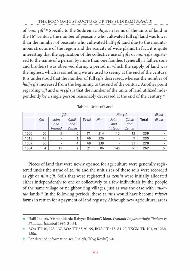
of “nim çift”.20 Specific to the Sudiremi nahiye, in terms of the units of land in the 16th century, the number of peasants who cultivated full çift land was lower than the number of peasants who cultivated half-çift land due to the mounta-inous structure of the region and the scarcity of wide plains. In fact, it is quite interesting that the application of the collective use of çifts or nim-çifts registe-red to the name of a person by more than one families (generally a father, sons and brothers) was observed during a period in which the supply of land was the highest, which is something we are used to seeing at the end of the century. It is understood that the number of full çifts decreased, whereas the number of half-çifts increased from the beginning to the end of the century. Another point regarding çift and nim çifts is that the number of the units of land utilized inde-pendently by a single person reasonably decreased at the end of the century.21
Table I- Units of Land
Çift Nim çift EkinliÇift Joint
and Instead
Çiftlik and
Zemin
Total Nim Joint and
Instead
Çiftlik and
Zemin
Total Ekinli
1500 60 5 6 71 214 13 12 239 -1518 45 - 1 46 226 - 9 235 -1539 36 - 4 40 239 - 31 270 -1584 4 15 2 21 86 145 36 267 5
Pieces of land that were newly opened for agriculture were generally regis-tered under the name of zemin and the unit sizes of these soils were recorded as çift or nim çift. Soils that were registered as zemin were initially allocated either independently to one or collectively to a few individuals by the people of the same village or neighbouring villages, just as was the case with muka-taa lands.22 In the following periods, these zemins would have become raiyyet farms in return for a payment of land registry. Although new agricultural areas
20 Halil İnalcık, “Osmanlılarda Raiyyet Rüsûmu”, Idem, Osmanlı İmparatorluğu Toplum ve Ekonomi, İstanbul 1996, 31-54.
21 BOA TT 40, 123-137, BOA TT 63, 91-99, BOA TT 415, 84-92, TKGM TK 104, vr.123b-130a.
22 For detailed information see: İnalcık, “Köy, Köylü”, 5-6.
314
DOĞAN YÖRük
were opened starting from the beginning of the century, it can be said that this movement increased after 1539.23
Another point that we should consider in parallel with zemins is the resm-i tapu and deştbani tax. This tax item was turned into another item different from bad-i heva tax in the cadastral records of 1539 and 1584 and constituted a con-siderable sum in almost every village.24 This could not only be explained by the existence of lands that were subjected to the tax in question, but could also be interpreted to have emerged from the transfer of the land from one hand to another. It is understood from the amount of the taxes in question that such practicable transactions had a wide area of application in the second half of the 16th century.25
Lands that could not be formed into a unit because they were small in num-ber or size were also registered under the name of zemin; 1 akçe of resm-i zemin or resm-i dönüm was collected from lands between 2 and 5 decares depending on yield.26 Units of land taxed in this way were observed only in 1539 and the total amount of tax collected was 100 akçes. Since one akçe of tax was taken for at least two decares of land, it could be said that taxable land of at least 200 decares existed.
A household unit mainly consisted of married individuals, so, apart from çifts and nim çifts, there were also bennaks who were married but did not have any land or had some land smaller than a nim çift. Of these bennaks, those who had land were named ekinli, and those who did not have any land were named caba-bennak. Although such a difference did not exist in the cadastral record books of the Karaman province dated 1500, 1518 and 1539, it is noteworthy that a distinction was made as ekinli and bennak only in 1584. However, the fact that the number of ekinli registers was limited to 5 nefers (individuals) gives the impression that there was not a clear distinction between bennaks with and wit-hout land. In fact, it was not possible for bennaks, who constituted 15.6 - 29.4% of the total population of nefers, to make a living without utilizing any land in any way. Yet, when we assume that only those who were registered as ekinli pos-
23 TT 415, 60-83, TK 104, vr.78b-99a.24 TT 415, 84-92, TK 104, vr.123b-130a.25 While it was 2.299 akçes in 1539, it became 3.979 akçes in 1584.26 İnalcık, “Raiyyet Rüsûmu”, 46-47, Bahaeddin Yediyıldız, Ordu Kazâsı Sosyal Tarihi (1455-
1613), Ankara 1985, 150, Süleyman Sûdi, Osmanlı Vergi Düzeni (Defter-i Muktesid, Ispar-ta 1996, 132.
315
the economic structure of the sudİremİ nahiye
sessed land on behalf of not being imprudent, it is not entirely clear how many decares of land these individuals utilized. However, Mehmet Öz asserts that this unit could be a quarter of the size of a çiftlik.27 The land owned by this fraction must have been taxed not in return for a payment of land registry but according to the amount of decares they owned.
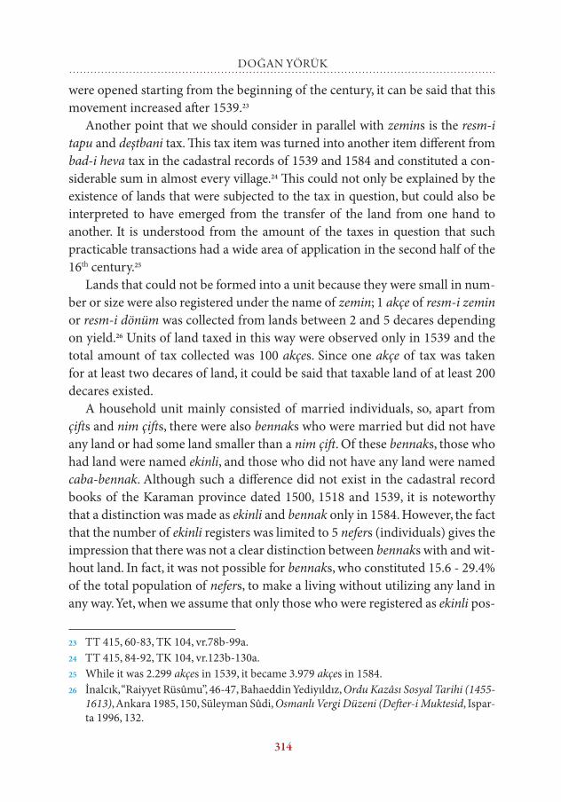
It is possible to find the minimal amount of the arable agricultural areas throughout the nahiye in decares based on the information provided above. In Karaman province, the area of a piece of medium fertile land equal to a çiftlik is 80-90 decares. Accordingly, it could be assumed that the average size of the land equal to a çiftlik was 80 decares, the land equal to a nim çift was 40 decares and the amount of land utilized by ekinli bennaks was 20 decares. Furthermore, since the taxes collected under the name of resm-i zemin were taken as one akçe for every two decares, the total amount of land can be found by multiplying the tax revenues by two. The results obtained by using these coefficients are presen-ted in Table II given below.
Table II- Agricultural Areas
Çift 1 Çift 80 decares
Nim çift
1 Nim çift 40 decares
Ekinli 1 Ekinli 20 decares
Total decares
1500 71 5680 239 9560 - - 15.2401518 46 3680 235 9400 - - 13.0801539 40 3200 270 10.800 - - 14.0001584 21 1680 267 10.680 5 100 12.360
It is a known fact that the numbers given in Table II do not represent the entire arable land. If we pay attention, we can see that only çift, nim çift, as well as ekinlis, çiftlik and zemin lands that are stated to amount to çift or nim çift are taken as base for the calculations here. Apart from these, the hamlets where agriculture is performed and villages that have direct tax records and lands under the control of exempt citizens are not taken into consideration. Nonet-heless, we can say that the area of the soils used as agricultural land was 15.240 decares in 1500, 13.080 decares in 1518, 14.000 decares in 1539 and 12.360 decares in 1584.
27 Öz, Anadolu’nun Sosyal Tarihine Dair Araştırmalar, 528.
316
DOĞAN YÖRük
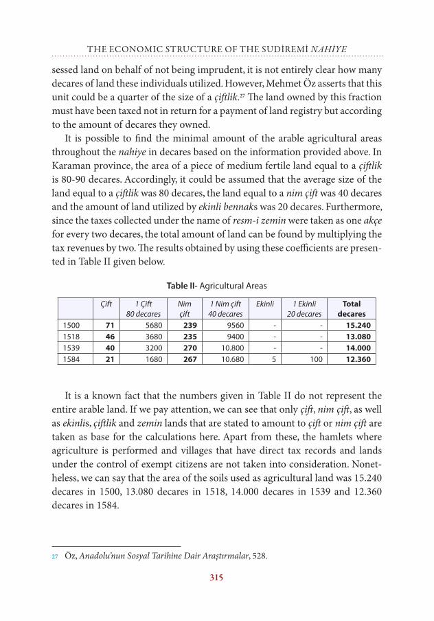
Table III- Population subject to taxation
Çift Nim çift
Ekinli Bennak Caba Sagir Mücerred Not known
or exempt
Nefer
1500 66 226 0 83 63 0 58 34 5301518 45 225 0 72 0 0 136 31 5091539 36 237 0 129 142 0 7 4 5551584 19 231 5 295 373 12 0 68 1003
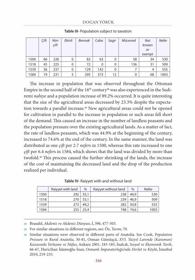
The increase in population that was observed throughout the Ottoman Empire in the second half of the 16th century28 was also experienced in the Sudi-remi nahiye and a population increase of 89.2% occurred. It is quite interesting that the size of the agricultural areas decreased by 23.3% despite the expecta-tion towards a parallel increase.29 New agricultural areas could not be opened for cultivation in parallel to the increase in population or such areas fell short of the demand. This caused an increase in the number of landless peasants and the population pressure over the existing agricultural lands. As a matter of fact, the rate of landless peasants, which was 44.9% at the beginning of the century, increased to 74.6% at the end of the century. In the same manner, the land was distributed as one çift per 2.7 nefers in 1500, whereas this rate increased to one çift per 6.4 nefers in 1584, which shows that the land was divided by more than twofold.30 This process caused the further shrinking of the lands, the increase of the cost of maintaining the decreased land and the drop of the production realized per individual.
Table IV- Raiyyet with and without land
Raiyyet with land % Raiyyet without land % Nefer1500 292 55,1 238 44,9 5301518 270 53,1 239 46,9 5091539 273 49,2 282 50,8 5551584 255 25,4 748 74,6 1003
28 Braudel, Akdeniz ve Akdeniz Dünyası, I, 396, 477-503.29 For similar situations in different regions, see: Öz, Tarım, 70.30 Similar situations were observed in different parts of Anatolia. See Cook, Population
Pressure in Rural Anatolia, 30-81, Osman Gümüşçü, XVI. Yüzyıl Larende (Karaman) Kazasında Yerleşme ve Nüfus, Ankara 2001, 183-185, İnalcık, Sosyal ve Ekonomik Tarih, 66-67, Huricihan İslamoğlu-İnan, Osmanlı İmparatorluğu’nda Devlet ve Köylü, İstanbul 2010, 219-235.
317
the economic structure of the sudİremİ nahiye
B- Agricultural Activities
1- Öşür (Tithe) and Salariye
The tax paid in the form of crops produced by peasants to the ehl-i örf (local representative of the executive power) for land, which was subject to the registry regime within the Ottoman miri land system and to the individuals and insti-tutions that possessed the land for vakıf and mulk land, is called öşür.31 This tax varied between the half and one tenth of the yield depending on local customs and traditions, the fertility of the land and irrigation conditions.32 Another tax that was collected together with öşür is salariye. The salariye tax is a set of lia-bilities, which those who are appointed to collect the öşür are allowed to take from the peasants in the form of food for themselves and their animals during the harvest season.33
In the areas where the rate of öşür was one in ten, the rate of salariye collec-ted was two and a half per cent or one in forty, thus the total amount of öşür taken from the producer was equal to the one eighth of the total product.34 Sala-riye was not collected in the areas where öşür was collected at a high rate like one in five, or at least it was regarded as unjustified.35 However, it is understood that although the rate of öşür collected was one in five, salariye was also collec-ted in the Karaman province.36 Some of the villages and hamlets in Sudiremi nahiye were allocated to vakıf and mülks. For this reason, the öşür collected from grains was transferred to these foundations and an amount correspon-ding to one fourth of this öşür was recorded for the sipahi under the name of
31 Güçer, Hububat Meselesi, 51-52.32 Ömer Lütfi Barkan, “Öşür”, İslam Ansiklopedisi, IX, Eskişehir 1997, 485.33 Güçer, Hububat Meselesi, 52-54.34 Barkan, Kanunlar, 20.35 İbid, 115, Idem, “Türk-İslam Toprak Hukuku Tatbikatının Osmanlı İmparatorluğu’nda
Aldığı Şekiller Malikâne-Divânî Sistem” Toplu Eserler I, İstanbul 1980, 173; Güçer, Hubu-bat Meselesi, 54, Mehmet Öz, XV-XVI. Yüzyıllarda Canik Sancağı, Ankara 1999, 87.
36 BOA TT 63, BOA TT 455, BOA TT 415, BOA TT 1068, TKGM TK 104, Barkan, Kanun-lar, 46-47, Ahmet Akgündüz, Osmanlı Kanunnâmeleri ve Hukukî Tahlilleri, III, İstanbul 1991, 322, 319, Mehmet Akif Erdoğru, “Karaman Vilayeti Kanunnâmeleri”, OTAM - An-kara Üniversitesi Osmanlı Tarihi Araştırma ve Uygulama Merkezi Dergisi 4 (1993), 504-512.
318
DOĞAN YÖRük
salariye.37 When we add the 20% of the product collected as öşür and one fourth of this as salariye, the total amount of tax taken from crops equals to 25% or ¼.
Regarding the öşür tax, what was stated in the revenues of villages and ham-lets was accepted as it was. If an additional salariye tax was mentioned, it was taken into account, but if it was not recorded, such a tax was ignored. When we tried to find out the total production based on the amount of öşür collected, it was considered that the öşür of vakıfs and mülks was 20%, the salariye share of timar and hases was 5% and their öşür and salariye share was 25%.
2- Grain Production
Wheat and barley were the most cultivated products in the region. At the begin-ning of the 16th century, these two products were grouped as a single item under the name of galle. As a matter of fact, it is possible that not only these two pro-ducts, but also other grains that had the same record value were grouped under this name, because no grain product is mentioned other than galle. Apart from wheat and barley, products like vetch and rye are also seen in the record books kept in the following years. However, the output of these products was substan-tially low. This probably resulted from the fact that the consumption range of vetch and rye was lower compared to that of wheat and barley; or these products were mixed into barley or wheat and barley blended galle since the registered value of these products was equal to that of barley. When problems emerged in adequately meeting the demand for grain with the increase in population that occurred after the second half of the 16th century, the production of grains like maize38 and legumes gained importance in various regions of Anatolia.39 Howe-ver, such a development was not observed in the region we studied.
Apart from grains, products like linen, onion, garlic, walnut, melon, vege-tables and fruit was also produced together with viticulture and horticulture. Based on this information, we can say that the products mentioned above were cultivated in the region.
Kile was the main unit of measurement for grain products. The kile that was in use within Karaman province was the Konya kile. The Konya kile is one
37 Barkan, “Malikâne-Divânî Sistem”, 169.38 Öz, Tarım, 68-7039 Huri İslamoğlu, “16. Yüzyıl Anadolusu’nda Köylüler, Ticarileşme ve Devlet İktidarının
Meşrulaştırılması”, Çağlar Keyder - Faruk Tabak (eds), Osmanlı’da Toprak Mülkiyeti ve Ticari Tarım, İstanbul 1998, 70-71.
319
the economic structure of the sudİremİ nahiye
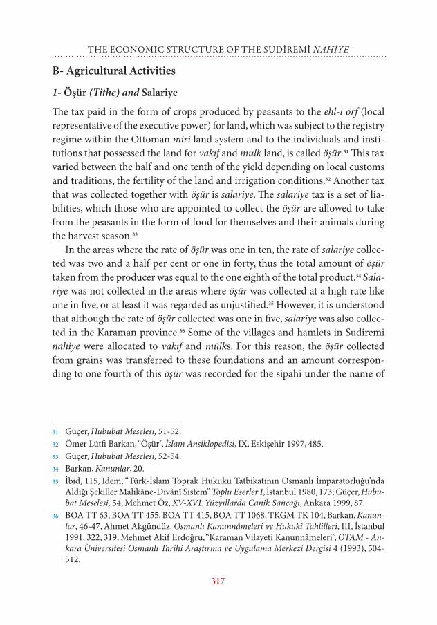
şinik;40 in other words, 1/4 larger than the Istanbul kile41. An Istanbul kile is 25.656 kg.42 Accordingly, a Konya kile equals to 32.07 kg.43
Table V- Grain Production
Tahrir Production Kile
Production Kg. Nefer Individual population(i)
Grain per individual kg
1500 35.198,5 1.128.815,8 530 1590 709,91518 28.615,2 917.689,4 509 1527 600,91539 32.440,4 1.040.363,6 555 1665 624,81584 41.957,9 1.345.589,8 1003 3009 447,1
(i) Individual population was found using the formula: Nefer x 3. See: Cook, Population Pressure in Rural Anatolia, 85, 90, 98, Öz, Canik, 63.
As it can be seen in the table given above, despite a partial increase in grain production, an excessive decrease is observed in the average amount of grain production per individual. In this regard, while the average of the total produc-tion per individual was 709.9 kg at the beginning of the century, the amount of grain per individual decreased to 447.1 kg towards the end of the century due to the fact that the increase in grain production fell behind the increase in population. Thus, there was a decrease of 37.1% in the average amount of grain per individual from the beginning to the end of the century.
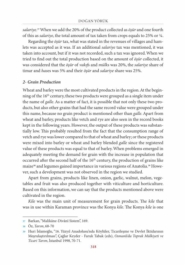
3- Prices of Grain Products
In the Karaman province the recorded value of wheat and barley varies depen-ding on the period of production. Accordingly, the kile price of wheat was 3 akçes in 1476, 4 akçes in 1500, 6 akçes in 1518, 7 akçes in 1539 and 158444 while the kile price of barley was 2 akçes in 1476, 3 akçes in 1500, 4 akçes in 1518 and
40 Akgündüz, Osmanlı Kanunnâmeleri, III, 323.41 Halil İnalcık, “Osmanlı Metrolojisine Giriş”, trans. Eşref Bengi Özbilen, Türk Dünyası
Araştırmaları 73 (1991), 32.42 Walther Hinz, “İslamda Ölçü Sistemleri”, trans. Acar Sevim, Türklük Araştırmaları Der-
gisi 5 (1989), 51.43 Suraiya Faroqhi, Osmanlı’da Kentler ve Kentliler, trans. Neyyir Kalaycıoğlu, İstanbul
1994, 239.44 However, 1 kile of wheat was traded for 15-20 akçes in the free market in the same pe-
riod. See: İslamoğlu, 16. Yüzyıl Anadolusu’nda Köylüler, 118, Konya Şeriye Sicili, II, 275, 280, 288, 289 etc.
320
DOĞAN YÖRük
5 akçes in 1539 and 1584. The increase in the price of wheat from 3 akçes to 7 akçes and the increase in the prices of barley, maize, rye, vetch, etc., from 2 akçes to 5 akçes throughout the century show the existence of an inflationary pres-sure on prices. The fact that the fee taken from 100 drachmas of silver was 400 akçes in 1477 and 450 akçes in 158245 shows the loss of value in currency. Howe-ver, it is obvious that the increase in the prices of agricultural products was substantially high (133%) despite the 11.2% loss in the value of akçe.46 This was observed not only in the Sudiremi nahiye or the Karaman province, but also in the economies of the old world.47
Table VI- Prices of Agricultural Products
Wheat Barley Galle 100 drachmas of silver
1477 3 akçes 2 akçes 2,5 akçes 400 akçes1584 7 akçes 5 akçes 6 akçes 450 akçes% 133 150 140 11,2
C- Stockbreeding
1- Sheep-Goat
The second economic activity that agricultural societies carried out together with cultivation is stockbreeding. Although it was mostly the form of produc-tion performed by migrant settlers, stockbreeding was also carried out at the least by settled peasants. This activity was taxed as one akçe for each two sheep and named as resm-i ganem or adet-i ağnâm.48 While the total amount of resm-i ganem collected from the Sudiremi nahiye was 7.410 akçes at the beginning of the 16th century, this amount increased to 9.421 akçes at the end of the century. Based on the amount of tax levied, it is possible to find the number of sheep in the nahiye by multiplying the tax by two. In this regard, while there were
45 Pamuk, Paranın Tarihi, 68.46 Yörük, Ereğli Kazâsı, 111.47 Pamuk, Paranın Tarihi, 122.48 T.C. Devlet Arşivleri Genel Müdürlüğü, 387 Numaralı Muhasebe-i Vilâyet-i Karaman
ve Rûm Defteri 937/1530, Ankara 1996, 4, Bayram Ürekli - Doğan Yörük, “Karaman Eyâletine Ait Bir Kanunnâme Sûreti”, Selçuk Üniversitesi Sosyal Bilimler Enstitüsü Dergisi 8 (2002), 348.
321
the economic structure of the sudİremİ nahiye
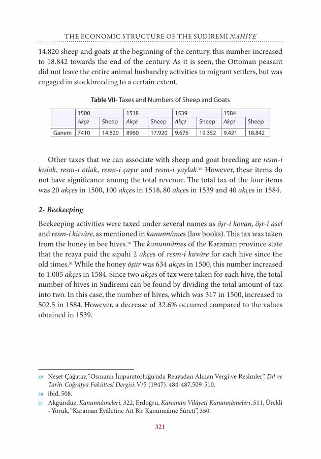
14.820 sheep and goats at the beginning of the century, this number increased to 18.842 towards the end of the century. As it is seen, the Ottoman peasant did not leave the entire animal husbandry activities to migrant settlers, but was engaged in stockbreeding to a certain extent.
Table VII- Taxes and Numbers of Sheep and Goats
1500 1518 1539 1584Akçe Sheep Akçe Sheep Akçe Sheep Akçe Sheep
Ganem 7410 14.820 8960 17.920 9.676 19.352 9.421 18.842
Other taxes that we can associate with sheep and goat breeding are resm-i kışlak, resm-i otlak, resm-i çayır and resm-i yaylak.49 However, these items do not have significance among the total revenue. The total tax of the four items was 20 akçes in 1500, 100 akçes in 1518, 80 akçes in 1539 and 40 akçes in 1584.
2- Beekeeping
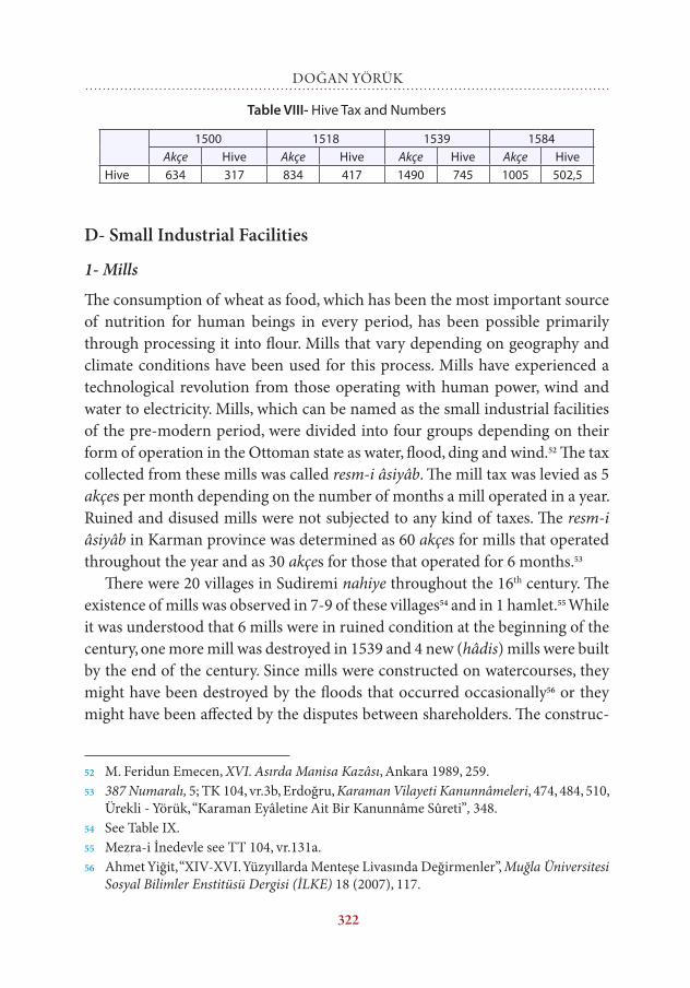
Beekeeping activities were taxed under several names as öşr-i kovan, öşr-i asel and resm-i küvâre, as mentioned in kanunnâmes (law books). This tax was taken from the honey in bee hives.50 The kanunnâmes of the Karaman province state that the reaya paid the sipahi 2 akçes of resm-i küvâre for each hive since the old times.51 While the honey öşür was 634 akçes in 1500, this number increased to 1.005 akçes in 1584. Since two akçes of tax were taken for each hive, the total number of hives in Sudiremi can be found by dividing the total amount of tax into two. In this case, the number of hives, which was 317 in 1500, increased to 502.5 in 1584. However, a decrease of 32.6% occurred compared to the values obtained in 1539.
49 Neşet Çağatay, “Osmanlı İmparatorluğu’nda Reayadan Alınan Vergi ve Resimler”, Dil ve Tarih-Coğrafya Fakültesi Dergisi, V/5 (1947), 484-487,509-510.
50 ibid, 508.51 Akgündüz, Kanunnâmeleri, 322, Erdoğru, Karaman Vilâyeti Kanunnâmeleri, 511, Ürekli
- Yörük, “Karaman Eyâletine Ait Bir Kanunnâme Sûreti”, 350.
322
DOĞAN YÖRük
Table VIII- Hive Tax and Numbers
1500 1518 1539 1584Akçe Hive Akçe Hive Akçe Hive Akçe Hive
Hive 634 317 834 417 1490 745 1005 502,5
D- Small Industrial Facilities
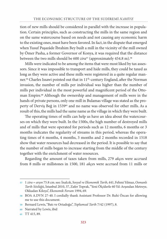
1- Mills
The consumption of wheat as food, which has been the most important source of nutrition for human beings in every period, has been possible primarily through processing it into flour. Mills that vary depending on geography and climate conditions have been used for this process. Mills have experienced a technological revolution from those operating with human power, wind and water to electricity. Mills, which can be named as the small industrial facilities of the pre-modern period, were divided into four groups depending on their form of operation in the Ottoman state as water, flood, ding and wind.52 The tax collected from these mills was called resm-i âsiyâb. The mill tax was levied as 5 akçes per month depending on the number of months a mill operated in a year. Ruined and disused mills were not subjected to any kind of taxes. The resm-i âsiyâb in Karman province was determined as 60 akçes for mills that operated throughout the year and as 30 akçes for those that operated for 6 months.53
There were 20 villages in Sudiremi nahiye throughout the 16th century. The existence of mills was observed in 7-9 of these villages54 and in 1 hamlet.55 While it was understood that 6 mills were in ruined condition at the beginning of the century, one more mill was destroyed in 1539 and 4 new (hâdis) mills were built by the end of the century. Since mills were constructed on watercourses, they might have been destroyed by the floods that occurred occasionally56 or they might have been affected by the disputes between shareholders. The construc-
52 M. Feridun Emecen, XVI. Asırda Manisa Kazâsı, Ankara 1989, 259.53 387 Numaralı, 5; TK 104, vr.3b, Erdoğru, Karaman Vilayeti Kanunnâmeleri, 474, 484, 510,
Ürekli - Yörük, “Karaman Eyâletine Ait Bir Kanunnâme Sûreti”, 348.54 See Table IX.55 Mezra-i İnedevle see TT 104, vr.131a.56 Ahmet Yiğit, “XIV-XVI. Yüzyıllarda Menteşe Livasında Değirmenler”, Muğla Üniversitesi
Sosyal Bilimler Enstitüsü Dergisi (İLKE) 18 (2007), 117.
323
the economic structure of the sudİremİ nahiye
tion of new mills should be considered in parallel with the increase in popula-tion. Certain principles, such as constructing the mills in the same region and on the same watercourse based on needs and not causing any economic harm to the existing ones, must have been favored. In fact, in the dispute that emerged when Yusuf Paşazâde İbrahim Bey built a mill in the vicinity of the mill owned by Ömer Pasha, a former Governor of Konya, it was required that the distance between the two mills should be 600 zira57 (approximately 454.8 m).58
Mills were indicated to be among the items that were most liked by tax asses-sors. Since it was impossible to transport and hide mills, they could be taxed as long as they were active and these mills were registered in a quite regular man-ner.59 Charles Issawi pointed out that in 11th-century England, after the Norman invasion, the number of mills per individual was higher than the number of mills per individual in the most powerful and magnificent period of the Otto-man Empire.60 Although the ownership and management of mills were in the hands of private persons, only one mill in Bulamas village was stated as the pro-perty of Derviş Beğ in 153961 and no name was observed for other mills. As a result of this, the mills had the same name as the village in which they were built.
The operating times of mills can help us have an idea about the watercour-ses on which they were built. In the 1500s, the high number of destroyed mills and of mills that were operated for periods such as 12 months, 6 months or 3 months indicates the regularity of streams in this period, whereas the opera-ting times of 6 months, 4 months, 3 months and 2 months recorded in 1518 show that water resources had decreased in the period. It is possible to say that the number of mills began to increase starting from the middle of the century together with the enrichment of water resources.
Regarding the amount of taxes taken from mills, 279 akçes were accrued from 8 mills or millstones in 1500, 181 akçes were accrued from 11 mills or
57 1 zira = arşın 75.8 cm. see: İnalcık, Sosyal ve Ekonomik Tarih, 441, Fehmi Yılmaz, Osmanlı Tarih Sözlüğü, İstanbul 2010, 37, Zafer Toprak, “Yeni Ölçülerle 60 Yıl: Arşından Metreye, Okkadan Kiloya”, Ekonomik Forum 1994, 69.
58 BOA A.DVN 27-40. I cordially thank Assistant Professor Dr. Ruhi Özcan for allowing me to use this document.
59 Bernard Lewis, “Batı ve Ortadoğu”, Toplumsal Tarih 7/42 (1997), 8.60 Narrated by Lewis, ibid61 TT 415, 89.
324
DOĞAN YÖRük
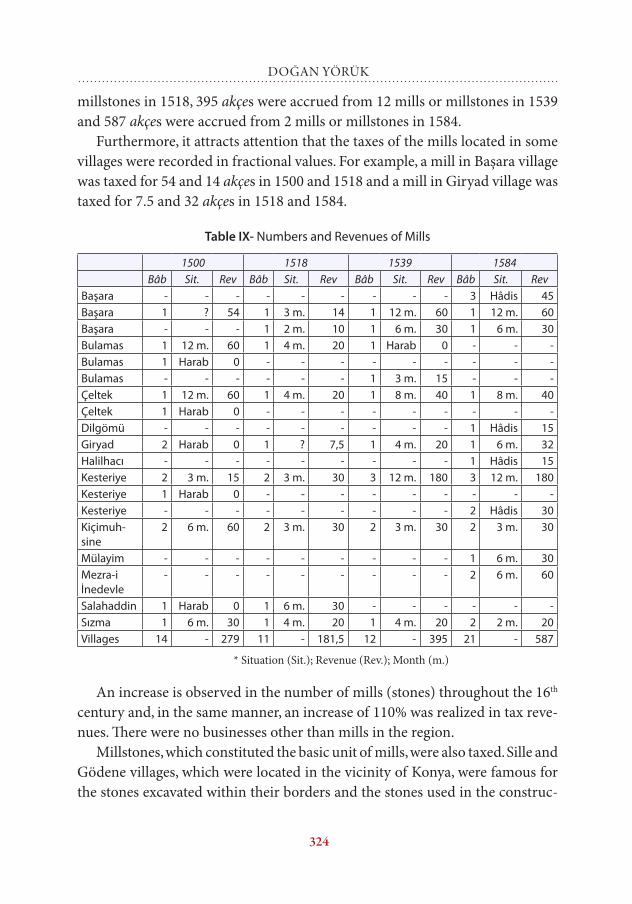
millstones in 1518, 395 akçes were accrued from 12 mills or millstones in 1539 and 587 akçes were accrued from 2 mills or millstones in 1584.
Furthermore, it attracts attention that the taxes of the mills located in some villages were recorded in fractional values. For example, a mill in Başara village was taxed for 54 and 14 akçes in 1500 and 1518 and a mill in Giryad village was taxed for 7.5 and 32 akçes in 1518 and 1584.
Table IX- Numbers and Revenues of Mills
1500 1518 1539 1584Bâb Sit. Rev Bâb Sit. Rev Bâb Sit. Rev Bâb Sit. Rev
Başara - - - - - - - - - 3 Hâdis 45Başara 1 ? 54 1 3 m. 14 1 12 m. 60 1 12 m. 60Başara - - - 1 2 m. 10 1 6 m. 30 1 6 m. 30Bulamas 1 12 m. 60 1 4 m. 20 1 Harab 0 - - -Bulamas 1 Harab 0 - - - - - - - - -Bulamas - - - - - - 1 3 m. 15 - - -Çeltek 1 12 m. 60 1 4 m. 20 1 8 m. 40 1 8 m. 40Çeltek 1 Harab 0 - - - - - - - - -Dilgömü - - - - - - - - - 1 Hâdis 15Giryad 2 Harab 0 1 ? 7,5 1 4 m. 20 1 6 m. 32Halilhacı - - - - - - - - - 1 Hâdis 15Kesteriye 2 3 m. 15 2 3 m. 30 3 12 m. 180 3 12 m. 180Kesteriye 1 Harab 0 - - - - - - - - -Kesteriye - - - - - - - - - 2 Hâdis 30Kiçimuh-sine
2 6 m. 60 2 3 m. 30 2 3 m. 30 2 3 m. 30
Mülayim - - - - - - - - - 1 6 m. 30Mezra-i İnedevle
- - - - - - - - - 2 6 m. 60
Salahaddin 1 Harab 0 1 6 m. 30 - - - - - -Sızma 1 6 m. 30 1 4 m. 20 1 4 m. 20 2 2 m. 20Villages 14 - 279 11 - 181,5 12 - 395 21 - 587
* Situation (Sit.); Revenue (Rev.); Month (m.)
An increase is observed in the number of mills (stones) throughout the 16th century and, in the same manner, an increase of 110% was realized in tax reve-nues. There were no businesses other than mills in the region.
Millstones, which constituted the basic unit of mills, were also taxed. Sille and Gödene villages, which were located in the vicinity of Konya, were famous for the stones excavated within their borders and the stones used in the construc-
325
the economic structure of the sudİremİ nahiye
tions in the region were mentioned with the names of these two settlements.62 However, there is no indication in the record books that the stones excavated from the aforementioned villages were used in the construction of mills. This must have been because the stones used in constructions were soft, but millsto-nes were hard in nature. It is understood from the resm-i seng-i âsiyâb, be-her fî 10, 5063 (akçe) records that in the 16th century, millstone production started in Tat village of the Sudiremi nahiye starting from 1539, a total of 50 akçes were collected as 10 akçes for each stone and the taxing was performed as 1 akçe for every 5 akçes. Again in the 16th century, 1 akçe of tax was collected for every 10 akçes from the millstones carved in another geographical region of Anatolia, in the Reşid-i Sagir and Reşid-i Kebir villages of the Edremit nahiye in the Karasi sancak and Kara Sekilü village of Temrezer.64 It is thought that the difference between the tax rates of the two regions is based on the öşür rates applied in these areas. In fact, while the öşür rate was 1/5 in Konya, it was 1/10 in Karasi.65
Millstones were not thrown out after being eroded and left out of use, but they were thinned, resized and used for grinding wheat etc., in homes.66 Reve-nue of 50 akçes was collected from millstones according to the records of 1539 and 1584.
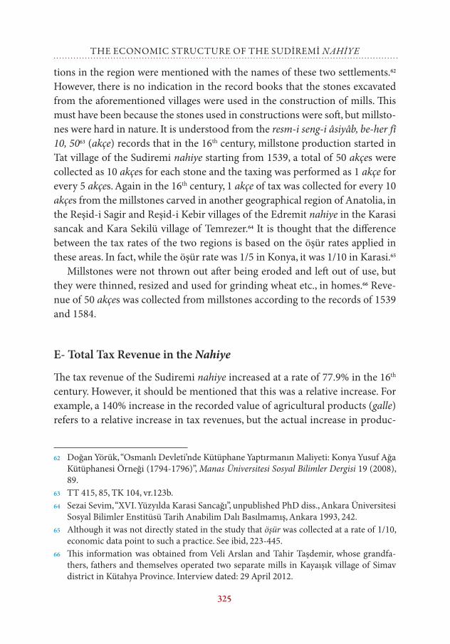
E- Total Tax Revenue in the nahiye
The tax revenue of the Sudiremi nahiye increased at a rate of 77.9% in the 16th century. However, it should be mentioned that this was a relative increase. For example, a 140% increase in the recorded value of agricultural products (galle) refers to a relative increase in tax revenues, but the actual increase in produc-
62 Doğan Yörük, “Osmanlı Devleti’nde Kütüphane Yaptırmanın Maliyeti: Konya Yusuf Ağa Kütüphanesi Örneği (1794-1796)”, Manas Üniversitesi Sosyal Bilimler Dergisi 19 (2008), 89.
63 TT 415, 85, TK 104, vr.123b.64 Sezai Sevim, “XVI. Yüzyılda Karasi Sancağı”, unpublished PhD diss., Ankara Üniversitesi
Sosyal Bilimler Enstitüsü Tarih Anabilim Dalı Basılmamış, Ankara 1993, 242.65 Although it was not directly stated in the study that öşür was collected at a rate of 1/10,
economic data point to such a practice. See ibid, 223-445.66 This information was obtained from Veli Arslan and Tahir Taşdemir, whose grandfa-
thers, fathers and themselves operated two separate mills in Kayaışık village of Simav district in Kütahya Province. Interview dated: 29 April 2012.
326
DOĞAN YÖRük
tion was 19.2%. It is possible to group these taxes into two as öşür and resim. Although resims amounted to a bigger sum in the total revenue at the begin-ning of the century, the situation changed starting from the middle of the cen-tury and öşür taxes became more important. The higher share of öşür items in the revenues is also observed in several sanjaks and kazas.67
Table X- Tax Revenues
Öşür Resim TotalAkçe % Akçe % Akçe
1500 21.601,5 47,9 23.464,5 52,1 45.0661518 25.057 48 27.154 52 52.2111539 35.914,5 54,1 30.493,5 45,9 66.4081584 45.245 56,4 34.965 43,6 80.210
Conclusion
In the Sudiremi nahiye, the most important economic activity was certainly agriculture. Wheat and barley production had the biggest share among agricul-tural products. In addition to grains, linen, hemp, vine, gardening, vegetables and fruit were also produced in the region. Agricultural products were suppor-ted by goat and sheep production and beekeeping. Furthermore, flour mills, which can be defined as the small industrial facilities of the period, were integ-rated into the agricultural activities of the rural areas.
Starting from the beginning of the century, all the agricultural lands amo-unting to a çift were gradually divided, lands became smaller towards the end of the century despite the creation of new agricultural areas and even divided lands started to be utilized collectively with another person such as the father, son or brother of the peasant. Despite the 89.2% increase in population, the existing agricultural areas became smaller. Although grain production increa-sed at a rate of 19%, this increase fell behind the increase in population and a decrease of 41.3% was observed in the amount of grain per individual. The dec-rease in the existing agricultural products could not be supported by low qua-lity but high-yield products. In addition to this decrease, the acts of banditry and Celali uprisings that occurred in the region accelerated the peasants’ aban-doning their land and villages. As a matter of fact, the numbers of villages and
67 Yörük, Aksaray Sancağı, 201, idem, Ereğli Kazâsı, 135-136, İbrahim Solak, XVI. Yüzyılda Zamantu Kazâsı’nın Sosyal ve İktisâdî Yapısı, Konya 2007, 73-74.
327
the economic structure of the sudİremİ nahiye
the population data in the avarız (tax) books belonging to the beginning of the 17th century support this point. In conclusion, issues such as population incre-ase, shortage of land, shortage of production, public security and safety, which could be generalized for the entire Anatolia in the second half of the 16th cen-tury, were also observed specifically in the Sudiremi nahiye.