Location based services and location based behavior in a ...
Upload
khangminh22Category
view
5download
0
ATHE ECONOMIC BASIS AND THE LOCATION OF SOME “IRON AGE” SETTLEMENTS ON PEMBA AND ZANZIBAR u
*EMANUEL T._KESSY
A T h e s i s S u b mi t t e d for M. P h i l in A r c h a e o l o g y
f me,V THE LTBRARt*QSt?
\UNIVERSITY OF CAMBRIDGEAUGUST 1992
UNIVERSITY o f NAIROBI LIBRARY
P. O. Bo* 30197 NAIROBI
UN» f ^ : : r „ oFNA,RoBi^ R A R v
i
CONTENTSCONTENTS >TABLES AND MAPS »ACKNOWLEDGEMENTS iiiINTRODUCTION »v1. CHAPTER 1THE EARLY HISTORY OF THE EAST AFRICAN COAST:SOME PROBLEMS 12. CHAPTER 2EARLY SETTLEMENTS IN THE ISLANDS 163. CHAPTER 3THE LOCATION OF THE SITE AND HARBOURS IN THE ISLANDS 244. CHAPTER 4SETTLEMENT ANALYSIS: A BRIEF EXAMINATION OF TWOSITES: PUJINI ON PEMBA, AND TUMBATU ON ZANZIBAR 35
5. CHAPTER 5CHANGES OF SETTLEMENTS ON THE ISLANDS OF PEMBAAND ZANZIBAR 46>6. CHAPTER 6THE TRADING SYSTEMS AND PARTNERSHIP IN THE ISLANDS 64BIBLIOGRAPHY 75

TABLES AND MAPS
1. A MAP FOR THE ARCHAEOLOGICAL SITES OF PEMBA 332. A MAP FOR THE ARCHAEOLOGICAL SITES OF ZANZIBAR 343. A GENERAL TABLE FOR THE SITES OF PEMBA ANDZANZIBAR 564. A TABLE OF SITES ON THE EASTERN SIDE OF PEMBA ISLANDOCCUPATION AND ABANDONMENT IN EACH CENTURY 585. A TABLE OF SITES ON THE WESTERN SIDE OF PEMBA ISLANDOCCUPATION AND AB ANDONMENT IN EACH CENTURY 586. A TABLE OF OCCUPIED AND ABANDONED SITES ON THE PEMBA ISLAND FROM THE 9TH CENTURY TO THE 19THCENTURY A.D 597. A TABLE OF OCCUPIED AND ABANDONED SITES ON THE ZANZIBAR ISLAND FROM THE 8TH CENTURY TO THE19TH CENTURY A.D 598. MAPS FOR THE DISTRIBUTION OF ARCHAEOLOGICAL SITES IN PEMBA EACH CENTURY: FROM THE9TH -19TH CENTURY A.D 60). MAPS FOR THE DISTRIBUTION OF ARCHAEOLOGICAL SITES IN ZANZIBAR EACH CENTURY: FROMTHE 8TH-19TH CENTURY A.D 62

ACKNOWLEDGEMENTS
I am very grateful to my supervisor Dr. D.W Phillipson of the University of Cambridge, who spent a lot of time to shape this piece of work. I am indebted to Dr. M Horton of the Pitt Rivers Museum, Dr. A. LaViolette of the University of Virginia, Dr. T. Reynolds of Cambridge and Professor H. Randi of the University of Bergen for their help in several ways. I would like to thank J. Carman, a PhD student at the University of Cambridge, P. Miller of the Archaeology department computing centre, the whole staff of the Archaeology department and my colleague students at the University of Cambridge for their encouragement. This work would not have been possible without funding help from the Cambridge Commonwealth Trust, and I am very grateful forthat.

INTRODUCTION
This work consists of six chapters which examine the! economic bases and the location of the Iron Age sites (first millennium A . D. to the 19th century) in the islands of Pemba and Zanzibar. The first chapter reviews discussion about problems facing the reconstruction of the early East African Coastal history and different approaches which have been taken to this.
Chapter two focuses on the earliest settlements in the islands. It is widely accepted by many that the earliest occupants of the islands were people from the African mainland coast. Archaeological evidence and linguistic studies support this, but still more researches are required in some areas where the evidence is contradictory.
Chapter three examines the location of the sites in relation to social, political and economic strategies. Each factor seems to have played a role in the location of the sites but from different angles at different times.
Chapter four is a brief look at two sites: Tumbatu islet on Zanzibar, and Pujini on Pemba. These sites are located in different environments in terms of both land and sea use potential, but both grew into prosperity at different times*.
Chapter five deals with the pattern of settlement changes during the 18th-19th centuries. The analysis
V
IV

considers what caused those changes and what would these changes imply in the history of settlement.
Chapter six is about the trading systems andpartnership in the islands. This chapter examines the resources which might have formed part of the exchange within the islands and the outside world.
I certify that this thesis does exceed 15,000 words.
>
CHAPTER 1
THE EARLY HISTORY OF THE EAST AFRICAN COAST:
SOME PROBLEMS
The East African Coast extends along the Indian Ocean shore from Mozambique 22° to Somalia 2° including the islands of Madagascar, Comoro, Mafia, Zanzibar, Pemba and Pate. This part of Africa is known to have played a significant role in the Indian Ocean trade since very early in the Christian era. (Horton 1987b, Verin 1986:30). This reflects its strategic position in relation to the sources of the raw materials which were highly valued in international trade at that particular time.
The ocean transport system depended upon the seasonal variation of the Indian Ocean winds, which alternatively facilitated northward and southward transport: fromDecember to March the North East Monsoon blows from north to south while, between May to October the wind blows from the south-west.
The East Africa'h coastal environment offers adequate land and sea resources for the support of substantial communities. With the exception of the northern area in northern Kenya and Somalia, which is fairly dry, the East African Coast has relatively fertile soil and adequate rainfall. The area to the south of Somalia is variably
capable of supporting crops such as sorghum, rice, millet, coconuts, bananas, cassava, beans, potatoes, figs, citrus fruits, sugar cane, maize, chick peas, and several varieties of vegetables (Newitt 1978:122). Some of these crops, such as millet and sorghum, are known to have been grown from early times (Connah 1987:156, & 170-1). Most of the other varieties are considered to have been brought to East Africa through trading contacts at different periods. For example, the banana is known to have its origin in Indonesia (Phillipson 1985:198). Animal herding may have also played a major role (Connah 1987:156, Chittick 1977:199). Excavation at Shanga has shown that the site was first occupied by people who domesticated cattle, sheep, goats, camels and birds (not yet identified) (Horton 1982). Another site of comparison as far as livestock is concerned is Chibuene-Mozambique where bones of cattle and sheep were recovered. (Sinclair 1982:162) Supplementary to these crops were foodstuffs which resulted from hunting (Chittick 1977:199) and the exploitation of marine resources. The evidence for this also comes from the Shanga site where animals such as bushbuck and dik-dik were hunted (Horton 1982).The hunting evidence can also be the result of symbiotic relationship between the town people and people living in adjacent forests (Stiles:1982:172 Allen 1984:220). The exploitation of the marine resources by people in the East African Coast is explained by the Periplus (see below) (Sheriff 1981:555).
V
2
The early history of the East African coast has always been controversial. A major problem has been the scarcity of written records, and even where these exist they are not always informative, most of them being the work of travellers from beyond the region. The earliest of these documents is the Periplus of the Ervthrean Sea. This was a guide to the commerce of the Red Sea and the Indian Ocean written by a Greek trader of the Roman empire probably during the 1st century A .D (Casson 1984:199, Sheriff 1981:552). But others have suggested a 2nd - to 3rd - century date.(Connah 1987:158, Freeman-Grenville, 1988:111 4, Ingham, 1962:1)
The Periplus explains the trade relations existing between the East African coastal people and those from the Persian Gulf. The trading stations mentioned by the Periplus may extend as far to the south as the Tanzanian coast (Phillipson 1977:98,1985:161-2). Rhapta, the most southerly station mentioned in the Periplus. is thought to be probably in the Rufiji Delta (Chittick 1982:57, Phillipson 1977:156, Freeman-Grenville 1988:111 4) This guide mentions that the items of exchange along the East African Coast were ivory, tortoise shell, rhinoceros horn, palm oil, cinnamon,' frankincense and slaves from the local people (Ingrams 1967:67-8, Connah 1987:156, Shephard 1982, Phillipson 1985:197-8). In return, they got awls, glass, wheat wine, daggers and hatchets from the traders. In this document it is also mentioned that the people along the East African Coast had piratical habits, and were great in
3
stature, and that each place was under its own chief. The following statement from the Periolus. indicates that there was probably a very close relationship between the traders and the people of the East African Coast, and that this may have been in existence long before the Writing of the Periolus.(Freeman-Grenville 1988:11 7)
"the Mapharitic chief governs it under some ancient right that subjects it to the sovereignty of the state that has become the first in Arabia. The people of Muza (?Mocha) now hold it under his authority, and send thither many large ships, using Arab captains and agents, who are familiar with the natives and intermarry with them, and who know the whole coast and understand the language" (Gray 1962:11).
Further information about the East African coast is from Claudius Ptolemy's Geoaraphia of which the extant version is thought to have been compiled around 400 A.D.(Connah 1987:158, Ingrams 1967:65), from an original of about 150 A .D . (Freeman Grenville 1988:11 5). Ptolemy talks of Rhapta as a metropolis (Sheriff 1987:14).
Al Masud, who wrote about East Africa in 947 A.D. inhis book The_Meadows__Ql_Gold .and the Mines of Gems.indicates that the East African inhabitants were black(Ingham 1962:2). He also mentions that a small population of people at Kanbalu (perhaps in Pemba) had adopted theIslamic faith (Freeman Grenville 1962 :14, Ingrams 1967: 81) and indicates that the people of this area, “The
4
Land of Zinj", had a king residing at Wafalmi (In Swahili literal Wafalme) and that their ornaments were made of iron (Trimingham 1964:4).
In the 12th century A . D, Al Idris, an Arab geographer, wrote about the Land of Zinj and mentioned the towns of Malindi, Manisa (thought to be Mombasa), and Kilwa. The inhabitants of Manisa worked in iron mines. (Freeman Grenville 1962:20, Chittick 1975:14). Another geographer was Dimishqi, who wrote in the 14th century about the East African Coast, reporting the inhabitants to be blacks who were pagans, and who had their own language (Trimingham 1964:4).
A 13th - century Chinese source describes stratified society along the East African Coast consisting of the bare headed and bare footed commoners who lived in huts made of palm leaves, and a ruling class whose habitations were made of stone. (Sheriff 1987:14). The Chinese sources also describe the coastal inhabitants as blacks who were herders, living on meat and milk (Chittick & Rotberg 1975 ; 21) . If this account is accurate, it raises the question of whether the early inhabitants of the East African Coast were agriculturalists, who also depended on marine resources for their subsistence, as has generally been believed. The East African coastal societies may have had very variable economic bases.
5

Later information about the East African Coast comes from the "Chronicles" such as those of Kilwa, Pate, Lamu, and also from early Portuguese travellers from the 15th century and other Europeans in the 19th century. The Kilwa chronicle is available both in the 16th century Portuguese version and in Arabic.
Most research about the early history of the East African Coast has relied on information from these written documents. This also affected the work of the early archaeologists. For example, some archaeologists saw East African culture as having its origin outside East Africa. Chittick (1971:137) in his early work was a typical example of this: "We should picture this civilisation as a remote outpost of Islam looking for its spiritual inspiration to the homeland of its religion." The dependence on these records has been challenged on the ground that the early writers may have recorded and represented information which they did not clearly understand. Another problem has been mentioned that some of these records might have contained second-hand information which were written by people who did not actually come to East Africa (Connah 1987:158). The Chronicles, though written by people who lived in East Africa, are mostly Concerned with leaders and their doings, and very little is told about society in general.
There has been a major problem in theories about the development of the East African Coast after the countries got their independence. After the independence of the East
6
African countries, a theory based on nationalistic moves for the development of the Coastal towns developed, in opposition to the previous colonial theories. These new theories of the independent countries assume local people played the major role in development, and reject the colonialist view which sought the sources for the development of East African Coastal towns in outside contacts (Rosenthal, 1971:80, Horton, 1987b). There are also differences in outlook among the local historians from the Coast and those from Inland regions. The Coastal people view the Coastal civilisation as the result of colonisation out of Africa. However, this is greatly challenged by other historians on the grounds that such interpretation is based upon the false ideologies of the ruling classes and therefore should not be adopted.
In recent years, several attempts have been made to develop a unified theory between the colonial historiography and the more extreme theories recently proposed. The colonial historiography has been challenged as overlooking the core and the basis for development of the early East African coastal towns. On the other hand, while the modern theories have tried to seek core factors, there is a danger'of over-emphasising the role of local development and under-estimating the part played by outsiders, although it is now widely agreed that the local role was primary. Horton (1991:25) has indicated that the conflict between the colonial historiography and the more
7
modern theories has obscured the real nature of the relationship between East Africa and Arabia.
Oral traditions have been widely used as asupplementary source to the written records inreconstructing the African past. However, oral traditions often go back only a few generations, and transmission by word of mouth is susceptible to changes through time and space (see also chapter 2). This means that the most reliable method for reconstructing the East African past is through archaeology. But the archaeological record is incomplete and can rarely be used in reconstructing the political and social systems of the society.
>Although a lot of archaeological work has been done in
some areas of the East African Coast, notably Kenya, a comprehensive archaeological view is still unattainable. Archaeological work on the Coast began before the 1920s, a notable case being the work of Pearce as described in hisbook Zanzibar: The_Island_metropolis_of_Eastern_Africa.More work was conducted after the second world war by people like Chittick, Freeman Grenville and Kirkman in the 1950s. Most of the early archaeology on the East African Coast has been recently criticised by modern
N
archaeologists,(eg Allen 1981, Connah 1987, Horton 1986, 1987a & 1991) who pointed out that it was concentrated on towns mentioned in the Arabic sources. The factors which might have led to the formation of the East African Coastal
* states were only partially studied. The main emphasis of
8
research was on contacts with the outside world, little attention being paid to local stimuli for the emergence of the towns and states of the East African Coast. Recent archaeological research has emphasised the possibilities of both local and outside causes for that development. In the majority of the recent studies the local contribution has been regarded as pre-eminent.
Allen (1981 & 1982), Connah (1987) and Horton (1987a & b) share an emphasis on the importance of African initiatives in the formation of the Coastal states. However, there are some differences in approaches between the three authors. Allen and Connah place more emphasis on local production, especially on agriculture and trade: local people obtained materials from the interior, accumulating them in the towns for international trade. Horton shares these ideas but he places more emphasis on the Islamic conversion which forged a common bond between the merchants, the elites in the East African Coastal towns, and people from the Near East, Persia, Arabia and India. Wilkinson (1981, 1989) has indicated that being part of the Dar-al-Islam provided a legal framework in which to conduct trade as well as protection from activities such -as slave raiding. Connah (1987:177) mentions Islam as the major ideological factor unifying the cities and the states of the East African Coast: "At every site there is at least one stone-built mosque and, significantly, the main congregational mosque usually occupies the central part within each settlement".
9
Urban communities developed in East Africa, not through direct colonisation from Arabia, but through social processes activated through maritime contacts (Horton 1991). The presence of mud houses in the early levels at Shanga is further proof of African settlement before the development of stone architecture (Horton 1991:24). Supporting evidence comes from travellers reports that the indigenous people of the East African Coast spoke a non- Arabic language and followed local customs (Freeman- Grenville 1962:1-14, Ingrams 1967:60-85).
It must be clear that there is no way that the development of the East African coastal states can be understood if the discussion ignores the appropriate environment needed for such development. The environment of the East African Coast is attractive to permanent settlements (Connah 1987:155). The sea provides rich marine resources. As mentioned above, with the exception of the Somali coast, most of the area consists of fertile soil which can support a number of food crops. The early settlers would probably have been attracted by this type of promising environment. In case of failure of agriculture production, the farmers could have turned to more intensive exploitation of the marine resources. Horton (1982, 1991:24-25) considers the East African Coast economies to have comprised agricultural production, trade, exploitation of marine resources, and possibly hunting. This situation would have allowed permanent settlement,
10
the growth of population and, later, the emergence of cities. Regular visits between the towns were made by the inhabitants using their sewn boats and canoes hollowed from single logs, as mentioned by the Periplus (Ingrams 1967:61), and in Portuguese sources (Newitt 1978:119).
Interest has focused in the question of how the coastal-based towns were related to the settlements in the East African hinterland. Were they completely separate units or linked units working together? Some writers have thought that a close relationship between the coast and the hinterland did not exist until the end of the 18th or early 19th century A.D. The argument was based on the absence of artefacts> demonstrating such contacts, especiallymaterials transported from the coast to the hinterland. A break-through to this question has been the discovery of the exotic material in Bambadyanalo in South Africa indicating contacts with the East African Coast. ( Barker.1978:95-96, Huffman 1982:143, Phillipson 1985:203- 4). In this site ivory and glass objects dating to the 10th century A.D. were discovered. Gold and ivory was probably traded to the Coast at that time. The development of this trade was practised throughout the development ofMapungubwe and la£er the development of the Great Zimbabwe.
\
Sinclair (1982:163) suggests entry of commodities from the Chibuene site of the Mozambiqan coast to the Zimbabwean plateau and Limpopo by the 8th -13th century A.D. Kilwa coin was discovered in Great Zimbabwe along with a few sherds of Chinese celadon (Garlake 1973). For a long time
11
only the South African evidence for exchange contacts with the interior and the coast was known, and there was no evidence for contacts between the coast and the interior further to the north prior to the 18th-19th century A . D . Recent researches have shown the possibility of trade contacts between the East African coast and its interior. Iron is reported to have been smelted along the East African coast both from locally available beach sands and from haematite ore from inland regions (Horton 1982). Rock crystal was traded along the Coast, its primary sources being in the Rift Valley of Kenya (Horton 1987a:318,& 1987b).
Archaeological field schools at the University of Dar- es-laam in 1986 and 1987, identified several sites as far as 20 kilometres off the coast: eg Mkiu site -20 kilometres off the coast has shown evidence of Tana ware glass objects and evidence for copper and iron working dating to the 9th century A .D . (LaViolette, Fawcett Karoma & Schmidt 1989). Further researches by the Unit in 1989 and 1991 have identified other sites with Tana ware (see explanation for properties of the pottery in chapter 2) more than 50 kilometres further inland (personal observation). All these discoveries show . that the relationship between the coast and the hinterland should not be underemphasised. Freeman- Grenville (1988:11, 13-14) looks closely at exports before the 18th-19th centuries like slaves and ivory, and suggests that there probably were trade contacts between the coast and the interior.
12
Another controversial question relating to the history of the East African Coast has been the structure and size of the population. The towns have been described as having thousands of people but very few stone houses (Garlake 1973:89). The greater part of the population probably lived in mud and thatch houses, and only a minority in stone buildings. The stone houses might have been very little favoured, an idea which would be opposite to what the majority of historians have indicated. The main question is why stone houses? Why such an adaptation? Were they really superior in those ages? Most of the stone buildings have been described as specifically East African in style.'Horton (1986:206-7) has suggested that the first stone architecture on the East African Coast was influenced from the Red Sea rather than the Persian Gulf. At the same time there is very little historical evidence, either traditional or from the external sources, to indicate settlement or trade with the Red Sea during the 10th -13th century, the time when this stone architecture flourished. The stone architecture seems to have been adopted along the northern shores of the Indian Ocean before it appeared on the East African Coast; its transmission may have taken place through trade and other social activities. This is not to imply that the stone buildings of the East African Coast were necessarily built by people from the north. The stone building tradition was first adopted in the north probably due to the lack of wood for building. Even during the first periods of contact
13

between the East African Coast and the people from the Gulf, one of the important items exported from East Africa was mangrove poles for house construction (Horton 1986:210, Sheriff 1987:12).
In exploring these issues, the whole question of adaptation has been neglected. As the result of this even the development, size, and the population of the East African Coastal towns have been overlooked by seeing the standing stone architecture alone. In dealing withinteraction between the cultures from the north and the East African Coast people have been mixing issues of adaptation and development, and the conclusions derived from such'analysis are biased interpretations. The majority of the houses at Manda, Pate, Shanga and Kilwa have been said to be built of mud, thatch and wood (Chittick, 1966, 1974:24, 1977:212, Horton 1986:205 & 209, & Sassoon1980:39-40). A question is does this reveal majority poverty and few rich individuals as often claimed? Doesthe evidence of having majority mud and thatch houses show any significance in adaptation when compared to stonehouses? Since the concepts of value and quality differ in different cultures and vary through time, the relationship between the stone-houses and mud/thatch houses should be examined under that category. Other factors of equalimportance which should be included in this question are adaptation, ideology towards each building tradition, differences in energy involved between building stone and mud houses (Allen 1984:220) and the popularity of each
14

building tradition through time. The history of the differences in buildings in the East African Coastal towris is a long one, so we should conclude that this relationship cannot be understood by looking at recent significance of the houses in recent societies alone.
In conclusion the early history of the East African coast cannot be fully understood by the combined study of written documents, oral traditions and archaeology while it is divorced from the role of environments and evidence for social, economic and political interactions and their contribution to the lives of its people. Both local and external social interactions were important in this developmeht, but still there is a need to develop an appropriate philosophy in understanding the contribution of each social interaction in that development.
15
CHAPTER___2
EARLY__SETTLEMENTS IN THE ISLANDS
The date of the first human settlement in the islands of Pemba and Zanzibar is still a controversial question which remains to be explored. Although no systematic analysis or strong interest has been shown in exploring the earliest evidence for human occupation in the islands, so far no reports either from geological work, or from accidental discoveries has shown the existence of human beings in the islands before the Holocene. Settlement of the islands is therefore thought to be a recent phenomenon and may t ave taken place as a result of either accidental or intentional discoveries by people who had a knowledge of sea transport probably early in the first millennium A .D (Horton & Clark 1985:35).
In this discussion two settlement phases are recognised: the Pre-Islamic phase and the Islamic phase.The Pre Islamic phase covers the period before the 8th century A.D. The earliest people to occupy the islands were possibly from the African Mainland. Recent archaeologicalexcavations and surveys in the islands show that a certain
\
type of pottery known as Tana ware occupies the lowest cultural layers. (Horton, 1991:25). This type of pottery is decorated at its neck with triangles which are shaded with stripes. The exact date for this type of pottery is a matter of further research.. In some places where the
16

pottery has been associated with dateable material, the Tana tradition has been found to survive up to the 13th century A . D . It appears that this type of pottery was associated with the societies which led to the formation of the Swahili population along the East African Coast and may predate 800 A.D (Horton 1987a:315, 1991:25). In some areas where this pottery has been found, eg. Fukuchani, Mkokotoni and Unguja Ukuu, it is associated with no or very little imported pottery, suggesting minimal external trade contacts at this time (Horton 1992, personal communication) Furthermore, most of the sites are found along the coast and have been associated with exploitation of the marine resources (Horton 1991:25). Although there are claims in some Arab written sources for Arab settlements in the islands before the 9th century A.D, there is no archaeological evidence for this. There is little evidence for direct trade with external areas other than the African mainland, but during the Pre-Islamic period the islands were probably not completely isolated from indirect trade with the external world beyond Africa. There might also have been regular visits by travellers and explorers. For example, the East African .coast was known to people such as the author of the Periplus during the 2nd century A.D (Freeman Grenville, 1988:111,4)
The introduction of Islam to the islands is thought to have taken place during the 8th-9th centuries A.D (Freeman Grenville 1988:IV,194, Shephard 1982:135-6, Verin 1986:53).
17
As far as this presentation is concerned, the Islamic lasted from that time up to the 19th century A .D - the period of European colonisation. This period is marked by frequent contacts and probably small scale immigration of people, from the Near East in the first case, and later by the Portuguese during the 15th-17th centuries A . D .Archaeological studies have characterised this period by the introduction of the mosques in the islands from the 12 th century A.D. but, we are informed by Masud that Kanbalu (Pemba) had a small population of Muslims in the 10th century A.D. (Freeman Grenville, 1962:14, Ingrams, 1967:81).
There are some written documents which report attempts at colonising the islands in a large scale, but such evidence has not been confirmed archaeologically. One such document is the chronicle of Pate. This chronicle states the Adulmalik the fifth of the Umayyad Caliphs (around 695-705 A.D.) heard of East Africa, and becameinterested in expanding his kingdom. One of the areas mentioned as having been colonised by him was Zanzibar (Gray 1962:11-12). Another document concerning theimmigration of people is the Kilwa chronicle. This states that the Sultan of Shiraz, named Hassan Bin Ali, had a dream which he interpreted as the downfall of his kingdom. After this he and his six sons decided to leave Shiraz for East Africa (Gray 1962 12). The sons settled in different areas along the East African Coast, one in Pemba and another in Kilwa Kisiwani, around 985 A.D. There is another
18
chronicle from Pemba which gives an account of immigration from the Persian Gulf. This immigration was led by a sultan from Shiraz called Darhash Bin Shah. He is said to have left his country with two brothers, his sister and three sons of his aunt, and a number of neighbours and slaves. They left Shiraz because of famine. As quoted by Gray (1962:12), Shahame Bin Ali, a cousin of Darhash's sister Kazija Bint Shah, landed on Zanzibar, and at Kilwa and Mrima on the African mainland. Kazija had an illegitimate child who settled with one of her slave girls named Tanu Bint Shah on the islet of Tumbatu. No date is given for this immigration but it might have taken place at the same time as that of Hassan Bin Ali. If the chronicles contain some truth, we can learn a lot from them. For example, in one of the stories we are informed of one family settling in different areas of the East African Coast, probably peacefully. This is evidence that these places were already known to the immigrants, and probably that they were already colonised by people from Shiraz. The division of the sultanate family could have meant the spread of power to those areas for control. If they had a problem with security they could not have spread into different places. It has been argued that there is no evidence for the settlement of" Arabs in East Africa, beyond solitary individuals before Oman colonisation (Horton 1991:25).
Another phase of settlement during the Islamic period is marked by the coming of the Portuguese. After Vasco Da Gama's visit to East Africa in 1498 A.D., there was a
19

Portuguese attempt to conquer East Africa. By 1502 Da Gama came back to the East African Coast equipped with 20 ships, he conquered Kilwa, and later invaded Zanzibar (Ayany 1970 :80). Some of the ruins in the islands show affinity to Portuguese architectural styles, for example the stone structures at Mvuleni Fukuchani and Zanzibar town (Horton & Clark, 1985, Horton, 1985:170). The Portuguese were replaced by the Omanis invasion in the 17th century. This period is characterised by the intensification of the slave trade, especially from the African mainland, the shift of Sultan Said Sayyid's capital from Oman to Zanzibar, and the coming of the Europeans in the 19th century. All these factors influenced immigration processes in the islands.
Greater understanding of the processes of settlement in the islands is a matter of further research. Up to now it would not be a good policy to rely very strongly on the excavated archaeological records in reconstructing the history of the early settlements. The main reason for this is that the archaeological record may contain biases due to the nature of the data collection and purposes of the previous research programme. Most of the archaeological research conducted-, so far has dealt with sites which are known historically. In addition most, archaeological research has been conducted in areas where the remains are most visible. The third problem is that most of the research has been conducted along the coast. Very little emphasis has been placed on the sites in the interior of
20

the islands. Other problems in this type of research are related to those of reconstructing the early history of East African Coast mentioned in chapter 1.
In understanding settlement in the islands much can be learned from linguistic evidence. Swahili is the language which is used by all people in the islands. This language is also used by most of the inhabitants of the East African Coast. The Swahili language consists of a mixture of words from Bantu and Arabic languages. Recent linguistic studies have shown that Swahili in grammatical structure is wholly Bantu, and external influence is minimal (Nurse 1983:127-50). This evidence could suggest that, the earliest occupants of the islands were also Swahili speaking Swahili language classification by Nurse (1983:137-39), has shown that the speech of Pemba and Zanzibar branched first from southern Swahili dialect, but there were also later immigrants to the islands from the northern Swahili dialect area.
Another branch of linguistic study is the study of place names. Although place names cannot tell us the exact time of immigration we can probably learn something about it, especially when they are correlated with events which are known historically. The place names Mkokotoni, Chwaka, and Tumbatu, for example are shared by all the islands. This might have been the result of immigration of people from one island to another. The place names Kwale, Barawa, Tanga, Bagamoyo, Kaole, Mikindani and Msumbiji and several
21

others are shared between island of Pemba and the East African Coast Mainland. The names Unyanyembe, Ugogo, and Tabora are shared between Pemba and central Tanzania. A close look at the use of place names such as Barawa, Bagamoyo, Mikindani, Unyanyembe, and Tabora indicates that they were centres for trade in mainland Africa. The giving of such names of places on the islands might be related to immigration to the island as the result of trade Archaeological excavation in these places could possibly help in identifying the time of occupation in these areas.
Oral traditions and written sources have been used very widely in trying to reconstruct the history of immigration in the Pemba and Zanzibar islands but these sources still present a problem. The main problem in using these sources is that oral traditions and written documents have been sometimes found to over-represent the ruling class and one sided information may be presented. In addition, oral traditions may be used by subordinates as a means of resistance, hence they may also over-represent the subordinated groups. For example, some of the Wahadimu and Watumbatu communities of Zanzibar claim to be descended from Persians or Shirazi. While these inhabitants show closer affinities -to the Bantu stock than to the Shirazian or Persians, nothing is mentioned about that (Gray 1977:135).
In conclusion, although it is accepted by many archaeologist that the first settlements in the islands
22
were by the people from the African mainland coast, more research is still required to explain how imported pottery (although existing in small number) got to the early sites. Research by Horton (Horton 1992, personal communication) has shown that the Tana ware which was used widely by most of the Swahili people along the East coast of Africa has some differences in decoration in different places. This difference could be used to indicate from which part of the coast the early inhabitants came.
\
23
CHAPTER 3
THE LOCATION OF THE SITES AND HARBOURS IN THE ISLANDS
The location of early harbours and sites along the islands of Pemba and Zanzibar is of great interest for several features can be used to explain the manner in which the islands were occupied. The environment in which the harbours are located is one of the aspects which can be used to explain the reasons for selecting a certain site. For example, some harbours are located in environments which can be used for sailing throughout the year, while some are hot. There are also differences in soil fertility and climate. Hence by looking at different properties of the site it is possible to identify which factors might have determined its location.
In addition to the physical attributes of the sites in the islands, such as good beaches and other natural features, economical and political factors played a major role in harbour location. In this discussion about the role of economic aspects in the location of the sites, all other minerals except water, stone and salt are excluded. This is because no historical or prehistorical information has indicated the geological sources for such resources in the islands. Even recent geological reports do not show where the minerals which were used at that time, such as iron, could have been obtained. The distribution of land
24
resources in the islands is affected by the fertility of the land, soil development and the availability of rainfall. With exception of Tumbatu islet most areas along the coast of Zanzibar (Al-Maamiry 1980:64) and Pemba have adequate water supply either from small streams or dug from shallow pits or wells.
Most of the fertile land in the islands is found in the west (Gray 1977:136). Most of the eastern part of the islands consist of poor infertile soils, and in some areas the soil is not developed consisting of coral up to the surface level. However, there are some differences between Pemba and Zanzibar. Pemba represents most of the fertile land and ' therefore, the eastern part of Pemba is more fertile than the eastern part of Zanzibar. There is more rainfall on the western parts of the islands than on the eastern sides. In Zanzibar main island, the relationship between the land resources, sea resources and the location of the archaeological sites can be clearly determined. Only three archaeological sites out of the total 18 coastal sites are located on the eastern side (see sites map, page 34). Although fishing played a major role in the subsistence economy of the sites, it is also interesting to note that they are located in places where fertile pockets of land are present. The location of these sites in relation to land fertility would imply that the early inhabitants probably practised cultivation in addition to fishing. Allen (1984:226) has indicated that agriculture
25
could have played a major role in Swahili settlements than trade.
In Pemba one notes a different situation with regards to settlements. In the eastern part there are almost the same number of archaeological sites as in the west. Although the existence of more rainfall and more fertile land on the eastern part of Pemba than in eastern Zanzibar may explain why the former has more archaeological sites than the latter, that is not the only explanation. Economically, the choice of a site in the islands would have also depended on its accessibility to the sea, which is an important aspect in fishing and trading. As will be explained* later, the topography of the coast of eastern Pemba is one of the contributing factors to site placement. Not all the sites have access to sailing or exploitation of marine resources throughout the year. This is mainly due to the location of sites in different sea current. Since most sites seem to have been inhabited during and after the 15th century A.D., (see sites table page 58-59) political instability by the Portuguese is also considered to have played a major role.
The physical .outline of the islands and the directionV
the sites face are important factors which seem to have affected settlement and location in the islands. The sea waves on the eastern sides of Pemba and Zanzibar are very strong due to the absence of barriers to break them, and because they originate from the deep Indian Ocean. The
26
strong currents completely restrict sailing on this side of the islands, especially from May to August. There is also an absence of some species of fish which are adapted to weaker sea currents. This affects the whole economy based on fishing and the trade system based on sailing.
The two islands of Pemba and Zanzibar have accommodated this problem differently. The existence of bays and inlets which help to break the very strong sea currents in certain areas make some places at least suitable for minimal localised fishing during the period of strong currents. As we can see on the map on page 34 even the existence of Chwaka and Uroa sites on the eastern part of Zanzibar can be explained by the existence of Chwaka Bay, which breaks the sea currents flowing from the south-east. However, the Shungi site is exceptional. The absence of fertile land and the lack of suitable and sufficient water for fishing can, therefore, contribute to our understanding of the way sites were occupied in Zanzibar island. The eastern part of Pemba island bears a different nature of coastal outline, consisting of inlets and bays (see map page 33) which to some extent have helped to counteract the action of strong waves, creating a favourable environment for harbour and localised fishing activities. However, during mid May to August, the conditions worsen so that even the waters in the bays can be used only with great difficulty for fishing or sailing.
27
Under these restricted conditions, it is obvious that the earliest inhabitants would have favoured settling on the western part of the islands first. Archaeological evidence supports this idea. With the exception of theShungi site on the East coast of Zanzibar which dates to the 13th century A.D., all archaeological sites on the eastern side of Pemba and Zanzibar islands were occupied after the 14th century (see maps and tables page 56-63). The sites which predate this century include Fukuchani, Jongowe, Kizimkazi, Mkokotoni, Shungi, Shangani, Unguja Ukuu, Zanzibar Gereza, Mkia wa Ngombe, Mtambwe Mkuu, and Ras Mkumbuu. Most of these sites yielded Tana ware in their earliest occupation layers. Apart from this, some of the sites hav^ provided some of the earliest trading materials from the Near East, India and China. At Mtambwe Mkuu for example, early sgraffiato pottery, as well as a sherd of Islamic white glaze dating to around the 10th century, were collected. (Horton 1991:14). At Ras Mkumbuu late Tana ware and sherds of sgraffiato pottery were recovered, dating to about 1000-1100 A.D. (Horton 1991:18-19). From Mtambwe Mkuuu and Unguja Ukuu Abbasid Gold dinars have been recovered, dating to 810 and 798 A .D . respectively (Chittick 1966:163, Horton 1991:21).
m\These areas, being the first to be settled, were also
probably the first to develop urban centres. Most of these sites, like Unguja Ukuu, Tumbatu island, Mtambwe Mkuu, and Ras Mkumbuu are mentioned in some manuscripts by the early travellers of the East African Coast. By 956 A.D. Masud,
28

mentions a place called Kanbalu in the land of Zanj (Ingrams 1967:81). This is believed to be Mkumbuu site in Pemba (Chittick 1982:57). He also mentions there were Arabs and Zinj at Kanbalu who were Moslems and non Moslems, and that ivory, tortoise shells and other things were exported (Shepherd 1982:136). Tumbatu islet is mentioned by another early traveller, Yakut Bin Abdulla, in the 12- 13th century A.D., who mentions Tumbatu people being Moslems. He mentions ships making trips to this islet, showing evidence for trading activities (Horton 1991:10). Yakut also mentions Lanjuya which is thought to be the site of Unguja Ukuu in Zanzibar.
Although there is no precise dating established by archaeological evidence to mark out the beginning of direct prehistoric Indian Ocean trade contacts between the islands and Asian continent before the 19th century, there is no doubt now that the early inhabitants had regular trade contacts with the African Mainland Coast. The widespread distribution of Tana ware along the mainland coast of East Africa from Southern Somalia to Mozambique has led to the assumption that was a sophisticated communication network, either in the form of trade or other social activities (Horton & Clark 1985). The settlement of Pemba and Zanzibar might have been through accidental or intentional discoveries when these sea routes were being travelled. It is important to note here that the location of harbours and specific sites during the early occupation should be able to demonstrate close adaptation
29

and exploitation of the environments in similar ways to contemporary sites along the East African Coast.
The early inhabitants of the Islands seem therefore, to have been people who already had a technology for the exploitation of marine resources and sea communication networks. In this case, selection for a good harbour was vital and, in addition, the harbours needed to be located in places with good soils since the inhabitants were also practising agriculture.
Politically, there are good reasons to believe that the location of the sites along the coasts might have been purposefully selected for security. However, this can be observed especially during the late prehistory of occupation in the islands during and after the 14th century (see below: the coming of the Portuguese and otherfactors).
Most of the sites with good harbours would have been good areas for escape by sea during times of danger. However, this would have beep important only if the resisting group or danger is from the inland. The opposing factor to these sites as far as security is concerned, is that the sites with good harbours would have given good accessibility for attacks from the sea.
The opposite is the case for sites with poor harbours. While bad harbours would have been less useful during times
30
of invasion, especially from the interior of the islands, they were also good strategic areas to keep out invaders from the sea. In sites like Pujini Pemba, the sea waves areso strong that even ocean vessels with sophisticatedtechnology today face trouble with waves, especially during mid-May to mid-August. It seems that most of these sites on the eastern coasts were occupied during the 14th century and afterwards. This period is marked by the peak ofexpansion of trading activities along the East AfricanCoast and other areas bordering the Indian Ocean. There was probably a need for more social security among the traders. Some would have probably favoured sites with bad harbours to reduce down accessibility by invaders.
There is good reason to believe that most of the sites which are located on the eastern sides of the Islands were established due to the political instability which commenced during the 15th century A .D. The most significant event of this period was the coming of the Portuguese. However, in Pemba no building remains show Portuguese influence (Horton 1985:170). Most of these sites were established between the 15th and the 17th centuries, when the Portuguese conquered the East African Coast. Newitt(1978 :117) indicates the establishment of small Muslim\settlements along the coast of Mozambique as the Portuguese took over control of the large towns.
Another reason is that people might have been forced to inhabit these eastern areas as the result of population
31
growth. The areas which were empty and unfavoured during the earlier occupation would have been available for expansion. When one speaks of population growth in this case, it should be clear that this depends on how people were organising and using their space. For example, a society based on farming by the slash and burn method will require more land than modern ones which use manure and use the land repeatedly. The organisation and use of space is also affected by beliefs and other cultural aspects of the society, and this may be very difficult to find archaeologically.
In conclusion the location of the sites in the islands during the early period of occupation (i.e. before the 17th century: see chapter 5) seems to have been affected by access potential to maritime economy as well as land potential. Possibly political instability and population growth (especially in the 14th-16th century) led to the location of sites in more variable and diverse strategic points. This may have marked the end of the dual dependence on both direct maritime and land resources in some societies when the sites which do not have an access to both economic strategic points were established.
32
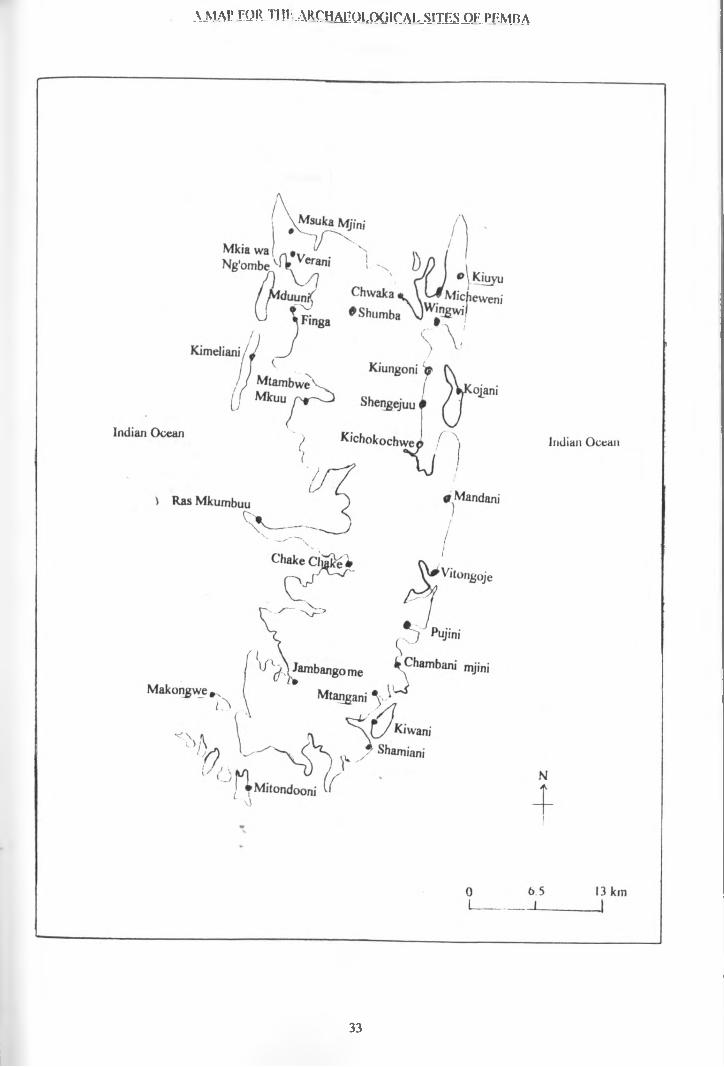
A JS1 AC f!OR TL!f*. A K C H ^ U J-QQICA1-._S.ITES-QF_PEMBA
33

34
CHAPTER 4
SETTLEMENT ANALYSIS; A BRIEF EXAMINATION OF TWO SITES: PUJINI QN PEMBA, AND TUMBATU ON ZANZIBAR
It is often assumed that human groups will tend to minimise the effort needed to obtain their daily- requirements by residing in the most advantageous location (Dennell 1980:2). It is thus likely that groups will seek to exploit the environment within a certain distance of their residence, where their culture and technology can allow such exploitation. The archaeological analysis of settlements has faced a problem in identifying groups and their specific needs through time, and how their needs have been affected by short-term environmental changes. Evidence which may be important may not have survived due to environmental conditions or culturally related factors; and this may hinder the whole issue of settlement analysis (Dennell 1980:13). Cultural abilities in site exploitation remain the most difficult aspect of settlement analysis. The leading factor here is that human activities are more than biological drives. Certain settlements may be selected, not because of their natural resource potential alone, but because they are found to fit with cultural values. It is said that, there is nothing random about the way human beings arrange themselves upon the face of the earth, in any of small or large communities (Wilson 1982:201).
35^ OF
The following discussion is based on two sites: Pujini on Pemba and Tumbatu islet of the coast of Zanzibar. These sites appear to have been located in similar environments i.e. close to the sea, although a close analysis shows that the role of the sea at these sites varied a great deal. Nevertheless their prosperity seems in both cases to have been influenced by international trade. These sites are also located in places with different land potential.
TUMBATU ISLET
Tumbatu is an islet off the north-west shore of Zanzibar.' The islet is formed of coraline limestone and in many parts there are small cliffs worn down by the erosive activity of the sea. On the south-eastern part of Tumbatu is an extensive group of stone ruins covering an area of about 25 hectares (Horton & Clark 1985:8-9). The ruins were first investigated by Pearce in 1915, who described the mosques, palace, and other stone houses. The site was also investigated by Horton (Horton & Clark, 1985, Horton 1989 (personal communication) & 1991) who have dated the site to the llth-12th century A.D. The number of the stone mounds suggests that this was probably the most extensive town in Zanzibar at that time. This does not take into account the mud and thatch houses which might have existed, an element which would indicate that the site was more extensive and compact than the visible remains reveal. In the area three mosques have been excavated so far, and two
36
areas with extensive ruins which may have been living houses (Horton 1991) . One of these houses has been associated with oral traditions relating to the king's palace (Horton 1991:7). Pearce (1920:402, 403) alsoreferred to buildings which were mentioned in oral traditions as "customs sheds" where goods and merchandise were stored.
Yakut, who visited the islet in the 13th century, reports that the inhabitants were already Moslem, although he does not specifically mention the existence of a town (Pearce 1920 406). Yakut also informs us that the Island of Lanjuya (Zanzibar) was the seat of the Kings of Zanj, and that ships made their way to it from all quarters (Trimingham 1964:17, Chittick 1977:195). He records that its people had transferred themselves to another island called Tumbatu.
Excavation by Horton in 1989 and 1991 has indicated contact between the islet and different areas bordering the Indian Ocean. This has led Horton (1991:21) to suggest that Tumbatu had trading contacts with different partners. A number of pottery types have been recovered, including sgraffiato, and black and yellow, dating to the 12th-14th century A . D . Only one sherd of Tana ware was recovered (Horton 1991:7). Chinese pottery, such as Chinese green and white wares, and a number of Indian pots were recovered (Horton 1991:8). Other finds include iron nails, glass, copper coins, copper needles and glass beads. One of the
37
Tumbatu mosques had Kufic inscriptions dating to the 12th century A . D . (Horton 1991:26). A comparable Kufic inscription comes from the Kizimkazi mosque in south east Zanzibar, dated to 1107 A. D. (Anon 1960:18). Horton has suggested that the early inhabitants of Tumbatu and Kizimkazi were descended from the people responsible for the Tana tradition.
In looking at the size of the town and the position of the islet in economic terms, in comparison with adjacent areas of the main Island, one immediately asks why such a big town was located there? Tumbatu islet is formed of corraline limestone which in many areas protrudes up to the surface. The surface is covered with coarse grasses, bushes, scrub and a few trees. The soil is very shallow and infertile; cultivation is very difficult due to the protruding coral rag.
At the present time the most widely used method of farming is slash and burn. This method simplifies agriculture as seeds can be grown immediately after clearing the vegetation by fire, but it makes the soil infertile after 3-4 years, and shifting cultivation is
Vtherefore widely, practised. In most of the cultivated areas, cassava, maize, beans, sweet potatoes and millet are currently grown. Banana is grown as well but only in places where deep pockets of soil exist. With regard to land resource potential the islet is insufficient to support its present population. The people living there also have
38

farms on the main island of Zanzibar and they cross the water for their daily agricultural activities. With regard to marine foods there is no problem. There no evidence for water streams or rivers in the islet but wells were dug through the coral rag. One well, found close to the 12th century mosque, contained many sherds from jars used for drawing water. Another feature which might be a well was found in one of the excavated houses in the site.
The main question which awaits further research is how the inhabitants managed their subsistence on an islet with such few resources, and why they decided to built such a big town there, rather than on the main island where subsistence activities would have been much easier. Excavation of the site by Horton in 1989 & 1991 (personal communication) recovered bones of fish, cattle and goat and probably of fowl. No evidence for agriculture has been recovered from archaeological research on the islet, but, it may be assumed that if the earliest inhabitants of the islet were agriculturalists, they might have depended on agriculture in their subsistence patterns.
On Tumbatu islet there are now two villages, one in the northern area called Gomani, while the southern one is called Jongowe. Recent observations can probably help to answer some of the problems concerned with subsistence activities in the past. In recent times, most of the longdistance trade and boat fishing is dominated by men. Agriculture and the collection of marine resources is done
39

by women. Research based on shell middens at Kizimkazi (south-western Zanzibar) showed about thirty species of marine creatures which are edible (Kleppe 1989: personalcommunication). Most of these are collected by women and children. There are many shell middens on Tumbatu but they have not yet been analysed. Probably the inhabitants of the Tumbatu islet exploited the same marine species as did their counterparts in Kizimkazi. At present, sea resources play a major role in the economy of the Tumbatu people. Due to the problem of the land in the islet, most Tumbatu people cross the sea to the main island of Zanzibar for agricultural activities where some of them own land.
The number of surviving buildings and the size of the old town on Tumbatu islet in relation to the land's potential for agriculture, suggest that, if all the inhabitants were cultivators, they must have had the same dependency for farming land on mainland Zanzibar. If that was the case, a good relationship between the Tumbatu islet and the adjacent areas in mainland Zanzibar must have been established.
For the Tumbatu town to have survived its inhabitants\
must have had either social or political influence on the Mkokotoni people. Mkokotoni is a multi-period site which is opposite Tumbatu on mainland Zanzibar (Horton & Clark 1985:10). Analysis based on beads, coins, local and imported pottery, suggests the site to have been occupied from the 8th century to the present (Horton & Clark 1985,
40
Horton 1991). It had the same potential subsistence activities as the Tumbatu site, but the main difference is that Mkokotoni is located in an area with good land for agriculture. The most interesting thing is that the two towns should have shared the same fishing areas. Tumbatu is just 2 km from Mkokotoni. In order to avoid conflicts over fishing and farming land, it is likely that the two towns established close relationships for their survival. This would be an indication that, although most of the East African Coastal towns existed as independent political units, some of them depended upon shared economic resources which could have exerted unifying influences between them.
' PUJINI
Pujini is a ruined fortified citadel on the eastern coast of Pemba Island. The site was visited and recorded by Pearce in 1915, Buchanan in 1933 and later by Kirkman in 1964. Recently the site has been visited and recorded by Horton and Clark in 1984 and by LaViolette in 1989 & 1990. The fortification enclosed an area of 125 square metres (Horton & Clark 1985:27) The site consists of rectangular stone houses enclosed in an earthen rampart. Apart from the houses, inside the enclosure is the shrine, subterranean chamber (which is now thought to be a well), and a stairway leading to the ramparts (LaViolette 1989 & 1990, personal communication). Pearce (1920 :3 84) described the ruins as different from the others in Pemba Island in general design and technique.
41
Oral traditions relate that the ruler of Pujini was called Mkamadume. This is a Swahili name with the literal meaning of "the milker of men", suggesting that he based his rule upon cruelty. Recent researches have shown that the ruins are of buildings that were erected late in the period of the prosperity of the East African Coastal towns, around the 15th century A.D. As we have seen,(Chapters 3 & 4) new sites were established on the eastern area of Pemba island at this time height. However in this site, new research has shown that it may have been occupied in earlier times. Dr. Adria LaViolette (1989 & (1990personal communication) , discovered Tana ware at Ukutani mosque, iind at another site to the south. (Laviolette 1989). The finds suggest that the site may have a longerhistory than has been thought, but proof awaits a moredetailed report of the finds.
As I have indicated in the earlier chapters, the analysis done here is based on past researches, which might have been biased in looking at stone ruins and coastal sites, rather than the sites of mud and thatchhouses and those which might have been located further inland. -
Pujini is one of the sites which contribute significantly to understanding the nature of settlement on the islands of Pemba and Zanzibar. The site is located close to the sea but, as the analysis of site location on
42
the Eastern side of the island has shown, dependency on the sea was minimal. The position and economic basis of Pujini differs from that of Tumbatu. The former is one of the sites located on the dangerous Pemba sea channel. Pearce, who visited the site in 1915, had this to say "Pujini is built on the dangerous east coast, a coast which even in these days of steam is shunned by vessels" (Pearce 1920:375). However the finds from the site include both local products and those derived from international trade. The local pottery includes both undecorated and red- burnished pottery with a series of simple folded and rolled rims, as well as Tana ware. The imported ceramics include 15th-16th century Chinese blue and white porcelain, Islamic earthenwaires, other glazed utilitarian wares and 19th- century European wares (LaViolette 1989:37). Despite the presence of these imports it is unlikely that the site had a direct link with international trade. Most of the exotic finds may have reached the site through other ports.
There remains the question, to what extent did this site benefit from marine resources? How was its location related to the sea? The dependency of the site upon sea resources seems to have been slight. The sea currents are too strong to allow boat fishing or the collection of molluscs, especially during the months from May to August. Economically, therefore, the site of Pujini would have relied more on the exploitation of land resources than on those of the sea.
43
The soil at Pujini is relatively fertile and, today, supports crops such as cassava, rice, beans, banana, pumpkin, citrus, coconuts, sweet potatoes, mangoes and a variety of vegetables. The area consists of very fertile valleys which can support crops such as r.ice which thrive in water logged soils. There is plenty of water in the constructed wells, which yield at a relatively high level compared with other areas in the island. Therefore the early inhabitants could have based their economy on agriculture and forest products, rather than on marine resources. There are so far no convincing reports of finds indicating intensive use of marine resources. I stayed in the site for one month in June to July in 1989 and also the same time in 1990 and no supply of marine resources were available in the market and, on asking people, I was told of the extreme dangers of the sea currents at that time of the year.
For international trade the people of Pujini probably depended on imports from other harbours, possibly those on the western side of the island. The fortification of the site in the 15th century was probably for defensive purposes, a view which is confirmed by the earthen rampart noted above. The dangerous sea would have protected the site from marine invaders but would have made escape difficult from inland invaders. But probably the greatest danger of attack was seen to be from the sea, and the site's location would have minimised the possibilities of sudden attacks from this direction.
44
In conclusion, through the analysis of the sites of Tumbatu islet and Pujini, it can be seen that, although most of the sites prior to the 19th century are located along the coast (chapter 5), the details, of each site's location must be analysed separately if its significance is to be properly understood. Generalised conclusions may lead to biased premises. Each site should be seen on its own. I hope that, through such study, one may be able to tell more clearly the nature of social, political and economic interactions between the sites in the islands. This will involve a study of the nature and accessibility ofexternal and internal resources. Both the amount of land available to the town dwellers and the adjacent villages are very important factors for assessing the overall economic possibilities.
The study of the size of the towns relative to the available resources is of equal importance. For example, the size of the town on Tumbatu islets in relation to the available land, suggests that the town depended on landproducts from mainland Zanzibar. This implies that the political, economical and social systems which operated in the towns becomes more complex when each site is examined in its own context.
45I
CHAPTER.-5
CHANGES OF SETTLEMENTS ON THE ISLANDS OF PEMBA AND ZANZIBAR
The following is the description of the site locations in Pemba and Zanzibar for every century of occupation. See also the site distribution tables and maps on page 58-63.
CHANGES OF SITE LOCATION ON PEMBA ISLAND
There are only two archaeolgical sites in the islandwhich predate the 11th century. By the 12th century, a new site was established and the total number of sites remained' the same through the 13 th century. It is important to note that from the 9th century to the 13thcentury all known sites were located in the western areaof the island. The exception is Pujini which may predate the 12th century - but this still awaits further dataanalysis (LaViolette 1989-90).
In the 14th century, which marks the peak of the prosperity of East African coastal towns, seven new sites were occupied. Four of these new sites are located on the eastern side of Pemba, the remaining six sites, including three new ones, were on the western side. In the 15th century six sites were abandoned, while six new ones were established. Four of the abandoned sites were on the west while two were on the eastern side. At the same time, two sites were established on the western side, three on the
46
eastern side and the rest on the northern part of the island. This abandonment of sites and establishment of others in the 15th century has been attributed to the coming of, and the disturbances brought about by, the Portuguese at the end of the 15th century and during the 16th century A .D .
In the 16th century only five sites are observed in the island. Six sites observed in the 15th were abandoned in the 16th century and only one new site seems to have been established in the 16th century. This is located on the eastern side. Of the total five sites that were occupied in the 16th century, three were located on the east , one in the north and one in the western part of the island. During this century we can observe that there was only half the number of sites that existed in the 14th and 15th centuries. This is probably an indication of reduced economic prosperity in the island; and Portuguese intrusion is seen as the main cause.
By the 17th century there were a total of six sites on Pemba. Three sites were abandoned, while four new sites were established. Of these sites, two were on the western side, while the other four were on the eastern side. In the 18th century there were a total of nine sites in the island. Three sites seem to have been abandoned while six new sites were occupied. Of the new sites, one was on the western side while four were on the eastern side. One site was established in an inland area of the north, and
47
this is the first time that the interior of the island shows signs of settlement. In the 19th century only four sites were occupied on in the island, seven sites were abandoned, while two new sites were established.
CHANGES OF SITE LOCATION ON ZANZIBARISLAND
From the 8th to the 10th century A .D. only four sites are known in Zanzibar island. All these were located on the western part of the island. In the 11th century one out of the four sites was abandoned. In the 12 th century one further site was abandoned, while three new sites were established, bringing the total number of sites to five. By the 13th century two new sites were established, making a total of seven sites on the island. Of the new sites established, two were on the western side and, for the first time, a site was established on the eastern side.
In the 14th century the site on the eastern side was probably abandoned, and there are only six sites on the island. In the 15th century three sites were abandoned and three new sites were established two were on the western side and one on the eastern side making the total number of sites six. A comparison made between the abandonment of sites in Pemba and Zanzibar in the 14th-15th centuries indicates half of the occupied sites in both islands to have been abandoned while the same number of new sites as the abandoned sites were established. In the 16th century
48
one site was abandoned and only five sites are in the island. Again this fall in the number of the sites in the 16th century can be linked with the coming of the Portuguese.
In the 17th century one site was established on the eastern part of Zanzibar bringing the total number of sites six. In the 18th century two sites were abandoned in the western part of the island, and there were only five sites altogether on the island. One is on the east ,while two are on the west. In the 19th century one site was abandoned and ten new sites were established. Three of the sites were established in the interior of the island. This is observed for the first time in the record of the sites in the island, as explained in the following section.
EXPLANATION FOR THE ABOVE DESCRIPTION OF THE SITES
Examination of the description of settlements before the 19th century shows a peculiar pattern in both the islands of Pemba and Zanzibar. The observable feature in this type of settlement is that the town sites were located along the coasts. As can be seen on the map and tables for the description of the sites (page 58-63)there were several abandonment's of the sites in different periods but the establishment of new sites was always along the coast. However, in the 18th-19th centuries sites were established inland. The causes for these changes are the result of
49

changes in the economic and political structures in the islands.
As has been mentioned before, most of the East African Coastal towns existed as independent political units. This is explained by the Periplus (Gray:1962:10) and the Portuguese (Newitt:1978:113) (see below) This type of political organisation affected the economic sectors in the islands. The trade systems in the towns were apparently controlled independently by each town.
As in most of the East African coastal towns the trading centres in the island faced severe problems of integrating and control from the early periods till the coming of the Omanis in the 17th century. This also may help to explain why they were easily conquered by the Portuguese. Disintegration and disunity would have been advantageous to the Portuguese during the time of conquest. Given the situation, even with state intervention, considerable competition would have developed between the towns and between foreign traders from different places.
Lack of overall control of the trading centres led to the opening of new and smaller areas whenever needed, in response to avoid competition. In other words the trade systems were not monopolised. This led to the underdevelopment of large scale trade systems. Lack of development of large scale systems led to the location of towns at similar strategic points.
50
The coming of the Omanis from the 17th century onwardsled to the amalgamation of the East African coastal townsto form large states. At the same time, the trade systemsseem to have changed by the involvement of more nationsthan before. For example, in the beginning of the 18thcentury we are informed that French merchants (Bennett,1969:148-175) were in trade contact with several Thecoming of the Omanis from the 17th century onwards ledareas of East Africa in search for slaves on the Coast(Sheriff 1987:42, Gray, 1962:179) At the beginning of the19th century, Pemba and Zanzibar had trade contacts withseveral European countries and with America. As the towns
\in the islands were now under unified political control certain structures of the economy such as trade and taxation become centralised. Trade relationships now had to be in the form of treaties, to control competition as every nation was trying to have a greater share of the trade. The centralised control of the economic structures would have eventually led to a decline in growth and prosperity of towns which were dependent on free economic structures. The populations of the declining towns had to look for alternative livelihoods.
By the end of the 18th and the beginning of the 19th century there was an agricultural revolution in Pemba and Zanzibar.(Swai 1984:27) This was based on the production of cloves and sugar which had an expanding international market (see below) (Sheriff 1987).
51
In the beginning of the 19th century there was a decline in the export of slaves as the result of changes in the economic structure of the capitalist countries at that time ( Swai 1984:27, Sheriff 1987). This led to the banning of the slave trade, a move in which England took the leading position (Al Maamiry 1980:78-79). Zanzibar and Pemba as major centres for that trade (Swai 1984:26) suffered. Therefore, there was now a need for these islands to develop new types of economy. "It was the merchant class who were in position to initiate the transformation of the slave sector of the economy of Zanzibar. From their acquaintahce with the Mascarenes they realised that if slaves could not be exported, the products of their labour could" (Sheriff 1987:48). In that case there was an establishment of a sugar and clove (as mentioned above) plantation economy in Zanzibar and Pemba where the slave power was turned to commodity production (Curtin, Feierman, Thompson & Vansina 1978:402-3). Sugar and cloves were introduced to the island from the West Indies by 177 0 (Sheriff 1987:49). At this point the land-based economy became very important. All these changes, i.e. the monopolisation of- trade, the establishment of a unified state from the free independent states, and the establishment of the plantation economy, led to changes in settlement in Zanzibar and Pemba. The majority of people now joined the land-based economy instead of the maritime trade which was by now subject to monopoly systems. This
52
new direction of the land-based economy led to a new infrastructure, small towns and roads for transport were established, but would have also depended on sea transport which was still easier. In Pemba one site (Shumba) was established in the interior in the 18th century. In the interior of Zanzibar three sites were established in the 19th century. The centres in Zanzibar, as they can beobserved in the map page.... were, Kizimbani, Kidichi, andDunga. Sheriff (1987:50) reports that Kizimbani had 4,000 clove trees in the 1st half of the 19th century. Zanzibar was now becoming the centre for all commercial activities on the East African coast and also an administrative centre. This was further strengthened by the shift of the Capital 6f Oman to Zanzibar by Sayyid Said in 1932 (Al Maamiry 1980:64). In Pemba, Chake Chake was the main centre for international trade transactions.
In conclusion what do the 18th-19th century historical changes tell us about the archaeology of the settlements in the islands? The answer can be partly derived from the above discussion. A centralised government may have been established by the 17th century and was certainly operating in the 19th century. This was accompanied by centralisation of international "economic affairs, for example, trade. There was also an increase in the numbers of trading partners. Another change was in material production for exchange, i.e. change from a slave export economy to a plantation economy based on sugar and clove production by slaves.
53
The beginning of the decline in the majority of the towns which were based on maritime resources when this newtrend in the economy appeared in the islands, would meanthat the conditions opposed to the above (17th--19thcenturies changes) existed in the towns before the 17thcentury. Generally, the solitary nature of the economies of the early towns (before the 17th century) was the major factor which led to their survival. This nature of existence led to free competition for major resources. This explains the periodic abandonment of sites and the establishment of new ones. The existence of free competition in the towns did not only lead to the establishment of many sites, but also tended to keep the towns smaller. Possibly there was no great differences in the people's basic economies and the majority of the population based their activities on the maritime economy, as well as on land resources. That is why the majority of sites were located along the coasts before the 18th-19th centuries. In each town was probably a political leader (Chittick 1977:210) who controlled the trade in his own territory. Historical sources support this. Periplus informs us that, the coastal people were under separate chiefs in each place (Gray, 1962:10). (Freeman Grenville, 1988: IV, 132) has indicated Pemba to have at least five kings and more than one sultanate contested the island in 15th -16th century A.D. Joao dos Santos (A Portuguese) writing in the 17th century, reports large settlements of Moors who were merchants living in cities, each with a king
54
(Newitt 1978:113). The king also probably had to collect taxes which were boosted his wealth and, therefore, power. All this implies that the towns existed as self-supporting units. The coming of the Omanis destroyed this system and, within it, the decline of the free economy-based towns. The population within those towns retreated to the land based economy. At the same time it was advantageous as the new introduced international trade had great demands for the agricultural products.
)
55
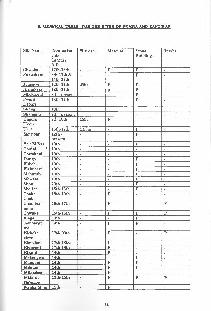
A GENERAL TABLE FOR THE SITES OF PEMBA AND ZANZIBAR
Site Name Occupation date : Century A.D.
Site Area Mosques StoneBuildings.
Tombs
Chwaka 17th-18th - P P .Fukuchani 8th-llth &
15th-17th- - P -
Jongowe 12th-14th 25ha P P _Kizimkazi 12th-14th - P P .Mkokotoni 8th - present - . P -PwaniDeburi
13th-14th - - P -Shungi 13th - . . .Shangani 8th - present - - . .UngujaUkuu
8th-10th 15ha P - -Uroa 15th-17th 1.5 ha - P .Zanzibar 12th-
present- - P -
Beit El Has 19th - - P .Chuini ' 19th - - - .Chwakani 19th - - - .Dunga 19th - - P .Kidichi 19th - - P .Kizimbani 19th - - P -Maharubi 19th - - P -Mbweni 19th ' - - P -Mtoni 19th - - P .Mvuleni 15th-16th - - P -ChakeChake
18th-19th - P - -Chambanimiini
16th-17th - P - PChwaka 15th-16th - P P PFinga 19th - - P -Jambango-me
19th - P P -Kichoko-chwe
17th-20th - P - PKimeliani 17th-18th. - P - .Kiungoni 17th-18th - P - -Kiwani 14th - P . -Makongwe 14th - - P .Mandani 14th - P P .Mduuni 14th - P P .Mitondooni 14th - P • .Mkia wa Ng'ombe
12th-15th - P P PMsuka Mjini 15th - P - -
56
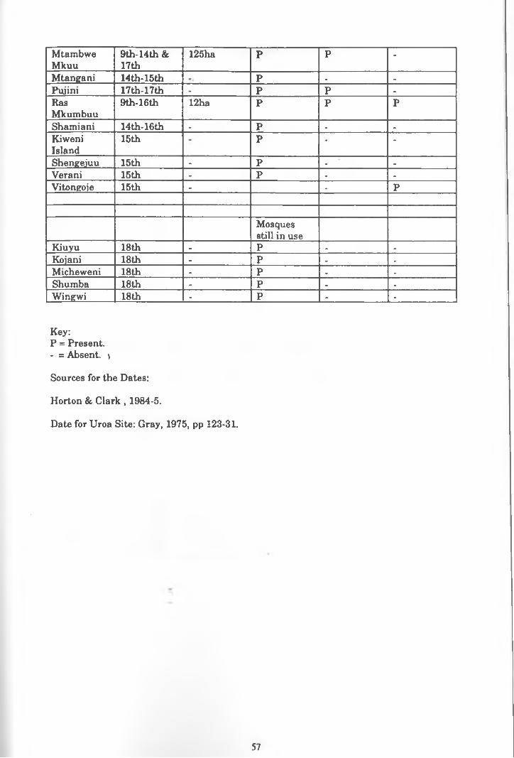
MtambweMkuu
9th-14th & 17th
125ha P P -Mtangani 14th-15th P . .
Puiini 17th-17th - P P -
RasMkumbuu
9th-16th 12ha P P PShamiani 14th-16th - P . -
KiweniIsland
15th P - -Shengejuu 15th - P . .
Verani 15th - P . -
Vitongoje 15th - . P
Mosques still in use
Kiuyu 18th - P - -
Kojani 18th - P . .
Micheweni 18th - P . .
Shumba 18th . P . .
Winewi 18th - P - -
Key:P = Present.- = Absent. )Sources for the Dates:Horton & Clark , 1984-5.Date for Uroa Site: Gray, 1975, pp 123-31.
57
A TABLE OF SITES ON THE EASTERN SIDE OF PEMBA ISLAND.
OCCUPATION AND ABANDONMENT IN EACH CENTURY
CenturyA.D
Abandoned sites New sites Total sites present9th - -
10th - -
11th - .
12th - .
13th - -
14th - 4 415th 2 3 516th 3 1 317th 1 2 418th 2 4 619th 5 - 1
A T^ABLE OF SITES ON THE WESTERN SIDE OF PEMBA ISLAND OCCUPATION AND ABANDONMENT IN EACH CENTURY
Century A.D. Abandoned sites New sites Total sites present9th - 2 210th - - 211th - - 212th - 1 313th - - 314th - 3 615th 4 2 416th 3 - 117th 1 2 218 th 1 1 219th 1 2 3
58
A TABLE OF OCCUPIED AND ABANDONED SITES ON THE PEMBA ISLANDFROM THE 9th CENTURY TO THE 19th CENTURY A.D.
CenturyA.D.
Total sites present
Abandonedsites
Newlyestablished orreoccupiedsites
Total sites/Easternside
Total sites/ Western side
9th 2 - 2 . 210th 2 - - _ 211th 2 - - - 212th 3 - 1 . 313th 3 - - - 314th 10 - 7 4 615th 10 6 6 5 4 +16th 5 6 1 3 1 +17th 6 3 4 4 218th 9 3 6 6 2 +19th 4 7 2 1 3
NB: + = additional sites as stated below:In the 15th century one site was established in the north. In the 16th century there was one site in the north In th 18th century one site is inland -Pemba -north
A TABLE QF OCCUPIED AND ABANDONED SITES IN THE ZANZIBAR ISLAND FROM THE 8th CENTURY TO THE 19th CENTURY A.D.
Century AD. Total sites present
Abandonedsites
Newlyestablishedorreoccupiedsites
Total sites/ Eastern side
Total sites/ Western side
8th 4 - 4 - 49th 4 - - - 410th 4 - - - 411th 3 1 - - 312th 4 1 3 . 513th 7 - 2 1 614th 6 1 - . 615th 6 3 3 1 516th 5 1 . . 517th 6 - 1 1 518th 4 2 • 1 319th 12 1 10 - 12
59
EEMBA-EACHXENMY, FROM
0L
10 km
61
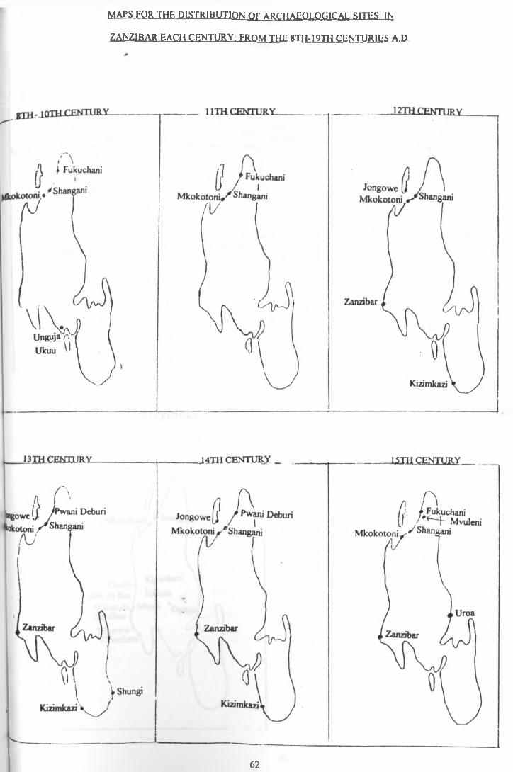
MAESJQR THE DISTRIBUTION OF ARCHAEOLOGICAL SITES IN ZANZIBAR PACH CENTURY. FROM THE 8TU-19TH CENTURIES A.D
62
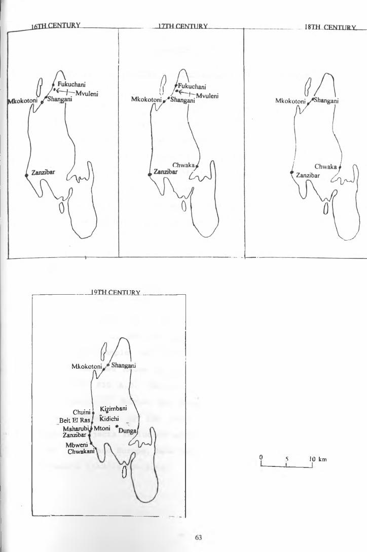
19TH CENTURY
Beit El Ras Maharubi^ Mtoni ZanzibarMbweni Chwakani'
Mkokotoni Shangani
Chuinil .Ki? mbani \ Kidichi
0 o 5 10 km
CHAPTER £
THE TRADING SYSTEMS AND PARTNERSHIP IN THE ISLANDS
It is known from historical sources that Pemba and Zanzibar islands played a major role as centres of trade both from the African Mainland and from the Asiancontinent (Curtin, Feierman, Thompson & Vansina, 1978:315- 401) . Therefore, speaking of trade systems within the islands does not exclude the external trade system which, I think, without the known development of early urbancentres, would have lagged behind.
The yariety and nature of the artefacts found at the lowest levels of some sites reveals operation of external trading activities, especially during and after the 9th century A .D . These activities were intensified by the 13th- 14th century A.D, up to the period when they were disrupted by the coming of the Portuguese late in the 15th century. Coins, for example, have been found in the earliest sites such as Mtambwe Mkuuu dating to (A. H . 184) 800 A.D. and(A.H. 195) 810 A.D. (Horton 1991: 21, Horton, Brown and Oddy 1986:117). Horton has suggested coin minting at RasMkumbuu possibly by the 11th century A.D. A number of
\
imported objects including pottery, glass from the Gulf, Asia, China and Europe, have been recovered as evidence of extensive trading contacts.
64
The diversity of local and imported materials invites the questions of who initiated the trade, who owned it, and how exchanges were made. Answering such questions needs a close examination of the economic systems and exchange potential between the participants. Historical documents such as those of earliest travellers, like the Periplus in the 1st century A .D. inform us of the items traded (see chapter 1).
In some areas, where the earliest sites have beenfound such as Mkokotoni, Unguja Ukuu and Fukuchani inZanzibar (Horton 1991) and Pujini on Pemba (LaViolette1989-90), the lowest layers yield Tana ware, sometimes with
vbead grinders and very little imported pottery. In mostsites iron slag is in association though (with theexception of Unguja Ukuu where convincing evidence for an iron industry has been found (Horton & Clark 1985:34) no site has produced substantial amounts. There are also a range of archaeological finds such as those resulting from agricultural production (eg, animal bones) as well as evidence showing exploitation of the marine resources.However, we must also remember that other materials, such as those from basketry, cloth manufacture and wooden artefacts, were perishable and their chances of being preserved are very low. For example, spindles are found in several sites in the island, but the materials which were used to make clothes were not preserved. What about other materials of special use which did not even leave indirect evidence like the weaving spindles for cloth? Some of the
65
products mentioned above require or represent specialisedactivities which could have led to the exchange ofdifferent commodities produced within the society. There isa suggestion that Swahili speaking people had knowledge ofiron technology before they moved southward (Nurse1 9 8 3 : 1 4 0 ) . T h e d e v e l o p m e n t o f s p e c i a l i s e d a c t i v i t i e s s u c has making perfumes and mats, textiles (Newitt 1978:120-1 2 1 ) , i r o n w o r k i n g , b o a t m a n u f a c t u r e , b e a d s a n d t h eexploitation of marine resources could have allowed thedevelopment of urbanism as such activities can beconcentrated in one site, since they do not require a lotof extensive land. Horton (1991:29) has indicated that aparticular feature of the coastal towns was the importance
vof craft activities.
It is not surprising that there were also experts in building houses and manufacturing other items which need special art and other industries such as the extraction of salt from sea water. Chittick (1975:151), for example, mentions salt making at the site of Mkadini along the Tanzanian coast in the 9th-10th century A . D . Connah (1987:1973) and Newitt (1978:122) mention that carving of ivory and bone was one of the economic activities in the ancient cities of the East African Coast.
E x p l o i t a t i o n o f f o r e s t p r o d u c t s w h i c h i n v o l v e s a c t i v i t i e s s u c h a s m a n g r o v e p o l e s a n d b o a t m a n u f a c t u r e h a v e b e e n r e p o r t e d b y s o m e e a r l y t r a v e l l e r s o n t h e E a s t A f r i c a n c o a s t . F o r e x a m p l e , i t i s k n o w n f r o m t h e P e r i p l n s
66

products mentioned above require or represent specialised activities which could have led to the exchange of different commodities produced within the society. There is a suggestion that Swahili speaking people had knowledge of iron technology before they moved southward (Nurse 1983:140). The development of specialised activities such as making perfumes and mats, textiles (Newitt 1978:120- 121), iron working, boat manufacture, beads and the exploitation of marine resources could have allowed the development of urbanism as such activities can be concentrated in one site, since they do not require a lot of extensive land. Horton (1991:29) has indicated that a particular feature of the coastal towns was the importance of craft activities.
It is not surprising that there were also experts in building houses and manufacturing other items which need special art and other industries such as the extraction of salt from sea water. Chittick (1975:151), for example, mentions salt making at the site of Mkadini along the Tanzanian coast in the 9th-10th century A . D . Connah (1987:1973) and Newitt (1978:122) mention that carving of ivory and bone was one of the economic activities in the ancient cities of-the East African Coast.
Exploitation of forest products which involves activities such as mangrove poles and boat manufacture have been reported by some early travellers on the East African coast. For example, it is known from the Periplus
66
and from the Portuguese that the indigenous population of the East African Coast used certain type of boat with sewn hulls and rectangular matting, known as the mtepe boat. There were also other types of small boats made from the hollowing of large logs, known as ngalawa and mtumbwi. The ownership of some resources and some specialised activities could have led to accumulation of wealth leading to stratified societies and powerful economic classes which could buy manpower.
This therefore implies that by the time the islands came into contact with the trading networks from the Near East, Asia or China, some sort of a merchant class was already existing among the society, and this probably formed the group of people who were living in the already established towns. It is important to note that indirect trade connections might have existed between the islands and the East African mainland linking them with the existing international trade before merchants from the Near East or Asia and China come to direct trade contacts with the islands. It is very interesting that, before the actual occupation of the islands by the people from the Near East -occupation which presumably took place after the 10th -11th century- there were coins and imported pottery. These would indicate international trading activities before the actual immigration of the people from the Near East to the islands took place.
67
It must be clear that if trading activities were one of the factors which attracted the attention of the international connections with the islands, there must have been an environment or conditions which were conducive to such a type of exchange system. One condition should have been the presence of people who were capable of initiating and accepting that type of economy. For that type of economy to be accepted, the indigenous people must have already developed structures which would have made the trade system acceptable. This could have been either in the form of supply of manpower as a commodity, as required in the proper functioning of the trading structures, and also commodity production for exchange with the partners. In this sense, it means that some sort of reciprocity must have existed. In addition, one important feature in exchange principles is the existence of customs or law structures, so that transactions could have been carried out in harmony. This situation did exist, and this is why early activities for trading or contacts are to be found in the earliest towns where the indigenous population seem to have lived. Even the immigration of the Arabs to the islands did not take place by. the opening of new and separate areas or sites out of those which were already occupied by the indigenous people but stayed together in the same sites. The sequence of archaeological materials from the excavated sites supports the view that settlements of foreigners where the indigenous people were living indicates that symbiotic relationships might have developed.
68
There are some aspects which are important to consider when discussing trading activities in the islands. Some of these are: how did the islands manage to keep the trading system working and where were the sources of raw materials or commodities for exchange during prehistoric times? In the growth of cities, the most stabilising agent would have been adequate supplies of food. We have seen that marine resources were one of the major sources of food. This is indicated by the presence of shell middens and fish bones in the archaeological sites, eg Fukuchani on Zanzibar (Horton 1991:4). There is also evidence for the domestication of cattle, goats and fowls in Tumbatu-Zanzibar (Horton 1991 personal communication). However, no serious research has been done to investigate the importance and development of plant agriculture in the islands. But it may be assumed that since the East African mainland Coast where the early inhabitants came from was already growing sorghum and millet, possibly these plants were also being grown for food in the islands. Connah (1987:171) has mentioned that South East Asian crops such as rice, coconuts, bananas, sugar cane and some other plants were already introduced to the East African Coast by the beginning of the Christian era. There is no doubt that they were grown by the islanders. These type of plants survive very well along the East African Coast. These would have produced enough to support the populations in the towns and also probably for export.
69
R e t u r n i n g t o t h e c o m i n g o f t h e A r a b s t o t h e i s l a n d s ,there is evidence that this might have taken place duringthe 9th -10th centuries A .D . (Masud's report on Kanbalu,I n g r a m s 1967:81) T h e i r i m m i g r a t i o n c a n b e e x p l a i n e d bythree reasons. There were groups which migrated from theN e a r E a s t t o E a s t A f r i c a d u e t o p o l i t i c a l i n s t a b i l i t y ,while at the same time others came for trade and stillothers for missionary activities, eg the spread of Islam( a l t h o u g h t h e a d o p t i o n o f I s l a m b y t h e E a s t A f r i c a n p e o p l emight have been also due to the social consequences oftrading partners and immigrants). The early written reportsfor the existence of Islamic societies in one of theislands come from Masud who visited Kanbalu (Pemba) in 916.
>A .D . He reported Kanbalu to have a Moslem population of substantial size and suggested that it was founded by refugees fleeing from the Umayad military in Arabia (Horton 1991:2). The coming of these groups would have stimulated and also created new social situations in trading and other activities. From this period of the coming the Arabs, trading activities and towns seems to have expanded rapidly up to the 14th century, when adecline began.
The period from the 12th-14th centuries A.D. ischaracterised by an increase of more exotic materials as well as local ones. The stimulation which would have been brought by the Arab traders would have been the need to produce more local materials for exchange with thecommodities from the outside world. The range of imported
70
materials such as glass bottles, glass beads, pottery, copper and gold objects indicate that import of raw materials was not from the Asian continent only but also from the African mainland as indicated by copper and gold. How the islands appropriated materials for international exchange is not fully known. Here the main aspect of interest is to examine the materials which were naturally produced from the islands. Apart from the possibilities of producing surplus food for exchange, materials such as mangrove poles were traded to the Near East where there was a shortage of forest products (Sheriff, 1987:12, Connah 1987:156). The islands have big reserves of mangrove trees, notably in Pemba. Other materials which could have been available from the islands from the early periods onwards, are forest products such as honey, animal skins and the extraction of salt from sea water. Even slaves were probably sold during the early period of trade contacts. Other products of exchange were secondary to the islands. The implication here is that they were imported to the islands for direct exchange with other areas, or they were manufactured as secondary products for resale. For example, although copper and gold have been worked within the islands there are no geological sources for such minerals.
v•
The islands acted as centres for the accumulation of trade materials in the East African coast ready for their transport to the Near East, i.e. the islands functioned as distribution centres (Curtin, Feierman, Thompson,and Vansina 1978:395-401). This probably took place when sea
71
transport northwards was not possible. If that was the case, how did the towns in the islands get materials for exchange with their African mainland partners? This is an interesting question for understanding the traderelationships and the ways of producing commodities for exchange. Almost all natural resources available in Pemba and Zanzibar which could have been used for exchange were also available in the African mainland, so, could theyhave acted as good items for exchange? Trading relationships result from value, quality and content differences in the items of exchange, therefore materials of different values, qualities and contents must have existed to allow the reciprocity system to work. Theislands had probably relied on the production of secondary products from trade items which they imported from the African mainland, such as gold, copper and ivory to be exchanged back to the mainland in the form of finishedgoods. Another alternative could have been that the islands imported things from the Near East, which were used for exchange with goods from the mainland. Indeed the islands might have acted as industrial bases of some kind,processing materials to finished goods and also acting as amiddlemen. A certain phase at Mkokotoni, for example, has
»
yielded thousands of glass and non-glass beads and many bead grinders. The amount of beads in the site, as well as bead grinders, leaves no doubt that this was a big industrial area for these items. Another area of comparable potential as far as the bead industry is concerned is Fukuchani, however, here only bead grinders have been
72
recovered in substantial amounts. No clear evidence has been established for the amount and the type of beads which were being produced.
Another industry which is of great interest is iron production. Iron slag has been found in several early sites such as Kizimkazi, Mtambwe Mkuu, Pujini, Fukuchani and Unguja Ukuu. However there are no structures connected with iron production yet found and, therefore, the production of this item is still a matter of further research. Another problem in this industry is that the sources of the iron ore are not known to exist in the islands and, therefore,raw materials must have been imported from the African
\mainland. The above information shows how the sources for the exchange material in the international trade from the islands become complicated from the earliest periods up to the prosperity of their towns in the 14th century A.D.
After the 14th century there was a decline of the towns not only within the islands, but the whole of the East African Coast due to the political instability brought by the Portuguese. The disturbances within the political system of the towns meant decline in their economic activities. The Portuguese captured the towns of Sofala, Kilwa, Mombasa, Malindi, Zanzibar and Pemba and took over control a major part of trade in the East African Coast. Later in the end of the 17th century, the Portuguese lost their power to control the East African Coast as they faced revolt from the towns and from the Omanis opposition, who
73
took over control (Verin 1986:65). The Portuguese were unable to manage and maintain the original state of the economic system. This may have been due to the hostility and chaos they had already established among the East African people and the Persians. Another factor was due to poor communication with their homeland due to problems with sea transport, i.e. going the entire way via Cape to Europe when compared, for example, with people coming from the Near East.
In conclusion the evidences for the trading systems and partnership in the islands is a matter of further research. Further analysis of local economic potential in the islands as opposed to external economic potential is required in understanding the contribution of the islands to international economic systems. This will require a detailed analysis of the nature of the location of the sites mentioned in chapter 3, 4 and 5 to see how the nature of their location helps in our understanding the nature of their economic strategies to both local and to the international economic systems. A detailed inventory for the possibilities of both perishable and non perishable materials which could have played a role in the exchange systems could be a key to a better conclusions about the local and the international exchange systems in the islands.
74
pielioORAPHY:Allen J.V, 1981, Swahili Culture and the Nature of the East Coast Settlements. International Journal of African Historical Studies 14 pp 306-314.Allen J.V, 1982, The "Shirazi" Problem in East African Coastal History. Paideuma 28 pp 9- 27.Allen J. V, 1984, Witu and Swahili Historians. In States Formation in Eastern Africa. Edited by, Salim S.I. Heinemann Educational Books, Nairobi.Al Maamiry A. H, 1980, Oman and East Africa. Lancers Publishers, second edition.Anon, 1960, Annual Report of the Antiquity Division for the year 1960. Tanganyika Ministry of Education, Governiment Printer Dar es Salaam.Ayany S.G.1970, A History of Zanzibar . A Study in Constitutional Development 1934- 1964 . East African Literature Bureau, Nairobi.Barker G, 1978, Economic Models for the Manekweni, Zimbabwe and Mozambique. In Ay.nnia Vol 13 pp 71-100.Bennett N. R, 1969, France and Zanzibar. In Eastern African History. Edited by McCall D.F, Bennett N.R, and Jeffrey B, pp 148-175. Frederick A. Praeger Publishers, New York.Casson L, 1984, Ancient Trade and Society. Weyne State University Press, Detroit.
>Chittick H. N, 1975, An Early Salt working site on the Tanzanian Coast. In Azania Vol:10 pp 151-153.Chittick H. N, 1966, Kilwa A preliminary Report pp 1-36. In Azania Vol IChittick H .N, 1971, The Coast of East Africa . In The African Iron Age, ed P.L. Shinnie, Clarendom Press Oxford.Chittick H.N, and Rotberg R.I, 1975, East Africa and the Orient. Africana Publishing Company New York.Chittick H.N, 1977, The East African Coast, Madagascar and the Indian Ocean* In Cambridge History of Africa. Vol 3., Edited by Oliver R. pp 183-231 London.Chittick H.N,1966, Unguja Ukuu: The earliest Imported Pottery, and An Abbasid Dinar.In Azania : Vol 11 1 page 161-3 .Chittick H.N, 1982, Reconnaissance in Coastal Tanzania. In Nvame Akuma Number 20 June 1982. pp 57-8.Chittick H.N, 1974, Kilwa : An Islamic Trading City on the East African Coast. Vol: 1 & 2. The British Institute in Eastern Africa. Nairobi.Connah G, 1987. African civilisation. Cambridge.Curtin P, Feiermans, Thompson L and Vansina J, 1978, African History. Longman.Dennel R, 1980, The Use, Abuse and Potential of site Catchment Analysis. In Catchment analysis: Essays on Prehistoric Resource and Space. Department of Anthropology University of California, Los Angeles. Edited by Findlow F. J. and Ericson J.E. pp 1-20.
75

Freeman Grenville G.S.P, 1962, The East African Coast: Select Documents From the First. tn tfrp F.nrljpr Nineteenth Century.. London : Clarendon Press.Freeman-Grenville G.S.P, 1988, The Swahili Coast. 2and to 19th Centuries. Variorum Reprints, London.Garlake P, 1973, Great Zimbabwe. London. Thames and Hudson.Gray J.M, 1962, History of Zanzibar From the Middle Ages to 1856. London, Oxford Press.Gray J.M, 1977, The Hadimu and Tumbatu of Zanzibar. In Tanzania Notes and Records No 81 pp 135-153.Gray J.M, 1975, A Portuguese Inscription and the Uroa Coin Hoard: Some discoveries in Zanzibar. In Azania. Vol: 10 pp 123-131.Horton C.M, 1991. Origins of Islam in East Africa Archaeological Report, BIEA,Leverhulme project. Unpublished report.Horton C.M, 1985, Archaeological survey of Zanzibar. In Azania Vol 20 pp 167- 71.Horton C.M, & Clark M.C, 1985, Zanzibar Archaeological survey 1984-5, Zanzibar Ministry of information culture and sports.Horton C.M, 1982, Some Archaeological problem regarding the genesis of the Swahili culture African History seminar , A paper presented at the University of London School of Oriental and African Studies. Institute of Commonwealth Studies*Horton C.M, 1986, Asiatic colonisation of the East African Coast: The Manda evidence. Journal of the Roval Asiatic society pt2 pp 201-213.Horton C.M, Brown H.M, and Oddy W.A, 1986, The Mtabwe Hoard. In Azania Vol 21, pp 115-123.Horton C.M, 1987a, Early Muslim Trading Settlements on the East African Coast: New Evidence from Shanga, Antiquaries Journal 67 pt 2, pp 290-323.Horton C.M, 1987b, The Swahili corridor Scientific American September issue.Horton C. M, 1989, 1991 and 1992. Personal CommunicationHuffman T, 1982, Archaeology and Ethnohistory of the African Iron Age, Annual Review af Anthropology 11 pp 133-150.Ingham K, 1962, A History of East Africa. Longmans.Ingrams W.H, 1967, Zanzibar Its History and Its People. Frank Cass, London, 2nd edition*Kleppe J, 1989. Personal communication.LaViolette A, Fawcett W.B, Karoma N.J, & Schmidt P.R, 1989, The Coastal and the Hinterland: The University of Dar es Salaaam Field Schools. In Nvame Aknma Number 32 December 1989. pp 38-45.LaViolette A, 1989, Preliminary Report, Excavations and survey at Pujini a Fotress on Pemba Island Tanzania. In Nvame Akuma. Number 32 December 1989. pp 35-38.
76 UNIVERSITY OF NAt**?*- LIBRARY________
LaViolette A, 1989 &1990, Personal communication.Newitt M, 1978, The Southern Swahili Coast in the First Century of European Expansion. In Amnia Vol:13, pp 111-126.Nurse D, 1983, A linguistic Reconsideration of Swahili Origins. In Azania Vol: 18, pp 127- 150.Pearce F.B, 1920, Zanzibar the Island Metropolis of Eastern Africa. London.Phillipson D.W, 1977, The later Prehistory of Eastern And Southern Africa. Heinemann, Ibadan, Nairobi, Lusaka.Phillipson D.W, 1985, African Archaeology. Cambridge.Rosenthal R, 1971, The sign of Ivory Horn. Eastern African Civilisation . Oceana Publication Inc New York.Sassoon H, 1980, Excavation at the Site of Early Mombasa. In Azania Vol:15 pp 1-42.Shepherd G, 1982 , The Making of the Swahili, A view from the Southern end of the East African Coast. Paideuma 28 pp 129-47.Sheriff A, 1981, The East African Coast and its Role in the Marine Trade. In Unesco General History of Africa II Ancient Civilisation, pp 551-566. Heinemann.Sheriff A, 1987, Slaves. Spices & Ivorv in Zanzibar. London.Sinclair P. 1982, Chibuene An Early Trading Site in Southern Mozambique. Paideuma 28 pp 149-164.Stiles D, 1982, A History of the Hunting Peoples of the Northern East African Coast Ecological and socio-economical consideration. Paideuma 28 pp 165-174.Swai B, 1984, Pre colonial States and European Merchant Capital. In States Formation in Eastern Africa. Edited by Salim S.I.Trimingham J. S. 1964, Islam in Eastern Africa . London Clarendom Press.Verin P, 1986. The History of Civilisation in the North Madagascar. A.A. Balkema, Rotterdam, Boston.Wilson T.H, 1982, Spatial Analysis and Settlement patterns in the East African Coast. Paideuma 28 pp 201-219.Winknson J.C, 1981, Oman and East Africa: New light on Kilwa History from the Omani Sources. In International Journal Of African Historical Studies 14.2 pp. 272-305.Winknson J.C, 1989, The Omani and Ibadi background to the Kilwa Sirah: The demise of Oman as a Political and Religious Force in the Indian Ocean in the 6th/12th centuries. In A Miscellany of Middle Eastern Articles in Memorium of Thomas Muir Johnstone 1924- •1983. PP 131-148, edited by Irvine A.K, Serjeant R.B and Smith. Longman London.
77
Copyright © 2022 FDOKUMEN