Heritage trails. International cultural heritage policies in a European perspective.
Upload
khangminh22Category
view
3download
0
THE DOLOMITES
THE WORLDNATURAL HERITAGE LIST UNESCO
Nomination of the Dolomites for inscription on the World Natural Heritage List UNESCO

2
O the mind, mind has mountains; cliffs of fallFrightful, sheer, no-manfathomed. Hold them cheapMay who ne’er hung there
G.M. Hopkins (1844 - 1889)
Odle / Geisler

Nomination of the Dolomites for inscription on the
World Natural Heritage List UNESCO
3
THE TENTATIVE LIST AND THE NOMINATION OF THE DOLOMITES
This Nomination Document is the answer to the Decision to defer the previous nomination of the Dolomites (2005) expressed by the World Heritage Commit-tee during the Thirty-first Session Christchurch, New Zealand (23 June – 2 July 2007).In detail, the World Heritage Committee having examined Documents WHC-07/31.COM/8B and WHC-07/31.COM/INF.8B.2, defers the examination of the nomina-tion of The Dolomites, Italy, to the World Heritage List on the basis of criteria (vii) and (viii).As outlined in the document licensed by the Word Heritage Committee at the end of the 29th session held in Durban, South Africa, in July 2005, Italy has proposed the Dolomites as one of the sites deserving consideration for a possible future nomination as a site of outstanding universal value.The request was included in annex 1 of the Tentative List dated march 31st 2005, whereas the denomination ‘Dolomites’ is defined in annex 2 “Tentative List Sub-mission in accordance with decision 27 Com 8a” and annex 3 (Properties ac-cepted as meeting the requirements for Tentative List), within the scope of the broader denomination ‘Alps’, which also includes a) Western Alps and c) Eastern Alps, under the category ‘Natural Sites’. This is in complete compliance with the procedure specified by article 64 of the UNESCO Convention, which stipulates that the nomination proper must be pre-ceded by the compilation of a Tentative List constituting the “inventory of the sites that each country deems appropriate for inscription in the World Heritage List”. States are therefore required to include in their respective Tentative Lists the names of all sites they consider to be cultural and/or natural heritage of outstand-ing universal value.The Inter-ministerial permanent work group for the World Heritage List UNESCO, set up through collaboration between the Ministero per i Beni e le Attività Culturali (Ministry of Cultural Heritages and Activities) and the Ministero dell’Ambiente e della Tutela del Territorio e del Mare (Ministry for Environment, Land and Sea), has acted effectively in this spirit. Indeed, the two ministries have already been considering nominating the Alpine Region as a serial cross-border site for some time. The nomination documented in this dossier is the result of the work of the two ministries and the substantial efforts of five provincial authorities in the North-East of Italy.

... Imagine mountains which have the shape of gothic cathedrals, castles in ruins, belfries, immense walls, high towers, steeples and pinnacles, pietrified thunder-bolts. Mountains made of rocks which change their color as the day goes on: sun-rise, morning, noon, sunset, evening, night... they could be white like the snow, yellow like the sun, gray like the clouds, pink like a rose, black like a burnt wood, red like the blood... Which is the color of the Dolomites? Is it white? yellow? gray? pearly? Is it the color of the ash? Is it the reflex of silver? Is it the paleness of the dead? Is it the shade of the roses? Are they rocks or clouds? They are real or they are dream?
Dino Buzzati (1906/1972)

Nomination of the Dolomites for inscription on the
World Natural Heritage List UNESCO
5
THE DOLOMITES ARE SPECIAL AND BEAUTIFUL MOUNTAINS
The Dolomites are nominated as a serial property since they appear as an organic whole even though they have a complex structure both from the geographical/landscape and the geological/geomorphological point of view. In fact the different systems make up a composition of evidence and landscape peculiarities, inter-linked by a network of genetic and aesthetic relationships.This Nomination Document proposes that the unique landscape of the Dolomites be recognized through the award of World Heritage Site status, in particular be-cause of their universal importance for the Earth Sciences (the Dolomites are one of the historical locations for the origin of Heart Sciences) and for their oustanding natural beauty and aesthetic importance. The achievement of long-term protection and positive management for the nomi-nated Site is a central concern of the proposal. Work towards this nomination has taken several years of active local, national and international consultation, and the principles and priorities for management have been established through thorough debate. A management framework has been prepared to accompany this nomi-nation, which points up the common engagement of the local Administrations and outlines the future management of the nominated area.The Provincia di Belluno, part of the Regione Veneto, the Provincia di Pordenone and the Provincia di Udine, included in the Regione Autonoma Friuli Venezia-Giulia, the Provincia Autonoma di Bolzano - Alto Adige / Autonome Provinz Bozen-Südtirol and the Provincia Autonoma di Trento have prepared this nomination, with the scientific contribution, assistance and advice of distinguished professors, many people and institutions. We believe that World Heritage Site status would provide an important contribution to the long-term conservation of the Dolomites and it would ensure that its earth science interests and its outstanding beauty are properly recognized. We are fully committed to working together to support the protection and public understanding of these superb mountains, in partnership with the many organisations and individuals who own, manage, visit and value it. We are delighted, therefore, to commend this nomination to the World Heritage Committee of UNESCO.
ProvinciaAutonoma di Trento
Provinciadi Udine
Provinciadi Pordenone
Provincia Autonomadi Bolzano-Alto Adige
Autonome ProvinzBozen-Südtirol
Provinciadi Belluno
Regione AutonomaFriuli Venezia Giulia


NOMINATION OF
THE DOLOMITESFOR INSCRIPTION ON
THE WORLDNATURAL HERITAGE LIST UNESCO
N O M I N A T I O N D O C U M E N T
PROVINCIA DI BELLUNOPROVINCIA AUTONOMA DI BOLZANO – BOZEN
PROVINCIA DI PORDENONEPROVINCIA AUTONOMA DI TRENTO
PROVINCIA DI UDINE

8
This document has been prepared by:
scientific adviceprof. Piero Gianolla, geology (coordinator)prof. Mario Panizza, geomorphologyarch. Cesare Micheletti, landscape and aestheticsprof. Franco Viola, ecology
scientific contributionprof. Alfonso Boselliniprof. Marco Stefani
scientific collaborationprof. Alberto Carton (geomorphology, Brenta Dolomites)prof. Mauro Soldati (landslides)prof. Renato Posenato (paleontology)dott. Sandro Furlanis (quaternary geology)arch. Loredana Ponticelli (aesthetics and landscape)dott. Rachele Andreetta, Stefano Furin, dott. Alberto Riva (geological aspects, cartography)dott. Lorenz Keim, dott. Evelyn Kustascher (geology, Bolzano / Bozen area) dott. Marco Avanzini (geology, Trento area)dott. Cesare Lasen (flora)dott. Michele Cassol (fauna)
technical collaborationdott. Viviana Valt (secretariat, coordination of the Nomination, Provincia di Belluno)dott. Franco Fiamoi, p.i Luigi Baldovin (geology, cartography, Provincia di Belluno)arch. Paola Agostini (land planning, Provincia di Belluno) dott. Serena Marcolin, p.a. Daniele Zucchiatti (geology, cartography, Provincia di Pordenone)dott. Gabriele Peressi (geology, cartography, Provincia di Udine)dott. Artur Kammerer, dott. Renato Sascor (parks, Provincia Autonoma di Bolzano / Autonome Provinz Bozen)dott. Giorgio Zampedri, Federica Boratti, Giangaspare Fucarino (geology, cartography, Provincia Autonoma di Trento)arch. Enrico Ferrari, arch. Angiola Turella (landscape and land planning, Provincia Autonoma di Trento)dott. Ilaria Viola, dott. Angelo Carriero (forests, Provincia Autonoma di Trento)dott. Lucia Fenti (communication, Provincia di Belluno)dott. Fausta Slanzi (communication, Provincia Autonoma di Trento)dott. Martina Dal Pont, dott. Emma Pierobon (Statute of the UNESCO Dolomites Committee, Provincia di Belluno)dott. Stephan Beikircher (Statute of the UNESCO Dolomites Committee,Provincia Autonoma di Bolzano / Autonome Provinz Bozen)dott. Michele Da Pozzo, dott. Gianni Poloniato (parks, local experts, Provincia di Belluno)dott. Claudio Ferrari, dott. Ettore Sartori (parks, Provincia Autonoma di Trento)
translationThe OfficeClare Littlewood (aesthetics and landscape)Giovanni Tosatti (geomorphology)
graphic designArtimedia

Nomination of the Dolomites for inscription on the
World Natural Heritage List UNESCO
9
1. Identification of the Property1.a Country (and State Party if different)1.b State, Province or Region1.c Name of Property1.d Geographical coordinates to the nearest second1.e Maps and plans, showing the boundaries of the nominated property and
buffer zone1.f Area of nominated property (ha.) and proposed buffer zone (ha.)
2. Description2.a Description of Property2.b History and Development
3. Justification for Inscription3.a Criteria under which inscription is proposed (and justification for inscription
under these criteria)3.b Proposed Statement of outstanding universal value3.c Comparative analysis (including state of conservation of similar properties)3.d Integrity and/or Authenticity.
4. State of Conservation and factors affecting the Property4.a Present state of conservation4.b Factors affecting the property
(i) Development Pressures (e.g. encroachment, adaptation, agriculture, mining)
(ii) Environmental pressures (e.g. pollution, climate change, desertification)(iii) Natural disasters and risk preparedness (earthquakes, floods, fires, etc.)(iv) Visitor/tourism pressures
(v) Number of inhabitants within the property and the buffer zone
5. Protection and Management of the Property5.a Ownership5.b Protective designation5.c Means of implementing protective measures.5.d Existing plans related to municipality and region in which the proposed
property is located (e.g., regional or local plan, conservation plan, tourism development plan)
5.e Property management plan or other management system5.f Sources and levels of finance5.g Sources of expertise and training in conservation and management tech-
niques5.h Visitor facilities and statistics5.i Policies and programmes related to the presentation and promotion of the
property5.j Staffing levels (professional, technical, maintenance)
Summary

10
6. Monitoring6.a Key indicators for measuring state of conservation6.b Administrative arrangements for monitoring property6.c Results of previous reporting exercises
7. Documentation7.a Photographs, slides, image inventory and authorization table and other au-
diovisual materials7.b Texts relating to protective designation, copies of property management
plans or documented management systems and extracts of other plans rel-evant to the property
7.c Form and date of most recent records or inventory of property7.d Address where inventory, records and archives are held7.e. Bibliography
8. Contact Information of responsible authorities8.a Preparer8.b Official Local Institution/Agency8.c Other Local Institutions8.d Official Web address
9. Signature on behalf of the State Party

Nomination of the Dolomites for inscription on the
World Natural Heritage List UNESCO
11
ANNEXES
ANNEX 1A.1.1 Maps and Plans of the nominated property and buffer zone in cartographic
and digital form (scale 1:250.00 and 1:25.000)
ANNEX 2A.2.1 Geology of the Dolomites (supplementary documentation on Geological
data)A.2.2 Ecological aspects of the Dolomites: the Flora and the Fauna (supplemen-
tary documentation on Floristic and Faunistic data)A.2.3 Video “The Dolomites”, 2007
ANNEX 3A.3.1 Letters of support
ANNEX 4A.4.1 Facilities (supplementary data and statistics on shelters, mountain cabins,
and footpath network)
ANNEX 5A.5.1 Protective designations in order to ProvincesA.5.2 Protective designations in order to Systems
ANNEX 6A.6.1 Environmental Monitoring
ANNEX 7A.7.1 DVD (Photographs)A.7.2 Bibliographical inventory
ANNEX 8A.8.1 Inventory of other local Authorities
Summary


Nomination of the Dolomites for inscription on the
World Natural Heritage List UNESCO
13
EXECUTIVE SUMMARY
State Party ITALY
RegionFRIULI-VENEZIA GIULIA, TRENTINO-ALTO ADIGE/SÜDTIROL,VENETO
ProvinceBELLUNO, BOLZANO-BOZEN, PORDENONE, TRENTO, UDINE
Name of Property The Dolomites
Geographical coordinates to the nearest second The barycenter of the nominated area is situated at:18°28’41.4’’ E46°12’38’’ N
Textual description of the boundary(ies) of the nominated property
The Dolomites are nominated as a serial property since they appear as an organic whole even though they have a complex structure both from the geographical/landscape and the geological/geomorphological point of view. In fact the different systems make up a composition of evidence and landscape peculiarities, inter-linked by a network of genetic and aesthetic relationships.
The property extend over a wide area on the northeasten part of Italy. To the north is limited by the Pusteria Valley/Pustertal, then descending east, by the Sesto Val-ley/Sextnertal, eastward by the upper part of the Tagliamento then down through the Tramontina valley and west into the intermediated part of the Cellina Valley. To the south by the Piave valley, the borders then follow the Cismon Valley, the Travignolo Valley and the Avisio Valley and then reach the Adige Valley. The most western part is limited by the Rendena Valley and Val Meledrio, then through the Sole Valleys it follows the Adige Valley and finally by the Isarco Valley.
Executivesummary

14
Map of the nominated property, showing boundaries and buffer zone

Nomination of the Dolomites for inscription on the
World Natural Heritage List UNESCO
15
Executivesummary

16
Justification Statement of Outstanding Universal ValueThe Dolomites are the archetype of a particular type of mountain landscape in the world, defined as “dolomitic landscape”, and the most outstanding anywhere. The extremely articulated topography and the exceptional variety of colours are distinctive characteristics of the dolomitic landscape, but even more so the ex-traordinary contrast between the gentle curves of the meadows and the sudden vertical thrust of mighty, completely bare, pale-coloured peaks with extraordinarily varied sculptural shapes. The result of these key traits determines the “dolomitic landscape”, that is that typology of mountain scenery whose original model and maximum expression is found in the Dolomites.
From the geological viewpoint, the Dolomites are a reference area at worldwide level for the Triassic period. The documentation of the Triassic is extraordinary, for the high sedimentation rates, for the enormous variety of depositional facies and environments, and for the abundant fossiliferous documentation that makes this one of the world reference areas for the biostratigraphy of the Triassic Tethys. Furthermore, they are the only area with easy access where large scale Mesozoic carbonate platforms and their adjoining basinal areas can be observed in natural transects and the interrelationships between carbonate rocks and igneous rocks are superbly exposed in an alpine terrain.
From a geomorphological viewpoint, the reliefs of the Dolomites shows a clear relationship with geology (morphostructur): there are landforms linked to tectonic movements (morphotectodynamics), as fault scarps; even more numerous are the landforms linked to morphoselection, for both for passive tectonics (morpho-tectostatics) like structural slopes, and for rock composition (morpholithology), like karst phenomena. Among morphoclimatic landforms, those connected to past climates are mainly derived from glacial and periglacial conditions (moraine deposits, glaciopressure evidence etc.). On the other hand, those connected to re-cent and present climate conditions are of the crionival genesis type (talus cones, protalus ramparts etc.). A recurrent aspect is represented by mass movements, with all possible types of landslides, quoted in international scientific literature. Furthermore the Dolomites are an exemplary case of geo(morpho)diversity), in every (extrinsic, intrinsic, at different scale) meaning.
Criteria under which the property is nominated (itemize criteria)
Criterion vii (contain superlative natural phenomena or areas of exceptional natu-ral beauty and aesthetic importance)
The Dolomites are generally recognised to be amongst the most attractive moun-tain landscapes in the world. Their topography presents a remarkable concentra-tion of spectacular mountain systems, each with its own characteristics. Similarly

Nomination of the Dolomites for inscription on the
World Natural Heritage List UNESCO
17
the quantity of extremely varied limestone formations (peaks, towers, pinnacles and vertical walls amongst the highest in the world) is extraordinary in a global context. The particular drama and magnificence of their scenic values have made the Dolomites a crucial reference for the aesthetic of the sublime in western cul-ture, so much so that they are considered to be a universal standard of natural beauty. The Dolomites also became famous throughout the world for the phe-nomenon of intense colouring assumed by the rock faces at sunrise and sunset (the colour range of orange-red-purple) and their scenic luminosity at dusk or by moonlight.
Criterion viii (to be outstanding examples representing major stages of earth’s his-tory, including the record of life, significant on-going geological processes in the development of landforms, or significant geomorphic or physiographic feature)
geology: The Dolomites are the world´s only area with easy access where large scale Triassic carbonate platforms and their adjoining basinal areas can be ob-served in natural transects. They show a practically continuous sequence of Up-per Palaeozoic and Mesozoic rocks and therefore documents 200 Ma of earth history in a small and easily accessible area. In particular, the continental succes-sions of the Permian and above all the marine successions of the Triassic make the Dolomites a reference area at a worldwide level for researchers and specialists of these periods. Significant parts of the Triassic have been historically defined in these areas: for example, the Ladinian (term deriving from Ladinia), the Fassanian (from the Val di Fassa) and the Cordevolian (from the Cordevole Valley). geomorphology: The Dolomites are a unitary system of morphostructural and morphoclimatic landforms, of outstanding universal value. They are a sort of geo-heritage high-altitude field laboratory, ideal for research, education and the de-velopment of geomorphological theories and understanding. Furthermore, they are a particularly representative case of geo(morpho)diversity, in every extrinsic or intrinsic meaning, at different scales. Finally, they show their geomorphological particularities in the midst of a landscape which is among the most spectacular in the world.
Executivesummary

18
Name and contact information of the official local institution / agency
authority Provincia di BellunoProvincia Autonoma di Bolzano Autonome Provinz Bozen-Südtirol
president Sergio Reolon Luis Durnwalder
addressI – 32100 BellunoVia S. Andrea, 5
I – 39100 BolzanoPalazzo 1, Via Crispi, 3
contacts
department
Assessorato alla candidatura delle Dolomiti a Patrimonio dell'UNESCO, Pianificazione strategica e UrbanisticaSettore Ambiente e Territorio
Ripartizione natura e paesaggio Ufficio Parchi Naturali
responsibleAss. Irma Visallidott. Paolo Centelleghe
dott. Artur Kammerer
addressI – 32100 BellunoVia S. Andrea, 5
I – 39100 BolzanoVia Renon, 4
phone +39.0437.959286 +39.0471.417770
fax +39.0437.950217 +39.0471.417789

Nomination of the Dolomites for inscription on the
World Natural Heritage List UNESCO
19
Executivesummary
Provincia di Pordenone Provincia Autonoma di Trento Provincia di Udine
Alessandro Ciriani Lorenzo Dellai Pietro Fontanini
I – 33170 PordenoneLargo San Giorgio, 12
I – 38100 TrentoPiazza Dante, 15
I – 33100 Udine Piazza Patriarcato, 3
Piazza Patriarcato, 3
Servizio Pianificazione del territorioAssessorato UrbanisticaDipartimento Urbanistica e Ambiente
Servizio promozione economica e sociale nell'ambito della Direzione d'Area Montagna
Ass. Markus Maurmairarch. Sergio Bergnach arch. Eddi Dalla Betta
Ass. Mauro Gilmozzidott.ssa Paola Matontidott. Fabio Scalet
Ass. Ottorino Faleschinidott. Daniele Dameledott. Gabriele Peressi
I – 33170 PordenoneLargo San Giorgio, 12
I – 38100 Trento Via Jacopo Aconcio, 5
I – 33100 Udine Piazza Patriarcato, 3
+39.0434.231200 +39.0461.493200 +39.0432.279752
+39.0434.231219 +39.0461.493201 +39.0432.279477

20
Nomination of the Dolomites for inscription on the
World Natural Heritage List UNESCO
21
1. Identification of the Property
1. IDENTIFICATION OF THE PROPERTY
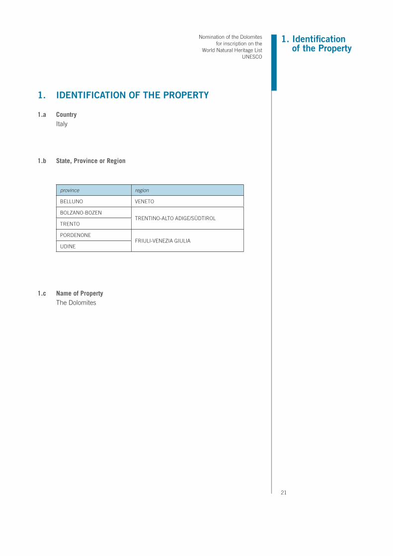
1.a CountryItaly
1.b State, Province or Region
province region
BELLUNO VENETO
BOLZANO-BOZENTRENTINO-ALTO ADIGE/SÜDTIROL
TRENTO
PORDENONEFRIULI-VENEZIA GIULIA
UDINE
1.c Name of PropertyThe Dolomites

22
WG
S 19
84 U
TMW
GS
84
Syst
ems
zone
East
ing
Nor
thin
gLa
titud
eLo
ngitu
deP
rovi
nce
Reg
ion
1. P
elm
o-N
uvol
au33
2782
9951
4781
3N
12°
6’49
”E
46°2
6’52
”B
ellu
noVe
neto
2. M
arm
olad
a32
7193
5751
4615
9N
11°
51’2
3”E
46°2
5’54
”Tr
ento
Bel
luno
Tren
tino-
Alto
Adi
ge/
Sudt
irol V
enet
o
3. P
ale
di S
an M
artin
o Sa
n Lu
cano
-
Dol
omiti
Bel
lune
si –
Vet
te F
eltr
ine
33 -
32
7307
9551
2587
2N
11°
59’3
9”E
46°1
4’51
”Tr
ento
Bel
luno
Tren
tino-
Alto
Adi
ge/
Sudt
irol V
enet
o
4. D
olom
iti F
riula
ne/D
olom
itis
Furla
nis
e d’
Oltr
e P
iave
3330
7907
5135
574
N 1
2°30
’13”
E 46
°20’
48”
Por
deno
ne,
Udi
neB
ellu
noFr
iuli
Vene
zia
Giu
lia V
enet
o
5. D
olom
iti S
ette
ntrio
nali/
Nör
dlic
he
Dol
omite
nCad
orin
e, S
ett S
ass
3328
2765
5166
052
N 1
2°9’
47”
E 46
°36’
47”
Tren
to,
Bol
zano
Bel
luno
Tren
tino-
Alto
Adi
ge/
Sudt
irolV
enet
o
6. P
uez-
Odl
e / P
uez-
Gei
sler
/ P
öz-O
dles
32
7149
5551
6490
7N
11°
48’2
4”E
46°3
6’13
”B
olza
noTr
entin
o-A
lto A
dige
/Sud
tirol
7. S
cilia
r-C
atin
acci
o / S
chle
rn-
Ros
enga
rten
- L
atem
ar32
6997
1451
4817
7N
11°
36’1
0”E
46°2
7’16
”Tr
ento
, B
olza
noTr
entin
o-A
lto A
dige
/Sud
tirol
8. R
io d
elle
Fog
lie/B
lette
rbac
h32
6862
1251
3689
0N
11°
25’1
4”E
46°2
1’37
”B
olza
noTr
entin
o-A
lto A
dige
/Su
dtiro
l
8 D
olom
iti d
i Bre
nta
3264
6797
5114
047
N 1
0°54
’9”
E 46
°9’5
1”Tr
ento
Tren
tino-
Alto
Adi
ge/S
udtir
ol
1.d Geographical coordinates to the nearest second

Nomination of the Dolomites for inscription on the
World Natural Heritage List UNESCO
23
1. Identification of the Property
1.e Maps and plans, showing the boundaries of the nominated property and buffer zone

24

Nomination of the Dolomites for inscription on the
World Natural Heritage List UNESCO
25
1. Identification of the Property

26
1.f Area of nominated property (ha.) and proposed buffer zone (ha.)
Systems CORE zone BUFFER zone TOTAL (ha)
1. Pelmo-Nuvolau 4.581,756 4.048,334 8.630,09
2. Marmolada 2.207,610 577,973 2.785,58
3. Pale di San Martino-San Lucano – Dolomiti Bellunesi – Vette Feltrine
29.401,708 26.648,757 56.050,46
4. Dolomiti Friulane/Dolomitis Furlanis e d’Oltre Piave
19.233,967 27.843,432 47.077,40
5. Dolomiti Settentrionali/Nördliche DolomitenCadorine, Sett Sass
52.252,031 26.860,222 79.112,25
6. Puez-Odle / Puez-Geisler / Pöz-Odles 7.834,938 2.896,884 10.731,82
7. Sciliar-Catinaccio / Schlern-Rosengarten - Latemar
8.991,473 4.887,707 13.879,18
8. Rio delle Foglie/Bletterbach 271,610 547,428 819,04
9. Dolomiti di Brenta 11.135,844 4.201,197 15.337,04
Total area (ha) 135.910,936 98.511,935 234.422,87

27
28
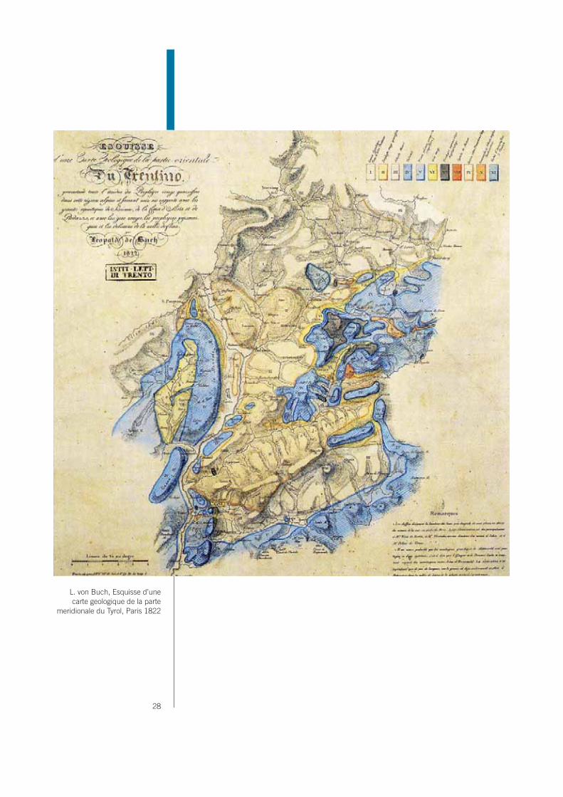
L. von Buch, Esquisse d’une carte geologique de la parte
meridionale du Tyrol, Paris 1822

2. Description of Property
Nomination of the Dolomites for inscription on the
World Natural Heritage List UNESCO
29
2. DESCRIPTION OF PROPERTY
IntroductionIn the eyes of the world the history of the Dolomites began with their “discovery” to-wards the end of the XVIIIth century, a vital period for the development of science and western culture.
Two key dates can be connected to their scientific discovery.The first is 1789, the year in which Deodat de Dolomieu identified the peculiarities of the mineral which makes up these mountains, to be named “Dolomites” in his honour a few years later by Nicolas de Saussure (son of Horace Benedict), who analysed them in a laboratory. The second was in 1822, the year in which Leopold von Buch stayed for a long time in these mountains to study their “strange” stratigraphy, summoning his friend Alexander von Humboldt, considered to be the best scholar of his time. The relationship and reports of these eminent scientists were not only important for science since they were also prominent cultural figures in XIXth century Europe. Thanks to their “universal spirit”, they were the first to grasp the intrinsic beauty of the geological and geomorphological peculiarities of these mountains, as is evident from their writings. Before the romantic aesthetic took hold, so important for the definition of the concept of natural beauty in western culture, the peaks of the Dolomites were not minimally considered, although always visited by painters and cultural figures. Thus the aesthetic importance of the Dolomites began to be recognised with the dissemination of scientific discovery, but was further popularised a few years later with the first travel books.
F. Dantone, traveller and alpine guides at Santner pass (about 1870)

30

2. Description of Property
Nomination of the Dolomites for inscription on the
World Natural Heritage List UNESCO
31
J. Ball, The Dolomite Alps of South Tyrol (1868)

32
This passage is recorded by two important events. The first was in 1837, the publication date of the first guidebooks specifically aimed at travellers and explorers: Murray’s handbook, published in London by John Murray and “Reisehandbuch durch Tirol” by Beda Weber. In these travel manuals, the “dolomite mountains” are described as unequalled, attracting the attention of the first English and German travellers. The second was in 1864, the year the travel log of the Englishmen J.Gilbert and G.C.Churchill, entitled “The Dolomite Mountains”, was published. The success of this popular book, pre-sented the mountains to the public at large and extended the name “Dolomites” from the mineral to describe the whole region. Alpine literature contributed to the universal adoption of the name Dolomites, not only in common use but also for official cartography, with the guide “The Eastern Alps” by J.Ball in 1868.
Thus the Dolomites can be perfectly interpreted both scientifically and aestheti-cally and therefore their nomination is deliberately proposed under criterion viii and criterion vii simultaneously. As the history of their discovery explains, these two criteria are indissolubly linked, just as the tie between scientific interest and love of natural beauty of their “discoverers” is inseparable.
2.a.1 The GEODIVERSITY of the Dolomites
A specific and important characteristic of the Dolomites consists in their geodi-versity. This concept first appeared in Australia (especially in Tasmania) in 1991 (Sharples, 1995), during an international congress on geoconservation, and re-ceived wide recognition, even if it was not always perfectly understood. This con-cept has not yet been properly developed in methodological terms and in the ap-plied field. In addition, some examples in different geological contexts (latu sensu)are shown which pinpoint the complexity and, sometimes, the ambiguity of this term (Barthlott & al.,1996; Dixon, 1996; Eberhard, ed., 1997; Erikstad, 1999; Gray, 2004; Zwolinski, 2004; Piacente & Coratza, ed., 2005). Some definitions of geodiversity are here summarised. They underline the complexity and difficul-ties in defining this concept a priori and, in particular, in applying it (Panizza & Piacente, 2007).
“intrinsic” geodiversity = on the basis of the geological complexity (l.s.) of the study area;
“extrinsic” geodiversity = in relation to geological differences (l.s.) compared with other areas;
“simpler” geodiversity = refers to the total range of geological objects (l.s.) in a given territory;
“broader” geodiversity = refers to particular geosystems, that are in themselves diverse or complex;
geodiversity assessed in a different way, according to the “scale” of analysis: global, regional or local;
geodiversity with a “subjective” criterion, i.e. based on some specific geological objects (l.s.).

2. Description of Property
Nomination of the Dolomites for inscription on the
World Natural Heritage List UNESCO
33
As regards the Dolomites, when considered on a global scale, they have specific geological, geomorphological and landscape characteristics which distinguish them from all other mountains in the world: i.e., they have greatly accentuated “extrinsic geodiversity” on a global level. Also on a regional level and in relation to morphostructural landforms, the Dolomites have a high degree of extrinsic geodi-versity compared with other alpine mountains. This is particularly true with respect to morphotectodynamics (relief energy, fault scarps, morphoneotectonic evidence etc.), morphotectostatics (fault-line valleys, slopes more or less inclined accord-ing to the tectonic dip of strata, rock towers isolated by fracture lines etc.) and morpholithology (steep dolomite walls overlying mild slopes in arenaceous-clayey materials, terraces or steps in correspondence with particular rock types etc.). Furthermore, when observed all together, they are very complex stratigraphically (from the Permian to the Cretaceous), lithologically (prevalently dolostones, but also limestones, sandstones, porphyries, lavas, gypsum etc.) and geomorphologi-cally (mostly climatic landforms: glacial, periglacial, fluvial etc., relict, dormant or active). Therefore, they also have greatly accentuated “intrinsic geodiversity” on a regional scale. Nevertheless, when the petrographic, stratigraphic and paleon-tological features of certain geological formations such as Dolomia Principale or San Cassiano Formation, are examined in detail, characteristics of accentuated uniformity (i.e. low intrinsic geodiversity) can be noticed in the whole Dolomite area. Moreover, the same uniformity is observed in certain types of landforms (talus cones and scree slopes). Therefore, for a certain typology of “geological ob-jects” on a regional scale, these mountains show limited “intrinsic geodiversity”. On the contrary, if other categories of “geological objects” are taken into account, as, for example, landslides, they show, still on a regional scale, a considerable complexity of types, causes, ages, lithology, movement, extent etc.; that is they have greatly accentuated “intrinsic geodiversity”. Another example is offered by karst areas: they display in detail a vast array of landforms, that is, consider-able intrinsic geodiversity on a local scale. These examples confirm that, although geodiversity is assumed as a basic principle for understanding and appraising geological (and geomorphological) heritage, the debate on its definition is still at an early stage and requires further contributions and reflections. Furthermore, whatever may be the specific meaning of this term, diverse geodiversity charac-teristics (Plate “A”) lead to an integration of the concept of geoheritage. For all these reasons, the Dolomites can be considered as a high-altitude field labora-tory for research, education and development of geological and geomorphological theories and understanding.

34

2. Description of Property
Nomination of the Dolomites for inscription on the
World Natural Heritage List UNESCO
35

36
2.a.2 Geology
IntroductionThe peculiar scientific importance of the Dolomites is rooted in the uniqueness of their depositional history. These few pages try to unravel and synthesize the complexity of this geological evolution, which is however far from being fully fathomed, despite more than two centuries of research, briefly synthesised in the following chapter. The fascinating complexity of the region prompts further research, made attractive by the spectacular preservation of seismic-scale depositional geometry and sedimentary facies, framed within a bio-isotopic chronology boasting an unrivalled accuracy for the Triassic. The easily accessible region is made attractive for research also by its accurately witnessing the Permo-Triassic mass extinction, Mesozoic palaeo-biological trends, Alpine tectonic structures and Quaternary landforms. The Dolomites belong to the Alpine Chain and correspond to a comparatively gently tectonised part of the Southern Alps. This Italian portion of the Alps derived from the structural shortening of a Mesozoic passive conti-nental margin of the Tethys Ocean. The Jurassic extensional thinning and breaking up of the continental crust were forerun by several pulses of Permo-Triassic deformation and magmatism, involving crustal structures generated by the Carboniferous Variscan Orogeny. The Middle Triassic transtensive deformation is particularly noteworthy for its casting a mark of uniqueness into the Dolomites geological landscape, by inducing fast subsidence and intense magmatism, matched with the fast growth of carbonate islands. Subsidence pulses controlled the growth of several independent carbonate platforms generations, surrounded by deep water basins, which were soon to be filled by large volumes of volcanic, volcaniclastic and terrigenous sediments. The sharp contrast be-tween the light-coloured, carbonate platform walls and the dark-hued, basin sediment slopes provides a key contribution to both the aesthetic and scientific fascination of the mountain range. The multilingual nature of both the geological publications and the toponyms of the Dolomites region, where German, Italian and Ladin languages overlap, makes the stratigraphic terminology complex. In the following discussion, some Ger-man and Italian terms are used, without seeking any terminological exhaustivity.
Simplified, North-South geologic cross-section through
the Dolomites Region. BSS – Metamorphic basement; P – Middle to Upper Permian
formations; WEN – Wengen Fm.; BHL – Contrin Fm. and Ladinian-
Carnian basinal successions (Buchenstein Fm., Wengen Fm.,
S. Cassian Fm.); V – volcanic rocks; SCI – Ladinian-Carnian
carbonate platforms; TVZ – Travenanzes Fm.; DPR – Dolomia
Principale.(from Castellarin 1982)

2. Description of Property
Nomination of the Dolomites for inscription on the
World Natural Heritage List UNESCO
37
The Palaeozoic evolution from the pre-Variscan sea to the Permian magmatism and sedimentation.The Dolomites area can be schematically subdivided into an eastern and a west-ern portion, recording different tectonic, stratigraphic, burial, and thermal evolu-tions. The western portion records repeated massif episodes of magmatism and subsidence confined to specific time intervals, while the eastern areas record a continuous and larger subsidence. The crustal structures separating these two areas run roughly along the Badia and Cordevole Valleys and have been active since Palaeozoic times. During the Early Palaeozoic, terrigenous marine sedimen-tation took place in passive continental margin settings, providing protoliths for the Late Palaeozoic collisional metamorphism that shaped the Dolomites base-ment. In Carboniferous times (about 330 Myr B.P.), the area was involved into the climax of the Variscan ductile deformation and then uplifted and eroded down to the greenschist basement level. Scattered immature conglomerate bodies then accumulated into incised valleys (Conglomerato di Ponte Gardena). Dur-ing the late Early Permian, transtensive stress induced fast subsidence, within pull-apart structures, in the western Dolomites. These subsiding areas were filled by large volumes of contemporaneous volcanites, dominated by riodacitic ign-imbrites (Bozen Porphyrites = Complesso Porfirico Atesino, sometimes exceeding 2 km in thickness. Volcanic activity started into the graben axis and then spread out, conquering almost the whole of the western Dolomites. Continental deposits are locally intercalated to the volcanites, preserving the oldest known reptile fos-sil from the area. Granitoid masses were in the meanwhile largely intruded into
Lithological sketch representing the geometric relationships between geological units in the Dolomites area. Abbreviations used in the drawing, in alphabetic order:ADZ: Zoppè Sds; ANG: Angolo Lms; ARV: Ammonitico Rosso Veronese;BEL: Bellerophon Fm; BIV: Mt. Bivera Fm; BRE: Breno Fm; BSS: Metamorphic basement; CG: Calcari Grigi;CTR: Contrin Lms; DAH: Dachenstein Lms; DAD: Gracilis Fm; DCS: Cassian Dm; DON: Dont Fm; DPR: Dolomia Principale;FPP: Ponte Pià Fm; g: granites; GAR: Val Gardena Sds; HKS: Heiligkreutz Fm; LVN: Livinallongo/Buchenstein Fm; IGN: Igne Fm; IMF: Mt. Fernazza Ignimbrites; MAI: Maiolica;MRB: Morbiac Fm; NTR: Mt. Rite Fm; OOV: Vajont Lms; PTA: Ponte Arche clays; PUE: Puez marls; RIC: Richthofen Cgm; SAA: Scaglia Rossa Fm; SCI: Sciliar Dm; SCS: San Cassiano Fm; SOC: Soccher Lms; SLO: Selcifero Lombardo;SOV: Soverzene Fm; TOF: Tofino Fm; TVZ: Travenanzes Fm; V: Ladinian volcanics; Vp: Permian porphyries; WEN: Wengen Fm;WER: Werfen Fm; ZUU: Zu Limestones;

38
adjacent upper crust volumes (Cima d’Asta and Bressanone-Brixen intrusions). Hydrothermal circulation generated spectacular crystal aggregates and some sul-phite ore accumulation. The uplifted eastern Dolomites stayed in the meanwhile unaffected by magmatism. During the Late Permian, moderate extension induced the starting of the stratigraphic cover accumulation. A comparatively faster sub-sidence was now registered in the eastern portion of the Dolomites. The relative sea-level increase was initially compensated by continental sedimentation, but repeated westward transgressive pulses then developed, eventually leading to shallow marine environments being developed almost throughout the Dolomites. The early continental deposits (Groedner Sandstein = Arenarie di Val Gardena) witness the evolution from fan conglomerated to braided and meandering river sandstones, and eventually to arid coastal plain sediments. Reptile foot-print as-sociations and plant remains are nicely preserved within this successions (e.g. Butterloch Gorge), providing a valuable insight into late Permian continental life. Transgression then induced marine sulphate sedimentation, dominating the lower and western portions of the latest Permian formation (Bellerophon Fm). A normal salinity, marine carbonate unit then progressively accumulated, ranging from a few to more than 200 m in thickness. This unit records an eastward dipping cal-careous ramp, dominated by micritic muds and loose bioclastic materials. The regions to the west of the Adige Valley remained under continental conditions into the Early Triassic, and therefore they lacks any Permian carbonate.
The Early Triassic evolution of a terrigenous carbonate ramp after the P/T mass extinction.Early Triassic subsidence rates were between 50-100 m/Myr, with a comparatively uniform distribution through time and space. Sedimentation was able to compen-sate this rate and therefore the region stayed near sea-level into the early Middle Triassic, recording major bio-evolution and palaeo-environmental change. The Permo-Triassic Boundary is marked by the most severe mass extinction of the en-tire Phanerozoic, very well documented by the classical outcrop of the region (e.g. Tesero, Bulla). The extinction event dramatically impacted on the biological com-munities, largely affecting the carbonate production dynamics. In the Dolomites, carbonates continued nevertheless to accumulate across the boundary at similar rates, preventing any significant chronological gap from being developed. The Early Triassic (Induan and Olenekian) is recorded by loose carbonate-terrigenous, storm dominated ramp deposits (Werfen Fm, ranging from 300 to 500 m, where uncut by the Anisian erosion), punctuated by peritidal and emersion episodes, under arid conditions (e.g. Andraz Mb). The ramp system dips toward eastern areas. During the earliest Triassic, trans-gressive oolites (Tesero Mb) gave way to loose micritic muds (Mazzìn Mb), with strongly oligotypic faunae. Bioturbation too was scanty. Mollusc diversification then gradually increased (Siusi-Seiser Mb), and ooids reappeared (e.g. Gastro-poden Oolit and Cencenighe Mb.s). During the Early Triassic, the carbonate frac-tion was always dominated by loose calcareous muds and mollusc bioclasts, ce-
Comelicania haueri (Stache), a typical Permian brachiopod
A typical faunal association of the Cencenighe Mb: Dinarites dalmatinus
(Haver), on the left, and Natiria costata Münster, on the right
Claraia clarai (Emmrich), a classical bivalve characterizing
the Werfen Formation

2. Description of Property
Nomination of the Dolomites for inscription on the
World Natural Heritage List UNESCO
39
mentation was scanty and bioconstructions absent. Throughout the Early Triassic, carbonate dominated phases alternated with episodes of increased terrigenous input, often associated with transgressive phases (e.g. micaceous silt-rich Campil Mb, Olenekian).
The Middle Triassic dynamic tectonic framework and the carbonate platform de-velopment.The Middle Triassic is characterised by the spectacular development of the car-bonate platforms so strongly marking the Dolomites geological landscape. Late diagenetic dolomitisation affects the majority of these platforms, but several large carbonate bodies escaped this fate, especially between the Anisian-Ladinian pre-volcanic ones. During the early Anisian, a wholly carbonate ramp formation accumulated (Lower Serla Fm), recording again an eastward bathymetric deep-ening and increase in thickness (50-200 m). The early Anisian phase of deforma-tion calm gave way to the tectonic reactivation of Permian structures, inducing a complex pattern of up-lifting and downward movements. The eastern Dolomites carbonate systems were unable to compensate the subsidence pulses and sev-eral generations of, independent platforms developed, surrounded by deepen-ing basins. Each platform generation records fast progradation, but the different sequences are separated by subaerial erosive discordances and transgressive back-jumping of the shallow water carbonate systems. Subsidence was initially fast only in the central portion of the eastern Dolomites, were the first generation of platforms developed, then it slowed down, while spreading across the eastern
Composite sequence of the uppermost Bellerophon Formation – Sass de Putia section – and lower Werfen Formation – Tesero section – (from Broglio Loriga et al., 1986; Neri et al., 1986, modified). Key legend: a) bioturbated marly limestone; b) limestone; c) marl; d) intraclastic limestone; e) oolitic limestone; f) bioclastic limestone with algae and forams; g) silty and arenaceous bioturbated dolomitic limestone; h) ostracod; i) fenestrae. (modified from Posenato, 1988).

40
Dolomites, during deposition of the second generation. Correlatable sequences of platforms grew at the west of the Adige Valley, within a subsiding framework. In the meanwhile, uplifting pulses were on the contrary affecting the western Dolo-mites, which at the time largely lost their Lower Triassic cover, through subaerial erosion, which even reached the basement in southerner regions.The first generation of Dolomites platforms (Mt Rite Fm, 245 Myr) appears to provide the oldest high relief buildups known from the entire Tethyan realm, after the Permo-Triassic mass extinction. These buildups show hardened margins and clinostratified slope units, with dip angles of up to 10-15°. Biota were diversified and rich in green algae. The following generation of platforms (Upper Serla Fm) rapidly prograded, forming tabular bodies, with thickness of about 50-100 m. Margin reef bodies show automicritic facies, pervasive phreatic cements, and
Cross-section of the Catinaccio/ Rosengarten. Reconstruction of the original stratigraphical
relationships before recent erosion. The Sciliar Dolomite is
constantly clinostratificated and show a progradation of many kilometres towards the Fassa Valley. The northern part (Re
Laurino, Vajolet Towers) has a horizontal stratification. It is also
notable the increase in thickness, rightward, of the Buchenstein
Formation. (Modified from Bosellini, 1996).

2. Description of Property
Nomination of the Dolomites for inscription on the
World Natural Heritage List UNESCO
41
encrusting organism. Corals are rare but noteworthy for their providing the oldest known occurrence of similar Cnidaria.In the late Anisian (about 239 Myr), the whole of the Dolomites was involved into fast subsidence. Basinal environments conquered the largest part of the eastern Dolomites, while a new generation of carbonate platforms (Contrin Fm) and an-oxic basins (Moena Fm) colonised the western half of the region. The platform thickness normally ranges between 50 and 150 m, but it can locally reach 500 m. Platform-top units consist of peritidal stromatolites and subtidal micrites, flanked by large clinostratified (15-20°) slope bodies. The palaeo-botanical content of the coeval basinal successions witness fast fluctuations toward moist climatic phases, within a palaeoclimatic framework globally dominated by aridity conditions. Dur-ing latest Anisian times, the subsidence further speeded up, climaxing at the extraordinary high value of about 1000 m/Myr. The entire Dolomites area was drown into deep-water anoxic environments (Plattenkalke Mb of the Buchenstein Fm), but some 30 carbonate pinnacles, showing width in the kilometre order, which were able to aggrade at very high speed. Several pinnacles experienced a drowning termination (e.g. Cernera), whereas other were able to keep up with the relative sea-level rise, becoming the nuclei of much larger platform (Sciliar Fm, Latemàr and Marmolada Limestones). The pinnacles were initially characterised by subtidal platform facies, flanked by concave slopes, with maximum dip of 20-25°. The platform-top then started to experience emersion cycles, fluctuating at sub-Milankovitch frequencies (e.g. Latemar). Syndepositional cementation be-came very pervasive and the narrow margin and upper slope were now dominated
Mt. Cernera – Voltago Conglomerate over Lower Serla Dolomite

42
by automicrites and large spheroid cement concretions (so called “evinospong-iae”). Slopes became planar and reached very strong inclinations (up to 40-42°). At the ending of the fast subsidence phase, the platforms reached 7-800 m of thickness, while in the very adjacent basinal areas only 10-15 m of sediment had accumulated. This phase was matched with the maximal availability of empty ac-commodation space. Basinal oxygenation in the meanwhile improved, enabling nodular cherty limestones (Knollenkalke Mb of the Buchenstein Fm) to accumu-late, with acidic ashes intercalations (“Pietra Verde”), valuable for their providing zircon crystal suitable for accurate isotopic dating, matched with ammonoid and pelagic pelecypods faunae. Platform derived granular sediments were almost ab-sent in these pre-volcanic basins. During the early Ladinian (240-239 Myr), in the western portion of the Dolomites, subsidence slowed down to negligible values, probably because of the incipient lithosphere heating, leading to a magmatic epi-sode. The carbonate platforms were therefore able to largely prograde, for several kilometres, over the surrounding deep-water basin, producing the large, steeply clinostratified slope breccia bodies so strongly characterizing the western Dolo-mite landscape (e.g. Rosengarten-Catinaccio). Slope cement rich breccia facies were similar to the previous ones. The progradation was much faster than the basin floor aggradation and therefore the base of slope migrated in an almost horizontal way. During the late Anisian and early Ladinian, in the Adige Valley and
Overlapping of volcaniclastic sediments over the flanks of a
late Anisian carbonate platform (Sciliar Dolomite) – Mt. Cernera

2. Description of Property
Nomination of the Dolomites for inscription on the
World Natural Heritage List UNESCO
43
in the Brenta areas, subsidence was fast, but not at the extreme values recorded in the Dolomites. Large shallow-water and peritidal platform systems therefore developed, producing well stratified units (e.g. Dolomie della Val d’Adige), the basinal deposits being confined to limited areas.
The Ladinian magmatism and environmental modification.During the middle Ladinian, volcanism engulfed the western Dolomites, largely perturbing the carbonate platform growth. The short-lived magmatism of the Do-lomites was part of a much longer-lasting magmatic activity, migrating through Austro-Southern Alpine and Po Plain areas, from Anisian to Carnian times, during about 15 Myr. In the Dolomites, the onset of the magmatic activity was matched with important ecological modifications. The large cement concretions disap-peared, while sponges, small encrusting problematica and automicritic facies started to dominate the margin and slope facies. Basaltic successions exceed-ing one km in thickness accumulated, mainly into submarine environments. The magmatic activity rapidly accumulated thick volcanic and volcanoclastic succes-sions, infilling large portions of the inter-platform basins. In the western Dolomites, magma rose up along inherited structures from the Permian extension and a few small bodies were intruded at shallow depth (Predazzo and Monzoni intrusions). Magmatic differentiation and interference between magma sources produced a great variety of intrusive lithologies, ranging from pyroxenites to alkaline granites, within small intrusive bodies. Thermo-metamorphism of Permo-Triassic rocks and hydrothermal alteration produced a great variety of peculiar minerals, which has made the western Dolomites a renowned area for museums and mineral collectors. During the early stage of volcanism, thermal dehydration of Permian gypsum prompted pseudo-diapiric deformation at the carbonate platforms edge, triggering the accumulation of chaotic megabrecciae (Caotico Eterogeneo Fm). At a later magmatic stage, large calderic collapsing occurred (Predazzo area). The eastern Dolomites and the Adige Valley areas were not directly affected by the volcanism. The deep water, eastern Dolomites Basin however received large volumes of resedimented volcanoclastic, following an episode of terrigenous sand turbiditic sedimentation (Arenarie di Zoppè). In the Adige Valley, a deformation phase is documented by uplifted blocks and angular unconformities (e.g. Mez-zolombardo area).
Branching coral, San Cassiano Fm
Actinastrea coral (size 8 cm - San Cassiano Fm)

44
The growth of the post-volcanic carbonate platform and the depositional shallowing of basins.After the magmatic activity ending, subsidence was often reduced in the western Dolomites, Val d’Adige and Brenta areas, whereas it remained active in the east-ern portion of the Dolomites, were speeds of about 200 m/Myr were recorded. The post-volcanic platform therefore prograded in still-stand condition in some western areas, with moderate aggradation in the majority of the Dolomites. The basins were now often fed by large amount of volcaniclastic sediments and there-fore basin floor depositionally aggraded, forcing the platform base of slope to migrate in a climbing way. The whole of the post-volcanic platforms is affected by a pervasive late diagenetic dolomitisation, significantly limiting the facies analy-sis potential. Some primary features are however visible within the dolomitised platform bodies (e.g. Sella Platform) and very well preserved facies are found in platform-derived olistoliths (so called Cipit Boulder, buried within argillaceous basinal units. Margin and slope facies remained similar to the synvolcanic ones. Slope clinostratifications were less steep (25-35°) than in the pre-volcanic plat-forms, showing concave geometry in their lower portions. Base of slope units were well supplied in bio-intraclastic calcarenites. Resediment loose calcarenitic and micritic sediments were now able to reach the adjacent basins (Bänderkalke, up-per Mb of the Buchenstein Fm; and Acquatona, Fernazza and S. Cassiano Fms), which also record the reappearing of ooid grains, that were absent in the region since the Lower Triassic. Terrestrial plant debris also reappears in these basinal deposits, witnessing moist climatic conditions and a northward shift of the ter-rigenous shoreline. In many areas, the post-volcanic platforms can be subdivided into two bodies (Cassian 1 and 2) by the recognition of a sharp discordance surface. The lower-middle portions of the slope palaeosurface were onlapped by basinal terrigenous beds, almost completely deprived of platform derived carbonates and enriched in continental plant debris, suggesting a period of almost total interruption of the carbonate platforms growth. The two platform generations shear many sedimen-tary facies similarity. The younger portions are however often enriched in stro-matoporoids and coral fragments. The massive progradation of these platforms,
Hypothetical geologic cross-section of the Western Dolomites during
Upper Ladinian. A volcanic edifice, comparable in size with actual
Vesuvio, was emerging from the water in the Marmolada / Monzoni area and it was rimmed by a series of small reefs, the so called fringing
reefs. On the bottom of the sea, covered by a large amount of lavas, hialoclastites and other submarine
volcanic products, was laying, within the caldera collapsed, the pre-
volcanic sedimentary succession, dismembered and contorted. BSS
– metamorphic basement; CPG – Ponte Gardena Conglomerate;
Vp – quartziferous porphyries; GAR – Val Gardena Sandstone; BEL – Bellerophon Fm.; WER – Werfen
Fm.; CTR – Contrin Fm.; BHL – Buchenstein Fm.; SCI – Sciliar
Dolomite; IMFa – M. Fernazza Fm, chaotic megabreccias and polygenic
breccias; IMF – M. Fernazza Fm, hialoclastites; V – vulcanites in
general. (Modified from Bosellini, 1996).

2. Description of Property
Nomination of the Dolomites for inscription on the
World Natural Heritage List UNESCO
45
associated with the strong aggradational evolution of the well sediment fed ba-sins progressively filled the inherited accommodation space, while subsidence was slowing down. During the post-volcanic evolution, the Adige Valley area was almost deprived of subsidence and mainly stayed under subaerial conditions, developing deep karst structures.The middle Carnian sediment record a major change in the carbonate facies ar-chitecture, associated with the demise of the high relief rimmed platforms and the accumulation of shallow-water loose terrigenous-carbonate sediments, witnessing the last Eastern Dolomites marine areas (Heiligkreuz Fm). These shallow water sediments colonised the form basin centre areas, while the previous carbonate platform emerged, witnessing a downward shift of the relative sea-level. The for-mation base is matched with a level of organic enrich claystones, with fresh wa-ter influences and strongly impoverished faunae. The following on the contrary record the growth of carbonate biostromes, with much diversified palaeontologi-cal associations, witnessing the appearing of the first “modern” colonial corals. No large reefs were however able to develop, and the unit grades upwards into peritidal dolomites, in turn capped by terrigenous-carbonate arenites, followed by a last carbonate unit. The arenitic unit is particularly noteworthy for its bearing some of the oldest known and better preserved ambers, preserving an extraordi-nary number of previously unknown micro-organism. This formation also bears important tetrapod foot-prints. The complete filling-up of any accommodation space correspond to a sharp emersion discordance. Tectonic reactivation was however soon matched with a renewed subsidence in the Dolomites, associated with the uplifting of metamorphic and Permian intrusive units in southern areas. Sedimentation was dominated by reddish continental and marginal marine clays, sandstones, conglomerates, sulphate evaporites and some dolomite beds (Trave-nanzes Fm, previously known as Raibl Fm). Sedimentation restarted also in the Adige and Brenta area, grading into peritidal dolomites that were to characterise a large portion of the Norian and Rhaetian, in the Brenta and Dolomites areas.
Geologic cross-section at the Ladinian-Carnian boundary. After the dismantling of the Marmolada / Monzoni volcanic edifice and the partial levelling down of the submarine morphology done by the Marmolada Conglomerate and by the Wengen Fm, on the highest points coral communities started up again. New carbonate platforms developed (Cassian Dolomite), this time prograding on shallower basins. WEN – Wengen Fm and Marmolada Conglomerate; SCS – S. Cassian Fm; DCS – Cassian Dolomite. (Modified from Bosellini, 1996).

46
The Late Triassic carbonate platforms and basinal systems.The middle Carnian phase of subsidence quiescence and filling-up of the ac-commodation space was followed by the starting of a long-lasting extensional deformation, eventually leading to the Jurassic break-up of the continental crust and to the opening of the Tethyan Ocean. The chronological framing of the thick Upper Triassic carbonate successions is often made poor by the lack of significant biostratigraphic fossil taxa and by the pervasiveness of the digenetic alteration, but the general evolutionary framework of the region is clear.In the Dolomites region, the Late Triassic (late Carnian, Norian and Rhaetian) extensional strain rate was moderate, the subsidence comparatively and the shal-low water carbonate sedimentation was therefore always able to counterbalance the creation of accommodation space. Persistent peritidal systems developed for a long period of time, recorded by thick dolomitic successions, showing well de-veloped stromatolitic inter-supratidal levels and poorly diversified subtidal faunae (Dolomia Principale). Reptile footprints are spectacularly preserved within shal-low water dolomites (e.g. Mt Pelmetto and Tre Cime di Lavaredo/Drei Zinnen). Subsidence rates were reduced in the western Dolomites, were only 250 m of peritidal dolomites accumulates (Sella Group, while they were four times larger in the Brenta and Eastern Dolomites areas. The landscape of the latter areas is largely dominated by theses well bedded dolomitic successions, as in the Cortina (e.g. Tofane Group) and in the Brenta areas. In palaeogeographic areas surround-ing the Dolomites (Austroalpine units, Friuli, Bellunese, Giudicarie, and Lake Iseo area in Lombardy ) the subsidence was much faster and the Upper Triassic suc-cession can locally exceed 4 000 m in thickness. In these rapidly subsiding areas, the shallow water carbonate sedimentation was often unable to keep pace with the fast relative sea-level increase and deeper water intraplatform basinal carbonates accumulated, generally under dys-anoxic conditions, producing potential source rocks for hydrocarbons. During the Norian Time, a moist climate phase devel-oped, associated with a strong argillaceous input, in western areas (Lombardy), recorded by thick terrigenous-carbonate successions, only marginally developed at the very border of the examined area (e.g. Grostè and Val Manèz in the Brenta Dolomite). In the late Rhaetic, any terrigenous input stopped and the subsidence was comparatively reduced in speed and uniform in space. The largest portion of the region returned in shallow water carbonate conditions, soon to experience a renewed phase of spectacular environmental modifications.
View of the west side of the Tofana di Rozes peak. The cliff is
entirely of Dolomia Principale

2. Description of Property
Nomination of the Dolomites for inscription on the
World Natural Heritage List UNESCO
47
The Jurassic: from shallow water platforms to oceanic radiolarites.Near the Triassic-Jurassic Boundary, a renewed phase of palaeogeographic dif-ferentiation developed, induced by spatial trends of subsidence reactivating the Late Triassic ones. This extensional deformation foreruns the entire Jurassic evo-lution of the Adria (Africa) passive continental margin. The evolutionary trend led from emerging carbonate areas to deep water oceanic environments, without any volcanic activity being developed, in sharp contrast with the magmatic active Triassic. During the early Liassic (Hettangian Time), shallow subtidal, peritidal and emerging environments survived in the Dolomites, Trento and Brenta areas (lower portion of the Calcari Grigi Fm and correlative stratigraphic gaps), while the adjacent rapidly subsiding regions experienced a deepening evolution, leading to the accumulation of basinal facies. The large Trento Platform was therefore now flanked by large deep water depressions (Lombardy and Belluno Basins, were the Soverzene, Tofino and Medolo Fm.s accumulated), expanding over pro-gressively drowned areas and receiving large amount of micritic muds, from the surviving shallow water carbonate factories. Direct faulting controlled the develop-ment of steep sub-aqueous scarps, associated with large scalloped detachment niches and basinal megabrecciae, both at the west and east of the Dolomites (e.g. Schiara Fm, Breccie del Pelf). Lower Liassic, comparatively thick shallow water successions are visible in the eastern Dolomites, forming the topmost por-tion of several massif (e.g. Pelmo, Fànes), whereas a coeval stratigraphic gap is recorded in the western portion of the region (Sella Massif). Major reptile footprint ichnological sites are developed in this unit (es. Lavini di Marco), spectacularly recording the living behaviour of continental dinosaurs in carbonate platform envi-ronments. During the following Liassic time (Sinemurian) the Dolomites and Bren-ta areas were conquered by deep water environments (e.g. Encrinite di Fànes), while subtidal oolitic environment developed on the surviving portion of the Trento Platform (Calcari Grigi: Loppio Fm), which was able to keep up with the relative sea-level rise for a further time (Pliensbachian; Calcari Grigi: Rotzo Fm), subject to some argillaceous influx, which was significant also in the adjacent basinal areas (e.g. Belluno Basin Igne Fm). Environmental stress then dumped the carbonate production of the shallow water factory (Toarcian) and even the Trento Platform experienced a deepening phase (Tenno Fm), followed by a last oolitic body (Oo-lite di San Vigilio Fm) in the western portion of the area, while a stratigraphic gap developed in the eastern portion of the Platform and in the Dolomites area. During this time (Toarcian) a generalized anoxic event triggered the deposition of organic-rich black shales in basinal areas (e.g. Belluno region). Any shallow water sedimentation was then terminated by an eventual generalized drowning event. Shallow water carbonate producing environments were able to survive only in the easternmost portion of the Southern Alps (eastern Friuli and Slovenia), far away from the Dolomites. The largest portion of the Southern Alps continental margin area was therefore severely starved of sediment and condensed horizons therefore slowly accumulated, both in the former basinal and platformal areas. Any sedimentation was by now able to compensate the subsidence and a further

48

2. Description of Property
Nomination of the Dolomites for inscription on the
World Natural Heritage List UNESCO
49
Gran Fanes, Sass dai Bec

50
deepening evolution therefore took place. Thin units of condensed nodular red limestones therefore accumulated, very rich in ammonites, accumulated onto the drowned? Trento and Dolomites plateau areas, during Dogger and Malm times (Bajocian-Bathonian Lower Rosso Ammonitico and Kimmeridgian-Tithonian Up-per Rosso Ammonitico, separated by a widespread hiatus). Ammonite bearing site are well known also in the Dolomites (e.g. Ra Stua near Cortina), where for-mation of this age are only locally preserved from the Quaternary erosion only at limited spots. In the meanwhile, the eventual break up of the continental crust took place in adjacent oceanic areas. The progressive deepening and the ocean water chemical modification brought large sea-bottom portion bellow the arago-nite compensation depth, in the Belluno Basin area (Fonzaso Fm) and even be-low the Carbonate Compensation Depth, leading to radiolarites deposition in the Lombardy Basin. In the Oxfordian, the global anoxic event affected also this area. During the Late Jurassic, a massif exportation of ooids started from the eastern Southern Alps platform, triggering the accumulation of thick resedimented oolitic succession (Oolite del Vajont), filing the Belluno Basin and spreading on mar-ginal portion of the former Trento Platform, at a later stage. The oolite exportation then suddenly cessed and pelagic cherty limestones returned to slowly deposit on the top of the oolites. During the latest Jurassic, the oceanic water chemistry was largely modified and the C.C.D. lowered by the evolutionary radiation of the calcareous nannoplankton.
Cretaceous and Tertiary: from passive margin pelagites to the collisional inver-sion.The long-lasting Cretaceous Period was spent by the Dolomites and the entire Venetian Alps under deep water condition, matched with tectonic quiescence and reduced subsidence of the mature continental margin. Large portion of the Austroalpine areas, palaeo-geographically adjacent to the Dolomites, during the Cretaceous were involved into the starting of the Alpine compressive deformation. The first half of the Cretaceous is therefore dominated by light-coloured, pelagic cherty micritic limestones (Biancone), grading upward into reddish coloured, cy-clically arranged, marl-limestones alternations (Scaglia Rossa). The hemipelagic successions encompass some organic rich levels, recording global anoxic events, like the Cenomanian one. The terrigenous input was stronger in northern Dolo-mites areas, where Neocomian marls (Marne del Puez, Antruilles Fm) outcrops at a few spots, bearing spectacular ammonites faunae. The fast rising of sub-aerial relief under subaerial erosion is witnessed by the starting of the turbiditic flysh sedimentation, documented in small areas both in the Dolomites (Ra Stua near Cortina d’Ampezzo) and in the Brenta area. The Dolomites and the adjacent Southern-Alpine areas were directly involved into compressive deformation during Tertiary times. During the Palaeogene, risen tectonic blocks were recolonised by carbonate platforms, while the surrounding basins were still subject to hemipe-lagic sedimentation. Tertiary times saw the onset of important magmatic activ-ity. In the Dolomites, Tertiary units are preserved at very limited spots only, with
Ammonitico Rosso
Puez marls, heteromof Ammonoids

2. Description of Property
Nomination of the Dolomites for inscription on the
World Natural Heritage List UNESCO
51
Oligocene calclithic shallow-marine brecciae. This unit is however valuable for its suturing important overthrust structures, thus dating the first important tectonic shortening experienced by the Dolomites region. The major overthrusting phase experienced by the region is however Neogene in age, probably to be largely referred to the upper Miocene (Messinian) and was in turn followed by the devel-opment of a widespread system of high angle strike slip faults, cross-cutting the previous structures and often showing up in the geological landscape. Significant seismic activity is still active in the region, particularly in the Belluno and Friuli areas, as witnessed by the major 1976 earthquake.
2.a.3 Geomorphology
From the geomorphological viewpoint, the Dolomites are a unit made up of vari-ous mountain systems which, although being physically discontinuous in places, show a typical landscape morphogenetic unity.The geomorphological evolution of the Italian Dolomites is linked to tectonic, litho-logical, climatic and, in more recent times, anthropogenic causes. In fact, the Dolomite landscape is the result firstly of lithogenesis and orogenesis and subse-quently of morphogenesis processes, which have modelled these mountains up to the present. The result is a fantastic display of rock towers, steeples, ledges,
See Annex A.2.1.
Panoramic view of the Gardenaccia plateau. Puez marls outcrop in the two visible pyramids on the top.

52

2. Description of Property
Nomination of the Dolomites for inscription on the
World Natural Heritage List UNESCO
53

54
crests and pinnacles sometimes isolated and sometimes clustered together in fes-toons or mountain ranges which overlie mild, green slopes with pastures, forests and anthropogenic infrastructures which accentuate the contrasts. This is the landscape of a universally famous, often described and depicted mountain herit-age. Indeed, the term “Dolomite landscape” is attributed to certain mountains that can to some extent conjure up the geomorphological spectacularity of the Italian Dolomites. Calcareous and dolomite escarpments, ridges of volcanic rock, hollows in clayey soils, folded, faulted and twisted layers, talus cones and scree slopes, plateaux and small lakes, colours and shapes, light and shadow: their history is ancient, complex and fascinating. Starting from the Upper Miocene, rocks emerged from the sea and meteoric water started to flow on the new reliefs and mountains of this part of the continent and waves used to break on its coasts. Changes of temperature and humidity caused the physical and chemical weathering of rocks whereas the force of gravity, water and wind moved and redistributed debris. Little by little rocks started to be eroded, especially the least resistant clayey or marly rock types or pyroclastic deposits. Depressions and valleys formed in correspond-ence with outcrops of these weak rocks or with important tectonic displacements and related cataclastic belts. On the contrary, more resistant rock types, such as calcareous, dolomite or igneous rocks underwent a different morphogenetic evolution and gave origin to the highest mountain tops of the region. This mor-phogenesis took place in different ways and with different rhythms, also in relation with diastrophism activities and climate changes.
Sunset on Odle / Geisler

2. Description of Property
Nomination of the Dolomites for inscription on the
World Natural Heritage List UNESCO
55
The morphological configuration of the relief in the Dolomite region presents a clear relationship with the geological factors: the valleys are prevalently situated along fractures, faults, synclines, surfaces of stratigraphic or heteropic contact between diverse rock formations; the narrow passages and confluence valleys are generally determined by lithological factors; the different slope gradients are conditioned by the variety of rock types and so on. All this belongs to that branch of Geomorphology known as Structural Geomorphology.The plate A shows its diverse aspects in a schematic way. Morphotectonics (or Morphotectodynamics) studies the relationships between the relief forms and tec-tonic movements, that are the geomorphological consequences of diastrophic displacements occurring from the beginning of geohistory to date. On the other hand, Morphoselection studies relief forms in connection with selective or dif-ferentiated erosion, that it, the passive role of geological structures. If we refer to tectonic arrangement, we deal with Morphotectostatics; if, on the other hand, we refer to lithological composition, we deal with Morpholithology.With regard to Morphotectodynamics, the Dolomites are located within the belt of Alpine orogenesis: high relief energy is usually recorded, with considerable variation in height between mountain tops and valley floors. More particularly, there is evidence of active or recent tectonics as witnessed by fault planes and scarps, stream cuts, fluvial elbows, saddles, crest displacements etc., all of which provide clear scientific and educational examples. Evident examples are found in upper Val Badia (N and NE of Corvara) or in mid-Val di Fassa (N of Pera); more detailed features, such as slope furrows, are also found, like at Forcella Piccola of Mt. Antelao. Particular evidence of links between erosional, sedimentation and pedogenesis processes from a neotectonic angle can also be observed, as at Col Bechei, in Fanes Dolomites. With regard to Morphoselection, a model of some relationships between lithostruc-tural characteristics and the most typical forms of Dolomite reliefs is shown in below. There are two typical ledges, i.e. steps resulting from the alternance be-
Plate A
Morphostructural
morphotectodynamicse.g. fault scarp
morphoselection
morphotectostatie.g. fault
morpholithologye.g. karst
Morphoclimatic
relicte.g. morainic deposits, glaciopressure
recent or activee.g. talus cones, avalanche traks

56
tween rock types of different resistance (e.g., dolostones and clayey marlstones); dip-downstream and dip-upstream slopes according to strata inclination; steeples and towers, linked to faults or sub-vertical fractures. More specifically, as regards Morphotectostatics, the arrangement of the main valleys, the location of many passes and saddles and the position of some of the most sheer and majestic rock walls are determined by the trends of important displacement lines and related belts of cataclastic rocks, which facilitate weather-ing and erosional processes. Furthermore, the attitude of layers in relation to the aspect of slopes has considerably influenced slope gradients. Thus, steep slopes alternate with gentle slopes, according to the bedding of the rock types in oppo-sition or in conformity to the slopes, respectively. A fine example of morphology
Some shapes of the dolomitic relief:
1- morpholithology due to selective erosion in different rocks, with two typical steps
(cengia);2- morphotectostatics due
to the attitude of the strata; 3- morphotectostatics due to
tectonic fractures.
Sunrise on Sciliar / Schlern

2. Description of Property
Nomination of the Dolomites for inscription on the
World Natural Heritage List UNESCO
57
linked to this arrangement is offered by Lastoni di Formin, where the wide top surface reproduces the geometry of the roof of layers, whereas the opposite slope shows a steep escarpment corresponding to the transversal section of layers. An-other example is found on Marmolada, where the north-facing slope shows a mild inclination, with the strata dipping downstream with an angle equal to the slope, whereas the south-facing slope is very steep because of the dipping upstream of the strata.
Furthermore, the tabular morphology of several Dolomite tops is in most cases re-lated to a sub-horizontal dipping of the strata, as in some well known mountain groups like Sciliar, Lastoni di Formin, Sella, Gardenaccia, Alpe di Fanes and on Mt. Pelmo and Mt. Civetta. An example of relief form resulting from tectonic folds is Cima Bocche, between the San Pellegrino Pass and Valles Pass. This is an anticline fold which has affected geological formations from the Permian to the Anisian and appears partially eroded along its axial direction. As for faults, in several cases they have determined the direction of valleys and river cuts, as in the case of Funes Val-ley, Tires Valley, upper Cismon Valley and San Vigilio Valley. In addition, the presence of overthrusts has caused the formation of saddles, like those of Valparola Pass and Falzarego Pass. However, the most typical landscape is that of dolomite peaks sculpted along fractures in the form of towers, steeples, crests and pinnacles, as, for example, at Tre Cime di Lavaredo, Cime di Fanis, Croda da Lago and Cinque Torri. With regard to Morpholithology, the great variety of rock formations generates a se-ries of selective-type relief forms, with steep walls and sheer peaks in marked con-trast with milder slopes and forms. In particular, alternances of compact rock types with weaker ones or with rocks of different origin (sedimentary and igneous) or the proximity of rocks with different compositions have all created varied and contrasting morphology, characterised by mild slopes, ledges, steps, steep rock walls and uni-form mountain massifs. This is the case, for example, of arenaceous-marly slopes underlying steep walls of compact dolomite or calcareous shelves, or when marly-clayey beds are interposed between dolomite rocks. A typical example is offered by the ledge of Sella Group, where the Raibl Formation interposed between Dolomia Cassiana at the bottom and Dolomia Principale at the top shows a low slope gradient in comparison with the sub-vertical dolomite walls. The location of some Dolomite passes is also connected to the presence of more easily erodible rocks.
Dip-downstream and dip-upstream slopes on the Marmolada, according to strata inclination. N-S geological section.Legend:1- colluvial deposits and scree slopes;2- Marmolada limestone; 3- Livinallongo formation; 4- Contrin formation; 5- Werfen formation; 6- volcanic dykes; 7- porphyries. (After various Authors, 1977, modified)

58
This is, for example, the case of the Gardena Pass, Sella Pass, Pordoi Pass and Campolongo Pass, which are shaped on ductile rocks weaker than the surround-ing dolomites.In the Dolomite region there are characteristic and spectacular examples of car-bonate structural slopes of primary depositional origin which have not been influ-enced by tectonics. These are the original slopes which connected the top of the Mesozoic shelves with the floors of the proximal basins. These Triassic submarine shelf morphologies stand out in the neighbouring landscape, isolated by differen-tial erosion of marly-clayey and pyroclastic rock types in the surrounding basins.
N-S geological section of the Gardena pass.
Legend: CgM, Wg, SC, MB and R - mainly clastic formations;
PtS and DP – dolomites. (After Carton & Pelfini, 1988, modified)
Slope karren on Alpe di Fanes

2. Description of Property
Nomination of the Dolomites for inscription on the
World Natural Heritage List UNESCO
59
Examples of these situations can be observed on the eastern wall of the Sciliar plateau, the eastern slope of Mt. Cernera and the north-western face of Pale di San Lucano.A very particular landscape characterises some mountain groups where rocks have been sculpted, cut and weathered by a series of karst and glacio-karst phe-nomena. Basically, these phenomena occur in the higher parts of the valleys and are mainly located in high carbonate massifs (1200 to 3000 m). Their de-velopment is also linked to the variability of calcium carbonate, magnesium and impurities present in the various rock types. In some places, alluvial or solution subsidence dolines are also found. From a morphological standpoint, karst phe-nomena are prevalent in plateaux, cirque floors or glacial hanging valley floors, on level summit areas, scarps and ridges. The most typical karst landforms in the Dolomites are large glacio-karst depressions, blind valleys, fluvio-karst dry valleys, dolines, glacio-karst karren, landslide scree heaps with karren and slope karren. Numerous other karst landforms are found within the depressions. The most typical examples of glacio-karst depressions are found at Lago Grande di Fosses, Lago Remeda Rossa di Fosses, Tondi di Sorapis, Lago Nero on Monte Popera, at
Geomorphological schematic map of the NE Dolomites. Legend:1- orography; 2- glaciers; 3- main glacial deposits; 4- movement direction of the LGM glaciers;5- rock glaciers; 6- ice- and snow-related phenomena;7- main landslides; 8- areas with karst phenomena; 9- troughs; 10- deeply eroded fluvial valleys;11- talus cones and alluvial fans. (After Carton & Soldati, 1993)

60
Small glacier on Vezzana-C.- Pala_P.S.Martino

2. Description of Property
Nomination of the Dolomites for inscription on the
World Natural Heritage List UNESCO
61
Alpe dei Piani, north of Monte Paterno, in Pale di San Martino near Forc di Sopra, Buse Alte, Sponde Alte, Buse di Coll’Alto, Riviera Manna and near Piani Eterni, in Vette and Feltrine Dolomites. Perennial or temporary lakes are often present in-side the depressions. The most typical example of a blind valley is Valle del Piano dell’Antelao: it is a hanging valley, on the floor of which there are several sinkholes near the terminal step. The mountain groups with very spread and typical karst langforms are mainly in the Systems of Pale di San Martino, San Lucano, Dolomiti Bellunesi e Vette Feltrine, of Dolomiti Settentrionali and of Dolomiti di Brenta. In particular, dolines are numerous: in Alpe di Fosses, there are dolines with diameters ranging from 50 to 150 m. However, the forms present in Pale di San Martino are smaller in size, thus creating cylindrical pits with diameters of about 1 to 10 m. The margins of these forms have often been modified by periglacial processes that are particularly effective in these environments. Karren are also very frequent: they occupy wide extensions, mainly on slightly inclined slopes, in highland plains and floors of glacio-karst depressions. On rocks polished by glaciers, other characteristic forms have also been sculpted, including solution runnels of various types (rectilinear ridge runnels, in small steps, meandering), solution pans (kamenitza), solution plains, heel-print karren, grikes several deci-metres wide and many metres long, cavernous karren and interstratified layer pits. There is a remarkable group of hundreds of rectilinear furrows on a ridge made up of a very inclined stratum at Alpe di Fosses. Pits are also present in the Dolomite mountain groups and several of them are also very evident. However, generally they are not particularly deep. Their presence is often revealed by local names such as bus, busa, buche and giasère. Among the most developed pits, the Grotta di Franzei (Roccapietore) should be mentioned, with its extent of 472 m and depth of 158 m, almost always blocked by ice, the Meander F2 Alpe di Fosses with its spatial extension of 360 m and depth of 152 m and the F 10/F 11 Meander System at Alpe di Fanes. Other subsurface forms are found also in the mountains of the Systems of Pale di San Martino, San Lucano, Dolomiti Bellunesi e Vette Feltrine and of Dolomiti di Brenta.Apart from the aforementioned geo-structural factors, relief form modelling also depends on morphogenetic agents, such as force of gravity, water, wind etc., and on climate conditions characterising a certain territory. These conditions directly influence morphogenetic agents through changes in temperature, humidity, at-mospheric pressure etc. Indeed, relief break-up processes, physical and chemi-cal changes affecting the rocks, accumulation of detritus and so on can either be favoured or hindered. Climate exerts also an indirect influence through vegeta-tion, which can preserve the soil from mechanical erosion phenomena; it can also start biochemical weathering processes and therefore trigger pedogenesis.With regard of Morphoclimatology, in the Dolomite region a wide and exemplary representation of geomorphological phenomena linked to past and present cli-matic conditions can be observed. The warm-humid climate of the Eocene-Miocene (60 to 7 million yrs B.P.), the temperate-humid climate of the Pliocene (7 to nearly 2 million yrs B.P.) and, in

62
particular, the alternation of cold and temperate climates of the Pleistocene and Holocene (about the last 1,800,000 yrs) have generated a sequence of different environments, in which reliefs have been modelled according to diverse proc-esses and landforms: this polygenesis is documented by the numerous forms that make up the Dolomite landscape. Some hypotheses have been proposed on the pre-Pleistocene origin of some relict terraced surfaces which can be ob-served in some Dolomite summits, or of some exhumed landforms like in Duron valley. Nevertheless, the data available are still scarce and unreliable. Abundant reliable evidence is found only on the glacialism of the last phase of the Würm Pleniglacial (25,000 to 17,000 yrs B.P.) and the so called Lateglacial (up to some 11,500 yrs B.P.). Traces of previous interglacial deposits are recorded in the mid-valleys of Fassa and Gardena, where cemented alluvial or slope deposits underly-ing Pleniglacial moraine heaps have been identified.During the Last Glacial Maximum (LGM) glaciers used to occupy all the Dolomite valleys, with ice thickness often exceeding 1500 m (in the Bolzano area nearly 2000 m). Therefore, only the highest peaks could emerge in the form of nunataks from this “sea” of ice. The glaciers coming from the large Dolomite groups joined together and created a network of glacial branches intersecting between one val-ley and another. Some flowed over the present Dolomite passes, which at the time acted as transfluence saddles. The particular diversity and distribution of the rocks in the Dolomites have also led to the identification of the direction of glacier movements by means of specific analyses carried out not only on relief morphol-ogy, but also on the distribution of debris transported along valleys or from one
Rockglacier at the base of Rocchette cliffs

2. Description of Property
Nomination of the Dolomites for inscription on the
World Natural Heritage List UNESCO
63
valley to another. In this way, some cases of transfluence have been recognised: for example, from the Adige to the Piave basins through the Gardena and San Pellegrino passes.The most evident traces linked to glacial morphogenesis can be attributed to subsequent melting phases, which took place intermittently and discontinuously during the Lateglacial phase which started around 17,000 yrs B.P. The most fre-quent erosion landforms are: steps, hanging valleys, roches moutonnées, sharp rocky crests and cirques. Hanging valleys are particularly evident at the junction of small valleys with principal valleys. Significant examples are found along the slopes of the Fassa valley at the confluences with the Contrin, Ciampac and Duron valleys. Glacial cirques are scattered almost everywhere near the valley heads: at present, many of them contain small cirque glaciers or glacierets. There is also plentiful till deposited by glaciers in stadial phases. Till is found within many val-leys and in characteristic shapes, but mainly in sequences of frontal ridges which can be seen one after another as far as the individual valley heads. Their distribu-tion throughout the NE Dolomite territory is summarized in the geomorphological schematic map. Stadial moraines contain some lakes, for example Lake Misurina (Cristallo Group) and Lake Carezza (Latemar Group). Holocene glacial deposits are plentiful and modelled in well developed ridges, very often showing a sharp profile like a knife blade, several dozen metres high, with marked linear develop-ment extending even up to several hundred metres. They are found mainly near the present glaciers, prevalently in the form of lateral moraines. Landforms related to recent or present-day glacier activity are not lacking, even if existing glaciers in the Dolomites are small in size because they have a relatively low mean alti-tude and high relief energy, which are unfavourable elements for glaciation. Some mountain groups still have ice masses today: the main ones are found on the following mounts: Cristallo, Tofane, Sorapis, Marmarole, Antelao, Marmolada (the largest one), Pelmo, Civetta, Pale di San Martino and the Brenta Group. Most of the ice masses are northward oriented and show an almost symmetrical distribu-tion with respect to the north.Also periglacial or fluvioglacial processes, linked to Pleistocene glacialism, have left many typical traces, such as permafrost and frost thrusting, cracking and sort-ing, or terraced forms or lacustrine and palustrine depressions. In addition, the confluence of several glacial tongues into narrow valleys during the advancement phase has generated considerable stresses due to glaciopressure on the rock walls, with consequent deformations in correspondence with discontinuity sur-faces. These relict morphological features still condition to date geomorphological dynamics: steep waterfalls with high erosional power flow from the hanging val-leys; moraine debris is repeatedly subject to degradation and collapse processes; the melting of permafrost can cause mass wasting processes due to water absorp-tion; the rocks broken up by frost-weathering are affected by debris falls which, in turn, generate debris flows; glaciofluvial terraces are the main sites of pedogenetic processes and situations of phyto-morpho-stasis; kettle lakes and ponds show in some places representative morphostratigraphic sequences containing organic

64
finds. The latter can be dated for paleo-geomorphological reconstructions. Glacio-pressure phenomena due to ice confluence have created potential detachment surfaces, along which some of the most spectacular landslides of the Dolomites have occurred.Following glacier retreat, intense debris reworking and accumulation processes have occurred. These deposits were subsequently fixed by vegetation and cut into terraces by water courses. Fluvial erosion, the instability of rock walls and present degradational processes have in turn produced deep gorges, various types of landslides (from rock falls to debris flows), slopes washed out or cut by rivulets or notches etc. Above the tree line, a series of forms resulting from the action of ice and snow can be observed. Several temperature fluctuations below and above 0 °C, with consequent cyclic transformation of water (percolating through the rock fissures and pores) into ice, cause the phenomenon of frost shattering in rocks. Among the most typical elements of this landscape there are talus cones and scree slopes: these are a very common and sometimes spectacular feature of the region, binding many mountain groups at their base. A landform which often accompanies these debris heaps is the protalus rampart, which consists of elongated ridges parallel to the slopes, due to the sliding of fallen blocks on snowy slopes. Other typical forms are rock glaciers: these are debris heaps arranged in the form of lobe or tongue, with a series of furrows, undulations or arches on their backs car contain ice. Snow avalanches are one of the most violent and spectacular phenomena. These are snow slides sometimes mixed with ice, debris and vegetal matter, which can occur quite suddenly. They frequently originate above 2000 m, i.e. beyond the upper tree line, from slopes with gradients usually exceeding 20° and with a prevalently northern aspect (win-ter avalanches) or southern aspect (springtime avalanches): also tracks and ava-lanche cones are typical landforms. Small landforms due to discontinuous frost and/or snow action (patterned ground) can be observed locally at high altitudes on plateau areas. Gelifluction phenomena also give rise to evident morphological features (scars, lobes, small flows etc.) especially on slopes consisting of pyro-clastic and clayey rock types.Landslides are widespread in the Dolomites and mainly consist of mass move-ments occurring from the Lateglacial to date. All the different types of landslides described by Cruden and Varnes (1996) can be found in the Dolomites (Plate B). The frequency and magnitude of gravitational phenomena is proved to be very high in the last Post-glacial period when slopes no longer sustained by ice masses, were affected by many large scale landslides. Panizza (1973) showed how these landslides seem to be concentrated downstream of the confluence of glaciated valleys where “glaciopressure” might have been more intense. These stresses were particularly strong at the convergence point of glacier tongues in a narrow valley during the advancement of the LGM glaciers. Deformations seem to have taken place in correspondence with surfaces of structural disconti-nuity such as stratification, faults and joint planes, giving rise to or accentuating the process of disjointing the adjacent rock masses and therefore creating sur-

2. Description of Property
Nomination of the Dolomites for inscription on the
World Natural Heritage List UNESCO
65
faces of potential displacement. Among these mass movements due to glacio-pressure, the following can be quoted: cima Rosetta in Val Cismon, Mt. Faloria and Mt. Antelao in Boite valley, Mt. Ponsin in Duron valley.
Landslide type /material involved
Rock Debris Earth
Fall
Prà e LagunazSystem: Pale di San Martino – San Lucano – Dolomiti Bellunesi – Vette Feltrine (3)Material involved: Dolomia Cassiana
Mt. SaltaSystem: Dolomiti friulane e d’Oltre Piave (4)Material involved: Vajont Limestone
Piz SomplufSystem: Puez/Odle (6)Material involved: Dolomia Cassiana
SassereSystem: Dolomiti di Brenta (9)Material involved: Calcari Grigi
– –
ToppleCinque TorriSystem : Pelmo – Nuvolau (1)Material involved: Dolomia Principale
– –
Slide
Passo GardenaSystem : Puez/Odle (6)Material involved: Dolomia Cassiana
SettsassSystem: Dolomiti settentrionali (5)Material involved: Dolomia Principale and Raibl Formation
–
CorvaraSystem : Puez/Odle (6)Material involved: La Valle and San Cassiano formations
Flow
Mt. FaloriaSystem : Dolomiti settentrionali (5)Material involved: Dolomia Principale and Travenanzes Formation
FiamesSystem : Dolomiti settentrionali (5)Material involved: scree slopes
LacedelSystem: Dolomiti settentrionali (5)Material involved: San Cassiano Formation
CherzSystem: Dolomiti settentrionali (5)Material involved: La Valle and San Cassiano formations
Spread
Lastoni di ForminSystem : Pelmo – Nuvolau (1)Material involved: Cassian Dolomite, Heiligkreuz Formation and San Cassiano Formation
– –
Plate B. Examples of landslides in the Dolomites, according to the scheme of Cruden and Varnes (1996). By M. Soldati, unpublished.

66
DETAILS ON THE LANDSLIDES QUOTED IN PLATE B
ROCK FALLSPrà and LagunazThe rock fall occurred on 3 December 1908 on the southern slope of the Pale di San Lucano. The villages of Prà and Lagunaz, located in the San Lucano valley, were almost destroyed and 28 peoples were killed. The volume of material detached from the vertical slopes of the mountain massif, consisting of Dolomia Cassiana, has been estimated in 250,000 m3. Piz SomplufThe rock fall occurred on 20 July 2006 at Piz Sompluf in the Community of S. Martino in Badia. It is an emblematic example of recent rock falls probably favoured by permafrost degradation and frost shattering processes. A volume of 40,000 m3 detached from a vertical cliff made up of Dolomia Cassiana, at a height of 2400 m. The fallen material travelled for a distance of 800 m on the debris cone at the foot of the slope. Mt. SaltaThe Mt. Salta landslide is located on the opposite slope of the more famous Vajont landslide. The landslide consists of rock fall deposits mainly accumulated due to an event dating back to 1674. The landslide has a volume of ca. 1,000,000 m3 and covers an area of about 160,000 m2: It is prevalently made up of a chaotic accumulation of blocks of the Vajont Limestones, partially covered by scree slopes, some of which reaching more than 800 m3. Isolated blocks belonging can be also found below the village of Casso.SassereThe Sassere landside is located valleyward of Malga Flavona, near the boundary of the system. It is a huge Holocene rock fall accumulation with an estimated volume of 55 million m3. The accumulation is chaotic and characterized by the presence of large blocks of limestones of the Calcari Grigi formation. The landslide is characterized by a clear correspondence between the source and accumulation areas, which is not the case for most large scale landslides observable in the system.
ROCK TOPPLESCinque TorriAn evident topple is observable at the Cinque Torri, isolated rock monoliths made up of Dolomia Principale in the vicinity of Cortina d’Ampezzo. The Torre Grande, the highest monolith (2361 m), characterized by almost vertical walls reaching the height of 150 m, is affected by open fractures which extend as far as the substratum; this leads to the subdivision of Torre Grande in some rock blocks and has favoured a rock topple.
ROCK SLIDESGardena PassThe upper part of the Passo Gardena landslide is a significant example of rock slide affecting the Dolomia Cassiana. In the Upper Badia Valley. It evolves into a rotational slide affecting weak clayey rocks of the S. Cassiano and La Valle formations, and then becomes an earth slide – earth flow of some million m3 of clayey material (cosmogenic 36Cl AMS dating: from about 11,800 to 8500 yr BP).SettsassA spectacular roto-translational rock slide is clearly visible on the west side of the Settsass mountain group between 2200 and 2000 m of elevation. The slide appears as a chaotic accumulation of large blocks of Dolomia Principale mobilised because of displacements that affected the underlying Raibl Formation.
EARTH SLIDESCorvaraThe Corvara landslide affects an area of more than 2.5 km2 located immediately uphill of the village of Corvara in Badia (Pralongià plateau), at the SE boundary of System 6. It can be classified as a rotational earth slide, which locally shows evidence of earth flow, giving to the landslide a complex style of activity. It affects slopes made up of the La Valle and San Cassiano formations. The estimated overall volume is of more than 300 million m3. It is known from several radiocarbon dates that the landslide has moved since at least about 10,000 cal BP, and that it underwent a second major phase of morphological development from about 5000 to 2500 cal BP. The landslide is active at present, with movement rates ranging from about 0.01 to 2 m/year.

2. Description of Property
Nomination of the Dolomites for inscription on the
World Natural Heritage List UNESCO
67
ROCK FLOWSMt. FaloriaA significant example of rock flow (sackung) have been recognised at Mt. Faloria, which is located the eastern slopes of the Cortina d’Ampezzo area. Here steep cliffs of Dolomia Principale overlie marls and clays of the Raibl Formation. The Dolomia Principale shows a dense net of joints, which heavily modified the mechanic behaviour of the formation, thus weakening the rock strength. Sackung-type deformations occur within its SW slope. In the highest parts numerous trenches, partially filled by large quantities of debris, are evident indicating a recent activity. Actually, a sector of the slope eventually encountered a sudden evolution, represented by a rock avalanche.
DEBRIS FLOWSFiamesA debris flow occurred on 4 September 1997 in the area of Cortina d’Ampezzo where it caused a significant threat owing to the intense urban development*. The event, which affected the talus fans at the foot of Mt. Pomagagnon near the village of Fiames, blocked the state road no. 51 “Alemagna” and, after sparing some houses, barred the course of the Torrent Boite and formed an impoundment. This debris flow aroused great concern among local authorities; therefore the construction of embankments for protecting the buildings threatened by the landslide was carried out. Other debris flows are along the Boite Valley (Acquabona, Cancia etc.), Parola Valley and Upper Gardena Valley.
EARTH FLOWSLacedelOne of the oldest dated earth flow in the Dolomites (a wood sample find in a borehole at a depth of 42.3 metres dated 10,035 ± 110 yr B.P.) is located at the boundary of System 5, on the western slopes of the Cortina d’Ampezzo hollow. Movements have repeatedly involved the terrains of the San Cassiano Formation during the Holocene and the landslide is still partially active. The thickness of the deposit, which has been estimated at 60 m through the evidence of a borehole, witnesses a prolonged sliding activity, particularly intense between 10,000 and 9000 yr B.P. The rate of movement has lately reached the value of 2 m/yr.CherzThe landslide affects the Cherz plateau (ca. 2000 m a.s.l.) that is located at the foot of the Settsass mountain group ), at the SW boundary of System 5. The landslide shows a complex style of activity, but the main type of movement is that of coalescent earth flows which convey material of the La Valle and San Cassiano formations from the upper part of the slopes, where rotational slides occur, to the Cordevole valley (near the villages of Cherz and Contrin). The accumulation collects also debris flowing down from the foot of the southern sector of the Settsass mountain group. The landslide is clearly active and the movement is favoured by the presence of several ponds on the accumulation.
ROCK SPREADINGLastoni di ForminOne of the most peculiar cases of rock spreading in the Dolomites is that of the Lastoni di Formin which are located SW of Cortina d’Ampezzo on the right side of the Rio Falzarego. The Lastoni di Formin can be described as a thick jointed plate of Dürrenstein Formation and Dolomia Cassiana overlying the marls, arenites and clays of the S. Cassiano Formation. The peculiarity of this phenomenon consists in the presence of various stages of evolution at the same time. Lateral spread phenomena are prevalent in the upper part accompanied by progressive displacements of the blocks downslope, which gives the slope a step-like morphology.
The analysis of the dated landslides has allowed correlations to be outlined be-tween increases in landslide activity and climatic changes in the study areas (Soldati et al., 2004). The first phase of marked slope instability is observed in the Preboreal and Boreal (about 11,500 to 8500 cal BP) and includes both large translational rock slides, which affected the dolomite slopes following the withdrawal of the LGM glaciers, and complex movements (rotational slides and flows) which affected the underlying pelitic formations probably favoured by high groundwater levels due to an increase of precipitation and/or permafrost melt-

68
ing. A second concentration of landslide events occurred during the Sub-boreal (about 5800 to 2000 cal BP), when slope processes mainly ascribable to rotation-al slides and/or flows took place in both the study areas. In the light of collected data, the events dated may be considered reactivations of older events linked to the phase of precipitation increase which has been documented in several European regions during this mid-Holocene period. The recurrence in time of this landslide activity was certainly influenced also by other non-climatic factors, in particular geological-structural ones. First of all the spatial distribution of geo-logical formations with different mechanical characteristics must be taken into account. In particular, the occurrence of landslides is high where rigid and resist-ant rocks (dolomites, limestones etc.) showing brittle behaviour, overlie weaker rocks characterised by ductile behaviour (marls, clays etc.). Furthermore, also where the effects of tectonics were most intense, in correspondence with faults or overthrusts, mass movements have been favoured. Gravitational landforms are also connected with the existence of deep-seated gravitational slope deforma-tions, recently recognised in the Dolomites and particularly in the area of Cortina d’Ampezzo. With respect to morphological evidence, they are generally charac-terised by the presence of trenches, gulls and uphill-facing scarps in the upper parts of the slopes and bulges in the lower parts (e.g. Tofàne, Lastoni di Formin and Faloria groups). It must be emphasised that deep-seated deformations may be the initial stage of large-scale mass movements whenever the deformation belt develops into a sliding plane. However it has been observed that the presence of these processes favours or induces “collateral movements” (rock falls, slides and flows) in the surrounding areas. With reference to rock falls that have recently occurred from some Dolomite peaks (Cinque Torri, mount Cir, Cima Una ecc.), it can be stated that these are quite normal events of the genetic evolution of these as well as others mountains of the Alpine chaine.With regard to paleoclimatic reconstructions, besides the landslides, also the glaciers existing today have a significant role: their small size permits them to respond readily to even the slightest changes in temperature and precipitation. Al-most in real time, they record climate variations with fluctuations of volume. Rock glaciers also play an important role in climatic and paleoclimatic reconstructions, since they mark the lower limit of discontinuous mountain permafrost.With regard to Permafrost, the distribution in the Dolomites is not yet completely known due to the lack of detailed studies over the entire territory. It is certainly present, though in a discontinuous way, over 2300/2500 m a.s.l., but its distribu-tion is extremely variable since, apart from the mean annual temperature, it de-pends on slope insolation, distribution, duration and thickness of the snow cover and characteristics of the bedrock. The distribution of permafrost can be assessed by considering the distribution of landforms connected to its presence (rock gla-ciers, block streams etc.) or by making use of models based on the integration of the principal environmental parameters that can reveal its presence. To date, the distribution of permafrost in the Dolomites is partially known by considering the distribution of active rock glaciers, which have been utilised for a preliminary

2. Description of Property
Nomination of the Dolomites for inscription on the
World Natural Heritage List UNESCO
69
assessment. In the whole Dolomite region some one hundred rock glaciers have been identified. They cover a total extension of some 1000 ha, but out of these only 3% are considered active and, as such, indicator of permafrost. All the others belong to the category of dormant or relict rock glaciers (sensu Barsch, 1996). These forms are typically found in cirques or in those areas where orography pro-duces a good protection against insolation. In any case, they are mostly located in the northern sectors. Rock glaciers are particularly concentrated in the Lagorai, Costabella and Croda Rossa d’Ampezzo ranges. In the latter and in the Marmo-lada Group (cima Uomo, Sasso Val Fredda), some forms are probably still active. The elevation of dormant or relict rock glaciers ranges from 1800 to 2300 m. Therefore, possible remnants of permafrost are to be sought at higher altitudes. In the Dolomites, investigations on the presence of permafrost by means of models have been carried out only in the Cordevole catchment, with the purpose of iden-tifying potential permafrost areas (with no geomorphological evidence) in relation to the present climate conditions recorded by automatic meteorological gauges in the past 15 years (1989-2004). The results of this investigation have identi-fied some 5 km2 characterised by possible permafrost. These areas are located beyond the altitude of 2700 m, on rather steep slopes facing north. A larger area (some 27 km2), though, seems to be characterised by possible permafrost. These areas are mostly found above 2500 m; rare remnants might be found as far down as 2000 m. Therefore, in the Cordevole catchment, the total surface of potential permafrost could amount to some 32 km2. The entire aforementioned relict, recent and present forms, which will be de-scribed more in detail in the various Dolomite Systems, make up an exemplary range of diverse and complex geomorphological phenomena. They have the at-tributes of scientific and educational exemplarity, morphological evolution and paleoenvironmental evidence and make the Dolomites into a “field laboratory” of outstanding importance for geomorphological research. In addition, in some places they have an ecological value as exclusive habitats of certain vegetal and animal species, as in the cases of small ponds, moraine deposits or landslide im-poundments. All these landforms are part of a “geoheritage” of significant value for scientific research and education. Furthermore, they are also an important geomorphological component of the Dolomite “geodiversity”.
LANDFORMS system1
system2
system3
system4
system5
system6
system7
system8
system9
morphostructural
morphotectodynamicse.g. fault scarp
morphotectostaticse.g. fault line valley
morpholithologye.g. karst
morphoclimatic
relict erosionalalso glaciopressuredepositional
recentoractive
erosionalalso landslidesdepositional
1 low or absent 2 medium 3 higt
Plate C

70
ArmentarawiesenPrati di Armentara
Hereafter the nine Dolomite Systems are described, following the morphogenetic subdivision shown in Plate A. More in detail, Plate MP-4 summarises the differ-ent presence of structural and climatic landforms in the various Systems: also some of the most representative phenomena of the Dolomites are reported (fault scarps, fault-line valleys, karst, glaciopressure and landslides). On the other hand, Plate D summarises the various types of geo(morpho)diversity found in the Systems. The different scales of representation and the varying spatial frequency are also indicated. The specific details concerning both plates have been pin-pointed and described in the discussion of the various Systems.
GEO(MORPHO)DIVERSITY system1
system2
system3
system4
system5
system6
system7
system8
system9
Extrinsic {Dolomitic landscape(global scale)
morphostructural landforms(regional scale)
Intrinsic
morphoclimatic landforms(regional scale)
landslides(regional scale)
karst landforms(local scale)
1 low or absent2 medium3 higt
Plate D

2. Description of Property
Nomination of the Dolomites for inscription on the
World Natural Heritage List UNESCO
71
2.a.4 Natural beauty and aesthetic importance
The description of the natural beauty of the property is divided into three parts. The first consists of analyses of the structure of the Dolomite landscape, split up into landscape units to show the more common, recognisable elementary struc-tures, the minimum common denominators, of all the nominated region. The second examines the overall view of the Dolomite landscape and deals prin-cipally with scenic values. The third analyses the aesthetic importance of the Dolomites, also from the his-toric point of view in that it describes how these mountains have struck the imagi-nation of whoever has studied, visited, or merely travelled across them.
Landscape structureThe analysis of the landscape values shows the peculiar structure of the nominat-ed property. The typical morphological components, representative of the whole of the Dolomite landscape, are identified according to a vertical sequence.The principal morphological components, from the bottom up: 1. extensive, gently undulating bases, polygenetic modelling;2. imposing mantles of detritus surrounding the bases of the carbonate struc-
tures;3. horizontal structural elements interrupting the rock faces, creating vast balco-
nies and strong colour contrasts;4. perfectly vertical, great white rock masses, with exceptionally varied shapes,
rising unexpectedly from the ground.These morphological characteristics are linked to the vegetation, together with other landscape values such as biodiversity, variety of natural habitats and rich-ness of plant associations, fluctuations in density and colour according to the seasons, etc. Since the nominated property is in high mountain territory, the vegetation is con-centrated into two strips corresponding to the climatic zones along the altitude of the tree line: the boreal strip (below) and the alpic strip (above). The former cor-responds to the conifer forests and subalpine shrublands; the latter to the primary grasslands and the various plant associations on the crags and scree, many of them endemic and some exclusive to the Dolomites. The vegetation is dynamic, dependant on natural factors (climate, soil type, mor-phology, etc.) and related to human action (mowing, control of ecological balance of the forests, water resources, stability of the slopes, etc.).The typical, repetitive way in which a certain type of vegetation relates to a basic morphological characteristic determines a landscape unit.In the Dolomites seven principal landscape units can be identified.From the bottom up these are: forest, shrubland, moors and heathland, grassland (relationships between vegetation and base undulating areas), scree (relation-ships between plant species and scree areas), bare rock and snowfields (“desert” areas)

72
> forestThis includes all the conifer woods (spruce fir, silver fir, larch, Alpine stone pine) and the subalpine shrubland (Swiss mountain pine, rhododendron, alder, various types of pioneer willows). Given the variety of orography and microclimates, there are a great many possible situations, often unexpected. Mixed woodland with a predominance of silver fir, extensive woods of spruce fir or larch and Alpine stone pine, create a wonderfully colourful landscape in autumn.
CORE ZONE BUFFER ZONE
area (ha) 135.910,94 area (ha) 98.511,93
231 Pastures 0,02% 231 Pastures 0,53%
242 Complex cultivation patterns 0,00% 242 Complex cultivation patterns 0,11%
243 Land principally occupied by agriculture, with significant areas of natural vegetation
0,07%243 Land principally occupied by
agriculture, with significant areas of natural vegetation
0,30%
244 Agro-forestry areas 0,00% 244 Agro-forestry areas 0,00%
311 Broad-leaved forest 2,49% 311 Broad-leaved forest 10,99%
312 Coniferous forests 13,77% 312 Coniferous forests 31,05%
313 Mixed forests 6,28% 313 Mixed forests 14,92%
321 Natural grassland 8,46% 321 Natural grassland 6,43%
322 Moors and heathland 5,45% 322 Moors and heathland 6,54%
324 Transitional woodland/shrub 10,37% 324 Transitional woodland/shrub 15,09%
331 Beaches, dunes, sands 0,24% 331 Beaches, dunes, sands 0,47%
332 Bare rock 35,88% 332 Bare rock 7,42%
333 Sparsely vegetated areas 16,35% 333 Sparsely vegetated areas 5,74%
335 Glaciers and perpetual snow 0,58% 335 Glaciers and perpetual snow 0,11%
512 Water bodies 0,04% 512 Water bodies 0,30%
Source: Corine land cover
> moors and heathlandBoth in the undergrowth and above the forest limits, dwarf shrubs are the most typical vegetation of the Dolomites. Great carpets of rhododendrons, junipers, heather, and bilberries in flower, offer spectacular shows in spring. The alder is commonly found on marshy ground (particularly on Cima Pape) as are sev-eral mixtures of willow, often after snowslides. Visually, the shrubland is a type of ground cover which highlights the undulations of the lower slopes, emphasising their fluidity.
> natural grassland

2. Description of Property
Nomination of the Dolomites for inscription on the
World Natural Heritage List UNESCO
73
The Dolomite grasslands are very varied. The fields and clearings below the shrub line are the result of mowing or grazing. They are quite scarce and their upkeep also serves to hold back the woodland. However, the characteristic, prevalent type is the primary grassland above the forest line. The rich variety of herbaceous plants is typical of primary Dolomite grasslands due to the particular physico-chemical char-acteristics of the soil, and an optimum climatic and environmental indicator. During the summer flowering, the grasslands are spectacular and of great scenic value. > wetlandThe damp areas are amongst the most delicate and important environments in the Dolomites from the naturalistic point of view. Even though not very extensive they are numerous and qualitatively important and for this reason they are con-sidered to be priority habitats, protected on national and international levels. Peat-bogs, alluvial land left by glaciers, water sources, pools, meadows (molinieti),puddles in the summer alpine pastures and spring water pools are all considered to be damp areas.
> screeThe detrital deposits of the Dolomites are imposing and characterise the region in number and size as much as the rock faces. These enormous deposits have a particular morphology and a significant presence of the Swiss mountain pine, the most widely spread species in the region, which also has the important rôle of consolidating the slopes against landslides.
ArmentarawiesenPrati di Armentara

74

2. Description of Property
Nomination of the Dolomites for inscription on the
World Natural Heritage List UNESCO
75
Landscape structureTypical morphological components (on the right) and vegetation features (on the left).
The ways in which a certain type of vegetation relate to a basic morphological characteristic determine some typical landscape units, which are present in the whole Dolomite region. The characteristic of each unit make it possible to develop a clear mental image of the landscape because of the clear definition of features and patterns within it that emphasize its 3 dimensional structure and identifiable landmarks.The landscape, as a result of its units (i.e. of its visual distinctiveness, diversity and compositional features) is everywhere in the region immediately impressive and memorable.

76
> bare rockThe very high vertical walls appear to be completely bare when seen in mass. The total absence of vegetation, which applies to whole mountains, is undoubtedly one of the most striking aspects of the Dolomites and gives them that “wild and terrible” aspect which so impressed the first visitors. In fact, the verticality and the compactness of the rock prevent the growth of plants of appreciable size. However, in the spring primroses, violets, bluebells, golden rampions, sandworts, rock jasmine, and saxifrages appear in the cracks of the rock faces to create astonishing effects. The most impressive flowering is provided by the alpine poppy at the highest altitudes, in areas generally covered in snow. The extraordinary contrast in colour with the candour of the walls, cre-ates an image of great evocative force. In popular literature, the phenomenon of the blushing of the peaks at sunset is explained thus: when the sun sets, the white rocks of the peaks are covered with incredible fields of megòjes, poppies, in flower.
> snowfieldsThe presence of a great number of small glaciers and snowfields, even at rela-tively low altitudes, is typical of the Dolomites. Apart from the Marmolada glacier, the most extensive in the Dolomites, and the Fradusta glacier amongst the Pale di San Martino, there are about seventy others, constantly monitored. Almost every mountain group has its own small snowfield in sheltered spots and cols exposed to the north. Some rare and surprising species have adapted to these extreme en-vironments. The areas near the snowfields have a meagre but rather specialised plant life and often have interesting detritus contributions. The typical plant life of the snowy valleys includes dwarf willows.
Scenic valuesThe nominated area is an extensive alpine region whose mountains principally consist of dolomite rock. Its topography is singular and different from all the other alpine mountains. The dolomitic mountains are crossed by deep valleys running in all directions to form a sort of grid. There are no wide massifs or mountain chains but a dense “archipelago” of exceptionally vertical, isolated mountain groups, linked by wide terracing precipitating in very narrow ravines interspersed with cirques of rare beauty. Given the particular orography the most panoramic viewpoints are found on the highest peaks of the isolated masses, now the destination of thousands of visi-tors (Piz Boè, Pordoi, outside the nominated area, and Marmolada). However, there are exceptional views even within the single groups (such as Catinaccio and Latemar). The exceptional scenic impact of this articulated landscape can be summarised in four main qualities: verticality, variety of form, monumentality and colour contrasts.
See Annex A.2.2.
“So far, no naturalist has ever set foot in the Fassa valley without
being taken aback by the sight of the high, white and jagged rocks which, from every side, surround
this strange and interesting valley.
Its vertical bastions take the form of obelisks and towers of such beauty that nothing like
that exists anywhere else in the Alps. Smooth rock faces rise
vertically several thousand feet high, thin and detached from other peaks, looking as if they
had stuck out from the ground in great numbers. Often, they look
like frozen waterfalls, whose long icicles have been turned upside
down and are now pointing upwards.
No crack in the rock breaks the verticality of the lines, most of
which stretch to the region of the eternal snows.”
Leopold von Buch, Über Dolomit als Gebirgsart, 1822

2. Description of Property
Nomination of the Dolomites for inscription on the
World Natural Heritage List UNESCO
77
> verticalityThe perfect verticality of the very high walls which “seem to grow from the ground”, as Leopold von Buch was the first to observe, is possibly the characteristic which most strikes the imagination. The Dolomites in fact do not have the typically py-ramidal shape of other alpine mountains; they do not develop from wide sloping bases but rise brusquely and perpendicularly from the ground. This is possibly the most sublime attribute of the Dolomites (“A perpendicular has more force in forming the sublime than an inclined plane…” observed Edmund Burke). Ex-ceptionally vertical walls, with sheer cliffs over 1500m. in height (some of these are amongst the highest limestone walls in the world: i.e. Burèl - 1800 m., Ag-nèr - 1600 m.), are very frequent in the Dolomites (Civetta, Sass Maor, Torre di Luganaz, Tofane and the southern wall of the Marmolada) and constitute one of the main motifs which make the Dolomites interesting from every point of view: geological, geomorphological, aesthetic and alpine.
> variety of form The variety and density of shapes is truly impressive both in a vertical sense (rock faces, peaks, spurs, aiguilles, needles, spires, pinnacles, towers, jags, …) as well as horizontal (ledges, roofs, plates, crags, plateaus, summit tablelands,…). It al-most seems that Nature, as if it were a sculptor, had removed the excess from the blocks of stone in these mountains, liberating the work of art imprisoned within.Every mountain group has its own characteristic shape which makes it unique and instantly recognisable. The toponomy is interesting in this respect. The name of each mountain group indicates its most representative formal aspect, conveyed in the musicality of the local dialect, an ancient Romance language of archaic origin: Les Odles = the Needles, ‘l Ciadinàc = the big Basin, La Marmolada = theShining Mountain, ‘l Burèl = the Gorge, ‘l Pelm = the Massif, ‘l Vajolet = the Cliff, etc.
The Dolomites, poster 1939
“They are unlike any other mountains, and are to be seen nowhere else among the Alps.
They arrest the attention by the singularity and picturesqueness
of their forms, by their sharp peaks or horns, sometimes rising
up in pinnacles and obelisks, at others extending in serrated ridges, teethed like the jaw of
an alligator ; now fencing in the valley with an escarped precipice
many thousand feet high, and often cleft with numerous
fissures all running nearly vertically. They are perfectly
barren, destitute of vegetation of any sort, and usually of a light
yellow or whitish colour.”
John Murray, A Handbook for Travellers in Southern Germany,
1837
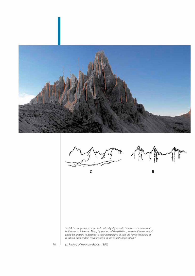
78
“Let A be supposed a castle wall, with slightly elevated masses of square-built buttresses at intervals. Then, by process of dilapidation, these buttresses might easily be brought to assume in their perspective of ruin the forms indicated at B, which, with certain modifications, is the actual shape (at C).”
(J. Ruskin, Of Mountain Beauty, 1856)

2. Description of Property
Nomination of the Dolomites for inscription on the
World Natural Heritage List UNESCO
79
The Dolomites, poster (~ 1930)
“… les plus belles constructions du monde”(Le Corbusier)
The possibility of classifying the karst structures into recognisable geometric shapes (points, lines, surfaces) and precise volumetric figures (prisms, cubes, parallelepipeds) have often led to an interpretation of the Dolomites as architectural structures. Like for monuments of the antiquity or modern skyscrapers, a giant order dominates the fantastic shapes of the Dolomites: detatched volumes, perfectly vertical walls, clean bases…Even the used terms in order to describe their shapes are borrowed from architectonic nomenclature: e.g. towers, rampart, steeples, pinnacles, pillars, bell towers, roofs, balconies, terraces, and cornices.

80
> monumentalityThe possibility of classifying the karst structures into recognisable geometric shapes (points, lines, surfaces) and precise volumetric figures (prisms, planes, cubes) has led to an interpretation of the Dolomites as artificial structures rather than simple natural expressions. The earliest explorers compared them figura-tively and metaphorically to the ruins of a “city inhabited by Titans”, thus project-ing the region into a mythical dimension. More recently the gigantic order which seems to dominate their architecture and the fantastic relationships in scale led Le Corbusier, considered the most important architect of the XXth century, to call them “les plus belles constructions du monde”.
> colour contrasts The visual impact is crowned by the richness of colours and the harmony of con-trasts which characterise each mountain group of the Dolomites. Vertically the bare, hard dolomitic towers rising from sterile scree cones, stand out against the green, undulating pastures and the luxuriant forests which cover the extensive slopes. Horizontally the transformation of facies from the light cliff formations to the dark formations of vulcanoclastic origin emphasise the light and shade effects created by the varying mutability of the surfaces.During the day the rock faces react spectacularly and uniquely to the changes in daylight due to their specific mineralogical structure: flushes of hot colours (or-ange – red - purple) at dawn and dusk, pale and diaphanous in the midday light, while twilight and moonlight give a cold, unearthly aspect to these mountains.
Drei Zinnen Tre Cime di Lavaredo
and Paternkofel Monte Paterno
“…the sharp contrast between their lofty precipice-walls,
crowned with jagged peaks and pinnacles, among which a glacier is seen suspended, and the softly swelling green slopes
at their feet, giving the spectator the impression of their having
been shot up from below in their present form, perfect and
complete…(…) nothing can be more
singular than their appearance, and in certain lights, such as
sunset or moonlight, they look positively unearthly.”
J. Gilbert and G.C. Churchill, The Dolomite mountains, 1864

2. Description of Property
Nomination of the Dolomites for inscription on the
World Natural Heritage List UNESCO
81
This aspect inspired many artists including the painters, Adolf Schaubach (1800-1850), Josiah Gilbert (1814-1892), Franz von Defregger (1835-1921), Karl Ludwig Prinz (1875-1944), Harry Rowntree (1878-1950) and Alfredo Paluselli (1900-1969), to name just a few. Edward Theodore Compton (1849-1921) was one of the most important and found a variety of scenery in the Dolomites which allowed him to express himself to the full. Subsequently, the extraordinary way these mountains react to light became the main interest of many great photog-raphers including Franz Dantone (1839-1909), Giovanni Battista Unterveger (1833-1912), Giuseppe Ghedina (1825-1896) and more recently Jakob Tappein-er (1937) and Walter Niedermayr (1952). The scenic value of the landscape is thus the characteristic of the Dolomites which most strikes the imagination, capable of inspiring every sort of artistic sensibility.
“Le Grand Paysage”The articulated structure of the Dolomites is scenic in itself, on a grand scale. For this reason the region has always had an enormous impact on the imagination of anyone who has visited it.
The region is divided by two main valleys, the Isarco/Adige and the Piave, perpen-dicular to the Alps (that is in a north/south direction) used by travellers arriving in Italy from Central Europe. They cut across the Dolomites as in a geological section, seeing the grandiosity of the landscape and the peculiarities which distinguish them from any other moun-tains with a dynamic, serial vision. English painters and German intellectuals were particularly sensitive observers of this extraordinary landscape. They came to Italy for the Wanderschaft, the formative journey, to visit places of classical and Ren-aissance culture. Albrecht Dürer (1471-1528) and Johan Wolfgang von Goethe (1749-1832) stood out amongst the many.
J. Gilbert, Fischleintal - Val Fiscalina, 1865 (coll. G. Angelini)

82

2. Description of Property
Nomination of the Dolomites for inscription on the
World Natural Heritage List UNESCO
83
“The limestone Alps which I have crossed so far are grey in colour and have beautiful and strangely irregular forms, even if the rock is ranged in layers and strata. However, as there are also arched layers and the rock crumbles in an extremely jagged way, the rock faces and the peaks take on extraordinary shapes. Mountains of this type rise all along the Brenner. By the upper lake, I noticed a change, though. On the dark, grey and green mica-schist, densely streaked with quartz, leaned white and firm limestone, which, breaking, revealed a mica component and cropped out in large, extremely rugged masses. Above that, I found the mica-schist again, though looking softer than the previous. Further uphill, there surfaces a peculiar type of gneiss, or rather a type of granite mixed with gneiss, as in the surroundings of Elbogen. “
Johan W. von Goethe, Italiänisce Reise, 1786

84
Dürer discovered these mountains in 1494, the same year that America was dis-covered. A painter with an exceptional interest in nature, Dürer left five splendid watercolours of the porphyritic platform of the Adige Valley and the carbonate structures of the Adige and Sarca Valleys. These paintings, particularly Welsch Pirg (Italian mountain), are considered to be the first landscape paintings in the history of European painting. However, Dürer did not paint any of the landscapes he came across either before or after these. Goethe travelled through the region in September 1786. An author and intellec-tual with many interests, Goethe was particularly interested in natural sciences and mineralogy, so much so that he became Minister of the mines in Germany. His attention was particularly drawn by the Limestone Alps, “Kalkalpen”, on one side of the Great Brenner Mountain, “Gross Brenner”, where he had noticed the whitest and most compact limestone, present in great masses with infinitely in-dented shapes (Italienische Reise).
Not all the large scale depictions, however, were able to capture the peculiarity of the Dolomite area, as is the case for the topographers’ bird’s eye view. Even the magnificent Atlas tyrolensis (Peter Anich and Blasius Hueber, 1774), considered to be the first unitary topographic map of European territory, treats the Dolomites in just the same way as all the other mountains.
J. Gilbert, Catinaccio – Rosengarten, 1862

2. Description of Property
Nomination of the Dolomites for inscription on the
World Natural Heritage List UNESCO
85
So it was not the need to depict the area graphically that led to a deeper knowl-edge of the Dolomites. It was scientific curiosity which brought a closer vision and the “discovery” of their exceptional beauty. This historic and conceptual approach was so important in understanding the aesthetic importance of the Dolomites that it deserves a specific paragraph.
A.B. Edwards, The Sass da Ronch, 1874
„…il y a un proverbe dans les Alpes Tyroloises qui dit que, nulle montagne n’existe sans un chapeau calcaire. Ce fait étoit trop important pour que je ne cherchasse pas à le constater, et je trouvai que réellement les plus hautes cîmes étoient terminées par des pierres calcaires. (…) Leurs bases, dont l’épaisseur varie, et qui font entremêlées de bancs de pierres calcaires homogènes ou micacées, ont différentes inclinaisons qui les approchent plus ou moins de la position verticale, en se dirigeant cependant vers un point central. Le prolongement de ces bancs forme ces pointes aigues, ces crêtes déchirées, ces arêtes qui cara térisent et indiquent de loin les montagnes dites primitives. De toutes les pierres, celles qui résistent le mieux aux injures de l’air et aux dégradations produites par les vicissitudes de l’atmosphère, sont les marbres, et parmi eux, ceux de ce nouveau genre.»
Déodat de Dolomieu, Lettre a M. Picot de La Peyrouse Malta, 30.01.1791

86
The observations of the first scientists to explore these mountains and to have first-hand experience, had vital importance both scientifically and aesthetically. Deodat de Dolomieu (1750-1801), Leopold von Buch (1774-1852) and Alexander von Humboldt (1769-1859), apart from being eminent scientists, were amongst the most important cultural figures in Europe in the XIXth century. They were the first to see the intrinsic beauty of the geological and geomorphological peculi-arities of these mountains, as proved by their writings, thanks to their humanist groundings. As proof of the “universal spirit” of their culture it is known that Dolo-mieu liked to describe his naturalistic journeys as “courses philosophiques-min-eralogiques” to stress the cultural value of his scientific expeditions.
Dolomieu was a truly romantic figure of a scientist, in the aesthetic sense. After his trip to the Tyrol he wrote to Baron Gioeni “it is on mountains that one can under-stand lithology through personal observation. Samples on their own are without character”. It is not surprising that Dolomieu was described by some scholars as a “founder of on-site geology” (Enrico Rizzi, 2007). In fact, even though some scholars had already guessed that the Dolomite region held interesting scientific discoveries (Giovanni Arduino, Antonio Scopoli and Goethe himself), it took an untiring explorer like Dolomieu to adventure up those tortured peaks. This scien-tist, already interested in limestone for some time, was attracted by these sum-mits to study the particular “marbre phosphorique peu effervescent” on site that other scholars had found in the river bed in the valley. However, having climbed to the top of these mountains, he did not only discover the mineral later called “Dolomite” in his honour, but also the powerful vision of “ces pointes aigues, ces crêtes déchirées, ces arêtes qui caraçtérisent et indiquent de loin les montagnes dites primitives”. Leopold von Buch was attracted to the Dolomites in 1822 to study their stratigraphy after Count Giovanni Marzari-Pencati, inspector of mines under the Austro-Hungarian Empire, published a study on the Canzoccoli quarry, near Predazzo in Valle di Fiemme. This paper demonstrated that granite was deposited on top of limestone in this area, turning upside down the theory that all the rocks were of sedimentary origin (the so-called Neptunist theory), also held by von Buch. Von Buch could not remain indifferent to this news and rushed to the mountains to verify personally this “strange” stratigraphy. However, once in the Dolomites, he was so struck by the extraordinary beauty of the mountains that he opened his speech to the Berlin Royal Academy of Science with an aesthetic description of the Valle di Fassa.The same happened to Alexander von Humboldt, fellow scholar of von Buch. In September of the same year von Humboldt joined his friend in the Dolomites to help him in his research to defend the Neptunist theory. Von Humboldt, a great scientist and sensitive humanist, was greatly impressed by the beauty of these mountains. In “Kosmos”, his main work, he acutely remarked that the geognostic phenomena of the Dolomites “excite the imagination as well as the powers of the intellect” and, to conjure up an idea of the exceptional scenery of the Dolomites, he compared them to the mountains painted by Leonardo da Vinci in the back-
“ The fact that all of them consist exclusively of white,
small-grain dolomite and that limestone is never present
among them is extremely must retain our attention in the
highest degree. Indeed, their structure distinguishes them - in
the same way as their massive proportions do -from all the other
types of Dolomites which have been dealt with so far. They rise among porphyry mountains and
we can be almost certain that where porphyry and similar rock
disappears, so do these pyramids and peaks, and the dolomite with
them.”
Leopold von Buch, Über Dolomit als Gebirgsart, 1822
“In Fassathal, the dolomite rises perpendicularly in the
form of smooth walls of dazzling whiteness to the height of several
thousand feet. It forms pointed conical hills, which stand side
by side in great numbers without touching one another. Their
physiognomical character brings to mind that sweetly fantastical
mountain-landscape with which Leonardo da Vinci has
ornamented the back-ground of his portrait of Mona Lisa.”
Alexander von Humboldt, KOSMOS: A General Survey
of Physical Phenomena of the Universe, 1845

2. Description of Property
Nomination of the Dolomites for inscription on the
World Natural Heritage List UNESCO
87
ground of the “Mona Lisa”.However, Leopold von Buch was the key figure in the fame of the Dolomites. He became the reference point for scientists and also for all the intellectuals and liter-ary figures interested in the Dolomites, who saw a sort of guarantee of exception-ality in his absolute authority on these mountains, even from the aesthetic point of view. His influence and cultural prestige attracted the most important scholars of the day and he is known to have written about 3,300 pages to contemporary scholars. “La Nave d’Oro”, the inn at Predazzo, where von Buch stayed, became the meeting point of the best geology and mineralogy scholars of the day, trans-forming Predazzo into a historic place for world geology research. The frontispiece of the visitors’ book of the famous inn is also proof of the indissoluble tie between scientific and aesthetic interest in the Dolomites. It is entitled: “Memorial of the famous travelling philosophers who, in their literary travels for geognostic observa-tions, honour Predazzo and Michele Giacomelli’s hotel”.
The aesthetic sensibility of these great scholars, who could not avoid describing the exceptional beauty of the Dolomites in their scientific tracts, was thus the first means of broadcasting the new-born aesthetic fame of these mountains. Thus a new motivation to visit the mountains began: the aesthetic experience. To the sen-sibility of the first scientists, who conceived aesthetic knowledge as a metaphysi-cal, philosophical experience, intimately connected to scientific knowledge, was added the sensibility of the first travellers who instead tended to regard aesthetic knowledge as an emotive experience.
In 1837 the first guides expressly aimed at travellers and adventure lovers were published: “Murray’s handbook”, published in London by John Murray and “Re-isehandbuch durch Tirol” by Beda Weber. In these guides the “Dolomite Moun-tains” are described as unequalled, attracting the attention of the first English and German speaking travellers. Murray’s descriptions in particular reflect the most significant aspect of the beauty of the Dolomites, that they are a magnificent example of the aesthetic of the Sub-lime. The characteristics of the beauty which Murray emphasises, almost exactly correspond to the categories of the Sublime described by Edmund Burke (1729-1797) in his famous Essay on the Sublime and Beautiful of 1757. The “steepness” in Murray corresponds to the most impressive type of the “vastness” in Burke, the “barren sterility” to the “privation”, the “gigantic walls, all running in a vertical direction” to the “magnitude”, the “dazzling whiteness” to the “colour”, etc. The reference to the sublime is very important. The sublime is in fact an aesthetic category expressly referring to nature. Burke wrote: “The passion caused by the great and sublime in nature, when those causes operate most powerfully, is as-tonishment (…) No work of art can be great and sublime as it deceives; to be otherwise is the prerogative of nature only”.The elaboration of the concept of sublime was of vital importance for the definition of the paradigm of natural beauty in western culture. It is not surprising that Mur-
“ They form a striking contrast to all other mountains in their dazzling whiteness, in their barren sterility, in their steepness, in the innumerable cracks and clefts which traverse their gigantic walls, all running in a vertical direction, and, above all, in their sharp peaks and tooth-like ridges, rising many thousand feet into the air, which present the most picturesque outline. (…) Sometimes they take the appearance of towers and obelisks, divided from one another by cracks some thousand feet deep ; at others the points are so numerous and slender, that they put one in mind of a bundle of bayonets or sword-blades. Altogether they impart an air of novelty and sublime grandeur to the scene, which can only be appreciated by those who have viewed it.”
John Murray, A Handbook for Travellers in Southern Germany, 1837

88
ray wrote, when giving a concise, powerful image of the Dolomites, “Altogetherthey impart an air of novelty and sublime grandeur to the scene which can only be appreciated by those who have viewed it.” For Murray the beauty of the Dolo-mites is of a new type that cannot be imagined, it has to be seen. In this sense the beauty of the Dolomites is astonishing. But if astonishment, as Burke has written, is the effect of the sublime of nature, so the Dolomite beauty, is sublime. This concept is constantly repeated in subsequent travel literature, due to the cu-riosity aroused by Murray’s powerful descriptions. The first travel logs are basically descriptions of the astonishment and amazement that the sight of these “strange mountains” provoked in visitors. These tales describe the curiosity aroused by their appearance on the horizon, and the surprise on their sudden apparition, accentuated by long, difficult journeys to approach them which increase the nar-rative suspense. Amongst the most important accounts of this type are the book by Josiah Gilbert (painter) and George Cheetham Churchill (naturalist), published in London in 1864, and the book by Amelia B. Edwards (author), published in 1872.The success of the first, “The Dolomite Mountains”, introduced these mountains as the “Dolomites” to the public at large, extending the name of the mineral to the whole region. The second, as can be guessed from the title “Untrodden Peaks and Unfrequented Valleys”, spread the image of the Dolomites as an unspoilt world, “uncorrupted” by industrial civilisation. This romantic image of uncontami-nated mountains was one of the main reasons compelling subsequent travellers to go to the Dolomites. Some of them wrote different types of books, preferring folklore and ethnography to adventure. Amongst these are the book by Rachel Harriette Busk from 1874 and the album by Elizabeth Tuckett in 1871. In the former, “The valleys of Tyrol: their traditions and customs and how to visit them”, the author preferred small villages, often excluded from classical itineraries, and gave original information on their architec-ture, uses and customs. It was in this book that Busk called the Marmolada “the Queen of the Dolomites” for the first time, the name used throughout the world for this mountain. The latter, “Zigzagging amongst Dolomites”, collects a series of sketches and notes on places and conditions in which the author’s brother conducted his alpine excursions, the great mountaineer Francis Fox Tuckett who opened the crossing of the Bocca di Brenta and conquered the Civetta at this time.Other important titles in travel literature include: “Holidays in Tyrol” (1876) by Walter White, “Les pays des Dolomites” (1880) by Jules Leclercq, “Aus den Alpen” (1896) by Robert von Lendenfeld, “Die Dolomiten” (1910) by Theodor Christomannos.
Climbing in the Dolomites began later than in other alpine regions, in 1857 with the ascent of Pelmo by Sir John Ball, naturalist and first president of the English Alpine Club. With his book, “A guide to the Eastern Alps” of 1868, trait d’unionbetween alpine exploration and the opening of the Dolomites to tourism, ends the
“… through a gap in the mountains at the farther end
of the lake, we are startled by a strange apparition of pale
fantastic peaks lifted high against the northern horizon (…) we have neither been looking for
them nor expecting them–and yet there they are, so unfamiliar, and yet so unmistakeable! One feels immediately that they are unlike all other mountains, and
yet that they are exactly what one expected them to be.”
Amelia B. Edwards, Untrodden Peaks and Unfrequented Valleys,
1872

2. Description of Property
Nomination of the Dolomites for inscription on the
World Natural Heritage List UNESCO
89
conceptual trail of the “approach” to the Dolomites. Alpine literature had a determining role in publicising the name and aesthetic vision of the Dolomites to the world. The first famous mountaineers were also ex-cellent writers such as Sir Leslie Stephen, literary critic who edited the publication of the “Dictionary of National Biography”, Douglas William Freshfield, educated at Oxford in history and Civil Law and a refined writer, or Paul Grohmann, with a degree in law from Vienna and founder in 1862 of the Österreichischer Alpenv-erein (the Austrian Alpine Club), together with the famous geologist Edmund von Mojsisovics and Guido Freiherr von Sommaruga. To the books of these legendary figures of alpine exploration (W.D. Freshfield “The Italian Alps”, 1875, P. Grohm-ann “Wanderungen in den Dolomiten”, 1877), other texts of great value should also be cited: “A pioneer in the high Alps” (1874) by Francis Fox Tuckett, “Im Hochgebirge” (1889) by Emil Zsigmondy, “Climbing in the Dolomites” (1896) by Leone Sinigaglia.The books of great mountaineers (Emilio Comici, Tita Piaz and Reinhold Messner) belong to this genre of literature as do those of great authors, especially Dino Buz-zati, one of the most important writers of the XXth century.
Their books bolstered the celebrity of the Dolomites as “the most beautiful moun-tains in the World”. After the first great ascents, the Dolomites were considered to be a true frontier world amongst the international mountain climbing environ-ments, compared to the Alps, full of difficulties, immersed in hard, wild nature. Over thirty years, from 1870 to 1900, world-famous people in the history of moun-taineering came to the Dolomites attracted by the fascination of adventure and competition at the highest level. The Dolomites, with their extraordinary shapes and vertiginous, vertical rock fac-es, were an extreme test, a sort of challenge to technical and expressive perfec-tion in climbing. A different, aesthetic attitude towards these mountains began, as expressed in the words of Emilio Comici: “To know how to devise the most logical and elegant way to reach a summit whilst spurning the easier, more convenient slope, and to climb it with a conscious exertion of all the nerves, muscles, fibres, desperately tense to beat the attraction of the void and the eddy of giddiness, is a real work of art; it is an action of great human beauty which, as such, dwells in the spirit of great artistic creations”. See Annex A.2.3.

90
2.b. History and development
The aim of this chapter is to describe the more significant events in the history of the Dolomites which have determined their present conditions and to explain the historic reasons for the administrative structure and linguistic diversity in the region. There are two historical perspectives in the Dolomite region: political and material. The political history gives prominence to frontiers and divisions since the area has always represented a boundary zone between different fields of influ-ence due to its geographic position. The material history, on the other hand, em-phasises the cultural cohesion of the region, inhabited by populations with similar languages and established traditions, typical of alpine culture.The interweaving of these “two” histories, has left its strongest mark in the multi-lingualism which characterises the area: two languages derive from political his-tory (Italian and German), while the other two are from material history (the Al-pine-Romance languages Ladin and Furlan). Dolomite toponymy faithfully reflects the historical and cultural wealth of the region and place names (inhabited nuclei, localities and mountain groups) are expressed in at least two or three languages, in respect of all the cultures peacefully living there.
Brief chronology
prehistory 10,000 B.C. first Mesolithic encampments of nomadic hunters and gatherers
Rhaetic period Vth century B.C. first stable settlements (Celts and Rhaetians)
Roman period IInd century B.C. Roman military occupation and colonisation
Ist century A.D. pacification of the alpine populations and constitution of the Regio X (Venetia et Histria): development of the Alpine-Romance culture
Middle Ages VIIth century linguistic boundary, German and Italian languages
XIth - XIIth c. first forms of autonomous local government
Modern Era XVth - XVIIIth Austrian and Venetian rule
1789 Dolomieu’s journey to the Alps and the “discovery” of the Dolomites
XIXth century Napoleonic campaigns: insurrections for independence of the Dolomite territories
1866 annexation of part of the Dolomites by the Kingdom of Italy
XXth century World War I (1915-1917)
1918 annexation of all the Dolomite territories by Italy
World War II
1943 the Dolomites were absorbed into the Nazi Reich as “Alpenvorland”
1946 treaty of Paris between Italy and Austria: the Dolomites return to Italy

2. Description of Property
Nomination of the Dolomites for inscription on the
World Natural Heritage List UNESCO
91
HistoryThe Dolomites offer a wealth of historic evidence even at the highest altitudes, in fact the mountains were populated from the beginnings of human history. Archaeological finds of Mesolithic camps and shelters, very important in docu-menting the history of human presence in the Alps, are testimony to occupation from 10,000 B.C. onwards. During the first millennium B.C. the Dolomites were an area of contact between Celtic and Rhaetian populations, whose presence is proved from the IVth century B.C. These populations were attributed with the first stable settlements and the first organised network of paths and passes for communication with central-northern Europe. Frequent commercial exchanges with populations of southern Europe, particularly the ancient Etruscans, have also been documented and survive in many place names, words of local languages and rock inscriptions on some of the mountains.The first subdivisions and political boundaries to parcel out the Dolomites date from the period of Roman colonisation, particularly the Imperial era of Ancient Rome (Ist century B.C.). To the north the area was divided into provinces militarily occupied by Raethia and Noricum (in whose territory part of the Northern Dolo-mites are found today), the centre and south were part of the X Regio Venetia et Histria, which covered most of the present region of the Dolomites. This Roman X Regio was subdivided into several jurisdictions, possibly respecting the different ethnic groups living there, in a way conceptually similar to today. The territories linked with the first cities founded by the Romans were particularly notable: Be-lunum (Belluno), Feltria (Feltre), Tridentum (Trento), Berua in the present South Tyrol, Iulium Carnicum in the present Friuli. During the period of Roman colonisation, the contact between the indigenous Dolomitic and the Latin populations brought the development of a new culture
Ladin settlement

92
and a new language, the result of cultural interaction between these different populations. This new, essentially rural, culture united the typical Latin ability to organise and manage the territory with the local Rhaetian knowledge of agricul-tural techniques in alpine environments. They developed their own settlement model, consisting of small rural villages (the “vìles”, still inhabited and well pre-served today) which were made up of collective, self-sufficient settlement units (of about 30 people). Their language, Alpine-Romance, extended over an area which covered most of the Alpine range (from Friuli to Switzerland) and still exists in the Dolomites (where it is called Ladin Dolomitan and Furlan) and in the Swiss Canton dei Grigioni (where it is called Rumantsch). During the early Middle Ages (from the Vth to the XIth century A.C) there were many invasions of Germanic and Slav populations moving from north-east Europe towards northern Italy. From the Vth century A.C. these tribes invaded and devastated the Dolomites. The indigenous populations moved inland where they built strongholds and strengthened villages. The consolidation of the linguistic boundary separating the Italian and German languages dates from this time and still exists today at the border between the Provinces of Trento (Longobard dominion ) and Bolzano/Bozen Province (Bajuvar dominion). Around the year 1000, the Dolomites were a transition area between the German consolidated feudal system and central Italian communal ferment (the future “Signorie” - Seigniories). The first forms of autonomy and self-gov-ernment conquered by the local communities in the region arose from this geo-political situation. The statutes which established the rights and liberties of the Magnifiche Comunità Montane – the Magnificent Mountain Communities (the
Opening of the Contrin refugeNuremberg section
of Alpenverein, 1887

2. Description of Property
Nomination of the Dolomites for inscription on the
World Natural Heritage List UNESCO
93
“Carte di Regola” – Charter of Rules) emphasise established landed situations and, above all, identify the collective properties of the mountain communities, the extensive resources typical of high altitudes: forests, pastures and grasslands.From the XIVth to XVIIIth centuries the Dolomites were subdivided into two great areas of influence, Austrian and Venetian, and frontiers and customs houses were established in the mountains. Nevertheless these boundaries continued to be moved, alternately annexing part of the area to one or other of the powers. In this political context, some territories kept their autonomy with continuity, as is the case of the Principato Vescovile (Episcopal Principality) of Trento, which had administrative freedom even though it was dependant on Austria. In 1798, the year of the French Revolution, the modern era began in European history. In the same year Deodat de Dolomieu, made his journey to the Alps and “discovered” the Dolomites. The new era began with uprisings and revolts for independence and the formation of national states also in the Dolomites. By the mid-XIXth century part of the area was annexed to the Italian Kingdom while the rest remained under the influence of the Austro-Hungarian Empire.However, it was the First World War which more profoundly affected the recent history of the Dolomites since the State confines, and therefore the war front, ran across these mountains. The end of this terrible war and the annexation of the southern Tyrol territories to Italy, concluded the history of the political frontiers of the Dolomites.The importance of this event spread beyond the boundaries of the Dolomite region and for this reason a specific paragraph is dedicated to it.
World War IThe transport of the remains of Sepp Innerkofler

94
World War IDue to its position between the Austro-Hungarian Empire and the Kingdom of Italy the Dolomite quadrant became the territory of an heroic but bloody battle indelibly scored, not only in the memory of the populations involved, but also on the summits and peaks which literally carry the scars of this terrible mountain war.The First World War involved the area from May 1915 to October 1917 (the Italian defeat at Caporetto) with a front extending along about 250 km.. The military tacti-cal choices, made by both fronts, rapidly implied trench warfare which required a massive logistic involvement. To connect up with the main means of communica-tion (from the north the Brennerbahn along the Adige valley and the Südbahn along Val Pusteria, from the south the Padua-Calalzo railway and the Conegliano-Belluno railway as well as the roads along the Piave and Cordevole valleys) many roads and even some narrow gauge railways were built (Val Gardena, Valle di Fiemme, Val di Landro and Val del Boite) to reach even the most remote valleys and render the Dolomite territory particularly accessible. In fact the construction of the Great Dolo-mite Road with the Pordoi and Falzarego Passes, and the Rolle Pass Road linking the Fiemme and Primiero valleys was immediately before the war.
The first battle lines, corresponding to the peaks and crests of the mountains, were fortified with complex systems of tunnels, trenches and underground pas-Roman model

2. Description of Property
Nomination of the Dolomites for inscription on the
World Natural Heritage List UNESCO
95
sages for many kilometres, often excavated with the help of pneumatic drills or mines. Daunting cableways were built next to these, allowing access to the high-est peaks. Many mule-tracks and military roads were built in the same way, still perfectly efficient today, giving access to the heart of the main mountain groups (e.g. Sesto, Marmolada, Tofane, etc.). Some of these military postings were later adapted into refuges (e.g. Lagazuoi refuge from a former Austrian posting and A. Bosi refuge from the Italian military command) as historic evidence.Aqueducts, radio stations, electricity and telephone lines were built to supply the outposts; heavy pieces of artillery were transported even to the highest postings, to altitudes of approximately 3,000 metres such as the Great Peak of Lavaredo and the Marmolada. Even glaciers became battle grounds: the network of galler-ies, postings and encampments excavated in the Marmolada mountain were so wide and extensive that they earned the name of “ice city”. The events which cost the lives of thousands and literally devastated the moun-tain skyline (the Col di Lana and Lagazuoi peaks were blown up by mines), have become history and traces of this international tragedy can still be found in the places themselves (fortifications, trenches, mule-tracks and roads), but also in museums and collections. Thus history is inseparably tied to the landscape, but what deeply divided then (often members of the same family found themselves fighting on opposing fronts), is once again a symbol of peace and union between populations.
DevelopmentThe intention of this paragraph is to set out concisely the main factors which brought the Dolomite quadrant to its present economic structure, beginning with the basic economy which existed in the area until the XVIIth century up to the economy of tourism today.
The economy in the Dolomite valleys was principally based on two available re-sources: on one hand rural activity dependant on local resources and on the other activities linked to commercial traffic, due to the network of communications between north and south of the Alps, existing since antiquity. Moreover, the local resources were never favourable to the development of the population, being poor and limited, leading to a simple subsistence economy.
Rural activity was organised according to two main cultural models: in the Ger-man-speaking area the so-called Germanic model prevailed, based on an organi-sation of single family nuclei with a prevalence of animal breeding over agricul-ture, therefore characterised by extensive, generally undivided pastureland. In the Romance area the Roman model was developed, with a social organisation of small communities, regulated by Roman law, dedicated mainly to agriculture and forestry.The signs of these different cultural backgrounds are still visible today in the landscape and the organisation of the territory: in fact collective properties are
Germanic model

96
still numerous, administered by public bodies called Comunità - Communities (Agordo, Cadore, Val di Fiemme) or Regole - Orders (Val di Fassa, Ampezzano, etc.), or are still subject to the so-called Uso Civico (common law regulating the use of public areas).By the mid XVIIIth century, at the time the area was visited by Dolomieu, the economy was therefore prominently based on agriculture, forestry and animal husbandry, very seasonal and with characteristics of mere subsistence, which caused mass emigration of the male work force during the winter. Alternative ac-tivities were minimal: some wood carving (particularly in Val Gardena/Grödental), and a little mining (Agordo area and the Val di Zoldo).The prevailing commercial activity was timber from collective woodlands, mostly for the Repubblica Serenissima of Venice. There was also a modest activity of merchandise in transit, favoured by the contact between the Venetian-Paduan areas to the south and the Austrian-German zones to the north. A limited network of accommodation grew up linked to this passing traffic (taverns, inns, guides and staging posts), on which the future tourist trade was later to be built.
Until the discovery of the Dolomites spread through the scientific world, between 1800 and 1850, the Dolomites had only been visited by a few scholars exclusively interested in geology.However, after 1850, with the diffusion of pictures of some of the mountain groups (Sassolungo/Langkofel, Latemar, Sciliar/Schlern, Catinaccio/Rosengar-ten, Marmolada, Civetta, Pelmo, etc.), already universally known as the Dolomite mountains, a flow of travellers began, curious to see the “baluginare delle pallide guglie dolomitiche” (the glimmering of the pallid dolomitic peaks) and explorers in search of adventure on the untrodden peaks and in the unfrequented valleys. After the first alpine climb (Pelmo 19.09.1857, John Ball), exploits and ascents increased using both local guides and foreign mountaineers (German, Austrian and English). As a result many refuges and shelters were built at high altitudes by most of the European Alpine Clubs to assist the ever increasing number of excursionists and climbers.Between 1870 and 1910 the mountaineering frenzy reached its peak, accompa-nied by a growing development of tourism and accommodation, indiscriminately pervading most of the region. Hotels were progressively transformed from the pioneer phase to a true economic activity on European level, comparable in some localities (i.e. Cortina d’Ampezzo, Sesto/Sexten ) to the best known tourist resorts in the Swiss Alps (St. Moritz, Davos).
The First World War brusquely interrupted this flourishing moment and had a negative impact on economic development for two reasons: firstly it caused gen-eral impoverishment regarding both local resources and the general European context, secondly it moved international traffic towards the new, faster means of communication outside the mountain area and modified the geopolitical structure of the local communities again with newly inflexible borders.

2. Description of Property
Nomination of the Dolomites for inscription on the
World Natural Heritage List UNESCO
97
1920 to 1950 marked an insignificant interval from the economic point of view, in that the advantages brought by tourism only touched the better organised locali-ties, with their efficient legacy of infrastructures and services inherited from the previous period. Even so, it is in this period that Alpine skiing and Nordic skiing began to take hold, doubling the opportunities for economic improvement and the possibilities of social well-being. After 1950 contemporary mass tourism was certainly the most relevant economic development for the whole area historically, in that it radically changed the productive system from rural to “industrial”, as well as the settlement and cultural systems. These transformations undoubtedly influenced the landscape of the Dolomite valleys, but also guaranteed the local populations an opportunity of social renewal, rediscovery of their cultural roots, and general investment in the territory.However, the substitution of the rural/local economic model by the tourist/glo-bal economic model has only sporadically concerned the area of the Dolomites, mainly involving the areas nearest the main arteries of communication and only in the valley bottoms, amply illustrated in paragraph 4.b.iv.

“As we descended, the most curious resemblances to architectural forms came out on either side – on the left particularly. There Monte Gusella, guarded the head of the pass, and its eastern end towered like a castle-keep, lofty and impregnable. Next to it a mountain, likewise presented endways to the descent, took the likeness of an apse to some enormous cathedral; and lower still, we were in doubt for a time whether a wooded ridge were not really crowned by the ruined walls of an abbey, till their real magnitude became indisputable.”
(J. Gilbert and G.C. Churchill, The Dolomite Mountains, 1864)

PELMO-NUVOLAUsystem 1

100
Lithological sketch representing the geometric relationships
between geological units in the Rio delle Pelmo - Nuvolao area.

2. Description of Property
Nomination of the Dolomites for inscription on the
World Natural Heritage List UNESCO
101
Pelmo – Nuvolao
CORE ZONE BUFFER ZONE
area (ha) 4.581,70 area (ha) 4.048,33
231 Pastures 0,00% 231 Pastures 0,35%
242 Complex cultivation patterns 0,00% 242 Complex cultivation patterns 0,00%
243 Land principally occupied by agriculture, with significant areas of natural vegetation
0,00%243 Land principally occupied by
agriculture, with significant areas of natural vegetation
0,00%
244 Agro-forestry areas 0,00% 244 Agro-forestry areas 0,00%
311 Broad-leaved forest 0,00% 311 Broad-leaved forest 0,00%
312 Coniferous forests 17,39% 312 Coniferous forests 47,07%
313 Mixed forests 0,00% 313 Mixed forests 2,24%
321 Natural grassland 22,76% 321 Natural grassland 14,49%
322 Moors and heathland 10,10% 322 Moors and heathland 6,00%
324 Transitional woodland/shrub 8,60% 324 Transitional woodland/shrub 13,06%
331 Beaches, dunes, sands 0,00% 331 Beaches, dunes, sands 0,00%
332 Bare rock 26,11% 332 Bare rock 6,89%
333 Sparsely vegetated areas 15,04% 333 Sparsely vegetated areas 9,90%
335 Glaciers and perpetual snow 0,00% 335 Glaciers and perpetual snow 0,00%
512 Water bodies 0,00% 512 Water bodies 0,00%
Physical and geographical description
The core zone is elongated along a NW-SE direction; it’s bounded to the east by the Boite Valley, to the southwest by the highest part of the Zoldo Valley and by the Fiorentina Valley, to the west-north west by the Codalonga River, to the north by the Falzarego Valley.It includes distinct mountain groups: the M. Pelmo group, the Formin-Rocchette-Croda da Lago group, the M. Cernera group and the Nuvolau group. The first group lies on SE-NW direction and from south to north it includes the M. Penna (2,169 m) and the isolated massif of the Pelmo whose main peaks are: Cima Pelmo (3,168 m), M. Pelmetto (2,990 m), Cima di Val D’Arcia (2,626 m). This area is physically separated from the Formin-Rocchette-Croda da Lago group, by a lower hill-shaped chain, extending on a N-S direction (Col della Puina 2,254 m, Col Roan 2080). The second group is composed from south to north, by the Rocchetta Chain, which is elongated on an E-W direction, and whose main peaks are La Rocchetta (2,469 m) and the Becco di Mezzodì (2,603 m), the M. Formin (2,657 m) with its famous highland plateau and the Croda da Lago (2,701 m) that includes the Cima Ambrizola (2,715 m), both elongated on a N-S direction. The Rio dei Loschi, the Forcella Giau and the Rio Mondeval separate westward this area from the M. Cernera group. The most important peaks of this area are: Corvo Alto (2,455 m), M. Cernera (2,657 m), M. Verdal (2,491 m), Col


2. Description of Property
Nomination of the Dolomites for inscription on the
World Natural Heritage List UNESCO
103
“…next, on the same side as the Pelmo but farther up the valley, appears a chain of wild confused crags, like a line of broken battlements, piled high on huge buttresses of sward and pine-forest.”
(A.B. Edwards, Untrodden Peaks and Unfrequented Valleys, 1872)
“But the greatest point of interest in the view was a summit to the south-east, a crest of pale spiry pinnacles, with light clouds partly veiling them”
(J. Gilbert and G.C. Churchill, The Dolomite Mountains, 1864)
Croda da Lago, Lastoi del Formin and Cernera

104
Piombin (2,313 m), P.ta di Zonia (2,282 m). Northward the Giau Pass signs the beginning of the Nuvolau group whose main peaks are La Gusela (2,595 m) and the Nuvolao (2,574 m).
Geological description
This area is also one of the symbols of the Dolomites both in scenic and geological terms. These mountains have been the object of scientific curiosity ever since the pioneer period of the first geologists and they still attract many researchers and scientists. Despite the fact that the area is crossed by important faults in a varying NS to NW-SE directions, the original relationships between the different bodies and the stratigraphic continuity of the principal elements are perfectly preserved from a structural point of view. In fact, the original margins and slopes of the pre- and post-volcanic platforms have been conserved. The successions outcropping in the eastern area are prevalently represented by Late Ladinian volcaniclastic sandstones, which cover the slopes of the previous Ladinian platforms of the Sciliar Dolomite and above which the basin sedimentation of the post-volcanic Cassian platforms can be observed once more (S. Cassiano Formation and Cas-siana Dm). Moving westward we can also observe the successive elements of the stratigraphic series such as the Santa Croce/Heiligkreuz Formation, the Travenan-zes Formation and the Dolomia Principale; the youngest formations on the other hand (Calcare di Dachstein and Calcari Grigi) characterise the highest peaks of the Mount Pelmo massif. The interval of time documented in this system runs from the Late Permian to the Early Jurassic with a truly remarkable continuity. The tectonic structure of the area can be traced back to a compressive phase oriented in an ENE-WSW direction known as “Valsuganese”. This unfolds in a series of SE-vergent overthrusts which, at the top, give rise to an alternating of synclines and anticlines. The Monte Pelmo massif is characterised by a synclinal structure which continues north with an anticline (Anticline of the Col de la Puina) and then it form a “cuesta” structure at Formin-Croda da Lago-Rocchetta group.
Stratigraphic and paleontological emergencies
– From a stratigraphic point of view, a complete succession (more than 2.5 km thick) has been preserved from the Late Permian to the Early Jurassic, bearing witness to an interval of time spanning approximately 100 million years.
– The response of the carbonate and terrigenous systems to the sea level varia-tions during the Anisian period are perfectly documented here by the repetition of three superimposed sub-aerial erosion systems, continental conglomerates, lagoons and recovery of the bioconstructed platforms. The interaction of the platform-basin systems of the Serla Superiore and Contrin with the respective basin sediments are emphasised here by the preservation of the margins and paleo-slopes with respect to the basins and therefore by the possibility of ana-lysing in detail the tectonic and eustatic control on the platforms themselves.

2. Description of Property
Nomination of the Dolomites for inscription on the
World Natural Heritage List UNESCO
105
– The Sciliar platform, is three dimensionally preserved in all its parts, showing back-stepping geometries of the margins and the progressive sinking of the atoll under the photic zone related to the increase in subsidence during an important transgression. The drowning of the platform is documented by the red ammonites and en-crinites on the top of the lagoon and on the slopes, and by the reduction of exportation of carbonate into the basins.
– The relationships between the drowned carbonate buildups (guyot) and the terrigenous and volcanoclastic deposits of the Late Ladinian are amazing. The onlap geometries between these and the paleo-slope are among the most spectacular of all the Dolomites.
– The interfingering of the Cassian Dolomite with the San Cassiano Formation at the Gusela del Nuvolau is impressive.
– The basin sequences, at the toe of the slope or those linked to the conden-sation on the top of the drowned platform, are rich in fossiliferous localities known for over 200 years. The most important examples include Punta Zonia which has provided splen-did examples of ammonoids from the Late Anisian and Ladinian, those of the Cernera area, the Dont and Recoaro Formations, of the Val Fiorentina; the Carnian examples from the San Cassiano Formation of Gusela del Nuvolau or Forcella Giau.
– As regards the ichnofauna, reptile footprints have been documented from all continental terrigeneous units of the Anisian period, moreover the peritidal dolomites of the Cassian Dolomite and the base of the Dolomia Principale have provided important findings of fossilized dinosaur tracks, including those from the landslide block at the base of the Pelmetto which have revolutionised the knowledge of the paleogeographical structure of the area.
Ammonoids from the pelagic drape of the Cernera Carbonate Platforms

106
“From whatever side it be seen, but specially from the E. and S., shows as a gigantic fortress of the most massive architecture, not fretted into minarets and pinnacles, like most of its rivals, but merely defended by huge bastioned outworks, whose walls in many places fall in sheer precipes more than 2,000 ft. The likeness to masonry is much increased by the fact that, in great part, the strata lie in nearly horizontal courses, and hence it happens that many of the steepest faces of the mountain are traversed by ledges wide enough to give passage to chamois and to their pursuers.”
John Ball, A Guide to the Eastern Alps, 1868
“It was the Pelmo on the left that now absorbed all attention. His tower-like form has been often mentioned, and the vast bulk of this, as we entered the Alpine scene, smote us with wonder and awe. His form was cut out in shadow against the western sky; a cloud hovered over the broken summit, and the horizontal lines of bedding, which most singularly mark the sides, looked like a gigantic staircase ascending to the mysterious cloud-filled hollow.”
J. Gilbert and G.C. Churchill, The Dolomite Mountains, 1864
Monte Pelmo

2. Description of Property
Nomination of the Dolomites for inscription on the
World Natural Heritage List UNESCO
107
Description of Geomorphology
This system shows a vast and exemplary range of morphostructural and mor-phoclimatic landforms.With regard to morphotectonics, fault gorges can be observed in the Mt. Pelmo area, east of Forcella Staulanza, and in Becco di Mezzodì, east of Rocchetta: they are deep cuts in correspondence with displacements which were very likely active also during the Pleistocene.With regard to morphotectostatics, there are some examples of hogbacks and cuestas. Among the former is the ridge stretching from Mt. Pelmo to Rocchetta di Prendera, or the top of Mt. Cernera. Among the latter are the slopes SW of Mt. Penna or Mt. Formin. There are numerous crests bounded by tectonic lines. Among the most typical are the Cinque Torri, which can be observed just be-yond the northern boundary of the system, which are separated by fractures and trenches, with NW-SE and NNE-SSW preferential directions, or wide troughs lo-cated at the top of Mt. Penna. These are found in correspondence with belts of fractures on dolomite or calcareous rocks and are the result of tensional release due to lateral spreading affecting these rock types overlying marly-pelitic forma-tions. An important fault borders to the north the Mt. Pelmo massif. It is E-W oriented and clearly separates Cime di Forca Rossa, to the south, from Cime di Val d’Arcia, to the north. Furthermore, it is marked by a track, a saddle and an alignment of small escarpments and cuts. With regard to morpholithology, there are typical plateaux, as Lastoni di Formin and the northern slope of Mt. Penna, which are located in correspondence with Triassic carbonate shelves. Another typical landform is the ledge (cengia), of which several examples can be observed along the slopes of Mt. Pelmo and Croda da Lago. Finally, some saddles are found where the most erodible rock types crop out, such as Passo Giau and Forcella Staulanza. Moreover, karst landforms set on series of fractures subject to glacio-karst evolution are found on the plateaux. Most of them are concentrated on the top part of Mt. Pelmo.From a morphoclimatic viewpoint, numerous landforms witness the Last Glacial Maximum (LGM). They result from a thick glacial tongue coming from a northerly direction, which flowed to SSE along the present Boite valley, or originated in the highest peaks of this system. Some erosional forms of the Boite glacier are found, such as roches moutonnées and glacial exaration terraces, especially near Mt. Pelmo. Moraine deposits identified in proximity of some Dolomite passes bear witness to transfluences of the Boite glacier towards the Zoldo and Fiorentina valleys. These landforms allowed the altimetric boundary of glaciers to be located between 2150 m to the north and 2050 m to the south. Traces of Pleistocene periglacial processes are also found, such as a cryoplanation surface in proximity of the summit of Mt. Penna.In Mondeval de Sora, at 2150 m a.s.l., there is a glacial cirque where an archaeo-logical site of extraordinary importance was found. In it a well preserved skeleton of a Mesolithic hunter was discovered: it is an example of a properly organised

108
and intentional burial, which makes up the first finding of this kind at such a high altitude. This archaeological site is located in the trough of the glacial cirque and is positioned under a slightly jutting out boulder which was detached from the overlying mountain top and subsequently transported downhill by a Würm Late-glacial glacier. The geomorphological reconstruction also shows that in the Meso-lithic period the centre of the trough was occupied by a pond. Recently, the area of this important archaeological find was rightly preserved from the construction of skiing facilities thanks to the efforts of a committed and enthusiastic group of environmentalists. This site can be quoted as an example of historical continuity and integration between geomorphological events, prehistory, present events and sustainability.Lateglacial morphology is represented by numerous, generally well preserved cirques near the highest peaks and by stadial moraine deposits. A kame terrace was also found along the eastern face of Mt. Pelmo. The prevailing morphology is, in any case, glacio-nival and has developed in a fairly continuous way up to the present with rock glaciers (S and W of Forcella Ambrizzola, N of Nuvolau, in the Formin valley and near Passo Giau), protalus ramparts (on the S face of Lastoni di Formin and on the E and NW faces of Mt. Pelmo), and avalanche cones (mainly N of Mt. Pelmo). Some of the most typical cases of landslides are found at Cinque Torri and Lastoni di Formin.

2. Description of Property
Nomination of the Dolomites for inscription on the
World Natural Heritage List UNESCO
109
Onlap of the volcaniclastic succession onto the slope of the Sciliar Dolomite carbonate platform. Mt Cernera
Mondeval de Sora (W of Becco di Mezzodì, on background). Glacial cirque, where an archaeological Mesolithic site is located, positioned under a slightly jutting out boulder which was detached from the overlying mountain top and subsequently transported downhill by a Würm Lateglacial glacier. The geomorphological reconstruction also shows that in the Mesolithic period the centre of the trough was occupied by a pond.

110
An evident topple is observable at the Cinque Torri, an isolated rock outcrop of Dolomia Principale, near the margin N of the system. The Cinque Torri consist of some monoliths affected by lateral spreading phenomena, at an advanced stage of evolution, and by collateral movements, such a falls, topples, slides and flows. The gravitational phenomena are mainly conditioned by the superposition of the Dolomia Principale of the Cinque Torri on an incompetent substratum, consisting in reddish marls and sandstones belonging to the Travenanzes Formation. This is the typical case of a superposition of hard and rigid rocks on soft and plastic ma-terials, a situation which is well known to be very favourable to the development of deep-seated gravitational deformations. The monoliths are highly interested by degradational phenomena (mainly frost shattering), favouring the occurrence of rock falls and topples, which contribute to the nourishment of the scree slopes present at the base of the rock walls. The direction of the fractures and trenches separating the blocks follows the tectonic style of the area, which shows a system of discontinuities with NW-SE and NNE-SSW preferential directions. The strata of the Travenanzes Formation dip downstream with the same angle of the slope; this fact surely contributed to the splitting up of the plateau and to the tilting of the blocks. The Torre Grande, the highest monolith (2361 m upon sea level), characterized by almost vertical walls reaching the height of 150 m, is affected by open fractures which extend as far as the substratum; this leads to the subdivi-sion of Torre Grande in some rock blocks and has favoured the rock topple here considered.One of the most peculiar cases of deep-seated gravitational deformation is that of the Lastoni di Formin which are located on the right side of the Rio Falzarego. It is part of the mountain group which includes Mt. Nuvolau and La Rocchetta. The Lastoni di Formin can be described as a thick plate of Heiligkreuz Formation and Cassian Dolomite overlying the marls, arenites and clays of the S. Cassiano Formation. From a structural point of view, the strata show a NW-SE strike and dip gently to NE. Moreover, the area is characterized by a system of discontinui-ties which controls the dismemberment of the plate and many other gravitational deformations and slope movements within almost the entire basin at the Boite torrent. The wide structural surface of the Lastoni di Formin is affected by deep-reaching fractures, whose direction runs parallel to the strike of the strata and consequently to the direction of the slope. The dimension of the fractures varies depending on the different evolutive stages of the phenomenon, which are quite clearly observable in the field. In fact, in the upper part of the Lastoni di Formin there are trenches reaching a maximum width of about 1 m, while in the lower part the trenches reach widths of decametric scale, with vertical displacements of similar entity. The peculiarity of this phenomenon consists in the presence of various stages of evolution at the same time. Lateral spread phenomena are prevalent in the upper part accompanied by progressive displacements of the blocks downslope, which gives the slope a step-like morphology. In the lower parts of the slope, lateral spread evolves in block slide, while at the base of the slope “simple” slope movements, such as falls, topples and slides take places.

2. Description of Property
Nomination of the Dolomites for inscription on the
World Natural Heritage List UNESCO
111
This is demonstrated by the presence of several dolomitic monoliths and boulders (some of them reaching some hundreds of cubic meters) isolated from the rocky plate and toppled inside the wood at the foot of the slope.In the latter two cases a series of collateral movements, such falls, topples, slides and flows are also found which show exemplary scientific and educational evi-dence. with a very wide range of the types quoted in literature. There are many mass movements of various age and dimensions, some of which are here quoted. Rock falls: concentrated around the dolomite faces of Mt. Pelmo and Nuvolau, the western face of Lastoni di Formin and the southern face of La Rocchetta. Rock slides: found in Val d’ Arcia and north of Forcella Ambrizzola. Sackung: found in particular on the eastern face of Mt. Pelmo. Mud and earth flows: affecting the terrigenous formations (Heiligkreuz, Travenanzes etc.), as on the southern slope of Mt. Pelmo. Debris flows frequently originate from the numerous talus cones and scree slopes, like the one occurring on 14th September 1994 on the northern slope of Mt. Pelmo. A series of landforms shows high extrinsic and intrinsic geodiversity from mor-phostructural and morphoclimatic point of view. Furthermore, typical talus cones and scree slopes are found: they show an accentuated morphological uniformity on a regional scale. Croda da Lago


2. Description of Property
Nomination of the Dolomites for inscription on the
World Natural Heritage List UNESCO
113

“And from there, by rare good fortune, we do see it–a huge, roof-shaped mass, sloping, and smooth, and snowy white against a leaden sky. For vastness of expression and extent of snow, as seen from this side, it recalls Mont Blanc. Distance, instead of diminishing its bulk, seems by contrast with surrounding heights, to enhance it. The two valleys of Andraz and Livinallungo, the Monte Padon and a whole sea of minor peaks occupy the intervening space; and yet the Marmolata seems to fill the scene”
(A.B. Edwards, Untrodden Peaks and Unfrequented Valleys, 1872)

MARMOLADAsystem 2

116
Lithological sketch representing the geometric relationships
between geological units in the Marmolada area.

2. Description of Property
Nomination of the Dolomites for inscription on the
World Natural Heritage List UNESCO
117
Marmolada
CORE ZONE BUFFER ZONE
area (ha) 3.292,89 area (ha) 917,44
231 Pastures 0,00% 231 Pastures 0,00%
242 Complex cultivation patterns 0,00% 242 Complex cultivation patterns 0,00%
243 Land principally occupied by agriculture, with significant areas of natural vegetation
0,00%243 Land principally occupied by
agriculture, with significant areas of natural vegetation
0,00%
244 Agro-forestry areas 0,00% 244 Agro-forestry areas 0,00%
311 Broad-leaved forest 0,00% 311 Broad-leaved forest 0,00%
312 Coniferous forests 0,02% 312 Coniferous forests 3,53%
313 Mixed forests 0,00% 313 Mixed forests 0,00%
321 Natural grassland 2,36% 321 Natural grassland 4,61%
322 Moors and heathland 2,34% 322 Moors and heathland 7,45%
324 Transitional woodland/shrub 2,62% 324 Transitional woodland/shrub 5,77%
331 Beaches, dunes, sands 0,00% 331 Beaches, dunes, sands 0,00%
332 Bare rock 68,23% 332 Bare rock 61,07%
333 Sparsely vegetated areas 7,79% 333 Sparsely vegetated areas 6,32%
335 Glaciers and perpetual snow 16,64% 335 Glaciers and perpetual snow 11,24%
512 Water bodies 0,00% 512 Water bodies 0,00%
Physical and geographical description
The Marmolada Group rises up almost at the centre of the Dolomites (attachment 2.5). It is the highest summit of the Dolomites and it possesses some of the most extended glacier; from here the name of “The Queen of the Dolomites”. It reaches a maximum height of 3,343 meters with Punta Penia, and it covers an area of approx. 4.6 km2. To the north, the valleys of the Cordevole Torrent and the Avisio River, which join through the Passo Pordoi (2,239 m), isolate it from the Sella Group. The Cordevole River valley closes the group to the east; to the south it is closed by the Biois Torrent, which has left tributaries that drain the southern side of the massif, and the San Pellegrino Brook, linking it to the Passo di San Pel-legrino (1,919 m). To the west the Marmolada Group continues, without interrup-tion, with the Cima di Costabella (2,762 m), the Monzoni Group (Ricoletta, 2,647 m) and Monte Vallaccia (2,637 m) through to the Avisio Torrent. The Marmolada Group can be divided in two parts. The southern part extends to the south of the San Nicolò Valley, bordered off by the Passo Ombretta and Pettorina Valley. Here there are a series of ridges: the chain between Costabella and Cima dell’Uomo (3,010 m), Cime d’Ombretta-Sasso Vernale (3,058 m), Cima Ombrettola-Sasso di Val Fredda (3,009 m), Monte Fop (2,892 m), Catena dell’Auta (Cime di Auta, 2,623 m), Monte Pezza (2,408 m) and Sasso Bianco (2,407 m); in the most southern part, the plains of Compagnaccia, Tegnausa and Schita, through to Pian


2. Description of Property
Nomination of the Dolomites for inscription on the
World Natural Heritage List UNESCO
119
“… the massive snow-clad Marmolata, 10,400 feet high, surnamed the Queen of the Dolomites; but she is a severe and haughty queen, who knows how to hold her own, and keep intruders at a distance; and many who have been enchanted with her stern beauty from afar have rued the attempt at intruding on the cold solitude of her eternal penance.”
(R.H. Busk, The Valleys of Tirol, 1874)
Punta Penia and Sasso Vernale

120
dell’Anima. In the North, which includes the top of the massif, there are other important peaks: Pala di Vernel (2,836 m), Gran Vernel (3,210 m) and Piccolo Vernel (3,098 m), Roda de Mulon (2,882 m), Pizzo Serauta (3,069 m), Punta Rocca (3,309 m) and, to the west of the main group, separated by the Contrin Valley, the Collaccio Chain (2,715 m) and the Sasso di Rocca (2,618 m).
Geological description
The stratigraphic succession is discontinuous and fragmentary, both due to tec-tonic and depositional causes. There are stratigraphic formations that cover a pe-riod that goes from the Late Permian in the Val Franzedaz, to the Middle-Late Ani-sian in Val Ombretta, to the Ladinian in the Marmolada and in the Sasso Vernale. The oldest layers of the succession outcrop in correspondence to the southern plateaus, or at their margins and along the north-western border of the area, while the northern ridges are completely modelled by the mainly calcareous-dolomitic Anisian and Ladinian formations. This part of the Marmolada Group is character-ised by a typical Dolomitic morphology, with steep calcareous and dolomitic reefs rich in fossils and affected by a complex tectonic where faults alternate with anti-clinal and synclinal folds. Here outcrop Permian terrains (different from those of the same age in the southern sector: they are limestones, sandstones, calcaren-ites), Werfenian and generally Triassic. The latter are formed by the typical white Marmolada Limestone. In the massif there are also outcrops of volcanic material, in particular ashes and tuffs, which witness the secondary effusive, heteropic ac-tivity with respect to the reefs. Connected to the Ladinian-volcanic activity are the dykes and the sills intruding the Marmolada Limestone on the northern side of the Sasso Vernale and the Serauta; these sub-vertical lava ducts of femic-latit-basaltic composition, are very extensive and in a mainly NE-SW direction. The tectonic elements that can be recognised in this area date back to Triassic movements, initially of distensive nature associated to uplifting phases in certain areas during the Anisian and Late Ladinian. The ancient Triassic lines were reactivated during the Alpine orogeny, which caused the general raising of the area.
Pian dei Fiacconi, gastropods from inner platform

2. Description of Property
Nomination of the Dolomites for inscription on the
World Natural Heritage List UNESCO
121
Stratigraphic and paleontological emergencies
– The Marmolada area is an historical area of the Triassic stratigraphy of the Dolomites. Among the numerous important aspects of this region, we could highlight the following emergencies:
– There is a spectacular documentation of the developing phase of the pre-volcanic platform with the relationships between the bio-constructed sections and the basin sediments that have been preserved in various parts.
– The volcanic and volcaniclastic deposits that bury and fossilized the pre-vol-canic platform are preserved in all their original complexity of form and depos-its.
– The inner lagoon sediments in the platform are rich with marine invertebrate fossils. The fauna of the Marmolada was studied by Mojsisovics (1882), Kittl (1895) and Salomon (1895) and it is important above all for the ammonoids, the bivalves, the gastropods and the brachiopods. Collections coming from these areas are held in some of the most important museum in the Alpine area, including Munich, Heidelberg, Zurich, Vienna, Padua, Milan, Bologna and Predazzo. The richness of ammonoids (including “Aplococeras” misanii, “Parakellnerites” waageni, Nevadites spp., Halilucites lateumbilicatus, Celtites sp., Parasturia sp., “Aplococeras” quadrangulus) found in the area of the Pian dei Fiacconi, are still subjected to important specific studies .
“I was now in the near neighbourhood of the Marmolata, already pointed out to the reader as the culminating peak of the Dolomite district. This mountain (…) has its slope, a very steep one, to the north. To the south, east, and west, it is perfectly precipitous, and presents nothing but walls of bare rock. Glaciers cover the greater part of the slope, and their melting supplies the springs of the Avisio which rise immediately below them. Standing in the centre of a Dolomite world, the view from the summit must be one of the most marvellous panoramas of isolated individual Rock Massives to be seen in the Alps, unclothed as on the day they first came to existence.”
J. Gilbert and G.C. Churchill, The Dolomite Mountains, 1864
Gran Vernel, Piccolo Vernel and Punta Penia from S. Nicolò Valley

122
Punta Penia at down

2. Description of Property
Nomination of the Dolomites for inscription on the
World Natural Heritage List UNESCO
123
Geomorphological description
This system characterises the landscape of the Dolomites in the form of a rocky massif with high relief energy and vertical walls which rises on the surrounding mild and undulated morphology.From a morphoneotectonic viewpoint, particular landforms are not found, apart from its considerable relief energy resulting from an uplift of about 1 mm/year still in progress to date.From a morphotectostatic viewpoint, several troughs and cuts in correspondence with fault lines, in some cases moderately open fractures, and basalt and andesite sills and dykes are found. Marmolada itself has a typical asymmetrical profile, with a steep slope to the south, in correspondence with the heads of the calcareous layers, and a mildly inclined plateau which, to the north, follows the attitude of the bedding planes (Fig. MP-13). The same situation is also found on Sasso Vernale, on Mt. La Banca and, with a SW-NE arranged crest line on Collaccio and Sasso di Valfredda.From a morpholithological viewpoint, the most striking contrast in the landscape is found between the calcareous and dolomite massifs and the gently sloping faces of the Ladinian volcanic rocks and the Werfen pelitic-arenaceous-marly rocks. In particular, along the western face of Mt. Vernel, a complex and diversified exam-ple of selective erosion can be observed, with steps, escarpments, reverse slopes, terraces etc. In this area, in fact, diverse rock types crop out: the variform Werfen Formation, the Anisian limestones, the Buchenstein Formation, the Marmolada Limestones and also Ladinian pyroclastic rocks. There are a few small karst cavi-ties near Malga Ciapela and Falier Hut. The most important one is the cave of Pale del Menin, which stretches for over 60 m. Since the Marmolada massif is not or only slightly dolomitised, in particular along its south wall, it shows some typical landforms of surface karst corrosion and extensive concretions.From a morphoclimatic viewpoint, the most characterising features are linked to past and present glacialism. For example, the upper part of Val Franzedaz and the high cirques of Sasso Vernale and Sasso di Val Fredda, where small glaciers and glacio-nival systems still exist. The most striking geographic-physical element of this system, though, is the Marmolada Glacier, which is the largest in the Do-lomites and is located on the northern side of the massif. Also the rocky step and picturesque waterfall of Val Ombretta, which flows from just beyond Malga Ombretta into the Val Franzedaz, are linked to glacial morphology. At the retreat of the glaciers some mass movements, with “glaciopressure” implications, were produced, especially on the northern face of Marmolada. The most considerable of these is found at the confluence between Rio di Cirelle and Torrent Avisio: in the Contrin valley, in correspondence with the ancient confluence of the glacial tongue originating from the SW slope of the Marmolada, passing between the Marmolada and Vernel peaks, and the glaciers moving northwards from Col Ombert and Cime Cadine, where the valley becomes narrower, a mass of landslide material broken away from the calcareous slope of the Collaccio can be observed. Also the land-

124
slide which broke off from Pizzo Guda and formed the terrace of Malga Ciapela is located at the convergence of several glacial tongues: those of Franzedas valley, Ombretta valley and Arei valley. The feet of the Marmolada walls and other moun-tain tops of the system are covered by talus cones and scree slopes. Also some alluvial fans are found, among which the largest one is found near Malga Ciapela. Snow avalanches are a recurrent event, taking place mainly in spring, when thaw takes place, or in winter, when several snowfalls overlap each other. They produce typical avalanche tracks, as on the southern wall of Marmolada or talus cones, at
Buffaure and Marmolada Group

2. Description of Property
Nomination of the Dolomites for inscription on the
World Natural Heritage List UNESCO
125
the foot of the slopes. Some rock glaciers are located on Cima Uomo and Sasso di Valfredda (southern area of yhe System); some forms are probably still active.As previously stated, the most characteristic geodiversity physiographic element of the system is the Marmolada glacier, which is a typical example of slope glacier. In fact, it has no real tongue but it covers a mildly inclined surface, rimmed to the south by a sheer rock wall with considerable relief energy. The system shows also high extrinsic and intrinsic geodiversity from morphostructural and morphocli-matic point of view.
“The scenery of the Fedaja Pass may be truly called unique in the Alps. (…) there is something in the contrast between the idyllic repose and seclusion of the Fedaya basin, and the intense sternness of the Marmolada, for which the writer is unable to suggest a parallel.”
John Ball, A Guide to the Eastern Alps, 1868
“It is from this side that the Marmolada presents the most striking contrast to the smooth glacier and rock slopes and bosses which are seen on its northern aspect. Not a particle of slope except the profile of the flattish snowy dome is visible; all else is sheer precipice presented corner-wise to the eye, while its jagged edges retreat foreshortened to the north-west and east, until lost to view. It stood out unmistakably the dominant peak of the district.”
J. Gilbert and G.C. Churchill, The Dolomite Mountains, 1864


2. Description of Property
Nomination of the Dolomites for inscription on the
World Natural Heritage List UNESCO
127

…we find ourselves on the summit of the pass, standing just below the base of the Cimon della Pala. The air up here is cold and rare. The pass rises to a height of 6,657 feet; the stupendous Dolomite wall above our heads towers up to 11,000 feet, of which more than 3000 feet are sheer, overhanging precipice. In form it is like a gigantic headstone, with a pyramidal coping-stone on the top. Terrific vertical fissures which look as if ready to gape and fall apart at any moment, give a frightful appearance of insecurity to the whole mass. Not the Matterhorn itself, for all its cruel look and tragic story, impresses one with such a sense of danger, and such a feeling of one’s own smallness and helplessness, as the Cimon della Pala.
“A.B. Edwards, Untrodden Peaks and Unfrequented Valleys, 1872

PALE DI SAN MARTINO - SAN LUCANODOLOMITI BELLUNESI - VETTE FELTRINE
system 3

130
Lithological sketch representing the geometric relationships
between geological units in the Pale di San Martino -
San Lucano - Dolomiti Bellunesi Vette Feltrine area.

2. Description of Property
Nomination of the Dolomites for inscription on the
World Natural Heritage List UNESCO
131
Pale di San Martino - San Lucano - Dolomiti BellunesiVette Feltrine
CORE ZONE BUFFER ZONE
area (ha) 29.401,71 area (ha) 26.648,76
231 Pastures 0,00% 231 Pastures 0,13%
242 Complex cultivation patterns 0,00% 242 Complex cultivation patterns 0,17%
243 Land principally occupied by agriculture, with significant areas of natural vegetation
0,27%243 Land principally occupied by
agriculture, with significant areas of natural vegetation
0,76%
244 Agro-forestry areas 0,00% 244 Agro-forestry areas 0,00%
311 Broad-leaved forest 5,08% 311 Broad-leaved forest 17,24%
312 Coniferous forests 11,47% 312 Coniferous forests 24,68%
313 Mixed forests 4,63% 313 Mixed forests 12,84%
321 Natural grassland 7,91% 321 Natural grassland 8,34%
322 Moors and heathland 6,47% 322 Moors and heathland 7,39%
324 Transitional woodland/shrub 15,52% 324 Transitional woodland/shrub 18,42%
331 Beaches, dunes, sands 0,03% 331 Beaches, dunes, sands 0,36%
332 Bare rock 35,29% 332 Bare rock 4,35%
333 Sparsely vegetated areas 12,93% 333 Sparsely vegetated areas 4,95%
335 Glaciers and perpetual snow 0,39% 335 Glaciers and perpetual snow 0,00%
512 Water bodies 0,01% 512 Water bodies 0,37%
Physical and geographical description
The core zone has a horseshoe shape and extends widely in a SW-NE direction, it’s bounded to the south-east by the Piave Valley, to the west by the Cismon Val-ley, to the north by the Valley of Travignolo, Valley of Biois and Agordina Valley, and to the north-east by the Valley of Maè (Zoldana Valley).It includes distinct mountain areas: from south to north we meet the Vette Feltrine-Cimonega-Erera Brendol, Monti del Sole and Schiara Talvena, the Mt. Civetta and the Pale di S. Martino and S. Lucano. The first area lies on SW-NE direction and from west to east it includes the Vette Feltrine whose main peaks are Mt. Vallazza (2,167 m), Mt. Pavione (2,335 m), Cima Dodici (2,265 m), La Pietena (2,195 m), Mt. Ramezza (2,250 m) and Sasso di Scarnia (2,226 m). Eastward there are the two main chains, Cimonega to the north and Piani Eterni to the south, surrounding the plane of Erera-Brendol. The most important peaks here are: Sas de Mura (2,547 m), Piz di Sagron (2,486 m), Piz de Mez (2,440 m) and Monte Agnellezze. Within this zone is also found the famous Busa delle Vette and the Integral Nature Reserve “Piazza del Diavolo”. Between the Mis and the Cordevole Valleys, a very wild area is documented by the Monti del Sole a relatively solitary, steep often not accessible group of mountains. The most important peaks here are: the Palaza (1909 m), the Piz de Mezzodì or

132

2. Description of Property
Nomination of the Dolomites for inscription on the
World Natural Heritage List UNESCO
133
“For this country owes its wonderful beauty in great part to the constantly recurring contrast between the tall bare cliffs of the green hills which like a sea roll their verdurous waves between them. Round the peaks lies a region of wide-spreading downs, scarcely divided from each other by low grassy ridges; of forest-clad values where the rich soil nurtures a dense undergrowth of ferns and moisture-loving plants. The huge crests of the Sass Maor or the Cimon della Pala never look so wonderful as when, seen from among the rhododendrons and between the dark spires of pine, their “rosy heights come out about lawns”
(D. Freshfield, The Italian Alps, 1875)
Pale di San Martino from NW, (from left to right) Cimon della Pala, Cima della Vezzana and Castellazzo

134
Pizzon (2.240 m), Monte Feruch (2121 m), Cima della Montagna bruciata (2152 m), Cima delle Stornade (2029 m), Cima della Boràla, Cima Peralora (1978 m), Cresta delle Coraie (2083 m) and Cima del Bus del Diaol. Moving eastward, on the other side of the Cordevole Valley the other group of peaks are the Schiara-Talvena. This area is situated in the northern area of the Belluno Dolomites National Park between the Valle del Maè (Val Zoldana) and the Agordo Canal (Val Cordevole). The chain of the Cime di San Sebastiano includes from north to south the Cima di S. Sebastiano, Tamer, Cima della Gardesana and Monte Castello. Among the most important peaks in the area: La Schiara (2,565 m), Monte Pelf (2,502 m) and Monte Burel (2,281 m), Monte Talvena (2,542 m) and Cima di Pramper (2,409 m).In the northern part, this area is link to the Mt. Civetta through the Duran Pass. The area includes, in the southern part, the Dolomitic towers of Moiazza Sud (2,878 m) and Moiazza Nord (2,865). To the north is the Civetta group with Cima delle Sasse (2,878 m) and the Cima Civetta (3,220 m). Civetta and Moiazza are linked by the Van delle Sasse. The main peaks of this area are Cima De Gasperi (2,994 m), Torre Venezia (2,337 m), Torre Trieste (2,458 m), Punta Civetta (2,920 m), Torre Coldai (2,600 m).The area of the Pale di S. Martino develops in a S-N direction, with two append-ages going eastward, and embrace the San Lucano Valley. In the first appendage towards the Pale di San Lucano, we find Monte San Lucano and Le Cime and in the second appendage to the south, Monte Croda Grande and Monte Agner. The highest famous peaks of the Pale are: Cima di Focobon (3,054 m), Cima di Bure-loni (3,130 m), Cima della Vezzana (3,192 m), Cimon della Pala (3,184 m), Cima della Rosetta (2,743 m), Pala di S. Martino (2,982 m), Cima Fradusta (2,939 m), Monte Mulaz (2,906 m), Agner (2,872 m), Croda Granda (2,849 m), Sass Maor (2,814 m), Sass d’Ortiga (2,634 m) and Cima Pape (2,503 m), Cimerlo (2,503 m), Cimon della Pala (3,129 m), and Monte Mulaz (2,906 m).
Geological description
The stratigraphy outcropping in this area covers a very long interval of time: here there is one of the most complete stratigraphic series of the whole Dolomites, starting from the Early Paleozoic metamorphic basement and reaching the Cre-taceous terms. The stratigraphic and sedimentological features of the various for-mations are well perceptible, even though these are often disturbed by regional tectonic lines like the Valsugana Line: this complex tectonic structure is the most important of the Dolomite Region and it split the System (the second for areal extension of the candidature) into two branches.
Dolomiti Bellunesi – Vette Feltrine - Brendol-Piani-Eterni-Cimonega - Schiara-Talvena - Pramper-Cime di San SebastianoThe succession in this southern sector is very thick and goes from the Sciliar Dolomite to the Scaglia Rossa. The Vette Feltrine certainly represents the most

2. Description of Property
Nomination of the Dolomites for inscription on the
World Natural Heritage List UNESCO
135
remarkable area of the system from a stratigraphic and paleontological point of view. This is due to the great variety and quantity of fossils that have been studied ever since the 19th century and to the classic formations that here show very peculiar facies and relevant variations in thickness. For instance, the Calcari Grigi in the Vette are known worldwide because they contain fossils of calcareous and siliceous sponges that belong to a geological era in which this kind of remains are very rare; moreover they contain a layer of glauconitic encrinites very rich in ammonites (Hildoceras, Harpoceras,...) that are perfectly preserved and boast an extraordinary stratigraphic value (Coston delle Vette, Col Fontana). Given its wide and varying paleontological content, the Rosso Ammonitico Inferiore is no doubt the most interesting formation. This unit is followed by several other forma-tions: the Fonzaso Formation, the Rosso Ammonitico Superiore and the Biancone (Vette della Vallazza and Pavione Mount).The Cimonega area stands out in the rock system for its typical Dolomitic appearance. It consists of a block of dolomite that detached from the wide Ladinian platform of the Pale di S. Martino and overthrusted south of the Valsugana Line overlying the Cretaceous and Jurassic grounds of the Neva Syncline. The most eastern area is represented by the highland of Piani Eterni-Erera where outcrops a complete stratigraphic succession typical of the Trento platform. The Middle Jurassic succession (Calcari Grigi Group - Rosso Ammonitico Sup.) is here particularly condensed due to the frequency of stratigraphic hiatus and its units are also characterized by rapid lateral variations. The eastward decreasing in thickness of the Fonzaso Fm and the related increasing of the Vajont Fm are important evidences that during the Middle Jurassic, the Piani Eterni-Erera used to be a structural high at the margin of the Trento platform, surrounded by deeper waters. In the deep canyons and on the inaccessible walls of the eastern Schiara–Talvena group it’s possible to observe the outlines that led to the fragmentation of the Triassic platform and that affected the stratigraphic successions of the Bel-luno basin, the tectonic configuration of the group and, indirectly, the evolution of the landscape. Some of the formations described above (Dolomia Principale, Calcari Grigi) have been here replaced by the relative formations of basin facies (Soverzene Fm, Igne-Calcarenite Fm in the Val degli Erbandoli), while others fea-ture much higher thicknesses (Calcare del Va-jont, Fornazo Fm); for instance, the group of the Calcari Grigi shows a thinner thickness to the east of the Medone Line until it disappears completely to the east of the Marmol paleo-line. This unit is replaced by thin, grey bituminous layered dolomites that alternate with thick brec-cia bodies, coming from the Trento platform (Schiara Dolomite), and from the grey bituminous dolomites with beds and nodules of black chert (Soverzene Fm). The geologic scenario changes quikly northward: the Cime di San Sebastiano and the Pramper are mainly characterized by the Dolomia Principale that lies on the conglomeratic and terrigenous-carbonate facies of the Travenanzes Formation.

136
Gusela di Val Vescovà

2. Description of Property
Nomination of the Dolomites for inscription on the
World Natural Heritage List UNESCO
137
Pale di San Martino-San Lucano – Civetta-MoiazzaThe stratigraphic series cover a period from the Early Paleozoic to the Late Car-nian-Norian. The formations in this branch mainly witness the geological history of the Permo-Triassic and, in particular, the Anisian-Ladinian periods are very well documented. The oldest lithologies that can be found, the schistose crystalline basement of the Early Paleozoic, outcrop to the south of the Pale Group, in the Primiero hollow. The Complesso Vulcanico Atesino narrows off to the south and east, and it is only evident in the north-western part of this group. The impressive complex of the Pale of S. Martino and the lower edifice of the Civetta-Moiazza group is formed by a large platform body developed between the Anisian and Carnian periods. It extended in a NE-SW direction, moving S-SE, N-NW, as highlighted by the depositional geometries and lateral relationships with the coeval basin deposits. The basement of this important paleogeographic do-main is made of Dolomia dello Sciliar/Schlern that here reaches a thickness of 1500-1800 m. In the west-northwestern part we find volcanoclastic rocks, lavas and dykes that also have a consistent and thick lateral continuity, ranging from just a few through to tens of meters. They sutured in onlap the old slope of the Sciliar platforms, perfectly preserved on the western side of the Pale di S. Lucano. At the Monte Agner and Mt. Pelsa, the upper part documents the carbonate plat-form sedimentation after the volcanic paroxysmal phase (Cassiana Dolomite). The superimposition of the Cassian platforms is marked by a spectacular paracon-formity: those are set on a previously eroded substrate after a period of emersion, characterized by paleo-karstic features. The higher edifice of the Civetta-Moiazza group is characterized by a 1000 m. thick regular sequence of dolomites and limestones dating from the Norian and Liassic (Dolomia Principale, Dachstain limestone, Calcari Grigi). These sequences lay or directly on the Cassian Dolomite, or by the interposition of the Heiligkreuz Fm and of the Travenanzes Formation.
Stratigraphic and palaeontological emergencies
– This system shows in great detail a considerable succession, that goes from the Early Paleozoic throughout the entire Cretaceous.
– The southern sector documents the entire structural and stratigraphic evolu-tion of the south-alpine passive margin, particularly in the area of the Schiara Talvena, part of the margin itself is preserved and fossilized under the post-rift deposits of the Late Jurassic.
– Extraordinary exposures of the drowning facies of the Jurassic Trento plat-form.
– The pre-volcanic platform (northern sector) is three dimensionally preserved in all its parts, and shows spectacular examples of geometric relationships with the volcanic bodies that onlap its slopes.
– The top of the pre-volcanic reef documents an important emersion phase, with widespread paleo-karstic features of the Triassic, with dolines and caves later filled with breccias and sealed by later generations of carbonates related

138
to low tides. – The Anisian-Ladinian basin and intra-platform successions are rich of fossil
areas, which have been studied for more than 200 years.
Geomorphological description
This vast Dolomite system shows a particular intrinsic geodiversity, made up of rocky massifs, such as Cima Vezzana, Mt. Agner, Mt. Civetta, Mt. Tamer and Mt. Ramezza; plateaux, such as Pale di San Martino and the Erera – Piani Eterni mountain group. A set of valleys separates or intersects the mountains of this re-gion. Nevertheless, this system presents a typical case of extrinsic geodiversity ata regional level. Indeed, it can be quoted as a typical and representative dolomite landscape with a marked and homogeneous physiognomy, although there are various degrees of articulation.From a morphotectodynamic viewpoint, at Pale di San Martino a NW-SE orient-ed neotectonic fault, uplifted on the NE side, is morphologically revealed by an aligned series of well exposed saddles and deeply cut tracks. The Plio-Quaternary and Holocene activity is made evident by very fresh geomorphological evidence and by a series of numerous recent landslides occurring all over the area.From a morphotectostatic viewpoint, many NE-SW trending alignments, which developed at a regional scale, have constrained the physical arrangement of this system, especially regarding the valley axes and the trend of the dolomite moun-tain tops. Among the former the Gares, Canali, Listolade and Moschesin valleys;

2. Description of Property
Nomination of the Dolomites for inscription on the
World Natural Heritage List UNESCO
139
among the latter are the Cima Vezzana – Cima di Focobon and the Croda Grande - Monte Agner alignments, the crests NW of Mt. Civetta and Mt. Pizzon and the alignment between Mt. Pavione and Mt. Ramezza. Furthermore, a series of es-carpments, rock cliffs and crests constrained by a joint network is present.From a morpholithological viewpoint, the various landforms result from the struc-ture of the area which is formed by different rock types. The Pale di San Martino plateau is an original surface of the dolomite reef, uncovered thanks to the erosion of the younger formations. On this plateau a paleo-karst surface caused by the mid-Triassic emergence which interrupted the carbonate production of the plat-form, is documented. The best paleo-karst evidence is in an area of approximately 2 km2, between Manna Riviera and the moraine complex of Fradusta Glacier. The evident paleo-karst features are formed by small pockets and large cavities with clastic filling, sedimentary dykes and intra-formation breccia deposits. On the plateau there are also interesting surface karst forms: crevices and pits, dolines of various shapes and size and large closed hollows which have made the sur-face of the plateau rugged and undulating. Also on Mt. Civetta the surface karst morphological features are spread throughout the outcropping belt characterised by the Calcari Grigi and the upper limestones of the Cassian platforms. The latter two are formed by a sinkhole which has given its name to the “Pian della Lora” at the foot of the Pelsa area. On the other hand, Van delle Sasse features spec-tacular examples of karren. From a karst viewpoint, the most interesting areas are the Van delle Sasse and Van della Moiazza. In these two areas there are snow pits with perennial ice up to 45 m deep, which have developed within the Calcari
Schiava and Pelf Monte Serva (right) Monte Tamer (left) from Nevegal

140
“It is one of the most imposing spots in this romantic region. The level bottom is dotted with pines and watered by one of those sparkling streams too rare in the Western Alps, which, content with their own station in life, do not seek notoriety by doing harm to their neighbours. On one hand the Pale di San Lucano rises in stupendous cliffs, in many places smooth and perpendicular as a newly-built wall, and capped by three massive towers. On the other is Monte Agner, a more broken and slightly less precipitous dolomite, its rugged face furrowed by numerous clefts filled at this early season by beds of snow, the remains of spring avalanches.”
(D. Freshfield, The Italian Alps, 1875)
Pale di San Martino – Rosetta plateau

2. Description of Property
Nomination of the Dolomites for inscription on the
World Natural Heritage List UNESCO
141
Grigi and the Dachstein Limestones. The Erera – Piani Eterni plateau is a complex physiographic, polygenic system with wide areas consisting of rocks with low relief energy (altitudes between 1700 and 1900 m a.s.l.), where karst morphogenesis often finds the right morpho-structural conditions to develop. In fact, this is the major karst group in the system and one of the most representatives of the Dolo-mites, in terms of landform variety and density, this means a high specific intrin-sic geodiversity at a local scale. In general, karst morphology is combined with glacial and structural landforms and its current evolution is mainly affected by the long presence of snow (nivo-karst). This area can be divided into more morpho-structural units. The Piana di Erera is a glacio-karst depression with structural influences and the shape of a small polje; the floor of the depression is flat and covered with thin alluvial or colluvial deposits and torrential fans. The depression is drained by means of sinkholes located at the basis of the alluvial fans. The Piani Eterni highland is a plateau constrained by stratification with wide rocky areas, structural terraces, structural surfaces with crevasses, different types of karrenand a couple of glacio-karst depressions (SE and E areas). Circo di Cimia features at the bottom a glacio-karst depression with microforms of corrosion, structural terraces, crevasses and pits. The Pelsa area consists of structural terraces and wide rocky surfaces with karst spurs that look like giant karren or “rock cities”. A network of over 200 underground cavities is also found. Drainage often takes place through subsurface karst network flow lines. Several springs have originated in this way, such as Colmeda (Lamon valley), Stien (San Martino valley) and Val Neva (Val Canzoi) on the mountain tops of the Feltre area.

142
The impressive southern cliff of the Pale di San Lucano, showing
an preserved westward-dipping slope and a flat platform top

2. Description of Property
Nomination of the Dolomites for inscription on the
World Natural Heritage List UNESCO
143
From a morphoclimatic viewpoint, the most relevant feature is given by the evi-dence of the Lateglacial and Holocene LGM glacialism. In the Group of Pale di San Martino there are various moraine deposits, especially around the Primiero hollow, in the Valle del Cismon and Valle dei Canali that merge here, and in the high basins of Mis, in Val Sarzana, Val Imperina and Val Biois. The moraine de-posits are made up of ridges and terraces and are often characterised by large erratic blocks, belonging to the LGM or, mainly, to subsequent periods. Moreover, there are numerous more recent moraines in the higher talwegs and cirques, or in the more protected mountain areas, up to the historic moraines in front of the small present-day glaciers. Also Mt. Civetta is rich in traces of moraine de-posits, which are particularly widespread over the NW and E slopes, extending also outside the core area, towards the Cordevole and Maè valleys, respectively. Less common, although still present, are the small moraine arcs at Mt. Tamer, Mt. Talvena, and Mt. Pizzon, found as far as Mt. Ramezza and Mt. Pavione. This depositional morphology is accompanied by a whole series of glacial cirques, also set in a step-like arrangement, as at Pale di San Martino. Other forms of glacial erosion are represented by roches moutonnées and quarrying processes. Typical examples of hanging valleys can also be found, especially on the left-hand slopes of the main valleys of the torrents Cordevole and Cismon. Some valley cuts show evidence of rock bars and basins resulting from differentiated glacial exaration.The highest peaks, that used to emerge from the ice covers, show evident forms of periglacial morphogenesis, whereas the already quoted glacio-karst phenomena are present on the plateaux. The processes that modelled them have continued
Glacial cirque, Val Cantoni glacier on the mount Civetta


2. Description of Property
Nomination of the Dolomites for inscription on the
World Natural Heritage List UNESCO
145
“…to the south, and close at hand, beheld, to our delight, the great mountain of our mid-day wonderment. All ruddy in the sunset, its pinnacled façade rose like some stupendous cathedral in the vista of the valley, and Caprile nestled at its foot.That view, favoured certainly at the moment by its suddenness, and by the striking effect of light, remains almost unrivalled in our Alpine experience. The mountain is Monte Civita.”
J. Gilbert and G.C. Churchill, The Dolomite Mountains, 1864
“The grand facade of the Civita–a sheer, magnificent wall of upright precipice, seamed from crown to foot with thousands of vertical fissures, and rising in a mighty arch towards the centre–faces the north-west, looking directly up the Cordevole towards Caprile, and filling in the end of the valley as a great organ-front fills in the end of a Cathedral aisle. Towards evening it takes all the glow of the sunset. In the morning, while the sun is yet low in the east, it shows through a veil of soft blue shade, vague and unreal as a dream. It was thus I first saw it. I had gone rambling out through the village before breakfast, and suddenly the Civita rose up before me like a beautiful ghost, draped in haze against a background of light. I thought it then, for simple breadth and height, for symmetry of outline, for unity of effect, the most ideal and majestic-looking mountain I had ever seen; and I think so still.”
A.B. Edwards, Untrodden Peaks and Unfrequented Valleys, 1872
Sunset on NW Wall of Civetta

146
their action in subsequent times and to date still characterise glacionival morpho-genesis. The products of frost thrusting, cracking and sorting form an interlacing of talus cones and scree slopes, which characterise the geouniformity of the whole system, i.e. they represent a low degree of intrinsic geodiversity, with reference to this type of deposit. In some places cryoclastic debris is arranged in the form of pro-talus ramparts, as at the foot of the scree of Vette Grandi and Pavionet, in the Vette Feltrine. A typical example of rock glacier is found uphill of the moraine circles of Busa delle Vette, in the Feltre Dolomites. During the glaciers’ retreat phase there were rock falls from the dolomite walls which had been subject to glaciopressure during the progression stages of the LGM gla-ciers, in correspondence with the confluence of two or more glaciated valleys. A typi-cal example is found at San Martino di Castrozza, at the confluence of the Tognolo, Cigolera, Bonetta, Cismon and Malga Pala streams, where Pleniglacial apparatuses were once present. The collapse of the Cima Rosetta dolomite wall caused the dam-ming of the Cismon valley. Another example is found NE of Fiera di Primiero at the confluence of various tributary and sub-tributary streams of the Cismon valley itself. Another one is found at the head of the Mis valley. Other landslides, fallen from dolo-mite rocks at the NE boundary of the system, can be observed downstream of Forno di Zoldo, in the area across which the streams Maè, Duran, Malisia, Pramper, Cer-veana and Torto flow. This zone shows evidence of the confluence of ancient glacial valleys. Failures affect dolomite rocks: they obstructed the Zoldo valley causing the subsequent formation of a vast impoundment, the sediments of which now appear as terraces in the village of Forno. The largest one can be observed just outside the
Pale di San Martino from Costabella

2. Description of Property
Nomination of the Dolomites for inscription on the
World Natural Heritage List UNESCO
147
system boundary, near Sospirolo, at the confluence of the Cordevole and Mis val-leys, which were previously occupied by glaciers. The accumulation of a large-block landslide (marocche) occurred as translational slide from the slope of Mt. Peron, damming the Mis valley, where an artificial lake is now present. This impoundment corresponds largely to the natural lake caused by landslide damming, which was subsequently filled in by alluvial deposits. A rock fall occurred on 3 December 1908 on the southern slope of the Pale di San Lucano. The villages of Prà and Lagunaz, located in the San Lucano valley, were almost destroyed and 28 peoples were killed. The volume of material detached from the vertical slopes of the mountain massif, consisting of Cassian Dolomite, has been estimated in 250,000 m3. The most fre-quent present-day gravitational processes, apart from the already described talus cones and scree slopes, are debris flows, which originate mainly from Pale di San Martino and Mt. Civetta. This system includes two small glaciers: Cristallo, on the NW wall of Mt. Civetta, and Giazzer, in Val dei Cantoni.As previously pointed out, this system shows many elements of geodiversity, of vari-ous grade and type and at different scales.- High extrinsic geodiversity at global scale: typical dolomitic lanscape;- High extrinsic geodiversity at regional scale: rocky cliffs, plateaux, valleys, a series of steeples ecc.;- High intrinsic geodiversity at regional scale: glacial and periglacial landforms;- High intrinsic geodiversity at local scale: karst landforms;- High geo-uniformity (low intrinsic geodiversity) at regional scale: talus cones and scree slopes.


2. Description of Property
Nomination of the Dolomites for inscription on the
World Natural Heritage List UNESCO
149
Erera – Piani Eterni plateau, a glacio-karst depression


2. Description of Property
Nomination of the Dolomites for inscription on the
World Natural Heritage List UNESCO
151


DOLOMITI FRIULANE / DOLOMITIS FURLANIS
E D’OLTRE PIAVE system 4

154
Lithological sketch representing the geometric relationships
between geological units in the Dolomiti Friulane (Dolomitis
Furlanis) e d’Oltre Piave area.

2. Description of Property
Nomination of the Dolomites for inscription on the
World Natural Heritage List UNESCO
155
Dolomiti Friulane (Dolomitis Furlanis) e d’Oltre Piave
CORE ZONE BUFFER ZONE
area (ha) 19.233,97 area (ha) 27.843,43
231 Pastures 0,00% 231 Pastures 0,00%
242 Complex cultivation patterns 0,00% 242 Complex cultivation patterns 0,11%
243 Land principally occupied by agriculture, with significant areas of natural vegetation
0,00%243 Land principally occupied by
agriculture, with significant areas of natural vegetation
0,04%
244 Agro-forestry areas 0,00% 244 Agro-forestry areas 0,00%
311 Broad-leaved forest 8,07% 311 Broad-leaved forest 17,62%
312 Coniferous forests 7,18% 312 Coniferous forests 8,02%
313 Mixed forests 34,62% 313 Mixed forests 37,89%
321 Natural grassland 2,53% 321 Natural grassland 2,61%
322 Moors and heathland 2,13% 322 Moors and heathland 3,03%
324 Transitional woodland/shrub 13,73% 324 Transitional woodland/shrub 13,58%
331 Beaches, dunes, sands 1,40% 331 Beaches, dunes, sands 0,91%
332 Bare rock 19,64% 332 Bare rock 8,52%
333 Sparsely vegetated areas 10,69% 333 Sparsely vegetated areas 7,22%
335 Glaciers and perpetual snow 0,00% 335 Glaciers and perpetual snow 0,00%
512 Water bodies 0,00% 512 Water bodies 0,46%
Physical and geographical description
The overall surface area is 470 km2 (of which 398 in the Province di Udine and Pordenone and 72 in that of Belluno) and it is enclosed between the Piave, the upper Tagliamento, the Val Tramontina and the intermediate part of the Val Cel-lina. From the hydrographical point of view the nucleus of the area is constituted by the head of the Cellina Torrent with its two affluents Cimoliana and Settimana. The northern part refers to small affluents on the hydrographic right hand side of the Tagliamento and to the west, the Piave River.The main groups from north to south are the Cridola (2581 m), Monfalconi (Cima Monfalcon 2548 m), the Spalti di Toro (Cadin di Toro 2386 m) and Duranno-Cima Preti (2706 m).
Geological description This system of mountain groups constitutes a chain oriented N-S, almost en-tirely appearing as a monotonous succession of dolomitic-calcareous rocks, to be dated between the Norian and the Lias and therefore representative of the higher portion of the Dolomites depositional history. The geological status is heavily com-plicated by three main tectonic lines that produce overlapping, leading to the repetitions of the sequences. The general status shows in any case the presence of the older terms in the northern area and at the higher altitudes of the southern


2. Description of Property
Nomination of the Dolomites for inscription on the
World Natural Heritage List UNESCO
157
“Over the enlarged ramp will spring out a high peak, a cusp and a wide balcony, red as firebrands, hold by a quadrangular shaft, speckled with livid shades and by a tough basement that enlarged and sink its vigorous roots into wrecks, as if all the responsibility of a collapse would be burdening over it, as the height, the isolation and the proclivity of this monstrous edifice presage, not only unavoidable but forthcoming.”
(Napoleone Cozzi, Album, 1903)
Campanile di Val Montanaia

158
area where, at the valley floor, more recent deposits are present. At the northern edge and along the Pinedo-Avasinis Line, limited outcrops of the Monticello For-mation (Carnian-Norian) are present. More diffused (and occupying more than half of the entire area) is the Dolomia Principale (Norian) accompanied above all in the northern part, by the heteropic Forni Dolomite (bituminous dolomitic Norian limestones). The Jurassic deposits (Soverzene Formations, Igne, Vajont, Fonzaso, Rosso Ammonitico), are prevalently calcareous and constitute the area Dof-Najarda, the area west of Cimolais, the head of the Cellina and the summit part of the Massiccio del Raut. The more recent terms of the Cretaceous and Palaeocene-Eocene are present with limited extension on the valley floor in the upper Cellina area. There are quaternary sections of extraordinary beauty and of easy interpretation at the confluence of the Mesazzo with the Vajont Torrent. In these sites a late glacial slide (Frana della Pineda) overlap a delta sequence (topset, foreset, bottomset) of fluvioglacial origin, allowing its preservation. This delta entered in a glacial lake now extinct, as witnessed by splendid laminite se-quences with drop-stones.All the tectonic lines of greater interest are oriented roughly E-W with a small an-gle and involve extensive movement producing the repetition of the stratigraphic sequence several times.
Libri di San Daniele, between Casso and Monte Borgà, appear
as great limestone pages stacked one on another and
characterised by a geometric appearance that recalls a
petrified book

2. Description of Property
Nomination of the Dolomites for inscription on the
World Natural Heritage List UNESCO
159
Emergenze stratigrafiche e paleontologiche
- In the area around M. Pramaggiore, the Dolomia Principale laterally varies and it is replaced by the bituminous facies of the Dolomia di Forni which witnesses the presence of synsedimentary intraplatform basins, linked to the praecox phase of the Retic-Liassic rifting.- The Igne Formation has always been important for its Toarcian ammonoids fau-nas, first studied by Taramelli in 1879. - Abundance of significative, thick and complex quaternary succession that runs from deposit Pre-LGM (Last Glacial Maximum) to actual.
Geomorphological descriptionThe main morphostructures of the morphotectodynamic type are linked to a belt of NW-SE and N-S trending transcurrent faults, considered as active also in the Holocene, which cut across some parts of this system. In this area of structural alignments small walls or fault escarpments are frequently found, with throws dis-placing some dolomite surfaces (Cima dei Preti, Cime Postegac, Mt. Cornaget and Mt. Chiarescons). The left-hand bank of the lower course of Torrent Cimoliana and its upper course between Mt. Cornaget and Mt. Caserine are constrained by two of these neotectonic alignments.From a morphotectostatic viewpoint, many sheer rock walls can be observed, such as on Cima dei Preti, together with pinnacles, towers, valleys, saddles, notches and tracks. They are conditioned by the dense intersection of the faults previ-
Cima dei Preti and Cima dei Frati from Val di Frassin


2. Description of Property
Nomination of the Dolomites for inscription on the
World Natural Heritage List UNESCO
161
The south wall of Cridola

162
ously mentioned and the belt of E–W oriented overthrusts, accompanied by abun-dant cataclastic deposits. The towering cliff named Campanile of Val Montanaia is certainly the symbolic top of the Friuli Dolomite system. This impressive tower, unique in its type, since it is isolated and completely detached from the surround-ing rock walls, rises in a Dolomite basin in the upper Val Montanaia, surrounded by a frame of pinnacles.From a morpholithological viewpoint, a sub-parallel series of small ledges can be observed on the northern face of Mt. Cridola/ il Cridule in correspondence with the most erodible beds of Dolomia Principale. Libri di San Daniele are one of the most interesting attractions between Casso and Monte Borgà. Sited on the crest between Mt. Piave and Mt. Sterpezza, the Libri appear as great stone pages stacked one on another and characterised by a geometric appearance that recalls a petrified book. These are slabs of Soccher Limestone (Jurassic) in Ammonitico Rosso facies, with horizontal bedding, which have undergone intense erosion of the clay seams, thus isolating the slabs. In addition, the area is affected by sig-nificant karst processes, taking place mainly on Jurassic rocks N of the Tinon and Frascola mountains. Several subsurface forms are also found, especially in the western sector of Cimolais (Busa dei Vedei).From a morphoclimatic viewpoint, there is ample evidence of glacial activity, es-pecially cirques and moraine deposits in correspondence with the highest sum-mits. Among the most representative areas, the slopes N of Mt. Cridola/ il Cridule and the ridge between Mt. Cornaget and Mt. Caserinele are worthy of note. On the latter, a set of well preserved cirques and moraine deposits can be observed. They characterise the upper course of Torrent Settimana. Many talus cones and screes slopes are also found, mainly at the foot of the dolomite walls. Concerning landslides, we should quote a rock fall of mount Salta and the very know phenom-enon of Vajont. The mount Salta landslide is located on the opposite slope of the more famous Vajont landslide. It consists of rock fall deposits mainly accumulated due to an event dating back to 1674. The mass movement has a volume of ca. 1,000,000 m3 and covers an area of about 160,000 m2: It is prevalently made up of a chaotic accumulation of blocks of the Vajont Limestones, partially covered by scree slopes, some of which reaching more than 800 m3. Isolated blocks belong-ing can be also found below the village of Casso.The Vaiont slide, located near the SW boundary of this system, is a slope move-ment known worldwide for its disastrous and impressive consequences. This landslide, which occurred on 9th October 1963, was caused by a rock slide that started to move in the Fonzaso Formation along a surface corresponding to clayey interbeds having the same angle as the slope. The landslide affected a volume of 270 million m3 of rock and debris and attained a velocity of some 20 to 30 m/s. The displaced mass filled the valley and the reservoir in less than sixty seconds causing a wave of water to propagate both upstream and downstream. It surged over the dam and the Vaiont gorge and eventually swept down to the Piave valley floor, where it destroyed the town of Longarone and neighbouring villages, claim-ing 1910 lives. More details are reported in a specific paragraph.

2. Description of Property
Nomination of the Dolomites for inscription on the
World Natural Heritage List UNESCO
163
The geodiversity of this system is very high with many elements of various type and at different scales; it is characterised by two particularities: i) an intrinsicgeodiversity at a local scale, linked to the variety of surface and subsurface karst landforms found in the areas N of Mts. Tinon and Frascola, in correspondence with Jurassic limestones; ii) an important example of extrinsic geodiversity at a global scale, made up by the Vaiont landslide.
Vajont landslide
The 1950s witnessed the beginning of the exploitation of the Vajont Valley (south-west corner of the system) as a water reservoir (165 million cubic meters) for hydroelectric purposes, with the construction of the highest double arch dam of that time (268 m high). In connection with the dam’s test activities (tests of storage capacity, including flooding and emptying the dam lake) an enormous landslide phenomenon was triggered on the northern slope of Monte Toc (crown-scarp length of 2.5 km!!). At 10:30 p.m. on October 9, 1963, an enormous mass of 250 million cubic meters of earth and rock detached from the Monte Toc and crashed with a speed of 25 m/s into the artificial lake created by the Vajont dam forming a frightful wave. The gigantic wave overcame the 140 meters high dam channeling into the deep gorge below, accelerating and then spreading out on the Piave Valley floor, where the town of Longarone was sited. This town with all its suburbs and fractions was literally swept away. The rest of the wave propagated
Monte Toc – Vajont landslide

164
up eastward of the Vajont Valley towards the town of Erto, oscillating from one side to the other, removing everything was in its way. Overall, the landslide caused approximately 2,000 deaths. The catastrophe, which had been somewhat ‘predicted’, stirred strong feelings in Italy and all over the world. Forty years later, the Vajont landslide and disaster still remains an example of how indiscriminate exploitation and careless land planning generates a risk for the populations. The Vajont Valley still bears the signs of the tragedy and its main causes; thus it is a place for remembering, a museum of risk, but also a museum that can teach us how to live and grow differently, re-establishing the relationship between humans and the environment, science and business, resources and exploitation.Moreover apart from the enormous and infamous landslide of 1963, we must say that the Vajont valley is subject to massive landslide phenomena ever since the late glacial period (paleo-slide at Pineda and Vajont-Colle Isolato). Even in these cases the element that registers memory is a landslide! A concept that we can extend to a social context: the enormous body and the scar of the Vajont landslide are elements that force us to reflect on the concept of the interference of man with the environment, distinguishing this from interaction.
Spalti di Toro

2. Description of Property
Nomination of the Dolomites for inscription on the
World Natural Heritage List UNESCO
165


2. Description of Property
Nomination of the Dolomites for inscription on the
World Natural Heritage List UNESCO
167


DOLOMITI SETTENTRIONALI / NÖRDLICHE DOLOMITEN
system 5

170
Lithological sketch representing the geometric relationships
between geological units in the Dolomiti Settentrionali / Nördliche
Dolomiten area.

2. Description of Property
Nomination of the Dolomites for inscription on the
World Natural Heritage List UNESCO
171
Dolomiti Settentrionali/Nördliche Dolomiten
CORE ZONE BUFFER ZONE
area (ha) 52.252,03 area (ha) 26.860,22
231 Pastures 0,00% 231 Pastures 0,27%
242 Complex cultivation patterns 0,00% 242 Complex cultivation patterns 0,00%
243 Land principally occupied by agriculture, with significant areas of natural vegetation
0,00%243 Land principally occupied by
agriculture, with significant areas of natural vegetation
0,30%
244 Agro-forestry areas 0,00% 244 Agro-forestry areas 0,00%
311 Broad-leaved forest 0,00% 311 Broad-leaved forest 0,00%
312 Coniferous forests 20,84% 312 Coniferous forests 62,29%
313 Mixed forests 0,04% 313 Mixed forests 0,08%
321 Natural grassland 8,04% 321 Natural grassland 2,61%
322 Moors and heathland 5,42% 322 Moors and heathland 6,79%
324 Transitional woodland/shrub 8,36% 324 Transitional woodland/shrub 15,74%
331 Beaches, dunes, sands 0,04% 331 Beaches, dunes, sands 0,42%
332 Bare rock 37,16% 332 Bare rock 6,97%
333 Sparsely vegetated areas 19,83% 333 Sparsely vegetated areas 4,40%
335 Glaciers and perpetual snow 0,15% 335 Glaciers and perpetual snow 0,00%
512 Water bodies 0,11% 512 Water bodies 0,13%
Physical and geographical description
This core zone, which includes four major areas the Sesto/Sextner Dolomites – Cadini area, the Braies/Prags - Fanes/Sennes and Tofane area and the Mt. Cristal-lo area and the Cadorine Dolomites is delimitated to the north by the Val Pusteria/Pustertal and the Sesto Valley, by the Val Badia/Gadertal to the west and it extends south along the Valley of S. Cassiano to Passo Falzarego and to the NW portion of the town of Cortina D’Ampezzo, to the east by the Padola torrent, to the southeast by the Piave Valley and to the southwest by the Boite Valley. The Sesto/Sextner Dolomites – Cadini area represents the most northeastern part of the Dolomites and it’s characterized by spectacular and well known dolomite massifs that lift from rocky plateaux with heights of over 2.000 meters: the Tre Cime di Lavaredo/Drei Zinner (Cima Grande 2.999 m), the Gruppo di Rocca and Croda dei Baranci/Haunold-Birkenkofel-Gruppe, Cima Dodici/Zwölfer Kofel (3.094 m), Croda Rossa/Sextner Rotwand (2.936 m), Punta Tre Scarperi/Dreis-chusterspitze (3.152 m), Cima Undici/Elfer (3.092 m), Cima Bagni (2.983 m), the Popera Group, Croda dei Toni (3.094 m) and the Cadini di Misurina (Cadin di S. Lucano 2.839 m). This area is separated to the south, from the Mt. Cristallo area, by the D’Ansiei Valley and the Landro Valley separated it to the west from the Braies/Prags - Fanes/Sennes and Tofane area. A large part of the Mt. Cristallo area is within the Ampezzo Dolomites Natural Park, where the Cristallo (3,221 m)

172
dominates; other major peaks are the sub-groups Pomagagnon to the south-west, Piz Popena (3,152 m) south-east and the internal channels of the Val Grande- Val Padeon, Val Fonda and Val Popena. The northwestern and central part of this core zone is the Braies/Prags - Fanes/Sennes and Conturines and Tofane, whose main peaks are: the Lagazuoi crest (2762 m), M. Cavallo/M. Ciaval, M. Vallon Bianco (2684 m), C.ma Conturines/Piz dles Conturines, C.ma La Varella / Piz d’la Varela to the west; Tofana di Rozes 3225 m, Tofana di Mezzo 3244 m, Tofana de Inze 3238 m, Col Bechei (2603 m), the plateaux of Senes and Fosses as far as the Croda del Beco/Seekofel/Sas della Porta (2810 m) and the Croda Rossa d’Ampezzo/Hohe Gaisl (3146 m). This very extended area also has a little appendix, extending EW, in the southwestern part that correspond to the Sett Sass (2,571 m) and to the Piccolo Sett Sass, also known as the Richthofen Reef in hon-our of the great Austrian geologist. The southeastern area of this system is domi-nated by three main massifs: the Sorapis occupies the north-western sector, the Marmarole are in the north-east and the Antelao is the south. The Antelao peak is at 3.264 m (second highest in the Provincia di Belluno after the Marmolada) and dominates to the south the Boite Valley from S. Vito to the Cadore Valley. Across the deep and isolated Val d’Oten we reach the Marmarole chain. This, extending E-W whose major peaks are: Bel Prà (m 2.917 a.s.l.) (Cimon di Froppa 2.932 m) and Ciastelin (2.570 m). In the Sorapis sub group we can identify to the north, the Alpe Faloria as far as the crest PuntaNera - Cime Marcoira, the Sorapis peaks, the Caccia Grande, the Tre Sorelle, all above 3.000m of altitude, the Col del Fuoco and Croda Marcora dominating north the town of San Vito diCadore.
Dolomiti di Sesto/sexner Dolomiten

2. Description of Property
Nomination of the Dolomites for inscription on the
World Natural Heritage List UNESCO
173
Geological description
In this area the stratigraphy outcropping, covers a very long interval of time: here the most complete stratigraphic series of the whole Dolomites are present, start-ing from the Cambrian metamorphic basement and reaching the youngest Oligo-Miocene terms. The stratigraphic and sedimentological features of the various formations are well perceptible, even though these are often disturbed by regional tectonic lines that sometimes double the stratigraphic succession. In this system, the depositional environments and the lithologies of the entire Dolomite sequence are well represented, regarding both the terrigenous or terrig-enous-carbonate facies, and the carbonate facies, with some stratigraphic pecu-liarities in the eastern area. This vast sector presents a tectonic setup in the form of a wide syncline with a WNW-ESE direction, having as nucleus Cretaceous sedi-ments. The syncline has been divided into blocks by overthrusts and fault lines, oriented in the most diverse directions. A structural element typical in the Sesto Dolomites are the graben structures with throws of hundreds of metres; struc-tures of particular interest are the so-called “peak overthrusts (sovrascorrimenti di vetta)” within the Jurassic limestones (Remeda Rossa/Rote Wand – Piccola Croda Rossa/Kleine Gaisl, Tofana III and Tofana II, Vallon Bianco, Col Bechei). To simplify the description, this system (the largest of the candidature) may be split into three branches from north to south according to the distribution of the major mountain groups.
“…and the extraordinary towers of the Drei Zinnen come one after the other into view. As for the Drei Zinnen, they surpass in boldness and weirdness all the Dolomites of the Ampezzo. Seen through an opening between two wooded hills, they rise abruptly from behind the intervening plateau of Monte Piano, as if thrust up from the centre of the earth, like a pair of tusks. No mere description can convey to even the most apprehensive reader, any correct impression of their outline, their look of intense energy, of upwardness, of bristling, irresistible force. Two barren isolated obelisks of pale, sulphurous, orange-streaked limestone, all shivered into keen scimitar-blades and shark-like teeth towards the summit, they almost defy the pencil and quite defy the pen.”
(A.B. Edwards, Untrodden Peaks and Unfrequented Valleys, 1872)

174
Dolomiti di Sesto/Sextner Dolomiten - Dolomiti di Braies/Pragser Dolomiten – Cadini di Misurina The mountain landscape is characterized above all by sedimentary rocks witness-ing the period of time between the Lower Permian and the Upper Triassic: the gen-tly sloping sides to the left of the Sesto valley/Sextental and of the Pusteria valley/Pustertal consist of up to 2000 m of Val Gardena Sandstone, of the Bellerophon Formation and of the Werfen Formation. To the terrains of the Lower Triassic fol-lows a powerful succession of carbonate platforms and their basins, starting from the Lower Serla Dolomite to the Contrin Formation, which are relatively tabular in their geometry. On this relatively homogeneous substrate lay the jagged crags of the Sciliar/Schlern Dolomite (Gruppo di Rocca e Croda dei Baranci/Haunold-Birkenkofel-Gruppe, Gruppo dei Tre Scarperi/Dreischuster-Massiv, Col Vallaccia) and the Cassian Dolomite (Picco di Vallandro/Dürrenstain, Cadini di Misurina).The more diffuse lithological formations are the Sciliar Dolomite and the Cassian Dolomite forming among others, the Croda Rossa di Sesto/Sextner Rotwand, Cima Undici/Elfer, Monte Popera/Hochbrunnerschneid, Cima Una/Einser, Punta dei Tre Scarperi/Dreischusterspitze, Rocca dei Baranci/Haunold and the Croda dei Baranci/Birkenkofel. These grey rock masses are covered by vary coloured marls and clays layers and by light coloured dolomites (Travenanzes Fm) that condition suggestive changes in our perception of forms, colours and landscapes.In the southern part of the Dolomiti di Sesto/Sextner Dolomiten and of the Dolo-miti di Braies/Pragser Dolomiten, the Sciliar Dolomite and the Cassian Dolomite instead constitute, the majestic bases of those real and true monuments of the
Sasso della Croce / Kreuzkofel / Sass dla Crus
from Armentara Wiese

2. Description of Property
Nomination of the Dolomites for inscription on the
World Natural Heritage List UNESCO
175
mountain chain: Cima Undici/Elfer, Monte Popera/Hochbrunnerschneid, Cima Dodici/Zwölferkofel, Monte Paterno/Paternkofel and the Tre Cime di Lavaredo/Drei Zinnen, whose all peaks are composed of Dolomia Principale. The high plateaux from which the Tre Cime/Drei Zinnen rise with elegance are formed by the Travenanzes Formation (Raibl Fm. Auct) which lies over the Heil-igkreuz Formation. The Travenanzes Fm. reaches here notable thickness and crops out with continuity near the saddles: in the mountain morphology it can be identified in the form of benches. In the hollows, it forms an impermeable sub-strate on which are spread green alpine grasslands and scintillating lakes. This formation hence forms extended flat areas among the massive grey dolomites, such as for example the Alpe dei Piani/Bödenalpe, or it’s related to incisions, as at the Forcella Giralba/Giralbajoch, Forcella Pian di Cengia/Büllelejoch, Forcella Lavaredo/Paternsattel or the Forcella S. Candido/Innichriedl. The youngest strati-graphic unit is here the Dolomia Principale, typically characterized by the regular horizontal stratification, which constitutes among others, the famous peaks of the Tre Cime di Lavaredo/Drei Zinnen, the Monte Paterno/Paternkofel and the Croda dei Toni/Zwölferkofel.
Dolomiti di Sennes/Sennes Dolomiten - Fanes - Lagazuoi – SettSass – Tofane – CristalloIn this sector of the system, the deposition of the Travenanzes Formation (Raibl Fm. Auct), is followed by a very well documented impressive succession of many hundreds of meters of shallow water carbonate sediments. These are represented
“A cloudless dawn was followed by a cloudless day, and the grand buttressed towers stood clear and sharp, with the yellow morning streaming from behind, pale and dreamy in the noontide heat, and in solid redness as the sun went down.”
(J. Gilbert and G.C. Churchill, The Dolomite Mountains, 1864)
Tre Cime / Drei Zinnen

176
by the Dolomia Principale, the Calcari di Dachstein and the Calcari Grigi which are characterized by a regular stratification and they form potent sequences that can be found over a large surface area that extends from the nucleus of this zone, as at the Croda Rossa/Hohe Gaisl, to the external parts, such as at the Tofane or at the nearby M. Cristallo. To the north the Calcari Grigi are stratigraphically followed by the Encrinite of Fanes Piccola/Klein Fanes/Pices Fanes and by the Rosso Am-monitico. Even though distributed in limited outcrops and often dismembered by tectonic events, the carbonate-terrigenous rock units that stratigraphically cover the Rosso Ammonitico, allow the documentation of a large part of the Cretaceous. At last, in net stratigraphic unconformity, we find the M. Parei Conglomerate (Oli-gocene). In the southern portion (Lagazuoi, SettSass, lower edifices of Tofane and of Cristallo), prevalently the Cassian platforms prograding on the corresponding basins emerge; over these follow the vary coloured argillites of the Travenanzes Formation and the Dolomia Principale. The Sett Sass group is one of the symbolic zones from a geological point of view, for the dolomitic stratigraphy, both for the perfect preservation of the depositional geometries of the Carnian carbonate plat-forms, and for the fossil bearing locations that are famous since the second half of the XIX century. The period of time that is documented there, goes from Late Ladinian (Middle Triassic) to the Early Norian (Late Triassic).
Dolomiti Cadorine The oldest formations outcrop in marginal areas and are represented by the terrig-enous-carbonate basin units of the Upper Ladinian (from the Zoppè Sandstones to the S. Cassiano Formation) and their heteropic carbonate reef formations, that, in a generalized shallowing stand of the basin, lead to the almost complete filling of the Ladinian Carnian basins. The final flattening occurs with the Heiligkreuz Formation that in these areas is very characteristic. On it, lays the Travenan-zes Formation followed by the 1300 m thick Norian-Liassic calcareous-dolomitic complex (Dolomia Principale, Dachstein limestones, Calcari Grigi) typical of the Eastern Dolomites.
Stratigraphic and paleontological emergencies
– As can be seen from this impressive list of mappable lithostratigraphic units, this area documents a potent and complete succession of facies and paleoenviron-ments witnessing in great detail a long interval of the Permian/Mesozoic time, in a thickness of more than 3000 meters.– The Anisian, Ladinian and Carnian platforms are preserved in three dimensions in all their parts, showing both spectacular examples of heteropy with the basins, and documenting inner platform and lagoon facies.– In this area the recovery of the bio-constructors after the P/T crisis is document-ed in one of the most potent and diversified successions of carbonate platforms in the Dolomites– The finds of fossil plants in this area are very important. In particular the Pra

2. Description of Property
Nomination of the Dolomites for inscription on the
World Natural Heritage List UNESCO
177
Marmarole
Tofane

178
della Vacca/Kühwiesen Lagerstatten (Anisian) had supplied an impressive quan-tity of plants, fish and even a reptile. Equally significant are the finds of plants in the Ladinian sediments studied since two century ago (Wissmann & Münster, 1841).– The basin successions from the Anisian, in particular those of the area of Braies/Prags, are rich in fossil bearing localities studied for years and famous for the invertebrate marine fauna (ammonoids, bivalves, brachiopods) and constructor metazoans.– In the area of Lagazuoi – Col dei Bos – Tofane, a section of approximate length of ten kilometers is preserved; there we can analyze in detail the variation in the types of deposition of the Carnian carbonate platforms during all the phases of the crisis of the carbonate producers which occurred at the Julian/Tuvalian bound-ary.– The Sett Sass group includes the type-area (Sett Sass group) of Cordevolian (Carnian historic subdivision) introduced by Mojsisovics et alii in 1895.– At the southwestern margin of the core zone, in the section of Prati di Stuores/Stuores Wiesen a GSSP (Global Boundary Stratotype Sections and Points) has been proposed for the base of the Carnian (228 My). The formal proposal has been done at the end of the 90s (Broglio Loriga et al., 1998; 1999) and now it has been ratified and it will be approved during the next International Geological Congress hold in Oslo in August 2008.– In the ridge between the Sief and the Sett Sass slopes and, above all, between the Piccolo Settsass and the area of Prati di Stuores/Stuores Wiesen, there are
“Monte Cristallo, a stupendous chevaux de frise of grey and
orange pinnacles, forms a grand background to the clustered
roofs, lofty campanile, and green pasturages of Cortina.”
(A.B. Edwards, Untrodden Peaks and Unfrequented Valleys, 1872)

2. Description of Property
Nomination of the Dolomites for inscription on the
World Natural Heritage List UNESCO
179
Tofane
Fanes
Settsass

180
various locations that are important at world level for palaeontology, palaeoecol-ogy and biostratigraphy, for the abundant foraminifera micro-fauna, Ostracoda, Roveacrinida, Holothurioidea, Asteroidea, Ophiuroidea and for the macro-fauna of bivalves, gastropods, brachiopods, ammonoids, serpulas, remains of coral and sponges.– The reef of the Piccolo Settsass (Richthofen Reef ) and the spectacular progra-dational one of the Sett sass represent one of the first known examples of fossil reefs and today they still are a seismic scale example of the depositional geometry of terrigenous-carbonate systems.– For the Carnian interval, we remember the Heiligkreuz Fm, which is very rich in fossil fauna and where, beside the many invertebrates, have been found remains of the cranium of a Stegocephalus (amphibian) and dinosaur footprints, which are among the oldest in the world.– In the area of the Tofane, within the Carnian sediments of the Heiligkreuz For-mation amber among the oldest known have been found. This amber contains one of the oldest association of preserved soft-bodied microorganisms such as bacteria, fungi, algae and protozoans.– From a stratigraphical point of view, we mention the presence of a conglomer-ate near Monte Parei, that, unique in the Dolomites, is attributed to the Tertiary. The formation crops out below the peak of the mountain on a morpho-structural ledge directed E-W at an altitude of approximately 2580 m; a further outcrop is present at height 2377m between the Col Bechei di Sotto and Croda d’Antruilles. The fossils association (foraminifers type amphystegina) found in the sandstone
“…the huge bulk of the Tofana looms up in sullen majesty,
headed by a magnificent precipice, like a pyramid of red
granite”
(A.B. Edwards, Untrodden Peaks and Unfrequented Valleys, 1872)
Tofana di Rozes

2. Description of Property
Nomination of the Dolomites for inscription on the
World Natural Heritage List UNESCO
181
strata, allows this formation to be referred to the Oligocene-Miocene boundary, approximately 25 million years ago.
Geomorphological description
This system is one of the largest of those included in the area proposed. Despite its extension, it has very high morphological and landscape unity making it a rep-resentative mountain group both from a scientific and educational standpoint and morphoclimatic genesis. This system shows two main partly intersecting types of landscapes: the plateaux (Fanes, Sennes, Braies), in the northwestern part, and the rocky cliffs (Antelao, Sorapis, Cristallo, Cadini, Tre Cime di Lavaredo/Drei Zin-nen, Tre Scarperi/Dreischusterspitze, Croda Rossa/Hohe Gaisl, Tofane, Settsass etc.).From a morphotectodynamic viewpoint, some morphostructures appear to be par-ticularly fresh and related to post-Miocene tectonic phases. This is witnessed, for example, by fault escarpments, like those between Croda del Becco and Croda Rossa/Hohe Gaisl and the Val Salata. The Pusteria Alps have undergone a gen-eral, neotectonic, differential uplift, characterised by periods of greater intensity during the main deglaciation phases. The Pleistocene features a series of small, mostly transcurrent faults, trending NW-SE and NNW-SSE. In the Sesto Dolo-mites/Sextner Dolomiten, N of Tre Cime di Lavaredo/Drei Zinnen, some large pro-tohistorical and historical landslides may be related to Holocene fault movements. Also in the Tofane area some neotectonic faults are present. A NNE–SSW oriented fault affects the Dolomia Principale formation near Col Bechei. Its presence is morphologically revealed by straight escarpments, aligned saddles, juxtaposed gorges and an altimetric crest displacement. It is thought to have been active in the Plio-Pleistocene, with uplift at its western end. Another NNW-SSE oriented fault is found on the western face of Tofane and is witnessed by deeply cut and aligned tracks. This tectonic feature, again active in the Plio-Pleistocene, lowered the western sector of the system. A third fault corresponds to Val Travenanzes, which is deeply cut and morphologically characterised by a straight trend, with saddles, active landslides and areas subject to erosion. It is a normal fault up-lifted on the western side. Its activity seems to have continued also during the Holocene, since some moraine deposits appear to have been displaced by it. A significant case is found at Col Bechei, where the links between geomorphology and pedogenesis indicate that the last movements of an overthrust occurred dur-ing the latest phase of neo-Alpine tectonics up to the beginning of the Pleistocene. Furthermore, several steps of surface faulting are observed in the Fanes Piccola and Piccola Croda Rossa/Hohe Gaisl plateaux, with narrow tracks, as on the NE face of Cima Forca di Ferro. Finally, the stream piracy of Val Salata and Val di Fanes by the River Rienza may be ascribed to morphoneotectonic events. Gener-ally, all the mountain groups of this system show high relief energy, as witnessed by the sub-vertical walls of Tofane or Tre Cime di Lavaredo/Drei Zinnen.With regard to morphotectostatics, it is evident that the main valleys are arranged

182
along fault lines or cataclastic belts. This can be observed in the upper Val di Fanes Grande, Valle di Landro, Val Salata – Valle del Boite and Valle di Tamers – Valle di San Vigilio. The San Vito and Bigontina – Valbona valleys are morpho-sculptures of regional importance which separate Mt. Antelao from Mt. Sorapis and Mt. Sorapis from Mt. Cristallo, respectively. They are both located in corre-spondence with two relevant tectonic alignments. Other valleys, NW-SE oriented, along fault lines of regional importance are: i) the Braies Vecchia valley, between Braies and Misurina, which separates Croda Rossa d’Ampezzo /Hohe Gaisl and Mt. Cristallo to SW, and Picco di Vallandro/Dürrenstain and Monte Piano, to NE; ii) the alignment Valle Marzon – Val d’Ansiei, NW of Auronzo, which cuts across various dolomite formations. Another important displacement line is found on the SW border of Mt. Piana, along the Popena valley: its throw attains nearly 1000
Paramegalodus eupalliatus - (h. 15 cm). Dolomia Principale

2. Description of Property
Nomination of the Dolomites for inscription on the
World Natural Heritage List UNESCO
183
m. The Ampezzo area plateaux and the Tofane and Mt. Cristallo mountain groups are a morphostructural high, with their top surfaces dipping mainly inwards. The walls and towers of Mount Cristallo correspond to fault lines and fracture planes. Asymmetrical slopes, resulting from the general N-dipping attitude of the strata, are found in the Marmarole mountain group: these are plateaux slightly inclined to the north, with sub-vertical walls to the south. The NE sector, corresponding to the Sesto Dolomites, shows an exemplary series of landforms of morphotecto-static type: a short description of some of them is provided. In the Baranci/Birk-enkofel –Rondoi/Schwalbenkofel mountain group, there is a belt of faults which has created a series of small valleys and crests distributed from NW to SE. A fault line in the Baranci area has caused the alignment of two valleys separated by a saddle, whereas another one has formed a series of valley depressions and small impoundments. In the Tre Scarperi/Dreischusterspitze group, a NW-SE trending displacement line separates the Sesto top from the Tre Scarperi/Dreischusters-pitze top; another fault line, sub-parallel to the previous one, runs along the Rio San Candido furrow and the NE border of Alpe di Ladro. In the Popera group, several valley cuts coincide with tectonic lines, as in the cases of Fiscalina valley, along the Girala saddle and Girala Alta valley, stretching towards Auronzo across the Ligonto saddle, following the western margin of the Group. In the Croda dei Toni group, Cima Dodici/ Zwölfer has the shape of an elongated spur, with a 700 m high uniform wall corresponding to a fracture plane; the northern margin of the same Group is separated from the Popera/HochbrunnerSchneid Group by a displacement line marked by a series of saddles. Cadini di Misurina have been
Dicerocardium curionii curionii -(h. 17 cm). Dolomia Principale

184
Pra della Vacca / Kühwiesen Lagerstatten (Dont Fm, Upper
Anisian) - Gordonopteris lorigae
Braies / Prags Dolomites, Rynchosauroides

2. Description of Property
Nomination of the Dolomites for inscription on the
World Natural Heritage List UNESCO
185
sculpted in the shape of thick steeples isolated by a series of fractures. In the Mt. Paterno/PaternKofel Group, several fault lines have created a series of ledges at various elevations: Alpe di Ladro and Piano di Lavaredo at 2300-2400 m, Pian di Cengia around 2100-2200 m, Collerena at 2600 m circa, and Pian di Cengia sad-dle at 2500 m. Very typical features are the three famous dolomite peaks named Tre Cime di Lavaredo/Drei Zinnen, which have been isolated by fractures, show-ing vertical or jutting out northern faces in correspondence with another major discontinuity. Also tectonic structures have noticeably influenced the geomorpho-logical evolution of Tre Cime di Lavaredo/Drei Zinnen: the north slope of the latter is characterised by quite steeply inclined plates of Dolomia Principale. Also the Tofane group shows a typical “dolomite” morphology with vertical walls, steeples, towers and crests corresponding to fractures and fault lines: a series of fractures affects the rock walls of these massifs, controlling the development of avalanche channels, small cuts and the apex of talus cones, whereas saddles and deep val-leys are found along overthrusts and faults.From a morpholithological viewpoint, the morphological contrast between sheer rock walls and gentle slopes is usually linked to the different erodibility of calcare-ous and dolomite rocks and arenaceous-clayey formations, respectively. Typical landforms are: micro-cuestas, steps and bluffs, corresponding to the beds of Cal-cari Grigi, undulating landforms in the Marne di Puez Formation and in particular ledges (cengie) in correspondence with the Travenanzes Formation, between the Heiligkreuz and Dolomia Principale dolostones. More in particular, the various mountain groups of Sesto Dolomites show an asymmetric relief, with milder forms towards the east, where they have been modelled in rock types from the Permian and Lower Triassic, and more rugged ones to the west, where they have been dug in dolomite rocks. Several steeples are found in correspondence with the Ladinian-Carnian dolostone (Rocca/ Haunold and Croda dei Baranci/ Birkenkofel, Croce Alta and Cima Bagni), whereas the sharpest peaks have been sculpted in the Norian-Rhaetic dolostone (Tre Scarperi/Dreischusterspitze and Tre Cime di Lavaredo/Drei Zinnen). In between the outcrops of the two types of dolostone, some ledges can be observed; they correspond to the Travenanzes strata (E face of Mt. Rudo, Lastron dei Scarperi/ShusterplatteRautkofel and Cima Undici/Elfer). Other, less frequent ledges are found between the Anisian and Carnian dolos-tones, in correspondence with the Buchenstein Formation, as in Croda Sora i Colesei. Some structural terraces, corresponding to the stratigraphic top of Dolo-mia Principale, make up Dosso Piano/Ebenkoefel, Alpe delle Pecore and Torri di Toblin/Toblinger Knoter. Others, developed in the Ladinian-Carnian dolostones, result from the more or less complete erosion of the Travenanzes strata, as at Mt. Piana and Collerena. The mountain massifs of Antelao, Sorapis, Cristallo, Croda Rossa/Hohe Gaisl and Tofane owe their spectacular and imposing look to the Dolomia Principale, which is in places overlain by Jurassic limestones. Many karst landforms of different sizes are found in the area of Fanes and Sennes. Also glacio-karst depressions are typical of the area: large, irregularly shaped closed basins created by different processes and especially by karst and glacial

186
erosion. These vast depressions have probably been developed from old karst de-pressions generated in a morpho-climatic context different from the present one. Most of the closed basins are shallow: between a few and some tens of metres deep. The maximum depths of the depressions, considering also the upper part of the slope above the contour level of the lips (lower parts of the perimeters), are normally much greater. Therefore the depths of the closed basins correspond only to a small percentage of the total difference in elevation of the forms. Dolines are also common: small forms, ranging in size from a few metres to about 100 m. Some small, typical alluvial dolines, circular in shape, were formed on talus or till covers by processes of both chemical solution and assimilation of loose material inside the karst cavities of underlying rocks. Asymmetrical dolines, with irregular and ill-defined perimeter and shallow depths are typical of some areas with well stratified limestones. On the contrary, pit dolines show well defined quadrangularperimeters and sub-vertical slopes. There are also different types of karren
From a morphoclimatic viewpoint, glacial cirques and moraine ridges are well preserved on all the massifs of this system: the former in a step-like arrangement and the latter in sequence: they both bear witness to the existence of ancient gla-ciers and indicate their frontal changes. The most clear morphoclimatic evidence
Karst morphology: in the foreground a karren slope
in massif limestones; in the background a structural staircase
in thinly stratified limestones (“Il Parlamento delle Marmotte”-Alpe
di Fanes).

2. Description of Property
Nomination of the Dolomites for inscription on the
World Natural Heritage List UNESCO
187
was left by the LGM glaciation, when the entire area was covered by ice up to 2500 m altitude. Powerful masses of ice smoothed the ground, modelled roches moutonnées, excavated depressions and transformed the longitudinal and trans-verse profiles of valleys such as Val Fiscalina/Fischleintal, Misurina valley, Valle di Campo di Dentro/Innerfeldtal, Val Travenanzes and Fanes valley. The conglomerates that crop out in hanging conditions on the left bank of the Rio Bosc gorge in Val Padeon (Mt. Cristallo), are one of the proglacial systems, from the first retreat phase of the ice, best preserved in the Dolomite geological panorama. The most important Tardiglacial deposits are mainly located on the N side of mounts Antelao, Marmarole, Sorapis, Cadini di Misurina, Cima Dodici/Zwölfer, Tre Cime di Lavaredo/Drei Zinnen, Cristallo, Croda Rossa/Hohe Gaisl, Alpe Fanes, Cunturines and Tofane; a set of small arcs is located between tha La-gazuoi and Settsass. Also some relict glaciers in the mounts Antelao, Marmarole, Sorapis, Cima Undici, Croda Rossa/Hohe Gaisl, Popera/HochbrunnerSchneid and Cristallo and some small snow fields in the Group of Cadini di Misurina are important. Many erosional forms such as cirques and steps that isolate spectacu-lar hanging valleys are found. Both ground and ablation glacial deposits crop out organised in lobes and ridges which are often an additional cause of lake forma-tion (Lago Paron, Lago di Misurina, Laghi di Lavaredo, Lago di Cengia, Lago Nero, Lago di Popera). The lakes in this territory are almost always located in depres-
Glacial cirque on Marmarole mount

188
sions of glacio-karst origin (Lago Grande di Fosses, Lago Secco di Fanes Piccola etc). In the postglacial period, the valley floors were filled by flooding and talus debris, burying the original rock floor. Debris and alluvial fans obstructed some valleys with the formation of lakes (Lago di Braies/Braies See and Lago di Dob-biaco/Toblacher See). Today, glacionival processes with frost cycles are the main weathering agents of the dolomite rock masses fractured by tectonics, and are responsible for the production of talus cones and scree slopes at the foot of rock walls. Some rock glaciers are located on Croda Rossa/Hohe Gaisl, some forms are probably still active. Some typical glacionival processes can be observed in the Settsass area: a protalus rampart at Pale di Gerda, a rock glacier at the foot of Piccolo Settsass and a series of gelifluction and debris flow processes. Sometimes the debris is the source area of mass transportation phenomena (mainly debris flows).There are some mass movements in the System: they are mostly transational, in particular the rock slide type. They have been developed as assemblages of sliding bedding layers and have sometimes given origin to rock falls and/or de-bris avalanches. The interrelations between some of these heaps and the tills of the last glacial phases show that some of these landslides took place while some glacial bodies still existed. Most of the landslides occurred after deglacia-tion, probably with glaciopressure implications. There are some typical examples of debris flows that affected mainly Val Boite: Cancìa (Borca di Cadore), Jaron de Sacomedan (San Vito di Cadore), Acquabona (between San Vito di Cadore and Cortina d’Ampezzo). One of the largest and most recurrent processes is the Cancìa debris flow: at 21:00 hours of 7th August 1996 a sudden slope movement detached from the western slope of Mt. Antelao and struck the village of Cancìa. Within a few minutes a 40,000 m3 mass of mud, debris and water fell into the village, stretching along a 250 m front as far as State highway no. 51 “Alemagna”. This destructive event took place in concomitance with a violent storm, lasting about 30 minutes with 25 mm of rain, after a period characterised by prolonged rainfall. In the past the area had already been struck by similar events. Among the major ones, the event of 27th July 1868 is worthy of note: on that occasion 11 lives were lost and a vast area was buried under detrital material. Another debris flow occurred on 4 September 1997 in the area of Cortina d’Ampezzo where it caused a significant threat owing to the intense urban development. The event, which affected the talus fans at the foot of Mt. Pomagagnon near the village of Fi-ames, blocked the state road no. 51 “Alemagna” and, after sparing some houses, barred the course of the Torrent Boite and formed an impoundment. This debris flow aroused great concern among local authorities; therefore the construction of embankments for protecting the buildings threatened by the landslide was carried out. Other debris flows, occurred along the Boite Valley (Acquabona, Cancia etc.), Parola Valley and Upper Gardena Valley. A significant example of rock flow (sack-ung) have been recognised at Mt. Faloria, which is located the eastern slopes of the Cortina d’Ampezzo area. Here steep cliffs of Dolomia Principale overlie marls and clays of the Travenanzes Formation. The Dolomia Principale shows a dense

2. Description of Property
Nomination of the Dolomites for inscription on the
World Natural Heritage List UNESCO
189
net of joints, which heavily modified the mechanic behaviour of the formation, thus weakening the rock strength. Sackung-type deformations occur within its SW slope. In the highest parts numerous trenches, partially filled by large quantities of debris, are evident indicating a recent activity. Actually, a sector of the slope even-tually encountered a sudden evolution, represented by a rock avalanche. Two earth flows very wide occurred at the boundary of the System. One of the oldest dated earth flow in the Dolomites (a wood sample find in a borehole at a depth of 42.3 metres dated 10,035 ± 110 yr B.P.) is located at the boundary of System, on the western slopes of the Cortina d’Ampezzo hollow. Movements have repeatedly involved the terrains of the San Cassiano Formation during the Holocene and the landslide is still partially active. The thickness of the deposit, which has been esti-mated at 60 m through the evidence of a borehole, witnesses a prolonged sliding activity, particularly intense between 10,000 and 9000 yr B.P. The rate of move-ment has lately reached the value of 2 m/yr. Another earth flow affects the Cherz plateau (ca. 2000 m a.s.l.) that is located at the foot of the Settsass mountain group ), at the SW boundary of System 5. The landslide shows a complex style of activity, but the main type of movement is that of coalescent earth flows which convey material of the Wengen and San Cassiano Formations from the upper part of the slopes, where rotational slides occur, to the Cordevole valley (near the vil-lages of Cherz and Contrin). The accumulation collects also debris flowing down from the foot of the southern sector of the Settsass mountain group. The landslide is clearly active and the movement is favoured by the presence of several ponds on the accumulation. A spectacular roto-translational rock slide is clearly visible on the west side of the Settsass mountain group between 2200 and 2000 m of elevation. The slide appears as a chaotic accumulation of large blocks of Dolo-mia Principale mobilised because of displacements that affected the underlying Travenanzes Formation.In this System it is possible to identify many components of high extrinsic geo-diversity at a regional level: structural slopes, crests and sheer peaks, plateaux, ledges etc. There is also some morphotectonic evidence, such as relief energy and fault escarpments. At a regional scale the system shows also high degrees of intrinsic geodiversity, with reference of morphoclimatic landforms. At a local level too and at a detailed scale, there are examples of high intrinsic geodiversity, such as the extremely vast and practically complete range of karst landforms found on the Ampezzo plateaux of Fanes, Fosses and Sennes: this area makes up a sort of high-altitude natural museum and field laboratory of great scientific and educa-tional interest for these typical morphological features.


2. Description of Property
Nomination of the Dolomites for inscription on the
World Natural Heritage List UNESCO
191


PUEZ - ODLE / PUEZ - GEISLER /PÖZ - ODLES
system 6

194
Lithological sketch representing the geometric relationships
between geological units in the Puez - Odle / Puez -Geisler / Pöz
- Odles area.

2. Description of Property
Nomination of the Dolomites for inscription on the
World Natural Heritage List UNESCO
195
Puez - Odle/Puez - Geisler/Pöz - Odles
CORE ZONE BUFFER ZONE
area (ha) 7.834,94 area (ha) 2.896,88
231 Pastures 0,00% 231 Pastures 0,10%
242 Complex cultivation patterns 0,00% 242 Complex cultivation patterns 0,00%
243 Land principally occupied by agriculture, with significant areas of natural vegetation
0,00%243 Land principally occupied by
agriculture, with significant areas of natural vegetation
0,10%
244 Agro-forestry areas 0,00% 244 Agro-forestry areas 0,00%
311 Broad-leaved forest 0,00% 311 Broad-leaved forest 0,00%
312 Coniferous forests 90,15% 312 Coniferous forests 21,03%
313 Mixed forests 0,00% 313 Mixed forests 0,00%
321 Natural grassland 1,51% 321 Natural grassland 17,70%
322 Moors and heathland 0,28% 322 Moors and heathland 3,00%
324 Transitional woodland/shrub 0,50% 324 Transitional woodland/shrub 5,00%
331 Beaches, dunes, sands 0,00% 331 Beaches, dunes, sands 0,00%
332 Bare rock 5,12% 332 Bare rock 35,99%
333 Sparsely vegetated areas 2,46% 333 Sparsely vegetated areas 17,09%
335 Glaciers and perpetual snow 0,00% 335 Glaciers and perpetual snow 0,00%
512 Water bodies 0,00% 512 Water bodies 0,00%
Physical and geographical description
This area extends over 10.200 hectares of surface area in the Provincia Autono-ma di Bolzano, and it can be defined the “geological worksite of the Dolomites”. Here there are all the sedimentary formations and rock types, the tectonic move-ments and the erosive manifestations, typical of the western Dolomites. The entire area is already protected as a Natural Park and it includes the last north western mountain bastions of the Dolomites today still saved from mass tourism. At the southern edge the Gardena Valley where we find the towns of Ortisei/St. Ulrich/Urtijëi, Santa Cristina/ St. Christina, Selva/Wolkenstein; beyond Passo Gardena/Grödnerjoch/Jeuf de Frea (2115 m) we enter the upper Val Badia/Gadertal, where the towns of Corvara, Badia/Abtei and S. Martino in Badia/St. Martin in Thurn delimit the eastern edge of this sector. From S. Martino the road of the Passo delle Erbe/Würzjoch/Ju de Börz leads us, following the northern edge of the park, to the Valley of Isarco and towards the Funes Valley, which from the western side penetrates amply into the heart of the protected area. As the double name says, Puez-Odle, this site is characterised by two landscape types. The northern por-tion of the territory is dominated by two imposing mountain massifs: the Odles d’Eores/Aferer Geisler (2,875 m) with the Sas de Putia/Peitlerkofel (2,875 m) and the Odle di Funes/ Geisler (Sas Rigais 3,025 m). The southern part is occupied by the ample bastion around the Col de Puez (2,725 m): a vast plateau at ap-

196
proximately 2,500 m, where in stony karst lands there are idyllic alpine meadows and splendid alpine lakes. Among the many peaks we note the Antersasc (2,381 m) behind Longiarù/Campill, the Somamunt (2,366 m) above Pedarces, the Sas-songher (2,665 m) above Corvara, the Sas Ciampac (2,365 m) above Colfosco, the Cir Group (Gran Cir 2,532 m) at Passo Gardena/Grödner Joch/Jeuf de Frea and the Seceda (2,518 m).
Geological descriptionIn the Natural Park Puez-Odle there is, with few exceptions, the entire stratigraph-ic succession of the Dolomites from the Permian to the Cretaceous. This part of the NW Dolomites came relatively “undamaged” through the phase of alpine orogeny and hence here the stratigraphic succession is very well preserved and little deformed. The Natural Park Puez-Odle is a part of the open syncline with axis SW-NE, that extends from the Alpe di Siusi to the Alpe di Fanes in the eastern Dolomites. The tectonic deformations of the area, in general, are not accentuated, with the exception of the higher peaks of the plateau of Puez and GardenacciaIn particular in this system there are quaternary deposits, here well documented, that witness in full detail, the processes from the last massive glaciation to nowa-days. The alternation of the lithological variation associated with the differing rhe-ology of the sedimentary succession that includes from volcanic rocks, deposits of terrigenous environment, lagoon and tidal plain facies, to deep underwater
Sunset on Odle / Geisler

2. Description of Property
Nomination of the Dolomites for inscription on the
World Natural Heritage List UNESCO
197
basins, defines an enormous landscape variability. The net heterogeneity of the lithological composition determines the variable landscape image of the zone: the regular slope of the Rasciesa-Raschötz formed by porphyries of the Atesino Volcanic Group contrasts with the soaring rocks of the carbonate platforms of the Odle (Sciliar/Schlern Dolomite), of Puez-Gardenacia or of Sas de Putia with its basin deposits (Fm. Buchenstein/Livinallongo, Wengen/La Valle and St. Cassian/San Cassiano).
Emerging stratigraphical and paleontological formations– The sedimentary series of the Val Gardena Sandstone and of the Bellerophon Formation emerging at Passo Erbe and in the Valle S. Anna (Val Gardena) for continuity and beauty of the outcrops.– The interfingering of the Triassic platforms (Sciliar Dolomite) with the coeval basin sediments, outcropping in the eastern bluffs of the Odle between Forcella Pana and Seceda, or in the slopes South of Sas de Putia.– The Anisian Ladinian basin succession outcropping at Seceda is one of the most significant at a Tethys scale and it’s a reference for biostratigraphy of am-monoids and bivalves, for the magneto-stratigraphy and geochronology. Recent core drilling was made to allow some intense studies by an international group of researchers.– The Puez Marls contain abundant macro fauna of echinoderms, bivalves and
“The sunny southern walls of the Odle stood out clearly on the brown-yellowish colour of the malgas’ pasture lands. Only silence, rocks and, now and then, the warning whistle of a marmot. So it was the Alpe di Cisles, as I knew it since I was a child”.
(Reinhold Messner, Dolomiti. le più belle montagne della Terra, 2002)
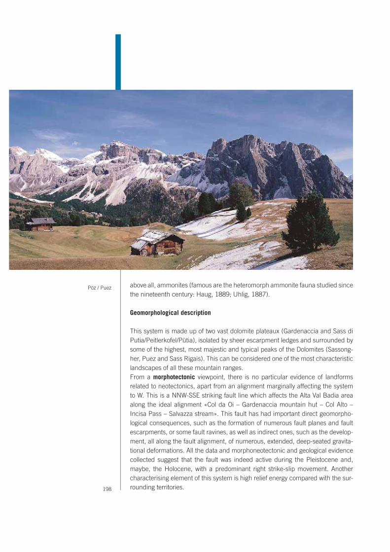
198
above all, ammonites (famous are the heteromorph ammonite fauna studied since the nineteenth century: Haug, 1889; Uhlig, 1887).
Geomorphological description
This system is made up of two vast dolomite plateaux (Gardenaccia and Sass di Putia/Peitlerkofel/Pütia), isolated by sheer escarpment ledges and surrounded by some of the highest, most majestic and typical peaks of the Dolomites (Sassong-her, Puez and Sass Rigais). This can be considered one of the most characteristic landscapes of all these mountain ranges.From a morphotectonic viewpoint, there is no particular evidence of landforms related to neotectonics, apart from an alignment marginally affecting the system to W. This is a NNW-SSE striking fault line which affects the Alta Val Badia area along the ideal alignment «Col da Oi – Gardenaccia mountain hut – Col Alto – Incisa Pass – Salvazza stream». This fault has had important direct geomorpho-logical consequences, such as the formation of numerous fault planes and fault escarpments, or some fault ravines, as well as indirect ones, such as the develop-ment, all along the fault alignment, of numerous, extended, deep-seated gravita-tional deformations. All the data and morphoneotectonic and geological evidence collected suggest that the fault was indeed active during the Pleistocene and, maybe, the Holocene, with a predominant right strike-slip movement. Another characterising element of this system is high relief energy compared with the sur-rounding territories.
Pöz / Puez
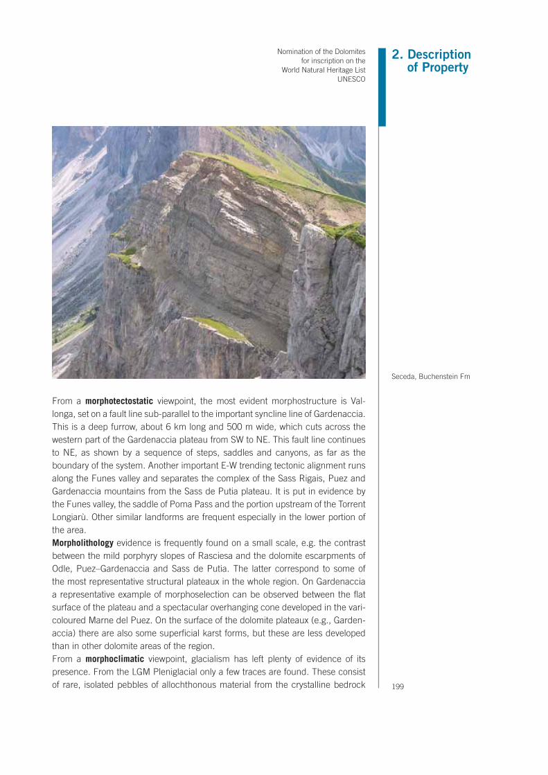
2. Description of Property
Nomination of the Dolomites for inscription on the
World Natural Heritage List UNESCO
199
From a morphotectostatic viewpoint, the most evident morphostructure is Val-longa, set on a fault line sub-parallel to the important syncline line of Gardenaccia. This is a deep furrow, about 6 km long and 500 m wide, which cuts across the western part of the Gardenaccia plateau from SW to NE. This fault line continues to NE, as shown by a sequence of steps, saddles and canyons, as far as the boundary of the system. Another important E-W trending tectonic alignment runs along the Funes valley and separates the complex of the Sass Rigais, Puez and Gardenaccia mountains from the Sass de Putia plateau. It is put in evidence by the Funes valley, the saddle of Poma Pass and the portion upstream of the Torrent Longiarù. Other similar landforms are frequent especially in the lower portion of the area.Morpholithology evidence is frequently found on a small scale, e.g. the contrast between the mild porphyry slopes of Rasciesa and the dolomite escarpments of Odle, Puez–Gardenaccia and Sass de Putia. The latter correspond to some of the most representative structural plateaux in the whole region. On Gardenaccia a representative example of morphoselection can be observed between the flat surface of the plateau and a spectacular overhanging cone developed in the vari-coloured Marne del Puez. On the surface of the dolomite plateaux (e.g., Garden-accia) there are also some superficial karst forms, but these are less developed than in other dolomite areas of the region.From a morphoclimatic viewpoint, glacialism has left plenty of evidence of its presence. From the LGM Pleniglacial only a few traces are found. These consist of rare, isolated pebbles of allochthonous material from the crystalline bedrock
Seceda, Buchenstein Fm

200
above Lech de Ciampei, or pebbles mixed with autochthonous debris near Gar-dena Pass. The latter indicate glacial transfluence from Val Gardena to Val Badia. Other similar, significant traces have been found in the surrounding areas as on the Pralongià plateau, SE of the system. This kind of evidence has allowed the elevation line reached by glaciers during the LGM and their flow direction to be traced. In particular, the most widespread evidence, in the form of glacial cirques and moraine deposits, was left during the Lateglacial phase. Among the former, the Puez, Ciampei and Sass Rigais forms can be quoted. Among the latter, there are moraine ridges and arcs stretching from Puez and Longiarù crest to the valley to NE, in the direction of Longiarù. Other well preserved glacial forms are found in the small Chedul and Juel valleys, which stretch to W and E of Gardenaccia, respectively. The correlation between all these pieces of evidence has allowed a reconstruction of glacial evolution comparable with other areas of the Dolomites. There are numerous talus cones, scree slopes, protalus ramparts and avalanche debris, connected to glacionival morphogenesis.There are also mass movements affecting the dolomite walls in the form of rock falls or, from their foot, debris flows or earth flows. An example of a vast rock fall is the one occurring some 5000 years B.P. on the Sass Ciampac dolomite escarp-ment, which discharged its material as far as the village of Colfosco and beyond. The landslide age was detected by means of radiometric methods on spruce trunks found within the landslide body. Other landslides occurred at Piz Som-pluf, at mount Cir, near Gardena pass, and from the W boundary of the System, towards Corvara in Badìa. The first is a rock fall occurred on 20 July 2006 at Piz Sompluf in the Community of S. Martino in Badia. It is an emblematic example of recent rock falls probably favoured by permafrost degradation and frost shattering processes. A volume of 40,000 m3 detached from a vertical cliff made up of Cas-
Scree slopes and protalus rampart on Juel valley

2. Description of Property
Nomination of the Dolomites for inscription on the
World Natural Heritage List UNESCO
201
sian Dolomite, at a height of 2400 m. The fallen material travelled for a distance of 800 m on the debris cone at the foot of the slope. The upper part of the Passo Gardena landslide is a significant example of rock slide affecting the Cassian Dolomite. In the Upper Badia Valley. It evolves into a rotational slide affecting weak clayey rocks of the S. Cassiano and Wengen formations, and then becomes an earth slide – earth flow of some million m3 of clayey material (cosmogenic 36Cl AMS dating: from about 11,800 to 8500 yr BP). The Corvara landslide affects an area of more than 2.5 km2 located immediately uphill of the village of Corvara in Badia (Pralongià plateau), at the SE boundary of System 6. It can be classified as a rotational earth slide, which locally shows evidence of earth flow, giving to the landslide a complex style of activity. It affects slopes made up of the Wengen and San Cassiano formations. The estimated overall volume is of more than 300 mil-lion m3. It is known from several radiocarbon dates that the landslide has moved since at least about 10,000 cal BP, and that it underwent a second major phase of morphological development from about 5000 to 2500 cal BP. The landslide is active at present, with movement rates ranging from about 0.01 to 2 m/year.The components of high extrinsic geodiversity, especially at a regional level, are found in the relief energy of the whole system, compared with the surrounding valleys, and in many examples of morphostructural landforms. The geomorpho-logical data from this area, concerning the intrinsic geodiversity for morphoclimat-ic landforms and in particular numerous kinds of evidence of LGM and Lateglacial glacialism, have allowed an important paleogeographic reconstruction of the LGM and the subsequent deglaciation phase, with extrapolations also in other sectors of the Dolomites.
Fault line valley of Vallonga.


2. Description of Property
Nomination of the Dolomites for inscription on the
World Natural Heritage List UNESCO
203


SCILIAR - CATINACCIO/SCHLERN - ROSENGARTEN - LATEMAR
system 7

206
Lithological sketch representing the geometric relationships
between geological units in the Sciliar - Catinaccio /
Schlern - Rosengarten - Latemar area.

2. Description of Property
Nomination of the Dolomites for inscription on the
World Natural Heritage List UNESCO
207
Sciliar - Catinaccio/Schlern - Rosengarten - Latemar
CORE ZONE BUFFER ZONE
area (ha) 8.991,47 area (ha) 4.887,71
231 Pastures 0,23% 231 Pastures 8,94%
242 Complex cultivation patterns 0,00% 242 Complex cultivation patterns 0,00%
243 Land principally occupied by agriculture, with significant areas of natural vegetation
0,00%243 Land principally occupied by
agriculture, with significant areas of natural vegetation
0,01%
244 Agro-forestry areas 0,00% 244 Agro-forestry areas 0,00%
311 Broad-leaved forest 0,00% 311 Broad-leaved forest 0,00%
312 Coniferous forests 19,86% 312 Coniferous forests 63,34%
313 Mixed forests 0,17% 313 Mixed forests 0,22%
321 Natural grassland 12,84% 321 Natural grassland 18,56%
322 Moors and heathland 2,22% 322 Moors and heathland 2,17%
324 Transitional woodland/shrub 9,33% 324 Transitional woodland/shrub 1,62%
331 Beaches, dunes, sands 0,00% 331 Beaches, dunes, sands 0,00%
332 Bare rock 49,63% 332 Bare rock 3,88%
333 Sparsely vegetated areas 5,70% 333 Sparsely vegetated areas 1,25%
335 Glaciers and perpetual snow 0,00% 335 Glaciers and perpetual snow 0,00%
512 Water bodies 0,03% 512 Water bodies 0,00%
Physical and Geographical description
This important core can be separated in two disctinct bodies: the Sciliar/Schlern - Catinaccio/Rosengarten and the Latemar. The first group is located on the edge of the Western Dolomites and, as can be gathered by the name, is composed of two large massifs: the Sciliar/Schlern, in the Provincia Autonoma di Bolzano, and the Catinaccio/Rosengarten, in the Provincia Autonoma di Trento (attachment 2.12). In a more southern position is palce the Latemar. Toward the west and northwest, The Sciliar/Schlern - Catinaccio/Rosengarten area is bordered by the Fiè/Völs-Siusi/Seis terrace and then by the Val d’Isarco/Eisacktal. Toward the southwest, it comprises Mount Balzo/Völsegg Spitze and the Val di Tires/Tires Tal. Toward the northeast, it extends from the steep walls of the Sciliar to the gentle morphology of the Alpe di Siusi/Seiser Alm and then to the Val Gardena/Grödnertal. T oward the southeast, the carbonatic structure is seamlessly conjoined to the Catinaccio group, which ex-tends from the northeast toward the east and southeast over an area that is approximately defined by the Alta Val Duron, Dociuril, Mazzin, Vigo di Fassa, Passo di Costalunga/Karerpass, Prato di Colbleggio/Kölblegwiesen, and the Passo Nigra/Niegerpass e Tires/Tiers The Sciliar group can be subdivided into three main bodies: – the dolomite massif itself, whose principal peak is Mt. Pez/Petz (2,563 m) and it’s subdivided into two sections by the deep Siusi/Seiser Klamm gorge which extends to Siusi and separates Mt. Castello (Burgstall 2,515


2. Description of Property
Nomination of the Dolomites for inscription on the
World Natural Heritage List UNESCO
209
“At last the Alp plateau was reached, and in a moment the Hohe Schlern fronted me high in air, looming big, black, and solid, a thin cloud girthing its middle. (…) Its massive and unbroken form from this point appeared to be relieved by but one isolated pinnacle at the northern end, whose roots lay hid in the dark pine forests that clung to the base of the mountain; soon, however, other pinnacles from behind their companion stood boldly out to view.”
(J. Gilbert and G.C. Churchill, The Dolomite Mountains, 1864)
Sciliar / Schlern

210
m) from Sciliar Davanti/Gabels Mull and from Piccolo Sciliar/Jungschlern (Gabels Mull 2,389 m) and Junger Schlern (2,283 m): – a central section which is domi-nated by Cranzes Peak (Kranzespetz 2,465 m) and comprises the small Bel Colle chain (Schönbichl 2,262 m), Mt. Cavaccio (Tschafatsch 2,235 m), Mez-zodì Peak (Mittagskofl 2,187 m), Mt. Cavone (Tschafon 1,743 m) and Mt. Balzo (Felsek 1,834 m); – finally, a third part made up of Terra Rossa Peak (Rothe Erde 2,655 m), which extends to include the characteristic pointed spires of the Denti di Terra Rossa (Rosszähne/Popes de Molignon). The northernmost part of the Cati-naccio/Rosengarten group is located beyond Passo del Molignon/Molignonpass. Although this group forms an integrated unit with the Sciliar/Schlern group, the two dolomitic groups have always been viewed as two independent entities. Actu-ally, a single glance is enough to appreciate the different characters of the two mountains; even though they are united by a thin juncture of peaks and crests, they have very different geomorphologies. While the Sciliar/Schlern appears as a compact, monolithic colossus of dolomite, the Catinaccio/Rosengarten has a thinner outline in the form of a slender, steep, jagged crest that runs from north to south and separates the valleys of Tires and Ega from the Val di Fassa. At many points along this lengthy chain, the peaks of the group reach an altitude of 3000 meters and often assume the shapes of dizzying obelisks and towers. The main valley in the Catinaccio/Rosengarten group is the Valle del Vajolet, which deeply grooves the group from the Passo del Principe to Rualp in Val di Fassa and col-lects water from a third of the Catinaccio/Rosengarten. The peaks in the group are famous: Torri di Vaiolet (2,813 m), Catinaccio di Antermoia (3,002 m), Cima
Looking backwards through an opening at one of these
dark corners, we saw again the Latemar precipices, which we had lost sight of since leaving
Welschenhofen. They stood high in air, and bathed in sunlight, their front worn into singular
resemblance to the pipes of a gigantic organ.”
(J. Gilbert and G.C. Churchill, The Dolomite Mountains, 1864)
Latemar and Lake Carezza / Karersee

2. Description of Property
Nomination of the Dolomites for inscription on the
World Natural Heritage List UNESCO
211
Catinaccio/Rosengarte Spitze (2,981 m), Croda di Re Laurino (2,813 m), Croda Davoi (2,745 m), Torre Gardeccia (2,483 m), Cogolo di Larsec (2,679 m), Crepe di Lausa (2,719 m), Scalieret Peak (2,887 m), Cima delle Poppe (2,768 m), the Masarè, and the Molignon (2,820 m). Despite the presence of the Rio di Soial and other streams, the hydrography of the group is uncertain because of its great altitude and special morphological/structural features. In a more south position there is the Latemar Massif, that extends across the Fiemme, Fassa and d’Ega/Eggental valleys. The Latemar is delimited in the north by the Passo Costalunga/Karerpass and by the basin of the Lago di Carezza/Karersee, to the east by the Valle di Fassa, to the south by Val Vardabè and the Passo Feudo, to the west by the Passo Pampeago and Vallata di Obereggen. The Gruppo del Latemar is com-monly intended to be the area between Rio di Stava and Rio della Pala to the west, Rio di Nova and Rio di Costalunga to the north, and Torrente Avisio to the east and south. This area is then subdivided into three subgroups: the Cresta del Latemar (or Carezza subgroup), the Valsorda subgroup, and finally the southern foothills of Cornon (or Cornon subgroup). The highest peak is Cimon del Latemar/Diamantiditurm (2,486 m). Other important peaks are Schenon/Latemarspitze (2,791 m), Pope/Popekanzel (2,460 m), Punta Chiesa/Kirchtagweid (2,616 m), Cima del Forcellone (2,750 m), Corno d’Ega/Eggentaler Horn (2,799 m), Cima di Valsorda (2,752 m), Feudo (2,670 m), Spiz dei Muss (2,636 m) and Cima da Ciamp (2,265 m).
Geological description The series of terraines that surface in the area extends from Permian to Upper Triassic (Ladinian and Carnian) Since the 19th century, the Sciliar – Catinaccio has been (and still is) one of the most important areas of study and reference
“Imagine a gigantic amphitheatre or jagged, cleft precipices, shooting 3,000 feet above the spectator out of a depth far below him (…) Let the arms of this amphitheatre stretch forwards so as to embrace nearly one half of his horizon, shutting him up to the one view of a stern, desolate, barren face, that present itself on all sides. Let successive masses of débris descend from the base of this long line of precipices through the whole sweep of its circuit, and threaten to occupy the entire basin below, while still leaving a small patch of bright green pasture, on which a dark spot is identified as a châlet. All this imagined will still give but a very inadequate idea of the impressiveness of the scene.”(J. Gilbert and G.C. Churchill, The Dolomite Mountains, 1864)
“In the writer’s opinion, the most impressive scenery in this district is enjoyed by mounting from Vigo into a hollow, or cirque, called Vajolet, which penetrates deeply into the mass of the Rosengarten. (…) It is not so regular in form as some spots to which that designation is given, but for grandeur and variety of rock-scenery it has scarcely a superior.”(John Ball, A Guide to the Eastern Alps, 1868)
Dirupi di Larsec and Vajolet Valley

212
in Triassic dolomitic stratigraphy because of its spectacular look and accessible outcroppings. Pioneering studies on the biogenic origin of these bodies and on the geometric configurations of the clinostratified bodies were carried out by F. von Richthofen (1860) and E. von Mojsisovics (1879). In particular, the 1860 study of the Sciliar by Richthofen succeeded in identifying the Triassic carbonatic masses of the Dolomites as coral reefs. Subsequently, Mojsisovics (1879) further studied the relationships between these dolomitic masses and the adjacent rocks. He introduced two new concepts: the facies heteropy concept between the reefs and the adjacent volcanic deposits, resulted to be onlapping; and the concept of Uberberguss-Schictung; that is, original strata deposited in the incline position on the reefs margins (clinostratifications).This area has not undergone significant tectonic activity. As a result, the geometric relationships between the sedimentary bodies are particularly well-preserved, which permits a thorough study - on a seismic scale - of the geometric designs and the methods of growth of the Ladinic carbonate platforms of the Western Dolomites. In fact, all parts of this reef are accessible for study; one can walk from the lagoon to the bio-constructed margin and then descend along the paleoslope until one sees the interfingering with the basinal sediments. Splendid examples of volcanites and volcanoclastics onlap geometries can also be observed. Volcanic products from the Ladinic volcanic event (which in terms of geologic time is practically instantaneous) ended up sealing and thus “fossilizing” the slope of the platform. One of the remarkable features of this area is the fact that the effects of volcanism and the associated tectonics were recorded on the carbonatic bodies. In Malknett/Molignon hamlet,
Schenon of Latemar

2. Description of Property
Nomination of the Dolomites for inscription on the
World Natural Heritage List UNESCO
213
a splendid remnant is preserved of an undersea landslide resulting from collapses of the Sciliar/Schlern slope, while the top of the Sciliar plateau shows subaerial lava flows. The Catinaccio/Rosengarten is one of the most spectacular examples of a prograding prevolcanic platform; for this reason it has been extensively stud-ied by researchers from the all world. On the Sciliar, this phase is present but not as well exposed; however, the post-volcanic phase is quite visible, so that one can see and calculate the true dipping angles of the clinoforms and their heteropic relationships with the basinal sediments. Also, the rates of aggrading and prograding can be estimated with the aid of other geochronological data.. A number of sections that outcrop along the streams at the base of these carbon-atic buildups were thoroughly studied during the last century. An interpretation of these exposed sections enables information to be gathered on the carbon-atic productivity of the platforms before, during and after volcanic activity. Also, thanks to the better preservation of the fossils buried in the basinal sediments, important bio-chronostratographic information can be obtained: those through stratigraphic correlations, allow a better dating also of the strata at the top of the platform (where the fossils are much less common because they were destroyed during dolomitization). Among the oldest known sections in the area, the most important are the ones along the Rio Frommer/Frommerbach, the Rio Freddo/ Frötschbach and the Rio Cipit/Tschapitbach. A complementary study of these two very close systems has therefore enabled researchers to increase their knowledge of the factors and dynamics which controlled their development of the systems, from their appearance to their death. From a “local” stratigraphic standpoint,
Mahlknecht Cliff, Alpe di Siusi/Seiser Alm. Ladinian slope deposits consisting of several carbonate breccia horizons alternating with volcaniclastic horizons. Megablocks can reach 25 m in height.

214
but of reference for the Triassic Tetide, this is the type-area for the Dolomia dello Sciliar/Schlern, whose name is in fact derived from this carbonate buildup. The Alpe di Siusi was already famous for its rich fossil fauna in the 17th century. Over the past two centuries, geologists and naturalists from Europe and elsewhere (cf. Stur, 1868; Mojsisovics, 1874, 1879; Zittel, 1899; Blaschke, 1905; Boili, 1907; Diener, 1903; Waagen, 1903, 1907; Koken, 1913..) have gathered, classified and collected a great many examples of brachiopods, bivalves, gastropods and cephalopods. For many years, the dating of these successions was mainly based on bentonic fossils, and the results were then correlated with the fauna of other areas. Numerous studies on the bioconstructors of reefs have been carried out on the “Cipit Boulders”, which are named after the Rio Cipit/Tschapit Bach stream that flows through the Alpe di Siusi. These are blocks of reef that have rolled down at the base of the slope and in the more proximal areas of the basin. The pecu-liarity of these blocks is that they have remained “packaged” in waterproof sedi-ments, which has enabled to analyze in detail the bioconstructors associations. If they had not been “packaged”, they would have been completely obliterated by dolomitization and by late diagenesis. One of the peculiarity of the geology of the Latemar is the excellent preservation of a entire carbonate platform. Respect to the link between volcanic and the carbon-ate platform the Latemar area shows one the most beautiful outcrop of the entire Dolomite. On this massif, in the ridge that extends from Forcella dei Campanili/Rotlahnscharte to the east, in the basin below Cimon del Latemar/Diamantiditurm, to the north by the Latemar Bivacco, and in the ridge of Schenon/Latemarspitze a number of red sedimentary dikes have been identified. These dikes probably document an extensional phase after the formation of the Latemar Platform but prior to the volcanism in Predazzo. One peculiarity of Latemar is that it was in-volved in the evolution of the Predazzo volcanism, as evidenced by the presence of diatremes within the platform. The Latemar diatremes are characterized by bre-ccias with either volcanic or carbonate clasts, immersed in a dark volcanic matrix. Spectacular basaltic dikes intruded in the limestone and in the entire outcropping stratigraphic succession are found along the northern mountainside and at the Cresta de Do Peniol. Here the plentiful basaltic dikes are parallel and normal to the ridge line. In the Latemar Massif their principal orientation is N150° ± 10°, with other dikes perpendicular to this group. The entire range to the east of the Feudale-Toac Line is characterized by a thick volcanic succession that constitutes the fill of the collapse of the caldera of Predazzo.
Stratigraphic and paleontological emergences– Since the 19th century, the Sciliar – Catinaccio has been (and still is) one of
the most important areas of study and reference in Triassic dolomitic stratigra-phy because of its spectacular look and accessible outcroppings.
– The pre-volcanic platform (northern sector) is three dimensionally preserved in all its parts, and shows spectacular examples of geometric relationships with the volcanic bodies that onlap its slopes.

2. Description of Property
Nomination of the Dolomites for inscription on the
World Natural Heritage List UNESCO
215
– The abundance of natural exposed sections (Rio Frommer/Frommerbach, the Rio Freddo/ Frötschbach and the Rio Cipit/Tschapitbach) enables information to be gathered on the carbonatic productivity of the platforms before, during and after volcanic activity; moreover enabled researchers to increase their knowledge of the factors and dynamics which controlled the development of the systems, from their appearance to their death
– The Alpe di Siusi was already famous for its rich fossil fauna in the 17th cen-tury. Over the past two centuries, geologists and naturalists from Europe and elsewhere (cf. Stur, 1868; Mojsisovics, 1874, 1879; Zittel, 1899; Blaschke, 1905; Boili, 1907; Diener, 1903; Waagen, 1903, 1907; Koken, 1913; Valduga, 1972; Leonardi, 1969; Urlichs, 1977; 2000, 2001) have gathered, classified and collected a great many examples of brachiopods, bivalves, gastropods and cephalopods.
– The Anisian/Ladinian Latemar reef is one of the most important and best-known examples of isolated fossil carbonate platform of the word. Numerous studies have been done on the depositional geometries, bio-constructor com-munities, and depositional typology of this platform.
– For the last 20 years the Latemar carbonate platform has been the subject of in-depth studies by the international scientific community on the cyclostratig-raphy, the geochronology, the sedimentation rate and the rate of evolution. The term “The Latemar Paradox” has been specifically coined.
– The fauna coming from the lagoon facies inside the atoll is noteworthy most of all for the ammonoids, the bivalves, the gastropods and the brachiopods.
Val Ciamin / Tschamin Tal

216
Collections from this area are housed in the most important museums of the Alpine area including Munich, Heidelberg, Zurich, Vienna, Padua, Milan, Bo-logna and Predazzo. This fauna have been investigated by Mojsisovics (1882), Bubnoff (1921), Kittl (1895), Salomon (1895) and later revised by Assereto (1969).
Mineralogical emergences
The northern area of the Sciliar/Schlern is famous for the presence of minerals. Let us examine some of the most common minerals in this area and offer a brief indication of the areas where they are found. In the Rio Frommer gorge (From-merbach), there are huge druses and crystals of analcime (a feldspathoid) in the grooves and fissures in the volcanic rock. Although the druses are amorphous, the crystals have uniform cube-shaped facets. Analcime crystals are very light and flesh-colored or off-white, and have facets that are perfectly regular and square. Many samples found in the park can be considered to be of great importance. Besides analcime, the valley has bountiful examples of apophillite (a phyllosilicate
“It is this great precipice which gives grandeur to the Schlern;
another, so sheer and lofty, can scarcely be found out of the
Dolomite district.”
(J. Gilbert and G.C. Churchill, The Dolomite Mountains, 1864)

2. Description of Property
Nomination of the Dolomites for inscription on the
World Natural Heritage List UNESCO
217
of potassium and calcium), which appears as aggregates of pink-orange lamellar crystals. Also found are minerals such as natrolite (belonging of the zeolites group) and celadonite, which was once used as a colouring agent and it’s known in the region as “Klausengrün” (Chiusa green). Just as interesting are the deep grooves in the Cipit hollow; besides natrolite, apophillite and analcime, the basin contains calcite (CaCO3), dolomite (CaMgCO32), pyrite (cubic iron sulfide), limonite (ferric hydroxide) and celadonite. In the Forra del Rio Freddo/Frötschbach, a few rare samples of tabular apophillite, with a yellowish color and almost transparent ap-pearance, have been found in deposits of greenish-gray vulcanites, specifically in a place known to mineral hunters as “Lafreider Hölle”. Incredibly beautiful sam-ples of analcime, natrolite, apophillite and celestine (strontium sulfate) are found along with calcite in the geodes and lithoclasts. Samples of marcasite (rhombic iron sulfate) have been found in a small ravine on the left orographic side of the Rio Freddo, upstream from Bagni di Ratzes/ Bad Ratzes. Small, beautiful globular masses of prehnite (calcium and magnesium philosilicates) in apple green and yellow have been found near the Rifugio Zallinge Hütte. Further down the ravine, along the Rio Salaria/Salaria Bach, there is a site that is known for the widespread presence of batolite (calcium or boron neosilicate). Some of the most beautiful
samples of this rare mineral have been found here in the form of perfectly clear crystals. Numerous minerals have been found upstream of the ravine of the Rio Salaria/Salaria Bach, near the Rifugio Dialer-Hütte. They include various types of quartz (SiO2), calcite, barite (barium sulfate), chalk (calcium sulfate), heulandite (zeolites group) and calcedonium (a variety of compact quartz), as well as iron ox-
Sciliar / Schlern area, Calcite and Heulandite
Sciliar / Schlern area, Fassanite and Prehnite

218
ides and numerous types of pink quartz (the color is due to traces of manganese) in the form of crystals or bizarre aggregates of crystals in various shapes.
Geomorphological descriptionThe Sciliar/Schlern – Catinaccio/Rosengarten – Latemar system, has rather ac-centuated morphological unity, although it presents a great variety of landforms, with sheer dolomite peaks up to nearly 3000 m and high relief energy. At its feet there are mild slopes of clayey-arenaceous or volcanic rock types, in places cov-ered by vast talus cones and scree slopes.From a morphotectodynamic viewpoint, no particular morphostructures are found, apart from an alignment of landforms linked to a neotectonic fault located in Val di Fassa, north of Pera. This is a right-strike slip, with alignments of saddles, es-carpments, landslides and erosion forms. This structure is also responsible for the piracy of the upper Val di Dona by the Torrent Udai. Furthermore, tectonic move-ment is also shown by the displacement of a series of intrusive dykes.From a morphoselective viewpoint, the first cause of landform variety can be found in an area’s structure and, in particular, in its lithology and in the tectonic configuration of its rocks.From a morphotectostatic viewpoint, the escarpments in the dolomite group show a rough correspondence between the directions of tectonic disturbances (faults and fractures) and the margins of slopes. More in particular, some sub-parallel tectonic lines which intersect the Sciliar Natural Park, between Fiè (to the W) and Catinaccio d’Antermoia (to the east), constrain the meridian trend of some val-leys, as the Duron and Ciamin valleys, and alignments of peaks, as the crests of Cime di Terrarossa/Roterd Spitz and those between Cima di Mezzodì and Cima Principe. Also the structural surfaces that can be observed in Col di Udai are characteristic of this area. Spectacular landforms can be seen, such as Torri del Vaiolet and the southern slope of Catinaccio/Rosengarten, isolated by a series of joints in the Sciliar Dolomite formation.From a morpholithological viewpoint, the system shows various rock types, which have created very diverse landscapes, both at a small and large scale. The main mountain massifs, such as Sciliar/Schlern, Catinaccio d’Antermoia and Latemar, are bordered by steep escarpments in Sciliar Principale. In sharp contrast with them are the mild slopes at their foot, which have been prevalently modelled in the arenaceous-marly rocks of the Permian (Val Gardena and Bellerophon For-mations) and, in particular, the Lower Triassic (Werfen Formation). Also some Dolomite passes have been shaped in the particularly erodible formations of the Permian and Lower Triassic, such as the Costalunga Pass, which separates the mountain group of Catinaccio/Rosengarten from Latemar, or the Lavazè Pass, west of Pala di Santa, or the Nigra Pass, west of Catinaccio/Rosengarten. Dolomite morphological features are in sharp contrast with those in porphyry: for example, Latemar compared with Pala di Santa. The latter consists of a mildly inclined pla-teau whereas the former is a rock massif with steep walls. There are many ledges

2. Description of Property
Nomination of the Dolomites for inscription on the
World Natural Heritage List UNESCO
219
in correspondence of the Buchenstein Formation, on the faces of Catinaccio/Rosengarten and Latemar, and Travenanzes Formation on Sciliar/Schlern. There are also numerous gorges and canyons separated by high rock towers, set in a typical Dolomite landscape.From a morphoclimatic viewpoint, the landscape shows considerable evidence of LGM and Lateglacial glacialism. Earlier debris deposits were found near Moena and Vigo di Fassa, just to the east of this system. These are alluvial and slope de-posits, stratified and generally cemented with particle sizes ranging from blocks (sometimes rounded) to sand. Their thickness ranges from a few metres to 20-30 m. They are in turn covered by LGM moraine deposits and should therefore be ascribed to an interglacial period (probably Riss–Würm). Some exhumed landforms, in the permian porphyries along the Duron valley, could be ascribed to a interglacial or pre-glacial period. During the LGM the pla-teaux were covered by ice caps, from which only the highest peaks emerged. The valleys were filled by long tongues of slowly moving ice. It is presumed that the glacier which flowed over Alpe di Siusi/Seiser Alm came from Val di Fassa and passed through Passo Sella, whence it flowed into the glacier of Val Gardena. The oldest materials can be attributed to a Pleniglacial or early Lateglacial glacia-tion and are found as thin deposits spread along isolated areas of the right-hand side of the Val di Fassa. The moraine deposits in the form of terraces and frontal systems, visible almost everywhere along the axis of the valley and on the sides of the Valle del Vaiolet, may be ascribed to the LGM. The moraine deposits observed in Monzon, north of Pera, and in the hamlet of Pian, NE of Campitello, are an
Crests of Denti di Terrarossa/ in correspondence of a bundle of tectonic fractures

220
isolated example of advancement during a phase of general retreat. The principal forms that can be attributed to the erosional action of glaciers are the cirques lo-cated on the highest points of Catinaccio d’Antemoia (which are currently subject to deterioration). The ridge line that connects Torri del Vaiolet to Pale Rabbiose is marked by a continuous sequence of glacial cirques. Some are well preserved, such as Coronelle and Cigolate, others, such as those at Rabbiose Pale, have been partially destroyed. Other forms of erosion include roches moutonnées, rock bars and small basins that, together with karst processes, created two lacustrine hollows currently located in Val d’Antemoia, just to the south of Val di Lusia. Other fairly well preserved Lateglacial traces are found on Latemar, uphill of Malga Gar-donè and south of Doss Cappello. An example of transfluence of the LGM glacier can be observed in proximity of Passo delle Pale, where it is oriented towards the Lavazè valley. Glacial modelling created numerous small lakes. However, over the course of several millennia, they have been transformed into peat bogs and wet meadows by gradual burial.During glaciation the highest tops emerging from the ice were modelled by per-iglacial processes which continued after the glaciers’ retreat and still shape most of the system’s landscape to date. As a consequence, the top parts of the slopes were bordered by glacionival degradation escarpments. In correspondence with tracks there are talus cones and scree slopes. Other periglacial phenomena ob-served in the area of the system are gelifluction processes and protalus ram-parts.With regard to slope movements, several earth flows and two landslides connect-ed with glaciopressure phenomena are found. The former, approximately 2 km upstream of Campitello di Fassa, obstructed the Duron Valley. This landslide body
Catinaccia d’Antemoiafrom Sciliar / Schlern

2. Description of Property
Nomination of the Dolomites for inscription on the
World Natural Heritage List UNESCO
221
is made up of Ladinian volcanic rock which collapsed from the northern slopes of Mount Ponsin in two successive periods. The occlusion of the valley narrows and the consequent formation of a lacustrine basin can be attributed to the first slide, by far the more important. During the maximum expansion of the LGM, the glacier of the Duron Valley, originating in the eastern part of the Sciliar/Schlern ridge, and a branch of the Gardena Valley glacier flowing into the Fassa Valley to the west of Sasso Piatto, converged directly upstream of this landslide. The latter slope movement, which originated from the SE slope of Punta Scalpello, between Mazzin and Pera di Fassa, is located at the confluence of Val di Fassa and Val Soial which contained a glacial branch stemming from Catinaccio/Rosengarten. Other movements are found in the Sciliar/Schlern plateau. The entire Mt. Pez area is affected by a deep gravitational movement consisting of highly developed lateral-spreading. Typically, these complex processes developed where a brittle rock mass – intersected by vertical fractures and not confined laterally – rests on ductile rock types. In this particular case, the N-S and E-W joints splitting up the Dolomia Principale into a number of blocks with different behaviour, have allowed rain water to rapidly seep into the underlying argillites of the Travenanzes Forma-tion. As these formations swell, they penetrate the overlying dolostones from be-low through the discontinuities, favouring fracture widening. In this way, the large blocks of Dolomia Principale push each other away (lateral spreading). There are also some rock falls and debris flows, such as those of Lavina Bianca, in the area of S. Cipriano.This system shows marked regional extrinsic and intrinsic geodiversity, compared with other non-dolomite areas: its characteristics of high relief energy, with rep-resentative examples of structural landforms, widespread glacial evidence and traces of mass movements with glaciopressure implications, make it a model of geomorphological evolution in a dolomite area.


2. Description of Property
Nomination of the Dolomites for inscription on the
World Natural Heritage List UNESCO
223


RIO DELLE FOGLIE/BLETTERBACHsystem 8

226
Lithological sketch representing the geometric relationships
between geological units in the Rio delle Foglie / Bletterbach
area.

2. Description of Property
Nomination of the Dolomites for inscription on the
World Natural Heritage List UNESCO
227
Rio delle Foglie/Bletterbach
CORE ZONE BUFFER ZONE
area (ha) 271,61 area (ha) 547,43
231 Pastures 0,00% 231 Pastures 0,20%
242 Complex cultivation patterns 0,00% 242 Complex cultivation patterns 0,00%
243 Land principally occupied by agriculture, with significant areas of natural vegetation
0,00%243 Land principally occupied by agriculture,
with significant areas of natural vegetation
0,00%
244 Agro-forestry areas 0,00% 244 Agro-forestry areas 0,00%
311 Broad-leaved forest 0,00% 311 Broad-leaved forest 10,20%
312 Coniferous forests 43,00% 312 Coniferous forests 40,13%
313 Mixed forests 11,01% 313 Mixed forests 22,67%
321 Natural grassland 0,00% 321 Natural grassland 0,00%
322 Moors and heathland 0,99% 322 Moors and heathland 4,79%
324 Transitional woodland/shrub 0,99% 324 Transitional woodland/shrub 5,01%
331 Beaches, dunes, sands 0,00% 331 Beaches, dunes, sands 0,00%
332 Bare rock 44,00% 332 Bare rock 17,00%
333 Sparsely vegetated areas 0,00% 333 Sparsely vegetated areas 0,00%
335 Glaciers and perpetual snow 0,00% 335 Glaciers and perpetual snow 0,00%
512 Water bodies 0,00% 512 Water bodies 0,00%
Physical and geographical description
The area of Rio delle Foglie/Bletterbach is located in the Provincia Autonoma di Bolzano and it’s a gorge cut by the stream Rio delle Foglie/Bletterbach (attach-ment 2.12). This narrow canyon is roughly limited to the northwest by the village of Aldino/Aldein, to the north by Monte Pausabella, towards the southeast by Pas-so di Oclini/Jochgrimm (1,989 m), towards south-southwest by Redagno/Radein and Monte Colle, and towards the west by the village of Olmi. The whole area is characterized by modest elevations compared to other Dolomitic areas. The only notable peak is Corno Bianco/Weisshorn, which is located in the eastern-most section and has an elevation of 2,317 m.
Geologic description
The Rio delle Foglie/Bletterbach Gorge, near Redagno/Radein in the southern part of Alto Adige, is a geological site without equals. The Rio delle Foglie/Bletter-bach is the Grand Canyon of the Dolomites. In any other area of the Alps, the base of the dolomite succession is hardly so well preserved: like a pile of books the vari-ous rock strata follow each other and each tells us its history. The Rio delle Foglie/Bletterbach Gorge allows one to cross, stratum by stratum, the geological period comprised between the Lower Permian up to the Anisian, crossing through one of


2. Description of Property
Nomination of the Dolomites for inscription on the
World Natural Heritage List UNESCO
229
Rovine of Bletterbach and Weisshorn

230
the greatest biological events that has ever been seen on Earth: the Permian/Tri-assic extinction. The outcrop rocks testify how the palaeo-environmental changed from the volcanic rocks at the base (ignimbrites, Atesino Volcanic Group) and to their breakdown products, that is to say reddish sand-stones, conglomerates and pelites (Val Gardena Sandstone) that were deposited in an arid tropical environ-ment (flood plain), modulated by various transgression and regression phases of the Permian Sea. One particularly powerful transgression allowed the deposi-tion of the so-called cephalopod bank that forms a sill on which now a splendid waterfall flows. Going up the natural gorge one moves also through time and can see the Upper Permian transgression and the deposition of the Bellerophon Formation, with the precipitation of evaporites, changing into beach deposits and carbonate and terrigenous ramp environments (Werfen Formation), upon which with an unconformity, after an erosive phase, sedimentation began again with the Richthofen Conglomerate and with the carbonate bank of Corno Bianco/Weiss-horn (Contrin Formation).
Stratigraphic and Palaeontologic emergencies
– The section of Rio delle Foglie/Bletterbach shows a splendid succession of con-tinental and sea-marginal environments starting from the Upper Permian to the Lower Triassic, with high rates of sedimentation in a strong subsidence context. This leads to an expansion of the series and thus to an increase in the strati-graphic resolution for this key interval for the history of the planet. – From the sedimentological point of view, the Permian palaeo-environments are here documented in a impressive manner and this section (for years already a geology park) is among the ones belonging to the Permian that has been studied in the deepest detail.– The Val Gardena Sandstone of the Rio delle Foglie/Bletterbach is known world-wide for its rich content of tetrapod footprints which have been known since the work by Kittl (1901) and studied from a palaeobotanic-palynological point of view since the half of the last century. From the mid-1970s to the present day, a number of studies have accumulated: i) on the ichnofauna; ii) on the palynoflora (at present 97 pollen species are recognized); iii) on fossil plants. The much di-
Val Gardena Sandstones, footprints referred to the tecodont
Tridactylichnium leonardii
Val Gardena Sandstones, footprints referred to
Rhinchosauroides pallini

2. Description of Property
Nomination of the Dolomites for inscription on the
World Natural Heritage List UNESCO
231
versified ichnofauna makes this site one of the most important Permian outcrop in the world. The footprints are dominated by Rhyncosauroides and Pachypes and up to now eight ichnogenera and nine ichnospecies have been recognized. More specifically, the most common footprints are attributed to Pachypes dolomiticus, Ichniotherium accordii, Rhynchosauroides pallini, Dicynodontipus, Pachypes, Paradoxichnium, Rhynchosauroides,see Dicynodontipus, Ichniotherium, Chiroth-erium, Chelichnus, Hyloidichnus and Janusichnus.
Geomorphological description
Stream erosion in rocky formations by Rio delle Foglie/Bletterbach has generated a deep, locally meandering gorge, arranged approximately E-W. The width of the gorge varies from 20-30 metres in the volcanic rock (ignimbrite) at the basis of the stratigraphic series to 200-300 m at the roof. The riverbed is interrupted in at least four places by waterfalls tens of metres high. In its terminal part the gorge opens up into a basin 600-700 m in diameter, where it is possible to admire the spectacular multi-colour series of the Bellerophon and Werfen Formations, with prevailing light-coloured dolostone at the roof of Corno Bianco/Weisshorn. The area around Rio delle Foglie – Bletterbach Gorge is mainly characterised by gla-cial deposits and landslide bodies of large dolostone blocks ascribable to glacial
Red beds of the Val Gardena Sandstones

232
transportation. From a morphotectonic viewpoint, there is no evidence of recent activity which might have caused particular landforms. Very likely, the deep cut of the Torrent Bletterbach is located in correspondence with a fracture which, in any case, does not displace the rock.From a morphoselective viewpoint, some small steps are formed in the fairly erod-ible rock types of the Valgardena Sandstone, Bellerophon and Werfen formations. A spectacular waterfall can be admired in correspondence with a bed made up of Valgardena Sandstones (with cephalopods).From a morphoclimatic viewpoint, the top area shows some remnants of glacial deposits, probably ascribable to the LGM. Some accumulations of large, alloch-thonous dolostone blocks are also found; they are related to mass movements with probable glacial transportation or reworking.An extrinsic morphological geodiversity of this small system is offered by a char-acteristic gorge, 8 km long and 400 m deep, dug into steep walls and at places interrupted by morphostructural steps and water falls.
Rovine of Bletterbach / Rio delle Foglie – Val Gardena Sandstones

2. Description of Property
Nomination of the Dolomites for inscription on the
World Natural Heritage List UNESCO
233


2. Description of Property
Nomination of the Dolomites for inscription on the
World Natural Heritage List UNESCO
235


DOLOMITI DI BRENTAsystem 9

238
Lithological sketch representing the geometric relationships
between geological units in the Dolomiti di Brenta area.

2. Description of Property
Nomination of the Dolomites for inscription on the
World Natural Heritage List UNESCO
239
Dolomiti di Brenta
CORE ZONE BUFFER ZONE
area (ha) 11.135,84 area (ha) 4.201,20
231 Pastures 0,00% 231 Pastures 0,01%
242 Complex cultivation patterns 0,00% 242 Complex cultivation patterns 0,00%
243 Land principally occupied by agriculture, with significant areas of natural vegetation
0,00%243 Land principally occupied by
agriculture, with significant areas of natural vegetation
0,00%
244 Agro-forestry areas 0,00% 244 Agro-forestry areas 0,00%
311 Broad-leaved forest 0,17% 311 Broad-leaved forest 5,63%
312 Coniferous forests 3,65% 312 Coniferous forests 29,02%
313 Mixed forests 0,07% 313 Mixed forests 2,87%
321 Natural grassland 18,66% 321 Natural grassland 17,44%
322 Moors and heathland 9,78% 322 Moors and heathland 23,98%
324 Transitional woodland/shrub 0,00% 324 Transitional woodland/shrub 0,01%
331 Beaches, dunes, sands 0,00% 331 Beaches, dunes, sands 0,00%
332 Bare rock 65,51% 332 Bare rock 20,94%
333 Sparsely vegetated areas 0,00% 333 Sparsely vegetated areas 0,00%
335 Glaciers and perpetual snow 2,14% 335 Glaciers and perpetual snow 0,02%
512 Water bodies 0,02% 512 Water bodies 0,08%
Physical and geographical description
The Group of the Dolomiti di Brenta, situated in the western of the Trento Prov-ince, is delimited to the west from the line of the Giudicarie that together with the Insubrica line defines the NW limit of the Dolomitic region. This Group is roughly 42 km long, 15 km across and arranged transversally from north-east to south-west, covering an area of around 92 km² (attachment 2.13). The northern boundary is formed by the Sole Valley and the Valley of Non: to the west the Meledrio Valley, Campiglio Valley and Rendena Valley divide the Brenta Group from the nearby Adamello-Presanella massifs. The Valley of Non and the Adige Valley close the circle around the Brenta Group. The Bocca di Brenta divides the chain into two branches: to the north the Sfulmini chain, the Grosté massif and the long northern chain, with Altissimo and the Campa subgroup branching out to the east and to the south the Cima Tosa massif and the Ambiez chain. Among the tallest peaks of the Brenta Group are Cima Brenta (3,150 metres), Cita Tosa (3,173 metres) Ambiéz (3,096 metres) and Vallon (2,935 metres). The main wa-tercourses of the area are to the west – the Sarca which collects water from all the streams that flow down from western Brenta (Bondai, Ambiez, Rio dei Molini, Rio d’Algone, Rio Valagola, Sarca del Brenta) and still to the west after Passo Campo Carlo Magno there is the Torrente Meledrio, a tributary of the River Noce which receives all the watercourses from the north-eastern slopes of Brenta. There are


2. Description of Property
Nomination of the Dolomites for inscription on the
World Natural Heritage List UNESCO
241
“High amongst the clouds soar its red towers and pinnacles; the bold ridges which support them sweep down upon us in majestic curves. (…) The ground-colour of their walls is a yellowish grey, streaked with red and black, and broken here and there by lines of shining white, where a steep glacier-stair scales the precipice”.
(D.W. Freshfield, The Italian Alps, 1875)
Western walls Brentagroup

242
also numerous lakes: after Molveno, the largest lake in the Brenta Dolomite ter-ritory is Lake Tovel, once famous for the red coloration of the water. Other lakes include Valagola, in Val d’Agola in the western sector, Lake Durigat near the Peller Refuge, Lake Salare near the ex-Cavalli malga and Lake Asbelz in the southern sector near the Passo della Nana.
Geological descriptionThe series of terrains that outcrop in the Brenta Group range from the early Paleo-zoic to the Cretaceous. The volcanic-sedimentary succession of the lower Permi-an outcropping on M. Massimeno, shows a very interesting intercalation between volcanic products and fluvial-lacustrine deposits. The units of the Norian-Liassic succession (Calcare di Zu, Formazione del Tofino, Calcari Grigi) are also peculiar in the geologic scenario of the Dolomite history as a witness of the transitional stratigraphy between the Trento platform and the Lombardy Basin, registering Mesozoic synsedimentary tectonic activity in the central Subalpine sector. In the eastern sector of Brenta Dolomites the higher part of Dolomia Principale drawn and, as shown by the deeper water environment facies of the Zu Limestone. The back-stepping trend follows with the subtidal limestone of Calcari Grigi Group. Moving westward all these units are instead replaced by the Rhaethian basinal deposits of the Tofino Limestone (Lombardy Basin). The condensed unit of Rosso Ammonitico Fm and the Selcifero Lombardo lay on both the Trento platform and on the Lombardy basinal facies, witnessing that from late Jurassic, all the area started to drawn in an homogeneous way. The Brenta Group is delimited to the west by the Giudicarie fault which follows the course of the Rendena and Meledrio valleys. This imposing tectonic line stretches for 150 km in a SW-NNE direction and connects to the Tonale faults in the Sole Valley. The line from Tonale con-tinues north-east and east into the Periadriatic line, forming the border between the eastern and southern Alps. There are characteristic structures in the Brenta Group which include very pronounced overthrusts with large duplications of the Triassic and Liassic sequences with front areas oriented towards E-W which, geo-metrically, may be referred to the Valsugana system. These front areas are sepa-rated and are at times interwoven with transpressive – left strike-slip faults, typical of the Giudicarie Line orientation.
Stratigraphical Emergencies– This area documents with a thick (about 3500 meters) and complete succes-
sion of facies and palaeo-environments, a continuous interval of time starting from the Upper Paleozoic throughout the entire Cretaceous.
– This area documents the entire structural and stratigraphic evolution of the south-alpine passive margin from the first rifting phases to the post-rift su-ture.
– The area spectacularly testified the tectonic history of the Dolomites with inter-ference figures and drag folds in massive dolomites and limestones.

2. Description of Property
Nomination of the Dolomites for inscription on the
World Natural Heritage List UNESCO
243
Geomorphological descriptionThe mountain massif of the Brenta Group is characterised by a long ridge which, to the west, is parallel to the upper Val Rendena – Val Meledrio. To the east, this chain borders Val di Non and Valle del Lago di Molveno. The long and well known Tovel valley furrow penetrates deeply into this massif, separating the ridge be-tween Cima Val Strangola and Croz dell’Altissimo from the main ridge. The high-est peaks attain elevations of 2800 to 3000 m circa (maximum top Cima Tosa, 3173 m a.s.l.). The Brenta Group is made up entirely of sedimentary rocks. In particular, the Dolomia Principale characterises the central body of this rock mas-sif and shows spectacular morphostructural (rock towers, steeples, ledges etc.) and morphoclimatic landforms (glacial cirques, roches moutonnées, cryogenic landforms etc.). Other more recent carbonate formations crop out at the margins of the Dolomia; they are characterised by milder forms in sharper contrast with the former.From a morphotectodynamic viewpoint, there is no particular evidence of land-forms linked to recent tectonic movements. On some peaks in the Dolomia Princi-pale some saddles which interrupt the crests in several points are found; they are typical landforms located in correspondence with breaks and cracks in the rock. Some of them could be related to neotectonic events. Morphological features re-sulting from collapse, reactivation of slickensides and fractures with displacement in carbonate concretions (stalactites, stalagmites and pillars) are found inside karst cavities; they might be ascribed to neotectonic movements. Between March 1992 and July 1993, the area was affected by several low-energy seismic shocks,
“Rocks, grey, gold, red, brown and black, cluster round his bewildered eyes, and he begins to doubt whether the scene is a solid reality or some Alastor-inspired Vision of Solitude.”
(D.W. Freshfield, The Italian Alps, 1875)
The Central Brenta group at dawn

244
concentrated between the Vedretta dei Camosci line and the S. Maria di Flavona line.From a morphotectostatic viewpoint, numerous forms seem to be linked to tec-tonics with a passive role. This results from the fact that in the Brenta Group there are many geological structures which include E-W oriented frontal over-thrust zones, with duplications of the Triassic and Liassic sequences. The frontal zones are separated and often intersected by transpression and transcurrent left strike-slip faults, typically oriented according to the Giudicarie Line. The latter is an important Alpine structural feature stretching some kilometres to the west of the Brenta Group. This complex tectonic framework is reflected by a dense series of structural elements (faults and overthrusts) affecting the Brenta Group with N-S trends parallel to one another which, in turn, are intersected nearly normally by many other discontinuities. Along or in proximity with these belts of structural weakness, some of the main valleys have developed, such as, for example, Val di Tovel (cut across by a series of N-S oriented faults linked to the Palete – S. Maria Flavona line and Val Strangola line), Valle delle Seghe (along a great normal fault), Val d’Ambiez (along the line bearing the same name), Val d’Agola (near the Pala dei Mugoni line and Sabion line) and Val Brenta (at the margin of Cima Pra’ dei Camosci line). Many other smaller, narrow, elongated valleys are located exactly in correspondence with as many tectonic lines. Worthy of note is the track which hosts the small glacier of Vedretta dei Camosci, just to the west of Cima Tosa, which is arranged along the normal fault line bearing the same name. The set of vertical faults and fractures, mainly intersecting dolostones, usually with sub-hori-
“On our left was a second massive rock castle, the Cima di
Brenta, connected with the Cima Tosa by the Fulmini di Brenta, a long line of flame-like pinnacles
of the strangest shapes, some of them seeming to bulge near the
top like a Russian steeple.”
(D.W. Freshfield, The Italian Alps, 1875)

2. Description of Property
Nomination of the Dolomites for inscription on the
World Natural Heritage List UNESCO
245
zontal or slightly inclined attitudes, have given origin to a series of remarkable pin-nacles and steeples of various sizes. The toponymy of the Group pinpoints these spectacular features, as in the cases of Campanil Basso di Brenta, Campanil Lungo (well known in the rock climbing environment) and Torre di Vallesinella.From a morpholithological viewpoint, several towers owe their origin to morpho-selection processes affecting different rock types. Turrion Basso and Turrion Alto in the upper Val di Tovel are spectacular examples of this kind of landforms. They rise in the form of Klippe (Auct. Summit thrusts or Gipfelfaltung) isolated by ero-sion. In some cases morphoselection acts also in correspondence with textural changes or at the boundary between one sedimentary cycle and the next within the same geological formation. This is the case of the narrow ledges shaped in Dolomia Principale, which is a typical dolostone shelf formation made up of a mo-notonous succession of metric peritidal cycles. Along these ledges, wind several alpine paths, the most famous of which is the trail “delle Bocchette”. In recent times rock tensional releases have occurred along ancient joint systems which have produced displacements fairly visible at ground surface but quite evident in depth, such as, the Paroi cave, Bus della Spia and Specchio cave.The Brenta Group is also characterised by accentuated karst morphology, in which the surface water flow is limited to a few streams located at the margins of the massif (Val d’Ambiez, Val delle Seghe, Val di Tovel, Val Brenta). Surface karst morphological features are very common; they often result from glacio-karst types, as, for example, in the Grostedi top plateau, Lastei depression etc. In par-ticular, the most represented surface forms are: perched blocks, karren, dolines
The Dolomitic landscape of the central Brenta group

246
and sinkholes, karst trenches and crevasses (all oriented in accordance with the tectonic features that control them), staircase ecc. These spectacular karst land-scapes have been developed on large sub-horizontal surfaces and/or glacio-karst hollows, in correspondence with outcrops of the Dolomia Principale and Calcari Grigi (Lias) formations. Remarkable examples of these landscapes are found in proximity of Bocca della Vallazza (E of Cima del Grostè) and Pian della Nana. In some areas vast endorheic depressions, with diameter up to 800 m, are present. The most typical of these is Pozza Tramontana, ellipsoidal cavity with a flat floor owing to the presence of alluvial deposits. It is some 130 m deep and in its middle part is crossed by a structural element (overthrust of Pozza Tramontana). Similar phenomena are found in Val Nardis (W of Cima Tosa) and near Malga Spora. In the former case, the depression shows a floor completely covered by alluvial deposits. In the latter case there is a vast depression covered by alluvial deposits flanked to the east by a 30 m high rocky cliff. Another example of surface karst landscape is offered by the whole area between Pietra Grande and the top of Mt. Grostè, where deeply karst-affected structural surfaces in Dolomia Principale are cut across by moderately open sub-vertical discontinuities along which crevassesand snow pits are found. An underground karst landscape has also developed in much the same way, as witnessed by many karst plateaux found all over the area (Spinale, Grostedi, Campo Flavona, Alpe Campa, Pra’ Castron, Alpe Nana). In the Brenta Group several hundred cavities are found in the form of sinkholes, many of which are up to 200 m deep. Caves are also quite common, which can attain a length of several kilometres, especially in the centre-southern part of the Group. The organisation of the underground flownet is constrained by the stratigraphic and structural attitude of the massif.The Brenta Group also displays a wide record of morphoclimatic landforms result-ing from both present-day climate conditions and those which characterised the latest geological epochs. Rare are the traces of the Last Glacial Maximum (LGM), since they have mostly been eroded or buried under the products of the subse-quent morphogenesis. In any case, it was assessed that in correspondence with the area of Madonna di Campiglio the ice cover attained the altitude of 2200 m during its maximum expansion. On the contrary, glacial morphogenesis linked to the phases following the LGM up to the present is well represented in the nu-merous valleys along the western and eastern flanks of this Dolomite Group. In many of them, it is possible to perceive their typical profile underneath the slope debris covers. Typical glacial valley morphology, with particularly accentuated and fresh forms, is shown in several valleys, among which the Val Gelada from Boc-chetta dei Tre Sassi up to the Carlo Magno area, is worthy of note. Since it is free from debris, its profile is particularly well shaped. In the mid-lower portions of the valleys, moraine ridges or remnants of ridges (e.g., upper Val Brenta, upper Vallesinella etc.) are often found. Owing to their topographic position and the fact that they are covered by soil, they are ascribable to the Lateglacial stadial phases. They mark the resumption of glacial activity after the LGM, when the glaciers of lateral valleys were no longer connected with the main one. On the other hand,

2. Description of Property
Nomination of the Dolomites for inscription on the
World Natural Heritage List UNESCO
247
the upper portions of these valleys or the areas in close proximity of present-day small glaciers, host well preserved, continuous, fresh moraine ridges free from soil. They mark the boundaries attained by the small glaciers during the Little Ice Age (LIA). Glacial-cirque morphology makes up the dominant feature in the top parts of the relief, where some small glaciers are still present. In proximity of areas of recent deglaciation (inside all cirques) or in particular morphological situations (Malga Flavona, upper Val di Tovel etc.), traces of glacial exaration (glacial striae and grooves, roches moutonnées) are also found.Morphology resulting from present-day climate conditions is prevalently of the frost and snow genesis type. Protalus ramparts, talus cones, scree slopes and patterned ground are landscape forms of glacionival or periglacial origin. Well preserved examples of protalus ramparts are visible at the foot of the long slope stretching from Cima Vagliana and Passo Grostè (Pra Castron di Flavona). Talus cones and scree slopes are found more or less everywhere and give origin to large accumulations. Their abundance can be explained by the considerable thickness of the calcareous and dolostone formations (which have been crushed by very complex tectonic processes), and rugged and jagged morphology. In concomi-tance with short, intense precipitation, some of the debris fans are mobilised, thus generating debris flows. The coarse debris deposits resulting from the breakup of the Dolomia Principale Formation on the slope west of the Val Brenta – Passo del Grostè area, are worthy of note owing to the spectacularity of their landscape. The typical talus cones are here substituted by coarse debris, sometimes very large, resulting from the fall and slide of entire rock masses. The presence of
“The scenery we were entering was at once strange and exciting. The common features of Alpine landscapes were changed: as if by some sudden enchantment we found ourselves amongst richer forests, purer streams, more fantastic crags.”
(D.W. Freshfield, The Italian Alps, 1875)
The skyline of Brenta group from Lake Nero in Adamello Brenta Nature Park

248
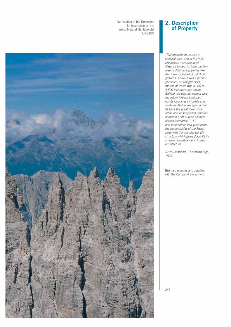
2. Description of Property
Nomination of the Dolomites for inscription on the
World Natural Heritage List UNESCO
249
“Full opposite to us rose a colossal rock, one of the most prodigious monuments of Nature’s forces. Its lower portion rose in diminishing stories like the Tower of Babel of old Bible pictures. Above it was a perfect precipice, an upright block, the top of which was 4,000 to 4,500 feet above our heads. Behind this gigantic keep a vast mountain fortress stretched out its long lines of turrets and bastions. But as we approached its base the great tower rose alone and unsupported, and the boldness of its outline became almost incredible (…);and it combines to a great extent the noble solidity of the Swiss peak with the peculiar upright structure which gives dolomite its strange resemblance to human architecture
(D.W. Freshfield, The Italian Alps, 1875)
Brenta pinnacles and aigullies with the Campanil Basso (left)

250
this particular kind of debris only in the area mentioned depends perhaps on the general attitude of the Dolomia Principale Formation, dipping W and WNW, which favours sliding. Large landslides, locally known also as Marocche, are the gravitational landforms that most characterise the Brenta Group. They all show morphological and structural features ascribable to the same type of large-sized catastrophic events known as mega-rockslides, involving millions of cubic metres of rock and debris. Their interpretation, though, is often problematic, owing to the difficulty of recognising precise relationships between the landslide bodies and the corresponding source areas. Some smaller strips are found in Valle delle Seghe. Also the vast, articulated land-slide that formed the barrier lake of Molveno should be mentioned, although is located at the border of the study area.The most frequently found landslides are rock falls. The most spectacular exam-ples are in the northern and southern sectors, while other areas characterised by the presence of smaller slope movements, are mainly located in the south-eastern sector. In the Tovel valley one of the three largest landslides of Trentino involving large rock blocks is present, with a volume of some 250-340 millions of cubic metres. According to Abele (1974), in the general classification of the slope move-
Series of pinnacles, steeples and rock needles of various sizes
shaped along vertical trending faults and fractures which cut
across the dolostones

2. Description of Property
Nomination of the Dolomites for inscription on the
World Natural Heritage List UNESCO
251
ments occurring in whole Alpine chain, this landslide is ranked 20th. It can be subdivided into a mega-rock fall and slide, locally known as marocca (“Marocca di Tovel”), and into two landslides (“frana delle Glare” and “frana di Sassere”). These consist of sudden detachments of large portions of rock from walls several hundred metres high which are affected by a high degree of discontinuities due to the combination of sub-horizontal stratum joints and sub-vertical tectonic frac-tures. Very likely, these movements were triggered by a series of seismic shocks. The Sassere landside is located valleyward of Malga Flavona, near the boundary of the system. It is a huge Holocene rock fall accumulation with an estimated volume of 55 million m3. The accumulation is chaotic and characterized by the presence of large blocks of limestones of the Calcari Grigi formation. The landslide is characterized by a clear correspondence between the source and accumula-tion areas, which is not the case for most large scale landslides observable in the system. Some of these landslides found in the Tovel valley have been dated to 17,000 - 14,000 cal. yrs B.P. With regard to present-day glacialism, there are to date 16 glaciers in the Brenta Group, all facing NW. The largest one is Vedretta d’Agola (area of about 20 ha) which is located in a cirque between the peak bearing the same name and Cima
Series of ledges shaped on the eastern face of Cima Brenta Bassa. They arise from morphoselection at the boundary between two sedimentary cycles in the Dolomia Principale Formation. The Pedrotti Refuge is located at the foot of the rock wall

252
d’Ambiez. The numerous glacial tongues that flowed to NE, E and SE are instead witnessed only by some moraine ridges. As regards the small glaciers still in exist-ence, it is rather difficult to assess their precise number and surface extent since many of them are covered by debris deposits which often conceal their bound-aries. The glaciers still present in the Brenta Group are typical cirque glaciers with mixed supply. Local morphology plays a major role on their accumulation and ablation dynamics. The spatial distribution of snow accumulations is strongly conditioned by avalanches which can redistribute the snow cover on nearly all the glacier’s surface, thus influencing mass balance. In addition, in the past few years, the surface processes and mass balances on two glaciers of the Brenta Group (Pra’ Fiorì and Agola) have been investigated in detail, in order to better understand the behaviour of this type of glacier in the present climate phase. Indeed, these are the only two glaciers monitored by means of mass balance in the entire Dolomite area.The geodiversity characteristics of this system are of various types. From the re-gional point of view, this system makes up a typical Dolomite landscape, with a very wide range of structural landforms of morphotectostatic type, at large and average scale, which distinguishes it from all the other mountain groups located on the right-hand side of the River Adige. Therefore, it shows an accentuated ex-trinsic geodiversity. In addition, it offers two representative situations of intrinsic
Pozza Tramontana. Large, ellipsoidal karst depression with
a flat floor due to the presence of alluvial deposits

2. Description of Property
Nomination of the Dolomites for inscription on the
World Natural Heritage List UNESCO
253
geodiversity: i) a well developed karst system showing both surface and subsur-face forms at a large scale; ii) an exemplary display of morphoclimatic landforms, both relict and present, at large and average scale. All this can make up an actual high-altitude scientific and educational field laboratory.


2. Description of Property
Nomination of the Dolomites for inscription on the
World Natural Heritage List UNESCO
255


Nomination of the Dolomites for inscription on the
World Natural Heritage List UNESCO
257
3. Justification for inscription
3. JUSTIFICATION FOR INSCRIPTION
3.a Criteria under which inscription is proposed (and justification for inscrip-tion under these criteria)
The nomination for the inscription of The Dolomites on the World Heritage List is based on Criterion vii - Contain superlative natural phenomena or areas of exceptional natural beauty and aesthetic importance, and on Criterion viii - To be outstanding examples representing major stages of earth’s history, including the record of life, significant on-going geological processes in the development of landforms, or significant geomorphic or physiographic feature. These criteria are closely interlinked in the case of the Dolomites, both from the historic point of view as well as for their landscape features. Historically the aesthetic importance and the scientific relevance of the Dolomites have attained world-wide significance due to pictures, descriptions and studies by the most important international sci-entists from the XVIIIth century onwards.

258
Criterion viiThe Dolomite region is a collection of landscapes, unique not only in the Alps, but also unseen in other mountain ranges throughout the world. The exceptional natural beauty of the region derives from two main factors: the landscape struc-ture and the scenic values.The frequency of separate mountain groups set side by side in a particularly re-stricted environment and the unusual variety of vertical shapes (rock faces, peaks, spurs, aiguilles, needles, spires, pinnacles, towers, jags, …) as well as horizontal (ledges, roofs, plates, crags, plateaus, summit tablelands,…) have all contributed to make it a universal standard for the visual perception of a mountain.The possibility of classifying the karst structures into recognisable geometric shapes (points, lines, surfaces) and precise volumetric figures (prisms, planes, cubes) have led to an interpretation of the Dolomites as artificial structures rather than simple natural expressions. The earliest explorers compared them figura-tively and metaphorically to the ruins of a city inhabited by Titans, thus project-ing the region into a mythical dimension. More recently the gigantic order which seems to dominate their architecture and the fantastic relationships in scale led Le Corbusier, considered the most important architect of the XXth century, to call them “les plus belles constructions du monde”.
The visual impact is crowned by the richness of colours and the harmony of con-trasts which characterise each mountain group of the Dolomites. Vertically the bare, hard dolomitic towers rising from sterile scree cones, stand out against the green, undulating pastures and the luxuriant forests which cover the extensive slopes. Horizontally the transformation of facies from the light cliff formations to the dark formations of volcanoclastic origin emphasise the light and shade effects created by the varying mutability of the surfaces. During the day the rock faces react spectacularly and uniquely to the changes in daylight due to their specific mineralogical structure: flushes of hot colours (orange – red - purple) at dawn and dusk, pale and diaphanous in the midday light, while twilight and moonlight give a cold, unearthly aspect to these mountains.
The variety and richness of landscape values make the Dolomites one of the most attractive mountainous areas in the world and this aesthetic experience can be enjoyed by thousands of visitors every year due to easy accessibility from the val-leys. In fact the impressive and dramatic landscape of the Dolomite region is a universal reference of exalted aesthetics, so much so that it is considered to be an ideal natural monument to the Sublime. From the beginning of the nineteenth century intellectuals and travellers in Europe witness to having found the superla-tive “embodiment” of those dramatic landscapes in the Dolomites which the most important painters of the period could only have invented. Through their travel logs, permeated with romantic culture, these landscapes became internationally famous, promoting the mountain aesthetic with the Dolomites as its ideal repre-sentation.

Nomination of the Dolomites for inscription on the
World Natural Heritage List UNESCO
259
3. Justification for inscription
The aesthetic theory of the Sublime, essential to the definition of the standards of natural beauty in western culture, found its perfect exponent in the stony land-scapes of the Dolomites.
Finally, when considering the superlative natural phenomena, it is important to realise that even without presenting the highest peaks, the widest glaciers or the most extensive areas of wilderness, the Dolomitic area is the only region in the world where pale dolomitic and dark volcanoclastic rocks are found together.The region is also outstanding for its unusual concentration of summits over 3000 metres above sea level and a remarkable presence of small glaciers and perennial snowfields at relatively low altitudes. The series of unbelievably vertical rock faces (from 800 to 1600 metres) and the exceptionally deep canyons (from 500 to 1500 metres) offer an extraordinary morphological variety which adds to the value of the natural beauties of the Dolomites.
Criterion viiiGeologyThe site, constituted of 9 different core areas, shows a practically continuous se-quence of Upper Palaeozoic and Mesozoic rocks and therefore documents 200 Ma of earth history in a small and easily accessible area. In particular, the conti-nental successions of the Permian and most of all the marine successions of the Triassic are a worldwide reference area for researchers and specialists of these periods. Significant intervals of the Triassic have been historically defined in these areas, for example: the Ladinian (term deriving from Ladinia), the Fassanian (from the Val di Fassa) and the Cordevolian (from the Cordevole Valley).The sites give the perception of geological and biological evolution in time together with a unique preservation of the original palaeo-environments, here spectacu-larly exposed preserving their original relationships and geometries; this allows an immersive experience unrivalled by any other place in the world. Its fossil “cliffs”, with atolls older than 200 Ma, are famous throughout the world, so perfectly are they preserved in their entire structure and beauty. Within the various areas that form this site, there are also a great number of fossiliferous sites of world-class importance for bio-chronostratigraphy and for palaeoecology studies.
General scientific reasons: The steep cliffs coupled with only moderate disturbance by tectonics and, above all, the easiness of access has early attracted naturalists and geologists. The re-sults of these pioneers still count among the classics in geology. Giovanni Arduino (1714-1795), Déodat-Guy-Silvain-Tancrède de Dolomieu (1750-1801), Alexander von Humboldt (1769-1859), Leopold von Buch (1774-1855), Edmund von Mojsisovics (1839-1907) and Ferdinand Freiherr von Richthofen (1833-1905) and many others paved the ground for future geoscientific research. The studies of these authors have been fundamental for the development of sub-jects such as stratigraphy, mineralogy, sedimentology and palaeontology. As an


262
example, relations between intrusive and sedimentary rocks were here defined for the first time, clearly discarding the theory that all rocks were of sedimentary origin (the so-called Neptunist theory). Today the Dolomites continue to be a train-ing and research ground for many scientists who come from all over the world for in-depth studying and to comparing notes on relevant geological matters. These zones are unquestionably a natural laboratory, which allows the great number of students and young researchers who visit these mountains every year, to see, to touch and to understand those geological phenomena that are documented here with extraordinary clarity.
Specific scientific reasons:The Dolomites are an area of reference at worldwide level for the Triassic period. The documentation of the Triassic is extraordinary, because of the high sedimenta-tion rates, and the enormous variety of depositional facies and environments. The abundant fossiliferous documentation makes this site one of the world reference areas for the biostratigraphy of the Triassic Tethys and testifies, in an outstanding way, the biological recovery after the most severe extinction in the Earth’s history at the end of the Permian Epoch. The Dolomites are the world´s only easy accessible area where large-scale Triassic carbonate platforms and their adjoining basinal ar-eas can be observed in natural transects. This represents a unique opportunity for the whole Mesozoic Era. Another exceptional aspect that characterizes this area is given by the interrelationships between carbonate rocks and igneous rocks, here superbly outcropping in an alpine, but still easily accessible, terrain.
An historical drawing by Mojsisorics 1879 of the SettSass
viewed from the Mt. Castello. WS. – Wengener Schichten
(Wengen Formation); C.M. – Cassianer Mergel (San Cassiano
Formation); CCi. – Cassianer Riffsteine (Cipitkalk); CDo – Cassianer Dolomit (Cassian
Dolomite).

Nomination of the Dolomites for inscription on the
World Natural Heritage List UNESCO
263
3. Justification for inscription
Finally, the Dolomites are the type area of the mineral dolomite, first described in the 18th century, whose occurrence is enigmatic still at the present time. The excellent outcrops shall provide a huge natural laboratory for the solution of the “dolomite problem”.
GeomorphologyThe Dolomites have an outstanding universal value also from the geomorpho-logical point of view: they make up a unit of representative morphostructural and morphoclimatic genesis, which results from the complex geological structure of these mountains and past and present climate conditions. They are a sort of geoheritage high-altitude field laboratory, ideal for research, education and the development of geomorphological theories and understanding. Furthermore, they are a particularly representative case of geo(morpho)diversity, in every extrinsic or intrinsic meaning, at different scales. Finally, they show their geomorphological particularities in the midst of a landscape which is among the most spectacular in the world.
The landforms of the Dolomites show important peculiarities which, apart from creating a spectacular landscape, make them a unique natural site of excep-tional scientific and educational value from the geomorphological point of view. They have, in fact, a wide and exemplary range of geomorphological phenomena resulting from the complex geological structure of these mountains and from the past and present climatic conditions. Indeed, they are a sort of high-altitude geo-
Settsass viewed from Monte Castello

264
heritage field laboratory of outstanding universal value, ideal for research, educa-tion and the development of geomorphological theories and understanding.In particular, the wide range of Dolomite landforms can be considered both from the morphostructural and morphoclimatic point of view.From a morphostructural viewpoint, the configuration of the reliefs in the Dol-omite region shows a clear relationship with tectonics and lithology. There are landforms linked to tectonic movements (morpho-tectodynamics), such as fault scarps, morphotectonic lines, neotectonic evidence, stream piracy etc., and also someindications of relationships between erosion, sedimentation and pedogen-esis processes. Even more numerous are the landforms related to morphose-lection, as regards both tectonics with a passive role (morpho-tectostatics) and rock composition (morpho-lithology). In the former case, more or less inclined structural slopes linked to the attitude of the strata can be observed, or fault-line valleys and a series of towers, steeples, crests and pinnacles, in correspondence with rockfractures. In the latter case, typical landforms are those of the majestic sheer peaks overlying mild slopes or level fields, or ledges that gird many dolomite rock walls (“cengia”). In some places the rocks appear to be sculpted, cut or dis-membered by several surface and subsurface karst processes.Among the landforms considered from the morphoclimatic standpoint, a wide and exemplary range of types linked to present-day climate conditions and those
Geological sketch of Catinaccio / Rosengarten carbonate platform

Nomination of the Dolomites for inscription on the
World Natural Heritage List UNESCO
265
3. Justification for inscription
occurring during the latest geological epochs are present. Among the latter, ero-sion and accumulation landforms resulting from glacial and periglacial morpho-genesis are frequently found, such as roches moutonnées, hanging valleys and moraine deposits, or traces of permafrost and cryoturbation, or, again, evidence of glaciopressure. These relict morphological features still condition geomorpho-logical evolution, for example in the form of terraces or in relation to some mass movements. The morphology linked to recent and present-day climate conditions is of the frost- and snow-genesis type, such as talus cones and scree slopes, pro-talus ramparts, rock glaciers or avalanche traks and cones. Mass wasting makes a frequent occurrence, with all possible types of movement, up to very evident and spectacular cases, which have frequently been described in international scientific literature.Therefore, the Dolomites make up a unit of representative evidence from the scientific standpoint, with peculiarities that are particularly interesting from the educational standpoint. They are concentrated in a territory of exceptional uni-versal value.The peculiarities, variety and reciprocal relations between the various land units which make up these unique mountain systems represent an exemplary case of geo-(morpho)-diversity, in every possible meaning.First of all, on a global scale the Dolomites show extrinsic geodiversity, this char-acterises and distinguishes them from all the other mountains of the world. Even on a regional scale there are landforms which show extrinsic geodiversity. These are mainly the structural landforms of morphotectodynamic genesis (fault scarps, morphotectonic lines, neotectonic evidence etc.), morphotectostatic genesis (structural slopes, fault-line valleys, towers, steeples, crests, pinnacles etc.) and morpholithological genesis (majestic sheer peaks overlying mild slopes, plateaux, ledges etc.). These components intersect with others which show high intrinsic geodiversity, that is, make up a unit of high educational and scientific value owing to their variety and complexity. At a regional level, glacial and periglacial landforms and especially mass movements can be quoted, which include practically all geo-morphological combinations of landslides described in literature, as regards typol-ogy, cause, age, lithology, movement, extent etc. At a local level, the wide range of surface and subsurface karst landforms is particularly significant as example of intrinsic geodiversity. In addition, there are also other components which, on a detailed scale are characterised by accentuated uniformity or nearly exclusivity: these show a low degree of intrinsic geodiversity, such as talus cones and scree slopes which gird the feet of most of the Dolomite massifs. The characteristics of this geodiversity have been, from case to case, one of the geomorphological keys for the description of each System.Finally, it should be pointed out that thanks to all these morphostructural, mor-phoclimatic and geo(morpho)diversity peculiarities the Dolomites are a landscape well-known and admired in every corner of the world.

266
3.b Proposed statement of outstanding universal value
The Dolomites are widely recognised as being amongst the most attractive moun-tain landscapes in the world. The particular dramatic power and spectacular qual-ity of their scenic values make the Dolomites a vital landmark for the aesthetic of the sublime in western culture and a global paragon of natural beauty.
One distinctive characteristic is the variety of colours and shapes which are ex-tremely accentuated both vertically and horizontally. Vertically perpendicular walls of very pale, bare rock rise sharply from imposing scree bases which rest on gentle, undulating formations, covered in woodland and pastures. Horizontally the changing facies between sedimentary and igneous formations emphasise the light and shade effects. The Dolomites also became famous throughout the world for the phenomenon of intense colouring assumed by the rock faces at sunrise and sunset (the colour range of orange-red-purple) and their scenic luminosity at dusk or by moonlight.Their topography presents a remarkable concentration of spectacular mountain systems, each with its own characteristics. Similarly the quantity of extremely varied limestone formations (peaks, towers, pinnacles and vertical walls amongst the highest in the world) is extraordinary in a global context.
The Dolomites are a reference area at worldwide level for the Triassic period. The documentation of the Triassic is extraordinary, for the high sedimentation rates, for the enormous variety of depositional facies and environments, and for the per-fectly preserved fossil atolls. Furthermore, they are the only area with easy access where large scale Triassic carbonate platforms and their adjoining basinal areas can be observed in natural transects and the interrelationships between carbon-ate and igneous rocks are superbly exposed in an alpine terrain.
From a geomorphological viewpoint, the reliefs of the Dolomites shows a clear relationship with geology (morphostructe): there are landforms linked to tectonic movements (morphotectodynamics), as fault scarps; even more numerous are the landforms linked to morphoselection, for both for passive tectonics (morpho-tectostatics) like structural slopes, and for rock composition (morpholithology), like karst phenomena. Among morphoclimatic landforms, those connected to past climates are mainly derived from glacial and periglacial conditions (moraine deposits, glaciopressure evidence etc.). On the other hand, those connected to re-cent and present climate conditions are of the crionival genesis type (talus cones, protalus ramparts etc.). A recurrent aspect is represented by mass movements, with all possible types of landslides, quoted in international scientific literature. Furthermore the Dolomites are an exemplary case of geo(morpho)diversity), in every (extrinsic, intrinsic, at different scale) meaning.
See Annex A.3.1.
Lago di Braies / Pragser Wildsee

2. Description of Property
Nomination of the Dolomites for inscription on the
World Natural Heritage List UNESCO
267

268
3.c Comparative analysis (including state of conservation of similar properties)
The Dolomites are the archetype of specific scenery which is universally used to define landscapes with similar features. In fact, the term “dolomitic landscape” has been used to define mountains , that are characterized by similar features from aesthetic, landscape, geologic, and geomorphologic point of view but which are seldom comparable to the archetype.
Comparative analysis between systems
THE
DO
LOM
ITES
criterion Typical featuresystem
1system
2system
3system
4system
5system
6system
7system
8system
9
vii natural phenomena sheer cliff
peaks > 3000 m
vertical bare rock
natural beauty landscape stuctures
scenic values
colourful
geometrical figure
volumetric stylization
aesthetic importance literature representation
figurative representatione
viii earth’s historyTectonic and Structural features
Stratigraphic sites
record of life Fossil sites
extrinsicgeo(morpho)diversity
dolomitic landscape(global scale)
morphostructurallandforms (regional scale)
intrinsicgeo(morpho)diversity
morphoclimaticllandforms (regional scale)
landslides(regional scale)
karst landforms(local scale)
1 low or absent2 medium3 outstanding

Nomination of the Dolomites for inscription on the
World Natural Heritage List UNESCO
269
3. Justification for inscription
Comparison on Criterion (vii)In terms of aesthetics and natural beauty, this comparative analysis considers the combination of landscape peculiarities which contribute to make the Dolomites of potentially outstanding universal value. This analysis focuses particular attention on the traits which have made the Dolomites an ideal example of a particular type of mountain landscape in the world, defined as “dolomitic landscape”.In fact no other mountain area is predominantly dolomitic, or has the same com-plex of geological, geomorphological and dolomitic landscape peculiarities.Reinhold Messner, universally regarded as the greatest living mountaineer, in support of this nomination testifies that: “ I grew up in the Dolomites, then, after more than 1000 climbing tours at home, I climbed on thousands of mountains around the world. My conclusion: no mountain can compete with the beauty of the Dolomites. The Dolomites are distinctive: in their variety of morphology, geol-ogy and especially in the type of landscape, which is characterised by the exciting contrast between flat and gentle fields and vertical cliffs. Not only in my opinion does the rocky landscape between Brenta and Udine, Sas de Putia and Porde-none offer the most beautiful mountains in the world, many other experts share this opinion, too.”
Characteristics of the “dolomitic landscape”The nominated property (core zone) covers 135,911 hectares and has more than 220 peaks, only counting the more important ones (the highest peak is Punta Penìa 3,343m. and the lowest is Monte Feruch 2,121m.). Of these 42 are higher than 3,100 metres; 40 are between 3,100 metres and 2,950; 50 are between 2,950 and 2,800 metres. The extremely articulated topography and the excep-tional variety of colours are distinctive characteristics of the dolomitic landscape, but even more so the extraordinary contrast between the gentle curves of the meadows and the sudden vertical thrust of mighty, completely bare, pale-coloured peaks with extraordinarily varied sculptural shapes. The result of these key traits determines the “dolomitic landscape”, that is that typology of mountain scenery whose original model and maximum expression is found in the Dolomites. In fact the mountains most similar to them are the northern limestone Alps and the western limestone Pre-Alps which have been nick-named the “Dolomites of …”, to show that they belong to this particular type of scenery.For example: in Austria the Gailtaler Alpen (Große Sandspitze 2,770 m. alt.) are also called „Lienzer Dolomiten“; the Dachsteingebirge (Hoher Dachstein 2,995 m. alt., Bischofsmütze 2,458 m. alt.) are called „Salzburger Dolomiten“. In France, the Massif du Vercors, (Grand Veymont 2,341 m. alt., Mont Aiguille 2,087 m. alt.)are also known as «les Dolomites françaises». These calcareous mountains have pale, bare, jagged peaks reminiscent of the Dolomites. However, they are not comparable either in geology or landscape solemnity or richness of contrasts as Leopold von Buch demonstrated in two papers presented to the Berlin Academy of Science between 1822 and 1823. These dissertations, significantly entitled “The Dolomites as mountain typology”, were a geological and morphological com-

270
parative analysis of mountains where the dolomite mineral is present (including the limestone Alps) and mountains formed from other minerals. With regard to the mountains which were later to be called «the Dolomites» (i.e. the nominated property), von Buch wrote: «The fact that all of them consist exclusively of white, small-grain dolomite and that limestone is never present among them is extremely must retain our attention in the highest degree. Indeed, their structure distin-guishes them - in the same way as their massive proportions do -from all the other types of Dolomites which have been dealt with so far.”Other important descriptions of their aesthetic peculiarities compared to other mountains can be consulted in the nomination document, paragraph 2 (D. de Dolomieu, A. von Humboldt, W.D. Freshfield, J.Murray, etc.).
Comparison with properties already on the World Heritage ListThere are more than sixty mountain areas already on the World Heritage List, registered as natural or mixed properties, amongst which about fifteen are in Eu-rope but only two in the Alps: the Jungfrau-Aletsch-Bietschhorn and Monte San Giorgio, both in Switzerland. Another two sites are in mountainous areas in the Alps but they are registered as cultural landscapes (Hallstadt-Dachstein Salzkam-mergut in Austria and Lavaux Vineyard Terraces in Switzerland).Monte San Giorgio is an important geological site but not comparable to the Do-lomites for scenic values. On the other hand, Jungfrau-Aletsch-Bietschhorn has a completely different mountain landscape from the Dolomites, both regarding topography and archetypal visual impact. There are many mountainous areas registered on the World Heritage List in oth-er parts of Europe, such as Western Caucasus, West Norwegian Fjords, Golden Mountains of Altai or Lake Baikal, but each of these presents fundamentally dif-ferent landscape characteristics to the Dolomites. The mixed property Pyrénées - Mont Perdu (Spain-France), is comparable to the Dolomites in height (Mont Perdu 3,352 m.; Punta Penìa 3,343 m.) and presents spectacular limestone for-mations such as the famous Cirque de Garvarnie or the Ordesa Canyon. However, the Dolomites have many more summits which reach this altitude and similar formations just as impressive, for example the cirques of Sorapiss, Sasso della Croce/Heliegkreuz/Sas dla Crusc or the Cellina and Butterloch ravines.
There are other mountain areas in the world with spectacular landscapes, already registered on the World Heritage List. In North America there are national parks following the American naturalistic-recreational model such as Waterton Glacier International Peace Park (Canada and USA), Canadian Rocky Mountain Parks (Canada), Yosemite National Park (California, Sierra Nevada Mountains) and Yel-lowstone National Park (Wyoming-Idaho-Montana). However, these present sub-stantially different scenic values from the Dolomites both regarding topography and colours (Waterton Glacier and Canadian Rocky Mountains), and geological formation and rock characteristics (Yosemite and Yellowstone Parks). In Asia, the Sagarmatha National Park (Nepal), which includes Mount Everest,
Déodat de Dolomieu .»Lettre du Commandeur D. de Dolomieu
a M. Picot de La Peyrouse (…) Sur un genre de Pierres calcaires
très-peu effervescentes avec les Acides, & phosphorescentes par la collision». Malta, 30.01.1791.

Nomination of the Dolomites for inscription on the
World Natural Heritage List UNESCO
271
3. Justification for inscription
the highest peak in the world, has spectacular scenery though completely dif-ferent from the Dolomites in topography, rock characteristics and dominant col-ours. In particular it does not have the unusual contrasts of masses and colours between undulating meadows and bare vertical rock formations, so typical of the Dolomites.
Other mountain areas present on the World Heritage List are not easily compa-rable since they are either volcanic (Kamchatka, Russian Fed.; Hawaii Volca-noes National Park, USA; Tongariro National Park, New Zealand; Teide National Park,Spain; Jeju volcanic island and lava tubes in Korea; Aeolian Islands, Italy) or because they have completely different climatic conditions (e.g. Los Glaciares, Argentina; Canaima National Park, Venezuela).Other areas have analogies with the Dolomites but only in specific details and have completely different scenery, either because they come from different bi-omes, or because the mountain is not the exclusive or predominant characteristic of the landscape (e.g. Dorset and East Devon Coast, United Kingdom, for the verticality of the cliffs; Ha Long Bay, Vietnam, for the isolated rock formations; Wulingyuan Scenic and Historic Interest Area, China, for the spectacular vertical limestone pillars).
In conclusion, the Dolomites are considered as archetypal “dolomite landscapes” and amongst the most scenically representative anywhere. The World Heritage List does not yet include any mountain areas with characteristics ascrivable to the “dolomitic landscape”.
Comparison on Criterion (viii)Comparison of geological aspectsOne of the exceptional values on which the nomination is based is the fact that the Dolomites document a significant interval of the Earth’s history, from the Up-per Permian through to the end of the Mesozoic. The most important interval of the succession is represented by Permian and Triassic rocks. Since this interval of time is well represented in other sites, comparison both with localities already included in the WHL and with other areas is necessary.
Comparison with properties already on the World Heritage ListThe first comparison with already-inscribed sites considers the example of Monte San Giorgio site in Switzerland, because this is a part of the same structural and paleogeographic context of the Dolomites. The site is on the WHL for its excep-tional marine vertebrate fauna of the Ladinian period (Middle Triassic), found in intra-platform lagoons located on the western side of the Triassic Tethian Ocean. The quantity and quality of the fossils present at Monte S. Giorgio are certainly more relevant than the marine vertebrate findings found in the Dolomites. The latter, however, preserves spectacularly the original palaeogeography of Mesozoic seas and islands, allowing the immediate visualization and understanding of the
To measure the scientific relevance of some geological localities recently included in the World Heritage List and to compare them with the Dolomites we queried the most complete database for geological literature, the ISI Web of Science (http://scientific.thomson.com/products/wos/). According to the data, the Dolomites area shows a consistent, comparable, systematically increasing and even superior relevance in the international scientific literature.
272
ancient environment where these large reptiles lived. Furthermore the Swiss site represents only the Ladinian stage, a shorter time interval when compared with the Dolomites, where the whole Mesozoic Era is represent with a comparable rich-ness of information for a twenty times-longer time period. The Triassic is represented in continental facies in the Ischigualasto Provincial Park-Talampaya National Park (Argentina) where a succession of vertebrate fauna and fossil flora are superbly documented. Here the comparison is more complex, since the site is included on the list only from the viewpoint of fossiliferous docu-mentation. Many intervals where it is possible to analyze the continental flora and fauna are also present in the Dolomites. In fact, remains of terrestrial vertebrates have been found at several levels, and the discovery of important groups of fossil footprints is important for the study of the evolution of reptiles and dinosaurs. The peculiarity of the Dolomites is that these fossiliferous levels that document the terrestrial environments can be linked physically and/or by biostratigraphy with the marine successions, and are therefore easier to outline in a bio- and chron-ostratigraphic context. The best-represented intervals are the Lower Triassic and the Anisian ones (the latter have no match elsewhere), but also the Late Triassic (Carnian) and the base of the Norian are well documented. In the Dolomites area there is also the most important Upper Permian site preserving tetrapods foot-prints (the Bletterbach/Butterloch section, Rio delle Foglie). The uniqueness of the site is enhanced by its closeness with several other footprints sites that offer an enlarged vision spanning from the Permian up to the Lower Jurassic (e.g. the Lavini di Marco site). The Argentine succession is exclusively continental, so it represents palaeoenvironments that are sensitively different from the Dolomites. For this reason, the two sites then may eventually be considered as complemen-tary for the Triassic Period. A more extensive time interval, and therefore with more common elements, is documented in the site in Dorset and on the East Devon Coast, which through a series of separate sections along the south coast of Great Britain allows for the reconstruction of a more or less continuous succession of the whole Mesozoic. The Triassic in the Dorset area is represented by about 1,100 meters of sandstone and limestone in prevalently continental facies (the so-called “Germanic facies”) whereas the marine facies are only appears at the summit. But there are enor-mous differences between this succession and that of the Dolomites, since the Triassic is prevalently marine in the latter, represented by more than 3,500 meters of sediments deposited in a tropical environment, documenting both sedimenta-tion and physiography of the Triassic Tethian Ocean. As regards the Jurassic, the Dorset/East Devon Coast offers one of the most complete basin successions in the world, with at least 74 biozones with ammonites. In the Dolomites, the Jurassic is distinguished instead by the presence of carbonate platforms and adjacent basins, which give fauna and ammonoids comparable to those of the English site only locally. The different and exceptional aspect of the Dolomites Jurassic is, however, the possibility of documenting the evolution of these platforms, and their response to climatic and tectonic forcing. In particular, during the Jurassic the

Nomination of the Dolomites for inscription on the
World Natural Heritage List UNESCO
273
3. Justification for inscription
shallow flooding of the carbonate sedimentation areas with encrinites and Rosso Ammonitico facies, is documented. Also for the Cretaceous, the stratigraphic suc-cession of the Dorset/East Devon Coast is very different from that of the Dolomites, which is prevalently emipelagic and deep. Therefore, the comparison with the two areas is not simple, since both demonstrate the response of the depositional systems to the development of a passive continental margin, but from completely different paleogeographical positions.
Comparative analysis as stratigraphic sites with locality not included in the World Heritage ListOther localities, not included on the WHL but where a Triassic succession compa-rable for continuity or fossil content with the Dolomites is visible or documented, are listed below:1. Lake Balaton and the Transdanubian Range (Hungary) – distinguished by a
fossiliferous content and a stratigraphic succession very similar to the Dolom-itic ones, but showing scarcity and discontinuity of outcrops, and a completely different scenery.
2. The Northern Calcareous Alps (Switzerland, Austria and Slovenia) – the NCAs succession of events documented, as well as the fossil quality and type for the Permian/Triassic period are partially comparable with the Dolomites ones. The substantial difference lies in the sedimentation rates, which are significantly lower and the absence of volcanic episodes separating the various platform generations. Carbonate platforms appear then welded together without pos-sibility of discrimination. The tectonic deformation linked to the conformation of the Alpine chain has been more intense than in the Dolomites, therefore the original geometric ratios are often impossible to recognize or have not been preserved.
3. The southwest of the U.S.A. (Arizona, New Mexico and Texas) features a very thick continental succession that covers, albeit with significant gaps, much of the Permo-Mesozoic. The Upper Triassic Petrified Forest Fm. (member of the Chinle Group), is complementary to the Dolomites as it was the Ischigualasto site. Important vertebrate fossils, plant remains in living position, and also amber have been found in these units. Despite comparison with this area and the Dolomites area is complex, being the depositional environments so differ-ent, the geological record in the Dolomites is in any case more complete and varied.
4. The Mesozoic and particularly the Triassic/Jurassic units of British Colombia (Canada), appear comparable by thickness and fossilized faunas. This site specifically documents the Middle and Upper Triassic stages as well as part of the Jurassic at ancient medium-high latitudes. Carbonate platforms of Ladin-ian age (Liard Formation) have been recognized also here. The Canadian suc-cession, however, although very important from the viewpoint of the bioevents recorded, does not seem to show the complexity and the variety of environ-ment and situations characteristic of the Dolomites. In addition the Canadian

274
case shows a completely-basinal succession, thus is rather monotonous from the lithological aspect, being prevalently siliciclastic. Outcrops, then, have nothing like the same scenic impact as that afforded by the Dolomites.
5. The Himalayan Permian-Mesozoic successions, and in particular the Triassic ones outcropping in the Spiti region (India, Himalaya) show very well-exposed and continuous outcrops. Sediment thickness is approximately three kilom-eters, thus comparable to the Dolomites. The Himalayan succession docu-ments the evolution of the passive continental margin of the Indian subcon-tinent. The substantial differences between the two areas are linked to the different organization of the two environments, the Indian being far less varied than that of the Dolomites. Furthermore, much of the Lower and Middle Trias-sic interval is condensed in Indian facies, generating a great abundance of fossil findings, but showing scarce biodiversity. There is also a paucity of bio-constructions, and also in this case the scenographic aspect of cliffs and basin sediments cannot be compared with the Dolomites.
Comparative analysis for carbonate platforms Another criterion of excellence is related to the presence and uniqueness of Meso-zoic carbonate platforms, from the evidence of the evolution of the bio-constructors after the crisis at the Permian/Triassic boundary, to the exceptional documentation due to the preservation of the depositional geometries and original relationships be-tween the bio-constructed bodies and the surrounding basins. There are no listed sites that present these characteristics, and comparative analysis is only possible with sites preserving other time periods. For several decades the Dolomites have represented the reference area for studies on the depositional geometries of plat-form bodies, being outcropping for several hundreds of meters (i.e. at the same scale of a seismic profile now used by oil companies), and for analysis of the differ-ent responses of carbonate systems to external control factors (evolution of biota, climate and tectonic). Throughout the world, with regard to outcrops, other exam-ples of shallow water carbonate bodies of different ages and with different deposi-tional dynamics can be identified. The following localities are worth mentioning:1) Canning Basin (Australia) – The Canning Basin is situated in the central-
north part of Australia and is one of the best outcropping and documented examples of Paleozoic carbonate platforms. The specific peculiarity of this site, dug out inside a narrow gorge (Windjana Gorge), consists in the expo-sure of an erosive margin surrounded by an almost vertical paleorelief cov-ered by the onlap depositionof slope and base-of-slope deposits. In this area can be observed one of the few examples in the world of a back-stepping carbonate platforms – another example is given indeed by the Dolomites.
2) Vercors (France) – La Montagnette is another famous example of a Jurassic - Cretaceous carbonate platform where seismic scale depositional geometries can be directly observed. This characteristic has been used for various types of studies, such as the reconstruction of synthetic seismic outcrop models, and for testing some of the models and concepts of sequence stratigraphy

Nomination of the Dolomites for inscription on the
World Natural Heritage List UNESCO
275
3. Justification for inscription
applied to carbonate deposits. As for most of the geological studies on car-bonate platforms, the models obtained from the Vercors study have been compared with similar models developed previously on various platforms in the Dolomites area (Picco di Vallandro, Sella, Catinaccio etc.).
3) Asturias and Mallorca (Spain) – These two Spanish areas offer spectacu-lar examples of carbonate platforms and their associated depositional ge-ometries. In the Asturias area a Paleozoic carbonate platform (Pico de Euro-pas) is documented, which has recently been the subject of many specific studies on depositional geometries, on the distribution and palaeoecology of bio-constructors, and on the influence of relative sea level variations on the platform structure. Compared to the documented platforms in the Do-lomites, the latter show a much wider and more articulated variety of types and geometries. The relationships with basin successions are also fewer and in any case the biocenosis of the constructors is significantly different. Those of the Balearic Islands (Miocene), however, are a spectacular example of a rimmed-platform controlled by high frequency sea level variations.
4) Guadalupe Mountains (Texas, USA) – In this spectacular Permian outcrop (Capitan Reef) the depositional architecture is very similar to the Miocene succession of Palma de Mallorca. In a natural transect several kilometers long the various relationships of the geometries and facies of the internal platform down to the basin can be observed, with the relative physical cor-relation of the different depositional environments. But this exceptional out-crop represents a very limited period of time, comparable, for example, with just one of the Dolomite platforms, that of the Catinaccio. On the contrary, in the Dolomites an evolution of carbonate systems in time and in space can be documented.
5) Steinplatte and Dachstein (Austria) – These Upper Triassic platforms of the Northern Calcareous Alps have also become classic examples of fossil bio-constructed bodies. They bear witness to the organization of the Triassic plat-forms for an interval of time that is not well represented in the Dolomites area. The depositional geometries and the arrangement of the bio-constructors are comparable to those found on the more ancient bodies of the Dolomites. However, these are yet another example of isolated cases in a structural and palaeogeographic context that is not immediately understandable.
6) Southwestern Germany and central Poland – In these areas are present scanty outcrops of Sponge-Coral Reef Mounds of late Pelsonian age. Car-bonate platforms with structures that comprise sponge-microbial stroma-tolite mounds are documented in Thuringia, Silesia, and in the Holy Cross Mountains, while sponge-coral mounds are present in Poland. They are com-parable in terms of biodiversity of bioconstructors with the Anisian plat-forms of the Dolomites but they are lacking of depositional geometries and often of primary relationships with the basins.
7) Hydra Island (Greece) – Algal Reefs from the upper part of the Eros lime-stone (Anisian) are documented there, they are typical “Tubiphytes” Reefs

276
and are very similar with the late Anisian platforms of the Dolomites, the reef growth lasted only a short time and was terminated earlier than in the South-ern Alps. The main difference with the Dolomites is in terms of quality of out-crops, stronger tectonics and a shorter time interval documented. Carbonate platforms were also present during Late Carnian and Norian-Rhaetian but they are again strongly tectonized and do not show any particular outstand-ing value.
8) Great Bank of Guizhou (Nanpanjiang Basin, South China) – A large plat-form-margin reef known as Upper Yangtze Platform, Anisian to Ladinian in age, is present in the Guizhou Province. This very huge shallow-marine carbonate platform is bordered by several basins to the southeast, but there is not separation inside the main carbonate body. The carbonate platform is exhumed with its depositional profile preserved and is dissected by a faulted syncline that expose a complete cross section as a seismic profile. The main differences with the Dolomites Triassic carbonate platforms are relates to the completely different scenario, the absence of basinal or continental sedi-ments which separated the platforms and the relatively short time interval documented there.
9) Julian Alps and South Karawanken (Slovenia) -Ladinian and Carnian reefs in central and northern Slovenia offer the possibility of comparing reefs built on swells within a basin (Slovenia Trough) with predominantly siliciclastic sedi-mentation and reefs formed on and at the edges of a shallow high energy carbonate platform (Julian platform) dissected by deepwater channels. The intensive tectonic deformation and the often not preserved relationship, with coeval basinal sediments results in a less impressive and complete example of Triassic carbonate platforms.
10) Appennines (Italy) – Some Triassic carbonate platform are present in the Central and Southern Appennines, as in the Catena Costiera, Monte Cara-molo in Calabria, Dolomiti Lucane and Lagonegro area (Monte Facito Forma-tion). Due to strong tectonic deformation and the depositional relationships are often lost and do not show any outstanding features.
11) Wetterstein Platform-Margin – The “Wetterstein Reefs” of the Northern Cal-careous Alps (Austria and Southern Germany) and the Western Carpathian Mountains (Slovakia and Hungary) is a very large and monotonous carbon-ate platform even if locally present interesting features as in the Karawendel or in the Nordkette. It correspond to the Anisian to Carnian platforms of the Dolomites but it lacks of special events such as volcanism or important drowning event, so that subdivision of the stratigraphical succession is not so evident as in the Dolomites.
12) Dinarides (Serbia) – In this region crop out various carbonate platform Tri-assic in age. The best example seems to be Zlatibor Mountains in western Serbia. However the quality of the outcrops is not even comparable with the Dolomites particularly in size.
13) Northwestern Caucasus (Russia) and the Crimea (Ukraine) – Scanty out-

Nomination of the Dolomites for inscription on the
World Natural Heritage List UNESCO
277
3. Justification for inscription
crops of Triassic shallow water carbonates are documented in these regions. Particularly well known platforms are from Salghir river valley near Simfer-opol and in the Alma river valley near Sablov. These areas are not as a good example as the Dolomites because of the small extension of the platforms, the tectonic deformations and the lack of clear relationships with the basins. The only comparable example is the very famous Norian Reef of the Bol’shoi Than’c that is more than 500 m thick and is partly similar to the Norian plat-form of the Dolomiti di Brenta area.
14) Taurus (Turkey) – The Triassic of Southern Anatolia is characterized by huge Late Carnian and Norian Reefs. The carbonate platforms succession records a shorter interval of time respect to the Dolomites. The scenario is com-pletely different even if these platforms are similar to the Cassian Reef of the Dolomites.
15) Sicily (Italy) – Late Triassic carbonates are present in the Panormide Moun-tains in western Sicily, in the Madonie Mountains of northern Sicily, Sicani Mountains of southern Sicily, and at Cozzo di Lupo in the Palermo Moun-tains. The carbonate platforms succession records a shorter interval of time respect to the Dolomites. They are often allochtonous platforms embedded into younger sediments. The original interfingering with the basinal sedi-ments is also missing due the strong tectonics.
16) Northeastern and central Iran. Central Iran (Tabas and Esfahan areas, Ma-rawand, Delijan, Dezijan, Mahallat area souhtwest of Tehran, Kerman and Abadeh region south of Esfahan) – The upper Triassic carbonate platforms of the Nayband Formation present a lot of differences from the Dolomites be-cause they are characterized by a peculiar association of bioconstructor, small size of the buildups and by the predominantly siliciclastic environment.
17) Karakorum Range (Pakistan) – Carbonate platforms, mainly Upper Triassic in age, are present in the chain. Because of the lack of scientific papers the comparison with this region is difficult. The strong deformation and the dif-ferent scenario however, let the Dolomites the best exposition of carbonate platforms.
18) Pamir (Tadzhkistan)- In the southeastern Pamir Range provides excellent opportunities to study reefs of Ladinian to Rhaethian age. The carbonate platforms are larger than Dolomites and often strongly tectonized but the in-terval of time registered is shorter and therefore the comparison is difficult.
19) Cordilleran region of western North America (USA and Canada) – The Trias-sic carbonate platforms occurs on tectonostratigraphic terranes that formed outboard of cratonic North America. They were principally volcanic islands dispersed into the ancient Pacific and subsequentely imbricated on the western side of the North America by plate motion. Those outcrops are thus widespread across the whole continent: Alaska (Iliamna, Wrangell Moun-tains, Gravina Island, Chulitna terrane); Yukon Territory (Whitehorse); British Columbia (northern Vancouver Island, southern Vancouver Island; Sevatian time, Eaglenest Mountain); Oregon (Wallowa Mountains); Idaho (Lewiston);

278
California (Lake Shasta), Nevada (Pilot Mountains), Southern Yukon, North-ern Canada; Norian Coral-Sponge Reefs of the Stikinia Terrane: Lime Peak, Northeast of Whitehouse; Idaho and Oregon Early Norian Coral-Sponge Reefs of the Wallowa Terrane: Hells Canyon in Idaho, Summit Peak in North-eastern Oregon. For this dispersion they are not a suitable site even if, at smaller scale, they have interesting characteristics as discuss above.
Comparison of geomorphological aspectsThe most significant geomorphological criterion for a global comparative analy-sis of the Dolomites with other mountains and, in particular, with the properties already inscribed in the World Heritage List, can be based on the concept of geodiversity. As previously illustrated, a typical and important characteristic of the Dolomite landforms consists in their geodiversity, in every possible meaning (extrinsic, intrinsic, at different scale, diverse categories of landforms etc.).If the Dolomites are considered at a global scale, they show a geomorphological specificity which characterises and distinguishes them from all the other moun-tains of the world: in fact the aggregation of morphostructural and morphoclimatic landforms, either relict, recent or active, has produced with time a complex unit that can be considered as a high-altitude field laboratory for research and devel-opment of geomorphological theories and understanding.More in particular, if the morphostructural aspects are taken into account, various types of landforms are recognisable. First of all, the landforms of morphotectody-namic genesis, such as the amount of relief energy, the presence of neotectonic
Structural slope on Alpe di Fanes

Nomination of the Dolomites for inscription on the
World Natural Heritage List UNESCO
279
3. Justification for inscription
morphological evidence and the singularity of some relationships between ero-sion, sedimentation and pedogenesis processes. These are followed by the land-forms of morphotectostatic genesis, such as the numerous fault-line valleys and escarpments, rock towers, steeples, crests and pinnacles sculpted along joints, the variety of more or less steep slopes according to the inclination of strata etc. From a morpholithological viewpoint, the great variety of geological formations produces a series of landforms due to selective genesis, such as sheer rock walls in sharp contrast with underlying mild slopes, as shown by plateaux or carbonate cliffs of the ancient Triassic platforms, ledges and structural steps as the char-acteristic “cenge”, which are not found at such concentration anywhere else in the world. Still from a morpholithological viewpoint, another typical landscape is observed in calcareous-dolomite rocks with both surface and subsurface karst landforms: this morphology is widespread in many Dolomite systems. Owing to their exemplarity and variety, these karst and glacio-karst landforms can be con-sidered a sort of scientific and educational “gymnasium” of intrinsic geodiversity at a local scale. All this produces a strongly exclusive extrinsic and intrinsic mor-phostructural geodiversity.From a morphoclimatic viewpoint, a complex unit of geomorphological phenome-na linked to past, recent and present climate conditions is observed. In particular, there are glacial and periglacial forms referable to the LMG and Lateglacial, which intersect more recent and active landforms resulting from glacionival processes. Their geodiversity is of the intrinsic type, linked to the variety and complexity of the processes and landforms at a regional level: i.e. many of the landforms of high-altitude mountain areas are present, although not exclusively. These are glacial cirques, till deposits, moraine arcs, roches moutonnées, protalus ramparts, rock glaciers, talus cones and scree slopes, avalanche tracks and cones etc.Another aspect of intrinsic geodiversity at a regional level is represented by mass wasting. In particular, landslide evidence is widespread in the Dolomites and mainly consists of slope movements occurring from the Lateglacial to date. In addition, some of them are ascribable to the phenomenon known as “confluence glaciopressure”, which was first identified and described in geomorphological lit-erature (Panizza, 1973) just in the Dolomites, with typical and significant exam-ples. All the different types of landslides described in geological literature can be found in this region: indeed, this high density of examples makes the Dolomites into a sort of field laboratory for research and education in relation to this particu-lar geomorphological phenomenon and not only.With regard to landslides, the Dolomites show types and causes which are sub-stantially different, reflecting the climate conditions found in the Late Glacial and Holocene: namely mass movements can be considered as indicators of climate changes in some mountain areas. Research carried out in this field has allowed results to be compared with those from other European regions, such as the United Kingdom, Iberian Peninsula, Swiss Alps and Polish Carpathians (Soldati et al., 2004). Other paleoclimatic reconstructions in the Dolomites are possible by means of correlations with the fluctuations in volume of present-day small glaciers

280

Nomination of the Dolomites for inscription on the
World Natural Heritage List UNESCO
281
3. Justification for inscription
and the evolution of rock glaciers. Particularly rock glaciers mark the lower limit of the discontinous mountain permafrost.All the various types of geo(morpho)diversity found in the Dolomites makes them into a unitary and complex whole which, from the morphogenetic and physi-ographic standpoint, is a unique and unrepeatable geoheritage of outstanding universal value, set in one of the most spectacular and typical landscapes of the Earth.
3.d Integrity and/or Authenticity
Criterion viiThe nominated property is a predominantly wild, inhospitable, high mountain landscape. The borders of the core zones and buffer zones follow the topography and geomorphology of the landforms and the remarkable natural characteristics of the ground. The integrity of the property is assured in conformation with crite-rion vii since these identified areas:- emphasise the superlative natural phenomena of the Dolomite region;- contain all the most significant areas of natural beauty of the Dolomites;- represent all the typical landforms considered to be of aesthetic importance.
Relative to the scenic values, the series of landscape units in particular (grass-lands above the tree-line, scree cones, rock faces, snowfields, peaks) is com-pletely represented in all the systems of the nominated property.
Structural ledge between Lagazuoi and Tofane
Plain ledge at the top of Brenta group
Extinct small lake, obstructed by a morainic arc (SE of Puez).

282
The series of nine core zones is extensive enough to ensure a complete represen-tation of the aesthetic and landscape qualities which contribute to the exceptional natural beauty of the mountain range. Moreover, the size of the buffer zones guar-antees the integrity of the views of single mountain groups (from the grasslands to the summits) and protects the nominated property from the effects of any human activity incompatible with their outstanding universal values.
The aesthetic integrity excludes valley bottoms from the most significant views since the universally recognised image of the Dolomites coincides with the in-tegral vision of the mountain groups from top to bottom. This is an historically proven fact, confirmed in art and literature. Given the characteristic topography of the region, an integral vision is only possible from high altitudes and determined positions: near the mountain ranges, usually far from inhabited valleys. In fact in the valleys and villages a complete vision of the ranges is rendered impossible by the slopes themselves. The recent tourist economy, strongly present in the valleys since 1960, does not influence the aesthetic integrity of the nominated property. Given the high altitudes of the nominated property, the principal non-traditional human activities are hiking and mountaineering. From 1850 the growth of these activities has involved the creation of shelters and camps which have contributed to the diffusion of scientific and aesthetic knowledge of the Dolomites as well as guaranteeing the protection and safety of visitors. During the First World War the existing network of paths was reinforced by the construction of many military roads. This universally significant war led to the construction of many earthworks, even at the highest altitudes, which constitute an exceptional historic testimony to the terrible, bloody frontier battle involving much of the Dolomites. Their presence adds the universal values of peace and brotherhood between populations to the exceptional natural qualities of the nominated property.
There have been no significant changes to the natural processes and eco-systems. The core areas contain a habitat of high naturalistic interest even though these are relatively common in the whole alpine range. The mouflon and the rainbow trout are amongst the very few animal species that have been introduced into the area of the Dolomites in the mid-twentieth century but their presence has not affected the equilibrium and has not threatened endemic species. The woodlands, mostly in buffer zones, are in semi-natural conditions since many of them are protected by existing parks. The rest of the forests are in particularly impervious or impass-able areas where forest management is limited to phytosanitary control.The grasslands have never been used for grazing or hay-making, apart from the distant past and in times of great need, due to their very low economic value. The pastures are marginal areas in the buffer zones of some of the systems and in any case grazing and hay-making are amongst the traditional, ecologically sustainable activities of local communities. These human interventions help to maintain high biodiversity and a rich flora in the eco-tonal areas and consequently preserve the historic landscape and scenic values.

Nomination of the Dolomites for inscription on the
World Natural Heritage List UNESCO
283
3. Justification for inscription
Criterion viiiWith regard to the integral nature of the geological, geomorphologic, litho-minera-logical and paleontological systems in the Dolomites, opinion can only be in favor of total invulnerability, or total integrity. In the past, however, episodes of collec-tion of important fossils and minerals were reported, even beyond the acceptable limits for purposes of scientific collection, but these were swiftly halted by new laws and regulations to that purpose, and by their effective application and careful supervision of the territory. Many important public collections or collections that are accessible not only to researchers but to the general public, are of world-wide fame today, and are available for purposes of study and research also thanks to past collecting activities. The geological integrity of the Dolomites should be ex-pressed, however, also at a larger scale, when considering the complete preserva-tion of “fossilized” atolls. The presence and the exposure of all the environments forming an ancient carbonate platform invaluably and exceptionally testify the paleo-ecological integrity of this otherwise lost part of the geological history of the Earth. It must also be mentioned that all the Dolomite systems, in as much as ex-pressions that represent a fully intact natural environment, must be considered as authentic in their intimate ecological structure, as also in their relationships within the ecosystem, i.e. regarding the physical-biological aspect, by which every one of their components is indissolubly linked. For this reason, a natural system stands and remains stable over time thanks to its endogenous mechanisms of home-ostasis, and certainly not for the cultural intervention of man. Also in this sense, the Dolomite systems, which are to say of the Dolomites asset in its entirety, can be declared with absolute certainty as authentic. From geomorphological point of view, the geomorphological processes and the derived landforms displayed in the nine systems are a wide and exemplary range of morphostructural and mor-phoclimatic phenomena that can be considered as a high-altitude field laboratory from research and education. Therefore all the systems are integrated trough the collation of the most significant phenomena occurring in of each one of them.

284

Nomination of the Dolomites for inscription on the
World Natural Heritage List UNESCO
285
4. State of conservation and factors affectingthe property
4. STATE OF CONSERVATION AND FACTORS AFFECTING THE PROPERTY
4.a Present state of conservation
The nominated property is not currently affected by any form of degradation, and an equally clear aggression has not been practiced on it. This can be stated for both the par excellence areas (core zones) and the buffer zones, where forms of ‘active’ management are practiced although with no, or almost no impact. In other words the current state of conservation is excellent, both in terms of the abiotic systems (geological and geomorphological systems, water, air and landscape etc.) and of phytocenosis and zoocenosis, or rather biocenosis, which have a structure and functions almost completely in line with natural forms. However, it is op-portune to point out some of the aspects of the ecology of the Dolomite systems, primarily related to the buffer zones, for which the desire to start and sustain an important monitoring action has been expressed. These aspects regard the planned management of some traditional coltural systems of great systemic and landscape value, and some aspects of the area’s dynamics related more to global change than to the presence of humans.
From the geological asset viewpoint the candidate area does not have any such equipment, nor any tracks of particular importance, and this is the reason behind the claim that winter tourism does not make any perceptible impact in the heart of winter or in the shoulder seasons. During summer, although the number of tourists in the Dolomites comes to a number of million per year, the impact on the assets is actually modest, as shown in recent surveys carried out by the Natural Parks Department. The rocks are not affected by other types of aggression. Quar-ries and mines, that once provided a very important source of income for the lo-cal populations, have not been active for many years. The collection of minerals, crystals, and fossils that was covered by very important scientific/museum docu-mentation in the last century, has for some time been prohibited or at least limited in terms of specific laws to study and research purposes. With references to rock falls that have recently occurred from some Dolomite peaks (5 Torri, Mt Cir, Cima Una/Einser, ecc.), it can be stated that these are quite normal event of the genetic evolution of these as well as others mountains of the Alpine chain.
On the next pages: Prati di Armentara / Armentara Wiese


288
4.b Factors affecting the property
(i) Development pressures
The nominated property is an area of high mountains whose uneven topography creates a natural limit to human use of the resources present. Most of the area is inaccessible for much of the year, from November to May, due to adverse weather conditions.
The factors which could threaten the integrity of the property can be summarised in three categories: pressure on the ecosystems; exploitation of the natural re-sources and non-productive uses.
Regarding pressure on the ecosystems, although the area is highly anthropic there are no specific threats: most of the ecosystems are sub-natural so they can compensate many of the variations in ecological factors. High altitudes are not normally very receptive to the introduction of any species that are not native (mainly flora but also fauna) and attempts at reintroduction are limited to species that were present in the recent past and are now part of Alpine tradition, e.g. lam-mergeyer or bearded vulture, ibex etc. From the point of view of atmospheric pol-lution, concentrations of ozone sufficient to damage plant life have recently been found at high altitudes as well.
Regarding exploitation of the natural resources there are no pressures on the nominated property due to its complexity, even though hydroelectric plants and mines are both present in the Dolomites. The water resources present in the nominated area are not used, except as drinking water from about one third of the springs, and there are no hydroelectric basins. Even the mineral deposits are intact and there is no industry.The use of the territory for agriculture, forestry and pastureland is important for the economy of the region. However, the peculiarities of the core zones of the high mountains prevent any such use. The limited and relatively highly regulated uses for farming and forestry only interest marginal parts of the buffer zones, as seen in paragraph 2.b.. In any case the presence of the typical alpine huts and summer mountain pastures and their relative infrastructures, such as forest roads, contrib-ute significantly to the protection of the landscape in the territory, strengthening the specific image that these places have in the collective mind.
Regarding non productive uses there are some shelters, only open during the summer months, from June to September, and mountain cabins built for the safety of mountaineers. It is permissible and consonant with preservation to main-tain and renovate existing, lawfully erected structures and facilities which are, however, still subject to stringent requirements for landscape protection and con-servation. Potential new interventions to exploit the resources, such as additional

Nomination of the Dolomites for inscription on the
World Natural Heritage List UNESCO
289
4. State of conservation and factors affectingthe property
tourist activities, are not compatible with applicable legislation or with the aims of the provincial administrations and can be ruled out for the time being.Their use for other purposes (military, civil protection, alpine rescue) have negligi-ble effects, even if there are no specific regulations.
(ii) Environmental pressures
Climate changeRecently an important change in the weather parameters has been occurring, in the Dolomites as well, and an equally important variation in the ecological and environmental systems. According to the report on the conditions of the Earth published by the Intergovernmental Panel on Climate Change (IPCC, 2001), an increase of around 0.6°C in average temperature of the planet occurred during the past century. This has caused a general melting of the glaciers. This phenom-ena has occurred in the Dolomites as well, seen mainly with the retreat of the glaciers (Cagnati et al. 2001), and in a less visible manner, with the increase of the altitude of permafrost (Haubner, 2002). According to CIPRA (2001) the changes in climate are also affecting the snowfall, with a reduction from 4 to 6 weeks of the duration of snow cover in the valley floors and rising of the winter snow limit altitude. Fazzini and Gaddo (2003) state that in some areas of Trentino, an in-crease of around 200 m in the snow level has been recorded and a significant reduction on the quantity of snowfall both in the valleys and at high altitudes. At the end of the last century of the 74 glaciers recorded in the Dolomites at the be-ginning of the 1900s, 7 had disappeared (extinct). Another 7 sites were occupied by masses of ice with an extension less than 1 hectare and completely covered by rubble; thus they can be defined as “fossil”, that is “almost extinct” glaciers (Cagnati, 2004). The remaining glaciers are progressively retreating both in terms of area and mass. The overall area of permanent glaciers in the Dolomites cur-rently amounts to slightly under 700 hectares (6.95 km2). Of these around half is covered with much rubble and thus it is difficult to measure with ground survey. The growing amount of rubble from slopes and canyons is in itself a consequence of the reduction of the glacier masses, but it is also the result of the reduced ca-pacity of the glacier to absorb the rubble through the deposit of snow and its sub-sequent transformation into ice. This tendency to become buried is an effective indicator of the future destiny of the small glacial appendages of the Dolomites. Thanks to the covering, frontal retreat is slowed, which consequently seems very limited. Only part of the remaining glaciers are subject to official measurements by the Italian Glaciological Committee and an increasing number can no longer be measured due to the growing rubble coverage of the fronts.

290

Nomination of the Dolomites for inscription on the
World Natural Heritage List UNESCO
291
4. State of conservation and factors affectingthe property
F. Dantone, Marmolada at 1880

292
On the western front, the Massif houses the largest glacier in the Dolomites, the Marmolada Glacier. This glacier set on the northern front of the massif, and is the most extensive of the entire Dolomites. Upstream it is bordered off by the rocky crest which culminates with Punta Rocca (3,310 m) and Punta Penia (3,344 m), but in certain parts the glacier reaches the ridge overlooking the extremely sheer south wall of the Marmo-lada. After the extensive retreat of recent years, the front has settled upstream of the rocky spurs (Sas da le Undes and Sas da le Doudes) which, until a few years ago, were a sharp dividing line between the three sec-tors (Eastern, Central and Western ones). Now the front is flattened and slightly jagged, although the original division into the three segments still remains. Over recent years, it has been completely separated from the section occupied by the cirque downstream of Punta Penia which was previously joined to by a narrow strip of ice. This sector is now completely independent. In 1994 the surface of the glacier covered slightly more than 190 hectares. At the beginning of the 60s (data supplied by the Italian Glacier Register), the surface of the glacier was 305 hectares, while in the 80s (data supplied by the World Glacier Inventory), it was just 259 hectares. However, the international register classifies glaciers with different methods and it is probable that the surface has been overestimated. The glacier is fed directly, as it is not surrounded by high rocky walls, which discharge avalanches onto its surface. A certain amount of snow from the avalanches is found in the most western point, which is enclosed by rocky ridges which culminate with Punta Rocca and Punta Penia. In the years when there was less snow, or with the hottest summers, the glacier had virtually no residual snow, just a few patches on the highest points. The areas with crevasses have also been considerably reduced. The area beneath the front wall, thanks to its position and the virtually total absence of anthropic activity, shows traces of glacier modelling, contrary to the eastern and western areas, by now irreversibly transformed into ski runs. The west side of the main glacier of the Marmolada now is independent, enclosed in a tight cirque that opens to the north of Punta Penia. A few years ago, the connection with the Marmolada ice cap (the famous “Schena de Mul”), which continues through to Punta Penia, was broken off. The glacier is mainly fed by the avalanches that fall onto its surface from the steep rocky walls that surround it upstream. Over recent years, it has often been left with no residual snow, and therefore was not fed at all. The western Marmolada glacier is the continuation towards northwest of the icy cap of the Marmolada, and has a wide closed canyon to the west and formed by the massif of the Gran Vernel. The two parts of the glacier, the upper and lower ones, which were once joined by a steep ice canal, are now separated. In the last century, it was considered an integral part of the Marmolada glacier. In the period between 1991 and 2000, the front retreated of an average of 40 m, and the lower part was covered by a large amount of debris. In 2001, due to the heavy snows in winter 2000, quite a large nivation glacier formed on the lower part. In the Marmolada Group we also find the smaller
The Marmolada Glacier

Nomination of the Dolomites for inscription on the
World Natural Heritage List UNESCO
293
4. State of conservation and factors affectingthe property
Lower Vernale Glacier. The Lower Vernale Glacier derives from the division into two portions of the Vernale Glacier, which covered a large cirque between the Sasso Vernale and the Cime di Ombretta. The top portion of the glacier has now completely disappeared. This glacier too, is now reduced to the minimum levels and in 1994, its surface area was just 3.8 hectares. The Italian Glacier Register recorded a surface of 12 hectares in the 60s, before it divided up. It is fed both by direct snowfalls and by the avalanches that detach from the northwest wall of the Sasso Vernale.
Marmolada Glacier from Monte Lagazuoi

294
However, this phenomenon is not consistent. The long retreat phase begun around a century ago on the Dolomites witnessed a temporary inversion of the trend at the end of the 1980s, demonstrated by an advance of around 25 m of the front of the Marmolada glacier, the largest of the region. The deglaciation of the Dolomites seems to be due to a change in the quantity of snowfall as well as an increase in temperatures. In the past twenty years mainly summer rains have increased, while the total height of fresh snow from the ground has significantly reduced during the same period. The thermal changes do not follow the same trend in all the Dolomites. For example the summer changes recorded at Arabba are progressively decreasing, but the average annual value remains basically sta-ble. The stations of the passes of Rolle and Mendola, Cortina and S. Martino instead, starting in 1980, have recorded a net increase of around 1 °C in aver-age annual values and similar variation in average summer values. The effects can be measured on the largest glacier in the Dolomites, the Marmolada. During the period from 1910-1999 (90 years) its area decreased by 48%; 26% of this was between 1910 and 1980. In 2001 a slight increase was recorded due to the abundant snowfall that winter.
Area measured in 1910 (Marinelli measurement) 968 ha
Area measured in 1960 (Italian Glacier Registry) 772 ha
Area measured in 1980 (W.G.I.) 719 ha
Area measured in 1999 (ARPAV) 544 ha
Change in 1910-1980 - 25.7 %
Change in 1980-1991 - 24.3 %
Total change in 1910-1999 - 43.7 %
(excerpt from A. Cagnati, 2004).
The frontal retreat from 1923 to 2000 was around 380 m, despite the slight ad-vance recorded at the end of the 1970s. During the 1990s the reduction of snow-fall accumulation compared to the average in the 1960-1989 thirty-year period was 30%. Data in the accumulation of snowfall also provide a good explana-tion for the related progress phase of the glaciers recorded during the decade 1970-1980. Analysis of the distribution of snowfall show that the months with the highest deficiency are February (-60%), May (-60%) and March (-40%), the months during which the spring snow cover forms which protects the glacier from excessive ablation during the summer months. The recent history of snow clima-tology on the southeastern Alps shows that, even in a situation of global changes which have produced a long period of winter dryness unlike anything that has oc-curred since instrument data on snow parameters has been available and which are certainly not rosy, particularly snowy winters are still to be expected like the 2003/2004 one. However, the snowfall balance will continue to be negative and the current phase of retreat will not undergo an inversion if a consistent series of snowy winters and cool, dry summers with little ablation do not occur. This trend does not allow for much hope. However, the Dolomite area is involved in a series

Nomination of the Dolomites for inscription on the
World Natural Heritage List UNESCO
295
4. State of conservation and factors affectingthe property
of “weather anomalies” seen by the increase in the frequency of unusual events,especially evident in the 1980s and 1990s and the first years of this third millen-nium.
(iii) Natural disasters and risk preparedness (earthquakes, flooding, fire, etc.)
The factors that may in some way invalidate or pose a threat to the property are not easy to identify, since for natural properties, as in this case; moreover because very little can be done about the effects of certain natural phenomena (e.g. seis-mic phenomena) and/or these are an integral part of the evolutionary history of the property itself (e.g. landslides).
Seismic PhenomenaThe active tectonic lines in the area mean that the Dolomite area is still seismic today, as can clearly be seen in the map that shows the distribution of epicenters of recent earthquakes The Dolomites in Friuli and the Sinistra Piave (left Piave bank) are shown to be particularly active. This area is part of the western edge of the Friuli seismogenic system and is subject to widespread, frequent earthquakes with a magnitude of < 3. Occasionally, stronger earthquakes have been recorded at the edges of this system (8th October 1986, M = 3,1). Historically, significant epicentres have been located in this area (intensity on the Mercalli Scale > VII), such as that in the area south of Claut, in Val Tramontina, and in the area north of Forni di Sopra. Following the earthquake in 1976 (the epicenter of which was in the area of the Andreis, Frisanco, and Tramonti municipalities), the prediction charts, drawn up for a recurrence period of 1000 years, indicate a maximum expected intensity of 8 MCS (see the historical earthquakes map annexed). Other nominated properties have suffered seismic episodes. Some of the most recent include: – Pelmo-Nuvolau: Selva di Cadore, 26th November 1998, magnitude 3, depth
12,3 km. Selva di Cadore, 26th November 1998, magnitude 3.2, depth 11,6 km.
– Marmolada: Marmolada, 29th June 2000, magnitude 2.5, depth 10,7 km.
Hydro-Geological RiskSome instruments are however already in place in the area to protect the moun-
tain district against hydro-geological disruption: – The Hydro-geological Settlement Plan of the Isonzo, Tagliamento, Piave and
Brenta-Bacchiglione river basins (known as PAI – Piano per l’Assetto Idrogeo-logico).
– Inventory of Italian Landslide Phenomena (IFFI - Inventario dei Fenomeni Fra-nosi Italiani).
– The Avalanche Risk Localisation Map (CLPV - Carta di Localizzazione del Peri-colo da Valanga).
The PAI was drawn up according to art 1, 1st comma, of Law 267/98 and Law

296
365/2000. It represents the acceptance of the know-how on hydrological and geological safety acquired by the Friuli Venezia Giulia and Veneto Regional Au-thorities, in terms of identifying danger areas. It deals with the identification and delimitation of areas in which there is a geological or hydrological or avalanche risk, and includes suitable indications as to preliminary planning and the type of work to be done to limit the danger. Currently, the Plan provides for definition of the boundaries of areas subject to hydrological risk only in the mid to low Taglia-mento basin, while delimitation of the mountain areas is in progress. In addition, the PAI includes all of the areas identified by the Mountain Settlement and Main-tenance Department in the Avalanche Risk Localisation Map (CLPV). The entire Dolomite area has also been surveyed as part of the IFFI Project (Inventory of Italian Landslide Phenomena). This Project, financed with funds from the Ministries’ Committee for Land Protec-tion according to Law 183/89, was run in collaboration with the Regional Admin-istrations and Autonomous Provincial Authorities, and is intended to make up for the lack of homogenous, shared data on the distribution of landslide phenomena within the Country. This inventory includes all landslide phenomena, excepting those already delimited in the PAI. The IFFI Project provides a definite, up to date picture of collapse phenomena that have occurred anywhere in the Country, by revising and homogenising the data already available, and integrating it for areas that have only been surveyed to a limited extent. This also led to the creation of a National Information System made up of a computerized map at a 1:25,000 scale, along with the related alphanumeric and iconographic database, contain-ing all survey data on landslides in Italy. It therefore provides a cognitive contribu-tion within the wider field of the instruments required for territorial planning on a national scale, and a qualitative, quantitative, and typological assessment of the landslide risk. A “UTM ED 50 zone 32” cartographic projection was used for the project. Each landslide is unequivocally identified for the entire country by means of a “Landslide ID” code, which provides the link between the Landslide Card (al-phanumeric database) and the PIFF [Landslide Phenomenon Identification Point] (cartographic database). All data is available both in hardcopy and in GIS-based format. Despite proving in some cases to be catastrophic for the local populations and for anthropic works in general, not all of these phenomena can be considered a real threat to the natural Property in question. In some cases these can upset the surface (e.g. barrier lakes) as well as the underground hydrography, or, when of more extensive size, they can completely upset the morphology of entire slopes (e.g. the Vajont landslide). In some cases nature can involuntarily deprive us of beautiful views like that of the 5 Torri and of Cima Una/Einser that stand out against the orange Dolomite sky. But the collapse of the Trephor Tower in 2004 and of Cima /Una in 2007, that attracted so much attention and surprise, will be followed in the future with the collapse of the other towers as well, and we can only resign to this inauspicious destiny. Both the seismic phenomena and the erosion ones, caused by ice and water, are natural, and as such are an integral part of the system. Morphogenetic

Nomination of the Dolomites for inscription on the
World Natural Heritage List UNESCO
297
4. State of conservation and factors affectingthe property
effects in general cannot be stopped. We should not forget that these same forces “sculptured” the Dolomites, and have been hard at work over millions of years modeling this stunning landscape.
(iv) visitor/tourism pressures
The Dolomites are known for their receptivity to tourism, only comparable to the Swiss Alps, and the main resorts, Cortina, Sesto/Sexten and Madonna di Cam-piglio, are world famous. The main backup infrastructures for heavy tourism are all outside the nominated area and the buffer zones. In spite of the fact that the valleys exert a wide attrac-tion on tourists which brings millions of people every year, the natural conditions of the nominated site heavily restrict the number of visitors.In fact, in spite of this mountain environment being particularly appreciated by tourists and holiday makers, most of them limit their excursions around the popu-lated areas, or use the downhill skiing facilities. There is naturally a big difference between summer and winter, considering that during the winter season access for walkers to high altitudes is virtually impossible, but it is estimated that less than 5% of tourists visit the high mountains (above 1600/1800 metres). So it is possible to confirm that visitors to the Dolomites are exclusively hikers, visitors who love the mountains and are prepared to embark on long, strenuous walks. Mass tourism is excluded.
Mountain cabin Goitan

298
However, overcrowding can happen, but the greatest density of visitors is concen-trated in specific spots generally organised to cope. These localities, mostly out-side the nominated area and their buffer zones, represent the “classic” viewpoints from which the first travellers in the XIXth century saw “the Dolomite mountains”, immortalising in drawings or watercolours what are now world famous views. A reduction of localised pressure will be an objective for sustainable management.
Within the core and buffer zones the only infrastructures generating any pressure are:- the network of footpaths- shelters (65) and mountain cabins (33)- the ropeway (2)
The Network Of Footpaths Generally the seasonal weather conditions drastically reduce the flux of people towards high altitudes. Also the mountainous characteristics of the footpaths in the nominated property limit transit to high altitude hikers. Access to most of the summits is restricted during the summer to mountaineers with specific prepara-tion and rock climbers with special equipment. The footpaths follow old tracks, many of them dating from before the XIXth century for transalpine commercial trade (see par. 2.b), clearly shown in place names (i.e. Passo Principe/ in mountain group Catinaccio/Rosengarten). During the period of great mountaineering and excursionist expansion, between 1880 and 1930, the footpath network was definitely fixed and looked after by various alpine clubs (Italian, Austrian and German), as were the shelters.The footpath network was extended and strengthened, also by the construction of military roads during the First World War which are still used to supply many structures.Nowadays the footpaths are precisely mapped and each registered with its own identification number; so they are constantly monitored and kept under control. This attention guarantees the efficiency of the network regarding safety and con-trol of visitors and avoids any misuse. The existing network responds perfectly to present requirements so no further extension is necessary.
Shelters And Mountain CabinsThe shelters arose from the necessity to offer logistic bases to hikers, mountain-eers and climbers who came to the Dolomites more and more assiduously from 1865-70. They were built by the European Alpine clubs (DÖAV Deutscher und Österreichischer Alpen Verein) or local clubs (SAT Società Alpinisti Tridentini).Twenty were constructed between 1882 and 1918, all in core zones, while be-tween the World Wars a dozen were built, some of them using old military posts, and the remaining ones were built before 1970. Since then there have been no more built, although obviously the original structures have been frequently re-stored and maintained, because of difficult natural environmental conditions and

Nomination of the Dolomites for inscription on the
World Natural Heritage List UNESCO
299
4. State of conservation and factors affectingthe property
growing interest in the Dolomites. They have always had a vital rôle in alpine rescue. The type of hospitality offered is very Spartan with bedrooms (from 2 to 8 beds) and dormitories (up to 30 beds), nothing like hotel accommodation. The opening period, with few exceptions, is limited to the summer months (April to September) and the sleeping spaces in the shelters generate some 60.000 over-night stays; i.e. 25% of the potential accomodation capacity (some 254.000). The upward trend continues, but no further shelters are planned.
Now 62% of the shelters is the property of alpine societies and the remaining 38% is private. The regulations for landscape and environmental protection prevent any sort of misuse and guarantee correct management both within and without the protected areas. Disposal of faecal matter and rubbish is a problem at some of the most-frequented shelters; this is less an ecological problem than an aesthetic one, but high altitudes and associated low temperatures make it difficult to solve. Technical solutions are being studied.
Mountain cabins, mainly built between 1960 and 1980, offer logistic support and a guarantee of safety for expert hikers; for this reason they are open all year round. The 33 mountain cabins offer a considerable number of beds (291 which is equal to 10% of the total available), but the use of camp beds excludes the typical tour-ist. In fact they are all built and maintained by the national alpine association (CAIClub Alpino Italiano) or provincial associations (AVS Alpenverein Südtirol, SAT Società Alpinisti Tridentini).
The Ropeways The facilities within the nominated property are two ropeways. The Tofane cable-way records some 149.000 transits (91% in winter, 9% in summer). Regarding the Marmolada cableway, which climbs as far as Punta Rocca with some 108.000 transits (70% in winter, 30% in summer), current regulations only allow for tech-nological adjustments.There are no other facilities within the nominated site to transport tourists (i.e. high-altitude landing strips, roads or car parks, etc.), nor are there areas for down-hill skiing, also the law forbids any inappropriate sports such as heliskiing.
(v) Number of inhabitants within the property and the buffer zone
The population of 15 people, residing within the borders of the core zones, is occupied in the management of shelters and buildings used for livestock farm-ing. The number of inhabitants in the buffer zones is negligible in relation to the vastness of the nominated property and is certainly not influential on the structure and functions of the Dolomite systems.
See Annex A.4.1.

300
POPULATION *– 2005
systems mountain groups Province core zone buffer zone
1. Pelmo-NuvolauPelmo
BL 00
Nuvolau
2. Marmolada Marmolada BL-TN 0
3. Pale di San Martino – San Lucano – Dolomiti Bellunesi
Civetta-Moiazza
BL-TN 0
2
Pale di S. Martino 17
Pale di S. Lucano
Dolomiti Bellunesi 88
Vette Feltrine
4. Dolomiti Friulane / Dolomits Furlanis e d’Oltre Piave
Dolomiti Friulane / Dolomitis FurlanisBL-PN-UD 0
18
Dolomiti d’Oltre Piave
5. Dolomiti Settentrionali / Nördliche Dolomiten
Cadini,
BL-BZ 15
Dolomiti di Sesto/Sextner Dolomiten, 8
Dolomiti di Ampezzo/Ampezzaner Dolomiten
Fanes
Dolomiti di Senes/Sennes Dolomiten
Dolomiti di Braies/Prags Dolomiten
Dolomiti Cadorine 1
Sett Sass 20
6. Puez-Odle / Puez-Geisler / Pöz-Odles
Puez/Puez/PözBZ 0
Odle/Geisler/Odles
7. Sciliar-Catinaccio / Schlern-Rosengarten – Latemar
Sciliar/Schlern
BZ-TN 0Catinaccio/Rosengarten/Ciadinac
Latemar
8. Rio delle Foglie / Bletterbach Rio delle Foglie/Bletterbach BZ 0
9. Dolomiti di Brenta Dolomiti di Brenta TN 0
TOTAL 15 154

Nomination of the Dolomites for inscription on the
World Natural Heritage List UNESCO
301
5. Protection and administration
5. PROTECTION AND MANAGEMENT OF THE PROPERTY
5.a Ownership
Five provinces have territory within the nominated property. The table below gives a breakdown of the area of the nominated property between the provinces of Bel-luno, Bolzano/Bozen, Pordenone, Trento and Udine.
PROVINCE CORE ZONE BUFFER ZONE
Belluno 54.690,56 40,24% 53.354,06 54,16%
Bolzano/Bozen 43.423,55 31,95% 14.195,57 14,41%
Pordenone 15.235,61 11,21% 15.840,72 16,08%
Trento 20.563,33 15,13% 7.930,21 8,05%
Udine 1.997,89 1,47% 7.191,37 7,30%
Total area (ha) 135.910,94 100% 98.511,93 100%
By far the greatest part of the land is publicly owned, that is, it belongs to local governments. The types of public property can be split into two main categories, the significance of which must be defined for legal, social and cultural reasons. The first type of public ownership regards the non-exploitable heritage of the re-gions, provinces or municipalities (public domain, such as rocks, glaciers and lakes); the demanial properties are inalienable.The second type of public ownership regards mountain communities (so-called “magnifica comunità” or “regole”) and organisations of various types (so-called “usi civici” are collective landholders); the forest and the alpine pastures are man-aged by these collective organizations, whose tradition-rich regulations of usage are often centuries old. The assets are considered bound indefinitely, inalienable and indivisible.As a rule, private ownership is restricted to urbanised land and thus to marginal areas.

302
The following table indicates, system by system, the major categories of land ownership (including State, Provincial, private, community, traditional, customary and non-governmental ownership, etc.). Less than 3% of the property is privately owned.
systems area core area buffer
ownership public* private public* private
1. Pelmo-Nuvolau 4.581,76 96,4% 3,6% 4.048,33 77,2% 22,8%
2. Marmolada 2.207,61 99,2% 0,8% 577,97 94,3% 5,7%
3. Pale di San Martino-San Lucano - Dolomiti Bellunesi Vette Feltrine
29.401,71 98,1% 1,9% 26.648,76 86,1% 13,9%
4. Dolomiti Friulane/Dolomitis Furlanis e d’Oltre Piave
19.233,97 99,5% 0,5% 27.843,43 98,6% 1,4%
5. DolomitiSettentrionali/Nördliche Dolomiten
52.252,03 88,40% 11,60% 26.860,22 82,75% 17,25%
6. Puez-Odle/Puez-Geisler/Pöz-Odles
7.834,94 70,0% 30,0% 2.896,88 65,0% 35,0%
7. Sciliar-Catinaccio/Schlern-Rosengarten- Latemar
8.991,47 92,6% 7,4% 4.887,71 73,7% 26,3%
8. Rio delle Foglie/Bletterbach
271,61 100,0% 0,0% 547,43 70,0% 30,0%
9. Dolomiti di Brenta 11.135,84 99,4% 0,6% 4.201,20 94,5% 5,5%
total 135.910,94 92,7% 7,3% 98.511,93 87,5% 12,5%
* public = local governments demain, mountain communities and collective landholders
5.b Protective designation
In Italy, protection of territory and its correlated values (landscape, environment, ecology) is founded on a system of planning, regulatory and customary legislation and regulations. These act at different levels, ranging from a national to a local level and are valid on either a general or specific scale.
Although the nominated site extends over 5 provinces and 3 regions – and is consequently governed by a complex legal system, with overlapping protected areas and various authorities responsible – it is effectively protected almost in its entirety. In the Dolomite region protection measures are founded on a common legislative base, defined by specific State law instruments. This common base

Nomination of the Dolomites for inscription on the
World Natural Heritage List UNESCO
303
5. Protection and administration
consists of large number of laws, which together form the framework of protec-tion. The legal instruments (laws pertaining to protection of nature, landscape and cultural heritage, forests, waters and the environment, land-use planning etc.) may be grouped by international, national and local level.
Selection of the most important legislation1. Europe– Conservation of natural habitats and of wild flora and fauna. Council Directive
92/43/EEC of 21 May 1992 - Official Journal L 206, 22/07/1992The greater part of the Dolomite region is under the protection of this Directive. In specific detail, there are 30 protected areas within the nominated property (total area about 95.000 ha) and they represent 70% of the entire candidate area. Any work that may potentially change the natural characteristics of these locations must be submitted for an environmental impact assessment.
systems SPZ / SCI
1. Pelmo-Nuvolau SCI IT3230017 Monte Pelmo - Mondeval – Formin
2. Marmolada SCI IT3120129 Ghiacciaio Marmolada (TN)SCI IT3230005 Gruppo Marmolada (BL)
3. Pale di San Martino - San Lucano - Dolomiti Bellunesi - Vette Feltrine
SCI IT3120010 Pale di San Martino (TN)SCI IT3120011 Val Venegia (TN)SCI/SPZ IT3230043 Pale di San Martino: Focobon, Pape -San Lucano, Agner Croda Granda (BL)SCI/SPZ IT3230084 Civetta - Cime di San Sebastiano (BL)SCI IT3120126 Val Noana (TN)SCI/SPZ IT3230083 Dolomiti Feltrine and Dolomiti Bellunesi (BL)
4. Dolomiti Friulane/Dolomitis Furlanis e d’Oltre Piave
SCI IT3230080 Val Talagona - Gruppo Monte Cridola - Monte Duranno (BL)SPZ IT3230089 Dolomiti del Cadore and Dolomiti di Comelico (BL)SCI - IT3310001 Dolomiti Friulane (PN-UD)SPZ - N.IT3311001 Dolomiti Friulane (PN-UD)
5. Dolomiti Settentrionali/Nördliche Dolomiten
SPZ/SCI IT3110049 Parco Naturale Fanes-Senes-Braies – Naturpark Fanes-Sennes-Prags (BZ)SPZ/SCI IT3110050 Parco Naturale Dolomiti di Sesto – Naturpark Sextner Dolomiten (BZ)SCI IT3230078 Gruppo del Popera - Dolomiti di Auronzo and Dolomiti di Val Comelico (BL)SPZ IT3230089 Dolomiti del Cadore and Dolomiti di Comelico (BL)SCI/SPZ IT3230071 Dolomiti di Ampezzo (BL)SCI/SPZ IT3230081 Gruppi Antelao - Marmarole – Sorapis (BL)SPZ IT3230086 Col di Lana – Settsas – Cherz (BL)
6. Puez-Odle/Puez-Geisler/Pöz-Odles
SCI and SPZ IT3110026 Valle di Funes-Sas de Putia nel Parco Naturale Puez-Odle – Villnöß-Peitlerkofel im Naturpark Puez-Geisler (BZ)SCI IT3110027 Gardena-Valle Lunga-Puez nel PN Puez-Odle – Gröden-Langental-Puez im Naturpark Puez-Geisler (BZ)
7. Sciliar-Catinaccio/Schlern-Rosengarten - Latemar
SCI IT3120119 Val Duro (TN)SCI IT3120106 Nodo del Latema (TN)SCI/SPZ – code IT 3110029 Parco Naturale Sciliar-Catinaccio –Naturpark Schlern-Rosengarten (BZ)
8. Rio delle Foglie/Bletterbach
9. Dolomiti di Brenta SCI IT3120009 Dolomiti di Brenta (TN)

304

Nomination of the Dolomites for inscription on the
World Natural Heritage List UNESCO
305
5. Protection and administration

306
2. Italy– Code for cultural and landscape assets, Law Decree No. 42, February 22nd,
2004The Code restricts, for landscape protection purposes, the use of areas sur-rounding lakes and the banks of permanent rivers and torrential rivers regis-tered in the list of public waters, portions of mountain above 1,600 metres in altitude (which therefore includes the entire candidate area), glaciers, glacial cirques and lastly, woodlands (art. 142).
– Framework law for protected areas. Law No. 394, December 6th, 2001. – Hydro-geological restrictions. RLD 3267/1923
All nominated area is subject to hydro-geological restrictions; any work that may constitute a risk to the stability of the slopes, including the transformation of woodland into pasture, is subject to particularly strict authorising proce-dures.
3. Region/Provinces and Autonomous Provinces [Receiving Council Directive 92/43/EEC in local legislation]
– Decree of Regional Government of 4th October 2002 for the Veneto Region, – Provincial Decree N° 63 of 26th October 2001 for the Provincia Autonoma di
Bolzano.– Provisions for town planning, environmental protection, public waters, trans-
port, fire services, public works and hunting, Provincial law N° 10 of 15th December 2004 for the Provincia Autonoma di Trento
– Regulations concerning regional natural parks and reserves, Regional Law N° 42 of 30th September 1996 for the Friuli Venezia Giulia Region
The Dolomite region includes nine parks (1 national, 2 regional, 6 provincial), all covered by management, protection, and control instruments that are well struc-tured, tried and tested. The table below summarises the protected areas within the nominated property.

Nomination of the Dolomites for inscription on the
World Natural Heritage List UNESCO
307
5. Protection and administration
Park province legal designation system
Parco Nazionale Dolomiti Bellunesi BL Republic President decree 12 July 1993 3.
Parco Naturale Regionale delle Dolomiti d’Ampezzo BL Regional Law 22 March 1990 No. 21 5.
Parco naturale regionale Dolomiti FriulanePNUD
Regional Law 30 September 1996 No.42 4.
Parco Naturale Fanes-Senes-Braies – Naturpark Fanes-Sennes-Prags
BZ P.D.P.C. 4 March 1980, No. 72/V/LS 5.
Parco Naturale Puez-Odle – Naturpark Puez-Geisler
BZ P.D.P.C. 31 October1977, No. 29/V/LS 6.
Parco naturale Sciliar-Catinaccio – Naturpark Schlern-Rosengarten
BZP.D.P.C. 16 September 1974, No. 68 – Landscape plan for the Alpe di Siusi – Art. 3 Board decision of 28 July 2003, No. 2629
7.
Parco Naturale Dolomiti di Sesto nei Comuni di Dobbiaco, Sesto and San Candido - Naturpark Sextner Dolomiten in den Gemeinden Toblach, Sexten und Innichen
BZP.D.P.C. 22 December 1981, No. 103/V/81
5.
Parco naturale provinciale Paneveggio-Pale di San Martino
TN Provincial Law 6 May 1988, No. 18: “Natural Parks Law” 3.
Parco naturale provinciale Adamello-Brenta TN Provincial Law 6 May 1988, No. 18: “Natural Parks Law 9.
BL = Belluno – TN = Trento – BZ = Bolzano/Bozen – UD = Udine – PN = Pordenone

308

Nomination of the Dolomites for inscription on the
World Natural Heritage List UNESCO
309
5. Protection and administration

310

Nomination of the Dolomites for inscription on the
World Natural Heritage List UNESCO
311
5. Protection and administration

312
5.c Means of implementing protective measures
Dolomites protection measures are founded on three levels within the nominated property (international, national and local), based on specific goals. In general, protection, maintenance and revaluation measures are provincial tasks. The provincial or regional authority defines the general guidelines for the or-ganisation and management of the territory through territorial development plans, and in fact protects the landscape and environment by introducing contents and landscaping limits into the plans. The Province has an overseeing role in respect of local urban plans and instructions are given for the municipal planning as re-gards the specific destinations of use of the territory.In this framework of responsibility the master plans of parks and protected areas are responsible for implementing protection zones at municipality level.To conclude, just as the protective instruments are diverse, so is their implemen-tation; by way of example:
– territorial planning, landscape protection (i.e. landscape and natural monu-ment inventories): the protective functions lie primarily within the framework of provincial tasks (those in the jurisdiction of the provincial government) and must be implemented primarily at provincial level.
– land protection (geology, hydrogeology), environment (i.e. inventories of mire landscapes, mires, alluvial areas) agriculture, water resources: implementa-tion of these inventories is under provincial jurisdiction, and the Provinces are free to choose what instruments are suitable (protective decrees, contracts, etc.)
– forest and fauna (protection areas): international/national legislation obliges the Provinces to protect and maintain inventoried areas of international/na-tional importance as well as biotopes of regional and local importance. How to do so is left to them.
5.d Existing plans related to municipality and region in which the proposed property is located (e.g. regional or local plan, conservation plan, tourism development plan)
One important form of protection is afforded by the urban and territorial planning schemes, which fall under the responsibility of the State, Regions and Autono-mous Provinces, Provinces and Municipalities. They are organised into various levels and various application sectors.A hierarchical view of the planning process is usually taken, in which the basic principles and rules laid down by the State are used as a reference for the sub-ordinate levels, which are, in descending order, the Regions and Autonomous Provinces, ordinary Provinces and Municipalities.Some subjects fall exclusively under State rule. A typical example of this is soil

Nomination of the Dolomites for inscription on the
World Natural Heritage List UNESCO
313
5. Protection and administration
protection. In other cases, such as the protection of nature, the State sets the basic rules for naturalistic and environmental planning, but this is done without prejudice to the Regions and Autonomous Provinces’ power to legislate in the same field. The Autonomous Provinces of Trento and Bolzano have legislative power over Urban and Territorial Planning. The Provinces as a whole are covered by the regional or provincial master plans and urban plans, but the nomination process shows that there is a great degree of homogeneity in the plans that cover the Dolomites and in the heterogeneous legislative structure to be found in local and regional autonomous structures.An overview of the urbanistic and planning instruments for each Province in the Dolomites area is found in the Annex.
5.e Property management plan and other management systems
A Management Framework is annexed with the nomination. The plan is proof of the commitment of the five provincial administrations, as indeed declared in a relative Programme Agreement, to harmonise the guidelines for the management of the portions of the nominated natural properties contained within their relative jurisdictions.The Management Framework is divided into two parts: the first briefly analyses the limits and opportunities that the candidate territory places on its planned management, specifies the objectives that the plan intends to pursue in the short and medium term on the basis of these and, consequently, lists the rules (guide-lines) with which the Dolomite territory will be managed in order to guarantee its conservation and utilization for the benefit of future generations. The second part, however, proposes in full the management strategies conceived for the Dolomites, illustrating their meanings and detailing their actions.
The Management Framework consists of three main passages:1. The Programme Agreement, which lays the foundations for the Co-ordinating
Committee, the body bearing legal responsibility in front of Provinces, State and UNESCO for the actions carried out and directed at the conservation, management and utilization of the nominated property.
2. The definition of the objectives and strategies of application that are developed on three fields of action: conservation (countryside, geology and, in a broad sense, the natural environment), management (path network, refuges, routes with limited access) and improvement (communication and promotion of the property);
3. The arrangement of a draft Management Plan defining the actions to put the three fields of action into effect and establish how to harmonize the instruments of territorial planning both currently and in the futureand fixes the means of control (monitoring) to check that the applications are being implemented cor-rectly.
See Annex A.5.1.
See Annex A.5.2.

314
The objectives that the Management Framework pursues via specific strategies are conservation, management and improvement of the nominated property.
The conservation strategy concerns the integrity of systems, whether the spec-tacularity of the Dolomite landscape and the quality of the environment, or the natural assets that distinguish its outstanding scenic values.The primary objective is the technical harmonization of the application of the protection regulations so that the plans or the institutional regulations of the parks are consistent with each other.The UNESCO Dolmites Committee will also establish the criteria for the monitor-ing of the nominated property in order to confirm the system status, the dynam-ics taking place and the territory’s carrying capacity, with the primary objective of guaranteeing the maintenance of the outstanding universal values which the candidacy is based on.
The Improvement strategies of the territory are made consistent with the conser-vation objectives. The idea is to communicate the strategic decisions to the local populations via instruments of communication, spreading knowledge about the value of the heritage and finding common cultural denominators that transcend the various differences between the valleys.In order to increase the protection and improvement of the Dolomites the plan foresees the involvement of the economic, cultural and institutional factors of the area. The aim is to activate new channels of communication through which mes-sages to visitors can be sent regarding opportunities for conscientious access to the territory and its assets, promoting a gradual transition from “consumer tour-ism” to forms of “quality tourism/hiking”.
The Management framework also promotes in its management plans conven-tional forms of usage of primary resources, such as the forests and pastures at the base of Dolomite systems, to maintain wildlife habitats and to conserve the value of the landscape and the stability of the slopes. In order to achieve an optimum synchronisation of the control tools for conserva-tion monitoring of the territory, it is deemed appropriate that the Management Framework be subject to triennial reviews (linked to UNESCO’s evaluation re-ports) and that it should have an overall validity which is commensurate with other territorial plans (usually a decade).

Nomination of the Dolomites for inscription on the
World Natural Heritage List UNESCO
315
5. Protection and administration
5.f Sources and levels of finance
Protection of the property is currently paid for by the Administrations, each using their own technical and financial means, and to varying degrees in relation to the respective management rules and a synergy of many other competing factors. The Programme Agreement signed by the Presidents of the Provinces provides for the setting up the Dolomiti-Unesco Committee, which is a system for harmonising all the actions required to manage protection and utilization of the Dolomites as-set, from a technical and financial point of view. It is also stated that the Administrations will pay all future financial costs resulting from the undertaking to harmonise the protection, control and utilization strategies for the Property, as outlined in the Management Framework. An initial estimate of the minimum expenditure for joint management of the Dolomites asset indi-cates an annual budget of Euro 250,000, which means an estimated cost of Euro 50,000 on the part of each of the provincial / regional administrations involved.

316
5.g Sources of expertise and training in conservation and management techniques
The Provincial Administrations have dedicated technical structures (named Serv-ice or Department) employing specifically trained personnel, experienced in the field of the management and control of ecological and territorial systems. In par-ticular, the following structures are up and running for each administration:
landscape protectionterritorial planning
geologyland protection hydrogeologywater resources
Italian Government– Technical Services of the
Basin Authority
Provincia di Belluno– Settore Ambiente e Territorio
(Nature and Landscape Department)
– Servizio Geologico (GeologicalService)
– Servizio Difesa del Suolo (Land protection Service)
Provincia Autonoma di Bolzano – Alto AdigeAutonome Provinz Bozen-Südtirol
– Ripartizione Natura e Paesaggio (Nature and Landscape Department)
– Ripartizione urbanistica (Urbanistic Department)
– Ufficio Geologia e Prove Materiali (Geology and materials testing office)
– Ripartizione Opere Idrauliche (Water works department)
Provincia di Pordenone– Dipartimento Pianificazione
Territoriale (Territorial Planning Service)
Provincia Autonoma di Trento
– Servizio Urbanistica e Tutela del Paesaggio (Urbanisticand landscape protection service)
– Servizio Geologico (GeologicalService)
Provincia di Udine– Settore Tecnico (Technical
Area - Land Protection and Civil Defence Service)
Regione Autonoma Friuli Venezia Giulia
Regione Veneto

Nomination of the Dolomites for inscription on the
World Natural Heritage List UNESCO
317
5. Protection and administration
environmentagricultureforest and fauna
natural sciencesculturepromotion
– Agenzia Nazionale Protezione Ambiente (TheEnvironmental Agency)
– Dipartimento Statale delle Foreste (State Forestry Department)
– Soprintendenze per i Beni Culturali e Ambientali (Superintendenciesfor Environmental and Cultural Assets)
– Servizio Risorse Idriche (Water resources Service)– Servizio Tutela e Gestione della Fauna e delle Risorse
Idriche (Fauna, hunting, and fishing Service)
– Servizio Cultura (Culture and education Service)
– Servizio Comunicazione e Promozione (Communication and promotion Service)
– Agenzia Provinciale Protezione Ambiente (Provincialenvironmental agency)
– Ripartizione Natura e Paesaggio (Nature and Landscape Department)
– Ripartizione agricoltura– (Agricultural Department– Ripartizione Foreste (Forestry department)
– Ripartizione beni culturali (Culturalassets department)
– Museo di Scienze Naturali Alto Adige/Südtirol (Natural Sciences Museum of South Tyrol)
– Dipartimento Protezione Ambiente (EnvironmentalProtection Service)
– Dipartimento Agricoltura (Agricultural Department)– Dipartimento per il controllo di Pesca e Caccia (Fish
and hunting control Department)
– Agenzia Provinciale Protezione Ambiente (Provincialenvironmental protection agency)
– Servizio Foreste e Fauna (Forest and Fauna Service)– Servizio Parchi e Conservazione della Natura (Parks
and Nature Conservation Service)
– Settore Ambientale (Environmental Area - Natural Resources Service)
– Direzione Centrale per le risorse Agricole Naturali Forestali e Montane (Central Directorate for Agricultural, Natural, Forestry, and Mountain Resources)
– Servizio Foreste (Forestry Services)– Agenzia Regionale Protezione Ambiente (Regional
Environmental Agency)– Centro Metereologico Arabba (Arabba Meteorological
Centre)

318
5.h Visitor facilities and statistics
The Dolomites is putting forward its nomination to become a World Heritage Site under criteria VII and VIII. These criteria are closely connected with each other and, in particular, criterion VII derives directly from VIII; this fact is historically documented via esthetic and travel literature (see par. 2a). Simple geological and photographic documentation is not enough to have full and complete knowledge, whether from a scientific or esthetic point of view, of the outstanding values of the nominated property. It is also necessary to have direct experience. Visiting candidate sites is the only way to understand the scenographic effects or feel the spaces defined by its towers, pinnacles and rockfaces.
The possibility of classifying the karst structures into recognisable geometric shapes and precise volumetric figures have led to an interpretation of the Dolo-mites as architectural structures. As for architectural knowledge, experiencing the spaces of the Dolomites, con-tained within its rocky landscape, is essential in order to completely capture the feeling and appreciate its incredible variety of forms.As with esthetic knowledge, scientific knowledge also requires practical on site reconnoitre, which will illustrate the history of the land and the evolution of the morphology of the Dolomites with incredible power and efficiency.
This “high-altitude museum”, this “city inhabited by Titans”, is nevertheless a high altitude territory that remains inaccessible for much of the year, from No-vember to May, due to adverse weather conditions. The uneven character of its topography and differences in altitude in its network of paths show how the exist-ing facilities (shelters and mountain cabins) are geared towards use exclusively by hikers, mountaineers and rockclimbers. These structures have always played a vital role in alpine rescue.
The opening period, with few exceptions, is limited to the summer months (max. June to September, i.e. 90 days) and the 2.850 sleeping spaces in the shelters generate some 60.000 overnight stays; i.e. 25% of the potential accomodation capacity (about 254.000). No further shelters are planned. Mountain cabins offer logistical support and a guarantee of safety for expert hik-ers; for this reason they are not a problem.
The management framework will be defining the limits of the area’s carrying ca-pacity, beyond which degradation and loss of capital will occur – not merely in terms of returns – and propose alternative ways, along which the supply and the use of resources will be restored and perfected, applying principles of compat-ibility or sustainability.

Nomination of the Dolomites for inscription on the
World Natural Heritage List UNESCO
319
5. Protection and administration
The table below shows the capacity of shelters and mountain cabins for each system.
systems shelters mountain cabins
sleeping spaces dormitory dormitory total
1. Pelmo-Nuvolau 149 0 0 149
2. Marmolada 16 6 9 31
3. Pale di San Martino - San Lucano - Dolomiti Bellunesi - Vette Feltrine
389 0 121 510
4. Dolomiti Friulane / Dolomitis Furlanis e d’Oltre Piave 125 0 58 183
5. Dolomiti Settentrionali / Nördliche Dolomiten 676 283 103 1062
6. Puez-Odle / Puez-Geisler / Pöz-Odles 216 0 0 216
7. Sciliar-Catinaccio / Schlern-Rosengarten - Latemar 336 179 0 515
8. Rio delle Foglie / Bletterbach 0 0 0 0
9. Dolomiti di Brenta 379 77 0 456
total 2286 545 291 3122
% 73,2% 17,5% 9,3% 100%
The only facilities within the nominated property are the cableways of Tofane (some149.000 transits/year) and of Marmolada (some 108.000 persons/year). It should be remembered that article 4 of the “Manifesto delle Alpi della Re-gione Europea Tirolo, Alto Adige, Trentino”, signed on the 26th January 2001 by the presidents of the Provincia Autonoma di Bolzano, the Provincia Autonoma di Trento and Land Tyrol, states that the characteristics of the alpine territory and the environmental impact and landscape must be considered in the future manage-ment of the tourist infrastructures and in particular “further exploitation of the glacier zones must be limited”.From this point of view the proposing parties have already undertaken the re-sponsibility to do not increase the level of human interventions on the Marmolada, even in the reorganisation of the infrastructures. There are no other facilities within the nominated site to transport tourists (i.e. high-altitude landing point, roads or car parks, etc.). Outside the area, the built-up areas on the valley floor offer a wide choice of accommodation, parking, public and tourist transportation.

320
5.i Policies and programmes related to the presentation and promotion of the property
One of the fields of action that the Management Framework is based on is the im-provement of the nominated property via suitable communication and promotion strategies. The objective is to create an information network with two main bands, plus a third extended band that could provide educational materials on the World Heritage Site with the aim of raising visitors’ and hikers’ awareness.The first band is made up of the network of shelters and mountain cabins that allow widespread and specific information on this “high-altitude museum”. The strategic position that these structures are in, within a natural laboratory, guaran-tees unlimited educational communication and offers visitors the chance to find out about the geological, geomorphical and landscape values of the World Herit-age Site. Besides, a large part of the nominated property lies within natural parks (see para. 5b), equipped with their own visitor centres and structures specially given over to environmental education, the promotion and utilizationof protected natural areas. This system makes up the second band of the information network, able to not only appeal to occasional visitors but also the local population and schoolchildren, thus providing quite an in-depth lesson in nature.
For these reasons and on the basis of the geological, geomorphological, landscape and eco-system characteristics described in the nomination document (see par. 2th) and in the attachments, the Plan attributes these prevalent aptitudes to the Systems, it being understood that the primary objective for every system remain the conservation of its outstanding universal values.
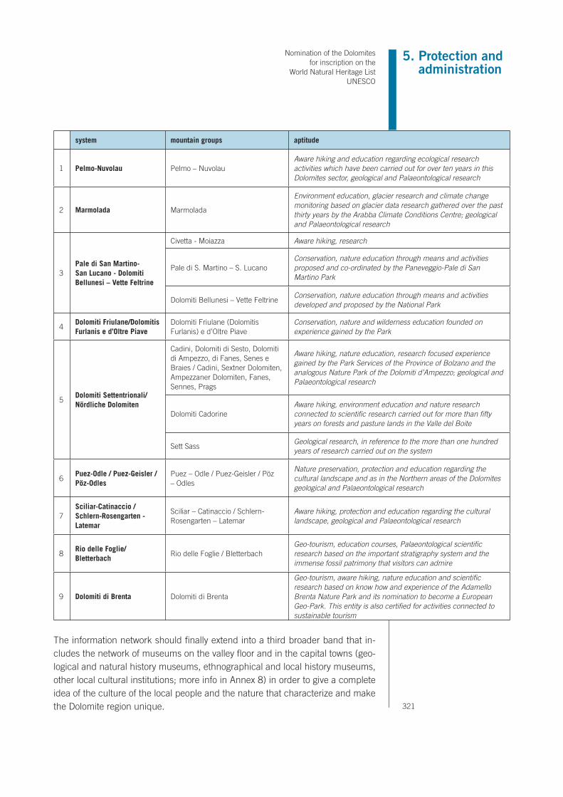
Nomination of the Dolomites for inscription on the
World Natural Heritage List UNESCO
321
5. Protection and administration
system mountain groups aptitude
1 Pelmo-Nuvolau Pelmo – Nuvolau Aware hiking and education regarding ecological research activities which have been carried out for over ten years in this Dolomites sector, geological and Palaeontological research
2 Marmolada Marmolada
Environment education, glacier research and climate change monitoring based on glacier data research gathered over the past thirty years by the Arabba Climate Conditions Centre; geological and Palaeontological research
3Pale di San Martino-San Lucano - Dolomiti Bellunesi – Vette Feltrine
Civetta - Moiazza Aware hiking, research
Pale di S. Martino – S. Lucano Conservation, nature education through means and activities proposed and co-ordinated by the Paneveggio-Pale di San Martino Park
Dolomiti Bellunesi – Vette Feltrine Conservation, nature education through means and activities developed and proposed by the National Park
4Dolomiti Friulane/Dolomitis Furlanis e d’Oltre Piave
Dolomiti Friulane (Dolomitis Furlanis) e d’Oltre Piave
Conservation, nature and wilderness education founded on experience gained by the Park
5Dolomiti Settentrionali/Nördliche Dolomiten
Cadini, Dolomiti di Sesto, Dolomiti di Ampezzo, di Fanes, Senes e Braies / Cadini, Sextner Dolomiten, Ampezzaner Dolomiten, Fanes, Sennes, Prags
Aware hiking, nature education, research focused experience gained by the Park Services of the Province of Bolzano and the analogous Nature Park of the Dolomiti d’Ampezzo; geological and Palaeontological research
Dolomiti Cadorine Aware hiking, environment education and nature research connected to scientific research carried out for more than fifty years on forests and pasture lands in the Valle del Boite
Sett Sass Geological research, in reference to the more than one hundred years of research carried out on the system
6Puez-Odle / Puez-Geisler / Pöz-Odles
Puez – Odle / Puez-Geisler / Pöz – Odles
Nature preservation, protection and education regarding the cultural landscape and as in the Northern areas of the Dolomites geological and Palaeontological research
7Sciliar-Catinaccio / Schlern-Rosengarten - Latemar
Sciliar – Catinaccio / Schlern-Rosengarten – Latemar
Aware hiking, protection and education regarding the cultural landscape, geological and Palaeontological research
8Rio delle Foglie/Bletterbach
Rio delle Foglie / Bletterbach Geo-tourism, education courses, Palaeontological scientific research based on the important stratigraphy system and the immense fossil patrimony that visitors can admire
9 Dolomiti di Brenta Dolomiti di Brenta
Geo-tourism, aware hiking, nature education and scientific research based on know how and experience of the Adamello Brenta Nature Park and its nomination to become a European Geo-Park. This entity is also certified for activities connected to sustainable tourism
The information network should finally extend into a third broader band that in-cludes the network of museums on the valley floor and in the capital towns (geo-logical and natural history museums, ethnographical and local history museums, other local cultural institutions; more info in Annex 8) in order to give a complete idea of the culture of the local people and the nature that characterize and make the Dolomite region unique.

322
5.j Staffing levels (professional, technical and maintenance)
Within the nominated property and especially within the confines of the national, regional, and provincial parks, technical personnel are employed to supervise and maintain the asset and its resources. All provincial departments employ quali-fied personnel and they work together with other local technical departments, including forestry stations, fishing/hunting control personnel, water quality control personnel, mountain basin technical personnel, personnel entrusted with main-tenance of tourist and recreational structures and the path network, park guards and forestry guards working for the municipalities and other ownerships. Highly qualified technical personnel who attend training courses and technical and scientific updating courses at least once a year.

Nomination of the Dolomites for inscription on the
World Natural Heritage List UNESCO
323
6. Monitoring
6. MONITORING
Monitoring is a fundamental measure for the effective control of the natural and environmental systems of the nominated property. This may be used as an instru-ment to control and manage ‘emergencies’, for example, immediately activating recovery measures in response to an unfortunately still possible cause of degra-dation. It is important to note that the Habitat Directive assigns SCI monitoring functions to the Monitoring plan, where, in the absence of evident threat, it is not deemed necessary to implement a specific Management Plan. In the presence of such threats, however, monitoring functions must be integrated into the Manage-ment Plan, alimenting and perfecting the cognitive process and acting almost as a feedback mechanism between the assessment of the status of the systems and the implementation of recovery and/or mitigation measures. In the latter case, the monitoring process is not only beneficial for the periodical assessment of the characteristics of the sites, but also for the evaluation of the detrimental effects caused by factors of disturbance and, as a consequence, for the definition and calibration of the necessary countermeasures. In this case, the five provinces – each of which with the instruments of its own institutional and administrative autonomy – must determine where, how and when to intervene in the event of threats to the nominated properties. However, in the context of a future harmo-nisation of their technical activities, monitoring for UNESCO could be integrated with those actions prescribed by European Directives for the protection of habitats and species of Community importance. As it stands, many institutions involved in activities of environmental conservation and nature protection, such as parks, for example, already implement nature and environment monitoring programmes which, despite being conducted with criteria and methods that change from case to case, may still provide the most solid and reliable foundation for future harmo-nisation.
6.a Key indicators for measuring state of conservation
The subjects of monitoring will be the territorial systems listed in the attached factsheets and, in particular, it will be concerned with the ecosystems, habitats and ecosystemic components of most naturalistic, environmental and social value. On the basis of these objectives, the organisational chart for the survey activities is drawn up, in other terms, the areas of observation, procedures, timeframes and indicators which, according to current knowledge, are the most effective means to define the most valuable ecological systems, and how to ensure their continued existence in conditions of safety. Nowadays exist monitoring programmers already established for the entire nomi-nated area (core zone and buffer zones), for example surfaces occupied by vege-tation systems as specified by letters a, b, e and f in the schedule of each System. Currently, each Administration monitors the area independently but an undertak-ing has been made to develop a common monitoring plan in the short term: The


Nomination of the Dolomites for inscription on the
World Natural Heritage List UNESCO
325
6. Monitoring
organisation chart for monitoring is given in table 6.a. The objective of the survey plan today is to fully develop the experience accumulated, and to allow for the future integration of these programs in keeping with the harmonisation process between provincial technical facilities and between these facilities and other bod-ies engaged in the periodical assessment of the natural systems.
Table 6.a.: indicators, monitered sites, monitored techniques, frequency of deter-mination (Y = annually; S = after several years; R = running record), and place of data retention.
MONITORED SITES FREQUENCY DATA HELD AT TECHNIQUES INDICATORS
Game preserves Every year Provinces Spring census on song Lagopus mutus helvetica
Game preserves; Parco Nazionale Dolomiti Bellunesi
Every yearProvincesNational Park.
Spring census at song arenas; summer census on sample areas to assess reproductive success
Tetrao tetrix
P.N. Dolomiti Bellunesi;P.N. Dolomiti di Fanes, Senes e Braies.
Every 3 yearsNational and Regional Parks
Search for nests and their monitoring with assessment of reproductive success
Aquila chrysaetos
Natura 2000 Network areas (SCIs and SPZs) of each system
Every 5 yearsProvincesand Regions, Nature Reserves
Field observations together with data from “ad hoc” research studies
Number of species of Community importance
Natura 2000 Network areas (SCIs and SPZs) of each system
Every 3 yearsProvincesand Regions, Nature Reserves
Field observations together with data from “ad hoc” research studies. Indications on surface areas and vegetation species of each habitat
Natura 2000 sites
All systems Every yearNational and Regional Parks
Permanent areas, photographsEvolution of high-altitudegrass systems
SYSTEMS 1, 2, 3, 5 9 SProvinces, Italian Glacier Measuring Network CAI
Topographic measurementsSurface areaof glacial systems
Agola, Fradusta, Marmolada
Every 2 years PAT, CAI Topographic measurements
All system RProvincesand Regions
Samplings Quality of air
All system RProvincesand Regions
SamplingsQuality of flowing water
Travignolo, Canali Every 2 years PAT Samplings
All systemY Provinces
and Regions
Photographs taken from fixedobservation points, representative of landscape types of each area, and their subsequent evaluation
Variety and integrityof landscape components

326
FREQUENCY DATA HELD AT MONITORED SITES TECHNIQUES INDICATORS
R
Provincesand RegionsAPAT
All system
Instrumental monitoring of major debris flows and rock-falls
Slope stability
S Landslides mapping
RDatabase landslides(IFFI Project)
R PAT/PABP.A.T. and P.A.B./A.P.B.
Project LIAR(Laserscan mapping)
RProvincesand Regions
All Systems Measurements and samplingClimatological and meteorological parameters
YEvery week in August
Provincesand Regions
All SystemsSociocultural indicatorsNumber of overnight stays
R
Provincesand RegionsNationaland Regional Parks
All Systems
Mechanical interventions Length of hiking trails Length of “via ferrata” Length of forest and alpine roads Number of the flights Number of the high-altitude landing facilitiesExpansion of existing sheltersConstruction of new shelters
6.b Administrative arrangements for monitoring property
The Technical Departments of the Public Administrations (Provinces / Regions) use their own means to develop specific monitoring plans on the basis of local regulations, with specificity that are highlighted (see par. 5). Currently, the follow-ing parameters are specifically monitored: – The quality of the air – The quality of flowing water – The status of glaciers and of snow blankets. – The stability of snowy masses – The stability of slopes. – The status of the animal populations of particular naturalistic interest. – The use of paths and many other aspects of the structure and functionality of
the ecological and territorial systems.
The subjects involved in monitoring and controlling the territory are rather varied (see par.5.g). In compliance with the Programme Agreement signed by the Provinces, the mon-itoring actions that are currently carried out according to criteria and using meth-ods that sometimes differ, will gradually be harmonised and partly re-programmed in order to suit the objectives of the Management Framework.

Nomination of the Dolomites for inscription on the
World Natural Heritage List UNESCO
327
6. Monitoring
6.c Results of previous reporting execises
The monitoring is carried out by the Provinces and is related to environment aspects: monitoring of waters, provincial fishing maps, wildlife monitoring (i.e. golden eagle, chamois, black woodpecker, marmot, etc.), wildlife management, hunting, etc. The monitoring reports are collected and published by dedicated technical structures.For having some illustrative examples, see the already established monitoring programmes related to the protected area within the nominated property. See Annex A.6.1.

328
In the area there are some glaciers of modest dimensions that cover a total surface area of 204.47 hectares: Lower Vallesinella Glacier, Upper Vallesinella Glacier, Tuckett Glacier, Upper Tuckett Glacier, Upper Brenta Glacier, Brentei Glacier, Northern Sfulmini Glacier, Bocca di Brenta Glacier, Crozzon Glacier, Camosci Glacier, Agola Glacier, Prà Fiorì Glacier, XII Apostoles Glacier, Sacco Glacier, Ambiez Glacier. The Lower Vallesinella Glacier is situated in a deep, narrow valley and, as with many glaciers in Brenta, is enclosed between steep rocky walls characterized by peaks that reach almost 3000 m (Campanile di Vallesinella and Cima Falkner). It is fed by both direct snowfall and avalanches. Its current surface area is less than 10 hectares. The Italian Glacier Register (1962) considered it joined to the Upper Vallesinella Glacier (649.1), attributing to it a total surface area of 38 hectares. The front retreated by around 35 m between 1995 and 1998 and the surface area is almost completely covered with detritus. The Upper Vallesinella Glacier was considered separate from the Lower Glacier already in the Italian Glacier Register (1962). It is set in the northern slopes of Cima Sella. The last surveys, relating to the ‘90s, attributed a surface area of less than 2 hectares, and from the end of the ‘90s the glacier was considered extinct. The Tuckett Glacier is situated in the deep narrow valley that culmi-nates in the Bocca di Tuckett and has recently undergone considerable morphological transformations, sub-dividing into different parts and losing entire portions. In 1995 there was the spectacular detachment of a section of the glacier that then melted, causing a retreat of the upper front of 100 m in one year. Until the end of the 1800s it was one of the main glaciers in the Brenta Group and had a surface area of around 66 hect-ares, reducing to around 50 hectares as reported in the Italian Glacier Register in 1962. Today the surface area is less than 15 hectares. A few years ago it was completely cut off from its connection with the Cima Brenta hanging glacier. It is fed mainly by avalanches that fall from the rocky walls that surround it, but, given its relatively low altitude, in the last few years the residual snow has melted completely and so cut off its sup-ply. Recently, a considerable increase in detritus has been observed, especially in the lower part. With the current climatic tendencies, the Tuckett Glacier is destined to undergo further transformations along with al-most all the glaciers in the Brenta Group. Below the glacier interesting glacial morphologies may be observed, such as the sharp, right lateral moraine from the Small Ice Age (1550-1850) that in part is crossed to reach the Bocca di Tuckett. The Upper Tuckett Glacier recently broke away from the Tuckett Glacier (650.0) and is now considered a distinct entity. The spectacular hanging ice cap is situated on the north-west slope of Cima Brenta. The surface area is around 5 hectares and is fed directly by snowfall. The Upper Brenta Glacier is located in a narrow valley cut in the north-west side of the Cima Brenta massif. It is a small glacier which, along with all the other Brenta glaciers, has suffered a great reduction in surface area and thickness over re-cent years. The Italian Glacier Register (1962) attributed a surface area of 15 hectares, while, according to
The Brenta Glaciers

Nomination of the Dolomites for inscription on the
World Natural Heritage List UNESCO
329
6. Monitoring
surveys carried out in the early ‘90s, it has reduced to around 4.5 hectares. The Brentei Glacier is in a narrow valley situated to the south of the Cima Brenta massif. It has by now reduced to next to nothing and is almost completely covered with detritus. The glacier is supplied by snowfall but also by avalanches that discharge from the side of the mountain. The Italian Glacier Register (1962) attributed a surface area of 10 hectares, which reduced to 4.5 by the mid-‘90s. The Southern Sfulmini Glacier occupies a large cirque dominated by Cima d’Armi and by Torre di Brenta, in one of the most enchanting and spectacular areas in the Brenta Group. In the mid-‘90s the front reached an altitude of 2620 m,, while the surface area in the same period was 9.5 hectares. The Italian Glacier Register (1962) reported a surface area of 18 hectares, but at the time the glacier was still joined to n° 653.1. The lower part is abundantly covered with detritus. It is fed by snowfall and by avalanches that fall on the section that covers the side of the Torre di Brenta massif. The front retreated by around 25 m between 1990 and 1996. The Bocca di Brenta glacier has by now reduced to next to nothing and is preserved only thanks to its favourable exposure and topographical location, with walls that surround it on three sides. It is located in the narrow valley that leads to the Bocca di Brenta and already at the beginning of the ‘90s was subdivided into three distinct bodies by a series of rocky cornices. At the end of the summer, the basin which contains the remains of the glacier is often full of residual snow that accumulated during the winter avalanches. The total surface area of the three portions was around 3 hectares at the beginning of the ‘90s, while the Italian Glacier Register (1962) attributed a surface area of 4 hectares. The Crozzon Glacier is distinctly subdivided into two areas, a level area that occupies the top of Cima Tosa (3170 m) and a steep section wedged in the canyon between Cima Tosa and Crozzon di Brenta. At the bottom of the canyon the glacier fans out, resting on a large rocky cornice. In this area the glacier reaches an altitude of around 2300 m, among the lowest in the Brenta Group. The part at the summit is fed mainly by direct snowfall, while the canyon is fed mainly by avalanches. The ice cap at the summit has reduced a lot over recent years, while the canyon has not undergone any major modifications, excluding a general “thinning”. The Camosci Glacier is situated in a valley cut between the Cima Tosa massif – Crozzon di Brenta and the Cima di Val Stretta. The lower part is abundantly covered by talus, while a rocky outcrop roughly halfway up the glacier is separating it into two distinct parts. It is fed both by direct snowfall and accumulations after avalanches that are dis-charged from the surrounding rocky walls. The Italian Glacier Register attributed a surface area of 27 hect-ares, reduced to around 23.5 at the beginning of the ‘90s, after which the front retreated by around 80 m. The Agola Glacier is the most extensive in Brenta and may be considered representative of all the glaciers of the mountain group. As with many other glaciers in the group, in fact, it is found at a relatively low altitude (from 2600 to 2900 m) and is preserved thanks to the protection offered by the steep rocky walls that surround it

330
(an arcing rocky ridge that culminates with Cima d’Agola and Cima d’Ambiez). It is characterized by a trian-gular form with a well defined toe area that does not have any significant covering of detritus. There are some transversal crevasses in this area. The glacier is fed by various means but of particular importance are the avalanches that fall on the upper part of the glacier where the last margins of the residual winter snow are preserved. Until a few decades ago it was connected to the nearby Camosci Glacier by the saddle of the same name, which today can easily be crossed without treading on snow. The Italian Glacier Register (1962) noted in this area a retreat of 13 m from 1911 to 1950 and a further 27 m from 1950 to 1958. The surface area has also suffered a drastic reduction, from 44 hectares at the end of the 1800s, to 34 hectares in 1962 (The Ital-ian Glacier Register), to 25 in 1991 to its current 23 hectares (data from 1997). In the surrounding area there are interesting dolomitic glacial morphologies, such as roche moutonnée arranged in steps (rocky outcrops smoothed and polished by the passage of the glacier) and the imposing and sharp left lateral moraine dating back to the Small Ice Age (1550- 1850), certainly one of the biggest in the Brenta Group. The Prà Fiorì Glacier is situated in a ba sin delimited by a crest line that culminates at Cima Prato Fiorito. It may be considered as a typical cirque glacier, even though the basin it is located in, is rather wide and open. Due to its characteris-tics, this glacier was considered representative of all the Brenta Group and, from the 1990s the Trentino Glaciological Committee have followed its evolution carefully and accurately, carrying out precise topographi-cal surveys of its surface every year. The surface area of the glacier was calculated by Richter (1888) as 39.6 hectares and reduced to around 27 in the 1960s (Italian Glacier Register, 1962). According to the last surveys the surface area has gone from 11 hectares in 1990 to 8.3 in 1999 with a reduction of around 80% in 110 years. Over the last few years it has suffered a dramatic reduction in thickness, confirmed by the emergence of a rocky step a little way above the toe area, a step that has broken the body of the glacier into two parts. The lowering of the surface, measured with topographical surveys was around 8-10 m between 1990 and

Nomination of the Dolomites for inscription on the
World Natural Heritage List UNESCO
331
6. Monitoring
1995. The 12 Apostles Glacier occupies a large cirque situated at the top of the Val di Sacco and is delimited by the Croz di Selvata peak, Padaiola and Padaiola Bassa. It has greatly reduced in surface area and cur-rently is made up of a layer of sub-rectangular ice resting on the rocky walls behind. It is fed by direct snowfall but the avalanche accumulations also play an important role. The Sacco Glacier is almost entirely covered by a thick blanket of detritus which makes it difficult to detect. It is the remainder of a glacier that is preserved thanks to the favourable exposure and the covering of detritus. It is on the bottom of a narrow cirque cut into the south-west slope of Cima di Vallon. The Italian Glacier Register (1962) reported data that referred to 1911 and attributed a surface area of only 5.5 hectares. At the beginning of the ‘90s the remaining surface area and detritus cover was estimated at just less than 3 hectares. The Ambiez Glacier is situated at the head of its homonymous valley, in a narrow valley cut into the southern slope of Cima Tosa. It is one of the few south facing glaciers of the Brenta Group, an unfavourable exposure with regard to its preservation. It is mostly covered with detritus and in the lower part there are also large masses due to the collapse of Torre Jandl in 1957. The Italian Glacier Register reported a surface area of 12 hectares, while the calculations for the begin-ning of the ‘90s attributed an area of around 10 hectares. It is fed both by direct snowfall and avalanche ac-cumulations, with a series of well visible residual snow fans on the upper part of the glacier at the end of summer. There are imposing moraines from the Small Ice Age (1550-1850) visible just above the Agostini Refuge.
Brenta group – Agola Glacier

332
authority Provincia di Belluno Provincia Autonoma di Bolzano – Autonome Provinz Bozen – Südtirol
department/agency Agenzia Regionale Protezione Ambiente del Veneto ARPAV – Dipartimento Provinciale di Belluno
Agenzia provinciale per l’ambiente (Ufficio valutazione impatto ambientale; Ufficio aria e rumore; Ufficio tutela acque)
responsibleaddressphone/faxemail
dott.sa Franca Bergogliovia F. Tomea, 5 – 32100 Belluno+39 0437 935500 – +39 0437 30340
Via Amba Alagi 5 39100 Bolzano+39 0471 417100 – +39 0471 [email protected]
department/agency Agenzia Regionale Protezione Ambiente del Veneto ARPAV – Dipartimento Regionale per la Sicurezza del Territorio
responsibleaddressphone/faxemail
dott. Alberto LuchettaVia del Candel, 65 – 32100 Belluno Italy+39 0437 098211 – +39 0437 [email protected]
department/agency Amministrazione Provinciale di belluno – Corpo Polizia Provinciale
responsibleaddressphone/faxemail
dott. Gianmaria Sommavillavia S. Andrea, 5 – 32100 Belluno+39 0437 959111 – +39 0437 942179
department/agency Corpo Forestale dello Stato – Comando Provinciale
responsibleaddressphone/faxemail
dott. Flavio De Nicolòvia Gregorio XVI, 8 – 32100 Belluno+39 0437 941985 – +39 0437 [email protected]
natural/national park Parco Nazionale delle Dolomiti Bellunesi
responsibleaddressphone/faxemail
dott. De Zordo GuidoP.le Zancanaro 1 – 32032 Feltre (BL)+39 0439 3328 – +39 0439 [email protected]
natural/national park Parco Naturale Regionale Dolomiti d’Ampezzo Parco Naturale Puez – OdleParco Naturale Fanes – Senes – BraiesParco Naturale Dolomiti di Sesto(Ufficio Parchi Naturali)
responsibleaddressphone/faxemail
dott.sa Cinzia GhedinaVia del Parco, 1 – 32043 Cortina d’Ampezzo0436 2206 – 0436 867707 – +39 0436 [email protected]
dott. Artur KammererVia Renon 4 – 39100 Bolzano+39 0471 417770 – +39 0471 [email protected]
natural/national park
addressphone/faxemail

Nomination of the Dolomites for inscription on the
World Natural Heritage List UNESCO
333
6. Monitoring
Provincia di PordenoneProvincia di Udine
Provincia Autonoma di Trento
Agenzia Regionale Protezione Ambiente del Friuli Venezia Giulia – ARPA FVG
Agenzia provinciale protezione ambiente
dott. Giuliana SpogliarichVia Cairoli, 14 – 33057 Palmanova (UD)+39 0432 922611 – +39 0432 [email protected], [email protected]
piazza Vittoria, 5 – I – 38100 Trento+39 0461 497701 – +39 0461 [email protected]
Servizio Geologico
via Roma, 50 – I – 38100 Trento+39 0461 495200 – +39 0461 [email protected]
Servizio Conservazione natura e Valorizzazione ambientale
via Guardini, 75 – I – 38100 Trento+39 0461 496161 – +39 0461 [email protected]
Regione Autonoma Friuli Venezia GiuliaDirezione Centrale risorse agricole, forestali, naturali e della montagnaCorpo Forestale Regionale
Servizio Foreste e Fauna
Mr Augusto Violavia Sabaddini, 17 IT 33100 Udine+39 0432 555319 – +39 0432 [email protected]
via Trener, 3 – I – 38100 Trento+39 0461 495943 – +39 0461 [email protected]
Parco Naturale Dolomiti Friulane Parco naturale Adamello – Brenta
dott. Marino MartiniVia Vittorio Emanuele, 27 IT 33080 Cimolais (UD)+39 0427 87333 – +39 0427 [email protected]
via Nazionale, 24 – I – 38080 Strembo (TN)+39 0465 806666 – +39 0465 [email protected]
Parco naturale Paneveggio Pale di San Martino
Villa Welsberg – via Castelpietra, 2 – I 38054 Tonadico (TN)+39 0439 64854 – +39 0439 [email protected]

334

Nomination of the Dolomites for inscription on the
World Natural Heritage List UNESCO
335
7. Documentation
7. DOCUMENTATION
The Nomination Document, the Management Framwork, the photographs and the images used inside are available on DVD.The supplementary documentation is attached to the dossier and is also in digital form:
Inventory of the publications and Audio-visual materials presented in the previous nomination (2005) and deposited at the UNESCO office of Paris.They were labeled as: Annex 4: Section 7f. “Books and publications annexed to the nomination”.
AA.VV., Mappaggio biologico di qualità dei corsi d’acqua della Provincia di Udine. Udine: Provincia di Udine Assessorato all’ambiente e territorio, 1995.
AA.VV., Dolomiti cattedrali di roccia. Cornuda: Antiga Edizioni, 2005.AA.VV., Un mondo di acque, rocce e foreste. Il Parco Naturale di Paneveggio
Pale di San Martino. Firenze: Giunti Gruppo Editoriale, 1997.AA.VV., Weekend Dolomiti National Park. Allegato alla rivista: Filò, Edizioni
Filò, 2005.AGOSTINI A. (editor), Natura 2000. Il contributo trentino alla rete europea di
biodiversità. Trento: Grafiche Mangrini, 2003.ARGENTI C. & LASEN, C., La flora. Collana: Studi e Ricerche - n° 3. Duck
Edizioni, 2001.AVANZINI M. e WACHTLER M., Dolomiti: storia di una scoperta. Trento: Mu-
seo Tridentino di scienze naturali, 1999.BARDUCCI G. and others, Parco Naturale Fanes-Senes-Braies - Nel regno
degli animali. Bolzano: Provincia Autonoma di Bolzano, 2001.BORGO A., Il ritorno della marmotta nel Parco Naturale delle Dolomiti Friu-
lane. Cimolais: Parco Nazionale Dolomiti Friulane, 2004.BOSELLINI A., Geology of the Dolomites. An introduction. Dolomieu Confer-
ence on Carbonate Platforms and Dolomitization. Ortisei/St. Ulrich, Val Gardena/Grodental, 1991.
BOSELLINI A., Geologia delle Dolomiti. Bolzano/Bozen: Casa Editrice Athe-sia, 1996.
BUCELLATI G. (editor)., Dolomiti monti di rosea fantastica luce. Belluno: Fondazione Giovanni Angelini Centro Studi sulla Montagna, 2002.
CARULLI G.B. et al., Geologia delle Prealpi Carniche. Udine: Edizioni del Museo Friulano di Storia Naturale, 2000.
COZZI D., DOMENICO I. & NAVARRA E., Sauris Zahre: una comunità delle Alpi Carniche. 2 v. Udine: Forum, 1998-1999.
DA POZZO M., Dolomiti D’Ampezzo. Parchi Naturali Veneti, a. XII, n. 3. Cor-nuda, Grafiche Antiga, 2005, pp.6-23.
DA POZZO M., La fauna del Parco Naturale delle Dolomiti D’Ampezzo. Opus-

336
colo del Parco Naturale delle Dolomiti d’Ampezzo, Regole d’Ampezzo.DA POZZO M., Parco Naturale delle Dolomiti d’Ampezzo. Opuscolo pieghev-
ole edito da Regole d’Ampezzo e Regione del Veneto.DANELIN G., Le Dolomiti Friulane e la forra del Cellina, in numero monografi-
co della rivista: Le Tre Venezie una rivista per promuovere e valorizzare storia, cultura, arte turismo, Aree naturali Protette, a. X, n. 7. Cornuda: Grafiche Antiga, 2003.
DE BATTAGLIA FRANCO E MARISALDI, LUCIANO., Enciclopedia delle Dolo-miti. Bologna: Zanichelli Editore, 2000.
DE BATTAGLIA, F. & TOMASI G., Dolomiti Trentine. Trento: Casa Editrice Panorama, 1999.
DELLA VECCHIA, F. M. & ZUCCHINI R., Guida al Museo. Ampezzo: Comu-nità Montana della Carnia Museo Geologico di Ampezzo, 1997.
FOLDER (Touring Club Italiano. Parchi dolomitici, Cartoguide Natura scala 1:200.000. Milano: Touring Editore, 2000 – Parco Naturale Dolomiti Friu-lane. Un parco straordinario dove vive la natura, tu chiamale se vuoi emozioni… Parco Naturale Dolomiti Friulane – booklet and photocop-yes).
GANDINI C., Pioneers, Guides and Rock glibers from to Checo da Melères to the Scoiattoli. Cortina: Regole d’Ampezzo, 1999.
GERVASI C. (editor)., Dolomiti la spettacolare rinascita di un arcipelago.Rimini: Associazione Meeting per l’amicizia tra i popoli, 2004.
GIORDANO D. E TOFFOLET L., Il paesaggio nascosto. Viaggio nella geologia e nella geomorfologia del Parco Nazionale Dolomiti Bellunesi. Collana: Studi e Ricerche - n° 5. Belluno: Industrie Grafiche Belluno, 2002.
GIOVANNINI A., Dolomiti. Storie e di uomini e montagne. Trento: Publilux, 1998.
GSTREIN D., Sotto la lente – I prati d’Armentara. Bolzano: Provincia Au-tonoma di Bolzano, 2002.
INNOCENTI A., Dolomiti montagne di corallo. Le origini, la storia le bellezze naturali. Firenze: Casa Editrice Bonechi, 2005.
LUNAZZI M., Ardimenti e incantevoli ozi: le dolomiti friulane negli acquerelli di Napoleone Cozzi. Belluno: Nuovi Sentieri Editore, 2004.
MENAPACE F., (editor), Fotografie di montagna 1893-1895, Beni artistici e storici. Quaderni del Trentino n. 7. Trento: La Grafica, 1998.
MENARDI R., Dolomiti d’Ampezzo il perché di un parco. VHS, 1992MESSNER R. & TAPPEINER, J. Dolomiti – Le più belle montagne della terra.
Edizioni Tappeiner, 2002.NASCIMBENE J. & CANIGLIA G., Licheni delle Dolomiti d’Ampezzo. Cor-
tina d’Ampezzo: Parco Naturale delle Dolomiti d’Ampezzo, Regole d’Ampezzo.
ORTNER, P., KIEBACHER C. & GRUBER, A., Parco Naturale Dolomiti di Sesto - La solitudine dei grandi nomi. Bolzano: Provincia Autonoma di Bolzano, 2002.

Nomination of the Dolomites for inscription on the
World Natural Heritage List UNESCO
337
7. Documentation
Parco delle Dolomiti d’Ampezzo – Regole d’Ampezzo. A passeggio nella valle d’Ampezzo La scoperta di una cultura di equilibrio tra uomo e natura. VHS.
PARCO DOLOMITI FRIULANE, Carta Topografica per Escursionisti scala 1:25.000. Tavagnacco, Casa Editrice Tabacco, 2003.
Parco Naturale del Monte Corno - Carta turistica scala 1:25.000. Tabacco-Provincia Autonoma di Bolzano.
Parco Naturale dello Sciliar - Carta turistica scala 1:25.000. Tabacco-Provin-cia Autonoma di Bolzano.
Parco Naturale Dolomiti di Sesto - Carta geologico escursionistica. Tabacco-Provincia Autonoma di Bolzano, 2004.
Parco Naturale Dolomiti di Sesto - Carta turistica scala 1:25.000. Tabacco-Provincia Autonoma di Bolzano.
Parco Naturale Fanes-Senes-Braies - Carta turistica scala 1:25.000. Tabac-co-Provincia Autonoma di Bolzano.
Parco Naturale Puez-Odle - Carta turistica scala 1:25.000. Tabacco-Provin-cia Autonoma di Bolzano, 2004.
PESCOLLER H. E ERARDI, A. Dolomites. Vette magiche. Unione Artisti Ladi-ni Val Badia, 2002.
PROVINCIA DI UDINE ASSESSORATO AL TURISMO, Carnia la montagna incantata. DVD.
RUFFINI F., MORANDELL I. & BRUTTI, E., Natura 2000 in Alto Adige. Bol-zano: Provincia Autonoma di Bolzano, 2002.
SCHÖNEGGER H., Lo scrigno della biodiversità - I parchi naturali in Alto Adige. DVD, Sudmediafilm, 2004.
SCHWEIGGL, M. & UNTERHOLZNER, L., Parco Naturale Puez-Odle - Il libro di storia della terra. Bolzano: Provincia Autonoma di Bolzano, 2001.
SCHWEIGGL, M. I Parchi naturali in Alto Adige. Provincia Autonoma di Bol-zano, Athesia, 2005.
SCHWEIGGL, M., Parco Naturale del Monte Corno - Il tempo sommerso e quello visibile. Bolzano: Provincia Autonoma di Bolzano, 2001.
SPAMPANI M., Orchidee delle Dolomiti d’Ampezzo. Cortina d’Ampezzo: Par-co Naturale delle Dolomiti d’Ampezzo, Regole d’Ampezzo.
TODESCHINI M.C., Dolomiti viaggio attraverso un regno incantato. Cortina d’Ampezzo: Light Hunter Publications.
TODESCHINI M.C., Rocce, uomini e storia. Dolomiti tra le montagne e i colori più belli. Cortina d’Ampezzo: Light Hunter Publications.
TOURING CLUB ITALIANO, Parks in the Dolomites. Tourist guide scala 1:200.000. Milano:Touring Editore, 2000.
VISENTIN L., Il Campanile della Val Montanaia nel Parco Naturale delle Dolomiti Friulane. Parco Naturale Dolomiti Friulane, 2002.
Vista panoramica 1 delle Dolomiti Friulane dalla Cima del Monte Vermost.Vista panoramica 2 del Monte Bivera e Dolomiti Pesarine dal paese di
Lateis.

338
WACHTLER M., Die Dolomiten geheimisvolle Wunderwelt VHS, Editore Me-diateam, 2000
WACHTLER M., Dolomiti Atolli e lagune Omaggio a Rinaldo Zardini. Cortina: Museo Paleontologico “Rinaldo Zardini” Regole d’Ampezzo, 2002.
WACHTLER M., Dolomiti La genesi di un paesaggio. VHS, Editore Medi-ateam, 1998.
ZANDONELLA CALLEGHER, I., Dolomiti. Trento: Casa Editrice Panorama, 2001.
ZANGHELLINI S., Il Parco Naturale Adamello – Brenta. Lo spettacolo della natura e i segni dell’uomo. Trento: Litografica Editrice Saturnia, 2004.

Nomination of the Dolomites for inscription on the
World Natural Heritage List UNESCO
339
7. Documentation
7.a. Photographs, inventories of images and authoritative tables and other audio-visual materials
One DVD contains photographs, inventories of images and authoritative tables and other audio-visual materials, is attached.
7.b. Texts relating to protective designation, copies of property management plans or documented management systems and extracts of other plans relevant to the property
Five CDs, with the list of relevant documents that contains texts relate to protec-tive designation have been presented in the previous nomination (2005) and are at the UNESCO office in Paris. They were labeled as: Annex 3: Section 7b. “Texts relating to protective designation”.
7.c. Form and date of most recent records or inventory of property
The implementation of this paragraph is not request for Natural Property nomina-tion.7.e. Bibliography
See Annex A.7.1.

authority Provincia di BellunoProvincia Autonoma di Bolzano - Autonome Provinz Bozen-Südtirol
information concerning
department/agencyaddressphonefax
environment
Agenzia Regionale Protezione Ambiente del Veneto ARPAV – Dipartimento Provinciale di Bellunovia F. Tomea, 532100 Belluno+39 0437 935500+39 0437 30340
Agenzia provinciale per l’ambiente (U+39 0471 417100+39 0471 417119
department/agencyaddressphonefax landscape
Servizio UrbanisticaI - 32100 Belluno Via S. Andrea, 5+39.0437.959286+39.0437.950217
Ripartizione natura e paesaggio Ufficio Parchi NaturaliI - 39100 BolzanoVia Renon, 4+39.0471.417770+39.0471.417789
department/agencyaddressphonefax
inventory of flora and fauna
Corpo Forestale dello Stato – Comando Provincialevia Gregorio XVI, 832100 Belluno+39 0437 941985+39 0437 944492
Ripartizione natura e paesaggio Ufficio Parchi NaturaliI - 39100 BolzanoVia Renon, 4+39.0471.417770+39.0471.417789
natural/national parkaddressphonefax
natural/national parkaddressphonefax
visitors facilities and statistics, managementand information
Parco Nazionale delle Dolomiti BellunesiP.le Zancanaro 132032 Feltre (BL)+39 0439 3328+39 0439 332999
Parco Naturale Regionale Dolomiti d’AmpezzoVia del Parco, 132043 Cortina d’Ampezzo (BL)+39 0436 867707+39 0436 2269
Parco Naturale Puez-OdleParco Naturale Fanes-Senes-Braies – Parco Naturale Dolomiti di SestoVia Renon 4 - 39100 Bolzano+39 0471 417770+39 0471 417789
7.d. Address where inventory, records and archives are held
Information concernig environment, landscape, inventories of fauna and flora, visitors facilities and statistics, management and information are available.

Nomination of the Dolomites for inscription on the
World Natural Heritage List UNESCO
341
7. Documentation
Provincia di PordenoneProvincia Autonoma di Trento
Provincia di Udine
Agenzia Regionale Protezione Ambientedel Friuli Venezia GiuliaARPA FVGVia Cairoli, 1433057 Palmanova (UD)+39 0432 922 611+39 0432 922 626
Agenzia provinciale protezione ambientepiazza Vittoria, 5I - 38100 Trento+39 0461 497701+39 0461 497759
Agenzia Regionale Protezione Ambientedel Friuli Venezia GiuliaARPA FVGVia Cairoli, 14 - 33057 Palmanova (UD)+39 0432 922 611+39 0432 922 626
Servizio Pianificazione del territorioI - 33170 Pordenone Largo San Giorgio, 12+39.0434.231200+39.0434.231219
Dipartimento Urbanistica e AmbienteI - 38100 Trento, Via Jacopo Aconcio, 5+39.0461.493200+39.0461.493201
Area TecnicaI - 33100 Udine Piazza Patriarcato, 3+39.0433.457014+39.0433.457090
Regione Autonoma Friuli Venezia Giulia Direzione Centrale risorse agricole, forestali, naturali e della montagnaCorpo Forestale Regionalevia Sabaddini, 17IT 33100 Udine+39 0432 555 319+39 0432 555 140
Servizio Foreste e Faunavia Trener, 3I - 38100 Trentotel. +39 0461 495943fax +39 0461 494947
Regione Autonoma Friuli Venezia Giulia Direzione Centrale risorse agricole, forestali, naturali e della montagnaCorpo Forestale Regionalevia Sabaddini, 17 IT 33100 Udine+39 0432 555 319+39 0432 555 140
Parco Naturale Dolomiti FriulaneVia Vittorio Emanuele, 27IT 33080 Cimolais (PN)+39 0427 87 333+39 0427 877 900
Parco naturale Adamello-Brentavia Nazionale, 24 I - 38080 Strembo (TN)+39 0465 806666+39 0465 806699
Parco naturale Paneveggio Pale di San MartinoVilla Welsberg - via Castelpietra, 2 I - 38054 Tonadico (TN)+39 0439 64854+39 0439 762419
Parco Naturale Dolomiti FriulaneVia Vittorio Emanuele, 27IT 33080 Cimolais (PN)+39 0427 87 333+39 0427 877 900

342
A list of references for this nomination is provided below. This is a small part of the large scientific literature which exists for the nominated Site.
LandscapeBASSETTI S., MORELLO P., 1983, Contrada y architetöra da paur dles valades ladines
dles Dolomites, B T B, TrentoBELLI G., GIACOMONI P., OTTANI CAVINA A. (eds.), Montagna. Arte, scienza, mito
da Dürer a Warhol, Skira MilanoBONAPACE B., 1962, Dolomiti occidentali: caratteri strutturali e aspetti della difesa di
un paesaggio unico al mondo, TEMI, TrentoChristomannos T., 1910, Die Dolomiten, Seidel & Sohn, Wien FESTI R., MANZATO E., 1990, Le Dolomiti nei manifesti, Priuli & Verlucca, IvreaMESSNER R., TAPPEINER J., 2002, Dolomiti: le più belle montagne della Terra,
Cierre, VeronaMESSNER R., 1988, Le mie Dolomiti, Tappeiner, BolzanoSTINGL V., WACHTLER M., 1998, Dolomiti: la genesi di un paesaggio, Athesia, BolzanoPELLEGRINON B., 1983, Fra romanticismo e realtà: Edward Theodore Compton, il
maestro del paesaggio alpino, Club alpino italiano. Sezione di Agordo
Aesthetics and LiteratureBURKE E., 1757, A philosophical inquiry into the origin of our ideas of the Sublime
and Beautiful, LondonBUZZATI D., 1989, Le montagne di vetro, Vivalda, TorinoGILPIN W., 1786, Observations, relative chiefly to picturesque beauty, made in the
year 1772, on several parts ofEngland; particularly the mountains and lakes of Cumberland and Westmoreland, Printed for R. Blamire, London
GILPIN W., 1792, Three Essays: on Picturesque Beauty; on Picturesque Travel; and on Sketching Landscape, R. Blamire in the Strand, London
GOETHE J.W., 1862, Italiänische Reise, StuttgartRUSKIN J., 1856, Modern Painters. Vol. IV „Of Mountain Beauty“, Smith, Elder and
Co., LondonWOLFF K.F., 1925, Dolomiten Sagen: Sagen und Überlieferungen, Märchen und
Erzählungen der ladinischen und deutschen Dolomitenbewohner, Ferrari (tip.), Bolzano
First scientific EssaysDE DOLOMIEU D., 1791, Lettre du Commandeur D. de Dolomieu a M. Picot de La
Peyrouse (…) Sur un genre de Pierres calcaires très-peu effervescentes avec les Acides, & phosphorescentes par la collision, Malta, 30.01.1791 in: «Observations et mémoires sur la physique, sur l’histoire naturelle, et sur les arts et métiers», Tome XXXIX, Juillet 1971.
VON BUCH L., 1823, Über Dolomit als Gebirgsart, gedruck in der Druckerei der Königl. Akademie der Wissenschaften, Berlin
See Annex A.7.2.

Nomination of the Dolomites for inscription on the
World Natural Heritage List UNESCO
343
7. Documentation
VON BUCH L., 1802, Geognostische Beobachtungen auf Reisen durch Deutschland und Italien, Haude und Spener, Berlin
VON HUMBOLDT A. 1845, Kosmos: Entwurf einer physischen Beschreibung, Stutt-gart und Tübingen
Travel literatureBALL J. 1873, A guide to Eastern Alps, Longmans, Green and Co, LondonBAEDEKER K., 1871, Southern Germany and Austria, including the Eastern Alps:
Handbook for travellers, Karl Baedeker (Firm)BUSK R.H., 1874, The valleys of Tirol: their traditions and customs and how to visit
them, Longmans, Green and Co, London EDWARDS A. B., 1873, Untrodden peaks and unfrequented valleys: a midsummer
ramble in the Dolomites, Tauchnitz, Leipzig FRESHFIELD D.W., 1875, Italian Alps, Longmans, Green and Co, LondonGILBERT J., Churchil G.C. 1864, The Dolomite mountains: excursions through Tyrol,
Carinthia, Carniola, & Friuli in 1861, 1862, & 1863: with a geological chapter, and pictorial illustrations from original drawings on the spot, Longman, Roberts, & Green, London
GILBERT J., 1869, Cadore or Titian’s Country, Longmans, Green and Co, LondonGROHMANN P., 1877, Wanderungen in den Dolomiten, Gerold Sohn, WienMURRAY J., 1937, A Handbook for Travellers in Southern Germany, John Murray
Albermarle Street, LondonSCHAUBACH A., 1871, Die Deutschen Alpen für Einheimische und Fremde ge-
schildert, Frommann, JenaTUCKETT E., 1871, Zigzagging amongst Dolomites, Longmans, Green, Reader &
Dyer, LondonTUCKETT F. F., 1920, A pioneer in the high Alps: alpine diaries and letters of F.F.
Tuckett: 1856-1874, Arnold, Edward, LondonWOLFF K.F., 1927, Dolomiten - Führer: illustriertes Handbuch für Dolomitenreisende,
Ferrari (tip.), BolzanoZSIGMONDY E., 1889, Im Hochgebirge, Duncker & Humblot, Leipzig
HistoryAVANZINI M., WACHTLER M., 1999, Dolomiten: Reisen in die Urzeit, Museo triden-
tino di scienze naturali, TrentoAVANZINI M., WACHTLER M., 1999, Dolomiti. La storia di una scoperta, Museo tri-
dentino di scienze naturali -Trento, Museo Dolomythos – San Candido, Editrice Athesia - Bolzano
AVANZINI M., WACHTLER M., 1999, Dolomiti: un tesoro da scoprire: paesaggi spet-tacolari e grande varietà di minerali, in: “Trentino emigrazione” N.12 (lug. 1999)
BELARDI W., 2003, Breve storia della lingua e della letteratura ladina, Istitut ladin Micurà de Rü, San Martin de Tor (BZ)
CHIAIS L. (ed.), 1989, I Monti Pallidi. Viaggio tra storia e leggenda nell’area dolomitica,Istituto Geografico de Agostini, Novara

344
DE BATTAGLIA F., MARISALDI L., 2000, Enciclopedia delle Dolomiti, Zanichelli, Bo-logna
DORIS L., 1999, Storia dell’alpinismo dolomitico: dalle origini al 1957, Nordpress, Chiari (BS)
GOGNA A., 1987, Sentieri verticali: storia dell’alpinismo nelle Dolomiti: gli itinerari,Zanichelli, Bologna
LAMMERER B., 1990, Wege durch Jahrmillionen – Geologische Wanderungen zwischen Brenner und Gardasee, Tappeiner, Bozen
MELUCCI P., 1960, Breve storia dell’alpinismo dolomitico, Club alpino italiano. Sezi-one di Firenze. Scuola alpinistica Tita Piaz, MESTRE M., 1995, Les dénomina-tions fluctuantes des refuges des Dolomites en fonction de l’histoire: un exemple d’impérialisme linguistique, in: «Cahiers d’études germaniques», n. 29 (1995), pp. 231-246
MILNER D., 1951, The Dolomites, Hale, LondonRIZZI E., 2007, Déodat de Dolomieu. Viaggi nelle Alpi, Fondazione Enrico Monti, An-
zola d’OssolaSCALFI P., 1992, I rifugi del Brenta: nascita dei rifugi sullo Spinale e sul Brenta, siti
nel territorio della Comunità delle Regole di Spinale-Manéz, sede in Ragoli: (anni 1890/1911), in: “Judicaria” N.21 (set.-dic. 1992); pp. 22-43
TOMASI G., 1997, Il territorio trentino-tirolese nell’antica cartografia, Priuli & Verlucca, Ivrea
WACHTLER M., 2005, La storia delle Dolomiti, Athesia Spectrum, BolzanoWolff K.F., 1908, Monographie der Dolomitenstrasse und des von ihr durchzogenen
Gebiets, Moser BolzanoZANZI L., 2003, Dolomieu. Un avventuriero nella Storia della Natura, Nicolini, Gavirate
(Varese)
World War IDI MARTINO B., CAPELLANO F., 2007, La Grande Guerra sul fronte dolomitico. Ros-
sato, Novale (VI)DULTINGER J., 1982, Vergessene Vergangenheit: Schmalspurbahnen der k.u.k.
Armee zur Dolomitenfront 1915-1918, Erhard, RumFEURSTEIN V., 1925, Dolomitenkämpfe, Sonderdruck, Mil. wiss. MitteilungenGIACOMEL P., 2007, Grande Guerra nella valle d’Ampezzo. Prima e seconda parte.
Gaspari Editore, UdineKÜBLER R., Guerra a Sesto e Dintorni - DOLOMITI 1915-1918. Athesia, BolzanoLANGES G., 1933, Die Front in Fels und Eis, Verlag Bruckmann, MünchenSCHAUMANN W., 1972, Guida alle località teatro della Guerra fra le Dolomiti, Edizioni
Ghedina, Cortina d’Ampezzovon LICHEM H., 1985, Der Tyroler Hochgebirgskrieg, Steiner Verlag, Innsbruckvon LICHEM H., 1999, Gebirgskrieg 1915-1918 Band 2, die Dolomiten Front, Athesia,
BolzanoWACHTLER M., OBWEGS G. & GIACOMEL P., 2004, Dolomiti. Guerra, dolore, morte.
Athesia Spectrum, Bolzano.

Nomination of the Dolomites for inscription on the
World Natural Heritage List UNESCO
345
7. Documentation
GeologyASSERETO R., BRUSCA C., GAETANI M. & JADOUL F., 1977, Le mineralizzazioni
Pb-Zn nel Triassico delle Dolomiti. Quadro geologico ed interpretazione genetica.L’Industria Mineraria, 28: 367 - 402.
AVANZINI M.,DALLA VECCHIA F.M., DE ZANCHE V., GIANOLLA P., MIETTO P., PRE-TO N. E ROGHI G., 2000, Aspetti stratigrafici relativi alla presenza di tetrapodi nellepiattaforme carbonatiche mesozoiche del Sudalpino. Accad. Naz. Sci. Lett. Arti di Modena, coll. st. 21 pp. 15-20.
BECHSTÄDT T. & BRANDNER R., 1970, Das Anis zwischen St.Vigil um dem Höh-lensteintal (Pragser und Olanger Dolomiten, Südtirol). Festband d. geol. Inst., 300-Jahr-Feier Univ. Innsbruck, 9-103.
BLENDINGER W., 1985, Middle Triassic Strike-Slip Tectonics and Igneous Activity of the Dolomites (Southern Alps). Tectonophysics, 113 (1-2): 105-121.
BLENDINGER W., PAROW A. & KEPLER f., 1984, Paleogeography of the M. Cernera-Piz del Corvo area (Dolomites, Italy) during the upper Anisian and Ladinian. Geo-logica Romana, 21: 217-234.
BOSELLINI A., & HARDIE, L. A., 1973, Depositional theme of a marginal marine evap-orite. Sedimentology, 20: 5-27.
BOSELLINI A., & HARDIE, L. A., 1988, Facies e cicli della Dolomia Principale delle Alpi Venete: Memorie della Società Geologica Italiana, 30 (1985): 245-266.
BOSELLINI A., 1968, Paleogeologia pre-anisica delle Dolomiti centro-settentrionali:Memorie dell’Accademia Nazionale dei Lincei, s. 8, 9: 1 - 34.
BOSELLINI A., 1973, Modello geodinamico e paleotettonico delle Alpi Meridionali durante il Giurassico-Cretacico. Sue possibili applicazioni agli Apennini. Ac. Naz. Lincei Quad., 183: 163- 205.
BOSELLINI A., 1984, Progradation geometries of carbonate platform: example from the Triassic of the Dolomites, Northern Italy. Sedimentology, 31: 1-24, Amster-dam.
BOSELLINI A., 1996, Geologia delle Dolomiti. Athesia, Bolzano, 192 pp.BOSELLINI A., GIANOLLA P. & STEFANI M., 2003, Geology of the Dolomites. Epi-
sodes, v. 26, pp. 181-185.BOSELLINI A., CASTELLARIN A., DOGLIONI C., GUY, F., LUCCHINI F., PERRI, M.C.,
ROSSI P.L., SIMBOLI G., & SOMMAVILLA E., 1982, Magmatismo e tettonica nelTrias delle Dolomiti, in Castellarin, A. and Vai, G. B., eds., Guida alla geologia del Sudalpino centro-orientale: Bologna, Guide Geologiche Regionali, Società Geo-logica Italiana, 189- 210.
BOSELLINI A., NERI C. & STEFANI M. 1996, Introduzione alla geologia delle Dolomiti. Introduzione Geologica e Guida alla Escursione Generale. Soc. Geol.it., 78° Riun-ione Estiva, San Cassiano (BZ), 120 pp.
BOSELLINI, A., MASETTI, D., AND SARTI, M., 1981, A Jurassic ‘Tongue of the Ocean’ infilled with oolitic sands: The Belluno Trough, Venetian Alps, Italy: Marine Geol., v. 44, p. 59-95, 25 Figs.
BRACK P., & RIEBER, H., 1993, Towards a better definition of the Anisian/Ladinian boundary: New stratigraphic data and correlations of boundary sections from the

346
Southern Alps. Eclogae geologae Helvetiae, v. 86(2): 415-527.BRACK P., AND MUTTONI, G., 2000, High-resolution magnetostratigraphic and
lithostratigraphic correlations in Middle Triassic pelagic carbonates from the Dolo-mites (northern Italy): Palaeogeography Palaeoclimatology Palaeoecology, 161(3-4): 361-380.
BROGLIO LORIGA, C., FUGAGNOLI, A., VAN KONIJNENBURG-VAN CITTERT, J. H. A., KUSTATSCHER, E., POSENATO, R. & WACHTLER, M. 2002. The Anisian macroflora from the Northern Dolomites (Monte Prà della Vacca/Kühwiesenkopf, Braies): a first report. – Rivista Italiana di Paleontologia e Stratigrafia, 108, 381-390.
BROGLIO LORIGA C., MASETTI D. E NERI C., 1983, La Formazione di Werfen (Scit-ico) delle Dolomiti occidentali: sedimentologia e biostratigrafi a. Riv. Ital. Paleont. Strat., 58: 501- 598.
BROGLIO LORIGA C., NERI C., PASINI M. & POSENATO R., 1988, Marine fossil as-semblages from Upper Permian to lowermost Triassic in the Western Dolomites. In G. Cassinis (ed.) Permian and Permian-triassic boundary in the South-alpine segment of the western Tethys and additional regional reports. Mem. Soc. Geol. Ital., 34(1986): 5-44.
BROGLIO LORIGA C., CIRILLI, S., DE ZANCHE V., DI BARI D., GIANOLLA P., LAGHI G.F., LOWRIE W., MANFRIN S., MASTANDREA A., MIETTO P., MUTTONI G., NERI C., POSENATO R., RECHICHI M.C., RETTORI R. & ROGHI G. 1999 - The Prati di Stuores/Stuores Wiesen section (Dolomites, Italy): a candidate Global Stra-totype section and Point for the base of the Carnian Stage. Riv. It. Strat. Paleont., Milano, v. 105.
CASTELLARIN A. & CANTELLI L., 2000, “Neo-Alpine evolution of the southern East-ern Alps”, Journal of Geodynamics, 30(1-2): 251-274, Sept. 2000.
COZZI A., 1999, Tectonic and sea-level controls on shallow water carbonate platform development: a case study from the Upper Triassic Dolomia Principale, Southern Alps, northern Italy. Ph.D. Dissertation, Johns Hopkins Univ.,. 411 pp, Baltimore.
DE ZANCHE V., GIANOLLA P., MIETTO P., SIORPAES C. & VAIL P. R., 1993, Triassic sequence stratigraphy in the Dolomites (Italy). Mem. Sc. Geol., 45: 1-27.
DOGLIONI C., & BOSELLINI, A., 1987, Eoalpine and mesoalpine tectonics in the Southern Alps: Geol. Rund., 76: 735 – 754, Stuttgart.
DOGLIONI C., 1987, Tectonics of the Dolomites (Southern Alps, Northern Italy). Journ. Struct. Geol., 9: 181- 193.
FARABEGOLI E. & GUASTI M., 1980, Anisian lithostratigraphy and paleogeography of M. Rite (Cadore, southeastern Dolomites). Riv. It. Paleont. Strat., 85(3-4): 909-930.
FOIS, E. & GAETANI, M., 1984, The recovery of reef-building communities and the role of cnidarians in carbonate sequences of the Middle Triassic (Anisian) in the Italian Dolomites: Paleontographica Americana, 54: 191-200.
GAETANI, M., FOIS, E., JADOUL, F., & NICORA, A., 1981, Nature and Evolution of Middle Triassic Carbonate Buildups in the Dolomites (Italy): Marine Geology, 44(1-2): 25-57.

Nomination of the Dolomites for inscription on the
World Natural Heritage List UNESCO
347
7. Documentation
GIANOLLA P., DE ZANCHE V., & MIETTO P., 1998a, Triassic Sequence Stratigraphy in the Southern Alps. Definition of sequences and basin evolution. In: P.C. de Gra-cianscky, J. Hardenbol, T. Jacquin, P.R. Vail and D. Ulmer-Scholle (Eds.): Mesozo-ic-Cenozoic Sequence Stratigraphy of European Basins: SEPM Special Publication 60: 723-751.
GIANOLLA, P., RAGAZZI, E., & ROGHI, G., 1998b, Upper Triassic amber from the Do-lomites (Northern Italy). A paleoclimatic indicator?: Rivista Italiana di Paleontologia e Stratigrafia, 104: 381-390.
KEIM L., BRANDNER, R., KRYSTYN, L., & METTE, W., 2001, Termination of carbon-ate slope progradation: an example from the Carnian of the Dolomites, Northern Italy: Sedimentary Geology, 143(3-4): 303-323.
KOKEN E., 1911, Zue Geologie Südtirols. Zentralbl. f. Miner. Geol.: 561-572. Strutt-gard.
LEONARDI P. (and collegues), 1967, Le dolomiti, geologia dei monti fra Isarco e Piave,(1-2): 1019.
MASETTI D., NERI, C., & BOSELLINI, A., 1991, Deep-Water Asymmetric Cycles and Progradation of Carbonate Platforms Governed by High-Frequency Eustatic Oscil-lations (Triassic of the Dolomites, Italy): Geology, 19(4): 336-339.
MASSARI F., CONTI M.A., FONTANA D., HEIMOLD K., MRIOTTI N., NERI C., NICOSI U., ORI G.G., PASINI M. & PITTAU P. (1988), The Val Gardena Sandstone and the Bellerophon Formation in the Bletterbach gorge (Alto Adige, Italy): biostratigraphy and sedimentology.Mem. Sci. Geol., Padova, 60: 229-273.
MASSARI F., NERI C., PITTAU P., FONTANA D. & STEFANI C., 1994, Sedimentology, palinostratigraphy and sequence stratigraphy of a continental to shallow marine rift-related succession: Upper Permian of the eastern Southern Alps (Italy). Mem. Sci. Geol., Padova, 46: 119-243.
MIETTO P. & MANFRIN S., 1995a, A high resolution Middle Triassic ammonoid stand-ard scale in the Tethys realm. Preliminary report. Bull. Soc. Geol. France, 166: 539-563.
MOJSISOVICS E., 1879, Die Dolomit-Riffe von Südtirol und Venetien. Beiträge zur Bildungsgeschichten der Alpen, 552 pp., Hölder, Wien.
NERI C. & POSENATO R., 1988, New biostratigraphical data on uppermost Werfen Formation of New biostratigraphical data on uppermost Werfen Formation of 1988 Western Dolomites (Trento, Italy). Geol. Paläont. Mitt. Innsbruck, 14(3) (1985): 83-107.
NERI C. & STEFANI M., 1998, Sintesi cronostratigrafica e sequenziale dell’evoluzione permiana superiore e triassica delle Dolomiti. Memorie della Società Geologica Italiana, 53: 417-463.
OGILVIE GORDON M., 1929, Geologie des Gebietes von Pieve (Buchenstein), St. Cas-sian und Cortina d’Ampezzo. Jahrb. d.Geol. Bundsanstalt, 79 (3-4): Padova
PISA G., FARABEGOLI E. E OTT E., 1979, Stratigrafia e paleogeografia dei terreni anisici della Conca di Agordo e dell’alta Val di Zoldo (Dolomiti sudorientali). Mem. della Soc. Geolog. Ital., 18: 63-92.
POSENATO R. & PRINOTH H., 2004, Orizzonti a Nautiloidi e a Brachiopodi della For-

348
mazione a Bellerophon (Permiano superiore) in Val Gardena. Geo.Alp, 1: 71-85 Innsbruck-Bolzano.
POSENATO R. & PRINOTH, H., 1999, Discovery of paratirolites from the Bellerophon Formation (Upper Permian, Dolomites, Italy): Rivista Italiana Di Paleontologia E Stratigrafia, 105: 129-134.
PRETO N., HINNOV, L. A., HARDIE, L. A., & DE ZANCHE, V., 2001, Middle Triassic orbital signature recorded in the shallow-marine Latemar carbonate buildup (Dolo-mites, Italy): Geology, 29(12): 1123-1126.
RICHTHOFEN VON, F., 1860, Geognostische Beschreibung der Umgebung von Predazzo, Sanct Cassian und der Seisseralpen in Südtirol: Perthes Ed., 327 pp., Gotha.
ROGHI G, RAGAZZI E, GIANOLLA P., 2006, Triassic Amber of the Southern Alps (Italy). PALAIOS, 21, 143-154.
SALOMON W., 1895, Geologische und Paleontologische Studien über die Marmolata. Palaeontographica, 42, Stuttgart.
SENOWBARI-DARYAN, B., ZÜHLKE, R., BECHSTÄDT, T., & FLÜGEL, E., 1993, Ani-sian (Middle Triassic) buildups of the Northern Dolomites (Italy): The recovery of reef comunities after the Permian/Triassic crisis: Facies, 28: 181-256.
SLOMAN L. E., 1989, Triassic Shoshonites from the Dolomites, Northern Italy – Alka-line Arc Rocks in a Strike-Slip Setting: Journal of Geophysical Research-Solid Earth and Planets, 94(B4): 4655-4666.
STACHE G., 1877, Beiträge zur Fauna der Bellerphonkalke Südtirols. Jarhbuch K.K. Geol. Reichsanst., 27(3): 272-318.
URLICHS M., 1974, Zur Stratigraphie und Ammonitenfauna der Cassianer Schichten von Cassian (Dolomiten/Italien). Schrift. Erdwiss. Komm. Österr. Ak. Wiss., 2: 207-222, Schrift. Erdwiss. Komm. Österr. Ak. Wiss., 2: 207-222, Wien.
URLICHS M., 1994, Trachyceras Laube 1869 (Ammonoidea) aus dem Unterkarn (Obertrias) der Dolomiten (Italien). Stuttgarter Beitr. Naturk., ser. B (Geol. Paläont.), 217: 1-55, Stuttgart.
VAN KONIJNENBURG-VAN CITTERT, J. H. A., KUSTATSCHER, E., & WACHTLER, M. 2006. Pteridophytes from the Anisian locality Kühwiesenkopf (Dolomites, Northern Italy). – Palaeontology, 49(5): 943-968.
VIEL G., 1979, Litostratigrafi a ladinica: una revisione. Ricostruzione paleogeografi a e paleostrutturale dell’area Dolomitico-Cadorina (Alpi Meridionali), Riv. Ital. Paleont. Strat., 85: 85-125; 297-352, Milano.
WINTERER E.L., BOSELLINI A., 1981, Subsidence and sedimentation on a Jurassic Passive Continental Margin, Southern Alps, Italy, AAPG Bull., 65(3): 394-421.
WISSMANN H. L. & MÜNSTER G. G. von. 1841, Beiträge zur Geognosie und Petre-facten- Kunde des Südöstlichen Tirol’s vorzüglich der Schichten von St. Cassian.Beitr. Petrefacten- Kunde, 4: 1-152, Bayreuth.
ZÜHLKE R., BECHSTÄDT, T., MUNDIL, R., 2003, Sub-Milankovitch and Milankovitch forcing on a model carbonate platform – the Latemar (Middle Triassic, Italy). Terra Nova 15, 69-80.

Nomination of the Dolomites for inscription on the
World Natural Heritage List UNESCO
349
7. Documentation
GeomorphologyABELE G., 1974, Bergstürze in den Alpen. Wissenschaftl. Alpenvereinshefte, 25, 230
pp.BARSCH D., 1996, Rockglaciers: indicators for the present and former geoecology.
High Mountain. Environments. Springer, Berlin, 331 pp.BARTHLOTT W., LAUER W. & PLACKE A., 1996, Global distribution of species diver-
sity in vascular plants: towards a world map of phytodiversity, «Erdkunde», 50/4, 317-327.
BINI A., MENEGHEL M. & SAURO U., 1998, Karst Geomorphology of the Altopiani Ampezzani. Z. Geomorph. N.F., Suppl. Bd. 109, 1-21.
BORGATTI, L. & SOLDATI, M., 2002, The influence of Holocene climatic changes on landslide occurrence in Europe. In: Rybár, J., Stemberk, J., Wagner, P. (Eds.), Landslides. A.A. Balkema Publishers, Lisse, 111-116.
CARTON A., 1979, Geomorfologia dell’alta val Gardonè e dell’alta val di Stava (Gruppo del Latemar, Dolomiti). Mem. Mus. Trid. Sc. Nat., 23, 79-111.
CARTON A. & PELFINI M., 1988, Forme del paesaggio d’alta montagna. Scuola di montagna, 5, Zanichelli, Bologna, 136 pp.
CARTON A. & SOLDATI M., 1993, Geomorphological features of the Dolomites (Italy).In: Panizza, Soldati., Barani (eds.), First Europ. Intans. Course on Appl. Geomorph. – Proceed., Univers. Modena, 13-29.
CASTALDINI D. & PANIZZA M., 1991, Inventario delle faglie attive tra i fiumi Po e Piave e il Lago di Como (Italia Settentrionale). Il Quaternario, 4(2), 333-410.
CASTIGLIONI B., 1931, Il Gruppo della Civetta (Alpi Dolomitiche). Mem. Ist. Geol. Miner. Univ. Padova, 9, 1-83.
Castiglioni B., 1939, Il Gruppo delle Pale di San Martino e le valli limitrofe (Alpi Dolo-mitiche). Minist. Lav. Pubbl., Mag. Acque, 145, 101 pp.
CASTIGLIONI G.B., 1964, Sul morenico stadiale delle Dolomiti. Mem. Ist. Geol. e Min. Univ. di Padova, 24, 16 pp.
CASTIGLIONI G.B., 1969, Saggio di carta geomorfologica dell’Italia nord-orientale. Riv. Geogr. It., 76, 3,249-258.
CORSINI A. & PANIZZA M., 2003, Conseguenze geomorfologiche di una faglia ne-otettonica nell’Alta Val Badìa (Dolomiti). In: Biancotti & Motta ed. “Risposta dei processi geomorfologici alle variazioni ambientali, MURST- COFIN, Brigati, Gen-ova, 173-176.
CRUDEN D.M. & VARNES D.J., 1996, Landslides Types and Processes, in “Land-slides: Investigation and Mitigation”, a cura di Turner e Schuster, Transportation Research Board, National Academy of Sciences, Washington D.C., Special Report 247, 36-75.
DAPPLES F., LOTTER A.F., VAN LEEUWEN J.F.N., VAN DER KNAAP W.O., DIMITRI-ADIS S. & OSWALD D., 2002, Paleolimnological evidence for increased landslide activity due to forest clearing and land-use since 3600 cal BP in the western Swiss Alps. Journal of Paleolimnology 27, 239-248.
DIXON G. 1996, Geoconservation: an international review and strategy in Tasmania.Misc. Rep. Parks & Wildlife Serv., Tasmania, 101 pp.

350
EBERHARD R. (ed.), 1997, Pattern and Process: Towards a Regional Approach to National Estate Assessment of Geodiversity; Technical Series No. 2, Australian Heritage. Commission & Environment Forest Taskforce, Environment Australia, Canberra, 102 pp.
ERIKSTAD L., 1999, A holistic approach to secure geoconservation in local physical planning. In: D. Barettino, M. Vallejo & E. Gallego (ed.), Towards the balanced management and conservation of the Geological Heritage in the New Millenium, «Sociedad Geológica de España», Madrid, 69-72.
G.N.G.F.G., 1997, Rock glacier inventory of the Italian Alps. Arch. Comit. Glac. It., Torino.
GOUDIE A., 1992, Environmental change. Third Edition, Oxford Univ. Press, Oxford, 329 pp.
GRAY M., 2004, Geodiversity, valuing and conserving abiotic nature, Wiley & S., Chichester, 2004. 448 pp.
KLEBESBERG R.V., 1956, Südtiroler geomorphologhisce Studien. Das Pustertal (Rienz-Anteil). Schlern - Schriften, 151.
MANTOVANI, F., 1979, Geomorfologia della valle del Vaiolet (Dolomiti). Mem. Mus. Trid. Sc. Nat., 23, 49-77.
MANTOVANI, F., 1997, The frequency of large landslides in the eastern Alps. Paläok-limaforschung - Palaeoclimate Research 19, 47-54.
MATTHEWS J.A., BRUNSDEN D., FRENZEL B., GLÄSER B. & WEIß M.M. (Eds.) (1997) - Rapid mass movement as a source of climatic evidence for the Holocene. Paläoklimaforschung - Palaeoclimate Research, vol. 19, 444 pp.
NANGERONI G., 1937, La forma delle Dolomiti. Natura, 28, Milano, 642-649.NICOD J., 1976, Les Dolomites de la Brenta (Italie), Karst hautalpin typique et le
probleme des cuvettes glacio-karstiques. Zeitschr. F. Geomorph., 26, Suppl. Bd, 35-57.
PANIZZA M., 1973, Glacio Pressure implicatons in the production of Landslides in the Dolomitic area. Geol. Appl. e Idrogeol., 8(1), 289-297.
PANIZZA M., 1990, The landslides in Cortina d’Ampezzo (Dolomites, Italy). In: A.Cancelli (a cura di), ALPS 90-6° ICFL, Switzerland-Austria-Italy, 31/8 – 12/9, Conf. Proc. Univ. Milano, 55-63.
PANIZZA M., CARTON, A., CASTALDINI, D., MANTOVANI, F. & SPINA, R., 1978, Es-empi di morfoneotettonica nelle Dolomiti occidentali e nell’Appennino modenese.Geografia Fisica e Dinamica Quaternaria 1, 28-54.
PANIZZA M. & DIBONA D., 1990, Segnalazione di un suolo presso il Col Bechei (Dolo-miti di Fanes) e suo possibile significato neotettonico. Il Quaternario, 3, 31-38.
PANIZZA M., PASUTO, A., SILVANO, S. & SOLDATI, M., 1996, Temporal occurrence and activity of landslides in the area of Cortina d’Ampezzo (Dolomites, Italy). Geo-morphology 15, 311-326.
PANIZZA M., PIACENTE S., SILVANO S., SIORPAES C., TOFFOLETTO F. & BOZZO G.P., 1998, La frana di Borca di Cadore (Belluno) del 7 Agosto 1996. Mem. Soc. Geol. It., 53, 465-478.
PANIZZA M. & PIACENTE S., 2007, Geodiversità: messa a punto concettuale e me-

Nomination of the Dolomites for inscription on the
World Natural Heritage List UNESCO
351
7. Documentation
todologie di valutazione. Accad. Scienze, Torino, in press.PASUTO A. & SCHROTT L. (Eds.), 1999, Temporal stability and activity of landslides
in Europe with respect to climatic change (TESLEC). Geomorphology 30(1-2), Spe-cial Issue, 211 pp.
PASUTO A., SILVANO S. & SOLDATI M., 1997, Deformazioni Gravitative Profonde di Versante e Frane: Casi Di Studio Nella Valle Del Boite (Dolomiti, Italia). Geogr. Fis. Din. Quat., 20, 107-111.
PELLEGRINI G.B., 2000, Geomorfologia della valle del Mis. Parco Naz. Dol. Bell., Feltre.
PELLEGRINI G.B., 2001, Geomorfologia del Monte Pelmo. Regione Veneto, Venezia, 55 pp.
PENCK A. & BRUCKNER E., 1909, Die Alpen im Eiszeitalter. 3 vols., Tauchnitz, Lip-sia.
PIACENTE S. & CORATZA P., (ed.), 2005, Geomorphological sites and geodiversity. «Il Quaternario», 18 (1), v.s., 332 pp.
REGIONE DEL VENETO, 1987, Carta delle unità geomorfologiche, le forne del territo-rio. Segreteria Regionale per il Territorio, Venezia, 31 pp.
ROSSI D., 1960, Le forme del rilievo e la struttura geologica delle Dolomiti nordorien-tali. L’Universo, XL, 5, 933-956.
SHARPLES C., 1995, Geoconservation in forest management-principles and proce-dures. Tastforest, Hobart, 7, 37-50.
SOLDATI M., (Ed.), 1996, Landslides in the European Union. Geomorphology 15 (3-4), Special Issue, 364 pp.
SOLDATI M., CORSINI A., PASUTO A., 2004, Landslides and climate change in the Italian Dolomites since the Lateglacial, Catena, 55(2), 141-161.
STARKEL L., 1985, The reflection of the Holocene climatic variations in the slope and fluvial deposits and forms in the European mountains. Ecologia Mediterranea 11(1), 91-97.
STRUNK H., 1997, A 3300 years history of debris-flow activity in the southern Alps: vegetation cover, soil depth, forest fire and overgrazing as controlling factors.Paläoklimaforschung - Palaeoclimate Research 19, 223-232.
TREVISAN L., 1939, Il Gruppo di Brenta (Trentino occidentale). Ministero dei Lavori pubblici – Magistrato alle Acque, Roma. Ufficio Idrografico. Pubbl. 146.125 pp.
VARIOUS AUTHORS, 1977, Carta geologica d’Italia alla scala 1:50.000 - F. 028 La Marmolada. Servizio Geologico d’Italia, Roma.
ZANFERRARI A., BOLLETTINARI G., CAROBENE L., CARTON A., CARULLI G.B., CASTALDINI D., CAVALLIN A., PANIZZA M., PELLEGRINI G.B., PIANETTI F. & SAURO U., 1982, Evoluzione neotettonica dell’Italia Nord-Orientale. Mem. Sci. Geol. Padova, 35, 355-376.
ZWOLINSKI Z., 2004, Geodiversity. «Encyclopaedia of Geomorphology», Goudie A.S., ed., 417-418.

352
8. CONTACT INFORMATION OF RESPONSIBLE AUTHORITIES
8.a Preparer
8.b Local official authority/agency
authority Provincia di BellunoProvincia Autonoma di Bolzano Autonome Provinz Bozen-Südtirol
Provincia di Pordenone
president Sergio Reolon Luis Durnwalder Alessandro Ciriani
addressI - 32100 BellunoVia S. Andrea, 5
I – 39100 Bolzano, Palazzo 1, Via Crispi, 3
I - 33170 Pordenone, Largo San Giorgio, 12
contacts
departmentSettore Ambiente e TerritorioServizio Pianificazione
Ripartizione natura e paesaggioUfficio Parchi Naturali
Servizio Pianificazione del territorio
responsible dott. Paolo Centelleghe dott. Artur Kammererarch. Sergio Bergnach arch. Eddi Dalla Betta
addressI - 32100 Belluno Via S. Andrea, 5
I - 39100 BolzanoVia Renon, 4
I - 33170 Pordenone Largo San Giorgio, 12
phone +39.0437.959286 +39.0471.417770 +39.0434.231200
fax +39.0437.950217 +39.0471.417789 +39.0434.231219
authority Provincia di BellunoProvincia Autonoma di Bolzano Autonome Provinz Bozen-Südtirol
addressI - 32100 BellunoVia S. Andrea, 5
I – 38100 Bolzano, Palazzo 1, Via Crispi, 3
phone +39.0437.959111 +39.0471.414303
fax +39.0437.950217 +39.0471.414309

Nomination of the Dolomites for inscription on the
World Natural Heritage List UNESCO
353
8. Contact information
Provincia Autonoma di Trento Provincia di UdineRegione Autonoma Friuli Venezia Giulia
Coordination of the NominationProvincia di Belluno
Lorenzo Dellai Pietro Fontanini Renzo Tondo
I - 38100 Trento, Piazza Dante, 15
I - 33100 Udine, Piazza Patriarcato, 3
I – 34133 Triestevia Carducci, 6
Assessorato UrbanisticaDipartimento Urbanistica e Ambiente
Servizio promozione economica e sociale nell'ambito della Direzione d'Area Montagna
Direzione Centrale Risorse Agricole, Naturali, Forestali e Montagna
Ass. Mauro Gilmozzidott.ssa Paola Matontidott. Fabio Scalet
Ass. Ottorino Faleschinidott. Daniele Dameledott. Gabriele Peressi
dott. Augusto Viola Ass. Irma Visalli
I - 38100 Trento, Via Jacopo Aconcio, 5
I - 33100 Udine Piazza Patriarcato, 3
I-33100 UdineVia Caccia, 17
I - 32100 Belluno Via S. Andrea, 5
+39.0461.493200 +39.0432.279752 +39.0432.555319 +39.0437.959286
+39.0461.493201 +39.0432.279477 +39.0432.555140 +39.0437.950217
[email protected] [email protected]
Provincia di Pordenone Provincia Autonoma di Trento Provincia di UdineRegione Autonoma Friuli Venezia Giulia
I - 33170 Pordenone, Largo San Giorgio, 12
I - 38100 Trento, Piazza Dante, 15
I - 33100 Udine, Piazza Patriarcato, 3
I – 34133 Triestevia Carducci, 6
+39.0434.231200 +39.0461.493200 +39.0432.2791 +39.040.3773536
+39.0434.231219 +39.0461.493201 +39.0432.279310 +39.040.3773608

354
8.c Other local Authorities
Provincia di Belluno
PARCO NAZIONALE DOLOMITI BELLUNESI Piazzale Zancanaro 1 – I 32032 Feltre (BL)tel. +39 0439 3328 fax +39 0439 [email protected]
VISITOR CENTRE – CENTRO VISITATORI DI PEDAVENA
Piazza 1° novembre 1 – I 32034 Pedavena (BL)– CENTRO VISITATORI DI VALLE IMPERINA
Centro Minerario di Valle Imperina – I 32020 Rivamonte Agordino (BL)– CENTRO VISITATORI DI BELLUNO
Piazza Piloni – I 32100 Belluno
PARCO NATURALE DELLE DOLOMITI D'AMPEZZOVia del Parco 1 – I 32043 Cortina d'Ampezzo (BL)tel. +39 0436 2206/867707 fax +39 0436 [email protected]
VISITOR CENTRE – UFFICIO INFORMAZIONI DI FIAMES
tel. +39 0436 4485– UFFICIO INFORMAZIONI ALL'ENTRATA DEL PARCO IN LOCALITÀ FELIZON
tel. +39 368 7119088
See Annex A.8.1.

Nomination of the Dolomites for inscription on the
World Natural Heritage List UNESCO
355
8. Contact information
Provincia Autonoma di Bolzano/Autonome Provinz Bozen-Südtirol
PARCO NATURALE PUEZ-ODLEPARCO NATURALE FANES-SENES-BRAIESPARCO NATURALE DOLOMITI DI SESTO”Ufficio Parchi Naturali - Via Renon 4 - 39100 Bolzanotel. +39 0471 417770 +39 0471 [email protected]
VISITOR CENTRE – CENTRO VISITE SAN VIGILIO
Via Catarina Lanz I-39030 St. Vigil tel. +39 0474 506120 / 0474 506585 [email protected]
– CENTRO VISITE DOBBIACO Via Dolomiti 1 I-39034 Dobbiaco tel. +39 0474 973017 / 0474 973017 [email protected]
– CENTRO VISITE TIRESSan Cipriano 81 I-39050 Tires tel. +39 0471 642196 [email protected]
See Annex A.8.1.

356
Provincia di Pordenone
PARCO NATURALE DOLOMITI FRIULANE Via Vittorio Emanuele, 27 – I-33080 Cimolais (PN) tel. +39 0427 87333 Fax +39 0427 877900 [email protected]
VISITOR CENTRE – CENTRO VISITE DI ANDREIS (PN)
Via Acquedotto 1 I-33080 Andreis (PN)– CENTRO VISITE DI CIMOLAIS (PN)
Via Vittorio Emanuele II 21 I-33080 Cimolais (PN)– PUNTO INFORMATIVO PONTE COMPOL
Loc. Compol Val Cimoliana I-33080 Cimolais (PN)– CENTRO VISITE DI ERTO AND CASSO (PN)
Via G. Pascoli 1 I-33080 Erto e Casso (PN)– PUNTO INFORMATIVO PRESSO DIGA DEL VAJONT (Erto-PN)
Loc. Moliesa I-33080 Erto e Casso (PN)– CENTRO VISITE DI POFFABRO (PN)
Piazza XX Settembre 1 Loc. Poffabro I-33080 Frisanco (PN)– PUNTO INFORMATIVO DI CLAUT (PN)
Via A. Giordani 17 I-33080 Claut (PN) – PUNTO INFORMATIVO DI TRAMONTI DI SOPRA (PN)
Via Roma 1 I-33090 Tramonti di Sopra (PN) – CENTRO VISITE DI FORNI DI SOPRA (UD)
Via Vittorio Veneto 1 I-33024 Forni di Sopra (UD) – CENTRO VISITE DI FORNI DI SOTTO (UD)
Via Baselia 29 I-33020 Forni di Sotto (UD)
Provincia di Udine
PARCO NATURALE DOLOMITI FRIULANE
VISITOR CENTRE – CENTRO VISITE DI FORNI DI SOPRA (UD)
Via Vittorio Veneto – I-33024 Forni di Sopra (UD)tel. +39 0433 88080 – [email protected]
– CENTRO VISITE DI FORNI DI SOTTO (UD)Via Baselia 29 – I-33020 Forni di Sotto (UD)tel. +39 0433 877403 – [email protected]
See Annex A.8.1.
See Annex A.8.1.

Nomination of the Dolomites for inscription on the
World Natural Heritage List UNESCO
357
8. Contact information
Provincia Autonoma di Trento
PARCO NATURALE ADAMELLO-BRENTA Via Nazionale, 24 – I-38080 Strembo (Trento) tel. +39 0465 806666 Fax +39 0465 806699 [email protected]
VISITOR CENTRE – CENTRO VISITATORI “LAGO ROSSO”
Loc. Lago di Tovel I-38019 Tuenno (Trento)tel. +39 0463 [email protected]
– CENTRO VISITATORI “ORSO”Via Alt Spaur, 82I-38010 Spormaggiore (Trento)tel. +39 0461 [email protected]
– PUNTO INFORMATIVO– FORESTERIAViale Dolomiti di Brenta, 14 – loc. S. Antonio di MavignolaI-38086 Pinzolo (Trento)[email protected]
PARCO NATURALE PANEVEGGIO – PALE DI SAN MARTINO Villa Welsperg – via Castelpietra, 2 – I-38054 Tonadico (Trento) tel. +39 0439 64854 Fax tel. +39 0439 762419 [email protected]
VISITOR CENTRE – CENTRO VISITATORI DI PANEVEGGIO Statale del Rolle
I-38037 Predazzo (Trento) tel. +39 0462 576283 Fax +39 0462 577221 [email protected]
– CENTRO VISITATORI DI SAN MARTINO DI CASTROZZAI-38054 Tonadico (Trento) tel. +39 0439 64854 Fax tel. +39 0439 762419 [email protected]
See Annex A.8.1.

358
8.d Official web site
The offical web site is under construction. More info on websites:
Provincia di Belluno: www.provincia.belluno.itProvincia Autonoma di Bolzano: www.provincia.bz.itProvincia di Pordenone: www.provincia.pordenone.itProvincia Autonoma di Trento: www.provincia.tn.itProvincia di Udine: www.provincia.udine.itRegione Autonoma Friuli Venezia Giulia: www.regione.fvg.it

359

360

Nomination of the Dolomites for inscription on the
World Natural Heritage List UNESCO
361
9. Signature on behalf of the State Party
Provincia di Belluno
Provincia Autonoma di Bolzano-Alto Adige/Autonome Provinz Bozen-Südtirol
Provincia di Pordenone
Provincia Autonoma di Trento
Provincia di Udine
ProvinciaAutonoma di Trento
Provinciadi Udine
Provinciadi Pordenone
Provincia Autonomadi Bolzano-Alto Adige
Autonome ProvinzBozen-Südtirol
Provinciadi Belluno
9. Signature on behalf of the State Party

362

Nomination of the Dolomites for inscription on the
World Natural Heritage List UNESCO
363
Acknowledgement
The following also provided vital contributions:
– Gen. Carlo Colella of the Istituto Geografico Militare for the cartographic data-set;
– Prof. Alessandro Minelli, for the description of wildlife and the evaluation of systems;
– Dr. Anna Angelini, for the archaeological and historical description and in the evaluation of related texts;
– Prof. Ester Cason Angelini, for part of the bibliographical research, the recovery of historical documentation and texts and the evaluation of related studies;
– Dr. Anselmo Cagnati, for the definition of climatic aspects of the Dolomite re-gion and, in particular, for the interpretation of glacial dynamics;
– Dr. Emiliano Oddone, for the geology and geomorphology of the Vajont area;– Dr. Davide Dal Zotto, for the collection, organisation and production of natural-
istic documentation;– Dr. Irene Pernigotto, for her contribution to the analysis of paleo-anthropologi-
cal data available in relation to the Autonomous Province of Bolzano;– The CAI (Italian Alpine Club) Scientific Committee for the Veneto, Friulano e
Giuliano areas, represented by Luca de Bortoli, prepared and supplied a docu-ment on the “state and carrying capacity of Alpine paths and iron ways in the Dolomites”. The document is annexed with the dossier;
– The SAT (Alpine Society of Trentino), for the historic documentation about the travel and alpine literature;
– The Fondazione Giovanni Angelini Mountain Research Centre contributed to the project with its own personnel, scientific documentation and all the bib-liographical, cartographical, iconographical and artistic material used, without which much of the Dossier and the Management Plan would not have been completed without great difficulty;
– Paolo Fedele and Dario Bellodis of the Museo delle Regole d’Ampezzo for photos of fossils;
– Prof. Paolo Mietto of the University of Study of Padova for useful information about biostratigraphy of the Triassic of the Dolomites;
– Prof. Wolfgang Blendinger for his suggestion for improvement the geological part of the ND.
– Dr. Guido Roghi of CNR for palinology and palaeontology;– Dr. Marco Pantaloni of APAT (geology, cartography); – Museo Scienze Naturali Alto Adige/Naturmuseum Südtirol;– Museo Tridentino di Scienze Naturali;– Many others within local authorities patiently and silently contributed to this
project, sustaining a great and intense additional body of work that added to their already demanding daily workload.
Copyright © 2022 FDOKUMEN