The creative reconstruction of the Internet: Google and the privatization of cyberspace and...
23
This article was published in an Elsevier journal. The attached copy is furnished to the author for non-commercial research and education use, including for instruction at the author’s institution, sharing with colleagues and providing to institution administration. Other uses, including reproduction and distribution, or selling or licensing copies, or posting to personal, institutional or third party websites are prohibited. In most cases authors are permitted to post their version of the article (e.g. in Word or Tex form) to their personal website or institutional repository. Authors requiring further information regarding Elsevier’s archiving and manuscript policies are encouraged to visit: http://www.elsevier.com/copyright
Transcript of The creative reconstruction of the Internet: Google and the privatization of cyberspace and...
This article was published in an Elsevier journal. The attached copyis furnished to the author for non-commercial research and
education use, including for instruction at the author’s institution,sharing with colleagues and providing to institution administration.
Other uses, including reproduction and distribution, or selling orlicensing copies, or posting to personal, institutional or third party
websites are prohibited.
In most cases authors are permitted to post their version of thearticle (e.g. in Word or Tex form) to their personal website orinstitutional repository. Authors requiring further information
regarding Elsevier’s archiving and manuscript policies areencouraged to visit:
http://www.elsevier.com/copyright
Author's personal copy
The creative reconstruction of the Internet: Googleand the privatization of cyberspace and DigiPlace
Matthew A. Zook *, Mark Graham
Department of Geography, University of Kentucky, Lexington, KY 40508, United States
Received 5 December 2006; received in revised form 3 May 2007
Abstract
The Internet has often been portrayed as the ultimate leveler of information where existing hierarchies of power and privilege areundermined by meritocracy. Some websites and functions are, however, more equal than others. In particular, search engines such asGoogle have been a key means to construct meaning out of disorder. This ordering (or enclosing of the Internet commons), however,comes at a cost as a location within the top 10 Google search results, marks the boundary (albeit a fluid one) between the core and theperiphery of the Internet. The recent incorporation of spatial elements into the Google indexing raises fresh and geographically relevantconcerns. This article focuses on the construction, access and use of Google derived rankings to deploy geo-referenced information in thephysical environment and the way this melding of code and place affects how people interact with place. Using the theoretical concept ofDigiPlace this article analyzes how Google Maps and Google Earth are structured and shape what appears (and what does not) in cyber-space and DigiPlace. Of particular concern are the implications of a private corporation controlling this new space.� 2007 Elsevier Ltd. All rights reserved.
Keywords: Online mapping; Google; Code; Cyberspace; Critical cartography; Hybrid space; DigiPlace; Public space
1. Introduction
‘‘The perfect search engine . . . would understandexactly what you mean and give back exactly whatyou want’’ – Google co-founder Larry Page (Google,2006b)
The Internet has often been portrayed as the ultimate lev-eler of information where existing hierarchies of power andprivilege are undermined by meritocracy. Words, not pedi-gree, determine the value of an interaction, comment orwebsite (Steiner, 1993). This vision, however flawed, re-mains compelling, particularly when deciding how to nego-tiate through a seemingly infinite set of choices available onthis network of networks. The distributed nature of theInternet makes high quality ‘‘search’’ essential, and search
engines have been a key avenue in constructing meaningfulexperience out of disorder. Although this ordering is basedon socially constructed software and databases, it is essen-tial to the operators of search engines that users perceivethe resulting structure as a natural outcome of a rational
process that produces unbiased results (Introna and Nissen-baum, 2000). Otherwise, users would likely seek other ave-nues for access.
A key actor within this naturalization of search is Goo-gle, the most recent (and most successful) of efforts to bringorder to the chaos of the Internet. This indexing (or enclos-ing of the Internet commons), however, comes at a cost.Although all Internet resources remain ‘‘equally’’ accessiblein theory, a location within the top 10 Google searchresults, marks the boundary (albeit a fluid one) betweenthe core and the periphery of the Internet (Jansena et al.,2000). Moreover, while there is no denying it is anincredibly useful tool, the Google index and its suite ofapplications are the products (and under the complete con-trol) of a private for-profit corporation. This private and
0016-7185/$ - see front matter � 2007 Elsevier Ltd. All rights reserved.
doi:10.1016/j.geoforum.2007.05.004
* Corresponding author.E-mail addresses: [email protected] (M.A. Zook), mark.graham@uky.
edu (M. Graham).
www.elsevier.com/locate/geoforum
Geoforum 38 (2007) 1322–1343
Author's personal copy
opaque control over the definitive index and search enginefor the Internet is the first topic of this article (see alsoVaidhyanathan, 2005).
The introduction of the Google Maps and Google Earthtechnologies raises fresh and geographically relevant con-cerns about Google’s ranking algorithms. Although onlyrecently introduced, these services have the potential ofbeing the ‘‘killer apps’’ of geo-referenced data as they areadopted by users worldwide. This article focuses specifi-cally on the construction, access and use of these Googletechnologies to rank and map information about physicalplaces.1 Particularly compelling are the ways in whichnew hybrid spaces (built through the dynamic melding ofcode, data and material place) affect how people live andthe extent to which these spaces are understood and shapedin non-transparent ways. Building upon a theoreticalreview of code, space and place, the concept of DigiPlaceis introduced as a heuristic for the cartographies that resultfrom the melding of data located and ranked in cyberspacewith people’s understanding and use of physical places.
Like all cartographies, however, DigiPlace abstractsfrom reality in its representations of the material world(Harley, 1988; Monmonier, 1996) and it is the nature andstructure of these distortions that is explored here. The arti-cle uses the results obtained from Google Maps and Goo-gle Earth searches to illustrate how DigiPlace is formedand how it can affect the use of physical places. This studyis not intended to be comprehensive, nor is it meant to be adetailed analysis of each topic introduced in this article.Instead, by reviewing a range of issues associated with Dig-iPlace, this article highlights how the digital and the mate-rial are increasingly combined in the daily livedgeographies of the 21st century.
2. Enclosing the cyberspace commons
‘‘Don’t do evil’’ – Google Corporate ethos (Harmon,2004)
The Internet has been lauded by commentators as a para-gon of democratic decentralized difference, freed from thegrand narratives which suppressed dissent in earlier times(Thu Nguyen and Alexander, 1996; Emberley, 1988; Warfand Grimes, 1997; Poster, 1995). In this view the Internetrepresents a ‘‘knowledge commons’’ (Hess and Ostrom,2006) in which information flows from node to node, andany blocks, censures, or attempts at presenting essential-ized knowledge or propaganda can easily be circumvented.
In short, the Internet has no center as it is by definition anetwork of networks.
This notion, however, is belied by the fact that the Inter-net is not some purely randomized network in which allnodes have a relatively equal position. Instead it is bestdescribed as a scale-free network in which a small propor-tion of nodes function as highly connected hubs while themuch larger group of remaining nodes have a relativelylow degree of integration into and influence over the net-work. This means that while Internet users can in theorycircumnavigate any and all discourses they encounter, theyare highly likely to utilize hubs, e.g., search engines thathave enclosed the Internet via their ranking and indexingmethodology. To be sure, this enclosure does not representa clear-cut boundary akin to a fence around a field, but ismore analogous to the fuzzy boundaries associated withacademic disciplines. Search engine indexes are filters ortendencies that can be thwarted, but only if an individualrecognizes the enclosure and seeks to circumvent it ratherthan remaining comfortably ensconced within it.2
This enclosure of information by hubs means that theyhave disproportionate sway over what is encountered andwhat is marginalized (Barabasi and Albert, 1999; Dodgeand Kitchin, 2001; Castells, 1996) and represents the powerof knowledge within a network of social relations (Fou-cault, 1972, 1980). Thus, despite broad technological, epis-temological and rhetorical shifts towards decentralization,the Internet also incorporates hierarchical power struc-tures, albeit ones in which the specific actors and actionsare continuously evolving. Chief among these is Googleand its proprietary ranking algorithm, PageRank, whichautomatically produces the space of Google rankings(Thrift and French, 2002) based on the socio-culturalmakeup of Internet linkages.
PageRank was modeled after academic citation litera-ture as an objective means to measure the worth of a web-page, i.e., it assumes that the number of hyperlinks to awebpage provide some indication of the importance orquality of that page (Brin and Page, 1998). The system‘‘interprets a link from page A to page B as a vote, by pageA, for page B’’ (Google, 2006c). But, Google looks at morethan the sheer volume of votes, or links a page receives; italso analyzes the page that casts the vote. ‘‘Votes cast bypages that are themselves ‘‘important’’ weigh more heavilyand help to make other pages important’’ (Google, 2006c).
The creators of Google initially intended PageRank tobe an unbiased measure of worth, free from commercialbias. Indeed they even boast that ‘‘PageRanks are virtuallyimmune to manipulation by commercial interests’’ (Pageet al., 1998, p. 12). Google, however, has since recog-nized vulnerabilities inherent to the system. Efforts by1 Google is certainly not the only company to see an opportunity in geo-
data as competing services are being developed by Yahoo! and Microsoft.This article concentrates exclusively on Google both to focus the analysisand because the authors perceive that Google is currently the leader in thisindustry. The analysis herein, however, could be readily and easilyextended to the entirety of this emerging industry of geo-coded informa-tion services rather than simply representing one specific software interfaceor company.
2 This filtering, however, does not take away from the fact that sometype of indexing is absolutely essential for searching the Internet.Moreover, search engines allow people to access the ‘‘long tail’’ of nichemarkets or marginalized interests (be they liberating or reactionary),providing them with hitherto unimaginable visibility (Anderson, 2006).
M.A. Zook, M. Graham / Geoforum 38 (2007) 1322–1343 1323
Author's personal copy
webmasters (e.g., search engine optimization) to influencetheir PageRank to appear higher in Google’s index (Seda,2004) have resulted in an arms race of sorts with Googleintroducing other measures and metrics to inhibit con-scious efforts to manipulate PageRank. Nevertheless a spotin Google’s top 10 search results is a coveted and soughtafter position given that the majority of Internet searchersdo not access more than the first page of results (Jansenaet al., 2000).
Consequently Google is very circumspect about themethodology it uses to rank websites. A page provided
by Google explaining its rankings simply states, ‘‘Google’sorder of results is automatically determined by more than100 factors, including our PageRank algorithm . . . Dueto the nature of our business and our interest in protectingthe integrity of our search results, we limit the informationwe make available to the public about our ranking system’’(Google, 2005). The statement that over ‘‘100 factors’’ gointo the determination of rankings highlights the complex-ity of the process. It is precisely this complexity that neces-sitates the automatic production of the space of Googlerankings. While the composition of the weights, measures
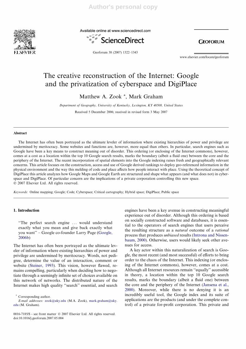
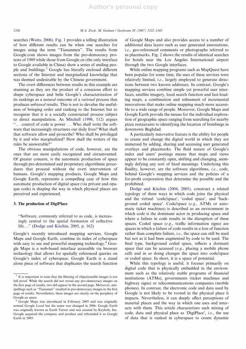
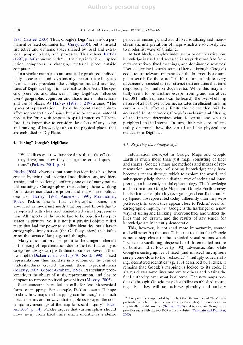
Fig. 1. Results of image search on keyword ‘‘Tiananmen’’. Source: Authors’ photo on March 23, 2007.
1324 M.A. Zook, M. Graham / Geoforum 38 (2007) 1322–1343
Author's personal copy
and criteria used are artificially constructed and constantlyrevised, Google attempts to ‘‘naturalize’’ its results as anobjective representation of the Internet.
Fundamentally, however, one cannot escape the shadingthat is an inherent process of ranking; but because Goo-gle’s algorithms are proprietary, the public is unable tolook inside the ‘‘black box’’. Instead they are urged toaccept these results as unbiased and rational. For example,at the bottom of Google’s News index (news.google.com)one finds the disclaimer, ‘‘The selection and placement ofstories on this page were determined automatically by a
computer program.’’ While no doubt intended to be reas-suring of the objectivity of Google, it provides an uninten-tional indication of the power of code (Lessig, 1999) toshape the access and ordering of information. And pre-cisely because ranking is based on code, it is subject tomanipulation by its owner/coder.
An excellent example of the ease in which Google canalter its ranking algorithm and shape representationinvolves the results from a simple Google image search.In a controversial move Google bowed to the demands ofthe Chinese government and agreed to filter the results of
Fig. 1 (continued)
M.A. Zook, M. Graham / Geoforum 38 (2007) 1322–1343 1325
Author's personal copy
searches (Watts, 2006). Fig. 1 provides a telling illustrationof how different results can be when one searches forimages using the term ‘‘Tiananmen’’. The results fromGoogle.com shows images from the pro-democracy pro-tests of 1989 while those from Google.cn (the only interfaceto Google available in China) show a series of smiling peo-ple and buildings.3 Google has literally enclosed differentsections of the Internet and marginalized knowledge thatwas deemed undesirable by the Chinese government.
The overt differences between results in this example arestunning as they are the product of a conscious effort toshape cyberspace and belie Google’s characterization ofits rankings as a natural outcome of a rational process thatproduces unbiased results. This is not to devalue the useful-ness of bringing order and ranking to the Internet but torecognize that it is a socially constructed process subjectto direct manipulation. As Mitchell (1996, 112) argues‘‘. . . control of code is power . . . Who shall write the soft-ware that increasingly structures our daily lives? What shallthat software allow and proscribe? Who shall be privilegedby it and who marginalized? How shall the writers of therules be answerable?’’
The obvious manipulations of code, however, are theones that are most easily recognized and circumvented.Of greater concern, is the automatic production of spacethrough pre-determined and proprietary algorithmic proce-dures that proceed without the overt intervention ofhumans. Google’s mapping products, Google Maps andGoogle Earth, represents a compelling case of how thisautomatic production of digital space (via private and opa-que code) is shaping the way in which physical places areperceived and experienced.
3. The production of DigiPlace
‘‘Software, commonly referred to as code, is increas-ingly central to the spatial formation of collectivelife. . .’’ (Dodge and Kitchin, 2005, p. 162)
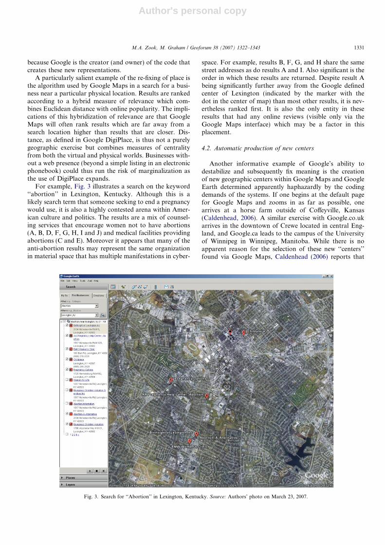
Google’s recently introduced mapping services, GoogleMaps and Google Earth, combine its index of cyberspacewith easy to use and powerful mapping technology.4 Goo-gle Maps is a web-based interface accessible via browsertechnology that allows for spatially referenced queries onGoogle’s index of cyberspace. Google Earth is a standalone piece of software that duplicates the search function
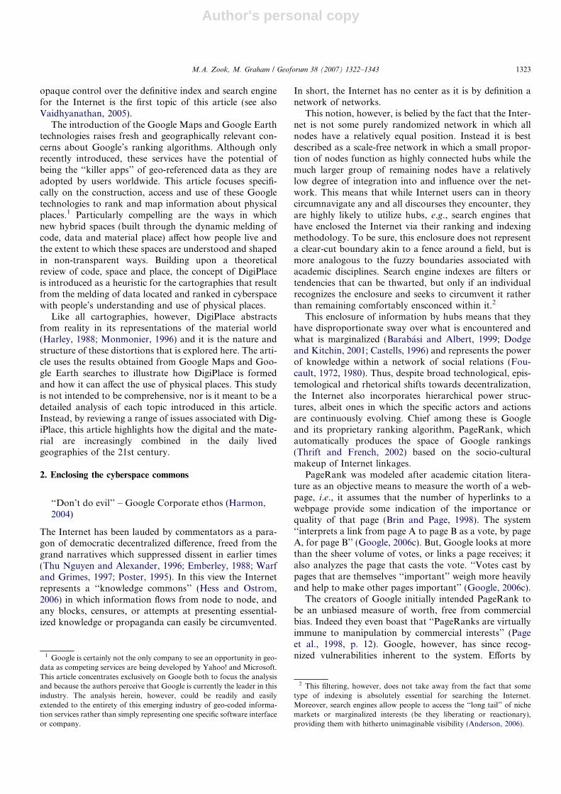
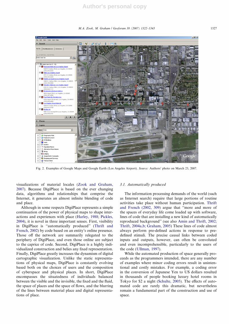
of Google Maps and also provides access to a number ofadditional data layers such as user generated annotations,i.e., geo-referenced comments or photographs referred toas placemarks. Fig. 2 shows the results of identical searchesfor hotels near the Los Angeles International airportthrough the two Google interfaces.
While online mapping programs such as MapQuest havebeen popular for some time, the uses of these services wererelatively limited, i.e., largely employed to generate direc-tions between two known addresses. In contrast, Google’smapping services combine simple yet powerful user inter-faces, satellite imagery, local search function and fast-load-ing maps; a combination and refinement of incrementalinnovations that make online mapping much more accessi-ble to a wide range of people. Moreover, Google Maps andGoogle Earth provide the means for the individual explora-tion of geographic space ranging from searching for nearbypizza restaurants to identifying the location of bombings indowntown Baghdad.
A particularly innovative feature is the ability for peopleto create and change the digital world in which they areimmersed by adding, sharing and accessing user generatedoverlays and placemarks. The fluid nature of Google’sindex and users’ postings means that maps and viewsappear to be constantly open, shifting and changing, seem-ingly defying any sort of fixed meanings. Underlying thisfluidity, however, are the software algorithms, i.e., code,behind Google’s mapping services and the policies of afor-profit corporation that determine the possible and theprohibited.
Dodge and Kitchin (2004, 2005), construct a relatedtypology of three ways in which code joins the physicaland the virtual: ‘code/space’, ‘coded space’, and ‘back-ground coded space’. Code/space (e.g., ATMs or auto-matic ticket machines) is described as an environment inwhich code is the dominant actor in producing space andwhere a failure in code results in the disruption of thesespaces. Coded space (e.g., traffic information signs) arespaces in which a failure of code results in a loss of functionrather than complete failure, i.e., the space can still be usedbut not as it had been augmented by code to be used. Thefinal type, background coded space, reflects a dormantspace that can be accessed (e.g., placing a mobile phonecall) and in so doing changes the space into code/spaceor coded space. In short, it is a space of potential.
While this typology is useful, it focuses primarily ondigital code that is physically embedded in the environ-ment such as the relatively stable programs of financialinstitutions (ATMs), governments (ticket machines andhighway signs) or telecommunications companies (mobilephones). In contrast, the electronic code and data used byGoogle is not likely to be rooted in the physical place itimpacts. Nevertheless, it can deeply affect perceptions ofmaterial places and the way in which one uses and inter-acts with them. This article characterizes such mixing ofcode, data and physical place as ‘DigiPlace’, i.e., the useof data that is ranked in cyberspace to create dynamic
3 It is important to note that the filtering of objectionable images is notfull proof. While the search did not reveal any pro-democracy images onthe first page of results, two did appear in the second page. Moreover, mis-spellings such as ‘‘Tianamen’’ resulted in pro-democracy images in the firstpage of results. Nevertheless, these images are clearly on the periphery ofGoogle.cn space.
4 Google Maps was introduced in February 2005 and was originallytermed Google Local but the name was changed in 2006. Google Earthwas originally known as Earth Viewer and was created by Keyhole, Inc.Google acquired the company and product and rebranded it as GoogleEarth in 2005.
1326 M.A. Zook, M. Graham / Geoforum 38 (2007) 1322–1343
Author's personal copy
visualizations of material locales (Zook and Graham,2007). Because DigiPlace is based on the ever changingdata, algorithms and relationships that comprise theInternet, it generates an almost infinite blending of codeand place.
Although in some respects DigiPlace represents a simplecontinuation of the power of physical maps to shape inter-actions and experiences with place (Harley, 1988; Pickles,2004), it is novel in three important senses. First, visibilityin DigiPlace is ‘‘automatically produced’’ (Thrift andFrench, 2002) by code based on an entity’s online presence.Those off the network are summarily relegated to theperiphery of DigiPlace, and even those online are subjectto the caprice of code. Second, DigiPlace is a highly indi-vidualized construction and belies any fixed representation.Finally, DigiPlace greatly increases the dynamism of digitalcartographic visualization. Unlike the static representa-tions of physical maps, DigiPlace is constantly evolvingbased both on the choices of users and the compositionof cyberspace and physical places. In short, DigiPlaceencompasses the situatedness of individuals balancedbetween the visible and the invisible, the fixed and the fluid,the space of places and the space of flows, and the blurringof the lines between material place and digital representa-tions of place.
3.1. Automatically produced
The information processing demands of the world (suchas Internet search) require that large portions of routineactivities take place without human participation. Thriftand French (2002, 309) argue that ‘‘more and more ofthe spaces of everyday life come loaded up with software,lines of code that are installing a new kind of automaticallyreproduced background’’ (see also Amin and Thrift, 2002;Thrift, 2004a,b; Graham, 2005) These lines of code almostalways perform pre-defined actions in response to pre-defined stimuli. The precise causal links between codedinputs and outputs, however, can often be convolutedand even incomprehensible, particularly to the users ofthe code (Ullman, 1997).
While the automated production of space generally pro-ceeds as the programmers intended, there are any numberof examples where minor coding errors result in uninten-tional and costly mistakes. For example, a coding errorin the conversion of Japanese Yen to US dollars resultedin thousands of people booking luxury hotel rooms inTokyo for $2 a night (Schulte, 2005). The effects of auto-mated code are rarely this dramatic, but neverthelessremain a fundamental part of the construction and use ofspace.
Fig. 2. Examples of Google Maps and Google Earth (Los Angeles Airport). Source: Authors’ photo on March 23, 2007.
M.A. Zook, M. Graham / Geoforum 38 (2007) 1322–1343 1327
Author's personal copy
The code of DigiPlace requires an online presence inorder to be ranked and those without one are switchedoff (see also Castells, 2001, p. 269–270). Being online, how-ever, is merely a necessary condition for inclusion and doesnot guarantee a prominent position in DigiPlace. Insteadvisibility is determined by the largely opaque code of theGoogle PageRank system. The invisibility of softwareencourages the perception of coded rules, such as GoogleMaps results, as natural. The programmed output of effectsin response to inputted stimuli, however, adds a heretoforeunknown dimension to the ways in which spaces are con-trolled and power distributed. Thrift and French againnote that ‘‘power is built into software from its inception.For example, binary code is premised on the Leibnizianconception of permitted/not permitted’’ (Castells, 2001,p. 325).
Even the act of classification and selection of searchterms is not unproblematic. As Bowker and Star (1999,5) argue, any type of categorization inevitably ‘‘. . . valo-rizes some point of view and silences another . . . and assuch it is dangerous.’’ Similar critiques of geodemograph-ics, i.e., applying data associated with an areal unit to indi-viduals living in that area, highlight the power ofclassification and code and the potential danger of digitalmodels becoming more powerful than the physical reality.
For example, Burrows et al. (2005, 37) assert that the useof Internet Based Neighborhood Information Systems(IBNIS) can ‘‘. . . contribute to ongoing processes of inter-neighborhood segregation and intra-neighborhood homog-enization’’. Similarly, Graham (2005, 563) contends that‘‘code-based technologized environments continuouslyand invisibly classify, standardize, and demarcate rights,privileges, inclusions, exclusions, and mobilities and norma-tive social judgments across vast, distanciated, domains.’’In short, the digital data space that contributes to the con-struction of DigiPlace is always filtered through the powerof someone’s code and therefore is always vulnerable toovert or surreptitious manipulation (see Fig. 1).
As the rules and rankings of code are automatically pro-duced and naturalized they give rise to and reproduce dis-tinct forms of social, political, and economic power. Suchconcerns have previously been raised by a number ofauthors (Eischen, 2003; Graham, 2005; Thrift and French,2002; Dodge and Kitchin, 2005). To date, however, thereremains very little work which attempts to understand howthe lived subjective spaces represented by DigiPlace areshaped and governed by the ‘‘black boxes that trap software-sorting, and the cultural and spatial politics of code, withintheir esoteric, largely unknown, and almost completely opa-que, technocratic worlds’’ (Graham, 2005, p. 575).
Fig. 2 (continued)
1328 M.A. Zook, M. Graham / Geoforum 38 (2007) 1322–1343
Author's personal copy
3.2. Individually conceived
Not only is DigiPlace a hybridization of the virtual andthe material, but it is also individualized and non-general-izable.5 DigiPlace does not exist in any sort of decontextu-alized and absolute manner but is actualized by themelding of information and locale by individual action.In the case of Google Maps or Google Earth, DigiPlaceis created and experienced when a specific query about alocation is conducted based on personal needs or interest,e.g., where can I eat lunch? Contexts can be both physical(i.e. the geographical location of a person), technological(e.g. the machine(s) used to connect to the virtual), andcode based (customized settings and software cookies).Furthermore, possibilities to interact directly with Digi-Place depend heavily on the individual ability of users toaccess the virtual world. Economic barriers to owning thenecessary hardware and access rights, as well as individualcognitive and technical skills, render DigiPlace invisible formany people.
These differences in context and ability mean that Digi-Place is accessed, interacted with, and conceived of in fun-damentally different ways by each user. Particularlyimportant is how these differences affect one’s cognitivemap of a place, i.e., the ‘‘representative expression of . . .an individual’s knowledge about the spatial and environ-mental relations of geographic space.’’ (Kitchin, 2001,p. 2120). Lynch’s (1960) ground-breaking work on the per-ception and mental maps of the city were necessarily lim-ited to the physical environment, but the advent ofDigiPlace means that a whole new layer of virtual inputscan shape one’s conception of a physical place. Moreoverby facilitating the sharing of spatially referenced annota-tions (see Figs. 5–10) DigiPlace allows individuals to easilyimpart their perception of places to others.
While the spaces of DigiPlace are differentially createdand interpreted by each person, they are also automaticallycreated by code based on the personal attributes of individ-uals. Graham (2005) defines this as ‘software-sorting,’ or aprocess through which selective access is organized using a‘‘burgeoning array of subscriptions, passwords, serviceentitlements, physical and virtual access control points,electronically surveilled passage points and transaction sys-tems, automated, biometric judgments, and normative dat-abases – all of which are continuously enacted andsustained through code and computerized systems basedon machine-readable inputs’’ (Graham, 2005, p. 546).Thus, not only does each individual’s ability and cognitionshape the DigiPlace they inhabit, but their unique code(manifested as a data profile) automatically determinesthe enclosure of information space in which they operate.In short, DigiPlace represents the situatedness of discrete
individuals straddling virtual and physical realities, ratherthan any sort of shared, objective, and fixed reality.
3.3. Dynamically reconstructed
In addition to varying individually, DigiPlace also istemporally dynamic particularly since electronic architec-tures can be reconfigured relatively quickly. For example,the Google index underlying Google Maps is updated dailyresulting in a continuous reconfiguration of rankings basedon the current constellation of links gathered by Google’sspidering programs. Moreover, the openness and structureof the Internet means that new material, links and websitesare constantly introduced or reconfigured.
In addition, the interlinked nature of the Internet meansthat changes in one part of the system influence a variety ofoutcomes in other parts of the system. Such effects arereadily evident in the context of Google and its PageRankalgorithm. As cultural, economic, and political trends,tastes, interests and processes evolve, those changes ripplethrough cyberspace and as a consequence, the Google’sranking systems never reach a stable equilibrium. A chan-ged PageRank score for any website results in the alter-ation of PageRank for every related website. Suchexponential effects are constantly being calculated by codeand lead to a system of ranking that is far from stable. Thefluidity of cyberspace combined with the dynamism inher-ent to physical spaces (i.e. the city is constituted in a differ-ent manner today than it was yesterday) (Harvey, 1989;Soja, 1989; Brenner, 1999; Massey, 1999), results in spacesof DigiPlace that are continually re-combined. While thisarticle focuses primarily upon the role of Google’s codein the production of DigiPlace, the users of cyberspace alsoassert power via the construction of their online linkages.In particular, the rise of social networking sites such asFaceBook or MySpace (commonly referred to as Web2.0) creates new networks of collaboration and culturalproduction which in turn reshapes PageRank and ulti-mately DigiPlace.
The satellite imagery deployed within Google Earth isan interesting combination of stasis and dynamism withinDigiPlace. The images are static and represent a certainmoment in time, but by no means is it the same momentfor every location. All images are reported to be three yearsold or less, but because they are drawn from a wide numberof sources it is ‘‘. . . difficult . . . to specify the date of a cityor region (a single city may have imagery taken from differ-ent months)’’ (Google, 2006d). This temporal diversity isfurther complicated by ongoing efforts to update andimprove images creating a dynamically evolving set of sta-tic imagery that varies across space.
Thus, physical places and digital cyberspace combineinto a DigiPlace that is conceived as hybrid and experi-enced instead of essentialized ontological entities. Digi-Place is a way of imagining the interdependencies ofphysical and virtual places and processes (see for example:Gregory, 1982; Johnston, 1984; Pred, 1984; Massey, 1985,
5 The individualization evident in DigiPlace follows the trend exempli-fied by the ongoing evolution of Fordism towards more flexible forms ofproduction and also echoes Castells’ (1996) argument that society isincreasing structured around ‘‘the Net’’ and ‘‘the Self’’.
M.A. Zook, M. Graham / Geoforum 38 (2007) 1322–1343 1329
Author's personal copy
1993; Castree, 2003). Thus, Google’s DigiPlace is not a per-manent or fixed container (c.f. Curry, 2005), but is insteadsubjective and dynamic space shaped by local and extra-local people, places, and processes. This echoes Batty’s(1997, p. 340) concern with ‘‘. . . the ways in which . . . spaceinside computers is changing material place outsidecomputers.’’
In a similar manner, as automatically produced, individ-ually conceived and dynamically reconstructed spacesbecome more prevalent, the configurations and architec-tures of DigiPlace begin to have real-world effects. The spe-cific presences and absences in any DigiPlace influenceusers’ geographic cognition and shade users’ interactionsand use of places. As Harvey (1989, p. 219) argues, ‘‘Thespaces of representation . . . have the potential not only toaffect representation of space but also to act as a materialproductive force with respect to spatial practices.’’ There-fore, it is imperative to consider the effects of any fixingand ranking of knowledge about the physical places thatare embodied in DigiPlace.
4. ‘‘Fixing’’ Google’s DigiPlace
‘‘Which lines we draw, how we draw them, the effectsthey have, and how they change are crucial ques-tions’’ (Pickles, 2004, p. 3)
Pickles (2004) observes that countless identities have beencreated by fixing and ordering lines, distinctions, and hier-archies, and in so doing stabilizing one out of many poten-tial meanings. Cartographers (particularly those workingfor a state) manufacture power, and maps have politics(see also Harley, 1988; Anderson, 1991; Monmonier,2002). Pickles asserts that cartographic fixings aregrounded in modernist needs that required knowledge tobe equated with clear and unmediated visual representa-tion. All aspects of the world had to be objectively repre-sented as pictures. So, it is not just physical objects calledmaps that had the power to stabilize identities, but a largercartographic imagination (the God’s-eye view) that influ-ences the forms of language and thought.
Many other authors also point to the dangers inherentin the fixing of representation due to the fact that analyticcategories always carry with them discursive power in theirown right (Dicken et al., 2001, p. 90; Scott, 1998). Fixedrepresentations thus translate into actions on the basis ofunderstandings created through those representations(Massey, 2005; Gibson-Graham, 1996). Particularly prob-lematic, is the ability of stasis, representation, and closureof space to remove political possibilities (Massey, 2005).
Such concerns have led to calls for less hierarchicalforms of mapping. For example, Pickles asserts: ‘‘I hopeto show how maps and mapping can be thought in muchbroader terms and in ways that enable us to open the con-temporary meanings of the map for social inquiry’’ (Pick-les, 2004, p. 14). Pickles argues that cartographies shouldmove away from fixed lines which uncritically stabilize
particular meanings, and avoid fixed totalizing and mono-chromatic interpretations of maps which are so closely tiedto modernist ways of thinking.
At first blush, Google’s index seems to democratize howknowledge is used and accessed in ways that are free frommeta-narratives, fixed meanings, and dominant discourses.User determined search terms (filtered through Google’scode) return relevant references on the Internet. For exam-ple, a search for the word ‘‘truth’’ returns a link to everydocument connected to the Internet that contains that term(reportedly 384 million documents). While this may ini-tially seem to be another escape from grand narratives(i.e. 384 million opinions can be heard), the overwhelmingnature of all of those voices necessitates an efficient rankingsystem which effectively limits the voices that will beaccessed.6 In other words, Google’s enclosure and filteringof the Internet determines what is central and what isperipheral on the Internet. In turn, these measures of cen-trality determine how the virtual and the physical aremelded into DigiPlace.
4.1. Re-fixing lines Google style
Information conveyed in Google Maps and GoogleEarth is much more than just maps consisting of linesand shapes. Google’s maps are methods and means of rep-resentation, new ways of storing knowledge; they havebecome a means through which to explore the world, andsubsequently help shape a distinct way of seeing and inter-preting: an inherently spatial epistemology. The knowledgeand information Google Maps and Google Earth conveyhas both an air of plurality (everyone gets heard) and unfix-ity (spaces are represented today differently than they wereyesterday). In short, they appear close to Pickles’ ideal forcartographic inquiry, i.e., Google is the harbinger of a newways of seeing and thinking. Everyone fixes and unfixes thelines that get drawn, and the results of any search forknowledge are inherently democratic.
This, however, is not (and more importantly, cannotand will never be) the case. This is not to claim that Googleis not a step closer to the exploded visualizations which‘‘evoke the vacillating, dispersed and disseminated natureof borders’’ that Pickles (p. 192) advocates. But, whileGoogle’s cartographies of fixed (and unfixed) inscriptionssurely come close to the ‘‘schizoid,’’ ‘‘multiply coded shift-ing, decentered identities’’ (p. 180) described by Pickles, itremains that Google’s mapping is locked to its code. Italways draws some lines and omits others and retains thefinal authority over what is allowed. The new maps pro-duced through Google may destabilize established mean-ings, but they will not achieve plurality and unfixity
6 This point is compounded by the fact that the number of ‘‘hits’’ on aparticular search term (or the overall size of its index) is by no means anempirically testable number (Sullivan, 2005) and in any case Google onlyprovides users with the top 1000 ranked websites (Calishain and Dornfest,2003).
1330 M.A. Zook, M. Graham / Geoforum 38 (2007) 1322–1343
Author's personal copy
because Google is the creator (and owner) of the code thatcreates these new representations.
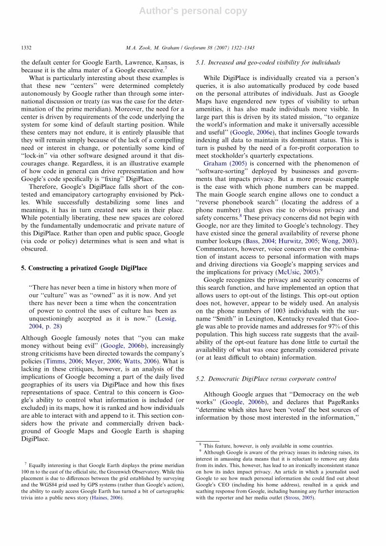
A particularly salient example of the re-fixing of place isthe algorithm used by Google Maps in a search for a busi-ness near a particular physical location. Results are rankedaccording to a hybrid measure of relevance which com-bines Euclidean distance with online popularity. The impli-cations of this hybridization of relevance are that GoogleMaps will often rank results which are far away from asearch location higher than results that are closer. Dis-tance, as defined in Google DigiPlace, is thus not a purelygeographic exercise but combines measures of centralityfrom both the virtual and physical worlds. Businesses with-out a web presence (beyond a simple listing in an electronicphonebook) could thus run the risk of marginalization asthe use of DigiPlace expands.
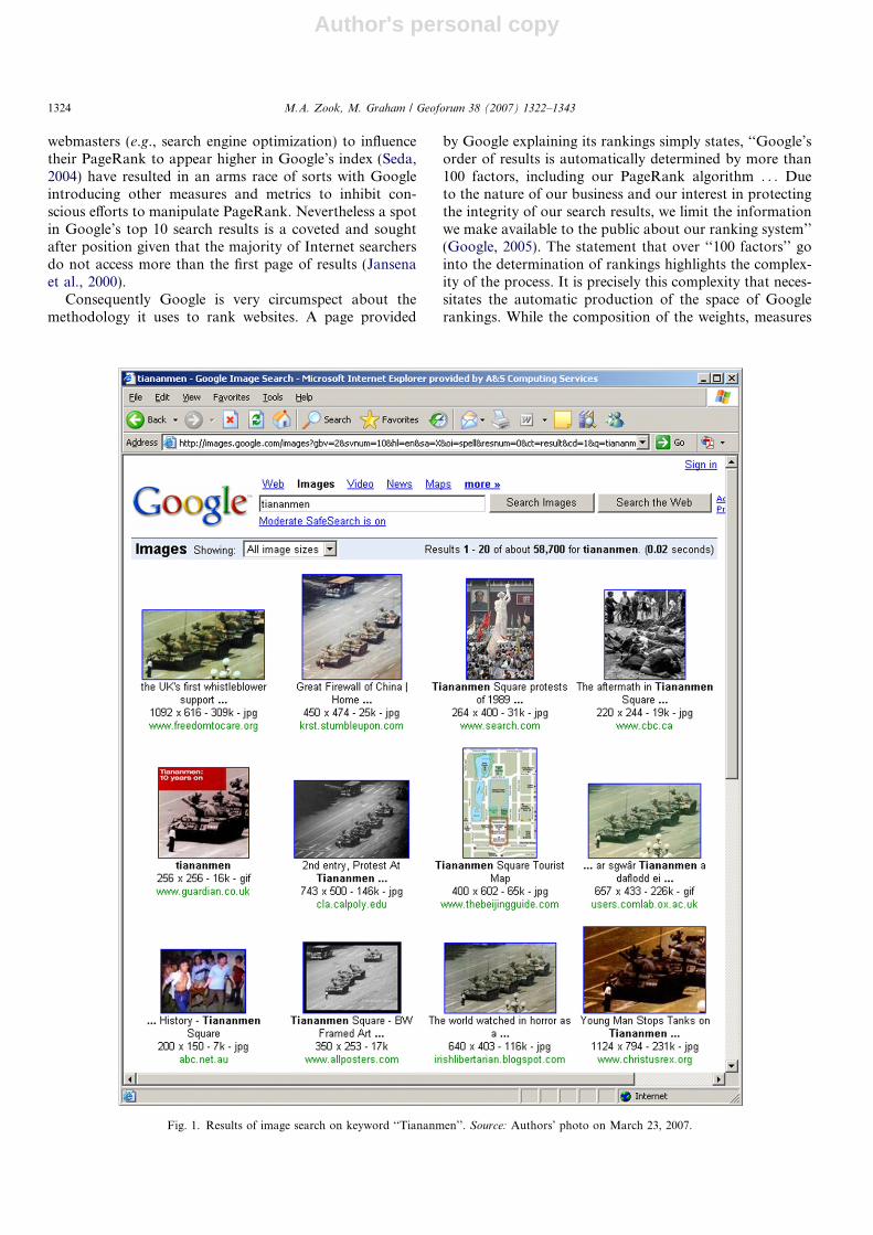
For example, Fig. 3 illustrates a search on the keyword‘‘abortion’’ in Lexington, Kentucky. Although this is alikely search term that someone seeking to end a pregnancywould use, it is also a highly contested arena within Amer-ican culture and politics. The results are a mix of counsel-ing services that encourage women not to have abortions(A, B, D, F, G, H, I and J) and medical facilities providingabortions (C and E). Moreover it appears that many of theanti-abortion results may represent the same organizationin material space that has multiple manifestations in cyber-
space. For example, results B, F, G, and H share the samestreet addresses as do results A and I. Also significant is theorder in which these results are returned. Despite result Abeing significantly further away from the Google definedcenter of Lexington (indicated by the marker with thedot in the center of map) than most other results, it is nev-ertheless ranked first. It is also the only entity in theseresults that had any online reviews (visible only via theGoogle Maps interface) which may be a factor in thisplacement.
4.2. Automatic production of new centers
Another informative example of Google’s ability todestabilize and subsequently fix meaning is the creationof new geographic centers within Google Maps and GoogleEarth determined apparently haphazardly by the codingdemands of the systems. If one begins at the default pagefor Google Maps and zooms in as far as possible, onearrives at a horse farm outside of Coffeyville, Kansas(Caldenhead, 2006). A similar exercise with Google.co.ukarrives in the downtown of Crewe located in central Eng-land, and Google.ca leads to the campus of the Universityof Winnipeg in Winnipeg, Manitoba. While there is noapparent reason for the selection of these new ‘‘centers’’found via Google Maps, Caldenhead (2006) reports that
Fig. 3. Search for ‘‘Abortion’’ in Lexington, Kentucky. Source: Authors’ photo on March 23, 2007.
M.A. Zook, M. Graham / Geoforum 38 (2007) 1322–1343 1331
Author's personal copy
the default center for Google Earth, Lawrence, Kansas, isbecause it is the alma mater of a Google executive.7
What is particularly interesting about these examples isthat these new ‘‘centers’’ were determined completelyautonomously by Google rather than through some inter-national discussion or treaty (as was the case for the deter-mination of the prime meridian). Moreover, the need for acenter is driven by requirements of the code underlying thesystem for some kind of default starting position. Whilethese centers may not endure, it is entirely plausible thatthey will remain simply because of the lack of a compellingneed or interest in change, or potentially some kind of‘‘lock-in’’ via other software designed around it that dis-courages change. Regardless, it is an illustrative exampleof how code in general can drive representation and howGoogle’s code specifically is ‘‘fixing’’ DigiPlace.
Therefore, Google’s DigiPlace falls short of the con-tested and emancipatory cartography envisioned by Pick-les. While successfully destabilizing some lines andmeanings, it has in turn created new sets in their place.While potentially liberating, these new spaces are coloredby the fundamentally undemocratic and private nature ofthis DigiPlace. Rather than open and public space, Google(via code or policy) determines what is seen and what isobscured.
5. Constructing a privatized Google DigiPlace
‘‘There has never been a time in history when more ofour ‘‘culture’’ was as ‘‘owned’’ as it is now. And yetthere has never been a time when the concentrationof power to control the uses of culture has been asunquestioningly accepted as it is now.’’ (Lessig,2004, p. 28)
Although Google famously notes that ‘‘you can makemoney without being evil’’ (Google, 2006b), increasinglystrong criticisms have been directed towards the company’spolicies (Timms, 2006; Meyer, 2006; Watts, 2006). What islacking in these critiques, however, is an analysis of theimplications of Google becoming a part of the daily livedgeographies of its users via DigiPlace and how this fixesrepresentations of space. Central to this concern is Goo-gle’s ability to control what information is included (orexcluded) in its maps, how it is ranked and how individualsare able to interact with and append to it. This section con-siders how the private and commercially driven back-ground of Google Maps and Google Earth is shapingDigiPlace.
5.1. Increased and geo-coded visibility for individuals
While DigiPlace is individually created via a person’squeries, it is also automatically produced by code basedon the personal attributes of individuals. Just as GoogleMaps have engendered new types of visibility to urbanamenities, it has also made individuals more visible. Inlarge part this is driven by its stated mission, ‘‘to organizethe world’s information and make it universally accessibleand useful’’ (Google, 2006e), that inclines Google towardsindexing all data to maintain its dominant status. This isturn is pushed by the need of a for-profit corporation tomeet stockholder’s quarterly expectations.
Graham (2005) is concerned with the phenomenon of‘‘software-sorting’’ deployed by businesses and govern-ments that impacts privacy. But a more prosaic exampleis the ease with which phone numbers can be mapped.The main Google search engine allows one to conduct a‘‘reverse phonebook search’’ (locating the address of aphone number) that gives rise to obvious privacy andsafety concerns.8 These privacy concerns did not begin withGoogle, nor are they limited to Google’s technology. Theyhave existed since the general availability of reverse phonenumber lookups (Bass, 2004; Hurwitz, 2005; Wong, 2003).Commentators, however, voice concern over the combina-tion of instant access to personal information with mapsand driving directions via Google’s mapping services andthe implications for privacy (McUsic, 2005).9
Google recognizes the privacy and security concerns ofthis search function, and have implemented an option thatallows users to opt-out of the listings. This opt-out optiondoes not, however, appear to be widely used. An analysison the phone numbers of 1003 individuals with the sur-name ‘‘Smith’’ in Lexington, Kentucky revealed that Goo-gle was able to provide names and addresses for 97% of thispopulation. This high success rate suggests that the avail-ability of the opt-out feature has done little to curtail theavailability of what was once generally considered private(or at least difficult to obtain) information.
5.2. Democratic DigiPlace versus corporate control
Although Google argues that ‘‘Democracy on the webworks’’ (Google, 2006b), and declares that PageRanks‘‘determine which sites have been ‘voted’ the best sources ofinformation by those most interested in the information,’’
7 Equally interesting is that Google Earth displays the prime meridian100 m to the east of the official site, the Greenwich Observatory. While thisplacement is due to differences between the grid established by surveyingand the WGS84 grid used by GPS systems (rather than Google’s action),the ability to easily access Google Earth has turned a bit of cartographictrivia into a public news story (Haines, 2006).
8 This feature, however, is only available in some countries.9 Although Google is aware of the privacy issues its indexing raises, its
interest in amassing data means that it is reluctant to remove any datafrom its index. This, however, has lead to an ironically inconsistent stanceon how its index impact privacy. An article in which a journalist usedGoogle to see how much personal information she could find out aboutGoogle’s CEO (including his home address), resulted in a quick andscathing response from Google, including banning any further interactionwith the reporter and her media outlet (Stross, 2005).
1332 M.A. Zook, M. Graham / Geoforum 38 (2007) 1322–1343
Author's personal copy
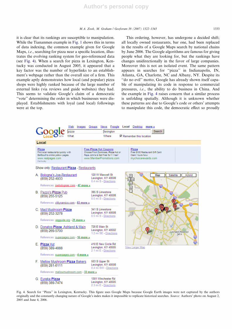
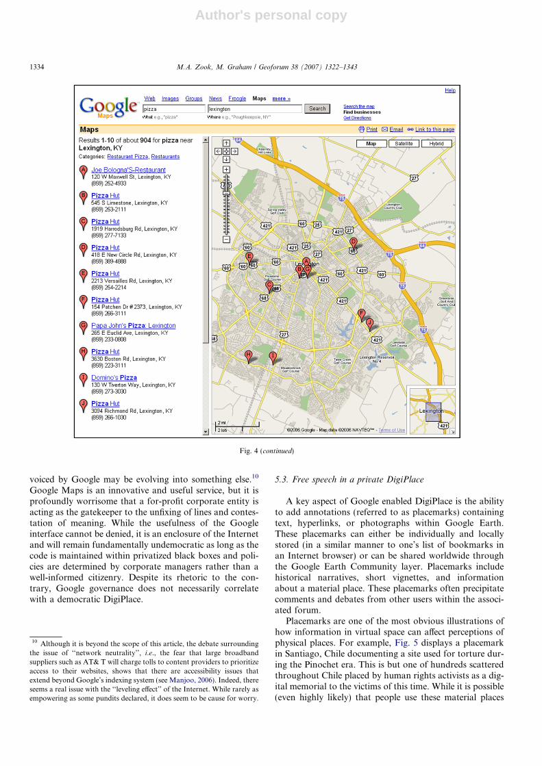
it is clear that its rankings are susceptible to manipulation.While the Tiananmen example in Fig. 1 shows this in termsof data indexing, the common example given for GoogleMaps, i.e., searching for pizza near a specific location, illus-trates the evolving ranking system for geo-referenced data(see Fig. 4). When a search for pizza in Lexington, Ken-tucky was conducted in August 2005, it appeared that akey factor was the number of hyperlinks to an establish-ment’s webpage rather than the overall size of a firm. Thisexample aptly demonstrates how local (and popular) pizzashops were highly ranked because of the large number ofexternal links (via reviews and guide websites) they had.This seems to validate Google’s claim of a democratic‘‘vote’’ determining the order in which businesses were dis-played. Establishments with loyal (and local) followingswere at the top.
This ordering, however, has undergone a decided shift;all locally owned restaurants, bar one, had been replacedin the results of a Google Maps search by national chainsby June 2006. The Google algorithms are famous for givingpeople what they are looking for, but the rankings havechanges unidirectionally in the favor of large companies.Moreover this is not an isolated event. The same patternappears in searches for ‘‘pizza’’ in Indianapolis, IN,Atlanta, GA, Charlotte, NC and Albany, NY. Despite its‘‘do no evil’’ motto, Google has already shown itself capa-ble of manipulating its code in response to commercialpressures, i.e., the ability to do business in China. Andthe example in Fig. 4 raises concern that a similar processis unfolding spatially. Although it is unknown whetherthese patterns are due to Google’s code or others’ attemptsto manipulate this code, the democratic effect so proudly
Fig. 4. Search for ‘‘Pizza’’ in Lexington, Kentucky. This figure uses Google Maps because Google Earth images were not captured by the authorsoriginally and the constantly changing nature of Google’s index makes it impossible to replicate historical searches. Source: Authors’ photo on August 2,2005 and June 4, 2006.
M.A. Zook, M. Graham / Geoforum 38 (2007) 1322–1343 1333
Author's personal copy
voiced by Google may be evolving into something else.10
Google Maps is an innovative and useful service, but it isprofoundly worrisome that a for-profit corporate entity isacting as the gatekeeper to the unfixing of lines and contes-tation of meaning. While the usefulness of the Googleinterface cannot be denied, it is an enclosure of the Internetand will remain fundamentally undemocratic as long as thecode is maintained within privatized black boxes and poli-cies are determined by corporate managers rather than awell-informed citizenry. Despite its rhetoric to the con-trary, Google governance does not necessarily correlatewith a democratic DigiPlace.
5.3. Free speech in a private DigiPlace
A key aspect of Google enabled DigiPlace is the abilityto add annotations (referred to as placemarks) containingtext, hyperlinks, or photographs within Google Earth.These placemarks can either be individually and locallystored (in a similar manner to one’s list of bookmarks inan Internet browser) or can be shared worldwide throughthe Google Earth Community layer. Placemarks includehistorical narratives, short vignettes, and informationabout a material place. These placemarks often precipitatecomments and debates from other users within the associ-ated forum.
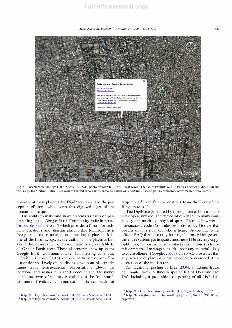
Placemarks are one of the most obvious illustrations ofhow information in virtual space can affect perceptions ofphysical places. For example, Fig. 5 displays a placemarkin Santiago, Chile documenting a site used for torture dur-ing the Pinochet era. This is but one of hundreds scatteredthroughout Chile placed by human rights activists as a dig-ital memorial to the victims of this time. While it is possible(even highly likely) that people use these material places
Fig. 4 (continued)
10 Although it is beyond the scope of this article, the debate surroundingthe issue of ‘‘network neutrality’’, i.e., the fear that large broadbandsuppliers such as AT& T will charge tolls to content providers to prioritizeaccess to their websites, shows that there are accessibility issues thatextend beyond Google’s indexing system (see Manjoo, 2006). Indeed, thereseems a real issue with the ‘‘leveling effect’’ of the Internet. While rarely asempowering as some pundits declared, it does seem to be cause for worry.
1334 M.A. Zook, M. Graham / Geoforum 38 (2007) 1322–1343
Author's personal copy
unaware of these placemarks, DigiPlace can shape the per-ception of those who access this digitized layer of thehuman landscape.
The ability to make and share placemarks turns on par-ticipating in the Google Earth Community bulletin board(http://bbs.keyhole.com/) which provides a forum for tech-nical questions and sharing placemarks. Membership isfreely available to anyone, and posting a placemark inone of the forums, e.g., as the author of the placemark inFig. 5 did, ensures that one’s annotations are available toall Google Earth users. These placemarks show up in theGoogle Earth Community layer (manifesting as a blue‘‘i’’ within Google Earth) and can be turned on or off asa user desires. Lively online discussions about placemarksrange from semi-academic conversations about thelocations and names of airport codes,11 and the namesand hometowns of military causalities of the Iraq war,12
to more frivolous communication themes such as
crop circles13 and filming locations from the Lord of theRings movies.14
The DigiPlace generated by these placemarks is in manyways open, unfixed, and democratic: a many to many com-plex system much like physical space. There is, however, abureaucratic code (i.e., rules) established by Google thatgovern what is seen and who is heard. According to theofficial FAQ there are only four regulations which governthe entire system: participants must not (1) break any copy-right laws, (2) post personal contact information, (3) trans-mit commercial messages, or (4) ‘‘post any material likelyto cause offense’’ (Google, 2006a). The FAQ also notes thatany message or placemark can be edited or censored at thediscretion of the moderators.
An additional posting by Lrae (2006), an administratorof Google Earth, outlines a specific list of Do’s and NotDo’s including a prohibition on posting of all ‘‘Political,
Fig. 5. Placemark in Santiago Chile. Source: Authors’ photo on March 23, 2007; Text reads ‘‘The Police Institute was utilised as a center of detention andtorture by the Chilean Police. Este recinto fue utilisado como centro de detencion y tortura utilisado por Carabineros. www.memoriaviva.com’’.
11 http://bbs.keyhole.com/ubb/showflat.php?Cat=0&Number=168950.12 http://bbs.keyhole.com/ubb/showflat.php?Cat=0&Number=178100.
13 http://bbs.keyhole.com/ubb/showflat.php/Cat/0/Number/175202.14 http://bbs.keyhole.com/ubb/showflat.php/Cat/0/Number/69500/an//
page//vc/1.
M.A. Zook, M. Graham / Geoforum 38 (2007) 1322–1343 1335
Author's personal copy
Religious, Racial, or Sexual material’’. These rules are nodoubt partially an effort to limit the administrative head-aches for Google Earth that offensive or controversialplacemarks would create. As a result, however, GoogleEarth differs fundamentally from the governance (or lackthereof) associated with the public Internet. Google Earthis a private space in which users are welcome to participateas they see fit, but ultimately the power of governance lieswith Google.
As a result, the enforcement of Google Earth’s rules issomewhat erratic. For example, one Google Earth userposted his own survey of the electric transmission grid inTampa, FL to Google Earth and reported having hisaccount canceled and his data removed because GoogleEarth received a ‘‘. . . very aggressive response from theTampa Electric Power Corporation who asserted that thecolors used and information presented show that the place-mark was derived from controlled internal data and wastherefore a breach of serious security for it to be out inthe public.’’ (timl2k6, 2006). Later postings by other usersdiscredited this corporation’s contention, noting that this‘‘secret’’ data was available for purchase. Whether this
removal was due to actual security concerns or Google’sdesire to avoid legal suits or justifiable copyright issues isunknown. The overlay nevertheless remained removed,illustrating the limits to publishing placemarks within Goo-gle Earth.
At the same time there are numerous examples that vio-late the prohibitions outlined in the FAQ and refined byLrae (2006), particularly those regarding commercial post-ings. It is relatively easy to find placemarks recommendingvacation hotels or identifying locations where prostitutesare available (e.g., specific locations and businesses withinBangkok and Amsterdam). In short, many placemarkswhich run counter to the stated Google Earth rules arereadily available through the community layer without cen-sure. It is impossible to determine whether this representsselective (or lax) enforcement on the part of Google Earthadministrators or is the result of the inherent difficulty inenforcing a code based on human judgment (versus thealgorithmically determined PageRank) on what is to beallowed and what is to be prohibited.
A particularly subjective area is the rule against posting‘‘political’’ materials. What one individual considers to be
Fig. 6. Placemark in Jenin, West Bank. Source: Authors’ photo on March 23, 2007; Text reads ‘‘clear erea [sic] in the middle of jenin destroyed by Israelitroops and killed 5000 people on 2003 the UN described this as a war crime . . .’’.
1336 M.A. Zook, M. Graham / Geoforum 38 (2007) 1322–1343

Author's personal copy
highly political, e.g., directions to abortion services, mayseem to another simply a basic informational service (c.f.Fig. 3). The example presented in Fig. 5 is both a memorialto victims of torture, but also a profoundly political actwhich condemns the actions of a regime that enjoyed thestaunch support and protection of the United States’ gov-ernment. Moreover, the presence of these digital markers inthe Santiago urban environment are not simply neutralfootnotes but an addition to the ongoing debate on the his-tory and politics of Chile (Fig. 6).
Another enlightening case (a listing of 700 villages thatPalestinians fled after the 1948 Arab-Israeli war) highlightsthe power of maps and markers in naming and laying claimto physical places.15 While the placemarks contain only vil-lage names and historical population figures, clicking on
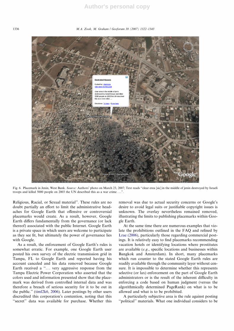
one of them also provides a link to an advocacy and onlinecommunity group for the displaced Palestinian population.Although not explicitly political, the locating of thesevillages in this conflict over land and occupation rights,can easily be interpreted as a political statement of Pales-tinian rights to places within the state of Israel (see Shoff-man, 2007). Likewise a placemark within the JeninRefugee camp in the West Bank (Fig. 7) documents the siteof destroyed houses and further asserts that Israeli troops‘‘killed 5000 people’’; an assertion contradicted by U.N.investigations into this event. Yet these placemarks havebeen incorporated within the Google Earth Communitylayer.
Overtly political placemarks are also evident in locationsthat are the site of ongoing strife. Fig. 7 shows a placemarknext to a bomb crater on a runway in Iraq, with the accom-panying text ‘‘hahahahaha america kicks ass!’’. The indi-vidual posting this placemark was celebrating the US’smilitary power in Iraq; one of the most contentious issuesin the world today, yet the link was included within GoogleEarth Community layer. Representing an alternative view,
Fig. 7. Placemark for Bomb Crater on a Runway at the Al Asad Airbase in Iraq. Source: Authors’ photo on March 23, 2007; Text reads ‘‘Nise [sic] Shot!hahahahaha america kicks ass!’’.
15 http://bbs.keyhole.com/ubb/showflat.php/Cat/0/Number/310630/an//page//vc/1. A related set of placemarks provides the location (along withphotos and other documentation) of Israeli settlements in the West Bankhttp://bbs.keyhole.com/ubb/showflat.php?Cat=&Board=EarthPeople&Number=588272.
M.A. Zook, M. Graham / Geoforum 38 (2007) 1322–1343 1337
Author's personal copy
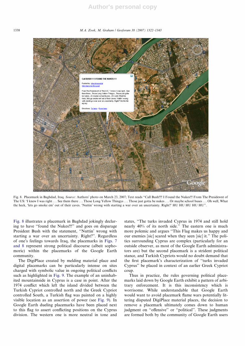
Fig. 8 illustrates a placemark in Baghdad jokingly declar-ing to have ‘‘found the Nukes!!!’’ and goes on disparagePresident Bush with the statement, ‘‘Nuttin’ wrong withstarting a war over an uncertainty. Right?’’. Regardlessof one’s feelings towards Iraq, the placemarks in Figs. 7and 8 represent strong political discourse (albeit sopho-moric) within the placemarks of the Google Earthcommunity.
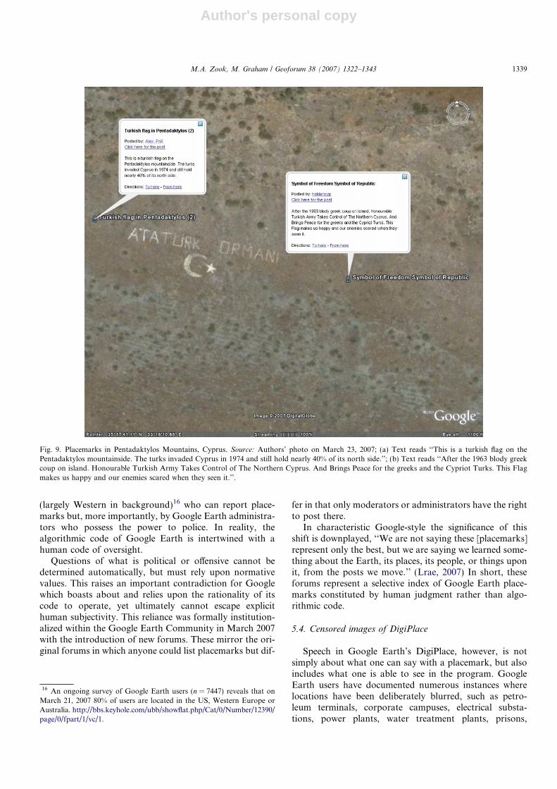
The DigiPlace created by melding material place anddigital placemarks can be particularly intense on sitescharged with symbolic value in ongoing political conflictssuch as highlighted in Fig. 9. The example of an uninhab-ited mountainside in Cyprus is a case in point. After the1974 conflict which left the island divided between theTurkish Cypriot controlled north and the Greek Cypriotcontrolled South, a Turkish flag was painted on a highlyvisible location as an assertion of power (see Fig. 9). InGoogle Earth dueling placemarks have been placed nextto this flag to assert conflicting positions on the Cyprusdivision. The western one is more neutral in tone and
states, ‘‘The turks invaded Cyprus in 1974 and still holdnearly 40% of its north side.’’ The eastern one is muchmore polemic and argues ‘‘This Flag makes us happy andour enemies [sic] scared when they seen [sic] it.’’ The poli-tics surrounding Cyprus are complex (particularly for anoutside observer, as most of the Google Earth administra-tors are) but the second placemark is a strident politicalstance, and Turkish Cypriots would no doubt demand thatthe first placemark’s characterization of ‘‘turks invadedCyprus’’ be placed in context of an earlier Greek Cypriotcoup.
Thus in practice, the rules governing political place-marks laid down by Google Earth exhibit a pattern of arbi-trary enforcement. It is this inconsistency which isworrisome. While understandable that Google Earthwould want to avoid placemark flame wars potentially lit-tering disputed DigiPlace material places, the decision toremove a placemark ultimately comes down to humanjudgment on ‘‘offensive’’ or ‘‘political’’. These judgmentsare formed both by the community of Google Earth users
Fig. 8. Placemark in Baghdad, Iraq. Source: Authors’ photo on March 23, 2007; Text reads ‘‘Call Bush!!!! I Found the Nukes!!! From The Presidewnt ofThe US: ‘I knew I was right . . . See them there . . . Those Long Yellow Thingys . . . Those just gotta be nukes . . . Or maybe school buses . . . Oh well, Whatthe heck, ‘lets go smoke em’ out of their caves. ‘Nuttin’ wrong with starting a war over an uncertainty. Right?’ HU HU HU HU HU’’.
1338 M.A. Zook, M. Graham / Geoforum 38 (2007) 1322–1343
Author's personal copy
(largely Western in background)16 who can report place-marks but, more importantly, by Google Earth administra-tors who possess the power to police. In reality, thealgorithmic code of Google Earth is intertwined with ahuman code of oversight.
Questions of what is political or offensive cannot bedetermined automatically, but must rely upon normativevalues. This raises an important contradiction for Googlewhich boasts about and relies upon the rationality of itscode to operate, yet ultimately cannot escape explicithuman subjectivity. This reliance was formally institution-alized within the Google Earth Community in March 2007with the introduction of new forums. These mirror the ori-ginal forums in which anyone could list placemarks but dif-
fer in that only moderators or administrators have the rightto post there.
In characteristic Google-style the significance of thisshift is downplayed, ‘‘We are not saying these [placemarks]represent only the best, but we are saying we learned some-thing about the Earth, its places, its people, or things uponit, from the posts we move.’’ (Lrae, 2007) In short, theseforums represent a selective index of Google Earth place-marks constituted by human judgment rather than algo-rithmic code.
5.4. Censored images of DigiPlace
Speech in Google Earth’s DigiPlace, however, is notsimply about what one can say with a placemark, but alsoincludes what one is able to see in the program. GoogleEarth users have documented numerous instances wherelocations have been deliberately blurred, such as petro-leum terminals, corporate campuses, electrical substa-tions, power plants, water treatment plants, prisons,
Fig. 9. Placemarks in Pentadaktylos Mountains, Cyprus. Source: Authors’ photo on March 23, 2007; (a) Text reads ‘‘This is a turkish flag on thePentadaktylos mountainside. The turks invaded Cyprus in 1974 and still hold nearly 40% of its north side.’’; (b) Text reads ‘‘After the 1963 blody greekcoup on island. Honourable Turkish Army Takes Control of The Northern Cyprus. And Brings Peace for the greeks and the Cypriot Turks. This Flagmakes us happy and our enemies scared when they seen it.’’.
16 An ongoing survey of Google Earth users (n = 7447) reveals that onMarch 21, 2007 80% of users are located in the US, Western Europe orAustralia. http://bbs.keyhole.com/ubb/showflat.php/Cat/0/Number/12390/page/0/fpart/1/vc/1.
M.A. Zook, M. Graham / Geoforum 38 (2007) 1322–1343 1339
Author's personal copy
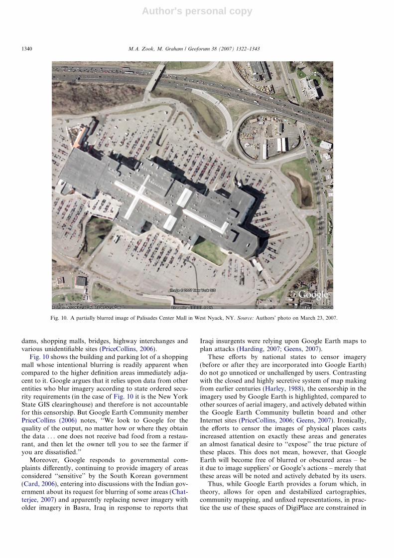
dams, shopping malls, bridges, highway interchanges andvarious unidentifiable sites (PriceCollins, 2006).
Fig. 10 shows the building and parking lot of a shoppingmall whose intentional blurring is readily apparent whencompared to the higher definition areas immediately adja-cent to it. Google argues that it relies upon data from otherentities who blur imagery according to state ordered secu-rity requirements (in the case of Fig. 10 it is the New YorkState GIS clearinghouse) and therefore is not accountablefor this censorship. But Google Earth Community memberPriceCollins (2006) notes, ‘‘We look to Google for thequality of the output, no matter how or where they obtainthe data . . . one does not receive bad food from a restau-rant, and then let the owner tell you to see the farmer ifyou are dissatisfied.’’
Moreover, Google responds to governmental com-plaints differently, continuing to provide imagery of areasconsidered ‘‘sensitive’’ by the South Korean government(Card, 2006), entering into discussions with the Indian gov-ernment about its request for blurring of some areas (Chat-terjee, 2007) and apparently replacing newer imagery witholder imagery in Basra, Iraq in response to reports that
Iraqi insurgents were relying upon Google Earth maps toplan attacks (Harding, 2007; Geens, 2007).
These efforts by national states to censor imagery(before or after they are incorporated into Google Earth)do not go unnoticed or unchallenged by users. Contrastingwith the closed and highly secretive system of map makingfrom earlier centuries (Harley, 1988), the censorship in theimagery used by Google Earth is highlighted, compared toother sources of aerial imagery, and actively debated withinthe Google Earth Community bulletin board and otherInternet sites (PriceCollins, 2006; Geens, 2007). Ironically,the efforts to censor the images of physical places castsincreased attention on exactly these areas and generatesan almost fanatical desire to ‘‘expose’’ the true picture ofthese places. This does not mean, however, that GoogleEarth will become free of blurred or obscured areas – beit due to image suppliers’ or Google’s actions – merely thatthese areas will be noted and actively debated by its users.
Thus, while Google Earth provides a forum which, intheory, allows for open and destabilized cartographies,community mapping, and unfixed representations, in prac-tice the use of these spaces of DigiPlace are constrained in
Fig. 10. A partially blurred image of Palisades Center Mall in West Nyack, NY. Source: Authors’ photo on March 23, 2007.
1340 M.A. Zook, M. Graham / Geoforum 38 (2007) 1322–1343
Author's personal copy
multiple ways. These constraints grow increasingly trouble-some when one considers the myriad ways in which spatialknowledge can influence political and economic decisionmaking. Perceptions of restaurants in Lexington, Kentuckyor neighborhoods in Santiago, Chile, are no longer basedsimply on an individual’s sensory experiences or cognitivemap. They are also based on the geo-referenced informa-tion one chooses to look at and, more importantly, havebeen allowed to look at, in Google Earth.
As access to such information moves increasingly fromthe desktop to mobile devices, the effects of censorshipaffect our real-time understanding of the spaces withinwhich we operate. The Internet evolved into what it didbecause it had very few rules about what one could do orsay. As a result it engendered a flowering of experimenta-tion and innovation. In contrast, Google Earth is a privatespace in which user behavior is regulated and proscribed bycorporate policy.
6. Creatively reconstructing the internet
‘‘. . . the competition from . . . the new technology . . .strikes not at the margins of the profits, and the out-puts of existing firms, but at their very lives. This kindof competition is as much more effective than theother as a bombardment is in comparison with forc-ing a door . . .’’ (Schumpeter, 1950, p. 84)
The creativity and entrepreneurship surrounding the Inter-net highlights the power of Schumpeterian ‘‘creativedestruction’’ in capitalist economies (Zook, 2005). Despitea relatively late start in the indexing of the Internet, Googleand its PageRank code has ‘‘destroyed’’ earlier ways ofsearching and accessing information. Moreover Googleshows no sign of dampening its ambitions. According tointernal presentations to analysts, the company envisionsthe future ‘‘as ‘a world with infinite storage, bandwidthand CPU power’ . . . a world where Google ‘get[s] all theworld’s information . . . and make it accessible from any-where (any device, any platform, etc.)’.’’ (Schofield, 2006).
Of particular interest to geographers is Google’s codingand enclosing of spatial information and how this informa-tion mixes with our cognition of places via DigiPlace. Inthis article we are arguing that Google’s codes and ambi-tions represent a fundamental reconstruction and reorder-ing of Internet information. Similar to Vaidhyanathan’s(2005) argument that Google’s provision of indexing andaccess services does not mean the company has become alibrary (to make such a claim ignores ‘‘all that librariesmean to the lives of their users’’), this article argues thatGoogle’s DigiPlace has not become a digital version of freeand democratic public space. Instead, Google has created aprivatized DigiPlace that is well on its way to be becomingthe de facto digital globe, despite subjective rules that areinconsistently enforced and without clear means of appeal-ing decisions. Moreover, because the DigiPlace of GoogleMaps and Google Earth depends upon the automatic rank-
ing and creation of space by the PageRank code, an essen-tial actor in creating our future experience of place, i.e.,code, remains obscured.
The goal of this analysis is to explore and perhaps evenopen up, the black boxes which shape and influence thespatial politics of the spaces of DigiPlace. Future researchwill be able to use this article as a base to explore detailedquestions about the relationships between DigiPlace andmapping, privacy, control, and free speech. As Graham(2005, 575) notes, ‘‘software-sorting practices must becometransparent if we are to evaluate critically the politics ofmobility . . ., inequality, citizenship, the city, and thebody.’’ Simply justifying the sorting of content as the out-come of ‘natural’ algorithms shuts down any discussionabout who is, and should be, seen and heard.
We have begun to develop an understanding of ways inwhich DigiPlace is formed, but there remains much to bedone in understanding how new lived spaces are influ-enced by the intersections between culture, code, and place.Hess and Ostrom (2006) ask ‘‘Who should govern theInternet?’’ Our fear is that the private nature of emergingDigiPlaces such as Google Maps and Google Earth willrender this question largely moot before it can even bedebated.
References
Amin, A., Thrift, N., 2002. Cities: Reimagining the Urban. Polity Press,Cambridge.
Anderson, B., 1991. Imagined Communities. Verso, London and NewYork.
Anderson, C., 2006. The Long Tail. Hyperion, New York.Barabasi, A.-L., Albert, R., 1999. Emergence of Scaling in Random
Networks. Science 286 (5439), 509–512.Bass, S., 2004. Learn (almost) anything about anybody. PC World
22 (2), 49.Batty, M., 1997. Virtual Geography. Futures 29, 337–352.Bowker, G., Star, S.L., 1999. Sorting Things Out: Classification and its
Consequences. The MIT Press, Cambridge, MA.Brenner, N., 1999. Beyond state-centrism? Space, territoriality, and
geographical scale in globalization studies. Theory and Society 28(1), 39–78.
Brin, S., Page, L., 1998. The anatomy of a large-scale hypertextual websearch engine. Computer Networks and ISDN Systems 30, 107–117.
Burrows, R., Ellison, N., Woods, B., 2005. Neighbourhoods on the Net:The Nature and Impact of Internet-Based Neighbourhood Informa-tion Systems. The Policy Press in Association with JRF. Availablefrom: <http://www.jrf.org.uk/bookshop/details.asp?pubID=709>.
Caldenhead, R., 2006. All Google’s Roads Lead to Kansas. Wired News,February 22, 2006 [cited April 5, 2006]. Available from: <http://www.wired.com/news/technology/internet/0,70227-0.html?tw=n_index_1>.
Card, J., 2006. The geography of the Korean psyche. Asian Times Online.June 6 [cited June 7, 2006]. Available from: <http://www.atimes.com/atimes/Korea/HF06Dg01.html>.
Calishain, T., Dornfest, R., 2003. Google Hacks. O’Reilly, Sebastapol,CA.
Castells, M., 1996. The Rise of the Network Society. Basil Blackwell,Oxford.
Castells, M., 2001. The Internet Galaxy. Internet Galaxy: Reflections onthe Internet, Business, and Society. Oxford University Press, Oxford,New York.
M.A. Zook, M. Graham / Geoforum 38 (2007) 1322–1343 1341
Author's personal copy
Castree, N., 2003. Place: connections and boundaries in an interdependentworld. In: Holloway, S.L., Rice, S.P., Valentine, G. (Eds.), KeyConcepts in Geography. Sage, London.
Chatterjee, M.B., 2007. Google yet to decide on blurring key Indian sites.India Times. March 21 [cited March 29, 2007]. Available from: <http://economictimes.indiatimes.com/Google_yet_to_decide_on_blurring_key_Indian_sites/articleshow/1785756.cms>.
Curry, M.R., 2005. Toward a geography of a world without maps: lessonsfrom ptolemy and postal codes. Annals of the Association of AmericanGeographers 95 (3), 680–691.
Dicken, P., Kelley, K., Olds, K., Yeung, H.W.-c., 2001. Chains andnetworks, territories and scales: towards a relational framework foranalysing the global economy. Global Networks 1 (2), 89–112.
Dodge, M., Kitchin, R., 2001. Mapping Cyberspace. Routledge, London.Dodge, M., Kitchin, R., 2004. Flying through code/space: the real
virtuality of air travel. Environment and Planning A 36 (2), 195–211.Dodge, M., Kitchin, R., 2005. Code and the transduction of space. Annals
of the Association of American Geographers 95 (1), 162–180.Eischen, K., 2003. Opening the black box of software. Information,
Communication, and Society 6 (1), 57–81.Emberley, P., 1988. Technology, values, and nihilism. Science, Technology
and Politics 3, 41–58.Foucault, M., 1972. The Archaeology of Knowledge. Pantheon, New
York.Foucault, M., 1980. The History of Sexuality (R. Hurley, Trans.). Vintage
Books, New York.Geens, S., 2007. Did Google censor Basra imagery? January 14.
OgleEarth.com [cited March 27, 2007]. Available from: <http://www.ogleearth.com/2007/01/did_google_cens.html>.
Gibson-Graham, J.K., 1996. The End of Capitalism (As We Know It): AFeminist Critique of Political Economy. Basil Blackwell, Oxford.
Google, 2005. Corporate Information. Available from: <http://www.goo-gle.com/intl/en/corporate/index.html>.
Google, 2006a. Google Earth Community: FAQ (Frequently AskedQuestions) 2006a [cited May 1, 2006]. Available from: <http://bbs.keyhole.com/ubb/faq.php>.
Google, 2006b. Our Philosophy 2006b [cited March 20, 2006]. Availablefrom: <http://www.google.com/intl/en/corporate/tenthings.html>.
Google, 2006c. PageRank Explained [Webpage]. Google 2006c [cited April2, 2006]. Available from: <http://www.google.com/technology/>.
Google, 2006d. Images and Dates [Webpage]. Google 2006d [cited June 2,2006]. Available from: <http://earth.google.com/images_dates.html>.
Google, 2006e. Company Overview [Webpage]. Google 2006e [cited June2, 2006]. Available from: <http://www.google.com/intl/en/corporate/index.html>.
Graham, S.D.N., 2005. Software-sorted geographies. Progress in HumanGeography 29 (5), 562–580.
Gregory, D., 1982. Regional Transformation and Industrial Revolution.Macmillan, London.
Haines, L., 2006. Google shifts Greenwich Meridian: Hey, where’d mylongitude go? The Register. February 6 [cited June 4, 2006]. Availablefrom: <http://www.theregister.co.uk/2006/02/06/greenwich_meridian/>.
Harding, T., 2007. Terrorists ‘use Google maps to hit UK troops’.Daily Telegraph. January 13 [cited March 27, 2007]. Available from:<http://www.telegraph.co.uk/news/main.jhtml?xml=/news/2007/01/13/wgoogle13.xml>.
Harley, B., 1988. Secrecy and silences: the hidden agenda of statecartography in early modern Europe. Imago Mundi 40, 57–76.
Harmon, A., 2004. Is a do-gooder company a good thing? The New YorkTimes, May 2.
Harvey, D., 1989. The Condition of Postmodernity: An Enquiry Into theOrigins of Cultural Change. Blackwell, Oxford.
Hess, C., Ostrom, E., 2006. Introduction: an overview of the knowledgecommons. In: Hess, Charlotte, Ostrom, Elinor (Eds.), UnderstandingKnowledge as a Commons: From Theory to Practice. MIT Press,Cambridge, MA.
Hurwitz, J.B., 2005. Search Engine Launches Mapping with ReversePhone Number Lookup (March 22, 2005) [Webpage]. Tri-State News
2005 [cited August 11 March 22, 2005]. Available from: <http://www.tristatenews.com/article_4924.stm>.
Introna, L.D., Nissenbaum, H., 2000. Shaping the web: why the politics ofsearch engines matters. The Information Society 16, 169–185.
Jansena, B.J., Spinkb, A., Saracevi, T., 2000. Real life, real users, and realneeds: a study and analysis of user queries on the web. InformationProcessing and Management 36, 207–227.
Johnston, R., 1984. The world is our oyster. Transactions of the Instituteof British Geographers, New Series 9, 443–459.
Kitchin, R., 2001. Cognitive maps. International Encyclopedia of theSocial & Behavioral Sciences. Elsevier Ltd, pp. 2120–2124.
Lessig, L., 1999. Code and Other Laws of Cyberspace. Basic Books.Lessig, L., 2004. Free Culture: How Big Media Uses Technology and the
Law to Lock Down Culture and Control Creativity. Penguin.Lrae, Master Wizard, 2006. Do’s and Not Do’s [Webpage] [cited June 2,
2006]. Available from: <http://bbs.keyhole.com/ubb/showthreaded.php/Cat/0/Number/16288/an/0/page/0#16288>.
Lrae, Master Wizard, 2007. New Forums [Webpage] [cited March 20,2007]. Available from: <http://bbs.keyhole.com/ubb/showflat. php/Cat/0/Number/834367/Main/834367/#Post834367>.
Lynch, K., 1960. The Image of the City. Technology Press, Cambridge,MA.
Manjoo, F., 2006. The corporate toll on the Internet. Salon. Availablefrom: <http://www.salon.com/tech/feature/2006/04/17/toll/>.
Massey, D., 1985. The conceptualisation of place. In: Massey, D., Jess, P.(Eds.), A Place in the World? Oxford University Press, Oxford,pp. 46–79.
Massey, D., 1993. Power geometry and a progressive sense of place. In:Bird, J., Curtis, B., Putnam, T., Robertson, G., Tickner, L. (Eds.),Mapping the Futures: Local Cultures, Global Change. Routledge,London, pp. 59–69.
Massey, D., 1999. Space–time, science and the relationship betweenphysical geography and human geography. Transactions of theInstitute of British Geographers, NS 24 (3), 261–276.
Massey, D., 2005. For Space. Sage, London.McUsic, T., 2005. Savvy consumer: services raise concerns about privacy
issues. Fort Worth Star-Telegram, April 5.Meyer, J., 2006. Pioneers Have Opened a Window in China. The
Guardian 2006 [cited February 19, 2006]. Available from: http://www.guardian.co.uk/china/story/0,,1712867,00.html.
Mitchell, W., 1996. City of Bits: Space, Place, and the Infobahn. MITPress, Cambridge, MA.
Monmonier, M., 1996. How to Lie With Maps. University of ChicagoPress, Chicago.
Monmonier, M., 2002. Spying With Maps: Surveillance Technologies andthe Future of Privacy. University of Chicago Press, Chicago, IL.
Page, L., Brin, S., Motwani, R., Winograd, T., 1998. The PageRankcitation ranking: bringing order to the web. Stanford Digital LibraryTechnologies Project. Available from: <http://citeseer.ist.psu.edu/page98pagerank.html>.
Pickles, J., 2004. A History of Spaces. Routledge, London.Poster, M., 1995. The Second Media Age. Polity, Oxford.Pred, A., 1984. Place as historically contingent process: structuration and
the time-geography of becoming places. Annals of the Association ofAmerican Geographers 27 (2), 279–297.
PriceCollins, 2006. Data Problems > Censorship version 8. Posted onFebruary 27 [cited June 4, 2006]. Available from: <http://bbs.keyhole.com/ubb/showthreaded.php/Cat/0/Number/330444/page/0/vc/1>.
Schofield, J., 2006. How does Google envisage the future? The Guardian[cited March 9, 2006]. Available from: <http://media.guardian.co.uk/newmedia/story/0,,1726289,00.html>.
Schulte, M.M., 2005. Asia for $10 a night (and less). USA Today,November 8. Available from: <http://www.usatoday.com/travel/hotels/hotsheet/2005-11-08-hotsheet_x.htm>.
Schumpeter, J.A., 1950. Capitalism, Socialism, and Democracy. third ed.Harper Perennial, New York.
Scott, J., 1998. Seeing Like a State: How Certain Schemes to Improve theHuman Condition Have Failed. Yale University Press, New Haven.
1342 M.A. Zook, M. Graham / Geoforum 38 (2007) 1322–1343

Author's personal copy
Seda, C., 2004. Search Engine Advertising: Buying Your Way to the Topto Increase Sales. New Rider, Indianapolis.
Shoffman, M., 2007. Google anti-Israel probe. TotallyJewish.com News.January 11. Available from: <http://www.totallyjewish.com/news/world/?content_id=5298>.
Soja, E., 1989. Postmodern Geographies. Verso, London.Steiner, P., 1993. On the Internet nobody knows you’re a dog. The New
Yorker 69 (20).Stross, R., 2005. Google anything, so long as it’s not Google. New York
Times, August 28.Sullivan, D., 2005. End of size wars? Google says most comprehensive but
drops home page count. SearchEngineWatch. September 27. Availablefrom: <http://searchenginewatch.com/searchday/article.php/3551586>.
Thrift, N., 2004a. Movement-space: the changing domain of thinkingresulting from the development of new kinds of spatial awareness.Economy and Society 33 (4), 582–604.
Thrift, N., 2004b. Remembering the technological unconscious byforegrounding knowledges of position. Environment and PlanningD: Society and Space 22 (1), 175–190.
Thrift, N., French, S., 2002. The automatic production of space.Transactions of the Institute of British Geographers 27, 309–335.
Thu Nguyen, D., Alexander, J., 1996. The coming of cyberspace time andthe end of polity. In: Shields, R. (Ed.), Cultures of Internet: Virtual
Spaces, Real Histories and Living Bodies. Sage, London, pp. 99–124.
timl2k6, 2006. Is this a threat to national security? Google EarthCommunity 2006 [cited May 26, 2006]. Available from: <http://bbs.keyhole.com/ubb/showflat.php?Number=376986>.
Timms, D., 2006. Google privacy battle likely to end in compromise. TheGuardian [cited March 15]. Available from: <http://www.guard-ian.co.uk/uk_news/story/0,,1731353,00.html>.
Ullman, E., 1997. Close to the Machine: Technophilia and its Discontents.City Lights Publishers, San Francisco.
Vaidhyanathan, S., 2005. A risky gamble with Google. The ChronicleReview 52 (15), B7.
Warf, B., Grimes, J., 1997. Counterhegemonic discourses and the Internet.The Geographical Review 87, 259–274.
Watts, J., 2006. Backlash as Google shores up great firewall of China. TheGuardian [cited January 25]. Available from: <http://business.guard-ian.co.uk/story/0,,1694152,00.html>.
Wong, M., 2003. Online data conflict with desire for privacy. WashingtonPost, December 26, 2003, A15.
Zook, M., 2005. The Geography of the Internet Industry. Blackwell.Zook, M.A., Graham, M., 2007. Mapping DigiPlace: geocoded Internet
data and the representation of place. Environment and Planning B:Planning and Design 34 (3), 466–482.
M.A. Zook, M. Graham / Geoforum 38 (2007) 1322–1343 1343