
THC Executive Committee Teleconference Meeting
22
April 15, 2020 10 A.M. THC Executive Committee Teleconference Meeting
-
Upload
khangminh22 -
Category
Documents
-
view
0 -
download
0
Transcript of THC Executive Committee Teleconference Meeting

AGENDA EXECUTIVE COMMITTEE
Teleconference Meeting April 15, 2020
10 a.m.
Pursuant the Governor’s executive order to avoid gatherings of more than ten and the Governor’s March 16, 2020 suspension of certain provisions of the Texas Open Meetings Act, the April 15, 2020 meeting of the THC Executive Committee will be held by telephonic conference call, as authorized under Texas Government Code section 551.125. Members of the public will have access by calling 1-844-721-7241; access code 3560787#, toll-free. An electronic copy of the agenda and a copy of the meeting materials are available at www.thc.texas.gov/teleconferences . A recording of the meeting will be available after April 16, 2020. To obtain a recording, please contact Esther Brickley at 512-463-5768. The members may discuss and/or take action on any of the items listed in the agenda. Note: The Executive Committee may go into executive session (close its meeting to the public) on any agenda item if appropriate and authorized by the Open Meetings Act, Texas Government Code, Chapter 551.
1. Call to Order – Chairman Nau A. Roll call for committee members B. Roll call for other participants C. Establish quorum D. Recognize and/or excuse absences
2. Discussion and possible action – Alamo archeological permit application for the Mission San
Antonio de Valero/Alamo Burial Exhumation (41BX6) Bexar County submitted by the General Land Office– Brad Jones, THC Archeology Division Director with presentation by Steve Tomka, Raba Kistner, Inc.
3. Committee Chairman’s Report A. Ongoing Projects; and B. Updates and Upcoming Events
4. Adjourn

TAB 2

Item 2 Texas Historical Commission
Executive Committee Meeting April 15, 2020
Presentation and possible action – Alamo archeological permit application for the Mission San Antonio de Valero/Alamo Burial Exhumation (41BX6) Bexar County submitted by the General
Land Office
Background: The General Land Office (GLO) has requested the Texas Historical Commission (THC) issue an Archeological Antiquities permit to Dr. Steve Tomka, Raba Kistner, Inc., to exhume four sets of human remains discovered during ongoing archeological investigations (Archeological Antiquities permit 8713) supporting an architectural assessment of the Alamo Church and Long Barrack (41BX6). Between November and December 2019, Raba Kistner, Inc. archeologists encountered the burials in four different test units during subfloor excavations in the Alamo Church. Each was excavated sufficiently to define and verify that it represented an intact burial and was then lightly reburied and left in-situ. Any further excavation of these units was restricted to outside the burial feature, resulting in a lack of space to install instrumentation and document necessary wall and foundation features. Currently, archeological excavations have stopped in the church and the four burial features remain in place. Because the architectural analysis of the structure is considered critical to preserving the Alamo Church, and the human remains impede the conduct of the current investigation, the GLO is proposing the exhumation, limited non-destructive analysis, and later re-interment of the remains as a critical step in advancing the architectural preservation and protecting the human remains from further environmental degradation. Current archeological permit 8713 for the architectural investigations of the Alamo Church and Long Barrack does not include exhumations as part of the scope-of-work or methodology. Since the excavations are occurring within the Alamo (41BX6), a Texas State Antiquities Landmark, issuance of a new archeological permit is required in conformance with the Texas Health and Safety Code, the Antiquities Code, and the Alamo Mission Archaeology Advisory Committee protocols for burials. Staff Recommendation: THC Staff has reviewed the permit application and recommends the following: The proposed excavation plan, osteological and artifact analysis, and curation component of the permit application are sufficient to consider issuance of the permit after minor modifications. Staff are requesting clarifications on how in-situ measurements and photography will be employed as field methodologies, the physical size of the “preservation instruments” that are being installed in the open excavations, and how and when certain analytical methods will be employed during the osteological analysis. Additionally, staff are requesting Raba Kistner, Inc. include a list of the project archeologists and their qualifications. Suggested Motion: Move that the Executive Committee approve the issuance of Archeological Permit # (TBD) for archeological exhumation of the four interments located in the Alamo Church (41BX6) for a period of 10 years, after the following minor modifications to the scope-of-work are accepted by THC staff:

information addressing how in-situ measurements and photography will be employed as field methodologies, the physical size of the “preservation instruments” that are being installed in the open excavations, how and when certain analytical methods will be employed during the osteological analysis, and a list of project archeologists and their qualifications.


PERMIT APPLICATION FOR THE
ARCHAEOLOGICAL EXCAVATION OF HUMAN REMAINS ASSOCIATED WITH THE ALAMO CHURCH,
SITE 41BX6, BEXAR COUNTY, TEXAS
Produced for: THE ANTIQUITIES COMMITTEE OF THE
TEXAS HISTORICAL COMMISSION
Produced by:
March 2020
DocuSign Envelope ID: 4B9E253E-9D53-441F-B7AE-84CF96494470

2
Table of Contents
Excavation Methods...................................................................................................................................... 6
Storage and Curation .................................................................................................................................... 7
Osteological and Artifact Analysis ................................................................................................................. 8
Reburial ......................................................................................................................................................... 8
Reburial Location .......................................................................................................................................... 9
Alamo Mission and Fort Background ............................................................................................................ 9
DocuSign Envelope ID: 4B9E253E-9D53-441F-B7AE-84CF96494470

3
The original permit application submitted and approved by the THC on January 25, 2019 called for the excavation of up to 32 units associated with the Alamo Church and the Long Barrack (Table 1). Because the Texas General Land Office (GLO) and Alamo Trust, Inc. (ATI) assumed human remains might be discovered during these archeological investigations, they established the Alamo Mission Archaeological Advisory Committee (AMAAC), which developed a comprehensive human remains treatment protocol. Upon the discovery of confirmed intentional interments (comprised of fragmented and disarticulated human bone), the GLO and ATI are now formally requesting THC approval to exhume intentional burials that have been and may be encountered within the units currently under excavation inside or outside of the Church. Further, we request approval to conduct basic analysis and re-inter the remains in a central location inside the Alamo Church. If a permit is granted for the removal of human burials, all proposed methods will comply with all appropriate regulations.
After the THC issued TAC Permit 8713, the Texas General Land Office (GLO) and the Alamo Trust Inc. (ATI) began archaeology. Three units were excavated along the outside perimeter and five others were to be excavated inside the footprint of the church immediately across from each exterior unit (Figure
3).
Figure 3. The location of the eight paired units excavated under TAC Permit 8713.
DocuSign Envelope ID: 4B9E253E-9D53-441F-B7AE-84CF96494470

4
Figure 4. The location of the nine units associated with the Long Barrack.
The excavation of units within and surrounding the Alamo Church commenced during the fall of 2019. To date, four of the five units found inside the Church (EUs 2 [Burial # 4], 4 [Burial # 1], 5 [Burial # 2], and 6 [Burial # 3]) have uncovered evidence of intentional burials comprised of human bone, with none of the four burials containing enough complete bones to constitute an entire human skeleton. Upon establishing each find indeed represented a burial, the exposed fragmented or disarticulated human bones were immediately covered with unbleached cotton muslin and a layer of soil to prevent unnecessary exposure and moisture loss in accordance with the previously established human remains protocol. The excavation unit containing the find was immediately secured, and all excavations in these units were suspended.
Given the positioning of the eight EUs, it is the assessment of the archaeologists and preservationists that the excavation of the units that encountered human remains cannot be suspended, nor could these units be moved to other locations without losing key information needed to develop a comprehensive preservation program for the Church. Permanently suspending the excavation of units with intentional burials will not only result in imminent site endangerment (access, environmental conditions, or indirect effects) to visitors, but also endanger the historic structure and will prevent the team from completing the development of a comprehensive preservation plan for the Alamo Church.
Burial 1
Burial number 1 was discovered during exploratory excavations of EU-04. The clustered elements were discovered at 49-cm below datum. The remains represent a concentration of several small bones that upon in-field preliminary analysis, appeared to represent a single infant or young child. It is unclear whether the cluster represents a disturbed burial, with elements subsequently gathered and reburied.
EUs 3 and 4 were positioned in the corner formed by the east wall of the Baptistry and the south wall of the Nave (Figure 3). These excavations allow the comparison of the below grade conditions present along the South wall of the Alamo Church in contexts associated with the Monel Plate versus that absence of the plate. There is no other setting along the perimeter of the Church that replicates this condition.
DocuSign Envelope ID: 4B9E253E-9D53-441F-B7AE-84CF96494470

5
Burial 2
Burial number 2 was discovered during excavations of EU-05. The fragmented or disarticulated human bones partially uncovered during the exploratory excavations consist of cranial (n=1) and postcranial (n=4) elements. The remains were identified at 83.5 cm below datum. Archaeologists did not discover an actual, physical coffin, casket, or other type of burial box within the unit, but the burial was defined primarily on the basis of the discovery of nails and a change in color in the unit’s soil forming a perimeter around the bones which appeared to archaeologists torepresent a hexagonal encasement that might have contained the bones within the excavation unit. No excavation of the remains found within the interior of the outline has been undertaken.
The location of EUs 5 and 6 inside the footprint of the Church (Figure 3), provides information on wall and foundation conditions for architectural elements that are entirely isolated from exterior conditions. Therefore, this pair of units serves as an important baseline for the condition of architectural elements not impacted by rainfall and daily and seasonal temperature changes. Furthermore, the two EUs provide opportunities to examine both east-to-west (i.e., the Nave wall), as well as north-to-south (i.e. the wall that divides the Monk’s Burial Ground [MBG] Room from the Sacristy) oriented foundations. These conditions are not present at any other location within the Alamo Church.
Burial 3
Burial number 3 was discovered during exploratory excavations in EU-06. The elements are tightly bundled together in a manner that appears to represent an intentional possible secondary burial. The bone fragments were identified 119.5 cm below datum or 109.5 cm below the pavers in the church. Based on a preliminary analysis, the elements represent the adult age group, but a Minimum Number of Individuals (MNI) and ancestry could not be determined.
The location of EUs 5 and 6 inside the footprint of the Church (Figure 3), provides information on wall and foundation conditions for architectural elements that are entirely isolated from exterior conditions. Therefore, this pair of units serves as an important baseline for the condition of architectural elements not impacted by rainfall and daily and seasonal temperature changes. Furthermore, the two EUs provide opportunities to examine both east-to-west (i.e., the Nave wall), as well as north-to-south (i.e. the wall that divides the Monk’s Burial Ground [MBG] Room from the Sacristy) oriented foundations. These conditions are not present at any other location within the Alamo Church.
Burial 4
Burial number 4 was discovered during exploratory excavations for EU-02. The burial was located in the south-central area of the unit at approximately 57 cm below datum, adjacent to the southern South Transept wall. A single subadult individual is represented by the fragmented or disarticulated human bones.
Excavation Units 1 and 2 (EUs 1 and 2) were positioned on the outside and inside of the South Transept, respectively. In 1995, a Monel Plate was inserted into the wall 15-inches below the modern-day ground surface spanning the South Transept. The goal of the plate was to prevent the upward migration of rising damp from the foundation to the wall of the structure, however, because the plate was not positioned at the original ground surface of the Church wall, its existence may actually be negatively affecting the Church. Anecdotal information indicates that the moisture content below the Monel Plate spiked while there was a considerable decrease above the plate. Since one of the principal adverse impacts to the two surviving structures of the site derives from rising damp, the examination of the area surrounding the
DocuSign Envelope ID: 4B9E253E-9D53-441F-B7AE-84CF96494470

6
Monel Plate some 24 years after it was installed will provide valuable information regarding its performance and the condition of the foundation below the plate and the wall above. Such information cannot be obtained in any other location. In addition, EUs 1 and 2 will allow the Design Team to study both the southern and eastern walls of the South Transept.
Excavation Methods The following methods shall be employed while excavating the remains identified above in the four units, as well as for any other remains discovered during further archaeological investigations under Texas Antiquities Permit # 8713. Due to likelihood that additional burials may be encountered during the excavation of the four identified intentional burials, this permit proposes to treat newly encountered burials in the same manner as delineated below.
Additional delineation of the intentional interments will occur via brushing and gentle trowel scraping. The archaeologist will observe the area to determine if there is a visible contrast between burial fill and the surrounding sediments. Once a contrast is defined, the intentional interment will be excavated with the soils from within the burial area and kept separate from the surrounding sediments. If no contrast is observed, artificial units will be created using the outline of the intentional interment.
Excavation of these burials will be done using bamboo skewers, wooden tools specific to the task, and soft brushes to minimize damage to the bones. Archaeologists conducting the excavation shall wear unbleached cotton gloves when handling the remains. All soil excavated from the burial will be screened through a 1/8-inch wire mesh to collect small items such as beads or fragmented bone that may have been missed during the excavation. Extreme care will be taken by archaeologists to ensure that all remains associated with the burial are recorded in situ; the screening of soil associated with the burial will take place to allow for collection of artifacts that were mixed with the soils and not obviously visible. All cultural and human remains will be collected from the screens and catalogued with provenience information. Each burial will be assigned a specific Burial Number, plotted on a site map, and its location will be recorded with a Total Data Station or high-accuracy GPS (no less than three points will be gathered for beginning elevations). It is possible that a burial may intrude on others. In these cases, alphanumeric designations may be used to show relationship to other burials.
Each burial will be recorded on a Burial Form, as well as a master burial log. Each Burial Form will include information regarding the vertical and horizontal locations of the remains, the position of fragmented or disarticulated human bones, orientation and direction of the cranium (if applicable), possible post-depositional impacts to the burial, relationship to other burials (if applicable), burial dimensions, and detailed description of the location of the burial in relationship to the historic structures. Photographs, with scale, will be taken of each burial only if drawings of the burials cannot sufficiently depict the relationship between elements. Should removal of the burial reveal additional elements, plan view maps and records will be updated to include this information. Elevations of newly exposed burial elements will be included on Burial Forms. Additional photographs will be taken only if plan maps cannot sufficiently record and document aspects of the burial. Photographs of the burials will be converted into depictions.
Should burials extend beyond the footprint of the excavation unit, or additional or additional burials are identified as intruding upon the initial interment, the excavations will be extended to remove the entirety of the additional burial and/or intrusive burial. Additional burials that are encountered beyond the excavation unit expansion and not in the path of planned impacts will be preserved in place, unless an association with other burials demonstrates the need to be kept together and both exhumed. Additional burials encountered that will need to be removed in order to place preservation instrumentation will be assigned a burial number and all information recorded on a separate Burial Form.
DocuSign Envelope ID: 4B9E253E-9D53-441F-B7AE-84CF96494470

7
The location of any funerary objects buried among the remains (i.e. projectile points, stone tools, buttons, beads, pendants, buckles, nails, etc.) will also be included on the plan view maps with elevation data. Once mapped, funerary objects will be collected and bagged with provenience information and a unique burial identifier (i.e., Burial Number). All funerary objects associated with the burial will be kept with the burial throughout the course of the project(s) and will be reinterred with the designated burial.
All elements of the burial will be stored together in a temporary curation storage container composed of natural, non-synthetic material.
Since the respectful excavation of each burial is expected to take more than a day, at the end of each workday the burial will be covered to prevent additional drying. The covering will also aid in prevention of viewing by the public, although in general excavation areas are already be screened-off per project requirements. The area will be secured each evening and monitored by Alamo Rangers until the return of the archaeologists. At all times, encountered remains will be treated with dignity and respect.
Storage and Curation The following storage and curation methods shall be employed with respect to the remains identified above in the four units, as well as for any other remains discovered during further archaeological investigations under Texas Antiquities Permit # 8713.
Excavated burials encountered during the course of the projects will be temporarily stored on site, in an environmentally-controlled and secure location. The Alamo Collections Vault, located in Alamo Hall Annex, will be the site of the temporary storage. Lighting will be kept at levels that are not harmful to the human remains. Access to the human remains will be limited and monitored by the Alamo Archaeologist, with the project physical anthropologist or osteologist recommending individuals associated with the project to be allowed into the area. The Alamo Rangers have access to the vault only in cases of emergency. The Alamo Archaeologist will escort the physical anthropologist/osteologist into the collection storage vault.
ATI maintains a database of environmental conditions. Temperatures and humidity are regulated through a dedicated HVAC system and dehumidifiers. Dehumidifiers are stationed within the curatorial storage vault to remove excess water vapor during humid times. ATI strives to keep the temperature at 68 degrees Fahrenheit, with a relative humidity between 50- and 60 percent. HOBO data loggers are positioned within the storage vault, logging the temperature and relative humidity every five minutes. ATI utilizes the Sapphire Suppression System in the event that a fire occurs within the building.
The human remains will be wrapped in unbleached muslin and placed in a temporary curation storage container during storage. Unbleached cotton gloves will be used at all times when handling the remains. The gloves and temporary storage boxes will be destroyed upon completion of the project. The Alamo will arrange for the gloves and storage boxes to be burned. Photographs of the human remains will only be retained in unique circumstances.
Project generated documentation including but not limited to field forms, maps, inventories, and photographs will be curated at a state certified curatorial repository at the completion of the individual projects.
DocuSign Envelope ID: 4B9E253E-9D53-441F-B7AE-84CF96494470

8
Osteological and Artifact Analysis The following analyses shall be employed with respect to the remains identified above in the four units, as well as for any other remains discovered during further archaeological investigations under Texas Antiquities Permit # 8713.
All osteological analysis of human remains will be conducted by the qualified physical/forensic anthropologist, bioarchaeologist, or osteologist and assistant. The human remains will be cleaned using wooden skewers and dry brushing during analysis. Data recorded, if obtainable, will include cranial and postcranial measurements, sex, potential age, dental and/or bone pathologies. Cranial suture fusion and epiphyseal closure, if obtainable, will be used in the determination of age of the individual at time of death. Other indications of age can be seen in the dentition and evidence of osteoarthritis. Ancestry of the remains will also be documented, if possible; however, no destructive analysis to determine ethnicity will occur.
DNA testing performed on any bones uncovered during the course of the Alamo project can only occur in one way – destructive analysis. In some cultures, it is not only disrespectful to destroy human remains but believed to have religious implications as well. Once a bone or bone fragment is destroyed, it cannot be pasted back together. The Alamo site has existed for nearly 300 years and is first and foremost a battleground. However, it was also called home by not only Native Americans and the Spanish founders of the mission, but also those living in Texas when it belonged to Mexico, and settlers arriving from the United States. Because of this, no certain determination can be made of the culture, tribal affiliation, or religion of a dry bone uncovered. Additionally, because nearly 300 years have passed, DNA analysis would not only destroy the bone forever but be unlikely to provide any more certainty about the deceased’s existence other than their ethnicity. Accordingly, DNA testing shall not be performed on these remains.
Ancestral affiliation may be determined based on analysis of dentition, morphology of the femora, complexity of cranial sutures, presence/absence of Wormian bones, and characteristics of ascending rami. All data collected will be entered into an Excel spreadsheet during the analysis process.
Analysis of fragmented or disarticulated human bones, as well as isolated finds, will also occur as part of the osteological analysis unit, and the analyst will make a determination of the minimum number of individuals (MNI) that cannot be associated with a specific burial designation if possible. The elements representing each individual will be noted and recorded in the database. All protocols required by the Texas Health and Safety Code will be followed.
Recovered funerary materials will be analyzed by archaeologists with extensive expertise in specific artifact types (i.e. ceramics, lithics, etc.). Each object will be catalogued, and attributes recorded. The funerary items will be kept with the remains, and a catalogue designation will reflect the specific burial designation. If the manufacture date or temporal affiliation of the item can be assigned, the archaeologist and lab technician will record this information in the catalogue.
Reburial The following reburial methods shall be employed with respect to the remains identified above in the four units, as well as for any other remains discovered during further archaeological investigations under Texas Antiquities Permit # 8713.
Reinterments of all burials and disarticulated remains or bone fragments will occur at one time, following the completion of the fieldwork and analysis of the project associated with the execution of the Alamo
DocuSign Envelope ID: 4B9E253E-9D53-441F-B7AE-84CF96494470

9
Plan. Every effort will be made to follow the reburial process as laid out by the previously established human remains protocol. Following consultation with the Alamo Mission Archaeological Advisory Committee, the reinterment process will be limited to a small number of invited individuals. Any public statements or notices regarding the reinternment process shall be managed by the GLO.
The excavated human remains and funerary objects will be wrapped in unbleached cotton muslin cloth tied with natural fiber string, with each cotton bundle representing an individual burial, or burial location (in the case that remains may have been previously disarticulated), and will contain the human remains and funerary objects associated with that burial. An area for reinterments will be determined based on the absence of human remains and architectural features, and the least likelihood of future disturbances.
The areas containing intentional interments will be excavated to an appropriate depth per current regulations. The size of the excavation area will be sufficient to avoid overcrowding of burial bundles. The final dimensions will be determined once the archaeological project has concluded, and the total number of reinterments is known. The soil collected from the previous burial location shall be used to envelop the muslin bundle. Soils from the new location will be used to fill the remainder of the excavated area.
To prevent soils from creating a visible depression, untreated wood planks or board may be placed between the interment and surface. After the completion of the reinterment, the surface should be made to look like the surrounding area, or as it was prior to the excavation. A site monitoring plan will be developed to address long-term protection to the reburial location.
Reburial Location The currently proposed reburial location for all remains discovered under Texas Antiquities Permit # 8713, as well as additional remains encountered during the exhumation process laid out in this scope of work, is the room of the Church labeled as the Monk’s Burial Ground. This location is within the confines of the Church, and therefore historic mission cemetery footprint, ensuring that the reburial location is within the line-of-site of the original location. Currently there are two archaeological excavation units within the Monk’s Burial Ground that may be able to act as the reburial locations. The Monk’s Burial Ground would be considered an optimal reburial location as it remains within the footprint and is steps away from the original interment locations.
As this is the first phase of the studies to determine the state of the walls and foundation of the Church, it is possible that a second phase will be needed to perform necessary repairs. It would be best to consider not reinterring the remains from these four Church units until all potential subsurface impacts within the Church have been completed. The fewer times a burial would need to be impacted the best, and in this case if there is the possibility that there will be additional impacts inside the Church, it would be better to reinter only after all the activities have been completed.
Alamo Mission and Fort Background The Alamo, the former site of Mission San Antonio de Valero (41BX6), is situated in downtown San Antonio, on the east bank of the San Antonio River. The original northern limits of the site extend roughly 60-feet north of Houston Street (Figure 1), under the Hipolito F. Garcia Federal Building and United States Courthouse.
DocuSign Envelope ID: 4B9E253E-9D53-441F-B7AE-84CF96494470

10
Figure 1. Site boundaries on aerial image of downtown San Antonio. Yellow outline depicts the Area of Potential Effect of the current Project.
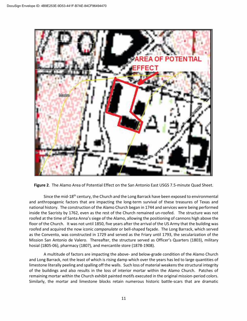
Since July 17, 2019, the archaeological staff of Raba Kistner Inc., has carried out archaeological excavations at the site of the Alamo (41BX6) under Texas Antiquities Permit Number 8713, issued in January, 2019 to Dr. Steve A. Tomka, Principal Investigator. The Area of Potential Effect (APE) of the project is depicted on the aerial image of downtown (Figure 1) and on the San Antonio East 7.5-minute USGS Quadrangle map (Figure 2).
DocuSign Envelope ID: 4B9E253E-9D53-441F-B7AE-84CF96494470
11
Figure 2. The Alamo Area of Potential Effect on the San Antonio East USGS 7.5-minute Quad Sheet.
Since the mid-18th century, the Church and the Long Barrack have been exposed to environmental and anthropogenic factors that are impacting the long-term survival of these treasures of Texas and national history. The construction of the Alamo Church began in 1744 and services were being performed inside the Sacristy by 1762, even as the rest of the Church remained un-roofed. The structure was not roofed at the time of Santa Anna’s siege of the Alamo, allowing the positioning of cannons high above the floor of the Church. It was not until 1850, five years after the arrival of the US Army that the building was roofed and acquired the now iconic campanulate or bell-shaped façade. The Long Barrack, which served as the Convento, was constructed in 1729 and served as the Friary until 1793, the secularization of the Mission San Antonio de Valero. Thereafter, the structure served as Officer’s Quarters (1803), military hosial (1805-06), pharmacy (1807), and mercantile store (1878-1908).
A multitude of factors are impacting the above- and below-grade condition of the Alamo Church and Long Barrack, not the least of which is rising damp which over the years has led to large quantities of limestone literally peeling and spalling off the walls. Such loss of material weakens the structural integrity of the buildings and also results in the loss of interior mortar within the Alamo Church. Patches of remaining mortar within the Church exhibit painted motifs executed in the original mission-period colors. Similarly, the mortar and limestone blocks retain numerous historic battle-scars that are dramatic
DocuSign Envelope ID: 4B9E253E-9D53-441F-B7AE-84CF96494470
12
reminders of the Siege of the Alamo. These remnants of the historic past of the Alamo Church and Long Barrack are endangered by the slow degradation of the buildings.
Currently, members of a multi-disciplinary team of civil engineers, historic preservation specialists, conservators, and architectural historians are engaged in the collection of data that will form the basis of future actions to address the stabilization and conservation of these historic treasures. These data collection steps include the installation of highly sensitive sensors from the base of the foundation to the top of the roof. The sensors will gather and transmit daily information on the conditions experienced by these structures. Among the specific information recorded will be oscillations in moisture levels, humidity, and temperature.
The below-grade installation of instrumentation and the examination of foundations requires excavations by trained professional archaeologists who meet the Secretary of the Interior’s Professional Qualifications Standards (36 CFR Appendix A to Part 61- Professional Qualifications Standards). The aforementioned archaeological investigations have been conducted in support of efforts to establish the current condition of the Alamo Church and Long Barrack.
DocuSign Envelope ID: 4B9E253E-9D53-441F-B7AE-84CF96494470