Terrestrial and oceanic influence on spatial hydrochemistry and trophic status in subtropical marine...
16
Terrestrial and oceanic influence on spatial hydrochemistry and trophic status in subtropical marine near-shore waters Sara M. Morales-Ojeda, Jorge A. Herrera-Silveira*, Jorge Montero Laboratorio de Produccion Primaria CINVESTAV-IPN, Unidad Me ´rida., Carr. Antigua a Progreso km. 6, C.P. 97310 Me ´rida, Yucata ´n, Me ´xico article info Article history: Received 14 March 2010 Received in revised form 2 July 2010 Accepted 14 July 2010 Available online 23 July 2010 Keywords: Water quality Trophic status Near-shore waters Multivariate analysis Yucatan abstract Terrestrial and oceanic influences like groundwater discharges and/or oceanic upwelling define the hydrochemical and biological characteristics of near-shore regions. In karst environments, such as the Yucatan Peninsula (SE Mexico), the balance between these two influences on spatial and temporal scales is poorly understood. This study focused on near- shore waters within 200 m offshore along the Yucatan coast. The trophic status and hydrochemical zones of the study area were determined as a function of physical and nutrient data collected from 2005 to 2006. The main terrestrial influence was groundwater discharge, while the most important marine influence was related to seasonal changes in water turbulence. Spatial differences ( p < 0.05) were observed among salinity, light extinction coefficient (k), NO 3 , NH 4 þ , and Chl-a. Seasonal differences were observed for all variables except for k. During the dry season, terrestrial influences are the dominant factor on near-shore hydrochemistry. The region around Dzilam exhibited the maximum influ- ence of groundwater discharge estimated by salinity dissolution (d). During the rainy and “nortes” seasons, there is a balance between oceanic and terrestrial influences. The trophic status measured using the TRIX index, indicated that near-shore waters were mainly oligo- mesotrophic; with a meso-eutrophic status in areas with documented anthropogenic impacts. Four hydrological zones were identified by a Canonical Variate Analysis (CVA) using salinity, NO 2 , k and NH 4 þ as the main discriminating variables. Zones I and II showed almost pristine conditions, with well-balanced terrestrialeoceanic influences. In Zone III, terrestrial influences such as groundwater discharges and inland pollution suggesting human impacts were dominant respect to the effects of oceanic influences like upwelling and sediment resuspension caused by winds and oceanic currents. Zone IV received enhanced groundwater and associated nutrients. Anthropogenic activities have led to ecosystem degradation but the speed at which this occurs depends on local and regional characteristics. Therefore, this study has defined those characteristics so as to enact better management policies. ª 2010 Elsevier Ltd. All rights reserved. * Corresponding author. Tel.: þ52 999 9429462 (direct line); fax: þ52 999 9812334. E-mail addresses: [email protected] (S.M. Morales-Ojeda), [email protected] (J.A. Herrera-Silveira), jmontero@ mda.cinvestav.mx (J. Montero). Available at www.sciencedirect.com journal homepage: www.elsevier.com/locate/watres water research 44 (2010) 5949 e5964 0043-1354/$ e see front matter ª 2010 Elsevier Ltd. All rights reserved. doi:10.1016/j.watres.2010.07.046
-
Upload
independent -
Category
Documents
-
view
2 -
download
0
Transcript of Terrestrial and oceanic influence on spatial hydrochemistry and trophic status in subtropical marine...
wat e r r e s e a r c h 4 4 ( 2 0 1 0 ) 5 9 4 9e5 9 6 4
Avai lab le a t www.sc iencedi rec t .com
journa l homepage : www.e lsev ie r . com/ loca te /wat res
Terrestrial and oceanic influence on spatial hydrochemistryand trophic status in subtropical marine near-shore waters
Sara M. Morales-Ojeda, Jorge A. Herrera-Silveira*, Jorge Montero
Laboratorio de Produccion Primaria CINVESTAV-IPN, Unidad Merida., Carr. Antigua a Progreso km. 6, C.P. 97310 Merida, Yucatan, Mexico
a r t i c l e i n f o
Article history:
Received 14 March 2010
Received in revised form
2 July 2010
Accepted 14 July 2010
Available online 23 July 2010
Keywords:
Water quality
Trophic status
Near-shore waters
Multivariate analysis
Yucatan
* Corresponding author. Tel.: þ52 999 942946E-mail addresses: [email protected]
mda.cinvestav.mx (J. Montero).0043-1354/$ e see front matter ª 2010 Elsevdoi:10.1016/j.watres.2010.07.046
a b s t r a c t
Terrestrial and oceanic influences like groundwater discharges and/or oceanic upwelling
define the hydrochemical and biological characteristics of near-shore regions. In karst
environments, such as the Yucatan Peninsula (SE Mexico), the balance between these two
influences on spatial and temporal scales is poorly understood. This study focused on near-
shore waters within 200 m offshore along the Yucatan coast. The trophic status and
hydrochemical zones of the study area were determined as a function of physical and
nutrient data collected from 2005 to 2006. The main terrestrial influence was groundwater
discharge, while the most important marine influence was related to seasonal changes in
water turbulence. Spatial differences ( p < 0.05) were observed among salinity, light
extinction coefficient (k), NO3�, NH4
þ, and Chl-a. Seasonal differences were observed for all
variables except for k. During the dry season, terrestrial influences are the dominant factor
on near-shore hydrochemistry. The region around Dzilam exhibited the maximum influ-
ence of groundwater discharge estimated by salinity dissolution (d). During the rainy and
“nortes” seasons, there is a balance between oceanic and terrestrial influences. The trophic
status measured using the TRIX index, indicated that near-shore waters were mainly oligo-
mesotrophic; with a meso-eutrophic status in areas with documented anthropogenic
impacts. Four hydrological zones were identified by a Canonical Variate Analysis (CVA)
using salinity, NO2�, k and NH4
þ as the main discriminating variables. Zones I and II showed
almost pristine conditions, with well-balanced terrestrialeoceanic influences. In Zone III,
terrestrial influences such as groundwater discharges and inland pollution suggesting
human impacts were dominant respect to the effects of oceanic influences like upwelling
and sediment resuspension caused by winds and oceanic currents. Zone IV received
enhanced groundwater and associated nutrients. Anthropogenic activities have led to
ecosystem degradation but the speed at which this occurs depends on local and regional
characteristics. Therefore, this study has defined those characteristics so as to enact better
management policies.
ª 2010 Elsevier Ltd. All rights reserved.
2 (direct line); fax: þ52 999 9812334.av.mx (S.M. Morales-Ojeda), [email protected] (J.A. Herrera-Silveira), jmontero@
ier Ltd. All rights reserved.
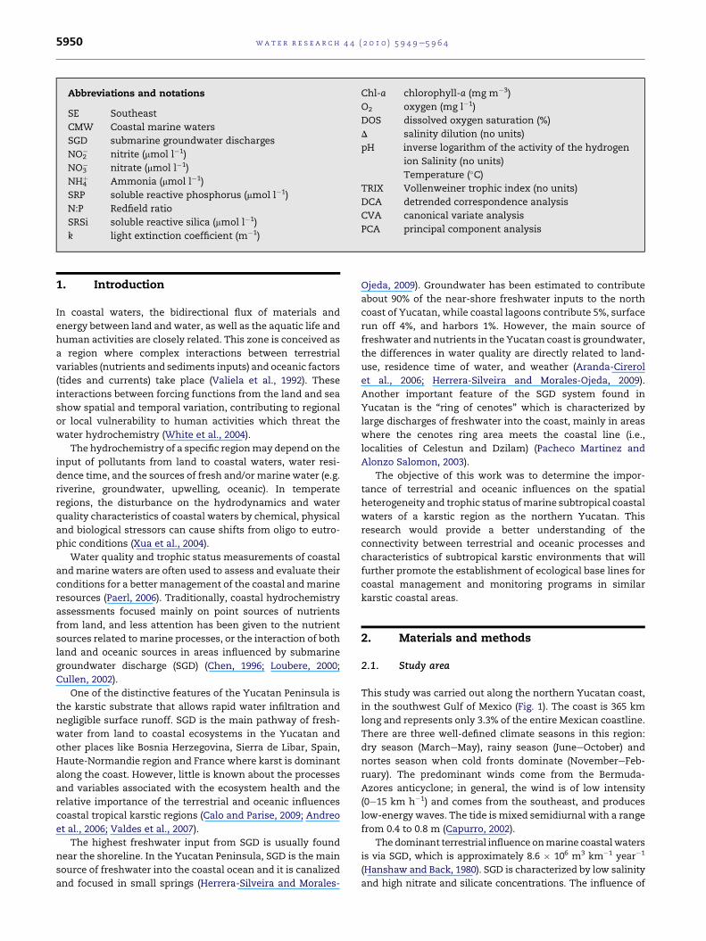
Abbreviations and notations
SE Southeast
CMW Coastal marine waters
SGD submarine groundwater discharges
NO2� nitrite (mmol l�1)
NO3� nitrate (mmol l�1)
NH4þ Ammonia (mmol l�1)
SRP soluble reactive phosphorus (mmol l�1)
N:P Redfield ratio
SRSi soluble reactive silica (mmol l�1)
k light extinction coefficient (m�1)
Chl-a chlorophyll-a (mg m�3)
O2 oxygen (mg l�1)
DOS dissolved oxygen saturation (%)
D salinity dilution (no units)
pH inverse logarithm of the activity of the hydrogen
ion Salinity (no units)
Temperature (�C)TRIX Vollenweiner trophic index (no units)
DCA detrended correspondence analysis
CVA canonical variate analysis
PCA principal component analysis
wat e r r e s e a r c h 4 4 ( 2 0 1 0 ) 5 9 4 9e5 9 6 45950
1. Introduction Ojeda, 2009). Groundwater has been estimated to contribute
In coastal waters, the bidirectional flux of materials and
energy between land and water, as well as the aquatic life and
human activities are closely related. This zone is conceived as
a region where complex interactions between terrestrial
variables (nutrients and sediments inputs) and oceanic factors
(tides and currents) take place (Valiela et al., 1992). These
interactions between forcing functions from the land and sea
show spatial and temporal variation, contributing to regional
or local vulnerability to human activities which threat the
water hydrochemistry (White et al., 2004).
The hydrochemistry of a specific regionmay depend on the
input of pollutants from land to coastal waters, water resi-
dence time, and the sources of fresh and/or marine water (e.g.
riverine, groundwater, upwelling, oceanic). In temperate
regions, the disturbance on the hydrodynamics and water
quality characteristics of coastal waters by chemical, physical
and biological stressors can cause shifts from oligo to eutro-
phic conditions (Xua et al., 2004).
Water quality and trophic status measurements of coastal
andmarine waters are often used to assess and evaluate their
conditions for a better management of the coastal andmarine
resources (Paerl, 2006). Traditionally, coastal hydrochemistry
assessments focused mainly on point sources of nutrients
from land, and less attention has been given to the nutrient
sources related to marine processes, or the interaction of both
land and oceanic sources in areas influenced by submarine
groundwater discharge (SGD) (Chen, 1996; Loubere, 2000;
Cullen, 2002).
One of the distinctive features of the Yucatan Peninsula is
the karstic substrate that allows rapid water infiltration and
negligible surface runoff. SGD is the main pathway of fresh-
water from land to coastal ecosystems in the Yucatan and
other places like Bosnia Herzegovina, Sierra de Libar, Spain,
Haute-Normandie region and France where karst is dominant
along the coast. However, little is known about the processes
and variables associated with the ecosystem health and the
relative importance of the terrestrial and oceanic influences
coastal tropical karstic regions (Calo and Parise, 2009; Andreo
et al., 2006; Valdes et al., 2007).
The highest freshwater input from SGD is usually found
near the shoreline. In the Yucatan Peninsula, SGD is the main
source of freshwater into the coastal ocean and it is canalized
and focused in small springs (Herrera-Silveira and Morales-
about 90% of the near-shore freshwater inputs to the north
coast of Yucatan, while coastal lagoons contribute 5%, surface
run off 4%, and harbors 1%. However, the main source of
freshwater and nutrients in the Yucatan coast is groundwater,
the differences in water quality are directly related to land-
use, residence time of water, and weather (Aranda-Cirerol
et al., 2006; Herrera-Silveira and Morales-Ojeda, 2009).
Another important feature of the SGD system found in
Yucatan is the “ring of cenotes” which is characterized by
large discharges of freshwater into the coast, mainly in areas
where the cenotes ring area meets the coastal line (i.e.,
localities of Celestun and Dzilam) (Pacheco Martinez and
Alonzo Salomon, 2003).
The objective of this work was to determine the impor-
tance of terrestrial and oceanic influences on the spatial
heterogeneity and trophic status ofmarine subtropical coastal
waters of a karstic region as the northern Yucatan. This
research would provide a better understanding of the
connectivity between terrestrial and oceanic processes and
characteristics of subtropical karstic environments that will
further promote the establishment of ecological base lines for
coastal management and monitoring programs in similar
karstic coastal areas.
2. Materials and methods
2.1. Study area
This study was carried out along the northern Yucatan coast,
in the southwest Gulf of Mexico (Fig. 1). The coast is 365 km
long and represents only 3.3% of the entire Mexican coastline.
There are three well-defined climate seasons in this region:
dry season (MarcheMay), rainy season (JuneeOctober) and
nortes season when cold fronts dominate (NovembereFeb-
ruary). The predominant winds come from the Bermuda-
Azores anticyclone; in general, the wind is of low intensity
(0e15 km h�1) and comes from the southeast, and produces
low-energy waves. The tide is mixed semidiurnal with a range
from 0.4 to 0.8 m (Capurro, 2002).
The dominant terrestrial influence onmarine coastalwaters
is via SGD, which is approximately 8.6 � 106 m3 km�1 year�1
(Hanshaw and Back, 1980). SGD is characterized by low salinity
and high nitrate and silicate concentrations. The influence of
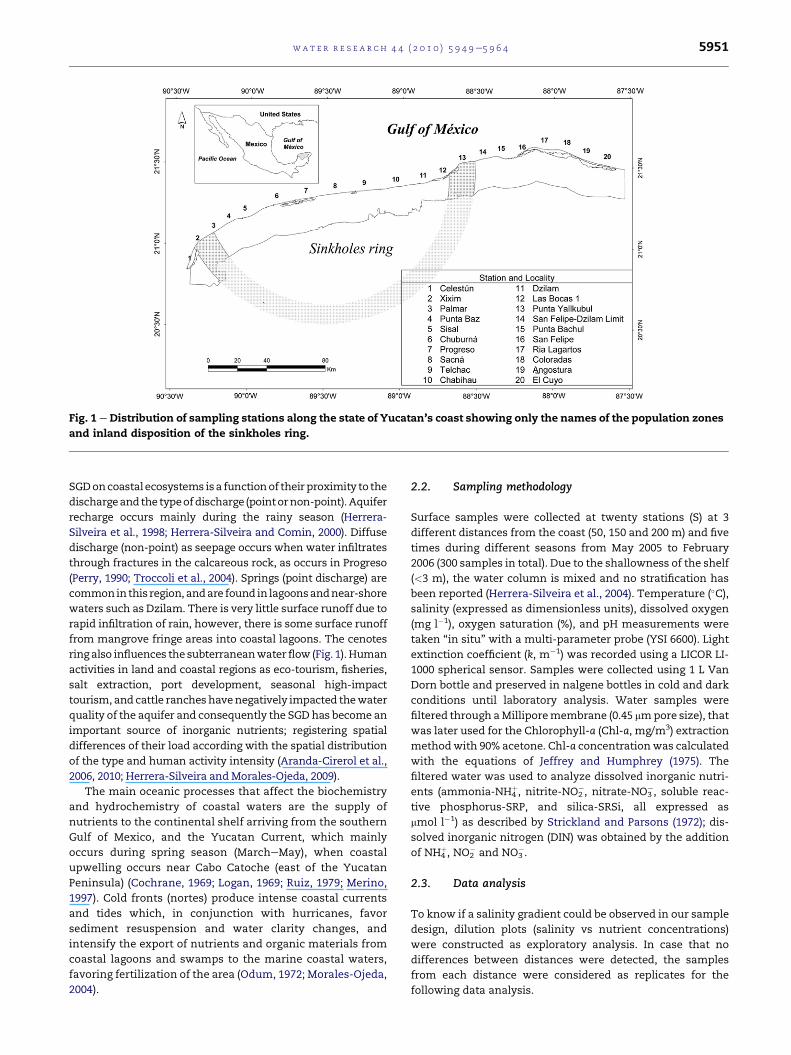
Fig. 1 e Distribution of sampling stations along the state of Yucatan’s coast showing only the names of the population zones
and inland disposition of the sinkholes ring.
wat e r r e s e a r c h 4 4 ( 2 0 1 0 ) 5 9 4 9e5 9 6 4 5951
SGDoncoastal ecosystems isa functionof their proximity to the
dischargeandthe typeofdischarge (pointornon-point).Aquifer
recharge occurs mainly during the rainy season (Herrera-
Silveira et al., 1998; Herrera-Silveira and Comin, 2000). Diffuse
discharge (non-point) as seepage occurs when water infiltrates
through fractures in the calcareous rock, as occurs in Progreso
(Perry, 1990; Troccoli et al., 2004). Springs (point discharge) are
commonin this region, andare found in lagoonsandnear-shore
waters such as Dzilam. There is very little surface runoff due to
rapid infiltration of rain, however, there is some surface runoff
from mangrove fringe areas into coastal lagoons. The cenotes
ring also influences the subterraneanwaterflow (Fig. 1). Human
activities in land and coastal regions as eco-tourism, fisheries,
salt extraction, port development, seasonal high-impact
tourism, and cattle rancheshavenegatively impacted thewater
quality of the aquifer and consequently the SGDhas become an
important source of inorganic nutrients; registering spatial
differences of their load according with the spatial distribution
of the type and human activity intensity (Aranda-Cirerol et al.,
2006, 2010; Herrera-Silveira and Morales-Ojeda, 2009).
The main oceanic processes that affect the biochemistry
and hydrochemistry of coastal waters are the supply of
nutrients to the continental shelf arriving from the southern
Gulf of Mexico, and the Yucatan Current, which mainly
occurs during spring season (MarcheMay), when coastal
upwelling occurs near Cabo Catoche (east of the Yucatan
Peninsula) (Cochrane, 1969; Logan, 1969; Ruiz, 1979; Merino,
1997). Cold fronts (nortes) produce intense coastal currents
and tides which, in conjunction with hurricanes, favor
sediment resuspension and water clarity changes, and
intensify the export of nutrients and organic materials from
coastal lagoons and swamps to the marine coastal waters,
favoring fertilization of the area (Odum, 1972; Morales-Ojeda,
2004).
2.2. Sampling methodology
Surface samples were collected at twenty stations (S) at 3
different distances from the coast (50, 150 and 200 m) and five
times during different seasons from May 2005 to February
2006 (300 samples in total). Due to the shallowness of the shelf
(<3 m), the water column is mixed and no stratification has
been reported (Herrera-Silveira et al., 2004). Temperature (�C),salinity (expressed as dimensionless units), dissolved oxygen
(mg l�1), oxygen saturation (%), and pH measurements were
taken “in situ” with a multi-parameter probe (YSI 6600). Light
extinction coefficient (k, m�1) was recorded using a LICOR LI-
1000 spherical sensor. Samples were collected using 1 L Van
Dorn bottle and preserved in nalgene bottles in cold and dark
conditions until laboratory analysis. Water samples were
filtered through aMilliporemembrane (0.45 mmpore size), that
was later used for the Chlorophyll-a (Chl-a, mg/m3) extraction
methodwith 90% acetone. Chl-a concentrationwas calculated
with the equations of Jeffrey and Humphrey (1975). The
filtered water was used to analyze dissolved inorganic nutri-
ents (ammonia-NH4þ, nitrite-NO2
�, nitrate-NO3�, soluble reac-
tive phosphorus-SRP, and silica-SRSi, all expressed as
mmol l�1) as described by Strickland and Parsons (1972); dis-
solved inorganic nitrogen (DIN) was obtained by the addition
of NH4þ, NO2
� and NO3�.
2.3. Data analysis
To know if a salinity gradient could be observed in our sample
design, dilution plots (salinity vs nutrient concentrations)
were constructed as exploratory analysis. In case that no
differences between distances were detected, the samples
from each distance were considered as replicates for the
following data analysis.
wat e r r e s e a r c h 4 4 ( 2 0 1 0 ) 5 9 4 9e5 9 6 45952
Area characterization was conducted through the identi-
fication of spatial and temporal variation of hydrochemical
(NH4þ, NO2
�, NO3�, SRP, SRSi) and trophic condition indicators
(Trophic index) (Vollenweider et al., 1998). Significant differ-
ences in variables among sites and/or sampling times were
identified through pair wise test using KruskaleWallis.
Since SGD is an important terrestrial influence on near-
shore hydrochemistry, salinity dilution (d) was used to esti-
mate the freshwater content of the marine near-shore waters
at each sampling site (Aranda-Cirerol et al., 2006); where dM is
the average of salinity dilution for the study period at each
sampling site; SM is the maximum salinity shown in the
course of time and SS is the sample salinity.
dM ¼ SS � SM=SS
Amultivariate analysis, which simplifies amultidimensional
space, was used to characterize the sampling sites according to
their hydrochemical characteristics. The first step was to
determine the gradient length with a DCA (detrended corre-
spondence analysis), which is an indirect ordination technique
that shows the maximum dispersion (using standard devia-
tions) of the sample scores. Since the first ordination axis was
<4 standard deviation, a linear behavior was identified, and so
an indirect method, like the Principal Component Analysis
(PCA) is recommended. The PCA was centered and standard-
ized (using a correlationmatrix) in order tominimize the effect
of the different variances of the measured variables, which are
in different scales (ter Braak and Smilauer, 2002). And so, PCA
was used as an exploratory technique to examine the main
“loading” or Pearson’s r correlation between the components
(i.e., component scores for each object) and the original vari-
able; high loading values indicate a strong correlation among
the variables and a particular component, therefore, the
loading could be used to examine which of the original vari-
ables had a strong contribution to each component (Quinn and
Keough, 2003). PCA was used to identify the variables that
explain the temporal hydrochemical behavior of the near-
shore Yucatan coasts.
To identify spatial zoning according to hydrochemical
variables, a cluster analysis was carried out using Euclidean
distances as similarity distances in a complete linkage
(furthest neighbour) clustering method, and represented in
a cluster tree. The included variables were station average
across all five sampling periods of temperature, salinity, light
extinction coefficient (k), oxygen saturation (%), NO2�, NO3
�,NH4
þ, SRP, SRSi, and Chl-a. The data were previously trans-
formed [log (X þ 1)]. The analyses were performed with the
Statgraphics Plus V 4.1 software package (Statistical Graphics
Corp., 1994e1999).
After the groups were identified by clustering, a Canonical
Variate Analysis (CVA) was used as a complement of the
clustering results, this approach testing which variables
discriminated best among the groups formed. Then, once no
multicollinearity was identified among the data (VIF < 20), the
CVA was run with Hill’s scaling, focusing on inter-variable
distances, with a full permutation model for the Monte Carlo
test with 999 unrestricted permutations. For the variable
selection, those with p values <0.05 were chosen. Canonical
Variate Analysis provided an objective assessment of the
similarity between the “a-priori” groups (formed by clustering)
as dummy variables (ter Braak and Smilauer, 2002). The above
approach was followed due to studies related to ecosystems
involve a multidimensional matrix that cannot be efficiently
analyzed through reductionist methods, which focus on the
properties of each isolated variable. Themultivariatemethods
allowed us to find relationships among response variables,
sample units or variables and sample units; for each case,
a specific method was required. DCA, PCA and CVA were
performed with the CANOCO V 4.51 software package (ter
Braak and Smilauer, 2002).
Trophic status of the Yucatan coast was estimated using
the TRIX index (Vollenweider et al., 1998). This index is a linear
combination of chlorophyll-a concentration, nutrient (DIN
and SRP) log scale concentrations, and dissolved oxygen
levels. This combination of four state variables describes
primary production (chlorophyll-a and oxygen), and nutri-
tional conditions (dissolved inorganic nitrogen and inorganic
phosphorus) (Giovanardi and Vollenweider, 2004). The TRIX
index was calculated as follows:
TRIX ¼ ðLog10½Chl� a$aD%O$DIN$P� þ xÞ=mWhere P¼ soluble reactive phosphorus (mg l�1); DIN¼ dissolved
inorganic nitrogen (mg l�1); Chl-a¼ chlorophyll-a concentration,
as mg l�1; aD%O ¼ absolute % of oxygen deviation from satu-
ration; x and m ¼ scale coefficients were introduced to fix the
lower limit value of the index and the extension of related
trophic scale from 0 to 10. This index was calculated for the
whole area and then for each particular zone. x ¼ 1.5 and
m ¼ 1.2.
In the original paper of Vollenweider et al. (1998), the
formulation of the index allowed the use of nitrogen and
phosphorus both in their mineral as in their total form, in the
case of nitrogen, as dissolved inorganic nitrogen (DIN) and
total nitrogen (TN), and in the case of phosphorus, as soluble
reactive phosphorus (SRP) and total phosphorus. In this study,
DIN and SRP were used and obtained an average difference of
0.5 TRIX units, that is to say that a TRIX value of 5 units
obtained using TN and TP, corresponds to a value of 4.5 units
using DIN and SRP, so this correction was applied.
Nevertheless, TRIX was mainly developed for coastal and
near-shore marine environments; it has been used in
ecosystems with different trophodynamic regimes, such as
coastal lagoons (e.g. Venice Lagoon; Bendoricchio and De Boni,
2005).
3. Results and discussion
3.1. Characterization
Almost all hydrochemical variables exhibited seasonal
differences (Table 1); for example, in the nortes season, cold
fronts reduced water temperature and light penetration.
Similar processes have been recorded in Florida Bay, where
shallowness favors sediment resuspension and turbidity
during windy events (Boyer et al., 1999). Water temperature
clearly displayed seasonal differences (Fig. 2a) with the lowest
mean value (21.8 �C) during the cold-front season (February),
Table 1 e The KruskaleWallis test for spatial and seasonal differences; p values are shown and the statistic H.
Spatial Temporal
Variable Median SE H p H p
Temperature (�C) 28.61 0.19 84.46 0.98 272.50 <0.05
Salinity 36.61 0.11 33.90 <0.05 177.40 <0.05
Light extinction coefficient as k (m�1) 1.12 0.05 54.45 <0.05 5.91 0.20
pH 8.24 0.01 18.08 0.52 212.67 <0.05
Dissolved oxygen saturation (%) 126.78 2.68 29.53 0.06 125.15 <0.05
Nitrite (mmol l�1) 0.22 0.02 15.94 0.66 191.8 <0.05
Nitrate (mmol l�1) 1.25 0.09 87.89 <0.05 80.32 <0.05
Ammonium (mmol l�1) 1.23 0.19 36.46 <0.05 50.65 <0.05
Dissolved inorganic nitrogen (mmol l�1) 3.46 0.25 30.64 <0.05 58.10 <0.05
Soluble reactive phosphorus (mmol l�1) 0.25 0.01 12.83 0.85 112.23 <0.05
Soluble reactive silica (mmol l�1) 9.7 0.44 29.54 0.58 132.90 <0.05
N:P ratio 17.03 4.06 17.39 0.06 82.61 <0.05
Chlorophyll-a (mg m�3) 3.11 0.25 44.44 <0.05 68.99 <0.05
wat e r r e s e a r c h 4 4 ( 2 0 1 0 ) 5 9 4 9e5 9 6 4 5953
and the highest mean value (31.1 �C) in the rainy season
(August) (Fig. 2a). Spatially, the lowest (27.6 �C) median
temperatures occurred in Chabihau (S10) and the highest
(29.5 �C) in Las Bocas 1 (S12) (Fig. 2b). The differences are likely
related to average depth (<2 m in Dzilam) and the occurrence
of SGD, which is characterized by low temperatures (<20 �C)(Herrera-Silveira, 1994; Aranda-Cirerol et al., 2006). In spite of
the fact that groundwater inputs reduce water temperatures,
it was similar to other subtropical coastal areas (Boyer et al.,
1999).
Salinity showed spatial and temporal variations. Season-
ally, mean salinity ranged from 35 during the end of the rainy
season (October) and early nortes season (November), to 37.8
during the dry season (May) (Fig. 2c). The lowest salinity
values were observed in the Dzilam region (from S10 to S15),
and the highest in the San Felipe-Rio Lagartos area (S16)
(Fig. 2d). High groundwater flow through the cenotes ring is
evident by an abundance of submarine springs at the inter-
section of the ring and the near-shorewaters in Xixim (S2) and
Las Bocas de Dzilam area (S12eS13), where salinity is highly
variable (Fig. 2d).
Seasonally the lowest salinity dilution d values (0.06) were
registered in May (dry season) and the highest values (0.13)
were observed in November (end rainy period) (Fig. 3e). High
values were calculated from Palmar (S3) to Progreso (S7) and
for Celestun (S1) in August, and in Xixim (S2) in February, as
previously observed by Aranda-Cirerol et al. (2006) (Fig. 2f).
The salinity dilution (d) showed little influence of ground-
water discharge in San Felipe (S16, d mean ¼ 0.06), Coloradas
(S18, d mean ¼ 0.07), and Rio Lagartos (S17, d mean ¼ 0.08),
whereas in Dzilam (S11) showed the largest groundwater
discharge (d mean ¼ 0.17), followed by Las Bocas (S12eS14,
d¼ 0.1) (Fig. 2f). The assessment of the salinity dilution (d) factor
could be non-precise due to the assumption of a constant end-
member value, or at least an end-member salinity is not
influenced by external variation. This is a problem in estuarine
areas where the end-member salinity station is set too close to
land, as occurs in this study. However, the results (Fig. 2e, f) are
a valuable indication of the fresh-marine water mix in this
region, characterized by submarine groundwater inputs.
Spatial differences in groundwater recharge and discharge
flows may be associated with geological variability along the
cenotes ring, due to high density of springs and breaks in sand
bars at the intersection of the ring with the sea as occurs in
Celestun and Dzilam (Perry et al., 1995; Pacheco Martinez and
Alonzo Salomon, 2003). Thus, these natural features affect
groundwater flow by diverting more than the 80% of the
groundwater flowing across the ring and discharging it to the
sea (Marin et al., 1990).
The spatial variability of coastal salinity has been observed
to be influenced by marine waters and point sources of
freshwater such as, rivers, creeks and springs (Boyer et al.,
1999; Kelble et al., 2007), suggesting that, in the Yucatan
coast, water exchange with the Gulf of Mexico, the Caribbean
Sea, point sources (springs), and non-point sources (mangrove
runoff) of freshwater, should exert strong influence on the
spatial variability and zoning of the hydrochemical conditions
observed in Yucatan near-shore waters.
According to the spatial distribution of temperature and
salinity, the main locations where SGD and runoff influence
near-shore hydrochemistry were El Palmar area (S2 and S3),
and from Chabihau (S10) to Punta Bachul (S15). Thus, is
probably that salinity variations are controlled by local
geomorphology, such as the cenotes ring and coastal features
as mangrove zones. The area with least influence of SGD and
runoff was the Sisal-Chuburna area (S4eS6), and from Ria
Lagartos (S17) to El Cuyo (S20), suggesting that, in this area,
local weather and oceanic influence (marine currents and cold
fronts) could be responsible for the variability in temperature
and salinity.
The lowest average light extinction coefficient (k) was
recorded in May (0.98 m�1), whereas the highest average k was
recorded in November (1.3 m�1). Although these differences
were not significant, low k values are related to stable water
conditions that occur during dry periods, while in the nortes
season high k values were the result of turbulence induced by
the strong winds that characterize this season (Troccoli et al.,
2004; Alvarez-Gongora and Herrera-Silveria, 2006; Aranda-
Cirerol et al., 2006) (Fig. 2g). Spatially, the highest k values
were associatedwith coastal lagoon inlets (stations S1, S6, S17),
harbor discharge (stations S7, S10, S20) and surface runoff
(stations S12, S13, S14) (Fig. 2h), while low k values were
recorded in areas with a greater coverage of submerged aquatic
vegetation, which reduce sediment resuspension, as in the
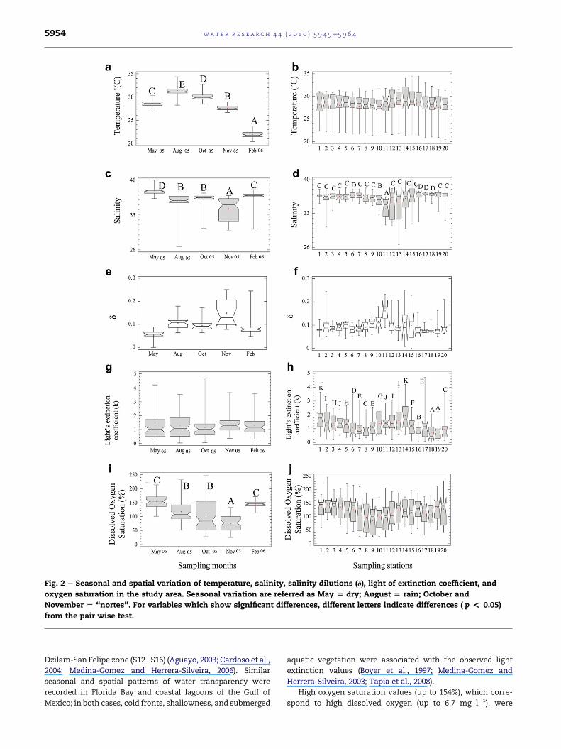
Fig. 2 e Seasonal and spatial variation of temperature, salinity, salinity dilutions (d), light of extinction coefficient, and
oxygen saturation in the study area. Seasonal variation are referred as May [ dry; August [ rain; October and
November [ “nortes”. For variables which show significant differences, different letters indicate differences ( p < 0.05)
from the pair wise test.
wat e r r e s e a r c h 4 4 ( 2 0 1 0 ) 5 9 4 9e5 9 6 45954
Dzilam-San Felipe zone (S12eS16) (Aguayo, 2003; Cardoso et al.,
2004; Medina-Gomez and Herrera-Silveira, 2006). Similar
seasonal and spatial patterns of water transparency were
recorded in Florida Bay and coastal lagoons of the Gulf of
Mexico; in both cases, cold fronts, shallowness, and submerged
aquatic vegetation were associated with the observed light
extinction values (Boyer et al., 1997; Medina-Gomez and
Herrera-Silveira, 2003; Tapia et al., 2008).
High oxygen saturation values (up to 154%), which corre-
spond to high dissolved oxygen (up to 6.7 mg l�1), were
wat e r r e s e a r c h 4 4 ( 2 0 1 0 ) 5 9 4 9e5 9 6 4 5955
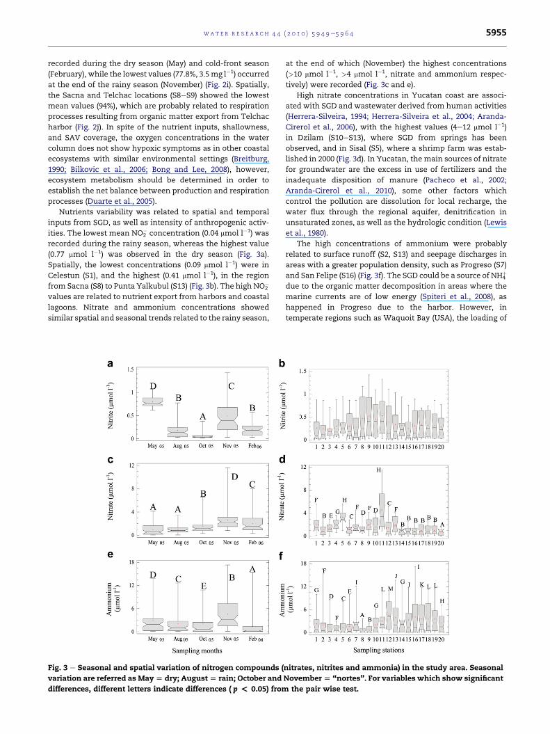
recorded during the dry season (May) and cold-front season
(February), while the lowest values (77.8%, 3.5mg l�1) occurred
at the end of the rainy season (November) (Fig. 2i). Spatially,
the Sacna and Telchac locations (S8eS9) showed the lowest
mean values (94%), which are probably related to respiration
processes resulting from organic matter export from Telchac
harbor (Fig. 2j). In spite of the nutrient inputs, shallowness,
and SAV coverage, the oxygen concentrations in the water
column does not show hypoxic symptoms as in other coastal
ecosystems with similar environmental settings (Breitburg,
1990; Bilkovic et al., 2006; Bong and Lee, 2008), however,
ecosystem metabolism should be determined in order to
establish the net balance between production and respiration
processes (Duarte et al., 2005).
Nutrients variability was related to spatial and temporal
inputs from SGD, as well as intensity of anthropogenic activ-
ities. The lowest mean NO2� concentration (0.04 mmol l�1) was
recorded during the rainy season, whereas the highest value
(0.77 mmol l�1) was observed in the dry season (Fig. 3a).
Spatially, the lowest concentrations (0.09 mmol l�1) were in
Celestun (S1), and the highest (0.41 mmol l�1), in the region
from Sacna (S8) to Punta Yalkubul (S13) (Fig. 3b). The high NO2�
values are related to nutrient export from harbors and coastal
lagoons. Nitrate and ammonium concentrations showed
similar spatial and seasonal trends related to the rainy season,
Fig. 3 e Seasonal and spatial variation of nitrogen compounds (
variation are referred as May[ dry; August[ rain; October and
differences, different letters indicate differences ( p < 0.05) from
at the end of which (November) the highest concentrations
(>10 mmol l�1, >4 mmol l�1, nitrate and ammonium respec-
tively) were recorded (Fig. 3c and e).
High nitrate concentrations in Yucatan coast are associ-
ated with SGD and wastewater derived from human activities
(Herrera-Silveira, 1994; Herrera-Silveira et al., 2004; Aranda-
Cirerol et al., 2006), with the highest values (4e12 mmol l�1)
in Dzilam (S10eS13), where SGD from springs has been
observed, and in Sisal (S5), where a shrimp farm was estab-
lished in 2000 (Fig. 3d). In Yucatan, the main sources of nitrate
for groundwater are the excess in use of fertilizers and the
inadequate disposition of manure (Pacheco et al., 2002;
Aranda-Cirerol et al., 2010), some other factors which
control the pollution are dissolution for local recharge, the
water flux through the regional aquifer, denitrification in
unsaturated zones, as well as the hydrologic condition (Lewis
et al., 1980).
The high concentrations of ammonium were probably
related to surface runoff (S2, S13) and seepage discharges in
areas with a greater population density, such as Progreso (S7)
and San Felipe (S16) (Fig. 3f). The SGD could be a source of NH4þ
due to the organic matter decomposition in areas where the
marine currents are of low energy (Spiteri et al., 2008), as
happened in Progreso due to the harbor. However, in
temperate regions such as Waquoit Bay (USA), the loading of
nitrates, nitrites and ammonia) in the study area. Seasonal
November[ “nortes”. For variables which show significant
the pair wise test.
wat e r r e s e a r c h 4 4 ( 2 0 1 0 ) 5 9 4 9e5 9 6 45956
nitrogen from watersheds could come from wastewater
fertilizer use and atmospheric deposition (Valiela et al., 1997).
Inorganic nitrogen sources in the near-shore waters have
been related mainly to terrestrial inputs; high nitrate
concentrations have been associated with groundwater
polluted with fertilizers and manure (Valiela et al., 2000),
whereas ammonium has been related to coastal urban areas
and aquaculture activities (Paez-Osuna, 2001; Bricker et al.,
2003). In Yucatan, both source could be responsible of the
inorganic nitrogen inputs due to the urban, agriculture
a farms developments lack wastewater treatment systems
(Herrera-Silveira et al., 2004; Aranda-Cirerol et al., 2010).
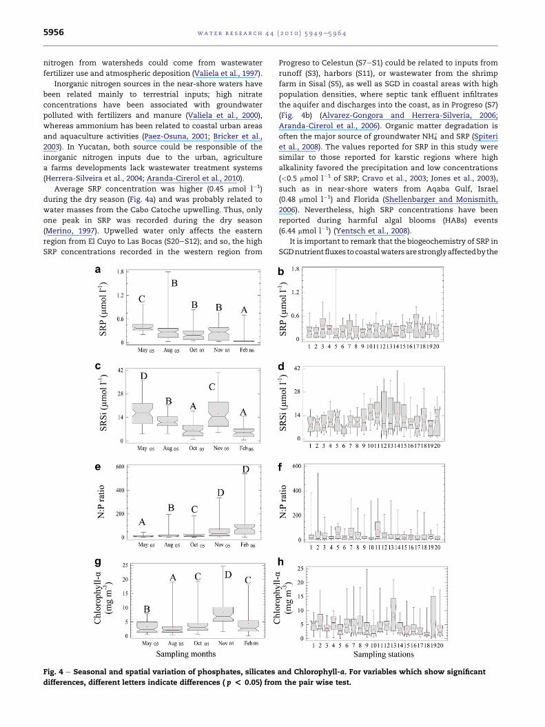
Average SRP concentration was higher (0.45 mmol l�1)
during the dry season (Fig. 4a) and was probably related to
water masses from the Cabo Catoche upwelling. Thus, only
one peak in SRP was recorded during the dry season
(Merino, 1997). Upwelled water only affects the eastern
region from El Cuyo to Las Bocas (S20eS12); and so, the high
SRP concentrations recorded in the western region from
Fig. 4 e Seasonal and spatial variation of phosphates, silicates
differences, different letters indicate differences ( p < 0.05) from
Progreso to Celestun (S7eS1) could be related to inputs from
runoff (S3), harbors (S11), or wastewater from the shrimp
farm in Sisal (S5), as well as SGD in coastal areas with high
population densities, where septic tank effluent infiltrates
the aquifer and discharges into the coast, as in Progreso (S7)
(Fig. 4b) (Alvarez-Gongora and Herrera-Silveria, 2006;
Aranda-Cirerol et al., 2006). Organic matter degradation is
often the major source of groundwater NH4þ and SRP (Spiteri
et al., 2008). The values reported for SRP in this study were
similar to those reported for karstic regions where high
alkalinity favored the precipitation and low concentrations
(<0.5 mmol l�1 of SRP; Cravo et al., 2003; Jones et al., 2003),
such as in near-shore waters from Aqaba Gulf, Israel
(0.48 mmol l�1) and Florida (Shellenbarger and Monismith,
2006). Nevertheless, high SRP concentrations have been
reported during harmful algal blooms (HABs) events
(6.44 mmol l�1) (Yentsch et al., 2008).
It is important to remark that the biogeochemistry of SRP in
SGDnutrientfluxes tocoastalwatersarestronglyaffectedbythe
and Chlorophyll-a. For variables which show significant
the pair wise test.
wat e r r e s e a r c h 4 4 ( 2 0 1 0 ) 5 9 4 9e5 9 6 4 5957
redox conditions of the freshwater and seawater (Spiteri et al.,
2008), these processes has not been investigated in the region.
In Yucatan Peninsula, nitrates and silicates (SRSi) are
enriched in SGD and have been used as a tracer of freshwater
input to thecoastal ecosystems (Smithetal., 1999).Thiscouldbe
possible because in the tropics the rate of rockmineralization is
high and in the karstic regions chemical reactions are respon-
sible of silica dissolution from the marine calcareous rock
(White and Blum, 1995; Stonestrom et al., 1998; Asano et al.,
2003). Seasonal variation was identified with the highest mean
of SRSi concentration (16.8 mmol l�1) during the dry season,
possible related to water masses from the Cabo Catoche
upwelling; while the highest mean value in late rainy season
(>14 in November) was probably due to SGD, which is more
intense during this tiem period (Fig. 4c). Spatially, the highest
mean concentrations (>10 mmol l�1) occurred Dzilam (S10eS15)
where there is enhanced SGD from springs and runoff into
harbors and coastal lagoons (S4, S9, S10, S12) (Fig. 4d).
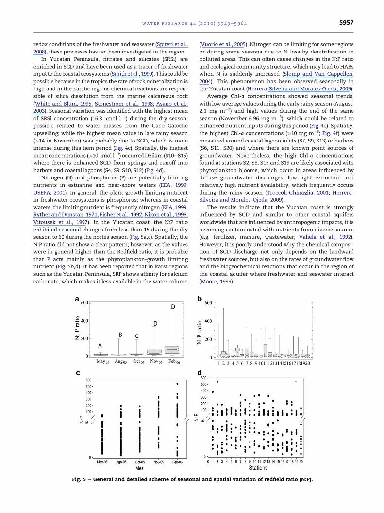
Nitrogen (N) and phosphorus (P) are potentially limiting
nutrients in estuarine and near-shore waters (EEA, 1999;
USEPA, 2001). In general, the plant-growth limiting nutrient
in freshwater ecosystems is phosphorus; whereas in coastal
waters, the limiting nutrient is frequently nitrogen (EEA, 1999;
Ryther andDunstan, 1971; Fisher et al., 1992; Nixon et al., 1996;
Vitousek et al., 1997). In the Yucatan coast, the N:P ratio
exhibited seasonal changes from less than 15 during the dry
season to 60 during the nortes season (Fig. 5a,c). Spatially, the
N:P ratio did not show a clear pattern; however, as the values
were in general higher than the Redfield ratio, it is probable
that P acts mainly as the phytoplankton-growth limiting
nutrient (Fig. 5b,d). It has been reported that in karst regions
such as the Yucatan Peninsula, SRP shows affinity for calcium
carbonate, which makes it less available in the water column
Fig. 5 e General and detailed scheme of seasona
(Vuorio et al., 2005). Nitrogen can be limiting for some regions
or during some seasons due to N loss by denitrification in
polluted areas. This can often cause changes in the N:P ratio
and ecological community structure, which may lead to HABs
when N is suddenly increased (Slomp and Van Cappellen,
2004). This phenomenon has been observed seasonally in
the Yucatan coast (Herrera-Silveira and Morales-Ojeda, 2009).
Average Chl-a concentrations showed seasonal trends,
with low average values during the early rainy season (August,
2.1 mg m�3) and high values during the end of the same
season (November 6.96 mg m�3), which could be related to
enhanced nutrient inputs during this period (Fig. 4e). Spatially,
the highest Chl-a concentrations (>10 mg m�3; Fig. 4f) were
measured around coastal lagoon inlets (S7, S9, S13) or harbors
(S6, S11, S20) and where there are known point sources of
groundwater. Nevertheless, the high Chl-a concentrations
found at stations S2, S8, S15 and S19 are likely associated with
phytoplankton blooms, which occur in areas influenced by
diffuse groundwater discharges, low light extinction and
relatively high nutrient availability, which frequently occurs
during the rainy season (Troccoli-Ghinaglia, 2001; Herrera-
Silveira and Morales-Ojeda, 2009).
The results indicate that the Yucatan coast is strongly
influenced by SGD and similar to other coastal aquifers
worldwide that are influenced by anthropogenic impacts, it is
becoming contaminated with nutrients from diverse sources
(e.g. fertilizer, manure, wastewater; Valiela et al., 1992).
However, it is poorly understood why the chemical composi-
tion of SGD discharge not only depends on the landward
freshwater sources, but also on the rates of groundwater flow
and the biogeochemical reactions that occur in the region of
the coastal aquifer where freshwater and seawater interact
(Moore, 1999).
l and spatial variation of redfield ratio (N:P).
wat e r r e s e a r c h 4 4 ( 2 0 1 0 ) 5 9 4 9e5 9 6 45958
Nutrient dynamics and Chl-a concentrations along the
northern coast of the Yucatan suggests that terrestrial inputs
can be divided into distinct zones such as: 1) areas affected by
runoff (mangrove areas, coastal lagoons inlets or harbors); 2)
locations with high population density where wastewater
inputs are greater; 3) locations with aquaculture activities and
4) areas where the cenotes ring intersects the coast and SGD is
enhanced. On the other hand, oceanic influence of the near-
shore ecosystem mostly shows seasonal variations in nutrient
dynamics. During the nortes season, remineralization
processes and sediment resuspension occur, the latter favoring
a reduction of the water clarity; whereas during the dry season,
upwellingwaters fromCabo Catoche are an important nutrient
source. Finally, during the rainy season, nutrient inputs to the
coast increased, particularly in locations with a higher pop-
ulation density, where septic tank effluent infiltrates the
aquifer and reaches the coast via SGD as seepage (Progreso),
and in areas where there is enhanced SGD from springs (Dzi-
lam). These terrestrial and oceanic influences play an impor-
tant role in the spatial and seasonal hydrochemical condition
of the northern cost of the Yucatan Peninsula, in consequence,
site-specific or region-specific patterns are observed, which
could be used to establish a framework for management
strategies and monitoring programs.
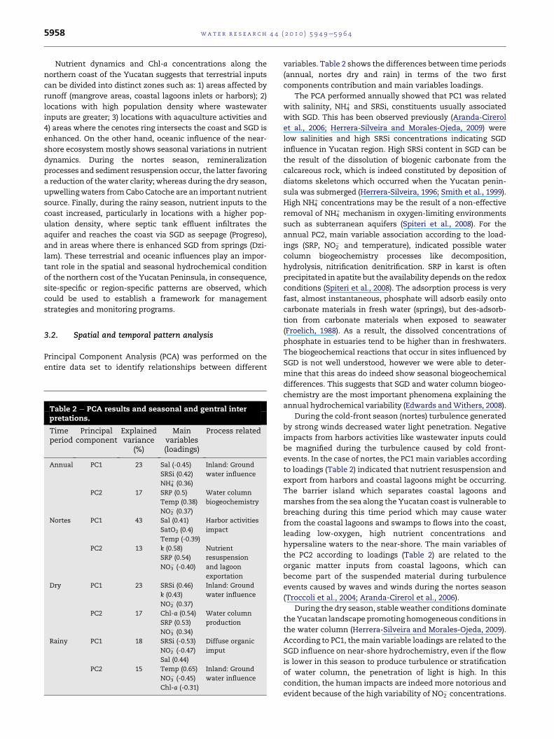
3.2. Spatial and temporal pattern analysis
Principal Component Analysis (PCA) was performed on the
entire data set to identify relationships between different
Table 2 e PCA results and seasonal and gentral interpretations.
Timeperiod
Principalcomponent
Explainedvariance
(%)
Mainvariables(loadings)
Process related
Annual PC1 23 Sal (-0.45)
SRSi (0.42)
NH4þ (0.36)
Inland: Ground
water influence
PC2 17 SRP (0.5)
Temp (0.38)
NO2� (0.37)
Water column
biogeochemistry
Nortes PC1 43 Sal (0.41)
SatO2 (0.4)
Temp (-0.39)
Harbor activities
impact
PC2 13 k (0.58)
SRP (0.54)
NO3� (-0.40)
Nutrient
resuspension
and lagoon
exportation
Dry PC1 23 SRSi (0.46)
k (0.43)
NO2� (0.37)
Inland: Ground
water influence
PC2 17 Chl-a (0.54)
SRP (0.53)
NO3� (0.34)
Water column
production
Rainy PC1 18 SRSi (-0.53)
NO2� (-0.47)
Sal (0.44)
Diffuse organic
imput
PC2 15 Temp (0.65)
NO3� (-0.45)
Chl-a (-0.31)
Inland: Ground
water influence
variables. Table 2 shows the differences between time periods
(annual, nortes dry and rain) in terms of the two first
components contribution and main variables loadings.
The PCA performed annually showed that PC1 was related
with salinity, NH4þ and SRSi, constituents usually associated
with SGD. This has been observed previously (Aranda-Cirerol
et al., 2006; Herrera-Silveira and Morales-Ojeda, 2009) were
low salinities and high SRSi concentrations indicating SGD
influence in Yucatan region. High SRSi content in SGD can be
the result of the dissolution of biogenic carbonate from the
calcareous rock, which is indeed constituted by deposition of
diatoms skeletons which occurred when the Yucatan penin-
sula was submerged (Herrera-Silveira, 1996; Smith et al., 1999).
High NH4þ concentrations may be the result of a non-effective
removal of NH4þ mechanism in oxygen-limiting environments
such as subterranean aquifers (Spiteri et al., 2008). For the
annual PC2, main variable association according to the load-
ings (SRP, NO2� and temperature), indicated possible water
column biogeochemistry processes like decomposition,
hydrolysis, nitrification denitrification. SRP in karst is often
precipitated in apatite but the availability depends on the redox
conditions (Spiteri et al., 2008). The adsorption process is very
fast, almost instantaneous, phosphate will adsorb easily onto
carbonate materials in fresh water (springs), but des-adsorb-
tion from carbonate materials when exposed to seawater
(Froelich, 1988). As a result, the dissolved concentrations of
phosphate in estuaries tend to be higher than in freshwaters.
The biogeochemical reactions that occur in sites influenced by
SGD is not well understood, however we were able to deter-
mine that this areas do indeed show seasonal biogeochemical
differences. This suggests that SGD and water column biogeo-
chemistry are the most important phenomena explaining the
annual hydrochemical variability (Edwards andWithers, 2008).
During the cold-front season (nortes) turbulence generated
by strong winds decreased water light penetration. Negative
impacts from harbors activities like wastewater inputs could
be magnified during the turbulence caused by cold front-
events. In the case of nortes, the PC1main variables according
to loadings (Table 2) indicated that nutrient resuspension and
export from harbors and coastal lagoons might be occurring.
The barrier island which separates coastal lagoons and
marshes from the sea along the Yucatan coast is vulnerable to
breaching during this time period which may cause water
from the coastal lagoons and swamps to flows into the coast,
leading low-oxygen, high nutrient concentrations and
hypersaline waters to the near-shore. The main variables of
the PC2 according to loadings (Table 2) are related to the
organic matter inputs from coastal lagoons, which can
become part of the suspended material during turbulence
events caused by waves and winds during the nortes season
(Troccoli et al., 2004; Aranda-Cirerol et al., 2006).
During the dry season, stable weather conditions dominate
the Yucatan landscape promoting homogeneous conditions in
the water column (Herrera-Silveira and Morales-Ojeda, 2009).
According to PC1, themain variable loadings are related to the
SGD influence on near-shore hydrochemistry, even if the flow
is lower in this season to produce turbulence or stratification
of water column, the penetration of light is high. In this
condition, the human impacts are indeed more notorious and
evident because of the high variability of NO2� concentrations.
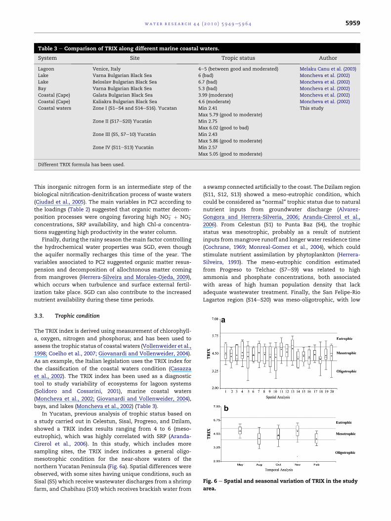
Table 3 e Comparison of TRIX along different marine coastal waters.
System Site Tropic status Author
Lagoon Venice, Italy 4e5 (between good and moderated) Melaku Canu et al. (2003)
Lake Varna Bulgarian Black Sea 6 (bad) Moncheva et al. (2002)
Lake Beloslav Bulgarian Black Sea 6.7 (bad) Moncheva et al. (2002)
Bay Varna Bulgarian Black Sea 5.3 (bad) Moncheva et al. (2002)
Coastal (Cape) Galata Bulgarian Black Sea 3.99 (moderate) Moncheva et al. (2002)
Coastal (Cape) Kaliakra Bulgarian Black Sea 4.6 (moderate) Moncheva et al. (2002)
Coastal waters Zone I (S1eS4 and S14eS16). Yucatan Min 2.41 This study
Max 5.79 (good to moderate)
Zone II (S17eS20) Yucatan Min 2.75
Max 6.02 (good to bad)
Zone III (S5, S7e10) Yucatan Min 2.43
Max 5.86 (good to moderate)
Zone IV (S11eS13) Yucatan Min 2.57
Max 5.05 (good to moderate)
Different TRIX formula has been used.
Fig. 6 e Spatial and seasonal variation of TRIX in the study
area.
wat e r r e s e a r c h 4 4 ( 2 0 1 0 ) 5 9 4 9e5 9 6 4 5959
This inorganic nitrogen form is an intermediate step of the
biological nitrification-denitrification process of waste waters
(Ciudad et al., 2005). The main variables in PC2 according to
the loadings (Table 2) suggested that organic matter decom-
position processes were ongoing favoring high NO2� þ NO3
�
concentrations, SRP availability, and high Chl-a concentra-
tions suggesting high productivity in the water column.
Finally, during the rainy season themain factor controlling
the hydrochemical water properties was SGD, even though
the aquifer normally recharges this time of the year. The
variables associated to PC2 suggested organic matter resus-
pension and decomposition of allochtonous matter coming
from mangroves (Herrera-Silveira and Morales-Ojeda, 2009),
which occurs when turbulence and surface external fertil-
ization take place. SGD can also contribute to the increased
nutrient availability during these time periods.
3.3. Trophic condition
The TRIX index is derived using measurement of chlorophyll-
a, oxygen, nitrogen and phosphorus; and has been used to
assess the trophic status of coastal waters (Vollenweider et al.,
1998; Coelho et al., 2007; Giovanardi and Vollenweider, 2004).
As an example, the Italian legislation uses the TRIX index for
the classification of the coastal waters condition (Casazza
et al., 2002). The TRIX index has been used as a diagnostic
tool to study variability of ecosystems for lagoon systems
(Solidoro and Cossarini, 2001), marine coastal waters
(Moncheva et al., 2002; Giovanardi and Vollenweider, 2004),
bays, and lakes (Moncheva et al., 2002) (Table 3).
In Yucatan, previous analysis of trophic status based on
a study carried out in Celestun, Sisal, Progreso, and Dzilam,
showed a TRIX index results ranging from 4 to 6 (meso-
eutrophic), which was highly correlated with SRP (Aranda-
Cirerol et al., 2006). In this study, which includes more
sampling sites, the TRIX index indicates a general oligo-
mesotrophic condition for the near-shore waters of the
northern Yucatan Peninsula (Fig. 6a). Spatial differences were
observed, with some sites having unique conditions, such as
Sisal (S5) which receive wastewater discharges from a shrimp
farm, and Chabihau (S10) which receives brackish water from
a swamp connected artificially to the coast. The Dzilam region
(S11, S12, S13) showed a meso-eutrophic condition, which
could be considered as “normal” trophic status due to natural
nutrient inputs from groundwater discharge (Alvarez-
Gongora and Herrera-Silveria, 2006; Aranda-Cirerol et al.,
2006). From Celestun (S1) to Punta Baz (S4), the trophic
status was mesotrophic, probably as a result of nutrient
inputs frommangrove runoff and longer water residence time
(Cochrane, 1969; Monreal-Gomez et al., 2004), which could
stimulate nutrient assimilation by phytoplankton (Herrera-
Silveira, 1993). The meso-eutrophic condition estimated
from Progreso to Telchac (S7eS9) was related to high
ammonia and phosphate concentrations, both associated
with areas of high human population density that lack
adequate wastewater treatment. Finally, the San Felipe-Rio
Lagartos region (S14eS20) was meso-oligotrophic, with low

wat e r r e s e a r c h 4 4 ( 2 0 1 0 ) 5 9 4 9e5 9 6 45960
nutrient concentrations as a result of the influence of the low
nutrient Caribbean waters (Lapointe and Thacker, 2002).
Seasonally, the north coast of the Yucatan Peninsula was
eutrophic, mainly during the Cabo Catoche upwelling inten-
sity peak in May (Merino, 1994; Cardenas-Palomo et al., 2010).
During this time terrestrial nutrient inputs also increase due
to peak in local tourism and consequently population incre-
ments which lead to an increase in wastewater discharge to
the aquifer. However, in November eutrophic conditions were
also registered (Fig. 6b), probably related to the turbulence,
nutrient and organic matter resuspension and remineraliza-
tion favored by windy conditions during this time of the year
(Ragueneau et al., 2002; Aranda-Cirerol et al., 2006).
This study is one of the first to develop a trophic charac-
terization and condition in subtropical near-shore waters
influenced by groundwater discharges. However, to establish
a trophic classification and reference values, the compilation
of a long-term dataset is required, which captures seasonal,
inter-annual variability, and terrestrial and oceanic changes
related to climate change.
3.4. Hydrologic zones
As a result of the classification analysis, four zones of hydro-
chemical affinity (Z IeZ IV) were identified (Fig. 7). Zone I (Z I)
grouped stationswith hydrochemical similarities but spatially
non-continuous, including stations located in the western
region from S1 (Celestun) to S4 (Punta Baz), and stations in the
eastern area from Dzilam to San Felipe (S14eS16).
Zone II includes eastern stations from S17 to S20 (Rio
Lagartos-El Cuyo). The grouping of the clusters indicates
similarities between Z I and Z II, in spite of being located in
geographically distant areas, both zones seems to be in
good hydrochemical and trophic conditions (Figs. 3, 4 and
Fig. 7 e Representation of hydrological affinity zones and the c
annual cycles in the coast of the state of Yucatan. Furthest neigh
and the squared Euclidean as a distance metric.
6). Both zones are characterized by high salinity and rela-
tively low nutrient concentrations, with the exception of
SRP. Zone II was influenced by the Caribbean Sea and by the
Gulf of Mexico, in response to this, the microalgal
community composition of the eastern coast of Yucatan
differs from the rest of the Yucatan coastal area as reported
by Troccoli et al. (2004) and Alvarez-Gongora and Herrera-
Silveria, 2006.
Z II and Z I are close and exhibited good conditions. Z II was
influenced by the Caribbean Sea with low nutrient concen-
trations, and Z I was influenced by the Gulf of Mexico. Both
zones showed high concentrations of organic matter coming
from coastal lagoons and also from submerged aquatic vege-
tation, however, they both were less affected by anthropo-
genic activities which could favor a good quality status of the
near-shore area being supported for phytoplankton structure
communities (Alvarez-Gongora and Herrera-Silveria, 2006).
The Zone III is also spatially discontinuous, including Sisal
location (S5) and the region of Sisal and from Progreso to
Telchac (S5, S7eS10). This zone was characterized by rela-
tively high salinity and nutrients concentrations (Figs. 3, 4
and 8); the latter is related to anthropogenic activities and
corresponds to the regionwith the greatest number of harbors
and human density (Progreso-Chicxulub). In addition, the
artificial inlets which connect mangrove swamps with the sea
(Telchac-Chabihau) play an important role modifying physic
and chemical environmental characteristics of lagoons and
near-shore waters, then changes in the structure of primary
producers as phytoplankton, SAV and mangrove (Herrera-
Silveira and Morales-Ojeda, 2009).
The ZIV is a group formed by the Dzilam region (S11eS13),
which is characterized by low salinity and high nutrient and
Chl-a concentrations, in this zone occurs the discharge zone
of the“cenotes ring” and springs inside marine near-shore
luster analysis of hydrological parameters of 2005e2006
bour (complete linkage) was used as the clustering method
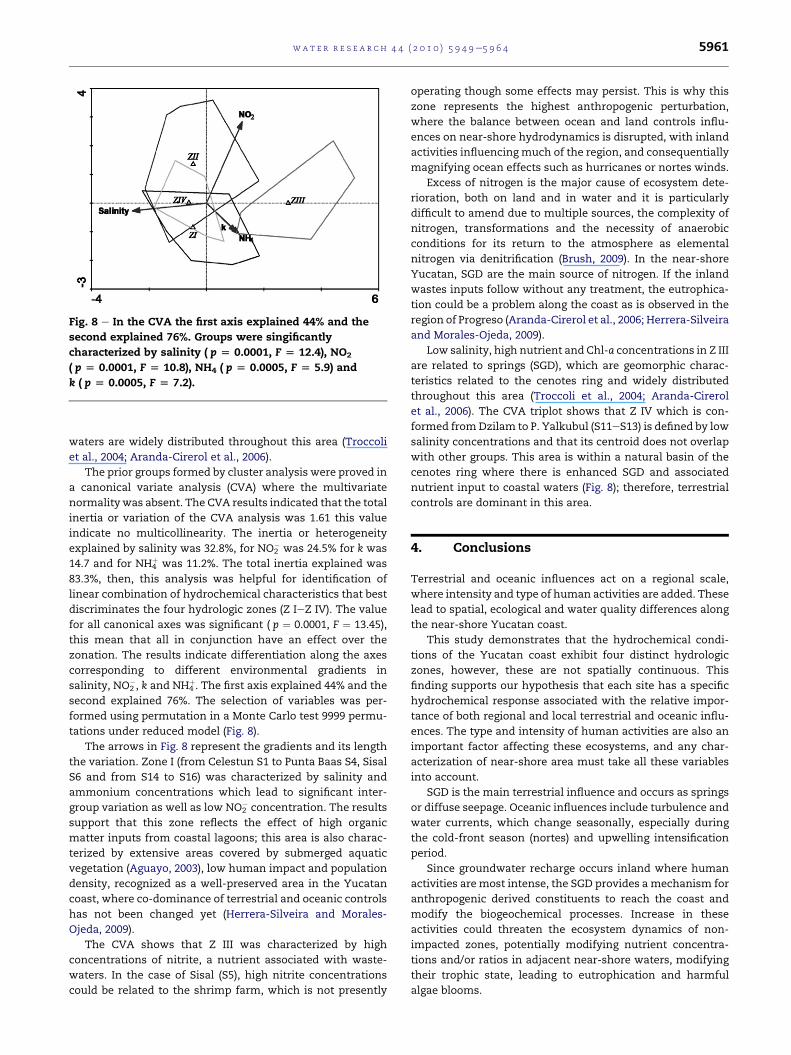
Fig. 8 e In the CVA the first axis explained 44% and the
second explained 76%. Groups were singificantly
characterized by salinity ( p [ 0.0001, F [ 12.4), NO2
( p [ 0.0001, F [ 10.8), NH4 ( p [ 0.0005, F [ 5.9) and
k ( p [ 0.0005, F [ 7.2).
wat e r r e s e a r c h 4 4 ( 2 0 1 0 ) 5 9 4 9e5 9 6 4 5961
waters are widely distributed throughout this area (Troccoli
et al., 2004; Aranda-Cirerol et al., 2006).
The prior groups formed by cluster analysis were proved in
a canonical variate analysis (CVA) where the multivariate
normality was absent. The CVA results indicated that the total
inertia or variation of the CVA analysis was 1.61 this value
indicate no multicollinearity. The inertia or heterogeneity
explained by salinity was 32.8%, for NO2� was 24.5% for k was
14.7 and for NH4þ was 11.2%. The total inertia explained was
83.3%, then, this analysis was helpful for identification of
linear combination of hydrochemical characteristics that best
discriminates the four hydrologic zones (Z IeZ IV). The value
for all canonical axes was significant ( p ¼ 0.0001, F ¼ 13.45),
this mean that all in conjunction have an effect over the
zonation. The results indicate differentiation along the axes
corresponding to different environmental gradients in
salinity, NO2�, k and NH4
þ. The first axis explained 44% and the
second explained 76%. The selection of variables was per-
formed using permutation in a Monte Carlo test 9999 permu-
tations under reduced model (Fig. 8).
The arrows in Fig. 8 represent the gradients and its length
the variation. Zone I (from Celestun S1 to Punta Baas S4, Sisal
S6 and from S14 to S16) was characterized by salinity and
ammonium concentrations which lead to significant inter-
group variation as well as low NO2� concentration. The results
support that this zone reflects the effect of high organic
matter inputs from coastal lagoons; this area is also charac-
terized by extensive areas covered by submerged aquatic
vegetation (Aguayo, 2003), low human impact and population
density, recognized as a well-preserved area in the Yucatan
coast, where co-dominance of terrestrial and oceanic controls
has not been changed yet (Herrera-Silveira and Morales-
Ojeda, 2009).
The CVA shows that Z III was characterized by high
concentrations of nitrite, a nutrient associated with waste-
waters. In the case of Sisal (S5), high nitrite concentrations
could be related to the shrimp farm, which is not presently
operating though some effects may persist. This is why this
zone represents the highest anthropogenic perturbation,
where the balance between ocean and land controls influ-
ences on near-shore hydrodynamics is disrupted, with inland
activities influencing much of the region, and consequentially
magnifying ocean effects such as hurricanes or nortes winds.
Excess of nitrogen is the major cause of ecosystem dete-
rioration, both on land and in water and it is particularly
difficult to amend due to multiple sources, the complexity of
nitrogen, transformations and the necessity of anaerobic
conditions for its return to the atmosphere as elemental
nitrogen via denitrification (Brush, 2009). In the near-shore
Yucatan, SGD are the main source of nitrogen. If the inland
wastes inputs follow without any treatment, the eutrophica-
tion could be a problem along the coast as is observed in the
region of Progreso (Aranda-Cirerol et al., 2006; Herrera-Silveira
and Morales-Ojeda, 2009).
Low salinity, high nutrient and Chl-a concentrations in Z III
are related to springs (SGD), which are geomorphic charac-
teristics related to the cenotes ring and widely distributed
throughout this area (Troccoli et al., 2004; Aranda-Cirerol
et al., 2006). The CVA triplot shows that Z IV which is con-
formed fromDzilam to P. Yalkubul (S11eS13) is defined by low
salinity concentrations and that its centroid does not overlap
with other groups. This area is within a natural basin of the
cenotes ring where there is enhanced SGD and associated
nutrient input to coastal waters (Fig. 8); therefore, terrestrial
controls are dominant in this area.
4. Conclusions
Terrestrial and oceanic influences act on a regional scale,
where intensity and type of human activities are added. These
lead to spatial, ecological and water quality differences along
the near-shore Yucatan coast.
This study demonstrates that the hydrochemical condi-
tions of the Yucatan coast exhibit four distinct hydrologic
zones, however, these are not spatially continuous. This
finding supports our hypothesis that each site has a specific
hydrochemical response associated with the relative impor-
tance of both regional and local terrestrial and oceanic influ-
ences. The type and intensity of human activities are also an
important factor affecting these ecosystems, and any char-
acterization of near-shore area must take all these variables
into account.
SGD is the main terrestrial influence and occurs as springs
or diffuse seepage. Oceanic influences include turbulence and
water currents, which change seasonally, especially during
the cold-front season (nortes) and upwelling intensification
period.
Since groundwater recharge occurs inland where human
activities aremost intense, the SGD provides a mechanism for
anthropogenic derived constituents to reach the coast and
modify the biogeochemical processes. Increase in these
activities could threaten the ecosystem dynamics of non-
impacted zones, potentially modifying nutrient concentra-
tions and/or ratios in adjacent near-shore waters, modifying
their trophic state, leading to eutrophication and harmful
algae blooms.
wat e r r e s e a r c h 4 4 ( 2 0 1 0 ) 5 9 4 9e5 9 6 45962
Acknowledgements
We would like to thank Primary Production Lab staff, CIN-
VESTAV-IPN, Merida. For field and laboratory assistance we
thank Javier Ramirez and IleanaOsorio.We thank Inia Soto for
English edition review. This was supported by CONACYT
FOMIX-YUC 66223 and 21336.
r e f e r e n c e s
Aguayo, C.M., 2003. Structure of Submerged Aquatic Vegetationas Bioindicator of Water Quality in a Tropical Coastal Zone.M.Sc. Thesis, Center of Research and Advanced Studies fromNational Polytechnic Institute, Merida, Mexico, 112 pp (inSpanish).
Alvarez-Gongora, C., Herrera-Silveria, J.A., 2006. Variations ofphytoplankton community structure related to water qualitytrends in a tropical karstic coastal zone. Marine PollutionBulletin 52, 48e60.
Andreo, B., Goldscheider, N., Vadillo, I., Vıas, J.M., Neukum, C.,Sinreich, M., Jimenez, P., Brechenmacher, J., Carrasco, F.,Hotzl, H., Perles, M.J., Zwahlen, F., 2006. Karst groundwaterprotection: first application of a Pan-European Approach tovulnerability, hazard and risk mapping in the Sierra de Lıbar(Southern Spain). Science of Total Environment 357 (1e3),54e73.
Aranda-Cirerol, N., Herrera-Silveira, J.A., Comın, F.A., 2006.Nutrient water quality in a tropical coastal zone withgroundwater discharge, northwest Yucatan, Mexico.Estuarine, Coastal and Shelf Science 68, 445e454.
Aranda-Cirerol, N., Comin, F., Herrera-Silveira, J., 2010. Nitrogenand phosphorus budgets for the Yucatan litoral: an approachfor groundwater management. Environmental Monitoring andAssessment. doi:10.1007/s10661.010-1349-z.
Asano, Y., Uchida, T., Ohte, N., 2003. Hydrologic and geochemicalinfluences on the dissolved silica concentration in naturalwater in a steep headwater catchment. Geochimica etCosmochimica Acta 67 (11), 1973e1989.
Bendoricchio, G., De Boni, G., 2005. A water-quality model for thelagoon of Venice, Italy. Ecological Modelling 184, 69e81.
Bilkovic, D.M., Roggero, M., Hershner, C.H., Havens, K.H., 2006.Influence of land use on macrobenthic communities innearshore estuarine habitats. Estuaries and Coasts 29 (6B),1185e1195.
Bong, Ch.W., Lee, Ch.W., 2008. Nearshore and offshorecomparison of marine water quality variables measuredduring SESMA 1. Malaysian Journal of Science 27 (3), 25e31.
Boyer, J.N., Fourqurean, J.W., Jones, R.D., 1999. Seasonal andlong-term trends in the water quality of Florida Bay. Estuaries22 (2B), 417e430.
Boyer, J.N., Fourqurean, J.W., Jones, R.D., 1997. Spatialcharacterization of water quality in Florida Bay andWhitewater Bay by multivariate analysis: zones of similarinfluence (ZSI). Estuaries 20, 743e758.
Breitburg, D.L., 1990. Near-shore hypoxia in the Chesapeake Bay:patterns and relationships among physical factors. Estuarine,Coastal and Shelf Science 30 (6), 593e609.
Bricker, S.B., Ferreira, J.G., Simas, T.C., 2003. An integratedmethodology for assessment of estuarine trophic status.Ecological Modelling 169, 39e60.
Brush, G.S., 2009. Historical land use, nitrogen, and coastaleutrophication: a paleoecological perspective. EstuariesCoasts 32, 18e28.
Calo, F., Parise, W., 2009. Management and problems ofgroundwater pollution in karst environments in the context ofa post-conflict scenario: the case of Mostar (BosniaHerzegovina). Habitat International 33, 63e72.
Capurro, L., 2002. A large coastal ecosystem: the Yucatanpeninsula. Advances and Perspectives 22, 69e75 (in Spanish).
Cardenas-Palomo, N., Herrera-Silveira, J.A., Reyes, O., 2010.Distribucion espacio-temporal de variables fisicoquımicas ybiologicas en el habitat del tiburon ballena Rhincodon typus(Orectolobiformes: Rhincodontidae) al norte del CaribeMexicano. Revista Biologia Tropical 58 (1), 399e412.
Cardoso, P.G., Pardal, M.A., Raffaelli, D., Baeta, A., Marques, J.C.,2004. Macroinvertebrate response to different species ofmacroalgal mats and the role of disturbance history. Journal ofExperimental Marine Biology and Ecology 308, 207e220.
Casazza, G., Silvestri, C., Spada, E., 2002. The use of bioindicatorsfor quality assessments of the marine environment: examplesfrom the Mediterranean Sea. Journal of Coastal Conservation8, 147e156.
Chen, C.T.A., 1996. The Kuroshio intermediate water is the majorsource of nutrients on the east China Sea continental shelf.Oceanologica Acta 19, 523e527.
Ciudad, G., Rubilar, O., Munoz, P., Ruiz, G., Chamy, R., Vergara, C.,Jeison, D., 2005. Partial nitrification of high ammoniaconcentration wastewater as a part of a shortcut biologicalnitrogen removal process. Process Biochemistry 40 (5),1715e1719.
Cochrane, J.D., 1969. Water and circulation on Campeche Bank inMay. Bulletin of the Japanese Society of Fisheries Oceanography,123e128. Spec. (Prof. Uda’s Commemorative Papers).
Coelho, S., Gamito, S., Perez-Ruzafa, A., 2007. Trophic state of Fozde Almargem coastal lagoon (Algarve, South Portugal) basedon the water quality and the phytoplankton community.Estuarine, Coastal and Shelf Science 71, 218e231.
Cravo, A., Madureira, M., Rita, F., Silva, A.J., Bebianno, M.J., 2003.Concentraciones de nutrientes en aguas costeras: Impacto delRıo Guadiana. Ciencias Marinas 29 (4), 483e495.
Cullen, P., 2002. Educating natural resource professionals forthe 21st century. In: Wilson, B.P., Curtis, A. (Eds.),Agriculture for the Australian Environment. Proceedings ofthe 2002 Fenner Conference on the Environment, Canberra,Australia, pp. 109e118.
Duarte, C.M., Agusti, S., Vaque, D., Agawin, N.S.R., Felipe, J.,Casamayor, E.O., Gasol, J.M.l., 2005. Experimental test ofbacteriaephytoplankton coupling in the southern ocean.Limnology and Oceanography 50, 1844e1854.
Edwards, A.C., Withers, P.J.A., 2008. Transport and delivery ofsuspendedsolids,nitrogenandphosphorus fromvarioussourcesto freshwaters in the UK. Journal of Hydrology 350, 144e153.
EEA (European Environment Agency), 1999. Nutrients in EuropeanEcosystems. In: Environment Assessment Report No. 4. EEA,Copenhagen, ISBN 92-9167-163-0.
Fisher, T.R., Peele, E.R., Ammerman, J.W., Harding, L., 1992.Nutrient limitation of phytoplankton in Chesapeake Bay.Marine Ecology Progress Series 82, 51e63.
Froelich, P.N., 1988. Kinetic control of dissolved phosphate innatural rivers and estuaries: a primer on the phosphate buffermechanism. Limnology and Oceanography 33 (4, part 2),649e668.
Giovanardi, F., Vollenweider, R.A., 2004. Trophic conditions ofmarine coastal waters: experience in applying the trophicIndex TRIX to two areas of the Adriatic and Tyrrhenian seas.Journal of Limnology and Oceanography 63 (2), 199e218.
Hanshaw, B.B., Back, W., 1980. Chemical mass-wasting of thenorthern Yucatan Peninsula by groundwater dissolution.Geology 8, 222e224.
Herrera-Silveira, J.A., 1993. Ecology of Primary Producers inCelestun Lagoon Mexico. Patterns of Spatial and Temporal
wat e r r e s e a r c h 4 4 ( 2 0 1 0 ) 5 9 4 9e5 9 6 4 5963
Variation. PhD Thesis, University of Barcelona, Spain, 225 pp.(in Spanish).
Herrera-Silveira, J.A., 1994. Nutrients from underground waterdischarges in coastal lagoon. Verhandlungen InternationalVereingung fur Theoretiche and Angesandte Limnologie 25,1398e1401.
Herrera-Silveira, J.A., 1996. Salinity and nutrients in a tropicalcoastal lagoon with groundwater discharges to the Gulf ofMexico. Hydrobiologia 324, 165e167.
Herrera-Silveira, J., Ramirez, J., Zaldivar, A., 1998. Overview andcharacterization of the hydrology and primary producercommunities of selected coastal lagoons of Yucatan, Mexico.Aquatic Ecosystem Health and Management, 353e372.
Herrera-Silveira, J., Comin, F., 2000. An introductory account ofthe types of aquatic ecosystems of Yucatan Peninsula (SEMexico). In: Munavar, M., Lawrence, S., Munavar, I., Malley, D.(Eds.), Aquatic Ecosystems of Mexico. Status and Scope.Backhuys Publishers, Liden, p. 435.
Herrera-Silveira, J.A., Comin, F.A., Aranda-Cirerol, N., Troccoli, L.,Capurro, L., 2004. Coastal waters quality assessment in theYucatan Peninsula, management implications. Ocean andCoastal Management 47, 625e639.
Herrera-Silveira, J.A., Morales-Ojeda, S.M., 2009. Evaluation ofthe health status of a coastal ecosystem in southeastMexico: assessment of water quality, phytoplankton andsubmerged aquatic vegetation. Marine Pollution Bulletin 59(1e3), 72e86.
Jeffrey, S.W., Humphrey, G.F., 1975. New spectrophotometricequation for determining chlorophylls a, b, c1 and c2 in higherplants, algae and natural phytoplankton. Biochemie undPhysiologie der Pflanzen 167, 191e194.
Jones, A., Dennison, W.C., Pantus, F., 2003. Assessment of Sewageand Septic Derived N in the Choptank and Patuxent Rivers.Final Report. Maryland Coastal Zone Management Program,Maryland Department of Natural Resources.
Kelble, C.R., Johns, E.M., Nuttle, W.K., Lee, T.N., Smith, R.H.,Ortner, P.B., 2007. Salinity patterns of Florida Bay. Estuarine,Coastal and Shelf Science 71, 318e334.
Lapointe, B.E., Thacker, K., 2002. Community-based water qualityand coral reef monitoring in the Negril Marine Park, Jamaica:land-based nutrient inputs and their ecological consequences.In: Porter, J., Porter, K. (Eds.), The Everglades, Florida Bay, andCoral Reefs of the Florida Keys: An Ecosystem Sourcebook.CRC Press, Boca Raton, FL.
Lewis, W.J., Farr, J.L., Foster, S.S.D., 1980. The pollution hazard tovillage water supplies in eastern Bostwana. Proceedings of theInstitution of Civil Engineers Part 2, 281e293.
Logan, B.W., 1969. Carbonate Sediments and Reefs, YucatanShelf, Mexico. American Association of Petroleum Geologists,250 pp.
Loubere, P., 2000. Marine control of biological production in theeastern equatorial Pacific. Nature 406, 497e500.
Marin, L.E., Perry, E.C., Pope, K.O., Duller, C.E., Booth, C.J.,Villasuso, M., 1990. Hurricane Gilbert: its effects on the aquiferin northern Yucatan, Mexico. In: Simpson, E.S., Sharp Jr., J.M.(Eds.), Selected Papers on Hydrogeology from the 28thInternational Geological Congress, Washington, D.C. VerlagHeinz Heise, Hannover, pp. 111e128. 506 pages.
Medina-Gomez, I., Herrera-Silveira, J.A., 2003. Spatialcharacterization of water quality in a karstic coastal lagoonwithout anthropogenic disturbance: a multivariate approach.Estuarine, Coastal and Shelf Science 58, 455e465.
Medina-Gomez, I., Herrera-Silveira, J.A., 2006. Primary productiondynamics in a pristine groundwater influenced coastal lagoonof the Yucatan Peninsula. Continental Shelf Research 26 (8),971e986.
Melaku Canu, D., Solidoro, C., Umgiesser, G., 2003. Modellingthe response of the lagoon of Venice ecosystem to
variation in the physical forcings. Ecological Modelling 170,265e290.
Merino, M., 1994. Afloramientos en la Plataforma de Yucatan,estructura y fertilizacion (sıntesis). In: Oceanologıa, vol. 1.Unidad de Educacion en Ciencias y Tecnologıa del Mar. S.E.P.,Mexico. 139e144.
Merino, M., 1997. Upwelling on the Yucatan Shelf: hydrographicevidence. Journal of Marine Systems 13, 101e121.
Moncheva, S., Doncheva, V., Shtereva, G., Kamburska, L., 2002.Application of eutrophication indices for assessment of theBulgarian Black Sea coastal ecosystem ecological quality.Water Science and Technology 46 (8), 19e28.
Monreal-Gomez, M.A., Salas-de-Leon, D.A., Velasco-Mendoza, H.,2004. La hidrodinamica del Golfo de Mexico. In: Caso, M.,Pisanty, I., Ezcurra, E. (Eds.), Diagnostico ambiental del Golfode Mexico. Harte Research Institute for Gulf of Mexico Studies,Secretarıa del Medio Ambiente y Recursos Naturales, InstitutoNacional de Ecologıa, Instituto de Ecologıa, A.C., Mexico, ISBN968-817-705-9, pp. 47e68.
Moore, W.S., 1999. The subterranean estuaryda reaction zone ofground water and sea water. Marine Chemistry 65, 111e125.
Morales-Ojeda, S.M., 2004. Effects of Hurricane Isidore onHidrobiological Characteristics on Four Localities of YucatanCoast. Thesis, Autonomous University of Yucatan (UADY)107 pp. (in Spanish).
Nixon, S.W., Ammenman, J.W., Atkinson, L.P., Berounsky, V.M.,Billen, G., Boicourt, W.C., Boynton, W.R., Church, T.M.,DiToro, D.M., Elmgren, R., Garber, J.H., Giblin, A.E., Jahnke, R.A., Owens, N.J.P., Pilson, M.E.J., Seitzinger, S.P., 1996. The fate ofnitrogen and phosphorus at the land sea margin of the northAtlantic Ocean. Biogeochemistry 35, 141e180.
Odum, E.P., 1972. Ecology (in Spanish), third ed. McGraw-HillInteramericana, Mexico, D.F., p. 639.
Paerl, H.W., 2006. Assessing and managing nutrient-enhancedeutrophication in estuarine and coastal waters: interactiveeffects of human and climatic perturbations. EcologicalEngineering 26, 40e54.
Paez-Osuna, F., 2001. The environmental impact of shrimpaquaculture: a global perspective. Environmental Pollution112, 229e231.
Pacheco, Avila, J., Pat, Canul, R., Cabrera, Sansores, A., 2002.Analisis del ciclo del nitrogeno en el medio ambiente conrelacion al agua subterranean y su efecto en los seres vivos.Ingenieria Revista Academica. Universidad Autonoma deYucatan 6 (3), 73e81.
Pacheco Martinez, J.I., Alonzo Salomon, L.A., 2003. AcademicMagazine of Engineering. Characterization of Karst Materialof Carrillo Puerto Formation in Yucatan, 7. AutonomousUniversity of Yucatan, Merida, Mexico (in Spanish)7e19.
Perry, E., 1990. Aspects of the hydrogeology of the northwestregion, Yucatan Peninsula, Mexico: its hydrogeologiccharacteristics and possible association with the Chuxchulubimpact crater. Geology 23 (1), 17e20.
Perry, E., Marin, L., McClain, J., Velazquez, G., 1995. Ring ofcenotes, northwest Yucatan, Mexico: its hydrogeologiccharacteristics and possible association with the Chixulubimpact crater. Geology 1 (23), 17e20.
Quinn, G.P., Keough, M.J., 2003. Experimental Design and DataAnalysis for Biologists. Cambridge University Press, UnitedKingdom, 520 pp.
Ragueneau, O., Lancelot, C., Egorov, V., Vervlimmeren, J.,Cociasu, A., Deliat, G., Krastev, A., Daoud, N., Rousseau, V.,Popovitchev, V., Brion, N., Popa, L., Cauwet, G., 2002.Biogeochemical transformations of inorganic nutrients in themixing zone between the Danube river and the north-westernBlack Sea estuarine. Coastal and Shelf Science 54 (3), 321e336.
Ruiz, F., 1979. Upwelling North of the Yucatan Peninsula. M.Sc.Thesis, Department of Oceanography, Texas A and M. 85 pp.
wat e r r e s e a r c h 4 4 ( 2 0 1 0 ) 5 9 4 9e5 9 6 45964
Ryther, J.H., Dunstan, W.M., 1971. Nitrogen, phosphorus andeutrophication in the coastal marine environment. Science171, 1198e1203.
Shellenbarger, G.G., Monismith, S.G., 2006. The importance ofsubmarine groundwater discharge to the nearshore nutrientsupply in the Gulf of Aqaba (Israel). Limnology andOceanography 51 (4), 1876e1886.
Slomp, C.P., Van Cappellen, P., 2004. Nutrient inputs to the coastalocean through submarine groundwater discharge: controlsand potential impact. Journal of Hydrology 295, 64e86.
Smith, S.V., Camacho-Ibar, V., Herrera-Silveira, J.A., Valdes, D.,David, L., Merino, M., Buddemeier, R.W., 1999. Quantifyinggroundwater flow using water budgets and multipleconservative tracers. In: Smith, S.V., Marshall Crossland, J.I., Crossland, C.J. (Eds.), Mexican and Central AmericanCoastal Lagoon Systems: Carbon, Nitrogen, and PhosphorusFluxes (Regional Workshop II). LOICZ Reports & StudiesNo. 13, pp. 96e105. Texel, The Netherlands.
Solidoro, C., Cossarini, G., 2001. Analisi ed interpretazione dei datianche mediante un modello di qualita dell’acqua. Melal.Techinical Report. Ministry for Infrastructure and TransportVenice Water Authority Concessionary Consorzio VeneziaNuova, 121 pp.
Spiteri, C., Slomp, C.P., Charette, M.A., Tuncayc, K., Meile, Ch, 2008.Flowandnutrient dynamics in a subterranean estuary (WaquoitBay, MA, USA): field data and reactive transport modeling.Geochimica et Cosmochimica Acta 72 (14), 3398e3412.
Statistical Graphics Corp., 1994e1999. StatGraphics Plus forWindows (Version 4.1).
Strickland, J., Parsons, T., 1972. A practical handbook of seawateranalysis. Bulletin of the Fisheries Research Board of Canada167, 310.
Stonestrom, D.A., White, A.F., Akstin, K.C., 1998. Determiningrates of chemical weathering in soils e solute transport versusprofile evolution. Journal of Hydrology 209, 331e345.
Tapia, F.U., Herrera-Silveira, J.A., Aguirre-Macedo, M.L., 2008.Water quality variability and eutrophic trends in karstictropical coastal lagoons of the Yucatan peninsula. Estuarine,Coastal and Shelf Science 76, 418e430.
ter Braak, C.J.F., Smilauer, P., 2002. CANOCO Reference Manualand CanoDraw for Windows User’s Guide: Software forCanonical Community Ordination (Version 4.5).Microcomputer Power, Ithaca, New York, USA.
Troccoli-Ghinaglia, L.E., 2001. Structural Changes of CoastalPhytoplankton from a Tropical Karst Zone: SpatialPerspectives. PhD. Thesis, Center of Research and advancedstudies from National Polytechnic Institute, Merida, Mexico,177 pp. (in Spanish).
Troccoli, G.L., Herrera-Silveira, J.A., Comıın, F.A., 2004. Structuralvariations of phytoplankton in the coastal seas of Yucatan,Mexico. Hydrobiologia 519, 85e102.
US Environmental Protection Agency (EPA), 2001. NutrientCriteria Technical Guidance Manual. US EPA-822-B-01e003.Available from:. In: Estuarine and Coastal Marine Watershttp://www.epa.gov/ost/standards/nutrients/marine/covercoastal.pdf.
Valdes, D., Dupont, J.-P., Laignel, B., Ogier, S., Leboulanger, T.,Mahler, B.J., 2007. A spatial analysis of structural controls onKarst groundwater geochemistry at a regional scale. Journal ofHydrology 340 (3e4), 244e255.
Valiela, I., Collins, G., Kremer, J., Lajtha, K., Geist, M., Seely, B.,Brawley, J., Sham, C.H., 1997. Nitrogen loading from coastalwatersheds to receiving estuaries: new method andapplication. Ecological Applications 17, 358e380.
Valiela, I., Foreman, K., LaMontagne, M., Hersh, D., Costa, J.,Peckol, P., DeMeo-Andreson, B., D’Avanzo, C., Babione, M.,Chi-Ho, S., Brawley, J., Lajtha, K., 1992. Couplings ofwatersheds and coastal waters: sources and consequences ofnutrient enrichment in Waquoit Bay, Massachussetts.Estuaries 15 (4), 443e457.
Valiela, I., Geist, M., Mcclelland, J., Tomasky, G., 2000. Nitrogenloading from watersheds to estuaries: verification of theWaquoit Bay nitrogen loading model. Biogeochemistry 49,277e293.
Vitousek, P.M., Mooney, H.A., Lubchenco, J., Melillo, J., 1997.Human domination of earth’s ecosystems. Science 277,494e499.
Vollenweider, R.A., Giovanardi, F., Montanari, G., Rinaldi, A., 1998.Characterization of the trophic conditions of marine coastalwaters with special reference to the new Adriatic Sea:proposal for a trophic scale, turbidity and generalized waterquality index. Environmetrics 9, 329e357.
Vuorio, K., Lagus, A., Lehtimaki, J.M., Suomela, J., Helminen, H.,2005. Phytoplankton community responses to nutrient andiron enrichment under different nitrogen to phosphorus ratiosin the northern Baltic Sea. Journal of Experimental MarineBiology and Ecology 322, 39e52.
White, A.F., Blum, A.E., 1995. Effects of climate on chemicalweathering in watersheds. Geochimica et CosmoschimicaActa 59 (9), 1729e1747.
White, D.L., Porter, D.E., Lewitus, A.J., 2004. Spatial and temporalanalyses of water quality and phytoplankton biomass in anurbanized versus a relatively pristine salt marsh estuary.Journal of Experimental Marine Biology and Ecology 298,255e273.
Xua, F.L., Lam, K.C., Zhao, Z.Y., Zhan, W., David Chen, Y., Tao, S.,2004. Marine coastal ecosystem health assessment: a casestudy of the Tolo Harbour, Hong Kong, China. EcologicalModelling 173, 355e370.
Yentsch, C.S., Lapointe, B.E., Poulton, N., Phinney, D.A., 2008.Anatomy of a red tide bloom off the southwest coast ofFlorida. Harmful Algae 7 (6), 817e826.