Tell el-Retaba, season 2016 - CEJSH
28
Tell el-Retaba, season 2016 EGYPT 109 PAM 26/1: Research Tell el-Retaba, season 2016 Sławomir Rzepka, 1 Jozef Hudec, 2 Łukasz Jarmużek, 3 Veronika Dubcová 4 and Lucia Hulková 5 1 Institute of Archaeology, University of Warsaw, 2 Slovak Academy of Sciences, Bratislava, 3 Independent researcher, 4,5 Institute of Egyptology, University of Vienna Abstract: Excavations of the Polish–Slovak Archaeological Mission in Tell el-Retaba in 2016 were continued in the western part of the site, uncovering remains of domestic and funerary struc- tures from the Second Intermediate Period in Area 4. Houses from the first half of the Eighteenth Dynasty were also investigated in this area. In Area 9, several houses from the ird Intermediate Period were explored and, for the first time, also substantial remains of a Late Period settlement, including at least one “tower house”. Keywords: Tell el-Retaba, Second Intermediate Period, Hyksos, New Kingdom, ird Intermediate Period, Late Period e Polish–Slovak Archaeological Mission has been exploring Tell el-Retaba, a large site in the middle of Wadi Tumilat in the Nile Delta, about 35 km west of Ismailiya, regularly since 2007. e excavation in the 2016 season focused on two areas, 4 and 9, both located in the western part of the site [Fig. 1]. Area 4 is a part of the tell closest to the modern settlement and is immediately endangered by present occupancy; in fact, local inhabitants have reclaimed a plot of land directly adjacent to the Migdol tower from the north. Yet, it is of considerable significance for understanding the archae- ological stratigraphic situation of the site as demonstrated by excavations in 2011 (Rzepka, Hudec, Wodzińska et al. 2014: 55–64; Rzepka, Hudec, Jarmużek et al. 2014: 87–93) and 2015 (Rzepka et al. 2016). e results indicated more or less undisturbed stratified remains from the early Eighteenth Dynasty and the Second Intermediate Period. ese layers are sealed by a mud-brick platform built underneath the northern Migdol tower and the adjoining defense wall (Petrie’s Wall 2) of the Twentieth Dynasty fortress of Ramesses III (Rzepka, Hudec, Wodzińska et al. 2014: 68–71). Brief excavations carried out during the 2016 season con- firmed this assumption. A sequence of three different architectural structures, dated to the Second Intermediate Period (SIP) and the early Eighteenth Dynasty, was unearthed. is stratigraphy is crucial for our understanding of the history and chronology of Tell el-Retaba.
-
Upload
khangminh22 -
Category
Documents
-
view
2 -
download
0
Transcript of Tell el-Retaba, season 2016 - CEJSH

Tell el-Retaba, season 2016EGYPT
109
PAM 26/1: Research
Tell el-Retaba, season 2016
Sławomir Rzepka,1 Jozef Hudec,2 Łukasz Jarmużek,3 Veronika Dubcová4 and Lucia Hulková5
1 Institute of Archaeology, University of Warsaw, 2 Slovak Academy of Sciences, Bratislava, 3 Independent researcher, 4,5 Institute of Egyptology, University of Vienna
Abstract: Excavations of the Polish–Slovak Archaeological Mission in Tell el-Retaba in 2016 were continued in the western part of the site, uncovering remains of domestic and funerary struc-tures from the Second Intermediate Period in Area 4. Houses from the first half of the Eighteenth Dynasty were also investigated in this area. In Area 9, several houses from the Third Intermediate Period were explored and, for the first time, also substantial remains of a Late Period settlement, including at least one “tower house”. Keywords: Tell el-Retaba, Second Intermediate Period, Hyksos, New Kingdom, Third Intermediate Period, Late Period
The Polish–Slovak Archaeological Mission has been exploring Tell el-Retaba, a large site in the middle of Wadi Tumilat in the Nile Delta, about 35 km west of Ismailiya, regularly since 2007. The excavation in the 2016 season focused on two areas, 4 and 9, both located in the western part of the site [Fig. 1]. Area 4 is a part of the tell closest to the modern settlement and is immediately endangered by present occupancy; in fact, local inhabitants have reclaimed a plot of land directly adjacent to the Migdol tower from the north. Yet, it is of considerable significance for understanding the archae-ological stratigraphic situation of the site as demonstrated by excavations in 2011 (Rzepka, Hudec, Wodzińska et al. 2014: 55–64; Rzepka, Hudec, Jarmużek et al.
2014: 87–93) and 2015 (Rzepka et al. 2016). The results indicated more or less undisturbed stratified remains from the early Eighteenth Dynasty and the Second Intermediate Period. These layers are sealed by a mud-brick platform built underneath the northern Migdol tower and the adjoining defense wall (Petrie’s Wall 2) of the Twentieth Dynasty fortress of Ramesses III (Rzepka, Hudec, Wodzińska et al. 2014: 68–71). Brief excavations carried out during the 2016 season con-firmed this assumption. A sequence of three different architectural structures, dated to the Second Intermediate Period (SIP) and the early Eighteenth Dynasty, was unearthed. This stratigraphy is crucial for our understanding of the history and chronology of Tell el-Retaba.

Sławomir Rzepka et aliiEGYPT
110
PAM 26/1: Research
Dates of work: 18–26 May and 18 September–16 October 2016Co-Directors: Dr. Sławomir Rzepka, archaeologist (Institute of Archaeology, University of Warsaw); Dr. Jozef Hudec, egyptologist (Slovak Academy of Sciences, Bratislava)SCA representatives: Sameh Ahmed Elsaid Hashem and Khaled FareedArchaeologists: Bartosz Adamski (Institute of Archaeology, Jagiellonian University, Kraków), Veronika Dubcová (Institute of Egyptology, University of Vienna), Lenka Horáková (Faculty of Arts, Comenius University, Bratislava), Lucia Hulková (Institute of Egyptology, University of Vienna), Barbara Jakubowska (independent), Łukasz Jarmużek (independent), Radka Knápek (Institute of Archaeology, Silesian University in Opava, Czech Republic), Markéta Kobierská (Faculty of Philosophy and Arts, Charles University in Prague), Marek Lintner (Aigyptos Foundation), Agnieszka Ryś (independent), Dr. Květa Smoláriková (Charles University, Prague), Piotr Sójka (independent), Lucia Žilincová (Faculty of Philosophy and Arts, Charles University in Prague)Pottery specialist: Dr. Anna Wodzińska (Institute of Archaeology, University of Warsaw)Archaeobotanist: Dr. Claire Malleson (independent)Archaeozoologist: Dr. Anna Gręzak (Institute of Archaeology, University of Warsaw)Civil engineer: Miroslav Černy (Aigyptos Foundation)Photographers: Tomáš Kmeť and Ľubomír Podhorský (both Aigyptos Foundation)Surveyor: Dr. Eva Stopková (Slovak University of Technology in Bratislava)Student trainees: Magdalena Konopová (Faculty of Arts, Palacký University Olomouc), Katarzyna Szymańska (Institute of Archaeology, University of Warsaw)
Team
AcknowledgmentsThe mission works under the auspices of the Polish Centre of Mediterranean Archaeology, University of Warsaw, in cooperation with the Institute of Archaeology, University of Warsaw; Slovak Academy of Sciences and the Aigyptos Foundation, Bratislava. The project has also been supported by the Polish National Science Centre (grant 2015/17/B/HS3/00597) and by the Slovak Research and Development Agency (grant APVV-5970-12; Slovak Research of Ancient Egyptian civilization).
Phase Dating Main featuresG3 Second Intermediate Period (SIP) Open settlement and cemeteryG2 SIP Open settlement and cemetery: enlargement
of some buildings from the previous phaseG1 SIP/early Eighteenth Dynasty Settlement and cemetery F4 Eighteenth Dynasty
(until Hatshepsut/Thutmosis III)Open settlement: Green House
F3 Eighteenth Dynasty (until Hatshepsut/Thutmosis III)
Open settlement: Black Houses
F2 Eighteenth Dynasty (Thutmosis III/Amenhotep II)
Scattered remains
F1 Late Eighteenth Dynasty No archaeological record yetE4 Nineteenth Dynasty Earliest defence wall: core of Petrie’s “wall 1”; infant cemeteryE3 Nineteenth Dynasty Fortress of Ramesses II: extension of “wall 1”; barracks/workshopsE2 Nineteenth Dynasty Fortress
Table 1. Site phasing system; in bold, phases mentioned in the report
Tell el-Retaba, season 2016EGYPT
111
PAM 26/1: Research
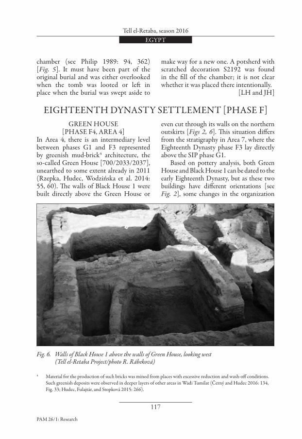
Fig. 1. General plan of the western part of the site marking areas excavated in 2016 (Tell el-Retaba Project/plan Ł. Jarmużek)
X100
X150
X200
Y150 Y200
AREA 4
AREA 9
AREA 7
0 50 m
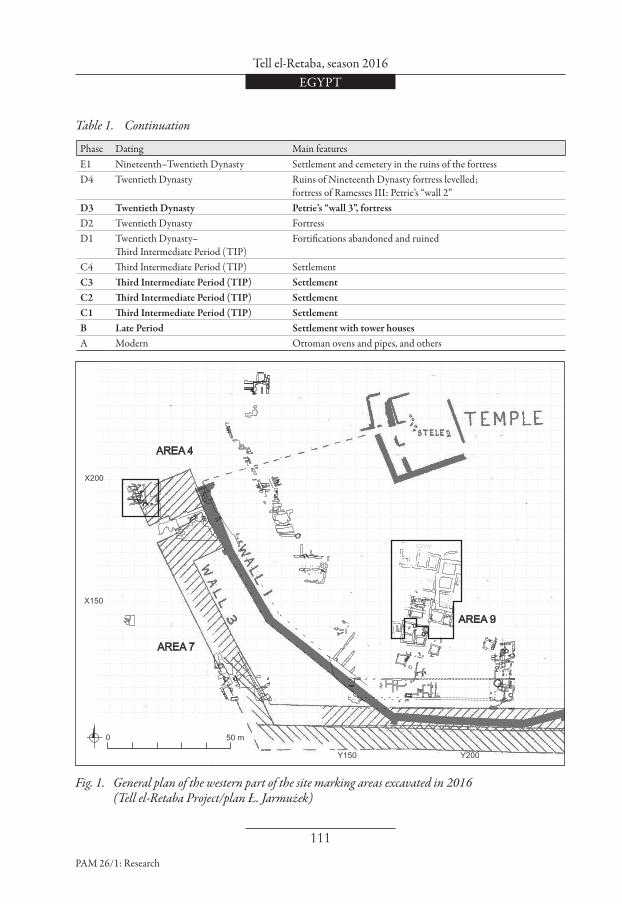
Phase Dating Main featuresE1 Nineteenth–Twentieth Dynasty Settlement and cemetery in the ruins of the fortressD4 Twentieth Dynasty Ruins of Nineteenth Dynasty fortress levelled;
fortress of Ramesses III: Petrie’s “wall 2”D3 Twentieth Dynasty Petrie’s “wall 3”, fortressD2 Twentieth Dynasty FortressD1 Twentieth Dynasty–
Third Intermediate Period (TIP)Fortifications abandoned and ruined
C4 Third Intermediate Period (TIP) SettlementC3 Third Intermediate Period (TIP) SettlementC2 Third Intermediate Period (TIP) SettlementC1 Third Intermediate Period (TIP) SettlementB Late Period Settlement with tower housesA Modern Ottoman ovens and pipes, and others
Table 1. Continuation

Sławomir Rzepka et aliiEGYPT
112
PAM 26/1: Research
SETTLEMENT (PHASE G3, AREA 4)
Mud-brick wall [2034]/[2065],1 probably part of a larger building from phase G3, was exposed in square Y60–X195 in 2016 [Fig. 2]. These poorly preserved remains need not be the earliest structure here in view of some yellowish bricks, possibly part of an older wall, observed eastward, underneath wall [2034] (see below). The orientation of the mud-brick walls from phase G3 in Area 4 seems to differ slightly from that of buildings already known from Area 7. This is hardly a surprise2 considering that the settlement seems to have grown organically rather than by plan (Bader 2015: 49). Excavations will be continued.
Mud-brick walls [2034]/[2045]/[2065]In the northwestern corner of the excavated part of Area 4, a mud-brick wall [2034] was excavated, and the associated room fills (2035), (2038), (2039) and (2040) were investigated. About 1.30 m of the wall extending to the NNW and 1.94 m of it to
the WSW were exposed. The architecture seems to continue northward, beyond the limits of the area excavated in 2016. The WSW part of the wall is one-brick thick, the NNW part only half-a-brick thick, although this could be due to later destruction. The wall is built of pale grey mud bricks (40×16×10 cm) in a stretcher bond. Only two courses of bricks, that is, about 0.21 m of the original height of the wall, have been preserved in most places. The row of bricks [2065] south of wall [2034] seems also to be part of the same large structure; so does wall [2045], but since the space between this wall and wall [2065] has yet to be excavated, this assumption cannot be proved until further work is done to clarify the situation. The architecture is apparently part of a domestic structure as suggested by the finds: scattered animal bones, grinders3 S2775 and S2833 and pottery, and associated features. Finds from layer (2007), presumably outside the building to the south, further indicated domestic/
SECOND INTERMEDIATE PERIOD [PHASE G]
Exploration in Area 9 concerned a place adjacent to a relatively well preserved house, [991], from the Third Intermediate Period (TIP) excavated in 2011. This spot was chosen as part of a new three-year research program scheduled for 2016–2018, finan-ced by the Polish National Science Centre. The plan is to explore a larger area, but
without going deeper than the levels of the Twentieth Dynasty. The aim is to get a fuller picture of the site’s settlement history during the Third Intermediate Period. The main results of the 2016 season are presented below following a phasing system developed for the site in the course of the excavation [Table 1].
1 Numbers in brackets refer to individual stratigraphic units: round brackets ( ) indicate fill or deposit layers, square brackets [ ] stand for mud-brick architecture, and corner brackets < > indicate cuts.
2 Differences in the orientation of single settlement structures can be observed also in other Second Intermediate Period (SIP) settlements, see Redmount 1989: 232–233, 236, 238, 240–241.
3 The term “grinder” denotes either a more or less well-rounded stone tool or a small stone tool of irregular shape, usually with flattened side(s), made of flint or quartzite in most cases. These objects were probably multifunctional tools used for grinding or hammering, possibly also for other activities. For identification as a hammer, see Prell 2011: 36.

Tell el-Retaba, season 2016EGYPT
113
PAM 26/1: Research
Fig. 2. Excavations in Area 4 (Tell el-Retaba Project/spatial data E. Stopková; drawing L. Hulková)
[1696]
[2009]
[2057]
[2034]
GREEN HOUSE[700]
season 2016
WOODEN POLES
BLACK HOUSE 1
[660]
[662]
[630]
[642]
Phase G3 - SIP - early settlement
Phase G2-G3 - SIP cemetery
Phase F4 - 18th dynasty settlementPhase F3 - 18th dynasty settlementPhase D4 - northern tower of migdol
[628]
[2041]
[2045]
[2065]
Y 60
Y 65
Y 70 Y 75
X 190
X 195
X 200
ROOM 1
ROOM 2
ROOM 3ROOM 4
0 5 m
industrial activities. They included a red ochre lump S2749, a scraper(?) made from a reused pottery sherd S2797 and a flint blade S2747. The architecture [2034]/[2045]/[2065] was already out of use by the time burials were made in this area. Wall [2034] was clearly cut by the construction of a large tomb [1696=1757], dug into sandy layer (2032). However, since layer
(2032) as well as its continuation to the east, that is, (2043) and (2064), contain typical rounded grinders, S2772, S2791, S2842 and S2845, bearing traces of use, it is probable that another contemporary domestic/industrial structure existed nearby. However, at this point, most of the architectural structures datable to this phase are concentrated in Area 7 further to the south.

Sławomir Rzepka et aliiEGYPT
114
PAM 26/1: Research
CEMETERY (PHASE G2, AREA 4)
A cemetery developed in the area, separated from the mud-brick architecture [2034]/[2045]/[2065] temporally but not spatially. The walls were already decayed and covered by a thin layer of sediment. The tombs apparently observed the same orientation patterns as in Area 7 (Rzepka, Hudec, Wodzińska et al. 2014: 43–44; Rzepka et al. 2015: 97–100) and were similar more or less to the tombs unearthed by an Egyptian mission further to the east (Nour el-Din et al. 2016: 75–114).
Mud brick tomb [2009] [Figs 2, 3]A relatively large mud-brick tomb with vaulted roof was excavated about 0.45 m south of wall [2045], which does not seem to be much older than the burial. It is unclear whether the building which wall [2045] once belonged to was still in use at the time when the tomb was built as the top edge of the tomb pit could not be established with certainty. Architecture. The SE–NW oriented tomb was constructed in a narrow rectan-gular tomb pit <2010> with rounded corners. The pit was dug into a reddish sandy gravel layer (2049) and was filled almost completely by the tomb structure. The inner dimensions of the rectangular burial chamber were 1.30 m by 0.56 m. The walls were one-brick thick and three courses high, built in an irregular bond of alternating stretchers and headers, with sporadic occurrence of yellowish and greyish mud-bricks. The vault was built directly on the burial chamber walls. This construction corresponds to the Tell el-Dabca type 4 (Forstner-Müller 2008: 29–30). The vault was further stabilized with a relatively thick covering layer of mud mortar.
Tomb content. Several individuals seem to have been buried in the tomb (anthropological analyses are still pending). A single heap of pelvis bones and human skull (2017) were found relatively high in the burial chamber, in fine loose fill (2016). Another and more complete interment (2019) was found deeper in the burial chamber. The bones of this individual, which filled the entire northern part of the burial chamber, were found displaced, although partly observing the original anatomical position: arms together under the skull in the south, legs placed together further to the north. This, as well as the discovery, next to the bones, of a bronze (or copper?) dagger S2722 with a limestone pommel S2720 (for parallels, see Philip 2006: 47–52) and the absence of a robbers’ pit, argues in favor of the burial not having been disturbed; skeletons from robbed tombs in Tell el-Retaba were in much greater disarray and without any significant accompanying finds (Rzepka, Hudec, Wodzińska et al. 2014: 44–45).
Mud brick tomb [2057] [Figs, 2, 4]A smaller mud-brick tomb [2057] was found in the eastern part of the excavated area, about 0.60 m east of wall [2065].
Architecture. Tomb [2057], aligned ENE–WSW, was built in a narrow rectan-gular burial pit <2052> with rounded corners. The burial chamber is trapezoidal, measuring inside 0.99 m by 0.38–0.58 m. The walls were built of two rows of rect-angular mud bricks (39×16×10 cm) in stretcher bond. Apart from the eastern gable, the walls of this tomb were only half-a-brick thick. A gabled roof built of pairs of sloping mud bricks propped against each other covered the burial chamber; a single brick laid atop the roof at the

Tell el-Retaba, season 2016EGYPT
115
PAM 26/1: Research
Fig. 3. Skeleton (2019) in tomb [2009] (Tell el-Retaba Project/photo L. Hulková)
Fig. 4. Young individual (2059) buried in tomb [2057] (Tell el-Retaba Project/photo L. Hulková)

Sławomir Rzepka et aliiEGYPT
116
PAM 26/1: Research
eastern end connected it to the gable. The trapezoid form of the burial chamber apart, this tomb corresponds to the Tell el-Dabca type 3.1 (Forstner-Müller 2008: 28). Tomb content. A young individual (2059) was buried in this tomb. The skeleton lay in semi-contracted position on its right side, the skull to the east, facing north. The legs were contracted and placed one upon the other. A pottery cup was placed by the head of the burial, in the northeastern corner.
Mud brick tomb [1696=1757]This large tomb was heavily destroyed by recent building activities. It was already partly excavated in 2015 (Rzepka et al. 2016). In 2016, the tomb was demonstrated to be significantly younger than the adjacent SIP architecture and the two tombs previously discussed. It evi-dently cut wall [2034] and seems to have been dug into layers covering the tombs [2009] and [2057]. Furthermore, the contemporary walking level, represented by ashy layers, was approximately level with the base of the vault. Architecture. The SE–NW oriented tomb once consisted of a rectangular burial chamber with inner dimensions of 0.90 m by 1.90m + 0.70 m. The northwestern corner of the structure is missing completely and the west wall is heavily damaged. Based on observation of the better preserved east wall, the chamber walls were one-brick thick and six courses high. The brick dimensions are 34×18×12 cm. Remains of mud mortar, once probably covering all the walls of the burial chamber, could be observed on the inside of the east and west walls. A mud-brick vault covered the burial chamber; its lowest part is preserved at the east end. The vault seems never to have
been buried completely underground, as there are thin ashy layers (from offerings?) level with the base of the vault, apparently not disturbed by the construction of the tomb and running toward the vault. The vault was damaged already in antiquity when the Green House (see below) was constructed (perhaps earlier). Tomb content. A largely disintegrated skeleton of a child [1699], together with scattered bones of two other individuals, were found in the burial chamber. Circular faience beads S2188, 24 in total, were discovered by the child burial. A small bronze socketed spearhead with a pointed leaf-shaped blade S2191 was discovered in the southeastern corner of the burial
Fig. 5. Spearhead S2191 from tomb [1696 =1757] (Tell el-Retaba Project/photo R. Rábeková)
Tell el-Retaba, season 2016EGYPT
117
PAM 26/1: Research
chamber (see Philip 1989: 94, 362) [Fig. 5]. It must have been part of the original burial and was either overlooked when the tomb was looted or left in place when the burial was swept aside to
make way for a new one. A potsherd with scratched decoration S2192 was found in the fill of the chamber; it is not clear whether it was placed there intentionally.
[LH and JH]
GREEN HOUSE[PHASE F4, AREA 4]
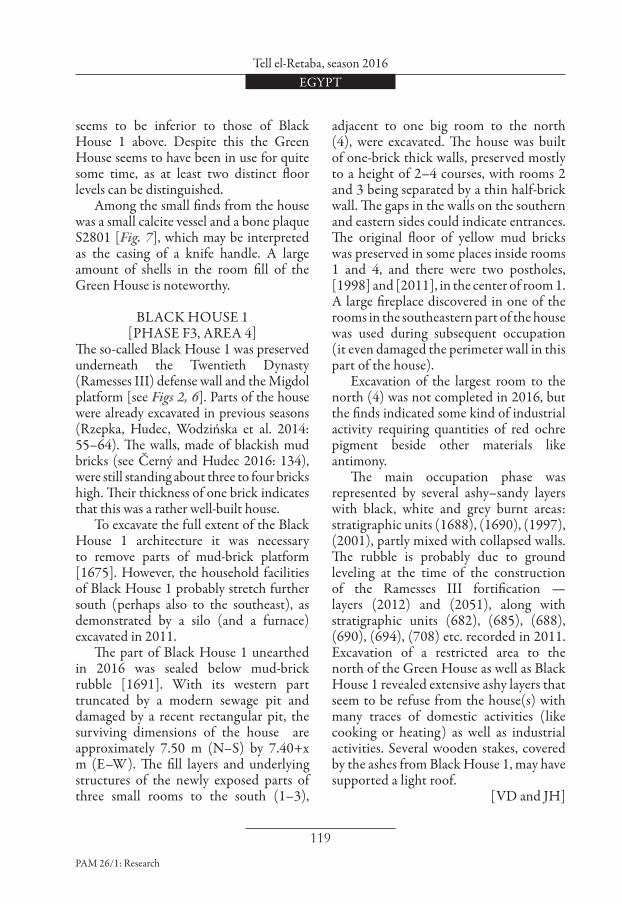
In Area 4, there is an intermediary level between phases G1 and F3 represented by greenish mud-brick4 architecture, the so-called Green House [700/2033/2037], unearthed to some extent already in 2011 (Rzepka, Hudec, Wodzińska et al. 2014: 55, 60). The walls of Black House 1 were built directly above the Green House or
even cut through its walls on the northern outskirts [Figs 2, 6]. This situation differs from the stratigraphy in Area 7, where the Eighteenth Dynasty phase F3 lay directly above the SIP phase G1. Based on pottery analysis, both Green House and Black House 1 can be dated to the early Eighteenth Dynasty, but as these two buildings have different orientations [see Fig. 2], some changes in the organization
EIGHTEENTH DYNASTY SETTLEMENT [PHASE F]
4 Material for the production of such bricks was mined from places with excessive reduction and wash-off conditions. Such greenish deposits were observed in deeper layers of other areas in Wadi Tumilat (Černý and Hudec 2016: 134, Fig. 33; Hudec, Fulajtár, and Stopková 2015: 266).
Fig. 6. Walls of Black House 1 above the walls of Green House, looking west (Tell el-Retaba Project/photo R. Rábeková)

Sławomir Rzepka et aliiEGYPT
118
PAM 26/1: Research
of the settlement structure presumably took place prior to the construction of Black House 1. More work is needed to investigate the nature of these changes more closely. As was the case with Black House 1, the architecture of the Green House was truncated on its western side by a drainage channel and a recent pit; its eastern part has not been fully excavated yet as it is partly covered by the northern tower of the Migdol. The Green House is approximately 7 m long (E–W) and 6.6 m wide (N–S), and was of a similar size as the overlying Black House 1, but its N–S axis is oriented more to the east [see Fig. 2] than that of
Black House 1. At least four “irregular” (not strictly rectangular) rooms were constructed of half-a-brick thick walls, preserved to a height of maximum six courses of bricks. As seen clearly from the eastern section of room 2, the first course of bricks of the Black House 1 walls stands almost directly on the walls of the Green House. It seems that the construction area of Black House 1 was not even consistently leveled off and the walls of the Green House were at least partly incorporated into the construction of Black House 1. Walls of the Green House are only half - -a-brick thick. The quality of these bricks
Fig. 7. Finds from the Green House: top, bone plaque S2801 and, bottom, alabaster kohl-pot (Tell el-Retaba Project/photo L. Hulková; drawing R. Knápek)
Tell el-Retaba, season 2016EGYPT
119
PAM 26/1: Research
seems to be inferior to those of Black House 1 above. Despite this the Green House seems to have been in use for quite some time, as at least two distinct floor levels can be distinguished. Among the small finds from the house was a small calcite vessel and a bone plaque S2801 [Fig. 7], which may be interpreted as the casing of a knife handle. A large amount of shells in the room fill of the Green House is noteworthy.
BLACK HOUSE 1 [PHASE F3, AREA 4]
The so-called Black House 1 was preserved underneath the Twentieth Dynasty (Ramesses III) defense wall and the Migdol platform [see Figs 2, 6]. Parts of the house were already excavated in previous seasons (Rzepka, Hudec, Wodzińska et al. 2014: 55–64). The walls, made of blackish mud bricks (see Černý and Hudec 2016: 134), were still standing about three to four bricks high. Their thickness of one brick indicates that this was a rather well-built house. To excavate the full extent of the Black House 1 architecture it was necessary to remove parts of mud-brick platform [1675]. However, the household facilities of Black House 1 probably stretch further south (perhaps also to the southeast), as demonstrated by a silo (and a furnace) excavated in 2011. The part of Black House 1 unearthed in 2016 was sealed below mud-brick rubble [1691]. With its western part truncated by a modern sewage pit and damaged by a recent rectangular pit, the surviving dimensions of the house are approximately 7.50 m (N–S) by 7.40+x m (E–W). The fill layers and underlying structures of the newly exposed parts of three small rooms to the south (1–3),
adjacent to one big room to the north (4), were excavated. The house was built of one-brick thick walls, preserved mostly to a height of 2–4 courses, with rooms 2 and 3 being separated by a thin half-brick wall. The gaps in the walls on the southern and eastern sides could indicate entrances. The original floor of yellow mud bricks was preserved in some places inside rooms 1 and 4, and there were two postholes, [1998] and [2011], in the center of room 1. A large fireplace discovered in one of the rooms in the southeastern part of the house was used during subsequent occupation (it even damaged the perimeter wall in this part of the house). Excavation of the largest room to the north (4) was not completed in 2016, but the finds indicated some kind of industrial activity requiring quantities of red ochre pigment beside other materials like antimony. The main occupation phase was represented by several ashy–sandy layers with black, white and grey burnt areas: stratigraphic units (1688), (1690), (1997), (2001), partly mixed with collapsed walls. The rubble is probably due to ground leveling at the time of the construction of the Ramesses III fortification — layers (2012) and (2051), along with stratigraphic units (682), (685), (688), (690), (694), (708) etc. recorded in 2011. Excavation of a restricted area to the north of the Green House as well as Black House 1 revealed extensive ashy layers that seem to be refuse from the house(s) with many traces of domestic activities (like cooking or heating) as well as industrial activities. Several wooden stakes, covered by the ashes from Black House 1, may have supported a light roof.
[VD and JH]

Sławomir Rzepka et aliiEGYPT
120
PAM 26/1: Research
Fig. 8. Area 9: structures belonging to the Third Intermediate Period (TIP) and Late Period settle-ments, phases C–B (Tell el-Retaba Project/drawing Ł. Jarmużek)
BUILDING[991]
[765]
[771]
[790]
[837]
- PHASE C4
- PHASE C3
- PHASE C2
- PHASE C1
- PHASE B
BUILDING[2074]
[2149]
[2143]
[2199]
2239
[2227][2196]
1686
2200
2199
2193
2192
2169
2150
2148
CHAMBER 3
CH. 2
CHAMBER 1
CH
. 4
2143
[1047]
BUILDING[2191]
ROOM 1
ROOM 2
BUILDING[1095]
ROOM 1
R. 2
ROOM 3
ROOM 4
Late Period
Third Intermediate
Period
seaso
n 2
016
0 5 m
BUILDING[2147]
ROOM 1
ROOM 2

Tell el-Retaba, season 2016EGYPT
121
PAM 26/1: Research
THIRD INTERMEDIATE PERIOD (PHASE C)SETTLEMENT
(PHASE C3, AREA 9)Two relatively large buildings from phase C3 were partly excavated in 2016 [Fig. 8]. They were situated 2 m to the north of building [991] discovered in earlier seasons (Rzepka, Hudec, Wodzińska et al. 2014: 86–88). The space between these buildings was destroyed by a modern cut. Thus, there is no direct stratigraphic relation between these structures. However, the similar orientation and level of the foundation of the buildings allow them to be placed in the same occupation phase.
Building [2227]The tops of two walls in the eastern part of the structure were cleared in preparation for future research [Figs 8, 9]. The western
part of the building was probably destroyed by modern cuts abounding in this area. The building was about 8.50 m long and at least 2 m wide, the thickness of walls being 0.60 m.
Building [2147]This building abutted the east wall of building [2227] [see Figs 8, 9]. It was roughly trapezoidal in plan, 8.50 m long and 4.80–5.50 m wide. Most of the building is relatively well preserved, some walls in the northern part of the building stand 1.30 m high. The condition of the southern part was much worse, the south wall being almost completely destroyed by a large modern cut. The building consisted of two rooms. Room 1, in the northern part of the building, measured 3.70–
Fig. 9. Building [2147], room 1 (phase C3); building [2196], room 2 (phase C2); building [2227] (phase C3–C2); building [2143] (phase B) (Tell el-Retaba Project/photo S. Rzepka)

Sławomir Rzepka et aliiEGYPT
122
PAM 26/1: Research
Fig. 10. Large storage jar (2213) and mud loom weights found in situ in building [2147], room 1 (Tell el-Retaba Project/photo S. Rzepka)
Fig. 11. Loom weights S3109, S3110, S3112 (Tell el-Retaba Project/photo S. Rzepka;
drawing A. Ryś)
2.30 m. Until now only its northern part has been excavated. In the northeastern corner of the room, a bin and a completely preserved large storage vessel (2213) were found [Fig. 10]. In the adjacent floor layer (2220), a relatively rich set of small finds was discovered, including nine weights (probably loom weights; for parallels, see Jarmużek 2010) made of unbaked mud [Fig. 11; see also Fig. 10]. They were found in one spot next to the north wall of the room, suggesting that a loom had once stood there. Not only weaving, but also spinning must have taken place in this room, as attested by a limestone spindle whorl S3132 found in the same floor layer.

Tell el-Retaba, season 2016EGYPT
123
PAM 26/1: Research
There were also other tools in the same context (three grinders, three fragments of querns, a slate palette), a fragment of a stone vessel and a faience scarab S3126 [Fig. 12]. Incised figural decoration on the scarab base depicts a king seated on a throne with a smaller human figure standing in front of him.5 All the features inside the room were covered with a relatively thick layer of debris (2216). It consisted mainly of sand and fragments of bricks. The entrance to the room was neither in the north nor the west walls, but at the present stage of research it is impossible to suggest its tentative location. It may be identified once the other half of the deposits inside the room is explored and the faces of the east and south walls are cleaned. Room 2 measured 4.35 m by 4.15 m. The excavation reached the level of debris covering this area, hence other walls may yet be found, bringing up the total number of explored rooms.
Building [2199]The structure was situated about 3 m to the north of building [2147] [see Fig. 8]. Only the tops of some of its walls have been cleared so far. The building measured at least 5.30 m by 5.00 m, the walls being about 0.60 m thick. The walls matched in alignment the walls of building [2147], but the level of the foundation was lower. Thus, building [2199] appears to be slightly older (built in phase C4), but both structures functioned concurrently in phase C3.
SETTLEMENT (PHASE C2, AREA 9)
Building [1095] Except for the northern part (which is covered by building [2074] from phase B, see below), building [1095] has been excavated to the foundation level, revealing a trapezoidal ground plan roughly 9 m by 7.70 m which remained unchanged over time [Fig. 13; see Fig. 8]. The four rooms of this building underwent significant alterations in terms of how they were interconnected. Three subphases were discerned on these grounds; during these subphases some old doorways were blocked, some new doorways were cut through walls, some installations (like bins, mastabas, fireplaces) were added, while others ceased to be used. Room 1 measured 3.90 m by 5.20 m. Floor (2183) of whitish-grey color filled the room. There were no remains of any installations. The floor layer contained a small amount of pottery, animal bones, ashes, and several small finds, mostly tools: two fragments of whetstones, two grinders,
Fig. 12. Scarab S3126 (Photo S. Rzepka)
5 For a close parallel to this type of decoration, see, for example, a scarab in the Egyptian Museum in Cairo CG 37104, Nineteenth Dynasty (Newberry 1907: 277, Pl. IX). See also: Petrie 1925: 26, Pl. XV (987); Petrie and Duncan 1906: Pl. XXXIII (68).

Sławomir Rzepka et aliiEGYPT
124
PAM 26/1: Research
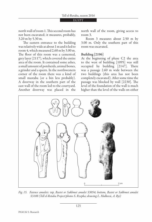
a pottery disk, a bronze needle and a loom weight S3107 [Fig. 14]. Noteworthy are two faience amulets from this context. The first one, S3054 [Fig. 15 top], is a pendant in the form of an aegis, that is, the head of a goddess with a broad-collar necklace. It is in this case a lion- or cat-headed goddess, with an uraeus and sun disc — either Bastet or Sakhmet.6 The other amulet, S3108 [Fig. 15 bottom], is also a pendant, but this time in the form of a full, standing figure of Bastet or Sakhmet. Room 2 was entered from room 1 via a doorway placed in the western end of the
6 Aegis amulets are quite common in the Third Intermediate Period and later. An aegis (made of silver) with the head of Bastet was found by W.M.F. Petrie in tomb 20 in Tell el-Retaba (Petrie and Duncan 1906: 32, Pl. XXXIVA).
Fig. 13. Building [1095] (phase C2), northern part (at right) covered by walls of building [2074] (phase B) (Tell el-Retaba Project/photo S. Rzepka)
Fig. 14. Loom weight S3107 (Tell el-Retaba Project, drawing L. Hulková)
0 2 cm
Tell el-Retaba, season 2016EGYPT
125
PAM 26/1: Research
Fig. 15. Faience amulets: top, Bastet or Sakhmet amulet S3054; bottom, Bastet or Sakhmet amulet S3108 (Tell el-Retaba Project/photos S. Rzepka; drawing L. Hulková, A. Ryś)
0 2 cm
north wall of room 1. This second room has not been excavated; it measures, probably, 3.20 m by 5.30 m. The eastern entrance to the building was relatively wide at about 1 m and it led to room 4, which measured 2.60 m by 3.00 m. The floor of this room was a cemented, grey layer (2117), which covered the entire area of the room. It contained some ashes, a small amount of potsherds, animal bones, a grinder and a quern. In the northwestern corner of the room there was a kind of small mastaba (or a bin less probably). A doorway in the southern part of the east wall of the room led to the courtyard. Another doorway was placed in the
north wall of the room, giving access to room 3. Room 3 measures about 2.50 m by 3.00 m. Only the southern part of this room was excavated.
Building [2196] At the beginning of phase C2 the area to the west of building [1095] was still occupied by building [2147]. There was a passage 2.60 m wide between the two buildings (this area has not been completely excavated). After some time the passage was blocked by wall [2230]. The level of the foundation of the wall is much higher than the level of the walls on either

Sławomir Rzepka et aliiEGYPT
126
PAM 26/1: Research
side. When building [2147] fell out of use, most of its walls were used for constructing building [2196] [see Figs 8, 9]. The ground plan of building [2196] differed slightly. Rooms 1 and 2 were delimited probably by the same walls as in the case of building [2147]. Room 3 was added where the passage between buildings [2147] and [1095] had once been. Compared to room 1 of building [2147], the only change is a reconstructed east wall, which was now much thinner, measuring 0.30 m in width. It could have held an entrance to the room, but most of it is lost. The northeastern part of the room was destroyed by a later cut. Other remains suggest the presence of an oven: the room was filled with a 20–30 cm thick layer of
ashes (mostly grey, but also black and white) in which fragments of fired mud bricks and the ceramic walls of an oven were found. Moreover, a fragmentary rounded cut <2211> was found in the middle of the room; it may be the lowermost part of an almost completely destroyed oven. Room 2 was limited by the same walls as room 2 in building [2147], which means that it measured 4.35 m by 4.15 m. Two approximately rectangular bins abutted its north wall.
Building [1047] Building [1047] was first traced but not fully documented in seasons 2011–2012 (Rzepka, Hudec, Wodzińska et al. 2014: 87); it was partly excavated in 2016
Fig. 16. Building [1047], abutting the west wall of building [991] (Tell el-Retaba Project/photo S. Rzepka)

Tell el-Retaba, season 2016EGYPT
127
PAM 26/1: Research
[Fig. 16; see Fig. 8]. It abutted the west wall of building [991], the walls however being founded at a much higher level than in the latter building, and following a different alignment. It is currently dated tentatively to phases C2 or C1. The overall ground plan of the building and of the individual rooms is trapezoidal. The part of the building excavated in season 2016 consisted of two rooms, but it is very probable that there are other rooms to the west. Room 1 measured 2.80 m by 3.00 m. No entrance to the room is in evidence; it was probably destroyed by one of the later cuts. Two floor levels were found inside the room. A round patch of black ashes (2120) on the floor in the southern part of the room [see Fig. 16] yielded several shapeless fragments of bronze and a piece of ceramic vessel with bronze slag attached to the wall face. These finds suggest that bronze-working activities took place in the room, however, no remains of a kiln for melting metal were discovered. The second room of the building was almost entirely destroyed by a large modern cut.
SETTLEMENT (PHASE C1, AREA 9)
Remains from phase C1 in Area 9 [see Fig. 8], discovered in seasons 2011–2012, demonstrated the continued use of build-ing [991]. Another room was added to it. Some poorly preserved structures were also found to the east of the building (Rzepka, Hudec, Wodzińska et al. 2014: 90–91).
Building [1095]Building [1095] was still in use during phase C1. Its general layout and the interconnection between rooms probably did not change from the last subphase of
phase C2 (see above). New floors were introduced in all of the rooms, on top of a layer of debris. Fireplace [2209] was found in the southwestern corner of room 1 [see Fig. 8]. It was lined with at least two layers of bricks. The fireplace was filled with a layer of ashes (2208), in which a net-weight S3074 made of limestone was found [Fig. 17] (see Jarmużek 2010). The last occupation of the room is marked by a layer of debris (2091) filling the room. This layer contained a relatively high number of small finds: six fragments of stone vessels, a grinder, a pounder and a fragment of a quern. Floor (2090) in room 4 was a cemented, whitish grey layer. Several big pieces of pottery vessels were found on it and several small pieces of iron were embedded in it. Small finds from the floor comprised four fragments of stone vessels, three querns, two flint tools, a grinder and a fragment of a ceramic animal figurine.
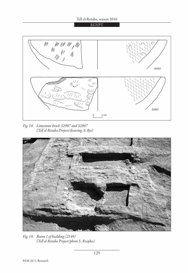
Floor (2093) inside room 3 is similar in its color and consistency to floors in other rooms. A faience ring and a crude limestone bowl S2907 [Fig. 18 top] were the only finds from this layer. Six more bowls of the same kind, among them S2867 [Fig. 18 bottom], were found in the debris layer (2070), which covered building [1095] when it was finally abandoned. Bowls of this kind are quite typical of the Third Intermediate Period contexts in Tell el-Retaba; more than 100 fragments have been found so far. They differ in size, but are all of similar, rather crude workmanship. Their outer surfaces are rough, often with visible traces of chiseling. Inside, the surfaces are often smooth, as if from frequent use. It is noteworthy that all the floors described above were created approximately

Sławomir Rzepka et aliiEGYPT
128
PAM 26/1: Research
0.40–0.50 m above the original foundation level of the building. The height of the walls from phase C2 obviously cannot be determined, but it is seems very likely that the roof level in phase C1 must have been raised.
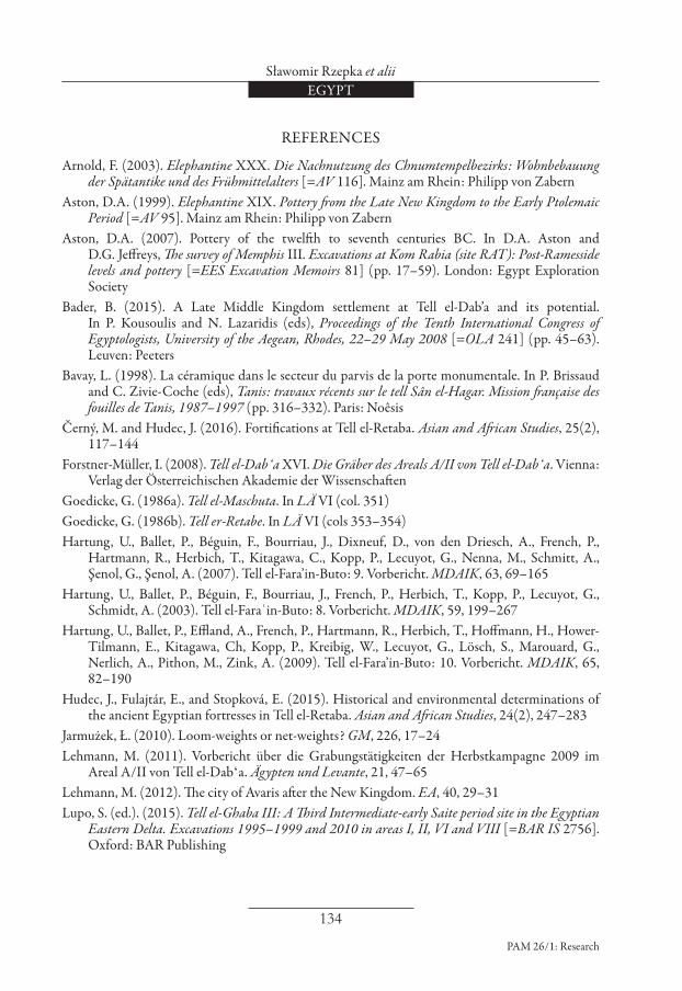
Building [2149] Remains from phase C1 in the area west of building [1095] were rather poorly preserved. Building [2196] from phase C2
went out of use. Building [2149] was built in its place. The building consisted of some new walls added to old walls from previous phases [Fig. 19; see Fig. 8]. The building comprised at least two rooms. Two layers of loose, grey ash were found inside room 1. These ash layers contained fragments of bowls with flaring rims; their shapes are very characteristic of the Third Intermediate Period (see Aston 1999: e.g., 50–51, also 65, 69; 2007: 34, Fig. 29;
Fig. 17. Net-weight S3074 (Tell el-Retaba Project/photo S. Rzepka; drawing A. Ryś)
0 2 cm
Tell el-Retaba, season 2016EGYPT
129
PAM 26/1: Research
Fig. 18. Limestone bowls S2907 and S2867 (Tell el-Retaba Project/drawing A. Ryś)
S2907
S2867
0 2 cm
Fig. 19. Room 1 of building [2149] (Tell el-Retaba Project/photo S. Rzepka)

Sławomir Rzepka et aliiEGYPT
130
PAM 26/1: Research
Bavay 1998: 323–324, Fig. 34.38–39). They are also very well known from Tell el-Retaba (Wodzińska in Rzepka et al. 2009: Fig. 30.7–8). After some time these vessels were covered with another layer of ash (2141). Rooms 1 and 2 may have been connected by a doorway in wall [2152], but the wall was so badly destroyed by
a later cut that it is impossible to determine the location of the doorway. Room 2 was 1.40 m wide and at least 2.50 m long. The east wall of the room is not preserved. It is possible that the wall abutted the west wall of building [1095]. Layers inside room 2 were completely destroyed by a later cut.
[ŁJ and SRz]
LATE PERIOD (PHASE B)SETTLEMENT
(PHASE B, AREA 9)Before the 2016 season the Late Period was attested in Tell el-Retaba only by some pottery found on the surface or in cuts. Apparently, in the parts of the tell excavated between 2008 and 2015, the Late Period architectural remains were completely obliterated by erosion. In 2016, for the first time, Late Period strata with substantial architectural remains of three large buildings were excavated.
Building [2191] Building [2191] was found in the north- ern part of the excavation trench [Fig. 20; see Fig. 8]. Only the tops of walls were cleared and documented. It seems at present that the building consisted of four rooms. It was 16.30 m long and 9.70 m wide. Wall thickness varied between 0.80 m and 1.00 m.
Building [2074] Building [2074], which was only partly excavated, was situated to the east of building [2191] [Fig. 21; see Figs 8, 13]. The building was about 20 m long and at least 10.50 m wide, but the eastern limit of the structure has yet to be located. The architectural features of the building indicate that it was a tower
house (Marouard 2014; Arnold 2003: 170–193). Very thick walls (up to 1.80 m) allowed a very high building to be constructed. The walls formed a casemate structure, that is, closed chambers without doorways between them. Casemates were often used to create a solid foundation for tower houses. In the case of building [2074], there were at least four chambers. Chamber 1 measured 3.10 m by 6.60 m and was roughly trapezoidal in plan [see Figs 8, 13]. Most of the chamber and its east wall were destroyed by a huge modern cut. After removing the wind-blown sand fill, the bottom levels of walls surrounding room 1 were exposed, revealing differences of up to one meter. These were due to some parts of the walls being constructed on top of the ruins of earlier structures, while other parts cut into old structures. Room 2 was roughly square in plan; it measured 4.40 m by 4.70 m. Almost the entire area of the chamber was covered with regularly laid bricks (2123) [Fig. 21]. Room 3 measured 4.20 m by 4.80 m. Room 4 was mostly destroyed. It was relatively narrow, being only 1.30 m wide. The area east of chamber 2 was cleared only on the surface. Two walls in this area suggest that there was another chamber there. In the case of the area east of room 3, it is still not clear

Tell el-Retaba, season 2016EGYPT
131
PAM 26/1: Research
Fig. 20. Building [2191] (Tell el-Retaba Project/photo S. Rzepka)
Fig. 21. Tower house [2074], chamber 2 (Tell el-Retaba Project/photo S. Rzepka)

Sławomir Rzepka et aliiEGYPT
132
PAM 26/1: Research
Fig. 22. Late Period artifacts: top, seated jackal amulet S3142; bottom, falcon amulet S3032 (Tell el-Retaba Project/photos S. Rzepka; drawing A. Ryś)
A
A
A - A
0 2 cm
whether it was covered by a layer of bricks or the east wall of the chamber was very thick. Directly to the north of the building there was a wall, of which the eastern part was straight and the western part was rounded; the latter abutted the north wall of building [2074]. The wall probably defined a courtyard connected with the building. Similar casemate structures of tower houses, dated to the Late Period, are known from several sites in the Nile Delta, such as Tell el-Dabca (Lehmann 2011; 2012), Buto (Hartung et al. 2003: 211–219; 2007: 120–126; 2009: 115–128), Tell el-Muqdam (Redmount and Friedman 1997) and Tell el-Ghaba (Lupo 2015: 63–95).
Building [2143] Building [2143] was situated 3.50 m to the southwest of building [2074] [see Figs 8, 9]. The destruction of the upper layers of the site in the area led to the loss of all direct stratigraphic relations between the buildings. The state of preservation of building [2143] was also very poor. Several fragmentary walls were uncovered. These walls were constructed in a manner similar to the walls of room 1 in building [2074] (see above); in some parts bricks were laid directly on top of debris from the Third Intermediate Period and in other parts foundation cuts were made. The number of small finds discovered in deposits linked with the said Late

Tell el-Retaba, season 2016EGYPT
133
PAM 26/1: Research
Period structures is still limited owing to the fact that the excavations have only just begun. However, the artifacts from the disturbed top layers above the Late Period ruins should be dated to this
period. Among them are two faience amulets, one (S3032) in the form of a falcon, the other (S3142) showing a seated jackal [Fig. 22].
[ŁJ and SRz]
CONCLUSIONSExcavations in Area 4 have contributed substantially to deciphering early stages of the Tell el-Retaba settlement history. The Second Intermediate Period tomb [1696=1757] has now been confirmed to be not an isolated unit, but part of a more extensive SIP cemetery, discovered in previous seasons. Further, it confirmed that the SIP settlement also continued northwards and was even older than the SIP cemetery. Of particular importance is the stratigraphy below Black House 1, which provides undisturbed levels from the period between the SIP and the early Eighteenth Dynasty. The layers indicate a continuum of occupancy rather than extinction horizon(s). Another section of the Third Inter-mediate Period settlement was uncovered
in Area 9. This made possible some new observations on the spatial organization within this settlement. The number of excavated houses is still limited, but it appears that typical domestic structures during all phases of the Third Intermediate Period comprised from two to four rooms with a habitable area varying from 26 m2 to 50 m2. A significant discovery in Area 9 are the large buildings (among them at least one “tower house”) from the Late Period. This discovery makes rather doubtful the widespread assumption that Tell el-Retaba was deserted during the Late Period, when its population moved to the nearby Tell el-Maskhuta (see Redford 1982: col. 1055; Goedicke 1986a; 1986b).
[SRz]
Assist. Prof. Sławomir Rzepka (SRz)Institute of Archaeology, University of Warsaw00-927 Warsaw, Poland, ul. Krakowskie Przedmieście 26/[email protected]. Jozef Hudec ( JH) Aigyptos Foundation953 03 Zlaté Moravce, Slovakia, Šafárikova [email protected] Łukasz Jarmużek (ŁJ) [email protected] Dubcová (VD) [email protected] Hulková (LH)[email protected]
Sławomir Rzepka et aliiEGYPT
134
PAM 26/1: Research
REFERENCES
Arnold, F. (2003). Elephantine XXX. Die Nachnutzung des Chnumtempelbezirks: Wohnbebauung der Spätantike und des Frühmittelalters [=AV 116]. Mainz am Rhein: Philipp von Zabern
Aston, D.A. (1999). Elephantine XIX. Pottery from the Late New Kingdom to the Early Ptolemaic Period [=AV 95]. Mainz am Rhein: Philipp von Zabern
Aston, D.A. (2007). Pottery of the twelfth to seventh centuries BC. In D.A. Aston and D.G. Jeffreys, The survey of Memphis III. Excavations at Kom Rabia (site RAT): Post-Ramesside levels and pottery [=EES Excavation Memoirs 81] (pp. 17–59). London: Egypt Exploration Society
Bader, B. (2015). A Late Middle Kingdom settlement at Tell el-Dab’a and its potential. In P. Kousoulis and N. Lazaridis (eds), Proceedings of the Tenth International Congress of Egyptologists, University of the Aegean, Rhodes, 22–29 May 2008 [=OLA 241] (pp. 45–63). Leuven: Peeters
Bavay, L. (1998). La céramique dans le secteur du parvis de la porte monumentale. In P. Brissaud and C. Zivie-Coche (eds), Tanis: travaux récents sur le tell Sân el-Hagar. Mission française des fouilles de Tanis, 1987–1997 (pp. 316–332). Paris: Noêsis
Černý, M. and Hudec, J. (2016). Fortifications at Tell el-Retaba. Asian and African Studies, 25(2), 117–144
Forstner-Müller, I. (2008). Tell el-Dabʻa XVI. Die Gräber des Areals A/II von Tell el-Dabʻa. Vienna: Verlag der Österreichischen Akademie der Wissenschaften
Goedicke, G. (1986a). Tell el-Maschuta. In LÄ VI (col. 351)Goedicke, G. (1986b). Tell er-Retabe. In LÄ VI (cols 353–354)Hartung, U., Ballet, P., Béguin, F., Bourriau, J., Dixneuf, D., von den Driesch, A., French, P.,
Hartmann, R., Herbich, T., Kitagawa, C., Kopp, P., Lecuyot, G., Nenna, M., Schmitt, A., Şenol, G., Şenol, A. (2007). Tell el-Fara’in-Buto: 9. Vorbericht. MDAIK, 63, 69–165
Hartung, U., Ballet, P., Béguin, F., Bourriau, J., French, P., Herbich, T., Kopp, P., Lecuyot, G., Schmidt, A. (2003). Tell el-Faraʿin-Buto: 8. Vorbericht. MDAIK, 59, 199–267
Hartung, U., Ballet, P., Effland, A., French, P., Hartmann, R., Herbich, T., Hoffmann, H., Hower-Tilmann, E., Kitagawa, Ch, Kopp, P., Kreibig, W., Lecuyot, G., Lösch, S., Marouard, G., Nerlich, A., Pithon, M., Zink, A. (2009). Tell el-Fara’in-Buto: 10. Vorbericht. MDAIK, 65, 82–190
Hudec, J., Fulajtár, E., and Stopková, E. (2015). Historical and environmental determinations of the ancient Egyptian fortresses in Tell el-Retaba. Asian and African Studies, 24(2), 247–283
Jarmużek, Ł. (2010). Loom-weights or net-weights? GM, 226, 17–24Lehmann, M. (2011). Vorbericht über die Grabungstätigkeiten der Herbstkampagne 2009 im
Areal A/II von Tell el-Dabʻa. Ägypten und Levante, 21, 47–65Lehmann, M. (2012). The city of Avaris after the New Kingdom. EA, 40, 29–31Lupo, S. (ed.). (2015). Tell el-Ghaba III: A Third Intermediate-early Saite period site in the Egyptian
Eastern Delta. Excavations 1995–1999 and 2010 in areas I, II, VI and VIII [=BAR IS 2756]. Oxford: BAR Publishing

Tell el-Retaba, season 2016EGYPT
135
PAM 26/1: Research
Marouard, G. (2014). Maisons-tours et organisation des quartiers domestiques dans les agglomerations du Delta: l’exemple de Bouto de la Basse Époque aux premiers Lagides. In S. Marchi (ed.), Les maisons-tours en Égypte durant la Basse Époque, les périodes ptolémaïque et romaine: actes de la table-ronde de Paris, Université Paris-Sorbonne (Paris IV), 29–30 novembre 2012 [=NeHeT 2] (pp. 105–133). Paris: Université de Paris-Sorbonne
Newberry, P.E. (1907). Catalogue général des antiquités égyptiennes du Musée du Caire. Nos. 36001–37521, Scarab-shaped seals. London: A. Constable and Co.
Nour el-Din, M., Hulkova, L., Wodzińska, A., Sefcáková, A., and Hudec, J. (2016). Egyptian Mission rescue excavations in Tell el-Retaba. Part 2: The Second Intermediate Period cemetery, Ägypten und Levante, 26, 75–114
Petrie, W.M.F. (1925). Buttons and design scarabs illustrated by the Egyptian collection in University College, London [=British School of Archaeology in Egypt Publications 38]. London: British School of Archaeology in Egypt
Petrie, W.M.F. and Duncan, J.G. (1906). Hyksos and Israelite cities [=British School of Archaeology Publications 12]. London: School of Archaeology
Philip, G. (1989). Metal weapons of the Early and Middle Bronze Ages in Syria-Palestine [=BAR IS 526]. Oxford: B.A.R.
Philip, G. (2006). Tell el-Dabʻa XV. Metalwork and metalworking evidence of the Late Middle Kingdom and the Second Intermediate Period [=Denkschriften der Gesamtakademie 36]. Vienna: Verlag der Österreichischen Akademie der Wissenschaften
Prell, S. (2011). Einblicke in die Werkstätten der Residenz: die Stein- und Metallwerkzeuge des Grabungsplatzes Q I [=Forschungen in der Ramses-Stadt 8]. Hildesheim: Gerstenberg
Redford, D.B. (1982). Pithom. In LÄ IV (cols 1054–1058)
Redmount, C.A. (1989). On an Egyptian/Asiatic frontier: An archaeological history of the Wadi Tumilat (unpubl. Ph.D. diss.). University of Chicago
Redmount, C.A. and Friedman, R.F. (1997). Tales of a Delta site: the 1995 field season at Tell el-Muqdam. JARCE, 34, 57–83
Rzepka, S., Hudec, J., Jarmużek, Ł., Dubcová, V., Hulková, L., Odler, M., Šefčáková, A., Sójka, P. (2016). Tell el-Retaba 2014–2015. PAM, 25, 193–225
Rzepka, S., Hudec, J., Jarmużek, Ł., Dubcová, V., Hulková, L., Odler, M., Wodzińska, A., Trzciński, J., Šefčáková, A., Sójka, P., Fulajtár, E., Černý, M., Tirpák, J. (2015). From Hyksos settlers to Ottoman pipe smokers. Tell el-Retaba 2014. Ägypten und Levante, 25, 97–166
Rzepka, S., Hudec, J., Jarmużek, Ł., and Piorun, M. with appendix by C. Malleson. (2014). Tell el-Retaba, season 2011. PAM, 23/1, 87–108
Rzepka, S., Hudec, J., Wodzińska, A., Jarmużek, Ł., Hulková, L., Dubcová, V., Piorun, M., Šefčáková, A. (2014). Tell el-Retaba from the Second Intermediate Period till the Late Period. Results of the Polish–Slovak Archaeological Mission, seasons 2011–2012. Ägypten und Levante, 24, 39–120
Rzepka, S., Wodzińska, A., Hudec, J., and Herbich, T. (2009). Tell el-Retaba 2007–2008. Ägypten und Levante, 19, 241–280