TELL-E ATASHI (BAM, SOUTHEASTERN IRAN) AND THE NEOLITHIC OF THE EASTERN NEAR EAST
14
Transcript of TELL-E ATASHI (BAM, SOUTHEASTERN IRAN) AND THE NEOLITHIC OF THE EASTERN NEAR EAST


IntroductionIn contrast to increasing archaeological research into theNeolithic period in the western part of Iran, including theZagros region, there is still little research into the Neolithicof Iran’s eastern regions. Due to the dry and desert landscapeof the east and southeast part of Iran, the low numbers ofsettlements and finally the difficulties in accessing the re-gion, archaeologists have not systematically attempted tolook for Neolithic sites. The publication of archaeologicalresearch on the Neolithic era has been confined to the Pot-tery Neolithic layers of Yahya and Tal-i Iblis while otherstudies have been confined to the Bronze Age such as theexcavations in Shahdad and Shahr-i Sokhta.
A disastrous earthquake in 2003 was a turning point inarchaeological research in this region. After the earth-quake and in order to complete the cultural heritage filefor UNESCO, Adle (2005) explored the cultural land-scape of Bam Citadel. He located some new sitesamongst which was a huge settlement, named Tell-e Ata-shi, which has no pottery on the surface but is covered ina significant amount of lithics. Adle interpreted it as aBronze Age settlement and suggested that the pottery wasremoved from the surface for unknown reasons. Somelithics were studied and classified as a Bronze Age as-semblage, without considering the possibility of aNeolithic dating. We went to the Darestan area in easternBam, Kerman Province, in order to revisit Tell-e Atashi.The result was the same: there was not even one potterysherd. We decided to excavate the site. The project is apart of the Arg-e Bam Rescue Project, under the auspicesof the Iranian Center for Archaeological Research(ICAR), under the direction of Omran Garazhian.
Geographic location and landscapeThe Lut Desert is one of the most arid and hottest desertsin the world, with no trace of surface water. At the presentday, the maximum amount of annual rainfall is approxim-ately 100mm. The southwestern margin of the Lut Desert,called Lut-e Zangi Ahmad, includes the area of Darestan.Darestan (58°37'20"E and 29°7'54"N) is a low-lying area,c.700m above sea level surrounded by volcanic mountainranges, Kapooti and Jamali. Alluvial sedimentary depositshave covered the region between these heights. The drybasin of two branches of the river Poshtrood, which oncecarried water in a west–east direction, can be observed inthe region. The northern branch is covered by pebble sed-iments coarser than those of the southern branch,indicative of episodic flooding. The basin of the southernbranch is covered by alluvial sand and contains less wa-ter. This branch reaches a low, flat area in which all thediscovered early sites of the region are located. From ageographical point of view, Tell-e Atashi is situatedbetween two dry basins. The region’s vegetation pattern isvery poor and contains scattered tamarix. The only agri-cultural product is palm, which is irrigated by deep wells.Most of these wells have salty water and soil salinity iscausing long-term problems. In the past, qanats were usedfor irrigation but now they are dry. The most importantfactor in the erosion is the wind erosion which causessand dunes.
Description of the siteTell-e Atashi is 675m above sea level and located in theDarestan region about 35km east of the city of Bam inKerman province (Fig. 1.1). The mound is currently pre-served to a length of 650m and a width of 530m. Based on
18
TELL-E ATASHI (BAM, SOUTHEASTERN IRAN) AND THENEOLITHIC OF THE EASTERN NEAR EAST
Omran Garazhian and Maryam Shakooie
18. Tell-e Atashi (Bam, Southeastern Iran) and the Neolithic of the Eastern Near East 274
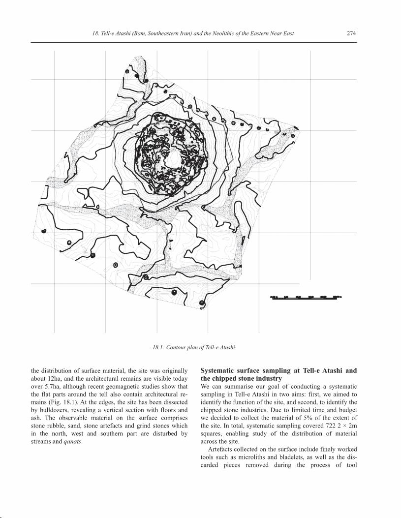
the distribution of surface material, the site was originallyabout 12ha, and the architectural remains are visible todayover 5.7ha, although recent geomagnetic studies show thatthe flat parts around the tell also contain architectural re-mains (Fig. 18.1). At the edges, the site has been dissectedby bulldozers, revealing a vertical section with floors andash. The observable material on the surface comprisesstone rubble, sand, stone artefacts and grind stones whichin the north, west and southern part are disturbed bystreams and qanats.
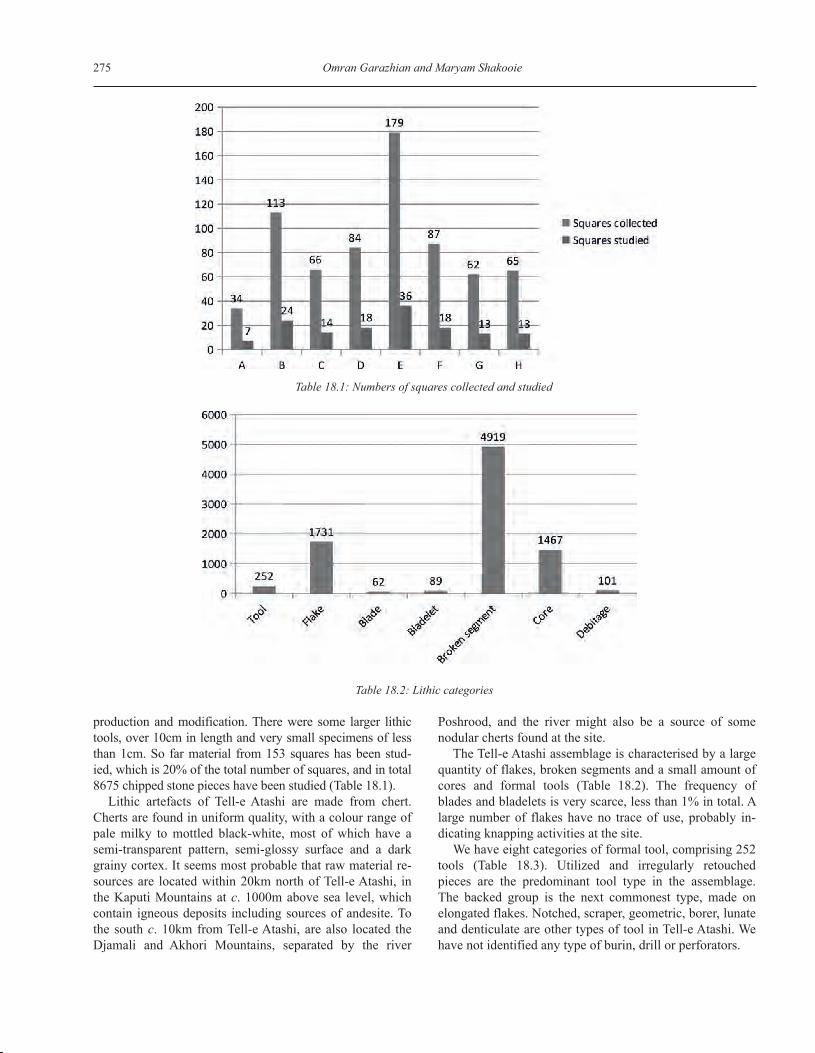
Systematic surface sampling at Tell-e Atashi andthe chipped stone industryWe can summarise our goal of conducting a systematicsampling in Tell-e Atashi in two aims: first, we aimed toidentify the function of the site, and second, to identify thechipped stone industries. Due to limited time and budgetwe decided to collect the material of 5% of the extent ofthe site. In total, systematic sampling covered 722 2 × 2msquares, enabling study of the distribution of materialacross the site.
Artefacts collected on the surface include finely workedtools such as microliths and bladelets, as well as the dis-carded pieces removed during the process of tool
18.1: Contour plan of Tell-e Atashi
275 Omran Garazhian and Maryam Shakooie
production and modification. There were some larger lithictools, over 10cm in length and very small specimens of lessthan 1cm. So far material from 153 squares has been stud-ied, which is 20% of the total number of squares, and in total8675 chipped stone pieces have been studied (Table 18.1).
Lithic artefacts of Tell-e Atashi are made from chert.Cherts are found in uniform quality, with a colour range ofpale milky to mottled black-white, most of which have asemi-transparent pattern, semi-glossy surface and a darkgrainy cortex. It seems most probable that raw material re-sources are located within 20km north of Tell-e Atashi, inthe Kaputi Mountains at c. 1000m above sea level, whichcontain igneous deposits including sources of andesite. Tothe south c. 10km from Tell-e Atashi, are also located theDjamali and Akhori Mountains, separated by the river
Poshrood, and the river might also be a source of somenodular cherts found at the site.
The Tell-e Atashi assemblage is characterised by a largequantity of flakes, broken segments and a small amount ofcores and formal tools (Table 18.2). The frequency ofblades and bladelets is very scarce, less than 1% in total. Alarge number of flakes have no trace of use, probably in-dicating knapping activities at the site.
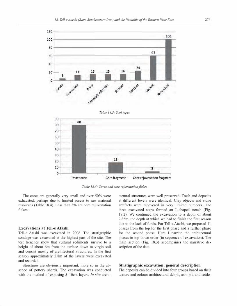
We have eight categories of formal tool, comprising 252tools (Table 18.3). Utilized and irregularly retouchedpieces are the predominant tool type in the assemblage.The backed group is the next commonest type, made onelongated flakes. Notched, scraper, geometric, borer, lunateand denticulate are other types of tool in Tell-e Atashi. Wehave not identified any type of burin, drill or perforators.
Table 18.1: Numbers of squares collected and studied
Table 18.2: Lithic categories
18. Tell-e Atashi (Bam, Southeastern Iran) and the Neolithic of the Eastern Near East 276
The cores are generally very small and over 50% wereexhausted, perhaps due to limited access to raw materialresources (Table 18.4). Less than 3% are core rejuvenationflakes.
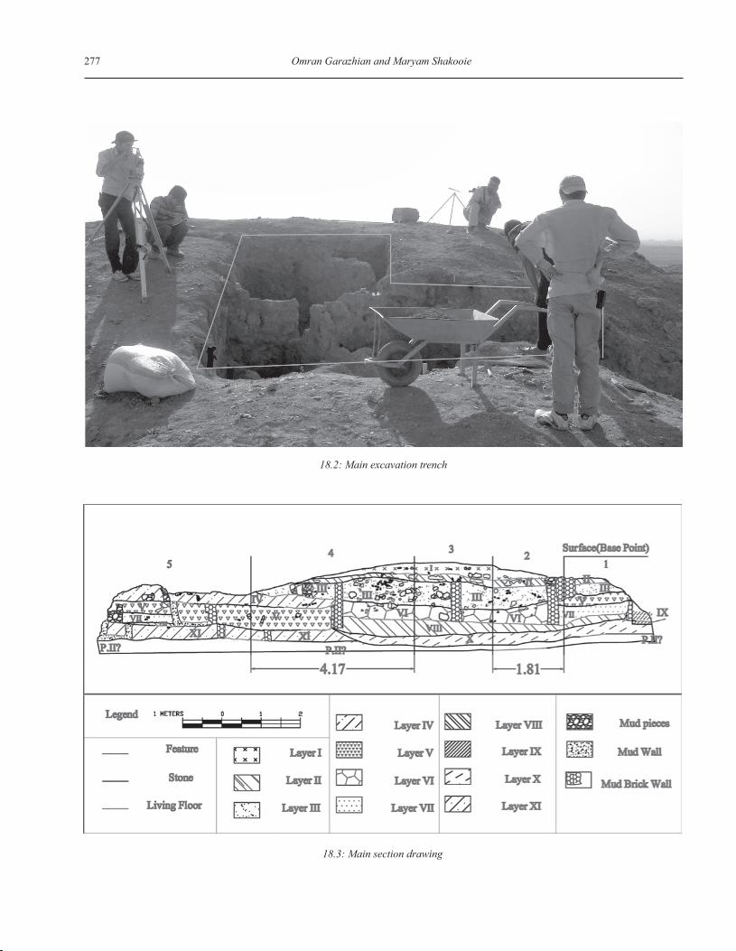
Excavations at Tell-e AtashiTell-e Atashi was excavated in 2008. The stratigraphicsondage was excavated at the highest part of the site. Thetest trenches show that cultural sediments survive to aheight of about 6m from the surface down to virgin soiland consist mostly of architectural structures. In the firstseason approximately 2.8m of the layers were excavatedand recorded.
Structures are obviously important, more so in the ab-sence of pottery sherds. The excavation was conductedwith the method of exposing 5–10cm layers. In situ archi-
tectural structures were well preserved. Trash and depositsat different levels were identical. Clay objects and stoneartefacts were recovered in very limited numbers. Thethree excavated steps formed an L-shaped trench (Fig.18.2). We continued the excavation to a depth of about2.85m, the depth at which we had to finish the first seasondue to the lack of funds. For Tell-e Atashi, we proposed 11phases from the top for the first phase and a further phasefor the second phase. Here I narrate the architecturalphases in top-down order (in sequence of excavation). Themain section (Fig. 18.3) accompanies the narrative de-scription of the data.
Stratigraphic excavation: general descriptionThe deposits can be divided into four groups based on theirtexture and colour: architectural debris, ash, pit, and settle-
Table 18.3: Tool types
Table 18.4: Cores and core rejuvenation flakes
277 Omran Garazhian and Maryam Shakooie
18.2: Main excavation trench
18.3: Main section drawing
18. Tell-e Atashi (Bam, Southeastern Iran) and the Neolithic of the Eastern Near East 278
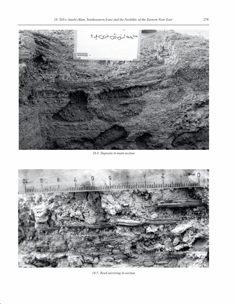
18.4: Deposits in main section
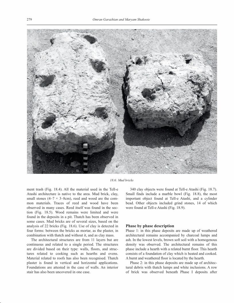
18.5: Reed surviving in section
279 Omran Garazhian and Maryam Shakooie
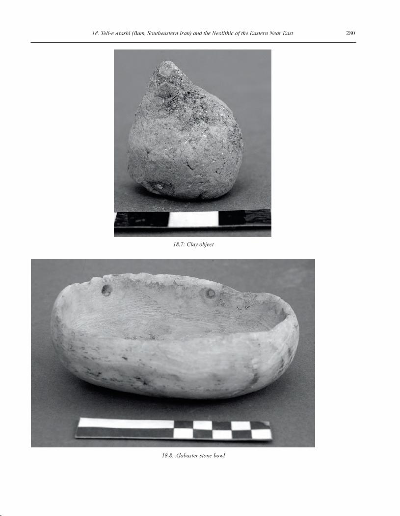
ment trash (Fig. 18.4). All the material used in the Tell-eAtashi architecture is native to the area. Mud brick, clay,small stones (4–7 × 3–8cm), reed and wood are the com-mon materials. Traces of reed and wood have beenobserved in many cases. Reed itself was found in the sec-tion (Fig. 18.5). Wood remains were limited and werefound in the deposits in a pit. Thatch has been observed insome cases. Mud bricks are of several sizes, based on theanalysis of 22 bricks (Fig. 18.6). Use of clay is detected infour forms: between the bricks as mortar, as the plaster, incombination with thatch and without it, and as clay mass.
The architectural structures are from 11 layers but arecontinuous and related to a single period. The structuresare divided based on their type: walls, floors, and struc-tures related to cooking such as hearths and ovens.Material related to roofs has also been recognised. Thatchplaster is found in vertical and horizontal applications.Foundations are attested in the case of walls. An interiorstair has also been uncovered in one case.
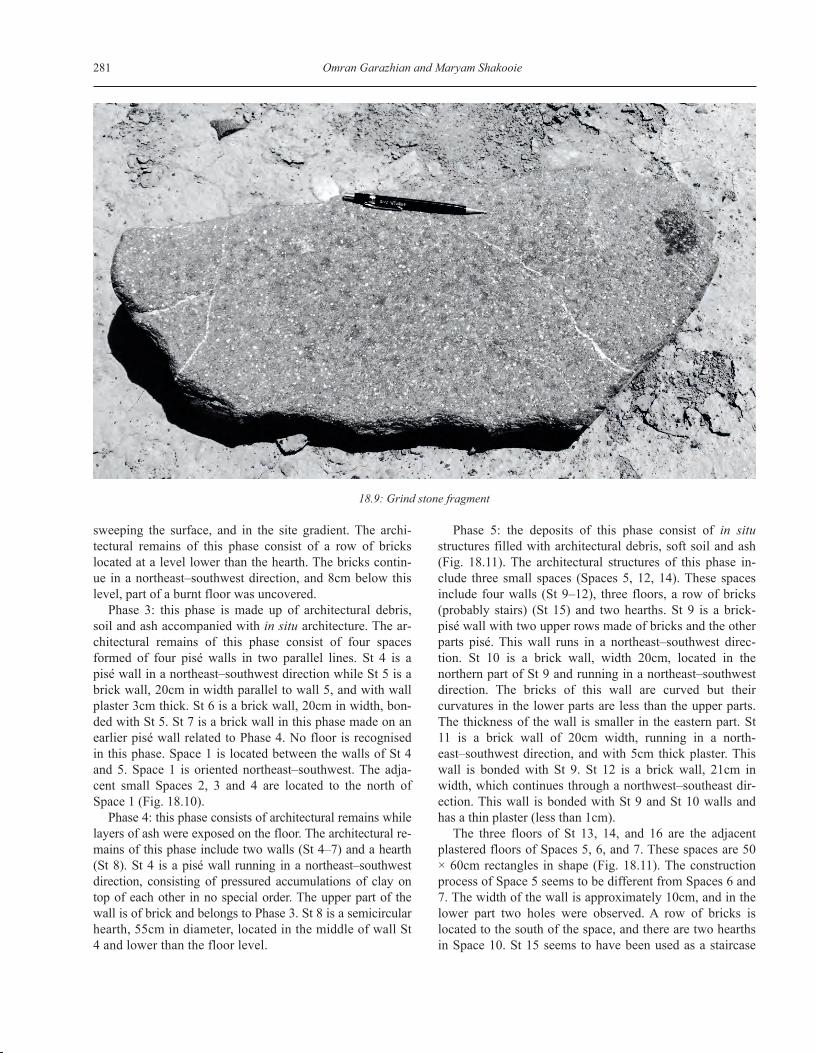
340 clay objects were found at Tell-e Atashi (Fig. 18.7).Small finds include a marble bowl (Fig. 18.8), the mostimportant object found at Tell-e Atashi, and a cylinderbead. Other objects included grind stones, 14 of whichwere found at Tell-e Atashi (Fig. 18.9).
Phase by phase descriptionPhase 1: in this phase deposits are made up of weatheredarchitectural remains accompanied by charcoal lumps andash. In the lowest levels, brown soft soil with a homogenousdensity was observed. The architectural remains of thisphase include a hearth with a related burnt floor. This hearthconsists of a foundation of clay which is heated and cooked.A burnt and weathered floor is located by the hearth.
Phase 2: in this phase deposits are made up of architec-tural debris with thatch lumps and white inclusions. A rowof brick was observed beneath Phase I deposits after
18.6: Mud bricks
18. Tell-e Atashi (Bam, Southeastern Iran) and the Neolithic of the Eastern Near East 280
18.7: Clay object
18.8: Alabaster stone bowl
281 Omran Garazhian and Maryam Shakooie
sweeping the surface, and in the site gradient. The archi-tectural remains of this phase consist of a row of brickslocated at a level lower than the hearth. The bricks contin-ue in a northeast–southwest direction, and 8cm below thislevel, part of a burnt floor was uncovered.
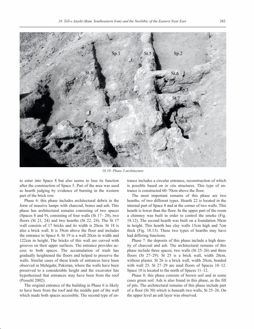
Phase 3: this phase is made up of architectural debris,soil and ash accompanied with in situ architecture. The ar-chitectural remains of this phase consist of four spacesformed of four pisé walls in two parallel lines. St 4 is apisé wall in a northeast–southwest direction while St 5 is abrick wall, 20cm in width parallel to wall 5, and with wallplaster 3cm thick. St 6 is a brick wall, 20cm in width, bon-ded with St 5. St 7 is a brick wall in this phase made on anearlier pisé wall related to Phase 4. No floor is recognisedin this phase. Space 1 is located between the walls of St 4and 5. Space 1 is oriented northeast–southwest. The adja-cent small Spaces 2, 3 and 4 are located to the north ofSpace 1 (Fig. 18.10).
Phase 4: this phase consists of architectural remains whilelayers of ash were exposed on the floor. The architectural re-mains of this phase include two walls (St 4–7) and a hearth(St 8). St 4 is a pisé wall running in a northeast–southwestdirection, consisting of pressured accumulations of clay ontop of each other in no special order. The upper part of thewall is of brick and belongs to Phase 3. St 8 is a semicircularhearth, 55cm in diameter, located in the middle of wall St4 and lower than the floor level.
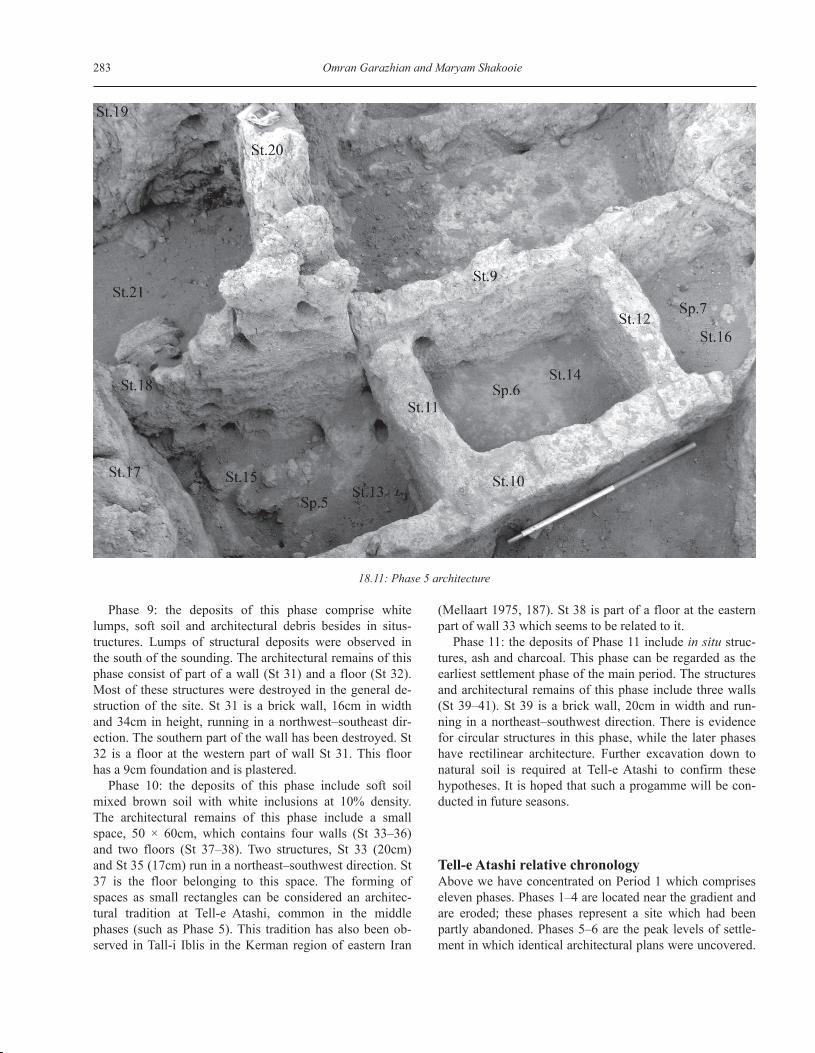
Phase 5: the deposits of this phase consist of in situstructures filled with architectural debris, soft soil and ash(Fig. 18.11). The architectural structures of this phase in-clude three small spaces (Spaces 5, 12, 14). These spacesinclude four walls (St 9–12), three floors, a row of bricks(probably stairs) (St 15) and two hearths. St 9 is a brick-pisé wall with two upper rows made of bricks and the otherparts pisé. This wall runs in a northeast–southwest direc-tion. St 10 is a brick wall, width 20cm, located in thenorthern part of St 9 and running in a northeast–southwestdirection. The bricks of this wall are curved but theircurvatures in the lower parts are less than the upper parts.The thickness of the wall is smaller in the eastern part. St11 is a brick wall of 20cm width, running in a north-east–southwest direction, and with 5cm thick plaster. Thiswall is bonded with St 9. St 12 is a brick wall, 21cm inwidth, which continues through a northwest–southeast dir-ection. This wall is bonded with St 9 and St 10 walls andhas a thin plaster (less than 1cm).
The three floors of St 13, 14, and 16 are the adjacentplastered floors of Spaces 5, 6, and 7. These spaces are 50× 60cm rectangles in shape (Fig. 18.11). The constructionprocess of Space 5 seems to be different from Spaces 6 and7. The width of the wall is approximately 10cm, and in thelower part two holes were observed. A row of bricks islocated to the south of the space, and there are two hearthsin Space 10. St 15 seems to have been used as a staircase
18.9: Grind stone fragment
18. Tell-e Atashi (Bam, Southeastern Iran) and the Neolithic of the Eastern Near East 282
to enter into Space 8 but also seems to lose its functionafter the construction of Space 5. Part of the area was usedas hearth judging by evidence of burning in the westernpart of the brick row.
Phase 6: this phase includes architectural debris in theform of massive lumps with charcoal, bones and ash. Thisphase has architectural remains consisting of two spaces(Spaces 8 and 9), consisting of four walls (St 17– 20), twofloors (St 21, 24) and two hearths (St 22, 24). The St 17wall consists of 17 bricks and its width is 20cm. St 18 isalso a brick wall. It is 39cm above the floor and includesthe entrance to Space 8. St 19 is a wall 20cm in width and122cm in height. The bricks of this wall are curved withgrooves on their upper surfaces. The entrance provides ac-cess to both spaces. The accumulation of trash hasgradually heightened the floors and helped to preserve thewalls. Similar cases of these kinds of entrances have beenobserved in Mehrgahr, Pakistan, where the walls have beenpreserved to a considerable height and the excavator hashypothesised that entrances may have been from the roof(Possehl 2002).
The original entrance of the building in Phase 6 is likelyto have been from the roof and the middle part of the wallwhich made both spaces accessible. The second type of en-
trance includes a circular entrance, reconstruction of whichis possible based on in situ structures. This type of en-trance is constructed 60–70cm above the floor.
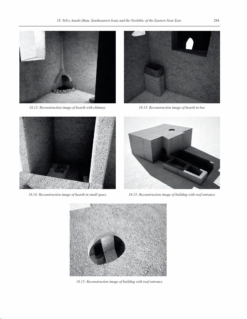
The most important remains of this phase are twohearths, of two different types. Hearth 22 is located in theinternal part of Space 8 and at the corner of two walls. Thishearth is lower than the floor. In the upper part of the rooma chimney was built in order to control the smoke (Fig.18.12). The second hearth was built on a foundation 50cmin height. This hearth has clay walls 15cm high and 7cmthick (Fig. 18.13). These two types of hearths may havehad differing functions.
Phase 7: the deposits of this phase include a high dens-ity of charcoal and ash. The architectural remains of thisphase include three spaces, two walls (St 25–26) and threefloors (St 27–29). St 25 is a brick wall, width 20cm,without plaster. St 26 is a brick wall, width 20cm, bondedwith wall 25. St 27–29 are mud floors of Spaces 10–12.Space 10 is located to the north of Spaces 11–12.
Phase 8: this phase consists of brown soil and in somecases green soil. Ash is also found in this phase, as the fillof pits. The architectural remains of this phase include partof a floor (St 30) which is beneath two walls, St 25–26. Onthe upper level an ash layer was observed.
18.10: Phase 3 architecture
283 Omran Garazhian and Maryam Shakooie
Phase 9: the deposits of this phase comprise whitelumps, soft soil and architectural debris besides in situs-tructures. Lumps of structural deposits were observed inthe south of the sounding. The architectural remains of thisphase consist of part of a wall (St 31) and a floor (St 32).Most of these structures were destroyed in the general de-struction of the site. St 31 is a brick wall, 16cm in widthand 34cm in height, running in a northwest–southeast dir-ection. The southern part of the wall has been destroyed. St32 is a floor at the western part of wall St 31. This floorhas a 9cm foundation and is plastered.
Phase 10: the deposits of this phase include soft soilmixed brown soil with white inclusions at 10% density.The architectural remains of this phase include a smallspace, 50 × 60cm, which contains four walls (St 33–36)and two floors (St 37–38). Two structures, St 33 (20cm)and St 35 (17cm) run in a northeast–southwest direction. St37 is the floor belonging to this space. The forming ofspaces as small rectangles can be considered an architec-tural tradition at Tell-e Atashi, common in the middlephases (such as Phase 5). This tradition has also been ob-served in Tall-i Iblis in the Kerman region of eastern Iran
(Mellaart 1975, 187). St 38 is part of a floor at the easternpart of wall 33 which seems to be related to it.
Phase 11: the deposits of Phase 11 include in situ struc-tures, ash and charcoal. This phase can be regarded as theearliest settlement phase of the main period. The structuresand architectural remains of this phase include three walls(St 39–41). St 39 is a brick wall, 20cm in width and run-ning in a northeast–southwest direction. There is evidencefor circular structures in this phase, while the later phaseshave rectilinear architecture. Further excavation down tonatural soil is required at Tell-e Atashi to confirm thesehypotheses. It is hoped that such a progamme will be con-ducted in future seasons.
Tell-e Atashi relative chronologyAbove we have concentrated on Period 1 which compriseseleven phases. Phases 1–4 are located near the gradient andare eroded; these phases represent a site which had beenpartly abandoned. Phases 5–6 are the peak levels of settle-ment in which identical architectural plans were uncovered.
18.11: Phase 5 architecture
18. Tell-e Atashi (Bam, Southeastern Iran) and the Neolithic of the Eastern Near East 284
18.12: Reconstruction image of hearth with chimney 18.13: Reconstruction image of hearth in box
18.14: Reconstruction image of hearth in small space 18.15: Reconstruction image of building with roof entrance
18.15: Reconstruction image of building with roof entrance
285 Omran Garazhian and Maryam Shakooie
Phases 7–11 show the first stage of the first period.All these data demonstrate that Tell-e Atashi can be de-
scribed as a Pre-Pottery Neolithic site. Regarding thechronology of Tell-e Atashi, it cannot be exactly estimated;we still do not have the absolute chronology due to limitedfunding. Epi-Palaeolithic or Pre-Pottery Neolithic evidencefrom southeastern Iran has been reported only from KuhBanan, based on surface survey and lithic studies (Huck-riede 1962). Otherwise, the lowest layers of Tal-i Iblis(Caldwell 1967) and a small range of material from Yahya(Lamberg-Karlovsky 1970; Prickett 1986) are the onlyNeolithic evidence from southeastern Iran. Pre-PotteryNeolithic data from Pakistan is limited to the Mehrgarh(Jarrige 1984) area in general.
Comparison and conclusions regarding chronologybased on the pottery collected from sites near to Tell-e Ata-shi, a traditional method, is the only course that remains.Reviewing data obtained by surface survey in the regionaround Tell-e Atashi has shown that the Neolithic pottery iscomparable with Tal-i Iblis Phase Zero. If this proposal isapproved, a proposed date for these sites at around 5500 to4500 BC will be suggested.
In support of this hypothesis, based on the architecturalstructures of Mehrgarh I (Kenoyer 2005), we can hesitantlysuggest a date of the second half of the sixth millenniumBC (5500–5000 BC). The upper phase and especially theoven observed in the first phases arguably show a settle-ment near the beginning of pottery production. We haveidentified several Ceramic Neolithic settlements in the 3kmradius of Tell-e Atashi (Garazhian 2009). In the first seasonat Tell-e Atashi natural soil was not reached. Deposits loc-ated under the first period belong to a second period, witheven older deposits. In summary, we believe that the ex-cavated levels at Tell-e Atashi predate 5500 BC, but weawait confirmation.
Reconstructions of Tell-e Atashi architecturalstructuresThe major evidence found at Tell-e Atashi comprises ar-chitectural remains. According to the data we havegathered from Tell-e Atashi the architectural spaces can bereconstructed generally, especially for Phases 3, 5 and 6,and a part of Phase 10. This reconstruction is a general onebecause of the small scale of excavation, but the repeateduse of the boxed feature, seen in three phases, along withthe domestic architecture, allows us the possibility of re-construction.
The plans of the units may have been built in two levels.The domestic architecture was probably located in the up-per part and the storage spaces in the lower part. The
hearths had a chimney set into the floor (Fig. 18.12) andwall (Fig. 18.13). Small hearths are recognized in the rec-tilinear spaces (Fig. 18.14), which may have been used fordaily activities.
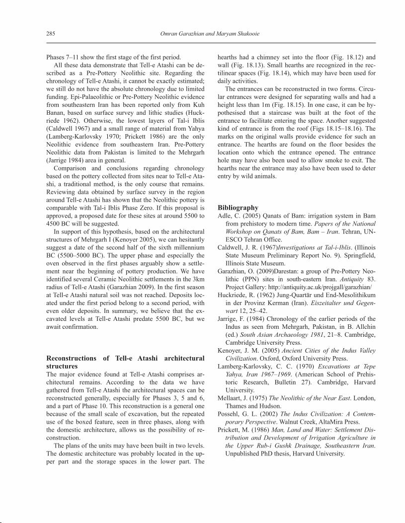
The entrances can be reconstructed in two forms. Circu-lar entrances were designed for separating walls and had aheight less than 1m (Fig. 18.15). In one case, it can be hy-pothesised that a staircase was built at the foot of theentrance to facilitate entering the space. Another suggestedkind of entrance is from the roof (Figs 18.15–18.16). Themarks on the original walls provide evidence for such anentrance. The hearths are found on the floor besides thelocation onto which the entrance opened. The entrancehole may have also been used to allow smoke to exit. Thehearths near the entrance may also have been used to deterentry by wild animals.
BibliographyAdle, C. (2005) Qanats of Bam: irrigation system in Bam
from prehistory to modern time. Papers of the NationalWorkshop on Qanats of Bam, Bam – Iran. Tehran, UN-ESCO Tehran Office.
Caldwell, J. R. (1967)Investigations at Tal-i-Iblis. (IllinoisState Museum Preliminary Report No. 9). Springfield,Illinois State Museum.
Garazhian, O. (2009)Darestan: a group of Pre-Pottery Neo-lithic (PPN) sites in south-eastern Iran. Antiquity 83.Project Gallery: http://antiquity.ac.uk/projgall/garazhian/
Huckriede, R. (1962) Jung-Quartär und End-Mesolithikumin der Provinz Kerman (Iran). Eiszeitalter und Gegen-wart 12, 25–42.
Jarrige, F. (1984) Chronology of the earlier periods of theIndus as seen from Mehrgarh, Pakistan, in B. Allchin(ed.) South Asian Archaeology 1981, 21–8. Cambridge,Cambridge University Press.
Kenoyer, J. M. (2005) Ancient Cities of the Indus ValleyCivilization. Oxford, Oxford University Press.
Lamberg-Karlovsky, C. C. (1970) Excavations at TepeYahya, Iran 1967–1969. (American School of Prehis-toric Research, Bulletin 27). Cambridge, HarvardUniversity.
Mellaart, J. (1975) The Neolithic of the Near East. London,Thames and Hudson.
Possehl, G. L. (2002) The Indus Civilization: A Contem-porary Perspective. Walnut Creek, AltaMira Press.
Prickett, M. (1986) Man, Land and Water: Settlement Dis-tribution and Development of Irrigation Agriculture inthe Upper Rub-i Gushk Drainage, Southeastern Iran.Unpublished PhD thesis, Harvard University.