Neighbourhood, city, diaspora: identity and belonging ... - CORE
Upload
khangminh22Category
view
2download
0
Teignmouth Neighbourhood Plan
Written Evidence Base Report: Local Evidence
Produced for: Teignmouth Town Council and Neighbourhood Plan Steering Group Produced by: Stuart Todd (Director) and Paul Weston (Associate Community Consultant)
27th July, 2018

Contents
Page Introduction 1
Context 1 What are we trying to find out? 3 The Plan Area 3 Basic Conditions 5 Deriving Topics 5
Natural Environment 7 Built Environment 28 Population and Housing 39 Economy, Employment and Retail 71 Transport, Infrastructure and Accessibility 84 Tourism, Arts and Culture 95 Sports, Leisure and Recreation 99 Community Facilities and Services 103 Renewable / Low Carbon Energy and Air Quality 110 Waste and Minerals 117
Summary of Key Issues and Messages 119
Appendix 1 - Historic England Listed Buildings Register (Listed Buildings in Teignmouth Parished Area) 117

1
Introduction Context The neighbourhood plan is a new type of plan introduced by the Localism Act 2011. It is the community’s plan and provides local people with the opportunity (if they wish) to introduce local planning policies which add to those set out in national and local authority-wide planning documents. Once it has passed through formal procedures of scrutiny required by law and it is approved (or ‘made’), it becomes part of the statutory development plan for the area, alongside the local authority’s Local Plan. The wider planning policy context within it sits is set out below.
Figure 1
Planning policy and proposals need to be based on a proper understanding of the place to where they relate, if they are to be relevant, realistic and address local issues effectively. It is important that the neighbourhood plan is based on robust information and analysis of the local area. Unless policy is based on real evidence and proper community engagement, then it is more likely to only reflect the aspirations, assumptions and prejudices of the plan’s authors than reflect the needs of the community. Importantly, the evidence base needs to be proportionate1 to the issues to be dealt with in the neighbourhood plan, although this can be a bit ‘chicken and egg’, as it is work on pulling together the evidence base which helps to set
1 The Neighbourhood Plan Roadmap (see http://locality.org.uk/resources/neighbourhood-planning-roadmap-guide/) produced by Locality suggests that “the evidence base needs to be proportionate to the size of the neighbourhood area and scope and detail of the Neighbourhood Plan. Other factors such as the status of the current and emerging Local Plan policies will influence the depth and breadth of evidence needed. It is important to remember that the evidence base needs to reflect the fact that the plan being produced here will have statutory status and be used to

2
out and confirm what some of those key issues are. The evidence for the neighbourhood plan is brought together in a number of ways and tends to ‘sit’ within one of two categories: 1. Local consultation (for example through public events and exhibitions, resident or business questionnaires and surveys, or talking to local groups, clubs and organisations); or, 2. Gathering information on the policies and factual data relevant to our area, otherwise known as the ‘written evidence base’ (for example from existing plans, programmes, strategies, guidance and statistics). These are illustrated in the diagram below. Figure 2
This report forms a key component to satisfy 2. above. It sets out “local” evidence base material, that is, information taken from publicly available data, studies, research and constraints maps, which together help to paint a picture of what Teignmouth is like in land-use planning terms. A further evidence base report has been produced alongside this report which focuses on “strategic” evidence base which focuses on the “wider-than-Teignmouth” planning policy documents such as national planning policy, Teignbridge District Council’s planning policies and other technical research and studies which cover a wider geographic area than just Teignmouth. It is important to recognise that this report provides a snapshot of available documents. There may be other written reports and policy advice which become available or are published after the time that this report has been compiled which may need to be taken into account as the neighbourhood plan develops. In this regard, developing the evidence base is an iterative process and sources of evidence are likely to need to be returned to as policies for the plan start to take shape.
decide planning applications in the neighbourhood area. It is necessary to develop a clear understanding of the neighbourhood area and policy issues covered; but not to review every piece of research and data in existence – careful selection is needed.”

3
What are we trying to find out? Teignmouth Town Council already has understanding of many of the key issues of relevance to the local community and to the development of a neighbourhood plan. Indeed, the starting point for exploring local evidence base material has been the Draft Community Plan produced in 2012, which contains a wealth of evidence base material which we have revised and sought to update where possible. We have also supplemented the evidence signposted and referenced in the Draft Community Plan with other sources that we are aware of which are relevant. The Community Plan’s strategic objectives have also formed the basis of our summary of key issues for each topic area and we have sought to understand where these have progressed to inform the development of our neighbourhood plan. Rather than simply repeat all evidence base material we have found, this report aims to provide a synopsis of local evidence so that it can be shared and better understood by those with an interest in neighbourhood planning in Teignmouth. Our review of written evidence base material focuses on exploring what key documents and data tell us about various topics, with a focus on gaining an understanding about things like: • Vision and objectives (i.e. a document’s overall ‘direction of travel’) • Policies and guidance • Constraints and formal designations • Assets (for example, things of value such as facilities, spaces, buildings or infrastructure) • Opportunities (for example, potential development or redevelopment sites) • Relevant statistics (to give us an understanding of the characteristics of our town) At this early stage in neighbourhood plan development, we have focused mainly on those documents and information which relate most closely to land-use planning matters. This has meant that we can concentrate our review of the written evidence on documents and information that we know will be of most relevance. There are other documents which we could review but which may say little directly relevant to our area or to land-use planning matters and others which may prove useful as policies are developed later in the process. There may be other, more local, evidence base documents and information that we can gather which is not reflected in this report. The Plan Area Our collection of written evidence material focuses on that which is likely to most affect Teignmouth. Our Plan area is set out in the map below.

4
Figure 3
Source: https://www.teignbridge.gov.uk/media/4681/teignmouth-proposed-neighbourhood-area.pdf
5
Basic Conditions A neighbourhood plan must meet the basic conditions before it can be put to a referendum and be made. The basic conditions are set out in paragraph 8(2) of Schedule 4B to the Town and Country Planning Act 1990 as applied to neighbourhood plans by section 38A of the Planning and Compulsory Purchase Act 2004. The basic conditions are:
• having regard to national policies and advice contained in guidance issued by the Secretary of State • the making of the neighbourhood plan contributes to the achievement of sustainable development • the making of the neighbourhood plan is in general conformity with the strategic policies contained
in the development plan for the area of the authority (or any part of that area) • the making of the neighbourhood plan does not breach, and is otherwise compatible with, EU
obligations • prescribed conditions are met in relation to the Plan and prescribed matters have been complied with
in connection with the proposal for the order neighbourhood plan A main purpose of this report endeavours to set out in an accessible form the prevailing guidance and the strategic policies that need to be recognised and/or adhered to. As regards EU policy in brief there are four directives that may be of particular relevance to neighbourhood planning: • Directive 2001/42/EC2 on the assessment of the effects of certain plans and programmes on the
environment (often referred to as the Strategic Environmental Assessment (SEA) Directive). This seeks to provide a high level of protection of the environment by integrating environmental considerations into the process of preparing plans and programmes. It may be of relevance to neighbourhood plans.
• Directive 2011/92/EU3 on the assessment of the effects of certain public and private projects on the environment (often referred to as the Environmental Impact Assessment (EIA) Directive). Environmental Impact Assessment is a procedure to be followed for certain types of proposed development. This is to ensure that decisions are made in full knowledge of any likely significant effects on the environment and that the public are given early and effective opportunities to participate in the decision making procedures. It may be of relevance to Neighbourhood Development Orders.
• Directive 92/43/EEC4 on the conservation of natural habitats and of wild fauna and flora and Directive 2009/147/EC on the conservation of wild birds (often referred to as the Habitats and Wild Birds Directives respectively). These aim to protect and improve Europe’s most important habitats and species.
• Human Rights the Plan should have regard to the fundamental rights and freedoms guaranteed under the European Convention on Human Rights and complies with the Human Rights Act 1998.
Other European directives, such as the Waste Framework Directive (2008/98/EC), Air Quality Directive (2008/50/EC) or the Water Framework Directive (2000/60/EC) may apply to the particular circumstances of a draft neighbourhood plan. Deriving Topics The topics under which the written evidence base has been grouped are based on a commonly used set of topic headings.
2 See http://eur-lex.europa.eu/legal-content/en/TXT/?uri=CELEX:32001L0042 3 See http://eur-lex.europa.eu/legal-content/EN/TXT/?uri=CELEX:32011L0092 4 See http://eur-lex.europa.eu/legal-content/EN/TXT/?uri=CELEX:31992L0043

6
Neighbourhood Plan Written Evidence Gathering Topic
Issues it could cover include (not exhaustive):
Natural environment Landscape, Ecology, Flora, Fauna, Habitat, Flood Risk, Land management
Built Environment Settlement / village characteristics, Historic Development of settlements / villages, Building design, Densities, Conservation Areas, Historic buildings, Heritage assets
Population and Housing Demographic characteristics, Development potential, Housing numbers, Housing demand, Housing types, Affordable housing and housing needs
Economy, Employment and Retail Local economy characteristics (for example, agricultural role or tourism role), Retail, Key sectors of local economy, Employment land and space, Businesses, Farming / agriculture, Deprivation,
Transport, Infrastructure and Accessibility
Transport – roads, public transport, community transport, cycle paths, footpaths and bridleways, Parking, Communications – broadband Utility and service provider infrastructure
Tourism, Arts and Culture Tourist, arts and cultural facilities
Sports, Leisure and Recreation Sports facilities and pitches, Recreation – spaces, assets, recreational walking opportunities, etc.
Community Facilities and Services
Schools, Churches, Nursery provision, Play facilities, Facilities for young people / youth, Local shop, Village hall, Pubs and restaurants, Socio-economic characteristics, Rural issues, Crime, Elderly care, Health and wellbeing, Young people, Young families
Renewable and Low Carbon Energy and air quality
Low carbon energy, Renewable energy, Energy efficiency, Energy supply, air quality
Waste and Minerals Waste planning, minerals planning There is naturally some overlap between a number of the topic areas, but categorising them in the way set out above helps to manage the task of compiling the written evidence in a structured way (in other words, the line has to be drawn somewhere when documenting the policies and guidance).

7
Natural Environment
Setting
Teignmouth is notable for its stunning location which results directly from the underlying geology. Contours within the town boundary range from below the mean high spring tide level in parts of the town centre, to around 820 feet (250m) above sea level on the golf course, at Little Haldon on the town’s northwestern extremity. With the distance between Teignmouth golf course and the town centre and seafront being only around 2 miles, much of Teignmouth is characterised by very steep and highly visible slopes, in combination with a series of steeply sided valleys.
Teignmouth is situated primarily on a bedrock of Permian red sandstones and breccias which yield a reasonably fertile red clay-loam soil, with a relatively neutral, or mildly alkaline ph. These Permian rocks are visible in the cliffs at Teignmouth, Shaldon and Dawlish. Higher parts of the town around Higher Exeter Road and on Haldon itself are located on Cretaceous greensand and Eocene gravels and flints, which yield a much less fertile soil, which is relatively acidic. Subsidence of properties in parts of Devon underlain by Permian bedrock has been known to occur, particularly during periods of drought, or when rainfall levels fluctuate significantly, but is infrequent. Mitigation can be provided within new build by good building design and high building standards.
Natural small watercourses (other than the Teign estuary, which is dealt with in a separate section) occur throughout the town. Many of these form in the higher reaches of Teignmouth where water percolates from Haldon through to the Permian layers. Examples include Brimley brook, much of which now flows through culverts under Teignmouth town centre, but is visible higher up in the town; the Winterbourne which historically flowed in winter, or periods of heavy rainfall down Shute Hill and Bitton Brook which flows along the Coombe Valley and empties into the river Teign close to Teignmouth Rugby Club. Historically most of east Teignmouth’s watercourses emptied through marshland into the Teign estuary in the area now occupied by the Fish Quay and Jolly Sailor Inn.
Statutory Environmental Designations
Teignmouth benefits from a designated Local Nature Reserve (LNR) at Coombe Valley, with the Little Haldon Heaths Site of Special Scientific Interest (SSSI) to the north west and outside of the plan area.
Figure 4
© Crown copyright and database right. All rights reserved (PSMA no. 0100050966) 2018 Source: http://www.natureonthemap.naturalengland.org.uk/

8
Biodiversity and Geodiversity
The following maps set out the habitat types and designations within and adjacent to the plan area.
Figure 5
© Crown copyright and database right. All rights reserved (PSMA no. 0100050966) 2018 Source: http://www.natureonthemap.naturalengland.org.uk/
Figure 6
© Crown copyright and database right. All rights reserved (PSMA no. 0100050966) 2018 Source: http://www.natureonthemap.naturalengland.org.uk/

9
Figure 7: County Wildlife Sites
© Crown copyright and database right. All rights reserved (PSMA no. 0100050966) 2018 Source: http://map.devon.gov.uk/dccViewer/

10
Figure 8
© Crown copyright and database right. All rights reserved (PSMA no. 0100050966) 2018 Source: https://www.teignbridge.gov.uk/media/1709/cirl-bunting-enhancement-zones-2006.pdf

11
Radon gas – a radioactive gas considered to be an issue in much of the south west peninsula and derived from degrading granite - is generally registered in low to negligible quantities throughout much of Teignmouth, due to the different underlying bedrock, although this does not mean that higher concentrations cannot be ruled out in certain circumstances. Areas immediately to the west of Teignmouth i.e. Newton Abbot exhibit somewhat higher levels of the gas and some mitigation maybe required in certain properties there.5 Public Health England has published reports into radon gas as well as an interactive map which suggests relatively low levels of radon gas underground in the Teignmouth area. The reports and map can be viewed via the following weblink http://www.ukradon.org/information/ukmaps . Landscape Natural England Landscape Character Areas6 National Character Areas (LCAs) divide England into distinct natural areas. Each is defined by a unique combination of landscape, biodiversity, geo-diversity and cultural and economic activity. Their boundaries follow natural lines in the landscape rather than administrative boundaries, making them a good decision making framework for the natural environment. LCA profiles provide a broad range of information that can be used by individuals and communities to help achieve a more sustainable future. The profiles include a description of the ecosystem services provided in each character area and how these benefit people, wildlife and the economy. They identify opportunities for positive environmental change (statements of environmental opportunity) and provide the best available information and evidence as a context for local decision making and action. Devon’s landscape character assessment describes the variations in character between different areas and types of landscape in the county. It provides an evidence base for local development frameworks and plans, articulating what people perceive as distinctive and special about all landscapes in Devon. It also set out strategies and guidelines for the protection, management and planning of the landscape The Landscape Character Areas for Teignbridge (see map below) were the subject of substantial analysis and strategy in 2009. Its purpose was to identify strategic guidelines for conservation, restoration, enhancement or renewal as appropriate and provide recommendations for each landscape character area to guide development and landscape management decisions. The map below shows the landscape character areas in and around Teignmouth. To the west and south of the town is the Teign Estuary LCA and to the north of the town the character area is the Haldon Ridge and Foothills LCA. The Teign Estuary LCA is described as: “The Teign Estuary includes the broad tidal river channel, intertidal areas and adjacent lower slopes. The estuary is defined by steeply rising high rounded hills with distinctive folds to the north and south. The river channel and the intertidal mudflats with their dynamic pattern of winding creeks dominate the landscape, and along with the enclosing hills and expansive cross-estuary views, provide a very strong sense of place. At high tide the estuary becomes a large expanse of water and the changing tides and presence of seabirds and waders add diversity and movement. To the south, there is a succession of sheltered inlets with shingle beaches at the mouths of combes; and intervening sandstone cliffs; while to the north gently rising slopes with an undulating shoreline give way to steeper hills around Bishopsteignton and Teignmouth. On these valley sides land use is predominantly pastoral with strong hedgerow patterns. This is often a busy landscape with movement along transport corridors and recreational activity on the estuary although greater tranquillity can be found within secluded combes and along parts of the estuary shore. This landscape has notable views to adjacent
5 Building Research Establishment 2012 - http://www.bre.co.uk/radon/Maps/BR211_Map2.pdf 6 www.naturalengland.org.uk/publications/nca/default.aspx

12
landscapes and other landscapes further afield, including Dartmoor; while at the mouth of the estuary Shaldon and Teignmouth frame views out to sea.”7 Figure 9: Landscape Character Areas Within and Around Teignmouth
KEY
Notes: Character types within and adjoining Teign Estuary Area = Purple - Coastal slopes and combes with settlement (4C); Orange – Coastal slopes and combes (4D); Brown – Estuaries (4A); Light Pink - Lower rolling farmed and settled valley slopes (3B); Dark Pink – Cliffs (4H); River valley slopes and combes (3G) © Crown copyright and database right. All rights reserved (PSMA no. 0100050966) 2018 … Source: Devon Landscape Character Area Assessment (DCLA), https://new.devon.gov.uk/planning/planning-policies/landscape/devons-landscape-character-assessment
The overall strategy for the LCA is “To protect and conserve the scenic quality and nature conservation value of this landscape. Opportunities to conserve and enhance estuary views and intertidal habitats, hedgerows, woodland and historic features are sought. New development respects the character and quality of estuary
7 See https://new.devon.gov.uk/planning/planning-policies/landscape/devon-character-areas/teignbridge-and-east-devon-area/teign-estuary

13
views. The pattern of fields, hedgerows and narrow lanes continues to reflect the area’s historic and vernacular character”. 8 The guidelines for the Teign Estuary LCA are as follows9: “Protect • Protect the open character of the estuary and the important expansive cross-estuary and sea views. • Protect the scattered rural settlement pattern of houses, farmsteads and hamlets and ensure that new
development reflects the vernacular character. • Protect and enhance the landscape setting of Teignmouth, Shaldon, Ringmore and Bishopsteignton,
ensuring new development enhances features such as hedgerows and woodlands. • Protect, and where appropriate, restore historic features along the estuary edges, including quays and
bridges. Provide sensitive interpretation to help tell the story of the landscape and its cultural significance. Manage • Manage mature hedgerow network, particularly ancient boundaries, and encourage traditional hedgerow
management practices. • Manage broadleaved woodland particularly along the water’s edge and on ridgelines. • Manage the estuary’s important habitats including saltmarshes and mudflats, ensuring marshes are
grazed at appropriate levels. • Manage agricultural land fringing the estuary, encouraging local farmers to use their land to enhance
birdlife habitat. Plan • Plan for the sensitive location of new development, avoiding prominent valley sides, unfettered ridge lines
and shoreline locations, and ensuring that settlements retain their individual identity. • Plan for the future impacts of climate change, particularly as a result of sea level rise and coastal erosion,
allowing natural processes to take place wherever possible whilst ensuring that local communities are involved in making decisions.
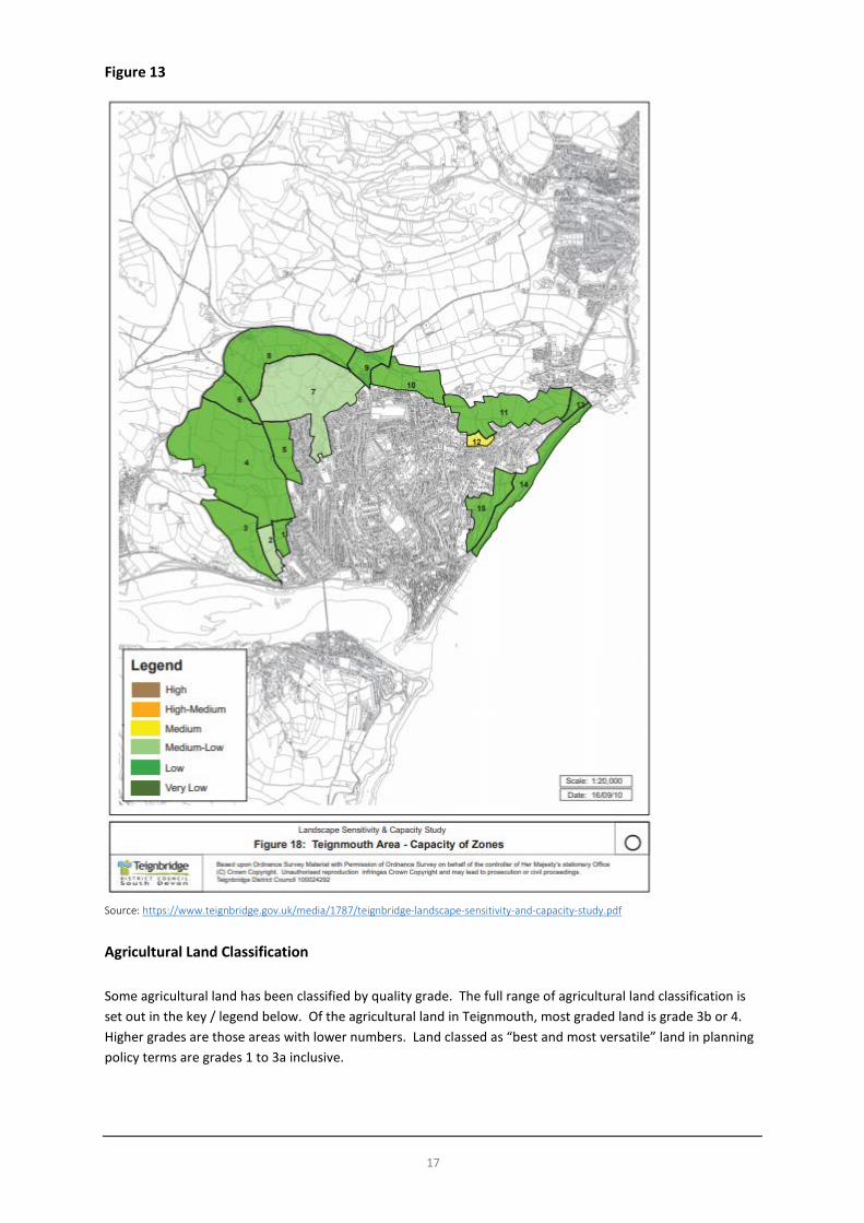
• Plan for opportunities to expand estuarine habitats to build resilience to future climate change.” Teignbridge Landscape and Sensitivity Study The Teignbridge Landscape and Sensitivity Study10 informed the planning of growth areas for development in the emerging Teignbridge Local Plan. It provides a guide to the degree of sensitivity of different areas of landscape to built development and analyses their capacity to accommodate built development without unacceptable adverse effects. The study was informed by both the Teignbridge Landscape Character Assessment (2009) and the Devon Historic Landscape Characterisation Study. Maps show the constraints and designations in the area, landscape visibility, landscape sensitivity and potential for development capacity as reproduced below.
8 See https://new.devon.gov.uk/planning/planning-policies/landscape/devon-character-areas/teignbridge-and-east-devon-area/teign-estuary 9 See https://new.devon.gov.uk/planning/planning-policies/landscape/devon-character-areas/teignbridge-and-east-devon-area/teign-estuary 10 See https://www.teignbridge.gov.uk/media/1787/teignbridge-landscape-sensitivity-and-capacity-study.pdf

14
Figure 10
Source: https://www.teignbridge.gov.uk/media/1787/teignbridge-landscape-sensitivity-and-capacity-study.pdf

15
Figure 11
Source: https://www.teignbridge.gov.uk/media/1787/teignbridge-landscape-sensitivity-and-capacity-study.pdf

16
Figure 12
Source: https://www.teignbridge.gov.uk/media/1787/teignbridge-landscape-sensitivity-and-capacity-study.pdf
17
Figure 13
Source: https://www.teignbridge.gov.uk/media/1787/teignbridge-landscape-sensitivity-and-capacity-study.pdf
Agricultural Land Classification Some agricultural land has been classified by quality grade. The full range of agricultural land classification is set out in the key / legend below. Of the agricultural land in Teignmouth, most graded land is grade 3b or 4. Higher grades are those areas with lower numbers. Land classed as “best and most versatile” land in planning policy terms are grades 1 to 3a inclusive.

18
Figure 14
© Crown copyright and database right. All rights reserved (PSMA no. 0100050966) 2018 Source: http://www.natureonthemap.naturalengland.org.uk/
The Climate and Flood Risk Teignmouth has a mild maritime climate in common with most of the UK. Prevailing winds across the south-west of England are from the west. While Teignmouth is located in Devon it does not exhibit a particularly typical Devonian climate. Teignmouth lies to the east of Dartmoor, in a rain-shadow, which means that rainfall is often lower than many other parts of Devon at around 850mm per annum (33inches). Rainfall shows a somewhat seasonal pattern with late autumn and winter significantly wetter than the dry period from March to September. Temperatures are often higher than other parts of Devon in summer, especially with an offshore wind, but onshore winds from an easterly direction can alter weather conditions dramatically and also cause rough seas. On average Teignmouth is one of the sunniest areas in the UK year round, although parts of the Isle of Wight and the Sussex coast are slightly sunnier. This makes it one of the most ideal locations in the UK for generating energy from solar power. These weather conditions have helped to contribute to the popularity of Teignmouth as a tourist and residential location and combined with a relatively fertile soil provide a good location for gardening, and habitats for many varieties of plants and animals. Historically Teignmouth was also the location of a thriving market gardening industry. Climate change presents a potential risk to Teignmouth, in particular to low-lying parts of the town centre and the rail-link. This risk comes from 2 main sources: storm surges, combined with high seas which happen currently, but could become a greater problem if sea-levels rise significantly; and more frequent extreme rainfall events, from which the effects could become exacerbated by the shape of the town. South Devon is vulnerable to rare but extremely heavy one-off rainfall events, due to the topography and geographical position, as with many other hilly coastal areas in South West England. Maintaining up to date Environment Agency defences, ensuring adequate and clear drainage systems, ensuring hillsides do not become over-developed and that new building has sustainable drainage systems are key to managing this risk. The following maps show the extent of flood risk from rivers, sea and surface water sources.

19
Figure 15: Risk from Surface Water
© Crown copyright and database right. All rights reserved (PSMA no. 0100050966) 2018 Source: https://flood-map-for-planning.service.gov.uk/

20
Figure 16: Risk from Rivers or Sea
© Crown copyright and database right. All rights reserved (PSMA no. 0100050966) 2018 Source: https://flood-map-for-planning.service.gov.uk/

21
Figure 17: Risk Summary
© Crown copyright and database right. All rights reserved (PSMA no. 0100050966) 2018 Source: https://flood-map-for-planning.service.gov.uk/

22
Maritime and Coast It is important to identify characteristics and designations which are on the coast and Teign estuary as local planning authorities and the development plan have responsibilities for planning to the extent of the mean low water tide mark. Marine Planning has responsibility for planning to the mean high water mark and so with land-use planning responsibilities to the mean low water mark, there is a shared responsibility for the Marine Management Organisation (MMO) and public authorities planning in the intertidal zone.11 The following maps show coastal and marine environment designations and habitat types relevant to Teignmouth. Figure 18
© Crown copyright and database right. All rights reserved (PSMA no. 0100050966) 2018 Source: http://www.natureonthemap.naturalengland.org.uk/
The coastal habitats map shows that there are two areas of coastal and marine habitat which are on the priority habitat inventory, areas identified nationally which identify specific types of habitat which are priorities for conservation.
11 Further guidance is available here https://www.gov.uk/government/publications/marine-planning-a-guide-for-local-councils/marine-planning-a-guide-for-local-councils

23
Figure 19
© Crown copyright and database right. All rights reserved (PSMA no. 0100050966) 2018 Source: http://www.natureonthemap.naturalengland.org.uk/
Figure 20
© Crown copyright and database right. All rights reserved (PSMA no. 0100050966) 2018 Source: http://www.natureonthemap.naturalengland.org.uk/

24
Figure 21
© Crown copyright and database right. All rights reserved (PSMA no. 0100050966) 2018 Source: http://www.natureonthemap.naturalengland.org.uk/
The map above sets out the areas and habitats defined to help implementation of the Water Framework Directive (WFD). The purpose of the WFD is to establish a framework for the protection of inland surface waters, estuaries, coastal waters and groundwater. While important to show the extent of fishing activity and fisheries within the context of the local economy (set out elsewhere in this document), it is also relevant to reproduce a map (see below) in this section given the close relationship with the natural environment.

25
Figure 22
© Crown copyright and database right. All rights reserved (PSMA no. 0100050966) 2018 Source: http://www.natureonthemap.naturalengland.org.uk/
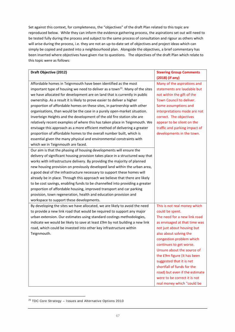
Community Plan (2012) Objectives In 2012, the Town Council produced a draft Community Plan which set out a raft of aspirations for the town, some of which were supported by statistics and data available at the time, but some of which seem not to be and are aspirational in what they suggest. The draft Plan contained objectives, some of which related to planning matters and issues and some of which did not. As the draft Plan was produced, it cannot be ignored as a piece of work which sought to document the Town Council’s aspirations and can be helpful in at least raising some issues thought to be important in 2012. However, time has moved on and the draft Plan was never the subject of public consultation, nor independently scrutinised at any form of Public Examination, and therefore the weight that it can carry in evidence terms remains limited. While many of the aspirations in the draft Plan are commendable, some are likely to have been or will have since proved difficult to implement. Set against this context, for completeness, the “objectives” of the draft Plan related to this topic are reproduced below. While they can inform the evidence gathering process, the aspirations set out will need to be tested fully during the process and subject to the same process of consultation and rigour as others which will arise during the process, i.e. they are not an up-to-date set of objectives and project ideas which can simply be copied and pasted into a neighbourhood plan. Alongside the objectives, a brief commentary has been inserted where objectives have given rise to questions. The objectives of the draft Plan which relate to this topic were as follows:

26
Draft Objective (2012) Steering Group Comments (2018) (if any) Flood defences to support regeneration - We will strongly support and encourage flood defence agencies, such as the Environment Agency to maintain and improve, subject to future evidence based requirements, appropriate future flood defence works to protect Teignmouth.
The Environment Agency is the only Agency with a responsibility for flood prevention and defence.
Teignmouth’s town plan will respect the existing parish boundaries between the town and its neighbouring communities. Existing strategic open breaks between Teignmouth, Bishopsteignton and Holcombe will be maintained. Within this plan TDC policy EN1 will be extended to respect the existing open break and existing boundary between Teignmouth and Bishopsteignton.
Key Issues and Messages • We are fortunate to have various environmental designations which help to protect the local (land side)
environment and biodiversity. However, there may be additional areas which require protection through the neighbourhood plan or currently protected areas which could benefit from additional planning policy protection.
• Maintaining the character and identity of the town and separation between Teignmouth, Holcombe and Bishopsteignton through the protection of open gaps and valued landscape is important.
• We have areas which form part of a wider habitat for protected species (such as the Cirl Bunting). While there are some protections for such species we should consider whether we can offer further policy protection through the neighbourhood plan.
• The coastal and estuarine environments frame the town and help to define its character. • Landscape character analysis suggests a mainly low capacity to accommodate new development on the
town’s edges. • Maintaining appropriate coastal and fluvial flood defences and introducing mitigation, as necessary, in
relation to new development to protect the town into the future is essential. • We should seek further evidence and information on important issues, priorities and policies from
agencies such as the Environment Agency and Natural England and organisations such as the Royal Society for the Protection of Birds and the Devon Wildlife Trust.

27
Built Environment
Heritage and Historic Assets Heritage at Risk Register There are some elements which warrant extra protection through the planning system. Since 1882, when the first Act protecting ancient monuments and archaeological remains was passed, Government has been developing the designation system. Listing is now applied to about half a million buildings ranging from palaces to street lamps. Details of buildings on the Register in Teignmouth are appended to this report. Criteria for inclusion on the ‘at Risk Register’ Buildings (not in use as a public place of worship) considered for inclusion on the Register must be listed grade I or II*, (or grade II in London) or be a structural scheduled monument. Buildings are assessed for inclusion on the basis of condition and, where applicable, occupancy (or use). The condition of buildings on the Register ranges from ‘very bad’ to ‘poor’, ‘fair’ and (occasionally) ‘good’. The Register also includes buildings that are vulnerable to becoming at risk because they are empty, under-used or face redundancy without a new use to secure their future. Buildings are removed from the Register when they are fully repaired/consolidated, their future secured, and where appropriate, occupied or in use. Listed Buildings A listed building is a building (or structure) that has been designated as being of ‘special architectural or historic interest’. The older and rarer a building is, the more likely it is to be listed. Buildings less than 30 years old are listed only if they are of outstanding quality and under threat. Listed buildings are graded I, II* and II. Grade I and II* are particularly important buildings of outstanding interest. Structures can occasionally be both listed as buildings and scheduled as monuments. There are 133 listed buildings in Teignmouth parished area. The list is attached to this report as an appendix and further details of listings can be accessed via www.historicengland.org.uk . The figures below show their and Scheduled Monument locations.

28
Figure 23
© Crown copyright and database right. All rights reserved (PSMA no. 0100050966) 2018 Source: http://www.natureonthemap.naturalengland.org.uk/
Figure 24
© Crown copyright and database right. All rights reserved (PSMA no. 0100050966) 2018 Source: http://www.natureonthemap.naturalengland.org.uk/

29
Figure 25
© Crown copyright and database right. All rights reserved (PSMA no. 0100050966) 2018 Source: http://www.natureonthemap.naturalengland.org.uk/
Conservation Areas Teignbridge DC has powers to declare an area of special architectural or historic interest, the character or appearance of which it is desirable to conserve or enhance to be a Conservation Area. Such declaration introduces a general control over the demolition of unlisted buildings and provides the basis for policies designed to preserve or enhance all the aspects of character or appearance that define an area's special interest. Apart from a few minor exceptions, no building can be demolished without prior approval (conservation area consent) and six weeks’ notice must be given if any tree is to be cut down or lopped. Local authorities can introduce Article 4(2) Directions to remove permitted development rights within Conservation Areas. There is a requirement under Section 71 of the Planning (Listed Building and Conservation Areas) Act 1990 for all local authorities to review their conservation areas and publish proposals for their preservation and enhancement. Further information about Conservation Areas in Teignbridge can be found here https://www.teignbridge.gov.uk/planning/heritage-assets/conservation-areas/information-about-each-conservation-area/ and summary maps of the Conservation Areas in Teignmouth are set out below. Each area has a Conservation Area Appraisal and Management Plan available via the above link. (It should also be noted that there are also Conservation Areas in neighbouring Bishopsteignton, Shaldon and Holcombe.)

30
Figure 26: Teignmouth Town Centre Conservation Area
© Crown copyright and database right. All rights reserved (PSMA no. 0100050966) 2018 Source: Teignmouth Town Centre Conservation Area Management Plan, p.6, https://www.teignbridge.gov.uk/media/4423/teignmouth_town_centre_management_plan_web.pdf

31
Figure 27
© Crown copyright and database right. All rights reserved (PSMA no. 0100050966) 2018 Source: Teignmouth Town Centre Conservation Area Appraisal, p.30, https://www.teignbridge.gov.uk/media/4422/teignmouth_town_centre_ca_web.pdf

32
Figure 28 Teignmouth St James Conservation Area
© Crown copyright and database right. All rights reserved (PSMA no. 0100050966) 2018 Source: Teignmouth St James Conservation Area Appraisal, p.30, https://www.teignbridge.gov.uk/media/4421/teignmouth_st_james_ca_web.pdf

33
Regeneration and Design From being a relatively prosperous coastal town and working port town in recent history, Teignmouth suffered from a slow decline in the popularity of the British seaside from the 1970s onwards. This slow decline, a lack of investment, several recessions and the results of a lack of demand in the local economy, combined to cause a steady decline in the fortunes of the town. This reached a nadir during the 1990s. Since then the town has begun to see a steady turnaround in its fortunes. From around 2000, many people started to rediscover the charms of the British seaside and coastal areas and Teignmouth is no exception. Nonetheless, much of the town’s visitor accommodation has since been turned over to residential, or other uses, so it is now much more of a daytrip destination. Changing trends in visitor accommodation have, in recent years, begun to benefit Teignmouth, with significant increases in visitor numbers enjoying the town’s attractions, including its natural environment. The seafront, in particular, draws people from nearby communities and holidaymakers from further afield to the area to make use of the play parks, adventure golf, beaches, backbeach, the Den, events, plus the shops, pubs, cafes and restaurants. Since the early 1990s, the town has benefitted from investment through many regeneration and environmental improvement schemes including: • Pedestrianisation of Teign Street and Bank Street; • Adoption of a town centre corporate colour scheme and design for seats, bollards, lamp columns, etc.; • Pedestrian public realm improvements to The Triangles and Esplanade including Waterloo Street (in
Devon County Council’s “Year of the pedestrian”) and enhancement of French Street and Northumberland Place (and therefore all contributing to a growing café culture);
• Extension of Teignmouth Museum; • Creation of a playground; • Creation of a skate park; • Provision of employment units at Broadmeadow; • Upgrading of tower block flats; • Investment and modifications to docks to enable longer vessels to use the docks combined with dredging
and deepening of the channel by the Harbour Commission; • Establishment of the Ice House, a 50 seat studio theatre; • Formation of Teignmouth Advisory / Action Arts Group (TAAG); • Construction of the Pavilions; • Arrival of national retail chains combined with popular local retailers such as Shaldon Bakery Flood
defence schemes; and, • Development of flood defence schemes. Local Distinctiveness During the design of the Triangles pedestrianisation and related schemes in the late 1980s an artist was involved as part of the design team to help create a street furniture house style for the public realm in Teignmouth. This included the adoption of a particular shade of blue as the ‘corporate colour’ and amongst other things distinctive designs for lighting columns (fish motif), seats (anchor design), bollards (town crest and fish motif) and the ‘fish screen’ in the big Triangle. This look and approach has continued since with new seats, maintenance of street furniture and the ‘Welcome to Teignmouth’ sign on the footbridge outside Teignmouth Community School in Exeter Road.
Brunswick Street Local Development Order Design Guide Teignbridge District Council has (in 2016) adopted a Local Development Order (LDO) for Brunswick Street in the town. An LDO, in effect, provides permission for development to proceed subject to the content of the LDO. A key part of the LDO is a design guide12, which sets out the “look and feel” or design character that
12 See https://www.teignbridge.gov.uk/media/1797/design-guide.pdf
34
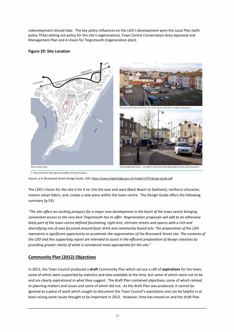
redevelopment should take. The key policy influences on the LDO’s development were the Local Plan (with policy TE4a) setting out policy for the site’s regeneration), Town Centre Conservation Area Appraisal and Management Plan and A Vision for Teignmouth (regeneration plan). Figure 29: Site Location
Source: p.4, Brunswick Street Design Guide, LDO, https://www.teignbridge.gov.uk/media/1797/design-guide.pdf
The LDO’s Vision for the site is for it to: link the east and west (Back Beach to Seafront); reinforce character, restore urban fabric; and, create a new place within the town centre. The Design Guide offers the following summary (p.53): “The site offers an exciting prospect for a major new development in the heart of the town centre bringing convenient access to the very best Teignmouth has to offer. Regeneration proposals will add to an otherwise lively part of the town centre defined fascinating, tight-knit, intricate streets and spaces with a rich and diversifying mix of uses focussed around food, drink and community based arts. The preparation of the LDO represents a significant opportunity to accelerate the regeneration of the Brunswick Street site. The contents of the LDO and this supporting report are intended to assist in the efficient preparation of design solutions by providing greater clarity of what is considered most appropriate for the site.” Community Plan (2012) Objectives In 2012, the Town Council produced a draft Community Plan which set out a raft of aspirations for the town, some of which were supported by statistics and data available at the time, but some of which seem not to be and are clearly aspirational in what they suggest. The draft Plan contained objectives, some of which related to planning matters and issues and some of which did not. As the draft Plan was produced, it cannot be ignored as a piece of work which sought to document the Town Council’s aspirations and can be helpful in at least raising some issues thought to be important in 2012. However, time has moved on and the draft Plan

35
was never the subject of public consultation, nor independently scrutinised at any form of Public Examination, and therefore the weight that it can carry in evidence terms remains limited. While many of the aspirations in the draft Plan are commendable, some are likely to have been or will have since proved difficult to implement. Set against this context, for completeness, the “objectives” of the draft Plan related to this topic are reproduced below. While they can inform the evidence gathering process, the aspirations set out will need to be tested fully during the process and subject to the same process of consultation and rigour as others which will arise during the process, i.e. they are not an up-to-date set of objectives and project ideas which can simply be copied and pasted into a neighbourhood plan. Alongside the objectives, a brief commentary has been inserted where objectives have given rise to questions. The objectives of the draft Plan which relate to this topic were as follows:
Draft Objective (2012) Steering Group Comments (2018) (if any)
We aim to ensure the conservation and enhancement of the strong historical and architectural character seen throughout the town, which adds to its distinctiveness including the removal of overhead cables where possible, new energy saving and dark skies friendly street lighting, removing unnecessary road signs, creating pedestrian-friendly civic space, new paving, locally distinctive street furniture in keeping with existing town centre designs, enforcing planning controls and the promotion and implementation of higher design standards.
The draft objective would benefit from setting out how these laudable aims could be actioned.
Include and promote good design which respects local distinctiveness, respects the character of the site and its surroundings, in order to protect and enhance the built and natural environments and create better places to live and work.
Be high quality designs with integrity, confidence and visual interest. It would be helpful to explain what is meant by integrity and confidence in this context.
Be based on a good understanding of the context of the site, and contribute positively to its setting by enhancing the local character. It should take into account the layout, scale, appearance, existing materials and built and natural features of the surrounding area. Where new development is surrounded by a strong existing context, the designs should draw clues and inspiration from these surroundings, without necessarily creating exact copies.
Create a 'sense of place'. New housing must create pleasant places in which to live, with good amenity. We expect design to adhere to the key principles set out in the Companion Guide to PPG3 - Better Places to Live by Design, produced by the Department for Communities and Local Government.
The objectives are laudable but some infer that the Town Council can ensure that these things can be delivered, although it is recognised that some of the ambitions are beyond the scope of the Council to deliver and for others that it could take the involvement of many bodies and organisations to deliver.
Conserve and enhance the identity, distinctive character and features of the existing settlements, urban and rural areas. It must demonstrate how it conserve and, or enhances the landscape character, including coastal areas, estuaries, river valleys, undulating uplands and other landscapes Preserve and enhance the quality of the historic environment. The design, siting, bulk, height, materials, colours and visual emphasis of proposed new development should take into account local context and in particular the character and appearance of the historic buildings and environment.

36
Draft Objective (2012) Steering Group Comments (2018) (if any)
Be carried out to the highest standards of sustainable construction where viable and practicable. Development should be adaptable, anticipating change in household needs and family structures throughout their lifetime as well as anticipating the impacts of climate change. Development should use locally sourced materials where possible, and minimise the use of materials, by using recycled materials in the construction of the development and minimising waste during construction. Promote the use of the highest energy saving and renewable energy generation standards available through the open market at the time of build for new construction. This is to future proof the town’s residents from energy price rises, and will contribute to more money available to spend in the local economy through reducing economic leakage out of the town. It has been estimated (2010 figures) that between 12 and 16% of Teignbridge residents were in fuel poverty and this figure could potentially rise. As a location Teignmouth is primarily south facing and has one of the highest levels of insolation available in the UK and this will ensure that residents are able to fully exploit the natural resources available on their doorstep. We aim to see all new buildings in Teignmouth designed with integral solar panels, when appropriate, as standard prior to 2016 when this policy is planned to be adopted nationally. Renewable energy production from new buildings in the town will be in keeping with the prominent landscape (for example large wind turbines are unlikely to prove suitable). For existing buildings Teignbridge District Council’s code - Solar Panels on dwelling-house roofs – will apply. Be achieved by ensuring the location, siting, layout, scale and design conserves and, or enhances what is special and locally distinctive about the landscape character. Design should retain, integrate and enhance distinctive features avoiding unsympathetic intrusion in the wider landscape, such as detrimental impact on the character of skylines, views from public vantage points and light pollution. Promotes outstanding environmental design through the application of the BREEAM Code for Sustainable Homes (CSH) to all developments of 5 homes, or over in Teignmouth. This code aims to help local authorities to deliver better, more sustainable buildings to the communities they serve. It improves the existing built environment through the provision of additional green space, tree planting and recreational space, where possible, to improve the quality of life for Teignmouth’s residents. This will also help to improve air quality and to improve habitats through the planting of native species It provides for future food needs of the residents of the town by the provision of gardens where possible allotments, the imaginative use of space for the growing of food and for public space fruit tree planting. The planting of fruit trees as opposed to primarily ornamental varieties will contribute to the aesthetic enhancement of the town; add local distinctiveness and help towards future food security. Greenfield sites not allocated for development within this plan will be secured as a resource to

37
Draft Objective (2012) Steering Group Comments (2018) (if any)
contribute towards future national and local food security and the production of biomass for energy. It ensures wherever possible that we do not build in areas where there is natural spring formation lessening the potential effects of flooding downstream or displacement of water to nearby properties. We will also investigate other more innovative options for funding should these be required. A potential model which could be explored further, subject to local support, is small-scale „retail‟ bonds – aimed at residents – to pay for key specific projects, which would offer a long-term return to the bond holder. Many councils have recently become credit rated to enable this to happen.
Key Issues and Messages • We have a valuable heritage and historic environment which contributes positively to the built character
of the town and should continue to be protected. • There are areas and buildings within the town which could benefit from regeneration and
improved maintenance. • The town has benefitted from successive regeneration schemes since the 1990s. The character of the
town should continue to be improved into the future, building on the momentum of enhancements made in these recent years.
• Maintaining and protecting the quality of the public realm and town’s character is important not only to residents, but to local businesses and visitors, helping to underpin the local economy.
• There is an opportunity to explore the development of a Design Code or Guide for the town to reinforce those characteristics which make Teignmouth what it is, reinforce local distinctiveness and to help ensure that a high quality urban environment in the Teignmouth context is delivered as new development and regeneration takes place into the future.
• Within the context of delivering high quality development, we should explore opportunities to increase the sustainability of development and its contribution to a reduction in carbon dioxide emissions through energy efficiency, use of low carbon solutions and energy generation, minimising waste (during construction) and maximising solar gain.
• There is an opportunity to help enhance the quality of life of residents through protection and provision of open greenspace and planting for access, design / aesthetic and air quality reasons.
• There may be opportunities to explore local funding schemes to raise capital funds to bring forward environmental improvements which benefit the community.
• We should seek further evidence and information on important issues, priorities and policies from Historic England.

38
Population and Housing Population
In the 2011 census Teignmouth had a population of 14,749 with an age profile as shown in the figure below. In 2016, the population was estimated to be around 15,054. There are currently no population projections of the town’s population available from Teignbridge District Council or Devon County Council beyond this date and the Office for National Statistics does not publish Ward based projections (only estimates of population as a “current” snapshot in time. (The three electoral wards in Teignmouth fit to the Teignmouth civil parish boundary.)
Figure 30

39
Source of data and copied table: ONS, NOMIS https://www.nomisweb.co.uk/
Figure 31: Population Estimates for Teignmouth Wards (2016)
WARD POP. Estimate Teignmouth Central 4,887 Teignmouth East 5,019 Teignmouth West 5,148 Total 15,054
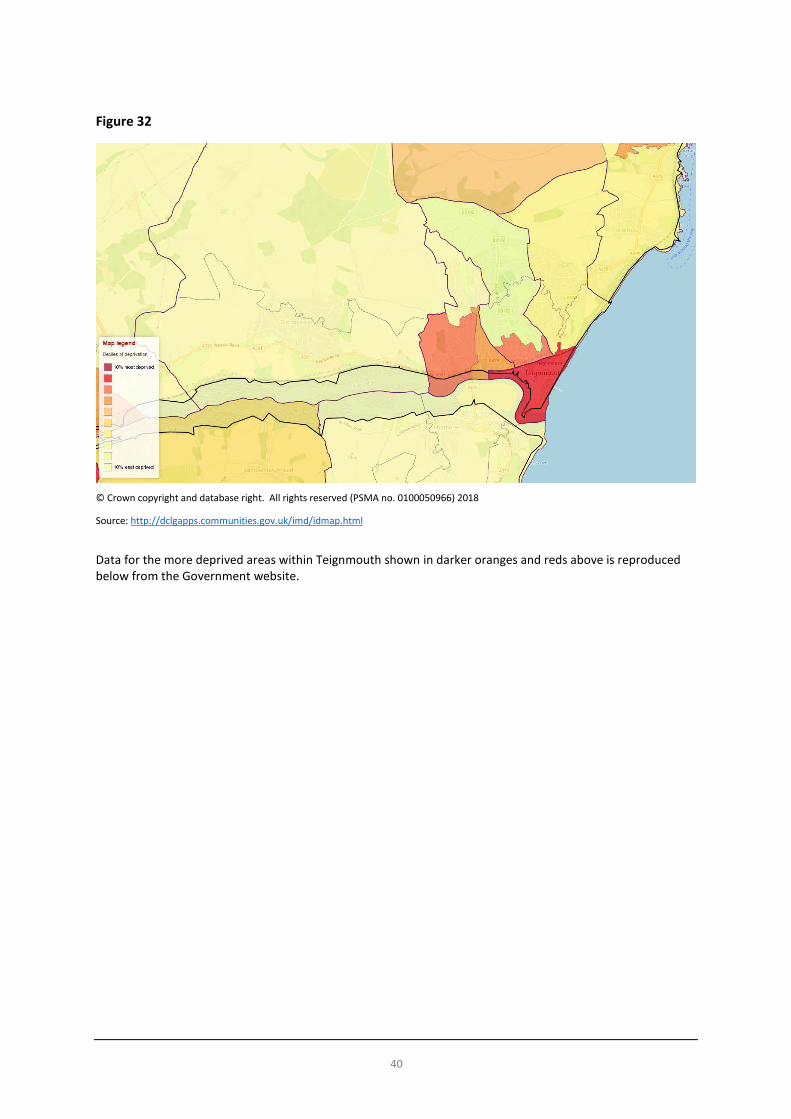
Source: ONS, October 2017, https://www.ons.gov.uk/peoplepopulationandcommunity/populationandmigration/populationestimates/datasets/wardlevelmidyearpopulationestimatesexperimental Deprivation The Government publishes data on relative levels of deprivation13. The latest figures are for 2015 and the map below shows the levels for overall levels in and around Teignmouth. The Government’s webpages state that “The Index of Multiple Deprivation 2015 is the official measure of relative deprivation for small areas14 (or neighbourhoods) in England. The Index of Multiple Deprivation ranks every small area in England from 1 (most deprived area) to 32,844 (least deprived area). It is common to describe how relatively deprived a small area is by saying whether it falls among the most deprived 10 per cent, 20 per cent or 30 per cent of small areas in England (although there is no definitive cut-off at which an area is described as ‘deprived’).” The 32,844 areas are “lower super output areas” (LSOAs), areas of measure used by the Office for National Statistics and other data providers.
13 Further information is available at https://www.gov.uk/government/statistics/english-indices-of-deprivation-2015 14 Lower-layer Super Output Areas, based on the 2011 Census.
40
Figure 32
© Crown copyright and database right. All rights reserved (PSMA no. 0100050966) 2018
Source: http://dclgapps.communities.gov.uk/imd/idmap.html
Data for the more deprived areas within Teignmouth shown in darker oranges and reds above is reproduced below from the Government website.

41
Figure 33
© Crown copyright and database right. All rights reserved (PSMA no. 0100050966) 2018
Source: http://dclgapps.communities.gov.uk/imd/idmap.html

42
Figure 34
© Crown copyright and database right. All rights reserved (PSMA no. 0100050966) 2018
Source: http://dclgapps.communities.gov.uk/imd/idmap.html

43
Figure 35
© Crown copyright and database right. All rights reserved (PSMA no. 0100050966) 2018
Source: http://dclgapps.communities.gov.uk/imd/idmap.html

44
Figure 36
© Crown copyright and database right. All rights reserved (PSMA no. 0100050966) 2018
Source: http://dclgapps.communities.gov.uk/imd/idmap.html
45
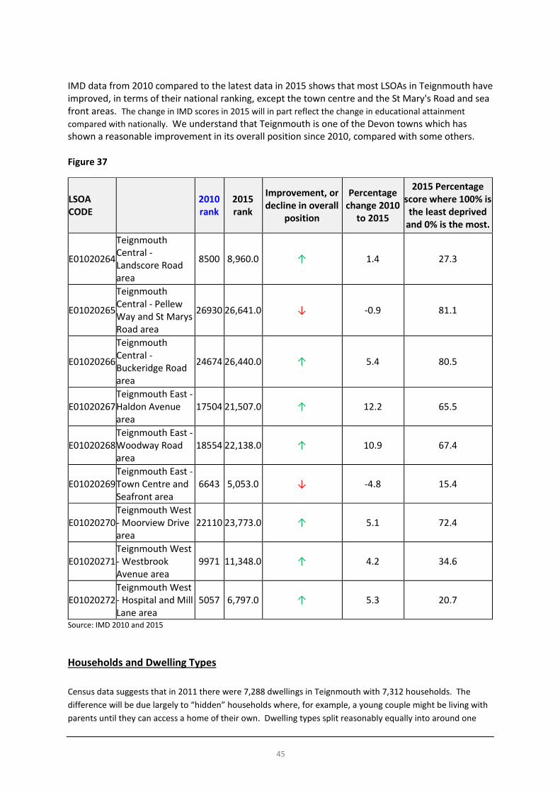
IMD data from 2010 compared to the latest data in 2015 shows that most LSOAs in Teignmouth have improved, in terms of their national ranking, except the town centre and the St Mary's Road and sea front areas. The change in IMD scores in 2015 will in part reflect the change in educational attainment compared with nationally. We understand that Teignmouth is one of the Devon towns which has shown a reasonable improvement in its overall position since 2010, compared with some others. Figure 37
LSOA CODE 2010
rank 2015 rank
Improvement, or decline in overall
position
Percentage change 2010
to 2015
2015 Percentage score where 100% is
the least deprived and 0% is the most.
E01020264
Teignmouth Central - Landscore Road area
8500 8,960.0 ↑ 1.4 27.3
E01020265
Teignmouth Central - Pellew Way and St Marys Road area
26930 26,641.0 ↓ -0.9 81.1
E01020266
Teignmouth Central - Buckeridge Road area
24674 26,440.0 ↑ 5.4 80.5
E01020267 Teignmouth East - Haldon Avenue area
17504 21,507.0 ↑ 12.2 65.5
E01020268 Teignmouth East - Woodway Road area
18554 22,138.0 ↑ 10.9 67.4
E01020269 Teignmouth East - Town Centre and Seafront area
6643 5,053.0 ↓ -4.8 15.4
E01020270 Teignmouth West - Moorview Drive area
22110 23,773.0 ↑ 5.1 72.4
E01020271 Teignmouth West - Westbrook Avenue area
9971 11,348.0 ↑ 4.2 34.6
E01020272 Teignmouth West - Hospital and Mill Lane area
5057 6,797.0 ↑ 5.3 20.7
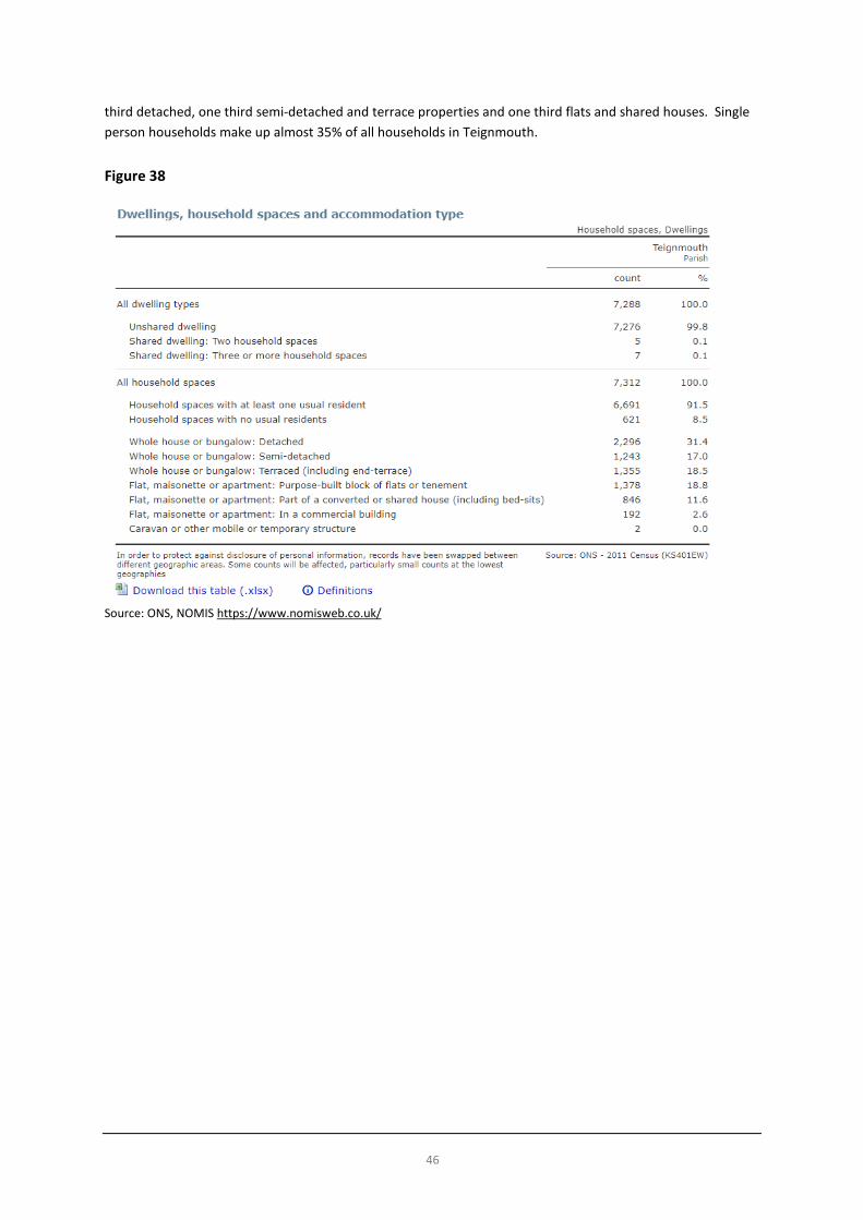
Source: IMD 2010 and 2015 Households and Dwelling Types Census data suggests that in 2011 there were 7,288 dwellings in Teignmouth with 7,312 households. The difference will be due largely to “hidden” households where, for example, a young couple might be living with parents until they can access a home of their own. Dwelling types split reasonably equally into around one
46
third detached, one third semi-detached and terrace properties and one third flats and shared houses. Single person households make up almost 35% of all households in Teignmouth. Figure 38
Source: ONS, NOMIS https://www.nomisweb.co.uk/

47
Figure 39
Source: ONS, NOMIS https://www.nomisweb.co.uk/ Additional data on household types, fitted against MOSAIC household types / profiles is available on the Devon County Council website. However, the data for Teignmouth is combined with that for Bishopsteignton and Dawlish and so presents a wider picture than that for the town in its own right.15 This is why some categories may not seem to “fit” with the characteristics of the town within the town council boundary (for example, 464 households seeming to be “residents of isolated rural communities”. Further details of the categorisation of types within the MOSAIC data is available from Devon County Council and Experian MOSAIC.
15 See https://new.devon.gov.uk/communities/your-community/teignmouth-profile for further details.

48
Figure 40
Source: http://www.devon.gov.uk/census_profile-div52-teignmouth_town.pdf
Notes: “Teignmouth Town” relates to an area wider than the parished area (Teignmouth, Bishopsteignton and Shaldon parishes), but is
useful to use as a basis for comparison purposes

49
Figures from the census also suggest that around 70% of all properties are owned 9% are social rent and almost 20% are privately rented. Figure 41
Source: ONS, NOMIS https://www.nomisweb.co.uk/ Land Supply Strategic Housing Land Availability Assessment (SHLAA) The SHLAA is a technical assessment undertaken by the local authority to inform the amount of available supply of land for housing development across the district. It relies on the local authority asking land-owners to put forward sites for technical assessment to evaluate their suitability, in planning terms, for potential development. Viability and deliverability are also assessed. The process does not mean that the sites which pass the tests get planning permission. Land-owners still need to apply for planning permission and therefore any proposals are assessed against planning policies at that time. SHLAA sites identified in Teignmouth have been identified and are reproduced from the local authority’s assessment below. However, it is important to note that the last SHLAA exercise that TDC undertook was to inform the emerging Local Plan, in 2012, although that was an update of work carried out in 2009 / 2010. Therefore, it seems likely that additional, different, sites will have become available in the time since 2012, which, if planning permission has not been obtained on them to date should be identified either by TDC in their next SHLAA exercise (which it is understood will take place in Spring / Summer 2018) or sooner by Teignmouth Town Council (in a local “Call for Sites” should the community decide that allocations for additional housing sites and numbers over and above those secured by TDC in the Local Plan are desirable).

50
We understand that the Greater Exeter Strategic Plan is undertaking work on strategic sites (sites with potential for 500+ dwellings and that this study will be available in June 2019. The extracts below reproduce information from the last SHLAA exercise16.
16 See TDC SHLAA 2012 Update, pp.7-8, https://www.teignbridge.gov.uk/planning/local-plans-and-policy/archive/strategic-housing-land-availability-assessment-shlaa/

51
The list of deliverable sites identified by the 2009 / 2010 SHLAA is reproduced over the page. A schedule of developable sites, with details of site assessments undertaken by TDC in 2009 / 2010 is available on their website17, but not detailed further here. Should the plan allocate sites, this type of data can be re-examined if necessary.
17 See https://www.teignbridge.gov.uk/media/5114/teignbridge-shlaa-2009-annex-6-developable-sites-02.pdf

52
Figure 42
table continued over the page…

53
Source: Annex 4, TDC SHLAA 2009/10, https://www.teignbridge.gov.uk/media/2082/shlaa-2009-annex-4-schedule-of-deliverable-sites.pdf

54
Local Plan: Allocated Housing and Housing Land Supply The Local Plan sets out the required numbers of dwellings appropriate for settlements in policy S4. Figures suggest an annualised rate of around 32 dwellings per annum in Teignmouth during the plan period or 620 in total during 2013-2033 as a minimum amount to be delivered (based on around 5% of the 640 dwellings per annum rate set out in the policy). The Local Plan sets out dwelling numbers for allocated sites and commitments at the time of the start of the plan period as follows. Figure 43

55

56
Source: Teignbridge Local Plan 2013-2033, pp.19-21
Figures set out in the Local Plan shown above suggest that 496 dwellings were either allocated or committed in Teignmouth in 2013. This suggests that at least 124 dwellings would come forward during the plan period from windfall sites and / or additional housing site allocations which may be made through the neighbourhood plan process (although it is worth noting that there is no legal requirement for a neighbourhood plan to allocate any housing sites). Housing land supply data is monitored and updated annually. The 2017 Five Year Housing Land Supply Statement18 updates data on allocated sites and permitted sites as follows.
18 See https://www.teignbridge.gov.uk/media/4949/five-year-land-supply-statement-april-2017.pdf

57
Figure 44
Source: 2017 Five Year Housing Land Supply Statement, Teignbridge District Council, Extract from Annex A and Annex B in full, https://www.teignbridge.gov.uk/media/4949/five-year-land-supply-statement-april-2017.pdf
Teignbridge District Council’s Brownfield Land Register19 sets out sites registered as previously developed land where there may be opportunities to redevelop. At the time of writing this report, the last updated data was produced on 13th December 2017 and shows four sites in Teignmouth on the register which are not allocated in the Local Plan. These are shown below but all have permission and are likely counted as commitments in Teignbridge monitoring figures.
19 See https://www.teignbridge.gov.uk/planning/local-plans-and-policy/evidence-facts-and-monitoring/brownfield-land-register/
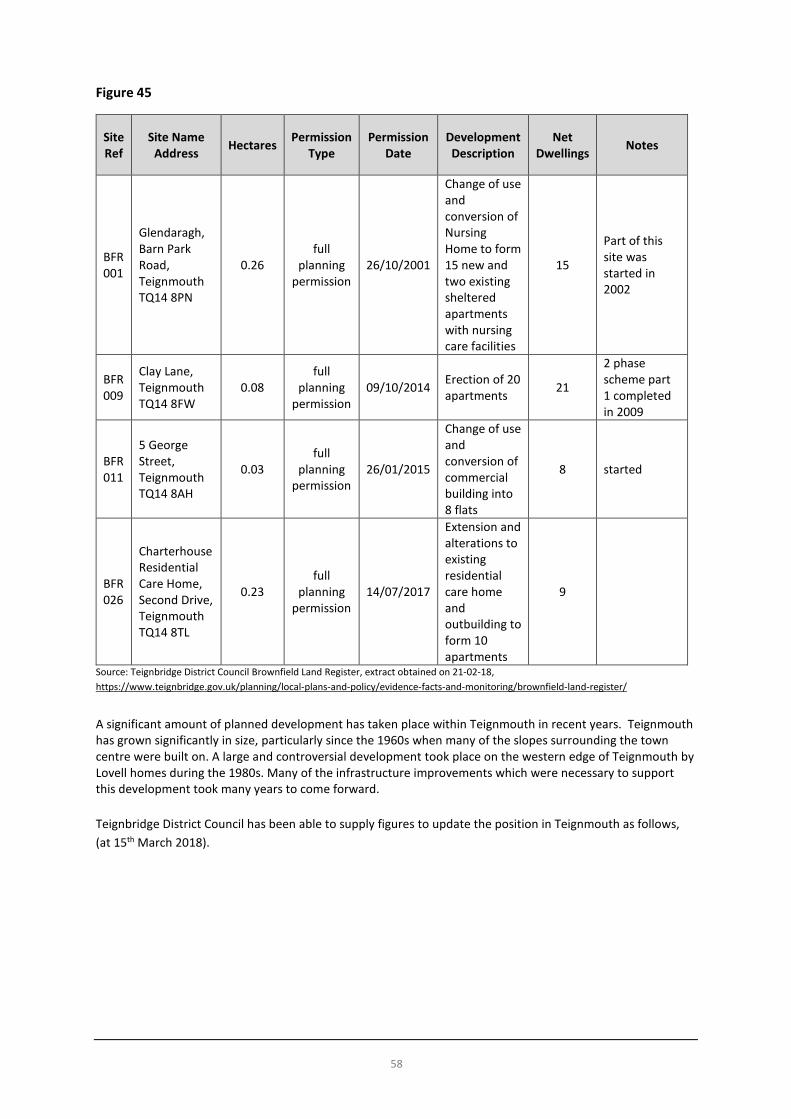
58
Figure 45
Site Ref
Site Name Address Hectares Permission
Type Permission
Date Development Description
Net Dwellings Notes
BFR 001
Glendaragh, Barn Park Road, Teignmouth TQ14 8PN
0.26 full
planning permission
26/10/2001
Change of use and conversion of Nursing Home to form 15 new and two existing sheltered apartments with nursing care facilities
15
Part of this site was started in 2002
BFR 009
Clay Lane, Teignmouth TQ14 8FW
0.08 full
planning permission
09/10/2014 Erection of 20 apartments 21
2 phase scheme part 1 completed in 2009
BFR 011
5 George Street, Teignmouth TQ14 8AH
0.03 full
planning permission
26/01/2015
Change of use and conversion of commercial building into 8 flats
8 started
BFR 026
Charterhouse Residential Care Home, Second Drive, Teignmouth TQ14 8TL
0.23 full
planning permission
14/07/2017
Extension and alterations to existing residential care home and outbuilding to form 10 apartments
9
Source: Teignbridge District Council Brownfield Land Register, extract obtained on 21-02-18, https://www.teignbridge.gov.uk/planning/local-plans-and-policy/evidence-facts-and-monitoring/brownfield-land-register/ A significant amount of planned development has taken place within Teignmouth in recent years. Teignmouth has grown significantly in size, particularly since the 1960s when many of the slopes surrounding the town centre were built on. A large and controversial development took place on the western edge of Teignmouth by Lovell homes during the 1980s. Many of the infrastructure improvements which were necessary to support this development took many years to come forward. Teignbridge District Council has been able to supply figures to update the position in Teignmouth as follows, (at 15th March 2018).

59
Figure 46
Dwellings Notes
Local Plan Requirement (at least) 620 Allocations:
TE3 250 application pending for 255 TE3A 50 no application to date
TE4 40 no application to date Local Plan residual number to be accommodated after discounting allocated sites
280 assuming completion in plan period
Completions since 6/5/2014 149 Approvals (not completed) since 6/5/2014 74 15 of which are started Total residual number to be found 2018-2033 after approvals and completions discounted
57 assuming all approvals built / completed
These figures suggest that there is no pressure for the neighbourhood plan to allocate additional housing sites to provide more housing than the Local Plan requires, particularly if windfall sites come through between now and 2033 at an annualised rate of 3.8 dwellings per year. However, allocations could be made in the neighbourhood plan: if the community wants some additional security to deter speculative development proposals (by identifying a 3-year supply of housing land) and wishes to be more strongly in the “driving seat” when it comes to steering development to the most appropriate locations determined locally; if the community supports additional housing to be brought forward; and, an objective assessment of need is undertaken and results indicate a clear need for additional housing. Teignmouth Draft Community Plan 2012: Housing “Allocations” The draft Community Plan sought to “allocate” housing sites in 2012. These were never formally allocated in the planning sense as the sites were not part of a statutory neighbourhood development plan at the time and subsequently, the Teignbridge Local Plan has allocated sites in Teignmouth (see below) for the period to 2033. There is no map of the sites in the draft Community Plan and the draft Plan was never subject of public consultation, finalised and approved by the Town Council. Nevertheless, it is important that the neighbourhood plan pays attention to the sites chosen for inclusion in the draft Community Plan and these sites should be reviewed during the plan process should the plan (and community) decide that it needs to allocate housing sites in addition to those allocated in the Local Plan.
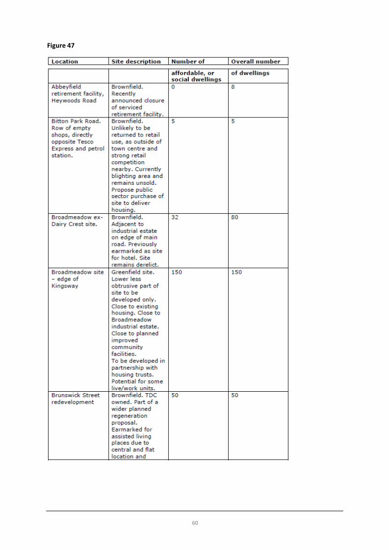
60
Figure 47

61

62
Source: pp.19-22, Draft Community Plan 2012

63
Local Housing Market Data has been obtained from online sources20 to get a picture of local housing market trends across the purchase and private rented sectors. These represent a snapshot in time but are useful to understand trends and change over time. Figure 48
Source: www.zoopla.co.uk 21st February 2018
20 Obtained from www.zoopla.co.uk on 21st February 2018.

64
Figure 49
Source: www.zoopla.co.uk 21st February 2018
Figure 50
Source: www.zoopla.co.uk 21st February 2018

65
Figure 51
Source: www.zoopla.co.uk 21st February 2018
Figure 52
Source: www.zoopla.co.uk 21st February 2018

66
Figure 53
Source: www.zoopla.co.uk 21st February 2018
Housing Needs Survey The last housing needs survey is now dated. However, the Teignbridge Affordable Housing Strategy 2010-15 indicated a need for up to 46 affordable new homes per year at Teignmouth, to meet local housing needs arising in the town. The delivery of 46 homes per year over 20 years, would mean that, in theory, a total of 920 affordable homes in total would need to be delivered to 2033. Need for forms of subsidised housing is therefore likely to far outstrip supply based on these (now dated) figures (which are just for affordable need) when set alongside the dwellings figures established by the Local Plan for the same period (620 dwellings) which are for market and affordable dwellings. It should also be noted that Teignmouth forms part of the wider Greater Exeter Housing Market Area (see the strategic evidence report for more details) and people often do not tend to remain in one community throughout their lifetime, often looking in neighbouring areas and wider to live. Community Plan (2012) Objectives In 2012, the Town Council produced a draft Community Plan which set out a raft of aspirations for the town, some of which were supported by statistics and data available at the time, but some of which seem not to be and are clearly aspirational in what they suggest. The draft Plan contained objectives, some of which related to planning matters and issues and some of which did not. As the draft Plan was produced, it cannot be ignored as a piece of work which sought to document the Town Council’s aspirations and can be helpful in at least raising some issues thought to be important in 2012. However, time has moved on and the draft Plan was never the subject of public consultation, nor independently scrutinised at any form of Public Examination, and therefore the weight that it can carry in evidence terms remains limited. While many of the aspirations in the draft Plan are commendable, some are likely to have been or will have since proved difficult to implement.
67
Set against this context, for completeness, the “objectives” of the draft Plan related to this topic are reproduced below. While they can inform the evidence gathering process, the aspirations set out will need to be tested fully during the process and subject to the same process of consultation and rigour as others which will arise during the process, i.e. they are not an up-to-date set of objectives and project ideas which can simply be copied and pasted into a neighbourhood plan. Alongside the objectives, a brief commentary has been inserted where objectives have given rise to questions. The objectives of the draft Plan which relate to this topic were as follows:
Draft Objective (2012) Steering Group Comments (2018) (if any)
Affordable homes in Teignmouth have been identified as the most important type of housing we need to deliver as a town21. Many of the sites we have allocated for development are on land that is currently in public ownership. As a result it is likely to prove easier to deliver a higher proportion of affordable homes on these sites, in partnership with other organisations, than would be the case in a purely open-market situation. Inverteign Heights and the development of the old fire station site are relatively recent examples of where this has taken place in Teignmouth. We envisage this approach as a more efficient method of delivering a greater proportion of affordable homes to the overall number built, which is essential given the many physical and environmental constraints with which we in Teignmouth are faced.
Many of the aspirations and statements are laudable but not within the gift of the Town Council to deliver. Some assumptions and interpretations made are not correct. The objectives appear to be silent on the traffic and parking impact of developments in the town.
Our aim is that the phasing of housing developments will ensure the delivery of significant housing provision takes place in a structured way that works with infrastructure delivery. By providing the majority of planned new housing provision on previously developed land within the urban area, a good deal of the infrastructure necessary to support these homes will already be in place. Through this approach we believe that there are likely to be cost savings, enabling funds to be channelled into providing a greater proportion of affordable housing, improved transport and car parking provision, town regeneration, health and education provision and workspace to support these developments. By developing the sites we have allocated, we are likely to avoid the need to provide a new link road that would be required to support any major urban extension. Our estimates using standard costings methodologies, indicate we would be likely to save at least £9m by not building a new link road, which could be invested into other key infrastructure within Teignmouth.
This is not real money which could be spent. The need for a new link road as envisaged at that time was not just about housing but also about solving the congestion problem which continues to get worse. Unsure about the source of the £9m figure (it has been suggested that it is net shortfall of funds for the road) but even if the estimate were to be correct it is not real money which "could be
21 TDC Core Strategy – Issues and Alternative Options 2010

68
Draft Objective (2012) Steering Group Comments (2018) (if any) invested into other key infrastructure”. It is understood that investigations with Teignbridge District Council and Devon County Council at the time found that significant public subsidy would be required at the time of the emerging draft plan. Concern therefore raised that this is misleading.
All developments of 10 homes or more should provide additional affordable housing provision within Teignmouth, either on-site or elsewhere in the town. Planned developments will include 40%, or more affordable housing, in line with Teignbridge policies S4 and WE3-5.
Many of the aspirations and statements are laudable but not within the gift of the Town Council to deliver. Some assumptions and interpretations made are not correct. The objectives appear to be silent on the traffic and parking impact of developments in the town.
Currently local housing associations look for tenants across Devon. This means that when affordable houses are built, they may not necessarily reduce the waiting list for houses in Teignmouth. We will stipulate to developers that their planning application must specify priority for local people. We aim to give priority to people currently resident within Teignmouth and aim to negotiate on each individual case, should a wider hinterland be considered. We in Teignmouth will encourage and support TDC to extend this scheme further across the District, encouraging activity in Teignmouth, to ease pressure on local housing supplies and enable families to access more suitable housing for their needs. The scheme will release sought-after larger family homes back into the social housing pool, and help meet the requirement for much needed affordable accommodation. There are already relatively high levels of residential use above shops. We will support TDC to continue to encourage the better use of accommodation and space in Teignmouth town centre, by encouraging living above shops in well designed, high standard accommodation. We will support Teignbridge planners in implementing additional shared ownership schemes in Teignmouth and across the wider Teignbridge area, to encourage greater participation in affordable home ownership. We support TDC in maintaining its 10% second homes discount (the minimum amount allowed). This helps to ensure greater year-round community vitality and the availability of housing locally. We support TDC in promoting self–build within the built-up area of Teignmouth, where buildings complement the town’s built and natural environment and contribute to the Town Council’s aspiration to create a more sustainable and energy efficient community. We will count windfall developments throughout the town of Teignmouth towards the overall housing target for the town after 10 years (from 2023), in line with UK Government policy. Undeveloped housing sites and delivery

69
Draft Objective (2012) Steering Group Comments (2018) (if any)
of building on allocated plan sites up to 2023 will be taken into consideration by the Town Council in a plan review at this time. It is our intention that all significant developments (10 homes or over) will provide contributions towards the town’s infrastructure requirements in proportion to the scale of the development and the amount of mitigation, or infrastructure upgrades required as a result of the development. Significant retail, or employment developments will be negotiated individually appropriate to the size of the development. Where developers provide significant regeneration benefits to the community by redeveloping difficult brownfield sites, contribute to medium and longer-term employment prospects in the town through the provision of high-quality workspace and provide environmentally sustainable and well designed buildings (in-keeping, or complementary to the surrounding area), we will take a flexible approach in terms of development contributions requested. Community Infrastructure Fund levies from the development of individual properties will also be retained within Teignmouth.
Key Issues and Messages • Our population looks likely to increase and it is likely that we will continue to have an ageing population. • A minimum of 57 dwellings (net) need to be delivered in Teignmouth to meet the Local Plan housing
target to 2033 based on completions and commitments to date. • Housing requirements (numbers) could increase during this period and beyond with the anticipated
changes (during 2018) to the way that local authorities will be required by Government to calculate housing needs across tenures and also as a result of the review of the Teignbridge Local Plan and emerging Greater Exeter Strategic Plan.
• Further research will be necessary if we need and want to better understand the total housing need and demand across tenures and types beyond that proposed in the adopted Teignbridge Local Plan (as the review of the Local Plan gets underway and the Greater Exeter Strategic Plan is developed).
• House prices continue to rise in the town with a 2.5% increase over the last 12 months, although there have recently been local signs of this stabilising (however, there is no guarantee that stabilising of prices will continue). Mortgages seem likely to be out of the reach of most first-time buyers in Teignmouth.
• An up-to-date housing needs survey and assessment would help to identify the need for affordable housing in the short-term (3-5 years).
• Consultation will need to establish the community’s appetite for housing delivery in terms of scale (over and above the Local Plan’s identified numbers), type and potential location(s).
• We will need to consider whether or not the neighbourhood plan should allocate housing sites or whether this should be left to Teignbridge District Council to do so.
• Highways infrastructure costs could be an impediment to the viability of major development in Teignmouth.
• Considering the Natural Environment section alongside the Housing section, Teignmouth is relatively constrained within its boundaries to accommodate new development on its edge.
• There are challenges around levels of deprivation in the town centre area, despite relative improvements in ranking between 2010 and 2015.

70
71
Economy, Employment and Retail
Economy
Teignmouth’s business sector comprises mainly small and micro businesses. Major employers within the town are primarily within the education sector (both state and private sector). Some of the more high-profile employers within the town include Corpdata, Teignmouth Quays, Addicott Electrics and Majestic Holidays.
Broadmeadow Industrial Estate, though a relatively small industrial estate, is the main employment focus outside the town centre. A small low density industrial estate “Station Yard” is situated immediately behind Teignmouth railway station.
Broadmeadow Industrial Estate is approximately 2.4 hectares of developed employment land (just under 6,000 sq. m of floorspace), situated at the westernmost extremity of Teignmouth – the gateway to the town. It has developed in a relatively piecemeal and low-density fashion over the years and is visible from Shaldon and Ringmore on the opposite side of the Teign estuary. It is home to several small and medium sized businesses which play an important role in the local economy and community. In 2009 a survey by Teignbridge District Council found that “7.9% was 'vacant', which was considered to be a low vacancy rate and reflects the demand for employment space in Teignmouth. Our anecdotal evidence also points to some companies having to leave Broadmeadow and find premises in other towns as they become more successful”. Broadmeadow is much more than just a collection of commercial businesses. It is also the location of a Morrisons supermarket, the Broadmeadow Sports Centre and the Happy Days Nursery.
In addition, 3.3 hectares of playing fields that are located on the site of the old Broadmeadow refuse tip will be remediated and brought back into use on the upper plateau area. Concerns about contamination and safety led to the fields being closed for sports in 2001. A new link road to serve the Broadmeadow site will be built.
Station Yard Business Park comprise nine single-storey part pre-fabricated industrial units that are home to mechanics, glaziers and the like.
Workforce
Current information on the area’s workforce is limited. The tables below, from the 2011 Census, are still the best statistical summary. They show that at the time of the last Census, of the 6,500 local residents in work: • Around a third (33.9%) worked in the retail and wholesale trade or the health and care services • 10% worked in education • 10% worked in the construction industry • Just over a quarter (25.8%) were in professional and technical occupations • Just over 10% were managers, directors or senior officials
Levels of most qualifications, including trade apprenticeships, are above the national average in Teignbridge. According to the census data, Teignmouth has a similar qualification profile to the district. It is likely that qualification levels have risen significantly since 2011 reflecting general upward trends nationally.

72
Figure 5422
Source: ONS, NOMIS https://www.nomisweb.co.uk/
Figure 55
Source: http://www.devon.gov.uk/census_profile-div52-teignmouth_town.pdf
Notes: “Teignmouth Town” relates to an area wider than the parished area (Teignmouth, Bishopsteignton and Shaldon parishes), but is
useful to use as a basis for comparison purposes
22 No qualifications No formal qualifications
Level 1 = 1-4 GCSEs, Scottish Standard Grade or equivalent qualifications Level 2 = 5 or more GCSEs, Scottish Higher, Scottish Advanced Higher or equivalent qualifications Apprenticeship= Apprenticeships (England, Wales and Northern Ireland only) Level 3 = 2 or more A-levels, HNC, HND, SVQ level 4 or equivalent qualifications Level 4 or above = First or higher degree, professional qualifications or other equivalent higher education qualifications. Other qualifications = Other vocational / work related qualifications and non-UK / foreign qualifications (England, Wales and Northern Ireland only)

73
Figure 56
Source: ONS, NOMIS https://www.nomisweb.co.uk/
Figure 57
Source: ONS, NOMIS https://www.nomisweb.co.uk/

74
Figure 58
Source: ONS, NOMIS https://www.nomisweb.co.uk/
Earnings
Teignbridge’s figures for people in employment are considered to be relatively strong but the district suffers from low wages with its annual median salary being considerably less than that of Exeter, South West and National average.
Figure 59: 2015 wage levels for the district:
Source: ONS https://www.ons.gov.uk/visualisations/nesscontent/dvc126/

75
An average annual income for all working persons of £17,472. The Teignmouth and Dawlish Coastal Communities Economic Plan of 201623 computes that, based on wage levels and average house prices, “50% household cannot afford to buy accommodation”.
According to the ONS, “on average, working people could expect to pay around 7.6 times their annual earnings on purchasing a home in England and Wales in 2016, up from 3.6 times earnings in 1997”24.
The rate of Jobseekers Allowance claimants in Teignmouth has been significantly above the Teignbridge and Devon averages. In East Teignmouth the rate is also above the national average and has increased significantly in this ward since before the recession of 2008/9, when its rate was well below the national average.
There is estimated to be only 0.4 jobs per working resident in Teignmouth25. Many residents of Teignmouth have to leave the town area for work purposes. According to the 2012 Community Plan’s interpretation of the Census data: “Teignmouth is currently one of the least self-contained towns in Devon in terms of employment. In the year 2001 around 46% of people resident in the town also worked within the town (not including home-workers), meaning that 54% commuted out to other locations. (By comparison in Bideford, a slightly smaller town, over 65% of residents worked within the town.) A significant number of Teignmouth residents commuted out to other parts of Teignbridge, or Exeter. Small numbers of Teignmouth residents regularly commuted long distances, for example to Bristol, Cornwall, London, the West Midlands and South East England. Despite there being good public transport links by bus and rail, nearly 60% travel to work by car or van.”
The Tourist Industry
Historically Teignmouth was a very popular destination for staying visitors in hotel and self-catering accommodation, but this declined significantly between the 1960s and 1980s and now forms a relatively small part of its economy but has contributed much to the character of much of the town.
A reversal in the fortune of many British seaside and coastal towns particularly as day-trip, or short-break destinations, has occurred and this has also benefited Teignmouth. Teignmouth is a very popular day-trip destination for residents of a large part of Devon, but the town itself now provides minimal visitor accommodation. Nonetheless many visitors that stay in neighbouring areas such as Shaldon, Dawlish Warren and further afield in Torbay, choose to visit the town and its attractions. Research has also suggested that 1,800 jobs across Teignmouth and Dawlish may be attributed to tourism26.
Latest figures released from Visit South Devon reveal that 2017 has been one of the best on record for the South Devon tourism industry. Visits to the official tourism marketing website for the region27 were the highest ever achieved reaching 1.3 million sessions and 2.7 million page-views. One of the towns reported to have that attracted the most attention on the website in 2017 was Teignmouth along with Salcombe, Dawlish and Exmouth.
Teignmouth Harbour
The port of Teignmouth is the second largest facility in Devon. In 2011 250 ships per year entered and left Teignmouth Harbour via the river mouth accessing the Associated British Ports (ABP) facility at Teignmouth Quays (a private company), with access generally at high tide. A major (£5m) Western Quay Development project was carried out in 2005 and ABP has continued to invest significantly in terms of cranage, plant and equipment.
23 https://www.coastalcommunities.co.uk/wp-content/uploads/2016/05/Teignmouth-and-Dawlish-CCT-Econ-Plan.pdf 24https://www.ons.gov.uk/peoplepopulationandcommunity/housing/bulletins/housingaffordabilityinenglandandwales/1997to2016 25 https://www.coastalcommunities.co.uk/wp-content/uploads/2016/05/Teignmouth-and-Dawlish-CCT-Econ-Plan.pdf 26 https://www.coastalcommunities.co.uk/wp-content/uploads/2016/05/Teignmouth-and-Dawlish-CCT-Econ-Plan.pdf 27 www.visitsouthdevon.co.uk

76
Future port development in terms of additional warehouse construction is now very limited due to the physical constraint of lack of land.
According to the ABP website the port handles animal feed and a wide variety of other dry bulks including grain, agribulks, stone chippings, salt, and forest products, as well as heavy lifts and abnormal loads. The port area of 7.5 acres handles in the region of 400,000 tonnes each year of which ball clay, the port's principal traffic, accounts for some 200,000 tonnes each year.
Figure 60
Source: Associated British Ports http://www.abports.co.uk/Our_Locations/Short_Sea_Ports/Teignmouth/
The port has relied heavily upon local ball clay exports. Ball clay exports from the Bovey Basin is exported mainly to the European export market through Teignmouth. Continued diversification into other markets is important. Maintaining good access is deemed to be even more critical in ensuring that new business is attracted to the port.
There are 650 moorings administered by Teignmouth Harbour Commission (one of 52 Trust Ports in England and Wales28) of varying quality, with the 130 highest quality moorings allowing boats to be afloat at all states of the tide. There are 2 visitor pontoons provided by Teignmouth Harbour Commission which accommodate approximately 1,200 visiting boats to Teignmouth each year, providing a boost to local business. There are 2 public slipways at Gales Hill and Polly Steps (managed by TDC). There are no other landing places except directly onto the river beach, or at Polly Steps. There is a small quay with a vertical ladder at Polly Steps (managed by TDC). There are currently no alongside berths for visiting leisure boats. Gales Hill has recently seen the construction of a new quay (Fish Quay) and replacement of an ageing wooden jetty with a modern pontoon. The construction makes it easier for the public, charter vessels and fisherman to access the quay. An important part of the town’s heritage, the investment at Fish Quay encourages tourism in Teignmouth by providing landing and recreational facilities for passenger boats.
Teignmouth RNLI Lifeboat Station is based at the Point. It has two vessels: • 'The Two Annes' - B809 Atlantic 85 • 'Malcolm Hawkesford 1' - Arancia A-67
There were 45 combined launches during 2017.
Fisheries
Based on information in the 2012 draft Community Plan, whilst there are around 20 trawlers registered at Teignmouth (registered ‘TH’), they spend a majority of time fishing from Brixham using beam and otter trawls
28 “Trust ports are not-for-profit, independent entities. They are tasked with operating in a commercially viable manner, without government support, whilst being accountable to their stakeholders. Stakeholders include port users, employees, the local community, local authorities, DfT and other organisations, groups or individuals with an interest in the port. Income is generated from charges levied on port users and other commercial sources. The trust port model is a longstanding and a unique one.” From Trust Port Study Key Findings and Recommendations, Dept of Transport, May 2016

77
for demersal fish, or in Lyme Bay. Landing is often undertaken at Brixham rather than Teignmouth, although some takes place at the Fish Quay in Teignmouth.
There are also a dozen or so open boats of 4 to 6 metres, which use a variety of methods fishing including netting and potting. Mussels and pacific oysters are farmed on 385 acres of beds covered by the Teign Mussel Fishery Order. In 2010 the Brixham fish market received an £8m overhaul, signifying confidence in the industry locally.
The sea off Teignmouth is renowned for its Sandeels, with the Teign being among the premier angling locations in the UK for Flounders. While many species are landed locally, historically a larger range of species were caught in Teignmouth, including pilchards and herrings – both species whose range tends to alter over time as a result of overfishing and temperature changes. Seine netting for salmon and sea trout traditionally took place on the river Teign and is the source of the traditionally designed river Teign seine boat now used for rowing races.
Teignmouth is a nationally designated area for mariculture (a specialised branch of aquaculture, involving the cultivation of marine organisms for food and other products) and shellfish harvesting. A small number of people are employed in the harvesting and processing of shellfish in the town.
The £1.1 million regeneration of Fish Quay, completed in 2016, was aimed at boosting the livelihoods of the local fishermen, helping retain the fishing heritage of the area and encourage visitors with new facilities and boats. The wooden jetty was replaced with a new pontoon, as well new equipment for fisherman to process their catches. There has also been an improvement in landing facilities for better handling and turnaround of boats, as well as better access for vehicles moving the catches to market.
Business Opportunities
Whilst no local studies have been undertaken the Community Plan was optimistic that Teignmouth would benefit from the trends identified in the evidence base of the Devon Local Economic Assessment 201129, “which are likely to be a significant factor in the County’s economy in the future”. They include:
A changing mode of working, “through advances in technology, some workers are increasingly likely to work from home, travelling into work only one or two days a week – if at all. For Devon, with its natural beauty and lifestyle benefits……. changing modes of working are likely to be a particularly strong driver in the future in shaping Devon’s economy, not least in its implications for:
• increasing self-containment and reducing out-commuting • increasing local participation in the labour market • contributing to social and environmental sustainability • reducing required levels of allocated employment land
Another major factor was sustainable lifestyles. It found that ‟Sustainable ways of living are growing in popularity….. focused around the local community, renewable energy generation, sustainable transport solutions and food self-sufficiency all form elements of this. It is likely that this trend – particularly when combined with improved ICT connectivity and a high quality of life – will favour population growth in Devon’s more rural areas and market towns”.
The third factor was the increasing importance of innovation. It found that “nationally – and indeed globally – there is an increasing focus on, and the resourcing of, the provision and support for innovation. Support that enables and facilitates companies to develop new ideas whatever their technology or market requirement. This requires flexibility and entrepreneurship – the extent to which Devon’s residents exhibit these traits will therefore become increasingly important.” Business support and mentoring is important in providing advice and help to businesses, particularly smaller businesses and start-ups which are often specialised their own particular field,
29http://www.devonomics.info/sites/default/files/documents/Devonomics%20-%20WP4%20-%20STEEP%20Analysis%20(May%202011%20-%20Final).pdf

78
but do not have the range of resources at hand that benefit larger companies. A good local example is the Teignbridge Business Buddies scheme.
Retailing
Teignmouth is Teignbridge’s second largest traditional retail centre after Newton Abbot (Trago Mills is not included in this analysis). It has around 280 town centre businesses.
South West Observatory analysis undertaken in 2010 identified Teignmouth as a local centre, with a similar retail function to settlements such as Axminster, Brixham, Honiton, Sidmouth and Tavistock. These centres are described as “selling most every-day and convenience goods and some more specialised goods. They tend to have a mixture of smaller and some medium sized stores, often with many independent retailers and serve relatively small, often overlapping catchment areas”.
Teignmouth Town Centre’s retail area has significantly reduced in size since the building of a dual carriageway during the early 1970‟s, which bisected the town. Most of the shops along the outer periphery of the road closed, as access to them became compromised by the busy road. Over the intervening years several of the larger and more significant department type stores have also closed and in some instances been subdivided to provide several smaller units. The town has benefitted from Waitrose, Wetherspoons, Bronx and new restaurants and higher end gift shops and art shops coming into the centre in 2014.
The town is largely self-sufficient for most goods, with two centrally positioned supermarkets, a handful of larger chain stores, a range of core businesses (butchers, bakers, greengrocers, fishmongers, clothing outlets and newsagents) and a plethora of individual and specialist outlets (delicatessen, health food shops, haberdashery, gentleman’s outfitter, book shops, craft supplies, gift shops, florists, framers and art galleries to name a few). Many of the chain stores in the town act as an anchor, which draws in visitors who also visit other local shops. Nearby Dawlish was, until relatively recently, also blessed with a similar number of chain stores, but these have tended to become depleted in number reducing the critical mass which draws in shoppers. The Teignmouth and Dawlish Coastal Communities Economic Plan of 201630 computes that “59% food/convenience spending goes out of town” and “79% non-food spending goes out of town”.
For many higher order and specialist goods it is, however, necessary to travel to centres such as Newton Abbot, Exeter, Torquay to a lesser extent, or further afield. There are several charity shops dominating the key positions in the main shopping areas and local charities are exempt from business rates, which provides them with an advantage in direct comparison with commercial businesses (although national charities do pay business rates). Teignmouth is thought to be slightly below the national average percentage for shop vacancies; it was around 6% in 2015. However, whilst the town remains fortunate in being populated by several unique and individual shops, the proportion of shops to other uses in the town centre has decreased. Retail data researched for Devon County Council31 in 2016 indicated that 25% of all units were comparison shops and 11% convenience shops. Almost two-thirds of the town centre units were occupied by services or leisure activity providers. Notably, 84% of the town centre units were independently run.
The retail sector has not been helped by the threatened closure of local banks. The Nat West Bank in the town centre, is scheduled to close on the 28th June 2018.
A significant proportion of the town centre is pedestrianised during the daytime and the cafés in the vicinity of these areas offer an alfresco experience, which enlivens the town during much of the year and gives a pleasant feel to the shopping experience. There is a thriving evening economy.
30 https://www.coasver to you talcommunities.co.uk/wp-content/uploads/2016/05/Teignmouth-and-Dawlish-CCT-Econ-Plan.pdf 31 Retail Centres in the South West, Local Data Company for Devon County Council, 14 Mar 16

79
Brunswick Street Regeneration
The town centre area of Brunswick Street (see grey area on map below), an area that has been underused since the Second World War, has been subject to a Local Development Order in April 2016 that aims to enable the regeneration of the area and create a vibrant “new place within Teignmouth Town Centre. New land uses along with existing, neighbouring food, drink, shopping, community, arts and residential uses will help to improve the image of the town centre and remove the current negative effect the site has on the character of the conservation area”32.
At February 2018 nothing substantial had occurred on the ground.
Figure 61
Source: Brunswick Street Design Guide, LDA Design 2015
Teignmouth and Dawlish Community Interest Company (CIC)
The Teignmouth and Dawlish CIC is a ‘company limited by guarantee’ incorporated on the 14th January 2013. The CIC was set up by Teignbridge District Council using funding from Section 106 agreements arising from the Sainsbury (Dawlish) and Morrison’s (Teignmouth) supermarket developments. The Board of Directors comprise three traders, plus one Town Councillor and one District Councillor from each town. The intention was to have a clear majority from the business world and for the CIC to operate using business principles.
The aims of the Company are to promote and carry forward the economic and community regeneration of Teignmouth and Dawlish with a particular focus on the town centres and to create/support a vibrant business community and economy in the two towns working with partners and stakeholders. It employs a town centre
32 https://www.teignbridge.gov.uk/planning/local-plans-and-policy/local-development-order/

80
manager and promotes the appeal of the centres in a variety of ways, including a website33. This work has included events such as: • Monthly Craft and Farmers Markets • The Craft and Farmers markets • Vintage Bus Event and Rotary Event • St Georges Festival • Supper Saturday and Lights Switch on event • Taste of the Teign
Community Plan (2012) Objectives In 2012, the Town Council produced a draft Community Plan which set out a raft of aspirations for the town, some of which were supported by statistics and data available at the time, but some of which seem not to be and are clearly aspirational in what they suggest. The draft Plan contained objectives, some of which related to planning matters and issues and some of which did not. As the draft Plan was produced, it cannot be ignored as a piece of work which sought to document the Town Council’s aspirations and can be helpful in at least raising some issues thought to be important in 2012. However, time has moved on and the draft Plan was never the subject of public consultation, nor independently scrutinised at any form of Public Examination, and therefore the weight that it can carry in evidence terms remains limited. While many of the aspirations in the draft Plan are commendable, some are likely to have been or will have since proved difficult to implement. Set against this context, for completeness, the “objectives” of the draft Plan related to this topic are reproduced below. While they can inform the evidence gathering process, the aspirations set out will need to be tested fully during the process and subject to the same process of consultation and rigour as others which will arise during the process, i.e. they are not an up-to-date set of objectives and project ideas which can simply be copied and pasted into a neighbourhood plan. Alongside the objectives, a brief commentary has been inserted where objectives have given rise to questions. The objectives of the draft Plan which relate to this topic were as follows:
Draft Objective (2012) Steering Group Comments (2018) (if any)
Employment Provision - achieve a better, more sustainable mix between jobs and housing and to provide alternatives, which will help to prevent significant additional growth in commuting.
The aspirations are laudable but delivery will be challenging. Which organisation(s) will be responsible for delivery? Some objectives in relation to Broadmeadow may been implemented since 2012.
Work with others to boost the economy of Teignmouth and the surrounding area • Work towards improving economic self-containment within
Teignmouth by a combination of measures such as: o Increasing, and improving utilisation of space at industrial estates o Providing flexible workspace hubs o Provision of live/work units and some town centre workspace o A better performing retail sector o A better tourist offer o Better business support o Making it easier to work from home o A well marketed town o Using the environmental quality and resources of the area to drive
forward economic growth
33 http://www.loveteignmouth.co.uk/

81
Draft Objective (2012) Steering Group Comments (2018) (if any)
Deliver a greater variety of employment opportunities across Teignmouth, including new higher paid skilled and creative employment within the town Improve the sectoral mix of businesses in the town, by creating a mix of different workspace types in Teignmouth Improve and increase vocational skills training for Teignmouth and the surrounding area Preserve and enhance employment provision at Broadmeadow through better design and the use of space Give priority in new and enhanced developments at Broadmeadow to small and medium sized businesses, with existing Broadmeadow based businesses given first refusal on premises Deliver an additional 0.37ha of high quality employment space land at Broadmeadow
Some objectives in relation to Broadmeadow may been implemented since 2012.
Provide a useful mix of high quality B1 and B2 developments at the Broadmeadow site
The aspirations are laudable but delivery will be challenging. Which organisation(s) will be responsible for delivery? Some objectives in relation to Broadmeadow may been implemented since 2012.
Investigate the potential for the inclusion of smaller scale B8 provision at Broadmeadow Three additional hectares of land (if well master-planned and including some higher density office space in addition to general industrial and some small-scale warehousing) Ensure Broadmeadow makes the best available use of space, tailored to local requirements and aspirations Put forward the case for the maintenance and improvement of bus and cycle links to Broadmeadow, in addition to road links Provide adequate screening of industrial development at Broadmeadow with native species, to ensure the site blends with the surrounding landscape context Support and promote the creation of flexible work-hub space in the centre of Teignmouth, available to all businesses, but targeted towards the creative sector. (If successful, roll-out of this model in Teignmouth) Support the provision of expert business support and mentoring to businesses in Teignmouth Implement and/or encourage the following to improve the town’s medium and long-term economic growth prospects:
1. better marketing of the town 2. providing a marina and additional moorings 3. improving the viability of our fishing industry 4. increasing the tourist appeal of the town 5. improving visitor access via the Teign estuary cycle route 6. maintaining and improving high speed broadband 7. increasing renewable energy production and energy saving 8. improving and increasing local food production 9. an improved town centre retail sector 10. improved car-parking provision and management 11. increasing the availability of live/work units

82
Draft Objective (2012) Steering Group Comments (2018) (if any)
12. encouraging the provision of high quality and in-keeping workshop space within the town centre
Support estuary and maritime stakeholders to achieve a vibrant, bustling, economically and environmentally sustainable harbour and estuary Support an economically vibrant working port in Teignmouth Improve highways to ensure road access is maintained and improved to the port Support the creation of additional moorings of a variety of types, including an increase in the number of moorings which allow boats to be afloat at all states of the tide Support the development of a small privately-run marina within the estuary Investigate the possibility of a pontoon landing point at Morgan’s Quay for mooring Support the continuation of the existing level of lifeboat provision from Teignmouth Provide an enhanced and regenerated Fish Quay facility in the Town Enhanced public steps at the Fish Quay A revamp of the neighbouring New Quay to combine with the Fish Quay as centres of interest e.g. potential for fish tanks, fish restaurants, history of fishing displays etc. Revitalise Teignmouth town centre focussing on four main areas: local co-ordination, design, promotion and economic development Enhance and promote investment in local assets within the town centre to ensure the vitality of Teignmouth through:
o maintaining, encouraging and enhancing employment in sustainable town centre locations accessible by public transport - linked to the provision of a workspace hub, improved retail sector, plus office space and creative / workshop space for small businesses
o promoting town centre living o providing a healthy and aesthetically attractive public realm o Promoting increased green space and planting o Encouraging the staging of events within the town o Encouraging creative and artistic designs in keeping with town
design codes o The provision of a regular market / farmers market in the town to
encourage shoppers and tourists – locations to be decided o maintaining and enhancing transport links to the town centre,
including improved provision for cyclists in time for the completion of the Teign Estuary Cycleway
o provision of public services within the flat and centrally located town centre
o greater commercial sustainability of all businesses within the town centre by creating a critical mass of activities, services, events and a diverse retail environment
Incentivise and encourage the conversion of such units to other types of workspace, in keeping with the high-quality townscape we wish to create,

83
Draft Objective (2012) Steering Group Comments (2018) (if any)
using flexible Use Class Orders and other methods. This could include live/work units. Investigate the feasibility and benefits that street-based markets could bring to Teignmouth. This should include investigating a variety of locations and themes for markets within the town centre. Ensure no additional new build out-of-town retail facilities (in excess of 1,000sq.m) are constructed in Teignmouth that adversely affect the economic viability of retail businesses Car parking incentives Alternative uses of shops /exploration of ‘empty shop orders’
Key Issues and Messages • Additional employment space could benefit the town. • It would be beneficial to local people to attract and nurture growth industries offering better quality job
opportunities. • We need to create and promote the town as a high quality, sustainable working environment. • On-going investment to ensure the Port can serve a wide range of purposes is important. • Tourism should remain an important facet of the local economy. • There are many tourism assets to develop and exploit. • A revitalised Teignmouth will benefit the district. • The town centre must continue to play a vital role at the heart of our community. • There is scope to broaden the evening economy in the town centre.

84
Transport, Infrastructure and Accessibility
Transport and Infrastructure
Teignmouth’s transport links are relatively good compared to many other towns in Devon, although the town suffers from some road traffic congestion and poor air quality as a result, particularly in congested areas such as Bitton Park Road.
Figure 62
© Crown copyright and database right. All rights reserved (PSMA no. 0100050966) 2018
Source: Teignmouth Transportation Access Strategy https://www.teignbridge.gov.uk/media/2243/teignmouth-transportation-access-strategy-august-2011.pdf

85
Accessibility
Teignmouth’s proximity to Exeter and the motorway network mean that it is conveniently located for Exeter airport (approx. 30 mins) and Bristol airport (approx. 1 hour 30 mins). It is also easily accessible to Exeter for larger and more specialised retailers and the university.
Roads
The main roads into the town are: • A379 south Devon coast road to Dawlish, Shaldon, Torquay and serving as a second route to Exeter. • A381 to Kingsteignton, Newton Abbot and on to destinations in the South Hams and Plymouth • B3192 to Exeter and on to the A30 and M5 for most destinations outside of south Devon. This route joins
the national dual carriageway/motorway network about 5 miles from Teignmouth and provides a relatively fast route into and out of the town, although is notable for several steep hills and sharp bends.
Between 1994 and 2004 significant traffic growth occurred on all major routes into and out of Teignmouth but was particularly concentrated on the B3192 toward Exeter and the motorway network. It is likely that several factors contributed to this, not least was the impact of commuting by car.
In 2005 Bitton Park Road was identified as an Air Quality Management Area (AQMA) and is outlined below. New Road provides an alternative to travelling through the town centre and connects the B3192 with the A379.
Figure 63
© Crown copyright and database right. All rights reserved (PSMA no. 0100050966) 2018
Source: Teignmouth Transportation Access Strategy https://www.teignbridge.gov.uk/media/2243/teignmouth-transportation-access-
strategy-august-2011.pdf
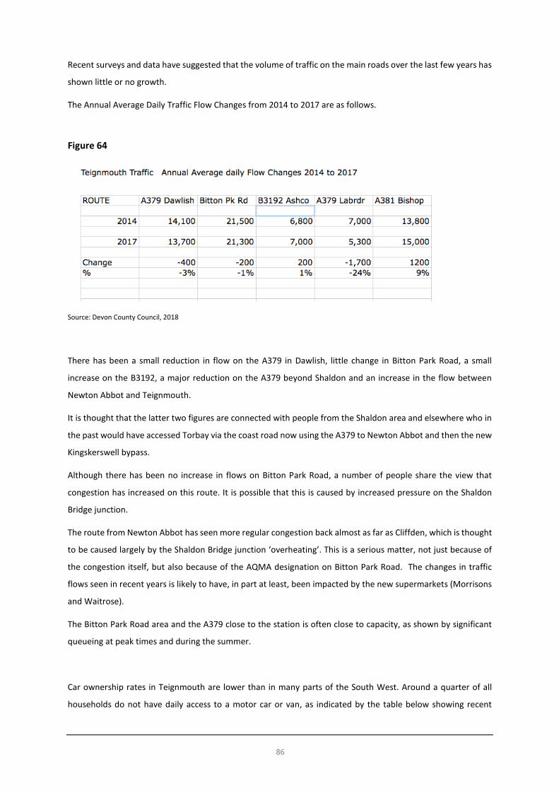
86
Recent surveys and data have suggested that the volume of traffic on the main roads over the last few years has
shown little or no growth.
The Annual Average Daily Traffic Flow Changes from 2014 to 2017 are as follows.
Figure 64
Source: Devon County Council, 2018
There has been a small reduction in flow on the A379 in Dawlish, little change in Bitton Park Road, a small
increase on the B3192, a major reduction on the A379 beyond Shaldon and an increase in the flow between
Newton Abbot and Teignmouth.
It is thought that the latter two figures are connected with people from the Shaldon area and elsewhere who in
the past would have accessed Torbay via the coast road now using the A379 to Newton Abbot and then the new
Kingskerswell bypass.
Although there has been no increase in flows on Bitton Park Road, a number of people share the view that
congestion has increased on this route. It is possible that this is caused by increased pressure on the Shaldon
Bridge junction.
The route from Newton Abbot has seen more regular congestion back almost as far as Cliffden, which is thought
to be caused largely by the Shaldon Bridge junction ‘overheating’. This is a serious matter, not just because of
the congestion itself, but also because of the AQMA designation on Bitton Park Road. The changes in traffic
flows seen in recent years is likely to have, in part at least, been impacted by the new supermarkets (Morrisons
and Waitrose).
The Bitton Park Road area and the A379 close to the station is often close to capacity, as shown by significant
queueing at peak times and during the summer.
Car ownership rates in Teignmouth are lower than in many parts of the South West. Around a quarter of all
households do not have daily access to a motor car or van, as indicated by the table below showing recent

87
Census data for ‘Teignmouth Town’ electoral division. It shows too, a discernible growth in households owning
more than one car between 2001 and 2011.
Figure 65
Source: ONS, NOMIS https://www.nomisweb.co.uk/
Figure 66
Source: http://www.devon.gov.uk/census_profile-div52-teignmouth_town.pdf
Notes: “Teignmouth Town” relates to an area wider than the parished area (Teignmouth, Bishopsteignton and Shaldon parishes), but is
useful to use as a basis for comparison purposes
Traffic Management and Parking
There are several public car parks in Teignmouth, particularly around the river mouth. This can cause traffic problems in the summer as visitors to the town have to travel through the town centre and the one-way system to the car parks.

88
Devon County Council has been working with Teignmouth Town Council and other stakeholders for several years developing proposals designed to:
• free up much on street parking as possible to benefit residents • encourage turnover of on-street limited waiting to benefit businesses • enable enforcement to be undertaken efficiently • encourage longer term visitors to use off-street car parks • encourage those working in the town make more sustainable travel choices, for example, car share, public
transport, walking and cycling.
After much consultation a new traffic management scheme, with extended one-way system and parking restrictions was introduced on a temporary basis (to be reviewed after one year) in 2016. It included a residents parking scheme to the north of the railway line close to the town centre, as on-street parking surveys had revealed that some residents in outlying areas were parking their vehicles in residential areas closer to the town centre during the day. The results of the consultation indicated that there was little demand for residents’ parking in other areas of the town.
Figure 67
Source: Teignmouth Transportation Access Strategy https://www.teignbridge.gov.uk/media/2243/teignmouth-
transportation-access-strategy-august-2011.pdf
Rail
Teignmouth is on the main UK national rail network and is the location of a railway station on the Penzance to London Paddington line. The station is situated within Teignmouth town centre, central to much of the town, although the station lacks adequate access for people with impaired mobility, parents with prams and passengers with heavy luggage as there is no lift. The main line section between Newton Abbot and Exeter, running through Teignmouth and Dawlish is notable as a visitor attraction in its own right, however, it is also one of the most expensive sections of UK mainline to maintain. This is due to the seawall which is vulnerable in high seas during easterly gales and needs regular maintenance, in addition to sections of cliff along this section of track which need shoring up.
Long-term sustainability and resilience of the railway line to the impacts of weather and coastal erosion is important to both Teignmouth and stations up and down the line (in terms of both the future of rail service and the impact on cliffs along the line and the beach). The outcome of a study being done by Network Rail on resilience of the railway line will need to be considered34.
34 It is expected that the study’s conclusions will be ready by mid-2019 (see https://www.gov.uk/government/news/resilience-work-on-key-south-west-rail-route-firmly-on-track-says-rail-minister and https://www.scottmann.org.uk/news/progress-dawlish-line-resilience-work-welcomed-scott-

89
Teignmouth is currently served by 29 weekday daily rail services southbound and 34 northbound. The majority of these services are run by Great Western Railway (GWR), with a small number of services also run by Crosscountry Trains.
This is mainly made up of local services running to Paignton, Exeter and Exmouth running approximately hourly and increasing to approximately half hourly at peak times. Many of these trains provide connections to other longer distance services.
In addition, some other services run direct to destinations such as:
• Plymouth • Penzance • Bristol • Cardiff • London Paddington - 4 services northbound to London Paddington; 2 services southbound • Manchester - 3 daily weekday services each way currently run by Crosscountry
Rail passenger numbers from Teignmouth has steadily increased since the Millennium. It increased by almost 58% between 2002/3 and 2009/10, with 451,000 entries and exits in the latter year. In 2015/16 the comparable figure was 640,112, which rose to 681,046 in 2016/17. Teignmouth station now regularly sees a greater number of passenger numbers than Torquay station (505,384 entries and exits in2016/17).
A significant recasting of the timetable serving Teignmouth is expected to come into effect in 2019. GWR has indicated that this will include a half hourly local service between Paignton and Exmouth for much of the day, but it is yet to be seen how this will affect direct services to other destinations.
Buses
The town is served by regular bus services. These are as follows: • Route 2 – Newton Abbot to Exeter – average frequency every 20 minutes • Route 22 – Teignmouth to Torquay – average frequency every hour, although not in the evenings • Route 184 – Teignmouth to Newton Abbot, approximately 2 hourly services serving Bishopsteignton
during the daytime • Teignmouth town services 80, 81 and 83 running frequently during the daytime • Route 886 – Teignmouth to Newton Abbot run by Dawlish Community Transport
In addition to these, there is a school bus from Dawlish to Paignton run by Stagecoach which stops at Teignmouth and a daily National Express coach service from Paignton to London Victoria which serves Teignmouth.
Teignmouth does not have a bus station building. There are five bus stops near to each other around the Triangle in the centre of town. There are eleven different bus routes from Teignmouth's Triangle to surrounding towns and villages.
While there are relatively good bus services in and around Teignmouth, there are concerns about the lack of direct services to the hospital in Exeter. However, it is acknowledged that it is probably not commercially viable for a more frequent and / or direct service to both the Exeter and Newton Abbot hospitals.
mann for further information). This will build on the report produced in 2014 https://cdn.networkrail.co.uk/wp-content/uploads/2016/11/West-of-Exeter-Route-Resilience-Study.pdf

90
Figure 68
Source: Devon County Council http://www.devon.gov.uk/teignmouth_town_plan_sum05.pdf
Walking and Cycling
Teignmouth town centre is relatively small in area and quite flat, so it is easy for people to walk around it. However, walking to the town centre can be an issue as the steep roads north of the town centre can discourage people from walking. It is however flat along the river and takes just over 30 minutes to walk from the town centre to Mill Lane on the western edge of town, with a number of pedestrian crossing points across the main roads.

91
There is a designated cycle route that uses the Shaldon Bridge and runs through the minor roads of the town centre before re-joining the A379 to Dawlish (see below). There are plans to extend this route to the west along the Teign Estuary. Cycle routes in and around Teignmouth are limited by the topography of the land. The land rises as much as 100m in 800m horizontally to the north of the town centre which may discourage people from cycling.
Teignmouth also has a foot ferry connection to Shaldon, which encourages sustainable travel between the two places.
Figure 69
© Crown copyright and database right. All rights reserved (PSMA no. 0100050966) 2018
Source: Teignmouth Transportation Access Strategy https://www.teignbridge.gov.uk/media/2243/teignmouth-transportation-access-
strategy-august-2011.pdf
South West Coast Path
The South West Coast Path is Britain's longest way-marked long-distance footpath and a National Trail. It stretches for 630 miles (1,014 km), running from Minehead in Somerset, along the coasts of Devon and Cornwall, to Poole Harbour in Dorset. The section from Torquay passes along steep wooded cliffs to Maidencombe, Labrador Bay and Shaldon. Walkers can then cross the river Teign
to Teignmouth via ferry or the Shaldon Bridge. From Teignmouth seafront the coast path follows the South Devon Railway sea wall to Hole Head/Parson and Clerk and joins the main Teignmouth to Dawlish road at

92
Smugglers Lane continuing to Dawlish. In 2003 a study calculated that local people took 23 million walks on the Path. The use of the path is likely to have increased since that study was undertaken.
Travel to Work
The census data confirms that a high proportion of persons normally travel to work by motor car.
Figure 70
Source: http://www.devon.gov.uk/census_profile-div52-teignmouth_town.pdf
Notes: “Teignmouth Town” relates to an area wider than the parished area (Teignmouth, Bishopsteignton and Shaldon parishes), but is
useful to use as a basis for comparison purposes
Comparison analysis of the 2001 and 2011 data indicates a trend over that period of more people working from
home and an increased propensity to travel a long way to work; and, apart from in West Teignmouth, more
people seemed to be travelling outside of Teignmouth for work.
The 2011 Teignmouth Transportation Access Strategy by Devon County Council reported on a registration plate surveys allow an analysis of the origins and destinations of trips into and through Teignmouth. It showed that more traffic leaves Teignmouth in the AM peak than arrives. This is likely to be commuter traffic travelling to Exeter, Torbay and Newton Abbot as suggested by the destination proportions. The majority of traffic travelling to Teignmouth originated from the north west and west, and is likely to come from Newton Abbot, Kingsteignton and Exeter.
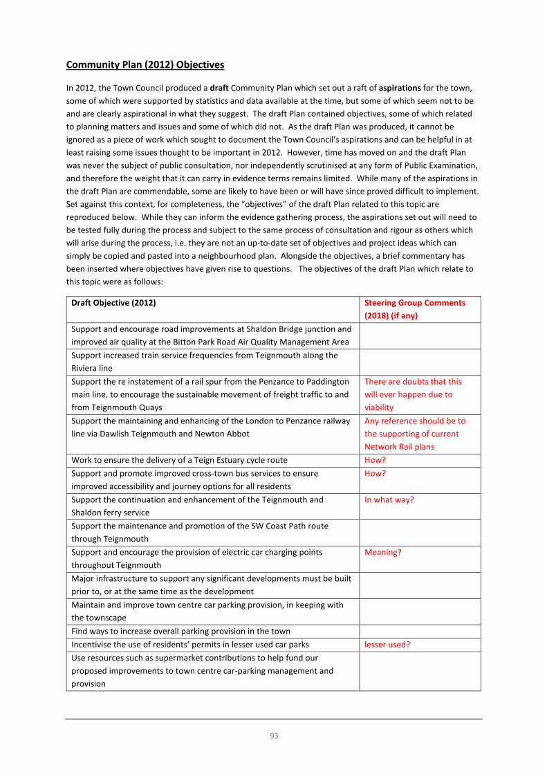
93
Community Plan (2012) Objectives
In 2012, the Town Council produced a draft Community Plan which set out a raft of aspirations for the town, some of which were supported by statistics and data available at the time, but some of which seem not to be and are clearly aspirational in what they suggest. The draft Plan contained objectives, some of which related to planning matters and issues and some of which did not. As the draft Plan was produced, it cannot be ignored as a piece of work which sought to document the Town Council’s aspirations and can be helpful in at least raising some issues thought to be important in 2012. However, time has moved on and the draft Plan was never the subject of public consultation, nor independently scrutinised at any form of Public Examination, and therefore the weight that it can carry in evidence terms remains limited. While many of the aspirations in the draft Plan are commendable, some are likely to have been or will have since proved difficult to implement. Set against this context, for completeness, the “objectives” of the draft Plan related to this topic are reproduced below. While they can inform the evidence gathering process, the aspirations set out will need to be tested fully during the process and subject to the same process of consultation and rigour as others which will arise during the process, i.e. they are not an up-to-date set of objectives and project ideas which can simply be copied and pasted into a neighbourhood plan. Alongside the objectives, a brief commentary has been inserted where objectives have given rise to questions. The objectives of the draft Plan which relate to this topic were as follows:
Draft Objective (2012) Steering Group Comments (2018) (if any)
Support and encourage road improvements at Shaldon Bridge junction and improved air quality at the Bitton Park Road Air Quality Management Area
Support increased train service frequencies from Teignmouth along the Riviera line
Support the re instatement of a rail spur from the Penzance to Paddington main line, to encourage the sustainable movement of freight traffic to and from Teignmouth Quays
There are doubts that this will ever happen due to viability
Support the maintaining and enhancing of the London to Penzance railway line via Dawlish Teignmouth and Newton Abbot
Any reference should be to the supporting of current Network Rail plans
Work to ensure the delivery of a Teign Estuary cycle route How? Support and promote improved cross-town bus services to ensure improved accessibility and journey options for all residents
How?
Support the continuation and enhancement of the Teignmouth and Shaldon ferry service
In what way?
Support the maintenance and promotion of the SW Coast Path route through Teignmouth
Support and encourage the provision of electric car charging points throughout Teignmouth
Meaning?
Major infrastructure to support any significant developments must be built prior to, or at the same time as the development
Maintain and improve town centre car parking provision, in keeping with the townscape
Find ways to increase overall parking provision in the town Incentivise the use of residents’ permits in lesser used car parks lesser used? Use resources such as supermarket contributions to help fund our proposed improvements to town centre car-parking management and provision

94
Key Issues and Messages • A good quality public transport service is vital for residents and visitors. • The railway is important to Teignmouth, with a good service that should be retained. However, there are
difficulties accessing the platforms with heavy cases, for the disabled, parents with pushchairs etc. • Long-term sustainability and resilience of the railway line to the impacts of weather is important to both
Teignmouth and stations up and down the line (in terms of both the future of rail service and the impact on cliffs along the line and the beach). The outcome of a study being done by Network Rail on resilience of the railway line will need to be considered.
• The local parking strategy could prioritise local roads for residents, whilst ensuring sufficient short-stay parking opportunities are available in appropriate locations.
• Adequate off-road parking areas should be provided for long-stay visitors. • We should find ways to further encourage and accommodate cycling. • Improvements to the frequency of and accessibility to public transport services would be welcome but will
be difficult to achieve. • We are concerned about the impact of congestion on air quality, particularly within the Air Quality
Management Area along Bitton Park Road. • We should seek to reduce congestion on the A379 from the station through to Shaldon Bridge.

95
Tourism, Arts and Culture
It is widely acknowledged that Teignmouth is now a very popular day-trip destination for residents of a large part of Devon, but that the town itself now provides minimal visitor accommodation.
Historically Teignmouth was a very popular destination for staying visitors in hotel and self-catering accommodation, but this declined significantly between the 1960s and 1980s and now forms a relatively small part of its economic make-up but has contributed much to the character of much of the town.
Some regeneration work which has taken place in the town in recent years has been generally well received by residents and visitors and has begun to make Teignmouth a more bustling and attractive place, as it has tended to complement the town’s natural, built and cultural environment. A coastal town renaissance is underway, sparked by investment in leisure and cultural projects. Examples include the Pavilions, Den playpark, Seafront skate park, music festivals including a spectacular Muse concert in 2009, the Teignbridge seafront Arts Trail, the renovated Riviera Cinema building and the Teign Heritage Centre (Teignmouth and Shaldon Museum).
The Pavilions, Teignmouth is an arts, community and enterprise venue providing a diverse programme of live performance and cinematic events; offering space for commercial, educational, health and community events; providing opportunities for development, engagement, education and growth through volunteering, participation, as audience or maker.
The Pavilions sits on the site of the old Carlton Theatre. Teignbridge District Council invested £2.5m, plus £1.75m from the Coastal Communities Fund and over £500,000 from Arts Council England (ACE).
The venue has an auditorium, with raked theatre seating for 218, or cabaret seating 104, a standing capacity of 350 (e.g. music events) and capable of hosting Wedding feasts for 146 max. The venue also includes work hubs, studios, meeting rooms, a café, function bar, gallery space and a box office.
The Pavilions receives no public subsidy and is a’ Charitable Incorporated Organisation and is governed by a Board of Trustees.
In 2016/17 the Pavilions sold 28,530 tickets, had 298 cinema showings and 156 live events. It held 480 fitness courses and 14 workshops. It has just 3.5 full time equivalent staff and is supported by over 50 volunteers.
The former Riviera Cinema is under-going improvements and modifications. The owners are planning that this the will combine the existing cinema auditorium with the Riviera Bar, Restaurant and Function Room to create an Arts Venue, which will provide a cinema, theatre, concert venue, art studio and gallery, tea room, music and recording studio, function room , bar and restaurant. The building started life as the Assembly Rooms. It was built in 1826. The interior was altered when it was converted into a cinema in the mid-20th century.
The Teign Heritage Centre is home to the Teignmouth and Shaldon Museum. It is located on French Street and was first opened to the public on 28th May 2011. The Centre offers residents and visitors the opportunity to explore the fascinating heritage of the area, as well as attend events, concerts and workshops. It also includes is a purpose-built, modern community venue, the Teign Room, which can be hired for community events and seats up to 70 people.
The original Museum, housed in an 18th century building, was granted to the Teignmouth Historical Society to set up a Museum and this was opened in July 1978. It is celebrating its 40th anniversary year in 2018. It opens seasonally from February to October.
The building was given a £1.1m transformation and annexe, with funding from the Heritage Lottery Fund, the CABE/ Sea Change Initiative, the Foyle Foundation, Viridor, English Heritage and many other funders, supporters and individual donors. In June 2012 it was awarded the top accolade in the ‘best commercial/public building’ category for its “interesting and sustainable design” by Devon Building Control Partnership.
96
Infrastructure and numerous ‘attractions’ related to Teignmouth’s maritime, rural and urban character and heritage all contribute to providing a diverse and interesting ‘offer’ to tourists, day-trippers and residents. The very varied facilities and events include: • beach-huts • carnival • coastal railway • coast-watch stations • crazy golf • diving centre • historic pier • lido • lifesaving demonstrations and a lifeguarded beach • local food and drink (including in restaurants, shellfish on the Back Beach) • music festivals (including folk and jazz festivals) • power boat racing • regatta • regency seafront architecture • rowing club races • sailing events • seafront playpark • Teign Heritage Centre • Templer Way, linking Haytor with Teignmouth • tennis courts • the Den, as a natural event space • working lifeboat, housed in a high-quality build lifeboat station • working port and fishing industry
Community Plan (2012) Objectives In 2012, the Town Council produced a draft Community Plan which set out a raft of aspirations for the town, some of which were supported by statistics and data available at the time, but some of which seem not to be and are clearly aspirational in what they suggest. The draft Plan contained objectives, some of which related to planning matters and issues and some of which did not. As the draft Plan was produced, it cannot be ignored as a piece of work which sought to document the Town Council’s aspirations and can be helpful in at least raising some issues thought to be important in 2012. However, time has moved on and the draft Plan was never the subject of public consultation, nor independently scrutinised at any form of Public Examination, and therefore the weight that it can carry in evidence terms remains limited. While many of the aspirations in the draft Plan are commendable, some are likely to have been or will have since proved difficult to implement. Set against this context, for completeness, the “objectives” of the draft Plan related to this topic are reproduced below. While they can inform the evidence gathering process, the aspirations set out will need to be tested fully during the process and subject to the same process of consultation and rigour as others which will arise during the process, i.e. they are not an up-to-date set of objectives and project ideas which can simply be copied and pasted into a neighbourhood plan. Alongside the objectives, a brief commentary has been inserted where objectives have given rise to questions. The objectives of the draft Plan which relate to this topic were as follows:

97
Draft Objective (2012) Steering Group Comments (2018) (if any)
Support the development of tourist accommodation and visitor attractions, providing they are in conformity with the additional landscape policy, business incentivisation measures and sustainable design code contained with the Teignmouth Community Plan.
Welcome the provision of high quality visitor accommodation within Teignmouth
Support the Local Plan policy regarding the protection of the undeveloped coastal zones, which are an important resource to support the tourism, culture and leisure industries
This is a very important policy
Support, the investigating the feasibility of all potential opportunities to create a better visitor offer. These ideas include:
1. A rejuvenated theatre 2. A cinema 3. Improvements to, and better publicity about, Eastcliff Walled
Garden 4. Tree planting throughout the town, including the re-planting of
historic fruit trees in Orchard Gardens 5. Maintaining and increasing the size and scope of the Jazz and Folk
festivals and investigating holding other festivals 6. Holding more spectacular one-off events 7. Investigating the possibility of providing an outdoor gym on the
seafront - for all abilities 8. Investigating the possibility of the provision of high quality
outdoor water drinking fountains to discourage the use of disposable plastic bottles
9. Investigating the provision of outdoor seafront showers for beach and waters-ports users
10. Encouraging Torbay Express steam trains to stop at Teignmouth 11. Encouraging cruise ship visits through Destination South West 12. Maintaining and improving the cleanliness of our beaches and
bathing water, including gaining prestigious awards and the publicity that follows
13. Continuing the seafront summer Arts Trail 14. Better marketing of the town as a destination along the South
West Coast Path and Templer Way 15. Encouraging the early completion of the Teign estuary cycle route
and provision of improved facilities for cyclists in Teignmouth 16. Improving swimming pool facilities 17. Maintaining and improving the seafront and its views and
investigate the planting of additional salt resistant species on the seafront
18. Encouraging use of Teignmouth Heritage Trail boards, including local walks with guides
19. Refurbishment of Mules Park Gardens and more organised use for events
“Ideas”, like aspirations are good, but will need to be evidenced and deliverable to feature in a neighbourhood plan.
• Support regeneration at:

98
Draft Objective (2012) Steering Group Comments (2018) (if any)
a) Brunswick Street / Northumberland Place - redevelopment of a 0.2ha. site to include, subject to viability, new homes and 1,500 to 2,000 square metres of comparison (non-food) retail or commercial floor-space. Replacement car parking provision at enhanced Quay Road car park;
b) River / Back Beach and Fish Quay - Flood defences and regenerated Back Beach / Fish Quay area to include pedestrian walkway and seating, floor-scape treatment along Queen Street / New Quay Street / Osmonds Lane; and
c) an enhanced swimming pool facility Work with DCC, TDC and schools to look at the requirements for a new primary school and investigate potential sites, or other options
Support the maintenance and improvement of effective neighbourhood policing across Teignmouth, combined with measures to help reduce levels of crime, such as better youth provision, a more pleasant environment and better employment opportunities
Support the maintenance and enhancement of the cover available through Teignmouth and neighbouring fire stations
Support the maintenance and enhancement of good healthcare in Teignmouth and the surrounding area, including ambulance cover, doctors and dentists, which is available to all people within our community
Key Issues and Messages • The development of arts and culture is important for the future of Teignmouth. • We have some first-class facilities that have set a standard for others. • The town would benefit from developing and promoting a strong modern cultural identity. • There are many tourism assets to develop and exploit. • Sustainable tourism development will be welcomed.

99
Sports, Leisure and Recreation
Sport and Leisure
Teignmouth is blessed with significant sports provision which includes:
1. Broadmeadow sports centre (including a 5 court sports hall, cardio gym, 2 x weights only gyms, 1 x studio, 1 x indoor cycling studio, 2 x squash courts and a sauna; and, outdoors: 1 x rugby pitch, 1 x adult football pitch and 2 x training pitches) 2. A popular outdoor Lido (summer only) 3. Football club 4. Rugby club 5. Golf course 6. Lifesaving club 7. Rowing club 8. Schools pitches and facilities 9. Multi-use games area (MUGA) including tennis court at The Den
The closest indoor swimming pools to Teignmouth are at the Dawlish Leisure Centre and Dyrons Leisure Centre in Newton Abbot.
There are many well-used boat moorings along the Teign estuary.
Parks
There are 6 play parks in Teignmouth (according to the Teignbridge DC website35) at the following locations: • Coombe Lane; • Eastcliff Lido; • Kingsway; • Lower Kingsdown; • The Den; and, • Third Avenue. There is also a skate park on the Promenade. The TDC website gives further details on The Den and Eastcliff Parks, which are reproduced below.
Figure 71
35 See https://www.teignbridge.gov.uk/sports-and-leisure/parks-and-open-areas/parks/

100
Figure 72
The Den play area also has a Management Plan in place covering the period 2013-201836.
36 See https://www.teignbridge.gov.uk/media/5327/den-management-plan-2013-2018.pdf

101
Rights of Way Figure 73: Public Rights of Way (Footpaths)
© Crown copyright and database right. All rights reserved (PSMA no. 0100050966) 2018 Source: http://map.devon.gov.uk/dccViewer/ Other Studies and Strategies with Potential Useful Information There are four studies / strategies currently underway which Teignbridge DC expect to publish in the Spring / Summer of 2018. When they have been published, they can be reviewed to understand any relevant content for Teignmouth. These are as follows: • Leisure Facilities Strategy • Playing Pitch Strategy • Open Spaces Needs Assessment • Built Leisure Facilities Needs Assessment Community Plan (2012) Objectives In 2012, the Town Council produced a draft Community Plan which set out a raft of aspirations for the town, some of which were supported by statistics and data available at the time, but some of which seem not to be and are clearly aspirational in what they suggest. The draft Plan contained objectives, some of which related to planning matters and issues and some of which did not. As the draft Plan was produced, it cannot be ignored as a piece of work which sought to document the Town Council’s aspirations and can be helpful in at least raising some issues thought to be important in 2012. However, time has moved on and the draft Plan
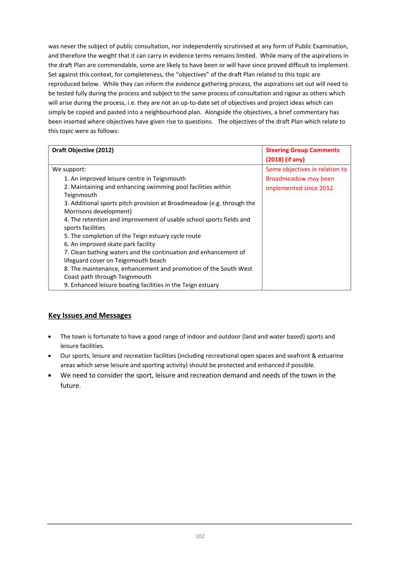
102
was never the subject of public consultation, nor independently scrutinised at any form of Public Examination, and therefore the weight that it can carry in evidence terms remains limited. While many of the aspirations in the draft Plan are commendable, some are likely to have been or will have since proved difficult to implement. Set against this context, for completeness, the “objectives” of the draft Plan related to this topic are reproduced below. While they can inform the evidence gathering process, the aspirations set out will need to be tested fully during the process and subject to the same process of consultation and rigour as others which will arise during the process, i.e. they are not an up-to-date set of objectives and project ideas which can simply be copied and pasted into a neighbourhood plan. Alongside the objectives, a brief commentary has been inserted where objectives have given rise to questions. The objectives of the draft Plan which relate to this topic were as follows:
Draft Objective (2012) Steering Group Comments (2018) (if any)
We support: 1. An improved leisure centre in Teignmouth 2. Maintaining and enhancing swimming pool facilities within Teignmouth 3. Additional sports pitch provision at Broadmeadow (e.g. through the Morrisons development) 4. The retention and improvement of usable school sports fields and sports facilities 5. The completion of the Teign estuary cycle route 6. An improved skate park facility 7. Clean bathing waters and the continuation and enhancement of lifeguard cover on Teignmouth beach 8. The maintenance, enhancement and promotion of the South West Coast path through Teignmouth 9. Enhanced leisure boating facilities in the Teign estuary
Some objectives in relation to Broadmeadow may been implemented since 2012.
Key Issues and Messages • The town is fortunate to have a good range of indoor and outdoor (land and water based) sports and
leisure facilities. • Our sports, leisure and recreation facilities (including recreational open spaces and seafront & estuarine
areas which serve leisure and sporting activity) should be protected and enhanced if possible. • We need to consider the sport, leisure and recreation demand and needs of the town in the
future.

103
Community Facilities and Services
Education
The following schools are located within Teignmouth:
Secondary
Teignmouth Community College serves Teignmouth, plus a hinterland of villages stretching as far as Stokeinteignhead and Ideford. It has over 1,000 students in total aged from 11 to 18 years and has a sixth form with around 170 students. The College recently merged management with Inverteign Primary School in Teignmouth, to form Teignmouth Community School. It was inspected by Ofsted in 2015. “Teignmouth Community School, Exeter Road, is larger than the average-sized secondary school. The school converted to academy status as part of the Teignmouth Learning Trust on 1 March 2011. When its predecessor school, Teignmouth Community College, was last inspected by Ofsted it was judged to be good overall. Most students are from White British backgrounds, with a very small proportion from other ethnic backgrounds. The proportion of disadvantaged students eligible for the pupil premium (additional funding for students in the care of the local authority or who are known to be eligible for free school meals) is close to the national average. The proportion of disabled students and those with special educational needs is above average. The school meets the government’s current floor standards, which set the minimum expectations for students’ attainment and progress. The school has specialist facilities for work-related learning, including motor vehicle maintenance, catering, hairdressing and construction. Most alternative education takes place on site.”37
Primary
Teignmouth Community School was formerly, Inverteign Community Nursery and Primary School. It is now known as the Mill Lane Campus. It is located on the western edge of Teignmouth and serves a large catchment area, primarily from students living in the western parts of the town. It also has nursery provision. The school caters for 3 to 11 year olds. The latest Ofsted report states: “Mill Lane is the size of an average primary school. The proportion of disabled pupils and those with special educational needs is well above average. Most of this group have behavioural difficulties or emotional needs. The proportion of pupils known to be eligible for free school meals is also well above average. Almost all pupils are White British; very few are of minority ethnic heritage and none is at the early stage of learning English as an additional language. The school has several recent accreditations, including the Healthy Schools Plus award. The school meets current floor standards. This is a good school. It has improved its effectiveness since the previous inspection. An overwhelming majority of parents and carers hold positive and accurate views about the school, especially the overall good quality of education it provides for their children.”38
Hazeldown Primary School is located on the northernmost edge of Teignmouth and serves a wide catchment area, primarily from students living in the central and eastern parts of the town. The school caters for 4 to 11 year olds. Ofsted reported in 2015 “This is a good school. Hazeldown School is larger than the average-sized primary school. The majority of pupils attending are of White British heritage. The proportion of disabled pupils or those who have special educational needs is below average and at times varies significantly from year to year. The proportion of pupils supported by the pupil premium (additional government funding for pupils known to be eligible for free school meals or who are looked after) is above average. Children in the early years commence their schooling full-time in the Reception classes. The school runs its own breakfast and after-school clubs.
37 http://www3.teignmouth.devon.sch.uk/resources/ofsted/exeter_road.pdf 38 http://www3.teignmouth.devon.sch.uk/resources/ofsted/mill_lane.pdf

104
The school meets the government’s current floor standards, which set out the minimum expectations for pupils’ attainment and progress in reading, writing and mathematics.”39
Our Lady and St. Patrick’s Primary School on Fourth Road, is run by the Roman Catholic diocese of Plymouth and serves the parishes of Teignmouth, with Bishopsteignton, Shaldon and Dawlish. The School also provides a nursery unit. The school caters for 3 to 11 year olds. It was inspected in 2017. “Our Lady and St Patrick’s Roman Catholic Primary School is smaller than the average sized primary school and is part of the Plymouth CAST. The Trust was formed in April 2014. The work of the Trust is overseen by a board of directors. The Trust is responsible for: one nursery; one first school; 32 primary schools; and two secondary schools across seven local authorities in the south west region. The school joined the Trust and became an academy on 1 April 2014. When its predecessor school, Our Lady and St Patrick’s Roman Catholic Primary School, was last inspected by Ofsted, it was judged to be inadequate overall. The proportion of pupils who receive support in school for their special educational needs and/or disabilities is below the national average. The proportion of pupils who are supported through pupil premium funding is below the national average. The percentage of pupils from minority ethnic groups is below the national average. The percentage of pupils who speak English as an additional language is also below the national average. The early years provision is part time for Nursery children and full time for Reception children. The school meets the government’s current floor standards, which set the minimum expectations for pupils’ attainment and progress in reading, writing and mathematics at the end of Year 6.”40
Independent
Trinity School is an independent school, college and nursery located in Buckeridge Road in Teignmouth. It caters for age groups from 3 months to 18 years. It also caters for boarders, many of whom are from overseas.
Healthcare
Teignmouth is reasonably well covered by healthcare provision, although much of it is approaching capacity.
There is a small hospital, Teignmouth Community Hospital within the town at Mill Lane. It provides a range of consultative and recuperative services and day surgery. It is open daily Monday to Friday and operated by NHS Torbay and South Devon NHS Foundation Trust. It no longer offers overnight bed spaces. More comprehensive healthcare and hospital cover is provided nearby at Newton Abbot, and especially Torbay and the Royal Devon and Exeter hospitals. Ambulance cover is provided primarily by an ambulance station in nearby Dawlish. While there are relatively good bus services in and around Teignmouth (see Transport section), there are concerns about the lack of direct services to the hospital in Exeter. However, it is acknowledged that it is probably not commercially viable for a more frequent and / or direct service to both the Exeter and Newton Abbot hospitals.
There are also a good range of general practitioners, dentists and some private healthcare practitioners located in the town. The amalgamation of two Teignmouth GP surgeries took place in the middle of 2017. It saw the former Teignmouth Medical Practice, with its 7,500 patients, and the 2,500 patients from the Richmond House Surgery, come together to form the new Teign Estuary Medical Group, which its bosses say will secure its future. GP surgeries in the town operate largely in outdated facilities / buildings.
In 2017 a new Coastal Information Centre was opened, which sits within the Health and Wellbeing Centre based at Teignmouth Hospital. The information centre enables local residents to access the wide range of support, activities and information that’s available in the area to support them to live their lives to the full and be as independent as possible. The centre is manned by ‘Volunteering in Health’.
39 https://reports.ofsted.gov.uk/provider/files/2494477/urn/113224.pdf 40 http://www.olsp-rc.devon.sch.uk/images/Final_Inspection_Report_2017.pdf

105
At the time of drafting this report, the Torbay and South Devon CCG has been consulting41 on the opportunity to improve services in the town by bringing some health and care services together in a new building. According to the CCG website, the suggestions are designed to improve services by:
• Making the best use of staff and resources • Continuing to support people out of hospital unless hospital bed based care clinically needed • Tackling accommodation issues such as the unsuitability of an ageing hospital building in Teignmouth for
the delivery of modern health and care services; a lack of expansion space in the town’s three GP practices; a need to find a long term base for the area’s successful health and wellbeing team
• Strengthening the close working between NHS and voluntary sector services • Ensuring the future provision of services used by most local people in the town
Figure 74: Key health statistics 201442
Source: Joint Strategic Needs Assessment Town Profile 2013-14: Teignmouth, Public Health Intelligence Team, Devon County
Council
41 See http://www.southdevonandtorbayccg.nhs.uk/teignmouth-engagement-2018/Pages/default.aspx 42 Teignmouth, Joint Strategic Needs Assessment Town Profile 2013-14, Public Health Intelligence Team, Devon CC, 2013

106
Figure 75: Census Health data 2011 (Parish)
Source: ONS, NOMIS https://www.nomisweb.co.uk/
Figure 76: Census Health data 2011 (Comparison)
Source: http://www.devon.gov.uk/census_profile-div52-teignmouth_town.pdf
Notes: “Teignmouth Town” relates to an area wider than the parished area (Teignmouth, Bishopsteignton and Shaldon parishes), but is
useful to use as a basis for comparison purposes

107
The Teignmouth and Dawlish Coastal Communities Economic Plan of 201643 estimates that Teignmouth will
experience a “12.2% forecast population increase by 2021”, that includes a “33% increase in people over 65 years
in next 15 years”.
Fire Service
Teignmouth is served by a retained firefighter-run station in the heart of the town. Teignmouth Fire Station is located at Higher Brook Street, Teignmouth. It covers an area of approximately 30 square kilometres and a population of almost 20,233 people (see response zone map for 2017 below).
Figure 77
Source: Teignmouth Local Community Plan 2016/17, Devon & Somerset Fire & Rescue Service https://www.dsfire.gov.uk/YourArea/WesternCommand/Stations/documents/201617TeignmouthLocalCommunityPlan.pdf
Community Facilities
There are community centres located at various points around the town providing a wide range of activities across the town. These centres are hireable by community and volunteer groups, plus individual members of the public. In addition to these community centres, other facilities such as the Pavilions, the Teign Heritage Centre and churches are also available for groups and individuals to hire. The Ice Factory and TAAG44 building (in the old Swansons’ motor dealership building) are both located in Northumberland Place and cater for several community activities and host all age groups.
43 https://www.coastalcommunities.co.uk/wp-content/uploads/2016/05/Teignmouth-and-Dawlish-CCT-Econ-Plan.pdf 44 TAAG = Teignmouth Arts Action Group. TAAG has been at the forefront of the strategy for Arts since 2007. It runs a variety of events in the town alongside 32 art exhibitions a year.

108
Community centres include:
• Alice Cross Day Centre (Central Teignmouth) • Eastcliff (Pulse) – focused mainly around younger people (East Teignmouth) • Kingsway Meadow Centre • Richard Newton Hall (North Teignmouth)
The Alice Cross Centre, Bitton Park Road, known as the ‘Alice’, is a charity-run centre for mainly for the elderly. It has a variety of rooms and hall available for hire. It is licensed premises with bar facilities, which makes it suitable for functions. The prime purpose of the Alice “is to further the well-being of the elderly in Teignmouth/Shaldon mainly by providing a day centre with meals, activities and clubs five days a week”. It is open Monday to Friday from 9am until around 1.30pm, serving morning coffee and lunches, with activities most afternoons. It has free WiFi and daily newspapers.
The Kingsway Meadow Centre has played a pivotal role in the community of West Teignmouth. “Kingsway Meadow Centre was built in the 1980's and for the last 30 years has been a popular place for local residents of all ages to attend. Kingsway Residents Association who run the centre provide a wide range of activities for people of all ages. The activities provided are vital as there are no other organisations in the immediate area to provide anything and lack of things to do can lead to social isolation and anti-social behaviour problems. Some of the activities include Youth clubs, summer play schemes, over 50's lunch club, craft group, parent/carer & child group and lots more. The centre is also available to hire for birthday parties and other occasions. Over 250 people use the centre every week and it is a valuable asset to the community.
Sadly the centre has seen better days and is in desperate need of a 'make over' to ensure the safety and suitability of its use for everyone. Besides the centre needing a lick of paint inside and out the men's toilets need replacing, the kitchen needs up-dating and the wooden floor is becoming a hazard as sections of it are coming loose.”45
The Richard Newton Hall, on Higher Buckeridge Road, is run by the New Road Area Community Association, which was formed in May 1966, to encourage and facilitate social, recreational and community activities for the then newly developed area. The Richard Newton Hall was built and opened 2 years later to provide a home for those activities. The hall comprises the main hall with stage, a separate lounge, a kitchen, and members' bar. All areas (except the stage itself) are wheelchair accessible. The Hall and Lounge are used by activity groups that are directly part of the Association and other organisations such as Teignmouth Pre-School, North Teignmouth Community Church, Teignmouth Women's Institute and Probus.
The Ice Factory on Somerset Place is a performing arts space and home of the Teignmouth Players. A former industrial building has been converted to create is a 50-seater studio theatre. It is a part of the recently labelled (2016) Arts Quarter in Teignmouth centre around Northumberland Place.
Close-by is the Arts and Community Centre, also known as the TAAG Centre. is home to the TRAIL (the recycled-material sculpture trail on the seafront), RNLI, Information Hub and used regularly by Teignmouth Art Society. There is a wide variety of art workshops, language teaching, book clubs, philosophy etc. It has two galleries and a meeting room that are available for hire. There are regular volunteer stewards in place every day from 10am -5pm and extra cover for evening events.
Youth Centres
Teignmouth has a strong and vibrant youth culture, focused especially around an arts and music scene, sports – including water-sports and a relatively new skatepark provided on the seafront.
The Eastcliff Centre has been run by a local registered charity, since the County Council withdrew funding in 2011.
45 From Aviva Community Fund website https://www.avivacommunityfund.co.uk/voting/project/view/17-5986

109
The Cave is a music project based in the ground floor section of the Eastcliff Centre in Teignmouth. There is a wealth of musical and creative talent in the town. The objective is to nurture and enhance this by improving the quality of bands and individual musicians through instrument lessons, master classes and training in related skills such as sound engineering, recording, marketing and promotion. Musicians from across a wide age spectrum are encouraged to work and perform together both by sharing the practice space and by the provision of regular monthly live sessions in venues across the town to showcase local talent.
Library
Teignmouth has a full-time library, with photocopying and computer/internet facilities, provided by Devon County Council. It is housed in a 1970s concrete building next to the dual carriageway in the centre of the town. It is also home to the Citizen’s Advice Bureau and is also used by other groups, including hosting surgeries with the local Member of Parliament. It includes a children’s library, a separate teen area with comfy seating and an IT suite comprising of 10 public access computers. The library holds regular children’s events, knit and natter, scrabble clubs and has a regular reading group.
Community Plan (2012) Objectives See Leisure and Tourism objectives.
Key Issues and Messages • Current education provision is generally acceptable, but its capacity is uncertain. • There are concerns about the sufficiency of local health provision to serve an ageing population. • GP surgeries and the Teignmouth hospital are operating from outdated buildings in need of improvement. • The community halls and centres are well used but some need modernisation. • Teignmouth has a strong and vibrant youth culture which should be supported and encouraged. • Some public facilities are in need of improvement.

110
Renewable / Low Carbon Energy and Air Quality
In 2012, the draft Community Plan summarised key data for emissions and other energy, air quality and waste related data some of which is repeated below. Some of these figures have been updated where data has been sourced / available.
Emissions The following data focuses on emissions data, but much of this is not available below district level. However, it is important to note in the local evidence report as important context. A similar summary to the bullets reproduced below is no longer produced as the South West Observatory no longer exists as a public sector monitoring organisation. Figure 78
Source: South West Regional Observatory 2012
While emissions data tends not to be made available down to the parish or town level, the Government publishes data from annual records. As the table below shows, carbon dioxide emission levels have been falling across sectors and sources since 2005 at the district level.

111
Figure 79
Source: https://www.gov.uk/government/statistics/uk-local-authority-and-regional-carbon-dioxide-emissions-national-statistics-2005-2015

112
As part of the local authority response to carbon emission reduction, Teignbridge DC has developed a Carbon Offsetting Calculator which can be used by developers of major development to demonstrate how they can meet the requirements of policies S7 and EN3 in the Local Plan. Further details can be seen in the strategic evidence base report. Air Quality Teignmouth Air Quality Management Area Teignmouth has an Air Quality Management Area (AQMA) along Bitton Park Road, one of four in the district. The area has been designated as a result of air quality exceeding a set of national targets for key pollutants. Further information is available on the Teignbridge DC website46. The area is shown in the figure below. Figure 80
Source: https://www.teignbridge.gov.uk/media/2445/aqma-teignmouth.pdf © Crown copyright and database right. All rights reserved (PSMA no. 0100050966) 2018
The latest monitoring report (published in June 2017) states that “In 2016 the results show a small reduction with 7 sites having figures slightly lower than in 2015. One site has shown an increase since 2016 and there are still 2 sites well exceeding the National Objective target for NO2.”47
46 See https://www.teignbridge.gov.uk/environmental-health-and-wellbeing/land-air-and-water-pollution/air-quality/ 47 See page 2, LAQM Annual Status Report 2017, https://www.teignbridge.gov.uk/media/5394/june-2016-asr.pdf

113
The AMQA has published an Air Quality Action Plan48, a statutory document, which is a requirement under Part IV of the Environment Act 1995 and the details of actions put in place to seek to improve air quality in the AQMA is set out there. Policy EN6 of the Local Plan sets out planning policy in relation to the AQMA (see strategic evidence report for further details). Energy An Assessment on the Landscape Sensitivity to Onshore Wind Energy Developments in Teignbridge District The study, commissioned by Teignbridge District Council and published in March 2017 seeks to help understand how best to accommodate wind energy developments in the landscape. It was informed by the Devon Landscape Character Assessment and guidance produced by consultants for the Devon Landscape Policy Group, “Devon Landscape Policy Group Advice Note No. 2: Accommodating Wind and Solar PV Developments in Devon's Landscape” (see summary in the strategic evidence report) which should be referred to and considered in greater depth if the neighbourhood plan considers allocating sites for wind and solar development.49 The following definitions are applied to various sizes of wind turbine development in the study. Figure 81
Source: p.6, An Assessment on the Landscape Sensitivity to Onshore Wind Energy Developments in Teignbridge District, https://www.teignbridge.gov.uk/media/6357/wind-web.pdf
The study applies the following sensitivity levels and definitions.
48 See https://www.teignbridge.gov.uk/media/2447/air-quality-action-plan.pdf 49 See http://www.devon.gov.uk/devon-guidance-v6-june-2013-final-report.pdf

114
Figure 82
Source: p.12, An Assessment on the Landscape Sensitivity to Onshore Wind Energy Developments in Teignbridge District, https://www.teignbridge.gov.uk/media/6357/wind-web.pdf
For each scale of turbine listed in the report’s Table 3.1 (reproduced above) a table and accompanying maps show the degree of sensitivity in the landscape (based on the Landscape Character Assessment Character Areas, considered in the Natural Environment section of the strategic evidence report). The tables relating to the LCAs relevant to Teignmouth are reproduced below.
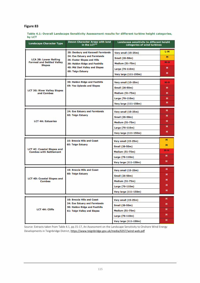
115
Figure 83
Source: Extracts taken from Table 4.1, pp.15-17, An Assessment on the Landscape Sensitivity to Onshore Wind Energy Developments in Teignbridge District, https://www.teignbridge.gov.uk/media/6357/wind-web.pdf

116
Community Plan (2012) Objectives In 2012, the Town Council produced a draft Community Plan which set out a raft of aspirations for the town, some of which were supported by statistics and data available at the time, but some of which seem not to be and are clearly aspirational in what they suggest. The draft Plan contained objectives, some of which related to planning matters and issues and some of which did not. As the draft Plan was produced, it cannot be ignored as a piece of work which sought to document the Town Council’s aspirations and can be helpful in at least raising some issues thought to be important in 2012. However, time has moved on and the draft Plan was never the subject of public consultation, nor independently scrutinised at any form of Public Examination, and therefore the weight that it can carry in evidence terms remains limited. While many of the aspirations in the draft Plan are commendable, some are likely to have been or will have since proved difficult to implement. Set against this context, for completeness, the “objectives” of the draft Plan related to this topic are reproduced below. While they can inform the evidence gathering process, the aspirations set out will need to be tested fully during the process and subject to the same process of consultation and rigour as others which will arise during the process, i.e. they are not an up-to-date set of objectives and project ideas which can simply be copied and pasted into a neighbourhood plan. Alongside the objectives, a brief commentary has been inserted where objectives have given rise to questions. The objectives of the draft Plan which relate to this topic were as follows:
Draft Objective (2012) Steering Group Comments (2018) (if any)
Teignmouth is a unique town in a protected coastal setting that includes coastal town, working docks and wildlife estuary. Enclosed by rolling hills and dramatic red sandstone cliffs it is nevertheless easily accessible by road and rail. The town will:
1. The town will be a sustainable, vibrant and accessible place that supports a high quality of life 2. The town will have a balanced economy that maximises the town’s potential 3. The town will have an efficient network of roads, good parking, and safe walking and cycle routes 4. The town will encourage culture, sport and the enjoyment of the area’s natural resources 5. The town will be safe from flood risk, adaptable to climate change and have reduced carbon dependence
Key Issues and Messages • We should consider how we might (and the degree to which we are able to) address climate change and
air quality related issues in the neighbourhood plan and improve the town’s sustainability (in terms of adaptation, mitigation and resilience to change, emissions, energy efficiency & generation and waste).
• There may be opportunities to support renewable energy generation in the town subject to the findings of the landscape sensitivity analysis.

117
Waste and Minerals
Waste and Recycling
Teignbridge District Council provides refuse collection and a comprehensive recycling service:
• Blue paper sack: for paper and magazines • Green Box: for cardboard, small electricals and glass • Black Box: for plastics and small metal containers • Blue food waste container: • Green garden waste bin (for subscribers only)
Teignbridge District Council encourages the composting of kitchen and garden “Home composting is the most environmentally friendly way of dealing with kitchen and garden waste. It produces compost that can be used as an excellent soil improver”. Residents can also buy low cost home compost bins from the district council.
The Brunel Road Recycling Centre50, Newton Abbot is the nearest centre for Teignmouth residents. It recycles a wide range of goods and materials.
Go Green Devon is a small, not-for-profit, recycling company, helping to support the local community by recycling and reusing. Its current services include; garden waste collection, composting, re-cycled wood products, garden maintenance and equipment hire. All profits go to local children's groups in order to compliment the services offered by the Teignbridge and Torbay Council. It recycles on its site in Newton Abbot. Products made from recycled materials are available for purchase and include planters, garden furniture, lighting sticks, logs, compost, wood chipping and mulch - all delivered to your home or allotment.
Trail (Teignmouth Recycled Art in Landscape)51 is one of Teignmouth’s success stories. It is a voluntary artist-led organisation raising awareness of environmental issues and promoting recycling through art. Established in 2005, TRAIL gives professional artists, community groups and amateur artists the opportunity to create and exhibit large scale art works for an outdoor environment. Trail has been very successful in getting local businesses to sponsor the annual sculpture trail, of recycled material along the seafront. In 2018 TRAIL has begun work with the Marine Conservation Society on project to ban/cease single use plastic straws.
Community Plan (2012) Objectives In 2012, the Town Council produced a draft Community Plan which set out a raft of aspirations for the town, some of which were supported by statistics and data available at the time, but some of which seem not to be and are clearly aspirational in what they suggest. The draft Plan contained objectives, some of which related to planning matters and issues and some of which did not. As the draft Plan was produced, it cannot be ignored as a piece of work which sought to document the Town Council’s aspirations and can be helpful in at least raising some issues thought to be important in 2012. However, time has moved on and the draft Plan was never the subject of public consultation, nor independently scrutinised at any form of Public Examination, and therefore the weight that it can carry in evidence terms remains limited. While many of the aspirations in the draft Plan are commendable, some are likely to have been or will have since proved difficult to implement. Set against this context, for completeness, the “objectives” of the draft Plan related to this topic are reproduced below. While they can inform the evidence gathering process, the aspirations set out will need to
50 https://new.devon.gov.uk/wasteandrecycling/centre/brunel-road-recycling-centre/ 51 http://www.trailart.co.uk/

118
be tested fully during the process and subject to the same process of consultation and rigour as others which will arise during the process, i.e. they are not an up-to-date set of objectives and project ideas which can simply be copied and pasted into a neighbourhood plan. Alongside the objectives, a brief commentary has been inserted where objectives have given rise to questions. The objectives of the draft Plan which relate to this topic were as follows:
Draft Objective (2012) Steering Group Comments (2018) (if any)
In relation to new development: Be carried out to the highest standards of sustainable construction where viable and practicable. Development should be adaptable, anticipating change in household needs and family structures throughout their lifetime as well as anticipating the impacts of climate change. Development should use locally sourced materials where possible, and minimise the use of materials, by using recycled materials in the construction of the development and minimising waste during construction.
How will this aspiration be delivered?
Key Issues and Messages • The Teignbridge kerbside service is very effective in encouraging recycling • The community seems open to new and innovative ideas to reduce and recycle waste • We should explore solutions to the storage of public and private waste and recycling bins on the
public highway and in other public areas.

119
Summary of Key Issues and Messages The following section summarises the key issues and messages identified in the local evidence base report.
Natural Environment • We are fortunate to have various environmental designations which help to protect the local (land side)
environment and biodiversity. However, there may be additional areas which require protection through the neighbourhood plan or currently protected areas which could benefit from additional planning policy protection.
• Maintaining the character and identity of the town and separation between Teignmouth, Holcombe and Bishopsteignton through the protection of open gaps and valued landscape is important.
• The coastal and estuarine environments frame the town and help to define its character. • Landscape character analysis suggests a mainly low capacity to accommodate new development on the
town’s edges. • Maintaining appropriate coastal and fluvial flood defences and introducing mitigation, as necessary, in
relation to new development to protect the town into the future is essential. • We should seek further evidence and information on important issues, priorities and policies from
agencies such as the Environment Agency and Natural England and organisations such as the Devon Wildlife Trust.
Built Environment • We have a valuable heritage and historic environment which contributes positively to the built character
of the town and should continue to be protected. • The town has benefitted from successive regeneration schemes since the 1990s. The character of the
town should continue to be improved into the future, building on the momentum of enhancements made in these recent years.
• Maintaining and protecting the quality of the public realm and town’s character is important not only to residents, but to local businesses and visitors, helping to underpin the local economy.
• There is an opportunity to explore the development of a Design Code or Guide for the town to reinforce those characteristics which make Teignmouth what it is, reinforce local distinctiveness and to help ensure that a high quality urban environment in the Teignmouth context is delivered as new development and regeneration takes place into the future.
• Within the context of delivering high quality development, we should explore opportunities to increase the sustainability of development and its contribution to a reduction in carbon dioxide emissions through energy efficiency, use of low carbon solutions and energy generation, minimising waste (during construction) and maximising solar gain.
• There is an opportunity to help enhance the quality of life of residents through protection and provision of open greenspace and planting for access, design / aesthetic and air quality reasons.
• There may be opportunities to explore local funding schemes to raise capital funds to bring forward environmental improvements which benefit the community.
• We should seek further evidence and information on important issues, priorities and policies from Historic England.

120
Population and Housing • Our population looks likely to increase and it is likely that we will continue to have an ageing population. • A minimum of 57 dwellings (net) need to be delivered in Teignmouth to meet the Local Plan housing
target to 2033 based on completions and commitments to date. (However, this could increase with the anticipated changes (during 2018) to the way that local authorities will be required by Government to calculate housing needs across tenures.)
• Further research will be necessary if we need and want to better understand the total housing need and demand across tenures and types beyond that proposed in the adopted Teignbridge Local Plan.
• House prices continue to rise in the town with a 2.5% increase over the last 12 months. Mortgages seem likely to be out of the reach of most first-time buyers in Teignmouth.
• An up-to-date housing needs survey and assessment would help to identify the need for affordable housing in the short-term (3-5 years).
• Consultation will need to establish the community’s appetite for housing delivery in terms of scale (over and above the Local Plan’s identified numbers), type and potential location(s).
• We will need to consider whether or not the neighbourhood plan should allocate housing sites or whether this should be left to Teignbridge District Council to do so.
• Highways infrastructure costs could be an impediment to the viability of major development in Teignmouth.
• Considering the Natural Environment section alongside the Housing section, Teignmouth is relatively constrained within its boundaries to accommodate new development on its edge.
• There are challenges around levels of deprivation in the town centre area, despite relative improvements in ranking between 2010 and 2015.
Economy, Employment and Retail • Additional employment space could benefit the town. • It would be beneficial to local people to attract and nurture growth industries offering better quality job
opportunities. • We need to create and promote the town as a high quality, sustainable working environment. • The Port must provide for a range of functions and activities. • Tourism should remain an important facet of the local economy. • There are many tourism assets to develop and exploit. • A revitalised Teignmouth will benefit the district. • The role and purpose of the town centre needs greater definition. • There is scope to broaden the evening economy in the town centre.
Transport, Infrastructure and Accessibility • A good quality public transport service is vital for residents and visitors. • The railway is important to Teignmouth. • Significant improvements to the road network are unlikely. • The local parking strategy should aim to protect local roads for residents and short-stay parking whilst
providing sufficient off-road parking areas for long-stay visitors. • We should find ways to further encourage and accommodate cycling. • Improvements to the frequency of and accessibility to public transport services would be welcome but will
be difficult to achieve.

121
• We are concerned about the impact of congestion on air quality, particularly within the Air Quality Management Area along Bitton Park Road.
Tourism, Arts and Culture • The development of arts and culture is important for the future of Teignmouth. • We have some first-class facilities that have set a standard for others. • A strong modern cultural identity would be helpful. • There are many tourism assets to develop and exploit. • Sustainable tourism development will be welcomed.
Sports, Leisure and Recreation • The town is fortunate to have a good range of indoor and outdoor (land and water based) sports and
leisure facilities. • Our sports, leisure and recreation facilities (including recreational open spaces and seafront & estuarine
areas which serve leisure and sporting activity) should be protected and enhanced if possible.
Community Facilities and Services • Current education provision is generally acceptable, but its capacity is uncertain. • There are concerns about the sufficiency of local health provision to serve an ageing population. • GP surgeries are operating from outdated buildings in need of improvement. • The community halls and centres are well used but some need modernisation. • Teignmouth has a strong and vibrant youth culture.
Renewable / Low Carbon Energy and Air Quality • We should consider how we might (and the degree to which we are able to) address climate change and
air quality related issues in the neighbourhood plan and improve the town’s sustainability (in terms of adaptation, mitigation and resilience to change, emissions, energy efficiency & generation and waste).
• There may be opportunities to support renewable energy generation in the town subject to the findings of the landscape sensitivity analysis.
Waste and Minerals • The Teignbridge kerbside service is very effective in encouraging recycling • The community seems open to new and innovative ideas to reduce and recycle waste
122
Appendix 1
Historic England Listed Buildings Register (Listed Buildings in Teignmouth Parished Area)
The List - Search Results The results of your search on the National Heritage List for England are listed below. To search again return to the List. To print a list entry description use the links below to open the entry and then use your browser print function. 133 results.
TWO K6 TELEPHONE KIOSKS OPPOSITE NOS. 1 AND 1A REGENT STREET
Heritage Category: Listing
Grade: II
Location: • TWO K6 TELEPHONE KIOSKS OPPOSITE NUMBER 1 WELLINGTON STREET, TRIANGLE
PLACE, Teignmouth, Teignbridge, Devon
1, WELLINGTON STREET
Heritage Category: Listing
Grade: II
Location: • 1, WELLINGTON STREET, Teignmouth, Teignbridge, Devon
2-5, WELLINGTON STREET
Heritage Category: Listing
Grade: II
Location: • 2-5, WELLINGTON STREET, Teignmouth, Teignbridge, Devon
14-17, WELLINGTON STREET
Heritage Category: Listing
Grade: II
Location: • 14-17, WELLINGTON STREET, Teignmouth, Teignbridge, Devon
WESTBROOK
Heritage Category: Listing
Grade: II
Location: • WESTBROOK, WESTBROOK AVENUE, Teignmouth, Teignbridge, Devon
WOODWAY HOUSE

123
Heritage Category: Listing
Grade: II
Location: • WOODWAY HOUSE, WOODWAY ROAD, Teignmouth, Teignbridge, Devon
GATES, GATE PIERS AND WALLS AT THE WEST ENTRANCE TO WOODWAY HOUSE
Heritage Category: Listing
Grade: II
Location: • GATES, GATE PIERS AND WALLS AT THE WEST ENTRANCE TO WOODWAY HOUSE, WOODWAY
ROAD, Teignmouth, Teignbridge, Devon
3, TEIGN STREET
Heritage Category: Listing
Grade: II
Location: • 3, TEIGN STREET, Teignmouth, Teignbridge, Devon
8, TEIGN STREET
Heritage Category: Listing
Grade: II
Location: • 8, TEIGN STREET, Teignmouth, Teignbridge, Devon
TEIGNMOUTH HOUSE AND ATTACHED WALL
Heritage Category: Listing
Grade: II
Location: • TEIGNMOUTH HOUSE AND ATTACHED WALL, 25, TEIGN STREET, Teignmouth, Teignbridge, Devon
BRITANNIA HOUSE
Heritage Category: Listing
Grade: II
Location: • BRITANNIA HOUSE, 26, TEIGN STREET, Teignmouth, Teignbridge, Devon
27 AND 28, TEIGN STREET
Heritage Category: Listing
Grade: II
Location: • 27 AND 28, TEIGN STREET, Teignmouth, Teignbridge, Devon
34 AND 35, TEIGN STREET

124
Heritage Category: Listing
Grade: II
Location: • 34 AND 35, TEIGN STREET, Teignmouth, Teignbridge, Devon
37, TEIGN STREET
Heritage Category: Listing
Grade: II
Location: • 37, TEIGN STREET, Teignmouth, Teignbridge, Devon
38, SUN STREET, 38, TEIGN STREET
Heritage Category: Listing
Grade: II
Location: • 38, SUN STREET, • 38, TEIGN STREET, Teignmouth, Teignbridge, Devon
39-42, TEIGN STREET
Heritage Category: Listing
Grade: II
Location: • 39-42, TEIGN STREET, Teignmouth, Teignbridge, Devon
TEIGN HOUSE
Heritage Category: Listing
Grade: II
Location: • TEIGN HOUSE, 43, TEIGN STREET, Teignmouth, Teignbridge, Devon
45, TEIGN STREET
Heritage Category: Listing
Grade: II
Location: • 45, TEIGN STREET, Teignmouth, Teignbridge, Devon
CATALUNA HOUSE
Heritage Category: Listing
Grade: II
Location: • CATALUNA HOUSE, TEIGN STREET, Teignmouth, Teignbridge, Devon
TEIGN BREWERY INN

125
Heritage Category: Listing
Grade: II
Location: • TEIGN BREWERY INN, TEIGN STREET, Teignmouth, Teignbridge, Devon
THE BLUE ANCHOR PUBLIC HOUSE
Heritage Category: Listing
Grade: II
Location: • THE BLUE ANCHOR PUBLIC HOUSE, TEIGN STREET, Teignmouth, Teignbridge, Devon
THOMAS LUNY HOUSE, ATTACHED WALLS AND GATEWAY
Heritage Category: Listing
Grade: II
Location: • THOMAS LUNY HOUSE, ATTACHED WALLS AND GATEWAY, TEIGN STREET, Teignmouth, Teignbridge,
Devon
BAY HOTEL MARINA COURT POWDERHAM TERRACE
Heritage Category: Listing
Grade: II
Location: • POWDERHAM TERRACE, 1-15, THE DEN, • MARINA COURT, 1-15, THE DEN, • BAY HOTEL, 1-15, THE DEN, Teignmouth, Teignbridge, Devon
LIGHTHOUSE
Heritage Category: Listing
Grade: II
Location: • LIGHTHOUSE, THE DEN, Teignmouth, Teignbridge, Devon
12 AND 14, THE TRIANGLE
Heritage Category: Listing
Grade: II
Location: • 12 AND 14, THE TRIANGLE, Teignmouth, Teignbridge, Devon
4 AND 5, TRIANGLE PLACE
Heritage Category: Listing
Grade: II

126
Location: • 4 AND 5, TRIANGLE PLACE, Teignmouth, Teignbridge, Devon
DRINKING FOUNTAIN
Heritage Category: Listing
Grade: II
Location: • DRINKING FOUNTAIN, TRIANGLE PLACE, Teignmouth, Teignbridge, Devon
CHERRY TREE COTTAGE
Heritage Category: Listing
Grade: II
Location: • CHERRY TREE COTTAGE, 1, REGENT GARDENS, Teignmouth, Teignbridge, Devon
2, REGENT GARDENS
Heritage Category: Listing
Grade: II
Location: • 2, REGENT GARDENS, Teignmouth, Teignbridge, Devon
KINGS ARMS PUBLIC HOUSE NUMBER 3 AND KINGS ARMS PUBLIC HOUSE
Heritage Category: Listing
Grade: II
Location: • NUMBER 3 AND KINGS ARMS PUBLIC HOUSE, 3, REGENT GARDENS, • KINGS ARMS PUBLIC HOUSE, FRENCH STREET, Teignmouth, Teignbridge, Devon
REGENT HOUSE
Heritage Category: Listing
Grade: II
Location: • REGENT HOUSE, 1 AND 1A, REGENT STREET, Teignmouth, Teignbridge, Devon
2, REGENT STREET
Heritage Category: Listing
Grade: II
Location: • 2, REGENT STREET, Teignmouth, Teignbridge, Devon
3, REGENT STREET
Heritage Category: Listing

127
Grade: II
Location: • 3, REGENT STREET, Teignmouth, Teignbridge, Devon
FORMER LLOYDS BANK
Heritage Category: Listing
Grade: II
Location: • FORMER LLOYDS BANK, 4, REGENT STREET, Teignmouth, Teignbridge, Devon
22, REGENT STREET
Heritage Category: Listing
Grade: II
Location: • 22, REGENT STREET, Teignmouth, Teignbridge, Devon
REMAINS OF A STONE CROSS AT SX 9432 7299
Heritage Category: Listing
Grade: II
Location: • REMAINS OF A STONE CROSS AT SX 9432 7299, REGENT STREET, Teignmouth, Teignbridge, Devon
SUMMERCOURT AND ATTACHED WALLS
Heritage Category: Listing
Grade: II
Location: • SUMMERCOURT AND ATTACHED WALLS, SHUTE HILL, Teignmouth, Teignbridge, Devon
5 AND 5A, SOMERSET PLACE, 1, 2, 2A AND 2B, BANK STREET
Heritage Category: Listing
Grade: II
Location: • 5 AND 5A, SOMERSET PLACE, • 1, 2, 2A AND 2B, BANK STREET, Teignmouth, Teignbridge, Devon
6-9, SOMERSET PLACE
Heritage Category: Listing
Grade: II
Location: • 6-9, SOMERSET PLACE, Teignmouth, Teignbridge, Devon
METHODIST CHURCH
Heritage Category: Listing

128
Grade: II
Location: • METHODIST CHURCH, SOMERSET PLACE, Teignmouth, Teignbridge, Devon
NUMBERS 1-4 (CONSECUTIVE) AND ATTACHED WALLS AND GATE PIERS AND RAILINGS
Heritage Category: Listing
Grade: II
Location: • NUMBERS 1-4 (CONSECUTIVE) AND ATTACHED WALLS AND GATE PIERS AND RAILINGS, 1-4, SOUTH
VIEW, Teignmouth, Teignbridge, Devon
2,3 AND 4, SUN LANE
Heritage Category: Listing
Grade: II
Location: • 2,3 AND 4, SUN LANE, Teignmouth, Teignbridge, Devon
FISH SMOKING HUT
Heritage Category: Listing
Grade: II
Location: • FISH SMOKING HUT, SUN LANE, Teignmouth, Teignbridge, Devon
THE KANGAROO INN
Heritage Category: Listing
Grade: II
Location: • THE KANGAROO INN, 1, TEIGN STREET, Teignmouth, Teignbridge, Devon
2 AND 2A, TEIGN STREET
Heritage Category: Listing
Grade: II
Location: • 2 AND 2A, TEIGN STREET, Teignmouth, Teignbridge, Devon
THE NORTHUMBRIAN PUBLIC HOUSE
Heritage Category: Listing
Grade: II
Location: • THE NORTHUMBRIAN PUBLIC HOUSE, 11 AND 12, NORTHUMBERLAND PLACE, Teignmouth,
Teignbridge, Devon
18, NORTHUMBERLAND PLACE

129
Heritage Category: Listing
Grade: II
Location: • 18, NORTHUMBERLAND PLACE, Teignmouth, Teignbridge, Devon
KEATS HOUSE
Heritage Category: Listing
Grade: II
Location: • KEATS HOUSE, 20, NORTHUMBERLAND PLACE, Teignmouth, Teignbridge, Devon
35, NORTHUMBERLAND PLACE
Heritage Category: Listing
Grade: II
Location: • 35, NORTHUMBERLAND PLACE, Teignmouth, Teignbridge, Devon
36, NORTHUMBERLAND PLACE
Heritage Category: Listing
Grade: II
Location: • 36, NORTHUMBERLAND PLACE, Teignmouth, Teignbridge, Devon
40, NORTHUMBERLAND PLACE
Heritage Category: Listing
Grade: II
Location: • 40, NORTHUMBERLAND PLACE, Teignmouth, Teignbridge, Devon
41-44, NORTHUMBERLAND PLACE
Heritage Category: Listing
Grade: II
Location: • 41-44, NORTHUMBERLAND PLACE, Teignmouth, Teignbridge, Devon
51, NORTHUMBERLAND PLACE
Heritage Category: Listing
Grade: II
Location: • 51, NORTHUMBERLAND PLACE, Teignmouth, Teignbridge, Devon
DEVON ARMS HOTEL
Heritage Category: Listing

130
Grade: II
Location: • DEVON ARMS HOTEL, NORTHUMBERLAND PLACE, Teignmouth, Teignbridge, Devon
GORWAY CROSS TOLL HOUSE
Heritage Category: Listing
Grade: II
Location: • GORWAY CROSS TOLL HOUSE, OAK HILL CROSS ROAD, Teignmouth, Teignbridge, Devon
WAREHOUSE AT SX 9377 7295
Heritage Category: Listing
Grade: II
Location: • WAREHOUSE AT SX 9377 7295, OLD QUAY STREET, Teignmouth, Teignbridge, Devon
ORCHARD HOUSE AND ATTACHED WALLS
Heritage Category: Listing
Grade: II
Location: • ORCHARD HOUSE AND ATTACHED WALLS, ORCHARD GARDENS, Teignmouth, Teignbridge, Devon
HIGHER COOMBE FARM COTTAGE
Heritage Category: Listing
Grade: II
Location: • HIGHER COOMBE FARM COTTAGE, PADDONS LANE, Teignmouth, Teignbridge, Devon
HIGHER COOMBE FARMHOUSE AND ATTACHED WALLS AND GATE PIERS
Heritage Category: Listing
Grade: II
Location: • HIGHER COOMBE FARMHOUSE AND ATTACHED WALLS AND GATE PIERS, PADDONS LANE,
Teignmouth, Teignbridge, Devon
OLD LIFEBOAT HOUSE
Heritage Category: Listing
Grade: II
Location: • OLD LIFEBOAT HOUSE, POINT CAR PARK, Teignmouth, Teignbridge, Devon
SHIP INN
Heritage Category: Listing

131
Grade: II
Location: • SHIP INN, QUEEN STREET, Teignmouth, Teignbridge, Devon
ST SCHOLASTICAS ABBEY
Heritage Category: Listing
Grade: II
Location: • ST SCHOLASTICAS ABBEY, DAWLISH ROAD, Teignmouth, Teignbridge, Devon
ST SCHOLASTICAS ABBEY, CEMETERY BUILDING
Heritage Category: Listing
Grade: II
Location: • ST SCHOLASTICAS ABBEY, CEMETERY BUILDING, DAWLISH ROAD, Teignmouth, Teignbridge, Devon
22, DAWLISH STREET
Heritage Category: Listing
Grade: II
Location: • 22, DAWLISH STREET, Teignmouth, Teignbridge, Devon
24, DAWLISH STREET
Heritage Category: Listing
Grade: II
Location: • 24, DAWLISH STREET, Teignmouth, Teignbridge, Devon
25 AND 26, DAWLISH STREET
Heritage Category: Listing
Grade: II
Location: • 25 AND 26, DAWLISH STREET, Teignmouth, Teignbridge, Devon
THE OLD COTTAGE
Heritage Category: Listing
Grade: II
Location: • THE OLD COTTAGE, DAWLISH STREET, Teignmouth, Teignbridge, Devon
UNITED REFORM CHURCH AND ATTACHED WALL
Heritage Category: Listing
Grade: II*
132
Location: • UNITED REFORM CHURCH AND ATTACHED WALL, DAWLISH STREET, Teignmouth, Teignbridge,
Devon
NUMBERS 1-5 (CONSECUTIVE) AND ATTACHED RAILINGS
Heritage Category: Listing
Grade: II
Location: • NUMBERS 1-5 (CONSECUTIVE) AND ATTACHED RAILINGS, 1-5, DEN CRESCENT, Teignmouth,
Teignbridge, Devon
NUMBERS 6-10 (CONSECUTIVE) AND ATTACHED RAILINGS
Heritage Category: Listing
Grade: II
Location: • NUMBERS 6-10 (CONSECUTIVE) AND ATTACHED RAILINGS, 6-10, DEN CRESCENT, Teignmouth,
Teignbridge, Devon
RIVIERA CINEMA
Heritage Category: Listing
Grade: II
Location: • RIVIERA CINEMA, DEN CRESCENT, Teignmouth, Teignbridge, Devon
CHURCH OF ST MICHAEL THE ARCHANGEL (PARISH CHURCH OF EAST TEIGNMOUTH)
Heritage Category: Listing
Grade: II
Location: • CHURCH OF ST MICHAEL THE ARCHANGEL (PARISH CHURCH OF EAST TEIGNMOUTH), DEN
PROMENADE, Teignmouth, Teignbridge, Devon
CHEST TOMB APPROXIMATELY 7 METRES NORTH OF CHURCH OF ST MICHAEL THE ARCHANGEL
Heritage Category: Listing
Grade: II
Location: • CHEST TOMB APPROXIMATELY 7 METRES NORTH OF CHURCH OF ST MICHAEL THE ARCHANGEL, DEN
PROMENADE, Teignmouth, Teignbridge, Devon
CHURCHYARD WALLS, GATE PIERS AND GATES TO CHURCH OF ST MICHAEL
Heritage Category: Listing
Grade: II
Location: • CHURCHYARD WALLS, GATE PIERS AND GATES TO CHURCH OF ST MICHAEL, DEN PROMENADE,
133
• CHURCHYARD WALLS, GATE PIERS AND GATES TO CHURCH OF ST MICHAEL, DAWLISH ROAD, Teignmouth, Teignbridge, Devon
DEN HOUSE
Heritage Category: Listing
Grade: II
Location: • DEN HOUSE, DEN PROMENADE, Teignmouth, Teignbridge, Devon
YANNON TOWERS
Heritage Category: Listing
Grade: II
Location: • YANNON TOWERS, EXETER ROAD, Teignmouth, Teignbridge, Devon
ENTRANCE WALL AND GATE PIERS TO EAST OF YANNON TOWERS
Heritage Category: Listing
Grade: II
Location: • ENTRANCE WALL AND GATE PIERS TO EAST OF YANNON TOWERS, EXETER ROAD, Teignmouth,
Teignbridge, Devon
CHURCH OF ST JAMES (PARISH CHURCH OF WEST TEIGNMOUTH)
Heritage Category: Listing
Grade: II*
Location: • CHURCH OF ST JAMES (PARISH CHURCH OF WEST TEIGNMOUTH), EXETER STREET, Teignmouth,
Teignbridge, Devon
THE ORANGERY, BITTON HOUSE
Heritage Category: Listing
Grade: II
Location: • THE ORANGERY, BITTON HOUSE, BITTON PARK ROAD, Teignmouth, Teignbridge, Devon
GOSPEL HALL
Heritage Category: Listing
Grade: II
Location: • GOSPEL HALL, BITTON PARK STREET, Teignmouth, Teignbridge, Devon
DOLPHINS
Heritage Category: Listing
134
Grade: II
Location: • DOLPHINS, 30A, BRUNSWICK STREET, Teignmouth, Teignbridge, Devon
32, BRUNSWICK STREET
Heritage Category: Listing
Grade: II
Location: • 32, BRUNSWICK STREET, Teignmouth, Teignbridge, Devon
ORIGINAL SOUTHERN BLOCK, TRINITY SCHOOL
Heritage Category: Listing
Grade: II
Location: • ORIGINAL SOUTHERN BLOCK, TRINITY SCHOOL, BUCKERIDGE ROAD, Teignmouth, Teignbridge, Devon
SOUTH ENTRANCE WALLS AND GATE PIERS TO TRINITY SCHOOL, AT SX 9379 7391
Heritage Category: Listing
Grade: II
Location: • SOUTH ENTRANCE WALLS AND GATE PIERS TO TRINITY SCHOOL, AT SX 9379 7391, BUCKERIDGE
ROAD, Teignmouth, Teignbridge, Devon
LOWER COOMBE COTTAGE
Heritage Category: Listing
Grade: II
Location: • LOWER COOMBE COTTAGE, COOMBE LANE, Teignmouth, Teignbridge, Devon
29, COOMBE VALE ROAD
Heritage Category: Listing
Grade: II
Location: • 29, COOMBE VALE ROAD, Teignmouth, Teignbridge, Devon
NUMBER 31 AND ATTACHED GATES, GATE PIERS AND WALL
Heritage Category: Listing
Grade: II
Location: • NUMBER 31 AND ATTACHED GATES, GATE PIERS AND WALL, 31, COOMBE VALE ROAD, Teignmouth,
Teignbridge, Devon
QUARRY COTTAGE

135
Heritage Category: Listing
Grade: II
Location: • QUARRY COTTAGE, 128, COOMBE VALE ROAD, Teignmouth, Teignbridge, Devon
HARBOUR LODGE HOTEL AND ATTACHED WALL TO THE LEFT
Heritage Category: Listing
Grade: II
Location: • HARBOUR LODGE HOTEL AND ATTACHED WALL TO THE LEFT, CUSTOM HOUSE HILL, Teignmouth,
Teignbridge, Devon
CLIFFDEN
Heritage Category: Listing
Grade: II
Location: • CLIFFDEN, 20, DAWLISH ROAD, Teignmouth, Teignbridge, Devon
ROWDENS LODGE
Heritage Category: Listing
Grade: II
Location: • ROWDENS LODGE, 56, DAWLISH ROAD, Teignmouth, Teignbridge, Devon
CAMBRIA HOUSE
Heritage Category: Listing
Grade: II
Location: • CAMBRIA HOUSE, 81, DAWLISH ROAD, Teignmouth, Teignbridge, Devon
ABBEY LODGE, ST SCHOLASTICAS ABBEY
Heritage Category: Listing
Grade: II
Location: • ABBEY LODGE, ST SCHOLASTICAS ABBEY, 99, DAWLISH ROAD, Teignmouth, Teignbridge, Devon
DUN ESK
Heritage Category: Listing
Grade: II
Location: • DUN ESK, DAWLISH ROAD, Teignmouth, Teignbridge, Devon
ENTRANCE WALLS AND GATE PIERS TO DUN ESK
136
Heritage Category: Listing
Grade: II
Location: • ENTRANCE WALLS AND GATE PIERS TO DUN ESK, DAWLISH ROAD, Teignmouth, Teignbridge, Devon
FOOTBRIDGE IN GROUNDS OF DUN ESK AT SX 9463 7412
Heritage Category: Listing
Grade: II
Location: • FOOTBRIDGE IN GROUNDS OF DUN ESK AT SX 9463 7412, DAWLISH ROAD, Teignmouth, Teignbridge,
Devon
ROWDENS
Heritage Category: Listing
Grade: II
Location: • ROWDENS, DAWLISH ROAD, Teignmouth, Teignbridge, Devon
ENTRANCE WALLS, GATES AND GATE PIERS TO ROWDENS
Heritage Category: Listing
Grade: II
Location: • ENTRANCE WALLS, GATES AND GATE PIERS TO ROWDENS, DAWLISH ROAD, Teignmouth,
Teignbridge, Devon
OLD LANDSCORE
Heritage Category: Listing
Grade: II
Location: • OLD LANDSCORE, ALLANDALE ROAD, Teignmouth, Teignbridge, Devon
GLENDARAGH NURSING HOME
Heritage Category: Listing
Grade: II
Location: • GLENDARAGH NURSING HOME, BARN PARK ROAD, Teignmouth, Teignbridge, Devon
WOODLANDS HOTEL
Heritage Category: Listing
Grade: II
Location: • WOODLANDS HOTEL, BARN PARK ROAD, Teignmouth, Teignbridge, Devon

137
1-12,12A AND 15, BARN PARK TERRACE
Heritage Category: Listing
Grade: II
Location: • 1-12,12A AND 15, BARN PARK TERRACE, Teignmouth, Teignbridge, Devon
BARNSLEY HOUSE
Heritage Category: Listing
Grade: II
Location: • BARNSLEY HOUSE, 8,9 AND 10, BARNSLEY DRIVE, Teignmouth, Teignbridge, Devon
THE OLD TOLL HOUSE AND ATTACHED WALL TO THE SOUTH
Heritage Category: Listing
Grade: II
Location: • THE OLD TOLL HOUSE AND ATTACHED WALL TO THE SOUTH, BISHOPSTEIGNTON ROAD, Teignmouth,
Teignbridge, Devon
LUGEHAY HOUSE
Heritage Category: Listing
Grade: II
Location: • LUGEHAY HOUSE, 76, BITTON PARK ROAD, Teignmouth, Teignbridge, Devon
83, BITTON PARK ROAD
Heritage Category: Listing
Grade: II
Location: • 83, BITTON PARK ROAD, Teignmouth, Teignbridge, Devon
LEACOMBE
Heritage Category: Listing
Grade: II
Location: • LEACOMBE, 98, BITTON PARK ROAD, Teignmouth, Teignbridge, Devon
WALLS AND GATE PIERS FORMING GARDEN WALLS TO LEACOMBE AND WESTBROOK
Heritage Category: Listing
Grade: II
Location: • WALLS AND GATE PIERS FORMING GARDEN WALLS TO LEACOMBE AND WESTBROOK, BITTON PARK
ROAD,

138
• WALLS AND GATE PIERS FORMING GARDEN WALLS TO LEACOMBE AND WESTBROOK, WESTBROOK AVENUE, Teignmouth, Teignbridge, Devon
BITTON HOUSE
Heritage Category: Listing
Grade: II*
Location: • BITTON HOUSE, BITTON PARK ROAD, Teignmouth, Teignbridge, Devon
CHURCHYARD GATES, GATE PIERS AND WALLS TO CHURCH OF ST JAMES
Heritage Category: Listing
Grade: II
Location: • CHURCHYARD GATES, GATE PIERS AND WALLS TO CHURCH OF ST JAMES, EXETER STREET,
Teignmouth, Teignbridge, Devon
ALTAR TOMB OF THOMAS LUNY APPROXIMATELY 35 METRES NORTH NORTH WEST OF THE CHURCH OF ST JAMES
Heritage Category: Listing
Grade: II
Location: • ALTAR TOMB OF THOMAS LUNY APPROXIMATELY 35 METRES NORTH NORTH WEST OF THE CHURCH
OF ST JAMES, EXETER STREET, Teignmouth, Teignbridge, Devon
THE OAK COTTAGE
Heritage Category: Listing
Grade: II
Location: • THE OAK COTTAGE, 38, FERNDALE ROAD, Teignmouth, Teignbridge, Devon
2 AND 2A, FORE STREET
Heritage Category: Listing
Grade: II
Location: • 2 AND 2A, FORE STREET, Teignmouth, Teignbridge, Devon
3, FORE STREET
Heritage Category: Listing
Grade: II
Location: • 3, FORE STREET, Teignmouth, Teignbridge, Devon
27, FORE STREET

139
Heritage Category: Listing
Grade: II
Location: • 27, FORE STREET, Teignmouth, Teignbridge, Devon
CHURCH OF OUR LADY AND ST PATRICK AND ADJOINING PRESBYTERY
Heritage Category: Listing
Grade: II
Location: • CHURCH OF OUR LADY AND ST PATRICK AND ADJOINING PRESBYTERY, GLENDARAGH ROAD,
Teignmouth, Teignbridge, Devon
LOWER COOMBE HOUSE
Heritage Category: Listing
Grade: II
Location: • LOWER COOMBE HOUSE, HEADWAY CROSS ROAD, Teignmouth, Teignbridge, Devon
THATCH COTTAGE
Heritage Category: Listing
Grade: II
Location: • THATCH COTTAGE, HEADWAY CROSS ROAD, Teignmouth, Teignbridge, Devon
1-4, HEYWOODS CLOSE
Heritage Category: Listing
Grade: II
Location: • 1-4, HEYWOODS CLOSE, Teignmouth, Teignbridge, Devon
BRIMLEY
Heritage Category: Listing
Grade: II
Location: • BRIMLEY, 42, HIGHER BRIMLEY ROAD, Teignmouth, Teignbridge, Devon
MILESTONE AT SX 9352 7453
Heritage Category: Listing
Grade: II
Location: • MILESTONE AT SX 9352 7453, HIGHER EXETER ROAD, Teignmouth, Teignbridge, Devon
WINTERBOURNE COTTAGE

140
Heritage Category: Listing
Grade: II
Location: • WINTERBOURNE COTTAGE, LANDSCORE CLOSE, Teignmouth, Teignbridge, Devon
GREENWAY NURSING HOME LANDSCORE HOUSE
Heritage Category: Listing
Grade: II
Location: • LANDSCORE HOUSE, 3 AND 4, LANDSCORE ROAD, • GREENWAY NURSING HOME, 3 AND 4, LANDSCORE ROAD, Teignmouth, Teignbridge, Devon
EASTCLIFF COTTAGE
Heritage Category: Listing
Grade: II
Location: • EASTCLIFF COTTAGE, MERE LANE, Teignmouth, Teignbridge, Devon
MEREHAVEN
Heritage Category: Listing
Grade: II
Location: • MEREHAVEN, MERE LANE, Teignmouth, Teignbridge, Devon
VINE COTTAGE
Heritage Category: Listing
Grade: II
Location: • VINE COTTAGE, MERE LANE, Teignmouth, Teignbridge, Devon
NEW QUAY
Heritage Category: Listing
Grade: II
Location: • NEW QUAY, NEW QUAY STREET, Teignmouth, Teignbridge, Devon
NEW QUAY INN AND ATTACHED REAR WAREHOUSE
Heritage Category: Listing
Grade: II
Location: • NEW QUAY INN AND ATTACHED REAR WAREHOUSE, NEW QUAY STREET, Teignmouth, Teignbridge,
Devon
141
TRINITY SCHOOL, PREPARATORY DEPARTMENT
Heritage Category: Listing
Grade: II
Location: • TRINITY SCHOOL, PREPARATORY DEPARTMENT, NEW ROAD, • TRINITY SCHOOL, PREPARATORY DEPARTMENT, BUCKERIDGE ROAD, Teignmouth, Teignbridge,
Devon
WALLS AND GATE PIERS TO THE NORTH OF TRINITY SCHOOL, PREPARATORY DEPARTMENT
Heritage Category: Listing
Grade: II
Location: • WALLS AND GATE PIERS TO THE NORTH OF TRINITY SCHOOL, PREPARATORY DEPARTMENT, NEW
ROAD, Teignmouth, Teignbridge, Devon
10,10A AND 10B, NORTHUMBERLAND PLACE
Heritage Category: Listing
Grade: II
Location: • 10,10A AND 10B, NORTHUMBERLAND PLACE, Teignmouth, Teignbridge, Devon
War Memorial in the churchyard of the church of St Michael the Archangel
Heritage Category: Listing
Grade: II
Location: • Church of St Michael, Den Promenade, Teignmouth, Devon, Teignmouth, Teignbridge, Devon
Teignmouth War Memorial
Heritage Category: Listing
Grade: II
Location: • Teignmouth, Teignbridge, Devon

142
Heritage at Risk
Source: Heritage at Risk register, Historic England, https://historicengland.org.uk/
Copyright © 2022 FDOKUMEN