Tectonomagmatic characteristics of the back-arc portion of the Calama–Olacapato–El Toro Fault...
19
Tectonomagmatic characteristics of the back‐arc portion of the Calama–Olacapato–El Toro Fault Zone, Central Andes V. Acocella, 1 A. Gioncada, 2 R. Omarini, 3 U. Riller, 4 R. Mazzuoli, 2 and L. Vezzoli 5 Received 5 December 2010; revised 1 February 2011; accepted 4 March 2011; published 2 June 2011. [1] Post–20 Ma magmatism in the Central Andes is either localized in the magmatic arc or distributed east of it, on the Altiplano‐Puna Plateau. Here there is a distinct concentration of magmatic centers on NW–SE trending lineaments, such as the Calama–Olacapato– El Toro (COT), that extends into the Eastern Cordillera to the east of the Puna. Understanding the possible genetic relationship between prominent structures and magmatic centers on these lineaments is important to elucidate the tectonomagmatic evolution of the Central Andes. We investigated the back‐arc area of the COT using remote sensing, geological, structural, and petrochemical data. Our study demonstrates that this portion of the COT consists of NW–SE striking faults, formed under overall left‐lateral transtension that decreases in activity toward the COT termini. Deformation on the COT occurred during and after activity of prominent N–S striking transpressive fault systems and is coeval with magmatism, which is focused on the central COT. The most evolved magmatic rocks, with an upper crustal imprint, are exposed on the central COT, whereas more primitive, mantle‐derived mafic to moderately evolved magmatic rocks, are found toward the COT termini. This points to a genetic relationship between upper crustal deformation and magmatic activity that led to enhanced magma storage in the central COT. COT magmas may result either from slab steepening or episodic delamination of the asthenospheric mantle. Citation: Acocella, V., A. Gioncada, R. Omarini, U. Riller, R. Mazzuoli, and L. Vezzoli (2011), Tectonomagmatic characteristics of the back‐arc portion of the Calama–Olacapato–El Toro Fault Zone, Central Andes, Tectonics, 30, TC3005, doi:10.1029/2010TC002854. 1. Introduction [2] The study of the influence of tectonic structures on the transport, emplacement and eruption of arc magmas is important to understand tectonomagmatic processes in con- vergent tectonic settings. However, our knowledge of struc- tures in magmatic arcs is frequently incomplete, as these are often obscured by volcanic rocks, and inadequate, because of the structural variability of magmatic arcs. Depending on the tectonic boundary conditions, magmatic arcs may be char- acterized by compressional, extensional or strike‐slip struc- tures, which have variable influence on magmatic activity [Cole, 1990; Corti et al., 2005; Galland et al., 2007]. In addition, the relationships between arc magmatism and the tectonic setting of the converging plates, in terms of erupted volumes and deformation rates, do not always follow expected trends [Schurr et al., 2003; Acocella and Funiciello, 2010]. Thus, understanding how the structural style of an arc controls ascent, emplacement and composition of magma is a challenging task [White et al., 2006] and requires an inte- grated scientific approach. [3] Most of the current information on the tectonomag- matic relationships in arcs is derived from specific locations, such as New Zealand [Wilson, 1996; Spinks et al., 2005], NE Japan [Sato, 1994; Acocella et al., 2008], Mexico [Tibaldi, 1992; Alaniz‐Alvarez et al., 1998] and the Central Andes [Riller et al., 2001; De Silva et al., 2006]. In par- ticular, back‐arc magmatism in the Central Andes is largely focused in five regularly spaced NW–SE trending transverse magmatic belts [Salfity, 1985; Viramonte and Petrinovic, 1990; Trumbull et al., 2006, and references therein]. These belts have been largely recognized from the align- ment of magmatic centers and the presence of lineaments identified from remote sensing analyses [ Allmendinger et al., 1983; Chernicoff et al., 2002; Matteini et al., 2002]. Tectonic models suggest a predominant left‐lateral motion on the faults [Allmendinger et al., 1983] that can be explained by an along‐strike gradient in transverse shortening in the 1 Dipartimento Scienze Geologiche, Università Roma Tre, Rome, Italy. 2 Dipartimento di Scienze della Terra, Università di Pisa, Pisa, Italy. 3 Facultad de Ciencias Naturales, Universidad Nacional de Salta, CONICET, Salta, Argentina. 4 School of Geography and Earth Sciences, McMaster University, Hamilton, Ontario, Canada. 5 Dipartimento Scienze Chimiche e Ambientali, Università dell’Insubria, Como, Italy. Copyright 2011 by the American Geophysical Union. 0278‐7407/11/2010TC002854 TECTONICS, VOL. 30, TC3005, doi:10.1029/2010TC002854, 2011 TC3005 1 of 19
-
Upload
independent -
Category
Documents
-
view
2 -
download
0
Transcript of Tectonomagmatic characteristics of the back-arc portion of the Calama–Olacapato–El Toro Fault...
Tectonomagmatic characteristics of the back‐arc portionof the Calama–Olacapato–El Toro Fault Zone,Central Andes
V. Acocella,1 A. Gioncada,2 R. Omarini,3 U. Riller,4 R. Mazzuoli,2 and L. Vezzoli5
Received 5 December 2010; revised 1 February 2011; accepted 4 March 2011; published 2 June 2011.
[1] Post–20 Ma magmatism in the Central Andes is either localized in the magmatic arc ordistributed east of it, on the Altiplano‐Puna Plateau. Here there is a distinct concentrationof magmatic centers on NW–SE trending lineaments, such as the Calama–Olacapato–El Toro (COT), that extends into the Eastern Cordillera to the east of the Puna.Understanding the possible genetic relationship between prominent structures andmagmatic centers on these lineaments is important to elucidate the tectonomagmaticevolution of the Central Andes. We investigated the back‐arc area of the COT usingremote sensing, geological, structural, and petrochemical data. Our study demonstratesthat this portion of the COT consists of NW–SE striking faults, formed under overallleft‐lateral transtension that decreases in activity toward the COT termini. Deformationon the COT occurred during and after activity of prominent N–S striking transpressivefault systems and is coeval with magmatism, which is focused on the central COT.The most evolved magmatic rocks, with an upper crustal imprint, are exposed on thecentral COT, whereas more primitive, mantle‐derived mafic to moderately evolvedmagmatic rocks, are found toward the COT termini. This points to a genetic relationshipbetween upper crustal deformation and magmatic activity that led to enhanced magmastorage in the central COT. COT magmas may result either from slab steepening orepisodic delamination of the asthenospheric mantle.
Citation: Acocella, V., A. Gioncada, R. Omarini, U. Riller, R. Mazzuoli, and L. Vezzoli (2011), Tectonomagmaticcharacteristics of the back‐arc portion of the Calama–Olacapato–El Toro Fault Zone, Central Andes, Tectonics, 30, TC3005,doi:10.1029/2010TC002854.
1. Introduction
[2] The study of the influence of tectonic structures on thetransport, emplacement and eruption of arc magmas isimportant to understand tectonomagmatic processes in con-vergent tectonic settings. However, our knowledge of struc-tures in magmatic arcs is frequently incomplete, as these areoften obscured by volcanic rocks, and inadequate, because ofthe structural variability of magmatic arcs. Depending on thetectonic boundary conditions, magmatic arcs may be char-acterized by compressional, extensional or strike‐slip struc-tures, which have variable influence on magmatic activity[Cole, 1990; Corti et al., 2005; Galland et al., 2007]. Inaddition, the relationships between arc magmatism and the
tectonic setting of the converging plates, in terms of eruptedvolumes and deformation rates, do not always followexpected trends [Schurr et al., 2003; Acocella and Funiciello,2010]. Thus, understanding how the structural style of an arccontrols ascent, emplacement and composition of magma isa challenging task [White et al., 2006] and requires an inte-grated scientific approach.[3] Most of the current information on the tectonomag-
matic relationships in arcs is derived from specific locations,such as New Zealand [Wilson, 1996; Spinks et al., 2005],NE Japan [Sato, 1994; Acocella et al., 2008], Mexico[Tibaldi, 1992; Alaniz‐Alvarez et al., 1998] and the CentralAndes [Riller et al., 2001; De Silva et al., 2006]. In par-ticular, back‐arc magmatism in the Central Andes is largelyfocused in five regularly spaced NW–SE trending transversemagmatic belts [Salfity, 1985; Viramonte and Petrinovic,1990; Trumbull et al., 2006, and references therein].These belts have been largely recognized from the align-ment of magmatic centers and the presence of lineamentsidentified from remote sensing analyses [Allmendingeret al., 1983; Chernicoff et al., 2002; Matteini et al., 2002].Tectonic models suggest a predominant left‐lateral motionon the faults [Allmendinger et al., 1983] that can be explainedby an along‐strike gradient in transverse shortening in the
1Dipartimento Scienze Geologiche, Università Roma Tre, Rome, Italy.2Dipartimento di Scienze della Terra, Università di Pisa, Pisa, Italy.3Facultad de Ciencias Naturales, Universidad Nacional de Salta,
CONICET, Salta, Argentina.4School of Geography and Earth Sciences, McMaster University,
Hamilton, Ontario, Canada.5Dipart imento Scienze Chimiche e Ambiental i , Universi tà
dell’Insubria, Como, Italy.
Copyright 2011 by the American Geophysical Union.0278‐7407/11/2010TC002854
TECTONICS, VOL. 30, TC3005, doi:10.1029/2010TC002854, 2011
TC3005 1 of 19

Central Andes [Riller et al., 2001]. However, only fewstructural studies have addressed the tectonomagmatic rela-tionship [e.g., Riller et al., 2001; Richards and Villeneuve,2002; Ramelow et al., 2006; Petrinovic et al., 2006] andseismicity [Schurr et al., 1999] of transverse volcanic belts indetail to date. Therefore, it is uncertain whether mappedlineaments correspond to fault zones and to what extentstructural discontinuities assist transport and eruption ofmagmas in these zones. Thus, examination of structural andmagmatic characteristics of transverse volcanic zones isexpected to provide information on the cause for the presenceof volcanic rocks as far as hundreds of kilometers east ofthe magmatic arc.[4] This study provides a detailed structural analysis of
the back‐arc portion of the most prominent transverse vol-canic belt of Central Andes, which corresponds spatially tothe Calama–Olacapato–El Toro (COT) Fault Zone (referredto as back‐arc COT, onward; Figure 1). Specifically, weexplore the relationships between tectonic and magmaticactivity in this zone. Notably, deformation on the COT isassessed with regard to its possible influence on the distri-bution of magmatic centers, as well as the generation,transport and storage of respective magmas. In this context,we also discuss tectonic scenarios involving crust andmantle dynamics in the back‐arc COT.
2. Tectonic and Geological Setting of the COT
[5] The Central Andes are dominated by the ∼4000 mhigh Altiplano‐Puna Plateau, which is bounded by theMiocene to Recent magmatic arc to the west, and the EasternCordillera and Subandean foreland fold‐and‐thrust beltto the east (Figure 1). The plateau formed chiefly by E–Wcrustal shortening [e.g., Isacks, 1988; Allmendinger et al.,1997; Kley and Monaldi, 1998; Elger et al., 2005], whichled to the development of internally drained, contractionalsedimentary basins [Kraemer et al., 1999; Riller andOncken, 2003; Sobel et al., 2003]. Shortening and associ-ated basin formation in the plateau area commenced during theEocene‐Oligocene [Jordan and Alonso, 1987; Allmendingeret al., 1997; Kraemer et al., 1999; Oncken et al., 2006] andcontinued in Quaternary times in the Eastern Cordilleraand Subandean foreland [Marrett et al., 1994; Marrett andStrecker, 2000]. In the Puna, compressive deformation isdistributed, whereas localized basement‐involved foldingand thrusting is more typical for the Eastern Cordillera[Kley, 1996].[6] Kinematic regimes in the Puna and Eastern Cordillera
are characterized by NW–SE and NE–SW shortening direc-tions, inferred from small‐scale faults [Marrett et al., 1994].These shortening directions were attributed to deformationincrements operating during the Miocene and Pliocene andduring the Pliocene to Recent times, respectively [Marrettet al., 1994; Cladouhos et al., 1994]. The change in theshortening directions has been related to the change in thedirection and rate of absolute motion of the South AmericanPlate [Marrett and Strecker, 2000]. Alternatively, the varia-tion in the shortening directions can be explained by thevariation in the orientation and kinematics of prominent faultzones, and, as a consequence, of orogen‐parallel extension[Riller and Oncken, 2003; Maffione et al., 2009]. Neogenedeformation in the plateau area is characterized by orogen‐
parallel extension and overall southward and eastwardpropagation [Riller and Oncken, 2003; Deeken et al., 2006].This is possibly induced by middle to lower crustal orogen‐parallel channel flow in the southern Central Andes [Hindleet al., 2005; Ouimet and Cook, 2010].[7] NW–SE striking lineaments, such as the COT, appear
as first‐order fault zones of the Altiplano‐Puna Plateau(Figure 1) [Salfity, 1985]. These fault zones are associatedwith Neogene magmatic centers, collectively known astransverse magmatic belts [Viramonte et al., 1984; Viramonteand Petrinovic, 1990;Matteini et al., 2002]. Their basement,in the Puna and Eastern Cordillera, consists mainly of low‐grade metamorphic rocks of the Late Neoproterozoic to EarlyCambrian Puncoviscana Formation [Turner, 1964], andOrdovician metamorphic rock and syntectonic granites[Hongn and Riller, 2007; Ramos, 2008, and referencestherein]. These rocks are unconformably overlain by Creta-ceous and Tertiary sedimentary rocks of the Salta Group,which formed during a phase of continental rifting prior toAndean orogenesis [Salfity and Marquillas, 1994].[8] The back‐arc COT consists of approximately 21 major
and highly different magmatic centers, including explosivevents, calderas, composite stratovolcanoes, monogeneticcones, lava domes and plutons that have been active sinceMiocene times (Figure 2). In the back‐arc portion of theCOT, next to the Miocene‐Quaternary volcanic arc, volca-nic activity consists of the geometrically aligned, closelyspaced andesitic‐dacitic stratovolcanoes of Rincon, Tul‐Tul,Del Medio and Pocitos [Koukharsky and Munizaga, 1990;Matteini, 2001; Matteini et al., 2002]. In its central sector,COT includes the Quevar and Aguas Calientes calderas, thaterupted voluminous silicic ignimbrites and tephra, individ-ual phreatoplinian vents, such as Tocomar and Ramadas,and Quaternary mafic effusive centers, i.e., Tuzgle, Negrode Chorrillos and San Jerónimo [Schreiber and Schwab,1991; Deruelle, 1991; Coira and Kay, 1993; Goddardet al., 1999; Petrinovic, 1999; Petrinovic et al., 2005, 2006,2010]. To the east, close to the Eastern Cordillera, COTincludes the partially dissected andesitic‐dacitic Chimpastratovolcano [Arnosio, 2002] and the Negra Muerta volcaniccomplex. The latter includes a caldera‐forming event, fol-lowed by lava flows, rhyodacitic dykes and domes[Petrinovic et al., 1999, 2005; Ramelow et al., 2006]. In thissector, dacitic domes, notably El Morro, Organullo andRupasca, have also been recognized [Viramonte et al., 1984;Blasco et al., 1996; Petrinovic et al., 1999; Arnosio et al.,2005]. The easternmost magmatic centers of the COT arefound in the Eastern Cordillera and include middle Mioceneintrusions, such as Las Burras and Acay, that were erodedduring exhumation of the Cordillera, andesitic‐dacitic lavadomes and flows of the Almagro and young mafic effusivecenters of the Los Gemelos and El Saladillo centers[Krallmann, 1994; Hongn et al., 2002; Matteini et al., 2002;Haschke et al., 2005; Gioncada et al., 2006; Guzmán et al.,2006; Mazzuoli et al., 2008; Vezzoli et al., 2009].[9] During the Neogene, the COT accomplished approx-
imately 20 km of left‐lateral displacement [Allmendingeret al., 1983]. In addition to the lateral displacement, theCOT is also locally characterized by a component of N–Sextension [Riller et al., 2001; Petrinovic and ColomboPiñol, 2006]. Overall left‐lateral transtension may havefacilitated the ascent of magma [Mazzuoli et al., 2008] and
ACOCELLA ET AL.: TECTONOMAGMATIC FEATURES OF COT TC3005TC3005
2 of 19

caldera formation [Riller et al., 2001; Caffe et al., 2002;Chernicoff et al., 2002;Matteini et al., 2002; Ramelow et al.,2006; Petrinovic et al., 2005, 2006], but this kinematicregime remains to be ascertained for the COT.
3. Results
3.1. Remote Sensing Analysis
[10] Acquisition of original remote sensing data and acompilation of known fault zones allows us to define thefirst‐order, largest structural elements of the back‐arc part ofthe COT, from the volcanic arc to the Eastern Cordillera(Figure 2). Remote sensing data are obtained from satelliteimages (available at http://earth.google.com/intl/it, with amean resolution of a few tens of meters) and digital eleva-tion models (DEM) (available at http://www.geomapapp.org, with a resolution of 90 m). Satellite images and DEMswere used to identify, map and characterize fault zones, interms of strike and length.[11] Lineaments in the back‐arc COT trend N–S, i.e.,
parallel to the regional structural grain of the area, and NW–SE (Figure 2). Lengths of individual NW–SE trendinglineaments are up to several tens of kilometers and are mostprominent in the central part of the study area, i.e., west of
San Antonio de los Cobres (Figure 2). These NW–SEtrending lineaments progressively decrease in spatial densityand length toward the northeast and southwest. In thewestern COT, the lineaments are rare, and here the presenceof NW–SE trending systems may be evident by the align-ment of the Tul‐Tul, Del Medio and Pocitos volcanoes(Figure 2). In many cases, as to the south of the San Antoniode los Cobres area, the NW–SE trending lineaments cross-cut the N–S trending ones; in other cases, as in the centralpart of the area, N–S trending lineaments merge with NW–SE trending ones, forming sigmoidal lineament patterns(Figure 2).[12] A compilation of fault zones from published geo-
logical maps [Hongn and Seggiaro, 2001; Marrett et al.,1994; Blasco et al., 1996] shows the pervasive presenceof N–S trending regional fault systems, with either reverseor normal sense of displacement (Figure 2). However, NW–SE trending faults have also been identified, largely in thecentral part of the studied area, where their length andspatial density is maximal, and generally coincide spatiallywith the NW–SE trending lineaments. The kinematics ofNW–SE striking faults is not well known, but sometimesreported as left‐lateral transtensive [Marrett et al., 1994, andreferences therein]. Their activity dates broadly to the
Figure 1. (a) Structure of the Central Andes, highlighting the back‐arc area, characterized by several∼NW–SE trending lineaments associated with magmatic activity (dashed lines). These include theLipez‐Coranzuli (LC), Calama–Olacapato–El Toro (COT), Archibarca‐Galan (AG), Culumpaja–Farallon Negro (CF), and Ojos del Salado (OS). (b) Simplified geological map, and related main structuralunits and regional faults, of the back‐arc part of the COT, from the current volcanic arc to the EasternCordillera (location shown by dashed rectangle in Figure 1a). SAC, San Antonio de los Cobres; Sa, Salta;Ju, Jujuy.
ACOCELLA ET AL.: TECTONOMAGMATIC FEATURES OF COT TC3005TC3005
3 of 19

Figure
2.DEM
oftheback‐arc
COT,reportin
gtheextent
andthemainfeatures
ofthemagmaticdepositsassociated
with
theactivity
of21
major
centers(red
triang
les).RI,Rincon;
TU,Tul‐T
ul;ME,ElMedio;PO,Pocitos;QU,Quevar;AZ,
Azufrero;
TO,Tocom
ar;TZ,Tuzgle;
SJ,San
Jeronimo;
NC,Negro
deChorillos;AC,Aguas
Calientes;EMO,ElMorro–
Organullo;NM,N
egra
Muerta;AC,A
cay;
RA,R
amadas;CH,C
himpa;RU,R
upasca;ES,E
lSaladillo;
LG,L
osGem
elos;
LB,L
asBurras;AL,A
lmagro‐ElT
oro.The
major
lineaments(inblue),also
visiblefrom
satellitemaps,andthemajor
faults
(inred,as
show
non
availablemaps)arealso
reported.N
umbersrefertothelocatio
nof
thesitesof
structuralanalysis.S
eetext
forfurtherdetails.
ACOCELLA ET AL.: TECTONOMAGMATIC FEATURES OF COT TC3005TC3005
4 of 19
Tab
le1.
Analysisof
theFaultSlip
Dataa
Site
N
P‐T
Metho
dDirectInversionMetho
dNum
eric
Dyn
amic
Analysis
Metho
dMax.Age
GeologicUnitb
PB
Ts1
s2s3
R(stress)
NEV
l1l2
l3R(strain)
NEV
1010
036/12
149/68
301/20
185/04
276/12
079/77
0.55
103
6/17
158/17
299/23
0.43
0NDA
<Paleozoic
Pun
coviscanaFormation
149
073/45
289/42
189/09
293/84
033/01
123/06
0.62
207
8/57
285/30
188/13
0.67
1NDA
<14
Ma
Las
Burrasgranite
(a)
2131
260/66
147/09
031/01
259/84
050/05
140/03
0.38
912
4/74
296/16
026/02
0.86
8NDA
<Paleozoic
Pun
coviscanaFormation
2221
157/83
357/52
255/11
268/11
358/03
102/78
0.23
906
8/78
171/03
261/11
0.88
11Invers.
<Paleozoic
Pun
coviscanaFormation
2325
278/19
104/75
191/02
279/26
091/64
187/03
0.49
1027
5/23
098/67
006/01
0.73
8NDA
<14
Ma
Las
Burrasgranite
(a)
245
180/84
349/09
079/00
172/39
295/34
050/33
0.45
017
4/84
348/06
078/01
0.53
0NDA
<11
Ma
Las
Cuevasvo
lcanic
mem
ber(a)
2617
237/47
046/58
161/13
356/88
196/02
106/01
0.37
429
8/84
060/03
151/05
0.47
2NDA
<Paleozoic
Pun
coviscanaFormation
3015
224/23
059/61
313/04
172/53
002/37
269/05
0.85
521
4/12
041/77
305/02
0.75
4NDA
<Paleozoic
Pun
coviscanaFormation
3612
094/66
301/31
020/03
108/69
261/19
354/09
0.23
127
4/71
107/19
016/04
0.66
0NDA
<7.4–
7Ma
Lavas,Alm
agro
Bmem
ber(a)
4517
069/04
139/75
336/05
274/10
009/24
162/64
0.19
706
5/11
257/79
155/02
0.56
2NDA
<14
Ma
Las
Burrasgranite
(a)
4814
229/15
301/77
329/01
194/49
022/40
289/04
0.90
622
8/56
047/34
137/01
0.66
1NDA
<Paleozoic
Pun
coviscanaFormation
502
136/20
041/16
282/59
P‐T
<Cretaceou
sSedim
.Yacoraite
Formation(Salta
Group
)53
633
5/44
213/19
111/31
017/10
109/09
239/77
0.55
035
5/32
240/35
115/39
0.83
1NDA
<Cretaceou
sSedim
.Yacoraite
Formation(Salta
Group
)54
525
6/01
344/08
320/87
121/13
028/15
249/70
0.70
112
0/20
218/19
349/62
0.79
1Invers.
<Paleozoic
Pun
coviscanaFormation
553
123/31
281/57
027/10
P‐T
<Paleozoic
Pun
coviscanaFormation
595
355/77
207/10
117/06
069/66
209/19
304/14
0.28
035
9/76
210/12
118/07
0.46
0NDA
<10
Ma
Taiam
arignimbrite
(b)
6124
006/65
193/31
103/07
270/82
018/02
109/07
0.22
434
3/74
194/14
102/08
0.31
5Invers.
<7.3Ma
Negra
Muertaandesite
lava
(c)
6212
275/65
172/13
077/12
007/27
246/45
116/33
0.46
430
2/79
191/04
100/10
0.27
2NDA
<Paleozoic
Pun
coviscanaFormation
665
314/72
056/09
150/14
310/22
214/15
092/63
0.89
232
6/74
061/02
152/16
0.41
0NDA
<2Ma
Con
tinentalalluvial
depo
sits
6725
068/23
200/59
325/14
140/80
295/09
026/04
0.20
807
0/42
240/48
335/05
0.82
6NDA
<1.5–
0.5Ma
Tocom
arpy
roclastic
units
(d,e)
693
318/15
070/51
213/35
P‐T
<8.5Ma
Ram
adas
Pyroclastic
Units(f)
7013
003/05
151/47
267/26
162/42
001/46
261/10
0.38
500
6/07
105/54
271/35
0.88
2NDA
<Cretaceou
sSedim
entary
continental
a The
tableliststheorientation(strikeanddip)
ofthestress
andstrain
axes,asob
tained
usingtheP‐T
,directinversion,
andnu
mericdy
namicanalysismetho
dsforthemeasurementsiteswith
≥4faults(see
text
fordetails).Visualizationof
theaxes
isrepo
rted
inFigure7.
The
tablealso
show
stheage,
litho
logy
,andgeolog
icun
its(w
ithassociated
reference)
oftherocksho
stingthedeform
ation.
Blank
cells
represent
insufficient
data.
bReferencesareas
follo
ws:a,
Mazzuoliet
al.[200
8];b,
Petrino
vicet
al.[201
0];c,
Ram
elow
etal.[200
6];d,
Aqu
ater
[198
0];e,
Petrino
vicet
al.[199
9];f,Viram
onte
etal.[198
4].
ACOCELLA ET AL.: TECTONOMAGMATIC FEATURES OF COT TC3005TC3005
5 of 19

Neogene, as they mostly affect sedimentary deposits of thisage [Blasco et al., 1996].[13] The spatial congruence, in location and orientation,
of lineaments inferred from remote sensing with faults evi-dent from geological maps suggests that a significant por-tion of the lineaments formed by faulting. Moreover, manymagmatic centers are aligned in correspondence with NW–SE and N–S trending lineaments and faults. The congruenceof remotely sensed and mapped faults also shows that theNW–SE systems are more abundant and prominent, in termsof spatial density and length, in the central COT area (Figure 2).Here, the COT reaches its maximum width of approximately50 km, and narrows toward its eastern and western termini(reaching a width of ∼20 km and < 10 km, respectively).
3.2. Structural Analysis
[14] Structural field data were collected mainly on themajor NW–SE and N–S trending fault systems of the back‐arc COT, in order to better characterize their geometry,kinematics, principal paleostress directions and relative age.The data include faults and, subordinately, extension frac-tures (Figure 3). Identification and measurement of slick-enlines on fault surfaces allowed us to constrain the faultkinematics. The slickenlines consist of striations, sometimes
associated with mineral fibers. The sense of slip on the faultswas also determined by the orientation of microscale andmesoscale indicators, such as stylolites, extension fractures,Riedel shears, steps and chatter marks. Our structural analysisincludes also data by Acocella et al. [2007] and Mazzuoliet al. [2008].[15] Deformed lithologies include metasedimentary, sed-
imentary (marine and continental), intrusive and volcanic(lavas and pyroclastites) deposits (Table 1). The age ofthe rocks affected by brittle deformation ranges from thePrecambrian metasedimentary Puncoviscana Formation toQuaternary alluvial deposits (Table 1) and allows us toestimate the maximum age of brittle deformation for variouslocations (Figure 2). Hence, maximum deformation agesvary from Paleozoic to Quaternary, but minimum ages couldnot be determined.[16] In general, extension fractures and faults of the back‐
arc COT strike mostly NW–SE and N–S and dip to the east(Figures 3 and 4a). However, the separation of extensionfractures and faults shows that the former exclusively have aNW–SE to E–W trend (Figures 4c and 4d). The extensionfractures and faults usually have a high angle to subverticaldip (Figure 4b). Therefore, the strike of the main structuresobserved in the field (Figure 4) is broadly consistent with
Figure 3. Collected structural field data set relative to the back‐arc COT. The data are plotted on lowerhemisphere equal‐area projections according to respective sites (numbered; for location see Figure 2);solid lines, faults; dashed lines, joints; arrows within the plots represent sense of movement, as inferredfrom striations.
ACOCELLA ET AL.: TECTONOMAGMATIC FEATURES OF COT TC3005TC3005
6 of 19
that obtained from remote sensing and published geologicalmaps (Figure 2).[17] Fault crosscutting relationships at 7 sites show that
the N–S trending faults are older than the NW–SE trendingfaults, whereas the opposite has been observed at 2 sites.These relationships, as well as the above mentioned coevaldevelopment of the ∼N–S and ∼NW–SE trending lineamentsshow that (1) some COT‐parallel structures postdate theactivity of the ∼N–S trending regional structures and (2) otherCOT‐parallel and ∼N–S regional fault systems are coeval.[18] The geometric and kinematic features of the COT‐
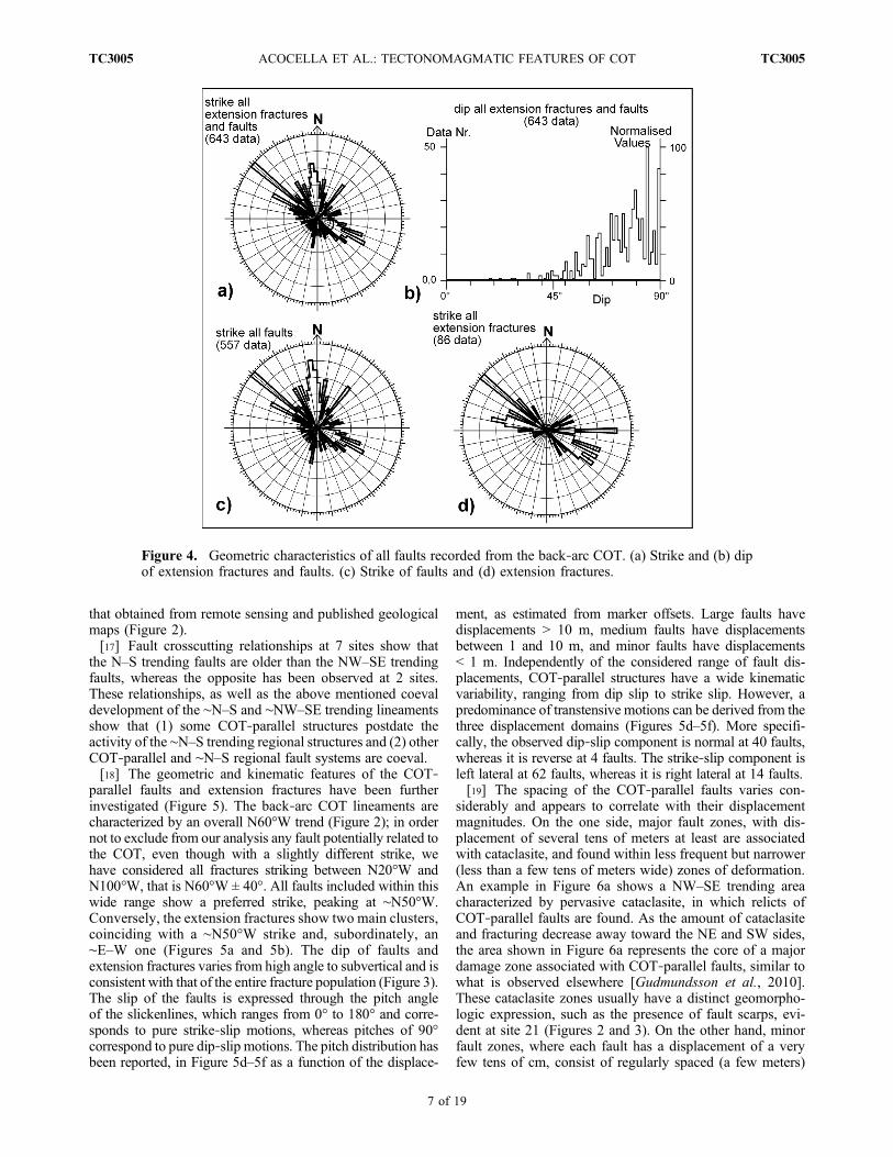
parallel faults and extension fractures have been furtherinvestigated (Figure 5). The back‐arc COT lineaments arecharacterized by an overall N60°W trend (Figure 2); in ordernot to exclude from our analysis any fault potentially related tothe COT, even though with a slightly different strike, wehave considered all fractures striking between N20°W andN100°W, that is N60°W ± 40°. All faults included within thiswide range show a preferred strike, peaking at ∼N50°W.Conversely, the extension fractures show two main clusters,coinciding with a ∼N50°W strike and, subordinately, an∼E–W one (Figures 5a and 5b). The dip of faults andextension fractures varies from high angle to subvertical and isconsistent with that of the entire fracture population (Figure 3).The slip of the faults is expressed through the pitch angleof the slickenlines, which ranges from 0° to 180° and corre-sponds to pure strike‐slip motions, whereas pitches of 90°correspond to pure dip‐slip motions. The pitch distribution hasbeen reported, in Figure 5d–5f as a function of the displace-
ment, as estimated from marker offsets. Large faults havedisplacements > 10 m, medium faults have displacementsbetween 1 and 10 m, and minor faults have displacements< 1 m. Independently of the considered range of fault dis-placements, COT‐parallel structures have a wide kinematicvariability, ranging from dip slip to strike slip. However, apredominance of transtensive motions can be derived from thethree displacement domains (Figures 5d–5f). More specifi-cally, the observed dip‐slip component is normal at 40 faults,whereas it is reverse at 4 faults. The strike‐slip component isleft lateral at 62 faults, whereas it is right lateral at 14 faults.[19] The spacing of the COT‐parallel faults varies con-
siderably and appears to correlate with their displacementmagnitudes. On the one side, major fault zones, with dis-placement of several tens of meters at least are associatedwith cataclasite, and found within less frequent but narrower(less than a few tens of meters wide) zones of deformation.An example in Figure 6a shows a NW–SE trending areacharacterized by pervasive cataclasite, in which relicts ofCOT‐parallel faults are found. As the amount of cataclasiteand fracturing decrease away toward the NE and SW sides,the area shown in Figure 6a represents the core of a majordamage zone associated with COT‐parallel faults, similar towhat is observed elsewhere [Gudmundsson et al., 2010].These cataclasite zones usually have a distinct geomorpho-logic expression, such as the presence of fault scarps, evi-dent at site 21 (Figures 2 and 3). On the other hand, minorfault zones, where each fault has a displacement of a veryfew tens of cm, consist of regularly spaced (a few meters)
Figure 4. Geometric characteristics of all faults recorded from the back‐arc COT. (a) Strike and (b) dipof extension fractures and faults. (c) Strike of faults and (d) extension fractures.
ACOCELLA ET AL.: TECTONOMAGMATIC FEATURES OF COT TC3005TC3005
7 of 19

fault segments, forming a tens of meters wide fault zone,without any evident geomorphic expression, as observed atsite 26 (Figure 6b). The motion of these minor fault zonesalso points to overall transtension.
3.3. Fault Slip Analysis
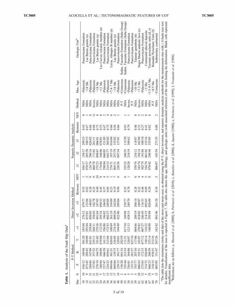
[20] In order to further determine the kinematic regime,notably local shortening and extension directions, of theback‐arc COT, the orientation of small‐scale faults andassociated sense of slip was measured at 23 sites (Table 1;see also auxiliary material).1 The sense of slip on the faultswas inferred from the orientation and geometry of stylolites,dilation fractures, Riedel shears, steps in mineral fibersand chatter marks. The fault population consists chieflyof ∼NW–SE striking sinistral and normal faults, ∼N–S striking
dextral, dextral oblique and reverse faults, as well as ∼NE–SWstriking normal and oblique normal faults (Figure 7). NW–SEstriking sinistral and (oblique) normal faults are more preva-lent at sites from within the central COT corridor (delimitedby yellow stippled lines in Figure 8). Conversely, strike‐slipand reverse faults are more developed outside the central COTcorridor (Figure 7).[21] For each fault population per site, the principal strain
and paleostress directions were calculated (Table 1) usingthe P‐T method [Turner, 1953], the direct inversion method[Angelier and Goguel, 1979] and the Numeric DynamicAnalysis (NDA) [Spang, 1972]. These methods adhere tothe Mohr‐Coulomb Criterion for brittle fracturing. The P‐Tmethod and NDA result in rudimentary strain tensors, i.e.,directions of the three principal reciprocal strains (l1 > l2 >l3) and the strain ratio (Rstrain). For these methods, weassumed that the angle between l1 and the maximumresolved shear strain, generally believed to be parallel to the
Figure 5. Geometric and kinematic features of the ∼NW–SE (striking between N20°W and N100°W)extension fractures and faults. Strike of (a) extension fractures and (b) faults. (c) Dip of faults. (d–f) Dis-tribution of fault pitch as a function of the displacement on the fault (see text for details).
1Auxiliary materials are available at ftp://ftp.agu.org/apend/tc/2010TC002854.
ACOCELLA ET AL.: TECTONOMAGMATIC FEATURES OF COT TC3005TC3005
8 of 19

mineral lineations on the shear faults, is 30°, which is withinthe limits of experimentally obtained values for this angle[Byerlee, 1968]. The direct inversion method provides sol-utions in terms of rudimentary paleostress tensors, notablythe directions of principal paleostress axes (s1 > s2 > s3)and the stress ratio (Rstress). In addition, the direct inversionmethod and NDA give the number of fault planes whosemeasured slip senses are opposite to the ones predicted by aparticular solution (indicated as “negative expected value”nev in Table 1). For further assumptions each method relieson, see reviews by Twiss and Unruh [1998] and Spernerand Zweigel [2010].[22] The direct inversion method and NDA require at least
four independent fault orientations per site. As four sitescontained less than four faults (Figure 3), 19 sites were usedfor brittle fault analysis to constrain the shortening andextension directions of the back‐arc COT (Table 1 andFigures 7 and 8). The choice of which method was used fora given fault population was based on the nev (Table 1) andthe best fit of principal axes orientations with respect to faultorientation and slip sense (Figure 8). We found that short-ening and extension directions of most brittle fault pop-ulations from COT were best represented by the NDA,whereby the P‐T method resulted in similar paleostrainsolutions (Table 1). Only for three sites the direct inversionmethod was preferred over the NDA. We, therefore, inter-pret the brittle fault populations of the back‐arc COT interms of paleostrain.[23] Principal shortening and extension axes projected to
map view show a distinct spatial pattern within the back‐arcCOT (Figure 8). Fault populations away from the central
corridor of COT are spatially associated with lower‐order(smaller in dimension), ∼N–S or ∼NW–SE striking reversefaults or may be related to the formation of the NegraMuerta caldera (sites 61 and 62). Away from this centralcorridor, shortening directions are oriented crudely ∼N–Sand extension directions are oriented ∼ESE–WNW. Theaverage strain ratio for these fault populations is 0.56(Table 1), suggesting plain strain conditions. Shorteningdirections change progressively in orientation from north-erly toward ∼ESE–WNW with proximity to the central COTcorridor (i.e., sites 10, 48 and 45 north of the corridor, andsites 70 and 53, south of the corridor). Within the centralCOT corridor, shortening directions are vertical and stretch-ing directions are oriented crudely N–S (see diagram dis-playing COT l1− and l3 axes in Figure 7). Here, faults arespatially associated with lower‐order faults striking ∼WNW–ESE, i.e., parallel to the overall strike of the COT. The averagestrain ratio is 0.7 (Table 1), indicating that axial extension ismore prevalent within the central COT. The obliquity betweencalculated shortening directions and lower‐order faults pointsto a sinistral component of displacement on these faults.Vertical shortening and sinistral displacement amount tosinistral transtension within the central COT corridor.
4. Age and Composition of COT MagmaticRocks: An Overview of Existing Data
[24] In the last decade, several studies focused on theevolution of the Miocene and younger back‐arc magmatismin the Central Andes, notably with regard to the transversevolcanic belts (e.g., see references in the works by Trumbull
Figure 6. Field examples of (a) major and (b) minor COT‐parallel fault zones, characterized by a morefocused and pervasive (site 21; Figure 3) and a broader less intense area of deformation (site 26; Figure 3),respectively. In particular, Figure 6a shows a NW–SE trending area characterized by pervasive cataclasite,in which relicts of COT‐parallel faults are found.
ACOCELLA ET AL.: TECTONOMAGMATIC FEATURES OF COT TC3005TC3005
9 of 19

et al. [2006] and Mazzuoli et al. [2008]). In this section, weconsider these studies to provide an overview of the maincompositional and age variation for the COT magmaticrocks (Figure 9a).[25] As a general consideration, the magmatic rocks along
the back‐arc COT are compositionally diverse, ranging insilica from 51 to 75 wt % (Figure 9b and Table 2) and
include mafic rocks with different affinity (basaltic andesitesand shoshonites; Table 2). Most volcanic deposits on theCOT are andesites and dacites. Approximately 650 km3 ofmainly dacitic magma are estimated to have been eruptedfrom the Aguas Calientes center alone [Petrinovic et al.,2010]. Rhyolites are represented by some phreatomag-matic tuffs and lavas in the central sector of the back‐arc
Figure 7. Structural data and related strain and stress axes for individual sites (for location of sites seeFigure 2) characterized by fault slip analysis, with ≥ 4 faults per site. The data are plotted on lowerhemisphere equal‐area projections. Quantities of the rudimentary strain and stress tensors are listed inTable 1.
ACOCELLA ET AL.: TECTONOMAGMATIC FEATURES OF COT TC3005TC3005
10 of 19

belt (Ramadas and Tocomar [Viramonte et al., 1984;Petrinovic and Colombo Piñol, 2006]). Mafic rocks arerepresented by basaltic andesites in the western sector (Tul‐Tul [Matteini et al., 2002]) and eastern sector (Chimpa[Arnosio, 2010]; Almagro [Mazzuoli et al., 2008]) and byshoshonites of 0.7–0.03 Ma monogenetic centers in thecentral and eastern sector of the back‐arc (San Jeronimo,Negro de Chorrillos, Los Gemelos and El Saladillo[Deruelle, 1991; Schreiber and Schwab, 1991; Guzmánet al., 2006]).[26] Available age data (see references in Table 2) show
that magmatic activity on the back‐arc COT occurred almostuninterruptedly between 17.15 and 5.3 Ma, starting in thecentral and eastern sectors, and affecting the entire back‐arcCOT between ∼12 and 5.3 Ma, with a peak at 12–8 Ma(Figure 9c). A gap in the volcanic activity between 5.3and 1.5 Ma (Tocomar [Aquater, 1980]) was followedby volcanism in the central Puna and Eastern Cordillera(Figure 9c). Mafic magmas were erupted at 12, 7–5 and< 1.5 Ma (Figure 9d).[27] There is no apparent trend in age or composition for
the magmatic products transverse to the strike of the COT.However, the overall composition of the magmatic productsolder than 5.3 Ma as a function of their location along theback‐arc COT allows us to distinguish four main groups(groups A, B, C, D in Table 2 and Figure 9). These groupscorrespond to the main morphostructural regions of theCOT, i.e., Western Puna, Central Puna, Eastern Puna andEastern Cordillera (Figure 9a). The composition of therocks of the four groups lacks a clear subduction imprint(Ba/Nb < 40; Figure 9e), and indicates that different mantle
and crustal domains were involved in magma generation,evident by the following points.[28] 1. In the Western Puna, immediately behind the arc,
group A basaltic‐andesitic to dacitic magmas (Table 2 andFigure 9) formed the stratovolcanoes Tul‐Tul, Del Medioand Pocitos. Volcanic rocks of these magmatic centers showparticularly high Ba/Rb, Sr/Y and La/Yb ratios (Table 2)and have been interpreted as being derived from magmasgenerated by partial melting of a garnet‐bearing lowercrustal source and differentiated by MASH processes(melting‐assimilation‐storage‐homogenization [Matteiniet al., 2002]), at the base of a thickened crust.[29] 2. In the Central Puna, group B andesite and dacite
magmas (Table 2 and Figure 9) erupted mainly as ignim-brites (Aguas Calientes center [Petrinovic et al., 1999,2010]). These centers show a peraluminous character (molarAl2O3/CaO+Na2O+K2O > 1) and high 87Sr/86Sr, suggestingthe involvement of the upper crust in the genesis of thesemagmas (Figures 9f and 9g).[30] 3. In the Eastern Puna, group C andesitic rocks
(Table 2 and Figure 9) produced stratovolcanoes, lava flows,domes and silicic ignimbrites. These products derive bymantle sources mixed with crustal melts [Petrinovic et al.,1999, 2005; Arnosio, 2010].[31] 4. In the Eastern Cordillera, group D andesitic mag-
mas (Table 2 and Figure 9) were emplaced at 14–12 Ma(Las Burras). They show low Ba/Nb and La/Ta and rela-tively high Nb and low 87Sr/86Sr ratios, and formed bydifferentiation of magmas from a low 87Sr/86Sr lithosphericmantle that was rich in K, Rb, Th, with negligible crustalinteraction [Mazzuoli et al., 2008]. Conversely, the magmas
Figure 8. Map view of the distribution of the orientation of the P and T axes derived from the structuralanalysis along the back‐arc COT. The corridor corresponding to the central portion of the COT is delineatedby dashed lines.
ACOCELLA ET AL.: TECTONOMAGMATIC FEATURES OF COT TC3005TC3005
11 of 19

Figure
9.Tim
escalesketch
map
ofthemagmatic
centersalon
gtheback‐arc
COT.(a)Areal
distribution
ofmagmatic
groups
A,B,C,D,andE(see
also
Table
2andtext)andlistof
relatedmagmatic
centers.
(b)Variatio
nof
SiO
2wt%
versus
along‐COTdistance
from
arc.(c)Availableagedataversus
along‐COTdistance
from
thearc;each
symbolincludes
errorbars.(d)Age
versus
MgO
wt%.(e)Age
versus
Ba/Nb,
show
ingthat
themajority
ofback‐arc
rocksdo
nothave
arc
characteristics.
(f)Age
versus
A/CNK
(molar
Al 2O2/CaO
+Na 2O+K2O,suggestin
gacrustalinvolvem
entin
magmagen-
erationwhen>1).(g)Age
versus
87Sr/86Sr.See
thetext
formoredetails.
ACOCELLA ET AL.: TECTONOMAGMATIC FEATURES OF COT TC3005TC3005
12 of 19

erupted after 12 Ma (Almagro) have relatively high87Sr/86Sr (Figure 9g), despite an even more mafic compo-sition. These magmas require an isotopically enriched,lithospheric mantle source [Mazzuoli et al., 2008]. Appar-ently, the crust plays a minor role on magma generation inthis back‐arc sector during activity of the COT.[32] Post 1.5 Ma volcanic activity differs from the previ-
ous activity. This younger volcanism occurs both in theCentral Puna and Eastern Cordillera and forms an additionalvolcanic group, i.e., group E (Table 2 and Figure 9). Thisgroup includes (1) lavas with shoshonitic affinity, eruptedfrom monogenetic centers [Deruelle, 1991; Schreiber andSchwab, 1991; Petrinovic et al., 2006], (2) high‐K ande-sites and shoshonites of the Tuzgle volcano [Coira and Kay,1993] and (3) the rhyolitic, peraluminous tuffs of theTocomar volcanic center. The shoshonitic rocks show 7–4 wt% MgO in the Central Puna (San Jeronimo and Negrode Chorrillos) and 9–7 wt % MgO in the Eastern Cordillera(Los Gemelos and El Saladillo; Figure 9d), a high content incompatible elements, high Ba/Nb (Figure 9e) and Sr isotopicratios of 0.7064–0.7077 (Figure 9g). The generation ofmagmas with these chemical characteristics requires littlepartial melting of a metasomatized, garnet‐bearing litho-spheric mantle source [Deruelle, 1991; Kay et al., 1994;Petrinovic et al., 2005; Guzmán et al., 2006]. Therefore, theeruption of the post–1.5 Ma shoshonites represents a three-fold novelty, as (1) shoshonitic magmas were erupted firston the COT, (2) monogenetic centers occurred for the first
time along the COT (Table 2), and (3) the same type ofactivity occurs both in the Puna and Eastern Cordillera, incontrast with the pre–5 Ma distinction in groups.
5. Discussion
5.1. Interpretation of the Remote Sensing, Geological,and Structural Data
[33] The distribution of the lineaments and the majorknown fault systems on the back‐arc COT shows an overallgood spatial correlation, in terms of location and orientation,suggesting that most of the lineaments are due to faulting(Figure 2). Most faults trend ∼N–S and ∼NW–SE, withthe latter ones occurring in the central portion of the COTand spatially associated with volcanic centers (Figure 2).Moreover, the geometric continuity between part of the∼N–S and ∼NW–SE fault systems (Figure 2) suggests thatpart of these faults are coeval. These relationships aresupported by the structural field data. Specifically, faultcrosscutting relationships show that ∼N–S and ∼NW–SEsystems are in part coeval, even though a significant partof the ∼NW–SE systems postdate the ∼N–S trendingregional structures. Also, the age of the sedimentary andvolcanic deposits, which are affected by the ∼NW–SEstriking faults, points to significant late Neogene to Qua-ternary tectonic activity (Table 1). Quaternary activity ofthe COT is consistent with seismicity in this area, indi-cating left‐lateral motion on the COT [Schurr et al.,
Table 2. Synthesis of the Main Volcanological, Petrological, Geochemical, and Age Data on the Magmatic Rocks of the Back‐Arc COTa
Group Locationmagmatic Centersand Ageb (Ma)
Field Characteristicsand Rock Type
SiO2 Range(wt %) Sr/Y Main Petrogenetic Models
A Western Puna 1, Rincon (11.7);2, Tul Tul (8.1–7.3);3, Del Medio (5.7);4, Pocitos (8.3)
basaltic andesite todacite stratovolcanoes
55–64 25–80 melting of garnet‐bearinglower crust (MASH)
B Central Puna 5, Quevar (10, 8.6–7.5);6, Azufrero (8.0);11, Aguas Calientes
(17.15–10.3)
andesite stratovolcanoes,andesite to dacite ignimbrite
blankets, calderas
61–67 10–30 upper crust melting,shallow AFC
C Eastern Puna 12, El Morro–Organullo (13–6);13, Negra Muerta (9–7.3);14, Acay monzonite (13);
15, Ramadas (8.5);16, Chimpa (12);17, Rupasca (11.4)
basaltic andesite todacite lava domes and
flows and stratovolcanoes,dacite ignimbrite blankets,rhyolite phreatomagmatic
centers, calderas
52–74 15–50 shallow fractionalcrystallization and mixingof mantle‐ and crust‐
derived melts
D Eastern Cordillera 20, Las Burras‐PanchoArias (15–12);
21, Almagro (11–6)
basaltic andesite todacite lava domes and flows,
cinder cones, intrusives
52–66 15–25 melting of lithosphericmantle sources, with amajor change at 11 Ma,
and moderate FC and AFCE Central Puna 7, Tocomar (1.5–0.55);
8, Tuzgle (0.5);9, San Jeronimo (0.78);
10, Negro de Chorrillos (0.45)
rhyolite phreatomagmaticcenters, shoshonite to latiteeffusive monogenetic centers
52–73 31–36 rhyolite, upper crustmelting; shoshonite,low % partial meltingof metasomatizedlithospheric mantle
E Eastern Cordillera 18, El Saladillo (<1);19, Los Gemelos (0.035)
shoshonite effusivemonogenetic centers
51–54 28–45 low % partial meltingof metasomatizedlithospheric mantle
aMASH, mixing‐assimilation‐storage‐homogenization; FC, fractional crystallization; AFC, fractional crystallization and concomitant crustal assimilation.bError on ages between ± 0.2 and ± 0.9, except Quevar: 10 ± 2 Ma. References for group A: 1, Gardeweg and Ramírez [1987]; 2, 3, and 4, Koukharsky
and Munizaga [1990] and Matteini et al. [2002]. References for group B: 5 and 6, Olson and Gilzean [1987] and Petrinovic et al. [1999]; 11, Petrinovicet al. [2010, and references therein]. References for group C: 12, Petrinovic et al. [1999] and Arnosio et al. [2005]; 13, Riller et al. [2001] and Petrinovicet al. [2005]; 14, Haschke et al. [2005]; 15, Viramonte et al. [1984]; 16, Arnosio [2010]; 17, Petrinovic et al. [1999]. References for group D: 20 and 21,Sillitoe [1977], Hongn et al. [2002], and Mazzuoli et al. [2008]. References for group E: 7, Aquater [1980] and Petrinovic et al. [1999, 2006]; 8, Coira andParis [1981], and Coira and Kay [1993]; 9 and 10, Aquater [1980], Deruelle [1991], and Kay et al. [1994]; 18 and 19, Guzmán et al. [2006].
ACOCELLA ET AL.: TECTONOMAGMATIC FEATURES OF COT TC3005TC3005
13 of 19

1999]. Shortening in the Puna, as due to the activity of∼N–S trending reverse faults, terminated mostly prior to∼10 Ma [Cladouhos et al., 1994; Coutand et al., 2001,and references therein; Müller et al., 2002], while shorten-ing in the Eastern Cordillera is ongoing [Marrett et al., 1994;Marrett and Strecker, 2000]. These considerations suggestthat structures of the back‐arc COT have been active fromthe Miocene to the Present. This age interval is broadlyconsistent with that of magmatic activity along the back‐arcCOT (Figure 9), pointing to a genetic relationship betweenmagmatism and deformation.[34] The ∼NW–SE trending COT faults dip steeply and
adhere to an overall transtensive kinematic regime (Figures 5and 7). Therefore, the kinematics of the back‐arc COT,as defined in this study, suggests that the other NW–SEtrending structures in the Central Andes (Figure 1) are alsocharacterized by left‐lateral transtension.[35] If we consider our structural data to be representative
of the entire back‐arc COT, they may allow us to make thefollowing points.[36] 1. The back‐arc COT, in addition to a magmatic and
geomorphologic characterization, has a structural expres-sion, which corresponds to a major left‐lateral transtensivefault zone. This supports previous tectonic models andstructural results on individual portions of the COT [Rilleret al., 2001; Ramelow et al., 2006; Petrinovic et al., 2006].[37] 2. The likely Miocene to Quaternary activity of the
COT structures crudely overlaps in time with the Miocene toQuaternary activity of the magmatic centers. As it will bediscussed in section 5.2, the observed transtensive motionalong the COT may provide favorable conditions for the riseand emplacement of magma.
5.2. Structural Control on Magmatism of the COT
[38] Strike‐slip and transtensive fault kinematics areresponsible for localized areas of horizontal extension(forming pull‐apart basins, tension gashes, releasing bends),which may provide the space required for the storage andtransport of magma [e.g., Bellier et al., 1999; Lavenu andCembrano, 1999; Garcia Palomo et al., 2004, and refer-ences therein]. Strike‐slip and extensional structures at thesurface require equivalent kinematic regimes at depth in thecrust, evident by the syntectonic emplacement of plutons,constituting the magma chambers of arc volcanoes [e.g.,Morand, 1992; Moreau et al., 1994; Vigneresse, 1995;Castro and Fernández, 1998; Gibbons and Moreno, 2002;Wagner et al., 2006]. Therefore, strike‐slip and transtensivestructures may well control magma transport and emplace-ment in arcs at shallower and deeper crustal levels.[39] The importance of local extension for localizing
magmatism along the COT is supported by our structuralfield evidence, indicating that orogen‐parallel extension isfocused in the central COT corridor (Figure 8). Also, thetectonomagmatic relationships described above apply to the21 main magmatic centers of the COT (Figures 2 and 9).Information on the structural control is available for 13magmatic centers, 9 of which are located in the Puna and4 in the Eastern Cordillera. Studies on the 9 centers in thePuna (Tul‐Tul, Del Medio, Pocitos, Tocomar, Negro deChorillos, San Jeronimo, Aguas Calientes, Negra Muertaand Chimpa; Figure 2) suggest that magmatism was con-
trolled by the activity of COT‐parallel faults and/or relatedextensional structures [Petrinovic, 1999; Riller et al., 2001;Arnosio, 2002; Matteini et al., 2002; Ramelow et al., 2006;Petrinovic et al., 2005, 2006, 2010; Petrinovic and ColomboPiñol, 2006]. Conversely, the development of the 4 centersin the Eastern Cordillera (El Saladillo, Los Gemelos, LasBurras, Almagro) appears to be also controlled by the activityof N–S trending transpressive faults [Guzmán et al., 2006;Acocella et al., 2007; Mazzuoli et al., 2008]. Therefore,activity of magmatic centers located on the Puna may bechiefly controlled by COT‐related structures, whereas theactivity of the centers within the Eastern Cordillera is alsocontrolled by the ∼N–S fault systems. This behavior reflectslikely the deep structure of crust underlying the Puna andthe Eastern Cordillera. In particular, the Puna is characterizedby a relatively lower spatial density of ∼N–S trendingregional faults, whereas the Eastern Cordillera appears per-vasively controlled by the ∼N–S striking faults, accom-plishing basement‐involved thrusting and significantly largershortening magnitudes than the Puna [Kley and Monaldi,2002; Müller et al., 2002; Acocella et al., 2007, and refer-ences therein]. Independently of these morphotectonicdomains, strike‐slip faults (NW–SE striking transtensionzones and, subordinately, ∼N–S striking transpressive faultzones), seem to provide ideal conditions for localizingmagmatism along the COT.[40] In broader terms, our data from the back‐arc COT
show that there is a spatial correlation between the fre-quency of the lineaments and faults (calculated fromFigure 2 and shown in Figure 10b) and the areal distribution(in km2) of the magmatic deposits (calculated from Figure 2and shown in Figure 10c), with a peak in the central part.Specifically, the central portion of the COT is the widest;to the east and to the west, the spatial density and lengthof faults decrease significantly (Figure 10). If we considerthe areal distribution of the magmatic deposits as indicativeof their volume, this correspondence implies that most ofthe magma was erupted in the tectonically more developedcentral portion of the back‐arc COT.[41] A correlation between the overall geometry of the
COT and the composition of its magmatic rocks is alsoapparent from our data. Geochemical data from the 17–5 MaCOT magmatic centers show a marked difference in com-position between the magmas spatially associated with thecentral part of the COT and those found toward its easternand western extremities (Table 2 and Figures 9 and 10). Thelatter include mantle‐derived magmas that are moderatelydifferentiated in crustal reservoirs. Conversely, magmaticrocks from the central COT are mostly derived from evolvedmagmas (dacite‐ryholite), with a clear component fromupper crust melting (Table 2 and Figure 10d, continuouslines). A similar trend, although with lower volumes oferupted magmas, is also shown by the volcanic activity inthe last 1.5 Ma (Figure 10d, dashed lines): rhyolites andhigh‐K andesites accompany shoshonites in the centralback‐arc COT, while only shoshonites occur in the EasternCordillera. It is also noteworthy that, in agreement with thisevidence, post–1.5 Ma shoshonites in the Central Puna showa moderate degree of differentiation by fractional crystalli-zation during magma ascent in the crust, whereas shosho-nites in the Eastern Cordillera show more primitive chemical
ACOCELLA ET AL.: TECTONOMAGMATIC FEATURES OF COT TC3005TC3005
14 of 19

Figure 10. Summary of the main tectonomagmatic features of the back‐arc part of the COT. (a) Sketchreporting the location (triangles) and extent (in gray) of the main magmatic centers and the main linea-ments and faults (from Figure 2). The simplified kinematics of the COT systems, consisting of left‐lateral transtension with an orogen‐parallel extension, is also highlighted. (b) Frequency distribution of themain lineaments and faults (from Figure 2, here calculated with a sampling frequency of 20 km) as afunction of along‐COT distance (see trace of profile in Figure 10a). (c) Areal distribution (in km2) of themagmatic deposits as a function of along‐COT distance (calculated with the same sampling frequency of20 km as in Figure 10b). The mean error is < 20%. (d) SiO2 wt % and 87Sr/86Sr ratio of the magmaticproducts as a function of along‐COT distance from arc (see trace of profile in Figure 10a); vertical linesindicate the range of values for each magmatic center. The groups A to E of Figure 9 are also highlighted.In general, the most fractured central part of the COT shows the highest SiO2 and
87Sr/86Sr values, sug-gesting an important role of the COT structures on enhancing magmatism at crustal levels. See text forfurther details.
ACOCELLA ET AL.: TECTONOMAGMATIC FEATURES OF COT TC3005TC3005
15 of 19

characteristics (e.g., Cr < 100 ppm, 7–4 wt % MgO, againstCr > 400 ppm, 9–7 wt % MgO [Deruelle, 1991; Guzmánet al., 2006]). We propose that the magmas from the cen-tral COT are related to a more permeable, possibly tecton-ically dilated, zone [e.g., Gudmundsson, 2000], providingspace for the storage of magma in the crust and allowing forits differentiation and enhancing interaction with crustalmelts. This can also account for the presence of collapsecalderas, which are the surface expression of large and long‐lived magmatic centers, in the central COT. Conversely,at the western and eastern back‐arc COT, the contributionof the upper crust to magma petrogenesis is limited. Thispoints to a diminished capacity of magma storage in theupper crust, possibly resulting from a lower permeabilitybrought about by lower magnitudes of horizontal exten-sion (dilation).[42] Volcanic rocks from the area between the Central
Puna and Eastern Cordillera (group C rocks; Figure 9)show characteristics of both evolved and primitive magmasources. The continental crust seems to be the main sourcefor the magmas in the Central Puna, whereas the lithosphericmantle seems to be the dominant source for the magmas inthe Eastern Cordillera. Accordingly, the Negra Muertavolcanic complex (group C rocks; Figure 9), lies in anintermediate position, with respective magmatic character-istics, i.e., mantle‐ and crust‐derived magmas.[43] Post–1.5 Ma magmatism, such as in the Tocomar
area, is also bimodal and corroborates, at a local scale, ourhypothesis of dilation‐controlled magmatic characteristics.The Tocomar rhyolitic magmas are related to normal faults,suggesting storage at shallow crustal level. By contrast,shoshonitic magmas at San Jeronimo are associated withstrike‐slip faults, pointing to rapid magma ascent from thebase of the crust [Petrinovic et al., 2006].[44] In summary, the diagrams in Figure 10 suggest that
the tectonically more developed (Figure 10b) central part ofthe back‐arc COT was associated with the eruption of largemagma volumes (Figure 10c) and corresponds to largevolumes of magma stored in the crust (Figure 10d). Similarrelationships, between magma volumes and compositionand horizontal extension of crust, have been previouslysuggested for convergent and divergent plate boundaries.For example, at the Peruvian convergent margin, magmastorage has been attributed to larger magnitudes of hori-zontal extension [Grocott et al., 1994;McNulty et al., 1998].Similarly, the southern Main Ethiopian Rift, which featureslower horizontal extension magnitudes, is dominated bymafic volcanic rocks, whereas the central Rift, which ischaracterized by larger magnitudes of extension, showswidespread bimodal volcanism, with felsic magmas fromcrustal reservoirs [Hayward and Ebinger, 1996; Ebingerand Casey, 2001; Corti, 2009].
5.3. The Availability of Magma at Depth
[45] In this study we offer an explanation for the structuralinfluence on magmatic activity along the COT, as related totranstensive tectonism. We also briefly address the sourceof magma at depth below the COT and located at distancesof nearly 300 km to the east of the active volcanic arc.[46] The genesis of magma to explain pre–12 Ma back‐arc
magmatism has been attributed to steepening of the sub-
ducting slab [Isacks, 1988; Kay et al., 1999] and thusreplacement of the slab by asthenosphere. This change inthermal regime may well have provided the initial sourcesfor the mantle‐ and crust‐derived melts at the central COT.Subsequent back‐arc magmatism, however, occurred duringlithospheric thickening. In this framework, delamination ofthe thickened and weakened lithospheric lid has beenrepeatedly invoked to explain the local rise of hotterasthenosphere and magma production in the back arc ofCentral Andes [Kay and Kay, 1993; Yuan et al., 2002].Delamination of lithospheric mantle may explain the initi-ation and termination of magmatic pulses in other back‐arcsettings, such as the Sierra Nevada [Elkins‐Tanton andGrove, 2003]. In the Central Andes, delamination was firstsuggested for the most recent (<2 Ma) back‐arc magmatismin the Puna Plateau [e.g., Kay et al., 1994]. However, recentage determinations of back‐arc magmatic products indicatethat the magmatic pulse which may be linked to delamina-tion in the southern Puna, at 26°S, had its peak at about5 Ma [Risse et al., 2008; Gioncada et al., 2010]. In addi-tion, other studies have recently suggested that delamina-tion may have been the cause for magma generation belowthe Altiplano‐Puna Volcanic Complex, immediately to thenorth of the COT, during 12–10 Ma [McQuarrie et al., 2005;De Silva et al., 2006]. These repeated magmatic events incontiguous portions of the Central Andes suggest the occur-rence of episodic, or piecemeal‐type, delamination processes[McQuarrie et al., 2005], of which the currently detachedlithosphere slab below the Puna [Schurr et al., 2006] isprobably the last episode.[47] As far as the possible effects of any delamination on
the COT magmatic belt are concerned, our overview high-lights at least two main periods which require changes in themantle melting regions, which may be consistent with thepreviously proposed piecemeal lithospheric delamination.The first period, at 12–11 Ma, is characterized by the abruptchange in the mantle‐derived magma composition with theAlmagro volcanic rocks, in the Eastern Cordillera [Mazzuoliet al., 2008]. This event coincides with the peak of ignim-brite activity in the central COT sector and the spreading ofmagmatic activity to the entire COT belt (Figure 9), sug-gesting intense magma generation in the back arc and aconnection with the ∼12 Ma Altiplano‐Puna ignimbriteflare‐up [McQuarrie et al., 2005]. The second period isyounger than 1.5 Ma and associated with the eruption ofshoshonitic magmas that may well be related to the latestdelamination pulse, also imaged by tomographic data [Kayet al., 1994; Schurr et al., 2006].[48] It appears that the occurrence of magmatism in the
back arc of the Central Andes may have been related todifferent processes, acting at different times and scales. Atthe regional scale, previous studies suggest that the avail-ability of magma below the back arc of Central Andes maybe related to slab steepening, during early middle Miocene[Isacks, 1988; Kay et al., 1999] and, most likely, delami-nation, during middle Miocene to Quaternary, responsible forthe repeated waxing and waning magma generation pulses[McQuarrie et al., 2005; Risse et al., 2008; Mazzuoli et al.,2008]. Once the magma was generated, its rise and anystorage in the crust occurred by means of ∼NW–SE trendingtranstensive structures. Occasionally, as in the Eastern Cor-
ACOCELLA ET AL.: TECTONOMAGMATIC FEATURES OF COT TC3005TC3005
16 of 19
dillera, ∼N–S trending transpressive regional systems mayhave further enhanced the rise and emplacement of magma[Guzmán et al., 2006; Mazzuoli et al., 2008].
6. Conclusions
[49] This study allows for highlighting the following points.[50] 1. Our structural data demonstrate that the back‐arc
COT consists of subparallel ∼NW–SE trending fault sys-tems, with an overall left‐lateral transtensive motion. COTfaults formed in Miocene to Quaternary times, are partlycoeval with magmatism, and partly postdate the activity ofN–S striking faults. Transtensive structures create areas oflocalized extension and provide favorable conditions for theascent and storage of magma.[51] 2. COT magmatism on the Puna appears to be con-
trolled by ∼NW–SE trending structures, whereas magma-tism in the Eastern Cordillera is also controlled by theactivity of the N–S regional structures.[52] 3. The most evolved magmas, with a clear crustal
component, were erupted along the central part of the back‐arc COT, where upper crustal faults display higher spatialdensity. Mantle‐derived mafic rocks, and primitive pro-ducts, however, seem to have been directly fed by themantle and are mainly found toward the COT termini, wherefaults are less prevalent. The central COT is also charac-terized by the largest erupted magma volumes. This implieslarger magma production rates and suggests that largerdilation magnitudes of the central COT favor the ascent ofmagma and the formation of crustal reservoirs.[53] 4. The occurrence of magmatism in the back arc of the
Central Andes seems related to different processes, acting atdifferent scales and levels. According to previous studies, atthe regional scale, magma generation may be largely relatedto episodic lithospheric delamination. In the last 17 Ma,during the formation of the COT magmatic belt, we highlighttwo periods, at 12–11 Ma and < 1.5 Ma, which may berelated to important changes at the lithospheric scale.
[54] Acknowledgments. Pablo Cavalieri, Eugenia Franzoni, MassimoMatteini, and Julieta Omarini provided enthusiastic help and expert adviceduring the field work. O. Galland and an anonymous reviewer providedhelpful comments. This work was carried out in the framework of thescientific convention between Pisa (Italy) and Salta (Argentina) Universities.The research was supported by the Consejo Nacional de InvestigacionesCientificas y Técnicas (CONICET‐Agencia, Argentina, PICT 0745‐)and the Consejo de Investigaciones de la Universidad Nacional de Salta(CIUNSA, Argentina, project 1861), the Italian Ministry of Universityand Research (MIUR‐PRIN 2003 project), and the Natural Sciences andEngineering Research Council of Canada. Structural data partly elaboratedwith DAISY software (kind permission of F. Salvini, Roma TRE).
ReferencesAcocella, V., and F. Funiciello (2010), Structural control of arc volcanismand related kinematic setting: An overview, Earth Planet. Sci. Lett., 289,43–53, doi:10.1016/j.epsl.2009.10.027.
Acocella, V., L. Vezzoli, R. Omarini, M. Matteini, and R. Mazzuoli (2007),Kinematic variations across Eastern Cordillera at 24°S (Central Andes):Tectonic and magmatic implications, Tectonophysics, 434, 81–92,doi:10.1016/j.tecto.2007.02.001.
Acocella, V., T. Yoshida, R. Yamada, and F. Funiciello (2008), Structuralcontrol on late Miocene to Quaternary volcanism in the NE Honshu arc,Japan, Tectonics, 27, TC5008, doi:10.1029/2008TC002296.
Alaniz‐Alvarez, S. A., Á. F. Nieto‐Samaniego, and L. Ferrari (1998),Effect of strain rate in the distribution of monogenetic and polygenetic
volcanism in the Transmexican volcanic belt, Geology, 26, 591–594,doi:10.1130/0091-7613(1998)026<0591:EOSRIT>2.3.CO;2.
Allmendinger, R. W., V. A. Ramos, T. E. Jordan, M. Palma, and B. L.Isacks (1983), Paleogeography and Andean structural geometry, north-west Argentina, Tectonics, 2, 1–16, doi:10.1029/TC002i001p00001.
Allmendinger, R. W., T. E. Jordan, S. M. Kay, and B. L. Isacks (1997),The evolution of the Altiplano‐Puna Plateau of the Central Andes, Annu.Rev. Earth Planet. Sci., 25, 139–174, doi:10.1146/annurev.earth.25.1.139.
Angelier, J., and J. Goguel (1979), Sur une méthode simple de détermina-tion des axes princepaux des contraintes pour une population de failles,C. R. Acad. Sci. Hebd. Seances Acad. Sci., Ser. D, 288, 307–310.
Aquater (1980), Exploracion geotermica en el area del Cerro Tuzgle,Provincia de Jujuy, Republica Argentina, estudio de prefactibilidad inedito,123 pp., Secr. de Miner. de la Prov. de Jujuy, Argentina, Jujuy, Argentina.
Arnosio, J. M. (2002), Volcanismo, geoquímica y petrología del volcánChimpa (24° LS–66° LO) provincia de Salta, República Argentina,Ph.D. thesis, 176 pp., Univ. Nac. de Salta, Salta, Argentina.
Arnosio, J. M. (2010), Evidencia textural y geoquímica de mezcla de magmasen el Volcan Chimpa, Puna Salteña, Asoc. Geol. Argent. Rev., 66, 251–268.
Arnosio, J. M., V. Marmol, and R. Becchio (2005), Estratigrafia volcanicay evolucion del centro volcanico El Morro (24°17′S–66°15′O), PunaSalteña, in Actas XVI Congreso Geologico Argentino, la Plata, 2005,vol. 1, pp. 859–866, Asoc. Geol. Argentina, Buenos Aires.
Bellier, O., H. Bellon, M. Sebrier, P. Sutanto, and R. C. Maury (1999),K‐Ar age of the Ranau tuffs: Implications for the Ranau calderaemplacement and slip‐partitioning in Sumatra (Indonesia), Tectono-physics, 312, 347–359, doi:10.1016/S0040-1951(99)00198-5.
Blasco, G., E. O. Zappettini, and F. Hongn (1996), Hoja geológica 2566‐1,San Antonio de los Cobres, Programa Nac. de Carteas Geol. de la Repub.Argentina, Dir. Nac. del Serv. Geol., Buenos Aires.
Byerlee, J. D. (1968), Brittle‐ductile transition in rocks, J. Geophys. Res.,73, 4741–4750, doi:10.1029/JB073i014p04741.
Caffe, P. J., R. B. Trumbull, B. L. Coira, and R. L. Romer (2002), Petro-genesis of early Neogene magmatism in the northern Puna: Implicationsfor magma genesis and crustal processes in the central Andean plateau,J. Petrol., 43, 907–942, doi:10.1093/petrology/43.5.907.
Castro, A., and C. Fernández (1998), Granite intrusion by externallyinduced growth and deformation of the magma reservoir, the exampleof the Plasenzuela pluton, Spain, J. Struct. Geol., 20, 1219–1228,doi:10.1016/S0191-8141(98)00056-X.
Chernicoff, C. J., J. P. Richards, and E. O. Zappettini (2002), Crustallineament control on magmatism and mineralization in northwesternArgentina: Geological, geophysical, and remote sensing evidence, OreGeol. Rev., 21, 127–155.
Cladouhos, I. T., R. W. Allmendinger, B. Coira, and E. Farrar (1994), LateCenozoic deformations in the Central Andes: Fault kinematics from thenorthern Puna, northwest Argentina and southwest Bolivia, J. SouthAm. Earth Sci., 7, 209–228, doi:10.1016/0895-9811(94)90008-6.
Coira, B., and S. Kay (1993), Implication of Quaternary volcanism at CerroTuzgle for crustal and mantle evolution of the Puna Plateau, CentralAndes, Argentina, Contrib. Mineral. Petrol., 113, 40–58, doi:10.1007/BF00320830.
Coira, B., and G. Paris (1981), Estratigrafia volcanica del area del CerroTuzgle, Provincias de Jujuy y Salta, in VIII Congreso Geológico Argentino,Actas, vol. 3, 659–671, Asoc. Geol. Argentina, San Luis, Argentina.
Cole, J. W. (1990), Structural control and origin of volcanism in the Taupovolcanic zone, New Zealand, Bull. Volcanol., 52, 445–459, doi:10.1007/BF00268925.
Corti, G. (2009), Continental rift evolution: From rift initiation to incipientbreak‐up in theMain Ethiopian Rift, East Africa, Earth Sci. Rev., 96, 1–53,doi:10.1016/j.earscirev.2009.06.005.
Corti, G., E. Carminati, F. Mazzarini, and M. O. Garcia (2005), Activestrike‐slip faulting in El Salvador, Central America, Geology, 33, 989–992,doi:10.1130/G21992.1.
Coutand, I., P. R. Cobbold, M. de Urreiztieta, P. Gautier, A. Chauvin,D. Gapais, E. A. Rossello, and O. López‐Gamundí (2001), Style andhistory of Andean deformation, Puna plateau, northwestern Argentina,Tectonics, 20, 210–234, doi:10.1029/2000TC900031.
Deeken, A., E. R. Sobel, I. Coutand, M. Haschke, U. Riller, and M. R.Strecker (2006), Development of the southern Eastern Cordillera, NWArgentina, constrained by apatite fission track thermochronology: FromEarly Cretaceous extension to middle Miocene shortening, Tectonics,25, TC6003, doi:10.1029/2005TC001894.
Deruelle, B. (1991), Petrology of Quaternary shoshonitic lavas of north-western Argentina, in Andean Magmatism and Its Tectonic Setting,edited by R. S. Harmon and C. W. Rapela, Spec. Pap. Geol. Soc. Am.,256, 201–217.
De Silva, S., G. Zandt, R. Trumbull, J. G. Viramonte, G. Salas, and N. Jiménez(2006), Large ignimbrite eruptions and volcano‐tectonic depressions in
ACOCELLA ET AL.: TECTONOMAGMATIC FEATURES OF COT TC3005TC3005
17 of 19
the Central Andes: A thermomechanical perspective, in Mechanism ofActivity and Unrest at Large Calderas, edited by C. Troise, G. De Natale,and C. R. Kilburn, Geol. Soc. Spec. Publ., 269, 47–63.
Ebinger, C. J., and M. Casey (2001), Continental breakup in magmatic pro-vinces: An Ethiopian example, Geology, 29, 527–530, doi:10.1130/0091-7613(2001)029<0527:CBIMPA>2.0.CO;2.
Elger, K., O. Oncken, and J. Glodny (2005), Plateau‐style accumulation ofdeformation: Southern Altiplano, Tectonics, 24, TC4020, doi:10.1029/2004TC001675.
Elkins‐Tanton, L. T., and T. L. Grove (2003), Evidence for deep melting ofhydrous metasomatized mantle: Pliocene high‐potassium magmas fromthe Sierra Nevadas, J. Geophys. Res., 108(B7), 2350, doi:10.1029/2002JB002168.
Galland, O., E. Hallot, P. R. Cobbold, G. Ruffet, and J. de Bremond d’Ars(2007), Volcanism in a compressional Andean setting: A structural andgeochronological study of Tromen volcano (Neuquén province), Argen-tina, Tectonics, 26, TC4010, doi:10.1029/2006TC002011.
Garcia Palomo, A., J. L. Macias, and J. M. Espíndola (2004), Strike‐slipfaults and K‐alkaline volcanism at El Chichón volcano, southeasternMexico,J. Volcanol. Geotherm. Res., 136, 247–268, doi:10.1016/j.jvolgeores.2004.04.001.
Gardeweg, M., and C. F. Ramírez (1987), La Pacana Caldera and the AtanaIgnimbrite—A major ash‐flow and resurgent caldera complex in the Andesof northern Chile, Bull. Volcanol., 49, 547–566, doi:10.1007/BF01080449.
Gibbons, W., and T. Moreno (2002), Tectonomagmatism in continentalarcs: Evidence from the Sark arc complex, Tectonophysics, 352, 185–201,doi:10.1016/S0040-1951(02)00196-8.
Gioncada, A., N. Hauser, M. Matteini, R. Mazzuoli, and R. Omarini(2006), Mingling and mixing features in basaltic andesites of the EasternCordillera (Central Andes, 24°S): A petrographic and microanalyticalstudy, Period. Mineral., 75, 127–139.
Gioncada, A., L. Vezzoli, R. Mazzuoli, R. Omarini, P. Nonnotte, andH. Guillou (2010), Pliocene intraplate‐type volcanism in the Andeanforeland at 26°10′S, 64°40′W (NW Argentina): Implications for mag-matic and structural evolution of the Central Andes, Lithosphere, 2,153–171, doi:10.1130/L81.1.
Goddard, P., J. J. Willson, S. Couch, and J. Viramonte (1999), The evolu-tion of El Quevar volcanic complex, Salta Province, Argentina, in XIVCongresoGeológicoArgentino, vol. 2, pp. 225–227, Asoc. Geol. Argentina,Salta, Argentina.
Grocott, J., M. Brown, R. D. Dallmeyer, G. K. Taylor, and P. J. Treloar(1994), Mechanisms of continental growth in extensional arcs: An exam-ple from the Andean plate‐boundary zone, Geology, 22, 391–394,doi:10.1130/0091-7613(1994)022<0391:MOCGIE>2.3.CO;2.
Gudmundsson, A. (2000), Fracture dimensions, displacements and fluidtransport, J. Struct. Geol., 22, 1221–1231, doi:10.1016/S0191-8141(00)00052-3.
Gudmundsson, A., T. H. Simmenes, B. Larsen, and S. L. Philipp (2010),Effects of internal structure and local stresses on fracture propagation,deflection, and arrest in fault zones, J. Struct. Geol., 32, 1643–1655,doi:10.1016/j.jsg.2009.08.013.
Guzmán, S. R., I. A. Petrinovic, and J. A. Brod (2006), Pleistocene maficvolcanoes in the Puna‐Cordillera Oriental boundary, NW‐Argentina,J. Volcanol. Geotherm. Res., 158, 51–69, doi:10.1016/j.jvolgeores.2006.04.014.
Haschke, M., A. Deeken, N. Insel, E. Sobel, M. Grove, and A. K. Schmitt(2005), Growth pattern of the Andean Puna plateau by apatite fissiontrack apatite (U‐Th)/He, K‐feldspar 40Ar/39Ar, and zircon U‐Pb geo-chronology, in 6th International Symposium on Andean Geodynamics,Barcelona, edited by Institut de Recherche Pour le Développement,pp. 360–363, Inst. de Rech. Pour le Dev., Paris.
Hayward, N. J., and C. J. Ebinger (1996), Variation in the along‐axis seg-mentation of the Afar Rift system, Tectonics, 15, 244–257, doi:10.1029/95TC02292.
Hindle, D., J. Kley, O. Oncken, and S. Sobolev (2005), Crustal balance andcrustal flux from shortening estimates in the Central Andes, Earth Planet.Sci. Lett., 230, 113–124, doi:10.1016/j.epsl.2004.11.004.
Hongn, F., and U. Riller (2007), Tectono‐magmatic evolution of the west-ern margin of Gondwana inferred from syntectonic emplacement ofPaleozoic granitoid plutons in NW‐Argentina, J. Geol., 115, 163–180,doi:10.1086/510644.
Hongn, F. D., and R. E. Seggiaro (2001), Hoja geológica 2566‐III, Cachi,scale 1:250.000, Bol. 248, SEGEMAR, Buenos Aires.
Hongn, F. D., J. M. Tubia, A. Aranguren, and R. Mon (2002), La monzo-diorita Las Burras: Un pluton miocenico en el batolito de Tastil, Cordil-lera Oriental Argentina, in Actas del XV Congreso Geologico Argentino,2002, vol. 2, pp. 128–133, Asoc. Geol. Argentina, Buenos Aires.
Isacks, B. L. (1988), Uplift of the central Andean plateau and bending ofthe Bolivian orocline, J. Geophys. Res., 93, 3211–3231.
Jordan, T. E., and R. N. Alonso (1987), Cenozoic stratigraphy and basintectonics of the Andes mountains, 20°–28° south latitude, AAPG Bull.,71, 49–64.
Kay, R. W., and S. M. Kay (1993), Delamination and delamination magma-tism, Tectonophysics, 219, 177–189, doi:10.1016/0040-1951(93)90295-U.
Kay, S. M., B. Coira, and J. Viramonte (1994), Young mafic back arc vol-canic rocks as indicators of continental lithospheric delamination beneaththe Argentine Puna Plateau, Central Andes, J. Geophys. Res., 99,24,323–24,339, doi:10.1029/94JB00896.
Kay, S. M., C. Mpodozis, and B. Coira (1999), Magmatism, tectonism, andmineral deposits of the Central Andes (22°–33°S latitude), in Geologyand Ore Deposits of the Central Andes, edited by B. Skinner, Spec. Publ.Soc. Econ. Geol., 7, 27–59.
Kley, J. (1996), Transition from basement‐involved to thin‐skinned thrust-ing in the Cordillera Oriental of southern Bolivia, Tectonics, 15, 763–775,doi:10.1029/95TC03868.
Kley, J., and C. R. Monaldi (1998), Tectonic shortening and crustal thick-ness in the Central Andes: How good is the correlation?, Geology, 26,723–726, doi:10.1130/0091-7613(1998)026<0723:TSACTI>2.3.CO;2.
Kley, J., and C. R. Monaldi (2002), Tectonic inversion in the Santa BarbaraSystem of the central Andean foreland thrust belt, northwestern Argenti-na, Tectonics, 21(6), 1061, doi:10.1029/2002TC902003.
Koukharsky, M., and F. Munizaga (1990), Los volcanes: Guanaquero,Chivinar Tul Tul, Del Medio y Pocitos, provincial de Salta, Argentina:Litologías y edades K/Ar, in XI Congreso Geológico Argentino, vol. 1,pp. 64–67, Asoc. Geol. Argentina, San Juan, Argentina.
Kraemer, B., D. Adelmann, M. Alten, W. Schnurr, K. Erpenstein, E. Kiefer,P. van den Bogaard, and K. Görler (1999), Incorporation of the Paleogeneforeland into the Neogene Puna plateau: The Salar de Antofalla area, NWArgentina, J. South Am. Earth Sci., 12, 157–182, doi:10.1016/S0895-9811(99)00012-7.
Krallmann, A. (1994), Petrographische und geochemische untersuchungenan jungen, basichen vulkaniten im bereich des Calama–Olacapato–ElToro lineaments östlich der vulkankette, NW Argentinien, ClausthalerGeowiss.Diss. 160, 79 pp., Inst. Fur Geol. und Palaontol., Stuttgart, Germany.
Lavenu, A., and J. Cembrano (1999), Compressional‐ and trasnpressional‐stress pattern for Pliocene and Quaternary brittle deformation in fore arcand intra‐arc zones (Andes of central and southern Chile), J. Struct.Geol., 21, 1669–1691, doi:10.1016/S0191-8141(99)00111-X.
Maffione, M., F. Speranza, and C. Faccenna (2009), Bending of the Boli-vian orocline and growth of the central Andean plateau: Paleomagneticand structural constraints from the Eastern Cordillera (22–24°S, NWArgentina), Tectonics, 28, TC4006, doi:10.1029/2008TC002402.
Marrett, R., and M. R. Strecker (2000), Response of intracontinental deforma-tion in the Central Andes to the late Cenozoic reorganization of SouthAmerican Plate motions, Tectonics, 19, 452–467, doi:10.1029/1999TC001102.
Marrett, R. A., R. W. Allmendinger, R. N. Alonso, and R. Drake (1994),Late Cenozoic tectonic evolution of the Puna Plateau and adjacent fore-land, northwestern Argentine Andes, J. South Am. Earth Sci., 7, 179–207,doi:10.1016/0895-9811(94)90007-8.
Matteini, M. (2001), Evolución petrológica, geoquímica y evaluacion delos mecanismos eruptivos en los complejos volcanicos Tul‐Tul, Del med-io y Pocitos, Puna Argentina: El rol del lineamiento Calama‐Olacapato‐El Toro, Ph.D. thesis, 176 pp., Univ. Nac. de Salta, Salta, Argentina.
Matteini, M., R. Mazzuoli, R. Omarini, R. A. F. Cas, and R. Maas (2002),Geodynamical evolution of the Central Andes at 24°S as inferred bymagma composition along the Calama–Olacapato–El Toro transversalvolcanic belt, J. Volcanol. Geotherm. Res., 118, 205–228, doi:10.1016/S0377-0273(02)00257-3.
Mazzuoli, R., et al. (2008), Miocene magmatism and tectonics in the east-ernmost sector of the Calama–Olacapato–El Toro fault system in CentralAndes at ∼24°S: Insights into the evolution of the Eastern Cordillera,Geol. Soc. Am. Bull., 120, 1493–1517, doi:10.1130/B26109.1.
McNulty, B., D. Farber, G. S. Wallace, R. Lopez, and O. Palacios (1998),Role of plate kinematics and plate‐slip‐vector partitioning in continentalmagmatic arcs: Evidence from the Cordillera Blanca, Peru, Geology, 26,827–830, doi:10.1130/0091-7613(1998)026<0827:ROPKAP>2.3.CO;2.
McQuarrie, N., B. K. Horton, G. Zandt, S. Beck, and P. G. DeCelles(2005), Lithospheric evolution of the Andean fold‐thrust belt, Bolivia,and the origin of the central Andean plateau, Tectonophysics, 399, 15–37,doi:10.1016/j.tecto.2004.12.013.
Morand, V. J. (1992), Pluton emplacement in a strike‐slip fault zone: TheDoctors Flat Pluton, Victoria, Australia, J. Struct. Geol., 14, 205–213,doi:10.1016/0191-8141(92)90057-4.
Moreau, C., D. Demaiffe, Y. Bellion, and A. M. Boullier (1994), A tectonicmodel for the location of the Palaeozoic ring complexes in Aïr (Niger,West Africa), Tectonophysics, 234, 129–146, doi:10.1016/0040-1951(94)90208-9.
ACOCELLA ET AL.: TECTONOMAGMATIC FEATURES OF COT TC3005TC3005
18 of 19

Müller, J. P., J. Kley, and V. Jacobshagen (2002), Structure and Cenozoickinematics of the Eastern Cordillera, southern Bolivia (21°S), Tectonics,21(5), 1037, doi:10.1029/2001TC001340.
Olson, S. F., and N. Gilzean (1987), Informe Interno de Avance de El QuevarProject, Minera Utah, Salta, Argentina.
Oncken, O., D. Hindle, J. Kley, K. Elger, P. Victor, and K. Schemmann(2006), Deformation of the Central Andean Upper Plate System—Facts,fiction, and constraints for plateau models, in The Andes—Active Subduc-tion Orogeny, edited by O. Oncken et al., pp. 3–27, Springer, Berlin.
Ouimet,W. B., andK. L. Cook (2010), Building the Central Andes through axiallower crustal flow, Tectonics, 29, TC3010, doi:10.1029/2009TC002460.
Petrinovic, I. A. (1999), La caldera de colapso del Cerro Aguas Calientes,Salta, Argentina: Evolución y esquema estructural, inGeología de los AndesCentrales Meridionales: El Noroeste Argentino, edited by F. Colombo,I. Queralt, and I. A. Petrinovic, Acta Geol. Hisp., 34, 243–253.
Petrinovic, I. A., and F. Colombo Piñol (2006), Phreatomagmatic and phre-atic eruptions in locally extensive settings of southern Central Andes:The Tocomar volcanic centre (24°10′S–66°34′W), Argentina, J. Volca-nol. Geotherm. Res., 158, 37–50, doi:10.1016/j.jvolgeores.2006.04.013.
Petrinovic, I. A., J. Mitjavila, J. G. Viramonte, J. Marti, R. Becchio, J. M.Arnosio, and F. Colombo (1999), Descripción geoquímica y geochrono-lógica de secuencias volcánicas neógenas de Trasarco, en el extremooriental de la Cadena Volca’ nica Transversal del Quevar (noroeste deArgentina), inGeológia de los Andes Centrales Meridionales: El NoroesteArgentino, edited by F. Colombo, I. Queralt, and I. A. Petrinovic, ActaGeol. Hisp., 34, 255–272.
Petrinovic, I. A., U. Riller, and J. A. Brod (2005), The Negra Muerta vol-canic complex, southern Central Andes: Geochemical characteristics andmagmatic evolution of an episodically active volcanic centre, J. Volca-nol. Geotherm. Res., 140, 295–320, doi:10.1016/j.jvolgeores.2004.09.002.
Petrinovic, I. A., U. Riller, G. Alvarado, J. A. Brod, and M. Arnosio(2006), Bimodal volcanism in a tectonic transfer zone: Evidence fortectonically controlled magmatism in the southern Central Andes, NWArgentina, J. Volcanol. Geotherm. Res., 152, 240–252, doi:10.1016/j.jvolgeores.2005.10.008.
Petrinovic, I. A., J. Martí, G. J. Aguirre‐Díaz, S. Guzmán, A. Geyer, andN. Salado Paz (2010), The Cerro Águas Calientes caldera, NWArgentina:An example of a tectonically controlled, polygenetic collapse caldera,and its regional significance, J. Volcanol. Geotherm. Res., 194, 15–26,doi:10.1016/j.jvolgeores.2010.04.012.
Ramelow, J., U. Riller, R. L. Romer, and O. Oncken (2006), Kinematic linkbetween episodic trapdoor collapse of the Negra Muerta Caldera andmotion on the Olacapato–El Toro Fault Zone, southern central Argentina,Int. J. Earth Sci., 95, 529–541, doi:10.1007/s00531-005-0042-x.
Ramos, V. A. (2008), The basement of the Central Andes, Annu. Rev. EarthPlanet. Sci., 36, 289–324, doi:10.1146/annurev.earth.36.031207.124304.
Richards, J., and M. Villeneuve (2002), Characteristics of late Cenozoicvolcanism along the Archibarca lineament from Cerro Llullaillaco toCorrida de Cori, northwest Argentina, J. Volcanol. Geotherm. Res.,116, 161–200, doi:10.1016/S0377-0273(01)00329-8.
Riller, U., and O. Oncken (2003), Growth of the central Andean Plateau bytectonic segmentation is controlled by the gradient in crustal shortening,J. Geol., 111, 367–384, doi:10.1086/373974.
Riller, U., I. Petrinovic, J. Ramelow, M. Strecker, and O. Onken (2001),Late Cenozoic tectonism, collapse caldera and plateau formation in theCentral Andes, Earth Planet. Sci. Lett., 188, 299–311, doi:10.1016/S0012-821X(01)00333-8.
Risse, A., R. B. Trumbull, B. Coira, S. M. Kay, and P. van den Bogaard(2008), 40Ar/39Ar geochronology of mafic volcanism in the back‐arcregion of the southern Puna plateau, Argentina, J. South Am. EarthSci., 26, 1–15, doi:10.1016/j.jsames.2008.03.002.
Salfity, J. A. (1985), Lineamentos transversales al rumbo andino en elnoroeste argentino, in Actas IV Congreso Geológico Chileno, vol. 2,pp. 119–137, Asoc. Geol. Argentina, Antofagasta, Chile.
Salfity, J. A., and R. A. Marquillas (1994), Tectonic and sedimentaryevolution of the Cretaceous‐Eocene Salta Group Basin, Argentina, inCretaceous Tectonics of the Andes, edited by J. A. Salfity, pp. 266–315,Vieweg, Brunswick, Germany.
Sato, H. (1994), The relationship between late Cenozoic tectonic events andstress field and basin development in northeast Japan, J. Geophys. Res.,99, 22,261–22,274, doi:10.1029/94JB00854.
Schreiber, U., and K. Schwab (1991), Geochemistry of Quaternary sho-shonitic lavas related to the Calama–Olacapato–El Toro Lineament,NW Argentina, J. South Am. Earth Sci., 4, 73–85, doi:10.1016/0895-9811(91)90019-H.
Schurr, B., G. Asch, A. Rietbrock, R. Kind, M. Pardo, B. Heit, and T.Monfret(1999), Seismicity and average velocities beneath the Argentine Punaplateau, Geophys. Res. Lett., 26, 3025–3028, doi:10.1029/1999GL005385.
Schurr, B., G. Asch, A. Rietbrock, R. B. Trumbull, and C. Haberland(2003), Complex patterns of fluid and melt transport in the centralAndean subduction zone revealed by attenuation tomography, EarthPlanet. Sci. Lett., 215, 105–119, doi:10.1016/S0012-821X(03)00441-2.
Schurr, B., A. Rietbrock, G. Asch, R. Kind, and O. Oncken (2006),Evidence for lithospheric detachment in the Central Andes from localearthquake tomography, Tectonophysics, 415, 203–223, doi:10.1016/j.tecto.2005.12.007.
Sillitoe, R. H. (1977), Permo‐carboniferous, Upper Cretaceous, andMiocene porphyry copper‐type mineralization in the Argentinian Andes,Econ. Geol., 72, 99–103, doi:10.2113/gsecongeo.72.1.99.
Sobel, E. R., G. E. Hilley, and M. R. Strecker (2003), Formation of inter-nally drained contractional basins by aridity‐limited bedrock incision,J. Geophys. Res., 108(B7), 2344, doi:10.1029/2002JB001883.
Spang, J. H. (1972), Numerical method for dynamic analysis of calcite twinlamellae, Geol. Soc. Am. Bull., 83, 467–471, doi:10.1130/0016-7606(1972)83[467:NMFDAO]2.0.CO;2.
Sperner, B., and P. Zweigel (2010), A plea for more caution in fault‐slipanalysis, Tectonophysics, 482, 29–41, doi:10.1016/j.tecto.2009.07.019.
Spinks, K., V. Acocella, J. Cole, and K. Bassett (2005), Structural controlof volcanism and caldera development in the transtensional Taupo VolcanicZone, New Zealand, J. Volcanol. Geotherm. Res., 144, 7–22, doi:10.1016/j.jvolgeores.2004.11.014.
Tibaldi, A. (1992), The role of transcurrent intra‐arc tectonics in the config-uration of a volcanic arc, Terra Nova, 4, 567–577, doi:10.1111/j.1365-3121.1992.tb00598.x.
Trumbull, R. B., U. Riller, O. Oncken, E. Scheuber, K. Munier, andF. Hongn (2006), The time‐space distribution of Cenozoic volcanismin the south‐central Andes: A new data compilation and some tectonicimplications, in The Andes—Active Subduction Orogeny, edited byO. Oncken et al., pp. 29–43, Springer, Berlin.
Turner, F. J. (1953), Nature and dynamic interpretation of deformationlamellae in calcite of three marbles, Am. J. Sci., 251, 276–298,doi:10.2475/ajs.251.4.276.
Turner, J. C. M. (1964), Descripción geológica de la Hoja 7c, Nevados deCachi, prov. Salta, Bol. 99, Dir. Peral de Geol. y Miner., Buenos Aires.
Twiss, R. J., and J. R. Unruh (1998), Analysis of fault‐slip inversion: Dothey constrain stress or strain rate?, J. Geophys. Res., 103, 12,205–12,222,doi:10.1029/98JB00612.
Vezzoli, L., M. Matteini, N. Hauser, R. Omarini, R. Mazzuoli, and V. Acocella(2009), Non‐explosive magma‐water interaction in a continental setting:Miocene examples from the Eastern Cordillera (Central Andes; NWArgentina), Bull. Volcanol., 71, 509–532, doi:10.1007/s00445-008-0239-5.
Vigneresse, J. L. (1995), Control of granite emplacement by regional defor-mation, Tectonophysics, 249, 173–186, doi:10.1016/0040-1951(95)00004-7.
Viramonte, J. G., and I. A. Petrinovic (1990), Cryptic and partially buriedcalderas along a strike‐slip fault system in the Central Andes, ISAGGrenoble, edited by Inst. Français de Rech. Sci., pp. 317–320, Ed. del’Orstom, Paris.
Viramonte, J. G., R. H. Omarini, V. Araña Saavedra, A. Aparicio, andL. Garcia Cacho (1984), Edad génesis y mecanismos de erupción delas riolítas granatíferas de San Antonio de Los Cobres, provincia de Salta,in IX Congreso Geológico Argentino, vol. 3, pp. 216–233, Asoc. Geol.Argentina, Bariloche, Argentina.
Wagner, R., C. L. Rosenberg, M. R. Handy, C. Möbus, and M. Albertz(2006), Fracture‐driven intrusion and upwelling of a mid‐crustal plutonfed from a transpressive shear zone—The Rieserferner pluton (EasternAlps), Geol. Soc. Am. Bull., 118, 219–237, doi:10.1130/B25842.1.
White, S. M., J. A. Crisp, and F. J. Spera (2006), Long‐term volumetriceruption rates and magma budgets, Geochem. Geophys. Geosyst., 7,Q03010, doi:10.1029/2005GC001002.
Wilson, C. J. N. (1996), Taupo’s atypical arc, Nature, 379, 27–28,doi:10.1038/379027a0.
Yuan, X., S. V. Savolev, and R. Kind (2002), New data on Moho topogra-phy in the Central Andes and their geodynamic implications, EarthPlanet. Sci. Lett., 199, 389–402, doi:10.1016/S0012-821X(02)00589-7.
V. Acocella, Dipartimento Scienze Geologiche, Università Roma Tre,Largo San Leonardo Murialdo, 1, I‐00146 Roma, Italy. ([email protected])A. Gioncada and R. Mazzuoli, Dipartimento di Scienze della Terra,
Università di Pisa, I‐56126 Pisa, Italy.R. Omarini, Facultad de Ciencias Naturales, Universidad Nacional de
Salta, CONICET, Salta, CP 4400, Argentina.U. Riller, School of Geography and Earth Sciences, McMaster
University, 1280 Main St. W., Hamilton, ON L8S 4K1, Canada.L. Vezzoli, Dipartimento Scienze Chimiche e Ambientali, Università
dell’Insubria, I‐22100 Como, Italy.
ACOCELLA ET AL.: TECTONOMAGMATIC FEATURES OF COT TC3005TC3005
19 of 19