Traditional medicine in Turkey. V. Folk medicine in the inner Taurus Mountains

From: RIES, A. C., BUTLER, R. W. H. & GRAHAM, R. H. (eds) 2007. Deformation of the Continental Crust: TheLegacy of Mike Coward. Geological Society, London, Special Publications, 272, 231–270.0305-8719/07/$15 © The Geological Society of London 2007.
Tectonic evolution of the South Tethyan ocean: evidence from theEastern Taurus Mountains (ElazIIIIIgb region, SE Turkey)
A. H. F. ROBERTSON1, O. PARLAK2, T. RÍZAOGbLU2, Ü. ÜNLÜGENÇ2,N. IqNAN3, K. TASLI3 & T. USTAÖMER4
1Grant Institute of Earth Science, School of GeoSciences, West Mains Road, EdinburghEH9 3JW, UK (e-mail: [email protected])
2Department of Geological Engineering, Çukurova University, 01330, BalcalI,Adana, Turkey
3Department of Geological Engineering, Mersin University, Mersin 33343, Turkey4Department of Geological Engineering, Istanbul University, 34310-AvcIlar,
Istanbul, Turkey
Abstract: Geological information from the Eastern Taurus Mountains, part of the Tethyan(South Neotethyan) suture zone exposed in the ElazIgb region, is used here to test existingtectonic hypotheses and to develop a new tectonic model. Five main tectonic stages areidentified: (1) Mid–Late Triassic rifting–spreading of Southern Neotethys; (2) Late Creta-ceous northward subduction–accretion of ophiolites and arc-related units; (3) Mid-Eocenesubduction-related extension; (4) Early–Mid-Miocene collision and southward thrustingover the Arabian Foreland; (6) Plio-Quaternary, post-collisional left-lateral tectonic escape.During the Late Cretaceous (c. 90 Ma) northward intra-oceanic subduction generatedregionally extensive oceanic lithosphere as the Iqspendere, Kömürhan, Guleman and Killanophiolites of supra-subduction zone type. A northward-dipping subduction zone wasactivated along the northern margin of the ocean basin (Keban Platform), followed by accre-tion of Upper Cretaceous ophiolites in latest Cretaceous time. As subduction continued theaccreted ophiolites and overriding northern margin (Keban Platform) were intruded bycalc-alkaline plutons, still during latest Cretaceous time. The northern margin was covered byshallow-marine mixed clastic–carbonate sediments in latest Cretaceous–Early Palaeogenetime. Northward subduction during the Mid-Eocene was accompanied by extension of thenorthern continental margin, generating large fault-bounded, extensional basins that wereinfilled with shallow- to deep-water sediments and subduction-influenced volcanic rocks(Maden Group). Thick debris flows (‘olistostromes’) accumulated along the oceanward edgeof the active margin. The partly assembled allochthon finally collided with the Arabiancontinental margin to the south during Early–Mid-Miocene time in response to obliqueconvergence; the entire thrust stack was then emplaced southwards over the downflexedArabian Foreland. Left-lateral strike-slip (tectonic escape) along the East Anatolian FaultZone ensued.
Cordilleran-type orogens that have not experi-enced continental collision (e.g. Western USA).The regional-scale Tethyan-type mountainchains are also more ‘typical’ of mountain-forming processes than the enormousHimalayan–Tibet orogen (Coward et al. 1987),which stands out as a rare, if not unique, settingin Earth history.
The Taurus Mountains have the addedadvantage of excellent exposure of a relativelyyoung orogen at a high structural level, andrelative accessibility. They have been regionallymapped by the Turkish Petroleum Company(TPAO) and the Mineral Research and Explora-tion Institute (MTA, Ankara). Research overseveral decades has advanced sufficiently toallow alternative tectonic models to be tested
The Taurus Mountain chain, extending for>1500 km across southern Turkey to Iran, isone of the most important orogenic belts for thestudy of tectonic processes. The Eastern TaurusMountains specifically document a completeplate-tectonic cycle beginning with continentalrifting, proceeding to sea-floor spreading andculminating in continental collision. The Tau-rides reflect the evolution of part of the Tethysocean, which formerly separated Gondwanafrom Eurasia (Fig. 1). This orogen is characteris-tic of many of the Mesozoic–Early CenozoicTethyan mountain belts of Eurasia, including theAlps (Coward et al. 1989), the Mediterraneanregion (Sc engör 1984), and the Early PalaeozoicIapetus orogen of the circum-Atlantic region(Dewey 1982). These settings differ from
232 A. H. F. ROBERTSON ET AL.
based on focused fieldwork in critical areas, asreported here.
The Tethyan evolution of the Eastern Taurideregion began with rifting in the Triassic (Fig. 2a)and ended with continental collision in theMiocene. Further west, the Taurides are still ina pre-collisional stage, as remnants of the Tethysocean still remain in the Eastern Mediterraneanregion to the south (Robertson 1998, 2000).
During the Triassic, one or several micro-continents rifted from Gondwana and driftednorthwards opening a Mesozoic ocean basin,commonly known as the Southern Neotethys(Scengör & YIlmaz 1981; Robertson & Dixon1984). This oceanic basin was associated with thegenesis and emplacement of ophiolites duringthe Late Cretaceous, followed by closure duringMiocene time (Fig. 2b and c).
Neotethys, as defined here, refers to severaloceanic basins of Mesozoic–Early Cenozoic agein the Eastern Mediterranean region that openedfollowing partial closure of an older ocean,termed Palaeotethys (Robertson & Dixon 1984;
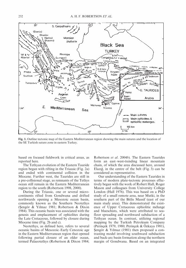
Robertson et al. 2004b). The Eastern Tauridesform an east–west-trending linear mountainchain, of which the area discussed here, aroundElazIgb, in the centre of the belt (Fig. 3) can beconsidered as representative.
Our understanding of the Eastern Taurides interms of modern plate-tectonic processes effec-tively began with the work of Robert Hall, RogerMason and colleagues from University CollegeLondon (Hall 1976). This was based on a PhDstudy of a small remote area, near Mutki, in thesouthern part of the Bitlis Massif (east of ourmain study area). This demonstrated the exist-ence of Upper Cretaceous ophiolitic mélangeand blueschists, which were attributed to sea-floor spreading and northward subduction of aTethyan ocean. In contrast, utilizing regionalmapping by the Turkish Petroleum Company(Perinçek 1979, 1980; Perinçek & Özkaya 1981),Scengör & YIlmaz (1981) then proposed a con-trasting model involving southward subductionand back-arc basin formation along the northernmargin of Gondwana. Based on an integrated
Fig. 1. Outline tectonic map of the Eastern Mediterranean region showing the main sutures and the location ofthe SE Turkish suture zone in eastern Turkey.

233TECTONIC EVOLUTION OF THE SOUTH TETHYAN OCEAN
study of the thrust front in the central part ofthe Eastern Taurides (Maden area), Aktasc &Robertson (1984) next put forward a tectonicmodel involving northward subduction of aMesozoic Tethyan ocean, with collision in eitherlatest Cretaceous or Mid-Cenozoic time, thelatter option being favoured. Utilizing mapping
by MTA (e.g. Yazgan 1984) and regional tectono-stratigraphic studies (Fontaine 1981; Fourcadeet al. 1991), it was suggested that these largeCretaceous ophiolites in the region were formednot in a southerly Neotethyan oceanic basin,but instead within a more northerly oceanic basinlocated closer to Eurasia. The ophiolites were
Fig. 2. Diagrammatic palaeo-tectonic sketch maps of the Mesozoic Tethys (Neotethys) in the Turkish region,indicating the setting of the study area in SE Turkey (ElazIgb area). (a) Late Triassic–Early Jurassic; (b) latestCretaceous; (c) Miocene. Based on Robertson (1998, 2002). Several Neotethyan basins opened in the Triassic (a),reached their maximum width in the Late Jurassic–Early Cretaceous, then progressively closed (b, c).
234 A. H. F. ROBERTSON ET AL.
emplaced by thrusting hundreds of kilometressouthwards in latest Cretaceous time (Michardet al. 1984; Yazgan 1984). It was also believedby these workers that the Tethyan ocean in thisregion was complely closed by latest Cretaceoustime.
Based on a study of the younger syn-post collisional sedimentary and volcanic rocksof eastern Anatolia, Dewey et al. (1986) clarifiedthe timing of final closure of the SouthernNeotethyan oceanic basin in SE Turkey as Early–Middle Miocene. This was followed by post-collisional left-lateral tectonic escape ofAnatolia, bounded by the North and EastAnatolian transform faults (Scengör et al. 1985).However, some geologists continued to believethat final Tethyan closure took place associatedwith the ophiolite emplacement in latestCretaceous time (Beyarslan & Bingöl 2000).
Based on detailed studies of PhD-sized studyareas in the western part of the Eastern Taurides,geologists from Istanbul Technical Universityelaborated on the concept of a Southern Neote-thys that opened in the Early Mesozoic, thenfinally closed by Mid-Miocene time (YIlmaz1991, 1993; YIlmaz et al. 1993).
Currently, the main focus of research is on theorigin and emplacement of the Late Cretaceousophiolites (Parlak et al. 2001, 2004; Robertson
et al. 2006) and on the tectonic evolution of thesuture zone and thrust belt.
The main tectonic models that have been pro-posed are summarized in Figure 4. Northwardsubduction is now generally assumed. There isnowadays also a near consensus that the ophio-lites formed in a southerly Mesozoic oceanicbasin. However, important questions and con-troversies remain, notably the timing of finalcontinental break-up of the Southern Neotethys,the setting of genesis and emplacement of theophiolites, the palaeo-tectonic setting of largemetamorphic units, and the timing and modeof ocean closure and collision. The present studyaddresses some of these outstanding questions,utilizing evidence mainly from the well-exposedElazIgb area in the central part of the EasternTaurides (Fig. 3), and concludes with a newtectonic model. We will show that any effectivemodel depends critically on taking full accountof the entire database of sedimentary, igneousand metamorphic rocks and their structuraldevelopment within a well-defined time frame-work. In the discussion below we highlight thecontribution of each tectonic unit to the overalltectonic evolution of the orogen. However, noattempt is made to discuss the Eastern Tauridesas a whole and, in particular, the extreme east ofthe belt, which has received little modern study, isexcluded.
Fig. 3. Outline structural map of the SE Turkish suture zone, discussed in this paper (ElazIgb area). Modified fromRobertson et al. (2006).

235TECTONIC EVOLUTION OF THE SOUTH TETHYAN OCEAN
Regional tectonostratigraphy
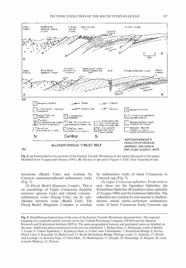
A broad north–south transect of the central partof the Eastern Taurus Mountains (ElazIgb area) isconsidered here (Figs 5 and 6). The area beginsin the north with a large Mesozoic carbonateplatform, the Keban Platform, which is inter-preted as part of the northern continental margin
of the Mesozoic Southern Neotethys. Movingsouthwards and structurally downwards, variousmagmatic, metamorphic and sedimentary unitsare crossed, until the Arabian Foreland isreached.
(1) Keban Platform. This is a low-grade-metamorphosed carbonate platform of LatePalaeozoic–Early Mesozoic age, cut by granitic
Fig. 4. Previous tectonic models for the evolution of the SE Turkish suture zone. (ai–aii) Late Cretaceouscollision followed by Miocene thick-skinned rethrusting; (bi–bii) northward subduction followed by LateCretaceous continental collision; (ci–cii) northward subduction, followed by re-thrusting of the Pütürge and Bitlismetamorphic massifs from the northern margin to a southerly position in post Mid-Eocene time, exposingophiolitic and other rocks to the north of this unit.

236 A. H. F. ROBERTSON ET AL.
237TECTONIC EVOLUTION OF THE SOUTH TETHYAN OCEAN
intrusions (Baskil Unit) and overlain byCenozoic unmetamorphosed sedimentary rocks(Fig. 7).
(2) ElazIgb–Baskil Magmatic Complex. This isan assemblage of Upper Cretaceous tholeiiticextrusive igneous rocks and related volcanic–sedimentary rocks (ElazIgb Unit), cut by calc-alkaline intrusive rocks (Baskil Unit). TheElazIgb–Baskil Magmatic Complex is overlain
by sedimentary rocks of latest Cretaceous toCenozoic age (Fig. 7).
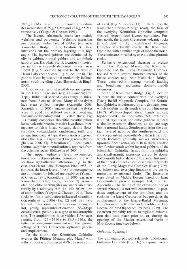
(3) Upper Cretaceous ophiolites. From west toeast, these are the Iqspendere Ophiolite, theKömürhan Ophiolite (Kömürhan meta-ophioliteof Yazgan 1984) and the Guleman Ophiolite. Theophiolites are overlain by non-marine to shallow-marine, mixed clastic–carbonate sedimentaryrocks of latest Cretaceous–Early Cenozoic age
Fig. 6. (a) Generalized cross-sections of the Eastern Tauride Mountains in the region discussed in this paper.Modified from Yazgan and Chessex (1991). (b) The key to (a) and to Figure 5. EAF, East Anatolian Fault.
Fig. 5. Simplified geological map of the area of the Eastern Tauride Mountains discussed here. The regionalmapping was originally mainly carried out by the Turkish Petroleum Company (TPAO) and the MineralResearch and Exploration Institute (MTA). The main geographical features and geological units are labelled onthe map. Additional places mentioned in the text are numbered: 1, Keban Dam; 2, HamuscagbI, south of Baskil;3, Laçan; 4, YukarI Iqspendere; 5, KapIkaya Dam; 6, Fodul, near YalIndamlar; 7, Kömürhan Bridge; 8, Sivrice,Hazar Lake; 9, Karadagb; 10, Baskil road; 11, Kerik (Kömürhan Bridge–Pütürge road); 12, Aslantasc, 13, Pertekand ÇaybagbI; 14, Karatasc Tepe; 15, Orta Mah.; 16, BadempInar; 17, SarIgül; 18, Hasretdagb; 19, Harput; 20, roadtowards Malatya; 21, Putyan.

238 A. H. F. ROBERTSON ET AL.
(Figs 5 and 6). Dismembered ophiolitic rocks(Killan Ophiolite) are also present in the frontalpart of the thrust belt.
(4) Pütürge and Bitlis metamorphic massifs.These units are located in the southern, structur-ally lower parts of the thrust belt, and exhibit‘basement’ and ‘cover’ units that were metamor-phosed in latest Cretaceous time (Figs 5 and 6).The Bitlis Massif is overlain by unmetamor-phosed sediments of latest Cretaceous age.The metamorphic massifs were exhumed by theMiddle Eocene and overlain by the volcanic–sedimentary Maden Group (Maden Complex;Fig. 6).
(5) Killan Imbricate Unit. This tectonicallyassembled unit forms the structurally lowest,frontal part of the thrust belt. It is most widelyexposed between the Pütürge and Bitlis metamor-phic massifs (Fig. 5b). This unit includes slices
of Upper Cretaceous ophiolitic rocks (KillanOphiolite) and Eocene deep-water pelagic orhemipelagic sediments (Maden Group) (Aktasc &Robertson 1984, 1990).
(6) Arabian Foreland. This comprises aPalaeozoic–Mesozoic succession overlying aPrecambrian basement (Fig. 6). The platformwas overthrust from the north by ophioliticand related units during latest Cretaceous(Campanian–Maastrichtian) time, and was thenunconformably overlain by an uppermostCretaceous–Palaeogene non-marine to shallow-marine succession (Fig. 7). This was followed bythe deposition of Lower Miocene turbidites thataccumulated in a foredeep related to final south-ward emplacement of the thrust belt in Mid-Miocene time (Basctugb 1980; Aktas & Robertson1984; Dewey et al. 1986; YIlmaz 1993).
Fig. 7. Summary of the stratigraphy of the main continental-type units exposed in the region studied. (See text fordata sources and literature citations.) Logs of the ophiolitic units are given in Figure 11.

239TECTONIC EVOLUTION OF THE SOUTH TETHYAN OCEAN
Each of the above units is discussed andinterpreted in more detail below.
Pütürge and Bitlis metamorphic massifs
The Bitlis and Pütürge metamorphic massifsdominate the structurally lower, southerly partof the Neotethyan suture (Figs 5 and 6) and arewidely exposed in the SE and SW of the regionstudied. Here, we are mainly concerned with theTriassic and later tectonic development. How-ever, the Palaeozoic setting is also relevant asit allows a comparison with the stratigraphy ofthe northern margin (Keban Platform) and thesouthern margin (Arabian Foreland) of theSouthern Neotethys, and this then sheds lighton the palaeogeography and the palaeo-tectonicsetting.
Bitlis Massif
The Bitlis Massif (Figs 3 and 7) is extensivelyexposed over several hundred kilometres alongthe Eastern Tauride thrust belt from the studyarea to beyond the border with Iran. Only theextreme west of the Bitlis Massif lies within ourpresent study area. However, below we include asummary of salient features based mainly on theliterature (Hall 1976; Perinçek 1979; Perinçek &Özkaya 1981; Çagblayan et al. 1984; Göncüogblu &Turhan 1984; HelvacI & Griffin 1984).
The metamorphic country rocks (‘basement’)are mainly isoclinally folded biotite–muscoviteschists and gneisses with occasional dark lensesof amphibolitic rocks. The schists and gneissesare locally kyanite-bearing, and lenses andblocks of eclogitic rocks have been reportedlocally. The metamorphic rocks are intruded byseveral elongate metagranitic bodies. Dykes ofsimilar composition intrude the metamorphiccountry rocks. The granites show ductile defor-mation, with the development of a planarfoliation, S–C tectonites and mineral stretchinglineation (P. A. Ustaömer & T. Ustaömer, pers.com.).
The metamorphic basement units are overlainunconformably by quartzites and schists, withinterlayered metacarbonates in the stratigra-phically higher levels of the succession (MeydanFormation of Göncüogblu & Turhan 1984).Fossils collected from the metacarbonateshave yielded Givetian–Frasnian ages (Mid-LateDevonian). Higher in the succession, felsic meta-tuffs are possibly Carboniferous in age (ÇescmeFormation). These sediments are reported tocontain blocks of metacarbonates (dolomites),calcschists and actinolitic schists. Göncüogblu &Turan (1984) considered that the granites were
intruded up to, and including, units of probableCarboniferous age, although current work sug-gests that the granites may be of pre-Hercynianage (P. A. Ustaömer & T. Ustaömer, pers. com.).A local unconformity was reported at the base ofthe overlying unit, of Early Permian age (ÇIkrIkFormation), associated with a metaconglomerate(Göncüogblu & Turhan 1984), but no major breakin the succession appears to exist at this level. Thesuccession continues upwards into thick-bedded,recrystallized limestones, calcschists and gra-phitic schist (ÇIkrIk Limestone), with UpperPermian fossils (Fig. 7). These metasediments areconformably overlain by thick-bedded metali-mestones (Tutu Formation) of Triassic age. Insome other areas (western Bitlis Massif) the suc-cession includes Middle–Upper Triassic meta-volcanic rocks and sediments, including alkalibasalts, volcaniclastic deposits, shales and radi-olarian sediments (Perinçek 1979, 1980, 1990;Perinçek & Özkaya 1981). Phyllites, shales andmetavolcaniclastic sediments at the highest pre-served levels of the succession remain undated(?Triassic or later Mesozoic).
In the south, the uppermost levels of theBitlis Massif are overlain tectonically by ophio-litic rocks (Hall 1976; Çagblayan et al. 1984;Göncüogblu & Turhan 1984). The contact is azone of intense mylonitization, as exposed alongthe southern front of the metamorphic massif(e.g. near Mutki; Hall 1976). Ophiolites are alsoexposed along the northern margin of the BitlisMassif, south of Lake Van, where they aremapped as being separated from the Bitlis Massifby the Middle Eocene volcanic–sedimentaryMaden Group (i.e. the Maden Complex ofPerinçek 1979). The ophiolitic rocks exposed inthe south (e.g. Mutki area), are mainly shearedserpentinite and ophiolitic mélange, associatedwith blocks of radiolarian chert, metabasalt,volcanic breccia, recrystallized limestone,glaucophane-bearing greenschists and localeclogites (Hall 1976). Micritic limestones locallycontain Globotruncana sp., indicating a LateCretaceous age. The HP–LT metamorphismtook place prior to deposition of UpperMaastrichtian cover sediments (Hall 1976;Perinçek 1979). The unconformably overlyingunit (Kinzu Formation) begins with debris-flowdeposits (‘wildflysch’), passing upwards intosandstone–shale alternations with occasionalmicritic limestone interbeds that have yieldedUpper Maastrichtian microfossils. The clastsand blocks were derived from ophiolitic andmetamorphic ‘basement rocks’.
The Upper Cretaceous facies are unconfor-mably overlain, above a basal red conglomerate,

240 A. H. F. ROBERTSON ET AL.
by pelagic or hemipelagic limestones, limestone–shale alternations and sandstones, of Mid–LateEocene age (KIzIlagbaç Formation). Poorly datedvolcanic rocks (andesites and tuffs), interbeddedwith polymict conglomerates occur above this(Salhan Volcanics). These units correlate withLower–Middle Eocene volcanic rocks and pela-gic or hemipelagic limestones (Baykan Group)that are extensively exposed south of Lake Van,and also with the Middle Eocene volcanic–sedimentary Maden Group (Maden Complex).
Interpretation of the Bitlis Massif
For the discussion that follows the main pointto note is that the Bitlis Massif exhibits Triassicrifting followed by deformation and HP–LTmetamorphism in an active margin setting duringLate Cretaceous time. This was followed byan Eocene volcanic–sedimentary succession thatis considered to relate to the later stage of sub-duction and back-arc basin formation duringmid-Cenozoic time. The Bitlis Massif was finallythrust southwards over the Arabian Forelandduring the Early Miocene. The Mesozoicpalaeogeographical setting of the Bitlis Massif iscontroversial and the additional information onthe pre-Triassic ‘basement’ is mainly includedhere as it helps with comparisons, both withthe Arabian Foreland to the south and theTauride margin (Keban Platform) to the north,as discussed later in the paper.
Pütürge Metamorphic Massif
The Pütürge Massif occupies much of the south-ern part of the present study area (Figs 5 and 6).Regional mapping around Pütürge village(Fig. 5) indicates that the metamorphic outcropthere comprises lower and upper metamorphicunits (YIlmaz 1971; Erdem & Bingöl 1995;YIlmaz et al. 1993). These two units are separatedby a phyllitic shear zone that is interpreted asa deformed unconformity (Bingöl 1984; Yazgan1984). The lower unit comprises augen gneiss,biotite schist and amphibolitic schist, cut bygranitic gneiss, with amphibolite–prasinite veins.The upper unit includes muscovite-, staurolite-,garnet- and kyanite-bearing schists, overlainby thicker and more extensive calcschists andmarble, with magnetite layers (Erdem & Bingöl1995). The intervening shear zone (>50–100 mthick) includes chlorite–pyrophyllite–diasporeassemblages (Yazgan & Chessex 1991). Thecore and cover units were metamorphosed toamphibolite facies, apparently during the LateCretaceous (Bingöl 1984; Yazgan & Chessex1991). In addition, small tourmaline leucogranite
intrusions were reported locally (Yazgan &Chessex 1991).
The Pütürge Massif can be correlated with theBitlis Massif, although the metamorphic grade ofthe Pütürge Massif may be somewhat higher, asthe succession appears to be more recrystallizedand less age dating from fossils is available. Thecross-cutting granitic rocks in the Pütürge Massifcould be of Precambrian age (P.A. Ustaömer &T. Ustaömer, pers. com), and the overlying marlsand calcschists may be of Permian age, extendinginto the Mesozoic, as in the Bitlis Massif. Themetacarbonates include graphitic schists thathave been correlated with similar organic-richfacies in the Keban Platform (YIlmaz 1993;YIlmaz et al. 1993). The reported shear zonebetween the upper and lower units might recordEarly Mesozoic rifting but more evidence isneeded.
Structural work in the east of the PütürgeMassif (Hazar Lake area; Fig. 5) has demon-strated the effects of regional folding (D1),with fold axes striking NE–SW. Muscovite,biotite and amphibole have yielded calculatedK/Ar ages of mainly 85–72 Ma (Campanian–Maastrichtian) (Yazgan 1984). The D1 defor-mation was reported to be associated with aprominent NNW-trending stretching lineation.Later deformation (D2) caused upright SE-verging folding associated with low-grademetamorphism (Hempton 1984, 1985). Ingeneral, regional metamorphism took placeunder amphibolite- to lower greenschist-faciesconditions.
The Pütürge Massif therefore follows a verysimilar structural history to that outlined for theBitlis Massif above. The information on the pre-Triassic lithologies is again useful to comparewith the stratigraphy of the Arabian marginand Tauride units and so shed light on thepalaeotectonic setting of the Bitlis and Pütürgemassifs.
Keban Platform
The Keban Platform forms a regional-scalethrust sheet above Upper Cretaceous ophioliticand arc-related rocks exposed to the south(Figs 5, 6 and 8). For example, NW of ElazIgb, alarge thrust sheet of metamorphosed Keban Plat-form rocks overlies unmetamorphosed UpperCretaceous magmatic rocks of the ElazIgb–BaskilMagmatic Complex. Prominent hills of metacar-bonate rocks are surrounded by soft-weatheringlithologies. The thrust is subhorizontal, to gentlynorthward dipping. Northwest of Baskil (Fig. 5),the Keban Platform, locally south dipping, isexposed as a mountainous ridge (near Laçan;Fig. 5, location 3). Marbles of the Keban

241TECTONIC EVOLUTION OF THE SOUTH TETHYAN OCEAN
Platform are structurally underlain by upper-most Cretaceous volcanic–sedimentary rocks ofthe ElazIgb Unit, with a moderately inclined (35°),NW-dipping thrust contact. In this area, thrustcontacts are also exposed locally in areas thatwere intruded by granitic rocks (Fig. 9a). Thisthrust is segmented, with nearly north–southtranspressional segments. To the north, theKeban Platform is structurally overlain by theMunzur Dagb, which is another major Mesozoiccarbonate platform unit located further north(Özgül 1981).
The stratigraphic succession in the KebanPlatform, several kilometres thick, is dominatedby low-grade (greenschist-facies) metasediments(Fig. 7). Lithologies are mainly marbles, schistsand black phyllites, with rare metaconglomeratesand amphibolites (Bingöl 1984; Yazgan 1984;Akgül 1987; Asutay 1988; Turan & Bingöl 1991;YIlmaz 1993; YIlmaz et al. 1993). A mainlyPermo-Carboniferous age was inferred, based onGlomospira and Ammodiscus (Kipman 1981),possibly extending into the Early Triassic (Özgül1981).
The contact between the Keban Platform andthe underlying Cretaceous ophiolitic and arc-related units (see below) is generally a thrust, asmapped SW of ElazIgb (Yazgan 1984; Yazgan &Chessex 1991; Beyarslan & Bingöl 2000; Fig. 5).However, cross-cutting dioritic to granitic intru-sive rocks were reported by Yazgan & Chessex(1991). Skarn zones are present between theUpper Cretaceous magmatic rocks and theKeban metamorphic rocks (Yazgan & Chessex1991). In places, the intrusions are associatedwith magnetite mineralization (e.g. SE of Ascvanvillage, near Keban Dam). Also, contact-metamorphosed hornfelses and skarns are wellexposed (e.g. NW of Birivan; also known asUlupInar). A marble–microsynenite contact nearKeban is associated with well-known silver–leadmineralization (Yazgan & Chessex 1991).
Where widely exposed near, and to the northof, Keban Dam (Fig. 5, location 1), the KebanPlatform is cut by numerous large granitic,granodioritic and minor gabbroic intrusions,together with dykes of mainly intermediate com-position (Yazgan 1984). The Keban metamor-phic rocks are also widely exposed further west,e.g. adjacent to the ElazIgb-Keban dam road,where they comprise an east-dipping successionof mainly well-bedded, dark marble with sub-ordinate intercalations of black phyllite. Cross-cutting plutonic rocks in this area includespectacular orbicular gabbro (Fig. 10d).
To the east of the Baskil area (e.g. nearHamuscagbI; Fig. 5, location 2), well-beddedmarbles of the Keban Platform are cut by intru-sive rocks of the Baskil Unit (locally diorite cutby quartz-monzonite). Dioritic intrusive rocks
include blocks of bedded marble (metres to tensof metres in size), interpreted as xenoliths of theKeban metamorphic rocks within a pluton ofthe Baskil Unit (Figs 9b,c and 10b). In places, thediorite and marble are cut by altered subverticalbasic dykes, up to 3 m wide (Fig. 9d). The intru-sive rocks and larger marble exposures are locallyseparated by a low-angle shear zone (traceable>200 m laterally). This shows that the primarymagmatic contacts were later deformed.
The Keban Platform is interpreted as ashallow-marine carbonate platform, although itsexact age and basement–cover relations areunclear because of limited exposure. DuringMesozoic time the Keban Platform is commonlyviewed as having been contiguous with theMunzur carbonate platform to the north, andwith the Malatya carbonate platform to the west(e.g. Michard et al. 1984; Fig. 8). However, theseplatform units might instead have formed sepa-rate palaeogeographical units (Scengör & YIlmaz1981; Robertson & Dixon 1984; Fig. 8c and d).The Keban Platform is cut by Upper Cretaceousarc-related plutonic rocks termed the Baskil Unit
Fig. 8. Alternative possible settings of the Pütürge andBitlis massifs. (a) in the south along the Arabianmargin (e.g. Yazgan & Chessex 1991); (b) in the northalong the Tauride margin (e.g. YIlmaz 1993); (c) asmicrocontinents adjacent to the Arabian margin(e.g. Scengör & YIlmaz 1981; Robertson & Dixon 1984;present study); (d) near the northern margin, possiblyas marginal rift blocks. AP, Arabian Platform;P-B, Pütürge and Bitlis massifs; KP, Keban Platform.(See text for discussion.)
242 A. H. F. ROBERTSON ET AL.
(Bingöl 1984; Michard et al. 1984; Yazgan 1984).Regional metamorphism probably took place inlatest Cretaceous time, as the Lower Cenozoiccover sediments are unmetamorphosed.
An important question therefore is whether,during Mesozoic time, the successions in the Bitlisand Pütürge massifs were located along theArabian margin to the south (Fig. 8a), adjacentto the Keban Platform to the north (Fig. 8b), orformed one (or several) microcontinents withinthe Southern Neotethys (Fig. 8c and d). The
pre-Triassic platform-type successions of theBitlis and Pütürge massifs can be generally cor-related with the Arabian Foreland (e.g. HazroInlier) (Çagblayan et al. 1984). However, similarpre-rift lithologies could well have existed alongthe northerly (conjugate) Tauride margin (KebanPlatform). Also, the Arabian Platform successiondiffers from the Keban Platform as it lacksintrusive or extrusive rocks (Fig. 7). In addition,these two units are everywhere separated by thebasal thrust of the Tauride allochthon.
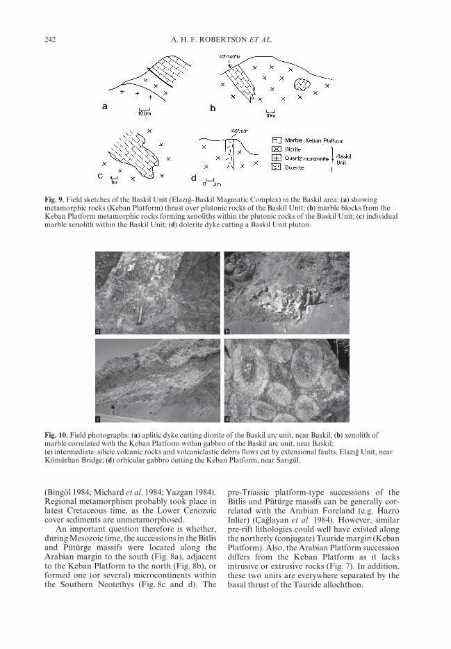
Fig. 9. Field sketches of the Baskil Unit (ElazIgb–Baskil Magmatic Complex) in the Baskil area: (a) showingmetamorphic rocks (Keban Platform) thrust over plutonic rocks of the Baskil Unit; (b) marble blocks from theKeban Platform metamorphic rocks forming xenoliths within the plutonic rocks of the Baskil Unit; (c) individualmarble xenolith within the Baskil Unit; (d) dolerite dyke cutting a Baskil Unit pluton.
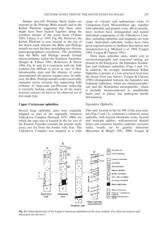
Fig. 10. Field photographs: (a) aplitic dyke cutting diorite of the Baskil arc unit, near Baskil; (b) xenolith ofmarble correlated with the Keban Platform within gabbro of the Baskil arc unit, near Baskil;(c) intermediate–silicic volcanic rocks and volcaniclastic debris flows cut by extensional faults, ElazIgb Unit, nearKömürhan Bridge; (d) orbicular gabbro cutting the Keban Platform, near SarIgül.
243TECTONIC EVOLUTION OF THE SOUTH TETHYAN OCEAN
Similar (pre-rift) Permian black shales areexposed in the Pütürge–Bitlis massifs and in theKeban Platform suggesting that these unitsmight have been located together along thenorthern margin of the ocean basin (YIlmaz1993; YIlmaz et al. 1993; Fig. 8b). However, theKeban Platform is now located at the top ofthe thrust stack whereas the Bitlis and Pütürgemassifs are near the base, precluding any obviouspalaeogeographical correlation. The possibilitythat the Bitlis and Pütürge massifs formedmicrocontinents within the Southern Neotethys(Scengör & YIlmaz 1981; Robertson & Dixon1984; Fig. 8c and d) is consistent with the fieldevidence but difficult to prove in view of theirmetamorphic state and the absence of unme-tamorphosed rift–passive margin units. In addi-tion, the Bitis–Pütürge massifs could conceivablyrepresent exotic terranes but supporting fieldevidence of large-scale pre-Pliocene strike-slipis currently lacking, especially as all the majortectonic contacts we have so far observed are oflow-angle type.
Upper Cretaceous ophiolites
Several large ophiolitic units were originallymapped as part of the regionally extensiveYüksekova Complex (Perinçek 1979, 1980), forwhich the type area is located in the far east ofthe Eastern Taurides (outside the present studyarea), not far from the border with Iran. TheYüksekova Complex was mapped as a wide
range of volcanic and sedimentary rocks ofCampanian–Early Maastrichtian age, togetherwith ophiolitic and granitic rocks. More recently,most workers have distinguished and namedindividual components of the Yüksekova Com-plex, including ophiolitic and magmatic arc-typerocks. Individual ophiolitic bodies have beengiven regional names to facilitate description andinterpretation (e.g. Michard et al. 1984; Yazgan1984; Yazgan & Chessex 1991).
Three main ophiolitic units, which vary intectonostratigraphy and structural setting, arepresent in the ElazIgb area: the Iqspendere, Kömür-han and Guleman ophiolites (Figs 5 and 11).In addition, the strongly dismembered KillanOphiolite is present at a low structural level nearthe thrust front (see below). Yazgan & Chessex(1991) distinguished between the Iqspendere andGuleman ophiolites, which are unmetamorpho-sed, and the ‘Kömürhan metaophiolite’, whichis partially metamorphosed to amphibolitefacies and, in places, has undergone ductiledeformation.
Iqspendere Ophiolite
This unit, located in the far SW of the area stud-ied (Figs 5 and 11), comprises a relatively intactophiolite, with layered ultramafic rocks, layeredand isotropic gabbro, well-preserved sheeteddykes and extensive basaltic–andesitic extrusiverocks, locally cut by granitic intrusions(Beyarslan & Bingöl 1991, 2000; Yazgan &
Fig. 11. Generalized logs of the Upper Cretaceous ophiolites in the area studied. (For data see sources anddiscussion see the text.)

244 A. H. F. ROBERTSON ET AL.
Chessex 1991). The deeper part of the pseudo-stratigraphy, well exposed in the west (at YukarIIqspendere; Fig. 5, location 4), exposes layeredultramafic rocks, locally cut by wehrlites,but with no evidence of a preserved tectonite(depleted mantle) unit beneath. The ultramaficcumulates are characterized by plagioclasewehrlite and wehrlite. The mafic cumulates aredominated by troctolite and gabbro. Higherparts of the ophiolite succession are exposedfurther east (near KapIkaya Dam; Fig. 5, loca-tion 5), where layered gabbros are cut by isolatedbasic dykes (<1 m thick) with well-developedchilled margins. Above come massive gabbros,with isolated diabase dykes and subhorizontaldolerite dykelets. A sheeted dyke complex ismade up of diabase and quartzmicrodioritedykes, as seen near KapIkaya Dam. An extrusivesuccession exposed further east between KapIk-aya Dam and Erenli includes basalts and morefractionated volcanic rocks. A representativechemical plot of the basalt (Fig. 12) illustratesa subduction-influenced character, as indicatedby the negative Nb anomaly. The successionincludes thick volcaniclastic debris flows, withclasts of volcanic rocks up to 1 m in size. Thissuccession was dated as Late Campanian–EarlyMaastrichtian based on the presence of plank-tonic Foraminifera within interbedded pelagicsediments (Yazgan & Chessex 1991).
Kömürhan Ophiolite
The laterally extensive Kömürhan Ophiolite(Fig. 5) is critical as, unlike the other ophiolites,its contacts are well exposed, both with thePütürge Massif to the south and with the ElazIgb–Baskil Magmatic Complex to the north. In thesouth, the ophiolite is thrust over the MiddleEocene volcanic–sedimentary Maden Group,whereas in the north it is either intruded bythe Upper Cretaceous ElazIgb–Baskil MagmaticComplex, or unconformably overlain byMiddle–Upper Eocene sediments (KIrkgeçitFormation; see below). Petrographic descrip-tions, supported by geochemical evidence, arereported elsewhere (RIzaogblu 2006; RIzaogbluet al. 2006), and only features directly relevant tothe tectonic setting are summarized here.
The Kömürhan Ophiolite (Fig. 11) is domi-nated by serpentinized tectonite, together withlayered ultramafic rocks, layered gabbro, iso-tropic gabbro, sheeted dykes and volcanic–sedimentary units. In addition, the plutonicsequence is locally cut by calc-alkaline plutonicrocks that are correlated with the uppermostCretaceous arc-related Baskil Unit (see below).Biotite from quartz-bearing leucodiorites hasyielded ages of 85P3 Ma. Also, muscovite froma trondhjemitic granophyre gave an age of
Fig. 12. Mid-oceanic ridge basalt (MORB)-normalized geochemical plots of extrusive igneous rocks from theUpper Cretaceous ophiolites (O. Parlak unpubl. data). The plots indicate that these ophiolites are likely to haveformed in an SSZ-type setting. One representative sample is included from the Göksun Ophiolite (also known asthe North Berit Ophiolite) further west in the zone of Upper Cretaceous ophiolitic rocks. Diagram from Sun &McDonough 1989.
245TECTONIC EVOLUTION OF THE SOUTH TETHYAN OCEAN
78.5P2.5 Ma. In addition, intrusive granodior-ites were dated at 75P2.4 Ma and 75.4P2.5 Ma,respectively (Yazgan & Chessex 1991).
The layered ultramafic rocks are mainlywehrlites and pyroxenite. Wehrlitic intrusionsare observed within layered gabbro (e.g. nearKömürhan Bridge; Fig. 5, location 7). Theseintrusions cut the primary layering at a highangle. The layered gabbros are dominated byolivine gabbro, normal gabbro and amphibolegabbro (e.g. Karadagb; Fig. 5, location 9). Isotro-pic gabbro is intensely deformed, as seen nearFodul (Fig. 5, location 6) and to the west ofHazar Lake (near Sivrice; Fig. 5, location 8). Thegabbro is cut by occasional moderately inclinednorth–south-trending dykes (Beyarslan & Bingöl2000).
Good exposures of sheeted dykes are exposedin the Hazar Lake area (e.g. at KamerziyaretiTepe). Individual sheeted dykes range in thick-ness from 15 cm to 100 cm. Many of the dykeslack clear chilled margins (RIzaogblu 2006;RIzaogblu et al. 2006), suggesting that the dykeswere intruded into still-hot rock. An overlyingvolcanic–sedimentary unit (c. 750 m thick; Fig.11) mainly comprises tholeiitic basaltic pillowlavas, volcanic breccia, massive lava flows, inter-mediate to felsic lavas, volcanic debris flows,turbiditic volcaniclastic sandstones, tuffs andpelagic limestone. A typical succession is exposedalong the Baskil–KuscsarayI (ElazIgb) road (RIzao-gblu et al. 2006; Fig. 5; location 10). Local hydro-thermal sulphide mineralization is reported fromthe volcanic rocks (Bölücek et al. 2004).
The upper ophiolite levels experiencedlow-grade metamorphism, commensurate withsea-floor hydrothermal alteration, e.g. in theeast, near Hazar Lake (Hempton 1984, 1985). Incontrast, the lower levels of the plutonic sequenceare dominated by foliated metagabbros (Yazgan& Chessex 1991; RIzaogblu et al. 2006; e.g. nearKömürhan Bridge; Fig. 5, location 7). Associ-ated ophiolitic harzburgites are underlain struc-turally by a relatively thin (i.e. 150–200 m) unitof amphibolites (Yazgan & Chessex 1991). Theserocks exhibit a subduction-influenced chemistry(RIzaogblu et al. 2006) (Fig. 12) and may haveformed in response to intra-oceanic slicing ofhot, young suprasubduction-zone (SSZ)-typeoceanic crust, possibly as a type of metamorphicsole. The amphibolites have yielded K/Ar agesranging from 127P14 Ma to 89.5P5 Ma, thelatter age being more consistent with the regionalsetting of Upper Cretaceous ophiolite genesisand emplacement.
To the south, the Kömürhan Ophioliteoverlies the Pütürge Metamorphic Massif witha thrust contact, dipping at 40°N, as seen south
of Kerik (Fig. 5, location 11). In the SE (on theKömürhan Bridge–Pütürge road), the base ofthe overlying Kömürhan Ophiolite comprisessheared, serpentinized layered cumulates. Fur-ther north, the Upper Cretaceous volcanic rocks(ElazIgb Unit) of the ElazIgb–Baskil MagmaticComplex structurally overlie the KömürhanOphiolite, with a similar angle of dip to the north.These units are intruded by calc-alkaline plutonicrocks.
Pervasive extensional shearing is presentwithin the Pütürge Massif, the KömürhanOphiolite and the ElazIgb Magmatic Complex,focused within several hundred metres of thethrust contact (e.g. near Kömürhan Bridge).These units exhibit strong normal faultingand boudinage, indicating down-to-the-NEextension.
South of Kömürhan Bridge (Fig. 5, location7), near the thrust contact with the overlyingElazIgb–Baskil Magmatic Complex, the Kömür-han Ophiolite is deformed by a high-strain zone,which exhibits north–south transport lineations(340°). Well-developed shear bands indicatetop-to-the-NE, to top-to-the-ENE extension.Rotated crystals in ophiolitic gabbros indicatea similar extension direction, as do late-stagebrittle normal faults. Southwards from the con-tact, layered gabbros dip southwestward andshow a persistent top-to-the-NE shear (Fig. 13b),which becomes gradually weaker structurallyupwards. Shear zones, up to 10 m thick, are alsoseen further south within layered gabbros of theKömürhan Ophiolite. In addition, the ophioliteand small granitic intrusions are cut by down-to-the-north brittle shears in this area. Just northof the thrust contact volcanic–sedimentary rocksof the ElazIgb Magmatic Complex (ElazIgb Unit;see below) and overlying limestones are cut bynumerous extensional faults. The limestoneswere dated as Middle Eocene based on largeForaminifera present (Sample 154; Fig. 14h;Appendix). The timing of the extension (one orseveral phases?) is not well constrained; it post-dates emplacement of the ophiolites and arcrocks in the latest Cretaceous but pre-dates theemplacement of the Elazig–Baskil MagmaticComplex over the Kömürhan Ophiolite (i.e. LateEocene or pre-Oligocene; Perinçek 1979). Theextension probably relates to regional exhuma-tion that took place prior to, or, during theopening of the Maden extensional basin inMid-Eocene time (see below).
Guleman Ophiolite
The unmetamorphosed, relatively undeformedGuleman Ophiolite (Fig. 11c) is exposed over a

246 A. H. F. ROBERTSON ET AL.
large area, SE of Hazar Lake (c. 200 km2; Fig. 5).The ophiolite is locally underlain in the east byamphibolites that could represent a type of meta-morphic sole, similar to the amphibolites asso-ciated with the Kömürhan Ophiolite, althoughthese rocks were previously correlated with theinternal stratigraphy of the Bitlis Massif (Yazgan& Chessex 1991). The sequence is dominated byharzburgite (ultramafic tectonite), with somedunite, passing upwards into layered cumulatescomposed of dunite, wehrlite, clinopyroxenite,troctolite, olivine gabbro, normal gabbro, quartzgabbro and quartz diorite (Özkan & ÖztunalI1984). The total thickness of the ultramafic rocksis estimated as 1800 m, and that of the gabbrosas 1000 m. The cumulate rocks exhibit structuresand textures indicative of crystal segregation,including magmatic layering, cross-bedding,slumping and synsedimentary faulting (Özkan &ÖztunalI 1984). The crystallization order of thecumulate rocks is characterized by chromite–olivine–clinopyroxene–plagioclase–hornblendeand quartz, as in many other Eastern Mediterra-nean ophiolites (Parlak et al. 2000). In addition,small exposures of massive gabbros are present,but no preserved sheeted dykes or extrusive rocksare known.
The Guleman Ophiolite is unconformablyoverlain by a well-exposed sedimentary succes-sion of Maastrichtian–Palaeocene age, known asthe Hazar Group (Perinçek 1979). For example,
where well exposed near Aslantasc village (Fig. 5,location 12), coarse-grained ophiolite-derivedconglomerates (included with the Ceffan For-mation by Aktasc & Robertson (1984, 1990))pass depositionally upwards into shallow-marinemudstones and sandstones (Simaki Formation)and then into neritic carbonates (GehrozFormation).
Interpretation of the ophiolites
The ophiolites are widely interpreted as pre-served fragments of a regionally extensive LateCretaceous SSZ-type ophiolite (part of the‘Yüksekova Complex’ of Perinçek 1979) thatformed within the Southern Neotethys above anorthward-dipping subduction zone (Aktasc &Robertson 1984; Yazgan 1984; Yazgan &Chessex 1991; YIlmaz 1991; Beyarslan & Bingöl2000; Parlak et al. 2001, 2004; Robertson 2002;Robertson et al. 2004a, 2006).
These ophiolites are inferred to be ofLate Cretaceous age, based on the presence ofCampanian–Maastrichtian pelagic carbonateswithin the volcanic–sedimentary unit, althoughthe primary crystallization age is not yet radio-metrically dated. The original stratigraphy isrestored as a complete ophiolite with mantletectonite, layered and massive gabbros, sheeteddykes and a thick (up to 750 m) extrusive and
Fig. 13. Field photographs. (a) Plagiogranite (pale) intruding gabbro within a broad ductile shear zone; Baskil arcunit, near Baskil; (b) sheared gabbro showing top-to-the-north C–S fabric, possibly related to mid-Tertiaryexhumation; Kömürhan Ophiolite, near Kömürhan bridge; (c) Maastrichtian shallow-marine limestone (HaramiFormation) conformably overlying Upper Cretaceous volcanic–sedimentary facies (ElazIgb Unit); near ElazIgb;(d) Middle Eocene Limestone (Seske Formation) unconformably overlying Late Cretaceous ElazIgbvolcanic–sedimentary unit; NE of Baskil.
247TECTONIC EVOLUTION OF THE SOUTH TETHYAN OCEAN
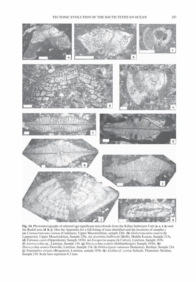
Fig. 14. Photomicrographs of selected age-significant microfossils from the Killan Imbricate Unit (a–c, i, k) andthe Baskil area (d–h, j). (See the Appendix for a full listing of taxa identified and the locations of samples.)(a) Contusotruncana contusa (Cushman), Upper Maastrichtian, sample 220c. (b) Globotruncanita stuarti (deLapparent), Upper Maastrichtian, Sample 220c. (c) Acarinina bullbrooki (Bolli), Middle Eocene, Sample 213a.(d) Fabiania cassis (Oppenheim); Sample 183b). (e) Eorupertia magna (le Calvez), Lutetian, Sample 183b.(f) Asterocyclina sp., Lutetian, Sample 154. (g) Discocyclina scalaris (Schlumberger); Sample 183b). (h)Discocyclina seunesi Douville, Lutetian, Sample 154. (i) Orbitoclypeus ramaraoi (Samanta), Ilerdian, Sample 214.(j) Nummulites striatus (Bruguiere), Lutetian, sample 183b. (k) Assilina cf. yvettae Schaub, Thanetian–Ilerdian,Sample 210. Scale bars represent 0.2 mm.

248 A. H. F. ROBERTSON ET AL.
volcaniclastic sedimentary succession. Whole-rock and mineral chemistry of the extrusive andintrusive rocks (e.g. from the Iqspendere andKömürhan ophiolites), provides additionalevidence that the ophiolites formed in an intra-oceanic SSZ-type setting (O. Parlak, unpubl.data). Taken as a whole, the extrusive–sedimentary sequences of the Guleman andKömürhan ophiolites comprise basic–intermediate–silicic volcanic rocks of tholeiiticcomposition, together with silicic tuffs, volcani-clastic turbidites and debris flows. This evidencesuggests that the SSZ-type ophiolite evolved intoan incipient intra-oceanic arc. The Iqspendereand Kömürhan ophiolites (but not the GulemanOphiolite) are cut by calc-alkaline intrusiverocks. Similar rocks are much more extensivelydeveloped within the ElazIgb–Baskil MagmaticComplex to the north, as discussed below.
Upper Cretaceous arc-related rocks
The arc-related rocks are represented by theElazIgb–Baskil Magmatic Complex in the areastudied (Figs 5 and 6). This unit is dominated bybasic–intermediate to silicic tholeiitic extrusiverocks (termed the ElazIgb Unit), and calc-alkalineintrusive rocks (termed the Baskil Unit). Theintrusive rocks were variously termed the BaskilMagmatic Rocks (Aktasc & Robertson 1984;Yazgan 1984), the ElazIgb Volcanic Complex(Hempton 1984, 1985) or the ElazIgb Granitoids(Beyarslan & Bingöl 2000; Turan & Bingöl,1989, 1991), and they were included within theYüksekova Complex by Perinçek (1979). Similarintrusive rocks are present further west in theGöksun–Afsc in area (Parlak 2006).
Intrusive Baskil Unit
This unit is widely exposed north of Keban Lake,where it is regionally overthrust by the KebanPlatform (Figs 5 and 9a). However, as notedabove, primary magmatic contacts are preservedin some areas (e.g. east of Baskil). Sanidine fromgranitic rocks has yielded K–Ar ages of 76P2.45 Ma and 78P2.5 Ma (Yazgan & Chessex1991).
An area north of Baskil, mapped in detail(RIzaogblu et al. 2006), is dominated by largeexposures of silicic intrusive rocks, interpretedas one or several plutons, composed of massivegranite, granodiorite, quartz-monzonite, tona-lite, quartz-diorite and diorite (e.g. KaratascTepe; Fig. 5, location 14). In general, the moresilicic plutons are cut by more basic dykes(RIzaogblu 2006; RIzaogblu et al. 2006). Numerouspartially assimilated xenoliths of dark country
rock (mainly <20 cm in size) are present. Thegranodiorite is locally cut by swarms of basicdykes, generally north–south – trending (mostly<0.6 m wide; Fig. 9d). There are also smallaplitic veins and dykes (Fig. 10a). Microdioritesand granophyres are interpreted as hypabyssalmagmatic rocks. Aplitic and dolerite dykesintrude the coarser-grained plutonic bodies at allstructural levels, whereas rhyolitic dykes are seenonly within granodiorite and tonalite. Locally,plagiogranite intrudes gabbro within a broadductile shear zone (Fig. 13a).
Volcanic–sedimentary ElazIgb Unit
Volcanic–sedimentary lithologies (ElazIgb Unit)form the country rock of the intrusive BaskilUnit, either as large intact exposures or as localscreens between individual intrusive bodies.Where well exposed (e.g. near Kömürhan Bridge;Fig. 5, location 7), the volcanic–sedimentarysuccession is composed of interbedded massiveto crudely stratified lithologies, estimated as>500 m thick (Figs 10c and 15a). Massive basal-tic or andesitic sheet flows predominate, mainly<20 m thick, and columnar-jointed dacites arealso rarely present. Basic–intermediate pillowlavas locally include red jasper within the pillowinterstices. Basaltic to andesitic lava brecciascontain clasts <0.4 m in size. Volcanigenicdebris flows (<30 m thick) are dominated bybasaltic or andesitic clasts (<30 cm in size), in apoorly sorted volcaniclastic matrix. Very coarse,well-bedded intervals of volcaniclastic cong-lomerates and sandstones are also present.Sandstones occasionally contain volcanic clasts(<20 cm). Fine to medium-grained volcaniclas-tic sandstones (beds <15 cm thick) are well
Fig. 15. Generalized logs of the volcanic–sedimentarysuccessions from the Upper Cretaceous ElazIgb–BaskilMagmatic Complex; (a) is dated as Late Campanian–Early Maastrichtian (Yazgan 1984). These units wereregarded as ‘synorogenic flysch’ (Michard et al. 1984;Yazgan 1984), but are here interpreted as part of avolcanic-arc succession.

249TECTONIC EVOLUTION OF THE SOUTH TETHYAN OCEAN
graded, with reddish coloured impure hemi-pelagic micrite near the top of individual beds.The succession includes mudstones, commonlyreddish, interbedded with volcanigenic sand-stones and pelagic carbonates (beds <10 cmthick). Thin (<1 m) lenses of pink pelagic lime-stones contain Globotrunca sp., indicating a LateCretaceous age. Occasional interbeds of palegrey, finely laminated siliceous tuffs are present,in units 1–2 m thick. The relative abundance ofthe main lithologies is estimated as 50% lavabreccia, 25% sheet flows, 25% volcaniclasticsandstone, 1% pelagic carbonate and 1% pillowlavas. However, the relative abundances of theselithologies vary between outcrops.
North of Baskil town, similar volcanic–sedimentary lithologies (Fig. 15b) are exposedbetween granitic intrusions, where they werepreviously mapped as ‘synorogenic flysch’ anddated as Late Campanian–Early Maastrichtian,utilizing planktic Foraminifera (Michard et al.1984; Yazgan & Chessex 1991; east of OrtaMah.; Fig 5, location 15). Elsewhere (e.g. NNEof ElazIgb) small exposures of the volcanic–sedimentary unit are dominated by basic–intermediate lavas, cut by occasional basic–silicicdykes. The volcanic–sedimentary unit also cropsout widely further east, near Hazar Lake (Fig. 5),where it includes basaltic, andesitic and siliciclava flows, pyroclastic deposits and volcani-clastic sediments, cut by minor intrusions (e.g.silicic dykes and domes) (Beyarslan & Bingöl2000). The volcanic rocks pass upwards into avolcanic–sedimentary succession of Campanian–Maastrichtian age.
Interpretation of the igneous–sedimentaryunit
In most previous interpretations the volcanic–sedimentary ElazIgb Unit was seen as representingan extrusive equivalent of the Baskil intrusiverocks in which volcanic rocks and sedimentsoverlie the plutonic rocks. In this interpretation,the plutonic rocks were overlain first by pillowlavas, cut by rare intermediate to felsic dykes,and then by pyroclastic and volcaniclasticsediments of Campanian–Maastrichtian age(Yazgan 1984; Yazgan & Chessex 1991; Beyar-slan & Bingöl 1996, 2000). However, this inter-pretation is unlikely for several reasons: (1) thevolcanic rocks are basic to acidic and tholeiitic,whereas the intrusive rocks are intermediate–acidic and calc-alkaline; (2) no upward gradationbetween a high-level volcanic–sedimentary unitand deeper-level intrusive units is observed;instead the calc-alkaline plutons cut the volcanicrocks and sediments; (3) the intrusions cut both
the volcanic–sedimentary unit and the directlystructurally overlying Keban Platform in someplaces (e.g. east of Baskil), showing that nooverlying volcanic–sedimentary unit existedat the time of intrusion; (4) similar volcanic–sedimentary lithologies form the uppermostlevels of the Iqspendere and Kömürhan ophiolitesfurther south, and comparable lithologies areassociated with Upper Cretaceous ophiolites e.g.the Berit (Göksun) Ophiolite, further west in theTauride thrust belt (Parlak et al. 2004; Robertsonet al. 2006).
The volcanic–sedimentary ElazIgb Unit is thusinterpreted as the upper part of a Late Creta-ceous ophiolitic assemblage that included basic,intermediate and silicic extrusive rocks anddykes, all of tholeiitic composition. The lowerplutonic units are rarely, if ever, exposed butmay be correlated with the Kömürhan Ophiolitefurther south.
During formation of the volcanic–sedimentary unit in Campanian–Maastrichtiantime the ocean floor was clearly highly irregular,presumably related to construction of smallvolcanic edifices, coupled with frequent masswasting to form debris flows and volcaniclasticturbidites. The background sediment was pelagiccarbonate, without terrigenous input.
The granitic intrusive rocks form part of thesame igneous complex as the Late Cretaceouscalc-alkaline intrusions cutting the KebanPlatform to the north and have been interpretedas an I-type continental margin arc related tonorthward subduction (Yazgan 1984; Yazgan &Chessex 1991; Beyarslan & Bingöl 1996, 2000).The ophiolitic basement of the volcanic–sedimentary unit, together with the Kömürhanand Iqspendere ophiolites in the ElazIgb region,were emplaced beneath the Keban Platform andthen mutually intruded by calc-alkaline graniticrocks during latest Cretaceous time.
Uppermost Cretaceous–Cenozoic coversequence
The uppermost Cretaceous–Lower Cenozoiccover sequences constrain the palaeoenviron-ments and the timing of important compres-sional and extensional events affecting the suturezone.
Maastrichtian slope carbonates
The ElazIgb–Baskil Magmatic Complex in theElazIgb area is depositionally overlain by shallow-marine limestones (Harami Formation; Fig.13c), which contain neritic fossils of LateCampanian–Maastrichtian age (Aksoy et al.

250 A. H. F. ROBERTSON ET AL.
1996, 1999). The contact was assumed to be anangular unconformity (Perinçek 1979). However,recent work indicates that the contact is transi-tional, at least locally. Shallow-marine carbonatedeposition began during the later stages ofgenesis of the volcanic–sedimentary ElazIgb Unit.Deposition began in a slope setting and contin-ued after magmatism ended in a shallow-watersetting, as seen c. 10 km SW of ElazIgb (nearBadempInar; Fig. 5, location 16) (Aksoy et al.1999). This observation is critical in establishingthat this part of the ElazIgb–Baskil MagmaticUnit reached its present position in the LateCretaceous. There is no possibility that theElazIgb–Baskil Magmatic Unit was ever thrustbeneath the Keban Platform and later exhumed,as implied by some tectonic models (see below).The uppermost Cretaceous thrust front betweenthe ElazIgb–Baskil Magmatic Unit and the KebanPlatform was evidently close to its present posi-tion by Maastrichtian time. This is consistentwith the existence of calc-alkaline plutonsstitching this thrust contact.
Lower Palaeocene coarse clastic sediments
Elsewhere, in the west of the area, around Baskiltown, the basal sediments are conglomeratic(Lower Palaeocene Kuscçular Formation), pass-ing southwards into red sandstones and mud-stones (Fig. 16b). South of Keban, in the Baskilarea, the ElazIgb–Baskil Magmatic Complex is
unconformably overlain by a thick unit (600 m)of Lower Palaeocene coarse clastic rocks, mainlyconglomerates, dominated by clasts mainlyderived from the Keban Platform. Further SW(e.g. at SarIgül; Fig. 5, location 17), the igneouscomplex is unconformably overlain by a distinc-tive basal unit (c. 25 m thick) that is composed ofwell-sorted and well-rounded, clast-supportedconglomerates. The clasts are mainly marble,with subordinate volcanic and intrusive igneousclasts. Upwards, a calcareous matrix becomesmore abundant, followed by a sharp sedimentarytransition (c. 10 cm) to rubbly limestonesand marls containing Nummulites sp. (UpperPalaeocene–Lower Eocene Seske Formation;Perinçek 1979). The Lower Palaeocene cong-lomerates were eroded from the overridingKeban Platform to the north and alluvial fansprograded into a playa lake (Aksoy et al. 1996).
Another area located further west (c. 17 kmwest of Baskil) illustrates a marked local faciesvariation within the uppermost Cretaceous–Palaeocene cover sediments. In the south, thebasal sediments are uppermost Cretaceous car-bonates (Harami Formation) that then passupwards into Lower Palaeocene coarse clasticdeposits (Kuscçular Formation). In contrast,c. 7 km further north the Harami Formation isabsent and the Upper Cretaceous magmaticrocks are unconformably overlain by LowerPalaeocene coarse clastic rocks (Turan &Türkmen 1996). Such relationships reflect the
Fig. 16. Summary of the uppermost Cretaceous–Lower Cenozoic successions overlying the various allochthonousrocks emplaced in latest Cretaceous time. Data sources are specified in the text.

251TECTONIC EVOLUTION OF THE SOUTH TETHYAN OCEAN
prevalence of marine conditions in the south,whereas the Keban Platform to the north wasemergent and eroding during latest Cretaceous–Early Palaeocene time.
Upper Palaeocene–Lower Eocene shelflimestones
The Lower Palaeocene coarse clastic depositsare, in turn, abruptly overlain by mainly shallow-marine limestones of Late Palaeocene–EarlyEocene age (Seske Formation; Perinçek 1979;Türkmen et al. 2001), marking a regional marinetransgression (Fig. 16a). This calcareous unit isextensively exposed west of Malatya city (Fig. 3).A representative succession is exposed in the westof the area studied on the crest of a hill (NWof Baskil, near Laçan; Fig 5, location 3). A thin(<25 m thick) basal conglomerate (KuscçularFormation), exposed above the Baskil MagmaticComplex there, contains large sub-rounded tosub-angular clasts (<0.8 m in size), mainlymarble with subordinate schist and rare volcanicclasts (Fig. 13d). These conglomerates are direc-tly overlain by white limestones that belong tothe Seske Formation (>80 m thick). In general,marginal clastic environments dominated inthe north, whereas coral-algal reefs developedfurther south and SW, reflecting open-marineconditions in this area (Türkmen et al. 2001).
Middle–Upper Eocene clastic rocks
During Middle to Late Eocene time there was aswitch from mainly carbonates to deposition ofvariable shallow, to relatively deep-marine clasticsediments, known as the KIrkgeçit Formation(Avscar 1983; Türkmen et al. 2001). North ofKeban Lake (Pertek area), this unit directly over-lies and seals a regional north–dipping thrustcontact between the Keban Platform, above andthe ElazIgb–Baskil Magmatic Complex, below(Fig. 5, location 13).
In the east, the Middle–Upper Eocene clasticunit unconformably overlies both the Kebanmetamorphic rocks and the ElazIgb–Baskil mag-matic rocks. For example, at Hasretdagb, NEof ElazIgb (Fig. 5, location 18, and Fig. 16f) theUpper Cretaceous volcanic–sedimentary ElazIgbUnit is unconformably overlain by shallow-marine clastic sediments of the KIrkgeçit Forma-tion. The base of the succession is an irregularerosion surface, infilled with conglomerates.Above this, a spectacular series of palaeo-channels is exposed (Türkmen & Essen 1997;Cronin et al. 2000). An argillaceous succession,c. 80 m thick, is interspersed with six discretechannelized clastic units that have prograded
southwards, based on palaeocurrent evidence.The channelized units include debris-flow con-glomerates, with clasts of Upper Cretaceousmagmatic rocks and rare clasts of Upper Creta-ceous shallow-marine limestone (derived fromthe Harami Formation). Inter-channel mud-stones include trace fossils (e.g. Paleodictyon;Zoophycus), indicating a shallow-water setting.The succession passes upward into finer-grainedsediments, interpreted as slope facies (Croninet al. 2000).
Facies variation during the Middle Eocenewas even more marked further west (e.g. aroundBaskil; Fig. 16a), where Upper Cretaceous mag-matic rocks are unconformably overlain byconglomerates, sandy limestones, marls and lim-estones of Middle–Late Eocene age (KIrkgeçitFormation; Asutay 1988). Crudely stratifiedbasal conglomerates include clasts (<25 cm insize) of basalt, granodiorite and nummulitic lime-stone. Recent work (Türkmen et al. 2001) hasrevealed a transition from a mainly carbonate toa dominantly terrigenous clastic depositionalsetting. West of Baskil, Middle–Upper Eoceneclastic rocks (KIrkgeçit Formation) variablyoverlie Maastrichtian or Lower Cenozoic sedi-mentary units in different local areas. Rubblybedded bioclastic limestones from one area arepacked with large benthic Foraminifera, datedduring this study as Lutetian (Middle Eocene)(Sample 154, Fig. 14f and g; Appendix). Furtherwest in the Baskil area, pale grey, bioturbated,muddy carbonates are interbedded with thin- tomedium-bedded, graded siliciclastic sandstonesthat may be storm deposits. The marls contain anabundant fauna including pectens, echinoids,bivalves, corals and calcareous algae. The marlscontain Lutetian large Foraminifera (Samples183a–c; Fig. 14e and j; Appendix), and areoverthrust by volcanigenic facies of the UpperCretaceous ElazIgb–Baskil Magmatic Complex.
The Middle–Upper Eocene clastic sediments(KIrkgeçit Formation) mainly accumulated ina peripheral rift basin (Fig. 17), bounded by anactive extensional fault in the south, known asthe Uluova Fault (Fig. 5). From north to south, arange of marginal, to slope, to basin plain set-tings developed during Middle–Late Eocene time(Özgül & Kerey 1996). The basin was bordered tothe north by an ENE–WSW-trending tract ofmarginal shelf carbonates. In response to intenseextensional faulting, large limestone blocks werelocally shed from the underlying calcareous suc-cession into small fault-controlled slope basins(effectively slope canyons) near the northernmargin of the rift basin (e.g. near Harput, northof ElazIgb; Fig. 5, location 17, and Fig. 16d;Türkmen & Essen 1997).

252 A. H. F. ROBERTSON ET AL.
Oligocene–Lower Miocene neriticcarbonates
Shallow-marine carbonates are locally exposedin the west and NW of the area, following defor-mation and erosion (Aksoy et al. 1996). Westof Baskil these Miocene sediments are locallyinvolved in thrusting (Yazgan 1984).
Tectonic implications of the sedimentarycover
The uppermost Cretaceous volcanic–sedimentary ElazIgb Unit is overlain by Maast-richtian shallow-marine carbonates (HaramiFormation), without any major unconformity orevidence of deep erosion. Both the Upper Creta-ceous ElazIgb–Baskil Magmatic Complex and theKeban Platform are unconformably overlain byMaastrichtian–Eocene mainly shallow-marinesediments, estimated to be up to 1.5 km thick(Fig. 17a). In the north, the Lower Palaeocene
clastic sediments are interpreted as alluvial fansshed from the overriding Keban metamorphicthrust sheet during Early Palaeocene time(Aksoy et al. 1996). However, there is no evi-dence that these clastic sediments were actuallyoverthrust by the Keban Platform. Thrustingapparently ended, then the clastic sediment weresupplied from the, by then static, thrust front.Further south (ElazIgb area), NW–SE-trendingextensional palaeofaults became active duringMiddle Eocene time (Fig. 17b), creating theaccommodation space necessary for the accumu-lation of channelized sediments (e.g. Hasretdagb)and basinal sediments further south.
The tectonic setting switched to compres-sional after Middle Eocene (pre-Oligocene) time(Perinçek 1979; YIlmaz 1993), triggering theinversion of extensional faults, regional upliftand thrusting. Further thrusting and open fold-ing took place in pre-Pliocene time. The entirearea was later dissected by high-angle faults asso-ciated with the South East Anatolian TransformFault during Plio-Quaternary time (Fig. 5).
Fig. 17. Interpretation of the tectonic setting of the uppermost Cretaceous to Mid-Cenozoic sedimentary cover ofthe north Tauride margin (Keban Platform): (a) Maastrichtian–Lower Eocene facies overlie an accretionarycomplex; (b) Middle Eocene crustal extension possibly related to roll-back of the north-dipping subduction zoneto the south. KO, Killan Ophiolite, KP, Keban Platform; G, Guleman Ophiolite; EBMC, ElazIgb-BaskilMagmatic Complex. (See text for discussion.)

253TECTONIC EVOLUTION OF THE SOUTH TETHYAN OCEAN
Middle Eocene Maden Group
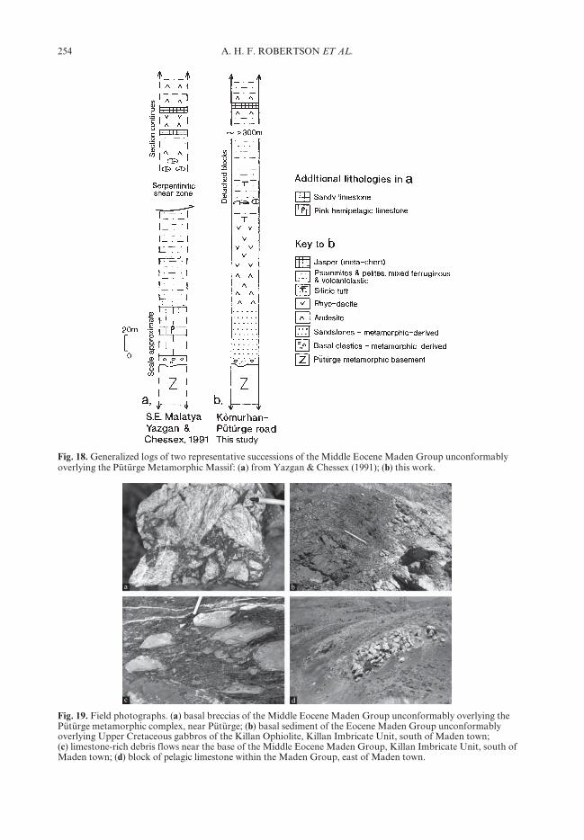
The Pütürge Massif is unconformably overlainby a regionally important volcanic–sedimentaryunit of Middle Eocene (Ypresian–Lutetian) age.To the east of the study area a similar unitcovers the northern margin of the Bitlis Massif(Çagblayan et al. 1984; Göncüogblu & Turhan1984), and is also present to the west of the areastudied in the Afscin–Elbistan and Berit areas(Perinçek & Kozlu 1984; YIlmaz et al. 1993;Robertson et al. 2006). All of these exposureswere assigned to a regionally important unitknown as the Maden Complex by Perinçek(1979, 1980). The term Maden Complex wasapplied by Rigo di Righi & Cortesini (1964) to astructurally complex unit in the southern part ofthe Tauride thrust belt, near Maden town, to theeast of the Pütürge metamorphic massif (Fig. 5).There is a continuing debate (Yigbitbasc & YIlmaz1996a) concerning the definition and significanceof the ‘Maden Complex’. This was variouslyinterpreted in different areas as an intact stra-tigraphic succession (Perinçek & Kozlu 1984;Robertson et al. 2006), as a ‘coloured’ mélange(Hempton 1984, 1985), or as a thrust-imbricatedsuccession (Aktasc & Robertson 1984; Yazgan &Chessex 1991; Fig. 5, location 20, and Fig. 18a;YIldIrIm & YIlmaz 1991). In the area studied,a stratigraphic succession does indeed exist,although variably thrust imbricated. For thisreason the conventional stratigraphic termMaden Group is adopted here.
Two successions were studied in the north-eastern part of the Pütürge Massif (Fig. 5).The more easterly succession (Fig. 18a) is wellexposed along the road from Pütürge toKömürhan Dam. The contact with the Pütürgemetamorphic rocks (locally mica schists) is anirregular unconformity, dipping NW at c. 40°. Abasal breccia contains angular clasts of metamor-phic rocks (<25 cm in size), cemented by a redhematitic gritty matrix (Fig. 19a). This is fol-lowed by a fining-upward succession (mainlyschistose) of coarse, then finer-grained sandstone(60–80 m). There is then a prominent volcanicinterval, mainly andesite (c. 50 m), flow-bandedrhyolite (c. 60–200 m thick) and fissile siliceoustuff (c. 6 m). Above comes a trail of elongatefossiliferous carbonate blocks. Individual blocks(up to 3 mx5 m in size) are composed of greymarble, locally rich in Nummulites sp. and otherlarge Foraminifera, dated as Lutetian (Sample206a–c; Appendix). These limestone blocks areset within volcanigenic debris flows, with clastsup to 20 cm in size. The larger limestone blockspass laterally into limestone debris flows com-posed of lithologically similar limestone blocks(up to 0.9 mx0.2 m in size). A trail of limestone
blocks can be traced up to 400 m along strike.The zone of limestone blocks is followed, up-sequence (northwards) by a thick succession(c. >1 km thick) that is dominated by schistoseandesitic extrusive rocks, with subordinatemetasedimentary intercalations. Most individualandesite flows are <5 m thick. Subordinatemetasedimentary intercalations include volcani-clastic sandstones, shales, debris-flow deposits,silty and tuffaceous limestones (individually<4 m thick), pale siliceous shale (interpreted assilicic tuff), reddish shales and recrystallized redribbon cherts. The succession commonly showsevidence of top-to-the-south shearing, markedby brittle folds, folded quartz veins, C–S fabricsand small (<10 cm) thrust duplexes. The uppercontact of the Maden Group in this area is athrust, dipping at c. 40° north. The layering in theoverlying Kömürhan Ophiolite (layered gabbro)dips at a similar angle (c. 35 °N), suggestingthat the intervening thrust was originally gentlyinclined (<10°).
The second, more deformed, north-dipping(c. 35°) unit was studied further west (nearKesrik, SE of Malatya; Fig. 5), although the baseof the succession was not accessible. Also, thesuccession there was too deformed to usefullylog. The higher part of the unit (c. 350 m thick)is dominated by greenschist-metamorphosedmudstones, andesites and andesitic breccias, withpurple mudstone intercalations. Most of thesuccession is too sheared and metamorphosedto distinguish primary volcanic and volcanic–sedimentary features. However, the uppermostseveral hundred metres of the succession com-prise volcanigenic debris flows, including flat-tened andesite clasts (<30 cm long), set in agreen volcanigenic matrix. Locally, clasts(<10 cm in size) include pale silicic extrusiverocks. Intercalations of matrix-supported debris-flow deposits, several metres thick with flattenedpebbles (<8 cm in size), pass depositionallyupward into volcaniclastic sandstones. Severalgreen volcanigenic units contain rare intercala-tions of purple schistose mudstone (up to 6 mthick). Subordinate flows of flattened pillowlavas show well-developed tension gashes. Thesuccession also exhibits numerous small duplexstructures indicating top-to-the-south shearing.
Samples of unfractionated meta-extrusiverocks were collected for chemical analysis byX-ray fluorescence (Table 1) from the higherlevels of both of the above units (Nos 184–190from the eastern locality and 202–215 from thewestern locality). When plotted on standardgeochemical discrimination plots (Fig. 20a–e),the samples are seen to be of basaltic andesiticto andesitic composition (Fig. 20a). They mainly
254 A. H. F. ROBERTSON ET AL.
Fig. 18. Generalized logs of two representative successions of the Middle Eocene Maden Group unconformablyoverlying the Pütürge Metamorphic Massif: (a) from Yazgan & Chessex (1991); (b) this work.
Fig. 19. Field photographs. (a) basal breccias of the Middle Eocene Maden Group unconformably overlying thePütürge metamorphic complex, near Pütürge; (b) basal sediment of the Eocene Maden Group unconformablyoverlying Upper Cretaceous gabbros of the Killan Ophiolite, Killan Imbricate Unit, south of Maden town;(c) limestone-rich debris flows near the base of the Middle Eocene Maden Group, Killan Imbricate Unit, south ofMaden town; (d) block of pelagic limestone within the Maden Group, east of Maden town.
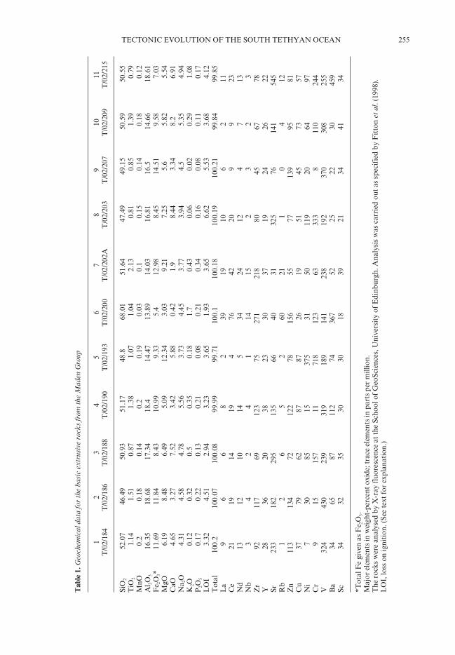
255TECTONIC EVOLUTION OF THE SOUTH TETHYAN OCEAN
Tab
le 1
. Geo
chem
ical
dat
a fo
r th
e ba
sic
extr
usiv
e ro
cks
from
the
Mad
en G
roup
12
34
56
78
910
11T
/02/
184
T/0
2/18
6T
/02/
188
T/0
2/19
0T
/02/
193
T/0
2/20
0T
/02/
202A
T/0
2/20
3T
/02/
207
T/0
2/20
9T
/02/
215
SiO
252
.07
46.4
950
.93
51.1
748
.868
.01
51.6
447
.49
49.1
550
.59
50.5
5T
iO2
1.14
1.51
0.87
1.38
1.07
1.04
2.13
0.81
0.85
1.39
0.79
MnO
0.2
0.18
0.14
0.2
0.19
0.03
0.1
0.15
0.14
0.18
0.12
Al 2O
316
.35
18.6
817
.34
18.4
14.4
713
.89
14.0
316
.81
16.5
14.6
618
.61
Fe 2
O3*
11.6
911
.84
8.43
10.9
99.
335.
412
.98
8.45
14.5
19.
587.
03M
gO6.
198.
486.
495.
0912
.34
3.03
9.21
7.25
5.6
5.82
5.54
CaO
4.65
3.27
7.52
3.42
5.88
0.42
1.9
8.44
3.34
8.2
6.91
Na 2
O4.
314.
584.
785.
563.
734.
453.
773.
944.
55.
354.
94K
2O0.
120.
320.
50.
350.
181.
70.
430.
060.
020.
291.
08P
2O5
0.17
0.22
0.13
0.21
0.08
0.21
0.34
0.16
0.08
0.11
0.17
LO
I3.
324.
512.
943.
233.
651.
933.
656.
625.
533.
684.
12T
otal
100.
210
0.07
100.
0899
.99
99.7
110
0.1
100.
1810
0.19
100.
2199
.84
99.8
5L
a9
66
82
3919
106
211
Ce
2119
1419
476
4220
99
23N
d13
1210
145
3424
124
713
Nb
34
24
114
152
32
3Z
r92
117
6912
375
271
218
8045
6778
Y28
3620
3823
3037
1924
2622
Sr23
318
229
513
566
4031
325
7614
154
5R
b1
26
52
6021
10
412
Zn
113
134
7212
278
156
5577
139
9581
Cu
3779
6287
8726
1951
4573
57N
i7
3085
1537
531
5011
920
6497
Cr
915
157
1171
812
363
333
811
024
4V
324
430
239
319
189
141
238
192
370
308
255
Ba
3465
8711
274
367
5225
2230
459
Sc34
3235
3030
1839
2134
4134
*Tot
al F
e gi
ven
as F
e 2O
3.M
ajor
ele
men
ts in
wei
ght-
perc
ent o
xide
; tra
ce e
lem
ents
in p
arts
per
mill
ion.
The
roc
ks w
ere
anal
ysed
by
X-r
ay fl
uore
scen
ce a
t the
Sch
ool o
f Geo
Scie
nces
, Uni
vers
ity
of E
dinb
urgh
. Ana
lysi
s w
as c
arri
ed o
ut a
s sp
ecif
ied
by F
itto
n et
al.
(199
8).
LO
I, lo
ss o
n ig
niti
on. (
See
text
for
expl
anat
ion.
)

256 A. H. F. ROBERTSON ET AL.
Fig
.20.
For
cap
tion
see
p. 2
57 o
ppos
ite.

257TECTONIC EVOLUTION OF THE SOUTH TETHYAN OCEAN
plot in the combined or overlapping island-arctholeiites and mid-ocean ridge basalt (MORB)field (Fig. 20b and c), but one lies in the within-plate basalt (WPB) field. The V/Ti plot is sug-gestive of a back-arc basin setting (Fig. 20d).All of the samples show a negative Nb anomalyon MORB-normalized ‘spider’ plots (Fig. 20e),suggestive of a subduction influence.
Interpretation of the Middle Eocenevolcanic–sedimentary unit
The Middle Eocene Maden Group was previ-ously interpreted in several different ways. First,it was seen as an immature island arc (Erdogban1975). Second, the magmatism was seen as beinggenerated along a zone of ‘intra-crustal subduc-tion’ (Michard et al. 1984; Yazgan 1984). In thisinterpretation, frictional heating along a deep-seated shear zone in a post-collisional settingfavoured crustal melting and uprise of magmas(Yazgan & Chessex 1991). Third, the Madenrocks in the frontal thrust zone, south of theBitlis Massif, were interpreted as a pull-apartbasin related to oblique subduction in a settingof incipient collision (Aktasc & Robertson 1990).Finally, the Maden unit rocks was interpretedas a back-arc basin related to northward subduc-tion (Hempton 1984, 1985; Yigbitbasc & YIlmaz1991, 1996a; YIlmaz et al. 1993; Fig. 6a).
In the present study a distinction is drawnbetween the Middle Eocene Maden-type unitsthat unconformably overlie the northern marginsof the Pütürge and Bitlis massifs and contrasting
volcanic rocks and sediments of the same agepreserved in a structurally low position near thethrust front (Killan Imbricate Unit; see below).The overall setting of the Maden Group abovethe metamorphic massifs is inferred to be arift developed above a north-dipping subductionzone, within the northern, active margin of theSouthern Neotethys during its later stages ofclosure; hence the combined SSZ and WPB char-acteristics of the volcanic rocks. However, thereis little evidence that this volcanism took placebehind a well-developed volcanic arc, which isabsent from the preserved frontal portion of theallochthon (see below).
The volcanic–sedimentary facies covering thePütürge and Bitlis massifs document an east–west-trending, subsiding extensional basin inMiddle Eocene time. Initial marine transgres-sion, with locally derived clastic deposition, andshallow-marine carbonate deposition was fol-lowed by basic–intermediate–silicic volcanism.The presence of siliceous tuff implies volcanismin shallow water, or on land, at least initially.Extensional collapse and deepening ensued,marked by supply of limestone blocks (‘olisto-liths’) into deeper water. The extensional basinlater gradually filled with mainly andesitic volca-nic rocks and volcaniclastic gravity flows, includ-ing matrix-supported breccia-conglomerates andvolcanigenic muds. The siliceous radiolariansediments are indicative of an unrestricted, rela-tively deep-water open-marine setting. The riftbasin later closed, resulting in thrust imbrication,especially in the higher levels. The Maden Group
Fig. 20. Plots of chemical analyses of extrusive rocks from the Middle Eocene Maden Group. (a) Zr/Ti v. Nb/Y(from Winchester & Floyd 1977). (Note the basaltic andesite to andesitic composition.) (b) Cr v. Y. The sampleslie within the island-arc tholeiitic (IAT) and mid-ocean ridge basalt fields (from Pearce 1982) (BSV; boniniteseries volcanism). (c) Zr/Y v. Zr. The samples fall in the same compositional groups, with one sample in thewithin-plate basalt field (from Pearce & Norry 1979). (d) V v. Ti. This plot suggests affinities with mainlyisland-arc and mid-ocean ridge or back-arc basin (BABB; back-arc basin basalt) settings (from Shervais 1982).(e) MORB-normalized ‘spider’ plots. All the samples show a negative Nb anomaly, suggestive of a subductioninfluence (from Sun & McDonough 1989).

258 A. H. F. ROBERTSON ET AL.
covering the Pütürge Massif was then overthrust,southwards, by the Kömürhan Ophiolite, prob-ably giving rise to the greenschist-facies meta-morphism affecting the Maden Group. Thetiming of this thrusting is likely to be pre-Oligocene in view of the absence of preservedOligocene sediments in the Maden Group andevidence of thrusting of this age reported fromthe wider region (Perinçek 1979; YIlmaz 1993).
Uppermost Cretaceous–Lower Cenozoicfrontal slice complex
A regionally important imbricate slice complexcomprising slices and blocks of ophiolitic andvarious sedimentary rocks distinguishes thesoutherly, structurally lowest, part of the alloch-thon (Figs 5 and 6). This unit was traditionallyincluded within the Upper Cretaceous Yükse-kova Complex and the Middle Eocene MadenComplex (Perinçek 1979, 1980) but was laterformalized as the Killan Imbricate Unit by Aktasc
& Robertson (1984), as it shows distinct features.The type area of the Killan Imbricate Unit islocated between the Pütürge and Bitlis massifs.However, the term has also been applied to thefrontal imbricate zone more regionally (Yazgan& Chessex 1991). This includes the southernmargin of the Bitlis Massif to the east (e.g. Licearea; Aktasc & Robertson 1984), and the south-ern margin of the Malatya–Pütürge Massiffurther west (e.g. Helete area; YIldIrIm & YIlmaz1991; Robertson et al. 2006).
In the type area, the Killan Imbricate Unitstructurally underlies the Pütürge Massif in thewest, whereas to the east it is separated from theBitlis metamorphic massif by a zone of high-angle faulting (Fig. 5). In the north, the KillanImbricate Unit is structurally overlain by theGuleman Ophiolite, whereas in the south it struc-turally overlies the Miocene Arabian Foreland(Perinçek 1979). The contact zone between theGuleman Ophiolite and the Killan ImbricateUnit (e.g. near Putyan; Fig. 5, location 21) is
Fig. 21. Summary logs of the Killan Imbricate Unit. Data sources: Aktasc & Robertson (1984, 1990). (See text fordiscussion.)

259TECTONIC EVOLUTION OF THE SOUTH TETHYAN OCEAN
marked by spectacular zone of detached sedi-mentary blocks derived from the uppermostCretaceous–Lower Cenozoic succession exposedto the north (Hazar Group; Fig. 21a and b; Aktasc& Robertson 1984). During this study, largeForaminifera of Thanetian–Late Palaeocene agewere determined within large limestone blocks(Sample 214; Fig. 14i; Appendix).
The Killan Imbricate Unit comprises severallarge tectonic slices, with an apparent structuralthickness of >17 km (Aktasc & Robertson 1984).The most southerly of these slices (Fig. 21f)comprises a dismembered Upper Cretaceousophiolitic unit (Killan Ophiolite); this is uncon-formably overlain by Middle Eocene deep-watersediments, including detached blocks and slicesof mainly pelagic carbonates and extrusive rocks(Fig. 19c). The contact between the ophiolite andthe sediments is well exposed south of Madentown, by the main road (near Degbirmendere).There, ophiolitic gabbro is cut by occasionalaltered dykes and overlain, above an irregularerosional surface, by a thin (<10 m) interval ofdebris-flow deposits (up to several metres thick),including numerous gabbro clasts (<0.6 m insize). This is followed by blocks (‘olistoliths’) andlenses (detached ‘rafts’) of pelagic and hemi-pelagic limestone, set within hemipelagic carbon-ates and tuffaceous mudstones. These limestonesclasts contain large Foraminifera of Thanetianor Ilerdian age (Palaeocene–Early Eocene) age(Sample 210; Fig. 14k; Appendix). The numberand size of exotic blocks and sheets increasesupwards (Fig. 21f).
A second major slice, further north (Fig. 21e),includes a major unit of Upper Cretaceousophiolitic rocks (Killan Ophiolite), mainlytholeiitic lavas. These lavas are interbedded withUpper Cretaceous radiolarites and pelagic car-bonates. The economic Maden copper sulphidemine is located within this unit. Deformed,brecciated ophiolitic gabbros are unconformablyoverlain by chocolate brown mudstones, richin hydrothermal epidote (0.5 km south of theMaden Mine towers). Exotic blocks of pelagicand hemipelagic limestone appear above this,within several tens of metres of the base of thecover succession. These limestones contain Fora-minifera of Middle Eocene age (Sample 213aand b; Fig. 14c and d; Appendix). In the vicinity,north-dipping massive ophiolitic lavas aredirectly overlain by debris flows, dominated bylava clasts (up to 2.8 in size), set in a reddishmatrix; for example, 300 m along the road toAlacakaca (Guleman) from the main Madenroad. Local horizons are rich in clasts of pinkpelagic limestone (up to 2 mx3 m in size). Otherdebris flows at the base of the Eocene succession
are polymict, with a mixture of basaltic andpelagic limestone clasts (Fig. 19d). The succes-sion then passes upwards into chocolate brown,locally tuffaceous mudstones with scatteredexotic limestone blocks and lenses, estimated asc. 500 m thick. The exotic pelagic carbonates arehomogeneous, lack interbedded argillaceous ortuffaceous sediments, and exhibit sharp, shearedmargins. Higher in the unit, a volcanic–sedimentary unit comprises disrupted blocks anddismembered slices of andesite, pelagic carbon-ate, shale, tuff and volcaniclastic sediments,with an aggregate thickness estimated at 6 km(Fig. 21d). Blocks of sheared and brecciatedvesicular andesite become more abundantupwards.
Units further north again (Fig. 21c) includemassive basalt, pillow basalt, lava breccia,volcaniclastic sandstone and red radiolarianchert; for example, as exposed along the HazarLake–Maden main road (and near Davudan).Tholeiitic basalts include pyroxene–plagioclase-phyric and aphyric varieties, withcommon epidote alteration. Volcaniclastic inter-calations (up to 50 m thick) are locally observed.There are also several slices, or intercalations (upto 10 m thick), of pink or grey pelagic limestoneand red radiolarian chert. The cherts werepreviously dated as Late Cretaceous utilizingRadiolaria (Aktasc & Robertson 1984) andduring this study associated pelagic carbonateswere identified as Late Maastrichtian in age,based on the presence of planktic Foraminifera(Samples 220a–c; Fig. 14a and b; Appendix).
Laterally equivalent units
Beneath the adjacent Pütürge and Bitlis meta-morphic massifs, lithological equivalents of theKillan Imbricate Unit are restricted to smallslices of mainly serpentinite above the basalthrust. Comparable Middle Eocene units aremore extensively exposed outside the presentstudy area, including beneath the Bitlis Massifto the east (e.g. in the Lice area; Basc tugb 1980;Aktasc & Robertson 1984, 1990) and beneaththe Malatya Metamorphic Massif to the west(Perinçek & Kozlu 1984; YIldIrIm & YIlmaz1991; Robertson et al. 2006; Fig. 5).
In the east (Lice area), an elongate volcanic–sedimentary slice, up to several hundred metresthick, comprises interbedded basic–intermediatecomposition extrusive rocks and turbiditic sand-stones, depositionally overlain by Middle Eocenepelagic carbonates. The sandstones containabundant terrigenous metamorphic material,probably derived from the structurally overlyingBitlis Massif. Basalts analysed from this area

260 A. H. F. ROBERTSON ET AL.
are of high-Al composition and generally show‘enriched’ stable element patterns without adetectable subduction component (Aktasc &Robertson 1990).
West of the study area (near Helete; Fig. 5)another elongate thrust sheet (c. 20 km longx200 m thick; YIldIrIm & YIlmaz 1991) includesophiolitic material and tholeiitic volcanic rocks(Helete–Savrun unit), depositionally overlainby Middle Eocene pelagic carbonates (Robertsonet al. 2006). These volcanic rocks show a markedchemical subduction influence (YIldIrIm &YIlmaz 1991; Robertson et al. 2006).
Interpretation of the frontal imbricates
The Upper Cretaceous Killan Ophiolite is inter-preted as the southerly part (trailing edge) of aregionally extensive ophiolite sheet, including theIqspendere, Kömürhan and Guleman ophiolitesthat docked along the northern ocean basinmargin, beneath the Keban Platform in latestCretaceous time. The Killan Ophiolite, asexposed in several tectonic slices, was dismem-bered and emplaced in latest Cretaceous timebut was not then exposed and eroded, as ophio-litic extrusive rocks are preserved, unlike theGuleman Ophiolite to the north. The UpperCretaceous ophiolitic extrusive rocks in each ofthe Killan imbricates are mainly subduction-influenced tholeiites (Aktasc & Robertson 1984,1990). An additional thrust sheet of alkaline
WPB-type extrusive rocks near the structuralbase of the imbricate stack further east (Goma-type extrusive rocks; Aktasc & Robertson 1984,1990) could represent fragments of seamountsaccreted from the Southern Neotethys.
Several of the slices of Killan ophiolitic rocksare unconformably overlain by a thick ‘volcanic–sedimentary unit’ of mainly Middle Eocene age,including thick debris flows (‘olistostromes’)(Maden Group of Aktasc & Robertson 1984).Much of this material was derived from thenorth. To the north, the emplaced GulemanOphiolite was deeply eroded and transgressed byMaastrichtian–Palaeocene clastic sediments(Ceffan and Simaki formations) and carbonatesediments (Gehroz Formation; Fig. 21a) of theHazar Group. Along its southern margin thissedimentary cover of the Guleman Ophiolitebecame unstable and partially slid southwards,as detached blocks and slide sheets duringMiddle Eocene time. A thick wedge of hemi-pelagic and redeposited background carbonatesand exotic limestone blocks thereby accumulatedalong the northern margin of a deep-water basinto the south. Two interpretations of this large-scale mass flow and redeposition are as follows.Aktasc & Robertson (1984) envisaged masswasting of mainly carbonate sediments (GehrozFormation) into an active subduction trench tothe south, within a forearc setting (Fig. 22a).Alternatively, the collapse of the margin andmass wasting reflects a discrete pulse of extension
Fig. 22. Alternative tectonic models for the uppermost Cretaceous–Lower Cenozoic Killan Imbricate Unit.(a) Steady-state subduction–accretion (Aktasc & Robertson 1984); (b) initial accretion of ophiolitic rocks duringlatest Cretaceous time, followed by extension related to subduction slab roll-back during Mid-Eocene time. (b) isfavoured here.

261TECTONIC EVOLUTION OF THE SOUTH TETHYAN OCEAN
along the active margin during Mid-Eocene time(Fig. 22b). The Middle Eocene basin later col-lapsed and was accreted to the base of theaccretionary wedge, probably at the same timeas deformation of the ‘back-arc’ Maden Basinto the north (pre-Oligocene?). In the regionalcontext the second option is preferred.
The location of the type area of the KillanImbricate Unit between the Bitlis and Pütürgemetamorphic massifs could be interpreted inseveral different ways. First, it could reflectMesozoic palaeogeography, whereby an oceanicconnection separated two microcontinents, rep-resented by the Bitlis and Pütürge massifs. Thiscould have created an embayment, facilitatingthe accretion of the Upper Cretaceous KillanOphiolite in latest Cretaceous time. In thismodel, oceanic crust to the east and west wasmainly subducted, apart from small ophioliticslices preserved within the frontal imbricate zone(e.g. beneath the Bitlis Massif). An alternative isthat the localized presence of the thick KillanImbricate Unit reflects subduction zone dynam-ics and differential exposure along an originallylinear thrust front (rather than palaeogeo-graphy). For example, subduction erosion, orstrike-slip could have removed frontal accretedmaterial. Also, tectonic exhumation of the Bitlisand Pütürge massifs in latest Cretaceous–MiddleEocene time (see below) might have been discon-tinuous, creating areas where metamorphic rocksare not exposed at the surface, but where thickaccretionary material such as the KillanImbricate Unit remained.
Regionally, the Middle Eocene basin furthereast (e.g. Lice unit) was interpreted as anextensional pull-apart basin related to obliquenorthward subduction during Middle Eocenetime (Aktasc & Robertson 1984, 1990). TheMiddle Eocene basin further west (i.e. Heleteunit) can be interpreted as part of an extensionalbasin formed above a subduction zone(Robertson et al. 2006), rather than an accretedoceanic arc (see YIlmaz 1993). An overall settingof oblique subduction is inferred here resulting insegmentation of the active margin, with differentareas undergoing accretion, transtension, orincipient arc volcanism, comparable with thesetting of the modern Andaman Sea region (e.g.Curray et al. 1979).
Arabian Foreland
The Tauride thrust belt is underlain by theArabian Foreland, which forms part ofthe autochthonous Arabian (African) Plate tothe south. Sedimentary successions (Fig. 7) shedlight on the history of the Southern Neotethyan
continental margin, especially its Mesozoicrift–passive margin stage and suturing duringMiocene time.
The Arabian Foreland succession includes acomplete stratigraphy, as exposed south of thethrust front in the Derik area near the Syrianborder. This begins with felsic igneous rocks ofpresumed Precambrian age and associated clasticsediments. These are unconformably overlain bya mixed volcaniclastic–siliciclastic–carbonatesuccession, of assumed Cambrian age. Overlyinglargely clastic sediments of Ordovician age passinto mainly shales (locally bituminous) of LateOrdovician–Devonian age. The succession isinterrupted by a Carboniferous unconformity,followed by further shallow-marine to paralicsediments. The Palaeozoic succession, c. 2.5 kmthick, records deposition on a stable shelfnear the edge of Gondwana (Rigo di Righi &Cortesini 1964; Perinçek 1979, 1981; YIlmaz1991, 1993).
Mesozoic deposition began with shelf-typesiliciclastic sediments of Early Triassic age,followed by a depositional hiatus from LateTriassic–Early Cretaceous (Barremian) time (e.g.in the Hazro inlier; Fontaine 1981). The develop-ment of reef facies, of Barremian–Turonian age,was followed by emergence and a hiatus duringConiacian–Santonian time. The shelf then sub-sided, creating a linear basin that infilled withsiliciclastic turbidites (Kastel Formation). Depo-sition in this basin ended in the Early Campanian(AltIner 1989). This was followed by southwardemplacement of Mesozoic slope units, in theform of broken formation and mélange (HezanUnit) during Late Campanian–Early Maastrich-tian time. The slope units include Middle Triassicdolomitic carbonates, Ladinian pelagic carbon-ates and Lower Norian volcanigenic sediments(Fourcade et al. 1991). Ocean-derived unitsinclude Tithonian–Berriasian pelagic carbonates(Konak Formation; Perinçek 1979; AltIner1989), abundant dismembered ophiolitic units(e.g. Koçali Ophiolite) and related pelagicsediments.
The ophiolitic allochthon was transgressed byshallow-marine carbonates of Late Maastrich-tian age, as seen all along the Arabian marginfrom Oman to Hatay in southern Turkey(Robertson 1987; YIlmaz 1993). Shallow-marinedeposition was interrupted by a tilting event inthe Early Eocene. Facies trends (Antak andGercüsc formations) point to uplift in the north(Rigo de Righi & Cortesini 1964). Transgressiveshallow-marine carbonate deposition followedduring Middle Eocene–Oligocene time acrossa wide area (Midyat Formation; Basctugb 1980).
262 A. H. F. ROBERTSON ET AL.
Facies become more basinal southwards, includ-ing siliceous limestones, and are overlain byevaporites and chalky marls in the north(towards the foothills structure belt). After alow-angle unconformity the succession passesinto Lower Miocene turbiditic clastic sediments,which range from coarser grained in the north(Çüngüsc Formation), to finer grained furthersouth (Lice Formation; Perinçek 1979; Basctugb1980). In addition, poorly dated debris-flowdeposits (‘wildflysch’) were entrained beneath theSouth Anatolian sole thrust.
Events affecting the Arabian Foreland
The Mesozoic succession records rifting thatprobably took place during Mid–Late Triassictime. Further extension possibly affected thisarea during Late Jurassic–Early Cretaceous time,and was followed by passive margin subsidence.The marginal slope succession, dating fromTriassic time, can be reconstructed from volcanicand sedimentary rocks that were emplacedsouthwards onto the Arabian margin in latestCretaceous time. For example, margin-relatedvolcanic rocks and sediments (Hezan Unit)include Upper Jurassic–Lower Cretaceouspelagic carbonates and associated radiolaritesthat are preserved as blocks in the BesniOlistostrome, beneath the Koçali Ophiolite in SETurkey.
The onset of regional convergence within theSouthern Neotethys during Turonian time trig-gered flexural upwarping of the Arabian margin,extending from the Eastern Mediterranean toOman (Robertson 1987; YIlmaz 1993). Theemplaced margin-type units (Hezan Unit) areinterpreted as a subduction–accretion complexthat was overridden by an ophiolite of SSZ type(Koçali Ophiolite). The ophiolites and ophioliticmélange correlate with ophiolites and relatedcontinental margin units of the Hatay andBaer–Bassit regions that were emplaced onto theArabian Foreland further west (Delaloye &Wagner 1984; Delaune-Mayère 1984; Al-Riyamiet al. 2002; Al-Riyami & Robertson 2002).During southward thrusting, the Arabian marginwas flexurally loaded by the advancing accretion-ary wedge, including ophiolites. This culminatedin collapse, followed by emplacement of thecontinental margin and oceanic units.
Palaeogene time recorded the re-establishment of a north-facing passive margin,from Late Maastrichtian time onwards. Tiltingin the Early Eocene could record renewed north-ward subduction. This was followed by subsid-ence of the margin, possibly accentuated by thepull (i.e. negative buoyancy) of the downgoingoceanic plate (Robertson et al. 2004). The margin
collapsed during the Miocene as the SouthernNeotethys finally closed. Debris-flow depositswere shed from the advancing thrust front(Midyat Formation), passing southwards intodeeper-water turbidites (Lice Formation). Priorto Mid-Miocene time, the southern part of theforedeep was overthrust by the northern part offoredeep and finally by the overriding Taurideallochthon along the South Anatolian basalthrust. Related to this collision, the ArabianPlatform was locally reverse-faulted and foldedwithin a marginal zone of deformation.
Discussion: remaining problematic issues
Ophiolites north and south of theBitlis–Pütürge units
The ophiolitic rocks are mainly exposed to thenorth of the Pütürge and Bitlis metamorphicmassifs (i.e. Iqspendere, Kömürhan, Guleman),but also occur as smaller thrust slices andophiolitic mélange beneath the metamorphicmassifs (e.g. Killan Imbricate Unit). Severalexplanations for this apparent duplication ofophiolites have been suggested.
(1) Regional overthrusting. The ophiolites rep-resent a single regional-scale thrust sheet that wasemplaced southwards over the Arabian margin,including the Pütürge and Bitlis units, related tocontinental collision in latest Cretaceous time(Michard et al. 1984; Yazgan 1984; Yazgan &Chessex 1991; Fig. 4ai). In this model, the empla-cement was followed by crustal-scale rethrustingof the Arabian Foreland and the emplacedophiolites after Middle Eocene time (Fig. 4aii).However, there is no evidence that the Arabianmargin experienced continental collision untilEarly–Middle Miocene time.
(2) Strike-slip. Duplication of the ophiolitesoccurred as the result of ‘terrane dispersal’,related to oblique convergence and collision(Aktasc & Robertson 1990). The Bitlis–Pütürgemassifs with their already accreted ophiolitesmight have been juxtaposed with the Keban Plat-form and its accreted ophiolites by regional-scale(hundreds of kilometres) strike-slip. However,this is unlikely as the tectonostratigraphy ofthe metamorphic massifs and the ophiolites–arcunits differs between the northerly and southerlybelts, and major (pre-Pliocene) strike-slip faultshave not yet been mapped.
(3) Crustal-scale out-of-sequence thrusting.During latest Cretaceous time the ophiolites wereaccreted beneath the Bitlis–Pütürge massifs thatthen formed part of the southern margin of amuch larger northerly continental margin unit,including the Keban Platform (Fig. 4ci). This

263TECTONIC EVOLUTION OF THE SOUTH TETHYAN OCEAN
was followed by crustal-scale (out-of-sequence)thrusting after Middle Eocene time, whichdetached the Bitlis–Pütürge unit from the Kebanunit and inserted the ophiolites–arc rocksbetween them (YIlmaz 1991, 1993; Fig. 4cii). Inanother version, crustal-scale rethrusting insteadoccurred during inferred continental collision inlatest Cretaceous time (Beyarslan & Bingöl 2000;Fig. 4bi and ii). However, there is no evidenceof such large-scale duplication of the tectono-stratigraphy, either during Late Cretaceous orpost-Mid-Eocene time in the study area orelsewhere in the Eastern Taurides.
(4) Palaeogeography. The Bitlis and Püturgemassifs represent one, or several, micro-continents that were rifted during opening of theSouthern Neotethys (Scengör & YIlmaz 1981;Robertson & Dixon 1984; Fig. 8c). This modelbest fits the structural evidence but needs to betested by more fieldwork, especially in the fareast of the region.
One or several spreading centres?
How can the near-simultaneous accretion ofophiolites to the Keban Platform (northernmargin) and their southward emplacement overthe Arabian margin in latest Cretaceous time beexplained (see Robertson 2006)? This is expli-cable if the Southern Neotethyan Ocean waseffectively closed by latest Cretaceous time(Yazgan & Chessex 1991; Beyarslan & Bingöl2000; Fig. 4a and b), but apparently is inconsis-tent with the predominant view that continentalcollision did not take place until Early–MiddleMiocene time (Dewey et al. 1986; YIlmaz1991, 1993; Robertson 1998, 2000). The Africa–Eurasia convergence path necessitates an oceanicseparation between Africa and Eurasia extendinginto Cenozoic time (Livermore & Smith 1984).The Northern Neotethys in the region was closedby Early Cenozoic time (YIlmaz et al. 1997; Okay& Scahintürk 1997; Rice et al. 2006) and cannothave accounted for this oceanic separation. Theexistence of a wide Black Sea to the north, sub-ducting southwards during Late Cretaceous–Early Cenozoic time has been suggested basedon igneous geochemical data (Bektasc et al. 1999),but as yet there is little supporting regional evi-dence. Assuming that a relatively wide (hundredsof kilometres) Southern Neotethys did indeedsurvive into Cenozoic time in SE Turkey, it isthen difficult to envisage the near-simultaneousemplacement, along both margins, of ophiolites,both of SSZ type, without invoking the existenceof more than one spreading centre. The implica-tion is thus that more than one SSZ spreadingcentre existed, one located to the north and
another to the south of the inferred Bitlis–Pütürge microcontinents; further work on thisaspect is needed.
Summary and conclusions: an integratedtectonic model
Taking all the evidence discussed above, theTauride thrust belt can be restored as a series oftime slices (Fig. 23).
Triassic
The Southern Neotethys rifted to form an east–west-trending basin along the northern marginof Gondwana during Mid–Late Triassic time.Rifting was accompanied by eruption of alkalinebasalts within the Pütürge and Bitlis massifs,coupled with subsidence and onset of deep-waterdeposition. Spreading probably began in LateTriassic–Early Jurassic time. The Bitlis andPütürge massifs are tentatively restored asmicrocontinents within the Southern Neotethys.
Jurassic–Cretaceous
Passive margins were constructed, represented bythe Keban Platform in the north and the ArabianForeland in the south. Little sedimentation ispreserved on the distal margins dating from thistime. The Pütürge and Bitlis massifs possiblythen existed as submerged microcontinentalunits. The Arabian margin apparently experi-enced uplift during Late Jurassic–Early Creta-ceous time, possibly related to thermally induceduplift along the margins of the SouthernNeotethys, as seen in the Levant region(Fig. 23a).
Late Cretaceous c. 90 Ma
Northward intra-oceanic subduction began,possibly directly outboard of the Keban Plat-form, and the ophiolites (Iqspendere, Kömürhan,Guleman and Killan) formed above anorthward-dipping subduction zone (Fig. 23b).Related to regional plate convergence, north-ward underthrusting–subduction was also initi-ated beneath the northern margin, presumablyconsuming MOR-type oceanic crust until theyoung (buoyant) spreading centre, representedby the SSZ-type ophiolites, arrived at the trenchand was accreted. Northward subductionthen continued beneath the accreted SSZ-typeophiolites and the Keban Platform, giving riseto the latest Cretaceous arc magmatism thatcuts both the accreted ophiolite (Kömürhan

264 A. H. F. ROBERTSON ET AL.
Fig. 23. Tectonic evolution of the Tauride thrust belt in SE Turkey in time slices. (See text for discussion.)
Ophiolite) and the Keban Platform to the north(‘Baskil arc’). The collision of the oceanic spread-ing centre was perhaps preceded by subductionerosion, resulting in the destruction of the former
passive margin of the Tauride (Keban) Platform.The units thrust furthest beneath the forearc(i.e. ElazIgb Unit, Kömürhan and Iqspendereophiolites) were intruded by calc-alkaline
265TECTONIC EVOLUTION OF THE SOUTH TETHYAN OCEAN
plutonic rocks in a fore-arc setting. Furthersouth, the Guleman Ophiolite was accreted to themargin, uplifted and partially eroded. The KillanOphiolite, in the most southerly position, wasalso accreted but remained submerged along thenortherly active margin.
The Pütürge and Bitlis metamorphic units,representing previously thinned continentalcrust (rift-related) were underplated beneath thenorthern margin (Keban Platform), related tonorthward subduction during latest Cretaceoustime. The subduction also gave rise to the HP–LTblueschist and eclogite metamorphism of UpperCretaceous metapelagic sediments and volcanicrocks, as documented near the southern marginof the Bitlis Massif (Hall 1976). The blueschistsand eclogites probably represent oceanicmaterial that was subducted and then rapidlyexhumed by latest Cretaceous time.
Exhumation of the Bitlis Massif took place, atleast partially, during latest Cretaceous time, asoverlying uppermost Cretaceous debris flowsinclude clasts and blocks of metamorphic rocks.However, it seems likely that parts of the massifsremained buried beneath the forearc, as aregional Lower Cenozoic sedimentary cover isnowhere present. Final exhumation of the meta-morphic massifs was probably triggered byregional extension that took place during Early–Mid-Eocene time.
Palaeogene
Regional plate convergence paused or slowed(Livermore & Smith 1984) and there is little evi-dence of subduction during this time. The north-ern margin of the remnant oceanic basin waspartially emergent and eroded. Later, it was sub-merged and covered by a southward-deepeningmarginal, to deeper marine succession duringEarly Palaeocene–Early Eocene time. Themargin topography was subdued with a strongeustatic sea-level control on transgressions andregressions. Passive margin conditions werere-established along the Arabian margin.
Middle Eocene
Northward subduction resumed and the cold,remnant oceanic slab ‘rolled back’ southwards,resulting in crustal extension of the northernmargin (Fig. 23d). In the far north, marginalsuccessions deepened southwards into a non-volcanic rift basin. Related to this extension, theby then exhumed Pütürge and Bitlis massifsrifted and were partially infilled with subduction-influenced extrusive rocks, deep-water volcano-genic muds, tuffs and minor siliceous sediments(Maden Group). Carbonate rocks slid from the
basin margins as exotic blocks. Extension-relatedcollapse gave rise to large-scale debris flows(‘olistostromes’), as exposed between the Pütürgeand Bitlis massifs (Maden Group) and elsewherealong the thrust front. The inferred roll-back wascoupled with minor amounts of subduction-influenced volcanism within a frontal extensionalbasin (e.g. Helete Unit in the west), but there islittle evidence that a substantial arc edificedeveloped, either in this area or elsewhere alongthe active margin. Convergence was probablyoblique. This is suggested by the presence ofchemically enriched volcanic rocks erupted inan inferred pull-apart basin along the southernmargin of the Bitlis Massif (Lice area; Aktasc &Robertson 1984), and an inferred regional-scalediachroneity in the pattern of volcanism alongthe active margin (Yigbitbasc & YIlmaz 1996b;Elmas & YIlmaz 2003). The active marginexperienced a pulse of compression, probably inLate Eocene time. This could relate to the finalsuturing of a northerly Neotethyan oceanic basinin central Anatolia to the NW (Scengör & YIlmaz1981; Clark & Robertson 2005). This collisionmay have triggered the collapse the MiddleEocene basin (Maden Group) and initiateda final phase of oblique subduction, trenchroll-back and diachronous collision.
Oligocene
Regional northward subduction is assumed tohave been active during this time although thereis little direct evidence of this from the study area.This part of the active margin experienced sub-duction erosion, or strike-slip removal of accre-ted material, or simply overthrusting during thecollision that ensued. Further west along thethrust front mélange units were being accretedduring this time (Misis–AndIrIn Complex;Robertson et al. 2004a).
Miocene–Recent
The, by then, assembled thrust belt progressivelycollided with the Arabian passive margin duringEarly–Mid-Miocene time. The existing thruststack was further shortened by internal south-ward thrusting, as seen in the Baskil area whereplatform and arc units are locally thrust overMiocene shallow-marine sediments. Diachron-ous collision is documented from sedimentarypatterns along the Arabian Foreland further west(Misis–AndIrIn segment; Derman et al. 1996;Robertson et al. 2004a). The Arabian Forelandwas flexurally downwarped and finally overrid-den by Mid-Miocene time (Fig. 23e). The entirethrust stack was emplaced southward over the

266 A. H. F. ROBERTSON ET AL.
Miocene foredeep along the South Anatoliansole thrust. The foreland was deformed, withfolding and reverse faulting during this event.Suture tightening affected the thrust belt in LateMiocene time.
By Late Miocene time the Southern Neote-thys in this region was completely closed,coupled with crustal thickening. Little furthershortening took place and, during Plio-Quaternary time, there was a switch to left-lateralstrike-slip and ‘tectonic escape’ along the EastAnatolian Transform Fault, which transects thestudy area (Scengör et al. 1985).
We thank D. James for assistance with chemical analy-sis by X-ray fluorescence, D. Baty for assistance withdrafting the figures, and Y. Cooper for producingdigital images. Helpful reviews of the manuscript wereprovided by D. Perinçek and S. Can Genç. The editors,A. Ries and R. Butler, also made helpful suggestions.
Appendix: Fossil identifications andlocalities.
(See text for explanation)154 (B1) Lutetian (Middle Eocene); limestone fromSc ituscagbI, 15 km east of Baskil. Grid reference: MalatyaK41 680686Discocyclina seunesi DouvilleDiscocyclina scalaris (Schlumberger)Nummulites striatus (Bruguiere)Assilina placentula (Deshayes)Operculina sp.Ranikothalia sp.Rotalia sp.Textularia sp.Miliolidae
163 (B9) Lutetian (Middle Eocene); limestone from nearKömürhan BridgeGrid reference: Malatya K41 672663Asterigerina rotula KaufmannGyroidina subangulata (Plummer)Eponides sp.Cibicides sp.Coralline algae
181 (B18) Thanetian (Upper Palaeocene); Calcareoussandstone from 0.9 km SW of Mirimümin Mah.(c. 16 km east of Baskil)Grid reference: Malatya K41 664672Lenticulina sp.Nodosaria sp.Globigerina sp
183a (B19) Lutetian (Middle Eocene); first limestonesample from near ArapuçagbI (c. 20 km W of Baskil)Grid reference: Malatya 141 857452
Eorupertia magna (le Calvez)Asterigerina rotula KaufmannGypsina linearis (Hanzawa)Nummulites sp.Orbitoides sp.Ophthalmidium sp.Textularia sp.
183b Lutetian (Middle Eocene); second limestonesample from near ArapuscagbI (c. 20 km west of Baskil)Fabiania cassis (Oppenheim)Eorupertia magna (le Calvez)Gypsina marianensis HanzawaOrbitolites complanatus LamarckNummulites striatus (Bruguiere)Ophthalmidium sp.Indeterminate alga and bryozoa
183c Lutetian (Middle Eocene); third limestone samplefrom near ArapuçagbI, (c. 20 km W of Baskil)Eorupertia magna (le Calvez)Gypsina linearis (Hanzawa)Orbitolites sp.Fabiania sp.
206a (B27) Lutetian (Middle Eocene); first sample ofrecrystallized limestone, 1 km SW of Çakçak DagbI(11 km south of main road)Grid reference: Malatya L41 857452Nummulites cf. burdigalensis (de la Harpe)Assilina cf. placentula (Deshayes)Assilina cf. tenuimarginata Heim
206b (B27) Eocene; second sample of recrystallizedlimestone, 1 km SW of Çakçak DagbI (11 km south ofmain road)Nummulites sp.Echinoid debris
206c (B27) Lutetian (Middle Eocene); third sample ofrecrystallized limestone, 1 km SW of Çakçak DagbI(11 km south of main road)Nummulites cf. striatus (Bruguiere)Assilina sp.
210 (B28) Thanetian–Ilerdian (Upper Palaeocene–LowerEocene); recrystallized limestone from an exotic block,Killan Imbricate Group, by Degbirmendere, 5 km SSEof Maden (Ergani)Grid reference: ElazIgb L43 440618Assilina cf. yvettae SchaubRanikothalia cf. sindensis (Davies)Discocyclina sp.
213a (B30) Middle Eocene; first sample of pelagic lime-stone just east of Maden on road to Karatop (Killan)Grid reference: ElazIgb L43 598493Acarinina bullbrooki (Bolli)Globigerina sp.

267TECTONIC EVOLUTION OF THE SOUTH TETHYAN OCEAN
213b (B30) Middle Eocene; second sample of pelagiclimestone just east of Maden on road to Karatop(Killan).Acarinina cf. topilensis (Cushman)Globigerina sp.
213c (B30) Eocene; third sample of pelagic limestonejust east of Maden on road to Karatop (Killan)Morozovella sp.Globigerina sp.
214 (B31) Ilerdian (Lower Eocene); limestone fromexotic block in olistostrome, from directly west ofArslantascI; near base of Killan Imbricate UnitGrid reference: ElazIgb L43 620541Discocyclina seunesi DouvilleOrbitoclypeus ramaraoi (Samanta)Rotalia trochidiformis LamarckGypsina linearis (Hanzawa)Mississippina binkhorsti (Reuss)Operculina sp.Gypsina sp.Anomalina sp.Asterocyclina sp.Algae:Amphiroa propria (Lemoine)Archaeolithothamnium johnsoni MastrorilliDistichoplax biserialis (Dietrich)Bryozoa
220a (B36) Upper Maastrichtian; first sample of pelagiclimestone from main road section, c. 9 km NW ofMaden (Ergani)Grid reference ElazIgb L43 537573Contusotruncana contusa (Cushman)Planomalina sp.Pseudotextularia sp.
220b (B36) Upper Maastrichtian; second sample ofpelagic limestone from main road section, c. 9 km NWof Maden (Ergani)Contusotruncana contusa (Cushman)Globotruncanita stuarti (de Lapparent)Pseudotextularia sp.
220c (B36) Upper Maastrichtian; third sample of pelagiclimestone from main road section, c. 9 km NW ofMaden (Ergani)Contusotruncana contusa (Cushman)Globotruncanita stuarti (de Lapparent)HeterohelicidaePlanomalina sp.
References
AKGÜL, B. 1987. Keban yöresi metamorfik kayaçlarInInpetrografik incelenmesi. (Petrographic investigationof metamorphic rocks in Keban region.) MSc thesis,Firat University, ElazIgb.
AKSOY, E., TURAN, M., TÜRKMEN, I. & ÖZKUL, M.1996. Tertiary evolution of the ElazIgb Basin, ETurkey. In: KORKMAZ, S. & AKÇAY, M. (eds) JeolojiMühendisligbi Bölümü 30 yIl Sempozyum Bildirileri.KTÜ, Trabzon, 293–310.
AKSOY, E., TÜRKMEN, I., TURAN, M. & MERIÇ, E.1999. New findings on stratigraphic position anddepositional environment of Harami Formation(Upper Campanian–Maastrichtian), south ofElazIgb. Bulletin of Turkish Association of PetroleumGeologists, 11(1), 1–15.
AKTASc , G. & ROBERTSON, A. H. F. 1984. The MadenComplex, SE Turkey: evolution of a Neotethyancontinental margin. In: DIXON, J. E. & ROBERTSON,A. H. F. (eds) The Geological Evolution of the East-ern Mediterranean. Geological Society, London,Special Publications, 17, 375–402.
AKTASc , G. & ROBERTSON, A. H. F. 1990. Tectonicevolution of the Tethys suture zone in S.E. Turkey:evidence from the petrology and geochemistry ofLate Cretaceous and Middle Eocene Extrusives. In:MOORES, E. M., PANAYIOTOU, A. & XENOPHONTOS,C. (eds) Ophiolites–Oceanic Crustal Analogues. Pro-ceedings International. Symposium ‘Troodos 1987’.Geological Survey Department, Nicosia, 311–329.
AL-RIYAMI, K. & ROBERTSON, A. H. F. 2002. Mesozoicsedimentary and magmatic evolution of the Arabiancontinental margin, northern Syria: evidence fromthe Baer–Bassit Mélange. Geological Magazine, 139,395–420.
AL-RIYAMI, K., ROBERTSON, A. H. F., XENOPHONTOS,C., DANELIAN, T. & DIXON, J. E. 2002. Origin andemplacement of the Late Cretaceous Baer–Bassitophiolite and its metamorphic sole in NW Syria,Lithos. 65, 225–260.
ALTINER, D. 1989. An example for the tectonic evolu-tion of the Arabian Platform margin (SE Anatolia)during Mesozoic and some criticisms of the previ-ously suggested models. In: ScENGÖR, A. M. C. (ed.)Tectonic Evolution of Tethyan Regions. Kluwer,Dordrecht, 117–129.
ASUTAY, H. J. 1988. Baskil (ElazIgb) çevresinin jeolojisive Baskil magmatitlerinon petrolojisi (Geologyof the Baskil region and petrology of the Baskilmagmatics.) Bulletin of Mineral Research and Explo-ration Institute of Turkey (MTA), Ankara, 107,48–72.
AVScAR, N. 1983. ElazIgb yakIn kuzeybatIsInda strati-grafik ve mikropaleontolojik arasctIrmalar. (Strati-graphical and micropaleontological investigations inNW part of Elazig.) PhD thesis, FIrat University,ElazIgb.
BAScTUGb, M. C. 1980. Sedimentation, Deformationand Melange Emplacement in the Lice Basin, Dicle–Karabegban Area. Phd thesis, Middle East TechnicalUniversity, Ankara.
BEKTASc, O., ScEN, C., ATÈCÈ, Y. & KÖPRÜBAScI, H. 1999.Migration of Upper Cretaceous subduction-relatedvolcanism towards the back-arc basin of the EasternPontides. Geological Journal, 34, 95–106.
BEYARSLAN, M. & BIqNGÖL, A. F. 1991. Petrographicalfeatures of the Iqspendere ophiolite, Kale–Malatya(Turkey). Geosound, 19, 59–68.
268 A. H. F. ROBERTSON ET AL.
BEYARSLAN, M. & BIqNGÖL, A. F. 1996. The geoche-mistry and petrology of ElazIgb magmatics. In:KORKMAZ, S. & AKÇAY, M. (eds) 30th Annual Sym-posium Proceedings, Karadeniz Teknik Üniversitesi,Trabzon, 208–224.
BEYARSLAN, M. & BIqNGÖL, A. F. 2000. Petrology of asupra-subduction zone ophiolite (ElazIgb, Turkey).Canadian Journal of Earth Sciences, 37, 1411–1424.
BIqNGÖL, A. F. 1984. Geology of the ElazIgb area inthe Eastern Taurus region. In: TEKELIq, O. &GÖNCÜOGbLU, M. C. (eds) Geology of the TaurusBelt, Proceedings of International Symposium.Mineral Research and Exploration Institute ofTurkey (MTA), Ankara, 209–217.
BÖLÜCEK, C., AKGÜL, M. & TÜRKMEN, I. 2004. Volca-nism, sedimentation and massive sulphide mineral-ization in a Late Cretaceous arc-related basin,Eastern Taurides, Turkey. Journal of Asian EarthSciences, 24, 349–360.
ÇAGbLAYAN, M. A., ÜNAL, R. N., ScENGÜN, M. &YURTSEVER, A. 1984. Structural setting of BitlisMassif. In: TEKELIq, O. & GÖNCÜOGbLU, M. C. (eds)Geology of the Taurus Belt, Proceedings of Inter-national Symposium. Mineral Research andExploration Institute of Turkey (MTA), Ankara,245–255.
CLARK, M. & ROBERTSON, A. H. F. 2005. UppermostCretaceous–Lower Tertiary UlukIscla Basin: sedi-mentary evolution of part of a unified basin com-plex within an evolving Neotethyan suture zone.Sedimentary Geology, 173, 15–31.
COWARD, M. P., BUTLER, R. W. H., KHAN, M. A. &KNIPE, R. J. 1987. The tectonic history of Kohistanand its implications for Himalayan structure.Journal of the Geological Society, London, 144,377–391.
COWARD, M. P., DIETRICH, D. & PARK, G. G. (eds)1989. Alpine Tectonics. Geological Society, London,Special Publications, 45.
CRONIN, B. T., HARTLEY, A. J., ÇELIqK, H., HURST, A.,TÜRKMEN, I. & KEREY, E. 2000. Equilibrium profiledevelopment in graded deep-water slopes: Eocene,Eastern Turkey. Journal of the Geological Society,London, 157, 943–955.
CURRAY, J. R., MOORE, D. G., LAWYER, L. A., EMMEL,F. T., RAITT, R. W., NENRY, M. & KIECKHEFER,P. W. (eds) 1979. Geological and Geophysical Inves-tigations of Continental Margins. American Asso-ciation of Petroleum Geologists, Memoirs, 29,189–198.
DELALOYE, M. & WAGNER, J.-J. 1984. Ophiolites andvolcanic activity near the western edge of the Ara-bian plate. In: DIXON, J. E. & ROBERTSON, A. H. F.(eds) The Geological Evolution of the Eastern Medi-terranean. Geological Society, London, SpecialPublications, 17, 225–233.
DELAUNE-MAYÈRE, M. 1984. Evolution of a Mesozoicpassive continental margin: Baer–Bassit (NWSyria). In: DIXON, J. E. & ROBERTSON, A. H. F.(eds) The Geological Evolution of the Eastern Medi-terranean. Geological Society, London, SpecialPublications, 17, 151–160.
DERMAN, A. S., AKDAGb, K., GÜL, M. A. & YENIqAY, G.1996. Relationshiop between sedimentation andtectonics in the Marasc Miocene basin. In: Turkish
Association of Petroleum Geologists, 11th PetroleumCongress, Ankara, 91–102.
DEWEY, J. F. 1982. Plate tectonics and the evolution ofthe British Isles. Journal of the Geological Society,London, 139, 389–412.
DEWEY, J. F., HEMPTON, M. R., KIDD, W. S. F.,ScAROGbLU, F. & ScENGÖR, A. M. C. 1986. Shorteningof continental lithosphere: the neotectonics of East-ern Anatolia—a young collision zone. In: COWARD,M. P. & RIES, A. C. (eds) Collision Tectonics.Geological Society, London, Special Publications,19, 3–36.
ELMAS, A. & YILMAZ, Y. 2003. Development of anoblique subduction zone—tectonic evolution ofthe Tethys suture zone in Southeast Turkey. Inter-national Geology Review, 45, 827–840.
ERDEM, E. & BIqNGÖL, A. F. 1995. Pütürge (Malatya)metamorfitlerinin petrografik özellikleri (Petro-graphical features of the Pütürge (Malatya)metamorphics.) Journal of Engineering Faculty,Firat University (FIrat Üniversitesi MühendislikFakültesi Dergisi), 7, 73–8.5.
ERDOGbAN, T. 1975. GölbascI yöresinin jeolojisi. (Geol-ogy of the GölbascI region.) Turkish PetroleumCompany Field Group Report, Ankara, 229.
FITTON, J. G., SAUNDERS, A. D., LARSON, L. M.,HARDARSON, B. S. & NORRY, M. S. 1998. Volcanicrocks of the southeast Greenland margin. In:SAUNDERS, A. D., LARSEN, H. C. & WISE, S. W., JR
(eds) Proceedings of the Ocean Drilling Program,Scientific Results, 152, Ocean Drilling Project,College Station, TX, 321–350.
FONTAINE, J. K. 1981. La plate-forme arabe et sa margepassive au Mésozoique: l’exemple d’Hazro SE de laTurquie. Thèse 3e cycle, Université Paris XI.
FOURCADE, E., DERCOURT, J., GUNAY, Y. et al. 1991.Stratigraphie et paléogéographie de la margeseptentrionale de la plate-forme arabe au Mesozoi-que (Turquie de Sud-East). Bulletin de la SocietéGéologique de France, 161, 27–41.
GÖNCÜOGbLU, M. & TURHAN, N. 1984. Geology ofthe Bitlis metamorphic belt. In: TEKELIq, O. &GÖNCÜOGbLU, M. C. (eds) Geology of the TaurusBelt, Proceedings of International Symposium.Mineral Research and Exploration Institute ofTurkey (MTA), Ankara, 237–244.
HALL, R. 1976. Ophiolite emplacement and the evolu-tion of the Taurus suture zone, South-east Turkey.Geological Society of America Bulletin, 87, 1078–1088.
HELVACI, C. & GRIFFIN, W. L. 1984. Rb–Sr geochro-nology of the Bitlis Massif, Avnik (Bingöl) area,SE Turkey. In: DIXON, J. E. & ROBERTSON, A. H. F.(eds) The Geological Evolution of the Eastern Medi-terranean. Geological Society, London, SpecialPublications, 17, 403–415.
HEMPTON, M. 1984. Results of detailed mapping nearLake Hazar Eastern Taurus mountains). In:TEKELIq, O. & GÖNCÜOGbLU, M. C. (eds) Geology ofthe Taurus Belt, Proceedings of International Sympo-sium. Mineral Research and Exploration Institute ofTurkey (MTA), Ankara, 223–228.
HEMPTON, M. R. 1985. Structure and deformationhistory of the Bitlis suture near Lake Hazar, SE

269TECTONIC EVOLUTION OF THE SOUTH TETHYAN OCEAN
Turkey. Geologial Society of America Bulletin, 96,223–243.
KIqPMAN, E. 1981. KebanIn jeolojisi ve Keban ScariyajI(Geology of Keban and the Keban Thrust.) IqstanbulÜniversitesi, Yerbilimleri Dergisi, 75(1–2), 75–81.
LIVERMORE, R. A. & SMITH, A. G. 1984. Some bound-ary conditions for the evolution of the Mediterra-nean region. In: STANLEY, D. J. & WEZEL, F.-C.(eds) Geological Evolution of the MediterraneanBasin. Springer, Berlin, 83–100.
MICHARD, A., WHITECHURCH, H., RICOU, L.-E.,MONTIGNY, R. & YAZGAN, E. 1984. Tauric subduc-tion (Malatya–ElazIgb provinces) and its bearingon tectonics of the Tethyan realm in Turkey. In:DIXON, J. E. & ROBERTSON, A. H. F. (eds) TheGeological Evolution of the Eastern Mediterranean.Geological Society, London, Special Publications,17, 361–374.
OKAY, A. I., & ScAHIqNTÜRK, O. 1997. Geology of theEastern Pontides. In: ROBINSON, A. (ed.) Regionaland Petroleum Geology of the Black Sea andSurrounding Region. American Association ofPetroleum Geologists, Memoirs, 68, 291–311.
ÖZGÜL, N. 1981. Munzur DagbInIn Jeolojisi. (Geology ofthe Munzur Dagb.) MTA Report, Ankara, 6995.
ÖZGÜL, M. & KEREY, Iq. E. 1996. Deep-sea shelf faciesanalysis (KIrkgeccit Formation) Turkish Journal ofEarth Sciences, 5, 57–70.
ÖZKAN, Y. Z. & ÖZTUNALI, O. 1984. Petrology of themagmatic rocks of Guleman Ophiolite. In: TEKELI,O. & GÖNCÜOGbLU, M. C. (eds) Geology of theTaurus Belt, Proceedings of International Sympo-sium. Mineral Research and Exploration Institute ofTurkey (MTA), Ankara, 285–293.
PARLAK, O. 2006. Geodynamic significance of granitoidmagmatism in southeast Anatolia: geochemical andgeochronological evidence from the Göksun–Afscin(Kahranmanmarasc, Turkey) region. InternationalJournal of Earth Sciences (in press).
PARLAK, O., HOECK, V. & DELALOYE, M. 2000. Supra-subduction zone origin of the PozantI–KarsantIophiolite (S. Turkey) deduced from whole rockand mineral chemistry of the gabbro cumulates. In:BOZKURT, E., WINCHESTER, J. A. & PIPER, J. D.(eds) Tectonics and Magmatism in Turkey and theSurrounding Area. Geological Society, London,Special Publications, 173, 219–234.
PARLAK, O., KOZLU, H., DELALOYE, M. & HÖCK, V.2001. Tectonic setting of the Yüksekova ophioliteand its relation to the Baskil magmatic arc withinthe southeast Anatolian orogeny. Fourth Interna-tional Turkish Geology Symposium, CukurovaUniversity, Adana, Turkey, Abstract 333.
PARLAK, O., HOECK, V., KOZLU, H. & DELALOYE, M.2004 . Oceanic crust generation in an island are tec-tonic setting, SE Anatolian orogenic belt (Turkey).Geological Magazine, 141, 583–603.
PEARCE, J. A. 1982. Trace element characteristics oflavas from destructive plate margins. In: THORPE,R. S. (ed.), Andesites. John Wiley & Sons, UK.
PEARCE, J. A. & NORRY, M. J. 1979. Petrogenetic impli-cations of Ti, Zr, Y and Nb variations in volcanicrocks. Contributions to Mineralogy and Petrology,69, 33–47.
PERIqNÇEK, D. 1979. The Geology of Hazro–Korudagb–Çüngüsc–Maden–Ergani–Hazar–ElazIgb–Malatya
Area. Special Publication of the Geological Societyof Turkey, Ankara.
PERIqNÇEK, D. 1980. Bitlis Metamorfitlerinde volkanitliTriyas. (Volcanic-bearing Triassic in Bitlismetamorphics.) Turkiye Jeoloji Kurumu Bülteni(Bulletin of the Geological Society of Turkey), C23,201–211.
PERIqNÇEK, D. 1990. Hakkari ili ve dolayInIn strati-grafisi, Hakkari Province, Southeast Turkey).(Stratigraphy of Hakkari city and surrounding.)Turkish Petroleum Society Bulletin, 2, 21–68.
PERIqNÇEK, D. & KOZLU, H. 1984. Stratigraphicaland structural relations of the units in the Afscin–Elbistan–Dogbanscehir region (Eastern Taurus). In:TEKELIq, O. & GÖNCÜOGbLU, M. C. (eds) Geologyof the Taurus Belt. Proceedings of InternationalSymposium. MTA, Ankara, 181–198.
PERIqNÇEK, D. & ÖZKAYA, I. 1981. Tectonic evolutionof the northern margin of the Arabian plate.Yerbilimleri, Bulletin of the Institute of EarthSciences of Hacettepe University, 8, 91–101.
RICE, A., ROBERTSON, A. H. F. & USTAÖMER, T. 2006.Late Cretaceous–Early Cenozoic tectonic evolutionof the Eurasian active margin in the Central andEastern Pontides, northern Turkey. In: ROBERTSON,A. H. F. & MOUNTRAKIS, D. (eds) Tectonic Develop-ment of the Eastern Mediterranean Region, Geolo-gical Society, London, Special Publications, 260,413–445.
RIGO DE RIGHI, M. & CORTESINI, A. 1964. Gravitytectonics in foothills structure belt of SE Turkey.AAPG Bulletin, 48, 1911–1937.
RIZAOGbLU, T. 2006. Petrography and geochemistryof the tectonomagmatic units between Baskil–Sivrice(ElazIgb). PhD thesis, Çukurova University (inTurkish).
RIZAOGbLU, T., PARLAK, O., HOECK, V. & IqScLER, F.2006. Nature and significance of Late Cretaceousophiolitic rocks and their relation to the Baskilgranitic intrusions of the ElazIgb region, SE Turkey.In: ROBERTSON, A. H. F. & MOUNTRAKIS, D. (eds)Tectonic Development of the Eastern MediterraneanRegion. Geological Society, London, SpecialPublications, 260, 327–350.
ROBERTSON, A. H. F. 1987. The transition from apassive margin to an Upper Cretaceous forelandbasin related to ophiolite emplacement in the OmanMountains. Geological Society of America Bulletin,99, 633–653.
ROBERTSON, A. H. F. 1998. Mesozoic–Tertiary tectonicevolution of the Easternmost Mediterranean area;integration of marine and land evidence. In:ROBERTSON, A. H. F., EMEIS, K. C., RICHTER,K.-C. & CAMERLENGHI, A. (eds) Proceeding of theOcean Drilling Program, Scientific Results, 160,723–782.
ROBERTSON, A. H. F. 2000. Mesozoic–Tertiarytectonic–sedimentary evolution of a south Tethyanoceanic basin and its margins in southern Turkey.In: BOZKURT, E., WINCHESTER, J. A. & PIPER, J. D.(eds) Tectonics and Magmatism in Turkey and theSurrounding Area. Geological Society, London,Special Publications, 173, 43–82.
ROBERTSON, A. H. F. 2002. Overview of the genesis andemplacement of Mesozoic ophiolites in the EasternMediterranean Tethyan region. Lithos, 65, 1–67.
270 A. H. F. ROBERTSON ET AL.
ROBERTSON, A. H. F. 2006. Contrasting modes ofophiolite emplacement in the Eastern Mediterra-nean region. In: GEE, D. & R. A. STEPHENSON (eds)European Lithosphere Dynamics. Geological Societyof London, Memoirs, 32, 233–256.
ROBERTSON, A. H. F. & DIXON, J. E. 1984. Introduc-tion: aspects of the geological evolution of theEastern Mediterranean. In: DIXON, J. E. &ROBERTSON, A. H. F. (eds) The Geological Evolutionof the Eastern Mediterranean. Geological Society,London, Special Publications, 17, 1–74.
ROBERTSON, A. H. F., ÜNLÜGENÇ, U., IqNAN, N. &TASLI, K. 2004a. Misis–AndIrIn Complex: mélangeformation related to closure and collision of theSouth-Tethys in S Turkey. Journal of Asian EarthSciences, 22, 413–453.
ROBERTSON, A. H. F., USTAÖMER, T., PICKETT, E. A.,COLLINS, A. S., ANDREW, T. & DIXON, J. E. 2004b.Testing models of Late Palaeozoic–Early Mesozoicorogeny in Western Turkey: support for an evolvingopen-Tethys model. Journal of the GeologicalSociety, London, 161, 501–511.
ROBERTSON, A. H. F., USTAÖMER, T., ÜNLÜGENÇ,Ü. C., PARLAK, O., TAScLI, K. & IqNAN, N. 2006. TheBerit transect of the Tauride thrust belt, S Turkey:Late Cretaceous–Early Tertiary accretionary andcollisional processes related to the South-Neotethys.Journal of Asian Earth Sciences, 27, 108–145.
ScENGÖR, A. M. C., 1984. The Cimmeride OrogenicSystem and the Tectonics of Eurasia. GeologicalSociety of America, Special Paper, 195.
ScENGÖR, A. M. C. & YILMAZ, Y. 1981. Tethyanevolution of Turkey: a plate tectonic approach.Tectonophysics, 75, 181–241.
ScENGÖR, A. M. C., GÖRÜR, N. & ScAROGbLU, F. 1985.Strike-slip deformation basin formation andsedimentation. In: BIDDLE, K. T. & CHRISTIE-BLICK, N. (eds) Strike–slip Deformation, Basin For-mation and Sedimentation. Society of EconomicPaleontolgists and Mineralogists, Special Publica-tions, 37, 227–264.
SHERVAIS, J. W. 1982. Ti-V plots and the petrogenesisof modern and ophiolitic lavas. Earth and PlanetaryScience Letters, 59, 101–118.
SUN, S. S. & MCDONOUGH, W. F. 1989. Chemicaland isotopic systematics of oceanic basalts: implica-tions for mantle composition and processes. In:SAUNDERS, A. D. & NORRY, M. J. (eds) Magmatismin the Ocean Basins. Geological Society, LondonSpecial Publications, 42, 313–347.
TURAN, M. & BIqNGÖL, A. F. 1989. KovancIlar–Baskil(ElazIgb) arasI bölgenin tektonostratigrafiközellikleri, (Tectonostratigraphical features ofKovancIlar–Baskil (Elazigb) region.) Proceedingsof Ahmet Acar Symposium. Çukurova University,Adana, Turkey, 213–227.
TURAN, M. & BIqNGÖL, A. F. 1991. Tectono-stratigraphic characteristics of the region betweenKovancIlar-Baskil, ElazIgb, Tukey. In: YETIqSc, C (ed.)Proceedings of Ahmet Acar Geology Symposium.Çukurova University, Adana, Turkey, 213–227.
TURAN, M. & TÜRKMEN, I. 1996. Stratigraphy andsedimentology of the Kuscçular Formation (Lower
Paleocene) to the west of ElazIgb, Turkey. TurkishJournal of Earth Sciences, 5, 109–121.
TÜRKMEN, I. & ESSEN, N. 1997. Facies aspects of shelf,canyon, and basin plain complex: Kirkeçit For-mation (Middle Eocene–Oligocene), ElazIgb vicinity.Türkiye. FIrat University Bulletin (ElazIgb), 1979,107–123.
TÜRKMEN, I., IqNCEÖZ, M., AKSOY, E. & KAYA, M.2001. New findings on Eocene stratigraphy andpalaeogeography of ElazIgb area. Yerbilimleri, 24,81–95.
WINCHESTER, J. A. & FLOYD, P. A. 1977. Geochemicaldiscrimination of different magma series and theirdifferentiation products using immobile elements.Chemical Geology, 20, 325–343.
YAZGAN, E. 1984. Geodynamic evolution of the East-ern Taurus region. In: TEKELIq, O. & GÖNCÜOGbLU,M. C. (eds) Geology of the Taurus Belt. Proceedingsof International Symposium. Mineral Research andExploration Institute of Turkey (MTA), Ankara,199–208.
YAZGAN, E. & CHESSEX, R. 1991. Geology and tectonicevolution of Southeastern Taurus in the regionof Malatya. Turkish Association of PetroleumGeologists Bulletin, 3, 1–42.
YIqGb IqTBASc, E. & YILMAZ, Y. 1996a. New evidenceand solution to the Maden complex controversy ofthe southeast Anatolian orogenic belt (Turkey).Geologische Rundschau, 85, 250–263.
YIqGb IqTBASc, E. & YILMAZ, Y. 1996b. Post-Late Creta-ceous strike-slip tectonics and its implications forthe Southeastern Anatolian orogen, Turkey. Inter-national Geological Review, 38, 818–831.
YILDIRIM, M. & YILMAZ, Y. 1991. GüneydogbuAnadolu Orojenik KuscagbInIn EkaylI Zonu. (Accre-tionary zone of the southeast Anatolian orogenicbelt.) Turkish Association of Petroleum GeologistsBulletin, 3, 57–73.
YILMAZ, O. 1971. Étude pétrographique et géochronolo-gique de la région de Cacas. PhD thesis, Universitéde Grenoble.
YILMAZ, Y. 1991. Allochthonous terranes in theTethyan Middle East: Anatolia and the surroundingregions. In: DEWEY, J. F., GASS, I. G., CURRY, G.B., HARRIS, N. B. W. & ScENGÖR, A. M. C. (eds)Allochthonous Terranes. Cambridge UniversityPress, Cambridge, 155–168.
YILMAZ, Y. 1993. New evidence and model on the evo-lution of the southeast Anatolian orogen. GeologicalSociety of America Bulletin, 105, 251–271.
YILMAZ, Y., YIqGbIqTBASc, E. & GENÇ, Sc . C. 1993.Ophiolitic and metamorphic assemblages of south-east Anatolia and their significance in the geologicalevolution of the orogenic belt. Publication ofIstanbul Teknik Universitesi Maden Fakultesi, 12,1280–1297.
YILMAZ, Y., TÜYSÜZ, O., YIqGb IqTBASc, E., GENÇ, Sc . C. &ScENGÖR, A. M. C. 1997. Geology and tectonicevolution of the Pontides. In: ROBINSON, A. G. (ed.)Regional and Petroleum Geology of the Black Seaand Surrounding Region. American Association ofPetroleum Geologists, Memoirs, 68, 183–226.
Copyright © 2022 FDOKUMEN