Tectonic controls on the hydrogeology of the Rio Grande Rift, New Mexico
19
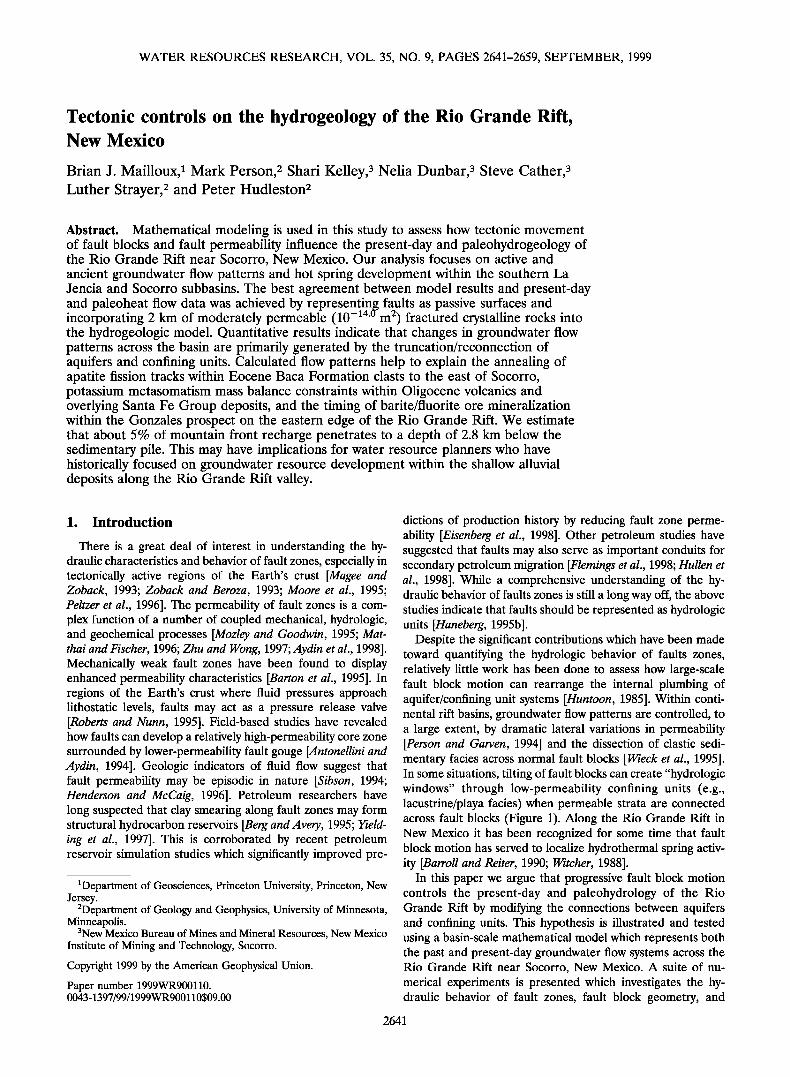
WATER RESOURCES RESEARCH, VOL. 35, NO. 9, PAGES 2641-2659, SEPTEMBER, 1999 Tectonic controls on the hydrogeology of the Rio Grande Rift, New Mexico Brian J. Mailloux, • Mark Person, 2 Shari Kelley, 3 Nelia Dunbar, 3 Steve Cather, 3 Luther Strayer, 2 and Peter Hudleston 2 Abstract. Mathematical modeling is usedin this study to assess how tectonicmovement of fault blocks and fault permeability influence the present-day and paleohydrogeology of the Rio Grande Rift near Socorro, New Mexico. Our analysis focuses on active and ancientgroundwater flow patternsand hot spring development within the southern La Jenciaand Socorro subbasins. The best agreement between model results and present-day and paleoheat flow data was achieved by representing faults as passive surfaces and 14 (I 2 incorporating 2 km of moderately permeable (10- ß rn ) fracturedcrystalline rocks into the hydrogeologic model. Quantitative results indicatethat changes in groundwater flow patternsacross the basinare primarily generated by the truncation/reconnection of aquifers and confining units. Calculated flow patterns help to explainthe annealing of apatite fission tracks within EoceneBaca Formationclasts to the east of Socorro, potassium metasomatism mass balance constraints within Oligocene volcanics and overlying SantaFe Group deposits, and the timing of barite/fluoriteore mineralization within the Gonzales prospect on the eastern edgeof the Rio Grande Rift. We estimate that about 5% of mountainfront recharge penetrates to a depth of 2.8 km below the sedimentary pile. This may have implications for water resource planners who have historically focused on groundwater resource development within the shallow alluvial deposits along the Rio Grande Rift valley. 1. Introduction There is a great deal of interest in understanding the hy- draulic characteristics andbehavior of fault zones, especially in tectonicallyactive regions of the Earth's crust [Mageeand Zoback, 1993; Zoback and Beroza, 1993; Moore et al., 1995; Peltzer et al., 1996]. The permeability of fault zonesis a com- plex functionof a numberof coupled mechanical, hydrologic, and geochemical processes [Mozley and Goodwin,1995;Mat- thai andFischer, 1996; Zhu and Wong, 1997; Aydinet al., 1998]. Mechanicallyweak fault zones have been found to display enhanced permeability characteristics [Barton et al., 1995]. In regionsof the Earth's crust where fluid pressures approach lithostaticlevels, faults may act as a pressurerelease valve [Roberts and Nunn, 1995]. Field-based studies have revealed howfaults can develop a relatively high-permeability corezone surrounded by lower-permeability fault gouge [Antonellini and Aydin, 1994]. Geologic indicators of fluid flow suggest that fault permeabilitymay be episodicin nature [Sibson, 1994; Henderson and McCaig, 1996]. Petroleum researchers have long suspected that clay smearing alongfault zones may form structural hydrocarbon reservoirs [Berg andAvery,1995; Yield- ing et al., 1997]. This is corroboratedby recent petroleum reservoir simulation studies which significantly improved pre- •Department of Geosciences, Princeton University, Princeton, New Jersey. 2Department of Geology and Geophysics, University of Minnesota, Minneapolis. 3New Mexico Bureau of Mines and MineralResources, NewMexico Institute of Mining and Technology, Socorro. Copyright 1999by the AmericanGeophysical Union. Paper number 1999WR900110. 0043-1397/99/1999WR900110509.00 dictions of production historyby reducing fault zone perme- ability [Eisenberg et al., 1998]. Other petroleum studies have suggested that faultsmay alsoserve as importantconduits for secondary petroleum migration [Flemings et al., 1998; Hullen et al., 1998]. While a comprehensive understanding of the hy- draulicbehaviorof faultszones is still a longway off, the above studies indicate that faultsshould be represented ashydrologic units [Haneberg, 1995b]. Despitethe significant contributions whichhavebeen made toward quantifyingthe hydrologic behavior of faults zones, relativelylittle work has been done to assess how large-scale fault block motion can rearrange the internal plumbing of aquifer/confining unit systems [Huntoon,1985]. Within conti- nental rift basins, groundwater flow patternsare controlled, to a large extent, by dramatic lateral variationsin permeability [Person and Garven, 1994] and the dissection of clastic sedi- mentaryfaciesacross normal fault blocks[Wieck et al., 1995]. In some situations, tiltingof fault blocks cancreate "hydrologic windows" through low-permeability confining units (e.g., lacustrine/playa facies) when permeable strataare connected across fault blocks (Figure 1). Along the Rio Grande Rift in New Mexico it has been recognized for some time that fault blockmotion hasserved to localizehydrothermal spring activ- ity [Barroll and Reiter,1990; Witchef, 1988]. In this paper we argue that progressive fault block motion controls the present-day and paleohydrology of the Rio Grande Rift by modifyingthe connections between aquifers and confining units. This hypothesis is illustratedand tested using a basin-scale mathematical modelwhich represents both the past and present-day groundwater flow systems across the Rio Grande Rift near Socorro, New Mexico. A suite of nu- merical experiments is presentedwhich investigates the hy- draulic behavior of fault zones, fault block geometry, and 2641
-
Upload
independent -
Category
Documents
-
view
1 -
download
0
Transcript of Tectonic controls on the hydrogeology of the Rio Grande Rift, New Mexico
WATER RESOURCES RESEARCH, VOL. 35, NO. 9, PAGES 2641-2659, SEPTEMBER, 1999
Tectonic controls on the hydrogeology of the Rio Grande Rift, New Mexico
Brian J. Mailloux, • Mark Person, 2 Shari Kelley, 3 Nelia Dunbar, 3 Steve Cather, 3 Luther Strayer, 2 and Peter Hudleston 2
Abstract. Mathematical modeling is used in this study to assess how tectonic movement of fault blocks and fault permeability influence the present-day and paleohydrogeology of the Rio Grande Rift near Socorro, New Mexico. Our analysis focuses on active and ancient groundwater flow patterns and hot spring development within the southern La Jencia and Socorro subbasins. The best agreement between model results and present-day and paleoheat flow data was achieved by representing faults as passive surfaces and
14 (I 2 incorporating 2 km of moderately permeable (10- ß rn ) fractured crystalline rocks into the hydrogeologic model. Quantitative results indicate that changes in groundwater flow patterns across the basin are primarily generated by the truncation/reconnection of aquifers and confining units. Calculated flow patterns help to explain the annealing of apatite fission tracks within Eocene Baca Formation clasts to the east of Socorro, potassium metasomatism mass balance constraints within Oligocene volcanics and overlying Santa Fe Group deposits, and the timing of barite/fluorite ore mineralization within the Gonzales prospect on the eastern edge of the Rio Grande Rift. We estimate that about 5% of mountain front recharge penetrates to a depth of 2.8 km below the sedimentary pile. This may have implications for water resource planners who have historically focused on groundwater resource development within the shallow alluvial deposits along the Rio Grande Rift valley.
1. Introduction
There is a great deal of interest in understanding the hy- draulic characteristics and behavior of fault zones, especially in tectonically active regions of the Earth's crust [Magee and Zoback, 1993; Zoback and Beroza, 1993; Moore et al., 1995; Peltzer et al., 1996]. The permeability of fault zones is a com- plex function of a number of coupled mechanical, hydrologic, and geochemical processes [Mozley and Goodwin, 1995; Mat- thai and Fischer, 1996; Zhu and Wong, 1997; Aydin et al., 1998]. Mechanically weak fault zones have been found to display enhanced permeability characteristics [Barton et al., 1995]. In regions of the Earth's crust where fluid pressures approach lithostatic levels, faults may act as a pressure release valve [Roberts and Nunn, 1995]. Field-based studies have revealed how faults can develop a relatively high-permeability core zone surrounded by lower-permeability fault gouge [Antonellini and Aydin, 1994]. Geologic indicators of fluid flow suggest that fault permeability may be episodic in nature [Sibson, 1994; Henderson and McCaig, 1996]. Petroleum researchers have long suspected that clay smearing along fault zones may form structural hydrocarbon reservoirs [Berg and Avery, 1995; Yield- ing et al., 1997]. This is corroborated by recent petroleum reservoir simulation studies which significantly improved pre-
•Department of Geosciences, Princeton University, Princeton, New Jersey.
2Department of Geology and Geophysics, University of Minnesota, Minneapolis.
3New Mexico Bureau of Mines and Mineral Resources, New Mexico Institute of Mining and Technology, Socorro.
Copyright 1999 by the American Geophysical Union.
Paper number 1999WR900110. 0043-1397/99/1999WR900110509.00
dictions of production history by reducing fault zone perme- ability [Eisenberg et al., 1998]. Other petroleum studies have suggested that faults may also serve as important conduits for secondary petroleum migration [Flemings et al., 1998; Hullen et al., 1998]. While a comprehensive understanding of the hy- draulic behavior of faults zones is still a long way off, the above studies indicate that faults should be represented as hydrologic units [Haneberg, 1995b].
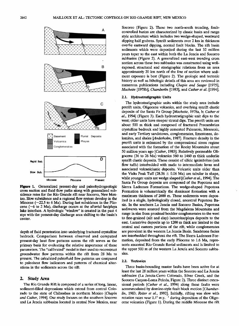
Despite the significant contributions which have been made toward quantifying the hydrologic behavior of faults zones, relatively little work has been done to assess how large-scale fault block motion can rearrange the internal plumbing of aquifer/confining unit systems [Huntoon, 1985]. Within conti- nental rift basins, groundwater flow patterns are controlled, to a large extent, by dramatic lateral variations in permeability [Person and Garven, 1994] and the dissection of clastic sedi- mentary facies across normal fault blocks [Wieck et al., 1995]. In some situations, tilting of fault blocks can create "hydrologic windows" through low-permeability confining units (e.g., lacustrine/playa facies) when permeable strata are connected across fault blocks (Figure 1). Along the Rio Grande Rift in New Mexico it has been recognized for some time that fault block motion has served to localize hydrothermal spring activ- ity [Barroll and Reiter, 1990; Witchef, 1988].
In this paper we argue that progressive fault block motion controls the present-day and paleohydrology of the Rio Grande Rift by modifying the connections between aquifers and confining units. This hypothesis is illustrated and tested using a basin-scale mathematical model which represents both the past and present-day groundwater flow systems across the Rio Grande Rift near Socorro, New Mexico. A suite of nu- merical experiments is presented which investigates the hy- draulic behavior of fault zones, fault block geometry, and
2641
2642 MAILLOUX ET AL.' TECTONIC CONTROLS ON RIO GRANDE RIFT, NEW MEXICO
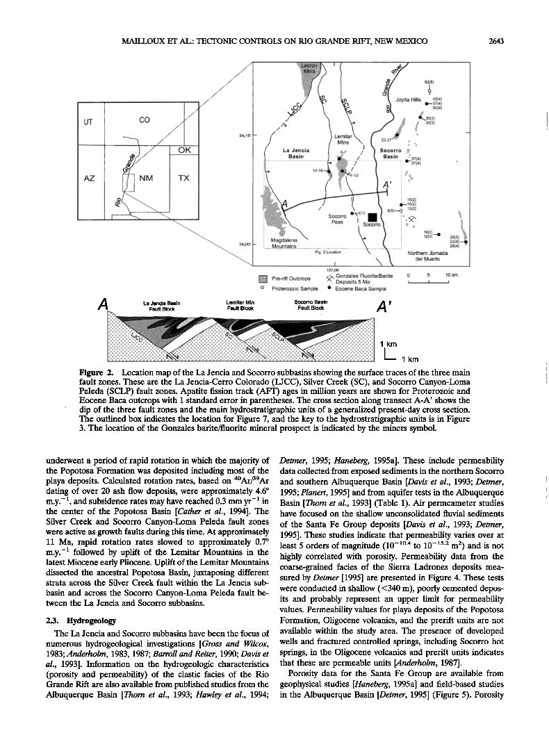
Socorro (Figure 2). These two north-south trending, fault- controlled basins are characterized by classic basin and range style architecture which includes two wedge-shaped, westward dipping half grabens. Synrift sediments over 2 km in thickness overlie eastward dipping, normal fault blocks. The rift basin sediments which were deposited during the last 32 million years taper to the east within both the La Jencia and Socorro subbasins (Figure 2). A generalized east-west trending cross section across these two subbasins was constructed using well- exposed, structural and stratigraphic relations from an area approximately 20 km north of the line of section where sedi- ment exposure is best (Figure 2). The geologic and tectonic history as well as lithologic details of this area are reviewed in numerous publications including Chapin and Seager [1975], Machette [1978b], Chamberlin [1983], and Cather et al. [1994].
Basement i!il !iii!ii Fluvial Deposits Volcanics Playas
Conglomerat es
Rapid Sub.
Slow Sub.
Miocene Pliocene Present
Figure 1. Generalized present-day and paleohydrogeologic cross section and fluid flow paths along with generalized sub- sidence rates for the Rio Grande rift near Socorro, New Mex- ico. Slow subsidence and a regional flow system develop in the Miocene (-22.5 to 6 Ma). During fast subsidence in the Plio- cene (-6 to 2 Ma), discharge occurs at the alluvial fan/playa lake interface. A hydrologic "window" is created in the past 4 myr with the present-day discharge area shifting to the basin's center.
depth of fluid penetration into underlying fractured crystalline bedrock. Comparison between observed and computed present-day heat flow patterns across the rift serves as the primary basis for evaluating the relative importance of these parameters. The "calibrated" model is then used to reconstruct groundwater flow patterns within the rift from 28 Ma to present. The calculated paleofluid flow patterns are compared to paleoheat flow indicators and patterns of chemical alter- ations in the sediments across the rift.
2. Study Area The Rio Grande Rift is composed of a series of long, linear,
sediment-filled depressions which extend from central Colo- rado to the state of Chihuahua in northern Mexico [Chapin and Cather, 1994]. Our study focuses on the southern Socorro and La Jencia subbasins located in central New Mexico, near
2.1. Hydrostratigraphic Units
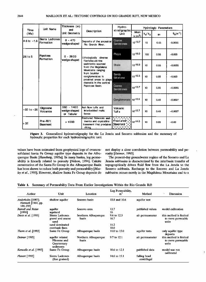
The hydrostratigraphic units within the study area include prerift units, Oligocene volcanics, and overlying synrift clastic deposits of the Santa Fe Group [Machette, 1978a, b; Cather et al., 1994] (Figure 3). Each hydrostratigraphic unit dips to the west; Older units have steeper stratal dips. The prerift units are about 500 m thick and composed of fractured Precambrian crystalline bedrock and highly cemented Paleozoic, Mesozoic, and early Tertiary sandstones, conglomerates, limestones, do- lomites, and shales [Anderholm, 1987]. Fracture density in the prerift units is enhanced by the compressional stress regime associated with the formation of the Rocky Mountains about 50 million years ago [Cather, 1983]. Relatively permeable Oli- gocene (36 to 26 Ma) volcanics 560 to 1460 m thick underlie synrift clastic deposits. These consist of silicic ignimbrites (ash flow tuffs) interbedded with mafic to intermediate lavas and associated volcaniclastic deposits. Volcanic units older than the Vicks Peak Tuff (28.56 _+ 0.06 Ma) are tabular in shape, while younger units are wedge shaped [Cather et al., 1994]. The Santa Fe Group deposits are composed of the Popotosa and Sierra Ladrones Formations. The wedge-shaped Popotosa Formation is volumetrically the dominant formation with a maximum thickness of 2600 m. These sediments were depos- ited in a single, hydrologically dosed, ancestral Popotosa Ba- sin. In the southern La Jencia and Socorro Basins, Popotosa sediments were sourced from the Magdalena Mountains and range in size from proximal boulder conglomerates to the west to fine-grained (silt and clay) lacustrine/playa deposits to the east. Lacustrine deposits up to 1200 m thick are limited to the central and eastern portions of the rift, while conglomerates are prevalent in the western La Jencia Basin. Sandstone facies are interbedded throughout the rift. The Sierra Ladrones For- mation, deposited from the early Pliocene to 1.6 Ma, repre- sents ancestral Rio Grande fluvial sediments and is limited to
the upper 500 m of the western La Jencia and Socorro subba- sins.
2.2. Tectonics
Three basin-bounding master faults have been active for at least the last 28 million years within the Socorro and La Jencia subbasins (La Jencia-Cerro Colorado, Silver Creek, and the Socorro Canyon-Loma Peleda, Figure 2). Three distinct exten- sional periods [Cather et al., 1994] along these faults were accommodated by domino-style fault block motion [Chamber- lin, 1983; Reiter et al., 1992]. Initially, rifting was slow with rotation rates near 0.1 ø m.y. -• during deposition of the Oligo- cene volcanics (Figure 1). During the middle Miocene the rift
MAILLOUX ET AL.' TECTONIC CONTROLS ON RIO GRANDE RIFT, NEW MEXICO 2643
./
UT CO x" /-
/'
/' OK ß '/'.• .•/
AZ NM TX
34i15'
A La Jencia Basin Lemitar Mtn Fault Block Fault Block
La Jencia Basin
/ \
Socorro •4(1 Peak
52(5)
Joyita Hills 45(4) •-.57(4)
5o(8)
30(3)
, 33(3)
Socorro •. Basin •37(4)
--37(4)
! 18(2) •16(2)
8(5)4 13(2)
-•!' •:.
Magdalena Mountains
Fig. 2 Location
I 107i00'
*.'.'.• Pre-rifi Outcrops 4•, Gonzales Fluorite/Barite Deposits 5 Ma o Proterozoic Sample ß Eocene Baca Sample
Socorro Basin A ' Fault Block
16(2)._• 12(4)•
Northern Jornada del Muerto
28(2) 22(4)--•.. 26(4)
0 5 10 km
i I i
1 km
Figure 2. Location map of the La Jencia and Socorro subbasins showing the surface traces of the three main fault zones. These are the La Jencia-Cerro Colorado (LJCC), Silver Creek (SC), and Socorro Canyon-Loma Peleda (SCLP) fault zones. Apatite fission track (AFT) ages in million years are shown for Proterozoic and Eocene Baca outcrops with 1 standard error in parentheses. The cross section along transect A-A' shows the dip of the three fault zones and the main hydrostratigraphic units of a generalized present-day cross section. The outlined box indicates the location for Figure 7, and the key to the hydrostratigraphic units is in Figure 3. The location of the Gonzales barite/fluorite mineral prospect is indicated by the miners symbol.
underwent a period of rapid rotation in which the majority of the Popotosa Formation was deposited including most of the playa deposits. Calculated rotation rates, based on 4øm_r/39A_r dating of over 20 ash flow deposits, were approximately 4.6 ø m.y.-2, and subsidence rates may have reached 0.3 mm yr-• in the center of the Popotosa Basin [Cather et al., 1994]. The Silver Creek and Socorro Canyon-Loma Peleda fault zones were active as growth faults during this time. At approximately 11 Ma, rapid rotation rates slowed to approximately 0.7 ø m.y. -2 followed by uplift of the Lemitar Mountains in the latest Miocene early Pliocene. Uplift of the Lemitar Mountains dissected the ancestral Popotosa Basin, juxtaposing different strata across the Silver Creek fault within the La Jencia sub-
basin and across the Socorro Canyon-Loma Peleda fault be- tween the La Jencia and Socorro subbasins.
2.3. I-Iydrogeology The La Jencia and Socorro subbasins have been the focus of
numerous hydrogeological investigations [Gross and Wilcox, 1983; Anderholm, 1983, 1987; Barroll and Reiter, 1990; Davis et al., 1993]. Information on the hydrogeologic characteristics (porosity and permeability) of the clastic facies of the Rio Grande Rift are also available from published studies from the Albuquerque Basin [Thom et al., 1993; Hawley et al., 1994;
Detmer, 1995; Haneberg, 1995a]. These include permeability data collected from exposed sediments in the northern Socorro and southern Albuquerque Basin [Davis et al., 1993; Detmer, 1995; Planert, 1995] and from aquifer tests in the Albuquerque Basin [Thom et al., 1993] (Table 1). Air permeameter studies have focused on the shallow unconsolidated fluvial sediments
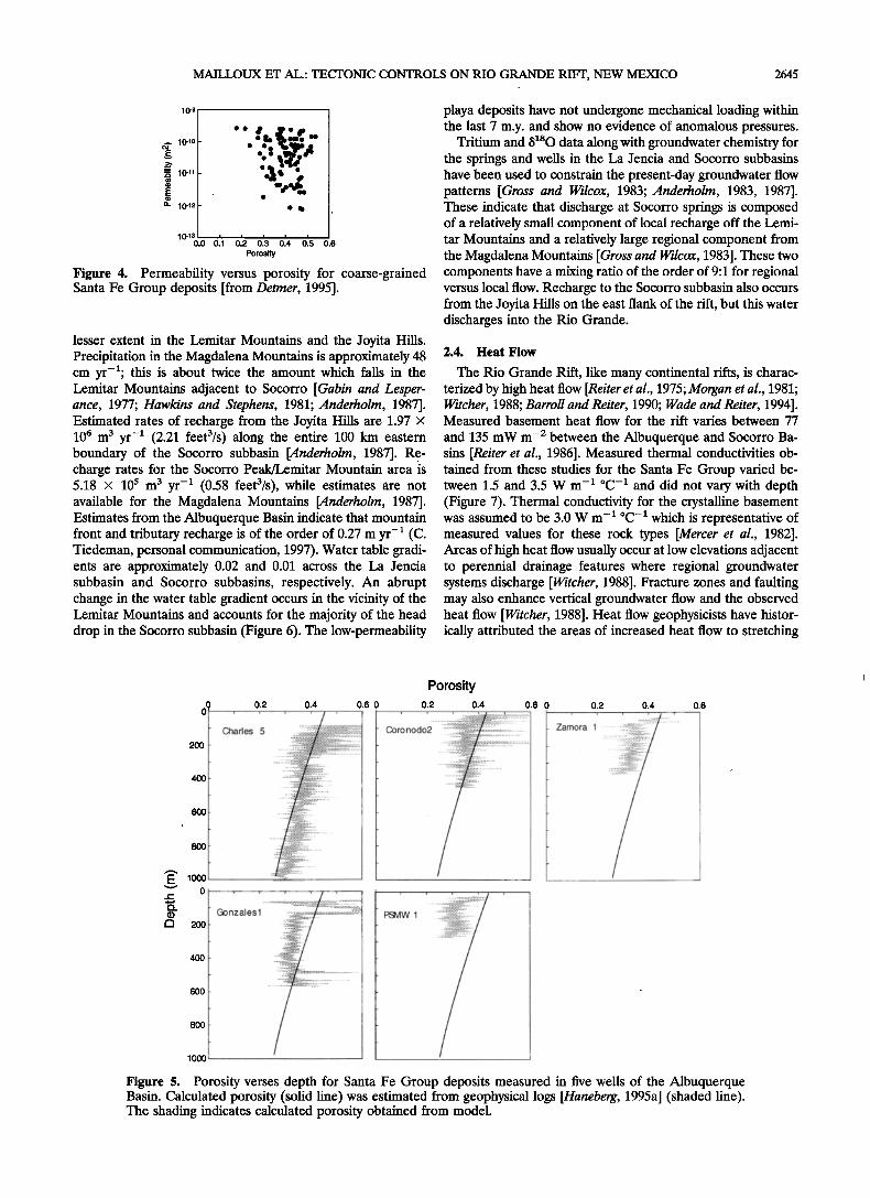
of the Santa Fe Group deposits [Davis et al., 1993; Detmer, 1995]. These studies indicate that permeability varies over at least 5 orders of magnitude (10 -20'4 to 10 -]5'2 m 2) and is not highly correlated with porosity. Permeability data from the coarse-grained facies of the Sierra Ladrones deposits mea- sured by Detmer [1995] are presented in Figure 4. These tests were conducted in shallow (<340 m), poorly cemented depos- its and probably represent an upper limit for permeability values. Permeability values for playa deposits of the Popotosa Formation, Oligocene volcanics, and the prerift units are not available within the study area. The presence of developed wells and fractured controlled springs, including Socorro hot springs, in the Oligocene volcanics and prerift units indicates that these are permeable units lAnderholm, 1987].
Porosity data for the Santa Fe Group are available from geophysical studies [Haneberg, 1995a] and field-based studies in the Albuquerque Basin [Detmer, 1995] (Figure 5). Porosity
2644 MAILLOUX ET AL.' TECTONIC CONTROLS ON RIO GRANDE RIFT, NEW MEXICO
Thickness (m) I Hydro- Hydrologic Parameters Time Unit Name and Description I stratigraphic, Mean kx/kz •o ) ( Ma) Unit Geemet ry • Bs(m-1 k (m 2)
Sierra Ladrones 0 - 470 Deposits of the ancestral 10-13.7 10 0.55 -0.0055 4.6 to ~ 1.6 Format ion wedge-shaped Rio Grande River.
•)6 to 5 Popot osa 0- •)600 Lit hole gically dive rse I '-------•• • 0'•'0 •00 0.• Format ion wedge-shard f luviolacust rine ................ sediments sourced •?:•'•(:"':'•?•?:"•dS•:?•??•:•:• 10 '16-0 10 0.55 -0.0055 from the •gdalena Mount ains ranging
,ro ou,dor tlI/ conglomerates in 10 '15-3 10 0.55 -0.003 proximal areas to playa depostis in t he cent ral ...............................................................................
,0 0.4 -0.00
-32 t o -26 Oigocene 560 - 1460 Ash flow tuffs and Volcanic Volcanics wedge-shaped int erbedded mafic Tuff s 10 '13.7 10 0.49 -0.0027
or Tabular lavas ,
Fractured •leozoic sed- /././././. Pre-Rift > 1000 iments and crystalline 'Fracturedcx½' 10 -14-0 10 0.05 -0.00
> 32 •sement basement t hat p redat es .'•sement •,•, rifting ß /• • • • • • '
Figure 3. Generalized hydrostratigraphy for the La Jencia and Socorro subbasins and the summary of hydraulic properties for each hydrostratigraphic unit.
values have been estimated from geophysical logs of overcon- solidated Santa Fe Group aquifer type deposits in the Albu- querque Basin [Haneberg, 1995a]. In many basins, log perme- ability is linearly related to porosity [Nelson, 1994]. Calcite cementation of the Santa Fe Group in the Albuquerque Basin has been shown to reduce both porosity and permeability [Moz- ley et al., 1995]. However, shallow Santa Fe Group deposits do
not display a clear correlation between permeability and po- rosity [Detmer, 1995].
The present-day groundwater regime of the Socorro and La Jencia subbasins is characterized by the interbasin transfer of topographically driven fluid flow from the La Jencia to the Socorro subbasin. Recharge to the Socorro and La Jencia subbasins occurs mostly in the Magdalena Mountains and to a
Table 1. Summary of Permeability Data From Earlier Investigations Within the Rio Grande Rift
Log Permeability, Author Unit Location m 2 Method Discussion
Anderholm [1987]; Hantush [ 1961, pp. 188-193]
Barroll and Reiter
[1990] Davis et al. [1993]
Thorn et al. [1993]
Detmer [1995]
Kernodle et al. [1995]
Planert [1995]
shallow aquifer Socorro basin 10.8 and 10.6 aquifer test
aquifer aquitard Sierra Ladrones
gravel and coarse sand
sand dominated
overbank fines
Sante Fe Group
aquifer related Pliocene and
Quarternary sediments
Sante Fe Group
Sierra Ladrones
(fine grained)
Socorro area 13.7 published values 16
Southern Albuquerque 9.6 to 12.3 air permeameter basin 10.7
11.2
18.0
Albuquerque basin 11.0 to 15.0 aquifer tests
Northern Albuquerque 9.7 to 12.1 air permeameter basin
Albuquerque basin 10.6 to 12.1 published data
Albuquerque basin 14.6 to 15.1 falling head centrifugal
model calibration
this method is limited
to more permeable units
only aquifer type deposits
this method is limited
to more permeable units
model was not
calibrated
MAILLOUX ET AL.: TECTONIC CONTROLS ON RIO GRANDE RIFT, NEW MEXICO 2645
10-9
._. 10-1o
• 10 -11
a. 10_12
0h 012 0h 0'.s Porosity
Figure 4. Permeability versus porosity for coarse-grained Santa Fe Group deposits [from Detmer, 1995].
lesser extent in the Lemitar Mountains and the Joyita Hills. Precipitation in the Magdalena Mountains is approximately 48 cm yr-•; this is about twice the amount which falls in the Lemitar Mountains adjacent to Socorro [Gabin and Lesper- ance, 1977; Hawkins and Stephens, 1981; Anderholm, 1987]. Estimated rates of recharge from the Joyita Hills are 1.97 x 10 6 m 3 yr -1 (2.21 feet3/s) along the entire 100 km eastern boundary of the Socorro subbasin [Anderholm, 1987]. Re- charge rates for the Socorro Peak/Lemitar Mountain area is 5.18 x 10⁵ m 3 yr -• (0.58 feet3/s), while estimates are not available for the Magdalena Mountains [Anderholm, 1987]. Estimates from the Albuquerque Basin indicate that mountain front and tributary recharge is of the order of 0.27 m yr -• (C. Tiedeman, personal communication, 1997). Water table gradi- ents are approximately 0.02 and 0.01 across the La Jencia subbasin and Socorro subbasins, respectively. An abrupt change in the water table gradient occurs in the vicinity of the Lemitar Mountains and accounts for the majority of the head drop in the Socorro subbasin (Figure 6). The low-permeability
playa deposits have not undergone mechanical loading within the last 7 m.y. and show no evidence of anomalous pressures.
Tritium and &too data along with groundwater chemistry for the springs and wells in the La Jencia and Socorro subbasins have been used to constrain the present-day groundwater flow patterns [Gross and Wilcox, 1983; Anderholm, 1983, 1987]. These indicate that discharge at Socorro springs is composed of a relatively small component of local recharge off the Lemi- tar Mountains and a relatively large regional component from the Magdalena Mountains [Gross and Wilcox, 1983]. These two components have a mixing ratio of the order of 9:1 for regional versus local flow. Recharge to the Socorro subbasin also occurs from the Joyita Hills on the east flank of the rift, but this water discharges into the Rio Grande.
2.4. Heat Flow
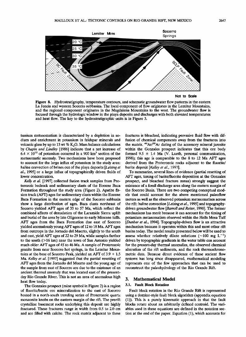
The Rio Grande Rift, like many continental rifts, is charac- terized by high heat flow [Reiter et al., 1975; Morgan et al., 1981; Witcher, 1988; Barroll and Reiter, 1990; Wade and Reiter, 1994]. Measured basement heat flow for the rift varies between 77
and 135 mW m -2 between the Albuquerque and Socorro Ba- sins [Reiter et al., 1986]. Measured thermal conductivities ob- tained from these studies for the Santa Fe Group varied be- tween 1.5 and 3.5 W m -• øC-• and did not vary with depth (Figure 7). Thermal conductivity for the crystalline basement was assumed to be 3.0 W m- • øC-• which is representative of measured values for these rock types [Mercer et al., 1982]. Areas of high heat flow usually occur at low elevations adjacent to perennial drainage features where regional groundwater systems discharge [Witcher, 1988]. Fracture zones and faulting may also enhance vertical groundwater flow and the observed heat flow [Witcher, 1988]. Heat flow geophysicists have histor- ically attributed the areas of increased heat flow to stretching
200
0 0.2 O:
400
6OO
8OO
1000 0
200
400
6O0
8OO
lOOO
Charles 5
0.4 0.6 0
-. ::: :::.•::?:'t•i'[¾".::',;:;'.;:: '
.
Porosity 0.2 0.4 0.6 0
::::::::::::::::::::::::':::::'
PSMW 1
0.2 0.4 0.6
Figure 5. Porosity verses depth for Santa Fe Group deposits measured in five wells of the Albuquerque Basin. Calculated porosity (solid line) was estimated from geophysical logs [Haneberg, 1995a] (shaded line). The shading indicates calculated porosity obtained from model.
2646 MAILLOUX ET AL.: TECTONIC CONTROLS ON RIO GRANDE RIFT, NEW MEXICO
1074 05' 107 •' 00' 106 '• 55 .•
3.4 • 05'
34 • 00'
\
\.
\
\
I
$ocorro
Sp,rings ................ .i•-
!
I sototto
!
/
Heat Flow Water Table 0 4 km .
(mW/m2) Elevation (m)
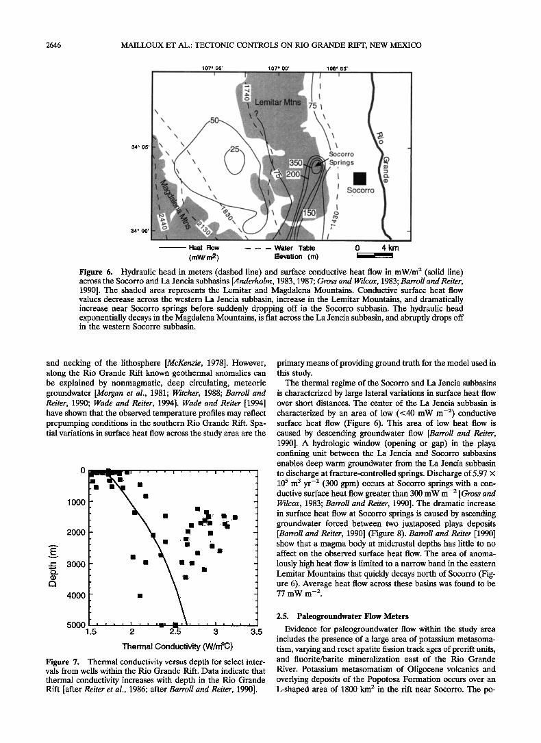
Figure 6. Hydraulic head in meters (dashed line) and surface conductive heat flow in mW/m 2 (solid line) across the Socorro and La Jencia subbasins lAnderholm, 1983, 1987; Gross and Wilcox, 1983; Barroll and Reiter, 1990]. The shaded area represents the Lemitar and Magdalena Mountains. Conductive surface heat flow values decrease across the western La Jencia subbasin, increase in the Lemitar Mountains, and dramatically increase near Socorro springs before suddenly dropping off in the Socorro subbasin. The hydraulic head exponentially decays in the Magdalena Mountains, is flat across the La Jencia subbasin, and abruptly drops off in the western Socorro subbasin.
and necking of the lithosphere [McKenzie, 1978]. However, along the Rio Grande Rift known geothermal anomalies can be explained by nonmagmatic, deep circulating, meteoric groundwater [Morgan et al., 1981; Witcher, 1988; Barroll and Reiter, 1990; Wade and Reiter, 1994]. Wade and Reiter [1994] have shown that the observed temperature profiles may reflect prepumping conditions in the southern Rio Grande Rift. Spa- tial variations in surface heat flow across the study area are the
o
lOOO
2000
3000 4000
5000 1.5 2 2.5 3 3.5
Thermal Conductivity (W/møC)
Figure 7. Thermal conductivity versus depth for select inter- vals from wells within the Rio Grande Rift. Data indicate that
thermal conductivity increases with depth in the Rio Grande Rift [after Reiter et al., 1986; after Barroll and Reiter, 1990].
primary means of providing ground truth for the model used in this study.
The thermal regime of the Socorro and La Jencia subbasins is characterized by large lateral variations in surface heat flow over short distances. The center of the La Jencia subbasin is
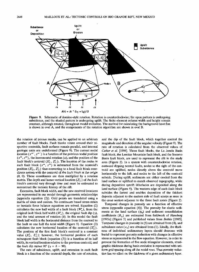
characterized by an area of low (<40 mW m -2) conductive surface heat flow (Figure 6). This area of low heat flow is caused by descending groundwater flow [Barroll and Reiter, 1990]. A hydrologic window (opening or gap) in the playa confining unit between the La Jencia and Socorro subbasins enables deep warm groundwater from the La Jencia subbasin to discharge at fracture-controlled springs. Discharge of 5.97 x l0 s m 3 yr -1 (300 gpm) occurs at Socorro springs with a con- ductive surface heat flow greater than 300 mW m -2 [Gross and Wilcox, 1983; Barroll and Reiter, 1990]. The dramatic increase in surface heat flow at Socorro springs is caused by ascending groundwater forced between two juxtaposed playa deposits [Barroll and Reiter, 1990] (Figure 8). Barroll and Reiter [1990] show that a magma body at midcrustal depths has little to no affect on the observed surface heat flow. The area of anoma-
lously high heat flow is limited to a narrow band in the eastern Lemitar Mountains that quickly decays north of Socorro (Fig- ure 6). Average heat flow across these basins was found to be 77 mW m -2.
2.5. Paleogroundwater Flow Meters
Evidence for paleogroundwater flow within the study area includes the presence of a large area of potassium metasoma- tism, varying and reset apatite fission track ages of prerift units, and fluorite/barite mineralization east of the Rio Grande
River. Potassium metasomatism of Oligocene volcanics and overlying deposits of the Popotosa Formation occurs over an L-shaped area of 1800 klrl 2 in the rift near Socorro. The po-
MAILLOUX ET AL.: TECTONIC CONTROLS ON RIO GRANDE RIFT, NEW MEXICO 2647
Socorro
Lemitar Mtns Springs
Not to Scale
Figure 8. Hydrostratigraphy, temperature contours, and schematic groundwater flow patterns in the eastern La Jencia and western Socorro subbasins. The local component of flow originates in the Lemitar Mountains, and the regional component originates in the Magdalena Mountains to the west. The groundwater flow is focused through the hydrologic window in the playa deposits and discharges with both elevated temperatures and heat flow. The key to the hydrostratigraphic units is in Figure 3.
tassium metasomatism is characterized by a depletion in so- dium and enrichment in potassium in feldspar minerals and volcanic glass by up to 13 wt % K20. Mass balance calculations by Chapin and Lindley [1986] indicate that a net increase of 6.4 x t0 •ø of potassium occurred in a 900 krll 3 section of the metasomatic anomaly. Two mechanisms have been proposed to account for the large influx of potassium in the study area: haline convection of brines out of the playa deposits [Leising et al., 1995] or a large influx of topographically driven fluids of lower concentration.
Kelly et al. [1997] collected fission track samples from Pro- terozoic bedrock and sedimentary clasts of the Eocene Baca Formation throughout the study area (Figure 2). Apatite fis- sion track (AFT) ages for sedimentary clasts within the Eocene Baca Formation in the eastern edge of the Socorro subbasin show a large distribution of ages. Baca clasts northeast of Socorro yielded AFT ages of 33 to 57 Ma, which reflect the combined affects of denudation of the Laramide Sierra uplift and burial of the area by late Oligocene to early Miocene tuffs. AFT ages from the Baca Formation due east of Socorro yielded anomalously young AFT ages of 12 to 18 Ma. AFT ages from outcrops in the Jornado del Muerto, slightly to the south and east, yield AFT ages of 22 to 29 Ma, while samples farther to the south (>16 km) near the town of San Antonio yielded much older AFT ages of 45 to 46 Ma. A sample of Proterozoic granite from near Socorro hot springs, in the Lemitar M6un- tains at the base of Socorro Peak, yielded an AFT of 3.9 + 1.5 Ma. Kelley et al. [1997] suggested that the partial resetting of AFT ages from the Jornado del Muerto and the young age of the sample from east of Socorro are due to the existence of an ancient thermal anomaly that was located east of the present- day Rio Grande River. This is not an area of anomalous high heat flow today.
The Gonzales prospect (mine symbol in Figure 2) is a region of fluorite/barite ore mineralization to the east of Socorro
hosted in a north-south trending series of Proterozoic quartz monzonite knobs on the eastern margin of the rift. The prerift crystalline basement rocks underlying this deposit are highly fractured. These fractures range in width from 0.5 to 2.0 cm and are filled with calcite. The rock matrix adjacent to these
fractures is bleached, indicating pervasive fluid flow with dif- fusion of chemical components away from the fractures into the matrix. 4øm_r/39A_r dating of the accessory mineral jarosite within the Gonzales prospect indicates that this ore body formed 9.5 + 1.4 Ma (V. Lueth, personal communication, 1998); this age is comparable to the 8 to 12 Ma AFT ages derived from the Proterozoic rocks adjacent to the fluorite/ barite deposit [Kelley et al., 1997].
To summarize, several lines of evidence (partial resetting of AFT ages, timing of barite/fluorite deposition at the Gonzales prospect, and bleached fracture zones) strongly suggest the existence of a fossil discharge area along the eastern margin of the Socorro Basin. There are two competing conceptual mod- els that could account for the above mentioned paleoflow meters as well as the observed potassium metasomatism across the rift: haline convection [Leising et al., 1995] and topography- driven groundwater flow [Barroll and Reiter, 1990]. The former mechanisms has merit because it can account for the timing of potassium metasomatism observed within the Hells Mesa Tuff [Dunbar et al., 1994]. Topography-driven flow is an attractive mechanism because it operates within this and most other rift basins today. The model results presented below will be used to assess whether relatively dilute solutions (---tOO mg L -•) driven by topographic gradients in the water table can account for the present-day thermal anomalies, the observed chemical alteration of the rift sediments, and the rock thermochrono- metric data. Because direct evidence of these ancient flow
systems has long since disappeared, mathematical modeling represents one of the few approaches that can be used to reconstruct the paleohydrology of the Rio Grande Rift.
3. Mathematical Model
3.1. Fault Block Rotation
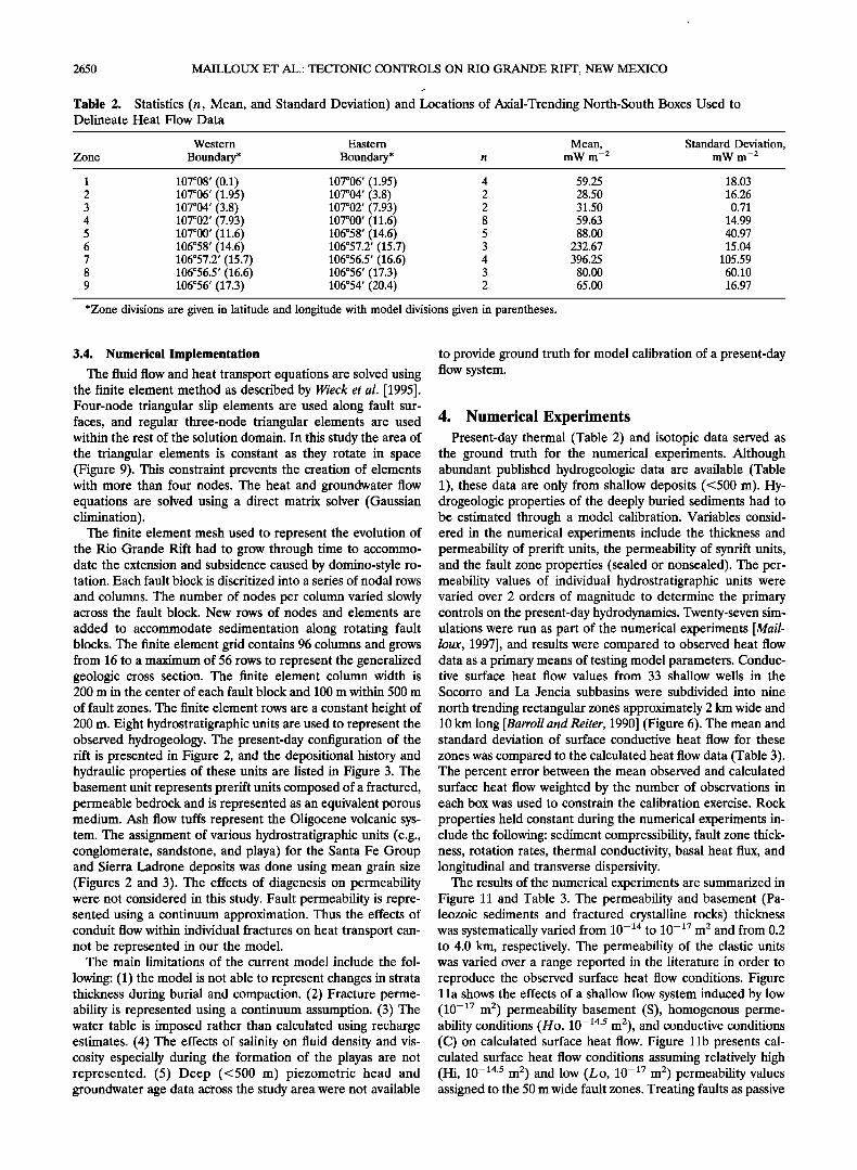
Fault block rotation in the Rio Grande Rift is represented using a domino-style fault block algorithm (appendix equation (1)). This is a purely kinematic approach in that the fault blocks rotate about an arbitrarily defined centroid. The vari- ables used in these equations are defined in the notation sec- tion at the end of the paper. Equation (1), which accounts for
2648 MAILLOUX ET AL.: TECTONIC CONTROLS ON RIO GRANDE RIFT, NEW MEXICO
•bsidence Up,lift or o r
Deposit ion Erosion
Uplift Subsidence
A
L1 L2
Jz Jz Jz Jz
J(n) = Jz '(L 1 + •L2)/2
Figure 9. Schematic of domino-style rotation. Rotation is counterclockwise; the open pattern is undergoing subsidence, and the shaded pattern is undergoing uplift. The finite element column width and height remain constant, although rotated, throughout model evolution. The method for calculating the background heat flux is shown in oval A, and the components of the rotation algorithm are shown in oval B.
the rotation of porous media, can be applied to an arbitrary number of fault blocks. Fault blocks rotate around their re-
spective centroids, fault surfaces remain parallel, and internal geologic units are undeformed (Figure 9). The current nodal location (x m ', z m') is a function of the previous nodal position (x m, zm), the incremental rotation (a), and the position of the fault block's centroid (X•c, Z•). The location of the nodes in each fault block (x m, z m) is subtracted from the centroid's position (X'c, Z•) thus converting to a local fault block coor- dinate system with the centroid of the fault block at the origin (0, 0). These coordinates are then multiplied by a rotation
ß
matrix. The depth and hence vertical location (Z•) of the fault block's centroid vary through time and must be estimated to reconstruct the tectonic history of the rift.
Extension, fault block width, and the new centroid locations are represented in our model through geometric relationships (appendix equation (2)). Grid points are translated using a matrix of sines and cosines. No continuum based stress-strain
or isostatic force balance equations are solved. Equation (2) calculates the new half width of a fault block (W•,•), from the original fault block half width (W•o), the original fault dip (3'), and the total amount of rotation (15). In this model the fault block half width is the horizontal distance from the centroid to
the fault or one half the total width (Figure 9). Equation (3) calculates the new horizontal location of the centroid (X•). The position of the first fault block's centroid is a constant
X 1 value ( c, Z•); however, the horizontal position of each subsequent fault block (equation (3)) is a function of its half width, its vertical location relative to the previous centroid, and the fault dip minus 90 ø (3' + /5 - 90).
The rate of subsidence, uplift, and extension in each fault block is a function of the centroid depth, the rate of rotation,
and the dip of the fault block, which together control the magnitude and direction of the angular velocity (Figure 9). The rate of rotation is calculated from the observed values of
Cather et al. [1994]. Three fault blocks, the La Jencia Basin fault block, the Lemitar Mountain fault block, and the Socorro Basin fault block, are used to represent the rift in the study area (Figure 2). In a system with counterclockwise rotation, eastward dipping normal faults, nodes to the right of the cen- troid are uplifted, nodes directly above the centroid move horizontally to the left, and nodes to the left of the centroid subside. During uplift, sediments are either eroded from the land surface or uplifted to match observed topography, while during deposition synrift lithofacies are deposited along the land surface (Figure 9). The western edge of each fault block subsides the fastest and enables deposition of the thickest deposits adjacent to the eastern side of fault scarps as seen in the cross section adjacent to the three fault zones (Figure 2).
Temporal changes in porosity are a function of effective stress (appendix equation (4)). The porosity for clastic sedi- ments at the land surface (qbo) and sediment consolidation coefficients (Bs) are estimated from fieldwork of Haneberg [1995a] (Figure 5) and published values from Bethke [1985]. Temporal changes in porosity in (5) are obtained from (4), and subsidence rates (rs) are obtained from (1). Ideally, the thick- ness of individual sedimentary layers should decrease with burial to represent porosity reduction with changes in effective stress as represented in the flow equation. However, in order to prevent the formation of five node triangular elements, strati- graphic thickness during basin evolution is represented with uni- form grid spacing along all the nodal rows. Thus porosity reduc- tion has no effect on the thickness of a given sedimentary layer.

MAILLOUX ET AL.: TECTONIC CONTROLS ON RIO GRANDE RIFT, NEW MEXICO 2649
1.4
1.2
'••[••_•over I m.y. 28 to 6 Ma /
0 2b ' 4b ' ' ob '00 Finite Element Column
Figure 10. Present-day and paleohead contours across the La Jencia and Socorro subbasins. Values are expressed in terms of finite element column because extension continuously changes the elements' horizontal locations. The present-day values are fromAnderholrn [1983, 1987] and Gross and Wilcox [1983]. The paleovalues are derived from the present-day con- ditions and geologic information about the uplift of the Mag- dalena [Kelley et al., 1992] and Lemitar Mountains [Chamber- lin, 1983].
3.2. Groundwater Flow
At the sedimentary basin scale, groundwater flow can be induced by sediment compaction, fluid-density variations, and topographic gradients in the water table (appendix equation (5)). All of these mechanisms are accounted for in the ground- water flow equation presented in (5) of the appendix. The groundwater flux is calculated using a variable-density formu- lation of Darcy's law (appendix equation (6)). Because fluid density varies with temperature, the groundwater flow direc- tion cannot be directly inferred from the hydraulic head gra- dients. The effect of salinity on haline convection [Duffy andAl Hassan, 1988; Leising et al., 1995] was not considered in this study. Equations (5) and (6) represent transient, variable- density groundwater flow in heterogeneous and anisotropic porous media in which the principal directions of the perme- ability ellipse rotate and are aligned with the lithologic units. The hydraulic conductivity tensor is calculated from (7) (ap- pendix), where 0 is equal to the amount of rotation for each node. The maximum hydraulic conductivity (kmax) is thken to be in the direction of bedding, and the minimum (kmin) is taken to be perpendicular to bedding. For lithologic units, 0 is equal to zero at deposition or the beginning of a simulation and is then the cumulative amount of rotation that each node
experiences. For nodes within the fault zones, 0 is 90 ø minus the fault dip (90 ø - 7 + /5).
Boundary conditions for the groundwater flow equation in- clude a specified head (water table) condition at the land surface and no flow boundary conditions along the sides and bottom of the solution domain. The present-day hydraulic- head boundary condition was obtained from published results [Gross and Wilcox, 1983; Anderholrn, 1983, 1987], and paleo- values are inferred from tectonic and sedimentological data for the Magdalena and Lemitar Mountains [Chamberlin, 1983; Kelley et al., 1992] (Figure 10). During the early period of basin formation (29-6 Ma) when the rift was hydrologically closed, a uniform head of 1400 m was applied over much of the eastern and central portion of the study area where playa lakes oc- curred. The western margin of the rift was assigned an elevated water table (up to 1700 m), where alluvial fans were being deposited. Hydrologic boundary conditions were changed over a 1 million year period to match modern conditions about 6 Ma
during the uplift of the Lemitar Mountains and formation of the ancestral Rio Grande.
3.3. Heat Transfer
Conductive/convective heat transfer within the Rio Grande
Rift basin is represented using (8)-(11) of the appendix. The solid phase is implicitly assumed to be in thermal equilibrium with the fluid phase, and the thermal dispersivity is negligible for the conditions represented in our model simulations [de Marsily, 1986]. Boundary conditions for the heat transport equations include a constant temperature boundary of 15øC along the land surface. The side and bottom boundaries were specified heat flux boundaries. This does not take into account changes in surface temperature due to climate change associ- ated with Pleistocene glaciation nor movement of the North American plate relative to the equator. The amount of heat flux either entering or leaving at a boundary node is equal to the vertical heat flux times the average horizontal width of the exposed side of the two boundary elements adjacent to that node (Figure 9). If no rotation occurs, then all of the heat would enter the basin across the bottom of the solution do-
main. However, if the fault blocks are tilted by 45 ø to the east, then only half of the heat would enter the basin along the base, and the other half would enter along west boundary. Sidewall boundaries on the east side of the rift have a specified heat flux removed. Observed background heat flux values for the Rio Grande Rift vary between 25 and 400 mW m -2 near Socorro [Reiter et al., 1975, 1986; Witcher, 1988; Barroll and Reiter, 1990; Wade and Reiter, 1994]. A vertical basal heat flow value of 77 mW m -2, which was applied along the base and tilted sides of the basin, best reproduced modern heat flow conditions within the southern Socorro and La Jencia Basins. It is difficult to
constrain temporal variations in basement heat flow across the Rio Grande Rift. Volcanism along the Socorro accommoda- tion zone, 10 km to the south of the model cross section, prior to rifting along with synrift lithospheric thinning could have elevated basement heat flow during the past 32 m.y. Basal heat flow was not varied through time in our model because the tectonic and magmatic history of this area does not fit any simple geodynamic model for the thermomechanical evolution of the underlying lithosphere. In this study, thermal conduc- tivity varied between 1.5 and 2.7 W m- • øC- • within the clastic sediments of the Rio Grande Rift using (9) of the appendix. This best reproduced measured thermal conductivities (Figure 7) of Santa Fe Group deposits presented by Reiter et al. [1986] and Barroll and Reiter [1990]. The fractured crystalline bedrock was assigned a thermal conductivity of 3.0 W m- • øC-•. A heat capacity of 843 J kg -• øC-• and a longitudinal and transverse thermal dispersivity of 100 m and 10 m, respectively, were assigned to all units within the model. These values were esti- mated from published data [Garven and Freeze, 1984; de Mar- sily, 1986; Barroll and Reiter, 1990].
The governing groundwater flow and heat transfer equations are formally coupled through equations of state. These equa- tions of state relate changes in density (equation (11)) and viscosity (equation (12)) to changes in subsurface temperature and are valid for temperature ranges between 10 ø and 150øC [Kestin et al., 1981]. Salinity effects are not represented because of the lack of evaporite minerals within the playas indicative of brine conditions (fluid density ranging between 1050 and 1200 kg m-3).
2650 MAILLOUX ET AL.: TECTONIC CONTROLS ON RIO GRANDE RIFT, NEW MEXICO
Table 2. Statistics (n, Mean, and Standard Deviation) and Locations of Axial-Trending North-South Boxes Used to Delineate Heat Flow Data
Western Eastern Mean, Standard Deviation, Zone Boundary* Boundary* n mW m -2 mW m -2
1 107008 ' (0.1) 107006 ' (1.95) 4 59.25 18.03 2 107006 ' (1.95) 107004 ' (3.8) 2 28.50 16.26 3 107004 ' (3.8) 107002 ' (7.93) 2 31.50 0.71 4 107002 ' (7.93) 107000 ' (11.6) 8 59.63 14.99 5 107000 ' (11.6) 106058 ' (14.6) 5 88.00 40.97 6 106058 ' (14.6) 106057.2 ' (15.7) 3 232.67 15.04 7 106057.2 ' (15.7) 106056.5 ' (16.6) 4 396.25 105.59 8 106056.5 ' (16.6) 106056 ' (17.3) 3 80.00 60.10 9 106056 ' (17.3) 106054 ' (20.4) 2 65.00 16.97
*Zone divisions are given in latitude and longitude with model divisions given in parentheses.
3.4. Numerical Implementation
The fluid flow and heat transport equations are solved using the finite element method as described by Wieck et al. [1995]. Four-node triangular slip elements are used along fault sur- faces, and regular three-node triangular elements are used within the rest of the solution domain. In this study the area of the triangular elements is constant as they rotate in space (Figure 9). This constraint prevents the creation of elements with more than four nodes. The heat and groundwater flow equations are solved using a direct matrix solver (Gaussian elimination).
The finite element mesh used to represent the evolution of the Rio Grande Rift had to grow through time to accommo- date the extension and subsidence caused by domino-style ro- tation. Each fault block is discritized into a series of nodal rows
and columns. The number of nodes per column varied slowly across the fault block. New rows of nodes and elements are
added to accommodate sedimentation along rotating fault blocks. The finite element grid contains 96 columns and grows from 16 to a maximum of 56 rows to represent the generalized geologic cross section. The finite element column width is 200 m in the center of each fault block and 100 m within 500 m
of fault zones. The finite element rows are a constant height of 200 m. Eight hydrostratigraphic units are used to represent the observed hydrogeology. The present-day configuration of the rift is presented in Figure 2, and the depositional history and hydraulic properties of these units are listed in Figure 3. The basement unit represents prerift units composed of a fractured, permeable bedrock and is represented as an equivalent porous medium. Ash flow tuffs represent the Oligocene volcanic sys- tem. The assignment of various hydrostratigraphic units (e.g., conglomerate, sandstone, and playa) for the Santa Fe Group and Sierra Ladtone deposits was done using mean grain size (Figures 2 and 3). The effects of diagenesis on permeability were not considered in this study. Fault permeability is repre- sented using a continuum approximation. Thus the effects of conduit flow within individual fractures on heat transport can- not be represented in our the model.
The main limitations of the current model include the fol-
lowing: (1) the model is not able to represent changes in strata thickness during burial and compaction. (2) Fracture perme- ability is represented using a continuum assumption. (3) The water table is imposed rather than calculated using recharge estimates. (4) The effects of salinity on fluid density and vis- cosity especially during the formation of the playas are not represented. (5) Deep (<500 m) piezometric head and groundwater age data across the study area were not available
to provide ground truth for model calibration of a present-day flow system.
4. Numerical Experiments Present-day thermal (Table 2) and isotopic data served as
the ground truth for the numerical experiments. Although abundant published hydrogeologic data are available (Table 1), these data are only from shallow deposits (<500 m). Hy- drogeologic properties of the deeply buried sediments had to be estimated through a model calibration. Variables consid- ered in the numerical experiments include the thickness and permeability of prerift units, the permeability of synrift units, and the fault zone properties (sealed or nonsealed). The per- meability values of individual hydrostratigraphic units were varied over 2 orders of magnitude to determine the primary controls on the present-day hydrodynamics. Twenty-seven sim- ulations were run as part of the numerical experiments [Mail- loux, 1997], and results were compared to observed heat flow data as a primary means of testing model parameters. Conduc- tive surface heat flow values from 33 shallow wells in the
Socorro and La Jencia subbasins were subdivided into nine
north trending rectangular zones approximately 2 km wide and 10 km long [Barroll and Reiter, 1990] (Figure 6). The mean and standard deviation of surface conductive heat flow for these
zones was compared to the calculated heat flow data (Table 3). The percent error between the mean observed and calculated surface heat flow weighted by the number of observations in each box was used to constrain the calibration exercise. Rock
properties held constant during the numerical experiments in- clude the following: sediment compressibility, fault zone thick- ness, rotation rates, thermal conductivity, basal heat flux, and longitudinal and transverse dispersivity.
The results of the numerical experiments are summarized in Figure 11 and Table 3. The permeability and basement (Pa- leozoic sediments and fractured crystalline rocks) thickness was systematically varied from 10 -14 to 10 -17 m 2 and from 0.2 to 4.0 km, respectively. The permeability of the elastic units was varied over a range reported in the literature in order to reproduce the observed surface heat flow conditions. Figure 1 la shows the effects of a shallow flow system induced by low (10 -•7 m 2) permeability basement (S), homogenous perme- ability conditions (Ho, l0 -•4'5 m2), and conductive conditions (C) on calculated surface heat flow. Figure 11b presents cal- culated surface heat flow conditions assuming relatively high (Hi, l0 -•4'5 m 2) and low (Lo, 10 -•7 m 2) permeability values assigned to the 50 m wide fault zones. Treating faults as passive
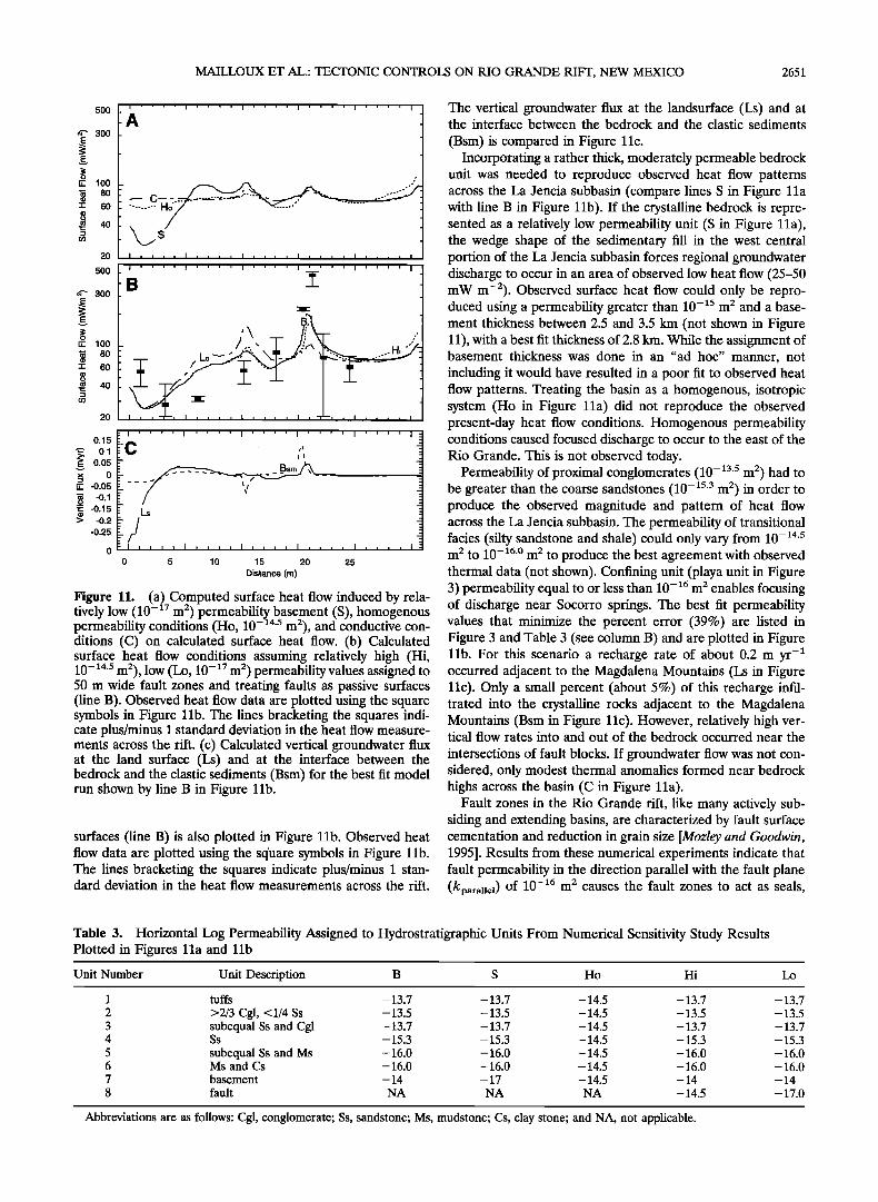
MAILLOUX ET AL.: TECTONIC CONTROLS ON RIO GRANDE RIFT, NEW MEXICO 2651
5OO
4'" 300 E
E v
o •_ 100 • 80
-1- 60
(o 40
20
500 I ' ' ' ' I ' ' ' ' I ' ' ' ' I •' ' ' I ' ' ' ' I 4'" 300 B
• , o
•_ 100 -
• 80 --• / Lo "-' -1- 60
• 40 20 , , , , , , , , , , , , , , ,
I .... I .... I .... I .... I .... I : 0.15 ' -
'"--' C •- 0.1 ,, E• 0.05 -
•_ -0.05 - - -/ • -0.1 •; -o.15 Ls
> -0.2 /./ -0.25
: I .... I , , , • I , • • • I , , , , I , , , , I o
o 5 lO 15 20 25
Distance (m)
Figure 11. (a) Computed surface heat flow induced by re]a- 17 2
tive]¾ low (10- m ) permeability basement (S), homogenous permeability conditions (Ho, l0 -z4'5 m2), and conductive con- ditions (C) on calculated surface heat flow. (b) Calculated surface heat flow conditions assuming relatively high (Hi, l0 -•4'5 m2), low (Lo, l0 -•? m 2) permeability values assigned to 50 m wide fault zones and treating faults as passive surfaces (line B). Observed heat flow data are plotted using the square symbols in Figure l lb. The lines bracketing the squares indi- cate plus/minus i standard deviation in the heat flow measure- ments across the rift. (c) Calculated vertical groundwater flux at the ]and surface (Es) and at the interface between the bedrock and the clastic sediments (Bsm) for the best fit model mn shown by line B in Figure llb.
surfaces (line B) is also plotted in Figure 11b. Observed heat flow data are plotted using the square symbols in Figure l lb. The lines bracketing the squares indicate plus/minus 1 stan- dard deviation in the heat flow measurements across the rift.
The vertical groundwater flux at the landsurface (Ls) and at the interface between the bedrock and the clastic sediments
(Bsm) is compared in Figure 11c. Incorporating a rather thick, moderately permeable bedrock
unit was needed to reproduce observed heat flow patterns across the La Jencia subbasin (compare lines S in Figure 11a with line B in Figure 11b). If the crystalline bedrock is repre- sented as a relatively low permeability unit (S in Figure 11a), the wedge shape of the sedimentary fill in the west central portion of the La Jencia subbasin forces regional groundwater discharge to occur in an area of observed low heat flow (25-50 mW m-2). Observed surface heat flow could only be repro- duced using a permeability greater than 10 -•5 m 2 and a base- ment thickness between 2.5 and 3.5 km (not shown in Figure 11), with a best fit thickness of 2.8 kin. While the assignment of basement thickness was done in an "ad hoc" manner, not including it would have resulted in a poor fit to observed heat flow patterns. Treating the basin as a homogenous, isotropic system (Ho in Figure 11a) did not reproduce the observed present-day heat flow conditions. Homogenous permeability conditions caused focused discharge to occur to the east of the Rio Grande. This is not observed today.
Permeability of proximal conglomerates (10 -•3'5 m 2) had to be greater than the coarse sandstones (10-•s.3 m 2) in order to produce the observed magnitude and pattern of heat flow across the La Jencia subbasin. The permeability of transitional facies (silty sandstone and shale) could only vary from 10 -•4'5 m 2 to 10 -•6'ø m 2 to produce the best agreement with observed thermal data (not shown). Confining unit (playa unit in Figure 3) permeability equal to or less than l0 -•6 m 2 enables focusing of discharge near Socorro springs. The best fit permeability values that minimize the percent error (39%) are listed in Figure 3 and Table 3 (see column B) and are plotted in Figure lib. For this scenario a recharge rate of about 0.2 rn yr -• occurred adjacent to the Magdalena Mountains (Ls in Figure 11c). Only a small percent (about 5%) of this recharge infil- trated into the crystalline rocks adjacent to the Magdalena Mountains (Bsm in Figure 11c). However, relatively high ver- tical flow rates into and out of the bedrock occurred near the
intersections of fault blocks. If groundwater flow was not con- sidered, only modest thermal anomalies formed near bedrock highs across the basin (C in Figure 11a).
Fault zones in the Rio Grande rift, like many actively sub- siding and extending basins, are characterized by fault surface cementation and reduction in grain size [Mozley and Goodwin, 1995]. Results from these numerical experiments indicate that fault permeability in the direction parallel with the fault plane (kparallel) of 10 -•6 m 2 causes the fault zones to act as seals,
Table 3. Horizontal Log Permeability Assigned to Hydrostratigraphic Units From Numerical Sensitivity Study Results Plotted in Figures 11a and lib
Unit Number Unit Description B S Ho Hi Lo
1 tuffs - 13.7 - 13.7 - 14.5 - 13.7 - 13.7
2 >2/3 Cgl, <1/4 Ss - 13.5 - 13.5 - 14.5 - 13.5 - 13.5 3 subequal Ss and Cgl -13.7 -13.7 -14.5 -13.7 -13.7 4 Ss - 15.3 - 15.3 - 14.5 - 15.3 - 15.3
5 subequal Ss and Ms - 16.0 - 16.0 - 14.5 - 16.0 - 16.0 6 Ms and Cs -16.0 -16.0 -14.5 -16.0 -16.0 7 basement - 14 - 17 - 14.5 - 14 - 14 8 fault NA NA NA - 14.5 - 17.0
Abbreviations are as follows: Cgl, conglomerate; Ss, sandstone; Ms, mudstone; Cs, clay stone; and NA, not applicable.
2652 MAILLOUX ET AL.: TECTONIC CONTROLS ON RIO GRANDE RIFT, NEW MEXICO
does not permit outflow at Socorro springs, and does not re- produce the observed surface heat flow (Lo in Figure 11b). Fault permeability (kparanel) of 10 -]4 m 2 (Hi in Figure 11b) 0 and anisotropy less than or equal to 1 (kperpendicular/kparallel) produces relatively high heat flow in the center of the La Jencia -2
Basin and lower heat flow at Socorro Hot Springs when com- pared to a passive fault zone (B in Figure 11b). Both relatively
-4
high and low permeability fault zones short circuit Socorro Hot 0 Springs and focused discharge (and hence relatively high sur- face heat flow) to occur in the center of the La Jencia Basin, which is not observed in the present-day heat flow data. Rep- resenting the faults as neither permeable nor impermeable 0 surfaces created the most focused discharge at Socorro Hot Springs and produced the best fit to observed conditions (Fig- ure 11c). It should be noted that none of the numerical exper- I::: iments could account for the exceptionally high heat flow at I• -4 0 Socorro Hot Springs. This may be due to the boundary condi- ._O tion used in our model at the land surface (constant temper- ature rather than a convective boundary condition, Xzz O T/
i
Oz = 0). m o
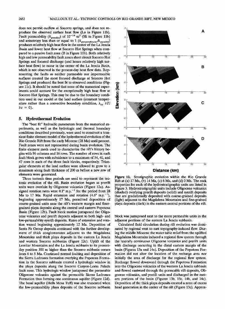
5. Hydrothermal Evolution The "best fit" hydraulic parameters from the numerical ex-
periments, as well as the hydrologic and thermal boundary conditions described previously, were used to construct a tran- sient finite element model of the hydr. othermal evolution of the Rio Grande Rift from the early Miocene (28 Ma) until present. Fault zones were not represented during basin evolution. The finite element mesh used to characterize the rift's history be- gins with 96 columns and 16 rows. The number of rows in each fault block grows with subsidence to a maximum of 54, 40, and 47 rows in each of the three fault blocks, respectively. Trian- gular elements at the land surface were allowed to grow to a maximum along fault thickness of 200 m before a new row of elements were generated.
Three tectonic time periods are used to represent the tec- tonic evolution of the rift. Basin evolution began as prerift units were overlain by Oligocene volcanics (Figure 12a). As- signed rotation rates were 0.1 ø m.y. -] for the period from 28 Ma to 17 Ma. Rapid extension and rotation (4.6 ø m.y.-]), beginning approximately 17 Ma, permitted deposition of coarse-grained units near the rift's western margin and finer- grained playa deposits along the central and eastern Popotosa Basin (Figure 12b). Fault block motion juxtaposed the Oligo- cene volcanics and prerift deposits adjacent to both high- and low-permeability synrift deposits. Rates of extension and rota- tion waned beginning approximately 12 Ma. Deposition of Santa Fe Group deposits continued with the further develop- ment of thick conglomerates adjacent to the Magdalena Mountains and thick playa deposits in the eastern La Jencia and western Socorro subbasins (Figure 12c). Uplift of the Lemitar Mountains and the La Jencia subbasin to its present- day position 300 m higher than the Socorro subbasin occurs from 6 to 5 Ma. Continued normal faulting and deposition of the Sierra Ladrones formation overlying the Popotosa Forma- tion in the Socorro subbasin created a hydrologic window in the playa deposits along the Socorro Canyon-Loma Peleda fault zone. This hydrologic window juxtaposed the permeable Oligocene volcanics against the permeable Sierra Ladrones Formation thus forming one continuous aquifer (Figure 12d). The basal aquifer (Hells Mesa Tuff) was also truncated when the low-permeability playa deposits of the Socorro subbasin
2O
A
B
• 1•0 1•5 2•0 2•5 3•0
c
20 25 30
2
-4 • 10 1•5 20 25
D
Distance (km)
Figure 12. Stratigraphic evolution within the Rio Grande Rift at (a) 17 Ma, (b) 14 Ma, (c) 6 Ma, and (d) 0 Ma. The rock properties for each of the hydrostratigraphic units are listed in Figure 3. Hydrostratigraphic units include Oligocene volcanics (shaded) overlying prerift deposits (solid) and synrift deposits that are gradationally deposited with coarse-grained deposits (light) adjacent to the Magdalena Mountains and fine-grained playa deposits (dark) in the eastern central portions of the rift.
block was juxtaposed next to the more permeable units in the adjacent portions of the eastern La Jencia subbasin.
Calculated fluid circulation during rift evolution was domi- nated by regional west to east topography-induced flow. Dur- ing the middle Miocene the water table relief from the uplifted Magdalena Mountains induced a regional flow system through the laterally continuous Oligocene volcanics and prerift units with discharge occurring in the distal eastern margin of the basin (Figures 13a and 14a). Deposition of the Popotosa For- mation did not alter the location of the recharge area nor initially the area of discharge for the regional flow system. Recharge flowed downward through the Popotosa Formation into the Oligocene volcanics of the western La Jencia subbasin and flowed eastward through the permeable rift deposits, Oli- gocene volcanics, and prerift units and discharged in the east- ern portions of the basin (Figures 13b, 13c, 14b, and 14c). Deposition of the thick playa deposits created a zone of excess head generation in the center of the rift (Figure 13c). Approx-
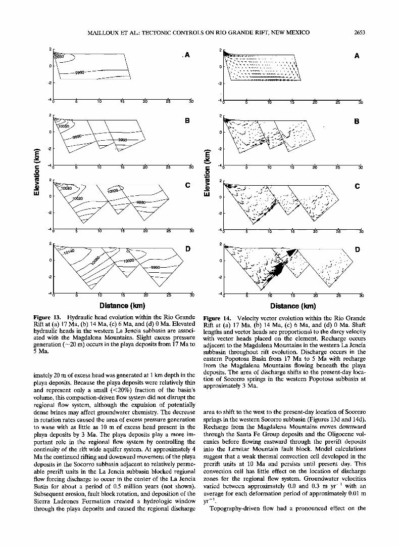
MAILLOUX ET AL.: TECTONIC CONTROLS ON RIO GRANDE RIFT, NEW MEXICO 2653
2
9990
-2
-4 0 • 1'0 1•5
,A
2•0 2'5 3•0
A
-4 0 • 1'0 1'5 2•0 2•5 3•0
-4 3O -4
I• '40 • 1• 1• •0 2• 3• I• .O_ O
_.e 08• C >
0 5 1• 1• 20 2•
-4 0 5 10 1'5 2'0 25 30
c
2 2
0 0
-2 -2
-4 0 • 1•0 1'5 2'0 2'5 3•0
Distance (krn)
Figure 13. Hydraulic head evolution within the Rio Grande Rift at (a) 17 Ma, (b) 14 Ma, (c) 6 Ma, and (d) 0 Ma. Elevated hydraulic heads in the western La Jencia subbasin are associ- ated with the Magdalena Mountains. Slight excess pressure generation (-20 m) occurs in the playa deposits from 17 Ma to 5 Ma.
imately 20 m of excess head was generated at 1 km depth in the playa deposits. Because the playa deposits were relatively thin and represent only a small (<20%) fraction of the basin's volume, this compaction-driven flow system did not disrupt the regional flow system, although the expulsion of potentially dense brines may affect groundwater chemistry. The decrease in rotation rates caused the area of excess pressure generation to wane with as little as 10 m of excess head present in the playa deposits by 3 Ma. The playa deposits play a more im- portant role in the regional flow system by controlling the continuity of the rift wide aquifer system. At approximately 4 Ma the continued rifting and downward movement of the playa deposits in the Socorro subbasin adjacent to relatively perme- able prerift units in the La Jencia subbasin blocked regional flow forcing discharge to occur in the center of the La Jencia Basin for about a period of 0.5 million years (not shown). Subsequent erosion, fault block rotation, and deposition of the Sierra Ladrones Formation created a hydrologic window through the playa deposits and caused the regional discharge
-4 0 • 1'0 1'5 •0 25 3•
Distance (kin)
Figure 14. Vcloci• vector evolution within the Rio Grande Rift at (a) 17 Ma, (b) 14 Ma, (c) 6 Ma, and (d) 0 Ma. Shaft lengths and vector heads arc proportional to the darcy vcloci• with vector heads placed on the clement. Recharge occurs adjacent to the Magdalcna Mountains in the western La Jcncia subbasin throughout rift evolution. Discharge occurs in the eastern Popotosa Basin from 17 Ma to 5 Ma with recharge from the Magdalcna Mountains flowing beneath the playa deposits. The area of discharge shifts to the present-day loca- tion of Socorro springs in the western Popotosa subbasin at approximately 3 Ma.
area to shift to the west to the present-day location of Socorro springs in the western Socorro subbasin (Figures 13d and 14d). Recharge from the Magdalena Mountains moves downward through the Santa Fe Group deposits and the Oligocene vol- canics before flowing eastward through the prerift deposits into the Lemitar Mountain fault block. Model calculations
suggest that a weak thermal convection cell developed in the prerift units at 10 Ma and persists until present day. This convection cell has little effect on the location of discharge zones for the regional flow system. Groundwater velocities varied between approximately 0.0 and 0.3 m yr -• with an average for each deformation period of approximately 0.01 m
--1 yr .
Topography-driven flow had a pronounced effect on the
2654 MAILLOUX ET AL.: TECTONIC CONTROLS ON RIO GRANDE RIFT, NEW MEXICO
A
I• -4• • 1'0 1'5 2•0 2'5 3}) ._o
D
D ista nce (km)
•EE150 .... 0 14', ø• 100 ,T ,'"" 6 . ,', ...,•/...:-;1..7. '/: ß 1- 50
0h'"•?'., •, ,, •, ,, , ,, 0 20 40 60 80
Finite Element Colqmn
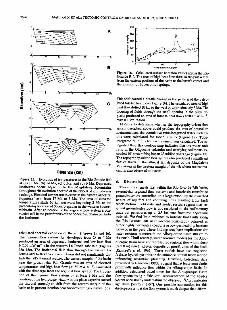
Figure 16. Calculated surface heat flow values across the Rio Grande Rift. The area of high heat flow shifts in the past 4 m.y. from the eastern portions of the basin to the basin's center and the location of Socorro hot springs.
This shift caused a drastic change in the pattern of the calcu- lated surface heat flow (Figure 16). The calculated area of high heat flow shifted 10 km to the west by approximately 3 Ma. The focusing of fluids through the small opening in the playa de- posits produced an area of intense heat flow (>200 mW m -2) over a 1 km region.
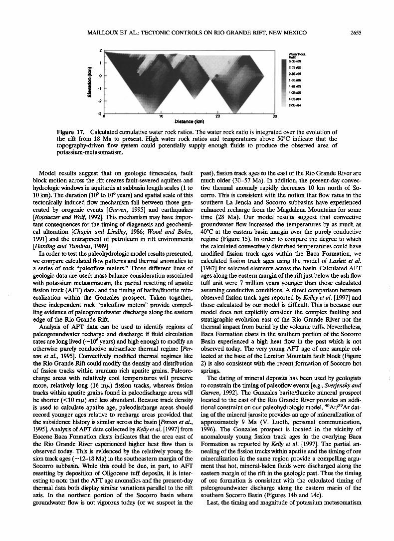
In order to determine whether the topography-driven flow system described above could produce the area of potassium metasomatism, the cumulative time-integrated water rock ra- tios were calculated for model results (Figure 17). Time- integrated fluid flux for each element was calculated. The in- tegrated fluid flux contour map indicates that the water rock ratio in the Oligocene volcanics and overlying sediments ex- ceeded 104 since rifling began 28 million years ago (Figure 17). The topography-driven flow system also produced a significant flux of fluids in the alluvial fan deposits of the Magdalena Mountains at the western margin of the rift where metasoma- tism is also observed to occur.
Figure 15. Evolution of temperatures in the Rio Grande Rift at (a) 17 Ma, (b) 14 Ma, (c) 6 Ma, and (d) 0 Ma. Depressed isotherms occur adjacent to the Magdalena Mountains throughout rift evolution because of the effects of groundwater recharge. Elevated temperatures occur in the eastern ancestral Popotosa basin from 17 Ma to 5 Ma. The area of elevated temperatures shifts 10 km westward beginning 3 Ma to the present-day location of Socorro Springs in the western Socorro subbasin. After truncation of the regional flow system a con- vective cell in the prerift units of the Socorro subbasin perturbs the isotherms.
calculated thermal evolution of the rift (Figures 15 and 16). The regional flow system that developed from 28 to 4 Ma produced an area of depressed isotherms and low heat flow (<100 mW m -2) in the western La Jencia subbasin (Figures 15a-15c). The horizontal fluid flow through the eastern La Jencia and western Socorro subbasin did not significantly dis- turb the rifi's thermal regime. The eastern margin of the basin near the present day Rio Grande was an area of elevated temperatures and high heat flow (>150 mW m -2) associated with the discharge from the regional flow system. The trunca- tion of the regional flow system by at least 3 Ma and the creation of the hydrologic window in the playa deposits caused the thermal anomaly to shift from the eastern margin of the basin to its present location near Socorro Springs (Figure 15d).
6. Discussion
This study suggests that within the Rio Grande Rift basin, present-day regional flow patterns and interbasin transfer of groundwater are controlled, to a large extent, by the dissected nature of aquifers and confining units resulting from fault block motion. Field data and model results suggest that re- gional groundwater flow is not restricted to the sedimentary units but penetrates up to 2.8 km into fractured crystalline bedrock. We find little evidence to indicate that faults along the Rio Grande Rift near Socorro consistently behaved as either highly permeable conduits or low-permeability barriers today or in the past. These findings may have implications for water resource planners in the Albuquerque Basin 100 km to the north. Until recently, water resource models for the Albu- querque Basin have not represented regional flow within deep (>500 m) synrift alluvial deposits or prerift units of the basin [Kernoodle et al., 1995]. These models have also neglected faults as hydrologic units or the influence of fault block motion influencing subsurface plumbing. However, hydrologic data presented by Haneberg [1995b] suggest that at least some faults profoundly influence flow within the Albuquerque Basin. In addition, calculated travel times for the Albuquerque Basin flow system using a "shallow" representation of the aquifer system consistently underestimated observed •4C groundwater age dates [Sanford, 1997]. One possible explanation for this discrepancy is that the flow system is much deeper than 500 m.
MAILLOUX ET AL.: TECTONIC CONTROLS ON RIO GRANDE RIFT, NEW MEXICO 2655
o 30
Distance (km)
ß : I AE+0'5 :: .:
Figure 17. Calculated cumulative water rock ratios. The water rock ratio is integrated over the evolution of the rift from 18 Ma to present. High water rock ratios and temperatures above 50øC indicate that the topography-driven flow system could potentially supply enough fluids to produce the observed area of potassium-metasomatism.
Model results suggest that on geologic timescales, fault block motion across the rift creates fault-severed aquifers and hydrologic windows in aquitards at subbasin length scales (1 to 10 km). The duration (10 s to 10 6 years) and spatial scale of this tectonically induced flow mechanism fall between those gen- erated by orogenic events [Garven, 1995] and earthquakes [Rojstaczer and Wolf, 1992]. This mechanism may have impor- tant consequences for the timing of diagenesis and geochemi- cal alteration [Chapin and Lindley, 1986; Wood and Boles, 1991] and the entrapment of petroleum in rift environments [Harding and Tuminas, 1989].
In order to test the paleohydrologic model results presented, we compare calculated flow patterns and thermal anomalies to a series of rock "paleoflow meters." Three different lines of geologic data are used: mass balance consideration associated with potassium metasomatism, the partial resetting of apatite fission track (AFT) data, and the timing of barite/fluorite min- eralization within the Gonzales prospect. Taken together, these independent rock "paleoflow meters" provide compel- ling evidence of paleogroundwater discharge along the eastern edge of the Rio Grande Rift.
Analysis of AFT data can be used to identify regions of paleogroundwater recharge and discharge if fluid circulation rates are long lived ('-•10 6 years) and high enough to modify an otherwise purely conductive subsurface thermal regime [Per- son et al., 1995]. Convectively modified thermal regimes like the Rio Grande Rift could modify the density and distribution of fission tracks within uranium rich apatite grains. Paleore- charge areas with relatively cool temperatures will preserve more, relatively long (16 mt•) fission tracks, whereas fission tracks within apatite grains found in paleodischarge areas will be shorter (<10 m/•) and less abundant. Because track density is used to calculate apatite age, paleodischarge areas should record younger ages relative to recharge areas provided that the subsidence history is similar across the basin [Person et al., 1995]. Analysis of AFT data collected by Kelly et al. [1997] from Eocene Baca Formation clasts indicates that the area east of
the Rio Grande River experienced higher heat flow than is observed today. This is evidenced by the relatively young fis- sion track ages (•12-18 Ma) in the southeastern margin of the Socorro subbasin. While this could be due, in part, to AFT resetting by deposition of Oligocene tuff deposits, it is inter- esting to note that the AFT age anomalies and the present-day thermal data both display similar variations parallel to the rift axis. In the northern portion of the Socorro basin where groundwater flow is not vigorous today (or we suspect in the
past), fission track ages to the east of the Rio Grande River are much older (30-57 Ma). In addition, the present-day convec- tive thermal anomaly rapidly decreases 10 km north of So- corro. This is consistent with the notion that flow rates in the
southern La Jencia and Socorro subbasins have experienced enhanced recharge from the Magdalena Mountains for some time (28 Ma). Our model results suggest that convective groundwater flow increased the temperatures by as much as 40øC at the eastern basin margin over the purely conductive regime (Figure 15). In order to compare the degree to which the calculated convectively disturbed temperatures could have modified fission track ages within the Baca Formation, we calculated fission track ages using the model of Laslett et al. [1987] for selected elements across the basin. Calculated AFT ages along the eastern margin of the rift just below the ash flow tuff unit were 7 million years younger than those calculated assuming conductive conditions. A direct comparison between observed fission track ages reported by Kelley et al. [1997] and those calculated by our model is difficult. This is because our model does not explicitly consider the complex faulting and stratigraphic evolution east of the Rio Grande River nor the thermal impact from burial by the volcanic tuffs. Nevertheless, Baca Formation clasts in the southern portion of the Socorro Basin experienced a high heat flow in the past which is not observed today. The very young AFT age of one sample col- lected at the base of the Lemitar Mountain fault block (Figure 2) is also consistent with the recent formation of Socorro hot springs.
The dating of mineral deposits has been used by geologists to constrain the timing of paleoflow events [e.g., Sverjensky and Garven, 1992]. The Gonzales barite/fluorite mineral prospect located to the east of the Rio Grande River provides an addi- tional constraint on our paleohydrologic model. 4ømr/39Ar dat- ing of the mineral jarosite provides an age of mineralization of approximately 9 Ma (V. Lueth, personal communication, 1996). The Gonzales prospect is located in the vicinity of anomalously young fission track ages in the overlying Baca Formation as reported by Kelly et al. [1997]. The partial an- nealing of the fission tracks within apatite and the timing of ore mineralization in the same region provide a compelling argu- ment that hot, mineral-laden fluids were discharged along the eastern margin of the rift in the geologic past. Thus the timing of ore formation is consistent with the calculated timing of paleogroundwater discharge along the eastern marin of the southern Socorro Basin (Figures 14b and 14c).
Last, the timing and magnitude of potassium metasomatism
2656 MAILLOUX ET AL.: TECTONIC CONTROLS ON RIO GRANDE RIFT, NEW MEXICO
of the Hells Mesa Tuff provides a qualitative constraint on our model. Chapin and Lindley [1986] argue that the metasoma- tism took place at temperatures which ranged between 50 ø and 90øC. Age dating by Dunbar et al. [1994] indicates that the tuffs were altered between 15 and 8 Ma. Model results indicate that
the basal volcanic aquifer directly below the land surface was heated above 50øC in the time period from 13 to 8 Ma (Figure 15). Assuming the potassium added to the Hells Mesa Tuff aquifer calculated by Chapin and Lindley [1986] is correct and that only 10% of the dissolved potassium was utilized in meta- somatic reactions, a potassium concentration of only 8 mg L-1 could have metasomatized the rocks of the Socorro and La
Jencia subbasins in approximately 5 million years. This potas- sium concentration is consistent with present-day potassium concentrations measured in shallow wells near Socorro [Ander- holm, 1987]. This does not prove that dilute fluids impelled by topography-driven groundwater flow were responsible for ob- served potassium metasomatism within the Hells Mesa Tuff. However, it does demonstrate that mass balance constraints are satisfied. The actual amount of potassium removed from solution would depend on temperature and pressure gradients within the Hells Mesa Tuff [Giggenbach, 1988]. Additional potassium diffusion may have also been contributed by haline convection from the playas and would decrease the time re- quired to metasomatize the tuffs and overlying units [Leising et al., 1995]. Incorporation of reactive solute transport processes into the numerical model could further constrain the potential source and concentration of potassium along with the mecha- nism that produced the large area of metasomatism.
7. Conclusions
Mathematical modeling has been used in this study to gain insight into how fault block motion within the La Jencia and Socorro subbasins of the Rio Grande Rift basin may control the present-day and paleogroundwater flow patterns. Two- dimensional finite element models of coupled domino-style fault block rotation, groundwater flow, and heat transfer were constructed for a cross-sectional transect across the rift near
Socorro, New Mexico. Integration of a domino-style fault block rotation algorithm which utilized special four-node tri- angular slip elements enabled us to generate a realistic depic- tion of the geometric evolution of the rift through time.
The model was first calibrated to determine plausible hy- draulic characteristics of fault zones, basement involvement within the regional flow system, and the permeability of the clastic sediments. Shallow heat flow data were used as the
primary means of model calibration. A best fit to modern heat flow data was achieved by incorporating a thick (2.8 km) layer of relatively permeable (10 -14'ø m 2) prerift sediments. While faults played an important role in modifying the juxtaposition of aquifers and confining units, we found little evidence to suggest that they acted as either barriers or conduits for fluid flow. Results from the numerical experiments highlight the importance of fault block rotation in forming a hydrologic window through playa deposits near Socorro Hot Springs.
The "calibrated" model was then used to reconstruct the
paleohydrology of the basin during the past 28 Ma. During the middle to late Miocene (28-6 Ma) a regional topography- driven groundwater flow system induced groundwater recharge to flow eastward through synrift deposits and the underlying 2 km of fractured crystalline rocks to the eastern margins of the Socorro basin. Compaction-driven flow occurred within the
low-permeability playa deposits during periods of rapid fault block rotation between 15 and 5 Ma. Groundwater flow to the
east of the Rio Grande River generated a region of high heat flow between 5 and 15 Ma. Juxtaposition of thick playa depos- its against more permeable synrift deposits associated with uplift of the Lemitar Mountains truncated the regional groundwater flow system and caused the convective thermal anomaly within the discharge area to shift westward to the base of Socorro Peak at the southern end of the Lemitar Mountains.
The model results are consistent with the present-day location of Socorro Hot Springs, the relatively young (4 Ma) fission track ages of Proterozoic outcrops at the base of Socorro Peak, the total annealing of apatite fission tracks in clasts of the Eocene Baca Formation to the east of Socorro, the formation of large areas of potassium metasomatism within Oligocene volcanics and overlying Santa Fe Group deposits, and the tim- ing of barite/fluorite ore mineralization within the Gonzales prospect on the eastern edge of the Rio Grande Rift. Model calculations indicate that about 5% of mountain front recharge to bedrock infiltrates to depths of 2.8 km below the sedimen- tary pile. These results may have implications for water re- source planners who have historically focused on groundwater resource development within the shallow (<1 km) alluvial de- posits along the Rio Grande Rift valley.
Appendix: Equations
Below are the equations which describe domino-style fault block rotation, compaction-, topography-, and buoyancy- driven groundwater flow, and conductive/convective heat transfer.
porous media deformation Number of
X m' Blocks nodes(i) X m 5] i=0 rn=0
* -sin (a) cos (a) + Zc] (1)
W'n = * (cos + sin (/3) ) ß
tan (y + /3) (2)
Xc' = Xc'
x-;': Jc;'-' + ran-'+ mn
- [(Zic- Zic -') ß tan (,/+/3 - 90)]
i=1
i>1
(3)
4• = C• o e -Bs•e (4)
fluid flow
Oh ps - & OL ) OT Ss Ot pl Ot' - err Ot 1 p& ax az /
dh qx=-m
qz = - txf[ k= • -nt- kzz '• 'nt- Pr
(6)

MAILLOUX ET AL.: TECTONIC CONTROLS ON RIO GRANDE RIFT, NEW MEXICO 2657
kx• = kmax sin 2 0 + kmi n cos 2 0
k= = kma x cos 2 0 q- kmin sin 2 0
kxz = k•x = (kmax- kmin) sin 0 cos 0
conductive/convective heat flow
aT p•h• ark [p•c• + psCs(1 - rk)] •- + (1 - rk) at
a( or or) or = OX' Xxx-• + Xxz-• --qxpfCfox
x=3- aT) aT + x= 37 -
X= Xz•J =x•b+xs(1-rk) 0 1 +p•c• D•x D= (dlqx 2 + dlq• 2) (dlqx 2 + dlq• 2)
Dx• = (qx 2 + qz2)l/2 Dzz = (qx 2 + q•2)1/2 (dl- dl)qxqz
Dxz = D= = (qx 2 + qz2)l/2 equations of state
(7)
(8)
(9)
(10)
1 --=A - BT- CT 2 (11) PI
m = •0(1 +/3T) (12)
Notation
x distance from origin (m). z elevation above datum (m).
x m, z m Cartesian coordinate of node rn. X•c, Z• centroid location of fault block i.
I4nn new width of fault block i. W'o original width of block i.
7 original fault dip measured from horizontal with counterclockwise positive (degrees).
8 total amount of rotation with counterclockwise
positive (degrees). a amount of rotation between each time step
(degrees). rk porosity (dimensionless).
rko porosity at the land surface (dimensionless). Bs porosity fit coefficient (m-l). Vs velocity of the solid phase in the z direction
rr e effective stress (m). h equivalent freshwater hydraulic head (m). t time (s).
Ss specific storage (m-l). L height of land surface above datum (m).
ar thermal expansivity of fluid (dimensionless). T temperature (øC).
Pf, Ps density of the fluid and solid phase (kg m-3).
Or relative density (Ps - PI). PI Po density at standard state conditions (m 3 qx horizontal Darcy velocity through aquifer of
thickness b (m s-l).
q z vertical Darcy velocity with respect to a moving coordinate framework (m s- 1).
kxx, kxz principal directions of the intrinsic permeability k zx, k zz tensor (m2).
kmax, kmi n permeability parallel (maximum) and perpendicular (minimum) to bedding (m2).
•f dynamic viscosity of the fluid (kg m -1 s-l). q amount of rotation at each node (degrees).
cf, cs specific capacities of the fluid and solid phases (J øC-1 kg-1).
h f specific enthalpy of the fluid (J kg-1). Xxx, Xxz principal components of the thermal Xzx, Xzz conductivity tensor (W øC-1 m-l).
D xx, D xz principal directions of the dispersivity tensor (m).
Xp Xs thermal conductivity of the fluid and solid (W øC-1 m-l).
all, dt longitudinal and transverse dispersivity (m). .4, B, C temperature dependent fitted polynomials.
/.rø hypothetical zero-pressure viscosity (Pa s). b pressure coefficient of viscosity (10 9 Pa). p fluid pressure (10 9 Pa).
Acknowledgments. Parts of this research were supported by grants from the National Science Foundation under EAR93-04873 and
EAR94-05807 and the Petroleum Research Fund, administered by the American Chemical Society under PRF 32479-AC2. Special thanks go to Chris Duffy of Penn State University, Jacquiline Huntoon of Mich- igan Tech, and Stephan Matthai of the Swiss Federal Institute of Technology for their insightful reviews of this manuscript. We grate- fully acknowledge S.S. Papadopulos and Associates for use of their computational resources during this project.
References
Anderholm, S. K., Hydrogeology of the Socorro and La Jencia basins, Socorro county, New Mexico, Field Conf. Guideb. N.M. Geol. Soc., 34, 303-310, 1983.
Anderholm, S. K., Hydrogeology of the Socorro and La Jencia Basins, Socorro County, New Mexico, U.S. Geol. Surv. Water Resour. Invest. Rep., 84-4342, 1987.
Antonellini, M., and A. Aydin, Effect of faulting on fluid flow in porous sandstones: Petrophysical properties, AAPG Bull., 78, 355-377, 1994.
Aydin, A., R. Meyers, and A. Younes, Faults: Seal or migration path- ways? Yes, no, some are but some aren't, and some faults are but only sometimes, paper presented at Annual Meeting, Am. Assoc. of Pet. Geol., Salt Lake City, Utah, May 17-20, 1998.
Barroll, M. W., and M. Reiter, Analysis of the Socorro hydrogeother- mal system: Central New Mexico, J. Geophys. Res., 95, 21,949- 21,963, 1990.
Barton, C. A., M.D. Zoback, and D. Moos, Fluid flow along poten- tially active fault zones, Geology, 23, 683-686, 1995.
Berg, R. R., and A. H. Avery, Sealing properties of Tertiary growth faults, Texas Gulf Coast, AAPG Bull., 79, 375-393, 1995.
Bethke, C. M., A numerical model of compaction-driven groundwater flow and heat transfer and its application to the paleo flow of intracratonic sedimentary basins, J. Geophys. Res., 90, 6817-6828, 1985.
Cather, S. M., Laramide Sierra uplift: evidence for major pre-rift uplift in central and southern New Mexico, Field Conf. Guideb. N.M. Geol. Soc., 34, 99-101, 1983.
Cather, S. M., R. M. Chamberlin, C. E. Chapin, and W. C. Mcintosh, Stratigraphic consequences of episodic extension in the Lemitar Mountains, central Rio Grande rift, in Basins of the Rio Grande Riff: Structure, Stratigraphy, and Tectonic Setting, edited by G. R. Keller, and S. M. Cather, Spec. Pap. Geol. Soc. Am., 291, 157-170, 1994.
Chamberlin, R. M., Cenozoic domino-style crustal extension in the Lemitar Mountains, New Mexico: A summary, Field Conf. Guideb. N.M. Geol. Soc., 34, 111-118, 1983.
2658 MAILLOUX ET AL.: TECTONIC CONTROLS ON RIO GRANDE RIFT, NEW MEXICO
Chapin, C. E., and S. M. Cather, Tectonic setting of the axial basins of the northern and central Rio Grande rift, in Basins of the Rio Grande Riff: Structure, Stratigraphy, and Tectonic Setting, edited by G. R. Keller, and S. M. Cather, Spec. Pap. Geol. Sac. Am., 291, 5-25, 1994.
Chapin, C. E., and J. I. Lindley, Potassium metasomatism of igneous and sedimentary rocks in detachment terranes and other sedimen- tary basins: Economic implications, Ariz. Geol. Sac. Dig., 16, 118- 125, 1986.
Chapin, C. E., and W. R. Seager, Evolution of the Rio Grande rift in the Socorro and Las Cruces areas, Field Conf. Guideb. N.M. Geol. Sac., 26, 297-321, 1975.
Davis, M. J., R. C. Lohman, F. M. Phillips, J. L. Wilson, and D. W. Love, Architecture of the Sierra Ladrones Formation, central New Mexico: Depositional controls on the permeability correlation struc- ture, Geol. Sac. Am. Bull., 105, 998-1007, 1993.
de Marsily, G., Quantitative Hydrogeology, 440 pp., Academic, San Diego, Calif., 1986.
Detmer, D., Permeability, porosity, and grain-size distribution of se- lected Pliocene and Quaternary sediments in the Albuquerque Ba- sin, N.M. Geol., 17(4), 79-87, 1995.
Duffy, C. J., and S. Al-Hassan, Groundwater circulation in a closed desert basin: Topographic scaling and climatic forcing, Water Resour. Res., 24, 1675-1688, 1988.
Dunbar, N. W., C. E. Chapin, D. J. Ennis, and A. R. Campbell, Trace element and mineralogical alteration associated with moderate and advanced degrees of K-metasomatism in a rift basin at Socorro, New Mexico, Field Conf. Guideb. N.M. Geol. Sac., 45, 225-231, 1994.
Eisenberg, R., R. Brenneman, A. Adeogba, and U. K. Acharaya, Char- acterization of fault seals and their effects on hydrocarbon distribu- tion and reservoir performance, paper presented at Annual Meet- ing, Am. Assoc. of Pet. Geol., Salt Lake City, Utah, May 17-20, 1998.
Flemings, P. B., M. H. Bennett, P. Hicks, C. A. Shaw, and W. A. Symington, Simulation of secondary migration in faults: Dynamic controls on hydrocarbon column height, paper presented at Annual Meeting, Am. Assoc. of Pet. Geol., Salt Lake City, Utah, May 17-20, 1998.
Gabin, V. L., and L. E. Lesperance, New Mexico Climatological Data, Precipitation, Temperature, Evaporation and Wind, Monthly and An- nual Means 1850-1975, 436 pp., W. K. Summers, Socorro, N.M., 1977.
Garven, G., Continental-scale groundwater flow and geologic pro- cesses, Annu. Rev. Earth Planet. Sci., 23, 89-117, 1995.
Garven, G., and R. A. Freeze, Theoretical analysis of the role of groundwater flow in the genesis of stratabound ore deposits, 1, Mathematical and numerical model, Am. J. Sci., 284, 1085-1124, 1984.
Giggenbach, W. F., Geothermal solute equilibria: Derivation of Na- K-Ca geoindicators, Geachim. Casmachim. Acta, 52, 2749-2765, 1988.
Gross, G. W., and R. Wilcox, Groundwater circulation in the Socorro geothermal area, Field Conf. Guideb. N.M. Geol. Sac., 34, 311-318, 1983.
Haneberg, W. C., Depth-porosity relationships and virgin specific stor- age estimates for the upper Santa Fe Group aquifer system, central Albuquerque Basin, New Mexico, N.M. Geol., 17(4), 62-71, 1995a.
Haneberg, W. C., Steady state groundwater flow across idealized faults, Water Resour. Res., 31, 1815-1820, 1995b.
Hantush, M. S., Aquifer tests on partially penetrating wells, J. Hydraul. Div. Am. Sac. Civ. Eng., 87(5), 171-195, 1961.
Harding, T. P., and A. C. Tuminas, Structural interpretation of hydro- carbon traps sealed by basement normal block faults at stable flank of foredeep basins and at rift basins, A,4PG Bull., 73, 812-840, 1989.
Hawkins, D. B., and D. B. Stephens, Geothermal data availability for computer simulation in the Socorro Peak KGRA, Socorro County, N.M., in State-Coupled Low Temperature Geothermal Resource As- sessment Program, Fiscal Year 1980, final technical report, edited by L. Icerman et al., 2-11-2-89, N.M. State Univ., Las Cruces, 1981.
Hawley, J. W., C. S. Haase, and R. P. Lozinsky, An underground view of the Albuquerque Basin, in Proceedings of the 39th Annual New Mexico Water Conference, The Water Future of Albuquerque and the Middle Rio Grande Basin, edited by C. T. Ortega-Klett, pp. 37-55, N.M. Water Resour. Inst., Albuquerque, 1994.
Henderson, I. H. C., and A.M. McCaig, Fluid pressures and salinity variations in shear zone-related veins, central Pyrenees, France:
Implications for fault-valve model, Tectanaphysics, 262, 321-348, 1996.
Hullen, J. B., J. A. Collster, N. F. Dahdah, P. E. Wannamaker, and J. C. Quick, Hydrocarbons in Miocene Lamprolitedikes of the San Fafael Dessert, Utah-Implications for fault-controlled oil migration and accumulation in the western Colorado Plateau, paper presented at Annual Meeting, Am. Assoc. of Pet. Geol., Salt Lake City, Utah, May 17-20, 1998.
Huntoon, P. W., Fault severed aquifers along the perimeters of Wyo- ming artesian basins, Ground Water, 23, 176-181, 1985.
Kelley, S. A., C. E. Chapin, and J. Corrigan, Late Mesozoic to Ceno- zoic cooling histories of the flanks of the northern and central Rio Grande rift, Colorado and New Mexico, Bull. N.M. Bur. Mines Miner. Resour., 145, 40 pp., 1992.
Kelley, S. A., C. E. Chapin, S. M. Cather, and M. Person, Paleohy- drology and thermal history of the Carthage-La Joya basin, Socorro county, New Mexico, Geol. Sac. Am. Abstr. Programs, 29(2), 17, 1997.
Kernodle, J. M., D. P. McAda, and C. R. Thorn, Simulation of ground- water flow in the Albuquerque Basin, central New Mexico 1901- 1994, with projections to 2020, U.S. Geol. Surv. Water Resour. Invest. Rep., 94-4251, 1995.
Kestin, J., H. E. Khalifa, and R. J. Correia, Tables of the dynamic and kinematic viscosity of aqueous NaC1 solutions in the temperature range of 20-150o•C and the pressure range of 0.1-35 MPa, J. Phys. Chem. Ref. Data, 10, 71-87, 1981.
Laslett, G. M., P. F. Green, I. R. Duddy, and A. J. W. Gleadow, Thermal annealing of fission tracks in apatite, 2, A quantitative analysis, Chem. Geol., 65, 1-13, 1987.
Leising, J. F., S. W. Tyler, and W. W. Miller, Convection of saline brines in enclosed lacustrine basins: A mechanism for potassium metasomatism, Geol. Sac. Am. Bull., 107(10), 1157-1163, 1995.
Machette, M. N., Geologic map of the San Acacia quadrangle, Socorro County, New Mexico, Geol. Quadrangle Map GQ-1415, scale 1:24,000, U.S. Geol. Surv., Reston, Va., 1978a.
Machette, M. N., Late Cenozoic geology of the San Acacia-Bernardo area, Circ. N.M. Bur. Mines Miner. Resour., 163, 135-137, 1978b.
Magee, M. E., and M.D. Zoback, Evidence for a weak interplate thrust fault along the northern Japan subduction zone and implica- tions for the mechanics of thrust faulting and fluid expulsion, Geal- agy, 21, 809-812, 1993.
Mailloux, B. J., Tectonic controls on the hydrothermal evolution of the La Jencia and Socorro sub-basins of the Rio Grande Rift, New Mexico, M.S. thesis, Univ. of Minnesota, Minneapolis, 1997.
Matthai, S. K., and G. Fischer, Quantitative modeling of fault-fluid- discharge and fault dilation-induced fluid-pressure variations in the seismogenic zone, Geology, 24, 183-186, 1996.
McKenzie, D. P., Some remarks on the development of sedimentary basins, Earth Planet. Sci. Lett., 40, 25-32, 1978.
Mercer, J. W., S. D. Thomas, and B. Rose, Parameters and variables appearing in repository siting models, NUREG/CR-3066, U.S. Nucl. Regul. Comm., Washington, D.C., 1982.
Moore, J. C., G. F. Moore, G. R. Cochrane, and H. J. Tobin, Negative- polarity seismic reflections along faults of the Oregon accrectionary prism: Indicators of overpressuring, J. Geaphys. Res., 100, 12,895- 12,906, 1995.
Morgan, P., V. Harder, C. A. Swanberg, and P. H. Daggett, A ground- water convection model for the Rio Grande rift geothermal re- sources, Trans. Geatherm. Resour. Caunc., 5, 193-196, 1981.
Mozley, P.S. and L. B. Goodwin, Patterns of cementation along a Cenozoic normal fault: A record of paleoflow orientations, Geology, 236, 539-542, 1995.
Mozley, P., J. Beckner, and T. M., Whitworth, Spatial distribution of calcite cement in the Santa Fe Group, Albuquerque Basin, NM: Implications for ground-water resources, N.M. Geol., 17(4), 88-93, 1995.
Nelson, P. H., Permeability-porosity relationships in sedimentary rocks, Log Anal., 35, 38-62, 1994.
Peltzer, G., P. Rosen, F. Rogez, and K. Hudnut, Postseseimic rebound in fault step overs caused by pore fluid flow, Science, 273, 1202-1204, 1996.
Person, M., and G. Garven, A sensitivity study of the driving forces on fluid flow during continental-rift basin evolution, Geol. Sac. Am. Bull., 106, 461-475, 1994.
Person, M., D. Toupin, and P. Eadington, Effects of convective heat
MAILLOUX ET AL.: TECTONIC CONTROLS ON RIO GRANDE RIFT, NEW MEXICO 2659
transfer on the thermal history of sediments and petroleum gener- ation within continental rift basins, Basin Res., 7, 81-96, 1995.
Planert, C. S., Determination of hydraulic conductivities of low per- meability materials in the Sierra Ladrones Formation, Albuquerque Basin, M.S. thesis, N.M. Inst. of Min. and Technol., Socorro, 1995.
Reiter, M., C. L. Edwards, H. Hartman, and C. Weidman, Terrestrial heat flow along the Rio Grande rift, New Mexico and southern Colorado, Geol. Soc. Am. Bull., 86, 811-818, 1975.
Reiter, M., R. E. Eggleston, B. R. Broadwell, and J. Minier, Estimates of terrestrial heat flow from deep petroleum tests along the Rio Grande Rift in central and southern New Mexico, J. Geophys. Res., 91, 6225-6245, 1986.
Reiter, M., M. W. Barroll, and S. M. Cather, Rotational buoyancy tectonics and models of simple half graben formation, J. Geophys. Res., 97, 8917-8926, 1992.
Roberts, S. J., and J. A. Nunn, Episodic fluid expulsion from geopres- sured sediments, Mar. Pet. Geol., 12(2), 195-204, 1995.
Rojstaczer, S., and S. Wolf, Permeability changes associated with large earthquakes: An example from Loma Prieta, California, Geology, 20, 211-214, 1992.
Sanford, W. E., Use of carbon-14 and other environmental tracers to improve the USGS regional ground-water model of the middle Rio- Grande basin, Geol. Soc. Am. Abstr. Programs, 29(6), A132, 1997.
Sibson, R., Crustal stress, faulting, and fluid flow, in Geofiuids: Origin, Migration and Evolution of Fluids in Sedimentary Basins, edited by J. Parnell, Spec. Publ.'Geol. Soc., 78, 69-84, 1994.
Sverjensky, D., and G. Garven, Tracing great fluid migrations, Nature, 356, 481-482, 1992.
Thorn, C. R., D. P. McAda, and J. M. Kernoodle, Geohydrologic framework and hydrologic conditions in the Albuquerque Basin, central New Mexico, U.S. Geol. Surv. Water Resour. Invest. Rep., 93-4149, 1993.
Wade, S.C., and M. Reiter, Hydrothermal estimation of vertical
ground-water flow, Canutillo, Texas, Groundwater, 325, 735-742, 1994.
Wieck, J., M. Person, and L. Strayer, A finite element method for simulating fault block motion and hydrothermal fluid flow within rifting basins, Water Resour. Res., 31, 3241-3258, 1995.
Witcher, J. C., Geothermal resources of southwestern New Mexico and southeastern Arizona, Field Conf. Guideb. N.M. Geol. Soc., 39, 191-198, 1988.
Wood, J. R., and J. R. Boles, Evidence for episodic cementation and diagenetic recording of seismic pumping events, North Coles Levee, California, U.S.A., Appl. Geochem., 6, 509-521, 1991.
Yielding, G., B. Freeman, and D. T. Needham, Quantitative fault seal prediction, AAPG Bull., 81,897-917, 1997.
Zhu, W., and T. F. Wong, The transition from brittle faulting to cataclastic flow: Permeability evolution, J. Geophys. Res., 102, 3027- 3041, 1997.
Zoback, M.D., and G. C. Beroza, Evidence for near-frictionless fault- ing in the 1989 (M 6.9) Loma Prieta, California, earthquake and its aftershocks, Geology, 21, 181-185, 1993.
S. Cather, N. Dunbar, and S. Kelley, New Mexico Bureau of Mines and Mineral Resources, New Mexico Institute of Mining and Tech- nology, Campus Station, Socorro, NM 87801. ([email protected]; [email protected]; [email protected])
P. Hudleston, M. Person, and L. Strayer, Department of Geology and Geophysics, University of Minnesota, 310 Pillsbury Drive SE, Minneapolis, MN 55455. ([email protected]; [email protected]; [email protected])
B. J. Mailloux, Department of Geosciences, Princeton University, Princeton, NJ 08544. ([email protected])
(Received June 5, 1998; revised January 18, 1999; accepted March 29, 1999.)