Tard-Tatárdomb: An Update on the Intensive Survey Work on ...
39
341 Tard-Tatárdomb: An Update on the Intensive Survey Work on the Multi-Layer Hatvan and Füzesabony Period Settlement Klára P. Fischl – Tobias L. Kienlin – Tamás Pusztai – Helmut Brückner – Simone Klumpp – Beáta Tugya – György Lengyel Abstract: In this paper the results of an intensive survey programme are discussed carried out on the Early to Middle Bronze Age site of Tard-Tatárdomb on the foothills of the Bükk mountains. This work is part of a joint project that seeks to provide more detailed infor- mation on the multi-layer tell or tell-like sites of the Hatvan and Füzesabony periods in northern Hungary than was hitherto available. Starting on the micro-level it is our aim to explore the inner structure of these settlements, to establish the location and the structure of households, to establish if there are settlement parts with specialised function, and to compare the architecture and activity patterns of the various parts of these sites. On a macro-level an attempt is made to define the factors that determined the choice of site location and to understand the spatial organisation of settlement in environmental, economic and social terms. In the long-run, it is asked what role the sites examined had to play in the settlement network of the Hatvan and Füzesabony cultures, and an attempt will be made at com- paring the land use, economy and society of both groups. To this end, our current research is based mainly on intensive archaeological survey, aerial photography, topographical measurements and magnetometer survey that provide important data both on the intra- and off-site level. In this paper we discuss the spatial data obtained by aerial photography and magnetometry as well as the results of our intensive surface survey including aspects of lithic raw material procurement and the evidence from animal bone finds. Keywords: Early and Middle Bronze Age, Carpathian Basin, Hatvan culture, Füzesabony culture, tell-like settlement, geomagnetic survey, intensive surface survey, aerial photography, site formation processes, settlement structure, economy, lithic finds, bone finds Introduction Beyond the information provided in a recent paper (Fischl/ Kienlin 2013), in the present contribution we want to report in greater detail on the results of an intensive survey programme that is carried out on the Bronze Age site of Tard-Tatárdomb on the foothills of the Bükk mountains in northern Hungary. This work is part of a joint project by the University of Miskolc, Hungary, the University of Cologne, Germany, and the Herman Ottó Museum in Miskolc. The project aims at multi-layer tell sites of the Hatvan and Füzesabony periods, among them Bogács- Pazsagpuszta, Tibolddaróc-Bércút, Tart-Tatárdomb, Vatta- Testhalom, Emőd-Nagyhalom, Emőd-Karola szőlők, Mezőcsát-Laposhalom and Tiszabábolna-Fehérlótanya. Most sites of this micro-region, that is located on the northern periphery of the Hatvan culture, were already mentioned in N. Kalicz’ (1968) classic monograph on the Early Bronze Age in north-eastern Hungary. However, it was only with a recent intensive survey programme that more detailed information on the structure of these sites and the settlement pattern in general has become available (Fischl/Kienlin/Seres 2012). The Hatvan and Füzesabony settlement sites under consideration are situated along the foothills of the Hungarian Bükk mountains and on the adjacent flatlands of the Borsod plain (Figure 1). By reference to their central, multi-layer core area they can be classified as tells or tell-like settlements (Kalicz 1968). However, the inner core of these multi-layer sites, that is typically surrounded by a wide ditch, is just one part of a more complex whole. In addition, there is often an outer settlement of substantial size, that can itself be divided into two parts: a) an intensively used inner zone, probably with houses, and b) an outer part featuring pits and rarely houses, that could be indicative of some kind of activity such as storage or production. The precise chronological and functional relation of these settlement parts will be the subject of future work. It is obvious, however, that at some stage in their development both the inner and outer part of such sites were used in parallel, following some kind of order or rule. We see a complex and structured use made of social space in daily life. This type of settlement cannot be properly understood without explicit reference to both its parts and a significant increase in the information available on the outer part of the settlement in particular (Figure 2). Unlike the Vatya situation in the west (e.g. Poroszlai/ Vicze 2000; 2005; Szeverényi/Kulcsár 2012), as well as the Otomani communities further east (e.g. Németi/ Molnár 2002; 2007; 2012), in the Hatvan and Füzesabony groups of our study area we have little indications that the tells or fortified sites were surrounded by a network of open satellite settlements. Since there is a relatively good coverage of the landscape by the local archaeological authorities, our current model therefore suggests, that the above described composite (tell or tell-like) sites are the ‘standard’ type of settlement in our microregion. Such regional variation in settlement patterns is often neglected and needs to be addressed on the basis of a better understanding of the internal organisation of such sites. To this end, new data from systematic field survey and the Settlement, Communication and Exchange around the Western Carpathians edited by T. L. Kienlin et al. pages 341-379 Copyright Archaeopress and the Authors 2014 Archaeopress Open Access
-
Upload
khangminh22 -
Category
Documents
-
view
3 -
download
0
Transcript of Tard-Tatárdomb: An Update on the Intensive Survey Work on ...

341
Tard-Tatárdomb: An Update on the Intensive Survey Work on the Multi-Layer Hatvan and
Füzesabony Period Settlement
Klára P. Fischl – Tobias L. Kienlin – Tamás Pusztai – Helmut Brückner – Simone Klumpp – Beáta Tugya – György Lengyel
Abstract: In this paper the results of an intensive survey programme are discussed carried out on the Early to Middle Bronze Age site of Tard-Tatárdomb on the foothills of the Bükk mountains. This work is part of a joint project that seeks to provide more detailed infor-mation on the multi-layer tell or tell-like sites of the Hatvan and Füzesabony periods in northern Hungary than was hitherto available. Starting on the micro-level it is our aim to explore the inner structure of these settlements, to establish the location and the structure of households, to establish if there are settlement parts with specialised function, and to compare the architecture and activity patterns of the various parts of these sites. On a macro-level an attempt is made to define the factors that determined the choice of site location and to understand the spatial organisation of settlement in environmental, economic and social terms. In the long-run, it is asked what role the sites examined had to play in the settlement network of the Hatvan and Füzesabony cultures, and an attempt will be made at com-paring the land use, economy and society of both groups. To this end, our current research is based mainly on intensive archaeological survey, aerial photography, topographical measurements and magnetometer survey that provide important data both on the intra- and off-site level. In this paper we discuss the spatial data obtained by aerial photography and magnetometry as well as the results of our intensive surface survey including aspects of lithic raw material procurement and the evidence from animal bone finds.
Keywords: Early and Middle Bronze Age, Carpathian Basin, Hatvan culture, Füzesabony culture, tell-like settlement, geomagnetic survey, intensive surface survey, aerial photography, site formation processes, settlement structure, economy, lithic finds, bone finds
Introduction
Beyond the information provided in a recent paper (Fischl/Kienlin 2013), in the present contribution we want to report in greater detail on the results of an intensive survey programme that is carried out on the Bronze Age site of Tard-Tatárdomb on the foothills of the Bükk mountains in northern Hungary. This work is part of a joint project by the University of Miskolc, Hungary, the University of Cologne, Germany, and the Herman Ottó Museum in Miskolc. The project aims at multi-layer tell sites of the Hatvan and Füzesabony periods, among them Bogács-Pazsagpuszta, Tibolddaróc-Bércút, Tart-Tatárdomb, Vatta-Testhalom, Emőd-Nagyhalom, Emőd-Karola szőlők, Mezőcsát-Laposhalom and Tiszabábolna-Fehérlótanya. Most sites of this micro-region, that is located on the northern periphery of the Hatvan culture, were already mentioned in N. Kalicz’ (1968) classic monograph on the Early Bronze Age in north-eastern Hungary. However, it was only with a recent intensive survey programme that more detailed information on the structure of these sites and the settlement pattern in general has become available (Fischl/Kienlin/Seres 2012).
The Hatvan and Füzesabony settlement sites under consideration are situated along the foothills of the Hungarian Bükk mountains and on the adjacent flatlands of the Borsod plain (Figure 1). By reference to their central, multi-layer core area they can be classified as tells or tell-like settlements (Kalicz 1968). However, the inner core of these multi-layer sites, that is typically surrounded by a wide ditch, is just one part of a more complex
whole. In addition, there is often an outer settlement of substantial size, that can itself be divided into two parts: a) an intensively used inner zone, probably with houses, and b) an outer part featuring pits and rarely houses, that could be indicative of some kind of activity such as storage or production. The precise chronological and functional relation of these settlement parts will be the subject of future work. It is obvious, however, that at some stage in their development both the inner and outer part of such sites were used in parallel, following some kind of order or rule. We see a complex and structured use made of social space in daily life. This type of settlement cannot be properly understood without explicit reference to both its parts and a significant increase in the information available on the outer part of the settlement in particular (Figure 2).
Unlike the Vatya situation in the west (e.g. Poroszlai/Vicze 2000; 2005; Szeverényi/Kulcsár 2012), as well as the Otomani communities further east (e.g. Németi/Molnár 2002; 2007; 2012), in the Hatvan and Füzesabony groups of our study area we have little indications that the tells or fortified sites were surrounded by a network of open satellite settlements. Since there is a relatively good coverage of the landscape by the local archaeological authorities, our current model therefore suggests, that the above described composite (tell or tell-like) sites are the ‘standard’ type of settlement in our microregion.
Such regional variation in settlement patterns is often neglected and needs to be addressed on the basis of a better understanding of the internal organisation of such sites. To this end, new data from systematic field survey and the
Settlement, Communication and Exchange around the Western Carpathians edited by T. L. Kienlin et al. pages 341-379
Copyright Archaeopress and the Authors 2014
Archae
opress Open Acce
ss

342
Settlement, Communication and Exchange around the Western Carpathians
application of geophysical survey methods is required. Similarly, the dynamics of such settlement systems and their individual sites through time is often ignored. For example, not all the Hatvan settlements in the Borsod plain and in the Hernád valley are covered by subsequent Füzesabony layers. Some Hatvan sites were also occupied in Füzesabony times, but there was an overall decline in numbers, and only few Füzesabony settlements were newly established. As a result the Füzesabony period sites tend to be larger, and they are located at greater distances. The land use and settlement structure of both groups were different. Here the obvious questions are: Precisely what is the nature of the differences we observe in the settlement pattern of both periods? What were the reasons of the changes observed? And, did the northern foothills follow the same trajectory as the Borsod plain and the Hernád valley?
Our current research is based mainly on intensive archaeological survey, aerial photography, topographical measurements and magnetometer survey that provide important data both on the intra and off-site level. In addition, a systematic drilling programme has just been initiated in order to provide more detailed information on the sites’ structure and their history of formation, as well as to detect suitable deposits for pollen analysis to reconstruct the prehistoric landscape, strategies of landuse and human impact on the Bronze Age environment. Besides aerial photography and topographic measurement, each site is surveyed by geomagnetics using a multiple sensor Foerster-type Sensys magnetometer (line spacing: 0.5m; sample interval: 0.05m) that enables us to cover large settlement areas at reasonable speed and with high precision. The results of the magnetometer survey are given here in the well-established +/-10nT greyscale plots, whereby positive anomalies appear dark grey to black, and negative ones light grey to white. In separate illustrations the greyscale plot of the magnetometer results is overlain by contour lines from our topographic measurements and an interpretation of the geophysical data is attempted. Thus, we want to provide an impression of the relation of underground features shown by magnetometry and such features – natural and man-made – still visible on the surface.
The systematic surface survey, that will eventually take place on all the sites covered by magnetometry, is much more time-consuming, both during fieldwork and find processing. Following a well-established practice on such sites surface finds are collected in squares of 5x5m size (inscribed in the larger 50x50m grids laid out for the magnetometer survey). Normally, this grid size provides sufficient spatial resolution to relate clusters of surface finds to geophysical anomalies, while still being reasonably fast in terms of laying out the grids etc. Due to the size of most of the sites under study, it is impossible to cover the whole area of the settlement, in particular its substantial outer part(s). The sampling strategy chosen for Tard-Tatárdomb reported on here was to collect the surface finds from a transect some 50m to 150m broad, that covers the whole
of the central tell-like part and extends well beyond the outer part of the settlement known from magnetometry to feature houses and into the outmost zone characterised by general settlement ‘pit’ features only. Typically, as one moves outwards from the central part to the outer zone the number of finds per 5x5m grid significantly diminishes. This is in good accordance with the postulated change in the intensity of activities carried out. All finds are collected and brought to the archaeological base at Miskolc for subsequent processing. The resulting density maps of the surface finds are overlain to the magnetometer results, in order to establish if both methods produce a comparable spatial pattern, indicative, for example, of the location of Bronze Age houses or other activity zones. Additional maps show the distribution of characteristic Hatvan or Füzesabony period material. Questions addressed here, for example, refer to the lifespan of the outer settlement and its chronological relation to the core area. It is discussed if the surface finds may be used – with all due caution – to assign an approximate date to specific features evident in the magnetometer data such as houses etc. Finally, the spatial distribution of more ‘special’ groups of artefacts, such as animal figurines, portable hearths or wheel models may be used as an indicator of functional, economic or social differences, if any, between the various different parts of the site.
Summing up, starting on the micro-level it is our aim to explore the inner structure of these settlements, to establish the location and the structure of households, to see if there are settlement parts with specialised function, and to compare the architecture and activity patterns of the various parts of these sites. On a macro-level an attempt is made to define the factors that determined the choice of site location and to understand the spatial organisation of settlement in environmental, economic and social terms. In the long-run, it is asked what role the sites examined had to play in the settlement network of the Hatvan and Füzesabony cultures, and an attempt will be made at comparing the land use, economy and society of both groups.
Results of aerial photography and magnetometry
Tard-Tatárdomb is situated on the first heights of the foothills, where the Bükk mountains run into the Borsod plain (Figure 3). The foothills are characterised by a number of small river valleys that run in north-south direction and drain into the previously swampy plain. The Bronze Age site of Tard-Tatárdomb occupies the edge of the high terrace above one of these streams called Lator patak. Given its limited height, Tard-Tatárdomb is a tell-like multi-layer settlement rather than a proper tell (Figure 4). It is situated some 40m above the modern village of Tard. N. Kalicz, in his catalogue of Hatvan sites, lists a ‘very large settlement’ of the Hatvan culture at Tard-Tatárdomb without providing details on the structure of the occupation etc. (Kalicz 1968: 119 no. 41). More recently, all available information on the history of research on the prehistoric fortified settlement of Tard-Tatárdomb
Settlement, Communication and Exchange around the Western Carpathians edited by T. L. Kienlin et al. pages 341-379
Copyright Archaeopress and the Authors 2014
Archae
opress Open Acce
ss

343
Klára P. Fischl et al.: Tard-Tatárdomb
Figure 1: The settlement network of the Hatvan Culture (RA1) and the settlement network and cemeteries of the Füzesabony Culture (RA2) on the Borsod Plain and foothill zone after our current knowledge. 1,
Feldebrő-Cserepes part; 2, Szihalom-Földvár; 3, Maklár-Baglyashalom; 4, Novaj-Földvár; 5, Bogács-Pazsagpuszta; 6, Tard-tatárdomb; 7, Tibolddaróc-Bércút; 8, Bükkábrány-Kálváriaoldal; 9, Vatta-Testhalom; 10, Harsány; 11, Hernádnémeti-Németi halom; 12, Bércút-Nagyhalom; 13, Emőd-Karola szőlők; 14, Gelej-Pincehát; 15,
Mezőcsát-Laposhalom; 16, Szakáld-Testhalom; 17, Sajószöged-Aranyoshalom; 18, Tiszalúc-Dankadomb; 19, Szentistván-Fehérló tanya; 20, Mezőcsát-Pástidomb; 21, Mezőcsát-Oroszdomb; 22, Tiszafüred-Ásotthalom, 23,
Ároktő-Dongóhalom; 24, Tiszakeszi-Szódadomb; 25, Tiszakeszi-Bálinthát-Újtemető; 26, Polgár-Ásotthalom; 27, Polgár-Kenderföld-Kiscsőszhalom; 28, Muhi-Lapis-Bábahalom; 29, Nagycsécs-Testhalom; 30, Hejőbába-
Magastető; 31, Mezőcsát-Harangdomb; 32, Füzesabony-Öregdomb; 33, Emőd-Zsedény.
Settlement, Communication and Exchange around the Western Carpathians edited by T. L. Kienlin et al. pages 341-379
Copyright Archaeopress and the Authors 2014
Archae
opress Open Acce
ss

344
Settlement, Communication and Exchange around the Western Carpathians
has been collected in a monograph on the castles of the Komitat Borsod-Abaúj-Zemplén (Nováki/Sárközy/Feld 2007: 125–126; in the meantime, see also Fischl/Kienlin/Seres 2012: 27–29; Fischl/Kienlin 2013: 18–27).
From the aerial photographs it is apparent that Tard-Tatárdomb follows the general pattern of Hatvan sites of the study area with a central tell or tell-like part, a fairly massive ditch that enclosed the inner section of the site and an outer settlement of substantial size (Figure 5). Surface finds of pottery confirm that both parts of the site were settled in Hatvan and subsequent Füzesabony times (see below). Both parts of the settlement are visible as distinct patches set apart from the wider surroundings by the colour of the top soil, that is by the remains of settlement activity that form a cultural layer covering both the central tell-like core and at least certain parts of the outer settlement. Interestingly, in the aerial photographs both the central part of the site (see below) and the remains of the outer settlement have a distinctly structured appearance. In the outer zone, in particular, there are distinctly greyish patches of soil alongside reddish to brown ones. The latter, reddish stretches of settlement remains visible on the surface were initially thought to indicate the position of Bronze Age houses, i.e. to consist of household debris and architectural remains such as burned clay and daub. In fact, however, it is the greyish patches that are situated on top of house remains visible in the magnetogram and that feature significant concentrations of surface finds (see below). For the time being, therefore, the origin and the composition of the reddish patches is still unclear. It is possible, that some of this material stems from unburned houses, as opposed to burned ones that show up magnetically (see below), but the relatively small number of accompanying surface finds seems to contradict this interpretation. In any case, however, it is quite clear that the reddish patches as well relate to the Bronze Age activity on the site. The greyish patches extend outside the ditch surrounding the central core area for about 75m to a maximum of a 100m. There
are some interruptions to this zone or cultural layer that may, therefore, be indicative of distinct clusters of houses and areas of more intense settlement activity, rather than a continuous occupation of the outer settlement.1
Our geophysical prospection and the intensive surface survey also confirm, that the history of the site was more complex in terms of its different phases and settlement dynamics than previously expected. The central part of Tard-Tatárdomb is enclosed by a U-shaped ditch that is visible in the magnetogram as a darkish (i.e. positive) magnetic anomaly of variable intensity (c. 5nT to 8nT down to c. 1nT to 4nT in less well-defined zones; Figure 6). The course of this anomaly corresponds well with the surface evidence for the existence of a ditch, i.e. the depression left on the surface and the different soil colour of its infill (Figures 4 and 5). Magnetometer data are not well suited to determine the exact width, depth and volume of such subterranean structures. So it is only an approximation that this (inner) ditch at Tard-Tatárdomb – as defined by the magnetic signal and the surface evidence – is approximately 13m to 15m wide, possibly with some variation in its different parts (for its depth see below on the results of first test drillings on the site).
Unlike other Hatvan sites,2 the ditch at Tard-Tatárdomb seems to have broadly linear sections and rounded ‘corners’ rather than forming a more or less circular or elliptical structure. This layout may be the consequence of the specific history of this site, with an original Hatvan time nucleus and a Füzesabony phase expansion to the central part of the settlement. Future excavations are necessary to be sure on this point. But from the data at hand it is possible that the older (Hatvan) core of the site was originally enclosed by a roundish ditch (Figure 7). At some later stage, the northern part of this older structure was apparently refilled, since it is overlain by some (pit) anomalies as well as by a concentration of surface finds, that may correspond to the younger Füzesabony occupation of the site (see below). Possibly during broadly the same younger phase an extension to the ditch was dug towards the north-west in order to enclose a somewhat larger core area. Surface finds tend to confirm this interpretation, since from the northern ‘extension’ of the central area there is mainly pottery attributable to the Füzesabony period, while the smaller ‘original’ core yields material from both the Hatvan and Füzesabony times (see below). If this interpretation is confirmed by subsequent work on the site, there was an older, roundish core (c. 0.15ha) of the settlement dating from Hatvan times onwards, and an extension in Füzesabony times that brought the central part of the site up to c. 0.47ha.
1 A similar pattern has recently been documented by aerial photography on other Hatvan sites as well, see Czajlik (2002: 162, 164 fig. 2, 168) and Miklós (2006: 140, 145 fig. 7).2 E.g. neighbouring site of Emőd-Nagyhalom (Fischl/Kienlin 2013: 11–14, figs. 4A, 4B and 5); see also Anders et al. (2010: 150 fig. 3, 154 fig. 7, 155 fig. 8), Czajlik (2002: 162, 164 fig. 2) and Miklós (2006: 138–141, 143 fig. 4, 145 fig. 7, 146 fig. 9).
Figure 2: Model of Hatvan sites in northern Hungary with a central multi-layer part (1), ditch/fortification
(2) and outer part (3–4) of the settlement.
Settlement, Communication and Exchange around the Western Carpathians edited by T. L. Kienlin et al. pages 341-379
Copyright Archaeopress and the Authors 2014
Archae
opress Open Acce
ss

345
Klára P. Fischl et al.: Tard-Tatárdomb
Figure 3: Tard-Tatárdomb. Location of the site on the high bank of the river Lator; in the background the Bükk Mountains. Aerial photograph 2012.
Figure 4: Tard-Tatárdomb. View of the central part of the settlement and ditch seen from the south.
Settlement, Communication and Exchange around the Western Carpathians edited by T. L. Kienlin et al. pages 341-379
Copyright Archaeopress and the Authors 2014
Archae
opress Open Acce
ss

346
Settlement, Communication and Exchange around the Western Carpathians
The original core, according to the above interpretation, c. 40m on 50m in size is set apart in the magnetometer data by its slightly negative (i.e. lighter) background readings in the c. -0.5nT to -2nT range (Figure 6). In this area there is evidence of some two to three houses that show up as broadly rectangular structures (c. 5nT to 10nT up to readings in the c. 30nT to 40nT range) orientated along the north-west to south-east axis (Figure 7). These houses range in size from c. 5–6m on 14–16m (or more) and may have had two rooms. This corresponds well with the geophysical results from the neighbouring site of Emőd-Nagyhalom (Fischl/Kienlin 2013: 14–17, figs. 6 and 7) and houses known from the excavation of Bronze Age tell sites in adjacent areas (for an overview see Fischl 2006: 185–187 and Kienlin 2012b: 287–289). A number of general ‘pit’ anomalies may point to additional houses that are less well preserved or not visible in the magnetogram due to their construction material or lack of burning etc. However, space is limited in this central part of Tard-Tatárdomb, and the maximum number of houses possibly coexisting at the same time was certainly rather small.
By comparison, the northern extension to the central part (as discussed above) has somewhat higher background values (Figure 6). Such differences in susceptibility are potentially due to the different nature and/or the different amount of settlement debris that accumulated in the course of time. Judging by the contour lines and the different
magnetic properties of the soil it is possible that the cultural layers in this area are less thick and occupation was less intense. This would nicely match the observation that surface finds imply a shorter (Füzesabony only) history of intense occupation in this area (see below). Interestingly, in this zone there are just some general settlement pit anomalies of various size and magnetic strength (c. 1m to 1.5m in diameter; c. 6nT to 15nT, rarely up to c. 25nT). For the time being, the reasons of this finding remain unclear (Figure 7). Potential houses in this area may simply be less well preserved; there may have been differences in architecture and building materials used during a younger occupation phase that affect magnetic visibility; or by mere chance houses in this area were not affected and improved in magnetic visibility by fire. From the anomalies encountered it is unlikely, however, that the newly enclosed area remained open and devoid of settlement activity. Thus, the Füzesabony period expansion postulated above would have provided space for a limited number of additional households in the enclosed central part of the site.
Some 50m outside the inner ditch there is evidence of a second enclosure. Unlike the inner demarcation this outer line is not visible on the surface, and it shows a different pattern of anomalies (Figure 6). It is only a maximum of c. 10m wide and more sharply bounded – at least in some parts – than the inner ditch. Since the inner ditch
Figure 5: Tard-Tatárdomb. Aerial photograph from 2010 showing the different parts of the Bronze Age settlement visible on the surface by the different colour of the soil.
Settlement, Communication and Exchange around the Western Carpathians edited by T. L. Kienlin et al. pages 341-379
Copyright Archaeopress and the Authors 2014
Archae
opress Open Acce
ss

347
Klára P. Fischl et al.: Tard-Tatárdomb
Figure 7: Tard-Tatárdomb. Interpretation of the magnetometer results and tentative plan of the settlement with houses and demarcation lines.
Figure 6: Tard-Tatárdomb. Greyscale plot (+/- 10 nT) of the magnetometer data of the central
part of the site and part of the outer settlement surveyed in 2012.
Settlement, Communication and Exchange around the Western Carpathians edited by T. L. Kienlin et al. pages 341-379
Copyright Archaeopress and the Authors 2014
Archae
opress Open Acce
ss

348
Settlement, Communication and Exchange around the Western Carpathians
is apparently two-phase (Hatvan and Füzesabony; see above), it is likely that both demarcations co-existed at some stage. But without an excavation it is unclear which of the following scenarios applies: There may have been an outer demarcation already in Hatvan times, and it may or may not have survived into Füzesabony times when the inner ditch was expanded. Alternatively, an outer demarcation was established only in Füzesabony times.
In the outer settlement, defined as the zone between the inner ditch(es) and the outer demarcation, there is evidence from magnetometry for some nine houses, whose general location and orientation is thought secure (Figures 6 and 7). As with the central part of the site, it is likely, that our magnetometer data is biased towards burned structures. Consequently, there may have been more houses than suggested in our reconstruction, particularly so, if the reddish patches observed on the surface in fact stem from unburned houses, as opposed to burned ones with their enhanced magnetic visibility (see above). What we clearly see, however, is that the houses in the outer settlement do not systematically differ in size and layout from those in the centre part (size from c. 5–6m on 14–16m, sometimes even more, and some with two rooms). The general pattern observed is one of houses arranged in concentric order parallel to both the inner and outer ditches. If in fact there are no additional houses in between both lines, there would have been two rows of houses situated at a distance of c. 15m to 20m from each other. The distance kept from the inner ditch was somewhat smaller (down to c. 2m to 3m) than on the outside where the houses are situated c. 5m to 6m away from the anomaly caused by the ditch.
Interestingly, the houses of the inner ring are located in an area that is characterised by its slightly negative (i.e. lighter) background readings alike the core area. In fact this zone that is approximately 4m to 15m wide reaches a height comparable to the central part of the site (Figures 8 and 9). This may just have been some kind of benching formed by material excavated from the inner ditch.3 Alternatively, it is possible that some households in this zone actually achieved a similar continuity like those of the central core area and left behind a comparable amount of settlement debris (Figure 5). This notion is clearly supported by the surface finds, since there are concentrations of pottery attributable to both the Hatvan and Füzesabony periods in close spatial relation to house anomalies in this zone (see below). In any case, from the surface finds it is evident, that this outer settlement was occupied both in Hatvan and Füzesabony times. A long and potentially complex history of occupation of the outer settlement is also implied by the
3 This feature has also been observed on aerial photographs of other Hatvan sites by Miklós (2006: 138–141, 143 fig. 4, 145 fig. 7, 146 fig. 9). However, the interpretation offered, that these are ramparts outside the trench, is unlikely in the light of our magnetometer data that clearly shows house structures in this zone. Given our surface evidence it is even unlikely, that there was a rampart at an early stage, but was built upon in a later phase: For, at least at Tard-Tatárdomb the houses on this benching have clearly been occupied throughout Hatvan and Füzesabony times (see below).
fact that at least one house of the inner ‘ring’ has a different orientation from the rest (Figure 7).
Finally, beyond the outer demarcation, there is evidence from the magnetogram of occasional ‘pit’ anomalies in general terms (Figures 6 and 7). The interpretation of this outer zone, that has also been observed on a number of other Hatvan sites (e.g. Fischl/Pusztai 2009; Fischl/Rebenda 2012), in functional terms is unclear. However, both surface finds of pottery and an occasional ‘pit’ in the magnetogram are indicative of some kind of activity and use made of this zone starting in Hatvan times and continued during the Füzesabony period. Our results are preliminary with regard to the extend of this zone that possibly extends well beyond the surveyed area and may have covered as much as c. 11ha.
Results of the intensive surface survey
The systematic surface survey at Tard-Tatárdomb was carried out in March 2012 with a group of archaeology students of the University of Miskolc. The weather was fine. The field had previously been harrowed, and there had been some rain so that the visibility of archaeological finds on the surface was high. The surface finds were collected prior to the geomagnetic survey from 5x5m squares inscribed into the larger 50x50m grids laid out for the magnetometer work during the same campaign. In total, the surface survey covered ten of these larger grids (hitherto referred to by their running number in the magnetometer survey), i.e. an area of 5ha. It extended over the whole fortified core area of the site, parts of the outer settlement and well in the outer zone featuring occasional ‘pit’ anomalies only (Figures 10 and 11). In this outer part of the site the number of finds diminished significantly. On the other hand, the tell-like centre part and the surrounding outer settlement yielded a very high number of finds – as was to be expected from a long-lived, multi-layer settlement of this kind. In total, during the survey 57,187 finds were recovered, equaling 510kg of find material, most of which was Bronze Age pottery. Grid 14, for example, covering a part of the tell-like core of the site, the ditch and a densely occupied section of the surrounding outer settlement, yielded 11,666 finds or 102kg. Grid 23, by contrast, situated furthest away into the outer part of the settlement with only an occasional ‘pit’ anomaly visible in the magnetometer data, yielded 3587 finds or 30kg only.
Due to the very high number of finds, the find processing is still in progress. In this paper we can only report on the detailed results of eight grids, that yielded a total of 1156 diagnostic pieces of pottery, plus some ‘special’ groups of finds such as portable hearths, animal figurines, miniature axes, clay discs and wheel models. This is the dataset drawn upon in the subsequent discussion and illustrated in Figures 10 to 18. A word of caution is required with regard to the chronology of our finds. Hatvan and Füzesabony are distinct pottery styles defined by characteristic shapes and decorations found on ceramics from settlements and graves (Kalicz 1968; 1984; Bóna 1975; Kovács 1984;
Settlement, Communication and Exchange around the Western Carpathians edited by T. L. Kienlin et al. pages 341-379
Copyright Archaeopress and the Authors 2014
Archae
opress Open Acce
ss
349
Klára P. Fischl et al.: Tard-Tatárdomb
Figure 8: Tard-Tatárdomb. Topography of the site with contour lines overlying the
magnetogram.
Figure 9: Tard-Tatárdomb. 3D model of the site.
Settlement, Communication and Exchange around the Western Carpathians edited by T. L. Kienlin et al. pages 341-379
Copyright Archaeopress and the Authors 2014
Archae
opress Open Acce
ss

350
Settlement, Communication and Exchange around the Western Carpathians
Thomas 2008). As such they define distinct phases of the late Early Bronze Age to early Middle Bronze Age and of the developed Middle Bronze Age respectively in Hungarian terminology (Bóna 1961; Kiss 2012). Certain shapes and decorations, however, clearly make their appearance in both periods, although their relative frequency may differ. Among these, there is the textile decoration, that is typical of Hatvan period pottery, but that survives into Füzesabony times although it is much less frequent in this younger phase (Szathmári 1990). Vice versa, the cannelures, that are so characteristic of the Füzesabony style, occasionally occur already in Hatvan assemblages (e.g. Tiszalúc-Dankadomb; Kalicz 1968). Stratified material from excavations is required to resolve this problem. Lacking this, we had to group all the textile decorated shards as ‘Hatvan’ period, while all the cannelured ones are classified as ‘Füzesabony’, thereby potentially introducing a bias. We are confident, however, that our total number of finds is large enough and the criteria applied in separating Hatvan and Füzesabony period material overall are sound, so that the tendency shown and the results presented here are reliable.
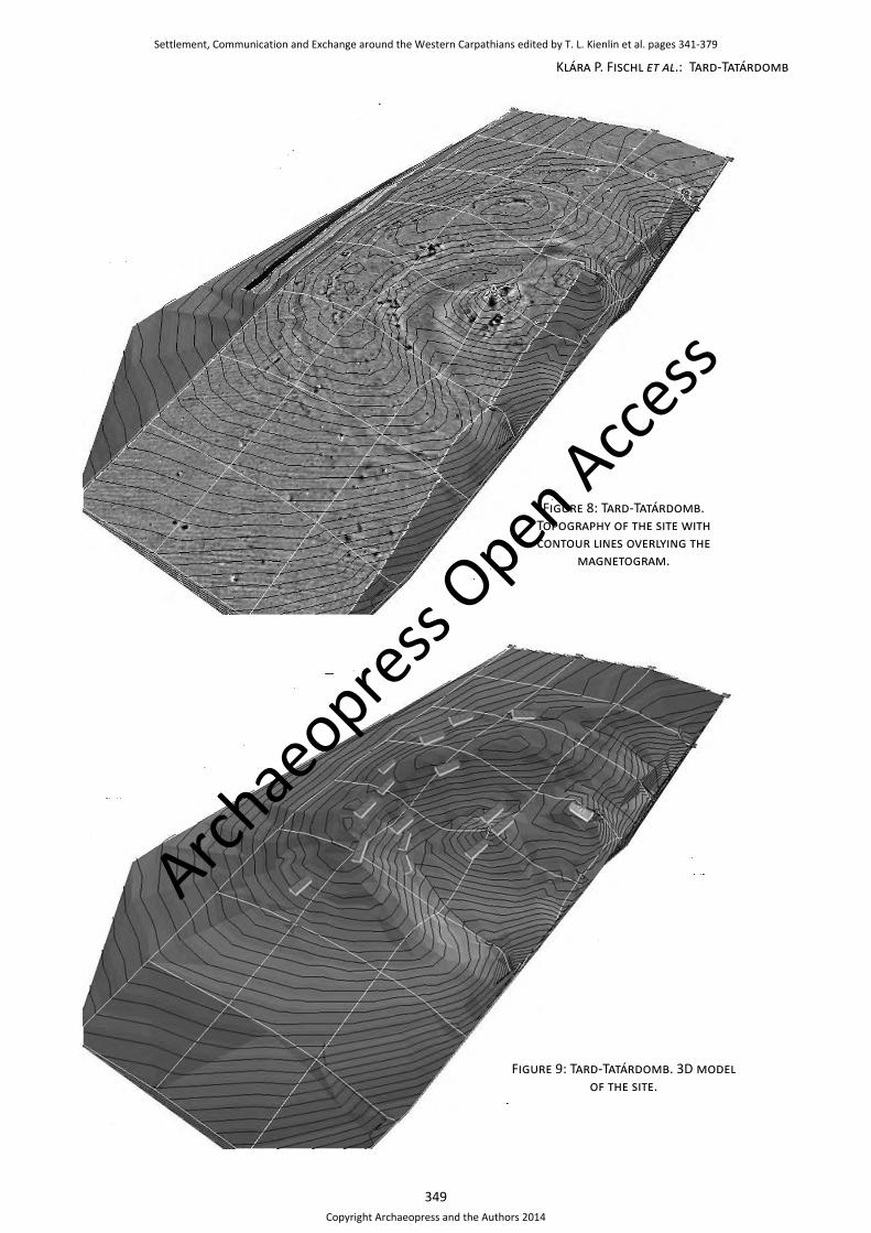
Starting with the maps indicating the general density of finds throughout the survey area (Figures 10 and 11), it has already been noted above, that the multi-layer core of the site and the nearby, more densely occupied parts of the outer settlement yielded a much higher count of finds than the outer zone with occasional ‘pit’ anomalies only. In the area of the ditches as well there are surface finds, which clearly stem from surrounding higher parts of the site and where moved into the depression and infill of the ditch by erosion. With respect to the chronology of the finds in the outer zone, it is interesting to note that this area features both Hatvan and Füzesabony period material (Figures 12 and 13). So, it its proven that the use of the outer settlement part already had started in the Hatvan period, and it continued through Füzesabony times. Beyond this, however, targeted excavations are required in order to establish what precisely was going on there. There is some pottery to be found in this zone and even an occasional ‘special’ find like a miniature clay animal or the fragments of a portable hearth (Figures 14–16). However, so far we lack all evidence of specialised activities such as craft production or large-scale communal herding or storage. Hence, it is still unclear what activities precisely were carried out in this area devoid of proper architectural remains (as far as the geomagnetics can tell), and what use was made of the occasional underground features or ‘pits’ that show up in the magnetometer data.
As one moves inwards, towards the more densely occupied part of the outer settlement, the number of surface finds increases significantly (Figures 10 and 11). This finding nicely matches the evidence for the existence of houses in the magnetometer data of this zone. The surface finds of this area can be dated to both the Hatvan and the Füzesabony period (Figures 12 and 13). It is proven, therefore, that the outer settlement, i.e. the zone between the inner ditch(es) and the outer demarcation (see above)
was occupied during both Early and Middle Bronze Age times. A more detailed inspection of the data reveals, that even individual houses visible in the magnetometer data may be recognisable on the surface by a concentration of find material. The best example certainly comes from the southern corner of grid 14, where two nearby houses (nos. 11 and 12 in Figure 7) are overlain by a very clear concentration of surface finds (Figures 10 and 11). These houses and their neighbours are situated on a kind of benching in front of the inner ditch. It has been suggested above that this zone may in fact comprise of a cultural layer, and that the large amount of settlement debris may indicate continuity of occupation comparable to the core area (see above). Now, this is supported by the high density of surface finds in this area, that point to intensive settlement activity. Furthermore, the phase maps confirm, that this part of the outer settlement indeed had a long tradition and was occupied both during Hatvan and Füzesabony times (Figures 12 and 13). The resolution of our surface data is not fine enough to tell apart the houses 11 and 12 visible in the magnetogram in chronological terms. At the nearby site of Ároktő-Dongóhalom Hatvan and Füzesabony period layers were divided by 70cm human sediment indicative of discontinuity in occupation (Fischl 2006: 187). But we clearly have to consider, that elsewhere individual households were continuously occupied from Hatvan to Füzesabony times with only a minor shift in location. It is possible that they ‘survived’ into a new pottery phase, rather than bearing witness to a replacement of population as previously suggested (e.g. Bóna 1992: 24, 27–29).
In the neighbouring grids 17 and 18 there are two of the reddish patches on the surface that were already discussed above. In the magnetometer data these are devoid of anomalies indicative of the the existence of houses. Theoretically, these zones may still feature unburned houses, that would not show up strongly in the magnetogram (see above). Now, at least from grid 17, as well as from the western corner of grid 11 and parts of grid 9 there is surface data related to this problem. In all three areas it turns out that the density of pottery found on the surface rather declines as one moves onto the reddish to brown stretches under discussion (Figure 11). Hence, surface evidence and magnetometer data would seem to be in accordance, both suggesting that we rather not have to expect intense occupation and architectural remains underneath the reddish patches on the surface. Given this state of affairs, future excavations or at least a systematic drilling programme and soil analysis are required in order to explain this surface feature and to account for its formation.
The greyish patches, on the other hand, not only seem to correspond well with burned houses in the magnetometer data (see above; Figures 10 and 11). Rather, by superimposing the surface finds and the aerial photographs, one gets the impression, that the density of surface finds itself in this cultural layer may also go as an indicator of (unburned) architectural remains that do not
Settlement, Communication and Exchange around the Western Carpathians edited by T. L. Kienlin et al. pages 341-379
Copyright Archaeopress and the Authors 2014
Archae
opress Open Acce
ss

351
Klára P. Fischl et al.: Tard-Tatárdomb
Figure 10: Tard-Tatárdomb. Density of surface finds; contour lines overlying the magnetogram.
Settlement, Communication and Exchange around the Western Carpathians edited by T. L. Kienlin et al. pages 341-379
Copyright Archaeopress and the Authors 2014
Archae
opress Open Acce
ss

352
Settlement, Communication and Exchange around the Western Carpathians
Figure 11: Tard-Tatárdomb. Density of surface finds; contour lines overlying the aerial photograph.
Settlement, Communication and Exchange around the Western Carpathians edited by T. L. Kienlin et al. pages 341-379
Copyright Archaeopress and the Authors 2014
Archae
opress Open Acce
ss

353
Klára P. Fischl et al.: Tard-Tatárdomb
Figure 12: Tard-Tatárdomb. Distribution of surface finds attributed to the Hatvan period.
Settlement, Communication and Exchange around the Western Carpathians edited by T. L. Kienlin et al. pages 341-379
Copyright Archaeopress and the Authors 2014
Archae
opress Open Acce
ss

354
Settlement, Communication and Exchange around the Western Carpathians
Figure 13: Tard-Tatárdomb. Distribution of surface finds attributed to the Füzesabony period.
Settlement, Communication and Exchange around the Western Carpathians edited by T. L. Kienlin et al. pages 341-379
Copyright Archaeopress and the Authors 2014
Archae
opress Open Acce
ss

355
Klára P. Fischl et al.: Tard-Tatárdomb
show up magnetically equally well. In particular, this may apply to the southern and the eastern part of grid 17 as well as to parts of grid 9 and 11 in the outer settlement. In grid 9, especially, there is a concentration of surface finds in what may be the continuation of the outer line of houses, that are arranged in concentric order and following the line of the outer ditch around the site (houses nos. 6, 4, 3, 2 and 1 in Figure 7). However, this hypothesis as well has to be confirmed by an excavation.
Alike both the outer ‘pit-only’ zone and the central fortified area, there are occasional finds of ‘special’ artefacts like portable hearths, animal figurines, miniature axes, clay discs and wheel models (Figures 17 and 18) throughout the outer settlement as delimited by the inner and outer ditches (see above). Some of these finds may correspond to house remains visible in the magnetometer data. Others may have been moved around on the surface for a few meters by the agricultural activities on the site (Figures 14–16). However, it is quite clear that such objects do make their appearance in both the inner and the outer part of the settlement. If understood in social and ritual terms, the occurrence of such items throughout the entire settlement would argue against substantial differences in social standing or economic success between the inhabitants of the different parts of the site or different ritual obligations or activities overseen by them. The same is indicated by the presence of houses of comparable size, layout and architectural details such as building materials (insofar as their magnetic ‘fingerprint’ is similar) throughout the site (see above).
Finally, regarding the inner core of the settlement, it has been suggested above that at some stage there was an enlargement to the demarcation and an expansion of the number of households that could lay claim to residence in the central area. This is confirmed by the surface evidence, and the surface finds allow us to be more precise on the details of this process. The original centre of Tard-Tátardomb was apparently enclosed by a roundish ditch (see above). In this rather small area we generally find a high density of Hatvan period pottery, as well as some distinct concentrations that more or less well correspond to house remains visible in the magnetogram (Figure 12). At some later stage, a part of the northern ditch was apparently refilled. In grid 15, in particular, there is a very distinct concentration of Füzesabony period pottery overlying what most likely was the earlier ditch (Figure 13). Since this concentration does not correspond to clearly visible house remains in the magnetometer data, an excavation is necessary to be sure on this point. Yet, it is likely, that we see evidence here of an unburned (i.e. magnetically largely invisible) house structure and of a newly established Füzesabony period household in this area. Surface finds of this period are also frequent throughout the older (Hatvan times) core area, and there are some distinct concentrations, so it is likely that occupation of the centre part of Tard-Tátardomb continued more or less continuously into Füzesabony times. During broadly the same phase, it has been suggested above, an
enlargement of the core area took place and a new ditch was dug towards the north-west. In the area that was additionally enclosed, there is little evidence from the surface finds of intense previous Hatvan period occupation (grid 12 in Figure 12). Füzesabony times pottery, on the other hand, is quite frequent, and there is a least one concentration of finds (Figure 13) that may correspond to the remains of an unburned house structure in this zone that does not show up magnetically. So it is very likely, that the newly enclosed area was indeed occupied by at least one Füzesabony period household. Excavations are required to confirm this interpretation, and in particular, to be more precise on the actual number of newly established ‘central’ households of this period vis-à-vis such that stood in an older Hatvan period tradition.
Lithic finds and some aspects of raw material procurement
The knapped lithic artefact assemblage recovered during the surface survey at Tard-Tatárdom consists of 63 items (Figure 19). Most of the artefacts are simple flakes, flake fragments and knapping debris. Out of the seven cores five served to produce flakes while two are typical bladelet cores. A total of three flake cores are fragmentary and two are complete. These latter have slightly convex and have wide flaking surfaces. This setup of core shape results in the removal of almost rectilinear, thin and wide flakes. One of the bladelet cores is a preform with bifacial pre-shaping. The other has two striking platforms opposed.
There are few formal tools in the assemblage (Figure 20). Among these there are an end-scraper, a fragment of a bifacial tool, a notched flake, fragments of three polished tools and a blade fragment with sickle shine. Further evidence of bifacial tool production is provided by a flake detached from a bifacial tool. Significant are the hammer stones made of pebbles. Bladelets are very few, as well as the blades which are always incomplete.
The most popular raw material is the limnic quartzite/silicite, light gray and whitish colored. This material might have originated in the southern part of Bükk mountains where outcrops of such rock are located (Pelikán 1986; Biró 1986; Biró/Pálosi 1983). The limnic quartzite assemblage consists of all phases of the stone knapping process. Debris is the most abundant, and the most common product is the flake. Laminar forms are fewer. Almost all the formal tools were made of this material.
The second popular raw material is the metarhyolith also called quartz porphyry (Markó et al. 2003). Its source is located in Bükk mountains near the village of Bükkszentlászló, about 20km north-east as the crow flies. This material yielded debris, flakes, even a retouched flake and a bladelet core. Also, there is a large hammerstone made of a metarhyolith pebble.
The hornstone (Pelikán 1986) of southern Bükk origin is present in very few items, as well as the silicite of Avas
Settlement, Communication and Exchange around the Western Carpathians edited by T. L. Kienlin et al. pages 341-379
Copyright Archaeopress and the Authors 2014
Archae
opress Open Acce
ss
356
Settlement, Communication and Exchange around the Western Carpathians
Figure 14: Tard-Tatárdomb. Distribution of surface finds of clay animal figurines.
Settlement, Communication and Exchange around the Western Carpathians edited by T. L. Kienlin et al. pages 341-379
Copyright Archaeopress and the Authors 2014
Archae
opress Open Acce
ss

357
Klára P. Fischl et al.: Tard-Tatárdomb
Figure 15: Tard-Tatárdomb. Distribution of surface finds of portable hearths.
Settlement, Communication and Exchange around the Western Carpathians edited by T. L. Kienlin et al. pages 341-379
Copyright Archaeopress and the Authors 2014
Archae
opress Open Acce
ss

358
Settlement, Communication and Exchange around the Western Carpathians
Figure 16: Tard-Tatárdomb. Distribution of surface finds of waggon models (wheels).
Settlement, Communication and Exchange around the Western Carpathians edited by T. L. Kienlin et al. pages 341-379
Copyright Archaeopress and the Authors 2014
Archae
opress Open Acce
ss

359
Klára P. Fischl et al.: Tard-Tatárdomb
Figure 17: Tard-Tatárdomb. Surface finds (drawing by Ádám Balázs).
in Miskolc 25km north-east from the site. The opal from Egerbakta, outcrops in the Bükk about 22km north-west from the site (Biró 1986), is present with a single blade core striking platform rejuvenating flake.
Distant lithic sources, that were exploited by the settlers of Tard-Tatárdomb or from where raw material was obtained, are located in the Tokaj mountains, about 100km eastwards as the crow flies. This is the obsidian of type
Carpathian 1 in Slovakia and the Mád-Mezőzombor-type limnicquartzite (Biró 1986).
The formal toolkit allows to deduce that the stones were used for domestic tasks such as scraping and cutting (bifacial) organic material. In addition, lithic implements were used for agricultural activities, which is proven by the blade mentioned above with sickle shine. Given the relatively small distance, it seems likely that the inhabitants
Settlement, Communication and Exchange around the Western Carpathians edited by T. L. Kienlin et al. pages 341-379
Copyright Archaeopress and the Authors 2014
Archae
opress Open Acce
ss

360
Settlement, Communication and Exchange around the Western Carpathians
Figure 18: Tard-Tatárdomb. Surface finds (drawing by Ádám Balázs).
Raw material
TotalAvas Obsidian Egerbakta
opal Jasper Limnic quartzite Metarhyolith Hornstone
Mezőzombor type
limnicquartzite
Bipolar core 0 0 0 0 1 0 0 0 1Blade 1 0 0 0 4 0 0 0 5Bladelet 0 1 0 1 0 0 0 1 3Bladelet core 0 0 0 0 1 1 0 0 2Flake 3 1 0 0 18 4 2 2 30Flake core 0 0 0 0 4 0 1 0 5Neocrest 0 0 0 0 0 0 1 0 1Rejuvenating flake 0 0 1 0 0 0 0 0 1
Debris 0 0 0 1 11 3 0 15Total 4 2 1 2 39 8 4 3 63
Figure 19: Tard-Tatárdomb. Lithic artefacts – knapped products by raw material.
Type Limnic quartzite Avas Metarhyolit
end-scraper on flake 2sickle blade 1notched flake 1retouched flake 1retouched blade 1bifacial tool fragment 1
Figure 20: Tard-Tatárdomb. Lithic artefacts – formal tools by raw material.
Settlement, Communication and Exchange around the Western Carpathians edited by T. L. Kienlin et al. pages 341-379
Copyright Archaeopress and the Authors 2014
Archae
opress Open Acce
ss

361
Klára P. Fischl et al.: Tard-Tatárdomb
of Tard-Tatárdomb themselves directly exploited the raw material sources of the Bükk mountains mentioned above. Raw material procurement in this case may have taken place during hunting and foraging campaigns into the nearby mountains. Lithics of Tokaj origin, on the other hand, would have been more difficult to obtain. Their procurement most likely was unrelated to everyday subsistence. It may have involved occasional expeditions or some kind of exchange with more distant communities that supplied this kind of material. Bearing in mind the network of Hatvan and Füzesabony communities, that extended not only south towards the Borsod plain, but also north and north-east along the Hernád and Tisza rivers, some kind of down-the-line exchange and frequent social interaction of the communities in both regions is conceivable to explain the presence these raw materials at Tard-Tatárdomb.
Preliminary results on the subsistence strategies of the Tard community: The evidence from the animal bone finds
During the survey on the site of Tard-Tatárdomb a large quantity of animal bones and clams – 2250 pieces in total – were collected besides the ceramics (Figure 21). The majority of the finds are in good condition, but their sizes show that they are chopped and cracked, so they can be defined as garbage. This is proven by the chewing and chopping marks too, which can be observed on some parts of the bones. 60% of the bones are smaller than 5cm, 26% of them are between 5cm and 10cm, and only 4% of them are longer. Besides the bones, the number of teeth is considerable (214 pieces). From the 2250 pieces of the finds, 279 were clams, generally the smaller fragments of the clam-shell.
None of the small bone finds were suitable for measuring of the height of withers. There were 343 finds, which could not be classified according to species unequivocally because of their small size. The bone sizes of this survey meet the international standard, which is accepted conventionally in archaeozoology (Driesch 1976). The source of the determinations of the age is the work of E. Schmid (1972).
Description
The largest part of the gathered bones derives from domestic animals, but several remains of hunted species turned up as well (Figure 21). 82.2% of the finds are domestic species, that is the killing of domestic animals was the source of meat on most occasions. Every species known to have been reared during the Early and Middle Bronze Age can be found among them (compare Figure 22); by the amount of bones, the most frequent species was cattle, followed by the small ruminants (sheep and goat), the pig, the horse and the dog. The domestic animals, which were of importance for meat consumption, were killed in the settlement. It is proven that the bones of parts containing both rich and poor in meat can be found
in equal proportions (Figures 23 and 24). If the animals had been killed outside the settlement, it is imaginable that the unnecessary dry limb parts (e.g. the feet) had been left behind.
Hunting just complemented the nutrition, and its portion was only 2.65%. The number of hunted species, however, is considerable (9 species). All four big games of the Carpathian Basin were hunted (aurochs, red deer, roe deer, wild boar). The red deer was brought down the most frequently, while wild boar, roe deer and aurochs were killed rarely. The hare represents the small games, besides its meat, its fur could also be utilized but it was not too valuable. The brown bear, the wolf and the fox could be brought down for their fur, first. The meat of the European pond terrapin was not disdained. The large amount of clams is 14.6%, which seems to be a considerable quantity, even if the collected clam-shells are rather cracked. Some bones emanated from transition sized individuals. For the pigs it could not be decided if we have to speak about the domestic or the wild species. Also, in the case of the dogs, it could not be decided that it could be a smaller dog or a golden jackal or a fox. From among the hunted species, only the bones of the red deer reach the amount that we can say the whole animal was transported from the place of the killing to the settlement.
Domestic animals
Cattle: Based on the amount of the bones, the most frequent species of the site was the cattle. 910 pieces bones are the equivalent of 47.7 % of the definable finds. Principally the intensive chopping of the cattle bones causes this outstanding measure. It is proved by the fact that – based on the bones – the minimum number of individuals is no more than eight. Among the individuals, both young and adult individuals can be found. At least two individuals were juvenilis, (1–3 years), one was subadultus (3–4 years) and two were adults (adultus) (Figure 25.1). The age of the remaining three individuals could not be defined. The mixed age distribution points to the multiple utilizations of the species: the young individuals could be killed because of the meat, while the adult representatives could be utilized for their milk and power, too. On some cattle bones (5 pieces) there are chewing marks, while at the end of one rib some cutting marks can be seen.
Sheep, goat, sheep/goat: Among the small ruminants, sheep and goat can be found. The bones of the two species are very similar, and they can be distinguished only in some cases. Their total number is 393 pieces, which means 20.6% of the definable finds. Based on the bones, the minimum number of individuals is two for the sheep, one for the goats and eight for sheep/goat. According to this the small ruminants were more frequent than the cattle. Among the specimen there were young and adult individuals as well, the youngest was only between ½ and ¾ years, it could be killed in the period of autumn and winter. Two other specimen were also young (juvenilis). Two specimens were nearly adults (subadultus), while
Settlement, Communication and Exchange around the Western Carpathians edited by T. L. Kienlin et al. pages 341-379
Copyright Archaeopress and the Authors 2014
Archae
opress Open Acce
ss

362
Settlement, Communication and Exchange around the Western Carpathians
the others were adults (adultus) (Figure 25.2). Among the sheep/goat finds, chopped bones can also be found, one lumbar was cleaved in two collaterally with the axis of the backbone. On the front side of a cochlea cutting marks can be seen in medium-lateral direction. One or both ends of an arm bone and that of two radius bones were chewed, which proves the presence of dogs in the site. The horn-stool of a goat was burnt partly black.
Pig: The third most frequent animal of the site is pig. It has got 233 pieces, which is 12.2% of the determinable bones. The minimum number of individuals analogizes with that of cattle: the bones of at least eight specimen can be found in the site. The age of the individuals is heterogeneous, from juvenilis to adultus. Most of them were young or near adult (subadultus). The youngest specimen was between
½ and one year. Among the specimen only two could be adult. This also proves that the pig was worth keeping for its meat, the younger individuals were killed relatively early. Although the pig becomes gravid early, the few adult individuals could be kept because of the continuance of progeny. Among the specimen, the proportion of the boars and sows were similar (3 finds refer to boar, 4 finds refer to sows). A dorsal vertebra, similar to the lumbar of sheep/goat, was cleaved in two. On three humerus and a pelvic chewing marks of dogs can be seen.
Horse: The frequency of the horse is much lower than that of the other species: 23 pieces bones add up to 1.2%. Based on the bones, the minimum number of individuals is one. At that time of the Bronze Age this species was rather rare and valuable. In contrast with the other domestic animals,
Species Number of bone findings % Minimum number of individuals
Cattle (Bos taurus L.) 910 47,7 8Sheep (Ovis aries L.) 3 0,2 2Goat (Capra hircus L.) 2 0,1 1Sheep/goat (Caprinae G.) 388 20,3 8Pig (Sus domesticus E.) 233 12,2 8Horse (Equus caballus L.) 23 1,2 1Dog (Canis familiaris L.) 9 0,5 1Domestic Animals 1568 82,2 29Aurochs (Bos primigenius B.) 2 0,1 1Red deer (Cervus elaphus L.) 32 1,7 2Roe Deer (Capreolus capreolus L.) 5 0,3 2Wild boar (Sus scrofa L.) 5 0,3 1Brown hare (Lepus europaeus P.) 1 0,05 1Brown bear (Ursus arctos L.) 1 0,05 1Wolf (Canius lupus L.) 1 0,05 1Red fox (Vulpes vulpes L.) 1 0,05 1European pond terrapin (Emys orbicularis L.) 1 0,05 1Wild animals 49 2,65 11Wild boar (Suidae sp.) 9 0,5 2Dog (Canidae sp.) 1 0,05 1Domestic or wild species 10 0,55 3Snail (Gastropoda sp.) 1 0,05 1Clam (Unio sp.) 279 14,6 -Other species 280 14,65 1Small ungulate 97 - -Large ungulate 245 - -Other mammal (Mammalia) 1 - -Not definable bones 343 - -
Total 2250 100 44
Figure 21: Tard-Tatárdomb. Animal bone finds – list of species. The Minimum Number of Individuals (MNI) is a referential, computative datum. It shows the minimal number of individuals, which can be separated surely
based on bones. During its determination, the bone fragments of the species have to take into consideration, which belonged to the same side of animal and shows same features. We also have to reckon with the age
evaluating based on the bone-finds and determining with teeth more exact.
Settlement, Communication and Exchange around the Western Carpathians edited by T. L. Kienlin et al. pages 341-379
Copyright Archaeopress and the Authors 2014
Archae
opress Open Acce
ss

363
Klára P. Fischl et al.: Tard-Tatárdomb
0%
5%
10%
15%
20%
25%
30%
35%
40%
45%
50%
55%
60%
65%
70%
75%
80%
85%
90%
95%
100%
Hernádbüd (n=514) Tard (n=1616) Tiszalúc (n=4050)
Fish
Bird
European pond terrapin
Beaver
Lynx
Wild cat
Red fox
Wolf
Brown bear
Brown hare
Wild boar
Roe deer
Red deer
Aurochs
Dog
Horse
Pig
Sheep, goat
Cattle
Figure 22: Comparison of animal bone finds at different sites of the Hatvan period.
Catt
le
Shee
p/go
at
Pig
Hors
e
Dog
Auro
chs
Red
deer
Roe
Deer
Wild
boa
r
Brow
n ha
re
Brow
n be
ar
Wol
f
Fox
Terr
apin
Suid
ae
Antler - - - - - - 13 2 - - - - - - -Horn core 1 1 - - - - - - - - - - - - -Cranium 6 - 8 - - - - 1 - - - - - - 2Maxilla 6 1 19 - 1 - 1 - - - - 1 - - -Jaw (Mandible) 70 18 29 - 1 - - - 1 - - - 1 1 -Tooth 94 76 32 7 2 - 2 - - - - - - - -Atlas 1 2 5 - 1 - - - - - - - - - -Axis 2 1 - - - - - - - - - - - - -Cervical vertebrae 16 - - 1 - - - - - - - - - - -
Thoracic vertebrae 9 - 2 - - - - - - - - - - - -
Pelvic vertebrae 16 5 3 - 1 - - - - - - - - - -Os Sacrum 1 - - - - - - - - - - - - - -Caudal vertebrae 1 - - - - - - - - - - - - - -
Vertebrae 7 - 2 - - - - - - - - - - - -Costa 39 1 3 - - - - - - - - - - - -
Settlement, Communication and Exchange around the Western Carpathians edited by T. L. Kienlin et al. pages 341-379
Copyright Archaeopress and the Authors 2014
Archae
opress Open Acce
ss

364
Settlement, Communication and Exchange around the Western Carpathians
Catt
le
Shee
p/go
at
Pig
Hors
e
Dog
Auro
chs
Red
deer
Roe
Deer
Wild
boa
r
Brow
n ha
re
Brow
n be
ar
Wol
f
Fox
Terr
apin
Suid
ae
Scapula 22 5 5 - 1 - - 2 - - - - - - -Humerus 47 34 22 1 - - 2 - 1 - - - - - -Radius 29 18 11 - - - 2 - - - - - - - 1Ulna 9 2 6 - - - - - 1 1 1 - - - 1Carpus 11 - 2 - - - 1 - - - - - - - 1Metacarpusl 20 9 3 - - - 1 - - - - - - - -Pelvis 18 7 7 1 2 - 1 - - - - - - - 1Femur 36 38 13 - - - - - - - - - - - 1Patella 1 - - 1 - - - - 1 - - - - - -Tibia 32 41 26 2 1 - - - - - - - - - -Fibula - - 1 - - - - - - - - - - - -Astragalus 25 14 4 - - - 2 - 1 - - - - - -Calcaneus 10 2 5 1 - - - - - - - - - - -Tarsus 7 - - - - - - - - - - - - - -Metatarsus 51 25 1 2 - - 2 - - - - - - - 1Metacarpus/metatarsus 19 3 2 - - - 1 - - - - - - - -
Phalanx I 33 3 11 3 - - 3 - - - - - - - -Phalanx II 19 3 5 - - 1 1 - - - - - - - 1Phalanx III 6 - 4 - - 1 - - - - - - - - -Long bone 209 84 2 3 - - - - - - - - - - -Flat bone 37 - - 1 - - - - - - - - - - -Total 910 393 233 23 10 2 32 5 5 1 1 1 1 1 9
Figure 23: Tard-Tatárdomb. Animal bone finds – anatomical distribution.
Catt
le
Shee
p/go
at
Pigg
Hors
e
Dog
Auro
chs
Red
deer
Roe
Deer
Wild
boa
r
Brow
n ha
re
Brow
n be
ar
Wol
f
Fox
Terr
apin
Suid
ae
Head 179 99 93 7 5 - 3 1 1 - - 1 1 1 2Trunk 106 13 17 2 3 - 1 - - - - - - - 1Scapula and thighs 106 79 45 2 1 - 2 2 2 - 1 - - - 1
Lean limb 213 112 56 5 1 - 9 - 2 1 - - - - 2Remaining in the skin 59 6 20 3 - 2 4 - - - - - - - 3
Other finds 247 84 2 4 - - 13 2 - - - - - - -
Figure 24: Tard-Tatárdomb. Animal bone finds – distribution according to species and body regions (classification according to Kretzoi 1967).
Settlement, Communication and Exchange around the Western Carpathians edited by T. L. Kienlin et al. pages 341-379
Copyright Archaeopress and the Authors 2014
Archae
opress Open Acce
ss

365
Klára P. Fischl et al.: Tard-Tatárdomb
Figure 25: Tard-Tatárdomb. Animal bone finds. 1, cattle metacarpus; 2, sheep/goat maxilla with teeth; 3, red deer antler; 4, red deer maxilla with teeth; 5, wild boar maxilla with teeth; 6, brown bear ulna; 7, wolf maxilla with
teeth; 8, fox jaw with teeth.
Settlement, Communication and Exchange around the Western Carpathians edited by T. L. Kienlin et al. pages 341-379
Copyright Archaeopress and the Authors 2014
Archae
opress Open Acce
ss

366
Settlement, Communication and Exchange around the Western Carpathians
consumption of the horse could take place very seldom. On the horse bones neither chopping nor chewing marks were found. The elder age (maturus) of the specimen shows the appreciation of the species.
Dog: The nine dog bones give 0.5% of the definable finds. The minimum number of individuals is one, which was an adult. On some finds of more species were chewing marks. The taphonomic damage owing to the dogs cannot be evaluated. They could gorge several bones entirely. The dropped dogs could be probably buried outside or a remote spot of the settlement, thus we cannot conclude on the real proportion of the species. During the Bronze Age, the dog meat was not despicable, broken up dog skulls were found at the Late Bronze Age sites of Szombathely-Kámon (Vörös 1999: 293) and Németbánya (Vörös 1996: 210). Moreover, there are proofs that the Schythians and Celtics also consumed it (Tugya 2010: 100–103). In the finds of Tard, chopped dog bones were not be found, but the consumption of meat of the species cannot be excluded entirely.
Wild animals
The composition of the hunted species reveals the contemporary environments of the site. The habitat of aurochs, red deer, roe deer, wild boar, hare and fox was in this territory and its surroundings. The growing space of aurochs was the flat and flood areas, declivous hill-sides where the pastures were rich. The red deer likes the broadleaf and mixed forest with clearings and meadows and the extended flood areas of rivers. In the same way, the park forest, the broadleaf and mixed forest with wet soil gives excellent habitat for the wild boar. The roe deer feels comfortable on timbered steppe and the areas with small arboreous patches. The open lowlands are ideal for the brown hare. In the surroundings of the site the park forests, the pastures and the plough-lands for agriculture guaranteed the ideal conditions for the wild animals as well.
Aurochs: Two aurochs bones (II–III. phalanges) were found; the finds prove the hunting of the largest meat-game in the Carpathian Basin. During the Late Neolithic Period, it was the most considerable, and then its occurrence decreases in the finds in general (Vörös 2003: 58).
Red deer: It is the most frequently hunted species of the site, 32 pieces of its finds are the 1.7% of the definable bones. Based on the bones, the minimum number of individuals is two, which were adults. Besides the bones, 13 pieces of antler fragments also turn up (Figure 25.3–4). The antler is an excellent raw material of tools, which is shown by that the assemblage contains two antler tools besides two chopped antler fragments (see descriptions below). In the Bronze Age the red-deer is the most frequent among the hunted species (Vörös 2003: 59).
Roe deer: The five roe deer finds give the 0.3% of the definable bones, the minimum number of individuals is
two, adult specimen. Besides the two fragments of antlers, three bones of the species were also found, which prove the hunting of the species. One find is a fragment of a roebuck skull with vestigial antlers. The hunting of roe deer is usually rarer in every archaeological period than that of red deer.
Wild boar, Suidae: Some finds of the wild boar, which is the fourth big game, also belong to the assemblage. The five bones are 0.3% of the definable finds, which derive from at least one adult specimen (Figure 25.5). Besides the wild boar, there were bones of transition-sized animals, between the domestic and wild species. The two species often mix, so it cannot be decided unambiguously if these bones derive from wild boars or domestic pigs. In addition, the intensive chopping and cracking is disadvantageous for the determination of these species.
Brown hare: Only an ulna fragment of a hare, which belongs to the small games, was found. This find, however, indicates other hunting methods than were used during the hunting of big games (e.g. by laying a snare).
Brown bear: Besides trophy obtaining, this species could be hunted for its fur. An ulna of an adult specimen was found (Figure 25.6). The brown bear is a rare species; its finds are also seldom. The species likes the higher-level, coherent forests, which can be found, for example in the Bükk mountains.
Wolf: Similar to the brown bear, only one find of wolf was found, a fragment of maxilla with three teeth in it (Figure 25.7). The bone derives from an adult.
Red fox: A fragment of a jaw with two teeth derives from an adult (Figure 25.8). The fox could be killed for its nice and valuable fur.
European pond terrapin: A jaw fragment of a terrapin proves the presence of this species in the assemblage. The meat of the terrapin is eatable; the bones of it can be found rarely, while the fragments of the crusts can be more frequent in an assemblage. The species could have occurred in the Lator stream.
Other species: Next to a snail, many but very broken clams (279 pieces) were collected. The length of the fragments can be between 14mm and 66mm. The clams could be collected in the nearby Lator stream. Because the high protein of clams they could be valuable amplifying nourishment. None of the clam shells was penetrated, which indicates that clams took a role in nourishment first. Neither signs of burning or singe, nor signs of ash could be seen on the clam shells. It indicates that they were ate uncooked (Gulyás 2009: 42, 46).
Bone tools
The assemblage contains 8 tools, made of antlers and bone.
Settlement, Communication and Exchange around the Western Carpathians edited by T. L. Kienlin et al. pages 341-379
Copyright Archaeopress and the Authors 2014
Archae
opress Open Acce
ss
367
Klára P. Fischl et al.: Tard-Tatárdomb
Antler tools: Casted antler of a red deer, the bur is trite (accession number TTD12G2). Red deer antler, the bur is worn together with the fragments of the place of the haft (TTD12F1) (Figure 26.1–2).
Tools made of bone: Small ungulate long-bone, either end is pointed like an awl (TTD17B2) (Figure 26.3). Chisel from a metatarsus of a sheep, the shaft is distal epiphysis (TTD14I2) (Figure 26.4). Cattle long-bone, either end is formed as a chisel (TTD12C5) (Figure 26.5). Similar tools are known from the site of Hernádbűd-Várdomb, too (Tugya 2009: 36 fig. 2).
Other objects: Sheep/goat astragalus, the side of medial and lateral is smoothed (TTD14C9) (Figure 26.6). Two pieces pigs I. phalanx, the surface is bright, the back side is trite (TTD20A4; TTD12B7) (Figure 26.7–8).
Comparison and summary
In this section the definable bones finds from the survey at Tard will be compared to the assemblages from two other sites belonging to the Hatvan culture. The assemblage from one of these was collected in the same way, that is by surface survey (Hernádbűd-Várdomb; Tugya 2009: 33–38), while the other comes from an archaeological excavation (Tiszalúc-Dankadomb; Bökönyi 1974: 413). Besides the method of acquirement, differences can also be seen in the quantity of the finds. The quantity of definable bones of Hernádbűd assemblage is at only 514 pieces. That of Tard is larger, 1616 pieces, while the assemblage of Tiszalúc is the largest with 4050 pieces (Figure 22).
In all three sites, the domestic animals were dominant. The cattle was the most frequent species among them, but its largest proportion was in the assemblage of Tard. At Tard and Tiszalúc, the small ruminants are the second in the frequency of species, while the pig is the third. At Hernádbűd, the proportion is quite the reverse. The sites are alike in that the horse is a rare domestic animal, its remains being in the range of 1–2%. Dog bones were found on all three sites, their proportion is minimal.
The red-deer was the most frequently hunted species at all sites, and the other big games (aurochs, roe deer, wild boar), although in lower proportion, can also be seen.
Although all settlements are situated near water, fish bones are known only from Tiszalúc. The reason of this most likely is the method of obtainment, because the very little fish-bones can hardly be observed during a surface survey. However, the closeness of rivers and streams was taken advantage of on the other two sites as well, which is indicated by the large amount of clam-shells.
One part of the wild species shows trapping at Tard and Tiszalúc, brown bear and fox at both sites and lynx at Tiszalúc, too.
Similar archaeozoological results are reported the site of Carei-Bobáld, belonging to the Otomani culture, where the assemblage could be garbage as well. Unlike the three sites of the Hatvan culture, the most frequent species at Carei is the pig, which is followed by the cattle with a little difference, then the sheep/goat, the horse, at last the dog. The opportunities of the near Mérges stream were utilized, which is showed by the fish-bones, scales, and the fragments of clam-shells and nails (Németi/Molnár 2012: 61–66).
To conclude with, although it derives from surface finds, we can state that the assemblage from Tard is in good accordance with such from other northern Hungarian sites of Hatvan culture. The foraging and hunting for meat was not typical any longer and did not contribute to nutrition in a substantial way. They hunted for several species, but this only completed the amount of meat obtained from the killing of domestic animals. The collection and consumption of clams happened in large quantity at Tard, too. A small number of bone-tools enrich the assemblage, like similar forming of chisel, awl and antlers tools.
Results of the coring programme
The coring location Tard-Tatárdomb is part of a microregion generated by the radial drainage system of the Bükk Mountains. The karstic Bükk Mountains in the north are part of the Hungarian ‘middle height mountain system’ (Pécsi 1970) whereas in the south the Holocene floodplain of the Tisza River is located. The uplift of the Bükk Mountains and its forelands during the Pliocene supported stream incision and valley formation in the Cserépfalu Basin less than 10km north-west of our site (Dobos 2012). At the moment we presume similar effects for Tard-Tatárdomb. The tell-like site is situated directlyat the valley border. The valley itself is v-shaped with a floodplain (Kerbsohlental) and shows a straight slope profile. In our case, the neighbouring Cserépfalu Basin serves as an example for the Quaternary landscape development in this region. It is a geological depression formed during the Alpine Orogeny. In the Quaternary period Pleistocene and Holocene colluvium, fluvial terraces as well as Holocene alluvium were deposited. Fluvial and colluvial sediments with gravel occur at the slopes. Consequently, finer material was deposited in the alluvium. Sediment changes imply changes between cooler climatic conditions and warmer periods (Dobos 2012: 18–20),wherefore a correlation between landforms and sediments is stateable (Dobos 2012).
At Tard-Tatárdomb, nowadays, intense agriculture forces fluvial erosion processes resulting in land degradation. Therefore, we have to suppose that the sediment record is incomplete and partly disturbed by human activity. Three boreholes were deepened into the surface with an Atlas Copco Cobra mk1 drilling unit (Figure 27). Sediment texture and units were defined by optical and haptical analysis according to the German Soil Survey Manual KA 5 (2005) and the Munsell Soil Color Chart. From
Settlement, Communication and Exchange around the Western Carpathians edited by T. L. Kienlin et al. pages 341-379
Copyright Archaeopress and the Authors 2014
Archae
opress Open Acce
ss

368
Settlement, Communication and Exchange around the Western Carpathians
Figure 26: Tard-Tatárdomb. Antler and bone finds. 1, red deer antler, the bur is trite (accession number TTD12G2); 2, red deer antler with the fragments of the place of the haft (TTD12F1); 3, awl from small ungulate
long-bone (TTD17B2); 4, chisel from a metatarsus of a sheep (TTD14I2); 5, chisel from a cattle long bone (TTD12C5); 6, smoothed sheep/goat astragalus (TTD14C9); 7, bright and trite I. phalanx of a pig (TTD20A4); 8,
bright and trite I. phalanx of a pig (TTD12B7).
Settlement, Communication and Exchange around the Western Carpathians edited by T. L. Kienlin et al. pages 341-379
Copyright Archaeopress and the Authors 2014
Archae
opress Open Acce
ss

369
Klára P. Fischl et al.: Tard-Tatárdomb
each layer representative samples were taken for further analyses. This summary presents our observations during field work.
Borehole TAR 1 in the very centre of the tell-like site was carried out to gather information on layer thickness and stratigraphy caused by human activity at Tard- Tatárdomb. Borehole TAR 2 within the 13 to 15m wide surrounding ditch was to complement the record from TAR 1. Furthermore, information on the assumed multiphase system ditch should be obtained. Borehole TAR 3 should provide insight into the immediate environment and landscape formation processes.
For TAR 1 (Figure 28) six sedimentological units were identified (Figure 29). Whereas units 1 to 3 contain sandy silt, units 4 to 6 range from sandy silt to silty clay. So grain size slightly decreases from top to bottom. Lime concrections increase from top to bottom in size and distribution. The first two units show finds of bones, pottery, charcoal and (burnt) daub (in Figure 29 referred to as b, c, d and ch). Within the first centimetres b.s. pottery and daub fragments range from 0.5–1.5cm in size. At 19cm b.s., a piece of black, polished, textile decorated shard could be identified. As stated above, it was classified to the Hatvan period. Pottery fragments are angular indicating an in situ accumulation. The highest find concentration is
between 55 and 80cm b.s. in unit 1. The salvaged pottery could either be Hatvan or Füzesabony. Apart from this, samples of charcoal and bone fragments were taken. Notable is unit 3, which is dark brown in colour, but does not contain any archaeological finds or datable material. In the lithological unit 4, one piece of daub (1cm in diameter) is the only indication of human input.
Core TAR 1 shows stratigraphic units representing two layers: the anthropogenic layer and the geologic layer. At first glance the boundary is not clear. However, taking the archaeological finds into account, the anthropogenic layer ends between 90 and 100cm b.s, thus comprising the units 1 and 2, which leads to the conclusion that erosion diminished it. Since TAR 1 was located within the central multilayer part of the site one would expect a greater thickness of anthropogenic strata. However, the site has clearly undergone erosion due to its location (Figure 3). The salvaged pottery could not be set in a stratigraphic context as these two units are disturbed by ploughing and only three identifiable shards were in the core. Unit 3 most probably represents a palaeosol; it does not show any sign of human interaction. The piece of daub in unit 4 may have been displaced by bioturbation processes. Units 4 to 6 are most likely the result of sediment deposition during the Pleistocene (Schweitzer 2009).
Figure 27: Tard-Tatárdomb. Location of drilling cores TAR 1, TAR 2 and TAR 3.
Settlement, Communication and Exchange around the Western Carpathians edited by T. L. Kienlin et al. pages 341-379
Copyright Archaeopress and the Authors 2014
Archae
opress Open Acce
ss

370
Settlement, Communication and Exchange around the Western Carpathians
Figure 28: Tard-Tatárdomb. Coring TAR 1 – central multilayer part.
Figure 29: Tard-Tatárdomb. Coring TAR 1 – sedimentology and interpretation.
Settlement, Communication and Exchange around the Western Carpathians edited by T. L. Kienlin et al. pages 341-379
Copyright Archaeopress and the Authors 2014
Archae
opress Open Acce
ss
371
Klára P. Fischl et al.: Tard-Tatárdomb
To sum up: the thickness of the anthropogenic layer is up to 100cm. As the landscape is very plain and uniform (Figure 4). There are two possibilities from a geoarchaeological point of view: First, the site offers a good overview ranging from the Bükk Mountains to the Tisza Plain. Second, fertile soils and water supply from the valley were strategic factors.
Core TAR 2 (Figure 30) with a length of 5 metres is located in the presumed younger phase of the inner ditch (Figure 27). Ten units were distinguished (Figure 31). Unit 1 consists of sandy silt, whereas the other units range from silt to silty clay. Units 1 and 2 contain pottery, bones, and daub. Concerning the finds, unit 2 shows a greater distribution and greater average fragment size as unit 1. Unit 3 is very dark brown in colour and has a higher clay content. While lime concretions increase, the human input of pottery, daub, and bones decreases. Anthropogenic evidence in TAR 2 is visible until the bottom of unit 7. The units 4 and 5 have the highest amount of lime concretions. Slightly heterogeneous are units 6 and 7. The units 8 to 10 show no sign of human impact.
In contrast to TAR 1, TAR 2 shows no inverse accumu-lation. Of course this has to be proven by dating. In both cores, the units 1 to 3, and probably unit 4 are almost identical. In contrast to TAR 1, unit 3 of TAR 2 is influenced by finds of daub, pottery, and bones. Pottery shards were too small for further identification. Generally, the anthropogenic influence is more intense in TAR 2 going down to 388cm b.s. It provides an indication for the original depth of the ditch. Though, due to the core loss (Figure 30) we interpret the thickness of 388cm as maximum depth. We found two pieces of ceramics at this maximum depth, plus an increasing amount of charcoal. The ditch is protected from erosion through the central part and the outer settlements of the tell-like site. The geological units 8, 9, and 10 give a loess-like impression. Similar to the units 4, 5, and 6 in TAR 1 they are of Pleistocene origin.
With the data at hand from just two drillings, TAR 1 and TAR 2, it is difficult to reconstruct the history and potentially two-phased construction of the ditch surrounding the central part of Tard-Tatárdomb. Between the surface and the bottom of unit 7 in TAR 2, there is no sterile unit void of artefacts, which would indicate a settlement interruption. This is in line with the archaeological evidence from the site which suggests settlement continuity from Hatvan to Füzesabony times. It can be ruled out for sure that there was a younger phase of the ditch construction that would have been dug into the fill of an older ditch, less deeply than its predecessor. On the other hand, it is less clear if there was a later renewal of the ditch deeper and wider than during its older phase. However, the fact that the units 1 to 3 and probably unit 4 are continuous and comparable between TAR 1 and 2 seem to contradict such an assumption. It implies that the time and the processes of soil formation on the tell and in the ditch ran broadly parallel. For reasons discussed
above, on the other hand, it is quite sure that there was an extension of the ditch to the north. During that time the original ditch around the older core of the site should still have been open and it may or may not have been renewed at this stage. One has to presume then that the infill in TAR 2 postdates the extension phase and broadly corresponds to the younger Füzesabony period settlement activity on the site. Given this consideration, more analytical work is required to prove beyond doubt that the corresponding units in TAR 1 and 2 are identical and contemporaneous.
A further question refers to the function of the ditch. We can exclude it to be a water ditch. The core shows no signs for a body of standing water. A visible bottom unit was not detectable, only via artefacts. Even so, an occupation layer is missing. We rather get the impression that the ditch was cleaned or restored on a regular basis because the fragment sizes of bone, daub, and pottery are smaller compared to the fragments in TAR 1. In this case, archaeological interpretation might solve the question of functionality. Apart from this, the depth of the ditch seems disproportional. This supports the argument that the archaeological layer in TAR 1 is incomplete due to erosion.
TAR 3 (Figure 32) was cored 300m west of the settlement area (Figure 27). This was to exclude any influence from the settlement. In total six sedimentological units were identified (Figure 33). Grain sizes vary between clayey silt and silty clay. Unit 1 is rich in organic matter, has a deph of 65cm b.s., and as the units 1 in TAR 1 and 2, comprises the plough horizon. From unit 2 to unit 5 grain size is clayey silt. One exception is unit 3 (105–183cm b.s.) showing signs of an argillic horizon, slightly hardened and clayey. Below, in units 4, 5, and partly 6, intense lime concretions occur.
It is interesting to note that TAR 3 shows no agricultural use in prehistoric times. Only 300m away from the settlement we have a soil rich in organic matter which is free of any kind of artefact. Plus, no ancient Ah horizon is visible. For this fact, there are two possible explanations: (i) There was no agricultural activity in prehistoric times. This seems rather unlikely, given the archaeological situation at Tard-Tatárdomb and the short distance between the tell-like site and the drilling location TAR 3. (ii) The prehistoric Ah horizon has already been eroded. As mentioned above, the layer thickness of TAR 1, in the central multilayer part of the tell, is affected by erosion. Therefore, it is possible that similar effects caused the disappearance of evidence of prehistoric land use at TAR 3. These possibilities cannot be proved or disproved without further field investigations. So far, age estimates from 14C and/or OSL dating is missing; therefore the establishment of a chronology for the Late Quaternary landscape evolution is as yet missing.
To sum up, Tard-Tatárdomb shows in the central multilayer part an anthropogenic layer thickness of 90 to 100cm. The profile is reduced due to erosion. The Units 1 to 3 and possibly unit 4 are identical in TAR 1 and 2, so to say in the central multilayer part and the inner ditch. The
Settlement, Communication and Exchange around the Western Carpathians edited by T. L. Kienlin et al. pages 341-379
Copyright Archaeopress and the Authors 2014
Archae
opress Open Acce
ss

372
Settlement, Communication and Exchange around the Western Carpathians
Figure 31: Tard-Tatárdomb. Coring TAR 2 – sedimentology and interpretation.
Figure 30: Tard-Tatárdomb. Coring TAR 2 – inner ditch.
Settlement, Communication and Exchange around the Western Carpathians edited by T. L. Kienlin et al. pages 341-379
Copyright Archaeopress and the Authors 2014
Archae
opress Open Acce
ss
373
Klára P. Fischl et al.: Tard-Tatárdomb
inner ditch has a maximum depth of 388cm b.s. The core TAR 2 shows no settlement interruption and corresponds therefore with the archaeological evidence. However, we could not clarify whether there was a renewal of the ditch being wider and deeper than its predecessor. So far, no use as a water ditch or an occupation layer could be traced. We thus agree with the archaeological interpretation of a (symbolically?) delimitation. Although clearly interlinked with the occupation phase, the inner ditch shows surprisingly small artefact sizes and numbers. We conclude that the ditch was cleaned or dredged on a regular basis. As yet, evidencefor prehistoric agricultural use is missing. In line with archaeological assumptions this can well be attributed to soil erosion. However, this still has to be proved.
Future research should consider two levels of analysis – small scale and broad scale. The small scale analysis should focus on a better understanding of the site taphonomy. For instance, it should include more drillings in the ditch to examine if there was a younger and an older phase. Additionally, a second set of drillings in the centre of the tell-like site might support stratigraphic relations between the different pottery layers. The broad scale analysis should focus on the past development of the Lator patak stream and the human-environment interaction. Since the Early and Middle Bronze Age, how has the relief and therefore the archaeological record changed? Corings in the alluvial fan at the foot of the slope might bear valuable information. Even more important, a well-based stratigraphic chronology should be established.
Discussion and conclusions
Tard-Tatárdomb is just one example from our ongoing work, but already the much greater dynamics of such sites is noteworthy, when compared to the earlier description in the work of N. Kalicz (1968). There is potentially much greater variability in their internal organisation and in their role in a wider social landscape than previously assumed. The outer part, in particular, tends to be considerably larger than used to be thought. Its different zones – such with building remains that point to regular settlement activity versus general ‘pit’ anomalies indicative of some other kind of activities – require greater archaeological attention. The well-known inner core of such sites is just one part of a more complex whole, and a general model would currently include the following elements, that may prove dynamic vis-à-vis each other through time in spatial, functional or social terms: 1. an inner, multi-layer core with evidence of settlement acitivity and houses of rather standardised size; 2. a deep and wide ditch that sets the inner tell or tell-like core (symbolically?) apart from its surroundings, but may be subject to modifications depending on social, economic or demographic requirements; 3. an outer settlement that can itself be divided in two parts: 3a. an intensively used inner part, potentially with houses that do not differ much from that in the centre part; 3b. an outer zone featuring pits possibly indicative of various activities related to storage and/or production. Finally, beyond that zone there
were numerous other such settlement units of a similar kind, their fields and pasture. And there was a socially constructed, ideational landscape that may have comprised ritual features such as places that attracted deposits as well as territories claimed by the respective communities, for example, through the location of their burial grounds (e.g. Fontijn 2001/02; Bérenger et al. 2012).
All of this is potentially more complex and fluid than the Bronze Age standard model of settlement hierarchies and political territories has us expect. In several respects, it does not correspond to the notion of a central tell site in political and economic control of both its immediate and its wider surroundings – the notorious fortified tell ‘acropolis’ opposite functionally and politically dependent open ‘villages’ (e.g. Hänsel 1996: 244–248; 2002: 82; Falkenstein 1998: 268; Earle/Kristiansen 2010c: 220).
For example, as already mentioned, there is no systematic difference in the size and the architecture of houses on the central tell part and in the surrounding outer settlement. Apart from the ‘specialised’ use the outer zone 3b, that was not used for living but for a variety of day-to-day activies, from the geomagnetics we lack all evidence of a differentiation on the household level. The random distribution of surface finds of ‘special’ artefact types like animal figurines, portable hearths or wheel models, that are commonly thought to be associated with outstanding, socially or ritually motivated activities, throughout both the inner and outer settlement points into the same direction. In addition, it is possible that some households located on the ‘benching’ in front of the inner ditch could actually lay claim to an equally long tradition like those resident ‘on-tell’ (see above). Upon excavation different traditions of doing things and preferences for specific tasks may become apparent on a family or household level, but there was no true differentiation in social or political terms.
So what may have ‘distinguished’ the families on the tell from (some of) their ‘off-tell’ neighbours may have been their claim to greater antiquity only and their positioning in the spatial and ideological focus of the community rather than ‘hard’ political power or economic predominance. However, we have seen that even these ‘soft’ factors may have been subject to negotiation: We have noted above, that at Tard-Tatárdomb there are indications of an extension to the central ‘tell-like’ part of the site in Füzesabony times with corresponding modifications of the inner ditch. Since we do not know precisely how densely the inner and the outer settlement respectively were occupied at any given time, we cannot determine the relative precentage of people living ‘on-tell’ and ‘off-tell’ in the outer part of the site. But it is certainly possibly, that this ratio underwent repeated change during different phases of occupation. And it is obvious that the relative standing of ‘on-tell’ and ‘off-tell’ households vis-à-vis each other did not solidify into anything like a chiefdom-type structure with a functionally and politically differentiated population. In fact, we cannot even take it as given, that living ‘on-tell’ was a social phenomenon at all, at least in the narrow sense
Settlement, Communication and Exchange around the Western Carpathians edited by T. L. Kienlin et al. pages 341-379
Copyright Archaeopress and the Authors 2014
Archae
opress Open Acce
ss

374
Settlement, Communication and Exchange around the Western Carpathians
Figure 32: Tard-Tatárdomb. Coring TAR 3 – outside settlement area.
Figure 33: Tard-Tatárdomb. Coring TAR 3 – sedimentology.
Settlement, Communication and Exchange around the Western Carpathians edited by T. L. Kienlin et al. pages 341-379
Copyright Archaeopress and the Authors 2014
Archae
opress Open Acce
ss

375
Klára P. Fischl et al.: Tard-Tatárdomb
of economic prosperity or political power. Rather, it may also have involved ideological concerns of relevance to and with a bearing on the wider community that ‘focused’ on this particular site and its enclosed (ancestral?) centre part (see, for example, Whittle 1996; Chapman 1997a; 1997b; 2000; Bailey 2000).
In any case, ‘membership’ or claim laid to the central tell part of such sites was potentially fluid. The communities in question faced different challenges and took different options. As a result, we see local variation in settlement organisation and its development through time. Rather than a constant build up of social differentiation, political rule and economic differences, there is evidence of variable responses to contigent events and long-term trends. These may have ranged from disease and demographic development, climate and environmental parameters to economic success and the agency of groups of people. This is all the more true since we are dealing with groups that were small in numbers and prone, for example, even to the impact of an individual aggrandizer on the future development of his/her community (see, for example, Roscoe 2000).
Alternatively, of course, a reorganisation like that postulated for the site of Tard-Tatárdomb may also have had more profane reasons, such as a growing reliance on the ditches for actual defence, when the number of group members may have temporarily declined, rather than mere social signalling (cf. Roscoe 2008; 2009). In more general terms, we must beware of ‘reading’ such sites in terms of linear growth only: From a number of (Otomani-)Füzesabony sites an expansion of their fortified central tell part and their outer settlement area is reported and is often related to an alleged increase in population size or a general economic and/or socio-political uprise.4 Judging from the case study reported on here, it would seem that much more work needs to be done on the chronological and functional relation of such sites and their various parts before we can rely on such interpretations. Furthermore, it is quite obvious that individual sites followed different trajectories. Tells and their surrounding open settlements were dynamic systems that we do not even understand in terms of ‘mere’ chronology and even less so in terms of their internal social, economic or political dynamics. The obvious variability encountered should not be subsumed to unilinear models that involve the evolution of political control and social differentiation in these communities.
It is true that paralleled by climatic changes from the second half of the Early Bronze Age onwards there is some socio-economic dynamics in the communities of the Carpathian Basin. This is the period when the tell settlements started growing, and it is obvious that in the course of time these communities became more differentiated in social and economic terms (e.g. Fischl
4 See, for example, Nižná Myšľa (Olexa 1992: 197; 2003), Otomani-Cetăţuia and Sălacea (Bader 1982: 56, 58, 60), Bakonszeg-Kádárdomb (Máthé 1988: 32), Andrid-Dealul Taurilor/Bika domb (Marta et al. 2010: 123–130) and Ároktő-Dongóhalom (Fischl 2006).
et al. 2013). However, we find it difficult to consider tell sites in general and the ones under study here ‘central’ in terms of political evolution and control exercised over adjacent ‘dependent’ sites on lower ranks of a perceived site hierarchy (e.g. Németi/Molnár 2002; 2007; Earle/Kristiansen 2010b; 2010c). Given the general lack of data from all classes of sites, often the presence of tells as such is the only argument for their ‘centrality’ at all. This is the kind of circular reasoning that we also find applied to the tell sites of our study area. Yet, surely for centrality to be a meaningful concept one should expect some differences between classes of sites. This, however, does not seem to be case in our study area during Hatvan times. For despite a relatively good coverage of the landscape, so far we have just one possible example of a short-lived single-layer site. It is situated close to one of our ‘normal’ multi-layer, composite sites at Emőd-Nagyhalom, and the situation may still turn out to be a settlement relocation to higher ground if both sites are shown to stand in chronological succession, or just a ‘normal’ outer settlement part located a bit further outside than usual for topographic reasons (Fischl/Kienlin/Seres 2012: 29–31, fig. 13). Our current model therefore suggests, that there are few, if any, single-layer settlements in the Borsod plain and in the foothill microregion, and that the above described composite (tell or tell-like) sites are the ‘standard’ type of settlement. There is some variability in the size of the central part of these sites and in the thickness of their cultural layers, but surely ‘centrality’ is not the right concept to account for such differences, that we will further examine in future. Hardly every such multi layer settlement situated at distances of c. 5–10km, that form a dense network covering the complete area suitable for settlement, would have been ‘central’ in such a system. For the Hatvan culture, therefore, a settlement pattern of more or less equivalent sites in social and functional terms is much more conceivable than the evolution of centralisation and political control.
All change observed through time invites speculation on linear ‘upward’ progression. Variation in local trajectories, on the other hand, and instability of individual sites or of complete settlement systems attracts much less attention. Variability is often neglected and needs to be adressed in future on the basis of a better understanding of local sequences. In our study area, for example, it seems that the Hatvan pattern of fairly regularly spaced, structurally similar sites was gradually replaced by a slightly different spatial arrangement during subsequent Füzesabony times (Figure 1). In this period some of the older Hatvan sites were abandoned. Others were continuously occupied, but the original ditches were backfilled, and there was an outward expansion of settlement activities. As a result the Füzesabony settlements tend to be larger and are located at bigger distances. So there was ‘centralisation’ of a kind, but none that saw chiefs seizing power. It is possible, that these communities became more differentiated in social and economic terms, and Füzesabony burial evidence certainly may point to differential access to wealth (see, for example, the recent review by Thomas 2008). But is unlikely this system ‘solidified’ into hereditary political
Settlement, Communication and Exchange around the Western Carpathians edited by T. L. Kienlin et al. pages 341-379
Copyright Archaeopress and the Authors 2014
Archae
opress Open Acce
ss

376
Settlement, Communication and Exchange around the Western Carpathians
inequality. Rather, from the settlement evidence one gets the impression that we see the consequences of a reorganisation of settlement structure and patterns of land-use. For like their predecessors Füzesabony sites still are situated in favourable topographic and ecological positions, and they too were home to a population drawing largely on agriculture. As in Hatvan times, it is thought unlikely that they did exercise political power or economic control over their surroundings (see also Fischl/Rebenda 2012: 495; Fischl/Kienlin 2013: 5–8, 27–28).
Acknowledgements
This research was supported by the European Union and the State of Hungary, co-financed by the European Social Fund in the framework of TÁMOP-4.2.4.A/ 2-11/1-2012-0001 ‘National Excellence Program’ and by the University of Cologne.
Addresses
Klára P. Fischl Institute for HistoryDepartment of Prehistory and ArchaeologyUniversity of Miskolc3515 Miskolc-Egyetemvá[email protected]
Tobias L. Kienlin Institut für Ur- und Frühgeschichte,Universität zu KölnWeyertal 125 50923 Kö[email protected]
Tamás Pusztai Herman Ottó MúzeumGörgey Artúr u. 283529 [email protected]
Helmut Brückner Geographisches Institut,Universität zu KölnAlbertus-Magnus-Platz50923 Kö[email protected]
Simone Klumpp Geographisches Institut,Universität zu KölnAlbertus-Magnus-Platz50923 Kö[email protected]
Beáta Tugya Anoster Bt. Kazanlak krt. 12/C8800 [email protected]
Lengyel GyörgyInstitute for HistoryDepartment of Prehistory and ArchaeologyUniversity of Miskolc3515 Miskolc-EgyetemvárosHungary
References
Anders et al. 2010 A. Anders/Z. Czajlik/M. Csányi/N. Kalicz/E. Gyöngyvér Nagy/P. Raczky/J. Tárnoki, Archaeological Register of Tell Settlements in Hungary. Archaeologiai Értesítő 135, 2010, 147–160.
Bader 1982 T. Bader, Die befestigten bronzezeitlichen Siedlungen in Nordwestrumänien. In: B. Chropovský/J. Herrmann (eds.), Beiträge zum bronzezeitlichen Burgenbau in Mitteleuropa. Berlin/Nitra: Archeologický Ustav Slovenskej Akadémie Vied 1982, 47–70.
Bailey 2000 D. W. Bailey, Balkan Prehistory. Exclusion, Incorporation and Identity. London: Routledge 2000.
Bérenger et al. 2012 D. Bérenger/J. Bourgeois/M. Talon/S. Wirth (eds.), Gräberlandschaften der Bronzezeit. Internationales Kolloquium zur Bronzezeit. Herne, 15.-18. Oktober 2008. Darmstadt: v. Zabern 2012.
Bihari et al. 2009 Z. Bihari/S. Szalai/L. Bozó, Climate. In: K. Kocsis/F. Schweitzer, Hungary in Maps. Budapest: Hungarian Academy of Sciences Geographical Research Institute 2009, 45–50.
Biró 1986 K. T. Biró, The Raw Material Stock for Chipped Stone Artefacts in the Northern Mid-Mountains Tertiary in Hungary. In: K. T. Biró (ed.), Őskori kovabányászat és kőeszköz-nyersanyag azonosítás a Kárpát medencében. Budapest: Sümeg 1986, 183–195.
Biró/Pálosi 1983 K. T. Biró/M. Pálosi, A pattintott kőeszközök nyersanyagának forrásai Magyarországon. Magyar Állami Földtani Intézet Évi Jelentése 1983, 407–435.
Bökönyi 1974 S. Bökönyi, History of domestic mammals in Central and Eastern Europe. Budapest: Akadémiai Kiadó 1974.
Bóna 1961 I. Bóna, Geschichte der frühen und mittleren Bronzezeit in Ungarn und im mittleren Donauraum. Annales Universitatis Budapestinensis Sectio Historica 3, 1961, 3–22.
Bóna 1975 I. Bóna, Die mittlere Bronzezeit Ungarns und ihre südöstlichen Beziehungen. Archaeologia Hungarica Series Nova 49. Budapest: Akadémiai Kiadó 1975.
Bóna 1992 I. Bóna, Bronzezeitliche Tell-Kulturen in Ungarn. In: W. Meier-Arendt (ed.), Bronzezeit in Ungarn. Forschungen in Tell-Siedlungen an Donau und Theiss. Frankfurt a. M.: Museum für Vor- und Frühgeschichte 1992, 9–39.
Settlement, Communication and Exchange around the Western Carpathians edited by T. L. Kienlin et al. pages 341-379
Copyright Archaeopress and the Authors 2014
Archae
opress Open Acce
ss
377
Klára P. Fischl et al.: Tard-Tatárdomb
Chapman 1997a J. Chapman, Places as Timemarks – the Social Construction of Prehistoric Landscapes in Eastern Hungary. In: J. Chapman/P. Dolukhanov (eds.), Landscapes in Flux. Central and Eastern Europe in Antiquity. Oxford: Oxbow 1997, 137–161.
Chapman 1997b J. Chapman, The origins of tells in Eastern Hungary. In: P. Topping (ed.), Neolithic Landscapes. Neolithic Studies Group Seminar Papers 2. Oxford: Oxbow 1997, 139–164.
Chapman 2000 J. Chapman, Fragmentation in Archaeology. People, Places and Broken Objects in the Prehistory of South-Eastern Europe. London: Routledge 2000.
Czajlik 2002 Z. Czajlik, Légi régészeti kutatások Magyarországon 2002-ben. Aerial archaeological investigations in Hungary in 2002. Régészeti Kutatások Magyarországon 2002, 161–169.
Dobos 2012 A. Dobos, Reconstruction of Quaternary Landscape Development with Geomorphological Mapping and Analysing of Sediments at the Cserépfalu Basin (The Bükk Mts, Hungary). Geomorphologia Slovaca et Bohemica 1, 2012, 7–22.
Driesch 1976 A. von den Driesch, Das Vermessen von Tierknochen aus vor- und frühgeschichtlichen Siedlungen. München: Universität München 1976.
Earle/Kristiansen 2010a T. Earle/K. Kristiansen (eds.), Organizing Bronze Age Societies. The Mediterranean, Central Europe and Scandinavia Compared. Cambridge: Cambridge University Press 2010.
Earle/Kristiansen 2010b T. Earle/K. Kristiansen, Introduction: Theory and Practice in the Late Prehistory of Europe. In: T. Earle/K. Kristiansen (eds.), Organizing Bronze Age Societies. The Mediterranean, Central Europe and Scandinavia Compared. Cambridge: Cambridge University Press 2010, 1–33.
Earle/Kristiansen 2010c T. Earle/K. Kristiansen, Organising Bronze Age Societies: Concluding Thoughts. In: T. Earle/K. Kristiansen (eds.), Organizing Bronze Age Societies. The Mediterranean, Central Europe and Scandinavia Compared. Cambridge: Cambridge University Press 2010, 218–256.
Falkenstein 1998 F. Falkenstein, Feudvar II. Die Siedlungsgeschichte des Titeler Plateaus. Prähistorische Archäologie in Südosteuropa 14. Kiel: Oetker/Voges 1998.
Fischl 2006 K. P. Fischl, Ároktő-Dongóhalom. Bronzkori tell telep. Bronzezeitliche Tell-Siedlung in Ároktő-Dongóhalom. Borsod-Abaúj-Zemplén Megye Régészeti Emlékei 4. Miskolc: Herman Ottó Múzeum 2006.
Fischl et al. 2013 K. P. Fischl/V. Kiss/G. Kulcsár/V. Szeverényi, Transformations in the Carpathian Basin around 1600 BC. In: H. Meller (ed.), 1600 BC – Cultural Change in the Shadow of the Thera-Eruption? Tagungen des Landesmuseums für Vorgeschichte Halle 9. Halle/Saale: Landesamt für Denkmalpflege und Archäologie Sachsen-Anhalt 2013, 354–371.
Fischl/Kienlin 2013 K. P. Fischl/T. L. Kienlin, Results of a Systematic Survey Programme on the Hatvan Sites of Emőd-Nagyhalom and Tard-Tatárdomb in Northern Hungary. Acta Archaeologica Academiae Scientiarum Hungaricae 64, 2013, 5–32.
Fischl/Kienlin/Seres 2012 K. P. Fischl/T. L. Kienlin/N. Seres, Bronzezeitliche (RBA1–2) Siedlungsforschungen auf der Borsoder Ebene und im Bükk-Gebirge. Überblick und neue Ergebnisse. A Herman Ottó Múzeum Évkönyve 51, 2012, 23–43.
Fischl/Pusztai 2009 K. P. Fischl/T. Pusztai, Előzetes jelentés Hernádbüd–Várdomb bronz-kori településének kutatásáról. Vorbericht der Erforschung der bronzezeitlichen Siedlung Hernádbüd–Várdomb. Communicationes Archaeologicae Hungariae 2009, 21–33.
Fischl/Rebenda 2012 K. P. Fischl/J. P. Rebenda, Early Bronze Age (RB A1–A2, about 2300–1500 cal BC) Settlement Structure at the Northern Part of the Great Hungarian Plain. A Case Study: Mezőcsát-Pástidomb. In: P. Anreiter/E. Bánffy/L. Bartosiewicz/W. Meid/C. Metzner-Nebelsick (eds.), Archaeological, Cultural and Linguistic Heritage. Festschrift for Erzsébet Jerem in Honour of her 70th Birthday. Budapest: Archaeolingua 2012, 487–497.
Fontijn 2001/02 D. R. Fontijn, Sacrificial Landscapes. Cultural Biographies of Persons, Objects and ‘Natural’ Places in the Bronze Age of the Southern Netherlands, c. 2300-600 BC. Analecta Praehistorica Leidensia 33/34, 2001/2002.
Gulyás 2009 S. Gulyás, Archaeomalakológiai adatok a bronzkori Hernádbűd-Várdomb régészeti kutatásának eredményeihez. Appendix. P. Fischl, K.-Pusztai, T.: Előzetes jelentés Hernádbűd-Várdomb bronzkori településének kutatásáról. Communicationes Archaeologicae Hungariae 2009, 39–49.
Hänsel 1996 B. Hänsel, Bronzezeitliche Siedlungssysteme und Gesellschaftsformen in Südosteuropa: Vorstädtische Entwicklungen und Ansätze zur Stadtwerdung. In: C. Belardelli/R. Peroni (eds.), The Bronze Age in Europe and the Mediterranean. XIII International Congress of Prehistoric and Protohistoric Sciences Forlì (Italia) 8/14 September 1996. Colloquia 11. Forlì: Abaco 1996, 241–251.
Hänsel 2002 B. Hänsel, Stationen der Bronzezeit zwischen Griechenland und Mitteleuropa. Bericht der Römisch-Germanischen Kommission 83, 2002, 69–97.
KA 5 2005 AD-HOC Arbeitsgruppe Boden, Bodenkundliche Kartieranleitung. Stuttgart: E. Schweizerbart‘sche Verlagsbuchhandlung 52005.
Kalicz 1968 N. Kalicz, Die Frühbronzezeit in Nordost-Ungarn. Budapest: Akadémiai Kiadó 1968.
Kalicz 1984 N. Kalicz, Die Hatvan-Kultur. In: N. Tasić (ed.), Kulturen der Frühbronzezeit des Karpatenbeckens und Nordbalkans. Beograd: Balkanološki Institut Sanu 1984, 191–217.
Kienlin 2012a T. L. Kienlin, Beyond Elites: An Introduction. In: T. L. Kienlin/A. Zimmermann (eds.), Beyond Elites. Alternatives to Hierarchical Systems in Modelling Social Formations. International Conference at the Ruhr-Universität Bochum, Germany, October 22–24, 2009. Universitätsforschungen zur prähistorischen Archäologie 215. Bonn: Habelt 2012, 15–32.
Kienlin 2012b T. L. Kienlin, Patterns of Change, or: Perceptions Deceived? Comments on the Interpretation
Settlement, Communication and Exchange around the Western Carpathians edited by T. L. Kienlin et al. pages 341-379
Copyright Archaeopress and the Authors 2014
Archae
opress Open Acce
ss

378
Settlement, Communication and Exchange around the Western Carpathians
of Late Neolithic and Bronze Age Tell Settlement in the Carpathian Basin. In: T. L. Kienlin/A. Zimmermann (eds.), Beyond Elites. Alternatives to Hierarchical Systems in Modelling Social Formations. International Conference at the Ruhr-Universität Bochum, Germany, October 22–24, 2009. Universitätsforschungen zur prähistorischen Archäologie 215. Bonn: Habelt 2012, 251–310.
Kienlin et al. 2012 T. L. Kienlin/L. Marta/P. Schramm/E. Rung, Results of the Geophysical Survey in the Swamp Fortification of the Gáva Culture at Căuaş-Sighetiu in the Ier Valley, North-Western Romania. In: L. Marta (ed.), The Gáva Culture in the Tisa Plain and Transylvania. Symposium Satu Mare 17–18 June 2011. Satu Mare: Muzeul Judeţean Satu Mare 2012, 83–99.
Kiss 2011 V. Kiss, The Role of the Danube in the Early and Middle Bronze Age of the Carpathian Basin. In: Gy. Kovács/G. Kulcsár (eds.), Ten Thousand Years Along the Middle Danube. Life and Early Communities from Prehistory to History. Varia Archaeologica Hungarica 26. Budapest: Archaeolingua 2011, 211–239.
Kiss 2012 V. Kiss, Megjegyzések a magyarországi kora és középső bronzkor relative és abszolút keltezésének kérdéseihez. Contribution to the relative and absolute chronology of the Hungarian Early and Middle Bronze Age. MΩMOΣ 4, 2012, 215–250.
Kovács 1984 T. Kovács, Die Füzesabony-Kultur. In: N. Tasić (ed.), Kulturen der Frühbronzezeit des Karpatenbeckens und Nordbalkans. Beograd: Balkanološki Institut Sanu 1984, 235–256.
Kretzoi 1967 M. Kretzoi, Étude paléontologique. In: M. Gábori/V. Csánk (ed.), La station du paléolothique moyen d’Érd, Hongrie. Budapest: Akadémiai Kiadó 1967, 59–104.
Markó et al. 2003 A. Markó/K. T. Biró/Zs. Kasztovszky, Szeletian felsitic porphyry: non-destructive analysis of a classical palaeolithic raw material. Acta Archaeologica Academiae Scientiarum Hungaricae 54, 2003, 297–314.
Marta et al. 2010 L. Marta/T. L. Kienlin/E. Rung/P. Schramm, Recent Archaeological Research on the Bronze Age Fortified Settlements of the Ier Valley, North-Western Romania. In: B. Horejs/T. L. Kienlin (eds.), Siedlung und Handwerk – Studien zu sozialen Kontexten in der Bronzezeit. Universitätsforschungen zur prähistorischen Archäologie 194. Bonn: Habelt 2010, 121–138.
Máthé 1988 M. Sz. Máthé, Bronze Age Tells in the Berettyó Valley. In: T. Kovács/I. Stanczik (eds.), Bronze Age Tell Settlements of the Great Hungarian Plain 1. Inventaria Praehistorica Hungariae 1. Budapest: Magyar Nemzeti Múzeum 1988, 27–122.
Miklós 2006 Zs. Miklós, Légi régészeti kutatások 2006-ban. Aerial archaeological investigations in 2006. Régészeti Kutatások Magyarországon 2006, 137–146.
Munsell 1992 Munsell Soil Color Charts. Revised Edition. Newburgh, New York: Macbeth 1992.
Németi/Molnár 2002 J. Németi/Zs. Molnár, A Tell telepek elterjedése a Nagykárolyi-síkságon és az Ér völgyében. Kolozsvár/Cluj-Napoca: Scientia Kiadó 2002.
Németi/Molnár 2007 J. Németi/Zs. Molnár, A tell-telepek fejlődése és vége a Nagykároly-síkságon és az Ér völgyében. Cluj-Napoca: Scientia Kiadó 2007.
Németi/Molnár 2012 J. Németi/Zs. Molnár, Bronzkori hatalmi központok Északnyugat-Erdélyben: A Nagykároly-Bobáld-tell. Szeged: University of Szeged 2012.
Nováki/Sárközy/Feld 2007 Gy. Nováki/S. Sárközy/I. Feld, Borsod-Abaúj-Zemplén megye várai az őskortól a kuruc korig. Magyarország várainak topográfiája 1. Borsod-Abaúj-Zemplén megye régészeti emlékei 5. Budapest: Castrum Bene Egyesület 2007.
Olexa 1992 L. Olexa, Náleziská z doby bronzovej v Nižnej Myšli. Slovenská Archeológia 40, 1992, 189–204.
Olexa 2003 L. Olexa, Nižná Myšľa. Osada a pohrebisko z doby bronzovej. Monumenta Archaeologica Slovaciae 7. Košice: Slovenská Akadémia Vied 2003.
Pécsi 1970 M. Pécsi, Geomorphological Regions of Hungary. Budapest: Akadémiai Kiadó 1970.
Pelikán 1986 P. Pelikán P, The mesosoic siliceous rocks of the Bükk mountains. In: K. T. Biró (ed.), Őskori kovabányászat és kőeszköz-nyersanyag azonosítás a Kárpát medencében. Budapest: Sümeg 1986, 177–180.
Poroszlai/Vicze 2000 I. Poroszlai/M. Vicze (eds.), SAX. Százhalombatta Archaeological Expedition. Annual Report 1 – Field Season 1998. Százhalombatta: Matrica Museum 2000.
Poroszlai/Vicze 2005 I. Poroszlai/M. Vicze (eds.), SAX. Százhalombatta Archaeological Expedition. Report 2 – Field Seasons 2000–2003. Százhalombatta: Matrica Museum 2005.
Roscoe 2000 P. Roscoe, New Guinea Leadership as Ethnographic Analogy: A Critical Review. Journal of Archaeological Method and Theory 7, 2000, 79–126.
Roscoe 2008 P. Roscoe, Settlement fortification in village and ‘tribal’ society. Journal of Anthropological Archaeology 27, 2008, 507–519.
Roscoe 2009 P. Roscoe, Social Signaling and the Organization of Small-Scale Society. Journal of Archaeological Method and Theory 16, 2009, 69–116.
Schmid 1972 E. Schmid, Atlas of Animal Bones for Prehistorians, Archaeologists and Quaternary Geologists. Knochenatlas für Prähistoriker, Archäologen und Quartärgeologen. Amsterdam: Elsevier 1972.
Schweitzer 2009 F. Schweitzer, Relief and Landscapes. In: K. Kocsis/F. Schweitzer, Hungary in Maps. Budapest: Hungarian Academy of Sciences Geographical Research Institute 2009, 38–44.
Szathmári 1990 I. Szathmári, A füzesabony-öregdombi bronzkori teli telep. Unpublished Dissertation. Budapest 1990.
Szeverényi/Kulcsár 2012 V. Szeverényi/G. Kulcsár, Middle Bronze Age Settlement and Society in Central Hungary. In: M. Jaeger/J. Czebreszuk/K. P. Fischl (eds.) Enclosed Space – Open Society. Contact and Exchange in the Context of Bronze Age Fortified Settlements in Central Europe. Studien zur Archäologie in Ostmitteleuropa 9. Poznań: Bogucki Wydawnictwo Naukowe 2012, 287–351.
Settlement, Communication and Exchange around the Western Carpathians edited by T. L. Kienlin et al. pages 341-379
Copyright Archaeopress and the Authors 2014
Archae
opress Open Acce
ss

379
Klára P. Fischl et al.: Tard-Tatárdomb
Thomas 2008 M. Thomas, Studien zu Chronologie und Totenritual der Otomani-Füzesabony-Kultur. Saarbrücker Beiträge zur Altertumskunde 86. Bonn: Habelt 2008.
Tugya 2009 B. Tugya, Hernádbűd-Várdomb bronzkori telep állatcsontleletei. Appendix. P. Fischl, K.-Pusztai, T.: Előzetes jelentés Hernádbűd-Várdomb bronzkori településének kutatásáról. Communicationes Archaeologicae Hungariae 2009, 33–38.
Tugya 2010 B. Tugya, A kutyahús fogyasztásának archaeozoológiai bizonyítékai. The archaeozoological evidences of dog meat consumption. In: J. Kvassay (ed.), Évkönyv és jelentés a Kulturális Örökségvédelmi Szakszolgálat 2008. évi feltárásairól. Field Service for Cultural Heritage 2008 Yearbook and Review of Archaeological Investigations. Budapest 2010, 99–106.
Vörös 1996 I. Vörös, Németbánya késő bronzkori település állatcsontleletei. Die Tierknochenfunde des spätbronzezeitlichen Teils von Németbánya. Pápai Múzeumi Értesítő. Acta Musei Papensis 6, 1996, 209–218.
Vörös 1999 I. Vörös, Szombathely-Kámon késő bronzkori település állatcsontleletei. Die Tierknochenfunde der spätbronzezeitlichen Siedlung Szombathely-Kámon. Savaria 24, 1999, 291–307.
Vörös 2003 I. Vörös, Hunted Animals. In: Zs. Visy (ed.), Hungarian Archaeology at the Turn of the Millennium. Budapest: Ministry of National Cultural Heritage 2003, 56–60.
Whittle 1996 A. Whittle, Europe in the Neolithic: The Creation of New Worlds. Cambridge: Cambridge University Press 199
Settlement, Communication and Exchange around the Western Carpathians edited by T. L. Kienlin et al. pages 341-379
Copyright Archaeopress and the Authors 2014
Archae
opress Open Acce
ss