Tanabe, S., et al . Holocene evolution of the Song Hong (Red ...
34
See discussions, stats, and author profiles for this publication at: https://www.researchgate.net/publication/230899314 Tanabe, S., et al . Holocene evolution of the Song Hong (Red River) delta system, northern Vietnam. Sedimentary Geology Article in Sedimentary Geology · May 2006 Impact Factor: 2.67 · DOI: 10.1016/j.sedgeo.2005.12.004 CITATIONS 92 READS 357 6 authors, including: Susumu Tanabe National Institute of Advanced Industr… 37 PUBLICATIONS 720 CITATIONS SEE PROFILE Yoshiki Saito National Institute of Advanced Industr… 265 PUBLICATIONS 6,661 CITATIONS SEE PROFILE All in-text references underlined in blue are linked to publications on ResearchGate, letting you access and read them immediately. Available from: Yoshiki Saito Retrieved on: 17 May 2016
-
Upload
khangminh22 -
Category
Documents
-
view
0 -
download
0
Transcript of Tanabe, S., et al . Holocene evolution of the Song Hong (Red ...
Seediscussions,stats,andauthorprofilesforthispublicationat:https://www.researchgate.net/publication/230899314
Tanabe,S.,etal.HoloceneevolutionoftheSongHong(RedRiver)deltasystem,northernVietnam.SedimentaryGeology
ArticleinSedimentaryGeology·May2006
ImpactFactor:2.67·DOI:10.1016/j.sedgeo.2005.12.004
CITATIONS
92
READS
357
6authors,including:
SusumuTanabe
NationalInstituteofAdvancedIndustr…
37PUBLICATIONS720CITATIONS
SEEPROFILE
YoshikiSaito
NationalInstituteofAdvancedIndustr…
265PUBLICATIONS6,661CITATIONS
SEEPROFILE
Allin-textreferencesunderlinedinbluearelinkedtopublicationsonResearchGate,
lettingyouaccessandreadthemimmediately.
Availablefrom:YoshikiSaito
Retrievedon:17May2016
www.elsevier.com/locate/sedgeo
Sedimentary Geology 1
Holocene evolution of the Song Hong (Red River) delta system,
northern Vietnam
Susumu Tanabe a,*, Yoshiki Saito a, Quang Lan Vu b, Till J.J. Hanebuth c,
Quang Lan Ngo b, Akihisa Kitamura d
a AIST, Geological Survey of Japan, Institute of Geology and Geoinformation, Central 7, Higashi 1-1-1, Tsukuba 305-8567, Japanb Northern Mapping Division, Department of Geology and Minerals of Vietnam, Ai Mo 1, Gia Lam, Hanoi, Vietnam
c Department of Geosciences, University of Bremen, PO Box 330440, 28334 Bremen, Germanyd Institute of Geosciences, Shizuoka University, Ohya 836, Shizuoka 422-8529, Japan
Received 30 June 2005; received in revised form 28 November 2005; accepted 7 December 2005
Abstract
The Song Hong (Red River) delta, located on the western coast of the Gulf of Bac Bo (Tonkin) in the South China Sea, formed as a
result of the Song Hong sediment discharge throughout the Holocene. The river’s sedimentary basin upstream from the delta plain is
not large. The delta plain comprises emerged tidal/mangrove flats formed during the sea-level highstand at +2–3 m (6–4 cal. kyr BP)
and a beach-ridge strandplain, with straight-to-lobate beach ridges, on the landward and seaward sides of the delta plain, respectively.
The delta affords us the opportunity to examine river-mouth morphodynamics comprehensively in relation to sediment discharge and
sea-level changes. In this paper, we describe the Holocene evolution of the Song Hong delta system and the river-mouth
morphodynamics on the basis of seven sediment cores, each 30–70 m long, taken from the delta plain during 1999–2001 and 101
radiocarbon dates obtained from the core sediments.
Sediments from the seven cores, consisting of incised-valley fills since the last glacial maximum, can be divided, in ascending
order, into fluvial sediments composed of gravelly sand and mottled clay, tide-influenced estuarine sediments containing shell and
wood fragments, and deltaic sediments composed of tide-influenced sand and mud deposits, in which the contents of sand and
wood fragments increase upward. By applying sequence stratigraphic concepts, a transgressive surface can be identified at the
gravelly sand-mottled clay boundary, and the maximum flooding surface can be identified at the estuarine–deltaic sediments
boundary. The lowstand systems tract, transgressive systems tract, and highstand systems tract record ~15, 15–9, and 9–0 cal. kyr
BP, respectively.
During the past 9 kyr, the majority of the sediment discharged by the Song Hong accumulated in the incised valley and
enhanced progradation at the river mouth. The river mouth prograded from the bay head toward the gulf, and its morphology
changed from funnel-shaped (9–6 cal. kyr BP) to straight (6–2 cal. kyr BP) and finally to lobate (2–0 cal. kyr BP). The
morphological change from a funnel-shaped to straight coast is interpreted to have been closely related to a hydrologic regime
shift from a tide-dominated bay-head setting to a wave-influenced open-coast setting. The cessation of the sea-level rise at 6 cal.
kyr BP may have played only a small role in the change of river-mouth morphology because the progradation rate decelerated from
22 to 4 m/yr, instead of accelerating at that time. The river-mouth morphodynamic change from straight to lobate was largely
0037-0738/$ - s
doi:10.1016/j.se
* Correspondi
E-mail addr
87 (2006) 29–61
ee front matter D 2005 Elsevier B.V. All rights reserved.
dgeo.2005.12.004
ng author. Tel.: +81 29 861 3515; fax: +81 29 861 3579.
ess: [email protected] (S. Tanabe).
S. Tanabe et al. / Sedimentary Geology 187 (2006) 29–6130
caused by an increase in the Song Hong sediment discharge from 17–27 (9–2 cal. kyr BP) to 49 million t/yr (2–0 cal. kyr BP) as a
result of anthropogenic deforestation along the upper reaches of the Song Hong.
D 2005 Elsevier B.V. All rights reserved.
Keywords: Holocene; Delta; River-mouth morphology; Sea-level change; Sediment discharge; Regime shift
1. Introduction
Deltas are defined as discrete shoreline protuber-
ances formed where rivers enter oceans, semi-enclosed
seas, lakes, or lagoons, and supply sediment more
rapidly than can be redistributed by basinal processes
(Elliott, 1986). Based on present-day coastal hydrody-
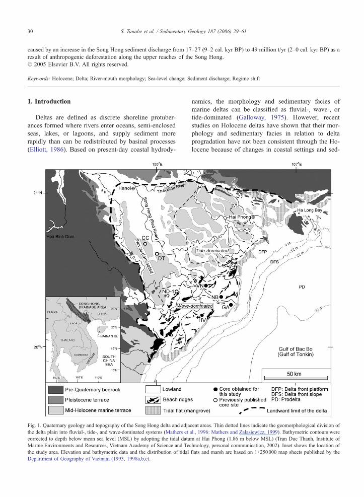
Fig. 1. Quaternary geology and topography of the Song Hong delta and adja
the delta plain into fluvial-, tide-, and wave-dominated systems (Mathers et
corrected to depth below mean sea level (MSL) by adopting the tidal datu
Marine Environments and Resources, Vietnam Academy of Science and Tec
the study area. Elevation and bathymetric data and the distribution of tidal
Department of Geography of Vietnam (1993, 1998a,b,c).
namics, the morphology and sedimentary facies of
marine deltas can be classified as fluvial-, wave-, or
tide-dominated (Galloway, 1975). However, recent
studies on Holocene deltas have shown that their mor-
phology and sedimentary facies in relation to delta
progradation have not been consistent through the Ho-
locene because of changes in coastal settings and sed-
cent areas. Thin dotted lines indicate the geomorphological division of
al., 1996: Mathers and Zalasiewicz, 1999). Bathymetric contours were
m at Hai Phong (1.86 m below MSL) (Tran Duc Thanh, Institute of
hnology, personal communication, 2002). Inset shows the location of
flats and marsh are based on 1 /250000 map sheets published by the
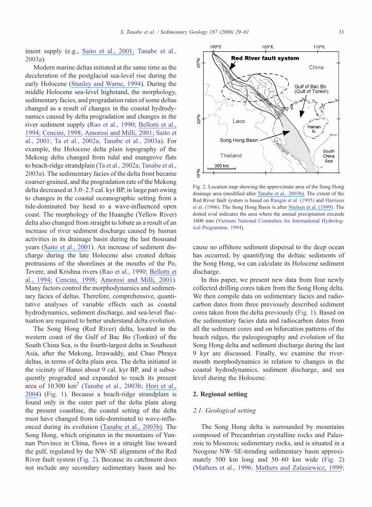
Fig. 2. Location map showing the approximate area of the Song Hong
drainage area (modified after Tanabe et al., 2003b). The extent of the
Red River fault system is based on Rangin et al. (1995) and Harrison
et al. (1996). The Song Hong Basin is after Nielsen et al. (1999). The
dotted oval indicates the area where the annual precipitation exceeds
1600 mm (Vietnam National Committee for International Hydrolog-
ical Programme, 1994).
S. Tanabe et al. / Sedimentary Geology 187 (2006) 29–61 31
iment supply (e.g., Saito et al., 2001; Tanabe et al.,
2003a).
Modern marine deltas initiated at the same time as the
deceleration of the postglacial sea-level rise during the
early Holocene (Stanley and Warne, 1994). During the
middle Holocene sea-level highstand, the morphology,
sedimentary facies, and progradation rates of some deltas
changed as a result of changes in the coastal hydrody-
namics caused by delta progradation and changes in the
river sediment supply (Rao et al., 1990; Bellotti et al.,
1994; Cencini, 1998; Amorosi and Milli, 2001; Saito et
al., 2001; Ta et al., 2002a; Tanabe et al., 2003a). For
example, the Holocene delta plain topography of the
Mekong delta changed from tidal and mangrove flats
to beach-ridge strandplain (Ta et al., 2002a; Tanabe et al.,
2003a). The sedimentary facies of the delta front became
coarser-grained, and the progradation rate of theMekong
delta decreased at 3.0–2.5 cal. kyr BP, in large part owing
to changes in the coastal oceanographic setting from a
tide-dominated bay head to a wave-influenced open
coast. The morphology of the Huanghe (Yellow River)
delta also changed from straight to lobate as a result of an
increase of river sediment discharge caused by human
activities in its drainage basin during the last thousand
years (Saito et al., 2001). An increase of sediment dis-
charge during the late Holocene also created deltaic
protrusions of the shorelines at the mouths of the Po,
Tevere, and Krishna rivers (Rao et al., 1990; Bellotti et
al., 1994; Cencini, 1998; Amorosi and Milli, 2001).
Many factors control the morphodynamics and sedimen-
tary facies of deltas. Therefore, comprehensive, quanti-
tative analyses of variable effects such as coastal
hydrodynamics, sediment discharge, and sea-level fluc-
tuation are required to better understand delta evolution.
The Song Hong (Red River) delta, located in the
western coast of the Gulf of Bac Bo (Tonkin) of the
South China Sea, is the fourth-largest delta in Southeast
Asia, after the Mekong, Irrawaddy, and Chao Phraya
deltas, in terms of delta plain area. The delta initiated in
the vicinity of Hanoi about 9 cal. kyr BP, and it subse-
quently prograded and expanded to reach its present
area of 10300 km2 (Tanabe et al., 2003b; Hori et al.,
2004) (Fig. 1). Because a beach-ridge strandplain is
found only in the outer part of the delta plain along
the present coastline, the coastal setting of the delta
must have changed from tide-dominated to wave-influ-
enced during its evolution (Tanabe et al., 2003b). The
Song Hong, which originates in the mountains of Yun-
nan Province in China, flows in a straight line toward
the gulf, regulated by the NW–SE alignment of the Red
River fault system (Fig. 2). Because its catchment does
not include any secondary sedimentary basin and be-
cause no offshore sediment dispersal to the deep ocean
has occurred, by quantifying the deltaic sediments of
the Song Hong, we can calculate its Holocene sediment
discharge.
In this paper, we present new data from four newly
collected drilling cores taken from the Song Hong delta.
We then compile data on sedimentary facies and radio-
carbon dates from three previously described sediment
cores taken from the delta previously (Fig. 1). Based on
the sedimentary facies data and radiocarbon dates from
all the sediment cores and on bifurcation patterns of the
beach ridges, the paleogeography and evolution of the
Song Hong delta and sediment discharge during the last
9 kyr are discussed. Finally, we examine the river-
mouth morphodynamics in relation to changes in the
coastal hydrodynamics, sediment discharge, and sea
level during the Holocene.
2. Regional setting
2.1. Geological setting
The Song Hong delta is surrounded by mountains
composed of Precambrian crystalline rocks and Paleo-
zoic to Mesozoic sedimentary rocks, and is situated in a
Neogene NW–SE-trending sedimentary basin approxi-
mately 500 km long and 50–60 km wide (Fig. 2)
(Mathers et al., 1996; Mathers and Zalasiewicz, 1999;
S. Tanabe et al. / Sedimentary Geology 187 (2006) 29–6132
Nielsen et al., 1999). The NW–SE alignment of the Red
River fault system (Rangin et al., 1995) regulates the
distribution of mountainous areas, the sedimentary
basin, the drainage area, and the straight course of the
Song Hong. The basin is filled with Neogene and Qua-
ternary sediments to a thickness of more than 3 km, and
the subsidence rate of the basin is 0.04–0.12 mm/yr
(Mathers et al., 1996; Mathers and Zalasiewicz, 1999;
Tran and Dinh, 2000).
2.2. Quaternary stratigraphy
The Quaternary sediments, which unconformably
overlie Neogene deposits, are composed mainly of
sands and gravels with subordinate lenses of silt and
clay, and the sediments thicken seaward to a maximum
thickness of 200 m beneath the coastal area of the
delta (Mathers et al., 1996; Mathers and Zalasiewicz,
1999).
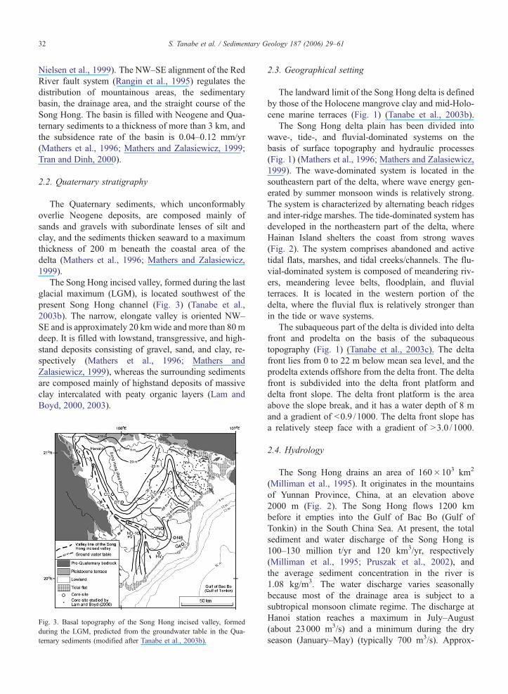
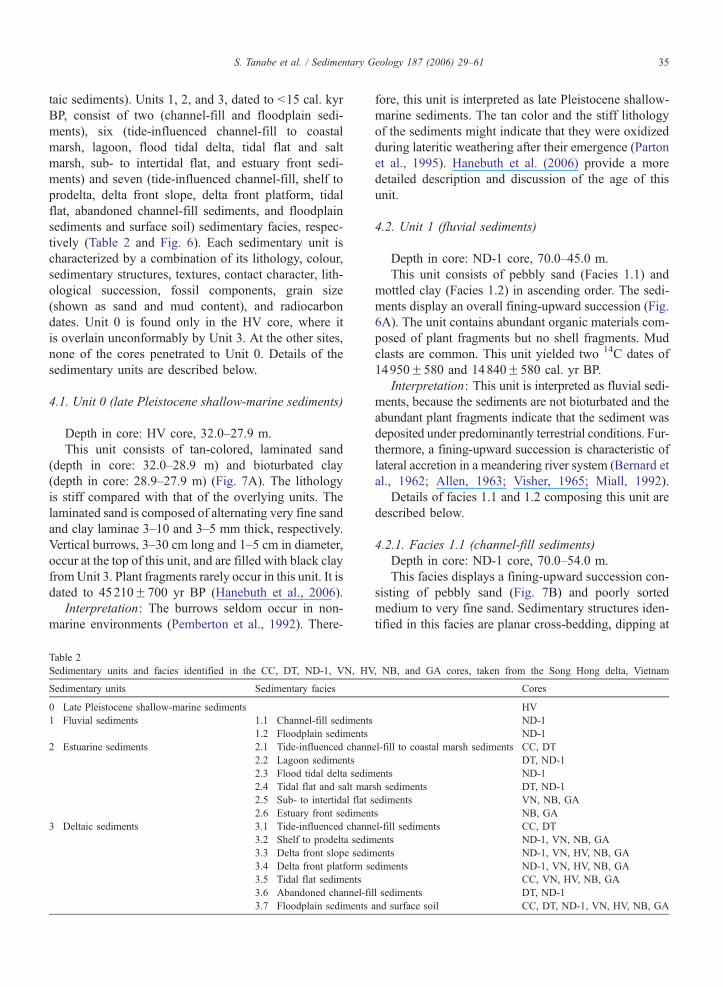
The Song Hong incised valley, formed during the last
glacial maximum (LGM), is located southwest of the
present Song Hong channel (Fig. 3) (Tanabe et al.,
2003b). The narrow, elongate valley is oriented NW–
SE and is approximately 20 kmwide and more than 80m
deep. It is filled with lowstand, transgressive, and high-
stand deposits consisting of gravel, sand, and clay, re-
spectively (Mathers et al., 1996; Mathers and
Zalasiewicz, 1999), whereas the surrounding sediments
are composed mainly of highstand deposits of massive
clay intercalated with peaty organic layers (Lam and
Boyd, 2000, 2003).
Fig. 3. Basal topography of the Song Hong incised valley, formed
during the LGM, predicted from the groundwater table in the Qua-
ternary sediments (modified after Tanabe et al., 2003b).
2.3. Geographical setting
The landward limit of the Song Hong delta is defined
by those of the Holocene mangrove clay and mid-Holo-
cene marine terraces (Fig. 1) (Tanabe et al., 2003b).
The Song Hong delta plain has been divided into
wave-, tide-, and fluvial-dominated systems on the
basis of surface topography and hydraulic processes
(Fig. 1) (Mathers et al., 1996; Mathers and Zalasiewicz,
1999). The wave-dominated system is located in the
southeastern part of the delta, where wave energy gen-
erated by summer monsoon winds is relatively strong.
The system is characterized by alternating beach ridges
and inter-ridge marshes. The tide-dominated system has
developed in the northeastern part of the delta, where
Hainan Island shelters the coast from strong waves
(Fig. 2). The system comprises abandoned and active
tidal flats, marshes, and tidal creeks/channels. The flu-
vial-dominated system is composed of meandering riv-
ers, meandering levee belts, floodplain, and fluvial
terraces. It is located in the western portion of the
delta, where the fluvial flux is relatively stronger than
in the tide or wave systems.
The subaqueous part of the delta is divided into delta
front and prodelta on the basis of the subaqueous
topography (Fig. 1) (Tanabe et al., 2003c). The delta
front lies from 0 to 22 m below mean sea level, and the
prodelta extends offshore from the delta front. The delta
front is subdivided into the delta front platform and
delta front slope. The delta front platform is the area
above the slope break, and it has a water depth of 8 m
and a gradient of b0.9 /1000. The delta front slope has
a relatively steep face with a gradient of N3.0 /1000.
2.4. Hydrology
The Song Hong drains an area of 160�103 km2
(Milliman et al., 1995). It originates in the mountains
of Yunnan Province, China, at an elevation above
2000 m (Fig. 2). The Song Hong flows 1200 km
before it empties into the Gulf of Bac Bo (Gulf of
Tonkin) in the South China Sea. At present, the total
sediment and water discharge of the Song Hong is
100–130 million t/yr and 120 km3/yr, respectively
(Milliman et al., 1995; Pruszak et al., 2002), and
the average sediment concentration in the river is
1.08 kg/m3. The water discharge varies seasonally
because most of the drainage area is subject to a
subtropical monsoon climate regime. The discharge at
Hanoi station reaches a maximum in July–August
(about 23000 m3/s) and a minimum during the dry
season (January–May) (typically 700 m3/s). Approx-
S. Tanabe et al. / Sedimentary Geology 187 (2006) 29–61 33
imately 90% of the annual sediment discharge occurs
during the summer monsoon season, at which time
the sediment concentration may reach 12 kg/m3
(Mathers et al., 1996; Mathers and Zalasiewicz,
1999).
In the delta plain, the river diverges into two major
distributaries in the vicinity of Hanoi: the Song Hong to
the southwest and the Thai Binh River to the northeast
(Fig. 1). The Thai Binh River carries 20% of the total
water discharge (General Department of Land Admin-
istration, 1996).
2.5. Oceanography
The mean tidal range is 2.0–2.6 m (Coleman and
Wright, 1975; Tran Duc Thanh, Institute of Marine
Environment and Resources, Vietnam Academy of Sci-
ence and Technology, personal communication, 2000),
and the maximum tidal range is 3.2–4.0 m along the
Song Hong delta coast (Mathers et al., 1996; Mathers
and Zalasiewicz, 1999; Tran and Dinh, 2000). In the
summer monsoon season, tidal influences within the
delta are restricted because of the overwhelming effect
of the high freshwater discharge, but in the dry season,
tidal effects are evident in both major distributaries
almost as far inland as Hanoi (Mathers et al., 1996;
Mathers and Zalasiewicz, 1999).
Along the delta coast, the mean and maximum wave
heights are 0.88 and 5.0 m, respectively (Tran and Dinh,
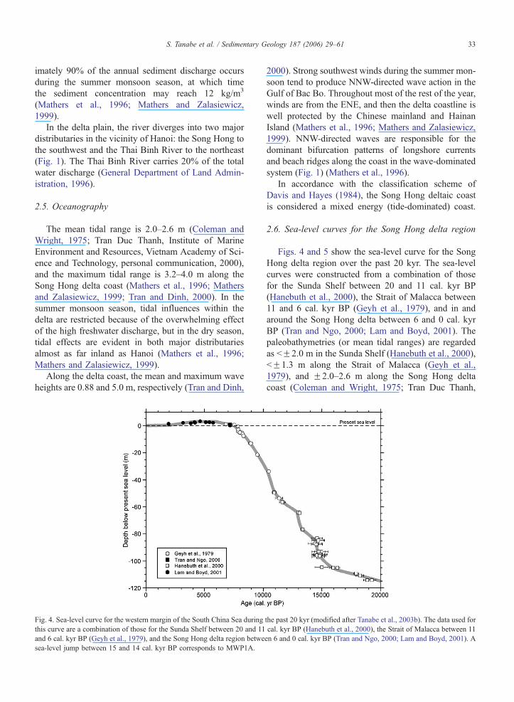
Fig. 4. Sea-level curve for the western margin of the South China Sea during
this curve are a combination of those for the Sunda Shelf between 20 and 11
and 6 cal. kyr BP (Geyh et al., 1979), and the Song Hong delta region betwe
sea-level jump between 15 and 14 cal. kyr BP corresponds to MWP1A.
2000). Strong southwest winds during the summer mon-
soon tend to produce NNW-directed wave action in the
Gulf of Bac Bo. Throughout most of the rest of the year,
winds are from the ENE, and then the delta coastline is
well protected by the Chinese mainland and Hainan
Island (Mathers et al., 1996; Mathers and Zalasiewicz,
1999). NNW-directed waves are responsible for the
dominant bifurcation patterns of longshore currents
and beach ridges along the coast in the wave-dominated
system (Fig. 1) (Mathers et al., 1996).
In accordance with the classification scheme of
Davis and Hayes (1984), the Song Hong deltaic coast
is considered a mixed energy (tide-dominated) coast.
2.6. Sea-level curves for the Song Hong delta region
Figs. 4 and 5 show the sea-level curve for the Song
Hong delta region over the past 20 kyr. The sea-level
curves were constructed from a combination of those
for the Sunda Shelf between 20 and 11 cal. kyr BP
(Hanebuth et al., 2000), the Strait of Malacca between
11 and 6 cal. kyr BP (Geyh et al., 1979), and in and
around the Song Hong delta between 6 and 0 cal. kyr
BP (Tran and Ngo, 2000; Lam and Boyd, 2001). The
paleobathymetries (or mean tidal ranges) are regarded
as bF2.0 m in the Sunda Shelf (Hanebuth et al., 2000),
bF1.3 m along the Strait of Malacca (Geyh et al.,
1979), and F2.0–2.6 m along the Song Hong delta
coast (Coleman and Wright, 1975; Tran Duc Thanh,
the past 20 kyr (modified after Tanabe et al., 2003b). The data used for
cal. kyr BP (Hanebuth et al., 2000), the Strait of Malacca between 11
en 6 and 0 cal. kyr BP (Tran and Ngo, 2000; Lam and Boyd, 2001). A
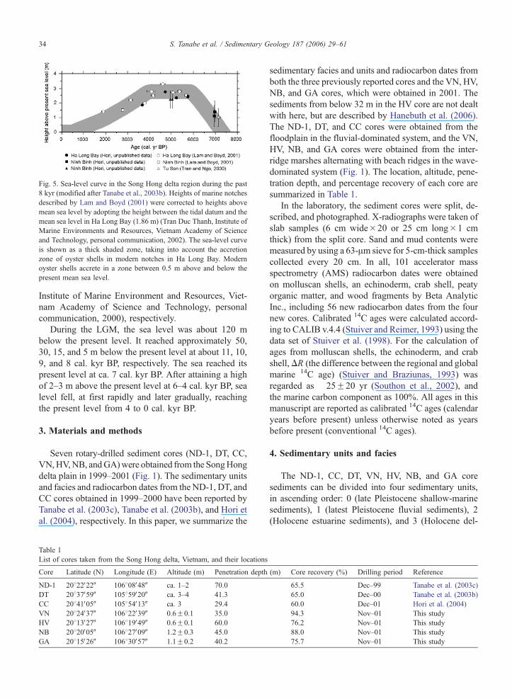
Fig. 5. Sea-level curve in the Song Hong delta region during the past
8 kyr (modified after Tanabe et al., 2003b). Heights of marine notches
described by Lam and Boyd (2001) were corrected to heights above
mean sea level by adopting the height between the tidal datum and the
mean sea level in Ha Long Bay (1.86 m) (Tran Duc Thanh, Institute of
Marine Environments and Resources, Vietnam Academy of Science
and Technology, personal communication, 2002). The sea-level curve
is shown as a thick shaded zone, taking into account the accretion
zone of oyster shells in modern notches in Ha Long Bay. Modern
oyster shells accrete in a zone between 0.5 m above and below the
present mean sea level.
S. Tanabe et al. / Sedimentary Geology 187 (2006) 29–6134
Institute of Marine Environment and Resources, Viet-
nam Academy of Science and Technology, personal
communication, 2000), respectively.
During the LGM, the sea level was about 120 m
below the present level. It reached approximately 50,
30, 15, and 5 m below the present level at about 11, 10,
9, and 8 cal. kyr BP, respectively. The sea reached its
present level at ca. 7 cal. kyr BP. After attaining a high
of 2–3 m above the present level at 6–4 cal. kyr BP, sea
level fell, at first rapidly and later gradually, reaching
the present level from 4 to 0 cal. kyr BP.
3. Materials and methods
Seven rotary-drilled sediment cores (ND-1, DT, CC,
VN,HV,NB, andGA)were obtained from the SongHong
delta plain in 1999–2001 (Fig. 1). The sedimentary units
and facies and radiocarbon dates from the ND-1, DT, and
CC cores obtained in 1999–2000 have been reported by
Tanabe et al. (2003c), Tanabe et al. (2003b), and Hori et
al. (2004), respectively. In this paper, we summarize the
Table 1
List of cores taken from the Song Hong delta, Vietnam, and their locations
Core Latitude (N) Longitude (E) Altitude (m) Penetration depth
ND-1 20822V22W 106808V48W ca. 1–2 70.0
DT 20837V59W 105859V20W ca. 3–4 41.3
CC 20841V05W 105854V13W ca. 3 29.4
VN 20824V37W 106822V39W 0.6F0.1 35.0
HV 20813V27W 106819V49W 0.6F0.1 60.0
NB 20820V05W 106827V09W 1.2F0.3 45.0
GA 20815V26W 106830V57W 1.1F0.2 40.2
sedimentary facies and units and radiocarbon dates from
both the three previously reported cores and the VN, HV,
NB, and GA cores, which were obtained in 2001. The
sediments from below 32 m in the HV core are not dealt
with here, but are described by Hanebuth et al. (2006).
The ND-1, DT, and CC cores were obtained from the
floodplain in the fluvial-dominated system, and the VN,
HV, NB, and GA cores were obtained from the inter-
ridge marshes alternating with beach ridges in the wave-
dominated system (Fig. 1). The location, altitude, pene-
tration depth, and percentage recovery of each core are
summarized in Table 1.
In the laboratory, the sediment cores were split, de-
scribed, and photographed. X-radiographs were taken of
slab samples (6 cm wide�20 or 25 cm long�1 cm
thick) from the split core. Sand and mud contents were
measured by using a 63-Am sieve for 5-cm-thick samples
collected every 20 cm. In all, 101 accelerator mass
spectrometry (AMS) radiocarbon dates were obtained
on molluscan shells, an echinoderm, crab shell, peaty
organic matter, and wood fragments by Beta Analytic
Inc., including 56 new radiocarbon dates from the four
new cores. Calibrated 14C ages were calculated accord-
ing to CALIB v.4.4 (Stuiver and Reimer, 1993) using the
data set of Stuiver et al. (1998). For the calculation of
ages from molluscan shells, the echinoderm, and crab
shell,DR (the difference between the regional and global
marine 14C age) (Stuiver and Braziunas, 1993) was
regarded as �25F20 yr (Southon et al., 2002), and
the marine carbon component as 100%. All ages in this
manuscript are reported as calibrated 14C ages (calendar
years before present) unless otherwise noted as years
before present (conventional 14C ages).
4. Sedimentary units and facies
The ND-1, CC, DT, VN, HV, NB, and GA core
sediments can be divided into four sedimentary units,
in ascending order: 0 (late Pleistocene shallow-marine
sediments), 1 (latest Pleistocene fluvial sediments), 2
(Holocene estuarine sediments), and 3 (Holocene del-
(m) Core recovery (%) Drilling period Reference
65.5 Dec–99 Tanabe et al. (2003c)
65.0 Dec–00 Tanabe et al. (2003b)
60.0 Dec–01 Hori et al. (2004)
94.3 Nov–01 This study
76.2 Nov–01 This study
88.0 Nov–01 This study
75.7 Nov–01 This study
S. Tanabe et al. / Sedimentary Geology 187 (2006) 29–61 35
taic sediments). Units 1, 2, and 3, dated to b15 cal. kyr
BP, consist of two (channel-fill and floodplain sedi-
ments), six (tide-influenced channel-fill to coastal
marsh, lagoon, flood tidal delta, tidal flat and salt
marsh, sub- to intertidal flat, and estuary front sedi-
ments) and seven (tide-influenced channel-fill, shelf to
prodelta, delta front slope, delta front platform, tidal
flat, abandoned channel-fill sediments, and floodplain
sediments and surface soil) sedimentary facies, respec-
tively (Table 2 and Fig. 6). Each sedimentary unit is
characterized by a combination of its lithology, colour,
sedimentary structures, textures, contact character, lith-
ological succession, fossil components, grain size
(shown as sand and mud content), and radiocarbon
dates. Unit 0 is found only in the HV core, where it
is overlain unconformably by Unit 3. At the other sites,
none of the cores penetrated to Unit 0. Details of the
sedimentary units are described below.
4.1. Unit 0 (late Pleistocene shallow-marine sediments)
Depth in core: HV core, 32.0–27.9 m.
This unit consists of tan-colored, laminated sand
(depth in core: 32.0–28.9 m) and bioturbated clay
(depth in core: 28.9–27.9 m) (Fig. 7A). The lithology
is stiff compared with that of the overlying units. The
laminated sand is composed of alternating very fine sand
and clay laminae 3–10 and 3–5 mm thick, respectively.
Vertical burrows, 3–30 cm long and 1–5 cm in diameter,
occur at the top of this unit, and are filled with black clay
fromUnit 3. Plant fragments rarely occur in this unit. It is
dated to 45210F700 yr BP (Hanebuth et al., 2006).
Interpretation: The burrows seldom occur in non-
marine environments (Pemberton et al., 1992). There-
Table 2
Sedimentary units and facies identified in the CC, DT, ND-1, VN, HV
Sedimentary units Sedimentary facies
0 Late Pleistocene shallow-marine sediments
1 Fluvial sediments 1.1 Channel-fill sediments
1.2 Floodplain sediments
2 Estuarine sediments 2.1 Tide-influenced chann
2.2 Lagoon sediments
2.3 Flood tidal delta sedim
2.4 Tidal flat and salt mar
2.5 Sub- to intertidal flat s
2.6 Estuary front sediment
3 Deltaic sediments 3.1 Tide-influenced chann
3.2 Shelf to prodelta sedim
3.3 Delta front slope sedim
3.4 Delta front platform se
3.5 Tidal flat sediments
3.6 Abandoned channel-fi
3.7 Floodplain sediments
fore, this unit is interpreted as late Pleistocene shallow-
marine sediments. The tan color and the stiff lithology
of the sediments might indicate that they were oxidized
during lateritic weathering after their emergence (Parton
et al., 1995). Hanebuth et al. (2006) provide a more
detailed description and discussion of the age of this
unit.
4.2. Unit 1 (fluvial sediments)
Depth in core: ND-1 core, 70.0–45.0 m.
This unit consists of pebbly sand (Facies 1.1) and
mottled clay (Facies 1.2) in ascending order. The sedi-
ments display an overall fining-upward succession (Fig.
6A). The unit contains abundant organic materials com-
posed of plant fragments but no shell fragments. Mud
clasts are common. This unit yielded two 14C dates of
14950F580 and 14840F580 cal. yr BP.
Interpretation: This unit is interpreted as fluvial sedi-
ments, because the sediments are not bioturbated and the
abundant plant fragments indicate that the sediment was
deposited under predominantly terrestrial conditions. Fur-
thermore, a fining-upward succession is characteristic of
lateral accretion in a meandering river system (Bernard et
al., 1962; Allen, 1963; Visher, 1965; Miall, 1992).
Details of facies 1.1 and 1.2 composing this unit are
described below.
4.2.1. Facies 1.1 (channel-fill sediments)
Depth in core: ND-1 core, 70.0–54.0 m.
This facies displays a fining-upward succession con-
sisting of pebbly sand (Fig. 7B) and poorly sorted
medium to very fine sand. Sedimentary structures iden-
tified in this facies are planar cross-bedding, dipping at
, NB, and GA cores, taken from the Song Hong delta, Vietnam
Cores
HV
ND-1
ND-1
el-fill to coastal marsh sediments CC, DT
DT, ND-1
ents ND-1
sh sediments DT, ND-1
ediments VN, NB, GA
s NB, GA
el-fill sediments CC, DT
ents ND-1, VN, NB, GA
ents ND-1, VN, HV, NB, GA
diments ND-1, VN, HV, NB, GA
CC, VN, HV, NB, GA
ll sediments DT, ND-1
and surface soil CC, DT, ND-1, VN, HV, NB, GA
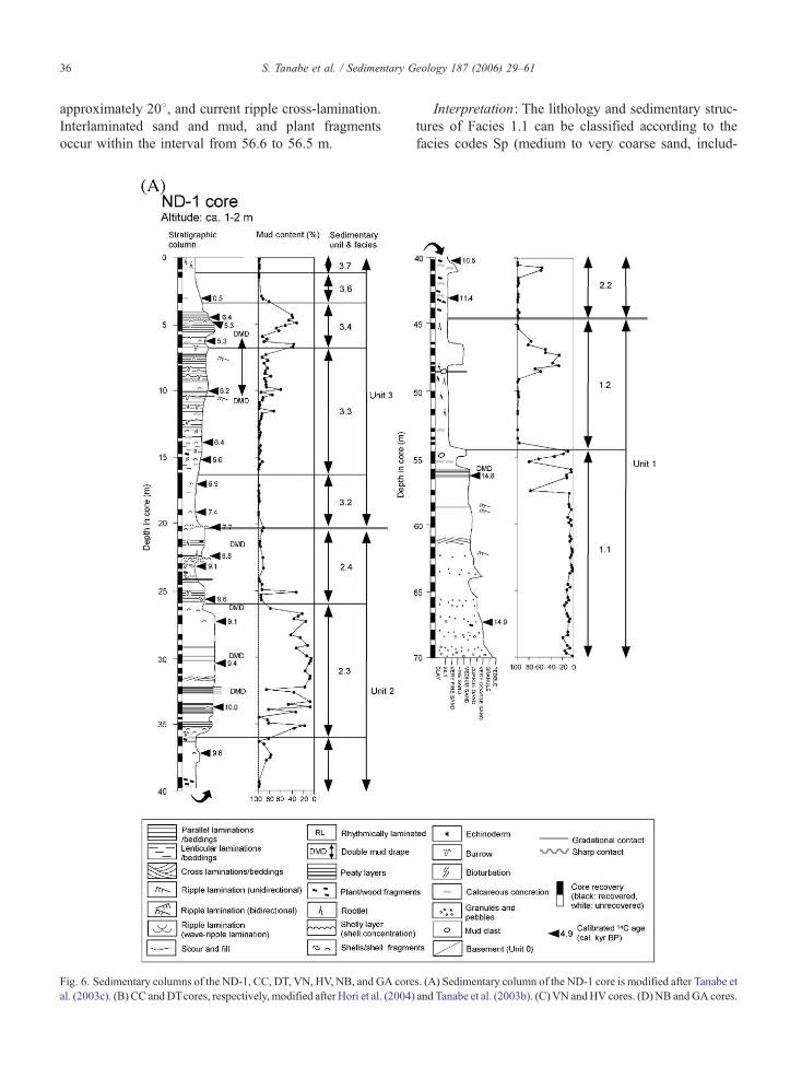
S. Tanabe et al. / Sedimentary Geology 187 (2006) 29–6136
approximately 208, and current ripple cross-lamination.
Interlaminated sand and mud, and plant fragments
occur within the interval from 56.6 to 56.5 m.
Fig. 6. Sedimentary columns of the ND-1, CC, DT, VN, HV, NB, and GA core
al. (2003c). (B) CC andDTcores, respectively, modified after Hori et al. (2004)
Interpretation: The lithology and sedimentary struc-
tures of Facies 1.1 can be classified according to the
facies codes Sp (medium to very coarse sand, includ-
s. (A) Sedimentary column of the ND-1 core is modified after Tanabe et
and Tanabe et al. (2003b). (C) VN andHV cores. (D) NB andGA cores.
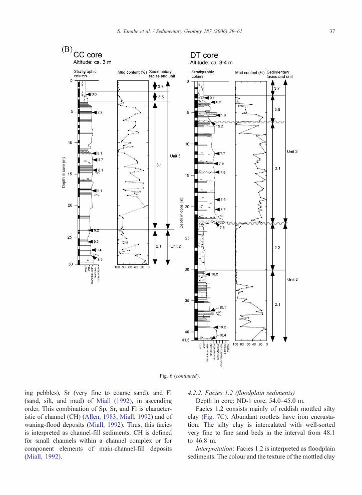
Fig. 6 (continued).
S. Tanabe et al. / Sedimentary Geology 187 (2006) 29–61 37
ing pebbles), Sr (very fine to coarse sand), and Fl
(sand, silt, and mud) of Miall (1992), in ascending
order. This combination of Sp, Sr, and Fl is character-
istic of channel (CH) (Allen, 1983; Miall, 1992) and of
waning-flood deposits (Miall, 1992). Thus, this facies
is interpreted as channel-fill sediments. CH is defined
for small channels within a channel complex or for
component elements of main-channel-fill deposits
(Miall, 1992).
4.2.2. Facies 1.2 (floodplain sediments)
Depth in core: ND-1 core, 54.0–45.0 m.
Facies 1.2 consists mainly of reddish mottled silty
clay (Fig. 7C). Abundant rootlets have iron encrusta-
tion. The silty clay is intercalated with well-sorted
very fine to fine sand beds in the interval from 48.1
to 46.8 m.
Interpretation: Facies 1.2 is interpreted as floodplain
sediments. The colour and the texture of the mottled clay
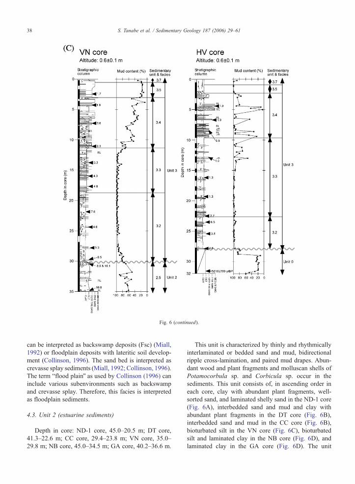
Fig. 6 (continued).
S. Tanabe et al. / Sedimentary Geology 187 (2006) 29–6138
can be interpreted as backswamp deposits (Fsc) (Miall,
1992) or floodplain deposits with lateritic soil develop-
ment (Collinson, 1996). The sand bed is interpreted as
crevasse splay sediments (Miall, 1992; Collinson, 1996).
The term bflood plainQ as used by Collinson (1996) can
include various subenvironments such as backswamp
and crevasse splay. Therefore, this facies is interpreted
as floodplain sediments.
4.3. Unit 2 (estuarine sediments)
Depth in core: ND-1 core, 45.0–20.5 m; DT core,
41.3–22.6 m; CC core, 29.4–23.8 m; VN core, 35.0–
29.8 m; NB core, 45.0–34.5 m; GA core, 40.2–36.6 m.
This unit is characterized by thinly and rhythmically
interlaminated or bedded sand and mud, bidirectional
ripple cross-lamination, and paired mud drapes. Abun-
dant wood and plant fragments and molluscan shells of
Potamocorbula sp. and Corbicula sp. occur in the
sediments. This unit consists of, in ascending order in
each core, clay with abundant plant fragments, well-
sorted sand, and laminated shelly sand in the ND-1 core
(Fig. 6A), interbedded sand and mud and clay with
abundant plant fragments in the DT core (Fig. 6B),
interbedded sand and mud in the CC core (Fig. 6B),
bioturbated silt in the VN core (Fig. 6C), bioturbated
silt and laminated clay in the NB core (Fig. 6D), and
laminated clay in the GA core (Fig. 6D). The unit
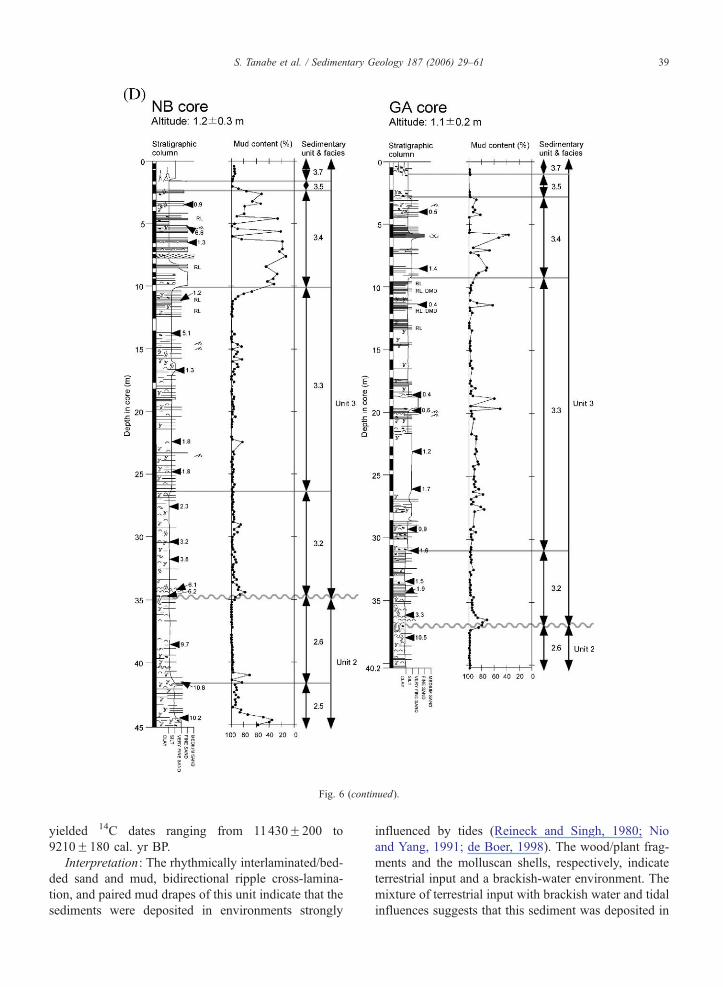
Fig. 6 (continued).
S. Tanabe et al. / Sedimentary Geology 187 (2006) 29–61 39
yielded 14C dates ranging from 11430F200 to
9210F180 cal. yr BP.
Interpretation: The rhythmically interlaminated/bed-
ded sand and mud, bidirectional ripple cross-lamina-
tion, and paired mud drapes of this unit indicate that the
sediments were deposited in environments strongly
influenced by tides (Reineck and Singh, 1980; Nio
and Yang, 1991; de Boer, 1998). The wood/plant frag-
ments and the molluscan shells, respectively, indicate
terrestrial input and a brackish-water environment. The
mixture of terrestrial input with brackish water and tidal
influences suggests that this sediment was deposited in
S. Tanabe et al. / Sedimentary Geology 187 (2006) 29–6140
a mixed zone with marine and fluvial influences such as
in an estuarine environment.
Details of facies 2.1–2.6 composing this unit are
described below.
4.3.1. Facies 2.1 (tide-influenced channel-fill to coastal
marsh sediments)
Depth in core: CC core, 29.4–23.8 m; DT core,
41.3–30.0 m.
Facies 2.1 shows an overall fining-upward succes-
sion from medium sand to laminated clay (Fig. 7D).
The sand contains mud drapes (b5 mm in thickness)
and mud clasts (b25 mm in diameter). Ripple cross-
laminations identified in the radiographs of the sand
contain bidirectional or multidirectional foresets. Peaty
organic layers and very fine sand layers less than 10 mm
thick are interlaminated with the clay. Rootlets occur at
the top of this facies.
Interpretation: Facies 2.1 is interpreted as tide-influ-
enced channel-fill to coastal marsh sediments. An over-
all fining-upward lithological succession and the
occurrence of mud drapes and bidirectional ripple
cross-lamination are common in tidal creek and tidal
flat sediments (Reineck and Singh, 1980; Dalrymple,
1992). Peaty laminated clay or clay with roots, which
occurs at the top of this facies, is a common feature of
floodplain and coastal marsh environments (Frey and
Basan, 1985; Miall, 1992; Collinson, 1996). It is most
appropriate to interpret this facies as coastal marsh
sediments because it is overlain by the lagoon sedi-
ments of Facies 2.2.
4.3.2. Facies 2.2 (lagoon sediments)
Depth in core: DT core, 30.0–22.6 m; ND-1 core,
45.0–36.0 m.
This facies is characterized by dark reddish silty
clay and bluish gray massive clay (Fig. 7E) with
abundant plant fragments and minor burrows. Thin
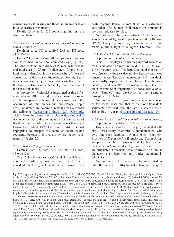
Fig. 7. Photographs of typical sedimentary facies of the ND-1, DT, CC, VN,
bar is 10 cm. (A) Unit 0, HV core, 27.65–28.15 m depth. Tan-colored silty s
62.50 m depth. Gravelly sand. Parallel laminations are partly contorted owing
depth. Red to black organic clay. (D) Facies 2.1, DT core, 34.80–35.30 m d
thick. (E) Facies 2.2, DT core, 25.85–26.25 m depth. Gray massive clay. (F
with peaty layers containing wood and plant fragments. Burrows and shells
Rhythmically interlaminated sand and mud. The sand and mud laminations
2.5, VN core, 30.00–30.50 m depth. Bioturbated sandy clay. (I) Facies 2.6,
Facies 3.1, DT core, 6.45–7.20 m depth. Sand–mud alternation. The sand
rhythmically laminated with thin silt and peaty layers. (K) Facies 3.2, ND-1
3.3, ND-1 core, 11.80–12.40 m depth. Sand–mud alternation with calcareou
core, 5.40–6.15 m depth. Medium sand interbedded with black organic clay.
rhythmically laminated clay. Shelly layer identified at the bottom. (O) Facies
organic layer at the top. (P) Facies 3.5, CC core, 3.05–3.65 m depth. Interla
1.55 m depth. Gray mottled clay. (r) Facies 3.7, CC core, 0.30–1.00 m dep
peaty organic layers, 5 mm thick, and calcareous
concretions (35–55 mm in diameter) are common in
the dark reddish silty clay.
Interpretation: The characteristics of this facies re-
semble those of lagoonal deposits reported by Reinson
(1992). The peaty layer may have formed in a salt
marsh at the margin of a lagoon (Reinson, 1992).
4.3.3. Facies 2.3 (flood-tidal delta sediments)
Depth in core: ND-1 core, 36.0–27.0 m.
Facies 2.3 displays a coarsening-upward succession
from laminated fine-medium sand (Fig. 7F) to well-
sorted medium sand. The laminated sand consists of
very fine to medium sand with clay laminae and peaty
organic layers. The clay laminations, 1–5 mm thick,
occasionally display paired mud drapes. Trough cross-
bedding that dips at 208 to 408 occurs in the well-sorted
medium sand. Shell fragments of Potamocorbula amur-
ensis (Shrenck) and Corbicula sp. are scattered
throughout this facies.
Interpretation: The upward-coarsening succession
of this facies resembles that of the flood-tidal delta
sediments described from the late Pleistocene paleo-
Tokyo Bay in Japan (Murakoshi and Masuda, 1991).
4.3.4. Facies 2.4 (tidal flat and salt marsh sediments)
Depth in core: ND-1 core, 27.0–20.5 m.
This facies is characterized by gray, laminated silty
clay, occasionally rhythmically interlaminated with
very fine sand laminae 1–3 mm thick (Fig. 7G).
Bivalves of P. amurensis (Shrenck) and Corbicula sp.
are present in 3- to 5-cm-thick shelly layers (shell
concentrations) in the silty clay. Some of the bivalves
are articulated. Occasional small burrows (b5 mm in
diameter), plant fragments, and rootlets are found in
this facies.
Interpretation: This facies can be interpreted as
tidal flat sediments. Rhythmically laminated clay is
HV, NB, and GA cores. The top is at the upper left in all figures. Scale
and overlain by black prodelta clay. (B) Facies 1.1, ND-1 core, 61.70–
to deformation during coring. (C) Facies 1.2, ND-1 core, 48.8–49.2 m
epth. Sand–mud alternation. Sand and mud layers are each 1–10 cm
) Facies 2.3, ND-1 core, 33.40–34.20 m depth. Sand–mud alternation
are identified at the top. (G) Facies 2.4, ND-1, 25.40–25.80 m depth.
are 1–5 mm thick. Shell fragments are identified at the top. (H) Facies
NB core, 40.25–41.00 m depth. Shelly silt with faint sand lamina. (J)
and mud are 1–8 and 1–20 cm thick, respectively. Mud beds are
core, 16.20–16.8 m depth. Gray clay with shell fragments. (L) Facies
s concretions (colored black in the photograph). (M) Facies 3.4, VN
(N) Facies 3.4, HV core, 4.40–5.10 m depth. Medium sand partly with
3.4, GA core, 8.40–9.00 m depth. Sandy clay–clay alternation. Peaty
minated sand and mud with rootlets. (Q) Facies 3.6, ND-1 core, 1.15–
th. Red mottled clay.
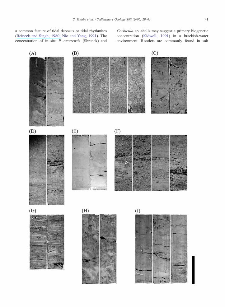
S. Tanabe et al. / Sedimentary Geology 187 (2006) 29–61 41
a common feature of tidal deposits or tidal rhythmites
(Reineck and Singh, 1980; Nio and Yang, 1991). The
concentration of in situ P. amurensis (Shrenck) and
Corbicula sp. shells may suggest a primary biogenetic
concentration (Kidwell, 1991) in a brackish-water
environment. Rootlets are commonly found in salt
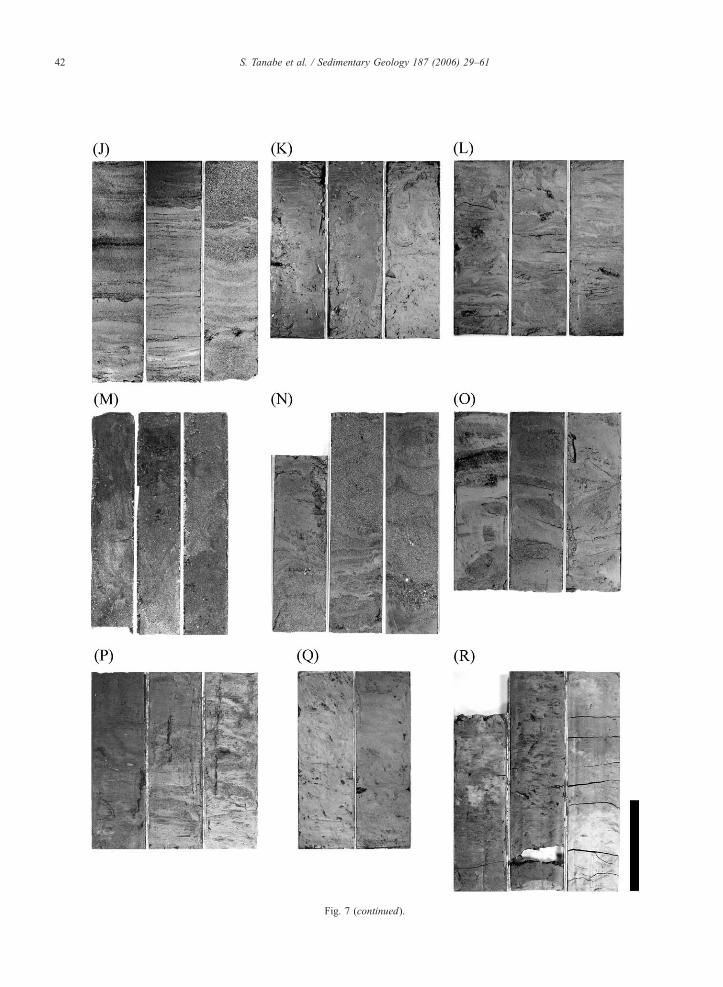
Fig. 7 (continued).
S. Tanabe et al. / Sedimentary Geology 187 (2006) 29–6142
S. Tanabe et al. / Sedimentary Geology 187 (2006) 29–61 43
marsh and upper tidal flat sediments (Frey and Basan,
1985).
4.3.5. Facies 2.5 (sub- to intertidal flat sediments)
Depth in core: VN core, 35.0–29.8 m; NB core,
45.0–41.6 m.
This facies is characterized by reddish gray, inten-
sively bioturbated silt (Fig. 7H). A large portion of this
facies is bioturbated, but very fine sand and clay lami-
nations remain as faint lenses 3–8 mm thick. In the
lower part of the VN core, from 32.5 to 33.0 m, clay
laminations 3–5 mm thick are preserved. They alternate
with very fine sand layers 3–10 mm thick, forming
lenticular bedding. The contact at the base of the sand
and silt layers is sharp, whereas at the top, the transition
to clay is gradual. Shelly layers 2–3 cm thick consisting
of jointed bivalves of Potamocorbula laevis and Cor-
bicula fluminea are also found. Wood/plant fragments
are scattered throughout this facies.
Interpretation: This facies is interpreted as subtidal
to intertidal flat sediments because of the lenticular
bedding, which is characteristic of those environments
(Reineck and Singh, 1980). Sand is transported and
deposited by currents whereas mud in suspension set-
tles onto the sand during slack-water periods (Reineck
and Wunderlich, 1968). Shelly layers of P. laevis and C.
fluminea indicate a brackish-water environment. A sim-
ilar lithology is reported from modern tidal flat sedi-
ments in Gomso Bay, Korea (Kim et al., 1999).
4.3.6. Facies 2.6 (estuary front sediments)
Depth in core: NB core, 41.6–34.5 m; GA core,
40.2–36.6 m.
This facies consists of reddish brown clay (Fig. 7I).
Parallel and lenticular laminations composed of silt, 3–
8 mm thick, rarely intercalate the clay. Articulated
shells of the bivalve P. laevis are scattered within the
clay, probably in life position. The mud content of this
facies is almost 100%. In the NB core, the contact with
the underlying Facies 2.5 is gradational, and wood/
plant fragments are decreased relative to Facies 2.5
(Fig. 6D).
Interpretation: The high mud content indicates that
most sediments of this facies were deposited from
suspension. Suspended clay in the present Song Hong
is red (Mathers and Zalasiewicz, 1999) because it is
derived from the lateritic soils along the river’s upper
reaches. Therefore, the red clay in this facies might
indicate a strong fluvial influence. Silt layers overlying
the clay with gradual boundaries might have been
deposited from hypopycnal flow during floods (Read-
ing and Collinson, 1996). In situ P. laevis indicates that
the water depth did not exceed 20 to 30 m. On the basis
of the facies succession, this facies is considered to
have been deposited seaward of Facies 2.5 (sub- to
intertidal flat sediments) and landward of Facies 3.2
(sea-floor and prodelta sediments). A similar lithology
has been reported from latest Pleistocene incised-valley
fill sediments in the Changjiang (Yangtze River) delta
in China, which have been interpreted as estuary front
sediments (Hori et al., 2001a).
4.4. Unit 3 (deltaic sediments)
Depth in core: ND-1 core, 20.5–0 m; DT core,
22.6–0.0 m; CC core, 23.8–0 m; VN core, 29.8–0.0 m;
NB core, 34.5–0.0 m; HV core, 27.9–0.0 m; GA core,
36.6–0.0 m.
This unit in the CC and DT cores is characterized by
laminated sand containing bidirectional ripple cross-
lamination and abundant shell fragments (Fig. 6B).
On the other hand, in the ND-1, VN, HV, NB, and
GA cores, this unit consists of an overall coarsening-
upward lithological succession from massive clay to
interlaminated sand and mud or massive sand (Fig.
6A, 6C, and 6D). Molluscan shells vary upward from
those with a shallow-marine habitat, including Sca-
pharca sp., to those with an intertidal habitat, including
Potamocorbula sp. The number of burrows and inten-
sity of bioturbation decrease upward, whereas the num-
ber of wood and plant fragments increases upward. The
mud content decreases from 100% to 0–40% upward.
In ascending order in each core, this unit consists of
massive clay, laminated clay, interbedded or laminated
sand and mud, interbedded sand and mud, and red
mottled clay in the ND-1 core; laminated sand, inter-
bedded sand and mud, and red mottled clay in the DT
core; laminated sand, grayish-brown silty clay, and red
mottled clay in the CC core; and massive clay, lami-
nated clay, interbedded or laminated sand and mud,
brown mottled silty clay, and red mottled clay in the
VN, HV, NB, and GA cores. This unit yielded 14C dates
ranging from 10090F110 cal. yr BP to modern.
Interpretation: This unit is interpreted as deltaic sedi-
ments because an upward-coarsening and shallowing
lithological succession is typical of prograding deltaic
deposits (Scruton, 1960; Visher, 1965; Coleman and
Wright, 1975). Vertical variations of bioturbation and
contents of wood and plant fragments are similar to those
of modern deltaic deposits reported from the Mekong
delta in Vietnam (Tanabe et al., 2003a) and the Chao
Phraya delta in Thailand (Tanabe et al., 2003d).
Details of facies 3.1–3.8 composing this unit are
described below.
S. Tanabe et al. / Sedimentary Geology 187 (2006) 29–6144
4.4.1. Facies 3.1 (tide-influenced channel-fill
sediments)
Depth in core: CC core, 23.8–3.3 m, DT core, 22.6–
6.4 m.
This facies consists of well-sorted fine to medium
sand partly interlaminated/bedded with clay and silt
(Fig. 7J). The medium sand contains abundant shell
fragments of Potamocorbula sp., Corbicula sp., and
Mactridae sp., which are mostly broken into thin
pieces less than 5 mm in diameter. Ripple cross-
lamination with bidirectional foresets and cross-lami-
nations dipping approximately 108 occur in the sands.
Clay and silt laminations/beds range in thickness
from b1 mm to 12 cm. They occasionally create
bbundle sequencesQ 3–30 cm thick in the medium
sand. The basal portion of the DT core (depth in
core: 22.6–22.4 m) contains oyster shell fragments,
quartz and feldspar grains, and calcareous concretions
of various sizes, ranging from very coarse sand to
pebbles. Calcareous concretions are well rounded
compared with those obtained from the underlying
Facies 2.2. The top portion of the DT core (depth
in core: 7.2–6.4 m) consists of rhythmically interla-
minated sand, mud, and peaty layers, between 1 and
5 mm thick (Fig. 7J).
Interpretation: The lithologies of this facies resem-
ble those reported from modern tide-influenced chan-
nel-fill deposits of the Fly River delta in the Gulf of
Papua (Dalrymple et al., 2003) and the Colorado River
delta in the Gulf of California (Meckel, 1975; Galloway
and Hobday, 1996). Well-rounded calcareous concre-
tions and oyster shell fragments in the DT core indicate
that the sediments were deposited in a tide-influenced
channel cutting into the underlying Facies 2.2. The
lithological succession of Facies 3.1 is relatively
thick compared with the succession of the channel-
fill deposits of the Fly and Colorado rivers, but the
heterolithic nature of the interbedded/laminated sand
and mud well resembles the sedimentary deposits of
those rivers. The rhythmically interlaminated sand,
mud, and peaty layers are regarded as tidal bar or
tidal flat sediments, which cap the channel-fill se-
quence (Dalrymple et al., 2003). The occurrence of
Potamocorbula sp. and Corbicula sp. also indicates a
brackish-water environment, which supports the inter-
pretation that the unit was deposited in a tide-influ-
enced environment.
4.4.2. Facies 3.2 (shelf to prodelta sediments)
Depth in core: ND-1 core, 20.5–16.2 m, VN core,
29.8–18.7 m; NB core, 34.5–26.3 m; HV core, 27.9–
22.5 m; GA core, 36.6–30.9 m.
This unit is characterized by blue to gray bioturbated
clay (Fig. 7K). Parallel lamination/bedding, 1–40 mm
thick and consisting of very fine sand and silt, is
occasionally preserved in the clay. Tests of the benthic
foraminifer Ammonia beccarii and shell fragments are
scattered in the clay. Mud content increases upward
from 80% to 100%. In the VN, NB, and GA cores,
the number of foraminifera and shell fragments
decreases upward and the frequency of sand and silt
layers increases upward.
Interpretation: This facies is interpreted as shelf to
prodelta sediments. The fining-upward lithological suc-
cession with the decrease in shell fragments and the
increase in sand/silt layers may reflect an increase in
fluvial influence. The increased mud content upward
also indicates an increase in riverine mud. A similar
lithology has been reported from the Holocene shelf to
prodelta sediments of the Mekong and Chao Phraya
deltas (Tanabe et al., 2003a,d). The lowest part of these
sediments is interpreted as condensed, having been
deposited in a sediment-starved offshore environment
(Tanabe et al., 2003a,d).
4.4.3. Facies 3.3 (delta front slope sediments)
Depth in core: ND-1 core, 16.2–6.8 m; VN core,
18.7–11.5 m; NB core, 26.3–10.0 m; HV core, 22.5–
9.5 m; GA core, 30.9–9.0 m.
This facies is characterized by reddish gray or black,
laminated silty clay (Fig. 7L). The boundary with un-
derlying Facies 3.2 is gradual, and the lithology grad-
ually coarsens upward. Well-sorted very fine sand and
silt layers, 0.1–10 cm thick, are commonly intercalated
with the silty clay. Burrows, molluscan shells, crab
shells, wood and plant fragments, and calcareous con-
cretions are common throughout this facies (Fig. 7L).
Paired mud drapes and rhythmically laminated silt and
clay, each layer 1–3 mm thick, are visible in the upper
portions of the ND-1, VN, NB, and GA cores.
Interpretation: The upward-coarsening succession
with abundant molluscan shells, crab shells, and
wood and plant fragments is typical of a delta front
facies (Scruton, 1960; Elliott, 1986; Coleman, 1981;
Reading and Collinson, 1996). The rhythmically lam-
inated silt and clay and the paired mud drapes show
that tidal currents influenced the upper portions of the
ND-1, VN, NB, and GA cores (Reineck and Singh,
1980; de Boer, 1998). The gradual contact with the
underlying Facies 3.2 suggests that these sediments
were deposited in the landward or shallower region
of the prodelta. The basal depth of this facies in the
cores is approximately 20 m below the present sea
level, which is comparable to the lower limit of the
S. Tanabe et al. / Sedimentary Geology 187 (2006) 29–61 45
present delta front slope (Fig. 1). Therefore, this facies
is interpreted as delta front slope sediments. Massive
sandy silt in the GA core (depth in core: 28.8–19.3m)
(Fig. 6D) is interpreted as hyperpycnal-flow deposits
preserved in a delta front.
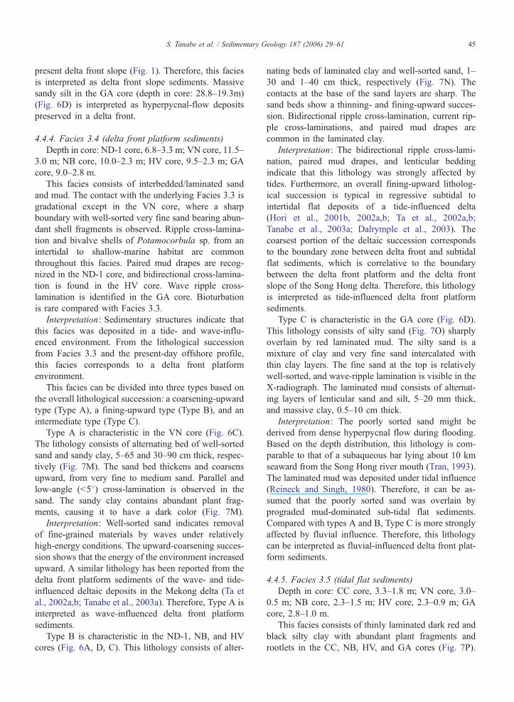
4.4.4. Facies 3.4 (delta front platform sediments)
Depth in core: ND-1 core, 6.8–3.3 m; VN core, 11.5–
3.0 m; NB core, 10.0–2.3 m; HV core, 9.5–2.3 m; GA
core, 9.0–2.8 m.
This facies consists of interbedded/laminated sand
and mud. The contact with the underlying Facies 3.3 is
gradational except in the VN core, where a sharp
boundary with well-sorted very fine sand bearing abun-
dant shell fragments is observed. Ripple cross-lamina-
tion and bivalve shells of Potamocorbula sp. from an
intertidal to shallow-marine habitat are common
throughout this facies. Paired mud drapes are recog-
nized in the ND-1 core, and bidirectional cross-lamina-
tion is found in the HV core. Wave ripple cross-
lamination is identified in the GA core. Bioturbation
is rare compared with Facies 3.3.
Interpretation: Sedimentary structures indicate that
this facies was deposited in a tide- and wave-influ-
enced environment. From the lithological succession
from Facies 3.3 and the present-day offshore profile,
this facies corresponds to a delta front platform
environment.
This facies can be divided into three types based on
the overall lithological succession: a coarsening-upward
type (Type A), a fining-upward type (Type B), and an
intermediate type (Type C).
Type A is characteristic in the VN core (Fig. 6C).
The lithology consists of alternating bed of well-sorted
sand and sandy clay, 5–65 and 30–90 cm thick, respec-
tively (Fig. 7M). The sand bed thickens and coarsens
upward, from very fine to medium sand. Parallel and
low-angle (b58) cross-lamination is observed in the
sand. The sandy clay contains abundant plant frag-
ments, causing it to have a dark color (Fig. 7M).
Interpretation: Well-sorted sand indicates removal
of fine-grained materials by waves under relatively
high-energy conditions. The upward-coarsening succes-
sion shows that the energy of the environment increased
upward. A similar lithology has been reported from the
delta front platform sediments of the wave- and tide-
influenced deltaic deposits in the Mekong delta (Ta et
al., 2002a,b; Tanabe et al., 2003a). Therefore, Type A is
interpreted as wave-influenced delta front platform
sediments.
Type B is characteristic in the ND-1, NB, and HV
cores (Fig. 6A, D, C). This lithology consists of alter-
nating beds of laminated clay and well-sorted sand, 1–
30 and 1–40 cm thick, respectively (Fig. 7N). The
contacts at the base of the sand layers are sharp. The
sand beds show a thinning- and fining-upward succes-
sion. Bidirectional ripple cross-lamination, current rip-
ple cross-laminations, and paired mud drapes are
common in the laminated clay.
Interpretation: The bidirectional ripple cross-lami-
nation, paired mud drapes, and lenticular bedding
indicate that this lithology was strongly affected by
tides. Furthermore, an overall fining-upward litholog-
ical succession is typical in regressive subtidal to
intertidal flat deposits of a tide-influenced delta
(Hori et al., 2001b, 2002a,b; Ta et al., 2002a,b;
Tanabe et al., 2003a; Dalrymple et al., 2003). The
coarsest portion of the deltaic succession corresponds
to the boundary zone between delta front and subtidal
flat sediments, which is correlative to the boundary
between the delta front platform and the delta front
slope of the Song Hong delta. Therefore, this lithology
is interpreted as tide-influenced delta front platform
sediments.
Type C is characteristic in the GA core (Fig. 6D).
This lithology consists of silty sand (Fig. 7O) sharply
overlain by red laminated mud. The silty sand is a
mixture of clay and very fine sand intercalated with
thin clay layers. The fine sand at the top is relatively
well-sorted, and wave-ripple lamination is visible in the
X-radiograph. The laminated mud consists of alternat-
ing layers of lenticular sand and silt, 5–20 mm thick,
and massive clay, 0.5–10 cm thick.
Interpretation: The poorly sorted sand might be
derived from dense hyperpycnal flow during flooding.
Based on the depth distribution, this lithology is com-
parable to that of a subaqueous bar lying about 10 km
seaward from the Song Hong river mouth (Tran, 1993).
The laminated mud was deposited under tidal influence
(Reineck and Singh, 1980). Therefore, it can be as-
sumed that the poorly sorted sand was overlain by
prograded mud-dominated sub-tidal flat sediments.
Compared with types A and B, Type C is more strongly
affected by fluvial influence. Therefore, this lithology
can be interpreted as fluvial-influenced delta front plat-
form sediments.
4.4.5. Facies 3.5 (tidal flat sediments)
Depth in core: CC core, 3.3–1.8 m; VN core, 3.0–
0.5 m; NB core, 2.3–1.5 m; HV core, 2.3–0.9 m; GA
core, 2.8–1.0 m.
This facies consists of thinly laminated dark red and
black silty clay with abundant plant fragments and
rootlets in the CC, NB, HV, and GA cores (Fig. 7P).
Table 3
Summary of AMS 14C dates from the sediment cores taken from the Song Hong delta
Depth in
core (m)
Altitude
(m)
Material Species d13C
(x)
Conventional 14C
age (yr BP)
Calibrated 14C age Sample code
(BETA-)1r range (cal. yr BP)
ND-1
3.22 �1.72 Wood �30.2 440F50 521–472 142396
4.82 �3.32 Molluscan shell Potamocorbula amurensis
(Schrenck)
�5.1 6040F30 6471–6395 142397
5.05 �3.55 Molluscan shell Potamocorbula amurensis
(Schrenck)
�8.4 4930F40 5295–5224 142398
6.73 �5.23 Molluscan shell Potamocorbula amurensis
(Schrenck)
�5.4 4970F40 5315–5266 142399
10.88 �9.38 Molluscan shell Solidicorbula erythrodon
(Lamarck)
�2.7 5780F40 6244–6159 142400
13.95 �12.45 Molluscan shell Mactra (Mactra)
veneriformis Reeve
�2.9 6060F40 6496–6401 142401
15.29 �13.79 Molluscan shell Varicorbula sp. cf.
V. rotalis (Hinds)
�1.3 6170F40 6639–6527 142402
16.66 �15.16 Shell fragments – �2.4 6420F40 6925–6797 142403
19.34 �17.84 Shell fragments – �1.0 6860F80 7424–7276 142404
20.45 �18.95 Molluscan shell Placamen tiara (Dillwyn) �0.9 7230F80 7742–7593 142405
22.4 �20.9 Molluscan shell Estellarca olivacea
(Reeve)
�5.8 8340F120 8945–8685 142406
23.35 �21.85 Molluscan shell Potamocorbula amurensis
(Schrenck)
�4.8 8530F80 9263–8909 142407
25.6 �24.1 Molluscan shell Corbicula sp. cf.
C. fluminea (Muller)
�8.6 9020F100 9824–9445 142408
27.75 �26.25 Molluscan shell Potamocorbula amurensis
(Schrenck)
�6.1 8560F70 9267–8929 142409
30.55 �29.05 Wood – �28.8 8360F70 9473–9280 142410
33.8 �32.3 Molluscan shell Corbicula sp. cf.
C. fluminea (Muller)
�10.9 9330F100 10275–9814 142411
37.15 �35.65 Molluscan shell Anisocorbula
venusta(Gould)
�11.8 9040F80 9827–9464 142412
40.2 �38.7 Wood – �26.7 9330F80 10670–10242 142413
43.4 �41.9 Wood – �30.2 9970F90 11627–11231 142414
56.35 �54.85 Wood – �27.0 12470F110 15413–14263 142417
67.05 �65.55 Wood – �28.3 12650F110 15526–14372 142418
DT
2.68 0.82 Molluscan shell Corbicula sp. �7.9 490F40 234–0 157762
3.25 0.25 Molluscan shell Corbicula sp. �6.6 540F40 263–132 157763
5.1 �1.6 Wood – �28.7 1710F40 1692–1549 159435
6.37 �2.87 Peaty organic – �28.7 8250F50 9398–9093 157764
11.43 �7.93 Shell fragments – �9.8 7260F60 7786–7664 157765
13.13 �9.63 Shell fragments – �9.6 7010F50 7562–7460 157766
14.52 �11.02 Molluscan shell Mactridae sp. �7.5 7300F50 7822–7700 157767
18.9 �15.4 Molluscan shell Mactridae sp. �10.4 6940F50 7498–7414 157768
20.37 �16.87 Molluscan shell Mactridae sp. �10.4 7450F50 7725–7634 157769
22.6 �19.1 Molluscan shell Oyster �3.9 7020F50 7566–7469 159436
30.7 �27.2 Wood – �28.0 8840F50 10147–9779 159438
36.61 �33.11 Wood – �29.7 8940F60 10191–9919 159439
39.16 �35.66 Wood – �29.4 9040F50 10234–10186 157773
41.17 �37.67 Wood – �29.3 9210F50 10479–10242 159440
CC
2.25 0.75 Wood – �28.8 5200F40 5988–5915 164861
5.13 �2.13 Wood – �28.3 6320F40 7269–7212 164862
11.63 �8.63 Molluscan shell Potamocorbula laevis �9.8 7660F40 8169–8056 164863
12.7 �9.7 Molluscan shell Corbicula fluminea �10.8 8170F40 8816–8588 164864
14.33 �11.33 Wood – �28.0 7240F40 8146–7976 164865
S. Tanabe et al. / Sedimentary Geology 187 (2006) 29–6146
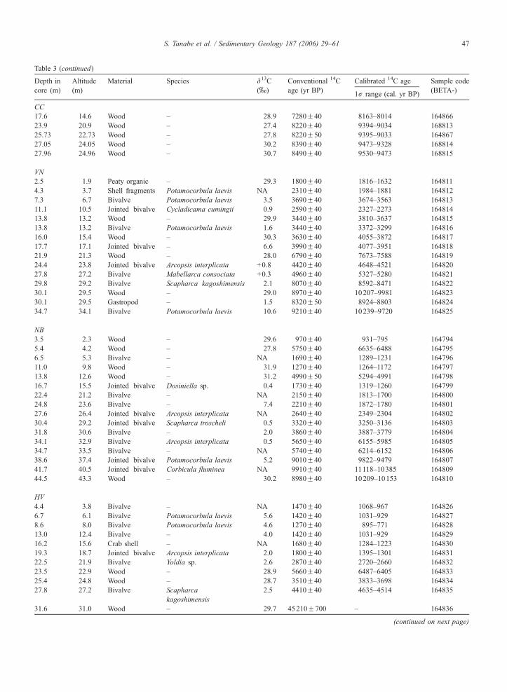
Table 3 (continued)
Depth in
core (m)
Altitude
(m)
Material Species d13C
(x)
Conventional 14C
age (yr BP)
Calibrated 14C age Sample code
(BETA-)1r range (cal. yr BP)
CC
17.6 �14.6 Wood – �28.9 7280F40 8163–8014 164866
23.9 �20.9 Wood – �27.4 8220F40 9394–9034 168813
25.73 �22.73 Wood – �27.8 8220F50 9395–9033 164867
27.05 �24.05 Wood – �30.2 8390F40 9473–9328 168814
27.96 �24.96 Wood – �30.7 8490F40 9530–9473 168815
VN
2.5 �1.9 Peaty organic – �29.3 1800F40 1816–1632 164811
4.3 �3.7 Shell fragments Potamocorbula laevis NA 2310F40 1984–1881 164812
7.3 �6.7 Bivalve Potamocorbula laevis �3.5 3690F40 3674–3563 164813
11.1 �10.5 Jointed bivalve Cycladicama cumingii �0.9 2590F40 2327–2273 164814
13.8 �13.2 Wood – �29.9 3440F40 3810–3637 164815
13.8 �13.2 Bivalve Potamocorbula laevis �1.6 3440F40 3372–3299 164816
16.0 �15.4 Wood – �30.3 3630F40 4055–3872 164817
17.7 �17.1 Jointed bivalve – �6.6 3990F40 4077–3951 164818
21.9 �21.3 Wood – �28.0 6790F40 7673–7588 164819
24.4 �23.8 Jointed bivalve Arcopsis interplicata +0.8 4420F40 4648–4521 164820
27.8 �27.2 Bivalve Mabellarca consociata +0.3 4960F40 5327–5280 164821
29.8 �29.2 Bivalve Scapharca kagoshimensis �2.1 8070F40 8592–8471 164822
30.1 �29.5 Wood – �29.0 8970F40 10207–9981 164823
30.1 �29.5 Gastropod – �1.5 8320F50 8924–8803 164824
34.7 �34.1 Bivalve Potamocorbula laevis �10.6 9210F40 10239–9720 164825
NB
3.5 �2.3 Wood – �29.6 970F40 931–795 164794
5.4 �4.2 Wood – �27.8 5750F40 6635–6488 164795
6.5 �5.3 Bivalve – NA 1690F40 1289–1231 164796
11.0 �9.8 Wood – �31.9 1270F40 1264–1172 164797
13.8 �12.6 Wood – �31.2 4990F50 5294–4991 164798
16.7 �15.5 Jointed bivalve Dosiniella sp. �0.4 1730F40 1319–1260 164799
22.4 �21.2 Bivalve – NA 2150F40 1813–1700 164800
24.8 �23.6 Bivalve – �7.4 2210F40 1872–1780 164801
27.6 �26.4 Jointed bivalve Arcopsis interplicata NA 2640F40 2349–2304 164802
30.4 �29.2 Jointed bivalve Scapharca troscheli �0.5 3320F40 3250–3136 164803
31.8 �30.6 Bivalve – �2.0 3860F40 3887–3779 164804
34.1 �32.9 Bivalve Arcopsis interplicata �0.5 5650F40 6155–5985 164805
34.7 �33.5 Bivalve – NA 5740F40 6214–6152 164806
38.6 �37.4 Jointed bivalve Potamocorbula laevis �5.2 9010F40 9822–9479 164807
41.7 �40.5 Jointed bivalve Corbicula fluminea NA 9910F40 11118–10385 164809
44.5 �43.3 Wood – �30.2 8980F40 10209–10153 164810
HV
4.4 �3.8 Bivalve – NA 1470F40 1068–967 164826
6.7 �6.1 Bivalve Potamocorbula laevis �5.6 1420F40 1031–929 164827
8.6 �8.0 Bivalve Potamocorbula laevis �4.6 1270F40 895–771 164828
13.0 �12.4 Bivalve – �4.0 1420F40 1031–929 164829
16.2 �15.6 Crab shell – NA 1680F40 1284–1223 164830
19.3 �18.7 Jointed bivalve Arcopsis interplicata �2.0 1800F40 1395–1301 164831
22.5 �21.9 Bivalve Yoldia sp. �2.6 2870F40 2720–2660 164832
23.5 �22.9 Wood – �28.9 5660F40 6487–6405 164833
25.4 �24.8 Wood – �28.7 3510F40 3833–3698 164834
27.8 �27.2 Bivalve Scapharca
kagoshimensis
�2.5 4410F40 4635–4514 164835
31.6 �31.0 Wood – �29.7 45210F700 – 164836
(continued on next page)
S. Tanabe et al. / Sedimentary Geology 187 (2006) 29–61 47
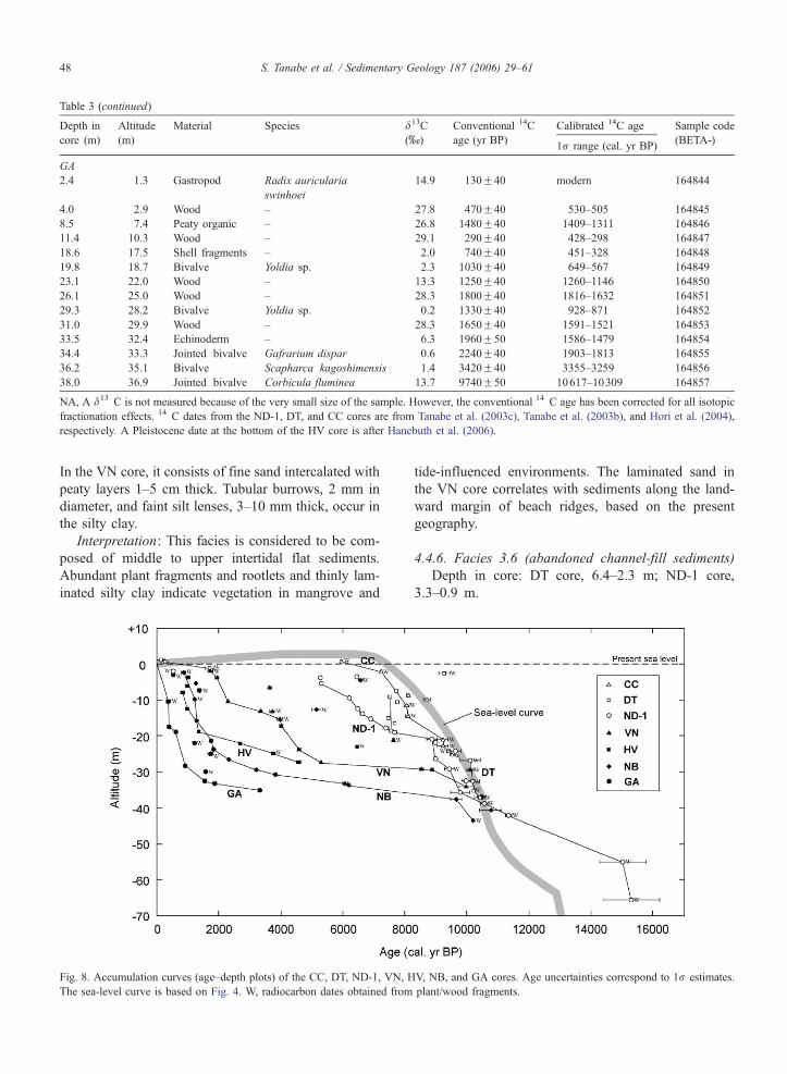
Table 3 (continued)
Depth in
core (m)
Altitude
(m)
Material Species d13C
(x)
Conventional 14C
age (yr BP)
Calibrated 14C age Sample code
(BETA-)1r range (cal. yr BP)
GA
2.4 �1.3 Gastropod Radix auricularia
swinhoei
�14.9 130F40 modern 164844
4.0 �2.9 Wood – �27.8 470F40 530–505 164845
8.5 �7.4 Peaty organic – �26.8 1480F40 1409–1311 164846
11.4 �10.3 Wood – �29.1 290F40 428–298 164847
18.6 �17.5 Shell fragments – �2.0 740F40 451–328 164848
19.8 �18.7 Bivalve Yoldia sp. �2.3 1030F40 649–567 164849
23.1 �22.0 Wood – �13.3 1250F40 1260–1146 164850
26.1 �25.0 Wood – �28.3 1800F40 1816–1632 164851
29.3 �28.2 Bivalve Yoldia sp. �0.2 1330F40 928–871 164852
31.0 �29.9 Wood – �28.3 1650F40 1591–1521 164853
33.5 �32.4 Echinoderm – �6.3 1960F50 1586–1479 164854
34.4 �33.3 Jointed bivalve Gafrarium dispar �0.6 2240F40 1903–1813 164855
36.2 �35.1 Bivalve Scapharca kagoshimensis �1.4 3420F40 3355–3259 164856
38.0 �36.9 Jointed bivalve Corbicula fluminea �13.7 9740F50 10617–10309 164857
NA, A d13 C is not measured because of the very small size of the sample. However, the conventional 14 C age has been corrected for all isotopic
fractionation effects. 14 C dates from the ND-1, DT, and CC cores are from Tanabe et al. (2003c), Tanabe et al. (2003b), and Hori et al. (2004),
respectively. A Pleistocene date at the bottom of the HV core is after Hanebuth et al. (2006).
S. Tanabe et al. / Sedimentary Geology 187 (2006) 29–6148
In the VN core, it consists of fine sand intercalated with
peaty layers 1–5 cm thick. Tubular burrows, 2 mm in
diameter, and faint silt lenses, 3–10 mm thick, occur in
the silty clay.
Interpretation: This facies is considered to be com-
posed of middle to upper intertidal flat sediments.
Abundant plant fragments and rootlets and thinly lam-
inated silty clay indicate vegetation in mangrove and
Fig. 8. Accumulation curves (age–depth plots) of the CC, DT, ND-1, VN, H
The sea-level curve is based on Fig. 4. W, radiocarbon dates obtained from
tide-influenced environments. The laminated sand in
the VN core correlates with sediments along the land-
ward margin of beach ridges, based on the present
geography.
4.4.6. Facies 3.6 (abandoned channel-fill sediments)
Depth in core: DT core, 6.4–2.3 m; ND-1 core,
3.3–0.9 m.
V, NB, and GA cores. Age uncertainties correspond to 1r estimates.
plant/wood fragments.
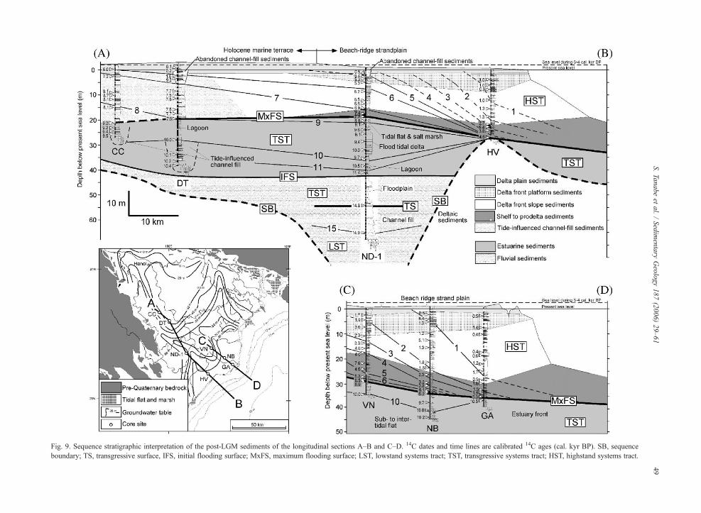
Fig. 9. Sequence stratigraphic interpretation of the post-LGM sediments of the longitudinal sections A–B and C–D. 14C dates and time lines are calibrated 14C ages (cal. kyr BP). SB, sequence
boundary; TS, transgressive surface, IFS, initial flooding surface; MxFS, maximum flooding surface; LST, lowstand systems tract; TST, transgressive systems tract; HST, highstand systems tract.
S.Tanabeet
al./Sedimentary
Geology187(2006)29–61
49
S. Tanabe et al. / Sedimentary Geology 187 (2006) 29–6150
This facies shows an overall fining-upward succession
from well-sorted medium sand to reddish gray, mottled
silt (Fig. 7Q). Mud clasts (b15 mm in diameter) and
parallel lamination occur in the sand. Burrows and in
situ jointed Corbicula sp. are common in the grayish
red clay at the top of this facies.
Interpretation: A series of channel levees beside the
DT site and along the modern distributary indicate that
the DT core site is located on a filled, cut-off mean-
dering channel of the Song Hong distributary. Based on
an aerial photograph of the ND-1 site and its vicinity,
the ND-1 site is also located on an abandoned and
filled cut-off meandering channel of the Song Hong
distributary (Haruyama et al., 2000). The presence of
burrows and Corbicula sp. in life positions suggests
that the sediments were influenced by brackish water.
As tidal effects penetrate all of the major distributaries
almost as far inland as Hanoi during the dry season
(Mathers et al., 1996; Mathers and Zalasiewicz, 1999),
brackish water prevails in the modern distributary
channel near the core sites. Therefore, this facies is
interpreted as channel-fill sediments of a modern Song
Hong distributary.
4.4.7. Facies 3.7 (floodplain sediments and surface
soil)
Depth in core: CC core, 1.8–0 m; DT core, 2.3–0.0
m; ND-1 core, 0.9–0 m; VN core, 0.5–0.0 m; NB core,
1.5–0.0 m; HV core, 0.9–0.0 m; GA core, 1.0–0.0 m.
This facies consists of reddish brown mottled clay,
which corresponds to a lateritic weathering profile de-
veloped in floodplain and channel-levee sediments at
the land surface of the core sites (Fig. 7R). Abundant
rootlets with iron encrustation and gypsum crystalliza-
tion are common in this facies.
5. Radiocarbon dates
In all, 101 14C dates were obtained and calibrated.
All of the data are shown in Table 3. 14C dates obtained
from units 1, 2, and 3 fell within the latest Pleistocene
or Holocene. Individually, units 1, 2, and 3 date roughly
to 15–11, 11–9, and 9–0 cal. kyr BP, respectively.
Fig. 8 shows age–depth plots with accumulation
curves for the ND-1, DT, CC, VN, HV, NB, and GA
cores. The accumulation curves do not take into ac-
count sediment compaction effects. The accumulation
curves indicate that the calibrated results of most 14C
dates obtained from plant and wood fragments (organic
carbon) tend to be older than those obtained from
molluscan shells, the echinoderm, or the crab shell
(carbonate). Dates on molluscan shells and wood frag-
ments obtained from the same horizons in the VN core
indicate that wood fragments show ages about 400–
1300 years older than those obtained from shell frag-
ments. As the sediment cores contain no slump or slide
deposits, it is difficult to postulate a stratigraphic inver-
sion. Most organic carbon dates might be older because
the materials were reworked from older fluvial deposits
upstream from the core sites that included old detrital
carbon.
6. Sequence stratigraphy
The sequence stratigraphic interpretation is based on
the core lithology, facies interpretation, isochrons, and
stacking patterns of the deltaic and estuarine sediments
along with the sea-level curve for the western coast of
the South China Sea since the LGM (Figs. 4 and 5).
The facies distribution and sequence stratigraphic inter-
pretation along longitudinal sections AB and CD are
shown in Fig. 9.
6.1. Sequence boundary
The Sequence Boundary (SB) is observed as an
unconformity between latest Pleistocene–Holocene flu-
vial–estuarine–deltaic sediments (units 1, 2, and 3) and
the underlying late Pleistocene sediments (Unit 0).
Lateritic weathering of interfluve sediments at the top
of Unit 0 in the HV core indicates subaerial exposure
during the sea-level lowstand of the LGM. The thalweg
of the fluvial incision formed during the LGM is locat-
ed beneath the southern part of the present delta plain
(Fig. 3). Though the SB cannot be identified in the
cores located in this incised valley, its depth was more
than 70 m below the present sea level, based on the
ND-1 core data. As underlying marine successions
below the incised valley fills and Holocene deltaic
sediments are correlated with Marine Isotope Stage
(MIS) 3 during the last glacial (Hanebuth et al.,
2006), the SB must be formed during the falling sea
level into the LGM. Overlying sediments consisting of
fluvial, estuarine, and deltaic sediments compose a
single depositional sequence reflecting one regres-
sion–transgression–regression cycle since the LGM.
6.2. Transgressive surface
A transgressive surface (TS) is defined as a flooding
surface separating a progradational or aggradational
lowstand systems tract (LST) from a retrogradational
transgressive systems tract (TST) (Van Wagoner et al.,
1988). Allen and Posamentier (1993) placed a TS at the
S. Tanabe et al. / Sedimentary Geology 187 (2006) 29–61 51
boundary between the tidal–estuarine and fluvial sedi-
ments in the Gironde estuary, France, which they
regarded as an initial marine flooding surface. In con-
trast, Hori et al. (2002b) placed a TS around the bound-
ary between sandy fluvial sediments and basal fluvial
gravels in the paleo-Changjiang incised-valley fill, be-
cause the thick aggradational fluvial sediments of the
upper part of the sequence were dated at around 12 cal.
kyr BP, which corresponds to the middle part of the last
sea-level rise after the LGM. They showed that a thick
fluvial sequence was overlain by an estuarine sequence
later during the period of sea-level rise.
In the Song Hong delta area, only the ND-1 core,
which is in the main incised valley, records information
about the transition from the LST to the TST. As in the
case of the paleo-Changjiang, a rather thick (20 m)
fluvial sequence (Unit 1) in the ND-1 core consists of
two parts, a lower coarse-grained channel-fill and an
upper fine-grained floodplain deposit. The age of the
lower part is ~14.8 or 14.9 cal. kyr BP; these dates fall
within the sea-level lowstand of the LGM (Fig. 4). On
the other hand, the age of the upper part must be before
11–12 cal. kyr BP, because the overlying estuarine
sediments were dated to 11.4 cal. kyr BP. As there is
no erosional surface between these intervals, the fine-
grained floodplain sediments must have been deposited
between 14.8 and 11–12 cal. kyr BP. During this period,
a rapid rise in sea level of more than 30 m, known as
Melt Water Pulse (MWP) 1A (Fairbanks, 1989), oc-
curred (Fig. 4) and the paleoshoreline moved from the
outer shelf area of the Gulf of Bac Bo to the vicinity of
the ND-1 site. Therefore, the landward shoreline migra-
tion (transgression) and the deposition of fine-grained
floodplain sediments were concurrent. Thus, the TS
should be located near the facies boundary between
fluvial channel-fill and floodplain sediments, which
might reflect a change from an amalgamated braided
river system to an aggradational meandering river sys-
tem. The braided river system may contain sediments
deposited during the sea-level fall into the LGM (~21
cal. kyr BP) (Hanebuth et al., 2000) and those deposited
during the sea-level lowstand of the LGM (~21–15 cal.
kyr BP). However, as there is no age data from the lower
parts of this system, further dating will be necessary. A
rapid rise in sea level affects not only the coastal area but
also the fluvial plain with respect to sediment stacking
and abrupt facies changes. Accommodation space on a
fluvial plain created by a rise in sea level is effectively
filled by fluvial sediments just as the accommodation
space on a coastal plain is filled by fluvial-coastal sedi-
ments. On the other hand, a fluvial–estuarine contact at
about 40 m depth in the ND-1 core has been identified as
the initial flooding surface (Zaitlin et al., 1994; Hori et
al., 2002b).
6.3. Maximum flooding surface
The Maximum Flooding Surface (MxFS), which is
defined as the flooding surface that separates the retro-
gradational transgressive systems tract (TST) from the
progradational highstand systems tract (HST) (Van
Wagoner et al., 1988), was identified between estuarine
sediments and downlapping deltaic sediments in the
cores. Its age is 8.8–8.5 cal. kyr BP (ca. 9 cal. kyr
BP). Below the MxFS, sedimentary environments indi-
cate a deepening-upward succession. The environment
changed from a floodplain to a flood-tidal delta in the
ND-1 core, from a tide-influenced channel to a lagoon
(central basin) in the DT core, and from a sub- to
intertidal flat to an estuary front in the NB core. All
these environments changed suddenly to a shelf envi-
ronment above the MxFS. On the other hand, sedimen-
tary environments indicate a shallowing-upward
succession above the MxFS. Shelf to prodelta environ-
ments changed to delta plain in the ND-1, VN, HV, NB,
and GA cores. In the VN, HV, NB, and GA cores, the
MxFS was identified at the base of the shelly layers in
the shelf and prodelta deposits (Fig. 6C and D). The
shelly layers overlie estuarine sediments with sharp
erosional surfaces and gradually shallow-upward to
the delta front sediments. These erosional surfaces are
interpreted as ravinement surfaces formed during a
transgression. The ages of the shelly layers just above
the erosional surface show 8.5, 6.2, 4.6, and 3.3 cal. kyr
BP at each site, respectively, and a hiatus with a dura-
tion of 0.4 to 5.6 kyr. Its duration increases basinward,
where the period of sediment starvation was relatively
longer (Jarvey, 1988; Loutit et al., 1988; Cattaneo and
Steel, 2003). These data indicate that transgressive sand
sheets overlying a ravinement surface (e.g., Saito,
1994) are not obvious in this region and the observed
patterns might be rather interpreted as regressive sand
sheets overlying a marine erosion surface (Tanabe et al.,
2003a; Ta et al., 2005). The MxFS is situated within the
hiatus between the transgressive estuarine system and
regressive delta system at VN, HV, NB, and GA core
sites.
The MxFS and the maximum paleo-water depth in a
sequence should occur at the same time (Posamentier et
al., 1988). However, a time gap of about 1–2 kyr
between the MxFS and the maximum paleo-water
depth has been preliminarily reported from the Song
Hong delta based on data from three cores (Hori et al.,
2004). The seven cores discussed here clearly show this

S. Tanabe et al. / Sedimentary Geology 187 (2006) 29–6152
gap between proximal and distal offshore sites. The
differences between the Holocene sea-level curve and
the accumulation curves reflect the changes in paleo-
Fig. 10. Paleogeographic map illustrating the evolution of the Song Hong d
newly collected data.
water depth at each core site, if we neglect sediment
compaction effects (Fig. 8). The maximum paleo-water
depth and its age at each site were ca. 10 m at 8.1 cal.
elta during the past 9 kyr. Modified after Tanabe et al. (2003b) using
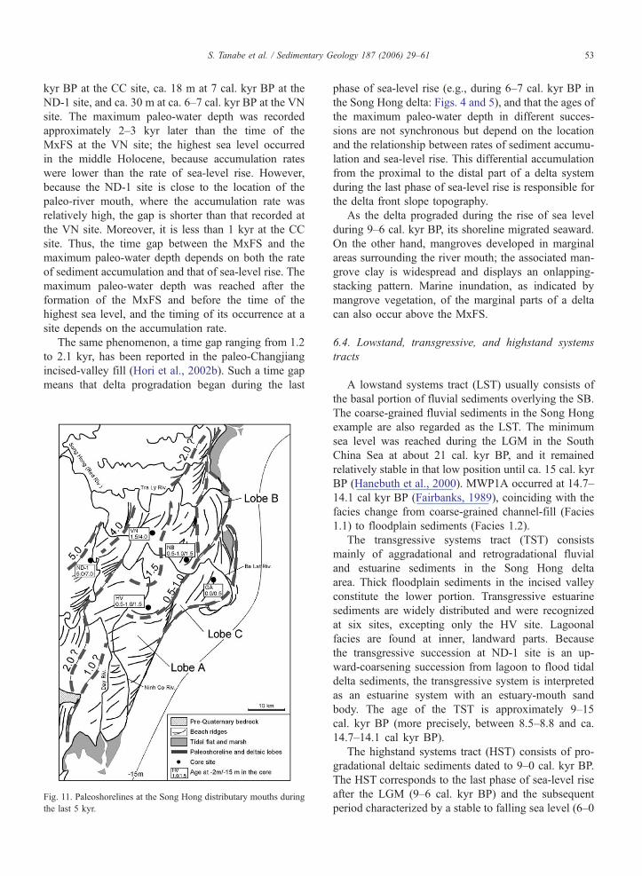
S. Tanabe et al. / Sedimentary Geology 187 (2006) 29–61 53
kyr BP at the CC site, ca. 18 m at 7 cal. kyr BP at the
ND-1 site, and ca. 30 m at ca. 6–7 cal. kyr BP at the VN
site. The maximum paleo-water depth was recorded
approximately 2–3 kyr later than the time of the
MxFS at the VN site; the highest sea level occurred
in the middle Holocene, because accumulation rates
were lower than the rate of sea-level rise. However,
because the ND-1 site is close to the location of the
paleo-river mouth, where the accumulation rate was
relatively high, the gap is shorter than that recorded at
the VN site. Moreover, it is less than 1 kyr at the CC
site. Thus, the time gap between the MxFS and the
maximum paleo-water depth depends on both the rate
of sediment accumulation and that of sea-level rise. The
maximum paleo-water depth was reached after the
formation of the MxFS and before the time of the
highest sea level, and the timing of its occurrence at a
site depends on the accumulation rate.
The same phenomenon, a time gap ranging from 1.2
to 2.1 kyr, has been reported in the paleo-Changjiang
incised-valley fill (Hori et al., 2002b). Such a time gap
means that delta progradation began during the last
Fig. 11. Paleoshorelines at the Song Hong distributary mouths during
the last 5 kyr.
phase of sea-level rise (e.g., during 6–7 cal. kyr BP in
the Song Hong delta: Figs. 4 and 5), and that the ages of
the maximum paleo-water depth in different succes-
sions are not synchronous but depend on the location
and the relationship between rates of sediment accumu-
lation and sea-level rise. This differential accumulation
from the proximal to the distal part of a delta system
during the last phase of sea-level rise is responsible for
the delta front slope topography.
As the delta prograded during the rise of sea level
during 9–6 cal. kyr BP, its shoreline migrated seaward.
On the other hand, mangroves developed in marginal
areas surrounding the river mouth; the associated man-
grove clay is widespread and displays an onlapping-
stacking pattern. Marine inundation, as indicated by
mangrove vegetation, of the marginal parts of a delta
can also occur above the MxFS.
6.4. Lowstand, transgressive, and highstand systems
tracts
A lowstand systems tract (LST) usually consists of
the basal portion of fluvial sediments overlying the SB.
The coarse-grained fluvial sediments in the Song Hong
example are also regarded as the LST. The minimum
sea level was reached during the LGM in the South
China Sea at about 21 cal. kyr BP, and it remained
relatively stable in that low position until ca. 15 cal. kyr
BP (Hanebuth et al., 2000). MWP1A occurred at 14.7–
14.1 cal kyr BP (Fairbanks, 1989), coinciding with the
facies change from coarse-grained channel-fill (Facies
1.1) to floodplain sediments (Facies 1.2).
The transgressive systems tract (TST) consists
mainly of aggradational and retrogradational fluvial
and estuarine sediments in the Song Hong delta
area. Thick floodplain sediments in the incised valley
constitute the lower portion. Transgressive estuarine
sediments are widely distributed and were recognized
at six sites, excepting only the HV site. Lagoonal
facies are found at inner, landward parts. Because
the transgressive succession at ND-1 site is an up-
ward-coarsening succession from lagoon to flood tidal
delta sediments, the transgressive system is interpreted
as an estuarine system with an estuary-mouth sand
body. The age of the TST is approximately 9–15
cal. kyr BP (more precisely, between 8.5–8.8 and ca.
14.7–14.1 cal kyr BP).
The highstand systems tract (HST) consists of pro-
gradational deltaic sediments dated to 9–0 cal. kyr BP.
The HST corresponds to the last phase of sea-level rise
after the LGM (9–6 cal. kyr BP) and the subsequent
period characterized by a stable to falling sea level (6–0
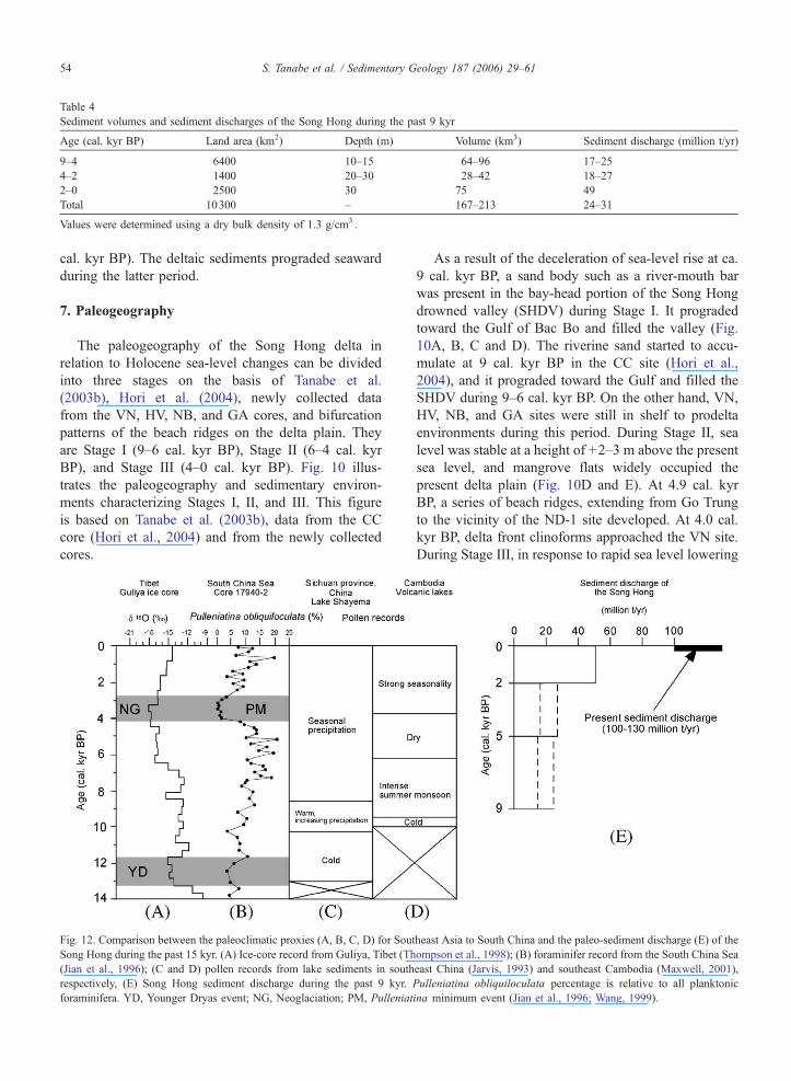
Table 4
Sediment volumes and sediment discharges of the Song Hong during the past 9 kyr
Age (cal. kyr BP) Land area (km2) Depth (m) Volume (km3) Sediment discharge (million t/yr)
9–4 6400 10–15 64–96 17–25
4–2 1400 20–30 28–42 18–27
2–0 2500 30 75 49
Total 10300 – 167–213 24–31
Values were determined using a dry bulk density of 1.3 g/cm3 .
S. Tanabe et al. / Sedimentary Geology 187 (2006) 29–6154
cal. kyr BP). The deltaic sediments prograded seaward
during the latter period.
7. Paleogeography
The paleogeography of the Song Hong delta in
relation to Holocene sea-level changes can be divided
into three stages on the basis of Tanabe et al.
(2003b), Hori et al. (2004), newly collected data
from the VN, HV, NB, and GA cores, and bifurcation
patterns of the beach ridges on the delta plain. They
are Stage I (9–6 cal. kyr BP), Stage II (6–4 cal. kyr
BP), and Stage III (4–0 cal. kyr BP). Fig. 10 illus-
trates the paleogeography and sedimentary environ-
ments characterizing Stages I, II, and III. This figure
is based on Tanabe et al. (2003b), data from the CC
core (Hori et al., 2004) and from the newly collected
cores.
Fig. 12. Comparison between the paleoclimatic proxies (A, B, C, D) for Sou
Song Hong during the past 15 kyr. (A) Ice-core record from Guliya, Tibet (Th
(Jian et al., 1996); (C and D) pollen records from lake sediments in south
respectively, (E) Song Hong sediment discharge during the past 9 kyr.
foraminifera. YD, Younger Dryas event; NG, Neoglaciation; PM, Pulleniat
As a result of the deceleration of sea-level rise at ca.
9 cal. kyr BP, a sand body such as a river-mouth bar
was present in the bay-head portion of the Song Hong
drowned valley (SHDV) during Stage I. It prograded
toward the Gulf of Bac Bo and filled the valley (Fig.
10A, B, C and D). The riverine sand started to accu-
mulate at 9 cal. kyr BP in the CC site (Hori et al.,
2004), and it prograded toward the Gulf and filled the
SHDV during 9–6 cal. kyr BP. On the other hand, VN,
HV, NB, and GA sites were still in shelf to prodelta
environments during this period. During Stage II, sea
level was stable at a height of +2–3 m above the present
sea level, and mangrove flats widely occupied the
present delta plain (Fig. 10D and E). At 4.9 cal. kyr
BP, a series of beach ridges, extending from Go Trung
to the vicinity of the ND-1 site developed. At 4.0 cal.
kyr BP, delta front clinoforms approached the VN site.
During Stage III, in response to rapid sea level lowering
theast Asia to South China and the paleo-sediment discharge (E) of the
ompson et al., 1998); (B) foraminifer record from the South China Sea
east China (Jarvis, 1993) and southeast Cambodia (Maxwell, 2001),
Pulleniatina obliquiloculata percentage is relative to all planktonic
ina minimum event (Jian et al., 1996; Wang, 1999).
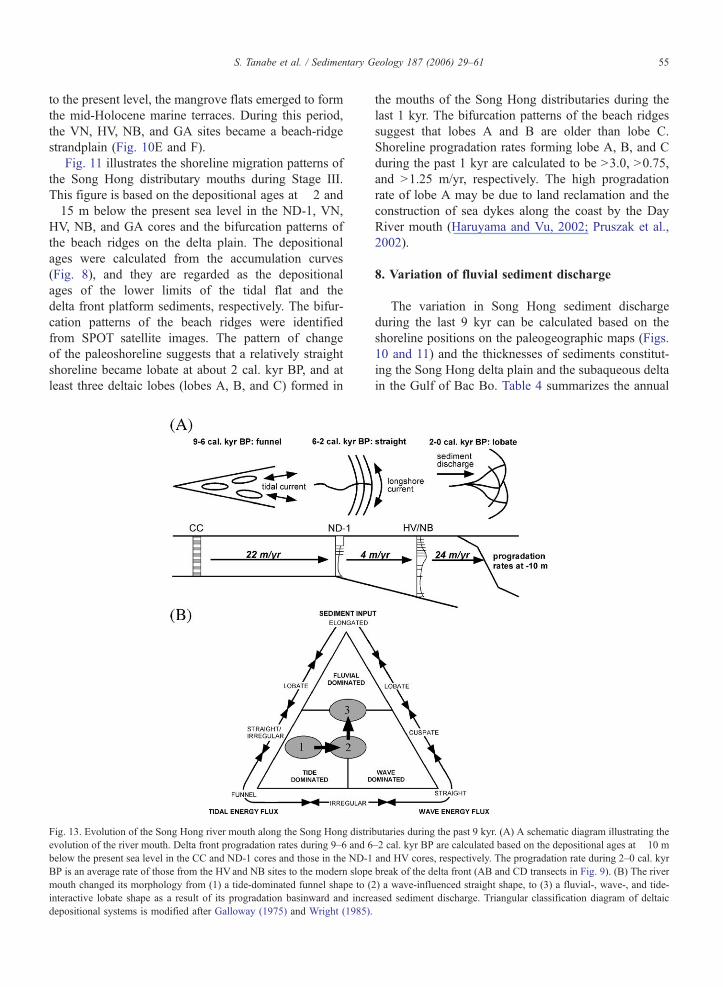
S. Tanabe et al. / Sedimentary Geology 187 (2006) 29–61 55
to the present level, the mangrove flats emerged to form
the mid-Holocene marine terraces. During this period,
the VN, HV, NB, and GA sites became a beach-ridge
strandplain (Fig. 10E and F).
Fig. 11 illustrates the shoreline migration patterns of
the Song Hong distributary mouths during Stage III.
This figure is based on the depositional ages at �2 and
�15 m below the present sea level in the ND-1, VN,
HV, NB, and GA cores and the bifurcation patterns of
the beach ridges on the delta plain. The depositional
ages were calculated from the accumulation curves
(Fig. 8), and they are regarded as the depositional
ages of the lower limits of the tidal flat and the
delta front platform sediments, respectively. The bifur-
cation patterns of the beach ridges were identified
from SPOT satellite images. The pattern of change
of the paleoshoreline suggests that a relatively straight
shoreline became lobate at about 2 cal. kyr BP, and at
least three deltaic lobes (lobes A, B, and C) formed in
Fig. 13. Evolution of the Song Hong river mouth along the Song Hong distri
evolution of the river mouth. Delta front progradation rates during 9–6 and 6
below the present sea level in the CC and ND-1 cores and those in the ND-1
BP is an average rate of those from the HVand NB sites to the modern slope
mouth changed its morphology from (1) a tide-dominated funnel shape to (
interactive lobate shape as a result of its progradation basinward and incre
depositional systems is modified after Galloway (1975) and Wright (1985).
the mouths of the Song Hong distributaries during the
last 1 kyr. The bifurcation patterns of the beach ridges
suggest that lobes A and B are older than lobe C.
Shoreline progradation rates forming lobe A, B, and C
during the past 1 kyr are calculated to be N3.0, N0.75,
and N1.25 m/yr, respectively. The high progradation
rate of lobe A may be due to land reclamation and the
construction of sea dykes along the coast by the Day
River mouth (Haruyama and Vu, 2002; Pruszak et al.,
2002).
8. Variation of fluvial sediment discharge
The variation in Song Hong sediment discharge
during the last 9 kyr can be calculated based on the
shoreline positions on the paleogeographic maps (Figs.
10 and 11) and the thicknesses of sediments constitut-
ing the Song Hong delta plain and the subaqueous delta
in the Gulf of Bac Bo. Table 4 summarizes the annual
butaries during the past 9 kyr. (A) A schematic diagram illustrating the
–2 cal. kyr BP are calculated based on the depositional ages at �10 m
and HV cores, respectively. The progradation rate during 2–0 cal. kyr
break of the delta front (AB and CD transects in Fig. 9). (B) The river
2) a wave-influenced straight shape, to (3) a fluvial-, wave-, and tide-
ased sediment discharge. Triangular classification diagram of deltaic
S. Tanabe et al. / Sedimentary Geology 187 (2006) 29–6156
sediment discharge of the Song Hong during 9–4, 4–2,
and 2–0 cal. kyr BP. It is assumed that the Song Hong
delta started to prograde at 9 cal. kyr BP, and the
seaward limit of the mid-Holocene marine terraces is
regarded as the paleoshoreline at 4 cal. kyr BP. The
thickness of the deltaic sediments trapped during 9–4
cal. kyr BP is regarded as 10 to 15 m on the basis of the
shape of the Song Hong incised valley and the thickness
of the deltaic sediments along the Song Hong (20 m) and
Thai Binh (5–30 m) rivers (Lam and Boyd, 2000, 2003).
The thickness of the deltaic sediments trapped between
the paleoshorelines from 4 to 2 cal. kyr BP is 20 to 30 m,
and that of the sediments between the paleoshorelines
from 2 to 0 cal. kyr BP is regarded as 30 m on the basis of
the thickness of the deltaic sediments and the present
offshore limit of the prodelta. The bulk density of the
deltaic sediments is estimated as 1.3 g/cm3.
The resulting calculated paleo-sediment discharges
show variations during the past 9 kyr. The sediment
discharge was 17–25 million t/yr during 9–4 cal. kyr
BP, 18–27 million t/yr during 4–2 cal. kyr BP, and 49
million t/yr during 2–0 cal. kyr BP. The sediment
discharge during 9–2 cal. kyr BP did not vary greatly,
but it increased drastically during the last 2 kyr. It was
still less than half of the sediment discharge measured
during the 1960s–1990s of 100–130 million t/yr, how-
ever (Milliman et al., 1995; Pruszak et al., 2002). This
means that sediment discharge of the Song Hong has
accelerated to the present level during the last 2 kyr.
The drastic increase in sediment discharge during the
last 2 kyr might be related to human activities such as
cultivation in the upper Song Hong catchment because
the sediment discharge increase is independent of cli-
matic records (Jarvis, 1993; Jian et al., 1996; Thompson
et al., 1998; Maxwell, 2001) collected from Southeast
and East Asia (Fig. 12). Neotectonics along the Red
River Fault System (RRFS) (Fig. 2) might have also
played a role in increasing the Song Hong sediment
discharge. However, it is difficult to consider that the
mass movements in the upper reaches of the Song
Hong, which were triggered by fault movements/earth-
quake, occurred frequently only in the last 2 kyr. Rath-
er, it is likely that the recurrence intervals of
earthquakes along the RRFS during the last millennia
(General Department of Land Administration, 1996)
were consistent with those throughout the Holocene.
On the other hand, people started to farm the moun-
tainous area where the annual precipitation rate is high-
est, up to 1600 mm, near the northwest border between
Vietnam and China in the Song Hong drainage at about
2 cal. kyr BP (Fig. 2) (Vietnam National Committee for
International Hydrological Program, 1994). At nearly
the same time, sites of occupation of the Bronze Age
Dong Son culture (3–2 cal. kyr BP) became widespread
on the present delta plain (Ogura, 1997), and it can be
inferred that people deforested the upper to middle parts
of the Song Hong catchment. Pollen data recorded in
the ND-1 core also show vegetation changes reflecting
deforestation by human activities during the last 3 kyr
(Li et al., 2006). The present extremely high sediment
discharge is thought to be the result of these human
activities, along with others, for example, dyke con-
struction, which began along the Song Hong in the
eleventh century (Ogura, 1997).
9. Morphodynamics of the Song Hong river mouth
Paleogeographic maps (Figs. 10 and 11) show that
most of the sediments discharged by the Song Hong
have accumulated along the Song Hong distributaries
within the SHDV during the past 9 kyr. The shoreline
prograded more than 100 km along the Song Hong
distributaries, but less than 50 km along the Thai Binh
distributaries. This means that the area along the Song
Hong distributaries has been the actively prograding
part and the area along the Thai Binh distributaries
was the marginal part of the delta during the past
9 kyr (Tanabe et al., 2003b). Fig. 13 summarizes the
morphodynamics and the acceleration/deceleration of
progradation rate at the distributary mouths of the
Song Hong. During the past 9 kyr, the Song Hong
river-mouth morphology changed from funnel-shaped
(9–6 cal. kyr BP), to straight (6–2 cal. kyr BP), to
lobate (2–0 cal. kyr BP), and the delta front prograda-
tion rate at 10 m below present sea level decelerated
from 22 to 4 m/yr at around 6 cal. kyr BP and then
accelerated from 4 to 24 m/yr at around 2 cal. kyr BP
(Fig. 13A).
The river-mouth morphological change, from fun-
nel-shaped to straight, and the deceleration of the pro-
gradation rate, which occurred at around 6 cal. kyr BP,
were mostly caused by a change in coastal oceano-
graphic conditions resulting from the river-mouth pro-
gradation. As the river mouth prograded basinward,
filling the SHDV, the tidal amplitude and the velocity
of tidal currents confined by the valley topography
became relatively weak, and the wave height and ve-
locity of longshore currents confined by the shoreline
topography became relatively strong along the coast.
The cessation of the sea-level rise at 6 cal. kyr BP may
have enhanced the progradation of the delta system
(Hori et al., 2004). However, the deceleration of delta
progradation rate is inconsistent with the deceleration
of sea-level rise. Furthermore, no major change oc-
S. Tanabe et al. / Sedimentary Geology 187 (2006) 29–61 57
curred in the Song Hong sediment discharge at around
6 cal. kyr BP (Fig. 12). Therefore, the morphological
change of the river mouth might have resulted from the
change of coastal topography and oceanographic con-
ditions from a narrow confined bay to a wider open bay.
A similar phenomenon affected the Mekong delta in
southern Vietnam at 3.0–2.5 cal. kyr BP (Ta et al.,
2002a; Tanabe et al., 2003a). Because of the delta
progradation toward an open coast from a sheltered
inner bay, the delta system was more open to wave
attack, and sediments were dispersed by wave-induced
longshore currents, resulting in the decrease in the
progradation rate from 30–40 to 11–20 m/yr (Tanabe
et al., 2003a). Relatively strong waves along the open
coast created beach ridges on the delta plain and well-
sorted, coarse sandy facies in the delta front sediments
(Tanabe et al., 2003a). The examples from the Song
Hong and the Mekong deltas indicate that a delta
system can evolve as a result of changes to the coastal
setting in relation to delta progradation into the open
ocean, resulting in its evolving into a more wave-dom-
inated delta from a tide-dominated delta (Fig. 13B). A
similar delta evolution from tide-dominated to wave-
influenced may have happened in other deltas that have
prograded from a narrow bay to an open, tide-influ-
enced coast, such as the Niger, Irrawaddy, and Orinoco
deltas, which are composed of series of beach ridges
and cheniers only along the present coastline (Allen,
1965; Rodolfo, 1975; Warne et al., 2002).
The morphological change from straight to lobate,
and the acceleration of the progradation rate that oc-
curred at around 2 cal. kyr BP are in large part due to an
increase in the Song Hong sediment discharge. Based
on the river-mouth morphology, the Song Hong distrib-
utary mouths became more protuberant and river-influ-
enced than they were before 2 cal. kyr BP (Fig. 13B).
As mentioned above, the Song Hong sediment dis-
charge during the last 2 kyr increased to nearly double
that during 9–2 cal. kyr BP as a result of anthropogenic
influences. The change of delta shape implies that for
the last 2 kyr the sediment volume supplied to the river
mouth through the river was much higher than the
amount of sediment reworked or redistributed by
waves and longshore currents. Several deltas changed
their morphology and progradation rates during the late
Holocene as a result of an increase in sediment dis-
charge and anthropogenic influences. In the case of the
Huanghe delta, the straight shoreline became lobate and
the rates of shoreline progradation became rapid at
about 1 cal. kyr BP because of a rapid increase in
sediment discharge induced by human activities (culti-
vation and vegetation change) on the Loess Plateau,
along the middle reaches of the Huanghe (Milliman et
al., 1987; Saito et al., 2001; Yi et al., 2003). In the Po
and Tevere catchments, human activities caused sub-
stantial changes in river dynamics, leading to the mor-
phological change of the deltas from arcuate to cuspate
(Bellotti et al., 1994; Cencini, 1998; Amorosi and Milli,
2001). In the case of the Krishna delta in India, the
shoreline progradation rate became rapid and the delta
morphology changed from straight to lobate as a result
of increased sediment discharge at 2 kyr BP (Rao et al.,
1990). Thus, changes in sediment discharge as well as
changes in coastal oceanographic settings have affected
delta morphology and progradation rates during the
Holocene.
10. Conclusions
(1) A detailed facies analysis and high-resolution
AMS 14C dating of seven sediment cores
obtained form the Song Hong delta plain revealed
that sediments at these sites can be classified into
four units: Unit 0 (late Pleistocene shallow-ma-
rine sediments), Unit 1 (fluvial sediments), Unit 2
(estuarine sediments), and Unit 3 (deltaic sedi-
ments), in ascending order. Units 1, 2, and 3,
dated to b15 cal. kyr BP and consist of two
(channel-fill and floodplain sediments), six
(tide-influenced channel-fill to coastal marsh, la-
goon, flood tidal delta, tidal flat and salt marsh,
sub- to intertidal flat, and estuary front sediments)
and seven (tide-influenced channel-fill, shelf to
prodelta, delta front slope, delta front platform,
tidal flat, abandoned channel-fill sediments, and
floodplain sediments and surface soil) sedimen-
tary facies, respectively.
(2) A sequence stratigraphic analysis was performed
on units 1, 2, and 3, which filled the Song Hong
incised valley since the last glacial maximum
(LGM) based on the stacking patterns of the
sediment facies and the lithology, isochrons, and
sea-level changes along the western coast of the
South China Sea. Units 1–3 can be divided into
lowstand (LST), transgressive (TST), and high-
stand (HST) systems tracts. The transgressive
surface (TS) between the LST and the TST lies
in the middle part of the fluvial sediments and
dates to ca. 15 cal. kyr BP. The maximum flood-
ing surface (MxFS) between the TST and HST is
at the top of the estuarine sediments and dates to
ca. 9 cal. kyr BP. The TST consists of aggrada-
tional and retrogradational estuarine sediments,
whereas the HST consists of progradational del-
S. Tanabe et al. / Sedimentary Geology 187 (2006) 29–6158
taic sediments. The LST, TST, and HST can be
dated to ca. ~15, 15–9, and 9–0 cal. kyr BP,
respectively.
(3) During the past 9 kyr, the majority of the sedi-
ment discharged by Song Hong accumulated and
enhanced river-mouth progradation along the
Song Hong distributaries within the Song Hong
drowned valley (SHDV). The river mouth pro-
graded from the bay head of the SHDV toward
the Gulf of Bac Bo, changing its morphology
from funnel-shaped (9–6 cal. kyr BP) to straight
(6–2 cal. kyr BP) to lobate (2–0 cal. kyr BP). The
morphological change from funnel-shaped to
straight was largely the result of filling of the
SHDV and a coastal hydrologic change from a
tide-dominated setting to a wave-influenced set-
ting. The cessation of sea-level rise at 6 cal. kyr
BP may have played only a small role in the
change of river-mouth morphology because the
river-mouth progradation rate decelerated from
22 to 4 m/yr instead of accelerating. The river-
mouth morphodynamic change from straight to
lobate was largely due to the increase of the Song
Hong sediment discharge from 17–27 (9–2 cal.
kyr BP) to 49 million t/yr (2–0 cal. kyr BP)
caused by anthropogenic deforestation along the
upper reaches of the Song Hong.
Acknowledgments
We thank members of the staff of the International
Cooperation Division of the Department of Geology and
Minerals of Vietnam (DGMV) for their kind support in
arranging all of the cooperative activities. Prof. C. Field-
ing and two anonymous reviewers are thanked for con-
structive reviews of the submitted manuscripts. This
research was conducted as part of a Geological Survey
of Japan (GSJ)-DGMV joint research program on Deltas
in Vietnam from 2001 to 2003, financially supported by
the Asian Delta Project of AIST and the Global Envi-
ronmental Research Fund of the Ministry of Environ-
ment of Japan. This paper is presented under the
UNESCO/International Union of Geological Sciences
(IUGS)-supported International Geoscience Programme
(IGCP) Project No. 475 bDeltas in the Monsoon Asia-
Pacific Region: DeltaMAPQ.
References
Allen, J.R.L., 1963. Henry Clifton Sorby and the sedimentary struc-
tures of sands and sandstones in relation to flow conditions.
Geologie en Mijinbouw 42, 223–228.
Allen, J.R.L., 1965. Late Quaternary Niger delta, and adjacent areas:
sedimentary environments and lithofacies. Bulletin of the Amer-
ican Association of Petroleum Geologists 49, 547–600.
Allen, J.R.L., 1983. Studies in fluviatile sedimentation: bars, bar
complexes and sandstone sheets (low-sinuosity braided streams)
in the brownstones (L. Devonian), Welsh Borders. Sedimentary
Geology 33, 237–293.
Allen, G.P., Posamentier, H.W., 1993. Sequence stratigraphy and
facies model of an incised valley fill: the Gironde estuary, France.
Journal of Sedimentary Petrology 63, 378–391.
Amorosi, A., Milli, S., 2001. Late Quaternary depositional architec-
ture of Po and Tevere river deltas (Italy) and worldwide compar-
ison with coeval deltaic successions. Sedimentary Geology 144,
357–375.
Bellotti, P., Chiocci, F.L., Milli, S., Tortora, P., Valeri, P., 1994.
Sequence stratigraphy and depositional setting of the Tiber delta:
integration of high-resolution seismics, well logs, and archaeolog-
ical data. Journal of Sedimentary Research 64, 416–432.
Bernard, H.A., Leblanc, R.J., Major, C.J., 1962. Recent and Pleisto-
cene geology of southeast Texas. In: Rainwater, E.H., Zingula,
R.P. (Eds.), Geology of the Gulf Coast and Central Texas, Geo-
logical Society of America, Guide Book for 1962 Annual Meet-
ing, pp. 175–224.
Cattaneo, A., Steel, R.J., 2003. Transgressive deposits: a review of
their variability. Earth-Science Reviews 1277, 1–42.
Cencini, C., 1998. Physical processes and human activities in the
evolution of the Po delta, Italy. Journal of Coastal Research 14,
774–793.
Coleman, J.M., 1981. Deltas: Processes of Deposition and Models for
Exploration. International Human Resources Development Cor-
poration, Boston.
Coleman, J.M., Wright, L.D., 1975. Modern river deltas: variability of
processes and sand bodies. In: Broussard, M.L. (Ed.), Deltas:
Models for Exploration. Houston Geological Society, Houston,
pp. 99–149.
Collinson, J.D., 1996. Alluvial sediments. In: Reading, H.G. (Ed.),
Sedimentary Environments: Processes, Facies and Stratigraphy.
Blackwell Scientific Publications, Oxford, pp. 37–82.
Dalrymple, R.W., 1992. Tidal depositional systems. In: Walker, R.G.,
James, N.P. (Eds.), Facies Models: Response to Sea Level
Change. Geological Association of Canada, Waterloo, Ontario,
pp. 195–218.
Dalrymple, R.W., Baker, E.K., Harris, P.T., Hughes, M.G., 2003.
Sedimentology and stratigraphy of a tide-dominated, foreland-
basin delta (Fly River, Papua New Guinea). In: Sidi, F.H., Num-
medal, D., Imbert, P., Darman, H., Posamentier, H.W. (Eds.),
Tropical Deltas of Southeast Asia-Sedimentology, Stratigraphy,
and Petroleum Geology, no. 76, pp. 147–173.
Davis Jr., R.A., Hayes, M.O., 1984. What is a wave-dominated coast?
Marine Geology 60, 313–329.
de Boer, P.L., 1998. Intertidal sediments: composition and structure.
In: Eisma, D. (Ed.), Intertidal Deposits: River Mouths, Tidal Flats,
and Coastal Lagoons. CRC Press, Boca Raton, pp. 345–362.
Department of Geography of Vietnam, 1993. Geographical Map of
Thanh Hoa, 1 :250,000 Scale. Department of Geography of Viet-
nam, Ha Noi.
Department of Geography of Vietnam, 1998a. Geographical map of
Hai Phong, 1 :250,000 scale. Department of Geography of Viet-
nam, Ha Noi.
Department of Geography of Vietnam, 1998b. Geographical map of
Ha Noi, 1 :250,000 scale. Department of Geography of Vietnam,
Ha Noi.
S. Tanabe et al. / Sedimentary Geology 187 (2006) 29–61 59
Department of Geography of Vietnam, 1998. Geographical map of
Nam Dinh, 1 :250,000 scale. Department of Geography of Viet-
nam, Ha Noi.
Elliott, T., 1986. Deltas. In: Reading, H.G. (Ed.), Sedimentary Envir-
onments and Facies. Blackwell Scientific Publications, Oxford,
pp. 113–154.
Fairbanks, R.G., 1989. A 17,000-year glacio-eustatic sea level record:
influence of glacial melting rates on the Younger Dryas event and
deep-ocean circulation. Nature 342, 637–642.
Frey, R.W., Basan, P.B., 1985. Coastal salt marshes. In: Davis Jr.,
R.A. (Ed.), Coastal Sedimentary Environments. Springer-Verlag,
New York, pp. 225–301.
Galloway, W.E., 1975. Process framework for describing the mor-
phologic and stratigraphic evolution of deltaic depositional sys-
tems. In: Broussard, M.L. (Ed.), Deltas, Models for Exploration.
Houston Geological Society, Houston, pp. 87–98.
Galloway, W.E., Hobday, D.K., 1996. Terrigenous Clastic Deposi-
tional Systems: Applications to Fossil Fuel and Groundwater
Resources. Springer-Verlag, Berlin. 489 pp.
General Department of Land Administration, 1996. Vietnam Na-
tional Atlas. General Department of Land Administration, Hanoi.
163 pp.
Geyh, M.A., Kudrass, H.-R., Streif, H., 1979. Sea-level changes
during the late Pleistocene and Holocene in the Strait of Malacca.
Nature 278, 441–443.
Hanebuth, T., Stattegger, K., Grootes, P.M., 2000. Rapid flooding of
the Sunda Shelf: a late-glacial sea-level record. Science 288,
1033–1035.
Hanebuth, T.J.J., Saito, Y., Tanabe, S., Vu, Q.L., Ngo, Q.T., 2006. Sea
levels during late marine isotope stage 3 (or older?) reported from
the Red River delta (northern Vietnam) and adjacent regions.
Quaternary International 145–146, 119–134.
Harrison, T.M., Leloup, P.H., Ryerson, F.J., Tapponnier, P., Lacassin,
R., Chen, W., 1996. Diachronous initiation of transtension along
the Ailao Shan—Red River Shear Zone, Yunnan and Vietnam. In:
Yin, A., Harrison, T.M. (Eds.), The Tectonic Evolution of Asia.
Cambridge University Press, New York, pp. 208–226.
Haruyama, S., Vu, V.P., 2002. Coastal change in the southern Song
Hong delta. Journal of Geography 111, 126–132.
Haruyama, S., Hiraide, S., Hori, K., Tanabe, S., Saito, Y., Doanh,
L.D., 2000. Micro-land form and geomorphic environmental res-
toration on the delta using electrical exploration—the Red River
delta, northern Vietnam. Technical Report, vol. 2000-15. Ad-
vanced Research Institute for Science and Engineering, Waseda
University. (22pp. (in Japanese with English abstract)).
Hori, K., Saito, Y., Zhao, Q., Cheng, X., Wang, P., Sato, Y., Li, C.,
2001. Sedimentary facies of the tide-dominated paleo-Changjiang
(Yangtze) estuary during the last transgression. Marine Geology
177, 331–351.
Hori, K., Saito, Y., Zhao, Q., Cheng, X., Wang, P., Sato, Y., Li, C.,
2001. Sedimentary facies and Holocene progradation rates of the
Changjiang (Yangtze) delta, China. Geomorphology 41, 233–248.
Hori, K., Saito, Y., Zhao, Q., Wang, P., 2002. Architecture and
evolution of the tide-dominated Changjiang (Yangtze) River
delta, China. Sedimentary Geology 146, 249–264.
Hori, K., Saito, Y., Zhao, Q., Wang, P., 2002. Evolution of the coastal
depositional systems of the Changjiang (Yangtze) River in re-
sponse to late Pleistocene–Holocene sea-level changes. Journal of
Sedimentary Research 72, 884–897.
Hori, K., Tanabe, S., Saito, Y., Haruyama, S., Nguyen, V., Kitamura,
A., 2004. Delta initiation and Holocene sea-level change: example
from the Song Hong (Red River) delta, Vietnam. Sedimentary
Geology 164, 237–249.
Jarvey, M.T., 1988. Quantitative geological modeling of siliciclastic
rock sequences and their seismic expression. In: Wilgus, C.K.,
Hastings, B.S., Kendall, C.G.St.C., Posamentier, H.W., Ross,
C.A., Van Wagoner, J.C. (Eds.), Sea-Level Changes: An Integrat-
ed Approach, SEPM Special Publication, no. 42, pp. 47–69.
Jarvis, D.I., 1993. Pollen evidence of changing Holocene monsoon
climate in Sichuan Province, China. Quaternary Research 39,
325–337.
Jian, Z., Li, B., Uwe, P., Wang, P., 1996. Late Holocene cooling in the
western Pacific. Science in China (Series D) 39, 543–550.
Kidwell, S.M., 1991. Taphonomic feedback (live/dead interactions) in
the genesis of bioclastic beds: keys to reconstructing sedimentary
dynamics. In: Einsele, G., Ricken, W., Seilacher, A. (Eds.), Cycles
and Events in Stratigraphy. Springer-Verlag, Berlin, Heidelberg,
pp. 268–282.
Kim, Y.H., Lee, H.J., Chun, S.S., Han, S.J., Chough, S.K., 1999.
Holocene transgressive stratigraphy of a macrotidal flat in the
southeastern Yellow Sea: Gomso Bay, Korea. Journal of Sedi-
mentary Research 69, 328–337.
Lam, D.D., Boyd, W.E., 2000. Holocene coastal stratigraphy and
model for the sedimentary development of the Hai Phong area
in the Red River delta, north Vietnam. Journal of Geology (Series
B) 15/16, 18–28.
Lam, D.D., Boyd, W.E., 2001. Some facts of sea-level fluctuation
during the late Pleistocene–Holocene in Ha Long Bay and Ninh
Binh area. Journal of Sciences of the Earth 23, 86–91 (in Viet-
namese with English abstract).
Lam, D.D., Boyd, W.E., 2003. Holocene coastal stratigraphy and the
sedimentary development of the Hai Phong area of the Bac Bo
Plain (Red River Delta), Vietnam. Australian Geographer 34,
177–194.
Li, Z., Saito, Y., Matsumoto, E., Wang, Y., Tanabe, S., Vu, Q.L., 2006.
Climate change and human impact on the Song Hong (Red River)
delta, Vietnam, during the Holocene. Quaternary International
144, 4–28.
Loutit, T.S., Hardenardenbol, J., Vail, P.R., Baum, G.R., 1988. Con-
densed sections, the key to age determination and correlation of
continental margin sequences. In: Wilgus, C.K., Hastings, B.S.,
Kendall, C.G.St.C., Posamentier, H.W., Ross, C.A., Van Wagoner,
J.C. (Eds.), Sea-Level Changes: An Integrated Approach, SEPM
Special Publication, no. 42, pp. 183–213.
Mathers, S.J., Zalasiewicz, J.A., 1999. Holocene sedimentary archi-
tecture of the Red River delta, Vietnam. Journal of Coastal
Research 15, 314–325.
Mathers, S.J., Davies, J., McDonald, A., Zalasiewicz, J.A., Marsh, S.,
1996. The Red River delta of Vietnam. British Geological Survey
Technical Report WC/96/02. 41 pp.
Maxwell, A.L., 2001. Holocene monsoon changes inferred from lake
sediment pollen and carbonate records, northeastern Cambodia.
Quaternary Research 56, 390–400.
Meckel, L.D., 1975. Holocene sand bodies in the Colorado delta area,
northern Gulf of California. In: Broussard, M.L. (Ed.), Deltas,
Models for Exploration. Houston Geological Society, Houston,
pp. 237–265.
Miall, A.D., 1992. Alluvial deposits. In: Walker, R.G., James, N.P.
(Eds.), Facies Models: Response to Sea Level Change. Geological
Association of Canada, Waterloo, Ontario, pp. 119–139.
Milliman, J.D., Qin, Y.-S., Ren, M.-E., Saito, Y., 1987. Man’s
influence on the erosion and transport of sediment by Asian
S. Tanabe et al. / Sedimentary Geology 187 (2006) 29–6160
rivers: the Yellow River (Huanghe) example. Journal of Geology
95, 751–762.
Milliman, J.D., Rutkowski, C., Meybeck, M., 1995. River Discharge
to the Sea: A Global River Index. LOICZ Core Project Office.
125 pp.
Murakoshi, N., Masuda, F., 1991. A depositional model for a flood-
tidal delta and washover sands in the Late Pleistocene paleo-
Tokyo Bay, Japan. In: Smith, D.G., Reinson, B.A., Rahmani,
R.A. (Eds.), Clastic Tidal Sedimentology, Canadian Society of
Petroleum Geologists, Memoir, no. 16, pp. 219–226.
Nielsen, L.H., Mathiesen, A., Bidstrup, T., Vejbaek, O.V., Dien, P.T.,
Tiem, P.V., 1999. Modelling of hydrocarbon generation in the
Cenozoic Song Hong Basin, Vietnam: a highly prospective basin.
Journal of Asian Earth Sciences 17, 269–294.
Nio, S.D., Yang, C.S., 1991. Diagnostic attributes of clastic tidal
deposits. In: Smith, D.G., Reinson, B.A., Rahmani, R.A. (Eds.),
Clastic Tidal Sedimentology, Canadian Society of Petroleum
Geologists, Memoir, no. 16, pp. 3–27.
Ogura, S., 1997. History of Vietnam: Dynamics of One Billion
People. Chuko-shinsho 1372, Chuokoronshinsya, Tokyo. 388 pp.
(in Japanese).
Parton, T.R., Humphrays, G.S., Mitchell, P.B., 1995. Soils—A New
Global View. UCL Press, London.
Pemberton, S.G., MacEachern, J.A., Frey, R.W., 1992. Trace fossil
facies models: environmental and allostratigraphic significance.
In: Walker, R.G., James, N.P. (Eds.), Facies Models: Response to
Sea Level Change. Geological Association of Canada, Waterloo,
Ontario, pp. 47–72.
Posamentier, H.W., Jervey, M.T., Vail, P.R., 1988. Eustatic controls on
clastic deposition I—conceptual framework. In: Wilgus, C.K.,
Hastings, B.S., Kendall, C.G.St.C., Posamentier, H.W., Ross,
C.A., Van Wagoner, J.C. (Eds.), Sea-Level Changes: An Integrat-
ed Approach, SEPM Special Publication, no. 42, pp. 109–124.
Pruszak, Z., Szmytkiewicz, M., Nguyen, M.H., Pham, V.N., 2002.
Coastal processes in the Red River delta area, Vietnam. Coastal
Engineering Journal 44, 97–126.
Rangin, C., Klein, M., Roques, D., LePichon, X., Trong, L.V., 1995.
The Red River fault system in the Tonkin Gulf, Vietnam. Tecto-
nophysics 243, 209–222.
Rao, B.K., Murthy, P.B., Swamy, A.S.R., 1990. Sedimentary char-
acteristics of Holocene beach ridges in western delta of Krishna
River. In: Rajamanickam, G.V. (Ed.), Sea Level Variation and its
Impact on Coastal Environment, Tamil University Publication, no.
131, pp. 133–143.
Reading, H.G., Collinson, J.D., 1996. Clastic coast. In: Reading, H.G.
(Ed.), Sedimentary Environments: Processes, Facies and Stratig-
raphy. Blackwell Scientific Publications, Oxford, pp. 154–231.
Reineck, H.E., Singh, I.B., 1980. Depositional Sedimentary Environ-
ments. Springer-Verlag, Berlin.
Reineck, H.E., Wunderlich, F., 1968. Classification and origin of
flaser and lenticular bedding. Sedimentology 11, 99–104.
Reinson, G.E., 1992. Transgressive barrier island and estuarine sys-
tems. In: Walker, R.G., James, N.P. (Eds.), Facies Models: Re-
sponse to Sea Level Change. Geological Association of Canada,
Waterloo, Ontario, pp. 179–194.
Rodolfo, K.S., 1975. The Irrawaddy delta: tertiary setting and mod-
ern offshore sedimentation. In: Broussard, M.L. (Ed.), Deltas,
Models for Exploration. Houston Geological Society, Houston,
pp. 339–356.
Saito, Y., 1994. Shelf sequence and characteristic bounding sur-
faces in a wave-dominated setting: Latest Pleistocene–Holo-
cene examples from Northeast Japan. Marine Geology 120,
105–127.
Saito, Y., Yang, Z., Hori, K., 2001. The Huanghe (Yellow River) and
Changjiang (Yangtze River) deltas: a review on their character-
istics, evolution and sediment discharge during the Holocene.
Geomorphology 41, 219–231.
Scruton, P.C., 1960. Delta building and the deltaic sequence. In:
Shepard, F.P., Phleger, F.B., van Andel, T.H. (Eds.), Recent Sedi-
ments, Northwest Gulf of Mexico. American Association of Pe-
troleum Geologists, Tulsa, Oklahoma, pp. 82–102.
Southon, J., Kashgarian, M., Fontugne, M., Metivier, B., Yim, W.W.-
S., 2002. Marine reservoir corrections for the Indian Ocean and
Southeast Asia. Radiocarbon 44, 167–180.
Stanley, D.J., Warne, A.G., 1994. Worldwide initiation of Holocene
marine deltas by deceleration of sea-level rise. Science 265,
228–231.
Stuiver, M., Braziunas, T.F., 1993. Modeling atmospheric 14C influ-
ences and 14C ages of marine samples back to 10,000 BC.
Radiocarbon 35, 137–189.
Stuiver, M., Reimer, P.J., 1993. Extended 14C database and re-
vised CALIB radiocarbon calibration program. Radiocarbon 35,
215–230.
Stuiver, M., Reimer, P.J., Bard, E., Beck, J.W., Burr, G.S., Hughen,
K.A., Kromer, B., McCormac, G., van der Plicht, J., Spurk, M.,
1998. INTCAL98 radiocarbon age calibration, 24,000–0 cal BP.
Radiocarbon 40, 1041–1083.
Ta, T.K.O., Nguyen, V.L., Tateishi, M., Kobayashi, I., Saito, Y.,
Nakamura, T., 2002. Sediment facies and late Holocene prograda-
tion of the Mekong River delta in Bentre Province, southern
Vietnam: an example of evolution from a tide-dominated to a
wave-dominated delta. Sedimentary Geology 152, 313–325.
Ta, T.K.O., Nguyen, V.L., Tateishi, M., Kobayashi, I., Tanabe, S.,
Saito, Y., 2002. Holocene delta evolution and sediment discharge
of the Mekong River, southern Vietnam. Quaternary Science
Reviews 21, 1807–1819.
Ta, T.K.O., Nguyen, V.L., Tateishi, M., Konayashi, I., Saito, Y., 2005.
Holocene delta evolution and depositional models of the Mekong
River delta, southern Vietnam. In: Giosan, L., Bhattacharya, J.P.
(Eds.), River Deltas: Concepts, Models and Examples, SEPM
Special Publication, no. 83, pp. 453–466.
Tanabe, S., Ta, T.K.O., Nguyen, V.L., Tateishi, M., Kobayashi, I.,
Saito, Y., 2003. Delta evolution model inferred from the Mekong
delta, southern Vietnam. In: Sidi, F.H., Nummedal, D., Imbert, P.,
Darman, H., Posamentier, H.W. (Eds.), Tropical deltas of South-
east Asia—sedimentology, stratigraphy, and petroleum geology,
SEPM Special Publication, no. 76, pp. 175–188.
Tanabe, S., Hori, K., Saito, Y., Haruyama, S., Vu, V.P., Kitamura, A.,
2003. Song Hong (Red River) delta evolution related to millen-
nium-scale Holocene sea-level changes. Quaternary Science
Reviews 22, 2345–2361.
Tanabe, S., Hori, K., Saito, Y., Haruyama, S., Doanh, L.Q., Sato, Y.,
Hiraide, S., 2003. Sedimentary facies and radiocarbon dates of the
Nam Dinh-1 core from the Song Hong (Red River) delta. Viet-
nam. Journal of Asian Earth Science 21, 503–513.
Tanabe, S., Saito, Y., Sato, Y., Suzuki, Y., Sinsakul, S., Tiyapairach,
S., Chaimanee, N., 2003. Stratigraphy and Holocene evolution of
the mud-dominated Chao Phraya delta, Thailand. Quaternary
Science Reviews 22, 789–807.
Thompson, L.G., Davis, M.E., Mosley-Thompson, E., Sowers, T.A.,
Henderson, K.A., Zagorodnov, V.S., Lin, P.-N., Mikhalenko, V.N.,
Campen, R.K., Bolzan, J.F., Cole-Dai, J., Francou, B., 1998. A
S. Tanabe et al. / Sedimentary Geology 187 (2006) 29–61 61
25,000 year tropical climate history from Bolivian ice cores.
Science 282, 1858–1864.
Tran, D.T., 1993. Geological evolution of the Bach Dang estuary
during the Holocene. Unpublished Ph.D. Thesis, Hanoi Universi-
ty, Hanoi. 135 pp.
Tran, D.T., Dinh, V.H., 2000. Coastal development of the modern Red
River delta. Bulletin of the Geological Survey of Japan 51, 276.
Tran, N., Ngo, Q.T., 2000. Development history of deposits in the
Quaternary of Vietnam. In: Nguyen, T.V. (Ed.), The Weathering
Crust and Quaternary Sediments in Vietnam. Department of Ge-
ology and Minerals of Vietnam, Hanoi, pp. 177–192.
Van Wagoner, J.C., Posamentier, H.W., Mitchum, R.M., Vail,
P.R., Sarg, J.F., Louit, T.S., Hardenbol, J., 1988. An overview
of the fundamentals of sequence stratigraphy and key defini-
tions. In: Wilgus, C.K., Hastings, B.S., Kendall, C.G.St.C., Posa-
mentier, H.W., Ross, C.A., Van Wagoner, J.C. (Eds.), Sea-Level
Changes: An Integrated Approach, SEPM Special Publication, no.
42, pp. 39–45.
Vietnam National Committee for International Hydrological
Programme, 1994. Vietnam Hydrometeorological Atlas. General
Department of Land Administration, Hanoi.
Visher, G.S., 1965. Use of vertical profile in environmental recon-
struction. American Association of Petroleum Geologists, Bulletin
49, 41–61.
Wang, P., 1999. Response of Western Pacific marginal seas to glacial
cycles: paleoceanographic and sedimentological features. Marine
Geology 156, 5–39.
Warne, A.G., Guevara, E.H., Aslan, A., 2002. Late Quaternary evo-
lution of the Orinoco Delta, Venezuela. Journal of Coastal Re-
search 18, 225–253.
Wright, L.D., 1985. River deltas. In: Davis Jr., R.A. (Ed.),
Coastal Sedimentary Environments. Springer-Verlag, New York,
pp. 1–76.
Yi, S., Saito, Y., Oshima, H., Zhou, Y., Wei, H., 2003. Holocene
environmental history inferred from pollen assemblages in the
Huanghe (Yellow River) delta, China: climate change and
human impact. Quaternary Science Reviews 22, 609–628.
Zaitlin, B.A., Dalrymple, R.W., Boyd, R., 1994. The stratigraphic
organization of incised-valley systems: origin and sedimentary
sequences. In: Dalrymple, R.W., Boyd, R., Zaitlin, B.A. (Eds.),
Incised-valley Systems: Origin and Sedimentary Sequences,
SEPM Special Publication, no. 51, pp. 45–60.