
Table of Contents Page August 2011 i PG&E Point Buchon ...
207
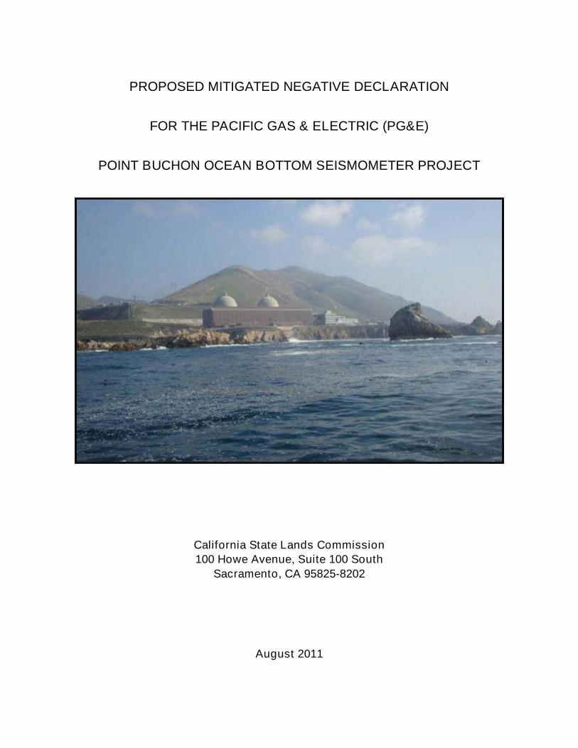
PROPOSED MITIGATED NEGATIVE DECLARATION FOR THE PACIFIC GAS & ELECTRIC (PG&E) POINT BUCHON OCEAN BOTTOM SEISMOMETER PROJECT California State Lands Commission 100 Howe Avenue, Suite 100 South Sacramento, CA 95825-8202 August 2011
-
Upload
khangminh22 -
Category
Documents
-
view
0 -
download
0
Transcript of Table of Contents Page August 2011 i PG&E Point Buchon ...
PROPOSED MITIGATED NEGATIVE DECLARATION
FOR THE PACIFIC GAS & ELECTRIC (PG&E)
POINT BUCHON OCEAN BOTTOM SEISMOMETER PROJECT
California State Lands Commission
100 Howe Avenue, Suite 100 South
Sacramento, CA 95825-8202
August 2011

Table of Contents
Page
August 2011 i PG&E Point Buchon Ocean BottomSeismometer Project Proposed MND
TABLE OF CONTENTS
EXECUTIVE SUMMARY ES-1
SECTION 1 PROJECT AND AGENCY INFORMATION 1-1
1.1 PROJECT TITLE..................................................................................................1-1
1.2 LEAD AGENCY NAME AND ADDRESS .............................................................1-1
1.3 PROJECT APPLICANT NAME AND ADDRESS .................................................1-1
1.4 PROJECT LOCATION.........................................................................................1-1
1.5 ORGANIZATION OF PROPOSED MITIGATED NEGATIVE DECLARATION.....1-1
1.6 PROJECT BACKGROUND AND OBJECTIVES..................................................1-2
1.7 PUBLIC REVIEW AND COMMENT .....................................................................1-3
1.8 PERMITS, APPROVALS AND REGULATORY REQUIREMENTS......................1-3
SECTION 2 PROJECT DESCRIPTION 2-1
2.1 NEED FOR PROJECT.........................................................................................2-1
2.2 PROPOSED STRUCTURES ...............................................................................2-1
2.2.1 Temporary OBS Units.............................................................................2-4
2.2.2 Long-Term OBS Units.............................................................................2-5
2.2.3 Power and Data Transfer Cable .............................................................2-6
2.2.4 Onshore Component...............................................................................2-6
2.3 TRANSPORTATION AND INSTALLATION PROCEDURES AND METHODS....2-7
2.3.1 Installation of Temporary OBS Units.......................................................2-7
2.3.2 Installation of Long-Term OBS Units and Power/Data Transfer Cable ...2-8
2.3.3 Onshore Component.............................................................................2-11
2.3.4 Actions Within the Point Buchon Marine Protected Area (MPA) ...........2-11
2.4 OPERATION AND MAINTENANCE OF LONG-TERM OBS UNITS..................2-11
2.5 PROJECT SCHEDULE......................................................................................2-12
2.5.1 Temporary OBS Units...........................................................................2-12
2.5.2 Long-Term OBS Units...........................................................................2-12
2.6 PROJECT PERSONNEL AND EQUIPMENT.....................................................2-12
2.6.1 Personnel Requirements ......................................................................2-12
2.6.2 Equipment Requirements .....................................................................2-12
2.7 ENVIRONMENTAL COMPLIANCE INSPECTION AND MITIGATION
MONITORING....................................................................................................2-13
SECTION 3 ENVIRONMENTAL ANALYSIS 3-1
3.1 ENVIRONMENTAL FACTORS POTENTIALLY AFFECTED ...............................3-1
3.2 AGENCY DETERMINATION ...............................................................................3-2
3.3 ENVIRONMENTAL CHECKLIST ...................................................................3.3.1-1
3.3.1 Aesthetics .........................................................................................3.3.1-1
3.3.2 Agriculture and Forest Resources ....................................................3.3.2-1
3.3.3 Air Quality and Greenhouse Gas (GHG) Emissions .........................3.3.3-1
3.3.4 Biological Resources ........................................................................3.3.4-1
Table of Contents
Page
PG&E Point Buchon Ocean Bottom ii August 2011Seismometer Project Proposed MND
3.3.5 Cultural Resources ...........................................................................3.3.5-1
3.3.6 Geology and Soils.............................................................................3.3.6-1
3.3.7 Hazards and Hazardous Materials....................................................3.3.7-1
3.3.8 Hydrology and Water Quality ............................................................3.3.8-1
3.3.9 Land Use and Planning.....................................................................3.3.9-1
3.3.10 Mineral Resources.......................................................................... 3.3.10-1
3.3.11 Noise............................................................................................... 3.3.11-1
3.3.12 Population and Housing.................................................................. 3.3.12-1
3.3.13 Public Services ............................................................................... 3.3.13-1
3.3.14 Recreation ...................................................................................... 3.3.14-1
3.3.15 Commercial and Recreational Fisheries ......................................... 3.3.15-1
3.3.16 Transportation / Traffic.................................................................... 3.3.16-1
3.3.17 Utilities and Service Systems.......................................................... 3.3.17-1
3.3.18 Mandatory Findings of Significance ................................................ 3.3.18-1
SECTION 4 ENVIRONMENTAL JUSTICE POLICY 4-1
4.1 INTRODUCTION..................................................................................................4-1
4.1.1 CSLC Policy............................................................................................4-2
4.1.2 Methodology ...........................................................................................4-2
4.1.3 “Communities of Concern” Definitions ....................................................4-3
4.2 SETTING .............................................................................................................4-3
4.2.1 Project Study Area..................................................................................4-3
4.2.2 Study Area Demographics......................................................................4-4
4.2.3 Communities of Concern Identified Within the Project Study Area .........4-7
4.3 ANALYSIS AND CONDITIONS............................................................................4-8
4.3.1 Air Quality and Greenhouse Gas Emissions...........................................4-8
4.3.2 Aesthetics ...............................................................................................4-8
4.3.3 Fisheries .................................................................................................4-9
4.3.4 Onshore Resources..............................................................................4-10
4.3.5 Community Benefits..............................................................................4-10
SECTION 5 MITIGATION MONITORING PROGRAM 5-1
5.1 AUTHORITY ........................................................................................................5-1
5.2 MITIGATION COMPLIANCE RESPONSIBILITY .................................................5-1
5.3 GENERAL MONITORING AND REPORTING PROCEDURES...........................5-1
5.4 MITIGATION MONITORING TABLE....................................................................5-2
SECTION 6 MND PREPARATION SOURCES AND REFERENCES 6-1
6.1 CSLC STAFF .......................................................................................................6-1
6.2 INFORMATION PROVIDED ON BEHALF OF PG&E ..........................................6-1
6.3 REFERENCES.....................................................................................................6-2
SECTION 7 ACRONYM AND ABBREVIATION LIST 7-1
Table of Contents
Page
August 2011 iii PG&E Point Buchon Ocean BottomSeismometer Project Proposed MND
APPENDICES
APPENDIX A: MV MICHAEL UHL SPECIFICATIONS
APPENDIX B: MV MICHAEL UHL SPILL PLAN
APPENDIX C: AQ EMISSION CALCS
APPENDIX D: TENERA REPORT
APPENDIX E: GREENE REPORT
APPENDIX F: NOISE BACKGROUND
APPENDIX G: ESSENTIAL FISH HABITAT ASSESSMENT
APPENDIX H: MARINE WILDLIFE CONTINGENCY PLAN
TABLES
Table ES-1 Environmental Issues and Potential Impacts .................................... ES-4
Table ES-2 Summary of Applicant Proposed Measures (APMs) andRecommended Mitigation Measures (MMs)...................................... ES-4
Table 1-1. Federal, State, and Local Permitting Agencies ....................................1-4
Table 2-1. Applicant-Proposed Measures (APMs) ..............................................2-14
Table 3.1-1. Environmental Issues and Potential Impacts .................................3.1.2-2
Table 3.3.3-1. Federal and State Attainment Status for San Luis ObispoCounty APCD Portion of the South Central Coast Air Basin ..........3.3.3-4
Table 3.3.3-2. Air Quality Data from the Project Area ...........................................3.3.3-5
Table 3.3.3-3. Federal and State Ambient Air Quality Standards..........................3.3.3-7
Table 3.3.3-4. Lbs/Day Emission Totals................................................................3.3.3-9
Table 3.3.3-5. Total GHG Emissions through Project Duration (tons)................. 3.3.3-12
Table 3.3.3-6. Bay Area Air Quality Management District GHG SignificanceThresholds (Updated 2011) ......................................................... 3.3.3-13
Table 3.3.5-1. Historic Listings within the Project Vicinity .....................................3.3.5-4
Table 3.3.5-2. Shipwrecks Identified in San Luis Obispo County..........................3.3.5-5
Table 3.3.7-1. Criticality Classification ..................................................................3.3.7-4
Table 3.3.7-2. Frequency Classification ................................................................3.3.7-4
Table 3.3.7-3. Definition of Significant Impact .......................................................3.3.7-4
Table 3.3.8-1. Deep Water WIS Hindcast Wave Data for the Project Area...........3.3.8-2
Table 3.3.8-2. Extreme Wave Conditions for the Project Area..............................3.3.8-3
Table 3.3.11-1.County of San Luis Obispo Exterior Noise Thresholds ................ 3.3.11-3
Table 3.3.15-1.Commercial Fisheries and Gear Types Used in Project Area ...... 3.3.15-2
Table of Contents
Page
PG&E Point Buchon Ocean Bottom iv August 2011Seismometer Project Proposed MND
Table 3.3.15-2.The Five Most Abundant Commercial Taxa from Fish Block615 (2006 through 2010).............................................................. 3.3.15-3
Table 4-1. U.S. Census Regional Demographic Comparison (2005-2009)...........4-6
Table 4-2. Socioeconomic Comparison of Proximal Cities to Project Areaas Compared to County of San Luis Obispo ........................................4-7
Table 5-1. Mitigation Monitoring Program .............................................................5-3
FIGURES
Figure ES-1. Site Specific Project Area Including Temporary and Long-TermOBS Locations................................................................................. ES-2
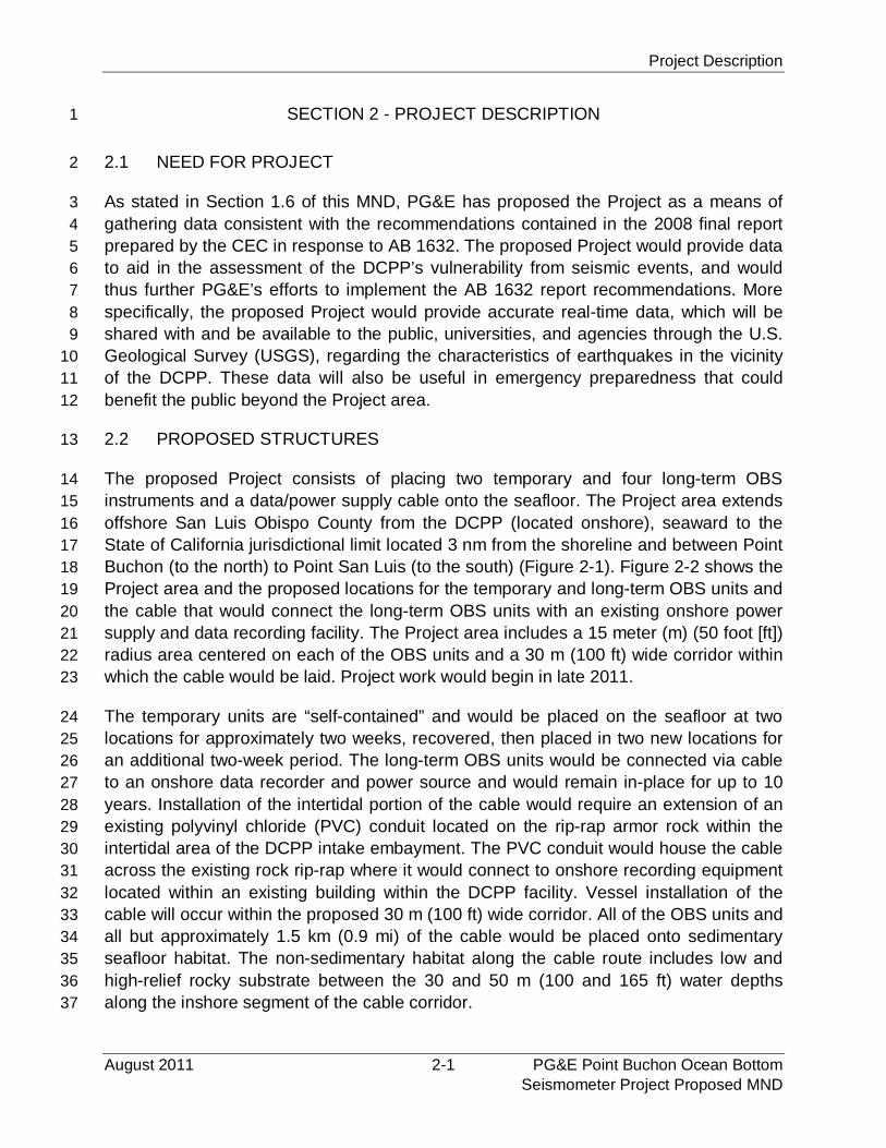
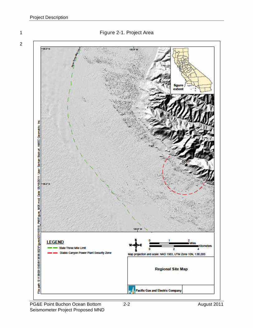
Figure 2-1. Project Area........................................................................................2-2
Figure 2-2. Site Specific Project Area Including Temporary and Long-TermOBS Locations....................................................................................2-3
Figure 2-3. Temporary OBS Unit ..........................................................................2-4
Figure 2-4. Schematic of Long-Term OBS Unit ....................................................2-5
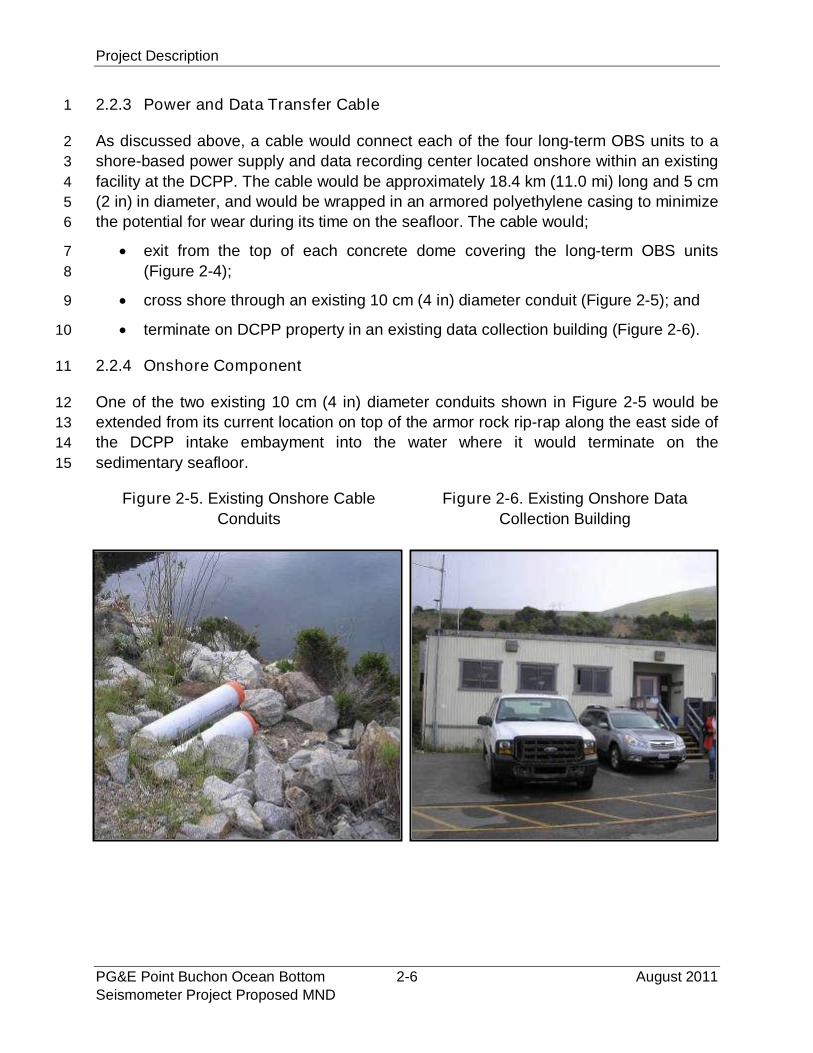
Figure 2-5. Existing Onshore Cable Conduits.......................................................2-6
Figure 2-6. Existing Onshore Data Collection Building .........................................2-6
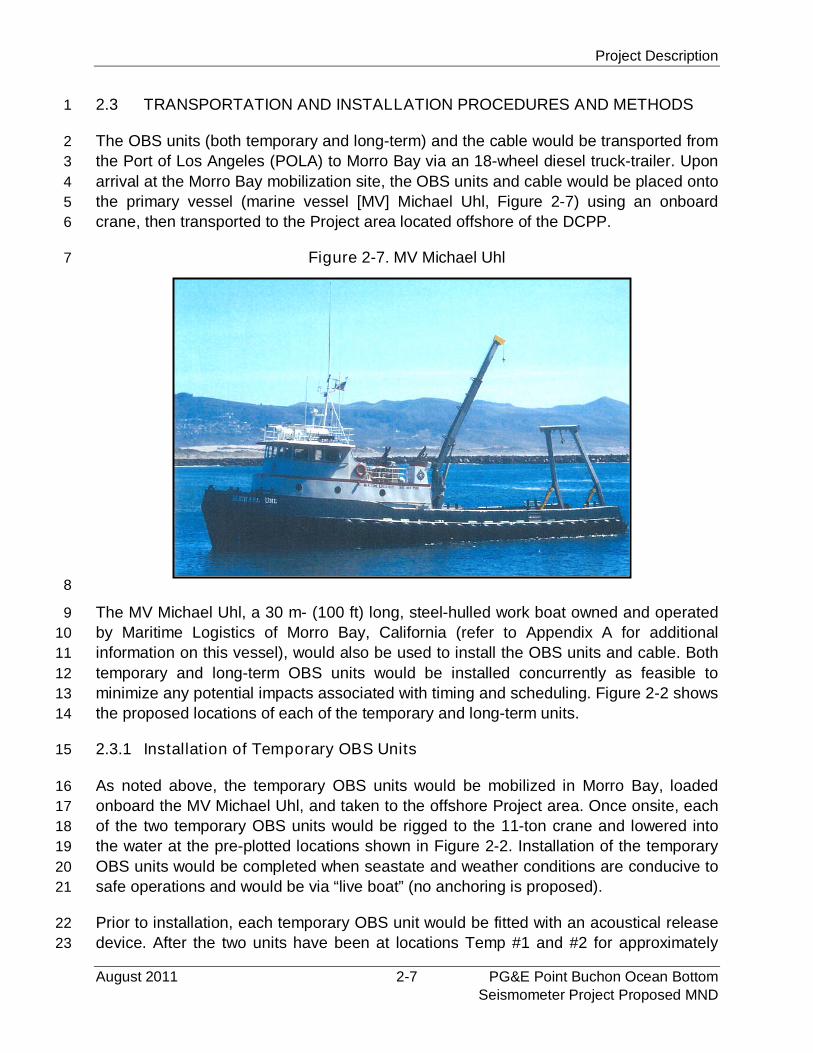
Figure 2-7. MV Michael Uhl ..................................................................................2-7
Figure 2-8. Intake Embayment Entrance ..............................................................2-9
Figure 2-9. Existing Boat Dock within DCPP Intake Embayment..........................2-9
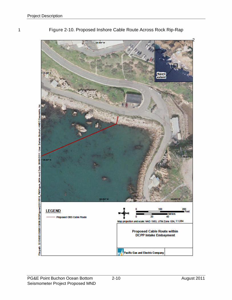
Figure 2-10. Proposed Inshore Cable Route Across Rock Rip-Rap .....................2-10
Figure 3.3.4-1. Regional Seafloor Habitats...........................................................3.3.4-2
Figure 3.3.4-2. Nearshore Cable Route Diver-Biologist Survey Area ...................3.3.4-6
Figure 3.3.4-3. Intertidal and Seafloor Habitats within Nearshore Cable Route....3.3.4-7
Figure 3.3.4-4. Point Buchon Marine Protected Area ......................................... 3.3.4-10
Figure 3.3.5-1. Shipwrecks in San Luis Obispo County Offshore Project Area... 3.3.5-10
Figure 3.3.6-1. Seafloor Habitat and Bathymetry for Cable Segment 1 ................3.3.6-2
Figure 3.3.6-2. Seafloor Habitat for OBS Unit Locations ......................................3.3.6-5
Figure 3.3.6-3. Seafloor Habitat and Bathymetry for Cable Segment 2 ................3.3.6-6
Figure 3.3.6-4. Seafloor Habitat and Bathymetry for Cable Segment 3 ................3.3.6-8
Figure 3.3.6-5. Seafloor Habitat and Bathymetry for Cable Segment 4 ................3.3.6-9
Figure 3.3.15-1.Regional and Site CDFG Fish Blocks......................................... 3.3.15-2
Figure 4-1. Project Area Including Morro Bay and Los Osos within SanLuis Obispo County ............................................................................4-5
Executive Summary
August 2011 ES-1 PG&E Point Buchon Ocean BottomSeismometer Project Proposed MND
EXECUTIVE SUMMARY1
This Mitigated Negative Declaration (MND) has been prepared by the California State2
Lands Commission (CSLC), as lead agency under the California Environmental Quality3
Act (CEQA), to analyze and disclose the environmental effects associated with the4
Pacific Gas and Electric Company (PG&E) Point Buchon Ocean Bottom Seismometer5
Project (Project). As proposed, the Project would enable PG&E to collect and provide6
accurate real-time data on the characteristics of earthquakes near its Diablo Canyon7
Power Plant (DCPP) consistent with California Assembly Bill (AB) 1632 (Blakeslee,8
Chapter 722, Statutes of 2006), which recommends an assessment of existing nuclear9
power plants in California, including potential vulnerability to seismic events or due to10
aging of the plants. This scientific study would begin in late 2011 and is not to be11
confused with PG&E’s proposed Central Coastal California Seismic Imaging Project for12
which the CSLC is preparing an Environmental Impact Report (SCH # 2011061085).13
The proposed Project would be located along the south-central coast of California14
offshore Point Buchon and the DCPP, San Luis Obispo County (Figure ES-1). Scientific15
data-recording instruments, called Ocean Bottom Seismometer (OBS) units, and an16
associated power/data cable will be placed on the seafloor within the State’s 3 nautical17
mile limit. PG&E would also extend an existing polyvinyl chloride (PVC) conduit within18
the intertidal area of the DCPP intake embayment; the conduit would house the19
power/data cable that would connect to an existing DCPP building with data recording20
equipment. PG&E proposes to install two types of OBS units: temporary and long-term.21
Temporary OBS units. These units would record ambient sound and seafloor22
movement (termed “noise” in geophysical terms) to assess background23
conditions. Each temporary unit consists of self-contained, two un-cabled (not24
connected to shore by cables)25
spheres that encase digitizers,26
data loggers, and rechargeable27
batteries within a 0.6 by 1.228
meter (m) (2 feet [ft] by 4 ft)29
tubular plastic rack with a total30
area of approximately 0.7 m2 (831
ft2). Underlying each rack are32
concrete ballast pieces. Two33
temporary OBS units will be installed for a period of two weeks. Installation of34
each temporary OBS unit is expected to take approximately one day to complete.35
These temporary OBS units would then be removed and reinstalled at another36
location for an additional two-week period. After the final two weeks of sampling,37
the temporary units would be retrieved and the data analyzed. As proposed, the38
concrete ballast pieces are expected to sink 6 inches (in) or more below the39
sedimentary seafloor and would remain on the seafloor.40
Executive Summary
PG&E Point Buchon Ocean Bottom ES-2 August 2011Seismometer Project Proposed MND
Figure ES-1. Site Specific Project Area Including1
Temporary and Long-Term OBS Locations2
Executive Summary
August 2011 ES-3 PG&E Point Buchon Ocean BottomSeismometer Project Proposed MND
Long-term OBS Units. The long-term OBS units would record earthquake-1
generated ground movement and sound data and continually transmit real-time2
data to an onshore facility for up to 10 years. Each long-term OBS unit consists3
of a titanium-encasement, 30 centimeter (cm) (1 ft) in diameter, that encloses4
digitizers and data loggers and is in turn covered by a 2.0 m wide by 0.3 m high5
(6 ft by 1 ft) concrete dome that secures and protects the unit.6
The power/data cable transmits electricity to the OBS units and data from the7
OBS units to a shore-based recorder. The long-term OBS units will be installed8
concurrently with the first installation of the two temporary OBS units. Installation9
of the long-term OBS units and new cable conduit is expected to take10
approximately one week to complete. The cable will be laid onto the seafloor and11
would not be trenched or buried during installation. The only onshore new12
“structure” is an extension of an existing 10 cm (4 in) diameter PVC conduit from13
its current location on top of the armor rock rip-rap along the east side of the14
DCPP intake bay into the water where it would terminate in approximately 2.4 m15
(8 ft) of water, mean lower low water (MLLW). A post-lay survey of the cable and16
OBS locations will be performed.17
Table ES-1 shows the anticipated level of Project-related impacts to each resource as18
determined through the environmental analysis that is detailed in this MND. Table ES-219
lists the Project-specific mitigations that are designed to reduce or eliminate potentially20
significant impacts. The mitigations comprise both Applicant-proposed mitigations21
(APM) and those that are recommended as a result of the environmental analysis22
detailed in the MND. With incorporation of mitigation, all Project-related impacts are23
reduced to less than significant.24
Executive Summary
PG&E Point Buchon Ocean Bottom ES-4 August 2011Seismometer Project Proposed MND
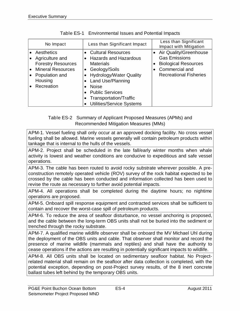
Table ES-1 Environmental Issues and Potential Impacts
No Impact Less than Significant ImpactLess than SignificantImpact with Mitigation
Aesthetics Agriculture and
Forestry Resources Mineral Resources Population and
Housing Recreation
Cultural Resources Hazards and Hazardous
Materials Geology/Soils Hydrology/Water Quality Land Use/Planning Noise Public Services Transportation/Traffic Utilities/Service Systems
Air Quality/GreenhouseGas Emissions
Biological Resources Commercial and
Recreational Fisheries
Table ES-2 Summary of Applicant Proposed Measures (APMs) and
Recommended Mitigation Measures (MMs)
APM-1. Vessel fueling shall only occur at an approved docking facility. No cross vesselfueling shall be allowed. Marine vessels generally will contain petroleum products withintankage that is internal to the hulls of the vessels.
APM-2. Project shall be scheduled in the late fall/early winter months when whaleactivity is lowest and weather conditions are conducive to expeditious and safe vesseloperations.
APM-3. The cable has been routed to avoid rocky substrate wherever possible. A pre-construction remotely operated vehicle (ROV) survey of the rock habitat expected to becrossed by the cable has been conducted and information collected has been used torevise the route as necessary to further avoid potential impacts.
APM-4. All operations shall be completed during the daytime hours; no nightimeoperations are proposed.
APM-5. Onboard spill response equipment and contracted services shall be sufficient tocontain and recover the worst-case spill of petroleum products.
APM-6. To reduce the area of seafloor disturbance, no vessel anchoring is proposed,and the cable between the long-term OBS units shall not be buried into the sediment ortrenched through the rocky substrate.
APM-7. A qualified marine wildlife observer shall be onboard the MV Michael Uhl duringthe deployment of the OBS units and cable. That observer shall monitor and record thepresence of marine wildlife (mammals and reptiles) and shall have the authority tocease operations if the actions are resulting in potentially significant impacts to wildlife.
APM-8. All OBS units shall be located on sedimentary seafloor habitat. No Project-related material shall remain on the seafloor after data collection is completed, with thepotential exception, depending on post-Project survey results, of the 8 inert concreteballast tubes left behind by the temporary OBS units.

Executive Summary
August 2011 ES-5 PG&E Point Buchon Ocean BottomSeismometer Project Proposed MND
Table ES-2 Summary of Applicant Proposed Measures (APMs) and
Recommended Mitigation Measures (MMs)
APM-9. The Applicant shall implement the marine wildlife contingency plan for OBSdeployment, cable lay, and equipment recovery that includes measures to reduce thechance of vessel/marine mammal and reptile interactions (see Appendix H). This Planincludes: (1) the provision for National Oceanic and Atmospheric (NOAA) Fisheries-approved marine mammal monitors to be onboard the OBS/cable installation vesselthroughout the daytime marine operations; and (2) measures that (a) specify thedistance, speed, and direction transiting vessels would maintain when in proximity to amarine mammal or reptile; (b) qualifications, number, location, and authority of onboardmarine mammal and reptile monitors; and (c) reporting requirements in the event of anobserved impact to marine wildlife.
MM AIR-1. The Applicant shall implement Standard Control Measures for ConstructionEquipment, which include:
Maintain all construction equipment in proper tune according to manufacturer’sspecifications;
Fuel all off-road and portable diesel powered equipment with California AirResources Board (CARB)-certified motor vehicle diesel fuel (non-taxed versionsuitable for use off-road);
Use diesel construction equipment meeting CARB's Tier 2 certified engines orcleaner off-road heavy-duty diesel engines, and comply with the State Off-RoadRegulation;
Use on-road heavy-duty trucks that meet CARB’s 2007 or cleaner certificationstandard for on-road heavy-duty diesel engines, and comply with the State On-Road Regulation;
Construction or trucking companies that do not have engines in their fleet thatmeet the engine standards identified in the above two measures (e.g., captive orNitrogen Oxides [NOx]-exempt area fleets) may be eligible by proving alternativecompliance;
All on and off-road diesel equipment shall not idle for more than five minutes.Signs shall be posted in the designated queuing areas and or job sites to reminddrivers and operators of the five-minute idling limit;
Diesel idling within 300 m (1,000 ft) of sensitive receptors is not permitted;
Staging and queuing areas shall not be located within 300 m (1,000 ft) ofsensitive receptors;
Electrify equipment when feasible;
Substitute gasoline-powered in place of diesel-powered equipment, wherefeasible; and,
Use alternatively fueled construction equipment onsite where feasible, such ascompressed natural gas, liquefied natural gas, propane or biodiesel.
Executive Summary
PG&E Point Buchon Ocean Bottom ES-6 August 2011Seismometer Project Proposed MND
Table ES-2 Summary of Applicant Proposed Measures (APMs) and
Recommended Mitigation Measures (MMs)
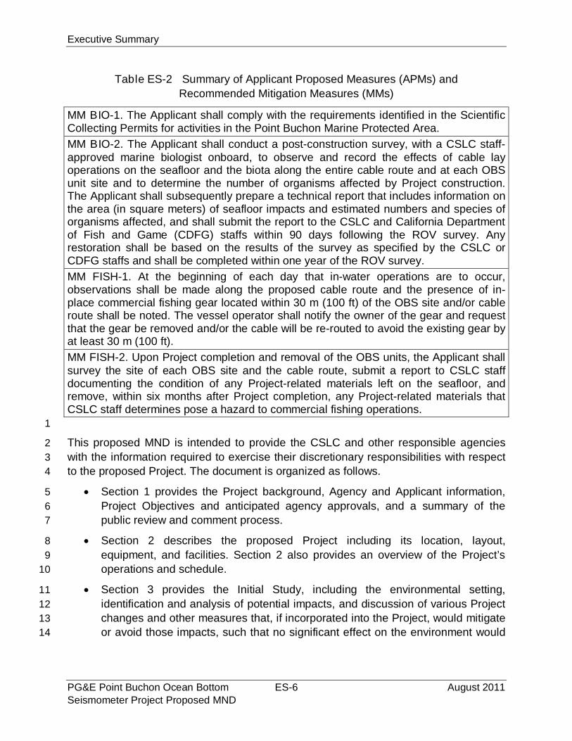
MM BIO-1. The Applicant shall comply with the requirements identified in the ScientificCollecting Permits for activities in the Point Buchon Marine Protected Area.
MM BIO-2. The Applicant shall conduct a post-construction survey, with a CSLC staff-approved marine biologist onboard, to observe and record the effects of cable layoperations on the seafloor and the biota along the entire cable route and at each OBSunit site and to determine the number of organisms affected by Project construction.The Applicant shall subsequently prepare a technical report that includes information onthe area (in square meters) of seafloor impacts and estimated numbers and species oforganisms affected, and shall submit the report to the CSLC and California Departmentof Fish and Game (CDFG) staffs within 90 days following the ROV survey. Anyrestoration shall be based on the results of the survey as specified by the CSLC orCDFG staffs and shall be completed within one year of the ROV survey.
MM FISH-1. At the beginning of each day that in-water operations are to occur,observations shall be made along the proposed cable route and the presence of in-place commercial fishing gear located within 30 m (100 ft) of the OBS site and/or cableroute shall be noted. The vessel operator shall notify the owner of the gear and requestthat the gear be removed and/or the cable will be re-routed to avoid the existing gear byat least 30 m (100 ft).
MM FISH-2. Upon Project completion and removal of the OBS units, the Applicant shallsurvey the site of each OBS site and the cable route, submit a report to CSLC staffdocumenting the condition of any Project-related materials left on the seafloor, andremove, within six months after Project completion, any Project-related materials thatCSLC staff determines pose a hazard to commercial fishing operations.
1
This proposed MND is intended to provide the CSLC and other responsible agencies2
with the information required to exercise their discretionary responsibilities with respect3
to the proposed Project. The document is organized as follows.4
Section 1 provides the Project background, Agency and Applicant information,5
Project Objectives and anticipated agency approvals, and a summary of the6
public review and comment process.7
Section 2 describes the proposed Project including its location, layout,8
equipment, and facilities. Section 2 also provides an overview of the Project’s9
operations and schedule.10
Section 3 provides the Initial Study, including the environmental setting,11
identification and analysis of potential impacts, and discussion of various Project12
changes and other measures that, if incorporated into the Project, would mitigate13
or avoid those impacts, such that no significant effect on the environment would14
Executive Summary
August 2011 ES-7 PG&E Point Buchon Ocean BottomSeismometer Project Proposed MND
occur. The Initial Study was conducted by the CSLC pursuant to section 15063 of1
the State CEQA Guidelines.12
Section 4 includes an environmental justice analysis and discussion consistent3
with CSLC Policy.4
Section 5 presents the Mitigation Monitoring Program.5
Sections 6 and 7 present information on report preparation, references, and a list6
of acronyms and abbreviations used in the MND.7
Appendices. Appendices include plans, data, and other information submitted by8
the Applicant and analyzed in this MND.9
o Appendix A: specification sheet on the primary project vessel, the MV10
Michael Uhl;11
o Appendix B: Spill Response Plan for the MV Michael Uhl;12
o Appendix C: air emissions calculations;13
o Appendix D: project-specific marine biological survey report;14
o Appendix E: project-specific seafloor habitat report;15
o Appendix F: background information on noise;16
o Appendix G: Essential Fish Habitat Assessment; and17
o Appendix H: Marine Wildlife Contingency Plan.18
1The State CEQA Guidelines are found in Title 14 of the California Code of Regulations, commencing
with section 15000.

Executive Summary
PG&E Point Buchon Ocean Bottom ES-8 August 2011Seismometer Project Proposed MND
PAGE PURPOSEFULLY LEFT BLANK

Project and Agency Information
August 2011 1-1 PG&E Point Buchon Ocean BottomSeismometer Project Proposed MND
SECTION 1 – PROJECT AND AGENCY INFORMATION1
1.1 PROJECT TITLE2
PG&E Point Buchon Ocean Bottom Seismometer Project3
1.2 LEAD AGENCY NAME AND ADDRESS4
California State Lands Commission (CSLC)5
100 Howe Avenue, Suite 100-South6
Sacramento, CA 958257
Contact person:8
Jennifer DeLeon, Senior Environmental Scientist9
Division of Environmental Planning and Management10
(916) 574-074812
1.3 PROJECT APPLICANT NAME AND ADDRESS13
Pacific Gas & Electric Company (PG&E)14
Mr. Loren Sharp, Senior Director, Technical Services15
Diablo Canyon Power Plant16
P.O. Box 56, Mail Code 104/6/60317
Avila Beach, CA 9342418
1.4 PROJECT LOCATION19
The proposed Project would be located in the waters of the Pacific Ocean offshore of20
the Diablo Canyon Power Plant (DCPP) along the south-central coast of California,21
approximately 26 kilometers (km) (16 miles [mi]) west of the city of San Luis Obispo.22
The Project area extends from the DCPP (located onshore), seaward to the State of23
California jurisdictional limit 3 nautical miles (nm) from the shoreline. The area includes24
the marine waters located between Point Buchon and Point San Luis. Please refer to25
Section 2 - Project Description, for further details on the proposed Project location.26
1.5 ORGANIZATION OF PROPOSED MITIGATED NEGATIVE DECLARATION27
This proposed Mitigated Negative Declaration (MND) is intended to provide the CSLC,28
as lead agency under the California Environmental Quality Act (CEQA), and other29
responsible agencies with the information required to exercise their discretionary30
responsibilities with respect to the proposed Project. The document is organized as31
follows.32

Project and Agency Information
PG&E Point Buchon Ocean Bottom 1-2 August 2011Seismometer Project Proposed MND
Section 1 provides the Project background, Agency and Applicant information,1
Project Objectives and anticipated agency approvals, and a summary of the2
public review and comment process.3
Section 2 describes the proposed Project including its location, layout,4
equipment, and facilities. Section 2 also provides an overview of the Project’s5
operations and schedule.6
Section 3 provides the Initial Study (IS), including the environmental setting,7
identification and analysis of potential impacts, and discussion of various Project8
changes and other measures that, if incorporated into the Project, would mitigate9
or avoid those impacts, such that no significant effect on the environment would10
occur. The IS was conducted by the CSLC pursuant to section 15063 of the11
State CEQA Guidelines.12
Section 4 includes an environmental justice analysis and discussion consistent13
with CSLC Policy.14
Section 5 presents the Mitigation Monitoring Program15
Sections 6 and 7 present information on report preparation, references, and a list16
of acronyms and abbreviations used in the MND.17
Appendices. The appendices include plans, data, and other information18
submitted by the Applicant and analyzed in this MND.19
o Appendix A: specification sheet on the primary project vessel, the MV20
Michael Uhl;21
o Appendix B: Spill Response Plan for the MV Michael Uhl;22
o Appendix C: air emissions calculations;23
o Appendix D: project-specific marine biological survey report;24
o Appendix E: project-specific seafloor habitat report;25
o Appendix F: background information on noise;26
o Appendix G: Essential Fish Habitat Assessment; and27
o Appendix H: Marine Wildlife Contingency Plan.28
1.6 PROJECT BACKGROUND AND OBJECTIVES29
Assembly Bill (AB) 1632 (Blakeslee, Chapter 722, Statutes of 2006) required the30
California Energy Commission (CEC) to assess the potential vulnerability of existing31
nuclear power plants within the State of California, including potential vulnerability from32
seismic events or due to aging of the plant. The CEC’s 2008 final report recommended33
that PG&E gather data on faults near the DCPP by conducting various scientific studies34
and surveys. The proposed Project will provide data to aid in this recommended35

Project and Agency Information
August 2011 1-3 PG&E Point Buchon Ocean BottomSeismometer Project Proposed MND
assessment of DCPP’s vulnerability from seismic events. More specifically, the Project1
will provide background (ambient) sound data from temporary Ocean Bottom2
Seismometer (OBS) units and accurate real-time data of earthquakes in the region from3
long-term OBS units as follows.4
The temporary OBS units would record ambient sound and seafloor movement5
(termed “noise” in geophysical terms) to allow assessment of background6
conditions.7
The long-term OBS units would record earthquake-generated ground movement8
and sound data and continually transmit real-time data to an onshore facility over9
a 10-year period.10
These data may also be useful in emergency preparedness that could benefit the public11
beyond the region and will be shared with public agencies, including but not limited to12
the U.S. Geological Survey (USGS).13
1.7 PUBLIC REVIEW AND COMMENT14
Consistent with the direction provided in the State CEQA Guidelines sections 1507215
and 15073, this MND is being circulated to local and state agencies and to interested16
individuals who may wish to review and comment. Written comments may be submitted17
to the CSLC during the 30-day public review period. Prior to taking action on adoption of18
the MND and approval of the Project, the CSLC will consider the proposed MND along19
with all comments received. Written comments should be sent to:20
Jennifer DeLeon, Senior Environmental Scientist21
California State Lands Commission22
Division of Environmental Planning and Management23
100 Howe Avenue, Suite 100-South24
Sacramento, CA 95825-820225
FAX: (916) 574-188527
1.8 PERMITS, APPROVALS AND REGULATORY REQUIREMENTS28
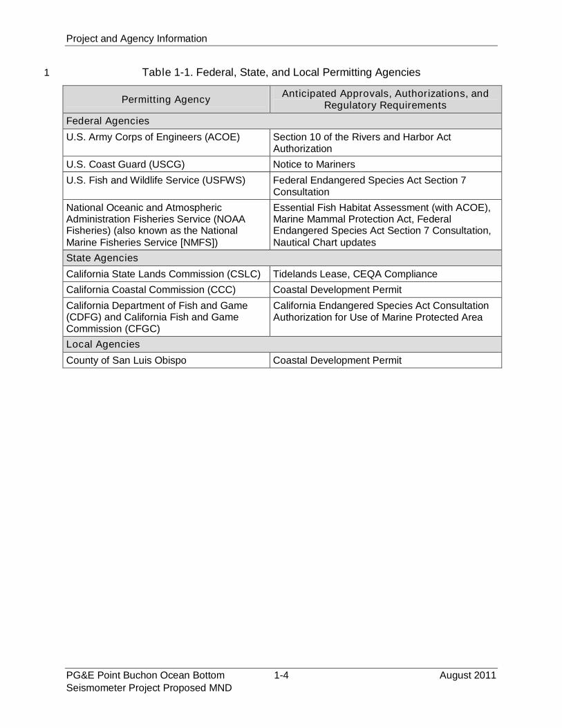
In addition to the CSLC’s leasing jurisdiction, the Project is subject to the authorities of a29
number of other federal, state, and local entities with statutory and/or regulatory30
jurisdiction over various aspects of the proposed Project. Prior to implementing the31
proposed Project, PG&E will be required to seek permits and/or approvals from the32
agencies listed in Table 1-1.33
Project and Agency Information
PG&E Point Buchon Ocean Bottom 1-4 August 2011Seismometer Project Proposed MND
Table 1-1. Federal, State, and Local Permitting Agencies1
Permitting AgencyAnticipated Approvals, Authorizations, and
Regulatory Requirements
Federal Agencies
U.S. Army Corps of Engineers (ACOE) Section 10 of the Rivers and Harbor ActAuthorization
U.S. Coast Guard (USCG) Notice to Mariners
U.S. Fish and Wildlife Service (USFWS) Federal Endangered Species Act Section 7Consultation
National Oceanic and AtmosphericAdministration Fisheries Service (NOAAFisheries) (also known as the NationalMarine Fisheries Service [NMFS])
Essential Fish Habitat Assessment (with ACOE),Marine Mammal Protection Act, FederalEndangered Species Act Section 7 Consultation,Nautical Chart updates
State Agencies
California State Lands Commission (CSLC) Tidelands Lease, CEQA Compliance
California Coastal Commission (CCC) Coastal Development Permit
California Department of Fish and Game(CDFG) and California Fish and GameCommission (CFGC)
California Endangered Species Act ConsultationAuthorization for Use of Marine Protected Area
Local Agencies
County of San Luis Obispo Coastal Development Permit
Project Description
August 2011 2-1 PG&E Point Buchon Ocean BottomSeismometer Project Proposed MND
SECTION 2 - PROJECT DESCRIPTION1
2.1 NEED FOR PROJECT2
As stated in Section 1.6 of this MND, PG&E has proposed the Project as a means of3
gathering data consistent with the recommendations contained in the 2008 final report4
prepared by the CEC in response to AB 1632. The proposed Project would provide data5
to aid in the assessment of the DCPP’s vulnerability from seismic events, and would6
thus further PG&E’s efforts to implement the AB 1632 report recommendations. More7
specifically, the proposed Project would provide accurate real-time data, which will be8
shared with and be available to the public, universities, and agencies through the U.S.9
Geological Survey (USGS), regarding the characteristics of earthquakes in the vicinity10
of the DCPP. These data will also be useful in emergency preparedness that could11
benefit the public beyond the Project area.12
2.2 PROPOSED STRUCTURES13
The proposed Project consists of placing two temporary and four long-term OBS14
instruments and a data/power supply cable onto the seafloor. The Project area extends15
offshore San Luis Obispo County from the DCPP (located onshore), seaward to the16
State of California jurisdictional limit located 3 nm from the shoreline and between Point17
Buchon (to the north) to Point San Luis (to the south) (Figure 2-1). Figure 2-2 shows the18
Project area and the proposed locations for the temporary and long-term OBS units and19
the cable that would connect the long-term OBS units with an existing onshore power20
supply and data recording facility. The Project area includes a 15 meter (m) (50 foot [ft])21
radius area centered on each of the OBS units and a 30 m (100 ft) wide corridor within22
which the cable would be laid. Project work would begin in late 2011.23
The temporary units are “self-contained” and would be placed on the seafloor at two24
locations for approximately two weeks, recovered, then placed in two new locations for25
an additional two-week period. The long-term OBS units would be connected via cable26
to an onshore data recorder and power source and would remain in-place for up to 1027
years. Installation of the intertidal portion of the cable would require an extension of an28
existing polyvinyl chloride (PVC) conduit located on the rip-rap armor rock within the29
intertidal area of the DCPP intake embayment. The PVC conduit would house the cable30
across the existing rock rip-rap where it would connect to onshore recording equipment31
located within an existing building within the DCPP facility. Vessel installation of the32
cable will occur within the proposed 30 m (100 ft) wide corridor. All of the OBS units and33
all but approximately 1.5 km (0.9 mi) of the cable would be placed onto sedimentary34
seafloor habitat. The non-sedimentary habitat along the cable route includes low and35
high-relief rocky substrate between the 30 and 50 m (100 and 165 ft) water depths36
along the inshore segment of the cable corridor.37
Project Description
PG&E Point Buchon Ocean Bottom 2-2 August 2011Seismometer Project Proposed MND
Figure 2-1. Project Area1
2
Project Description
August 2011 2-3 PG&E Point Buchon Ocean BottomSeismometer Project Proposed MND
Figure 2-2. Site Specific Project Area Including1
Temporary and Long-Term OBS Locations2
Project Description
PG&E Point Buchon Ocean Bottom 2-4 August 2011Seismometer Project Proposed MND
Power to the long-term OBS units will be provided from an existing onshore source1
within the DCPP and data will be recorded at a station located within an existing2
building located within the DCPP intake embayment. Details on the OBS units,3
installation methods, and maintenance are provided below.4
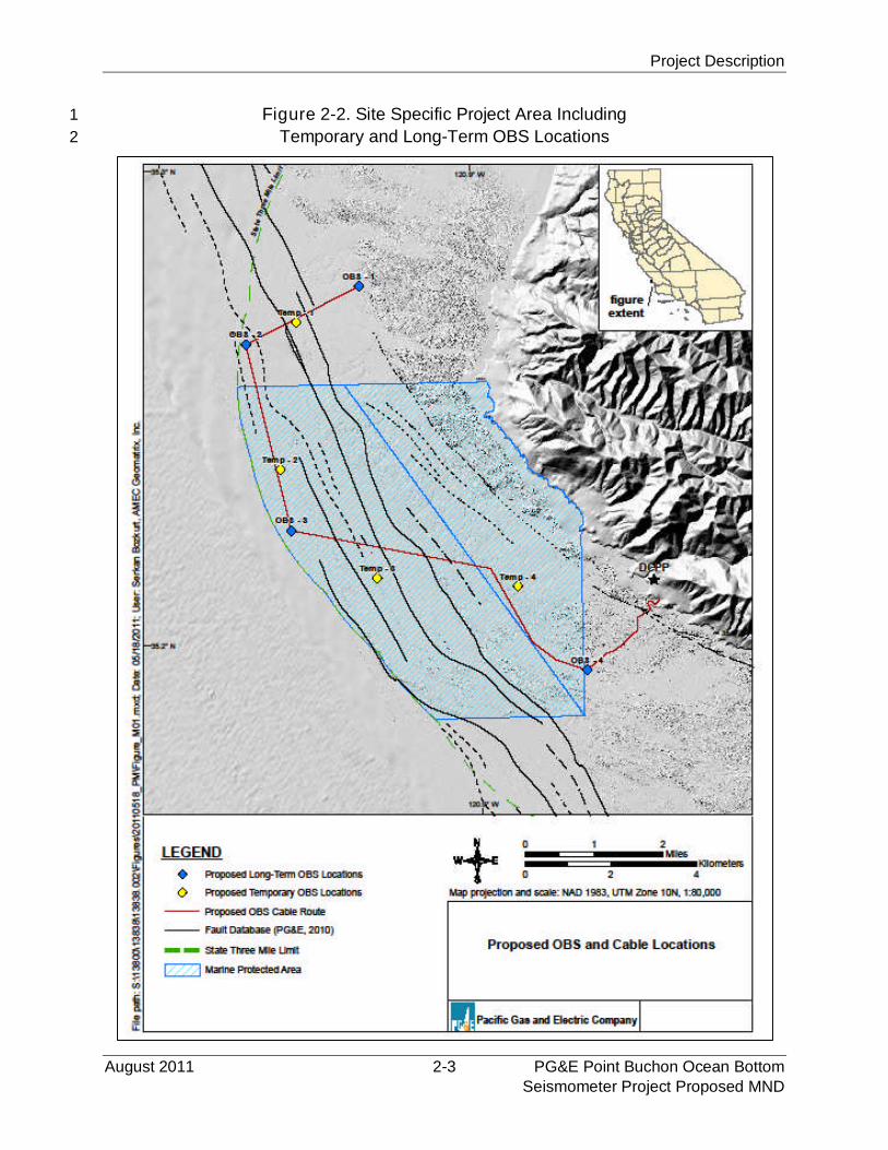
2.2.1 Temporary OBS Units5
Figure 2-3 shows a temporary OBS unit. Each temporary OBS unit would record6
ambient sound and seafloor movement (termed “noise” in geophysical terms) to allow7
assessment of background conditions. The temporary OBS units are self-contained8
units each comprising two spheres that encase digitizers, data loggers, and9
rechargeable batteries supported by a 0.6 by 1.2 m (2 ft by 4 ft) tubular plastic rack. The10
total area of each temporary OBS unit is 0.7 m2 (8 ft2) and a volume of approximately 411
m3 (20 ft3). The temporary OBS units have two, 10 centimeter (cm) (4 inch [in]) diameter12
by 1.2 m- (4 ft) long concrete cylinders attached to the bottom of each rack for ballast.13
Figure 2-3. Temporary OBS Unit14
15

Project Description
August 2011 2-5 PG&E Point Buchon Ocean BottomSeismometer Project Proposed MND
2.2.2 Long-Term OBS Units1
The long-term OBS units would record earthquake-generated ground movement and2
sound data and continually transmit real-time data to the onshore facility through the3
cable described in Section 2.3.3. Each long-term OBS unit is a 30 cm (1 ft) -diameter4
titanium-encasement that encloses digitizers and data loggers which is covered by a5
2.0 m wide by 0.3 m high (6 ft by 1 ft) concrete dome that secures and protects the unit6
(Figure 2-4). The concrete dome has an aperture located at the top to facilitate7
attachment to the proposed cable. Each long-term OBS unit is powered by electricity8
provided by a shore-based power source that is transmitted through the attached cable.9
Collected data are transmitted to a shore-based recorder through the same cable.10
Figure 2-4. Schematic of Long-Term OBS Unit11
12
Project Description
PG&E Point Buchon Ocean Bottom 2-6 August 2011Seismometer Project Proposed MND
2.2.3 Power and Data Transfer Cable1
As discussed above, a cable would connect each of the four long-term OBS units to a2
shore-based power supply and data recording center located onshore within an existing3
facility at the DCPP. The cable would be approximately 18.4 km (11.0 mi) long and 5 cm4
(2 in) in diameter, and would be wrapped in an armored polyethylene casing to minimize5
the potential for wear during its time on the seafloor. The cable would;6
exit from the top of each concrete dome covering the long-term OBS units7
(Figure 2-4);8
cross shore through an existing 10 cm (4 in) diameter conduit (Figure 2-5); and9
terminate on DCPP property in an existing data collection building (Figure 2-6).10
2.2.4 Onshore Component11
One of the two existing 10 cm (4 in) diameter conduits shown in Figure 2-5 would be12
extended from its current location on top of the armor rock rip-rap along the east side of13
the DCPP intake embayment into the water where it would terminate on the14
sedimentary seafloor.15
Figure 2-5. Existing Onshore Cable
Conduits
Figure 2-6. Existing Onshore Data
Collection Building
Project Description
August 2011 2-7 PG&E Point Buchon Ocean BottomSeismometer Project Proposed MND
2.3 TRANSPORTATION AND INSTALLATION PROCEDURES AND METHODS1
The OBS units (both temporary and long-term) and the cable would be transported from2
the Port of Los Angeles (POLA) to Morro Bay via an 18-wheel diesel truck-trailer. Upon3
arrival at the Morro Bay mobilization site, the OBS units and cable would be placed onto4
the primary vessel (marine vessel [MV] Michael Uhl, Figure 2-7) using an onboard5
crane, then transported to the Project area located offshore of the DCPP.6
Figure 2-7. MV Michael Uhl7
8
The MV Michael Uhl, a 30 m- (100 ft) long, steel-hulled work boat owned and operated9
by Maritime Logistics of Morro Bay, California (refer to Appendix A for additional10
information on this vessel), would also be used to install the OBS units and cable. Both11
temporary and long-term OBS units would be installed concurrently as feasible to12
minimize any potential impacts associated with timing and scheduling. Figure 2-2 shows13
the proposed locations of each of the temporary and long-term units.14
2.3.1 Installation of Temporary OBS Units15
As noted above, the temporary OBS units would be mobilized in Morro Bay, loaded16
onboard the MV Michael Uhl, and taken to the offshore Project area. Once onsite, each17
of the two temporary OBS units would be rigged to the 11-ton crane and lowered into18
the water at the pre-plotted locations shown in Figure 2-2. Installation of the temporary19
OBS units would be completed when seastate and weather conditions are conducive to20
safe operations and would be via “live boat” (no anchoring is proposed).21
Prior to installation, each temporary OBS unit would be fitted with an acoustical release22
device. After the two units have been at locations Temp #1 and #2 for approximately23

Project Description
PG&E Point Buchon Ocean Bottom 2-8 August 2011Seismometer Project Proposed MND
two weeks and sufficient data have been recorded, the MV Michael Uhl would return to1
the site and the acoustic releases would be signaled to release the OBS frame from the2
concrete ballast. The frame and attached spheres would float to the surface where they3
would be recovered with the crane onboard the MV Michael Uhl. As proposed by PG&E,4
the two concrete ballast pieces from each temporary OBS unit would remain in place5
since they are expected to sink into seafloor sediments; the location of each would be6
recorded. Following retrieval of the data from the two temporary units, the MV Michael7
Uhl would reinstall the temporary units at locations Temp #3 and #4 for an additional8
two weeks. After two weeks of sampling, the units would be recovered in an identical9
manner as discussed above and the data would be retrieved and analyzed.10
Installation of the temporary OBS units is expected to take approximately four days to11
complete (one day for each unit), with the first two units’ placement being completed12
concurrently with the installation of the long-term OBS units. When the temporary OBS13
units are no longer required, each unit would be returned to PG&E.14
2.3.2 Installation of Long-Term OBS Units and Power/Data Transfer Cable15
As with the installation of the temporary OBS units, the long-term OBS units would be16
mobilized in Morro Bay and transported onboard the MV Michael Uhl to the Project17
area. Each long-term OBS unit would arrive encased in and attached to the concrete18
dome which would have three or four “lifting eyes” (Figure 2-4). The crane onboard the19
MV Michael Uhl would use a lifting bridle, consisting of wire rope cables attached to the20
lifting eyes, to deploy the unit; one long-term OBS unit would be deployed at a time. The21
cable would be deployed with each unit and the “free end” would be fitted with a buoy22
for ease of recovery and connecting the cable(s) from the other long-term units. Once23
the OBS is on the seafloor, the lifting bridle would be released and the short lifting24
bridle, which is connected to the cable, would remain draped over the concrete dome.25
Following deployment of the first long-term unit, the MV Michael Uhl would return to port26
to secure the second unit and cable. It would return to the site the following day, recover27
the buoy attached to the free end of the previously-laid cable and prepare to deploy the28
second unit following onboard cable splicing operations. Subsequent long-term units29
would be deployed in the same manner, progressing north to south (locations OBS 1 to30
4 in Figure 2-2). Deploying one OBS unit at a time precludes nighttime operations and31
the use of a larger vessel (the MV Michael Uhl has sufficient deck space for a single32
OBS unit and the associated cable). The cable would be laid onto the seafloor and33
would not be trenched or buried during installation. The weight of the cable is 1.334
grams/cm3 (81.1 pounds [lbs] per ft3) and in sedimentary habitats the cable is expected35
to naturally sink; previous projects using this same cable have resulted in natural36
sinking into sedimentary seafloor (Geralp 2011). Where necessary, it would lay across37
rocky substrates; no trenching is proposed. Installation would be completed when38
seastate and weather conditions are conducive to safe operations and would be via “live39
Project Description
August 2011 2-9 PG&E Point Buchon Ocean BottomSeismometer Project Proposed MND
boat” (i.e., no anchoring of the MV Michael Uhl would be required). As currently1
proposed, the long-term OBS units would be in situ for approximately 10 years. Once2
deployment is completed, no additional offshore maintenance activities are anticipated3
over the life of the installation.4
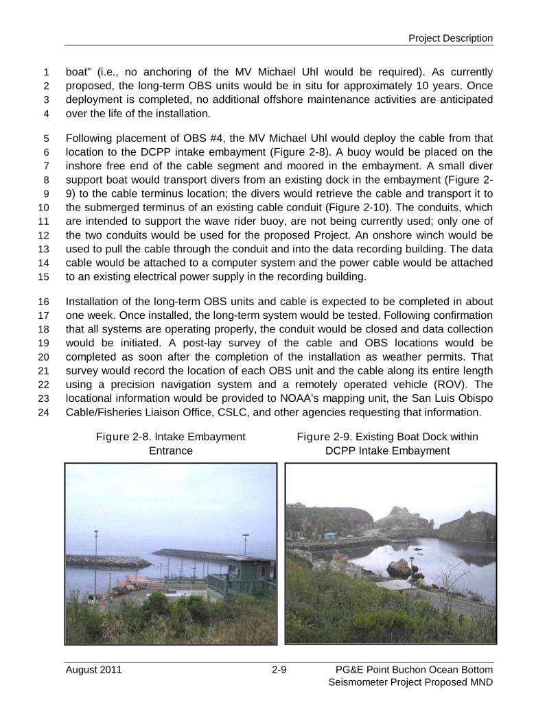
Following placement of OBS #4, the MV Michael Uhl would deploy the cable from that5
location to the DCPP intake embayment (Figure 2-8). A buoy would be placed on the6
inshore free end of the cable segment and moored in the embayment. A small diver7
support boat would transport divers from an existing dock in the embayment (Figure 2-8
9) to the cable terminus location; the divers would retrieve the cable and transport it to9
the submerged terminus of an existing cable conduit (Figure 2-10). The conduits, which10
are intended to support the wave rider buoy, are not being currently used; only one of11
the two conduits would be used for the proposed Project. An onshore winch would be12
used to pull the cable through the conduit and into the data recording building. The data13
cable would be attached to a computer system and the power cable would be attached14
to an existing electrical power supply in the recording building.15
Installation of the long-term OBS units and cable is expected to be completed in about16
one week. Once installed, the long-term system would be tested. Following confirmation17
that all systems are operating properly, the conduit would be closed and data collection18
would be initiated. A post-lay survey of the cable and OBS locations would be19
completed as soon after the completion of the installation as weather permits. That20
survey would record the location of each OBS unit and the cable along its entire length21
using a precision navigation system and a remotely operated vehicle (ROV). The22
locational information would be provided to NOAA’s mapping unit, the San Luis Obispo23
Cable/Fisheries Liaison Office, CSLC, and other agencies requesting that information.24
Figure 2-8. Intake Embayment
Entrance
Figure 2-9. Existing Boat Dock within
DCPP Intake Embayment
Project Description
PG&E Point Buchon Ocean Bottom 2-10 August 2011Seismometer Project Proposed MND
Figure 2-10. Proposed Inshore Cable Route Across Rock Rip-Rap1
2
Project Description
August 2011 2-11 PG&E Point Buchon Ocean BottomSeismometer Project Proposed MND
2.3.3 Onshore Component1
The only onshore new “structure” that would be constructed as part of this Project is an2
extension of an existing 10 cm (4 in) diameter conduit (Figure 2-5) from its current3
location on top of the armor rock rip-rap along the east side of the DCPP intake bay into4
the water where it would terminate in approximately 2.4 m (8 ft) of water, mean lower5
low water (MLLW). The extension would be assembled onsite and attached to the6
existing part with PVC glue. The cable would be pulled through the conduit and into the7
data recording building.8
2.3.4 Actions Within the Point Buchon Marine Protected Area (MPA)9
As shown in Figure 2-2, a portion of the proposed Project will be within the existing10
Point Buchon MPA which includes the inshore State Marine Reserve (SMR) and11
offshore State Marine Conservation Area (SMCA). Cable-laying activities associated12
with the proposed Project are expected to cross over rocky substrate at two locations13
within the MPA between kilometer posts 4.0 and 6.0.14
The Marine Life Protection Act (Fish & G. Code § 2850 et seq.) and existing MPA15
regulations generally prohibit the take of all living marine resources in an SMR; an16
SMCA designation also prohibits take of living marine resources, but excepts the17
commercial and recreational take of salmon and albacore. However, take of specified18
marine species in an MPA may be authorized by the CFGC for scientific purposes19
under a scientific collecting permit (SCP) issued by the CDFG.20
PG&E’s marine biological consultant, Tenera Environmental, has received such21
authorization for five of its staff to allow take of marine and intertidal invertebrates during22
the proposed placement and operation of the proposed OBS units and cable within the23
MPA. The SCP allows the sacrifice of specified marine fishes, marine aquatic plants,24
and marine and intertidal invertebrates, and the capture and release of marine fishes25
and marine intertidal invertebrates from within the Point Buchon MPA, and does not26
include take of sensitive or listed species, including algae or seagrasses. The SCP27
amendment received from CDFG is valid from June 29, 2011 through December 15,28
2011 after which a new SCP amendment must be procured if work activities within the29
MPA continue beyond that date.30
2.4 OPERATION AND MAINTENANCE OF LONG-TERM OBS UNITS31
Maintenance of the equipment is expected to be minimal; however if a long-term OBS32
unit malfunctions, a vessel, equipped with appropriate lifting equipment and an ROV,33
would be deployed to the site to observe and, if necessary, recover the damaged unit34
and/or cable. Repairs would be made onboard or the damaged equipment would be35
taken to an onshore facility. Reinstallation of the repaired equipment would be36
conducted in a similar manner as discussed in Section 2.4.37
Project Description
PG&E Point Buchon Ocean Bottom 2-12 August 2011Seismometer Project Proposed MND
The long-term OBS units are anticipated to remain in-place for up to 10 years and,1
when the equipment is no longer required, each unit and all of the cable would be2
removed from the seafloor and the material would either be recycled or disposed of at a3
permitted onshore facility. No equipment would be left on the seafloor or within the4
intake embayment upon removal of the long-term OBS units. The eight 1.2 m- (4 ft-)5
long concrete ballast cylinders from the temporary OBS units will remain on the seafloor6
offshore of the DCPP, unless otherwise directed by the CSLC pursuant to MM FISH-2.7
2.5 PROJECT SCHEDULE8
2.5.1 Temporary OBS Units9
It is anticipated that installation of the OBS units would begin in November 2011. Each10
temporary OBS unit would remain in place for approximately two weeks for data11
collection. Following data collection, the temporary OBS units at locations Temp #1 and12
Temp #2 would be moved to Temp #3 and Temp #4, where they would record data for13
an additional two weeks. Following the second data collection effort, both temporary14
OBS units would be recovered and would no longer be used for this Project.15
2.5.2 Long-Term OBS Units16
As currently proposed, the long-term OBS units would be installed in the 4th quarter of17
2011 at approximately the same time as the temporary units are deployed and would be18
in situ for 10 years.19
2.6 PROJECT PERSONNEL AND EQUIPMENT20
2.6.1 Personnel Requirements21
PG&E estimates that 15 personnel would be required for OBS unit installation:22
MV Michael Uhl crew: 523
Onboard OBS service crew: 424
Support boat and divers: 325
Administrative/computer support: 326
All personnel would be either local or be representatives of the OBS manufacturer. No27
new jobs would be created by the proposed project.28
2.6.2 Equipment Requirements29
Most of the equipment required to install the temporary and long-term OBS units and30
cable is already onboard the MV Michael Uhl, and consists of an existing hydraulic31
crane, A-frame, and positioning system. Except for a small cable reel onto which the32
Project Description
August 2011 2-13 PG&E Point Buchon Ocean BottomSeismometer Project Proposed MND
cable would be wound for transport to the site, no additional equipment would be1
required. A listing of the engines and equipment onboard the MV Michael Uhl is2
provided in Appendix A. The diver support vessel is used for environmental monitoring3
at DCPP and is already at the DCPP small boat dock within the intake embayment.4
2.7 ENVIRONMENTAL COMPLIANCE INSPECTION AND MITIGATION5
MONITORING6
Environmental checks for the proposed Project would include specific requirements for7
controlling and/or mitigating potential impacts to water quality (such as oil spills), and8
biological resources.9
Project plans that would be prepared by PG&E (or its contractors) and approved by the10
CSLC include: a Marine Safety Plan; Rigging and Lifting Plan; Critical Operations and11
Curtailment Plan; Navigation Marking and Lighting Plan; and Oil Spill Response Plan12
(refer to Appendix B for additional information on these plans). In addition, cable-laying13
operations will conform to the Project’s Marine Wildlife Contingency Plan (refer to14
Appendix H), and a qualified marine wildlife monitor would be onboard the MV Michael15
Uhl during OBS deployment operations.16
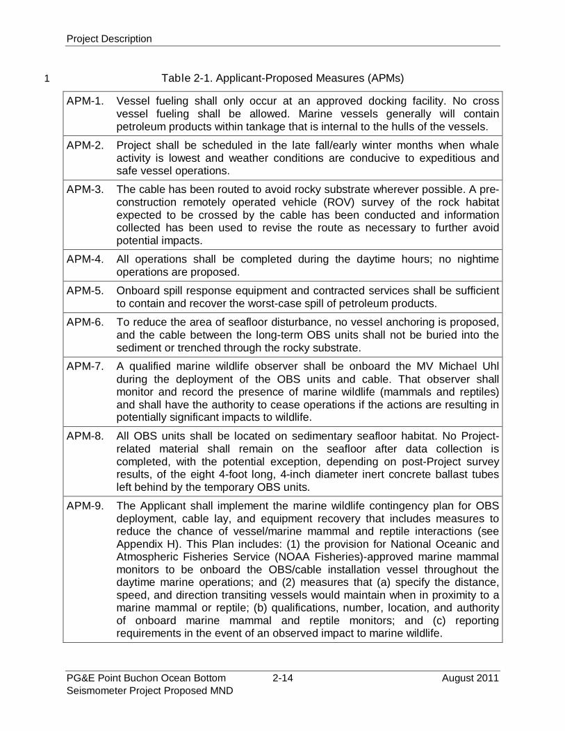
Table 2-1 lists the “Applicant-Proposed Mitigations” (APMs) that PG&E will implement;17
these APMs are designed to reduce or eliminate potentially significant impacts. When18
implemented, the APMs and any mitigation measures recommended as a result of the19
environmental analysis detailed in the MND (see Section 5.0) are intended to reduce all20
Project-related impacts to less than significant.21
22
Project Description
PG&E Point Buchon Ocean Bottom 2-14 August 2011Seismometer Project Proposed MND
Table 2-1. Applicant-Proposed Measures (APMs)1
APM-1. Vessel fueling shall only occur at an approved docking facility. No crossvessel fueling shall be allowed. Marine vessels generally will containpetroleum products within tankage that is internal to the hulls of the vessels.
APM-2. Project shall be scheduled in the late fall/early winter months when whaleactivity is lowest and weather conditions are conducive to expeditious andsafe vessel operations.
APM-3. The cable has been routed to avoid rocky substrate wherever possible. A pre-construction remotely operated vehicle (ROV) survey of the rock habitatexpected to be crossed by the cable has been conducted and informationcollected has been used to revise the route as necessary to further avoidpotential impacts.
APM-4. All operations shall be completed during the daytime hours; no nightimeoperations are proposed.
APM-5. Onboard spill response equipment and contracted services shall be sufficientto contain and recover the worst-case spill of petroleum products.
APM-6. To reduce the area of seafloor disturbance, no vessel anchoring is proposed,and the cable between the long-term OBS units shall not be buried into thesediment or trenched through the rocky substrate.
APM-7. A qualified marine wildlife observer shall be onboard the MV Michael Uhlduring the deployment of the OBS units and cable. That observer shallmonitor and record the presence of marine wildlife (mammals and reptiles)and shall have the authority to cease operations if the actions are resulting inpotentially significant impacts to wildlife.
APM-8. All OBS units shall be located on sedimentary seafloor habitat. No Project-related material shall remain on the seafloor after data collection iscompleted, with the potential exception, depending on post-Project surveyresults, of the eight 4-foot long, 4-inch diameter inert concrete ballast tubesleft behind by the temporary OBS units.
APM-9. The Applicant shall implement the marine wildlife contingency plan for OBSdeployment, cable lay, and equipment recovery that includes measures toreduce the chance of vessel/marine mammal and reptile interactions (seeAppendix H). This Plan includes: (1) the provision for National Oceanic andAtmospheric Fisheries Service (NOAA Fisheries)-approved marine mammalmonitors to be onboard the OBS/cable installation vessel throughout thedaytime marine operations; and (2) measures that (a) specify the distance,speed, and direction transiting vessels would maintain when in proximity to amarine mammal or reptile; (b) qualifications, number, location, and authorityof onboard marine mammal and reptile monitors; and (c) reportingrequirements in the event of an observed impact to marine wildlife.
Environmental Analysis
August 2011 3-1 PG&E Point Buchon Ocean BottomSeismometer Project Proposed MND
SECTION 3 - ENVIRONMENTAL ANALYSIS1
This Initial Study (IS) has been completed for the proposed Project in accordance with2
CEQA. The IS identifies site-specific conditions and impacts, evaluates their potential3
significance, and discusses ways to avoid or lessen impacts that are potentially4
significant. The information, analysis and conclusions included in this IS provide the5
basis for determining the appropriate document needed to comply with CEQA. For the6
proposed Project, based on the analysis and information contained herein, the CSLC7
has found that the IS shows that there is substantial evidence that the project may have8
a significant effect on the environment but revisions to the Project would avoid the9
effects or mitigate the effects to a point where clearly no significant effect on the10
environment would occur. As a result, the CSLC has concluded that this MND is the11
appropriate CEQA document for the proposed Project.12
3.1 ENVIRONMENTAL FACTORS POTENTIALLY AFFECTED13
The evaluation of environmental impacts provided in Section 3.3 of this MND is based,14
in part, on the environmental impact thresholds provided by State CEQA Guidelines15
Appendix G. An impact assessment matrix is provided as part of the evaluation for each16
environmental issue area. The column headings for each impact assessment matrix are17
defined below.18
Potentially Significant Impact. This column has been checked if there is19
substantial evidence that a Project-related environmental effect may be20
significant. If there are one or more “Potentially Significant Impacts” a Project21
Environmental Impact Report (EIR) will be prepared.22
Less than Significant with Mitigation. This column has been checked when23
the Project may result in a significant environmental impact, but the incorporation24
of identified project-specific mitigation measures into the proposed Project will25
reduce the identified effect(s) to a less than significant level.26
Less than Significant Impact. This column has been checked when the Project27
would not result in any significant effects. The Project’s impact is less than28
significant even without the incorporation of a project-specific mitigation measure.29
No Impact. This column has been checked when the Project would not result in30
any impact in the category or the category does not apply.31
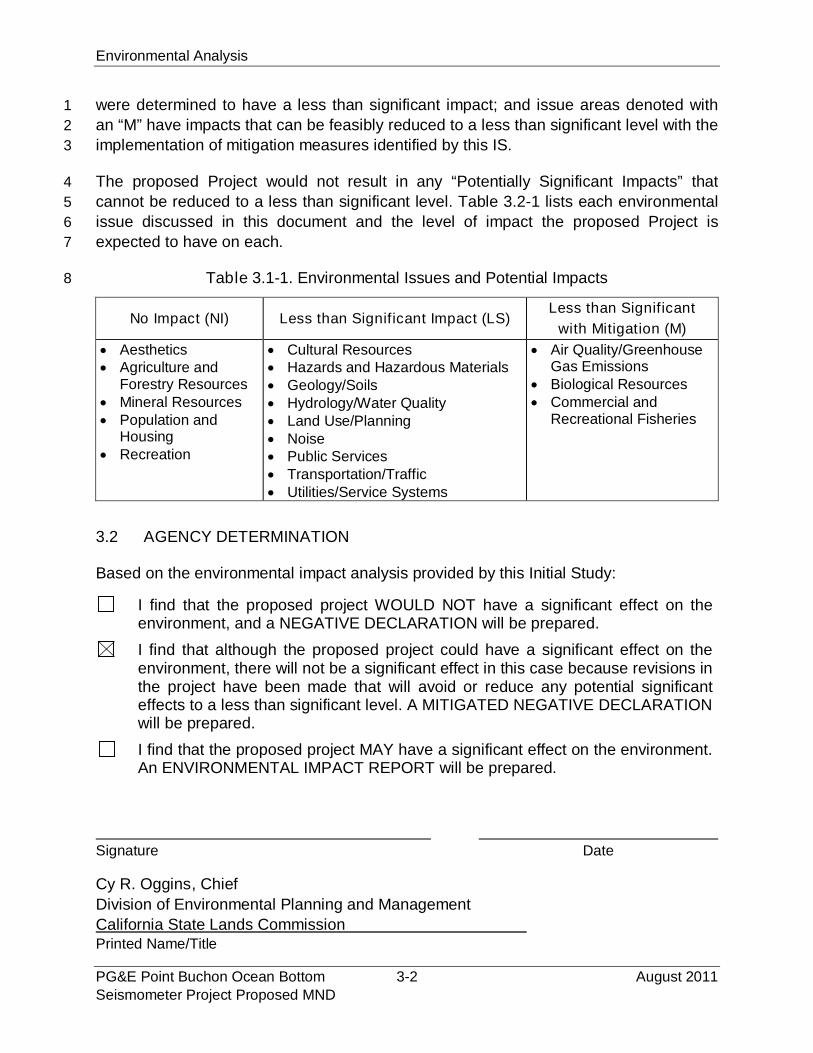
Descriptions and analyses of project-specific and cumulative impacts that could result32
from the implementation of the proposed Project are provided in Section 3.3 of this IS. A33
summary of the environmental impact analysis conclusions is provided in the table34
below: if evaluation of potential environmental impacts determined that the Project35
would not result in an impact regarding a specific environmental issue area, that issue36
area is denoted with an “NI” (no impact); environmental issue areas denoted by an “LS”37
Environmental Analysis
PG&E Point Buchon Ocean Bottom 3-2 August 2011Seismometer Project Proposed MND
were determined to have a less than significant impact; and issue areas denoted with1
an “M” have impacts that can be feasibly reduced to a less than significant level with the2
implementation of mitigation measures identified by this IS.3
The proposed Project would not result in any “Potentially Significant Impacts” that4
cannot be reduced to a less than significant level. Table 3.2-1 lists each environmental5
issue discussed in this document and the level of impact the proposed Project is6
expected to have on each.7
Table 3.1-1. Environmental Issues and Potential Impacts8
No Impact (NI) Less than Significant Impact (LS)Less than Significant
with Mitigation (M)
Aesthetics Agriculture and
Forestry Resources Mineral Resources Population and
Housing Recreation
Cultural Resources Hazards and Hazardous Materials Geology/Soils Hydrology/Water Quality Land Use/Planning Noise Public Services Transportation/Traffic Utilities/Service Systems
Air Quality/GreenhouseGas Emissions
Biological Resources Commercial and
Recreational Fisheries
3.2 AGENCY DETERMINATION
Based on the environmental impact analysis provided by this Initial Study:
I find that the proposed project WOULD NOT have a significant effect on theenvironment, and a NEGATIVE DECLARATION will be prepared.
I find that although the proposed project could have a significant effect on theenvironment, there will not be a significant effect in this case because revisions inthe project have been made that will avoid or reduce any potential significanteffects to a less than significant level. A MITIGATED NEGATIVE DECLARATIONwill be prepared.
I find that the proposed project MAY have a significant effect on the environment.An ENVIRONMENTAL IMPACT REPORT will be prepared.
Signature Date
Cy R. Oggins, Chief
Division of Environmental Planning and Management
California State Lands CommissionPrinted Name/Title
Environmental Checklist – Aesthetics
August 2011 3.3.1-1 PG&E Point Buchon Ocean BottomSeismometer Project Proposed MND
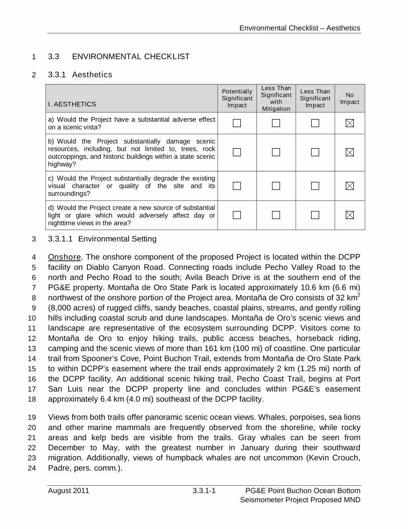
3.3 ENVIRONMENTAL CHECKLIST1
3.3.1 Aesthetics2
I. AESTHETICS
PotentiallySignificant
Impact
Less ThanSignificant
withMitigation
Less ThanSignificant
Impact
NoImpact
a) Would the Project have a substantial adverse effecton a scenic vista?
b) Would the Project substantially damage scenicresources, including, but not limited to, trees, rockoutcroppings, and historic buildings within a state scenichighway?
c) Would the Project substantially degrade the existingvisual character or quality of the site and itssurroundings?
d) Would the Project create a new source of substantiallight or glare which would adversely affect day ornighttime views in the area?
3.3.1.1 Environmental Setting3
Onshore. The onshore component of the proposed Project is located within the DCPP4
facility on Diablo Canyon Road. Connecting roads include Pecho Valley Road to the5
north and Pecho Road to the south; Avila Beach Drive is at the southern end of the6
PG&E property. Montaña de Oro State Park is located approximately 10.6 km (6.6 mi)7
northwest of the onshore portion of the Project area. Montaña de Oro consists of 32 km28
(8,000 acres) of rugged cliffs, sandy beaches, coastal plains, streams, and gently rolling9
hills including coastal scrub and dune landscapes. Montaña de Oro’s scenic views and10
landscape are representative of the ecosystem surrounding DCPP. Visitors come to11
Montaña de Oro to enjoy hiking trails, public access beaches, horseback riding,12
camping and the scenic views of more than 161 km (100 mi) of coastline. One particular13
trail from Spooner’s Cove, Point Buchon Trail, extends from Montaña de Oro State Park14
to within DCPP’s easement where the trail ends approximately 2 km (1.25 mi) north of15
the DCPP facility. An additional scenic hiking trail, Pecho Coast Trail, begins at Port16
San Luis near the DCPP property line and concludes within PG&E’s easement17
approximately 6.4 km (4.0 mi) southeast of the DCPP facility.18
Views from both trails offer panoramic scenic ocean views. Whales, porpoises, sea lions19
and other marine mammals are frequently observed from the shoreline, while rocky20
areas and kelp beds are visible from the trails. Gray whales can be seen from21
December to May, with the greatest number in January during their southward22
migration. Additionally, views of humpback whales are not uncommon (Kevin Crouch,23
Padre, pers. comm.).24
Environmental Checklist -- Aesthetics
PG&E Point Buchon Ocean Bottom 3.3.1-2 August 2011Seismometer Project Proposed MND
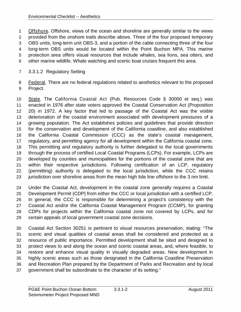
Offshore. Offshore, views of the ocean and shoreline are generally similar to the views1
provided from the onshore trails describe above. Three of the four proposed temporary2
OBS units, long-term unit OBS-3, and a portion of the cable connecting three of the four3
long-term OBS units would be located within the Point Buchon MPA. This marine4
protection area offers visual resources that include whales, sea lions, sea otters, and5
other marine wildlife. Whale watching and scenic boat cruises frequent this area.6
3.3.1.2 Regulatory Setting7
Federal. There are no federal regulations related to aesthetics relevant to the proposed8
Project.9
State. The California Coastal Act (Pub. Resources Code § 30000 et seq.) was10
enacted in 1976 after state voters approved the Coastal Conservation Act (Proposition11
20) in 1972. A key factor that led to passage of the Coastal Act was the visible12
deterioration of the coastal environment associated with development pressures of a13
growing population. The Act establishes policies and guidelines that provide direction14
for the conservation and development of the California coastline, and also established15
the California Coastal Commission (CCC) as the state’s coastal management,16
regulatory, and permitting agency for all development within the California coastal zone.17
This permitting and regulatory authority is further delegated to the local governments18
through the process of certified Local Coastal Programs (LCPs). For example, LCPs are19
developed by counties and municipalities for the portions of the coastal zone that are20
within their respective jurisdictions. Following certification of an LCP, regulatory21
(permitting) authority is delegated to the local jurisdiction, while the CCC retains22
jurisdiction over shoreline areas from the mean high tide line offshore to the 3 nm limit.23
Under the Coastal Act, development in the coastal zone generally requires a Coastal24
Development Permit (CDP) from either the CCC or local jurisdiction with a certified LCP.25
In general, the CCC is responsible for determining a project’s consistency with the26
Coastal Act and/or the California Coastal Management Program (CCMP), for granting27
CDPs for projects within the California coastal zone not covered by LCPs, and for28
certain appeals of local government coastal zone decisions.29
Coastal Act Section 30251 is pertinent to visual resources preservation, stating: “The30
scenic and visual qualities of coastal areas shall be considered and protected as a31
resource of public importance. Permitted development shall be sited and designed to32
protect views to and along the ocean and scenic coastal areas, and, where feasible, to33
restore and enhance visual quality in visually degraded areas. New development in34
highly scenic areas such as those designated in the California Coastline Preservation35
and Recreation Plan prepared by the Department of Parks and Recreation and by local36
government shall be subordinate to the character of its setting.”37
Environmental Checklist – Aesthetics
August 2011 3.3.1-3 PG&E Point Buchon Ocean BottomSeismometer Project Proposed MND
Coastal Act Section 30253 states, in part, that new development shall “… where1
appropriate, protect special communities and neighborhoods which, because of their2
unique characteristics, are popular visitor destination points for recreational uses.”3
Local. San Luis Obispo County (1988) has developed the San Luis Obispo Land Use4
Element - LCP/Coastal Plan Policies. As a result, the County has authority to issue5
CDPs for most development in the generally 915 m (3,000 ft) wide coastal zone. The6
San Luis Obispo County LCP contains several policies related to visual resources;7
policies applicable to the proposed Project are summarized below.8
Protection of Visual and Scenic Resources. Unique and attractive features of the9
landscape, including but not limited to unusual landforms, scenic vistas and10
sensitive habitats are to be preserved, protected and, in visually degraded areas,11
restored where feasible.12
Site Selection for New Development. Permitted development should be sited so13
as to protect views to and along the ocean and scenic coastal areas. Wherever14
possible, site selection for new development is to emphasize locations not visible15
from major public view corridors.16
Landform Alterations. Grading, earthmoving, major vegetation removal and other17
land alterations within public view corridors are to be minimized. Where feasible,18
contours of the finished surface are to blend with adjacent natural terrain to19
achieve a consistent grade and natural appearance.20
Development on Beaches and Sand Dunes. Prohibit new development on open21
sandy beaches, except facilities required for public health and safety. Require22
permitted development to minimize visibility and alterations to the natural23
landform and minimize removal of dune stabilizing vegetation.24
Development on Coastal Bluffs. New development on bluff faces shall be limited to25
public access stairways and shoreline protection structures. Permitted26
development shall be sited and designed to be compatible with the natural27
features of the landform as much as feasible. New development on bluff tops shall28
be designed and sited to minimize visual intrusion on adjacent sandy beaches.29
3.3.1.3 Impact Analysis30
a) Would the Project have a substantial adverse effect on a scenic vista?31
See response below.32
b) Would the Project substantially damage scenic resources, including, but33
not limited to, trees, rock outcroppings, and historic buildings within a34
state scenic highway?35
Environmental Checklist -- Aesthetics
PG&E Point Buchon Ocean Bottom 3.3.1-4 August 2011Seismometer Project Proposed MND
See response below.1
c) Would the Project substantially degrade the existing visual character or2
quality of the site and its surroundings?3
The onshore component of the proposed Project would result in the extension of an4
existing 10.0 cm (4.0 inch) diameter conduit across existing armor rock rip-rap into the5
DCPP intake bay and is expected to take one day to complete. The visible portion of the6
new conduit would only be several meters in length. The onshore portion of the Project7
would not substantially alter any landforms, scenic vistas or sensitive habitat; would not8
be visible from a major public view corridor (residential areas, public lands or roads);9
would not result in grading, landform alterations, or vegetation removal; and would not10
result in development on a sandy beach or coastal bluff. Therefore, the onshore11
component of the Project would have no impact to scenic coastal resources.12
The majority of the proposed Project components (i.e., temporary and permanent OBS13
units and associated cables) would be located below the ocean surface and away from14
public views. During installation activities, one 30 m (100-foot) long vessel would be15
used for both OBS and cable deployment. A smaller boat may be used within the DCPP16
intake embayment to transport divers onshore to help pull the cable through the17
proposed conduit. Views of the primary vessel would be possible from both onshore and18
offshore locations during the installation and recovery activities. Views of the vessel19
from onshore locations would be primarily limited to areas within the immediate vicinity20
of the DCPP, Montaña de Oro, and the trails described above. Offshore, commercial21
and recreational vessels would also have views of the project vessels during installation22
and recovery activities. The short-term use of a vessel as seen from the shoreline or23
from commercial or recreational vessels would not result in views that are out of24
character with surrounding visual conditions, or result in significant changes to existing25
visual conditions as seen from viewpoints provided in the project area.26
d) Would the Project create a new source of substantial light or glare which27
would adversely affect day or nighttime views in the area?28
All proposed equipment installation and recovery operations would occur during daytime29
hours, and the Project would not result in a short-term increase in off-shore nighttime30
lighting. Therefore, the Project would have no lighting-related impacts.31
3.3.1.4 Mitigation and Residual Impacts32
Mitigation. The proposed project would not result in significant aesthetic impacts and33
no mitigation is required.34
Residual Impacts. The proposed Project would have no impact on aesthetics/scenic35
resources, no mitigation is required, and no residual impacts would occur.36
Environmental Checklist – Agriculture and Forest Resources
August 2011 3.3.2-1 PG&E Point Buchon Ocean BottomSeismometer Project Proposed MND
3.3.2 Agriculture and Forest Resources1
II. AGRICULTURE AND FOREST RESOURCES:
In determining whether impacts to agriculturalresources are significant environmental effects, leadagencies may refer to the California AgriculturalLand Evaluation and Site Assessment Model (1997)prepared by the California Dept. of Conservation asan optional model to use in assessing impacts onagriculture and farmland. In determining whetherimpacts to forest resources, including timberland,are significant environmental effects, lead agenciesmay refer to information compiled by the CaliforniaDepartment of Forestry and Fire Protectionregarding the state’s inventory of forest land,including the Forest and Range Assessment Projectand the Forest Legacy Assessment Project; and theforest carbon measurement methodology providedin Forest Protocols adopted by the California AirResources Board. Would the Project:
PotentiallySignificant
Impact
Less ThanSignificant
withMitigation
Less ThanSignificant
Impact
NoImpact
a) Convert Prime Farmland, Unique Farmland, orFarmland of Statewide Importance (Farmland), asshown on the maps prepared pursuant to the FarmlandMapping and Monitoring Program of the CaliforniaResources Agency, to non-agricultural use?
b) Conflict with existing zoning for agricultural use, or aWilliamson Act contract?
c) Conflict with existing zoning for, or cause rezoning of,forest land (as defined in Public Resources Codesection 12220(g)), timberland (as defined by PublicResources Code section 4526), or timberland zonedTimberland Production (as defined by GovernmentCode section 51104(g))?
d) Result in the loss of forest land or conversion offorest land to non-forest use?
e) Involve other changes in the existing environmentwhich, due to their location or nature, could result inconversion of Farmland, to non-agricultural use orconversion of forest land to non-forest use?
This section briefly discusses existing agricultural conditions that occur in the Project2
area, identifies significance criteria, and assesses potential Project-related impacts.3
3.3.2.1 Environmental Setting4
The proposed Project area is predominately located in the Pacific Ocean offshore San5
Luis Obispo County, not on agricultural or forested lands. The only onshore component6
of the proposed Project is an extension of an existing cable conduit and would occur7
Environmental Checklist – Agriculture and Forest Resources
PG&E Point Buchon Ocean Bottom 3.3.2-2 August 2011Seismometer Project Proposed MND
within the DCPP facility, which is located within the coastal zone between Montaña de1
Oro State Park (to the north) and Point San Luis (to the south). The following is2
provided as background information.3
According to San Luis Obispo County’s Agricultural Element of the General Plan (2010),4
the County contains unique, diverse and valuable agricultural resources and agricultural5
production. In 1995, cropland and grazing land accounted for approximately 1.2 million6
acres (55 percent) of the total county area. Agriculture in the County is a multi-million7
dollar industry. In 2008, the total production value of agriculture products produced in8
the County was estimated at over $600 million; wine grapes were the number one cash9
crop, with gross production totaling over $120 million, followed by broccoli with gross10
production totaling almost $70 million. Other leading agricultural products include11
strawberries, cattle and calves, vegetable transplants, head lettuce, cut flowers, head12
lettuce, indoor decorative plants, and carrots (San Luis Obispo County 2010).13
According to the San Luis Obispo County LCP Policy Document of the County Land14
Use Element (2007), the coastal zone between Point San Luis and Montaña de Oro15
State Park consists of a marine terrace and the lower slopes of the Irish Hills.16
Agricultural use of the coastal terrace is divided among barley, garbanzo beans, and17
grazing. The area includes approximately 10 fields separated by arroyos, and most of18
the land is owned by two large cattle companies.19
No changes to agricultural uses adjacent to the DCPP are proposed. The nearest20
agricultural field to the onshore element of the Project is approximately 1.2 km (0.8 mi)21
to the north. Although not currently active, the field adjacent to the DCPP facility to the22
northeast is considered Unique Farmland and is located approximately 0.4 km (0.3 mi)23
from the DCPP intake cove. No other Prime Farmland or Farmland of Statewide24
Importance is located in the Project area. Grazing occurs adjacent to the DCPP facility25
approximately 0.4 km (0.3 mile) from the proposed onshore component of the Project.26
According to the San Luis Obispo County LCP, no forestry uses occur within the coastal27
zone between Montaña de Oro State Park and Point San Luis. The nearest forest28
component to the proposed Project area is approximately 8.0 km (5.0 mi) to the north29
located at the Los Osos Oaks Preserve.30
3.3.2.2 Regulatory Setting31
Federal. There are no federal regulations that pertain to agricultural resources relevant32
to this Project.33
State. The California Land Conservation Act of 1965, commonly referred to as the34
Williamson Act, enables local governments to enter into contracts with private35
landowners for the purpose of restricting specific parcels of land to agricultural or36
related open space use, and provides landowners with lower property tax assessments.37

Environmental Checklist – Agriculture and Forest Resources
August 2011 3.3.2-3 PG&E Point Buchon Ocean BottomSeismometer Project Proposed MND
Local government planning departments are responsible for the enrollment of land into1
Williamson Act contracts. Generally, any commercial agricultural use will be permitted2
within any agricultural preserve. In addition, local governments may identify compatible3
uses permitted with a use permit.4
Local. The San Luis Obispo County General Plan Agricultural Element (2010)5
contains goals and policies related to agricultural resources. The Agricultural Element6
includes detail regarding agricultural zoning and mapping requirements. In addition to7
the Agricultural Element, the San Luis Obispo County LCP references the Coastal Act,8
which requires the protection of "the maximum amount of prime agricultural land."9
3.3.2.3 Impact Analysis10
a) Convert Prime Farmland, Unique Farmland, or Farmland of Statewide11
Importance (Farmland), as shown on the maps prepared pursuant to the12
Farmland Mapping and Monitoring Program of the California Resources13
Agency, to non-agricultural use?14
See response below.15
b) Conflict with existing zoning for agricultural use, or a Williamson Act16
contract?17
The proposed Project is not located within lands designated for or currently being used18
for agricultural purposes. The nearest lands designated as important farmland are19
adjacent to the DCPP facility approximately 0.4 km (0.3 mi) from the intake cove. The20
Project would not include the conversion of any farmlands, nor would it conflict with any21
existing agricultural lands or Williamson Act contracts. As such, no impacts to22
agricultural land uses would result.23
c) Conflict with existing zoning for, or cause rezoning of, forest land (as24
defined in Public Resources Code section 12220(g)), timberland (as defined25
by Public Resources Code section 4526), or timberland zoned Timberland26
Production (as defined by Government Code section 51104(g))?27
See response below.28
d) Result in the loss of forest land or conversion of forest land to non-forest29
use?30
See response below.31
e) Involve other changes in the existing environment which, due to their32
location or nature, could result in conversion of Farmland, to non-33
agricultural use or conversion of forest land to non-forest use?34
Environmental Checklist – Agriculture and Forest Resources
PG&E Point Buchon Ocean Bottom 3.3.2-4 August 2011Seismometer Project Proposed MND
The proposed Project is not located within or adjacent to any forested lands. The1
Project would not require the conversion of any forested lands to non-forested uses, nor2
would any other changes be required that could result in conversions of existing3
agricultural uses. No impacts to forest lands or agriculture would result.4
3.3.2.4 Mitigation and Residual Impact5
Mitigation. The Project would have no impacts on agriculture or forest resources and6
no mitigation measures are required.7
Residual Impacts. No impacts have been identified and no residual impacts would8
result.9
Environmental Checklist – Air Quality and Greenhouse Gas Emissions
August 2011 3.3.3-1 PG&E Point Buchon Ocean BottomSeismometer Project Proposed MND
3.3.3 Air Quality and Greenhouse Gas (GHG) Emissions1
III. AIR QUALITY:
Where available, the significance criteriaestablished by the applicable air qualitymanagement or air pollution control district may berelied upon to make the following determinations.Would the Project:
PotentiallySignificant
Impact
Less ThanSignificant
withMitigation
Less ThanSignificant
Impact
NoImpact
a) Conflict with or obstruct implementation of theapplicable air quality plan?
b) Violate any air quality standard or contributesubstantially to an existing or Projected air qualityviolation?
c) Result in a cumulatively considerable net increase ofany criteria pollutant for which the Project region is non-attainment under an applicable federal or state ambientair quality standard (including releasing emissions whichexceed quantitative thresholds for ozone precursors)?
d) Expose sensitive receptors to substantial pollutantconcentrations?
e) Create objectionable odors affecting a substantialnumber of people?
f) Generate greenhouse gas emissions, either directlyor indirectly, that may have a significant impact on theenvironment?
g) Conflict with an applicable plan, policy or regulationadopted for the purpose of reducing the emissions ofgreenhouse gases?
This section discusses the existing air quality conditions that occur within the Project2
area. This section also identifies significance criteria, and assesses potential Project-3
related impacts to existing air quality conditions. A discussion and analysis of GHG4
emissions in relation to global climate change (GCC) is also included.5
3.3.3.1 Environmental Setting6
Ambient air quality is influenced by the climate, meteorology, and topography of an area7
along with the quantity and type of pollutants released into the air.8
Climate and Meteorology. The proposed Project is located in San Luis Obispo County9
(on the central coast of California) within the South Central Coast Air Basin (SCCAB).10
Summers are typically mild and characterized by early morning and afternoon fog.11
Winters are generally cool and wet with the rainy season extending from late November12
to early April.13
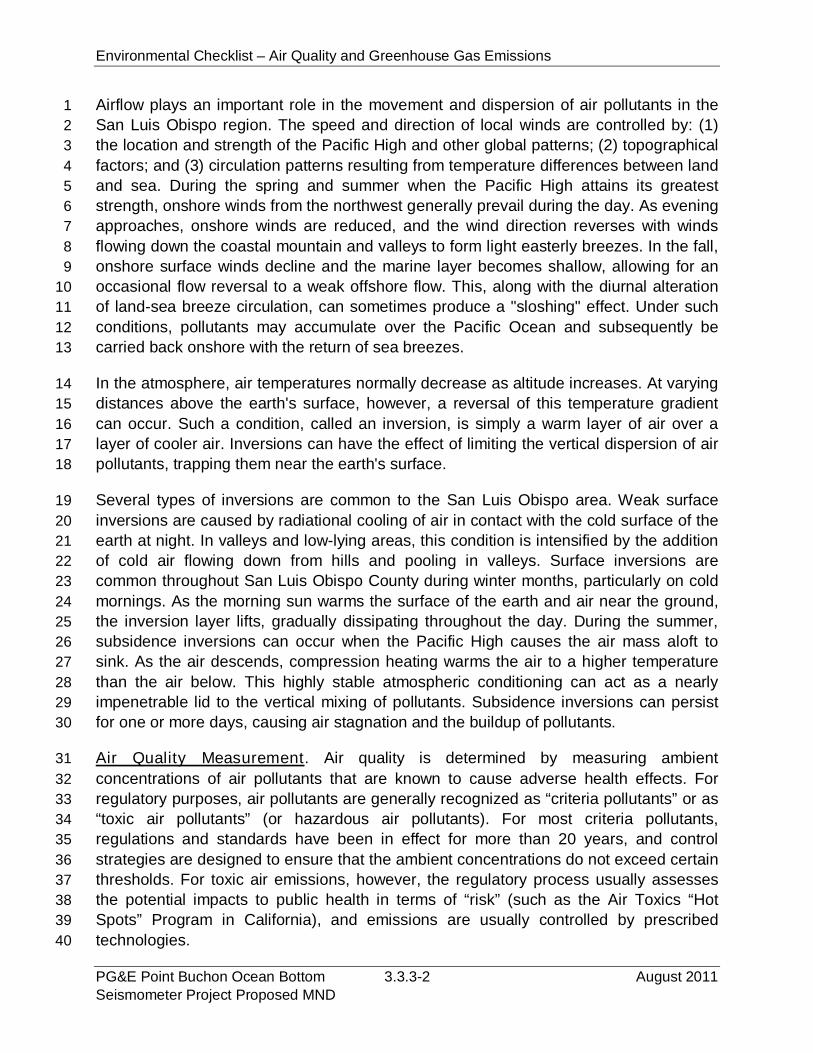
Environmental Checklist – Air Quality and Greenhouse Gas Emissions
PG&E Point Buchon Ocean Bottom 3.3.3-2 August 2011Seismometer Project Proposed MND
Airflow plays an important role in the movement and dispersion of air pollutants in the1
San Luis Obispo region. The speed and direction of local winds are controlled by: (1)2
the location and strength of the Pacific High and other global patterns; (2) topographical3
factors; and (3) circulation patterns resulting from temperature differences between land4
and sea. During the spring and summer when the Pacific High attains its greatest5
strength, onshore winds from the northwest generally prevail during the day. As evening6
approaches, onshore winds are reduced, and the wind direction reverses with winds7
flowing down the coastal mountain and valleys to form light easterly breezes. In the fall,8
onshore surface winds decline and the marine layer becomes shallow, allowing for an9
occasional flow reversal to a weak offshore flow. This, along with the diurnal alteration10
of land-sea breeze circulation, can sometimes produce a "sloshing" effect. Under such11
conditions, pollutants may accumulate over the Pacific Ocean and subsequently be12
carried back onshore with the return of sea breezes.13
In the atmosphere, air temperatures normally decrease as altitude increases. At varying14
distances above the earth's surface, however, a reversal of this temperature gradient15
can occur. Such a condition, called an inversion, is simply a warm layer of air over a16
layer of cooler air. Inversions can have the effect of limiting the vertical dispersion of air17
pollutants, trapping them near the earth's surface.18
Several types of inversions are common to the San Luis Obispo area. Weak surface19
inversions are caused by radiational cooling of air in contact with the cold surface of the20
earth at night. In valleys and low-lying areas, this condition is intensified by the addition21
of cold air flowing down from hills and pooling in valleys. Surface inversions are22
common throughout San Luis Obispo County during winter months, particularly on cold23
mornings. As the morning sun warms the surface of the earth and air near the ground,24
the inversion layer lifts, gradually dissipating throughout the day. During the summer,25
subsidence inversions can occur when the Pacific High causes the air mass aloft to26
sink. As the air descends, compression heating warms the air to a higher temperature27
than the air below. This highly stable atmospheric conditioning can act as a nearly28
impenetrable lid to the vertical mixing of pollutants. Subsidence inversions can persist29
for one or more days, causing air stagnation and the buildup of pollutants.30
Air Quality Measurement. Air quality is determined by measuring ambient31
concentrations of air pollutants that are known to cause adverse health effects. For32
regulatory purposes, air pollutants are generally recognized as “criteria pollutants” or as33
“toxic air pollutants” (or hazardous air pollutants). For most criteria pollutants,34
regulations and standards have been in effect for more than 20 years, and control35
strategies are designed to ensure that the ambient concentrations do not exceed certain36
thresholds. For toxic air emissions, however, the regulatory process usually assesses37
the potential impacts to public health in terms of “risk” (such as the Air Toxics “Hot38
Spots” Program in California), and emissions are usually controlled by prescribed39
technologies.40
Environmental Checklist – Air Quality and Greenhouse Gas Emissions
August 2011 3.3.3-3 PG&E Point Buchon Ocean BottomSeismometer Project Proposed MND
Criteria Pollutants. Criteria pollutants that are considered to be inert (those that do not1
react chemically, but preserve the same chemical composition from point of emission to2
point of impact), include carbon monoxide (CO), ozone (O3), nitrogen dioxide (NO2),3
sulfur dioxide (SO2), coarse particulate matter less than 10 microns in aerodynamic4
diameter (PM10) and 2.5 microns or less (PM2.5), lead (Pb), sulfates (SO4), and5
hydrogen sulfide (H2S).6
CO is primarily formed through the incomplete combustion of organic fuels. Higher CO7
values are generally measured during winter when dispersion is limited by morning8
surface inversions. Seasonal and diurnal variations in meteorological conditions lead to9
lower values in summer and in the afternoon.10
Ozone is formed in the atmosphere through a series of complex photochemical11
reactions involving oxides of nitrogen (NOx), reactive organic gases (ROG), and sunlight12
occurring over several hours. Since ozone is not emitted directly into the atmosphere,13
but is formed as a result of photochemical reactions, it is classified as a secondary or14
regional pollutant. Because these ozone-forming reactions take time, peak ozone levels15
are often found downwind of major source areas.16
Ambient air quality standards have been set for two classes of particulate matter: PM1017
and PM2.5. Both consist of different types of particles such as metal, soot, smoke, dust18
and fine mineral particles that are suspended in the air. Depending on the source of19
particulates, toxicity and chemical activity can vary. Particulate matter is a health20
concern, because when inhaled it can cause permanent damage to the lungs. The21
primary source of PM10 emissions appears to be soil via roads, construction, agriculture,22
quarries, and natural windblown dust. Other sources of PM10 include particulate matter23
released during combustion processes (such as those in gasoline or diesel vehicles),24
wood burning, and sea salt. Fugitive emissions from construction sites, wood stoves,25
fireplaces and diesel truck exhaust are primary sources of PM2.5. Both sizes of26
particulates can be dangerous when inhaled; however, PM2.5 tends to be more27
damaging because it remains in the lungs once it is inhaled.28
Nitric oxide (NO) is a colorless gas formed during combustion processes which rapidly29
oxidize to form NO2, a brownish gas. The highest NO values are generally measured in30
urbanized areas with heavy traffic.31
Existing Air Quality. The United States Environmental Protection Agency (EPA) has32
designated all areas of the U.S. as having either air quality better than (attainment) or33
worse than (nonattainment) the National Ambient Air Quality Standards (NAAQS). The34
NAAQS are federal air quality standards established under the Clean Air Act (CAA).35
The CAA also mandates that states submit and implement a State Implementation Plan36
(SIP) for local areas not meeting those standards. The plans must include pollution37
control measures that demonstrate how the standards will be met.38
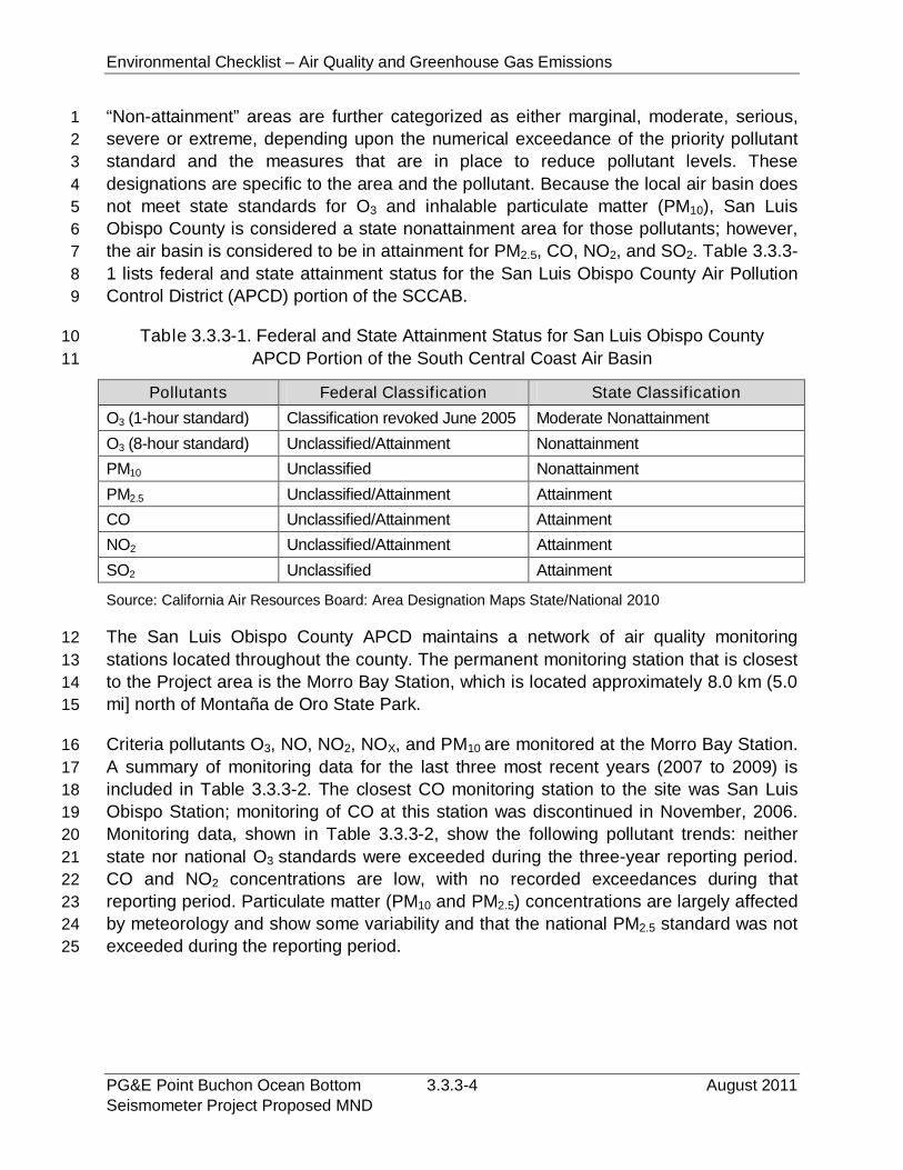
Environmental Checklist – Air Quality and Greenhouse Gas Emissions
PG&E Point Buchon Ocean Bottom 3.3.3-4 August 2011Seismometer Project Proposed MND
“Non-attainment” areas are further categorized as either marginal, moderate, serious,1
severe or extreme, depending upon the numerical exceedance of the priority pollutant2
standard and the measures that are in place to reduce pollutant levels. These3
designations are specific to the area and the pollutant. Because the local air basin does4
not meet state standards for O3 and inhalable particulate matter (PM10), San Luis5
Obispo County is considered a state nonattainment area for those pollutants; however,6
the air basin is considered to be in attainment for PM2.5, CO, NO2, and SO2. Table 3.3.3-7
1 lists federal and state attainment status for the San Luis Obispo County Air Pollution8
Control District (APCD) portion of the SCCAB.9
Table 3.3.3-1. Federal and State Attainment Status for San Luis Obispo County10
APCD Portion of the South Central Coast Air Basin11
Pollutants Federal Classification State Classification
O3 (1-hour standard) Classification revoked June 2005 Moderate Nonattainment
O3 (8-hour standard) Unclassified/Attainment Nonattainment
PM10 Unclassified Nonattainment
PM2.5 Unclassified/Attainment Attainment
CO Unclassified/Attainment Attainment
NO2 Unclassified/Attainment Attainment
SO2 Unclassified Attainment
Source: California Air Resources Board: Area Designation Maps State/National 2010
The San Luis Obispo County APCD maintains a network of air quality monitoring12
stations located throughout the county. The permanent monitoring station that is closest13
to the Project area is the Morro Bay Station, which is located approximately 8.0 km (5.014
mi] north of Montaña de Oro State Park.15
Criteria pollutants O3, NO, NO2, NOX, and PM10 are monitored at the Morro Bay Station.16
A summary of monitoring data for the last three most recent years (2007 to 2009) is17
included in Table 3.3.3-2. The closest CO monitoring station to the site was San Luis18
Obispo Station; monitoring of CO at this station was discontinued in November, 2006.19
Monitoring data, shown in Table 3.3.3-2, show the following pollutant trends: neither20
state nor national O3 standards were exceeded during the three-year reporting period.21
CO and NO2 concentrations are low, with no recorded exceedances during that22
reporting period. Particulate matter (PM10 and PM2.5) concentrations are largely affected23
by meteorology and show some variability and that the national PM2.5 standard was not24
exceeded during the reporting period.25
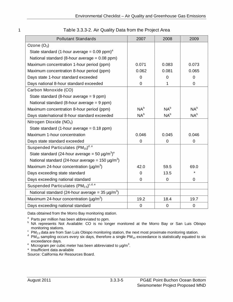
Environmental Checklist – Air Quality and Greenhouse Gas Emissions
August 2011 3.3.3-5 PG&E Point Buchon Ocean BottomSeismometer Project Proposed MND
Table 3.3.3-2. Air Quality Data from the Project Area1
Pollutant Standards 2007 2008 2009
Ozone (O3)
State standard (1-hour average = 0.09 ppm)a
National standard (8-hour average = 0.08 ppm)
Maximum concentration 1-hour period (ppm) 0.071 0.083 0.073
Maximum concentration 8-hour period (ppm) 0.062 0.081 0.065
Days state 1-hour standard exceeded 0 0 0
Days national 8-hour standard exceeded 0 1 0
Carbon Monoxide (CO)
State standard (8-hour average = 9 ppm)
National standard (8-hour average = 9 ppm)
Maximum concentration 8-hour period (ppm) NAb NAb NAb
Days state/national 8-hour standard exceeded NAb NAb NAb
Nitrogen Dioxide (NO2)
State standard (1-hour average = 0.18 ppm)
Maximum 1-hour concentration 0.046 0.045 0.046
Days state standard exceeded 0 0 0
Suspended Particulates (PM10)d, e
State standard (24-hour average = 50 µg/m3)e
National standard (24-hour average = 150 µg/m3)
Maximum 24-hour concentration (µg/m3) 42.0 59.5 69.0
Days exceeding state standard 0 13.5 *
Days exceeding national standard 0 0 0
Suspended Particulates (PM2.5)c,d, e
National standard (24-hour average = 35 µg/m3)
Maximum 24-hour concentration (µg/m3) 19.2 18.4 19.7
Days exceeding national standard 0 0 0
Data obtained from the Morro Bay monitoring station.a
Parts per million has been abbreviated to ppm.b
NA represents Not Available: CO is no longer monitored at the Morro Bay or San Luis Obispomonitoring stations.
cPM2.5 data are from San Luis Obispo monitoring station, the next most proximate monitoring station.
dPM10 sampling occurs every six days, therefore a single PM10 exceedance is statistically equated to sixexceedance days.
eMicrogram per cubic meter has been abbreviated to µg/m
3.
* Insufficient data availableSource: California Air Resources Board.
Environmental Checklist – Air Quality and Greenhouse Gas Emissions
PG&E Point Buchon Ocean Bottom 3.3.3-6 August 2011Seismometer Project Proposed MND
Global Climate Change. GCC is a change in the average weather of the earth, which1
can be measured by wind patterns, storms, precipitation, and temperature. Common2
GHGs (gases that trap heat in the atmosphere) include water vapor, carbon dioxide3
(CO2), methane (CH4), NOx, chlorofluorocarbons, hydrofluorocarbons, perfluorocarbons,4
sulfur hexafluoride, ozone, and aerosols. GHGs are emitted by both natural processes5
and human activities, and the accumulation of GHGs in the atmosphere regulates the6
earth’s temperature. Without the natural heat trapping effect of GHGs, the earth’s7
surface would be approximately 34 degrees Centigrade (°C) cooler. However, it is8
generally agreed by the scientific community that emissions from human activities, such9
as electricity production and vehicle use, have elevated the concentration of these10
gases in the atmosphere beyond the level of naturally occurring concentrations.11
In 2006, the California State Legislature adopted AB 32, the California Global Warming12
Solutions Act of 2006, which focuses on reducing GHGs in California. As defined under13
AB 32, GHGs include: CO2, CH4, NOx, hydrofluorocarbons, perfluorocarbons, and sulfur14
hexafluoride. AB 32 requires the California Air Resources Board (CARB), the state15
agency charged with regulating statewide air quality, to adopt rules and regulations that16
by 2020 would achieve GHG emissions equivalent to statewide levels in 1990.17
Section 15064.4 of the State CEQA Guidelines provides regulatory direction on how to18
determine the significance of potential impacts from GHGs. Under this section, lead19
agencies are required to describe, calculate, or otherwise characterize GHG emissions.20
Where feasible, lead agencies should strive to quantify emissions, but section 15064.421
provides that a qualitative analysis or reliance on performance based standards are22
allowed, as long as the lead agency makes a “good-faith effort” based on scientific,23
factual data, to disclose and analyze GHG impacts.24
3.3.3.2 Regulatory Setting25
Federal Regulations. The CAA was first enacted in 1955 and has been amended26
many times in subsequent years (i.e., 1963, 1965, 1967, 1970, 1977, and 1990). It27
establishes federal air quality standards, known as NAAQS, and specifies future dates28
for achieving compliance. The CAA also mandates that states submit and implement a29
SIP for local areas not meeting those standards. SIPs must include pollution control30
measures that demonstrate how the standards will be met. The 1990 CAA Amendments31
identify specific emission-reduction goals for areas not meeting the NAAQS. The32
sections of the CAA that would most substantially affect the development of the33
proposed Project include Title I (Nonattainment Provisions) and Title II (Mobile-Source34
Provisions). Title I provisions were established with the goal of attaining the NAAQS for35
criteria pollutants. Table 3.3.3-3 shows the NAAQS currently in effect for each criteria36
pollutant. The NAAQS were amended in July 1997 to include an 8-hour standard for O337
and to adopt a NAAQS for fine particulate matter (PM2.5).38
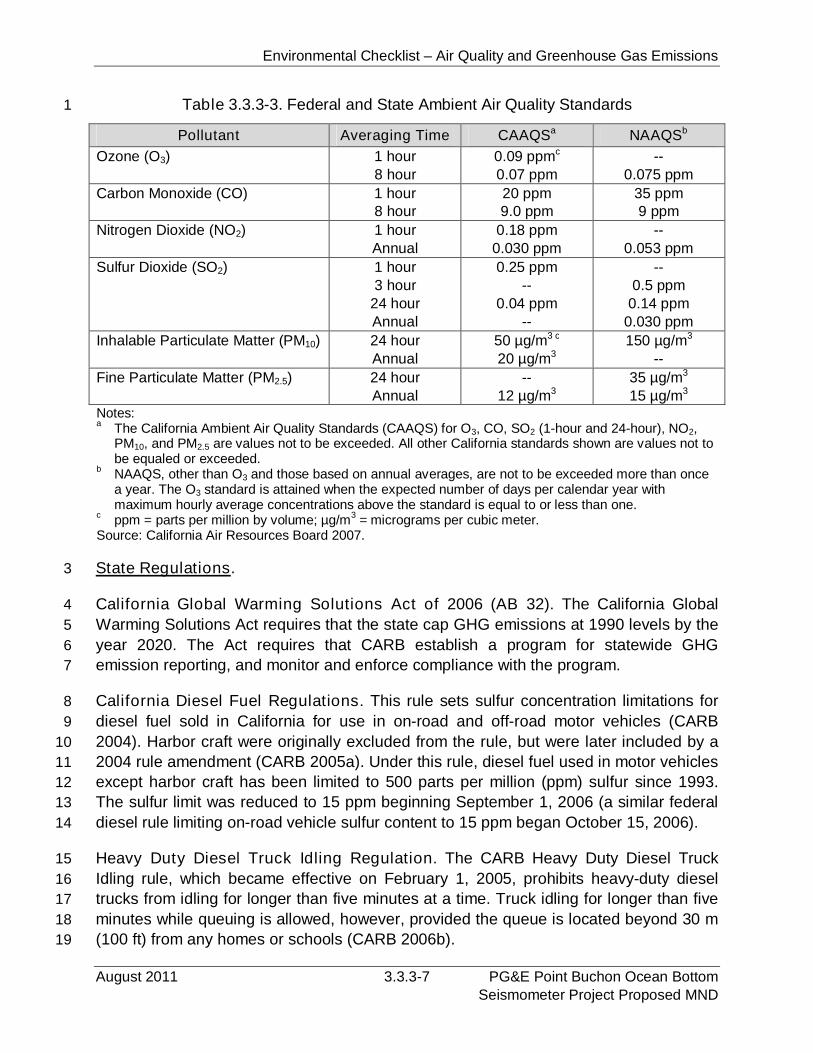
Environmental Checklist – Air Quality and Greenhouse Gas Emissions
August 2011 3.3.3-7 PG&E Point Buchon Ocean BottomSeismometer Project Proposed MND
Table 3.3.3-3. Federal and State Ambient Air Quality Standards1
Pollutant Averaging Time CAAQSa NAAQSb
Ozone (O3) 1 hour8 hour
0.09 ppmc
0.07 ppm--
0.075 ppm
Carbon Monoxide (CO) 1 hour8 hour
20 ppm9.0 ppm
35 ppm9 ppm
Nitrogen Dioxide (NO2) 1 hourAnnual
0.18 ppm0.030 ppm
--0.053 ppm
Sulfur Dioxide (SO2) 1 hour3 hour
24 hourAnnual
0.25 ppm--
0.04 ppm--
--0.5 ppm
0.14 ppm0.030 ppm
Inhalable Particulate Matter (PM10) 24 hourAnnual
50 µg/m3 c
20 µg/m3150 µg/m3
--
Fine Particulate Matter (PM2.5) 24 hourAnnual
--12 µg/m3
35 µg/m3
15 µg/m3
State Regulations.3
California Global Warming Solutions Act of 2006 (AB 32). The California Global4
Warming Solutions Act requires that the state cap GHG emissions at 1990 levels by the5
year 2020. The Act requires that CARB establish a program for statewide GHG6
emission reporting, and monitor and enforce compliance with the program.7
California Diesel Fuel Regulations. This rule sets sulfur concentration limitations for8
diesel fuel sold in California for use in on-road and off-road motor vehicles (CARB9
2004). Harbor craft were originally excluded from the rule, but were later included by a10
2004 rule amendment (CARB 2005a). Under this rule, diesel fuel used in motor vehicles11
except harbor craft has been limited to 500 parts per million (ppm) sulfur since 1993.12
The sulfur limit was reduced to 15 ppm beginning September 1, 2006 (a similar federal13
diesel rule limiting on-road vehicle sulfur content to 15 ppm began October 15, 2006).14
Heavy Duty Diesel Truck Idling Regulation. The CARB Heavy Duty Diesel Truck15
Idling rule, which became effective on February 1, 2005, prohibits heavy-duty diesel16
trucks from idling for longer than five minutes at a time. Truck idling for longer than five17
minutes while queuing is allowed, however, provided the queue is located beyond 30 m18
(100 ft) from any homes or schools (CARB 2006b).19
Notes:a
The California Ambient Air Quality Standards (CAAQS) for O3, CO, SO2 (1-hour and 24-hour), NO2,PM10, and PM2.5 are values not to be exceeded. All other California standards shown are values not tobe equaled or exceeded.
bNAAQS, other than O3 and those based on annual averages, are not to be exceeded more than oncea year. The O3 standard is attained when the expected number of days per calendar year withmaximum hourly average concentrations above the standard is equal to or less than one.
cppm = parts per million by volume; µg/m
3= micrograms per cubic meter.
Source: California Air Resources Board 2007.
Environmental Checklist – Air Quality and Greenhouse Gas Emissions
PG&E Point Buchon Ocean Bottom 3.3.3-8 August 2011Seismometer Project Proposed MND
Statewide Portable Equipment Registration Program (PERP). This Program1
establishes a uniform program to regulate portable engines and portable engine-driven2
equipment units (CARB 2005b). Once registered in the PERP, engines and equipment3
units may operate throughout California without the need to obtain individual permits4
from local air districts. The PERP generally would apply to shore-end and land-based5
construction equipment such as generators, compressors and power winches.6
Local Regulations. The San Luis Obispo APCD is the local agency in San Luis Obispo7
County primarily responsible for attaining the air quality standards established by the8
CARB and EPA. The APCD implements programs and regulations to control air9
pollution released from stationary sources within the APCD; it also implements10
programs to encourage alternative means of transportation. In 2009, the APCD11
published a revised CEQA Air Quality Handbook to help local governments analyze and12
mitigate project-specific air quality impacts. This handbook, which provides standards,13
methodologies, and procedures for conducting air quality analyses in EIRs, was used14
extensively in the preparation of this assessment. The APCD has established CEQA15
thresholds for the emissions of air pollutants by construction activities. The established16
threshold for Best Available Control Technology (BACT) for construction equipment is17
185 lbs/day or 2.5 tons/calendar quarter of ROG or NOx. If these thresholds are18
exceeded, mitigation measures, including offsets, may be required.19
Through the attainment planning process, the APCD developed the County APCD20
Rules and Regulations to regulate sources of air pollution in the county. The emission21
sources associated with the proposed Project are mobile sources, and therefore, not22
subject to the APCD rules that apply to stationary sources, such as Regulation VI - New23
Source Review and Regulation VII - New Source Review of Toxic Air Contaminants.24
3.3.3.3 Impact Analysis25
Significance Criteria. Applicable significance thresholds are contained in the San Luis26
Obispo County APCD (2009) CEQA Air Quality Handbook. If any of the thresholds27
below are exceeded, Project emissions are considered to result in a significant impact.28
1. Operational impact threshold for ROG, NOx, SO2, PM10 that exceed 10 lbs/day,29
and for CO that exceed 550 lbs/day. The APCD considers impacts significant30
and requires more stringent environmental review for projects exceeding 2531
lbs/day of ROG, NOx, SO2 and PM10 emissions, or 550 lbs/day of CO emissions.32
2. Construction impact threshold for ROG, NOX, SO2, PM10 that exceeds 18533
lbs/day or 2.5 tons/quarter and for PM10 emissions that exceed 2.5 tons/quarter.34
The APCD requires BACT for construction equipment for projects with ROG or35
NOX emissions between 2.5 and 6.0 tons/quarter and requires BACT plus further36
mitigation for projects with emissions exceeding 6.0 tons/quarter.37
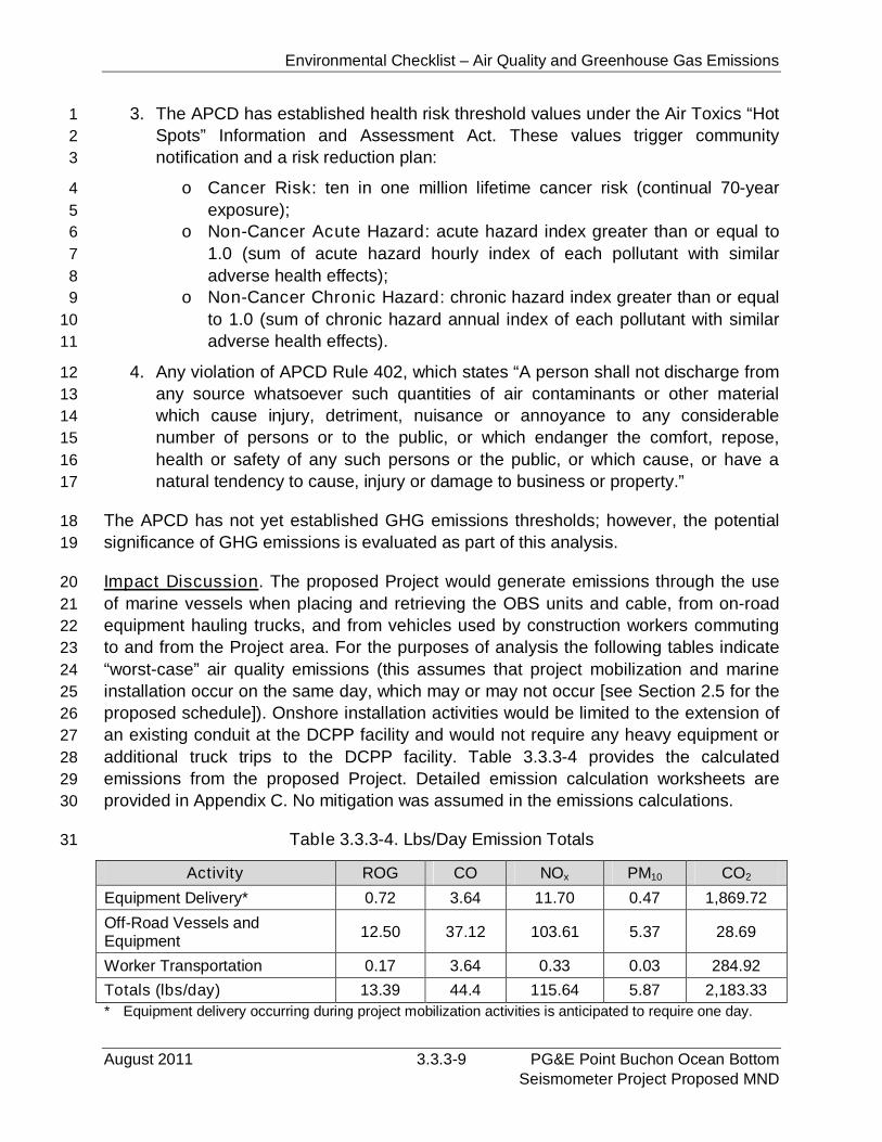
Environmental Checklist – Air Quality and Greenhouse Gas Emissions
August 2011 3.3.3-9 PG&E Point Buchon Ocean BottomSeismometer Project Proposed MND
3. The APCD has established health risk threshold values under the Air Toxics “Hot1
Spots” Information and Assessment Act. These values trigger community2
notification and a risk reduction plan:3
o Cancer Risk: ten in one million lifetime cancer risk (continual 70-year4
exposure);5
o Non-Cancer Acute Hazard: acute hazard index greater than or equal to6
1.0 (sum of acute hazard hourly index of each pollutant with similar7
adverse health effects);8
o Non-Cancer Chronic Hazard: chronic hazard index greater than or equal9
to 1.0 (sum of chronic hazard annual index of each pollutant with similar10
adverse health effects).11
4. Any violation of APCD Rule 402, which states “A person shall not discharge from12
any source whatsoever such quantities of air contaminants or other material13
which cause injury, detriment, nuisance or annoyance to any considerable14
number of persons or to the public, or which endanger the comfort, repose,15
health or safety of any such persons or the public, or which cause, or have a16
natural tendency to cause, injury or damage to business or property.”17
The APCD has not yet established GHG emissions thresholds; however, the potential18
significance of GHG emissions is evaluated as part of this analysis.19
Impact Discussion. The proposed Project would generate emissions through the use20
of marine vessels when placing and retrieving the OBS units and cable, from on-road21
equipment hauling trucks, and from vehicles used by construction workers commuting22
to and from the Project area. For the purposes of analysis the following tables indicate23
“worst-case” air quality emissions (this assumes that project mobilization and marine24
installation occur on the same day, which may or may not occur [see Section 2.5 for the25
proposed schedule]). Onshore installation activities would be limited to the extension of26
an existing conduit at the DCPP facility and would not require any heavy equipment or27
additional truck trips to the DCPP facility. Table 3.3.3-4 provides the calculated28
emissions from the proposed Project. Detailed emission calculation worksheets are29
provided in Appendix C. No mitigation was assumed in the emissions calculations.30
Table 3.3.3-4. Lbs/Day Emission Totals31
Activity ROG CO NOx PM10 CO2
Equipment Delivery* 0.72 3.64 11.70 0.47 1,869.72
Off-Road Vessels andEquipment
12.50 37.12 103.61 5.37 28.69
Worker Transportation 0.17 3.64 0.33 0.03 284.92
Totals (lbs/day) 13.39 44.4 115.64 5.87 2,183.33
* Equipment delivery occurring during project mobilization activities is anticipated to require one day.
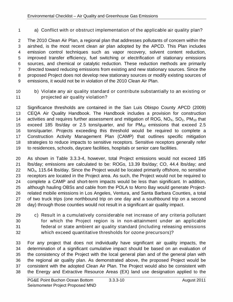
Environmental Checklist – Air Quality and Greenhouse Gas Emissions
PG&E Point Buchon Ocean Bottom 3.3.3-10 August 2011Seismometer Project Proposed MND
a) Conflict with or obstruct implementation of the applicable air quality plan?1
The 2010 Clean Air Plan, a regional plan that addresses pollutants of concern within the2
airshed, is the most recent clean air plan adopted by the APCD. This Plan includes3
emission control techniques such as vapor recovery, solvent content reduction,4
improved transfer efficiency, fuel switching or electrification of stationary emissions5
sources, and chemical or catalytic reduction. These reduction methods are primarily6
directed toward reducing emissions from existing and new stationary sources. Since the7
proposed Project does not develop new stationary sources or modify existing sources of8
emissions, it would not be in violation of the 2010 Clean Air Plan.9
b) Violate any air quality standard or contribute substantially to an existing or10
projected air quality violation?11
Significance thresholds are contained in the San Luis Obispo County APCD (2009)12
CEQA Air Quality Handbook. The Handbook includes a provision for construction13
activities and requires further assessment and mitigation of ROG, NOX, SO2, PM10 that14
exceed 185 lbs/day or 2.5 tons/quarter, and for PM10 emissions that exceed 2.515
tons/quarter. Projects exceeding this threshold would be required to complete a16
Construction Activity Management Plan (CAMP) that outlines specific mitigation17
strategies to reduce impacts to sensitive receptors. Sensitive receptors generally refer18
to residences, schools, daycare facilities, hospitals or senior care facilities.19
As shown in Table 3.3.3-4, however, total Project emissions would not exceed 18520
lbs/day; emissions are calculated to be: ROGs, 13.39 lbs/day; CO, 44.4 lbs/day; and21
NOx, 115.64 lbs/day. Since the Project would be located primarily offshore, no sensitive22
receptors are located in the Project area. As such, the Project would not be required to23
complete a CAMP and short-term impacts would be less than significant. In addition,24
although hauling OBSs and cable from the POLA to Morro Bay would generate Project-25
related mobile emissions in Los Angeles, Ventura, and Santa Barbara Counties, a total26
of two truck trips (one northbound trip on one day and a southbound trip on a second27
day) through those counties would not result in a significant air quality impact.28
c) Result in a cumulatively considerable net increase of any criteria pollutant29
for which the Project region is in non-attainment under an applicable30
federal or state ambient air quality standard (including releasing emissions31
which exceed quantitative thresholds for ozone precursors)?32
For any project that does not individually have significant air quality impacts, the33
determination of a significant cumulative impact should be based on an evaluation of34
the consistency of the Project with the local general plan and of the general plan with35
the regional air quality plan. As demonstrated above, the proposed Project would be36
consistent with the adopted Clean Air Plan. The Project would also be consistent with37
the Energy and Extractive Resource Areas (EX) land use designation applied to the38
Environmental Checklist – Air Quality and Greenhouse Gas Emissions
August 2011 3.3.3-11 PG&E Point Buchon Ocean BottomSeismometer Project Proposed MND
Project area by the County of San Luis Obispo Coastal Zone Land Use Ordinance1
(CZLUO).2 According to CZLUO section 23.07.040, EX areas are those where:2
a. Mineral or petroleum extraction occurs or is proposed to occur;3
b. The state geologist has designated a mineral resource area of statewide or4
regional significance pursuant to the Surface Mining and Reclamation Act (Pub.5
Resources Code § 2710 et seq.); or6
c. Major public utility electric generation facilities exist or are proposed.7
The Project consists of the installation on the seafloor and operation of OBS8
instruments and a cable in support of the existing DCPP. As it is an existing major9
public utility, the DCPP facility falls under the “c” category of CZLUO section 23.07.040.10
Based on the Project’s consistency with the Clean Air Plan and General Plan, the11
Project’s air emissions would not be cumulatively considerable or result in a significant12
cumulative impact.13
d) Expose sensitive receptors to substantial pollutant concentrations?14
The proposed Project would be predominately located in ocean waters offshore of the15
DCPP. The only onshore component is the extension of an existing conduit within the16
DCPP facility. No public access is allowed within the DCPP grounds. Since the17
proposed Project is located offshore and within the boundaries of the existing DCPP18
facility, no sensitive receptors are located within the Project area. As such, no impacts19
to sensitive receptors would result.20
e) Create objectionable odors affecting a substantial number of people?21
Installation of the OBS units would slightly and temporarily increase ambient air22
pollutant concentrations offshore due to the combustion of diesel fuel. Some individuals23
consider diesel combustion odors to be objectionable, although quantifying the odor24
impacts of such emissions is difficult. The location of the proposed Project, offshore of25
DCPP, ensures that only those associated with installation activities onboard the MV26
Michael Uhl or its support vessel would be exposed to any odors. The mobile nature of27
the marine engine emission sources would help disperse those emissions. Therefore,28
any temporary impact would be less than significant.29
f) Generate greenhouse gas emissions, either directly or indirectly, that may30
have a significant impact on the environment?31
2The EX land use designation is a combined designation to protect significant resource extraction and
energy production areas identified by the Land Use Element from encroachment by incompatible landuses that could hinder resource extraction or energy production operations, or land uses that would beadversely affected by extraction or energy production.
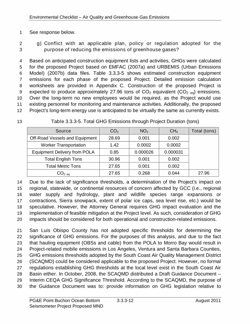
Environmental Checklist – Air Quality and Greenhouse Gas Emissions
PG&E Point Buchon Ocean Bottom 3.3.3-12 August 2011Seismometer Project Proposed MND
See response below.1
g) Conflict with an applicable plan, policy or regulation adopted for the2
purpose of reducing the emissions of greenhouse gases?3
Based on anticipated construction equipment lists and activities, GHGs were calculated4
for the proposed Project based on EMFAC (2007a) and URBEMIS (Urban Emissions5
Model) (2007b) data files. Table 3.3.3-5 shows estimated construction equipment6
emissions for each phase of the proposed Project. Detailed emission calculation7
worksheets are provided in Appendix C. Construction of the proposed Project is8
expected to produce approximately 27.96 tons of CO2 equivalent (CO2 eq) emissions.9
Over the long-term no new employees would be required, as the Project would use10
existing personnel for monitoring and maintenance activities. Additionally, the proposed11
Project’s long-term energy use is anticipated to be virtually the same as currently exists.12
Table 3.3.3-5. Total GHG Emissions through Project Duration (tons)13
Source CO2 NO2 CH4 Total (tons)
Off-Road Vessels and Equipment 28.69 0.001 0.002
Worker Transportation 1.42 0.0002 0.0002
Equipment Delivery from POLA 0.85 0.000026 0.000031
Total English Tons 30.96 0.001 0.002
Total Metric Tons 27.65 0.001 0.002
CO2 eq 27.65 0.268 0.044 27.96
Due to the lack of significance thresholds, a determination of the Project’s impact on14
regional, statewide, or continental resources of concern affected by GCC (i.e., regional15
water supply and hydrology, plant and wildlife species range expansions or16
contractions, Sierra snowpack, extent of polar ice caps, sea level rise, etc.) would be17
speculative. However, the Attorney General requires GHG impact evaluation and the18
implementation of feasible mitigation at the Project level. As such, consideration of GHG19
impacts should be considered for both operational and construction-related emissions.20
San Luis Obispo County has not adopted specific thresholds for determining the21
significance of GHG emissions. For the purposes of this analysis, and due to the fact22
that hauling equipment (OBSs and cable) from the POLA to Morro Bay would result in23
Project-related mobile emissions in Los Angeles, Ventura and Santa Barbara Counties,24
GHG emissions thresholds adopted by the South Coast Air Quality Management District25
(SCAQMD) could be considered applicable to the proposed Project. However, no formal26
regulations establishing GHG thresholds at the local level exist in the South Coast Air27
Basin either. In October, 2008, the SCAQMD distributed a Draft Guidance Document –28
Interim CEQA GHG Significance Threshold. According to the SCAQMD, the purpose of29
the Guidance Document was to: provide information on GHG legislation relative to30
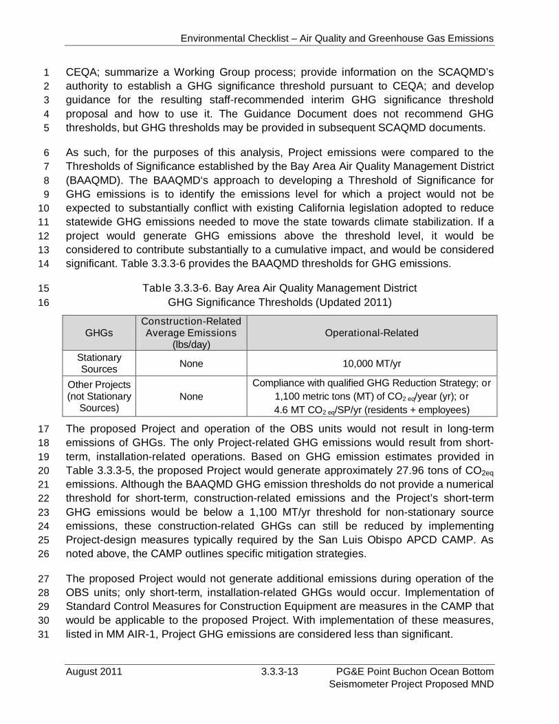
Environmental Checklist – Air Quality and Greenhouse Gas Emissions
August 2011 3.3.3-13 PG&E Point Buchon Ocean BottomSeismometer Project Proposed MND
CEQA; summarize a Working Group process; provide information on the SCAQMD’s1
authority to establish a GHG significance threshold pursuant to CEQA; and develop2
guidance for the resulting staff-recommended interim GHG significance threshold3
proposal and how to use it. The Guidance Document does not recommend GHG4
thresholds, but GHG thresholds may be provided in subsequent SCAQMD documents.5
As such, for the purposes of this analysis, Project emissions were compared to the6
Thresholds of Significance established by the Bay Area Air Quality Management District7
(BAAQMD). The BAAQMD‘s approach to developing a Threshold of Significance for8
GHG emissions is to identify the emissions level for which a project would not be9
expected to substantially conflict with existing California legislation adopted to reduce10
statewide GHG emissions needed to move the state towards climate stabilization. If a11
project would generate GHG emissions above the threshold level, it would be12
considered to contribute substantially to a cumulative impact, and would be considered13
significant. Table 3.3.3-6 provides the BAAQMD thresholds for GHG emissions.14
Table 3.3.3-6. Bay Area Air Quality Management District15
GHG Significance Thresholds (Updated 2011)16
GHGsConstruction-RelatedAverage Emissions
(lbs/day)Operational-Related
StationarySources
None 10,000 MT/yr
Other Projects(not Stationary
Sources)None
Compliance with qualified GHG Reduction Strategy; or
1,100 metric tons (MT) of CO2 eq/year (yr); or
4.6 MT CO2 eq/SP/yr (residents + employees)
The proposed Project and operation of the OBS units would not result in long-term17
emissions of GHGs. The only Project-related GHG emissions would result from short-18
term, installation-related operations. Based on GHG emission estimates provided in19
Table 3.3.3-5, the proposed Project would generate approximately 27.96 tons of CO2eq20
emissions. Although the BAAQMD GHG emission thresholds do not provide a numerical21
threshold for short-term, construction-related emissions and the Project’s short-term22
GHG emissions would be below a 1,100 MT/yr threshold for non-stationary source23
emissions, these construction-related GHGs can still be reduced by implementing24
Project-design measures typically required by the San Luis Obispo APCD CAMP. As25
noted above, the CAMP outlines specific mitigation strategies.26
The proposed Project would not generate additional emissions during operation of the27
OBS units; only short-term, installation-related GHGs would occur. Implementation of28
Standard Control Measures for Construction Equipment are measures in the CAMP that29
would be applicable to the proposed Project. With implementation of these measures,30
listed in MM AIR-1, Project GHG emissions are considered less than significant.31
Environmental Checklist – Air Quality and Greenhouse Gas Emissions
PG&E Point Buchon Ocean Bottom 3.3.3-14 August 2011Seismometer Project Proposed MND
3.3.3.4 Mitigation and Residual Impacts1
The following mitigation measure will reduce Project-related GHG emissions.2
MM AIR-1. The Applicant shall implement Standard Control Measures for Construction3
Equipment, which include:4
Maintain all construction equipment in proper tune according to manufacturer’s5
specifications;6
Fuel all off-road and portable diesel powered equipment with CARB-certified7
motor vehicle diesel fuel (non-taxed version suitable for use off-road);8
Use diesel construction equipment meeting CARB's Tier 2 certified engines or9
cleaner off-road heavy-duty diesel engines, and comply with the State Off-Road10
Regulation;11
Use on-road heavy-duty trucks that meet CARB’s 2007 or cleaner certification12
standard for on-road heavy-duty diesel engines, and comply with the State On-13
Road Regulation;14
Construction or trucking companies that do not have engines in their fleet that15
meet the engine standards identified in the above two measures (e.g., captive or16
NOx-exempt area fleets) may be eligible by proving alternative compliance;17
All on and off-road diesel equipment shall not idle for more than five minutes.18
Signs shall be posted in the designated queuing areas and or job sites to remind19
drivers and operators of the five-minute idling limit;20
Diesel idling within 300 meters (1,000 feet) of sensitive receptors is not21
permitted;22
Staging and queuing areas shall not be located within 300 meters (1,000 feet) of23
sensitive receptors;24
Electrify equipment when feasible;25
Substitute gasoline-powered in place of diesel-powered equipment, where26
feasible; and,27
Use alternatively fueled construction equipment onsite where feasible, such as28
compressed natural gas, liquefied natural gas, propane or biodiesel.29
The Project’s incremental contribution to GCC is not cumulatively considerable due to30
the small amount of GHG emissions in relation to that emitted in the region (California’s31
annual GHG emissions have been estimated at 468.8 million tons in 2004), and the32
short-term nature of these emissions. Therefore, construction of the proposed Project33
would not contribute to a significant cumulative impact to GHGs or GCC.34
Residual Impacts. With the incorporation of the recommended mitigation, there will be35
no residual impacts to air quality or associated with GHG emissions.36
Environmental Checklist – Biological Resources
August 2011 3.3.4-1 PG&E Point Buchon Ocean BottomSeismometer Project Proposed MND
3.3.4 Biological Resources1
IV.BIOLOGICAL RESOURCES:
Would the Project:
PotentiallySignificant
Impact
Less ThanSignificant
withMitigation
Less ThanSignificant
Impact
NoImpact
a) Have a substantial adverse effect, either directly orthrough habitat modifications, on any species identifiedas a candidate, sensitive, or special status species inlocal or regional plans, policies, or regulations, or by theCalifornia Department of Fish and Game or U.S. Fishand Wildlife Service?
b) a substantial adverse effect on any riparian habitator other sensitive natural community identified in local orregional plans, policies, regulations or by the CaliforniaDepartment of Fish and Game or US Fish and WildlifeService?
c) Have a substantial adverse effect on federallyprotected wetlands as defined by Section 404 of theClean Water Act (including, but not limited to, marsh,vernal pool, coastal, etc.) through direct removal, filling,hydrological interruption, or other means?
d) Interfere substantially with the movement of anynative resident or migratory fish or wildlife species orwith established native resident or migratory wildlifecorridors, or impede the use of native wildlife nurserysites?
e) Conflict with any local policies or ordinancesprotecting biological resources, such as a treepreservation policy or ordinance?
f) Conflict with the provisions of an adopted HabitatConservation Plan, Natural Community ConservationPlan, or other approved local, regional, or state habitatconservation plan?
3.3.4.1 Environmental Setting2
Regional Marine Habitats and Biota. The Project area includes the marine waters3
between Point Buchon and Point San Luis (Figure 2-2) and offshore to the 122 m (4004
ft) water depth. As is shown in Figure 3.3.4-1, seafloor and intertidal habitats within the5
area range from fine sediments in the deepest water areas to natural and manmade6
rock substrates. Offshore, low to high relief rock reefs have been recorded to water7
depths of at least 110 m (360 ft) at and seaward of the state 3 nm limit, but are more8
common in water depths shallower than 61 m (200 ft).9
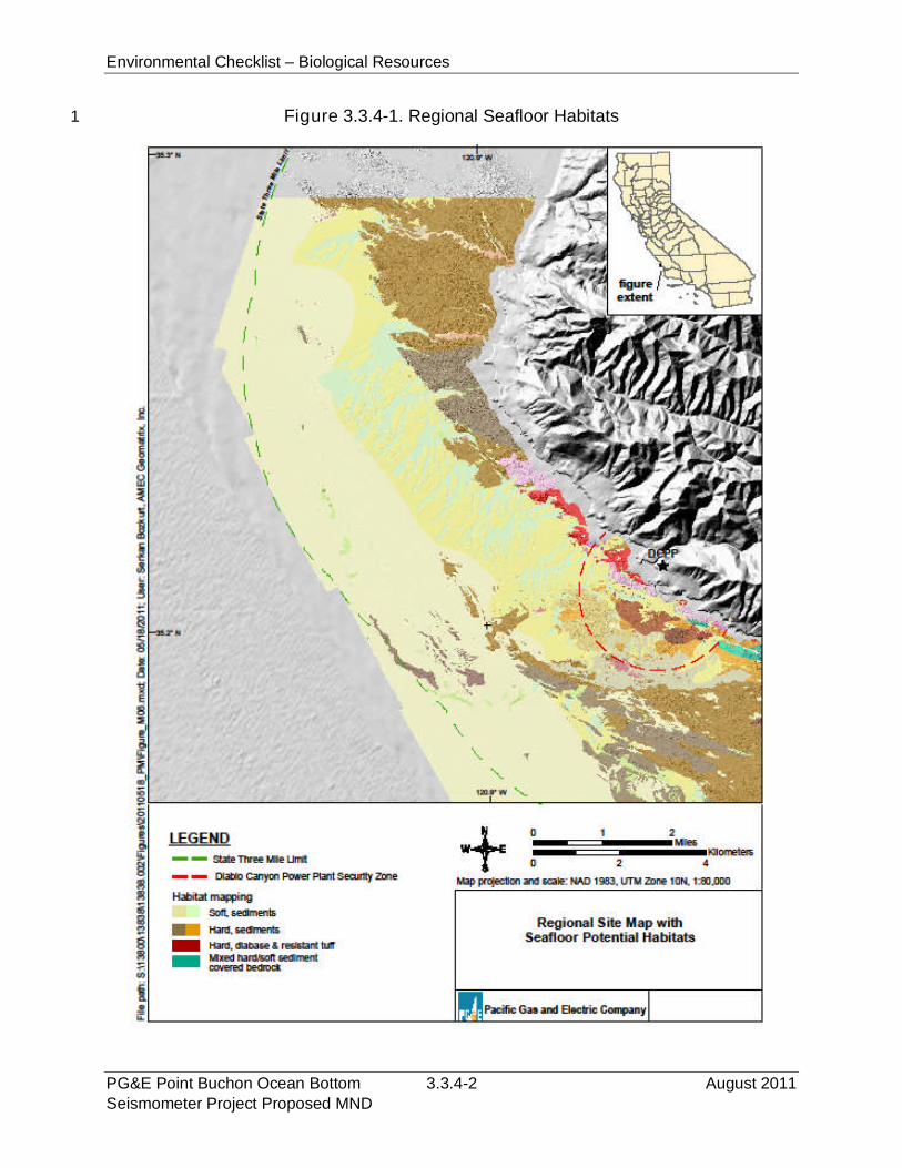
Environmental Checklist – Biological Resources
PG&E Point Buchon Ocean Bottom 3.3.4-2 August 2011Seismometer Project Proposed MND
Figure 3.3.4-1. Regional Seafloor Habitats1

Environmental Checklist – Biological Resources
August 2011 3.3.4-3 PG&E Point Buchon Ocean BottomSeismometer Project Proposed MND
Intertidal and Nearshore (to -30 m [-100 ft]). The shoreline of the region is1
characterized by a rocky headland approximately 19 km (12 mi) in lateral extent which2
trends northwest to southeast and which is bounded to the north and south by extensive3
sand beaches.4
Point Buchon is the prominent feature of this shoreline, which consists of wave-exposed5
headlands alternating with semi-protected coves. Stable bedrock and variously sized6
boulders are the predominant substratum. Sand, as fine gravel and shell-debris, is7
uncommon in the intertidal areas, where it tends to be ephemeral, but becomes the8
predominant substrate with increasing distance and depth offshore. The nearshore9
intertidal and subtidal algae, invertebrates, and fishes in the area lying generally10
between Point Buchon to the north of DCPP and Point San Luis to the south of DCPP11
have been well studied and are similar to the marine biological communities found in12
other areas of central California.13
Thermal effects studies dating back to 1976 have provided an extensive database on14
the existing intertidal and shallow subtidal habitats and biota within the Project area and15
have described changes in the intertidal and shallow subtidal biological communities16
resulting from thermal discharges within the DCPP’s outfall area (Diablo Cove). The17
biological communities in Diablo Cove mainly differ from those along the surrounding18
coastline by having a higher proportion of warm-tolerant species and fewer cold-tolerant19
species. Descriptions of the long-term changes can be found in annual monitoring and20
analysis reports that PG&E has submitted to the Regional Water Quality Control Board21
(RWQCB) (Tenera 2010).22
Tenera (2010) characterizes the regional intertidal and subtidal rocky habitats and23
associated biota. The barren appearance of the splash zone disappears lower in the24
intertidal zone (+1.2 m [+4 ft] MLLW) as algal cover becomes more conspicuous with25
scattered clumps of rockweeds (Fucus and Silvetia) and the turfy red alga Endocladia26
muricata. The iridescent red alga Mazzaella flaccida is a dominant species in the mid- to27
low intertidal zone. Other abundant red algae include hollow branch seaweed28
(Gastroclonium subarticulatum), grapestone seaweed (Mastocarpus papillatus), and29
Christmas tree seaweed (Chondracanthus canaliculatus). Surf grass (Phyllospadix30
spp.), a flowering plant, is the dominant plant in the transition zone between the low31
intertidal and the shallow-subtidal. Surf grass is listed by the CDFG as a species of32
special concern.33
The subtidal algal assemblage is spatially dominated by various species of kelp. Bull34
kelp (Nereocystis luetkeana) is a common surface canopy-forming kelp along the coast35
in the area of DCPP. Giant kelp (Macrocystis pyrifera) occurs with bull kelp in semi-36
exposed areas, but tends to be more abundant in calmer water. A third surface canopy-37
forming kelp species, Cystoseira osmundacea, also occurs with these two kelps,38
generally in areas shallower than about 10 m (30 ft). The canopies of all three species39
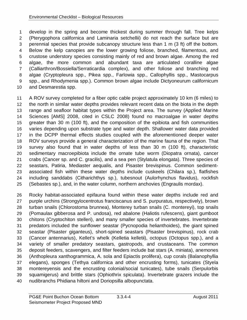
Environmental Checklist – Biological Resources
PG&E Point Buchon Ocean Bottom 3.3.4-4 August 2011Seismometer Project Proposed MND
develop in the spring and become thickest during summer through fall. Tree kelps1
(Pterygophora californica and Laminaria setchellii) do not reach the surface but are2
perennial species that provide subcanopy structure less than 1 m (3 ft) off the bottom.3
Below the kelp canopies are the lower growing foliose, branched, filamentous, and4
crustose understory species consisting mainly of red and brown algae. Among the red5
algae, the more common and abundant taxa are articulated coralline algae6
(Calliarthron/Bossiella/Serraticardia complex), and other foliose and branching red7
algae (Cryptopleura spp., Pikea spp., Farlowia spp., Callophyllis spp., Mastocarpus8
spp., and Rhodymenia spp.). Common brown algae include Dictyoneurum californicum9
and Desmarestia spp.10
A ROV survey completed for a fiber optic cable project approximately 10 km (6 miles) to11
the north in similar water depths provides relevant recent data on the biota in the depth12
range and seafloor habitat types within the Project area. The survey (Applied Marine13
Sciences [AMS] 2008, cited in CSLC 2008) found no macroalgae in water depths14
greater than 30 m (100 ft), and the composition of the epibiota and fish communities15
varies depending upon substrate type and water depth. Shallower water data provided16
in the DCPP thermal effects studies coupled with the aforementioned deeper water17
ROV surveys provide a general characterization of the marine fauna of the region. That18
survey also found that in water depths of less than 30 m (100 ft), characteristic19
sedimentary macroepibiota include the ornate tube worm (Diopatra ornata), cancer20
crabs (Cancer sp. and C. gracilis), and a sea pen (Stylatula elongata). Three species of21
seastars, Patiria, Mediaster aequalis, and Pisaster brevispinus. Common sediment-22
associated fish within these water depths include cuskeels (Chilara sp.), flatfishes23
including sanddabs (Citharichthys sp.), tubesnout (Aulorhynchus flavidus), rockfish24
(Sebastes sp.), and, in the water column, northern anchovies (Engraulis mordax).25
Rocky habitat-associated epifauna found within these water depths include red and26
purple urchins (Strongylocentrotus franciscanus and S. purpuratus, respectively), brown27
turban snails (Chlorostoma brunnea), Monterey turban snails (C. montereyi), top snails28
(Pomaulax gibberosa and P. undosa), red abalone (Haliotis rufescens), giant gumboot29
chitons (Cryptochiton stelleri), and many smaller species of invertebrates. Invertebrate30
predators included the sunflower seastar (Pycnopodia helianthoides), the giant spined31
seastar (Pisaster giganteus), short-spined seastars (Pisaster brevispinus), rock crab32
(Cancer antennarius), Kellet’s whelk (Kelletia kelletii), octopus (Octopus spp.), and a33
variety of smaller predatory seastars, gastropods, and crustaceans. The common34
deposit feeders, scavengers, and filter feeders include bat stars (A. miniata), anemones35
(Anthopleura xanthogrammica, A. sola and Epiactis prolifera), cup corals (Balanophyllia36
elegans), sponges (Tethya californica and other encrusting forms), tunicates (Styela37
montereyensis and the encrusting colonial/social tunicates), tube snails (Serpulorbis38
squamigerus) and brittle stars (Ophiothrix spiculata). Invertebrate grazers include the39
nudibranchs Phidiana hiltoni and Doriopsilla albopunctata.40
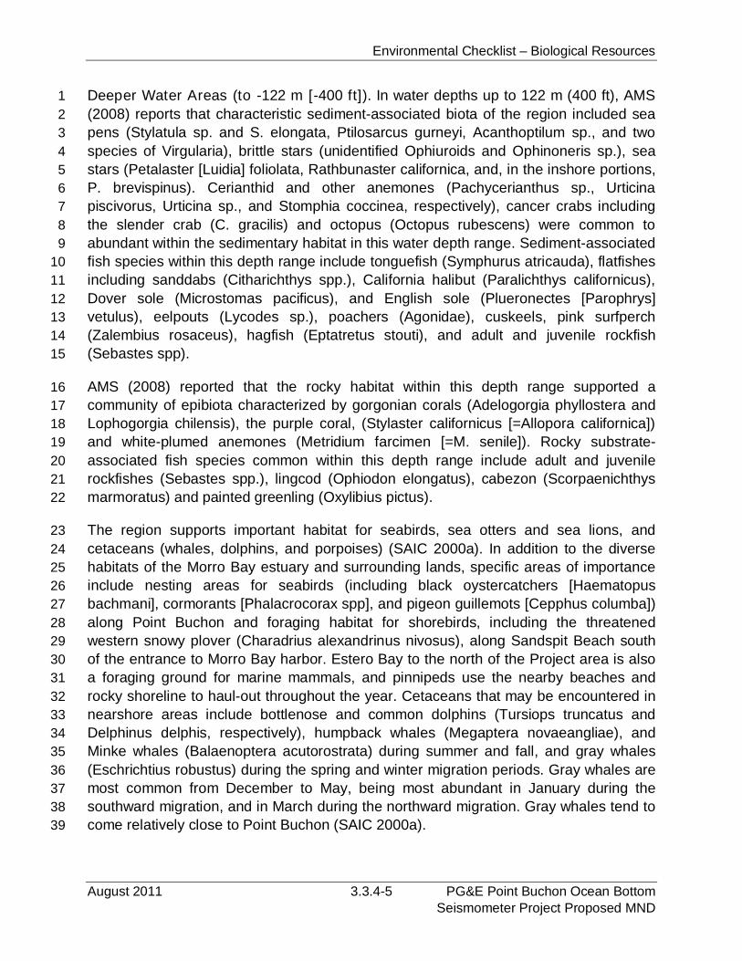
Environmental Checklist – Biological Resources
August 2011 3.3.4-5 PG&E Point Buchon Ocean BottomSeismometer Project Proposed MND
Deeper Water Areas (to -122 m [-400 ft]). In water depths up to 122 m (400 ft), AMS1
(2008) reports that characteristic sediment-associated biota of the region included sea2
pens (Stylatula sp. and S. elongata, Ptilosarcus gurneyi, Acanthoptilum sp., and two3
species of Virgularia), brittle stars (unidentified Ophiuroids and Ophinoneris sp.), sea4
stars (Petalaster [Luidia] foliolata, Rathbunaster californica, and, in the inshore portions,5
P. brevispinus). Cerianthid and other anemones (Pachycerianthus sp., Urticina6
piscivorus, Urticina sp., and Stomphia coccinea, respectively), cancer crabs including7
the slender crab (C. gracilis) and octopus (Octopus rubescens) were common to8
abundant within the sedimentary habitat in this water depth range. Sediment-associated9
fish species within this depth range include tonguefish (Symphurus atricauda), flatfishes10
including sanddabs (Citharichthys spp.), California halibut (Paralichthys californicus),11
Dover sole (Microstomas pacificus), and English sole (Plueronectes [Parophrys]12
vetulus), eelpouts (Lycodes sp.), poachers (Agonidae), cuskeels, pink surfperch13
(Zalembius rosaceus), hagfish (Eptatretus stouti), and adult and juvenile rockfish14
(Sebastes spp).15
AMS (2008) reported that the rocky habitat within this depth range supported a16
community of epibiota characterized by gorgonian corals (Adelogorgia phyllostera and17
Lophogorgia chilensis), the purple coral, (Stylaster californicus [=Allopora californica])18
and white-plumed anemones (Metridium farcimen [=M. senile]). Rocky substrate-19
associated fish species common within this depth range include adult and juvenile20
rockfishes (Sebastes spp.), lingcod (Ophiodon elongatus), cabezon (Scorpaenichthys21
marmoratus) and painted greenling (Oxylibius pictus).22
The region supports important habitat for seabirds, sea otters and sea lions, and23
cetaceans (whales, dolphins, and porpoises) (SAIC 2000a). In addition to the diverse24
habitats of the Morro Bay estuary and surrounding lands, specific areas of importance25
include nesting areas for seabirds (including black oystercatchers [Haematopus26
bachmani], cormorants [Phalacrocorax spp], and pigeon guillemots [Cepphus columba])27
along Point Buchon and foraging habitat for shorebirds, including the threatened28
western snowy plover (Charadrius alexandrinus nivosus), along Sandspit Beach south29
of the entrance to Morro Bay harbor. Estero Bay to the north of the Project area is also30
a foraging ground for marine mammals, and pinnipeds use the nearby beaches and31
rocky shoreline to haul-out throughout the year. Cetaceans that may be encountered in32
nearshore areas include bottlenose and common dolphins (Tursiops truncatus and33
Delphinus delphis, respectively), humpback whales (Megaptera novaeangliae), and34
Minke whales (Balaenoptera acutorostrata) during summer and fall, and gray whales35
(Eschrichtius robustus) during the spring and winter migration periods. Gray whales are36
most common from December to May, being most abundant in January during the37
southward migration, and in March during the northward migration. Gray whales tend to38
come relatively close to Point Buchon (SAIC 2000a).39

Environmental Checklist – Biological Resources
PG&E Point Buchon Ocean Bottom 3.3.4-6 August 2011Seismometer Project Proposed MND
Site-Specific Marine Habitats and Biota.1
Nearshore Cable Route. Results of a project-specific diver-biologist survey of2
nearshore portion of the cable route are provided in Tenera (2011); the report is3
provided in Appendix D. The survey included both intertidal and subtidal observations4
within that portion of the cable alignment that was within the DCPP intake embayment.5
The intertidal survey was from the high to low intertidal rip-rap within a 3 m (10 ft)6
corridor centered along the proposed alignment of the PVC conduit extension. An7
objective of the intertidal survey was to determine if abalone, including the endangered8
black abalone (Haliotis cracherodii) was present within the proposed cable corridor. The9
subtidal segment was along the proposed cable alignment from the base of the rip-rap10
to an area beyond the breakwaters and consisted of a team of diver-biologists11
swimming along the alignment shown in Figure 3.3.4-2 and recording habitat type and12
dominant macroepibiota within a 3.0 to 4.6 m (10 to 15 ft) wide corridor centered on the13
proposed cable alignment.14
Figure 3.3.4-2. Nearshore Cable Route Diver-Biologist Survey Area15
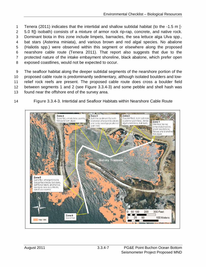
Environmental Checklist – Biological Resources
August 2011 3.3.4-7 PG&E Point Buchon Ocean BottomSeismometer Project Proposed MND
Tenera (2011) indicates that the intertidal and shallow subtidal habitat (to the -1.5 m [-1
5.0 ft]) isobath) consists of a mixture of armor rock rip-rap, concrete, and native rock.2
Dominant biota in this zone include limpets, barnacles, the sea lettuce alga Ulva spp.,3
bat stars (Asterina miniata), and various brown and red algal species. No abalone4
(Haliotis spp.) were observed within this segment or elsewhere along the proposed5
nearshore cable route (Tenera 2011). That report also suggests that due to the6
protected nature of the intake embayment shoreline, black abalone, which prefer open7
exposed coastlines, would not be expected to occur.8
The seafloor habitat along the deeper subtidal segments of the nearshore portion of the9
proposed cable route is predominantly sedimentary, although isolated boulders and low-10
relief rock reefs are present. The proposed cable route does cross a boulder field11
between segments 1 and 2 (see Figure 3.3.4-3) and some pebble and shell hash was12
found near the offshore end of the survey area.13
Figure 3.3.4-3. Intertidal and Seafloor Habitats within Nearshore Cable Route14
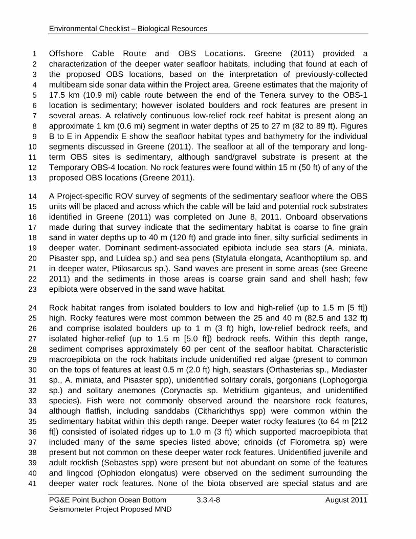
Environmental Checklist – Biological Resources
PG&E Point Buchon Ocean Bottom 3.3.4-8 August 2011Seismometer Project Proposed MND
Offshore Cable Route and OBS Locations. Greene (2011) provided a1
characterization of the deeper water seafloor habitats, including that found at each of2
the proposed OBS locations, based on the interpretation of previously-collected3
multibeam side sonar data within the Project area. Greene estimates that the majority of4
17.5 km (10.9 mi) cable route between the end of the Tenera survey to the OBS-15
location is sedimentary; however isolated boulders and rock features are present in6
several areas. A relatively continuous low-relief rock reef habitat is present along an7
approximate 1 km (0.6 mi) segment in water depths of 25 to 27 m (82 to 89 ft). Figures8
B to E in Appendix E show the seafloor habitat types and bathymetry for the individual9
segments discussed in Greene (2011). The seafloor at all of the temporary and long-10
term OBS sites is sedimentary, although sand/gravel substrate is present at the11
Temporary OBS-4 location. No rock features were found within 15 m (50 ft) of any of the12
proposed OBS locations (Greene 2011).13
A Project-specific ROV survey of segments of the sedimentary seafloor where the OBS14
units will be placed and across which the cable will be laid and potential rock substrates15
identified in Greene (2011) was completed on June 8, 2011. Onboard observations16
made during that survey indicate that the sedimentary habitat is coarse to fine grain17
sand in water depths up to 40 m (120 ft) and grade into finer, silty surficial sediments in18
deeper water. Dominant sediment-associated epibiota include sea stars (A. miniata,19
Pisaster spp, and Luidea sp.) and sea pens (Stylatula elongata, Acanthoptilum sp. and20
in deeper water, Ptilosarcus sp.). Sand waves are present in some areas (see Greene21
2011) and the sediments in those areas is coarse grain sand and shell hash; few22
epibiota were observed in the sand wave habitat.23
Rock habitat ranges from isolated boulders to low and high-relief (up to 1.5 m [5 ft])24
high. Rocky features were most common between the 25 and 40 m (82.5 and 132 ft)25
and comprise isolated boulders up to 1 m (3 ft) high, low-relief bedrock reefs, and26
isolated higher-relief (up to 1.5 m [5.0 ft]) bedrock reefs. Within this depth range,27
sediment comprises approximately 60 per cent of the seafloor habitat. Characteristic28
macroepibiota on the rock habitats include unidentified red algae (present to common29
on the tops of features at least 0.5 m (2.0 ft) high, seastars (Orthasterias sp., Mediaster30
sp., A. miniata, and Pisaster spp), unidentified solitary corals, gorgonians (Lophogorgia31
sp.) and solitary anemones (Corynactis sp. Metridium giganteus, and unidentified32
species). Fish were not commonly observed around the nearshore rock features,33
although flatfish, including sanddabs (Citharichthys spp) were common within the34
sedimentary habitat within this depth range. Deeper water rocky features (to 64 m [21235
ft]) consisted of isolated ridges up to 1.0 m (3 ft) which supported macroepibiota that36
included many of the same species listed above; crinoids (cf Florometra sp) were37
present but not common on these deeper water rock features. Unidentified juvenile and38
adult rockfish (Sebastes spp) were present but not abundant on some of the features39
and lingcod (Ophiodon elongatus) were observed on the sediment surrounding the40
deeper water rock features. None of the biota observed are special status and are41
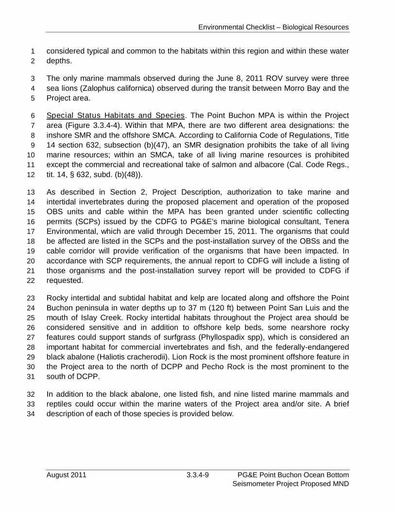
Environmental Checklist – Biological Resources
August 2011 3.3.4-9 PG&E Point Buchon Ocean BottomSeismometer Project Proposed MND
considered typical and common to the habitats within this region and within these water1
depths.2
The only marine mammals observed during the June 8, 2011 ROV survey were three3
sea lions (Zalophus californica) observed during the transit between Morro Bay and the4
Project area.5
Special Status Habitats and Species. The Point Buchon MPA is within the Project6
area (Figure 3.3.4-4). Within that MPA, there are two different area designations: the7
inshore SMR and the offshore SMCA. According to California Code of Regulations, Title8
14 section 632, subsection (b)(47), an SMR designation prohibits the take of all living9
marine resources; within an SMCA, take of all living marine resources is prohibited10
except the commercial and recreational take of salmon and albacore (Cal. Code Regs.,11
tit. 14, § 632, subd. (b)(48)).12
As described in Section 2, Project Description, authorization to take marine and13
intertidal invertebrates during the proposed placement and operation of the proposed14
OBS units and cable within the MPA has been granted under scientific collecting15
permits (SCPs) issued by the CDFG to PG&E’s marine biological consultant, Tenera16
Environmental, which are valid through December 15, 2011. The organisms that could17
be affected are listed in the SCPs and the post-installation survey of the OBSs and the18
cable corridor will provide verification of the organisms that have been impacted. In19
accordance with SCP requirements, the annual report to CDFG will include a listing of20
those organisms and the post-installation survey report will be provided to CDFG if21
requested.22
Rocky intertidal and subtidal habitat and kelp are located along and offshore the Point23
Buchon peninsula in water depths up to 37 m (120 ft) between Point San Luis and the24
mouth of Islay Creek. Rocky intertidal habitats throughout the Project area should be25
considered sensitive and in addition to offshore kelp beds, some nearshore rocky26
features could support stands of surfgrass (Phyllospadix spp), which is considered an27
important habitat for commercial invertebrates and fish, and the federally-endangered28
black abalone (Haliotis cracherodii). Lion Rock is the most prominent offshore feature in29
the Project area to the north of DCPP and Pecho Rock is the most prominent to the30
south of DCPP.31
In addition to the black abalone, one listed fish, and nine listed marine mammals and32
reptiles could occur within the marine waters of the Project area and/or site. A brief33
description of each of those species is provided below.34
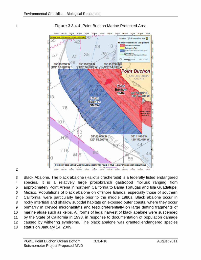
Environmental Checklist – Biological Resources
PG&E Point Buchon Ocean Bottom 3.3.4-10 August 2011Seismometer Project Proposed MND
Figure 3.3.4-4. Point Buchon Marine Protected Area1
2
Black Abalone. The black abalone (Haliotis cracherodii) is a federally listed endangered3
species. It is a relatively large prosobranch gastropod mollusk ranging from4
approximately Point Arena in northern California to Bahia Tortugas and Isla Guadalupe,5
Mexico. Populations of black abalone on offshore Islands, especially those of southern6
California, were particularly large prior to the middle 1980s. Black abalone occur in7
rocky intertidal and shallow subtidal habitats on exposed outer coasts, where they occur8
primarily in crevice microhabitats and feed preferentially on large drifting fragments of9
marine algae such as kelps. All forms of legal harvest of black abalone were suspended10
by the State of California in 1993, in response to documentation of population damage11
caused by withering syndrome. The black abalone was granted endangered species12
status on January 14, 2009.13

Environmental Checklist – Biological Resources
August 2011 3.3.4-11 PG&E Point Buchon Ocean BottomSeismometer Project Proposed MND
Steelhead, South-Central California Coast ESU. The south-central California coast1
evolutionarily significant unit (ESU) steelhead (Oncorhynchus mykiss) is a federally2
listed endangered species. Its range extends from the Pajaro River basin in Monterey3
Bay south to, but not including, the Santa Maria River basin near the city of Santa4
Maria. Historical data on the South-Central California Coast steelhead ESU are sparse.5
In the mid-1960s, CDFG 1965 (cited in NOAA 2005) estimated that the ESU-wide run6
size was about 17,750 adults. No comparable recent estimate exists; however, recent7
estimates exist for five river systems (Pajaro, Salinas, Carmel, Little Sur, and Big Sur),8
indicating runs of fewer than 500 adults where previous runs had been on the order of9
4,750 adults.10
Rockfish. Several species of rockfish (genus Sebastes) are known or could be expected11
to occur within the Project area. Many of these species are considered depleted by12
state and federal agencies, and some species (i.e., cowcod and canary rockfish) have13
had specific areas set aside to protect it from commercial catch. Another species, the14
Southern Distinct Population Segment of bocaccio (Sebastes paucispinis), is a federal15
species of concern. Rockfish use kelp beds and rocky seafloor habitats within the16
Project area and were observed during the Project-specific ROV survey,17
Blue whale. The blue whale is a federally listed endangered species, due to intensive18
historical commercial whaling. Blue whales are distributed worldwide in circumpolar and19
temperate waters and inhabit both coastal and pelagic environments (Leatherwood et20
al. 1982; Reeves et al. 1998). Like most baleen whales, they migrate between warmer21
waters used for breeding and calving in winter and high-latitude feeding grounds where22
food is plentiful in the summer. The most recent estimates of blue whale indicate that at23
a minimum of 2,039 individuals are known to occur off the U.S. West Coast (National24
Marine Fisheries Service [NMFS] 2009).25
Fin whale. The fin whale is a federally endangered species, due to a severe worldwide26
population decline due to intensive commercial whaling. The most recent estimates of27
the fin whale population indicate that at least 2,541 individuals are known to occur off28
California, Oregon, and Washington (NMFS 2009). There is some evidence that recent29
increases in fin whale abundance have occurred in California waters (Barlow 1994;30
Barlow and Gerodette 1996, NOAA 2005), but these have not been significant (Barlow31
et al. 1997).32
Humpback whale. The humpback whale is a federally endangered species, due to33
intensive historical commercial whaling. Humpbacks are distributed worldwide and34
undertake extensive migration in parts of their range (Leatherwood et al. 1982; NMFS35
1991a). The population in the Project area is referred to as the eastern Northern stock,36
which spends the winter/spring months in coastal Central America and Mexico for37
breeding and calving and migrate to the coast of California to southern British Columbia38
in summer/fall to feet (NMFS 2008). During migration, humpback whales are known to39
Environmental Checklist – Biological Resources
PG&E Point Buchon Ocean Bottom 3.3.4-12 August 2011Seismometer Project Proposed MND
occur within the vicinity of the Channel Islands. Migrants passing through central1
California appear to follow a more inshore path than blue, or fin whales (Bonnell and2
Dailey 1993). The most recent estimates of humpback whale indicate that at least 1,2503
individuals are known to occur off California, Oregon, and Washington (NMFS 2009).4
This population estimate is anticipated to be increasing (NMFS 2009).5
Northern right whale. The northern right whale is federally endangered, due to intensive6
historical commercial whaling. Like other baleen whales, right whales appear to migrate7
from high-latitude feeding grounds toward more temperate waters in the fall and winter,8
although the location of seasonal migration routes is unknown (Scarff 1986). The usual9
wintering ground of northern right whales extended from northern California to10
Washington, although sightings have been recorded as far south as Baja California and11
near the Hawaiian Islands (Scarff 1986; Gendron et al. 1999). Estimates of the regional12
population are not available; however in 2002 two of the 13 individuals observed13
between 1999 and 2001 were “re-observed” (NMFS 2008a). It is believed that the14
population is between 100 to 200 individuals (Braham 1984). Due to the low population15
numbers and lack of data, no long-term population trends have been determined.16
Steller sea lion. The Steller or northern sea lion (Eumetopias jubatus) is a federally17
threatened species. Historically, this species was the most abundant pinniped in the18
Southern California Bight (SCB). Numbers have declined precipitously in the last several19
decades, but the causes of the decline are not well understood (Bartholomew 1967; Le20
Boeuf and Bonnell 1980). The SCB is the southern extreme of the historical breeding21
range of the species: 96 percent of the world population is found in Alaska or Siberian22
waters (Loughlin et al. 1980). The most recent population estimate for the Steller sea lion23
indicate that at least 2,396 individuals were observed in California (NMFS 2009). This24
population is believed to be decreasing (NMFS 2009).25
Southern sea otter. The southern sea otter (Enhydra lutris nereis) is a federally26
threatened species. Historically the range of sea otters extended from the northern27
islands of the Japanese Archipelago northeast along Alaska and southward along North28
America to Baja California (Dailey et al. 1993). The sea otter was nearly extirpated by29
the fur trade during the 18th and 19th centuries. The current range is restricted to the30
waters of the coast of Alaska and California. Currently, the sea otter is expanding its31
range southward along the coast, including a recent expansion south of Point32
Conception into the Santa Barbara area. This species prefers rocky shoreline with water33
depth of less than 50 feet, which support kelp beds where they feed on benthic34
macroinvertebrates including clams, crabs, abalone, sea urchins, and sea stars. Based35
on the spring 2010 data (the latest available), the “three-year running average” indicates36
that the California population of the southern sea otter numbers approximately 2,711, a37
3.6 per cent decrease over the 2009 (USGS 2011).38
Environmental Checklist – Biological Resources
August 2011 3.3.4-13 PG&E Point Buchon Ocean BottomSeismometer Project Proposed MND
Several species of sea turtles occur within waters off the California coast; however three1
species are most likely to occur within the Project area waters: olive Ridley sea turtle2
(Lepidochelys olivacea), leatherback sea turtle (Dermochelys coriacea), and the green3
sea turtle (Chelonia mydas). Overall, populations of marine turtles have been greatly4
reduced due to over-harvesting and loss of nesting sites in coastal areas (Ross 1982).5
All three (olive Ridley, leatherback, and green) are listed as endangered under the U.S.6
Endangered Species Act.7
Green sea turtle. The green sea turtle generally occur worldwide in waters with8
temperatures above 20° C (MFS Globenet Corp./WorldCom Network Services9
[MGCWCNS] 2000). Green sea turtles have been reported as far north as Redwood10
Creek in Humboldt County and off the coasts of Washington, Oregon, and British11
Columbia (Channel Islands National Marine Sanctuary [CINMS] 2000; MGCWCNS12
2000). The green sea turtle is thought to nest on the Pacific coasts of Mexico, Central13
America, South America, and the Galapagos Islands. There are no known nesting sites14
along the West Coast of the U.S., and the only known nesting location in the continental15
U.S. is on the east coast of Florida (MGCWCNS 2000). Green sea turtles are sighted16
year-round in marine waters off the southern California coast, with the highest17
concentrations occurring during July through September. Green sea turtles are18
omnivores, feeding primarily on algae and sea grasses, but also on fish and19
invertebrates (e.g., sardines, anchovies, jellies, mollusks, worms, etc.) (MGCWCNS20
2000). Recent minimum population estimates for green sea turtles indicate that at least21
3,319 individuals are known to occur in the eastern Pacific; this population is believed to22
be increasing (NOAA 2011).23
Olive Ridley sea turtle. The olive (or Pacific) Ridley sea turtle is distributed24
circumglobally and is regarded as the most abundant sea turtle in the world (Eguchi et25
al. 2007). Within the east Pacific, the normal range of olive Ridley sea turtles is from26
Southern California to Peru (NOAA 2011); however, they have been reported as far27
north as Washington, Oregon, and are a rare visitor to the California coast (MGCWCNS28
2000). The olive Ridley sea turtle is omnivorous, feeding on fish, crabs, shellfish,29
jellyfish, sea grasses and algae (CINMS 2000; MGCWCNS 2000), and may dive to30
considerable depths (83.2 313.6 m [260 to 980 ft]). Major nesting beaches are located31
on the Pacific coasts of Mexico and Costa Rica (MGCWCNS 2000; Eguchi et al. 2007).32
The number of olive Ridley nests has increased from 50,000 in 1988 to over 700,000 in33
1994 to more than a million nests in 2000 (Márquez et al. 2002). The eastern tropical34
Pacific population is estimated at 1.39 million, consistent with the dramatic increases of35
olive Ridley nesting populations that have been reported (Eguchi et al. 2007).36
Leatherback sea turtle. Leatherback sea turtles are the most common sea turtle off the37
West Coast of the U.S. (CINMS 2000). Leatherback sea turtles have been sighted as38
far north as Alaska and as far south as Chile (CINMS 2000; MGCWCNS 2000). Their39
extensive latitudinal range is due to their ability to maintain warmer body temperatures40
Environmental Checklist – Biological Resources
PG&E Point Buchon Ocean Bottom 3.3.4-14 August 2011Seismometer Project Proposed MND
in colder waters (MGCWCNS 2000). Off the U.S. West Coast, leatherback turtles are1
most abundant from July to September. In January, 2010, NOAA submitted a proposal2
to revise the current habitat for the leatherback sea turtle to include the coastal areas3
between Point Arena to Point Vicente in California.4
Leatherback sea turtles are omnivores, but feed principally on soft prey items such as5
jellyfish and planktonic chordates (e.g., salps) (CINMS 2000; MGCWCNS 2000).6
Recent population estimates for the eastern Pacific leatherback sea turtles indicate that7
at least 178 individuals are known to occur off of California (Benson et al. 2007). This8
population is believed to be decreasing worldwide; however nesting trends on U.S.9
beaches have been increasing in recent years (NOAA 2011).10
Loggerhead sea turtle. Loggerhead sea turtles primarily occur in subtropical to11
temperate waters and are generally found over the continental shelf (MFS Globenet12
Corp./WorldCom Network Services 2000). Loggerhead sea turtles are omnivorous and13
feed on a wide variety of marine life including shellfish, jellyfish, squid, sea urchins, fish,14
and algae (MGCWCNS 2000; CINMS 2000).15
The eastern Pacific population of loggerhead sea turtles breeds on beaches in Central16
and South America. Southern California is considered to be the northern limit of17
loggerhead sea turtle distribution (MGCWCNS 2000); however, loggerhead sea turtles18
have stranded on beaches as far north as Washington and Oregon (CINMS 2000;19
MGCWCNS 2000). In addition, in 1978, a loggerhead sea turtle was captured near20
Santa Cruz Island in southern California (MGCWCNS 2000). Loggerhead sea turtle21
abundance in southern California waters is higher in the winter during warm years than22
cold years; however, during the summer months (July through September) abundance23
is similar in warm and cold years. In the U.S., nesting occurs only in Florida and the24
worldwide population appears to be decreasing (Conant et al. 2009).25
3.3.4.2 Regulatory Setting26
This section identifies and discusses the regulations and policies administered by27
resource agencies pertaining to those biological resources that are known to exist28
and/or have the potential to occur within the Project area.29
Federal30
Endangered Species Act of 1972. The Federal Endangered Species Act (FESA),31
administered by the USFWS and the NOAA Fisheries, provides protection to species32
listed as Threatened (FT) or Endangered (FE), or proposed for listing as Threatened33
(PFT) or Endangered (PFE). In addition to the listed species, the Federal Government34
also maintains lists of species that are neither formally listed nor proposed, but could35
potentially be listed in the future. The Federal candidate species (FC) list includes taxa36
for which substantial information on biological vulnerability and potential threats exists,37
Environmental Checklist – Biological Resources
August 2011 3.3.4-15 PG&E Point Buchon Ocean BottomSeismometer Project Proposed MND
and is maintained in order to support the appropriateness of proposing to list the taxa as1
an endangered or threatened species. Federal Species of Concern (FSC) comprise2
those species that should be given consideration during environmental review.3
Section 9 of the FESA prohibits the “take” of any member of a listed species. Take is4
defined as, “…to harass, harm, pursue, hunt, shoot, wound, kill, trap, capture, or collect,5
or to attempt to engage in any such conduct.” Harass is “an intentional or negligent act6
or omission that creates the likelihood of injury to a listed species by annoying it to such7
an extent as to significantly disrupt normal behavior patterns that include, but are not8
limited to, breeding, feeding, or sheltering.” Harm is defined as “…significant habitat9
modification or degradation that results in death or injury to listed species by10
significantly impairing behavioral patterns such as breeding, feeding, or sheltering.”11
Applicants proposing projects with a federal nexus that “may affect” a federally-listed or12
proposed species are required to consult with USFWS or NOAA Fisheries, as13
appropriate, under Section 7 of the ESA. Section 7 of the ESA provides that each14
federal agency must ensure, in consultation with the Secretary of the Interior or15
Commerce, that any actions authorized, funded, or carried out by the agency are not16
likely to jeopardize the continued existence of any endangered or threatened species or17
result in the destruction or adverse modification of areas determined to be critical18
habitat. A biological opinion is issued by USFWS or NOAA Fisheries at the completion19
of formal consultation. The biological opinion can conclude that the Project as proposed20
is either likely or not likely to jeopardize the continued existence of the species. If the21
biological opinion concludes “no jeopardy,” but that take will occur, the biological opinion22
will contain an incidental take statement that authorizes a specified level of take23
anticipated to result from the proposed action, as well as “reasonable and prudent24
measures” that are designed to minimize the level of incidental take and that must be25
implemented as a condition of the take authorization. If the biological opinion concludes26
“jeopardy,” USFWS or NOAA Fisheries will identify “reasonable and prudent27
alternatives” to the proposed action that would avoid jeopardizing the species.28
Federal Migratory Bird Treaty Act (MBTA) of 1918. The USFWS also administers the29
MBTA of 1918 (16 United States Code [U.S.C.] § 703-711) (see below). Under the30
MBTA, it is unlawful to take, possess, buy, sell, purchase, or barter any migratory bird31
listed in 50 Code of Federal Regulations (CFR) section 10 (50 CFR 10), including32
feathers or other parts, nests, eggs or products, except as allowed by implementing33
regulations (50 CFR 21).34
Magnuson-Stevens Fishery Conservation and Management Act and Sustainable35
Fisheries Act of 1996. The Magnuson-Stevens Fishery Conservation and Management36
Act (Magnuson-Stevens Act) (16 U.S.C. § 1801 et seq., is intended to implement37
procedures to conserve and manage fishery resources. Further, as amended by the38
Sustainable Fisheries Act of 1996, review of projects whose business is conducted39

Environmental Checklist – Biological Resources
PG&E Point Buchon Ocean Bottom 3.3.4-16 August 2011Seismometer Project Proposed MND
pursuant to federal permits and licenses must consider the designation, promotion and1
protection of essential fish habitat (EFH) for those species included in a Federal Fishery2
Management Plan, as established pursuant to 16 U.S.C. § 1851 - 1863. Specifically,3
section 303(a)(7) of the Magnuson-Stevens Act, as amended, requires that EFH be4
properly described and identified.5
Essential Fish Habitat is defined as “…those waters and substrate necessary to fish for6
spawning, breeding, feeding, or growth to maturity.” As used in this definition, “waters”7
are defined to include “aquatic areas and their associated physical, chemical, and8
biological properties that are used by fish.” These may include “…areas historically used9
by fish where appropriate; ‘substrate’ to include sediment, hard bottom, structures10
underlying the waters, and associated biological communities.” “Necessary” means “the11
habitat required to support a sustainable fishery and the managed species’ contribution12
to a healthy ecosystem.”13
Marine Protection, Research, and Sanctuaries Act of 1972. The Marine Protection,14
Research, and Sanctuaries Act (MPRSA) establishes a framework for the control of15
dumping material in the territorial sea and seaward and includes specific criteria and16
conditions for permissible dumping. The MPRSA is the primary federal environmental17
statute governing the discharge of dredged material in the ocean.18
Section 101 (a) (5) (D) of the Marine Mammal Protection Act (MMPA), 16 U.S.C. § 137119
(a) (5) provides for the issuance of Incidental Take Authorizations for non-listed marine20
mammals. Section 102 of the MPRSA authorizes the EPA to announce environmental21
criteria for evaluation of all dumping permit actions, to retain review authority over22
ACOE section 103 permits, and to designate ocean disposal sites for dredged and other23
material disposal. The EPA’s regulations for ocean disposal are published at 40 C.F.R.24
§ 220-229. Under the authority of section 103 of the MPRSA, the ACOE may issue25
ocean dumping permits for dredged and other material if EPA concurs with the decision.26
If EPA does not agree with the ACOE permit decision, a waiver process under section27
103 allows further action to be taken. The permitting regulations advertised by the28
ACOE, under MPRSA, appear in 33 C.F.R. § 320-330 and § 335-338. Based on an29
evaluation of compliance with the regulatory criteria of 40 C.F.R. § 227, both EPA and30
the ACOE may prohibit or restrict disposal of material that does not meet the criteria.31
The EPA and the ACOE also may determine that ocean disposal is inappropriate32
because of Ocean Dredged Material Disposal Site management restrictions or because33
options for beneficial use(s) exist(s). Site management guidance is provided in 4034
C.F.R. § 228.7-228.11.35
Marine Mammal Protection Act. The MMPA of 1972 (16 U.S.C. § 1361 et seq.), as36
amended, establishes a national policy designed to protect and conserve marine37
mammals and their habitats. Under the MMPA, the Secretary of Commerce is38
responsible for the conservation and management of pinnipeds (other than walruses)39
Environmental Checklist – Biological Resources
August 2011 3.3.4-17 PG&E Point Buchon Ocean BottomSeismometer Project Proposed MND
and cetaceans. This act also specifies and defines actions that are considered1
harassment and provides for agency-mandated compliance with mitigations to reduce2
impacts to the protected species. The Secretary of the Interior is responsible for3
walruses, sea and river otters, polar bears, manatees and dugongs. The Secretary of4
Commerce delegated MMPA authority to NOAA Fisheries. Part of the responsibility that5
NOAA Fisheries has under the MMPA involves monitoring populations of marine6
mammals to make sure that they stay at optimum levels. If a population falls below its7
optimum level, it is designated as "depleted," and a conservation plan is developed to8
guide research and management actions to restore the population to healthy levels.9
Migratory Bird Treaty Act of 1918 (16 U.S.C. § 703 et seq., as amended). The10
Migratory Bird Treaty Act (MBTA) was agreed to by the U.S. and Canada in 1918; the11
1936 Convention for the Protection of Migratory Birds and Animals, between the U.S.12
and Mexico; and subsequent amendments to these Acts provide legal protection for13
almost all breeding bird species occurring in the U.S. The MBTA restricts the killing,14
taking, collecting, and selling or purchasing of native bird species or their parts, nests,15
or eggs. Certain game bird species are allowed to be hunted for specific periods16
determined by federal and state governments. The intent of the MBTA is to eliminate17
any commercial market for migratory birds, feathers, or bird parts, especially for eagles18
and other birds of prey.19
Rivers and Harbors Act (33 U.S.C. § 401). Section 10 of the Rivers and Harbors Act20
limits the construction of structures and the discharge of fill into navigable waters of the21
U.S. This regulation is used by the ACOE to control, and permit, the placing of22
structures or the operation of vessels within the waters of the U.S. Several Nationwide23
Permits, which are used to authorize specific activities that have been previously24
assessed under NEPA, provide an expedited permitting process for the more “routine”25
in-water construction activities such as placing scientific equipment, construction of26
pipelines, and placing shoreline protective devices.27
Other relevant federal environmental regulations include:28
The Clean Water Act (CWA) is a comprehensive piece of legislation that29
generally includes reference to the Federal Water Pollution Control Act of 1972,30
its substantial supplementation by the CWA of 1977, and subsequent31
amendments. Overall, the CWA seeks to protect the nation’s water from pollution32
by setting water quality standards for surface water and by limiting the discharge33
of effluents into waters of the U.S., which are enforced by the EPA. The CWA34
also provides for a permitting system to control discharges to surface waters.35
State operation of the program is encouraged. The ACOE is responsible for the36
issuance of permits for the placement of dredged or fill material into waters of the37
U.S. pursuant to CWA section 404. As defined in 33 CFR 328.3(a)(3), waters of38
the U.S. are those that are currently used, or were used in the past, or may be39
Environmental Checklist – Biological Resources
PG&E Point Buchon Ocean Bottom 3.3.4-18 August 2011Seismometer Project Proposed MND
susceptible to use in interstate or foreign commerce, including all waters which1
are subject to the ebb and flow of the tide; tributaries and impoundments to such2
waters; all interstate waters including interstate wetlands; and territorial seas.3
The Marine Plastic Pollution Research and Control Act of 1987 (33 U.S.C. §4
1901 et seq.) prohibits the disposal of plastics and non-biodegradable material5
into the marine waters;6
The National Aquatic Invasive Species Act was originally passed in 1990 in7
response to the invasion of the zebra mussel and other species that damaged8
the Great Lakes. That law brought much-needed attention to the global9
movement of aquatic species. It also established the federal interagency Aquatic10
Nuisance Species Task Force, which became a key resource for regional and11
state efforts. The 2005 reauthorization specifies the requirements related to the12
exchange/discharge of ballast water from ocean-going vessels that enter federal13
waters or U.S. lakes.14
The Oil Pollution Act of 1990 (OPA 90) (33 U.S.C. § 2712) requires owners and15
operators of facilities that could cause substantial harm to the environment to16
prepare and submit plans for responding to worst-case discharges of oil and17
hazardous substances. The passage of OPA 90 directed the State of California18
to pass a more stringent spill response and recovery regulation and to create the19
State Office of Spill Prevention and Response (OSPR) to review and regulate oil20
spill plans and contracts;21
State22
California Aquatic Invasive Species Management Plan. In 2008 the State of23
California developed a plan to control the introduction and spread of non-native species24
within the aquatic and marine waters of the state. That plan proposes management25
actions for addressing aquatic invasive species (AIS) threats to the State of California. It26
focuses on the non-native algae, crabs, clams, fish, plants and other species that27
continue to invade California’s creeks, wetlands, rivers, bays and coastal waters.28
California Coastal Act of 1976. The Coastal Act requires anyone who proposes any29
development in the coastal zone to secure a CDP from either the CCC or local30
jurisdiction with a certified LCP. In general, the CCC is responsible for determining a31
project’s consistency with the Coastal Act and/or the CCMP and for granting CDPs for32
projects within the California coastal zone not covered by LCPs. The San Luis Obispo33
County has a certified LCP; therefore, the County’s coastal policies are applicable to the34
onshore portion of the Project.35
California Endangered Species Act (Fish & G. Code § 2050 et seq.). The CDFG36
administers a number of laws and programs designed to protect fish and wildlife37
resources. Principal of these is the California Endangered Species Act of 1984 (CESA)38
Environmental Checklist – Biological Resources
August 2011 3.3.4-19 PG&E Point Buchon Ocean BottomSeismometer Project Proposed MND
that regulates the listing and take of State endangered (SE) and threatened species1
(ST). Under section 2081 of CESA, CDFG may authorize the take of an Endangered2
and/or Threatened species, or candidate species by a permit or Memorandum of3
Understanding (MOU) for scientific, educational, or management purposes, or for the4
incidental take associated with implementation of a project.5
CDFG maintains lists of Candidate-Endangered species (SCE) and Candidate-6
Threatened species (SCT). California candidate species are afforded the same level of7
protection as listed species. CDFG also designates Species of Special Concern (CSC)8
that are species of limited distribution, declining populations, diminishing habitat, or9
unusual scientific, recreational, or educational value. These species do not have the10
same legal protection as listed species, but may be added to official lists in the future.11
The CSC list is intended by CDFG as a management tool to call attention to declining12
populations and focus efforts on decreasing threats to long-term viability.13
CDFG administers other state laws designed to protect wildlife and plants. Under14
section 3511 of the Fish and Game Code, CDFG designates species that are afforded15
“fully protected” (FP) status. Under this protection, CDFG may authorize take or capture16
of a designated species for “…necessary scientific research, including efforts to recover17
fully protected, threatened, or endangered species” and “…live capture and relocation of18
those species pursuant to a permit for the protection of livestock.” Section 3503 of the19
Fish and Game Code protects all birds-of-prey, their eggs, and their nests.20
CDFG also manages the California Native Plant Protection Act of 1977 (Fish & G. Code21
§ 1900 et seq.), which was enacted to identify, designate and protect rare plants. In22
accordance with CDFG guidelines, California Native Plant Society 1B list plants are23
considered “rare” under the Act, and are evaluated under CEQA.24
California Harbors and Navigation Code, Sections 1-7340. The California Harbors25
and Navigation Code describes and defines provisions and legislative policy for26
California harbors, navigable waters, traffic, cargo, wrecks and salvage, marinas,27
construction/improvements, and harbor and port mitigation.28
Lempert-Keene-Seastrand Oil Spill Prevention and Response Act (OSPRA). The29
OSPRA established OSPR within the CDFG to provide protection of California's natural30
resources from the potential effects of an oil spill within the ocean waters. The Act31
covers all aspects of marine oil spill prevention and response in California. It established32
an Administrator who is given broad powers to implement the provisions of the Act. The33
Act requires that the CDFG, the Administrator of OSPR, establishes rescue and34
rehabilitation stations for seabirds, sea otters, and other marine mammals.35
Marine Life Protection Act of 1999 (MLPA) (Fish & G. Code § 2850 et seq.). The36
MLPA directs the state to redesign California's system of MPAs to function as a network37
in order to: increase coherence and effectiveness in protecting the state's marine life38
Environmental Checklist – Biological Resources
PG&E Point Buchon Ocean Bottom 3.3.4-20 August 2011Seismometer Project Proposed MND
and habitats, marine ecosystems, and marine natural heritage, as well as to improve1
recreational, educational and study opportunities provided by marine ecosystems2
subject to minimal human disturbance. There are six goals that guide the development3
of MPAs in the MLPA planning process: 1) Protect the natural diversity and abundance4
of marine life, and the structure, function and integrity of marine ecosystems; 2) Help5
sustain, conserve and protect marine life populations, including those of economic6
value, and rebuild those that are depleted; 3) Improve recreational, educational and7
study opportunities provided by marine ecosystems that are subject to minimal human8
disturbance, and to manage these uses in a manner consistent with protecting9
biodiversity; 4) Protect marine natural heritage, including protection of representative10
and unique marine life habitats in California waters for their intrinsic values; 5) Ensure11
California's MPAs have clearly defined objectives, effective management measures and12
adequate enforcement and are based on sound scientific guidelines; and 6) Ensure the13
State's MPAs are designed and managed, to the extent possible, as a network.14
To help achieve these goals, three types of MPA designation types are used: SMRs,15
SMCAs, and state marine parks. Public Resources Code section 36710 lists the16
restrictions applied to SMR and SMCA areas (the proposed Project does not include17
any areas designated as a state marine park):18
State Marine Reserves: In a state marine reserve, it is unlawful to injure,19
damage, take, or possess any living, geological, or cultural marine resource,20
except under a permit or specific authorization from the Commission for21
research, restoration, or monitoring purposes.22
State Marine Conservation Areas: In a state marine conservation area, it is23
unlawful to injure, damage, take, or possess any living, geological, or cultural24
marine resource for commercial or recreational purposes, or a combination of25
commercial and recreational purposes except as specified in subsection 632(b),26
Title 14, California Code of Regulations, areas and special regulations for use.27
The Commission may permit research, education, and recreational activities, and28
certain commercial and recreational harvest of marine resources, provided that29
these uses do not compromise protection of the species of interest, natural30
community, habitat, or geological features.31
Porter-Cologne Water Quality Control Act of 1969 (Cal. Water Code § 13000 et32
seq.). This Act mandates that waters of the State shall be protected, such that activities33
which may affect waters of the State shall be regulated to attain the highest quality. This34
Act establishes the State Water Resources Control Board (SWRCB) as the principal35
state agency for the coordinated control of water quality in California. The SWRCB36
provides regulations that mandate a “non-degradation policy” for state waters,37
especially those of high quality. The SWRCB is divided into local regional boards which38
have been delegated authority to issue permits or waive water quality conditions under39
section 401 of the CWA (see above) for the ACOE permitting process.40
Environmental Checklist – Biological Resources
August 2011 3.3.4-21 PG&E Point Buchon Ocean BottomSeismometer Project Proposed MND
Local1
San Luis Obispo County LCP Policy A. Sensitive Habitats. Policy A indicates that2
environmentally sensitive habitat areas are settings in which plant or animal life (or their3
habitats) are rare or especially valuable due to their special role in an ecosystem.4
Designation of environmentally sensitive habitats include but are not limited to: 1)5
wetlands and marshes; 2) coastal streams and adjacent riparian areas; 3) habitats6
containing or supporting rare and endangered or threatened species; 4) marine habitats7
containing breeding and/or nesting sites and coastal areas used by migratory and8
permanent birds for resting and feeding. The Coastal Act provides protection for these9
areas and permits only resource-dependent uses within the habitat area. Development10
adjacent must be sited to avoid impacts.11
Policy 38: Protection of Kelp Beds, Offshore Rocks, Rocky Points, Reefs and Intertidal12
Areas of the San Luis Obispo County LCP states that “uses shall be restricted to13
recreation, education and commercial fishing. Adjacent development shall be sited and14
designed to mitigate impacts that would be incompatible with the continuance of such15
habitat areas.”16
3.3.4.3 Impact Analysis17
a) Would the Project have a substantial adverse effect, either directly or18
through habitat modifications, on any species identified as a candidate,19
sensitive, or special status species in local or regional plans, policies, or20
regulations, or by the California Department of Fish and Game or U.S. Fish21
and Wildlife Service?22
See response below.23
b) Would the Project have a substantial adverse effect on any riparian habitat24
or other sensitive natural community identified in local or regional plans,25
policies, regulations or by the California Department of Fish and Game or26
U.S. Fish and Wildlife Service?27
The proposed Project would result in the placement of temporary and long-term OBS28
units and cable onto the seafloor offshore the DCPP; the recovery of the temporary29
OBS units after two weeks; and the installation of approximately 24 m (80 ft) of 10.0 cm30
(4.0 in) diameter plastic conduit along existing rip-rap. Eleven special status marine31
species could be present within the Project area (Section 3.3.4.1 above), including the32
endangered black abalone (H. cracherodii), which prefers open ocean rocky intertidal33
habitats.34
Impacts to special status species or habitats could occur from the placement of OBS35
units and/or cable onto individuals or across a substantial area of sensitive habitat,36
Environmental Checklist – Biological Resources
PG&E Point Buchon Ocean Bottom 3.3.4-22 August 2011Seismometer Project Proposed MND
including rock features, eelgrass, surf grass, or kelp. Other significant effects could1
occur if there were a substantial increase in noise; entanglement of a listed species in2
the cable during offshore deployment; or from a collision with a Project vessel. The3
potential for the Project to result in these types of impacts to special status species and4
sensitive habitat is evaluated below.5
PG&E has incorporated several measures into the proposed Project to reduce or6
eliminate the potentially significant impacts to marine resources, including:7
Aligning the cable route within sedimentary seafloor habitat wherever possible.8
The approximate 1.0 km (0.6 mi) rock habitat crossed is low relief and does not9
support any sensitive resources. The alignment precludes the crossing or any10
sea grass or kelp (Macrocystis spp) as documented in Tenera (2011).11
Locating the conduit extension over existing rock rip-rap that does not support12
black abalone. Tenera (2011) reports that no black abalone were observed within13
a 3 to 4.6 m (10 to 15 ft) wide corridor centered on the proposed cable alignment.14
A Project-specific Marine Wildlife Contingency Plan has been prepared (see15
Appendix H). Among other items, that plan specifies that a qualified marine16
wildlife observer will be onboard the MV Michael Uhl throughout the OBS and17
cable installation (and recovery) periods. The observer will be located in an area18
of the vessel that allows clear views of the direction of travel during transit19
periods and around the vessel during OBS and cable deployment. Should an20
interaction with a marine mammal or turtle be imminent, the onboard observer21
will have the authority to curtail operations until the animal is out of the area. The22
onboard monitor will maintain a record of marine wildlife observations and23
prepare and submit a post-installation observation report to the CSLC.24
PG&E has located all OBS units within sedimentary habitat. Greene (2011)25
reports that the habitat under and within 15 m (50 ft) of all proposed OBS unit26
locations is sedimentary, thereby precluding impacts to rock features. Water27
depths of all OBS unit locations are deeper than those which would support kelp28
or sea grass. Therefore those sensitive resources will not be affected.29
As proposed and with the incorporation of these measures, along with the Mitigation30
Measures listed in Section 3.3.4.4 as BIO-1, BIO-2, and APM-1 through APM-9, no31
significant impacts to sensitive marine resources, listed species or habitat used by those32
species, or sensitive habitats such as seagrass and kelp beds and rocky features are33
expected, because the measures either provide a mechanism for avoidance of one or34
more of the potential impacts identified above or incorporate specific requirements and35
limitations on how Project activities are conducted.36
The organisms that could be potentially affected by the deployment of the proposed37
OBS units and associated cable include polychaete worms, sea pens, anemones,38
Environmental Checklist – Biological Resources
August 2011 3.3.4-23 PG&E Point Buchon Ocean BottomSeismometer Project Proposed MND
seastars, mollusks, and possibly small, leafy red algae attached to the upper portions of1
some of the rock features). The loss of those individuals by burial under the OBS units2
or burial or abrasion by the cable is not considered significant. The less than significant3
impact determination is based on the consistency of habitat and biota within the affected4
area to that of the region, and the availability of similar habitat nearby.5
The proposed Project also includes an extension of an existing cable conduit from its6
current location on top of the armor rock rip-rap along the east side of the DCPP intake7
bay into the water where it will terminate on the natural sedimentary seafloor. The rock8
rip-rap does not provide any sensitive habitat and Project-specific surveys of the9
proposed conduit/cable route determined that this Project component would not result in10
significant impacts to sensitive species (e.g., black abalone).11
Although not regulated by law, NOAA Fisheries has established guidelines for noise12
levels that could affect marine mammals. While some studies have shown that13
behavioral changes in marine mammals occur with a received impulse sound pressure14
level (SPL) of 160 decibels (dB) in reference to one micro Pascal root mean square (dB15
re 1Pa rms), mitigation is usually required within the area within which SPLs between16
of 180 dB and 190 dB (both re 1Pa rms) are predicted. The 180 dB level is generally17
applicable within areas where cetaceans (whales and dolphins) are present, and the18
190 dB distance applies to areas supporting otarids and pinnipeds (seals and sea lions).19
Available scientific evidence suggests that harassment of these marine mammals could20
occur from SPLs at or above these levels and mitigations are developed on a case-by-21
case basis through consultation with the NOAA Fisheries office within the region.22
Data presented in Entrix (2004), which cites various published sources, indicate that23
underwater noise levels generated by tugs and supply boats range from 147 to 156 dB24
at 33 ft (10 m) from the source; those levels decrease to 107 to 116 dB within 0.6 mile25
(one kilometer). The Project vessel-generated noise is expected to be within this range26
and within the normal ambient range of the area which is subject to regular vessel27
traffic, including larger commercial fishing vessels. The OBS units are “passive” and28
generate no noise. Therefore, no significant noise-related impacts to special status29
species are expected.30
c) Would the Project have a substantial adverse effect on federally protected31
wetlands as defined by Section 404 of the Clean Water Act (including, but32
not limited to, marsh, vernal pool, coastal, etc.) through direct removal,33
filling, hydrological interruption, or other means?34
The proposed Project is within the marine waters and shoreline area of the Pacific35
Ocean and does not include any federally protected wetlands. Discussions with B.36
Henderson (pers. comm.) of the ACOE indicated that the proposed Project would not37
Environmental Checklist – Biological Resources
PG&E Point Buchon Ocean Bottom 3.3.4-24 August 2011Seismometer Project Proposed MND
require a 404 authorization from the ACOE. The OBS and cable are not considered “fill”1
and therefore no impacts to wetlands would occur.2
d) Would the Project interfere substantially with the movement of any native3
resident or migratory fish or wildlife species or with established native4
resident or migratory wildlife corridors, or impede the use of native wildlife5
nursery sites?6
The OBS units are approximately 0.3 m (1.0 ft) high and the cable will be laid onto the7
seafloor where it is expected to naturally bury itself into the sediments. If sections of the8
cable are not covered with sediment, it will provide additional solid substrate for9
epibiota. The cable will be laid across low-relief rock features where necessary;10
however no trenching or removal of rock will be required. The conduit extension will be11
laid onto the existing rip-rap. None of these items are expected to interfere with12
movements of biota as they will not be impenetrable and organisms will be able to go13
around or over all of the items. Kelp beds, which are nursery areas for some organisms,14
have been avoided with the proposed alignment and no other nursery areas, including15
marine mammal rookeries, will be affected by the proposed Project. Therefore, as16
currently designed, no significant impacts to the movement of organisms, the migratory,17
or nursery areas are expected as a result of the proposed actions.18
e) Would the proposed Project conflict with any local policies or ordinances19
protecting biological resources, such as a tree preservation policy or20
ordinance?21
Except for the conduit area along the existing armor rock rip-rap, the Project is located22
within the state marine waters. The Project area is not within any areas that are23
protected by local policies or ordinances. Therefore no conflicts between existing local24
policies and ordinances will occur.25
f) Would the proposed Project conflict with the provisions of an adopted26
Habitat Conservation Plan, Natural Community Conservation Plan, or other27
approved local, regional, or state habitat conservation plan?28
Without specific authorization from the CFGC, the proposed Project would conflict with29
and be in violation of the regulations that govern the use of the Point Buchon MPA30
because of the potential for take of organisms within the MPA. Without mitigation (i.e.,31
formal authorization) the proposed Project would be inconsistent with the no take32
requirements of the MPA.33
None of the organisms within the MPA boundaries that could be potentially affected by34
the deployment of the proposed OBS units and associated cable are “special status”35
species. Species that may be affected include polychaete worms, sea pens, anemones,36
seastars, mollusks, and possibly small, leafy red algae attached to the upper portions of37
Environmental Checklist – Biological Resources
August 2011 3.3.4-25 PG&E Point Buchon Ocean BottomSeismometer Project Proposed MND
some of the rock features), and the loss of those individuals by burial under the OBS1
units or burial or abrasion by the cable is not considered significant. The less than2
significant impact determination is based on the consistency of habitat and biota within3
the affected area to that of the region, and the availability of similar habitat nearby;4
however, because habitat and organisms that are within the Point Buchon MPA could5
be affected, take of those animals and plants would violate MPA regulations and is6
therefore considered a potentially significant impact. Impacts associated with the take of7
non-listed species within the MPA would be reduced to a less than significant level with8
the implementation of the requirements of an amended Scientific Collecting Permit9
(SCP) issued by the CDFG, because the Project would no longer conflict with the10
regulations governing activities within the MPA.11
PG&E’s marine biological consultant, Tenera Environmental, applied for and received12
SCP amendments for five of its staff to allow take of marine and intertidal invertebrates13
during the proposed placement and operation of the proposed OBS units and cable14
within the MPA. The amendments received from CDFG are valid from June 29, 201115
through December 15, 2011 after which a new amendment must be procured if work16
activities within the MPA continue beyond that date. PG&E will comply with the specific17
requirements of the SCP amendment including timely notifications to the CDFG18
Monterey office prior to work activities, the presence of a permit holder onsite during19
project activities, and a post-survey report of specimens collected or salvaged.20
3.3.4.4 Mitigation and Residual Impacts21
Recommended Mitigation Measures22
BIO-1 The Applicant shall comply with the requirements identified in the23
Scientific Collecting Permits (SCPs) for activities in the Point Buchon24
Marine Protected Area.25
BIO-2 The Applicant shall conduct a post-construction remotely operated26
vehicle (ROV) survey, with a California State Lands Commission27
(CSLC) staff-approved marine biologist onboard, to observe and28
record the effects of cable lay operations on the seafloor and the biota29
along the entire cable route and at each OBS unit site and to30
determine the number of organisms affected by Project construction.31
The Applicant shall subsequently prepare a technical report that32
includes information on the area (in square meters) of seafloor impacts33
and estimated numbers and species of organisms affected, and shall34
submit the report to the CSLC and California Department of Fish and35
Game (CDFG) staffs within 90 days following the ROV survey. Any36
restoration shall be based on the results of the survey as specified by37
the CSLC or CDFG staffs and shall be completed within one year of38
the ROV survey.39
Environmental Checklist – Biological Resources
PG&E Point Buchon Ocean Bottom 3.3.4-26 August 2011Seismometer Project Proposed MND
Applicant-Proposed Mitigation Measures (APMs)1
APM-1 Vessel fueling shall only occur at an approved docking facility. No2
cross vessel fueling shall be allowed. Marine vessels generally shall3
contain petroleum products within tankage that is internal to the hulls of4
the vessels.5
APM-2 Project shall be scheduled in the late fall/early winter months when6
whale activity is lowest and weather conditions are conducive to7
expeditious and safe vessel operations.8
APM-3 The cable has been routed to avoid rocky substrate wherever possible.9
A pre-construction remotely operated vehicle (ROV) survey of the rock10
habitat expected to be crossed by the cable has been conducted and11
information collected has been used to revise the route as necessary12
to further avoid potential impacts.13
APM-4 All operations shall be completed during the daytime hours; no14
nightime operations are proposed.15
APM-5 Onboard spill response equipment and contracted services shall be16
sufficient to contain and recover the worst-case scenario spill of17
petroleum products.18
APM-6 To reduce the area of seafloor disturbance, no vessel anchoring is19
proposed and the cable between the long-term Ocean Bottom20
Seismometer (OBS) units shall not be manually buried into the21
sediment or trenched through the rocky substrate.22
APM-7 A qualified marine wildlife observer shall be onboard the MV Michael23
Uhl during the deployment of the Ocean Bottom Seismometer (OBS)24
units and cable. That observer shall monitor and record the presence25
of marine wildlife (mammals and reptiles) and shall have the authority26
to cease operations if the actions are resulting in potentially significant27
impacts to wildlife.28
APM-8 All Ocean Bottom Seismometer (OBS) units shall be located on29
sedimentary seafloor habitat. No Project-related material shall remain30
on the seafloor after data collection is completed, with the potential31
exception, depending on post-Project survey results, of the eight 4-foot32
long, 4-inch diameter inert concrete ballast tubes left behind by the33
temporary OBS units.34
APM-9 Marine Wildlife Contingency Plan. The Applicant shall implement the35
marine wildlife contingency plan for Ocean Bottom Seismometer (OBS)36
deployment, cable lay, and equipment recovery that includes37
measures to reduce the chance of vessel/marine mammal and reptile38
Environmental Checklist – Biological Resources
August 2011 3.3.4-27 PG&E Point Buchon Ocean BottomSeismometer Project Proposed MND
interactions (see Appendix H). This Plan includes: (1) the provision for1
National Oceanic and Atmospheric Fisheries Service (NOAA2
Fisheries)-approved marine mammal monitors to be onboard the3
OBS/cable installation vessel throughout the daytime marine4
operations; and (2) measures that (a) specify the distance, speed, and5
direction transiting vessels would maintain when in proximity to a6
marine mammal or reptile; (b) qualifications, number, location, and7
authority of onboard marine mammal and reptile monitors; and (c)8
reporting requirements in the event of an observed impact to marine9
wildlife.10
Residual Impacts. With the incorporation of the recommended mitigation, there will be11
no residual impacts to the existing marine biological resources.12
Environmental Checklist – Biological Resources
PG&E Point Buchon Ocean Bottom 3.3.4-28 August 2011Seismometer Project Proposed MND
PAGE PURPOSEFULLY LEFT BLANK
Environmental Checklist – Cultural Resources
August 2011 3.3.5-1 PG&E Point Buchon Ocean BottomSeismometer Project Proposed MND
3.3.5 Cultural Resources1
V. CULTURAL RESOURCES:
Would the Project:
PotentiallySignificant
Impact
Less ThanSignificant
withMitigation
Less ThanSignificant
Impact
NoImpact
a) Cause a substantial adverse change in thesignificance of a historical resource as defined in§15064.5?
b) Cause a substantial adverse change in thesignificance of an archaeological resource pursuant to§15064.5?
c) Directly or indirectly destroy a unique paleontologicalresource or site or unique geologic feature?
d) Disturb any human remains, including those interredoutside of formal cemeteries?
3.3.5.1 Environmental Setting2
The proposed Project area is predominately located offshore within the waters of the3
Pacific Ocean. As such, cultural and historic resources would primarily be limited to the4
offshore areas within the immediate Project area; however, for the purposes of analysis,5
the following discussion provides information on both onshore and offshore areas of the6
DCPP area in San Luis Obispo County.7
Onshore. The onshore portion of the proposed Project is located within the territory8
historically occupied by the Obispeño Chumash, the northernmost of the Chumash-9
speaking peoples of California. Archaeological evidence has revealed that the10
ancestors of the Obispeño settled in San Luis Obispo County over 9,500 years ago. The11
Obispeño area extends from San Simeon Creek to Avila Bay and contains at least12
2,500 archaeological sites that span many years of occupation by the Chumash and13
their ancestors.14
Archaeological sites are an integral part of the modern day Native American community.15
Their history is contained in the sites, and most contemporary Chumash believe that16
cultural resources are best left in their natural state. When unavoidable adverse impacts17
are proposed, most strongly support the best sensitive scientific study that will benefit18
their culture and the general community. Today, many Chumash people are involved in19
protecting their native heritage and practicing traditional beliefs in the same territory as20
their ancestors have for over 9,000 years.21
Following the rise of the Chumash, in the late 1700s, Spanish and Mexican influences22
greatly changed the aboriginal way of life. With the establishment of Mission San Luis23
Obispo de Tolosa in 1772, as well as occasional European visits to the area prior to that24
time, the Native American culture of the area changed dramatically. Indigenous25
Environmental Checklist – Cultural Resources
PG&E Point Buchon Ocean Bottom 3.3.5-2 August 2011Seismometer Project Proposed MND
technologies were lost or replaced by Western ones, and religion and belief systems1
became transformed and incorporated into the Spanish culture. Most devastating to the2
local Chumash population was the introduction of Old World diseases for which they3
had little natural tolerance (Heizer 1974). As a result, the Native American population in4
the area dropped dramatically between the end of the 18th and 19th centuries.5
After the decline of the mission era in the 1830s, San Luis Obispo gradually grew into a6
thriving town. For a period of over 60 years, a large population of Chinese immigrants7
lived in a busy Chinatown. The arrival of the railroad accelerated the growth of the8
commercial and residential community that included many Americans from the mid-9
West and further east.10
In the 1860s, the economy of San Luis Obispo County changed from a cattle market11
based on hides and beef to a mixed economy including dairy operations introduced by12
Swiss-Italian farmers. In the mid-20th century agricultural development continued to13
diversify with more grain production (Krieger 1988). The community of San Luis Obispo14
also changed in 1903 when the California Polytechnic State University opened.15
Offshore16
Prehistoric and Historic Setting. During the late Wisconsin glaciation (30,000 to17
17,000 years Before Present), sea levels were as much as 400 feet (ft) [122 meters (m)]18
lower than they are today, and the coastline along San Luis Obispo County would have19
been approximately six nautical miles (nm) (11 km) farther offshore than at present20
(Hunter 1999). Even as recently as 8,000 years ago, sea levels were as much as 50 to21
65 ft (15 to 20 m) lower than at present (Bickel 1978).22
Areas of the Outer Continental Shelf predicted to be sensitive for submerged prehistoric23
resources have been identified by the former U.S. Minerals Management Service24
(MMS) (Pierson, Shiller, and Slater 1987; Snethkamp et al. 1990). These areas25
correspond to the locations of sensitive landforms (paleoembayments, submerged26
channel systems, and island complexes) along the shoreline at various periods ranging27
from approximately 18,000 to 7,500 years ago. However, to date no known occurrences28
of in-situ remains of prehistoric habitation sites have been reported offshore Morro Bay29
or Diablo Canyons Lands. The closest recorded underwater site to the Project area is30
located at Avila Beach (Port San Luis) to the south of the Project area (Hudson 1976).31
Maritime peoples worldwide have developed some form of watercraft with which to32
traverse bodies of water and exploit marine resources otherwise unavailable to them.33
Local peoples used such craft to exploit the offshore environment. The Chumash and34
other coastal populations of central California may have been skilled fishers prior to35
arriving in the area, and had subsistence strategies and techniques with which to exploit36
coastal resources (Johnson 1999). Although the early Spanish explorer Vizcaino37
describes the Tomol, a large sewn plank canoe in use south of Monterey in 1602, there38
Environmental Checklist – Cultural Resources
August 2011 3.3.5-3 PG&E Point Buchon Ocean BottomSeismometer Project Proposed MND
is no information to attribute its use north of the Santa Barbara Channel area. The1
“Playeño” peoples of Estero Bay, whether Chumash and/or Salinan, particularly in the2
Cayucos area, used some form of watercraft. At the request of Franciscan Friars after3
the Spanish establishment of the Mission system, Tomols navigated around Point4
Conception and up coast as far as San Luis Obispo Bay (Hudson and Blackburn 1979;5
Cunningham 1980). Although such water craft may reasonably be assumed to have6
navigated the waters in and offshore of Estero Bay, evidence of such vessels is unlikely7
to be preserved in the offshore environment due to the fragile nature of the craft in8
terms of construction methods and perishable materials used.9
The overland expedition of Gaspar de Portola in 1769 provided the first certain account10
of the topography of Estero Bay (Smith and Teggart 1990). This expedition resulted in11
the founding of the Spanish Mission system in Upper California which stimulated trade12
and interaction throughout California, but did little to increase maritime activity within13
Estero Bay (Hunter 1999). Estero Bay was hunted as part of the sea otter trade, but14
was otherwise little used until the 1860s. By then, farms, dairies and ranches in the15
Estero Bay region began maritime shipments to the growing markets of San Francisco,16
Los Angeles, and San Diego (Hunter 1999). A makeshift wharf built by Franklin Riley17
around 1864 (Gates and Bailey 1982; Hunter 1999) was replaced in 1872 by a good18
wharf at Morro Bay when he went into partnership with a Captain Williams, owner of the19
coastal sailing vessel Alexina, to promote trade between San Francisco and Morro Bay.20
Most shipping, however, continued to go through Cave Landing in San Luis Obispo Bay21
to the south (Hunter 1999). Barge traffic through the area was stimulated in the 1890s22
by excavation of a quarry on Morro Rock to produce construction materials for the San23
Luis Harbor breakwater. At that time, the entrance channel to the estuary was on the24
north side of Morro Rock. Several locations inside Estero Point were probably used by25
liquor smugglers in the 1920s (Hunter 1999). Standard Oil of California opened an26
offshore mooring oil transfer facility known as the Estero Bay Marine Terminal in 1929.27
Other historic maritime activities in Estero Bay included naval training operations during28
World War II, fishing, and commercial abalone harvesting (Hunter 1999).29
Fishing as an important economic development, whether from shore or watercraft, must30
also be considered prominent in the maritime activities of Estero Bay. Reliance on31
fishery resources dates back to Native American habitation of the area. Some of the32
earliest shell middens in the Estero Bay area date 5,000 to 7,000 years Before Present33
(Jones 1992; cited in Hunter 1999). The Fisheries Commission Report for 1888 notes34
that 27 people were employed in the San Luis Obispo County fishing industry.35
Commercial fishing for both local use and export employed few people in Estero Bay,36
generally and Morro Bay in particular, until the 1930s. After WWII a fleet was37
established when wartime improvements provided additional moorings that allowed38
north coast fishing vessels to move in (Gates and Bailey 1982; cited in Hunter 1999). By39
1950, Morro Bay lands were officially recorded by the CDFG.40
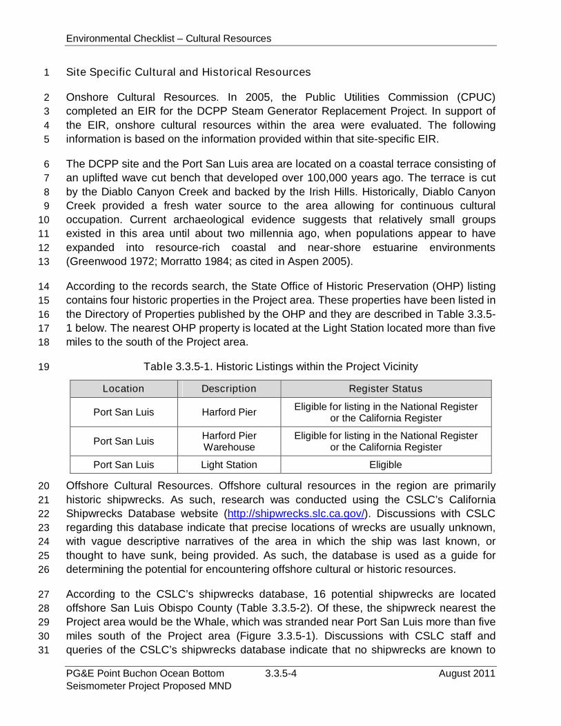
Environmental Checklist – Cultural Resources
PG&E Point Buchon Ocean Bottom 3.3.5-4 August 2011Seismometer Project Proposed MND
Site Specific Cultural and Historical Resources1
Onshore Cultural Resources. In 2005, the Public Utilities Commission (CPUC)2
completed an EIR for the DCPP Steam Generator Replacement Project. In support of3
the EIR, onshore cultural resources within the area were evaluated. The following4
information is based on the information provided within that site-specific EIR.5
The DCPP site and the Port San Luis area are located on a coastal terrace consisting of6
an uplifted wave cut bench that developed over 100,000 years ago. The terrace is cut7
by the Diablo Canyon Creek and backed by the Irish Hills. Historically, Diablo Canyon8
Creek provided a fresh water source to the area allowing for continuous cultural9
occupation. Current archaeological evidence suggests that relatively small groups10
existed in this area until about two millennia ago, when populations appear to have11
expanded into resource-rich coastal and near-shore estuarine environments12
(Greenwood 1972; Morratto 1984; as cited in Aspen 2005).13
According to the records search, the State Office of Historic Preservation (OHP) listing14
contains four historic properties in the Project area. These properties have been listed in15
the Directory of Properties published by the OHP and they are described in Table 3.3.5-16
1 below. The nearest OHP property is located at the Light Station located more than five17
miles to the south of the Project area.18
Table 3.3.5-1. Historic Listings within the Project Vicinity19
Location Description Register Status
Port San Luis Harford PierEligible for listing in the National Register
or the California Register
Port San LuisHarford PierWarehouse
Eligible for listing in the National Registeror the California Register
Port San Luis Light Station Eligible
Offshore Cultural Resources. Offshore cultural resources in the region are primarily20
historic shipwrecks. As such, research was conducted using the CSLC’s California21
Shipwrecks Database website (http://shipwrecks.slc.ca.gov/). Discussions with CSLC22
regarding this database indicate that precise locations of wrecks are usually unknown,23
with vague descriptive narratives of the area in which the ship was last known, or24
thought to have sunk, being provided. As such, the database is used as a guide for25
determining the potential for encountering offshore cultural or historic resources.26
According to the CSLC’s shipwrecks database, 16 potential shipwrecks are located27
offshore San Luis Obispo County (Table 3.3.5-2). Of these, the shipwreck nearest the28
Project area would be the Whale, which was stranded near Port San Luis more than five29
miles south of the Project area (Figure 3.3.5-1). Discussions with CSLC staff and30
queries of the CSLC’s shipwrecks database indicate that no shipwrecks are known to31

Environmental Checklist – Cultural Resources
August 2011 3.3.5-5 PG&E Point Buchon Ocean BottomSeismometer Project Proposed MND
have occurred within the immediate Project area; however, the CSLC database reflects1
a search of many published records, but does not represent actual fieldwork, and2
locations based on historic accounts may not be precise. Not all shipwrecks are listed in3
the database and, in some cases listed vessels were refloated or salvaged.4
Table 3.3.5-2. Shipwrecks Identified in San Luis Obispo County5
Ship’s Name Type Year Sunk Cause
Lena Schooner 1866 Grounded
La Cresentia 1935 Wrecked
Roanoke Steamship 1916 Cargo shifted
ChallengeThree-Masted
Schooner1877 Wrecked
Whale Barge 1925 Stranded
Golden gate Schooner 1873 Parted Cable
Montebello Tanker 1941 Torpedoed
HM Adams Oil Screw 1945 Stranded
Casco Steam Schooner 1913 Stranded
Otsego Schooner 1872 Stranded
Sierra NevadaSidewheelSteamboat
1869 Grounded in Fog
Electra Schooner 1894 Parted Cables
Santa Lucia Oil Screw 1954 Burned
Santa Cruz Steam Screw 1904 Wrecked
Harlech Castle Bark 1869 Grounded
Harlech Castle Bark 1905 Grounded
3.3.5.2 Regulatory Setting6
The following discussion summarizes the most important federal and state laws and7
regulations that apply to cultural resource protection for both the onshore and offshore8
portions of the proposed Project area.9
Regulatory Setting10
Federal11
The National Historic Preservation Act of 1966, as amended, (NHPA) and its12
implementing regulations (36 CFR 800). The NHPA requires federal agencies to13
evaluate the potential effects of their actions on historic properties. This process, often14
referred to as the “section 106” process, applies to properties that are listed on or15
eligible for listing on the National Register of Historic Places (National Register).16

Environmental Checklist – Cultural Resources
PG&E Point Buchon Ocean Bottom 3.3.5-6 August 2011Seismometer Project Proposed MND
Abandoned Shipwreck Act of 1987 (ASA) (43 U.S.C. sec. 2101 et seq.) The ASA1
provides that any abandoned shipwreck embedded in a state’s submerged lands or that2
is located on a state's submerged lands and is included in, or determined eligible for3
inclusion in, the National Register is the property of that state.4
As provided by the ASA, the title to all abandoned shipwrecks, cargo, and other5
contents, on or in the tide and submerged lands of California is vested in the state and6
such resources are under the jurisdiction of the CSLC.7
State8
CEQA and the State CEQA Guidelines (Public Resources Code § 21000 et seq. and9
State CEQA Guidelines, Cal. Code Regs., tit. 14, § 15000 et seq.)10
As the CEQA lead agency, the CSLC is responsible for complying with all provisions of11
CEQA that relate to “historical resources.” An historical resource includes: 1) a12
resource that is listed in, or determined to be eligible for listing in the the California13
Register of Historic Resources (CRHR); 2) a resource included in a local register of14
historical or identified as significant in an historical resource surveys; and, 3) any15
resource that a lead agency determines to be historically significant for the purposes of16
CEQA, when supported by substantial evidence in light of the whole record.17
The CRHR was created to identify resources deemed worthy of preservation on a state18
level and was modeled closely after the National Register. The criteria are nearly19
identical to those of the NRHP, but focus on resources of statewide significance. The20
criteria are set forth in section 15064.5, subdivision (a)(3) of the State CEQA Guidelines21
and are defined as any resource that meets any of the following criteria:.22
Is associated with events that have made a significant contribution to the broad23
patterns of California’s history and cultural heritage;24
Is associated with lives of persons important in our past;25
Embodies the distinctive characteristics of a type, period, region, or method of26
construction, or represents the work of an important creative individual, or27
possesses high artistic values; or28
Has yielded, or may be likely to yield, information important in prehistory or29
history.30
Properties listed, or formally designated as eligible for listing, on the National Register31
are automatically listed on the CRHR, as are certain State Landmarks and Points of32
Interest.33
Environmental Checklist – Cultural Resources
August 2011 3.3.5-7 PG&E Point Buchon Ocean BottomSeismometer Project Proposed MND
In addition, section 15064.5, subdivision (a)(4) of the State CEQA Guidelines states:1
The fact that a resource is not listed in, or determined to be eligible for2
listing in the California Register of Historical Resources, not included in a3
local register of historical resources (pursuant to Section 5020.1(k) of the4
Public Resources Code), or identified in an historical resources survey5
(meeting the criteria in Section 5024.1(g) of the Public Resources Code)6
does not preclude a lead agency from determining that the resource may7
be an historical resource as defined in Public Resources Code Section8
5020.1(j) or 5024.19
California Coastal Act of 1976. Coastal Act section 30244 provides that, “Where10
development would adversely impact archaeological or paleontological resources as11
identified by the State Historic Preservation Officer, reasonable mitigation measures12
shall be required.”13
Local14
Local Coastal Program. The San Luis Obispo County LCP contains policies for the15
protection of archaeological resources, prevention of vandalism, identification of16
archaeological sites, site surveys, protection of sites through mitigation, and protection17
of resources discovered during construction or other activities.18
County of San Luis Obispo Land Use Ordinance. The County of San Luis Obispo’s19
Land Use Ordinance includes regulations for identifying and protecting archaeologically20
sensitive areas and requirements for notifications in the event of discovery of21
archaeological resources or human remains.22
3.3.5.3 Impact Analysis23
Impact Analysis24
a) Cause a substantial adverse change in the significance of a historical25
resource as defined in §15064.5?26
See response below.27
b) Cause a substantial adverse change in the significance of an28
archaeological resource pursuant to §15064.5?29
See response below.30
c) Directly or indirectly destroy a unique paleontological resource or site or31
unique geologic feature?32
Environmental Checklist – Cultural Resources
PG&E Point Buchon Ocean Bottom 3.3.5-8 August 2011Seismometer Project Proposed MND
Onshore Impacts. The only onshore component of the proposed Project consists of an1
extension of an existing conduit (Figure 2-5) from its current location on top of the armor2
rock rip-rap along the east side of the DCPP intake cove into the water where it would3
terminate on the natural sedimentary seafloor in approximately 2.4 m (8 ft) of water,4
MLLW. According to the DCPP Steam Generator Replacement Project Final EIR, the5
intake cove area has been the subject of previous cultural resource surveys, and6
archaeological resources are known to exist within the area; however the onshore7
portion of the conduit would be extended at the man-made rock rip-rap located within8
the intake cove. As such, any ground disturbance of onshore materials would be fill9
materials placed in support of the DCPP. This material would not include any prehistoric10
or historic resources, nor would it include any known archaeological resources or11
paleontological resources. Therefore, no impacts would result.12
Offshore Impacts. The proposed Project is located offshore the DCPP with the13
power/data transfer cable extending from water depths of up to 82 m (270 ft). Potential14
impacts to cultural or historic resources would be limited to underwater archaeological15
resources, specifically shipwrecks. According to the CSLC’s shipwrecks database, no16
known archaeological or historical resources are located within the Project area (Figure17
3.3.5-1). Therefore, the potential for the Project to result in a significant impact to18
important archaeological or historical resources is remote and the Project is considered19
to have no impact on offshore cultural resources. In the unlikely event that Project20
activities encounter a previously unidentified archaeological site, PG&E will require the21
contractor to immediately stop work activities in the vicinity of the find. The CSLC is the22
point of contact for unanticipated discoveries and would be notified immediately.23
There are no unique geological features in the Project area that could be disturbed by the24
Project. The Project would not result in ground disturbing activities that have the potential25
to impact any paleontological resources that may be located in the Project area.26
d) Disturb any human remains, including those interred outside of formal27
cemeteries?28
Onshore Impacts. The only onshore component of the Project consists of an extension29
of the existing conduit. The onshore portion of the conduit would be extended at the30
man-made rock rip-rap located within the intake cove of the DCPP. As such, any ground31
disturbance of onshore materials would be fill materials placed in support of the DCPP.32
This material does not contain any human remains. Therefore, the potential for the33
Project to result in a significant impact to human remains is remote and the Project is34
considered to have no impact on onshore cultural resources; however, should35
previously unknown human remains be unearthed during any Project activities, PG&E36
would be required by State Health and Safety Code section 7050.5 to stop work in the37
vicinity of the find until the County Coroner has made the necessary findings as to origin38
and disposition pursuant to Public Resources Code section 5097.98. If the remains are39
Environmental Checklist – Cultural Resources
August 2011 3.3.5-9 PG&E Point Buchon Ocean BottomSeismometer Project Proposed MND
determined to be of Native American descent, the coroner has 24 hours to notify the1
Native American Heritage Commission (NAHC). The NAHC will then contact the most2
likely descendant of the deceased Native American, who will then serve as consultant3
on how to proceed with the remains (i.e., avoid or re-bury).4
Offshore Impacts. The proposed Project is not located in any areas known to contain5
human remains, including, but not limited to, formal cemeteries. The majority of Project6
activities would occur offshore the DCPP. The likelihood of encountering human7
remains on the seafloor is minimal and a less than significant impact.8
3.3.5.4 Mitigation and Residual Impacts9
Mitigation. The proposed Project would not result in significant impacts to historic,10
cultural or paleontological resources. Therefore, no mitigation measures are required.11
Residual Impacts. The proposed Project would have no significant historic, cultural or12
paleontological resources impacts. No mitigation is required and no residual impacts13
would occur.14
15
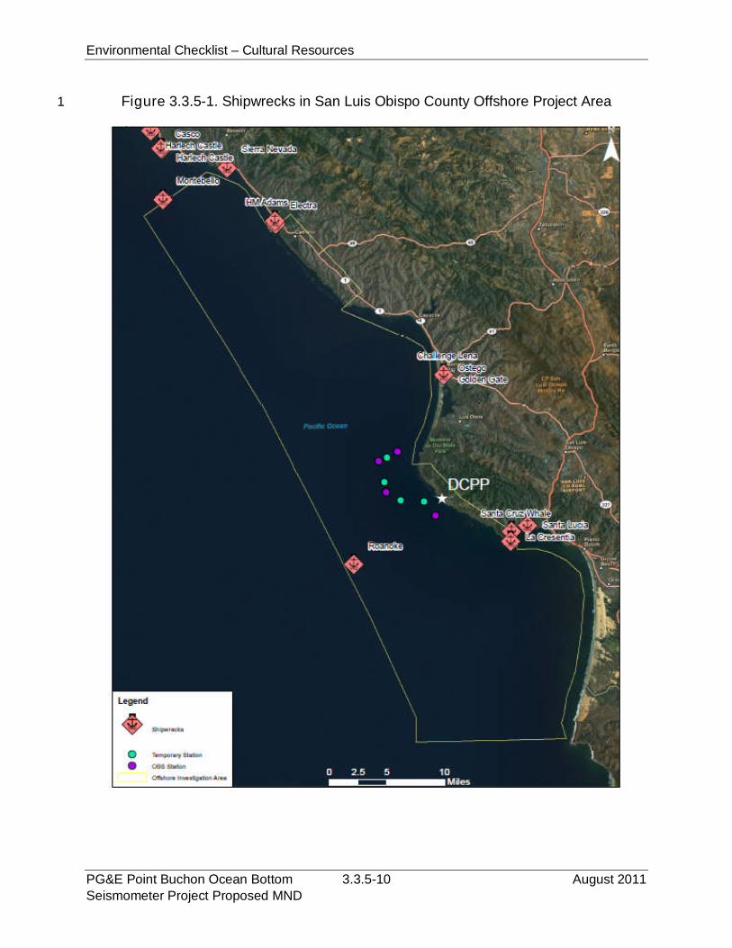
Environmental Checklist – Cultural Resources
PG&E Point Buchon Ocean Bottom 3.3.5-10 August 2011Seismometer Project Proposed MND
Figure 3.3.5-1. Shipwrecks in San Luis Obispo County Offshore Project Area1
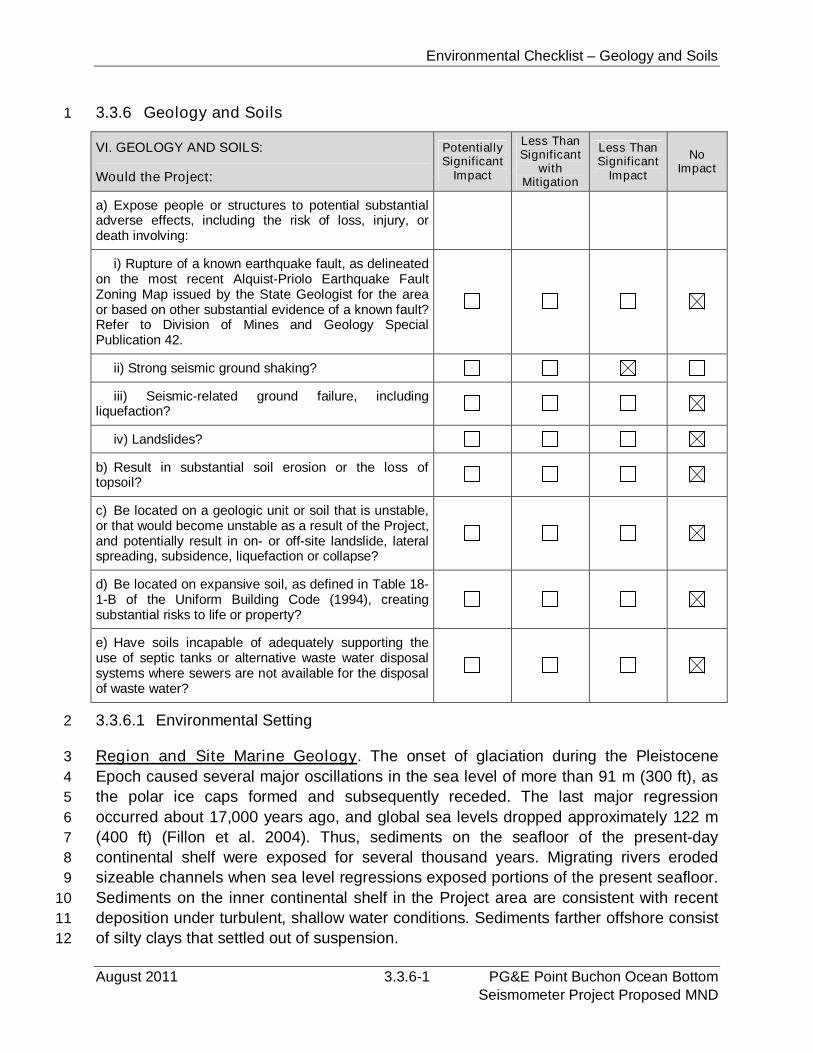
Environmental Checklist – Geology and Soils
August 2011 3.3.6-1 PG&E Point Buchon Ocean BottomSeismometer Project Proposed MND
3.3.6 Geology and Soils1
VI. GEOLOGY AND SOILS:
Would the Project:
PotentiallySignificant
Impact
Less ThanSignificant
withMitigation
Less ThanSignificant
Impact
NoImpact
a) Expose people or structures to potential substantialadverse effects, including the risk of loss, injury, ordeath involving:
i) Rupture of a known earthquake fault, as delineatedon the most recent Alquist-Priolo Earthquake FaultZoning Map issued by the State Geologist for the areaor based on other substantial evidence of a known fault?Refer to Division of Mines and Geology SpecialPublication 42.
ii) Strong seismic ground shaking?
iii) Seismic-related ground failure, includingliquefaction?
iv) Landslides?
b) Result in substantial soil erosion or the loss oftopsoil?
c) Be located on a geologic unit or soil that is unstable,or that would become unstable as a result of the Project,and potentially result in on- or off-site landslide, lateralspreading, subsidence, liquefaction or collapse?
d) Be located on expansive soil, as defined in Table 18-1-B of the Uniform Building Code (1994), creatingsubstantial risks to life or property?
e) Have soils incapable of adequately supporting theuse of septic tanks or alternative waste water disposalsystems where sewers are not available for the disposalof waste water?
3.3.6.1 Environmental Setting2
Region and Site Marine Geology. The onset of glaciation during the Pleistocene3
Epoch caused several major oscillations in the sea level of more than 91 m (300 ft), as4
the polar ice caps formed and subsequently receded. The last major regression5
occurred about 17,000 years ago, and global sea levels dropped approximately 122 m6
(400 ft) (Fillon et al. 2004). Thus, sediments on the seafloor of the present-day7
continental shelf were exposed for several thousand years. Migrating rivers eroded8
sizeable channels when sea level regressions exposed portions of the present seafloor.9
Sediments on the inner continental shelf in the Project area are consistent with recent10
deposition under turbulent, shallow water conditions. Sediments farther offshore consist11
of silty clays that settled out of suspension.12
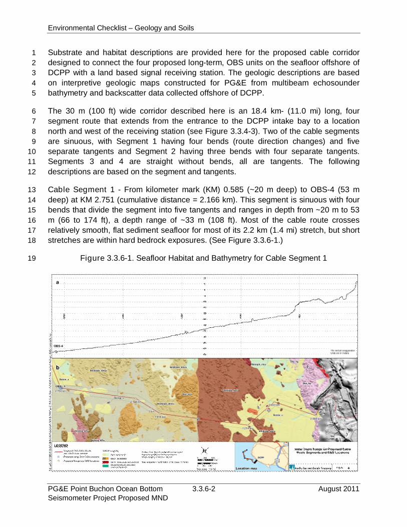
Environmental Checklist – Geology and Soils
PG&E Point Buchon Ocean Bottom 3.3.6-2 August 2011Seismometer Project Proposed MND
Substrate and habitat descriptions are provided here for the proposed cable corridor1
designed to connect the four proposed long-term, OBS units on the seafloor offshore of2
DCPP with a land based signal receiving station. The geologic descriptions are based3
on interpretive geologic maps constructed for PG&E from multibeam echosounder4
bathymetry and backscatter data collected offshore of DCPP.5
The 30 m (100 ft) wide corridor described here is an 18.4 km- (11.0 mi) long, four6
segment route that extends from the entrance to the DCPP intake bay to a location7
north and west of the receiving station (see Figure 3.3.4-3). Two of the cable segments8
are sinuous, with Segment 1 having four bends (route direction changes) and five9
separate tangents and Segment 2 having three bends with four separate tangents.10
Segments 3 and 4 are straight without bends, all are tangents. The following11
descriptions are based on the segment and tangents.12
Cable Segment 1 - From kilometer mark (KM) 0.585 (~20 m deep) to OBS-4 (53 m13
deep) at KM 2.751 (cumulative distance = 2.166 km). This segment is sinuous with four14
bends that divide the segment into five tangents and ranges in depth from ~20 m to 5315
m (66 to 174 ft), a depth range of ~33 m (108 ft). Most of the cable route crosses16
relatively smooth, flat sediment seafloor for most of its 2.2 km (1.4 mi) stretch, but short17
stretches are within hard bedrock exposures. (See Figure 3.3.6-1.)18
Figure 3.3.6-1. Seafloor Habitat and Bathymetry for Cable Segment 119
Environmental Checklist – Geology and Soils
August 2011 3.3.6-3 PG&E Point Buchon Ocean BottomSeismometer Project Proposed MND
Tangent 1 – At the eastern end of Segment 1, Tangent 1 is located in ~20 m (661
ft) water depth on a soft mobile unconsolidated sand sheet that covers the2
southern tip of a hard bedrock (diabase) exposure that crops out to the north of3
KM 0.59 and appears to form an ~10 m (33 ft) high rock face at the entrance to4
DCPP intake bay. At KM 0.6, a trough (depression) of unconsolidated rippled5
sand and gravel is exposed on the seafloor and is probably ephemeral as mobile6
sand sheets that migrate through this area periodically cover the substrate at the7
base of the depression. From KM 0.6 to where the route bends to the south at8
KM 0.9, the seafloor within the cable corridor is composed of a soft mobile9
unconsolidated sand sheet habitat with locally exposed small hard bedrock10
outcrops and boulders. At KM 0.9, the center of the cable corridor crosses an11
approximately 3 m (10 ft) high boulder or bedrock exposure. The end of this12
tangent is at ~27 m (89 ft), giving an overall depth range of 7 m (23 ft) for the 0.413
km (0.3 mi) stretch (0.018 degree slope or 1.82 percent grade).14
Tangent 2 - From KM 0.933 at ~27m (89 ft) water depth to the next bend at KM15
1.2 the cable corridor along this tangent is located mainly on soft mobile16
unconsolidated sand sheets with local exposures of bedrock or sediment-17
covered bedrock. A small scour depression of soft unconsolidated rippled sand18
and gravel is located just to the west of the bend at KM 0.9 and may be covered19
in the future by the migrating mobile unconsolidated sand sheets that are20
prominent in this area. At KM 1.0, the center of the cable corridor splits two21
bedrock exposures that rise several meters above the seafloor and crosses a22
boulder at KM 1.0 in about 28 m (92 ft) water depth. Further along this segment,23
between KM 1.1 and 1.2 the cable corridor is composed of soft mobile24
unconsolidated sand sheets that locally cover bedrock with small, scattered hard25
bedrock outcrops producing a fairly varied and rugose seafloor. The end of this26
tangent is located at ~29 m (95 ft) water depth, giving an overall depth range of 227
m (7 ft) for the 0.3 km length of the tangent (0.01 degree slope or 0.71 percent28
grade).29
Tangent 3 - The most complex seafloor characterization of Segment 1, and of the30
entire cable route, exists between the bend at KM 1.2 and the bend at KM 1.9.31
From KM 1.3 to 1.4, in about 32 m (105 ft) water depth on a flat seafloor, the32
centerline of the proposed cable corridor skirts along the southern margin of hard33
bedrock exposure that is locally covered with sediment. The northern half of the34
corridor is located mostly in hard differentially eroded bedrock that is mixed with35
locally unconsolidated sediment pockets while the southern half is located on36
mobile unconsolidated sand sheets. From KM 1.4 the center and northern half of37
the cable corridor, and from KM 1.43 the entire corridor width, to KM 1.5 is38
located on differentially eroded bedrock exposures that are locally covered with39
unconsolidated sediment. Two closely spaced (~20 m [66 ft] peak to peak) rock40
pinnacles, one rising 1 m (3 ft) off the seafloor and the other 2.5 m (8.2 ft) high,41
Environmental Checklist – Geology and Soils
PG&E Point Buchon Ocean Bottom 3.3.6-4 August 2011Seismometer Project Proposed MND
are crossed by the centerline of the proposed cable corridor between KM 1.451
and 1.48 in 37 m (121 ft) water depth.2
From KM 1.45 to 1.62 where a lithologic contact exists in 40 m (131 ft) water3
depth the corridor crosses a hard bedrock surface covered locally with4
unconsolidated sediment, the centerline crossing only flat sediment covered5
substrate overlying hard bedrock. The proposed cable corridor crosses a fairly6
flat sediment covered bedrock seafloor from KM 1.62 to the end of the tangent at7
KM 1.92, with the centerline crossing over several small hard rock boulders or8
pinnacles, the most prominent being one at KM 1.86 that rises ~1 m (3 ft) off the9
39 m (128 ft) deep seafloor.10
Tangent 3 varies in depth from ~32 m to ~45 m (105 to 148 ft) , a range of 13 m11
(43 ft) along a 0.71 km stretch (0.18 degree slope or 1.8 percent grade). This12
tangent is equal to the slope and grade of Tangent 1, the steepest of all the13
segments.14
Tangent 4 - This is a short tangent that extends from KM 1.92 in ~45 m (148 ft)15
water depth to KM 2.15 in ~47 m (154 ft) water depth, a length of 0.23 km ((0.1416
mi). The entire proposed cable corridor along this tangent crosses flat scoured17
sediment (rippled sand and gravel) substrate with the exception at KM 2.1 where18
the centerline crosses the front of a mobile unconsolidated sand sheet and the19
southern edge of the corridor skirts several hard outcrops of differentially eroded20
sedimentary bedrock. Water depth ranges from about 45 m to about 47 m (148 to21
154 ft), a differential of 2 m for the 0.23 km length of the tangent (0.01 degree22
slope, 0.9 percent grade).23
Tangent 5 - This tangent begins at KM 2.15 in a water depth of ~47 m (154 ft)24
and extends to the site of OBS-4 at the bend at KM 2.80 in ~53 m (174 ft) water25
depth. With the exception of three small hard bedrock outcrops at KM 2.1526
(located along the southern margin of the corridor), KM 2.27 (located along the27
northern margin of the corridor) and KM 2.70 (located in the southern half of the28
corridor), this tangent crosses soft unconsolidated sediment. Most of the route is29
in scoured substrate of rippled sand and gravel while from KM 2.40 to 2.50 the30
centerline skirts the front of a mobile unconsolidated sand sheet that covers most31
of the northern half of the corridor. Also, from KM 5.20 to 6.20 at a general depth32
of 50 m (164 ft) the corridor crosses a mobile unconsolidated sand sheet. Water33
depth along this tangent ranges from ~47 to ~53 m (154 to 174 ft) along the 0.6134
km length, a depth differential of 6 m (20 ft) for the tangent (0.01 degree slope,35
0.1 percent grade).36
OBS-4. The proposed location of OBS-4 is located on flat current scoured rippled sand37
and gravel substrate, near and down current of the front of a mobile unconsolidated38
sand sheet (see Figure 3.3.6-2). The sand sheet is an ephemeral feature and could39
migrate across the proposed OBS location. No bedrock outcrops are located within a 1540

Environmental Checklist – Geology and Soils
August 2011 3.3.6-5 PG&E Point Buchon Ocean BottomSeismometer Project Proposed MND
m (50 ft) radius of the location. The closest small bedrock exposure is located 0.17 km1
(0.11 mi) east of the OBS location, with scattered rocks present 0.17 km (0.10 mi) and2
further away north of the OBS location. Figure 3.3.6-2 shows the seafloor habitat for all3
of the proposed OBS units.4
Figure 3.3.6-2. Seafloor Habitat for OBS Unit Locations5
6
Cable Segment 2 - From OBS-4 (~53 m [174 ft] deep) at KM 2.75 to OBS-3 (~113 m7
[370 ft] deep) at KM 11.0 (4.81 km [2.98 mi] long). Segment 2 has four tangents with8
three bends and a total length of 8.25 km (5.11 mi). The most sinuous part of the9
segment is located along its southern half, which parallels the coast and isobaths, while10
the northern half is oriented nearly east-west as one straight tangent that is oblique to11
the coastline and obliquely crosses isobaths. (See Figure 3.3.6-3.)12
Tangent 1 - Tangent 1 of Segment 2 begins at the proposed site of OBS-4, at KM13
2.75 in ~53 m (174 ft) of water and extends to a bend at KM 3.51 in water depth14
of ~61 m (200 ft). The entire tangent corridor is located on soft mobile15
unconsolidated sand sheets and, with the exception of a small bedrock outcrop in16
the northern part of the corridor at KM 3.3, the entire tangent is positioned in soft,17
unconsolidated sand. For the 0.76 km (0.47 mi) length of the tangent, depth18
varies by 8 m ((26 ft) (0.01 degree slope, 1.05 percent grade).19
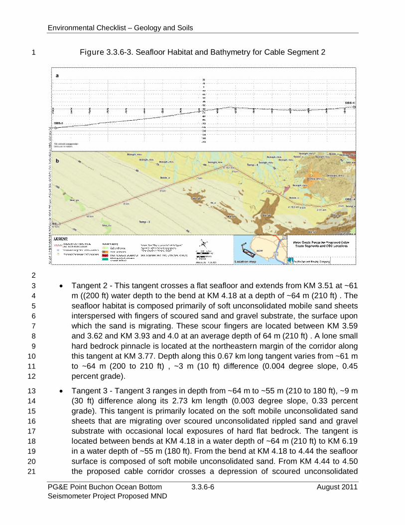
Environmental Checklist – Geology and Soils
PG&E Point Buchon Ocean Bottom 3.3.6-6 August 2011Seismometer Project Proposed MND
Figure 3.3.6-3. Seafloor Habitat and Bathymetry for Cable Segment 21
2
Tangent 2 - This tangent crosses a flat seafloor and extends from KM 3.51 at ~613
m ((200 ft) water depth to the bend at KM 4.18 at a depth of ~64 m (210 ft) . The4
seafloor habitat is composed primarily of soft unconsolidated mobile sand sheets5
interspersed with fingers of scoured sand and gravel substrate, the surface upon6
which the sand is migrating. These scour fingers are located between KM 3.597
and 3.62 and KM 3.93 and 4.0 at an average depth of 64 m (210 ft) . A lone small8
hard bedrock pinnacle is located at the northeastern margin of the corridor along9
this tangent at KM 3.77. Depth along this 0.67 km long tangent varies from ~61 m10
to ~64 m (200 to 210 ft) , ~3 m (10 ft) difference (0.004 degree slope, 0.4511
percent grade).12
Tangent 3 - Tangent 3 ranges in depth from ~64 m to ~55 m (210 to 180 ft), ~9 m13
(30 ft) difference along its 2.73 km length (0.003 degree slope, 0.33 percent14
grade). This tangent is primarily located on the soft mobile unconsolidated sand15
sheets that are migrating over scoured unconsolidated rippled sand and gravel16
substrate with occasional local exposures of hard flat bedrock. The tangent is17
located between bends at KM 4.18 in a water depth of ~64 m (210 ft) to KM 6.1918
in a water depth of ~55 m (180 ft). From the bend at KM 4.18 to 4.44 the seafloor19
surface is composed of soft mobile unconsolidated sand. From KM 4.44 to 4.5020
the proposed cable corridor crosses a depression of scoured unconsolidated21
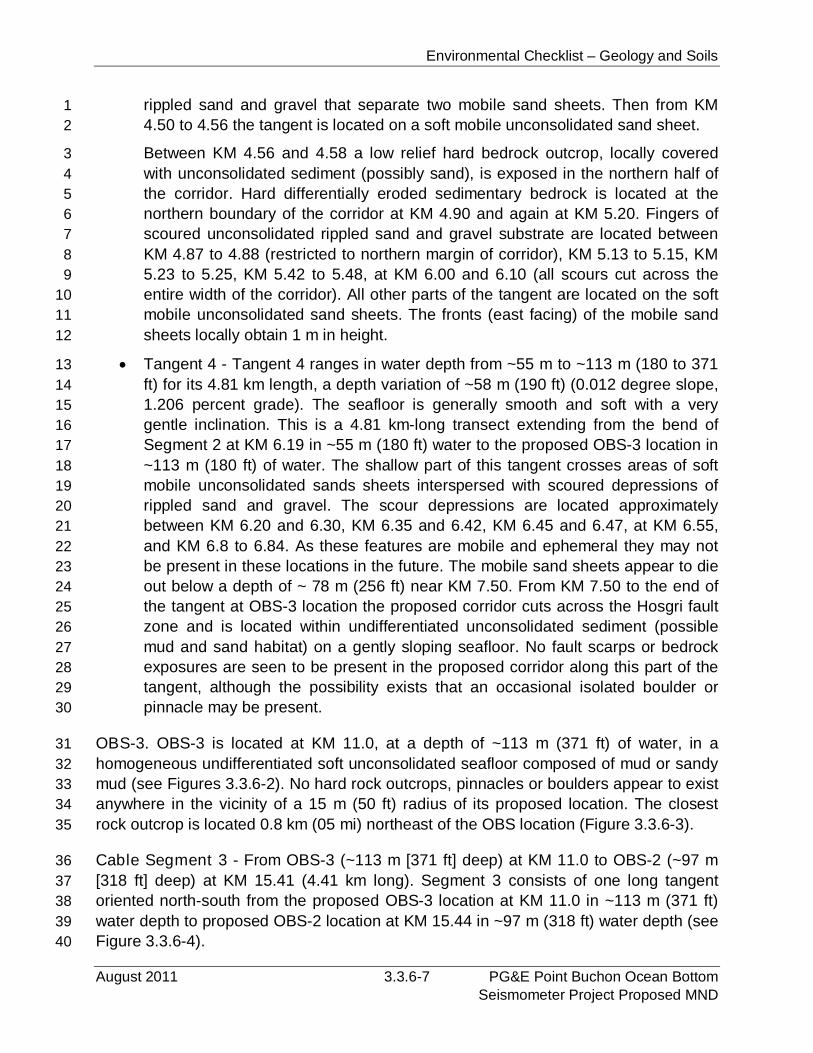
Environmental Checklist – Geology and Soils
August 2011 3.3.6-7 PG&E Point Buchon Ocean BottomSeismometer Project Proposed MND
rippled sand and gravel that separate two mobile sand sheets. Then from KM1
4.50 to 4.56 the tangent is located on a soft mobile unconsolidated sand sheet.2
Between KM 4.56 and 4.58 a low relief hard bedrock outcrop, locally covered3
with unconsolidated sediment (possibly sand), is exposed in the northern half of4
the corridor. Hard differentially eroded sedimentary bedrock is located at the5
northern boundary of the corridor at KM 4.90 and again at KM 5.20. Fingers of6
scoured unconsolidated rippled sand and gravel substrate are located between7
KM 4.87 to 4.88 (restricted to northern margin of corridor), KM 5.13 to 5.15, KM8
5.23 to 5.25, KM 5.42 to 5.48, at KM 6.00 and 6.10 (all scours cut across the9
entire width of the corridor). All other parts of the tangent are located on the soft10
mobile unconsolidated sand sheets. The fronts (east facing) of the mobile sand11
sheets locally obtain 1 m in height.12
Tangent 4 - Tangent 4 ranges in water depth from ~55 m to ~113 m (180 to 37113
ft) for its 4.81 km length, a depth variation of ~58 m (190 ft) (0.012 degree slope,14
1.206 percent grade). The seafloor is generally smooth and soft with a very15
gentle inclination. This is a 4.81 km-long transect extending from the bend of16
Segment 2 at KM 6.19 in ~55 m (180 ft) water to the proposed OBS-3 location in17
~113 m (180 ft) of water. The shallow part of this tangent crosses areas of soft18
mobile unconsolidated sands sheets interspersed with scoured depressions of19
rippled sand and gravel. The scour depressions are located approximately20
between KM 6.20 and 6.30, KM 6.35 and 6.42, KM 6.45 and 6.47, at KM 6.55,21
and KM 6.8 to 6.84. As these features are mobile and ephemeral they may not22
be present in these locations in the future. The mobile sand sheets appear to die23
out below a depth of ~ 78 m (256 ft) near KM 7.50. From KM 7.50 to the end of24
the tangent at OBS-3 location the proposed corridor cuts across the Hosgri fault25
zone and is located within undifferentiated unconsolidated sediment (possible26
mud and sand habitat) on a gently sloping seafloor. No fault scarps or bedrock27
exposures are seen to be present in the proposed corridor along this part of the28
tangent, although the possibility exists that an occasional isolated boulder or29
pinnacle may be present.30
OBS-3. OBS-3 is located at KM 11.0, at a depth of ~113 m (371 ft) of water, in a31
homogeneous undifferentiated soft unconsolidated seafloor composed of mud or sandy32
mud (see Figures 3.3.6-2). No hard rock outcrops, pinnacles or boulders appear to exist33
anywhere in the vicinity of a 15 m (50 ft) radius of its proposed location. The closest34
rock outcrop is located 0.8 km (05 mi) northeast of the OBS location (Figure 3.3.6-3).35
Cable Segment 3 - From OBS-3 (~113 m [371 ft] deep) at KM 11.0 to OBS-2 (~97 m36
[318 ft] deep) at KM 15.41 (4.41 km long). Segment 3 consists of one long tangent37
oriented north-south from the proposed OBS-3 location at KM 11.0 in ~113 m (371 ft)38
water depth to proposed OBS-2 location at KM 15.44 in ~97 m (318 ft) water depth (see39
Figure 3.3.6-4).40
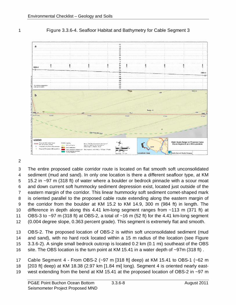
Environmental Checklist – Geology and Soils
PG&E Point Buchon Ocean Bottom 3.3.6-8 August 2011Seismometer Project Proposed MND
Figure 3.3.6-4. Seafloor Habitat and Bathymetry for Cable Segment 31
2
The entire proposed cable corridor route is located on flat smooth soft unconsolidated3
sediment (mud and sand). In only one location is there a different seafloor type, at KM4
15.2 in ~97 m (318 ft) of water where a boulder or bedrock pinnacle with a scour moat5
and down current soft hummocky sediment depression exist, located just outside of the6
eastern margin of the corridor. This linear hummocky soft sediment comet-shaped mark7
is oriented parallel to the proposed cable route extending along the eastern margin of8
the corridor from the boulder at KM 15.2 to KM 14.9, 300 m (984 ft) in length. The9
difference in depth along this 4.41 km-long segment ranges from ~113 m (371 ft) at10
OBS-3 to ~97 m (318 ft) at OBS-2, a total of ~16 m (52 ft) for the 4.41 km-long segment11
(0.004 degree slope, 0.363 percent grade). This segment is extremely flat and smooth.12
OBS-2. The proposed location of OBS-2 is within soft unconsolidated sediment (mud13
and sand), with no hard rock located within a 15 m radius of the location (see Figure14
3.3.6-2). A single small bedrock outcrop is located 0.2 km (0.1 mi) southeast of the OBS15
site. The OBS location is the turn point at KM 15.41 in a water depth of ~97m (318 ft) .16
Cable Segment 4 - From OBS-2 (~97 m [318 ft] deep) at KM 15.41 to OBS-1 (~62 m17
[203 ft] deep) at KM 18.38 (2.97 km [1.84 mi] long). Segment 4 is oriented nearly east-18
west extending from the bend at KM 15.41 at the proposed location of OBS-2 in ~97 m19
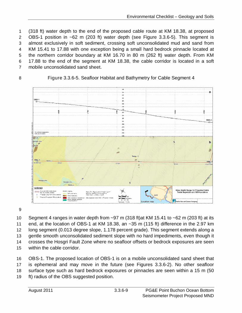
Environmental Checklist – Geology and Soils
August 2011 3.3.6-9 PG&E Point Buchon Ocean BottomSeismometer Project Proposed MND
(318 ft) water depth to the end of the proposed cable route at KM 18.38, at proposed1
OBS-1 position in ~62 m (203 ft) water depth (see Figure 3.3.6-5). This segment is2
almost exclusively in soft sediment, crossing soft unconsolidated mud and sand from3
KM 15.41 to 17.88 with one exception being a small hard bedrock pinnacle located at4
the northern corridor boundary at KM 16.70 in 80 m (262 ft) water depth. From KM5
17.88 to the end of the segment at KM 18.38, the cable corridor is located in a soft6
mobile unconsolidated sand sheet.7
Figure 3.3.6-5. Seafloor Habitat and Bathymetry for Cable Segment 48
9
Segment 4 ranges in water depth from ~97 m (318 ft)at KM 15.41 to ~62 m (203 ft) at its10
end, at the location of OBS-1 at KM 18.38, an ~35 m (115 ft) difference in the 2.97 km11
long segment (0.013 degree slope, 1.178 percent grade). This segment extends along a12
gentle smooth unconsolidated sediment slope with no hard impediments, even though it13
crosses the Hosgri Fault Zone where no seafloor offsets or bedrock exposures are seen14
within the cable corridor.15
OBS-1. The proposed location of OBS-1 is on a mobile unconsolidated sand sheet that16
is ephemeral and may move in the future (see Figures 3.3.6-2). No other seafloor17
surface type such as hard bedrock exposures or pinnacles are seen within a 15 m (5018
ft) radius of the OBS suggested position.19
Environmental Checklist – Geology and Soils
PG&E Point Buchon Ocean Bottom 3.3.6-10 August 2011Seismometer Project Proposed MND
Temporary OBS-4. Temporary OBS-4 is located on flat seafloor in a soft scour1
depression of unconsolidated rippled sand and gravel. This type of substrate exists2
within the 15 m (50 ft) radius around the suggested OBS position; however soft mobile3
unconsolidated sand sheets surround the rippled scour depression and may migrate4
across the location in the future. Southeast of this OBS location is a series of5
differentially eroded sedimentary bedrock exposures, and 0.22 km (0.14 mi) east of the6
location is an extensive outcrop of sedimentary bedrock.7
Temporary OBS-3. Temporary OBS-3 proposed location is in soft unconsolidated mud8
and sand on flat seafloor. No other habitat type exists within a 15 m-(50 ft) radius of the9
suggested position.10
Temporary OBS-2. Temporary OBS-2 proposed location is in soft unconsolidated mud11
and sand on a flat seafloor. No other habitat type exists within a 15 m-(50 ft) radius of12
the suggested position.13
Temporary OBS-1. Temporary OBS-1 proposed location is in soft unconsolidated mud14
and sand on flat seafloor. No other habitat type exists within 15 m-(50 ft) radius of the15
suggested position.16
Faulting and Seismicity. The Project area is located in a seismically active region and17
has experienced numerous historic seismic events resulting from movement along18
onshore and offshore faults. The Hosgri Fault Zone, the southernmost component of the19
complex San Gregorio-San Simeon-Hosgri fault system, extends about 113 km (70 mi)20
from Point Pedernales to near San Simeon, trending to the northwest and remaining21
offshore for its entire length. The Hosgri fault is primarily a strike-slip fault with a22
subordinate amount of dip slip that varies along strike. The California Geological Survey23
(CGS) defines a fault as active if it has had surface displacement within the Holocene24
period (approximately the last 11,000 years). Several studies (i.e., Lettis et al. 2004, and25
Bryant 2005) have shown that the Hosgri fault is active. The proposed OBS units and26
cable would extend across the Hosgri Fault Zone in the vicinity of the DCPP (Figure 2-27
2). In 2009, seismic studies identified a coast-parallel, near-shore bedrock fault zone28
that lies within the epicentral uncertainty of the seismicity lineament called the Shoreline29
fault zone. The Shoreline fault zone is divided into three segments based on differences30
in the geologic and geomorphic expression of surface and near-surface faulting,31
intersections with other mapped structures, features observed in the high-resolution32
magnetic field data, and variations in the continuity, trend, and depth of the seismicity33
along the lineament.34
Regional onshore faults include the Edna, Los Osos and Oceanic faults, approximately35
8 km (5 mi), 11.2 km (7 mi), and 20.8 km (13 mi) to the east respectively, and the San36
Andreas fault, approximately 75 km (47 mi) to the northeast at its closest point.37
Environmental Checklist – Geology and Soils
August 2011 3.3.6-11 PG&E Point Buchon Ocean BottomSeismometer Project Proposed MND
3.3.6.2 Regulatory Setting1
Federal. There are no federal regulations related to geology and soils relevant to the2
proposed Project.3
State. California is a highly geologically-active area, and therefore has substantial4
relevant regulatory requirements. The regulations listed below are at least partially5
applicable to the proposed Project.6
Alquist-Priolo Earthquake Fault Zoning Act of 1972 (Pub. Resources Code §§ 2621-7
2630). This act (formerly known as the Special Studies Zoning Act) requires that8
"sufficiently active" and "well-defined" earthquake fault zones be delineated by the state9
geologists and prohibits locating structures for human occupancy across the trace of an10
active fault. This act does not specifically apply to marine installations like the Project,11
but it does help define areas where fault rupture is most likely to occur onshore.12
California Building Code (CBC). The CBC contains requirements related to13
excavation, grading, and construction. According to the CBC, a grading permit is14
required if more than 50 cubic yards (38.2 m3) of soil are moved. Chapter 33 of the CBC15
contains requirements relevant to the construction of pipelines alongside existing16
structures. CCR Title 23, §§ 3301.2 and 3301.3 contain the provisions requiring17
protection of the adjacent property during excavations and require a 10-day written18
notice and access agreements with the adjacent property owners. The CBC does not19
specifically apply to offshore marine installations.20
California Seismic Hazards Mapping Act of 1990 (Pub. Resources Code § 2690 and21
following as Division 2, Chapter 7.8) and the Seismic Hazards Mapping Regulations22
(CCR Title 14, Division 2, Chapter 8, Article 10). Designed to protect the public from the23
effects of strong ground shaking, liquefaction, landslides, other ground failures, or other24
hazards caused by earthquakes, the act requires that site-specific geotechnical25
investigations be conducted identifying the hazard and formulating mitigation measures26
prior to permitting most developments designed for human occupancy. Special27
Publication 117, Guidelines for Evaluating and Mitigating Seismic Hazards in California28
(CGS 2008), constitutes the guidelines for evaluating seismic hazards other than29
surface fault rupture and for recommending mitigation measures as required by Public30
Resources Code § 2695(a). This act does not specifically apply to marine cable31
installations like the Project.32
Local. There are no local regulations related to geology and soils relevant to the33
proposed Project.34
Environmental Checklist – Geology and Soils
PG&E Point Buchon Ocean Bottom 3.3.6-12 August 2011Seismometer Project Proposed MND
3.3.6.3 Impact Analysis1
The proposed Project would not result in changes to existing power generation2
operations or facilities at the DCPP. This evaluation of potential geology and soils3
impacts considers possible effects related to the seismic monitoring equipment that4
would be provided by the proposed Project, which consists of temporary and long-term5
OBS units, associated power/data transfer cable, and a new cable conduit.6
a) Expose people or structures to potential substantial adverse effects,7
including the risk of loss, injury, or death involving:8
i) Rupture of a known earthquake fault, as delineated on the most recent9
Alquist-Priolo Earthquake Fault Zoning Map issued by the State10
Geologist for the area or based on other substantial evidence of a11
known fault? Refer to Division of Mines and Geology Special12
Publication 42.13
ii) Strong seismic ground shaking?14
iii) Seismic-related ground failure, including liquefaction?15
iv) Landslides?16
The Project objective is to deploy seismic monitoring equipment that would be used to17
gather accurate real-time data regarding seismic events that occur in the Project area.18
To accomplish this objective, proposed temporary and long-term OBS units, and19
associated power/data transfer cable would be deployed in offshore locations within the20
Hosgri Fault Zone. Although the monitoring equipment could be adversely affected if21
earthquake-related ground rupture or ground shaking were to occur, such effects would22
not result in a substantial risk of loss, injury or death. Therefore, potential ground23
rupture and ground shaking impacts to proposed seismic monitoring equipment are less24
than significant.25
Proposed OBS units and cable would be located offshore in generally level areas.26
Therefore, the seismic monitoring equipment would not be subject to significant effects27
resulting from ground failure, liquefaction or landslides. The proposed power/data28
transfer cable would come ashore at the DCPP facility and would be located in a new29
cable conduit to be provided on an existing rock rip area. The new conduit would have30
no impact on the geologic hazards such as ground rupture, ground shaking, ground31
failure or landslides.32
b) Result in substantial soil erosion or the loss of topsoil?33
The proposed Project would not result in any ground disturbing activities at the DCPP34
facility and would not result in any soil erosion or loss of topsoil impacts.35
Environmental Checklist – Geology and Soils
August 2011 3.3.6-13 PG&E Point Buchon Ocean BottomSeismometer Project Proposed MND
c) Be located on a geologic unit or soil that is unstable, or that would become1
unstable as a result of the Project, and potentially result in on- or off-site2
landslide, lateral spreading, subsidence, liquefaction or collapse?3
See response below.4
d) Be located on expansive soil, as defined in Table 18-1-B of the Uniform5
Building Code (1994), creating substantial risks to life or property?6
The only onshore component of the proposed Project would be a new cable conduit to7
be located on top of a rock rip-rap area. Therefore, the Project would not result in any8
structural development that could be adversely affected by soil-related hazards such as9
landslides, subsidence, liquefaction or expansive soil.10
e) Have soils incapable of adequately supporting the use of septic tanks or11
alternative waste water disposal systems where sewers are not available12
for the disposal of waste water?13
The proposed Project would not result in any development that would increase the14
generation of wastewater or require the use of an individual waste water treatment or15
disposal system.16
3.3.6.4 Mitigation and Residual Impact17
Mitigation. The proposed Project would not result in significant geology or soils impacts18
and no mitigation measures are required.19
Residual Impacts. The proposed Project would have no significant geology or soils20
impacts. No mitigation is required and no residual impacts would occur.21

Environmental Checklist – Geology and Soils
PG&E Point Buchon Ocean Bottom 3.3.6-14 August 2011Seismometer Project Proposed MND
PAGE PURPOSEFULLY LEFT BLANK
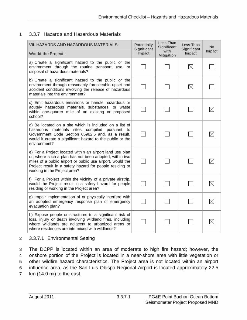
Environmental Checklist – Hazards and Hazardous Materials
August 2011 3.3.7-1 PG&E Point Buchon Ocean BottomSeismometer Project Proposed MND
3.3.7 Hazards and Hazardous Materials1
VII. HAZARDS AND HAZARDOUS MATERIALS:
Would the Project:
PotentiallySignificant
Impact
Less ThanSignificant
withMitigation
Less ThanSignificant
Impact
NoImpact
a) Create a significant hazard to the public or theenvironment through the routine transport, use, ordisposal of hazardous materials?
b) Create a significant hazard to the public or theenvironment through reasonably foreseeable upset andaccident conditions involving the release of hazardousmaterials into the environment?
c) Emit hazardous emissions or handle hazardous oracutely hazardous materials, substances, or wastewithin one-quarter mile of an existing or proposedschool?
d) Be located on a site which is included on a list ofhazardous materials sites compiled pursuant toGovernment Code Section 65962.5 and, as a result,would it create a significant hazard to the public or theenvironment?
e) For a Project located within an airport land use planor, where such a plan has not been adopted, within twomiles of a public airport or public use airport, would theProject result in a safety hazard for people residing orworking in the Project area?
f) For a Project within the vicinity of a private airstrip,would the Project result in a safety hazard for peopleresiding or working in the Project area?
g) Impair implementation of or physically interfere withan adopted emergency response plan or emergencyevacuation plan?
h) Expose people or structures to a significant risk ofloss, injury or death involving wildland fires, includingwhere wildlands are adjacent to urbanized areas orwhere residences are intermixed with wildlands?
3.3.7.1 Environmental Setting2
The DCPP is located within an area of moderate to high fire hazard; however, the3
onshore portion of the Project is located in a near-shore area with little vegetation or4
other wildfire hazard characteristics. The Project area is not located within an airport5
influence area, as the San Luis Obispo Regional Airport is located approximately 22.56
km (14.0 mi) to the east.7
Environmental Checklist – Hazards and Hazardous Materials
PG&E Point Buchon Ocean Bottom 3.3.7-2 August 2011Seismometer Project Proposed MND
There have been no documented releases of hazardous waste at the DCPP facility and1
no active corrective action operations are occurring. There are hazardous materials and2
hazardous waste materials associated with nuclear power generation within the DCCP.3
These materials are situated within the DCCP site reactor units and waste storage4
areas, and are remote from the onshore activities of the proposed Project. The5
proposed Project would not affect the operation of any existing hazardous material or6
waste management facilities or activities.7
Offshore areas near the DCPP are used for commercial and recreational fishing.8
Further offshore, marine traffic use designated shipping lanes that vary in distance from9
shore based on the cargo being carried and generally parallel the coastline.10
3.3.7.2 Regulatory Setting11
This section identifies selected regulations and policies that are administered by federal,12
state, and local agencies and that pertain to the reduction of hazards and the13
management of hazardous materials.14
Federal15
Clean Water Act of 1972. The CWA is a comprehensive piece of legislation that16
generally includes reference to the Federal Water Pollution Control Act of 1972, its17
substantial supplementation by the CWA of 1977, and subsequent amendments in18
1981, 1987, and 1993. Overall, the CWA seeks to protect the nation’s water from19
pollution by setting water quality standards for surface water and by limiting the20
discharge of effluents into waters of the U.S. These water quality standards are21
enforced by the EPA. The CWA also provides for development of municipal and22
industrial wastewater treatment standards and a permitting system to control23
wastewater discharges to surface waters.24
International Navigational Rules Act of 1977. The international rules and regulations25
governing operations at sea were formalized at the Convention on the International26
Regulations for Preventing Collisions at Sea in 1972 and became effective on July 15,27
1977. Congress adopted these rules and regulations as the International Navigational28
Rules Act of 1977, commonly called 72 COLREGS. These rules, with 198929
amendments, identify all the regulations that govern operations on U.S. navigable30
waters. The rules are administered and enforced by the USCG.31
Oil Pollution Act of 1990. The Oil Pollution Act (OPA) of 1990 (33 U.S.C. § 2712)32
requires owners and operators of facilities that could cause substantial harm to the33
environment to prepare and submit plans for responding to worst-case discharges of oil34
and hazardous substances. The passage of OPA motivated the State of California to35
pass a more stringent spill response and recovery regulation and the creation of the36
OSPR to review and regulate oil spill plans and contracts.37
Environmental Checklist – Hazards and Hazardous Materials
August 2011 3.3.7-3 PG&E Point Buchon Ocean BottomSeismometer Project Proposed MND
State1
Lempert-Keene-Seastrand Oil Spill Prevention and Response Act (OSPRA).2
OSPRA established the OSPR division of the CDFG to provide protection of California's3
natural resources from petroleum discharges. The Act covers all aspects of marine oil4
spill prevention and response in California. It established an Administrator who is given5
broad powers to implement the provisions of the Act.6
Porter-Cologne Water Quality Control Act of 1969 (Cal. Water Code § 13000 et7
seq.). This act mandates that the waters of the State shall be protected, such that8
activities, which may affect waters of the State, shall be regulated to attain the highest9
quality. This Act established the SWRCB as the principal state agency for coordinated10
and controlling water quality in California. The SWRCB provides regulations mandating11
a “non-degradation policy” for state waters, especially those of high quality. The12
SWRCB is divided into local regional boards.13
Local. San Luis Obispo County is responsible for enforcing the state regulations for14
hazardous substance generators, hazardous substance storage, and underground15
storage tanks (including inspections, enforcement, and removals) within the Project16
area. The San Luis Obispo County Environmental Health Division (EHD) regulates the17
use, storage, and disposal of hazardous substances in the county by issuing permits,18
monitoring regulatory compliance, investigating complaints, and other enforcement19
activities. The EHD reviews technical aspects of hazardous substance site cleanups20
and oversees remediation of contaminated sites resulting from leaking underground21
storage tanks. It is also responsible for providing technical assistance to public and22
private entities seeking to minimize the generation of hazardous substances.23
3.3.7.3 Impact Analysis24
Two factors can be used to determine the significance of impacts potentially resulting25
from an upset condition: criticality and frequency. Criticality classifications, which range26
from negligible to disastrous, are defined in Table 3.3.7-1. Frequency classifications,27
which range from extraordinary to frequent, are defined in Table 3.3.7-2. When28
evaluated together, these two factors define a threshold of significance. This is shown in29
Table 3.3.7-3 where the shaded areas in the matrix represent significant impacts.30
The DCPP is a nuclear-powered facility that generates electricity. The proposed Project31
would not alter any existing power generation or associated operations at the facility.32
Hazardous material use that would result from the implementation of the Project would33
generally be limited to hydrocarbons associated with fueling and maintenance of34
equipment and vessels.35
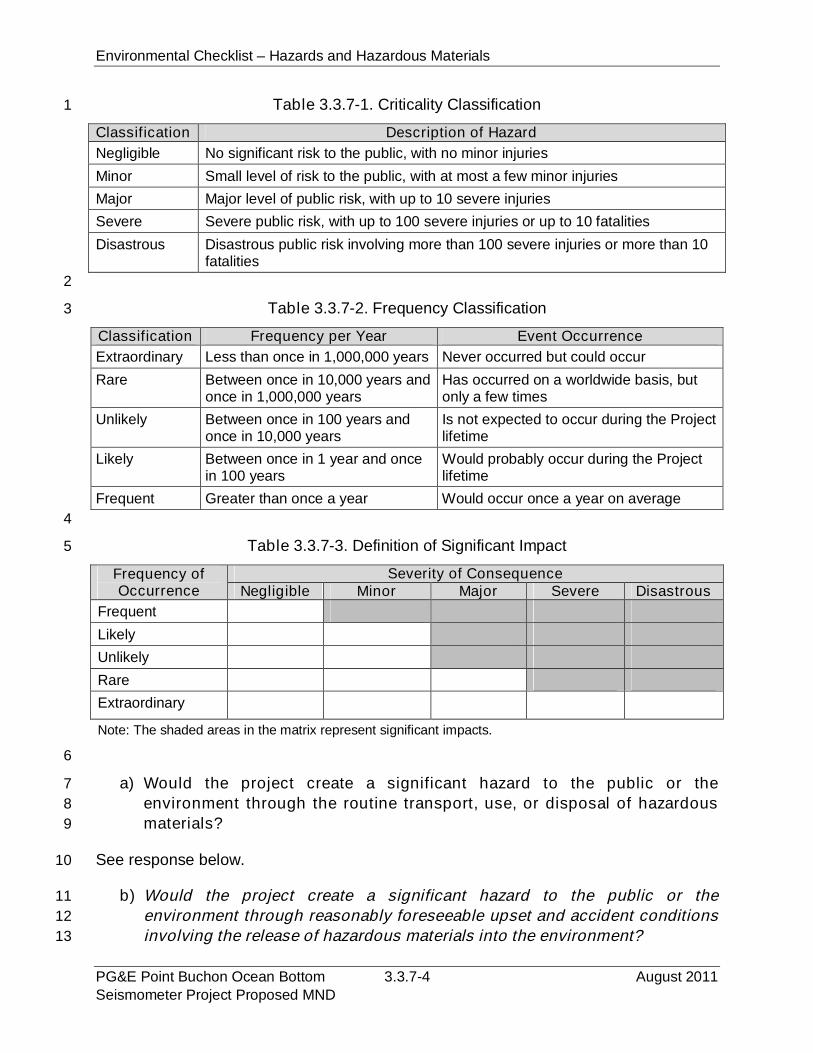
Environmental Checklist – Hazards and Hazardous Materials
PG&E Point Buchon Ocean Bottom 3.3.7-4 August 2011Seismometer Project Proposed MND
Table 3.3.7-1. Criticality Classification1
Classification Description of Hazard
Negligible No significant risk to the public, with no minor injuries
Minor Small level of risk to the public, with at most a few minor injuries
Major Major level of public risk, with up to 10 severe injuries
Severe Severe public risk, with up to 100 severe injuries or up to 10 fatalities
Disastrous Disastrous public risk involving more than 100 severe injuries or more than 10fatalities
2
Table 3.3.7-2. Frequency Classification3
Classification Frequency per Year Event Occurrence
Extraordinary Less than once in 1,000,000 years Never occurred but could occur
Rare Between once in 10,000 years andonce in 1,000,000 years
Has occurred on a worldwide basis, butonly a few times
Unlikely Between once in 100 years andonce in 10,000 years
Is not expected to occur during the Projectlifetime
Likely Between once in 1 year and oncein 100 years
Would probably occur during the Projectlifetime
Frequent Greater than once a year Would occur once a year on average
4
Table 3.3.7-3. Definition of Significant Impact5
Frequency ofOccurrence
Severity of ConsequenceNegligible Minor Major Severe Disastrous
Frequent
Likely
Unlikely
Rare
Extraordinary
Note: The shaded areas in the matrix represent significant impacts.
6
a) Would the project create a significant hazard to the public or the7
environment through the routine transport, use, or disposal of hazardous8
materials?9
See response below.10
b) Would the project create a significant hazard to the public or the11
environment through reasonably foreseeable upset and accident conditions12
involving the release of hazardous materials into the environment?13
Environmental Checklist – Hazards and Hazardous Materials
August 2011 3.3.7-5 PG&E Point Buchon Ocean BottomSeismometer Project Proposed MND
Although unlikely, the release of petroleum or other substance into the marine1
environment from the construction vessel or equipment could result in potentially2
significant impacts to marine biota, particularly avifauna and early life stage forms of fish3
and invertebrates, which are sensitive to those effects. Refined products (i.e., diesel and4
gasoline) are more toxic than heavier crude or Bunker-type products and, in the event of5
a spill during refueling or maintenance activities, could cause coating of organisms and6
alteration of habitat should heavier oil attach to rocky substrate. The potential for a7
Project-related release of diesel fuel, gasoline or other hazardous substance would be8
substantially reduced because vessel fueling would only occur at an approved docking9
facility, and no cross vessel fueling would occur. Due to the short, one-week Project-10
related construction duration, the potential for a release of hazardous materials in that11
period is very low. Onboard spill response equipment and contracted services would12
also be provided and sufficient to contain and recover a petroleum product spill. Impacts13
of an accidental release would be further reduced through the implementation of the Oil14
Spill Contingency Plan (OSCP) maintained by the MV Michael Uhl (Appendix B).15
OSCPs are standard requirements for the offshore construction industry and provide16
detailed measures to prevent spills and dispose of hazardous materials. Implementation17
of the OSCP and APMs will reduce the potential for and consequences of a hazardous18
material release to a less than significant level. No mitigation measures are required.19
c) Would the project emit hazardous emissions or handle hazardous or20
acutely hazardous materials, substances, or waste within one-quarter mile21
of an existing or proposed school?22
No Project-related operations would occur within one-quarter mile of a school.23
d) Would the project be located on a site which is included on a list of24
hazardous materials sites compiled pursuant to Government Code Section25
65962.5 and, as a result, would it create a significant hazard to the public or26
the environment?27
No Government Code section 65962.5-compiled hazardous materials or waste sites are28
at or near the Project location.29
e) For a Project located within an airport land use plan or, where such a plan30
has not been adopted, within two miles of a public airport or public use31
airport, would the Project result in a safety hazard for people residing or32
working in the Project area?33
See response below.34
f) For a Project within the vicinity of a private airstrip, would the Project result35
in a safety hazard for people residing or working in the Project area?36
Environmental Checklist – Hazards and Hazardous Materials
PG&E Point Buchon Ocean Bottom 3.3.7-6 August 2011Seismometer Project Proposed MND
The proposed Project would not affect operations at a public or private airport or airstrip.1
g) Would the project impair implementation of or physically interfere with an2
adopted emergency response plan or emergency evacuation plan?3
Construction activities would occur over a short period of time and would not generate a4
substantial increase in vehicular traffic. Therefore, the Project would not have an impact5
on emergency evacuation procedures that have been established for the DCPP.6
h) Would the project expose people or structures to a significant risk of loss,7
injury or death involving wildland fires, including where wildlands are adjacent8
to urbanized areas or where residences are intermixed with wildlands?9
Most Project-related construction activities would occur offshore and onshore10
construction activities would not occur in or near areas with substantial vegetation that11
would contribute to potential wildfire hazard impacts. As a result, the Project would have12
no impact related to an increase in wildfire risk.13
3.3.7.4 Mitigation and Residual Impacts14
Mitigation. Implementation of existing regulations, standard offshore construction15
industry standards for the containment and recovery of spills (the OSCP maintained by16
the MV Michael Uhl), and the implementation of the APMs below would reduce the17
potential for an accidental release of petroleum or other hazardous material products to18
a less than significant level. No hazardous material release mitigation measures are19
required. The proposed Project would have no impact related to airport operations,20
wildfire risk, evacuation planning, or other hazardous material-related impacts.21
APM-1 Vessel fueling shall only occur at an approved docking facility. No cross22
vessel fueling shall be allowed. Marine vessels generally shall contain23
petroleum products within tankage that is internal to the hulls of the vessels.24
APM-2 Project shall be scheduled in the late fall/early winter months when whale25
activity is lowest and weather conditions are conducive to expeditious and26
safe vessel operations.27
APM-4 All operations shall be completed during the daytime hours; no nightime28
operations are proposed.29
APM-5 Onboard spill response equipment and contracted services shall be sufficient30
to contain and recover the worst-case scenario spill of petroleum products.31
Residual Impacts. The proposed Project would have less than significant impacts32
related to the potential for an accidental release of hazardous materials, and no impact33
related to airport operations, wildfire risk, evacuation planning, or other hazardous34
material-related impacts. No significant residual impacts would occur.35
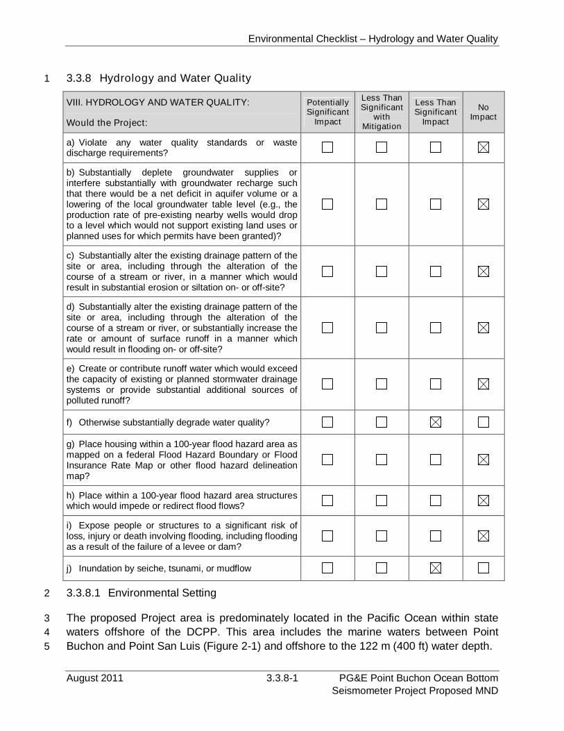
Environmental Checklist – Hydrology and Water Quality
August 2011 3.3.8-1 PG&E Point Buchon Ocean BottomSeismometer Project Proposed MND
3.3.8 Hydrology and Water Quality1
VIII. HYDROLOGY AND WATER QUALITY:
Would the Project:
PotentiallySignificant
Impact
Less ThanSignificant
withMitigation
Less ThanSignificant
Impact
NoImpact
a) Violate any water quality standards or wastedischarge requirements?
b) Substantially deplete groundwater supplies orinterfere substantially with groundwater recharge suchthat there would be a net deficit in aquifer volume or alowering of the local groundwater table level (e.g., theproduction rate of pre-existing nearby wells would dropto a level which would not support existing land uses orplanned uses for which permits have been granted)?
c) Substantially alter the existing drainage pattern of thesite or area, including through the alteration of thecourse of a stream or river, in a manner which wouldresult in substantial erosion or siltation on- or off-site?
d) Substantially alter the existing drainage pattern of thesite or area, including through the alteration of thecourse of a stream or river, or substantially increase therate or amount of surface runoff in a manner whichwould result in flooding on- or off-site?
e) Create or contribute runoff water which would exceedthe capacity of existing or planned stormwater drainagesystems or provide substantial additional sources ofpolluted runoff?
f) Otherwise substantially degrade water quality?
g) Place housing within a 100-year flood hazard area asmapped on a federal Flood Hazard Boundary or FloodInsurance Rate Map or other flood hazard delineationmap?
h) Place within a 100-year flood hazard area structureswhich would impede or redirect flood flows?
i) Expose people or structures to a significant risk ofloss, injury or death involving flooding, including floodingas a result of the failure of a levee or dam?
j) Inundation by seiche, tsunami, or mudflow
3.3.8.1 Environmental Setting2
The proposed Project area is predominately located in the Pacific Ocean within state3
waters offshore of the DCPP. This area includes the marine waters between Point4
Buchon and Point San Luis (Figure 2-1) and offshore to the 122 m (400 ft) water depth.5
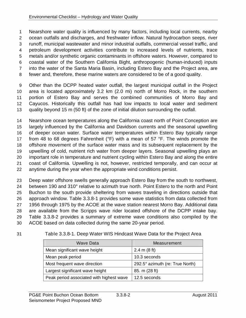
Environmental Checklist – Hydrology and Water Quality
PG&E Point Buchon Ocean Bottom 3.3.8-2 August 2011Seismometer Project Proposed MND
Nearshore water quality is influenced by many factors, including local currents, nearby1
ocean outfalls and discharges, and freshwater inflow. Natural hydrocarbon seeps, river2
runoff, municipal wastewater and minor industrial outfalls, commercial vessel traffic, and3
petroleum development activities contribute to increased levels of nutrients, trace4
metals and/or synthetic organic contaminants in offshore waters. However, compared to5
coastal water of the Southern California Bight, anthropogenic (human-induced) inputs6
into the water of the Santa Maria Basin, including Estero Bay and the Project area, are7
fewer and, therefore, these marine waters are considered to be of a good quality.8
Other than the DCPP heated water outfall, the largest municipal outfall in the Project9
area is located approximately 3.2 km (2.0 mi) north of Morro Rock, in the southern10
portion of Estero Bay and serves the combined communities of Morro Bay and11
Cayucos. Historically this outfall has had low impacts to local water and sediment12
quality beyond 15 m (50 ft) of the zone of initial dilution surrounding the outfall.13
Nearshore ocean temperatures along the California coast north of Point Conception are14
largely influenced by the California and Davidson currents and the seasonal upwelling15
of deeper ocean water. Surface water temperatures within Estero Bay typically range16
from 48 to 68 degrees Fahrenheit (°F) with a mean of 57 °F. The winds promote the17
offshore movement of the surface water mass and its subsequent replacement by the18
upwelling of cold, nutrient rich water from deeper layers. Seasonal upwelling plays an19
important role in temperature and nutrient cycling within Estero Bay and along the entire20
coast of California. Upwelling is not, however, restricted temporally, and can occur at21
anytime during the year when the appropriate wind conditions persist.22
Deep water offshore swells generally approach Estero Bay from the south to northwest,23
between 190 and 310° relative to azimuth true north. Point Estero to the north and Point24
Buchon to the south provide sheltering from waves traveling in directions outside that25
approach window. Table 3.3.8-1 provides some wave statistics from data collected from26
1956 through 1975 by the ACOE at the wave station nearest Morro Bay. Additional data27
are available from the Scripps wave rider located offshore of the DCPP intake bay.28
Table 3.3.8-2 provides a summary of extreme wave conditions also compiled by the29
ACOE based on data collected during the same 20-year period.30
Table 3.3.8-1. Deep Water WIS Hindcast Wave Data for the Project Area31
Wave Data Measurement
Mean significant wave height 2.4 m (8 ft)
Mean peak period 10.3 seconds
Most frequent wave direction 292.5° azimuth (re: True North)
Largest significant wave height 85. m (28 ft)
Peak period associated with highest wave 12.5 seconds
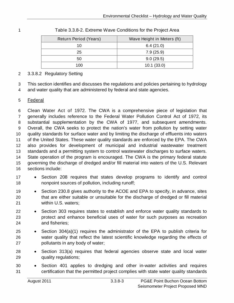
Environmental Checklist – Hydrology and Water Quality
August 2011 3.3.8-3 PG&E Point Buchon Ocean BottomSeismometer Project Proposed MND
Table 3.3.8-2. Extreme Wave Conditions for the Project Area1
Return Period (Years) Wave Height in Meters (ft)
10 6.4 (21.0)
25 7.9 (25.9)
50 9.0 (29.5)
100 10.1 (33.0)
3.3.8.2 Regulatory Setting2
This section identifies and discusses the regulations and policies pertaining to hydrology3
and water quality that are administered by federal and state agencies.4
Federal5
Clean Water Act of 1972. The CWA is a comprehensive piece of legislation that6
generally includes reference to the Federal Water Pollution Control Act of 1972, its7
substantial supplementation by the CWA of 1977, and subsequent amendments.8
Overall, the CWA seeks to protect the nation’s water from pollution by setting water9
quality standards for surface water and by limiting the discharge of effluents into waters10
of the United States. These water quality standards are enforced by the EPA. The CWA11
also provides for development of municipal and industrial wastewater treatment12
standards and a permitting system to control wastewater discharges to surface waters.13
State operation of the program is encouraged. The CWA is the primary federal statute14
governing the discharge of dredged and/or fill material into waters of the U.S. Relevant15
sections include:16
Section 208 requires that states develop programs to identify and control17
nonpoint sources of pollution, including runoff;18
Section 230.8 gives authority to the ACOE and EPA to specify, in advance, sites19
that are either suitable or unsuitable for the discharge of dredged or fill material20
within U.S. waters;21
Section 303 requires states to establish and enforce water quality standards to22
protect and enhance beneficial uses of water for such purposes as recreation23
and fisheries;24
Section 304(a)(1) requires the administrator of the EPA to publish criteria for25
water quality that reflect the latest scientific knowledge regarding the effects of26
pollutants in any body of water;27
Section 313(a) requires that federal agencies observe state and local water28
quality regulations;29
Section 401 applies to dredging and other in-water activities and requires30
certification that the permitted project complies with state water quality standards31
Environmental Checklist – Hydrology and Water Quality
PG&E Point Buchon Ocean Bottom 3.3.8-4 August 2011Seismometer Project Proposed MND
for actions within state waters. Under section 401, states must establish water1
quality standards for waters in the territorial sea. Dredging and other in-water2
activities may not cause the concentrations of chemicals in the water column to3
exceed state standards. To receive state certification, the applicant must4
demonstrate that these standards will not be exceeded;5
Section 401(a)(1) requires any applicant for a federal permit (i.e., section 404) to6
provide certification from the state in which the discharge originates that such7
discharge will comply with applicable water quality provisions (i.e., section 303);8
Section 402 requires the EPA Administrator to develop the National Pollutant9
Discharge Elimination System (NPDES) to issue permits for pollutant discharges10
to waters of the U.S. A NPDES permit is required for: (1) any proposed point11
source wastewater or stormwater discharge to surface waters from municipal12
areas with a population of 100,000 or more; and (2) construction activities13
disturbing 1.0 acre (0.4 hectare) or more of land. A stormwater pollution14
prevention plan (SWPPP) is required for projects disturbing more than 1 acre15
(0.4 hectare), pursuant to the general permit for construction-related discharges;16
Section 404 establishes programs regulating the discharge of dredged and fill17
material into navigable waters of the United States. The CWA and MPRSA18
overlap for discharges to the territorial sea. The CWA supersedes MPRSA if19
dredged material is disposed of in the ocean for beach restoration or some other20
beneficial use. MPRSA supersedes CWA if dredged material is transported and21
disposed of in the territorial sea; and22
Section 404(b)(1) guidelines are the substantive criteria used in evaluating23
discharges of dredged or fill material under section 404.24
Oil Pollution Act of 1990 (33 U.S.C. § 2712). This act requires owners and operators25
of facilities that could cause substantial harm to the environment to prepare and submit26
plans for responding to worst-case discharges of oil and hazardous substances.27
Rivers and Harbors Act (33 U.S.C. § 401). Section 10 of the Rivers and Harbors Act28
limits the construction of structures and the discharge of fill into navigable waters of the29
U.S.30
State31
Porter-Cologne Water Quality Control Act of 1969 (Cal. Water Code § 13000 et32
seq.). The Porter-Cologne Act is the principal law governing water quality in California.33
The Act, which establishes a comprehensive program to protect water quality and the34
beneficial uses of state waters, also established the SWRCB and the nine RWQCBs,35
which are charged with implementing the SWRCB provisions and have primary36
responsibility for protecting water quality in California. The Porter-Cologne Act also37
Environmental Checklist – Hydrology and Water Quality
August 2011 3.3.8-5 PG&E Point Buchon Ocean BottomSeismometer Project Proposed MND
implements many provisions of the Federal CWA, such as the NPDES permitting1
program. CWA section 401 gives the SWRCB the authority to review any proposed2
federally permitted or federally licensed activity which may impact water quality and to3
certify, condition, or deny the activity if it does not comply with state water quality4
standards. If the SWRCB imposes a condition on its certification, those conditions must5
be included in the federal permit or license.6
Basin Plan. The Central Coast Region of the RWQCB has established a Water Quality7
Control Plan (Basin Plan) for coastal waters. A water quality control plan for the waters8
of an area is defined as having three components: beneficial uses which are to be9
protected, water quality objectives which protect those uses, and an implementation10
plan which accomplishes those objectives (Cal. Water Code § 13050). The RWQCB’s11
Basin Plan standards incorporate the applicable portions of the California Ocean Plan12
and are more specific to the beneficial uses of marine waters adjacent to the Project13
area. The water quality objectives and toxic material limitations are designed to protect14
the beneficial uses of ocean waters, which are as follows:15
Water Contact Recreation (REC-1). Uses of water for recreational activities16
involving body contact for water, where ingestion of water is reasonably possible.17
These uses include, but are not limited to, swimming, wading, water skiing, skin18
and scuba diving, surfing, and fishing;19
Non-Contact Water Recreation (REC-2). Uses of water for recreational activities20
involving proximity to water but not normally involving body contact with water,21
where ingestion of water is not reasonably possible. These uses include, but are22
not limited to, picnicking, sunbathing, hiking, beachcombing, camping, boating,23
tide pool and marine life study, hunting, sightseeing, and aesthetic enjoyment in24
conjunction with the above activities;25
Industrial Service Supply (IND). Uses of water for industrial activities that do not26
depend primarily on water quality including, but not limited to, mining, cooling27
water supply, hydraulic conveyance, gravel washing, fire protection, or oil well re-28
pressurization;29
Navigation (NAV). Uses of water for shipping, travel, or other transportation by30
private, military, or commercial vessels;31
Marine Habitat (MAR). Uses of water that support marine ecosystems including,32
but not limited to, preservation or enhancement of marine habitats, vegetation33
such as kelp, fish, shellfish, or wildlife such as marine mammals and shorebirds;34
Shellfish Harvesting (SHELL). Uses of water that support habitats suitable for the35
collection of filter-feeding shellfish such as clams, oysters, and mussels, for36
human consumption, commercial, or sport purposes. This includes water that37
may have in the past or may in the future contain significant shellfisheries;38
Environmental Checklist – Hydrology and Water Quality
PG&E Point Buchon Ocean Bottom 3.3.8-6 August 2011Seismometer Project Proposed MND
Ocean Commercial and Sport Fishing (COMM). Uses of water for commercial or1
recreational collection of fish, shellfish, or other organisms including uses2
involving organisms intended for human consumption or bait purposes;3
Rare, Threatened, or Endangered Species (RARE). Uses of water that support4
habitats necessary at least in part for the survival and successful maintenance of5
plant or animal species established under state or federal laws as rare,6
threatened, or endangered; and7
Wildlife Habitat (WILD). Uses of water that support terrestrial ecosystems8
including, but not limited to, preservation and enhancement of terrestrial habitats,9
vegetation, wildlife, e.g., mammals, birds, reptiles, amphibians, invertebrates, or10
wildlife water and food sources.11
Along with the Ocean Plan provisions, the RWQCB Basin Plan specifies additional12
objectives applicable to all ocean waters, including: (1) the mean annual dissolved13
oxygen concentration shall not be less than 7.0 milligrams per liter (mg/L), nor shall the14
minimum dissolved oxygen concentration be reduced below 5.0 mg/L at any time; and15
(2) the pH value shall not be depressed below 7.0 or raised above 8.5.16
California Ocean Plan. The California Ocean Plan (SWRCB 2001, et seq.) establishes17
water quality objectives for California's ocean waters and provides the basis for18
regulation of wastes discharged into the state's ocean and coastal waters. The SWRCB19
prepares and adopts the Ocean Plan, which incorporates the state water quality20
standards that apply to all NPDES permits for discharges to ocean waters; the SWRCB21
and the six coastal RWQCBs implement and interpret the Ocean Plan. The Ocean Plan22
is not applicable to vessel wastes or the control of dredged material.23
California Coastal Act of 1976. The Coastal Act requires anyone who proposes any24
development in the coastal zone to secure a CDP from either the CCC or local25
jurisdiction with a certified LCP. In general, the CCC is responsible for determining a26
project’s consistency with the Coastal Act and/or the CCMP and for granting CDPs for27
projects within the California coastal zone not covered by LCPs.28
California Clean Coast Act (Senate Bill [SB] 771), 2006. This Act establishes29
limitations for shipboard incinerators, the discharge of hazardous material, including oily30
bilgewater, graywater, and sewage into the waters of the State of California or a marine31
sanctuary. In addition, it provides specific direction for the reporting of discharges to the32
SWRCB and for the submission of information on visiting vessels to the CSLC.33
Local. There are no local regulations related to hydrology and water quality relevant to34
the proposed Project.35
Environmental Checklist – Hydrology and Water Quality
August 2011 3.3.8-7 PG&E Point Buchon Ocean BottomSeismometer Project Proposed MND
3.3.8.3 Impact Analysis1
a) Would the project violate any water quality standards or waste discharge2
requirements?3
The only onshore construction activity that would result from the proposed Project is the4
extension of an existing conduit across the existing intake bay rip-rap and into the water5
to a depth of approximately 2.4 m (8.0 ft). No accumulation of contaminated material is6
expected to have occurred within the existing conduit; however, brushes and other7
devices may be used to remove dirt from the inner portion of the conduit. The discharge8
of those materials, which is likely to consist of sediment, would not result in water quality9
degradation or an increase in contaminants that exceeds the California Ocean Plan.10
Since these materials are non-toxic, no significant adverse effects on marine organisms11
or water quality would occur beyond the immediate area of physical disruption.12
The offshore portion of the proposed Project would result in the installation of temporary13
and long-term OBS units and the associated power/data transfer cable. Offshore14
operations would be conducted using the MV Michael Uhl, and no waste water or other15
materials would be discharged from the vessel. Therefore, proposed OBS installation16
activities would not be a substantial source of discharges to ocean waters. The17
operation of the proposed OBS units would not have the potential to result in discharges18
to ocean waters. Therefore, the proposed Project would not result in short- or long-term19
violations of a water quality standard or waste discharge requirements.20
b) Would the project substantially deplete groundwater supplies or interfere21
substantially with groundwater recharge such that there would be a net22
deficit in aquifer volume or a lowering of the local groundwater table level23
(e.g., the production rate of pre-existing nearby wells would drop to a level24
which would not support existing land uses or planned uses for which25
permits have been granted)?26
Onshore construction activities would result in the installation of a 10.0 cm (4.0 in)27
diameter conduit across existing rock rip-rap. No additional development would occur at28
the DCPP site, no other impermeable surfaces would be provided, and existing water29
use would not be increased. Therefore, the proposed Project would have no impact30
related to existing groundwater levels or recharge.31
c) Would the project substantially alter the existing drainage pattern of the32
site or area, including through the alteration of the course of a stream or33
river, in a manner which would result in substantial erosion or siltation on-34
or off-site?35
See response below.36
Environmental Checklist – Hydrology and Water Quality
PG&E Point Buchon Ocean Bottom 3.3.8-8 August 2011Seismometer Project Proposed MND
d) Would the project substantially alter the existing drainage pattern of the1
site or area, including through the alteration of the course of a stream or2
river, or substantially increase the rate or amount of surface runoff in a3
manner which would result in flooding on- or off-site?4
See response below.5
e) Create or contribute runoff water which would exceed the capacity of6
existing or planned stormwater drainage systems or provide substantial7
additional sources of polluted runoff?8
The proposed conduit extension across existing rip-rap would not alter any existing9
drainage patterns, result in an increase in erosion or flooding, require modifications to10
any existing drainage facilities, or adversely affect the quality of runoff water.11
f) Would the project otherwise substantially degrade water quality?12
Impacts to ocean water quality would have the potential to occur during Project-related13
OBS installation and recovery operations if an accidental release of petroleum products14
or other similar substances were to occur. Operations aboard the MV Michael Uhl would15
be the most likely source of an accidental discharge. Although it is unlikely that such an16
event would occur, an accidental release would have the potential to result in a17
significant impact to ocean water quality if confinement and recovery operations are18
delayed or inadequate. The water quality effects of an accidental discharge can feasibly19
be reduced to a less than significant level with the implementation of the OSCP that has20
been prepared for and is implemented by the MV Michael Uhl (Appendix B). OSCPs are21
standard for the offshore construction industry and describe spill response equipment22
maintained on the vessel and actions that will be taken in the event of a petroleum spill.23
The implementation of this existing plan is adequate to reduce Project-related impacts24
to a less than significant level and no mitigation measures are required.25
No significant water quality degradation is expected from the resuspension of sediment26
during the installation of the OBS units or the cable. The units will be lowered to the27
seafloor in a controlled manner and only minor sediment resuspension is expected.28
Likewise, the cable would be laid onto the seafloor, no trenching or burial is proposed.29
Therefore the increase in turbidity from the installation is expected to be short-term and30
with only localized effects.31
g) Would the project place housing within a 100-year flood hazard area as32
mapped on a federal Flood Hazard Boundary or Flood Insurance Rate Map33
or other flood hazard delineation map?34
See response below.35
Environmental Checklist – Hydrology and Water Quality
August 2011 3.3.8-9 PG&E Point Buchon Ocean BottomSeismometer Project Proposed MND
h) Would the project place within a 100-year flood hazard area structures1
which would impede or redirect flood flows?2
See response below.3
i) Would the project expose people or structures to a significant risk of loss,4
injury or death involving flooding, including flooding as a result of the5
failure of a levee or dam?6
The proposed Project would not result in the development of any housing, or result in7
the development of any structures that would redirect flood flows. Therefore, the project8
would have no flooding-related impacts. The Project area is not located in a designated9
dam inundation zone (San Luis Obispo County General Plan Safety Element 1999).10
j) Would the project be subject to inundation by seiche, tsunami, or11
mudflow?12
Ground displacement beneath the ocean has the potential to cause the formation of a13
tsunami wave. The Pacific Tsunami Warning Center is operated by NOAA and would14
likely be able to provide advance notice of an oncoming wave. If a tsunami were to15
occur during proposed OBS installation or recovery operations, such a warning would16
enable the MV Michael Uhl to move into a deep water area, which would reduce17
potential safety impacts to the vessel and crew to a less than significant level. No18
mitigation measures are required for this impact. A tsunami wave could have the19
potential to damage or displace the temporary and long-term OBS units. This impact,20
however, would not result in substantial property damage or safety impacts and is not21
considered to be significant.22
3.3.8.4 Mitigation and Residual Impacts23
Mitigation. Implementation of existing regulations, standard offshore construction24
industry measures for the containment and recovery of spills (the OSCP maintained by25
the MV Michael Uhl), and the implementation of applicant-proposed measures would26
reduce the potential for and water quality-related impacts of an accidental release of27
petroleum or other materials to a less than significant level. Applicant-proposed28
mitigation measures are provided below. The short-term resuspension of seafloor29
sediments during installation is also considered to be less than significant. No additional30
mitigation measures are required. The proposed Project would not result in any other31
water quality- or hydrology-related impacts.32
APM-1 Vessel fueling shall only occur at an approved docking facility. No cross33
vessel fueling shall be allowed. Marine vessels generally shall contain34
petroleum products within tankage that is internal to the hulls of the vessels.35
Environmental Checklist – Hydrology and Water Quality
PG&E Point Buchon Ocean Bottom 3.3.8-10 August 2011Seismometer Project Proposed MND
APM-5 Onboard spill response equipment and contracted services shall be sufficient1
to contain and recover the worst-case scenario spill of petroleum products.2
Residual Impacts. The proposed Project would have less than significant hydrology3
and water quality impacts. No residual impacts would occur.4
Environmental Checklist – Land Use and Planning
August 2011 3.3.9-1 PG&E Point Buchon Ocean BottomSeismometer Project Proposed MND
3.3.9 Land Use and Planning1
IX. LAND USE AND PLANNING:
Would the Project:
PotentiallySignificant
Impact
Less ThanSignificant
withMitigation
Less ThanSignificant
Impact
NoImpact
a) Physically divide an established community?
b) Conflict with any applicable land use plan, policy, orregulation of an agency with jurisdiction over the Project(including, but not limited to the general plan, specificplan, local coastal program, or zoning ordinance)adopted for the purpose of avoiding or mitigating anenvironmental effect?
c) Conflict with any applicable habitat conservation planor natural community conservation plan?
3.3.9.1 Environmental Setting2
Onshore. PG&E owns the DCPP, which is located on approximately 30.4 km2 (7,5003
acres) of land and consists of two reactor units. Unit 1 is a 1,073 megawatt (MW)4
pressurized water reactor (PWR), which began commercial operation in 1985. Unit 2 is5
a 1,087 MW PWR that began commercial operation in 1986. The DCPP, including the6
onshore portion of the proposed Project, is located on Assessor’s Parcel Number 076-7
011-018.8
Land uses adjacent to the Project area include approximately 0.12 km2 (30 acres) of9
farmland south of the DCPP facility. Additionally, the coastline along DCPP has a year-10
round grazing program for cows, goats, and sheep. Montaña de Oro State Park, which11
encompasses over 32.4 km2 (8,000 acres) of land, is immediately north of the DCPP12
property. Activities and amenities within the park include: fishing, horseback trails,13
guided tours, bike trails, campsites, exhibits and programs, hiking trails, nature trails,14
wildlife viewing, surfing, picnic areas, and trailers accommodations.15
Offshore. Uses of the marine waters located in the offshore portion of the Project16
include boating, kayaking, fishing and other water sports, although commercial and17
recreational fishing are the primary offshore uses in the ocean waters within and18
adjacent to the Project area. Commercial and tourist vessels also transit the area19
between major West Coast ports such as San Francisco and Los Angeles. The marine20
waters near DCPP also provide opportunities for whale watching.21
3.3.9.2 Regulatory Setting22
Federal. There are no federal regulations related to land use and planning relevant to23
the proposed Project.24
25
Environmental Checklist – Land Use and Planning
PG&E Point Buchon Ocean Bottom 3.3.9-2 August 2011Seismometer Project Proposed MND
State1
California State Lands Commission (CSLC). The CSLC has jurisdiction and2
management authority over all ungranted tidelands, submerged lands, and the beds of3
navigable lakes and waterways. The CSLC also has certain residual and review4
authority for tidelands and submerged lands legislatively granted in trust to local5
jurisdictions (Pub. Resources Code §6301 and §6306). All tidelands and submerged6
lands, granted or ungranted, as well as navigable lakes and waterways, are subject to7
the protections of the Common Law Public Trust. As general background, the State of8
California acquired sovereign ownership of all tidelands and submerged lands and beds9
of navigable lakes and waterways upon its admission to the United States in 1850. The10
State holds these lands for the benefit of all people of the State for statewide Public11
Trust purposes, which include but are not limited to waterborne commerce, navigation,12
fisheries, water-related recreation, habitat preservation and open space. On tidal13
waterways, the State's sovereign fee ownership extends landward to the mean high tide14
line, except for areas of fill or artificial accretion. In the Project area, sovereign lands to15
the 3 nm state boundary are regulated by the CSLC, and are subject to CSLC the16
leasing and/or permitting requirements.17
California Coastal Act of 1976. The Coastal Act requires anyone who proposes any18
development in the coastal zone to secure a CDP from either the CCC or local19
jurisdiction with a certified LCP. In general, the CCC is responsible for determining a20
project’s consistency with the Coastal Act and/or the CCMP and for granting CDPs for21
projects within the California coastal zone not covered by LCPs. The San Luis Obispo22
County has a certified LCP; therefore, the County’s coastal policies are applicable to the23
onshore portion of the Project.24
Marine Life Protection Act of 1999 (MLPA) (Fish & G. Code § 2850 et seq.). The25
MLPA directs the state to redesign California's system of MPAs to function as a network26
in order to: increase coherence and effectiveness in protecting the state's marine life27
and habitats, marine ecosystems, and marine natural heritage, as well as to improve28
recreational, educational and study opportunities provided by marine ecosystems29
subject to minimal human disturbance. The Point Buchon MPA has been established30
within the Project area (Figure 2-2). Within that MPA, there are two different area31
designations: the inshore SMR and the offshore SMCA. Three of the four proposed32
temporary OBS units, long-term OBS-3, and a portion of the cable connecting three of33
the four long-term OBS units are located within the MPA.34
Local35
San Luis Obispo General Plan, Land Use Element, and Local Coastal Plan. State36
law requires that every county have a General Plan with goals, policies, and programs37
that regulate the use of land in the unincorporated areas of the county. The San Luis38
Environmental Checklist – Land Use and Planning
August 2011 3.3.9-3 PG&E Point Buchon Ocean BottomSeismometer Project Proposed MND
Obispo County General Plan governs land use within unincorporated communities and1
surrounding areas. The Land Use Element (LUE) and LCP establish the overall policies2
for land use in the unincorporated inland and coastal areas of the county, respectively.3
The LUE is composed of four sections: framework for planning, the area plans, the4
coastal program policy document, and the official maps.5
Framework for Planning. This section contains policies, programs, and procedures that6
apply countywide, and explains how the LUE is to be used with other adopted plans.7
The framework section also describes the various land use categories that apply to the8
unincorporated portions of the county, the allowable land uses within each category,9
and typical building intensities (parcel sizes, population, and building densities). There is10
also a coastal framework for planning that describes the policies, programs and land11
use categories that apply to lands within the Coastal Zone.12
Area Plans. The LUE includes 15 Area Plans that address specific land use issues13
affecting the unincorporated communities and regions within the county. The Area Plans14
supplement and refine the general goals, policies, and programs contained in the15
framework section and help to make the planning process more localized. The Area16
Plans describe where the land use categories are to be applied and discuss population17
growth and economic conditions, public services, and circulation. The onshore portion18
of the Project area is located within the boundaries of the San Luis Bay Area Coastal19
Plan (San Luis Obispo County 1988). The LUE of the Coastal Plan designates the20
DCPP property and the leasehold area controlled by PG&E as “Public Facilities.” Within21
the Public Facilities designation, the following additional designations and ordinance22
requirements are applicable to the onshore portion of the Project area.23
Diablo Canyon Power Plant. This designation includes the location of the power24
plant and the surrounding buffer area of the PG&E lease site. The operations25
should not be expanded beyond the present property, nor should future26
development of adjacent lands encroach into this area and hinder the operating27
capabilities of the plant.28
County of San Luis Obispo Coastal Zone Land Use Ordinance. The CZLUO regulates29
the development of land within the Coastal Zone. It details permitting requirements for30
development; provides site design, site development, operational and combining-31
designation standards; and, lists provisions for special uses. The following coastal zone32
designations and ordinance requirements are applicable to the onshore portion of the33
proposed Project.34
Energy or Extractive Area. This area applies to where oil, gas, or mineral35
extraction occurs or is proposed. This designation is also given to energy-36
producing facilities. Title 23 of the San Luis Obispo County Code, section37
23.01.033, mandates consistency with the LUE and LCP requirements that no38
new use of land, buildings, division of land or other development be established,39
Environmental Checklist – Land Use and Planning
PG&E Point Buchon Ocean Bottom 3.3.9-4 August 2011Seismometer Project Proposed MND
and no application for such use, land division or other permit required pursuant to1
this title be approved, unless the proposed use or division is determined to be2
allowable in the land use category where the proposed site is located, pursuant3
to subsections (a) through (e) of this section.4
Flood Hazard Combining Designation. FEMA designated the coastline containing5
DCPP as a 100-year flood hazard. All uses proposed within the Flood Hazard6
Combining Designation (FH) are subject to FH Area Permit and Processing7
Requirements (§ 23.07.064 of the CZLUSO).8
Geologic Study Area. A Geologic Study Area (§ 23.07.080) combining9
designation is applied by the Official Maps (Part III) of the Land Use Element to10
areas where geologic and soil conditions could present new developments and11
their users with potential hazards to life and property12
Sensitive Resource Area Combining Designation. Under the San Luis Obispo13
County LCP, the Project is in or near areas considered to be an Environmentally14
Sensitive Habitats (ESH) or a Sensitive Resource Area (SRA) under the Land15
Use Element. These include Marine Habitats, Wetlands, Streams and Riparian16
Habitats, Archaeological Sensitive Area, and Terrestrial Habitat.17
San Luis Bay Rural Area Standards. The County of San Luis Obispo contains special18
"standards" for new development in the San Luis Bay Planning Area. These standards19
are mandatory requirements for development designed to handle special problems in a20
particular area of the county. These standards apply to the planning and development of21
new land uses, and must be satisfied to enable a permit for a new use to be approved,22
and for a newly constructed project to be used. The following area standard is23
applicable for the onshore portion of the proposed Project. The standard below is24
specifically designated under Energy and Extractive Resource Areas (EX) combining25
designations within the County.26
DCPP Access. Access to the power plant site is to remain in control of PG&E.27
Development of adjacent land shall not provide access to the power plant site.28
3.3.9.3 Impact Analysis29
a) Would the Project physically divide an established community?30
The only proposed onshore “structure” is an extension of an existing 10 cm (4 in)31
diameter conduit from its current location on top of armor rock rip-rap along the east32
side of the DCPP intake embayment. The conduit would be extended into the water33
where it would terminate on the natural seafloor sediment in approximately 2.4 m (8 ft)34
of water. The proposed Project would not divide an established community.35
b) Would the Project conflict with any applicable land use plan, policy, or36
regulation of an agency with jurisdiction over the Project (including, but37
Environmental Checklist – Land Use and Planning
August 2011 3.3.9-5 PG&E Point Buchon Ocean BottomSeismometer Project Proposed MND
not limited to the general plan, specific plan, local coastal program, or1
zoning ordinance) adopted for the purpose of avoiding or mitigating an2
environmental effect?3
An evaluation of the proposed Project’s consistency with applicable policies of the4
California Coastal Act and San Luis Obispo County is provided below, leading to a5
conclusion that the Project would be potentially consistent with the requirements of6
these policies.7
San Luis Obispo County8
The proposed Project would not result in a change in pattern, scale, or character of the9
land use at or in the general Project area. The onshore Project area has a “Public10
Facility” land use designation. The Project includes the deployment and operation of11
temporary and long-term OBS units in support of seismic monitoring activities for the12
DCPP. As such, the Project would be consistent with existing land uses on the Project13
area and in the surrounding area.14
The County’s CZLUSO has applied to the onshore portion of the Project area the15
various combining designations described in Section 3.3.9.2 of this MND. The only16
onshore development proposed is the placement of a short segment of cable conduit17
across an existing rock rip-rap area. This development would not increase existing flood18
or landslide hazard risk, result in impacts to sensitive habitat, and would be consistent19
with existing onsite energy production operations.20
California Coastal Act21
Coastal Act Policy Analysis of Consistency with Policy
§ 30211 - Development Not to Interfere withAccess. Development shall not interfere withthe public’s right of access to the sea whereacquired through use or legislativeauthorization, including, but not limited to, theuse of dry sand and rock coastal beaches tothe first line of vegetation.
The only proposed onshore development is acable conduit that would be located on existingstone rip-rap at the DCPP facility. The DCPPdoes not provide public access to the ocean.The Project would not interfere with publicaccess to coastal resources.
§ 30212.5 - Public Facilities. Wheneverappropriate and feasible, public facilities,including parking areas or facilities, shall bedistributed throughout an area so as to mitigateagainst the impacts, social or otherwise, ofovercrowding or overuse by the public of anysingle area.
The Project would not result in short- or long-term impacts to existing public facilities,including parking facilities, and would not resultin population growth that would have thepotential to increase the demand for coastalarea parking or other public facilities.
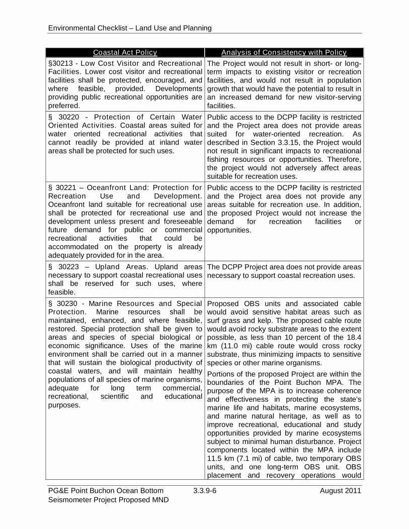
Environmental Checklist – Land Use and Planning
PG&E Point Buchon Ocean Bottom 3.3.9-6 August 2011Seismometer Project Proposed MND
Coastal Act Policy Analysis of Consistency with Policy
§30213 - Low Cost Visitor and RecreationalFacilities. Lower cost visitor and recreationalfacilities shall be protected, encouraged, andwhere feasible, provided. Developmentsproviding public recreational opportunities arepreferred.
The Project would not result in short- or long-term impacts to existing visitor or recreationfacilities, and would not result in populationgrowth that would have the potential to result inan increased demand for new visitor-servingfacilities.
§ 30220 - Protection of Certain WaterOriented Activities. Coastal areas suited forwater oriented recreational activities thatcannot readily be provided at inland waterareas shall be protected for such uses.
Public access to the DCPP facility is restrictedand the Project area does not provide areassuited for water-oriented recreation. Asdescribed in Section 3.3.15, the Project wouldnot result in significant impacts to recreationalfishing resources or opportunities. Therefore,the project would not adversely affect areassuitable for recreation uses.
§ 30221 – Oceanfront Land: Protection forRecreation Use and Development.Oceanfront land suitable for recreational useshall be protected for recreational use anddevelopment unless present and foreseeablefuture demand for public or commercialrecreational activities that could beaccommodated on the property is alreadyadequately provided for in the area.
Public access to the DCPP facility is restrictedand the Project area does not provide anyareas suitable for recreation use. In addition,the proposed Project would not increase thedemand for recreation facilities oropportunities.
§ 30223 – Upland Areas. Upland areasnecessary to support coastal recreational usesshall be reserved for such uses, wherefeasible.
The DCPP Project area does not provide areasnecessary to support coastal recreation uses.
§ 30230 - Marine Resources and SpecialProtection. Marine resources shall bemaintained, enhanced, and where feasible,restored. Special protection shall be given toareas and species of special biological oreconomic significance. Uses of the marineenvironment shall be carried out in a mannerthat will sustain the biological productivity ofcoastal waters, and will maintain healthypopulations of all species of marine organisms,adequate for long term commercial,recreational, scientific and educationalpurposes.
Proposed OBS units and associated cablewould avoid sensitive habitat areas such assurf grass and kelp. The proposed cable routewould avoid rocky substrate areas to the extentpossible, as less than 10 percent of the 18.4km (11.0 mi) cable route would cross rockysubstrate, thus minimizing impacts to sensitivespecies or other marine organisms.
Portions of the proposed Project are within theboundaries of the Point Buchon MPA. Thepurpose of the MPA is to increase coherenceand effectiveness in protecting the state'smarine life and habitats, marine ecosystems,and marine natural heritage, as well as toimprove recreational, educational and studyopportunities provided by marine ecosystemssubject to minimal human disturbance. Projectcomponents located within the MPA include11.5 km (7.1 mi) of cable, two temporary OBSunits, and one long-term OBS unit. OBSplacement and recovery operations would
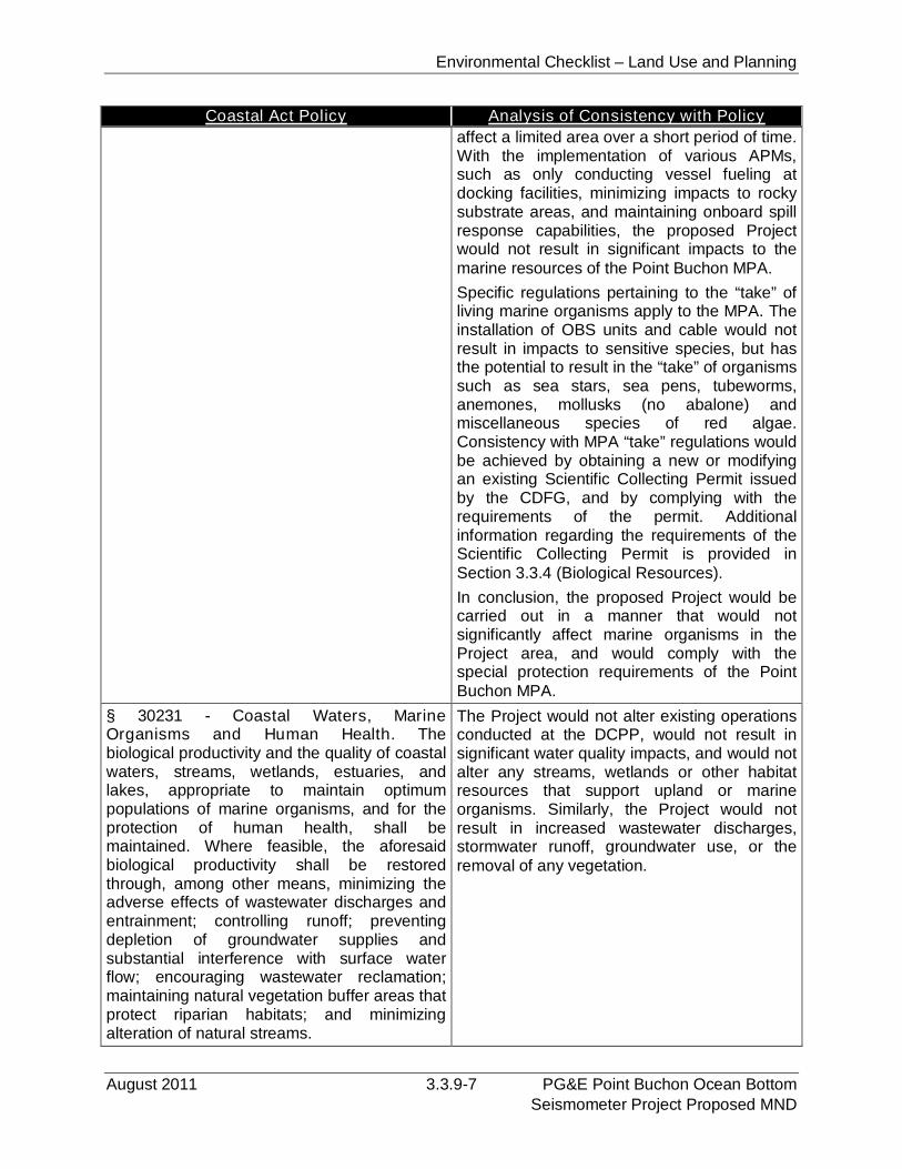
Environmental Checklist – Land Use and Planning
August 2011 3.3.9-7 PG&E Point Buchon Ocean BottomSeismometer Project Proposed MND
Coastal Act Policy Analysis of Consistency with Policy
affect a limited area over a short period of time.With the implementation of various APMs,such as only conducting vessel fueling atdocking facilities, minimizing impacts to rockysubstrate areas, and maintaining onboard spillresponse capabilities, the proposed Projectwould not result in significant impacts to themarine resources of the Point Buchon MPA.
Specific regulations pertaining to the “take” ofliving marine organisms apply to the MPA. Theinstallation of OBS units and cable would notresult in impacts to sensitive species, but hasthe potential to result in the “take” of organismssuch as sea stars, sea pens, tubeworms,anemones, mollusks (no abalone) andmiscellaneous species of red algae.Consistency with MPA “take” regulations wouldbe achieved by obtaining a new or modifyingan existing Scientific Collecting Permit issuedby the CDFG, and by complying with therequirements of the permit. Additionalinformation regarding the requirements of theScientific Collecting Permit is provided inSection 3.3.4 (Biological Resources).
In conclusion, the proposed Project would becarried out in a manner that would notsignificantly affect marine organisms in theProject area, and would comply with thespecial protection requirements of the PointBuchon MPA.
§ 30231 - Coastal Waters, MarineOrganisms and Human Health. Thebiological productivity and the quality of coastalwaters, streams, wetlands, estuaries, andlakes, appropriate to maintain optimumpopulations of marine organisms, and for theprotection of human health, shall bemaintained. Where feasible, the aforesaidbiological productivity shall be restoredthrough, among other means, minimizing theadverse effects of wastewater discharges andentrainment; controlling runoff; preventingdepletion of groundwater supplies andsubstantial interference with surface waterflow; encouraging wastewater reclamation;maintaining natural vegetation buffer areas thatprotect riparian habitats; and minimizingalteration of natural streams.
The Project would not alter existing operationsconducted at the DCPP, would not result insignificant water quality impacts, and would notalter any streams, wetlands or other habitatresources that support upland or marineorganisms. Similarly, the Project would notresult in increased wastewater discharges,stormwater runoff, groundwater use, or theremoval of any vegetation.
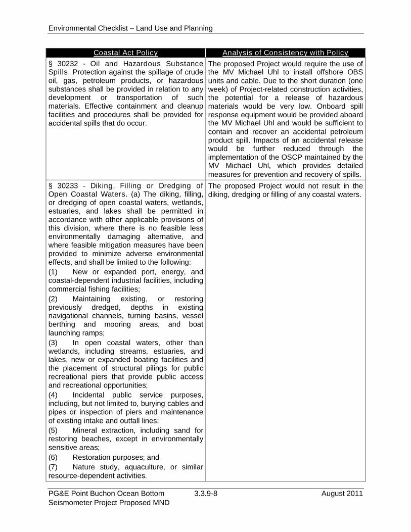
Environmental Checklist – Land Use and Planning
PG&E Point Buchon Ocean Bottom 3.3.9-8 August 2011Seismometer Project Proposed MND
Coastal Act Policy Analysis of Consistency with Policy
§ 30232 - Oil and Hazardous SubstanceSpills. Protection against the spillage of crudeoil, gas, petroleum products, or hazardoussubstances shall be provided in relation to anydevelopment or transportation of suchmaterials. Effective containment and cleanupfacilities and procedures shall be provided foraccidental spills that do occur.
The proposed Project would require the use ofthe MV Michael Uhl to install offshore OBSunits and cable. Due to the short duration (oneweek) of Project-related construction activities,the potential for a release of hazardousmaterials would be very low. Onboard spillresponse equipment would be provided aboardthe MV Michael Uhl and would be sufficient tocontain and recover an accidental petroleumproduct spill. Impacts of an accidental releasewould be further reduced through theimplementation of the OSCP maintained by theMV Michael Uhl, which provides detailedmeasures for prevention and recovery of spills.
§ 30233 - Diking, Filling or Dredging ofOpen Coastal Waters. (a) The diking, filling,or dredging of open coastal waters, wetlands,estuaries, and lakes shall be permitted inaccordance with other applicable provisions ofthis division, where there is no feasible lessenvironmentally damaging alternative, andwhere feasible mitigation measures have beenprovided to minimize adverse environmentaleffects, and shall be limited to the following:
(1) New or expanded port, energy, andcoastal-dependent industrial facilities, includingcommercial fishing facilities;
(2) Maintaining existing, or restoringpreviously dredged, depths in existingnavigational channels, turning basins, vesselberthing and mooring areas, and boatlaunching ramps;
(3) In open coastal waters, other thanwetlands, including streams, estuaries, andlakes, new or expanded boating facilities andthe placement of structural pilings for publicrecreational piers that provide public accessand recreational opportunities;
(4) Incidental public service purposes,including, but not limited to, burying cables andpipes or inspection of piers and maintenanceof existing intake and outfall lines;
(5) Mineral extraction, including sand forrestoring beaches, except in environmentallysensitive areas;
(6) Restoration purposes; and
(7) Nature study, aquaculture, or similarresource-dependent activities.
The proposed Project would not result in thediking, dredging or filling of any coastal waters.
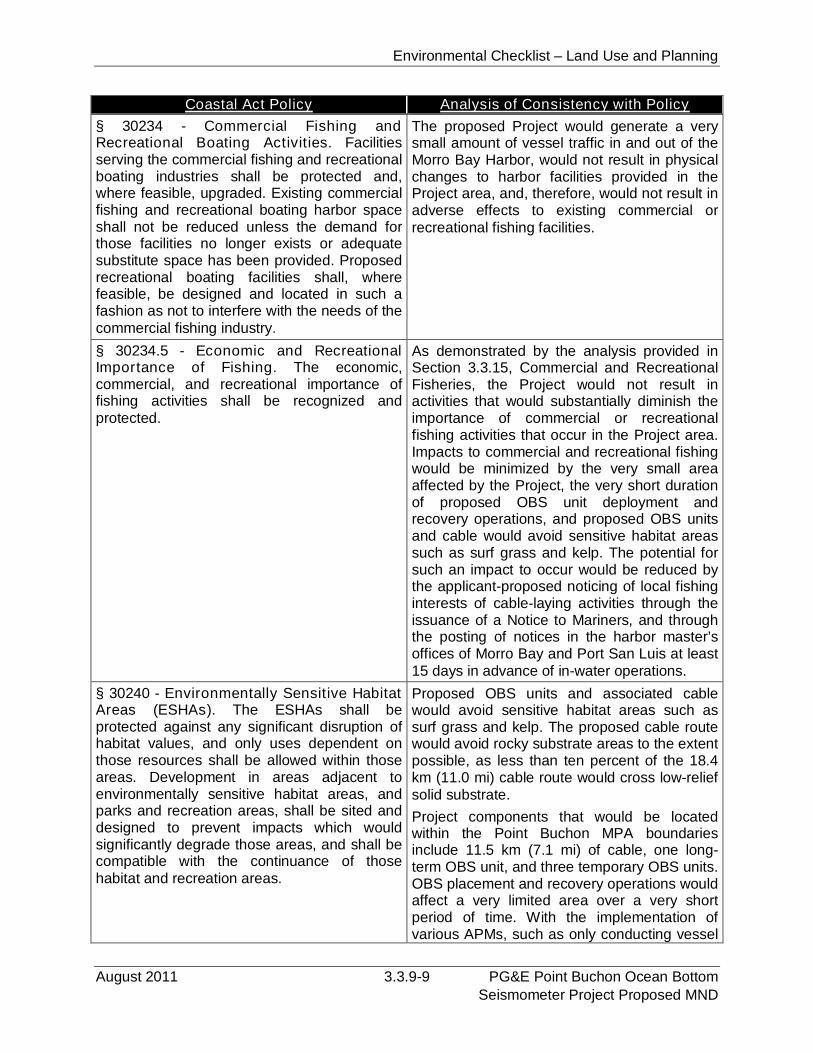
Environmental Checklist – Land Use and Planning
August 2011 3.3.9-9 PG&E Point Buchon Ocean BottomSeismometer Project Proposed MND
Coastal Act Policy Analysis of Consistency with Policy
§ 30234 - Commercial Fishing andRecreational Boating Activities. Facilitiesserving the commercial fishing and recreationalboating industries shall be protected and,where feasible, upgraded. Existing commercialfishing and recreational boating harbor spaceshall not be reduced unless the demand forthose facilities no longer exists or adequatesubstitute space has been provided. Proposedrecreational boating facilities shall, wherefeasible, be designed and located in such afashion as not to interfere with the needs of thecommercial fishing industry.
The proposed Project would generate a verysmall amount of vessel traffic in and out of theMorro Bay Harbor, would not result in physicalchanges to harbor facilities provided in theProject area, and, therefore, would not result inadverse effects to existing commercial orrecreational fishing facilities.
§ 30234.5 - Economic and RecreationalImportance of Fishing. The economic,commercial, and recreational importance offishing activities shall be recognized andprotected.
As demonstrated by the analysis provided inSection 3.3.15, Commercial and RecreationalFisheries, the Project would not result inactivities that would substantially diminish theimportance of commercial or recreationalfishing activities that occur in the Project area.Impacts to commercial and recreational fishingwould be minimized by the very small areaaffected by the Project, the very short durationof proposed OBS unit deployment andrecovery operations, and proposed OBS unitsand cable would avoid sensitive habitat areassuch as surf grass and kelp. The potential forsuch an impact to occur would be reduced bythe applicant-proposed noticing of local fishinginterests of cable-laying activities through theissuance of a Notice to Mariners, and throughthe posting of notices in the harbor master’soffices of Morro Bay and Port San Luis at least15 days in advance of in-water operations.
§ 30240 - Environmentally Sensitive HabitatAreas (ESHAs). The ESHAs shall beprotected against any significant disruption ofhabitat values, and only uses dependent onthose resources shall be allowed within thoseareas. Development in areas adjacent toenvironmentally sensitive habitat areas, andparks and recreation areas, shall be sited anddesigned to prevent impacts which wouldsignificantly degrade those areas, and shall becompatible with the continuance of thosehabitat and recreation areas.
Proposed OBS units and associated cablewould avoid sensitive habitat areas such assurf grass and kelp. The proposed cable routewould avoid rocky substrate areas to the extentpossible, as less than ten percent of the 18.4km (11.0 mi) cable route would cross low-reliefsolid substrate.
Project components that would be locatedwithin the Point Buchon MPA boundariesinclude 11.5 km (7.1 mi) of cable, one long-term OBS unit, and three temporary OBS units.OBS placement and recovery operations wouldaffect a very limited area over a very shortperiod of time. With the implementation ofvarious APMs, such as only conducting vessel
Environmental Checklist – Land Use and Planning
PG&E Point Buchon Ocean Bottom 3.3.9-10 August 2011Seismometer Project Proposed MND
Coastal Act Policy Analysis of Consistency with Policy
fueling at docking facilities, minimizing impactsto rocky substrate areas, and maintainingonboard spill response capabilities, the Projectwould not result in significant impacts to themarine resources of the Point Buchon MPA.
As proposed, the Project would not result in asignificant disruption of habitat values, andstructures placed within the Point Buchon MPAwould not degrade the area or interfere withthe recreational use of the area.
§ 30244 - Archaeological or PaleontologicalResources. Where development wouldadversely impact archaeological orpaleontological resources as identified by theState Historic Preservation Officer, reasonablemitigation measures shall be required.
As described in Section 3.3.5, CulturalResources, the onshore and offshorecomponents of the proposed Project would notadversely affect any known archaeologicalresources, and the potential for the Project toimpact undetected resources is remote. TheProject would not result in any grounddisturbing operations that could affect anypaleontological resources that may be locatedin the Project area.
§ 30250 - Location in Existing DevelopedArea. New residential, commercial, orindustrial development, except as otherwiseprovided in this division, shall be locatedwithin, contiguous with, or in close proximity to,existing developed areas able to accommodateit. Where such existing developed areas arenot able to accommodate it, development shallbe located in other areas with adequate publicservices and where it will not have significantadverse effects, either individually orcumulatively, on coastal resources.
The proposed OBS units, accessory cablesand onshore cable conduit would be installedin support of the existing DCPP facility, andwould be provided in locations that are inproximity to the DCPP. The Project area isable to accommodate the proposed Projectcomponents, and the Project would not requireadditional public services.
§ 30251 - Scenic and Visual Qualities. Thescenic and visual qualities of coastal areasshall be considered and protected as aresource of public importance. Permitteddevelopment shall be sited and designed toprotect views to, and along, the ocean andscenic coastal areas to minimize the alterationof natural land forms, to be visually compatiblewith the character of surrounding areas, and,where feasible, to restore and enhance visualquality in visually degraded areas.
The only development component of theproposed Project that would be visible is thecable conduit to be placed across an existingarea of rip-rap. Views of the rip-rap are notaccessible to the public as access to the DCPPis restricted. The proposed conduit would be aminor feature and would not adversely affectexisting views of or along the ocean.
Environmental Checklist – Land Use and Planning
August 2011 3.3.9-11 PG&E Point Buchon Ocean BottomSeismometer Project Proposed MND
Coastal Act Policy Analysis of Consistency with Policy
§ 30253.3 - New Development, Air PollutionControl District and California AirResources Board Rules. New developmentshall be consistent with requirements imposedby an air-pollution control district or the StateAir Resources Control Board, as to eachparticular development.
As demonstrated by the analysis provided bySection 3.3.3, Air Quality and Greenhouse GasEmissions, the proposed Project would notresult in air emissions or other impacts thatexceed a significance threshold adopted by theSan Luis Obispo County APCD and BAAQMD.Project-related GHGs would not be substantialand would not interfere with efforts by the StateAir Resources Board to meet the greenhousegas emission reduction goals established byAB 32.
§ 30260 - Location or Expansion. Coastal-dependent industrial facilities shall beencouraged to locate or expand within existingsites and shall be permitted reasonable long-term growth where consistent with this division.However, where new or expanded coastal-dependent industrial facilities cannot feasiblybe accommodated consistent with otherpolicies of this division, they may nonethelessbe permitted in accordance with this sectionand sections 30261 and 30262 if (1) alternativelocations are infeasible or moreenvironmentally damaging; (2) to do otherwisewould adversely affect the public welfare; and(3) adverse environmental effects are mitigatedto the maximum extent feasible.
The proposed Project would implement aseismic monitoring program for the DCPP. TheProject would not result in changes to existingDCPP operations or result in an expansion ofthe facility. Therefore, the Project would bepotentially consistent with the requirements ofthis policy.
c) Would the Project conflict with any applicable habitat conservation plan or1
natural community conservation plan?2
The proposed Project would result in the installation and recovery of seismic monitoring3
equipment within the boundaries of the Point Buchon MPA. Specific regulations4
pertaining to the “take” of living marine organisms apply to the MPA. The installation of5
OBS units and cable have the potential to result in the “take” of marine organisms such6
as sea stars, sea pens, tubeworms, anemones, mollusks (no abalone) and7
miscellaneous species of red algae. Consistency with MPA “take” regulations would be8
achieved by compliance with the requirements of the modified Scientific Collecting9
Permit (SCP) issued by the CDFG to PG&E’s biological consultant, Tenera10
Environmental. Additional information regarding the requirements of the SCP is11
provided in Section 3.3.4, Biological Resources, and Section 3.3.15, Commercial and12
Recreational Fisheries. With the implementation of this permitting requirement, the13
Project would not conflict with the regulations governing activities within the Point14
Buchon MPA.15
Environmental Checklist – Land Use and Planning
PG&E Point Buchon Ocean Bottom 3.3.9-12 August 2011Seismometer Project Proposed MND
3.3.9.4 Mitigation and Residual Impact1
Mitigation. The proposed Project would not result in impacts related to dividing an2
established community or consistency with applicable state and local land use policies.3
The Project has the potential to result in the “take” of marine organisms within the4
boundaries of the Point Buchon MPA. This potential conflict with the requirements of the5
MPA would be eliminated by complying with the requirements of an amended SCP be6
obtained from the CDFG prior to the start of Project-related in-water operations. No7
additional mitigation is required.8
Residual Impacts. With the implementation of the required amended SCP, Project-9
related land use impacts would be reduced to a less than significant level.10

Environmental Checklist – Mineral Resources
August 2011 3.3.10-1 PG&E Point Buchon Ocean BottomSeismometer Project Proposed MND
3.3.10 Mineral Resources1
X. MINERAL RESOURCES:
Would the Project:
PotentiallySignificant
Impact
Less ThanSignificant
withMitigation
Less ThanSignificant
Impact
NoImpact
a) Result in the loss of availability of a known mineralresource that would be of value to the region and theresidents of the state?
b) Result in the loss of availability of a locally-importantmineral resource recovery site delineated on a localgeneral plan, specific plan or other land use plan?
3.3.10.1Environmental Setting2
The onshore portion of the project area lies within the southern portion of the Coast3
Ranges Geomorphic Province, which is characterized by northwest-trending mountains4
and valleys composed of Mesozoic and Cenozoic marine and terrestrial sedimentary5
deposits underlain by Franciscan formation metamorphic rocks and/or granitic rocks of6
the Salinian Block. The Coast Ranges Geomorphic Province is bounded by the offshore7
Santa Maria Basin to the west. Within the Coast Range Geomorphic Province, the8
project area is within the South Coastal Santa Lucia Range that is delineated by the9
Nacimiento Fault and the Pacific Ocean (Miles and Goudey 1997). Onshore and10
adjacent lands contain ragged seacliffs with examples of varying erosion and exposure11
of the Miguelito member of the Pismo Formation. These lands are composed of12
repetitive beds of diatomite or clayey porcellanite, diatomaceous mudstone, dolomite13
and chert (California Department of Parks & Recreation 2006).14
No mineral resource development operations occur on or near the proposed onshore or15
offshore Project areas. The Project area is within an existing MPA that precludes any16
mineral development or other similar activities without prior authorization from the17
CFGC.18
3.3.10.2Regulatory Setting19
Federal. There are no federal regulations related to mineral resources relevant to the20
proposed Project.21
State.22
Marine Life Protection Act of 1999 (MLPA). As noted above, the Project area is within23
an existing MPA that precludes any mineral development or other similar activities24
without prior authorization from the CFGC.25
Surface Mining and Reclamation Act of 1975 (SMARA). The CGS, formerly the26
California Division of Mines and Geology, classifies the regional significance of mineral27
Environmental Checklist – Mineral Resources
PG&E Point Buchon Ocean Bottom 3.3.10-2 August 2011Seismometer Project Proposed MND
resources in accordance with SMARA and assists in the designation of lands containing1
significant aggregate resources. Mineral Resource Zones (MRZs) have been2
designated to indicate the significance of mineral deposits. The MRZ categories follow:3
MRZ-1: Areas where adequate information indicates that no significant mineral4
deposits are present or where it is judged that little likelihood exists for their5
presence.6
MRZ-2: Areas where adequate information indicates significant mineral deposits7
are present, or where it is judged that a high likelihood exists for their presence.8
MRZ-3: Areas containing mineral deposits the significance of which cannot be9
evaluated from available data.10
MRZ-4: Areas where available information is inadequate for assignment to any11
other MRZ.12
Local. The San Luis Obispo County Local Coastal Plan designates areas containing13
mineral resources with the zoning overlays EX (Energy or Extractive Resource Area) or14
EX1 (Extractive Resource Area). The proposed Project area is located within an area15
designated by the County as EX.16
3.3.10.3 Impact Analysis17
a) Result in the loss of availability of a known mineral resource that would be18
of value to the region and the residents of the state?19
See response below.20
b) Result in the loss of availability of a known mineral resource that would be21
of value to the region and the residents of the state?22
The proposed Project area has an EX zoning overlay designation. The EX designation23
refers to the ongoing energy production at DCCP. This zoning overlay designation does24
not refer to a resource extraction (e.g., mining) operation. There are no known mineral25
extraction operations onsite or on adjacent lands; therefore, no impact would occur. All26
proposed project activities are consistent with the EX land use designation.27
3.3.10.4Mitigation and Residual Impacts28
Mitigation. The proposed project would have no impact on mineral resources and no29
mitigation is required.30
Residual Impacts. The proposed project would have no impact on mineral resources,31
no mitigation is required, and no residual impacts would occur.32
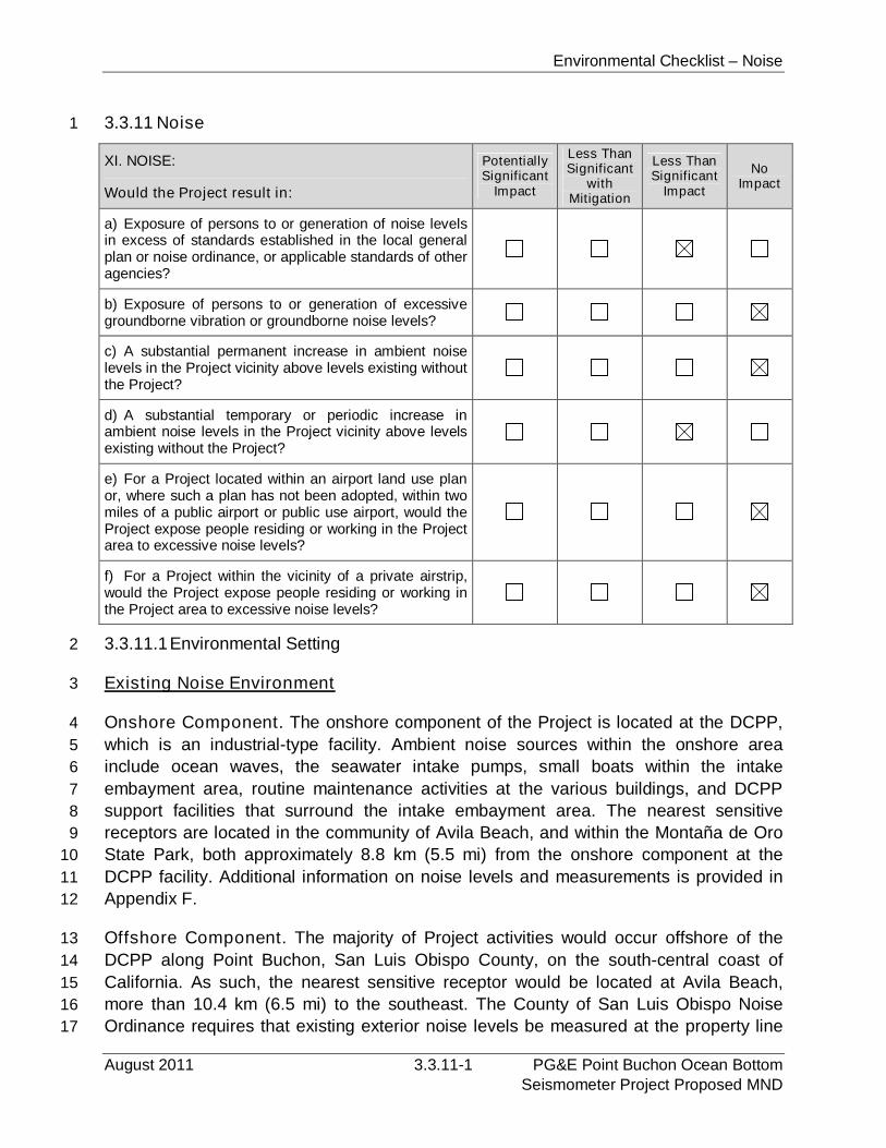
Environmental Checklist – Noise
August 2011 3.3.11-1 PG&E Point Buchon Ocean BottomSeismometer Project Proposed MND
3.3.11 Noise1
XI. NOISE:
Would the Project result in:
PotentiallySignificant
Impact
Less ThanSignificant
withMitigation
Less ThanSignificant
Impact
NoImpact
a) Exposure of persons to or generation of noise levelsin excess of standards established in the local generalplan or noise ordinance, or applicable standards of otheragencies?
b) Exposure of persons to or generation of excessivegroundborne vibration or groundborne noise levels?
c) A substantial permanent increase in ambient noiselevels in the Project vicinity above levels existing withoutthe Project?
d) A substantial temporary or periodic increase inambient noise levels in the Project vicinity above levelsexisting without the Project?
e) For a Project located within an airport land use planor, where such a plan has not been adopted, within twomiles of a public airport or public use airport, would theProject expose people residing or working in the Projectarea to excessive noise levels?
f) For a Project within the vicinity of a private airstrip,would the Project expose people residing or working inthe Project area to excessive noise levels?
3.3.11.1Environmental Setting2
Existing Noise Environment3
Onshore Component. The onshore component of the Project is located at the DCPP,4
which is an industrial-type facility. Ambient noise sources within the onshore area5
include ocean waves, the seawater intake pumps, small boats within the intake6
embayment area, routine maintenance activities at the various buildings, and DCPP7
support facilities that surround the intake embayment area. The nearest sensitive8
receptors are located in the community of Avila Beach, and within the Montaña de Oro9
State Park, both approximately 8.8 km (5.5 mi) from the onshore component at the10
DCPP facility. Additional information on noise levels and measurements is provided in11
Appendix F.12
Offshore Component. The majority of Project activities would occur offshore of the13
DCPP along Point Buchon, San Luis Obispo County, on the south-central coast of14
California. As such, the nearest sensitive receptor would be located at Avila Beach,15
more than 10.4 km (6.5 mi) to the southeast. The County of San Luis Obispo Noise16
Ordinance requires that existing exterior noise levels be measured at the property line17
Environmental Checklist – Noise
PG&E Point Buchon Ocean Bottom 3.3.11-2 August 2011Seismometer Project Proposed MND
of the affected noise-sensitive land use (§ 23.06.044); however, since the nearest1
sensitive land use is located 10.4 km (6.5 mi) from the offshore Project area (at Avila2
Beach), site-specific noise measurements were not deemed necessary. Ambient noise3
sources in the offshore Project area include ocean waves and occasional fishing and4
commercial vessels.5
3.3.11.2Regulatory Setting6
Federal. Federal regulation of noise has been addressed through EPA Guidelines as7
well as Federal Aviation Administration (for air traffic noise), and the U.S. Department of8
Transportation (DOT), Federal Highway Administration..9
The Noise Control Act of 1972 required the EPA to establish noise emission10
criteria as well as noise testing methods (40 CFR Chapter 1, Subpart Q). These11
criteria generally apply to interstate rail carriers and to some types of construction12
and transportation equipment.13
The DOT regulates noise levels for motor vehicles (49 CFR Chapter III, Part14
325). These standards address measurement protocols for measuring highway15
noise, instrumentation, and stationary testing procedures.16
State. State regulations for limiting population exposure to physically- and/or17
psychologically-significant noise levels include established guidelines and ordinances18
for roadway noise under the California Department of Transportation (Caltrans) as well19
as the now defunct California Office of Noise Control. The California Office of Noise20
Control land use compatibility guidelines provided the following:21
An exterior noise level of 60 to 65 dBA CNEL is considered "normally22
acceptable" for residential uses.23
A noise level of 70 dBA CNEL is considered to be "conditionally acceptable."24
This level is considered to be the upper limit of "normally acceptable" noise levels25
for sensitive uses such as schools, libraries, hospitals, nursing homes, churches,26
parks, offices, and commercial and professional businesses.27
A noise level of greater than 75 dBA CNEL is considered "clearly unacceptable"28
for residences.29
Local. The proposed Project is located within the DCPP industrial facility located within30
the jurisdiction of the County of San Luis Obispo. As such the County Local Coastal31
Plan and General Plan Noise Element would be applicable to the proposed Project. The32
County also maintains a noise ordinance. Section 23.06.040 of the County Noise33
Ordinance discusses thresholds of significance for developments with the intended34
purpose of identifying standards for the protection of individuals from excessive noise35
levels. In addition, section 23.06.042 discusses where those standards are applicable36
and which areas would be exempt from such regulation.37
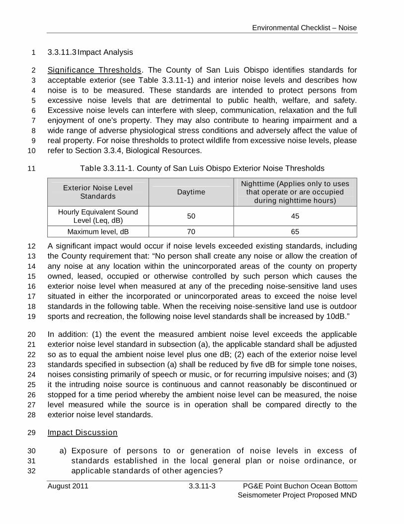
Environmental Checklist – Noise
August 2011 3.3.11-3 PG&E Point Buchon Ocean BottomSeismometer Project Proposed MND
3.3.11.3 Impact Analysis1
Significance Thresholds. The County of San Luis Obispo identifies standards for2
acceptable exterior (see Table 3.3.11-1) and interior noise levels and describes how3
noise is to be measured. These standards are intended to protect persons from4
excessive noise levels that are detrimental to public health, welfare, and safety.5
Excessive noise levels can interfere with sleep, communication, relaxation and the full6
enjoyment of one's property. They may also contribute to hearing impairment and a7
wide range of adverse physiological stress conditions and adversely affect the value of8
real property. For noise thresholds to protect wildlife from excessive noise levels, please9
refer to Section 3.3.4, Biological Resources.10
Table 3.3.11-1. County of San Luis Obispo Exterior Noise Thresholds11
Exterior Noise LevelStandards
DaytimeNighttime (Applies only to uses
that operate or are occupiedduring nighttime hours)
Hourly Equivalent SoundLevel (Leq, dB)
50 45
Maximum level, dB 70 65
A significant impact would occur if noise levels exceeded existing standards, including12
the County requirement that: “No person shall create any noise or allow the creation of13
any noise at any location within the unincorporated areas of the county on property14
owned, leased, occupied or otherwise controlled by such person which causes the15
exterior noise level when measured at any of the preceding noise-sensitive land uses16
situated in either the incorporated or unincorporated areas to exceed the noise level17
standards in the following table. When the receiving noise-sensitive land use is outdoor18
sports and recreation, the following noise level standards shall be increased by 10dB.”19
In addition: (1) the event the measured ambient noise level exceeds the applicable20
exterior noise level standard in subsection (a), the applicable standard shall be adjusted21
so as to equal the ambient noise level plus one dB; (2) each of the exterior noise level22
standards specified in subsection (a) shall be reduced by five dB for simple tone noises,23
noises consisting primarily of speech or music, or for recurring impulsive noises; and (3)24
it the intruding noise source is continuous and cannot reasonably be discontinued or25
stopped for a time period whereby the ambient noise level can be measured, the noise26
level measured while the source is in operation shall be compared directly to the27
exterior noise level standards.28
Impact Discussion29
a) Exposure of persons to or generation of noise levels in excess of30
standards established in the local general plan or noise ordinance, or31
applicable standards of other agencies?32

Environmental Checklist – Noise
PG&E Point Buchon Ocean Bottom 3.3.11-4 August 2011Seismometer Project Proposed MND
Offshore Project Activities1
The proposed Project consists of placing instruments and cable onto the seafloor within2
California state waters offshore of the DCPP. The majority of Project activities would3
occur offshore away from areas of public access and onshore sensitive receptors.4
Vessel equipment onboard the MV Michael Uhl includes a 104 horsepower (hp)5
generator, and two 375 hp, 4-cycle main vessel engines. Use of this equipment will6
increase existing noise levels within the offshore Project area.7
Although unlikely, there is a possibility that some individuals would be within the Project8
area on recreational or commercial vessels during OBS placement and recovery9
operations. Noise generated by vessel and onboard equipment operations would not be10
substantial and would not adversely affect persons on nearby boats. Therefore, this11
short-term noise impact would not be significant. In addition, PG&E has agreed to12
provide the required Notice to Mariners, which will specify vessel type, location,13
operation, and contact information prior to in-water operations so that commercial and14
recreational vessels are aware of Project activities and can avoid the work vessel area.15
The nearest sensitive receptors to the proposed Project area would be at Avila Beach,16
which is located more than 8.9 km (5.5 mi) from proposed offshore activities. As such,17
noise from offshore activities would not be audible to sensitive receptors, would not18
result in an increase in ambient noise conditions at sensitive receptor locations, or result19
in noise levels in excess of existing standards. Therefore, Project-related activities20
would be less than significant.21
Crew members aboard the Project vessel would be exposed to onboard noise from22
equipment. Those potential effects would be minimized by measures provided in the23
project-specific Health and Safety Plan, which will require the provision of ear protection24
to all onboard personnel. Therefore, noise impacts to crew members would not be25
significant and no mitigation is required.26
Information on the effects of noise on marine biota is provided in Section 3.3.427
Biological Resources.28
Onshore Project Activities29
The only onshore component of the proposed Project would occur within the existing30
DCPP facility and consist of the construction and installation of an extension of the31
conduit that would house the power/data transfer cable. No public entry is currently32
allowed within the DCPP facility, and the nearest sensitive receptor to the onshore33
portion of the proposed Project is located at Avila Beach, more than 8.9 km (5.5 mi)34
south of the DCPP. As such, noise impacts associated with the use of hand tools during35
onshore project activities would be minimal and would not expose individuals or36
Environmental Checklist – Noise
August 2011 3.3.11-5 PG&E Point Buchon Ocean BottomSeismometer Project Proposed MND
sensitive receptor areas to excessive noise. The impacts are considered to be less than1
significant.2
The proposed Project would generate a limited number of worker vehicle trips and truck3
trips to deliver equipment (see Section 3.3.16, Transportation/Traffic, for information4
regarding the traffic generation characteristics of the Project). Due to the small volume5
of vehicle traffic generated by the Project, and the short-term and intermittent nature of6
Project-generated vehicle trips, the proposed Project’s traffic noise impacts would be7
less than significant.8
b) Exposure of persons to or generation of excessive groundborne vibration9
or groundborne noise levels?10
The proposed Project includes the installation of the OBS units in waters located11
offshore of the DCPP as well as an extension of an existing conduit onshore. OBS units12
would be placed onto the seafloor using an onboard vessel crane, and operation of the13
OBS units would not result in the generation of any vibrations. Operation of the OBS14
units does not generate any vibrations. The extension of the existing onshore conduit15
would be constructed using hand tools. As such, no vibratory equipment would be16
required. No ground-borne vibration would be associated with offshore or onshore17
project activities; therefore, no impacts would occur.18
c) A substantial permanent increase in ambient noise levels in the Project19
vicinity above levels existing without the Project?20
The proposed Project includes the placement of temporary and long-term OBS units21
and cable onto the seafloor. Installation activities are anticipated to require22
approximately seven days. Following installation, long-term OBS units are expected to23
remain on the seafloor for up to 10 years while data are recorded and transmitted to the24
onshore collection area. The OBS units are passive recorders and therefore no25
additional noise would be generated during the data collection activities. The only26
Project-related noise would be the temporary sounds associated with installation27
activities. Due to the temporary nature of installation activities, no long-term or28
permanent changes in the existing noise environment would result. No impacts are29
expected to result.30
d) A substantial temporary or periodic increase in ambient noise levels in the31
Project vicinity above levels existing without the Project?32
As discussed above, OBS and cable installation activities would not result in significant33
temporary noise impacts to receptors located in onshore or offshore areas. Further, the34
vessel’s crew will be provided with ear protection to further reduce potential effects of35
onboard noise. Therefore, temporary noise impacts of the proposed Project would be36
less than significant and no mitigation is required.37
Environmental Checklist – Noise
PG&E Point Buchon Ocean Bottom 3.3.11-6 August 2011Seismometer Project Proposed MND
e) For a Project located within an airport land use plan or, where such a plan1
has not been adopted, within two miles of a public airport or public use2
airport, would the Project expose people residing or working in the Project3
area to excessive noise levels?4
See response below.5
f) For a Project within the vicinity of a private airstrip, would the Project6
expose people residing or working in the Project area to excessive noise7
levels?8
The proposed Project is not located near any public or private airport or airstrip. The9
proposed Project is not located within a jurisdictional boundary of an airport land use10
plan. No impact would result.11
3.3.11.4Mitigation and Residual Impacts12
Mitigation. The proposed Project would not result in significant short- or long-term13
noise impacts. Therefore, no mitigation measures are required.14
Residual Impacts. The proposed Project would have no significant noise impacts. No15
mitigation is required and no residual impacts would occur.16
Environmental Checklist – Population and Housing
August 2011 3.3.12-1 PG&E Point Buchon Ocean BottomSeismometer Project Proposed MND
3.3.12 Population and Housing1
XII. POPULATION AND HOUSING:
Would the Project:
PotentiallySignificant
Impact
Less ThanSignificant
withMitigation
Less ThanSignificant
Impact
NoImpact
a) Induce substantial population growth in an area,either directly (for example, by proposing new homesand businesses) or indirectly (for example, throughextension of roads or other infrastructure)?
b) Displace substantial numbers of existing housing,necessitating the construction of replacement housingelsewhere?
c) substantial numbers of people, necessitating theconstruction of replacement housing elsewhere?
3.3.12.1Environmental Setting2
According to the U.S. Census Bureau (2010), San Luis Obispo County encompasses an3
area of approximately 8,557 km2 (3,304 mi2). In 2009, the County’s estimated4
population was 266,971, with a population density of 81 persons per square mile, and5
115,336 housing units. The average household size is approximately 2.39 persons. Of6
this population, approximately 85.3 percent (223,498 persons) are of Caucasian origin.7
The minority race with the highest concentration in this area is Hispanic or Latino, which8
constitutes approximately 18.8 percent (49,374 persons) of the total population.9
The nearest urban areas or towns to the onshore and offshore portion of the Project10
area are Los Osos, approximately 9.7 km (6.0 mi) north, and the Town of Avila Beach,11
more than 8.9 km (5.5 mi) south. Baywood/Los Osos has an estimated population of12
14,848 with an estimated 6,520 housing units. The average household size is13
approximately 2.39 persons. Of this population, approximately 87.4 percent (13,21514
persons) are of Caucasian origin. The minority race with the highest concentration in15
this area is Hispanic or Latino, which constitutes approximately 13.7 percent (2,06316
persons) of the total population (U.S. Census Bureau 2010). Avila Beach has an17
estimated population of 1,627, nearly 1,100 housing units, and average household size18
of 1.93 persons. 92.6 percent (1,507 persons) of the population is of Caucasian origin.19
The largest minority ethnicity, constituting 6.8 percent (111 persons) of Avila Beach, is20
Hispanic or Latino (U.S. Census Bureau 2010). The closest residence to the Project21
area is a single-family dwelling located near Coon Creek, approximately 2.0 km (1.3 mi)22
north of the proposed Project area.23
3.3.12.2Regulatory Setting24
Federal and State. No federal or state regulations related to population and housing25
are relevant to the Project.26
Environmental Checklist – Population and Housing
PG&E Point Buchon Ocean Bottom 3.3.12-2 August 2011Seismometer Project Proposed MND
Local. According to the San Luis Obispo County LCP Land Use Ordinance (1988), the1
onshore portion of the Project area is located within the Energy and Extractive2
Resource Areas planning area. A more specific Diablo Canyon Power Plant3
designation includes the location of the power plant and the surrounding buffer area of4
the PG&E lease site. Operations should not be expanded beyond the present property5
nor should future development of adjacent lands encroach into this area.6
3.3.12.3 Impact Analysis7
a) Induce substantial population growth in an area, either directly (for8
example, by proposing new homes and businesses) or indirectly (for9
example, through extension of roads or other infrastructure)?10
The proposed Project would not cause an increase in population or short- or long-term11
employment opportunities. The estimated 15 personnel required to install the OBS units12
and cable will be employees of existing companies. Equipment maintenance and13
monitoring would not require additional PG&E personnel. The proposed project would14
not result in the extension of an infrastructure system (i.e., roads, water or sewer15
service) that would have a growth inducing impact.16
b) Displace substantial numbers of existing housing, necessitating the17
construction of replacement housing elsewhere?18
See response below.19
c) Displace substantial numbers of people, necessitating the construction of20
replacement housing elsewhere?21
The onshore Project area is on DCPP property, is not located within or adjacent to22
housing or a residential area, and would not displace existing homes or population;23
therefore, existing demographics would not be impacted. During the proposed short-24
term construction period, installation activities will require approximately 15 personnel.25
Offshore construction will require workers who reside in the Project area, and will be26
onboard the MV Michael Uhl, which is currently docked at Morro Bay. Any out of town27
personnel would use facilities available on the vessel, or nearby hotels.28
3.3.12.4Mitigation and Residual Impacts29
Mitigation. The proposed Project would not result in impacts related to existing30
population or housing and no mitigation is required.31
Residual Impacts. The proposed project would have no impact on existing population32
levels or housing stock. No mitigation is required and no residual impacts would occur.33
Environmental Checklist – Public Services
August 2011 3.3.13-1 PG&E Point Buchon Ocean BottomSeismometer Project Proposed MND
3.3.13 Public Services1
XIII. PUBLIC SERVICES:
PotentiallySignificant
Impact
Less ThanSignificant
withMitigation
Less ThanSignificant
Impact
NoImpact
a) Would the Project result in substantial adversephysical impacts associated with the provision of new orphysically altered governmental facilities, need for newor physically altered governmental facilities, theconstruction of which could cause significantenvironmental impacts, in order to maintain acceptableservice ratios, response times or other performanceobjectives for any of the public services:
Fire protection?
Police protection?
Schools?
Parks?
Other public facilities?
3.3.13.1Environmental Setting2
Fire Services. According to the San Luis Obispo County LCP Safety Element, DCPP3
lies within an area designated as a high fire hazard zone. The DCPP Fire Department is4
the first responder to fire and medical emergencies at the project area, with the5
California Division of Forestry and Fire Protection (CDF)/San Luis Obispo County Fire6
Department providing backup fire protection service if requested by DCPP (Aspen7
2005). The CDF/San Luis Obispo County fire station closest to onshore project activities8
is located at Avila Beach. The closest fire station to the offshore portion of the project9
area is located in Los Osos. Response times for fire service personnel to the onshore10
portion of the project area would be over 20 minutes.11
DCPP maintains a full time (24-7) industrial/medical emergency response department12
staffed at all times by at least five fully trained fire fighters, all of whom are qualified as13
emergency medical technicians. The department operates a plant site fire station with14
dedicated emergency response vehicles and support equipment, including two Type-115
fire fighting apparatus trucks (which carrye than 500 gallons of fire suppressant) and a16
mobile (towed) hazardous materials release mitigation unit.17
Police Services. DCPP maintains an extensive onsite site security organization. The18
organization’s focus is security of the nuclear facility boundaries; however, it also19
implements surveillance of, and access control over, the Utility-owned lands20
surrounding the plant site. Personnel and vehicle access to the general lands21
is controlled by the site security organization (Bryan Cunningham, PG&E, pers. comm.).22
Environmental Checklist – Public Services
PG&E Point Buchon Ocean Bottom 3.3.13-2 August 2011Seismometer Project Proposed MND
The closest public law enforcement station to both onshore and offshore activities is the1
San Luis Obispo County Sheriff Department’s office in Los Osos. Because of the rural2
location of the DCPP, the County Sheriff and California Highway Patrol are responsible3
for responding to 911 disturbances in the vicinity. Response times for law enforcement4
personnel to the onshore portion of the Project area would be over 20 minutes.5
School Services. Twelve school districts serve San Luis Obispo County. The project6
area is located within the service boundary of the San Luis Coastal Unified School7
District. No public or private schools are located near the onshore portion of the Project8
area.9
Parks. DCPP is located in a rural portion of the County; therefore, there are no10
residential or neighborhood parks near the Project area. Montaña de Oro State Park is11
located approximately 2 km (1.25 mi) to the northeast of the onshore portion of the12
Project area and approximately 3.2 km (2 mi) shoreward (east) of OBS-1. Montaña de13
Oro State Park encompasses over 32 km2 (8,000 acres) of land and provides14
opportunities for fishing, horseback riding, guided tours, biking, and camping. It also15
provides exhibits and programs, hiking trails, nature trails, wildlife viewing, surfing,16
picnic areas, and can accommodate trailers and campers.17
Emergency Medical Services. There is an onsite medical facility staffed during regular18
business hours by a physician’s assistant and at least one registered nurse. The19
facility's primary function is not emergency response, but, when staffed, it will provide20
emergency medical care services and support preparation for offsite transport of21
personnel to area hospitals via commercial ambulance services (Bryan Cunningham,22
PG&E, pers. comm.). The closest hospital services to the Project area are available at23
Sierra Vista Regional Medical Center and Twin Cities Community Hospital. Response24
times for emergency medical personnel to the onshore portion of the project area would25
be over 20 minutes. For the offshore portions of the proposed Project, medical services26
would be at an onshore facility and transport would most likely be via helicopter.27
3.3.13.2Regulatory Setting28
Federal. No federal regulations pertain to public services relevant to this Project.29
State. DCPP, along with state and local government agencies, have developed various30
fire and emergency response plans, such as:31
DCPP Fire Protection Program, Fire Loss Prevention Program, Fire System32
Impairment Procedure, Control of Combustibles Procedure, Wildlands Fuel33
Management Plan, and Emergency Response Plan State of California Nuclear34
Power Plant Emergency Response Plan; and35
San Luis Obispo County/Cities Nuclear Power Plant Emergency Response Plan.36
Environmental Checklist – Public Services
August 2011 3.3.13-3 PG&E Point Buchon Ocean BottomSeismometer Project Proposed MND
Local. Several local ordinances direct fire prevention activities within San Luis Obispo1
County. These include Chapter 19.20, Construction Standards of Title 19, of the County2
Code, as well as section 22/23.05.050 et seq. of the Land Use Ordinance (San Luis3
Obispo County 1988a) and CZLUSO (San Luis Obispo County 1988b). These sections4
of Titles 22 and 23 contain standards pertaining to the preparation and review of fire5
safety plans, fire safety standards, site access, and driveway requirements. In addition,6
the provisions of the Uniform Fire Code have been adopted by San Luis Obispo County.7
3.3.13.3 Impact Analysis8
a) Would the Project result in substantial adverse physical impacts9
associated with the provision of new or physically altered governmental10
facilities, need for new or physically altered governmental facilities, the11
construction of which could cause significant environmental impacts, in12
order to maintain acceptable service ratios, response times or other13
performance objectives for any of the public services?14
The proposed Project would result in short-term onshore and offshore OBS installation15
and recovery operations and would not introduce a need for long-term changes to fire or16
police protection services. Proposed onshore and offshore Project activities would be17
short-term operations that are not typically associated with the need for additional fire,18
emergency, and law enforcement needs. Project activities are unlikely to require fire19
services because the majority of the activities involve in-water construction; however, in20
the unlikely event of a fire, fire suppression services would be required. This potential21
short-term impact would not require new or physically altered government facilities and22
would not result in a significant impact to local fire suppression services.23
The proposed Project could require emergency services (“Other Public Facilities”) if a24
worker injury occurs during construction; however, such an event would not result in a25
significant impact to existing medical facilities. Short-term onshore and offshore operations26
would not result in an increase in project area population; therefore, the Project would27
have no impact related to school and park services.28
3.3.13.4Mitigation and Residual Impacts29
Mitigation. The proposed project would not result in significant impacts to public30
services and no mitigation is required.31
Residual Impacts. The proposed project would have less than significant impacts on32
public services, no mitigation is required, and no residual impacts would occur.33

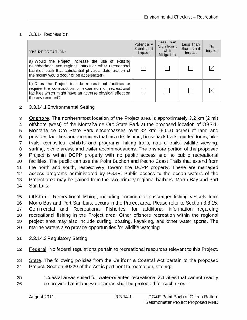
Environmental Checklist – Recreation
August 2011 3.3.14-1 PG&E Point Buchon Ocean BottomSeismometer Project Proposed MND
3.3.14 Recreation1
XIV. RECREATION:
PotentiallySignificant
Impact
Less ThanSignificant
withMitigation
Less ThanSignificant
Impact
NoImpact
a) Would the Project increase the use of existingneighborhood and regional parks or other recreationalfacilities such that substantial physical deterioration ofthe facility would occur or be accelerated?
b) Does the Project include recreational facilities orrequire the construction or expansion of recreationalfacilities which might have an adverse physical effect onthe environment?
3.3.14.1Environmental Setting2
Onshore. The northernmost location of the Project area is approximately 3.2 km (2 mi)3
offshore (west) of the Montaña de Oro State Park at the proposed location of OBS-1.4
Montaña de Oro State Park encompasses over 32 km2 (8,000 acres) of land and5
provides facilities and amenities that include: fishing, horseback trails, guided tours, bike6
trails, campsites, exhibits and programs, hiking trails, nature trails, wildlife viewing,7
surfing, picnic areas, and trailer accommodations. The onshore portion of the proposed8
Project is within DCPP property with no public access and no public recreational9
facilities. The public can use the Point Buchon and Pecho Coast Trails that extend from10
the north and south, respectively, toward the DCPP property. These are managed11
access programs administered by PG&E. Public access to the ocean waters of the12
Project area may be gained from the two primary regional harbors: Morro Bay and Port13
San Luis.14
Offshore. Recreational fishing, including commercial passenger fishing vessels from15
Morro Bay and Port San Luis, occurs in the Project area. Please refer to Section 3.3.15,16
Commercial and Recreational Fisheries, for additional information regarding17
recreational fishing in the Project area. Other offshore recreation within the regional18
project area may also include surfing, boating, kayaking, and other water sports. The19
marine waters also provide opportunities for wildlife watching.20
3.3.14.2Regulatory Setting21
Federal. No federal regulations pertain to recreational resources relevant to this Project.22
State. The following policies from the California Coastal Act pertain to the proposed23
Project. Section 30220 of the Act is pertinent to recreation, stating:24
“Coastal areas suited for water-oriented recreational activities that cannot readily25
be provided at inland water areas shall be protected for such uses.”26
Environmental Checklist – Recreation
PG&E Point Buchon Ocean Bottom 3.3.14-2 August 2011Seismometer Project Proposed MND
Section 30221 states, in part, that new development shall:1
“Oceanfront land suitable for recreational use shall be protected for recreational2
use and development unless present and foreseeable future demand for public3
or commercial recreational activities that could be accommodated on the4
property is already adequately provided for in the area.”5
Section 30223 states, in part, that new development shall:6
“Upland areas necessary to support coastal recreational uses shall be reserved7
for such uses, where feasible.”8
Section 30234 states, in part, that for new development:9
“Facilities serving the commercial fishing and recreational boating industries shall10
be protected and, where feasible, upgraded. Existing commercial fishing and11
recreational boating harbor space shall not be reduced unless the demand for12
those facilities no longer exists or adequate substitute space has been provided.13
Proposed recreational boating facilities shall, where feasible, be designed and14
located in such a fashion as not to interfere with the needs of the commercial15
fishing industry.”16
Local. The San Luis Obispo County Local Coastal Plan (1988) contains several policies17
related to parks and recreation. However, because of limited onshore Project activities,18
all of which are within DCPP property or within an existing berth location at Morro Bay19
Harbor, there are no policies that would pertain to Project-related activities.20
3.3.14.3 Impact Analysis21
a) Would the Project increase the use of existing neighborhood and regional22
parks or other recreational facilities such that substantial physical23
deterioration of the facility would occur or be accelerated?24
See response below.25
b) Does the Project include recreational facilities or require the construction26
or expansion of recreational facilities which might have an adverse27
physical effect on the environment?28
Onshore activities would occur within DCPP property or onboard the MV Michael Uhl29
while it is moored at its established berth within Morro Bay Harbor. Installation, recovery30
and operation of the proposed OBS units would not result in an increase in Project area31
population or a demand for onshore recreation facilities. Therefore, the Project would32
not result in deterioration of existing recreation facilities or require the construction of33
new facilities.34
Environmental Checklist – Recreation
August 2011 3.3.14-3 PG&E Point Buchon Ocean BottomSeismometer Project Proposed MND
Coastal Act policies that pertain to recreation facilities and opportunities require the1
protection of water-oriented recreation activities, protection of oceanfront and upland2
areas suitable for recreation use, and the protection of recreation boating facilities. The3
proposed Project would be consistent with these requirements in regard to onshore4
facilities because the Project would not result in impacts to existing recreation facilities5
or require the development of new facilities. As described in Section 3.3.15, Commercial6
and Recreational Fisheries, the Project would not result in significant impacts to7
recreational fishing, and as a result, would be consistent with Coastal Act policies8
related to offshore recreation resources and opportunities. Additional policy consistency9
analysis related to recreation opportunities is provided in Section 3.3.9, Land Use and10
Planning.11
3.3.14.4Mitigation and Residual Impacts12
Mitigation. The proposed Project would not result in significant recreation impacts.13
Therefore, no mitigation measures are required.14
Residual Impacts. The proposed Project would not result in impacts related to15
recreation facilities or opportunities. No mitigation is required and no residual impacts16
would occur.17
Environmental Checklist – Recreation
PG&E Point Buchon Ocean Bottom 3.3.14-4 August 2011Seismometer Project Proposed MND
PAGE PURPOSEFULLY LEFT BLANK

Environmental Checklist – Commercial and Recreational Fisheries
August 2011 3.3.15-1 PG&E Point Buchon Ocean BottomSeismometer Project Proposed MND
3.3.15 Commercial and Recreational Fisheries1
The region supports both commercial and recreational fishing activities, discussed2
below. The potential effects of the proposed Project on those activities and mitigation3
measures to reduce or eliminate those potential impacts are also provided. This4
environmental issue area is not included in the State CEQA Guidelines Appendix G5
checklist, but is included here due to the location of the proposed Project within the6
nearshore marine waters of central California.7
3.3.15.1Environmental Setting8
Commercial Fishing. Commercial catch data within the marine waters off California9
are reported by the CDFG from a series of 10 latitude by 10 longitude area blocks, each10
covering an area of approximately 343 km2 (100 nm2), called a Fish Block (FB). FB11
boundaries correspond to lines of latitude and longitude and so, due to the irregular12
California coast, FBs that include the shoreline encompass a smaller area. Figure13
3.3.15-1 shows the regional FB coverage; the Project area is within FB 615, which14
extends from the Morro Bay Sand Spit to approximately 1.9 km (1 nm) north of Point15
San Luis and offshore to water depths of up to approximately 320 m (1,050 ft). Seafloor16
habitats within that FB range from fine sediments in the deepest water areas to low- and17
high-relief rocky reefs and isolated pinnacles closer to shore.18
Data sources used in the following discussions include technical reports and personal19
communications with local fishers, and commercial catch data that were obtained from20
CDFG.21
The primary ports that provide facilities for commercial vessels within the area are22
Morro Bay and Port San Luis/Avila. Discussions with E. Endersby and S. McGraw (pers.23
comm.), harbormasters at Morro Bay and Port San Luis Harbors, respectively, indicate24
that currently between 145 and 170 commercial fishing vessels berth in the two ports25
(75 to 100 in Morro Bay and approximately 70 in Port San Luis). The number of trawlers26
within the Morro Bay/Avila Harbors has decreased over the past 10 years and,27
currently, commercial fishing in the vicinity of Morro Bay targets a variety of species28
ranging from crab to rockfish to pelagic species such as salmon and albacore. More29
recently, a trap fishery for hagfish has redeveloped in the region.30
Gear types used to catch these resources include trawl, gill net, trap, diving, round-haul31
nets, and hook-and-line. Table 3.3.15-1 provides a summary of the commercial gear32
types, target species, and areas fished within the Project area.33
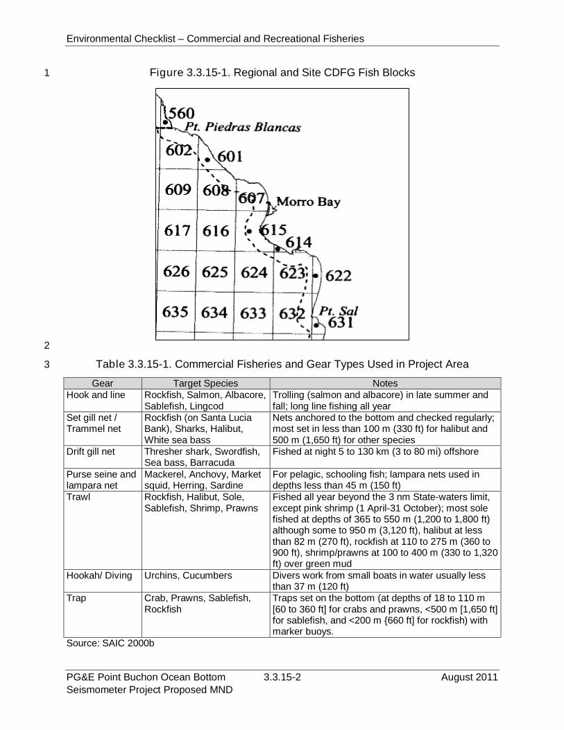
Environmental Checklist – Commercial and Recreational Fisheries
PG&E Point Buchon Ocean Bottom 3.3.15-2 August 2011Seismometer Project Proposed MND
Figure 3.3.15-1. Regional and Site CDFG Fish Blocks1
2
Table 3.3.15-1. Commercial Fisheries and Gear Types Used in Project Area3
Gear Target Species NotesHook and line Rockfish, Salmon, Albacore,
Sablefish, LingcodTrolling (salmon and albacore) in late summer andfall; long line fishing all year
Set gill net /Trammel net
Rockfish (on Santa LuciaBank), Sharks, Halibut,White sea bass
Nets anchored to the bottom and checked regularly;most set in less than 100 m (330 ft) for halibut and500 m (1,650 ft) for other species
Drift gill net Thresher shark, Swordfish,Sea bass, Barracuda
Fished at night 5 to 130 km (3 to 80 mi) offshore
Purse seine andlampara net
Mackerel, Anchovy, Marketsquid, Herring, Sardine
For pelagic, schooling fish; lampara nets used indepths less than 45 m (150 ft)
Trawl Rockfish, Halibut, Sole,Sablefish, Shrimp, Prawns
Fished all year beyond the 3 nm State-waters limit,except pink shrimp (1 April-31 October); most solefished at depths of 365 to 550 m (1,200 to 1,800 ft)although some to 950 m (3,120 ft), halibut at lessthan 82 m (270 ft), rockfish at 110 to 275 m (360 to900 ft), shrimp/prawns at 100 to 400 m (330 to 1,320ft) over green mud
Hookah/ Diving Urchins, Cucumbers Divers work from small boats in water usually lessthan 37 m (120 ft)
Trap Crab, Prawns, Sablefish,Rockfish
Traps set on the bottom (at depths of 18 to 110 m[60 to 360 ft] for crabs and prawns, <500 m [1,650 ft]for sablefish, and <200 m {660 ft] for rockfish) withmarker buoys.
Source: SAIC 2000b
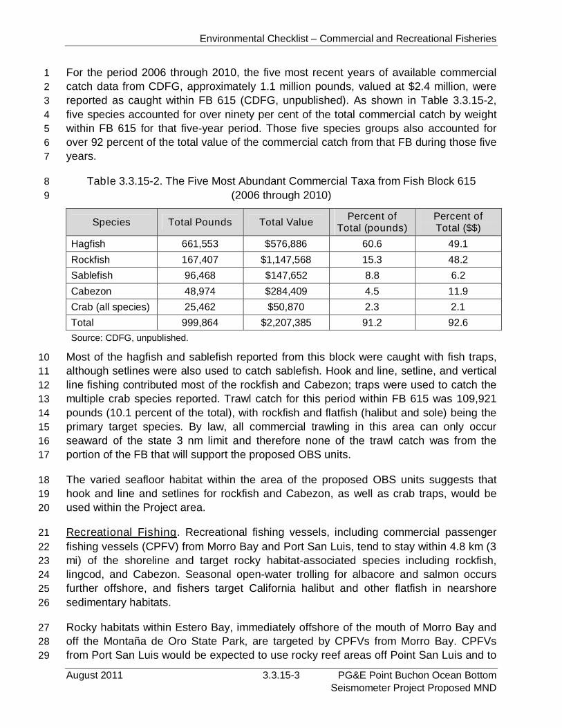
Environmental Checklist – Commercial and Recreational Fisheries
August 2011 3.3.15-3 PG&E Point Buchon Ocean BottomSeismometer Project Proposed MND
For the period 2006 through 2010, the five most recent years of available commercial1
catch data from CDFG, approximately 1.1 million pounds, valued at $2.4 million, were2
reported as caught within FB 615 (CDFG, unpublished). As shown in Table 3.3.15-2,3
five species accounted for over ninety per cent of the total commercial catch by weight4
within FB 615 for that five-year period. Those five species groups also accounted for5
over 92 percent of the total value of the commercial catch from that FB during those five6
years.7
Table 3.3.15-2. The Five Most Abundant Commercial Taxa from Fish Block 6158
(2006 through 2010)9
Species Total Pounds Total ValuePercent of
Total (pounds)Percent ofTotal ($$)
Hagfish 661,553 $576,886 60.6 49.1
Rockfish 167,407 $1,147,568 15.3 48.2
Sablefish 96,468 $147,652 8.8 6.2
Cabezon 48,974 $284,409 4.5 11.9
Crab (all species) 25,462 $50,870 2.3 2.1
Total 999,864 $2,207,385 91.2 92.6
Source: CDFG, unpublished.
Most of the hagfish and sablefish reported from this block were caught with fish traps,10
although setlines were also used to catch sablefish. Hook and line, setline, and vertical11
line fishing contributed most of the rockfish and Cabezon; traps were used to catch the12
multiple crab species reported. Trawl catch for this period within FB 615 was 109,92113
pounds (10.1 percent of the total), with rockfish and flatfish (halibut and sole) being the14
primary target species. By law, all commercial trawling in this area can only occur15
seaward of the state 3 nm limit and therefore none of the trawl catch was from the16
portion of the FB that will support the proposed OBS units.17
The varied seafloor habitat within the area of the proposed OBS units suggests that18
hook and line and setlines for rockfish and Cabezon, as well as crab traps, would be19
used within the Project area.20
Recreational Fishing. Recreational fishing vessels, including commercial passenger21
fishing vessels (CPFV) from Morro Bay and Port San Luis, tend to stay within 4.8 km (322
mi) of the shoreline and target rocky habitat-associated species including rockfish,23
lingcod, and Cabezon. Seasonal open-water trolling for albacore and salmon occurs24
further offshore, and fishers target California halibut and other flatfish in nearshore25
sedimentary habitats.26
Rocky habitats within Estero Bay, immediately offshore of the mouth of Morro Bay and27
off the Montaña de Oro State Park, are targeted by CPFVs from Morro Bay. CPFVs28
from Port San Luis would be expected to use rocky reef areas off Point San Luis and to29
Environmental Checklist – Commercial and Recreational Fisheries
PG&E Point Buchon Ocean Bottom 3.3.15-4 August 2011Seismometer Project Proposed MND
the south offshore Pismo Beach, as well as sedimentary habitats within San Luis Bay1
where halibut and pelagic species would most likely be found.2
3.3.15.2Regulatory Setting3
Federal. No federal regulations are applicable to the commercial and recreational4
fishing within the area.5
State6
California Coastal Act. The Coastal Act includes the following policies related to7
commercial and recreational facilities and opportunities.8
Section 30234 states, in part: “Facilities serving the commercial fishing and recreational9
boating industries shall be protected and, where feasible upgraded. Existing commercial10
fishing and recreational boating harbor space shall not be reduced unless the demand11
for those facilities no longer exists or adequate substitute space has been provided.12
Proposed recreational boating facilities shall, where feasible, be designed and located13
in such a fashion as not to interfere with the needs of the commercial fishing industry.”14
Section 30234.5 states, in part: “The economic, commercial, and recreational15
importance of fishing activities shall be recognized and protected.”16
Marine Life Protection Act of 1999 (MLPA) (Fish & G. Code § 2850 et seq.). The17
MLPA directs the State to redesign California's system of MPAs to function as a network18
in order to: increase coherence and effectiveness in protecting the state's marine life19
and habitats, marine ecosystems, and marine natural heritage, as well as to improve20
recreational, educational and study opportunities provided by marine ecosystems21
subject to minimal human disturbance. There are six goals that guide the development22
of MPAs in the MLPA planning process: 1) Protect the natural diversity and abundance23
of marine life, and the structure, function and integrity of marine ecosystems; 2) Help24
sustain, conserve and protect marine life populations, including those of economic25
value, and rebuild those that are depleted; 3) Improve recreational, educational and26
study opportunities provided by marine ecosystems that are subject to minimal human27
disturbance, and to manage these uses in a manner consistent with protecting28
biodiversity; 4) Protect marine natural heritage, including protection of representative29
and unique marine life habitats in California waters for their intrinsic values; 5) Ensure30
California's MPAs have clearly defined objectives, effective management measures and31
adequate enforcement and are based on sound scientific guidelines; and 6) Ensure the32
State's MPAs are designed and managed, to the extent possible, as a network.33
To help achieve these goals, three types of MPA designation types are used in the34
MLPA process: SMRs, SMCAs, and state marine parks (see Section 3.3.4.2,35
Regulatory Setting, for restrictions applied to SMR and SMCA areas).36
Environmental Checklist – Commercial and Recreational Fisheries
August 2011 3.3.15-5 PG&E Point Buchon Ocean BottomSeismometer Project Proposed MND
State of California, 2011-2012 California Ocean Sport Fishing Regulations. Each1
year, the CFGC issues regulations on recreational fishing within the marine waters of2
the State of California. These regulations specify season, size and bag limits, and gear3
restrictions as well as licensing requirements. Since the development of the MPAs, a4
section on fishing restrictions within the MPAs has also been included.5
State of California, Commercial Fishing Laws and Licensing Requirements.6
Similar to the recreational fishing industry, commercial fishing is regulated by a series of7
laws passed by the CFGC and issued each year in a summary document. Seasonal8
and gear restrictions within the various Fish and Game Districts, licensing instructions9
and restrictions, and species-specific fishing requirements are provided in the10
document. Most of the MPAs have commercial fishing restrictions (based on the11
designation of each area) which are also listed in the summary document.12
3.3.15.3 Impact Analysis13
Significance Criteria. Although no federal or state criteria for significant impacts to the14
fisheries of the Project area have been established, previous state-administered15
environmental analyses have used loss of available area, reduction of habitat, and/or16
substantial decrease in the number of organisms of commercial or recreational value as17
the basis for analyzing impacts. For the proposed Project, a significant impact to the18
fisheries would occur if:19
a) 10 percent or more of the currently-available fishing area used by a target20
species was lost.21
b) Commercial or recreational fishing activities were precluded from a currently-22
utilized area for more than one month.23
c) The Project resulted in substantial reduction in the Essential Fish Habitat24
required by one or more of the species managed by the Pacific Fisheries25
Management Council’s fisheries management plans.26
Impact Discussion27
The proposed Project consists of placing temporary and long-term OBS units and an28
associated cable onto the seafloor in water depths up to 82 m (270 ft) within the state 329
nm limit. Short-term, less than significant impacts to the recreational and commercial30
operations within the immediate area of the Project vessels would occur due to31
preclusion of available area. This temporary (less than one day for any one location)32
impact is not considered to be significant due to the availability of the similar seafloor33
habitat and open water areas within the region. Less than 1 percent of the available34
fishing area within the Project area would be affected during the installation and35
operation of the OBS units and cable.36
Environmental Checklist – Commercial and Recreational Fisheries
PG&E Point Buchon Ocean Bottom 3.3.15-6 August 2011Seismometer Project Proposed MND
Potentially significant impacts to in-place commercial fishing gear could occur if the1
project vessel passes across and/or the cable and OBS units are laid onto that gear.2
The potential for such an impact to occur would be reduced by the applicant-proposed3
noticing of local fishing interests through the issuance of a Notice to Mariners, and4
through the posting of notices in the harbor master’s offices of Morro Bay and Port San5
Luis at least 15 days in advance of in-water operations; however, there remains a6
chance that commercial fishing gear will be in-place during in-water operations. The7
implementation of mitigation measure MM FISH-1, described below, would ensure this8
potential impact remains less than significant.9
As is discussed in the Essential Fish Habitat Assessment (Appendix G), no significant10
project-related impacts to the Habitats of Particular Concern (HAPC) which include kelp11
beds, sea grass areas, and rocky reefs, are expected as a result of the proposed12
Project. The OBS units are to be placed on sedimentary habitat and the cable has been13
routed to avoid HAPCs throughout its length. Further, the cable has been routed to14
avoid as much rocky substrate as possible and crosses approximately 1.0 km (0.6 mi)15
of low-relief solid substrate which is less than 10 percent of the total proposed cable16
length. As designed, no significant impacts to the EFH are expected to result from the17
installation or operation of the proposed project.18
Although the OBS units would extend up to 0.3 m (1.0 ft) above the seafloor, assuming19
no natural burial, those units are not expected to represent a significant “snag” for20
recreational or commercial fishing operations. Likewise, the cable, which is expected to21
naturally sink into the sediment, is not expected to be a significant seafloor obstruction22
to recreational or commercial fishing. Where the OBS cable crosses the low-relief rock23
habitat is within the DCPP Security Zone, which has restricted access to recreational24
and commercial fishing vessels. Also, with the completion of the post-installation survey25
of the cable and long-term OBS units, the locations of the units will be provided to the26
NOAA nautical chart facility for incorporation onto future nautical charts. As proposed,27
no significant effects of the cable within this area to ongoing and future fishing are28
expected.29
PG&E, however, proposes to leave the concrete ballast pieces associated with the30
temporary OBS units in place after removal of the data spheres. These pieces are31
expected to sink below the mudline, which would make them difficult to remove. MM32
FISH-2, described below, would require a post-construction survey to verify that the33
pieces do not pose a hazard to commercial fishing operations. CSLC staff will review34
the results of the survey and require removal of the ballast pieces if they are a hazard.35
The proposed Project would generate a small amount of additional vessel traffic in and36
out of the Morro Bay Harbor, and would not result in any physical changes to any harbor37
facilities provided in the Project area. Therefore, the Project would not result in any38
adverse effects to existing commercial or recreational fishing facilities. As demonstrated39
Environmental Checklist – Commercial and Recreational Fisheries
August 2011 3.3.15-7 PG&E Point Buchon Ocean BottomSeismometer Project Proposed MND
by the analysis provided above, the Project would not result in activities that would1
substantially diminish the importance of commercial or recreational fishing activities that2
occur in the Project area. Therefore, the Project would be consistent with the Coastal3
Act policies described in Section 3.3.15.2, Regulatory Setting.4
3.3.15.4Mitigation and Residual Impacts5
Mitigation6
FISH-1 At the beginning of each day that in-water operations are to occur,7
observations would be made along the proposed cable route and note8
the presence of in-place commercial fishing gear located within 30 m9
(100 ft) of the OBS site and/or cable route. The vessel operator will10
notify the owner of the gear and request that the gear be removed11
and/or the cable will be re-routed to avoid the existing gear by at least12
30 m (100 ft).13
FISH-2 Upon Project completion and removal of the Ocean Bottom14
Seismometer (OBS) units, the Applicant shall survey the site of each15
OBS site and the cable route, submit a report to California State Lands16
Commission (CSLC) staff documenting the condition of any Project-17
related materials left on the seafloor, and remove, within six months18
after Project completion, any Project-related materials that CSLC staff19
determines pose a hazard to commercial fishing operations.20
Residual Impacts. With the incorporation of the proposed mitigation, no residual21
impacts are expected.22
Environmental Checklist – Commercial and Recreational Fisheries
PG&E Point Buchon Ocean Bottom 3.3.15-8 August 2011Seismometer Project Proposed MND
PAGE PURPOSEFULLY LEFT BLANK
Environmental Checklist – Transportation/Traffic
August 2011 3.3.16-1 PG&E Point Buchon Ocean BottomSeismometer Project Proposed MND
3.3.16 Transportation / Traffic1
XVI. TRANSPORTATION / TRAFFIC:
Would the Project:
PotentiallySignificant
Impact
Less ThanSignificant
withMitigation
Less ThanSignificant
Impact
NoImpact
a) Conflict with an applicable plan, ordinance or policyestablishing measures of effectiveness for theperformance of the circulation system, taking intoaccount all modes of transportation including masstransit and non-motorized travel and relevantcomponents of the circulation system, including but notlimited to intersections, streets, highways and freeways,pedestrian and bicycle paths, and mass transit?
b) Conflict with an applicable congestion managementprogram, including, but not limited to level of servicestandards and travel demand measures, or otherstandards established by the county congestionmanagement agency for designated roads or highways?
c) Result in a change in air traffic patterns, includingeither an increase in traffic levels or a change in locationthat results in substantial safety risks?
d) Substantially increase hazards due to a designfeature (e.g., sharp curves or dangerous intersections)or incompatible uses (e.g., farm equipment)?
e) Result in inadequate emergency access?
f) Conflict with adopted policies, plans or programsregarding public transit, bicycle, or pedestrian facilities,or otherwise decrease the performance or safety of suchfacilities?
The following section discusses existing transportation routes within the Project area.2
This includes both onshore transportation and offshore marine vessel activity within the3
Project area as well as information on local ports.4
3.3.16.1Environmental Setting5
Onshore Transportation. The onshore portion of the proposed Project is located within6
the DCPP facility. Access to the facility is gained regionally from U.S. Highway 101 to7
Port San Luis via either Avila Beach Drive (access from the south) or San Luis Bay8
Drive (access from the north), which merges into Avila Beach Drive near Avila Beach.9
Access to the site is then gained by entering Lighthouse Road to the north, which then10
turns into Pecho Road. Pecho Road is a privately owned and gated roadway maintained11
by PG&E for the DCPP. Pecho Road continues for approximately 9.6 km (6 mi) through12
agricultural and grazing lands to the DCPP facility.13
Environmental Checklist – Transportation/Traffic
PG&E Point Buchon Ocean Bottom 3.3.16-2 August 2011Seismometer Project Proposed MND
Existing Traffic Volumes and Levels of Service. Transportation conditions are often1
described in terms of level of service (LOS), which is a means of describing the existing2
amount of traffic on a roadway compared to the design capacity of the roadway. The3
design capacity of a roadway is defined as the maximum rate of vehicle travel, e.g.,4
vehicles per hour that can reasonably be expected along a section of roadway. Capacity5
is dependent upon road classification and number of lanes, road condition, terrain,6
weather, and driver characteristics. LOS is generally a function of the ratio of traffic7
volume (V) to the capacity (C) of the roadway or intersection. The LOS rating uses8
qualitative measures that characterize operational conditions within a traffic stream and9
their perception by motorists. These measures include freedom of movement, speed10
and travel time, traffic interruptions, types of vehicles, comfort, and convenience.11
The County of San Luis Obispo has established level of service “C” as the acceptable12
level of service for roadways in the Avila area including San Luis Bay Drive and Avila13
Beach Drive. Previous studies have attempted to measure the wide range of traffic14
volumes experienced in the area during the summer months, which lead to the15
establishment of a level of service of “D” for the summertime weekends. U.S. Highway16
101, however, is currently operating at a level of service “D” near Morro Bay and at LOS17
“E” or worse near the Avila Beach exits, falling below the Caltrans LOS standard for18
highways. Pecho Road has not been evaluated for LOS but, since this road primarily19
serves the DCPP, traffic levels on the roadway are expected to be low except during20
shift changes.21
Pedestrian and Bicycle Routes. The Avila Beach area is a popular tourist/recreational22
area with beach, marina, hot springs, golf, and other recreational attractions. Bicycle23
and pedestrian routes currently exist along Avila Beach Drive from U.S. Highway 101 to24
Avila Beach, and additional bike paths (Class I) and bike lanes (Class II) are proposed25
along San Luis Bay Drive and Avila Beach Drive from the highway to the San Luis Pier26
(San Luis Obispo County 2009).27
Offshore Transportation. Marine traffic in the Project area includes commercial and28
recreational vessels operating primarily from the Port of San Luis (to the south) and29
Morro Bay Harbor (to the north).30
Morro Bay Harbor. The City of Morro Bay currently owns and operates all facilities at31
the Morro Bay Harbor. The City maintains and operates North & South T-Piers as well32
as a floating dock and anchorage area for transient vessels. In addition, the City33
maintains approximately 500 moorings, berths, and slips, of which 75 to 100 are used34
by commercial fishing vessels (E. Endersby, pers. comm.).35
Port San Luis Harbor. The Harbor District owns and controls both land and tideland36
properties at San Luis Obispo Bay including Port San Luis Harbor. According to the37
Harbor District 2004 Master Plan, the primary active use of San Luis Harbor area is for38
Environmental Checklist – Transportation/Traffic
August 2011 3.3.16-3 PG&E Point Buchon Ocean BottomSeismometer Project Proposed MND
navigation and mooring of commercial and recreational vessels and it serves a variety1
of water-oriented recreational uses related to Olde Port Beach, Avila Beach, Pirate’s2
Cove, and numerous sheltered inlets below the Sunset Palisades area of Pismo Beach.3
Approximately 280 moorings are currently in use in the main harbor, divided among4
recreational power and sailing vessels, commercial fishing, guest boats, and5
approximately one dozen recreational moorings are on the west side of Avila Pier.6
3.3.16.2Regulatory Setting7
Federal. Federal regulations concerning marine navigation are codified in 33 CFR Parts8
1 through 399 and are implemented by the USCG and the ACOE. Federal regulations9
for marine vessel shipping are codified in 46 CFR Parts 1 through 599 and are10
implemented by the USCG, Maritime Administration, and Federal Maritime Commission.11
California laws concerning marine navigation are codified in the Harbors and Navigation12
Code and are implemented by local city and county governments.13
The entire marine vessel study area is within the 11th USCG District, which includes all14
of California and the offshore waters. Each USCG District publishes a weekly Local15
Notice to Mariners (LNTM), which is the primary means of disseminating information16
pertaining to navigational safety and other items of interest to mariners. Information17
contained in the LNTM includes reports of hazards to navigation, channel conditions,18
obstructions, dangers, anchorages, restricted areas, regattas, construction or19
modification of bridges, construction or removal of oil platforms, and laying of undersea20
cable. LNTMs are developed from information received from USCG field units, the21
general public, the ACOE, U.S. Merchant Fleet, National Ocean Service, and other22
sources, concerning the establishment of, changes to, and deficiencies in aids to23
navigation and any other information pertaining to the safety of the waterways.24
Designated coastwise shipping traffic lanes have been established along two portions of25
the California coast: (1) in the vicinity of the entrance to San Francisco Bay, and (2)26
from Point Conception southeast to the vicinity of the entrance to the Ports of Los27
Angeles and Long Beach. The shipping lanes are generally 7.4 to 37 km (4 to 20 nm)28
offshore. Where shipping lanes have not been established, such as the central coast,29
navigation practice has produced a pattern of traffic flow at various distances from shore30
based on transit direction, vessel type, and cargo. Members of the Western States31
Petroleum Association, whose tankers carry crude oil from Alaska, agreed in 1990 to32
voluntarily keep laden vessels a minimum of 93 km (50 nm) from shore along the33
California central coast. Slower-going ocean tank barges transit the central coast34
approximately 28 to 46 km (15 to 25 nm) from shore to minimize interaction with the35
offshore oil tankers and the inshore container ships. Given these practices, ocean tank36
barges and oil tankers would be approximately 7 km (4.2 nm) west of the proposed37
offshore project area.38
Environmental Checklist – Transportation/Traffic
PG&E Point Buchon Ocean Bottom 3.3.16-4 August 2011Seismometer Project Proposed MND
State. Chapter 2, Article 3 of the California Vehicle Code defines the powers and duties1
of the California Highway Patrol, which has enforcement responsibilities for the2
operation of vehicles and highway use within the state. In addition to the California3
Vehicle Code, Caltrans is responsible for the design, construction, maintenance, and4
operation of the California State Highway System, as well as that portion of the5
Interstate Highway System within the state's boundaries.6
Local. The Project is located in San Luis Obispo County and is subject to the policies7
and plans within the County General Plan Transportation Element (1979), the Avila8
Beach Specific Plan (2001) and the San Luis Bay Specific Area (2009). In addition to9
the area General Plan and Specific Plans, Project vessels using the Morro Bay Harbor10
would be subject to the regulations and requirements of the Morro Bay Harbor11
Administration.12
3.3.16.3 Impact Analysis13
Significance Criteria. In addition to State CEQA Guidelines criteria “a” through “f” listed14
above, a significant transportation impact would result if the Project:15
Reduces the existing level of safety for vessels transiting the Project area; or16
Substantially increases the potential for vessel collisions.17
Impact Discussion18
a) Conflict with an applicable plan, ordinance or policy establishing measures19
of effectiveness for the performance of the circulation system, taking into20
account all modes of transportation including mass transit and non-21
motorized travel and relevant components of the circulation system,22
including but not limited to intersections, streets, highways and freeways,23
pedestrian and bicycle paths, and mass transit?24
See response below.25
b) Conflict with an applicable congestion management program, including but26
not limited to level of service standards and travel demand measures, or27
other standards established by the county congestion management agency28
for designated roads or highways?29
Offshore Impacts. The proposed Project consists of placing instruments and cable30
onto the offshore the DCPP. As such, the Project is not located within or adjacent to any31
vessel transportation facilities or corridors. The majority of Project activities would take32
place offshore within the confines of a requested CSLC offshore lease area. OBS units33
would be installed using the MV Michael Uhl, a 30 m- (100 ft) long, steel hulled work34
boat owned and operated by Maritime Logistics of Morro Bay. In addition, a smaller35

Environmental Checklist – Transportation/Traffic
August 2011 3.3.16-5 PG&E Point Buchon Ocean BottomSeismometer Project Proposed MND
diver support vessel will be used in the area within the DCPP intake embayment. As1
such, it is anticipated that most Project vessel traffic and personnel will be mobilized2
from Morro Bay; an existing small boat dock will be used for the diver support vessel at3
DCPP. Because local vessels (i.e., vessels with existing berthing) would be used for4
crew and supply transport, no additional berthing for Project-related vessels within5
Morro Bay or Avila will be needed.6
The installation of the temporary OBS units is expected to take approximately two days,7
followed by a period of data collection of approximately two weeks, prior to being moved8
to two new locations for another two weeks of data collection. Long-term OBS units9
would be installed concurrently with the installation of the first two temporary OBS units.10
Following the installation of each long-term OBS unit, the MV Michael Uhl will return to11
the Morro Bay Harbor to mobilize the next unit until all four units have been placed.12
Following installation, the long-term OBS units would remain in place for up to 10 years.13
Vessel traffic within Morro Bay Harbor may increase by up to two boat trips per day on14
days that OBS unit installation/recovery operations occur, except during data collection15
activities during which no vessels would be onsite (approximately two weeks during16
temporary OBS unit collection). This small increase in vessel traffic would not17
substantially reduce vessel safety conditions and would not result in a significant18
transportation impact.19
Project-related vessels would travel from the Morro Bay Harbor south to the Project20
area. Vessels are expected to follow the most direct route avoiding shallow water areas21
and the surf zone, thus reducing the chance for vessel interactions during transit. PG&E22
has agreed to submit the required Notice to Mariners, which will specify vessel type,23
location, operation, and contact information prior to in-water operations. Notices of the24
proposed activities will also be posted at the harbormaster’s offices at Morro Bay and25
Port San Luis. All Project vessels will use appropriate markings and/or lighting to26
designate the vessels as either towing equipment, conducting diver operations or27
operating with limited maneuverability. As such, the Project would not substantially28
increase the potential for vessel collisions and would not result in a significant29
transportation impact.30
Onshore Traffic. Traffic that would be generated by proposed offshore operations31
would include activities such as MV Michael Uhl and support vessel crew commuting to32
and from the Morro Bay Harbor, and the transportation of Project-related equipment33
(cable and OBS units) to Morro Bay Harbor. It is expected that vessel crew would be34
from the local area, and that equipment delivery trips would be “one time” deliveries that35
would not substantially increase traffic on local roadways.36
Approximately 15 personnel would be required for offshore work, and those Project-37
related crew would commute to and from the Morro Bay Harbor intermittently during the38
Environmental Checklist – Transportation/Traffic
PG&E Point Buchon Ocean Bottom 3.3.16-6 August 2011Seismometer Project Proposed MND
one-month period that Project-related mobilization, demobilization and installation1
operations would occur. Installation of the permanent and first deployment of temporary2
OBS units and the cable is expected to take one week to complete. The addition of boat3
crew commute trips (approximately 30 vehicle trips on days that the vessel leaves or4
returns to the harbor) to roadways that provide access to the Morro Bay Harbor would5
be a temporary impact, and would not result in significant impacts to existing circulation6
system conditions or conflict with County and Caltrans standards for roadway7
operations. Temporary increases in vehicle traffic to the harbor would not conflict with a8
traffic-related policy or Congestion Management Plan.9
c) Result in a change in air traffic patterns, including either an increase in10
traffic levels or a change in location that results in substantial safety risks?11
The proposed Project does not include any activities that would require the use or12
modification of existing air space. Furthermore, the Project is not located near any13
airstrips or airports. As such, no impacts to air traffic patterns or air traffic levels will14
result.15
d) Substantially increase hazards due to a design feature (e.g., sharp curves16
or dangerous intersections) or incompatible uses (e.g., farm equipment)?17
The proposed Project consists of placing instruments and cable onto the seafloor within18
the state 3 nm limit. The proposed OBS units are approximately 0.3 m (1 ft) high and19
would not interfere with existing vessel traffic, nor would the units create any other20
hazards for vessels. The power/data transfer cable would be located along the seafloor21
of the intake cove prior to being strung through the existing conduit to the data collection22
building. By stringing the cable through the conduit system, the power/data cable will23
not cross any roads or streets and will not increase hazards along any roadways.24
e) Result in inadequate emergency access?25
Emergency access to the DCPP occurs via the private, gated access route along Pecho26
Road. Proposed Project activities would not change existing emergency access routes27
to the DCPP, and would not generate a substantial amount of traffic that would28
adversely affect emergency access to the Project area or other locations in the Project29
area. The only onshore Project component is the extension of an existing conduit that30
would house the power/data transfer cable, which does not occur at or near Pecho31
Road. As such, the Project would not interfere with Pecho Road or any of the access32
routes within the DCPP. Therefore, the Project would have no impact on existing33
emergency access conditions.34
f) Conflict with adopted policies, plans or programs regarding public transit,35
bicycle, or pedestrian facilities, or otherwise decrease the performance or36
safety of such facilities?37
Environmental Checklist – Transportation/Traffic
August 2011 3.3.16-7 PG&E Point Buchon Ocean BottomSeismometer Project Proposed MND
The only onshore component of the proposed Project would occur within the existing1
DCPP facility and consist of extending an existing conduit that would house the2
power/data transfer cable prior to its entry into the building housing the equipment used3
for data collection. No public entry is allowed within the DCPP facility. No public4
transportation routes, bicycle routes or pedestrian walkways are located within or5
adjacent to the facility. Onshore personnel would be limited to existing DCPP6
employees and no additional vehicle trips would be necessary. As such, the onshore7
portion of the proposed Project would have no impacts to existing circulation systems.8
The existing conduit is buried under the perimeter roadway and will not be excavated to9
install the cable. No traffic disruption would result from the onshore cable installation.10
3.3.16.4Mitigation and Residual Impacts11
Mitigation. Traffic generated by the proposed Project would not be substantial, would12
occur intermittently, and would occur over a short (one month) period of time. Therefore,13
the Project’s transportation and traffic impacts would be less than significant and no14
mitigation measures are required.15
Residual Impacts. The proposed project would have less than significant traffic and16
transportation impacts. No mitigation is required, and no significant residual impacts17
would occur.18

Environmental Checklist – Transportation/Traffic
PG&E Point Buchon Ocean Bottom 3.3.16-8 August 2011Seismometer Project Proposed MND
PAGE PURPOSEFULLY LEFT BLANK
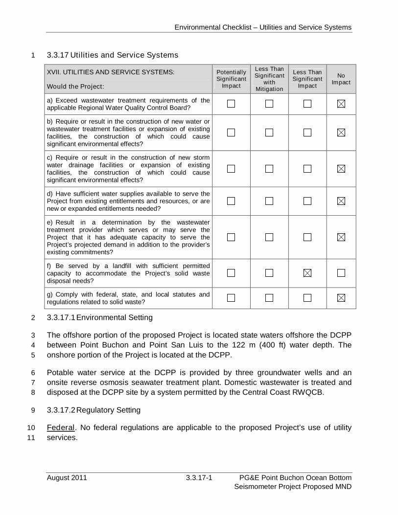
Environmental Checklist – Utilities and Service Systems
August 2011 3.3.17-1 PG&E Point Buchon Ocean BottomSeismometer Project Proposed MND
3.3.17 Utilities and Service Systems1
XVII. UTILITIES AND SERVICE SYSTEMS:
Would the Project:
PotentiallySignificant
Impact
Less ThanSignificant
withMitigation
Less ThanSignificant
Impact
NoImpact
a) Exceed wastewater treatment requirements of theapplicable Regional Water Quality Control Board?
b) Require or result in the construction of new water orwastewater treatment facilities or expansion of existingfacilities, the construction of which could causesignificant environmental effects?
c) Require or result in the construction of new stormwater drainage facilities or expansion of existingfacilities, the construction of which could causesignificant environmental effects?
d) Have sufficient water supplies available to serve theProject from existing entitlements and resources, or arenew or expanded entitlements needed?
e) Result in a determination by the wastewatertreatment provider which serves or may serve theProject that it has adequate capacity to serve theProject’s projected demand in addition to the provider’sexisting commitments?
f) Be served by a landfill with sufficient permittedcapacity to accommodate the Project’s solid wastedisposal needs?
g) Comply with federal, state, and local statutes andregulations related to solid waste?
3.3.17.1Environmental Setting2
The offshore portion of the proposed Project is located state waters offshore the DCPP3
between Point Buchon and Point San Luis to the 122 m (400 ft) water depth. The4
onshore portion of the Project is located at the DCPP.5
Potable water service at the DCPP is provided by three groundwater wells and an6
onsite reverse osmosis seawater treatment plant. Domestic wastewater is treated and7
disposed at the DCPP site by a system permitted by the Central Coast RWQCB.8
3.3.17.2Regulatory Setting9
Federal. No federal regulations are applicable to the proposed Project’s use of utility10
services.11
Environmental Checklist – Utilities and Service Systems
PG&E Point Buchon Ocean Bottom 3.3.17-2 August 2011Seismometer Project Proposed MND
State. The RWQCB has permitted the DCPP domestic wastewater treatment and1
disposal system.2
Local. The County of San Luis Obispo Local Coastal Plan and CZLUSO provide a3
variety of policies and requirements related to the provision of utility services.4
3.3.17.3 Impact Analysis5
a) Would the project exceed wastewater treatment requirements of the6
applicable Regional Water Quality Control Board?7
Proposed onshore and offshore construction activities would not result in the generation8
of a substantial amount of domestic wastewater. All wastewater generated by the9
primary vessel, MV Michael Uhl, would be disposed of at an authorized facility in Morro10
Bay Harbor. Long-term operation of the proposed OBS units would not be a source of11
wastewater. Therefore, the Project would not result in significant wastewater treatment12
or disposal impacts, and would not conflict with requirements of the RWQCB.13
b) Would the project require or result in the construction of new water or14
wastewater treatment facilities or expansion of existing facilities, the15
construction of which could cause significant environmental effects?16
Proposed onshore and offshore construction activities would not result in the generation17
of a substantial amount of domestic wastewater. All wastewater generated by the18
primary vessel, MV Michael Uhl, would be disposed of at an authorized facility in Morro19
Bay Harbor. Long-term operation of the proposed OBS units would not be a source of20
wastewater. Therefore, the Project would not result in significant wastewater treatment21
or disposal impacts, and would not conflict with requirements of the RWQCB.22
c) Would the project require or result in the construction of new storm water23
drainage facilities or expansion of existing facilities, the construction of24
which could cause significant environmental effects?25
Proposed onshore construction would consist of the construction and installation of26
approximately 10 m (30 ft) of new power/data transfer cable conduit to be located over27
existing rock rip-rap. The proposed cable conduit would not result in a significant28
change to existing stormwater runoff characteristics.29
d) Would the project have sufficient water supplies available to serve the30
Project from existing entitlements and resources, or are new or expanded31
entitlements needed?32
Proposed onshore and offshore construction activities would use existing potable water33
sources and the long-term operation of proposed OBS units would not require the use34
Environmental Checklist – Utilities and Service Systems
August 2011 3.3.17-3 PG&E Point Buchon Ocean BottomSeismometer Project Proposed MND
of potable water. Therefore, the Project would not result in significant domestic water1
supply impacts.2
e) Would the project result in a determination by the wastewater treatment3
provider which serves or may serve the Project that it has adequate4
capacity to serve the Project’s projected demand in addition to the5
provider’s existing commitments?6
Proposed onshore and offshore construction activities would not result in the generation7
of a substantial amount of domestic wastewater. All wastewater generated by the8
primary vessel, MV Michael Uhl, would be disposed of at an authorized facility in Morro9
Bay Harbor. Long-term operation of the proposed OBS units would not be a source of10
wastewater. Therefore, the Project would not result in significant wastewater treatment11
or disposal impacts and would not conflict with requirements of the RWQCB.12
f) Would the project be served by a landfill with sufficient permitted capacity13
to accommodate the Project’s solid waste disposal needs? See response14
below.15
See response below.16
g) Would the project comply with federal, state, and local statutes and17
regulations related to solid waste?18
Project-related solid wastes would generally be limited to incidental food and paper19
products that would be retained onboard the vessel. All Project-generated onboard and20
onshore wastes would be removed from the vessel or onshore site at the end of each21
work day and following demobilization of Project vessels. Wastes would be disposed of22
in covered containers onboard the vessel and at the onshore site and would be23
disposed of at an appropriate disposal site. The extremely small amount of solid waste24
generated during proposed OBS installation operation would not adversely affect the25
waste disposal capacity or recycling capabilities of waste management facilities located26
in the Project area. The proposed Project would not be a long-term source of solid27
waste. Therefore, the proposed Project would not result in significant solid waste28
management or disposal impacts.29
3.3.17.4Mitigation and Residual Impacts30
Mitigation. The proposed Project would not result in significant impacts to utilities or31
municipal services; therefore, no mitigation measures are required.32
Residual Impacts. The proposed project would have no impact on existing municipal33
services. No mitigation is required and no residual impacts would occur.34

Environmental Checklist – Utilities and Service Systems
PG&E Point Buchon Ocean Bottom 3.3.17-4 August 2011Seismometer Project Proposed MND
PAGE PURPOSEFULLY LEFT BLANK
Environmental Checklist – Mandatory Findings of Significance
August 2011 3.3.18-1 PG&E Point Buchon Ocean BottomSeismometer Project Proposed MND
3.3.18 Mandatory Findings of Significance1
XVIII. MANDATORY FINDINGS OF SIGNIFICANCE –
The lead agency shall find that a project may have asignificant effect on the environment and therebyrequire an EIR to be prepared for the project wherethere is substantial evidence, in light of the wholerecord, that any of the following conditions mayoccur. Where prior to commencement of theenvironmental analysis a project proponent agreesto mitigation measures or project modifications thatwould avoid any significant effect on theenvironment or would mitigate the significantenvironmental effect, a lead agency need notprepare an EIR solely because without mitigationthe environmental effects would have beensignificant (per Section 15065 of the State CEQAGuidelines):
PotentiallySignificant
Impact
Less ThanSignificant
withMitigation
Less ThanSignificant
Impact
NoImpact
a) Does the project have the potential to degrade thequality of the environment, substantially reduce thehabitat of a fish or wildlife species, cause a fish orwildlife population to drop below self-sustaining levels,threaten to eliminate a plant or animal community,substantially reduce the number or restrict the range ofa rare or endangered plant or animal or eliminateimportant examples of the major periods of Californiahistory or prehistory?
b) Does the project have the potential to achieve short-term environmental goals to the disadvantage of long-term environmental goals?
c) Does the project have impacts that are individuallylimited, but cumulatively considerable? (“Cumulativelyconsiderable” means that the incremental effects of aproject are significant when viewed in connection withthe effects of past projects, the effects of other currentprojects, and the effects of past, present and probablefuture projects)?
d) Does the project have environmental effects whichwill cause substantial adverse effects on human beings,either directly or indirectly?
3.3.18.1 Impact Analysis2
a) Does the project have the potential to degrade the quality of the3
environment, substantially reduce the habitat of a fish or wildlife species,4
cause a fish or wildlife population to drop below self-sustaining levels,5
threaten to eliminate a plant or animal community, substantially reduce the6
number or restrict the range of a rare or endangered plant or animal or7
Environmental Checklist – Mandatory Findings of Significance
PG&E Point Buchon Ocean Bottom 3.3.18-2 August 2011Seismometer Project Proposed MND
eliminate important examples of the major periods of California history or1
prehistory?2
As described in Section 3.3.4, Biological Resources, the proposed Project would not3
result in significant impacts to sensitive marine resources and would not have a4
significant effect on listed species or habitat used by those species. Sensitive habitats5
located within the Project area such as sea grass and kelp beds would be avoided, and6
rocky features where the proposed power/data transfer cable would be laid would not7
be significantly affected. Organisms that could be potentially affected by the deployment8
of the proposed OBS units and associated cable include polychaete worms, sea pens,9
anemones, seastars, mollusks, and possibly small, leafy red algae attached to the10
upper portions of some of the rock features. Impacts to these common species that may11
result from burial under the OBS units or burial or abrasion by the cable would not result12
in a significant impact. Therefore, the Project would not result in significant impacts13
related to habitat reduction, fish or wildlife populations, or the range of sensitive species.14
As described in Section 3.3.5, Cultural Resources, the proposed Project would not15
result in significant impacts to any known cultural resources and the potential for the16
Project to encounter previously undetected resources is remote.17
b) Does the project have the potential to achieve short-term environmental18
goals to the disadvantage of long-term environmental goals?19
As described in Section 3.3.9, Land Use and Planning, the proposed Project would be20
consistent with applicable policies of the Coastal Act and San Luis Obispo County. The21
Project would not result in impacts such as an increase in the population of the Project22
area, which would have the potential to result in long-term impacts.23
c) Does the project have impacts that are individually limited, but24
cumulatively considerable? (“Cumulatively considerable” means that the25
incremental effects of a project are significant when viewed in connection26
with the effects of past projects, the effects of other current projects, and27
the effects of past, present and probable future projects)?28
Project-related impacts would result from the installation and recovery of proposed OBS29
units. Due to the short-term duration and effects of such impacts, the Project would not30
result in impacts that are cumulatively considerable.31
d) Does the project have environmental effects which will cause substantial32
adverse effects on human beings, either directly or indirectly?33
The proposed Project would not result in significant air quality, noise, hazards or other34
environmental impacts that would result in substantial adverse impacts to residents of35
the Project area.36
Environmental Justice Policy
August 2011 4-1 PG&E Point Buchon Ocean BottomSeismometer Project Proposed MND
SECTION 4 – ENVIRONMENTAL JUSTICE POLICY1
This section discusses the distributional patterns of high-minority and low-income2
populations on a regional basis and characterizes the distribution of such populations3
adjacent to the proposed Project location. This analysis focuses on whether the4
proposed Project has the potential to adversely and disproportionately affect area(s) of5
high-minority population(s) and low-income communities, thus creating a conflict with6
the CSLC’s Environmental Justice Policy.7
4.1 INTRODUCTION8
On February 11, 1994, President Clinton issued an “Executive Order on Federal Actions9
to Address Environmental Justice in Minority Populations and Low-Income Populations”10
designed to focus attention on environmental and human health conditions in areas of11
high minority populations and low-income communities and promote non-discrimination12
in programs and projects substantially affecting human health and the environment13
(White House 1994). The order requires the EPA and all other federal agencies (as well14
as state agencies receiving federal funds) to develop strategies to address this issue.15
The agencies are required to identify and address any disproportionately high and16
adverse human health or environmental effects of the programs, policies, and activities17
on minority and/or low-income populations.18
In 1997, the EPA’s Office of Environmental Justice released the Environmental Justice19
Implementation Plan, supplementing the EPA environmental justice strategy and20
providing a framework for developing specific plans and guidance for implementing21
Executive Order 12898. Federal agencies received a framework for the assessment of22
environmental justice in the EPA’s Final Guidance for Incorporating Environmental23
Justice Concerns in EPA’s NEPA [National Environmental Policy Act] Compliance24
Analyses (1998). This approach emphasizes the importance of selecting an analytical25
process appropriate to the unique circumstances of the potentially affected community.26
While many state agencies have used the EPA’s Environmental Justice Implementation27
Plan as a basis for the development of their own environmental justice strategies and28
policies, the majority of California state agencies do not have guidance for incorporation29
of the environmental justice impact assessment into CEQA analyses. CARB has, for30
example, examined this issue and has received advice from legal counsel, by a31
memorandum entitled “CEQA and Environmental Justice.” This memorandum states, in32
part, “for the reasons set forth below, we will conclude that CEQA can readily be33
adapted to the task of analyzing cumulative impacts/environmental justice whenever a34
public agency (including the CARB), the air pollution control districts, and general35
purpose land use agencies) undertakes or permits a project or activity that may have a36
significant adverse impact on the physical environment. All public agencies in California37
are currently obligated to comply with CEQA, and no further legislation would be38

Environmental Justice Policy
PG&E Point Buchon Ocean Bottom 4-2 August 2011Seismometer Project Proposed MND
needed to include an environmental justice analysis in the CEQA documents prepared1
for the discretionary actions public agencies undertake.”2
Under AB 1553, signed into law in October 2001, the California Governor’s Office of3
Planning and Research (OPR) is required to adopt guidelines for addressing4
environmental justice issues in local agencies’ general plans. In 2003, OPR released an5
update to the General Plan Guidelines to incorporate the requirements of AB 1553.6
4.1.1 CSLC Policy7
The CSLC developed and adopted an Environmental Justice Policy to ensure equity8
and fairness in its own processes and procedures. The CSLC adopted an amended9
Environmental Justice Policy on October 1, 2002 to ensure that “Environmental Justice10
is an essential consideration in the Commission’s processes, decisions and programs11
and that all people who live in California have a meaningful way to participate in these12
activities.” The policy stresses equitable treatment of all members of the public and13
commits to consider environmental justice in its processes, decision-making, and14
regulatory affairs. The policy is implemented, in part, through identification of, and15
communication with, relevant populations that could be adversely and disproportionately16
affected by CSLC projects or programs, and by ensuring that a range of reasonable17
alternatives is identified that would minimize or eliminate environmental issues affecting18
such populations. This discussion is provided in this document consistent with and in19
furtherance of the CSLC’s Environmental Justice Policy. The staff of the CSLC is20
required to report back to the Commission on how environmental justice is integrated21
into its programs, processes, and activities (CSLC 2002).22
4.1.2 Methodology23
As the Project would occur in the offshore waters extending seaward of the DCPP, the24
Environmental Justice Policy analysis is focused on the County of San Luis Obispo, as25
well as the cities of Morro Bay and Los Osos, which are adjacent to the Project area.26
The only onshore component of the Project would include extending an existing 10 cm27
(4 in) diameter conduit from its current location on top of the armor rock rip-rap along28
the east side of the DCPP intake bay into the water where it would terminate on the29
sedimentary seafloor. Due to the fact that the Project area is located primarily offshore30
and within an isolated industrial area where no communities are present, the onshore31
discussion has been limited to the adjacent beach and the Morro Bay Harbor, from32
which the offshore vessel will mobilize.33
Analysis for related environmental issue areas is also provided below with respect to the34
effects that would represent conflicts with the CSLC’s Environmental Justice policy, if35
those impacts would disproportionately affect minority or low-income populations or36
decrease these communities’ employment and/or economic base.37
Environmental Justice Policy
August 2011 4-3 PG&E Point Buchon Ocean BottomSeismometer Project Proposed MND
4.1.3 “Communities of Concern” Definitions1
Minority Populations. According to the Council of Environmental Quality (CEQ)2
guidelines for environmental justice analysis:3
Minority populations should be identified where either (a) the minority population4
of the affected area exceeds 50 percent or (b) the minority population percentage5
of the affected area is meaningfully greater than the majority population6
percentage in the general population or other appropriate unit of geographic7
analysis. A minority population also exists if there is more than one minority8
group present and the minority percentage, as calculated by aggregating all9
minority persons, meets one of the above-stated thresholds (CEQ 1997).10
As a conservative assumption, the Environmental Justice analysis uses the CEQ11
minority population definition to identify “communities of concern” within the Project12
study area.13
Low-Income Populations. The CEQ’s environmental justice guidance does not clearly14
set the demarcations at the census poverty thresholds, but states that “Low-income15
populations in an affected area should be identified with the annual statistical poverty16
thresholds from the Bureau of the Census’ Current Population Reports, Series P-60 on17
Income and Poverty.” According to the EPA’s Final Guidance for Incorporating18
Environmental Justice Concerns in EPA’s NEPA Compliance Analyses, a minority or19
low-income community is disproportionately affected when the community will bear an20
uneven level of health and environmental effects compared to the general population.21
Further, the State CEQA Guidelines recommend that the “community of comparison”22
selected should be the smallest governmental unit that encompasses the impact23
footprint for each resource. Therefore, the “community of comparison” for the Project24
area was determined as the cities directly adjacent to the offshore activities. Minority25
and income data were obtained for all the “communities of comparison” identified.26
4.2 SETTING27
This section analyzes the distributional patterns of minority and low-income populations28
within the proposed Project’s affected region and specifically characterizes the29
distribution of such populations within the areas adjacent to the proposed Project’s30
offshore site.31
4.2.1 Project Study Area32
The Project study area for the Environmental Justice analysis has been determined33
based on the cities that are adjacent to the proposed offshore activities. As described34
within Section 2.0, Project Description, both temporary and permanent OBS units will35
mobilize from Morro Bay Harbor to the proposed offshore work area. Additionally, as36

Environmental Justice Policy
PG&E Point Buchon Ocean Bottom 4-4 August 2011Seismometer Project Proposed MND
shown in Figure 4-1, the cities of Morro Bay and Los Osos within the County of San Luis1
Obispo are both adjacent to the proposed work area. As such, minority and low-income2
data were collected for the County of San Luis Obispo, as well as the cities of Morro3
Bay and Los Osos; however, most of the actual work activities will occur approximately4
1.6 to 4.8 km (1 to 3 mi) offshore. It is important to note that the proposed location of5
three temporary OBS units and one long-term OBS unit will be within the Point Buchon6
MPA.7
4.2.2 Study Area Demographics8
The County of San Luis Obispo, as well as the cities of Morro Bay and Los Osos were9
identified within the Project study area due to the fact that they are adjacent to the10
offshore Project area.11
Minority Populations. Information regarding racial diversity in these adjacent12
communities was derived from the 2005-2009 American Community Survey 5-Year13
Estimates (U.S. Census Bureau 2005-2009). Table 4-1 presents the racial composition for14
the County of San Luis Obispo, as well as the cities of Morro Bay and Los Osos.15
The County of San Luis Obispo is estimated to have a total population of 262,149. Of this16
population, it is estimated that 14.8 percent is in the minority population, while 85.3 percent17
of the population is White in origin. The city of Morro Bay is estimated to have a total18
population of 10,300. Of this population it is estimated that 4.7 percent is in the minority19
population, while 95.2 percent of the population is White in origin. The city of Los Osos is20
estimated to have a total population of 15,112. Of this population it is estimated that 12.521
percent is in the minority population, while 87.4 percent of the population is White in origin.22
The data provided in Table 4-1 indicate that the communities adjacent to the offshore23
Project area are predominately comprised of White (non-minority) individuals (85.3 to 95.224
percent). The minority population of the County of San Luis Obispo (14.8 percent) is similar25
to that of the city of Los Osos (12.5 percent); however, at 4.7 percent, the city of Morro Bay26
has a much lower percentage of minority population.27
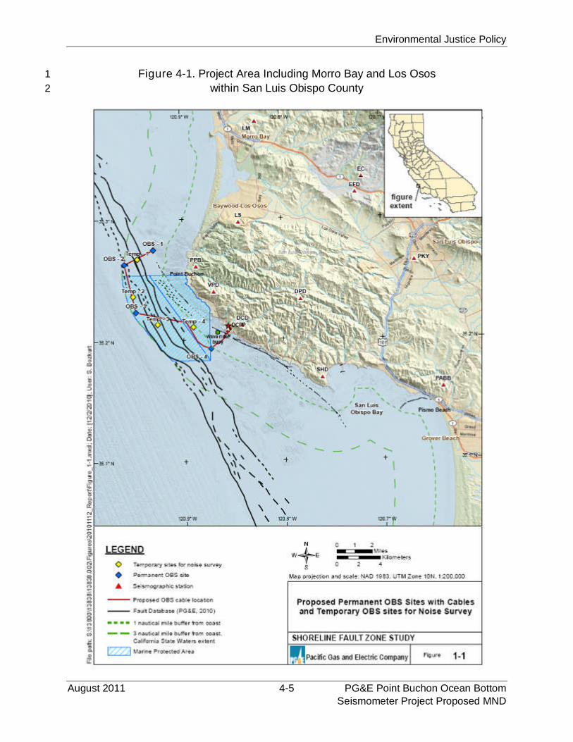
Environmental Justice Policy
August 2011 4-5 PG&E Point Buchon Ocean BottomSeismometer Project Proposed MND
Figure 4-1. Project Area Including Morro Bay and Los Osos1
within San Luis Obispo County2
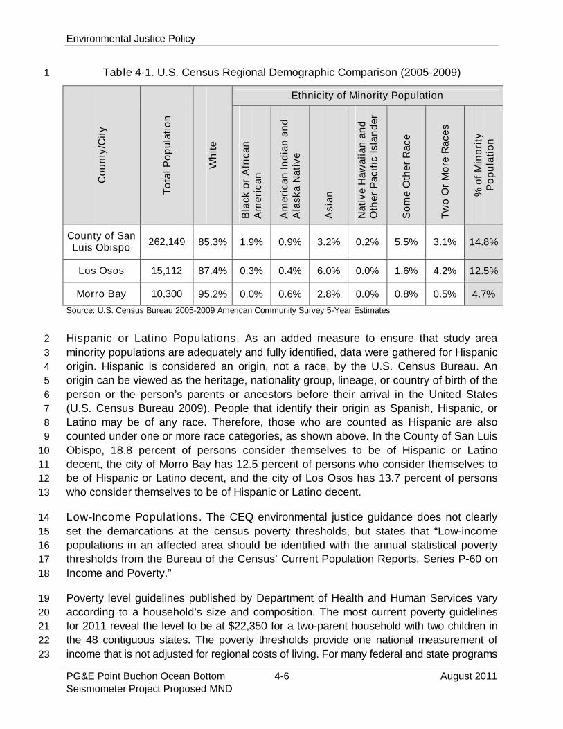
Environmental Justice Policy
PG&E Point Buchon Ocean Bottom 4-6 August 2011Seismometer Project Proposed MND
Table 4-1. U.S. Census Regional Demographic Comparison (2005-2009)1
Co
un
ty/C
ity
To
tal
Po
pu
lati
on
Wh
ite
Ethnicity of Minority Population
Bla
ck
or
Afr
ica
nA
me
ric
an
Am
eri
ca
nIn
dia
na
nd
Ala
sk
aN
ati
ve
As
ian
Na
tiv
eH
aw
aiia
na
nd
Oth
er
Pac
ific
Isla
nd
er
So
me
Oth
er
Ra
ce
Tw
oO
rM
ore
Ra
ce
s
%o
fM
ino
rity
Po
pu
lati
on
County of SanLuis Obispo
262,149 85.3% 1.9% 0.9% 3.2% 0.2% 5.5% 3.1% 14.8%
Los Osos 15,112 87.4% 0.3% 0.4% 6.0% 0.0% 1.6% 4.2% 12.5%
Morro Bay 10,300 95.2% 0.0% 0.6% 2.8% 0.0% 0.8% 0.5% 4.7%
Source: U.S. Census Bureau 2005-2009 American Community Survey 5-Year Estimates
Hispanic or Latino Populations. As an added measure to ensure that study area2
minority populations are adequately and fully identified, data were gathered for Hispanic3
origin. Hispanic is considered an origin, not a race, by the U.S. Census Bureau. An4
origin can be viewed as the heritage, nationality group, lineage, or country of birth of the5
person or the person’s parents or ancestors before their arrival in the United States6
(U.S. Census Bureau 2009). People that identify their origin as Spanish, Hispanic, or7
Latino may be of any race. Therefore, those who are counted as Hispanic are also8
counted under one or more race categories, as shown above. In the County of San Luis9
Obispo, 18.8 percent of persons consider themselves to be of Hispanic or Latino10
decent, the city of Morro Bay has 12.5 percent of persons who consider themselves to11
be of Hispanic or Latino decent, and the city of Los Osos has 13.7 percent of persons12
who consider themselves to be of Hispanic or Latino decent.13
Low-Income Populations. The CEQ environmental justice guidance does not clearly14
set the demarcations at the census poverty thresholds, but states that “Low-income15
populations in an affected area should be identified with the annual statistical poverty16
thresholds from the Bureau of the Census’ Current Population Reports, Series P-60 on17
Income and Poverty.”18
Poverty level guidelines published by Department of Health and Human Services vary19
according to a household’s size and composition. The most current poverty guidelines20
for 2011 reveal the level to be at $22,350 for a two-parent household with two children in21
the 48 contiguous states. The poverty thresholds provide one national measurement of22
income that is not adjusted for regional costs of living. For many federal and state programs23
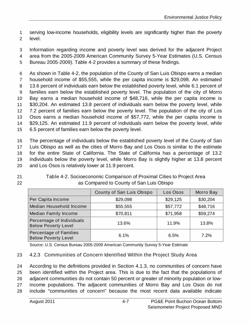
Environmental Justice Policy
August 2011 4-7 PG&E Point Buchon Ocean BottomSeismometer Project Proposed MND
serving low-income households, eligibility levels are significantly higher than the poverty1
level.2
Information regarding income and poverty level was derived for the adjacent Project3
area from the 2005-2009 American Community Survey 5-Year Estimates (U.S. Census4
Bureau 2005-2009). Table 4-2 provides a summary of these findings.5
As shown in Table 4-2, the population of the County of San Luis Obispo earns a median6
household income of $55,555, while the per capita income is $29,098. An estimated7
13.6 percent of individuals earn below the established poverty level, while 6.1 percent of8
families earn below the established poverty level. The population of the city of Morro9
Bay earns a median household income of $48,716, while the per capita income is10
$30,204. An estimated 13.8 percent of individuals earn below the poverty level, while11
7.2 percent of families earn below the poverty level. The population of the city of Los12
Osos earns a median household income of $57,772, while the per capita income is13
$29,125. An estimated 11.9 percent of individuals earn below the poverty level, while14
6.5 percent of families earn below the poverty level.15
The percentage of individuals below the established poverty level of the County of San16
Luis Obispo as well as the cities of Morro Bay and Los Osos is similar to the estimate17
for the entire State of California. The State of California has a percentage of 13.218
individuals below the poverty level, while Morro Bay is slightly higher at 13.8 percent19
and Los Osos is relatively lower at 11.9 percent.20
Table 4-2. Socioeconomic Comparison of Proximal Cities to Project Area21
as Compared to County of San Luis Obispo22
County of San Luis Obispo Los Osos Morro Bay
Per Capita Income $29,098 $29,125 $30,204
Median Household Income $55,555 $57,772 $48,716
Median Family Income $70,811 $71,958 $59,274
Percentage of IndividualsBelow Poverty Level
13.6% 11.9% 13.8%
Percentage of FamiliesBelow Poverty Level
6.1% 6.5% 7.2%
Source: U.S. Census Bureau 2005-2009 American Community Survey 5-Year Estimate
4.2.3 Communities of Concern Identified Within the Project Study Area23
According to the definitions provided in Section 4.1.3, no communities of concern have24
been identified within the Project area. This is due to the fact that the populations of25
adjacent communities do not contain 50 percent or greater of minority population or low-26
income populations. The adjacent communities of Morro Bay and Los Osos do not27
include “communities of concern” because the most recent data available indicate28
Environmental Justice Policy
PG&E Point Buchon Ocean Bottom 4-8 August 2011Seismometer Project Proposed MND
minority populations to total at approximately 4.7 percent and 12.5 percent, respectively.1
Similarly, low-income population data for Morro Bay and Los Osos indicate that 13.82
percent of individuals earn below the established poverty level and 11.9 percent,3
respectively. As these communities do not exist within the study area, no inconsistency4
with the CSLC’s environmental justice policy would be expected to result from Project-5
related activities.6
4.3 ANALYSIS AND CONDITIONS7
This analysis focuses primarily on whether the proposed Project’s impacts have the8
potential to affect area(s) of high-minority population(s) and low-income communities9
disproportionately and thus would create an adverse environmental justice effect. For10
the purpose of the environmental analysis, the proposed Project’s inconsistency with11
the CSLC’s Environmental Justice Policy would occur if the proposed Project would:12
Have the potential to disproportionately affect minority and/or low-income13
populations adversely; or14
Result in a substantial, disproportionate decrease in employment and economic15
base of minority and/or low-income populations residing in the County and/or16
immediately surrounding cities.17
4.3.1 Air Quality and Greenhouse Gas Emissions18
As discussed within Section 3.3.3, Air Quality and Greenhouse Gas Emissions, the Project19
would generate emissions through the use of marine vessels during placement and20
retrieval of the OBS units, from on-road equipment hauling trucks, and from vehicles21
used by construction workers commuting to and from the Project area. Yet, due to the22
short-term nature of the Project (estimated at one day for delivery and mobilization at23
Morro Bay, and two weeks for installation), no significant impacts would result relating to24
air quality. Once installed, the continued operation of the OBS units will not result in any25
new emissions onshore. Given the absence of a significant impact affecting the local26
communities, no inconsistency with the CSLC’s environmental justice policy would27
result from Project-related activities.28
4.3.2 Aesthetics29
Section 3.3.1, Aesthetics, describes the impacts that may result from the proposed30
Project on the existing vistas and visual resources within the area. As the Project is31
temporary in nature (installation is scheduled to take two weeks), the presence of32
marine vessels associated with installation of the cable will not be a significant aesthetic33
impact because: (1) the vessels would be transitory and will be located within the34
marine environment on a temporary basis, and (2) the occurrence of marine vessels35
along this area of the coastline is not unusual, so the typical viewer of the marine36
component of the Project (such as recreational users of Montaña de Oro State Park37
Environmental Justice Policy
August 2011 4-9 PG&E Point Buchon Ocean BottomSeismometer Project Proposed MND
located approximately seven miles from DCPP) would not likely consider the vessels’1
temporary presence visually obtrusive. The cable and OBS units would be underwater2
and not visible once installed. Given the absence of a significant impact affecting the3
local communities, no inconsistency with the CSLC’s environmental justice policy would4
result from Project-related activities.5
4.3.3 Fisheries6
Section 3.3.15, Commercial and Recreational Fisheries, describes commercial and7
recreational fishing in the offshore area where the Project is proposed. As indicated in8
Section 3.3.15, this area is not widely used in support of commercial/recreational9
fishing. Within the region, vessels fishing in the area primarily use the Morro Bay and10
Port of San Luis Harbors. Recent commercial fishing economic declines within the11
region have been identified and linked to the groundfish fishery relying on bottom12
trawling. In 2006, The Nature Conservancy purchased six federal trawling permits,13
which has reduced commercial trawling by local fishers (NOAA 2006). Additionally, the14
Point Buchon SMR and SMCA exist within the proposed Project area and have15
regulations enforced by the CDFG. Specifically, the SMR has restrictions prohibiting the16
take of all living marine resources while the SMCA prohibits the take of all living marine17
resources except the commercial and recreational take of salmon and albacore.18
Recreational fishing opportunities may also exist at Montaña de Oro State Park, but19
Project activities would not impact these onshore users.20
The Project is temporary in nature with scheduled installation anticipated to take21
approximately two weeks. Temporary preclusion from the work area may be required for22
installation activities during construction, but will not significantly affect commercial or23
recreational fishing within the area due to the fact that the area is not widely used in24
support of commercial/recreational fishing, and because most of the Project area is25
located within a State Marine Reserve/Conservation area.26
After construction is completed, the cable and permanent OBS units will remain27
installed on the seafloor for approximately 10 years. Less than 1 percent of the available28
fishing area within the project region would be affected during the installation and29
operation of the OBS units and cable. In addition, the OBS units are to be placed on30
sedimentary habitat and the associated cable would be routed to avoid surf grass and31
kelp (HAPC). The cable has been routed to avoid as much rocky substrate as possible32
and crosses approximately 1.0 km (0.6 mi) of low-relief solid substrate, less than 1033
percent of the total proposed cable length. As designed, no significant impacts to fishing34
operations or essential fish habitat are expected to result from the installation or35
operation of the proposed Project. Given the less than significant impact affecting36
existing commercial fishing operations and the corresponding less than significant effect37
on local communities, no inconsistency with the CSLC’s environmental justice policy38
would be expected to result from Project-related activities.39
Environmental Justice Policy
PG&E Point Buchon Ocean Bottom 4-10 August 2011Seismometer Project Proposed MND
4.3.4 Onshore Resources1
Installation activities would involve approximately 15 workers, of which 5 will be from a2
local crew of the MV Michael Uhl used for the Project. As a result, the implementation of3
this Project would neither result in any employment losses nor any reduction in local4
economic activity. The proposed Project would not generate a significant amount of new5
employment as Project personnel will be traveling to the Project area.6
The proposed Project-related onshore activities including the loading of OBS units at Morro7
Bay Harbor and the addition of conduit at DCPP to receive the cable are comparable to the8
current activities and land uses at the sites and the surrounding vicinity. No new jobs will be9
created for continued operations or periodic maintenance. The Project-related activities10
would be short-term, and are not expected to involve specialized materials, equipment or11
activities.12
Consequently, given the absence of any local employment or economic activity13
decreases, no inconsistency with the CSLC’s environmental justice policy would result14
from the proposed Project’s economic effects.15
4.3.5 Community Benefits16
As mentioned within Section 2, Project Description, the proposed Project would provide17
data to aid in the assessment of DCPP’s vulnerability from seismic events. More18
specifically, the proposed Project would provide accurate, real-time data regarding the19
characteristics of earthquakes in the vicinity of the DCPP. These data will also be useful20
in emergency preparedness that could benefit the public beyond the Project area and21
will be shared with public agencies, including but not limited to the USGS. This is22
considered a beneficial impact to all communities, including those with low-income or23
minority populations.24
Mitigation Monitoring Program
August 2011 5-1 PG&E Point Buchon Ocean BottomSeismometer Project Proposed MND
SECTION 5 – MITIGATION MONITORING PROGRAM1
5.1 AUTHORITY2
CEQA directs Lead Agencies to adopt, concurrent with adoption of an MND, a program3
for reporting or monitoring the changes that have been incorporated into the project or4
that have been made a condition of approval to mitigate or avoid significant5
environmental effects. This proposed Mitigation Monitoring Program (MMP) has been6
prepared to provide a summary and discussion of the ways in which the CSLC, as the7
Lead Agency for the proposed Project, would ensure the measures identified in the8
MND are implemented, and identifies other agencies potentially having enforcement9
and compliance responsibilities. While the MMP may identify other public agencies with10
oversight or permitting jurisdiction, until the mitigation measures have been completed,11
the CSLC would remain responsible for ensuring all measures are implemented in12
accordance with the MMP. Should the CSLC adopt the MND after considering it13
together with any comments received during the public review process, it would adopt a14
final MMP in compliance with CEQA. (See Pub. Resources Code § 21081.6, subd. (a);15
State CEQA Guidelines §§ 15074, subd. (d), 15097)16
5.2 MITIGATION COMPLIANCE RESPONSIBILITY17
PG&E is responsible for successfully implementing all the Applicant Proposed18
Measures (APMs) and mitigation measures (MMs) in the MMP, and is responsible for19
assuring that these requirements are met by all of its construction contractors and field20
personnel. Standards for successful mitigation also are implicit in many mitigation21
measures that include such requirements as obtaining permits or avoiding a specific22
impact entirely. Additional mitigation measures may be imposed by applicable agencies23
with jurisdiction through their respective permit processes.24
5.3 GENERAL MONITORING AND REPORTING PROCEDURES25
The CSLC and the environmental monitor(s) are responsible for integrating the26
mitigation monitoring procedures into the project implementation process in coordination27
with PG&E. To oversee the monitoring procedures and to ensure the required measures28
are implemented properly, the environmental monitor assigned must be on site during29
any portion of project implementation that has the potential to create a significant30
environmental impact or other impact for which mitigation is required. The31
environmental monitor is responsible for ensuring that all procedures specified in the32
MMP are followed.33
Site visits and specified monitoring procedures performed by other individuals will be34
reported to the assigned environmental monitor. A monitoring record form will be35
submitted to the environmental monitor by the individual conducting the visit or36
Mitigation Monitoring Program
PG&E Point Buchon Ocean Bottom 5-2 August 2011Seismometer Project Proposed MND
procedure so that details of the visit can be recorded and progress tracked by the37
environmental monitor. A checklist will be developed and maintained by the38
environmental monitor to track all procedures required for each mitigation measure and39
to ensure that the timing specified for the procedures is adhered to. The environmental40
monitor will note any problems that may occur and take appropriate action to rectify the41
problems.42
5.4 MITIGATION MONITORING TABLE43
The following mitigation monitoring table lists all APMs and MMs identified in Section 344
of the proposed MND. The table lists the following information, by column:45
Potential Impact;46
Mitigation Measure;47
Location;48
Monitoring/reporting action;49
Responsible agency; and50
Timing.51
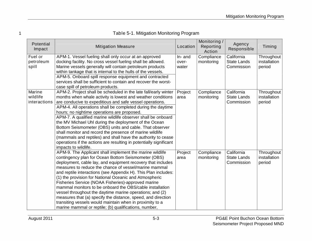
Mitigation Monitoring Program
August 2011 5-3 PG&E Point Buchon Ocean BottomSeismometer Project Proposed MND
Table 5-1. Mitigation Monitoring Program1
PotentialImpact
Mitigation Measure LocationMonitoring /Reporting
Action
AgencyResponsible
Timing
Fuel orpetroleumspill
APM-1. Vessel fueling shall only occur at an approveddocking facility. No cross vessel fueling shall be allowed.Marine vessels generally will contain petroleum productswithin tankage that is internal to the hulls of the vessels.
In- andover-water
Compliancemonitoring
CaliforniaState LandsCommission
Throughoutinstallationperiod
APM-5. Onboard spill response equipment and contractedservices shall be sufficient to contain and recover the worst-case spill of petroleum products.
Marinewildlifeinteractions
APM-2. Project shall be scheduled in the late fall/early wintermonths when whale activity is lowest and weather conditionsare conducive to expeditious and safe vessel operations.
Projectarea
Compliancemonitoring
CaliforniaState LandsCommission
Throughoutinstallationperiod
APM-4. All operations shall be completed during the daytimehours; no nightime operations are proposed.APM-7. A qualified marine wildlife observer shall be onboardthe MV Michael Uhl during the deployment of the OceanBottom Seismometer (OBS) units and cable. That observershall monitor and record the presence of marine wildlife(mammals and reptiles) and shall have the authority to ceaseoperations if the actions are resulting in potentially significantimpacts to wildlife.APM-9. The Applicant shall implement the marine wildlifecontingency plan for Ocean Bottom Seismometer (OBS)deployment, cable lay, and equipment recovery that includesmeasures to reduce the chance of vessel/marine mammaland reptile interactions (see Appendix H). This Plan includes:(1) the provision for National Oceanic and AtmosphericFisheries Service (NOAA Fisheries)-approved marinemammal monitors to be onboard the OBS/cable installationvessel throughout the daytime marine operations; and (2)measures that (a) specify the distance, speed, and directiontransiting vessels would maintain when in proximity to amarine mammal or reptile; (b) qualifications, number,
Projectarea
Compliancemonitoring
CaliforniaState LandsCommission
Throughoutinstallationperiod
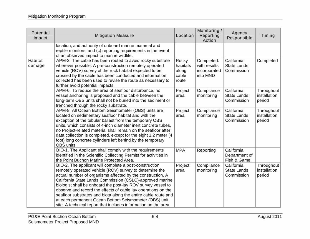
Mitigation Monitoring Program
PG&E Point Buchon Ocean Bottom 5-4 August 2011Seismometer Project Proposed MND
PotentialImpact
Mitigation Measure LocationMonitoring /Reporting
Action
AgencyResponsible
Timing
location, and authority of onboard marine mammal andreptile monitors; and (c) reporting requirements in the eventof an observed impact to marine wildlife.
Habitatdamage
APM-3. The cable has been routed to avoid rocky substratewherever possible. A pre-construction remotely operatedvehicle (ROV) survey of the rock habitat expected to becrossed by the cable has been conducted and informationcollected has been used to revise the route as necessary tofurther avoid potential impacts.
Rockyhabitatsalongcableroute
Completed.with resultsincorporatedinto MND
CaliforniaState LandsCommission
Completed
APM-6. To reduce the area of seafloor disturbance, novessel anchoring is proposed and the cable between thelong-term OBS units shall not be buried into the sediment ortrenched through the rocky substrate.
Projectarea
Compliancemonitoring
CaliforniaState LandsCommission
Throughoutinstallationperiod
APM-8. All Ocean Bottom Seismometer (OBS) units arelocated on sedimentary seafloor habitat and with theexception of the tubular ballast from the temporary OBSunits, which consists of 4-inch diameter inert concrete tubes,no Project-related material shall remain on the seafloor afterdata collection is completed, except for the eight 1.2 meter (4foot) long concrete cylinders left behind by the temporaryOBS units.
Projectarea
Compliancemonitoring
CaliforniaState LandsCommission
Throughoutinstallationperiod
BIO-1. The Applicant shall comply with the requirementsidentified in the Scientific Collecting Permits for activities inthe Point Buchon Marine Protected Area.
MPA Reporting CaliforniaDepartment ofFish & Game
BIO-2. The applicant will complete a post-constructionremotely operated vehicle (ROV) survey to determine theactual number of organisms affected by the construction. ACalifornia State Lands Commission (CSLC)-approved marinebiologist shall be onboard the post-lay ROV survey vessel toobserve and record the effects of cable lay operations on theseafloor substrates and biota along the entire cable route andat each permanent Ocean Bottom Seismometer (OBS) unitsite. A technical report that includes information on the area
Projectarea
Compliancemonitoring
CaliforniaState LandsCommission
Throughoutinstallationperiod
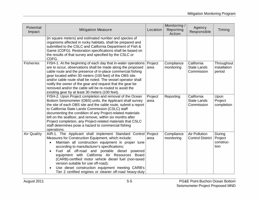
Mitigation Monitoring Program
August 2011 5-5 PG&E Point Buchon Ocean BottomSeismometer Project Proposed MND
PotentialImpact
Mitigation Measure LocationMonitoring /Reporting
Action
AgencyResponsible
Timing
(in square meters) and estimated number and species oforganisms affected in rocky habitats, shall be prepared andsubmitted to the CSLC and California Department of Fish &Game (CDFG). Restoration specifications shall be based onthe results of that survey and specified by the CSLC orCDFG.
Fisheries FISH-1. At the beginning of each day that in-water operationsare to occur, observations shall be made along the proposedcable route and the presence of in-place commercial fishinggear located within 30 meters (100 feet) of the OBS siteand/or cable route shall be noted. The vessel operator shallnotify the owner of the gear and request that the gear beremoved and/or the cable will be re-routed to avoid theexisting gear by at least 30 meters (100 feet).
Projectarea
Compliancemonitoring
CaliforniaState LandsCommission
Throughoutinstallationperiod
FISH-2. Upon Project completion and removal of the OceanBottom Seismometer (OBS) units, the Applicant shall surveythe site of each OBS site and the cable route, submit a reportto California State Lands Commission (CSLC) staffdocumenting the condition of any Project-related materialsleft on the seafloor, and remove, within six months afterProject completion, any Project-related materials that CSLCstaff determines pose a hazard to commercial fishingoperations.
Projectarea
Reporting CaliforniaState LandsCommission
UponProjectcompletion
Air Quality AIR-1. The Applicant shall implement Standard ControlMeasures for Construction Equipment, which include: Maintain all construction equipment in proper tune
according to manufacturer’s specifications; Fuel all off-road and portable diesel powered
equipment with California Air Resources Board(CARB)-certified motor vehicle diesel fuel (non-taxedversion suitable for use off-road);
Use diesel construction equipment meeting CARB'sTier 2 certified engines or cleaner off-road heavy-duty
Projectarea
Compliancemonitoring
Air PollutionControl District
DuringProjectconstruc-tion
Mitigation Monitoring Program
PG&E Point Buchon Ocean Bottom 5-6 August 2011Seismometer Project Proposed MND
PotentialImpact
Mitigation Measure LocationMonitoring /Reporting
Action
AgencyResponsible
Timing
diesel engines, and comply with the State Off-RoadRegulation;
Use on-road heavy-duty trucks that meet CARB’s 2007or cleaner certification standard for on-road heavy-dutydiesel engines, and comply with the State On-RoadRegulation;
Construction or trucking companies that do not haveengines in their fleet that meet the engine standardsidentified in the above two measures (e.g., captive orOxides [NOx]-exempt area fleets) may be eligible byproving alternative compliance;
All on and off-road diesel equipment shall not idle formore than five minutes. Signs shall be posted in thedesignated queuing areas and or job sites to reminddrivers and operators of the five-minute idling limit;
Diesel idling within 300 meters (1,000 feet) of sensitivereceptors is not permitted;
Staging and queuing areas shall not be located within300 meters (1,000 feet) of sensitive receptors;
Electrify equipment when feasible; Substitute gasoline-powered in place of diesel-powered
equipment, where feasible; and, Use alternatively fueled construction equipment onsite
where feasible, such as compressed natural gas,liquefied natural gas, propane or biodiesel.
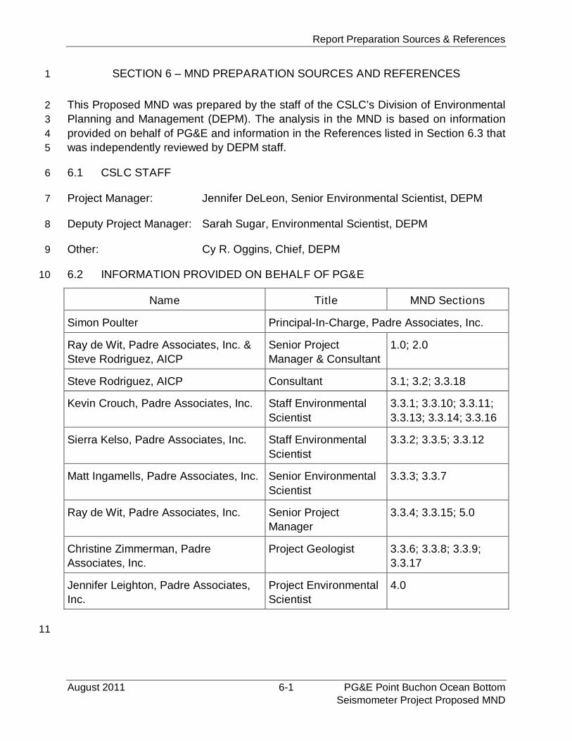
Report Preparation Sources & References
August 2011 6-1 PG&E Point Buchon Ocean BottomSeismometer Project Proposed MND
SECTION 6 – MND PREPARATION SOURCES AND REFERENCES1
This Proposed MND was prepared by the staff of the CSLC’s Division of Environmental2
Planning and Management (DEPM). The analysis in the MND is based on information3
provided on behalf of PG&E and information in the References listed in Section 6.3 that4
was independently reviewed by DEPM staff.5
6.1 CSLC STAFF6
Project Manager: Jennifer DeLeon, Senior Environmental Scientist, DEPM7
Deputy Project Manager: Sarah Sugar, Environmental Scientist, DEPM8
Other: Cy R. Oggins, Chief, DEPM9
6.2 INFORMATION PROVIDED ON BEHALF OF PG&E10
Name Title MND Sections
Simon Poulter Principal-In-Charge, Padre Associates, Inc.
Ray de Wit, Padre Associates, Inc. &
Steve Rodriguez, AICP
Senior Project
Manager & Consultant
1.0; 2.0
Steve Rodriguez, AICP Consultant 3.1; 3.2; 3.3.18
Kevin Crouch, Padre Associates, Inc. Staff Environmental
Scientist
3.3.1; 3.3.10; 3.3.11;
3.3.13; 3.3.14; 3.3.16
Sierra Kelso, Padre Associates, Inc. Staff Environmental
Scientist
3.3.2; 3.3.5; 3.3.12
Matt Ingamells, Padre Associates, Inc. Senior Environmental
Scientist
3.3.3; 3.3.7
Ray de Wit, Padre Associates, Inc. Senior Project
Manager
3.3.4; 3.3.15; 5.0
Christine Zimmerman, Padre
Associates, Inc.
Project Geologist 3.3.6; 3.3.8; 3.3.9;
3.3.17
Jennifer Leighton, Padre Associates,
Inc.
Project Environmental
Scientist
4.0
11
Report Preparation Sources & References
PG&E Point Buchon Ocean Bottom 6-2 August 2011Seismometer Project Proposed MND
6.3 REFERENCES1
PROJECT DESCRIPTION2
Geralp. 2011. Personal communication, e-mail from Host Rademacher (Geralp) to Ray3
de Wit (Padre Associates, Inc.). July 25, 2011.4
AESTHETICS5
County of San Luis Obispo. 1988. Land Use and Circulation Elements of the San Luis6
Obispo General Plan: San Luis Bay Area Coastal Plan. Revised August 2009.7
Crouch, Kevin. 2011. Personal observation by Kevin Crouch during monitoring8
activities, Padre Associates, Inc. May 17, 2011.9
AGRICULTURE AND FOREST RESOURCES10
Aspen Environmental Group. 2005. Diablo Canyon Power Plant - Steam Generator11
Replacement Project, prepared for the California Public Utilities Commission.12
County of San Luis Obispo. 2007. Local Coastal Program, Policy Document (A Portion13
of the San Luis Obispo County Land Use Element of the General Plan).14
. 2010. General Plan Agricultural Element.15
AIR QUALITY AND GREENHOUSE GAS EMISSIONS16
California Air Resources Board (CARB). 1987. AB 2588 Air Toxics Hot Spots Program.17
Accessed online June 2011 at: www.arb.ca.gov/ab2588/ab2588.htm.18
. 2004. California Diesel Fuel Regulations, Title 13, California Code of19
Regulations, sections 2281-2285 and Title 17, California Code of Regulations,20
section 93114.21
. 2005a. Proposed Extension of the California Standards for Motor Vehicle22
Diesel Fuel to Diesel Fuel Used for Intrastate Diesel-Electric Locomotives and23
Harbor Craft. Accessed online June 2011 at:24
www.arb.ca.gov/regact/carblohc/pro.pdf.25
. 2005b. Regulation to Establish a Statewide Portable Equipment Registration26
Program, effective September 1.27
. 2006a. California Global Warming Solutions Act Assembly Bill 32. Accessed28
online June 2011 at: www.arb.ca.gov/cc/ab32/ab32.htm.29
. 2006b. Commercial Idling Restrictions. Accessed online June 2011 at:30
www.arb.ca.gov/toxics/idling/idling.htm.31
. 2007a. EMFAC2007 On-Road Mobile Source Emissions Estimation Model.32
Accessed online June 2011 at: www.arb.ca.gov/msei/onroad/latest_version.htm.33
Report Preparation Sources & References
August 2011 6-3 PG&E Point Buchon Ocean BottomSeismometer Project Proposed MND
. 2007b. URBEMIS Program. Accessed online June 2011 at:1
www.arb.ca.gov/planning/urbemis/urbemis2007/urbemis2007.htm.2
. 2007c. Proposed Early Actions to Mitigate Climate Change in California.3
. 2010. Area Designation Maps. Accessed online June 2011 at:4
www.arb.ca.gov/desig/adm/adm.htm.5
. 2011. Top Four Summary. Accessed online June 2011 at:6
www.arb.ca.gov/adam/topfour/topfour2.php.7
California Natural Resources Agency. 2009. Final Statement of Reasons for Regulatory8
Action Amendments to the State CEQA Guidelines Addressing Analysis and9
Mitigation of Greenhouse Gas Emissions Pursuant to SB97.10
Governor’s Office of Planning and Research. 2009. Senate Bill No. 97. Accessed online11
June 2011 at: www.opr.ca.gov/index.php?a=ceqa/index.html.12
San Luis Obispo County Air Pollution Control District (APCD). 2001. Clean Air Plan.13
. 2003. Construction Activity Management Plan Guidelines (CAMP).14
. 2009. CEQA Air Quality Handbook – A Guidebook for Assessing the Air Quality15
Impacts for Projects Subject to CEQA Review.16
. 2010. Coastal Zone Land Use Ordinance (CZLUO).17
BIOLOGICAL RESOURCES18
Applied Marine Sciences. 2008. Survey Report: Remotely Operated Vehicle (ROV)19
Biological Characterization Survey of the Asia America Gateway (AAG) S-520
Project Fiber Optic Cable Route Offshore Morro Bay, California prepared for21
AT&T Company, dated January. Revised May 2008.22
Barlow, J. 1994. Recent information on the status of large whales in California waters,23
NOAA Tech. Memo. NMFS-SWFSC-203, 27 pp.24
Barlow, J., and T. Gerrodette. 1996. Abundance of cetaceans in California waters based25
on 1991 and 1993 ship surveys. NOAA Tech. Memo. NOAA-TM-NMFS-SWFSC-26
223.27
Barlow, J. et al. 1997. U.S. Pacific Marine Mammal Stock Assessments 1996. NOAA28
Tech. Memo. NMFS-SWFSC-248.29
Bartholomew, G.A. 1967. Seal and sea lion populations of the California Islands, In:30
R.N. Philbrick (ed.), Proceedings. Symposium on the Biology of the California31
Islands, Santa Barbara Botanic Garden. Santa Barbara, CA, pp. 229-244.32
Benson, S.R., K.A. Forney, J.T. Harvey, J.V. Carretta, and P.H. Dutton. 2007.33
Abundance, distribution, and habitat of leatherback turtles (Dermochelys34
coriacea) off California, 1990-2003. Fishery Bulletin, Volume 105, 2007.35
Report Preparation Sources & References
PG&E Point Buchon Ocean Bottom 6-4 August 2011Seismometer Project Proposed MND
Braham, H.W. 1984. The status of endangered whales: An overview. Marine Fisheries1
Review 46:2-6.2
California State Lands Commission. 2008. Draft Environmental Impact Report for the3
AT&T Asia American Gateway Fiber Optic Cable Project. SCH No. 2007111029.4
December.5
Channel Islands National Marine Sanctuary [CINMS]. 2000. Working Draft6
Environmental Impact Statement for Channel Islands National Marine Sanctuary.7
Conant, T.A., P.H. Dutton, T. Eguchi, S.P. Epperly, C.C. Fahy, M.H. Godfrey, S.L.8
MacPherson, E.E. Possardt, B.A. Schroeder, J.A. Seminoff, M.L. Snover, C.M.9
Upite, and B.E. Witherington. 2009. Loggerhead sea turtle (Caretta caretta) 200910
status review under the U.S. Endangered Species Act. Report of the Loggerhead11
Biological Review Team to the National Marine Fisheries Service, August 2009.12
222 pp.13
County of San Luis Obispo 2004. Local Coastal Program Policy Document (Summary).14
Coastal Plan Policies, updated June 2004.15
Dailey, M.D., D.J. Reish, and J.W. Anderson (eds.). 1993. Ecology of the Southern16
California Bight: A Synthesis and Interpretation. University of California Press.17
Eguchi, T., T. Gerrodette, R.L. Pitman, J.A. Seminoff, and P.H. Dutton. 2007. At-sea18
density and abundance estimates of the olive Ridley turtle Lepidochelys olivacea19
in the eastern tropical Pacific. Endang Species Res. Vol. 3, pp. 191–203.20
Entrix. 2004. Noise Analysis of Onshore and Offshore Construction Phase, Appendix21
H2 for Draft EIR/EIS for BHP Biliton LNG, Cabrillo Port Project. Revised August22
2004.23
Gendron, D., S. Lanham and M. Carwardine. 1999. North Pacific right whale sighting24
south of Baja California, Aquatic Mammals. Vol. 25, Issue 1, pp. 31-34.25
Greene, H. G. 2011. Substrate and Habitat Types Along PG&E’s OBS Cable Route,26
prepared for PG&E and Padre Associates, Inc. May 26.27
Leatherwood, S., R.R. Reeves, W.F. Perrin, and W.E. Evans. 1982. Whales, dolphins,28
and porpoises of the eastern North Pacific and adjacent Arctic waters, A guide to29
their identification. NOAA Tech. Rept., NMFS Circular 444, 245 pp.30
LeBouef, B.J., and M.L. Bonnell. 1980. Pinnipeds of the California islands: Abundance31
and distribution, In: D.M. Power, ed., The California Islands: Proceedings of a32
Multidisciplinary Symposium. Santa Barbara, CA: Haagen Printing, pp. 475-493.33
Loughlin, T.R., et al. 1984. Northern sea lion distribution and abundance: 1956-80. J.34
Wildl. Manage. Vol. 48, Issue 3, pp. 729-740.35
Márquez, M. R., M. A. Carrasco, and M. C. Jiménez. 2002. The marine turtles of36
Mexico: An Update, In Kinan, I. (Ed.), Proceedings of the Western Pacific Sea37
Report Preparation Sources & References
August 2011 6-5 PG&E Point Buchon Ocean BottomSeismometer Project Proposed MND
Turtle Cooperative Research and Management Workshop, Hawaii, Feb. 5-8,1
2002. App. IV, pp 281-285. Honolulu: Western Pacific Regional Fishery2
Management Council.3
MFS Globenet Corp./WorldCom Network Services (MGCWCN). 2000. MFS Globenet4
Corp./WorldCom Network Services Fiber Optic Cable Project Final5
Environmental Impact Report, SCH No. 98091053, Volume I.6
Morro Group, Inc. 1999. MFS Globenet Corp./WorldCom Network Services Fiber Optic7
Cable Project Draft Environmental Impact Report, SCH No. 98091053. Submitted8
to County of San Luis Obispo, Department of San Luis Obispo, Department of9
Planning and Development. October.10
National Marine Fisheries Service. 2008. Marine Mammal Stock Assessment Reports11
by Species. Accessed online September 2010 at:12
www.nmfs.noaa.gov/pr/sars/species.htm.13
. 2009. Marine Mammal Stock Assessment Reports by Species. Accessed14
online September 2010 at: www.nmfs.noaa.gov/pr/sars/species.htm.15
National Oceanographic and Atmospheric Administration (NOAA). 2005. Updated16
Status of Federally Listed ESUs of West Coast Salmon and Steelhead. NOAA17
Tech. Memo. NMFS-NWFSC-66. June.18
. 2011. Status of marine turtles. Accessed online June 2011 at:19
www.nmfs.noaa.gov/pr/species/turtles/.20
Reeves, R.R., P.J. Clapham, R.L. Brownell, Jr., and G.K. Silber. 1998. Recovery plan21
for the blue whale (Balaenoptera musculus). Office of Protected Resources,22
National Marine Fisheries Service, NOAA. Silver Spring, MD, 42 pp.23
Scarff, J.E. 1986. Historic and present distribution of the right whale in the eastern North24
Pacific south of 50 N and east of 180 W. R.L. Brownell, Jr., P.B. Best, and J.H.25
Prescott (eds.), Right whales: Past and present status. International Whaling26
Commission. Cambridge, UK, pp. 43-6327
Science Applications International Corporation (SAIC). 2000a. Draft Environmental28
Impact Report: AT&T China - U.S. Cable Network, SCH No. 99051063. Prepared29
for State Lands Commission. January 10.30
. 2000b. Mitigated Negative Declaration: AT&T Japan - U.S. Cable Network, SCH31
No. 2000031062. Prepared for State Lands Commission. March.32
Tenera Environmental. 2010. Diablo Canyon Power Plant NPDES Receiving Water33
Monitoring Program: 2009 Annual Report. Prepared for PG&E, Diablo Canyon34
Power Plant Avila Beach, CA. April 20.35
. 2011. Ocean Bottom Seismometer Cable Landing Habitat Characterization36
Study. Prepared for PG&E. May 27.37

Report Preparation Sources & References
PG&E Point Buchon Ocean Bottom 6-6 August 2011Seismometer Project Proposed MND
U.S. Geological Survey, 2011. Spring 2010 Mainland California Sea Otter Survey1
Results.2
www.werc.usgs.gov/ProjectSubWebPage.aspx?SubWebPageID=16&ProjectID=3
91&List=SubWebPages&Web=Project_91.4
COMMERCIAL AND RECREATIONAL FISHERIES5
California Department of Fish and Game. 2011. Commercial catch data for Fish Block6
615, provided to Padre Associates, Inc. via e-mail from Jana Robertson,7
Statistics Branch, CDFG. Los Alamitos, CA. May 11.8
Endersby, Eric. 2011. Personal communication, Morro Bay Harbor Department,9
Operations Manager, telephone discussion with Ray de Wit (Padre Associates,10
Inc.). May 16, (805) 772-6242.11
McGraw, Steve. 2011. Personal communication, Harbor Master, Port San Luis,12
telephone discussions and e-mail exchange with Ray de Wit (Padre Associates,13
Inc.). May 16.14
Science Applications International Corporation (SAIC). 2000. Mitigated Negative15
Declaration: AT&T Japan - U.S. Cable Network, SCH No. 2000031062. Prepared16
for State Lands Commission. March.17
CULTURAL RESOURCES18
Aspen Environmental Group. 2005. Diablo Canyon Power Plant-Steam Generator19
Replacement Project. Prepared for the California Public Utilities Commission.20
Bickel, Polly. 1978. “Changing Sea Levels along the California Coast: Anthropological21
Implications.” Journal of California Anthropology. Vol. 5, No. 1, pp. 6-20.22
California State Lands Commission. 2009. Final Environmental Impact Report for the23
AT&T Asia American Gateway Fiber Optic Cable Project. SCH No. 2007111029.24
February.25
Cunningham, Richard W. 1979. California Indian Watercraft, 1989. EZ Nature Books.26
San Luis Obispo, CA.27
Gates, Dorothy L. and Jane H. Bailey. 1982. Morro Bay’s Yesterdays: Vignettes of Our28
City’s Lives & Times. Morro Bay, CA: El Moro Publications. . Second Printing29
1993.30
Greenwood, Roberta. 1972. 9,000 Years of Prehistory at Diablo Canyon, San Luis31
Obispo County, California. San Luis Obispo County Archaeological Society32
Occasional Paper No. 7. San Luis Obispo, CA.33
Heizer, Robert. 1974. The Destruction of California Indians. Santa Barbara, CA:34
Peregrine Smith Inc.35
Report Preparation Sources & References
August 2011 6-7 PG&E Point Buchon Ocean BottomSeismometer Project Proposed MND
Hudson, D. Travis. 1976. Marine Archaeology Along the Southern California Coast. San1
Diego Museum of Man. San Diego, CA.2
Hudson, D. Travis and Thomas C. Blackburn. 1982. The Material Culture of the3
Chumash Interaction Sphere: Food Procurement and Transportation, Volume 1.4
A Ballena Press/Santa Barbara Museum of Natural History Cooperative5
Publication. Los Altos, CA: Ballena Press.6
Hunter, Jack. 2000. Marine Cultural Resources - Offshore, Draft Environmental Impact7
Report, WorldCom Fiber Optic Cable Project, State Lands Commission.8
Johnson, John R. 1999. Chumash Social Organization in Cultural Affiliation and Lineal9
Descent of Chumash Peoples in the Channel Islands and the Santa Monica10
Mountains, S. McLendon and J. Johnson (eds.). National Parks Service.11
Washington, D.C.12
Jones, Terry L. 1992. Evolution of Marine Mammal Hunting: a View from the California13
and Oregon Coasts. Journal of Anthropological Archaeology. Vol. 11, pp. 360-14
401.15
Krieger, Daniel. 1988. San Luis Obispo County--Looking Backward Into the Middle16
Kingdom. Chatsworth, CA: Windsor Publications.17
Moratto, M. 1984. California Archaeology. New York, NY: Academic Press.18
Pierson, Shiller & Slater. 1987. Archaeological Resource Study: Morro Bay to Mexican19
Border (1987). Prepared for the Minerals Management Service, U.S. Department20
of the Interior, OCS Study MMS 87-0025.21
Smith, D.E. and F.J. Teggart. 1990. Diary of Gaspar de Portola During the California22
Expedition of 1769-1770. Publication of the Academy of Pacific Coast History,23
1,3 (Reprint October 1909) 13.24
Snethkamp, P.G., Wessen, A.L., York, J.H., Cleland, S.D. Hoyt, and R.L. Gearhart II.25
1990. California, Oregon, and Washington Archaeological Resource Study, Vol.26
3: Prehistory. Prepared by Espey.27
GEOLOGY AND SOILS28
Bryant, W.A. 2005. Digital Database of Quaternary and Younger Faults from the Fault29
Activity Map of California, version 2.0: California Geological Survey. Web Page:30
www.consrv.ca.gov/CGS/information/publications/QuaternaryFaults_ver2.htm.31
Lettis, W.R., K.L. Hanson, J.R. Unruh, M. McLaren, and W.U. Savage. 2004.32
Quaternary Tectonic Setting of South-Central Coastal California, United States33
Geological Survey Bulletin 1995-AA.21 pp.34
Report Preparation Sources & References
PG&E Point Buchon Ocean Bottom 6-8 August 2011Seismometer Project Proposed MND
HAZARDS AND HAZARDOUS MATERIALS1
Department of Toxic Substances Control. 2011. Accessed online May 2011 at:2
Envirostor; http://www.envirostor.dtsc.ca.gov.3
HYDROLOGY AND WATER QUALITY4
County of San Luis Obispo. 1999. General Plan Safety Element.5
State Water Resources Control Board. 2001. California Ocean Plan, Water Quality6
Control Plan-Ocean Waters of California, updated 2009.7
LAND USE AND PLANNING8
San Luis Obispo. 1988. Land Use and Circulation Elements of the San Luis Obispo9
General Plan: San Luis Bay Area Coastal Plan, Revised August 2009.10
MINERAL RESOURCES11
California Department of Parks and Recreation. 2006. Spooner Ranch House Sanitary12
Facility Repair project Mitigated Negative Declaration, San Luis Obispo, CA.13
Miles, S. and C. Goudey. 1997. Ecological Subregions of California: Section and14
Subsection Descriptions, USDA Forest Service, Pacific Southwest Region15
Publication R5-EM-TP-005, San Francisco, CA.16
San Luis Obispo. 1988. Land Use and Circulation Elements of the San Luis Obispo17
General Plan: San Luis Bay Area Coastal Plan, revised August 2009.18
NOISE19
Federal Highway Administration (FHWA). 2006. Roadway Construction Noise Model20
(RCNM) and Users Guide.21
. 2008. Construction Noise Handbook Chapter 9, Construction Equipment Noise22
Levels and Ranges. Accessed online February 2008 at:23
www.fhwa.dot.gov/environment/noise/handbook/09.htm.24
Malme, Charles I. and LGL Environmental Research Associates. 2001. Assessment of25
Noise Issues Relevant to Marine Mammals Near the BP Clair Development, LGL26
Report TA2565-2.27
San Luis Obispo County. 2010. Coastal Zone Land Use Ordinance.28
Santa Barbara County. 2008. Paradiso del Mar Ocean and Inland Estates, Draft29
Environmental Impact Report.30
Science Applications International Corporation (SAIC). 2000a. Draft Environmental31
Impact Report: AT&T China - U.S. Cable Network, prepared for State Lands32
Commission.33
Report Preparation Sources & References
August 2011 6-9 PG&E Point Buchon Ocean BottomSeismometer Project Proposed MND
. 2000b. Mitigated Negative Declaration: AT&T Japan - U.S. Cable Network,1
prepared for State Lands Commission.2
Ventura County. 2005. Construction Noise Threshold Criteria and Control Measures.3
POPULATION AND HOUSING4
San Luis Obispo. 1988. Land Use and Circulation Elements of the San Luis Obispo5
General Plan: San Luis Bay Area Coastal Plan, revised August 2009.6
U.S. Census Bureau. 2010. State and County Quick Facts. Accessed online May 20117
at: http://quickfacts.census.gov/qfd/states/06/06079.html.8
PUBLIC SERVICES9
Aspen Environmental Group. 2005. Draft Environmental Report for Diablo Canyon10
Power Plant Steam Generator Replacement Project, prepared for California11
Public Utilities Commission, San Francisco, California.12
Cunningham, Bryan. 2011. Personal communication, Pacific Gas and Electric, Email13
correspondence from Ray de wit of Padre Associates, Inc. regarding fire, police,14
and emergency services at DCPP, dated May 27.15
San Luis Obispo. 1988a. Land Use and Circulation Elements of the San Luis Obispo16
General Plan: San Luis Bay Area Coastal Plan, revised August 2009.17
. 1988b. Coastal Zone Land Use Ordinance: Title 23 of the San Luis Obispo18
County Code, revised August 2010.19
RECREATION20
San Luis Obispo. 1988. Land Use and Circulation Elements of the San Luis Obispo21
General Plan: San Luis Bay Area Coastal Plan, revised August 2009.22
TRANSPORTATION / TRAFFIC23
City of Morro Bay. 2011. Accessed online May 2011 at: www.morro-24
bay.ca.us/index.aspx?NID=171.25
City of Morro Bay. 1988. Circulation Element.26
County of San Luis Obispo. 1979. General Plan, Circulation Element.27
. 2001. Avila Beach Specific Plan.28
2010. Council of Government’s (SLOCOG) - 2010 Regional Transportation Plan.29
County of San Luis Obispo, Department of Public Works and Transportation. 2009.30
Avila Valley Circulation Study. Prepared by TPG Consulting.31
32
Report Preparation Sources & References
PG&E Point Buchon Ocean Bottom 6-10 August 2011Seismometer Project Proposed MND
Endersby, Eric. 2011. Personal communication, Operations Manager, Morro Bay Harbor1
Department, telephone discussion with Ray de Wit (Padre Associates, Inc.). May2
16. (805) 772-6242.3
Port San Luis Harbor District and the State Coastal Conservancy. 2007. Port San Luis4
Harbor District Port Master Plan.5
ENVIRONMENTAL JUSTICE POLICY6
California State Lands Commission (CSLC). 2002. Environmental Justice Policy.7
Accessed online June 2011 at:8
www.slc.ca.gov/Policy_Statements/Environmental_Justice _Home_Page.html.9
Council on Environmental Quality (CEQ). 1997. Environmental Justice Guidance Under10
the National Environmental Policy Act.11
Federal Register Vol. 59. No. 32. Wednesday. 1994. White House, Executive Order12
12898, Federal Actions to Address Environmental Justice in Minority Populations13
and Low-income Populations. February 16.14
NOAA Coastal Services, November/December. 2006. No-Trawl Zones: Using Private15
Money to Protect Seafloor Habitat in California. Accessed online June 2011 at:16
www.csc.noaa.gov/magazine/2006/06/article2.html.17
U.S. Census Bureau. 2005-2009. American Community Survey 5-Year Estimate.18
Accessed online June 2011 at:19
http://factfinder.census.gov/servlet/DatasetMainPageServlet?_program=ACS&_s20
ubmenuId=&_lang=en&_ds_name=ACS_2009_5YR_G00_&ts=.21
. 2009. American Community Survey, Subject Definitions. Accessed online June22
2011 at:23
www.census.gov/acs/www/Downloads/data_documentation/SubjectDefinitions24
/2009_ACSSubjectDefinitions.pdf.25
U.S. Environmental Protection Agency. 1998. Final Guidance for Incorporating26
Environmental Justice Concerns in EPA's NEPA Compliance Analyses.27
Accessed online June 2011 at:28
www.epa.gov/compliance/resources/policies/nepa/.29
Acronym and Abbreviation List
August 2011 7-1 PG&E Point Buchon Ocean BottomSeismometer Project Proposed MND
SECTION 7 – ACRONYM AND ABBREVIATION LIST
°C degrees centigrade
°F degrees Fahrenheit
micro
Pa rms micro Pascal root mean square
AB Assembly Bill
AB32 Assembly Bill 32, the California Global Warming Solutions Act
ACOE U.S. Army Corps of Engineers
AMS Applied Marine Sciences
APCD Air Pollution Control District
AQMP Air Quality Management Plan
BAAQMD Bay Area Air Quality Management District
C Capacity
CAA Clean Air Act
CalTRIP California Toxic Release Inventory Program
CARB California Air Resources Board
CBC California Building Code
CCA California Coastal Act
CCC California Coastal Commission
CCMP California Coastal Management Program
CDF California Division of Forestry and Fire Protection
CDP Coastal Development Permit
CDFG California Department of Fish and Game
CEC California Energy Commission
CEQ Council of Environmental Quality
CEQA California Environmental Quality Act
CESA California Endangered Species Act
CFGC California Fish and Game Commission
CFR Code of Federal Regulations
CGS California Geological Survey
CH4 methane
CINMS Channel Islands National Marine Sanctuary
cm centimeter
CNEL Community Noise Level Equivalent
CO carbon monoxide
CO2; CO2 eq carbon dioxide; carbon dioxide equivalent
CP Conservation Plan
Acronym and Abbreviation List
PG&E Point Buchon Ocean Bottom 7-2 August 2011Seismometer Project Proposed MND
CPFV commercial passenger fishing vessels
CSLC California State Lands Commission
CSUMB California State University Monterey Bay
CWA Clean Water Act
CY cubic yard
CZLUO Coastal Zone Land Use Ordinance
dB decibels
dBA decibels, A-weighted
DCPP Diablo Canyon Power Plant
DDT dichlorodiphenyltrichloroethane
DOT Department of Transportation
DTSC Department of Toxic Substances Control
EFH Essential Fish Habitat
EHD Environmental Health Division
EIR Environmental Impact Report
EIS Environmental Impact Statement
EPA U. S. Environmental Protection Agency
EPCRA Emergency Planning and Community Right-to-Know Act
EPS Expanded Polystyrene
ESA Endangered Species Act
ESH Environmentally Sensitive Habitats
EX Energy and Extractive Resource Areas
FAA Federal Aviation Administration
FB Fish Block
FC Federal Candidate Species
FEMA Federal Emergency Management Agency
FESA Federal Endangered Species Act
FH Flood Hazard Combining Designation
FHA Federal Highway Administration
FONSI Finding of No Significant Environmental Impact
FE Federal Endangered
ft feet
FT Federal Threatened
ft2 square feet
FP Fully Protected
FSC Federal Species of Concern
GCC global climate change
GHG greenhouse gases
Acronym and Abbreviation List
August 2011 7-3 PG&E Point Buchon Ocean BottomSeismometer Project Proposed MND
GPH gallon per hour
H2S Hydrogen Sulfide
HAPC Habitats of Particular Concern
HCP Habitat Conservation Plan
hp horsepower
hr hour
HWY highway
Hz hertz
in inch
IHA Incidental Harassment Authorization
IS Initial Study
ITP Incidental Take Permit
kW kilowatt
km kilometer
KM Kilometer Mark
km2 kilometer squared
L Liter
LCP Local Coastal Plans/Programs
Leq Energy Equivalent Sound Level
Ldn Day-Night Average Level
LNM Local Notice to Mariners
LOS Level of Service
LUE Land Use Element
LUST leaking underground storage tank
m meter
mg milligrams
mg/L milligrams per liter
MBTA Federal Migratory Bird Treaty Act
MGCWCNS MFS Globenet Corp./WorldCom Network Services
mi miles
min minute
MLLW mean lower low water
MLPA Marine Life Protection Act
MMP Mitigation Monitoring Program
MMPA Marine Mammal Protection Act
MND Mitigated Negative Declaration
MOU Memorandum of Understanding
MPA Marine Protected Area
Acronym and Abbreviation List
PG&E Point Buchon Ocean Bottom 7-4 August 2011Seismometer Project Proposed MND
MPRSA Marine Protection, Research, and Sanctuaries Act
MT/yr CO2eq metric tons per year CO2 equivalents
MSL mean sea level
MSP Marine Safety Plan
MSRP Montrose Settlement Restoration Program
MT metric tons
MV marine vessel
MW megawatt
NO nitric oxide
N2O nitrous oxide
NAHC Native American Heritage Commission
NAAQS National Ambient Air Quality Standards
NEPA National Environmental Policy Act
nm nautical miles
nm2 squared nautical miles
NMFS National Marine Fisheries Service
NOAA National Oceanic and Atmospheric Administration
NO2 nitrogen dioxide
NOX nitrogen oxides
O3 Ozone
OBS Offshore Bottom Survey
OHP State Office of Historic Preservation
OPA Oil Pollution Act
OPR Governor’s Office of Planning and Research
OSCP Oil Spill Contingency Plan
OSPR Office of Spill Prevention and Response
OSPRA Lempert-Keene-Seastrand Oil Spill Prevention and Response Act
Pb Lead
PCB polychlorinated biphenyl
PERP Portable Equipment Registration Program
PFE Proposed Federal Endangered
PFT Proposed Federal Threatened
PG&E Pacific Gas and Electric
PM particulate matter
PM2.5 particulate matter air pollutants with diameter of 2.5 micrometers or less
PM10 particulate matter air pollutants with diameter of 10 micrometers or less
POLA Port of Los Angeles
PRC Public Resources Code
Acronym and Abbreviation List
August 2011 7-5 PG&E Point Buchon Ocean BottomSeismometer Project Proposed MND
PVC polyvinyl chloride
PWR pressurized water reactor
ROG Reactive Organic Gases
ROV remotely operated vehicle
RCNM Roadway Construction Noise Model
RWQCB Regional Water Quality Control Board
SB Senate Bill
SCAB South Coast Air Basin
SCAQMD South Coast Air Quality Management District
SCE State Candidate Endangered
SCP Scientific Collecting Permit
SCT State Candidate Threatened
SE State Endangered
SEL Sound Exposure Levels
SIP State Implementation Plan
SLO San Luis Obispo
SLOC San Luis Obispo County
SMCA State Marine Conservation Area
SMR State Marine Reserve
SO2 Sulfur Dioxide
SO4 Sulfates
spp Species
SCAQM South Coast Air Quality Management District
SRA Sensitive Resource Area
SPL sound pressure level
SSC Species of Special Concern
ST State Threatened
SWRCB State Water Resources Control Board
TRI Toxic Release Inventory
UBC Uniform Building Code
US United States
U.S.C. United States Code
USCG United States Coast Guard
USFWS United States Fish and Wildlife Service
UST underground storage tank
UV ultraviolet
v traffic volume
VOC volatile organic compounds