Syn and post-accretionary structures in the Neoproterozoic Central Allaqi-Heiani suture zone,...
14
Precambrian Research 185 (2011) 95–108 Contents lists available at ScienceDirect Precambrian Research journal homepage: www.elsevier.com/locate/precamres Syn- and post-accretionary structures in the Neoproterozoic Central Allaqi-Heiani suture zone, Southeastern Egypt Mamdouh M. Abdeen a,∗ , Amr A. Abdelghaffar b a Geography Department, Kuwait University, Sate of Kuwait and National Authority for Remote Sensing and Space Sciences, 23 Joseph Broz Tito St., El-Nozha El-Gedida, Cairo, Egypt b Western Geco, Cairo, Egypt article info Article history: Received 20 June 2009 Received in revised form 9 December 2010 Accepted 21 December 2010 Available online 5 January 2011 Keywords: Pan-African Allaqi-Heiani suture Transpressionl Arabian-Nubian Shield Gabgaba terrane South Eastern Desert terrane abstract The Allaqi-Heiani suture (AHS) is the western part of the main Allaqi-Heiani-Gerf-Onib-Sol Hamed-Yanbu suture and represents one of the Neoproterozoic, arc–arc sutures in the Arabian-Nubian Shield (ANS). It separates the ca. 750 Ma South Eastern Desert terrane in the north from the ca. 830–720 Ma Gab- gaba terrane in the south. The AHS is a deformed belt of ophiolitic rocks, syn-tectonic granitoids and metasediments. The central AHS zone is divided into three structural domains. The western domain (I) is characterized by NNE dipping thrusts and SSW-vergent folds. The central domain (II) includes upright tight to isoclinal NNW–SSE oriented folds and transpressional faults. The eastern domain (III) shows NNW–SSE oriented open folds. Structural analysis indicates that the area has a poly-phase deformation history involving at least two events. Event D1 was an N–S to NNE–SSW regional shortening generating the SSW-verging folds and the NNE dipping thrusts. Event D2 was an ENE–WSW shortening producing NNW–SSE oriented folds in the central and eastern parts of the study area and reactivating older thrusts with oblique-slip reverse fault movement. The tectonic evolution of the area involves two episodes of collision: an early collision between the South Eastern Desert terrane and the Gabgaba terrane along the AHS after the consumption of a basin floored by oceanic crust above a north-dipping subduction zone; and a later collision between East- and West-Gondwanas at ca. 750–650 Ma, leading to the closure of the Mozambique Ocean. This collision deformed the AHS along N–S trending shortening zones and produced NW–SE and NE–SW oriented sinistral and dextral transpressional faults, respectively. The early collision episode is related to the terrane accretion during the early Pan-African orogen, while the later phase is related to a late Pan-African or Najd orogen. © 2011 Elsevier B.V. All rights reserved. 1. Allaqi-Heiani suture (AHS) The AHS is a well-defined ophiolite-decorated linear belt that extends W and NW-wards for about 250 km from the N–S trend- ing Hamisana shear zone in the E to Lake Nasser in the W (Fig. 1). It is the westernmost extension of the main Allaqi-Heiani-Gerf- Onib-Sol Hamed-Yanbu arc-arc suture that extends eastwards from SE Egypt and NE Sudan into W Saudi Arabia (Stern et al., 1990). It has been suggested that the AHS and the south Hafafit suture, which is exposed in the northern part of the south Eastern Desert of Egypt (Fig. 1b) were once continuous before being sinistrally off-set 300 km along the Wadi Kharit–Wadi Hodein shear zone (Greiling et al., 1994). The Allaqi-Heiani belt changes its orienta- tion from WNW in its western part to N–S in its central part and ENE in its eastern part (Fig. 1c). The structural style varies along ∗ Corresponding author. Permanent address: Geography Department, Kuwait University, Kuwait. Tel.: +965 65121727; fax: +965 24837164. E-mail address: m m [email protected] (M.M. Abdeen). this belt (Abdeen et al., 2002b; Ren and Abdelsalam, 2006; Zoheir and Klemm, 2007). There have been several competing interpretations of the Allaqi- Heiani belt and its surroundings. These include (a) a suture zone between the South Eastern Desert terrane (also called Gerf or Aswan terrane) and the Gabgaba terrane (Kröner et al., 1987); (b) a foreland basin in which a thick pile of molasse sediments accumu- lated above shelf sediments containing limestone layers (El Gaby et al., 1988); (c) westward extension of the Heiani-Onib-Sol Hamed ophiolite belt (Stern et al., 1990; Sultan et al., 1993); (d) a major fault zone (Morgan, 1990); (e) a questionable suture (Berhe, 1990); (f) a complex major shear zone (Taylor et al., 1993; El-Kazzaz and Taylor, 2001); (g) a lateral ramp (Ren and Abdelsalam, 2006). Structural studies have proposed two conflicting structural- tectonic models. The first proposes a nappe transport direction of top towards the north over a southward-dipping subduction zone (e.g. Taylor et al., 1993; Greiling et al., 1994; El-Kazzaz and Taylor, 2001) while the second proposes a nappe transport direction of top to the south over a north-dipping subduction zone (e.g. Stern, 1994; Mansour et al., 1998; de Wall et al., 2001; Abdelsalam et al., 2003). 0301-9268/$ – see front matter © 2011 Elsevier B.V. All rights reserved. doi:10.1016/j.precamres.2010.12.006
Transcript of Syn and post-accretionary structures in the Neoproterozoic Central Allaqi-Heiani suture zone,...
SA
Ma
b
a
ARRAA
KPATGS
1
eiIOSIwoo(tE
U
0d
Precambrian Research 185 (2011) 95–108
Contents lists available at ScienceDirect
Precambrian Research
journa l homepage: www.e lsev ier .com/ locate /precamres
yn- and post-accretionary structures in the Neoproterozoic Centralllaqi-Heiani suture zone, Southeastern Egypt
amdouh M. Abdeena,∗, Amr A. Abdelghaffarb
Geography Department, Kuwait University, Sate of Kuwait and National Authority for Remote Sensing and Space Sciences, 23 Joseph Broz Tito St., El-Nozha El-Gedida, Cairo, EgyptWestern Geco, Cairo, Egypt
r t i c l e i n f o
rticle history:eceived 20 June 2009eceived in revised form 9 December 2010ccepted 21 December 2010vailable online 5 January 2011
eywords:an-Africanllaqi-Heiani sutureranspressionl Arabian-Nubian Shieldabgaba terraneouth Eastern Desert terrane
a b s t r a c t
The Allaqi-Heiani suture (AHS) is the western part of the main Allaqi-Heiani-Gerf-Onib-Sol Hamed-Yanbusuture and represents one of the Neoproterozoic, arc–arc sutures in the Arabian-Nubian Shield (ANS).It separates the ca. 750 Ma South Eastern Desert terrane in the north from the ca. 830–720 Ma Gab-gaba terrane in the south. The AHS is a deformed belt of ophiolitic rocks, syn-tectonic granitoids andmetasediments. The central AHS zone is divided into three structural domains. The western domain (I)is characterized by NNE dipping thrusts and SSW-vergent folds. The central domain (II) includes uprighttight to isoclinal NNW–SSE oriented folds and transpressional faults. The eastern domain (III) showsNNW–SSE oriented open folds. Structural analysis indicates that the area has a poly-phase deformationhistory involving at least two events. Event D1 was an N–S to NNE–SSW regional shortening generatingthe SSW-verging folds and the NNE dipping thrusts. Event D2 was an ENE–WSW shortening producingNNW–SSE oriented folds in the central and eastern parts of the study area and reactivating older thrustswith oblique-slip reverse fault movement. The tectonic evolution of the area involves two episodes of
collision: an early collision between the South Eastern Desert terrane and the Gabgaba terrane along theAHS after the consumption of a basin floored by oceanic crust above a north-dipping subduction zone;and a later collision between East- and West-Gondwanas at ca. 750–650 Ma, leading to the closure of theMozambique Ocean. This collision deformed the AHS along N–S trending shortening zones and producedNW–SE and NE–SW oriented sinistral and dextral transpressional faults, respectively. The early collisionepisode is related to the terrane accretion during the early Pan-African orogen, while the later phase isan or
related to a late Pan-Afric. Allaqi-Heiani suture (AHS)
The AHS is a well-defined ophiolite-decorated linear belt thatxtends W and NW-wards for about 250 km from the N–S trend-ng Hamisana shear zone in the E to Lake Nasser in the W (Fig. 1).t is the westernmost extension of the main Allaqi-Heiani-Gerf-nib-Sol Hamed-Yanbu arc-arc suture that extends eastwards fromE Egypt and NE Sudan into W Saudi Arabia (Stern et al., 1990).t has been suggested that the AHS and the south Hafafit suture,
hich is exposed in the northern part of the south Eastern Desertf Egypt (Fig. 1b) were once continuous before being sinistrally
ff-set 300 km along the Wadi Kharit–Wadi Hodein shear zoneGreiling et al., 1994). The Allaqi-Heiani belt changes its orienta-ion from WNW in its western part to N–S in its central part andNE in its eastern part (Fig. 1c). The structural style varies along∗ Corresponding author. Permanent address: Geography Department, Kuwaitniversity, Kuwait. Tel.: +965 65121727; fax: +965 24837164.
E-mail address: m m [email protected] (M.M. Abdeen).
301-9268/$ – see front matter © 2011 Elsevier B.V. All rights reserved.oi:10.1016/j.precamres.2010.12.006
Najd orogen.© 2011 Elsevier B.V. All rights reserved.
this belt (Abdeen et al., 2002b; Ren and Abdelsalam, 2006; Zoheirand Klemm, 2007).
There have been several competing interpretations of the Allaqi-Heiani belt and its surroundings. These include (a) a suture zonebetween the South Eastern Desert terrane (also called Gerf orAswan terrane) and the Gabgaba terrane (Kröner et al., 1987); (b) aforeland basin in which a thick pile of molasse sediments accumu-lated above shelf sediments containing limestone layers (El Gabyet al., 1988); (c) westward extension of the Heiani-Onib-Sol Hamedophiolite belt (Stern et al., 1990; Sultan et al., 1993); (d) a majorfault zone (Morgan, 1990); (e) a questionable suture (Berhe, 1990);(f) a complex major shear zone (Taylor et al., 1993; El-Kazzaz andTaylor, 2001); (g) a lateral ramp (Ren and Abdelsalam, 2006).
Structural studies have proposed two conflicting structural-tectonic models. The first proposes a nappe transport direction of
top towards the north over a southward-dipping subduction zone(e.g. Taylor et al., 1993; Greiling et al., 1994; El-Kazzaz and Taylor,2001) while the second proposes a nappe transport direction of topto the south over a north-dipping subduction zone (e.g. Stern, 1994;Mansour et al., 1998; de Wall et al., 2001; Abdelsalam et al., 2003).
96 M.M. Abdeen, A.A. Abdelghaffar / Precambrian Research 185 (2011) 95–108
Fig. 1. Simplified tectonic sketch maps: (a) sutures in the Arabian-Nubian Shield (modified after Abdeen and Greiling, 2005; Johnson and Woldehaimanot, 2003); (b) locationof the study area with respect to the Allaqi-Heiani and the South Hafafit sutures (modified after Greiling et al., 1994); (c) location of the study area with respect to theAllaqi-Heiani-Gerf-Onib-Sol Hamed suture and the Hamisana Shear Zone (modified after Abdelsalam et al., 2003).
ecamb
Td
ttatIaa
2
cmTasKTdSiacfsC1bS
tbis1A
oegmHtr
udr
3
sa1auoGEeZ
M.M. Abdeen, A.A. Abdelghaffar / Pr
he exact timing and nature of tectonic events are still matters ofebate (e.g. Stern, 1994; El-Kazzaz and Taylor, 2001).
The present work aims to clarify the history of deformation ando present a tectonic model for the central Allaqi-Heiani belt duringhe Neoproterozoic through detailed field mapping and structuralnalysis. A better understanding of the geological setting and his-ory of this area also has implications for ore deposit exploration.n this study, previously processed Landsat 7 ETM+ images printedt a scale of 1:50,000 (Abdeen and Abdelghaffar, 2008) were useds the base for field mapping and structural studies.
. Regional tectonic setting
The Arabian-Nubian Shield (ANS) is dominated by juvenileontinental crust that was formed by differentiation of mantleelts largely without reworking of pre-existing continental crust.
his juvenile crust is composed of intra-oceanic island arc/back-rc basin complexes and micro-continents welded together alongutures (Almond, 1982; Harris et al., 1984; Stoeser and Camp, 1985;röner et al., 1987; Pallister et al., 1989; Stern and Kröner, 1993).hese sutures are marked by north- to east-trending ophiolite-ecorated linear belts (Vail, 1985; Berhe, 1990; Stern et al., 1990;tern, 1994; Abdelsalam and Stern, 1996). The sutures (Fig. 1a) aredentified as arc–arc sutures separating individual arc terranes; andrc–continent sutures separating the ANS from pre-Neoproterozoicontinental blocks to the east and west. The arc–arc sutures wereormed between ∼800 and 700 Ma ago while the arc-continentutures were formed between ∼700 and 650 Ma ago (Stoeser andamp, 1985; Pallister et al., 1989; Ayalew et al., 1990; Kröner et al.,992). Five arc–arc sutures and also five arc–continent sutures haveeen recognized in the ANS by Stern (1994) and Abdelsalam andtern (1996).
The Allaqi-Heiani ophiolitic belt in SE Egypt has been interpretedo be the northernmost arc–arc suture in the ANS. This suture iselieved to separate the ca. 750 Ma South Eastern Desert terrane
n the north from the ca. 830 to 720 Ma Gabgaba terrane to itsouth (Stoeser and Camp, 1985; Pallister et al., 1989; Kröner et al.,987, 1992; Ayalew et al., 1990; Greiling et al., 1994; Stern, 1994;bdelsalam and Stern, 1996).
The South Eastern Desert terrane represents the western partf the Gerf terrane of Kröner et al. (1987) and is composed ofnsimatic island arc rocks, ophiolite nappes, syn- to late-tectonicranitoids and shelf sediments. The whole succession was meta-orphosed to low to medium grade facies (El Gaby et al., 1988;assan and Hashad, 1990) and was subsequently intruded by late-
o post-tectonic acidic to basic plutonic and covered by volcanicocks.
The Gabgaba terrane (Kröner et al., 1987) in NE Sudan is madep of immature arc–volcanic assemblages (Stern et al., 1990). Aistinctive feature of this terrane is the presence of marbles, whichepresent shallow water carbonates fringing island arcs.
. Geology of the central Allaqi-Heiani suture
The Allaqi-Heiani area has been investigated in many fieldtudies (e.g. El Shazly et al., 1975; Abdel Khalek, 1979; Greilingnd Rashwan, 1995; Sadek, 1995; Geological Survey of Egypt,996; Mansour et al., 1998; Qiu et al., 2006). The geology of therea is commonly described in terms of three major lithotectonicnits, namely ophiolites, island arc assemblages, and syn- to post-
rogenic granitic intrusions (Kröner et al., 1987; Taylor et al., 1993;reiling et al., 1994; Shackleton, 1994; Abdelsalam and Stern, 1996;l-Shimi, 1996; Abdel-Maguid et al., 1996; Nasr et al., 2000; Abdeent al., 2002a,b; Kusky and Ramadan, 2002; Abdelsalam et al., 2003,oheir and Klemm, 2007). The present study of the central AHSrian Research 185 (2011) 95–108 97
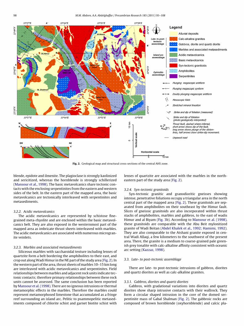
involved 1:50,000 scale field mapping and structural studies of theexposed Precambrian rocks. In line with previous studies the rocksare subdivided into three tectonic assemblages with eight litholog-ical units as follows:
Young Late- to post-tectonicassemblage
Calc-alkaline granites
Gabbros, diorites and quartz dioritesIsland arc assemblage Metasediments including marbles
Acidic metavolcanicsBasic metavolcanicsSyn-tectonic granitoids (gneisses)
Old Ophiolitic assemblage AmphibolitesSerpentinites
3.1. Ophiolitic assemblage
The ophiolitic assemblage in the central AHS zone comprisesfragments of oceanic lithosphere probably representing rem-nants of the Neoproterozoic Mozambique ocean or the floor ofa back arc basin (Abd El-Naby et al., 2000). The ophiolitic rocksinclude serpentinites-talc carbonates, mélange, basic volcanicsand deformed gabbros that were subsequently metamorphosedto greenschist and amphibolite facies. On the geological mappresented in Fig. 2, the ophiolitic assemblage is divided into ser-pentinites and amphibolites.
3.1.1. SerpentinitesThe largest mass of serpentinite forms a thrust nappe exposed
in the central part of the study area at Gabal Shalman (Fig. 2).Serpentinite is also found along thrusts, where it is assembledas slices with metavolcanics, amphibolites and metasedimentsincluding marbles (Figs. 2 and 3a). Zones of highly sheared andfoliated serpentinite are marked by magnesite, asbestos and/ortalc replacement. The serpentinites are closely associated withisland arc basic metavolcanics. The serpentinites consist of antig-orite and chrysotile with talc, chromite, iron oxides and carbonateminerals as accessories (Mansour et al., 1998). Tectonic clasts ofpyroxenite and dunite fragments were also recorded by theseauthors.
3.1.2. AmphibolitesThe amphibolites are formed of compositional mafic-rich bands
with high percentage of hornblende alternating with felsic bandsrich in plagioclase. Iron oxides, chlorite, garnet, orthoclase andepidote are minor constituents (Mansour et al., 1998). The amphi-bolites are metamorphosed dismembered ophiolitic fragments oflayered gabbros, sheeted dykes and pillow basalts interveningbetween serpentinites, granitoid gneisses, and marble along theeastern margin of Wadi Himur (Fig. 3b). The sheeted dykes are com-posed of about 50–80 cm thick parallel metamorphosed doleriticdykes (Fig. 3c) with preserved chilled margins. Pillow meta-basaltsare also observed in the same sequence showing clastic sedi-ments filling the characteristic Y-shaped spaces between pillows(Fig. 3d).
3.2. Island arc assemblage
The island-arc rock assemblage is divided into arc volcanics(basic and acidic metavolcanics) and associated sediments, andarc-related syn-tectonic granitoids.
3.2.1. Basic metavolcanicsThe basic metavolcanics form a 40 km long NW–SE trending belt
in the central part of the study area (Fig. 2). These metavolcanics areschistose meta-basalts composed of plagioclase, actinolitic horn-
98 M.M. Abdeen, A.A. Abdelghaffar / Precambrian Research 185 (2011) 95–108
al cros
ba(tsmm
3
gcmTi
3
qctartubmrri
Fig. 2. Geological map and structur
lende, epidote and ilmenite. The plagioclase is strongly kaolinizednd sericitized, whereas the hornblende is strongly schillerizedMansour et al., 1998). The basic metavolcanics share tectonic con-acts with the enclosing serpentinites from the eastern and westernides of the belt. In the eastern part of the mapped area, the basicetavolcanics are tectonically interleaved with serpentinites andetasediments.
.2.2. Acidic metavolcanicsThe acidic metavolcanics are represented by schistose fine-
rained meta-rhyolite and are enclosed within the basic metavol-anics belt. They are also exposed in the westernmost part of theapped area as imbricate thrust sheets interleaved with marbles.
he acidic metavolcanics are associated with numerous microgran-te veinlets.
.2.3. Marbles and associated metasedimentsSiliceous marbles with saccharoidal texture including lenses of
uartzite form a belt bordering the amphibolites to their east, androp out along Wadi Himur in the NE part of the study area (Fig. 2). Inhe western part of the area, thrust sheets of marbles 10–15 km longre interleaved with acidic metavolcanics and serpentinites. Fieldelationships between marbles and adjacent rock units indicate tec-onic contacts; therefore primary relationships between these rocknits cannot be assessed. The same conclusion has been reported
y Mansour et al. (1998). There are no igneous intrusions or thermaletamorphic effects in the marbles. Therefore the marbles couldepresent metamorphosed limestone that accumulated as a fringeeef surrounding an island arc. Pelitic to psammopelitic metased-ments composed of chlorite schist and garnet biotite schist with
s-sections of the central AHS zone.
lenses of quartzite are associated with the marbles in the north-eastern part of the study area (Fig. 2).
3.2.4. Syn-tectonic granitoidsSyn-tectonic granitic and granodioritic gneisses showing
intense, penetrative foliations occupy a triangular area in the northcentral part of the mapped area (Fig. 2). These granitoids are sep-arated from amphibolites on their southeast by the Himur fault.Slices of gneissic granitoids are also incorporated within thruststacks of amphibolites, marbles and gabbros, to the east of wadisHimur and al Biyam (Fig. 3b). According to Mansour et al. (1998),these granitoids are comparable with the Abu Beit mylonitizedgranite of Wadi Beitan (Abdel Khalek et al., 1992; Hamimi, 1992).They are also comparable to the Atshani granite exposed in cen-tral Wadi Allaqi, a few kilometers to the southwest of the presentarea. There, the granite is a medium to coarse-grained pale green-ish grey tonalite with calc-alkaline affinity consistent with oceanicarc setting (Kazzaz, 1998).
3.3. Late- to post-tectonic assemblage
There are late- to post-tectonic intrusions of gabbros, dioritesand quartz diorites as well as calc-alkaline granites.
3.3.1. Gabbros, diorites and quartz diorites
Gabbros, with gradational variations into diorites and quartzdiorites show sharp intrusive contacts with their wallrock. Theyform a circular shaped intrusion in the core of the domed ser-pentinite mass of Gabal Shalman (Fig. 2). The gabbroic rocks arecomposed of brown hornblende (oxyhornblende) and calcic pla-

M.M. Abdeen, A.A. Abdelghaffar / Precambrian Research 185 (2011) 95–108 99
F t of th( s strikl osed ia ed inb disme
gToa
3
cmscaasaoawba
4
4
i
ig. 3. Field photographs: (a) West Himur thrust stack exposed in the western parM), serpentinites (S), metavolcanics (V), and amphibolites (A) separated by thrustow angle thrust sheets of layered gabbros, gneisses, marbles, and amphibolites expre synthetic to the main Himur fault, photo looking NW; (c) sheeted dykes exposasalt with clayey matrix exposed in the eastern part of Wadi Himur as part of the
ioclase (Mansour et al., 1998), similar to other younger gabbros ofakla et al. (1981). The diorites and quartz diorites are composedf quartz, orthoclase, plagioclase and biotite with zircon, sphene,patite and iron oxides as accessories.
.3.2. Calc-alkaline granitesCalc-alkaline granites are represented by isotropic
oarse-grained muscovite–biotite–hornblende tonalites andonzo-granites. They intrude the metavolcanics northwest and
outhwest of Gabal Shalman (Fig. 2), where they represent aontinuation of the Kilkobob granite described by Kazzaz (1998)s being composed of microcline–perthite, quartz, plagioclasend chloritized biotite with rare tourmaline. The geochemicalignature of this granite is ambiguous, indicating alkaline affinitynd within-plate tectonic setting that is attributed to its late stagef emplacement (Kazzaz, 1998). In the central part of the studyrea at Gabal Umm Ara, these granites intrude basic metavolcanicsith sharp intrusive contact. They also form a large intrusion into
asic metavolcanics at Gabal Umm Dabir, where they border themphibolites along the Himur fault.
. Structural analysis
.1. Bedding
Primary bedding (S0) is occasionally preserved in the metased-mentary rocks especially in the sections containing interca-
e study area (domain I) showing alternating thrust sheets of gneisses (G), marblesing WNW–ESE and dipping towards NNE, photo taken looking NW; (b) imbricaten the north central part of the study area along Wadi Himur. The low angle thruststhe eastern part of Wadi Himur as part of the dismembered ophiolites; (d) pillowmbered ophiolites.
lated marble and quartzite. Bedding surfaces are folded aboutWNW–oriented fold axes in the western part of the study area(Figs. 2 and 4a,b).
4.2. Foliations
The regional foliation (S1) is a penetrative schistosity in theamphibolites and basic metavolcanics, gneissose banding in thegranitoids, and slaty cleavage in the pelitic and psammopeliticmetasediments. Foliation planes (S1) are parallel to sub-parallelwith the bedding surfaces (S0) and are defined by preferentially ori-ented low-grade metamorphic minerals such as muscovite, biotiteand chlorite and by flattening of quartz grains and plagioclasecrystals. The attitudes of foliations are apparently related to boththrusting and later folding. In the western part of the study area,extensive foliations are documented in both hanging- and foot-walls of the major thrusts. These foliations (S1) strike WNW–ESEand dip gently towards NNE. Another set of foliations (S2) isobserved in the central and eastern parts of the study area. S2 foli-ations strike NNW–SSE and dip steeply towards ENE and WSW.Extensive fold axial plane cleavage is documented in the core of theShalman synform and in its associated mesoscopic folds (Fig. 4c).
The foliation data are presented on the structural map and plottedstereographically in Fig. 5. These foliations show evidence for fold-ing of the foliation planes about WNW- and NNW-nearly horizontalaxes in the western and eastern parts of the study area, respectively.These fold axes are referred to as F1 and F2 folds, respectively.
100 M.M. Abdeen, A.A. Abdelghaffar / Precamb
Fig. 4. (a) Field photograph of the West Himur antiform exposed in the westernmostpart of the study area showing the folded bedding and the fold vergence towards theSSW; (b) stereogram of density-contoured poles to bedding around the (F1) WestHoSl
4
eca(SetcNa
4
c
folding, the steps and striae on both fault surfaces are consistent
imur megascopic antiform showing ESE plunging fold axis; (c) field photographf near vertical foliations (S2) in the basic metavolcanics forming the core of thehalman synform in the central part of the study area (domain II), photo takenooking north.
.3. Lineations
Well-developed stretching lineations defined by stretched min-ral aggregates including hornblende, plagioclase, quartz, biotite,hlorite and sphene are observed on the foliation planes of themphibolites and the granitoids. Stereograms of these lineationsFig. 5) show their tendency to gently plunge towards NNW andSE and steeply plunge towards SW. The NNW–SSE oriented lin-ations are dominant and overprint the SW oriented lineations andhus they are younger. The SW plunging lineations were observedlose to the Himur thrust stack and are referred to as L1 and theNW–SSE oriented lineations were observed in all the study areand are referred to as L2.
.4. Mesoscopic folds
Mesoscopic folds are mostly found on the flanks of the megas-opic folds and in the foot- and hanging-walls of thrusts and
rian Research 185 (2011) 95–108
oblique-slip reverse faults below and above fault surfaces (Fig. 5).They have variable styles distinguishing two folding events, namelyF1 and F2. F1 folds are represented in the western part of thestudy area by intrafolial, asymmetric, overturned, tight folds withkink geometry (Fig. 6a–c) with sub-horizontal axes plunging gen-tly towards the WNW or ESE (Fig. 5). These folds are foundto verge towards the SSW in the footwalls below the NNE-dipping low angle thrusts. This is taken to indicate a SSW-warddirection of nappe transport. F2 folds overprint F1 folds andare represented in the central and eastern parts of the studyarea by mesoscopic S-, Z- and M-folds (Fig. 6d). The F2 meso-scopic folds are of the same generation and have the sameNNW–SSE orientation and a gentle plunge as the megascopicfolds (Fig. 5). Less common are steeply plunging mesoscopic foldsobserved close to the oblique-slip reverse faults in the centralpart of the study area. These may have formed as fault-dragfolds.
4.5. Megascopic folds
There are six significant megascopic folds with WNW–ESE toNNW–SSE orientation in the study area (Figs. 2 and 5). Threewere mapped earlier by Mansour et al. (1998) who assigned tothem the names Shalman syncline, Bir Himur anticline and Biyamsyncline. These names have been modified and three additionalfolds are identified in this study. From west to east, these foldsare West Himur antiform, Shalman synform, Bir Himur antiform,Biyam synform, Biyam antiform and East Biyam synform. TheWest Himur antiform (Figs. 4a,b and 5) plunges gently towardsthe ESE (118◦/11◦). It is asymmetric with 75◦ SSW-dipping and32◦ NNE-dipping limbs. The fold axial plane dips 64◦ towardsENE. The Shalman synform is by far the most continuous fold(Figs. 2 and 5). It is upright, tight, slightly asymmetric and plungesgently towards the NNW. The Bir Himur antiform folds calc-alkalinegranites that intruded thrusted basic metavolcanics and serpen-tinites (Fig. 2). This fold plunges gently towards the NNW, andis asymmetric with a steep WSW-dipping flank, and a gentlerENE-dipping flank. The Biyam synform plunges gently towardsthe NNW. It is asymmetric with a steep WSW-dipping flank anda gentler ENE-dipping flank. The East Biyam antiform (Fig. 5)has a similar orientation and plunge to that of the Biyam syn-form.
4.6. Faults
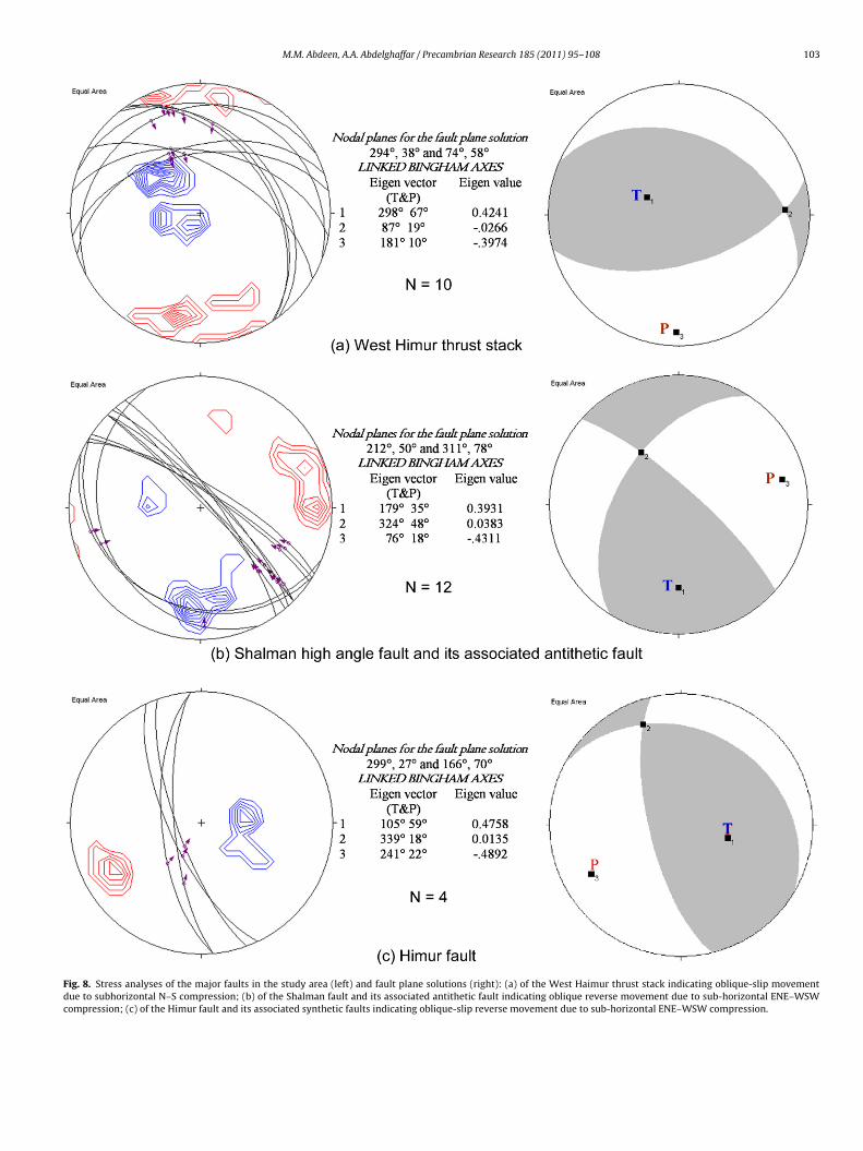
Faults are represented by narrow zones of intense shearing sep-arating either similar or different lithological units. The fault zonesare dominated by intense mylonitization, drag folds, stretching lin-eation, steps, and slickensides. They are most important in thewestern and central parts of the study area (Figs. 2 and 5). In thewestern part, they form a group of imbricate thrust sheets referredto as the West Himur thrust stack (Fig. 3a), while in the central partthey form two individual steeply dipping faults (the Shalman andHimur faults) that lie on opposite limbs of the tight Shalman syn-form. These two faults meet each other as they are traced aroundthe closure of the Shalman antiform. They are therefore suggestedto have once been a single low-dipping fault, perhaps a thrust of thesame age as those of the West Himur thrust stack to the west. Thisfault was subsequently folded about the (F2) NNW–SSE orientedfold. Whatever the original movement sense on this fault before
with reactivation of these steep faults as transpressional structures.In the present study, both faults are collectively assigned the name“Shalman–Himur fault”, but treated separately for the sake of strainanalysis.
M.M. Abdeen, A.A. Abdelghaffar / Precambrian Research 185 (2011) 95–108 101
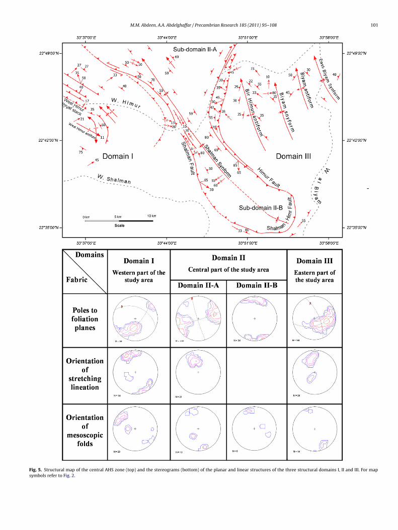
Fig. 5. Structural map of the central AHS zone (top) and the stereograms (bottom) of the planar and linear structures of the three structural domains I, II and III. For mapsymbols refer to Fig. 2.

102 M.M. Abdeen, A.A. Abdelghaffar / Precambrian Research 185 (2011) 95–108
Fig. 6. Mesoscopic folds observed in the study area: (a) intrafolial fold in meta-sedimentary rocks; (b) drag fold in gneissic granite verging towards SSW associated withW shapei phas(
4
Rmdp
4
caaflwotsc
4
ap
left-lateral (sinistral) reverse movement sense. Associated with theShalman fault is an antithetic sub-parallel, gently WSW-dippingthrust that is believed to be formed at the time of reactivation ofthe Shalman fault. Stress analysis of the fault plane striae and the
est Haimur thrust stack; (c) kink folds in metasedimentary rocks; (d) S, Z and M-n the western part of the study area (domain I) and belong to the early deformationdomain II) and belong to a later D2 phase.
.7. Strain analysis
Fault plane striae were used to determine stress directions (e.g.amsay and Huber, 1983). Conglomerates generally provide strainarkers (Lisle, 1985). Extraction of individual pebbles and thus
irect reading of the axial dimensions and orientations of X axesrovide strain information.
.7.1. West Himur thrust stackThe West Himur thrust stack (Figs. 2 and 5) is an imbri-
ate stack of sheets of alternating serpentinites, marbles, andcidic metavolcanics (Fig. 3a). Individual thrust sheets are sep-rated by moderately to gently NNE dipping zones of intenseoliation. Kinematic indicators such as SSW-plunging stretchedineations and steps on the fault surfaces of duplexes (Fig. 7) as
ell as the vergence of the mesoscopic folds in the footwallsf the major thrusts (Fig. 6b) indicate thrust transport towardshe SSW. Stress analysis of the fault plane striae and fault planeolutions (Fig. 8a) show sub-horizontal N–S maximum principalompression.
.7.2. Shalman and Himur faultsThe Shalman fault (Figs. 2 and 5) separates hangingwall basic or
cidic metavolcanics and calc-alkaline granites from footwall ser-entinites. The fault is characterized by a NNW strike and a steep
d folds in acidic metavolcanics. Folds in (a), (b), and (c) represent F1 folds observede D1, whereas folds in (d) are F2 folds observed in the central part of the study area
dip towards the NE or ENE (70–80◦). Oblique slickensides plung-ing 30◦ towards SE (N130) and steps on the fault surface indicate
Fig. 7. Field photograph of a thrust duplex composed of marble and metavol-canic slabs (horses) associated with West Himur thrust stack showing NNE-dippingthrusts. Steps and slickensides on thrust surfaces indicate transport direction toptowards SSW. Photo taken looking WNW.
M.M. Abdeen, A.A. Abdelghaffar / Precambrian Research 185 (2011) 95–108 103
Fig. 8. Stress analyses of the major faults in the study area (left) and fault plane solutions (right): (a) of the West Haimur thrust stack indicating oblique-slip movementdue to subhorizontal N–S compression; (b) of the Shalman fault and its associated antithetic fault indicating oblique reverse movement due to sub-horizontal ENE–WSWcompression; (c) of the Himur fault and its associated synthetic faults indicating oblique-slip reverse movement due to sub-horizontal ENE–WSW compression.
1 ecamb
fE
heSsmspsalaT
Fi
04 M.M. Abdeen, A.A. Abdelghaffar / Pr
ault plane solution of both faults (Fig. 8b) indicate a sub-horizontalNE–WSW compression.
The Himur fault separates syn-tectonic granitoid gneisses in theanging wall from amphibolites in the footwall (Fig. 2). The north-rn part of the fault strikes NNE, while its southern part strikesSE. Oblique slickensides plunging 50◦ towards SW (N215◦) andteps on the fault surface indicate right-lateral (dextral) reverseovement. Stress analysis of the fault plane striae and fault plane
olution (Fig. 8c) indicate sub-horizontal ENE–WSW directed com-ression similar to that of the Shalman fault. Associated and
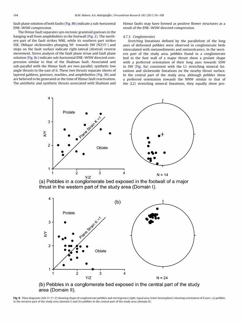
ub-parallel with the Himur fault are two parallel, synthetic lowngle thrusts to the east of it. These two thrusts separate sheets ofayered gabbros, gneisses, marbles, and amphibolites (Fig. 3b) andre believed to be generated at the time of Himur fault reactivation.he antithetic and synthetic thrusts associated with Shalman andig. 9. Flinn diagrams (left, X < Y < Z) showing shape of conglomerate pebbles and stereogran the western part of the study area (domain I) and (b) pebbles in the central part of the
rian Research 185 (2011) 95–108
Himur faults may have formed as positive flower structures as aresult of the ENE–WSW directed compression.
4.7.3. ConglomeratesStretching lineations defined by the parallelism of the long
axes of deformed pebbles were observed in conglomerate bedsintercalated with metasediments and metavolcanics. In the west-ern part of the study area, pebbles found in a conglomeratebed in the foot wall of a major thrust show a prolate shapewith a preferred orientation of their long axes towards SSW
to SW (Fig. 9a) consistent with the L1 stretching mineral lin-eations and slickenside lineations on the nearby thrust surface.In the central part of the study area, although pebbles showa preferred orientation towards the NNW similar to that ofthe (L2) stretching mineral lineations, they equally show pro-ms (right, equal area, lower hemisphere) showing orientation of X axes: (a) pebblesstudy area (domain II).
ecamb
lF
4
ld
4
maWSetgS
4
aisddtpmapSfftTdsaLp
4
mcca(En
5
iptNIEtaii
M.M. Abdeen, A.A. Abdelghaffar / Pr
ate and oblate shapes on the Flinn diagram (Flinn, 1978,ig. 9b).
.8. Structural domains
According to the structural styles and attitudes of planar andinear fabrics, the study area has been divided into three structuralomains I, II and III (Fig. 5) separated by major faults.
.8.1. Structural domain IStructural domain I extends from the western boundary of the
apped area to the Shalman fault (Fig. 5). This domain is char-cterized by folding of beds (S0) and foliations (S1) about NW toNW-oriented mesoscopic and megascopic (F1) fold axes (Fig. 5).
tretching lineations show two predominant trends (Fig. 5): anarly SSW steeply plunging lineation (L1) and a later NNW–SSEo N–S gently plunging lineations (L2). Pebbles’ long axes of a con-lomerate bed from this domain (Fig. 9a) show a preferred SW toSW plunge.
.8.2. Structural domain IIStructural domain II occupies the area between the Shalman
nd the Himur faults (Fig. 5) and includes the NNW–SSE trend-ng Shalman synform. This domain has been subdivided into twoub-domains; II-A in the north and II-B in the south. In the sub-omain II-A, the stereographic projection of the poles to foliationescribes a partial girdle (Fig. 5) consistent with folding about a gen-ly plunging NNW axis (F2). This fold corresponds to the northernart of the Shalman synform, which is symmetrical and upright. Theesoscopic fold axes (Fig. 5) show two predominant orientations;gently plunge NNW–SSE and a steeply SW plunge. The NNW–SSElunging mesoscopic folds have a similar attitude to the hinge of thehalman synform. The steeply SW plunging mesoscopic folds areound only near the Shalman fault and are interpreted as fault dragolds. In the structural sub-domain II-B, the stereogram of poleso foliation (Fig. 5) is distinctly different to that for domain II-A.he change to nearly E–W striking steeply dipping foliations in thisomain is attributed to bending of the axial plane of the Shalmanynform. The mesoscopic fold axes show predominantly NNW–SSEnd fewer ENE and ESE trends (Fig. 5). Stretching mineral lineations2 (Fig. 5) and pebbles’ long axes in this sub-domain show gentlelunge towards the NNW.
.8.3. Structural domain IIIStructural domain III extends from the eastern boundary of the
apped area westwards to the Himur fault (Fig. 5). This domain isharacterized by a homogeneous set of NNW–SSE trending megas-opic folds. Stereographic projection of the poles to foliation showsgirdle pattern with interpreted fold axis plunging moderately
30◦) to the NNW. The estimated axial plane dips steeply towardsNE. Stretching lineations and mesoscopic folds show predomi-antly moderate to gentle NNW–SSE plunges (Fig. 5).
. Discussion and conclusions
The tectonic evolution of the central AHS zone is character-zed by a polyphase deformation history involving, at least, twohases of deformation (D1 and D2). Each phase has its own struc-ural style and interpreted stress regime. D1 phase involves N–S toNE–SSW shortening and is documented in the structural domainat the western part of the study area, whereas D2 phase involves
NE–WSW shortening and is documented in domains II and III inhe central and eastern parts of the area, respectively (Fig. 5). D1nd D2 structures are the results of two episodes of collision asndicated from the strain analysis (Figs. 8 and 9) and illustratedn Fig. 10; a NNE–SSW followed by ENE–WSW. The early episoderian Research 185 (2011) 95–108 105
of collision was between the South Eastern Desert (Aswan) ter-rane and the Gabgaba terrane between ca. 800 and 700 Ma (Stoeserand Camp, 1985; Pallister et al., 1989; Ayalew et al., 1990; Kröneret al., 1992) and generated a set of WNW–ESE trending imbricatethrust sheets dipping gently towards the NNE (Fig. 10a), megas-copic and mesoscopic folds (F1) verging to SSW, shear foliations(S1) along thrust planes, and SSW plunging stretching lineation(L1). F1 fold vergence, stretching lineations (L1) and steps of thefault plane striae were taken to indicate a thrust transport of toptowards SSW. Similar SSW direction of thrust transport has beenreported by Abdelsalam et al. (2003) in the western part of the AHS.However, Greiling and Rashwan (1995) proposed a tectonic trans-port towards the NW in Abu Swayel area to the NW of the presentarea. This later conclusion is based on NW-plunging stretching lin-eations, which in the present area, overprint earlier SSW-plunginglineations hence represent a later movement. Farther N in theHafafit area (Fig. 1b) a regional nappe transport towards the NWis proposed also by Greiling (1987, 1997) who attributed the SWoriented stretching lineations and the SW vergent folds that havebeen assumed earlier by El Ramly et al. (1984) as indicating a nappetransport towards SW to an older movement. Similar situation isencountered in the present area that is taken to confirm that theAHS and the South Hafafit suture were once continuous beforebeing off-set by the Wadi Kharit-Wadi Hodein Shear Zone (Greilinget al., 1994). Continued collision between the South Eastern Desertand the Gabgaba terranes resulted in open coaxial refolding. Wesuspect that these open coaxial refolds are also D1 structures result-ing from continued compression in the NNE–SSW direction. Thiscollision produced a complexly deformed belt comprising dismem-bered ophiolitic slabs representing back-arc oceanic crust withN-MORB geochemical affinity (Zimmer et al., 1995) and range inage between ca. 800 and 730 Ma (Pallister et al., 1989; Kröneret al., 1992). These ophiolites were thrusted together with syn-tectonic granitoids and metasediments (Stern, 1994; Abdelsalamand Stern, 1996; El-Nisr, 1997; Abd El-Naby et al., 2000; El-Kazzazand Taylor, 2001; Abdelsalam et al., 2003; Zoheir and Klemm, 2007).The thrust slices were subsequently intruded by post-tectonic gran-itoids and gabbros. The eastern part of the AHS zone has a 60 kmlong belt of medium to high-grade metapelites bordering its south-ern margin (El-Nisr, 1997). This metamorphic assemblage includescoarse-grained staurolite–andalusite schists in the west and garnetamphibolite and garnet staurolite schists farther east. In the centralpart of the AHS zone similar rock units are exposed to the south inthe footwall beneath the ophiolites (Zoheir and Klemm, 2007). Inthe western part of the AHS, a 30 km long belt formed of threeNNE-dipping nappes was identified by Abdelsalam et al. (2003)including greenschist and blue-schist facies metamorphic assem-blages (Taylor et al., 1993) that were transported southwards over ablock of metavolcanics in the south. These nappes have been tracedinto the central part of the AHS by Ren and Abdelsalam (2006). Themetamorphic assemblages lie structurally below the AHS ophioliteand form the footwall (i.e. they lie south) of the AHS. These footwallrocks have island arc-like affinity (Zoheir, 2004). The higher gradeof metamorphism was interpreted by El-Nisr (1997) to result fromdepression of the lithosphere under the obducted ophiolites. In thehanging-wall of AHS, relatively high-grade gneisses represent theuplifted and/or thrusted parts of lower (island arc) crust. Greilinget al. (1994) interpreted this geology as deeper gneissic rocks thatwere thrusted towards the WSW over subduction-related high-pressure rock assemblages during the final stage of arc collision.
The late episode of collision probably resulted from the colli-
sion of the ANS with the pre-Neoproterozoic continental blocksand accreted arc terranes to the east and west at ca. 750–650 Ma,leading to the closure of the Mozambique Ocean (Shackleton, 1994;Stern, 1994). In the central AHS zone, the ENE–WSW collision ledto the formation of D2 structures including NNW–SSE oriented
106 M.M. Abdeen, A.A. Abdelghaffar / Precambrian Research 185 (2011) 95–108
F ni sutr abgabt
mNstrsaaeswstttc
ig. 10. Schematic sketch showing the tectonic evolution of the central Allaqi-Heiaesults of the N–S compression between the South Eastern Desert terrane and the Ghrust to steeply dipping Shalman and Himur transpressional faults.
egascopic and mesoscopic (F2) folds with the development ofNW–SSE sub-vertical axial plane cleavage (S2) and NNW–SSE
hallowly plunging stretching lineations (L2). During D2, olderhrust faults (most notably the Shalman and Himur faults), wereeactivated with oblique-slip reverse movement as D2 transpres-ional faults. The Shalman and Himur faults were probably oncesingle thrust belonging to the D1 phase that was later D2 folded
round NNW–SSE trending fold axes. Continuing ENE–WSW short-ning rotated the folded thrust to steeply dipping orientations. Thishortening also caused vertical foliations, especially in domain II-Ahich was expelled northwards in the fashion of tectonic escape by
queezing at the southern end of the domain (Fig. 10b). Evidence forhis escape is documented by the sense of movement on the reac-ivated Shalman and Himur faults. Stress analysis of the striae ofhese two faults (Fig. 8b and c) indicates sub-horizontal ENE–WSWompression, with dextral oblique slip on the Himur fault and sinis-
ure zone during the Neoproterozoic East African Orogen. (a) D1 phase showing thea terrane. (b) D2 phase showing folding and rotation of the earlier Shalman–Himur
tral oblique slip on the Shalman fault accommodating northwardescape of domain II-A rocks. Further evidence for the componentof strike-slip movement on the reactivated faults is the presence ofsteeply plunging ENE–WSW oriented mesoscopic folds close to theShalman and the Himur faults. These folds are interpreted as fault-drag folds related to the strike-slip movement of these two faults.
Probably the same E–W collision deformed the ANS along N–Strending shortening zones (Stern et al., 1990; Miller and Dixon,1992; Abdelsalam, 1994) and major northwest trending, sinistralstrike-slip faults (Moore, 1979; Davies, 1984; Stern, 1985; Staceyand Agar, 1985; Agar, 1987; Berhe, 1990; Sultan et al., 1986;
Stoeser and Stacey, 1988; Bonavia and Chorowicz, 1993; Alene andBarker, 1993; El-Kazzaz and Taylor, 2001; de Wall et al., 2001)and minor northeast trending, dextral strike-slip faults (Berhe,1990; Abdelsalam, 1994). According to the present observations,the major NW trending sinistral faults and the minor NE trending
ecamb
dtae
esEitEro
A
aPt
R
A
A
A
A
A
A
A
A
A
A
A
A
A
A
A
B
B
D
d
E
E
M.M. Abdeen, A.A. Abdelghaffar / Pr
extral faults in the ANS may represent segments of folded earlierhrusts that were folded and rotated to steeply dipping attitudesnd reactivated as transpressional faults in the fashion of tectonicscape.
In conclusion, the evolution of the central AHS zone involves anarly N–S shortening followed by a late E–W shortening. The N–Shortening is associated with accretion and obduction of the Southastern Desert island arc rocks over the Gabgaba island arc rocks tots south after the consumption of a north dipping oceanic crust athe early phase of the Neoproterozoic Pan-African orogen. The late–W shortening is associated with a post-accretion phase probablyelated to the latest stage of the Pan-African orogen or to the Najdrogen.
cknowledgements
Discussion with M.G. Abdelsalam and R.J. Stern are gratefullycknowledged. Suggestions and comments by the editor (Randallarrish) as well as the reviewers (A. Fowler and R.O. Greiling) helpedo improve the paper considerably.
eferences
bdeen, M.M., Abdelghaffar, A.A., 2008. Mapping Neoproterozoic structures alongthe central Allaqi-Heiani suture, southeastern Egypt, using remote sensing andfield data, Egypt. J. Remote Sensing Space and Sci. 11, 4–32.
bdeen, M.M., Greiling, R.O., 2005. A quantitative structural study of late Pan-Africancompressional deformation in the central Eastern Desert (Egypt) during Gond-wana assembly. Gondwana Res. 8 (4), 457–471.
bdeen, M.M., Thurmond, A.K., Abdelsalam, M.G., Stern, R.J., 2002a. Use of Terrasatellite ASTER band-ratio images for geological mapping in arid regions: theNeo-Proterozoic Allaqi suture, Egypt. J. Remote Sensing Space and Sci. 5, 19–40.
bdeen, M.M., Abdelsalam, M.G., Dowidar, H.M., Abdelghaffar, A.A., 2002b. Varyingstructural style along the Neo-Proterozoic Allaqi-Heiani suture, southern Egypt.In: 19th Colloquium of African Geology , El Jadida, Morocco, p. 2.
bdel Khalek, M.L., 1979. Tectonic evolution of the basement rocks in southern andcentral Eastern Desert of Egypt. Bull. Inst. Appl. Geol. King Abdul Aziz Univ.Jeddah 3 (1), 53–62.
bdel Khalek, M.L., Takla, M.A., Sehim, A., Hamimi, Z., El Manawi, A.W., 1992. Geologyand tectonic evolution of Wadi Beitan area, south Eastern Desert, Egypt. Geol.Arab World, Cairo Univ. 1, 369–393.
bdel-Maguid, A.A., Ibrahim, M.E., El-Metwally, A.A., 1996. Geology and structureof the western part of Neoproterozoic Allaqi-Suture, south Egypt. Bull. Fac. Sci.,Mansoura Univ. 23 (2), 1–25.
bd El-Naby, H.W., Frisch, W., Hegner, E., 2000. Evolution of the Pan-African WadiHaimur metamorphic sole, Eastern Desert, Egypt. J. Metamorph. Petrol. 18,639–651.
bdelsalam, M.G., 1994. The Oko shear zone Sudan: post-accretionary deformationin the Arabian–Nubian Shield. J. Geol. Soc. Lond. 151, 767–776.
bdelsalam, M.G., Stern, R.J., 1996. Sutures and shear zones in the Arabian-NubianShield. J. Afr. Earth Sci. 23 (3), 289–310.
bdelsalam, M.G., Abdeen, M.M., Dowidar, H.M., Stern, R.J., Abdelghaffar, A.A., 2003.Structural evolution of the Neoproterozoic western Allaqi-Heiani suture zone,Southern Egypt. Precambr. Res. 124, 87–104.
gar, R.A., 1987. The Najd fault system revisited: a two-way strike-slip orogen inthe Saudi Arabian Shield. J. Struct. Geol. 9, 41–48.
lene, M., Barker, A.J., 1993. Tectono-metamorphic evolution of the Moyale region,south Ethiopia. Precambr. Res. 62, 271–283.
lmond, D.C., 1982. New ideas on the geological history of the basement complexof northeast Sudan. Sudan Notes Records 59, 106–136.
yalew, T., Bell, K., Moore, J.M., Parrish, R.R., 1990. U–Pb and Rb–Sr geochronologyof the west Ethiopian Shield. Geol. Soc. Am. Bull. 102, 1309–1316.
erhe, S.M., 1990. Ophiolites in northeast and east Africa: implication for Proterozoiccrustal growth. J. Geol. Soc. Lond. 147, 41–57.
onavia, F.F., Chorowicz, J., 1993. Neoproterozoic structures in The Mozambiqueorogenic belt of south Ethiopia. Precambr. Res. 62, 307–322.
avies, F.B., 1984. Strain analysis of wrench faults and collision tectonics of theArabian-Nubian shield. J. Geol. 92, 37–53.
e Wall, H., Greiling, R.O., Sadek, M.F., 2001. Post-collisional shortening in the LatePan-African Hamisana high strain zone SE Egypt: field and magnetic fabric evi-dence. Precambr. Res. 107, 179–194.
l Gaby, S., List, F.K., Tehrani, R., 1988. Geology, evolution and metallogenesis of thePan-African belt in Egypt. In: El-Gaby, S., Greiling, R.O. (Eds.), The Pan-African
Belt of Northeast Africa and Adjacent Areas: Tectonic Evolution and EconomicAspects of a Late Proterozoic Orogen, Vieweg and Sohn, Braunschweig, Wies-baden, Germany. , pp. 17–65.l-Kazzaz, Y.A.H.A., Taylor, W.E.G., 2001. Tectonic evolution of the Allaqi Shear zoneand implications for Pan-African terrane amalgamation in the southern EasternDesert Egypt. J. Afr. Earth Sci. 33, 177–197.
rian Research 185 (2011) 95–108 107
El-Nisr, S.A., 1997. Late Precambrian volcanism at Wadi Allaqi, south Eastern DesertEgypt: evidence for transitional continental arc margin environment. J. Afr. EarthSci. 24 (3), 301–313.
El Ramly, M.F., Greiling, R.O., Kröner, A., Rashwan, A.A., 1984. On the tectonic evo-lution of the Wadi Hafafit area and environs, Eastern Desert of Egypt. Bull. Fac.Earth Sci. King Abdulaziz Univ. 6, 113–126.
El Shazly, E.M., Bassyouni, R.M., Abdel Khalek, M.L., 1975. Geology of the GreaterAbu Swayel area, Eastern Desert, Egypt. Egypt J. Geol. 19, 1–41.
El-Shimi, K.A., 1996. Geology, structure and exploration of gold mineralization inWadi Allaqi Area (SW, Eastern Desert, Egypt). Ph.D. Thesis, Ain Shams University,326 pp.
Flinn, D., 1978. Construction and computation of three-dimensional progressivedeformations. J. Geol. Soc. Lond. 135, 291–305.
Geological Survey of Egypt, 1996. Geological Map of Wadi Jabjabah Quadrangle at ascale of 1:250,000. Egypt Geol. Surv., Cairo, Egypt.
Greiling, R.O., 1987. Directions of Pan-African thrusting in the Eastern Desert of Egyptderived from lineation and strain data. In: Matheis, G., Schandelmeier, H. (Eds.),Current Research in African Earth Sciences. Balkema, Rotterdam, pp. 83–86.
Greiling, R.O., 1997. Thrust tectonics in crystalline domains: the origin of a gneissdome. Proc. Ind. Acad. Sci. (Earth Planet Sci.) 106, 209–220.
Greiling, R.O., Abdeen, M.M., Dadir, A.A., El Akhal, H., El Ramly, M.F., Kamal El Din,G.M., Rashwan, A.A., Rice, A.H.N., Sadek, M.F., 1994. A structural synthesis of theProterozoic Arabian-Nubian Shield in Egypt. Geol. Rundsch. 83, 484–501.
Greiling, R.O., Rashwan, A.A., 1995. The structure of the Nubian Shield in Egypt andits importance for the geometry and distribution of mineral deposits. In: Pro-ceedings of the International Conference 30 Years Coop. , Geol. Surv. Egypt, Spec.Pub. 69, pp. 199–209.
Hamimi, Z., 1992. Geological and structural studies on Wadi Beitan area, southEastern Desert, Egypt. Ph.D. Thesis, Cairo University, Egypt.
Harris, N.B., Hawkesworth, C.J., Ries, A.C., 1984. Crustal evolution in north and eastAfrica from model Nd ages. Nature 309, 773–775.
Hassan, M.A., Hashad, A.H., 1990. Precambrian of Egypt. In: Said, R. (Ed.), The Geologyof Egypt. Balkema, Rotterdam, pp. 201–248.
Johnson, P.R., Woldehaimanot, B., 2003. Development of the Arabian-NubianShield: perspectives on accretion and deformation in the northern East AfricanOrogen and the assembly of Gondwana. Geol. Soc. Lond. Spec. Publ. 206,289–325.
Kazzaz, Y.A., 1998. Tectonic setting of granite intrusions in the central WadiAllaqi area, south Eastern Desert, Egypt. Ann. Geol. Surv. Egypt XXI,385–394.
Kröner, A., Greilling, R.O., Reischmann, T., Hussein, I.M., Stern, R.J., Durr, S., Kruger,J., Zimmer, M., 1987. Pan-African crustal evolution in northeast African. In:Proterozoic Lithospheric Evolution. American Geophysical Union GeodynamicSeries 17, pp. 235–257.
Kröner, A., Todt, W., Hussein, I.M., Mansour, M., Rashwan, A.A., 1992. Dating oflate Proterozoic ophiolites in Egypt and the Sudan using the single grain zirconevaporation technique. Precambr. Res. 59, 15–32.
Kusky, T.M., Ramadan, T.M., 2002. Structural controls on Neoproterozoic mineral-ization in the South Eastern Desert, Egypt: an integrated field, Landsat TM, andSIR-C/X SAR approach. J. Afr. Earth Sci. 35, 107–121.
Lisle, R.J., 1985. Geological Strain Analysis, A Manual for the Rf/Ø Technique. Perga-mon Press, London, p. 99.
Mansour, S., Hamimi, Z., El Amawy, 1998. Geology and structural evolution of BirHaimur area, south Eastern Desert, Egypt. Ann. Geol. Surv. Egypt XXI, 395–409.
Miller, M.M., Dixon, T.H., 1992. Late Proterozoic evolution of the N part of theHamisana zone, northeast Sudan: constraints on Pan-African accretionary tec-tonics. J. Geol. Soc. Lond. 149, 743–750.
Moore, J.M., 1979. Tectonics of the Najd transcurrent fault system, Saudi Arabia. J.Geol. Soc. Lond. 136, 441–454.
Morgan, P., 1990. Egypt in the framework of global tectonics. In: Said, R. (Ed.), Geol-ogy of Egypt, Balkema. A.A. Rotterdam, The Netherlands, pp. 91–111.
Nasr, B.B., Makhlouf, A.A., Sadek, M.F., 2000. The metamorphic events in themetasediments at Rawd Al Bill area, south Eastern Desert, Egypt. Ann. Geol.Surv. Egypt XXIII, 509–524.
Pallister, J.S., Stacy, J.S., Fischer, L.B., Premo, W.R, 1989. Precambrian ophiolites ofArabia: geological setting, U–Pb geochronology Pb-isotopic characteristics andimplications for continental accretion. Precambr. Res. 38, 60–64.
Qiu, F., Abdelsalam, M.G., Thakkar, P., 2006. Spectral analysis of ASTER data coveringpart of the Neoproterozoic Allaqi-Heiani suture, southern Egypt. J. Afr. Earth Sci.44, 169–180.
Ramsay, J.G., Huber, M.I., 1983. The Techniques of Modern Structural Geology, V 2:Folds and Fractures. Academic Press, London, pp. 309–700.
Ren, D., Abdelsalam, M.G., 2006. Tracing along-strike structural continuity in theNeoproterozoic Allaqi-Heiani suture, southeastern Egypt using principal com-ponent analysis (PCA), fast Fourier transformation (FFT), and redundant wavelettransformation (RWT) of ASTER data. J. Afr. Earth Sci. 44, 181–195.
Sadek, M.F., 1995. Geology, geochemistry and structure of Gabal Muqsim area andenvirons, South Eastern Desert, Egypt. Forschungszentrum Jülich GmbH. Sci. Ser.Int. Bureau 32, 280.
Shackleton, R.M., 1994. Review of Late Proterozoic sutures, ophiolitic mélanges and
tectonics of eastern Egypt and northeast Sudan. Geol. Rundsch. 83, 537–546.Stacey, J.S., Agar, R.A., 1985. U–Pb isotopic evidence for the accretion of a continentalmicro-plate in the Zalm region of the Saudi Arabian Shield. J. Geol. Soc. Lond.142, 1189–1203.
Stern, R.J., 1985. The Najd fault system Saudi Arabia and Egypt: a Late Precambrianrift system? Tectonics 4, 497–511.

1 ecamb
S
S
S
S
S
S
S
08 M.M. Abdeen, A.A. Abdelghaffar / Pr
tern, R.J., 1994. Arc assembly and continental collision in the Neo-Proterozoic EastAfrican orogen: implication for the consolidation of Gondwanaland. Annu. Rev.Earth Planet. Sci. 22, 319–351.
tern, R.J., Kröner, A., 1993. Geochronologic and isotopic constraints on Late Pre-cambrian crustal evolution in NE Sudan. J. Geol. 101, 555–574.
tern, H.J., Nielsen, K.C., Best, E., Sultan, M., Arvidson, R.E., Kröner, A., 1990. Orien-tation of late Precambrian sutures in the Arabian-Nubian shield. Geology 18,1103–1106.
toeser, D.B., Camp, V.E., 1985. Pan African microplate accretion of the ArabianShield. Geol. Soc. Am. Bull. 96, 817–826.
toeser, D.B., Stacey, J.S., 1988. Evolution U–Pb geo-chronology, and isotope geologyof the Pan-African Nabitah orogenic belt of the Saudi Arabian shield. In: El-Gaby,S., Greiling, R.O. (Eds.), The Pan-African Belt of Northeast Africa and AdjacentAreas. Vieweg, Braunschweig/Wiesbaden, pp. 227–288.
ultan, M., Arvidson, H.E., Sturchio, N.C., 1986. Mapping of serpentinites in theEastern Desert of Egypt by using Landsat thematic mapper data. Geology 14,995–999.
ultan, M., Tucker, R.D., Gharabawi, R.I., Ragab, A.I., El-Alfy, Z., 1993. On the locationof the boundary between the Nubian Shield and the old African continent:inferences from U–Pb (zircon) and common Pb data. In: Thorweihe, U.,
rian Research 185 (2011) 95–108
Schandelmeier, H. (Eds.), Geoscientific Research in North-East Africa, Balkema.A.A. Rotterdam, The Netherlands, pp. 31–34.
Takla, M.A., Basta, E.Z., Fawzi, E., 1981. Characterization of older and younger gabbrosof Egypt. Delta J. Sci., 279–314.
Taylor, W.E.G., El-Kazzaz, Y.A.H.A., Rashwan, A.A., 1993. An outline of the tec-tonic framework for the Pan-African orogeny in the vicinity of Wadi Um Relanarea, south Eastern Desert, Egypt. In: Thorweihe, U., Schandelmeier, H. (Eds.),Geoscientific Research in North-East Africa, Balkema. A. A., Rotterdam, TheNetherlands, pp. 31–34.
Vail, J.R., 1985. Pan-African (late Precambrian) tectonic terranes and reconstructionof the Arabian-Nubian Shield. Geology 13, 839–842.
Zimmer, M., Kröner, A., Jochhum, K.P., Reischmann, T., Todt, W., 1995. The Gabal Gerfcomplex: a Precambrian N-MORB ophiolite in the Nubian Shield, NE African.Chem. Geol. 123, 29–51.
Zoheir, B.A., 2004. Gold mineralization in the Um El Tuyor area, south Eastern Desert,Egypt: geologic context, characteristics and genesis. Ph.D. Thesis, Ludwig Max-imilians Universität, München, Germany, 159 pp.
Zoheir, B.A., Klemm, D.D., 2007. The tectono-metamorphic evolution of the centralpart of the Neoproterozoic Allaqi–Heiani suture, south Eastern Desert of Egypt.Gondwana Res. 12, 289–304.