Symbolism in City Planning in Cambodia From Angkor to Phnom Penh (with Paul Reeve)
36
Journal of the Siam Society, Vol. 99, 2011 1 Symbolism in City Planning in Cambodia From Angkor to Phnom Penh Martin Stuart-Fox and Paul Reeve Phnom Penh was a trading port when Angkor Thom fell to a Siamese army in 1431. Its choice as the site of a new capital for the Kingdom of Cambodia took account of the geographic symbolism of its location, while its urban planning incorporated additional symbolism believed necessary to legitimise royal power. The symbolism evident in the layout of pre- modern Phnom Penh derived from three sources: from Hindu-Buddhist cosmological beliefs that found their mature Khmer expression in Angkor Thom; from beliefs about the legitimisation of royal power in Theravada Buddhism; and from the principles traditionally applied in the design of Tai centres of power. The first rested on correspondences believed to exist between the divine macrocosm and the mundane microcosm. The second emphasized the significance of merit. The third defined a status hierarchy based on the direction of flow of the rivers on which the capitals of Tai polities were always located. City planning was a matter of great concern in all the Indianised kingdoms of Southeast Asia. The location of cities, their orientation and their layout were not decided at the whim of kings: they required the combined talents of the most learned men at court – astrologers, geomancers and court Brahmins well-read in the religious texts of ancient India, notably the treatises known as śāstra on such diverse subjects as law, statecraft and architecture. City planning reflected the way court officials and the kings they served understood the relationship between gods and kings, from which derived royal legitimacy in the eyes of their subjects, along with the power to ensure both economic prosperity and victory over their enemies. The key concepts were cosmological: belief that symbolic correspondences existed between the divine macrocosm and the mundane microcosm. The power that flowed from the former to the latter was enhanced through ensuring that these correspondences were given symbolic expression not just through ritual re-enactment but also in the material configuration of centres of power. 1 Plato’s Cosmology: The Timaeus of Plato, translated and with commentary by F. M. Cornford. London: Routledge & Kegan Paul, 1937. W. K. C. Guthrie, “Man’s Role in the Cosmos. Man the Microcosm: the Idea in Greek Thought and its Legacy to Europe.” In The Living Heritage of Greek Antiquity. European Cultural Foundation. The Hague: Mouton, 1967, pp. 56–73.
Transcript of Symbolism in City Planning in Cambodia From Angkor to Phnom Penh (with Paul Reeve)

Journal of the Siam Society, Vol. 99, 2011
1
Symbolism in City Planning in Cambodia From Angkor to Phnom Penh
Martin Stuart-Fox and Paul Reeve
Phnom Penh was a trading port when Angkor Thom fell to a Siamese army in 1431. Its choice as the site of a new capital for the Kingdom of Cambodia took account of the geographic symbolism of its location, while its urban planning incorporated additional symbolism believed necessary to legitimise royal power. The symbolism evident in the layout of pre-modern Phnom Penh derived from three sources: from Hindu-Buddhist cosmological beliefs that found their mature Khmer expression in Angkor Thom; from beliefs about the legitimisation of royal power in Theravada Buddhism; and from the principles traditionally applied in the design of Tai centres of power. The first rested on correspondences believed to exist between the divine macrocosm and the mundane microcosm. The second emphasized the significance of merit. The third defined a status hierarchy based on the direction of flow of the rivers on which the capitals of Tai polities were always located.
City planning was a matter of great concern in all the Indianised kingdoms of Southeast Asia. The location of cities, their orientation and their layout were not decided at the whim of kings: they required the combined talents of the most learned men at court – astrologers, geomancers and court Brahmins well-read in the religious texts of ancient India, notably the treatises known as śāstra on such diverse subjects as law, statecraft and architecture. City planning reflected the way court officials and the kings they served understood the relationship between gods and kings, from which derived royal legitimacy in the eyes of their subjects, along with the power to ensure both economic prosperity and victory over their enemies. The key concepts were cosmological: belief that symbolic correspondences existed between the divine macrocosm and the mundane microcosm. The power that flowed from the former to the latter was enhanced through ensuring that these correspondences were given symbolic expression not just through ritual re-enactment but also in the material configuration of centres of power.
1 Plato’s Cosmology: The Timaeus of Plato, translated and with commentary by F. M. Cornford. London: Routledge & Kegan Paul, 1937. W. K. C. Guthrie, “Man’s Role in the Cosmos. Man the Microcosm: the Idea in Greek Thought and its Legacy to Europe.” In The Living Heritage of Greek Antiquity. European Cultural Foundation. The Hague: Mouton, 1967, pp. 56–73.

2 MARTIn STuART-Fox And PAuL REEVE
Journal of the Siam Society, Vol. 99, 2011
nowhere was this principle applied to city planning more rigorously than in the imperial capitals built by the Khmer in the Angkor region between the ninth and the thirteenth centuries CE. As Hinduism declined and the Khmer adopted Theravada Buddhism, however, the power of this symbolism waned. By the fifteenth century, when the Khmer capital was moved to Phnom Penh, two quite different sets of symbolic relationships for legitimising the power of the ruler had become combined with what remained of the belief that the centre of royal power should be designed to replicate the realm of the gods: demonstration of (1) personal merit (prioritised in Theravada Buddhism), and (2) high status as indicated by the direction of flow of the river on whose banks the capital stood. The latter notion was borrowed by the Khmer from the Tai peoples (Siamese and Lao) with whom they had been in contact over the centuries.
In the following pages, the key beliefs that are embodied in the city of Angkor Thom and its precursors are first analysed in their application in the planning of those centres of royal power. Special attention is given to the role in city planning of the royal temple mountain and its directional relationships, the outer walls and gateways and the location of the royal palace. The very different relationships that figured in the layout of Siamese and Lao river cities are outlined, citing several examples. Finally, it is shown how the planning of pre-modern Phnom Penh combines both sets of symbolic relationships, augmented by the legitimisation provided by Theravada Buddhism. .
Macrocosm–microcosm parallelismThere are two forms of the belief that a parallel exists between the divine
macrocosm and the human microcosm. In the first form, the earliest record of which goes back to the tenth book of the Ṛg Veda, a parallel is drawn between the macrocosm and the human person. That idea was also developed by the Greeks1 and in medieval Christian, Jewish and Muslim thought,2 and has persisted in the modern world in the guise of astrology. In hymn 90 of the Ṛg Veda, the famous Puruṣa Sūkta, explicit parallels are drawn between cosmic phenomena and parts of the “Primal Person” whose sacrifice creates the world, both its physical components and social divisions.3 In Jain cosmology the macrocosm has the actual form of a human body: the flat, circular earth is situated around the navel, with hells below down to the feet and heavens above up to the crown of the head, to which rise all jiva (souls) liberated from the weight of their karma.4 The correspondence between
2 Pierre duhem, Medieval Cosmology. Translated by Roger Ariew. Chicago: university of Chicago Press, 1985.3 Thomas J. Hopkins, The Hindu Religious Tradition. Encino, California: dickenson, 1971; in which a useful diagram of these correspondences is given on p. 23.4 Collette Caillat and Ravi Kumar, Jain Cosmology. Translated by R. norman. new delhi: Bookwise, 2004.

3SYMBoLISM In CITY PLAnnInG In CAMBodIA
Journal of the Siam Society, Vol. 99, 2011
the macrocosm and the microcosmic human being is a recurrent theme in Hinduism, where it is central to the meditative tradition, including yoga.5 Banished by the Buddha, this correspondence is again evident in Mahāyāna Buddhism and becomes prominent in Tantric Vajrayāna.6
The second form of macrocosm–microcosm parallelism was between the realm of the gods and centres of power of earthly kingdoms, the origins of which go back beyond India to ancient Mesopotamia.7 Whereas the correspondences between the divine macrocosm and the human person had implications primarily for the individual, those between the divine and human realms had social implications, ranging from politics to town planning. In both forms of divine–human parallelism, correspondences enabled human beings to draw upon divine potency; in the first case to advance spiritual goals, in the second for political ends, namely the legitimisation and exercise of power. For divine potency to be of value, however, some channel had to exist through which this magical power could flow and be effectively utilised, and its arbitrary manifestations controlled.
The way to draw upon the power of the gods was through the “cosmo-magic principle” of symbolic equivalences,8 of which there were two kinds. one was to construct temples as divine abodes, where the divine and human came face to face. The other was to extend the parallels to incorporate the entire royal capital, which thus stood in a similar relationship to the rest of the kingdom as the divine macrocosm did to the earthly microcosm over which the gods had dominion. Power flowed from the former to the latter via the king alone, a conduit reinforced by rituals that only the king could conduct.
Medieval Indian temples were designed to be more than a temporary abode for the god to whom they were dedicated. As Benjamin Rowland has noted, a temple was “at once the house and body of the deity, its fabric the very substance of the divinity.”9 The rituals accompanying its entire construction, from its foundation through to the “awakening” of the image housed in the inner cella (garbha gṛha),
5 The correspondence is inherent in the identity of ātman and brahman. W. T. de Bary, ed. Sources of Indian Tradition, vol. 1. new York: Columbia university Press, 1958, pp. 24–25; J. Varenne, Yoga and the Hindu Tradition. Translated by d. Coleman. delhi: Motilal Banarsidass, 1989.6 In Tantricism the macrocosm takes the form of a three-dimensional maṇḍala of the Dhyāni Buddhas, whose meditative achievements must be replicated by the adept by means of his ascent through the sequence of his own microcosmic cakras. Lama Anagarika Govinda, Foundations of Tibetan Mysticism. London: Rider, 1960.7 Though it is not certain that the ziggurat fulfilled the same symbolic role as axis mundi that Mount Meru does in Indian cosmology. See I. W. Mabbett, “The Symbolism of Mount Meru”, History of Religions 23 (1983): 64–83. 8 Robert Heine-Geldern, “Conceptions of State and Kingship in Southeast Asia”, Far Eastern Quarterly 2 (1942), p. 15.9 Benjamin Rowland, The Art and Architecture of India. Harmondsworth: Penguin, 1970, p. 274.

4 MARTIn STuART-Fox And PAuL REEVE
Journal of the Siam Society, Vol. 99, 2011
all reinforced this identification. The image, or liṅga in a temple dedicated to Śiva, was placed beneath the central śikhara (mountain peak), which did not just represent, but was explicitly identified with, the mountain of the gods (Mount Meru) that stood at the centre of the Indian cosmos.10 All its measurements, every detail of its external decoration, were designed to reinforce the symbolic identity of the temple with the cosmic mountain.
Indian temples were not constructed for congregational worship. only Brahmin priests performed the daily rituals in the darkness of the cella, lit only by oil lamps. While it continued in pūjā, the temple remained the source of divine influence for the community: it was the centre of radiation of the magic power of the god through whom sun, moon and stars maintained their orbits and the sequence of the seasons occurred. The benefit to the ruler derived from the beneficence of the god. His wealth and will might have been responsible for the temple’s construction, but as a kṣatriya his duty was to fight to protect his people: he was not central to worship or ritual, which was the responsibility of the priests. It was this temple as divine construct that was given individual form in the temple of the body as the focus of transformation through meditation.11
north Indian cities were not planned as symbolic replicas of the divine macrocosm. only in South India were temple cities like Madurai constructed around a central shrine. Concentric rectangular walls around the Mīnākṣi Sundarēśvara temple symbolize the structure of the cosmos, and the entire city is said to have the shape of a lotus. But Madurai was never the capital of a Tamil kingdom. The two principal capitals of the Cholas, a dynasty that exerted direct influence on Southeast Asia,12 were Thanjavur and Gangaikondacholapuram, at the centre of which great temples were erected, with royal palaces in close proximity. But the cities beyond their religious/administrative cores were not planned as microcosmic replicas of the divine macrocosm. In any case, Chola influence came too late to serve as a model for the earlier Khmer royal capitals.
What the Khmer took from India were texts, not models of city planning. These texts informed them about the exact proportions of temples and statues, and the details of Indian cosmography (in both its Hindu and closely similar Buddhist forms). From these texts the Khmer also took the concept that a parallel existed
10 George Michell, The Hindu Temple: An Introduction to Its Meaning and Forms. Chicago: university of Chicago Press, 1988, pp. 69–71.11 Stella Kramrisch, The Hindu Temple, Vol. 1. delhi: Motilal Banarsidass, 1976, p. 71.12 In the eleventh century, coastal regions of much of Southeast Asia fell under Chola domination, but never Angkor. other areas of influence for Southeast Asia included orissa, where a spate of temple construction occurred from the eleventh to the thirteenth centuries, and Bengal, which was the principal centre of Tantricism. In neither were cities planned as microcosmic replicas of the divine macrocosm.

5SYMBoLISM In CITY PLAnnInG In CAMBodIA
Journal of the Siam Society, Vol. 99, 2011
between macrocosm and microcosm. But from these ingredients they created cities that were uniquely Khmer, and that provided both power and legitimacy for their rulers.13
The macrocosmic modelAt the centre of the cosmos in both Hindu and Buddhist cosmography
stands Mount Meru, the sacred axis mundi that links microcosm to macrocosm. Mount Meru is variously described as a stepped pyramid or alternatively one with a summit broader than its base. on its summit dwell the 33 gods of Hinduism, presided over by Indra, in the divine city of Sudarśana. The mountain also reaches down to the nether realm of the demonic asura. Above the summit in the Buddhist version extend five more heavenly realms, known as “realms of desire” (kāmaloka) because the divinities that inhabit them are still subject to rebirth. The lowest of them is the heaven of Śakra (Indra), who enjoys special status above the other 32 gods. Above the realms of desire stretch the “realms of form” (rūpaloka) and the “formless realms” (arūpaloka), while below the realm of the asura descends a sequence of hells. These higher and lower realms, while they may be portrayed architecturally, play no part in Buddhistic city planning, and so for our purposes may be disregarded.
The significant details of Indian cosmography for city planning purposes were those believed to have influence over the human world.14 Mount Meru stands at the centre of the circular earthly plane, surrounded by four lesser peaks marking the divine realm, a configuration that was given symbolic expression in temple architecture (for example, in the Mahābodhi temple at Bodh Gaya, which in its current form dates from the seventh century). At the level above the mundane world live the four Lokapālas, the guardian gods possessing dominion over the four cardinal directions (commonly referred to in Buddhism as the four heavenly kings). They are Indra in another guise (east), god of thunder; Kubera (north), god of wealth; Varuṇa (west), god of moral order; and Yama (south), god of death. With each is associated a consort, a weapon, a mantra and a planet. Gods are also assigned to the four intermediate directions, of which Vāyu (northwest), god of the winds, and Agni (southeast), god of fire, were the two of greatest significance for the Khmer. Mount Meru is surrounded by seven annular seas separated by seven annular mountain ranges. Four continents are situated in the four directions, either inside or outside the seas and mountains. The human world is the triangular continent to the south (Jambudvīpa); the other three being semicircular (west), square (north) and circular (east).
13 due to climate and warfare, no Sanskrit texts from this period have survived in Cambodia.

6 MARTIn STuART-Fox And PAuL REEVE
Journal of the Siam Society, Vol. 99, 2011
Buddhism assigned the same significance to spatial relationships as did Hinduism. This is most evident in the maṇḍala of the Dhyāni Buddhas, whose most elaborate form is found in Vajrayāna Buddhism. In the maṇḍala there are five “cells”, for the four directions and the centre, each of which is associated not only with a specific Dhyāni Buddha and its identifying mudrā and emblem, but also with an accompanying bodhisattva, vāhana or vehicle, element and colour.15 The maṇḍala can be set out as a two dimensional diagram, but as a spiritual path it takes on a third dimension going upwards from the realms of desire to the realms of form and formlessness. This three-dimensional maṇḍala served as the architectural model for the extraordinary ninth-century temple of Borobudur in Central Java; but it never served as the plan for a Khmer city.
For Indianised Southeast Asia, the divine macrocosm represented the ideal world, in respect of both order and power. order provided the basis for social harmony and prosperity, while power established that order and controlled the demonic forces that could potentially disrupt it. Such power a king was expected, and desired, to have. Its source, however, lay not in the mundane world of economies and armies, but in the world of the gods. The potency of kingship depended on the king’s ability to tap into this divine power, by establishing the necessary symbolic equivalence between macrocosm and microcosm. Legitimacy rested on possession of the conduit of power this provided. Cities were designed to replicate the divine realm of the thirty-three gods, not for the ultimate purpose of some “quest for perfection”, as Charles Higham suggests,16 but rather to reinforce kingly power and legitimacy.
The macrocosm served as a model not just for temple architecture and city planning, but also for the administration of the kingdom. The earliest examples of this in Southeast Asia were in Burma. The Pyu kingdom, and later also the Mon kingdom of Pegu, were divided between thirty-two vassal lords, over whom the king ruled as Indra over the other thirty-two gods.17 In Ayutthaya, the kingdom was divided into four parts corresponding to the four directions. The king had four principal wives (sometimes five, including one for the centre), and four chief ministers were responsible for administration.18 These examples demonstrate how the symbolism expressed in the temple as microcosm was extended to include the city, and further still to incorporate the entire kingdom.
14 For the elaborate symbolism of Mount Meru, see Mabbett, “The Symbolism of Mount Meru”.15 For an interpretation of the Dhyāni Buddha maṇḍala, see Roderick S. Bucknell and Martin Stuart-Fox, The Twilight Language: Explorations in Buddhist Meditation and Symbolism. London: Curzon, 1986.16 In his contribution to the symposium “Were Cities Built as Images?”, Cambridge Archaeological Journal 10, 2 (2000): 357.17 Heine-Geldern, “Conceptions of State and Kingship”, p. 19. 18 S. J. Tambiah, World Conqueror and World Renouncer: A Study of Buddhism and Polity in Thailand against a Historical Background. Cambridge: Cambridge university Press, 1976.

7SYMBoLISM In CITY PLAnnInG In CAMBodIA
Journal of the Siam Society, Vol. 99, 2011
A similar development happened in Cambodia when at the end of the eighth century CE, the young prince Jayavarman II was able to forge a substantial kingdom by gaining control over several small principalities, partly through force of arms, but mainly by marriage to hereditary princesses.19 no inscriptions remain from the reign of Jayavarman II, but it seems likely that the king would have permitted a prince of each ruling family to continue to administer his principality (sruk) as its lord (poñ). Each would have been required to take an oath of loyalty to Jayavarman II and to provide an annual tribute, plus a contingent of troops if and when called upon. Each prince would have presented his tribute in person to the king, accompanied by a retinue commensurate with his standing and wealth. Such a kingdom was, however, inherently unstable. Powerful rulers could hold the kingdom together through force of arms and the threat of retribution, but under weaker kings regional princes could withhold tribute and withdraw their allegiance, thus reducing the extent of the king’s rule and even bringing about the dissolution of the kingdom. For this reason it was essential for kings to bolster their legitimacy by ideological means.
Khmer city planning and the legitimisation of powerPre-Angkorean Khmer princes mostly turned to the Indian god Śiva to
legitimise their rule. Śiva was identified with the Vedic god Rudra, the god of storms, who brought the monsoons that were essential for rice production. Thus Śiva was a fertility deity, who could incorporate the autochthonous Khmer spirits of the land, which appear to have been worshipped in high places – as was Śiva on Mount Kailāśa in the Himalayas. Śiva was worshipped in the form of a liṅga, symbol of fertility, which was installed in a temple constructed on a raised base, symbolising Mount Meru. Such a temple served as the ritual centre of each principality. The palace of the ruler was situated adjacent to the central temple, with around it the āśrama of the Brahmins who ministered to the cult and the houses of the court nobility. Beyond them lay the houses and rice fields of artisans and peasants. Thus a layout began to take shape, though not yet designed to replicate the divine macrocosm.
Jayavarman II did not just cobble together a kingdom through conquest and marriage, and leave it at that. It seems that he sought to strengthen his legitimacy through initiating a cult or ritual known as the devarāja, about which there is much conjecture. The inception of the devarāja is described in a single account dating from two and a half centuries later, inscribed on the Sdok Kak Thom stele in both old Khmer and Sanskrit. Claude Jacques understands devarāja to mean ”the god who is king” (over other gods) and believes it represented an amalgam of Śiva and an ancient supreme Khmer territorial spirit (nak ta), thus creating a uniquely Khmer
19 Trudy Jacobsen, Lost Goddesses: The Denial of Female Power in Cambodian History. Copenhagen: nIAS Press, 2008, p. 28.

8 MARTIn STuART-Fox And PAuL REEVE
Journal of the Siam Society, Vol. 99, 2011
synthesis that empowered the ruler and legitimised his supremacy over tributary princes.20
It seems very likely that Jayavarman’s devarāja cult was designed to back his claim that the god from whom he drew his power was superior to the regional deities of the principalities he had incorporated in his kingdom, and that this is what enabled him to throw off the suzerainty of “Java” to which he had previously been subject. But of what did the cult consist, given that it was portable and always accompanied the king (a bit like the Ark of the Covenant in ancient Israel)? It is unlikely that the devarāja took the form of a massive stone liṅga, certainly not the one Jayavarman had set up on Phnom Kulen, where his coronation and the initiating rites of the devarāja took place. Besides, once installed a liṅga was not transferred from one temple to another. Herman Kulke suggests therefore that the devarāja may have been a small bronze image of Śiva.21 More recently Hiram Woodward has argued that sacred fire played a central role in the devarāja cult, and that its container was what accompanied the king.22 Whatever the cult consisted of, however, its purpose was clear: to legitimise the power of the king. That it accomplished by equating the king with Indra through the identification of Phnom Kulen as Mahendraparvata, “the mountain of the great Indra”.
The legitimacy provided by the cult of the devarāja was reinforced in a more material way by the layout and architecture of Jayavarman’s last royal capital (figure 1). Even though the temples that remain at Hariharalaya (the “Roluos group”) are not the work of Jayavarman II, but of the third ruler, Indravarman I, they do reflect his intentions. The constructions are significant because they comprise the core elements used to express the parallelism believed to exist between macrocosm and microcosm. The first notable construction was the Indratataka baray, or reservoir. At 3,800 by 800 metres it cannot compare with the baray later excavated at Angkor, but it is still an impressive size. There has been much debate over why such reservoirs were constructed. It seems unlikely, however, that the principal purpose at the time was for irrigation of dry season rice. Seasonal rains and the annual flooding of the
20 Claude Jacques, Angkor. Cologne: Könemann, 1999, p. 44. This interpretation is also accepted by Michael Vickery in Society, Economics, and Politics in Pre-Angkor Cambodia: The 7th–8th Centuries (Tokyo: Centre for East Asian Cultural Studies for unESCo, The Toyo Bunko, 1998), pp. 423–425. The notion that territorial spirits form a hierarchy of power is well known in Tai polities (phi ban, phi meuang), but no firm evidence exists for a similar belief in pre-Angkorean Cambodia. 21 Herman Kulke, The Devarāja Cult, transl. I. W. Mabbett. Ithaca: Southeast Asia Program data Paper no. 108, 1978.22 Hiram W. Woodward, Jr. “Practice and Belief in Ancient Cambodia: Claude Jacques’s Angkor and the Devarāja Question”, Journal of Southeast Asian Studies 32, 2 (2001): 249–261. The sacred fire would presumably have been essential for the consecration of a successor, or usurper, and so kept in the palace precincts. (The present authors are grateful to Peter Sharrock for drawing this debate to their attention.)

9SYMBoLISM In CITY PLAnnInG In CAMBodIA
Journal of the Siam Society, Vol. 99, 2011
Great Lake of Tonle Sap would have been more than sufficient to grow rice for a relatively small population.23 The name Indratataka means Sea of Indra, which reiterated the identity of the king with the god. As the reservoir is fed by streams flowing from the flanks of Phnom Kulen (Mahendraparvata), geographically the Indratataka represented the sea encircling Mount Meru, to the south of which lay the continent of Jambudvīpa with Hariharalaya as its capital.
Indravarman I was a usurper. It was important, therefore, for him to cement his position in the line of kings from the founder of the empire and capital, Jayavarman II. It was to honour the spirit of Jayavarman II, and those of Indravarman’s own ancestors, that he constructed the temple of Preah Ko. But Indravarman’s most striking construction was the temple mountain known as the Bakong. In the shrine that once stood on the uppermost of the five stepped terraces was consecrated the liṅga Indreśvara, combining the king’s name with that of Śiva to indicate to whom the power of the god was directed. The message was clear: Hariharalaya proclaimed in stone the identity of the king with Indra, king of the gods, and that his power derived, as did Indra’s, from the supreme god, Śiva.
The symbolic relationships expressed in Hariharālaya need stressing, for they are crucial in city planning in the Angkor region. The Bakong, with its double moat and raised terraces represented Mount Meru, situated at the symbolic centre of the kingdom. In close proximity was the palace, either as in later cities located northwest of the Bakong, within the precincts of the dynastic temple (Preah Ko), or possibly to the southwest at Prei Monti.24 What seems to have been lacking at Hariharālaya was a surrounding city wall or moat.25
23 once constructed, the raised dykes of the reservoir captured monsoon runoff water, which could be channelled as needed to rice paddies in the vicinity of Hariharalaya, though it seems likely that to serve its symbolic purpose the Indratataka was not allowed to run dry. The whole debate over the purpose of the baray is summarised in Michael d. Coe in Angkor and the Khmer Civilization (London: Thames & Hudson, 2003), pp. 145–148. What is quite evident, however, is that they were of both symbolic (legitimising) and practical value (for water control and agriculture). 24 The northwest is presided over by Vayu, god of wind. Situating the palace in this direction would have established a correspondence between the king’s palace and the ‘flying palace’ of the gods as sculpted, for example, on the walls of the temple of Sambor Prei Kuk. The site of the temple has never been identified, however, and it has been suggested that it may actually lie southeast of the Bakong. Christophe Pottier, “notes sur le Bakong et son implantation”, Bulletin de l’Ecole française d’Extrême-Orient, 83, 1 (1996): 318 – 326.25 It may be that Indravarman I did not have the time or resources to construct walls at Hariharalaya. It is also unclear whether walls were constructed around some other earlier regional capitals, but certainly they existed at what was probably the earliest Khmer capital at Śreṣṭapura near Vat Phu in southern Laos, dating from the late fifth century CE. Part of that city has since been eroded away by the Mekong River, but enough remains to make clear that it had been protected by a double set of walls facing the cardinal directions. There is no sign, however, of a central temple, probably because the focus of worship was the remarkable natural liṅga atop the nearby Lingaparvata mountain, to which the temple of Vat Phu was dedicated.

10 MARTIn STuART-Fox And PAuL REEVE
Journal of the Siam Society, Vol. 99, 2011
The Meru temple of Hariharalaya stood not just as the symbolic geographical centre of the kingdom with dominion over the four directions, but also as a vertical hierarchy mounting from the guardians of the four directions to the “heaven of the thirty-three” to Indra’s heaven. This symbolic hierarchy legitimised the hierarchy of social status and power, from regional rulers26 who officiated at their own local temples, to the court nobles responsible for the administration of the capital’s royal temples, to the king himself who personally presided over the most significant rituals on the central temple-mountain.27 The very construction of the city thus legitimised both the power of the king and the social order over which he presided.
YaśodharapuraThe next stage in the development of symbolic city planning in the Angkor
region came with the decision of Yaśovarman I, the son of Indravarman, to construct a new capital with the hill of Phnom Bakheng as its temple mountain. The reasons for that move are not recorded. It may be that Hariharalaya had been damaged in the war for succession that followed Indravarman’s death; or it may be that Yaśovarman wanted to construct a capital commensurate with the extensive empire he claimed to rule; or the move may have reflected the advice of learned Brahmans that the geography was auspicious (Phnom Bakheng as Mount Meru situated between the Siem Reap and Roluos rivers, both flowing from Phnom Kulen, symbolising surrounding annular seas).
The city, known as Yaśodharapura (figure 2), was planned on an enormous scale. As his father had done, Yaśovarman began by constructing a massive baray, the Yaśodharatataka (now known as the Eastern baray) approximately 7.0 by 1.8 kilometres in area, entirely fed by monsoon runoff. once again, the reservoir had two purposes, one symbolic (to reinforce the cosmological parallelism), the other practical (for water control, and to improve agricultural productivity for an increasing population). The city was defined by a square earthen embankment aligned with the four cardinal directions and measuring four kilometres on each side, enclosing an area larger than any other city in the world at that time. 28 From gateways at the centre of each side raised roadways led directly to the foot of Phnom Bakheng, from which wide laterite stairways ascended the hill. Whether walls and gateways
26 Zhou daguan reported that in 1296–97 the Khmer empire was divided into more than ninety provinces (sruk). Zhou daguan, A Record of Cambodia: The Land and Its People. Trans. Peter Harris. Chiang Mai: Silkworm Books, 2007.27 This is the real significance of the apocryphal story reported by Zhou daguan of the king’s nightly tryst with a serpent goddess – which is that the king alone could perform the rituals necessary to ensure the prosperity of the kingdom.28 d. Evans et al. “A Comprehensive Archaeological Map of the World’s Largest Preindustrial Settlement Complex at Angkor, Cambodia”, PNAS 104: 36 (September 4, 2007): 14277–14282.

11SYMBoLISM In CITY PLAnnInG In CAMBodIA
Journal of the Siam Society, Vol. 99, 2011
existed to reinforce the symbolism of the city as microcosm is unknown, since nothing remains of either the portals or any laterite fortifications that may originally have topped the earthen embankments. What is evident is that the space within the walls represented the entire kingdom.
The palace, of which nothing remains, would have been situated to the north, or more probably northwest, of Phnom Bakheng, reached by a gateway in the eastern wall reserved for the entry of the king (as in Angkor Thom).29 From this royal gateway a causeway ran southeast to where Yaśovarman constructed his ancestral temple (the Lolei) on a small island in the Indratataka baray, perhaps as an offering to his father’s spirit for abandoning Hariharalaya, as well as a way of linking it to Yaśodharapura.
The Bakheng temple that Yaśovarman constructed atop Phnom Bakheng created a much more striking microcosmic equivalent of Mount Meru than had the Bakong. To begin with the elevation was much greater, and perhaps it was this that required the city of Yaśodharapura to be so extensive – to get the proportions right. Equally striking was the detail of the symbolism that identified the temple with the divine Meru. This can best be appreciated in aerial photographs. The complex consisted of a stepped pyramid on the flat summit of which stood a tall central shrine housing the king’s liṅga, surrounded by four smaller towers representing the four lesser peaks associated with Mount Meru. on each square terrace stood small sandstone sanctuaries, one at each corner and two flanking the flights of steps at the centre of each of the four sides – so amounting to twelve per terrace, or sixty altogether. Around the lowest terrace forty-four larger brick towers were constructed to define the sacred area of the summit, a number chosen specifically to ensure that the central shrine was surrounded by 108 subsidiary shrines (4+60+44), to make up the most sacred number in Hindu mythology. Even more remarkably, anyone climbing the stairways up Phnom Bakheng from any of the four directions would be able to count just thirty-three of these surrounding shrines, for the thirty-three gods who dwelt on its summit.30 Such details indicate the lengths to which the architects went to reinforce the macrocosmic–microcosmic symbolism, and how important they considered this to be.
The hill of Phnom Bakheng is oval in shape, with the longer axis running roughly east–west. The wall and moat marking off the sacred precinct had therefore to be rectangular (650x436 metres), but the city beyond was square, its outer wall and moat representing the outer mountains and seas of the divine macrocosm, squared off to mark the four directions. Later inscriptions explicitly stated the
29 Jacques, Angkor, map, pp. 52–53.30 J. Filliozat, “Le symbolisme du monument de Phnom Bakheng”, Bulletin de l’École Française d’Extrême-Orient 44:2 (1951): 527–554.

12 MARTIn STuART-Fox And PAuL REEVE
Journal of the Siam Society, Vol. 99, 2011
king’s intention in building his capital to model it on the divine macrocosm. Thus Udayādityavarman II, who built the Baphuon as his central temple-mountain, did so because “seeing that the Jambudvīpa had in its centre a mountain of gold, [he] provided for his capital city, too, to have a golden mountain in its interior.”31
Several subsequent Khmer kings extended the empire and built beautiful monuments, notably Angkor Wat, but none added much to city planning.32 Their cities all followed the same symbolic model. Each was built with a royal temple representing Mount Meru at its centre, in close proximity to which, situated to the north or northwest, was the royal palace. Where walls existed they faced the four cardinal directions and formed a square. Within the walls lived officials, priests, and palace attendants, dancers, musicians and skilled artisans; outside the walls settlement was dispersed. People grew rice and vegetables using irrigation, paid taxes in kind and performed corvée labour.
The Cambodian empire was severely shaken when in 1177 a Cham invasion force briefly seized the capital. Material destruction seems to have been slight, but the Cham victory challenged the very basis of royal power – the belief that the great Hindu gods (whether Śiva or Viṣṇu) and the power with which the king was endowed by them through the devarāja cult would protect Kambujadeśa, the land (empire) of Cambodia, and make it prosper. The king who restored the Khmer empire turned to an alternative source of divine power on which to base his claim to royal legitimacy, as a universal ruler or cakravartin, while still retaining the crucial concept of macrocosm–microcosm parallelism.
Angkor ThomJayavarman VII, arguably the greatest of the Khmer kings, embarked upon
both an expansion of the empire and a building programme that dwarfed those of all previous rulers. Part of that programme was to build a new capital city (Angkor Thom) with, at its centre, a new temple mountain (the Bayon), adjacent palace (on the walled site originally chosen by Suryavarman I) and baray (to the northeast of the city). The city Jayavarman VII built prioritised Buddhist symbolism, which may have caused some resentment among previously powerful Hindu Brahman families.33 A brief Hindu-inspired, anti-Buddhist reaction did occur a century later, but by then the Khmer were well on the way to adopting Theravāda Buddhism.
31 Heine-Geldern, “Conceptions of State and Kingship”, p. 18. 32 Angkor Wat never functioned as the central temple of a city. It was dedicated to Viṣṇu and faced west. Its symbolism served other purposes, about which there is still much debate. A controversial interpretation of the symbolism of Angkor Wat is provided by Eleanor Mannikka, Angkor Wat: Time, Space, and Kingship. Honolulu: university of Hawaii Press, 1996.33 david Snellgrove, Angkor Before and After: A Cultural History of the Khmers. Bangkok: orchid Press, 2004, pp. 175–176.

13SYMBoLISM In CITY PLAnnInG In CAMBodIA
Journal of the Siam Society, Vol. 99, 2011
Angkor Thom, the “great city” (figure 3), was constructed as a 3.3-kilometre square with sides facing the cardinal directions, surrounded by a high laterite wall and wide moat crossed by impressive approach bridges that provided access to the city through five monumental gateways tall enough for elephants to pass through. Roads from the centres of the four sides converged on the temple-mountain. The fifth road leading from the eastern wall directly west to the palace was reserved for the king.34
If the Bayon was designed as a microcosmic representation of the macrocosmic Mount Meru in its Buddhist version, the temple’s labyrinthine cells and shrines would have represented the Heaven of the Thirty-three [Hindu] Gods, of whom Indra (Śakra) was primus inter pares. Above towered multiple faces gazing out over the four directions, the identity of which is debated. A common interpretation is that Jayavarman VII was a follower of Mahāyāna Buddhism, and that the faces are those of the bodhisattva Lokeśvara, “lord of the world”, a form of the most widely worshipped of all bodhisattvas, Avalokiteśvara.35 But as Peter Sharrock has argued, this identification runs into difficulties and the faces may rather represent “the ethereal, formless Vajrasattva, beyond time and place yet omnipresent and omniscient”36 – which would indicate that Jayavarman VII was in fact a follower of Tantric Buddhism.37 Sharrock’s interpretation is reinforced if the faces are understood to represent the “realms of form” (rūpaloka), topped by sculpturally unadorned topmost levels representing the “formless realms” (arūpaloka), as in the Borobudur.38
If the Bayon was designed to represent Tantric Buddhist cosmology, Jayavarman VII would most likely have still identified himself with Indra, not with Vajrasattva (or Lokeśvara), so the faces on the towers would not have been portraits of the king. Jayavarman VII’s palace, with its own temple of the royal cult within the palace walls, in the form of the restored Phimeanakas, was therefore the
34 It may have been constructed for him to ceremonially re-enter his capital after his conquest of Champa in 1203 preparatory to celebrating his Indrabhiseka, or second consecration. (The present authors are grateful to Peter Sharrock for this explanation.)35 Two of Jayavarman VII’s predecessors (Rajendravarman II and Jayavarman V) were also followers of Mahāyāna Buddhism.36 Peter d. Sharrock, ”The Mystery of the Face Towers”, in Joyce Clark, ed. Bayon: New Perspectives. Bangkok: River Books, 2007, p. 280. 37 Tantricism was known in Cambodia at least as early as the ninth century CE, and was well established by the eleventh century. Chirapat Prapandvidya, “The Sab Bāk Inscription: Evidence of an Early Vajrayana Buddhist Presence in Thailand”, Journal of the Siam Society 78 (1990): 10–16. But Peter Sharrock believes its introduction dates two centuries earlier (personal communication).38 Jacques dumarçay, Borobudur. trans. and ed. by Michael Smithies (2nd ed.). Singapore: oxford university Press, 1991.

14 MARTIn STuART-Fox And PAuL REEVE
Journal of the Siam Society, Vol. 99, 2011
microcosmic reflection of Indra’s palace. As Indra, the king personally would have presided over key rituals in the Bayon. As Indra, lord of hosts, the king’s divine power protected the kingdom. In Buddhist mythology Indra expelled the asura (demons) from the Heaven of the Thirty-three Gods, banishing them to the base of the mountain, and then led the army of the gods when the asura tried to return. Indra triumphed, more by good fortune than superiority in arms, and the asura were defeated. As Jean Boisselier has argued,39 the significance of this story lies in the identity, in the eyes of the Khmer, of the Cham as asura, presumably because they had previously seized the city. By identifying himself as Indra, Jayavarman VII took it upon himself to protect the capital from possible future attack.40
Hence Boisselier has suggested an entirely different interpretation of the symbolism of the gateways to the city. The usual interpretation is that the giant figures lining the causeways leading to the gates represent the well-known myth of the churning of the milky ocean.41 Boisselier refers to another myth, however, in which Indra, to protect against a repeat attack by the asura, called upon the services of giant nāga and two groups of yakṣa, terrifying giants who like the nāga had vowed to protect the dharma, the true teachings of the Buddha. The two lines of stone figures lining the approach bridges before each gateway carry two giant nāga whose rearing heads confront visitor or attacker. Boisselier has maintained that the two lines represent different “families” of yakṣa, not gods (deva) and asura engaged in churning the milky ocean. In favour of this interpretation is that both lines hold nāga heads, whereas in the churning myth recounted in the Mahābhārata the gods hold the tail of the serpent king, Vāsuki, and the asura hold the head. Also Vāsuki was wound around the subsidiary peak of Mount Mandara, not Mount Meru.42 And, finally, there would have been no reason for Jayavarman VII, ardent Buddhist that he was, to resort to the Hindu myth of the churning of the milky ocean to reinforce the symbolism of Angkor Thom as the microcosmic parallel of the city of the gods,
39 Jean Boisselier, “The Meaning of Angkor Thom” in Helen Ibbitson Jessup and Thierry Zephir, eds. Sculpture of Angkor and Ancient Cambodia: Millennium of Glory. Washington: national Gallery of Art/Thames and Hudson, 1997, pp. 117–121. 40 Jayavarman VII relied on Cham support to impose his rule over Cambodia, but the asuras could well have included any enemy of the king, including dissident Khmer. 41 Paul Mus, “Angkor at the Time of Jayavarman VII”, Indian Art and Letters, 11 (1937): 65–75. Mus went further to suggest that the approach bridges symbolised rainbows, bows of Indra, which link the heavenly and earthly realms, so strengthening the macrocosm–microcosm symbolism. Cœdès endorsed Mus’s interpretation. George Cœdès, Angkor: An Introduction. Hong Kong: oxford university Press, 1963, pp. 47–48.42 Wendy doniger o’Flaherty, Hindu Myths: A Sourcebook Translated from the Sanskrit. Harmondsworth: Penguin, 1975, pp. 274–275.

15SYMBoLISM In CITY PLAnnInG In CAMBodIA
Journal of the Siam Society, Vol. 99, 2011
while the Buddhist myth of defence against renewed attack by the asura was so much more appropriate.43
no doubt debate will continue over exactly what symbolic associations were given expression in the building of Angkor Thom. What is not in doubt is that symbolism determined Jayavarman’s construction of his capital. The weight of this symbolism was carried by two key elements: the central temple-mountain (discussed earlier), and the outer walls and defences. Angkor Thom was built as a city able to withstand renewed attack, by the Cham or any other enemies. Its laterite walls appear to have been higher than those of any previous city in the Angkor region; and its moat deeper. But its defences also drew upon divine power. no builders of previous cities had gone to such pains to proclaim that the city, and so the entire kingdom it represented, was divinely protected. The burden of the symbolism they expressed was carried by the approach causeways and the five monumental gateways. The yakṣa lining the causeways across the moat number 54 on each side, making up the symbolically significant magical number of 108. That Angkor Thom was Indra’s realm was made abundantly evident by the images of Indra astride his life-size, three-headed elephant, Airāvata, on either side of each gateway. But above Indra rose towers adorned with the same fourfold faces staring out from the towers of the Bayon,44 to warn any attacker that Angkor Thom was a Buddhist city, under the protection of the greater spiritual power of the most revered of bodhisattvas (whether Avalokiteśvara or Vajrasattva).
Finally, mention must be made of the palace and associated terraces. The palace was located northwest of the Bayon, the preferred direction from the temple-mountain, and was identified with the realm of Indra. East of the palace Jayavarman VII constructed two high terraces, known as the Terrace of the Elephants (for its massive frieze of war elephants) and the Terrace of the Leper King, named for a statue found there of Yama, God of death, which suggests that royal cremations might have been held there.45 Both terraces face eastward across a ceremonial area north of the Bayon, providing a public space for royal spectacles. The Chinese envoy
43 In a personal communication Peter Sharrock notes that there is also a tantric Buddhist version of the ‘Churning myth’, which he summarises as follows: “Vajrapāṇi leads the devas against Rāhu, who absconds with the amṛta after the Churning but is betrayed to Vajrapāṇi by the sun and moon, who saw him pass by. Rāhu is eventually caught by Vajrapani. As the amṛta only touched Rāhu’s mouth, he forever angrily chases the sun and moon for revenge. But when he swallows them in eclipses they immediately reappear from the back of his eternal mouth. This is partly shown on the Banteay Chmar outer Gallery relief.”44 Not the Lokapāla, or kings of the four directions, as Boisselier asserts, for they reside below Indra’s heaven, not above. Zhou daguan says the heads were of the Buddha. 45 Coe, Angkor, p. 125.

16 MARTIn STuART-Fox And PAuL REEVE
Journal of the Siam Society, Vol. 99, 2011
Zhou daguan has left a wonderful description of the magnificent royal procession that accompanied a Khmer king each time he ventured forth from the palace.46
The construction of Angkor Thom demonstrates the remarkable impact that symbolism had on city planning in Cambodia – far greater than in the Middle East or India, or for that matter China,47 or Central America.48 Its purpose was not for ostentatious show, but to enable the ruler to draw on the divine source of royal power considered essential both to protect the people and promote the prosperity of the kingdom. Belief in the reality of this source of power, and the means by which it could be tapped, both legitimised royal rule and motivated the learned architects who designed, and the tens of thousands of labourers who built, the city. For them it made perfect sense to build such a city, as an expression of their own worldview, for it was to their communal benefit to do so in order to ensure their own well being – as well as to ward off any future depredations by the Cham.
Symbolism in Tai city planningKhmer city planning was extremely influential in mainland Southeast Asia
(though not as far as Burma). But it was only one of the two principal influences that contributed to the syncretic urban planning of Central Thailand. From the sixth to eleventh centuries the region remained predominantly Mon and Theravāda Buddhist, though Khmer influence was strong and Hindu gods were also worshipped.49 As the power and reach of the Khmer empire expanded, the region fell increasingly under Khmer domination. When Tai peoples filtered down the Mekong and Chao Phraya river systems they encountered both Mon and Khmer. By the mid-thirteenth century they had established their own principalities in northern and central Thailand, adopting Theravāda Buddhism from the Mon (and probably also from the Burmese, who were already a power in Pagan), and concepts of kingship and power from the Khmer.
The Iron-Age settlements that have been identified in northeastern Thailand were mostly defended by roughly circular or oblong earthen walls and moats in varying combinations.50 Mon sites of south central Thailand adopted a
46 Chou Ta-kuan, Notes on the Customs of Cambodia, pp. 40–41.47 Paul Wheatley, The Pivot of the Four Quarters: A Preliminary Enquiry into the Origins and Character of the Ancient Chinese City. Chicago: Aldine, 1971.48 Saburo Sugiyama, “Worldview Materialized in Teotihuacan, Mexico”, Latin American Antiquity 4, 2 (1993): 103–129.49 Robert L. Brown, The Dvaravati Wheels of the Law and the Indianization of South East Asia. Leiden: Brill, 1996. opinion is divided as to whether and when Mon principalities comprised a cohesive kingdom or maṇḍala, called dvaravati. 50 dougald J. W. o’Reilly, Early Civilizations of Southeast Asia. Plymouth: AltaMira Press, 2007, p. 83

17SYMBoLISM In CITY PLAnnInG In CAMBodIA
Journal of the Siam Society, Vol. 99, 2011
similar configuration. Most were oval with a long axis usually oriented north–south (u-Thong), while others were rectangular (Khu Bua) or square (Chansen). nakhon Pathom, which most scholars believe was the capital of the Mon kingdom of dvaravati, was rectangular, with at its centre the great Phra Pathom stupa, symbolising Mount Meru in the Theravāda Buddhist tradition.51 Lavo (Lopburi) was roughly circular in outline built around a large stupa. All were surrounded by moats.52 Ancient cities like Lopburi that became important centres of Khmer power were not rebuilt according to the Angkor model. other centres such as Sukhothai that originated as Khmer garrison towns did, however, incorporate Khmer city planning.53
When Tai chieftains seized power in the thirteenth century, whether from the Khmer in Sukhothai or the Mon in Haripuñjaya (Lamphun), they occupied existing cities. But Mangrai, the northern Tai-Yuan king who conquered Haripuñjaya, was more ambitious and determined to construct his own new capital, Chiang Mai, from scratch. Before doing so, however, he consulted over the layout and defences of the city with two close allies, the Tai kings of Phayao and Sukhothai, both of whom had had close contact with the Khmer. Construction began in April 1296.54
The city (figure 4) was built on a plan evidently based on a Khmer model, close to, but not fronting, the Ping River. It was surrounded by a single wall measuring approximately 1.5 kilometres square and oriented towards the four cardinal directions, with an outer moat. There were five gateways, one in each direction plus an extra one in the south. The southeast gateway gave access to the commercial area downstream from the city.55 The Palace was located at the centre of the city and beside it the royal temple, both in close proximity to the foundation
51 Adrian Snodgrass, The Symbolism of the Stupa. Ithaca, nY: Cornell university Southeast Asia Program, 1985, pp. 73–76. Like the Hindu temple, the stupa has cosmic significance no matter where it is situated. Its symbolism does not depend on spatial relationships within a city plan.52 Excavations and studies of settlement patterns suggest that where double moats existed, outer moats were constructed to accommodate increases in population. Emmanuel Guillon, The Mons: A Civilization of Southeast Asia. Transl. James V. di Crocco. Bangkok: The Siam Society, 1999, p. 76.53 Sukhothai was roughly square, oriented to the cardinal directions, with gates at the centre of each triple wall. At the city centre were two stupas, with the palace to the east, and two royal temples. Betty Gosling, Sukhothai: Its History, Culture, and Art. Singapore: oxford university Press, 1991.54 david K. Wyatt, Thailand: A Short History. new Haven: Yale university Press, 1984, p. 48. The advice of the two kings as recorded in the Chiang Mai Chronicle pertains only to the size of the city, but certainly much else was discussed. david K. Wyatt and Aroonrut Wichienkeeo, The Chiang Mai Chronicle. Chiang Mai: Silkworm Press, 1995, pp. 43–46.55 That a city should have five gateways probably indicates Khmer influence, even though it may not be square. It can be seen even in a city like Chiang Sæn, one side of which fronts the Mekong River, and which nevertheless still has the required five gateways. Wyatt and Wichienkeeo, The Chiang Mai Chronicle, map p. 58.

18 MARTIn STuART-Fox And PAuL REEVE
Journal of the Siam Society, Vol. 99, 2011
pillar, a layout adopted from Burmese Theravāda Buddhism that was significantly different from the Khmer model.56
For Tai city planning uninfluenced by the Khmer, Luang Phrabang provides the best example (figure 5). Then known as xiang dong xiang Thong, the city became the capital of the Lao kingdom of Lan xang in the mid-fourteenth century. Luang Phrabang is located on a narrow peninsula formed by the confluence of the Mekong River and one of its tributaries, the nam Khan. Apart from its strategic location, the site was remarkable for its steep hill, Mount Phu Si, which rises at the base of the peninsula. For any Buddhist trader or monk finding his way to Luang Phrabang, Mount Phu Si would immediately have evoked a comparison with Mount Meru, a parallelism powerfully reinforced by the construction of a small stupa on its summit.57 Macrocosm–microcosm parallelism would have been further reinforced by the natural amphitheatre formed by the surrounding hills.
The royal palace in the nineteenth century was located just upstream from that built by the French in 1904 (now the Palace Museum), both situated between Mount Phu Si and the Mekong River. But the fourteenth-century palace of Fa ngum, the founding ruler of Lan xang, was almost certainly located near the tip of the peninsula,58 in no close relationship to Phu Si. Moreover the Mekong here runs northeast–southwest, so the cardinal directions also played no role in the layout of the city. What determined the positioning of the palace was rather the traditional Tai concern with the direction of flow of the river, which defined social status.59 The palace was located upstream of the houses of the aristocracy, which were upstream from those of court servants and artisans, with the commercial quarter farther downstream, beyond the defensive city wall.
56 The same centring of the palace is found in Burma, for example in Mandalay, the explanation for which lies in the link between kingship, karma and merit in the Theravada tradition. Great kings claiming to be cakravartin (Pali: cakkavatti) do so on the basis of having accumulated great merit in previous existences. More merit is made by distributing alms, endowing the Saṅgha, and ruling in accordance with the dhamma, as set out in the influential Thai cosmological text known as the Trai Phum Phra Ruang. Frank E. Reynolds and Mani B. Reynolds, Three Worlds According to King Ruang: A Thai Buddhist Cosmology. Berkeley: university of California Press, 1982, pp. 135–137.57 Buddhism reached Luang Phrabang well before the founding of Lan xang, probably brought by Mon from either Viang Chan or Lamphun. Martin Stuart-Fox, The Lao Kingdom of Lan Xang: Rise and Decline. Bangkok: White Lotus Press, 1998.58 While no archaeological investigation has been undertaken, this location would have been the most propitious: at the head of the sleeping nāga believed to lie beneath the topography of Luang Phrabang, just across from the shrine to the Great River Serpent at the mouth of the nam Khan. on nāga lore, see Mayoury and Pheuiphanh ngaosrivathana, The Enduring Sacred Landscape of the Naga. Chiang Mai: Mekong Press, 2009.59 Jacques népote, “Louang Phrabang: d’une position géo-politique articulatoire à un urbanism microcosmique”, Péninsule 34, no. 1 (1997): 129–152.

19SYMBoLISM In CITY PLAnnInG In CAMBodIA
Journal of the Siam Society, Vol. 99, 2011
Even though the Lao chronicles relate that Fa ngum was educated at the Khmer court at Angkor, married a Khmer princess and established his kingdom through force of arms with the help of a Khmer army, there is no suggestion of Khmer city planning in the layout of xiang dong xiang Thong. nor is there any indication of Buddhist symbolic planning, even though the chronicles also maintain that Buddhism was introduced into Laos from Cambodia. Buddhist kings derive legitimacy from the merit they make by endowing royal temples, but of the three monasteries that supposedly date from the time of Fa ngum, two were outside the city walls, and the third was well away from the palace, near Mount Phu Si.60 no temple was constructed close to the palace, which suggests that Buddhism had a tenuous hold at best.
In 1479 a Vietnamese invasion destroyed the Lao capital. The rebuilding included the palace and new monasteries. Early in the sixteenth century King Vixun initiated the cult of the Phra Bang Buddha image, and promoted the institution of Buddhist kingship to legitimise his rule. Yet the temple built for the Phra Bang was not adjacent to the palace, but located to the southeast of Phu Si (though another royal temple was built close to the palace). Buddhist texts were borrowed from Chiang Mai, in all probability including cosmological treatises like the Trai Phum, which was widely studied at the time. Certainly by this time, if not before, Phu Si was widely accepted as the microcosmic Mount Meru61. Yet still it was the direction of flow of the Mekong that determined the position of the palace, as it did for all Lao house construction, with the ridge poles always being parallel to the river.62
In 1560 King xetthirath moved the capital of Lan xang from xiang dong xiang Thong (which he renamed Luang Phrabang, in honour of the Phra Bang) to Viang Chan (Vientiane), leaving behind, near where the palace had once stood, the beautiful royal temple, Vat xiang Thong. Viang Chan was already a well-established city (figure 6). The ruling nobility lived in the upstream quarter near the temples of Vat Chan, Vat Inpeng and Vat ongteu. Rather than build his palace there, however, xetthirath positioned it in relation with the sacred That Luang stupa, not nearby as a Khmer ruler would have done, but so that the line between palace and stupa was (roughly) perpendicular to the flow of the river, which at this point describes a curve from west–east to north–south. The palace fronted the river, and was surrounded by its own rectangular wall on the other three sides. It was bracketed by two new royal temples, upstream and downstream, the construction of which both provided
60 Martin Stuart-Fox, Naga Cities of the Mekong. Singapore: Media Masters, 2006, p. 18.61 The unique Lao syncretism of Buddhist and animist beliefs is evident, however, even in relation to Phu Si, which has always also been identified with nāga worship. Stuart-Fox, Naga Cities, p. 11.62 Sophie Clément-Charpentier and Pierre Clément, L’habitation lao dans les region de Vientiane et de Louang Prabang. Leuven: Peeters, 1990. Volume 1.

20 MARTIn STuART-Fox And PAuL REEVE
Journal of the Siam Society, Vol. 99, 2011
spiritual protection from malevolent influences and proclaimed the merit of the king. Within the palace walls a worship hall was built to house the king’s personal palladium, the Phra Kaeo, or Emerald Buddha, now in Bangkok.
The outer walls and moat of the city created an uneven perimeter along the river, pierced by a number of grand gateways, one of which ran from the palace to the That Luang. xetthirath completely reconstructed the stupa on a much grander scale, in the form seen today. That it represented Mount Meru was made abundantly clear by the name bestowed upon it at its re-dedication: the Phra Chedi Lokachulamani, meaning “sacred reliquary stupa, precious jewel at the summit of the world”. The thirty small pinnacles surrounding the central spire represent the “ten perfections” of a bodhisattva at the three levels of achievement,63 indicating the progression of the king (as cakravartin) towards Buddhahood. Around the palace clustered the establishments of the nobility, and downstream, beyond the city wall, was the commercial quarter.64 Viang Chan therefore combined Tai directional planning with relationships derived from Theravada Buddhist legitimisation of power, with no sign of the Khmer influence evident in Chiang Mai and some Siamese cities.
Comparison between the original city plan of Luang Phrabang and that of Viang Chan is highlighted by the change in location of the palace that took place when Luang Phrabang declared independence in 1707. As in Viang Chan, the palace in Luang Phrabang was constructed fronting the Mekong on a line from Mount Phu Si (representing Mount Meru) roughly perpendicular to the flow of the river, a move that symbolically reinforced the claim of the new king to legitimacy and power – even though some families of the nobility occupied the upstream part of the town. So in both sixteenth-century Viang Chan and eighteenth-century Luang Phrabang a compromise was worked out between Buddhist symbolism of legitimisation and traditional Tai relationships defining social status that located residency in relation to upstream–downstream orientation; nonetheless, the tension between the two systems was never entirely resolved.65
The significance of the direction of river flow for Tai peoples is evident in city planning elsewhere too. In Ayutthaya (figure 7), the city created by joining up the Chao Phraya, Lopburi and Pasak rivers was roughly square in outline, and
63 Symbol of the Lao Nation: The That Luang of Vientiane. Vientiane: Vientiane Times Publications, 1996.64 For a description of Viang Chan in 1642 by the Jesuit Giovanni de Marini, see G. F. de Marini, A New and Interesting Description of the Lao Kingdom. Transl. by Walter E. J. Tips and Claudio Bertuccio. Bangkok: White Lotus, 1998.65 A similar tension is evident in Bali between topographical orientation between mountain and sea and orientation according to the cardinal directions. david J. Stuart-Fox, Pura Besakih: Temple, Religion and Society in Bali. Leiden: KITLV Press, 2002, pp. 97–99.

21SYMBoLISM In CITY PLAnnInG In CAMBodIA
Journal of the Siam Society, Vol. 99, 2011
oriented to the cardinal directions. The palace was not at the centre, however, but in the northwest sector of the city near the most upstream point of the Chao Phraya. The royal temple of Wat Phra Sri Sanphet was located within the palace walls, with other temples ringing the site.66 The commercial areas where Chinese and European traders lived were downstream. And when a new Siamese capital was built at Bangkok (figure 8), Chinese traders were relocated downstream from the palace.67 But what influences emerge in Phnom Penh?
The symbolic layout of Phnom PenhAngkor Thom was abandoned as the capital of Cambodia in the mid-
fifteenth century, following its capture by Siamese forces in 1431. By that time several important developments had occurred, of which the most notable had been the adoption of Theravada Buddhism by the end of the thirteenth century, a shift in population and productivity from the Angkor region to the southeast, and the growing importance of seaborne trade.68 So great was the prestige of Angkor Thom, so powerful the symbolism of its construction, that it might be expected that any Khmer king moving the capital elsewhere would attempt to construct a replica (if on a smaller scale). But by the fifteenth century the resources required were no longer available. Moreover, a new set of beliefs about the legitimisation of power associated with Theravada Buddhism had very largely, yet not entirely, usurped belief in macrocosm–microcosm parallelism. only belief in the semi-divinity of the king lingered on from Angkor.
In Theravada Buddhism, legitimisation of power flows not from the special relationship established between god and king through the dedication of a Śiva liṅga or the construction of a royal capital as a microcosmic model of the divine macrocosm, but from the belief that social status resulted from merit accumulated in previous existences. Kings were persons who had amassed great merit in previous existences, potential cakravartin who, like bodhisattva, had magnanimously chosen to assist humankind by creating conditions of social order conducive to propagation of the dharma. Theravada Buddhist kings drew their right to rule from their own previous merit, their adherence to the dharma (in the form of the Ten Kingly Virtues prescribed for a Buddhist ruler), and the merit derived from supporting throngs of monks in royally endowed monasteries. In city planning this legitimisation was symbolised by the close proximity of the palace and royal temples, whether located
66 For construction of the city and palace, see derick Garnier, Ayutthaya: Venice of the East. Bangkok: River Books, 2004, chapter 3.67 Mark Askew, Bangkok: Place, Practice and Representation, London, Routledge, 2002, p. 20.68 david P. Chandler, A History of Cambodia, 2nd ed. St Leonards, nSW: Allen & unwin, 1993, pp. 77–81.

22 MARTIn STuART-Fox And PAuL REEVE
Journal of the Siam Society, Vol. 99, 2011
in the centre of a city, as in Chiang Mai, or in relation to the flow of the river on which a city was located, as in Ayutthaya.
Phnom Penh was not the first choice for the location of a new capital, but it was an obvious one, for it was an important regional centre well before the capture of Angkor by the Siamese.69 It was strategically situated on the Mekong River at the junctions of the Tonle Sap and Bassac rivers, which together make up the Quatre Bras, or four arms, by which the conjuncture is known. It enjoyed easy access both to the sea via the Mekong delta and by river to other parts of the kingdom, and was already an established trading port. For court advisors recommending a location for the new capital, however, the “four rivers” would have held symbolic significance, and so too the existence of the small hill or phnom from which Phnom Penh gets its name.
The Khmer chronicles relate a legend explaining how the phnom got its name. The tale recounts how a certain Lady Penh saw a large koki tree floating down the Mekong. Thinking she could use it for firewood, she asked some boatmen to pull it ashore. To her surprise caught in its branches were four bronze statues of the Buddha and a stone image of Viṣṇu. Realizing the significance of her find, she convinced the local population to enlarge a natural mound near where she lived, on top of which she constructed a shrine, using the timber from the koki tree. There the four Buddha images were installed. The Viṣṇu statue was placed at the base of the hill. So the hill became known as the Phnom of (Lady) Penh.70 All this is supposed to have happened in 1372, though it is likely that the small hill was sacred to the local spirit of the land (neak ta) centuries before it was later used first as a Hindu, then as a Buddhist place of worship.
Few writers have failed to note the equivalence between the four faces of the Bayon and the four Buddha images atop the Phnom Penh. The hill, like the Bayon temple-mountain, clearly represents Mount Meru, with the four Buddha images symbolizing dominion over the four directions. The macrocosm–microcosm symbolism was reinforced when the Phnom became the temple-mountain of the new capital by construction of a new stupa on the summit in which were lodged four Buddha images oriented in the four directions. That these symbolic equivalences should be so marked indicates how powerful a hold the Angkorean conception of the parallelism between macrocosm and microcosm still had on the Khmer imagination. The Cambodian conception of royal power continued to draw on the belief that kings enjoyed privileged access to divine forces, an idea that was never
69 Michael Vickery, “Cambodia and Its neighbors in the 15th Century”, Asian Research Institute Working Paper no. 27, June 2004.70 George Cœdès, “Études cambodgiennes VIII: La fondation de Phnom Peñ au xVe siècle d’après la chronique cambodgienne”, Bulletin de l’École Français d’Extrême-Orient, 13, no. 6 (1913): 6–11.

23SYMBoLISM In CITY PLAnnInG In CAMBodIA
Journal of the Siam Society, Vol. 99, 2011
entirely replaced as the legitimising principle of kingship by the notion of superior individual merit proclaimed by Theravada Buddhism.
The new capital was called Kron Cadomukh Monkol Sokkalakampucathipdei Sereisothor Pavara Intapattaborei Rattharacasema Mohanokor, which translates as “the capital of the four faces, fortunate master of all Cambodia, wealthy, noble city of Indraprastha, frontier of the kingdom”, a title not only echoing the symbolism of the four-faced towers of Angkor Thom, but also continuing to identify the king as Indra. “Frontier of the kingdom” makes reference not to geography, but to international trade and foreign relations. The continuity between Angkor and Phnom Penh was further reinforced by installing several bronze statues of Hindu gods brought from Angkor in the lower chamber of the Phnom stupa, symbolically at the level below the four Buddha images in the upper chamber.71
Another set of symbolic relationships that influenced the initial urban layout of Phnom Penh were associated with the direction of flow of the river on whose banks the city stood. By the mid-fifteenth century the Khmer had been in contact with the encroaching Tai peoples (Siamese, Yuan, Lao) for upwards of five centuries, time enough to have incorporated upstream–downstream status distinctions into their worldview. Phnom Penh was laid out on the west bank of the Tonle Sap arm at the point where it meets the Mekong. As the Tonle Sap reverses flow during the course of a year, filling and emptying the Great Lake, the Mekong River establishes the direction of flow, even though the juncture of the Tonle Sap River defined the northwest–southeast axis of the city.
The king’s palace, according to George Cœdès,72 was located in the upstream sector of the city just southeast of the Phnom (figure 9). It faced the river and was surrounded by its own protective wall oriented to the direction of the river, not the cardinal points. Three royal monasteries were constructed nearby, one or more of which probably existed before the site was chosen as the capital. Two temples were located to the north of the palace and one to the east, while a small temple protected the mouth of an underground canal linking the river with the palace moat. A monastery was also constructed next to a small stupa built around an Angkor-period tower (cella)73 on a site probably sacred to the local spirit of the land in pre-Angkorean times. This became known as Vat ounalom, in proximity to which (downstream) the king’s eldest son (and heir) built his own palace (roughly where
71 Cœdès, “La fondation de Phnom Peñ”, p. 10.72 Cœdès, “La fondation de Phnom Peñ”, map p. 7.73 olivier de Bernon dates this Ankorean core to the twelfth or early thirteenth century. “Le plus ancien édifice subsistant de Phnom Penh : une tour angkorienne sise dans l’enceinte du Vatt unnlom. Bulletin de l’Ecole française d’Extrême-Orient, 88, 1 (2001): 249 – 260.

24 MARTIn STuART-Fox And PAuL REEVE
Journal of the Siam Society, Vol. 99, 2011
the royal palace stands today.) Two other royally endowed monasteries were located to the north and south of these royal enclaves.
The whole city was surrounded by an earthen embankment and moat comprised of three straight sections. The moat in the north was later known as the canal of the Chinese blacksmiths, who forged metal work there for the royal armoury. But this name surely dates from a later settlement, after the court had moved upstream to Lovek and Phnom Penh was no longer the nation’s capital, for foreign artisans would not have been permitted to settle upstream of the palace. As in Tai cities, the commercial quarter was downstream, beyond the city walls.
The planning of pre-modern Phnom Penh thus attempted to combine three sets of symbolic relationships: (a) those associated with a central Meru temple-mountain and the four cardinal directions, the crucial requirement to establish macrocosm–microcosm parallelism; (b) those associated with the legitimisation provided by Theravada Buddhism; and (c) those associated with the direction of flow of the river. Compromise was inevitable. Judging by the later layout of the city, walls and city gates were not aligned with the Phnom, because the river did not run north–south. But where the three systems came together was in the location of the palace, which was (a) in close proximity to the Phnom, (b) bracketed by royally endowed temples and (c) in the upstream sector of the city. This location thus combined the symbolic relationships inherited from Angkor with those prescribed by Theravada Buddhism along with Tai river-flow relationships.
The symbolism incorporated in the planning of pre-modern Phnom Penh has been lost sight of because of the subsequent history of the city. Within a few years the threat of Siamese or Vietnamese invasion forced the court to move the capital more than once. When the first Europeans arrived in Cambodia in the sixteenth century, the capital was located at Lovek. Minimal excavations have taken place at this site; although a “stupa-Buddha ensemble” of the kind crowning the Phnom at Phnom Penh has been identified.74 A seventeenth-century dutch map shows a city intersected by waterways, with the palace centrally placed some distance from the river with a stupa nearby. Houses within the city walls were all aligned in the Tai way with the flow of the Mekong, while Chinese merchants were located on the opposite bank, and the dutch factory downstream.75 Later the court moved to the more defensible site of udong.
74 Ashley Thompson, “The Future of Cambodia’s Past: A Messianic Middle-Period Cambodian Royal Cult” in John Marston and Elizabeth Guthrie, eds. History, Buddhism, and New Religious Movements in Cambodia. Honolulu: university of Hawaii Press, p. 28.75 The map was originally published in De Oost-Indische compagnie in Cambodja en Laos : Verzameling Van Bescheiden van 1636 tot 1670 / uitg. en toegelicht door dr. Hendrik P.n. Muller, ‘s-Gravenhage : M. nijhoff, 1917 (insert cover).

25SYMBoLISM In CITY PLAnnInG In CAMBodIA
Journal of the Siam Society, Vol. 99, 2011
during this period of almost four centuries, Phnom Penh remained the most important Cambodian trading centre, visited by a stream of European missionaries and merchants. Since it was no longer the royal capital, artisans and traders were free to settle wherever they could acquire land and obtain permission to build. By the end of the sixteenth century the population of Phnom Penh was estimated at 20,000, including 3,000 Chinese and 1,500 Buddhist monks.76 By this time a second large stupa had been constructed at Wat ounalom, which had become not just the largest Buddhist monastery, but also the spiritual heart of the city, displacing the previously more significant Phnom.
not until after Vietnamese and Siamese forces briefly invaded Cambodia in 1811 did Phnom Penh again become the capital. But the earlier symbolic relationships no longer carried significance. A new royal residence was constructed south of Wat ounalom, whose stupa took the place of the Phnom in the modified symbolic layout of the city. For the next thirty years Vietnam exercised predominant political influence in Cambodia, through the presence of a Vietnamese garrison located opposite the Phnom upstream from the palace. In 1841 anti-Vietnamese feelings boiled over and the Siamese again invaded. Seven years later, following a peace agreement between Siam and Vietnam, the capital was once again relocated to udong. By then, however, a new power had entered the equation. In 1863 King norodom accepted French protection, and at French urging moved the capital back to Phnom Penh. A new palace was built fronting the river on a site between Vat ounalom to the north and Vat Botum Vaddey to the south, which, given the extension of the Chruy Changvar peninsular, maintained the symbolically significant relationship with the Mekong, Bassac and Tonle Sap rivers – the ‘Quatre Bras’.. The French meanwhile encamped near the Phnom, an area that in time became the French quarter of the city. Though the French occupied the Phnom for strategic reasons, ironically their location upstream from the palace seems symbolically appropriate for the de facto rulers of Cambodia.
The sprawling, bustling, modern city of Phnom Penh reveals few signs of the symbolism that informed its original layout. nevertheless, it is there – a synthesis of the macrocosmic–microcosmic parallelism that was given material form in the construction of Angkor Thom, the symbolic expression of the Theravada Buddhist legitimisation of power, and the traditional upstream–downstream orientation of Tai city planning to define social status. of them all, the Theravada Buddhist component was most significant for the legitimisation of power in nineteenth-century Phnom Penh, expressed through the continued relationship between the monarchy and the
76 Bernard P. Groslier, Angkor and Cambodia in the Sixteenth Century: According to Portuguese and Spanish Sources. Bangkok: orchid Press, 2006, p. 116.

26 MARTIn STuART-Fox And PAuL REEVE
Journal of the Siam Society, Vol. 99, 2011
Sangha. What did not change was the way in which urban planning and the built environment were used to assert and reinforce political power. That is evident in both the planning of the colonial city (for example, in the location of the French quarter around the Phnom and of the national Museum adjacent to the palace), and in the urban planning and building programme undertaken by Prince Sihanouk after independence (modern architecture, prestigious construction). But that is another story.77
77 For a history of modern Phnom Penh, see Milton osborne. Phnom Penh: A Cultural and Literary History. oxford: Signal Books, 2008.

27SYMBoLISM In CITY PLAnnInG In CAMBodIA
Journal of the Siam Society, Vol. 99, 2011
Figure 1.

28 MARTIn STuART-Fox And PAuL REEVE
Journal of the Siam Society, Vol. 99, 2011
Figure 3.
Figure 2.

29SYMBoLISM In CITY PLAnnInG In CAMBodIA
Journal of the Siam Society, Vol. 99, 2011
Figure 4.
Figure 5.
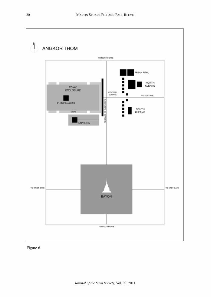
30 MARTIn STuART-Fox And PAuL REEVE
Journal of the Siam Society, Vol. 99, 2011
Figure 6.

31SYMBoLISM In CITY PLAnnInG In CAMBodIA
Journal of the Siam Society, Vol. 99, 2011
Figure 7.
Figure 8.

32 MARTIn STuART-Fox And PAuL REEVE
Journal of the Siam Society, Vol. 99, 2011
Figure 9.

33SYMBoLISM In CITY PLAnnInG In CAMBodIA
Journal of the Siam Society, Vol. 99, 2011
Bibliography
Askew, Mark. Bangkok: Place, Practice and Representation, London, Routledge, 2002.
Boisselier, Jean. “The meaning of Angkor Thom” in Helen Ibbitson Jessup and Thierry Zephir, eds. Sculpture of Angkor and Ancient Cambodia: Millennium of Glory. Washington: national Gallery of Art/Thames and Hudson, 1997.
Brown, Robert L. The Dvaravati Wheels of the Law and the Indianization of South East Asia. Leiden: Brill, 1996.
Bucknell, Roderick S, and Stuart-Fox, Martin. The Twilight Language: Explorations in Buddhist Meditation and Symbolism. London: Curzon, 1986.
Caillat, Collette and Ravi Kumar, Jain Cosmology. Translated by R. norman. new delhi: Bookwise, 2004.
Chandler, david P. A History of Cambodia, 2nd ed. St Leonards, nSW: Allen & unwin, 1993
Chirapat Prapandvidya, “The Sab Bāk inscription: Evidence of an early Vajrayana Buddhist Presence in Thailand” Journal of the Siam Society 78 (1990): 10–16
Clément-Charpentier, Sophie., and Clément, Pierre. L’habitation lao dans les region de Vientiane et de Louang Prabang. Leuven: Peeters, Volume 1., 1990.
Coe, Michael d. Angkor and the Khmer Civilization. London: Thames & Hudson, 2003.
Cœdès, George. “Études cambodgiennes VIII: La fondation de Phnom Peñ au xVe siècle d’après la chronique cambodgienne” Bulletin de l’École Français d’Extrême-Orient, 13, no. 6 (1913): 6–11.
Cœdès, George. Angkor: An Introduction. Hong Kong: oxford university Press, 1963.
de Bary, W. T. ed. Sources of Indian Tradition, vol. 1. new York: Columbia university Press, 1958, pp. 24–25;
de Bernon, olivier. “Le plus ancien édifice subsistant de Phnom Penh : une tour angkorienne sise dans l’enceinte du Vatt unnlom. Bulletin de l’Ecole française d’Extrême-Orient, 88, 1 (2001): 249 – 260.
de Marini, G.F. A New and Interesting Description of the Lao Kingdom. Transl. by Walter E. J. Tips and Claudio Bertuccio. Bangkok: White Lotus, 1998.
duhem, Pierre. Medieval Cosmology. Translated by Roger Ariew. Chicago: university of Chicago Press, 1985.
Evans, d. et al. “A comprehensive archaeological map of the world’s largest preindustrial settlement complex at Angkor, Cambodia” PNAS 104: 36 (September 4, 2007): 14277–14282.
Filliozat, J. “Le symbolisme du monument de Phnom Bakheng” Bulletin de l’École Française d’Extrême-Orient 44:2 (1951): 527–554.

34 MARTIn STuART-Fox And PAuL REEVE
Journal of the Siam Society, Vol. 99, 2011
Garnier, derick. Ayutthaya: Venice of the East. Bangkok: River books, 2004. Gosling, Betty. Sukhothai: Its History, Culture, and Art. Singapore: oxford
university Press, 1991.Govinda,Lama Anagarika. Foundations of Tibetan Mysticism. London: Rider, 1960.Groslier, Bernard P. Angkor and Cambodia in the Sixteenth Century: According to
Portuguese and Spanish Sources. Bangkok: orchid Press, 2006.Guillon, Emmanuel. The Mons: A civilization of Southeast Asia. Transl. James V.
di Crocco. Bangkok: The Siam Society, 1999.Guthrie, W. K. C. “Man’s Role in the Cosmos. Man the Microcosm: the Idea in
Greek Thought and its Legacy to Europe.” In The Living Heritage of Greek Antiquity. European Cultural Foundation. The Hague: Mouton, 1967.
Heine-Geldern, Robert. “Conceptions of State and Kingship in Southeast Asia” Far Eastern Quarterly 2 (1942).
Hopkins, Thomas J. The Hindu Religious Tradition. Encino CA; dickenson, 1971.Jacobsen, Trudy, Lost Goddesses: The Denial of Female Power in Cambodian
History. Copenhagen: nIAS Press, 2008.Jacques, Claude. Angkor. Cologne: Könemann, 1999.Kulke, Herman The Devarāja Cult, transl. I. W. Mabbett. Ithaca: Southeast Asia
Program data Paper no. 108, 1978Mabbett, I. W. “The Symbolism of Mount Meru” History of Religions 23 (1983):
64–83. Kramrisch, Stella. The Hindu Temple, Vol. 1. delhi: Motilal Banarsidass, 1976. Mannikka, Eleanor. Angkor Wat: Time, Space, and Kingship. Honolulu: university
of Hawai’i Press, 1996.Michell, George. The Hindu Temple: An introduction to its meaning and forms.
Chicago: university of Chicago Press, 1988Muller, dr. Hendrik P.n. De Oost-Indische compagnie in Cambodja en Laos :
Verzameling Van Bescheiden van 1636 tot 1670 / uitg. en toegelicht door ‘s-Gravenhage : M. nijhoff, 1917.
Mus, Paul. “Angkor at the time of Jayavarman VII, Indian Art and Letters, 11 (1937): 65–75.
népote, Jacques. “Louang Phrabang: d’une position géo-politique articulatoire à un urbanism microcosmique” Péninsule 34, no. 1 (1997): 129–152.
ngaosrivathana, Mayoury and Pheuiphanh. The Enduring Sacred Landscape of the Naga. Chiang Mai: Mekong Press, 2009.
o’Flaherty, Wendy d. Hindy Myths: A Sourcebook Translated from the Sanskrit. Harmonsworth: Penguin, 1975.
o’Reilly, dougald JW. Early Civilizations of Southeast Asia. Plymouth: AltaMira Press, 2007.
osborne, Milton. Phnom Penh: A Cultural and Literary History. oxford: Signal Books, 2008.

35SYMBoLISM In CITY PLAnnInG In CAMBodIA
Journal of the Siam Society, Vol. 99, 2011
Plato, Plato’s Cosmology: The Timaeus of Plato, translated and with commentary by F. M. Cornford. London: Routledge & Kegan Paul, 1937.
Pottier, Christophe. “notes sur le Bakong et son implantation” Bulletin de l’Ecole française d’Extrême-Orient, 83, 1 (1996): 318 – 326.
Reynolds, Frank E and Mani B. Three Worlds According to King Ruang: A Thai Buddhist Cosmology. Berkeley: university of California Press, 1982, pp. 135–137.
Rowland, Benjamin. The Art and Architecture of India. Harmondsworth: Penguin, 1970, p. 274.
Sharrock, Peter d. ”The mystery of the face towers”, in Joyce Clarke, ed. Bayon: New Perspectives. Bangkok: River Books, 2007.
Snellgrove, david. Angkor Before and After: A Cultural History of the Khmers. Bangkok: orchid Press, 2004, pp. 175–176.
Snodgrass, Adrian. The Symbolism of the Stupa. Ithaca, nY: Cornell university Southeast Asia Program, 1985.
Stuart-Fox, david J. Pura Besakih: Temple, Religion and Society in Bali. Leiden: KITLV Press, 2002.
Stuart-Fox, Martin. The Lao Kingdom of Lan Xang: Rise and Decline. Bangkok: White Lotus Press, 1998.
Stuart-Fox, Martin. Naga Cities of the Mekong. Singapore: Media Masters, 2006.Sugiyama, Saburo. “Worldview Materialized in Teotihuacan, Mexico” Latin
American Antiquity 4, 2 (1993): 103–129.Symbol of the Lao Nation: The That Luang of Vientiane. Vientiane: Vientiane Times
Publications, 1996.Tambiah, S. J. World Conqueror and World Renouncer: A Study of Buddhism and
Polity in Thailand against a Historical Background. Cambridge: Cambridge university Press, 1976.
Thompson, Ashley. “The Future of Cambodia’s Past: A Messianic Middle-Period Cambodian Royal Cult” in John Marston and Elizabeth Guthrie, eds. History, Buddhism, and New Religious Movements in Cambodia. Honolulu: university of Hawai’i Press, 2004.
Varenne, J. Yoga and the Hindu Tradition. Translated by d. Coleman. delhi: Motilal Banarsidass, 1989.
Vickery, Michael. Society, Economics, and Politics in Pre-Angkor Cambodia: The 7th–8th Centuries (Tokyo: Centre for East Asian Cultural Studies for unESCo, The Toyo Bunko, 1998
Vickery, Michael. “Cambodia and Its neighbors in the 15th century”, Asian Research Institute Working Paper no. 27, June 2004.
Wheatley, Paul. The Pivot of the Four Quarters: A Preliminary Enquiry into the Origins and Character of the Ancient Chinese City. Chicago: Aldine, 1971.

36 MARTIn STuART-Fox And PAuL REEVE
Journal of the Siam Society, Vol. 99, 2011
Woodward, Hiram W. Jr. “Practice and Belief in Ancient Cambodia: Claude Jacques’ Angkor and the Devarāja Question” Journal of Southeast Asian Studies 32, 2 (2001): 249–261
Wyatt, david K. Thailand: A Short History. new Haven: Yale university Press, 1984.
Wyatt, david K and Aroonrut Wichienkeeo, The Chiang Mai Chronicle. Chiang Mai: Silkworm Press, 1995.
Zhou daguan, A Record of Cambodia: The Land and its People, translated with an introduction and notes by Peter Harris. Chiang Mai: Silkworm Books, 2007.