supervisor prof. dr umbreen javaid by zakir hussain roll no. 05 ...
314
GEO-STRATEGIC SIGNIFICANCE OF GILGIT-BALTISTAN: POLITICAL, ECONOMIC AND SECURITY INTERESTS OF PAKISTAN, INDIA, AND CHINA (1947-2013) SUPERVISOR PROF. DR UMBREEN JAVAID BY ZAKIR HUSSAIN ROLL NO. 05 DEPARTMENT OF POLITICAL SCIENCE UNIVERSITY OF THE PUNJAB, LAHORE, PAKISTAN 2017
-
Upload
khangminh22 -
Category
Documents
-
view
1 -
download
0
Transcript of supervisor prof. dr umbreen javaid by zakir hussain roll no. 05 ...

GEO-STRATEGIC SIGNIFICANCE OF GILGIT-BALTISTAN:
POLITICAL, ECONOMIC AND SECURITY INTERESTS OF
PAKISTAN, INDIA, AND CHINA (1947-2013)
SUPERVISOR
PROF. DR UMBREEN JAVAID
BY
ZAKIR HUSSAIN
ROLL NO. 05
DEPARTMENT OF POLITICAL SCIENCE
UNIVERSITY OF THE PUNJAB,
LAHORE, PAKISTAN
2017

GEO-STRATEGIC SIGNIFICANCE OF GILGIT-BALTISTAN:
POLITICAL, ECONOMIC AND SECURITY INTERESTS OF
PAKISTAN, INDIA, AND CHINA (1947-2013)
A thesis submitted to the Political Science Department, University of the Punjab Lahore (Pakistan) in partial fulfillment of the requirement for the
award of research degree of Doctorate of Philosophy.
SUPERVISOR
PROF. DR UMBREEN JAVAID
BY
ZAKIR HUSSAIN
ROLL NO. 05
DEPARTMENT OF POLITICAL SCIENCE
UNIVERSITY OF THE PUNJAB,
LAHORE, PAKISTAN
2017

CERTIFICATE
It is certified that I have read the dissertation submitted by Zakir Hussain, Student of Department
of Political Science, University of the Punjab Lahore, entitled “Geo-strategic Significance of
Gilgit-Baltistan: Political, Economic and Security Interest of Pakistan, India, and China (1947-
2013)” as a partial fulfillment for the award of degree of Doctorate of Philosophy in Political
Science. I have evaluated the dissertation and found it up to the requirement in its scope and
quality for the award of the degree.
____________________
Supervisor
Prof. Dr. Umbreen Javaid
Chairperson
Department of Political Science

DECLARATION
I hereby declare that this thesis is the result of my individual research and that it has not been
submitted concurrently to any other University for any other degree.
Zakir Hussain

Dedicated
To
My late Mother who left me when my wings enabled me to fledge

Contents
Acknowledgement I-II
List of Figures III
List of Tables IV
List of Abbreviation V-VI
Abstract VII-VIII
Introduction 1-2
Review of literature 3-17
Justification and Likely Benefits 18
Research questions 19
Research objectives 19-20
Plan of Work 20-21
Research methodology 21-22
Place of Work and Facilities Available 22
References 23-26
Chapter No. 1
Geo-Strategic: A Theoretical Perspective
1. Introduction 28
1.1. What is Geography? 29-30
1.2 What is Geopolitics? 30-33
1.3 Relations between Geopolitics and Geography 33-35
1.4 What is Geostrategy? 35-36
1.5 Geostrategic Location 36
1.6 Strategic Importance 37
1.7 What is Geostrategic? 37-38
1.8 Elements of Strategy 38
1.9 Geo-Strategists 38-40
1.9.1 Freidrich Ratzel 40-42
1.9.2 Rudolf Kjellen 42-44
1.9.3 Sir Halford Mackinder: Heartland Theory (1904) 44-47
1.9.4 Rimland Theory 47-51
1.9.5 Alfred T. Mahan (1890) 51-52
1.9.6 Karl Haushofer 52-54
1.9.7 Zbigniew Brzezinski 55
1.10 Elements of Geo-Strategy 55
1.11 Theoretical Implications for Gilgit-Baltistan 56
1.11.1 Geographical Location 56
1.11.2 The Karakoram Highway 56-58
1.11.3 Wakhan Corridor 58-59
1.11.4 The Sost Dry Port 59-60
1.11.5 The Mighty Indus 60-61
1.11.6 Tourism in Gilgit-Baltistan 61-62
1.11.7 Tourism Assets of Gilgit-Baltistan 62
1.11.7.1 Natural Legacy 62
1.11.7.2 Cultural Tradition 63
1.11.7.3 Archaeological Legacy 64-65
1.11.8 Natural Resources(Minerals) ……..66-67
1.11.9 Trade Opportunities 68
References 69-73

Chapter No. 2
Gilgit-Baltistan: A Geographical Detail
Introduction 75
2.1 Gilgit-Baltistan: Location 76-78
2.2 Gilgit-Baltistan: Population 78
2.3 Gilgit-Baltistan: Languages 79
2.3.1 Shina 79
2.3.2 Balti 79
2.3.3 Burushasky 80
2.3.4 Khowar 80
2.3.5 Domaaki 80
2.3.6 Wakhi 80
2.4 Gilgit-Baltistan: Administrative Division 81
2.5 Gilgit Division 82
2.5.1 Gilgit District 82
2.5.2 Ghizer 83
2.5.3 Hunza 83
2.5.4 Nagar 84
2.6 Diamer Division 84
2.6.1 Diamer District 84-85
2.6.2 Astor 85
2.7 Baltistan Division 85-86
2.7.1 Skardu 86
2.7.2 Ghanche 86-87
2.7.3 Shigar 87-88
2.7.4 Kharmang 88

2.8 Gilgit-Baltistan: Mountain Ranges 88-90
2.8.1 Karakoram Range 90-91
2.8.2 The Himalaya Range 91
2.8.3 The Hindu Kush Range 91-92
2.9 Gilgit-Baltistan: Peaks 92
2.9.1 K2 92-93
2.9.2 Nanga Parbat 93
2.9.3 Gasherbrum (K5) 93-94
2.9.4 Broad Peak 94
2.9.5 Gasherbrum II (K4) 94
2.9.6 Masherbrum 94
2.9.7 Rakaposhi 95
2.9.8 Sia Kangri 95
2.9.9 Trango Towers 95
2.10 Gilgit-Baltistan: Passes 96
2.10.1 Mintaka Pass 96
2.10.2 Kilik Pass (15,800 feet) 96
2.10.3 Shandur Pass 97
2.10.4 Babusar Pass 97
2.10.5 Burzil Pass 97-98
2.10.6 Darkot Pass 98
2.10.7 Baroghil Pass 98
2.10.8 Karambar Pass 98

2.10.9 Khunjarab Pass 98-99
2.10.10 Shimshal Pass 99
2.10.11 Hispar Pass 100
2.10.12 Muztagh Pass 100
2.10.13 Karakoram Pass 100
2.10.14 Dadarili Pass 100
2.10.15 Shonter Pass 100
2.10.16 Kamri Pass 101
2.10.17 Manejo Pass 101
2.10.18 Zoji La Pass 101
2.10.19 Banak La Pass 101
2.11 Gilgit-Baltistan: Glacier 101-102
2.11.1 Siachen Glacier 103
2.11.2 Biafo Glacier 103
2.11.3 Batura Glacier 104
2.12 Gilgit-Baltistan: Lakes 104
2.12.1 Dosai Sheosar Lake 104
2.12.2 Satpara Lake Skardu 104-105
2.12.3 Upper Kachura Lake 105
2.12.4 Lower Kachura Lake 105
2.12.5 Borith Lake 106
2.12.6 Rama Lake 106
2.12.7 Rush Lake, World's Highest Alpine Lake 107

2.12.8 Karambar Lake Ghizer 107
2.12.9 Khalti Lake Gupis 107
2.12.10 Attabad Lake Gojal Hunza 107-108
2.13 Gilgit Baltistan: Historical Forts 109
2.13.1 Baltit Fort 109
2.13.2 Altit Fort 110
1.13.3 Skardu Fort/ Kharpocho Fort 110
1.13.4 Shigar Fort 110-111
2.13.5 Khaplu Fort 111
2.14 Gilgit Baltistan: Valleys 111-112
2.14.1 Rama Valley 112
2.14.2 Rattu Valley 112
2.14.3 Minimarg Valley 112
2.14.4 Shingo Valley 113
2.15 Fairy meadows 113
2.16 Deosai Plains 113-114
2.17 Gilgit-Baltistan: FAUNA 114
2.17.1 Markhor 115
2.17.2 Bear 115
2.17.3 Musk Deer 116
2.17.4 Duck 116
2.17.5 Chukar Partridge 116
2.17.6 Chukar 116
2.17.7 Zho 117

2.17.8 Marmet 117
2.17.9 Hawk 117
2.17.10 Sparrow Hawk 117
2.18 Gilgit-Baltistan: Flora 117-118
References 119-121
Chapter # 3
Gilgit-Baltistan: Political and Constitutional Status
3. Introduction 123
3.1 Gilgit-Baltistan: Historical Evolution 124-125
3.2 Primeval History 126
3.2.1 Megalith Builders 126
3.2.2 Dardic People 127
3.2.3 Scytho Parthians 127
3.2.4 The Kushans 128
3.2.5 The Post Kushans 128
3.2.6 The Huns 128
3.3 Autonomous Hill States 129
3.4 Dogra Raaj 129-130
3.5 Treaty of Lahore 130
3.6 Treaty of Amritsar 131
3.7 British Indian Rules 131-132
3.8 Gilgit Agency 132
3.9 The Gilgit Scout 133
3.10 End of British Rules 134
3.11 United Nations Resolution 134-135
3.12 Political Development in Gilgit Baltistan 1947-2013 135
3.12.1 Karachi Agreement 1949 135-136
3.12.2 Transfer To Ministry Of Kashmir Affairs 136-137
3.13 Gilgit-Batistan after Accession with Pakistan 137
3.13.1 Chronological Order of Administration and Self-government Reforms (1947-2009).137
3.13.2 Formation of the Ministry 1950 137
3.13.3 Appointment of Resident 1950-52 137-138
3.13.3 Empowerment of Resident 1967 138
3.13.3 Creation of Representative Body of Northern Areas 1970 138
3.13.4 Resident Commissioner 1972 138
3.13.5 Z.A Bhutto Government Reforms 1947s 138-139
3.13.6 Imposition of Zia-ul-Haq Martial Law and Zone E 1977 139
3.13.7 Appointment of Advisor to Kashmir Affairs 1985 140
3.13.8 Advisor to Prime Minister 1988 140
3.13.9 Benazir Bhutto Announced new Reforms 1994 140
3.13.10 Delegation of Legislative power to the NALC (1999) 141
3.13.11 Establishment of Apex Court (2005) 141
3.13.12 Empowerment of Northern Areas Legislative Council (2006) 141
3.13.13 The Reforms Package (2007) 141
3.13.14 The Gilgit Baltistan Empowerment and self-Governance Order (2009) 142-144
3.14 The Gilgit Baltistan Assembly 144
3.15 Gilgit Baltistan Council 144-145
3.16 Election in Gilgit-Baltistan 145
3.17 Sectarianism in Gilgit-Baltistan 146-147
References 148-151

Chapter # 4
Gilgit-Baltistan: Political, Economic and Security Interest for Regional
Powers
Introduction 153
4.1 Gilgit-Baltistan: A Corridor for China’s Economic Development 154
4.1. China Growing Economic 154-155
4.2 China’s Economic Growth after Civil War (1949-1976) 155
4.3 China’s Economic Reforms: After Mao Zedong (1979-the Present) 156-158
4.4 China’s Soft Power 159-160
4.5 China in South Asian 160-161
4.5.1 China’s Relations with Afghanistan 161-162
4.5.2 Sri Lanka 162
4.5.3 Bangladesh 162
4.5.4 Nepal 163
4.5.5 China and Bhutan 163
4.5.6 China and Maldives 163
4.5.7 China’s Relations with India 164-165
4.5.8 The Pakistan-China relations 165-166
4.6 Sino-Pak Boundary Agreement 1963 166-167
4.7 Shasgham Valley 167-168
4.8 Wakhan Corridor 168-169
4.9 Karakoram Highway 169-172
4.10 Slik Road & Gateway for Buddhism 172-173
4.11 Turmoil in Xingjian Province 173-174

4.12 One-Belt-One Road Initiative 174-175
4.12.1 Importance for China 176-177
4.13 China-Pakistan Economic Corridor (CEPC) 177-178
4.13.1 Tripartite Road Networks 179
4.13.2 Pakistani Interest 179-182
4.13.3 Chinese Interest 183
4.14 South China Sea and The Malacca factors 183-184
4.15 Development of Western China 184-185
4.16 Gilgit-Baltistan Relation with China 186-187
4.17 Gilgit-Baltistan: An Indian’s Perspective 187-188
4.18 Indian’s Claim of Ownership of the Region 188
4.19 Gilgit-Baltistan connection with Kashmir 188-189
4.20 Dogra Raj in Gilgit-Baltistan 189-190
4.21 Treat of Lahore and Treat of Amritsar 1846 190-191
4.22 Lease of Gilgit 1935 191
4.22 Gilgit Baltistan: Nearest Routs for Central Asian States 192
4.22.1 India-Afghan Relation 192
4.22.2 Central Asian & India 192-193
4.23 Gilgit-Baltistan: Gateway for Afghanistan and CARs 193-195
4.24 Kashmir Dispute 195-198
4.25 Siachen Issue 198-199
4.26 Kargil War 200

4.27 Kargil Road 201-202
4.28 Curtailment of Chinese Influences 202
8.28.1 Indo-Sino War 1962 202-203
4.29 Gilgit-Baltistan: Pakistan De facto Rule and its Interest 203
4.29.1 Gilgit-Baltistan: Aftermath Freedom Movement 1947 203-204
4.29.2 Gilgit-Baltistan’s Role in Kashmir Issue 205
4.29.3 Gilgit-Baltistan: Key for Kashmir Plebiscite 205
4.29.4 Trade and Link with China and Central Asian States 205-206
4.29.5 Energy and Water Resources 206
4.29.6 Gilgit-Baltistan: Pakistan’s Energy Security 206-207
4.29.7 Gilgit-Baltistan: Pakistan’ Security Importance 207
4.29.8 Tourism as a beneficial factor in National Economic Development 207
Reference 208-215
Chapter No.5
Conclusions and Policy Recommendations
Conclusions 217-230
Findings 231-235
Survey Analysis 236-255
Suggestions and Policy Recommendations 256-258
Bibliography 259-280
Appendixes 281-290
.

I
ACKNOWLEDGEMENTS I am grateful to Almighty Allah who provided me strength and stamina to complete the present
study. It was, no doubt, an arduous task which needed lot of patience, hard work and
commitment, which I was able to get through the blessings of Almighty Allah. In addition,
without the active support of the people around us, it is difficult to conduct research. For this, I
am indebted to many people.
I am highly indebted to my supervisor Prof. Dr.Umbreen Javaid, Chairperson Department
of Political Science, University of the Lahore, whose guidance, constant encouragement and
inspiration enabled me to sail through. The foundation of my study in fact is based upon her
guidance and direction. I faced great troubles during last stage of my thesis but at that time her
support and tender-hearted was commendable and praiseworthy. It would have been quite
impossible for me to bring the thesis in the present form without her able assistance.
I am also grateful to Dr. Shujaat Ali (University Bordeaux-France) as he critically went
through numerous drafts of the study and his scholarly acumen helped me a lot. Discussions with
him not only brought clarity into my understanding of the subject but also crystallized my ideas.
I would like to thank my friends Mir Waheed (PhD, Scholar PU), Dr Zahid Yaseen (PhD-PU),
Singay Ali (M.Phil Scholar; Solid State Physics PU), My Nephew Dilawar Ali Dilber (M.Phil
Scholar; at PMAS Arid Agriculture University Rawalpindi) who were cooperative and of
valuable help, during my research work.
I am also grateful to staff of Seminar Library Department of political Science, Central
Library University of the Punjab, Pakistan Study Centre Library, Center For South Asian Studies
Library, Quaid-i-Azam Library Lahore, National Defense University Islamabad, Municipal

II
Library Gilgit and Skardu City, Degree College Skardu Library, and many authors, scholars
writers and theirs books, research papers, websites, helped me to complete this laborious work.
Last but not least, my family deserves special praise. During this research work, they
provided me emotional support and facilitated me to reach the culmination stage of my study My
Brother Muhammad Ali and Muhammad Sharif were the source of my trust and reliance. I
cannot forget the prayers and services of my father and my late mother. I must say, that I have
completed this task with the support of all these people, but all the errors found in this work will
be always mine.
Zakir Hussain
Department of Political Science
University of the Punjab
May, 2017.

III
List of Figures
Chapter # Map # Page # Description #
1 1.1 45 Mackinder Heartland Theory
1 1.2 46 Map of Heartland vs. Rimland
1 1.3 48 Rimland Theory
1 1.4 54 Map of Haushofer’s Pan Region Model
1 1.5 59 Map of Wakhan Corridor
1 1.6 61 The Indus River
1 1.7 64 Polo Match in Gilgit-Baltistan
1 1.8 66 Zehra-Mohra (Mush Serpentine Mineral)
1 1.9 67 Mineral Target Area in Gilgit-Baltistan
2 2.1 77 Map of Gilgit-Baltistan
2 2.2 81 Districts of Gilgit-Baltistan
2 2.3 90 Mountain Ranges in Gilgit-Baltistan
2 2.4 93 Mighty K-2
2 2.5 99 Khunjarab Pass
2 2.6 102 Glaciers in Gilgit-Baltistan
2 2.7 106 Shangri-La Lake Skardu
2 2.8 108 Attabad Lake Hunza
2 2.9 109 Baltit Fort Hunza
2 2.10 114 Deosai Plains
2 2.11 115 Brown Bear in Gilgit-Baltistan
2 2.12 118 Fauna and Flora in Gilgit-Baltistan
3 3.1 125 This Prehistoric Caprine depiction in Chilas
3 3.2 133 Gilgit-Scouts
4 4.1 167 Shasgham valley
4 4.2 169 Wakhan Corridor Afghanistan
4 4.3 176 One Belt One Road Initiatives
4 4.4 178 China-Pakistan Economic Corridor
4 4.5 182 Economic Corridor
4 4.6 199 Siachen Glacier Areas
4 4.7 200 Kargil War
IV
List of Tables
Chapter # Table # Page # Description #
2 2.1 78 Population in Gilgit-Baltistan
2 2.2 89 Eight Thousanders Mountains of Gilgit-
Baltistan
4 4.1 157 Chinese Real GDP Growth 1979-2014
4 4.2 158 Worldwide Chinese Investments &
construction, 2005-16
4 4.3 183 Saving in terms of Distances (Via Shanghai vs.
Gawadar)
V
List of Abbreviations
ADB Asian Development Bank
AD Anno Domini
ADP Annual Development Program
AKDN Agha Khan Development Network
AJ & J Azad Jammu and Kashmir
AK Azad Kashmir
BC Before Christ
BCE Before Common Era
CPEC China Pakistan Economic Corridor
CARs Central Asian Republics
CCP Chinese Communist Party
CMSR Century Maritime Silk Road
CFL Cease Fire Line
CCP Chinese Communist Party
FATA Federally Administered Tribal Areas
FDI Foreign Direct Investment
FIEs Foreign Invested Enterprises
FCR Frontier Crime Rules
DPA Gross Domestic Product
GB Gilgit-Baltistan
GBLA Gilgit-Baltistan Legislative Assembly
GLF Great Leap Forward
IMF International Monetary Fund
IB Intelligence Bureau
ISI Inter -Services Intelligence
J&K Jammu and Kashmir
KKH Karakorum High Way
KAGB Kashmir Affairs and Northern Areas
KANA Kashmir Affairs and Northern Areas
LFO Legal Framework Order
LOC Line of Control
PML (N) Pakistan Muslim League (Nawaz)
PM Prime Minster
NAC Northern Areas Council
NALC Northern Areas Legislative Council

VI
NWFP North West Frontier Province
NFC National Finance Commission
NGO Non-Governmental Organization
NATCO Northern Areas Transportation Company
OBOR One-Belt One -Road
PRC People Republic of China
POEs Private Owned Enterprises
PPP People Party Pakistan
ROC Republic of China
R &B Road and Belt
SAARC South Asian Association for Regional Cooperation
SSR State Subject Rule
SPA Strategic Partnership Agreement
SREB Silk Road Economic Belt
UN United Nation
USAID United States Agency for International Development
UNSC United National Security Council
UNCIP United Nations Commission for India and Pakistan
USSR Union of Soviet Socialist Republics
US(A) United State of (America)
SOEs State Owned Enterprises
WW-I World War-I
WW-II World War-II
WB World Bank
WTO World Trade Organization

VII
Abstract
Geography is the study of earth, environment and the people living on it and geographical
position of a state determines its geopolitical and geostrategic significant role in international
politics. Gilgit-Baltistan (GB), formally known as Northern Areas of Pakistan, is located at a
place where three great mountain ranges (Empires); Karakorum, Himalayas and Hindukush,
meet. Gilgit-Baltistan borders with Xinyang Autonomous Province of China, Indian held
Kashmir and Ladakh region, Pakistan held Kashmir and KPK province, and ‘Wakhan’ of
Afghanistan and this narrow belt separates Gilgit-Baltistan from Central Asian Republics
(CARs). Gilgit-Baltistan is the home of mighty mountain ranges, numerous highest peaks
including five ‘eight thousanders’ of the world, K-2, world second highest peak, 5100 glaciers,
huge fresh water and natural resources, rivers, world second highest plateaus, coldest deserts,
beautiful lakes, gorgeous valleys, enormous fauna and flora, rich cultures, attractive historical
tourist points, ancient routes, and multi-ethic societies. Gilgit-Baltistan always remained an
attractive point for foreign invaders, travelers, tourist, and missionaries due to its unique
topography as well as its geopolitical position, hence this region is called ‘Heaven on Earth for
tourist.’ Politically, this region stayed under the rules of the various Empires, kingdoms, Rajas,
of the invaders from ancient China, Central Asia, India and other old civilizations. In the
medieval history, Gilgit-Baltistan went under the rules of local dynasties. In 1840s Dogra of
Jammu invaded in Gilgit-Baltistan and defeated the local rulers and sized power. In 1870s,
during Great Game, Gilgit-Baltistan went under the consideration of British. To curtail the
Russian’s expansion, British decided to establish Gilgit Agency in 1877 and reestablish in 1889.
In March 1935 the control of Gilgit was given to British as a 60 year lease by Maharaja Hari
Sing. In 1947, the political scenario had been changed in Sub-continent. Under the Indian
VIII
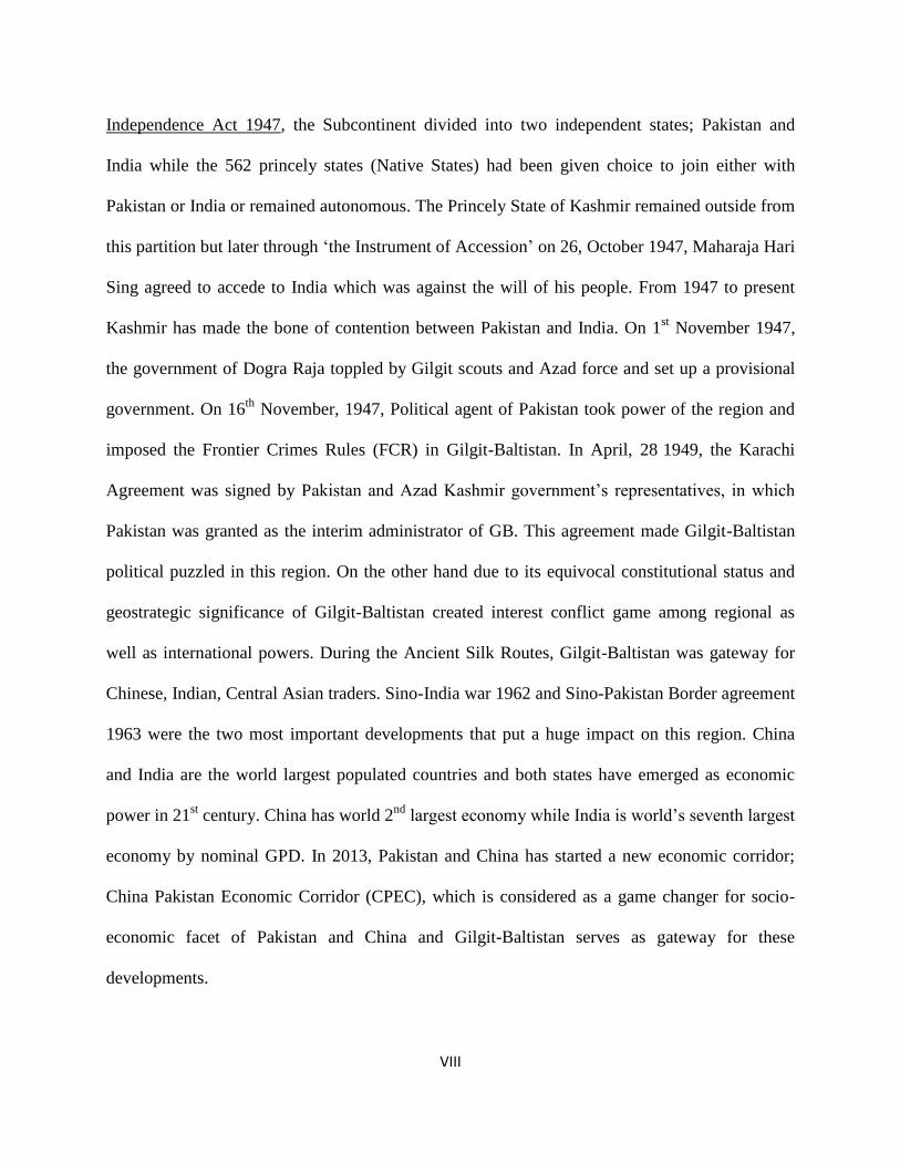
Independence Act 1947, the Subcontinent divided into two independent states; Pakistan and
India while the 562 princely states (Native States) had been given choice to join either with
Pakistan or India or remained autonomous. The Princely State of Kashmir remained outside from
this partition but later through ‘the Instrument of Accession’ on 26, October 1947, Maharaja Hari
Sing agreed to accede to India which was against the will of his people. From 1947 to present
Kashmir has made the bone of contention between Pakistan and India. On 1st November 1947,
the government of Dogra Raja toppled by Gilgit scouts and Azad force and set up a provisional
government. On 16th
November, 1947, Political agent of Pakistan took power of the region and
imposed the Frontier Crimes Rules (FCR) in Gilgit-Baltistan. In April, 28 1949, the Karachi
Agreement was signed by Pakistan and Azad Kashmir government’s representatives, in which
Pakistan was granted as the interim administrator of GB. This agreement made Gilgit-Baltistan
political puzzled in this region. On the other hand due to its equivocal constitutional status and
geostrategic significance of Gilgit-Baltistan created interest conflict game among regional as
well as international powers. During the Ancient Silk Routes, Gilgit-Baltistan was gateway for
Chinese, Indian, Central Asian traders. Sino-India war 1962 and Sino-Pakistan Border agreement
1963 were the two most important developments that put a huge impact on this region. China
and India are the world largest populated countries and both states have emerged as economic
power in 21st century. China has world 2
nd largest economy while India is world’s seventh largest
economy by nominal GPD. In 2013, Pakistan and China has started a new economic corridor;
China Pakistan Economic Corridor (CPEC), which is considered as a game changer for socio-
economic facet of Pakistan and China and Gilgit-Baltistan serves as gateway for these
developments.
1
Introduction
Geo strategic importance of any region casts a deterministic shadow over the regions politico-
economic conditions. It affects almost all choices made by a state while deciding matters as
important as choosing friends and foes in the realm of international politics. Proper and thorough
understanding of a states geo strategic importance gives a degree of predictability while
analyzing state behavior and future course of action. If manipulated properly, geo strategic
realities can bring fruits of regional and global economic and political prosperity.
Pakistan enjoys immense strategic importance in regional and global political order. It borders
India to the East, a rising global economy, Iran and Afghanistan to the West and North West,
Arabian Sea to the South, Central Asian Republics (CARs) to the North West and China to the
North. Among all these neighboring states, Pakistan has experienced a very smooth, cordial and
―an all-weather friendship‖ with Chinese Republic, the state bordering the Region of Pakistan‘s
Gilgit Baltistan region. Pakistan, the most allied ally of the U.S in the 60‘s and the much hailed
non-NATO ally of the west in recent times, surprisingly found Communist China more friendly
without any malice to her relations with the capitalist west. Pakistan has reciprocated in the like
manner and the mutual friendship has been labeled as, ―stronger than steal, higher than the
Himalayas, deeper than the oceans and sweeter than honey‖. Both states, though in opposite
camps in the global division of capitalist-communist world, have understood the dictates of geo
strategic realities and share a greater degree of congruence on many of the global issues,
enhancing future prospects of mutual cooperation and regional integration. It is worth
mentioning that the region which serves as the only gate way to china, the region ―Gilgit-
Baltistan of Pakistan‖ is no less than a political puzzle. Pakistan considers it as a part of Kashmir
dispute and is administering the region till the solution of Kashmir issue as per U.N resolutions

2
on Kashmir. On the other hand India has showed serious concerns over the future of region and
claims it as her part. Indian stakes in the region are very high because of her dubious relations
with china who has been involved in various developmental projects in that region. India
perceives a threat of encirclement by China in the region and hence considers Gilgit-Baltistan as
an important factor when it comes to regional and global power rivalry. Besides this India and
china have emerged as major trade partners in the region, if the Gilgit puzzle turns in Indian
favors in any way, it would be the most desirable scenario for India. While such a turnout would
deprive direct Sino-Pak contact, grudging Pakistan of any military support from her most trusted
friend in case of war against India, it will naturally bring china and India more closer, enhancing
mutual trade and cooperation. New avenues of trade towards the Central Asian region are an
incentive related with Gilgit-Baltistan that equally attracts India, Pakistan and China.
Besides being the most important factor in the context of China, Pakistan and India relation
equation, the region is rich in many natural resources which magnify its importance manifolds.
The energy potential of the region is yet to be exploited which is projected to be 31,000 to
40,000 MWs, an incentive of much higher importance for any of the stake holder. The abundant
fresh water resources of the region play a pivotal role in defining already strained relations
between India and Pakistan over water security issues. Minerals of high commercial importance
and potential for becoming an international tourist spot further enhance the stakes in the region.
The study would aim at analyzing Geo Strategic importance of Gilgit-Baltistan vis a vis China,
Pakistan, India relations equation while taking into account the socio political and economic
impacts that affect the region itself for being part of a regional rivalry that characterizes the
South Asian region.

3
Literature Review
A thought provoking research is conducted about Gilgit-Baltistan by Sikandar Khan Baloch
(2004). The book discusses a detail geographical account and the struggle movement of local to
liberate them from the Dogra Raj. The author explains various element of geographical account
such as the location, mountains, ranges, peaks, important passes, the rivers, the ancient historical
roads, languages, religion, early history, the rise of Silk Road, Dogras and the British
domination. Gilgit-Baltistan known as the root of the world, situated on the juncture of Central
and south Asia. The three great mountain ranges meet her. World second highest peak K2
situated in Gilgit-Baltistan. Snowy peaks of this region are the gigantic natural storehouses of
water. The Indus River, main source of Pakistan‘s agriculture and energy contributor passes
through these region. The author has brought the significance of the area in the in context of
water security for Pakistan. The writer is inspired from the bravery of the local people while
highlighting the saga of their heroism. He points out that despite the lack of communication and
transportation means, arsenal compare to their enemies; the local people had some advantages in
this battle against their enemies. First and foremost was the high standard of leadership which
accompanied them to the field , their knowledge of the job, drive, determination and supreme
dedication to the cause is the main factor which contributed to their success. To sum it up, it was
a highly unconventional war. Every conceivable factor went against the freedom fighters and still
nothing deterred them from their aim. These ill-trained, ill-equipped and ill-clothed men proved
superior to a well-trained, regular and numerically much superior army. Their strongest point
was their aberration from the set dogmas and non-adherence to the basic principles of war.

4
Another important book edited by K.Warkoo (2011) on Central Asian Republics and South Asia
power collaboration and Transportation. The book divides into two parts, energy cooperation and
transportation. The researcher M. Mitypov discusses in his paper ―The Great Silk Route:
Historical perspective‘ that the great silk route was an important world trading communications
in Eurasia in ancient and middle ages. This mighty road was cover from Europe to Asia. This
road was used for different purposes by invaders, pilgrim, religious propagation especially
Buddhist‘s believes. The writer points out that being the great material monument of the
civilization‘s openness to external world and international economic relations, the silk Route
provided not only a trading, information and cultural exchange, but also served as the guarantor
of peace on the Eurasian borders. The Slik Route, the oldest major trading road from China to
other parts of the world, played a vital role in the establishment and preservation of diplomatic
relations among states. Today, emerging China and its economic growth with the revival of ―Silk
Road Diplomacy‖ as technological advancement, develop communication systems, globalization
and growing the interdependence. Meena Singh Roy contributed ―North-South Corridor:
Prospects and Challenges for India‖ and the researcher highlights that for India, the importance
of Central Asia lies in its historical and civilization links. The obstacle in reviving and
developing new corridors are geographical constrains, security fears and political differences and
economic constraints also have discussed. Mondira Duta writes his paper ―India and
Afghanistan: Options for Access and Trade‖ that the shortest route between India and
Afghanistan is via Pakistan occupied Kashmir (PoK). The route that traverses through Kargil is
via Skardu, Gilgit to Khunjerab Pass meandering its way into Tashkurgan in China before
entering Murghab and to Afghanistan border at Khorog in Tajikistan. During the ancient Slik
routes days, the Gilgit City then the capital of Gilgit-Baltistan was known as an important city

5
and through which the teaching of Buddhism spread to Asia, Warkoo writes in his paper‖
Ladakh: Indian‘s Gateway to Central Asia‖ that Ladakh played an important role as a gateway in
the Indo-Central Asian exchange of men, materials and ideas though the ages. The location
strategic location of Ladakh offers an easiest way for India to China and Center Asian Republics.
Geography has great impact on politics of state. It changes the strategy and national interest.
Geopolitics therefore is dealt with its implication and consequences of geographical position on
on national interest, security and State foreign policies. According to the author ―geography is
the mother of strategy‖, in that the geographical arrangement of terrestrial and sea, with respect
to a state‘s strategic policy, or an alliance between states, can exercise a double strategic
acclimatizing effect: on positions imperative for security, and on the routes and geographical
configurations which favor an attacking force, be it on land or sea. The study provides a detail
account on the theoretical aspect of the proposed research work. Strategic implication is based on
various factors like geographical position, environment, size, landscape, demography natural
possessions, route, transportation and communication means. The study of geopolitics had been
gained much important during the great wars period when the expansionism and colonialism
were on its peak. Different geo-strategist published books, articles, papers, presenting their
theories about the geographical impacts on national interests of states and how and what were the
techniques might be used to gain powers. In this regard Geoffrey Sloan discusses the SirHalfor
Mackinder‘s The Heartland theory. In this theory the famous English geo-strategist had
presented a model; how it is possible to rule on world. He says; ―Who rules East Europe
controls the heartland: Who rules the heartland commands the world-Island: Who rules the
world-Island commands the World.‖ The book is relevant and helpful in understanding the

6
geopolitics and geo-strategy and its impact on state policies and interest. (Gray & Geoffrey,
1999).
Pakistan and china are enjoying friendly relations since 1950s when both countries established
diplomatic ties in May 21, 1951. The relations reached on its peak during 1960s when the
regional security and political environment had been changed aftermath the Sino-India war in
1962. The book ―60 Years of Pakistan-China Relations Land, Trends and Approaches‖ is based
on this saga. The book contains full information about security challenges and stability,
economic development, infrastructure issues in the relations between Pakistan and China. Mr Li
Tao contributes his papers‖ Tibetan Element in Baltistan, and Sino-Pak Relations. It is focused
on culture and art, language, religion, customs, ethnicity and the transformation of Islam and its
impacts in the context of Baltistan. The region of Baltistan known as little Tibet was historically
linked with the great Tibet. The influence of Islam and environmental changes the region cut off
from Tibet. According the researcher, Gilgit-Baltistan was the corridor of Buddhist‘s expansion
in Asia, so there are many carved rocks of Tibetan language, the rock of Buddhist Sculptures, the
images of Sakyamuni, stupas, Jampa Buddha etc. in Gilgit-Baltistan can be helpful to understand
the teaching of Buddhism. ( Rehman, Jia, & Tao, 2012).
A brief historical as well as geo-politico-economical aspect of Gilgit-Baltistan is discussed in the
book ―Northern Areas: Crisis and Prospects‖. The study is focused on the historical background,
political development, ethnic as well as sectarian conflicts, its players, economical opportunities,
and strategic importance of Gilgit-Baltistan. The researchers try to bring out the impoverishment
conditions of the region regarding the constitutional, legal, and administrative rights. The
researchers recommends that it is focal needed that the region , waiting more than 60 year for

7
constitutional rights, should be given the autonomous status like Azad Kashmir until and unless
the Kashmir issue does not solve. (Amir, & Rathore, 2007).
The book ―Pakistan Occupied Kashmir: The Untold Truth‖ is written about the area of Jammu &
Kashmir held by Pakistani administration. The whole region is divided into two administrative
units: Azad Kashmir and Gilgit-Baltistan. Gilgit-Baltistan formally called Northern Areas of
Pakistan but in 2009, the name changed to Gilgit-Baltistan. Due to its position, Pakistan
administrative Kashmir has very important strategic significance because it shares its border with
Pakistan, China, Afghanistan, and India and nearest route for Tajikistan through Wakhan belt.
After the construction of Karakoram Highway the relations between Pakistan and India reached
highest summit and it increased the geopolitical of the region in manifold. If this part of Kashmir
region were fall under the administration of Indian government then the geostrategic position of
the whole region including the geostrategic of Asia especially Sub-Continent and it global role
would have been changed from what it is currently. Furthermore, the region Gilgit-Baltistan
(Kashmir) is known as the entrance gate to Central Asian Republics (CARs) and its growing
international markets. To supply foods and other things for NATO and allied forces in
Afghanistan through Wakhan corridor, the region of Gilgit-Baltistan would have play important
role . In this book the researchers have been brought some fact about the occupation and the
feeling of deprivation of the people. They have pointed out that due to the conservative approach
of political mainstream in Pakistan‘s politics this region has kept away from its basic right.
People are suffering from the unequal treatment of regarding their basic rights. (Gupta, Alok,
2007).
In his autobiography, the former president of Pakistan, General Pervaz Musharraf (2006),
describes about the Kargil conflict that Indian forces have made an offensive plane and creeping

8
forward across the LOC. The Kargil conflict broke out in May 1999. Here, the writer also
provides information about the Mujahedeen that how the Pakistani Army used them and
occupied the Indian controlled 500m2 areas. The writer considered Kargil operations as a
landmark in the history of Pakistan, although the implications of this conflict were not proved
fruitful for Pakistan. Here, the man criticized the Prime Minister Nawaz Sharif for his
unconditional cease fire and withdrawal of Pakistani troops. According to the writer India‘s
planed offensive was pre-empted. By examining story, the researcher will be able to know the
importance of Siachen region for India as well as for Pakistan.
In this edited book, the writers discussed many theories, models, tactics and principles of
conflict management and resolution and their applicability for Pakistan and India and other
countries of South Asia. The writers consider that in developed world research and studies on
conflict resolution, conflict prevention and conflict management served the interests of those
states in bringing peace and prosperity. Along with that they criticized the developing world like
South Asia where research on conflict and conflict resolution is little. The main purpose of this
book is to provide theoretical studies are the typical approach of conflict resolution and conflict
managements and alternative approaches for conflict resolution in South Asian. The writers also
provide the ways to settle water disputes in South Asia and the role of cyber space in conflict
resolution. (Ahmar, 2005).
How intensity conflict in India, an analysis in this book, the writer beautifully outline the reason
of Siachen conflict, traced the historical background of Siachen region. He tried to find out the
demographic, religious social ethnical and the structure of politico-economic of the region which
led to the conflict. The writer considered this conflict as a low intensity conflict the traced this
disputed area before the portion of sub- continent where Radcliff boundary commission did not

9
demarcated Siachen, the writer tried to delineate the potential threat to India form Pakistan
because of those threats India on 17 April, 1984 successfully accomplished occupation of Sia La.
The writer also showered ample light on the resolution process of this dispute. But he considered
both states responsible for not resolving the conflict. (Chadha, 2005)
Another importance research conducted by Ashok Swain (2009) Profession of Peace and
Conflict Resolution at Uppsale University, with the title of the ―Indus II and Siachen Peace Park:
Pushing the India Pakistan Peace Process Forward.‖ The researcher divided the article into two
parts; in first section he discussed the important of Indus River for Pakistan and the northern-
western part of India because it is the largest source of water. It starts from Tibet ―Lake
Manasarovar‖ and then enters Himalayas region in Indian Territory before arriving in Pakistan.
Indus River is the back born for the economy of Pakistan passes through Siachen region. Siachen
Glacier contributes a huge of water in Indus River. In second part of his research article he
presented the significant of Siachen for the economic development of both countries. In his point
of view though peace process the battle ground may convert into Peace Park.
The people of Karakorum region are facing the misery of identification. The people of Gilgit-
Baltistan the most important areas of Himalaya and Karakorum region, did not acquired as
independent status despite their self-made freedom sixty year ago. Their destiny always
connected with Kashmir issue. Qasim Naseem a local scholar and researcher brought out the
facts of Kashmir issue and Gilgit-Baltistan. These regions have strategically very important for
Pakistan, as well as for India and China. The Kargil and Siachen wars fought in this region. The
researcher brought out the facts and figures into light about the affiliation of this region with
Pakistan. In this book he tried to find out the history, geography, freedom movement of Gilgit
Baltistan, and its affiliation with Pakistan, Kashmir Issue and its relation with Gilgit-Baltistan.
10
Albeit this book is not related to Siachen Issue directly but a researcher can acquainted with the
significant of the Karakorum region where the flash point boundaries are situated. (Naseem,
2007).
An important contribution towards the issue of Siachen Glacier is conducted by Robert G.
Wrising (1994). In this book the researcher tried to present the Kashmir Issue. Siachen as the
writer point of view is the part of unresolved Kashmir dispute. According to the writer Kashmir
issue is the flash point of conflict between two nuclear states. Siachen is also part of conflict
which was occurred during 1980s, is also the continuity of Kashmir dispute. Keeping in view,
the problem of settlement the Kashmir issue between Pakistan and India, the researcher tried to
his best to highlight the important of the region for Pakistan, India and China. He also finds out
the facts about the demarcation on Siachen region, he claimed that the inner boundary of the area
is unquestionably incomplete. Its northern most sectors as wait delimitation.
Paul, W.,S., Asif, B. &Sami, S. (2006). ―Kashmir: new voices, new approaches‖ Published by
Lynne Rienner. This book provides information about violence in Kashmir and the role of
Indian military to destabilize Kashmir. This edited book also provides different resolutions and
proposals for solution of Kashmir dispute. Indian military forces killed thousands of innocent
people of Kashmir. Terrorists came in Kashmir and went back after attacks. Indian Para-military
forces started torture the civilians of Kashmir. The people of Kashmir are fighting last many year
for the liberation and self-determination. According to author the best solution of Kashmir
dispute is free and fair elections for the right of autonomy.
An inspirational work has been done by Izhar Hunzai (2013) about the sectarian violence in
Gilgit-Baltistan. In this report the researcher discusses the sectarian conflict in this region, its

11
historical background, internal and external factors in a detail account. According to the
researcher the tensions between Shia and Sunni escalated during 1980s especially after the
construction of Karakorum Highway, when external forces linked the local people. The first
serious sectarian conflict in Gilgit broke out in 1983. In 1988, nearly four hundred Shias killed
and several Shia villages burnt. In 2012 the same situation happened once again especially
killings the targeted Shia travelers on the Karakoram highway and other places. The author
points out that a peaceful Gilgit-Baltistan is essential for regional stability and development. He
believes that this issue may be reduced through a good governance and redressing the grievances
among societies.
An important book written by Priyanka Singh (2013) with the titled ―Gilgit-Baltistan: Between
Hope and Despair. In this book the research discusses in a precise way about the historical
background of Gilgit-Baltistan, its political dimensions, socio-ethnic and economic parameters,
international and geopolitical dimensions and the relations between Gilgit-Baltistan with China.
The author is seemed highly concerned and worried about the Chine‘s extensive involvement in
Gilgit-Baltistan. The researcher highlights the factors and prominent strategic features like
geographical location, Karakoram highway, Wakhan Corridor, the dry Sost Port which is
contributed and enhanced the regional significance. The book discusses the several key
fundamental issues and its link with the foreign intervention. The writer focused the main
question that despite the strategic pivotal of the region of former Dogra state of Kashmir, why
did the whole region of Gilgit-Baltistan ignore in the past while making foreign policy process.
In the research paper ―Geopolitical Significance of Gilgit Baltistan of J& K State‖ the researcher
has highly concerned with the geographical location of Gilgit-Baltistan. The region was as a part
of Jammu Kashmir before 1947, covered by India, Pakistan, Tibet, China and Afghanistan. The
12
researchers presume that this region has potential to effect peace and security in South Asia.
Gilgit-Baltistan importance for India due to it‘s formally status as a part of Princely State Jammu
Kashmir. Important for Pakistan due to its multi-dimensional border linked with China,
Afghanistan, India, Tibet and nearest access CARs. It is also important for Pakistan ‗water
security. The region has great significance for China on reflects of her easy access to the world
markets. (Saini &Showkat, 2013).
This book is a comprehensive explanation of the state of environment and development of Gilgit-
Baltistan. The book has been divided twenty chapters. In this report the researchers also focus on
the political status and their unrepresentative into main state administrative stream, whereas the
continuing conflict and stress over the Kashmir‘s future with India creates threat to the security
of the region. Gilgit-Baltistan previously known as the ―Northern Areas (NA)‖ has a exclusive
and substantial role in the development of economic aspect of Pakistan because it has
geographical as well as economic opportunities which are considered as the assets of Pakistan.
Meanwhile the geographical area of Gilgit-Baltistan comparatively small but various elements
increase its geopolitical position in whole region. It offers Pakistan the largest source of water for
agriculture and hydroelectricity generation. The region has also possessed the state most
essential natural forests, large number of mineral reserves, an affluence of biodiversity, famous
archeological heritage and a unique rich culture This research report will be very helpful to
understand the nature of the constraint of the regional development and the main failure to gain
the basic rights from their independence. (Perkin, 2003).
In his book ―Expansion of the Karakoram Corridor: Implication and Prospects‖ Sering (2012)
explains the Chinese transport projects in Gilgit-Baltistan and its socio-political and security
impact on this region. The author highlights that the expanding of Karakoram Highway and it

13
benefits for region. He has view that it would serve on Pakistan and Chinese geostrategic and
political interest instead for the bone to local people. The book is based on the Sino-Pakistan
Strategic Alliance, strategic importance of Gilgit-Baltistan, China as the postmodern colonial
power, the KKH construction, expansion and consequences. The researcher has skeptical view
about the Chinese role in the region. He says that the aim of Chinese presence in Gilgit-Baltistan
is long term planning and the developmental project of infrastructure by Chinese are to sustain
their interest in GB. The economic, geostrategic and political interest of China in Gilgit-Baltistan
are immense that compelling China to build the Karakoram highway.
A very important contribution is made by Anwar Hussain Syed (1974). His research is based on
the Pakistan China friendly relationship. The author explains about the nature of relations and its
impact on both countries. In the introduction he states that China‘s relations with Pakistan have
generated stresses and strains in the latter‘s relations with the superpowers. The American
decision to terminate military assistance to Pakistan in 1965, and the Soviet decision to assist
India in dismembering her in 1971, cannot be fully understood without reference to these powers
‗ anxiety over China‘s growing influence in Pakistan. The book is very helpful to understanding
the initial steps have been taken by both governments since 1950-60s.The relations reached its
peak during 1960s when both countries engaged wars with India. The issue of border
demarcation between Pakistan and China was solved and singed on March 2, 1963.
The book ‗China World Politics: policies, process, process‘ written by Judith and john (2007),
provide useful material about the China‘s futuristic approach. The book explains the new
ideologies, Chines world order and relations with its neighbors, the issues, development,
perceptions, and security. In the chapter six‘ China and its Asian Neighbors the authors highlight

14
the importance of relations between Pakistan and China. Beijing has a long-term concern in
seeing that Pakistan remains a feasible counterforce to Indian command of the subcontinent and
the surrounding regions. Sino-India relations always remained hostile due to border issue. But
with the passage time both states are establishing a strong bilateral relationships promoting trade,
business, and cultural exchange programs.
The book ―China‘s Power Projection‖ presents a detail analysis about China‘s economic,
political and military modernization, grand strategy, her rising power status and its possible
implications for India‘s security. The author is in doubt about the attitude and behavior of
economically strong and militarily powerful China. Modernizing the military and searching
modern technology, building economic strength china is determined to build its power projection
capabilities. The researcher also discusses that China always preferred to Pakistan because it‘s
geo-satirical importance for her and used as Cat‘s Paw in constraining India. The author points
out the strategy of China regarding India that China would continue its policy of constraining
India while at the same time improving trade and other relations to keep India from growing too
distant. (Phadke, 2005).
Martin Jacques (2012) contributed a profound understating about the Chinese ascendency and its
impacts on world economic as well as on cultural aspects. This gentle giant (China) is threat for
western civilization. The sub-heading of this book ―The end of the Western World and the birth
of a New Global order‖ itself contains a powerful message that the power has been shifted from
west to East. Now it is turn for Eastern power to projects its own world order. To reshaping it
power projection China needs new markets, routes, etc., for this purpose Pakistan can play a key
role while offering easiest routes and sea ports.

15
The researcher in this article discusses about the construction of ―Karakoram Highway (KKH)‖
and its impacts on the region especially the Hunza valley formally known as Hunza State. The
KKH has brought a socio-economic and political transformation in the region. The KKH play a
vital role to improve the connection between Gilgit to other part of the county and the town had
become a center for trade and administrative base for the region. Karakoram Highway one the
one hand brought some positive innovations in this region but on the same way it had trespassed
and smashed the socio-cultural harmony of these societies. The author points out that with
infrastructural supports of the Karakoram Highway, the whole region connected to the rest of the
country which brought upheaval in the local economy but it also increased the dependency to
center and it contributed in amalgamating the whole region of Gilgit-Baltistan into Pakistan.
(Kreutzmann,1991).
Twelve researchers and scholars are discussed their papers in March 10 at Colombo Workshop in
2010 arranged by the Conciliation Resources, a UK based non-government organization. The
aim was of this discussion to analyses policy and strategic frameworks to promote trade and
communication, and to point out the potential implications and barrier between the divided
zones. It is argued that trade can contribute towards peace in the region through three reinforcing
mechanisms: interdependence making an incentive for peace, paving the pathway for
normalization of the condition and providing a chance for greater collaboration among the
general population. M. Ismail Khan discusses in his paper ―Unlocking the cross-border trade
potential of Gilgit-Baltistan for peace and development‖ that Gilgit-Baltistan as known ‗Axis of
Asia‘ has all the potential to become a modern-day ‗Axis of Trade Corridors‘ linking economic
blocs of South, Central and West Asia, hence steering in a new period of regional collaboration,

16
exchanges, harmony and development in the region of South Asia. (Conciliation resources, 2010,
December).
The competition and struggling to control over the strategic region of the Central Asian‘s
landmass, Russia and British confronted in this region. This competition of interest conflict is
called Great Game which was being played between these two imperial power in 19th
century.
The expansion of Russian Cesar created threat to the security and interest of British India
because Russian empire was spreading it jurisdiction in the Himalayan and HinduKush region.
Gilgit-Baltistan the northern most area of Kashmir got importance for British due to its strategic
location. It borders China, Afghanistan, Taskhand and this location gave British strategically
advantages to curtail the Russian‘s expansion and they got Gilgit from Maharaja to ensure to
preserve the interests of British Empire. The result of this event created the Gilgit-Game. (Keay,
1979).
It was a strange game, played during nineteen century, to control over Central Asian Republics
and Middle East, between the old rivalry world player Russia and Great Britain. This war fought
on different level, sometimes through blocking routes or confronting armed forces on the
frontiers. The great game changed the geopolitics of the region. Gilgit-Baltistan also was part of
this game, served the Briton to blocking Russia on the pitch of Great Mountains. This book is
consists of full story about the technique, conspiracies, and exploration about the war which had
countless impacts on human history. To understanding the present and futures postulation about
the geo strategic importance of Gilgit-Baltistan this book is very helpful. (Bondarevsky, 2002)
The Book ―The Last Colony: Muzaffarabad-Gilgit-Baltistan‖ focusing on Pakistan‘s occupied
Kashmir and Gilgit-Baltistan, points out three major developments which imprinted on the
regional security and prosperity. The devastating earthquake of October 2005, the post 9/11

17
Jihadi activities, and the sectarian violence in Gilgit-Baltistan, happened in the recent years, are
the three parameters which for disastrous propositions for future of the region. The researchers
have discussed about the Jihadi elements in POK, sectarian violence in Northern Areas, Diamer-
Basa Dams, Chinese Strategic interest in the region, political, economic, and social and human
rights issues. (Stobdan, &Chandran, 2008)
A detail political, social and cultural history of Gilgit-Baltistan has been discussed by Dr. Ahmed
Hassan Dani (2001) in his book. The writer tries to bring all aspect of the historical accounts of
the region while making countless determinations to rediscover the extinct history of Gilgit-
Baltistan. The writer highlights the impoverishment of the commodities to preserve the history of
this region faced by local people. Most of the historical events are based on narrations of the
local elders, is the main hindrance for the researcher.
Prof. Omer Farooq Zain(2010) analysis about the socio- political study of Gilgit-Baltistan. He
points out that occupying an extraordinary varied and attractive landscape; the region has
become very important for regional powers. The researcher highlights that Gilgit-Baltistan is the
home of the great mountain ranges and peaks. The Karakoram, the HinduKush, the Himalayas
and the Pamir ranges are guards of these regions because these great mountain ranges meet here
and protect the whole region from invaders. According to geologists, the region is the meeting
point of ―continents in collision‖ because the Indian tectonic plate amalgamates here with
Eurasian, resulting behind huge ―fault‖ in the region. The giant Indus river which is considered
the backbone in the economic development of Pakistan, passes along the beautiful vales of
Gilgit-Baltistan. In 2009, the name of this region change from Northern Areas of Pakistan to
Gilgit-Baltistan and the new administrative setups enhanced the important of region. Due to its

18
location and physical attachment of three great states, Gilgit-Baltistan is presenting an immense
attractive spot for investor in near future.
Justification and Likely Benefits
Gilgit-Baltistan is one of the most important regions in South Asia. Due to its immense strategic
location, it is considered economical as well as strategic hub for regional powers. This area is
covered by India, China - the emerging superpower of Asia –Pakistan, Afghanistan and Central
Asian States. China and India both have enormous interests in Gilgit-Baltistan. If their interests
remain hostile then it is possible that Gilgit-Baltistan will become a new buffer zone for these
states. The equivocal political and constitutional status is also aiding this premise. United State
of America is another key international actor, taking interest in this region while helping locals
through USAIDs programs. China and Pakistan are busy to promote trade, business, and
infrastructures, construction of dams, roads and Mega Projects. The dubiousness of political and
constitutional rights is one hand, GB presenting as a Global and regional conflict zone on the
other hand, in this situation what would be the impacts on this region especially on it politico-
socio-economic, and security aspects. This study also evaluates the assumption that the
ambiguous political and constitutional statuses, regional and global powers interests in this
region are the main determinant of reinforcement of sectarian issue in Gilgit-Baltistan.
The study is significance for the researchers, academics, and the students of political science, IR
and Defense and strategic studies because this research provides them in depth knowledge of
Gilgit-Baltistan and its political, economic and security importance for Pakistan, India and China
while on the other hand it also provide recommendation which can be help for the regional
policy makers.
19
Research Questions
1. After accession with Pakistan in 1947, this region could not meet its political and
constitutional rights yet. Why the policy makers of Pakistan remained it as a disputed
region? And how it would be clashed for its national interest in future?
2. When the Political and Constitutional statues of Gilgit-Baltistan so ambiguous, then why
these regional power do not let it to decide its own fate?
3. What are impacts and consequences of the tri-angular interests on this region especially
on its politico-socio-economic and security context?
4. Geographical location of once area determine strengthen and significance of that region.
So, on this way what are the geographical and physical features of Gilgit-Baltistan and
how much it increases the strategic importance of GB?
5. What are the China, Pakistan and Indian‘s interest in Gilgit-Baltistan?
Research Objectives
The foremost objective of this study is to find out the geo-strategic importance of Gilgit-Baltistan
in the framework of the tri-angular -Pakistan, India and China- national interest and it‘s politico-
socio-economic and security impacts on region. The following objectives also will be focused in
this study.
1. To provide a detail geographical account of Gilgit-Baltistan because geography has great
impact on politics and national interest.
2. To find out the constitutional status of Gilgit-Baltistan and its relationship with the
longstanding Kashmir issue.
3. To highlight political and constitutional development in the region.

20
4. To describe the geopolitics and geo-strategic implication for Gilgit-Baltistan.
5. To analyze the clash of national interest of China, India and Pakistan, in the region of
Gilgit-Baltistan and their perspectives about the region.
Plan of Work
The proposed study has been divided into five sections. It started with the introduction following
the literature review of existing materials on this region, research questions, research objectives,
significance and likely benefits, research methodology, research plan and place of work and
facilities available.
In ―Chapter One‖ the theoretical framework of the dissertation is presented. The concepts of
geopolitics and geo strategy, its inception and consequences in world politics and its relationship
with national interest, foreign policies, and security with are discussed in detail. Geography has
great impact on politics and different factors like location, size, demography, natural resources,
transport and communication means raise the significance of one‘s state. Keeping in mind these
perceptions, this chapter will create a correlation between the theoretical assumptions with
Gilgit-Baltistan.
Chapter number two has presented a detail explanation of geographical account of Gilgit-
Baltistan. The location, land, mountain and ranges, passes, rivers and lacks , natural resources,
minerals, administrative division , district, population, socio- economic trends, cultural diversity
will be focused in this capture. These factors are the key to understand the region significance
and its power. In chapter three ‗Gilgit-Baltistan: Political and Constitutional Status‖ has dealt the
political and constitutional status and its development from the early self-autonomous states to
current situation. It has focused the constitutional as well as political status of the region and the

21
political development of Gilgit-Baltistan. It has also given a brief not on the ancient political
development and the foreign invaders and rule in detail. Chapter four has discussed the national
interest of Pakistan, India, and China in Gilgit-Baltistan. As a corridor for China‘s economic
development, Gilgit-Baltistan provides the nearest routes and access to international market.
India on the other hand claim for ownership of this region while this region is very important for
Pakistan‘ economic and water security. All these assumption and facts have discussed in this
capture with a detail. Last chapter ―conclusions and policy recommendations‖ is consisted of
three parts, summary, finding, and suggestion. It has explained the geo-strategic significance and
its impact on region. Keeping in mind to the settled research question of this thesis, the chapter
evaluated the answers. In the last of this chapter, suggestion and recommendations have been
given that how it is possible to avoid conflict of interest and reduce the security threat of the
region, how the geographical and strategic advantages use for development and progress of this
region.
Research Methodology
Research methodology is most important part of the dissertation writing process because it gives
a complete guidance and direction to determine a research within precise stratagem. There are
two approaches of research methodology; the qualitative method of research and quantitative
approach. The present proposed study was established on both approaches. To analysis the
research material and data, and evaluate the survey report both approaches have been used. A
questionnaire based survey was conducted with twenty closed ended questions from the people
of Gilgit-Baltistan. The random sample method was used to select the respondents from general
and professional. Nevertheless most respondents of general were educated youth belonging from
whole region of Gilgit-Baltistan. Furthermore the primary and secondary sources have used for

22
data collection and explain the present study. Primary sources included to visit the area under
impact, and collection of information through questionnaires as well as discussions with
government officials, diplomats, business owners, researchers, religious scholars, political and
nationalist leaders, and the exploring the government documentations while secondary sources
were including the existing material in the shape of books, journals, Magazines, local and
national newspapers and Internet. All these sources remained very supportive while construing
data to achieve a rational and a complete conclusion based on the proposed research questions.
Place of Work and Available Facilities
To conduct this research different places are used. The Political Science Department‘s library
with its friendly environment and facilities provided a key place for this research. Most of the
time, this seminar library was used to conduct this research. Other places of work were the Main
Library University of the Punjab which is the one of the largest libraries of Pakistan, Pakistan
Study Center Library, the library of Centre for South Asian Studies, Quaid-a-Azam Library
Lahore near Jinnah Garden, and Main Library Azad Kashmir University Muzaffar Abad,
Municipal Library Gilgit and Skardu, Main Library of Karakoram University Gilgit.

23
References
Amir, M,.R., &Rathore, M. (2007). Northern Areas: Crisis and Prospects. Islamabad, Pakistan:
Pakistan Institute for Peace Studies (PIPS).
Bondarevsky,P.G.L.(2002). The Great Game A Russian Perspective. Retrieved
from http://www.christiebooks.com/ChristieBooksWP/wp.../The-Great-Game.pdf
Conciliation resources.(December, 2010). ―Jammu and Kashmir: Trade across the Line of
Control.” Papers discussed at Colombo Workshop. Retrieved from http://cpdr.org.pk/wp-
content/uploads/2012/01/Trade_report_WEB.pdf
Chadha,Vivek(2005). Low Intensity Conflicts in India an Analysis. New Dehli, India: Sage
Drew, F. (I875).The Jummoo and Kashmir Territories. London.
Gray, Colin S.; Geoffrey Sloan ( 1999). Geopolitics, Geography and Strategy. London and
Portland, Oregon: Frank Cass.
Gupta, Virendra; AlokBansal (2007).Pakistan Occupied Kashmir: The Untold Story.New Delhi,
India: Manas Publication.
Hunzai, I. (2013). Conflict Dynamics in Gilgit-Baltistan (Special Report 321).Washington ,
USA: USIP
Hasan,D. A..(2001). History of Northern Areas of Pakistan: upto 2000 A.D. Lahore, Pakistan:
Sang e Meel.
Hopkirk. P. (2001), The Great Game: On Secret Service in High Asia. London, UK: Oxford.
Hassnain, F. M. (1978). Gilgit: The Northern Gate of India. New Delhi, India
Huttenback, R. A. (1975). 'The "Great Game" in the Pamirs and the Hindukush: The British
Conquest of Hunza and Nagar', Modern Asian Studies IX, pp. 1-29.
Isapahani, M. Z. (1989), Roads and Rivals: The Politics of Access in the Borderlands of Asia, I.
B. Tauris& Co Ltd. Publishers, London.

24
Jianming, W. (2010), China‟s Western Development Programme in Xinjiang (2000-2009),Unp- -
ublished Thesis, Centre for South, Central and Southeast Asian Studies, School of International
Studies, JNU, New Delhi, India
Jacques, Martin. (2012).When China rules the World (2nd
ed.). London, UK:Penguin.
Kornberg, J.F. & Faust, J.R.(2007).China World Politics policies, processes, prospects(2nd
ed.).
New Delhi, India: Viva.
Kornberg, J.F. & Faust, J.R.(2007).China World Politics policies, processes, prospects(2nd
ed.).
New Delhi, India: Viva.
Khan, S.B. (2004).In The Wonderland of Asia Gilgit-Baltistan.Lahore,Pakistan: Sange-e-Meel.
Keay.J.(1979).The Gilgit Game the Explorers of the Western Himalayas 1865-95. London, UK:
John Murray.
Khosa, R. S. (1999). The Siachen Glacier dispute: Imbroglio on the roof of the world.
Contemporary South Asia, 8:2, 201.
Kreutzmann, H. (1991). The Karakoram Highway: The Impact of Road Construction on
Mountain Societies. Modern Asian Studies, 25(4), 711-736. Retrieved from URL: http://www
.jstor.org/stable/312750
Khan, Sikandar,B (2004).In The Wonderfuland of Asia Gilgit-Baltistan. Lahore,Pakistan: Sange-
e-Meel.
Kamal, N. (1979).Karakoram Highway: A Nation-Building Effort', Strategic Studies 11/3, pp.
18-31.
Knight, E. F. (I895).Where Three Empires Meet. London.
Kondapalli, S. (2007), ‗China-Pakistan Border Dispute: Old Issues & New Developments‘,
World Focus, January 2007 pp 26-31
Leitner, G. W. (I894). Dardistan in 1866, 1886 and 1893.Woking.
Musharraf, Pervez (2006). In The Line of Fire: A Memoir.London UK: Simon & Schuster.
25
Naseem,Q. (2007).Gilgit- Baltistan aur Masala Kashmir.Lahore, Pakistan: Sang-e-Meel.
Nazir, M. (2010).Maalumaat-e- Baltistan(Urdu).Skardu, Pakistan: Soday Books.
Nibra, N. (1951). 'The Sinkiang-Hunza Frontier',Journal of the Royal Central Asian Society 3 8,
pp. 73-81.
Nadeem,N. (I965). 'Ancient Routes through the Pamirs', Central Asian Review XIII, I, pp. 44-54.
Paul, W. S. S.,Asif,B.&Sami, S. (2006). Kashmir: New Voices, New Approaches. Boulder Co,
US: Lynne Rienner.
Perkin, S. (2003). Northern Areas State of Environment and Development (compiled). Karachi,
Pakistan: IUCN.
Phadke, Ramesh. (2005).China‟s Power Projection. New Delhi, India: Manas.
Qamar, A. S. K. (1975). Lure of the Karakorum. Rawalpindi.
Rehman,K , Jia, R. & Tao, L. (2012). 60 Years of Pakistan-China Relations Land, Trends and
Approaches. Islamabad, Pakistan: IPS. Retrieved from http://dx.doi.org/10.1080/09584939908
719864
Saleem, D. (2009). Baltistan (Tarkheek K Aeenay Mai: Urdu Traslation of Baltistan in
History).Skardu: Soday Books.
Singh, P. (2013).Gilgit Baltistan: Between Hope and Despair. New Delhi, India: IDSA
Saini, S. &Showkat, S. D. (2013) .Geopolitical Significance of Gilgit Baltistan of J & K
State.International Journal of Humanities and Social Science Invention, 2(5), 48-56. Retrieved
from http:// www.ijhssi.org/
Starr, S. F. ed. (2004), ‗Xinjiang: China‟s Muslim Borderland.London, UK: Central Asia Caucus
Institute
Swain, Ashok (2009).The Round Table, The Indus II, and Siachen Peace Park: Pushing India-
Pakistan Peace Process Forward. London, UK: Rutledge.
Sering,H.S. (2012).Expansion Of The Karakoram Corridor: Implications And Prospects. New
Delhi, India: Lancers

26
Syed, A.H.(1974).China & Pakistan Diplomacy of Entente Cordiale. Karachi, Pakistan: Oxford
Stobdan,P. &Chandran, D. S (Eds.).(2008).The Last Colony: Muzaffarabad-Gilgit-Baltistan
(Eds.). New Delhi, India: IRP.
Schaller, G. B. (I980). Stones of Silence.Journeys in the Himalaya. London.
Stephens, I. (1953). 'Politics and Apricots (Hunza and Nagir)'.The Geographical Magazine
XXV, pp. 489-95.
Staley, J.(1969). 'Economy and Society in the High Mountains of Northern Pakistan', Modem
Asian Studies III, pp. 225-43.
Warikoo, K (2011). Central Asia and South Asia Energy Cooperation and Transport Linkages
(eds). Delhi India: Pentagon.
Wirsing, R. G. (1994). India, Pakistan, and the Kashmir Dispute on Regional Conflict and Its
Resolution. Delhi, India: Rupa& Co.
Woodman, I.(1969).Himalayan Frontiers: A Political Review of British, Chinese, Indian and
Russian Rivalries. London.
Zakir, B. M. (1991). Siahen Glacier ( DunyakaBulandTareenMahaz Jang). Multan, Pakitan:
SoniDaharti .
Zain, O. F. (2010). A Socio-Political Study of Gilgit Baltistan Province.Pakistan Journal of
Social Sciences, 30(1), 181-190.

27
Chapter No.1
Geo-Strategic: A Theoretical Perspective

28
1. Introduction
The famous American professor ―Nicholas J. Spykman‖ in his book “America‟s Strategy in
World Politics: The United States and the Balance of Power.” writes;
―Geography is the most fundamental factor in the foreign policy of states because
it is the most permanent. Ministers come and go, even dictators die, but mountain
ranges stand unperturbed….the nature of the territorial base has influence in the
past and will continue to do so in the future.‖ (Spykman, 1942, p. 41)
Geographical position, location and it size are the first and foremost entities come into
considerations and targets of the diplomats and policy makers whereas examining the strength or
the weakness of a state, which reveals its significance in the course of foreign policy
formulation. The size and position of the land, convenience and eccentric of the boundaries,
temperature and residents, natural assets, capability of manufacturing and transportation services
are certain main concerns and dynamic features while determining an area globally for any state.
Great nations attain much of their influences because terrestrial place afford them a central
strategic point, entrance to sea paths or worldwide conveyance courses and control over vigorous
natural capitals. It is obvious fact of geography that numerous nations of the world are receiving
a large of benefits and privileges by their size, location, natural resources, climate, and by other
geographical aspects. (Alam, 2015) Political Geography emerged as an important discipline in
late nineteen century and Germany is considered as the cradle of its formation. Political
Geography deals with the political territorial parts, frontiers and governmental sectors. (Jones &
Woods, 2004) Geopolitics and Geostrategic are intertwined with geography. To understand the
significance of any area, it is essential to know about its geopolitical and geostrategic position
and its dynamic factors. This chapter is focused on this aspect of theoretical outline of
geographical position.

29
1.1 What is Geography?
Geography is the most important determining factor of one‘s state foreign policy, shaping her
attitude in the direction of other countries. Geography is the combination of two words ‗Geo‘ and
‗graphy‘. Geo originates from the Greek word ‗Ge‘ means ‗Earth‘ and ‗graphy‘ is derived from
‗graphein‘ means ‗to write or describe‘. Hence geography means to describe about the Earth, its
topographies such as the mountains, terrestrial, rivers, plants, soil, weather, climate, population,
and man-mad artificial features such as towns and cities, farmlands, settlements, economic
activities. Human being is considered as geographer by birth because geography is the first and
foremost element which has a huge impact on human activities. Geography can be divided into
two broad branches; Physical geography and human geography and environmental geography we
examine how human activities effect on nature such as climate changes, global worming etc.
(Liew,2011) Today the scope of geography has increased due to the globalization and the
advancement in science and technology. The definition of geography and its implication are
always strife among scholars and geographers. National Geographic Society describes a detail
definition about geography on its website. It says
―Geography is the study of places and the relationships between people and
their environments. Geographers explore both the physical properties of Earth‘s
surface and the human societies spread across it. They also examine how
human culture interacts with the natural environment and the way those locations
and places can have an impact on people. Geography seeks to understand where
things are found, why they are there, and how they develop and change over time.‖
(Source: ―http://www.nationalgeographic.org/encyclopedia/ geography/‖)

30
Another distinguished intellectual society and professional group for geography ―Royal
Geographical Society (with the Institute of British Geographers)‖ founded in 1830 in UK draw a
detail sketch of geography and its implication. It explores geography that;
―Geography is the study of Earth‘s landscapes, peoples, places and environments.
It is, quite simply, about the world in which we live. Geography is unique in
bridging the social sciences (human geography) with the natural sciences
(physical geography). Human geography concerns the understanding of the
dynamics of cultures, societies and economies, and physical geography concerns
the understanding of the dynamics of physical landscapes and the environment.
Geography is, in the broadest sense, an education for life and for
living.‖http://www.rgs.org/GeographyToday/What+is+geography.htm
1.2 What is Geopolitics?
―Geopolitics is the study of the effects of geography (human and physical) on
international politics and international relations.‖ (Devetak, 2011)
Since the term ―geopolitics” was invented in 1899, it has used in different implication. The two
parts of it ‗geo‘ and politics‘ are the centric points to all explanation. They all evolve around its
two parts, ―geo‖ and ―politics.‖ An in-depth understanding is required to make a distinction
between them. First, ‗geo‘ can indicate different geographic features like space, territory or soil.
More precisely, this element of geopolitics explores the geographic conditions, such as the
natural resources and its presence in a confined region. Whether geography should be measured
a stagnant or a dynamic aspect has also been matter to consideration. In addition, the word
―politics‖ usually associates to power and authority, such as international relations, foreign

31
policy, and military approach. Here the conversation has been driven by dissimilar assessments
on the comparative significance of states vis-à-vis non state players. It is common thought that
geography and political practices reciprocally impact one other. (Efferink, 2015)
Traditional model of geopolitics focus not only the position of key states and regions but it also
evaluates the space in the framework of geographical conditionings. Land or sea position and
the volume of terrain were the elements which definite the supremacy and influence of a state
nature. Taking into contemplation the fact that the state does not function in a space but
somewhat in an explicit global arrangement, later cohort of geopolitical theories instigated to
take into account those fluctuations taking place in the international environment. Development
in the approach in the direction of space took place as an outcome. Today, not only geographical
circumstances choose geo-strategic implication, but also economic, political and cultural and
civilization ones. (Smolen, 2012)
.
―Geopolitics is the analysis of the interaction between, on the one hand,
geographical settings and perspectives and, on the other, political processes. The
settings are composed of geographical features and patterns and the multilayered
regions that they form. The political processes include forces that operate at the
international level and those on the domestic scene that influence international
behavior. Both geographical settings and political processes are dynamic, each
influences and is influenced by the other. Geopolitics addresses the consequences
of this interaction.‖ (Cohen 2003, p.12)

32
“Geopolitics” has a rich history but the observers and statements of world politics only used it as
to explain or analyze explicit foreign policy matters and problems which confined its broader
implication of theories and the recognized body of thought, and the works of renowned scholars
and theorist. Geopolitical theorist and scholar such as H. Mackinder, A.T. Mahan, Nicholas
Spykman and James Burnham gave utmost devotion in the evaluation of geopolitics. These
geopoliticians beautifully described and joined the previous events with extraordinary predations
of future developments. For instance, in early 1929s and then 1943, Mackinder anticipated about
the development of a North Atlantic Alliance and within the short of period it was established in
1949. Likewise Burnham projected an approach in the late 1940s and early 1950s to destabilize
USSR supremacy in Europe especially its Central and Eastern parts that indicated the operational
strategies of the ―Reagan government‖ in the 1980s.
At the culmination of the cold war period a ‗new world order‘ was predicted and that was
‗economics‘ or in the word of Edward Luttwak, ‗geo-economics‘ would substitute ‗geopolitics‘
as the dynamic force in global politics. But latter events proved that the imperative of geography
was still prevailing, that all states had desire for power and territory, military supremacy and
hegemonic nature still a trump card, and that divergent to the assumption of Fukuyama ―the end
of history‖. The cold war ending had not meant to end of the history but it was a pause among
hegemonic and coalition powers to grabbed the global domination. In the history of the world,
there are numerous pattern of this tit-for-tat for clout struggle among states and kingdoms. But at
every stage of this struggling was opposed by an alliance of states with a firm position to
reinstate or maintain the equilibrium of power. It is believed that the twenty-first century will
not be different to previous one. China is emerging as leading power in the world and ready to
play its roles and that is considered a possible menace to the supremacy of United States. Arab
33
spring and its outcome, a relation of distress between American and Russia, Brexit and threat to
European, once again the global concentration has shifted to Central Asia, East Asia, Southwest
Asia and the Pacific Rim. Due to several reasons, as well as the disintegration of the Soviet
Union, huge oil supplies and natural gas in the Caspian Sea area, the nuclear feature to the India-
Pakistan conflict and the rise of China, this vast region has yet again become what Alfred Thayer
Mahan entitled the ―debatable and debated ground.‖ (Sempa, 2002) The geostrategic and
economic interests of China, Japan, Russia, Turkey, Iran, India, Pakistan, the Koreas and the
United States are in a collide situation in this region to gain or control one or more area of this
region. In the history of the world wars and conflicts among world powers whether global or
regional, were fought on land, at sea and in the air. But in 21st century the dimension and have
been changed. Now the struggle for powers has involved the territories, land, sea but also
includes the outer space of universe. The influences of science and technology will make to
compel the statesmen, geostratists, geopoliticians, theorists, scholars to increase their geopolitical
understanding.
1.3 Relation between Geopolitics and Geography
The relations between geography and politics had increased during 19th
century. Geographical
position of a state has pronounced impression on its socio-political aspect. To protect the
national interest of a state, geography provides a set courses and that increase the relationships
between politics and geography. Geopolitics is a subfield of political geography concern with
state‘s relations with geographical dimension. (Jones & Woods, 2004) The relations between
geography and geopolitics are concomitance. As the famous writer of ―Geopolitics: From the
Cold War to 21st Century‖ Francis Sempa (2002) beautifully describes this coexistence;

34
―Knowledge of geography is essential to geopolitical analysis. Geopolitics is
about the interaction among states and empires in a particular geographical
setting. Throughout history, geography has been the stage on which nations and
empires have collided. Geography is the most fundamental factor in international
politics because it is the most permanent. The geography of a state—its position
in a geographical region and in the world as a whole—presents opportunities to,
and imposes limitations on, the state. For that reason, geography also conditions
the perspectives of a state‘s leaders or rulers and, thereby, affects their decision-
making in matters of foreign policy. Throughout history, geography has
influenced the geopolitical orientation of countries in the direction of either land
power or sea power.‖
The size of a state is an important factor which determines the state role in the global politics.
Throughout the cold war the Soviet Union (USSR) and the United States of America were two
important geopolitical actors and both had a great size of area. But it is fact that only size alone is
not having much strength and sufficient to assurance the significance of geopolitical because
many larger counties by area like Australia, Brazil or Argentina have played less role compare to
the smaller countries such as Japan and England, which built world empires as well as played
substantial role in international politics. The belief of international relations is that a considerable
geographical position of a state is huge significant than the size. According to the history of
global politics, Northern Hemisphere had a profound impact on international politics. The major
activities of the global politics had been happened in this region. Most of the time in the history
of world politics, the arena of geopolitics revolved around the counties situated in Eurasia and its
neighbors. Population, technology, military power, economics, and government‘ character are

35
another important elements which have demonstrated the capability of a state‘s role in
international relations. However, these factors are dynamic in natures and change with the
passage of time. Meanwhile, geography is constant by nature but its influence can transform. At
its utmost central level, the global politics is encircled on the struggle for space and supremacy.
The history of the world politics is full of events, actions, stories of kingdoms, empires and their
desires to enlarge their boundaries and influences over other nations. (Sempa, 2002)
1.4 What is Geostrategy?
Sometime students or scholars of international relations mingle with the geopolitics and
Geostrategy. Even both have a distinct position. Geostrategy is a sub branch of geopolitics and
geography has imperative while explaining the implication of both of these terms. According to
Gray and Sloan (1999), ―geography is the mother of strategy." Geostrategy is expected to
describe foreign policy of a state based on geographic dynamics. Academics, statesmen, theorist
and scholars of geostrategic are unable to present a standard definition of Geostrategy.
Nevertheless, most all explanation, put emphasis on the combination of strategic contemplations
with geopolitical elements. Federick L. Schuman was the first scholar of geopolitician, use the
term ‗ geo-strategy‘ in his article in 1942 ― Let Us Learn Our Geopolitics.‖ Some modern
definitions of Geostrategy are;
"[T]he words geopolitical, strategic, and geostrategic are used to convey the following
meanings: geopolitical reflects the combination of geographic and political factors
determining the condition of a state or region, and emphasizing the impact of geography
on politics; strategic refers to the comprehensive and planned application of measures
to achieve a central goal or to vital assets of military significance;
and geostrategic merges strategic consideration with geopolitical ones." (Brzezinski,
1986)

36
Krishnendra Meena the renewed geopolitical thinker and practitioner most precise explains the
geostrategy,
―Geostrategy - Geostrategy is the geographic direction of a state‘s foreign policy.
More precisely, geostrategy describes where a state concentrates its efforts by
projecting military power and directing diplomatic activity. The underlying
assumption is that states have limited resources and are unable, even if they are
willing, to conduct an all-out foreign policy. Instead they must focus politically and
militarily on specific areas of the world. Geostrategy describes the foreign-policy
thrust of a state and does not deal with motivations or decision-making processes.
The geostrategy of a state, therefore, is not necessarily motivated by geographic or
geopolitical factors. A state may project power to a location because of ideological
reasons, interest groups, or simply the whim of its leader.‖
The Merriam-Webster (online) defines the ‗Geostrategy‘ as
―1. A branch of geopolitics that deals with strategy. 2, the combination of geopolitical and
strategic factors characterizing a particular geographic region. 3, the use by a government of
strategy based on geopolitics.‖
1.5 Geostrategic Location
A geographical location plays a critical role to determined strategy. The strategic
location confines entry into a greater imperative geographical sphere. Typically, mountain passes
and fortifications on the top of hills and mountains become strategic location providing
distinctive benefit to a protector contrary to a subjugator. It's a place that has benefits. In historic
terms, the "strategic importance of a place" denotes to the key impression location has played in
deciding.

37
1.6 Strategic importance
Strategic importance of place has manifold explanation. Frequently the term is used for military
and economic connotation of a place and its vital position for the country. These places got
conspicuous position during wars. There are numerous elements which enhance the strategic
important of a place and in which geographical location of a region is vital because the position
of a places near major communication and transportation lines have much noteworthy. The
implication of this theory has been changed because in the past time the location near rivers or
coasts were pivotal but today location near highway, railway or air routes have great values.
Other elements such as human resources, large population, manufacturing centers, natural
resource and wealth, mountains, water resource, forest etc have also excessive role to increase
the strategic importance of a place. A place can also be strategically vital due to its historic as
well as it cultural significance. Thus, strategic importance simply brings up to certain
characteristics that make a place substantial. (kirschner, 2015). Geo-strategic significance means
the importance of a nation/state with virtue to its geographical location.
1.7 What is geo-strategic?
Since the idea of large scale troops movement grow into part of combat, 'strategy' became
devoted from the conduct of warfare. Strategy since then has been a continuous topic of study by
the commanders who would command armies in fight. As the battle grounds became bigger and
bigger concerning continents, more and more geography came into play in theorizing the
forthcoming wars. It was in the Napoleonic period that geo-strategy became the field of the
chiefs as well of the sovereign. The two exclusive wars in the history of modern human being
granted the concept an improvement, with additional stress laid on it by the geographers turned
geo-strategists. Geo-strategy is not total but some of the elements or factors could be absolute

38
and the assessment could variation with moving characters of variables. Geo-strategy is
translucent yet discerning. Hence, one desires to apprehend the predominant geo-strategic
veracity in the global framework in overall and local context in precise. It must be strong in
understanding as to how the international reality affects the region.
1.8 Elements of Geo-Strategy
The strategic position of a state is independent on certain variable and non-variable aspects. One
requires distinguishing and understanding the ways how these elements incline to effect a
country's geo-strategic strength or its weakness. The most significant in influential the strength
or vulnerability elements are;
Geographic location of state and region (the most vital factor),
Population
Resources
Military History
Military prowess
1.9 Geo-Strategists
In the end of 19th century and Second World War period is called as the ―golden era‖ of
traditional geopolitics; both in the relations of concept and practical perspectives. In 19th
century
the geographical development had reached its peak. During this period geography was leading
discipline in social science which had great impact on political system of the world. It escalated
the enmity of the great powers especially among Britain, Germany Russian and United Sate of
America. To preserve their interest secret alliances were made and the geopolitical theorist
produced theories or techniques to improve or secure the national interests. These geopolitical
39
thinkers were the statesmen, researchers, scholars and academics and the philosophies, ideas and
concepts had been presented by these geostratists were used by the states policymakers with a
great extent at their home states. Their models hence played an imperative part in the
associations among the superpowers of the era.
While the word ‗geopolitics‘ was used by Rudolf Kjellen in 1899, to express the geographical
implication on states affairs because the relations between geographical entities and human
actions are as old as the history of human polities. With the passage of time, the relations among
these polities had been changed constantly. These interactions brought a structural change in the
global as well as regional political patterns. These continuous intermingling among polities
contributed a great extent in the development and evaluation of geopolitical models. In the late
nineteen century the geopolitics theory gained much famous throughout the world and
established institutions, organization, research centers. These institutions played a vital role in
the evaluation of geopolitics but it also tried to legitimize concept of the imperialism. During this
era the great powers of the world started to stretch their territories while seizing the natural
resource of small states. Geography was raised as a science and scientific methods and
techniques were used by the geographer to explain the geographical phenomena. Different
renowned researchers, scholars, intellectuals such as Friedrich Ratzel, Rudolf Kjellen, Alfred
Mahan, Halford Mackinder, Nicholas Spykman, Karl Haushofer, and George Kennan were
contributed in the development of geopolitics through.
From the development of Geopolitics as a theory in 1899, it has enjoyed a disputed, provocative
and contentious academic history. Hence, it is the most difficult task to sketch the perspectives of
intellectual history of geopolitical thinking as renowned geographer Dodds states;
40
―Over the last hundred years, many attempts have been made to chart the complex history of
geopolitics, but few have managed to capture the historical and political complexities of the
field. Throughout the twentieth century, academic work on geopolitics has often been
conflicting, contradictory and confusing because of the variety of approaches brought to the
historical examination of this intellectual field and contemporary analyses of world politics‖.
(Dodds, 1973)
The models and ideas produced the renowned scholars of geographers had been established the
conventional or classic theory of geopolitics. Though it is not possible to describe classic
geopolitics in a compressive and intelligible style, one may deliver somewhat of a broad
framework of the field, as fathers of geopolitics constructed their models according to certain
shared possibilities and the global viewpoint.
1.9.1 Freidrich Ratzel
Freidrich Ratzel (1844-1904) the German renowned scholar is known as the father of political
geography and a natural scientist was the first man modern history of the world who dealt
systematic and scientific approach to study the space and geographical location. He projected his
theory of geopolitics on the scientific approach to advocate the expansionist and imperialist
policies that helped Germany to fulfillment its desire to expand it power. Germany is situated in
the European continent and was known great power during the end of the nineteenth century
because the economy of Germany was gigantic and had emerged economic and military power in
Europe. Under the leadership of Bismarck Germany defeated Austria and France in the war, it
had a vast territory, developed its infrastructure and industries, and brought socio-economic
reforms. Germany had new and very commanding marines and with the help of this advance

41
naval system Germany expanded its influences in Europe, Asia and Africa continent which
created a grave menace to Britain and French interests..
Ratzel laid down the foundation of his systematic theory on the doctrines of science and
evolution. He presented his geographical theory of geopolitics focusing on ―space (raum) and
Location (Lage).‖(Cohen, 2003) His writings ―Politische Geographie (1897)‖ and ―Laws on the
Spatial Growth of States (1897)‖ established the solid foundation for ‗geoplitik‘. He was the first
man who created the concept of the organic state and state was treated as a system of organic
entity. The territory of the state as treated its body while he assumed that the existence of states
and its development depend over organic laws. Ratzel thought that geography and social science
is concomitance and the relations of both are indispensable. He had view that without the
geography aim of the social sciences would become equivocal and tenuous.
For Ratzel, the root of the state is pinched in the land and therefore it nourishes according to the
nature of its environment, location and territory. On the basis of this organic theory, every state
is considered a living organism and its development and growth is depended upon the state‘s
nature. According to the theory state organism, the developed and advanced states amalgamate
and mesmerize smaller or fail states because it is law of nature. Thus, he advocated to state
expansion by purporting that the enlargement is vigorous for a state from the time when it wants
to increase its power. He believed that the value of geographical position of every state and its
capabilities to use of its natural resources are the main forces to determine the human activities.
In the nutshell, the Ratzel contribution can summarize in the following points. (Hagan, 1942 )
States are living organisms
State must get continued nourishment like the body of organism.
States are created by humans, so a state will act like one

42
The Justification of his theory was for German Expansionism, as wheel because during
his period of time Germany was emerged as superpower in Europe and she wanted to
expand her territory beyond its border. So some critics think that Ratzel established his
theory to fulfill the desires of German imperialism.
1.9.2 Rudolf Kjellen
Rudolp Kjellen (1864-1922), was a well-known Swedish geostratist and expert in Political
Science and the student of Friedrich Ratzel. Kjellen had honor to be the first political scientist
who coined the term ―geopolitics‖ in his writings that put a huge impact on the history of
political geography and its relations. He was influenced by his teacher ‗Ratzel‘ state theory of
livening organism and later he played an imperative role to develop the foundation of the
German Geopoltick and also a great influence over the writing of G.K. Haushofer‘s geoplitik.
(Mattern, 1942)
Kjellen was the member of Swedish national assembly, observed geopolitics as the ―Science of
the State‖ with which the state‘s natural atmosphere delivered the agenda for a power
component‘s quest of ―inevitable laws of advancement,‖ Geopolitics was originally perceived by
Kjellen as one of five chief fields for understanding the state, the others organism labeled
―econo-demo- soci- and crato- (Power) politics‖. As the support of the five, geopolitics emanated
to calculate the others the strong organic method led Kjelllen to advocate the principle that
political procedures were spatially firm. Furthermore, since colossal states in Europe could only
be formed by war, he noticed geopolitics as first and foremost a science of war.(Cohen, 2003)
Rudolf Kjellen was the inspired by his teacher Ratzel teaching about geopolitics and later he
adopted the organic state theory in his model of the study. Kjellen was from Sweden and his
most of works were in his national language which was unfamiliar to rest part of the world
especially United States and United Kingdom. He got popularity in Germany and Japan and his
43
works translated into German and Japanese. He was pro-German geopolitical theorist. As Ratzel
was big proponent of scientific study of geopolitics. According to Kjellen, a state is a living
organism and phenomenon of Space. Living things need food, care for a healthy growth and state
also need same antidotes for it survive and development. This justification of state organism
provided opportunity to the imperialist powers especially Germany to expand theirs territories.
For a strong and powerful state, Kjellen proposed five kinds of policies and these elements were
necessary to a state to play its due roles at global political system. These elements of strategies
were ―Econopolitik, Kratopolitik, Sociopolitik Demopolitik,, and finally Geopolitik.‖ He argued
that geopolitics is not idealistic approach but it is realistic because it exists on Earth and every
state would face this geographical reality. Kjellen inspiration was mainly resilient in Germany,
where in 1916, his writing ―Staten som Livsform (The State as a Life-Form)‖ published and
extensively read and the term ‗geoplitik‘ had become very popular and it was used a broader and
unfathomable geo-political implication. Kjellen advocated the idea that the nature of state was
dynamic which naturally rose and nourish with superior powers.
Culture is the key for States development and progress. The culture is more dynamic in nature it
plays more powerful role to increase its power as well as to expand its territories. Culture has
dynamic characteristic and the progressive in cultural values means to enlarge of states land and
penetrate in other lands, thus, for him, states boundaries were not founded on stone but it were
flexible.
Another important work of Kjellen was the theory of ―Autarky‖ which basically means a state
with self-sufficient. This term comes from the Greek word ―autarkeia-Autos, meaning self and
arkein, means to be strong enough or sufficient‖ (Investopedia). This concept of Kjellen

44
provided Karl Haushofer to establish his theory of geopolitics and later he made the geopolitics
as integral parts of our lives. Haushofer was a great devotee of Kjellen, Ratzel and Mackinder‘s
works. Therefore, to understand the Haushofer theory of geopolitics, it would be appropriated to
explain the work of Mackinder services in the field of geopolitics which had great impacts on
geopolitical history of the world. (Ferrari, 2010)
1.9.3 Sir Halford Mackinder: Heartland Theory (1904)
In the evolution of geopolitics, many scholars contributed with their zeal and zest. Due to their
efforts in 19th
century, the geopolitics became as a leading discipline in a short period. In this
regards German philosophers, politicians, geopolitician, geographers, geostratist played
impetrative role. Although, the leading geopolitical philosophers were German but it is incorrect
to treat geopolitics as a scientific knowledge comes from Germany. In the history of Geopolitics
an Englishman, Sir Halford Mackinder (1862-1947) had a gigantic impression on geopolitics
evaluation. He was, as the professor of Geography at Oxford University and worked as the
Director of the London School of Economics (LSE). He was established new theories and key
elements which explain geopolitical possibilities of the world map designed by Imperialist
powers. Mackinder is known for his contribution in the field of geopolitics presenting the pivot
of history of geography, heartland theory; focusing the location of Russian empire, which was
the key position to lead the world.
He set up contemporary geopolitical thoughts and ideas, made a picture of the World as a
combined both as far as space and time. For him geography is an essential part and parcel of
world politics because without geography, the political determinations could not achieve.
Mackinder had two kind of desires his lifetime. The first objective, he wanted to establish

45
geography as a separate discipline and autonomous science in United Kingdom and to build up
geography as fundamental component in the British education system.
Mackinder Heartland Theory
Figure 1.1: Map of Mackinder Heartland Theory
Source:https://en.wikipedia.org/wiki/The_Geographical_Pivot_of_History#/media/File:Heartlan
d.png
During this era, Germany and Russia were great powers and both had a desire of hegemonic
designed. Their imperialist pattern of geopolitics was created threat to the British interest in
Europe. The second objective of life of Mackinder was to set up a solid foundation for British
Empire to compete these potential dangers created by the geographical emerging imperialist

46
power; Germany and Russia. To achieve this mission, Mackinder established concepts and
theories that left a huge imprint upon the history of geopolitics as well as it changed the course of
history. On 25th
January, 1904, in an speech entitled‖ The Geographical Pivot of History‖ ,
Mackinder presented his prominent work ―Heartland Theory‖ in front of the members of Royal
Geographical Society. In this theory he tried to explore the connect geography with politics in
historical framework. Geography, according to him, was the only and important discipline which
provided a complete understanding and knowledge for political actors especially to the
imperialist powers of Europe to understand the place, location or position where they lived. In
the word of Fetwies (2003) that Mackinder was the first man who contributed in the field of
geography and international politics and the amalgamation of both discipline brought to public
consideration.
Figure 1.2: Map of Heartland vs Rimland
Source: https://birminghamwarstudies.files.wordpress.com/2012/06/heartland.gif
The realities of geography, the historic enmity of empires and kingdoms, and the geopolitical
instructions of the First World War persuaded Mackinder of the strategic requirement to preclude

47
the amalgamation of Eastern Europe and the Heartland by a single clout (power) or coalition of
powers. Failure to do so could emerge a pronounced authority that was highest both on terrestrial
and at sea. This perceptive and trepidation molded the basis of Mackinder‘s eminent cautioning
to the negotiators and peacemaker at Versailles. (Blouet, 1987). His famous statement about the
heartland is;
―Who rules East Europe commands the Heartland Who rules the Heartland
commands the World-Island. Who rules the World-Island commands the World?‖
In short, the theory of Sir Halford Mackinder can be summarizing to the following points;
His theory of geopolitics is called ―The Hartland Theory‖
The power who captures the heartland land will lead to world rule
Interior Eurasia is the pivot area
To control pivot area, must control Eastern Europe,
Soviets emerge as superpower past WWII because she possessed most part of the Hartland.
All Western power were busy to focus on Containment of Soviet Influence
His theory gain great attention during this era
1.9.4 Rimland Theory
Many American scholars and researchers and geographers strongly denied German geoplitik,
resultant in a general disinclination to follow the learning of geopolitics. Nicholas Spykman, was
an American political and International scientist, one of the proponents of traditional realist
school of thought in American external policy and was one of the renowned strategist for his
work in geopolitics and the dissident to Mackinder‘s theory of Heartland supremacy.
Nonetheless, despite the terminology used by Spykman, his explanation of global geographical
location, and political conclusion of his theory show that he was inspired by the Mackinder‘s
work and the assumption of his work was refuted to Hartland. Basically Spykman wanted to
stimulate the United States in contrast to the threat of world supremacy by German. He felt that
only devotion coalition of Anglo-American sea (naval) power, Soviet terrestrial command could

48
avoid Germany from grabbing control of all the Eurasian seashores and in that way acquisition
ascendancy over World-Island.
Rimland Theory of Spykman
Figure 1.3 Rimland Theory of Spykman
Source: https://tackk.com/uzdv8w
For Spykman, the key global geographical position and source for global powers was the littoral
lands of Eurasia (including the naval of Europe, the Middle East, China, Southeast Asia, and
India,) which he called the Rimland and these area were the main sources to control the world
because they possessed large population, huge natural assets and well the sea routes. (Spykman,
1938)

49
It is fact that Spykman was inspired by Mackinder but he had also same view of global position
of power, the important of geographical position, but his theoretical framework was rejected the
choice of geographical position adopted by Mackinder. For Mackinder Heartland was the main
source of supremacy and one who captures the heartland, he captures the world and would be the
superpower of the world. On the other hand Spykman presented his Rimland Theory, in which
he rejected the heartland doctrine while say
―who controls the Rimland rules Eurasia:
who rules Eurasia controls the destinies of the world.‖
Spykman thought that the Rimland (―Mackinder‘s Marginal Crescent‖) was significant tool to
control over the realm of the world. In the past, the division of the Western European part of
Rimland and the influence of United States and United Kingdom (―portions of what Spykman
thought the Offshore Continents and Islands‖) had made unitary governor of the Rimland
difficult. (This offshore area, which comprised the New Domain, Sub-Saharan Africa, and
Australasia, was alike to Mackinder‘s ―Outer Crescent.‖ At this time , nevertheless, Spykman
anxious is that a solitary power like Germany, might grab control of the European Rimland and
then take over the other part through different arrangement of conquests and coalitions , via
vessel and ships superiority and expertise of a system of naval and air bases all over the places of
Eurasia.
Surely, sea makes the communication and transportation of goods comfortable and inexpensive
to carry one place to other. It gives a positive favor to sea because the masses and goods
movement save money and time which are precious during the conflict time. A united Maritime
Europe would have to have grip takeover of the North Africa, Mediterranean, the Middle East,
Australia and Sub Saharan and formerly it could try to utilize its strategic ascendancy upon the
50
cue of the South and East Asian parts of the Rimland. It could be successful merely if the
Heartland or the Offshore New World‘s American command did not interfere. He also seized
that a Rimland China that cleared into control of Offshore or South Asia would be at a drawback
in pursuing to control the Middle East contrary to Heartland, Western European- or African-
based stresses.
The significance of inner positions of land communication, even in the middle of parts of the
Rimland, reveals larger today that it did in Spykman‘s thoughts. Thus, the Chinese terrestrial
base was gifted to maintain Vietnam and North Korea and North in despite of the control of the
oceans, highways and the air by Offshore powers. Communist linkages of rails and
contemporary roads, forest and mountain trials in South China and North Vietnam were the
strengths of politico economic infiltration that final overcome the United States in Vietnam, and
that have nightmare Vietnam, Laos, and Cambodia into China‘s tactical mistake. (Spykman,
1944) Spykman re-explained Mackinder's well-known aphorism,
“Who controls eastern Europe rules the Heartland, Who controls the Heartland rules the
World Island; and Who rules the World Island rules the World”
In contradict, modifying it hence:
“Who controls the Rimland rules Eurasia; Who rules Eurasia controls the destinies of
the world.”
These parts of littoral of Eurasia would attract the leading world powers. It has been observed
that many conflicts and wars were fought in this region to control the littoral part of Eurasia. In
21st century war on terrors and struggling for natural resources and constant clashes among states
and non-state actors are said the revival of the geopolitics.
51
The Spykman theory can be summarized in the following points;
Nicolas Spykman gives counter-thesis to Mackinder‘s Theory ―Heartland‖
Coastal Rimland of Eurasia is key to rule over the world
He gives suggestion to control of water/ports, therefore he thinks the pivot area is sea not land
He believed that northern countries would always dominate southern
1.9.5 Alfred T. Mahan (1890)
Adminral Alfred T.Mahan (1849-1914) was a marine historian born in New York United State.
the book writer “The American Civil War” John Keegan (2009) called him ― the most important
American strategist of the nineteen century.‖ In 1890, he wrote the famous book “The Influence
of Sea Power upon History, 1660-1783” won award and recognition in America and Europe.
After his publication of ―The influence of Sea Power upon the French Revolution and Empire,
1793-1812” he became more powerful and famous American author in the history of nineteen
century. The events of seventeen century wars among England, France Spain, Dutch Republic
one hand and the naval war between Great Britian and France on the other hand had put a
profound impact on shaping the views and theory of Mahan. His keen observation of the naval
conflicts and its subsequent outcome, Mahan emphasized naval power and later became a
staunch proponent of sea power. He also focused on Eurasia to explain his theory of geopolitics
and the international perception. For Mahan, the territories of northern hemisphere of world, the
long distant portions of which were connected viva the passageways and corridors presented by
the Panama and Suez channels, was the vital to global power; inside that hemisphere, Eurasia
was the most imperative factor. Mahan acknowledged that Russia was the leading Asian land
commander as well as the geographical position had been made her incontestable and irrefutable.
Nevertheless, he thought that the landlocked characteristic of Russian geographical location had
given her detriment to its national security, for the reason that, he thought that ―sea movement
was superior to land movement.‖

52
For Mahan, the perilous area of encounter lay between the thirtieth and fortieth counterparts in
Asia, where Russian terrestrial authority and British sea power encountered. He claimed that
world supremacy could be seized by an Anglo-American coalition from important centered
contiguous Eurasia. Undeniably, he forecast that a coalition of the Germany, Japan, United
States, and Britain, would one day grasp collective reason contrary to Russia and China.
Mahan established his geopolitical understandings as America‘s frontline history was depicting
to a close and the state had begun to look further than its continental parameters to a different
new part as a world power. He measured the United States to be a station of European authority
and civilization, concerning its Pacific coastline and landmasses to be additions of the Atlantic-
European kingdom. The United States therefore lay bounded by the Western half of the twofold
international context, the Oriental (Asian) being the further half. In this ways, Mahan‘s concepts
of the world‘s location predicted Mackinder‘s. Their completely divergent strategic assumptions
curtailed from different assessments of the relative efficacy of terrestrial contrasted with sea
movement. (Dorpalen, 1984)
According to Mahan ―The influence of Sea Power Upon History‖
He describes importance of access to ports and seas
He believes that naval power is necessary to gain political power
He stresses on state the acquisition of islands for naval bases
He contributed to naval build up in US and Germany
He is Considered as the first modern geopolitical writing
1.9.6 Karl Haushofer
Karl Ernst Haushofer (1869-1946) was another famous German geopolitician and army officer,
who contributed in the field of frontiers, Autarky and lebensraums supporting state‘s
expansionism as his predecessors had done. He was born in Munich on 27th
August 1869. His

53
central contributions were in the field of geopolitics and his ideas helped the German dictator
Adolf Hitler to develop his expansionist policies and stratagems in early 20th
century. His
writings and teaching during the interwar period reflected the theory of Ratzel‘s state organism.
.Concerning Mackinder work in the field of geopolitics ―Geopolitical Pivot of History‖ he
claimed that these few pages on geopolitics were marvelous and not ever seen anything better
than it. (Sloan, 1999). German geographer Ratzel presented the idea of ―Lebensraum‖ which
provided the justification for imperialist power to expand it territories. It was first principal of
Haushofer philosophy. Lebensraum is a land or place which a state or leader believes to be
important for its development. He explained that Lebensraum provided a new approach for
colonial imperialism. The imperialist powers always were focused to control the key geostrategic
areas. Panama Canals or Suez Canal, for example always remained a key points for the colonial
or imperialist powers to require it interests. Weigert (1942) has brought the detail about his
intention of Lebensraum. According to him ―Haushofer was absolutely convinced that the
successful country would be one that not only imposed its economic and ideological will on
others it would be the country that would become dominant in many different regions of the
world and would control key shipping lanes ,ports and harbors and trade routes.‖ (Weigert,1942)
The second fundamental part of his idea was the concept of ―Autarky‖ ; the term was established
by Kjellen, which meant self-sufficient in all means. In other word the state should be
independent and not reliant on other helps for its economic requirements. The Idea of Pan-
regionalism was the third point of Kjellen theory of geopolitics which stated that states required
expand it territories to amalgamate the people who had same culture and values. (Hee, 2010)

54
Figure 1.4: Map of Haushofer‘s Pan Region Model
Source: https://www.slideshare.net/cindipatten/geopolitical-theory
The contribution of the Haushofer to geopolitics theory was the idea of dynamics frontlines
(frontiers). Divergent to the common notion in stationary and static boundaries during his era, he
claimed to provisional frontiers that were designed to achieve the states hunt for ―lebensraum,
autarky and pan regionalism.‖ For him border had the characteristic of living organism because it
growth and declined like the living things. (Herwig, 2008). The work of Mackinder Heartland
had a central role in the idea of Haushofer. Haushofer thought that the Heartland theory of
Mackinder was the main source for Germany because it offered the essential element for a state;
―Lebensraum, Autarky, and pan regional‖. Haushofer was believed that ―Mackinder‗s Heartland
was really the ―heart of the world.‖ (Walsh, 1946)

55
1.9.7 Zbigniew Brzezinski
Zbigniew Brzezinski(1997) is a American-Polish renowned person of political scientist ,
diplomat and scholar of international relation. He belongs to the realist school of thought of
international relations, and his contribution in the field of classical geopolitics appeared the
influences of the ideas of Mackinder and Spykman. He presented his most important contribution
after the Cold War geostrategic theory in his famous book ―The Grand Chessboard. (1997)”
Brzezinski demarcated four areas of Eurasia, and suggested that the United States policy maker
should project its foreign policies toward each region so that it would help to sustain and
perverse its international supremacy. His four regions of Eurasia (as Mackinder are:
―Europe, the Democratic Bridgehead
Russia, the Black Hole
The Middle East, the Eurasian Balkans
Asia, the Far Eastern Anchor‖
1.10 Elements of Geo-Strategy
Geographic location of state and region (the most important element),
National assets and natural resources,
High skilled population
Military History, and
Military competency
56
1.11 Theoretical Implications for Gilgit-Baltistan
The geopolitical and geostrategic location displays with numerous aspects of geographical as
well as natural entities and its multifaceted human and cultural history has increased the
importance of the region. Today Gilgit-Baltistan is showing as Lebensraum among emerging
global powers. As it falls into Rimland, this region is considered the home of ancient trading
routes and it was connected of empires. The following some strategic feature of GB which are
key to enhance the geostrategic significance of Gilgit-Baltistan
1.11.1 Geographical Location:
This region is surrounded by the world‘s highest mountain range i: e Himalayas and the
Karakorum and HinduKush so it is located an imperative geostrategic location in the world. It
borders Wakhan Belt of Afghanistan to the North-West, Chinese Autonomous Province Xinjiang
to the North-East, Jammu & Kashmir to the South and South-East, the Azad Jammu Kashmir
(AJK) to the South and Khyber Pakhtunkhwa the province of Pakistan to the West. Therefore,
Gilgit Baltistan has pivotal value for Pakistan, India and China as well as for Afghanistan and
Central Asian Republics. Furthermore, with the vicinity to the Afghanistan and the Chinese, this
region has got most significant value of excellence before United State also.
1.11.2 The Karakoram Highway:
With the collaboration of Pakistani and Chinese engineers, the highway was made-up in mid
1960s. After renaming as the Pakistan-China ―friendship Highway through Paradise‖, this
Highway was become operative in 1978 and opened the public in 1986. Over the year, this
highway are using for both trade and military purpose which ultimately reason the enhancement
of it importance in multiple ways. This highway starts form Hassan Abdal, a distance of 45 km
form Islamabad and continues along the Abbottabad, Mansehra, crossing the Khunjarab pass it

57
connect Kashgar the region of Xinxiang province. The complete distance of this road is about
1300 kilometers in which 806 km is in Pakistan while 494 km in China. In Pakistan the
Karakorum Highway (KKH) is operated by ―National Highway Authority (NHA)‖ and in China,
the ―Chinese State-owned Assets and Administration Commission (SASAC)‖ are responsible its
supervision. A Memorandum of Understandings (MoU) was signed on June 30 for the more
extension of the Highway from 10 to 30 m, and to make all weather roads because during winter
there is heavy snowfall which hinders the heavy vehicles movements. There was another option
to connect Karakoram Highway (KKH) to the Gawadar sea port in Baluchistan via a rail tracks.
(Hunzai, 2013) The topography of the region is very tough terrain hence the construction of
railway networks also very hard job. The Karakoram highway runs along the Indus River at 310
Km and intersects the rivers of Gilgit, Hunza and Khunjarab. The elevation of this river is around
4733m, and this becomes the highest metaled routes in the world. This road has increased the
bilateral relations between Pakistan and China. In June 2006, to improve the interaction among
masses both governments agreed to started regular bus services from Sost border to Kashgar city.
The foundation of this highway is an identity of an important strategic claim which has setup a
well trading method between two countries. This trade between two countries operates in billions
of dollars. It has also played a key role in economics development of Gilgit Baltistan and the
local trade increased. Local traders‘ setup new enterprises and companies to export the local
things in international market such as leads, copper and chromate and other precious stones and
minerals etc. are exported to China. (Gupta & Bansal , 2007) In 1963, Pakistan and China singed
on border agreement which is called ‗Trans-Karakoram Pack 1963‟ through which both states
resolved the border issues. This agreement boosted up the relation of Pakistan and China.
Karakoram Highway was basically the revival of Ancient Slik Road which was used by Chinese

58
Emperor in fourteenth century strengthen and economic relation of his states with rest of the
World. Karakoram Highway (KKH) enhanced the geostrategic significance of Gilgit-Baltistan
because it connected not only Pakistan and China by land but also offer India a nearest routes to
reach Central Asian Republics (CARs) and Afghanistan. In 2013, when Pakistan and China
signed a new pack ―China Pakistan Economic Corridor‖ the strategic imperatives of GB got
more attention in international arena.
1.11.3 Wakhan Corridor:
The Wakhan Strip which divides Central Asian Republics (CARs) from Gilgit Baltistan is about
350km long and 16-22 km wide. It borders with Pakistan, Tajikistan and China. It gained
strategically importance during world Great Game and it was the political creation strip as a
buffer zone between Russia and British India. Wakhan is situated north west of Gilgit-Baltistan
and British strategist used this region to deal the Russian movement in Central and South Asia.
In 1893 this corridor got much strategically significance because the Anglo Russian Boundary
Commission setup to settle the dispute during Great Game. Both states agreed to establish a thin
strip of territory was granted to Afghanistan to organize a buffer zone between Russia and
British. During the world game in nineteenth century British Empire wanted to containment the
Communist imperialist power Russia. For this purpose both states used these regions for
suppression to each other. This corridor shares 76 km of border with the Chinese province of
Xingjian. But China closed the border since 1940s due to the turmoil situation in Afghanistan.
Historically this corridor severed many imperialist, invader o Central Asian States and Europe to
invade in India or set a trade with southern nation. This narrow strip provides Gilgit-Baltistan to
access in Afghanistan as well as to Central Asian States.(Hopkirk 2001).
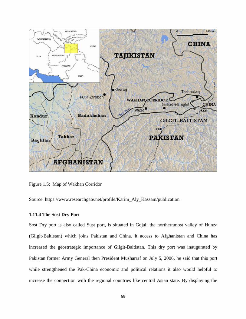
59
Figure 1.5: Map of Wakhan Corridor
Source: https://www.researchgate.net/profile/Karim_Aly_Kassam/publication
1.11.4 The Sost Dry Port
Sost Dry port is also called Sust port, is situated in Gojal; the northernmost valley of Hunza
(Gilgit-Baltistan) which joins Pakistan and China. It access to Afghanistan and China has
increased the geostrategic importance of Gilgit-Baltistan. This dry port was inaugurated by
Pakistan former Army General then President Musharraf on July 5, 2006, he said that this port
while strengthened the Pak-China economic and political relations it also would helpful to
increase the connection with the regional countries like central Asian state. By displaying the

60
significance of this port, President Musharraf pointed out that this port would help us in doing
inter-region trade in future which is under the supervision of Pa-China Sost Dry Port Trust. In
2010, after the huge flood in Pakistan, the affected regions were rescued through this port.
1.11.5 The Mighty Indus
This giant river is considered one of the few biggest rivers of the world originates from the Kaila
Range, southern part of the Tibetan plateau and then starts its long and laborious voyage en route
for North West. In Kohzhung region of Tibet it rounds at a height of 13,800 feet. Draining
hundreds of tributaries and streams from the Himalayan watershed and twisting through the high
mountains and terrains, it advances towards the Ladakh district of the Indian Occupied Kashmir.
In Ladakh it forms a dividing line between two massive ranges of the world; the Karakorum and
the Himalayas which stand on its north and south respectively. Receiving innumerable glacier
fed streams from its north and south; it continues its advance towards Baltistan till it finally
crossed over the ceasefire line near north of Kargil, and enters Gilgit-Baltistan of Pakistan. By
the time it enters Baltistan, it has already accomplished over 400 miles trip. In Ladakh, the river
is called ― Singey-Khabab‖ which means ‗ a river coming out of the mouth of a lion‘. In Gilgit-
Baltistan it is called ―Abasin‖ which means the ‗father of all rivers; the most suitable name. In
early times it was called ―Sindu‖; the Greeks called it Sinthos while in Latin it was referred to as
the Sindus. (Albinia, 2008) This mighty river has a huge potential to generate vast level of
energy as well as significant source of water supplier to the plains of Sindh and Punjab. Thus, it
constitutes as the mainstay for husbandry and the production of food in Pakistan.
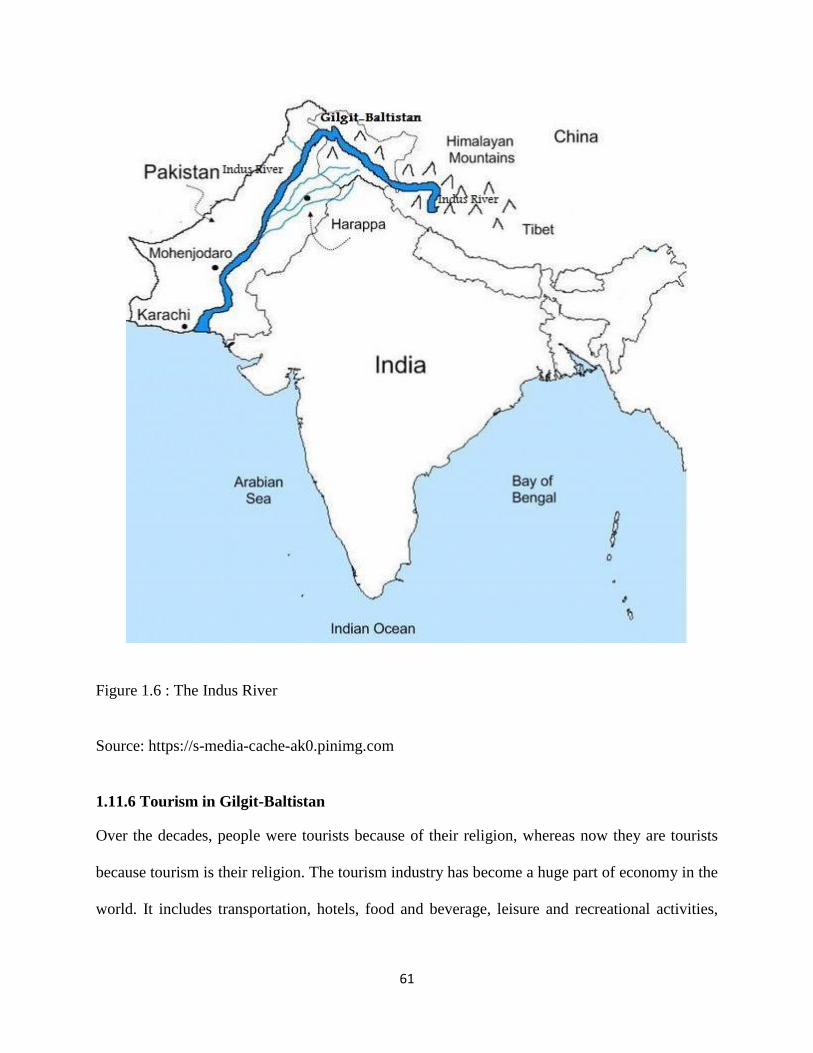
61
Figure 1.6 : The Indus River
Source: https://s-media-cache-ak0.pinimg.com
1.11.6 Tourism in Gilgit-Baltistan
Over the decades, people were tourists because of their religion, whereas now they are tourists
because tourism is their religion. The tourism industry has become a huge part of economy in the
world. It includes transportation, hotels, food and beverage, leisure and recreational activities,
62
handicrafts, tour guiding and tour operation, etc. So, tourism should be a top priority activity for
federal government because tourism provides employment to the poorest of the poor.
The region Gilgit-Baltistan (GB) is known as the most attractive tourist point of Pakistan due to
its topography, scenic exquisiteness and amusing culture. The three world great mountain ranges;
Karakorum, the Hindukush and the Himalayas meet here. Gilgit-Baltistan is the home of K-2, the
second heights peak of the world and some longest glaciers, lakes, beautiful landscapes etc. It is
like a paradise for hikers, explorers, adventure sports enthusiasts and nature lovers. The area
possesses a gorgeous traditional legacy and assortment of rare fauna and flora. The people of
Gilgit-Baltistan are meticulous and they are considered most hospitable in the whole Northern
Pakistan.
According to GB Tourism Department, careful an estimate suggests that the foreign tourists
arrived in GB were approximately 10,338 in 2007, which has decreased to 4,524 tourists in 2013
due to worsening security situation in GB. Meanwhile, it has been observed that the flow of
domestic tourism is gradually increasing. In 2013, GB welcomed 51,914 domestic tourists
compared to 22,780 in 2007. It shows that there is a positive trend in domestic tourism market
which previously has been shy to visit far flung areas of GB. (Rana, 2014)
1.11.7 Tourism Assets of Gilgit-Baltistan
1.11.7.1 Natural Legacy
Gilgit-Baltistan is the region of Pakistan presents some beautiful and sensational mountain
scenery on earth. There are 14 highest peaks above 8000 meters in the world and five of them
are situated in Gilgit-Baltistan, including K2, Nanga Parbat, Gasherbrum-I, Broad Peak,
63
Gasherbrum-II. Furthermore, Gilgit-Baltistan has beautiful valleys, glaciers, lakes; world coldest
deserts, highest plateau, rivers, minerals and picturesque pastures and fairy meadows.
1.11.7.2 Cultural Tradition
In the history of Gilgit-Baltistan, different nations played a pivotal role in the development of its
cultures and norm. The ancient key trading route known as Slik Route which connected Indian
subcontinent to China, Middle East, Central Asia and Europe, passed through Gilgit Baltistan.
The connection of the world leading route among major countries had been made Gilgit-
Baltistan as the hub for invaders, Buddhist pilgrims, traders, and explorers, emperors. Buddhist
used this region to establish theirs teaching of Buddhism in China and East Asia. They travelled
from North India using the Slik route through this region and in Gilgit-Baltistan there are many
inscription and carving stones of Buddhists teaching. In 1970s, Pakistan and China agreed to
revival a section of ancient Slik Routes and constructed the Karakoram Highway. Today, this
road has been playing an imperative role in the development of Pakistan and China relations as
well as in their economies. As a result of this wide-ranging history, Gilgit-Baltistan keeps a
miscellaneous and interesting ethnic heritage.

64
Figure 1.7: Polo Match in Gilgit-Baltistan
Source: http://shujaatalii.blogspot.com/2015_01_01_archive.html
1.11.7.3 Archaeological Legacy
Significant archaeological sites cover caves‘ paintings, megalithic stone circles, rock carving,
castles, mosques and tombs. Sacred Rock of Hunza, Manthal Rock near Skardu, Rock carvings
and inscriptions near Chilas, Kargah Buddha, Baltit Fort, Altit Fort, Shigar Fort and Palace,
Khaplu Fort, Amburiq Mosque and Mamorokutz Mosque are famous sites. (Ahmed, et al,2010) In
addition, there are more than twenty significant passes which connect Gilgit-Baltistan with
outside of the world. Gilgit-Baltistan is landlocked region with high mountains ranges and peaks
and these passes provide significant advantages to the inhabitants of this region. Some of the
vital passes among them are, Shimshal, Kilik, Mintaka, Darkot, Muztagh, Parpik and Khunjarab.
In a less than one hundred square miles territory, more than one hundred high peaks are situated.

65
Some of them are very famous and include world highest peak such as K-2 (28, 250 ft) Raka
Poshi (25,550 ft. high), Nanga Parbat (26, 607 ft.), Broad Peak (26, 550ft.) The region is blessed
by God largest glaciers, beautiful lakes, mighty mountain ranges, enormous natural resources.
The area is spotted over by more than forty utmost glaciers, some of which are known the
biggest outside the polar area. These are some famous glaciers in Gilgit-Baltistan: Hispar (61
km), Baltoro (58 km), Biafo (62 km long), Siachen (72 km), Batura (58 km) long and
Gasherbrum (38 km). In the nutshell the important of Gilgit-Baltistan summarized by Sikandar
Baloch the secretary of Tourism Government of Gilgit-Baltistan in a presentation report
“Tourism Development in Gilgit-Baltistan: Situation Analysis and Investment” available at
Department of Tourism, Government of Gilgit Baltistan‘s official website. According to his
remarks Gilgit-Baltistan possesses the following characteristic which not only offer attraction for
foreigners but also clears the importance of this region;
―(1).World‘s Most Famous Mountain Ranges (2).The Himalayas, Karakorum &
HinduKush. (3).K2 World‘s Second Highest Peak. (4).Five over 8000 Meters Peaks.
(5).101 Peaks over 7000 Meters. (6).5100 Glaciers. (7).2200 Sq. Miles of Snow Covered
Area. (8).119 Lakes. (9). 4 National Parks (10). 09 Game Reserves (11). 3 wildlife
sanctuaries (12).230 species of Birds (13).54 Species of mammals (14).20 species of
fresh water fish (15).23 species of reptiles (16). 6 of amphibians (17).6592 Sq. KM of
Forests, which constitutes 9.1 % of the total area (18).5 ethnic groups and 5 ethnic
languages with 36 dialects.(19). 7 Asia Pacific Heritage Conservation, UNESCO and
British Airways Award Winning Historical Sites. (20). 23 Historical Forts. (21).75 Polo
grounds. (22)65 Archeological sites. (23.). More than 39,000 Rock carvings and
inscriptions. (24). Centuries Old trade and travel route. (25).The only part of Pakistan to
border and neighbor four countries. (26).Presence of International Road Network.‖
\

66
1.11.8 Natural Resources (Minerals)
Gilgit-Baltistan has gifted many natural resources and assets. The mighty Indus River provides a
huge hydroelectric potential. Gilgit-Baltistan is blessed with gigantic hydroelectric power
generation and increasing the demand of energy in modern industrial states, GB could serve as
an important lever for their economic growth. In Pakistan energy crisis is the most important
issue and this has put negative impact on economic growth of Pakistan. To overcome this
shortfall, Gilgit-Baltistan offers more than forty thousand MW but due to lack of attention of
states this potential could use. There are various mineral deposits in Gilgit-Baltistan. The
principal deposits are nickel, copper, cobalt, lead, mica, tin, quartz, zircon and coal. The territory
has a varied mix of expensive and semi-precious ―stones (such as rubies and sapphires), size
stones (such as marble and granite) and metals (including copper, gold, Tungsten and
molybdenum).‖ (Nayyar, 1987)
Figure 1.8: Zehr-Mohra (Mush Serpentine)
Source: https://www.facebook.com/shigarvalley

67
Even, the proper surveyed, Gilgit-Baltistan is believed to be rich in major hub of natural
resources and minerals. Gold the precious mineral are found in Braldo, Parkuta, Saltoro, Basha,
and in the rivers of Indus, Shyoq, Shigar, Gilgit, and Hunza River. This is sedimentary gold
together by washing in Gilgit-Baltistan. Zehr-Mohra (Mush serpentine) is another important
stone found near the streams in Shigar valley; and different types of apparatus such as cups,
teapots, lower, tumblers, vases etc. are made from the stone of Mush Serpentine. The best quality
of crystal, quartz is found in different part of Gilgit-Baltistan. (Abadi, 1984)
There is a mine manufacturing marble of worthy value in the area of Kwardo on the elevation
facing Skardu and Black marble is found in the region of ‗Gulabpur‘ and Chotron in the Shigar
valley. There is an emerald mine; asbestos, mica mine, copper and fluoride, Salajit ,copper
sulphate, Iron mines exists in Nend and Chotron ,Alum are some precious minerals found in the
different valleys of Gilgit-Baltistan. (Butt, n.d)
Figure 1.9 : Mineral Targeted Area in Gilgit-Baltistan
Source: http://www.gilgitbaltistan.gov.pk/DownloadFiles/InvestmentPotential/Minerals.pdf

68
1.11.9 Trade Opportunities
Due to the strategic and geographical location of Gilgit-Baltistan at the juncture of among India,
China, Pakistan, Afghanistan and the Central Asian Republics (CARs), GB provides and serves
as a bridge of land for transit and trade. While the possible for increasing trade viva the regional
passage is significant, the prevailing stages of trade remain narrow in scale and scope. After the
agreement of China Pakistan Economic Corridor (CPEC), the role and geographical status of
Gilgit-Baltistan have been increased gigantically. India and China both are emerging economic
superpowers and for its economic sustainable development, both nations require huge source of
energy and new markets and mostly they export from the Gulf States and Central Asian
Republics and Gilgit-Baltistan provides them easiest transit routes to access the international
markets.
The geographical location of Gilgit-Baltistan gives it‘s a uniqueness and distinctiveness. To
understand the geographical position, the next chapter has provided a detail sketch of geography
of Gilgit-Baltistan.

69
References
Alam, Z. (2015). Geo-Strategic Dimensions of India‘s Foreign Policy. International Journal of
Science and Research (IJSR), 4(1). Retrieved from: www.ijsr.net
Abadi,M., Y. H. (1984). Baltistan Per Aik Nazar. Rawalpindi, Pakistan
Afridi, B., G. (1988). Baltistan in History . Peshawar, Pakistan: Emjay Book International.
Albinia, A. (2008). Empires of the Indus: The Story of a River. New York American: Norton &
Company.
Ahmed,P., Zucchi, C.E., Noshab, F. &Safdar Parvez, S. (2010). Pakistan: Gilgit-Baltistan
Economic Report Broadening the Transformation. (Report No. 55998-PK). Retrieved from
http://documents.worldbank.org/curated/en/971671468057878511/pdf/559980ESW0Gray1OFFI
CIAL0USE0ONLY191.pdf
Butt, I. M. (n.d) Geopolitical Importance of Northern Areas of Pakistan, Retrieved from the
official website of Nazraia Pakistan http://www.nazariapak.info/Research-corner/Geo.php
Baloch,I.S. (n.d). Tourism Development in Gilgit-Baltistan: Situation Analysis and
Investment, Tourism Government of Gilgit-Baltistan, Retrieved from:http:// www.
gilgitbaltistan. gov.pk/DownloadFiles/InvestmentPotential/Tourism.pdf
Brzezinski, Z. (1997).The Grand Chessboard: American Primacy and its Geostrategic
Imperatives. New York, USA: Basic Books.
Blouet, B. (1987). Halford Mackinder: A Biography. Texas, USA: Texas A & M University
Press
Brzezinski, Z. (1986). Game Plan: A Geostrategic Framework for the Conduct of the U.S.–
Soviet Contest. Boston, USA: The Atlantic Monthly Press.
Cahnman,W.J.(1943). Concepts of Geopolitics. American Sociological Review, 8(1).p. 57.

70
Cohen, S.B. (2003). Geopolitics of the World System. Maryland, USA: Rowmann & LittleField.
Devetak, R. (2011). An Introduction to International Relations.Cambridge, UK: Cambridge
University Press
Dorpalen, A. (1984). The World of General Haushofer. New York, USA: Farrar & Rinehart,
Inc.
Dodds, (1967). Geopolitics: A Very Short Introduction.
Clover,C. (1999) "Dreams of the Eurasian Heartland," Foreign Affairs, 78(March/April), p. 9..
Defay,A. (2005). Jeopolitik. Ankara, Turkey: Dost.
Dodds, (1970). Geopolitics in a Changing World. London, UK: Oxford.
Efferink, L., V. (2015). Geopolitics, Oxford bibliographies. Retrieved from: http://www. oxford
bibliographies.com/view/document/obo-9780199874002/obo-9780199874002-0017.xml
Ferrari,B.D (2010). Some Considerations About the Methods and the Nature of Political
Fettweis, C.J. (2003). Revisiting MacKinder and Angell: The obsolescence of great power
geopolitics. Comparative Strategy, 22, 1009-129.
Geography and Geopolitics. Retrieved from: www.ciari.org/investigacao/Politicalgeopdf.
Goodall,B. (1987). Dictionary of Human Geography. London, UK: Penguin Books.
Geography. Encyclopædia Britannica Online, 15 June 2010, http://www.britannica.com/ EB
checked/topic /229637/geography.
Geopolitics, Encyclopædia Britannica Online, 15 June 2010, Retrieved from: http:/
/www.britannica.com/EB checked/topic /229932/ geopolitics.

71
Gray, Colin S.; G. Sloan (November 30, 1999). Geopolitics, Geography and Strategy. London
and Portland, Oregon, UK: Frank Cass.
Geostrategy | Definition of Geostrategy by Merriam-Webster https://www.merriam
webster.com/dictionary/geostrategy
Hagan,B. (1942). Geopolitics, The Journal of Politics, 4(4). p. 485.
Hee,R. (2010). World Conquest: The Heartland Theory of Halford J. Mackinder. Retrieved from:
http://www.argumentations.com/Argumentations/StoryDetail_1040.aspx.
Herwig (n.d).Geopolitik: Haushofer, Hitler and Lebensraum, p. 221.
Investopedia. (n.d). What is Autarky. Retrieved from; www.investopedia. Come/terms /a/
autarky.asp
Jones, M., Jones, R. & Woods, M. (2004).An international Political Geography: Space, Place
and Politics. London, UK: Rutledge
Jones,M., Jones, R., and Woods, M. (2004). An Introduction to Political Geography: Space,
Place and Politics, London, UK: Rutledge.
Kirschner (2015). What does strategic importance of a place mean?, eNotes. Retrieved from:
https://www.enotes.com/homework-help/what-does-strategic-importance-place-mean-273708
Keegan, J. (2009). The American Civil War. New York, USA: Knopf.
Longman Dictionary of Contemporary English, Essex: Longman, p. 433.
Liew, J. (2011).International Lower Secondary Geography. Singapore: Marshal Cavendish
Education.
Mackinder, H. J. (1996). Democratic Ideals and Reality. Washington DC, USA: National
Defense University Press,
Meena, K. (n.d). Munesh Chandra asked: What is the difference between geo-politics and geo-
strategy? IDSA Retrieved from: http://idsa.in/askanexpert/geopoliticsandgeostrategy

72
Mackinder, H. J (1904). The Geographical Pivot of History, The Geographical Journal, 23(4)
pp. 421-437.
Mackinder, H.. J. (1919). Democratic Ideals and Reality: A Study in the Politics of
Reconstruction. London: Constable & Co. (reprinted in 2012 by Forgotten Books).
Mackinder, H. J. (1943). ―The Round World and the Winning of the Peace.‖ In Foreign Affairs,
21(4), pp. 595-605.
Mahan, A. T. (1987), The Influence of Sea Power upon History, 1660-1783. New York, USA:
Dover Publications (first published in 1890).
Mahan, A. T. (1902). Retrospect and Prospect: Studies in International Relations, Naval and
Political. Boston, USA : Little, Brown & Co.
Mattern, J. (1942). Geopolitik: Doctrine of National Self-Sufficiency and Empire. Baltimore,
USA: The Johns Hopkins Press
Nayyar,A. (1987). Baltistan (Research Translation). Islamabad, Pakistan: Lok Virsa.
Rana, A., R. (2014, June 10).Position Paper for Drat Tourism Policy-Gilgit-Baltistan. USAID
Firms Project. Retrieved from pdf.usaid.gov/pdf_docs/PA00K7VS.pdf
Spykman,N. (1938). Geography and Foreign Policy, II, American Political Science Review,
32(3) p. 236.
Sloan,G. (1999,eds.), Geopolitics, Geography and Strategy, London, UK: Frank Cass.
Spykman, J.N.(1942) America‟s Strategy in World Politics: The United States and the Balance
of Power. USA, New York: Harcourt

73
Spykman, N. (1938). Geography and foreign policy. American Political Science Review, 32(1),
28-50.
Spykman, N.(1944). The Geography of Peace. New York, USA: Brace
Smolen, K. (2012) Evolution of Geopolitical School of Thought. University of Lublin
Sempa, F., P. (2002). Geopolitics from the Cold War to the 21st Century. USA, New
Jersy:Transaction
Toal,G (1990). Critical Geopolitics: The Politics of Writing Global Space. London, UK:
Rutledge
Weigert, H.W. (1942). Haushofer and the Pacific. Foreign Affairs, 20(4), 332-342.
Walsh, E. A. (1946) "The Mystery of Haushofer" Life (September 16, 1946) pp. 107–120

74
Chapter No. 02
Gilgit-Baltistan: A Geographical Detail
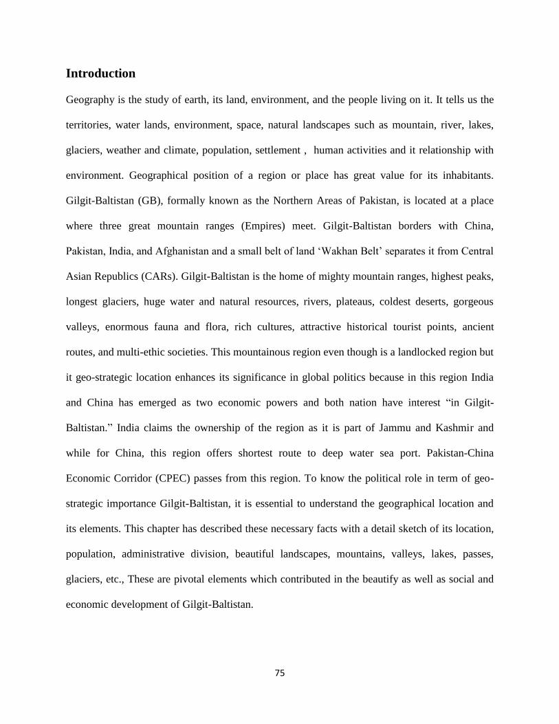
75
Introduction
Geography is the study of earth, its land, environment, and the people living on it. It tells us the
territories, water lands, environment, space, natural landscapes such as mountain, river, lakes,
glaciers, weather and climate, population, settlement , human activities and it relationship with
environment. Geographical position of a region or place has great value for its inhabitants.
Gilgit-Baltistan (GB), formally known as the Northern Areas of Pakistan, is located at a place
where three great mountain ranges (Empires) meet. Gilgit-Baltistan borders with China,
Pakistan, India, and Afghanistan and a small belt of land ‗Wakhan Belt‘ separates it from Central
Asian Republics (CARs). Gilgit-Baltistan is the home of mighty mountain ranges, highest peaks,
longest glaciers, huge water and natural resources, rivers, plateaus, coldest deserts, gorgeous
valleys, enormous fauna and flora, rich cultures, attractive historical tourist points, ancient
routes, and multi-ethic societies. This mountainous region even though is a landlocked region but
it geo-strategic location enhances its significance in global politics because in this region India
and China has emerged as two economic powers and both nation have interest ―in Gilgit-
Baltistan.‖ India claims the ownership of the region as it is part of Jammu and Kashmir and
while for China, this region offers shortest route to deep water sea port. Pakistan-China
Economic Corridor (CPEC) passes from this region. To know the political role in term of geo-
strategic importance Gilgit-Baltistan, it is essential to understand the geographical location and
its elements. This chapter has described these necessary facts with a detail sketch of its location,
population, administrative division, beautiful landscapes, mountains, valleys, lakes, passes,
glaciers, etc., These are pivotal elements which contributed in the beautify as well as social and
economic development of Gilgit-Baltistan.

76
2.1 Gilgit-Baltistan: Location
Gilgit-Baltistan is situated in the north of Pakistan. Geographically most part of the area covers
highest mountain ranges and tough terrain. The area of Gilgit-Baltistan covers around 72,971
square kilometers (28,174 miles). According the census of 1998, the population of Gilgit-
Baltistan was 870,347, and in 2013 the population is estimated around 1.250Million. (Robert,
2003) The region Gilgit-Baltistan lies between 32 and 37 Degree to N. Latitude and the longitude
is 71 to 75 E. (Dani, 2007) Gilgit-Baltistan has a unique geographical and climatically character.
The physical landscape of the region is mountainous and roughly terrain. The three great
mountain ranges; Karakoram, Himalaya and HinduKush and the Pamir ranges have immured the
whole region with it amidst towering mountains, snow peaks and hefty glaciers. Despite being
deprived of constitutional rights after 69 years of independence from the Dogra Raj, Gilgit
Baltistan makes its importance as an attractive land of enormous geostrategic and militarily
important region of the world. Gilgit Baltistan shares its boundaries with Khaibar Pakhtoon
Kakhaw (KPK) the province of Pakistan to the West, China in the Northeast, Afghanistan's
Wakhan Corridor to the North, Azad Kashmir to the Southwest and the Jammu and Kashmir and
Ladakh (Indian held Kashmir) to the East and Southeast. Ladakh and Kargil and Baltistan were
one administrative unit during Dogra Raj. After 1947, Gilgit-Baltistan and Ladakh divided into
two parts and respectively; both region went under Pakistan and Indian‘s administration.
It had been a Geo-Corridor for the great regimes in ancient time. Even today, the great regimes
like China, US, Russia and India (being a neighbor) has great interest and embraces it from all
directions. Gilgit Baltistan has an honor to represent the largest glaciers of the polar region.
Biafo glacier, Baltoro glacier and Hisper glaciers are the most notified ones. These glaciers make
Gilgit Baltistan potential to generate 50 thousand MW of electricity due to rich in water and

77
having the mighty Indus River which flows from Gilgit Baltistan to Arabian Sea in the west.
Having rich with enormous types of minerals, it is also consider as one of the best market in the
world and especially in Pakistan. It is the foremost deposits of Copper, Cobalt, Nickel, Tin,
Lead, Mica, Bismit, Coal, Zircon, Quartz and Actinolite having one of the finest qualities in the
world. (Zain, 2010) Gilgit-Baltistan consists of three administrative divisions, having 10
districts (four are new) and 22 tehsils. The capital city of Gilgit-Baltistan is Gilgit which shares
equal distance to other district being in the middle of the area.
Map of Gilgit-Baltistan
Figure 2.1: Map of Gilgit-Baltistan
Source: http://www.gilgitbaltistanscouts.gov.pk/geodemo.htm
Silk Route makes it worthy with having the title of the single path connects between Gilgit
Baltistan and Pakistan as well as with Chinese western province; Xingjian. In 2016 after the
CPEC agreement between Pakistan and China, Silk Route has become the major and important
route due to the only way between Pakistan and China for trade. Despite having giant mountains
in the region, Gilgit Baltistan host all four climates (Spring, Summer, Autumn, Winter) with

78
variation from area to area . Furthermore, the eastern portion of Gilgit Baltistan has the humid
region of the Himalayas, but the climate dries considerably in Karakoram and Hindu Kush
regions. Towns like Chilas and the capital city Gilgit experience more temperature in summer as
compare to Skardu, Khaplu, Hunza and Astore and in winter, Skardu, Khaplu and Astore also
have snow falling.
2.2 Gilgit-Baltistan: Population
The population of the districts of Gilgit-Baltistan according to the last census and latest official
projections
Name Capital Area (Km2) Population Census
01-03-1998
Population
Projection (P)
01-07-2013
Astore Astore 5,411 71,666 114,000
Diamir Chilas 7,234 131,925 214,000
Ghanche Khaplu 8,531 88,366 108,000
Ghizer Gahkuch 12,381 120,218 190,000
Gilgit Gilgit 4,208 145,272 222,000
Hunza-Nagar Aliabad 15,034 98,052 148,000
Skardu Skardu 19,697 214,848 305,000
Gilgit-Baltistan Gilgit 72,496 870,347 1,301,000
Table 2.1: Population in Gilgit-Baltistan
Source: http://www.citypopulation.de/GilgitBaltistan.html
_____________________________________________________________________________________
(1998) Government of Pakistan and IUCN (web), 2013 Government of GB, Planning and Development Department, Statistical

79
Cell. In 2015, District Hunza-Nagar has been split into two districts named as District Hunza and District Nagar, while the largest
populated District Skardu has been split into three districts named as Skardu, Shigar and Kharmang districts.
2.3 Gilgit-Baltistan: Languages
―Language is the foundation of civilization; it is the glue that holds the people together‖ [quoting
Louise]. Gilgit-Baltistan has rich in ethnic and cultural values. Language is an important aspect
of its national ethos that embellishes beauty of region with it traditional diversity and
communication. The fastened geographical characteristics of Gilgit-Baltistan provide different
dialects and languages. Due to cultural amalgamation and globalization the local languages of
Gilgit-Baltistan is endangered for its existence. Gilgit-Baltistan has diverse culture and tradition
which births different dialects, the following major languages are spoken in this region.
2.3.1 Shina
One of the most speaking languages in Gilgit-Baltistan is Shina. It is the native language of the
capital territory of GB. It is written in Arabic script and belongs to the family Indo-Aryan Dardic
Shina. The Shina language is widely speaking in capital Gilgit, Diamer, Astore, Ghizer and also
in some parts of Chitral with little differences. But its native speakers are also found in Ishkoman
Valley of Shigar, Nagar, Hunza and some places of Baltistan like Gultari, Astak and Xhoq.
2.3.2 Balti
Balti language is the sub branch of Tibetan language. Its transcript is also derived from ―Aagy‖
Tibetan language. Majority of the population in Baltistan division is the native speaker Balti
language. It is also spoken in Tibet and more especially in Ladakh-Kargil district of India. After
the advent of Islam in this region, many Arabic and Persian words were absorbed in it. Now the
original transcript of this language is endangered.

80
2.3.3 Burushasky
Burushasky is the language without any written script spoken by the natives of the both sides of
Hunza River. Northern bank is called Hunza and Southern bank is called Nagar. Although it
diverge slightly in Hunza and Nagar district but it is considered as a dialect of a single language.
But it diverges very prominently in Yasin as khowar.
2.3.4 Khowar
Khowar is one of the languages spoken in Chitral. ―Kho‖ means Chitral and ―war‖ means
language. It is also a part of the Dardid Shina family of Indo-Aryan. It is written in Urdu script
since 20th
century. Khowar speaking people live in Chitral, Ghizer and also in some parts of
Chitral.
2.3.5 Domaaki
Domaaki is the language of a group settled in Hunza. There are very small number of people of
this community is living in suburb of Gilgit city. According to Professor Gerard Fussman these
people are smith and musicians by professional. Most of the people know Shina and Brusheshki
due to the integrating other communities and their influences. It is spoken that this Domaaki is a
dying language. (Dani, 2001)
2.3.6 Wakhi
Wakhi is considered as the Pamirian branch of the Iranian languages. This language is
extensively speaking in Upper Ishkoman valley of district Ghizer, Chitral, upper part of Hunza
vale, Valley in Hunza District. The Wakhan corridor in Afghan is the inhabitant of the people of
Wakhi. It also has a very rare speaker in the region. (Lorimer, 1985)
81
2.4 Gilgit-Baltistan: Administrative Division
After annexation with Pakistan, the whole region was divided into two main adminstrative unit
including the Hunza state. In 1972 after the demolishion of FCR (Fronter Crime Rules) , Prime
mininster Bhutto introduced new constituional reforms. In 1987 , General Zia Huq government
made Diamer also a division of Gb. The Whole region is administratively divided into three main
administrative division i.e Gilgit, Baltistan, Diamer. Furthermore, administratively GB is
consisted of ten districts: Skardu, Gilgit, Ghizar, Diamer, Astore, Nagar, Hunza, Shigar,
Ghanche, and Kharmang.
Figure 2.2: Districts of Gilgit-Baltistan
Source: http://www.travelpk.org/2005/01/districts-of-gilgit-baltistan-with-its.html

82
2.5 Gilgit Division
Gilgit Division is the largest administrative division having four districts including the capital
city of Gilgit Baltistan. Here are the districts in Gilgit Division.
2.5.1 Gilgit District
Gilgit district administers the gilgit city as the capital in focus and also some nearby areas
including the well known Naltar Valley for its tourism. Gilgit strategically located in the centre
of Gilgit Baltistan and from centuries, it is serving as a main corridor and trade for whole region.
Gilgit is the center for administration as well as capital town of GB. Hunza River, Ghizer and the
Indus River with other tributaries of these rivers meet here and feed to the whole region. In
ancient time the historical Silk routes passed from Gilgit Baltistan and the city of Gilgit has also
been a very important city of this route, facilitating the Caravan, invader and visitors. Now after
the CPEC agreement between Pakistan and China, Gilgit city has become the most worthy city in
the region for trade and business. Of particular note, Naltar Valley which is 35 km away from the
city Gilgit is a striking Greenland which is bounded by high peaks with nearby glacial lakes and
also perfect resorts for winter skiing. The government of Pakistan in collaboration to many
foreign countries is having some projects in Naltar valley including the hydropower projects.
Furthermore, there is Kargah Buddha, the 8th
century AD carved rock wall of Buddha and
carcasses of a Buddhist monastery and Stupa. Gilgit city is also prominent in the region due to
educational factors as the main campus of the Karakoram International University (the only
university in the region) also is located there. Now two sub campuses have been established in
Skardu City and Hunza. (Minister of Tourism GB: www.visitgilgitbaltistan.gov.pk)

83
2.5.2 Ghizer
Ghizer is important district of Gilgit-Baltistan and it borders with Khabar Pakhtoonkhwa the
province of Pakistan and Wakhan corridor. It is situated on the north-west of Gilgit city. In the
pre-modern era, this district had a unique distinction and there were several independent and
small dynasties like Puniyal, Gupis, Yasin and Ishkoman. The languages of the people of Ghizer
district are mainly Wakhi and Khowar but Shina is also import part of their lives. Due to
geographical amalgamation with Wakhan district of Afghan and route for the ancient traders, this
district has rich norm and values and cultural diversities. The beautiful and very famous places of
district Ghizer are Phandar, Sherqilla, Chator khand, Khalti and Shandur. The most attractive
and significant point of this district is highland of Shandur Pass over, where the historical and
polo ground is situated and every year the traditional Polo festival is celebrated in July. Polo
matches are played between the local polo teams. Tourists from all over the world gather as a
spectator to enjoy the match. Phandar valle is another most eye-catching place of this district.
((Minister of Tourism GB: www.visitgilgitbaltistan.gov.pk))
2.5.3 Hunza
Hunza, one of the most beautiful places (formerly it was a state ruled by an old ruling dynasty of
Mirs) is now a district of Gilgit-Baltistan. It borders Gilgit, Nagar, Baltistan and China. Nagar
was also a part of this district before 2015. It spreads along the Hunza river right up to its source
at Khunjrab pass. The Karakoram Highway (KKH) starts from this pass and follows the bank of
the river Hunza to the area Dangor, where Hunza River joins the Gilgit River. The former rulers
had two old forts, Altit and Baltit. Hunza was an independent state before merging it with Gilgit.
In 2014, Hunza got status as district. This district always remained very attractive and striking
place for tourist and is considered highest literacy rates in Pakistan. Hundreds of thousands of
84
local and foreign tourists visit Hunza every year due to its scenic beauty. There are four highest
peaks with 7,000m i.e., Rakaposhi, Diran, Golden and Ultar, situated around this district which
makes this region unique. The languages of local people of Hunza district are Burushaski and
Wakhi.(Dani, 2017)
2.5.4 Nagar
Current Nagar is the very nouvelle district of Gilgit Baltistan. It used to be a part of Hunza-Nagr
district since 2015. It was also home of the Rulers and had history of princely state. Until 1947,
as a subsidiary alliance of the British India, It bordered to Hunza in North and East, and in the
South and West it bordered to the Gilgit Agency of that time. It also administered as a Princely
state of Pakistan from 1947 to 1974, with the town Nagar as a capital. During 1880s, the role of
Dogra of Kashmir and British India had increased in this region. Before the British gained
control in 1889 and 1893, the district Nagar and it the neighboring district Hunza were sovereign
princedoms. Later, the whole region was call princely state until the creation of Pakistan and
India but it was a vassal state of Jammu and Kashmir although it never being directed ruled by
Dogra Kashmir or Britishers. The rulers of this princely state with the ruler of Hunza Along were
most loyal rulers of Maharajs of Jammu Kashmir.
2.6 Diamer Division
2.6.1 Diamer District
Diamer district is the entrance gate of Gilgit-Baltistan. The head-quarter of Diamer is Chilas and
majority population are Shina language speakers. There are two main routes to access in Gilgit-
Baltistan through the Karakoram Highway or the Naran-Kaghan road and Chilas is the meeting
points of these two strategically important means of transportation. Diamer has a unique history.
Thousands of rock inscriptions, rock carving and petroglyphs have been discovered in this region

85
which made easy to trace the human existence in these mountainous region. A survey shows that
there are more than 34000 rocks arts including inscription and carving found which represented
the foreigner invasion and their advancement in the region. (Dani, 1995). There are many
important historical vales of Diamer like Darel, Chilas, Tangir, Bunar Das, Governor Farm, and
Raikot . There are several tourist attractive points and Nanga Parbat (8125m), Raikot face, fairy
Meadows are the key places of this region. Nanga Parbat also known as Killer mountain is one of
the eight thousanders mountain peaks in Pakistan. This district border with new born Astore
district on its east , Kohestan the district of KPK in its southwest, the beautiful vale of Azad
Kashmir ― Neelum‖ is in the south of Diamer and Gilgit district is situated in the north and
northeast and the district Ghizer in the north and northwest of Diamer.. In 2004, Astore was
separated from the Diamer District and created a new District.
2.6.2 Astor
Astore is given status as a district in 2004 with its headquarter at Eidgah/Gorikot. It is
consisted of several small gorges and beautiful settlements on hills. There are very prominent
and attractive places of places such as Rama, Chilim, Dashkin, Rehmanpur, Bounji, Gorikot and
Rattu. Famous tourist points in this region are the Rupal face of the Killer Mountain(Nanga
Parbat), Rama Lake, Dosai Kala Pani (the black water) , Dambabaho, Domail ,Chilim and
Minimerg. Shina is the native language of the populations. Green meadows and Rama Lake in
the hilly areas are the most famous tourist charming points in the region.
2.7 Baltistan Division
The division of Baltistan, spread over 3,380 km is one of the beautiful landscape in the northern
most part of Pakistan which geographically borders with Indian held autonomous region

86
Ladakh to the East, Pakistan administered Azad Kashmir to the South, and to the north the
autonomous Chines western province Xinxiang is situated. It is the home of beautiful landscape,
mountin ranges of Karakoram and Himalayas, highest peaks of Pakistan and 2nd
highest peak of
the world K2, largest glaciers after the North and South pole, and the largest high elevation
plateau , the Deosai Plains. (www.serenhotels.com) Baltistan Division has following districts.
2.7.1 Skardu
Skardu is the capital of Baltistan region. It is situated at the bank of Indus river at an altitude of
nearly 2500 metres (8,202 feet). By area it comprises a landscape 40 km (25 miles) long by 10
kilometers (6 miles) wide at the confluence of the river Indus and Shigar. The mighty Himalaya
and Karakoram mountain ranges makes wall around the whole city. The geography of Skardu
district is very interesting. Most of its south western part is lush green and forested. Basho valley
and upper parts of Roundu valley are forested by junipers, birch and pine trees. Similar in south
part of the district there is lush green Deosai Plateau which is also famous as world‘s Roof and
covers an area of 3000sq Km. The central parts of the valley now have turned into a densely
populated areas due to arrival of large quantity of immigrants in the city after Kargil Siachen war
between Pak and India. Some of the top attraction sides are: Kachura Lakes and Shigrila Resort,
Deosai National Park, Katpana Lake and Cold Desert, Basho Valley, Stak valley, Sadpara lake ,
Kharpocho fort.
2.7.2 Ghanche
Ghanche District is very important district of GB and it is located in the easternmost of Baltistan.
Balti is spoken in whole region of this district and Khapolo is the capital of this district. Ghanche
district is bordered by China in north-east, Indian occupied Ladakh in south, Skardu district in
west and Shigar district in north-west. During the Karachi agreement between Pakistan and India

87
1948, the Siachen area of this district remained without demarcation. In 1984, Pakistan and India
confronted at Siachen to control the glacier and adjoin areas. Both countries have different
perspective of the demarcation. Today, the whole territories of east of the Actual Ground
Position Line (AGPL) including Siachen are controlled by India while Pakistan controls west
of Saltoro Ridge. It is also considered as the coldest place of Pakistan. The appellation of
―Ghanche‖ itself denoted the coldest. The word means in Balti language is ―the land of glacier‖.
There are thousands of glaciers. It is located in between the mighty peaks of Karakoram range .
Masherbrum and Gashabrum peaks are famous of this region. The legendary river Shoyk f river
is the important tributary of the river Indus River. According to Molve Hasmatullah the writer of
: Tarikh e Jammu‖ , original settlers of Ghance was Tibetans and Turks.A warrior namely Baig
Manthal is believed to be the founder of Yabgo Dynasty, the ancient powerful ruler of this
region. In 14th century a Muslim Sufi missionary syed ali Hamdani also called shahe Hamadan
came from Yarkan and inclined people towards Sufi Islam. In Ganche , there are some highest
peaks of the world such as Masherbrum, Sia kangri, Saltoro Kangri, K7, K6, Laila Peak, Naiza
Peak and Amin Braq. Other top attraction places are, Khaplu fort, Chaqchan Mosque, Hushe
Valley, Nangma valley, thalley valley, Hot springs of Kondus valley and Kharfaq Lake. Due to
unstable borders with India, it is the important militarily significant region of Pakistan. (Dani,
2007)
2.7.3 Shigar
Shigar Valley (now a nouvelle district) is considered as one of the beautiful valley in Northern
Pakistan due to many scenic beauties and mighty Karakorum Mountains Range including K2, the
world second highest peak. The valley is expended about 170 km from Skardu city to Askole,
which is the last settlement in the district. Shigar town is the largest town with maximum

88
population in this district having many small villages surrounding to this town. Shigar town is
also considered as the capital of this district having all governmental departments at there. Shigar
is also blessed by Shigar River, which is responsible for the local irrigation of the fields. It is also
considered as one of the richest districts in mineral mining and also rich in electricity due to rich
in water . Shigar also have a very good history and some monuments like the Shigar fort, which
recently has been changed to a Serena hotel . Many Rajas ruled the place in past. Still their
ascenders in the districts are honored by the residents
2.7.4 Kharmang
Kharmang District is also a nouvelle district which has been split from Skardu District in 2015.
Kharmang valley also counts into the first five biggest valleys of Baltistan division. It
headquarter is located in Tolti. This district is 100 km far from Skardu, the capital city of
Baltistan district in the south. The name ―Kharmang‖ is basically derived from two Balti words .
―Khar‖ means fort and ―Mang‖ means abundant. As the name was given by the famous ruler of
Baltistan, Ali Sher Khan Anchan, who built many forts in this valley because of its strategic
importance and also being a neighbor of the Mughal Emperors. Kharmang is also a political sub-
division of Baltistan. Kharmang borders with Kargil on the southeast. Kargil was part of this
district but later war with India it went under Indian administration and today it is the importance
station of Indian army. In 1999 Pakistan army started an operation to recapture the region but it
did not succeed. Kharmang also borders with Jammu and Kashmir, Skardu, and Ghanche.
2.8 Gilgit-Baltistan: Mountain Ranges
Gilgit-Baltistan is blessed of highest peak, mountain ranges, beautiful tourist attracting spots and
places. There are fourteenth highest peak of ―eight thousanders‖ and five of them located in

89
Gilgit Baltistan. The region is the home of more than 50 peaks above 7000 meters. Gilgit and
Skardu are the two important cities and destinations of the aspirants of mountain expedition and
trekkers. The highest peak of the world ―K2‖ and Naga Parbat (the most fear mountain) is
situated in this region. The towering and skyscraper of these peaks inspire the foreigners and
local tourist to visit the region. Three great mountain ranges of the world including Pamir
mountain range encircle the whole region. In 1856 , British Roayal Engineers Thomas George
Montgomery had discovered cluster of peaks in Karakoram range within 200Km territories.
Mr. Thomas named these peaks of Karakoram as K1, K2, K3, K4 and K5. This survey opened
the mountaineers and the eagerness reached its peaks. Later more survey conducted by different
groups with modern technologies. Today, the peaks discovered by Mr. Thomas are known as K-
1 Masherbrum, K-2 as Godwin Auston or Choghori (K2), K3 as Broad Peak, K4 as Gasherbrum
II and K5 is known as Gasherbrum I. (Khan, 2004).
Name Heights (M) Pakistan Rank World Rank Location
K2 8611 1 2 Karakoram
Nanga Parbat 8126 2 9 Himalaya
Gasherbrum(K-5) 8080 3 11 Karakoram
Broad Peak 8051 4 12 Karakoram
Gasherbrum-II(K-4) 8035 5 13 Karakoram
Table 2.2: Eight Thousanders Mountains of Gilgit-Baltistan
Source: https://en.wikipedia.org/wiki/List_of_mountains_in_Pakistan#8000.2B_meters

90
These mountain ranges are host of numerous mountain highest peaks ranging from 5000 to 8611
meters above sea level which provide a distinctive position of this region. A small town of Gilgit
named Joglot, where these three mountain ranges meet and due this junction, tourists all over the
world visit here and which is key element for economic development of Pakistan.
Figure 2.3: Mountain Ranges in Gilgit-Baltistan
Source: https://twitter.com/rashidgilgiti/status/801848227062575106
2.8.1 Karakoram Range
Karakorum, literally meaning ―Black Mountain‖, is one of the many chains that curve away from
the nodal point at Pamir Knot. Starting from the northern most tips to the Hindu Kush, it
advances towards east, up to upper tributary of the Shyok River. Its paramount importance, apart
91
from other reasons is springs out of its strategic location. In the first place are two great
neighbors China and Pakistan who are separated by this great mountain range. Its high ridge
forms a natural boundary. The Karakoram Range is of a complicated character. Broadly
speaking, it is a continuation of the Hindu Kush and forms the water-shed between the Central
Asian drainage and the streams flowing into the Indian Ocean. It peaks average from 21,000 to
23,000 feet which, on the west, culminate in the well-known Rakaposhi mountain (25, 550feet)
standing north of Gilgit. Further east is the mighty group of peaks round the head of the Baltoro
glacier dominated by the 2nd highest peak of the world, the K-2, rising to 28,265 feet above sea
level. The head of every valley is the birth place of a glacier. Many of these glaciers are of
immense size, such as the Siachen, the Baltoro, the Biafo and the Hisper glaciers. The
Karakoram Range consists of numerous sub ranges and groups of mountains. (Balcoh, 2004)
2.8.2 The Himalaya Range
The great Himalaya is one of the mountain ranges in Gilgit Baltistan which separates
immediately the North of subcontinent to the Tibetan Plateau. It is spread into five countries
including Pakistan. Himalayas gives its extension to China, Nepal, India and Bhutan. In the
northwest it borders to the Hindu Kush range and the mighty Karakoram Range. Famous peaks
of Himalaya range are the Nanga Parbat in Pakistan and the world highest peak mighty ―Mount
Everest‖ in Nepal. Himalaya is the home of many rare animals which will be described later in
this chapter.
2.8.3 The Hindu Kush Range
Another important mountain range of this region is the Hindu Kush range which is the home of
several highest peaks. The length of this mountain range is approximately 800 Kilometers. It
92
starts from Afghanistan and stretches toward north and enters Gilgit-Baltistan of Pakistan where
it meets Karakoram and Himalayan mountain ranges near Juglot. Tirich Mir (7,708m) is the
highest peak in the Hindu Kush range located in Chitral, Khabar Pakhtoon Khawah province of
Pakistan and this range is considered as the geographic center of the world‘ population. (www.
Gilgitbaltistanscouts.gov.pk)
2.9 Gilgit-Baltistan: Peaks
2.9.1 K2
K2 which is famous as Mount Godwin-Austen is also called ―Chogori‖ in Balti language Mount
Godwin- Austin is suggested locally in honor of the great early explorer of the area, Sir Henry
Godwin Austin. While the name Chogori is pronounced as ―Chogo‖ means highest and ‗ri‖
means Peak so it means the highest peak in local Balti term. It is Also Known As Savage
Mountain as it is very difficult to summit. It has a great fatality rate among the eight thousanders.
The ration of fatalities to the total is 1:4. K2 is the second highest peak of the world with 8,611
meters heights. China and Pakistan border Agreement 1963, acceded it northern face to China.
Today it is situated on the border of Baltistan and China near Karakoram Pass. Usually it is
ascended to summit from the Pakistani side, as the Chinese side is very difficult to summit. Sir
Thomas Montgomery, the great British officer made survey and discovered raceme of peaks in
Karakoram Range. Local name of K1 is Masherbrum while the K2 is called Chogori. (Baloch
2004)

93
Figure: 2.4: Mighty K-2
Source: http://www.wallpapers-web.com/k2-wallpapers/4797797.html
2.9.2 Nanga Parbat (Naked Mountain)
Nanga Parbat (Urdu meaning Naked Mountain) is the 2nd
highest mountain of Pakistan and 9th
highest peak in the world. Nanga Parbat known as Killer Mountain is also considered a one of
the most notorious peak to summit. Due the highest summit elevation of 8,126 m, it is also
includes in the gigantic ―eight thousanders.‖ Nanga Parbat is the lone highest peak of Himalayan
region in Pakistan and lies in the west of it. Nanga Parbat has three faces with picturesque for
foreigner tourists, Diamer face (West) which is the best one, Rakhiot (North) and Rupal (South)
in Astore. (www. gilgitbaltistanscouts.gov.pk)
2.9.3 Gasherbrum (K5)
K5, the 11th highest peak in the world is also known as Gasherbrum and Hidden peak
internationally .Baltistan is the home of the this mountain and it is located at the border of China-
94
Pakistan and is part of the Gasherbrum Chain. Gasherbrum is also a Balti name as "gasha" means
beautiful while "brum" means mountain, as it is situated in the mighty Karakoram mountain
range. The word for Gasherbrum peak 5 was chosen in 1865 by T.G. Montgomery, which means
the 5th peak of the Karakoram. Later William Martin Conway named it ―Hidden Peak‖ in 1892.
(Baloch, 2004)
2.9.4 Broad Peak
Another gigantic of ―eight thousanders‖ and world 12th
highest peaks is the ―Broad Peak‖ having
an altitude of 8,051 meters (26,414 feet). Broad Peak lies in the Karakoram Range at a distance
around eight kilometers from K2. The summit length of this peak is 1.5 km, therefore this peak is
known as "Broad Peak". (www. Gilgitbaltistanscouts.gov.pk)
2.9.5 The Gasherbrum II (K-4)
Karakoram 4 or K4 another the ―eight thousanders‖ is located Karakoram range in Baltistan near
Chinese Border. The local people of Baltistan are called this mountain as Gasherbrum II. The
height of this mountain peak is 8,035 which make it world no. 13th
highest peak. (Awan, 1990)
2.9.6 Masherbrum
In 1856, the first survey of Karakoram Range was conducted by T.G Montgomery, and he was
found the cluster of peaks in Karakorum Range and named them K1 to K5. The K1 or
Karakoram one is locally known as Masherbrum means ―Queen of Peaks‖ was the peak which
scaled and mapped first in Karakoram Range. Masherbrum is located in Baltistan and neighbor
of the mighty K2.The height of this mountain is 7,821 meters which makes it world 22nd highest
peak and 9th
highest peak in Pakistan. (Baloch, 2004)

95
2.9.7 Rakaposhi
The beautiful peak Karakoram ‗Rakaposhi‘ is located in Nagar Valley of Gilgit-Baltistan, which
is 100 kilometers away from the Gilgit City. In the local language Rakaposhi means "Snow
Covered". This picaresque peak has another name Dumani which means "Mother of Mist".
Rakaposhi attracts a lot of tourist for trekking as well as expenditure due to its easiness location
as compare to other peaks. It is ranked as 12th highest in Pakistan while 27th
highest peak in the
world. The height of this peak is 7,788m and easily ascendable from all side of this peak. (Awan,
1990)
2.9.8 Sia Kangri
Sia Kangri is among the seven thousanders having an elevation of 7,442 meters (24,370 ft.) to
ascend for summit. It ranks 25th highest in Pakistan and 63rd highest in the world. Geopolitically
Sia Kangri is famous due to its tri-point connecting Pakistan, India and China. In 1963, Pakistan
and China border Agreement bestowed the controlled of the northeast part that leads to the
―Trans Karakoram Tract‖ while India claims it to be its part. (www.gilgitbaltistanscouts.gov.pk)
2.9.9 Trango Towers
There are different types of the mountian. The Trango Towers are belonged the family of rock
tower or ―granite spires‖ which are siuated near th Baltoro Glaicer in of Karakoram Range in
Gilgit-Baltistan. It offers most chanllgenging oppertunies and largest cliffs for rock climbers. It
demands high techniqal skill to climb it. The summit of ―Great Trango Towers‖ with the heights
of 6,286 m or (20,608 feet) is the highest point of the Trango Towers group. The Great Trango
Towers has honer to be the ―world‘ greatest nearly verical drop.‖ (Hennek, 1978)

96
2.10 Gilgit-Baltistan: Passes
Gilgit-Baltistan is covered by highest and largest mountain ranges and this landlocked feature
confined the interaction of the region with rest of the globe. With the passage of time , human
curiosity helped them to discover many world famous passed. Later these pass played a critical
role in the development and nourishment human civilization in this region. These passed brought
socio-economic changes in the lives of the local inhabitants. The invaders, historian, travelers,
traders of Central Asia, Europe, India, and Chinese used these mountain passes to preserve their
interest. There are widely scattered and strategically significant mountains as well as glacier
passes in Gilgit Baltistan. A precise view of some of them is listed below;
2.10.1 Mintaka Pass
Mintaka is derived from a Turkish word which means Thousand Ibex. It is at an elevation of
(4,827 meters / 15,837 feet). This is historical pass is located in Karakoram Range which
separates Xingjian autonomous province of China and Gilgit Baltistan. Central Asian traders
used this pass to reach India and it was main source of linkage between these two regions.
(Baloch , 2004)
2.10.2 Kilik Pass (15,800 feet)
In the north of the Darkot Pass and North West of Hunza, at the main Sino Pak border, stands the
historic Kilik Pass. It connects Hunza with the Chinese Turkistan and then leads to the Russian
territory of Sarbil and Khushbil. The pass is located in the Hindu Kush range on its northern tip.
Slightly ahead of it, on its west, is the Wakhjir Pass facing north south. It is located in China and
links Little Pamir (Wakhan) of Afghanistan with the Chinese Turkistan. (Smith et al, 2007)

97
2.10.3 Shandur Pass
In the northwest , nest to the Dadarilli Pass is located the Shandur Pass at an elevation of 3700
meters (12,200 feet) in District Ghizer of Gilgit Baltistan. Shandur Pass is one of the four major
mountain passes of GB which is located on the main route which links Chitral to Gilgit. Shandur
Top is often called 'Roof of the World' where the Hindu Kush, Pamir Mountains and Karakorum
Range meet. It is a flat plateau which can be only crossed between late April and early
November. It is more known for its famous "Shandur Festival", trout streams and its gradual
grade. Due to its location in the mighty mountainous terrain, Shandur Pass always face
difficulties , especially in winter season it is closed due to heavy snowfall in the area for few
months which cuts the link of Chitral to rest of Pakistan.
2.10.4 Babusar Pass
At an elevation of 4173 meters (13,69 1feet), just after swift turn in the south of Karakoram Pass
stands the Babusar Pass which has historical importance due to its location. Although, it is not
located in Gilgit Baltistan but it is worth a great significance for the whole region. The name
Babusar Pass is from the local Babusar Valley. It is a major alternative route to Karakoram
Highway and joins the Kaghan Valley of KPK to Chilas, Gilgit Baltistan on the Karakoram
Highway (KKH). The pass remains snow clogged between October to late May and movement
through the pass is also restricted during monsoons.
2.10.5 Burzil Pass
At an elevation of 4,100 meters (13,500 feet), Burzil pass locates as a caravan route between
Indian Occupied Srinagar and Gilgit-Astore. It extends in the North from Chilam, Astor Pakistan

98
to Minmarg; Indian occupied Kashmir in South. It was the major route for transportation and
trade till the partition connecting Gilgit-Baltistan to Kashmir through the Doesai Plateau.
2.10.6 Darkot Pass
Darkot pass has a worth importance due to its history and location with an elevation of 14,500
feet. It is the famous pass stands in the west of Gilgit town. Darkot pass got the name due to the
nearby Village Darkot at the foot of the route which leads to the top of Ishkoman Village. It is
located at the border line in the Hindu Kush range between Gilgit Agency and Chitral Agency.
Through Chitral it passes to the Oxus Basin located in the Wakhan strip. Darkot Pass was used
by Chinese in 747AD to invade now Gilgit City.
2.10.7 Baroghil Pass
Baroghil Pass is located in the HinduKush range on Durand line border betwee n Wakhan Strip
of Afghanistan and Chitral with an altitude of 3,798 m (12,461 ft.). Although it is not a part of
Gilgit Baltistan, but it provides a route to Gilgit Via Chitral as it is located in the west of the
Darkot Pass.
2.10.8 Karambar Pass
At an elevation of 14,060 feet in the Hindu Kush range, Karambar Pass locates in the same high
ridge where the Darkot Pass also lies. It also links Gilgit to Chitral further leads to Wakhan strip
of Afghanistan via the Barghil Pass.
2.10.9 Khunjarab Pass
At an elevation of 15,420 feet, Khunjarab Pass forms the boundary line between Gilgit Baltistan,
Pakistan to the Xingjian the autonomous western province of China. It is located in the District

99
Hunza, ahead of the tributary of the Hunza River in the north and southeast of the famous Kilik
Pass. Currently Pakistan links with China through Khunjarab Pass and both countries are using
it for Trade. After the agreement of the famous CPEC between Pakistan and China, the
Khunjarab Pass got more importance as it is the only active border line between the two
countries. In the north, locates the Parpik Pass and on the Sino Pak Boundary lies the Oprang
Pass.
Figure: 2.5: Khunjarab Pass
Source: http://www.chinadaily.com.cn/world/images/attachement/jpg
2.10.10 Shimshal Pass
At an elevation of 15,540 feet, lies the Shimshal Pass in the South of the Sino Pak Border but it
leads to China in the Sinkiang Province. Shimshal Pass locates in the Karakorum Range where it
wide the most. It is a part of the Hispar group locates nears the Dastaghil Sar of this group.

100
2.10.11 Hispar Pass
At an elevation of 17,560 feet, Hispar Pass lies in the centre of the Hispar group. It faces
Shimshal pass in the southeast of Shimshal pass. Hispar Pass links Nagar District to Baltistan at
Shigar District.
2.10.12 Muztagh Pass
At an elevation of 19,080 feet, between the Chiring and the Trango group of glaciers in the
Karakorum Range Muztagh Pass is located. The mighty K2 faces the Pass from the east. In
1887, Francis Young husband died at this pass while heading to the Baltoro glaciers.
2.10.13 Karakoram Pass
At an elevation of 18,550 feet, locates the Karakoram Pass in the mighty Karakoram ranges. In
ancient times, it was a link between Ladakh and Chinese Turkistan. After the Indian occupation
of Siachen this Pass is currently it forms the ceasefire line between Pakistan administered
Baltistan and Indian administered Ladakh. It also links the Indian administered Leh to Yarkand.
2.10.14 Dadarili Pass
At an elevation of 16,210 feet, Dadarilli lies in the Hindu Kush range which links Gilgit Baltistan
to Kalam Valley of Kohistan, FATA.
2.10.15 Shonter Pass
At an elevation of 15,650 feet, Shonter Pass lies in between the Tattu plains of Astore district of
Gilgit Baltistan to Kel Valley of AJK. Shonter Pass is basically an extension of the amazing
Nanga Parbat ridge, standing on the north of the pass. It is also consider as a border line between
Gilgit Baltistan and AJK.

101
2.10.16 Kamri Pass
At an elevation of 13,368 feet, slightly in the south between Burzil and Shonter lies the Kamri
Pass which is also known as Kamri top. Kamri originates from the local village just at the foot of
the pass. It also links GB with AJK through the Rattu road which leads from Burzil to the main
Srinagar Valley of AJK.
2.10.17 Manejo Pass
At an elevation of 18000 feet, Manejo Pass lies in the Nanga Parbat ridge connecting Astore
district to Bunar Chilas of Diamer district. It usually remains close due to heavy snowfall.
2.10.18 Zoji La Pass
At an elevation of 11300 feet, locates the Zoji La Pass. ―La‖ means a pass in Tibetan language. It
is locates on the main Sonamrg, Dras, Kargil and Srinagar route. During the independence war in
1947/48, it was captured under the fighters but later it again fell to the Indian Army. Now it is a
part of the IOK.
2.10.19 Banak La Pass
At the elevation of 9162 feet, locates the Banak La pass which links Skardu to Astore. It is also
considered as the direct route between these two districts.
In addition, numerous small passes locates in the Karakorum, Himalaya and HinduKush regions.
Many of them are now part of India as they are located in Ladakh, Kargil and IOK.
2.11 Gilgit-Baltistan: Glacier
Gilgit Baltistan has been blessed by more than hundred glaciers in the mighty Karakoram,
Himalaya and HinduKush mountain ranges. That is the reason Gilgit Baltistan is rich in water
resources and has a potential to generate more forty thousand MW electricity with its water

102
resources and for Pakistan and India water is the most crucial elements for its economic
developments. War is fought by both states over these glaciers. India captured Siachen glacier in
1984 after a sever conflict with Pakistan. This conflict increased the geo-strategic and military
importance of Gilgit-Baltistan because the huge fresh water resources offer plenty opportunities
of economic development for both nations.
Figures 2.6: Glaciers in Gilgit-Baltistan
Source: http://www.mediapoint.pk/wp-content/uploads/2012/04/baltoromeetssiachen.jpg
These glaciers provide sufficient water to River Indus which is used for the irrigation in the plain
areas of Pakistan like Punjab and Sindh. Some of the glaciers are following:
103
2.11.1 Siachen Glacier
Siachen Glacier is situated in the Eastern part of Karakoram Range and the length of this glacier
is around 70 Km. Siachen Glacier is the world 2nd
longest and the longest glacier of Karakoram
ranges. The name Siachen is a Balti term as ―Sia‖ refer to a plant belongs to rose family and
―Chan‖ means in abundance. As Siachen has abundance of roses so it is got the named Siachen.
It is located between the Baltoro glacier to its west and the main Karakoram ranges. The
glaciated portion of the summit of Saltoro Range is 7,720 meters high (25,330 feet). This range
also has many passed. Some major passes are, Sia La at an elevation of 5,589 m, Bilafond La
5,450 meters, and the Gyong La at 5,689 meters. The temperatures Siachen Glacier during winter
season can decrease to -50 °C and approximately 10 to 12 m (35 ft) snowfall can be recorded.
The water of glacier falls in the Nubra River in Indian held Ladakh region and turned into the
River Shoky toward Khaplu Baltistan which intermingle with Indus River. Before 1980s, the
Siachen area was the no man land. In 1949, Pakistan and India signed an agreement under the
supervisor of UN to demarcation the ceasefire line. At point near Nubra village to Karakoram
Pass had left without demarcation. This area was Siachen Glacier. Later both countries fought
war in 1984 to seize the power over Siachen. This conflict has created security as well as
environmental threat to the region. (Hussain, 2012)
2.11.2 Biafo Glacier
Biafo Glacier is the another important glacier situated in the region of Gilgit-Baltistan.In the
outside of Polar Regions the Biafo Glacier is the world 3rd longest glacier in the Karakoram
Range with the length of 63 Km. This highway of ice connects Nagar in the West to Baltistan in
the East. The bisect/perambulate uses all of the Hispar Glacier and 51 km of the Biafo Glacier's
63 kilometers to form a 100 kilometers glacial route.

104
2.11.3 Batura Glacier
Batura Glacier is one of another longest and important glacier situated in Karakoram Range in
Gilgit-Baltistan. The length of this glacier is 57 kilometers. The southeast of Baltoro glacier the
Baltoro Muztag is situated while on the southern side of this glacier is covered by the
Masherbrum Mountains. There are several highest peaks lies in or along this glacier. K2 the 2nd
highest mountain of the world is in this mountain region. This glacier is the source of fresh water
which contributes a huge amount of water to Shigar River. .
2.12 Gilgit-Baltistan: Lakes
2.12.1 Dosai Sheosar Lake
Doesai Lake or Sheosar Lake lies in the Dosai Plateau which is also known as roof of the world.
Sheosar Lake with an altitude of 4,142 meters is considered as the gigantic and highest lake in
the world. This beautiful and most striking lake is 2.3 kilometers long, while it wide is 1.8
kilometers and the around 40 meters are average depth of this region. The Sheosar lake is
located near the Astor district valley called Chilam. Tourist enjoys fishing at the lake along with
its scenic beauty .Deosai is the land of the very rare Brown Bear which is the only species found
in the world here. Other kind of wild animals are also found in this region. Among them
Markhor is famous. (www.northparadise.com.pk)
2.12.2 Satpara Lake Skardu
Satpara Lake, now Satpara Dam is one of the largest fresh water lakes in Pakistan. It lies in
Skardu District at a distance of 9 km from the Skardu municipality. It supplies the drinking and
agricultural water for the Skardu City. Tourists enjoy the trout fishing and boating at the lake
along with fresh air and green pastures which surrounds the lake. It lies at elevation higher then

105
Skardu city. The depth of this lake is 39 m. It is fed by the Satpara Stream which originates from
Deosai Plains as Deosai Plateau is near to Satpara Dam at little high elevation. A dam has been
constructed on this lake named Satpara Dam to fulfill the agricultural water requirement of the
Skardu City. It generates 17MW electricity. In the middle of the lake there lies a small Island
(now covered by water) due to water storage . For the facilitation of tourist a small "PTDC
Motel" has been constructed.
2.12.3 Upper Kachura Lake
Upper Kachura Lake lies in Kachura, Skardu District and this lake is at about 20 km away from
the Skardu city. It is also one of the most visiting touristic places. Its depth is 70 m with the
storage of frsh water. It is surrounded by the forest mainly consisting of the Apricot trees and
Conifer. Tourist enjoys the view of the snow-capped mountains along with trout fishing, boating,
hiking and trekking of the Western Himalayas.
2.12.4 Lower Kachura Lake
Lower Kachura Lake which is famous internationally as Shangri-La Lake is a part of the
Shangri-La resort. It is located at 15 km away from the Skardu city just near to upper Kachura
Lake at high elevation and River Indus at low elevation. Shangrilla is one of the world famous
tourist destinations, with different motels having current and Chinese architectures and a coffee
shop that is built on the fuselage of an aircraft which was crashed in nearby river Indus in 1950s.
It is surrounded by beautiful mountains having peaks covered by snow. Tourist enjoys boating in
the lake.

106
Figure 2.7: Shangri-La Lake Skardu
Source: http://gilgit-baltistan.com/wp-content/uploads/2011/11/LakeShangrila.jpg
2.12.5 Borith Lake
Lies in the village of Borith, there is Borith lake just near to Gulmit and Gojal valleys of upper
Hunza, Gilgit-Baltistan Pakistan.. It can be accessed from Husseni Village through 2 km
unpaved road or it can be accessed directly from the Gulkin Village passing directly through
glacier with a tracking route of 2-3 hour. The lake becomes home of the thousands of migratory
birds from the southern Pakistan, Central Asia and South China.
2.12.6 Rama Lake
Rama Lake is a beautiful and tourist attractive lake with nature scenes is situated in the District
Astore of Gilgit Baltistan. The lake is one the east face of Nanga Parbat (9th Highest peak in the
world). The surrounding landscape Rama Lake is very charming and stunning usually hugely
forested with cedar, fir and juniper trees. It is also a camping site by the trekkers and climbers, as
eastern face of Nanga Parbat is accessible from here.

107
2.12.7 Rush Lake, World's Highest Alpine Lake
Rush Lake is one of the most beautiful and breath-taking lake in Gilgit Baltistan. It is the highest
alpine lake in the world. It can be accessed via Nagar Valley of the Gilgit Baltistan. The visitors
take view of some of the most amazing landscapes of the Karakorum Mountain Ranges that
includes, Spantik, Malubiting, Ultar Sar and Phuparash Peak. While heading towards the Rush
Lake, tourists enjoy the views of beautiful terrace fields, glaciers and snowcapped mountains.
2.12.8 Karambar Lake Ghizer
The 2nd highest lake in Pakistan, Karambar lake lies on the border of KPK and Ghizer, Gilgit
Baltistan. It is 3.9 km long and 2 km wide. The depth of the lake is 52 m. Karambar lake almost
covers an area of 263.44 hectares. It also has the highest water clarity in all the lakes of Pakistan
surrounded by spectacular and breath-taking landscape.
2.12.9 Khalti Lake Gupis
Khalti Lake is one of the beautiful lakes located in Gupis, District Ghizer. This lack is located at
a distance of 120 Km in the west from Gilgit city and the deep of this land is between 30 to 70
feet. This beautiful lake is known as home for trout fish which is very tasty and valuable kind of
fish, abundantly find in this region. During winter, Lake freezes due to the low temperature of
the region and become a tourist spot as well as football ground for local residents. It is also a
huge source for freshwater. (Mir, 2015)
2.12.10 Attabad Lake Gojal Hunza
Hunza is the one of the most tourists attractive of places of Gilgit-Baltistan. Attabad is a village
of Gojal, upper part of Hunza district. Hunza River and Karakoram Highway pass along these
villages. In January 2010, the Hunza River blocked due a massive landslide at Attabad Lake,
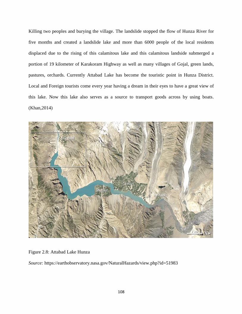
108
Killing two peoples and burying the village. The landslide stopped the flow of Hunza River for
five months and created a landslide lake and more than 6000 people of the local residents
displaced due to the rising of this calamitous lake and this calamitous landside submerged a
portion of 19 kilometer of Karakoram Highway as well as many villages of Gojal, green lands,
pastures, orchards. Currently Attabad Lake has become the touristic point in Hunza District.
Local and Foreign tourists come every year having a dream in their eyes to have a great view of
this lake. Now this lake also serves as a source to transport goods across by using boats.
(Khan,2014)
Figure 2.8: Attabad Lake Hunza
Source: https://earthobservatory.nasa.gov/NaturalHazards/view.php?id=51983

109
2.13 Gilgit Baltistan: Historical Forts
2.13.1 Baltit Fort
In the history of Gilgit-Baltistan, there were many small independents states. Among them
Hunza was also a state situated on the opposite side of Nigar state. Baltit Fort is situated in
Karimabad; the capital of Hunza. The old name of Karimabad was Baltit. Baltit for is one of the
oldest forts built 700 years ago. In early 15th
century the prince of Hunza Ayasho II married with
Shah Khatoon the princess from Baltistan and the princess Khatoon brought Balti skillful
craftsmen from to construct or restore building for her as dowry. The ascenders of the feudal
regime of Hunza were ensured by the impressive Baltit fort. Mirs in Hunza used to live here until
1945 then moved to new place. In 1990, Agha Khan IV took interest to restore the Fort. Later
Mir Ghazanfar Ali Khan the ruler of Hunza handover the fort to Baltit Heritage Trust. Baltit fort
is considered as a historical Palace and is listed in the United Nation Heritage List in 2004.
( http://www.baltitfort.org/history.htm)
Figure 2.9: Baltit Fort Hunza Source: http://static.panoramio.com/photos/large/24503882.jpg

110
2.13.2 Altit Fort
This majestic and historical fort is considered as the simple of ancient Hunza state. Altit Fort is
located at Altit village near Baltit Fort and was the old capital of Hunza. Altit gave the birth of
Hunza Kingdom. This fort was constructed by artisans and craftsmen came from Baltistan with
princes Khatoon in 1540s A.D. In 1548 A.D. some modifications took place in this fort and built
the Shikari tower or watch tower to protect the village from the rivals‘ states invasion and
attacks. (http://www.ideeaz.com/altithunza/altit_fort.htm)
1.13.3 Skardu Fort/ Kharpocho Fort
Skardu Fort also known as ―The king of Forts‖ is located at the Hill inn Skardu city of Gilgit-
Baltistan at high elevation then the city that dates from the 16th century CE. It was built by Ali
Sher Khan Anchan, the famous Ruler of the area. As Skardu fort was very worthy due to its
location because the whole Skardu city can be controlled and viewed from the fort due to high
elevation. Many rulers including Mughal Emperor Aurangzeb tried to occupy this fort but he
couldn‘t. An ancient mosque is also present inside the fort. Now Pakistan Army takes control
due to strategically importance.
1.13.4 Shigar Fort
The Fort is located in Shigar district the beautiful valley of Gilgit-Baltistan and the home of the
world 2nd
largest peak K2. In local Balti language, this fort is called ―Fong Khar‖ in which
‗Fong‘ means ‗Rock‘ and ‗Khar‘ means ‗Palace‘ , in the other word the ―Palace on the Rock‖ . It
is one of the ancient and historical forts in Gilgit Baltistan administered by different Rajas of
previous centuries. Still the ascenders of Raja family own it. In 1634, the 20th
ruler of Amacha
dynasty, Raja Hassan Khan built the fort. Originally, the family of Amacha is belonged to the

111
―Hamacha tribe‖ ruled over Shigar from many centuries. The Khar-e-Dong was the old palace of
ruling family but lost due to the prowling invaders. Later this palace was destroyed by Mughal
forces who came from Kashmir to help Raja Hassan Khan to restore his reign in Shigar Valley
Raja Hassan Khan brought artisan, and skilled workers from Kashmir to Shigar to build the
Fong Khar. Today, after renovation and restoration by Agha Khan Foundation, this fort has been
converted as a luxury hotel under the Serena Hotel Pakistan. (Tarkati, 2016)
2.13.5 Khaplu Fort
Khaplu is the capital of Ghanche district, Gilgit-Baltistan. Khaplu was also an oldest state of
Baltistan. It is the home of many picturesque and majestic historical places. The Yabgo family
was ruler of the of this region, hence the Khaplu Khar (Palace) is also called Yango Khar,
located at a distance around 1-2 kilometers from the Khaplu city (Bazar). This fort was
constructed by the Yabgo ruler Daulat Li Khan the son of Muhammad Ali in 1840. In 1590s the
ruler of Maqpoon dynasty Skardu Murad Ali Khan seized the fort during his attacked on
Khapolo, blocking water and other goods to the fort. After three month beleaguered the fort by
the army of Murad khan, the rule of Yabgo family of Khapolo, Ramhim Khan, surrendered
before Murad Khan. This fort was used by invaders and attackers from near dynasties but most
of the time it remained under the Yabgo family. Now this fort has been renovated by the Agha
Khan foundation. This fort is considered as the tourist hub in District Ghanche.
2.14 Gilgit Baltistan: Valleys
Valleys in Gilgit Baltistan are touristic points due to immense beauty and history. The pastures
and hilly valleys in GB attract the nature lovers to make a date with nature. Primarily valleys in

112
the region are carved by rivers. Small and scattered villages are situated on both sides of the
rivers, and economic activity is mainly agricultural based.
2.14.1 Rama Valley
District Astor is rich for natural beauty. It has many beautiful valleys, lakes, meadows. Rama is
one of these gorgeous sceneries, attracting foreign. Rama Lake is considered one of the most
beautiful lakes in Gilgit-Baltistan. In summer this landscape present beautiful meeting points for
tourist.
2.14.2 Rattu Valley
Rattu Valley is located at 30 km west of Astore. Army High Attitude School at Rattu apart from
being a military training institute is a tourist attraction, offering skiing facility to general public
as well. Darley ladeat an elevation of 9900 ft. (AMSI) is located 11 km from Rattu on route to
Kamri Lake and surroundings contain pine forests and green meadows. Rupal face of Nanga
Parbat can be approached from Rattu valley. Kamri Bal Pass and Shountar Pass linking Kashmir
Valley with Gilgit Baltistan through Rattu Valley over 14000 ft . Ranjit Singh Hut at Rattu,
constructed and used by Maharaja is a historical place and still maintains its majestic view.
(Army High Altitude School: https://www.pakistanarmy.gov.pk/ AWPReview/TextContent. As
px?pId= 287&rnd=491)
2.14.3 Minimarg Valley
Minimarg valley is included one of the most beautiful vale of Gilgit-Baltistan, located near the
border of Kashmir and Astor District. This valley played a due role during connecting Srinagar
Kashmir to Gilgit-Baltistan through the ancient Slik Route. Burzil Pass provides only road access
to Minimarg. Before independence of Pakistan 1947, this pass was only route between Kashmir
and Gilgit. (Dashtnavard , 2013)
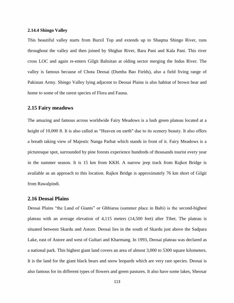
113
2.14.4 Shingo Valley
This beautiful valley starts from Burzil Top and extends up to Shaqma Shingo River, runs
throughout the valley and then joined by Shighar River, Bara Pani and Kala Pani. This river
cross LOC and again re-enters Gilgit Baltsitan at olding sector merging the Indus River. The
valley is famous because of Chota Deosai (Dumba Bao Fields), also a field fiving range of
Pakistan Army. Shingo Valley lying adjacent to Deosai Plains is also habitat of brown bear and
home to some of the rarest species of Flora and Fauna.
2.15 Fairy meadows
The amazing and famous across worldwide Fairy Meadows is a lush green plateau located at a
height of 10,000 ft. It is also called as ―Heaven on earth" due to its scenery beauty. It also offers
a breath taking view of Majestic Nanga Parbat which stands in front of it. Fairy Meadows is a
picturesque spot, surrounded by pine forests experience hundreds of thousands tourist every year
in the summer season. It is 15 km from KKH. A narrow jeep track from Rajkot Bridge is
available as an approach to this location. Rajkot Bridge is approximately 76 km short of Gilgit
from Rawalpindi.
2.16 Deosai Plains
Deosai Plains ―the Land of Giants‖ or Ghbiarsa (summer place in Balti) is the second-highest
plateau with an average elevation of 4,115 meters (14,500 feet) after Tibet. The plateau is
situated between Skardu and Astore. Deosai lies in the south of Skardu just above the Sadpara
Lake, east of Astore and west of Gultari and Kharmang. In 1993, Deosai plateau was declared as
a national park. This highest giant land covers an area of almost 3,000 to 5300 square kilometers.
It is the land for the giant black bears and snow leopards which are very rare species. Deosai is
also famous for its different types of flowers and green pastures. It also have some lakes, Sheosar

114
is the most prominent one. Deosai is one of the most touristic place in Gilgit Baltistan with
almost 0.2 million tourist every year according to recent statistics. This place is accessible for
only few months in summer (July to Sept.). Due to heavy snowfall the route to Deosai is closed
in other months. (Hussain, Z. et al, 2015)
Figure 2.10: Deosai Plain
Source: http://www.shangrilaresorts.com.pk/exc_images/satpara_lake.jpg
2.17 Gilgit-Baltistan: FAUNA
Gilgit Baltistan is a home to many varieties of animals and birds including many rare species.
Due to green pasture lands, forest and rich in water, Gilgit Baltistan potentially have many types
of local animals and birds. Some prominent examples are following

115
2.17.1 Markhor
Markhor, the national animal of Pakistan is considered as the biggest wild goat belongs to a
member of goat antelope subfamily. Markhors are noted for the massive, spirally twisted horns
that grow on the adult males. It is found throughout Gilgit Baltistan as it is a wild animal use to
live in mountains. Foreign hunters usually come to Gilgit Baltistan to prey Markhor by paying a
huge amount of taxes. Recently an American hunter paid 60 thousand dollar to hunt Markhor.
2.17.2 Bear
Brown bear, an endangered species, is only found in Gilgit Baltistan and in some areas of
Canada. In Pakistan brown bear are found in Deosai/Mini Deosai, a sanctuary protected by
WWF. Deosai brown bears are often seen near Kala Pani and Bara Pani while moving from
Chilam to Skardu via Deosai Plain. Black bears are also found mostly in western parts of Domel
and Kamri.
Figure 2.11: Brown Bear in Gilgit-Baltistan
Source: https://farm9.static.flickr.com/8631/15791395416_c40695e8db_b.jpg

116
2.17.3 Musk Deer
Musk Deer are found in western parts of Gilgit Baltistan. They are called mush as in Urdu
language ―Musk‖ means perfume so it is known to have a good fragrance so can be hunted to
make perfumes and is extremely costly.
2.17.4 Duck
In summers, flocks of ducks and birds migrated from China and Central Asia arrives in Gilgit
Baltistan. White headed ducks and Mallots are few examples of these birds. They are found in
almost every lake in Gilgit Baltistan while somewhere people use to hunt these birds.
2.17.5 Chukar Partridge
―Chukar Partridge is a ―Eurasian‖ highland beautiful bird. It belongs to the ―Pheasant family‖
and is very beautiful with well-marked black and white bars on the edges and has a black string
running from its forehead across the eye down the head to form a necklace that encloses a white
throat. It is found in big quantity in Gilgit Baltistan.‖
2.17.6 Chukar
Chukar, also known as Game Bird in North America belongs to the pheasant Family and is a 13-
14 inch long, with a grey breast, light brown back and buff tummy. The shads vary across the
countless inhabitants. Its face is white with a black garget. It has red legs, rufous-streaked flanks
and coral red bill. The suddenly clear garget differentiates this specie from the ―Chukar Partridge
which has black collar breaking into dark streaks near the breast.‖ It is also bigger in size than
Chukar Partridge. Locally it is known as Ram Chakor and is found in eastern parts of Gilgit
Baltistan
117
2.17.7 Zho
Zho is a local domestic animal belongs to cow family. In Gilgit Baltistan Zho is a source of meat
and milk. It is also used for the transpiration purposes. Zho Polo, game of polo played on Zho, is
of traditional importance to the locals of the area.
2.17.8 Marmet
Marmet is beautiful squirrel like animal belonging to the rodent squirrel family. It is mostly seen
in the area from May-Sep during summer as it goes to hibernation during the winter season and
reappears after melting of the snow. Marmet is also known as the Big Rat and called "Turshoon"
in local language.
2.17.9 Hawk
Gilgit Baltistan region is the home to some of the rarest species of Hawks. The hawks are found
mainly in the areas of Deosai Plains. Hawks are seen in this area during summers. Hawks hunt
small animals and fishes for its food.
2.17.10 Sparrow Hawk
Sparrow hawks are mainly found in forests and prey primarily on birds of moderate size, such as
pigeons, sparrows and doves in suburban areas. These are also found in Deosai Plains.
2.18 Gilgit-Baltistan: Flora
The region is gifted with a wide diversity of flora. The flora of the region seems to change color
with the transformation of weather. In winter, it is completely roofed with snow. The greenery
begins to take root in late May after the melting of snow and reaches its bloom in July when the
whole area is covered with green carpet. At the end of August, again because of the temperature
drop, the flowers and grass begin to turn brown and finally turn black giving rise to winters. The
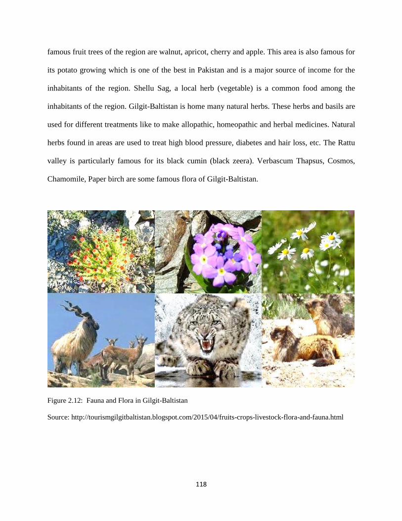
118
famous fruit trees of the region are walnut, apricot, cherry and apple. This area is also famous for
its potato growing which is one of the best in Pakistan and is a major source of income for the
inhabitants of the region. Shellu Sag, a local herb (vegetable) is a common food among the
inhabitants of the region. Gilgit-Baltistan is home many natural herbs. These herbs and basils are
used for different treatments like to make allopathic, homeopathic and herbal medicines. Natural
herbs found in areas are used to treat high blood pressure, diabetes and hair loss, etc. The Rattu
valley is particularly famous for its black cumin (black zeera). Verbascum Thapsus, Cosmos,
Chamomile, Paper birch are some famous flora of Gilgit-Baltistan.
Figure 2.12: Fauna and Flora in Gilgit-Baltistan
Source: http://tourismgilgitbaltistan.blogspot.com/2015/04/fruits-crops-livestock-flora-and-fauna.html
119
References
Awan, N.U.(1990). The Unique Mountains. Peshawar, Pakistan: Alpine Club of Pakistan
Ali, M.(2004, June 12). Archaeology of Dardistan. The News, Lahore.
Ameer, S. (2002). Shumali Illaqa Jat: Eik Nazar. Nadir Printers, Gilgit.
Dani, A.H. (1995). Human Records on Karakoram Highway. Lahore,Pakistan: Sang-e-Meel
Publication.
Dani. A.H.(2001). History of Northern Areas of Pakistan: upto 2000 A.D. Lahore, Pakistan:
Sang e Meel.
Dashtnavard, (February 6, 2013). Minimarg-A Heaven on Earth, Dashtnavard‟ blog Retrieved
from https://dashtnavard.wordpress.com/2013/02/06/minimarg-a-heaven-on-earth/
Endreson, R. T. (1998). History, Folklore and Culture of Gilgit Baltistan. Oxford University
Press, London.
Frembegen, J. (1964). Ethnographical Field-Research on the History of the Northern Areas.
Oxford University Press, London.
Gupta, Virendra; Alok Bansal (2007). Pakistan Occupied Kashmir: The Untold Story. New
Delhi, India: Manas Publication.
Ghazali, K. (2005, December 2). Land of the Giant. The Muslim, Islamabad.
Hilali, W. B. (1995). Hikayat-e-Baltistan., Skardu, Baltistan Book Depot.
Hussainabadi, Y.(2003). Tareekh-e-Baltistan. Baltistan Book depot, Skardu.
Hunzai, I. (2013). Conflict Dynamics in Gilgit-Baltistan (Special Report 321). Washington ,
USA: USIP
Hopkirk. P. (2001), The Great Game: On Secret Service in High Asia. London, UK: Oxford.
Hassnain, F. M. (1978). Gilgit: The Northern Gate of India. New Delhi, India
Huttenback, R. A. (1975). 'The "Great Game" in the Pamirs and the Hindukush: The British
Conquest of Hunza and Nagar', Modern Asian Studies IX, pp. 1-29.

120
Hussain, Z. et al. (2015). Grassland productivity and carrying capacity of Deosai National Park,
Gilgit-Baltistan, Pakistan. J. Agric. Res., 53(3), pp. 437-452. Retrieved from http://apply.jar.
punjab.gov.pk/up load/ 1456204265_119_13._Paper_No._286.pdf
Hennek, D. (1978). Great Trango Tower. American Alpine Journal. 21 (52), p. 436–446 New
York: American Alpine Club.
Hussain, Z. (2012). Border Conflict in South Asia: A Case study of Siachen Issue between India
and Pakistan. M.Phil. Thesis, Center for South Asian Studies, Punjab University Lahore Pakistan
Isapahani, M. Z. (1989), Roads and Rivals: The Politics of Access in the Borderlands of Asia, I.
B. Tauris & Co Ltd. Publishers, London.
Jianming, W. (2010), China‟s Western Development Programme in Xinjiang (2000-2009),
Unpublished Thesis, Centre for South, Central and Southeast Asian Studies, School of
International Studies, JNU, New Delhi, India
Jabir, A.,H. (2001, November 21). Kashmir Papers. The Muslim, Islamabad.
Keay.J.(1979).The Gilgit Game the Explorers of the Western Himalayas 1865-95. London, UK:
John Murray.
Khosa, R. S. (1999). The Siachen Glacier dispute: Imbroglio on the roof of the world.
Contemporary South Asia, 8:2, 201.
Kreutzmann, H. (1991). The Karakoram Highway: The Impact of Road Construction on
Mountain Societies. Modern Asian Studies, 25(4), 711-736. Retrieved from URL:
http://www.jstor.org/stable/312750
Khan, F. (May 25, 2014). Attabad Lake: Teardrop Miracle. The Express Tribune Magazine.
Retrieved from https://tribune.com.pk/story/711242/attabad-lake-teardrop-miracle/
Khan, S.,B. (2004).In The Wonderfuland of Asia Gilgit-Baltistan. Lahore,Pakistan: Sange-e-
Meel.
121
Kamal, N. (1979).Karakoram Highway: A Nation-Building Effort', Strategic Studies 11/3, pp.
18-31.
Knight, E. F. (I895). Where Three Empires Meet. London.
Lorimer, D.L. (1985). The Wakhi Language., London, UK
Malik, I. (2008). Arz-e-Shumal Ka Manzar Nama. Habib Publishers, Gilgit.
Miller K. (1988). Gilgit through the ages. Cosmo Publications, Calcutta.
Mir, S. (January 11, 2015). On thin ice: Khalti Lake becomes a perilous playground for children.
The Express Tribune. Retrieved from: https://tribune.com.pk/story/819870/on-thin-ice-khalti-
lake-becomes-a-perilous-playground-for-children
Paul (1996). A History of Western Himalayas. Penguin Books, London. 190 Pakistan Journal of
Social Sciences Vol. 30, No. 1
Robert, K. E. (2003). Geotectonic Evolution in the Northern Areas of Pakistan. U.S. Government
Printing Office, Washington, D.C.
Smith, D.S, Naseer,D., Balint, Z. Hassan, S.A. (2007). Butterflies of the Hunza Region, Northern
Pakistan and Adjecent Afghanistan. Holarctic Lepidoptera, 11 (1-2), Pp. 1-57. Retrieved from
http://www.troplep.org/Smith-et%20al-Butterflies%20of%20Hunza-Afganistan-sm.pdf
Stein, M. A. (1987). The Wonders of Hindukush. Sterling Publication, New Delhi.
Tarkati,M.H. (2016). The Stunning Forts and Palaces of Baltistan. Nauroz Youth Magazine (1st
Edition), Lahore, Pakistan: Millstone
Trench, C.C. (1992). The Icy Baltistan. Oxford University Press, London. Wallace,
Walter, J. M. (2006, April 27). Wild life on the top roof. The Telegraph, Calcutta. Watters, T.
(1978). Travels of Northern India. Neeraj Publishing House, New Delhi.
Zain, O.,F. (2010). A Socio-Political Study of Gilgit Baltistan Province. Pakistan Journal of
Social Sciences (PJSS). 30 (1) pp. 181-190

122
Chapter 3
Gilgit-Baltistan: Political and Constitutional Status

123
3. Introduction
Gilgit-Baltistan is famous among foreigners for its beautiful landscapes, picturesque sceneries,
highest peaks, mountains ranges, as well as its unique politico-geographic and historical
importance; hence this region is called Heaven on Earth for tourist. (Chuhaan, 2012) Politically,
this region remained under the rules of the various Empires, kingdoms, Rajas, Maqpoon, etc.
invaded from ancient, China, Central Asia, India and oldest civilization and different names such
as Dardistan, Boluristan, Brushal, and Tibat-e- Khurd etc. have been given by scholars, historian,
travelers of the ancient Greek, Hindu, Chinese, Tibetan, and Muslim writers. In the medieval
history Gilgit-Baltistan went under the rules of local dynasties and whole region was divided
among these ruling families. In 1840s Dogra of Jammu invaded in Gilgit-Baltistan and defeated
the local rulers and sized power. In 1870s, during Great Game, Gilgit-Baltistan went under the
consideration of British. To curtail the Russian‘s expansion, British decided to establish Gilgit
Agency in 1877 and reestablish in 1889. In March 1935 the control of Gilgit was given to British
as a 60 year lease by Maharaja Hari Sing. In 1947, the political scenario had been changed in
Sub-continent. British India had divided into two independent states; Pakistan and India, while
the 562 princely states (Native States) had been given choice to join either with Pakistan or India
or remained autonomous by the Indian Independence Act 1947.The Princely State of Kashmir
remained outside from this partition but later through ‗the Instrument of Accession‘ on 26,
October 1947, Maharaja Hari Sing agreed to accede to India which was against the will of its
people. From 1947 to present Kashmir has made the bone of contention between Pakistan and
India. After defeated the Dogra, the People of GB decided to affiliate with Pakistan but due the
Kashmir issue this region remained unconstitutional and disputed. In this chapter the political
and constitutional development of GB has been discussed.

124
3.1 Gilgit-Baltistan: Historical Evolution
There are no sufficient archeological evidences to clarify the ancient historical cultures and
values of local people of Gilgit-Baltistan. The cultural evidences regarding the presence of man
in the region is still unknown phenomenon through archaeological evidencing procedures.
However there are some clues regarding the food for hunting in the area but that still lacks the
vigor and zeal in this sake. The dominant evidence which symbolizes the area‘s cultural values is
the rock art which is dominantly found in the area contiguous to the Gilgit-Baltistan like
Xingjian, Swat, Ladakh and the surrounding region of Kashmir. The two most important things
which are a clear symbol of the rich culture of this region are (1) The Rock Art and (2)
Continuity of Art throughout in region showing similarities. These symbols are also indicating
the behavior related to socio-economy, taste, and their civilization. A. H Francke (1907) in his
book ―A History of Western Tibet” called these early settlement of people as Dard but famous
Pakistan researcher and author of ―The History of Northern Areas of Pakistan (upto 2000AD)‖
Dr. Ahmad Hassan Dani called the early people of this region ‗ The Rock Art People‘ and writes
that these people are older than Dard. According to Dani (2007) these Rock Art People
developed an interesting socioeconomic system based mutual cooperation and on hunting and
gathering food. This mutual cooperation and understating helped them to promote a family
system in this mountainous region. The rocks had very important in their lives and made their
shelter from rocks to protect the cold winds. Indus river also had important for them but to cross
of this river they had not expertise in boat making but using rafts of woods they used to cross the
river. The leaders or headmen had special advantages and dressed of animal skins to preserve
from the cold. Religiously, the people of Rock Art believed on the mysterious of mountains and
the natural phenomena and worshiped it. Historians suggest that they had some means of trade

125
very much related to barter one in order to meet the needs. They had probably trade in mineral
and other sources.
Rock art is the sole an authentic source of history of these mountainous people. Recognizing the
importance of the rock art, a systematic survey conducted by a group of Scientists, scholars and
archaeologists from Pakistan and Germany. This provided valuable information about the
historic evidences of this area. The ancients routes where passed these area and many inscription
and engravings of rocks found in this routes. Archeologists suggest that the history of the region
Gilgit-Baltistan can be sketched back to about, 5000 BC; but indication and evidence concerning
any pre-history are unsound. (Dani, 1983)
Figure: 3.1: This prehistoric Caprine depiction in Chilas
Source: https://www.dawn.com/news/629659
126
3.2 Primeval History
The people of Gilgit-Baltistan dated back to the 5th millennium BCE (Before Common Era). The
people of Gilgit-Baltistan were known as the people of Rock Art as they began the tradition of
rock carvings. Throughout Gilgit-Baltistan, there are multiple evidences of rock carving found.
After comprehensive study of the rocks inscriptions showed that the Rock of art people was the
original people of this mountain area. They were hunters and lived in the rocks. Mountain was
played an exclusive role in their lives and people worshiped of these mountains. (Ali, 2004)
3.2.1 Megalith Builders
With the passage of time the Art of rock faced new type of civilization brought by the migrated
people or groups of people from nearby territories. These people were expert in megalith
buildings. Migration of these people had brought some better technologies to the region in
building art. They were pioneers in stone cutters and wall erecting methods. They had introduced
advanced system of irrigation as well. There was no awareness regarding their crops productions
but they were used precious stones and metals for different tool making for diversified purposes.
These were included coopers, gold, silvers etc. They had domesticated cattle but were used
mainly by specific group for certain purposes. They were two groups; one who came from
Chitral and the second group of people migrated from Swat and adjoining areas and
professionally both where traditional builder of great megaliths. It was to have a carved
ceremony stone at the center, which was worshiped. Here is interesting to note that this new
migration did not abolished the rock of arts but it was existed side by side. (Dani, 2007)

127
3.2.2 Dardic People
The British Orientalist Dr. Gottlieb William Leitner was the first person who coined the word
―Dardistan‖. It is interesting point that today no one calls of the area himself as Dard. In 4th
century BC, the Greek historian Herodotus mentioned about a group of war like people of
northern Indian frontier and he named them Dadikai who lived during Achaemenian Empire.
These people are belonged to Indo-Arian races. They had some uncertain culture and their social
and culture was quite visible. Their economic activities comprised mining and trading gold and
other precious metals and this was the prominent source of trade and income. This has led to the
creation of trade routes to China and Central Asia. (Torwali, 2012)
3.2.3 Sakas or Scythians and Parthian
These people were inhabited in Turkistan the Central Asian region. The historian found various
types of rocks inscriptions and rocks carving around Chilas that the Scythians were migrated
from the Central Asian and settled down in Gilgit-Baltistan. These people were physically strong
and around first century they ruled over these areas and established its reign. Several rock and its
inscriptions and carving around Chilas recommend that the Scythians of Central Asia founded its
dominance in the region around the first century. Rock carving and Kharoshti inscriptions have
been found in Chilas, Gilgit and Hunza and these are depicts a clear picture of their rules in this
region. Scythes rulers introduced the Kharoshti script and stupas of Texila and built up a close
business relationship with Texila. Scythe rules were limited and had continued their presence till
a generation or two. When the Scythians Empire declined, the Parthians or Pahlava belong to the
Gondophares group, came into power in this region. The Parthians are famous for their
engravings and coins in Gandhara. Several rocks inscriptions are found in Gilgit Baltistan which
proves their movements in this region. (Arif, 2014)

128
3.2.4 The Khushans
The first emperor of Khushan, Vima Kadphises, the descendant of Kujula Kadphises, was the
first emperor who expanded the reign of Khushan Empire in Gilgit-Baltistan. They were the
powerful inhabitants of that time. The rocks with Kharoshti inscriptions have been discovered in
Alam Bridge near Jogloot, in Hunza near sacred rock, and Chilas-II which depicts the sign of the
Khushan and their attachment of this region. The Khushan had established trade with other
empires especially from these records indicates that the diplomatic relations with Chinese
emperors were established in early time. Peshawar was the capital the Khushans and they
succeeded to create a strong kingdom in the northern India and contiguous territories. Gold was
used by them for commercial purposes and an ancient route from northern region was built to
reach Chin and Central Asian States. (Arif, 2014)
3.2.5 The Post Khushans
After the Khushans kingdom, the Persian Sassanis captured the whole region at the start of the
3rd century AD in a dominating way and propagated their traditions throughout the region.
During this period, Buddhism sustained to prosper and this area stayed a famous crossing point
for trips to and from China, India and Central Asia. The junction of mountains made it a very
important place for the ruler in the China and Central Asian region.
3.2.6 The Huns
They were tribes of Central Asia who were fighters. They had craze for hunting and to damage
other people in all the possible ways. They administrated over numerous Shina and Burushasky
rulers called "Rajas" and provoked them with clear instructions to follow and obey. At that time,
Buddhism was still in the process of expanding. Although, Buddhism had caught the attention of
the rulers but the locals in these regions had different versions to follow. (Hauptmann, 1990)

129
3.3 Autonomous Hill States
In ancient history, the hilly region, Gilgit-Baltistan was controlled by invaders of Central Asian,
Indian and Chinese empires. During 7th
and eight centuries the region went under the reign of
local dynasties. Gilgit-Baltistan, like ancient Greek city state, was divided into several states
ruled by succession of various local Rajas, Mirs, Khan etc. According to Dr. Ahmad Hassan
Dani (2007), the famous ruling families were following;
1) Tarakhans of Gilgit
(2).Maghlots of Nagar
(3) Ayasho of Hunza
(4) Burshai of Punyal
(5) Kator family of Chitral
(6) Khushwaqat family of Yasin and Mastuj.
(7)Maqpoons of Skardu
(8) Amachas of Shigar
(9) Yabgos of Khaplu
(10) Rajas of Roundu, Astor, Kartakhsha and Tolti
3.4 Dogra Raaj
In 1820 the Maharaja of Lahore Darbar, Ranjeet Sing rewarded his brave soldier Gulab Sing the
ruler of Jammu and made him Raja of Jammu. Gulab Sing was belonging to a Hindu family of
Jammu or Dogra. He set up a large army to expend his reign while serving Ranjeet Sing. In
1830s, conquering the Buddhist majority Kingdom of Himalayan region, under his notable army
general Zorawar Sing, he reached Tibet and he annexed Muslim majority of Baltistan in 1841.

130
Baltistan went under the rule of Dogra due to the internecine over successor between Ruler of
Skardu Raja Ahmad Shah and his youngest son Muhammad Shah. Muhammad Shah went
Jammu and sought help for his legacy and ascendancy from Gulab Sing. At the same time Gilgit
and adjoin sovereignties were subjugated by Sikh the ruler of Lahore Darbaar. In 1842 at the
request of karim Khan , the brother of Raja Shah Sikandar of Gilgit ,the ruler of Kashmir sent a
strong contingent of army led by Colonel Nathu Shah entered Gilgit and defeated Gour Rahman
of Yasim and established their rules in Gilgit . In 1852 the rebellion attack under Gour Rahman
command on Dogra forts at Gilgit Killed Dogra soldiers and Gilgit slipped out of Kashmir‗ s
governor. But in 1860 under the Maharaja Ranbeer Sing Gilgit once again went under the control
of Sikh kingdom of Lahore. (Madhok, 1992)
3.5 Treaty of Lahore
First Anglo-Sikh war battled at Punjab between the Sikh Empire of Lahore Darbar and the East
India Company. This war brought a great detrimental in the Sikh dynasty and started to decline.
On the other hand British got opportunities to firm the foot over subcontinent that led them to
take over whole region. It had great impacts on Kashmir and its adjoining areas which ceded to
company by the Lahore Dar. Consequence to collapse of Sikh rulers of Lahore; Treaty of Lahore
was signed on March 9, 1946 between the Government of British India and Sikh rulers. It says;
―The Maharaja relinquishes to honorable company in individual sovereignty as
equivalent for one crore rupees, all his castles, lands, privileges and benefits in the
alpine countries which are located between the river Bias and Indus, including the
provinces of Kashmir and Hazara‖
―(Annexation of Punjab: http://www.facts-about-india.com/annexation-of-punjab.php‖

131
3.6 Treaty of Amritsar Following to the above assignment, a separate contract was signed between the ruler of Jammu
and Kashmir Maharaja Gulab Sing and the Government of British India on March 16, 1946.
Article 1 of the treaty states that, ―The British government shifted to Maharaja Gulab Singh and
inherits all the alpine state in the light of treaty of Lahore‖. The article of Amritsar Treaty proved
that the area of Chilas, Hunza, Nagar and remaining region of the north were not transferred to
the government of Maharaja Kashmir. If we strictly interpret the Gulab Nama, even Astor was
the only land under protection but not a definite territorial part of Kashmir. The Indus River pass
along with Kohistan‘s region but the region never considered as part of Kashmir. It is strange
that the Buddhist majority region Ladakh and Muslim majority region Baltistan are not revealed
in the treaty, while the river Indus passes through the regions. This is understandable, because
these two areas never formed part of Sikh territory. So, if treaty is properly understood in the
historical perception, its meaning has to be restricted to property of the Sikhs in Jammu and
Kashmir.(Haque, 2012)
3.7 British Indian Rules
The British transmitted power and control of region to Dogra in 1846. But continuing expansion
of Czarist Russia, British made Gilgit as it‘s based to curtail the Russian‘s invasion in this
northern frontier. In 1889 the Gilgit Agency was restored under Captain A. Durand as the Agent
of British India. Latter Gilgit Scout was established to topple the local rebellion and protection of
administration. When Soviet activites in Central Asia and their relations with Chinese regimes
in Xingjian developed, the fears of British had increased. , thus, they used these circumstances to
build up pressure on Maharaja Hari Singh to accept their de-jour administration over Gilgit
agency. For this purpose , on 26 March 1935,an agreement of a lease for 60 years was signed by

132
Colonel Lang, the Resident of British in Kashmir and the Maharaja of Kashmir, gave the civil
and military authority of Gilgit Agency to British, subject to the condition that this region would
continue under the dominion of Maharaja of Jammu and Kashmir. The lease terminated in 1947
during partition of India and the British returned the administration of Gilgit agency to Maharaja.
But the uprising of freedom movement against Dogras in 1947-48 by local people under Gilgit-
Scout, Maharaja of Jammu and Kashmir lost it authority over Gilgit and Baltistan and later the
Local rulers affiliated this region with Pakistan. (Warikoo, 2014)
3.8 Gilgit Agency
Gilgit Agency was created in 1877 by the government of British India to protect the northern
region from the invaders of Russia and other powers. During this time the World game was its
peak. British officers were much concerned over the influences of USSR in Himalayan region
and that was creating threat to the empire of British India. To containment the Russian Caser
advancement, the government of British India decided to establish the Gilgit agency. The
Agency was reestablished and it was controlled by the British officers, residing in Jammu and
Kashmir. The Gilgit Agency included, the Gilgit Wazarat, region of Hunza and Nigar States, the
Jagir of Punial, and other of territories of Ishkoman, Chilas, Yasim and Kuh-Ghizr. In 1935, the
international political scenario had been changed, and the British took Gilgit and adjoin areas for
a lease of 60 years from the Maharaja of Kashmir. After lease this region went under the direct
administrative control of British India.

133
3.9 The Gilgit Scout
The interest of British had increased in Gilgit and took it under its vigilant to look the Russian
movements in central and Karakoram regions. Under the command of Colonel Algernon Durand,
British Indian government established a force in this border region with the name of Gilgit
Levies with the aim to protect the British from the local unrest and resistance. In 1891, the force
clashes the Hunza‘s army in the battle of Nilt. Major JC Bridges reestablished the force in 1913
on company basis and the name was changed Gilgit Levies to Gilgit scouts. During the formation
of the Gilgit Scout, the strength was only 582. The recruitment and training in Gilgit scout was
depended on the suggestion of local Raja and Mirs of the region. During freedom movement
Gilgit scout mutinied against Dogra commander and play a significant role in the freedom of
Gilgit-Baltistan. (https://www.pakistanarmy.gov.pk/AWPReview/TextContent.aspx?pId=162&rnd=462)
Figure 3.2: Gilgit-Scouts
Source: https://defence.pk/pdf/threads/happy-independence-day.406410/page-2

134
3.10 End of British Rules
On October 26, 1947, Maharaja Hari Singh singed with India on the Instrument of Accession of
Jammu and Kashmir after a tribal invasion from Pakistan. The residents of Gilgit did not favor
the accession of the State to India. Feeling unhappy, Major William Brown, commander of the
Maharaja Scout Gilgit, mutinied on November 1, 1947, toppling Governor Ghansara Singh. An
interim government was setup by the inhabitants of Gilgit and Raja Shah Rais Khan appointed as
president and Mirza Hassan Khan was mad as commander in chief. Major Brown the
commander of Gilgit Scout had telegraphed Khan Abdul Qayyum Khan asking Pakistan to take
over the region. To affiliation the region with Pakistan, Khan Mohammad Alam Khan, the
Pakistani political agent, reached Gilgit on 16 November and took over the administration of
Gilgit (Scholfied , 2003)
The provisional government in Gilgit remained for 16 days. According to Yaqoob Khan Bangash
(2010) highlighted that the residents of Gilgit, as well as those of Chilas, Ishkoman,Koh Ghizr,
Punial, Yasin, Hunza and Nagar merged Pakistan by choice. After taking control of Gilgit,
Scouts of Gilgit and the irregular Azad moved to Baltistan and Ladakh and captured Skardu in
May 1948. They blocked Indian reinforcements and then captured Dras and Kargill, cutting off
Indian communications to Leh in Ladakh. The Indian forces mounted an offensive in the autumn
of 1948 and took over the entire district of Kargil. Baltistan region, however, remained under
Gilgit control.
3.11 United Nations Resolution
After the partition of Subcontinent, the princely states of British India were given choice to join
the new independent states or remained autonomous. Kashmir was a princely state ruled by
Maharaja, a Hindu ruler while the majority of populations were Muslim. In 1947, A Lashkar

135
from the Pakistani controlled Tribal areas attacked on Kashmir to help the people to topple the
ruler of Kashmir. This invasion brought India a chance to compel the ruler of Kashmir to sign the
―Instrument of Accession‖. This incursion led a war between Pakistan and India. In 1948, India
brought this issue on International forum to make it Internationalized. In January, 1948, under
the UN Charter, article 35, India brought the issue before United Nation Security Council
(UNSC) and the UN quickly take the matter in hands. The matter was taken seriously for a long
time and Kashmiris were given the right of plebiscite that they are free to choice their future. In
the resolution adopted by members of UNSC, Kashmir issue was to resolve through plebiscite in
which people were given three options, to become part of Pakistan, or India or remain
independent State. But the implementation of the UN resolution did not come true due the
antagonist behavior of both states. The people of Gilgit-Baltistan claimed that the whole region
was kept with Kashmir issue for the Plebiscite. Accordingly, on 20 January 1948, a three
member delegation visited scene of battling. On 21 April 1948, a five member of ―United
Nations Commission for India and Pakistan (UNCIP)‖ was established to resolve the Kashmir
issue and UNSC resolution 47 on Kashmir adopted. This resolution stated that; “both India and
Pakistan desire that the question of the accession of Jammu and Kashmir to India or
Pakistan should be decided through the democratic method of a free and impartial
plebiscite”. (Kashmir- the History, http://www.pakun.org/kashmir/history.php)
3.12 Political Development in Gilgit Baltistan 1947-2013
3.12.1 Karachi Agreement 1949
In November, 1947, with the help local population, Gilgit Scouts and Azad army freed Gilgit and
adjoin areas from the Dogra Raj and declared as an Independent State. In 16th
November, this
region affiliated with Pakistan and the representative of Pakistan took the charge of
administration abolishing the new born state. But the fate of this area and its people fell in the
136
doldrums when this region kept with Kashmir dispute. Karachi Agreement has a great impact on
Gilgit-Baltistan and it futures political developments. On 28th
April, 1949 an agreement was
signed between the representatives of Azad Kashmir Government and the Representative of
Pakistan. The members of signatories/ representatives were;
1. The representative of Pakistan Mr. Mushtaq Ahmed Gurmani (Minister without Portfolio)
2. The President of Azad Kashmir Mr. Sardar Muhammad Ibrahim Khan
3. Chaudhry Ghulam Abbas, the leader of ―All Jammu and Kashmir Muslim Conference‖
In this agreement the arrangement of Kashmir affairs were distributed between Pakistan and
Azad Kashmir Government. Under this agreement the administrative power of Gilgit-Baltistan
was granted to Pakistan till Kashmir Resolution and Pakistan became as a de-facto ruler of
Gilgit-Baltistan. The people of Gilgit-Baltistan rejected this agreement on based of following
arguments.
1. According to local people of Gilgit-Baltistan, the region was already affiliated with Pakistan in
1947.
2. In 1947, the people liberated the whole region from the Dogra Raj of Kashmir, so theirs
(Kashmiri) claimed were baseless and unjustified.
3. In the signatories of agreement, there was not a single representative from Gilgit-Baltistan,
and without consensus the locals the agreement about fortunes of GB people would not be
accepted. (Naseem, 2007)
3.12.2 TRANSFER TO MINISTRY OF KASHMIR AFFAIRS
The history of political development and constitutional reforms in Gilgit-Baltistan has a long
journey. Due to annexation with Kashmir issue, the process of constitutional or political reforms
in this region has observed very slow and sluggish. The first political development took place in
137
1950 when the administration of Gilgit-Baltistan formally called ―Northern Area‖ shifted to
Ministry of Kashmir Affair from North West Frontiers Province (today, Khaibar Pakhtunkhwa).
Before this arrangement, the appointment of Political agent for the area fell under the control of
NWFP government. This arrangement process continued till 1952 when the charge of the post of
Resident of NA was given under the administration of the Joint Secretary Kashmir Affairs.
3.13 Gilgit-Batistan after Accession with Pakistan
3.13.1 Chronological Order of Administration and Self-government Reforms (1947-2009)
The people of Gilgit-Baltistan affiliated the whole region with Pakistan after the independence
from the Dogra Raj. They abolished their new state to amalgamate with Pakistan; which
remained 16th
days on the map of the world. Pakistan sent a political agent as a representative
and imposed. This law had been launched by Pakistani government in all agencies and tribal
areas. (Hassnain 1978) With the passage of the time, government of Pakistan started to
introduce organizational and political modifications and reforms in order to fulfill the demands
of local people are mentioned below.
3.13.2 Formation of the Ministry 1950
The federal government set up new ministry to look up the affairs of Kashmir and the Norther
areas of Pakistan. For this purpose government introduced the Ministry of Kashmir Affairs and
Northern Areas (KANA) and relocated administrative dealings of the whole Northern Areas to
the Ministry.
3.13.3 Appointment of Resident 1950-52
In 1950 the post of political resident and chief advisor in Kashmir affair was created. The
administrative power of Northern Areas transferred from the governor of NWFP to Ministry of
Kashmir Affair and this transformation of power was the political resident for Gilgit and

138
Baltistan. This political process remained until 1952, when the federal government bestowed the
post of the resident of NA to the Join Secretary with the additional charge of the Chief advisor
for Kashmir. (Ali & Rehman, 2001)
3.13.3 Empowerment of Resident 1967
In 1967 another administrative changes brought in the affair of Kashmir Ministry. This time the
reform launched about the powers of the resident of Gilgit. The resident was given the power of
―High Court and Revenue Commissioner‖ and selected two political agents one for each Gilgit
and Baltistan agency. Political agent was gifted the District level authority to take command as
judge of session and district court, Revenue Collector, Commissioner for FCR, Chief of police
and controlling officer. (Dani, 2007)
3.13.3 Creation of Representative Body of Northern Areas 1970
Another political reform was introduced by General Yahya Khan in 1970. Through this reform
the first council ―Northern Areas Advisory Council (NAAC)‖ was established and the election of
its sixteen members also held for the first time in same year. Whereas member of the council had
granted a limited powers about the developmental projects and the rest issues were beyond its
powers. (Naseem, 2007)
3.13.5 Z.A Bhutto Government Reforms 1970s
In 1970s, the major political changes took place in Pakistan. During these years, the political and
constitutional demands and awareness rose among the people of Gilgit-Baltistan. In 1971, the
first indigenous political Party ―Tanzeem-e-Millat Party‖ was formed. The main purpose and
manifesto of this political party was to abolish the FCR laws and to award the region as the
provincial setup. The party arranged protests in every nook and cranny of the region. This made
the situation of whole region turmoil. Government of Pakistan set up a committee to introduce

139
new reform to control the situation in Gilgit-Baltistan. On the suggestion of the committee
members, the President of Pakistan signed new constitutional and political reforms in August,
1972.
A). Feudal system was stemmed in socio-political and economic system of GB. The new reform
abolished feudal system as well as Frontier Crimes Regulations (FCR) and tradition political
setup of rajas and mir of Nagar and other states also eradicated.
B). The old system of Agency system converted the new political system. Gilgit and Baltistan
were the Agencies changed into districts set up.
C). The Deputy commissioners and Commissioner were introduced as the head of district,
changed the political agents and the post of the resident.
The reform continued and Diamer was made a new district in December, 1972 and the Prime
Minister Zulfiqar Ali Bhutto visited the region in September 1974 and announced few more
reforms including the abolishment of Hunza States, formation of the District Ghanche and
creation of Ghizer district. (Dani, 2007)
3.13.6 Imposition of Zia-ul-Haq Martial Law and Zone E 1977
In 1977, when Martial Law was enacted in Pakistan by the General Zia-ul-Haq, Northern Area
(GB) was declared as Zone-E and whole area went under the Martial Law. It was a different step
took by Zia government which was in contradiction of Pakistan‘s stance on Gilgit-Baltistan with
regard to the Kashmir issue. The people‘s representatives of Gilgit-Baltistan were included in the
Majlis-e-Shura.(Naseem, 2007)

140
3.13.7 Appointment of Advisor to Kashmir Affairs 1985
So as to bring reforms in GB, government of Pakistan comprised a high-level commission
including ―Federal Secretaries of Finance, Planning, Law, Interior, Education, and Kashmir
Affairs and Northern Areas (KA&NA)‖.After recommendations of the committee, a
representative of Norther Areas ;Agha Ahmed Ali Shah was granted as Counselor to Minister of
Kashmir Affairs.
3.13.8 Advisor to Prime Minister 1988
Another political development observed during Ms. Benazir Bhutto government in 1988. She
was selected Mr. Qurban Ali as advisor to Prime Minister. He was representative of Northern
Area Council. The status of advisor was equal with a State Minister.
3.13.9 Benazir Bhutto Announced new Reforms 1994
To bring improvement in Northern Areas, Prime Minister Benazir Bhutto announced new
reforms and the member of the Federal Cabinet approved a set of ―Package of Reforms‖ as
―Legal Framework Order 1994.‖ The new institutions such as ―Northern Area Rules of Business,
Chief Secretary and Civil Secretariats‖ had been created and major developments took place
regarding judicial reforms. After the abolishment judicial commissioner a Chief Court of 3
members had been established under the presidency of a retired judge.―Any senior judicial
officer who was either the member of federation or the provisional High court was able for the
member of chief courts, while a District Session Judge from the Northern Areas is qualified to be
its member. During the governance of Pervez Musharraf, he offered a constitutional package to
the Gilgit Baltistan which ultimately led to the prominent changes in the pre-existing system and
take it to the top prominent level. The council was renamed as Northern Areas Legislative
Assembly.‖ (Gupta and Bansal, 2007)
141
3.13.10 Delegation of Legislative power to the NALC (1999)
According to the schedule 2 of the Legal Framework order (LFO), the legislative power over
forty nine of subjects was given to the Legislative Council. These reforms brought a
modification in the LFO of 1994 and the Legislative council power also rose.
3.13.11 Establishment of Apex Court (2005)
In 2005, the first ―Northern Area Court of Appeal‖ was created as well as the number of reserved
seats for technocrats had increased up to six and to empowerment of the women, one additional
woman seat was increased in Northern Areas Legislative Council.
3.13.12 Empowerment of Northern Areas Legislative Council (2006)
After selecting the six (06) advisory from NALC members, they got equal status in incentives,
payments and freedoms as members of AJ & K Assembly had possessed.
3.13.13 The Reforms Package (2007)
On 23rd
October, 2007 General Pervez then the President of Pakistan paid an official visit to
Gilgit, where he announced a set of new constitutional reform for the region. This new package
brought huge changes in the administrative set up of GB. The Reforms Package 2007 changed
the name of Legislative council to Legislative Assembly and the power of the Legislative
assembly was upgraded. Furthermore, the designation of the ―Deputy Chief Executive was made
its Chief Executive and the minister for Kashmir Affairs was granted as the Chairman of the
Legislative Assembly.‖ (gbtribune.blogspot.com) Before the name change it was called Northern
Areas Legislative Council (NALC). It is pertinent to note that this reform lifted the status of the
region without causing the Kashmir issue. Therefore, the whole Kashmiri leadership, for the first
time , had accepted this reforms even in past any setup or reforms related Northern Areas (GB)

142
were opposed by all Kashmiri leadership whether they belong to AJK or Indian held Kashmir.
(Mehmud, 2007)
3.13.14 The Gilgit Baltistan Empowerment and self-Governance Order (2009)
Federation is the unique characteristic in the political system of Pakistan. The federation of
Pakistan is comprised four provinces including four non-units of territories. The non-provincial
units of Federalism are Federally Administrative Tribal Areas (FATA), Gilgit-Baltistan
(formally Known Northern Areas), Azad Jammu Kashmir and the capital territory Islamabad.
Unfortunately, the region of Gilgit Baltistan is facing the problem of constitutional vacuum for
over 60 years. The people of this region do not have right to participate in the mainstream
political process in Pakistan. They are not representation in parliament nor have constitutional
mandate to the local assembly. On the other hand Pakistan held Kashmir part known as ―Azad
Jammu and Kashmir (AJK)‖ have possessed a wide range and well defined governance
arrangement operational under an interim constitution approved by Azad Kashmir Legislative
Assembly in 1974. Whereas, Indian-held Jammu & Kashmir is functioning its administrative
responsibilities under ―Indian constitution of article 370‖ and has its own state‘s constitution
(1957), which the importance of G.B; fairly irrational and unwarranted even more contradict as
compared to disputed areas of Azad Jammu and Kashmir. While the other two, capital city and
FATA have their own representative in parliament and senate. In 2009, Government of Pakistan
introduced a balanced and comprehensive constitutional reform in the region.The ―Gilgit-
Baltistan Self-Empowerment and Governance Order 2009‖ was launched in August 2009, which
is strongly influenced by the AJK pattern and Pakistan's provincial arrangements. It describes
that people of Gilgit-Baltistan were demanding a wide range political and constitutional reforms
and the democratic government of Pakistan led by Pakistan People Party (PPP) took steps to

143
bring Gilgit-Baltistan in the mainstream of national political and constitutional process and
increased internal autonomy while giving provincial set-up but did not declared as a province. It
obviously demonstrates that GB is not a part of Pakistan. Article-1 of the constitution of the
Islamic Republic of Pakistan deals with the regional and territorial concern of Pakistan. It clearly
defines the territories and region which fall under the constitutional administration of Pakistan.
However, the current package of reforms is in fact a further improvement in the legal framework
of the Council of Northern Regions.
Under the supervision of the ―Minister of Kashmir Affairs and Northern Areas‖, the Prime
Minister of Islamic Democratic of Pakistan announced a high powered commission in which the
DG (ISI) and (IB) were the members of this committee along with the ―Minister for Foreign
Affairs, Minister for Law and Justice, Secretary Law and Justice, Secretary Cabinet, Secretary
KANA and Advisor for Interior.‖ In this committee, the current condition and reforms in Gilgit
Baltistan was taken into account and negotiated with the participants of Northern Areas
According to the Gilgit-Baltistan Empowerment and Self-governance 2009, the name of
Northern Areas was replaced by Gilgit Baltistan along with the separate appointment of the
Officer of Governor, Chief Minister and Ministers. Like AJK, this Gilgit Baltistan Council has
a supremacy of approving funds. The concept of the amalgamated Capitals was introduced and
the legislative power of the Assembly are enhanced from 49-61 subjects with supremacy of the
all the other themes which is not in the range of Gilgit-Baltistan councils. GB has a power to
promulgate on all the 55 subjects. The ―Gilgit Baltistan Empowerment and Self-Governance
Order 2009‖ was considered as a comprehensive package ever implemented by Federal
government. Through this constitutional package the name of this region changed from Northern
Areas of Pakistan to Gilgit-Baltistan which brought a positive impact on regional socio-political

144
and economic system. This package introduced a provincial setup for administration but
constitutionally it kept with Kashmir Affair. This reform brought huge infrastructural changes as
well as increased legislative powers Gilgit Baltistan Legislative Assembly. (Haque, 2012).
3.14 The Gilgit Baltistan Legislative Assembly
The political packages 2009 give a comprehensive and inclusive political and administrative
power to the people of Gilgit-Baltistan. An autonomous provincial set-up for self-rule and a
unicameral legislative body were introduced by the GB Empowerment and Self-Governance
order 2009. The legislative body of Gilgit-Baltistan is called Gilgit Baltistan Legislative
Assembly (GBLA) is constituted of 33 members of which:
(a) 24 members of the assembly choose directly by the people of Gilgit-Baltistan on the basis of
adult franchise.
(b) The six reserved seats for women members nominate on the basis national assembly procedures
of Pakistan. A further seat (7) was assigned for newly made district of Hunza Nagar.
(c) There are three technocrats and professional seats in GBLA elect on the lines of reserved seats in
Pakistan.
3.15 Gilgit Baltistan Council
As the result of the article 33 of Self-Governance Package 2009, Gilgit Baltistan Council has
been formulated to enhance the relations between the central and local governments. The council
entitled power to legislate on 53 subjects as it provided by schedule III of the Order. The prime
minister of the Pakistan is its Chairman and the Governor of GB is the Vice-Chairman of the
Council. The Council comprises of
145
― 1). The Prime Minister of Pakistan
2). The Governor of Gilgit Baltistan
3). Six members will appoint by the prime minister of Pakistan from the federal ministers and
parliamentarians on the recommendation of Minister of Kashmir affairs and Gilgit Baltistan.
4). The chief minister of Gilgit Baltistan.
5). Six members of Council will be elected by the Assembly according to the method of
proportional representation by means of a single transferable ballot.‖ (Gilgit-Baltistan Council:
http://www.gbcouncil.com/)
3.16 Election in Gilgit-Baltistan
Election Commission of Gilgit-Baltistan was established under the provision of the Gilgit-
Baltistan Empower and Self-governance order 2009 to conduct a fair and free election in Gilgit-
Baltistan. Prior this order, the Home Department was responsible to conduct the general election
and its affairs. On 12th
November 2009 first general election in 24 Constituencies of Gilgit-
Baltistan was conducted by the Election Commission GB under the guidance of the self-
governance order 2009. As the result of the election of 2009, the PPP led coalition came into
power and Syed Mehdi Shah appointed as first Chief Minister of Gilgit-Baltistan.
In 2015 second general election was held for 24 seats of GBLA. At this time Pakistan Muslim
League Nawaz (PMLN) emerged as the largest party of Gilgit-Baltistan, won 14 seats. Pakistan
People Party (PPP) lost its majority in the Assembly and PMLN appointed Hafiz Hafeez-ur-
Rehman; a Gilgit based political leader of PMLN, as the Chief Minister of Gilgit-Baltistan.
(http://ecgb.gov.pk/elec09.htm)
146
3.17 Sectarianism in Gilgit-Baltistan
The issue of Sectarianism in the region called as Gilgit Baltistan is the offshoot of the general ray
of sectarianism spread throughout the country, in fact in the whole Muslim world. On the other
hand, it should be observed with the bird‘s eye view with the assisting factors of the historical
and the political importance which are the core parameters in developing the ethnic and social
clothing of the said area. It was said to the Shiite area dominantly according to some historians
and some other versions like the Afghans who had the nomadic type of life settled there and
were mainly practicing the some other versions of Islam. But still it‘s not controversial that the
area was the center of the two main sects of Islam and they were living harmoniously and
friendly .The other strong doctrine is that sometimes in the same family people were practicing
the religious versions differently. The said population in general constitutes Shiites, Sunnis,
Ismailis and some minor sects like Noorbakhshia in the periphery of the Baltistan near the Indian
Ladakh. Shiites constitute the maximum population of the region and the other sect Sunnis and
Ismaili are constituted high in the region. The majority of the Shia population is in the districts
like Skardu, Ghanche and the Nager valley near to the Hunza. The other parts like Diamer, Darel
and Tangier, and Ghizer they are very negligible and are dominated by other sects of Islam. The
region of the Diamer is solely the place for the Sunnite population and the Ghizer is dominated
by the Ismaili community dominantly. As according to the versions of the old people and orally
passed information the regions of the Diamer and Ghizer are dominated two clans Sheen and
Yushkuns and these are part of other parts of the Gilgit Baltistan except the Baltistan region
where people have different type of the family system. According to the facts the clan and family
system have been more dangerous than the sect and same version is always supported by the
people and they are always at dagger drawn with each other‘s on the time of election and other

147
common matters of interest .The issue of sectarianism is a curse for the progress of the region
and this might also create problem to the state as well because taking the shelter of religion the
inimical factors will always protect their distorted version of the nationalism indeed that will be
hostile to the whole country and might create problem for the useful projects like the CPEC in
future. In the tie of the British and prior to them the Dogra rules there were no clues of the
sectarianism and the people have a very peaceful life and even they were practicing the intersect
marriages and he facts supported that the region get the flame of the sectarianism when the Islam
was politicize and the people were used as the tool of the nefarious actors working for the
disability of the region and the country overall. So, with the passage of time there were different
incident which compel the two sects to act against each other. When they are out of the hands
and not controlled then other perceptions were developed in the region and these are as below
• Sectarianism is the child of the state for its convenience
• Sectarianism will lead to the political diversion and let other harmful thing to be intermingled
with the good version making in impure and there is no need of it.
• Sectarianism has created the feeling of the diffidence on the minds of people leading them to a
confusion of mind and ability.
• Sectarianism had been the tool like the British policy of divide and start ruling in a way as
defined by the set policy and make the inhabitant entangled in the net where they can breathe but
not die and not move like a normal being. So people are very cautious about the policies of the
state especially the agency controlled by the state and they are always under the constant fear of
mind as they themselves set all these in their minds.
• And also there is no clear set policy of the government to tackle the issue of sectarianism.
(Hunzai, 2013).

148
References
Arif. M. (2014) Rock Art of Gilgit-Baltistan. In K.Warikoo (Eds.), The Other Kashmir Society,
Culture, and Poltics in the Karakoram Himalayas (pp.1-10). New Delhi, India: Pentagon Press.
Amir, M. R.., & Rathore, M. (2007). Northern Areas: Crisis and Prospects. Islamabad, Pakistan:
Pakistan Institute for Peace Studies (PIPS).
Ali, A. (2002). A Siachen Peace Park: The Solution to a Half-Century of International Conflict?
Mountain Research and Development, 3(7).
Ali, S.S., & Rahman, J. (2001). Indigenous Peoples and Ethnic Minorities of Pakistan;
Constitutional and Legal perspectives. Great Britain: Curzon Press
BIR: USA, D. O.S. (1968, November). China-Pakistan Boundary. International Boundary Study.
Bureau of Intelligence and Research. p.2
Bangash, Y.K. (2010). Three Forgotten Accessions: Gilgit, Hunza and Nagar", The Journal of
Imperial and Commonwealth History, 38 (1): 117–143,
Bondarevsky, P.G.L. (2002). The Great Game A Russian Perspective. Retrieved from http://
www.christiebooks.com/Christie BooksWP/wp.../The-Great-Game.pdf
Chuhaan, A. (2012). Tareekh Gilgit (Urdu). Lahore, Pakistan: Jamhori Publication. (It is Urdu translation
of ‗The Gilgit Agency 1877-1935‘ translated by Dr. Uzma Saleem and Shair Baaz Ali Khan Barcha).
Conciliation Resources. (2010, December). Jammu and Kashmir: Trade across the Line of
Control. Papers discussed at Colombo Workshop. Retrieved from http://cpdr.org.pk/wp-
content/uploads/2012/01/Trade_report_WEB.pdf
Drew, F. (I875). The Jummoo and Kashmir Territories. London.
Dani,A .H. (1983). Chilas: the City of Nanga Parvat (Dyamar). Islamabad, Pakistan

149
Dani.A.H.(2007). History of Northern Areas of Pakistan (Upto 2000 AD). Lahore, Pakistan:
Sange-e-Meel Publication.
Francke, A.H. (1907). A History of Western Tibet. London; One of the Unknown Empires.
London,UK: S. W. Partridge & Co.
Gray, Colin, S. & .Geoffrey, S. ( 1999). Geopolitics, Geography and Strategy. London, UK:
Frank Cass.
Gupta, V., & Alok, B. (2007). Pakistan Occupied Kashmir: The Untold Story. New Delhi, India:
Manas Publication.
Hunzai, I. (2013). Conflict Dynamics in Gilgit-Baltistan (Special Report 321). Washington ,
USA: USIP
Hopkirk. P. (2001), The Great Game: On Secret Service in High Asia. London, UK: Oxford.
Hilali, W. B. (1995). Hikayat-e-Baltistan. Skardu, Pakistan: Baltistan Book Depot
Haque, I.U. (2012).Determining the Political Status of Gilgit-Baltistan Future Perspective.(MSc
Thesis), Islamabad, Pakistan: NUMAL
Hussainabadi, Y. (2003). Tareekh-e-Baltistan. Skardu, Pakistan, Baltistan Book depot.
Hasan, D. A. (2001). History of Northern Areas of Pakistan: upto 2000 A.D. Lahore, Pakistan:
Sang e Meel.
Hajni, M. (2011). The Kashmir Conflict: A Kashmiri Perspective. (I. Shahid, Ed.) Advance
Contemporary Affairs, 73(2), p. 200.
Hauptmann,H. & Bemmann (1990) Rock Carvings and Inscriptions along the Karakoram
Highway (Preliminary Report) Retrieved from http://www.haw.uni-heidelberg.de /forschung/fors
chungsstellen/karakorum.en.html
Jabir, A. H. (2001, November 21). Kashmir Papers. The Muslim, Islamabad
Jettmar, K. (1980). Bolder and Dardistan. Islamabad, Pakistan: National Institute of Folk
Heritage.
Khan,M.I. (2007, October 30). NA Reforms the good, the bad and the ugly. The News.
Lorimer, D. L. (1976). Notes on the Bloody Partition. Oxford University Press, New Delhi.
Malik, I. (2008). Arz-e-Shumal Ka Manzar Nama. Gilgit, Pakistan: Habib Publishers.

150
Madhok, B. R. (1992). Kashmir The Storm Center of the World. Jammu & Kashmir,India:
A.Ghos.
Mahmud, E. (2007).The Gilgit-Baltistan Reforms Package 2007: Background, Phases and
Analysis, Policy Perspectives , 5(1)
Misra, A.(2000) ‗Siachen Glacier flashpoint: a study of Indian Pakistani relations.‘, Working
Paper. University of Durham, Centre for Middle Eastern and Islamic Studies, Durham.
URL: http//www.dur.ac.uk/sgia/
Mock,J. & Kimberley. (n.d). Dards, Dardistan, and Dardic: an Ethnographic, Geographic, and
Linguistic Conundrum. Retrieved from their website http://www.mockandoneil.com/dard.htm
Nazir, M. (2010). Maalumaat-e- Baltistan(Urdu). Skardu, Pakistan: Soday Books.
Naseem, M.Q.( 2007). Gilgit Baltistan aur Masala-e-Kashmir. Lahore, Pakistan: Sang-e-Meel
Publications.
Pillai, S. K. (2002). Border Conflicts and Regional Disputes. In P. v. Monique Mekenkamp,
Searching for Peace in Central and South Asia : An overview of Conflict Prevention and
peacebuilding Activities (p. 249). Colorado (USA): Lynne Rienner.
Rahman, K., & Mahmud, E. (2004). Northern Areas - Facts, Problems & Recommendations.
Policy Perspectives. 1 (1). Islamabad: IPS.
Rizvi, G. (1993). South Asia in a Changing International Order. Karachi, Pakistan: Oxford
University Press.
Rashid, S. (2011). The Apricot Road to Yarkand. Lahore, Pakistan : Sang-e-Meel .
Schofield, V.(2000). Kashmir in conflict: India, Pakistan and the unending war.UK; London:
I.B.Tauris & Co.
Salik, B. A. (2007, July 28). Kashmir settlement vital for peace in region. The Nation.
Saleem, D. (2009). Baltistan (Tarkheek K Aeenay Mai: Urdu Traslation of Baltistan in History).
Skardu: Soday Books
Torwali,Z. (2012). The ignored Dardic culture, The News.( 14-08-2012) Retrieved from
http://iportal. riphah .edu.pk/wp-content/uploads/data/12/08/270812idc.pdf

151
Yousaf, K. (2011, May 30) Lingering dispute: India, Pakistan open Siachen talks today. The
Express Tribune. URL: hptt://tribune.com.pk/story/178610/lingering-dispute-india-pakistan-
open-siachen-talks-today/
Wirsing, R. G. (1994). India, Pakistan, and the Kashmir Dispute on Regional Conflict and Its
Resolution. Delhi: Rupa & Co.
Zakir, B. M. (1991). Siahen Glacier ( Dunya ka Buland Tareen Mahaz Jang). Multan, Pakistan:
Soni Daharti .

152
ChapterNo.4
Gilgit-Baltistan: Political, Economic and Security Interest
for Regional Powers

153
Introduction
Geographically, Gilgit-Baltistan borders with India, Pakistan, China and Afghanistan.
Historically this region was the passage of ancient traders, invaders, travelers. The famous
Chinese ancient Slik routes passed through Gilgit-Baltistan. It was gateway for Chinese, Indian,
Central Asian traders used these routes for their trades. After Independence of Pakistan, India,
and Communist revolution in China the situation of the region was changed. Sino-India war
1962 and Sino-Pakistan Border agreement 1963 were the two most important developments that
put a huge impact on this region. In 1966-79 after the construction of Karakoram Highway
(KKH); length 1300Km, was constructed which brought dynamic improved in the relations of
Pakistan and China. On the other hand, Sino-India or Pak-India relations remained hostile and
antagonistic. The constitutional status of Gilgit-Baltistan is dubious because the fate of this
region amalgamated with Kashmir issue despite it was freed from the Dogras of Kashmir by
local people without any foreign help and affiliated with Pakistan. China and India are the world
largest populated countries and both states have emerged as economic powers in 21st century.
China has world 2nd
largest economy while India is world‘s seventh largest economy by nominal
GPD. In 2013, Pakistan and China has started a new economic corridor; China Pakistan
Economic Corridor (CPEC), which is considered as a game changer for socio-economic facet in
Pakistan and China .Gilgit-Baltistan serves as gateway for these developments. While India has
much concerned to any development whether it political or economic in Gilgit-Baltistan because
India claimed to be owner of this region. India and Pakistan confronted at Siachen Conflict 1984,
Kargil war 1999, and many border skirmishes in this region. This chapter has focused on the
triangular relationships, Pakistan, China, and India, and their interests in Gilgit-Baltistan.
154
4.1 Gilgit-Baltistan: A Corridor for China’s Economic Development
4.1. China Growing Economic
One of the famous cliché of Napoleon Bonaparte, the French military leader then the Emperor,
was supposedly said on China over 200 years ago that : ―Let China Sleep, for when she wakes,
she will shake the world,‖ (Boyle: 2004)
Today, the French Emperor‘s warning has seemed unerringly apposite when we observe the
economic growth and cumulative power of China. In the history of China; the world oldest
civilization and most populous country; has witnessed up and down upheaval, cycles of
prosperity and decline, socio cultural fragmentation, wars, chaos. During the Song Dynasty:
around 1200 Century, the Chinese economic and technological performances were its peak.
China had the highest iron production, the uppermost urbanization rate, and the biggest national
economy in the world. China was economic and technological leader of the world during the Pre-
modern period. It position stagnated between 16th
and 19th
centuries while the economic growth
of Western Europe had increased steadily throughout the same period. There are different
reasons presented by historians about this trample of Chinese economy. According to one school
of thought this declination was happened due to the Industrial revolution in England and the
political system of Ming (1368-1644) and Qing dynasties (1644-1911) that hampered the socio
economical activities in China. (Zhu, 2012) Another School of thought, argue that this economic
recession was happened owing to the imperialist political structure which only sheltered the
nepotism of the elite classes who created restrained to adopt new technologies. The two great
mishaps; Opium Wars between China and Great Britain (1840s-1850s) and the Sino-Japanese
War of 1894–95, brought marginal industrial and economic activities in China but fresh impetus
155
for industrial progression kept in thwart till 1950s due to the constant civil wars and the Global
war (1939-1945). (Brandt, Ma, and Rawski , 2012)
4.2 China’s Economic Growth after Civil War (1949-1976)
After a long civil war in October 1949, the Chinese National Party (Kuomintang) was defeated
by the Chinese Communist Party (CCP) and established the People‘s Republic of China (PRC)
while the nationalist pushed to Taiwan where it proclaimed the Republic of China (ROC). (China
country profile, 2016) Under the leadership of Moe Zedong, China adopted the Soviet model of
economic stratagems that was based on Marxist approach. To boost up the industrial sectors
Chinese government spent huge investments on increasing heavy industries like steel,
machineries etc. A prodigious modification can observe in China during 1958 to 1961 when the
Communist Party of China (CPC) announced the Great Leap Forward; an economic and social
exhortation, led by Mao Zedong. The campaign was aimed to promptly move from agriculture
based economy to industrialization. This policy did not push up the GDP but also created turmoil
in agriculture production that steered Great Leap Famine in China of 1959-1961 which resulted
more than 15 million death and casualties. (Zhu, 2012) From 1952 to 1978 the government led-
industrialization policies did not set a rock to surge the improvement the living standard. In
addition, during these years the average annual growth rate of china‘s real GPD was 4.4.
(Maddison, 2007)
In this period, despite the leadership of Mao Zedong, China‘s economy languished sever
setbacks and downturns, the Great Leap Forward (1958-1960) and the Cultural Revolution
(1966-1976) exacerbated the situation that provoke socio-economic and political chaos and
dismay among masses.

156
4.3 China’s Economic Reforms: After Mao Zedong (1979-the Present)
A long stagnation of Chinese economic development under the Maoist approach, China started
deviating reforms to the rigid authoritarian state controlled policies after the demise of Chairman
Mao in 1976. Deng Xiaoping the new communist leader seizure power in 1978, initiated
different economic reforms to decentralization economic and enterprises to the units. Agriculture
sector was long neglected sector in previous regime, took special consideration in Deng‘s first
initiatives. To overcome the deteriorating situation of food supplies and production, the
government launched price and ownership policies for farmer, which enabled them to promote
the agriculture productions as well as it lift up the living standards of millions communes.
(Marrison 2015)
The modernization and liberation economic policies of Deng in 1978 put countless impression
on China which prepared her to play an imperative role in the global stage. Indebted to the
market-oriented and opening-up reforms in 1970s by leaders, China has achieved astonishing
enactment in last 37 years. During these years (1979-2014) the annual growth rate of China‘s
real GDP is 10% which is the highest rate in the world. In 2011 Chinese become world second
highest GDP defeating Japan. As napoleon proclaimed his famous aphorism around 200 years
ago that China is a sleeping giant now it today it‘s valued when someone observe Chinese
Economic growth. Chinese President Xi himself admitted to announcing that China has been
growing with peace, pleasant and civilized. In his words
―According to history, realizing the Chinese dream would bring opportunities rather
than threats, peace rather than turmoil to the world. It will help the world make
progress in various aspects. Napoleon Bonaparte once said that China 'is a sleeping

157
lion and when China wakes up, the world will shake'. In fact, the lion of China has
awoken, but what the world sees now, is a peaceful, amiable, civilized lion."
(Sridharan; 2014)
An impressive upheaval in Chinese economic growth which also increase the GDP per capita to
$ 6075 in 2012 , up from $ 205 in 1980. China has added $3.3 trillion GDP in foreign exchange
reserves, ranked top in the world. (Yang, 2013)
Table 4.1: Chinese Real GDP Growth 1979-2014
Source: International Monetary Fund, World Economic Outlook
China became a member of World Trade Organization (WTO) in 2001.Since then its economic
growth jump up sky-high ranked top trading nation of the world involving trade treaties,
organization, pacts, and playing vital role in international trade and business. China is fastest
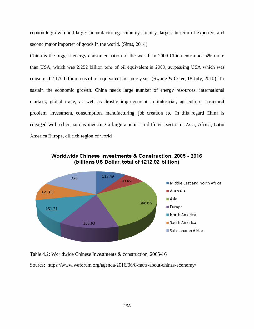
158
economic growth and largest manufacturing economy country, largest in term of exporters and
second major importer of goods in the world. (Sims, 2014)
China is the biggest energy consumer nation of the world. In 2009 China consumed 4% more
than USA, which was 2.252 billion tons of oil equivalent in 2009, surpassing USA which was
consumed 2.170 billion tons of oil equivalent in same year. (Swartz & Oster, 18 July, 2010). To
sustain the economic growth, China needs large number of energy resources, international
markets, global trade, as well as drastic improvement in industrial, agriculture, structural
problem, investment, consumption, manufacturing, job creation etc. In this regard China is
engaged with other nations investing a large amount in different sector in Asia, Africa, Latin
America Europe, oil rich region of world.
Table 4.2: Worldwide Chinese Investments & construction, 2005-16
Source: https://www.weforum.org/agenda/2016/06/8-facts-about-chinas-economy/

159
4.4 China’s Soft Power
In 1990s end of cold war after the collapsed of Communist bloc, United State of America
emerged as super power eliminating the bipolar system of world politics. In 21st century the
world power structure has changed. According many scholars of international politics the global
power projection rapidly is going to be transformed from unipolar to multipolar. Power has been
shifting from West to East. China is the world biggest populous county with estimated over 1.3
billion population. To play china it own role in global scenario, china protect it interest through
the Soft power policies. China , instead the use of mass destructions confrontation preferred to
promote peace and prosperity through trading, diplomacy, investment, infrastructure
development, construction rail and roads, foreign assistance. In addition the People Republic has
involved actively in regional and international organization, helped them providing financial
assistance, strengthening economic ties with other nations to secure its own national interest.
These strategies abetted to promote its influences globally. Now the role of China in global
politics has accepted. (Lum, Morrison, Vaughn, 2008, January 4)
China is the second largest country in the world in term of land area after Russia and has also the
maximum neighbors, borders with 14 countries. Under the Mao‘s administration, government
focused on State-owned enterprises (SOEs), which discouraged the direct foreign investments
and private enterprises resulting pitfalls in economy. From 1978 to 1990s, ―China Open Door‖
reforms and economic modernization helped to elevate the Foreign Direct Investment (FID) in
China. In 2010, according to a report, more than 445,244 foreign-invested enterprises (FIEs)
registered, created 55.2 million jobs. (Morrison, 2015)
On the other hand oversees investment by Chinese companies was strictly prohibited.
Nevertheless, Chinese government adopted a new strategy ―Go Global‖ in 2001, aimed to

160
encourage the Chinese Firms to finance oversees. Chinese outward direct investment has been
increased since 2000s. State own Enterprises (SOEs) and private owned enterprises (POEs) are
engaging to raise it ODI; generally in construction, petroleum, telecommunication, infrastructure,
shipping, energy and power sectors. Overseas direct investment of China has extensively
increased, last two decades. In 2003 the total size of ODI was less than 3 billion, increased it in
70 billion in 2011.Now china stood world third position of ODI and largest recipient of FDI.
(Brunjes, Levine,Palmer & Smith, 2013)
4.5 China in South Asian
South Asian consisted of Pakistan, India, Nepal, Bangladesh, Afghanistan, Maldives, Sri Lanka,
and Bhutan. One fourth of the world population (over 24%) lives in this region, estimated 1.749
billion. In 1985 an economic cooperation organization namely South Asian Association for
Regional Cooperation (SAARC) was establish to promote socio-economic and political
cooperation among these countries. The south Asian region is considered one of the potential but
least economic assimilated regions in the world. This region experienced poor living standard,
downtrodden economic system, weak institutional structure, in and outward conflict, border
tensions, arm races, poverty, terrorism, extremism and a state of contention among its neighbors.
World trade route by lands and maritime, cheap labors, consumer markets, wealth resources are
the key factors of South Asian nations which always attract the imperialist power. There are four
wars including numerous skirmishes could be observed between, India and Pakistan, the two
major countries of South Asian. These catastrophic situation brought South Asian‘s nations on
the edge of nuclear wars. ("South Asia Regional Overview" 2008)
China is neighbor of this region bordering with Pakistan, India, Afghanistan, Nepal and Bhutan
directly.. In Asia India another is economic emerging country countering China. China influence
161
in South Asian takes serious concern for Indian interest. China engagements with south Asian
states based on many fold. First consideration of China‘s interest in South Asia is about its
growing economy which needs energy and consumer markets. Second facet is thought Chinese
western region development. This region is least developed, and turmoil, prevailing the separatist
movement and fragmented ethnic clashes. China wants to overcome this situation while
eliminating imbalance developmental works in last three decades. For this purpose China has
been increased trade with its western borders especially with South Asian neighboring states.
Third assumption is due the Indian Ocean, China has great ambitious to prolong it influence in
South Asian regions because world major trade and economic activities are ensued in Indian
Ocean. In 2014 the trade between South Asian countries and China reached $105.56 billion.
(Singh, 2016)To understand the Chinese interests in South Asia, it is essential to look at a
succinct view on relations between China and south Asian states and its socio economic
projections which will be helpful to realize the imperative roles of Gilgit-Baltistan as an
economic corridor for Chinese‘s development.
4.5.1 China’s Relations with Afghanistan
Chin and afghan relations always remained since Soviet intervention. US led coalition attack on
Afghanistan and dismantle Taliban regime, and new government in Afghanistan took initiative to
promote relations with China. China has several strategic interests in Afghanistan. China western
region Xinjiang province borders with Afghanistan where Uighur Muslim militant groups have
been involved insurgency, separatist movement, destabilizing whole region for decades. To
combat religious extremism China need a stable and prospectus Afghanistan, which is
considered safe home for Separatist Jihadist. China bilateral and economic relation also
162
improved in recent years. China‘s commercial incentives have focused on natural resources.
(Small, 2014)
China is major economic supporter of Afghanistan. During 2001 to 2013, afghan received 1.5
billion Yuan (nearly $240million) aid from China. In 2014 it increased significantly upward $80
million. (Huasheng , 2015) A stable Afghanistan is guarantor to build up the western parts
China‘s One belt initiatives. China also keens interest in TAPI (Turkmenistan-Afghanistan-
Pakistan-India Gas-pipeline) which is started by UA to protect its interest in Asia. (Maini, 2015)
4.5.2 Sri Lanka: A swift change occurred in China and Sri Relations during President
Mahindra Rajapaksa in 2015. Sri Lankan government sought help from China to defeat Tamil
Separatist. China. To fight against Tamil Tigers China provided $ 37 million aid to Sri Lanka.
The 26-years civil war ended in 2009, the than China led main role to rebuild road,
infrastructure, and ports, home. Among these infrastructure development, Hamantota port and
port city project in Colombo are the major initiatives to boost up the Sri Lankan economy. Now
Sri Lanka ranked fourth in South Asia for Chinese strategic planning. Sri Lanka also has a
pivotal in China‗s Strings of Pearl. (Bhatia, 2016)
4.5.3 Bangladesh: The relationship has been growing between China and Bangladesh since
1974. Now Bangladesh stood up on third in trade partnership for china in South Asia. The trade
between Bangladesh and China increased from 1.1 billion dollars to 4 billion dollars during 2002
to 2008. In 2002, for construction bridges, road, infrastructures, military, China provided more
than 7.25 million financial aids to Bangladesh. Despite close geographical contiguity with India,
the government Look East policy, China now is largest importer for Bangladesh. (Bukhari &
Bakht, 2013)

163
4.5.4 Nepal: Nepal has vital position for Chinese strategic outlooks. Both countries shares
111.47 kilometer borders. Beijing has concerned over the Indians involvement in Nepal, because
it is gateway for Tibetan separatist to India. Tibat is key in Chinese‘s foreign policies toward
Nepal. A stable and prosperous Nepal is in favor in Chinese‘s interest, which will help to counter
the separatist movement because Nepal is largest home for Tibetan refugees , numbering around
22,000. By last two decades the bilateral trade increased significantly. From 2009-2010, trade
has risen from 11 percent to 19 percent between Nepal and China and have a total US$ 1.2
billion. (Lama, 2013)
4.5.5 China and Bhutan: the tiny Himalayan state surrounded between India and China.
Chinese involvement in Tibet and border conflict in 1966 nourished distresses in Bhutan‘s
authoritarian regime which brought Indian‘s interference in State, making peace and defense
treaties. To counter the Indian hegemony, China has been trying to develop bilateral relations
with Nepal, offering investment, resolving border issue. China-Bhutan solved the border
demarcation about 500 km since 1984 (Malik ,2001)
4.5.6 China and Maldives: The small island of India ocean got Independence from British and
launched diplomatic relations with China in 1972. Since then, cooperation has been enlarged in
the field of tourism, infrastructure, communication, business and technologies. In 2013, largest
number of Chinese tourist visited to Maldives. China futuristic approach of one belt policy these
initiatives deem a favorable stride to protect Chinese interest in Indian Ocean. (Bukhari & Bakht
, 2013)

164
4.5.7 China’s Relations with India
India is major dominated power of South Asia. It ranks world seventh largest by area and second
most populist country in the world. India also has fastest growing economy with a rate around 6
%. Indian‘s nominal GDP increased in recent years with $ 2.25 trillion year place graded seven
positions while stood third in term of Purchasing power parity (PPP) with $8.7 trillion. (Bajpai,
2016). These calculations have been made India as major power in the world. History tells that
both countries had relation from many centuries; however new diplomatic relations was started
during 1950s. Sino-Indian relations have experienced full hitches due to its border conflicts and
hegemonic yearning in the region. Territorial disputes between India and China remained hard
issues. India and China have been confronted three major military conflicts since 1960s, Sino-
Indian war 1962 in Ladakh region, the Chola Dispute in 1967 in Sikkim and the 1987 Skirmish.
Sino-Pak relations are another stake of disturbance between Sino-Indian relations. China do not
recognize legitimate authority over Arunachal Pradesh, Jammu and Kashmir, in responding India
also question on Tibet, South Chinese Seas. India claims ownership on Askachin, Tibet and
disputed border territories, blaming unlawful occupation by China, While China also blamce on
India inflicting the situation within its boundaries. India has great concern over Chinese
involvement in Gilgit-Baltistan, the region she claimed to be part of Jammu Kashmir, an integral
Part of India. To counter Chinese‘ ―String Pearl‖ in Indian Ocean, India inception the ―Iron
Curtail‖ which aim to restrain the Chinese influences. Despite of these border skirmishes and
antagonism, China and India have enabled to develop a strong bilateral and economic
cooperation. The volume of bilateral trade between China and India reached $73.9 billion in
2012. (IANS, 2012) The growing competition for economic and energy incentives among major
powers can be observed in this region. To secure it strategic interest, United State is increasing

165
relationship with India, enhancing nuclear and military agreements; these are considered a
counter strategy for Chinese Influence in the World. (Brunjes, Levine,Palmer & Smith, 2013)
4.5.8 The Pakistan-China relations
Sino-Pakistan relationship is labeled as ―deeper than the ocean, higher than the Himalaya and
sweeter than honey‖ this attractive metaphor extensively use in Pakistan. Pakistan was the first
Muslim and third non-communist country, recognized the People Republic of China than
established bilateral relations, and later on Sino-India war 1962 and Pak-Sino Border Agreement
1963 provided a stalwart foundation.
China always supported Pakistan in major confrontations with India in 1965, 1972, Kargial war
1999 or other border skirmishes and tension, on national and international level. Pakistan is china
second largest trade partnership in South Asia. In 2006, Pakistan China signed a free trade
agreement, after that the annual trade surged from $1.9 billion in 2002-2011 to $ 13 billion in
2013. China is assisting Pakistan in energy, power, rail highways, agriculture, ports, and defense
sectors. (Bukhari & Bakht , 2013)
India has emerged as economic power in South Asia. Its hegemonic attitudes and historical
antagonistic relations with China and Pakistan have further strengthened Pakistan and China‘s
friendships. To maintain a balance of power in South Asian region, China has assisted Pakistan‘s
conventional and non-conventional weapons, warfare arsenals, and military apparatus, since last
fifty years. Pakistan.(Curtis& Scissors, 2012). China needs more energy and resource to sustain
it economic growth. China‘s energy most depends on Middle East states. For this purpose China
launch One belt one road initiative to revival the old silk routes. China Pakistan economic
corridor CPEC) is an essential part of this great strategy to link China western region from
maritime through Gawader port. This will help China to boos up its economic activities and short

166
trade road for International market. To understand the Gilgit-Baltistan (GB) importance for
China it is vital to know how China secures its interest in Pakistan because Sino Pakistan trade
activities are happened through GB. Sino- Pakistan agreement 1963 was turning point to reshape
the bilateral relations which bestowed China to access Karakoram. India reserved about this
settlement because it thought that China illegally took large portion of Gilgit Baltistan region
into her administration. (Kumar, 2006)
4.6 Sino-Pak Boundary Agreement 1963
In 1963, Pakistan and China after a series of dialogues and discussions reached a boundary
Agreement. This agreement extended the boundary 325 miles from Afghan border to Karakorum
Pass near Siachen Glacier. This agreement had come into effect after the signatures of Chinese
foreign Minister Chen Yi and Pakistani Prime Minister Zulfiqar Ali Bhutto in 1963. This
agreement resulted to bring both states into a closed relationship since their Independence. In this
agreement China ceded over 1,942 square kilometers to Pakistan and Pakistan agreed the
sovereignty over Shasgham valley of Gilgit-Baltistan, near Karakorum Pass. The agreement is
controversial for India, protests on this agreement and never accepted this agreement but never
challenged the control of Pakistan control over Siachen areas. (BIR, 1968)
This Pakistan officially announced that Gilgit-Baltistan is part of Jammu Kashmir, as this treaty
showed that after the settlement of Kashmir issue both states will reopen negotiations on border
demarcation. Article 6 of this agreement declares;
“ The two Parties have agreed that after the settlement of the Kashmir dispute between Pakistan
and India, the sovereign authority concerned will reopen negotiations with the Government of
the People's Republic of China, on the boundary as described in Article Two of the present

167
Agreement, so as to sign a formal Boundary Treaty to replace the present agreement: Provided
that in the event of that sovereign authority being Pakistan, the provisions of this agreement and
the aforesaid Protocol shall be maintained in the formal Boundary Treaty to be signed between
the People’s Republic of China and Pakistan.” (Official Text: The Boundary Agreement between
China and Pakistan, 1963)
4.7 Shasgham Valley
Shasgham valley was discovered by famous British Indian army officer, explorer, Sir Francis
Young husband , the famous writer of “The Heart of a Continent (1896)‖, during his expedition
in Karakoram range. In a discussion ― The Problem of Shasgham Valley, he tells;
“When I reached Yarkand, in September 1887 I found a letter from Colonel Mark Bell (the head of
the Intelligence Department in India), who had preceded me by a month on the way from Peking
to India, recommending me to explore the direct route from Central Asia to India which led by the
Mustagh Pass into Baltistan and Kashmir. This route was formerly used by the natives; but nothing
was known about it. And it was while exploring this route that I discovered the Shasgham Valley. I
had to cross it on the way to the Mustagh Pass.” (Younghusband, 1926)
Figure: 4.1: Shasgham valley
Figure: Source: https://twitter.com/higgsbosan/status/653909367360782337

168
Shasgham Valley or Trans-Karakoram Tract is situated on the border of Pakistan and China. The
area ,around 5,800km2, transferred under Chinese administration after Sino-Pakistan Border
agreement in 1963 with the proviso of Kashmir dispute settlement, when Kashmir issue would
resolve , both agree renegotiate on border demarcation. According to local historian this region
was part of Shigar Raja (Royal Family) reign and through Muztag Pass they used to visit during
autumn to play polo match with Hotan rulers and travel to Yarkand for exchange goods by local
merchants. Around 5th
century AD, A polo ground Muztaghi Shagran (The polo-ground of ice-
peak) was established by Raja of Shigar on the South of Shaksgam valley. (Sering, 2013)
4.8 Wakhan Corridor
Wakhan corridor or Wakhan is situated in north-east of Afghanistan, bordering with China,
Tajikistan, and Pakistan. Wakhan corridor was pivotal for trade route of ancient Silk Road used
by European, Chinese to access Indian plain and the Indian Oceans but this 350Km long and 13-
65 kilometers wide strip has got strategic consideration since its political creation in 1893 during
the Great Game between Russian Cesar and British Empire, making a buffer zone between tow
imperialist powers.( Khan, 2015). In 1949, the Wakhjir Pass was blocked by the Chinese Leader
Mao Zedong, to prevent from the threats existing the western part of its border Wakhan shares a
300 Km long borders with Gilgit-Baltistan (Irshan Pass) and Chitral District of Pakistan in the
South, and in northeast it shares a 260 Km with Tajikistan and with 76 Km with China to its east.
This narrow strip has strategic value for Tajikistan, Pakistan, China and India. Tajikistan and
Central Asian Republic States (CARs), are landlocked countries, having enormous natural
resources, need safe access to International trade route, while India has much concerned over the
growing Chinese economic activities as well as to connect the Afghanistan and CARs, it is
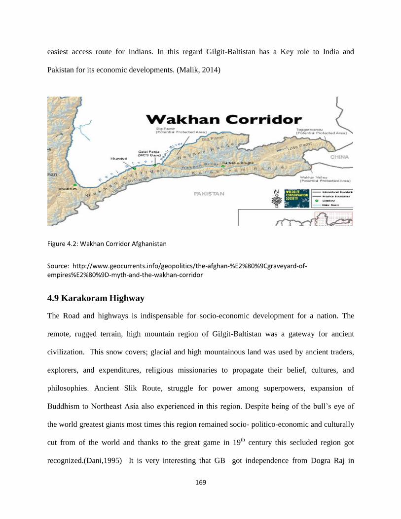
169
easiest access route for Indians. In this regard Gilgit-Baltistan has a Key role to India and
Pakistan for its economic developments. (Malik, 2014)
Figure 4.2: Wakhan Corridor Afghanistan
Source: http://www.geocurrents.info/geopolitics/the-afghan-%E2%80%9Cgraveyard-of-empires%E2%80%9D-myth-and-the-wakhan-corridor
4.9 Karakoram Highway
The Road and highways is indispensable for socio-economic development for a nation. The
remote, rugged terrain, high mountain region of Gilgit-Baltistan was a gateway for ancient
civilization. This snow covers; glacial and high mountainous land was used by ancient traders,
explorers, and expenditures, religious missionaries to propagate their belief, cultures, and
philosophies. Ancient Slik Route, struggle for power among superpowers, expansion of
Buddhism to Northeast Asia also experienced in this region. Despite being of the bull‘s eye of
the world greatest giants most times this region remained socio- politico-economic and culturally
cut from of the world and thanks to the great game in 19th
century this secluded region got
recognized.(Dani,1995) It is very interesting that GB got independence from Dogra Raj in
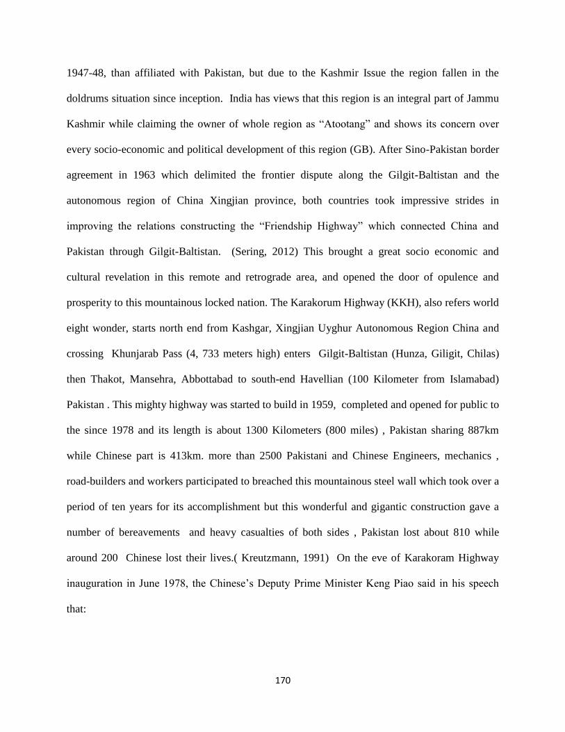
170
1947-48, than affiliated with Pakistan, but due to the Kashmir Issue the region fallen in the
doldrums situation since inception. India has views that this region is an integral part of Jammu
Kashmir while claiming the owner of whole region as ―Atootang‖ and shows its concern over
every socio-economic and political development of this region (GB). After Sino-Pakistan border
agreement in 1963 which delimited the frontier dispute along the Gilgit-Baltistan and the
autonomous region of China Xingjian province, both countries took impressive strides in
improving the relations constructing the ―Friendship Highway‖ which connected China and
Pakistan through Gilgit-Baltistan. (Sering, 2012) This brought a great socio economic and
cultural revelation in this remote and retrograde area, and opened the door of opulence and
prosperity to this mountainous locked nation. The Karakorum Highway (KKH), also refers world
eight wonder, starts north end from Kashgar, Xingjian Uyghur Autonomous Region China and
crossing Khunjarab Pass (4, 733 meters high) enters Gilgit-Baltistan (Hunza, Giligit, Chilas)
then Thakot, Mansehra, Abbottabad to south-end Havellian (100 Kilometer from Islamabad)
Pakistan . This mighty highway was started to build in 1959, completed and opened for public to
the since 1978 and its length is about 1300 Kilometers (800 miles) , Pakistan sharing 887km
while Chinese part is 413km. more than 2500 Pakistani and Chinese Engineers, mechanics ,
road-builders and workers participated to breached this mountainous steel wall which took over a
period of ten years for its accomplishment but this wonderful and gigantic construction gave a
number of bereavements and heavy casualties of both sides , Pakistan lost about 810 while
around 200 Chinese lost their lives.( Kreutzmann, 1991) On the eve of Karakoram Highway
inauguration in June 1978, the Chinese‘s Deputy Prime Minister Keng Piao said in his speech
that:

171
“It has always been our view that the presence in the South Asia sub-continent of a
strong Pakistan firmly adhering to a policy of independence is an important factor for
peace and stability in this region... Our Pakistani friends may rest assured that
whatever the vicissitudes on the international arena, the Chinese Government and
people will remain your reliable friends in your just struggle to build and defend your
country.” (Singh, 1981)
When the KKH construction started in 1960s , India showed strong protest accusing China of ―
Military expansionism‖ and Pakistan for ― Causing threat to the peace and tranquility of the
region. In june 1971 , Surendra Pal Singh Indian Deputy Minister for external affairs expressed
that the road possessed a serous‖ danger to peace ans security in the region‖. Earlier Indians had
viewed that this road had possessed a serious military and security threat to India and thought
any development of this region would led Chinse involment in its region. Indian Minister for
External Affairs , Dinesh Singh, expressed such an apprehension in Loc Sabha. He said:
“This road will help to extend the Chinese road network in the Tibet-Sinkiang
(Xiniang) area into Northern Kashmir. It will give easier access to Chinese troops
from the areas under the illegal occupation of China in North-East Kash- mir and
from Tibet into the Gilgit area in Pakistan-occu- pied Kashmir, which lies to the
north of the cease-fire line. The military significance of this road is, therefore,
self- evident.” (Singh, 1981)
For economic and commercial as well as security perspectives this road network facilitated to
raise the living standard of two far-flung and remote of region of China and Pakistan, it also
opened a new trading mart for countries. The Karakoram Highway provided China a short and
safe road to the Arabian Sea, Persian Gulf and African continents. It also helped to diminution
the turmoil situation in western province Xingjian. The linkage with China through KKH
facilitated Pakistan to protect its political, strategic and security interests and enabled to expend
its internal communication and transportation linkages to far-flung areas. It has been proved that
Central Asian Republics have a 236 trillion cubic feet gas reserves and 200 billion barrels oil

172
reserves and these landlocked countries need road and infrastructures to expand its economy.
Karakoram highway is safest and short route ready to serve for this purpose. (Sering, 2012)
4.10 Slik Road & Gateway for Buddhism
Human beings are developed interaction with each other to fulfill theirs necessities. For this
purpose trade, ideas, skills, goods were exchanged with theirs neighbors. With the passage of
time, this collaboration had expanded in a great extent and reached in its peak when human being
were enabled to discover the world, explored the natural entities, human civilization, new
territories, etc. The magnificent ancient Silk Road was an emblem of this interaction of human
history. This international oldest trade route was built during Han dynasty by the imperial
exploration and missionary envoy led by Ambassador Zhang Qian around 114 BC. These vast
networks used to carry goods, precious commodities, merchandise as well as exchanging ideas,
cultures, knowledge, beliefs, religions, philosophies, technologies and diseases among China
with different cultures of Eurasia, Roman and Persia, Arabia, Greek. ―Silk Road‖ this name was
given by famous German geographer Ferdinand Von Richthofen in 1877, represents a number of
ancient trade route connecting China with other civilization and Chinese Silk contained at a large
quantity of this trade. (UNESCO, n.d) The Karakoram and Himalayan mountain passes used by
Chinese envoys to interact with Indian civilization, and China also received Buddhism through
this route through Buddhist missionaries from Gandhara reached China crossing Karakoram
Mountains. Different archeological sites, inscription rocks, carving rocks, were discovered in
Gilgit-Baltistan which proved that Buddhism was not only part of this region but always served
as an significant role to intermingle different cultures. Due to different reason the significant of
Silk trade routes were declined in mid-15th
century but in 1960s construction of Karakoram

173
Highway between Pakistan and China also created a hope to survival the ancient Silk Route.
(Dani, 1995)
4.11 Turmoil in Xingjian Province
The Growing economic activities can be observed in Eastern Part of China while it far-flung
western part remained downtrodden sanctuaries in the mind of Chinese policy makers and the
negligent attitude promoted a separatist movement in this autonomous region. For centuries more
than 10 million Muslim Uighurs, an ethnically non-Han Turkic people are living in Xingjian, the
northwest province of China. Xingjian, the home of Muslim majority, has a great geo-strategic
position in China; it borders with Afghanistan, Pakistan (Gilgit-Baltistan), India, CARs and
Russia. It was the main gateway in old Slik road era. Since 1980s this province has been
presenting mayhem by the religious fundamentalism and separatist movements of Uighurs
Muslim as well as cradling the detrimental strategies of Chinese authorities. The Uighurs Muslim
follow the moderate form of Sunni Islam want to create an independent Islamic state ―East
Turkestan‖, rejecting the name and idea of Xingjian. (Curtis, 2016) In 1990s, the most prominent
and well organized group was formed with the name of ―The East Turkestan Islamic Movement
(ETIM)‖. To secure its ideology, this group has been involved attacking Chinese security
personals and apparatus. The rise of Taliban and Al-Qaedah in neighboring countries, Pakistan
and Afghanistan was created serious threat in this region. Chinese government has much concern
over the separatist relationships and influences with the global jihadist groups, which brought
extra vigilant of Chinese‘s authorities in this region. For combat separatist movement, China‘s
new regime shifted the policy to focus in this unprivileged area. (Boehm, 2009) Many
developmental projects including western Himalayan infrastructure plan, were started to provide
equal opportunities to bring back the separatist into mainstream of national integration. Singy

174
Hassan (2012) codes the Chinese‘s appraisal investment of $730 billion in the transport sector in
west China and $88 billion in Xingjian; this will help to counter the separatist.
4.12 One-Belt-One Road Initiative
One belt and road initiative is a new strategy for revival of the ancient Routes, started with new
economic and trade paradigms, looking new incentives, connecting China with Europe, Asia,
Africa through overland and marine ways. OBOR initiative comprises of two ambitious
developmental projects;
1. Silk Road Economic Belt (SREB)
2. 21st Century Maritime Silk Road (CMSR)
Chinese President Xi Jinping was announced The Silk Road Economic Belt on September 7,
2013 at Nazarbayev University Kazakhstan while The New Maritime Silk Road was unveiled on
October 3, 2013,before the Indonesian Parliament , during his state visit to Indonesia. China
wants to boost up its economic growth sharing, connecting world through roads, highways,
railway roads, develop a mutual trade and commerce activities. In March 2015 the Chinese
Ministry of Foreign Affairs and the Ministry of Commerce issued a paper ―Vision and Actions
on Jointly Building Silk Road Economic Belt and 21st Century
Maritime Silk Road‖ explains that:
―The Belt and Road run through the continents of Asia, Europe, and Africa,
connecting the vibrant East Asia economic circle at one end and developed
European economic circle at the other, and encompassing countries with huge
potential for economic development. The Silk Road Economic Belt focuses on
bringing together China, Central Asia, Russia and Europe (the Baltic); linking
China with the Persian Gulf and the Mediterranean Sea through Central Asia
and West Asia; and connecting China with Southeast Asia, South Asia and the
Indian Ocean. The 21st- Century Maritime Silk Road is designed to go from
China‘s coast to Europe through the South China Sea and the Indian Ocean in

175
one route, and from China‘s coast through the South China Sea to the South
Pacific in the other.‖ ( Swaine, 2015)
The Silk Road Economic Belt (SREB) is a vision to revive the old Silk Road connecting China
with Europe, Central Asia, and South Asia by land routes through corridors, roads, highways,
railways networks, airports, etc and this strategy basically consists of three corridors.
1. Norther Corridor: It starts from Bejing China through Mascow and Germany to Europe
2.Central Corridor: This road begins from Shanghai to Europe and Persian Gulf via Taskent,
Tehran, and Badar Imam Khomani Port of Iran
3. Southern Corridor: This corridor initiates from Guangzhou via Xingjian the Chinese
Autonomous western Region. From Khunjarab Pass it enters in Pakistan to reach port Gawadar
Port. These three corridors will pass through Xingjian province from its north, centre and south
directions.
Meanwhile the 21st Century Maritime Silk Road (CMSR) focus ports, coastal, littoral land,
marine ships, and connects China to Europe, Asia, Africa via marine route crossing South China
Sea, Pacific Ocean and Indian ocean. B & R strategies will cover more than 60 emerging
international markets and developing countries. One belt one Road plan is not mere road and
highway or ports; it includes a large of developmental projects including road , highway,
railways, ports, oil and gas lines, networking, Educational sectors, hospitals, airports, other
infrastructures as well as increase economic coordination, free trade zones, financial integration,
social, cultural and interactions.
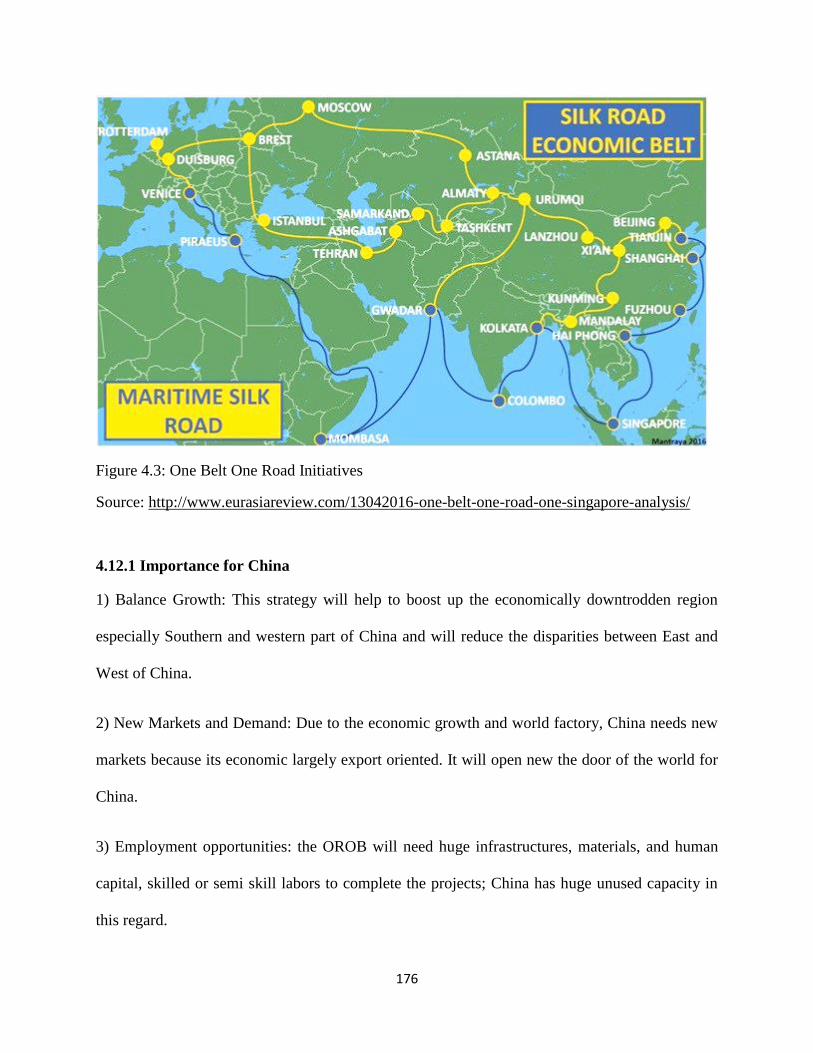
176
Figure 4.3: One Belt One Road Initiatives
Source: http://www.eurasiareview.com/13042016-one-belt-one-road-one-singapore-analysis/
4.12.1 Importance for China
1) Balance Growth: This strategy will help to boost up the economically downtrodden region
especially Southern and western part of China and will reduce the disparities between East and
West of China.
2) New Markets and Demand: Due to the economic growth and world factory, China needs new
markets because its economic largely export oriented. It will open new the door of the world for
China.
3) Employment opportunities: the OROB will need huge infrastructures, materials, and human
capital, skilled or semi skill labors to complete the projects; China has huge unused capacity in
this regard.

177
4) Soft power/Diplomacy: The R&B will provide diplomatic superiority to China that will help
to play its role as a super power.
5) Energy Security: To sustain the economic growth China requires a large amount of energy.
For this purpose R & B initiative will help to fulfill its requirements.
4.13 China-Pakistan Economic Corridor (CEPC)
Brunner (2013) defines ―Economic corridors connect economic agents along a defined
geography. They provide important connections between economic nodes or hubs that are
usually centered in urban landscapes." The China-Pakistan Economic Corridor is a significant
segment of China One Belt One Road strategic initiative. The CEPC links Kashgar, China‘s
Western Xingjian Uygar Autonomous Region, with Gawadar Port on Arabian Sea via road,
highways, railway, and pipelines. Gawadar Port is situated near Iranian Chahbahar port. China is
investing more than US $46 billon in this project which has potential to boost up bilateral trade,
economic, cultural interactions between two countries as well as it helps to improve regional
stability, harmony and connectivity. This corridor provides China direct access to deep warm
water port on the Arabian Sea, Middle East, Central and South Asia and beyond which is the
pivotal for China‘s strategic and economic ambitions in 21st century. This economic corridor
cross snow-caped highlands, narrow strip valleys, lush green fields, desert, dry hills while to
reach its destination it passes around 2,700Km long through the terrain of Pakistan. CPEC is not
just a route for container or transit points but it is a collective name for several developmental
ventures that enhance the regional cooperation among stakeholders. According to Pakistan
Government official website, the significance / potential of area of CPEC are included;

178
Regional Connectivity
o Transport Arrangement
o Energy Sectors
o Logistic Hub
o Commerce & Trade
o Peace & development of region
o Connectivity/Harmonization/Integration of civilizations
Educational linkage
Industrial Cooperation
Agricultural Cooperation
Tourism
Financial Cooperation
Health Care
Increase in livelihood opportunities
Human resource development
People to people contact
Enhance Security and stability of the region
Diverse Investment opportunities ―CPEC Potential‖(n.d.)
Figure 4.4: China-Pakistan Economic Corridor
Source: http://www.currentaffairspk.com/ China-Pakistan-Economic-Corridor.jpg

179
4.13.1 Tripartite Road Networks
CPEC is a multiple networks of roads connect not only Gawadar to Kashgar but also connect
major cities of Pakistan. In an interview Minister for Planning Ahsan Iqbal identified three major
routes within the CPEC;
i) Western Alignment: Kashgar – Khunjarab – Peshawar – Dera Ismail Khan – Zhob – Qilla
Saifullah –Queta – Gwadar.
ii) Center Alignment: Kashgar – Khunjerab – Peshawar – Kohat – Dera Ismail Khan – Dera
Gazi Khan – Sukkur – Ratodero – Gwadar, and
iii)Eastern Road: Kashgar – Khunjerab – Islamabad – Lahore- Multan – Sukkur – Hyderabad –
Karachi – Gwadar (Shahzad 2015).
4.13.2 Pakistani Interest
Economic Aspect
1). CPEC is a long term project that brings a positive impact on Pakistan economic dimension. It
will bring more than $46 billion investment which creates job and opportunities. The project will
complete in 2030 that will produce over 700000 new jobs in different sectors and 2 to 2.5
percentage points will add in Pakistan economic annual growth.( Khalid , 2016)
2).It will help to build the trust of foreign investment. Pakistan Foreign Direct Investment (FDI)
deeply declined from last few years. Law and order situation in Pakistan drastically affected on
foreign investors. In 2000 Pakistan received only $322 million from FDI, but in 2008 the volume
of FDI increased to $ 5.4 billion and in 2011 it dropped to $1.7 billion. (Yusuf,2013) Due to
CPEC, China plan to spend $ 46 billion foreign direct investment that is biggest FDI in the
history of Pakistan which can build up trust and confidence of foreign investors and it is also
good indication for Pakistan economic growth . (Rafi, Khan & Aslam, 2016)
3.) It will connect major cities and areas through road, highway, and railways. It will upsurge
the local industrial sector as well improve a nation-wide infrastructures which have been
declined last few years. A worth, approximately $11billion will be used for Infrastructure

180
development including 1,100 Kilometer long Lahore Karachi Motorway, Karakoram Highway
will be constructed and up graded.
4.) CPEC is a long term project that not only connects Pakistan with China and other regions
but also boost the economic condition of unprivileged provinces of Pakistan.
5). Relations with China is not based on just geopolitical interaction but it is a win-win model or
both countries. A huge investment aim to build a strong and prosperous neighbor brought closed
collaboration between Pakistan and China and CPEC is deepening its more steady and strong.
6). Energy: Energy crisis in Pakistan is lamentable since 2008 and mismanagement and weak
government policies swelled the wound and reached a massive shortfall over 4,500 MW. In this
project $35 billion out of $46 billion will be expended on the power and energy sectors of
Pakistan. It is expected that the energy crisis and shortfall will be overcome after the completing
the short term energy projects under egis of CPEC and in march 2018 Pakistan would be able to
generate 10,400 MW and after the accomplishment of all CPEC projects which is projected to
enhanced a total of 16,400 MW. (Rafi, Khan & Aslam, 2016)
7) Baluchistan is largest province by area, and has significance geo-strategic position and
resourced rich region in Pakistan. Most of the part of Balochistan is unprivileged which
nurtured distant, insurgency and security threat to national integration. Gawadar is Part of
Balochistan, and Pakistan China‘s new economic millennia encircles on this deep port. CPEC
will boost up the socio-economic development of Gawadar that will lead positive effects and
help the stability, peace and harmony Balochistan. China is investing a huge amount around $
793 million in Gawadar. According to Ministry of Planning these projects are included in
CPEC, Eastbay Expressway, Gawadar International Airport, Construction of Breakwaters,
Dredging of berthing area and channels, Infrastructure for Free Zone & EPZs port related
181
industries, Necessary Facilities of Fresh Water Treatment and Supply, Hospital at Gawadar ,
Technical and Vocational institute at Gawadar.
8). Pakistan needs financial aids to foster its economy. In history, most of the time Pakistan
economy is based on dependent or support by its coalition or International Monetary Fund
(IMF). Relations with China and CPEC are considered as a substitute for US aids because US
financial assistance perceived unreliable and untrustworthy in Pakistan. It is believed that US
aids are based on vested interest; whenever US interests have decreased it supports also dropped
down considerably. Compare to US, China is most trustworthy, all weather friends, of Pakistan
and she helped in every hardship and setbacks.
Political Aspect:
1). It can help to harmonize a strong relation among provinces as well as to improve state-center
interaction.
2). A successful complete implementation of the CPEC could improve the credibility and
capacities of the civilian government and such strength the process of democratic transition.
3). It can improve the image of Pakistan in international level as self-sufficient, prosperous and
peaceful nations. Since the 9/11 tragedy, Pakistan have been suffering from terrorism, religious
extremism and others security issues. These destructive impressions on Pakistan abridged the
country image on international level as ―terrorist producer‖ or ―beggar nation.‖ But these
projects will be a golden bird for Pakistan to stand up a new international positioning with self-
confidence.
4). It will helpful to play its own due roles on international level making independence and self-
reliant foreign policies, climbing on the bandwagon with China the potential new Superpower.
5). CPEC opens new opportunity of interaction for Pakistan with regional as well international
players. It links Afghanistan, Central Asian Republics (CARs) and resource rich Middle East
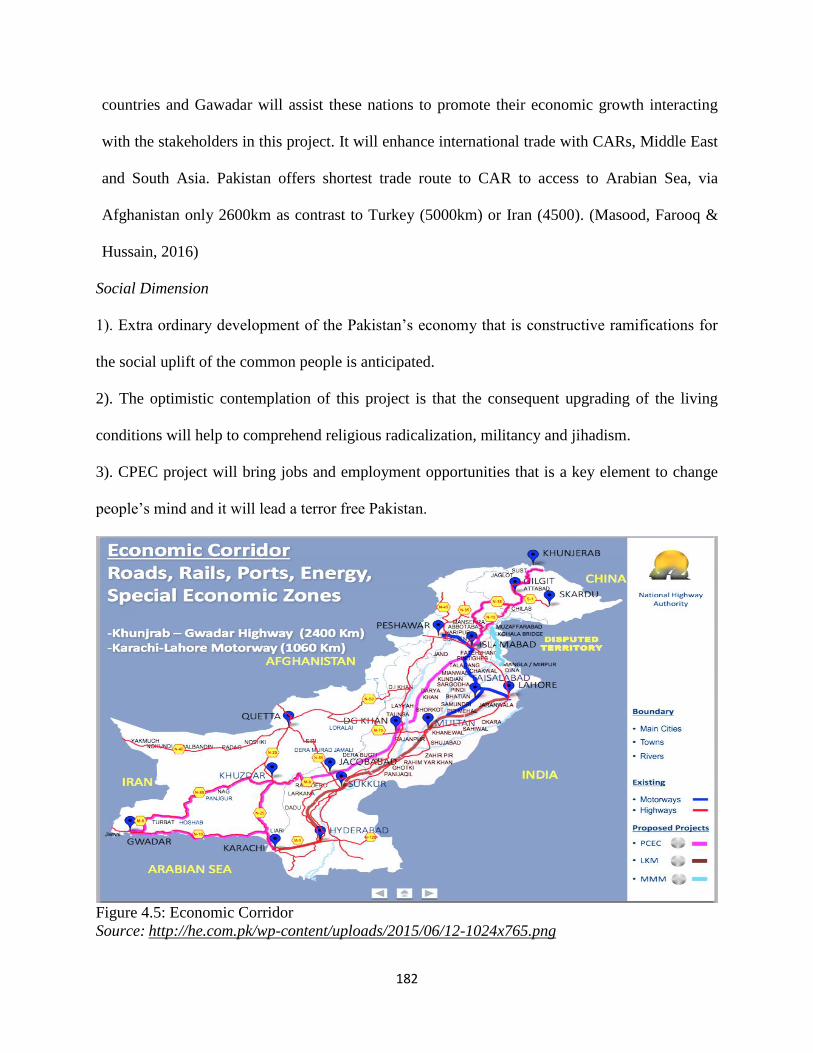
182
countries and Gawadar will assist these nations to promote their economic growth interacting
with the stakeholders in this project. It will enhance international trade with CARs, Middle East
and South Asia. Pakistan offers shortest trade route to CAR to access to Arabian Sea, via
Afghanistan only 2600km as contrast to Turkey (5000km) or Iran (4500). (Masood, Farooq &
Hussain, 2016)
Social Dimension
1). Extra ordinary development of the Pakistan‘s economy that is constructive ramifications for
the social uplift of the common people is anticipated.
2). The optimistic contemplation of this project is that the consequent upgrading of the living
conditions will help to comprehend religious radicalization, militancy and jihadism.
3). CPEC project will bring jobs and employment opportunities that is a key element to change
people‘s mind and it will lead a terror free Pakistan.
Figure 4.5: Economic Corridor
Source: http://he.com.pk/wp-content/uploads/2015/06/12-1024x765.png

183
4.13.3 Chinese Interest
Political Dimension
1). The CPEC would provide China with another access route to the Indian Ocean.
2). Distant factor. Chinese needs energy resources for its gigantic economic growth and to fulfill
the requirements China depend on Middle East and Gulf states. To reach Persian Gulf from
Western China ship oil takes about 45 days while viva Pakistan it reduces to 10 days. Gawadar
port minimizes the access China to International Market. The blow table is helpful to understand
that how it is beneficial for China to reduce the distance for trades.
Table 4.3: Saving in terms of Distances (Via Shanghai vs. Gawadar)
Source: (Masood, Farooq & Hussain, 2016)
The importance of CPEC for China can be understood from above table. From Central China to
Middle East, China is likely to save a distance of 7580 miles compare to over 10,000 miles to
reach Middle East from Western China. China will save money, fuels and times that certainly
will enlarge her trade and investments potential.
4.14 South China Sea and The Malacca factors
China, world second largest oil consumer and importer, is planning to expand it power all over
the world. One Belt one Road (OBOR) initiative is part of this power projection. Chinese export
and import mostly depends on western Chinese routes through South China Sea. It is estimated

184
that over 80 % of its oil and 30 percent of natural gas imports reach China viva Strait of Malacca
to South China Sea. China thinks that this international trade route has several menaces and
drawbacks. Long distance, South China sea Issue, Strait of Malacca, Indian rivalry, US
influences are those factors which Chinese policy makers ruminate peril to its economic
development. The blocked of Strait of Malacca will considerable impact on China‘s international
trades. China claims ownership on South China Sea while it neighbors Philippines, Malaysia,
Vietnam, Brunei, also want share in its but China declines their prerogatives deploying national
army on its islands and the Nine- Dash line area. This bone of contention has a possible conflict
in future if it would not resolve. CPEC will serve as an alternate route for China. (Rafi, Khan &
Aslam, 2016)
4.15 Development of Western China
After the revolutionary movement, and economic and agricultural reforms by Deng Xiaoping
were mainly focused on eastern part of China. Economic and infrastructural development was
due to its coastal admittance while the western parts of china are mainly landlocked and rocky
and dry terrain remained sparse population and underprivileged. The Heihe-Tengchong Line , an
imaginary line that divides China East and West territories , clearly shows that the west of the
line has 57% of the land and only 4 % Chinese population while in Southeast of this line the
total area is covered 36% but 96 % of the population living here. (Naughton, 2007) Despite the
economic growth the inequities of social, economic have been observed profound in these two
parts and this unbalanced economic growth enormous disparity between two parts instigated
many problem especially in Xingjian province, an autonomous region and home of largest
Muslim Uyghurs western China, where separatist movement created turmoil and threat to
national integration of China. Xingjian has historical and strategic significance. It is home of

185
many ethnic minority groups, as well as it serves an ancient trade route between China with
Central Asia , South Asia , Middle East, Europe, and it borders eight countries. To eliminate
inequities and balance economic growth Chinese premier Zhu Rongji introduced a new western
development strategy in 1999-2000. The aims of this strategy were to develop transport,
hydropower plants, telecommunications, energy, economic zone, direct foreign investment,
building infrastructures, environment protection etc. (Lai, 2002)Chinese government wanted to
bring transformation through infrastructure in central and western parts. These strategies further
gained importance when Chinese administration announced One Belt one Road initiative in
2013. CPEC is part of this transformation of economic disparity in western region that is
imperative for national integration for China as well as its economic balance growth. Xingjian
borders with Gilgit-Baltistan and CPEC links Xingjian to Persian Gulf and other region. As an
alternate of Strait of Malacca, this old silk route has extended essential for Chinese‘s strategist.
CPEC will contribute in Chinese western development strategy that will supportive to reduce the
ethnic strain and suppress the separatist movement.
4.15.1 Indian Concern
The friendship between China and Pakistan boost up after the agreement of CPEC project in
2013. Pakistani policy makers consider that this project is game changer for Pakistan. A number
of developmental projects and more than $46 billion Chinese direct investment in Pakistan
increased its international role. India has concerned over this project and ruminates as it is part of
Chinese String of Pearls strategy. (Sohail,n.d.). CPEC connects Gawadar to Kashgar passes
through Gilgit-Baltistan; the region India claims as to be part of Jammu & Kashmir and has
expressed its reservation about the project. To counter Pakistan-China nexus Indian strategists
are pondering different optional to minus GB asserting ownership of this region on international

186
level. On the other hand analysts look Indian‘s huge investments in Iran and Afghanistan as a
containment policy to Chinese influence in South Asia. (Arif, 2016)
4.16 Gilgit-Baltistan Relation with China
In ancient era, there were historical, trade, geographical, and social relation between the people
of Baltistan and Yarkand through Karakorum Pass. People used to this la (Pass) to enter each
other side. This route was used in fourteen century by Iranian preachers to come Baltistan. These
famous Iranian preachers were included Hazrat Ameer Kabeer Syed Ali Himdani (Shah
Hamdan),Syed Muhammad Noor Bukhsh , Syed Ali Tosi and Syed Nasir Tosi ,whom efforts
brought Islam in Baltistan. (Zakir, 1991, pp. 39-42)
The local people of Saltoro called ―Raga Naq poing‖ in Balti which is meant the People of
China. The figures, habits, mode of life, of local Saltoro inhabitants are same like the people of
Yarkand. Before the raised the Glaciers, there were many routes to access from Baltistan to
Yarkand, Turkistan (China). These routes were Kondus Glacier, Sia La, Siachen Glacier,
Muztagh pass, Turkistan La etc. But passage of time these Las (Passes) close due to the raised of
Glaciers. (Zakir, 1991, p.41) A Pakistani famous historian Salman Rashid (The Apricot Road to
Yarkand) tells about the travel expedition of ‗Godfrey Thomas Vigne -who took a circuitous
route through India and up into Baltistan late in the summer of 1835- in his book and presented
the cause of the closure of the Muztagh Pass in his book Travel in Kashmir.
―The path down the Muztag is one of the best ways to Yarkand, and was formerly
much used by saudagars, or merchants, in their journeys to and from Kashmir.
There were several stories afloat of the reason why it is never, I believe, used by
merchants at present. One of the most current is that they were plundered by the
[Baltis] in times past; and another says, that they took flight in consequence of a

187
Yarkandi merchant finding , upon his arrival in that city, that the gold in his box
must have been taken out and replaced by silver during his stay at Shighur.‖
(Rashid, 2011, pp. 18-19)
4.17 Gilgit-Baltistan: An Indian’s Perspective
India, very important country of south Asia, is the seventh largest country by area and second
largest populous country of the world after China. India has multi-cultural tradition as well old
oldest civilization and home of multi-religious diversity of the world. India borders with
Pakistan, China, Bangladesh, Nepal, Bhutan, Myanmar, Arabian Sea, Indian Ocean, Bengal gulf.
India has a unique history, and became most influential nation in the world. Indian‘s economy is
considered world fastest economy and became world leading nation in the world. In history
Indian‘s economy always have been stayed stable especially during Mughal Empire in 17th
century India had world second largest economy and was estimated at about 24% world
economy but after the British invasion its economic share to world income drastically fell down
from 22.6% in 18th
century to 3.8% in 1952. (Sing, 2005.July 10). In 1980s Indian economic
growth rate was recorded very low around 3.5% (Pakistan economic growth at that time was 5%)
but in 1991 the market based economic liberation announced by central government which
injected its stagnated economy to a highest and fastest economy of the world, in 2006 the GDP
growth rate reached its peak around 9.6 %. Now India, according to US President Obama ―India
is not emerging; India has emerged.‖ (Khambatta, 2013) Today in Asia, China and India are
considered the rising states and stakeholders for power, worlds market and investments
opportunities. Both countries are leading world highest energy consumers and depend on it for
Middle East and central Asian states. Sino-India has been confronted three major conflicts since
1962 on border disputes and competition for power has instigated this disagreement broaden.

188
which For sustained economic development needs new worlds markets, routes, advanced
technologies, infrastructure , trade partnerships etc. Gilgit-Baltistan is reflected as a bridge for
both nations including Pakistan to preserve its national interest. This region is very important for
India for its economic development as well as to counter the China-Pakistan nexus because this
region provides shortest route for India to reach Afghanistan and CARs. As India claims the
ownership of the region annexing it‘s as part of disputed region of Kashmir. To understand the
Indian ambition it is vital to study the wars fought by Pakistan and India in this region.
4.18 Indian’s Claim of Ownership of the Region
In the result of sub-continent in 1947, this northern region of British India split into many
fragments and raised a new frontier between new Independent of Pakistan and India. Since its
partition the people of this region are waiting its fate. India asserts over this region as right to
rule and considers the Pakistan administration in this region is illegal. Indian‘s entitlement over
this strategic area is based on her old stance on Kashmir issue. Therefore, it is important to
illuminate the connection of this region with Kashmir and its subsequent dispute between
Pakistan and India.
4.19 Gilgit-Baltistan connection with Kashmir
In ancient history, the hilly region, Gilgit-Baltistan was controlled by invaders of Central Asian,
Indian and Chinese empires. During 7th
and eight centuries the region went under the reign of
local dynasties. Gilgit-Baltistan , like ancient greeck city state, was divided into Several states
ruled by succession of various local Rajas , Mirs, Khan etc. According to Dr. Ahmad Hassan
Dani (2007),the famous ruling families were following;
189
1). Tarakhans of Gilgit
(2).Maghlots of Nagar
(3) Ayasho of Hunza
(4) Burshai of Punyal
(5) Kator family of Chitral
(6) Khushwaqat family of Yasin and Mastuj.
(7)Maqpoons of Skardu
(8) Amachas of Shigar
(9) Yabgos of Khaplu
(10) Rajas of Roundu, Astor, Kartakhsha and Tolti
In mid-19th
century these regional states were presenting a political turmoil situation due to
constant warfare for power, wealth and prestige, rebellion movements, quarrel over successions
which were made them paralyzed and many states broken away and political instability
weakened the whole region. The conditions went worse when the British, Sihks, and Dogras
started to set about expanding their empire in 1840s in this region.Due to their divergence, they
not only lost their prestige and kingdom but also whole region fell under the control of foreign
invasion.
4.20 Dogra Raj in Gilgit-Baltistan
In 1820 the Maharaja of Lahore Darbar, Ranjeet Sing rewarded his brave soldier Gulab Sing the
ruler of Jammu and made him Raja of Jammu. Gulab Sing was belonging to a Hindu family of
Jammu or Dogra. He set up a large army to expend his reign while serving Ranjeet Sing. In
1830s, conquering the Buddhist majority Kingdom of Himalayan region, under his notable army
general Zorawar Sing, he reached Tibet and he annexed Muslim majority of Baltistan in 1841.
Baltistan went under the rule of Dogra due to the internecine over successor between Ruler of
Skardu Raja Ahmad Shah and his youngest son Muhammad Shah. Muhammad Shah went

190
Jammu and sought help for his legacy and ascendancy from Gulab Sing. At the same time Gilgit
and adjoin sovereignties were subjugated by Sikh the ruler of Lahore Darbaar. In 1842 at the
request of karim Khan , the brother of Raja Shah Sikandar of Gilgit ,the ruler of Kashmir sent a
strong contingent of army led by Colonel Nathu Shah entered Gilgit and defeated Gour Rahman
of Yasim and established their rules in Gilgit . In 1852 the rebellion attack under Gour Rahman
command on Dogra forts at Gilgit Killed Dogra soldiers and Gilgit slipped out of Kashmir‗ s
governor. But in 1860 under the Maharaja Ranbeer Sing Gilgit once again went under the control
of Sikh kingdom of Lahore. (Madhok, 1992)
4.21 Treat of Lahore and Treat of Amritsar 1846
The first Anglo-Sikh war began in 1845 in which Sikh army were defeated. On 9 March 1846
with the effort of Gulab Sing ―Treaty of Lahore‖ was singed between Lahore Darbar and British.
According to this treaty, Lahore Dar was to pay 15 Lakh pounds and to relinquish the area
between the Sutlej and Beas to the British as indemnity of war. On 16 March 1846, after seven
days of Lahore treaty another agreement was signed by Raja of Jammu Gulab Sing and British
‗Treaty of Amritsar‘ through which the British sold beautiful vale Kashmir and contiguous areas
to Gulab Sing in 75 Lakhs rupees in cash and accepted his independent sovereignty over all
districts and territories in the hills. At the time of these agreements, Baltistan was already control
of Dogra of Jammu while Gilgit region and Kashmir valley was under the control of Sikh rulers.
The ―Gazetteer of Kashmir and Ladakh together with routes in the territories of the Maharaja of
Jammu and Kashmir‖ explains that
―When the Treaties of 1846 were made, Gulab Singh held, as Raja of Jammu, the hill
chief ship around Jammu in a more or less complete state subjection, and Ladakh and
191
Baltistan by right of conquest, and Gilgit had become an appendage of the Sikh
Governorship of the treaty of Amritsar was to confirm Gulab Singh in what he
already possessed, and to transfer to him the province of Kashmir with its newly
acquired authority over Gilgit.‖
4.22 Lease of Gilgit 1935
The British transmitted power and control of region to Dogra in 1846. But continuing expansion
of Czarist Russia, British made Gilgit as its based to curtail the Russian‘s invasion in this
northern frontier. In 1889 the Gilgit Agency was restored under Captain A. Durand as the Agent
of British India. Latter Gilgit Scout was established to topple the local rebellion and protection of
administration. When Soviet activates in Central Asia and their relations with Chinese regimes
in Xingjian developed, the fears of British had increased. , thus, they used these circumstances to
build up pressure on Maharaja Hari Singh to accept their de-jour administration over Gilgit
agency. For this purpose , on 26 March 1935,an agreement of a lease for 60 years was signed by
Colonel Lang, the Resident of British in Kashmir and the Maharaja of Kashmir, gave the civil
and military authority of Gilgit Agency to British, subject to the condition that this region would
continue under the dominion of Maharaja of Jammu and Kashmir. The lease terminated in 1947
during partition of India and the British returned the administration of Gilgit agency to Maharaja.
But the uprising of freedom movement against Dogras in 1947-48 by local people under Gilgit-
Scout, Maharaja of Jammu and Kashmir lost it authority over Gilgit and Baltistan and later the
Local rulers affiliated this region with Pakistan. (Warikoo, 2014)

192
4.22 Gilgit Baltistan: Nearest Routs for Central Asian States
4.22.1 India-Afghan Relation
After the US invasion in Afghanistan 2001, Indian roles in Afghanistan have increased. In 2011,
Hamid Karzai the Afghan President visited to India and singed a Strategic Partnership
Agreement (SPA) which strengthens the relations between two countries. Now both countries
have developed its strategic, security economic ties. For Afghanistan India is a strategic, world
growing economy, most favorite nation which can be helpful to revival for war shattered its
economy and to prevent the Islamist Taliban government is interest in both states. For India,
Afghanistan is vital for its national interest as well as its rich natural resources offers plenty
opportunities for its economic development. Afghanistan is also a gateway for central Asia. For
its strategic interest protection India is helping in different sectors especially infrastructure road,
dams in Afghanistan. Chabahar Port and the Zaranj-Dehlaram Road are the example of Indian
strategy to counter the Pakistan as well as its futuristic approach of it power projection. But for
India to secure its strategic partnership depends on third nations because there are no routes or
borders to direct access to Afghanistan. (Moradian, 2015)
4.22.2 Central Asian & India
Central Asian Republics (CARs) consist of Tajikistan, Kyrgyzstan, Kazakhstan, Turkmenistan
and Uzbekistan, formally was under ruled of USSR, and got independence after the
disintegration of USSR in 1991. All these states are landlocked and have a very unique
geopolitical position, and situated at the junction of Europe and Asia. This area is blessed plenty
of natural resources especially oil and gas, uranium, hydrocarbon fields, untapped mineral
deposits. A study shows Kazakhstan grips ―65 years of oil reserves and 308 years of coal
reserves‖ while Turkmenistan‘s national gas reveres is for 223 years. Tajikstan and Kyrgyz are

193
mountainous regions have great potential for hydro-power generation. (Fadi, Claire & Marina,
2011) Strategically position, abundant national resources, energy potential, largest arable lands
for agriculture, highly literacy rates, highest FDI are some of key factors which could be enticed
the worlds growing economic powers to enhance their national interest in this region.
The relations between India and Central Asian countries could be traced with the ancient silk
routes. The ancient Slik routes has been connected India with Central Asia till 15th
Century when
the sea route discovered by European to reach India. (Sajjanhar, 2016) The fastest economic
growth of India demands energy security, for this purpose India is focusing on CARs as an
alternate energy hub reducing dependence on Middle East. These countries have enormous
natural resources and projected to be home for world‘s 4% natural gas reserves, and about 3 % of
oil reserves. (Campbell, 2013)
4.23 Gilgit-Baltistan: Gateway for Afghanistan and CARs
India geo-strategic and economic interest in Afghanistan and Central Asian states have reshaped
in recent decades. The geo-political position of world scenario has been rapidly changing since
9/11 tragedy. China and India‘s rising as an economic giant‘s transformed world into multi-polar
characteristic. The geographical position of Pakistan is a great disadvantage for India to secure
its national interest in Central Asia. Pakistan is hindrance direct access to Afghanistan.
Afghanistan and CARs are landlocked countries, mostly depends on third one for their economic
activities. Same course for India, it depends either Iran or Pakistan to access central Asia. The
relations between Pakistan and India have been remained hostile since their independence. Sino-
India war in 1962 on border issue brought Pakistan and China proximity that undermined the
strategic interest of India in Gilgit-Baltistan. In history many Central Asian or western Asian
invasions and influences took place in India through this region. The Sino-Pak nexus and China
194
unabating diplomatic, logistic, military, financial and physical assistants to Pakistan has made
the situation more deteriorating for Indian security point of views because it facilitated Pakistan
to firm its grip over Gilgit-Baltistan the strategic northern frontier. As this strategic frontline
remained a meeting place during 19th
century in the shadow of the Great Game between British
and Russia. During Dogra Raj , British policy makers took special consideration on this region
and used the topography of this highland for its strategic motivation with monitoring the Russian
movements in Central Asia and the adjoining areas; Pamir, Wakhan and Xingjian region. For
this purpose British took control for 60 years leased of Gilgit-Baltistan from Dogra Raj. The
British influxes in this region had extended its strategic position as E.E. Knight (1905) mentioned
the importance of Gilgit in his famous book ‘Where Three Empires Meet’ that
―…the value of Gilgit to the Kashmir State, commanding as it does the Indus Valley
and the mouth of the Hunza River, and so holding in check the unruly tribes in either
side. Gilgit, the northernmost outpost of the Indian Empire covers all the passes over
the Hindoo Koosh, from the easternmost one —the Shimshal, to those at the head of
the Yasin River. Possession of the Gilgit valley affords a direct communication
through Kashmir territory to the protected state of Chitral‖.
Being a central part of the old caravan routes networking that were connected ancient Slik Route,
this mountainous frontier played as an important India‘s gateway to Central Asia. During 19th
and early 20th century this area was the centre for regional domination among three great
empires; China, Russia and Great Britain and Indo-Central relations were influenced by this
competition.
The policy of Dogra rulers in this strategic frontier gave them opportunities to develop direct and
friendly relations with the chieftains of neighboring central Asians states as well as the effective
control over this frontier kept them aware with the changing events in the neighboring. The
widely divergent of Indo-Central Asian overland trade observed from time to time because of the
great game and political the changing political situation in this area. The trade value between
195
Central Asia and India reached its height during 1920-21, but this flow could not maintain due to
the communist regime‘s annexation of Xinjiang and closed the trade routes. Subsequent events
such as people movement against Dogras, affiliation with Pakistan, and Sino-Pakistan diplomatic
relations made the Indo-Central Asian connection impassible. So the government of India and
the Prime Minister Jawaharlal Nehru were aware the geo-political position of Gilgit-Baltistan as
only India‘s overland corridor to Central Asia. On 20th
August 1948, the first Indian prime
minister Nehru wrote a letter to United Nation Commission for India and Pakistan, which had
authority to ceasefire covenant, proclaiming the ownership of Kashmir over Gilgit-Baltistan, He
wrote:
―The authority of Govt. of J&K over the sparsely populated and mountainous region
of the J&K State has not been challenged or disturbed, except by roving bands of
hostiles or in some places like Skardu. The Commission resolution, as you agreed in
the course of our interview on the 18th, does not deal with the problem of
administration or defense in this large area. We desire that, after Pakistan troops and
irregulars have withdrawn from the territory, the responsibility for the administration
of the evacuated areas should revert to the Government of Jammu and Kashmir and
that for defense to us. We must be free to maintain garrisons at selected points in this
area for the dual purpose of preventing the incursion of tribesmen, who obey no
authority and to guard the main trade routes from the state into Central Asia.‖
(Report of UNCIP, 1948)
4.24 Kashmir Dispute
Kashmir is located in the extreme North-West corner of South Asian Sub-continent. Its location
makes it important as it is located between Central Asia and South Asia. Kashmir has shared
borders with India, Pakistan, Afghanistan and China. The total area of the Kashmir valley is
53,452 square Kilometer divided between Pakistan and India according to the Shimla agreement

196
(1972) leaved an area of 21,106 square Kilometer in the North and West to Pakistan and the rest
33,346 sq.km is under Indian control.
At the time of partition 1947, the State of Jammu and Kashmir consisted on five districts/region;
the value of Kashmir, Ladakh, Baltistan, Poonch, Gilgit and Jammu. After the Kashmir war
1947-48 India possessed control over Jammu, Mirpur, Poonch, Ladakh and the Valley of
Kashmir while Pakistan have Western Poonch, Muzaffrabad, and a part of Mirpur, Baltistan and
Gilgit. Kashmir dispute is major source of bone of contention between Pakistan and India since
their partition. Due to the Kashmir issue, the relationships and peace negotiated process have
never been come successive. This dispute is linked the great partition of subcontinent in 1947,
which left it unresolved and fuel of hostility and violence between two antagonist states.
Kashmir the nuclear flashpoint has potential to create security threat in south Asia. Both nations
have meet three full-fledged wars (1948, 1965, and 1971) against each other‘s and ample serious
border skirmishes. Maharaja Hari Singh was the ruler of former princely states of Jammu and
Kashmir during the great division of British India. Albeit, he was a Hindu ruler, the majority of
populations were belonging to Muslims sects. According to the 1941 census, Muslims were
encompassed 3,100,000 and Hindus 809,000 of the total population of 4,021,616. (Rizvi, 1993,
p. 45)
With the departure of British from India, many questions were raised over the destiny of the
princely states. These ambiguities had gained more serious when the last Viceroy of British
India, Lord Mountbatten, gave authorities to the rulers of formerly autonomous princely states to
join either Pakistan or India or remain autonomous statues. Joining formula of the princely states
with Pakistan or with India should be considered the criteria presented Lord Mountbatten
himself. He said, ―Normally geographical situation and communal interests and so forth will be

197
factors to be considered.‖ (Hajni, 2011) About 530 princely states were to be joined either with
India or Pakistan. The rulers of three princely states –Junagarh, Hyderabad, and Jodhpur –
wished to accede to Pakistan, but rejected by India clamming to be geographical contiguity and
Hindu majority states because the majority populations of these princely states were Hindus. On
the one hand Indian claims over majoritism formula of population or religious factors, but on the
other hand India refused to accept this principal in Kashmir dispute. Because majority of
populations of Kashmir were belong to Muslim and they also rejected the Indian occupation. The
Radcliffe Award, according to Shereen Ilahi, gerrymanders the boundary to India more benefits
providing routes to Kashmir. (Ilahi, 2003, p.77)The whole issue of Kashmir dispute revolves
around the ‗Chairman of Boundary Commission‘, Sir Cyril Radcliff. The Secretary of Sir Cyril
Radcliff, named Christopher Beaumont alleged, on 1992, in London that Radcliff Award was
changed under the high pressure of Lord Mountbatten. District Gurdaspur, was cut of from the
territory of Pakistan and awarded to India with out any reason. Geographically this district linked
Kashmir to Pakistan. This district was the part of Pakistan according to its contiguity, and
majority of Muslim population, according to 3rd June plan. Nehru-Batten collaboration made it,
the part of India.
Geographical contiguity and religious attachments with Pakistan, Kashmir was to be joined with
Pakistan irrespective of the wishes of their ruler. But the Hindu Maharaja Hari Singh was not
favor in Pakistan, acceded to India on 26 October 1947. This unacceptable accession brought a
state of conflict and revolt in Kashmir. The accession Kashmir to India, the rebellion movement
against adjustment, Tribal lashkars invasion from NWFP, and the Indio-Pakistan war in the same
year, changed the geography of Kashmir. Kashmir was divided into two parts, resulted by these
calamitous events, Indian Administrative Kashmir (IAK) and Pakistan Administrative Kashmir

198
(PAK).Line of Control (LoC) established between two disputed parts of Kashmir in July 1971
Shimla Accord (replacing the 1949 Cease-fire-Line). Despite the Tashkent and Shimla
agreements, their acceptance and of Kashmir issue as a core dispute that need to be solved
through bilateral negotiation, the issue is still remained an unfinished business of Partition and
has possible potential to nuclear flashpoint in South Asia.
4.25 Siachen Issue
―Sia‖ is called a wild rose in Balti language. This hard stem plant generally finds more than
8000 feet high places. The color of this flower is white, yellow and rosy colors. ―Sia‖ in Balti
language refers a wild flower (rose) and ―Chun‖ means abundance or plenty or density. Siachen
glacier was ‗no man-land‘ before 1984. The issue linked with Kashmir issue. When Pakistan and
India armies agreed a Cease Fire Line ( CFL) Agreement in 1949 commonly known as Karachi
Agreement , both state drowned a de facto line between Indian Occupied Kashmir( IOK) and
Pakistani Administrative Kashmir( PaK) under the supervision of UN delegation , this no man-
land areas ( Siachen Glacier) had left without demarcation at a point , known as NJ9842 –
situated in Shoyk – up to Chinese border. The area of above NJ9842 up to Chinese border had
also left unmarked in Tashqand Agreement (1966) and Simla Agreement (1972). Two reasons
commonly said to leave this region unmarked, first, this area was no-man land and there was no
military based or conflict during Pakistan and India ‗wars 1965, 1971. Pakistan and China had
reached a border agreement in 1963 after a series of discussions and dialogues. Both countries
solved their border disputes. This agreement never accepted India. During 1970s many
international mountaineering expedition groups‘ conquered Siachen glacier and adjacent peaks
with the permission of Pakistan government. The above mention factors led a conflict in 1984
when India launched a military operation named ‗Operation Maghdoot‘. Zakir, 1991, p75)

199
Figure 4.6: Siachen Glacier Areas
Source: Google image of Siachen Glacier Area: www.google.com/siachen/images/
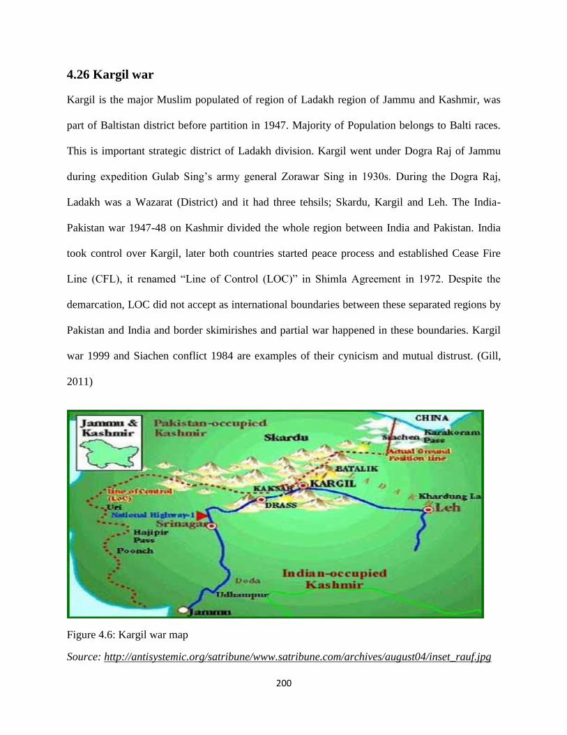
200
4.26 Kargil war
Kargil is the major Muslim populated of region of Ladakh region of Jammu and Kashmir, was
part of Baltistan district before partition in 1947. Majority of Population belongs to Balti races.
This is important strategic district of Ladakh division. Kargil went under Dogra Raj of Jammu
during expedition Gulab Sing‘s army general Zorawar Sing in 1930s. During the Dogra Raj,
Ladakh was a Wazarat (District) and it had three tehsils; Skardu, Kargil and Leh. The India-
Pakistan war 1947-48 on Kashmir divided the whole region between India and Pakistan. India
took control over Kargil, later both countries started peace process and established Cease Fire
Line (CFL), it renamed ―Line of Control (LOC)‖ in Shimla Agreement in 1972. Despite the
demarcation, LOC did not accept as international boundaries between these separated regions by
Pakistan and India and border skimirishes and partial war happened in these boundaries. Kargil
war 1999 and Siachen conflict 1984 are examples of their cynicism and mutual distrust. (Gill,
2011)
Figure 4.6: Kargil war map
Source: http://antisystemic.org/satribune/www.satribune.com/archives/august04/inset_rauf.jpg
201
4.27 Kargil Road
Kargil is located between Srinagar: headquarter of Jammu and Kashmir and Leh: the capital of
Ladakh region. The northern face of Kargil, Baltistan is situated and there is only 173km of
distance from Skardu to Kargil. Leh is an important strategic town because it serves as a strategic
base for logistic supplies to Indian army stationed and operating in Siachen. The Kargil conflict
was started in 1999, when Pakistan force infiltrated LOC and captured the essential sectors of
Kargil town and its adjacent areas. Behind this operation, many analysis believed, that there
were many strategic motives of Pakistan army. Siachen the no man land was taken by Indian
army in 1984 after operation Maghdood, so Pakistan army wanted to oust the Indian army from
Siachen and highlighted the Kashmir dispute in the world. Pakistan army and Mujahedeen
penetrated almost 10 KM into the territories of Indian side taking the vacant posts of Indian
soldiers. It gave Pakistani forces a strong position to cut off the supplies to Indian forces in
Siachen because it covered the routes including the Indian National Highway (NH 1) and passes.
(Cheema, 2013). The Srinagar – Leh road is an important connectivity that passes Srinagar to
the Zojila pass and further Siachen at it northern end. The Indian army uses this route for
movement and commodities for Siachen and other sectors along of LOC. In May 1999 Pakistan
army infiltrate in Kargil and blocked this vital road for all traffic and transportation. (Mazari,
1999:34-36). This blockade of road instigated Indian army and made furious the Indian nation.
India started operations to regain the Indian position. India used international community to
pressurize on Pakistan to withdrawal from the position as well as started ―Operation Vijay‖ ,
launching air strikes against Pakistan army and intrusion . In July, 1999 Pakistan civil
government announced to pull out Pakistan army from Kargil .(Nayyer, 2003). The Pakistan
army plan failed due to lack of logistic supports to army and diplomatic weakness due to Civil-
202
Military strife on this issue. Skardu the capital of Baltistan and its contiguous areas were also
affected by this crisis in Pakistani side. (Adnan, 2015)
4.28 Curtailment of Chinese Influences
8.28.1 Indo-Sino War 1962
India and China are most important country of Asia having world largest population as well as
fastest economic growth which have increased their global, economic and diplomatic powers.
Although, both nations have tried to develop strong diplomatic and economic relations since
1947 but the territorial disputes always remained a stiff concern between them. India and China
have been confronted three major military conflicts since 1960s, Sino-Indian war 1962 in Ladakh
region, the Chola Dispute in 1967 in Sikkim and the 1987 Skirmish. Sino-Pak relations are
another stake of disturbance between Sino-Indian relations. China does not recognize the
legitimate authority of India over Arunachal Pradesh, Jammu and Kashmir and in responding
India also questions on Tibet, South Chinese Seas. Aksai Chin and Arunchal Pradesh are two
large and significant disputed territories between India and China. Arunchal Pradesh, the
northernmost Indian state, is claimed by China as a part of South Tibet. Aksai Chin, the
uninhabited land is situated among Xingjian, Tibet and Ladakh. Aksai Chen is claimed by as part
of Jammu and Kashmir and Ladakh region but it is controlled and administered by China as part
of Xinjiang Autonomous Region. These border issues led a conflict between India and China
that happened in 1962. Other issues such as Tibetan Uprising 1959 and Indian‘s conferral
political asylum to the Dalai Lama and subsequent border violent incidents, Indian Forward
Policy which had made the situation more multifaceted. On 20 October 1962, after deadlock on
conflict resolution over Himalayan border dispute, Chinese army launched offensive assault in
Ladakh and crossed the McMahon Line (China never accept the validity of this Line). On 20

203
November 1962 the war ended when China declared a ceasefire and Indian posts and patrols
detached from Aksai Chin and all these territories went under direct Chinese control.
4.29 Gilgit-Baltistan: Pakistan De facto Rule and its Interest
4.29.1 Gilgit-Baltistan: Aftermath Freedom Movement 1947
British sized power in the subcontinent after the war of independence, 1857. However after a
long struggle movement started by Muslim of India and Hindus the British‘s rule over India
ended in 1947. But at departure, India was divided between Hindu and Muslim. Two new states
emerged on the map of the worlds, India (Hindustan) and Pakistan. During the movement of
Pakistan, the Muslim of India got independence not only from the British but the majority of
Hindus. Although, the partition happened in 14 August 1947, but this partition raised some
questions about partition credibility of boundary commission and many issues left without
solution and these have become bone of contentions between Pakistan and India. In these
controversies, Kashmir issue is the most divergent point which prompted both nation on the eve
of wars and skirmishes. During the Partition Gilgit –Baltistan was ruled by Dogra rule of Jammu.
The Local peoples with the help of Gilgit Scout defeated Dogra armies and seized the power
under the local commander and declared as an Independence state in November 1st, 1947 and
Raja Shah Raees Khan was made its first president but this newly born state could not maintain
its status because after sixteen days of its independence it was afflicted with Pakistan by local
rulers and Mirs on the desire of the people in November 16, 1947. Pakistan had sent an
administrative officer Sardar Alam Khan as a political agent and representative of Pakistan who
captured the power and declared the Frontier Crime Rules (FCR) law in Gilgit Baltistan. For
affiliation many actors played important roles. This affiliation was happened in three stages:
Firstly the local new ruler and its administration along with commander of Gilgit scout
204
connected the leadership of Pakistan and requested to send representative of Pakistan to take
over the government. Lt. Col.(Retd) Sikandar Khan Baloch (2004) mentions in his book ― In the
wonderland of Asia Gilgit and Baltistan‖ about the affiliation process as;
―A military cabinet was set up which was headed by a civilian, Raja Shah Rais Khan
as a caretaker president. It was purely a temporary arrangement before the
Government of Pakistan could take charge. A special messenger was rushed to
Pakistan to apprise the government of the situation and with request to send her
representative as soon as possible‖
Further he mentions that
―Back at Gilgit, repeated telegrams was sent to the Govt. of Pakistan to send her
representative. On 16 November, a Harvard landed near Gilgit, out o which emerged
the first Pakistani Political Agent, Sardar Mohammad Alam Khan. Amidst cheers
and slogans of Pakistan Zindabad, he was escorted to the Agency House, where he
was handed over keys of the treasury. He took over the civil administration.‖
(Baloch, 2004)
And the second and third level of affiliation took place when the rulers of princely states of
Hunza, Nigar, and people representatives of Dareel, Tangair , and Chilas decided to annex
their territories with Pakistan.

205
4.29.2 Gilgit-Baltistan’s Role in Kashmir Issue
The region of Gilgit-Baltistan got independence in 1947. On the other hand in 1947 the
princely states of Kashmir became a puzzle between Pakistan and India. The ruler of
Jammu could not make decision in early due to the affiliation complexities because the
rulers were Hindu while the majority of the populations of its realm were Muslim. So he
decided to remain as an independent which were not acceptable for the Muslim population
as well as the Pakistan. In 1948 the tribal men of Pakistan were attacked on Kashmir which
prompted India and on the request of Dogra Rulers of Jammu, India sent its troops and
captured Jammu and Kashmir since 1948. Meanwhile, Gilgit-Baltistan went under the
supervision of Pakistan till the peaceful settlement of Kashmir issue.
4.29.3 Gilgit-Baltistan: Key for Kashmir Plebiscite
Despite of self-independent of Gilgit-Baltistan, this region put in straw under the Kashmir issue.
Pakistani policy makers and statesmen think that Gilgit-Baltistan has not only important
geographical position but also has a pivotal role in the settlement of Kashmir if the plebiscite
would happen because majority population of Gilgit-Baltistan are Muslims and a staunch
supporters of Pakistan would be a key player in the plebiscite as it was order by the United
Nation resolution.
4.29.4 Trade and Link with China and Central Asian States
Gilgit-Baltistan has imperative value for Pakistan to set up its relations with India and Central
Asian States. The relations of China and Pakistan had started in 1960s after the border agreement
of Pakistan and China in1963. The relations become stronger when both nations constructed a
friendship road: Karakoram Highway, in 1970s from Xingjian, the province of the Western
China to Pakistan. It opened new opportunities for both countries. In recent years, China and

206
Pakistan converted this road and economic corridor and given the appellation ―China-Pakistan
Economic Corridor‖ which is considered a game changer for both nations especially for Pakistan
because it will bring more than 46 billion dollars as direct investment which boosts up the
economic growth of Pakistan. All these activities are possible due to Gilgit-Baltistan because this
region serves as host to Chinese import and export and provides easiest road of connection to
both nations.
4.29.5 Energy and Water Resources
Pakistan‘s economy is much depended on agricultural because agriculture is the main source of
income and for agricultural development water is pivotal element of it. In this regard Gilgit-
Baltistan has possessed vast fresh water as well as glaciers, mountains, peaks, lakes and huge
waters resources. The Indus River which is called the backbone in the growth of Pakistan
agriculture and food productions and this mighty river passed from Gilgit-Baltistan where many
contributories and stream like Shyok River, Shigar River, Gilgit River, and Hunza-Nigar River
added it contribution to give well water to the plain of Punjab and Sindh.
4.29.6 Gilgit-Baltistan: Pakistan’s Energy Security
Pakistan is facing serve energy crises since 2000s. The demand of energy is rapidly increasing
every year especially during summer the gape of demand and production of energy has
increased. There are five to six thousands short fall have been recorded in the demand and
production in every year. These crises brought the economic decline in Pakistan because many
foreign investors transformed their investments from Pakistan which put negative impacts on the
economic growth of Pakistan. Gilgit-Baltistan has a huge potential for hydropower generation.
The Diamer Basha Dam and Bonji,Stak Dam, and other power projects will be helpful to

207
eliminate the power crises from Pakistan. It is believed that Gilgit-Baltistan is very important for
Pakistan‘s energy security.
4.29.7 Gilgit-Baltistan: Pakistan’ Security Importance
The unique geography of Gilgit-Baltistan and its natural boundary of highest peaks and mountain
ranges secure the northern frontier of Pakistan. Militarily this region is very vital because its
geographical evaluation and setting give a supreme position during war. As the neighbor of the
emerging superpowers China and India and Central Asian counties this region has militarily
significance for Pakistan. Northern Light Infantry (NLI) regiment is an important and bravest
regiment in Pakistan Army based in Gilgit-Baltistan.
4.29.8 Tourism as a beneficial factor in National Economic Development
Gilgit-Baltistan (GB) is the most amazing region of Pakistan in terms of its topography, scenic
exquisiteness and amusing culture. Here three great mountain ranges of the world: the
Karakorum, the Hindukush and the Himalayas meet. World‘s second heights peak K-2 and some
of the largest glaciers outside Polar Regions are also located in Gilgit-Baltistan. It is like a
paradise for hikers, explorers, adventure sports enthusiasts and nature lovers. The region has a
rich traditional legacy and assortment of rare fauna and flora. The people of Gilgit-Baltistan are
meticulous and they are considered most hospitable in the whole Northern Pakistan.
According to GB Tourism Department, careful estimates suggests that the foreign tourists
arrived in GB were approximately 10,338 in 2007, which has decreased to 4,524 tourists in 2013
due to worsening law and order situation in GB. On the other hand, the flow of domestic tourism
is gradually increasing. In 2013, GB welcomed 51,914 domestic tourists compared to 22,780 in
2007. It shows that there is a positive trend in domestic tourism market which previously has
been shy to visit far flung areas of GB. (Rana, 2014)
208
References
Ali, G. (2015,). Review of the book The China Pakistan Axis Asia‘s New Geopolitics, by
Andrew Small. Journal of Historical Studies I(2).Haryana, India: Random House India
Abebe, D. & Masur, J.(2008). A Nation Divided: Eastern China, Western China and the Problem
of Global Warming, University of Chicago. Retrieved from: http://chicagounbound.
uchicago.edu /cgi/viewcontent. cgi?article=1006&context=public_law_and_legal_theory
Arif, A. (2016, June.07).Gawadar and Chabahar: Implications for the Region. Institute of
Strategic Studies. Retrieved from http://issi.org.pk/wp-content/uploads/2016/06/Final-Issue-
brief-Areeba-dated-07-6-2016.pdf
Adnan, M. (2015). The Kargil Crisis 1999 and Pakistan‘s Constraints. Journal of Political
Studies, 22(1), 129:151
Baloch, S.K. (2004). In the wonderland of Asia Gilgit and Baltistan. Lahore, Pakistan: Sang-e-
Meel Publication
Bramal, C. (2009).Chinese Economic Development. NY, USA: Rutledge China country
profile. (2016). Retrieved from http://www.bbc.com/news/world-asia-pacific-13017877
Boyle, E., C. (2004, July 19). China wakes up as the World Watches. Insurance magazine. Retrieved from
http://www.insurancejournal.com/magazines/features/2004/07/19/44587.htm
Brunjes, E., Levine, N., Palmer,M. & Smith, A. (2013). China‟s Increased Trade and Investment
in South Asia (Spoiler Alert: It‟s The Economy) Prepared for the U.S. Government Office of
South Asia Policy, by University of Wisconsin–Madison. Retrieved from https://www.
lafollette.wisc.edu /images/publications/workshops/2013-China.pdf
Bhatia, G. (2016, 26 April). China, India tussle for influence as Sri Lanka seeks investment.

209
CNBC. Retrieved from http://www.cnbc.com/2016/04/24/global-opportunities-china-india-
tussle-for-influence-as-sri-lanka-develops.html
Bukhari, S.W.H. & Bakht, N. (2013). China‘s Economic Diplomacy towards South
Asia.International Journal of Humanities and Social Science Invention, 2(7),41-49.
Bajpai,P.(2016). The World's Top 10 Economies. Retrieved from http://www.investopedia. com/
articles/investing/022415/worlds-top-10-economies.asp
Brunner, H.P. (2013).What is Economic Corridor Development and What Can It Achieve in
Asia‘s Sub regions? ADB Working Paper Series on Regional Economic Integration, No 117.
Asian Development Bank.
Bureau of Intelligence and Research, (1968, November15). China-Pakistan Boundary.
International Boundary Study, (No.85). Retrieved from http://blankonthemap. Free. fr/ 3_
geographie/33_karakoram/337_siachen/doc/Boundaries_Shaksgam.pdf
Boehm, D.C.( 2009).China's Failed War on Terror: Fanning the Flames of Uighur Separatist
Violence. Berkeley Journal of Middle Eastern & Islamic Law Retrieved from Available at:
http://scholarship.law.berkeley.edu/jmeil/vol2/iss1/3
Curtis,L. Scissors, Derek. (2012). The Limits of the Pakistan–China Alliance. Retrieved from
http://www.heritage.org/research/reports/2012/01/the-limits-of-the-pakistan-china-alliance
Curtis, L. (2016). China‘s South Asian Strategy Testimony before the U.S.-China Economic and
Security Review Commission. Washington, DC, USA: The Heritage Foundation.
Cheema, R.Z. (2013) Some „Facts‟ about Kargil Conflict 1999. Retrieved from http://native
pakistan.com/kargil-war-1999-real-facts-about-kargil-conflict/
Campbell, I. (2013). India‟s role and interests in Central Asia. London, UK; Saferworld.
Chofield, V. (2003). Kashmir in Conflict India, Pakistan and the Unending War. New York,
USA: I.B Tauris.

210
Dani, A.H. (1995). Human Records on Karakoram Highway. Lahore,Pakistan: Sang-e-Meel
Publication.
Fadi, F., Claire, B. & Marina,C.(2011)The Competitiveness Potential of Central Asia .In OECD/
The World Economic Forum, Competitiveness and Private Sector Development: Central Asia
2011: Competitiveness Outlook, (pp. 9-25).Paris, France: OECD Publishing.
DOI: http://dx.doi.org/10.1787/9789264097285-en
Gill, J.H. (2011) Kargil War (1999). In The Encyclopedia of War, John Wiley & Sons, online
library. Retrieved from http://onlinelibrary. wiley.com/doi/ 10.1002/9781444338232. Wbeow
331/abstract
Hajni, M. (2011). The Kashmir Conflict: A Kashmiri Perspective. (I. Shahid, Ed.) Advance
Contemporary Affairs, 73 (2nd), p. 200.
Hilali, A. (2007). Kashmir Dispute and United Nations Mediation Efforts: An Historical
Perspective. Small Wars and Insurgencies , 8 (2).
Huasheng , Z. (2015). What is Behind China‟s Growing Attention to Afghanistan?. Carnegie
Endowment for international Peace. Retrieved from http://carnegieendowment.org/2015/03/ 08/
what-is-behind-china-s-growing-attention-to-afghanistan-pub-59286
IANS. (2012).China wants Free Trade agreement with India. Retrieved from
http://news.biharprabha.com/2012/11/china-wants-free-trade-agreement-with-india/
Ilahi, S. (2003).The Radcliffe Boundary Commission and the Fate of Kashmir, India Review,
2(1), 77. URL:http://dx.doi.org/10.1080/714002326
Khan, R.M. (2015). China's Economic and Strategic Interests in Afghanistan . FWU Journal of
Social Sciences, 1 (1). Retrieved from http://www.sbbwu.edu.pk/journal/special%20issue/7
China‘sEconomic_and_Strategic_Interests_in_Afghanistan.pdf.
Kumar, A.(2006, September 30). CHINA-PAKISTAN ECONOMIC (Report) New Delhi, India:
IPCS. www.ipcs.org.
211
Kreutzmann, H. (1991). The Karakoram Highway: The Impact of Road Construction on
Mountain Societies. Modern Asian Studies 25(4) pp. 711-736, Cambridge University Press,
http://www.jstor.org/stable/312750.
Khan,A, (2015).Wakhan Corridor: An opportunity. Retrieved from http://defence .pk/ threads
/wakhan-corridor-an-opportunity.407932/
Khalid, S. (2016, December, 25). CPEC to create over 700,000 direct Jobs. Associated Press of
Pakistan (APP). https://www.app.com.pk/cpec-to-create-over-700000-direct-jobs/
Knight, E.F.(1905).Where Three Empires Meet. London, UK: Longmans, London.
Khambatta, P (February, 2013). The Emerging Indian Economy, CSIS, Washington DC
http://www.thehindu.com/2005/07/10/stories/2005071002301000.htm
Lamb, A. (1991). Kashmir A Disputed Legacy (1846-1990). Karachi: Oxfored University Press.
Loren,B., Ma,D., & Rawski, T. (2012). From Divergence to Convergence: Re-evaluating the
History behind China‘s Economic Boom. Economic History Working Papers: London School
of Economics and Political Science, Department of Economic History. Retrieved from
http://www.lse.ac.uk/economicHistory/workingPapers/2012/WP158.pdf
Lum,T., Morrison,W.M., & Vaughn,B.( 2008). China‟s Soft Power in Southeast Asia (CRS
Report for Congress). Retrieved from https://fas.org/sgp/crs/row/RL34310.pdf
Lama J. Y. (2013). China and its Peripheries Securing Nepal in South Asia. IPCS. Retrieved
from http://www.ipcs.org/pdf_file/issue/IB232-Jigme-ChinaPeriphery-Nepal.pdf
Malik , M. (2001). South Asia in China's Foreign Relations. Pacifica Review: Peace, Security &
Global Change, 13(1), 73-90.

212
Morrison W.M. (2015 ). China‟s Economic Rise: History, Trends, Challenges, and Implications
for the United States (Report No. 7-5700). Congressional Research Service Retrieved from:
https://fas.org/sgp/crs/row/RL33534.pdf
Maddison, A. (2007). Chinese Economic Performance in the Long Run, 960-2030 (2nd
ed.) Paris,
France: OECD
Maini, S.T. (2015, March 27) China and India: Competing for Influence in Afghanistan. The
Diplomat. Retrieved from http://thediplomat.com/2015/03/china-and-india-competing-for-in
fluence-in-afghanistan
Morrison, W.M. (2015). China‘s Economic Rise: History, Trends, Challenges, and Implications
for the United States ,South Asia Regional Overview.(2008, November 21). South Asian
Regional Development Gateway. Retrieved From https://web.archive.org/web/20081121043924
/http://www.sardeg .org/marketana.asp
Malik, H., Y. (2014).Geo-political Significance of the Wakhan Corridor for China. Fudan
Journal of the Humanities and Social Sciences, 7(2):307–323
Masood.M.T., Farooq, M. & Hussain, B.H. (2016 ,April) Pakistan‘s Potential as a Transit Trade
Corridor and Transportation Challenges. Pakistan Business Review. Retrieved From
journals.iobmresearch.com/index.php/PBR/article/download/668/141
Mazari, S. M. (2003). The Kargil Conflict 1999: Separating Facts from Fiction. Islamabad,
Pakistan :ISSI Publication
Moradian, D. (2015).Indo-Afghan Relationship: Afghan Expectations and Indian Reluctance. In
Vishal ,C (Eds.), India and South Asia Exploring Regional Perceptions (pp.119-127). New
Delhi,India: Pentagon Press

213
Nayyer, K. (2003).Wall at Wagah: India-Pakistan Relations. New Delhi, India: Gyan
Publishing House.
Naughton, B. (2007). The Chinese Economy: Transitions and Growth. Cambridge, UK: MIT
Press.
Paul, T. (2006). The India-Pakistan Conflict: An Enduring Rivalry. New Delhi: Cambridge
University Press.
Quereshi, I. (1996). A Short History of Pakistan. Karachi, Pakistan: Karachi University Press
Rafi, A. , Khan, F.,& Aslam, S. (2016, September).CPEC: Pakistan‘s Way to Success. IICR
Retrieved From http://iicr.org.pk/wp-content/uploads/2016/09/IICR-Special-Report-on-CPEC.
Rizvi, G. (1993). South Asia in a Changing International Order. Karachi, Pakistan: Oxford
University Press.
Rashid, S. (2011). The Apricot Road to Yarkand. Lahore, Pakistan: Sang-e-Meel.
Reports of United Nations Commission for India and Pakistan (June 1948 to December 1948),
Ministry of External Affairs, New Delhi, pp. 17–18.
Sims.D. (March 14, 2013) China Widens Lead as World's Largest Manufacturer. Retrieved from
thomasnet.com
Swartz,S & Oster,.S (2010, July18). China Tops U.S. in Energy Use: Asian Giant Emerges as No.
1Consumer of Power, Reshaping Oil Markets, Diplomacy. The Wall Street Journal. Retrieved
from http://www.wsj.com/articles/
Sridharan,V. (2014, March 29). China Sleeping lion has woken. IBtimes. Retrieved from:
http://www.ibtimes.co.uk/china-sleeping-lion-has-woken-says-xi-jinping-1442415
Singh, K., P. (2016).China and South Asia: Deepening of Engagement: in Jagannath P.Panda &
(Ed.), China‟s Transition Under Xi Jinping (PP. 277-313). New Delhi, India: Pentagon Press.

214
Small, A. (2014, January). Regional Dynamics and Strategic Concerns in South Asia China‘s
Role. A Background Paper of the CSIS Program on Crisis, Conflict, and Cooperation
Washington: USA CSIC www.csis.org
Sering, S. (2013). China‘s Interests in Shasgham Valley. Retrieved from http:// www. Sharnoffs
globalviews.com/china-shaksgam-valley-191/
Singh,G.(1981).The Karakoram Highway and Its Strategic Implications for India. The Indian
Journal of Political Science, 42(1) pp. 18-26 Published by: Indian Political Science Association.
Retrieved from http://www.jstor.org/stable/41855073
Sering, S., H. (2012).Expansion Of The Karakoram Corridor Implications and Prospects. New
Delhi , India: Lancers Book
Sohail, M.(n.d.).China-Paksitan Economic Corridor (CPEC): Challenges & Global Trade Impact.
SHEIR. Retrieved from http://www.sheir.org/china-pakistan-economic-corridor.html
Shahzad, M. K.(2015, 8th March). ‗Economic corridor will have multiple routes‘ Dawn.
http://www.dawn.com/news/1168081/sound-bytes-economic-corridor-will-have-multiple-routes
Swaine, M.D. (2015). Chinese Views and Commentary on the ―One Belt, One Road‖ Initiative.
Retrieved from http://www.hoover.org/sites/default/files/research/docs/clm47ms.pdf
Sattar, A. (2007). Pakistan's Foreign Policy 1947-2005 A Concise History. Karachim Pakistan:
Oxford university Press.
Sajjanhar, A. (2016) India-Central Asia relations: Expanding vistas of partnership. Observer
Research Foundation. Retried from http://www.orfonline.org/expert-speaks/india-central-asia-
relations-expanding-vistas-of-partnership/
Sing, M. (2005). Of Oxford, economics, empire, and freedom. The Hindu http://www.
thehindu.com /2005/07/10/stories/2005071002301000.htm

215
The Boundary Agreement between China and Pakistan, 1963, Retrieved from http:// people.
unica.it/annamariabaldussi/files/2015/04/China-Pakistan-1963.pdf
UNESCO (n.d.). Silk Road, Dialogue, Diversity and Development. Retrieved from
http://en.unesco.org/silkroad/about-silk-road
Wirsing, R. G. (1994). India, Pakistan, and the Kashmir Dispute on Regional Conflict and Its
Resolution. Delhi, Pakistan: Rupa & Co.
Yang, L. (2013).China‟s Growth Miracle: Past, Present, and Future. Chinese Academy of
Social Sciences, Switzerland. Retrieved from http://www.unrisd.org/80256B3C005BD6AB
Young, h., F. (1926).The Problem of the Shaksgam valley. Retrieved from http:// pahar.in/wpfb-
file/1926-problem-of-shaksgam-valley-by-younghusband-from-gjv68-s-pdf/
Yusuf, S. (2013). Can Chinese FDI Accelerate Pakistan‟s Growth?. International Growth
Centre, LSE London. Retrieved from: https://www.theigc.org/wp content? Uploads /2014
/09/Yusuf-20 13-Working-Paper1.pdf
Zhu,X. (2012). Understanding China‘s Growth: Past, Present, and Future, Journal of Economic
Perspectives, 26(4), 103–124. Retrieved from http://homes.chass.utoronto.ca/~xzhu/paper/ JEP
2012.pdf
Zakir, B. M. (1991). Siahen Glacier ( Dunya ka Buland Tareen Mahaz Jang). Multan, Pakistan:
Soni Daharti

216
.
Chapter No. 5
Conclusions and Policy Recommendations

217
Geography is simply defined as the study of the earth and its environment. Geography is the
combination of two words ‗Geo‘ and ‗graphy‘. Geo originates from the Greek word ‗Ge‘ means
‗Earth‘ and ‗graphy‘ is derived from ‗graphein‘ means ‗to write or describe‘. Hence geography
means to describe about the Earth, its topographies such as the mountains, terrestrial, rivers,
plants, soil, weather, climate, population, and man-mad artificial features such as towns and
cities, farmlands, settlements, economic activities. Geography is the most important determining
factor of one‘s state foreign policy, shaping her attitudes in the direction of other countries.
Geographical position and it sized are the first and foremost entities come into considerations
and targets of the diplomats and policy makers whereas examining the strengths or the weakness
of a state, which reveals its significance in the course of foreign policy formulation. The size and
position of the land, convenience and eccentric of the boundaries, temperature and residents,
natural assets, capability of manufacturing power and transportation services are main concerns
and dynamic features while determining an area globally for any state. Great nations attain much
of their influences because geographical place give them a central strategic point, entrance to sea
routes or worldwide conveyance passages and control over vigorous natural resources. It is
obvious fact of geography that numerous nations of the world are receiving a large of benefits
and privileges by their size, location, natural resources, climate, and by other geographical
aspects.
Political Geography emerged as an important discipline in late nineteen century and Germany is
considered as the cradle of its formation. Political Geography deals with the political territorial
parts, frontiers and governmental sectors. Geopolitics and Geostrategic are intertwined with
geography. To understand the significance of any area, it is essential to know about its
geopolitical and geostrategic position and its dynamic factors.

218
Since the term ―geopolitics” was invented in 1899 it has used in different implications. It is
common thought that geography and political practices reciprocally impact one other.
Geopolitical theorists and scholars such as H. Mackinder, A.T. Mahan, Nicholas Spykman and
James Burnham played significant roles in the evaluation of geopolitics. These geopoliticians
beautifully described and joined the previous events with extraordinary predations of future
developments. Mackinder, for instance, anticipated in early 1920s and again in 1943 about the
development of an Alliance of North Atlantic States and in 1949 NATO was established.
Geography is called the mother of strategy. Geostrategy is expected to describe foreign policy of
a state based on geographic dynamics. A geographical location plays a critical role to determined
strategy. Strategic importance of place has manifold explanation. Frequently the term is used for military
and economic connotation of a place and its vital position for the country. There are numerous elements
which enhance the strategic important of a place and in which geographical location of a region is vital
because the position of a places near major communication and transportation lines have much
noteworthy. Other elements such as human resources, large population, manufacturing centers, natural
resources and wealth, mountains, water resources, forest etc. have also excessive role to increase the
strategic importance of a place. Geo-strategic significance means the importance of a nation/state with
virtue to its geographical location. Geopolitics and geostrategic theories developed during the end of 19th
century to the end of Second World War 1945 and this period is thought ―The Golden Era‖ of geopolitical
school thought. This discipline gained a huge appraisal and nourishment during this era. In Europe
Germany was the most important player and it had emerged as superpower, created a threat to the
existence of other powers. The scholars of geopolitics focused on this aspect of hegemonic design. They
presented their theories that how to rule over the World while using the geographical topographies. Some
of the prominent geostratist were Alfred Mahan, Halford Mackinder, Friedrich Ratzel, Rudolf Kjellen,

219
Karl Haushofer, Nicholas Spykman and their writings, ideas left a great impression on international
political system.
The German famous scholars and political scientist Freidrich Ratzel who is known as the father
of political geography presented his theory based on scientific and biological laws. He writes that
states are living organism and it must get continued nourishment like the body of organism. He
states that state expansionism is necessary to the existence of state. Rudolf Kejellel was a
political scientist and Swedish geostratist and had honor to be the first man who coined the term
‗geopolitics‘ in his writings and which later put a countless impact on the global politics.
Sir Halford Mackinder, the British geographer and politician, changed the discourse of
geopolitical discussion when he presented ‗the Heartland Theory‘ in 1904. He states that who
captures the heartland will lead to rule over the world. His famous dictum was; who rules East
Europe commands the Heartland and who rules the Heartland commands the World Island and
who rules the World Island commands the World. Nicholas Spykman, an American political
scientist and geostratist was presented the ‗Rimland Theory‘ and most of his work was an
antidote to Mackinder theory of Heartland. He states that Rimland of Eurasia is the key to rule
over the world. Alfred T. Mahan was an American naval historian and is known as the most
influential American geostratist in nineteen century. For Mahan, Sea and ports (naval power)
were important to gain political power. Karal Haushofer was the German geographer and Army
officer and his contribution in the field of geopolitics provided a solid foundation to Hitler
expansion policies in early 20th
century. His contribution in geopolitical theory was the idea of
dynamics frontiers. Zbigniew Brzezinski is famous American diplomat, political scientist. In his
book ‗The Gran Chessboar(1997)‟ he demarcated four regions of Eurasia : Europe; the
Democratic bridgehead, Russia: the black hole, The Middle East: the Eurasian Balkans and Asia:
the far Eastern anchor.

220
The geographical location of Gilgit-Baltistan gives her an enormous position in the world. Gilgit
Baltistan covers an area of 72,971 square kilometers (28,174 miles). It has an estimated
population of two million (2016). Despite being deprived of constitutional rights after 69 years
of independence from the Dogra Raj, Gilgit Baltistan makes its importance as a land of immense
geographic and strategic significance. Occupying an extraordinarily varied and attractive
landscape, Gilgit-Baltistan becomes a meeting point of world's three famous highest mountain
ranges namely the Himalaya, the Karakoram and the Hindu Kush ranges. Gilgit-Baltistan shares
its borders with Pakistan's KPK province to the West, Autonomous Xingjian western province of
China in the Northeast, Afghanistan's Wakhan Corridor to the North, Azad Kashmir to the
Southwest and Indian held Jammu and Kashmir to the East and Southeast. The 16-60 kilometers
wide narrow strip which is called Wakhan corridor separates Gilgit-Baltistan from the Gorno-
Badakhshan region of Tajikistan.
Gilgit Baltistan has an honor to represent some of the largest glaciers of the polar region. Biafo
glacier, Baltoro glacier and Hisper glaciers are the most notified ones. These glaciers make Gilgit
Baltistan potential to generate 50 thousand MW of electricity due to rich in water and having the
mighty Indus River which flows from Gilgit Baltistan to Arabian Sea in the west. Having rich
with enormous types of minerals, it is also consider as one of the best minerals market in the
world and especially in Pakistan. It is the major deposits of Copper, Nickel, Cobalt, Tin, Lead,
Bismit, Mica, Coal, Zircon, Quartz and Actinolite having one of the best qualities in the world.
Gilgit Baltistan comprises of three divisions, having 10 districts and 22 tehsils. Gilgit is the
capital city of Gilgit Baltistan which shares equal distance to other district being in the middle of
the area. Silk Route makes it worthy with having the title of the only road link between Gilgit
Baltistan and other parts of Pakistan. In 2013 after the CPEC agreement between Pakistan and

221
China, Silk Route has become the major and important route due to the only way between
Pakistan and China for trade. Despite having giant mountains in the region, Gilgit Baltistan host
all four climates (Spring, Summer, Autumn, Winter) with variation from region to region . The
eastern part of Gilgit Baltistan has the moist zone of the Himalayas, but the climate dries
considerably in Karakoram and Hindu Kush regions. Towns like Chilas and the capital city
Gilgit experience more temperature in summer as compare to Skardu, Khaplu, Hunza and Astore
and in winter, Skardu, Khaplu and Astore also have snow falling.
Gilgit-Baltistan has rich in ethnic and cultural values. Language is an important aspect of its
national ethos that embellishes beauty of region with it traditional diversity and communication.
The fastened geographical characteristics of Gilgit-Baltistan provide different dialects and
languages. Shina, Balti, Wakhi, Burushasky, Khowar, Domaaki, Gojari are spoken in Gilgit
Baltistan. Gilgit-Baltistan is blessed of five of the ―eight-thousanders‖ and to more than 101
Peaks over 7000 meters, 5100 Glaciers, 2200 Sq. miles of Snow Covered Areas, 119 Lakes, 4 National
Parks, three wildlife sanctuaries , 230 species of Birds, 54 Species of mammals, 20 species of fresh water
fish, 23 species of reptiles , 6 of amphibians, 6592 Sq. km of Forests, which constitutes 9.1 % of the
total area, seven Asia Pacific Heritage Conservation, UNESCO and British Airways Award Winning
Historical Sites, 23 Historical Forts,65 Archeological sites, more than 39,000 Rock carvings and
inscriptions, Centuries Old trade and travel route, The only part of Pakistan to border and neighbor four
countries, presence of International Road Network . Gilgit and Skardu cities are the two main
destinations for trekking and expeditions to those mountains. Amongst these the notable highest
mountains are K2 (Mount Godwin-Austen), the second highest peak in the world and Nanga
Parbat, also known as the most feared (Killer) mountains in the world.
222
The historical evolution of Gilgit-Baltistan remained silent because there are not solid documents
for evidence but on the bases rocks inscriptions and carving, some historian suggest that the
inhabitants in Gilgit-Baltistan had started around 5th millennium BC. The history shows that this
region remained important trading routes and invaders passages for different Kingdoms and also
served as a sacred channel for Buddhist ideologies from the Northern India to North Eastern
China etc.
In ancient history, the hilly region, Gilgit-Baltistan was controlled by invaders of Central Asian,
Indian and Chinese empires. During seventh and eighth centuries the region went under the reign
of local dynasties. Gilgit-Baltistan, like ancient Greek city state, was divided into several states
ruled by succession of various local Rajas, Mirs, Khan, Maqpoon, Amacha etc. These
autonomous local Kings enjoyed monarchial rules and their inner fightings for throne and
powers brought Dogra in Gilgit-Baltistan.
In 1820 , Maharaja of Lahore Darbaar, Ranjeet Sing , rewarded the throne of Jammu to his army
commander Gulab Sing and made him Raja of Jammu. Raja set up an army to expand his
Kingdom‘s frontiers. In 1830s, under his notable army general Zorawar Sing, the army of Gulab
Sing conquered the Buddhist majority Kingdom of Himalayan region, Ladakh and Tibet and they
annexed Muslim majority of Baltistan in 1841 with their Kingdom. Baltistan went under the rule
of Dogra due to the internecine over successor between Ruler of Skardu Raja Ahmad Shah and
his youngest son Muhammad Shah. Muhammad Shah went Jammu and sought help for his
legacy and ascendancy from Gulab Sing. At the same time Gilgit and adjoined sovereignties
were subjugated by Sikh the ruler of Lahore Darbar. In 1842 at the request of Karim Khan , the
brother of Raja Shah Sikandar of Gilgit ,the ruler of Kashmir sent a strong contingent of army
led by Colonel Nathu Shah entered Gilgit and defeated Gour Rahman of Yasin and established

223
their rules in Gilgit . In 1852 the rebellion attacked under Gour Rahman command on Dogra‘s
forts at Gilgit, killed Dogra soldiers and Gilgit slipped out of Kashmir‗s government. But in 1860
under the Maharaja Ranbeer Sing Gilgit once again went under the control of Sikh kingdom of
Lahore.
The British transmitted power and control of region to Dogra in 1846. But continuing expansion
of Czarist Russia, British made Gilgit as it‘s based to curtail the Russian‘s invasion in this
northern frontier. In 1889 the Gilgit Agency was restored under Captain A. Durand as the Agent
of British India. Latter Gilgit Scout was established to topple the local rebellion and protect to
administration. When Soviet activities in Central Asia and their relations with Chinese regimes
in Xingjian developed, the fears of British had increased. , thus, they used these circumstances to
build up pressure on Maharaja Hari Singh to accept their de-jour administration over Gilgit
agency. For this purpose , on 26 March 1935,an agreement of a lease for 60 years was signed by
Colonel Lang, the Resident of British in Kashmir and the Maharaja of Kashmir, gave the civil
and military authority of Gilgit Agency to British, subject to the condition that this region would
continue under the dominion of Maharaja of Jammu and Kashmir. The lease terminated in 1947
during partition of India and the British returned the administration of Gilgit agency to Maharaja.
But the uprising of freedom movement against Dogras in 1947-48 by local people under Gilgit-
Scout, Maharaja of Jammu and Kashmir lost its authority over Gilgit and Baltistan and later the
Local rulers affiliated this region with Pakistan
Although, the partition happened in 14 August 1947, but this partition raised some questions
about partition credibility of boundary commission and many issues left without solution and
these have become bone of contentions between Pakistan and India. In these controversies,
Kashmir issue is the most divergent point between Pakistan and India which prompted both

224
nation on the eve of wars and skirmishes. During the Partition Gilgit –Baltistan was ruled by
Dogra rule of Jammu.
The Local peoples with the help of Gilgit Scout defeated Dogra armies and seized the power
under the local commander and declared as an Independence state in November 1st, 1947 and
Raja Shah Raees Khan was made as its first president but this newly born state could not
maintain its status because after sixteen days of its independence it was afflicted with Pakistan
by local rulers and Mirs on the desire of the people in November 16, 1947. Pakistan had sent an
administrative officer Sardar Alam Khan as a political agent and representative of Pakistan who
became administrative head and declared the Frontier Crime Rules (FCR) as laws in Gilgit
Baltistan.
For affiliation many actors played important roles. This affiliation was happened in three stages:
Firstly the local rulers and its administration along with commander of Gilgit scout connected the
leadership of Pakistan and requested to send representative of Pakistan to take over the
government. And the second and third level of affiliation took place when the rulers of princely
states of Hunza, Nigar, and people representatives of Dareel, Tangair , and Chilas decided to
annex their territories with Pakistan.
The region of Gilgit-Baltistan got independence in 1947. On the other hand in 1947 the princely
states of Kashmir became a puzzle between Pakistan and India. The ruler of Jammu could not
make decision in early due to the affiliation complexities because the ruler was Hindu while the
majority of the populations of his realm were Muslim. So he decided to remain as an
independent which were not acceptable for the Muslim population as well as the Pakistan. In
1948 the tribal men of Pakistan were attacked on Kashmir which prompted India and on the
request of Dogra Rulers of Jammu, India sent its troops and captured Jammu and Kashmir since

225
1948. Meanwhile, Gilgit-Baltistan went under the supervision of Pakistan till the peaceful
settlement of Kashmir issue.
Despite of self-independent of Gilgit-Baltistan, this region put in straw under the Kashmir issue.
Pakistani policy makers and statesmen think that Gilgit-Baltistan has not only important
geographical position but also has a pivotal role in the settlement of Kashmir if the plebiscite
would happen because majority population of Gilgit-Baltistan are Muslims and a staunch
supporters of Pakistan would be a key player in the plebiscite as it was order by the United
Nation resolution.
In March 1949 Karachi Agreement was signed between Pakistani representative and Kashmiri
leaderships without consensus of the people of Gilgit-Baltistan, and this region was given to
Pakistan as a de-jure administration by Kashmiri leaderships. Political development had started
in Gilgit-Baltistan during Bhutto regime, when he announced to abolish Frontier Crime Rules
(FCR); most notorious rules (Black Law) in the history of Gilgit-Baltistan introduced by
Pakistani Regime after independence.
After a long civil war in October 1949, the Chinese National Party (Kuomintang) was defeated
by the Chinese Communist Party (CCP) and established the People‘s Republic of China (PRC)
while the nationalist pushed to Taiwan where it proclaimed the Republic of China (ROC). A long
stagnation of Chinese economic development under the Maoist approach, China started deviating
reforms to the rigid authoritarian state controlled policies after the demise of Chairman Mao in
1976. Deng Xiaoping the new communist leader seizure power in 1978 initiated different
economic reforms to decentralization economic and enterprises to the units.

226
The modernization and liberation economic policies of Deng in 1978 put countless impression on China
which prepared her to play an imperative role in the global stage. Indebted to the market-oriented and
opening-up reforms in 1970s by leaders, China has achieved astonishing enactment in last 37 years.
During these years (1979-2014) the annual growth rate of China‘s real GDP is 10% which is the highest
rate in the world. In 2011 Chinese became world second highest GDP defeating Japan.
China is the biggest energy consumer nation of the world. In 2009 China consumed 4% more
than USA, which was 2.252 billion tons of oil equivalent in 2009, surpassing USA which was
consumed 2.170 billion tons of oil equivalent in same year. To sustain the economic growth,
China needs large number of energy resources, international markets, global trade, as well as
drastic improvement in industrial, agriculture, structural problem, investment, consumption,
manufacturing, job creation etc. In this regard China is engaged with other nations investing a
large amount in different sector in Asia, Africa, Latin America Europe, oil rich region of the
world.
In 1963, Pakistan and China after a series of dialogues and discussions reached a boundary
Agreement. This agreement extended the boundary 325 miles from Afghan border to Karakorum
Pass near Siachen Glacier. This agreement had come into effect after the signatures of Chinese
foreign Minister Chen Yi and Pakistani Prime Minister Zulfiqar Ali Bhutto in 1963. This
agreement resulted to bring both states into a closed relationship since their Independence. In this
agreement China ceded over 1,942 square kilometers to Pakistan and Pakistan agreed the
sovereignty over Shasgham valley of Gilgit-Baltistan, near Karakorum Pass.
The Road and highways is indispensable for socio-economic development for a nation. The
remote, rugged terrain, high mountain region of Gilgit-Baltistan was a gateway for ancient
civilization. This snow covers; glacial and high mountainous land was used by ancient traders,

227
explorers, and expenditures, religious missionaries to propagate their belief, cultures, and
philosophies. Ancient Slik Route, struggle for power among superpowers, expansion of
Buddhism to Northeast Asia also experienced in this region
The Karakoram Highway (KKH) was started to build in 1959, completed and opened to public
in 1978 and its length is about 1300 Kilometers (800 miles) , Pakistan sharing 887km while
Chinese part is 413km., more than 2500 Pakistani and Chinese Engineers, mechanics , road-
builders and workers participated to breached this mountainous steel wall which took over a
period of ten years for its accomplishment but this wonderful and gigantic construction gave a
number of bereavements and heavy casualties of both sides , Pakistan lost about 810 while
around 200 Chinese lost their lives.
This international oldest trade route was built up during Han dynasty by the imperial exploration
and missionary envoy led by Ambassador Zhang Qian around 114 BC. The Karakoram and
Himalayan mountain passes used by Chinese envoys to interact with Indian civilization,
Different archeological sites, inscription rocks, carving rocks, were discovered in Gilgit-Baltistan
which proved that Buddhism was not only part of this region but always served as an significant
role to intermingle different cultures. Due to different reason the significant of Silk trade routes
were declined in mid-15th
century but in 1960s construction of Karakoram Highway between
Pakistan and China also created a hope to survival the ancient Silk Route.
The China-Pakistan Economic Corridor is a significant segment of China One Belt One Road
strategic initiative. The CEPC links Kashgar, China‘s Western Xingjian Uygar Autonomous
Region, with Gawadar Port on Arabian Sea via road, highways, railway, and pipelines. Gawadar
Port is situated near Iranian Chabahar port. China is investing more than US $46 billon in this

228
project which has potential to boost up bilateral trade, economic, cultural interactions between
two countries as well as it helps to improve regional stability, harmony and connectivity. This
corridor provides China direct access to deep warm water port on the Arabian Sea, Middle East,
Central and South Asia and beyond, which is the pivotal for China‘s strategic and economic
ambitions in 21st century.
India, is the seventh largest country by area and second largest populous country of the world
after China. India has multi-cultural tradition as well oldest civilization and home of multi-
religious diversity of the world. In 1991 the market based economic liberation announced by
central government which injected its stagnated economy to a highest and fastest economy of the
world; in 2006 the GDP growth rate reached its peak around 9.6 %. Now India, according to US
President Obama ―India is not emerging; India has emerged.‖ Today in Asia, China and India are
considered the rising states and stakeholders for power, worlds market and investments
opportunities. Both countries are leading world highest energy consumers and depend on it for
Middle East and central Asian states. Sino-India has been confronted three major conflicts since
1962 on border disputes and competition for power has instigated this disagreement broaden. For
sustained economic development both states need new worlds markets, routes, advanced
technologies, infrastructure, trade partnerships etc. Gilgit-Baltistan is reflected as a bridge for
both nations including Pakistan to preserve its national interest. This region is very important for
India to its economic development as well as to counter the China-Pakistan nexus because this
region provides shortest route for India to reach Afghanistan and CARs. As India claims the
ownership of the region, annexing it with disputed region of Kashmir. To understand the Indian
ambition it is vital to study the wars fought by Pakistan and India in this region.

229
India geo-strategic and economic interest in Afghanistan and Central Asian states have reshaped
in recent decades. The geo-political position of world scenario has been rapidly changing since
9/11 tragedy. China and India‘s rising as an economic giant‘s transformed world into multi-polar
characteristic. The geographical position of Pakistan is a great disadvantage for India to secure
its national interest in Central Asia. Pakistan is hindrance direct access to Afghanistan.
Afghanistan and CARs are landlocked countries, mostly depends on third one for their economic
activities. Same course for India, it depends either Iran or Pakistan to access central Asia. The
relations between Pakistan and India have been remained hostile since their independence. Sino-
India war in 1962 on border issue brought Pakistan and China proximity that undermined the
strategic interest of India in Gilgit-Baltistan. In history many Central Asian or western Asian
invasions and influences took place in India through this region. The Sino-Pak nexus and China
unabating diplomatic, logistic, military, financial and physical assistants to Pakistan has made
the situation more deteriorating for Indian security point of views because it facilitated Pakistan
to firm its grip over Gilgit-Baltistan the strategic northern frontier. As this strategic frontline
remained a meeting place during 19th
century in the shadow of the Great Game between British
and Russia. During Dogra Raj , British policy makers took special consideration on this region
and used the topography of this highland for its strategic motives with monitoring the Russian
movements in Central Asia and the adjoining areas; Pamir, Wakhan and Xingjian region. For
this purpose British took control for 60 years leased of Gilgit-Baltistan from Dogra Raj.
Gilgit-Baltistan has imperious value for Pakistan to set up its relations with China and Central
Asian States. The relations of China and Pakistan had started in 1960s after the border agreement
of Pakistan and China in1963. The relations became stronger when both nations constructed the
friendship road; the Karakoram Highway (KKH), in 1970s from Xingjian, the province of the

230
Western China to Pakistan. It opened new opportunities for both countries. In recent years, China
and Pakistan converted this road as economic corridor and given the appellation ―China-Pakistan
Economic Corridor‖ which is considered a game changer for both nations especially for Pakistan
because it will bring more than 46 billion dollars as direct investment which boosts up the
economic growth of Pakistan. All these activities are possible due to Gilgit-Baltistan because this
region serves as host to Chinese import and export and provides easiest road of connection to
both nations.Pakistan‘s economy is much depended on agricultural because agriculture is the
main source of income and for agricultural development water is pivotal element. In this regard
Gilgit-Baltistan has possessed vast fresh water as well as glaciers, mountains, peaks, lakes and
huge waters resources. The Indus River which is called the backbone in the growth of Pakistan
agriculture and food productions and this mighty river passed from Gilgit-Baltistan where many
contributories and stream like Shyok River, Shigar River, Gilgit River, and Hunza-Nigar River
add into it.
Pakistan is facing serve energy crises since 2000s. The demand of energy is rapidly increasing
every year especially during summer the gape of demand and production of energy has
increased. There are five to six thousands short fall have been recorded in the demand and
production in every year. These crises brought the economic decline in Pakistan because many
foreign investors transformed their investments from Pakistan which put negative impacts on the
economic growth of Pakistan. Gilgit-Baltistan has a huge potential for hydropower generation.
The Diamer Basha Dam and Bonji,Stak Dam, and other power projects will be helpful to
eliminate the power crises from Pakistan. It is believed that Gilgit-Baltistan is very vital for
Pakistan‘s energy security. Since the independence, political and administrative reforms
introduced by Pakistani regimes did not overcome the grievance of people
231
Findings
1. Geographical location of a place determines its importance and the values in the global level
and geopolitics and geostrategic of a place defines its role in global politics while using
geographical elements it setups a state‘s foreign as well as internal policies.
2. Today, in twenty-first century despite the advancement in science and technology and warfare,
it could not be denied the geographical position of a place because most of the conflicts in
present era are also for powers and gaining lands and geopolitical prominent territories.
3. The geographical landscape of Gilgit-Baltistan and its location enhance its importance because
it borders with global political powers like China, India, Pakistan, Afghanistan, and neighbor for
Central Asian Republics. Three Great Mountain Ranges meet here. It is home of the highest
peaks (including K-2), reservoir for world fresh waters, longest glaciers, beautiful lakes, valleys,
highest potential energy generators, precious natural resource and minerals, attractive tourist
points , historical international trades routes, scarce fauna and flora, world‘s best military,
stunning culture and tradition and the home of more than two million of people.
4. Last seventy year, Pakistan introduced several administrative packages and ordinances in
Gilgit-Baltistan to meet people desires. Although, these political developments were in right
direction but it did not fulfill the cover constitutional demand of people of Gilgit-Baltistan.
5. Despite self-independence from Dogra Raj, the fate of the people of Gilgit-Baltistan kept with
the Kashmir dispute, which created a sense of political deprivation among the masses. Pakistani
policy makers and statesmen think that Gilgit-Baltistan has important not only geographical
position but also has a pivotal role in the settlement of Kashmir if the plebiscite would happen

232
because majority population of Gilgit-Baltistan are Muslims and a staunch supporters of Pakistan
that would be a key player in the plebiscite and this referendum was proposed by United Nations
Resolutions to resolve the Kashmir Issue.
6. On 28 April 1949, the Karachi Agreement was signed between the Government of Pakistan
representative Mushtaq Ahmed Gurmani, ―Minister without portfolio‖ and the President of Azad
Kashmir Sardar Mohammed Ibrahim Khan, Choudhry Ghulam Abbas, head of All Jammu and
Kashmir Muslim Conference. Through this accord, Pakistan was granted an interim
administrative power over Gilgit-Baltistan until the settlement of Kashmir dispute. This was a
strange contract in the history that the fate of the people of Gilgit-Baltistan had decided without
the consent of local population and there was not a single representative from the region in this
agreement. Even people had already affiliated this region with Pakistan and on 16 November
1947 Government of Pakistan had sent Sardar Muhammad Alam as a representative of Pakistan
to Gilgit. Karachi Agreement has undue impacts on Gilgit-Baltistan‘s political and constitutional
status.
7. Due to the border contiguity with Pakistan, China, Afghanistan, and India, Gilgit-Baltistan has
potential to make global connection more strong and wide-ranging. The study showed that these
elements are also a source of menace for peace and harmony in the region. Because the national
interest of these players meet here.
8. China has become 2nd
largest economy of the world and China needs energy and international
markets. Gilgit-Baltistan as the Gateway to China‘s economic development, offers shortest
routes to international Markets. 1n 1963, China-Pakistan was signed an agreement of border
settlement. Shasgham valley went under the Chinese administration. Connecting Gilgit-Baltistan,

233
China also wants to transfer the turmoil situation through developmental projects in Xingjian; the
major Muslim populated of Western borders of China. Karakoram Highway (KKH) and
subsequent major projects including China Pakistan Economic Corridor (CPEC) have increased
the geostrategic imperative of Gilgit-Baltistan to China.
9. India; the home second largest population of the world, has also emerged as an economic
giant. Like China, India also imports oil from Middle East and Central Asian Republics (CARs).
Gilgit-Baltistan offers the shortage route for India to reach Afghanistan and CARs. India claimed
ownership over this region as part of its territory and considered any development whether it‘s
economic or political in Gilgit-Baltistan is illegitimate. The study also found that due to the
economic competition and traditional antagonistic relations between China and India, the region
is most import for India. India captured Siachen Glacier because of its security was risked from
China. Furthermore, Karakorum Highway, Kargil war, also enhanced the Indian concern. Indian
claimed over Gilgit-Baltistan (GB) means a great hindrance China-Pakistan relations because
without GB means no connection between Sino-China by land. It will be containment to the
Chinese economic growth.
10. Since independence, Gilgit-Baltistan has been ruling under the interim administration of
Pakistan. Gilgit-Baltistan is very important for Pakistan in term of its politico-economic, security
interests. Karakoram Highway; the Friendship Road, passes from Gilgit-Baltistan, which are the
most important factors in Sino-Pak relations as well as in Pakistan economic growth.
11. China-Pakistan Economic Corridor (CPEC) has boosted up the geo-strategic position of
Gilgit-Baltistan because it connects both countries and offers shortest route to China to reach
international deep water port in Arabian Sea. CPEC is considered as the game changer in the
234
region because through this corridor, Pakistan receives direct investment more than 46billion US
dollars from China which reflects an antidote for the morass of economic growth of Pakistan.
12. The natural boundary of mountain ranges protect it from Northern side while these
mountains ranges fulfill the water and power security of Pakistan. Pakistan is facing sever energy
shortages from last two decades and as an agriculture country Pakistan needs water and Gilgit-
Baltistan has potential to overcome this issue.
13. The relations of these regional powers and their conflict of interest in this region have some
positive and negative impacts. Kargil conflicts (1999) and Siachen war (1984) and many border
skirmishes have been fought which brought dire consequences in this area. On the other hand
Sino-Pak warmly relations and the construction of Karakoram in 1970s, has changed the socio-
economic conditions of Gilgit-Baltistan
14. During this study it is concluded that the people of Gilgit-Baltistan believe that Kashmir
issue is their primary concern because due to this reasons they are awaiting last seventeen year
for their constitutional and political rights and identification and this long-lasting issue has
increased the sense of deprivation and disgust among them. In 2009, Pakistan People Party
Government announced an administrative package which is called the ―Gilgit-Baltistan
Empowerment and Self-Governance order 2009‖. Although it was a comprehensive package for
administration but the constitutional status of this region did not clear in this reform.
15. Another most important issue of Gilgit Baltistan was Sectarianism. Shia, Sunni, Ismailia and
Noorbakhshia are the prominent school of thought in Gilgit-Baltistan. Due to its geostrategic
location, ambiguous political and constitutional status, and linkage with Kashmir issue, national
and international players are involved and divided whole region on the sect‘s basis. It is observed

235
that sect identification or feelings for fellow sects are stronger than nationalism. When the
sectarian issue arises than the dictum of the mutual understanding and peaceful coextend become
meaningless. But it has been observed that most of the sectarian conflicts were happened within
a confined territory of the Gilgit-city and around its suburbs, which made whole region stagnant
and in the doldrums.
A survey was conduct to find out the people responses about the political and constitutional
status of Gilgit-Baltistan and best option for a long-lasting peaceful solution in this region. The
survey had also aimed to acquire people‘s opinion about the geographical implication with the
references of geopolitical and geo-strategic significance of Gilgit-Baltistan. A questionnaire
survey containing 20 closed-ended questions was conducted with the help of quantitative
research design. The participants in the survey were belonging to all part of Gilgit-Baltistan.
There were 250 participants and in which 20% respondents were professional and 80% were
youth and simple random sampling method was used for their selection with minimum education
level was graduation. 30% of the respondents in this survey were women. Pie chart is used to
show the responses of the participants.

236
Q. 1. Gilgit-Baltistan Should be the fifth province of Pakistan;
This is the most interesting and important question of this survey because after Gilgit-Baltistan
Empowerment and Self-Governance 2009, which named the region as Gilgit-Baltistan, people
started to call Gilgit-Baltistan as the fifth province of Pakistan but reality was divergent of this
notion because due to connection with Kashmir issue , this region did not granted constitutional
rights. Interestingly, the majority, 84 %, of respondents agreed to be part of Pakistan as fifth
province while 14 % rejected this statement.
Respondents Strong Agree
Agree Neutral Disagree Strong Disagree
Total
General 91 80 4 18 10 200
Professional 32 7 0 5 3 50
123 87 4 23 13 250
Strong Agree 49%
Agree 35%
Neutral 2%
Disagree 9%
Strong Disgree 5%
Question.1 Gigit Baltistan Should make fifth province of Pakistan

237
Q. 2.Gilgit-Baltistan should be given interim representation in Parliament of Pakistan until the
Kashmir issue settlements.
This statement is overwhelming accepted by the participants, as 89% agreed with this option, 3%
remained uncertain while 8 % disagreed to the option. The majority respondents believed that
through this choice they would get representation in parliament of Pakistan and this also would
not derail the struggle movement in Kashmir because this would be an interim basis till the
Kashmir dispute settlement.
Stonge Agree 59%
Agree 30%
Neutral 3%
Disagee 5%
Strong Digaree 3%
Question 2. Interim Represetnation
Respondents Strong Agree
Agree Neutral Disagree Strong Disagree
Total
General 119 63 6 8 4 200
Professional 29 11 1 6 3 50
148 74 7 14 7 250

238
Q. 3 The best possible option in the existing circumstances with regard to the inclusion of the Gilgit
Baltistan in the National Agenda is to assimilate it into the Azad Kashmir and make it as “One
Unit”
This was another famous option to end the political and constitutional vacuum in Gilgit-
Baltistan. But the majority of respondents 80 % disagreed with this statement while 15 %
respondents in favored of ‗one unit‘ and 5 % did not have opinion. Majority of the people saw
that One Unite was not core solution of their problem. They were of viewed that amalgamation
with Azad Kashmir meant to remain more underprivileged. This perception or the gap between
two regions is said due to the leadership of Azad Kashmir and their attitude toward Gilgit-
Baltistan. There is a big communication gap between the two region therefore majority of
respondents did not want to part of Azad Kashmir.
Strong Agree 2%
Agree 13% Neutral
5%
Disagree 42%
Strong Disagree 38%
Question No. 3: One Unit (Amalgamation with Azad Kashmir)
Respondents Strong Agree
Agree Neutral Disagree Strong Disagree
Total
General 6 23 9 91 71 200
Professional 3 9 2 13 23 50
9 32 11 104 94 250

239
Q.4 Gilgit-Baltistan is part of Kashmir therefore it is right decision to wait for its independence
Majority of the participant of this research responded that Gilgit-Baltistan is not part of
Kashmir, therefore to keep within the existing system till the independence of Kashmir is not
accepted them. A majority of 49% respondents disagreed with this statement and 43 % had
strong disagreed with this notion. The rejection by majority respondents may be the reflection of
general perception that GB was freed from Dogra Raj in 1947 so Kashmiri had no right to claim
the ownership over GB.
Strong Agree 1%
Agree 4%
Neutral 3%
Disagree 49%
Strong Disagree 43%
Question No. 4: Part of Kashmir
Respondents Strong Agree
Agree Neutral Disagree Strong Disagree
Total
General 3 7 4 109 77 200
Professional 1 2 3 13 31 50
4 9 7 122 108 250
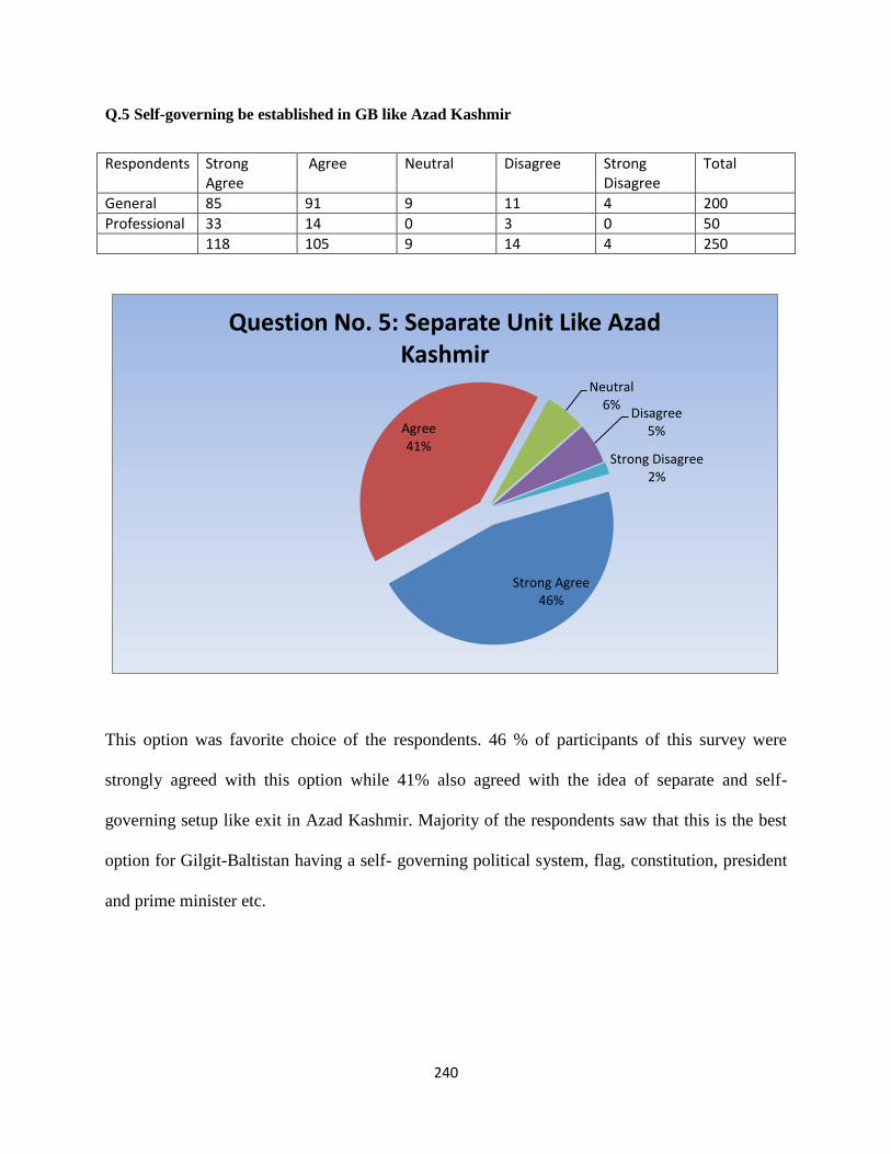
240
Q.5 Self-governing be established in GB like Azad Kashmir
This option was favorite choice of the respondents. 46 % of participants of this survey were
strongly agreed with this option while 41% also agreed with the idea of separate and self-
governing setup like exit in Azad Kashmir. Majority of the respondents saw that this is the best
option for Gilgit-Baltistan having a self- governing political system, flag, constitution, president
and prime minister etc.
Strong Agree 46%
Agree 41%
Neutral 6%
Disagree 5%
Strong Disagree 2%
Question No. 5: Separate Unit Like Azad Kashmir
Respondents Strong Agree
Agree Neutral Disagree Strong Disagree
Total
General 85 91 9 11 4 200
Professional 33 14 0 3 0 50
118 105 9 14 4 250
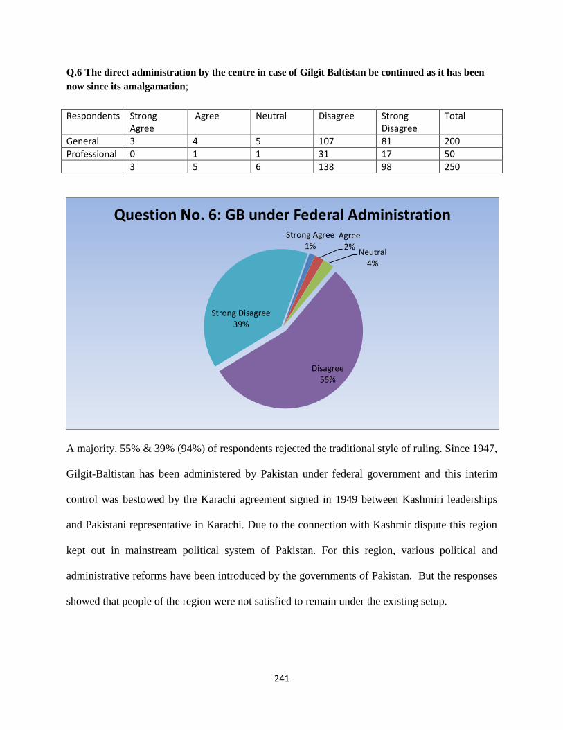
241
Q.6 The direct administration by the centre in case of Gilgit Baltistan be continued as it has been
now since its amalgamation;
A majority, 55% & 39% (94%) of respondents rejected the traditional style of ruling. Since 1947,
Gilgit-Baltistan has been administered by Pakistan under federal government and this interim
control was bestowed by the Karachi agreement signed in 1949 between Kashmiri leaderships
and Pakistani representative in Karachi. Due to the connection with Kashmir dispute this region
kept out in mainstream political system of Pakistan. For this region, various political and
administrative reforms have been introduced by the governments of Pakistan. But the responses
showed that people of the region were not satisfied to remain under the existing setup.
Strong Agree 1%
Agree 2%
Neutral 4%
Disagree 55%
Strong Disagree 39%
Question No. 6: GB under Federal Administration
Respondents Strong Agree
Agree Neutral Disagree Strong Disagree
Total
General 3 4 5 107 81 200
Professional 0 1 1 31 17 50
3 5 6 138 98 250

242
Q.7 Constitutional annexation of Gilgit-Baltistan with Pakistan would damage the struggle in
Kashmir;
This was an interesting question because many people of Kashmir think that political and
constitutional assimilation of Pakistan with Pakistan would damage the Kashmir cause and it is
also against the traditional perspective of Pakistan. The opinions of the respondents of this
question showed slightly interesting, 16 % are strong agree, 21% agree while 25% and 23 %
thought that annexation with Pakistan would not harm the freedom movement of Kashmir and
15% respondents remained neutral.
Strong Agree 16%
Agree 21%
Neutral 15%
Disagree 23%
Strong Disagree 25%
Q.7 Constitutional annexation of GB with Pakistan would demage Kashmir struggle
Respondents Strong Agree
Agree Neutral Disagree Strong Disagree
Total
General 29 36 35 47 53 200
Professional 12 16 2 11 9 50
41 52 37 58 62 250

243
Q.8 The Gilgit-Baltistan, in the Kashmir Plebiscite will justify its dominating role
Kashmir is the core issue between Pakistan and India. The people of Kashmir are waiting for
freedom and the decision will be happened according to UN resolution. A general view is that
plebiscite is the best option for Kashmir dispute, in which the people of Kashmir will decide that
the state should join India or Pakistan or become independent. In this case Whether Gilgit-
Baltistan has important role to change the result. The 21% respondents showed strong agreed and
27% agreed to this question and 37% people rejected this statement and 15 % remained neutral.
Majority of the respondents, 48%, agreed that GB would dominant role in plebiscite.
Strong Agree 21%
Agree 27%
Neutral 15%
Disagree 21%
Strong Disagree 16%
Q.8 Gilgit-Baltistan role in Plebiscite of Kashmir
Respondents Strong Agree
Agree Neutral Disagree Strong Disagree
Total
General 34 53 31 47 35 200
Professional 18 15 6 5 6 50
52 68 37 52 41 250

244
Q.9 The Kashmir Dispute is directly responsible for keeping the Gilgit-Baltistan under the state of
an ambiguous political and constitutional status
It is the most important question of this survey because Kashmir dispute has vital role in the
process of Gilgit-Baltistan constitutional rights. Majority of the respondents agreed that Kashmir
dispute is the major obstacles for their political and constitutional rights. The 32 % and 26 %
respondents agreed with this statement while 16 % & 9% opposed this statement and 17%
remained neutral.
Strong Agre 26%
Agree 32%
Neutral 17%
Disagree 16%
Strong Disagree 9%
Q. 9 Kashmir Dispute is responsible for GB constitutional problem
Respondents Strong Agree
Agree Neutral Disagree Strong Disagree
Total
General 39 71 38 34 18 200
Professional 25 10 4 7 4 50
64 81 42 41 22 250

245
Q 10. Independent Kashmir (United States of Kashmir) is the best option for Kashmir dispute and
Gilgit-Baltistan should be a part of this new federation?
This was an interesting proposal to settle Kashmir dispute. The responses divided over this
option. 33% of respondents showed strong disagree and 28% disagree. There are 14%
respondents who had strong agreed with this proposal while 16% agreed and 10 % remained
neutral. This question had two parts i.e. one the Idea of Independent Kashmir and other is Gilgit-
Baltistan role in this new state. The first part of this question was mere a proposal made by
Kashmiri leadership, While second part was aimed to ascertain public opinion. The majority of
the respondents 66% were against to include GB in this new federation.
Strong Agree 13%
Agree 16%
Neutral 10%
Diagree 28%
Strong Disagree 33%
Q.10 Independent Kashmir and GB should be part of this new federation
Respondents Strong Agree
Agree Neutral Disagree Strong Disagree
Total
General 27 32 22 58 61 200
Professional 5 9 3 12 21 50
32 41 25 70 82 250

246
Q. 11 The Geostrategic importance of the region in presence of constitutional vacuum would drag
for the regional politics into confusion and ambiguities.
The 43 % & 35% of participants of this survey strongly advocated with this statement that the
land without constitutional rights and recognition always remained a bone of contention among
regional as well as international players. In the case of Gilgit-Baltistan, this region has very
significant location but due the constitutional vacuum this location would be harmful and
distress. 16% people‘s opinion remained silent and 4% disagreed with this notion.
Strong Agree 35%
Agree 43%
Neutral 16%
Disagree 4%
Strong Disagree 2%
Q.11. Geostrategic importance of region without constitutional status create
confusion
Respondents Strong Agree
Agree Neutral Disagree Strong Disagree
Total
General 72 82 36 7 3 200
Professional 15 26 5 2 2 50
87 108 41 9 5 250

247
Q. 12 Do you think CPEC and its importance for china will be very crucial in granting
constitutional rights to Gilgit-Baltistan?
Answering to this question 48 % & 29 respondents responded that China has crucial role, 10 %
remained neutral, 9 % disagree, and 4 % showed strong disagree. The majority of the
respondents looked toward China as a key factor to resolve their identical crises because Chinese
interest in CPEC is immense and Gilgit-Baltistan is the gateway for this new corridor. A disputed
region will never be in the interest of China. Respondents believed that this is the crucial points,
for which China can play her role.
Strong Agree 29% Agree
48%
Neutral 10%
Disagree 9%
Strong Disagree 4%
Q.12.CPEC is importance for GB Constitutional rights
Respondents Strong Agree
Agree Neutral Disagree Strong Disagree
Total
General 57 98 21 17 7 200
Professional 15 23 3 5 4 50
72 121 24 22 11 250

248
Q 13 China Pakistan Economic Corridor (CPEC) will endow Socio-Economic opportunities to the
region of Gilgit-Baltistan, struggling for the uplifting of the life standard in the region
Gilgit-Baltistan has imperative role to link the CPEC from Gawadar to Kashgar and it is said that
CPEC is the game changer for this region. An overwhelm majority of respondents, 25% strong
and 60 % agreed with this statement. They thought that CPEC would provide socio-economic
benefits to the people of this region and only 5% of respondents disagreed while 9% stayed
impartial.
Stonge Agree 25%
Agree 60%
Neutral 9%
Disagree 5%
Strong Disagree 1%
Q.13 CPEC for Socio Economic development of Giligt-Baltistan
Respondents Strong Agree
Agree Neutral Disagree Strong Disagree
Total
General 47 122 18 11 2 200
Professional 16 26 5 2 1 50
63 148 23 13 3 250
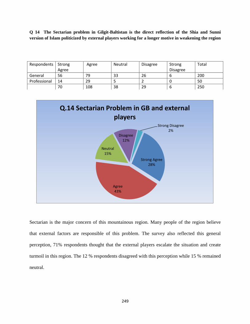
249
Q 14 The Sectarian problem in Gilgit-Baltistan is the direct reflection of the Shia and Sunni
version of Islam politicized by external players working for a longer motive in weakening the region
Sectarian is the major concern of this mountainous region. Many people of the region believe
that external factors are responsible of this problem. The survey also reflected this general
perception, 71% respondents thought that the external players escalate the situation and create
turmoil in this region. The 12 % respondents disagreed with this perception while 15 % remained
neutral.
Strong Agree 28%
Agree 43%
Neutral 15%
Disagree 12%
Strong Disagree 2%
Q.14 Sectarian Problem in GB and external players
Respondents Strong Agree
Agree Neutral Disagree Strong Disagree
Total
General 56 79 33 26 6 200
Professional 14 29 5 2 0 50
70 108 38 29 6 250

250
Q.15 A probable contract between Pakistan and India and opening the Kashmir-Astor and Kargil-
Skardu Roads will be an omen for bringing economic revolution in Gilgit-Baltistan
Gilgit-Baltistan is a landlocked area and this region had served as ancient trade routes between
central Asian, Chinese and Indian empires. There are many routes that link in this region with its
neighbors but due to Kashmir problem, direct access to Kashmir or Ladakh Kargil areas had
been closed since 1947. The majority of the respondents was in favor and saw the opening old
trade routes would be a good omen for their economic condition. 10 % respondents remained
neutral while 6 % respondents opposed this statement.
Strong Agree 39%
Agree 44%
Neutral 10%
Diagree 6%
Strong Disagree 1%
Q. 15.Kargil-Skardu and Kashmir-Astore Road
Respondents Strong Agree
Agree Neutral Disagree Strong Disagree
Total
General 83 84 23 13 2 200
Professional 14 31 2 3 1 50
97 109 25 16 3 250
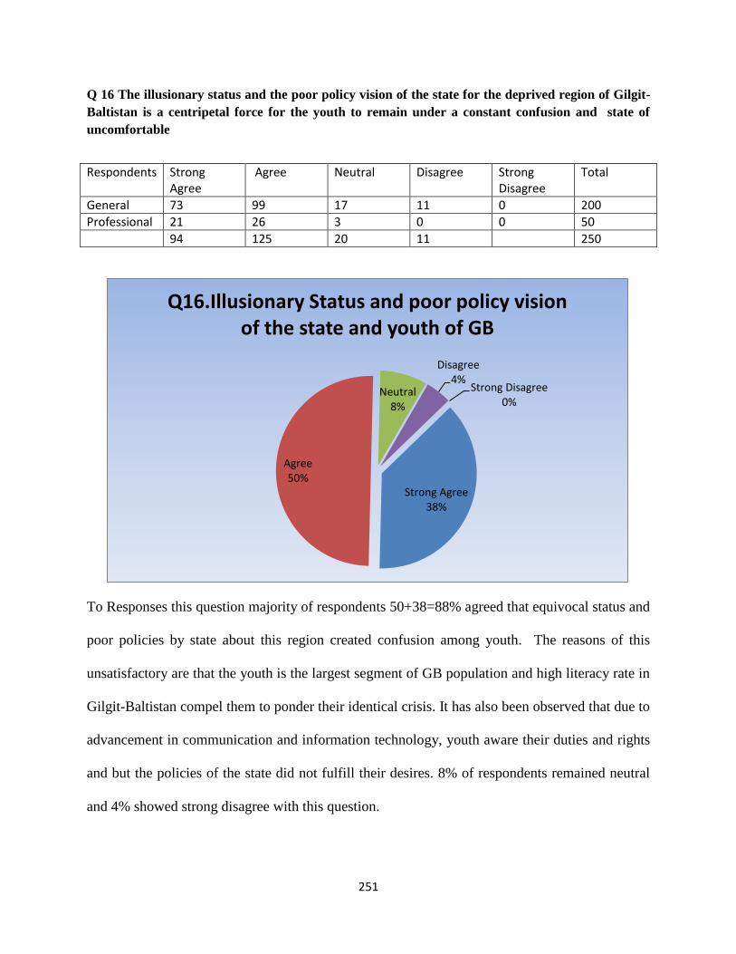
251
Q 16 The illusionary status and the poor policy vision of the state for the deprived region of Gilgit-
Baltistan is a centripetal force for the youth to remain under a constant confusion and state of
uncomfortable
To Responses this question majority of respondents 50+38=88% agreed that equivocal status and
poor policies by state about this region created confusion among youth. The reasons of this
unsatisfactory are that the youth is the largest segment of GB population and high literacy rate in
Gilgit-Baltistan compel them to ponder their identical crisis. It has also been observed that due to
advancement in communication and information technology, youth aware their duties and rights
and but the policies of the state did not fulfill their desires. 8% of respondents remained neutral
and 4% showed strong disagree with this question.
Strong Agree 38%
Agree 50%
Neutral 8%
Disagree 4%
Strong Disagree 0%
Q16.Illusionary Status and poor policy vision of the state and youth of GB
Respondents Strong Agree
Agree Neutral Disagree Strong Disagree
Total
General 73 99 17 11 0 200
Professional 21 26 3 0 0 50
94 125 20 11 250

252
Q. 17 Emerging and hostile craving of India and China may sandwich the region being the
important in the geostrategic sense and a place for their future important concerns.
Gilgit-Baltistan borders with India and China and the relations of both countries have been
observed antagonistic and hostile since the Sino-India War 1962. Both have border disputes as
well as confronted border skirmishes in many times. 44% of respondents were point of viewed
that their antagonistic and power struggling attitudes are dangerous for this region, 30%
respondents strongly agreed with this statement while 8% disagreed and 16 % did not have
responses and remained neutral.
Strong Agree 30%
Agree 44%
Neutral 16%
Disagree 8%
Strong Disagree 2%
Q.17. India and China and GB
Respondents Strong Agree
Agree Neutral Disagree Strong Disagree
Total
General 60 85 34 17 4 200
Professional 14 24 7 4 1 50
74 109 41 21 5 250

253
Q.18The geo-strategic location and the parallel unsettled constitutional status would be further
detrimental for the vulnerable Gilgit-Baltistan
Response 18: Responses to this question show that a majority, 33 % & 45 % respondents thought
that although the strategic location of Gilgit-Baltistan is very important but ambiguous and
unsettled constitutional status would derail its significant factor because due to vague status
regional players claimed the ownership over the region which may escalate the situation harmful
to the people of Gilgit-Baltistan. 6% respondents did not agree to this question while 14 %
percent remained neutral.
Strong Agree 33%
Agree 45%
Neutral 14%
Disagree 6%
Strong Disagree 2%
Q.18 The Geostrategic location and unsettled Constitutional Status and GB
Respondents Strong Agree
Agree Neutral Disagree Strong Disagree
Total
General 66 90 29 10 5 200
Professional 16 23 6 5 0 50
82 113 35 15 5 250

254
Q.19 The famous China Pakistan friendship be further heightened and honeyed without the
consideration of the fears of the people of Gilgit Baltistan
Responses: China and Pakistan friendship is very strong since the inception of independence.
The region Gilgit-Baltistan links both countries by land and this is the only geographical
contiguity between them. Majority of the respondent 48%, and 28%, thought that the uncertainty
of the people of Gilgit-Baltistan is importance factor and without consideration the fears of the
people of Gilgit-Baltistan the relation would not fruitful. 17% respondents remained neutral
while only 6% respondents consider that GB factor is not important for them.
Strong Agree 1%
Agree 6%
Neutral 17%
Disagree 48%
Strong Disagree 28%
China Pakistan friendship without GB
Respondents Strong Agree
Agree Neutral Disagree Strong Disagree
Total
General 3 14 38 95 50 200
Professional 0 1 5 25 19 50
3 15 43 120 69 250

255
Q.20 Creation of independent and autonomous State of Gilgit-Baltistan is the best solution to avoid
regional political complexities.
Responses: The people of Gilgit-Baltistan liberated their region from Dogras and affiliated with
Pakistan but due to Kashmir issue government of Pakistan did not included it into mainstream
political system of Pakistan. Independent Gilgit-Baltistan was interesting option in this research.
The 17% of the respondents agreed and majority of respondents 38% & 18 %, rejected this idea
while 22 % respondents remained neutral. This shows that a separate state is not the priority of
the people of Gilgit-Baltistan despite unconstitutional and political status of the region. Some
nationalist groups advocate the independent Gilgit-Baltistan; it could get further popular if this
region remains without consideration of state policies.
Strong Agree 5%
Agree 17%
Neutral 22% Disagree
38%
Strong Disagree 18%
Q.20. Independent Gilgit-Baltistan
Respondents Strong Agree
Agree Neutral Disagree Strong Disagree
Total
General 11 37 46 75 31 200
Professional 3 6 8 19 14 50
14 43 54 94 45 250
256
Suggestion
1. India and Pakistan must take step to deescalate the situation in Kashmir and focus on mutual
understanding and composite dialogues to resolve the Kashmir dispute. People of Kashmir have
been suffering since 1947 and millions of people have lost their lives in this conflict. Both
countries are atomic powers and this issue has potential to escalate war between them which
would be destructive to whole region. Resolving the Kashmir issue means less tension in the
region than it will be helpful to both countries to focus on economic developments rather than
defense or military apparatus. Gilgit-Baltistan is a part of this dispute and any development in
Kashmir dispute directly effects on this region.
2. Due to the ambiguous and equivocal constitutional status the feeling of deprivation in the
people of Gilgit-Baltistan have aroused which are considered to be harmful the national
integration of Pakistan. Therefore government of Pakistan should take step to reduce the
grievances of the people. These following options are best to reduce the identical crisis in the
region.
A. Gilgit-Baltistan should grant fifth provincial status as the majority of populations see the best
option for their region‘s status because people liberated the region and affiliated with Pakistan so
there should be no objection.
B. Gilgit-Baltistan should be given an interim representation in the Parliament of Pakistan until
Kashmir dispute would not resolve as such type of agreement happened in Karachi Agreement
and administrative control of the region was granted to Pakistan. This is another best option to
avoid the any turmoil situation in the region.

257
C. A self-governing setup like Azad Kashmir is the third best option for their identical crisis. An
interim self-governing body will work until Kashmir resolution. It will be helpful to reduce the
grievances of people of the region.
4. Tourism is the backbone in the economy of the local people as well as to the country. Gilgit-
Baltistan is considered as the heaven for tourists due to its enormous natural resources and
beautiful sceneries, mountains, highest peaks etc. but lack of well-developed infrastructures and
facilities, the tourism industry could not progress. Government should focus the hindrances in
this way and provide facilities to the foreign as well as local tourists.
5. Gilgit-Baltistan is a mountainous region and neighbors to Indian held Kashmir, Ladakh,
Kargil, China, Tibet, Afghanistan, Tajikistan (Central Asian Republics). Karakorum highway is
the only means of transportation and communication to the region. There are no alternatives
means to the region during the natural disasters or catastrophes. So government should take
measures to open other means of transportation and communication. Skardu-Kargil road, Ghizer-
Tajikistan road, China-Shigar Roads, and Kashmir-Astor road are the best options for
consideration. It will help not only to boost up the local economy but also assist to join the
separated families of frontiers.
6. Gilgit-Baltistan is the gateway for China-Pakistan Economic Corridor. Without the
consideration of the fear of this region the bones of the CPEC will diminish. Therefore
government should include the region in this project and people‘s fears should be removed.
7. A separate department for Gilgit-Baltistan study should be established in Karakoram
University that will be helpful to policymakers to understand the region and its importance.

258
8. Siachen Glacier should be declared demilitarized zone. The militaries of both states should
redeploy from Siachen to mutually agreed line. The unmarked region above the point NJ 9842
should be demilitarized zone. Siachen may be economically boons for both nations, if the region
is used of mountaineering expedition. Because the there are many world longest glaciers, highest
peaks and ranges are situated. Both states should make a mechanism to vacant the glacier from
military endanger and invite the international mountaineering expedition groups from both sides.
9. Government should take measurements to explore the mineral and natural resources, and
establish of hydropower units throughout Gilgit-Baltistan. It will be helpful to reduce the energy
crisis in Pakistan.

259
.
Bibliography

260
Bibliography Amir, M,.R., & Rathore, M. (2007). Northern Areas: Crisis and Prospects. Islamabad, Pakistan:
Pakistan Institute for Peace Studies (PIPS)
Alam, Z. (2015). Geo-Strategic Dimensions of India‘s Foreign Policy. International Journal of
Science and Research (IJSR), 4(1). Retrieved from: www.ijsr.net
Abadi,M., Y. H. (1984). Baltistan Per Aik Nazar. Rawalpindi, Pakistan
Afridi, B., G. (1988). Baltistan in History . Peshawar, Pakistan: Emjay Book International.
Albinia, A. (2008). Empires of the Indus: The Story of a River. New York American: Norton &
Company.
Ahmed,P., Zucchi, C.E., Noshab, F. &Safdar Parvez, S. (2010). Pakistan: Gilgit-Baltistan
Economic Report Broadening the Transformation. (Report No. 55998-PK). Retrieved from
http://documents.worldbank.org/curated/en/971671468057878511/pdf/559980ESW0Gray1OFFI
CIAL0USE0ONLY191.pdf
Arif. M. (2014) Rock Art of Gilgit-Baltistan. In K.Warikoo (Eds.), The Other Kashmir Society,
Culture, and Poltics in the Karakoram Himalayas (pp.1-10). New Delhi, India: Pentagon Press.
Awan, N.U.(1990). The Unique Mountains. Peshawar, Pakistan: Alpine Club of Pakistan
Ali, M.(2004, June 12). Archaeology of Dardistan. The News, Lahore.
Ameer, S. (2002). Shumali Illaqa Jat: Eik Nazar. Nadir Printers, Gilgit.
Ali, A. (2002). A Siachen Peace Park: The Solution to a Half-Century of International Conflict?
Mountain Research and Development, 3(7).
Ali,S.S., & Rahman, J. (2001). Indigenous Peoples and Ethnic Minorities of Pakistan;
Constitutional and Legal perspectives. Great Britain: Curzon Press
Ali, G. (2015,). Review of the book The China Pakistan Axis Asia‘s New Geopolitics, by
Andrew Small. Journal of Historical Studies I(2).Haryana, India: Random House India

261
Abebe, D. & Masur, J.(2008). A Nation Divided: Eastern China, Western China and the Problem
of Global Warming, University of Chicago. Retrieved from: http://chicagounbound.
uchicago.edu /cgi/viewcontent. cgi?article=1006&context=public_law_and_legal_theory
Arif, A. (2016, June.07).Gawadar and Chabahar: Implications for the Region. Institute of
Strategic Studies. Retrieved from http://issi.org.pk/wp-content/uploads/2016/06/Final-Issue-
brief-Areeba-dated-07-6-2016.pdf
Adnan, M. (2015). The Kargil Crisis 1999 and Pakistan‘s Constraints. Journal of Political
Studies, 22(1), 129:151
Baloch, S.K. (2004). In the wonderland of Asia Gilgit and Baltistan. Lahore, Pakistan: Sang-e-
Meel Publication
BIR: USA, D. O.S. (1968, November). China-Pakistan Boundary. International Boundary Study.
Bureau of Intelligence and Research. p.2
Butt, I. M. (n.d) Geopolitical Importance of Northern Areas of Pakistan, Retrieved from the
official website of Nazraia Pakistan http://www.nazariapak.info/Research-corner/Geo.php
Baloch,I.S. (n.d). Tourism Development in Gilgit-Baltistan: Situation Analysis and
Investment, Tourism Government of Gilgit-Baltistan, Retrieved from:http:// www.
gilgitbaltistan. gov.pk/DownloadFiles/InvestmentPotential/Tourism.pdf
Brzezinski, Z. (1997).The Grand Chessboard: American Primacy and its Geostrategic
Imperatives. New York, USA: Basic Books.
Blouet, B. (1987). Halford Mackinder: A Biography. Texas, USA: Texas A & M University
Press
Brzezinski, Z. (1986). Game Plan: A Geostrategic Framework for the Conduct of the U.S.–
Soviet Contest. Boston, USA: The Atlantic Monthly Press.

262
Bangash, Y.K. (2010). Three Forgotten Accessions: Gilgit, Hunza and Nagar", The Journal of
Imperial and Commonwealth History, 38 (1): 117–143,
Bondarevsky, P.G.L. (2002). The Great Game A Russian Perspective. Retrieved from http://
www.christiebooks.com/Christie BooksWP/wp.../The-Great-Game.pdf
Bramal, C. (2009).Chinese Economic Development. NY, USA: Rutledge China country
profile. (2016). Retrieved from http://www.bbc.com/news/world-asia-pacific-13017877
Boyle, E., C. (2004, July 19). China wakes up as the World Watches. Insurance magazine. Retrieved from
http://www.insurancejournal.com/magazines/features/2004/07/19/44587.htm
Brunjes, E., Levine, N., Palmer,M. & Smith, A. (2013). China‟s Increased Trade and Investment
in South Asia (Spoiler Alert: It‟s The Economy) Prepared for the U.S. Government Office of
South Asia Policy, by University of Wisconsin–Madison. Retrieved from https://www.
lafollette.wisc.edu /images/publications/workshops/2013-China.pdf
Bhatia, G. (2016, 26 April). China, India tussle for influence as Sri Lanka seeks investment.
CNBC. Retrieved from http://www.cnbc.com/2016/04/24/global-opportunities-china-india-
tussle-for-influence-as-sri-lanka-develops.html
Bukhari, S.W.H. & Bakht, N. (2013). China‘s Economic Diplomacy towards South
Asia.International Journal of Humanities and Social Science Invention, 2(7),41-49.
Bajpai,P.(2016). The World's Top 10 Economies. Retrieved from http://www.investopedia. com/
articles/investing/022415/worlds-top-10-economies.asp
Brunner, H.P. (2013).What is Economic Corridor Development and What Can It Achieve in
Asia‘s Sub regions? ADB Working Paper Series on Regional Economic Integration, No 117.
Asian Development Bank.
Bureau of Intelligence and Research, (1968, November15). China-Pakistan Boundary.
International Boundary Study, (No.85). Retrieved from http://blankonthemap. Free. fr/ 3_
geographie/33_karakoram/337_siachen/doc/Boundaries_Shaksgam.pdf

263
Boehm, D.C.( 2009).China's Failed War on Terror: Fanning the Flames of Uighur Separatist
Violence. Berkeley Journal of Middle Eastern & Islamic Law Retrieved from Available at:
http://scholarship.law.berkeley.edu/jmeil/vol2/iss1/3
Bondarevsky,P.G.L.(2002). The Great Game A Russian Perspective. Retrieved from http://www.
Christiebooks.com/ChristieBooksWP/wp/The-Great-Game.pdf
Cahnman,W.J.(1943). Concepts of Geopolitics. American Sociological Review, 8(1).p. 57.
Cohen, S.B. (2003). Geopolitics of the World System. Maryland, USA: Rowmann & LittleField.
Chuhaan, A. (2012). Tareekh Gilgit (Urdu). Lahore, Pakistan: Jamhori Publication. (It is Urdu translation
of ‗The Gilgit Agency 1877-1935‘ translated by Dr. Uzma Saleem and Shair Baaz Ali Khan Barcha).
Conciliation Resources. (2010, December). Jammu and Kashmir: Trade across the Line of
Control. Papers discussed at Colombo Workshop. Retrieved from http://cpdr.org.pk/wp-
content/uploads/2012/01/Trade_report_WEB.pdf
Curtis,L. Scissors, Derek. (2012). The Limits of the Pakistan–China Alliance. Retrieved from
http://www.heritage.org/research/reports/2012/01/the-limits-of-the-pakistan-china-alliance
Curtis, L. (2016). China‘s South Asian Strategy Testimony before the U.S.-China Economic and
Security Review Commission. Washington, DC, USA: The Heritage Foundation.
Cheema, R.Z. (2013) Some „Facts‟ about Kargil Conflict 1999. Retrieved from http://native
pakistan.com/kargil-war-1999-real-facts-about-kargil-conflict/
Campbell, I. (2013). India‟s role and interests in Central Asia. London, UK; Saferworld.
Chofield, V. (2003). Kashmir in Conflict India, Pakistan and the Unending War. New York,
USA: I.B Tauris.

264
Conciliation resources.(December, 2010). ―Jammu and Kashmir: Trade across the Line of
Control.” Papers discussed at Colombo Workshop. Retrieved from http://cpdr.org.pk/wp-
content/uploads/2012/01/Trade_report_WEB.pdf
Chadha,Vivek(2005). Low Intensity Conflicts in India an Analysis. New Dehli, India: Sage
Devetak, R. (2011). An Introduction to International Relations.Cambridge, UK: Cambridge
University Press
Dorpalen, A. (1984). The World of General Haushofer. New York, USA: Farrar & Rinehart,
Inc.
Clover,C. (1999) "Dreams of the Eurasian Heartland," Foreign Affairs, 78(March/April), p. 9..
Defay,A. (2005). Jeopolitik. Ankara, Turkey: Dost.
Dodds, (1970). Geopolitics in a Changing World. London, UK: Oxford.
Drew, F. (I875).The Jummoo and Kashmir Territories. London.
Dani, A.H. (1995). Human Records on Karakoram Highway. Lahore,Pakistan: Sang-e-Meel
Publication.
Dani,A .H. (1983). Chilas: the City of Nanga Parvat (Dyamar). Islamabad, Pakistan
Dani.A.H.(2007). History of Northern Areas of Pakistan (Upto 2000 AD). Lahore, Pakistan:
Sange-e-Meel Publication.
Dashtnavard, (February 6, 2013). Minimarg-A Heaven on Earth, Dashtnavard‟ blog Retrieved
from https://dashtnavard.wordpress.com/2013/02/06/minimarg-a-heaven-on-earth/
Efferink, L., V. (2015). Geopolitics, Oxford bibliographies. Retrieved from: http://www. oxford
bibliographies.com/view/document/obo-9780199874002/obo-9780199874002-0017.xml
Endreson, R. T. (1998). History, Folklore and Culture of Gilgit Baltistan. Oxford University
Press, London.

265
Frembegen, J. (1964). Ethnographical Field-Research on the History of the Northern Areas.
Oxford University Press, London.
Ferrari,B.D (2010). Some Considerations About the Methods and the Nature of Political
Fettweis, C.J. (2003). Revisiting MacKinder and Angell: The obsolescence of great power
geopolitics. Comparative Strategy, 22, 1009-129.
Francke, A.H. (1907). A History of Western Tibet. London; One of the Unknown Empires.
London,UK: S. W. Partridge & Co.
Fadi, F., Claire, B. & Marina,C.(2011)The Competitiveness Potential of Central Asia .In OECD/
The World Economic Forum, Competitiveness and Private Sector Development: Central Asia
2011: Competitiveness Outlook, (pp. 9-25).Paris, France: OECD Publishing.
DOI: http://dx.doi.org/10.1787/9789264097285-en
Gill, J.H. (2011) Kargil War (1999). In The Encyclopedia of War, John Wiley & Sons, online
library. Retrieved from http://onlinelibrary. wiley.com/doi/ 10.1002/9781444338232. Wbeow
331/abstract
Gray, Colin, S. & .Geoffrey, S. ( 1999). Geopolitics, Geography and Strategy. London, UK:
Frank Cass.
Gupta, V., & Alok, B. (2007). Pakistan Occupied Kashmir: The Untold Story. New Delhi, India:
Manas Publication.
Gupta, Virendra; Alok Bansal (2007). Pakistan Occupied Kashmir: The Untold Story. New
Delhi, India: Manas Publication.
Ghazali, K. (2005, December 2). Land of the Giant. The Muslim, Islamabad.
Geography and Geopolitics. Retrieved from: www.ciari.org/investigacao/Politicalgeopdf.
Goodall,B. (1987). Dictionary of Human Geography. London, UK: Penguin Books.
Geography. Encyclopædia Britannica Online, 15 June 2010, http://www.britannica.com/ EB
checked/topic /229637/geography.

266
Geopolitics, Encyclopædia Britannica Online, 15 June 2010, Retrieved from: http:/
/www.britannica.com/EB checked/topic /229932/ geopolitics.
Gray, Colin S.; G. Sloan (November 30, 1999). Geopolitics, Geography and Strategy. London
and Portland, Oregon, UK: Frank Cass.
Geostrategy | Definition of Geostrategy by Merriam-Webster https://www.merriam
webster.com/dictionary/geostrategy
Gray, Colin S.; Geoffrey Sloan ( 1999). Geopolitics, Geography and Strategy. London and
Portland, Oregon: Frank Cass.
Gupta, Virendra; AlokBansal (2007).Pakistan Occupied Kashmir: The Untold Story.New Delhi,
India: Manas Publication.
Hunzai, I. (2013). Conflict Dynamics in Gilgit-Baltistan (Special Report 321).Washington ,
USA: USIP
Hasan,D. A..(2001). History of Northern Areas of Pakistan: upto 2000 A.D. Lahore, Pakistan:
Sang e Meel.
Hopkirk. P. (2001), The Great Game: On Secret Service in High Asia. London, UK: Oxford.
Hassnain, F. M. (1978). Gilgit: The Northern Gate of India. New Delhi, India
Huttenback, R. A. (1975). 'The "Great Game" in the Pamirs and the Hindukush: The British
Conquest of Hunza and Nagar', Modern Asian Studies IX, pp. 1-29.
Hajni, M. (2011). The Kashmir Conflict: A Kashmiri Perspective. (I. Shahid, Ed.) Advance
Contemporary Affairs, 73 (2nd), p. 200.
Hilali, A. (2007). Kashmir Dispute and United Nations Mediation Efforts: An Historical
Perspective. Small Wars and Insurgencies , 8 (2).

267
Huasheng , Z. (2015). What is Behind China‟s Growing Attention to Afghanistan?. Carnegie
Endowment for international Peace. Retrieved from http://carnegieendowment.org/2015/03/ 08/
what-is-behind-china-s-growing-attention-to-afghanistan-pub-59286
Hunzai, I. (2013). Conflict Dynamics in Gilgit-Baltistan (Special Report 321). Washington ,
USA: USIP
Hopkirk. P. (2001), The Great Game: On Secret Service in High Asia. London, UK: Oxford.
Hilali, W. B. (1995). Hikayat-e-Baltistan. Skardu, Pakistan: Baltistan Book Depot
Haque, I.U. (2012).Determining the Political Status of Gilgit-Baltistan Future Perspective.(MSc
Thesis), Islamabad, Pakistan: NUMAL
Hussainabadi, Y. (2003). Tareekh-e-Baltistan. Skardu, Pakistan, Baltistan Book depot.
Hajni, M. (2011). The Kashmir Conflict: A Kashmiri Perspective. (I. Shahid, Ed.) Advance
Contemporary Affairs, 73(2), p. 200.
Hauptmann,H. & Bemmann (1990) Rock Carvings and Inscriptions along the Karakoram
Highway (Preliminary Report) Retrieved from http://www.haw.uni-heidelberg.de /forschung/fors
chungsstellen/karakorum.en.html
Hilali, W. B. (1995). Hikayat-e-Baltistan., Skardu, Baltistan Book Depot.
Hussainabadi, Y.(2003). Tareekh-e-Baltistan. Baltistan Book depot, Skardu.
Hunzai, I. (2013). Conflict Dynamics in Gilgit-Baltistan (Special Report 321). Washington ,
USA: USIP
Hopkirk. P. (2001), The Great Game: On Secret Service in High Asia. London, UK: Oxford.
Hassnain, F. M. (1978). Gilgit: The Northern Gate of India. New Delhi, India
Huttenback, R. A. (1975). 'The "Great Game" in the Pamirs and the Hindukush: The British
Conquest of Hunza and Nagar', Modern Asian Studies IX, pp. 1-29.
Hussain, Z. et al. (2015). Grassland productivity and carrying capacity of Deosai National Park,
Gilgit-Baltistan, Pakistan. J. Agric. Res., 53(3), pp. 437-452. Retrieved from http://apply.jar.
punjab.gov.pk/up load/ 1456204265_119_13._Paper_No._286.pdf
268
Hennek, D. (1978). Great Trango Tower. American Alpine Journal. 21 (52), p. 436–446 New
York: American Alpine Club.
Hussain, Z. (2012). Border Conflict in South Asia: A Case study of Siachen Issue between India
and Pakistan. M.Phil. Thesis, Center for South Asian Studies, Punjab University Lahore
Pakistan.
Hagan,B. (1942). Geopolitics, The Journal of Politics, 4(4). p. 485.
Hee,R. (2010). World Conquest: The Heartland Theory of Halford J. Mackinder. Retrieved from:
http://www.argumentations.com/Argumentations/StoryDetail_1040.aspx.
Herwig (n.d).Geopolitik: Haushofer, Hitler and Lebensraum, p. 221.
Investopedia. (n.d). What is Autarky. Retrieved from; www.investopedia. Come/terms /a/
autarky.asp
Isapahani, M. Z. (1989), Roads and Rivals: The Politics of Access in the Borderlands of Asia, I.
B. Tauris & Co Ltd. Publishers, London.
IANS. (2012).China wants Free Trade agreement with India. Retrieved from
http://news.biharprabha.com/2012/11/china-wants-free-trade-agreement-with-india/
Ilahi, S. (2003).The Radcliffe Boundary Commission and the Fate of Kashmir, India Review,
2(1), 77. URL:http://dx.doi.org/10.1080/714002326
Jianming, W. (2010), China‟s Western Development Programme in Xinjiang (2000-2009),Unp- -
ublished Thesis, Centre for South, Central and Southeast Asian Studies, School of International
Studies, JNU, New Delhi, India
Jacques, Martin. (2012).When China rules the World (2nd
ed.). London, UK:Penguin.
Jabir, A. H. (2001, November 21). Kashmir Papers. The Muslim, Islamabad

269
Jettmar, K. (1980). Bolder and Dardistan. Islamabad, Pakistan: National Institute of Folk
Heritage.
Jianming, W. (2010), China‟s Western Development Programme in Xinjiang (2000-2009),
Unpublished Thesis, Centre for South, Central and Southeast Asian Studies, School of
International Studies, JNU, New Delhi, India
Jones, M., Jones, R. & Woods, M. (2004).An international Political Geography: Space, Place
and Politics. London, UK: Rutledge
Jones,M., Jones, R., and Woods, M. (2004). An Introduction to Political Geography: Space,
Place and Politics, London, UK: Rutledge.
Jabir, A.,H. (2001, November 21). Kashmir Papers. The Muslim, Islamabad.
Kirschner (2015). What does strategic importance of a place mean?, eNotes. Retrieved from:
https://www.enotes.com/homework-help/what-does-strategic-importance-place-mean-273708.
Keegan, J. (2009). The American Civil War. New York, USA: Knopf.
Keay.J.(1979).The Gilgit Game the Explorers of the Western Himalayas 1865-95. London, UK:
John Murray.
Khosa, R. S. (1999). The Siachen Glacier dispute: Imbroglio on the roof of the world.
Contemporary South Asia, 8:2, 201.
Kreutzmann, H. (1991). The Karakoram Highway: The Impact of Road Construction on
Mountain Societies. Modern Asian Studies, 25(4), 711-736. Retrieved from URL:
http://www.jstor.org/stable/312750
Khan, F. (May 25, 2014). Attabad Lake: Teardrop Miracle. The Express Tribune Magazine.
Retrieved from https://tribune.com.pk/story/711242/attabad-lake-teardrop-miracle/
Khan, S.,B. (2004).In The Wonderfuland of Asia Gilgit-Baltistan. Lahore,Pakistan: Sange-e-
Meel.
Kamal, N. (1979).Karakoram Highway: A Nation-Building Effort', Strategic Studies 11/3, pp.
18-31.
Knight, E. F. (I895). Where Three Empires Meet. London.

270
Khan,M.I. (2007, October 30). NA Reforms the good, the bad and the ugly. The News.
Khan, R.M. (2015). China's Economic and Strategic Interests in Afghanistan . FWU Journal of
Social Sciences, 1 (1). Retrieved from http://www.sbbwu.edu.pk/journal/special%20issue/7
China‘sEconomic_and_Strategic_Interests_in_Afghanistan.pdf.
Kumar, A.(2006, September 30). China-Pakistan Economic (Report) New Delhi, India: IPCS.
www.ipcs.org.
Kreutzmann, H. (1991). The Karakoram Highway: The Impact of Road Construction on
Mountain Societies. Modern Asian Studies 25(4) pp. 711-736, Cambridge University Press,
http://www.jstor.org/stable/312750.
Khan,A, (2015).Wakhan Corridor: An opportunity. Retrieved from http://defence .pk/ threads
/wakhan-corridor-an-opportunity.407932/
Khalid, S. (2016, December, 25). CPEC to create over 700,000 direct Jobs. Associated Press of
Pakistan (APP). https://www.app.com.pk/cpec-to-create-over-700000-direct-jobs/
Knight, E.F.(1905).Where Three Empires Meet. London, UK: Longmans, London.
Khambatta, P (February, 2013). The Emerging Indian Economy, CSIS, Washington DC
http://www.thehindu.com/2005/07/10/stories/2005071002301000.htm
Kornberg, J.F. & Faust, J.R.(2007).China World Politics policies, processes, prospects(2nd
ed.).
New Delhi, India: Viva.
Kornberg, J.F. & Faust, J.R.(2007).China World Politics policies, processes, prospects(2nd
ed.).
New Delhi, India: Viva.
Khan, S.B. (2004).In The Wonderland of Asia Gilgit-Baltistan.Lahore,Pakistan: Sange-e-Meel.
Keay.J.(1979).The Gilgit Game the Explorers of the Western Himalayas 1865-95. London, UK:
John Murray.

271
Khosa, R. S. (1999). The Siachen Glacier dispute: Imbroglio on the roof of the world.
Contemporary South Asia, 8:2, 201.
Kreutzmann, H. (1991). The Karakoram Highway: The Impact of Road Construction on
Mountain Societies. Modern Asian Studies, 25(4), 711-736. Retrieved from URL: http://www
.jstor.org/stable/312750
Khan, Sikandar,B (2004).In The Wonderfuland of Asia Gilgit-Baltistan. Lahore,Pakistan: Sange-
e-Meel.
Kamal, N. (1979).Karakoram Highway: A Nation-Building Effort', Strategic Studies 11/3, pp.
18-31.
Knight, E. F. (I895).Where Three Empires Meet. London.
Kondapalli, S. (2007), ‗China-Pakistan Border Dispute: Old Issues & New Developments‘,
World Focus, January 2007 pp 26-31
Leitner, G. W. (I894). Dardistan in 1866, 1886 and 1893.Woking.
Lorimer, D. L. (1976). Notes on the Bloody Partition. Oxford University Press, New Delhi.
Lorimer, D.L. (1985). The Wakhi Language., London, UK
Longman Dictionary of Contemporary English, Essex: Longman, p. 433.
Liew, J. (2011).International Lower Secondary Geography. Singapore: Marshal Cavendish
Education.
Lamb, A. (1991). Kashmir A Disputed Legacy (1846-1990). Karachi: Oxfored University Press.
Loren,B., Ma,D., & Rawski, T. (2012). From Divergence to Convergence: Re-evaluating the
History behind China‘s Economic Boom. Economic History Working Papers: London School
of Economics and Political Science, Department of Economic History. Retrieved from
http://www.lse.ac.uk/economicHistory/workingPapers/2012/WP158.pdf
Lum,T., Morrison,W.M., & Vaughn,B.( 2008). China‟s Soft Power in Southeast Asia (CRS
Report for Congress). Retrieved from https://fas.org/sgp/crs/row/RL34310.pdf
Lama J. Y. (2013). China and its Peripheries Securing Nepal in South Asia. IPCS. Retrieved
from http://www.ipcs.org/pdf_file/issue/IB232-Jigme-ChinaPeriphery-Nepal.pdf

272
Malik , M. (2001). South Asia in China's Foreign Relations. Pacifica Review: Peace, Security &
Global Change, 13(1), 73-90.
Morrison W.M. (2015 ). China‟s Economic Rise: History, Trends, Challenges, and Implications
for the United States (Report No. 7-5700). Congressional Research Service Retrieved from:
https://fas.org/sgp/crs/row/RL33534.pdf
Maddison, A. (2007). Chinese Economic Performance in the Long Run, 960-2030 (2nd
ed.) Paris,
France: OECD
Maini, S.T. (2015, March 27) China and India: Competing for Influence in Afghanistan. The
Diplomat. Retrieved from http://thediplomat.com/2015/03/china-and-india-competing-for-in
fluence-in-afghanistan
Morrison, W.M. (2015). China‘s Economic Rise: History, Trends, Challenges, and Implications
for the United States ,South Asia Regional Overview.(2008, November 21). South Asian
Regional Development Gateway. Retrieved From https://web.archive.org/web/20081121043924
/http://www.sardeg .org/marketana.asp
Malik, H., Y. (2014).Geo-political Significance of the Wakhan Corridor for China. Fudan
Journal of the Humanities and Social Sciences, 7(2):307–323
Masood.M.T., Farooq, M. & Hussain, B.H. (2016 ,April) Pakistan‘s Potential as a Transit Trade
Corridor and Transportation Challenges. Pakistan Business Review. Retrieved From
journals.iobmresearch.com/index.php/PBR/article/download/668/141
Mazari, S. M. (2003). The Kargil Conflict 1999: Separating Facts from Fiction. Islamabad,
Pakistan :ISSI Publication
Moradian, D. (2015).Indo-Afghan Relationship: Afghan Expectations and Indian Reluctance. In
Vishal ,C (Eds.), India and South Asia Exploring Regional Perceptions (pp.119-127). New
Delhi,India: Pentagon Press
Mackinder, H. J. (1996). Democratic Ideals and Reality. Washington DC, USA: National
Defense University Press,

273
Meena, K. (n.d). Munesh Chandra asked: What is the difference between geo-politics and geo-
strategy? IDSA Retrieved from: http://idsa.in/askanexpert/geopoliticsandgeostrategy
Mackinder, H. J (1904). The Geographical Pivot of History, The Geographical Journal, 23(4)
pp. 421-437.
Mackinder, H.. J. (1919). Democratic Ideals and Reality: A Study in the Politics of
Reconstruction. London: Constable & Co. (reprinted in 2012 by Forgotten Books).
Mackinder, H. J. (1943). ―The Round World and the Winning of the Peace.‖ In Foreign Affairs,
21(4), pp. 595-605.
Mahan, A. T. (1987), The Influence of Sea Power upon History, 1660-1783. New York, USA:
Dover Publications (first published in 1890).
Mahan, A. T. (1902). Retrospect and Prospect: Studies in International Relations, Naval and
Political. Boston, USA : Little, Brown & Co.
Mattern, J. (1942). Geopolitik: Doctrine of National Self-Sufficiency and Empire. Baltimore,
USA: The Johns Hopkins Press
Malik, I. (2008). Arz-e-Shumal Ka Manzar Nama. Habib Publishers, Gilgit.
Miller K. (1988). Gilgit through the ages. Cosmo Publications, Calcutta.
Mir, S. (January 11, 2015). On thin ice: Khalti Lake becomes a perilous playground for children.
The Express Tribune. Retrieved from: https://tribune.com.pk/story/819870/on-thin-ice-khalti-
lake-becomes-a-perilous-playground-for-children
Malik, I. (2008). Arz-e-Shumal Ka Manzar Nama. Gilgit, Pakistan: Habib Publishers.
Madhok, B. R. (1992). Kashmir The Storm Center of the World. Jammu & Kashmir,India:
A.Ghos.
Mahmud, E. (2007).The Gilgit-Baltistan Reforms Package 2007: Background, Phases and
Analysis, Policy Perspectives , 5(1)

274
Misra, A.(2000) ‗Siachen Glacier flashpoint: a study of Indian Pakistani relations.‘, Working
Paper. University of Durham, Centre for Middle Eastern and Islamic Studies, Durham.
URL: http//www.dur.ac.uk/sgia/
Mock,J. & Kimberley. (n.d). Dards, Dardistan, and Dardic: an Ethnographic, Geographic, and
Linguistic Conundrum. Retrieved from their website http://www.mockandoneil.com/dard.htm
Musharraf, Pervez (2006). In The Line of Fire: A Memoir.London UK: Simon & Schuster.
Naseem,Q. (2007).Gilgit- Baltistan aur Masala Kashmir.Lahore, Pakistan: Sang-e-Meel.
Nayyar,A. (1987). Baltistan (Research Translation). Islamabad, Pakistan: Lok Virsa.
Nazir, M. (2010). Maalumaat-e- Baltistan(Urdu). Skardu, Pakistan: Soday Books.
Naseem, M.Q.( 2007). Gilgit Baltistan aur Masala-e-Kashmir. Lahore, Pakistan: Sang-e-Meel
Publications.
Nayyer, K. (2003).Wall at Wagah: India-Pakistan Relations. New Delhi, India: Gyan
Publishing House.
Naughton, B. (2007). The Chinese Economy: Transitions and Growth. Cambridge, UK: MIT
Press.
Nazir, M. (2010).Maalumaat-e- Baltistan(Urdu).Skardu, Pakistan: Soday Books.
Nibra, N. (1951). 'The Sinkiang-Hunza Frontier',Journal of the Royal Central Asian Society 3 8,
pp. 73-81.
Nadeem,N. (I965). 'Ancient Routes through the Pamirs', Central Asian Review XIII, I, pp. 44-54.
Paul, W. S. S.,Asif,B.&Sami, S. (2006). Kashmir: New Voices, New Approaches. Boulder Co,
US: Lynne Rienner.
Paul, T. (2006). The India-Pakistan Conflict: An Enduring Rivalry. New Delhi: Cambridge
University Press.

275
Paul (1996). A History of Western Himalayas. Penguin Books, London. 190 Pakistan Journal of
Social Sciences Vol. 30, No. 1
Pillai, S. K. (2002). Border Conflicts and Regional Disputes. In P. v. Monique Mekenkamp,
Searching for Peace in Central and South Asia : An overview of Conflict Prevention and
peacebuilding Activities (p. 249). Colorado (USA): Lynne Rienner.
Perkin, S. (2003). Northern Areas State of Environment and Development (compiled). Karachi,
Pakistan: IUCN.
Phadke, Ramesh. (2005).China‟s Power Projection. New Delhi, India: Manas.
Qamar, A. S. K. (1975). Lure of the Karakorum. Rawalpindi.
Quereshi, I. (1996). A Short History of Pakistan. Karachi, Pakistan: Karachi University Press.
Rahman, K., & Mahmud, E. (2004). Northern Areas - Facts, Problems & Recommendations.
Policy Perspectives. 1 (1). Islamabad: IPS.
Rizvi, G. (1993). South Asia in a Changing International Order. Karachi, Pakistan: Oxford
University Press.
Rafi, A. , Khan, F.,& Aslam, S. (2016, September).CPEC: Pakistan‘s Way to Success. IICR
Retrieved From http://iicr.org.pk/wp-content/uploads/2016/09/IICR-Special-Report-on-CPEC.
Rizvi, G. (1993). South Asia in a Changing International Order. Karachi, Pakistan: Oxford
University Press.
Rashid, S. (2011). The Apricot Road to Yarkand. Lahore, Pakistan: Sang-e-Meel.
Reports of United Nations Commission for India and Pakistan (June 1948 to December 1948),
Ministry of External Affairs, New Delhi, pp. 17–18.
Rashid, S. (2011). The Apricot Road to Yarkand. Lahore, Pakistan : Sang-e-Meel .
Robert, K. E. (2003). Geotectonic Evolution in the Northern Areas of Pakistan. U.S. Government
Printing Office, Washington, D.C.
Rana, A., R. (2014, June 10).Position Paper for Drat Tourism Policy-Gilgit-Baltistan. USAID
Firms Project. Retrieved from pdf.usaid.gov/pdf_docs/PA00K7VS.pdf

276
Rehman,K , Jia, R. & Tao, L. (2012). 60 Years of Pakistan-China Relations Land, Trends and
Approaches. Islamabad, Pakistan: IPS. Retrieved from http://dx.doi.org/10.1080/09584939908
719864
Saleem, D. (2009). Baltistan (Tarkheek K Aeenay Mai: Urdu Traslation of Baltistan in
History).Skardu: Soday Books.
Singh, P. (2013).Gilgit Baltistan: Between Hope and Despair. New Delhi, India: IDSA
Saini, S. &Showkat, S. D. (2013) .Geopolitical Significance of Gilgit Baltistan of J & K
State.International Journal of Humanities and Social Science Invention, 2(5), 48-56. Retrieved
from http:// www.ijhssi.org/
Starr, S. F. ed. (2004), ‗Xinjiang: China‟s Muslim Borderland.London, UK: Central Asia Caucus
Institute
Swain, Ashok (2009).The Round Table, The Indus II, and Siachen Peace Park: Pushing India-
Pakistan Peace Process Forward. London, UK: Rutledge.
Sering,H.S. (2012).Expansion Of The Karakoram Corridor: Implications And Prospects. New
Delhi, India: Lancers
Syed, A.H.(1974).China & Pakistan Diplomacy of Entente Cordiale. Karachi, Pakistan: Oxford
Stobdan,P. &Chandran, D. S (Eds.).(2008).The Last Colony: Muzaffarabad-Gilgit-Baltistan
(Eds.). New Delhi, India: IRP.
Schaller, G. B. (I980). Stones of Silence.Journeys in the Himalaya. London.
Stephens, I. (1953). 'Politics and Apricots (Hunza and Nagir)'.The Geographical Magazine
XXV, pp. 489-95.
Staley, J.(1969). 'Economy and Society in the High Mountains of Northern Pakistan', Modem
Asian Studies III, pp. 225-43.
Sims.D. (March 14, 2013) China Widens Lead as World's Largest Manufacturer. Retrieved from
thomasnet.com

277
Swartz,S & Oster,.S (2010, July18). China Tops U.S. in Energy Use: Asian Giant Emerges as No.
1Consumer of Power, Reshaping Oil Markets, Diplomacy. The Wall Street Journal. Retrieved
from http://www.wsj.com/articles/
Sridharan,V. (2014, March 29). China Sleeping lion has woken. IBtimes. Retrieved from:
http://www.ibtimes.co.uk/china-sleeping-lion-has-woken-says-xi-jinping-1442415
Singh, K., P. (2016).China and South Asia: Deepening of Engagement: in Jagannath P.Panda &
(Ed.), China‟s Transition Under Xi Jinping (PP. 277-313). New Delhi, India: Pentagon Press.
Small, A. (2014, January). Regional Dynamics and Strategic Concerns in South Asia China‘s
Role. A Background Paper of the CSIS Program on Crisis, Conflict, and Cooperation
Washington: USA CSIC www.csis.org
Sering, S. (2013). China‘s Interests in Shasgham Valley. Retrieved from http:// www. Sharnoffs
globalviews.com/china-shaksgam-valley-191/
Singh,G.(1981).The Karakoram Highway and Its Strategic Implications for India. The Indian
Journal of Political Science, 42(1) pp. 18-26 Published by: Indian Political Science Association.
Retrieved from http://www.jstor.org/stable/41855073
Sering, S., H. (2012).Expansion Of The Karakoram Corridor Implications and Prospects. New
Delhi , India: Lancers Book
Sohail, M.(n.d.).China-Paksitan Economic Corridor (CPEC): Challenges & Global Trade Impact.
SHEIR. Retrieved from http://www.sheir.org/china-pakistan-economic-corridor.html
Shahzad, M. K.(2015, 8th March). ‗Economic corridor will have multiple routes‘ Dawn.
http://www.dawn.com/news/1168081/sound-bytes-economic-corridor-will-have-multiple-routes
Swaine, M.D. (2015). Chinese Views and Commentary on the ―One Belt, One Road‖ Initiative.
Retrieved from http://www.hoover.org/sites/default/files/research/docs/clm47ms.pdf
Sattar, A. (2007). Pakistan's Foreign Policy 1947-2005 A Concise History. Karachim Pakistan:
Oxford university Press.

278
Sajjanhar, A. (2016) India-Central Asia relations: Expanding vistas of partnership. Observer
Research Foundation. Retried from http://www.orfonline.org/expert-speaks/india-central-asia-
relations-expanding-vistas-of-partnership/
Sing, M. (2005). Of Oxford, economics, empire, and freedom. The Hindu http://www.
thehindu.com /2005/07/10/stories/2005071002301000.htm
Schofield, V.(2000). Kashmir in conflict: India, Pakistan and the unending war.UK; London:
I.B.Tauris & Co.
Salik, B. A. (2007, July 28). Kashmir settlement vital for peace in region. The Nation.
Saleem, D. (2009). Baltistan (Tarkheek K Aeenay Mai: Urdu Traslation of Baltistan in History).
Skardu: Soday Books
Spykman,N. (1938). Geography and Foreign Policy, II, American Political Science Review,
32(3) p. 236.
Smith, D.S, Naseer,D., Balint, Z. Hassan, S.A. (2007). Butterflies of the Hunza Region, Northern
Pakistan and Adjecent Afghanistan. Holarctic Lepidoptera, 11 (1-2), Pp. 1-57. Retrieved from
http://www.troplep.org/Smith-et%20al-Butterflies%20of%20Hunza-Afganistan-sm.pdf
Stein, M. A. (1987). The Wonders of Hindukush. Sterling Publication, New Delhi.
Sloan,G. (1999,eds.), Geopolitics, Geography and Strategy, London, UK: Frank Cass.
Spykman, J.N.(1942) America‟s Strategy in World Politics: The United States and the Balance
of Power. USA, New York: Harcourt
Spykman, N. (1938). Geography and foreign policy. American Political Science Review, 32(1),
28-50.
Spykman, N.(1944). The Geography of Peace. New York, USA: Brace
Smolen, K. (2012) Evolution of Geopolitical School of Thought. University of Lublin

279
Sempa, F., P. (2002). Geopolitics from the Cold War to the 21st Century. USA, New
Jersy:Transaction
The Boundary Agreement between China and Pakistan, 1963, Retrieved from http:// people.
unica.it/annamariabaldussi/files/2015/04/China-Pakistan-1963.pdf
Toal,G (1990). Critical Geopolitics: The Politics of Writing Global Space. London, UK:
Rutledge
Tarkati,M.H. (2016). The Stunning Forts and Palaces of Baltistan. Nauroz Youth Magazine (1st
Edition), Lahore, Pakistan: Millstone
Trench, C.C. (1992). The Icy Baltistan. Oxford University Press, London. Wallace,
Torwali,Z. (2012). The ignored Dardic culture, The News.( 14-08-2012) Retrieved from
http://iportal. riphah .edu.pk/wp-content/uploads/data/12/08/270812idc.pdf
UNESCO (n.d.). Silk Road, Dialogue, Diversity and Development. Retrieved from
http://en.unesco.org/silkroad/about-silk-road
Wirsing, R. G. (1994). India, Pakistan, and the Kashmir Dispute on Regional Conflict and Its
Resolution. Delhi, Pakistan: Rupa & Co.
Wirsing, R. G. (1994). India, Pakistan, and the Kashmir Dispute on Regional Conflict and Its
Resolution. Delhi: Rupa & Co.
Walter, J. M. (2006, April 27). Wild life on the top roof. The Telegraph, Calcutta. Watters, T.
(1978). Travels of Northern India. Neeraj Publishing House, New Delhi.
Weigert, H.W. (1942). Haushofer and the Pacific. Foreign Affairs, 20(4), 332-342.
Walsh, E. A. (1946) "The Mystery of Haushofer" Life (September 16, 1946) pp. 107–120
Warikoo, K (2011). Central Asia and South Asia Energy Cooperation and Transport Linkages
(eds). Delhi India: Pentagon.
Wirsing, R. G. (1994). India, Pakistan, and the Kashmir Dispute on Regional Conflict and Its
Resolution. Delhi, India: Rupa& Co.

280
Woodman, I.(1969).Himalayan Frontiers: A Political Review of British, Chinese, Indian and
Russian Rivalries. London.
Yang, L. (2013).China‟s Growth Miracle: Past, Present, and Future. Chinese Academy of
Social Sciences, Switzerland. Retrieved from http://www.unrisd.org/80256B3C005BD6AB
Young, h., F. (1926).The Problem of the Shaksgam valley. Retrieved from http:// pahar.in/wpfb-
file/1926-problem-of-shaksgam-valley-by-younghusband-from-gjv68-s-pdf/
Yusuf, S. (2013). Can Chinese FDI Accelerate Pakistan‟s Growth?. International Growth
Centre, LSE London. Retrieved from: https://www.theigc.org/wp content? Uploads /2014
/09/Yusuf-20 13-Working-Paper1.pdf
Yousaf, K. (2011, May 30) Lingering dispute: India, Pakistan open Siachen talks today. The
Express Tribune. URL: hptt://tribune.com.pk/story/178610/lingering-dispute-india-pakistan-
open-siachen-talks-today/
Zhu,X. (2012). Understanding China‘s Growth: Past, Present, and Future, Journal of Economic
Perspectives, 26(4), 103–124. Retrieved from http://homes.chass.utoronto.ca/~xzhu/paper/ JEP
2012.pdf
Zakir, B. M. (1991). Siahen Glacier ( Dunya ka Buland Tareen Mahaz Jang). Multan, Pakistan:
Soni Daharti
Zain, O. F. (2010). A Socio-Political Study of Gilgit Baltistan Province.Pakistan Journal of
Social Sciences, 30(1), 181-190.
Zain, O.,F. (2010). A Socio-Political Study of Gilgit Baltistan Province. Pakistan Journal of
Social Sciences (PJSS). 30 (1) pp. 181-190
281
Appendixes

282
TREATY OF LAHORE -1846
Article 1. There shall be perpetual peace and friendship between the British Government and Maharajah
Dhuleep Sing, his heirs and successors.
Article 2. The Maharajah of Lahore renounces for himself, his heirs and successors, all claim to, or
connection with the territories lying to the south of the River Sutlej, and engages never to have any
concern with those territories or the inhabitants thereof.
Article 3. The Maharajah cedes to the Honorable Company, in perpetual sovereignty, all his forts,
territories and rights in the Doab or country, hill and plain, situated between the Rivers Beas and Sutlej.
Article 4. The British Government having demanded from the Lahore State, as indemnification for the
expenses of the war, in addition to the cession of territory described in Article 3, payment of one and half
crore of Rupees, and the Lahore Government being unable to pay the whole of this sum at this time, or to
give security satisfactory to the British Government for its eventual payment, the Maharajah cedes to the
Honorable Company, in perpetual sovereignty, as equivalent for one crore of Rupees, all his forts,
territories, rights and interests in the hill countries, which are situated between the Rivers Beas and Indus,
including the Provinces of Kashmir and Hazara.
Article 5. The Maharajah will pay to the British Government the sum of 60 lakhs of Rupees on or before
the ratification of this Treaty.
Article 6. The Maharajah engages to disband the mutinous troops of the Lahore Army, taking from them
their arms-and His Highness agrees to reorganize the Regular Regiments of Infantry, upon the system,
and according to the Regulations as to pay and allowances, observed in the time of the late Maharajah
Runjeet Sing. The Maharajah further engages to pay up all arrears to the soldiers that are discharged,
under the provisions of this Article.
Article 7. The Regular Army of the Lahore State shall henceforth be limited to 25 Battalions of Infantry,
consisting of 800 bayonets each with twelve thousand Cavalry - this number at no time to be exceeded
without the concurrence of the British Government. Should it be necessary at any time - for any special
cause - that this force should be increased, the cause shall be fully explained to the British Government,
and when the special necessity shall have passed, the regular troops shall be again reduced to the standard
specified in the former Clause of this Article.
Article 8. The Maharajah will surrender to the British Government all the guns-thirty-six in number-
which have been pointed against the British troops-and which, having been placed on the right Bank of
the River Sutlej, were not captured at the battle of Subraon.
Article 9. The control of the Rivers Beas and Sutlej, with the continuations of the latter river, commonly
called the Gharrah and the Punjnud, to the confluence of the Indus at Mithunkote-and the control of the
Indus from Mithunkote to the borders of Balochistan, shall, in respect to tolls and ferries, rest with the
British Government. The provisions of this Article shall not interfere with the passage of boats belonging
to the Lahore Government on the said rivers, for the purpose of traffic or the conveyance of passengers up
and down their course. Regarding the ferries between the two countries respectively, at the several ghats
of the said rivers, it is agreed that the British Government, after defraying all the expenses of management
and establishments, shall account to the Lahore Government for one-half the net profits of the ferry
collections. The provisions of this Article have no reference to the ferries on that part of the River Sutlej
which forms the boundary of Bahawalpur and Lahore respectively.

283
Article 10. If the British Government should, at any time, desire to pass troops through the territories of
His Highness the Maharajah, for the protection of the British territories, or those of their Allies, the
British troops shall, on such special occasion, due notice being given, be allowed to pass through the
Lahore territories. In such case the officers of the Lahore State will afford facilities in providing supplies
and boats for the passage of rivers, and the British Government will pay the full price of all such
provisions and boats, and will make fair compensation for all private property that may be damaged. The
British Government will, moreover, observe all due consideration to the religious feelings of the
inhabitants of those tracts through which the army may pass.
Article 11.. The Maharajah engages never to take or to retain in his service any British subject - nor the
subject of any European or American State - without the consent of the British Government.
Article 12 . In consideration of the services rendered by Rajah Golab Sing of Jummoo, to the Lahore
State, towards procuring the restoration of the relations of amity between the Lahore and British
Governments, the Maharajah hereby agrees to recognize the Independent sovereignty of Rajah Golab
Sing in such territories and districts in the hills as may be made over to the said Rajah Golab Sing, by
separate Agreement between himself and the British Government, with the dependencies thereof, which
may have been in the Rajah's possession since the time of the late Maharajah Khurruck Sing, and the
British Government, in consideration of the good conduct of Rajah Golab Sing, also agrees to recognize
his independence in such territories, and to admit him to the privileges of a separate Treaty with the
British Government.
Article 13. In the event of any dispute or difference arising between the Lahore State and Rajah Golab
Sing, the same shall be referred to the arbitration of the British Government, and by its decision the
Maharajah engages to abide.
Article 14.. The limits of the Lahore territories shall not be, at any time, changed without the concurrence
of the British Government.
Article 15.. The British Government will not exercise any interference in the internal administration of
the Lahore State, but in all cases or questions which may be referred to the British Government, the
Governor-General will give the aid of his advice and good offices for the furtherance of the interests of
the Lahore Government.
Article 16.. The subjects of either State shall, on visiting the territories of the other, be on the footing of
the subjects of the most favoured nation.
This Treaty consisting of sixteen articles, has been this day settled by Frederick Currie, Esquire, and
Brevet-Major Henry Montgomery Lawrence acting under the directions of the Right Hon'ble Sir Henry
Hardinge, G.C.B., Governor-General, on the part of the British Government, and by Bhaee Ram Sing,
Rajah Lal Sing, Sirdar Tej Sing, Sirdar Chuttur Sing Attareewalla, Sirdar Runjore Sing Majeethia, Dewan
Deena Nath, and Faqueer Noorooddeen, on the part of the Maharajah Dhuleep Sing, and the said Treaty
has been this day ratified by the seal of the Right Hon'ble Sir Henry Hardinge, G.C.B., Governor-General,
and by that of His Highness Maharajah Dhuleep Sing.
Done at Lahore, this ninth day of March, in year of Our Lord one thousand eight hundred and forty-six;
corresponding with the,tenth day of Rubbee-ool-awul, 1262 Hijree, and ratified on the same date.
1. (Sd.) H. Hardinge (L.S.) 2. (Sd.) Maharajah Dhuleep Sing (L.S.)
3. Bhaee Ram Sing (L.S.) 4. Rajah Lal Sing (L.S.)
5. Sirdar Tej Sing (L.S.) 6. Sirdar Chuttur Sing Attareewalla (L.S.)
7. Sirdar Runjore Sing Majeethia (L.S.) 8.Dewan Deena Nath (L.S.) 9.Faqueer Norooddeen (L.S.)

284
Treaty of Amritsar March 16, 1846
The treaty between the British Government on the one part and Maharajah Gulab Singh of Jammu on the
other concluded on the part of the British Government by Frederick Currie, Esq. and Brevet-Major Henry
Montgomery Lawrence, acting under the orders of the Rt. Hon. Sir Henry Hardinge, G.C.B., one of her
Britannic Majesty's most Honorable Privy Council, Governor-General of the possessions of the East India
Company, to direct and control all the affairs in the East Indies and by Maharajah Gulab Singh in person -
1846.
Article 1 The British Government transfers and makes over for ever in independent possession to
Maharajah Gulab Singh and the heirs male of his body all the hilly or mountainous country with its
dependencies situated to the eastward of the River Indus and the westward of the River Ravi including
Chamba and excluding Lahol, being part of the territories ceded to the British Government by the Lahore
State according to the provisions of Article IV of the Treaty of Lahore, dated 9 March 1846.
Article 2 The eastern boundary of the tract transferred by the foregoing article to Maharajah Gulab Singh
shall be laid down by the Commissioners appointed by the British Government and Maharajah Gulab
Singh respectively for that purpose and shall be defined in a separate engagement after survey.
Article 3 In consideration of the transfer made to him and his heirs by the provisions of the foregoing
article Maharajah Gulab Singh will pay to the British Government the sum of seventy-five lakhs of rupees
(Nanukshahee), fifty lakhs to be paid on or before the 1st October of the current year, A.D., 1846.
Article 4 The limits of territories of Maharajah Gulab Singh shall not be at any time changed without
concurrence of the British Government.
Article 5 Maharajah Gulab Singh will refer to the arbitration of the British Government any disputes or
question that may arise between himself and the Government of Lahore or any other neighboring State,
and will abide by the decision of the British Government.
Article 6 Maharajah Gulab Singh engages for himself and heirs to join, with the whole of his Military
Forces, the British troops when employed within the hills or in the territories adjoining his possessions.
Article 7 Maharajah Gulab Singh engages never to take to retain in his service any British subject nor the
subject of any European or American State without the consent of the British Governnent.
Article 8 Maharajah Gulab Singh engages to respect in regard to the territory transferred to him, the
provisions of Articles V, VI and VII of the separate Engagement between the British Government and the
Lahore Durbar, dated 11 March 1846.
Article 9 The British Government will give its aid to Maharajah Gulab Singh in protecting his territories
from external enemies.
Article 10 Maharajah Gulab Singh acknowledges the supremacy of the British Government and will in
token of such supremacy present annually to the British Government one horse, twelve shawl goats of
approved breed (six male and six female) and three pairs of Cashmere shawls.
This Treaty of ten articles has been this day settled by Frederick Currie, Esq. and Brever-Major Henry
Montgomery Lawrence, acting under directions of the Rt. Hon. Sir Henry Hardinge, Governor-General,
on the part of the British Government and by Maharajah Gulab Singh in person, and the said Treaty has
been this day ratified by the seal of the Rt. Hon. Sir Henry Hardinge, Governor-General. Done at
Amritsar the sixteenth day of March, in the year of our Lord one thousand eight hundred and forty-six,
corresponding with the seventeenth day of Rubee-ul-Awal (1262 Hijri)
(Signed) (Seal) H. Harding Maharaja Gulab Singh (Signed) (Signed) F. Currie H. M. Lawrence By order
of the Right Honorable the Government of India (Signed) F. Currie
Source: http://www.portmir.org.uk/assets/pdfs/treatyofamritsar.pdf.

285
LEASE OF GILGIT-26 MARCH 1935
Article I - The Viceroy and Governor-General of India may at any time after the ratification of this
agreement assume the civil and military administration of so much of the Wazarat of Gilgit province
(herein after referred to as the ―said territory‖) of the State of Jammu and Kashmir as lies beyond the right
bank of the river Indus, but notwithstanding anything in this agreement the said territory shall continue to
be included within the dominions of His Highness the Maharaja of Jammu and Kashmir.
Article II – In recognition of the fact that the said territory continues to be included within the dominion
of His Highness the Maharaja of Jammu and Kashmir salutes and customary honours shall be paid in the
said territory of the administration on the occasion of the birthday of His Highness, Baisakhi, Dussehra,
Basant-Panchmi and on such other occasions as may be agreed upon by His Excellency the Viceroy and
Governor-General of India. The flag of His Highness will be flown at the official headquarters of the
agency throughout the year.
Article III – In normal circumstances no British Indian troops shall be dispatched through that portion of
the Wazarat of Gilgit Province which lies beyond the left bank of the river Indus.
Article IV – All rights pertaining to mining are reserved to His Highness the Maharaja of Jammu and
Kashmir. The grant of prospecting licenses and mining leases will be made during the period of the
agreement mentioned below.
Article V – This agreement shall remain in force for sixty years from the date of its ratification and the
leases will terminate at the end of that period.
Source: www.K4Kashmir.com, July 19, 2010, Article by Prof Dr. Shabbir Chaudry
KARACHI AGREEMENT-1949
Text of the agreement signed between Pakistan and Azad Kashmir Governments in March 1949. The
Agreement was signed by the following:
1. Honourable Mushtaque Ahmed Gurmani, Minister without Portfolio, Government of Pakistan.
2. Sardar Mohammed Ibrahim Khan, the president of Azad Kashmir .
3. Choudhry Ghulam Abbas, Head of All Jammu and Kashmir Muslim Conference.
A. Matters within the purview of the Government of Pakistan.
1. Defence (as modified under....).
2. Foreign policy of Azad Kashmir.
3. Negotiations with the United Nations Commission for India and Pakistan.
4. Publicity in foreign countries and in Pakistan.

286
5. Co - ordination and arrangement of relief and rehabilitation of refugees.
6. Co - ordination of publicity in connection with plebiscite.
7. All activities within Pakistan regarding Kashmir such as procurement of food, civil supplies running of
refugee camps and medical aid.
8. All affairs of Gilgit - Ladakh under the control of Political Agent.
B. Matters within the purview of Azad Kashmir Government.
1. Policy with regard to administration of AK territory.
2. General supervision of administration in AK territory.
3. Publicity with regard to the activities of the Azad Kashmir Government and administration.
4. Advice to the honourable Minister without Portfolio with regard to negotiations with United Nations
Commission for India and Pakistan.
5. Development of economic resources of AK territory.
C. Matters within the purview of the Muslim Conference.
1. Publicity with regard to plebiscite in the AK territory.
2. Field work and publicity in the Indian occupied area of the State.
3. Organisation of political activities in the AK territory and the Indian occupied area of the State.
4. Preliminary arrangements in connection with the plebiscite.
5. Organisation for contesting the plebiscite.
6. Political work and publicity among the Kashmiri refugees in Pakistan.
7. Advise the honourable minister without Portfolio with regard to the negotiations with the United
Nations Commission for India and Pakistan.
SINO-PAK BORDER AGREEMENT 1963
The Government of the People‘s Republic of China and the Government of Pakistan; HAVING
agreed, with a view to ensuring the prevailing peace and tranquility on their respective border, to
formally delimit and demarcate the boundary between China‘s Sinkiang and the contiguous areas
the defence of which is under the actual control of Pakistan, in a spirit of fairness,
reasonableness, mutual understanding and mutual accommodation, and on the basis of the ten
principles as enunciated in the Bandung conference. Being convinced that this would not only
give full expression to the desire of the people of China and Pakistan for the development of
good neighbourly and friendly relations, but also help safeguard Asian and world peace.
Have resolved for this purpose to conclude the present agreement and have appointed as their
respective plenipotentiaries the following.
For the Government of the People's Republic of China; Chen Yi, Minister of Foreign Affairs.

287
For the Government of Pakistan Zulfikar Ali Bhutto, Minister of External Affairs. Who, having
mutually examined their full powers and found them to be in good and due form have agreed
upon following:
Article 1
In view of the fact that the boundary between China‘s Sinkiang and the contiguous areas
the defence of which is under the actual control of Pakistan has never been formally
delimited, two parties agree to delimit it on the basis of the traditional customary
boundary line including features and in a spirit of equality, mutual benefit and friendly
cooperation.
Article 2
In accordance with the principle expounded in Article 1 of the present agreement, the two
parties have fixed as follows the alignment of the entire boundary line between China‘s
Sinkiang and the contiguous areas the defence of which is under the actual control of
Pakistan.
1 Commencing from its north western extremity at height 5,630 metres (a peak the
reference coordinates of which are approximately longitude 74 degrees 34 minutes east
and latitude 37 degrees 3 minutes north), the boundary line runs generally eastward and
then South-eastward strictly along the main watershed between the tributaries of
the Tashkurgan River of the Tarim river system on the one hand on the tributes of
the Hunza river of the Indus river system on the other hand, passing through the Kilik
Daban (Dawan), the Mintake Daban (pass), the Kharchanai Daban (named on the
Chinese map only), the Mutsgila Daban (named on the Chinese map only) and the Parpik
Pass (named on the Pakistan map only) and reaches the Khunjerab (Yutr) Daban (Pass).
2 After passing through the Khunjerab (Yutr) Daban (pass) the boundary line runs
generally southward along the above-mentioned main watershed up to a mountain-top
south of the Daban (pass), where it leaves the main watershed to follow the crest of a spur
lying generally in a south-easterly direction, which is the watershed between the Akjilga
river ( a nameless corresponding river on the Pakistan map) on the one hand, and the
Taghumbash (Oprang) river and the Koliman Su (Oprang Jilga) on the other hand.
According to the map of the Chinese side, the boundary line, after leaving the south-
eastern extremity of the spur, runs along a small section of the middle line of the bed of
the Koliman Su to reach its confluence with the Kelechin river. According to the map of
the Pakistan side, the boundary line, after leaving the south-eastern extremity of this spur,
reaches the sharp bend of the Shaksgam or Muztagh river.
3 From the aforesaid point, the boundary lines runs up the Kelechin river (Shaksgam or
Muztagh river) along the middle line of its bed its confluence (reference coordinates
approximately longitude 76 degrees 2 minutes east and latitude 36 degrees 26 minutes
north) with the Shorbulak Daria (Shimshal river or Braldu river).
4 From the confluence of the aforesaid two rivers, the boundary line, according to the
map of the Chinese side, ascends the crest of a spur and runs along it to join

288
the Karakoram range main watershed at a mountain-top (reference coordinates
approximately longitude 75 degrees 54 minutes east and latitude 36 degrees 15 minutes
north) which on this map is shown as belonging to the Shorgulak mountain. According to
the map of the Pakistan side, the boundary line from the confluence of the above
mentioned two river ascends the crest of a corresponding spur and runs along it, passing
through height 6.520 meters (21,390 feet) until it joins the Karakoram range main
watershed at a peak (reference coordinates approximately longitude 75 degrees 57
minutes east and latitude 36 degrees 3 minutes north).
5 Thence, the boundary line, running generally south-ward and then eastward strictly
follows the Karakoram range main watershed which separates the Tarim river drainage
system from the Indus river drainage system, passing through the east Mustagh
Pass (Muztagh pass), the top of the Chogri peak (K2) the top of the Broad Peak, the top
of the Gasherbrum mountain (8,068), the Indirakoli pass (names of the Chinese maps
only) and the top of the Teram Kangri peak, and reaches its south-eastern extremity at
the Karakoram Pass. Then alignment of the entire boundary line as described in section
one of this article, has been drawn on the one million scale map of the Pakistan side in
English which are signed and attached to the present agreement. In view of the fact that
the maps of the two sides are not fully identical in their representation of topographical
features the two parties have agreed that the actual features on the ground shall prevail, so
far as the location and alignment of the boundary described in section one is concerned,
and that they will be determined as far as possible by bgint survey on the ground.
Article 3
The two parties have agreed that:
i) Wherever the boundary follows a river, the middle line of the river bed shall be the
boundary line; and that
ii) Wherever the boundary passes through a deban (pass) the water-parting line thereof
shall be the boundary line.
Article 4
One the two parties have agreed to set up, as soon as possible, a joint boundary
demarcation commission. Each side will appoint a chairman(Chaudry Mohammad
Aslam for the Pakistani side), one or more members and a certain number of advisers and
technical staff. The joint boundary demarcation commission is charged with the
responsibility in accordance with the provisions of the present agreement, to hold
concrete discussions on and carry out the following tasks jointly.
1) To conduct necessary surveys of the boundary area on the ground, as stated in Article
2 of the present agreement so as to set up boundary markers at places considered to be
appropriate by the two parties and to delineate the boundary line of the jointly prepared
accurate maps.
289
To draft a protocol setting forth in detail the alignment of the entire boundary line and the
location of all the boundary markers and prepare and get printed detailed maps, to be
attached to the protocol, with the boundary line and the location of the boundary markers
shown on them.
2) The aforesaid protocol, upon being signed by representatives of the governments of the
two countries, shall become an annex to the present agreement, and the detailed maps
shall replace the maps attached to the present agreement.
3) Upon the conclusion of the above-mentioned protocol, the tasks of the joint boundary
demarcation commission shall be terminated.
Article 5
The two parties have agreed that any dispute concerning the boundary which may arise
after the delimitation of boundary line actually existing between the two countries shall
be settled peacefully by the two parties through friendly consultations.
Article 6
The two parties have agreed that after the settlement of the Kashmir
dispute between Pakistan and India, the sovereign authority concerned will reopen
negotiations with the Government of the People's Republic of China on the boundary as
described in Article. Two of the present agreement, so as to sign a formal boundary treaty
to replace the present agreement, provided that in the event of the sovereign authority
being Pakistan, the provisions of the present agreement and of the aforesaid protocol shall
be maintained in the formal boundary treaty to be signed between the People‘s Republic
of China and the Islamic Republic of Pakistan.
Article 7
The present agreement shall come into force on the data of its signature. Done in
duplicate in Peking on the second day of March 1963, in the Chinese and English
languages, both side being equally authentic.
Source: https://en.wikipedia.org/wiki/Sino-Pakistan_Agreement
APPOINTMENT OF GOVERNOR OF GILGIT WAZARAT The Jammu and Kashmir Government Gazette, 16th Sawan 2004 No.16
His Highness the Maharaja Bahadur has been pleased to command that:-
1. The Administration of the entire Gilgit territory i.e. Former Gilgit Wazarat North of the Indus
and all Political District be taken over on 1st August.
2. The above together with Bunji will form the Gilgit Frontier Province.
3. A post of Governor in the grade of 700-40-900 with the usual Frontier Allowance and
sumptuary allowance of Rs.200 p.m is sanctioned.
4. Brigadier Ghansara Singh is appointed Governor. He will draw his personal pay Rs.1, 000
together with Frontier and Sumptuary allowances.

290
5. For Revenue and General administration work, 3 officers, one Revenue Assistant and two
Naib-Tehsildars, are sanctioned.
6. Services of two British officers, one as Assistant Governor Chilas and one as Commandant
Gilgit Scouts be taken over in for a period of one year each. The emoluments of these officers
will be sanctioned later when we know the class of officers we are getting.
7. The company stationed at Bunji may be reinforced by one more company.
8. The budget for the Gilgit Frontier province will be sanctioned when full details are known and
have been scrutinized. Prime Minister