Stratigraphy of the Southern Coast Ranges near the San ...
53
Stratigraphy of the Southern Coast Ranges near the San Andreas Fault from Cholame to Maricopa, California GEOLOGICAL SURVEY PROFESSIONAL PAPER 764
-
Upload
khangminh22 -
Category
Documents
-
view
2 -
download
0
Transcript of Stratigraphy of the Southern Coast Ranges near the San ...

Stratigraphy of the
Southern Coast Ranges near the
San Andreas Fault from
Cholame to Maricopa, California
GEOLOGICAL SURVEY PROFESSIONAL PAPER 764

Stratigraphy of the
Southern Coast Ranges near the
San Andreas Fault from
Gholame to Maricopa, California
By T. W. DIBBLEE, JR.
GEOLOGICAL SURVEY PROFESSIONAL PAPER 764
A discussion of the regional stratigraphy of the McLure Valley area, Temblor Range, Carrizo Plain, Cuyama Valley, Caliente Range, La Panza Range, and Sierra Madre Mountains
UNITED STATES GOVERNMENT PRINTING OFFICE, WASHINGTON : 1973

UNITED STATES DEPARTMENT OF THE INTERIOR
ROGERS C. B. MORTON, Secretary
GEOLOGICAL SURVEY
V. E. McKelvey, Director
Library of Congress catalog-card No. 72-600327
For sale by the Superintendent of Documents, U.S. Government Printing Office, Washington, D.C. 20402 Price: Paper cover-80 cents, domestic postpaid; 55 cents, GPO Bookstore. Stock No. 2401-00300
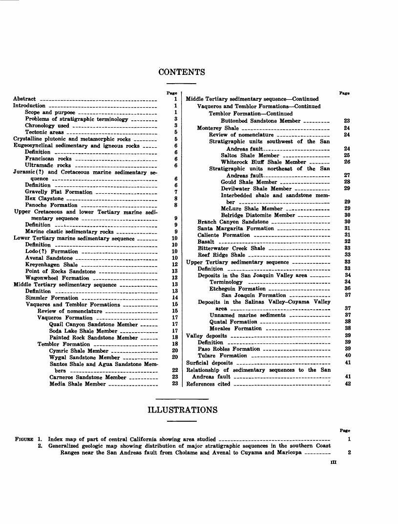
CONTENTS
Abstract _ _ __________________________Introduction _____________________________________
Scope and purpose ___________________________Problems of stratigraphic terminology _________Chronology used _____________________________Tectonic areas ____________________________
Crystalline plutonic and metamorphic rocks ________Eugeosynclinal sedimentary and igneous rocks _____
Definition ___________________________________Franciscan rocks ____________________________Ultramafic rocks _ __ __________________
Jurassic (?) and Cretaceous marine sedimentary se quence __ ______________________________
Definition _____________________________Gravelly Flat Formation _____________________Hex Claystone _______________________________Panoche Formation __________________________
Upper Cretaceous and lower Tertiary marine sedi mentary sequence _________________
Definition ___i_______________________________Marine clastic sedimentary rocks ______________
Lower Tertiary marine sedimentary sequence _______Definition ________________________ Lodo(?) Formation __________________________Avenal Sandstone ____________________________Kreyenhagen Shale __________________________Point of Rocks Sandstone _________________Wagonwheel Formation ______________________
Middle Tertiary sedimentary sequence _____________Definition ___________________________________Simmler Formation __________________________Vaqueros and Temblor Formations ____________
Review of nomenclature __________________Vaqueros Formation ____________
Quail Canyon Sandstone Member __ Soda Lake Shale Member _____________Painted Rock Sandstone Member
Temblor Formation ______________________Cymric Shale Member ___________Wygal Sandstone Member ____________Santos Shale and Agua Sandstone Mem
bers __________Carneros Sandstone Member ________Media Shale Member _________________
Page11133556666
66788
999
10101010121313131314151517171718182020
222323
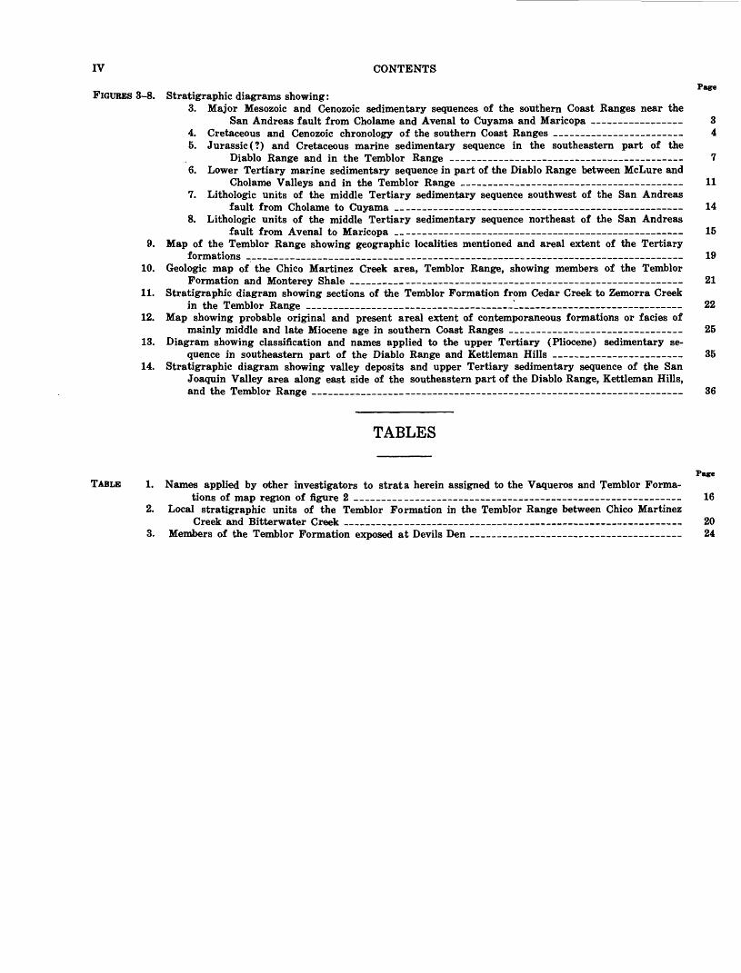
PageMiddle Tertiary sedimentary sequence Continued
Vaqueros and Temblor Formations Continued Temblor Formation Continued
Buttonbed Sandstone Member ______ 23Monterey Shale ____________________ 24
Review of nomenclature _____ _ 24Stratigraphic units southwest of the San
Andreas fault 24 Saltos Shale Member ______________ 25Whiterock Bluff Shale Member ____ 26
Stratigraphic units northeast of the SanAndreas fault. 27
Gould Shale Member __ 28 Devilwater Shale Member 29 Interbedded shale and sandstone mem
ber ____________ 29 McLure Shale Member __ 29 Belridge Diatomite Member 30
Branch Canyon Sandstone ___ 30 Santa Margarita Formation ___ 31 Caliente Formation 31 Basalt _________________-___ 32 Bitterwater Creek Shale _____ 33 Reef Ridge Shale ___________ 33
Upper Tertiary sedimentary sequence 33Definition _____ 33Deposits in the San Joaquin Valley area 34
Terminology __ 34Etchegoin Formation 36
San Joaquin Formation 37Deposits in the Salinas Valley-Cuyama Valley
area _____ 37Unnamed marine sediments _ 37Quatal Formation 38Morales Formation 38
Valley deposits 39Definition ________ 39Paso Robles Formation 39 Tulare Formation _ 40
Surficial deposits 41 Relationship of sedimentary sequences to the San
Andreas fault _ _ 41 References cited _ '- 42
ILLUSTRATIONS
FIGURE 1. Index map of part of central California showing area studied __________________________________2. Generalized geologic map showing distribution of major stratigraphic sequences in the southern Coast
Ranges near the San Andreas fault from Cholame and Avenal to Cuyama and Maricopa
Page
1
III
IV CONTENTS
Page FIGURES 3-8. Stratigraphic diagrams showing:
3. Major Mesozoic and Cenozoic sedimentary sequences of the southern Coast Ranges near theSan Andreas fault from Cholame and Avenal to Cuyama and Maricopa 3
4. Cretaceous and Cenozoic chronology of the southern Coast Ranges 45. Jurassic (?) and Cretaceous marine sedimentary sequence in the southeastern part of the
Diablo Range and in the Temblor Range 76. Lower Tertiary marine sedimentary sequence in part of the Diablo Range between McLure and
Cholame Valleys and in the Temblor Range 117. Lithologic units of the middle Tertiary sedimentary sequence southwest of the San Andreas
fault from Cholame to Cuyama _ _ 148. Lithologic units of the middle Tertiary sedimentary sequence northeast of the San Andreas
fault from Avenal to Maricopa 15 9. Map of the Temblor Range showing geographic localities mentioned and areal extent of the Tertiary
formations _ __________________ 1910. Geologic map of the Chico Martinez Creek area, Temblor Range, showing members of the Temblor
Formation and Monterey Shale ________ 2111. Stratigraphic diagram showing sections of the Temblor Formation from Cedar Creek to Zemorra Creek
in the Temblor Range ____________ -_ _ - 2212. Map showing probable original and present areal extent of contemporaneous formations or facies of
mainly middle and late Miocene age in southern Coast Ranges ___ _ _ 2513. Diagram showing classification and names applied to the upper Tertiary (Pliocene) sedimentary se
quence in southeastern part of the Diablo Range and Kettleman Hills 3514. Stratigraphic diagram showing valley deposits and upper Tertiary sedimentary sequence of the San
Joaquin Valley area along east side of the southeastern part of the Diablo Range, Kettleman Hills, and the Temblor Range ___________ _______________________ _ __-_ 36
TABLES
TABLE 1. Names applied by other investigators to strata herein assigned to the Vaqueros and Temblor Forma tions of map region of figure 2 _________
2. Local Stratigraphic units of the Temblor Formation in the Temblor Range between Chico Martinez Creek and Bitterwater Creek _______ ____________ _
3. Members of the Temblor Formation exposed at Devils Den ___________ _____ _
Page
16
2024
STRATIGRAPHY OF THE SOUTHERN COAST RANGESNEAR THE SAN ANDREAS FAULT
FROM CHOLAME TO MARICOPA, CALIFORNIA
By T. W. DIBBLEE, JR.
ABSTRACTThe upper Mesozoic and Cenozoic sedimentary series
within about 20 miles on either side of the San Andreas fault has been mapped and systematically classified. South west of the fault, the sedimentary series overlies a Mesozoic crystalline basement of plutonic and metamorphic rocks, is from 5,000 to 40,000 feet thick, and is divided into four lithologic sequences. Northeast of the fault, the sedimentary series overlies a Mesozoic basement of eugeosynclinal rocks (Franciscan rocks and serpentine), is from 25,000 to 40,000 feet thick, and is divided into five lithologic sequences. These sequences are in large part separated by regional uncon formities. The Cretaceous and Tertiary sequences are marine and terrestrial southwest of the fault, marine northeast of it. The youngest sequence, mainly of Quaternary age, is composed of lithologically similar valley sediments on each side of the fault.
Most of the sedimentary sequences are divided into litho logically distinct formations of large areal extent, some of which in turn are divided into local members. A standardized set of names has been designated for the formations and members for this region, using the existing names that are applicable.
On opposite sides of the San Andreas fault, not only are the basement rocks contrasting, but the oldest correspond ing sedimentary sequences are dissimilar; the successively younger sequences are progressively less different. This con dition appears to be the result of persistent right-lateral movement on the fault since Cretaceous time.
INTRODUCTIONSCOPE AND PURPOSE
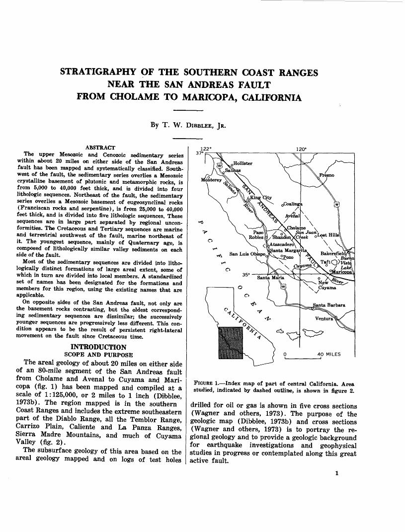
The areal geology of about 20 miles on either side of an 80-mile segment of the San Andreas fault from Cholame and Avenal to Cuyama and Mari- copa (fig. 1) has been mapped and compiled at a scale of 1:125,000, or 2 miles to 1 inch (Dibblee, 1973b). The region mapped is in the southern Coast Ranges and includes the extreme southeastern part of the Diablo Range, all the Temblor Range, Carrizo Plain, Caliente and La Panza Ranges, Sierra Madre Mountains, and much of Cuyama Valley (fig. 2).
The subsurface geology of this area based on the areal geology mapped and on logs of test holes
122 120°
FIGURE 1. Index map of part of central California. Area studied, indicated by dashed outline, is shown in figure 2.
drilled for oil or gas is shown in five cross sections (Wagner and others, 1973). The purpose of the geologic map (Dibblee, 1973b) and cross sections (Wagner and others, 1973) is to portray the re gional geology and to provide a geologic background for earthquake investigations and geophysical studies in progress or contemplated along this great active fault.
STRATIGRAPHY, SOUTHERN COAST RANGES NEAR SAN ANDREAS FAULT, CALIFORNIA
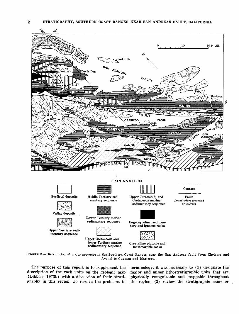
EXPLANATION
Upper Tertiary sedi mentary sequence
Middle Tertiary sedi mentary sequence
Lower Tertiary marine sedimentary sequence
Upper Cretaceous and lower Tertiary marine sedimentary sequence
Upper Jurassic (?) and Cretaceous marine sedimentary sequence
Eugeosynclinal sedimen tary and igneous rocks
Crystalline plutonic and metamorphic rocks
Contact
FaultDotted where concealed
or inferred
FIGURE 2. Distribution of major sequence in the Southern Coast Ranges near the San Andreas fault from Cholame andAvenal to Cuyama and Maricopa.
The .purpose of this report is to supplement the description of the rock units on the geologic map (Dibblee, 1973b) with a discussion of their strati graphy in this region. To resolve the problems in
terminology, it was necessary to (1) designate the major and minor lithostratigraphic units that are physically recognizable and mappable throughout the region, (2) review the stratigraphic name or
INTRODUCTION
names that have been applied to each unit by pre vious investigators, and (3) suggest the best desig nation for each unit.
PROBLEMS OF STRATIGRAPHIC TERMINOLOGY The map area (fig. 2) is one in which the Meso-
zoic and Cenozoic stratigraphy is exceedingly com plex because of many unconformities and lateral variations in lithology and thickness resulting from deposition concurrent with tectonic movement. Dur ing pioneer geologic investigations of the oil and gas districts of this region in the early twentieth century, attempts were made to delineate major stratigraphic units on the basis of reconnaissance mapping. Later, more detailed investigations re vealed stratigraphic complexities not recognized in the earlier investigations. Correlation problems be came evident and led to the naming of numerous local stratigraphic units. As a result, each district has its own set of locally recognized stratigraphic units, and no major regional stratigraphic units of the California Coast Ranges have been established. Thus, the stratigraphic terminology is somewhat chaotic.
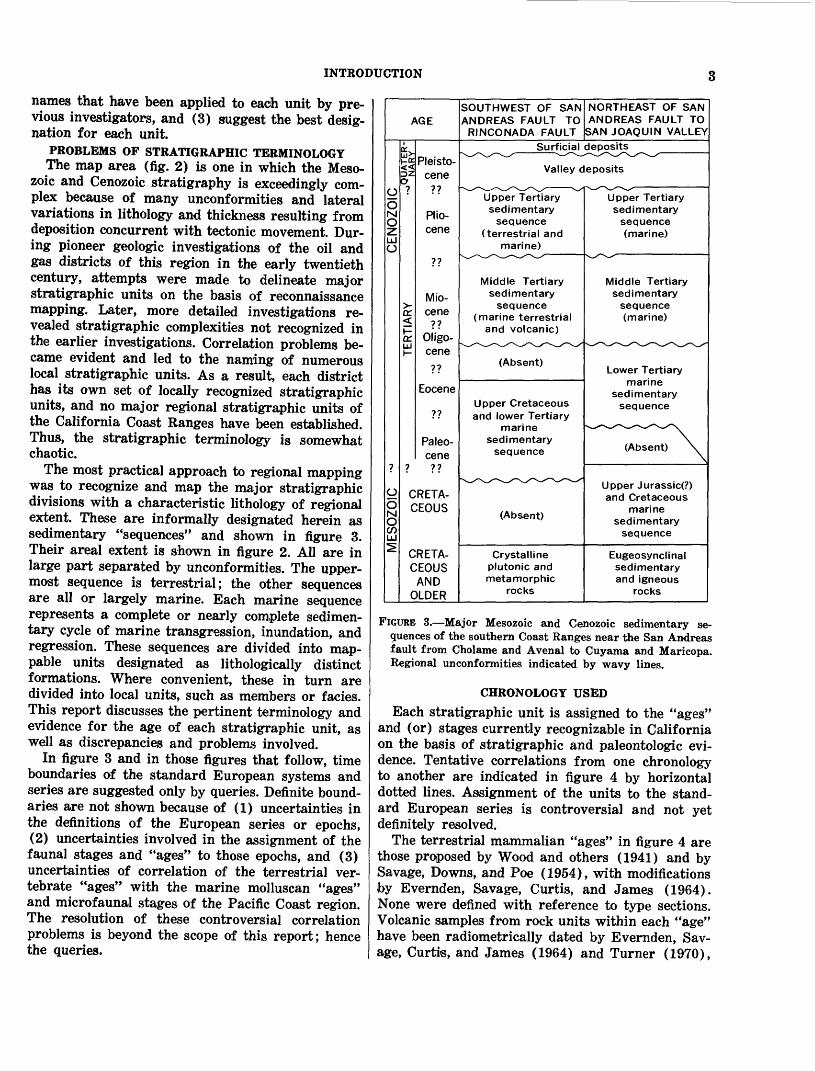
The most practical approach to regional mapping was to recognize and map the major stratigraphic divisions with a characteristic lithology of regional extent. These are informally designated herein as sedimentary "sequences" and shown in figure 3. Their areal extent is shown in figure 2. All are in large part separated by unconformities. The upper most sequence is terrestrial; the other sequences are all or largely marine. Each marine sequence represents a complete or nearly complete sedimen tary cycle of marine transgression, inundation, and regression. These sequences are divided into map- pable units designated as lithologically distinct formations. Where convenient, these in turn are divided into local units, such as members or fades. This report discusses the pertinent terminology and evidence for the age of each stratigraphic unit, as well as discrepancies and problems involved.
In figure 3 and in those figures that follow, time boundaries of the standard European systems and series are suggested only by queries. Definite bound aries are not shown because of (1) uncertainties in the definitions of the European series or epochs, (2) uncertainties involved in the assignment of the faunal stages and "ages" to those epochs, and (3) uncertainties of correlation of the terrestrial ver tebrate "ages" with the marine molluscan "ages" and microfaunal stages of the Pacific Coast region. The resolution of these controversial correlation problems is beyond the scope of this report; hence the queries.
AGE
0O MOzLJO
OOsCO UJs
1X£K<<
?
o:
HcrLU1-
Pleistocene
??
Pliocene
??
Miocene
Oligo-cene
??
Eocene
??
Paleo- cene
CRETA-CEOUS
CRETACEOUS
ANDOLDER
SOUTHWEST OF SANANDREAS FAULT TO
RINCONADA FAULT
NORTHEAST OF SANANDREAS FAULT TO
SAN JOAQUIN VALLEY
Surficial deposits-v_x-\/-^_/ v_^\^-^x~v_/-S_x--v_x
Valley deposits
Upper Tertiarysedimentary
sequence(terrestrial and
marine) v^x-v^-~V^
Middle Tertiarysedimentary
sequence(marine terrestrial
and volcanic)
(Absent)
Upper Cretaceousand lower Tertiary
marinesedimentary
sequence
-^
(Absent)
CrystallinePlutonic andmetamorphic
rocks
Upper Tertiarysedimentary
sequence(marine)
V_/~v^
Middle Tertiarysedimentary
sequence(marine)
Lower Tertiarymarine
sedimentarysequence
^^^v^^^-^^^^V-x^s.
(Absent) \
Upper Jurassic(?) and Cretaceous
marine sedimentary
sequence
Eugeosynclinalsedimentaryand igneous
rocks
FIGURE 3. Major Mesozoic and Cenozoic sedimentary se quences of the southern Coast Ranges near the San Andreas fault from Cholame and Avenal to Cuyama and Maricopa. Regional unconformities indicated by wavy lines.
CHRONOLOGY USED
Each stratigraphic unit is assigned to the "ages" and (or) stages currently recognizable in California on the basis of stratigraphic and paleontologic evi dence. Tentative correlations from one chronology to another are indicated in figure 4 by horizontal dotted lines. Assignment of the units to the stand ard European series is controversial and not yet definitely resolved.
The terrestrial mammalian "ages" in figure 4 are those proposed by Wood and others (1941) and by Savage, Downs, and Poe (1954), with modifications by Evernden, Savage, Curtis, and James (1964). None were defined with reference to type sections. Volcanic samples from rock units within each "age" have been radiometrically dated by Evernden, Sav age, Curtis, and James (1964) and Turner (1970),

STRATIGRAPHY, SOUTHERN COAST RANGES NEAR SAN ANDREAS FAULT, CALIFORNIA
< sr u
CENOZOIC
MESOZOIC
SYS
TEM
*£r- £zzCX
TERTIARY
<i> CL Q.ID
<l> a o
^
<5 o
CRETACEOUS
*%^ e/j-> <
SERIES
Holocene
Pleistocene
Pliocene
Miocene
Oligocene
Eocene
Paleocene
Upper
Lower
Upper
Middle
Lower
Upper
Lower
Upper
Middle
Lower
Upper
Lower
Upper
Lower
Upper
MAMMA LIAN
"AGES"
Rancho- labreanIrving- tonian
Blancan
Hemp- hillian
Claren- donian
Barsto- vian
Heming- fordian
Arika- reean
RADIO- METRIC
AGES 1
I 5 .............
4
10 ........... ?
12?---?
13? 14
&=***
21 ..--.._ 2£.o
1C
Maestrichtian Campanian w Santonian w Coniacian ^ Turonian i- Cenomanian w Albian Aptian Barremian ^ Hauterivian wValanginian 0- _ . o Bernasian ^
;.) u
Tithonian
FORAMIN- IFERAL STAGES
"Delmontian" 2 Mohnian
Luisian
Relizian
Saucesian
Zemorrian
Refugian
Narizian
Ulatisian
Penutian
Bulitian
Ynezian
MOLLUSCAN "AGES"
"Upper Pleistocene"
"Lower Pleistocene"
"San Joaquin" and "Etchegoin"
"Jacalitos"
"Santa Margarita"
"Temblor"
"Vaqueros"
"Gaviota"
"Tejon"
"Domengine"
"Capay"
"Meganos"
"Martinez"
1 Potassium-argon dates in millions of years (Evernden and others, 1964, and Turner. 1970). 2Now considered part of Mohnian Stage (R. L. Pierce, oral commun., 1970)
FIGURE 4. Cretaceous and Cenozoic chronology of the southern Coast Ranges. Diagonal dotted lines indicate correla tions with the standard European series (Durham, 1954, fig. 3; Savage and others, 1954, fig. 10); horizontal dotted lines indicate questionable but tentative correlations.
CRYSTALLINE PLUTONIC AND METAMORPHIC ROCKS
who determined the approximate age in millions of years of the boundaries of those "ages." Correlation of the "age" boundaries with the standard Euro pean series as inferred by Durham (1954, fig. 3) and Savage, Downs, and Poe (1954, fig. 10) is indicated in figure 4. Figure 4 is based on the correlation by Turner (1970, fig. 9) of the mammalian "ages" with the foraminiferal stages and on the currently ac cepted assignment of those stages and correlative molluscan ages to the European series.
The marine foraminiferal stages assigned to the middle Tertiary system were proposed and defined by Kleinpell (1938), and those assigned to the lower Tertiary were proposed and defined by Mallory (1959). Correlation of the middle Tertiary stages with corresponding mammalian "ages" is adopted from Turner (1970, fig. 9), who radiometrically dated the approximate boundaries of most of those stages as well as those of the mammalian "ages." Assignment of the foraminiferal stages to the Euro pean series is adopted from Weaver and others (1944, chart 11), with modifications from Bandy and Arnal (1969, p. 786).
Marine molluscan "ages" have been proposed or listed but never adequately defined. Those shown are the ones currently recognized for the southern Coast Ranges by W. O. Addicott (oral commun., 1970). Assignment of those ages to the European series is modified after Weaver and others (1944, chart 11). Those assigned to the Quaternary and upper Tertiary are listed by Durham (1954, ch. 3, p. 25); those to the middle Tertiary were proposed by Corey (1954, ,p. 82), and those to the lower Ter tiary, by Clark and Yokes (1936).
Fossils have been reported from only very few places in the Mesozoic rocks; so, only a very general assignment of their ages to the European systems and stages can be inferred. Lack of microfaunal data from these rocks precludes their assignment to the foraminiferal stages proposed by Goudkoff (1945) and recognized by Church (1968).
TECTONIC AREAS
The region discussed in this report (fig. 2) is divisible by the San Andreas fault or some of its strands into two tectonic areas of dissimilar base ment rocks and sedimentary sequences. The area on the northeast, which has a basement of eugeo- synclinal sedimentary and igneous rocks, extends into the San Joaquin Valley. The area to the south west, which is part of the Salinia block of Reed (1933, p. 12, fig. 16), has a basement of crystalline rocks and extends to the Rinconada fault (fig. 2). Much of the Rinconada fault as shown is commonly
assumed to be the Nacimiento fault (Vedder and Brown, 1968). Recent mapping by the writer, how ever, reveals that the Rinconada fault as shown in figure 2 is continuous to the northwest not with the Nacimiento fault of Taliaferro (1943) but with the Rinconada fault (Jennings, 1958) northwest of Atascadero. Southeastward from Atascadero, how ever, the Rinconada fault (fig. 2) is largely within the Sur-Nacimiento fault zone as defined by Page (1970).
It is noteworthy that not only do these two juxta posed tectonic areas have contrasting basement rocks, but they also have dissimilar sedimentary sequences; the successively younger corresponding sequences are progressively more similar (fig. 3). This dissimilarity is interpreted to be the result of recurrent or continuous lateral movements on the San Andreas fault during or after deposition of each sedimentary sequence since Cretaceous time, as inferred by Hill and Dibblee (1953, p. 445-449) and discussed further at the end of this report.
CRYSTALLINE PLUTONIC AND METAMORPHIC ROCKS
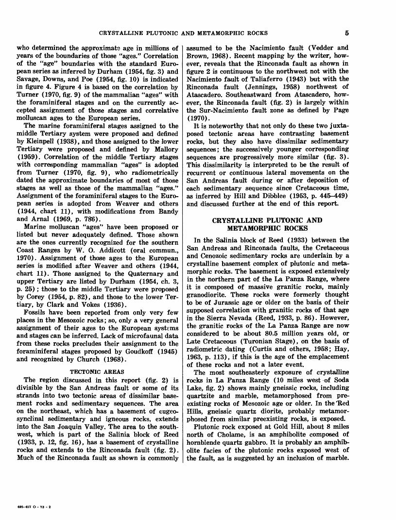
In the Salinia block of Reed (1933) between the San Andreas and Rinconada faults, the Cretaceous and Cenozoic sedimentary rocks are underlain by a crystalline basement complex of plutonic and meta- morphic rocks. The basement is exposed extensively in the northern part of the La Panza Range, where it is composed of massive granitic rocks, mainly granodiorite. These rocks were formerly thought to be of Jurassic age or older on the basis of their supposed correlation with granitic rocks of that age in the Sierra Nevada (Reed, 1933, p. 86). However, the granitic rocks of the La Panza Range are now considered to be about 80.5 million years old, or Late Cretaceous (Turonian Stage), on the basis of radiometric dating (Curtis and others, 1958; Hay, 1963, p. 113), if this is the age of the emplacement of these rocks and not a later event.
The most southeasterly exposure of crystalline rocks in La Panza Range (10 miles west of Soda Lake, fig. 2) shows mainly gneissic rocks, including quartzite and marble, metamorphosed from pre existing rocks of Mesozoic age or older. In the Hed Hills, gneissic quartz diorite, probably metamor phosed from similar preexisting rocks, is exposed.
Plutonic rock exposed at Gold Hill, about 8 miles north of Cholame, is an amphibolite composed of hornblende quartz gabbro. It is probably an amphib olite facies of the plutonic rocks exposed west of the fault, as is suggested by an inclusion of marble.
495-417 O - 73 - 2
STRATIGRAPHY, SOUTHERN COAST RANGES NEAR SAN ANDREAS FAULT, CALIFORNIA
The gabbro has been radiometrically dated as about 143 million years old, or Jurassic in age (Hay, 1963, p. 113).
EUGEOSYNCLINAL SEDIMENTARY AND IGNEOUS ROCKS
DEFINITION
Northeast of the San Andreas fault (with the exception of Gold Hill in Cholame Valley), the low est major rock division is a generally unmetamor- phosed but severely deformed assemblage of eugeo- synclinal sedimentary and mafic igneous rocks. It forms the basement complex upon which the upper Mesozoic and Cenozoic miogeosynclinal sedimentary sequences rest. The sedimentary and volcanic rocks that make up most of this assemblage are known informally as Franciscan rocks (Bailey and others, 1964). Ultramafic igneous rocks intruding the Franciscan rocks form part of the eugeosynclinal complex.
Exposures of the eugeosynclinal assemblage in the Temblor Range are the southeasternmost in the Coast Ranges northeast of the San Andreas fault. This assemblage is exposed extensively in the Diablo Range to the northwest, mostly beyond the map area.
FRANCISCAN ROCKSAs in other parts of the Coast Ranges province,
the Franciscan rocks, as designated by Bailey, Irwin, and Jones (1964, figs. 1, 2, 3; pi. 1), form an assemblage of eugeosynclinal marine sedimentary and mafic volcanic rocks many thousands of feet thick. The assemblage is composed of graywacke, claystone, basalt (greenstone), and small lenses of varicolored chert and limestone. These rock types, together with the mafic intrusive rocks, form numer ous commonly brecciated lenticular masses of all sizes in a pervasively sheared "matrix" of dark claystone and fragmented graywacke. It is not known how or when this assemblage became so in tensely deformed. This deformation may have re sulted from severe tectonic movements such as underthrusting, accompanied by the numerous in jections of ultramafic rocks, during or soon after deposition. These violent events appear to have occurred prior to deposition of the superjacent Jurassic (?) and Cretaceous marine sedimentary se quence because it is unaffected by pervasive shear ing, mixing, and shattering.
The age within the Mesozoic Era of the Francis can rocks of this region is controversial. Foramini- fera from limestone east of Cholame Valley suggest a middle Cretaceous age (Dickinson, 1966a, p. 718-
719), yet the lowest units of the superjacent sedi mentary sequence in the Diablo Range contain fos sils inferred to indicate Early Cretaceous age. The Franciscan of western California is generally con sidered to range in age from Late Jurassic (Tith- onian) to Late Cretaceous (Turonian) only on the basis of fossils from a few localities (Bailey and others, 1964, p. 122). The age relationship of the Franciscan to the crystalline basement complex across the San Andreas fault is not definitely known.
ULTRAMAFIC ROCKSIn the area within figure 2, the uliramafic rocks
are composed mainly of serpentine and partly of serpentinized peridotite. They are intricately asso ciated with Franciscan rocks in the form of numer ous lenticular sill-like masses, some large, either intrusive or injected into the Franciscan rocks. Many are at or near the top of this assemblage in contact with the overlying Jurrassic(?) and Cre taceous marine sedimentary sequence, but none are found within that sequence. All the serpentinous masses are pervasively sheared or shattered, either because of expansion that occurred as a result of serpentinization, because of tectonic movements, or both. These ultramafic rocks are presumably Early Cretaceous and (or) possibly Late Jurassic in age.
JURASSIC(?) AND CRETACEOUS MARINE SEDIMENTARY SEQUENCE
DEFINITIONNortheast of the San Andreas fault, the eugeo
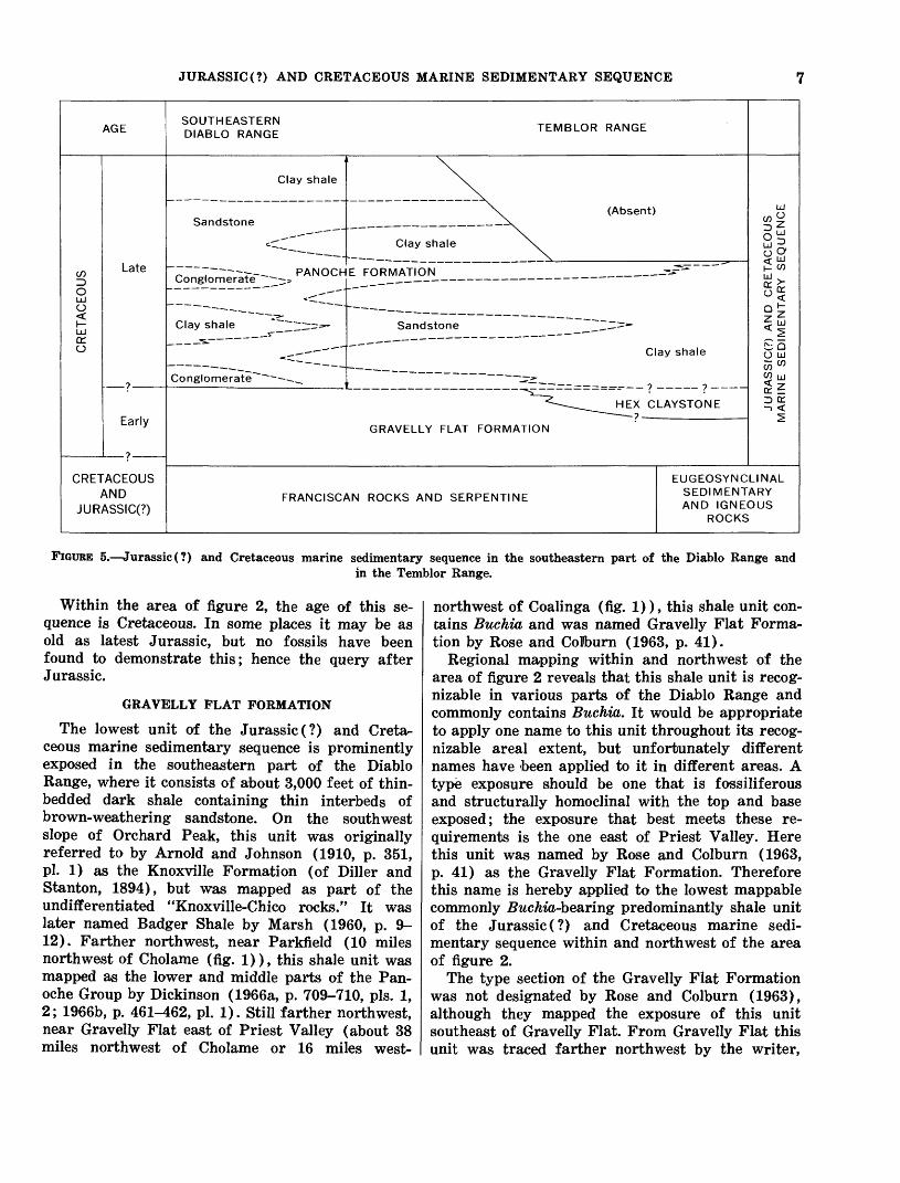
synclinal sedimentary and igneous rocks are over lain by or are in fault contact with a sequence of miogeosynclinal marine clastic sedimentary rocks chiefly of Cretaceous age. This sequence is herein designated the Jurassic (?) and Cretaceous marine sedimentary sequence. It is the same major unit as that referred to by Bailey, Irwin, and Jones (1964, p. 123-124) as the Great Valley sequence. It was informally named for the Great Valley, west of which it is thickest. The term "Great Valley se quence" is somewhat inappropriate because the entire sequence is marine and was not deposited in a valley, as this seemingly descriptive term implies. Within the region of figure 2, this sequence is from 7,000 to 10,000 feet thick and is composed of sand stone, shale, claystone, and small lenses of conglom erate. It accumulated probably under open-sea con ditions offshore from a landmass, as suggested by scarcity of megafossils and lack of terrestrial beds. Three divisions are recognizable: in ascending order, the Gravelly Flat Formation, Hex Claystone, and Panoche Formation (fig. 5).
JURASSIC (?) AND CRETACEOUS MARINE SEDIMENTARY SEQUENCE
AGE
CRETACEOUS
Late
?
Early
o
CRETACEOUS AND
JURASSIC(?)
SOUTHEASTERN TCMQI r»o OAM/-C DIABLO RANGE TEMBLOR RANGE
Clay shale
Sandstone
c"^
\\. (Absent)
Clay shale ^^
_ . -r- PANOCHE FORMATION
Clay shale ~~~~ -=""s
s.
Conglomerate"^"^-- --._
Sandstone ~~~.Z=»-
_ .^^
Clay shale
^-----_____HEX CLAYSTONE
GRAVELLY FLAT FORMATION
FRANCISCAN ROCKS AND SERPENTINE
JURASSIC(?) AND CRETACEOUS MARINE SEDIMENTARY SEQUENCE
EUGEOSYNCLINAL SEDIMENTARY AND IGNEOUS
ROCKS
FIGURE 5. Jurassic (?) and Cretaceous marine sedimentary sequence in the southeastern part of the Diablo Range andin the Temblor Range.
Within the area of figure 2, the age of this se quence is Cretaceous. In some places it may be as old as latest Jurassic, but no fossils have been found to demonstrate this; hence the query after Jurassic.
GRAVELLY FLAT FORMATION
The lowest unit of the Jurassic (?) and Creta ceous marine sedimentary sequence is prominently exposed in the southeastern part of the Diablo Range, where it consists of about 3,000 feet of thin- bedded dark shale containing thin interbeds of brown-weathering sandstone. On the southwest slope of Orchard Peak, this unit was originally referred to by Arnold and Johnson (1910, p. 351, pi. 1) as the Knoxville Formation (of Diller and Stanton, 1894), but was mapped as part of the undifferentiated "Knoxville-Chico rocks." It was later named Badger Shale by Marsh (1960, p. 9- 12). Farther northwest, near Parkfield (10 miles northwest of Cholame (fig. 1)), this shale unit was mapped as the lower and middle parts of the Pan- oche Group by Dickinson (1966a, p. 709-710, pis. 1, 2; 1966b, p. 461-462, pi. 1). Still farther northwest, near Gravelly Flat east of Priest Valley (about 38 miles northwest of Cholame or 16 miles west-
northwest of Coalinga (fig. 1)), this shale unit con tains Buchia and was named Gravelly Flat Forma tion by Rose and Colburn (1963, p. 41).
Regional mapping within and northwest of the area of figure 2 reveals that this shale unit is recog nizable in various parts of the Diablo Range and commonly contains Buchia. It would be appropriate to apply one name to this unit throughout its recog nizable areal extent, but unfortunately different names have 'been applied to it in different areas. A type exposure should be one that is fossiliferous and structurally homoclinal with the top and base exposed; the exposure that best meets these re quirements is the one east of Priest Valley. Here this unit was named by Rose and Colburn (1963, p. 41) as the Gravelly Flat Formation. Therefore this name is hereby applied to the lowest mappable commonly Buchia-bearmg predominantly shale unit of the Jurassic (?) and Cretaceous marine sedi mentary sequence within and northwest of the area of figure 2.
The type section of the Gravelly Flat Formation was not designated by Rose and Colburn (1963), although they mapped the exposure of this unit southeast of Gravelly Flat. From Gravelly Flat this unit was traced farther northwest by the writer,
8 STRATIGRAPHY, SOUTHERN COAST RANGES NEAR SAN ANDREAS FAULT, CALIFORNIA
and type section is here designated as the spur extending southwest from Center Peak in the SW*4 sec. 12 and NW*4 sec. 13, T. 20 S., R. 12 E., about 3 miles northwest of Gravelly Flat (Priest Valley 15' quad.) and about 16 miles west-northwest of Coalinga (fig. 1). There the Gravelly Flat Forma tion is about 2,400 feet thick. It is composed mainly of dark shale, including about 400 feet of brown- weathering sandstone in the lowest part, in contact with serpentine at the base. The shale is conform ably overlain by a thick conglomerate unit herein assigned to the base of the Panoche Formation.
According to Rose and Colburn (1963, p. 41) and D. L. Jones (oral commun., 1970), the lowest part of the Gravelly Flat Formation east of Priest Valley contains Buchia piochii, generally considered diagnostic of Late Jurassic (Tithonian) age; the middle part contains Buchia crassa, diagnostic of Early Cretaceous (Valanginian) age; and the upper part contains fossils suggestive of Early Cretaceous (Hauterivian) age.
In its exposure east of Priest Valley and also within the area of figure 2, the Gravelly Flat Forma tion is distinguishable from the overlying Panoche Formation by its dark-gray to olive-brown color, the dark-colored graywacke character of its sandstone interbeds, and a lack of thick light-colored sandstone beds. Within the area of figure 2 on the south and west slopes of Orchard Peak, where the unit herein referred to the Gravelly Flat Formation was mapped by Marsh (1960, p. 9-12, pi. 1) as the Badger Shale, the formation is about 3,700 feet thick, it contains two layers of tuff or bentonite, and its base is partly if not entirely in fault contact with serpentine. North of Orchard Peak this unit is either depositional on or in fault contact with the Franciscan rocks. It yielded no diagnostic fossils in any of these exposures, but is assigned to the Gravelly Flat Formation because it is lithologically similar to and occupies the same stratigraphic posi tion as the type section. It is tentatively considered to be of the same age, but because of the absence of fossils, the Jurassic assignment is queried.
In the northwestern Temblor Range the Gravelly Flat Formation is lithologically similar to the unit in the Diablo Range, and no fossils were found. It may be over 5,000 feet thick, but its contact with shale of the overlying Panoche Formation is only arbitrarily placed at the lowest abundantly inter- bedded sandstones.
HEX CLAYSTONE
Pervasively sheared gray claystone is exposed in two places, one southeast of Orchard Peak, the
other west of Devils Den. In the former exposure it was named Hex Formation by Marsh (1960, p. 6-7). The type locality was designated at Hex Hill, about 6 miles east-southeast of Orchard Peak. This name is adopted herein for this unusual formation, but is modified to Hex Claystone because of its nearly homogeneous claystone lithology.
The stratigraphic position of the Hex Claystone is not definitely known because (1) it is pervasively sheared, (2) it is bounded by faults, (3) it appears to have been injected as a plastic mass between faults into the Panoche Formation at Hex Hill and even into Tertiary rocks at Devils Den, and (4) it is lithologically similar to the claystone or clay shale of the Panoche Formation, but contains fossils diag nostic of a pre-Late Cretaceous age.
Marsh (1960, p. 6-7) considered his Hex Forma tion to be of Late Jurassic (?) age on the basis of marine fossils found in the Hex and to be older than his Badger Shale (Gravelly Flat Formation of this report), which he assigned to the Early Cre taceous (?). While it is possible that the Hex Clay- stone may have been injected from below the Gravelly Flat Formation, this is considered unlikely because no claystone has been found in that position in an unfaulted section. Structural evidence revealed from mapping on Hex Hill (Dibblee, 1972a) sug gests that the Hex Claystone formed by pervasive shearing of the upper part of the Gravelly Flat Formation, possibly with some involvement of the Panoche Formation.
Belemnites and foraminifers from the Hex Clay- stone of the Hex Hill area have been considered suggestive of Late Jurassic, Early Cretaceous, or Late Cretaceous ages, and the formation was tenta tively assigned a Late Jurassic (?) age (Marsh, 1960, p. 8). Foraminifers from both the Hex Hill and Devils Den exposures are now, however, con sidered strongly suggestive of an Early Cretaceous (Valanginian) age (Church, 1968, p. 527). This age is also suggested from Buchia species found at both exposures (D. L. Jones, oral commun., 1970).
PANOCHE FORMATION
In the southeastern part of the Diablo Range, the Gravelly Flat Formation is overlain by as much as 7,500 feet of interbedded concretion-rich light- colored sandstone and dark-gray clay shale or clay- stone of Late Cretaceous age. The contact with the underlying Gravelly Flat Formation is gradational, but in places it is marked by lenses of conglomerate or sandstone.
These Upper Cretaceous strata were referred by Arnold and Johnson (1910, p. 35-37, pi. 1) to the

UPPER CRETACEOUS AND LOWER TERTIARY MARINE SEDIMENTARY SEQUENCE
Chico Formation (of Gabb, 1869), but were mapped as the major part of their undifferentiated "Knox- ville-Chico rocks." In the Orchard Peak area south west of McLure Valley, these strata were divided by Marsh (1960, p. 12-29, pis. 1, 2) into eight local units mapped as formations, including the upper most claystone unit that he referred to the Moreno Formation of Anderson and Pack (1915). The names Marsh applied to these units are not adopted herein because the units are not recognizable out side that area. Farther northwest, all the Creta ceous marine sedimentary sequence was referred by Dickinson (1966a, p. 709-710) to the Panoche Group.
This series of strata, of Late Cretaceous age, is assigned to the Panoche Formation because it in cludes the major part of the series mapped as the Panoche Formation by Anderson and Pack (1915) and is lithologically distinct from the part assigned to the Gravelly Flat Formation. It is most practical to differentiate the Panoche Formation on the basis of lithology into units that are predominantly sand stone, units that are predominantly shale or clay- stone, and units that are predominantly conglom erate, as shown in figure 5. No names are applied herein because the lateral extent of these units is very limited.
The uppermost clay shale unit crops out on the west and south sides of McLure Valley, where it is about 900 feet thick and is overlain unconform- ably by Tertiary formations. On the south side of the valley, this clay shale unit was referred by Marsh (1960, p. 28-29, pi. 1) to the Moreno Forma tion of Anderson and Pack (1915, p. 46-47) on the basis of similar lithology and microfaunal correla tion. This correlation is doubtful, however, because the Moreno Formation, of latest Cretaceous and Paleocene(?) age, overlies the Panoche Formation north of Coalinga but is overlapped by Tertiary formations south of Coalinga; moreover, it is not known to be present within the area of figure 2, either on the surface or in the subsurface (R. L. Pierce, oral commun., 1968).
In the northwestern Temblor Range, only the lowest 2,000 feet of the Panoche Formation is ex posed. It lies unconformably below Tertiary forma tions, and its contact with the underlying Gravelly Flat Formation is gradational and arbitrarily Jocated.
The Panoche Formation within the area of fig ure 2 contains scattered megafossils and micro- fossils diagnostic of Late Cretaceous age (Cam- panian and Maestrichtian Stages) (Marsh, 1960, p. 16, 21, 24, 25, 28, Orchard Peak area; Dickinson,
1966b, p. 464, Table Mountain area; D. L. Jones, oral commun., 1966, Cedar Creek area of northwest Temblor Range). In the Orchard Peak area, the upper half of the Panoche Formation is inferred from megafossils and microfossils to be mainly within the Campanian Stage, ranging into the San- tonian and possibly into the lower Maestrichtian Stages (Marsh, 1960, p. 25, 28, 29). West of Reef Ridge the lowest shale unit of the Panoche Forma tion, about 7 miles southwest of Avenal, yielded an ammonite (found by Paul Enos) considered diag nostic of the Turonian Stage (D. L. Jones, oral commun., 1965).
UPPER CRETACEOUS AND LOWERTERTIARY MARINE SEDIMENTARY
SEQUENCE
DEFINITION
Southwest of the San Andreas fault, the crystal line basement of the Salinia block is overlain by a very thick sequence of miogeosynclinal marine clastic sedimentary rocks that ranges in age from very Late Cretaceous through Paleocene to middle Eo cene. It is designated herein as the Upper Creta ceous and lower Tertiary marine sedimentary se quence. It is extensively exposed in the La Panza Range and the Sierra Madre Mountains, where it is herein designated as marine clastic sedimentary rocks; a small part is exposed at the southeast end of the Caliente Range, where it was called Pattiway Formation.
This thick sequence and its paleogeographic im plications were described by Chipping (1972), who divided it into several unnamed lithogenetic units.
MARINE CLASTIC SEDIMENTARY ROCKS
The marine clastic sedimentary rocks are a mo notonous, continuously deposited series, as much as 30,000 feet thick, of interbedded arkosic sandstone, siltstone, clay shale, and granitic conglomerate. These strata appear to be deltaic deposits derived from rapid erosion of a nearby granitic terrane and deposited in a shallow sea. This thick series is not named nor differentiated into formations or mem bers because it contains no persistent distinct litho- logic units other than a basal conglomerate as thick as 2,000 feet which overlies granitic basement in the La Panza Range. The marine clastic sedimentary rocks, together with the granitic basement exposed in the La Panza Range, are overlain unconformably by the middle Tertiary sedimentary sequence.
This series of marine clastic sedimentary rocks rarely contains fossils. This sequence was formerly thought to be of Late Cretaceous age (Eaton and
10 STRATIGRAPHY, SOUTHERN COAST RANGES NEAR SAN ANDREAS FAULT, CALIFORNIA
others, 1941, p. 213-214, fig. 3; Hill and others, 1958, p. 2997; Jennings, 1958); however, a few fos sils diagnostic of Late Cretaceous age were found in the lowest 6,000 feet of this sequence in the La Panza Range from 21/& to 7 miles northwest of Pozo and in the basal 1,000 feet near Deadman Flat, 24 miles southeast of Pozo. A few mollusks and foraminifers considered to be of Paleocene age were found stratigraphically higher a few miles southeast of Pozo, and orbitoidal foraminifers diag nostic of early to middle Eocene age were found still higher in the section in the Sierra Madre Mountains (Vedder and Brown, 1968, p. 248-249). Just beyond the southeast border of figure 2, the highest part of this series yielded mollusks diag nostic of middle Eocene age (Vedder and Brown, 1968, p. 249-251).
At the southeast end of the Caliente Range (T. 10 N., R. 25 W.), is exposed about 3,000 feet of marine clastic sedimentary rocks which there were named the Pattiway Formation by Hill, Carlson, and Dib- blee (1958, p. 2977). This name is adopted herein for this unit but only for this exposure, and others beyond the southeast border of figure 2. In these exposures, the Pattiway Formation is composed of light-gray sandstone, gray silty shale, and a few thin conglomerate lenses. It is unconformably over lain by the Simmler Formation, and the base is not exposed. In the Caliente Range, the Pattiway For mation yielded mollusks and foraminifers considered to be of Paleocene age (Vedder and Repenning, 1965).
LOWER TERTIARY MARINE SEDIMENTARY SEQUENCE
DEFINITION
Northeast of the San Andreas fault, the Juras sic (?) and Cretaceous marine sedimentary sequence is overlain unconformably or disconformably by a marine sedimentary sequence of early Tertiary age. It is designated herein as the lower Tertiary ma rine sedimentary sequence. It is as thick as 3,000 feet and is composed of moderately well defined units of sandstone and clay shale of Eocene age; it includes at the top a thin unit of early Oligocene age exposed only at Devils Den.
All but the thin top unit of this sequence was formerly referred to the Tejon Formation (of Gabb, 1869, p. XIII and p. 129, footnote) by Arnold and Anderson (1910, p. 67-70, pi. 1), Arnold and John son (1910, p. 38-39, pi. 1), and Curran (1943). Such a name might be appropriate, but as now used it is generally applied to strata that are definitely
or presumably of late Eocene age, whereas part of the sequence described here is older. This lower Tertiary sequence is composed of the units shown in figure 6.
LODO(?) FORMATION
On Media Agua Creek, in the Temblor Range, about 280 feet of rocks, predominantly clay shale, forms an interval between shale of the Panoche Formation and the Point of Rocks Sandstone. On the basis of microfaunas, this interval was corre lated with and assigned by Mallory (1959, figs. 3, 7) to the Lodo Formation of White (1938) (type locality about 35 miles northwest of Coalinga) of Paleocene and early Eocene age. Mallory divided this interval into three units: lower, middle and upper Lodo.
The lower Lodo, as indicated by Mallory (1959, p. 25-26, 30-31, 34, figs. 3, 7), is about 160 feet thick at Media Agua Creek and is composed of soft clay shale. On the basis of microfaunas he assigned this unit to his Ynezian and Bulitian Stages, Paleo cene, with the exception of the uppermost 20 feet, which, together with the overlying "sandstone reef" (his middle Lodo), he designated as his type Penu- tian Stage, early Eocene. These stages assigned to this 160-foot-thick clay shale unit correlate it with the type Lodo Formation, and its assignment to that formation is tentatively adopted. From Media Agua Creek this clay shale unit appears to extend south eastward along strike for an unknown distance, through poor exposures, possibly as far as Carneros Creek or Salt Creek. Northwest of Media Agua Creek it laps out.
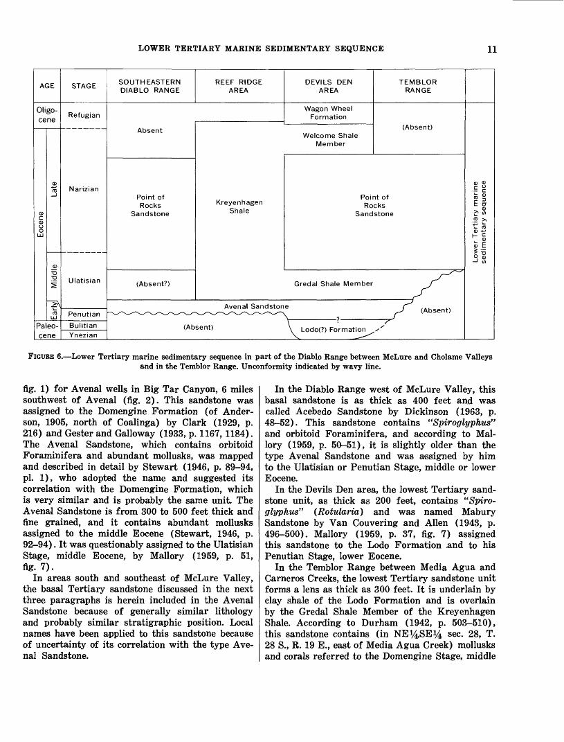
Mallory (1959, p. 28, 37, fig. 7) suggested that a similar shale unit underlying the Avenal ("Ma- bury") Sandstone in the Devils Den area may be of Paleocene and early Eocene ages, and he assigned it to the Lodo Formation. Foraminifera suggestive of those ages have been reported from a thin shale unit above the Panoche Formation from several wells in the Devils Den area (H. C. Wagner and others, unpub. data).
Mallory's middle Lodo at Media Agua Creek is considered to be the Avenal Sandstone, and his upper Lodo the Gredal Shale Member of the Kreyen- hagen Shale, for reasons discussed under "Avenal Sandstone." Their assignment to the Lodo Forma tion is therefore not adopted.
AVENAL SANDSTONE
In the Reef Ridge area, northwest of McLure Valley, the basal Tertiary sandstone unit was named Avenal Sandstone by Anderson (1905, p. 164, pi. 34,
LOWER TERTIARY MARINE SEDIMENTARY SEQUENCE 11
AGE
Oligo- cene
CD
CDOO
L±J
CD
ro""
CD
i
<sL±J
Paleo- cene
STAGE
Refugian
Narizian
Ulatisian
Penutian
Bulitian
Ynezian
SOUTHEASTERN DIABLO RANGE
Absent
Point of Rocks
Sandstone
(Absent?)
REEF RIDGE AREA
DEVILS DEN TEMBLOR AREA RANGE
Wagon Wheel Formation
(Absent)Welcome Shale
Member
KreyenhagenShale
Point of Rocks
Sandstone
Gredal Shale Member ./
Avenal Sandstone J^ (Absent)
(Absent) \ |_odo(?) Formation X
CO 0)
-Egio « E a
ro >
0} *->L_ C
V <"
« E
-J w
FIGURE 6. Lower Tertiary marine sedimentary sequence in part of the Diablo Range between McLure and Cholame Valleysand in the Temblor Range. Unconformity indicated by wavy line.
fig. 1) for Avenal wells in Big Tar Canyon, 6 miles southwest of Avenal (fig. 2). This sandstone was assigned to the Domengine Formation (of Ander- son, 1905, north of Coalinga) by Clark (1929, p. 216) and Gester and Galloway (1933, p. 1167,1184). The Avenal Sandstone, which contains orbitoid Foraminifera and abundant mollusks, was mapped and described in detail by Stewart (1946, p. 89-94, pi. 1), who adopted the name and suggested its correlation with the Domengine Formation, which is very similar and is probably the same unit. The Avenal Sandstone is from 300 to 500 feet thick and fine grained, and it contains abundant mollusks assigned to the middle Eocene (Stewart, 1946, p. 92-94). It was questionably assigned to the Ulatisian Stage, middle Eocene, by Mallory (1959, p. 51, fig. 7).
In areas south and southeast of McLure Valley, the basal Tertiary sandstone discussed in the next three paragraphs is herein included in the Avenal Sandstone because of generally similar lithology and probably similar stratigraphic position. Local names have been applied to this sandstone because of uncertainty of its correlation with the type Ave nal Sandstone.
In the Diablo Range west of McLure Valley, this basal sandstone is as thick as 400 feet and was called Acebedo Sandstone by Dickinson (1963, p. 48-52). This sandstone contains <(Spiroglyphus" and orbitoid Foraminifera, and according to Mal lory (1959, p. 50-51), it is slightly older than the type Avenal Sandstone and was assigned by him to the Ulatisian or Penutian Stage, middle or lower Eocene.
In the Devils Den area, the lowest Tertiary sand stone unit, as thick as 200 feet, contains "Spiro- glyphus" (Rotularia) and was named Mabury Sandstone by Van Couvering and Alien (1943, p. 496-500). Mallory (1959, p. 37, fig. 7) assigned this sandstone to the Lodo Formation and to his Penutian Stage, lower Eocene.
In the Temblor Range between Media Agua and Carneros Creeks, the lowest Tertiary sandstone unit forms a lens as thick as 300 feet. It is underlain by clay shale of the Lodo Formation and is overlain by the Gredal Shale Member of the Kreyenhagen Shale. According to Durham (1942, p. 503-510), this sandstone contains (in NE^4SE^4 sec- 28, T. 28 S., R. 19 E., east of Media Agua Creek) mollusks and corals referred to the Domengine Stage, middle
12 STRATIGRAPHY, SOUTHERN COAST RANGES NEAR SAN ANDREAS FAULT, CALIFORNIA
Eocene. However, at Media Agua Creek, where the sandstone unit is only 25 feet thick, Mallory (1959, p. 24, 34, fig. 7) designated the sandstone (his mid dle Lodo) and 20 feet of the underlying shale as his type Penutian Stage, lower Eocene; he correlated the sandstone, which there contains "Spiroglyphus" and orbitoid foraminifers, with the Mabury Sand stone of Devils Den and assigned both to the Lodo Formation.
This assignment is not adopted because at Media Agua Creek this 25-foot-thick "sandstone reef" is overlain by about 90 feet of clay shale which Mal lory (1959, p. 30, fig. 3, 7) designated as upper Lodo but which he assigned to his Ulatisian Stage, middle Eocene. This assignment would correlate this shale with the Gredal Shale Member of the Kreyenhagen Shale. The underlying "sandstone reef" is therefore probably the same unit as the Avenal Sandstone, to which it is assigned.
Although there is some doubt as to exact correla tion, the Acebedo Sandstone west of McLure Valley, Mabury Sandstone of Devils Den, and the sandstone at Media Agua Creek are herein assigned to the Avenal Sandstone because in each area they are of generally similar lithology and form the basal trans- gressive sandstone unit of the lower Tertiary marine sedimentary sequence; thus they appear to be the same unit. Therefore the local names Acebedo and Mabury are not formally adopted. The Avenal Sand stone, as herein mapped, is presumably in the Do- mengine molluscan age and Fenutian and Ulatisian Stages, early and middle Eocene.
KREYENHAGEN SHALEThe clay shale and claystone facies of the lower
Tertiary marine sedimentary sequence is promi nently exposed in the Reef Ridge area north of McLure Valley. It was named Kreyenhagen Shale for Kreyenhagen wells at Canoas Creek (7 miles west of Avenal), the type locality, by Anderson (1905, p. 163-168). This name was not used by Arnold and Anderson (1910, p. 58-70) but was adopted by Cushman and Siegfus (1942), who de scribed the sections exposed at Canoas and Garza Creeks (7 miles west of Avenal) and by Stewart (1946, p. 95, pi. 1), who described and mapped the formation in detail.
In the Reef Ridge area the Kreyenhagen Shale is from 950 to 1,250 feet thick, consists of gray clayey to silty shale, overlies the Avenal Sandstone, and is unconformably overlain by the Temblor Sandstone. The major part of the Kreyenhagen Shale contains foraminifers diagnostic of the Nari- zian Stage, late Eocene (Mallory, 1959, p. 71, fig. 7). Cushman and Siegfus (1942, p. 395-397) suggested
that the upper part may be as young as Oligocene (Refugian). The lowest 50-110 feet of the Kreyen hagen Shale is greenish claystone which was named the Canoas Siltstone Member by Cushman and Sieg fus (1942, p. 390-391) and which contains a foram- iniferal fauna ("Canoas Fauna") to which they assigned a middle Eocene age. Mallory (1959, p. 51, 71) suggested that this fauna may belong to his Ulatisian Stage, middle Eocene, but it is not cer tainly diagnostic.
In the Devils Den area the Kreyenhagen Shale is separated into two units of clayey shale by the Point of Rocks Sandstone (fig. 6). The lower unit, as thick as 700 feet, was named the Gredal Forma tion by Van Couvering and Alien (1943, p. 496- 500). This same unit was designated as the Gredal Member of the Lodo Formation and assigned to the Ulatisian Stage, middle Eocene, by Mallory (1959, p. 45, 51, fig. 7), but it was mapped as the Canoas Siltstone Member of the Kreyenhagen Shale by Marsh (1960, p. 31, pi. 1). Because this unit is much thicker than the type Canoas Siltstone Member of Reef Ridge (too thin to show at the map scale), with which it is correlated by petroleum geologists, the unit at Devils Den is herein adopted as the Gredal Shale Member of the Kreyenhagen Shale. The type section of this member is designated as the section exposed in NE*4 sec. 10, T. 26 S., R. 18 E., 4 miles south of Devils Den, where it consists of about 750 feet of gray clayey shale with local occurrences of green and red clay, overlies the Ave nal ("Mabury") Sandstone, and is overlain by the Point of Rocks Sandstone.
In the northwestern Temblor Range, the Gredal Shale Member of the Kreyenhagen Shale is exposed south of Cedar Creek and at Media Agua Creek (fig. 9). In the former area, it is several hundred feet thick and consists of gray, green, and red clay- stone that unconformably overlies the Gravelly Flat Formation. At Media Agua Creek, it overlies the Avenal (?) Sandstone and is overlain by the Point of Rocks Sandstone, as at Devils Den; it is about 90 feet thick and is the same unit as the upper Lodo of Mallory (1959, p. 24, 45, figs. 3, 7), which he assigned to his Ulatisian Stage, middle Eocene.
The upper unit of the Kreyenhagen Shale in the Devils Den area is composed of about 600 feet of clayey shale that overlies the Point of Rocks Sand stone and is overlain by the Wagonwheel Formation. This shale unit was named Welcome Formation by Van Couvering and Alien (1943, p. 496-500). This unit is herein adopted as the Welcome Shale Mem ber of the Kreyenhagen Shale, with the type section designated as Welcome Valley (SE^4 sec. 35, T. 25

MIDDLE TERTIARY SEDIMENTARY SEQUENCE 13
S., R. 18 E., NE*4NE14 sec. 2 and NWVi sec. 1, T. 26 S., R. 18 E.), just south of Devils Den. This unit is poorly and incompletely exposed; it is con cealed by alluvium to the southeast and is over lapped by the Temblor Formation to the northwest. It forms the upper part of the type Narizian Stage, upper Eocene, of Mallory (1959, p. 55-56), al though foraminifers of the Refugian Stage have been reported from the uppermost part of this shale unit by Smith (1956, p. 77-78) and Mallory (1959, p. 71).
On the basis of the foregoing evidence, the Gredal Shale Member of the Kreyenhagen Shale is assigned to the Ulatisian Stage, middle Eocene, and the Wel come Shale Member is assigned to the Narizian Stage, upper Eocene, with the upper part possibly extending into the Refugian Stage, early Oligocene.
POINT OF ROCKS SANDSTONE
The sandstone of the Eocene sedimentary sequence is prominently exposed in the northwest part of the Temblor Range, where it is as much as 2,000 feet thick, near Devils Den where it is about 2,350 feet thick, and in the Diablo Range, where it is as much as 1,250 feet thick. In the Devils Den area, it was named Point of Rocks Sandstone, for Point of Rocks (Si/2 sec. 2, T. 26 S., R. 18 E.), 3 miles south of Devils Den, by Van Couvering and Alien (1943, p. 496-500). This name is adopted herein. In the Reef Ridge area, this sandstone either is missing or may be represented by a sandstone lens as thick as 30 feet about 100 feet above the base of the Kreyenhagen Shale (Dickinson, 1966a, p. 711).
The Point of Rocks Sandstone rarely contains fossils. "Characteristic Tejon fossils" were reported but not listed from the Point of Rocks area by Arnold and Johnson (1910, p. 38). At Devils Den, the Point of Rocks Sandstone, with the possible exception of the lowest 75 feet, was designated as the type Narizian Stage, upper Eocene, by Mallory (1959, p. 55-56). Foraminifers diagnostic of the Narizian Stage were obtained from thin shale beds in this sandstone at Devils Den and also at Media Agua Creek by Mallory (1959, p. 56). At Devils Den, shale interbeds in the lowest 75 feet of the Point of Rocks Sandstone contain foraminifers as signed by Mallory (1959, p. 57) to the Ulatisian Stage. The basal part of the Point of Rocks Sand stone is thereby assigned to the Ulatisian Stage, middle Eocene, and the major part to the Narizian Stage, upper Eocene.
WAGONWHEEL FORMATION
In the Devils Den area, a basal marine sandstone and a clayey shale unit, about 500 feet thick, were
mapped as Oligocene (?) rocks by Arnold and John son (1910, p. 40). Johnson (1909, p. 63) had pre viously named this unit the Wagonwheel Formation for exposures near Wagonwheel Mountain, 2 miles south of Devils Den, and had tentatively assigned it to the Oligocene. This name was used by Van Couvering and Alien (1943, fig. 213) and is adopted herein. Atwill (1935, p. 1207) correlated this unit with his Tumey Formation north of Coalinga.
The Wagonwheel Formation and its foramini- feral fauna were described and discussed in detail by Smith (1956). He assigned the formation to the Refugian Stage of early Oligocene age and indicated that it lies conformably on the Kreyenhagen Shale and disconformably below the Temblor Formation. Because of these stratigraphic relationships, this unit, which is the only one wholly assigned to the Refugian Stage within this region, is placed arbi trarily at the top of the lower Tertiary marine sedi mentary sequence, rather than in the middle Ter tiary sedimentary sequence.
MIDDLE TERTIARY SEDIMENTARY SEQUENCE
DEFINITIONThe middle Tertiary sedimentary sequence is ex
tensive on both sides of the San Andreas fault. It lies unconformably on the older rock units in most areas and is lithologically more variable than the other sedimentary sequences. It represents a com plete sedimentary cycle of transgression, inunda tion, and regression. This sequence is mainly of Miocene age, but it is in part Oligocene and possibly in part Pliocene.
Southwest of the San Andreas fault, this sequence is as thick as 10,000 feet in the central part of the Caliente Range and probably equally as thick under the Carrizo Plain. Within a few miles the whole sequence thins to the northwest, southwest, and southeast to about 2,500 feet or less, with a few local unconformities within it. The lowest unit of this sequence is terrestrial, the remainder is marine; much of this marine part grades laterally northeast ward into terrestrial deposits apparently derived from a granitic terrane that existed northeast of the San Andreas fault in middle Tertiary time. Most of the marine facies is sandstone and some argillaceous sediments, but the middle part in areas distant from the San Andreas fault is mostly sili ceous shale. Basaltic intrusions and lava flows occur in both the terrestrial and marine facies in the Caliente Range. This sequence unconformably over lies the Upper Cretaceous and lower Tertiary marine sedimentary sequence, overlapping and truncating
495-417 O - 73 - 3
14 STRATIGRAPHY, SOUTHERN COAST RANGES NEAR SAN ANDREAS FAULT, CALIFORNIA
LLl
* Miocene
Oligocene
STAGE
Mohnian
Luisian
Relizian
Saucesian
Zemorrian
SIERRA MADRE MOUN" AND LA PANZA RAN
SAN"
CALIENTE RANGE, rAINS CARRIZO PLAIN(?), AND NORTHEAST.^GE RED HILLS AREA
FA MARGARITA FORMATION ^^^<^___Basa\i_^>
(sandstone) "r"--.,. f- ̂-^ /Basalt
I Whiterock Bluff Shale J> <^ <---"*1 Member -= - ' -.--" BRANCH ""^ ->. ~3sasalt
MONTEREY ^.--^ ^--> ,v,v/ ---J1 _==^pa*<MSHALE
Saltos Shale M
S VAQU N FORM
SAN n^Tni\|F <"ember <=̂ - " -*"-> ^
Basalt/ _ _ ^---r-^?' , J
-7= =~ % CALIENTEBasalt 7 «£ FORMATION
< Painted Rock ^Sandstone __- ^^ ^^^
EROS Member <^^ -^T ^> ATION - =._"""" ^--::^" ^^-^
^" Soda Lake Shale Member J^;*~ ̂>-
\ * '1 Mostly *^ Quail Canyon Sandstone Member7
(Absent) \^ conglom- ^fMMLER FORMATION Mostly ^x erate ~~^
x v^ <^ sandstone
UPPER CRETACEOUS AND LOWER TERTIARY MARINE SEDIMENTARY SEQUENCE, AND CRYSTALLINE ROCKS
| MIDDLE TERTIARY SEDIMENTARY SEQUENCE
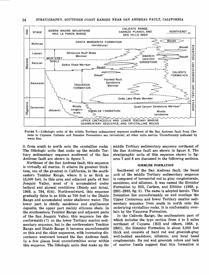
FIGURE 7. Lithologic units of the middle Tertiary sedimentary sequence southwest of the San Andreas fault from Cho- lame to Cuyama. Caliente and Simmler Formations are terrestrial; all other units marine. Unconformity indicated by wavy line.
it from south to north onto the crystalline rocks. The lithologic units that make up the middle Ter tiary sedimentary sequence southwest of the San Andreas fault are shown in figure 7.
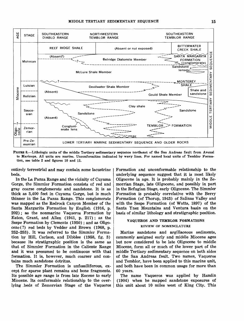
Northeast of the San Andreas fault, this sequence is virtually all marine. It attains its greatest thick ness, one of the greatest in California, in the south eastern Temblor Range, where it is as thick as 15,000 feet. In this area and adjacent parts of San Joaquin Valley, most of it accumulated under bathyal and abyssal conditions (Bandy and Arnal, 1969, p. 794, 814). Northwestward, this sequence gradually thins to as little as 700 feet in the Diablo Range and accumulated under shallower water. The lower part is chiefly sandstone and argillaceous deposits, the upper part mainly siliceous shale. In the southeastern Temblor Range and adjacent parts of the San Joaquin Valley, this sequence lies dis- conformably(?) on the lower Tertiary marine sedi mentary sequence, but in the northwestern Temblor Range and Diablo Range it becomes unconformable on this and the older sequences, with increasing dis cordance westward toward the San Andreas fault. In a few places local unconformities occur within this sequence. The lithologic units that make up the
middle Tertiary sedimentary sequence northeast of the San Andreas fault are shown in figure 8. The stratigraphic units of this sequence shown in fig ures 7 and 8 are discussed in the following sections.
SIMMLER FORMATION
Southwest of the San Andreas fault, the basal unit of the middle Tertiary sedimentary sequence is composed of terrestrial red to gray conglomerate, sandstone, and siltstone. It was named the Simmler Formation by Hill, Carlson, and Dibblee (1958, p. 2981-2983, fig. 3). The name is adopted herein. This formation lies unconformably on and overlaps the Upper Cretaceous and lower Tertiary marine sedi mentary sequence from south to north onto the underlying crystalline rocks. It is conformably over lain by the Vaqueros Formation.
In the Caliente Range, the southeastern part of which includes the type section from 4 to 5 miles northeast of Cuyama (Hill and others, 1958, p. 2981), the Simmler Formation is about 3,000 feet thick and consists of hard red and greenish-gray well-bedded sandstone, siltstone, and local basal conglomerate. Its red and greenish colors and lack of marine fossils suggest that this formation is
MIDDLE TERTIARY SEDIMENTARY SEQUENCE 15
STAGE SOUTHEASTERN DIABLO RANGE
NORTHWESTERN TEMBLOR RANGE
SOUTHEASTERN TEMBLOR RANGE
REEF RIDGE SHALE (Absent or not exposed)BITTERWATER CREEK SHALE
(Absent?)
MohnianBelridge Diatomite Member
McLure Shale Member
SANTA MARGARITA FORMATION J^pnglpmerate)
Sandstone lenses<
Luisian
Relizian
Sauce-
sian
Devilwater Shale Member
(Absent)
SHALE
Shale and Gould Shale Member I sandstone
Sandstone
o <u QOC
Zemor-
rian
(Absent)
Conglom erate lens
TEMBLOR FORMATION
Pre-Ze-
morrianLOWER TERTIARY MARINE SEDIMENTARY SEQUENCE AND OLDER ROCKS
FIGURE 8. Lithologic units of the middle Tertiary sedimentary sequence northeast of the San Andreas fault from Avenal to Maricopa. All units are marine. Unconformities indicated by wavy lines. For named local units of Temblor Forma tion, see table 2 and figures 10 and 11.
entirely terrestrial and may contain some lacustrine beds.
In the La Panza Range and the vicinity of Cuyama Gorge, the Simmler Formation consists of red and gray coarse conglomerate and sandstone. It is as thick as 3,400 feet in Cuyama Gorge, but is much thinner in the La Panza Range. This conglomerate was mapped as the Redrock Canyon Member of the Santa Margarita Formation by English (1916, p. 202); as the nonmarine Vaqueros Formation by Eaton, Grant, and Alien (1941, p. 217); as the Sespe Formation by Clements (1950); and as Oligo- cene(?) red beds by Vedder and Brown (1968, p. 252-253). It was referred to the Simmler Forma tion by Hill, Carlson, and Dibblee (1958, fig. 3) because its stratigraphic position is the same as that of Simmler Formation in the Caliente Range and it was presumed to be continuous with that formation. It is, however, much coarser and con tains much sandstone detritus.
The Simmler Formation is unfossiliferous, ex cept for sparse plant remains and bone fragments. Its possible age range is from late Eocene to early Miocene. Its conformable relationship to the over lying .beds of Zemorrian Stage of the Vaqueros
Formation and unconformable relationship to the underlying sequence suggest that it is most likely Oligocene in age. It is probably mainly in the Ze morrian Stage, late Oligocene, and possibly in part in the Refugian Stage, early Oligocene. The Simmler Formation is probably correlative with the Berry Formation (of Thorup, 1943) of Salinas Valley and with the Sespe Formation (of Watts, 1897) of the Santa Ynez Mountains and Ventura basin on the basis of similar lithology and stratigraphic position.
VAQUEROS AND TEMBLOR FORMATIONS
REVIEW OF NOMENCLATURE
Marine sandstone and argillaceous sediments, commonly assigned early and middle Miocene ages but now considered to be late Oligocene to middle Miocene, form all or much of the lower part of the middle Tertiary sedimentary sequence on both sides of the San Andreas fault. Two names, Vaqueros and Temblor, have been applied to this marine unit, and both have been in common usage for more than 60 years.
The name Vaqueros was applied by Hamlin (1904) when he mapped sandstone exposures of this unit about 10 miles west of King City. This

16 STRATIGRAPHY, SOUTHERN COAST RANGES NEAR SAN ANDREAS FAULT, CALIFORNIA
name was also used by Fairbanks (1904) for equiva lent rocks near Paso Robles. Anderson (1905) ap plied the name "Temblor beds" to what was later found to be essentially a stratigraphically equivalent unit in the Temblor Range. Application of both these names followed, as shown on table 1. In early years,
TABLE 1. Names applied by other investigators to strata herein assigned to the Vagueros and Temblor Formations of map region of figure 2
Southwest of San Andreas fault
Northeast of San Andreas fault Investigators
Vaqueros Formation ____ _ ___ Fairbanks (1904) Temblor beds ______-Anderson (1905, p.
170-172; 1908, p.18-20).
Vaqueros Formation Arnold and Anderson(1908, p. 31-35,pl. 1;1910. p. 80-88, pi. 1).
_,_do____ _ __ Arnold and Johnson(1910, p. 42-51, pi. 1).
Temblor Group _ Anderson and Martin,(1914, p. 37-44, pi.10).
Vaqueros Formation __Anderson and Pack (1915p. 80-87).
Vaqueros Formation.--___ ____ English (1916, p. 198-201, pi. XIX).
Vaqueros Formation English (1921, p. 13 21,Pi. 1).
Do Loel and Corey (1932, p.45-50).
Temblor1 and Vaqueros1 _________________Eaton (1939, p. 261-266,pi. IV); Eaton, Grantand Alien (1941, p.216-230, fig. 3).
Temblor Formation ___Kleinpell (1938, p. 104-107, pi. 6).
Temblor Sandstone _ Woodring, Stewart, andRichards (1940, p.129-144, pi. 51).
Temblor-Vaqueros ____Simonson and Kruegrer(1942, p. 1613-1616).
Temblor Formation _ Curran (1943, p. 1365 1369).
Escudo and Hannah Van Couvering and Formations Alien (1943, p. 496-
500). Vaqueros Sandstone _ Bramlette and Daviess
(1944). Temblor Formation ___Stewart (1946, p. 97-103,
pi. 9). do -Heikkila and MacLeod
(1951, p. 5, 7-11, pi. 1).
___do___________Marsh (1960, p. 31-32,Pi. 1).
Vaqueros Formation _ _ Hill, Carlson, andDibblee (1958, p. 2983-2987).
Do__________ Temblor-Vaqueros Dibblee (1962, p. 9-10); Formation. Fletcher (1962, p.
17). Do ________________-__-___-- Vedder and Repenning
(1965). Temblor-Vaqueros Dickinson (1966a, p.
Formation. 711-713, pi. 2). Temblor Formation ___Foss and Blaisdell (1968,
p. 38-41). ___
1 Used in the time-stratigraphic sense.
"Vaqueros" was used by geologists of the U.S. Geological Survey, and "Temblor" by F. M. Ander son of the California Academy of Sciences.
Paleontological studies of the molluscan and echi- noid faunas from the "lower Miocene" strata by Wiedey (1928, p. 104-107) and by Loel and Corey (1932, p. 45-50) established the presence of two faunal zones, namely a lower or Turritella inezana zone and an upper or Turritelta ocoyana zone. Al though some confusion resulted when it was found that Turritella ocoyana ranges downward far into
the lower faunal zone in the Caliente Range (Eaton, 1939, pi. IV; Repenning and Vedder, 1961, p. C237), the faunal assemblages are distinct. Loel and Corey (1932, p. 45-50), Wimrarth (1938, p. 2127, 2234- 2235), Eaton (1939, p. 259-266, pi. IV), Eaton, Grant, and Alien (1941, p. 216-224), and Woodring, Stewart, and Richards (1940, p. 129) applied the term Vaqueros to strata that contain fossils of the lower faunal zone because these fossils occur in the type Vaqueros Formation (of Hamlin, 1904) and applied the term Temblor to strata that contain fossils of the upper faunal zone because these fossils occur in most of the type Temblor Formation (of Anderson, 1905). These names were also applied to the faunal zones or "ages," when the lower faunal zone became known as "Vaqueros age" and the upper zone as "Temblor age" (Weaver and others, 1944, chart 11; Corey, 1954, chap. Ill, fig. 9), but these molluscan "ages" were never defined.
Studies of the foraminiferal faunas in the "lower Miocene" strata by Kleinpell (1938, p. 152-155, fig. 4) indicate that "Vaqueros age" corresponds roughly to his Zemorrian Stage; "Temblor age" to his late Saucesian Relizian and Luisian Stages; and a "tran sition zone" to his early Saucesian Stage.
Differentiating the "lower Miocene" marine strata into the Vaqueros and Temblor Formations on the basis of their faunal content seemed appropriate, but was impractical because (1) generally the lith- ology does not change within these strata, (2) no definite boundary separates the two faunal "ages," and (3) in many exposures fossils are scarce or lacking. Even in the most fossiliferous and complete section in the Caliente Range, the formations could not be differentiated with certainty on this basis by Hill, Carlson, and Dibblee (1958) or by Vedder and Repenning (1965), although the faunizones could be recognized.
It is here proposed that in all areas southwest of the San Andreas fault the name Vaqueros Forma tion be applied to this whole stratigraphic unit and that in all areas northeast of this fault the name Temblor Formation be applied. Because of their long-established usage in this manner (fig. 4), both names are best retained with the fault as an arbi trary boundary.
In the field this marine unit, deposited under a transgressing sea, is diff erentiable into two principal lithologic types or fades: (1) sandstone and (2) argillaceous sedimentary rocks variously called mudstone, siltstone, claystone, clay shale, silty shale, and shale. Where these two types are interbedded, the facies unit is designated by the predominant rock type. In some areas, especially near oil fields,
MIDDLE TERTIARY SEDIMENTARY SEQUENCE 17
the parts of these facies that form local strati- graphic units have been named and described in many publications as members.
The age of the Vaqueros and Temblor Formations is generally regarded as early Miocene or Oligocene and Miocene (Weaver and others, 1944, chap. 11). Within the region of figure 2 both formations are mainly within the Zemorrian and Saucesian Stages, and locally the uppermost parts include the lowest part of the Relizian Stage, middle Miocene. The Zemorrian Stage is now considered equivalent to late Oligocene age and the Saucesian Stage to the early Miocene (Bandy and Arnal, 1969, p. 786). If this correlation is accepted, then the Vaqueros and Temblor Formations are late Oligocene to middle Miocene in age.
VAQUEROS FORMATION
Southwest of the San Andreas fault the Vaqueros Formation is thickest, 7,000 feet, in the central and northwestern parts of the Caliente Range and pos sibly under the Carrizo Plain. It thins southeast ward to about 1,000 feet at the southeast end of the range, in part by intertonguing of its upper part into the terrestrial Caliente Formation. To the northwest, west, and southwest, this formation thins to about 1,000 feet or less under Salinas Valley and in the La Panza Range. In western Cuyama Valley and in the Sierra Madre Mountains, it is either absent or very thin.
In areas other than the Caliente Range, the Vaqueros Formation is mostly all sandstone and is undivided. In the Caliente Range, this formation was divided by Hill, Carlson, and Dibblee (1958, p. 2983-2988) into a local basal unit called the Soda Lake Sandstone Member, a lower unit called Soda Lake Shale Member, and an upper unit called Painted Rock Sandstone Member. The last two of these names are adopted herein; the first is re named (fig. 7).
QUAIL CANYON SANDSTONE MEMBER
The Soda Lake Shale Member in the southeastern Caliente Range is underlain in large part by a thin sandstone unit that was called the Soda Lake Sand stone Member by Hill, Carlson, and Dibblee (1958, p. 2984). Because the name Soda Lake is already applied to the overlying shale unit, this sandstone unit is here renamed the Quail Canyon Sandstone Member of the Vaqueros Formation. It is named for exposures in Quail Canyon, Cuyama quadrangle, 1964. The type locality is in the NWViSWi/i sec. 4, T. 10 N., R. 25 W., which is the same as that
designated by Hill, Carlson, and Dibblee (1958, p. 2984) for the Soda Lake Sandstone Member. It conformably overlies red beds of the Simmler For mation and was described by Hill, Carlson, and Dibblee (1958, p. 2984) as follows: The sandstone in the type section attains a maximum thick ness of 300 feet. It thins westward by a probable gradation into Soda Lake shale and toward the southeast it becomes undifferentiated from the overlying Painted Rock sandstone (T. 10 N., R. 25 W.). At its type locality * * * the Soda Lake sandstone is characteristically gray-white, weathering to light buff, massively bedded, fine to medium grained, well sorted, and very firmly indurated. It is commonly cross-bedded with fore-set beds dipping in a westerly di rection.
This sandstone member contains Pecten mag nolia and other forms diagnostic of "Vaqueros age" (J. G. Vedder, oral commun., 1968), Oligocene. According to R. L. Pierce (oral commun., 1970), this sandstone member is probably correlative with the Agua Sandstone Member of the Temblor For mation, and with the Vaqueros Sandstone of the Santa Ynez Mountains. The Quail Canyon Sand stone Member is assigned to the late Zemorrian Stage, late Oligocene, on the basis of the foregoing evidence.
SODA LAKE SHALE MEMBER
The Soda Lake Shale Member consists of dark- gray silty clay shale, claystone, and siltstone. The type section is in the northwestern Caliente Range (NE14 sec. 6, T. 31 S., R. 19 E., and extreme SE14 sec. 31, T. 30 S., R. 19 E.), 3 miles west of the north end of Soda Lake (Hill and others, 1958, p. 2983, 2985). There, it is about 1,200 feet thick and contains a prominent bed of chert just below the middle. It contains foraminifers diagnostic of the Zemorrian Stage (late Oligocene) below that chert bed and foraminifers of the Saucesian Stage (early Miocene) above it.
The Soda Lake Shale Member is also exposed in the southeastern Caliente Range, where the probable time-stratigraphic equivalent of the type section is about 900 feet thick or less. It is of the same lith- ology as at the type section and in one place con tains a lens of chert a few feet thick, just below the middle. It is in part overlain by as much as 2,000 feet of siltstone and some interbedded sandstone that was included in the Soda Lake Shale Member of this area by Vedder and Repenning (1965) be cause of its predominant siltstone lithology. Accord ing to them, this part contains foraminifers diagnos tic of the Saucesian Stage and mollusks diagnostic of "Vaqueros age." Near the southeast end of this range, all the strata assigned to the Soda Lake Shale
18 STRATIGRAPHY, SOUTHERN COAST RANGES NEAR SAN ANDREAS FAULT, CALIFORNIA
Member grade laterally eastward into the Painted Rock Sandstone Member.
According to R. L. Pierce (oral commun., 1970), the part of the Soda Lake Shale Member below the chert bed at the type section and the lowest part of this member in the Cuyama Valley oil fields contain a neritic foraminiferal fauna diagnostic of the late Zemorrian Stage and are probably correlative with the Agua Sandstone Member and part of the under lying lower part of the Santos Shale Member of the Temblor Formation as defined herein; the part above the chert bed at the type section and the upper part in the Cuyama Valley oil fields contain a subabyssal fauna diagnostic of the early Saucesian Stage and are probably correlative with the upper part of the Santos Shale Member of the Temblor Formation as defined herein. The faunas of the Soda Lake Shale Member, according to Pierce, however, are unlike those of the San Joaquin Valley, but are similar to those of the same age in the Santa Ynez Mountains. Thus, the basin in which this member accumulated was probably not connected with the San Joaquin Valley basin at that time, as suggested by Cross (1962, p. 27).
PAINTED ROCK SANDSTONE MEMBER
The Painted Rock Sandstone Member was named for Painted Rock, a prominent cavernous sandstone outcrop south of Soda Lake, but the type locality is the section exposed in the vicinity of Caliente Moun tain, 7 miles northwest of New Cuyama (Hill and others, 1958, p. 2986, 2988). In the northwestern Caliente Range this member is nearly all sandstone, but at Caliente Mountain and a few miles eastward it includes as much as 50 percent interbedded silt- stone. In these areas this member is about 5,500 feet thick. It thins to the southeast, in part by lat eral gradation of its lower beds into the Soda Lake Shale Member and of its upper beds into the terres trial Caliente Formation and in part by actual thinning of the whole member. At the southeast end of the Caliente Range, the Painted Rock Sandstone Member is only about 600 feet thick.
The Painted Rock Sandstone Member in the vicinity of Caliente Mountain and southeastward contains abundant Turritella ocoyana and Lyropec- ten miguelensis, especially in its upper and middle parts. In other areas these species occur in sand stones of "Temblor age." Eaton, Grant, and Alien (1941) assigned the upper 900 feet of this sand stone unit to the "Temblor" and the rest to the "Vaqueros." The fauna throughout this member is now considered to be of "Vaqueros age," early Mio cene (Repenning and Vedder, 1961). In the north western Caliente Range, the uppermost sandstones
of this member are somewhat higher stratigraphic- ally than those near Caliente Peak and may be of "Temblor age," middle Miocene.
The Painted Rock Sandstone Member contains undiagnostic shallow-water foraminifers, but foram- inifers diagnostic of the Saucesian Stage, early Miocene, occur in the underlying beds of the Soda Lake Shale Member and west of Caliente Mountain in the immediately overlying beds of the Monterey Shale (Vedder and Repenning, 1965).
On the northeast flank of La Panza Range, the Vaqueros Formation is nearly all sandstone and ranges from about 200 to 1,200 feet in thickness. It is assigned to the Painted Rock Sandstone Mem ber because it is lithologically similar to that unit in the nearby northwestern Caliente Range and is conformably overlain by the Saltos Shale Member of the Monterey Shale. In most places the Painted Rock Sandstone Member rests unconformably on crystalline basement rocks or on the Upper Creta ceous and lower Tertiary sedimentary sequence, against which the lower beds buttress out. In other places this member conformably overlies conglom erate of the Simmler Formation, and at La Panza Canyon (in sec. 36, T. 29 S., R. 16 E.) it overlies a thin intervening wedge as thick as 200 feet of the Soda Lake(?) Shale Member of the Vaqueros Formation.
The upper part of the Painted Rock Sandstone Member of La Panza Range is generally fine grained and fossiliferous, with abundant fossils of the Tur ritella ocoyana zone of "Temblor age," lower or middle Miocene. The lower part is medium to coarse grained, nearly white, and rarely fossiliferous, al though fossils of the Turritella inezana zone or "Vaqueros age," lower Miocene, were reported and listed by Loel and Corey (1932, p. 107 and correla tion chart).
TEMBLOR FORMATION
In the Temblor Range the Temblor Formation is composed of sandstone and lesser amounts of argil laceous sedimentary rocks. In the southeastern part of the range, as much as 7,000 feet crops out; the base of this unit is unexposed. In the northwestern part this unit is much thinner but of variable thick ness. At the northwest end of the Temblor Range and on the southwest flank of the Diablo Range near Cholame Valley, the Temblor Formation is nearly all sandstone and is 0-5,000 feet thick but generally less than 2,000 feet. At one place about 5 miles northeast of Cholame, the Temblor Formation con tains a lens, as much as 500 feet thick, of terrestrial red beds, as mapped by Dickinson (1966a, p. 711, pi. 1). At a locality 7 miles slightly south of east
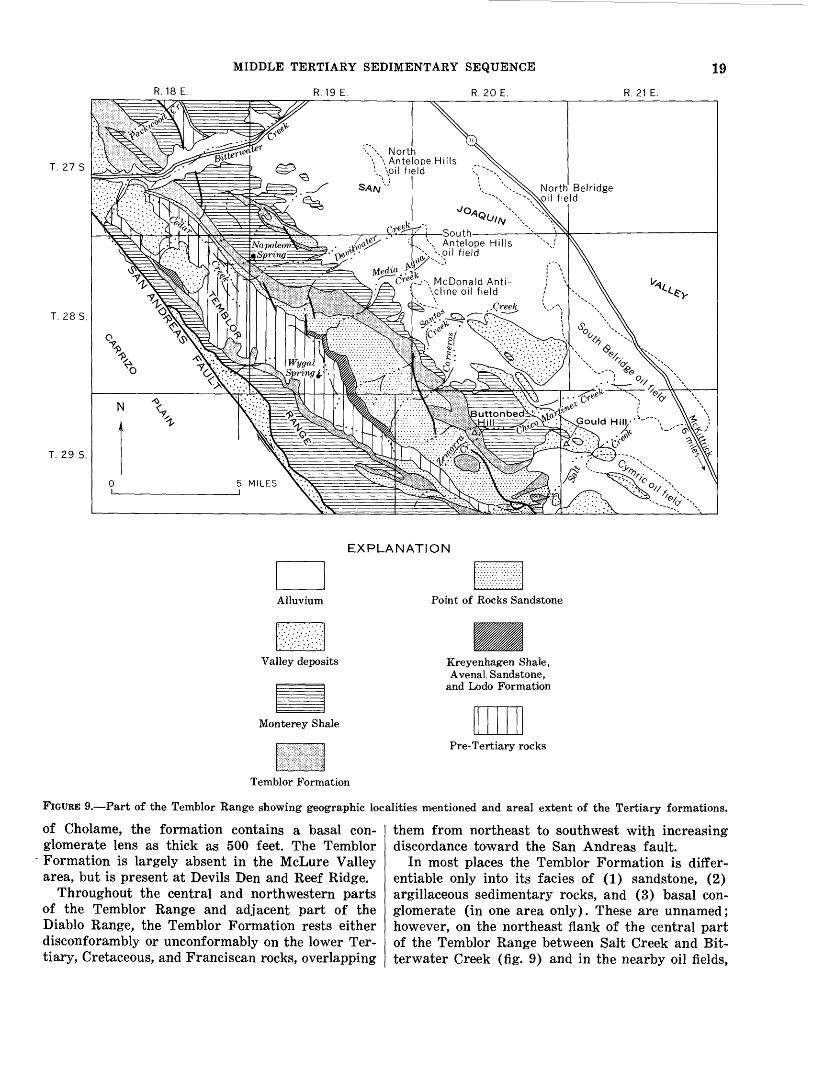
T. 27 S
T. 285.
R.18 E.
MIDDLE TERTIARY SEDIMENTARY SEQUENCE
R.19E. R. 20 E.
19
R. 21 E.
T. 29 S.
\\ North \ \ Antelope Hills
'. Voil field
-i-fr"' '-., \ Antelope Hills N. 'voil field
McDonald Anti cline oil field
EXPLANATION
Point of Rocks Sandstone
Pre-Tertiary rocks
Temblor Formation
FIGURE 9. Part of the Temblor Range showing geographic localities mentioned and areal extent of the Tertiary formations.
of Cholame, the formation contains a basal con glomerate lens as thick as 500 feet. The Temblor Formation is largely absent in the McLure Valley area, but is present at Devils Den and Reef Ridge.
Throughout the central and northwestern parts of the Temblor Range and adjacent part of the Diablo Range, the Temblor Formation rests either disconforambly or unconformably on the lower Ter tiary, Cretaceous, and Franciscan rocks, overlapping
them from northeast to southwest with increasing discordance toward the San Andreas fault.
In most places the Temblor Formation is differ- entiable only into its facies of (1) sandstone, (2) argillaceous sedimentary rocks, and (3) basal con glomerate (in one area only). These are unnamed; however, on the northeast flank of the central part of the Temblor Range between Salt Creek and Bit- terwater Creek (fig. 9) and in the nearby oil fields,
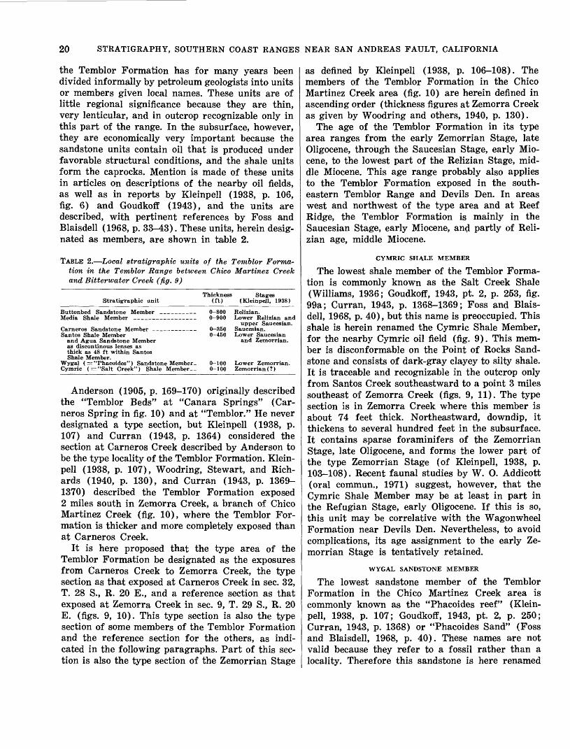
20 STRATIGRAPHY, SOUTHERN COAST RANGES NEAR SAN ANDREAS FAULT, CALIFORNIA
the Temblor Formation has for many years been divided informally by petroleum geologists into units or members given local names. These units are of little regional significance because they are thin, very lenticular, and in outcrop recognizable only in this part of the range. In the subsurface, however, they are economically very important because the sandstone units contain oil that is produced under favorable structural conditions, and the shale units form the caprocks. Mention is made of these units in articles on descriptions of the nearby oil fields, as well as in reports by Kleinpell (1938, p. 106, fig. 6) and Goudkoff (1943), and the units are described, with pertinent references by Foss and Blaisdell (1968, p. 33-43). These units, herein desig nated as members, are shown in table 2.
TABLE 2. Local stratigraphic units of the Temblor Forma tion in the Temblor Range between Chico Martinet Creek and Bitterwater Creek (fig. 9)
Stratigraphic unitThickness
(ft)Stages
(Kleinpell, 1938)
Buttonbed Sandstone Member Media Shale Member _____.
Carneros Sandstone Member ___________Santos Shale Member
and Agua Sandstone Memberas discontinous lenses asthick as 48 ft within SantosShale Member.
Wygal ( =: "Phacoides") Sandstone Member. Cymric (="Salt Creek") Shale Member_.
0-800 0-900
0-350 0-450
Relizian.Lower Relizian and
upper Saucesian. Saucesian. Lower Saucesian
and Zemorrian.
0-100 Lower Zemorrian. 0-100 Zemorrian (?)
Anderson (1905, p. 169-170) originally described the "Temblor Beds" at "Canara Springs" (Car neros Spring in fig. 10) and at "Temblor." He never designated a type section, but Kleinpell (1938, p. 107) and Curran (1943, p. 1364) considered the section at Carneros Creek described by Anderson to be the type locality of the Temblor Formation. Klein pell (1938, p. 107), Woodring, Stewart, and Rich ards (1940, p. 130), and Curran (1943, p. 1369- 1370) described the Temblor Formation exposed 2 miles south in Zemorra Creek, a branch of Chico Martinez Creek (fig. 10), where the Temblor For mation is thicker and more completely exposed than at Carneros Creek.
It is here proposed that the type area of the Temblor Formation be designated as the exposures from Carneros Creek to Zemorra Creek, the type section as that exposed at Carneros Creek in sec. 32, T. 28 S., R. 20 E., and a reference section as that exposed at Zemorra Creek in sec. 9, T. 29 S., R. 20 E. (figs. 9, 10). This type section is also the type section of some members of the Temblor Formation and the reference section for the others, as indi cated in the following paragraphs. Part of this sec tion is also the type section of the Zemorrian Stage
as defined by Kleinpell (1938, p. 106-108). The members of the Temblor Formation in the Chico Martinez Creek area (fig. 10) are herein defined in ascending order (thickness figures at Zemorra Creek as given by Woodring and others, 1940, p. 130).
The age of the Temblor Formation in its type area ranges from the early Zemorrian Stage, late Oligocene, through the Saucesian Stage, early Mio cene, to the lowest part of the Relizian Stage, mid dle Miocene. This age range probably also applies to the Temblor Formation exposed in the south eastern Temblor Range and Devils Den. In areas west and northwest of the type area and at Reef Ridge, the Temblor Formation is mainly in the Saucesian Stage, early Miocene, and partly of Reli zian age, middle Miocene.
CYMRIC SHALE MEMBER
The lowest shale member of the Temblor Forma tion is commonly known as the Salt Creek Shale (Williams, 1936; Goudkoff, 1943, pt. 2, p. 253, fig. 99a; Curran, 1943, p. 1368-1369; Foss and Blais dell, 1968, p. 40), but this name is preoccupied. This shale is herein renamed the Cymric Shale Member, for the nearby Cymric oil field (fig. 9). This mem ber is disconformable on the Point of Rocks Sand stone and consists of dark-gray clayey to silty shale. It is traceable and recognizable in the outcrop only from Santos Creek southeastward to a point 3 miles southeast of Zemorra Creek (figs. 9, 11). The type section is in Zemorra Creek where this member is about 74 feet thick. Northeastward, downdip, it thickens to several hundred feet in the subsurface. It contains sparse foraminifers of the Zemorrian Stage, late Oligocene, and forms the lower part of the type Zemorrian Stage (of Kleinpell, 1938, p. 103-108). Recent faunal studies by W. O. Addicott (oral commun., 1971) suggest, however, that the Cymric Shale Member may be at least in part in the Refugian Stage, early Oligocene. If this is so, this unit may be correlative with the Wagonwheel Formation near Devils Den. Nevertheless, to avoid complications, its age assignment to the early Ze morrian Stage is tentatively retained.
WYGAL SANDSTONE MEMBER
The lowest sandstone member of the Temblor Formation in the Chico Martinez Creek area is commonly known as the "Phacoides reef" (Klein pell, 1938, p. 107; Goudkoff, 1943, pt. 2, p. 250; Curran, 1943, p. 1368) or "Phacoides Sand" (Foss and Blaisdell, 1968, p. 40). These names are not valid because they refer to a fossil rather than a locality. Therefore this sandstone is here renamed
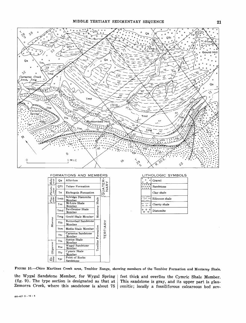
MIDDLE TERTIARY SEDIMENTARY SEQUENCE 21
Cameros Creek /.Jmdo /Tmg
,! : 42> ;.' .'.' .*
FORMATIONS AND MEMBERS LITHOLOGIC SYMBOLS
Pleisto-\Holo- cene [eerie
F^l
1
Oligocene 1 Miocene
§1
Qa
QTt
Te
Tmb
Tm
Tmd
Tmg
Ttb
Ttm
Ttc
Tts
Ttw
Tty
Tpr
Alluvium
Tulare Formation
Etchegoin Formation
Belridge Diatomite MemberMcLure Shale MemberDevilwater Shale Member
Gould Shale Member
Buttonbed Sandstone Member
Media Shale Member
Carneros Sandstone MemberSantos Shale MemberWygal Sandstone MemberCymric Shale Member
Monterey Shale
Temblor Formation
Point of Rocks Sandstone
i
orh-o:UJh-
0 ° °
*
irSTTJl-iV++
Gravel
Sandstone
Clay shale
Siliceous shale
Cherty shale
Diatomite
FIGURE 10. Chico Martinez Creek area, Temblor Range, showing members of the Temblor Formation and Monterey Shale.
the Wygal Sandstone Member, for Wygal Spring (fig. 9). The type section is designated as that at Zemorra Creek, where this sandstone is about 75
feet thick and overlies the Cymric Shale Member. This sandstone is gray, and its upper part is glau- conitic; locally a fossiliferous calcareous bed sev-
495-417 O - 73 - 4
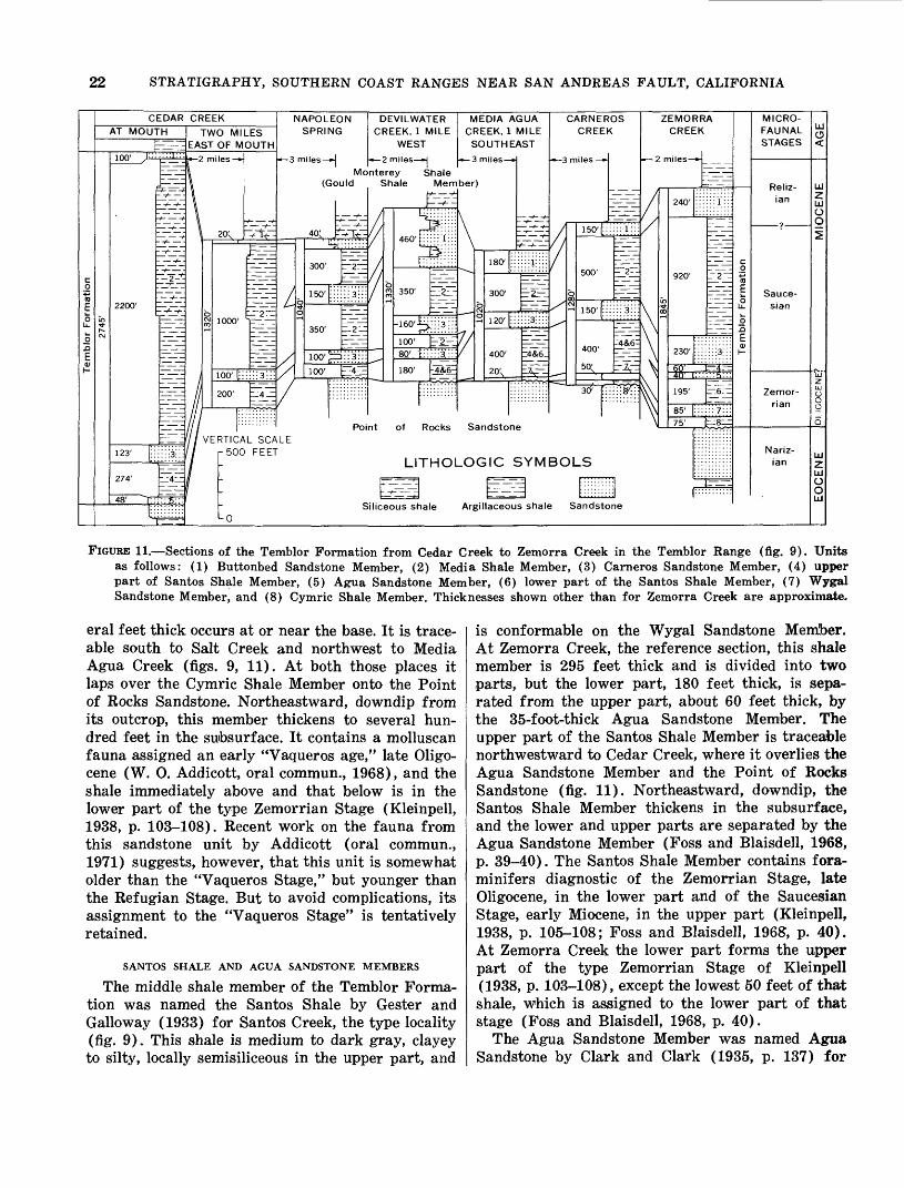
22 STRATIGRAPHY, SOUTHERN COAST RANGES NEAR SAN ANDREAS FAULT, CALIFORNIA
lor Formation
a
!
CEDAR CREEKAT MOUTH
E^EHE
In
CM
100' ^-
2200'
123' [::
274'
-v- -/
- -/-
_4^_
" '5 ' ' '
TWO MILES EAST OF MOUTH
r
f
m
bCM CO
VE
i es »
1000'
200'
RTICA r500
-0
+- -t-
L SCAFEET
3
L
LE
M/
m
so
VPOLE 3PRIN<
iles *|
(Gc
4°; L
300'
350'
100' t± 100'
ON
Mo uld
- -/--
z
Z"
J~ :..... D::3:::
b?;:
Poi
S
[ C
nte'
ynt
ilic
)E RE
2n re 3h
bCO CO
VILWA1 EK, 1 N WEST
niles H
y sale
350'
-160'-^
100'80'
180'
of
LI
ecus st
ER 1ILE
hale Mem
?!!!!!B;;;;
2
\\\-\-s\\\-4&6-
Rocks
THOL
iale
N Cl
c
ber
\
IE RE 50
n
)
o
Sar
_OG
Argil
DIA EK, 1 UTH
i les-
180'
300'
120'
400'
idsto
,IC
lacec
ACL H Ef-ft
-
ne
c
IU
3UA ^IILE kST
_4&6_
;YM
; shal«
3
/
C/
rr
§CM
BOL
3 S
\RNER CREEH
iles
150' (::
500'
150' ::
400'
50;' c
3d' =
-S
andsto
OS
::: 1:::
2--
7v
ne
S\
Z
n
un
§
EMO CREE
niles-
240'
920'
230'
i6'
195'
85' 75'
RR EK
-»
pJ
A
::; 1 ::
_ 2 _
.6
S^-N^
__ _____ _
jmblor Formation
MICRO-
FAUNAL STAGES
Reliz-ian
Sauce-
sian
Zemor
rian
Nariz-
ian
UJ C5
MIOCENE
| EOCENE IOLIGOCENE?
FIGURE 11. Sections of the Temblor Formation from Cedar Creek to Zemorra Creek in the Temblor Range (fig. 9). Units as follows: (1) Buttonbed Sandstone Member, (2) Media Shale Member, (3) Carneros Sandstone Member, (4) upper part of Santos Shale Member, (5) Agua Sandstone Member, (6) lower part of the Santos Shale Member, (7) Wygal Sandstone Member, and (8) Cymric Shale Member. Thicknesses shown other than for Zemorra Creek are approximate.
eral feet thick occurs at or near the base. It is trace able south to Salt Creek and northwest to Media Agua Creek (figs. 9, 11). At both those places it laps over the Cymric Shale Member onto the Point of Rocks Sandstone. Northeastward, downdip from its outcrop, this member thickens to several hun dred feet in the subsurface. It contains a molluscan fauna assigned an early "Vaqueros age," late Oligo- cene (W. 0. Addicott, oral commun., 1968), and the shale immediately above and that below is in the lower part of the type Zemorrian Stage (Kleinpell, 1938, p. 103-108). Recent work on the fauna from this sandstone unit by Addicott (oral commun., 1971) suggests, however, that this unit is somewhat older than the "Vaqueros Stage," but younger than the Refugian Stage. But to avoid complications, its assignment to the "Vaqueros Stage" is tentatively retained.
SANTOS SHALE AND AGUA SANDSTONE MEMBERS
The middle shale member of the Temblor Forma tion was named the Santos Shale by Gester and Galloway (1933) for Santos Creek, the type locality (fig. 9). This shale is medium to dark gray, clayey to silty, locally semisiliceous in the upper part, and
is conformable on the Wygal Sandstone Member. At Zemorra Creek, the reference section, this shale member is 295 feet thick and is divided into two parts, but the lower part, 180 feet thick, is sepa rated from the upper part, about 60 feet thick, by the 35-foot-thick Agua Sandstone Member. The upper part of the Santos Shale Member is traceable northwestward to Cedar Creek, where it overlies the Agua Sandstone Member and the Point of Rocks Sandstone (fig. 11). Northeastward, downdip, the Santos Shale Member thickens in the subsurface, and the lower and upper parts are separated by the Agua Sandstone Member (Foss and Blaisdell, 1968, p. 39-40). The Santos Shale Member contains fora- minifers diagnostic of the Zemorrian Stage, late Oligocene, in the lower part and of the Saucesian Stage, early Miocene, in the upper part (Kleinpell, 1938, p. 105-108; Foss and Blaisdell, 1968, p. 40). At Zemorra Creek the lower part forms the upper part of the type Zemorrian Stage of Kleinpell (1938, p. 103-108), except the lowest 50 feet of that shale, which is assigned to the lower part of that stage (Foss and Blaisdell, 1968, p. 40).
The Agua Sandstone Member was named Agua Sandstone by Clark and Clark (1935, p. 137) for
MIDDLE TERTIARY SEDIMENTARY SEQUENCE 23
Media Agua Creek (fig. 9). They did not designate a type locality, although they mentioned the out crop at the mouth of Cedar Creek. This outcrop is designated the type locality as it was mapped by Heikkila and MacLeod (1951, pi. 1). This is the only other place besides Zemorra, Creek, the refer ence section, where this unit crops out, although at a few places between Cedar Creek and Zemorra Creek, the Santos Shale Member contains a sand stone bed a few feet thick that may be correlative. In the subsurface (in North Belridge, North and South Antelope Hills, McDonald Anticline oil fields and vicinity, (fig. 9) the Agua Sandstone Member is persistent, is several hundred feet thick, and is assigned to the top of the Zemorrian Stage (Foss and Blaisdell, 1968, p. 40).
The Agua Sandstone Member is light gray, arko- sic, and locally pebbly. At the mouth of Cedar Creek it is as thick as 48 feet, occurs at the base of the Santos Shale Member, and is disconformable on the Point of Rocks Sandstone (fig. 11). At this outcrop it contains a few fossils, including Pecten magnolia, and is assigned a late "Vaqueros age" (W. 0. Addi- cott, oral commun., 1968). At Zemorra Creek this sandstone is 35 feet thick, is unfossiliferous, and is at the top of the type Zemorrian Stage (Kleinpell, 1938, p. 103-108), late Oligocene.
CARNEROS SANDSTONE MEMBER
The name Carneros was first applied to the mid dle sandstone member of the Temblor Formation by Cunningham and Barbat (1932, p. 417-421) for Carneros Creek, the type locality (fig. 10). The Car neros Sandstone Member is conformable on the Santos Shale Member, is light gray and thick bedded, rarely contains fossils, and is about 215 feet thick at Zemorra Creek, the reference section, but as much as 500 feet thick in the area of figure 9. It is traceaible as far northwest as Cedar Creek (fig. 11). Northwest of Devilwater Creek the upper part intertongues into the lower part of the Media Shale Member, and the lowest sandstone tongue persists as a layer about 120 feet thick. Northeastward, downdip, the Carneros Sandstone Member thickens to more than 1,000 feet locally in the subsurface. It is within the Saucesian Stage, early Miocene, as indicated by foraminifers from the shales below and above.
MEDIA SHALE MEMBER
The name Media was first applied to the upper shale member of the Temblor Formation by Cun ningham and Barbat (1932, p. 417-421), for Media Agua Creek (fig. 9). The Media Shale Member is
light gray, clayey to silty, and in part semisiliceous. It is conformable on the Carneros Sandstone Mem ber, is 920 feet thick at Zemorra Creek, the desig nated type section (sec. 9, T. 29 S., R. 20 E., Car neros Rocks quadrangle), and about 500 feet thick at Carneros and Santos Creeks. It is traceable north west to and beyond the mouth of Cedar Creek (figs. 9, 11). Northwest of Devilwater Creek it thickens as the upper parts of the Carneros Sandstone Mem ber and lower parts of the Buttonbed Sandstone Member intertongue into it. In the Cedar Creek area the Media Shale Member is as thick as 2,200 feet, and the upper part includes much hard semisiliceous shale.
In the Chico Martinez Creek area, the Media Shale Member contains foraminifers diagnostic of the upper Saucesian Stage, early Miocene; the upper most 50 feet, a sandy siltstone, contains foraminifers diagnostic of the lower Relizian Stage, middle Mio cene (Foss and Blaisdell, 1968, p. 39).
BUTTONBED SANDSTONE MEMBER
Anderson (1905, p. 170) referred to the top sandstone unit of his Temblor Beds at Carneros Creek as "button beds." This term has subsequently been commonly applied informally to this sandstone (Kleinpell, 1938, p. 105; Foss and Blaisdell, 1968, p. 38). The type locality was designated as Carneros Creek (Heikkila and MacLeod, 1951, p. 10), in sec. 32, T. 28 S., R. 20 E. (fig. 10). It is here formally named the Buttonbed Sandstone Member for its exposure on Buttonbed Hill (fig. 10). This sand stone is light gray, thick bedded, and commonly cal careous, with numerous shell fragments. It ranges in thickness from 0 to 500 feet (240 ft thick at Zemorra Creek, the reference section). It is pre sumed to be locally disconformable on the Media Shale Member and may be a transgressive basal sandstone of the Monterey Shale, as indicated by an unconformity locally at its base in the Shale Hills area (Heikkila and MacLeod, 1951, p. 10) and at Devils Den. In other areas, this sandstone mem ber or its equivalent is not differentiate from the underlying sandstone fades of the Temblor Forma tion.
The Buttonbed Sandstone Member is traceable northwestward from Zemorra Creek to and beyond Bitterwater Creek. Northwest of Devilwater Creek all but the upper part intertongues into the upper part of the Media Shale Member.
The Buttonbed Sandstone Member contains mol- lusks and buttonlike echinoids (mostly Scutella merriami) assigned to "Temblor age," Miocene, (W. 0. Addicott, oral commun., 1967). In the Chico

24 STRATIGRAPHY, SOUTHERN COAST RANGES NEAR SAN ANDREAS FAULT, CALIFORNIA
Martinez Creek area, the Buttonbed Sandstone Mem ber is in the early Relizian Stage (middle Miocene), as indicated by the microfauna in the adjacent shale below and above (R. L. Pierce, oral commun., 1968).
At Devils Den, local names were applied to units within the Temblor Formation by Van Couvering and Alien (1943, p. 496-500) ; none of these are adopted herein. The members recognized in the Chico Martinez Creek area of the Temblor Range are believed to be as indicated in table 3, mainly on
TABLE 3. Members of the Temblor Formation exposed at Devils Den
Name applied by Van Couvering and
Alien (1943.)Average (Members 1-5
Name of member thickness assigned to Hannah(ft) Formation)
Buttonbed Sandstone Member __ ___ __Media Shale Member __- _ __________ ____Carneros Sandstone Member
(includes interbedded shale).Upper part of Santos Shale Member _ _Undivided lower members:
Agua Sandstone Member _Lower part of Santos Shale Member _Wygal Sandstone MemberCymric Shale Member
50350200
300
180100
7050
Escudo Formation.Member 1.Member 2 (sand
stone and shale).Member 3 (shale).Member 4 (sand
stone).Member 5 (shale).
Do.Do.
the basis of similar lithologic sequences, although correlations are uncertain. In the northern expo sures, the Buttonbed Sandstone Member overlaps the older members of the Temblor Formation.
MONTEREY SHALE
REVIEW OF NOMENCLATUREA distinctive marine deposit of predominantly
siliceous organic shale, of early, middle, and late Miocene age, overlies the Vaqueros and Temblor Formations. In the Temblor Range and part of the Caliente Range, the name Monterey Shale was ap plied to this unit by Arnold and Johnson (1910, p. 55-62, pi. 1), who adopted the name from the term Monterey Formation applied by Blake (1856, p. 328-331) to a similar siliceous deposit exposed near Monterey.
Confusion resulted when part of this siliceous shale unit in the Diablo Range, Temblor Range, and Caliente Range was correlated with and assigned to the Santa Margarita Formation by Arnold and Anderson (1910) and English (1916, p. 202-203), and the name Maricopa Shale was applied to the rest of this shale unit in the Caliente Range by English (1916, p. 198-200, pi. XIX) and in the Temblor Range by Pack (1920, p. 35-41, pi. II). This was done when the terms Monterey Series (of Louderback, 1913, p. 191-214) and Monterey Group (of Lawson, 1914) were applied to most of the Miocene marine sedimentary rocks of the California Coast Ranges.
The terms Monterey Series and Maricopa Shale were discarded after 1935, and the term Monterey Shale was adopted for the lithologic unit of "pre dominantly hard silica-cemented shales and softer shales carrying siliceous microfossils" (Wilmarth, 1938, p. 1407, 1299). The term Monterey Shale was applied to this unit by Woodring, Bramlette, and Kleinpell (1936, p. 127-146), Kleinpell (1938, p. 7, 105; 122, fig. 6), Woodring, Stewart, and Richards (1940, p. 122-123), Hill, Carlson, and Dibblee (1958, p. 2988-2991), and Durham (1963, 1964, 1966). The term Monterey Formation was also applied (Simon- son and Krueger, 1942, p. 1616; Bramlette and Daviess, 1944; Heikkila and MacLeod, 1951, p. 5, 11, pi. 1; Foss and Blaisdell, 1968, p. 36), but because this unit is characterized by a distinctive shale, the term Monterey Shale is hereby retained.
The Monterey Shale is the most extensive unit of the middle Tertiary sedimentary sequence on both sides of the San Andreas fault, in places ex tending beyond the limits of the Vaqueros and Temblor Formations. It was deposited under con ditions of maximum inundation during the middle Tertiary sedimentary cycle.
STRATIGRAPHIC UNITS SOUTHWEST OF THE SAN ANDREAS FAULT
Southwest of the San Andreas fault, the Mon terey Shale is from 2,000 to 3,000 feet thick on the southwest flank of the Caliente Range and the northeast flank of the La Panza Range, from which it extends northwestward under Salinas Valley. In the Caliente Range, Cuyama Valley, and Sierra Madre Mountains, the Monterey Shale intertongues northeastward into sandstone mapped as the Branch Canyon Sandstone (figs. 7, 12). In the La Panza Range and western Cuyama Valley, the Monterey Shale thins to only a few hundred feet; in places it wedges out.
The Monterey Shale exposed in the areas between the San Andreas and Rinconada faults is composed of two lithologic units: a lower unit of predomi nantly argillaceous shale of middle and locally in part of early Miocene age and an upper unit of siliceous shale of middle Miocene age. The lower unit has been named the Saltos Shale Member, and the upper unit the Whiterock Bluff Shale Member (fig. 7).
In several wells in the valley area between Atas- cadero and Shandon, the uppermost part (as much as 300 feet) of the Monterey Shale contains fora- minifers diagnostic of the late Miocene Mohnian Stage (H. C. Wagner, oral commun., 1970). Part of the Monterey Shale exposed north of Atascadero
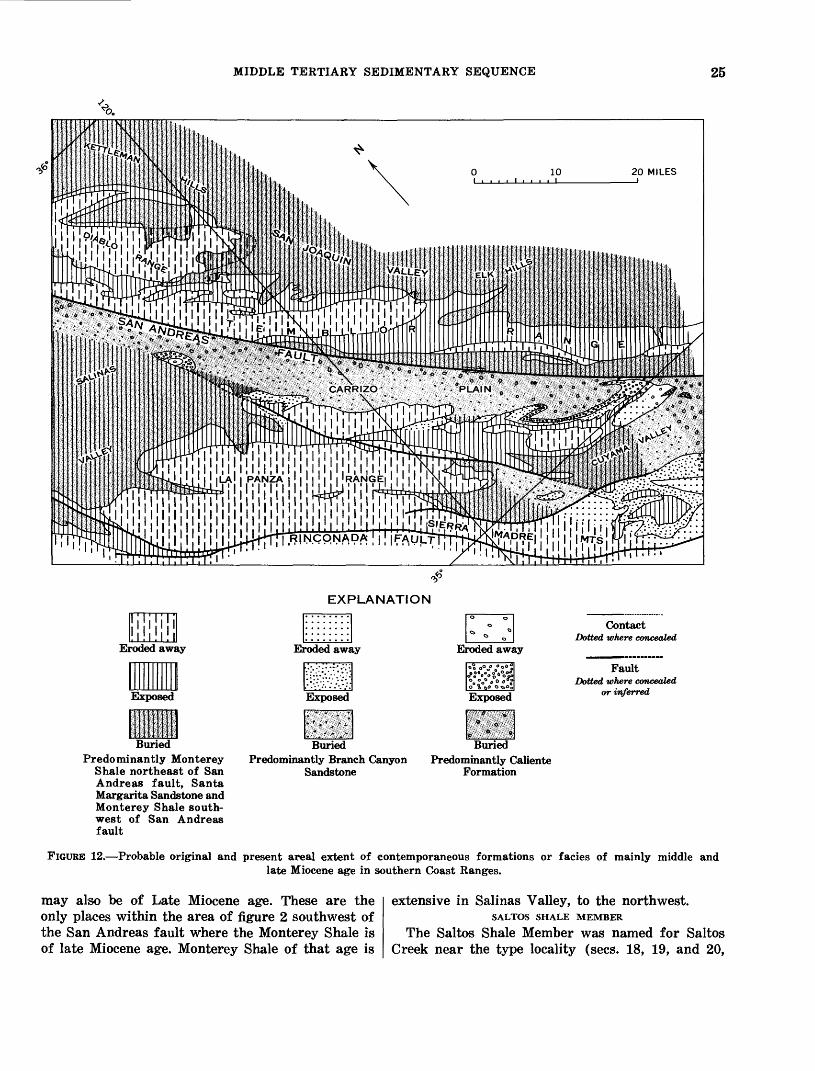
MIDDLE TERTIARY SEDIMENTARY SEQUENCE 25
EXPLANATION
Buried
Contact Dotted where concealed
FaultDotted where concealed
or inferred
BuriedPredominantly Branch Canyon
SandstonePredominantly Caliente
Formation
BuriedPredominantly Monterey
Shale northeast of San Andreas fault, Santa Margarita Sandstone and Monterey Shale south west of San Andreas fault
FIGURE 12. Probable original and present areal extent of contemporaneous formations or facies of mainly middle andlate Miocene age in southern Coast Ranges.
may also be of Late Miocene age. These are the only places within the area of figure 2 southwest of the San Andreas fault where the Monterey Shale is of late Miocene age. Monterey Shale of that age is
extensive in Salinas Valley, to the northwest.SALTOS SHALE MEMBER
The Saltos Shale Member was named for Saltos Creek near the type locality (sees. 18, 19, and 20,

26 STRATIGRAPHY, SOUTHERN COAST RANGES NEAR SAN ANDREAS FAULT, CALIFORNIA
T. 11 N., R. 27 W., San Bernardino base line and meridian) in the central Caliente Range, 8-9 miles northwest of New Cuyama, by Hill, Carlson, and Dibblee (1958, p. 2989-2990), and the name is herein adopted. According to them, the member is about 2,150 feet thick at the type locality: the lower part, about 1,000 feet thick, is composed of gray clay shale and siltstone and is separated by a sill of basalt about 75 feet thick from the upper part, about 1,100 feet of soft fissile shale and hard, brittle siliceous shale and frequent thin beds of dolomite. The lower part was assigned to the Saucesian Stage, early Miocene, and the upper part to the Relizian Stage, middle Miocene.
The Saltos Shale Member exposed northwestward along the Caliente Range and in the La Panza Range is generally similar to that at the type local ity, but in these places it lacks the basalt and aver ages about 1,500 feet in thickness. In the La Panza and northwestern Caliente Ranges, the Saltos Shale Member is composed of soft-weathering yellowish- gray thin-bedded clayey to weakly siliceous or cal careous shale and contains a foraminiferal fauna of the Relizian Stage, middle Miocene. It conform ably overlies the Painted Rock Sandstone Member of the Vaqueros Formation, in places with a grada- tional or intertonguing contact. In both these areas this shale unit is lithologically similar to and correl ative with the Sandholdt Formation of Thorup (1943) in Salinas Valley.
Near the west end of Cuyama Valley, the lower 150 feet of the Saltos Shale (?) Member is semi- siliceous shale, and the upper 500 feet is clay shale that is overlain by the Branch Canyon (?) Sand stone. The shale there contains foraminifers as signed to the lower(?) Saucesian Stage (R. L. Pierce, oral commun., 1967). Where the Vaqueros Sandstone is missing, the shale overlies the Simmler Formation and underlying rocks of Paleocene(?) age with angular discordance of as much as 45°. This is the only place between the San Andreas and Rinconada faults where an angular unconformity appears within the middle Tertiary sedimentary sequence.
On the northeast flank of the Caliente Range, on both flanks southeast of Caliente Mountain, and in the eastern San Rafael Mountains, the Saltos Shale Member becomes mainly siltstone, in places contain ing sparse foraminifers of the Saucesian and Reli zian Stages, and thin sandstone beds that contain mollusks of the "Temblor Stage" (Vedder and Repenning, 1965). Included in the Saltos Shale Mem ber of these exposures is several hundred feet of similar but stratigraphically higher siltstone that
contains foraminifers of the Luisian Stage and that grades laterally westward into the Whiterock Bluff Shale Member (fig. 7). The siltstone of the Saltos Shale Member intertongues northeastward into the Branch Canyon Sandstone within a few miles of the San Andreas fault (fig. 12).
WHITEROCK BLUFF SHALE MEMBER
In the Caliente Range, La Panza Range, and Sierra Madre Mountains, the siliceous shale unit was named the Whiterock Bluff Shale Member of the Santa Margarita Formation by English (1916, p. 191-215, pi. XIX). This shale unit was named for Whiterock Bluff, the type locality (sec. 25, T. 11 N., R. 28 W.), about 8 miles west-northwest of New Cuyama (fig. 1), where this shale is approxi mately 1,200 feet thick. This name was adopted and applied to this shale unit by Hill, Carlson, and Dib blee (1958, p. 2990-2991), but the unit was reas signed to the Monterey Shale. The Whiterock Bluff Shale Member was reported by them to contain foraminifers diagnostic of late Relizian and Luisian Stages, middle Miocene. This name as used by Hill, Carlson, and Dibblee (1958) is adopted herein for this shale unit in the area between the San Andreas and Rinconada faults.
The Whiterock Bluff Shale Member consists of hard, brittle thin-bedded siliceous shale and inter- bedded fissile to punky shale. It is as much as 1,500 feet thick, but averages 1,200 feet. It is gradational downward into the Saltos Shale Member and up ward into sandstone of the Santa Margarita Forma tion. For about 6 miles on each side of Indian Creek (about 12 miles south of Shandon, fig. 2), a zone about 70 feet thick near the top of the Whiterock Bluff Shale Member contains thin layers of phos- phatic pellets and bentonite (H. D. Gower, oral commun., 1970). This zone is overlain by about 80 feet of siliceous and diatomaceous shale, which is overlain by the Santa Margarita Formation. In western Cuyama Valley and on the southwest flank of the La Panza Range, the Whiterock Bluff Shale Member is absent or may be represented by sand stone. Elsewhere this shale unit is widely distri buted, and in Salinas Valley this member and the underlying Saltos Shale Member are recognizable in well logs as far northeast as San Juan Creek. It is noteworthy, however, that within 7-10 miles of the San Andreas fault, as in the Caliente Range, this siliceous shale unit grades laterally northeast ward through siltstone of the Saltos Shale Member lithology into the Branch Canyon Sandstone (figs. 7,12).
In many places the Whiterock Bluff Shale Mem-
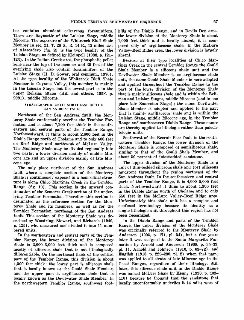
MIDDLE TERTIARY SEDIMENTARY SEQUENCE 27
her contains abundant calcareous foraminifers. These are diagnostic of the Luisian Stage, middle Miocene. The exposure of the Whiterock Bluff Shale Member in sec. 21, T. 28 S., R. 14 E., 12 miles east of Atascadero (fig. 2) is the type locality of the Luisian Stage, as defined by Kleinpell (1938, p. 121- 123). In the Indian Creek area, the phosphatic pellet zone near the top of the member and 30 feet of the overlying shale also contain foraminifers of the Luisian Stage (H. D. Gower, oral commun., 1970). At the type locality of the Whiterock Bluff Shale Member in Cuyama Valley, this member is mainly in the Luisian Stage, but the lowest part is in the upper Relizian Stage (Hill and others, 1958, p. 2991), middle Miocene.
STRATIGRAPHIC UNITS NORTHEAST OF THE SAN ANDREAS FAULT
Northeast of the San Andreas fault, the Mon- terey Shale conformably overlies the Temblor For mation and is about 7,200 feet thick in the south eastern and central parts of the Temblor Range. Northwestward, it thins to about 2,600 feet in the Diablo Range north of Cholame and to only 600 feet on Reef Ridge and northwest of McLure Valley. The Monterey Shale may be divided regionally into two parts: a lower division mainly of middle Mio cene age and an upper division mainly of late Mio cene age.
The only place northeast of the San Andreas fault where a complete section of the Monterey Shale is continuously exposed in a homoclinal struc ture is along Chico Martinez Creek in the Temblor Range (fig. 10). This section is the upward con tinuation of the Zemorra Creek section of the under lying Temblor Formation. Therefore this section is designated as the reference section for the Mon terey Shale and its members, as well as for the Temblor Formation, northeast of the San Andreas fault. This section of the Monterey Shale was de scribed by Woodring, Stewart, and Richards (1940, p. 125), who measured and divided it into 11 num bered units.
In the southeastern and central parts of the Tem blor Range, the lower division of the Monterey Shale is 2,000-3,000 feet thick and is composed mostly of siliceous shale that is not lithologically differentiable. On the northeast flank of the central part of the Temblor Range, this division is about 1,300 feet thick: the lower part is siliceous shale that is locally known as the Gould Shale Member, and the upper part is argillaceous shale that is locally known as the Devilwater Shale Member. In the northwestern Temblor Range, southwest foot
hills of the Diablo Range, and in Devils Den area, the lower division of the Monterey Shale is about 1,000 feet thick and is locally absent; it is com posed only of argillaceous shale. In the McLure Valley-Reef Ridge area, the lower division is largely absent.
Because at their type localities at Chico Mar tinez Creek in the central Temblor Range the Gould Shale Member is a siliceous shale unit and the Devilwater Shale Member is an argillaceous shale unit, the name Gould Shale Member is here adopted and applied throughout the Temblor Range to the part of the lower division of the Monterey Shale that is mainly siliceous shale and is within the Reli zian and Luisian Stages, middle Miocene (and in one place late Saucesian Stage); the name Devilwater Shale Member is adopted and applied to the part that is mainly argillaceous shale and is within the Luisian Stage, middle Miocene age, in the Temblor Range and southeastern Diablo Range. These names are thereby applied to lithologic rather than paleon- tologic units.
Southwest of the Recruit Pass fault in the south eastern Temblor Range, the lower division of the Monterey Shale is composed of semisiliceous shale, similar to that of the Gould Shale Member, and about 50 percent of intenbedded sandstone.
The upper division of the Monterey Shale is a unit of thin-bedded siliceous shale and (or) siliceous mudstone throughout the region northeast of the San Andreas fault. In the southeastern and central parts of the Temblor Range, it is 4,000-5,000 feet thick. Northwestward it thins to about 1,900 feet in the Diablo Range north of Cholame and to only 550 feet in the McLure Valley-Reef Ridge area. Unfortunately this shale unit has a complex and confused terminology because its identity as a single lithologic unit throughout this region has not been recognized.
In the Diablo Range and parts of the Temblor Range, the upper division of the Monterey Shale was originally referred to the Monterey Shale by Anderson (1905, p. 171, pi. 34), but a few years later it was assigned to the Santa Margarita For mation by Arnold and Anderson (1908, p. 35-39, pi. 1), Arnold and Johnson (1910, p. 63-72), and English (1918, p. 229-230, pi. 2) when that name was applied to all strata of late Miocene age in the Coast Ranges, regardless of their lithology. Still later, this siliceous shale unit in the Diablo Range was named McLure Shale by Henny (1930, p. 403- 410) because he thought that the sandstone that locally unconformably underlies it 14 miles west of
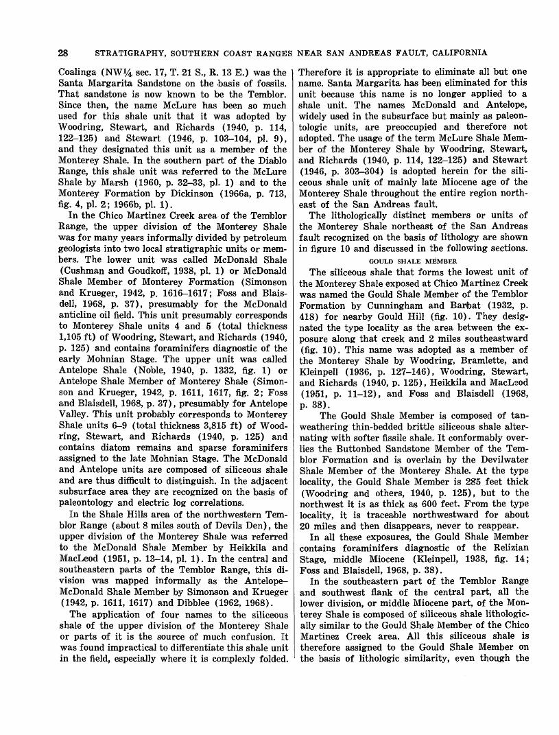
28 STRATIGRAPHY, SOUTHERN COAST RANGES NEAR SAN ANDREAS FAULT, CALIFORNIA
Coalinga (NW^4 sec. 17, T. 21 S., R. 13 E.) was the | Santa Margarita Sandstone on the basis of fossils. That sandstone is now known to be the Temblor. Since then, the name McLure has been so much used for this shale unit that it was adopted by Woodring, Stewart, and Richards (1940, p. 114, 122-125) and Stewart (1946, p. 103-104, pi. 9), and they designated this unit as a member of the Monterey Shale. In the southern part of the Diablo Range, this shale unit was referred to the McLure Shale by Marsh (1960, p. 32-33, pi. 1) and to the Monterey Formation by Dickinson (1966a, p. 713, fig. 4, pi. 2; 1966b, pi. 1).
In the Chico Martinez Creek area of the Temblor Range, the upper division of the Monterey Shale was for many years informally divided by petroleum geologists into two local stratigraphic units or mem bers. The lower unit was called McDonald Shale (Cushman and Goudkoff, 1938, pi. 1) or McDonald Shale Member of Monterey Formation (Simonson and Krueger, 1942, p. 1616-1617; Foss and Blais- dell, 1968, p. 37), presumably for the McDonald anticline oil field. This unit presumably corresponds to Monterey Shale units 4 and 5 (total thickness 1,105 ft) of Woodring, Stewart, and Richards (1940, p. 125) and contains foraminifers diagnostic of the early Mohnian Stage. The upper unit was called Antelope Shale (Noble, 1940, p. 1332, fig. 1) or Antelope Shale Member of Monterey Shale (Simon- son and Krueger, 1942, p. 1611, 1617, fig. 2; Foss and Blaisdell, 1968, p. 37), presumably for Antelope Valley. This unit probably corresponds to Monterey Shale units 6-9 (total thickness 3,815 ft) of Wood- ring, Stewart, and Richards (1940, p. 125) and contains diatom remains and sparse foraminifers assigned to the late Mohnian Stage. The McDonald and Antelope units are composed of siliceous shale and are thus difficult to distinguish. In the adjacent subsurface area they are recognized on the basis of paleontology and electric log correlations.
In the Shale Hills area of the northwestern Tem blor Range (about 8 miles south of Devils Den), the upper division of the Monterey Shale was referred to the McDonald Shale Member by Heikkila and MacLeod (1951, p. 13-14, pi. 1). In the central and southeastern parts of the Temblor Range, this di vision was mapped informally as the Antelope- McDonald Shale Member by Simonson and Krueger (1942, p. 1611, 1617) and Dibblee (1962, 1968).
The application of four names to the siliceous shale of the upper division of the Monterey Shale or parts of it is the source of much confusion. It was found impractical to differentiate this shale unit in the field, especially where it is complexly folded.
Therefore it is appropriate to eliminate all but one name. Santa Margarita has been eliminated for this unit because this name is no longer applied to a shale unit. The names McDonald and Antelope, widely used in the subsurface but mainly as paleon- tologic units, are preoccupied and therefore not adopted. The usage of the term McLure Shale Mem ber of the Monterey Shale by Woodring, Stewart, and Richards (1940, p. 114, 122-125) and Stewart (1946, p. 303-304) is adopted herein for the sili ceous shale unit of mainly late Miocene age of the Monterey Shale throughout the entire region north east of the San Andreas fault.
The lithologically distinct members or units of the Monterey Shale northeast of the San Andreas fault recognized on the basis of lithology are shown in figure 10 and discussed in the following sections.
GOULD SHALE MEMBER
The siliceous shale that forms the lowest unit of the Monterey Shale exposed at Chico Martinez Creek was named the Gould Shale Member of the Temblor Formation by Cunningham and Barfoat (1932, p. 418) for nearby Gould Hill (fig. 10). They desig nated the type locality as the area between the ex posure along that creek and 2 miles southeastward (fig. 10). This name was adopted as a member of the Monterey Shale by Woodring, Bramlette, and Kleinpell (1936, p. 127-146), Woodring, Stewart, and Richards (1940, p. 125), Heikkila and MacLeod (1951, p. 11-12), and Foss and Blaisdell (1968, p. 38).
The Gould Shale Member is composed of tan- weathering thin-bedded brittle siliceous shale alter nating with softer fissile shale. It conformably over lies the Buttonbed Sandstone Member of the Tem blor Formation and is overlain by the Devilwater Shale Member of the Monterey Shale. At the type locality, the Gould Shale Member is 285 feet thick (Woodring and others, 1940, p. 125), but to the northwest it is as thick as 600 feet. From the type locality, it is traceable northwestward for about 20 miles and then disappears, never to reappear.
In all these exposures, the Gould Shale Member contains foraminifers diagnostic of the Relizian Stage, middle Miocene (Kleinpell, 1938, fig. 14; Foss and Blaisdell, 1968, p. 38).
In the southeastern part of the Temblor Range and southwest flank of the central part, all the lower division, or middle Miocene part, of the Mon terey Shale is composed of siliceous shale lithologic ally similar to the Gould Shale Member of the Chico Martinez Creek area. All this siliceous shale is therefore assigned to the Gould Shale Member on the basis of lithologic similarity, even though the
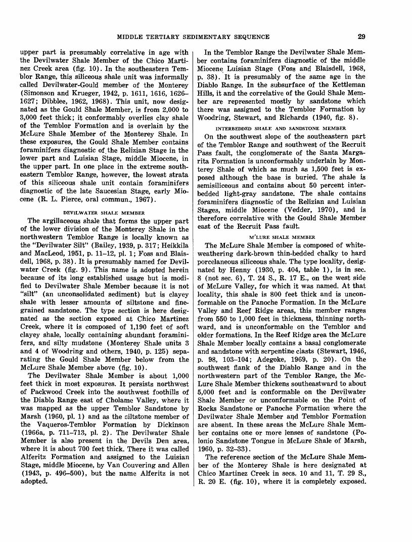
MIDDLE TERTIARY SEDIMENTARY SEQUENCE 29
upper part is presumably correlative in age with the Devilwater Shale Member of the Chico Marti- nez Creek area (fig. 10). In the southeastern Tem blor Range, this siliceous shale unit was informally called Devilwater-Gould member of the Monterey (Simonson and Krueger, 1942, p. 1611, 1616, 1626- 1627; Dibblee, 1962, 1968). This unit, now desig nated as the Gould Shale Member, is from 2,000 to 3,000 feet thick; it conformably overlies clay shale of the Temblor Formation and is overlain by the McLure Shale Member of the Monterey Shale. In these exposures, the Gould Shale Member contains foraminifers diagnostic of the Relizian Stage in the lower part and Luisian Stage, middle Miocene, in the upper part. In one place in the extreme south eastern Temblor Range, however, the lowest strata of this siliceous shale unit contain foraminifers diagnostic of the late Saucesian Stage, early Mio cene (R. L. Pierce, oral commun., 1967).
DEVILWATER SHALE MEMBER
The argillaceous shale that forms the upper part of the lower division of the Monterey Shale in the northwestern Temblor Range is locally known as the "Devilwater Silt" (Bailey, 1939, p. 317; Heikkila and MacLeod, 1951, p. 11-12, pi. 1; Foss and Blais- dell, 1968, p. 38). It is presumably named for Devil- water Creek (fig. 9). This name is adopted herein because of its long established usage but is modi fied to Devilwater Shale Member because it is not "silt" (an unconsolidated sediment) but is clayey shale with lesser amounts of siltstone and fine grained sandstone. The type section is here desig nated as the section exposed at Chico Martinez Creek, where it is composed of 1,190 feet of soft clayey shale, locally containing abundant foramini fers, and silty mudstone (Monterey Shale units 3 and 4 of Woodring and others, 1940, p. 125) sepa rating the Gould Shale Member below from the McLure Shale Member above (fig. 10).
The Devilwater Shale Member is about 1,000 feet thick in most exposures. It persists northwest of Packwood Creek into the southwest foothills of the Diablo Range east of Cholame Valley, where it was mapped as the upper Temblor Sandstone by Marsh (1960, pi. 1) and as the oiltstone member of the Vaqueros-Temblor Formation by Dickinson (1966a, p. 711-713, pi. 2). The Devilwater Shale Member is also present in the Devils Den area, where it is about 700 feet thick. There it was called Alferitz Formation and assigned to the Luisian Stage, middle Miocene, by Van Couvering and Alien (1943, p. 496-500), but the name Alferitz is not adopted.
In the Temblor Range the Devilwater Shale Mem ber contains foraminifers diagnostic of the middle Miocene Luisian Stage (Foss and Blaisdell, 1968, p. 38). It is presumably of the same age in the Diablo Range. In the subsurface of the Kettleman Hills, it and the correlative of the Gould Shale Mem ber are represented mostly by sandstone which there was assigned to the Temblor Formation by Woodring, Stewart, and Richards (1940, fig. 8).
INTERBEDDED SHALE AND SANDSTONE MEMBER
On the southwest slope of the southeastern part of the Temblor Range and southwest of the Recruit Pass fault, the conglomerate of the Santa Marga- rita Formation is unconformably underlain by Mon terey Shale of which as much as 1,500 feet is ex posed although the base is buried. The shale is semisiliceous and contains about 50 percent inter- bedded light-gray sandstone. The shale contains foraminifers diagnostic of the Relizian and Luisian Stages, middle Miocene (Vedder, 1970), and is therefore correlative with the Gould Shale Member east of the Recruit Pass fault.
M'LURE SHALE MEMBERThe McLure Shale Member is composed of white-
weathering dark-brown thin-bedded chalky to hard porcelaneous siliceous shale. The type locality, desig nated by Henny (1930, p. 404, table 1), is in sec. 8 (not sec. 6), T. 24 S., R. 17 E., on the west side of McLure Valley, for which it was named. At that locality, this shale is 800 feet thick and is uncon- formable on the Panoche Formation. In the McLure Valley and Reef Ridge areas, this member ranges from 550 to 1,000 feet in thickness, thinning north ward, and is unconformable on the Temblor and older formations. In the Reef Ridge area the McLure Shale Member locally contains a basal conglomerate and sandstone with serpentine clasts (Stewart, 1946, p. 98, 103-104; Adegoke, 1969, p. 20). On the southwest flank of the Diablo Range and in the northwestern part of the Temblor Range, the Mc Lure Shale Member thickens southeastward to about 5,000 feet and is conformable on the Devilwater Shale Member or unconformable on the Point of Rocks Sandstone or Panoche Formation where the Devilwater Shale Member and Temblor Formation are absent. In these areas the McLure Shale Mem ber contains one or more lenses of sandstone (Po- lonio Sandstone Tongue in McLure Shale of Marsh, 1960, p. 32-33).
The reference section of the McLure Shale Mem ber of the Monterey Shale is here designated at Chico Martinez Creek in sees. 10 and 11, T. 29 S., R. 20 E. (fig. 10), where it is completely exposed.
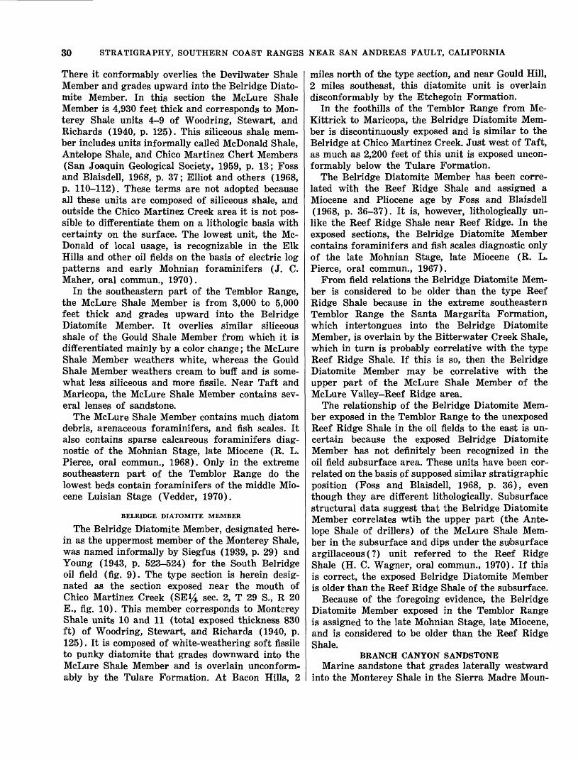
30 STRATIGRAPHY, SOUTHERN COAST RANGES NEAR SAN ANDREAS FAULT, CALIFORNIA
There it conformably overlies the Devilwater Shale Member and grades upward into the Belridge Diato- mite Member. In this section the McLure Shale Member is 4,930 feet thick and corresponds to Mon- terey Shale units 4-9 of Woodring, Stewart, and Richards (1940, p. 125). This siliceous shale mem ber includes units informally called McDonald Shale, Antelope Shale, and Chico Martinez Chert Members (San Joaquin Geological Society, 1959, p. 13; Foss and Blaisdell, 1968, p. 37; Elliot and others (1968, p. 110-112). These terms are not adopted because all these units are composed of siliceous shale, and outside the Chico Martinez Creek area it is not pos sible to differentiate them on a lithologic basis with certainty on the surface. The lowest unit, the Mc Donald of local usage, is recognizable in the Elk Hills and other oil fields on the basis of electric log patterns and early Mohnian foraminifers (J. C. Maher, oral commun., 1970).
In the southeastern part of the Temblor Range, the McLure Shale Member is from 3,000 to 5,000 feet thick and grades upward into the Belridge Diatomite Member. It overlies similar siliceous shale of the Gould Shale Member from which it is differentiated mainly by a color change; the McLure Shale Member weathers white, whereas the Gould Shale Member weathers cream to buff and is some what less siliceous and more fissile. Near Taft and Maricopa, the McLure Shale Member contains sev eral lenses of sandstone.
The McLure Shale Member contains much diatom debris, arenaceous foraminifers, and fish scales. It also contains sparse calcareous foraminifers diag nostic of the Mohnian Stage, late Miocene (R. L. Pierce, oral commun., 1968). Only in the extreme southeastern part of the Temblor Range do the lowest beds contain foraminifers of the middle Mio cene Luisian Stage (Vedder, 1970).
BELRIDGE DIATOMITE MEMBER
The Belridge Diatomite Member, designated here in as the uppermost member of the Monterey Shale, was named informally by Siegfus (1939, p. 29) and Young (1943, p. 523-524) for the South Belridge oil field (fig. 9). The type section is herein desig nated as the section exposed near the mouth of Chico Martinez Creek (SEi/4 sec. 2, T 29 S., R 20 E., fig. 10). This member corresponds to Monterey Shale units 10 and 11 (total exposed thickness 830 ft) of Woodring, Stewart, and Richards (1940, p. 125). It is composed of white-weathering soft fissile to punky diatomite that grades downward into the McLure Shale Member and is overlain unconform- ably by the Tulare Formation. At Bacon Hills, 2
miles north of the type section, and near Gould Hill, 2 miles southeast, this diatomite unit is overlain disconformably by the Etchegoin Formation.
In the foothills of the Temblor Range from Mc- Kittrick to Maricopa, the Belridge Diatomite Mem ber is discontinuously exposed and is similar to the Belridge at Chico Martinez Creek. Just west of Taft, as much as 2,200 feet of this unit is exposed uncon- formably below the Tulare Formation.
The Belridge Diatomite Member has been corre lated with the Reef Ridge Shale and assigned a Miocene and Pliocene age by Foss and Blaisdell (1968, p. 36-37). It is, however, lithologically un like the Reef Ridge Shale near Reef Ridge. In the exposed sections, the Belridge Diatomite Member contains foraminifers and fish scales diagnostic only of the late Mohnian Stage, late Miocene (R. L. Pierce, oral commun., 1967).
From field relations the Belridge Diatomite Mem ber is considered to be older than the type Reef Ridge Shale because in the extreme southeastern Temblor Range the Santa Margarita Formation, which intertongues into the Belridge Diatomite Member, is overlain by the Bitterwater Creek Shale, which in turn is probably correlative with the type Reef Ridge Shale. If this is so, then the Belridge Diatomite Member may be correlative with the upper part of the McLure Shale Member of the McLure Valley-Reef Ridge area.
The relationship of the Belridge Diatomite Mem ber exposed in the Temblor Range to the unexposed Reef Ridge Shale in the oil fields to the east is un certain because the exposed Belridge Diatomite Member has not definitely been recognized in the oil field subsurface area. These units have been cor related on the basis pf supposed similar stratigraphic position (Foss and Blaisdell, 1968, p. 36), even though they are different lithologically. Subsurface structural data suggest that the Belridge Diatomite Member correlates wtih the upper part (the Ante lope Shale of drillers) of the McLure Shale Mem ber in the subsurface and dips under the subsurface argillaceous(?) unit referred to the Reef Ridge Shale (H. C. Wagner, oral commun., 1970). If this is correct, the exposed Belridge Diatomite Member is older than the Reef Ridge Shale of the subsurface.
Because of the foregoing evidence, the Belridge Diatomite Member exposed in the Temblor Range is assigned to the late Mohnian Stage, late Miocene, and is considered to be older than the Reef Ridge Shale.
BRANCH CANYON SANDSTONEMarine sandstone that grades laterally westward
into the Monterey Shale in the Sierra Madre Moun-
MIDDLE TERTIARY SEDIMENTARY SEQUENCE 31
tains and Caliente Range (fig. 7) was named the Branch Canyon Formation by Hill, Carlson, and Dibblee (1958, p. 2991-2993) for Branch Canyon (3 miles south of New Cuyama), the type section (sec. 2. T. 9 N., R. 27 W.). This usage is adopted herein but the name is modified to Branch Canyon Sandstone.
In the Branch Canyon area south of Cuyama Valley, the Branch Canyon Sandstone is about 3,200 feet thick. The lower 2,100 feet ("Vaqueros," "Temblor," and "Briones," of Eaton and others, 1941, fig. 13) contains mollusks and echinoids diag nostic of the "Temblor Stage," middle Miocene. The upper 1,100 feet ("upper Briones," "Cierbo," and "lower Neroly" of Eaton and others, 1941, fig. 13) contains mollusks and echinoids diagnostic of the "Santa Margarita Stage," late Miocene, and is over lain by the Santa Margarita Formation. Farther east, the Branch Canyon Sandstone is overlapped by and tongues out into nonmarine formations.
In the Caliente Range, the Branch Canyon Sand stone is as much as 3,000 feet thick. There it con tains mollusks of the "Temblor Stage," middle Mio cene, only. It intertongues southwestward into the Saltos Shale Member of the Monterey Shale in both northwestern and southeastern parts of the range. In the southeastern part, it is overlain by and tongues laterally eastward into the Caliente Forma tion.
Several wells drilled for petroleum in the western parts of the Carrizo Plain and near the San Juan River to the northwest and a well northwest of Cholame penetrated sandstone of, or correlative with, the Branch Canyon Sandstone. These occur rences and the exposures of this sandstone along the northeastern flank of the Caliente Range sug gest that the Branch Canyon Sandstone may be con tinuous under the southwestern part of the Carrizo Plain to and beyond Cholame. Along this strip, this marine sandstone intertongues southwestward into the Monterey Shale and northeastward toward the San Andreas fault into the Caliente Formation (fig. 12). Similar conditions prevail in the eastern Sierra Madre Mountains and presumably under Cuyama Valley. These relations indicate that the Branch Canyon Sandstone is essentially a strandline deposit between the Monterey Shale deposited offshore to the southwest and the terrestrial Caliente Forma tion to the northeast.
SANTA MARGARITA FORMATION Throughout much of the region southwest of the
San Andreas fault, the Monterey Shale is overlain by marine sandstone that was named the Santa
Margarita Formation by Fairbanks (1904) for ex posures at Santa Margarita, the type locality (8 miles southeast of Atascadero, fig. 2). This usage is herein retained for this sandstone unit.
The Santa Margarita Formation is about 1,500 feet thick in most places and is composed mainly of white friable sandstone. In some places, such as north of the La Panza Range and also south of Cuyama Valley, it contains thin rhyolitic tuffaceous beds, zones of phosphatic pellets, and one or two thin units of silty diatomaceous siliceous shale. South of Cuyama Valley the Santa Margarita For mation is underlain by upper Miocene beds of the Branch Canyon Sandstone, from which it is arbi trarily separated by a shale unit at the base of the Santa Margarita Formation. In one exposure just west of Carrizo Plain, the Santa Margarita Forma tion tongues eastward into nonmarine red beds. Within a few miles of the San Andreas fault in the southeastern Caliente Range and under Carrizo Plain, the Santa, Margarita Formation is not pres ent, but is probably represented by the upper part of the Caliente Formation.
The sandstone of the Santa Margarita Formation contains shallow-water marine mollusks and echi noids of the "Santa Margarita Stage," late Miocene. It was deposited as a littoral marine facies of a regressing sea.
Northeast of the San Andreas fault, coarse clastic deposits in the upper Miocene section are present only in the southeastern part of the Temblor Range. In this area very coarse conglomerate, which locally contains mollusks of late Miocene age, was referred to the Santa Margarita Formation by Simonson and Krueger (1942 p. 1619-1621). This usage is re tained herein. This conglomerate, which also in cludes lenses of breccia and sandstone, is as much as 2,500 feet thick. It intertongues northeastward, downdip, into the Belridge Diatomite Member of the Monterey Shale.
CALIENTE FORMATION
In areas southwest of the San Andreas fault, terrestrial deposits that intertongue westward into the marine deposits of Miocene age (fig. 7) were named the Caliente Formation by Hill, Carlson, and Dibblee, 1958 p. 2993-2995) for the Caliente Range. The type locality was designated in the southeastern part of the range in sees. 26 and 23, T. 11 N., R. 26 W., 5-6 miles northeast of New Cuyama. This usage is adopted herein.
The Caliente Formation of the Caliente Range is as thick as 4,200 feet and consists of varicolored sandstone, claystone, conglomerate, and four units

32 STRATIGRAPHY, SOUTHERN COAST RANGES NEAR SAN ANDREAS FAULT, CALIFORNIA
of basalt. It has yielded vertebrate remains diag nostic of the following ages of the mammalian chronology (fig. 4): Arikareean, late Oligocene (?) and early Miocene; Hemingfordian, middle Mio cene; Barstovian, middle (?) and late Miocene; Clarendonian, late Miocene (?); and Hemphillian, Pliocene (Repenning and Vedder, 1961; Vedder and Repenning, 1965). It is therefore assigned an Oligo cene (?), Miocene, and Pliocene age (fig. 7), but it is mostly of Miocene age.
The strata of the Caliente Formation that contain mammalian faunas assigned to the Arikareean, Hemingfordian, and early Barstovian ages inter- tongue westward into marine beds that have yielded molluscan faunas diagnostic of the "Temblor Stage" and foraminiferal faunas diagnostic of the Sauce- sian, Relizian, and Luisian Stages in the central Caliente Range. The strata that contain mammalian faunas assigned to the late Barstovian, Claren donian, and Hemphillian "ages" are overlain by the Quatal Formation and are considered in part if not in whole correlative with the Santa Margarita For mation, which is also overlain by the Quatal Forma tion south of Cuyama Valley and northwest of Car- rizo Plain. If all the upper strata of the Caliente Formation correlate with the Santa Margarita Formation, then the Santa Margarita, of late Mio cene age of the marine invertebrate chronology, may be in part Pliocene of the mammalian chron ology. Until the relationship of the mammalian "ages" to the marine "ages" and stages is more precisely known, this problem is unresolved.
In the Santa Barbara Canyon area southeast of Cuyama Valley, red beds that underlie the Branch Canyon Sandstone were named the Pato Red Mem ber of the Vaqueros Formation by English (1916, p. 200, pi. XIX), but assigned to the Caliente For mation (by Hill, Carlson, and Dibblee (1958, p. 2995). The latter usage is retained, and the name Pato is considered obsolete. These beds contain sparse mam malian remains that suggest Arikareean age (J. G. Vedder, oral commun., 1968).
In the Red Hills northwest of Carrizo Plain, the granitic basement is overlain by about 3,000 feet of red to gray coarse boulder-cobble conglomerate of granitic detritus. This conglomerate is questionably referred to the Caliente Formation and is presum ably of middle or late Miocene age, but it may be in part of early Miocene or Oligocene (?) age. It is overlain by sandstone that has late Miocene fossils and is assigned to the Santa Margarita Formation but that could be correlative with the Branch Canyon Sandstone.
A well drilled for petroleum about 2 miles east
of the Red Hills penetrated terrestrial beds of the Caliente (?) Formation to a depth of 2,910 feet, then struck granitic basement. Another well about 11 miles northwest of the Red Hills or 2V& miles northwest of Cholame was drilled through terres trial sedimentary rocks, presumably of the Caliente Formation, similar to those in the Red Hills from depths of 1,950 to 6,523 feet, then entered granitic basement.
About 18 miles southeast of the Red Hills, red sandy beds which intertongue(?) southwestward into the Santa Margarita Formation crop out.
The widely scattered exposures of the Caliente Formation are probably only a very small part of its total areal extent; it is largely covered by younger formations. This terrestrial unit or facies probably underlies the southeastern part of Cuyama Valley and possibly much of the northeast margin of Carrizo Plain (fig. 12), as suggested by the dis tribution of the formation in surface exposures and well sections referred to. If the Caliente Formation is continuous along this strip, it intertongues south- westward into the Branch Canyon Sandstone and was deposited along a coastal plain adjacent to the Miocene sea to the southwest. The position of the west margin of the continental facies southwest of the San Andreas fault is about as postulated by Hill and Dibblee (1953, p. 446-448) but extends farther northwest. The granitic detritus that makes up the Caliente Formation was derived from a granitic terrane that presumably lay northeast of the San Andreas fault in middle Tertiary time.
BASALT
Exposures of volcanic flows, sills, and dikes of olivine basalt are present only in the middle Tertiary sedimentary sequence in the Caliente Range and on the east margin of the La Panza Range (fig. 7). Most of the flows are in the Monterey Shale, Branch Canyon Sandstone, and middle and upper Miocene parts of the Caliente Formation of the Caliente Range. Dikes are locally abundant in the Vaqueros and Simmler Formations near Soda Lake, and sev eral sills occur in the Vaqueros Formation.
In the southeastern Caliente Range, two of three prominent basalt flows ("Triple basalts" of Eaton, 1939; Hill and others, 1958, p. 2994; and Vedder and Repenning, 1965) were radiometrically dated by Turner (1970, p. 115): the upper flow was dated as about 14.2 and 14.4 million years, and the lower one as about 16.1 million years. Both flows are in the Branch Canyon Sandstone, which contains a "Temblor" fauna and which intertongues eastward
UPPER TERTIARY SEDIMENTARY SEQUENCE 33
into the part of the Caliente Formation that con tains a "Barstovian" fauna.
BITTERWATER CREEK SHALE
Marine siliceous shale or mudstone that discon- formablyC?) overlies conglomerate of the Santa Margarita Formation in the Elkhorn Hills area southwest of Maricopa on the northeast side of the San Andreas fault was named the Bitterwater Creek Shale (Dibblee, 1962, p. 8-11, pi. 1). It was named for Bitterwater Creek, 6 miles southwest of Mari copa, the type locality, where as much as 2,000 feet of this shale is exposed and is unconformably over lain by the Paso Robles Formation. This usage is adopted herein.
The Bitterwater Creek Shale was thought to be of Pliocene (?) age (Dibblee, 1962) because of its stratigraphic position as indicated; however, it con tains foraminifers, fish scales, and diatoms diagnos tic of the Mohnian Stage, late Miocene (R. L. Pierce, oral commun., 1967; Vedder, 1970). This age is the same as that of the Belridge Diatomite Member of the Monterey Shale, but the Bitterwater Creek Shale is stratigraphically higher (fig. 8).
The relationship of the Bitterwater Creek Shale to the unnamed Pliocene marine clastic sediments to the northwest, which were formerly included in the Bitterwater Creek Shale (Dibblee, 1962, pi. 1), is not clear because of insufficient exposures and structural complications. North of the Elkhorn Hills the Bitterwater Creek Shale intertongues northwest ward into unfossiliferous sandstone with siliceous shale pebbles. This sandstone is similar to that of the unit mapped as unnamed marine sediment, of early Pliocene age. If the sandstones are the same, the Bitterwater Creek Shale is equivalent to at least the lower part of that unit. It is possible, how ever, that the Bitterwater Creek Shale and the un fossiliferous sandstone are overlapped by that unit and if so, are thus older. From the foregoing evi dence the Bitterwater Creek Shale is considered to be late Miocene (Mohnian) and possibly early Plio cene in age.
REEF RIDGE SHALE
In the Reef Ridge and McLure Valley areas, about 500 feet of soft-weathering claystone is ex posed that is transitional between the underlying Monterey Shale and overlying Etchegoin Formation. It was described and named the Reef Ridge Shale by Barbat and Johnson, 1933, p. 239; 1934, p. 1-17) and by Gester and Galloway (1933, p. 1174-1176). This usage was adopted by Woodring, Stewart, and Richards (1940, p. 119-122) and Stewart (1946, p. 104, pi. 9) and is retained herein. This unit is arbi
trarily placed at the top of the middle Tertiary sedimentary sequence. No type locality was desig nated, but Barbat and Johnson (1933, p. 4-5) stated that this shale unit is "typically exposed" from Little Tar Creek (9 miles south-southeast of Ave- nal) northwest for 22 miles to Jasper Creek (15 miles west of Avenal). They assigned this shale unit to the uppermost Miocene. The type locality is herein designated as the exposure in Big Tar Creek (about 5 miles south-southwest of Avenal) in sees. 7, 8, and 17, T. 23 S., R. 17 E., where the Reef Ridge Shale is about 550 feet thick.
According to Kleinpell (1938, p. 165), the Reef Ridge Shale contains foraminifers assigned to his Delmontian Stage, of latest Miocene age. His Del- montian Stage is, however, now considered to be part of, and inseparable from, his Mohnian Stage (R. L. Pierce, oral commun., 1970). Therefore, the Reef Ridge Shale of the type area is considered by Pierce to be of late Miocene age (Mohnian Stage). This age assignment, however, has not yet been doubtlessly ascertained, as it may range into early Pliocene.
Clay shale correlative with the Reef Ridge Shale does not crop out in the Temblor Range. Under the alluviated area to the east, however, wells penetrate between the Etchegoin Formation and Monterey Shale a shale unit from 150 to 900 feet thick that is referred to the Reef Ridge Shale by petroleum geolo gists. This shale unit was considered to be late Mio cene and possibly early Pliocene in age and corre lated with both the Reef Ridge Shale of Reef Ridge and the Belridge Diatomite Member of the Monterey Shale in the Temblor Range (Foss and Blaisdell, 1960, p. 36). Correlation with the Reef Ridge Shale is probably valid because of its similar stratigraphic position and because in some wells, such as in the Elk Hills oil field, this unit is gray clay shale (J. C. Maher, oral commun., 1970) similar to the Reef Ridge Shale of Reef Ridge. Correlation with the Belridge Diatomite Member is considered not valid, as the Reef Ridge Shale is thought to be younger than that unit .because of reasons as indicated in the discussion of the Belridge Diatomite Member. Accordingly, then, the Reef Ridge Shale is probably correlative with the Bitterwater Creek Shale in the south end of the Temblor Range and is considered to be late Miocene and possibly early Pliocene in age.
UPPER TERTIARY SEDIMENTARY SEQUENCEDEFINITION
In many places on both sides of the San Andreas fault, the middle Tertiary sedimentary sequence is
34 STRATIGRAPHY, SOUTHERN COAST RANGES NEAR SAN ANDREAS FAULT, CALIFORNIA
overain by shallow-water marine, brackish-water, and terrestrial sedimentary deposits mainly of Plio cene age. These deposits are informally designated herein as the upper Tertiary sedimentary sequence. The age of the sequence may range into early Pleis tocene, depending upon the age interpretation of the fossils in the upper part.
This sequence underlies almost all the San Joaquin Valley east of the San Andreas fault. West of the fault it is restricted to Cuyama Valley, Carrizo Plain, and Salinas Valley and is exposed at only a few places along the margins of this alinement of valleys. The sequence must have accumulated in two northwest-trending basins separated by the Temblor Range, against which this sequence thins from both sides. In each of these basins the sequence is different in stratigraphy and thickness, as indi cated subsequently.
DEPOSITS IN THE SAN JOAQUIN VALLEY AREA
The upper Tertiary sedimentary sequence of the part of the San Joaquin Valley region of figure 2 accumulated in what developed (after middle Ter tiary time) into a large marine embayment, in large part bounded on the southwest by uplifts that be came the Temblor Range and the Diablo Range. Because this embayment covered the area that is now the San Joaquin Valley, it is commonly called the San Joaquin basin. The upper Tertiary sequence deposited in this basin is as thick as 7,000 feet and is composed mainly of fossiliferous interbedded sandstone, siltstone, and claystone of shallow ma rine origin with some brackish water and lacustrine beds at the top. The sequence crops out in the Reef Ridge and McLure Valley areas of the Diablo Range, and the upper part is exposed in the Kettleman Hills. In these areas it lies conformably on the Reef Ridge Shale and is overlain conformably by the Tulare Formation.
Southeast of McLure Valley and Kettleman Hills, this sedimentary sequence is concealed except for a few very small exposures in the foothills of the Temblor Range. Subsurface well data from east of the Temblor Range indicate that this sequence is about 7,000 feet thick, but it thins abruptly south- westward against previously deformed and eroded Monterey Shale of the Temblor Range.
TERMINOLOGY
The stratigraphic nomenclature applied to the upper Tertiary sedimentary sequence of the west side of San Joaquin Valley is much confused, as pointed out by Woodring, Stewart, and Richards (1940, p. 26-27). In the area north of Coalinga,
Anderson (1905, p. 178-181) originally named the entire exposed sequence "Etchegoin Beds," for ex posures on "Etchegoin ranch, some twenty miles northeast of Coalinga" (this plots in the alluvium of San Joaquin Valley), but he called the lower two-thirds "Etchegoin Sands" and the upper third "San Joaquin Clays." Later, Arnold and Anderson (1910, p. 113-114) located this ranch in NW*4 sec. 1, T. 19 S., R. 15 E., but designated the type section of the Etchegoin Formation on Anticline Ridge "9 miles north of Coalinga" and defined the forma tion as consisting of sand, gravel, and clay above "the Glycimerus zone."
On the east flank of the Diablo Range south of Coalinga and in the Kettleman Hills, Arnold and Anderson (1908, p. 46-55; 1910, p. 96-124) applied the term "Etchegoin Formation" to the upper two- thirds of this sequence and named the lower third "Jacalitos Formation," which was inferred from the fossils to be of late Miocene age. This classifica tion was adopted by Nomland (1916); however, a year later he (Nomland, 1917, p. 197) abandoned the name Jacalitos Formation because that unit is lithologically and paleontologically nearly similar to the Etchegoin, and he applied the term Etchegoin Formation or Group to both units and assigned both to the Pliocene.
In later years the San Joaquin Clay again became recognized as the upper third of the upper Tertiary sedimentary sequence in the west-side oil fields and the foothill areas (Reed, 1933, p. 236; Barbat and Galloway, 1934). In the Kettleman Hills this unit was formally defined and mapped as the San Joaquin Formation by Woodring, Stewart, and Richards (1940, p. 26-28) and adopted by Stewart (1946, p. 104-105, pi. 9). In both reports the name Jaca litos Formation was revived for the lower third, and Etchegoin Formation retained for the middle third of the upper Tertiary sedimentary sequence. They considered all three units to be of Pliocene age. Still later, Adegoke (1969, p. 28-34) recognized only a twofold division of this Pliocene sequence. He assigned the predominantly sandy lower two- thirds to the Etchegoin Formation and the largely clayey upper one-third to the San Joaquin Forma tion, as shown in figure 13.
In the oil field subsurface areas east of the Tem blor Range, Pack (1920, p. 44-47, pi. 1) and Wood- ring, Roundy, and Farnsworth (1932, p. 32-39) applied the term "Etchegoin Formation" to the entire Pliocene marine sedimentary sequence.
Although the lithology of the upper Tertiary sedi mentary sequence is generally similar throughout, it is proposed to adopt the terminology proposed by

"d S
i
&
§
I
a
r
!
Etchegoin beds
Etchegoin Sands San Joaquin Clays
Jacalitos FormationEtchegoin Formation
Etchegoin Formation or Group
Etchegoin Group
Jacalitos Formation
JacalitosEtchegoin
Etchegoin Sand
Jacalitos FormationEtchegoin Formation
Etchegoin Formation
Blue sandstone
\ /\ 7\\ / \ / \
Etchegoin Formation \/ \
v V
San Joaquin Clay
San Joaquin Clay
San Joaquin Clay
San Joaquin Formation
San Joaquin Formation
San Joaquin Formation
H- Q. VO (D O -i
3
to > q go-o~z E0 ? Q.
2 ^ O
!^I 53"Q.
VO (Dto (D00 Q.
o _ 0 10 Q.
-h
^ DOO 0)
,_. 0)_ -i
^^
0) 3 ^
1-1 (? ^ ?0 (S O ^ g P 0 ? 0-
=!̂~(D
-^
!^
o
(D
G
IoW§
S8aoNanbas AnviNawiaas
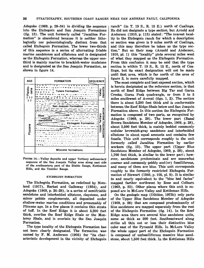
36 STRATIGRAPHY, SOUTHERN COAST RANGES NEAR SAN ANDREAS FAULT, CALIFORNIA
Adegoke (1969, p. 28-34) in dividing the sequence into the Etchegoin and San Joaquin Formations (fig. 13). The unit formerly called "Jacalitos For mation" is abandoned because it is neither litho- logically nor paleontologically distinct from that called Etchegoin Formation. The lower two-thirds of this sequence is a series of alternating friable marine sandstones and siltstones and is designated as the Etchegoin Formation, whereas the upper one- third is mainly marine to brackish-water mudstone and is designated as the San Joaquin Formation, as shown in figure 14.
AGE
So, «/> c'M <Dl»
? ? ?
? ?
0)C 0)u
QL
FORMATION [SEQUE' ^ «» - « *--%»OoOOO»»-_.._.
c.VJ'J r o" -~ Tulare Formation ~" ~ "" " "" 0 0.-0000--.000 <...--.«>- --».-.--. .-
^, O OOOO O 0 OOOOOO------
.' :~ ~~- San Joaquin Formation -
" BluejJ-^l' '^~rrr^fe ~ L .- - ' -; :
- -sandstone .^rr-^-,..,.. __. _..__.__....
----- -«- . . . _ _.. » . . _ ___ _ . . . . _ _ _ ... .
- - o -......__......._. _...... _... .......
- 0 <9 0 ---- ---_..
- - - . . .
- - o o » . . .
Miocene formations
NCE
(A>*i0) (A
ra a.> 9
0) 0
> *£ 3ra CT r; 0)t- w<D ,. H £»_ ra£ca»D E o
(A
FIGURE 14. Valley deposits and upper Tertiary sedimentary sequence of the San Joaquin Valley area along east side of the southeastern part of the Diablo Range, Kettleman Hills, and the Temblor Range.
ETCHEGOIN FORMATION
The Etchegoin Formation, as redefined by Nom- land (1917), Barbat and Galloway (1934), and Adegoke (1969, p. 26-28), is a series of semifriable sandstone and interbedded siltstone, claystone, and minor pebble conglomerate, all deposited under shallow-water marine conditions and presumably of Pliocene age. In a few places it contains thin strata of tuff. In the Reef Ridge it is about 5,200 feet thick, overlies the Reef Ridge Shale or the Mon- terey Shale, and is overlain by the San Joaquin Formation.
The type locality of the Etchegoin Formation has not been clearly designated. The formation was named by F. M. Anderson (1905) for "its char acteristic development in the vicinity of Etchegoin
ranch" (in T. 19 S., R. 15 E.) north of Coalinga. He did not designate a type section, but Arnold and Anderson (1910, p. 113) stated: "The nearest local ity to the Etchegoin ranch for which a description or section was given is 9 miles north of Coalinga, and this may therefore be taken as the type sec tion." But on their map (Arnold and Anderson, 1910, pi. 1) this "locality" plots several miles west of what they mapped as the Etchegoin Formation. From this confusion it may be said that the type section is within T. 19 S., R. 15 E., north of Coa linga, but its exact designation will not be made until that; area, which is far north of the area of figure 2, is more carefully mapped.
The most complete and best exposed section, which is herein designated as the reference section, is that north of Reef Ridge between Big Tar and Garza Creeks, Garza Peak quadrangle, or from 3 to 5 miles southwest of Avenal (figs. 1, 2). The section there is about 5,200 feet thick and is conformable between the Reef Ridge Shale below and San Joaquin Formation above. In this section the Etchegoin For mation is composed of two parts, as recognized by Adegoke (1969, p. 28). The lower part (Basal Brown Sandstone Member of Adegoke, 1969, p. 28), about 3,500 feet thick, is mainly bedded commonly nodular brownish-gray sandstone and interbedded siltstone in about equal amounts and contains few fossils. This unit corresponds roughly to the unit formerly called Jacalitos Formation by earlier workers (fig. 13). The upper part (Upper Blue Sandstone Member of Adegoke, 1969, p. 28), about 1,700 feet thick, is similar to the lower part; how ever, sandstones predominate and are somewhat coarser and commonly pebbly and (or) fossiliferous, and many of them are blue. This unit corresponds roughly to the formerly restricted Etchegoin For mation of Stewart (1946, p. 105, pi. 9). It is similar to and nearly equivalent to the "blue bed fades" mapped farther northwest by Rose and Colburn (1963, p. 33). Other places where this unit is ex posed are in McLure Valley and Kettleman Hills.
On the geologic map (Dibblee, 1973b) only parts of the Upper Blue Sandstone Member of Adegoke (1969, p. 28) that are composed predominantly of blue sandstone are mapped separately from the rest of the Etchegoin Formation (fig. 14). In the Reef Ridge area there are several blue sandstone units, some as thick as 500 feet. Southeastward along strike all thin out or lose their distinctive blue color east of the Pyramid Hills. In McLure Valley the whole upper part of the Etchegoin Formation is composed of unfossiliferous massive blue sand stone, about 1,500 feet thick. In the Kettleman Hills
UPPER TERTIARY SEDIMENTARY SEQUENCE 37
(North and Middle Domes) several thin blue sand stone strata are present.
The blue sandstones are medium grained and commonly contain pebbles of black and variegated chert and andesite. The blue color of the sandstone is the effect of a thin blue coating on the grains.
The Etchegoin Formation of the Reef Ridge and Kettleman Hills areas contains abundant marine mollusks and echinoids of Pliocene age (Woodring and others, 1940, p. 102-103). In the Kettleman Hills (North Dome) and at a locality 10-12 miles north of Coalinga, a few mammalian remains from the upper part of the Etchegoin Formation are assigned to the late Hemphillian age, Pliocene (D. E. Savage, written commun. to C. A. Repenning, 1968). In the Reef Ridge area, the few molluscan fossils from the lower part of the Etchegoin Forma tion are considered to be early Pliocene, and those from the upper part are considered to be late Plio cene (W. O. Addicott, oral commun., 1969).
SAN JOAQUIN FORMATION
In the Kettleman Hills the San Joaquin Forma tion, as mapped by Woodring, Stewart, and Richards (1940, p. 26-28, pi. 1), is from 1,200 to 1,800 feet thick and is mainly gray soft claystone, siltstone, and fine-grained sandstone. The base was taken as the base of a 50-foot-thick bed of gray to blue sand stone and pebble conglomerate (Cascajo Conglom erate Member of Woodring and others, 1940, p. 49-53). The San Joaquin Formation overlies the Etchegoin Formation and grades upward into the Tulare Formation. The type locality of the San Joaquin Formation is on the northeast flank of Ket tleman Hills, in sec. 23, T. 22 S., R. 18 E., 8 miles east of Avenal (fig. 1), as suggested by Barbat and Galloway (1934, p. 478-480); however, Woodring, Stewart, and Richards (1940, p. 27) suggested a better standard section 3 miles northwest in sec. 8, T. 22 S., R. 18 E.
In the foothills north of Reef Ridge, the San Joaquin Formation is about 2,000 feet thick and is similar to its exposure in Kettleman Hills. The base is taken as a thin pebble bed that overlies blue sandstone of the Etchegoin Formation. The San Joaquin Formation grades upward into the Tulare Formation through interbeds of conglomerate simi lar to that of the Tulare Formation. Southeastward along strike, the contact with the Tulare Forma- ion becomes difficult to map because the upper 1,200 feet of the San Joaquin Formation contains increas ing amounts of sandstone and many layers of shale- pebble conglomerate, a composition like that of the Tulare Formation.
The San Joaquin Formation in the Kettleman Hills contains marine, brackish-water, and lacus trine fossils considered to be of late Pliocene age by Woodring, Stewart, and Richards (1940, p. 103). They reported (1940, p. 97-98) mammalian fossils from the "Pecten zone" about 600 feet below the top of this unit. These were considered by Durham, Jahns, and Savage (1954, p. 69) to be of Blancan age or late Pliocene and early Pleistocene age and by Hibbard, Ray, Savage, Taylor, and Guilday (1965, p. 512) to be early Blancan age or late Pliocene. Adegoke (1969, p. 51) suggested that part or all of the San Joaquin Formation may be of Pleistocene age. In the Reef Ridge foothills the San Joaquin Formation contains molluscan fossils that Addicott (oral commun., 1968) considered to be of late Pliocene age. The unit is tentatively assigned a late Pliocene age, but could range into the Pleisto cene, depending on the interpretation of the Plio cene-Pleistocene boundary.
DEPOSITS IN THE SALINAS VALLEY CUYAMA VALLEY AREA
The upper Tertiary sedimentary sequence of the southeastern part of Salinas Valley, Carrizo Plain, Caliente Range, and Cuyama Valley is as thick as 5,000 feet, but generally thinner. It accumulated in what developed after Miocene time into a large troughlike basin between the Temblor Range uplift on the northeast and an extensive uplift to the southwest that evolved into the Santa Lucia, La Panza and Sierra Madre Mountains (fig. 2). This trough apparently extended northwestward through Salinas Valley and may therefore be referred to as the Salinas basin. Most of the upper Tertiary sedi mentary sequence lies southwest of the San Andreas fault; a small part is on the northeast side of the fault in a narrow strip between the fault and the Temblor Range uplift.
The upper Tertiary sedimentary sequence is ter restrial, except under Salinas Valley and in part of the strip on the northeast side of the San Andreas fault, where it is marine. In the central parts of the Salinas basin, this sequence conformably overlies the Santa Margarita or Caliente Formation, but along the flanks, especially the southwestern flank, it lies unconformably on all older formations, includ ing the crystalline rocks. Where exposed, this se quence is unconformaibly overlain by the Paso Robles Formation.
UNNAMED MARINE SEDIMENTS
Several test holes drilled for petroleum in the Shandon area of the Salinas Valley southwest of the San Andreas fault passed through as much as

38 STRATIGRAPHY, SOUTHERN COAST RANGES NEAR SAN ANDREAS FAULT, CALIFORNIA
2,000 feet of marine sandstone and siltstone of probable Pliocene age below the Paso Robles Forma tion and above the Santa Margarita Formation. Because of its comparable age and stratigraphic position, this unit may be equivalent to the Pancho Rico Formation, as redefined by Durham and Addi- cott (1964, p. E4; 1965, p. A2-A5) in Salinas Valley northwest of figure 2.
In the narrow strip on the northeast side of the San Andreas fault east of Soda Lake is exposed about 2,000 feet of marine sandstone that overlies conglomerate of the Santa Margarita Formation and grades laterally northward and upward into the terrestrial Morales Formation. The relationship of this sandstone to the Bitterwater Creek Shale is discussed under that formation. This marine sand stone unit contains early Pliocene mollusks (Arnold and Johnson, 1910, p. 89; W. 0. Addicott, oral commun., 1967). It may be correlative with the marine unit in the Shandon area described pre viously and also with part of the lithologically simi lar Etchegoin Formation of San Joaquin Valley and the Diablo Range.
QUATAL FORMATION
In the eastern Caliente Range, red beds of the Caliente Formation are overlain conformably by as much as 700 feet of lacustrine gray claystone. This claystone is believed to correlate, on the basis of similar lithology and stratigraphic position, with the Quatal Formation named by Hill, Carlson, and Dibblee (1958, p. 2996-2997) for Quatal Canyon near the type locality, in the Cuyama badlands south east of the Caliente Range and beyond the southeast border of figure 2. This name is herein adopted for this claystone in both exposures.
The Quatal Formation, which conformably under lies the terrestrial Morales Formation, is exposed at only a few places other than in the Caliente Range. In the Cuyama badlands it is composed of about 400 feet of reddish-brown claystone and gypsum that overlies the Caliente Formation. South of Cuyama Valley it is composed of 200-400 feet of white sand stone and red clay that disconformably overlies the Santa Margarita Formation and Branch Canyon Sandstone. In San Juan Creek, northwest of Carrizo Plain, about 200 feet of gray clay assigned to the Quatal Formation disconformably overlies the Santa Margarita Formation.
The Quatal Formation was presumed by Hill, Carl- son, and Dibblee (1958, p. 2996) to be of late Mio cene age because of its stratigraphic position. In the Caliente Range the uppermost beds of the Caliente Formation that underlie the Quatal contain mam
malian remains diagnostic of Hemphillian age, Plio cene (Savage, 1957, p. 1845), and beds about 1,600 feet above the base of the overlying Morales Forma tion contain a few mammalian remains of Blancan age (James, 1963, p. 11; Repenning and Vedder, 1961). The relationship of the Quatal Formation to the Pliocene (?) marine sediments of the Shandon area to the northwest is concealed, but the Quatal is presumably younger. Because of its stratigraphic position, the Quatal Formation is herein inferred to be of Hemphillian age and is assigned to the Plio cene.
MORALES FORMATIONIn the Cuyama Valley, Caliente Range, and in the
area northwest of Carrizo Plain is exposed a de formed valley deposit, as much as 5,000 feet thick, of light-gray gravel, sand, and silt that conformably overlies the Quatal Formation and unconformably laps onto the middle Tertiary sedimentary sequence. This valley deposit was named the Morales Member of the Santa Margarita Formation by English (1916, p. 203, pi. XIX) for Morales Canyon (10 miles north west of New Cuyama), the type locality. This deposit was redefined as a formation by Hill, Carlson, and Dibblee (1958, p. 2990, 2996-2998) because it differs lithologically from the Santa Margarita Formation and in the type locality in unconformably overlies the Santa Margarita Formation with angular dis cordance. The usage of Morales Formation of Hill, Carlson, and Dibblee (1958) and Vedder (1970) is retained herein.
The Morales Formation was inferred to be of Plio cene age by Hill, Carlson, and Dibblee (1958, p. 2996-2998) on the basis of its stratigraphic position above the Quatal Formation and Miocene strata and because of its unconformable relationship below equivalents of the Paso Robles Formation in western Cuyama Valley and eastern Caliente Range and at San Juan Creek northwest of Carrizo Plain.
A tooth of Equus (Pleisohippus) sp. (large horse), considered diagnostic of Blancan age (Plio cene or Pleistocene) of the vertebrate chronology, was found near the middle of the 5,000-foot-thick Morales Formation in the eastern Caliente Range (Vedder and Repenning, 1965; Vedder, 1970). The profound deformation of this formation, however, as compared to the much less deformed uncon formably overlying Paso Robles Formation indicates that the Morales Formation probably is late Plio cene in age, to which it was assigned by Vedder (1970).
In the Panorama Hills and southwestern foothills of the Temblor Range just northeast of the San Andreas fault, as much as 2,500 feet of terrestrial
VALLEY DEPOSITS 39
gravel named Panorama Hills Formation by Dibblee (1962, p. 8, pi. 1) gradationally overlies sandstone of the unnamed marine sediments and is uncon- formably overlain by the Paso Robles Formation. The name Panorama Hills Formation is herein abandoned, and this unit is assigned to the Morales Formation because it is of similar lithology and is probably in large part correlative. Presumably this valley deposit accumulated in the same basin as the Morales Formation now exposed in the Caliente Range and Cuyama Valley.
VALLEY DEPOSITSDEFINITION
Alluvial deposits of Pleistocene and possibly late Pliocene age form the uppermost and youngest thick sedimentary unit of the map area. These are informally designated herein as valley deposits. They accumulated in the San Joaquin and Salinas basins after the sea completely withdrew from this region near or at the end of Pliocene time. These basins thereby became valleys, separated by the Temblor-Diablo Range uplift, which was rising on the northeast side of the San Andreas fault. The valley deposits southwest of this uplift are com monly called the Paso Robles Formation; these accumulated in a long valley that extended from what is now the Salinas Valley southeastward through Carrizo Plain into Cuyama Valley. The valley deposits northeast of the Temblor-Diablo Range uplift are commonly called the Tulare Forma tion, and they accumulated in the San Joaquin Val ley.
PASO ROBLES FORMATION
Dissected locally deformed valley deposits in up per Salinas Valley were named the Paso Robles For mation by Fairbanks (1898, p. 565-566) for expo sures near Paso Robles (fig. 1). This name has since been applied to these deposits beyond the Paso Robles area by Fairbanks (1904), Arnold and John son (1910, pi. 1), Bramlette and Daviess (1944), Dibblee (1962, p. 6-10, pi. 1), and Durham (1963, 1964, 1966) and is used herein.
In the Salinas Valley lowland area north of the La Panza Range, the Paso Robles Formation is as much as 1,500 feet in exposed thickness; it attains a total maximum thickness of more than 4,000 feet in the subsurface west of Shandon as indicated from well logs. In this lowland area this valley deposit is composed of pebble gravel, sand, and clay, derived from the La Panza Range and from mountains west of Salinas Valley. In the subsurface near Shandon it conformably (?) overlies the un
named Pliocene marine sediments (Pancho Rico(?) Formation) as indicated by well logs. In the La Panza Range and Red Hills, this valley deposit thins and unconformably laps over the previously de formed middle Tertiary sedimentary sequence onto the crystalline basement complex.
Under the Carrizo Pain, the Paso Robles Forma tion is as thick as 2,000 feet near the San Andreas fault as indicated from well logs, and is composed largely of shale-pebble gravel, sand, and clay, de rived mainly from the Temblor Range. Southwest- ward this valley deposit thins and buttresses out against previously deformed Morales and Quatal Formations and the middle Tertiary sedimentary sequence of the Caliente Range.
At and near the southeast end of the Caliente Range and southwest of the San Andreas fault, the Paso Robles Formation ("deformed fanglomerate from eastern sources" of Vedder and Repenning, 1965, and "deformed alluvial deposits" of Vedder, 1970) is as thick as 1,000 feet and is unconformable on previously deformed lower, middle, and upper Tertiary sequences, including the Morales Forma tion. The Paso Robles Formation is there composed of gravel and some landslide debris of rocks exposed in the San Emigdio Mountains across the fault, but now is some 20 miles southeast of this area, owing to that much strike-slip on the fault since deposi tion of this detritus.
Northeast of the San Andreas fault, the Paso Robles Formation is as thick as 2,000 feet and more adjacent to the fault, but thins out rapidly northeastward against the Temblor Range. It un conformably overlies rocks of the Temblor Range, including the Morales Formation, and was derived entirely from the Temblor Range.
In Cuyama Valley, equivalents of the Paso Robles Formation are thought to be the old dissected locally deformed alluvial fan deposits, such as sev eral on the southwest side of the Caliente Range and one southwest of New Cuyama. These deposits are as thick as 600 feet and are composed of coarse locally derived detritus.
The top of the Paso Robles Formation, where preserved from erosion, is a surface of deposition, or an old valley surface that was never buried. Carrizo Plain, where it is preserved under a thin cover of alluvium, is a remnant of this former very extensive valley surface of deposition. To the north west and west this old valley surface becomes in creasingly dissected and largely destroyed by down- cutting stream channels of the present Salinas River drainage system. Along its margins this old valley
40 STRATIGRAPHY, SOUTHERN COAST RANGES NEAR SAN ANDREAS FAULT, CALIFORNIA
surface of deposition blends into the old erosion surface of the La Panza, Caliente, and Temblor Ranges as the Paso Robles Formation thins out against those previously elevated areas.
The age of the Paso Robles Formation can only be inferred from its stratigraphic position and from geomorphic relations because, except in one place, no diagnostic fossils have been found. This formation has been variously inferred to be Plio cene, Pleistocene, or Pliocene and Pleistocene in age. Durham (1966, p. B22) and Galehouse (1967, p. 955-956) considered it to be Pliocene and possibly Pleistocene in age because of the apparent inter- tonguing relationship with the underlying marine Pancho Rico Formation (lower Pliocene) east and southeast of King City. In that part of Salinas Val ley (northwest of fig. 2), however, the Paso Robles Formation is thin, and some of the lower beds into which marine beds intertongue may be equivalent to the Morales or Quatal Formations farther south east.
The Paso Robles Formation must be at least in part of Pleistocene age because its top surface of deposition, which blends into the Pleistocene erosion surface of the adjacent mountains where this sur face is cut on units as young as the Morales Forma tion, is in large part preserved, whereas no surface of deposition of any Tertiary formation remains unburied and uneroded. The angular unconformable relationship of the Paso Robles Formation to all older units, including the Morales Formation of late Pliocene age, suggests that all the Paso Robles For mation in areas in which this relationship exists is of Pleistocene age.
The single locality in which fossils were found in the Paso Robles Formation is 2 miles east of Atascadero in a roadcut about 300 feet west of middle of west line of sec. 7, T, 28 S., R. 13 E. At that place, brackish-marine mollusks were found (by J. S. Galehouse) in shale-pebble gravel about 20 feet above the base of the Paso Robles Forma tion. W. O. Addicott (written commun., 1971) con sidered them probably Pliocene, possibly middle Pliocene. Also found at this locality, and in basal cobble gravel of this formation within 3 miles south east of Santa Margarita, are cobbles with mollusk- bored holes.
Although the Paso Robles Formation is generally regarded as Pliocene and Pleistocene (?) in age, the formation within the area of figure 2 is considered by the writer to be of Pleistocene age and in places partly of probable late Pliocene age because of the stratigraphic relations and fossil data as indicated.
TULARE FORMATION
Locally deformed dissected valley deposits com posed of gravel, sand, and silt in the hills on the southwest side of the San Joaquin Valley near Coalinga were named Tulare Formation by Ander- son (1905, p. 181) for nearby Tulare Lake. No type locality was then designated, but Woodring, Stewart, and Richards (1940, p. 13) suggested the exposures on the northeast flank of the northern part of Kettle- man Hills North Dome as the type section. The name Paso Robles Formation was also applied to these valley deposits by Anderson and Pack (1915, pi. 1) and to those in the Temblor Range by Pack (1920, pi. II, p. 47-52). These deposits in the Tem blor Range, however, were included earlier by Arnold and Johnson (1910, pi. 1) in a unit they named McKittrick Formation. These valley sedi ments were redesignated the Tulare Formation by Woodring, Roundy, and Farnsworth (1932, p. 16- 30), Dibblee (1962, p. 8-10, pi. 1), and Foss and Blaisdell (1968 p. 35) because, even though they are lithologically similar to and occupy the same stratigraphic position as does the Paso Robles For mation, they were deposited in a different basin or valley. This usage is retained herein.
In the foothills of the Diablo Range and in the Kettleman Hills, the Tulare Formation is about 2,700 feet thick and grades downward into the San Joaquin Formation. Well data in the subsurface of the Elk Hills, Buena Vista Hills, and east of the Temblor Range indicate that it is similar. In the foothills of the Temblor Range it thins out west ward against the unconformably underlying Etche- goin Formation and Monterey Shale. The top of the Tulare Formation is a valley surface of deposi tion that forms the present undissected surface of San Joaquin Valley under a thin mantle of alluvium but is severely dissected, though partly preserved, where it is elevated by deformation in the Elk Hills, Buena Vista Hills (east of Taft), and foothills of the Temblor Range.
The age of the Tulare Formation is inferred to be late Pliocene and Pleistocene (Arnold and Ander son, 1910, p. 140, 154; Pack, 1920, pi. II; Woodring and others, 1932, p. 27, and 1940, p. 104; Stewart, 1946, p. 105; Wahrhaftig and Birman, 1965, p. 314r- 316) or Pleistocene (Goudkoff, 1943, p. 248-249; McMasters, 1947, fig. 34; Foss and Blaisdell, 1968, p. 35). A few mammalian fossils found in the San Joaquin Formation just below the base of the Tu lare Formation in the Kettleman Hills and near McKittrick are diagnostic of the Blancair age, late Pliocene or Pleistocene (C. A. Repenning, oral
SURFICIAL DEPOSITS 41
commun., 1968). On the Tulare Formation cene and Pleistocene commun., 1968).
The Tulare Formation is probably correlative Paso Robles Formation lithology, stratigraph relations and is likewise Pliocene (?) and Pleistocene
the basis of diatom studies, is considered to be of Plio-
age (K. E. Lohman, written
within the area of figure 2 with most of if not all the on the basis of its similar
ic position, and geomorphic tentatively assigned a late
age.
SURFICIAL DEPOSITSSurficial deposits consist of older alluvium, allu
vium, and landslides. These deposits are generally undeformed, except along or near the San Andreas fault. They are generally unconformable on older formations, except in much of the San Joaquin Valley and Carrizo Plain, where they may be con formable on the Tulare and Paso Robles Forma tions where these formations are undeformed.
The older alluvium, which is as thick as 400 feet and includes terrace deposits, is dissected where elevated. At the tar seeps a mile south of McKit- trick, terrace sands yielded a large mammalian fauna (Schultz, 1938) of Rancholabrean age late Pleistocene (C. A. Repenning, oral commun., 1969).
The alluvium forms a thin cover, generally less than 100 feet thick, on the valleys and flood plains of canyons. The alluvium and landslides are mainly of Holocene age, but may be in part latest Pleisto cene, depending upon the interpretation of when the Holocene started.
RELATIONSHIP OF SEDIMENTARYSEQUENCES TO THE SAN
ANDREAS FAULTIt may be noted throughout this report that the
successively older sedimentary sequences are in creasingly different on opposite sides of the San Andreas fault and that the basement complex upon which they rest is totally different. This condition appears to be the result of cumulative right-lateral displacement on this fault since Cretaceous (or Jurassic) time, along which areas of dissimilar older sequences and rocks have been juxtaposed, almost exactly as inferred by Hill and Dibblee (1953).
In the environs of the Carrizo Plain, it was found that the Paso Robles Formation on the northeast side of the San Andreas fault and also just south west of it is composed of detritus derived from the mountains on the northeast side and that these detrital sediments on the southwest side have been shifted some 10-15 miles northwest from their
sources on the northeast side (Hill and Dibblee, 1953, p. 446; Dibblee, 1973t>).
The Pliocene marine sediments (Pancho Rico(?) Formation and its equivalent) on the northeast side of the fault extend some 50-60 miles farther south east than they do on the southwest side, suggesting a right-lateral shift of that amount since they were deposited.
The spectacular difference in stratigraphy of the middle Tertiary sedimentary sequence on opposite sides of the fault, with sudden changes of fades at the fault as shown in figure 12, is almost certainly due to lateral juxtaposition of once distant areas. The juxtaposition of the all-marine (in part bathyal) fades of the northeast block against coarse terrestrial facies, which in large part grades later ally westward into shallow marine facies on the southwest block, is difficult to account for otherwise.
A right-lateral offset of about 65 miles on the fault since late Miocene time was estimated by Hill and Dibblee (1953, p. 446-448) from the offset on the fault of the transition facies zone where the terrestrial sediments grade laterally westward into marine sediments. On the northeast block this zone is in the San Emigdio Mountains (southeast of Maricopa, fig. 1); on the southwest block, it is some 100 miles farther northwest, just northwest of Cholame, suggesting a right-lateral displacement of that amount. Further evidence suggesting that much displacement is the occurrence, in the upper Miocene Santa Margarita Formation of the Temblor Range northeast of the fault, of landslide (?) masses and coarse detritus of crystalline basement rocks presumably derived from those rocks in the Gabilan Range (north of King City, fig. 1) southwest of the fault but now more than 80 miles to the northwest (Dibblee, 1962, p. 8). This post-Miocene right- lateral displacement may be as much as 150 miles, as inferred by Huffman (1970, p. 105-106) from matching the coarse conglomerate and breccia of this formation in the Temblor Range with their probable bedrock source in the Gabilan Range west of the San Andreas fault.
Right-lateral offset of some 175 miles since early Miocene time was suggested by Hill and Dibblee (1953, p. 448-449) on the basis of a similar assem blage of volcanic rocks and terrestrial and marine sedimentary rocks of early Miocene age in the northern Gabilan Range on the southwest side of the fault and in the San Emigdio Mountains on the northeast side. Radiometric age dates of 21.5 million years obtained from the volcanic rocks in both areas by D. L. Turner (1970, p. 101; oral commun., 1970) reaffirm this inferred offset.
42 STRATIGRAPHY, SOUTHERN COAST RANGES NEAR SAN ANDREAS FAULT, CALIFORNIA
The lower Tertiary and Cretaceous sedimentary sequences, although composed almost entirely of marine clastic rocks, are very unlike in stratigraphy, thickness, and age range on opposite sides of the fault within the region of figure 2. This condition must also be the result of juxtaposition along the fault of areas once far distant. To ascertain Hill and Difoblee's (1953, p. 448-449) estimated right- lateral offset on the fault of possibly 225 miles since Eocene time, 320 miles since Cretaceous time, and 350 miles since Jurassic time, it is necessary to go far beyond the borders of figure 2, which is also beyond the scope of this report.
It may be concluded that the stratigraphy of the region within figure 2 is closely related and greatly affected by movements on and near the San Andreas fault and that the available evidence suggests that this fault was active, either recurrently or continu ously, since Jurassic or Cretaceous time.
In summary, it may be said that the northeast block is one of oceanic basement of eugeosynclinal sedimentary and mafic igneous rocks overlain by four sequences of bathyal to shallow-water marine sedimentary rocks, whereas the southwest block is one of continental basement of granitic and meta- sedimentary rocks overlain unconformably by three sequences of shallow-water marine and terrestrial sedimentary and minor volcanic rocks. It seems evi dent that the southwest block was shifted north westward relative to and along the northeast block by many tens of miles of cumulative right-slip on the San Andreas fault during the Cenozoic Era.
REFERENCES CITEDAdegoke, O. S., 1969, Stratigraphy and paleontology of the
marine Neogene formations of the Coalinga region, Cali fornia: California Univ. Pubs. Geol. Sci., v. 80, 241 p., 13 pis., figs., maps.
Anderson, F. M., 1905, A stratigraphic study in the Mount Diablo Range of California: California Acad. Sci. Proc., 3d ser., Geology, v. 2, p. 155-248.
1908, A further stratigraphic study in the Mount Diablo Range of California: California Acad. Sci. Proc., 4th ser., v. 3, p. 1-40.
Anderson, F. M., and Martin, Bruce, 1914, Neocene record in the Temblor Basin, California, and Neocene deposits of the San Juan district, San Luis Obispo County: Calif. Acad. Sci. Proc., 4th ser., v. 4, p. 15-112.
Anderson, Robert, and Pack, R. W., 1915, Geology and oil resources of the west border of the San Joaquin Valley north of Coalinga, California: U.S. Geol. Survey Bull. 603, 220 p.
Arnold, Ralph, and Anderson, Robert, 1908, Preliminary re port on the Coalinga oil district, Fresno and Kings Counties, California: U.S. Geol. Survey Bull. 357, 142 p.
1910, Geology and oil resources of the Coalinga dis trict, California: U.S. Geol. Survey Bull. 398, 354 p., 52 pis.
Arnold, Ralph, and Johnson, H. R., 1910, Preliminary report on the McKittrick-Sunset oil region, Kern and San Luis Obispo Counties, California: U.S. Geol. Survey Bull. 406, 225 p.
Atwill, E. R., 1935, Oligocene Tumey formation of California: Am. Assoc. Petroleum Geologists Bull., v. 19, no. 8, p. 1192-1204.
Bailey, E. H., Irwin, W. P., and Jones, D. L., 1964, Fran ciscan and related rocks, and their significance in the geology of western California: California Div. Mines and Geology, Bull. 183, p. 1-177.
Bailey, W. C., 1939, Wasco oil field [California] California Oil Fields Summ. Operations, v. 24, no. 3, p. 66-71 [1941].
Bandy, O. L., and Arnal, R. E., 1969, Middle Tertiary basin development, San Joaquin Valley, California: Geol. Soc. America Bull., v. 80, p. 783-819.
Barbat, W. F., and Galloway, John, 1934, San Joaquin clay, California: Am. Assoc. Petroleum Geologists Bull., v. 18, no. 4, p. 476-499.
Barbat, W. F., and Johnson, F. L., 1933, Stratigraphy and foraminifera of the Reef Ridge shale, upper Miocene, California [abs.]: Pan-Am. Geologist, v. 59, no. 3, p. 239; also, 1934, Jour. Paleontology, v. 8, no. 1, p. 1-17.
Blake, W. P., 1855, Notice of remarkable strata containing the remains of Infusoria and Polythalmia in the Ter tiary formation of Monterey, California: Acad. Nat. Sci. Philadelphia Proc., v. 7, p. 328-331.
Bramlette, N. M., and Daviess, S. N., 1944, Geology and oil possibilities of the Salinas Valley, California: U.S. Geol. Survey Oil and Gas Inv. Prelim. Map 24.
Chipping, D. H., 1972, Early Tertiary paleogeography of central California: Am. Assoc. Petroleum Geologists Bull., v. 56, no. 3, p. 480-493.
Church, C. C., 1968, Lower Cretaceous Foraminifera of the Orchard Peak-Devils Den area, California: California Acad. Sci., Proc., 4th ser., v. 32, no. 18, p. 523-580, 8 pis.
Clark, B. L., 1929, Tectonics of the Valle Grande of Cali fornia: Am. Assoc. Petroleum Geologists Bull., v. 13, no. 3, p. 199-238.
Clark, B. L., and Vokes, H. E., 1936, Summary of marine Eocene sequence of western North America: Geol. Soc. America Bull., v. 47, no. 6, p. 851-878.
Clark, L. M., and Cl-ark, Alexander, 1935, The Vaqueros in the Temblor Range [abs.]: Am. Assoc. Petroleum Geologists Bull., v. 19, no. 1, p. 137.
Clements, T. D., 1950, Geology of Cuyama Gorge, California [abs.]: Read before Am. Assoc. Petroleum Geologists, Los Angeles, Calif., October 20, 1950.
Corey, W. H., 1954, Tertiary basins of southern California, pt. 8 in chap. 3 of Jahns, R. H., ed. Geology of southern California: California Div. Mines Bull. 170, p. 73-83.
Cross, R. K., 1962, Geology of the Carrizo-Cuyama Basin, in Guidebook to the geology of Carrizo Plain and San Andreas Fault, San Joaquin Geol. Soc. and Pacific Sees. Am. Assoc. Petroleum Geologists and Soc. Econ. Paleon tologists and Mineralogists: p. 27-35.
Cunningham, G. M., and Barbat, W. F., 1932, Age of produc ing horizons at Kettleman Hills, California: Am. Assoc. Petroleum Geologists Bull., v. 16, no. 4, p. 417-421.
Curran, J. F., 1943, Eocene stratigraphy of the Chico Mar- tinez Creek area, Kern County, California: Am. Assoc. Petroleum Geologists Bull., v. 27, no. 10, p. 1361-1386.
REFERENCES CITED 43
Curtis, G. H., Evernden, J. F., and Lipson, J. I., 1958, Age determination of some granitic rocks in California by the potassium-argon method: California Div. Mines Spec. Kept. 54, 16 p.
Cushman, J. A., and Goudkoff, P. P., 1938, New species of Pulvinulinella from the California Miocene: Cushman Lab. Foram. Research, Contr. v. 14, pt. 1, pi. 1.
Cushman, J. A., and Siegfus, S. S., 1942, Foraminifera from the Kreyenhagen Shale of California: San Diego Soc. Nat. History Trans., v. 9, no. 34, p. 385-426, pis. 14-19.
Dibblee, T. W., Jr., 1962, Displacements on the San Andreas rift zone and related structures in Carrizo Plain and vicinity, in Guidebook to the geology of Carrizo Plain and San Andreas fault, San Joaquin Geol. Soc. and Pacific Sees. Am. Assoc. Petroleum Geologists and Soc. Econ. Paleontologists and Mineralogists: p. 5-12, pi. 1.
1968, Geologic map of Temblor Range, San Luis Obispo and Kern Counties, California, in Guidebook to geology and oil fields of west side southern San Joaquin Valley, Am. Assoc. Petroleum Geologists and Soc. Econ. Paleontologists and Mineralogists, Pacific Sees., Ann. Field Trip, 1968: In pocket.
1973a, Geologic map of the Shandon and Orchard Peak quadrangles, California, showing Mesozoic and Cenozoic rock units juxtaposed along the San Andreas fault: U.S. Geol. Survey Misc. Geol. Inv. Map 1-788 [in press],
1973b, Regional geologic map of San Andreas andrelated faults in Carrizo Plain, Temblor, Caliente, and La Panza Ranges and vicinity, California: U.S. Geol. Survey Misc. Geol. Inv. Map 1-757 [in press].
Dickinson, W. R., 1963, Tertiary stratigraphic sequence of the Hancock Ranch area, Monterey and Kings Counties, California, in Guidebook to the geology of Salinas Val ley and the San Andreas fault, Am. Assoc. Petroleum Geologists and Soc. Econ. Paleontologists and Mineralo gists, Pacific Sees., Ann. Field Trip, 1963: p. 47-53.
1966a, Structural relationships of San Andreas fault system, Cholame Valley and Castle Mountain Range, California: Geol. Soc. America Bull., v. 77, no. 7, p. 707-726.
1966b, Table Mountain serpentine extrusion in California Coast Ranges: Geol. Soc. America Bull., v. 77, no. 5, p. 451-472.
Diller, J. S., and Stanton, T. W., 1894, The Shasta-Chico series: Geol. Soc. America Bull., v. 5, p. 435-464.
Durham, D. L., 1963, Geology of the Reliz Canyon, Thomp son Canyon, and San Lucas quadrangles, Monterey County, California: U.S. Geol. Survey Bull. 1141-Q, p. Q1-Q41.
1964, Geology of the Cosio Knob and Espinosa Canyon quadrangles, Monterey County, California: U.S. Geol. Survey Bull. 1161-H, p. H1-H29.
1966, Geology of the Hames Valley, Wunpost andValleton quadrangles, Monterey County, California: U.S. Geol. Survey Bull. 1221-B, p. B1-B53.
Durham, D. L., and Addicott, W. O., 1964, Upper Miocene and Pliocene marine stratigraphy in southern Salinas Valley, California: U.S. Geol. Survey Bull. 1194-E, p. E1-E7 [1965].
1965, Pancho Rico Formation, Salinas Valley, Cali fornia: U.S. Geol. Survey Prof. Paper 524-A, p. Al- A22.
Durham, J. W., 1942, Reef corals from the California middle Eocene: California Acad. Sci. Proc., 4th ser., v. 23, no. 34, p. 503-510.
1954, The marine Cenozoic of southern California, pt. 4, in chap. 3 of Jahns, R. H., ed., Geology of southern California: California Div. Mines Bull. 170, p. 23-32.
Durham, J. W., Jahns, R. H., and Savage, D. E., 1954, Marine-nonmarine relationships in the Cenozoic section of California, pt. 7, in chap. 3 of Jahns, R. H., ed., Geology of southern California: California Div. Mines Bull. 170, p. 59-71.
Eaton, J. E., 1939, Geology and oil possibilities of Caliente Range, Cuyama Valley and Carrizo Plain, California: California Jour. Mines and Geol., v. 35, no. 3, p. 255- 274.
Eaton, J. E., Grant, U. S., and Alien, H. B., 1941, Miocene of Caliente Range and environs, California: Am. Assoc. Petroleum Geologists Bull., v. 25, no. 2, p. 193-262.
Elliot, W. J., Tripp, Eugene, and Karp, S. E., 1968, Road guides, in Guidebook to geology and oil fields of west side southern San Joaquin Valley, Am. Assoc. Petroleum Geologists, Soc. Econ. Geophysicists, and Soc. Econ. Paleontologists and Mineralogists, Pacific Sees., Ann. Field Trip, 1968: p. 102-142.
English, W. A., 1916, Geology and oil prospects of Cuyama Valley, California: U.S. Geol. Survey Bull. 621-M, p. 191-214.
1918, Geology and oil prospects of the Salinas Val- ley-Parkfield area, California: U.S. Geol. Survey Bull. 691-H, p. 219-250.
1921, Geology and petroleum resources of northwestern Kern County, California: U.S. Geol. Survey Bull. 721, 48 p.
Evernden, J. F., Savage, D. E., Curtis, G. H., and James, G. T., 1964, Potassium-argon dates and Cenozoic mamma lian chronology of North America: Am. Jour. Sci., v. 262, no. 2, p. 145-198.
Fairbanks, H. W., 1898, Geology of a portion of the south ern Coast Ranges: Jour. Geology, v. 6, no. 6, p. 551-576.
1904, Description of the San Luis quadrangle [Cali fornia] : U.S. Geol. Survey Geol. Atlas, Folio 101, 14 p.
Fletcher, G. L., 1962, The Recruit Pass area of the Temblor Range, San Luis Obispo and Kern Counties, California, in Guidebook to the geology of Carrizo Plain and San Andreas fault, San Joaquin Geol. Soc. and Pacific Sees. Am. Assoc. Petroleum Geologists and Soc. Econ. Paleon tologists and Mineralogists: p. 16-20.
Foss, C. D., and Blaisdell, Robert, 1968, Stratigraphy of the west side of southern San Joaquin Valley, in Guidebook to geology and oil fields of west side southern San Joaquin Valley, Am. Assoc. Petroleum Geologists, Soc. Econ. Geophysicists, and Soc. Econ. Paleontologists and Mineralogists, Pacific Sees., Ann. Field Trip, 1968: p. 33-43.
Gabb, W. M., 1869, Cretaceous and Tertiary fossils: Cali fornia Geol. Survey, Paleontology, v. 2, 299 p. 36 pis.
Galehouse, J. S., 1967, Provenance and paleocurrents of the Paso Robles Formation, California: Geol. Soc. America Bull., v. 78, no. 8, p. 951-978.
Gester, C. G., and Galloway, John, 1933, Geology of Kettle- man Hills oil field, California: Am. Assoc. Petroleum Geologists Bull., v. 17, no. 10, p. 1161-1193.
44 STRATIGRAPHY, SOUTHERN COAST RANGES NEAR SAN ANDREAS FAULT, CALIFORNIA
Goudkoff, P. P., 1934, Subsurface stratigraphy of Kettle- man Hills oil fields: Am. Assoc. Petroleum Geologists Bull., v. 18, no. 4, p. 435-475.
1943, Correlation of oil field formations on the west side of San Joaquin Valley [California]: California Div. Mines Bull. 118, p. 247-252.
1945, Stratigraphic relations of upper Cretaceous inGreat Valley, California: Am. Assoc. Petroleum Geol ogists Bull., v. 29, no. 7, p. 956-1007.
Hamlin, Homer, 1904, Water resources of the Salinas Val ley, California: U.S. Geol. Survey Water-Supply and Irrigation Paper 89, 91 p.
Hay, E. A., 1963, Age and relationships of the Gold Hill pluton, Cholame Valley, California, in Guidebook to the geology of Salinas Valley and San Andreas fault, Am. Assoc. Petroleum Geologists and Soc. Econ. Paleontolo gists, Pacific Sees., Ann. Field Trip, 1963: p. 113-115.
Heikkila, H. H., and MacLeod, G. M., 1951, Geology of Bitter- water Creek area, Kern County, California: California Div. Mines Spec. Rept. 6, 21 p.
Henny, Gerard, 1930, McLure shale of the Coalinga region, Fresno and Kings Counties, California: Am. Assoc. Petroleum Geologists Bull., v. 14, no. 4, p. 403-410.
Hibbard, C. W., Ray, C. E., Savage, D. E., Tayk>r, D. W., and Guilday, J. E., 1965, Quaternary mammals of North America, in The Quaternary of the United States: Princeton, N. J., Princeton Univ. Press, p. 509-525.
Hill, M. L., and Dibblee, T. W., Jr., 1953, San Andreas, Big Pine, and Garlock faults, California a study of the character, history, and tectonic significance of their dis placements: Geol. Soc. America Bull., v. 64, no. 4, p. 443-458.
Hill, M. L., Carlson, S. A., and Dibblee, T. W., Jr., 1958, Stratigraphy of Cuyama Valley Caliente Range area, California: Am. Assoc. Petroleum Geologists Bull., v. 42, no. 12, p. 2973-3000.
Huffman, O. F., 1970, Miocene and post-Miocene offset on the San Andreas fault in central California [abs.]: Geol. Soc. America Abs. with Programs, v. 2, no. 2, p. 104-105.
James, G. T, 1963, Paleontology and nonmarine stratigraphy of the Cuyama Valley badlands, California; Pt. 1, Geology, faunal interpretations, and systematic descrip tions of Chiroptera, Insectivora, and Rodentia: Cali fornia Univ. Pubs. Geol. Sci., v. 45,154 p.
Jennings, C. W., 1958, Geologic map of California, Olaf P. Jenkins edition, San Luis Obispo Sheet: California Div. Mines Map Sheet.
Johnson, H. R., 1909, Geology of the McKittrick-Sunset Dis trict, California [abs.]: Science, v. 30, p. 63-64.
Kleinpell, R. M., 1938, Miocene stratigraphy of California: Tulsa, Okla., Am. Assoc. Petroleum Geologists, 450 p.
Lawson, A. C., 1914, Description of the San Francisco dis trict Tamalpais, San Francisco, Concord, San Mateo and Hayward quadrangles [California]: U.S. Geol. Sur vey Geol. Atlas, Folio 193.
Loel, Wayne, and Corey, W. H., 1932, The Vanqueros Forma tion, lower Miocene of California; Pt. 1, Paleontology: California Univ. Pubs., Dept. GeoL Bull, v, 22, no. 3, p. 31-410.
Louderback, G. D., 1913, The Monterey series in California: California Univ. Pubs., Dept. Geol. Bull., v. 7, p. 177- 214.
McMasters, J. H., 1947, Cymric oil field, Kern County, Cali fornia, in Field trip guidebook, Am. Assoc. Petroleum
Geologists, Soc. Econ. Geophysicists, and Soc. Econ. Paleontologists and Mineralogists, Pacific Sees., Ann. Field Trip, 1947: p. 100-105.
Mallory, V. S., 1959, Lower Tertiary biostratigraphy of the California Coast Ranges: Tulsa, Okla., Am. Assoc. Petroleum Geologists, 416 p.
Marsh, O. T., 1960, Geology of the Orchard Peak area, Cali fornia: California Div. Mines Spec. Rept. 62, 42 p.
Noble, E. B., 1940, Rio Bravo oil field, Kem County, Cali fornia: Am. Assoc. Petroleum Geologists Bull., v. 24, no. 7, p. 1330-1333.
Nomland, J. O., 1916, Fauna from the lower Pliocene at Jacalitos Creek and Waltham Canyon, Fresno County, California: California Univ. Pubs., Dept. Geology Bull., v. 9, p. 199-214.
1917, The Etchegoin Pliocene of middle California: California Univ. Pubs., Dept. Geology Bull., v. 10, no. 14, p. 201-202.
Pack, R. W., 1920, The Sunset-Midway oil field, California; Part 1, Geology and oil resources: U.S. Geol. Survey Prof. Paper 116,179 p.
Page, B. M., 1970, Sur-Nacimiento fault zone of California: Continental margin tectonics: Geol. Soc. America Bull., v. 81, p. 667-690.
Reed, R. D., 1933, Geology of California: Tulsa, Okla., Am. Assoc. Petroleum Geologists, 355 p.
Repenning, C. A., and Vedder, J. G., 1961, Continental verte brates and their stratigraphic correlation with marine mollusks, eastern Caliente Range, California, in Short papers in the geologic and hydrologic sciences, 1961: U.S. Geol. Survey Prof. Paper 424-C, p. C235-C239.
Rose, R. L., and Colburn, I. P., 1963, Geology of the east- central part of the Priest Valley quadrangle, California, in Guidebook to geology of Salinas Valley and San Andreas fault, Am. Assoc. Petroleum Geologists and Soc. Econ. Paleontologists, Pacific Sees., Ann. Field Trip, 1963: p. 38-45.
San Joaquin Geological Society, 1959, Guidebook, field trip, Chico Martinez Creek area, California, May 9, 1959: 15 p., geol. map.
Savage, D. E., 1957, Age of the Caliente Formation, Caliente Range, California [abs.]: Geol. Soc. America Bull., v. 68, no. 12, pt. 2, p. 1845.
Savage, D. E., Downs, Theodore, and Poe, O. J., 1954, Cenozoic land life of southern California, pt. 6 in chap. 3 of Jahns, R. H., ed., Geology of southern California: California Div. Mines Bull. 170, p. 43-58.
Schultz, J. R., 1938, A late Quaternary mammal fauna from the tar seeps of McKittrick, California: Carnegie Inst. Washington Pub. 487, p. 113-215.
Siegfus, S. S., 1939, Stratigraphic features of Reef Ridge Shale in southern California: Am. Assoc. Petroleum Geologists Bull, v. 3, no. 1, p. 24-44.
Simonson, R. R., and Krueger, M. L., 1942, Crocker Flat Landslide area, Temblor Range, California: Am. Assoc. Petroleum Geologists Bull., v. 26, no. 10, p. 1608-1631.
Smith, H. P., 1956, Foraminifera from the Wagonwheel Formation, Devils Den district, California: California Univ. Pubs. Geol. Sci., v. 32, p. 65-126.
Stewart, Ralph, 1946, Geology of Reef Ridge, Coalinga dis trict, California: U.S. Geol. Survey Prof. Paper 205-C, p. 81-115 [1947].

REFERENCES CITED 45
Taliaferro, N. L., 1943, Geologic history and structure of the central Coast Ranges of California: California Div. Mines BulU 118, p. 119-162.
Thorup, R. R., 1943, Type locality of the Vaqueros Forma tion [California]: California Div. Mines Bull. 118, p. 463-466.
Turner, D. L., 1970, Potassium-argon dating of Pacific Coast Miocene foraminiferal stages: Geol. Soc. America Spec, Paper 124, p. 91-129.
Van Couvering, Martin, and Alien, H. B., 1943, Devils Den oil field [California]: California Div. Mines Bull. 118, p. 496-501.
Vedder, J. G., 1970, Geologic map of the Wells Ranch and Elkhorn Hills quadrangles, San Luis Obispo and Kern Counties, California showing juxtaposed Cenozoic rocks along the San Andreas fault: U.S. Geol. Survey Misc. Geol. Inv. Map 1-585.
Vedder, J. G., and Brown, R. D., 1968, Structural and strati- graphic relations along the Nacimiento fault in the southern Santa Lucia Range and San Rafael Moun tains, California, in Dickinson, W. R. and Grantz, Arthur, eds., Proceedings of conference on geologic prob lems of the San Andreas fault system: Stanford Univ. Pubs. Geol. Sci., v. 11, p. 243-258.
Vedder, J. G., and Repenning, C. A., 1965, Geologic map of the southeastern Caliente Range, San Luis Obispo County, California: U.S. Geol. Survey Oil and Gas Inv. Map OM-217.
Wagner, H. C., Bartow, J. A., Pierce, R. H., and Dibblee, T. W., Jr., 1973, Geologic sections across the San Andreas fault in the Carrizo Plain and the Temblor, Caliente, and La Panza Ranges and vicinity, California: U.S. Geol. Survey Misc. Geol. Inv. Map [in press].
Wahrhaftig, Clyde, and Birman, J. H., 1965, The Quaternary of the Pacific Mountain system in California, in Wright, H. E., and Frey, D. G., eds., The Quaternary of the United States A review volume for the 7th Congress of International Association for Quaternary research: Princeton, N. J., Princeton Univ. Press, p. 299-340.
Watts, W. L., 1897, Oil and gas yielding formations of Los Angeles, Ventura and Santa Barbara Counties, Cali fornia: California State Min. Bur. Bull. 11, 94 p.
Weaver, C. E., chm., and others, 1944, Correlation of the marine Cenozoic formations of western North America [Chart 11]: Geol. Soc. America Bull., v. 55, no. 5, p. 569-598.
White, R. T., 1938, Eocene Lodo formation and Cerros mem ber of California [abs.]: Geol. Soc. America Proc. for 1937, p. 256-257.
Wiedey, L. W., 1928, Notes on the Vaqueros and Temblor Formations of the California Miocene with descriptions of new species: San Diego Soc. Nat. History Trans., v. 5, no. 10, p. 95-182.
Williams, R. N., 1936, Recent developments in the North Belridge oil field [California]: California Oil Fields Summ. Operations, v. 21, no. 4, p. 5-16.
Wilmarth, M. G., 1938, Lexicon of geologic names of the United States (including Alaska): U.S. Geol. Survey Bull. 896, 2396 p.
Wood, H. E., chm., and others, 1941, Nomenclature and cor relation of the North American continental Tertiary: Geol. Soc. America Bull., v. 52, no. 1, p. 1-48.
Woodring, W. P., Bramlette, M. N., and Kleinpell, R. M., 1936, Miocene stratigraphy and paleontology of Palos Verdes Hills, California: Am. Assoc. Petroleum Geolo gists Bull., v. 20, no. 2, p. 125-159.
Woodring, W. P., Roundy, P. V., and Farnsworth, H. R.,. 1932, Geology and oil resources of the Elk Hills, Cali fornia (including Naval Petroleum Reserve No. 1): U.S. Geol. Survey Bull. 835, 82 p.
Woodring, W. P., Stewart, R. B., and Richards R. W., 1940, Geology of the Kettleman Hills oil field, California, stra tigraphy, paleontology, and structure: U.S. Geol. Sur vey Prof. Paper 195, 170 p.
Young, Umberto, 1943, Republic area of the Midway-Sunset oil field [California]: California Div. Mines Bull. 118, p. 522-525.
0. S. GOVERNMENT PRINTING OFFICE : 1973 O - 495-417