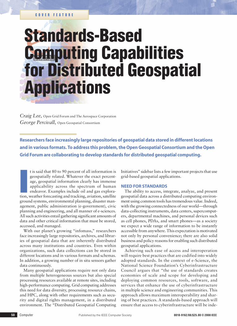
Standards-Based Computing Capabilities for Distributed Geospatial Applications
8
Standards-Based Computing Capabilities for Distributed Geospatial Applications I t is said that 80 to 90 percent of all information is geospatially related. Whatever the exact percent- age, geospatial information clearly has immense applicability across the spectrum of human endeavor. Examples include oil and gas explora- tion, weather forecasting and tracking, aviation, satellite ground systems, environmental planning, disaster man- agement, public administration (e-government), civic planning and engineering, and all manner of e-sciences. All such activities entail gathering significant amounts of data and other critical information that must be stored, accessed, and managed. With our planet’s growing “infomass,” researchers face increasingly large repositories, archives, and librar- ies of geospatial data that are inherently distributed across many institutions and countries. Even within organizations, such data collections can be stored in different locations and in various formats and schemas. In addition, a growing number of in situ sensors gather data continuously. Many geospatial applications require not only data from multiple heterogeneous sources but also special processing resources available at remote sites, including high-performance computing. Grid computing addresses this need for data diversity, processing resource chains, and HPC, along with other requirements such as secu- rity and digital rights management, in a distributed environment. The “Distributed Geospatial Computing Initiatives” sidebar lists a few important projects that use grid-based geospatial applications. NEED FOR STANDARDS The ability to access, integrate, analyze, and present geospatial data across a distributed computing environ- ment using common tools has tremendous value. Indeed, with the growing connectedness of our world—through data-collecting instruments, data centers, supercomput- ers, departmental machines, and personal devices such as cell phones, PDAs, and smart phones—as a society we expect a wide range of information to be instantly accessible from anywhere. This expectation is motivated not only by personal convenience; there are also solid business and policy reasons for enabling such distributed geospatial applications. Achieving such ease of access and interoperation will require best practices that are codified into widely adopted standards. In the context of e-Science, the National Science Foundation’s Cyberinfrastructure Council argues that “the use of standards creates economies of scale and scope for developing and deploying common resources, tools, software, and services that enhance the use of cyberinfrastructure in multiple science and engineering communities. This approach allows maximum interoperability and shar- ing of best practices. A standards-based approach will ensure that access to cyberinfrastructure will be inde- Researchers face increasingly large repositories of geospatial data stored in different locations and in various formats. To address this problem, the Open Geospatial Consortium and the Open Grid Forum are collaborating to develop standards for distributed geospatial computing. Craig Lee, Open Grid Forum and The Aerospace Corporation George Percivall, Open Geospatial Consortium COVER FEATURE 50 Computer Published by the IEEE Computer Society 0018-9162/08/$25.00 © 2008 IEEE
-
Upload
independent -
Category
Documents
-
view
1 -
download
0
Transcript of Standards-Based Computing Capabilities for Distributed Geospatial Applications
Standards-Based Computing Capabilities for Distributed Geospatial Applications
It is said that 80 to 90 percent of all information is geospatially related. Whatever the exact percent-age, geospatial information clearly has immense applicability across the spectrum of human endeavor. Examples include oil and gas explora-
tion, weather forecasting and tracking, aviation, satellite ground systems, environmental planning, disaster man-agement, public administration (e-government), civic planning and engineering, and all manner of e-sciences. All such activities entail gathering significant amounts of data and other critical information that must be stored, accessed, and managed.
With our planet’s growing “infomass,” researchers face increasingly large repositories, archives, and librar-ies of geospatial data that are inherently distributed across many institutions and countries. Even within organizations, such data collections can be stored in different locations and in various formats and schemas. In addition, a growing number of in situ sensors gather data continuously.
Many geospatial applications require not only data from multiple heterogeneous sources but also special processing resources available at remote sites, including high-performance computing. Grid computing addresses this need for data diversity, processing resource chains, and HPC, along with other requirements such as secu-rity and digital rights management, in a distributed environment. The “Distributed Geospatial Computing
Initiatives” sidebar lists a few important projects that use grid-based geospatial applications.
NEED for staNDarDsThe ability to access, integrate, analyze, and present
geospatial data across a distributed computing environ-ment using common tools has tremendous value. Indeed, with the growing connectedness of our world—through data-collecting instruments, data centers, supercomput-ers, departmental machines, and personal devices such as cell phones, PDAs, and smart phones—as a society we expect a wide range of information to be instantly accessible from anywhere. This expectation is motivated not only by personal convenience; there are also solid business and policy reasons for enabling such distributed geospatial applications.
Achieving such ease of access and interoperation will require best practices that are codified into widely adopted standards. In the context of e-Science, the National Science Foundation’s Cyberinfrastructure Council argues that “the use of standards creates economies of scale and scope for developing and deploying common resources, tools, software, and services that enhance the use of cyberinfrastructure in multiple science and engineering communities. This approach allows maximum interoperability and shar-ing of best practices. A standards-based approach will ensure that access to cyberinfrastructure will be inde-
researchers face increasingly large repositories of geospatial data stored in different locations
and in various formats. to address this problem, the open Geospatial Consortium and the open
Grid forum are collaborating to develop standards for distributed geospatial computing.
Craig Lee, Open Grid Forum and The Aerospace Corporation
George Percivall, Open Geospatial Consortium
C o v e r f e a t u r e
50 Computer Published by the IEEE Computer Society 0018-9162/08/$25.00©2008IEEE
November 2008 51
pendent of operating systems; ubiquitous, and open to large and small institutions.”1 In fact, these issues are not specific to e-Science but are applicable across many enterprises.
oGC-oGf CollaboratioNThe Open Geospatial Consortium (www.opengeospatial.
org) and the Open Grid Forum (www.ogf.org) are col-laborating to develop open standards that address the distributed computing needs of geospatial applications while accommodating the inevitability of diverse for-mats, schemas, and processing algorithms.
OGC is an international consortium that uses a con-sensus process to develop publicly available interface standards for geospatial information and services. OGF is a similar organization dedicated to the development of standards for the management of distributed computing resources such as servers, networks, and storage.
The integration of OGC and OGF standards will provide the necessary infrastructure for developing tools, software, and services that work together and can be used by multiple communities. They will support interoperability and the development and wide adop-tion of shared best practices, as well as help both small
and large technology providers and users innovate and leverage one another’s strengths and accomplishments. Layered on basic Internet and Web standards like HTTP, HTML, and XML, these efforts enable powerful new capabilities available through the huge installed base of Internet and Web clients and servers.
NotioNal GEoComputiNG arChitECturEFigure 1 shows a notional architecture for distributed
geospatial applications. Such a cyberinfrastructure must process sensor data from its raw observational state to georeference its location and remove artifacts associated with the sensor network’s acquisition specifics. It must also transform the data from sensor measurements to calibrated physical parameters of interest—that is, engi-neering units.
Researchers can use this data directly or store it in a repository. In either case, to enable proper tagging (identification), processing, and decision making, the cyberinfrastructure must provide user access to direct sensor observations or to geoscience repositories in an interoperable fashion that includes metadata about the observational data and the sensor itself. In many cases, the data’s provenance is important.
Distributed Geospatial Computing initiativesThefollowinggrid-basedinitiativesillustratethe
broadapplicabilityofandgrowingdemandfordis-tributedgeospatialcomputingresources.
CYClopsTheCyberinfrastructureforCivilProtectionOpera-
tiveProceduresproject(www.cyclops-project.eu)bringstogetherGlobalMonitoringforEnvironmentandSecurity(GMES),amajorEuropeanspaceinitia-tive,andgridcomputingwithafocusontheneedsofEuropeancivilprotection.CYCLOPSwillusetheEUgridinfrastructurebuiltbytheEnablingGridsforE-SciencEproject.
GEo GriDTheGlobalEarthObservationGridproject(www.
geogrid.org)atJapan’sNationalInstituteofAdvancedIndustrialScienceandTechnologyalsoappliesgridtechnologytoglobalEarthobservation.GEOGridintegratessatelliteimagery,geologicaldata,andter-restrialsensordatatomonitorandrespondtodisas-terssuchasearthquakes,landslides,andflooding.
GEossTheGlobalEarthObservationSystemofSystems
(www.earthobservations.org/)isanactivityofGroup
onEarthObservations,apartnershipof124govern-mentsandinternationalorganizations.GEOSSaimstoenablecontinuousmonitoringoftheEarthandpro-videaccessbyresearcherstoavastsharedsetofinfor-mationresources.TheOpenGeospatialConsortiumhasledaseriesofGEOSSinteroperabilitydemonstra-tionsatIEEEandInternationalSocietyforPhotogram-metryandRemoteSensingmeetings.OGCalsoleadsaGEOSSArchitectureImplementationPilotinvolvingmorethan120organizations(www.ogcnetwork.net/aipilot).
saNYTheSensorsAnywhereintegratedproject(http://
sany-ip.eu)focusesoninteroperabilityofinsitusen-sorsandsensornetworks.TheSANYarchitecturepro-videsaquickandcost-efficientwaytoreusedataandservicesfromcurrentlyincompatiblesensoranddatasources.TheprojectcontributestoGMESandGEOSSintheareaofinsitusensorintegration.
sEaDataNEtSeaDataNet(www.seadatanet.org)isapan-Euro-
peanprojectthatprovidesadistributedinfrastructureformanagingoceanandmarinedatacollectedfrominsituandremotesensingsourcesin35countries.

52 Computer
Because sensor networks and data repositories are usu-ally distributed, the infrastructure should support ease of access, data interoperability, and user authentication and authorization as constrained by policy. Providing interoperability with other domains, including the mass market for geospatial data on the Internet, is another consideration.
Data processing requirements can be straightforward or complex and intensive. In either case, it might be nec-essary to discover and schedule computing resources that are suitable to the requirements on a grid or in a computing cloud.
Decision-support services typically consume the final data products. These services might simply pres-ent the data to human decision-makers in a format appropriate for human comprehension. They could also be rule-based or other automated systems that infer appropriate decisions. In either case, such deci-sions could drive subsequent actuator systems that “close the loop” by affecting the system under obser-vation. Such systems are sometimes called dynamic data-driven application systems (www.dddas.org).
Certain basic capabilities are necessary for an open-standards-based infrastructure for geospatial applications. First, information models, encodings, and metadata are needed to enable integration of data collected from different sources into representa-tions of scientific knowledge. Second, standards for geospatial catalog services and standards for describ-ing sensors, geospatial Web services, and geospatial data are necessary to enable discovery of and access to extended networks of such resources. Finally, pro-cessing and workflow architectures and standards must accommodate large, distributed datasets and grid computing resources.
oGC WEb sErviCEsThe notional geocomputing architecture is largely sup-
ported by the OpenGIS standards that OGC already has in place (www.opengeospatial.org/standards).
oWs standardsOGC Web Service stan-
dards are layered on top of open Internet standards—in particular, the HTTP, uniform resource locators (URLs), multipurpose Internet mail extensions (MIME), and XML World Wide Web standards. The main OWS standards include the following:
Web map ser vice. WMS standardizes the display of registered and superimposed maplike
views of information that come simultaneously from multiple remote and heterogeneous sources.
Web feature service. WFS standardizes the retrieval and update of digital representations of real-world enti-ties referenced to the Earth’s surface.
Web Coverage service. WCS standardizes access to spatially extended coverages, usually encoded in a binary format and offered by a server.
Catalogue service for the Web. CSW standardizes interfaces to publish, discover, browse, and query meta-data about data, services, and other resources. Meta-data standards from ISO/TC 211 (ISO 19115:2003, Geographic information—Metadata and ISO/TS 19139:2007, Geographic information—Metadata—XML schema implementation) also play a critical role in the Web-based publishing and discovery of geospatial resources.
sWE standardsOGC Sensor Web Enablement (SWE) standards make
all types of sensors, instruments, and imaging devices accessible and, where applicable, controllable via the Web:
sensor observation service. SOS standardizes the retrieval of observations and sensor system information. Observations can be from in situ sensors (for example, water monitoring) or dynamic sensors (for example, sat-ellite imaging).
sensor planning service. SPS standardizes an inter-face to task sensors or models. It can be used to repro-gram or calibrate sensors, start or change sensor mis-sions, and execute and control simulation models.
sensor alert service. SAS defines an interface for publishing and subscribing to alerts from sensors. If an event occurs, the SAS will notify all clients that subscribe to this event type.
observations and measurements. O&M defines an abstract model and an XML schema (www.w3.org/XML/Schema) encoding for observations and provides support for common sampling strategies. O&M also
Decisionservices
RecommendationsGeoprocessing
FeaturesSensornetwork
Observations
Datarepository
Measurements
Lee Figure 1Figure 1. To support critical decision making, a geoscience cyberinfrastructure must provide end-to-end support including sensing, data storage, and data processing. Because sensor networks and data repositories are usually distributed, the infrastructure should support ease of access, data interoperability, and user authentication and authorization.
November 2008 53
provides a general framework for scientific and engi-neering systems that deal in technical measurements.
sensor model language. SensorML specifies models and XML encoding that provide a framework within which the geometric, dynamic, and observational char-acteristics of sensors and sensor systems can be defined and encoded in XML.
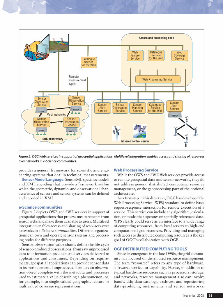
e-science communitiesFigure 2 depicts OWS and SWE services in support of
geospatial applications that process measurements from sensor webs and make them available to users. Multilevel integration enables access and sharing of resources over networks in e-Science communities. Different organiza-tions can own and operate sensor systems and process-ing nodes for different purposes.
Sensor-observation value chains define the life cycle of sensor-produced observations, from raw unprocessed data to information products and services delivered to applications and consumers. Depending on require-ments, geospatial applications can provide sensor data in its most elemental unprocessed form, as an observa-tion object complete with the metadata and processes used to estimate a value describing a phenomenon, or, for example, into single-valued geographic feature or multivalued coverage representations.
Web processing serviceWhile the OWS and SWE Web services provide access
to remote geospatial data and sensor networks, they do not address general distributed computing, resource management, or the geoprocessing part of the notional architecture.
As a first step in this direction, OGC has developed the Web Processing Service (WPS) standard to define basic request-response interaction for remote execution of a service. This service can include any algorithm, calcula-tion, or model that operates on spatially referenced data. WPS clearly could serve as an interface to a wide range of computing resources, from local servers to high-end computational grid resources. Providing and managing such access to distributed computing resources is the key goal of OGC’s collaboration with OGF.
oGf DistributED ComputiNG toolsSince its emergence in the late 1990s, the grid commu-
nity has focused on distributed resource management. The term “resource” refers to any type of hardware, software, service, or capability. Hence, in addition to typical hardware resources such as processors, storage, and networks, resource management also can involve bandwidth; data catalogs, archives, and repositories; data-producing instruments and sensor networks;
SOS observatoryMission control center
Access and processing node
Registermeasurementtypes
Mesh networks
SensorObservation
Service
SensorPlanningService
CatalogueService
for the Web
CatalogueService
for the WebCatalogueService
for the Web
WebFeatureService
WebCoverageService
SensorAlert
Service
SensorAlert
Service
Web Processing Service
SensorObservation
Service
SensorObservation
Service
SensorObservation
Service
SensorObservation
Service
Figure 2. OGC Web services in support of geospatial applications. Multilevel integration enables access and sharing of resources over networks in e-Science communities.
54 Computer
and computational services, including peer-to-peer networks.
Grid capabilitiesWhile the grid concept grew out of the need to collabo-
rate and share data and computing resources on large scientific projects, grid capabilities are fundamental to general distributed computing and directly support the notional geospatial architecture.
information models and architectures. Basic resources in the distributed computing environment must be describable in a well-known information model. OGF is working with the Distributed Management Task Force (www.dmtf.org/home) to integrate ele-ments of the Grid Laboratory Uni-fied Environment into the Common Information Model, a widely used information model standard. Even with such models, every application domain user group must define its own information architecture that captures domain-specific knowledge.
Catalogs and discovery services. Once such informa-tion models and architectures are in place, the grid com-munity can use concrete instances to populate catalogs of information for discovery by users and systems. Such catalogs must support discovery or “look-up” queries to find useful and relevant data, services, and so on. Depending on the size of the distributed environment to be supported, multiple catalogs might have to federate together to serve a large, distributed user community. An example of this is the Globus Monitoring and Discovery Service (www.globus.org/toolkit/mds).
Data, execution, and workflow services. There must be a way to access data, and for services there must be a way to schedule execution. Data access could mean simply transferring remote files using the GridFTP protocol (http://dev.globus.org/wiki/GridFTP), posing queries to remote databases, or even using a grid file system that provides a uniform file namespace across multiple institutions.
Similarly, service execution means being able to sched-ule the execution, monitor its progress until completion, and then retrieve any results. This can be accomplished using the HPC Basic Profile (www.ogf.org/documents/GFD.114.pdf) or the Distributed Resource Manage-ment Application API (www.drmaa.org). Workflow is the management of a sequence of operations or services that typically have dependencies and must be executed in a given order. The grid community has developed many workflow management systems.
Event, monitoring, and management services. Event notification is a key part of any distributed sys-tem and can be accomplished using OGF standards such as Information Dissemination (INFOD) that sup-
port the publish-subscribe paradigm. Monitoring an execution’s progress is important to an individual user, but depending on the size of the distributed infrastruc-ture to be maintained, it might be necessary to monitor which machines are up, which networks are up, and so on. Administrators must also be able to manage which machines and services are available to authorized users and their physical configuration.
security. Users must be issued a grid identity that enables authentication and authorization when they request use of remote resources. This is typically done with X.509 certificates using the Grid Security Infra-
structure (GSI) or Shibboleth. A key development in grid secu-
rity is the notion of virtual organi-zations—different users and insti-tutions can participate in different VOs and have different roles and capabilities depending on their requirements. A good example of such a system is the Virtual Orga-nization Membership Service
(www.globus.org/grid_software/security/voms.php).
oGf standardsOGF has ongoing work across all of these areas,
though in the context of the OGS WPS standard, which is a key point of collaboration between the organiza-tions, the following OGF standards (www.ogf.org/gf/docs) are the most directly relevant:
hpC basic profile. This is a cluster-scheduling interop-erability layer that coordinates the use of the Job Sub-mission Description Language and the OGSA Basic Execution Service, along with interoperable security mechanisms, to address the primary high-performance use case of batch-job scheduling for scientific and tech-nical applications. Demonstrated at Supercomputing 2006 and 2007, HPC Basic Profile is being developed commercially by Microsoft, Platform Computing, and Altair Computing.
simple api for Grid applications. SAGA is an object-oriented API for programming grid applications with a common “look and feel” across all operations when pro-gramming in a distributed environment. This includes support for job and task management, file management, replica management, name spaces, streams, monitoring, sessions, security contexts, and error handling. SAGA currently has C++ and Java bindings.
GridrpC. This standard generalizes the well-known remote procedure call model for grid environments. It provides a simple model and API whereby function handles can be used to reference and invoke remote ser-vices as though a procedure call was being made. Such calls can, however, be synchronous or asynchronous depending on application requirements. The GridRPC API is currently used by the NetSolve/GridSolve (http://
Grid capabilities are fundamental to general
distributed computing and directly support the notional
geospatial architecture.
November 2008 55
icl.cs.utk.edu/netsolve), Ninf-G (http://ninf.apgrid.org), and Distributed Interactive Engineering Toolbox (http://graal.ens-lyon.fr/~diet) systems, which provide a registry to catalog function handles for later discovery and use.
Data access and integration specifications. WS-DAI defines a general data service model and associated message patterns that can be applied to all manner of data resources in a grid environment. In WS-DAI, data resources are addressed using WS-Address-ing end-point references that contain the resource’s abstract name and uniquely identify the resource. XML-based property documents can be associated with a data resource and read/set through the data access service’s interface.
information Dissemination. INFOD provides a general means to determine which messages are to be sent from publishers to sub-scribers based on information kept in a registry. More specifically, it specifies interfaces that allow the characterization of publishers, subscribers, and vari-ous other components using vocabularies that are meaningful to members of the communities to which they belong.
iNitial iNtEGratioN EffortsWith these models and standards in mind, OGC and
OGF have identified numerous possible areas for ini-tial integration efforts. As indicated earlier, a key goal is implementing WPS with standard grid tools that enable access to a range of back-end processing environments. Beyond WPS, there is a need to develop joint interoper-ability specifications for workflow management, event notification, and security.
Because WPS employs a relatively simple model whereby a user can send data for processing on a (pos-sibly remote) server and retrieve the results, implementa-tions using HPC Basic Profile, SAGA, or GridRPC would all be possible. Depending on the security requirements and discovery support requirements, however, imple-mentation strategies could also include generic Web ser-vices or even Web 2.0 mashups based on asynchronous JavaScript technology and XML.
back-end hardware provisioningIn terms of back-end environments, obvious can-
didates include traditional grid infrastructures with large national and international backing such as the EU Enabling Grids for E-SciencE (EGEE; www.eu-egee.org), the Japanese National Research Grid Initiative (NAREGI; www.naregi.org), the UK National Grid Service (NGS; www.grid-support.ac.uk), and the US TeraGrid (www.teragrid.org).
Other possibilities include virtualization and cloud computing technologies, which established grids are beginning to use already. This development supports the viewpoint that the traditional grid concept is essentially a distributed framework that encompasses the notion of dynamic provisioning by cloud resources.2
Workflow managementWorkflow management tools are typically used to
manage sequences of calls to multiple remote services. Rather than having the output from service A “bounce” through the user client to be input to service B, workflow tools can coordinate the direct transfer of data from A to
B with the scheduling and comple-tion of these services.
Grid programming tools such as SAGA and GridRPC could man-age basic workflow requirements. While commercially oriented workflow tools such as the Busi-ness Process Execution Language are available, the grid community has also developed numerous open
source workflow tools for scientific and engineering applications, including Directed Acyclic Graph Man-ager (www.cs.wisc.edu/condor/dagman), Pegasus (http://pegasus.isi.edu), Kepler (http://kepler-project.org), Taverna (http://taverna.sourceforge.net), and Tri-ana (www.trianacode.org).
Event notificationMany geospatial tools require event notification and
information dissemination. Besides geoprocessing work-flows, event notification is needed for decision support services and sensor web enablement. Hence, standards like INFOD that provide content-based publish-sub-scribe capability could find wide applicability.
initiativesTo coordinate integration of standardized tools, OGC
and OGF have organized a series of successful work-shops at OGC and OGF meetings. OGF has also par-ticipated in the planning efforts for OGC’s sixth OGC Web Services Testbed (OWS-6), which began 30 June 2008. OGC testbeds and other “interoperability ini-tiatives” are fast-paced, practical, hands-on, scenario-focused projects designed to test different approaches and to deliver draft standards into the OGC’s Technical Committee. Grid computing plays a central role in the Geo-Processing Workflow thread of OWS-6.
In addition, the broad applicability and demand for distributed geospatial computing capabilities that are driving this effort have spawned numerous practical integration initiatives that are well under way and repre-sent potential participants. The “OGC-OGF Integration Initiatives” sidebar describes several of these efforts.
oGC and oGf have identified
numerous possible areas for initial
integration efforts.
56 Computer
ChallENGEs aND futurE WorkThe OGC-OGF collaboration is off to a good start,
but many unresolved issues are critically important in the context of the rapidly emerging global need to migrate data from technically or physically isolated repositories with poor or nonstandard metadata to more open envi-ronments.
One key challenge is hiding grid complexity and sim-plifying tools for nonspecialists in geospatial applica-tion domains. Progress in ease of use might depend on a large community adopting single approaches, such as the WPS standard, that provide a standard way to exploit grid technology. However, this requires gaining more experience in using WPS with a range of back-end processing environments and various workflow man-agement tools.
Handling massive data is another major issue, and this requires involving organizations such as EGEE, NAREGI, NGS, and TeraGrid that are capable of supporting vast computing resources as well as interoperability requirements. Similarly, the need
for real-time data processing will accelerate as more experimenters get access to large-scale distributed computing environments.
Workshops on digital repositories, with participation by geospatial projects such as Dissemination and Exploi-tation of Grids in Earth Science (www.eu-degree.eu) and Ground European Network for Earth Science Interop-erations—Digital Repositories (www.genesi-dr.eu) are planned for future OGF and OGC meetings, with a focus on topics such as security, workflow management, and programming models. Other organizations are also interested in these issues. For example, some of the Euro-pean Geophysical Union’s recent Earth and Space Sci-ence Informatics sessions explicitly covered grids, and more such sessions are in the works.
OGC and OGF groups have a shared interest in dis-cussing overlapping or complementary work in digi-tal rights management, information communications, semantics, and workflow management. This work will contribute to the development of best practices for integrating registries with grid data movement tools
oGC-oGf integration initiativesThefollowinginitiativesareexamplesofOGC-OGF
integrationeffortsdrivenbythedemandfordistrib-utedgeospatialcomputingcapabilities.
GEospatial kNoWlEDGE GriDTheGeorgeMasonUniversityCenterforSpatial
InformationScienceandSystem(CSISS)GeospatialKnowledgeGrid(http://grid.laits.gmu.edu)isaWebportalthatintegratesOGCandgridtechnologiesforEarthsciencemodelingandapplications.TheprojectissponsoredbyNASA’sAdvancedInformationSys-temsTechnologyprogramandconductedbyCSISSinconjunctionwiththeAmesResearchCenterandtheDepartmentofEnergy’sLawrenceLivermoreNationalLaboratory.TheGeospatialKnowledgeGridispartoftheCommitteeonEarthObservationSatellites(www.ceos.org)testbedforevaluatingtheusabilityofgridtechnologyingeospatialdisciplines.
52° North Wps-G WPS-Gisapowerfulopensourceenhancementof
52°North’sWebprocessingservice(http://52north.org)thatispubliclyavailable.Existingimplementa-tionsof52°NorthWPSprocessescanbereusedanddistributedoverthegrid.TheservicesupportsUnicore6middleware(www.unicore.eu/download/unicore6),andcouldeasilysupportothergridmiddlewarepack-agessuchasGlobus.WPS-Grequiresnoadministra-tiveaccess,onlyavalidcertificate.52°Northplansto“gridify”othermainstreamgeographicinformation
systemtoolssuchasESRI’sArcGISServer(www.esri.com/software/arcgis/arcgisserver/index.html)andtheGeographicResourcesAnalysisSupportSystem(http://grass.osgeo.org)viaWPS.
saW-GEo aND sEE-GEoTheUKJointInformationSystemsCommitteeis
responsibleforfundingresearchintotheprovisionofcutting-edgeinformationservicesfortheUKaca-demiccommunity.In2006,JISCcommissionedtheGridOGCCollisionProgramtoinvestigateintegrationofgridcomputingandWebservicesbasedonOGCstandards(http://edina.ac.uk/projects/seesaw).Theprograminvolvedtwothemes,workflowsandsecu-rity,whichledrespectivelytotheSemanticallyAwareWorkflowEnginesforGeospatialWebServiceOrches-trationandSecureAccesstoGeospatialServicesprojects.SAW-GEOinvolveschainingmultipleWebservicestogetherinasemanticallyinformedworkflowmanagementsystemandworkflowengine,whileSEE-GEOinvolvesdemonstratinghowtosecurelyaccessOGCWebservicesusingGSI,Shibboleth,andWS-Security.
sENsorNEtOGCisinvolvedwithOakRidgeNationalLabo-
ratory’sSensorNetproject(www.sensornet.gov),acomprehensiveincidentmanagementsystemforallmannerofgeospatiallyrelatedthreats—chemical,biological,radiological,nuclear,andexplosive.
November 2008 57
and security models. Data consumed and produced by WPS calls could come from and be returned to OGC federated catalogues in a simple client-server fashion, but secure, third-party transfers might also be desirable.
M etcalfe’s law states that a telecommunication network’s value increases in proportion to the square of the number of nodes on the net-
work (http://en.wikipedia.org/wiki/Metcalfe’s_law). A corollary to this law is that the value of online geo-spatial data increases according to its accessibility and interoperability.
The world’s major funding agencies, foundations, and corporations are coming to realize the tremen-dous value of maintaining geospatial data online for verification, ongoing longitudinal studies, and cross-disciplinary studies of all sorts. This will certainly require the widespread adoption of robust metadata, distributed computing, and system management standards. Ultimately, grid-based geoprocessing will become an integral and routine part of a resource-rich Web environment. ■
references 1. National Science Foundation Cyberinfrastructure Council,
“Cyberinfrastructure Vision for 21st Century Discovery,” NSF, Mar. 2007; www.nsf.gov/pubs/2007/nsf0728/nsf0728.pdf.
2. D. Gannon, “The Computational Data Center—A Science Cloud,” Indiana Univ.; www.extreme.indiana.edu/~gannon/science-data-center.pdf.
Craig Lee is president of the Open Grid Forum as well as a senior scientist at The Aerospace Corporation. His research interests include clusters, grids, clouds, and all aspects of parallel and distributed computing. Lee received a PhD in computer science from the University of Califor-nia, Irvine. He is a member of the IEEE Computer Society and the ACM. Contact him at [email protected].
George Percivall is the chief architect and an executive director of the Open Geospatial Consortium. His research interests include systems architecture, information sci-ence, geoinformatics, and semiotics. Percivall received an MS in electrical engineering from the University of Illi-nois at Urbana-Champaign. He is a senior member of the IEEE. Contact him at [email protected].
Hungry for moreinformation aboutlarge-scale computing?Computing in Science & Engineering magazine offers
computational tools and methods for 21st century
science. Each issue offers articles on special issue
topics (such as computational astrophysics, cloud
computing, petascale and grid computing, and
nanoscience), computer simulations, visualization,
education, and scientific programming. By
emphasizing real-world applications and modern
problem-solving, this magazine communicates to
those at the intersection of computing, science,
engineering, and mathematics.
Members receive CiSE for the low price of $47 per year...Subscribe today at www.computer.org/cise/