SPZO (Tnte Fap Alejandro Velazco Ast)
10
JEPPESEN JeppView 3.7.3.0 SPZO (Tnte Fap Alejandro Velazco Ast) Airport Information General Info Cuzco, PER S 13° 32.1' W 71° 56.3' Mag Var: 2.4°W Elevation: 10860' Public, IFR, Control Tower, Customs Time Zone Info: Bogota, Lima, Quito Time GMT-5:00 no DST Runway Info Runway 10-28 11155' x 148' asphalt Runway 10 (99.0°M) TDZE 10860' Runway 28 (279.0°M) TDZE 10702' Communications Info ATIS 127.0 Cuzco Tower 118.1 Cuzco Ground Control 121.9 Cuzco Approach Control 120.6
-
Upload
khangminh22 -
Category
Documents
-
view
1 -
download
0
Transcript of SPZO (Tnte Fap Alejandro Velazco Ast)

JEPPESEN
JeppView 3.7.3.0SPZO (Tnte Fap Alejandro Velazco Ast)Airport Information
General InfoCuzco, PERS 13° 32.1' W 71° 56.3' Mag Var: 2.4°WElevation: 10860'
Public, IFR, Control Tower, Customs
Time Zone Info: Bogota, Lima, Quito Time GMT-5:00 no DST
Runway InfoRunway 10-28 11155' x 148' asphalt
Runway 10 (99.0°M) TDZE 10860'Runway 28 (279.0°M) TDZE 10702'
Communications InfoATIS 127.0Cuzco Tower 118.1Cuzco Ground Control 121.9Cuzco Approach Control 120.6
Licensed to (unknown). Printed on 04 Dec 2010.
Notice: After 17 Dec 2010 0901Z, this chart may no longer be valid. Disc 24-2010
JEPPESEN
JeppView 3.7.3.0
JEPPESEN
CHANGES:
CUZCO
114.9 ZCO
ZCO
S13 31.2 W072 00.6
D
URCOS
115.6 URC
URC
S13 39.0 W071 35.2
D
AKREL
BOLEP
S13 22.8
W072 51.2
.UT.212.
.V.10.
102^
S13 17.9
W072 50.1
BO
LEP 1
AKREL 1
At
or
above
FL 250
D30 ZCO
30
30
2020
D50D50
1
Dir
ect
dis
tance
fro
m Z
CO
to:
4 NM
RO
UTIN
GSTA
R
AK
REL 1
BO
LEP 1
D30 ZCO
108̂
R-288 and continue in accordance with ATC instructions.
Descend from route UT-212 on ZCO R-288. Proceed on ZCO
Descend from routes V-10/UV-10 on ZCO R-282. Proceed on
ZCO R-282 and continue in accordance with ATC instructions.
CUZCO
TMA
At
or
above
FL 230
R288^
R282^
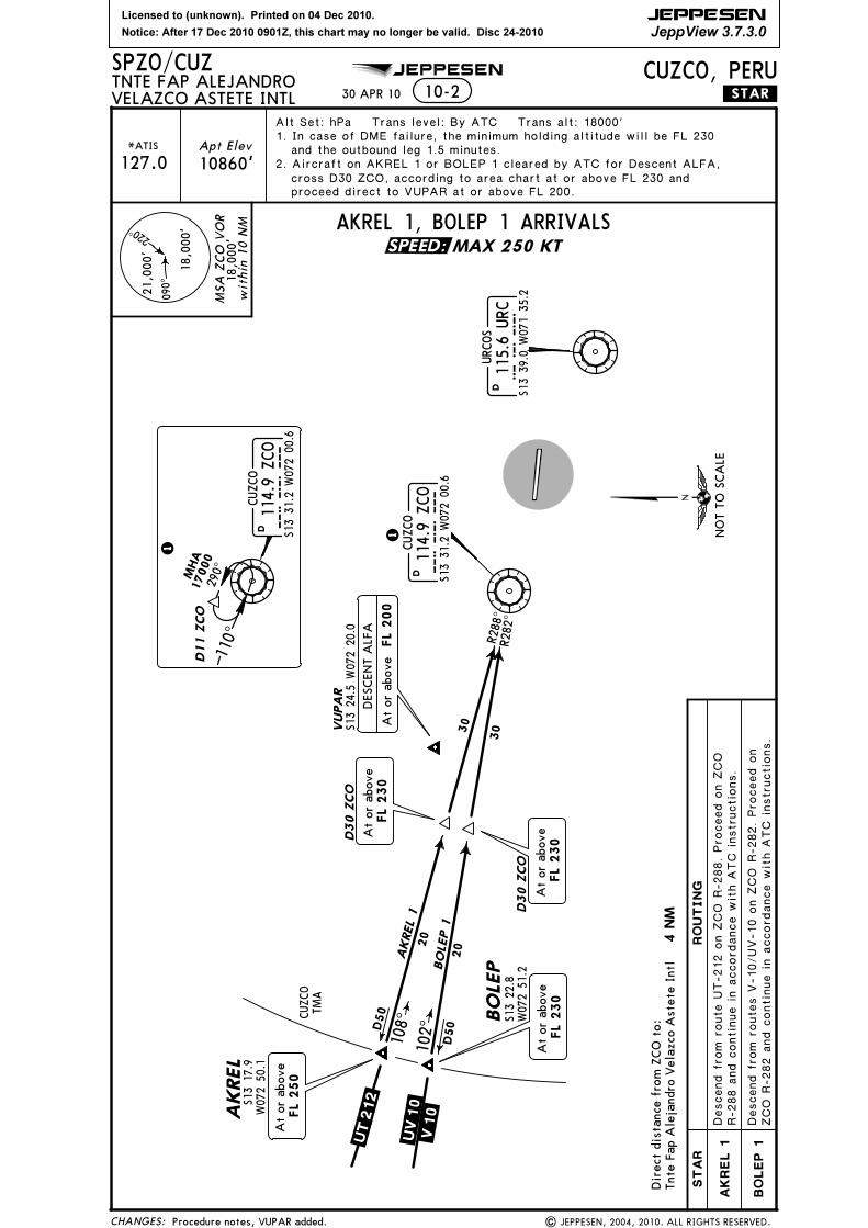
SPZO/CUZ
VELAZCO ASTETE INTLTNTE FAP ALEJANDRO
10-2
CUZCO, PERU.STAR.
220^
090^
wit
hin
10 N
M
MSA
ZCO
VO
R
21,0
00'
18,0
00'
18,0
00'
At
or
above
FL 230
At
or
above
FL 230
Alt Set: hPa Trans level: By ATC Trans alt: 18000'
MAX 250 KT
AKREL 1, BOLEP 1 ARRIVALS
Tnte
Fap A
leja
ndro
Vela
zco A
stete
Intl
MHA
17000
290^
D11 ZCO
CUZCO
114.9 ZCO
ZCO
S13 31.2 W072 00.6
D
1
110^
30 APR 10
and the outbound leg 1.5 minutes.
2. Aircraft on AKREL 1 or BOLEP 1 cleared by ATC for Descent ALFA,
VUPA
R
| JEPPESEN, 2004, 2010. ALL RIGHTS RESERVED.Procedure notes, VUPAR added.
*ATIS
127.0
Apt Elev
10860'
S13 24.5 W072 20.0
.UV.10.
1. In case of DME failure, the minimum holding altitude will be FL 230
cross D30 ZCO, according to area chart at or above FL 230 and
proceed direct to VUPAR at or above FL 200.
DESCENT A
LFA
At
or
above
FL 200
SPEED:
NO
T T
O S
CA
LE

Licensed to (unknown). Printed on 04 Dec 2010.
Notice: After 17 Dec 2010 0901Z, this chart may no longer be valid. Disc 24-2010
JEPPESEN
JeppView 3.7.3.0
JEPPESEN
CHANGES:
CUZCO, PERU.STAR.
MAX 250 KTURCOS
115.6 URC
URC
S13 39.0 W071 35.2
D
110^
290^
MHA
18000
RO
UT
IN
GST
AR
CEM
IL 2
DA
BU
L 1
CEMIL 2, DABUL 1, ILMOX 2, LITOT 1 ARRIVALS
MO
RVI
52
20
R069^
R271^
40
.V10.
249^
CEMIL
R194^
D9 URC
.V.11.
70
.V15.
S13 30.8
W071 16.4
LITOT
ILMOX
ESNO
B
D
D
D60
D
CUZCO
114.9 ZCO
ZCO
S13 31.2 W072 00.6
D
S14 35.7
W070 50.7
.V.11.
3 26 ^
R14 6^
014^
S14 47.6
W071 48.9
LITOT 1
I LM
OX 2
62
D71
CEM
IL 2
S13 14.4
W070 39.0
DA
BUL 1
DABUL
At
or
above
FL 210
S13 41.9
W072 53.2
S13 41.0
W072 28.6
24
D76
ILM
OX
2
LIT
OT
1
URC R-069 and continue in accordance with ATC instructions.
Descend from routes V-10/UV-10 on URC R-069. Proceed on
Descend from routes V-11/UV-11 on URC R-271. Proceed on
URC R-271 and continue in accordance with ATC instructions.
URC R-146 and continue in accordance with ATC instructions.
Descend from routes V-11/UV-11 on URC R-146. Proceed on
Descend from routes V-15/UV-15 on URC R-194. Proceed on
URC R-194 and continue in accordance with ATC instructions.
At
or
above
FL 220
CUZCO TMA
CUZCO TMA
C UZCO T M
A
CUZCO
TMA
At
or
above
FL 230
At
or
above
FL 230
At
or
above
FL 210
091^
SPZO/CUZ10-2A
VELAZCO ASTETE INTLTNTE FAP ALEJANDRO
220^
090̂
within 1
0 N
M
MSA
ZCO
VO
R
21,0
00'
18,0
00'
18,0
00'
Apt Elev
10860'
Alt Set: hPa Trans level: By ATC Trans alt: 18000'
In case of DME failure, the minimum holding altitude will be
FL 230 and the outbound leg 1.5 minutes.
Dir
ect
dis
tance
fro
m U
RC t
o:
Tnte
Fap A
leja
ndro
Vela
zco
Ast
ete
Intl
22 NM
.UV15.
.UV10.
*ATIS
127.0
At
or
above
FL 210
30 APR 10
.UV.11.
.UV.11.
| JEPPESEN, 2004, 2010. ALL RIGHTS RESERVED.None.
SPEED:
NO
T T
O S
CA
LE

Licensed to (unknown). Printed on 04 Dec 2010.
Notice: After 17 Dec 2010 0901Z, this chart may no longer be valid. Disc 24-2010
JEPPESEN
JeppView 3.7.3.0
CHANGES:
CUZCO, PERU.STAR.
RO
UT
IN
GST
AR
.V10.
CEMIL
.V15.
LITOT
ILMOX
MHA
17000
290^
D11 ZCO
CUZCO
114.9 ZCO
ZCO
S13 31.2 W072 00.6
D
110^
S14 35.7
W070 50.7
.V11.
S14 47.6
W071 48.9
S13 14.4
W070 39.0
CUZCO TMA
CUZCO TMA
C UZ CO TM
A
At
or
above
FL 230
At
or
above
FL 210
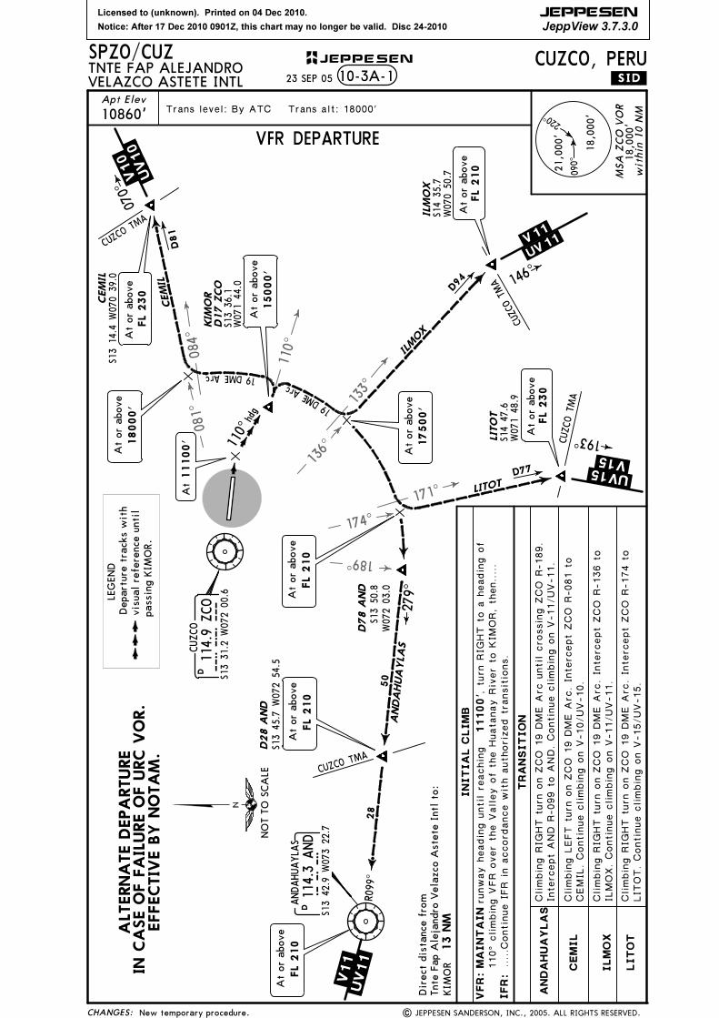
JEPPESENSPZO/CUZ23 SEP 05VELAZCO ASTETE INTL
TNTE FAP ALEJANDRO
220^
090^
within 1
0 N
M
MSA
ZCO
VO
R
21,0
00'
18,0
00'
18,0
00'
Apt Elev
10860'
Alt Set: hPa Trans level: By ATC Trans alt: 18000'
FL 230 and the outbound leg 1.5 minutes.
Dir
ect
dis
tance
fro
m Z
CO
to:
Tnte
Fap A
leja
ndro
Vela
zco A
stete
Intl
.UV15.
.UV11.
.UV10.
*ATIS
127.0
10-2A-1
354^
3 16 ^
261^
R136̂
R 1 74 ^
R081^
D81
D94
D 77
46
16
19
19
19
16
9
49
59
CEM
IL ZCO
I LMOX ZCO
L ITOT Z
CO
CEM
IL ZC
O
ILM
OX
ZC
O
LIT
OT
ZC
O
CEMIL ZCO, ILMOX ZCO, LITOT ZCO ARRIVALS
At
or
above
FL 190
At
or
above
FL 210
D35 ZCO
D19 ZCO
D19 ZCO
D19 ZCO
D35 ZCO
D28 ZCO
Proceed t
o Z
CO a
nd c
ontin
ue in a
ccordance w
ith A
TC
| JEPPESEN SANDERSON, INC., 2005. ALL RIGHTS RESERVED.
1. In case of DME failure, the minimum holding altitude will be
2. For arrival from Lima refer to SPZO 10-2.A
t or
above
FL 200
Descend f
rom V
-10/UV-10 o
n Z
CO R
-081 (headin
g 2
61^).
Descend f
rom V
-11/UV-11 o
n Z
CO R
-136. Proceed o
n Z
CO
Descend f
rom V
-15/UV-15 o
n Z
CO R
-174. Proceed o
n Z
CO
instructio
ns.
18000'
At
or
above
18000'
At
or
above
18000'
At
or
above
ALTERNA
TE A
RRIV
ALS
IN CA
SE O
F FA
ILURE O
F URC VO
R.
EFFECTIV
E BY NO
TA
M.
4 NM
R-136 t
o Z
CO a
nd c
ontin
ue in a
ccordance w
ith A
TC
instructio
ns.
R-174 t
o Z
CO a
nd c
ontin
ue in a
ccordance w
ith A
TC
instructio
ns.
New temporary procedure.
At
or
above
FL 230
NO
T T
O S
CA
LE

Licensed to (unknown). Printed on 04 Dec 2010.
Notice: After 17 Dec 2010 0901Z, this chart may no longer be valid. Disc 24-2010
JEPPESEN
JeppView 3.7.3.0
R290^
| JEPPESEN SANDERSON, INC., 2004. ALL RIGHTS RESERVED.CHANGES:
runway h
eadin
g u
ntil r
eachin
g
CUZCO, PERU
URCOS
115.6 URC
URC
S13 39.0 W071 35.2
D
AKREL
BO
LEP
S13 22.8
W072 51.2
.UT.212.
.V.10.
.UV.10.
S13 17.9
W072 50.1
At
or
above
FL 230
At
or
above
FL 230
D22 ZCO
22
22
2828
D50D50
RO
UT
IN
G
D22 ZCO
.SID.
Dir
ect
dis
tance
fro
m
KIM
OR
13 NM
110^
D9 URC
hdg
KIM
OR
S13 36.1 W071 44.0
14500'
At
or
above
R 13 0^
3 10 ^
16000'
At
or
above
288^
282̂
AKREL
BOLEP
At
or
above
FL 250
CUZCO
114.9 ZCO
ZCO
S13 31.2 W072 00.6
D
CUZCO 1 DEPARTURE
At
11100'
CUZCO
TMA
76 NM
URC
18000'
At
or
above
11100'
to a
headin
g o
f 1
10^ c
limbin
g V
FR o
ver t
he V
alley o
f t
he
TRA
NSIT
IO
NS
AK
REL
Climbin
g L
EFT t
urn t
o p
roceed o
n Z
CO R
-282 t
o B
OLEP.
BO
LEP
New procedure at this airport.
Contin
ue c
limbin
g o
n r
oute U
T-212.
Climbin
g L
EFT t
urn t
o p
roceed o
n Z
CO R
-288 t
o A
KREL.
Contin
ue c
limbin
g o
n r
outes V
-10/UV-10.
VFR: M
AIN
TA
IN
At
or
above
FL 230
, turn R
IGHT
Apt Elev
JEPPESENSPZO/CUZ
10860'
31 DEC 04
Trans level: By ATC Trans alt: 18000'
VELAZCO ASTETE INTLTNTE FAP ALEJANDRO
220^
09 0̂
within 10 NM
MSA ZCO VOR
21,000'
18,000'
18,000'
10-3
Tnte
Fap A
leja
ndro
Vela
zco A
stete
Intl
to:
IFR:
Huatanay R
iver t
o K
IMOR, then.....
.....C
ontin
ue IFR w
ith a
climbin
g R
IGHT t
urn t
o intercept Z
CO
R-130 (headin
g 3
10^) to Z
CO, and c
ontin
ue w
ith a
uthoriz
ed
transitio
n.
NO
T T
O S
CA
LE
Depart
ure
tra
cks
wit
hvis
ual re
fere
nce
unti
lpass
ing K
IMO
R.
LEG
END

Licensed to (unknown). Printed on 04 Dec 2010.
Notice: After 17 Dec 2010 0901Z, this chart may no longer be valid. Disc 24-2010
JEPPESEN
JeppView 3.7.3.0
254^
| JEPPESEN SANDERSON, INC., 2004. ALL RIGHTS RESERVED.CHANGES:
Apt Elev
JEPPESENSPZO/CUZ
10860'
31 DEC 04
CUZCO, PERU10-3A
Trans level: By ATC Trans alt: 18000'
CEMIL 2, DABUL 1, ERODI 1,ILMOX 2, LITOT 1 DEPARTURES
ILM
OX
2
LIT
OT
1
Contin
ue c
lim
bin
g o
n U
RC
R-290,
at U
RC
turn R
IGH
T a
nd c
ontin
ue o
n
Contin
ue c
lim
bin
g o
n U
RC
R-290,
at U
RC
turn R
IGH
T a
nd c
ontin
ue o
n
New procedures at this airport.
.SID.
220^
0 9 0 ^
within 10 NM
MSA ZCO VOR
21,000'
18,000'
18,000'
UR
C R
-194 t
o L
ITO
T.
Contin
ue c
lim
bin
g o
n r
outes V
-15/U
V-15.
UR
C R
-146 t
o I
LM
OX.
Contin
ue c
lim
bin
g o
n r
outes V
-11/U
V-11.
URCOS
115.6 URC
URC
S13 39.0 W071 35.2
D
CUZCO
114.9 ZCO
ZCO
S13 31.2 W072 00.6
D
35
R290^
9
DO
NKI
70
UV 15 V 15
LITOT
ILMOX
S14 35.7
W070 50.7
.V .11.
.UV.11.
S14 47.6
W071 48.9
LITOT 1
ILM
OX 27 1
MO
RVI
35
29
V 11
UV
11
DABUL
S13 41.9
W072 53.2
S13 41.0
W072 28.6
24
D76
271^
R090^
110^
D9 URC
hdgK
IMO
R
S13 36.1 W071 44.0
At or above
FL 210
D17 URC
16000'
At or above
D52
DA
BUL 1
D17 URC
ERO
DI 1
S13 55.9
W072 25.8
D52
R106^
ERODI
S13 49.8
W072 52.4
CUZCO
TMA
27
30
CUZCO TMA
CUZCO TMA
20
40
UV 10
V 10
CEMIL
S13 30.8
W071 16.4
ESNO
B
D
D60
CEM
IL 2
S13 14.4
W070 39.0
At or above
FL 230
069^
1 46 ^
194^
C UZ CO T M
A
D
D
At or above
FL 210
At or above
FL 230
CEM
IL 2
DA
BU
L 1
ERO
DI 1
Contin
ue c
lim
bin
g o
n U
RC
R-290,
at U
RC
turn L
EFT a
nd c
ontin
ue o
n
ANDAHUAYLAS
114.3 AND
AND
S13 42.9 W073 22.7
D
At or above
FL 210
286^
16000'
At or above
270^
D76 URC
SID
At or above
FL 210
Cli
mbin
g R
IGH
T t
urn t
o i
ntercept U
RC
R-271 t
o D
AB
UL.
Contin
ue
cli
mbin
g o
n r
outes V
-11/U
V-11.
UR
C R
-069 t
o C
EM
IL.
Contin
ue c
lim
bin
g o
n r
outes V
-10/U
V-10.
RO
UT
IN
G
a h
eadin
g o
f 2
86^ (
AN
D R
-106)
to E
RO
DI.
Contin
ue c
lim
bin
g o
n r
outes
V-11/U
V-11.
17500'
At or aboveAt or above
FL 220
VELAZCO ASTETE INTLTNTE FAP ALEJANDRO
At
11100'
14500'
At or above
Cli
mbin
g R
IGH
T t
urn t
o i
ntercept U
RC
R-254 t
o D
ON
KI.
Turn R
IGH
T t
o
Direct distance from
KIM
OR
13 NM
Tnte Fap A
lejandro Velazco A
stete Intl to:
IFR: ..
...C
ontin
ue I
FR
in a
ccordance w
ith a
uthoriz
ed S
ID.
runw
ay h
eadin
g u
ntil
reachin
g 1
1100'
IN
IT
IA
L C
LIM
B
VFR: M
AIN
TA
IN
, turn R
IGH
T t
o a
headin
g o
f
At or above
FL 210
110^ c
lim
bin
g V
FR
over t
he V
all
ey o
f t
he H
uatanay R
iver t
o K
IMO
R,
then..
...
NOT TO SCALE
Departure tracks with
visual reference until
passing KIM
OR.
LEGEND
Licensed to (unknown). Printed on 04 Dec 2010.
Notice: After 17 Dec 2010 0901Z, this chart may no longer be valid. Disc 24-2010
JEPPESEN
JeppView 3.7.3.0
084^
110^
133^
171^
1 36 ^
081^
189^
1 7 4 ^
S14 35.7
W070 50.7
| JEPPESEN SANDERSON, INC., 2005. ALL RIGHTS RESERVED.CHANGES:
Apt Elev
SPZO/CUZ
10860'
23 SEP 05
CUZCO, PERU
Trans level: By ATC Trans alt: 18000'
220^
090^
within 1
0 N
M
MSA
ZC
O V
OR
21,000'
18,000'
18,000'
CUZCO
114.9 ZCO
ZCO
S13 31.2 W072 00.6
D
.UV 15. .V 15.
ILM
OX
.V.11.
.UV.11.110̂
h dg
CUZCO TMA
CUZCO TMA
.UV 10.
.V 10.
CEM
IL
CUZCO TM
A
ANDAHUAYLAS
114.3 AND
AND
S13 42.9 W073 22.7
D
VELAZCO ASTETE INTLTNTE FAP ALEJANDRO
Direct distance from
KIMOR
13 NM
Tnte Fap Alejandro Velazco Astete Intl to:
IFR:
runway heading until reaching
11100'
IN
IT
IA
L C
LIM
B
VFR: M
AIN
TA
IN
, turn RIGHT to a heading of
110^ climbing VFR over the Valley of the Huatanay River to KIMOR, then.....
10-3A-1
CEM
IL
JEPPESEN
.SID.
At
11100'
D 77
D94
D81
CEMIL
ILMOX
L IT OT
At or above
17500'
S13 14.4 W070 39.0
18000'
At or above
At or above
FL 230
19 DME Arc
19 DME Arc
279^
ANDAHUAYLAS
50
R099^
28
D28 A
ND
S13 45.7 W072 54.5
LIT
OT
S14 47.6
W071 48.9
At or above
FL 230
ILM
OX
LIT
OT
AN
DA
HU
AY
LA
S
CEMIL. Continue climbing on V-10/UV-10.
Climbing RIGHT turn on ZCO 19 DME Arc. Intercept ZCO R-136 to
ILMOX. Continue climbing on V-11/UV-11.
Climbing RIGHT turn on ZCO 19 DME Arc. Intercept ZCO R-174 to
LITOT. Continue climbing on V-15/UV-15.
CU ZCO
TM A
At or above
FL 210
D78 A
ND
S13 50.8
W072 03.0
.....Continue IFR in accordance with authorized transitions.
TRA
NSIT
IO
N
Climbing RIGHT turn on ZCO 19 DME Arc until crossing ZCO R-189.
Intercept AND R-099 to AND. Continue climbing on V-11/UV-11.
Climbing LEFT turn on ZCO 19 DME Arc. Intercept ZCO R-081 to
.V 11.
.UV
11.
At or above
FL 210
146̂
193^
KIM
OR
D17 ZCO
S13 36.1
W071 44.0
At or above
15000'
VFR DEPARTURE070^
At or above
FL 210
At or above
FL 210
New temporary procedure.
ALTERNA
TE DEPA
RTURE
IN CA
SE O
F FA
ILURE O
F URC VO
R.
EFFECTIV
E BY NO
TA
M.
NOT TO SCALE
Departure tracks with
visual reference until
passing KIMOR.
LEGEND

Licensed to (unknown). Printed on 04 Dec 2010.
Notice: After 17 Dec 2010 0901Z, this chart may no longer be valid. Disc 24-2010
JEPPESEN
JeppView 3.7.3.0
SP(R)-43
13000
130 0
0
130 0
0
14000
14000
14000
14000
1 4 0 0 0
15 0 0 0
14000
1 4 000
14000
13000
13000
12000
12000
13 000
1 2 000
12000
1 2 000
1 2 00 0
12000
12000 13000
12000
12000
12000
1 200
0
MISSED APCH:
CEIL-VIS
CIRCLE-TO-LAND
MDA(H)
..CEILING.REQUIRED..
A
B
C
D
MaxKts
100
135
180
205
14500' (3800') 1200m-8.0 km
on110^
CUZCO, PERU
TNTE FAP ALEJANDRO VELAZCO ASTETE
13-1
*CUZCO Tower
120.6 118.1 121.9VORZCO
114.9 110^
Minimum AltEDROX
17000'
Apt Elev
10702' 220^
0 9 0 ^
10860'Rwy 28
Circling prohibited for Rwy 10Circling not authorized north of airport
BRIE
FIN
G STRIP
TM
DESCENT ALPHA
FinalApch Crs
VOR DME (CIRCLING) Rwy 28
within 10 NM
MSA ZCO VOR
MAP at D3.0 ZCO
5.0%Gnd Speed-Kts 70 90 100 120 140 160
Rate of descent on final 354 456 506 608 709 810hdg
Refer toMinimums
MDA(H)
| JEPPESEN SANDERSON, INC., 2000, 2005. ALL RIGHTS RESERVED.
110^
21,000'
18,000'
18,000'
PA
NS O
PS
DAY NIGHT
NA
SPZO/CUZ
1. DME required. 2. Procedure not authorized at night. 3. Max IAS below FL 230 is 220 Kts.
cross URC VOR at or above 18000' and hold.
Climb on 110^ heading (R-110 ZCO/R-290 URC) and
ZCOD10.0 ZCO
CUZCO
114.9 ZCOZCO
290^
110^17000
10 .0
110^
VUPA
R D
20.0 Z
CO
EDR OX
D11.0
ZCO
ZCO
D 10.0 ZCO
110^
17000
12714'
12474'14614'
13229'
13738'
14338'
14719'12730'
13734'13416'
13400'
12400'
13200'
14400'
13600'
14300'
13400'
12800'
(Cro
ss a
t or
above F
L 200)
(IF)
URCOS
115.6 URCURC
D
13-30
72-0072-10
110^
hd gD
D3 .0
Alt Set: hPa Rwy Elev: 335 hPa Trans level: By ATC Trans alt: 18000'
(6300')
PAPI-L
ATIS added.
26 AUG 05
*ATIS
127.0*CUZCO Approach *Ground
13-35
CHANGES:
10.0
17000' 110^
10702'3.0 RWY 28
JEPPESEN
EDROX
ZCO VOR D3.0
290 ^
110 ^
115.6 URCURC
D 9.0 URCNOT TO SCALE
MISSEDAPCH FIX
URCOS
18 0 0 0

Licensed to (unknown). Printed on 04 Dec 2010.
Notice: After 17 Dec 2010 0901Z, this chart may no longer be valid. Disc 24-2010
JEPPESEN
JeppView 3.7.3.0
SP(R)-43
10
28
09 9 ^
2 79 ^
Elev 10702'
ControlTower
03^W
CUZCO, PERUS13 32.2 W071 56.3
13-110860'Apt Elev
118.1121.9
3 40 0 m
45m
12474'
TNTE FAP ALEJANDRO VELAZCO ASTETE
11,155'
| JEPPESEN SANDERSON, INC., 2000, 2005. ALL RIGHTS RESERVED.
CAUTION: Rwy 28, 180^ turns prohibited for
heavy acft on overrun (zone of extreme safety).
SPZO/CUZ
Elev 10860'
AB
C
ARP
13-31 13-31
13-32 13-32
13-33 13-33
71-55
71-55
71-56
71-56
71-57
71-57
C
B
A
115
3
17
94
26
8
10
PARKING SPOT COORDINATES
SPOT NO. COORDINATES
1 thru 5
6, 8, 10
7, 9, 11
S13 32.3 W071 56.6
S13 32.3 W071 56.5
S13 32.3 W071 56.7
71-56.7 71-56.6 13-32.4
13-32.3 13-32.3
13-32.2 13-32.2
*Tower
RVR
*ATIS
127.0
ATIS added.
*CUZCO Ground
26 AUG 05
CHANGES:
RWY
ADDITIONAL RUNWAY INFORMATION
Threshold
LANDING BEYONDUSABLE LENGTHS
WIDTHTAKE-OFFGlide Slope
10
28148'
PAPI-L (angle 3.0^)
JEPPESEN
0
0
1000
500
2000 3000 4000 5000
15001000Meters
Feet

Licensed to (unknown). Printed on 04 Dec 2010.
Notice: After 17 Dec 2010 0901Z, this chart may no longer be valid. Disc 24-2010
JEPPESEN
JeppView 3.7.3.0
SP(R)-43
13000
1 2 000
1 30 0 0
130001300013000
1 3 000
14000
14000
1 4 0 0 0
14000
14000
14000
140 0 0
14000
14000
1400014000
1 4 0 0 0
14000
14000
15000
15000
15000
15000
1 5000
12000
12000
13000
1 4 000
130 00
13000
120 0 0
1 2 000
1 3 000
14000
13000 1
2000
120 0 0
12000
1 3 000
1 4 0 0 0
12000
1 2 000
12000
12000
13000
13000
1 4 000
MISSED APCH:
CIRCLE-TO-LAND..CEILING.REQUIRED..
A
B
C
D
MaxKts
100
135
180
205
on290^
URC
CUZCO, PERU
TNTE FAP ALEJANDRO VELAZCO ASTETE
13-2
*CUZCO Tower
120.6 118.1 121.9VORURC
115.6 290^
Minimum Alt
17400'
Apt Elev
10702'
MSA URC VOR
10860'Rwy 28
Rwy Elev: 335 hPaAlt Set: hPa Trans level: By ATC Trans alt: 18000'
Circling prohibited for Rwy 10Circling not authorized north of airport
DESCENT BRAVO
200^
3 1 0 ^
D9.0 URC
URCOS
115.6 URCURC
D
290^
110^
MUMKYD8.0 URC18000'
D9.0URC
KIMORD9.0 URC
D16.0URC
290^
18 0 0 0
14735'
12474'14614'
13734'
13416'
14387'
16000'
14725'
13708'
14912'
14371'
14496'13500'
14100'
14000'
12800'
VOR DME (CIRCLING) Rwy 28
FinalApch Crs
1. DME required. 2. Max IAS below FL 230 is 220 Kts. within 15 NM
(IF)
290^1740 0
8. 0
5.3% 376 483 537 644 751 859Gnd Speed-Kts 70 90 100 120 140 160
MAP at D16.0 URC
Rate of descent of final
hdg
MDA(H)
| JEPPESEN SANDERSON, INC., 2000, 2005. ALL RIGHTS RESERVED.
hd g
SPZO/CUZ
VOR at or above 16000' and hold at ZCO VOR at or above 17000'.
Climb on 290^ heading (R-110 ZCO) and cross ZCO
13-30
13-40
71-3071-4071-5072-00
26 AUG 05
*ATIS
127.0
PA
NS O
PS
BRIE
FIN
G STRIP
TM
Refer toMinimums
19,000'23,000'
19,000'
*CUZCO Approach *Ground
URC VOR
(6700')
PAPI-L
CEIL-VISMDA(H)
14500' (3800') 1200m-8.0 km
DAY NIGHT
NA
ATIS added, minimums.
zco
CHANGES:
17400'
290̂
KIMORD16.0
10702' 7.0RWY 28 9.0
110^
ZCO 114.9CUZCO
MISSED APCH FIX
15970'
15148'
D11.0 ZCO
JEPPESEN
URC VOR
290^17000