Some Problems Related to Making Accesible for Tourists the Throne Room of Makuria Kings in Old...
8
Proceedings of the IASS-SLTE 2014 Symposium “Shells, Membranes and Spatial Structures: Footprints” 15 to 19 September 2014, Brasilia, Brazil Reyolando M.L.R.F. BRASIL and Ruy M.O. PAULETTI (eds.) Copyright © 2014 by the authors. Published by the International Association for Shell and Spatial Structures (IASS) with permission. 1 Some Problems Related to Making Accesible for Tourists the Throne Room of Makuria Kings in Old Dongola (North Sudan) Teresa DZIEDZIC a , Romuald TARCZEWSKI* * Faculty of Architecture, Wroclaw University of Technology ul. B. Prusa 53/55, 51-317 Wroclaw, Poland [email protected] a Faculty of Architecture, Wroclaw University of Technology teresa.dziedzic@ pwr.edu.pl Abstract This paper describes the conservation actions taken at the excavation site in Old Dongola, in northern Sudan. In connection with the decision to create on that area the archaeological park, it was necessary to perform works to secure discovered objects and preparing them to explore. The work done in the 2013 season included the construction of a barrier protecting against sand and fencing in area of the future park as well as preparation to make the building of the Throne Room available for visitors. Keywords: Throne Room of Makuria Kings, Old Dongola, sand protection, accessibility for visitors. 1. Introduction Old Dongola is the early medieval town in Nubia, located on the east bank of the Nile, between the third and fourth cataracts, near the current El Ghaddar in Northern Sudan. Now deserted, it was the capital of the kingdom of Makuria, whose ruler in the middle of the sixth century was baptized by Byzantine missionaries. Almost a hundred years later, when united with the kingdom Makuria Nobadii (bordering on the north), Dongola became the capital of a unified Christian kingdom of Nubia. In the accounts of medieval Arabic historians and travelers one can find numerous references to this city. Old Dongola was founded in the fifth century as a fortress. Soon, the city grew around the fortress. The city declined during the thirteenth and fourteenth centuries. It was conquered by the Arabs in the fifteenth century. Inhabitants of the city moved tens of kilometers to the north, creating a new city, which since the nineteenth century took the name of Dongola (to distinguish the previous town was named the Old Dongola). A Polish archaeological mission has been excavating the town and conducts conservation work since 1964. The main objects in Dongola are: The Citadel located on a rock uplifted on the banks of the Nile, (with an internal area of approximately 37 000 square meters) and the building with throne room of the kings of Makuria. The latter is the only preserved in the whole, from the foundations to the roof, a multi-storey building from Christian period in Nubia. It was built in the ninth century. he throne room originally housed there has been converted in 1317 into a mosque, which remained in use until the sixties of the twentieth century. 2. General program of protective and conservation works in Old Dongola Archeological research preceding conservation and protective works was commenced by the Polish Archeological Mission in 1964. The excavation in the area of the Christian town, the capital of the Kingdom of Makuria began 50 years earlier. It was Somers Clarke, a prominent scholar studying the architecture of ancient Egypt and Nubia, who marked his presence in Old Dongola. He made the measurements and provided the architectural records for the Throne Room of the Makurian Kings – today’s oldest mosque in Sudan. He also drew attention to the necessity of carrying out archeological works in the entire Old Dongola, as he foresaw the existence of town structures and several churches in the area. This hypothesis was later confirmed by the Polish Archeological Mission of the Warsaw University’s Mediterranean Archeology Center under the supervision of
Transcript of Some Problems Related to Making Accesible for Tourists the Throne Room of Makuria Kings in Old...

Proceedings of the IASS-SLTE 2014 Symposium “Shells, Membranes and Spatial Structures: Footprints”
15 to 19 September 2014, Brasilia, Brazil Reyolando M.L.R.F. BRASIL and Ruy M.O. PAULETTI (eds.)
Copyright © 2014 by the authors. Published by the International Association for Shell and Spatial Structures (IASS) with permission. 1
Some Problems Related to Making Accesible for Tourists the Throne Room of Makuria Kings in Old Dongola (North Sudan)
Teresa DZIEDZICa, Romuald TARCZEWSKI*
* Faculty of Architecture, Wroclaw University of Technology ul. B. Prusa 53/55, 51-317 Wroclaw, Poland
a Faculty of Architecture, Wroclaw University of Technology
teresa.dziedzic@ pwr.edu.pl
Abstract This paper describes the conservation actions taken at the excavation site in Old Dongola, in northern Sudan. In connection with the decision to create on that area the archaeological park, it was necessary to perform works to secure discovered objects and preparing them to explore. The work done in the 2013 season included the construction of a barrier protecting against sand and fencing in area of the future park as well as preparation to make the building of the Throne Room available for visitors.
Keywords: Throne Room of Makuria Kings, Old Dongola, sand protection, accessibility for visitors.
1. Introduction Old Dongola is the early medieval town in Nubia, located on the east bank of the Nile, between the third and fourth cataracts, near the current El Ghaddar in Northern Sudan. Now deserted, it was the capital of the kingdom of Makuria, whose ruler in the middle of the sixth century was baptized by Byzantine missionaries. Almost a hundred years later, when united with the kingdom Makuria Nobadii (bordering on the north), Dongola became the capital of a unified Christian kingdom of Nubia. In the accounts of medieval Arabic historians and travelers one can find numerous references to this city.
Old Dongola was founded in the fifth century as a fortress. Soon, the city grew around the fortress. The city declined during the thirteenth and fourteenth centuries. It was conquered by the Arabs in the fifteenth century. Inhabitants of the city moved tens of kilometers to the north, creating a new city, which since the nineteenth century took the name of Dongola (to distinguish the previous town was named the Old Dongola). A Polish archaeological mission has been excavating the town and conducts conservation work since 1964.
The main objects in Dongola are: The Citadel located on a rock uplifted on the banks of the Nile, (with an internal area of approximately 37 000 square meters) and the building with throne room of the kings of Makuria. The latter is the only preserved in the whole, from the foundations to the roof, a multi-storey building from Christian period in Nubia. It was built in the ninth century. he throne room originally housed there has been converted in 1317 into a mosque, which remained in use until the sixties of the twentieth century.
2. General program of protective and conservation works in Old Dongola Archeological research preceding conservation and protective works was commenced by the Polish Archeological Mission in 1964. The excavation in the area of the Christian town, the capital of the Kingdom of Makuria began 50 years earlier. It was Somers Clarke, a prominent scholar studying the architecture of ancient Egypt and Nubia, who marked his presence in Old Dongola. He made the measurements and provided the architectural records for the Throne Room of the Makurian Kings – today’s oldest mosque in Sudan. He also drew attention to the necessity of carrying out archeological works in the entire Old Dongola, as he foresaw the existence of town structures and several churches in the area. This hypothesis was later confirmed by the Polish Archeological Mission of the Warsaw University’s Mediterranean Archeology Center under the supervision of
Proceedings of the IASS-SLTE 2014 Symposium “Shells, Membranes and Spatial Structures: Footprints”
Copyright © 2014 by the author(s). Published by the International Association for Shell and Spatial Structures (IASS) with permission.
professor Kazimierz Michałowski. Currently the Mission is managed by professor Włodzimierz Godlewski, an archeologist responsible for both the initiation and the progress of the protection and conservation of historical sites at the archeological park.
The master plan for the archeological park was started in 2010 at the request of the Sudanese Ministry of Culture. The aim of the project was to prepare the historical Old Dongola for tourists who more often and in greater numbers than ever before want to visit the Christian-Muslim architectural legacy of Sudan. During the first step in the preparation of the master plan it was necessary to put in order the images and other documentation of Old Dongola. The archives of the Polish Archeological Mission included a plan, annually updated with new objects excavated during the current works. The plan encompassed information on the localization of the Citadel, the Cruciform Church and the Cathedral as well as the Palace – the Throne Room of Makuria Kings, a later mosque – a monastery, and residential buildings. The plan was expanded thanks to the cooperation of French Unit (SFDAS) and the National Corporation of Antiquities and Museum (NCAM), which in May 2009 resulted in a map drawn by Mahmoud Beshir (NCAM), Yassine Mohamed Said (NCAM), Francois LENOIR (SFDAS), Fig. 1. The documentation took into account the location of the Muslim cemeteries (still in use) that neighbored on the park area as well as the new asphalt road connecting Kerma in the north with ed Debba to the south of Old Dongola. The topography measurement carried out by the participants of the Mission (Łukasz Wojciechowski and Teresa Dziedzic) in January 2010 made it possible to complete the map and mark the new electrical line placed at the archeological site.
Figure 1: Map drawn by French Unit (SFDAS) and the National Corporation of Antiquities and Museum
(NCAM), (The Archive of the Warsaw University’s Polish Archeological Mission)
In the master plan the food joints, the sanitary units and the ticket offices were placed in the entrance zone, located next to the asphalt road. These structures separate the car park from the maneuvering area for the electrical cars, which the tourists are meant to use in order to move around the archeological park. The car park was divided into 16 spaces for coaches and 210 for personal vehicles.
The central part of the archeological park was designed as a large maneuvering area for electrical tourist cars. From the north the square is limited by the building of the café and the tourist information center, while its south end is marked by a rocky hill with the monumental mosque at the top. The square will be accessed from the east and then the tourists will walk, passing the main gate leading to the Citadel and the churches. It will also be possible to reach the Citadel and the churches from the south by means of the electrical cars; the tourists will first drive through the river bank area, from where they will be able to admire the views of the meandering Nile to the left and of the remains of the ancient houses of Old Dongola to the right. It will also be possible to sightsee the entire area on foot as all the locations will be connected by walking paths with clearly located viewing points, from where one will be able to take photos of the most beautiful historical objects as well as of the valley of the Nile, Fig. 2.

Proceedings of the IASS-SLTE 2014 Symposium “Shells, Membranes and Spatial Structures: Footprints”
Copyright © 2014 by the author(s). Published by the International Association for Shell and Spatial Structures (IASS) with permission.
Figure 2: A fragment of the master plan of the archeological park’s central part. (Drawing by T. Dziedzic)
2. Sand protection barrier and visitors center for the archeological park The design of the barrier took into account the most unfavorable climatic conditions related to the very strong eastern winds blowing from the desert. Another important factor that influenced the design was the need to use traditional local resources. In Sudan adobe, or mud brick, has been such a traditional material for centuries, but it is more and more often replaced with concrete blocks. The idea for an adobe wall that would protect all the most important historical objects was presented in 2010. From the east it was also meant to serve the function of a covered lapidarium that would hold a large number of architectural details from the local churches. The roof was designed as a light metal construction. The west side of the wall was supposed to cascade in a stair-like fashion that would help stop the sand from being blown into the area from the desert. The idea was abandoned in 2013 due to the change of the construction material as well as a new localization of the barrier. The wall has been moved slightly to the east in order to create a gap between the barrier and the churches. Moreover, it has been decided that concrete blocks will be used for constructing the wall.
The blocks, with dimensions 20×20×40 cm, are locally produced, and thus easily available and relatively cheap. However, due to the expected height of the wall, approximately 3.0 m, they cannot form a self-supporting structure of the barrier. For this reason, the wall was stiffened by pilasters (pins) made of reinforced concrete, with dimensions of 20×40 cm, spaced 3.0 m. The pilasters are reinforced with # 12 mm rebars, anchored in footings. Dimensions of footings are B×L = 100×200 cm and height 50 cm. Due to the protection of the archaeological park area, they are placed very shallow – at a depth of 0.50 m. Between the pilasters wall is reinforced with rebars # 6 every second layer.
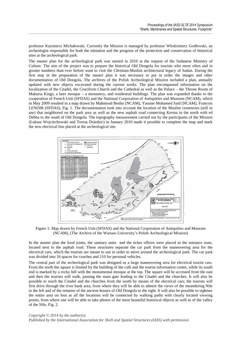
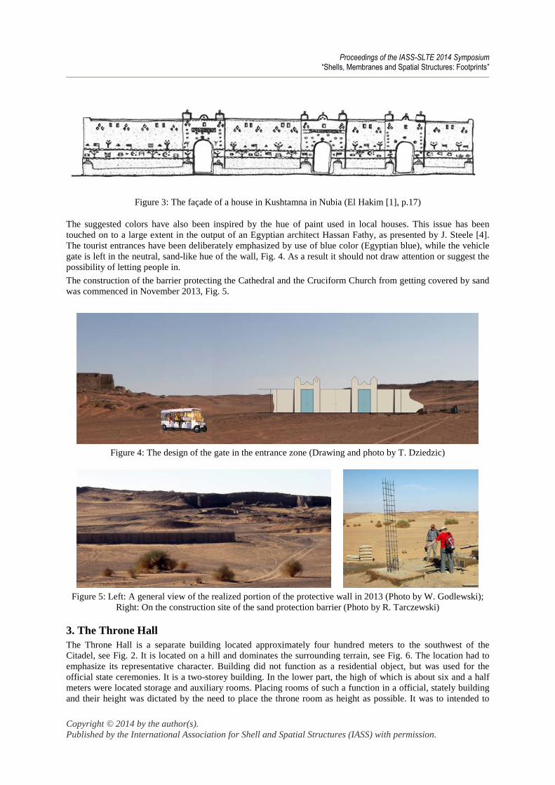
The entrance zone located near the building encompassing the café and the tourist information center is a very important part of the barrier. The design of the gate has been based on an axis, with symmetrically placed entrances for tourists walking towards the Citadel or the churches nearby. The main axis goes through the middle of the gate designed with wheeled vehicles in mind; vehicles that for technical reasons will need to get close to the Citadel or the churches. In their form the clearly visible tourist entrances will make use of traditional Sudanese architecture, Fig. 3.
Proceedings of the IASS-SLTE 2014 Symposium “Shells, Membranes and Spatial Structures: Footprints”
Copyright © 2014 by the author(s). Published by the International Association for Shell and Spatial Structures (IASS) with permission.
Figure 3: The façade of a house in Kushtamna in Nubia (El Hakim [1], p.17)
The suggested colors have also been inspired by the hue of paint used in local houses. This issue has been touched on to a large extent in the output of an Egyptian architect Hassan Fathy, as presented by J. Steele [4]. The tourist entrances have been deliberately emphasized by use of blue color (Egyptian blue), while the vehicle gate is left in the neutral, sand-like hue of the wall, Fig. 4. As a result it should not draw attention or suggest the possibility of letting people in.
The construction of the barrier protecting the Cathedral and the Cruciform Church from getting covered by sand was commenced in November 2013, Fig. 5.
Figure 4: The design of the gate in the entrance zone (Drawing and photo by T. Dziedzic)
Figure 5: Left: A general view of the realized portion of the protective wall in 2013 (Photo by W. Godlewski);
Right: On the construction site of the sand protection barrier (Photo by R. Tarczewski)
3. The Throne Hall The Throne Hall is a separate building located approximately four hundred meters to the southwest of the Citadel, see Fig. 2. It is located on a hill and dominates the surrounding terrain, see Fig. 6. The location had to emphasize its representative character. Building did not function as a residential object, but was used for the official state ceremonies. It is a two-storey building. In the lower part, the high of which is about six and a half meters were located storage and auxiliary rooms. Placing rooms of such a function in a official, stately building and their height was dictated by the need to place the throne room as height as possible. It was to intended to

Proceedings of the IASS-SLTE 2014 Symposium “Shells, Membranes and Spatial Structures: Footprints”
Copyright © 2014 by the author(s). Published by the International Association for Shell and Spatial Structures (IASS) with permission.
impress visitors hosted by the ruler and raise his prestige. For this purpose served also windows adequately distributed in the stairwell, which gradually revealed the view on the city and the Citadel. The upper floor is lower - its height is just over two and a half meters. The building is made of adobe, and the thickness of its walls is very different in each parts.
Figure 6: The Ancient Throne Hall of Makuria Kings – general view (Photo by R. Tarczewski)
Making the building available for tourists requires two kinds of work. The first group is associated with securing and local strengthening of construction of the object, in order to ensure the safety of the visitors. The second group of works includes some additions and minor modifications to facilitate access to the building and allowing exposition of its most important parts.
3.1 Securing and strengthening of floors and new, additional observation deck In the building were used two types of floor structures. Above the ground floor are mostly adobe vaults, with a cross section close to parabolic, filled with a similar adobe material. At the upper level and the stairwell – wooden floors are used. There are ceilings made of untreated or partially treated beams filled with pugging of adobe and clay, laid on a mat of reeds. Locally for fillings were used adobe bricks. In the later period of exploitation of the building, wooden beams were also used to repair damaged portions of the vaults, Fig. 7 and 8.
Figure 7: Left: View of the typical vault over the ground floor; Right: Cross section through the vault after
completing the reinforced concrete slab (Drawing and photo by R. Tarczewski)

Proceedings of the IASS-SLTE 2014 Symposium “Shells, Membranes and Spatial Structures: Footprints”
Copyright © 2014 by the author(s). Published by the International Association for Shell and Spatial Structures (IASS) with permission.
Figure 8: Left: View of the typical wooden beam floor; Right: Cross section through the floor after completing
the reinforced concrete slab (Drawing and photo by R. Tarczewski)
Due to the fact that the ceilings are much destroyed, it is impossible to make them accessible to visitors without adequate securing. As a general solution, both for the vaults and wooden beams floors, it was decided to construct an additional reinforced concrete slab, not connected with existing floors. This slab will be made within the existing pugging layer and will not increase the overall thickness of the floor. On its upper surface will be reconstructed the existing floor. The general idea of strengthening the floors is shown on Fig. 7 and Fig. 8.
The use of reinforced concrete slab will protect existing structural components of floors by suspending them by steel hangers. In addition, supporting and connecting the slab with the walls of the building will increase the overall rigidity to the horizontal forces and protect against deformation the walls, in which there are no other components with this function, such as rims.
Figure 9: Left: Plan of the upper floor of the building (part); Right top: Location of the additional reinforced
concrete floors and temporary working platforms; Right bottom: The cross section through the additional floors (Drawing by R. Tarczewski)

Proceedings of the IASS-SLTE 2014 Symposium “Shells, Membranes and Spatial Structures: Footprints”
Copyright © 2014 by the author(s). Published by the International Association for Shell and Spatial Structures (IASS) with permission.
It is proposed, in the concept of object presentation, to make additions to the walls on the west side at the stairwell, along with additional floor levels. During construction works the floors will be used as working platforms for the transportation of materials. After completion of the works, these slabs will provide additional surface area used for exhibition and an observation deck, see Fig. 9.
3.2 New roofing over the audience hall For the protection of the building and to prepare it for visitors, a new roof over the main part of the object – throne hall, is designed. The existing wooden roof is in poor condition, Fig. 10. New roof will protect fragments of a wooden structure destined for exposition. It will also form a structure which will hold both: a suspended false ceiling, replacing partially damaged existing structure and preserved parts of the existing ceiling. In the central area of the roof cover, a small glass-covered dome is designed. This will provide a necessary natural lighting. Figure 11 presents visualization of the proposed structure.
The new roof structure will be made of hot rolled steel elements, as a plane grid. Coverage of the roof will be made of trapezoidal steel sheets. Part of the roof over the staircase will be constructed as a reinforced concrete slab. This part will form an observation deck, as mentioned in section 3.1.
The steel structure will be placed over the level of existing roofing. On the walls will be made a trough of adobe, which will be a formwork for the reinforced concrete rim. It will linked together walls and allow anchoring lightweight steel structure, protecting it against the wind.
Figure 10: Views of the current roofing of the throne room (Photo by R. Tarczewski)
Figure 11: Visualization of the proposed additional roofing over the throne room (Drawing by R. Tarczewski)

Proceedings of the IASS-SLTE 2014 Symposium “Shells, Membranes and Spatial Structures: Footprints”
Copyright © 2014 by the author(s). Published by the International Association for Shell and Spatial Structures (IASS) with permission.
4. Concluding remarks Old Dongola is a set of unique, early Christian and later Muslim, monuments. The decision to make them available for visitors, in the form of an archaeological park, initiated the work to secure discovered objects. It includes both protection against sand backfill and ensure the safety inside the buildings.
The scope of the work is very extensive. They are labor intensive and require a lot of care. The pace of work and choice of some technical solutions is also affected by the availability of materials and skilled workers in the local market.
References [1] El Hakim O., Nubian architecture, Cairo, 1999.
[2] Gartkiewicz P.M. Nubia I, Dongola 2, Varsovie, 1990.
[3] Kelm T. Architektura sakralna Sahary (in Polish), Warszawa, 2000.
[4] Steele J. An architecture for people. The complete works of Hassan Fathy, Cairo, 1997.