
Social Implications of Climate Change for Coastal Areas of Pakistan
48
Social Implications of Climate Change for Coastal Areas of Pakistan Paper Presented at Euro-Asian Research and Training in Climate Change Management 2007 Dr. Mirza Arshad Ali Beg Former Director General PCSIR 136-C Rafahe Aam Housing Society, Malir Halt, Karachi-75210 e-mail: [email protected] Abstract Climatic variations whether local or global have the most serious social implications on the environment of coastal areas, mainly because their unpredictable nature is further complicated by their interfacing with all major components of the environment viz. land, sea, water, air and sunshine or electromagnetic radiation. They are therefore exposed to all major hazards emanating from the land, sea, air and space. They are particularly vulnerable to storm impacts, flooding, wind damage and erosion. Of recent they have become more vulnerable due to man made interventions that are seemingly cause for change in natural cycles and erratic variation in climate. The impact of Climate Change having different consequences within and between countries has indeed been noticed in the context of diversity in the ecosystems of Pakistan (Mirza Arshad Ali Beg, Comments on Pakistan National Communication on Implementation of UNFCCC, May 2001) . The situation current in 2001 indicated that Pakistan is faced with extremes of climate variations resulting from natural as well as man made modifications. The aftermath of Cyclone 02A, which landed on the low lying coastal area of Badin in May 1999 and the floods in the same area in 2003, were a preview of the impending disaster due to climate change.
-
Upload
independent -
Category
Documents
-
view
2 -
download
0
Transcript of Social Implications of Climate Change for Coastal Areas of Pakistan
Social Implications of Climate Change for Coastal Areas of Pakistan
Paper Presented at Euro-Asian Research and Training in
Climate Change Management2007
Dr. Mirza Arshad Ali Beg Former Director General PCSIR
136-C Rafahe Aam Housing Society, Malir Halt, Karachi-75210 e-mail: [email protected]
Abstract
Climatic variations whether local or global have the most serious social implications on the environment of coastal areas, mainly
because their unpredictable nature is further complicated by their interfacing with all major components of the environment
viz. land, sea, water, air and sunshine or electromagnetic radiation. They are therefore exposed to all major hazards
emanating from the land, sea, air and space. They are particularly vulnerable to storm impacts, flooding, wind damage
and erosion. Of recent they have become more vulnerable due to man made interventions that are seemingly cause for change in natural
cycles and erratic variation in climate.
The impact of Climate Change having different consequences within and between countries has indeed been noticed in the context of diversity in the ecosystems of Pakistan (Mirza Arshad Ali Beg,
Comments on Pakistan National Communication on Implementation of UNFCCC, May 2001) . The situation current in 2001 indicated that Pakistan is faced with extremes of climate variations resulting from natural as well as man made
modifications. The aftermath of Cyclone 02A, which landed on the low lying coastal area of Badin in May 1999 and the floods in the
same area in 2003, were a preview of the impending disaster due to climate change.
Climates dominated by monsoons experience the most pronounced seasonal wind shifts. In South Asia, the rainy season, typically
beginning in June, is preceded by nearly two months of scorching temperatures, cooled only with the commencement of the summer
rains brought by the southwesterlies. January is the peak of the dry season, which is marked by cool, dry northeasterly flow over
most of the region.
The over 150 years of data and assessment of driving forces behind the southwest monsoon circulation conclusively indicate that no
other region outside the monsoon belt is as much vulnerable to the extremes of wetness and dryness as the tropical monsoon belt. Man
made interventions have caused water scarcity in the region that includes Pakistan. The scarcity is likely to continue for the
next few decades, mainly because of inadequate management of the precious resource. This has created a mismatch between
availability from surface run off and extensive water use. Withdrawal from all sources viz. rivers, lakes, and reservoirs,
and mining of underground aquifers at an unprecedented rate had increased not only in Pakistan but also in Asia, in general, by
almost 300% between 1950 and 1995, and may have increased further if the availability was not a constraint. A mismatch between
availability of water and its extensive use that has increased by almost 250% during the last 50 years in Pakistan, has resulted in
withdrawal from all sources viz. rivers, canals, wells, tubewells, karezes and springs( Economic Survey 1999-2000, Government of Pakistan, Finance Division,
Economic Advisor’s Wing, Islamabad) . This type of modification in the ecosystem has increased aridity in the region and has instigated losses of
habitat, vegetative cover, biomass and biodiversity (The Pakistan
National Conservation Strategy, Environment & Urban Affairs Division, GoP, and IUCN) . Construction of large dams, diversion of river flow into an intricate
irrigation system and over harvesting of groundwater resources constitutes the greatest intervention of ecosystem of the
region, and a large interference in the water cycle by increasing the losses due to evaporation and seepages and the consequent
increased availability of water vapour, a greenhouse gas in the air.
The process of augmented withdrawal during the decade after 1995 proceeded to the extent that Pakistan is relegated to water
stressed country from the status of water surplus country. It is estimated that almost 10% of the agricultural food production is
now dependent on mined groundwater. Loss of storage in the aquifers and their mining already indicates that availability of
water in Pakistan has decreased and is less likely to be reversed since recharging of the aquifer takes several hundred years, if
left to the natural process of surface water infiltration.
In 1951, when population stood at 34 million, per capita availability of water was 5300 cubic meter, which has now
decreased to 1105 cubic meter, just touching water scarcity level of 1000 cubic meter. With a present growth in population and the
low rainfall, the threshold limit of water scarcity i.e. 1000 m3
of water per capita per year may be reached as early as the year 2010. The estimates show that the current water shortage of 9
million acre feet would aggravate to 25 MAF if all planned dams under Vision 2025 are not constructed by 2016( Economic Survey of Pakistan 2005-
06).
The annual rainfall as well as seepage due to floods, which were the constituents of the ecological processes that balance the
inflow and outflow of water, have been disturbed by extensive withdrawal and diversion into canals which leaves only about 24.6
billion cubic metre ( bcm) for Lower Sindh. The groundwater resources are not being replenished to help in building up the reservoirs of the areas adjacent to rivers and in filling up their
sub-soil, or the deep zones of groundwater.
The recharge in the delta area is restricted to area within the embankment system, whose c onstruction was aimed at providing protection against flooding. This constitutes another set of
interventions that has caused an irreversible damage to the ecosystem of the riverine and delta areas. The embankments have
removed the floodplains and the aquifer there is not being recharged with the same frequency and intensity as in the 1950s.
The ecology of floodplains and delta area changed after the mid- 1960s, and its adverse and irreversible impacts have, besides
depriving the delta area of its traditional rice crop, induced seawater intrusion through intensive harvesting of
groundwater (Mirza Arshad Ali Beg, Ecological Imbalances in the coastal areas of Pakistan and Karachi
harbour, Pakistan Journal of Marine Sciences, 4(2), 159-74, 1995), ( H.T. Sorley (1964) The Gazetteer of West
Pakistan: The Former Province of Sind, Government of West Pakistan, Lahore, pp-11,). The snowmelt, according to observations from the satellite
imageries, starts from April each year. By mid-April there is substantial flow of over 30,000 cusecs and by the end of June
50% of the basin is free of snow. The remaining 50% of the snow cover keeps melting through the summer. A recession starts in the
snowmelt hydrographs towards the end of August until it hits the base flow towards the end of October. However, 18% of the snow
covered area remains unaffected and does not see the light of the day.
Not much of recession in the glacier area is reported to have occurred since the meteorologists have been claiming a large
amount of snowfall on the catchment area. Recent reports( Brian Handwerk,
National Geographic News ,September 11, 2006) based on meteorological data compiled over the past century, bear out the conclusions of the satellite data.
These data indicate that winter temperatures have been rising in parts of the Western Himalaya, Karakoram, and Hindu Kush mountain
ranges, while average summer temperatures, which melt snow and glaciers, have been decreasing. The winter snowfall that feeds
the glaciers in the region has, however, been increasing. The downward trend in summer temperatures, according to David
Archer, co-author of the above study is contradictory to the finding that glaciers are melting in the Eastern Himalaya i.e.
Nepal( Himalaya Ice-Melt Threat Monitored in Nepal",
news.nationalgeographic.com/news/2006/03/0310_glaciers.html) . The combination of reduced summer melt and increase in winter snowfall, according to
these authors, accounts for glacial growth (Archer et.al., under publication,
Journal of Climatev American Meteorological Society).
The data compiled by Archer and colleagues also indicate changes in the diurnal temperature range, or the span between daytime
high and nighttime low temperatures for a given day in the basin. They find a large increase in the diurnal temperature change in
all seasons and in all the annual data sets. Contrarily there is a

decrease in diurnal temperature range in most parts of the world, which fits into the global climate-change models.
Introduction
Social implications consequent upon the catalytic role of extremes in climate changes can be traced back to ancient
civilizations and the downfall of dynasties: the Tang dynasty in China and Maya of South America is attributed to them( Catherine Brahic,
Collapse of civilisations linked to monsoon changes 04 January 2007, NewScientist.com news service) . Gerald Haug of the GeoForschungsZentrum in Germany and
colleagues, while studying geological records of monsoons over the past 16,000 years( Gerald Haug, GeoForschungsZentrum) have found a startling
correlation between climate extremes and the fall of these civilizations. The records show that around the time that these
civilizations went into decline, they experienced stronger than average winds in the winter and weaker summer monsoon rains.
These weak rains would have reduced crop yields. The Maya civilisation and Tang dynasty were contemporary and there is a
striking similarity between the Chinese and Latin American climate data. These include a general shift towards a drier climate around AD 750 and three very dry periods between then and
AD 910, the last of which coincides with both the Maya and the Tangcollapse.
Despite correlations of the above kind, climate has been considered as one of the many unpredictable and complicated
elements of the environment upon which human societies depend for their survival. It is because of its sensitivity and complexity
that it is difficult to determine the factors governing the climatic fluctuations and the degree to which they affect the society. There is for example considerable controversy
concerning the Bengal Famine of 1942, and the Sahelian famine of the late 1960s and early 1970s. There are evidences that both
events were the direct result of climatic variation, but there are equally strong evidences to support that the underdeveloped
economic infrastructure of the countries affected, external interference in affairs of those countries, or inflexible
techniques of animal and crop husbandry, were the root cause.

Climatic variations whether local or global have the most serious social implications on the environment of coastal areas, mainly
because their unpredictable nature is further complicated by their interfacing with all major components of the environment
viz. land, sea, water, air and sunshine or electromagnetic radiation. They are therefore exposed to all major hazards
emanating from the land, sea, air and space. They are particularly vulnerable to storm impacts, flooding, wind damage
and erosion. Of recent they have become more vulnerable due to man made interventions that are seemingly cause for change in natural
cycles and erratic variation in climate.
Climate changes on seacoast are both unpredictable and erratic. Accordingly coastal communities who opt to live on the seacoast
develop their own system to protect themselves from marine- related hazards and to keep themselves in preparedness for
disasters. This is why Netherlands has had to go for construction of dykes along the coast. This mitigation measure was considered
essential to minimize the losses that were being inflicted on the living environment along the coast. Coastal populations are
impacted by a variety of natural hazards, including erosion, saltwater intrusion, subsidence, and floods due to both storm
surges and swollen rivers, besides tsunamis.
The severity of the impacts of these natural hazards can be modified by:
Local factors, for example, the exposition of the coast to the sea, the presence or absence of natural protection (sand
barrier, coral reefs, dunes, vegetation), among others,and
Man made interventions.
Man made modifications have, however, made extensive amendments in the local factors by either removing the protection systems or
altering them to suit to specific requirement irrespective of the damages done to the ecosystem. Such modifications have altered several ecosystems and increased the vulnerability of coastal
communities, infrastructure and ecosystems to cope with the onslaught of the impending disaster. Their vulnerability seems
at the threshold since the frequency of disaster events is on an increase and floods, storms and destructive waves are taking
larger share of economic, social and environmental losses.
The increase in frequency of marine-related hazards is being taken as an indicator of climatic change leading to alteration in
heat balance, melting of glaciers, sea level rise, progressive inundation of low-lying coastal areas and enhanced erosion of unprotected erodible coastlines. Losses resulting from exposure
to hazards, and to development along coastal margins and the impacts that result during hazards and generate hazardous
conditions that affect coastal ecosystems, are expected to increase due to impoverished environment, poverty, promotion of
development projects with little regard for adverse environmental impact, and the effects of global climate change.
Climate ChangeDefinition
Weather is the combination of natural phenomena as temperature, precipitation, light intensity and duration, wind direction and
velocity and relative humidity. In any given location these weather factors assume a certain pattern changing from day to
day, week to week, month to month and season to season and the same pattern repeats from year to year. The pattern of change is the climate of the location.
The United Nations Framework Convention on Climate Change (UNFCCC), in order to make a distinction between Climate Change
attributable to human activities altering the atmospheric composition, and Climate variability attributable to natural causes,
defines climate change in its Article 1, as: a change of climate, which is attributed directly or indirectly to human activity that alters the
composition of the global atmosphere and which is in addition to natural climate variability observed over comparable time periods . Predicting and managing the likely impact of Climate Change on the ecosystem of
the earth is a real challenge, but considering the recurrence of environmental catastrophes with increasing frequency, it is
timely to analyse these problems as well as their social implications.
Working Group II of the IPCC suggests that policy makers need to contemplate immediate actions. First, because anticipated
Climate Changes should not be wait for to happen before taking actions, since by that time it might be too late to amend, and
second, because appropriate management responses consist in a no-regret-policy since efforts to reduce the vulnerability and
increase the resilience of sites to existing non-climatic pressures and threats would also reduce their vulnerability to
Climate Change related stresses. It has, however, been accepted by the IPCC that the impact of Climate Change is projected to have
different effects within and between countries. The challenge of addressing Climate Change raises an important issue of equity.
The Intergovernmental Panel on Climate Change (IPCC) has, in its Third Assessment Report stated “The Earth’s climate system has
demonstrably changed on both global and regional scales since the pre-industrial era, with some of these changes attributable to
human activities”. To limit the amplitude of Climate Change, mitigation (reducing the emission and enhancing the sinks of greenhouse gases) is needed, and “adaptation is a necessary
strategy at all scales to complement Climate Change mitigation efforts”.
Situation Analysis
The impact of Climate Change having different consequences within and between countries has indeed been noticed in the context of diversity in the ecosystems of Pakistan (Mirza Arshad Ali Beg,
Comments on Pakistan National Communication on Implementation of UNFCCC, May 2001) . The situation current in 2001 indicated that Pakistan is faced with extremes of climate variations resulting from natural as well as man made
modifications. The aftermath of Cyclone 02A, which landed on the low lying coastal area of Badin in May 1999 and the floods in the
same area in 2003, were a preview of the impending disaster due to climate change.

Climates dominated by monsoons experience the most pronounced seasonal wind shifts. In South Asia, the rainy season, typically
beginning in June, is preceded by nearly two months of scorching temperatures, cooled only with the commencement of the summer
rains brought by the southwesterlies. January is the peak of the dry season, which is marked by cool, dry northeasterly flow over
most of the region.
The monsoon climates are especially vulnerable to disruptions in global weather, which have, in any given year led to drought,
flooding, or both. The over 150 years of data and assessment of driving forces behind the southwest monsoon circulation has
resulted in a better understanding of weather extremes experienced throughout the tropics, and their subsequent impact
on ecological balance governing aquatic ecology. These data conclusively indicate that no other region outside the monsoon
belt is as much vulnerable to the extremes of wetness and dryness as the tropical monsoon belt.
Changes in Ecological Balance & Water Resource Depletion
Man made interventions have caused water scarcity in the region that includes Pakistan. The scarcity is likely to continue for
the next few decades, mainly because of inadequate management of the precious resource. This has created a mismatch between
availability from surface run off and extensive water use. Withdrawal from all sources viz. rivers, lakes, and reservoirs,
and mining of underground aquifers at an unprecedented rate had increased not only in Pakistan but also in Asia, in general, by
almost 300% between 1950 and 1995, and may have increased further if the availability was not a constraint.
A mismatch between availability of water and its extensive use that has increased by almost 250% during the last 50 years in
Pakistan, has resulted in withdrawal from all sources viz. rivers, canals, wells, tubewells, karezes and springs( Economic Survey 1999-
2000, Government of Pakistan, Finance Division, Economic Advisor’s Wing, Islamabad) . This type of modification in the ecosystem has increased aridity in the region
and has instigated losses of habitat, vegetative cover, biomass
and biodiversity (The Pakistan National Conservation Strategy, Environment & Urban Affairs
Division, GoP, and IUCN) . Construction of large dams, diversion of river flow into an intricate irrigation system and over harvesting of
groundwater resources constitutes the greatest intervention of ecosystem of the region, and a large interference in the water
cycle by increasing the losses due to evaporation and seepages and the consequent increased availability of water vapour, a
greenhouse gas in the air.
The process of augmented withdrawal during the decade after 1995 proceeded to the extent that Pakistan is relegated to water
stressed country from the status of water surplus country. It is estimated that almost 10% of the agricultural food production is
now dependent on mined groundwater. Water tables that were falling at a rate of a metre a year have been going down at a much
rapid rate. In the Quetta valley, for example it has fallen by 30 metre during the last 20 years. A similar situation is being faced
in China, India, Mexico and Yemen, the other countries falling in the same belt.
Loss of storage in the aquifers and their mining already indicates that availability of water in Pakistan has decreased
and is less likely to be reversed since recharging of the aquifer takes several hundred years, if left to the natural process of
surface water infiltration. Fluctuations in water table are vulnerable to weather changes e.g. changes in temperature,
humidity and rainfall, besides soil permeability. These changes affect the rate of evaporation and evapotranspiration and also
the sub-soil flow. Aridity causes increased evaporation, which in certain cases is in excess of 3 cusecs per square mile in
certain worse areas. Evaporation from soil surface is related to the depth of groundwater. It is very high, ranging up to 50% of
the surface water evaporation for a groundwater depth of 2 to 3 ft; 33 to 55% for a depth of 5 ft and 20% for a depth of 10 ft.
Social Implication of Excessive Extraction of Water
In 1951, when population stood at 34 million, per capita availability of water was 5300 cubic meter, which has now
decreased to 1105 cubic meter, just touching water scarcity level of 1000 cubic meter. With a present growth in population and the
low rainfall, the threshold limit of water scarcity i.e. 1000 m3
of water per capita per year may be reached as early as the year 2010. The estimates show that the current water shortage of 9
million acre feet would aggravate to 25 MAF if all planned dams under Vision 2025 are not constructed by 2016( Economic Survey of Pakistan 2005-
06).
Increasing the water use by over 300% is the greatest man made intervention of ecosystem aimed at achieving a fast rate of
economic growth. Ecosystem of concerned regions of the earth has been modified by different practices for use of surface and
ground water for irrigation and for domestic use. Construction of large dams with a height of over 15 metre at a rate of 300 every
year has caused the largest intervention in the water cycle by having over 40,000 dams constructed all over the world. An adverse effect noticed from the operation of large dams led to the
construction of small dams and hundreds of thousands of ponds. Dams and ponds increased the losses due to evaporation and
seepages and the consequent increased availability of water vapour in the air. They have caused depletion of groundwater
resources and reduction in the flow of freshwater into the estuarine areas besides losing the advantages that were naturally available from the ecosystem e.g. firewood, livestock, poultry, fish, cow dung, biomass, mangrove forest
cover and biodiversity.
Construction of embankments to protect land from flooding constitutes another set of interventions that has caused an irreversible damage to the ecosystem of the riverine, estuarine
and coastal areas in Pakistan. The embankments have removed the floodplains and the aquifer is not being recharged with the same
frequency and intensity as in the past and thus the ecology has changed abruptly, adversely and irreversibly. They have,
besides depriving the delta area of its traditional rice crop in the kharif season and oilseeds and millet in the rabi season,
induced salinization of groundwater by seawater intrusion through intensive harvesting of groundwater.
Reduced availability of water due to this man made intervention has led to the rice grown in the coastal belt just off the coastal
area near Keti Bunder and Shah Bunder, being almost abandoned, while rendering the mangrove forests under stress.
The annual rainfall as well as seepage due to floods, which were the constituents of the ecological processes that balance the
inflow and outflow of water, have been disturbed by extensive withdrawal and diversion into canals which leaves only about 24.6
billion cubic metre ( bcm) for Lower Sindh. The groundwater resources are not being replenished to help in building up the reservoirs of the areas adjacent to rivers and in filling up their
sub-soil, or the deep zones of groundwater.
The recharge in the delta area is restricted to area within the embankment system, whose c onstruction was aimed at providing protection against flooding. This constitutes another set of
interventions that has caused an irreversible damage to the ecosystem of the riverine and delta areas. The embankments have
removed the floodplains and the aquifer there is not being recharged with the same frequency and intensity as in the 1950s.
The ecology of floodplains and delta area changed after the mid- 1960s, and its adverse and irreversible impacts have, besides
depriving the delta area of its traditional rice crop, induced seawater intrusion through intensive harvesting of
groundwater (Mirza Arshad Ali Beg, Ecological Imbalances in the coastal areas of Pakistan and Karachi
harbour, Pakistan Journal of Marine Sciences, 4(2), 159-74, 1995), ( H.T. Sorley (1964) The Gazetteer of West
Pakistan: The Former Province of Sind, Government of West Pakistan, Lahore, pp-11,).
Water Budget Management
Components of Water Budget: Pakistan receives its 180 bcm or 145 MAF of surface flow from (i) Snow and glacier melt and (ii)
Monsoon system, as the main constituents of its water budget.The melting of perennial snow cover and glaciers in the Lesser
Himalayas, which are the south oriented outer ranges of the Himalayas in the northern part of Indus Basin, starts when the sun
moves northward after March each year and is a major source of the

river flow. The Kailas range holds the key to the supply ofwater to two main river systems viz. the Indus that drains its
water to the west and southwest, and the Brahamaputra, which flows east and then via Assam to the Bay of Bengal. It is
interesting that both the rivers rise from Lake Mansarowar.
Glaciers
The melt-water of glaciers of Pakistan is the principal source of supply to the rivers, which feed the irrigation system. Siachin
alone is estimated to contain 100 million acre feet (100 MAF) of water, which is little less than the total annual irrigation
diversion in the Indus Plain. The glacial and snowmelt in the upper Indus catchment area are the source of 80% flow during the
summer. There is only minor variation in the timing and volume of annual flow of snowmelt. 95 bcm or 84% of the total mean flow
measured for the Indus at Kalabagh takes place between April and September, which is the kharif season.
The rise in flow volume due to snowmelt starts from early May and attains its height between the last week of June and first week of
July, which is the time for the first flood flow. This is either accompanied or followed immediately by a higher glacial melt
combined with monsoon rains in the catchment area starting from mid-July to August. The water level in the river starts falling
from September and reaches its minimum between mid-January and mid-February, the upper reaches beyond Skardu run dry
thereafter. The driest month for the Indus is February, with an average annual winter flow recorded for the 1956 to 1997 period
being 17.95 bcm, while July has the highest seasonal inflow, the annual average summer flow being 112.2 bcm.
The snowmelt, according to observations from the satellite imageries, starts from April each year. By mid-April there is
substantial flow of over 30,000 cusecs and by the end of June50% of the basin is free of snow. The remaining 50% of the snow
cover keeps melting through the summer. A recession starts in the snowmelt hydrographs towards the end of August until it hits the
base flow towards the end of October. However, 18% of the snow
covered area remains unaffected and does not see the light of the day.
Not much of recession in the glacier area is reported to have occurred since the meteorologists have been claiming a large
amount of snowfall on the catchment area. Recent reports( Brian Handwerk,
National Geographic News ,September 11, 2006) based on meteorological data compiled over the past century, bear out the conclusions of the satellite data.
These data indicate that winter temperatures have been rising in parts of the Western Himalaya, Karakoram, and Hindu Kush mountain
ranges, while average summer temperatures, which melt snow and glaciers, have been decreasing. The winter snowfall that feeds
the glaciers in the region has, however, been increasing. The downward trend in summer temperatures, according to David
Archer, co-author of the above study is contradictory to the finding that glaciers are melting in the Eastern Himalaya i.e.
Nepal( Himalaya Ice-Melt Threat Monitored in Nepal",
news.nationalgeographic.com/news/2006/03/0310_glaciers.html) . The combination of reduced summer melt and increase in winter snowfall, according to
these authors, accounts for glacial growth (Archer et.al., under publication,
Journal of Climatev American Meteorological Society).
The data compiled by Archer and colleagues also indicate changes in the diurnal temperature range, or the span between daytime
high and nighttime low temperatures for a given day in the basin. They find a large increase in the diurnal temperature change in
all seasons and in all the annual data sets. Contrarily there is a decrease in diurnal temperature range in most parts of the world,
which fits into the global climate-change models.
Artificial Glaciers : Apart from the use of water from natural glaciers, Glacier Plantation or Artificial Glaciers making is
also practiced in Pakistan. The process is carried out by transporting snow and ice from the neighbouring glaciers and
burying it in a hole from which the glaciers are to grow. The hole is lined and covered with various types of material. Straw and
snow are always used with large amount of salt. But sometimes dung, herbs, and charcoal are also used. The development of
artificial glaciers, of course, depends on the balance between
accumulation and melting of ice. The process may seem to be unbelievable but is widely known and has been practised since
generations in northern parts of Pakistan i.e, Chitral, Hunza, and Baltistan with success.
Glaciers on Eastern Himalayas: The exceptional position of Pakistan side of Glaciers as against those of most glaciated
regions worldwide, including the Eastern Himalayas, where glaciers have been shrinking significantly, is thought by Lonnie
Thompson, a paleoclimatologist and glacier expert at Ohio State University in Columbus, as a short-term trend where increased
winter snowfall outweighs summer melt. He is of the opinion that these glaciers will follow the same pattern as those in Sweden and
Norway, which were growing until 1999 due to increasing winter snowfall even when temperatures were rising. These same glaciers
have been retreating since 1999. The balance of glaciers globally shows retreat and accelerated rate of retreat( "Greenland Glaciers Losing Ice
Much Faster, news.nationalgeographic.com/news/2006/02/0216_warming.html [February 2006].) . This suggests the need for installation of monitoring stations to
predict the implications of climate change in the glacier environment of the Pakistani glaciers.
Glaciers in Eastern Himalayas are faced with a different situation. The Khumbu Glacier on Mount Everest is reported to
have retreated more than five kilometers since 1953 (James Owen, National
Geographic News, March 10, 2006, news.nationalgeographic.com) . S imilar trend in glaciers have been recorded throughout the Himalayas, which spans several
Asian countries and its glacial-melt feeds over one third of the world population. These water supplies may eventually dry up as
global warming becomes predominant and melts the glaciers.
According to a WWF report (James Owen, National Geographic News, March 10, 2006,
news.nationalgeographic.com) released last year, Himalayan glaciers are currently receding at an average rate of 33 to 50 feet (10 to 15
meters) per year. In India the Gangotri Glacier, the source of the Ganges River, is retreating at a rate of 75 feet (23 meters)
annually. The report also noted that air temperatures in the region have risen by 1°C since the 1970s, twice as much as average
warming in other northern hemisphere countries over the same time
period. Environmental implications associated with faster melting glaciers that feed the Brahmaputra, Salween, Mekong, Yangtze, and Huang Ho, include an increased risk of flooding and
landslides, while the social implications initially include loss of agricultural land due to excessive flooding followed by
flash floods during the rainy season and drying of river beds and irrigation system during the remaining period of the year. The
coastal will receive excessive flow resulting from flash floods, which may not be to the liking of the coastal communities as well
as the marine fauna and flora.
Social Implications of Glacier Melting
The United Nations Environment Program 2001 survey had shown that at least 20 glacier lakes formed by accumulated meltwater in
Nepal have grown to the point where they could potentially burst, and suddenly discharge massive volumes of water, known as glacial
lake outburst flooding (GLOF). Such flooding will have serious social implications since they would cause loss of life and
widespread damage to villages, roads, bridges, and farmland downstream, and inundation of low-lying coastal areas and
enhanced erosion of unprotected erodible coastlines .
GLOF is a major threat in Nepal where a number of glacier lakes are expanding in size. Glacial melting will also increase the volume
of water in rivers, causing widespread flooding. This situation will change, however, and the water level in rivers will decline. Over time, as the glaciers become smaller, seasonal melt will
decrease and contribute less water to annual river flows. For example, reduced glacier meltwater would cut July-through- September river flow of the Ganges by two-thirds. This decline
would leave 500 million people, 37 percent of the irrigated land and the entire coastal community that depends on surface flow,
short of water in India.
Melting of glaciers in the eastern Himalayas might as well be the result of man made interventions. These interventions comprise a
set of irreversible changes in the eastern Himalayan ecosystem caused by indiscriminate exploitation of forest resources in the
eastern Himalayas. This has set the stage for alteration of the monsoon pattern in South Asia. The monsoon winds are now able to
cross over the Himalayas into China, instead of traveling along the mountains and bringing rains to the Lower Himalayan region over Nepal, and later on to the areas in Pakistan. This pattern is
being witnessed for the last eight years and can often be seen from the weather satellite imageries telecast from the end of June each year. This has resulted in rains across the Himalayas in
China and on the east of Nepal but not on its West.
The net result is deficit in both components of the water budget; there is reduced precipitation and reduced surface flow. Water
availability has been gradually reduced to below 90 MAF and this is likely to continue if the climate change has become operative, as it seems it has from the receipt and flow pattern of the past
ten years. The availability at canal head was, according to Economic Survey of Pakistan, 2001-02, less than 84 MAF. As
against the normal surface water availability at canal heads of 103.5 million-acre feet (MAF), the overall (both for Kharif and Rabi) water availability has been less in the range of 5.9 per
cent (2003-04) to 29.4 per cent (2001-02). Relatively speaking, the Rabi season faced more shortage of water than Kharif during
these periods. During the current fiscal year (2005-06), the availability of water for Kharif 2005 (for the crops such as rice,
sugarcane and cotton) has been 5.5 per cent more than the normal supplies and 19.8 per cent more than last year’s Kharif. Excessive winter rainfalls (January-March 2005) along with the
melting of snow on mountains top were responsible for higher than normal availability of water during Kharif 2005. The water
availability during the Rabi season (for major crop such as wheat), as on end of March, 2006 was estimated at 30.0 MAF, which
was 17.3 per cent less than the normal availability, and 29.8 per cent more than last year’s Rabi (Economic Survey of Pakistan, 2005-06).
This deficiency will go down still further since availability from the groundwater sources will get reduced each year as a
result of reduced recharge. The impact of climate change on the economy, particularly agricultural activity in Pakistan, will
be highly disturbing if such a situation really sets in.
Monsoon System
The monsoon system, which is the other component of the water budget, comprises the following sequences:
(a) An eastward push of the warm current that starts from the eastern coast of Africa,
(b) Intense heating of the desert area extending from Balochistan, and Rajasthan to Central India in the east and from
the desert areas of Kharan and Thar in Sindh in the south to the Potohar plateau in the north of Pakistan, resulting in heat waves
from March to mid-June, with sizzling temperatures of 43o C to 48oC that creates low-pressure zone over the region with its focus on
the Nokundi-Sibbi-Jacobabad axis, (c) Westward pull of moist air by the low pressure zone created by
heat wave , (d) Breaking of monsoon in early June at the southwest of the
Indian Peninsula,(e) Causing the monsoon winds to travel across the IndianPeninsula and over the Bay of Bengal,
(f) Picking up more moisture to the point of saturation and supersaturation and causing a series of storms by the
simultaneous entry of moist air from the Bay of Bengal and the Arabian Sea,
(g) Plenty of rainfall following the breaking of monsoon in Bangladesh, Nepal, the eastern and northern provinces of India,
the snow covered mountainous region comprising the Siwaliks andouter Himalayas and the catchment areas of Indus and Brahamputra,
which is by this time left with 50% snow cover, (h) Intense and heavy precipitation over the area and the
adjoining plains initiating the flood flow in July, (i) Bifurcation of the system on reaching Central India with one
of its branches entering Pakistan from the east and the other from its north and (j) Diffusion of monsoon current.
The warm current from East Africa and the winds accompanying it have sufficient driving force when they strike the southwest of
the Indian Peninsula to move past its eastern coast in early June.

The winds shed their moisture at this point but when they emerge at the western side of Bay of Bengal, they find the water warmer.
They pick up more moisture from the Bay of Bengal, get saturated and supersaturated as they proceed landward to the northeast. The
velocity of winds is reduced due to over-saturation and their rising in the form of towering rain clouds.
The driving force of the monsoon system henceforth is the temperature gradient i.e. the intensely heated, low-pressure
zone extending from Central India to Pakistan and Iran and the cold front of the snow cover of the Himalayas. If the winds are weak the system fails to push the moisture laden winds to the zone past central India into Pakistan and there is heavy rainfall in
the eastern zone However, if the winds are strong enough they push the system westward to the low pressure zone after shedding the
water content over the Bay of Bengal. The winds lose almost 80% of the moisture during their travel from Bangladesh to Central India and the rainfalls in Pakistan are only of medium intensity. The high and devastating floods of the past have been found to be the consequence of storms or a series of storms caused by the
simultaneous entry of moist air from the Bay of Bengal and from the Arabian Sea. There is widespread rainfall of long duration in the catchment areas which are often flooded since the flow volume
often increases beyond the drainage capacity of the soil.
The month of September is marked by occurrence of heavy floods since the land in the catchment and adjoining areas is already
saturated and has lost its absorption capacity giving rise to a high rate of runoff. This is what happened in 1973 and 1988 when
there was heavy precipitation in the catchment areas of the rivers Chenab and Ravi and large areas were inundated.
There are two flood flows in the Indus river system; one due to the early rains in mid-July when the snowmelt contributes its share
and the other in mid-August when it is mostly due to precipitation There is widespread flood and large areas are inundated when the
catchment area is overfull due to increase in flow volume beyond absorption and drainage capacity of the system. The rate of run
off increases rapidly after each heavy downpour in the catchment
area as was observed in 1973, 1988, 1992 and 1997 when there was heavy pre cipitation in the catchment areas of the rivers of the Indus system and large areas were inundated. The volume of
discharge during the summer season exceeds 10 to 20 times the winter flow.
Social Implication of Flood
Aftermath of rainstorm of July 2003 has convincingly demonstrated the vulnerability low lying coastal areas of Badin
and Thatta districts of Sindh Province to floods and storms. These areas have been hit again and again by devastations of high
magnitude: the Cyclone 02A in May 1999; rainstorm of 2003, and floods again in August 2006. The flood conditions were
precipitated in the year 2003, not by the rainfall of 350 to 450 mm in 5 days, but by the combined action of natural forces with two
man made interventions. The run-off from the prolonged and high intensity rainfall and high velocity canal flows through the
breaches in the man made interventions: Sani Guni Canal, Phullely Canal, Nasir Canal and other distributaries. The high flows in
the canals were caused by the restricted-use or no-use of irrigation water by the farmers. This water had to end up at the
canal escapes mentioned above. A huge surge of saline water that came from the cuts and breaches made by the people to drain
surface water into the other man made intervention: LBOD system, was face to face with a massive flow of seawater that came from the
opposite direction and stopped the floodwater and the escape water from going into the sea.
Carrying capacity of the LBO drainage system had been rendered inadequate as a result of its having remained idle during the continuous drought for the previous five years. The channels were
silted up to a great extent and were unable to accept the massive inflow of floodwater. This led to accumulation of floodwater and
seawater in thickly populated Talukas of Badin and SF Rahu for days together. The other Talukas viz. Tando Bagho, Matli and
Talhar were also badly affected and all of them had to face destruction of crops, livestock and property.

The rainstorm and floods affected the entire coastline primarily due to the damaged Tidal Link embankments in the south of Badin
District. Absence of an effective drainage system and the high water table, which did not allow the rainwater from a rainfall of
350 to 450 mm in 5 days to percolate rapidly, were in the same way responsible for the devastations. A number of fertile agricultural fields turned into saline water ponds, while the
massive seawater intrusion caused irreparable damage to the entire coastal belt. This event has clearly demonstrated the need
of mitigation measures such as a strongly built embankment on the south of Badin District.
It is important to mention that the land slope in Badin district is generally 1 ft to a mile or 1 in about 5000 and less than that in
the nearshore region. The channel bed of Tidal Link of the Left Bank Outfall Drainage (LBOD) canal system has, however, a slope
of 1 in 14,000. The adequacy of the slope is difficult to justify in consideration of the tidal forces and oceanic currents that
are highly energetic during the monsoon season. National Institute of Oceanography has observed that at least half of the
volume that is drained by the Tidal Link during low tide is pushed upstream during high tides. This aspect of drainage when
considered in the light of need to have the Cholri weir suggests that the Tidal Link as well as the dhands upstream are potentially
vulnerable to residual pressure that may persist at peak water levels under extreme tidal conditions.
According to the above stated conditions it is likely for the Tidal Link even in its dilapidated form not to accept drainage water from the tail-end of Karo, Gunjro and Guni outfall drains,
whenever there is a rise in the water level in the dhands that are interconnected with Cholri dhandh. Such situations that have
occurred during the rainstorm of 2003, would always result in building up the salinity level at the coastline and also lead to seawater intrusion. Wetness of the soil along the coastline much
ahead of Tidal Link found during the visit to the area for environmental audit, indicates that this phenomenon is already
operating in the southern areas of Badin district.
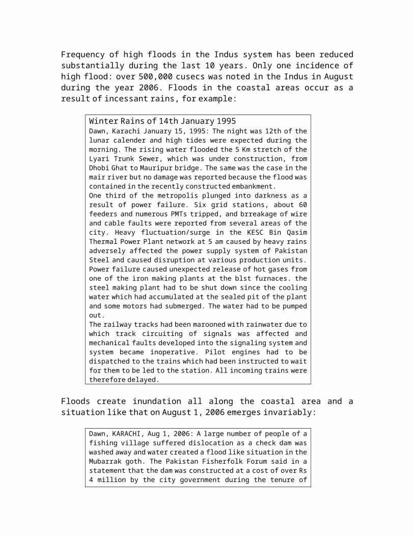
Frequency of high floods in the Indus system has been reduced substantially during the last 10 years. Only one incidence of
high flood: over 500,000 cusecs was noted in the Indus in August during the year 2006. Floods in the coastal areas occur as a result of incessant rains, for example:
Winter Rains of 14th January 1995 Dawn, Karachi January 15, 1995: The night was 12th of the lunar calender and high tides were expected during the
morning. The rising water flooded the 5 Km stretch of the Lyari Trunk Sewer, which was under construction, from Dhobi Ghat to Mauripur bridge. The same was the case in the
mair river but no damage was reported because the flood was contained in the recently constructed embankment.
One third of the metropolis plunged into darkness as a result of power failure. Six grid stations, about 60 feeders and numerous PMTs tripped, and brreakage of wire
and cable faults were reported from several areas of the city. Heavy fluctuation/surge in the KESC Bin Qasim
Thermal Power Plant network at 5 am caused by heavy rains adversely affected the power supply system of Pakistan
Steel and caused disruption at various production units. Power failure caused unexpected release of hot gases from
one of the iron making plants at the blst furnaces. the steel making plant had to be shut down since the cooling water which had accumulated at the sealed pit of the plant
and some motors had submerged. The water had to be pumpedout.
The railway tracks had been marooned with rainwater due to which track circuiting of signals was affected and
mechanical faults developed into the signaling system and system became inopera tive. Pilot engines had to be
dispatched to the trains which had been instructed to wait for them to be led to the station. All incoming trains were
therefore delayed.
Floods create inundation all along the coastal area and a situation like that on August 1, 2006 emerges invariably:
Dawn, KARACHI, Aug 1, 2006: A large number of people of a fishing village suffered dislocation as a check dam was
washed away and water created a flood like situation in the Mubarrak goth. The Pakistan Fisherfolk Forum said in a statement that the dam was constructed at a cost of over Rs
4 million by the city government during the tenure of
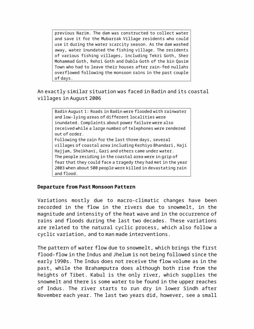
previous Nazim. The dam was constructed to collect water and save it for the Mubarrak Village residents who could use it during the water scarcity season. As the dam washed
away, water inundated the fishing village. The residents of various fishing villages, including Tekri Goth, Sher
Mohammad Goth, Rehri Goth and Dabla Goth of the bin Qasim Town who had to leave their houses after rain-fed nullahs
overflowed following the monsoon rains in the past couple of days.
An exactly similar situation was faced in Badin and its coastal villages in August 2006
Badin August 1: Roads in Badin were flooded with rainwater and low-lying areas of different localities were
inundated. Complaints about power failure were also received while a large number of telephones were rendered
out of order. Following the rain for the last three days, several
villages of coastal area including Kerhiyo Bhandari, Haji Hajjam, Sheikhani, Gari and others came under water.
The people residing in the coastal area were in grip of fear that they could face a tragedy they had met in the year 2003 when about 500 people were killed in devastating rain
and flood.
Departure from Past Monsoon Pattern
Variations mostly due to macro-climatic changes have been recorded in the flow in the rivers due to snowmelt, in the magnitude and intensity of the heat wave and in the occurrence of
rains and floods during the last two decades. These variations are related to the natural cyclic process, which also follow a
cyclic variation, and to man made interventions.
The pattern of water flow due to snowmelt, which brings the first flood-flow in the Indus and Jhelum is not being followed since the
early 1990s. The Indus does not receive the flow volume as in the past, while the Brahamputra does although both rise from the
heights of Tibet. Kabul is the only river, which supplies the snowmelt and there is some water to be found in the upper reaches
of Indus. The river starts to run dry in lower Sindh after November each year. The last two years did, however, see a small
channel of water carrying some water to the coast. The wide channel of the Indus downstream Kotri, remains dry but for
accumulation of saline water in ponds indicating intrusion of seawater upstream.
Precipitation on the east of Lake Mansarowar, the catchment area for the Brahamputra is heavy and either the winds slacken so as not to reach the catchment area of the Indus on the west or there
is not enough moisture in the clouds or snow cover left to contribute to the flow. Deforestation in the Eastern Himalayas
has been rampant and that has reduced the capacity of the area to act as rain forest. Now that melting of glaciers in the Eastern
Himalayas has been established, it is more than likely that the moisture laden winds that cross over the Eastern Himalayas are
able to precipitate their moisture more easily on the east than in its west side. That may be one reason for excessive flow in the
Brahamputra and reduced flow in the Indus and Jhelum.
The inadequacy of snowmelt in the Indus system did not raise the inflow at Tarbela or Mangla till mid-April and even on April 17 of
the year 2000, it was a mere 20,100 cusecs at the former and 26,300 cusecs at the latter dam. The low flow continued till past the
first week of May 2000. The observed low flow has been attributed to lower rainfall during the preceding five months. Since a
similar situation was faced in 1994 and 1997, it is quite likely that the process of slowing down of snowmelting at the glaciers
was contributing to low rainfall.
Heat Wave
Departure from past trend is inferred from visible expansion of heat zone. Much larger area in the north and south is reportedly
being affected by heat wave and the heat zone is no longer limited to Balochistan, Sindh, Rajasthan and Central India but extends to
Northern Areas of Pakistan and to Iran. The focus of the heat zone extends along the Nokundi-Sibbi-Jacobabad axis to Mianwali. The
departure from normal, as observed may not be unusual but is so persistent in recurrence as to suggest that either the
established monsoon pattern is not being followed or

modification of some sort, e.g. deforestation leading to extensive desertification has taken place, and that is being manifested by the intensity of heat wave over a wider area.
Loss of forest cover at the annual rate of 800 sq km is the reason for the decrease of the forest area from 26,000 sq km to only
19,000 sq km i.e. from 3.26% to 2.38% between 1980 and 1990.D esertification affects over 43 million hectares of landannually (Environment Policy of Pakistan 2005) . Deforestation rate has been
estimated at 0.2-0.5 percent per annum. Forest cover, which was 4.8 percent of total land area in 1992, could hardly be increased
substantially despite all efforts. Forestry has nevertheless been registering negative growth for three consecutive years,
registering a -9.7 per cent in 2005-06 as against a negative growth of -30.4 per cent (Economic Survey of Pakistan 2005-06).
Degradation and encroachment of natural forests, rangelands and
freshwater and marine ecosystems have resulted in loss ofbiodiversity (Environment Policy of Pakistan 2005) . At least four mammal
species, including tiger, swamp deer, lion and Indian one-horned rhinoceros, are known to have become extinct from Pakistan while
at least 10 ecosystems of particular value for the species richness and uniqueness of their floral and faunal communities
are considered to be critically threatened( National Environmental Policy
2005).
The deforestation process is not limited to collection of firewood but is quite extensive in that it involves removal of
vegetative cover for this use. This is borne out by another set ofdata which show that shrubs and weeds together contribute 5.84 %
of the total renewable energy source. This indicates the indiscriminate removal of forest cover. It may be added that some
of the weeds constitute the herbs, which grow in the forest areas and have a high value, if grown and harvested systematically. The
weeds are being removed ruthlessly so that there is no likelihood of their growth in future (Mirza Arshad Ali Beg, Comments on Pakistan National Communication on
Implementation of UNFCCC, May 2001).

The loss of vegetative cover from the forest base includes destruction of the mangrove swamps. Loss of the swampy area
implies a loss of surface area for absorption of CO2 which under the circumstances adds to its flux.
One of the main observations concerning the extension of the heat zone is related to an overall cooling as indicated by the Mean
Temperature recorded at practically all the Meteorological Observatories. Meteorological Data supplied by the Department
show that the annual mean temperature during the last 40 years has fallen in rural towns and increased in cities. In Badin the annual
mean temperature decreased from 27o C in 1960-70 to 26.5o C in 1970- 80, 26.7o C in 1980-90 and to 26.7o C in 1990-99. In Hyderabad a net
decrease of 0.2o C is observed for the last decade compared with the first, at Jacobabad there has been a decrease of 0.1oC
compared with the first decade, at Karachi there has been a net increase of 0.7o C during the period, at Nokundi a net decrease of
1.1o C is noted for the 1990-99 compared with the 1960-70 decade, for Quetta there is a net increase of 0.5o C and for Gilgit the net
increase is 0.2o C for the corresponding period, at Islamabad there is a net decrease of 0.6o C, at Lahore there is net increase
of 0.6o C while at Peshawar there was a net increase of 0.3o C.
This observation is explained by aridity introduced as a result of desiccation of the soil which increases the concentration of
particulate matter which do not absorb thermal energy but radiate it and thus are effective in cooling the surrounding air.
The mean maximum temperature at Badin decreased during the four decades under reference by 1.4o C, at Hyderabad it decreased by
0.7o C, at Jacobabad it decreased by 0.3 o C, at Karachi (Airport) it increased by 0.6 o C, at Nokkundi it increased by 0.4o C, at Quetta
it: increased by 0.4o C, at Gilgit it: increased by 0.7o C, at Islamabad it increased by 0.4o C between 1960 and 1990 followed by
a decrease showing no change in last decade from 1960-70 period, at Lahore an increase of 0.2o C was noted between 1960 and 1990 and
then a decrease of 0.1o C showing a decrease in last decade from 1960-70 period, while at Peshawar an increase of 0.9o C was
recorded.

Another important observation is the increase in precipitation noted at Badin (9%), Jacobabad (70%), Quetta (44%), Gilgit (21%),
Islamabad (35%), Lahore (39%) and Peshawar (37%), while a decrease is noted at Hyderabad (32%), Karachi (38%) and Nokkundi
(30%).
At Badin the annual mean precipitation has increased from 237 mm in the 1961-70 decade to 243 mm in the 1981-90 and to 259 mm in the 1991-99 period, which is a 9% increase over the
1961-70 decade. At Jacobabad the annual mean precipitation has increased
from 83 mm in the 1961-70 decade to 134 mm in the 1981-90 and to 141 mm in the 1991-99 period, which amounts to an increase of 70% over the 1961-70 decade.
At Quetta the annual mean precipitation has increased from 189 mm in the 1961-70 decade to 355 mm in the 1981-90 and to 272 mm in the 1991-99 period, which is a 44% increase over the 1961-70 decade.
At Gilgit the annual mean precipitation has increased from 120 mm in the 1961-70 decade to 131 mm in the 1981-90 and to 145 mm in the 1991-99 period, which is a 21% increase over the 1961-70 decade.
At Islamabad the annual mean precipitation has increased from 968 mm in the 1960-70 decade to 1293 mm in the 1981-90
and to 1312 mm in the 1991-99 period, which amounts to an increase of 35% over the 1961-70 decade.
At Lahore the annual mean precipitation has increased from 503 mm in the 1961-70 decade to 733 mm in the 1981-90 and to 698 mm in the 1991-99 period, which is an increase of 39%
over the 1961-70 decade. At Peshawar the annual mean precipitation has increased
from 390 mm in the 1961-70 decade to 413 mm in the 1981-90 and to 536 mm in the 1991-99 period, which is an increase of 37%
over the 1961-70 decade. At Hyderabad the annual mean precipitation has decreased
from 209 mm in the 1961-70 decade to 165 mm in the 1981-90 and to 142 mm in the 1991-99 period, which is a decrease of 32%
over the 1961-70 decade.
At Karachi the annual mean precipitation has decreased from 254 mm in the 1961-70 decade to 162 mm in the 1981-90 and to 158 mm in the 1991-99 period, which is a decrease of 38% over the 1961-70 decade.
At Nokkundi the annual mean precipitation has decreased from 42 mm in the 1961-70 decade to 31 mm in the 1981-90 and
to 31.5 mm in the 1991-99 period, which amounts to a decrease of 30% over the 1961-70 decade.
The cooling of the plains and the almost 30% increase in the precipitation has been recorded by the Meteorology Department
and also arrived at by the above analysis. The IPCC has, in its Special Report on Regional Impacts of Climate Change, An
Assessment of Vulnerability, compiled data for the Middle East and Arid Asia Region which includes Pakistan, shown that two-
thirds of the region covered by the Report has been classified as hot or cold desert. In the northern part of the region, a steppe
climate prevails, with cold winters and hot summers. A narrow zone contiguous to the Mediterranean Sea is classified as a
Mediterranean zone, with wet and moderately warm winters and dry summers. Permafrost zones exist in high mountain areas in the
southeast part of the region.
Annual temperatures in most of the Middle East region, according to the Report showed almost no change during the period 1901–96,
but a 1–2°C/century increase was discernible in central Asia. There was a 0.7°C increase during 1901–96 in the region as a
whole. The above analysis of data indicates a pattern significantly different from the Middle East countries since
there is an overall cooling effect accompanied by a rise in amount of annual precipitation. This pattern, being anomalous from IPCC
expectations, needs to be explained differently.
Social Implications of Temperature Rise & Heat Waves
Punjab and Sindh went through a blazing hot spell for more than a month. Multan recorded its hottest temperature on 15th May 1995
and lahore 44.3o C. Only on 10th May was there some cooling due to duststorm and light rain.

May and June are traditionally hot months. This year, however, the spring went on a little longer than usual and the onset of
summer was all too quick. On May 18 of 1994 the temperature at Lahore was 42o C, Sargodha 43, Shorkot 46, Sialkot 42, Multan 45o C.
The hot spell is broken by the monsoons in July and in the meantime occasional thunderstorms and light rains could bring some
relief.
The heatwave generally arrives from India because of the persistence of rain bearing systems for a few days over the Bay of
Bengal and eastern parts of India. The massive rains in eastern India divert the heatwave to Central and Upper Parts of Pakistan.
It was due to this diversion that many parts of the country except the north were experiencing sizzling heat in mid-May 1995. Multan and Dera Ismail Khan had recorded 45.5o C on May 16. Even Murri had
31o C. Karachi had better days since the temperature was around34o C.
Social Implications of Persistent Heatwaves Preceding MonsoonBreak
Severe heat wave incidents kill hundreds of people in Pakistan, India and Bangladesh. Women, children and the elderly are among
the dead. Temperatures have risen to between 45 and 50 degrees Celsius (113
to 122 degrees Fahrenheit), nearly 10 degrees above the normal level. People are unable to sit in the buildings because it become
unbearably hot. At the same time, they cannot go out because of the heat wave and fear of sunstroke. But for the thousands of
people living in tin-roofed shanties and other inadequate dwellings, or the homeless who sleep on the pavements, the
situation is a catastrophe.
Coastal areas have the highest concentrations of the poor fishermen all along the coastline. Lack of freshwater in the
Indus delta has pushed a number of fishermen in Badin district to change their professional affiliation from fisherman or mallah to
woodcutter, or daily wage laborers, street hawkers, beggars and homeless laborers. They are all forced to work outside, and
consequently have become the main victims of the heatwaves. A large number of people who are killed are those who survive on daily wages; they have no choice but to go out in search of work
everyday. There is also no water in the coastal area, even for animals. They have to walk two kilometres to get drinking water in
this scorching heat.
Despite daily reports of mounting disaster, the governing hierarchy downplays the extent of the crisis, claiming that the
death toll is lower than last year. Rather than the death rate remaining below previous years, worsening temperatures and a
lack of assistance is pushing it far higher. There are increasing numbers suffering sunstroke and severe dehydration, with
vomiting and high fever.
An emergency plan is needed to cut the disastrous number of fatalities but it requires massive funding to assist outdoor
workers and others most vulnerable to the heat, so they can remain indoors until temperatures drop. Emergency shelters need to be
provided for the homeless and accommodation for the poor substantially improved.
Cyclones
It is while the heat engine is on in the deforested areas of Pakistan and India that storms brew in the Arabian Sea and the Bay
of Bengal. As expected, a serious storm started pounding the Chittagong coastal areas and offshore of Bangladesh from 15th May
1995. The windspeed on 16th at Chittagong was 96 kph and at Cox's Bazar it was 72 kph. The airport in Chittagong was inundated by a storm surge from the Bay of Bengal and this suspended flights for
two days. 175 mm of rain was recorded at Chittagong in two days, 200 mm in Cox's Bazar and 100 mm in Dhaka, while it was also quite
heavy in other parts of the country. The storm flattened 10,000 shanty home along the coast and on islands in the Bay of Bengal,
leaving some 70,000 persons homeless. Some 50,000 were evacuated
to storm shelters but many were stranded in their villages that were inundated after floods breached embankments.
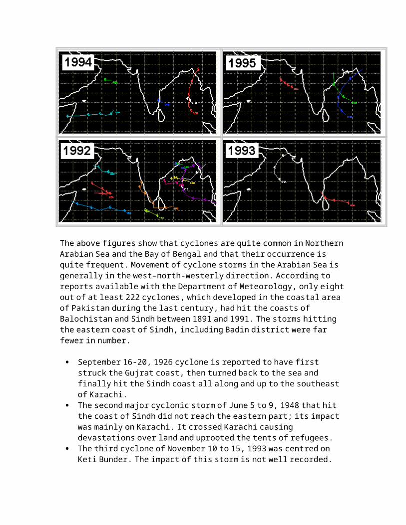
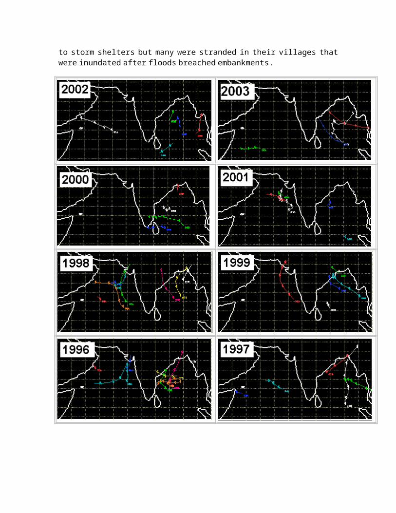
The above figures show that cyclones are quite common in Northern Arabian Sea and the Bay of Bengal and that their occurrence is
quite frequent. M ovement of cyclone storms in the Arabian Sea is generally in the west-north-westerly direction. According to
reports available with the Department of Meteorology, only eight out of at least 222 cyclones, which developed in the coastal area
of Pakistan during the last century, had hit the coasts of Balochistan and Sindh between 1891 and 1991. The storms hitting
the eastern coast of Sindh, including Badin district were far fewer in number.
September 16-20, 1926 cyclone is reported to have first struck the Gujrat coast, then turned back to the sea and
finally hit the Sindh coast all along and up to the southeast of Karachi.
The second major cyclonic storm of June 5 to 9, 1948 that hit the coast of Sindh did not reach the eastern part; its impact was mainly on Karachi. It crossed Karachi causing
devastations over land and uprooted the tents of refugees. The third cyclone of November 10 to 15, 1993 was centred on
Keti Bunder. The impact of this storm is not well recorded.

The fourth major cyclonic storm to hit the eastern coast of Pakistan was Cyclone-02A on May 19-20, 1999. It hit and
devastated extensive areas of the coastline of Badin and Thatta districts.
Cyclone-02A was, according to information available from SUPARCO, the most threatening cyclone during recent years. It had
started developing in mid-May, 1999. On May 19 it was, according to the Meteorological Department, still 40 km south of Karachi
with internal sustained wind of 110 to 115 knots and likely to cause a tidal surge of 3 to 4 metres. The storm, however changed
direction at the last moment and hit the coastal area of Thatta and Badin districts while Karachi remained in the peripheral area and only rain showers of moderate intensity were recorded.
The coastline of Sindh has, because of the low occurrence of storms, been classified outside the zone of cyclone activity of
the Arabian Sea. Thunderstorm frequency is also low and is reported to occur at an average rate of 10 thunderstorms/year.
During the last few years, however, rainstorms have been threatening the coastline of Badin and Thatta districts. These
have been noted to occur during the mid-May and early June period and are cause for rainfall in the areas that lie in Thatta, Badin,
as well as Tharparkar and Rajputana in the north of the Rann ofKutch.
Social Implications of Storms in Coastal Region
Tropical cyclone 01A was in the Arabian Sea at a distance of 800 km from Karachi at mid-night on Sunday. It was moving at a speed of
3.7 nautical mile per hour on Saturday, and while heading in the north-north-westerly direction at a speed of 10 nautical miles
per hour was gaining speed on Sunday. It was said to be moving with maximum sustained winds of 50 nautical miles or 92.6 km per hour, gusting to 60 nautical miles or about 110 km.
Tropical cyclones with maximum sustained surface winds of less than 62.4 km per hour are called tropical depressions. When winds
reach a speed of 110 km/hour they are called a hurricane in the

North Atlantic Ocean, the Northeast Pacific Ocean east of the dateline, or the South Pacific Ocean east of 160E; a typhoon in
the Northwest Pacific Ocean west of the dateline; a severe cyclonic storm in the North Indian Ocean, and a tropical cyclone
in the Southwest Indian Ocean. By classification then Cyclone 01A is a severe cyclonic storm.
The speed of a severe tropical cyclone such as 01A usually increases and tropical cyclone 01A was likely to enter the north
Arabian Sea on Monday and create very rough conditions on the sea and widespread rains/dust-thundershowers were expected in lower
Sindh, with some moderate to heavy rainfall in Badin and Thatta districts and adjoining areas of the Balochistan coast during the following 48 hours.
Cyclone 01A had moved from 15.0N and 72.3E at 0230 Hours on May 09 to 19.5N 67.2E at 2030 Hours on the same day and was reported to be at 18.5 N 70 E at 0000 Hours on May 10. This change in direction
diverted the cyclone towards the Western Coast of Gujrat inIndia.
Tropical cyclones such as 01A that is in the news now or 02A that destroyed vast areas of Badin District in May 1999 are packed with
tremendous energy and constitute the most powerful and destructive meteorological systems on earth. 80 to 100 of them
develop over tropical oceans of the earth each year. Many of them make landfall i.e. they strike the coastline and can cause
considerable damage to property and loss of life as a result of high winds and heavy rains.
Tropical Cyclones occur primarily during summer in the Northern Hemisphere and during autumn in the Southern Hemisphere. The peak
in summer/autumn is due to having all of the necessary conditions for development of a cyclone become most favorable during this
time of year. The necessary conditions for development of cyclones are warm ocean waters with temperatures of at least
26°C, a tropical atmosphere that can quite easily kick off convection causing thunderstorms, low vertical shear in the

troposphere, and a substantial amount of large-scale spin available, either through the monsoon trough or easterly waves.
In the North Arabian Sea the ocean reaches its warmest temperatures in the month of May and thus the conditions for
peaking of the cyclones are obtained. The cyclones therefore do not have to wait for the time of maximum solar radiation, which is
late June for the tropical Northern Hemisphere. The atmospheric circulation in the tropics also reaches its most pronounced and
favorable for tropical cyclones at the same time.
Modification of Cyclones: It has been quite tempting to modify, if not destroy cyclonic storms by various techniques such
as: seeding clouds with dry ice or Silver Iodide, cooling the ocean with cryogenic material or icebergs, changing the
radiation balance in the cyclone environment by absorption of sunlight with carbon black, blowing the cyclone apart with hydrogen bombs, and blowing the storm away from land with
windmills, etc. The rationale behind these suggestions sounds reasonable but they do not seem to take into consideration the tremendous amount of energy that each system carries with it.
When Hurricane Andrew struck South Florida in 1992, the eye and eyewall i.e. the center of cyclone, devastated a 20 miles wide
strip of land on its course. The heat energy released around the eye was 5,000 times the combined heat and electrical power
generation of a nuclear power plant over which the eye passed. The kinetic energy of the wind at any instant was equivalent to that
released by a nuclear warhead. We may fight a cyclone of such severity if we travel at nearly the speed of light. We may then
have enough energy for intervention in the cyclone dynamics. The energy involved in atmospheric dynamics is primarily low-grade
heat energy, but the amount of it is immense in terms of human dimensions.
Attacking weak tropical waves or depressions before they have a chance to grow into hurricanes is not very promising. About 222 of
these disturbances formed in the Arabian Sea during the last century and about 80 of disturbances form every year in the
Atlantic basin, but only about 5 become cyclones in a typical

year. There is no way to tell in advance which ones will develop. If the energy released in a tropical disturbance were only 10% of
that released in a cyclone, it will still be a lot of power, so that the hurricane police may need to dim the lights of the whole
world many times a year.
These may be ideas but not solutions. Perhaps the best solution is not to try to alter or destroy the tropical cyclones, but just
learn to live with them. Since we know that coastal regions are vulnerable to the storms, building codes that can have houses
that withstand the force of the tropical cyclones need to be enforced. The people that choose to live in these locations, such
as the Defence Housing Scheme, should be willing to shoulder a fair portion of the costs in terms of property insurance that may
truly reflect the risk of living in a vulnerable region. It is at the same time necessary to educate the public on effective
preparedness.
Helping poor countries in their mitigation efforts can also result in saving innumerable lives. Finally, we need to continue
in our efforts to better understand and observe tropical Cyclones in order to more accurately predict their development,
intensification and track.
Abnormal Winter Rainfall & Social Implications
Winter Rainfall of devastating nature are not unusual because they are brought every year by five or six storms that cross over from the Mediterranean started into Pakistan. It is the same
storms which bring rains and snow all over the hilly areas of Balochistan, NWFP and Kashmir. Occasionally they are of very high
intensity and are cause for extensive damage to the coastal areas of Balochistan. In 1999 the storm had struck the Gawadar area with
such intensity that River Kalamat changed its course.
Torrential rains had pounded the south coast and northern Pakistan only four years back on 15th February 2003. Heavy snowfalls blanketed northwestern and northeastern border areas
on 15 Feb 2003. As far as the rains were concerned, these were the

heaviest in 30 years area and intensity. Heavy rains and snow across Pakistan battered parts of the country, with reports of deaths and devastation caused to land and households. Much of the damage was caused by micro-tornados one of which struck the
outskirts of Karachi at Gadap and the other struck Sheikhupura.
In the year 2005 the intensity of the storms was much severe. The wet spell had started in the north since the beginning of December
2004. Many parts of the NWFP, northern Balochistan and the Punjab, including twin cities of Islamabad and Rawalpindi, received first winter rains while light snowfall was reported
from hills and mountains of Northern Areas. This was followed almost one month later by heavy rains and snow to ease the fears of
drought in Pakistan and to boost its key agriculture sector.
The widespread winter rains and snow in the last week of January 2005 alleviated the danger of drought and ensured of meeting the
country’s water needs for the current season. These were in complete contrast with the warnings of drought last year by Pakistan Meteorological Department. That warning was issued
after the agricultural provinces of Baluchistan, Sindh and Punjab received from 25 to 75 percent less monsoon rain than usual
in the June to mid-September period.
Greater than normal rains and snowfall started in most parts of the country, while other areas received heavy rain or snowfall
starting from January 21, 2005. The Margalla Hills overlooking Islamabad received snow for the first time in about eight years
and even rugged regions like South Waziristan in the country’s northwest and the southwestern town of Chaman, both close to the
Afghan border received heavy snow for the first time in years.
While the storms from the Mediterranean Sea that bring the winter rains in Pakistan, were still at the Hindukush-Himalaya-
Karakorum Mountain tops and bringing snowfall there and rains in the valleys of Afghanistan, NWFP, and Kashmir, another strong
system was developing on February 1, 2005 over Iran and Afghanistan and on the next day it had started moving from the
south of Iran.

On 4th of February it was more than clear that the storm had extensive dimensions and would, in heading towards the entire
western sector of Pakistan, take a southerly course and would travel along the coastline. On the 6th it had strengthened the
northerly storm and in the following days the system had started descending on southern Balochistan. On the 8th and 9th the two
weather systems had engulfed the entire area of Pakistan. The movement of the two systems was like a pincer movement one in the
north heavily impacting Afghanistan, NWFP and Kashmir and the other creating havoc in the coastal areas of Balochistan.
The wet spell that had started from the end of December got prolonged as a result of the overlapping of the two weather
systems. Peshawar, Chitral, Mansehra, Swat, Buner, Dir, Malakand and Hazara had been receiving intermittent rains until
the 11th . The Pakistan Meteorological Department said that snowfall and rain in the country had exceeded the normal levels.
Peshawar received 131mm of rain in January 2005 that was only two millimetre less than the highest ever recorded for the month in
1942. In the corresponding month of last year, the provincial capital had recorded only 64mm of rain. In February so far, it has
recorded 97mm of rain, a much higher than 60mm of rainfall in February 2004. Other parts of the Frontier province recorded a
similarly high level of rainfall when compared with the previous five years. The PMD's observatory in Chitral recorded 92mm of rain in February and 50.6mm in January. The one in Parachinar
noted 140mm of rain in January and 110mm in the first 11 days of February.
The second system was more devastating than the former and it brought catastrophic rains in the coastal area and heavy rains in Chagai, Nushki, Kharan, Mastung, Khuzdar, Kalat, besides the
districts of Awaran, Lasbela, Gwadar and Kech.
The situation in the flood-affected areas of Balochistan worsened on the 13th as a fresh spell of heavy rain lashed the province and swelled all the seasonal rivers in medium to high

floods and hampered relief operation. The situation became extremely serious in Suntesar where dozens of villages and human
settlements are still under water. The Dasht River and its tributaries of Nihing and Kech Kaur are swollen with flood water.
Chalvi dam in Kolach union council in Pasni Tehsil and Gawar Bagh dam in Turbat district burst in the afternoon due to persistent
rains and flash floods. About 50 villages were inundated by the bursting of the two dams while breeches in Gaggo dam in Lasbela
district, forced villagers to take refuge on nearby hills. Earlier, they were reported missing.
Hingol recorded a discharge of more than 300,000 cusecs. A bridge on the river has been badly damaged. Flood water was reported
standing three to four metres above the bridge over the Hingol river, eroding its sides by 300 to 400 feet. The Gugu dam
downstream of the Hingol river was swept away in the fresh rain, according to reports.
The major towns of Ormara, Pasni, Gwadar and Jiwani along the Balochistan coast remain completely cut off from other parts of
the country, except for the air link established to rush relief supplies.
Vehicular traffic between Karachi and Gwadar through the Coastal Highway remains suspended and if the bridge over the Hingol river
collapses or is washed away, communication between Karachi and Gwadar will suffer a serious setback. Hingol is the biggest
seasonal river of Balochistan with a catchment area of more than 2,500 miles, starting from central Balochistan to Ormara.
Gwadar area was hit by flash floods while areas around Pasni were hit when the Shadi Khor dam, which had been recently constructed,
could not withstand the massive pressure of rainwater and gave way, flooding many areas and affecting a large number of people
living in many small villages downstream. The Shadi Khor damat Pasni, which had been constructed only recently, had been
completely filled and it had enough water to meet requirements of the Pasni town for four years, but unfortunately it broke down.
The reasons for the dam-break, including its construction quality, would need to be thoroughly investigated.
Social Implication of Climate Variation on Crop Performance
The temperature and precipitation data may seem anomalous with respect to IPCC elucidations but are supported by the statistics
on crop performance that are available from different regions of the world. These data show that the year-to-year variation in
growth and development of winter crops e.g. wheat is due to changes in weather. Cool and moist weather during early growth,
and warm and dry weather during grain formation is by and large regarded as ideal for such crops. This was exactly the condition
that prevailed during 1999-2000 in irrigated areas of Punjab and Sindh and that brought a bumper crop during that year.
It mustbe
Over the last five years, growth in agriculture has witnessed a mixed trend. During the first two years (2000-01 and 2001-
02), the country experienced the crippling drought, which badly affected its agriculture and eventually overall growth
in agriculture turned negative for these two years. In the preceding years (2002-03 to 2004-05), relatively better
availability of irrigation water had positive impact on overall agricultural growth and this sector exhibited a
modest to strong recovery.
However, the performance of agriculture during the fiscal year 2005-06 has been weak. Against the target of 4.2 per cent
and last year’s achievement of 6.7 per cent, overall agriculture grew by 2.5 per cent in 2005-06, due to a
relatively poor performance of major crops and forestry, and weaker one of minor crops and fishery. At the same time,
Livestock has been the sole saving grace. Major corps, accounting for 35.2 per cent of value added in agriculture, registered a decline of 3.6 per cent as production of two of
the four major crops, namely cotton and sugarcane has been significantly less than last year for a variety of reasons
including, excessive rains at the time of sowing, high temperature at the flowering stage, late harvesting of wheat
crop, a strong base effect (cotton) and lastly the incidence of frost, damaging sugarcane crop in the month of January,
2006. The production of third major crop, namely wheat, remained more or less at last year’s level at 21.7 million
tons thereby registering a meagre growth of 0.4 per cent. The production of rice, the fourth major crop, has been the sole
major crop which registered an impressive growth of 10.4 per cent, but failed to turn the negative growth in major crops to
a positive one.
mentioned here that low temperature during the month of January and February markedly affect vegetative growth in general and of
wheat in particular. This is the desired condition that was obtained in 1999-2000. It may be compared with that prevailing
during the previous years except 1998-1999 when there was a foggy and misty weather of four weeks from December 17 to January 14
which was the highest vegetative growth period and the yield was adversely affected as a result of reduced sunshine. During the
year 1999-2000, low temperatures had beneficial effect on the vegetative growth. The natural forces that control growth and
development of crops have therefore not lost ground to global warming as observed elsewhere but neither in Pakistan nor in the
Middle East.
It must be emphasized that temperature influences early chemical, physiological and biological process in plants by
solubilising minerals and organic solutes and providing them in their tissue at the most critical stages of physiological process
in plant life. The suggested impact of global warming and its evaluation by the model for its projection to the year 2020 and
2050 is therefore not supported by the observed meteorological data. If there has not been a bumper wheat crop earlier on it is
for different reasons that are related to the outmoded agricultural practices, but not to the climate change so far.
The temperature data indicate that neither the temperature of the plains in Pakistan has increased at a rate of 0.3o C/decade nor has
the precipitation decreased by 1% per decade. So far as Pakistan is concerned there is little evidence of gradual warming. The
conclusions drawn for substantiating the above figure, describing heat stress vulnerability do not seem to be valid
because the temperatures during the maturity and seed formation period are within the suggested range. The high temperatures are
and have to be reached at the ripening stage.
Climate and wheat productivity
Wheat production in the year 1999-2000, was extraordinarily high, despite the total availability of irrigation water being
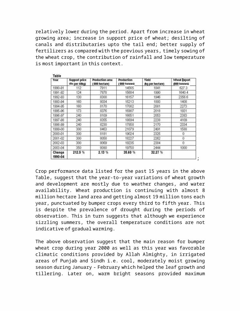
relatively lower during the period. Apart from increase in wheat growing area; increase in support price of wheat; desilting of
canals and distributaries upto the tail end; better supply of fertilizers as compared with the previous years, timely sowing of
the wheat crop, the contribution of rainfall and low temperature is most important in this context.
;
Crop performance data listed for the past 15 years in the above Table, suggest that the year-to-year variations of wheat growth
and development are mostly due to weather changes, and water availability. Wheat production is continuing with almost 8
million hectare land area and getting almost 19 million tons each year, punctuated by bumper crops every third to fifth year. This
is despite the prevalence of drought during the periods of observation. This in turn suggests that although we experience
sizzling summers, the overall temperature conditions are not indicative of gradual warming.
The above observation suggest that the main reason for bumper wheat crop during year 2000 as well as this year was favorable
climatic conditions provided by Allah Almighty, in irrigated areas of Punjab and Sindh i.e. cool, moderately moist growing season during January - February which helped the leaf growth and
tillering. Later on, warm bright seasons provided maximum
sunshine for photosynthesis, and the dry harvest period. This is besides the increase in wheat price.
Analysis of Events
Pakistan is not isolated in the crisis of erratic climatic variations or in maintaining its water budget. Scarcity of water
is looming large all over the arid regions of the earth. The crisis in the monsoon region is in the interruptions of the cycles
of wetness and dryness and that has become prominent during the last fifteen years. It is this crisis that is seeking answers on
whether it is due to changes in climate resulting from the cyclic events that govern the climate, and if so, whether it is of
permanent nature, or it is due to the ecosystem misbalance induced by man made interventions.
Observations on the pattern of flow due to snowmelt, intensity of heat wave, precipitation data and occurrence and severity of
floods in the region do suggest that some alteration has occurred in the system, in general and at the tail end of the monsoon cycle in particular. The monsoon system has, in not following its
previous pattern, resulted in water scarcity and serious drought conditions over extensive areas, which are continuously
expanding.
The failure of the monsoon system could be due to interventions in the cyclic processes that govern the water balance on the earth.
Explanations can just as well be provided in terms of cycles of wetness and dryness as done by Shnitnikov’s analysis (G.P. Kalinin and V.D.
Bykov, The World Water resources, Present and Future, in Ecology of Man: An Ecosystem Approach, ed. R. L. Smith,
Harper & Row Publishers, New York, 1972) , and in terms of El Nino and La Nina factors that are a local manifestation of global events taking
due account of the persistent domination of these events(Maryam
Golnaraghi and Rajiv Kaul, Responding to ENSO, Environment, January-February, 1995) .
Shnitnikov analysis of the variation in ground and surface water, glaciation and changes in plant communities shows the existence

of a general law of terrestrial humidity cycle, which repeats every 1800 to 2000 years. The results are confirmed by the cycles
of snow cover and glaciation. The present erratic variations attributed to climate change may very well be following the
terrestrial cycle by which the earth may be passing through a transitory period from highly humid to a dry phase. The droughts
are becoming too frequent because continents are losing their share of land while oceans are gaining in volume of water and
expanding in area. The above conclusions are based on the observations over the last century, which show that 430 cubic km
of water are being lost annually from the land and the level of seawater is rising at a rate of 1.2 mm annually (G.P. Kalinin and V.D. Bykov, The
World Water resources, Present and Future, in Ecology of Man: An Ecosystem Approach, ed. R. L. Smith, Harper & Row
Publishers, New York, 1972).
Periods of greater and lower humidity affect vast areas of the earth but at no time do they involve the whole of the earth. The
period of high humidity in one part is accompanied by reduced humidity elsewhere. Glaciers have been receding in Eastern Himalayas but are still firm on the western side. The period of
run-off in the drainage basins of the major rivers and the boundary of such areas is fairly constant and seems to follow a
cycle extending over a certain number of years. For example, between 1926 and 1930 the run-off was abundant in Europe and North
America, but it was reduced in the rest of the Northern Hemisphere. For the 1931 to 1940 period there was rever sal; the
area excluding Europe and North America received higher run-off. The peak and low discharges in the run-off occur at different
times in the different well defined but large zones of the earth17.
Cyclic variations in stream flow of rivers, were analyzed byKalinin (G.P. Kalinin and V.D. Bykov, The World Water resources, Present and Future, in Ecology of Man: An
Ecosystem Approach, ed. R. L. Smith, Harper & Row Publishers, New York, 1972) who suggested that cycles that recur most frequently are with periods of 2 to 3, 5 to
7, 11 to 13 and 22 to 28 years. The 11 to 13 year cycles are regarded normally as being governed by solar activity. Cycles of dryness
and wetness have been well recorded for Karachi and they are adequately explained by Shnitnikov analysis.

Long dry spells are not common on the coastal areas of Pakistan that includes Karachi; the maximum period ranges from 7 to 9
months over a period of at the most one year. However, the drying up of Hub dam and its refilling; reduced water flow in the Indus
are indications that perhaps the persistent domination of La Nina factor has induced a climate change that has disrupted the cyclic
process. The cycle of dry spells repeats in 47 to 53 years, the first one to be noted was from October 1857 to June 1858, the
second from April to December 1904. This cycle repeated as expected in 1951 when there was low rainfall. The last ones that occurred were in 1987 followed by that in 1993 and now in 1999 and
2000.
The gap between heavy rain years in Karachi varies from 4 to 11 years with the longest one extending over 50 years. Records are
available to suggest that there is the periodicity of 50 years e.g. 1863 (347 mm), 1913 (341 mm), and 1961 (610 mm); for 1866 (343 mm), 1916 (555 mm), and 1967 (713 mm); 1878 (605 mm), 1926 (509),
and 1977 (207), and for 1894 (577 mm), 1944 (745 mm), and 1994 (450 mm). S.N. Naqvi had, in his analysis of the meteorological data,
suggested the existence of a short cycle of 3 to 5 years, a medium cycle of 10 to 13 years, a Bruckner's cycle of 18 to 23 years and a
long cycle of 50 years. The data indicate large fluctuations from year to year but there is genuine orderliness among them over a
decade and still better correlations over a 30 year period(Mirza
Arshad Ali Beg, Shocks of the rain and flood havoc, Pakistan and Gulf Economist, Aug12-18, 1995).
The available records apparently suggest that the natural process of compensating the deficit of one year with excess in the
following year has been able to adequately maintain the water balance in Karachi. The present crisis of shortage of water could
therefore be considered as part of the natural system. The cycle of precipitation, if the data have any meaning, suggests that
since the deficiencies of the past years are compensated, the two years following 1995 and 1996 should have been deficit years and
that the next dry spell should have occurred in 1999 (Mirza Arshad Ali Beg,
Shocks of the rain and flood havoc, Pakistan and Gulf Economist, Aug12-18, 1995) . Incidentally this happens to be the case, and indeed the year 2007 has been a very rainy year. The critical situation, which has precipitated

in the form of drought, thus appears to be part of the natural repetitive cycles.
The social implications of disasters resulting from erratic climatic changes, specifically the monsoon system, are grave.
Coastal areas are particularly exposed to the vagaries of erratic changes in the climate, whether they are due to natural hazards or
global environmental consequences.
In Pakistan and developing countries of the region they are mainly due to lack of preparedness for the eventualities. Early
warning system, contingency plan and timely availability of assistance from government authorities are conspicuous by their
absence. The microenvironment of the disaster is particularly at stake. In the case of floods, storms and tidal surge, the impact
is widespread and is not limited to the microenvironment but extends over to the macroenvironment and also the global
environment.
The plight of such a vast number of people for several weeks has raised questions on the efficiency of the government in tackling
disasters. The damages are usually higher at each successive episode. In this background, the claims about rescue and relief
operations made by the government daily at its official briefings are viewed as nothing but statistical gimmick.
The limitations of the relief operations arise due to the conspicuous absence of contingency plans and lack of preparedness to deal with the impact of disasters. While the
monsoons in certain areas may be heavy, many parts of Pakistan confront the danger of flooding every year with potentially
devastating consequences for millions of people. Environmental disasters caused by global environmental complexities are
creating problems for Pakistan which is threatened with desertification and degradation of land due to rapid increase in
population and growing pressure on the natural resource base to meet the needs of its people and for earning foreign exchange. Yet, the money for the necessary flood prevention, including

adequate dams and levees, warning systems and emergency relief is not available.