"Site Selection for US Unmanned and Manned Lunar Missions"
53
Site Selection for U.S. Unmanned and Manned Lunar Missions 1964 to 1972 JPL April 6, 2010
-
Upload
independent -
Category
Documents
-
view
1 -
download
0
Transcript of "Site Selection for US Unmanned and Manned Lunar Missions"

Site Selection for U.S. Unmanned and Manned Lunar Missions
1964 to 1972JPL
April 6, 2010

AgendaFootprints at the Snowman: Why Land Here?Apollo Zone of Interest: Early Choices for Possible LandingsLanding Site SelectionSpecific Initial Operational ConsiderationsZone of InterestPlanning for Manned Landings--What’s There?Ranger, Surveyor, Lunar OrbiterRanger SurveyorLunar OrbiterLunar Orbiter CoverageRanger, Surveyor, Lunar Orbiter Overview
Results: the Selected SitesAfter Apollo 12: Target RevisionsSurveyor 3Whitaker hunts the SnarkInitial Site Selection for AS-12AS-11 Lands LongResurrecting Surveyor 3Using Surveyor to Find SurveyorSurveyor Becomes the TargetPinpoint LandingAfter 12Differences in Mission ConstraintsCapturing the StoryReferencesAppendicesWhitaker’s original article

Footprints at the Snowman: Why Land Here?
November 1969: Apollo 12, the second manned lunar mission, lands in the Known Sea, Ocean of Storms, at the site first explored 31 months prior by Surveyor 3. Why was this site chosen?

Apollo Zone of Interest: Early Choices for Possible Landings

Landing Site Selection• From the beginning, site selection weighed the scientific objectives and operational concerns, with one issue overriding all others: Kennedy’s challenge. • Process begins in 1961. Harold Urey of UCSD produces a list of sites of greatest scientific interest: high latitudes (seeking water); inside a large crater; in two maria of different types; near one of the great wrinkles in the maria; and in a mountainous region, but from the outset, operational considerations dominate. • March 1962: AT&T subsidiary Bellcomm, Inc., counsels NASA's Office of Manned Space Flight on operational issues, communications network and technical support for the Apollo program. Bellcomm creates the Apollo Landing Zone.• July 1965: NASA establishes an Apollo Site Selection Board to select landing sites for individual missions from recommendations made by Bellcomm's Group for Lunar Exploration Planning.

Specific Initial Operational Considerations (1)
• Smoothness: Relatively few craters and boulders; surface characteristics consonant with safety for manned activity, i.e., firmness and support for the LM and the astronauts.
• Approach: No large hills, high cliffs, or deep craters that could cause incorrect altitude signals to the lunar module landing radar.
• Propellant Requirements: The least expenditure of spacecraft propellants.
• Free Return: Within reach of the spacecraft launched on a free-return translunar trajectory if the SPS fails.
• Slope: Less than 2° slope in the approach path and landing site.

Specific Initial Operational Considerations (2)
• Flat terrain that would offer a margin of error for the approach; target area an ellipse of 12 mile by 3 miles to anticipate navigation errors of 1.5 miles north or south and 2.5 miles east or west, representing represented 50, 90, and 100 percent dispersion possibilities.
• Allowance for possible interference with communication caused by solar activity
• Landings at lunar sunrise for relief visibility (sun 5-13° over horizon); approach from the east with the sun behind; splashdown in daylight
• Recycle: Effective launch preparation recycling if the Apollo Saturn V countdown is delayed
• Eastern and western bounds of possible landing areas limited by constraints of the LM guidance system during final descent, requirement for unbroken communications with MC
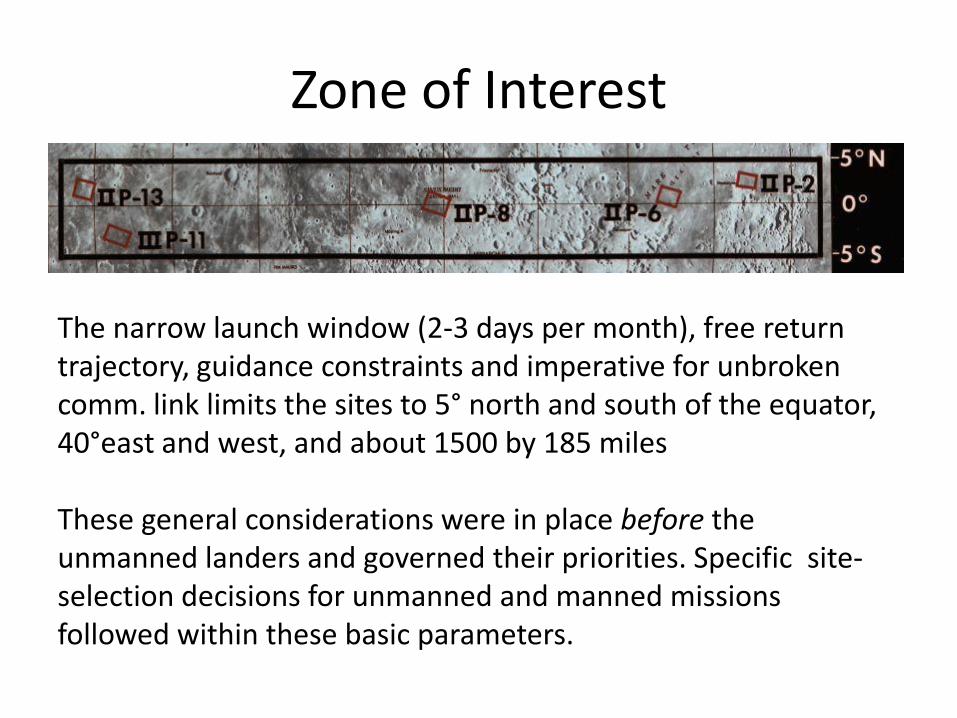
Zone of Interest
The narrow launch window (2-3 days per month), free return trajectory, guidance constraints and imperative for unbroken comm. link limits the sites to 5° north and south of the equator, 40°east and west, and about 1500 by 185 miles
These general considerations were in place before the unmanned landers and governed their priorities. Specific site-selection decisions for unmanned and manned missions followed within these basic parameters.
Ranger, Surveyor and Lunar Orbiter: Planning for Manned Landings--What’s There?

Inadequate Telescopic Data

Inadequate Telescopic Data

Challenges Under DeadlineAt the time of Kennedy’s challenge with safety uppermost:
• Nature of the surface unknown
• Speculation on deep dust indicated by radar
• Telescopic observation offers inadequate topographical detail
• First task: comprehensive reconnaissance, surface testing and cartography
• JPL’s Surveyor and Ranger in progress; retasked for lunar exploration
• Lunar Orbiter commissioned to photograph the Zone of Interest and as much else as possible

Ranger, Surveyor, Lunar Orbiter

Ranger
• 1961-1965• JPL• Photoreconnaissance• High impact • Hard landers• Most failed; first success was
Ranger VII in 1964• Ranger 8 succeeds in
surveying Mare Tranquillitatis, first close-up views indicating suitability of Site 2; Ranger IX examines Alphonsus

Surveyor
• 1966-1968• Hughes• First successful US soft lander;
seven missions, five successes • Tested surface weight bearing
characteristics (disproves Gold) • Local photographs, television;
86,000+ 70-millimeter pictures at high res (to 1 mm)
• Soil composition, chemistry, mechanics, impact, trenching, magnetic properties, and composition
• Thermal testing
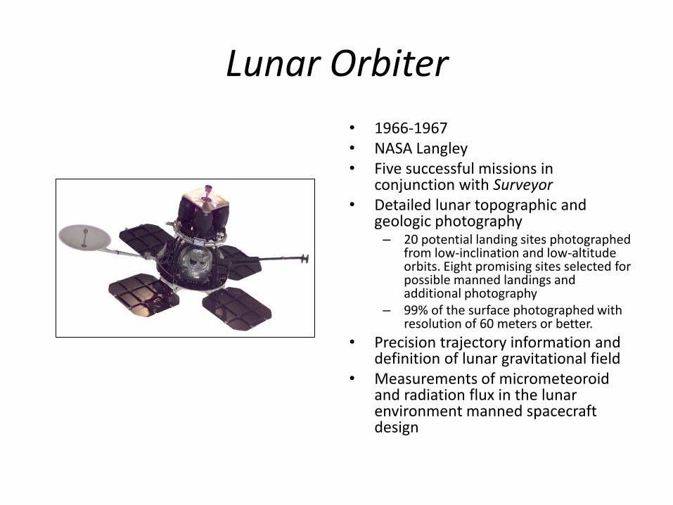
Lunar Orbiter
• 1966-1967• NASA Langley• Five successful missions in
conjunction with Surveyor• Detailed lunar topographic and
geologic photography– 20 potential landing sites photographed
from low-inclination and low-altitude orbits. Eight promising sites selected for possible manned landings and additional photography
– 99% of the surface photographed with resolution of 60 meters or better.
• Precision trajectory information and definition of lunar gravitational field
• Measurements of micrometeoroid and radiation flux in the lunar environment manned spacecraft design

Lunar Orbiter Coverage

Results: Selected Sites
Narrowed to five Zone of Interest mare-based sites• ALS1 and ALS2 in Mare Tranquillitatis. ALS1 discounted
as too far east. ALS2 becomes Statio Tranquillitatis.• ALS3 in the Sinus Medii to be used as a backup for ALS1
and ALS2 in the event of a 48-hour launch delay.• ALS4 and ALS5 in the Oceanus Procellarum.
Backup candidates• ALS6 in Procellarum, Surveyor I site inside the
Flamsteed Ring• ALS7 in Procellarum, Surveyor III site

Results: Lunar Cartography

Surveyor 3
• Launched April 17, 1967• Landed April 20, 1967 at the
Mare Cognitum portion of the Oceanus Procellarum
• Transmitted a total of 6,315 TV images to the Earth
No further interest from NASA. The S3 site felt to be of insufficient scientific interest to return with a manned mission, but a team member from the LPL pursues the final question: where is it?

Whitaker Hunts the SnarkEwen A. Whitaker• British-born astronomer
specializing in lunar studies• Astronomer at the Royal
Greenwich Observatory• Director of the Lunar Section
of the British Astronomical Association
• Joined staff of the Yerkes Observatory
• In 1960 left Yerkes, along with Gerard P. Kuiper, helping found the Lunar and Planetary Laboratory at the University of Arizona, eventually becoming research scientist emeritus
The value of the data transmitted by the various successful landed Surveyor spacecraft is considerably augmented when actual locations of these craft can be found on Orbiter photographs of their respective landing sites.

Initial Site Selection for AS-12

AS-11 Lands Long

Resurrecting Surveyor 3

Final Site Selection for AS-12

Using Surveyor to Find Surveyor
“Some time after spacecraft touchdown, we were presented with a hastily assembled mosaic of about eight wide-angle images, brought in by Gene with his words ‘Hey, guys, we're on the inner east slope of a shallow crater’, or words to that effect. This was obvious from the direction of shadows behind rocks, and from the slope of the horizon. The problem of glare was noticeable in all of the separate images, in this case from the brightly illuminated crater wall shining on the mirror dust.”

Using Surveyor to Find Surveyor

Using Surveyor to Find Surveyor

Using Surveyor to Find Surveyor
“The next item was to try to pinpoint this particular crater on Lunar Orbiter 3 images which had blanketed a large area around the target landing spot months earlier. The S/C tracking people gave us their best estimate of the lunar coordinates of the landing location (2.99°S., 23.37° W.) together with the size of the probable-error ellipse. Now the major problem was to determine the location of this ellipse on the Orbiter photos, which of course, do not have a latitude/longitude grid marked on them. Fortunately, three tiny craters drawn on the best map available were also included in the Orbiter 3 coverage, from which I was able to determine that the central third of Orb. frame H154 most likely contained ‘Surveyor crater,’ but it might also just be on any of the adjacent eight frames.”

Using Surveyor to Find Surveyor

Using Surveyor to Find Surveyor

Using Surveyor to Find Surveyor

Using Surveyor to Find Surveyor

Surveyor Becomes the Target

Pinpoint Landing

At the Snowman

LRO of the Snowman

Inside the Surveyor Crater

Inside the Surveyor Crater

Inside the Surveyor Crater

Surveyor 3 Camera

After Apollo 12
• Cancellations force NASA to accelerate the program and make more ambitious leaps.
• H-2 (Apollo 13/14) Fra Mauro• H-3 (Apollo 14) Littrow• H-4 (Apollo 15) Censorinus• J-2 (Apollo 17) Marius Hills• J-3 (Apollo 18) Copernicus• J-4 (Apollo 19) Hadley• J-5 (Apollo 20) Tycho• J-1 (Apollo 15) Hadley Rille• J-2 (Apollo 16) Descartes• J-3 (Apollo 17) Taurus-Littrow

Mission Planning Constraints
• Smoothness: Relatively few craters and boulders; surface characteristics consonant with safety for manned activity, i.e., firmness and support for the LM and the astronauts.
• Approach: No large hills, high cliffs, or deep craters that could cause incorrect altitude signals to the lunar module landing radar
• Propellant Requirements: The least expenditure of spacecraft propellants
• Free Return: Within reach of the spacecraft launched on a free-return translunar trajectory if the SPS fails
• Slope: Less than 2° slope in the approach path and landing site.
• Flat terrain that would offer a margin of error for the approach; target area an ellipse of 12 mile by 3 miles to anticipate navigation errors of 1.5 miles north or south and 2.5 miles east or west, representing represented 50, 90, and 100 percent dispersion possibilities.
• Allowance for possible interference with communication caused by solar activity
• Landings at lunar sunrise for relief visibility (sun 5-13° over horizon); approach from the east with the sun behind; splashdown in daylight
• Recycle: Effective launch preparation recycling if the Apollo Saturn V countdown is delayed
• Eastern and western bounds of possible landing areas limited by constraints of the LM guidance system during final descent, requirement for unbroken communications with MC

Capturing the Story of the Snark

Capturing the Story of the Snark

References
• Apollo Missions - Landing Site Selection. http://www.bbc.co.uk/dna/h2g2/A1110367. Accessed 04/03/10
• Byers, Bruce K., NASA TM X-3487 DESTINATION MOON: A History of the Lunar Orbiter Program April 1977. http://history.nasa.gov/TM-3487/top.htm. Accessed 04/03/10
• Cortright, Edgar M., Compiler and Editor. Exploring Space with a Camera. (Washington: NASA: Science and Technical Information Division, Office of Technology Utilization. 1968). http://history.nasa.gov/SP-168/contents.htm. Accessed 04/03/10
• Clow, David, and Whitaker, Ewen. A Pinpoint on the Ocean of Storms: Finding the Target for Apollo 12. Quest: The History of Spaceflight Quarterly. Vol. 10, No. 4. 2003
• Compton, William David, Where No Man Has Gone Before: A History of Apollo Lunar Exploration Missions. Appendix 3, LUNAR EXPLORATION PLANNING, 1961-1967 http://history.nasa.gov/SP-4214/cover.html. Accessed 04/03/10.
• Lunar and Planetary Institute, Exploring the Moon, Apollo 12 Mission, Apollo 12 Landing Site Selection http://www.lpi.usra.edu/lunar/missions/apollo/apollo_12/landing_site/. Accessed 03/04/10.
• NASA SP- 184 SURVEYOR Program Results Scientific and Technical Information Division NATIONAL AERONAUTICS AND SPACE ADMINISTRATION OFFICE OF TECHNOLOGY UTILIZATION Washington, D.C 1969. http://ntrs.nasa.gov/archive/nasa/casi.ntrs.nasa.gov/19690027073_1969027073.pdf.Accessed04/03/10.
• Whitaker, Ewen A. Mapping and Naming the Moon. Cambridge University Press. 1999.
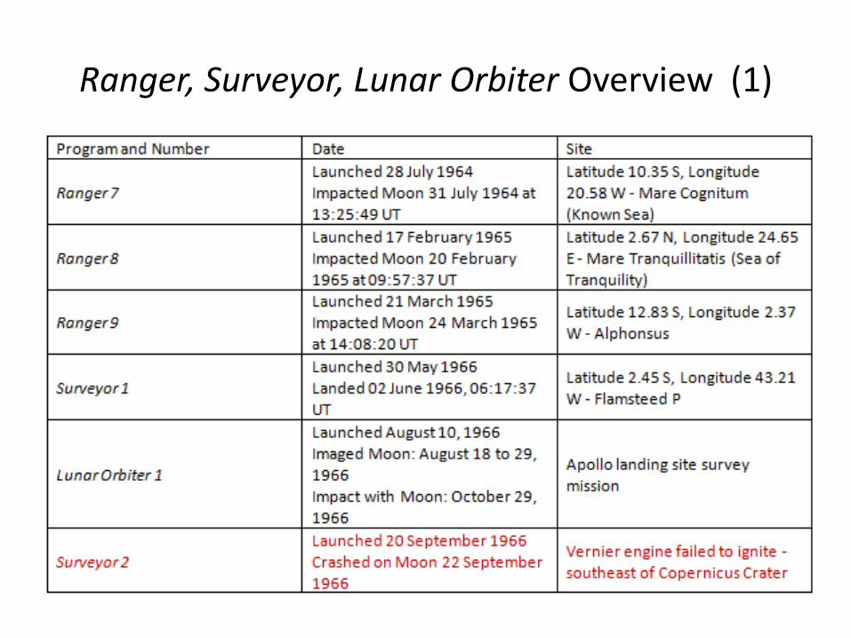
Ranger, Surveyor, Lunar Orbiter Overview (1)

Ranger, Surveyor, Lunar Orbiter Overview (2)

Ranger, Surveyor, Lunar Orbiter Overview (3)

Whitaker’s Original Article

Whitaker’s Original Article