Silk Road Ecological Protection and Rehabilitation Project
196
Initial Environmental Examination Document Stage: Draft Project Number: 51425-002 June 2021 People’s Republic of China: Silk Road Ecological Protection and Rehabilitation Project Prepared by Provincial Forestry and Grassland Bureau of Gansu, Shaanxi and Qinghai provinces for the Asian Development Bank. .
-
Upload
khangminh22 -
Category
Documents
-
view
3 -
download
0
Transcript of Silk Road Ecological Protection and Rehabilitation Project

Initial Environmental Examination
Document Stage: Draft Project Number: 51425-002 June 2021
People’s Republic of China: Silk Road Ecological Protection and Rehabilitation Project
Prepared by Provincial Forestry and Grassland Bureau of Gansu, Shaanxi and Qinghai provinces for the Asian Development Bank. .

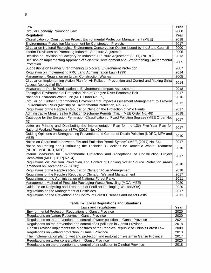
CURRENCY EQUIVALENTS (as of 17 May 2021)
Currency unit - yuan (CNY) CNY1.00 = US$0.1553 US$1.00 = CNY6.4371
ABBREVIATIONS
ADB - Asian Development Bank IA - Implementing Agency BOD - Biochemical Oxygen Demand IEE - Initial Environmental Examination CNY - Chinese Yuan IWRM - Integrated Water Resources Management COD - Chemical Oxygen Demand LPMO - Local project management office CRVA - Climate risk vulnerability assessment CS-EMP - Construction Site EMP LIC - Loan implementation consultant CSC - Construction supervision company MEE - Ministry of Ecology and Environment DEIA - Domestic Environmental Impact
Assessment Mu - Chinese land unit (1 ha = 15 mu)
EA - Executing Agency NDRC - National Development and Reform Commission
EEB - Ecology and Environment Bureau NPS - Non-point source EED - Ecology and Environment Department OPF - Operator of project facility EHS - Environmental, health and safety PIC - Project implementation consultant EIA - Environment Impact Assessment PMO - Project management office EMP - Environmental Management Plan PRC - People's Republic of China
EIRF - Environmental Impact Registration Form REA - Rapid environment assessment EIT - Environmental Impact Tabular Report SPS - Safeguard Policy Statement EMS - Environmental monitoring station NFGA - National Forestry and Grassland
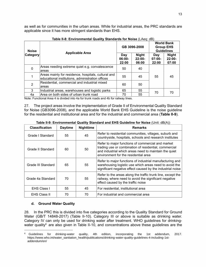
Administration FSR - Feasibility Study Report TOR - Terms of Reference
GDP - Gross Domestic Product TRTA Transaction technical assistance GHG - Greenhouse Gas GRM - Grievance redress mechanism
WEIGHTS AND MEASURES
oC degree centigrade m2 square meter dB Decibel m3/a cubic meter per annum g Gram m3 cubic meter ha Hectare m3/d cubic meter per day km Kilometer m3/s cubic meter per second km2 square kilometer mg/l milligram per liter kW Kilowatt mg/m3 milligram per cubic meter L Liter Mm millimeter LAeq Equivalent continuous A-weighted sound pressure level T metric ton MW Megawatt t/d metric ton per day m Meter t/a ton per annum
NOTE
In this report, "$" refers to United States dollars. This initial environmental examination is a document of the borrower. The views expressed herein do not necessarily represent those of the Asian Development Bank's (ADB) Board of Directors, Management, or staff, and may be preliminary in nature. Your attention is directed to the "terms of use" section on ADB's website. In preparing any country program or strategy, financing any project, or by making any designation of or reference to a particular territory or geographic area in this document, ADB does not intend to make any judgments as to the legal or other status of any territory or area.
Table of Contents
I. EXECUTIVE SUMMARY .................................................................................................................... 1 A. Introduction .................................................................................................................................. 1 B. Environmental Baseline ............................................................................................................... 3 C. Anticipated Impacts and Mitigation Measures ............................................................................. 4 D. Public Consultation and Grievance Redress Mechanism ........................................................... 5 E. Climate Change ........................................................................................................................... 5 F. Environmental Management Plan ............................................................................................... 6 G. Risks and Assurances ................................................................................................................. 6
II. POLICY, LEGAL AND ADMINISTRATIVE FRAMEWORK ................................................................ 7 A. Overview ...................................................................................................................................... 7 B. PRC Environmental Laws, Regulations, Guidelines, and Standards.......................................... 7 C. International Agreements ........................................................................................................... 10 D. Applicable ADB Polices and World Bank’s EHS Guidelines ..................................................... 10 E. Assessment Standards for Proposed Project Components ...................................................... 11 F. Domestic EIA Preparation and Approval ................................................................................... 15
III. DESCRIPTION OF THE PROJECT ................................................................................................. 16 A. Introduction ................................................................................................................................ 16 B. Outputs and Project Components ............................................................................................. 16 C. Project Description ..................................................................................................................... 23 D. Description of Construction and O&M Activities of Forestry Works .......................................... 32 E. O&M of Forest Health and Wellness and Tourism Facilities ..................................................... 42 F. Associated and Existing Facilities ............................................................................................. 42
IV. DESCRIPTION OF THE ENVIRONMENT (BASELINE) .................................................................. 49 A. Overview .................................................................................................................................... 49 B. Location and Setting .................................................................................................................. 49 C. Topography and Geology ........................................................................................................... 51 D. Climate ....................................................................................................................................... 52 E. Hydrology ................................................................................................................................... 54 F. Protected Areas and Forests ..................................................................................................... 61 G. Flora and Fauna ......................................................................................................................... 69 H. Physical Cultural Resources ...................................................................................................... 71 I. Social and Economic Conditions ............................................................................................... 73 J. Environmental quality ................................................................................................................ 75
V. POTENTIAL ENVIRONMENTAL IMPACTS AND MITIGATION MEASURES ................................ 80 A. Project Area of Influence and Sensitive Receptors ................................................................... 80 B. Anticipated Project Benefits and Positive Impacts .................................................................... 85 C. Pre-construction Phase ............................................................................................................. 86 D. Construction Phase ................................................................................................................... 87 E. Operation Phase ...................................................................................................................... 106 F. Indirect, Induced and Cumulative Impacts .............................................................................. 117 G. Climate Change and Greenhouse Gas Emissions .................................................................. 118
VI. ALTERNATIVE ANALYSIS ............................................................................................................. 121 A. No Project Alternative .............................................................................................................. 121 B. Alternatives in Planning and Design of Subprojects ............................................................... 122
VII. PUBLIC CONSULTATION AND INFORMATION DISCLOSURE .................................................. 125 C. Information Disclosure ............................................................................................................. 125 D. Public Consultation .................................................................................................................. 130 E. Future Information Disclosure and Public Consultation Program ........................................... 135
VIII. GRIEVANCE REDRESS MECHANISM ......................................................................................... 136 IX. ENVIRONMENTAL MANAGEMENT PLAN ................................................................................... 137 X. PROJECT ASSURANCES ............................................................................................................. 138 XI. CONCLUSION ................................................................................................................................ 139

APPENDIX 1. ENVIRONMENTAL MANAGEMENT PLAN ................................................................... 140 APPENDIX 2: HEALTH & SAFETY PLAN FOR EMERGING DIESEASE OUTBREAKS..................... 175 APPENDIX 3: LIST OF PLANT SPECIES PLANNED FOR AFFORESTATION, AND, EXISTING FLORA AND FAUNA IN WETLAND PROJECT SITES ...................................................................................... 178

1
I. EXECUTIVE SUMMARY A. Introduction 1. This initial environmental examination (IEE), including an environmental management plan (EMP), is prepared for the proposed Silk Road Ecological Rehabilitation and Protection Project (the project) in three provinces of Gansu, Shaanxi, and Qinghai of the People’s Republic of China (PRC). These provinces are located in the northwest PRC, encompassing part of the Qinghai–Tibet plateau and loess plateau, which are undergoing significant environmental and ecological deterioration due to soil erosion and forest degradation. The proposed project will support improved land, soil, forest, and wetland management. The project is aligned with national and provincial development plans and the Asian Development Bank’s (ADB) country partnership strategies for the PRC, 2016–2020 and 2021–2025. Under ADB’s Safeguard Policy Statement (SPS 2009), the project is classified as Category B for the environment. 2. This IEE and EMP has been prepared following the requirements of the ADB’s SPS and PRC’s environmental laws, regulations, and standards. They are based on information and data from (i) three domestic environment impact tables prepared by the domestic EIA (DEIA) institutes - Gansu Lanxi Environmental Protection Technology Co., Ltd (for Gansu subproject), Beijing Energy and Environment Development Engineering Limited (for Qinghai subproject), Beijing Research Institute of Uranium Geology (for Shaanxi subproject), (ii) the feasibility study reports (FSRs) prepared by FSR Institutes - Gansu Academy of Forestry Sciences (Gansu), Beijing Global Environmental Institute (Qinghai), Northwest Forestry Survey Planning and Design Institute (Shaanxi); (iii) environmental, social, technical and economic assessments conducted by the consultants for the project transaction technical assistance (TRTA), in cooperation with the FSR institutes, DEIA institutes, and municipal and county governments.
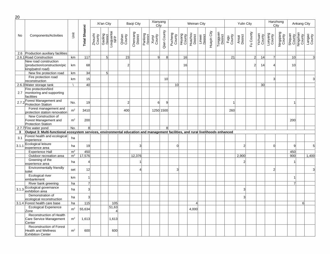
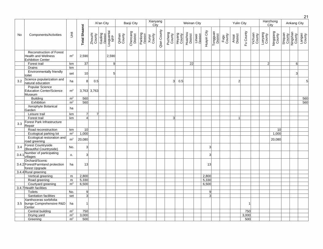
3. The project outputs are: (i) Knowledge on sustainable forest and wetland management, institutional capacity, and trans-provincial coordination strengthened, (ii) Forests and wetlands protected and rehabilitated, and (iii) Multi-functional ecosystem services, environmental education and management facilities, and rural livelihoods enhanced. The National Forestry and Grassland Administration (NFGA) is the executing agency (EA). The provincial Forestry Departments are the implementing agencies (IAs). A summary of all project activities to be carried out in each province is in Table ES-1; a detailed list is in Section III. The proposed afforestation activities in the project will be carried out by the native plant species.
Table ES-1: Summary of Project Activity List
No. Activities Unit Total Qinghai Gansu Shaanxi
1 Output 1: Knowledge on sustainable forest and wetland management, institutional capacity, and trans-provincial coordination strengthened
1.1 Capacity building and training PD 16,127 1,322 1,583 13,222
2 Output 2: Forests and wetlands protected and rehabilitated
2.1 Afforestation ha 14,821.13 1,333.33 6,179.00 7,308.80
2.1.1 New plantation ha 6,730.43 1,333.33 2,246.00 3,151.10
2.1.2 Reforestation and low-benefits forests rehabilitation
ha 5,931.07 0.00 3,933.00 1,998.07
2.2 Forest Tending ha 22,566.25 15,993.33 3,001.00 3,571.92
2.3 Standardized nursery ha 75.85 53.33 22.52
2.4 Wetland restoration ha 112 112
2.4.1 Water network clearing (dredging) km 11.4 11.4
2.4.2
Ecological water replenishment
Ecological drainage canal km 4.00 4.00
Water system connection m2 545,606 545,606

2
No. Activities Unit Total Qinghai Gansu Shaanxi
Hydraulic drop No. 91.00 91.00
Bridge and culvert No. 15.00 15.00
Inlet control gate No. 4.00 4.00
Dredging the drains km 22.00 22.00
Soil and Water-retaining mounds/ridges km 60.00 60.00
2.4.3 Wetland vegetation restoration ha 198.00 86.00 112.00
2.4.4 Restoration of bird breeding areas ha 33.90 33.90
2.4.5 Wetland Shelter Forest ha 296.70 296.70
2.4.6 Wetland patrol road km 10.20 10.20
2.4.7 Wooden walkway m2 6,700.00 6,700
2.5 Wetland Science Publicity and Education ha 0.67 0.67
2.6 Production auxiliary facilities
2.6.1 Road Construction km 209.01 50.00 42.30 116.71
2.6.2 Drip irrigation system ha 2,386.70 2,386.70
2.6.3 Water storage tank No. 40.00 40.00
2.6.4
Supporting production facilities
Water suction pump No. 50.00 50.00
Electricity generator No. 30.00 30.00
Water pipe km 18.20 18.20
Water pump and water pipe set 20.00 20.00
Bush cutter No. 15.00 15.00
Rotary cultivator No. 40.00 40.00
2.7 Fire protection/bird monitoring and supporting facilities
2.7.1
Observation Deck/Tower
Wetland bird watching tower m2 278.00 278.00
Fire observation deck/tower No. 5.00 2.00 3.00
m2 325.60 45.60 280.00
Observatory equipment set 3.00 3.00
2.7.2 Forest Management and Protection Station No. 31.00 12.00 19.00
2.7.3 Wetland Bird Monitoring Station m2 600.00 0.00 600.00
2.7.4 Firebreak km 68.00 68.00
2.7.5 Supporting fire protection equipment and facilities
set 11,855 11,835 20
2.7.6 Fire protection signs No. 242.00 217.00 25.00
2.7.7 Fire water pond No. 11.00 3.00 8.00
2.7.8 Vehicles No. 47.00 8.00 14.00 25.00
3 Output 3: Multi-functional ecosystem services, environmental education and management facilities, and rural livelihoods enhanced
3.1 Forest health and ecological experience ha 20.00 20.00
3.1.1 Ecological leisure experience area ha 15 - 15
Experience Hall m2 450 - 450
Outdoor recreation area m2 23076 - 23076
Greening of the experience area ha 4 - 4
Leisure trail km 14 - 14
Solar street light No. 373 - 373
Outdoor seating set 70 - 70
Environmentally friendly toilet seat 7 - 7
Trash can No. 200 - 200
Ecological publicity and education signs No. 228 - 228
Ecological river embankment km 1 - 1
River bank greening ha 6.67 - 6.67
3.1.2 Ecological governance exhibition area ha 556.42 553.33 3.09
3.1.3 Forest health care base ha 301.79 186.67 115.12
Ecological Experience Zone m2 55,654 20 55634
Display system m2 1,000 1000
Interpretation system set 300 300
Forest trail km 42 5 37
Mountain patrol and rain shelter/rest area No. 24 5 19

3
No. Activities Unit Total Qinghai Gansu Shaanxi
platform
Ecological cultural corridor/flower corridor m2 600 300 300
Drains km 8 8
Solar street light No. 70 70
Environmentally friendly toilet seat 10 10
Billboard No. 214 214
3.2 Science popularization and natural education ha 7.75 7.75
3.3
Forest Park Infrastructure Repair
Road reconstruction km 9.70 9.70
Rest pavilion seat 2.00 2.00
Ecological parking lot m2 1,000.00 1,000
Ecological restoration and road greening Ha 1.95 1.95
Signage No. 19.00 19.00
Billboard No. 2.00 2.00
Hundred-meter pile No. 126.00 126.00
3.4 Forest countryside (beautiful countryside) No. 9.00 1.00 5.00 3.00
3.4.1 Number of participating villages No. 9 1 5 3
3.4.2 Orchard/Scenic Forest/Farmland protection forest Upgrade
ha 82.82 70 - 12.82
3.4.3 Outdoor recreation area m2 25,200 - - 25,200
3.4.4 Rural greening - - -
Vertical greening m 2,800 - - 2,800
Road greening m 5,160 - - 5,160
Courtyard greening m2 6,500 - - 6,500
3.4.5 Picking/Leisure Trail km 4.76 - - 4.76
3.4.6 Supporting Seat set 19 - - 19
3.4.7 Health facilities - - - -
Toilets No. 9 - - 9
Sanitation facilities set 3 - - 3
3.5 Xanthoceras sorbifolia bunge Comprehensive R&D Center
ha 0.5 - - 0.5
Source: NPMO and PPMOs, May 2021.
B. Environmental Baseline 4. The project activities will be carried out in 33 counties/districts (5 in Gansu, 23 in Shaanxi, and 5 in Qinghai). All the project sites are located in ecologically fragile areas, many regions that have been degraded through long-term human use (for centuries, and in some regions, for thousands of years) for agriculture and, more recently, for urban settlement and industrial development. Climate is generally semi-arid, with dry summers and harsh winters. The surface soil is mostly loess and sandy. Due to the unique characteristics of loess, its soil erosion resistance is poor, which quickly leads to the extension of gully head and bank erosions. Rainfall is concentrated in July to September and causes high erosion of loess soils that are long exposed to agriculture and other human activities, resulting in fragmented terrain, steep gully depth and slope, large surface undulation, sparse vegetation, low forest coverage, and severe soil erosion. The water and soil loss caused by overgrazing and deforestation in the upper reaches of the watersheds over the years has resulted in a large amount of silt silting up in lakes, rivers wetlands, the gradual shrinkage of wetlands, and a decrease in biodiversity. 5. The project activities include sites within 9 protected areas and one lake: (i) Five protected areas in Shaanxi Province – one national wetland park (Malan River National Wetland Park) and four national forest parks (Heihe, Louguantai, Wudishan, Hanshuiyuan), (ii) four protected areas in Qinghai Province – one provincial park (Huangshui Forest Park), two heritage sites (Tulou and Nanchan temples), and one scenic reserve (Jiuyanquan Natural Tourism Area), and (iii) one lake, Shuangquan Lake Wetland in Gansu Province (not a protected area, but supports wetland

4
habitats). These sites support a range of ecological and/or heritage values, including wetland habitats, migratory waterbirds, and nationally protected bird, fish, and plant species. All these protected areas have well-developed management plans, and the proposed project activities will comply with the existing management plans. The project will support the restoration and improved management of habitats in these sites. 6. The project sites are located in remote or rural areas, and hence the surface water, air, and noise quality of most places are generally good. Air quality complies with the requirements of Class 2 standard (GB3095-2012). Noise quality is within Class 1 standard (GB3096-2008). Surface water and groundwater quality comply with the Class 3 standard (GB3838-2002 and GB/T14848-2017). C. Anticipated Impacts and Mitigation Measures 7. Construction phase. Construction activities include small-scale earthworks and civil works such as site preparation for forest afforestation, wetland restoration, and tourism infrastructure. Key risks associated with these activities are (i) soil erosion from site development and increased sedimentation into streams, (ii) soil compaction and puddling by machinery, (iii) noise and air pollution from construction activities, (iv) buildup of organic matter under plantations posing a fire hazard, (vi) ecological impacts to sites within protected areas, (vii) loss of habitat and decreased biological diversity by replacement of natural forest by plantations with a limited number of species and increased uniformity of forest structure, and/or (vii) damage to physical cultural resources in the project sites. 8. The risk assessment covered the locations and scope of the project activities with respect to the protected area management plans, the distance of works to the nearest core habitat or heritage location, and timing of works (to assess potential impacts to migratory waterbirds). All project works in the protected areas are confirmed to: (i) comply with the approved site management plans, (ii) are located outside of the core protection zones, and are restricted to the site buffer zones, tourism zones, and multi-functional zones and are consistent with the regulatory uses for these zones, and (iii) do not involve the damage or loss of critical habitat as per ADB’s SPS. Impacts of civil works, including dust, noise and vibration, may cause temporary impacts to migratory birds, dust on temples, and to tourists. The key mitigation measures to be implemented to minimize these impacts are: (i) for all wetland sites, no civil works will be implemented from March-April and September-October, the months of peak waterbird migration, (ii) no removal of existing vegetation, (iii) no land development on steep, unstable, and erosive slopes, (iv) strictly supervised use of machinery near two temples, (v) no establishment of any temporary facilities, such as workers camps, waste disposal, and material storage sites, in the protected areas, and (vi) close collaboration of works with the site managers for the protected areas and temples, to minimize disturbance to site values and visitors. Based on the relatively limited scope of works in protected areas and the exclusion of any strict protection zones and critical habitats from the project locations, and compliance of works with the site management plans, the environmental risks are assessed to be low. 9. Operation phase. During operation and maintenance (O&M) stages, risks include (i) unsustainable water demand for watering, (ii) impacts to water and/or soil quality due to the use of herbicides and/or pesticides, and/or (iii) induced disturbance to habitats, fauna, and flora from increased tourism within the project locations. For the forest protected areas, additional risks include unintended forest or soil damage, from the clearance of forest to establish fire breaks and/or for weeding, removal of fallen wood debris (which provides important shelter for some fauna), and/or increase risk of forest fire due to increased visitor activity. To minimize the use of

5
water for irrigation, shrubs and herbaceous plant species which are native to the project areas and are known for their drought resistance, saline tolerance, and low water demands have been selected; and the project designs utilize water-saving technologies, including drip irrigation, slope protection, and grassy ditches to improve recharge. The project designs and EMP include the preparation of O&M procedures. 10. Coronavirus disease outbreak (COVID-19). The outbreak and global spread of COVID-19 since December 2019 pose new risks and management implications for most countries. For the current project, the extent of COVID-19 in project provinces and the project area was reviewed. A health and safety plan is included in the EMP to manage the health risks associated with any such new emerging disease outbreaks. Measures include screening all project personal before admission to project sites and onsite measures for sanitation, ventilation, the provision of personal protective equipment, and emergency response. 11. Project Benefits. The project will have significant environmental benefits on the existing landscape low-efficiency forests by controlling soil erosion, improving forest quality, expanding forest areas, increasing forest coverage, and improving the ecological environment. Biodiversity in the project restored wetlands will also be significantly enhanced due to an improved micro-climate for the wildlife. The key expected benefits of the project include (i) improving the quality and management of 43,318 ha of forests, (ii) an increase in forest coverage from 71.84% to 80% in the north-south mountains and from 43.7% to 68% in the Xibu green area, (iii) control of 677,400 tons soil erosion, (iv) increase in wetland area by about 120 ha in Gansu and 311 ha in Shaanxi, (v) generation of additional tourists of 200,000 annually for wetland tourism and 550,000 annually for forests and cultural tourism, and (vi) improve livelihoods of about 151,00 households in 31 counties. D. Public Consultation and Grievance Redress Mechanism 12. Two rounds of information disclosure and public consultation were conducted. The first round comprised the disclosure of project information on the domestic EIA institute’s websites. The second round of consultation included public meetings and a questionnaire survey. Prior to consultations, a summary of the project designs and IEE findings was distributed to communities to provide adequate time for residents to read and consider the information. Feedback from consulted villagers and institutions was obtained and the findings have been reflected in the EMP (Appendix 1), updated FSR, and domestic environmental assessments. A project grievance redress mechanism (GRM) has been designed to facilitate the resolution of complaints during project construction and operation. The GRM includes time-based steps for receiving, documenting, and resolving grievances. E. Climate Change 13. A climate risk vulnerability assessment (CRVA) for the project area was conducted to identify the risk climate change presents to project viability, assuming a design life of 30 years. For the project sites across three provinces, it is projected that the annual mean temperature will increase from 2.1 to 2.3 °C and from 2.7 to 3.3 °C for project sites in 2050 under RCP4.5 and RCP8.5 climate change scenarios, respectively. For precipitation, it is projected to increase from 1.8% to 11.2% and from 6.9% to 10.4% for project sites in 2050 under RCP4.5 and RCP8.5 climate change scenarios, respectively. Projected increases in both temperature and precipitation are lower in the humid subtropics south Shaanxi and becoming higher gradually for project sites in northern Shaanxi, Gansu, and Qinghai Provinces. The project has been designed to invest a substantial proportion of the project fund in climate change adaptation and mitigation. Many

6
project subcomponents are also dual benefit measures for both adaptation and mitigation. On completion, the project will reduce the net GHG emission by about 324,505 tons of CO2e per year. The project is below the threshold of concern (100,000 CO2te per year) in ADB’s SPS. F. Environmental Management Plan 14. An EMP (Appendix 1) has been developed to ensure (i) implementation of identified mitigation and management measures to avoid, reduce, mitigate, and compensate for anticipated adverse environmental impacts; (ii) implementation of monitoring and reporting against the performance indicators; and (iii) compliance with the PRC’s relevant environmental laws, standards and regulations and the SPS. The EMP includes an environmental monitoring plan to monitor the environmental impacts of the project and assess the effectiveness of mitigation measures and a capacity building and training program focused on health, safety, and the environment. Organizational responsibilities and budgets are clearly identified for implementation, monitoring, and reporting. G. Risks and Assurances 15. Several previous ADB loan- and grant-funded projects have been implemented in the project provinces, but few with the specific IAs for this project. This limited experience in ADB safeguard requirements may result in the limited implementation of the project EMP and inadequate O&M of the project facilities. These risks have been minimized as follows: (i) the appointment of one qualified environmental and social officer within the national project management office (NPMO) and one qualified environmental and social officer in each provincial PMO (PPMO) to lead EMP delivery, (ii) the appointment of an environmental focal point for each 29 PIUs (1 in Qinghai, 5 in Gansu and 23 in Shaanxi), (iii) the recruitment of qualified “start-up” environment specialists (1 for NPMO and 3 for PPMOs) in the start-up consulting services, and, environment specialists (1 for NPMO and 3 for PPMOs) in the loan implementation consulting services, (iv) recruitment of environmental monitoring agencies (1 for each PPMO)to lead the external monitoring specified in the EMP), (iv) clear roles and responsibilities of all relevant agencies for EMP implementation, including contractors and construction supervision companies, and (v) capacity building for EMP implementation. Environmental assurances have been agreed upon and are included in the loan and project agreements.

7
II. POLICY, LEGAL AND ADMINISTRATIVE FRAMEWORK A. Overview 16. The project is classified as environmental Category B under the ADB SPS (2009), requiring the preparation of a project IEE. ADB’s country partnership strategy for the PRC (2016-2020) supports realizing an ‘ecological civilization’ through environmental sustainability, pollution control, and climate change adaptation measures; achieving greenhouse gas emissions commitments ahead of its 2030 target; and, the overarching strategic goal of building a well-off society by focusing on the three strategic pillars of inclusive growth, environmentally sustainable development, and urban-rural integration. Under PRC EIA regulations, these project activities fall into either Category B or C. 17. The PRC has a range of laws, regulations, technical guidelines and standards that govern the way in which environmental protection and environmental impact assessment for projects must be implemented, including for pollution prevention and control on air, noise, water, ecology and solid waste, and technical guidelines on assessing ambient air, noise, surface water, groundwater, and ecological impacts. Three EIA Tables1 were prepared in accordance with the PRC Law on Environmental Impact Assessment (2018 revision); Management Regulation on EIA Categories of Construction Projects (Ministry of Ecology and Environment (MEE), 2018 revision); Guidelines on Public Participation in EIA (MEE, 2019); 2 and, Technical Guidelines for Environmental Impact Assessment (HJ/T2).3 B. PRC Environmental Laws, Regulations, Guidelines, and Standards 18. The primary national laws and regulations that govern IEE are in Table II-1. Table II-2 shows the relevant national and provincial laws and regulations.
Table II-1: National Laws and Regulations Relevant to Project
Law Year
Forest Law 2019
Water Law 2016
Environmental Protection Law 2015
Urban and Rural Planning Law 2008
Solid Waste Pollution Prevention and Control Law 2016
Environmental Impact Assessment Law 2019
Water Pollution Prevention and Control Law 2018
Air Pollution Prevention and Control Law 2018
Noise Pollution Prevention and Control Law 2018
Soil Pollution Prevention and Control Law 2018
Land Administration Law 2004
Wild Animal Protection Law 2018
Water and Soil Conservation Law 2011
Clean Production Promotion Law 2012
Fisheries Law 2013
Energy Conservation Law 2016
1 Environmental Impact Assessment Table (EIA Table) is more and less similar to Initial Environmental Examination
(IEE), but in a different format. 2 Passed in the meeting of MEE on 16 April 2019 and implemented since 1 January 2019. 3 Including: atmosphere (HJ 2.2), surface water (HJ/T 2.3), noise (HJ 2.4), ecology (HJ 19) and biodiversity (HJ 623),
groundwater (HJ 610), and invasive species (HJ 624).
8
Law Year
Circular Economy Promotion Law 2008
Regulation Year
Classification of Construction Project Environmental Protection Management (MEE) 2018
Environmental Protection Management for Construction Projects 2017
Circular on National Ecological Environment Conservation Outline issued by the State Council 2000
Interim Provisions on Promoting Industrial Structure Adjustment 2005
Decision on Revision of Category on Industrial Structure Adjustment (2011) (NDRC) 2013
Decision on Implementing Approach of Scientific Development and Strengthening Environmental Protection
2005
Suggestions on Further Strengthening Ecological Environment Protection 2007
Regulation on Implementing PRC Land Administration Law (1999) 2014
Management Regulation on Urban Construction Wastes 2005
Circular on Implementing Action Plan for Air Pollution Prevention and Control and Making Strict Access Approval of EIA
2014
Measures on Public Participation in Environmental Impact Assessment 2018
Ecological Environmental Protection Plan of Yangtze River Economic Belt 2017
National Hazardous Waste List (MEE Order No. 39) 2016
Circular on Further Strengthening Environmental Impact Assessment Management to Prevent Environmental Risks (Ministry of Environmental Protection, No. 77)
2012
Regulations of the People's Republic of China on the Protection of Wild Plants 2017
Administrative Measures for Pollution Discharge Permits (Trial) (MEE Order No. 48) 2018
Catalogue for the Emission Permission Classification of Fixed Pollution Sources (MEE Order No. 45)
2017
Letter on Printing and Distributing the Implementation Plan for the 13th Five-Year Plan for National Wetland Protection (SFA, [2017] No. 40)
2017
Guiding Opinions on Strengthening Prevention and Control of Dioxin Pollution (NDRC, MFA and MEE)
2010
Notice on Coordination between EIA and Emission Permit System” (MEE, [2017] No. 84) 2017
Notice on Printing and Distributing the Technical Guidelines for Domestic Waste Treatment (NDRC, MOHURD, MEE);
2010
Interim Measures for Environmental Protection and Acceptance of Construction Project Completion (MEE, [2017] No. 4)
2017
Regulations on Pollution Prevention and Control of Drinking Water Source Protection Areas (amended on December 22, 2010);
2010
Regulations of the People's Republic of China on River Management 2018
Regulations of the People's Republic of China on Wetland Management 2017
Regulations on the Administration of National Forest Parks 2011
Management Method of Pesticide Packaging Waste Recycling (MOA, MEE) 2020
Guidance on Recycling and Treatment of Fertilizer Packaging Waste(MOA) 2020
Regulations on the Management of Pesticides 2017
Regulations on the Prevention and Control of Forest Diseases and Insect Pests 2011
Table II-2: Local Regulations and Standards
Laws and regulations Year
Environmental Protection Regulations of Gansu Province 2020
Regulations on Nature Reserves in Gansu Province 2020
Regulations on the prevention and control of water pollution in Gansu Province 2021
Regulations on the prevention and control of air pollution in Gansu Province 2018
Gansu Province implements the Measures of the People's Republic of China's Forest Law 2009
Regulations on wetland protection in Gansu Province 2013
The implementation plan of wetland protection and restoration system in Gansu Province 2017
Regulations on water conservation in Gansu Province 2020
Regulations on the prevention and control of air pollution in Qinghai Province 2018

9
Laws and regulations Year
Regulations on the prevention and control of air pollution in Xining City 2016
Regulations on the prevention and control of water pollution in the Weishui basin of Qinghai Province
2018
Qinghai Province implements the Measures of the Forest Law of the People's Republic of China
2018
Regulations on the Protection of the Ecological Environment in Qinling, Shaanxi Province (effective December 1, 2019).
2020
Regulations on the prevention and quarantine of forest pests in Shaanxi Province 2020
Shaanxi Province implements the Measures of the Environmental Impact Assessment Law of the People's Republic of China
2020
Shaanxi Province implements the Measures of the Environmental Protection Law of the People's Republic of China
2020
Regulations on the prevention and control of air pollution in Shaanxi Province 2019
Regulations on the prevention and control of environmental pollution from solid waste in Shaanxi Province
2019
Regulations on the protection of the ecological environment in Qinling, Shaanxi Province 2019
Regulations on soil and water protection in Shaanxi Province 2013
Regulations on forest parks in Shaanxi Province 2012
19. The implementation of environmental laws and regulations is supported by associated management and technical guidelines. Those applicable to the project are in Table II-3.
Table II-3: Applicable Environmental Guidelines
Guideline Code/Year
Technical Guideline on EIA: for Construction Projects HJ/T 2.1-2016
Technical Guideline on EIA: Atmospheric Environment HJ 2.2-2018
Technical Guideline on EIA: Surface Water Environment HJ/T 2.3-2018
Technical Guideline on EIA: Acoustic Environment HJ 2.4-2009
Technical Guideline on EIA: Ecological Assessment HJ 19-2011
Technical Guideline on EIA: Ground Water Environment HJ610-2016
Standard for the assessment of regional biodiversity HJ623-2011
Technical Guideline for Assessment on Environmental Risk of Alien Species HJ624-2011
Technical Guideline on Environmental Risk Assessment for Construction Project HJ/T169-2018
Technical Specifications for the Collection, Storage and Transportation of Hazardous Waste
HJ2025-2012
National List of Hazardous Wastes (MEE, Order No. 39) 2016
General Provisions-Technical Guidelines for Self-Monitoring of Pollution Emission Entities
HJ819-2017
Guidelines for Environmental Impact Assessment of Hazardous Wastes in Construction Projects” (MEE, No. 43)
2017
Technical Specifications for Application and Issuance of Pollution Discharge Permits HJ942-2018
Technical Requirements for Environmental Protection for Standardized Construction of Centralized Drinking Water Sources
HJ 773-2015
Technical Specifications for Domestic Waste Incineration Treatment Engineering CJJ 90-2009
20. The national environmental quality standard system that supports/evaluates the implementation of the environmental protection laws and regulations in the PRC is classified into two categories by function, i.e. pollutant emission/discharge standards and ambient environmental standards. The standards applicable to this project are in Table II-4.

10
Table II-4: Applicable Environmental Standards
Standard Code
Surface Water Quality Standard GB3838-2002
Urban Ambient Acoustic Quality Standard GB3096-2008
Ambient Air Quality Standard GB3095-2012
Groundwater Quality Standard GB/T14848-2017
Integrated Emission Standard of Air Pollutants GB16297-1996
Emission Standard for Odor Pollutant GB 14554-93
Emission Standard for Industrial Enterprises Noise at Boundary GB12348-2008
Soil environmental quality-Risk control standard for soil contamination of agricultural land
GB15618-2018
Soil environmental quality-Risk control standard for soil contamination of development land
GB36600—2018
Integrated Wastewater Discharge Standard GB8978-1996
Noise Limit for Construction Sites GB12523-2011
Standard on Pollution Control of Storage and Disposal Location for General Industrial Waste
GB18592-2001
Technical Specification on Landfill Treatment of Municipal Waste GB50869-2013
Standard on Pollution Control of Municipal Waste Landfill GB16889-2008
Identification of Major Hazard Sources of Hazardous Chemicals GB18218-2018
Standard for Grading of Soil Erosion Intensity SL190-2007
Urban Area Environmental Vibration GB10070–88
C. International Agreements 21. The PRC is a signatory to major international environmental agreements relevant to the project (Table II-5), dealing with biodiversity, wetland protection and climate change.
Table II-5: Applicable international agreements
Agreement Year Purpose (relevance to the project)
Ramsar Convention on Wetlands of International Importance
1975 Prevent encroachment on and loss of wetlands for now and the future (project includes the reservoir)
Convention on Biological Diversity 1993 Conservation and sustainable use of biological diversity (project includes afforestation)
United Nations Framework Convention on Climate Change
1994 Achieve stabilization of atmospheric greenhouse gas (GHG) concentrations (project involves GHG emission reduction)
Kyoto Protocol to UN Framework Convention on Climate Change
2005 Further reduction of greenhouse gas emissions (as above)
Montreal Protocol on Substances That Deplete the Ozone Layer
1989 Protection of the ozone layer (same as above)
UN Convention to Combat Desertification
1996 Combat desertification and mitigate effects of drought (project involves soil erosion control)
Basel Convention 1992 Control over the transboundary movement of hazardous wastes
D. Applicable ADB Polices and World Bank’s EHS Guidelines
22. The Safeguard Policy Statement (SPS, 2009) is ADB’s principal document that prescribes ADB requirements for the design, preparation, and implementation of safeguards for ADB-funded projects. All projects funded by ADB must comply with the SPS (2009), which establishes an environmental review process to ensure that projects undertaken as part of programs funded under ADB loans are environmentally sound, are designed to operate in line with applicable

11
regulatory requirements, and are not likely to cause significant environment, health, social, or safety hazards. The SPS also requires borrowers to follow environmental standards consistent with good international practice, as reflected in internationally recognized standards such as the World Bank Group’s EHS Guidelines.4 The latter contains discharge effluent, air emissions, and other numerical guidelines and performance indicators as well as prevention and control approaches that are normally acceptable to ADB and are generally considered to be achievable at reasonable costs by existing technology. In the event that when host country regulations differ from international levels and measures, a project will achieve whichever is more stringent, and if less stringent levels are proposed, then a full and detailed justification be provided by the borrower. Hence, the project compared both the PRC and EHS standards and the more stringent standards are applicable for the current project (see the following sections). 23. Compared with PRC EIA requirements, the SPS requires additional considerations for EIA preparation, including (i) a project-specific GRM; (ii) definition of the project area of influence; (iii) assessment of direct, indirect, induced and cumulative impacts; (iv) due diligence of project associated facilities; (v) protection of physical cultural resources; (vi) climate change mitigation and adaptation; (vii) occupational and community health and safety requirements (including emergency preparedness and response); (viii) impacts on livelihoods through environmental media; (ix) biodiversity conservation; and (x) ensuring that the EMP includes an implementation schedule and measurable performance indicators. These requirements are usually weak in PRC EIAs. With the assistance of TA Consultants, the DEIA has been updated in accordance with SPS by the DEIA Institute to fill in the above gaps and comply with SPS requirements. E. Assessment Standards for Proposed Project Components
a. Surface Water Quality
24. The PRC’s Environmental Quality Standards for Surface Water (GB 3838-2002) defines five categories reflecting different environmental functions: I – highest water quality, for headwaters and national nature reserves; II – drinking water sources in Class I protection areas, habitats for rare aquatic organisms, breeding grounds for fish and crustaceans, and feeding grounds for fish fry; III – drinking water sources in Class II protection areas, wintering grounds for fish and crustaceans, migration routes, water bodies for aquaculture and capture fishery, and swimming; IV – general industrial use and non-contact recreational activities; V – lowest quality, suitable only for agricultural and scenic water uses (Table II-6). The World Bank Group has no guidelines on ambient water quality and recognizes the use of local criteria for compliance purposes. The standards relevant to this project are Grade III, IV and V of PRC Environmental Quality Standards for Surface Water (GB3838-2002) (Table II-6). The standard includes 24 parameters for regular surface water, and other 68 parameters specific for centralized drinking water sources. Eight of the 24 parameters were selected for sampling (Table II-6) as these are the most relevant to providing meaningful baselines and risk assessment based on the project scope.
Table II-6: Environmental Quality Standards for Surface Water (Unit: mg/L, except for pH)
Parameter pH CODCr CODMn BOD5 TN NH3-N TP Oil
Class II Standard 6-9 15 4 3 0.5 0.5 0.1 0.05
Grade III Standard 6-9 20 6 4 1 1.0 0.2 0.05
Grade IV Standard 6-9 30 10 6 1.5 1.5 0.3 0.5
Grade V Standard 6-9 40 15 10 2 2 0.4 1 Note: CODCr/CODMn = chemical oxygen demand, BOD5 = 5 days biochemical oxygen demand, NH3-N = ammonia nitrogen, TN=total nitrogen, TP=total phosphorus.
4 World Bank Group. Environmental, Health, and Safety Guidelines. 30 April 2007. Washington.

12
b. Ambient Air Quality
25. In the PRC, air quality is categorized in three classes (Ambient Air Quality Standard GB 3095-1996 and amendment in 2000): Class I (highest quality) to Class III (the worst). Ambient air quality in the project area meets the Class II standard. In 2012, a new national standard was issued (GB 3095-2012; effective 1 January 2016), which replaced GB 3095-1996. The new standard combined Classes II and III, and has two classes, I and II. It also introduced PM2.5 standards and relaxed the 1-hour NO2 standard to match the World Health Organization (WHO)5 Air Quality Guideline (AQG) standard. The World Bank Group adopted the WHO standards for its Environment, Health and Safety (EHS) standards for air quality. Recognizing that progressive actions are needed to achieve these standards, the WHO established interim targets to achieve the AQG. Table II-7 compares the PRC and World Bank EHS standards for ambient air quality. The EHS has stricter standards for SO2 and PM10, and PRC has stricter or equivalent standards for other parameters. Hence, the more stringent standards are applicable to the project. Ambient air quality in the environmentally sensitive locations, and the areas outside the construction sites, meets Grade II of PRC Ambient Air Quality Standard GB3095-2012 and EHS guidelines.
Table II-7: Ambient Air Quality Standard - Grade II (Unit: mg/m3).
Pollutant Time GB 3096-1996
(Grade II) GB3095-2012
(Grade II) World Bank Group EHS
Guidelines
SO2
Annual average 0.06 0.06 n/a
Daily average 0.15 0.15 0.125-0.05 (0.005 - 0.02
guideline)
Hourly average 0.50 0.50 n/a
PM2.5 Annual average - 0.035 0.035
Daily average - 0.075 0.075
PM10 Annual average 0.10 0.07 0.07-0.03 (0.02 guideline)
Daily average 0.15 0.15 0.075-0.15 (0.05 guideline)
NO2
Annual average 0.08 0.04 0.04 guideline
Daily average 0.12 0.08 n/a
Hourly average 0.24 0.2 0.20 guideline
CO Daily average 4.0 4.0 n/a
Hourly average 10.0 10.0 n/a
Note: SO2=sulfuric dioxide; NO2=nitrogen dioxide; PM10/PM2.5=particulate matter; CO=carbon monoxide.
c. Ambient Acoustic Quality
26. The PRC’s GB 3096-2008 identifies five categories based on tolerance to noise pollution: 0 – areas with convalescent facilities (least tolerant to noise; stringent day and night noise standards); 1 – residential areas, hospitals and clinics, educational institutions and research centers; 2 – mixed residential and commercial areas; 3 – areas with industrial production, storage and logistics functions; 4 – areas adjacent to traffic noise sources such as major roads and highways, and is subdivided into 4a (road and marine traffic noise) and 4b (rail noise). The EHS guidelines have lower noise limits for residential, commercial and industrial mixed areas but higher noise limits for industrial areas and night-time noise near trunk roads. Therefore, the EHS standards, which are more stringent than PRC, are applied for the project activities in rural areas
5 World Health Organization. 2005. Air quality guidelines global update 2005. Bonn.
13
as well as for communities in the urban areas. While for industrial areas, the PRC standards are applicable since it has more stringent standards than EHS.
Table II-8: Environmental Quality Standards for Noise (LAeq: dB)
Noise Category
Applicable Area
GB 3096-2008 World Bank Group EHS Guidelines
Day 06:00-22:00
Night 22:00-06:00
Day 07:00-22:00
Night 22:00-07:00
0 Areas needing extreme quiet e.g. convalescence areas
50 40
55 45 1 Areas mainly for residence, hospitals, cultural and educational institutions, administration offices
55 45
2 Residential, commercial and industrial mixed areas
60 50
3 Industrial areas, warehouses and logistic parks 65 55 70 70
4a Area on both sides of urban trunk road 70 55 Note: Functional Area 4 is divided into 4a for trunk roads and 4b for railway lines.
27. The project areas involve the implementation of Grade II of Environmental Quality Standard for Noise (GB3096-2008), and the applicable World Bank EHS Guideline is the noise guideline for the residential and institutional area and for the industrial and commercial area (Table II-9).
Table II-9: Environmental Quality Standard and EHS Guideline for Noise (Unit: dB(A))
Classification Daytime Nighttime Remarks
Grade I Standard 55 45 Refer to residential communities, villages, suburb and countryside, hospitals, schools and research institutes
Grade II Standard 60 50
Refer to major functions of commercial and market trading use or combination of residential, commercial and industrial which areas need to maintain the quiet environment for the residential area
Grade III Standard 65 55 Refer to major functions of industrial manufacturing and warehousing logistic use which areas need to avoid the significant negative effect caused by the industrial noise
Grade 4a Standard 70 55 Refer to the areas along the traffic trunk line, except the railway, where need to avoid the significant negative effect caused by the traffic noise
EHS Class I 55 45 For residential, institutional area
EHS Class II 70 70 For industrial and commercial area
d. Ground Water Quality
28. In the PRC this is divided into five categories according to the Quality Standard for Ground Water (GB/T 14848-2017) (Table II-10). Category III or above is suitable as drinking water. Category IV can only be used for drinking water after treatment. WHO guidelines for drinking-water quality6 are also given in Table II-10, and concentrations above these guidelines are the
6 Guidelines for drinking-water quality, 4th edition, incorporating the 1st addendum, 2017.
https://www.who.int/water_sanitation_health/publications/drinking-water-quality-guidelines-4-including-1st-addendum/en/

14
cause of health concern. The national Grade III standards are more stringent than WHO standards, and hence the groundwater quality in the project area must comply with the Grade III standards.
Table II-10: Quality Standard for Groundwater (Unit: mg/L, except pH, total bacteria and total coli.)
Parameter Grade I Grade II Grade III Grade IV Grade V WHO Guidelines for drinking water quality (2017)
pH 6.5~8.5 5.5-6.5
<5.5, >9 6.5-8.5 8.5-9
Ammonia nitrogen (mg/L) ≤0.02 ≤0.10 ≤0.50 ≤1.5 >1.5 NA
Chloride (mg/L) ≤50 ≤150 ≤250 ≤350 >350 ≤250
Sulfate (mg/L) ≤50 ≤150 ≤250 ≤350 >350 NA
Nitrate (in N) (mg/L) ≤2 ≤5 ≤20 ≤30 >30 ≤50
Nitrite (in N) (mg/L) ≤0.01 ≤0.10 ≤1.00 ≤4.80 >4.80 ≤3
Fluoride (mg/L) ≤1 ≤1 ≤1 ≤2 >2 ≤1.5
Zinc (mg/L) ≤0.05 ≤0.5 ≤1 ≤5 >5 ≤3
Copper (mg/L) ≤0.01 ≤0.05 ≤1 ≤1.5 >1.5 ≤2
Manganese (mg/L) ≤0.05 ≤0.05 ≤0.1 ≤1.5 >1.5 NA
Iron (mg/L) ≤0.1 ≤0.2 ≤0.3 ≤2.0 >2.0 NA
Total dissolved solids (mg/L) ≤300 ≤500 ≤1000 ≤2000 >2000 ≤1000
Total hardness (mg/L) ≤150 ≤300 ≤450 ≤650 >650 -
Permanganate index (mg/L) ≤1 ≤2 ≤3 ≤10 >10
Mercury (mg/L) ≤0.0001 ≤0.0001 ≤0.001 ≤0.002 >0.002 ≤0.006
Hexavalent chromium (mg/L) ≤0.005 ≤0.01 ≤0.05 ≤0.1 >0.1 ≤0.05
Arsenic (mg/L) ≤0.001 ≤0.001 ≤0.01 ≤0.05 >0.05 ≤0.01
Lead (mg/L) ≤0.005 ≤0.005 ≤0.01 ≤0.1 >0.1 ≤0.01
Cadmium (mg/L) ≤0.0001 ≤0.001 ≤0.005 ≤0.01 >0.01 ≤0.003
Cyanide (mg/L) ≤0.001 ≤0.01 ≤0.05 ≤0.1 >0.1 ≤0.07
Volatile phenol (mg/L) ≤0.001 ≤0.001 ≤0.002 ≤0.01 >0.01 ≤0.002
Benzene (μg/L) ≤0.5 ≤1 ≤10 ≤120 >120 ≤10
Toluene (μg/L) ≤0.5 ≤140 ≤700 ≤1400 >1400 ≤700
Xylene (μg/L) ≤0.5 ≤100 ≤500 ≤1000 >1000 ≤500
Nickel (mg/L) ≤0.002 ≤0.002 ≤0.02 ≤0.1 >0.1 ≤0.02
e. Air Pollutant Emission
29. The PRC’s Air Pollutant Integrated Emission Standard (GB 16297-1996) regulates the emission of particulate matter into the air, with a maximum allowable concentration of 120 mg/m3 at source and for fugitive emission, the highest concentration outside site boundary of 1.0 mg/m3. During project construction, levels of onsite fugitive emissions should comply with Grade II of Integrated Emission Standards of Air Pollutants (GB16297-1996) (Table II-11). The World Bank Group has no such standards, but WHO Air Quality Guidelines are provided for comparison in Table II-11. The PRC standards for NOx are more stringent than WHO guidelines, and WHO guidelines for SO2 and PM10 are more stringent than PRC standards. Hence, both the standards, whichever is more stringent, are applicable for the project.
Table II-11: Integrated Emission Standards of Air Pollutants (Unit: mg/m3)
Classification Parameter Fugitive Emission Limit at Monitoring Point
WHO Air Quality Guidelines (24-hour average)
Grade II Standard SO2 0.4 0.02
NOx 0.12 0.2
PM 1.0 0.05

15
f. Noise Levels During Project Construction 30. The construction activities must comply with PRC Noise Limits for Construction Site standard (GB12523-2011). For the operation phase, Emission Standard for Industrial Enterprises Noise at Boundary (GB12348-2008) was adopted to assess the noise at the boundary of construction sites. The PRC standards for construction noise are more stringent than World Bank EHS Guidelines (Table II-12 and Table II-13), and hence PRC standards are applicable to the project.
Table II-12: Emission Standard of Environment Noise for Boundary of Construction Site
Daytime (dB(A)) Nighttime (dB(A)) Code of Standard
70 55 GB12523-2011
70 70 EHS (industrial, commercial area)
Table II-13: Emission Standard for Industrial Enterprises Noise at Boundary
Daytime (dB(A)) Nighttime (dB(A)) Classification 55 45 Grade I Standard 60 50 Grade II Standard 70 70 EHS (industrial, commercial area)
g. Vibration
31. Construction activities may cause vibration impact and must comply with PRC Standard for Urban Area Environmental Vibration (GB10070–88) (Table II-14). World Bank Group has no standards for vibration.
Table II-14: Vertical (Z) Vibration Standard Value for Various Urban Areas (Unit: dB)
Scope of applicable area Day Night
Special residential area 65 65
Residential, cultural and educational area 70 67
Mixed area and commercial center 75 72
Industrial centralized area 75 72
Both sides of traffic trunk line 75 72
Both sides of railway main line 80 80
F. Domestic EIA Preparation and Approval
32. Three domestic environmental assessments were prepared, and are expected to be approved by the Ecology and Environment Departments (EEDs) of Gansu, Qinghai, and Shaanxi provinces, in June 2021.

16
III. DESCRIPTION OF THE PROJECT
A. Introduction
33. Project activities will be carried out in Gansu, Shaanxi and Qinghai provinces, located in the northwest PRC. These include parts of the Qinghai-Tibet plateau and loess plateau, which are both of great significance for addressing environmental deterioration, natural resource degradation and stress, global climate change and maintaining ecological security along the Silk Road. The provincial governments are scaling up management and protection of land, soil, forest, wetland, and grassland resources, in order to address regional soil erosion, improve water conservation capacity, and ecosystem service functions and service values.
B. Outputs and Project Components 34. The project will have three outputs, as follows. 35. Output 1: Knowledge on sustainable forest and wetland management, institutional capacity, and trans-provincial coordination strengthened. This output will strengthen institutional capacity and coordination to support climate-resilient forest and wetland protection. Activities include (i) establishment and enhancement of a trans-provincial coordination mechanism for environment and ecosystem protection; (ii) enhancing climate-resilient forestry planning supported by real-time data collection and monitoring using high-level technology (e.g., drones, web-based application); (iii) piloting community forest management as a key project demonstration activity to engage local communities as custodians of local areas in planning, and operations and management (O&M) activities for forests (encouraging women-led activities) and wetlands; (iv) conducting research studies on project activities, including a pilot study on gross ecosystem product (GEP) for natural resource accounting in Qinghai Province, to systematically capture lessons and share knowledge solutions gained from the project.7 Project demonstration activities will be incorporated in a knowledge management plan to support scaling-up of good practices to other local areas and provinces in the PRC and along the Silk Road region facing similar ecological challenges; and (v) capacity building and training to support effective implementation and sustainability of project activities. This output will provide important support for the implementation of activities under outputs 2 and 3. 36. Output 2: Forests and wetlands protected and rehabilitated. This output will address the issue of poor forest and wetland ecosystem quality (e.g., fragile ecological environment, low ecological carrying capacity, lack of forest diversity) by focusing on afforestation, reforestation, and rehabilitation activities in project areas. All activities will apply a close-to-nature forestry management approach, which treats forest as an important ecological system performing multiple functions, to transform the traditional monoculture forestry practices to a new system more suited to the local environment. This output will support: (i) afforestation and reforestation of degraded forest areas. Activities will include provision of seedlings, planting, replanting or replacing trees and shrub species in existing forested areas, upgrading of existing access roads in some forestry
7 Gross ecosystem product (GEP) is a novel aggregate measure of the contributions of ecosystem services to the
economy analogous to gross domestic product. The project will undertake a GEP pilot study in Qinghai Province, a biodiversity hotspot and crucial store of natural capital and ecosystem service flows for much of PRC. The PRC government has launched pilot studies into GEP for evaluating government performance in key ecological function zones and to inform policy decisions for trans-regional compensation payments (eco-compensation) for conservation of ecosystem assets to secure provision of ecosystem services. Ouyang, Z. et al. 2020. Using gross ecosystem product to value nature in decision making. Proceedings of the National Academy of Sciences of the United States of America. Vol.117(25).pp.14593–14601.

17
sites, tending and forest fire management and protection. Both afforestation and reforestation will use native species to enhance climate resilience and improve biodiversity; and (ii) wetland rehabilitation. Activities include provision of seedlings, restoration plantings with native species to improve biodiversity and improve the quality of existing forest and wetland areas as well as implementation of bird wildlife protection. Other activities will include construction of supporting facilities such as canals, bridges, water control mechanisms, and patrol stations. 37. Output 3: Multi-functional ecosystem services, environmental education and management facilities, and rural livelihoods enhanced. Forests and wetlands play an integral role in environmental protection and the provision of important ecosystem services and functions. This includes serving as the basis for improving the rural living environment and providing opportunities for diversifying rural livelihoods through eco-tourism and ecological restoration and management activities. They also serve as areas for promoting environmental educational and awareness raising. Ecological systems including forests and wetlands provide multi-functional benefits which can be leveraged to create opportunities for additional income generating activities for local rural communities. The project is also believed to be the first in the northwest PRC region to adopt the close-to-nature forestry approach as part of climate-resilient forestry planning and management. However, knowledge of this approach and the silvicultural systems required to maintain the ‘close-to-nature’ forest is limited, and planners will require education and training support during the project’s implementation phase and beyond as the forest matures. This output will support the beautiful village program under rural vitalization, including eco-tourism development, climate-resilient ecological restoration and management activities, and environmental education through: (i) improving eco-tourism resources such as forests, plant communities, and wetlands, and rehabilitating existing facilities; (ii) establishing community fruit-picking gardens; and (iii) constructing cultural exhibition facilities, green plazas and tourist environmental education centers. 38. A summary of project activities is in Tables III-1 to III-3 and in the descriptions below.

18 Table III-1: Project Activity List (Civil Works) – Gansu Province
No Components/Activities Unit Total
(Gansu)
Qingyang City Zhangye City
Huachi Branch
Huachi County
Qingcheng County
Ganzhou District
Linze County
2 Output 2: Forests and wetlands protected and rehabilitated
2.1 Afforestation ha 6,179 826 1,600 1,600 2,153
2.1.1 New plantation ha 2,246 493 800 800 153
2.1.2 Low-benefits forests rehabilitation ha 3,933 333 800 800 2,000
2.2 Forest Tending and Mountain Closure ha 3,001 467 1,067 1,067 400
2.3 Standardized nursery ha 53 53
2.4 Wetland restoration ha
2.4.1 Water network clearing (dredging) km 11.4 11.4
2.4.2 Ecological water replenishment
Ecological drainage canal km 4 4
Water system connection m2 545,606 545,606
Hydraulic drop No. 91 91
Bridge and culvert No. 15 15
Inlet control gate No. 44 4
Dredging the drains km 22 22
Soil and Water-retaining mounds/ridges km 60 60
2.4.3 Wetland vegetation restoration ha 86 86
2.4.4 Restoration of bird breeding areas ha 34 34
2.4.5 Wetland Shelter Forest ha 297 297
Shelterbelt establishment ha 30 30
Shelterbelt restoration ha 267 267
2.4.6 Wetland patrol road km 10 10
2.4.7 Wooden walkway m2 6,700 6,700
2.5 Wetland Science Publicity and Education ha
2.5.3 Sanitation treatment in the surrounding areas m2 249 249
2.6 Production auxiliary facilities
2.6.1 Road Construction km 42 3 35 4
New road construction
(production/construction/picking/patrol road) km 8 2 4 2
Road improvement and greening km
New fire protection road km 22 1 22
Fire protection road reconstruction km 12 10 2
2.6.3 Water storage tank \
2.7 Fire protection/bird monitoring and supporting facilities
2.7.1 Observation Deck/Tower
Wetland bird watching tower m2 278 278
2.7.2 Forest Management and Protection Station No.
2.7.3 Wetland Bird Monitoring Station m2 600 600
2.7.4 Firebreak km
2.7.7 Fire water pond No. 3 3

19
No Components/Activities Unit Total
(Gansu)
Qingyang City Zhangye City
Huachi Branch
Huachi County
Qingcheng County
Ganzhou District
Linze County
3 Output 3: Multi-functional ecosystem services, environmental education and management facilities, and rural livelihoods enhanced
3.1 Forest health and ecological experience ha
3.2 Science popularization and natural education ha
Popular Science Education Center/Science Museum m2 3,500 3,500
Building m2 3,500 3,500
Exhibition m2 3,500 3,500
Xerophyte Botanical Garden ha 133 133
3.3 Forest Park Infrastructure Repair
3.4 Forest Countryside (Beautiful Countryside) No. 5 5
3.4.1 Number of participating villages No. 5 5
3.4.2 Rural greening
Tree planting No. 7,140 7,140
Hedgerow m 17.750 17,750
Public square grassland and flower m2 16,234 16,234
3.4.3 Landscape architecture (Statues, iron-art structures, pavilion) No. 15 15
3.4.4 Road hardening (compaction of alleyways) m2 17,712 17,712
3.4.5 Road lighting (solar street lamp) No 190 190
3.4.6 Street drains m 770 770
3.4.7 Outdoor fitness equipment (swing, chair, walking machine) set 38 38 *Note: Mountain closure means the unstable mountain slopes with sparse wood or barren land (that has better site condition for afforestation) will be for carrying out activities such as agricultural cultivation, livestock grazing and wood cutting for a period of 3 to 5 years (some areas up to 8-9 years).
Table III-2: Project Activity List (Civil Works) – Shaanxi Province
No Components/Activities
Unit
To
tal S
ha
an
xi Xi'an City Baoji City
Xianyang City
Weinan City Yulin City Hanzhong
City Ankang City
Zh
ouzhi
County
Gaolin
g
Dis
tric
t
Louguanta
i
NF
P
Qis
han
County
Chencang
Dis
tric
t
Panlo
ng
Dis
tric
t
Xunyi
County
Qia
n C
ounty
Pucheng
County
Heyang
County
Huazhou
Dis
tric
t
Lin
wei
Dis
tric
t
Huayin
City
To
ngguan
Dis
tric
t
Fu
gu
County
Ansai
Dis
tric
t
Fu C
ounty
Yic
huan
County
Lueyang
County
Nin
gqia
ng
County
Shiq
uan
County
Nin
gshan
County
Langao
County
2 Output 2: Forests and wetlands protected and rehabilitated
2.1 Afforestation ha 7,308 47 561 72 74 1,404 296 403 299 41 300 163 1,581 136 200 607 292 354 333 154
2.1.1 New plantation ha 3,157 47 141 72 74 63 20 133 239 41 163 533 32 200 607 144 267 333 25
2.1.2 Low-benefits forests rehabilitation
ha 1,998 20 12 50 300 104 149 128
2.2 Forest Tending and Mountain Closure
ha 3,571 401 1,341 60 270 1048 87
2.3 Standardized nursery ha 22.5 22.5
2.4 Wetland restoration ha 112 112
2.4.3 Wetland vegetation restoration
ha 112 112
2.5 Wetland Science Publicity and Education
ha 1 1
20
No Components/Activities
Unit
To
tal S
ha
an
xi Xi'an City Baoji City
Xianyang City
Weinan City Yulin City Hanzhong
City Ankang City
Zh
ouzhi
County
Gaolin
g
Dis
tric
t
Louguanta
i
NF
P
Qis
han
County
Chencang
Dis
tric
t
Panlo
ng
Dis
tric
t
Xunyi
County
Qia
n C
ounty
Pucheng
County
Heyang
County
Huazhou
Dis
tric
t
Lin
wei
Dis
tric
t
Huayin
City
To
ngguan
Dis
tric
t
Fu
gu
County
Ansai
Dis
tric
t
Fu C
ounty
Yic
huan
County
Lueyang
County
Nin
gqia
ng
County
Shiq
uan
County
Nin
gshan
County
Langao
County
2.6 Production auxiliary facilities
2.6.1 Road Construction km 117 5 23 9 8 16 21 2 14 7 10 3
New road construction (production/construction/picking/patrol road)
km 68 2 16 2 14 4 10
New fire protection road km 34 5
Fire protection road
reconstruction km 15 10 3 3
2.6.3 Water storage tank \ 40 10 30
2.7 Fire protection/bird monitoring and supporting facilities
2.7.2 Forest Management and Protection Station
No. 19 2 6 9 1 1
Forest management and
protection station renovation m2 3410 400 1250 1500 260
New Construction of
Forest Management and Protection Station
m2 200 200
2.7.7 Fire water pond No. 8 8
3 Output 3: Multi-functional ecosystem services, environmental education and management facilities, and rural livelihoods enhanced
3.1 Forest health and ecological experience
ha
3.1.1 Ecological leisure experience area
ha 19 3 0 2 0 9 5
Experience Hall m2 450 450
Outdoor recreation area m2 17,576 12,376 2,900 900 1,400
Greening of the
experience area ha 4 1 2 1
Environmentally friendly
toilet set 12 4 3 2 3
Ecological river
embankment km 1 1
River bank greening ha 7 7
3.1.3 Ecological governance exhibition area
ha 3 3
Demonstration of
ecological reconstruction ha 3 3
3.1.4 Forest health care base ha 115 105 4 6
Ecological Experience
Zone m2 55,634
51,634
4,000
Reconstruction of Health
Care Service Management Center
m2 1,613 1,613
Reconstruction of Forest
Health and Wellness Exhibition Center
m2 600 600
21
No Components/Activities
Unit
To
tal S
ha
an
xi Xi'an City Baoji City
Xianyang City
Weinan City Yulin City Hanzhong
City Ankang City
Zh
ouzhi
County
Gaolin
g
Dis
tric
t
Louguanta
i
NF
P
Qis
han
County
Chencang
Dis
tric
t
Panlo
ng
Dis
tric
t
Xunyi
County
Qia
n C
ounty
Pucheng
County
Heyang
County
Huazhou
Dis
tric
t
Lin
wei
Dis
tric
t
Huayin
City
To
ngguan
Dis
tric
t
Fu
gu
County
Ansai
Dis
tric
t
Fu C
ounty
Yic
huan
County
Lueyang
County
Nin
gqia
ng
County
Shiq
uan
County
Nin
gshan
County
Langao
County
Reconstruction of Forest
Health and Wellness Exhibition Center
m2 2,590 2,590
Forest trail km 37 9 22 2 6
Drains km
Environmentally friendly
toilet set 10 5 3
3.2 Science popularization and natural education
ha 8 0.5 3 0.5 2 5
Popular Science
Education Center/Science Museum
m2 3,763 3,763
Building m2 560 560
Exhibition m2 560 560
Xerophyte Botanical
Garden ha
Leisure trail km 7 7
Forest trail km 4 3 1
3.3 Forest Park Infrastructure Repair
Road reconstruction km 10 10
Ecological parking lot m2 1,000 1,000
Ecological restoration and
road greening m2 20,080 20,080
3.4 Forest Countryside (Beautiful Countryside)
No. 3 3
3.4.1 Number of participating villages
o. 3 3
3.4.2 Orchard/Scenic Forest/Farmland protection forest Upgrade
ha 13 13
3.4.4 Rural greening
Vertical greening m 2,800 2,800
Road greening m 5,330 5,330
Courtyard greening m2 6,500 6,500
3.4.7 Health facilities
Toilets No. 9 9
Sanitation facilities set 3 3
3.5 Xanthoceras sorbifolia bunge Comprehensive R&D Center
ha 1 1
Central building m2 750 750
Drying yard m2 3,000 3,000
Greening m2 500 500

22
Table III-3: Project Activity List (Civil Works) – Qinghai Province
No Components/Activities Unit Total (Qinghai) Xining City
2 Output 2: Forests and wetlands protected and rehabilitated
2.1 Afforestation ha 1,333 1,333
2.1.1 New plantation ha 1,333 1,333
2.1.2 Low-benefits forests rehabilitation ha
2.2 Forest Tending and Mountain Closure ha 15,993 15,993
2.3 Standardized nursery ha
2.4 Wetland restoration ha
2.5 Wetland Science Publicity and Education ha
2.6 Production auxiliary facilities
2.6.1 Road Construction Road improvement and greening km 50 50
2.7 Fire protection/bird monitoring and supporting facilities
2.7.2 Forest Management and Protection Station No. 12 12
Forest management and protection station renovation m2 1,600 1,600
New Construction of Forest Management and Protection Station m2 960 960
2.7.4 Firebreak km 68 68
3 Output 3: Multi-functional ecosystem services, environmental education and management facilities, and rural livelihoods enhanced
3.1 Forest health and ecological experience ha 20 20
3.1.3 Ecological governance exhibition area ha 553 553 Demonstration of afforestation models ha 533 533
3.1.4 Forest health care base ha 187 187
Ecological Experience Zone m2 20 20
Reconstruction of Health Care Service Management Center m2 1,500 1,500
Reconstruction of Forest Health and Wellness Exhibition Center m2 1,000 1,000
Forest trail km 5 5
Drains km 8 8
3.2 Science popularization and natural education ha
3.3 Forest Park Infrastructure Repair
3.4 Forest Countryside (Beautiful Countryside) No. 1 1
3.4.1 Number of participating villages No. 1 1
3.4.2 Orchard/Scenic Forest/Farmland protection forest Upgrade ha 70 70

23
C. Project Description 39. The key project activities in each province that will have potential environmental impacts are grouped into three categories (i) forest restoration works; (ii) wetland restoration works and (iii) ecotourism works. A detailed description of the project activities is given below.
1. Project Activities in Gansu Province 40. Projects in Gansu Province are located in the Loess Plateau and Hexi Corridor Plain. The two regions suffer from wide ranges of droughts, severe soil erosion, low ecological carrying capacity, and weak natural restoration capabilities. Specific environmental problems in the area include scarce vegetation, fragile ecology, and low soil moisture content; poor growth of forest trees; decline of groundwater level in forest areas; insufficient ecological protection and restoration capabilities, lack of professional management and technical personnel for forest and wetland protection in the project area, and lack of forestry technology and skills in the project area. 41. The project involves afforestation and forest restoration in the Qingyang Loess Plateau of Forest Ecological Restoration Area and Zhangye Heihe River Wetland Ecological Restoration Area. The former includes Huachi Branch, Huachi County, Qingcheng County and other three counties (forest farms), involving Wujiao and Nanliang and other 8 townships; and the latter includes Heihetan in Ganzhou District, Jiulongjiang Forest Farm in Ganzhou District, and Xichengyi Forest Farm. The project location map is given in Figure III-1. The afforestation activities in Gansu will not be carried out in any protected areas.
Figure III-1: Location of Project Area in Gansu Province

24
42. The main development activities of the project include afforestation (including afforestation, tending, degraded forest and low-efficiency forest transformation), forest tracks and fire prevention facilities, pest control, grass planting and “Beautiful Countryside”. The works under ‘beautiful countryside’ development mainly involve improving the village landscape by constructing landscape architecture (e.g. statues, iron art structures, and pavilion), road lighting, street tree planting, road landscape improvement through plantation, road hardening (compaction of rural roads), and road maintenance. The native plant species will be used for the afforestation and forest restoration works. Details of proposed plant species are given in Appendix 3. 43. The main project activities and their locations are shown in Table III-4. These include construction of 42.3 km of roads for patrol and fire protection (32.3 km of new roads and rehabilitation of 12 km of reconstruction of existing roads).
Table III-4: Details of Forests Restoration Activities in Gansu Province
Project Area Afforestation
(ha) Road (km)
Firefighting water tanks
(m3)
Public Education (#signs/
monument)
Beautiful Countryside Construction
Qingyang 6,179 42.3 25 5
Huachi Branch 826 2.8 (new) 5
Huachi County 1,600 35.5 (25.5 km
new and 10 km existing)
13
Qingcheng County 1,600 4.0 (2 km new
and 2 km existing)
7 5
Ganzhou District 2,153 1,800
Heihe River Basin wetland ecological restoration area
296.70 121
44. Detailed locations of the afforestation activities are given in Table III-5.
Table III-5: Details of Afforestation Activities in Gansu Province
Project area Water and soil conservation
forest (ha)
Forest tending (ha)
Low-efficiency forest transformation (ha)
Subtotal (ha)
Huachi Branch Chenghao Forest Farm
493.00 466.67 333.33 1,293
Huachi County 800.00 1,066.67 800.00 2,666.67 Wujiao Township 800.00 800.00 Nanliang Town 351.54 1,066.67 1,418.21 Zifangpan Township 448.46 448.46
Qingcheng County 800.00 1,066.67 800.00 2,666.67 Gaolou Town 233.33 166.7 180 580.03 Qingcheng Town 233.33 433.3 233.3 899.93 Nanzhuang Township 190 210 400 Sanshipu Town 333.34 276.7 176.7 786.74
Ganzhou District 2,000 2,400 Jiulongjiang Forest Farm 1,466.7 1,466.7 Xichengyi Forest Farm 400 533.3 933.3
Linze County 30 266.70 296.70 Total 2,123.00 2,866.71 1,933.33 6,923.04
Additional Works for Shuangquan Lake Wetland Restoration

25
45. In addition to afforestation works, as described in the above section, the project will carry out the following works for the Shuangquan Lake wetland restoration. Locations of these works are shown in Figure III-2.
• Water-flow channels construction: About 12 km of drains will be desilted to improve the water flow to the wetlands and a new 4 km channel will be constructed to divert the water from the existing wetland to a new 33.9 ha lake to be constructed for birds breeding and protection.
• Wetland vegetation restoration: 86 ha of wetland will be restored through replantation.
• Bird breeding and protection: 33.9 ha wetland for bird breeding area will be established. Moreover, some native and common fish will be cultured in the lake to increase the biodiversity as well as provide food for birds. The lake will be designed to ensure that the new lake habitat has wide, shallow, muddy shores. The “bird islands” are to be low structures with few or no trees and shrubs. A range of native wetland grasses, shrubs, and low trees will be planted to provide a diversity of food resources for wetland birds and animals.
• Wetland shelter forest: 296.7 ha wetland forest will be restored. The shelter forests plant configuration mainly consists of Pinus sylvestris var. mongolica, Populus euphratica, Populus alba var. pyramidalis Bge, Elaeagnus angustifolia Linn, Ulmus pumila L., Prunus Cerasifera Ehrhar f. atropurpurea (Jacq.) Reh, and mixed with shrubs such as Tamarix gallica, Caragana korshinskii Kom., Hedysarum scoparium Fisch. et Mey.
• Strengthening sound management of Shuangquan Lake reservoir (111.6 ha), This component comprises the removal of floating solid waste (e.g., plastics) and woody debris from the reservoir surface, and removal of litter from the embankments and surrounding land. This work will be done manually and does not involve machinery or any dredging of the reservoir.
• Supporting system: maintaining (resurfacing and repairing) the 10.2 km of existing roads and 6,700 m2 wooden walkway (boardwalk roads) for regular patrol and for preventing fire. The equipment for the prevention of fire in the wetland will also be purchased.

26
Figure III-2: Location of Wetland Restoration Activities, Linze County, Gansu Province
46. “Beautiful Countryside”. This project actively explores community-led and community participatory management model for forestry development. It is mainly aimed at the problems that exist in the forestry development model of community participatory management that has not yet been formed. The goal is to create forestry development with community participatory management. According to the construction scope of the project area, a total of 5 beautiful countrysides will be built in Qingcheng County. Construction mainly involves the construction of a rural library, brand creation of agricultural products, landscape architecture, road lighting, street tree planting, road landscape improvement, road hardening and road maintenance.
Table III-6: List of villages to be beautified in Gansu Province
Project area Village name Quantity
Qingcheng County
Yangyuan village in Gaolou town, Heyuan village in Nanzhuang township, Xinzhuang village in Nanzhuang township, Yaowangdong village in Qingcheng town, Beiwulipo village in Qingcheng town
5
2. Project Activities in Shaanxi Province
47. The project is principally located along the ancient Silk Road, including the loess hilly and gully area of northern Shaanxi. The project activities will be carried out in 22 counties (districts) and one provincial-directed state-owned forest farm, making up 23 project entities. Among them, 16 counties involve afforestation and forest products processing. The project locations in Shaanxi province are shown in Figure III-3.

27
Figure III-3: Location of Project Sites in Shaanxi Province

28
Forest Restoration Works 48. The project afforestation development involves 19 counties (districts, cities) with an area of 6,875.94 ha. Among them: new afforestation 3,716.76 ha, forest tending 1,027.96 ha, closing hills (shelterbelts) for afforestation 1,341.00 ha and low-efficiency forest replantation 790.22 ha. Details of these activities are given in Table III-7. Native tree species will be used for the proposed reforestation activities and details of these species are given in Appendix 3.
Table III-7: Afforestation and reforestation in 16 counties, Shaanxi province (unit: ha)
No. Project city Project area Scenic Beauty Forest
Economic Forest
Shelter Forest
Forest Tending
Low-efficiency forest
transformation
Closing hillsides for afforestation
Subtotal
1. Xi’an City Gaoling District
47.33 47.33
2.
Baoji City
Chencang District*
71.93 71.93
3. Panlong District
74.4 74.40
4. Qishan County
140.68 401.29 19.51 561.48
5. Xianyang
City
Qian County
15.52 490 12.49 518.01
6. Xunyi
County* 63.2 1,341 1,404.20
7.
Weinan City
Heyang County*
239.4 50 289.4
8. Pucheng County
134.78 134.78
9. Huazhou District
38.0 38.0
10. Huayin City 300 300
11. Tongguan
City 163.33 163.33
12.
Yan’an City
Ansai District
32.37 103.73 136.1
13. Fu County 200.0 200
14. Yichuan County
606.67 606.67
15. Yulin City Fugu
County 666.67 533.33 1,200
16. Hanzhong
City Lueyang County
143.53 148.53 292.06
17.
Ankang City
Shiquan County
214.0 17.13 93.34 26.66 351.13
18. Ningshan County
332.61 332.61
19. Langao County
25.21 129.30 147.13
Total 935.48 1,080.67 1,700.61 1,027.96 790.22 1,341.00 6,875.94
* the proposed afforestation works in Xunyi and Heyang counties involve protected forest parks.
Malan River Wetland Restoration Works 49. In Shaanxi Province, wetland restoration will be implemented in 112 ha in Xunyi County along the Malan River. The proposed afforestation works are given in Table III-8 and their locations are shown in Figure III-4.

29
50. To restore the terrestrial habitat within the wetland, a mixed forest along the river bank will be construed with different native tree species, such as conifers, trees, and shrubs. The planting density of conifers is designed to be 2×2 m; the shrub will be planted based on the local terrain with a density of 1.5×1.5 m, which accounts for no less than 20% of trees. Additionally, the model of the mixed forest is block mix mainly, and the band mix is also designed in some regions.
51. To restore the aquatic ecosystem in wetland, the native emergent plants and floating plants will be planted near shore (list of these species are given in Appendix 3 and in Table III-8). These plants will be planted with a mixed model to increase the regional biodiversity. During the plantation of aquatic plants, the mud will be used as a substance, and coarse sand and gravel will cover the surface of the mud to avoid the degradation of water quality. The stem and seedling will be planted for these plants from the center to the shore of the waterbody. The floating plants will be fixed with a fence.
Table III-8: Shaanxi Wetland Vegetation Configuration Plan
Figure III-4: Malan River Wetland Protection Project Layout, Xunyi County, Shaanxi Province
Type Main tree species for
planting Secondary tree species for
planting Current
landscape Suitable site or
habitat conditions
Shelter Trees
Pinus tabuliformis, Acer pictum, Populus alba, Salix cathayana, Fraxinus chinensis, Koelreuteria paniculata, Salix babylonica
Ziziphus jujuba Mill., Diospyros kaki Amygdalus triloba, Rosa multiflora, Rosa xanthina, Vitis amurensis, Commelina communis, Bothriochloa ischaemum
River bank Xunyi Malan River Wetland Shore Land
Aquatic plant
Zantedeschia aethiopica, Acorus calamus, Phragmites communis
Lemna minor, Sparganiaceae
Shallow water wetland
Shallow water area of floating water plants in Malan River Wetland, Xunyi

30
Eco-tourism Development 52. Eco-tourism investments are located along the ancient Silk Road, including the loess hilly and gully area of northern Shaanxi, the Huanglongshanqiao Mountain area, the Guanzhong Plain, the Guanshan Mountain area on the northern slope of the Qinling Mountains, the central and western area of the southern slope of the Qinling Mountains, and the Qinba low mountain and hilly area. The project activities will be carried out in fourteen districts and counties of Shaanxi Province. The investments can be grouped as follows, five forest health and wellness investments, four forest science popularization experience park investments, two tourism infrastructure maintenance and upgrade investments, and two wetland science popularization and education exhibition investments. The design capacity for the health and wellness centers and facilities included consideration of maximum daily visitor numbers; and the designs for the walking trails considered seasonal visitor usage, crowd limits, public access, and entry fees. These issues will be reviewed again during the stage of detailed engineering design.
53. The five forest health and wellness centers to be constructed will comprise: (i) One forest health and wellness exhibition centre at the Louguantai State-owned
Ecological Experimental Forestry Farm (reconstruction of 4,803 square meters of building);
(ii) One forest health and wellness facility in Dongshan, Ansai District (reconstruction of 600 square meters of existing building);
(iii) One health and wellness facility at Zhoushu Mountain, Lueyang County construction activity (reconstruction of 600 square meters of existing building);
(iv) Establishment of one forest health and wellness trail, in Ningshan County (construction of 6.2 km of forest trail);
(v) One urban forest health and wellness facility at Pucheng County (reconstruction of 4,000 square meters of existing building).
54. Upgrading and renovation of four forest science popularization experience parks. The proposed activities are upgrading of facilities in existing forest science popularization and forest experience parks. These improvements will provide tourists with improved modern science education experiences. There are 4 activities in 4 counties (districts) of Qishan County, Shiquan County, Chencang District, and Langao County; the investments are:
i. Forest Science Popularization Experience Zone Improvement Activity of Zhougong Temple Scenic Area in Qishan County.
ii. Chihe Sericulture Ecological and Cultural Zone in Shiquan County. iii. Beipo Forest Park in Chencang District. iv. Bashan Rare Botanical Garden in Langao County (Forest experience science facility).
55. Upgrading and renovation of tourism infrastructure in two parks. The proposed restoration and improvement activities are (i) Zhouzhi County State-owned Houzhenzi Ecological Experimental Forest Farm (Shaanxi Heihe National Forest Park) tourism infrastructure and supporting facilities construction activity, and (ii) Ningqiang County Hanshuiyuan Forest Park infrastructure restoration activity.
3. Project Activities in Qinghai Province
56. The project area includes Chengxi District, Chengzhong District, Chengbei District,
31
Chengdong District and Huangzhong County of Xining City, involving 4 towns, 9 villages and nearly 5,000 villagers. The projects can be broadly defined into two categories: afforestation and forest function improvement and forest ecological function utilization. Afforestation and Forest Function Enhancement 57. The afforestation and forest function improvement project is divided into 4 parts: y the Xibu area afforestation and greening project, the forest landscape improvement and tending project in the north and south mountains, the road renovation and greening and beautification project, and the forest fire prevention and supporting facilities. Afforestation will be completed at 1,333.33 ha, Forest tending and landscape enhancement 15,933.33 ha. Details are given in Table III-9.
Table III-9: Proposed Forest Restoration Activities in Shaanxi Province
Project Development Tasks
1. Afforestation project in Xibu area Afforestation and greening 1,333.33 ha (20,000 mu)
2. Forest landscape improvement and tending projects in the north and south mountains of Xining
Adult forest tending is 333.33 ha (5,000 mu); middle and young forest tending forest is 15,333.33 ha (230,000 mu), and forest landscape function improvement and transformation 266.67 ha
3. Road reconstruction and greening and beautification
Upgrade and renovate existing roads of 50 km. Both sides of the roads are mainly native trees, flowers and shrubs, for greening and beautification.
4. Forest fire prevention and its supporting facilities
Fire isolation belt 68 km, 12 forest management and protection stations; 8 fire-resistant vehicles; 1,000 sets of fire-retardant equipment (flame-retardant clothing, protective gloves, protective shoes, helmets, headlights, etc.), 1,000 fire-extinguishing equipment, and fire-resistant consumables 1,000 sets
Forest ecological function utilization 58. The forest ecological function utilization project includes the reconstruction of the Hongye Valley Forest Eco-healthcare Base, the Xiaoyou Mountain Plateau Forest Science and Technology Exhibition, the promotion and education of ecological culture. 59. Xiaoyou Mountain Plateau Forest Science and Technology Exhibition Area: located in the Xixingyuan Forest Experience Area of the "Xining Huancheng Ecological Park Planning". It includes the loess hilly afforestation model exhibition area.
60. Loess Hilly Afforestation Model Exhibition Area: The exhibition area is arranged in accordance with the "Overall Plan for the Construction of the Qinghai-Tibet Plateau Modern Forestry Technology Industry Demonstration Zone", focusing on the afforestation and greening effects of Xining City in recent years. The exhibition area covers an area of 533.33 ha (8,000 mu). The display types include evergreen coniferous forest landscape, deciduous broad-leaved forest landscape, coniferous and broad-leaved mixed forest landscape and shrub forest landscape; the display includes Picea asperata, Sabina chinensis, Pinus tabuliformis, Populus cathayana, Ulmus pumila, Caragana korshinskii and other native tree species. Activities such as scientific research, ecological observation, vegetation survey and landscape photography can be carried out simultaneously with natural education and ecological physical examination. The specific development activity includes high-quality forest planting in the exhibition area, supporting signs (columns), explanation systems, promotional materials and other supporting facilities.
61. Afforestation display corridor: The afforestation display corridor is 400 m in length and 1.5 m wide. It mainly relies on the biological species in the area to build a forest science park,

32
which introduces the afforestation technology and growth process of various tree species under the same site conditions, especially for many years. Adjacent to the afforestation display corridor, combined with the current topography, a circular 5km forest trail will be constructed. On the basis of the existing afforestation technology display, increase the technology display of both forest and grass ecological restoration and grassland ecological restoration.
62. Ecological culture publicity and education: Compile three books on forest and grass science popularization, focusing on explaining plateau animals and plants, ecological protection and restoration, forest health and maintenance, nature education, etc.; create a forest and grass science popularization APP; carry out cultural experience activities. Build a team of 100 professionals and 500 volunteers.
Figure III-5: Location of Afforestation Display Corridor
D. Description of Construction and O&M Activities of Forestry Works 63. The sequence of activities to be followed during the planning, construction and operational stages of afforestation are given below, and each of these steps is elaborated in the following sections.
• Selection of native tree species based on the site conditions (this step is completed by the feasibility studies, and the list of species are given in Appendix 3)
• Procurement of seedlings for the identified species
• Site preparation for plantation
• Planting of seedlings
• Post-Plant monitoring
• Watering
• Use of Pesticides
1. Selection of Tree Species

33
64. Identification of site characteristics. During the feasibility study, all the proposed sites for afforestation are divided into different site types by topography, soil type, soil moisture and current vegetation conditions. The site types identified in the Gansu province are shown in Table III-10 as an example. Based on these soil types, the feasibility study reports have selected the tree species for the proposed afforestation activities.
Table III-10: Site Characteristics in the Project Area
Type No.
Type name
Site characteristics
Topography (altitude, slope
position) Soil type
Slope type
Current Vegetation
I.
Forest Ecological Restoration Area in Qingyang Loess Plateau
Flat ground has no slope.
The flat ground has no aspect, < 5 degrees, with an altitude of 1100-1781m
Loessial soil
Ridges and hills
Artemisia, coverage 10-30%, height 0.2-0.5m
II. sunny, gentle slope
South slope, southwest slope, 6-25 degrees, altitude 1100-1781m
Loessial soil
sunny slop
Artemisia, coverage 10-30%, height 0.2-0.5m
III. sunny steep slope
South slope, southwest slope, 26-45 degrees, altitude 1100-1781m
Loessial soil
sunny slope
Artemisia, coverage 10-30%, height 0.2-0.5m
IV. shade gentle slope
North slope, northeast slope, 6-25 degrees, altitude 1100-1780m
Loessial soil
shade slope
Artemisia, coverage 20-80%, height 0.2-0.7m
V. shade steep slope
North slope, northeast slope, 26-45 degrees, altitude 1100-1781m
Loessial soil
shade slope
Artemisia, coverage 20-80%, height 0.2-0.7m
VI. semi-sunny gentle slope
Southeast and west slopes, 6-25 degrees, altitude 1100-1781m
Loessial soil
semi-sunny slope
Artemisia, coverage 10-40%, height 0.2-0.6m
VII. semi-sunny steep slope
Southeast and west slopes, 26-45 degrees, altitude 1100-1781m
Loessial soil
semi-sunny slope
Artemisia, coverage 10-40%, height 0.2-0.6m
VIII. semi-shade gentle slope
Northwest and east slopes, 6-25 degrees, altitude 1100-1781m
Loessial soil
semi-shade slope
Artemisia, coverage 20-80%, height 0.2-0.7m
IX. semi-shade steep slope
Northwest and east slopes, 26-45 degrees, altitude 1100-1781m
Loessial soil
semi-shade slope
Artemisia, coverage 20-80%, height 0.2-0.7m
X. Wetland Qilian North slope, 15-20 Aeolian Pinus sylvestris var. mongolica,

34
Type No.
Type name
Site characteristics
Topography (altitude, slope
position) Soil type
Slope type
Current Vegetation
Ecological Restoration Area of Heihe River Basin in Zhangye
mountain shallow mountain area
degrees, altitude 2116-230m
soil
Pinus sylvestris var. mongolica, Picea crassifolia, Picea asperata Mast, Platycladus orientalis, Platycladus orientalis, Achnatherum splendens (Trin.) Nevski
XI. sparse wood land
Flat ground, elevation 1505m
Aeolian sand
Populus alba, Platycladus orientalis, Pinus sylvestris var. mongolica, Picea asperata Mast., Picea crassifolia, Ulmus pumila L
XII. Wetland Flat ground, elevation 1505m
Desert soil,
saline-alkali soil
Elaeagnus angustifolia, PopulusL., Salix babylonica, Tamarix ramosissima, Hedysarum scoparium, Achnatherum splendens (Trin. ) Nevski, Reaumuria soongarica, Artemisia desertorum, Phragmites australis, Typha Linn
65. Identification of Tree Species. Based on the above soil types in the project sites, 13 mixed types are identified for selection in afforestation design (shown in Table III-11). Tree species and seedling specifications are determined according to the design requirements (shown in Table III-12). All the proposed tree species are native to the region, suitable for local soil conditions, drought-resistant, cold-tolerant and capable of growing on poor soil. Details of these tree species are given in Appendix 3.

35
Table III-11: Afforestation Model
Afforest- ation type
Site type
Main afforestation tree species Mixed mode Soil preparation /m Afforestation (m, plant /mu)
Method Specifications Season seedling size
Method Season Mixed mode
Mixed ratio
spacing in the
rows and rows
planting density
1 II Platycladus orientalis, Armeniaca sibirica Broad leaf mix fish scale pits8
0.8×0.6×0.4
Spring and Autumn
I Plant seedlings
Spring and
Autumn
Lump
1:1
2×2
167
2 II Pinus tabulaeformis, Robinia pseudoacacia Coniferous-broadleaf mixing
As above 0.8×0.6×0.4
As above I As above As above
Lump
1:1
2×2
167
3 II Pinus tabulaeformis, Platycladus orientalis, Amygdalus davidiana
Coniferous mixture
As above 0.8×0.6×0.4
As above I As above As above
between the lines
1:1
2×2
167
4 III Pinus sylvestris var. mongolica, Hippophae rhamnoides Linn.Amygdalus davidiana
Arbor-shrub mix
As above 0.8×0.6×0.4
As above I As above As above
between the lines
1:1:1
2×2
167
5 IV Pinus tabulaeformis, Hippophae rhamnoides Linn.
Arbor -shrub mix
As above 0.8×0.6×0.4
As above I As above As above
between the lines
2:1
2×2
167
6 V Pinus tabulaeformis, Armeniaca sibirica Coniferous-broadleaf mix
As above 0.8×0.6×0.4
As above I As above As above
between the lines
2:1
2×2
167
7 V, IX Robinia pseudoacacia, Armeniaca sibirica Broad leaf mix As above 0.8×0.6×0.4 As above I As above As above
between the lines
1:1
2×2
167
8 VI Pyrus betulifoli, Amygdalus davidiana Arbor-shrub mix
As above 0.8×0.6×0.4
As above I As above As above
Lump
2:1
2×2
167
9 VI, VII
Armeniaca sibirica, Robinia pseudoacacia, Hippophae rhamnoides Linn.
Broad leaf mix As above 0.8×0.6×0.4
As above I As above As above
Lump
1:1:1
2×2
167
10 VII, VIII
Platycladus orientalis, Robinia pseudoacacia, Hippophae rhamnoides
conifer-broadleaf mix
As above 0.8×0.6×0.4 As above I As above As above
Lump 1:1:1 2×2 167
11 IV Picea asperata, Amorpha fruticosa Arbor-shrub mix
Cavern shape
0.8×0.6×0.4 As above I As above As above
Lump 1:1:1
2×3
111
12 X, XI
Pinus sylvestris var. mongolica, Populus alba, Populus euphratica
mingled forest Cavern shape
0.8×0.6×0.4 As above I, II As above As above
Lump 1:1:1 2×3 111
13 XII Populus alba, Populus euphratica, Elaeagnus angustifolia
mingled forest Cavern shape
0.8×0.6×0.4
As above I, II As above As above
Lump
1:1:1 2×3 111
8 In many regions of the PRC, semicircular mini-catchments, known as “fish-scale pits”, which are built on slopes in an alternating pattern similar to the arrangement of the scales of a fish, can effectively reduce runoff and soil erosion and improve land productivity. A photograph of the pit is shown in Figure III-6.

36
Table III-12: Technical Specifications on Tree Species Selection and Plantation Item Measures
1. Establishing seedling bases
Soil and water conservation forests adopt excellent native tree species such as Pinus tabulaeformis, Platycladus orientalis, Robinia pseudoacacia, Amygdalus davidiana, Hippophae rhamnoides Linn. etc., which are drought-resistant, cold-resistant, and can grow on poor soil. The water conservation forest uses local native tree species such as Picea asperata Mast.Picea crassifolia, Pinus tabulaeformis, Pinus sylvestris var. mongolica, Platycladus orientalis. Wetland shelter forests are dominated by tree species such as Pinus sylvestris var. mongolica, Pinus tabulaeformis, Platycladus orientalis, Populus euphratica, Populus alba, Elaeagnus angustifolia, Ulmus pumila, Prunus Cerasifera Ehrhar f. atropurpurea (Jacq.) Rehd. and shrubs such as Tamarix ramosissima, Caragana korshinskii, Hedysarum scoparium.
2. Seedling size
In addition to full top buds, complete coniferous, and no multi-headed pine, the large seedlings are 1.0~1.5m high, ground diameter ≥3cm, crown width ≥80cm, soil ball diameter ≥35cm, soil ball height
≥30cm; young seedlings are 3 years old Ⅰ Grade container seedlings, the height is 0.25-0.5m.
Except for the full lignification of other seedlings, Platycladus orientalis is a 3-year-old first-grade container seedling with a seedling height >25cm; Hippophae rhamnoides Linn. is a 2-year-old first-grade field seedling with a seedling height >25cm and a ground diameter> 0.6cm; Robinia pseudoacacia is a 2-year-old first-grade field seedling. Seedlings, seedling height>1.5m, ground diameter>1.2m; Armeniaca sibirica and Amygdalus davidiana are 2-year-old field seedlings, seedling height>1.0m, ground diameter>0.8cm; Salix babylonica and PopulusL.PopulusL are 2-year-old cutting seedlings, ground Diameter>1.5cm, seedling height>1.5m. In order to prevent long-distance transportation of seedlings, use locally cultivated high-quality seedlings nearby, and try not to use seedlings from other places.
3. Land-preparation methods
In order to reduce damage to the ground and prevent soil erosion, the method of land preparation with fish scale pits (small pits in the shape of fish) is adopted. Site preparation time: Spring is from March to April, and autumn is from September to October.
4. Afforestation It adopts a mixed mode with coniferous species Pinus tabulaeformis as the main species, and broad-leaved species such as Armeniaca sibirica, Amygdalus davidiana, Hippophae rhamnoides Linn., Robinia pseudoacacia as a supplement. The mixing ratio and mixing method are determined according to site type and afforestation tree species.
5. Nursery Protection and management
Perform soil loosening, weeding, hole expansion, and soil cultivation 1-2 times a year.
6. Forest Tending
Tending is used to control competing vegetation in a young developing forest. Tending activities include
• Thinning or Spacing: manage tree densities to promote healthy growth by removing trees to allow the remaining trees to grow rapidly
• Weeding and cleaning: remove competing plants using mechanical cutting (e.g., brush saws) or herbicides to allow the desired trees to grow healthier.
2. Procurement of seedlings for the identified species
66. Seedlings will be mainly produced from the local nurseries, which are already established by the provinces at the provincial, municipal and county levels. In Gansu, the project area has 2 central nurseries, 6 state-owned nurseries, and 10 rural collective nurseries, which can meet the needs of the project's afforestation seedlings. In recent years, people in the project area have cultivated a large number of seedlings such as Pinus tabulaeformis, Platycladus orientalis, and Robinia pseudoacacia. In general, the demand for these seedlings is low. Overall in Gansu Province in 2019, there are 19,246 nurseries, including 254 state-owned nurseries, with 60 varieties of nursery species and 64.477 billion seedlings. The supply of seedlings from the available nurseries is also sufficient. Similarly, other provinces also adequate nurseries. The project will also support developing 75.85 ha of nurseries (53.33 ha in Ganzhou District of Gansu province and 22.52 ha in Linwei District of Shaanxi province).
3. Site preparation for plantation
67. Site preparation activities will be carried out in two seasons: spring and autumn, spring is
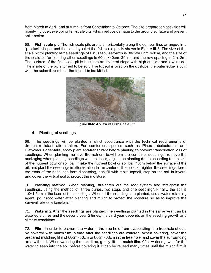
37
from March to April, and autumn is from September to October. The site preparation activities will mainly include developing fish-scale pits, which reduce damage to the ground surface and prevent soil erosion. 68. Fish scale pit. The fish scale pits are laid horizontally along the contour line, arranged in a "product" shape, and the plan layout of the fish scale pits is shown in Figure III-6. The size of the scale pit for planting large seedlings of Pinus tabulaeformis is 80cm×60cm×40cm, and the size of the scale pit for planting other seedlings is 60cm×40cm×30cm, and the row spacing is 2m×2m. The surface of the fish-scale pit is built into an inverted slope with high outside and low inside. The inside of the pit is turned to be soft. The topsoil is piled on the upslope, the outer edge is built with the subsoil, and then the topsoil is backfilled.
Figure III-6: A View of Fish Scale Pit
4. Planting of seedlings
69. The seedlings will be planted in strict accordance with the technical requirements of drought-resistant afforestation. For coniferous species such as Pinus tabulaeformis and Platycladus orientalis, spray plant anti-transpirant before planting to prevent transpiration loss of seedlings. When planting, remove the nutrient bowl from the container seedlings, remove the packaging when planting seedlings with soil balls, adjust the planting depth according to the size of the nutrient bowl or soil ball, make the nutrient bowl or soil ball 10cm below the surface of the pit, and plant the seedlings in afforestation In the center of the hole, straighten the seedlings, keep the roots of the seedlings from dispersing, backfill with moist topsoil, step on the soil in layers, and cover the virtual soil to protect the moisture. 70. Planting method. When planting, straighten out the root system and straighten the seedlings, using the method of "three buries, two steps and one seedling". Finally, the soil is 1.0~1.5cm at the base of the seedlings. When all the seedlings are planted, use a water-retaining agent, pour root water after planting and mulch to protect the moisture so as to improve the survival rate of afforestation. 71. Watering. After the seedlings are planted, the seedlings planted in the same year can be watered 3 times and the second year 2 times; the third year depends on the seedling growth and climate conditions. 72. Film. In order to prevent the water in the tree hole from evaporating, the tree hole should be covered with mulch film in time after the seedlings are watered. When covering, cover the prepared mulching film of 80cm×80cm or 60cm×60cm in the tree hole, and cover the surrounding area with soil. When watering the next time, gently lift the mulch film. After watering, wait for the water to seep into the soil before covering it. It can be reused many times until the mulch film is
38
broken and cannot be used for recycling.
5. Post-Plant monitoring and care
73. To protect and promote healthy growth of seedlings, their growth will be regularly monitored, replanted, pruned, fertilized and watered.
• Replanting. Replanting the forest stands where the preservation rate of seedlings and saplings does not meet the afforestation requirements, or the open space in the forest has a stand larger than 25m2, or the forest land with good site conditions and few tree species that meet the business objectives. Tending and replanting points will be arranged in forest gaps and open spaces in the forest. The replanting will be carried out during the afforestation season, and the replanting of seedlings should not affect the growth and development of the original seedlings and young trees on the afforestation land. When replanting, do not damage the original understory vegetation and minimize the disturbance to the soil.
• Pruning. Pruning and tending to remove dead branches and under-canopy trees in the project area that need to cultivate large-diameter target trees but whose natural pruning is not good, or other tall trees whose branches hinder the growth of the target tree. Round ~ 2 round branches. After pruning the young forest, keep the crown length not less than 2/3 of the height of the tree, and the piles should be trimmed as much as possible, and the cut should not damage the phloem and xylem of the trunk.
• Watering. In areas where the rainfall is less than 400 mm, water the young plantations with young seedling ages, short afforestation years and weak resistance to drought. The watering should be watered with holes.
• Fertilization: For forest stands with poor soil and poor growth of seedlings, top-dressing and tending. The topdressing should be organic fertilizer or compound fertilizer, and the fertilizer should be applied to the soil or trees to maintain and improve the fertility of the soil.
6. Use of Pesticides 74. The main pests in the forestry sector are rodents and fungal diseases (ascomycota). Rodents consume the roots of planted trees, causing plants to die. Common methods of their control are trapping and killing. The common methods of disease control are (i) remove and bury or burn the diseased leaves to reduce pathogens, (ii) spray pesticides (carbendazim and chlorothalonil) to the canopy in late spring and early summer. The estimated use of agrochemicals is given in Table III-13. The project will minimize the use of pesticides, especially synthetic organic pesticides, and strictly prohibit the use of highly toxic pesticides with a long residual period, including all kinds of pesticides prohibited and restricted by the state. The safe use of pesticides strictly abides by the "General Rules for the Safe Use of Pesticides" (NY/T 1276-2007).
Table III-13: Estimated Use of Agrochemicals
District / County Subproject location Name of chemicals
Area (ha)
Dosing rate (t/ha)
Estimated dosing (t/a)
Gansu Province
Qingyang City Qingcheng County, Huachi County
Qingyang Loess Plateau Forest Ecological Restoration Zone
Fertilizer 2,246.33 100% 27.08
Qingyang City Qingcheng County, Huachi County; Ganzhou District,
Qingyang Loess Plateau Forest Ecological Restoration Zone The ecological restoration
Pesticides 2,399.33 100% 28.09

39
District / County Subproject location Name of chemicals
Area (ha)
Dosing rate (t/ha)
Estimated dosing (t/a)
Linze County, Zhangye City
area of wetlands in the Heihe River Basin
Qinghai Province
Xining City The afforestation and greening project in the Xibu area
Pesticides 20,000 100% 2.8
Xining City The afforestation and greening project in the Xibu area
Fertilizer 20,000 100% 547
Shaanxi Province
Fugu Fugu Fertilizer 533.33 2.52 1,343.99
Fugu Fugu Pesticide 533.33 0.033 17.60
Shiquan Shiquan Pesticide 93.34 3.5 326.69
Shiquan Shiquan Pesticide 93.34 0.033 3.08
Qian Qian Fertilizer 400 0.75 300.00
Qishan Qishan Fertilizer 24.22 0.75 18.17
7. Water Use, Sources and Conservation Measures
75. Source of water. Water supply for the forest activities will be mainly from surface water sources. Groundwater sources will be used for subprojects in two counties (Linze and Linwei counties). The water supply for the rural and tourism support activities will be sourced from the existing water supply facilities. The water sources for the various counties and proposed water abstraction measures are given in Table III-14.
Table III-14: Sources of Water Supply for the Project Counties
No. County Water
demand (1,000 m3)
Water sources Water Taking Measure
A Gansu
1 Huachi County
234 Surface water (Liyuanpu River) Pumping+watering truck
2 Qingcheng 390 Surface water (Malian River, well) Pumping+watering truck
3 Huachi Bureau
144 Surface water (Chenghao River) Pumping+watering truck
4 Ganzhou 8,211 Surface water (Heihe River, Shandan River) Canal + pump+pipeline
5 Linze 1,653 Surface water, subsurface water Artesian well, canal
B Shaanxi
6 Fugu 1,095 Subsurface water (Yellow River, Huangfu River, Qingshui River, Mugua River, Gushan River)
Watering truck, pump
7 Yichuan 340 Surface water (Yellow River, Luchuan River, Baishui River)
Watering truck, pump
8 Heyang 180 Surface water (Jinshui River, Xuishui River) Watering truck, pump
9 Ansai 144 Surface water (Yanhe River) Watering truck, pump
10 Fuxian 278 Surface water (Beiluo River, Hulu River, Dashenhao River)
Watering truck, pump, pipe
11 Xunyi 95 Surface water (Malan River) Pump
12 Pucheng 824 Surface water (Luoxi Canal) Luoxi Canal
13 Chencang 112 Surface water (Baoji Total Canal from Weihe pump, canal

40
No. County Water
demand (1,000 m3)
Water sources Water Taking Measure
River)
14 Panlong 54 Surface water (Baoji Total Canal from Weihe Rive, Wangjiaya Reservoir)
Watering truck, pump
15 Qishan 312 Surface water (Xifang River, Hengshui River, Shitou River)
Watering truck, pump
16 Qianxian 248 Surface water (Ganhe River, Yangmaowan Canal, Qianling Reservoir)
Watering truck, pump
17 Gaoling 226 Surface water (Weihe River, Jinghe River, Jiuzhi Canal)
Watering truck
18 Linwei 231 Subsurface water (well) pump
19 Huayin 600 Surface water (Luofu River, Liuye River, Changjian River)
Watering truck,pump
20 Huazhou 124 Surface water (Luowen River) /
21 Tongguan 478 Surface water (Tonghe River,Weihe River) Watering truck,pump
22 Zhouzhi 69 Surface water (Damang River, Heihe River, Kunyu River, Heihe Canal)
Watering truck, pump
23 Ningshan 8.6 Surface water (Chang'an River, Donghe River)
pump
24 Shiquan 929 Surface water (Ziwu River, Raofeng River, Hanjiang River, Chihe Rive)
Watering truck, pump
25 Langao 321 Surface water (Siji River, Lanhe River, Pingxi River)
Watering truck, pump
26 Ningqiang 110 Surface water (Changan River, Donghe River)
existing facilities of water storage, water supply in the Park
27 Lueyang 702 Surface water (Jialing River, Badu River, Dongdu River)
Watering truck, pump
C Qinghai
28 Xining 876.3 Surface water (Huangshui River; Nanchuan River, Beichuan River, Huoshao Gully, Shihui Gully)
Pumping
Total 18,8322.90
Water-Saving Measures Adopted in the Project Designs 76. The project designs have adapted the various water-saving technologies, including both structural or non-structural measures and drought-mitigation technologies. These aspects are summarized below: Non-Structural Measures
(i) Selection of tree species. Species of trees relying on long-term watering and high water use for normal growth will not be used. Priority will be given to drought-enduring native tree species, for which natural precipitation is enough to meet the water consumption need for the grown forest in the proposed project areas. The list of tree species is given in Appendix 3.
(ii) Water-saving awareness. Awareness raising of the increasing aridity of the project region and the project water-saving measures will be included in the project trainings for communities and government agencies.

41
Structural Measures (i) Afforestation of site preparation technology for soil and water conservation. These
comprise: (i) micro-structures will be used at planting sites to maximize capture of rainwater and runoff, reduce the use of groundwater, and stabilize slopes and soil – site preparation along contours, use of shallow grassy trenches to capture runoff and reduce overland flow, small ponds, reverse-slope terraces, level benches, and fish scale pits,9 (ii) use of water-efficient taps, and (iii) recycling of treated wastewater for watering of landscaped sited.
(ii) Afforestation of mobile greenhouse technology. Mobile greenhouse, also known as the water tray, is used in the process of planting saplings with water collection, heat preservation, increasing photosynthesis, weed and insect controlling and other effects made of polypropylene, has a good role in conserving soil moisture. This water tray has a double-layer structure with a silver-gray reflective layer outside, and black endothermic layer inside to raise the ground temperature and balance the temperature difference between day and night, to collect various water of rain, snow, dew, condensation and soil evaporation. As anti-aging technology and anti-ultraviolet technology are added to the materials, the outdoor service life of the greenhouse of the water tray will be more than 5 years, and the protection time for vegetation growth is longer. According to the feasibility report, this technique will be mainly applied in the sub-project areas of Qinghai province.
(iii) Afforestation of ecological grass ditch technology. Considering the runoff of green
land rainwater, ecological grass ditch is similar to pipeline drainage. Generally, the ditch is a lower concave green belt land with cross section of triangular or trapezoidal shape. Due to high speed of water flow, commonly, stones are laid on the bottom of the grass ditch to mitigate soil erosion. Although the ditch is a belt-shape transmission measure for rainwater, there is no stiff regulation on the width of grass ditch. It can also be designed as a green space and become a multi-functional area integrating leisure and greening. Ecological grass ditch is the applying of sponge city concept to forestry, which play an important role in soil and water conservation, soil purification and habitat restoration by mitigating the impact of surface runoff, collecting, infiltrating and purifying rainwater in the subproject area, promoting the utilization of water resources and ecological environment protection. According to the feasibility report, this technology will mainly be applied in the sub-project areas of Qinghai province.
(iv) Afforestation of water-retaining agent technology. During the planting of seedlings,
10-50g water-retaining agent10 will be buried to the roots of seedlings. After watering or
9 Level bench method: used on the slope with many rocks and large slope (10° ~ 25°), is to cut the outer pad along the contour line from top to bottom to form a table, with the outer surface being higher and lower, so as to store as much water as possible and reduce the loss. Fish-scale pit: ground should follow the natural slope shape along the contour line, and dig approximately half-moon shaped pits according to certain plant spacing. The bottom of the pits should be 30cm lower than the original slope surface, and the pits should be kept horizontal or inclined inward. Fish-scale pits are laid along the contour levels with shape of “ ”, and the surface is high for outer side and low for inner side so as to form an adverse slope shape to reduce soil erosion. Reverse slope terrace: suitable for the rectification of sloping land with relatively thin soil and excavation along the contour line from top to bottom. The topsoil is first stacked on both sides, the subsoil is made into a ridge, the topsoil is backfilled in the pit, and the reverse slope with a slope of about 30°~40° is built on the downward slope surface. According to the feasibility study, these technologies are mainly used in various subproject areas of soil and water conservation forests 10 Water-retaining agents that are commonly used in the PRC are (i) potasium polyacrylamide (“PAM”), which contains 65–66% acrylamide potassium (acrylamide is an organic compound with the chemical formula CH2=CHC(O)NH2) and 23– a soil conditioning agent in agricultural applications and other land management practices and s.

42
rainfall, water will be absorbed into the soil for long-term absorption by the trees due to the prepared water-retaining agent. In addition, a mixture can be made by 50~100g of water-retaining agent and 50kg of water by mixing and fully stirring. During planting, each seedling can be irrigated with 0.5kg of this mixture and then covered with soil rapidly. Subsequently, watering can be conducted based on drought conditions at that time. According to the feasibility study, this technology is mainly used in various sub-project areas in the three provinces.
(v) Afforestation of transpiration resistant agent technology. Generally, anti-
transpiration agents are classified into three categories: metabolic, thin-film and reflective. Different anti-transpiration agents can be used for different degrees of drought. Membrane-forming anti-transpiration agents are more suitable for heavy drought resistance, metabolic anti-transpiration agents can be used for mild-drought and occasional drought. The use of anti-transpiration agents in afforestation is able to reduce the transpiration of plants, ensure the water metabolism balance during the incomplete recovery of plant roots, promote the development of plant roots, and shorten the recovery time of roots. Before afforestation, watering on the branches and leaf surface of seedlings can form ultra-thin and transparent protective film, which can effectively inhibit the over-transpiration of water in plants, reduce the damage of branches and leaves caused by transplantation, drought and wind erosion to the greatest extent. And this will improve the survival rate of plants and reduce the artificial maintenance cost. According to the feasibility study, this technique is mainly used in various sub-project areas in the three provinces.
E. O&M of Forest Health and Wellness and Tourism Facilities 77. The project will augment existing facilities for water supply, sanitation and waste collection. The water supply will be mainly from the existing sources within the proposed forest and tourism areas or from the existing municipal water supply facilities. The electricity supply for these facilities will be from the existing distribution lines of the national grid. The park management will be responsible for maintaining cleanliness, drinking water supply and sanitation, and waste collection and disposal. The existing landfills, waste and wastewater treatment facilities will be used for managing the solid waste and sewage waste generated from the project facilities. Details of waste and wastewater generated from the project facilities and their proposed management using existing municipal facilities are explained in Table III-15.
F. Associated and Existing Facilities 78. The project due diligence considered two types of facilities per ADB’s SPS: (i) associated facilities – those which are not funded by the project but whose viability and existence depend exclusively on the project and whose operation and services are essential for the successful operation of the project; and (ii) existing facilities – those which are already established and will be necessary for the project operations, but whose operation does not depend on the project. These existing facilities are not part of the project scope and will not be subject to any ADB-funded construction, operation, upgrade, rehabilitation, or other activities. For completeness, due diligence was conducted for both associated and existing facilities. The existing facilities assessed include municipal facilities for waste disposal and wastewater treatment. The power supply for the project facilities will be from the existing power distribution network in the country. A summary of the existing facilities is given in Table III-15 and details of these facilities are explained in the following sections.

43
79. The hazardous waste generated from the project activities mainly includes pesticide packaging waste, which will be managed separately, complying with the current regulations. According to PRC Regulation on Management of Pesticide Packaging Waste co-issued by MOA and MEE in 2020, (i) Pesticide producers and dealers shall be responsible for recycling or disposal of pesticide packaging waste. Pesticide producers and dealers may negotiate to determine the specific ways to fulfill the obligation of recycling or disposal of pesticide packaging waste. Pesticide dealers shall set up pesticide packaging waste collection facilities at their business sites. This is a regulatory requirement and currently in practice in the project provinces. (ii) Agricultural bureaus at or above the county level shall guide the establishment of a recycling system for pesticide packaging waste; reasonably arrange collection stations (points) at county, township and village levels. (iii) Pesticide users shall collect pesticide packaging waste and return it to pesticide dealers or pesticide packaging waste recycling stations. (iv) The PRC government encourages and supports the recycling of pesticide packaging waste; the waste that cannot be recycled shall be disposed of at landfill sites or incineration facilities. The agriculture departments, together with the ecological environment departments at the provincial level, shall determine the qualified companies for recycling pesticide packaging waste and make them public to society. Disposal of hazardous materials, e.g., pesticide residue, was not included in the FSRs. Mitigation measures are proposed in the IEE section V-E.
Table III-15: Summary of Existing Facilities
No. Existing Facility Capacity Start of
Operation EIA
Approval Compliance
issues
Capacity to meet project
requirement
Gansu
1 Linze County Landfill 350,000 m3 2017 Yes None Yes
Qinghai
2 Xining City Yanjiagou Sewage Landfill
4.16 million m3 2006 Yes None Yes
Shaanxi
3 Zhouzhi County Domestic Waste Sanitary Landfill Site
1.3 million m3 2011 Yes None Yes
4 Sewage treatment plant in Louguantai Road Cultural Exhibition Area
12,500 tons of sewage per day
Yes None Yes
5 Shiquan County Landfill 100 tons/day of waste treatment
2012 Yes None Yes
6 Shiquan County Sewage Treatment Plant
20,000 tons of sewage per day
2017 Yes None Yes
7 Langao County Landfill site
72 tons/day of waste treatment
2010 Yes None Yes
8 Langao County Sewage Treatment Plan
72 tons/day of sewage
Yes None Yes
9 Hongligou Waste Landfill 2.2 million m3
(570 tons/day of waste treatment)
2013 Yes None Yes
10 Xunyi County Domestic Landfill Site
45 tons/day of waste treatment
Yes None Yes
11 Xunyi County Sewage Treatment Plant
10,000 tons/day 2013 Yes None Yes
12 Ningqiang County Landfill
2.8 million m3
(200 tons/day of waste treatment)
Yes None Yes
44
No. Existing Facility Capacity Start of
Operation EIA
Approval Compliance
issues
Capacity to meet project
requirement
13 Ansai County Second Landfill
158,400 m3 2016 Yes None Yes
14 Hanjing Town Waste Landfill
650,000 m3 2017 Yes None Yes
15 Huayue Waste Treatment Plant
200 tons/day 2007 Yes None Yes
16 Huayin Sewage Treatment Plant
40,000 m3 per day Yes None Yes
17 Fuxian Domestic Waste Treatment Plant
707,000 m3 (60 tons/day of waste treatment)
2010 Yes None Yes
18 Lueyang County Landfill 0.76 million m3
(70 tons/day) 2013 Yes None
80. The project is not expected to have any associated facility. The existing facilities that the project is going to use are existing forest nurseries, if available, and existing municipal facilities for waste management.
1. Gansu
81. Linze County Landfill. Two proposed garbage collection stations around the Shuangquan Lake Project Area. The waste from these stations will be regularly cleared and transported to Linze County's landfill, which is an associated facility for this project. Linze County, the total capacity of the landfill 350,000 m3. HDPE civil film is used to ensure long-term sealing. In 2016, the Environmental Environment Bureau of Zhangye City approved the environmental impact assessment of landfills. It was operational in 2017 with a total design period of 15 years. The landfill is managed and operated by the Linze County Housing and Urban-Rural Construction Bureau. 82. Connection with the local power grid: The power load level of this project is designed according to the secondary load, according to the provisions of GB50052-2009, the power supply system. The load will be supplied by 10kv lines located in close proximity.
2. Qinghai
83. Pumping stations supplying water to this project: A total of 24 pumping stations supplying water to this project are the Yangjiawan pumping station, Bailugou pumping station, Caijiagou pumping station, Wenjiagou pumping station, Tarshan forest farm pumping station, iron riding ditch pumping station, Zhengyuan company pumping station, Xiaoyuanshan pumping station, Haining Pearl Pump Station, Xishan Forest Field Pumping Station, Morning Light Pumping Station, Green Pass Pumping Station, Hanzhuang Pumping Station, Tank Trench Pumping Station, Zhangjiawan Pumping Station, Shenjiazhai Village Xishan Pumping Station, Gejiazhai Xishan Pumping Station, Langbar Pumping Station, Zhujiazhai Pumping Station, Baojia Dagou Pumping Station, Xiao Lushan 1, 2 Pumping Station, Yanzishan Pumping Station. They are considered to be related facilities for irrigation and water supply in the project area. The capacity and service period of the existing pumping stations were evaluated, the water demand of the project was 2.82 million m3, and the water supply capacity of the pumping stations was 20 million m3.

45
84. Landfill: Xining City Yanjiagou Landfill will be used for the disposal of solid waste generated from the project facilities, including the sludge generated from the sewage treatment facilities. The total capacity of the Yujiagou Landfill is 4.16 million m3. HDPE civil film is used to ensure long-term sealing of the bottom. In 2004, Qinghai Provincial Ecological Environment Department approved the environmental impact assessment of landfills. It was operational since 2006 and the design life is 15 years. The landfill is managed by Xining City's Yanjiagou Landfill. Yanjiagou Landfill 2021 run the last year, Yanjiagou Landfill this year entered the closure phase. After the closure of the Yanjiagou Landfill, the Zhangjiawan Landfill in Xining City West District will accept the project's household waste and sewage treatment stations such as health centers management stations and other sludge, as the associated facilities for the project. Zhangjiawan landfill total capacity of 3.03 million m3, HDPE civil film is used to ensure long-term sealing. In 2017, Qinghai Provincial Ecological Environment Protection Department approved the landfill environmental impact assessment, put into use in 2019, a total design service period of 15 years. The landfill is managed by the West District government of Xining City.
3. Shaanxi
85. Several landfill sites and wastewater treatment facilities are identified for the management of solid waste and wastewater generated from the various component activities. Details of these facilities are given in Table III-16.
Table III-16: Existing Facilities in Shaanxi Province
County/Existing Facility
Subcomponents that use the facility
1. Zhouzhi (Louguantai National Forest Rehabilitation Base, Heihe National Forest Park)
Zhouzhi County Domestic Waste Sanitary Landfill Site
(1) Heihe National Forest Park: The domestic garbage produced by tourists is collected in the park. The amount of garbage generated is about 460.8 tons/year, which is sent to the Zhouzhi County Domestic Waste Sanitary Landfill by the local sanitation department. (2) Louguantai National Forest Health and Rehabilitation Base: Domestic garbage produced by tourists is collected in the park. The amount of garbage generated is about 374.4 tons per year, which is sent to the Zhouzhi County Domestic Waste Sanitary Landfill by the local sanitation department. (3) The landfill. The designed storage capacity is 1.3 million m3, and the designed annual processing capacity is 35,000 to 40,000 tons. The design service life is 18 years (starting operation after completion of the project on October 1, 2011). The domestic waste of this project is included in the local sanitation department for unified collection and treatment, and the domestic waste can be properly treated.
2. Sewage treatment plant in Louguantai Road Cultural Exhibition Area
(1) Louguantai National Forest Rehabilitation Base: The domestic sewage generated in the park is treated by septic tanks and then connected to the Zhouzhi County municipal sewage pipe network, and finally discharged into the sewage treatment plant of the Louguantai Road Cultural Exhibition Area for centralized treatment. The amount of sewage generated 11.4 tons/year. (2) The sewage treatment plant handles 12,500 tons of sewage per day. The service scope is the sewage within the Louguantai Cultural Exhibition Area, including the area where the Louguantai National Forest Health Base is located. The sewage pipe network has been laid. The domestic sewage of this project is treated in septic tanks and can be collected through the sewage pipe network and then sent to the sewage treatment plant for treatment. The domestic sewage can be properly treated.
2. Shiquan County (Hanfeng Golden Silkworm Experience Hall)
Shiquan County Landfill
(1) Hanfeng Golden Silkworm Experience Hall and surrounding cultural park: The domestic garbage produced by tourists is collected and sent to the Shiquan County Landfill by the local sanitation department. The amount of garbage generated is

46
County/Existing Facility
Subcomponents that use the facility
about 48 tons per year. (2) The landfill. The designed daily processing capacity is 100 tons, and the design service life is 15 years (starting operation after the completion of the project in 2012.12). The domestic waste of this project is included in the local sanitation department for unified collection and treatment, and the domestic waste can be properly treated.
Shiquan County Sewage Treatment Plant
(1) Hanfeng Golden Silkworm Experience Hall: The domestic sewage produced by visitors and staff in the experience hall is treated by septic tanks and then connected to the Shiquan County municipal sewage pipe network and finally discharged into the Shiquan County Sewage Treatment Plant for centralized treatment. The amount of sewage generated is 1.15 Tons/year. (2) After the sewage treatment plant was rebuilt and expanded in 2017, the daily sewage treatment capacity reached 20,000 tons, and the service scope covered the area where the Hanfeng Golden Silkworm Experience Hall was located. The domestic sewage of this project is treated in septic tanks and can be collected through the sewage pipe network and then sent to the sewage treatment plant for treatment. The domestic sewage can be properly treated.
3. Langao (Science Museum of Bashan Rare Botanical Garden)
Landfill site of domestic waste in Langao County
(1) Science Museum of Bashan Rare Botanical Garden and surrounding cultural parks: The domestic garbage generated by tourists is collected and sent to the landfill of Langao County by the local sanitation department. The amount of garbage generated is about 48 tons per year. (2) The landfill. The designed daily processing capacity is 72 tons, and the design service life is 15 years (starting operation after completion in 2010). The domestic waste of this project is collected and processed by the local environmental sanitation department, and the domestic waste can be properly processed.
Langao County Sewage Treatment Plant
(1) Science Museum of Bashan Rare Botanical Garden: The domestic sewage produced by tourists and staff in the experience hall is treated by septic tanks and then connected to the municipal sewage pipe network of Langao County and finally discharged into Langao County Sewage Treatment Plant for centralized treatment. The amount of sewage generated is 1.15 tons /year. (2) The sewage treatment plant has a daily sewage treatment capacity of 72 tons, and its service scope covers the area where the Science Museum of Bashan Rare Botanical Garden is located. The domestic sewage of this project is treated in septic tanks and can be collected through the sewage pipe network and then sent to the sewage treatment plant for treatment. The domestic sewage can be properly treated.
4. Chencang (Forest Science Popularization Experience Park in Beipo Forest Park, Chencang District)
Hongligou Waste Landfill in Baoji City
(1) Forest Science Experience Park of Beipo Forest Park in Chencang District: The domestic garbage produced by tourists is collected in the park and sent to the Hongligou landfill in Baoji City by the local sanitation department. The amount of garbage generated is about 104 tons per year. (2) The landfill. The designed storage capacity is 2.2 million m3, and the designed daily processing capacity is 570 tons. The design service life is 12 years (starting operation after completion in 2013). The domestic waste of this project is included in the local sanitation department for unified collection and treatment, and the domestic waste can be properly disposed of.
5. Xunyi (Wetland Education (Management) Center)
Xunyi County Domestic Waste Landfill Site
(1) Wetland Education (Management) Center and Wetland Park: The domestic garbage generated by tourists is collected and sent to the Xunyi County domestic garbage landfill by the local environmental sanitation department. The amount of garbage generated is about 48 tons per year.

47
County/Existing Facility
Subcomponents that use the facility
(2) The landfill. The short-term (2020) domestic waste landfill volume is 45.0 t/d, and the long-term (2025) domestic waste landfill volume is 60.0 t/d. The domestic waste of this project is included in the local environmental sanitation department for unified collection and treatment, and the domestic waste can be properly treated.
Xunyi County Sewage Treatment Plant
(1) Wetland Education (Management) Center: The domestic sewage produced by visitors and staff in the museum is treated by septic tanks and then connected to the municipal sewage pipe network of Xunyi County and finally discharged into the Xunyi County Sewage Treatment Plant for centralized treatment. The amount of sewage generated 1.15 tons/year. (2) After the sewage treatment plant was rebuilt and expanded in 2013, the daily sewage treatment capacity reached 10,000 tons, and the service scope covered the area where the wetland education (management) center was located. The domestic sewage of this project is treated in septic tanks and can be collected through the sewage pipe network and then sent to the sewage treatment plant for treatment. The domestic sewage can be properly treated.
6. Ningqiang (Ningqiang Hanshuiyuan Forest Park)
Ningqiang County Landfill
(1) Ningqiang Hanshuiyuan Forest Park in Ningqiang County: The domestic garbage produced by tourists is collected in the park and sent to the landfill of Ningqiang County by the local environmental sanitation department. The amount of garbage generated is about 100 tons per year. (2) The waste landfill has a designed storage capacity of 2.8 million m3 and a designed daily processing capacity of 200 tons. It is currently operating normally. The domestic waste of this project is included in the local sanitation department for unified collection and treatment, and the domestic waste can be properly disposed of.
7. Ansai (City Health Forest (Natural Park))
The second landfill in Ansai County
(1) Urban Health Care Forest (Natural Park): The domestic garbage produced by tourists is collected in the park and sent to the second landfill in Ansai County by the local sanitation department. The amount of garbage generated is about 30 tons per year. (2) The designed storage capacity of the landfill is 158,400 m3, and the design service life is 20 years (2016-2035). It is currently operating normally. The domestic waste of this project is included in the local environmental sanitation department for unified collection and treatment, and the domestic waste can be properly treated.
8. Pucheng (Health Care Forest (Natural Park))
Hanjing Town Landfill, Pucheng County
(1) Urban Kangyang Forest (Natural Park): The domestic garbage produced by tourists is collected in the park and sent to the landfill in Hanjing Town, Pucheng County, by the local sanitation department. The amount of garbage generated is about 100 tons per year. (2) The landfill has a short-term landfill capacity of 75 tons/day, a long-term landfill capacity of 80 tons/day, an effective storage capacity of 650,000 m3, and a design service life of 15.3 years (operation after completion in 2017), and it is currently operating normally, the domestic waste of this project is included in the local environmental sanitation department for unified collection and treatment, and the domestic waste can be properly handled.
9. Huayin (Forest Village)
Huayue Landfill (1) Forest rural town: The domestic garbage produced by villagers and tourists is collected and sent to Huayue Landfill by the local environmental sanitation department. The amount of garbage produced is about 160 tons per year. (2) The landfill processes 200 tons of municipal solid waste per day, with a total storage capacity of 1.8 million m3 and a service life of 20 years. It was put into trial operation on March 15, 2007. The current operation is normal, the domestic waste of this project is included in the local environmental sanitation department for unified
48
County/Existing Facility
Subcomponents that use the facility
collection and treatment, and the domestic waste can be properly disposed of.
Huayin Sewage Treatment Plant
(1) Forest rural town: the domestic sewage produced by tourists and villagers in the town is treated by septic tanks and then connected to the Huayin municipal sewage pipe network, and finally discharged into the Huayin sewage treatment plant for centralized treatment. The sewage generated 3.84 tons /year. (2) The sewage treatment plant handles 40,000 m3 of sewage per day, and its service scope covers the area where the forest village town is located currently operating normally. The domestic sewage of this project can be collected through the sewage pipe network after being treated in the septic tank and then collected in the sewage treatment plant for treatment.
10. Fu County
Fuxian City Domestic Waste Treatment Plant
(1) Xanthoceras sorbifolia Bunge Comprehensive Development Center: The domestic waste generated in the tea-making process of the development center is collected and sent to the domestic waste treatment plant in Fuxian City by the local sanitation department. The waste generation is about 0.3 tons/year. (2) The landfill total storage capacity is 707,000 m3, Daily treatment of solid municipal waste 60 tons, service life 18 Years, October 2010 put into trial operation monthly, The current operation is normal, the domestic waste of this project is included in the local environmental sanitation department for unified collection and treatment, and the domestic waste can be properly disposed of.
11. Lueyang County
Lueyang County Landfill
(1) Lueyang City Weekly Ecological Experience Zone: The domestic garbage produced by tourists is collected and sent to Lueyang County Garbage Treatment Plant by the local environmental sanitation department. (2) The landfill. Daily treatment of municipal solid waste 70 tons, total storage capacity 0.76 million m3, the service life is 20 years, November 2013 put into trial operation. The current operation is normal, the domestic waste of this project is included in the local environmental sanitation department for unified collection and treatment, and the domestic waste can be properly disposed of.
49
IV. DESCRIPTION OF THE ENVIRONMENT (BASELINE)
A. Overview 86. Project areas in Gansu Province are located in the Loess Plateau and Hexi Corridor Plain. The two regions have a wide range of droughts, severe soil erosion, low ecological carrying capacity, and weak natural restoration capabilities. The prominent ecological problems in the project area include sparse vegetation, fragile ecology, poor living and production environment; low soil moisture content; poor growth of forests; the decline of forest groundwater level; insufficient ecological protection and restoration capacity, lack of forest and wetland protection in the project area Professional management and technical personnel, farmers in the project area lack forestry technology and skills. Natural hazards and improper use of resources for a long time, soil erosion, vegetation degradation, and frequent occurrence of various natural disasters are still severe environmental problems facing Gansu Province. Many forest lands in Gansu remain abandoned, and grassland degradation is still increasing. Almost 50% of grassland areas are seeing moderate or higher levels of degradation; and the area of desertified land accounts for 28% of the province’s total land area; 2/3rd of the national total land area are under conditions of soil erosion at varying degrees.
87. Natural environmental conditions in Shaanxi Province are complex and diverse, and human activities have a profound impact on the ecological environment. Shaanxi Province is listed among the national main ecological governance areas because it straddles three areas with serious soil erosion and desertification, including the upper-middle reaches of the Yellow River, the upper-middle reaches of the Yangtze River, and the "Three North" comprehensive sandstorm control area. The province's existing soil erosion area is 107.5 million km2, accounting for 52.3% of the country's land area, of which the moderate and strong soil erosion area accounts for 40%. The province's annual sediment volume into the Yellow River and Yangtze River is 920 million tons, accounting for one-fifth of the national river sediment volume. 88. Qinghai Province has the world's largest area of alpine wetlands, alpine grasslands, shrub forests and other ecosystems. It is the origin of the Yangtze, Yellow and Lancang rivers, and its ecological location is important. Main ecological problems in the project area include: (i) Insufficient coordination between mountains on urban fringes and the urban greens; (ii) Low vegetation coverage and serious soil erosion; (iii) Low level of biodiversity, with 70% of the forest with singular species; (iv) Forest stand degradation and fragile ecology; (v) Difficulty of afforestation and consolidation of forest management outcomes; (vi) Insufficient forest tourism facilities and recreational space for residents; (vii) Extreme scarcity of funds and talents, weak ecological protection and restoration technology support; rural development lags behind, with 1 national-level poverty county (Huangzhong county) and 5 key poverty villages; and (viii) The government’s subsidy for conversion of farmland to forest land ended in 2018, and there is no update on the renewal of subsidy policy. Therefore, the villagers may damage the forest vegetation due to lack of subsidies or inadequate subsidies for the conversion of farmland to forest land.
B. Location and Setting 89. The project sites are located in 33 counties and districts of Shaanxi, Gansu, and Qinghai provinces (Table IV-1). Locations of project counties and their terrain are shown in Figure IV-1. The sensitive receptors near the project sites are given in Section V.A.
50
Table IV-1: Locations of Project Sites
No. Province City County/District/Farm
1. Qinghai Xining Chengbei District
2. Chengxi District
3. Chengdong District
4. Chengzhong District
5. Huangzhong District
6. Gansu Qingyang Huachi Branch
7. Huachi County
8. Qingcheng County
9. Zhangye Ganzhou District
10. Linze County
11. Shaanxi Xi'an Zhouzhi County
12. Gaoling District
13. Louguantai National Forest Park
14. Baoji Qishan County
15. Chencang District
16. Panlong New District
17. Xianyang Xunyi County
18. Qian County
19. Weinan Pucheng County
20. Heyang County
21. Huazhou District
22. Linwei District
23. Huayin City
24. Tongguan District
25. Yulin Fugu County
26. Ansai District
27. Fu County
28. Yichuan County
29. Hanzhong Lueyang County
30. Ningqiang County
31. Ankang Shiquan County
32. Ningshan County
33. Langao County
90. Project counties of Shaanxi Province are located in southern Shaanxi, Guanzhong Plain, and northern Shaanxi loess plateau, respectively. Each of those three zones has a unique climate type and physical environmental settings.
• Southern Shaanxi, in the south of Mt. Qinling, has a subtropical climate with warm and wet conditions. Hydrologically, the region is the upper catchments of Hanjiang River and Jialingjiang River, which are all major tributaries of the Yangtze.
• In the north of Shaanxi Province, there are three counties located on the loess plateau. They are within various catchments for tributaries of the Yellow River. Those counties have got drier climates with annual precipitation ranging from 450- 550mm and very erosional soils.
• Most Shaanxi project counties are located in the middle of Shaanxi Province, along the Wei River that is also an important tributary of the Yellow River. The climate and other physical environments of the Wei River catchment are between the above-mentioned regions, with

51
approximately 500-600 mm of annual precipitation and fertile soils.
Figure IV-1: Elevation of three project provinces and Locations of Project counties
91. There are four project counties from Gansu, two in the southeast and two in the northwest of the province. The climate and physical conditions of the two southeast counties are similar to those of northern Shaanxi project counties, whilst the two northwest counties are the driest among all project sites of this project, with less than 200 mm of annual precipitation. The wetland projects of those two counties will fully rely on the water from the Heihe River, which is an inland river that ends in an inland lake of western Inner Mongolia. 92. Project sites in Qinghai Province are concentrated in the mountains surrounding Xining City, including some areas of Huangzhong District. The long-term average annual precipitation is 380 mm in Xining City whilst it is slightly higher on the surrounding mountains, reaching approximately 400 mm.
C. Topography and Geology 93. The project area is located in the Loess Plateau, with an altitude of 1200-1800 m. The loess deposits are more than 100 m thick. The terrain is generally inclined to the southeast from east, north and west. The terrain is dominated by hilly land forms, river valleys, and plateaus. The typical landforms of gully erosion in the project area are shown in Figure IV-2. 94. Qingyang loess plateau forest ecological restoration area is a typical ecological fragile area in the country and is also a key area for soil and water conservation and ecological restoration in
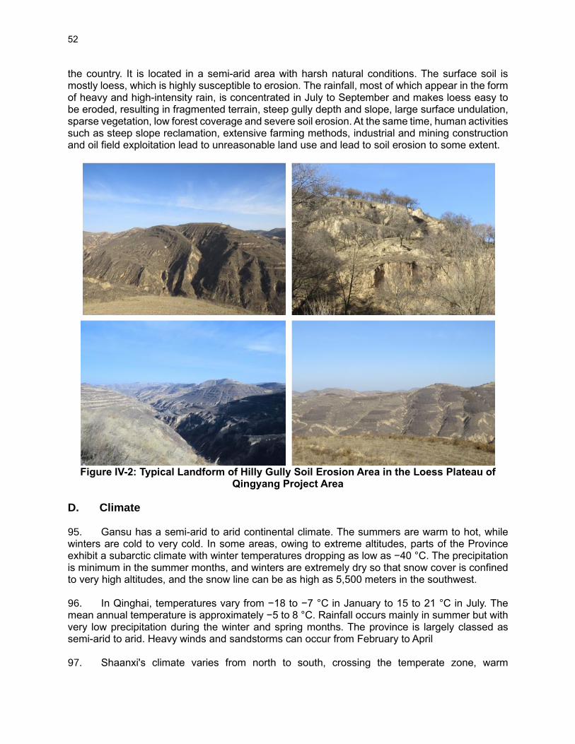
52
the country. It is located in a semi-arid area with harsh natural conditions. The surface soil is mostly loess, which is highly susceptible to erosion. The rainfall, most of which appear in the form of heavy and high-intensity rain, is concentrated in July to September and makes loess easy to be eroded, resulting in fragmented terrain, steep gully depth and slope, large surface undulation, sparse vegetation, low forest coverage and severe soil erosion. At the same time, human activities such as steep slope reclamation, extensive farming methods, industrial and mining construction and oil field exploitation lead to unreasonable land use and lead to soil erosion to some extent.
Figure IV-2: Typical Landform of Hilly Gully Soil Erosion Area in the Loess Plateau of
Qingyang Project Area
D. Climate 95. Gansu has a semi-arid to arid continental climate. The summers are warm to hot, while winters are cold to very cold. In some areas, owing to extreme altitudes, parts of the Province exhibit a subarctic climate with winter temperatures dropping as low as −40 °C. The precipitation is minimum in the summer months, and winters are extremely dry so that snow cover is confined to very high altitudes, and the snow line can be as high as 5,500 meters in the southwest. 96. In Qinghai, temperatures vary from −18 to −7 °C in January to 15 to 21 °C in July. The mean annual temperature is approximately −5 to 8 °C. Rainfall occurs mainly in summer but with very low precipitation during the winter and spring months. The province is largely classed as semi-arid to arid. Heavy winds and sandstorms can occur from February to April 97. Shaanxi's climate varies from north to south, crossing the temperate zone, warm

53
temperate zone and north subtropical, all of which are typical continental monsoon climate zone. With Qinling as the boundary, the north-south climate difference is significant: the south is located in the subtropical humid monsoon climate zone, the north is a temperate semi-arid monsoon climate zone. The average annual temperature of the province is 13.3°C, and the distribution trend is gradually decreasing from south to north and from east to west. Among them, the average annual temperature in southern Shaanxi is 14 to 16°C, 12 to 13°C in Guanzhong, and 8 to 10°C in northern Shaanxi. The province's average annual precipitation is 663.2 mm, of which the average in northern Shaanxi is 461.7 mm, the average in Guanzhong is 590.4 mm, and the average in southern Shaanxi is 864.6 mm. The average annual number of hours of sun in the province is 1865.3 hours, and the actual number of hours of daylight in various places is between 1356 and 2918 hours. Taking the Qinling Mountains as the boundary, the climate difference between the north and the south is significant: the south is located in the subtropical humid monsoon climate zone, and the north is in the temperate semi-arid monsoon climate zone. The annual average temperature of the whole province is 13.3°C, and the distribution trend is gradually decreasing from south to north and from east to west. The annual average temperature in southern Shaanxi is 14-16°C, that in Guanzhong is 12-13°C, and that in Northern Shaanxi is 8-10°C. The average annual precipitation of the whole province is 663.2 mm, including 461.7 mm in Northern Shaanxi, 590.4 mm in Guanzhong and 864.6 mm in southern Shaanxi. The annual average sunshine hours of the whole province are 1865.3 hours, and the actual sunshine hours are 1356-2918 hours. 98. Average monthly temperatures and precipitation data at five representative stations (Xifeng and Zhangye in Gansu; Hanzhong, Qindu, Yanan and Yulin in Shaanxi; and Xining in Qinghai) in the project area are given in Figure IV-3 and Figure IV-4.
Figure IV-3: Monthly Mean Temperatures in the Project Area
-10
-5
0
5
10
15
20
25
30
Jan Feb Mar Apr May Jun Jul Aug Sep Oct Nov Dec
MONTHLY TEMPERATURE(OC)
Zhangye Xining Yulin Yanan Xifeng Qindu Hanzhong
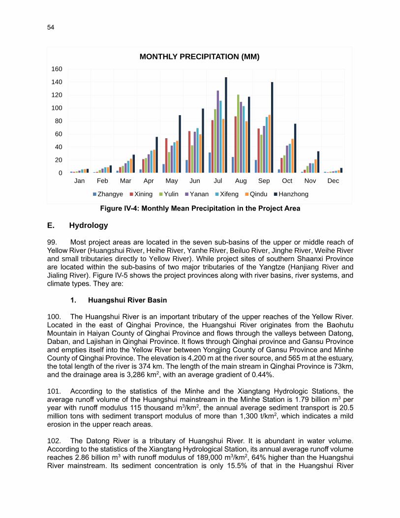
54
Figure IV-4: Monthly Mean Precipitation in the Project Area
E. Hydrology 99. Most project areas are located in the seven sub-basins of the upper or middle reach of Yellow River (Huangshui River, Heihe River, Yanhe River, Beiluo River, Jinghe River, Weihe River and small tributaries directly to Yellow River). While project sites of southern Shaanxi Province are located within the sub-basins of two major tributaries of the Yangtze (Hanjiang River and Jialing River). Figure IV-5 shows the project provinces along with river basins, river systems, and climate types. They are: 1. Huangshui River Basin 100. The Huangshui River is an important tributary of the upper reaches of the Yellow River. Located in the east of Qinghai Province, the Huangshui River originates from the Baohutu Mountain in Haiyan County of Qinghai Province and flows through the valleys between Datong, Daban, and Lajishan in Qinghai Province. It flows through Qinghai province and Gansu Province and empties itself into the Yellow River between Yongjing County of Gansu Province and Minhe County of Qinghai Province. The elevation is 4,200 m at the river source, and 565 m at the estuary, the total length of the river is 374 km. The length of the main stream in Qinghai Province is 73km, and the drainage area is 3,286 km2, with an average gradient of 0.44%. 101. According to the statistics of the Minhe and the Xiangtang Hydrologic Stations, the average runoff volume of the Huangshui mainstream in the Minhe Station is 1.79 billion m3 per year with runoff modulus 115 thousand m3/km2, the annual average sediment transport is 20.5 million tons with sediment transport modulus of more than 1,300 t/km2, which indicates a mild erosion in the upper reach areas. 102. The Datong River is a tributary of Huangshui River. It is abundant in water volume. According to the statistics of the Xiangtang Hydrological Station, its annual average runoff volume reaches 2.86 billion m3 with runoff modulus of 189,000 m3/km2, 64% higher than the Huangshui River mainstream. Its sediment concentration is only 15.5% of that in the Huangshui River
0
20
40
60
80
100
120
140
160
Jan Feb Mar Apr May Jun Jul Aug Sep Oct Nov Dec
MONTHLY PRECIPITATION (MM)
Zhangye Xining Yulin Yanan Xifeng Qindu Hanzhong
55
mainstream. Its average sediment concentration is only 1.13kg/m3. As mentioned in section 3.2.1, the water transferring project plays an important role in supplement water resources from the Datong River to the Huangshui River. 103. Project sites are located mainly in Xining and Huangzhong County, which are in the middle of the river basin. These are also the highest project sites in this project, with elevations above 2,200 meters. The annual precipitation in the valley is about 380 mm but slightly higher in the surrounding mountains. 2. Heihe River Basin 104. The Heihe River originates from the northern foot of the Qilian Mountains and flows through Qinghai, Gansu and ends in Inner Mongolia with mainstream of 821 km. Above the outlet pass of the Yingluo Gorge is the upstream areas with river course of 303 km and a drainage area of 10.0 thousand km2. The vegetation on both sides of the river is relatively good. The river-reach from the Yingluo Gorge to the Zhengyi Gorge is the middle reaches, 185 km, covering an area of 25.6 thousand km2. The terrain on both sides is flat, and the resources of light and heat are abundant, but the drought is severe, with only 140 mm of annual precipitation but 1,410 mm of annual evaporation. The river-reach lower the Zhengyi Gorge is the lower reaches, 333 km long, with an area of 80.4 thousand km2 and an extremely arid climate.
105. The Heihe River is the largest river in the Hexi Corridor, which is mainly supplied by precipitation, meltwater from glaciers and snows covering a certain proportion. The Heihe River is the main water source for industrial and domestic water in Zhangye City, Linze County, Gaotai County, the Jinta and Egina Banner Oasis, in the downstream area. According to statistics, the annual runoff volume of the Zhengyixia Hydrological Station is 993 million m3. Due to the influence of climate and topography, the runoff varies greatly from year to year, with the maximum runoff volume of 1.57 billion m3 in 1989 and the minimum runoff volume of 513 million m3 in 1997. 106. The subproject sites of Zhangye city of northern Gansu province are in the upper stream of the Heihe River. Those are the driest sites of this project, with average annual precipitation below 200 mm. the water resources required by subprojects rely entirely on the water from the Hehe River. 3. Small tributaries directly to the Yellow River 107. According to the Shaanxi FSR, there are three subproject areas (Fugu, Heyang and Yichuan) in the north of Shaanxi Province located in the catchments of small tributaries directly to the Yellow River. The annual average precipitation in these areas ranges from 435 mm to 535 mm. Table IV-2 presents the basic hydrologic data for the subproject counties.
Table IV-2: Basic Hydrologic Data for the Subproject Areas
SA=subproject area, MAP=Mean Annual Precipitation, MAE=Mean Annual Evaporation, MOAP=Most Annual Precipitation, YMP=Year of most precipitation, LAP=Least annual precipitation, YLP=Year of Least precipitation, MAWR=Mean annual water resources, AWR=Available water resources, APWR=Approved water resources in 2020.
108. Yellow River tributaries in Fugu County. Fugu County has a temperate semi-arid
SA MAP MEA MOAP YMP LAP YLP MAWR AWR APWR
Unit mm mm mm mm million m3 million m3 million m3
Fugu 435.5 1,466.6 849.6 1967 243.8 1972 606 286 110
Heyang 535.5 1,096.6 881.4 2003 321.1 1998 110 17.95 93
Yichuan 492.2 1,582.8 843.5 1958 309.3 1995 131.09 26.22 16.66

56
continental monsoon climate, with four distinct seasons and average annual precipitation of 453.5 mm. The precipitation is mainly from July to September, accounting for 67% of the total annual precipitation. There are many rivers in this county, all of which belong to the Yellow River system. The Yellow River enters from the Dengtou Agricultural Park in Fugu County, flows through nine towns and townships, 103 km, accounting for 1.9% of the total length of the Yellow River. Fugu County is rich in water resources with an annual runoff of surface water of 591 million m3, groundwater of 232 million m3 and recoverable of 115 million m3 per year. 109. Yellow River tributaries in Heyang County. The total water resources in Heyang reach is 181.19 million m3/a, of which the amount of rainfall is 13.38 million m3/a, subsurface runoff 58.32 million m3/a, surface water resource of 39.50 million m3/a (not including the water amount from the Yellow River), total water use of Yellow River diversion project 25 million m3/a, other receipt of about 12 million m3/a. In addition, Limestone karst water reserves 1,178.9 billion m3. It is estimated that the total exploitation of water resources is 81.81 million m3/a. By 1990, Heyang County had utilized 51.16 million m3 per year, including 18.96 million m3 of groundwater per year. In Heyang County, the surface water decreases gradually from the north to the south. In the high-yielding flow area along the mountains in the north, the annual runoff depth reaches 75~100mm, while in the south, it is only 25mm, with a north-south difference of 50~75mm. Perennial mean runoff depth is 34.8 mm. The average runoff of surface water in Heyang County is 46.64 million m3/a. 110. Yellow River tributaries in Yichuan County. Yichuan County has abundant water resources, with a mean annual rainfall of 568.6 mm, and a maximum of 843.5 mm. The surface runoff reaches 115.37 million m3, and total groundwater about 120 billion m3. In addition to human and animal drinking, other agricultural irrigation, aquaculture, industrial water consumption is very small. 4. Yanhe River Basin 111. As a tributary of the Yellow River, the Yanhe is 286.9 km in length, with an average slope of 3.26‰ and a total altitude difference of 860 meters. Originating from the Zhoushan, Tianciwan Township, Jingbian County, it flows from northwest to southeast through Zhidan, Ansai and Yan'an, and joins the Yellow River near the Nanhegou River, Yanchang County, with a drainage area of 7,725 km2.
112. The terrain of the Yanhe Basin is high in the northwest and low in the southeast and takes three categories. From the source of the river to the upstream of the Zhenwu Cave, there are hilly and mountainous areas with many ridges and small hills, large river beds, sparse vegetation, intense soil erosion. From Zhenwu Cave to Ganguyi is the middle reaches of this river with hill and many small narrow ridges, wide valleys and well-developed terraces, less erosion than the upper reaches. From Ganguyi to the lower reaches area is the broken plain area with narrow original surface, developed gully, and less soil erosion.
113. The average annual runoff volume of the Yanhe River reaches 293 million m3. The regional distribution of runoff is quite different, and the runoff decreases gradually from the upstream to the downstream. The average annual runoff depth is more than 45mm in the upper reaches, between 30 and 45mm in the middle reaches, and less than 30mm lower the Yanchang station. The runoff is mainly from the upper reaches.
114. Soil and water erosion in the Yanhe River basin are heavy, and the river has a large sediment concentration. The average sediment concentration in each station is 244~311 kg/m3

57
for many years, with a maximum value measured at the Yan’an station,1,300 kg/m3 (on June 17, 1963), while that measured in the Yanjiatan Station was 1,100 kg/m3. The average sediment transport for many years is 71.6 million tons, accounting for 5.0% of the 1.6 billion tons of the Shanxian Station of the Yellow River. 115. There are obvious regional differences in the sediment sources in the Yanhe River, with heavy soil erosion in the upper and lower reaches, and relatively light in the middle reaches. Agricultural activities are frequent in the downstream area and lack of vegetation protection. The vegetation in the middle reaches is better, especially in the south of Yan'an City.
116. According to the Shaanxi FSR, the proposed subproject sites locate in Ansai County, the upper reach area of the Yanhe River Basin. Table IV-3 presents the basic hydrologic data for the subproject county.
Table IV-3: Basic Hydrologic Data for the Subproject Areas in Yanhe River Basin
SA=subproject area, MAP=Mean Annual Precipitation, MAE=Mean Annual Evaporation, MOAP=Most Annual Precipitation, YMP=Year of most precipitation, LAP=Least annual precipitation, YLP=Year of Least precipitation, MAWR=Mean annual water resources, AWR=Available water resources, APWR=Approved water resources in 2020.
5. Beiluo River Basin 117. As a tributary of the Yellow River and the Weihe River, the Beiluo River is 680.3 km long. Originating from the Caoliang Mountain at the southern foot of the Baiyu Mountain, it flows into the Weihe River from northwest to southeast and passes through two topographic units of the Loess Plateau region and the Guanzhong Plain, with drainage area of 26,905 km2. 118. The Beiluo River is a heavy sediment river, with an annual sediment transport volume of 95.9 million tons. The river generally contains more than 100 kg/m3 of sediment, up to 440 kg/m3, and the annual sediment transport modulus up to 17,600 tons/km2. The sediment concentration and sediment transport modulus decrease from the upstream to the downstream, which indicates that the main sediment sources of the Beiluo River are the above area of the Liujia River Basin and the Zhoushui River Basin are. The annual distribution of sediment transport is extremely uneven and highly concentrated in the rainy season, accounting for 93-97% of the annual sediment transport in June, July and August. 119. The proposed subproject sites locate in Fuxian County, the upper reach area of the Beiluo River Basin. Table IV-4 presents the basic hydrologic data for the subproject counties.
Table IV-4: Basic Hydrologic Data for the Subproject Areas in Beiluo River Basin
SA=subproject area, MAP=Mean Annual Precipitation, MAE=Mean Annual Evaporation, MOAP=Most Annual Precipitation, YMP=Year of most precipitation, LAP=Least annual precipitation, YLP=Year of Least precipitation, MAWR=Mean annual water resources, AWR=Available water resources, APWR=Approved water resources in 2020.
6. Jinghe River Basin
SA MAP MEA MOAP YMP LAP YLP MAWR AWR APWR
Unit mm mm mm mm million m3 million m3 million m3
Ansai 506.6 1035.5 852.2 2013 275 1997 114 42 23.78
SA MAP MEA MOAP YMP LAP YLP MAWR AWR APWR
Unit mm mm mm mm million m3 million m3 million m3
Fuxian 532.7 1507.1 755.3 1983 325.2 1995 109.94 49.71 48.75
Huachi 480.0 1052.0 725.6 2013 319.2 2006 99.779 33.22 22
58
120. Jinghe River is the most important tributary of the Weihe and covers areas of both provinces of Gansu and Shaanxi. As it is located on the highly erosional loess plateau, it is well-known for its muddy river flow that merges into the clean Weihe River at their confluence. This basin covers two Gansu project counties and one Shaanxi project county. It is dry in the north of the basin, but annual precipitation for project counties is between 500 mm to 600 mm. The precipitation is mainly concentrated in summer, which generally accounts for more than 60% of the annual precipitation. Moreover, the precipitation intensity is high, and the inter-annual variation is significant.
121. The basin is located in the middle of the Loess Plateau. The terrain in the basin is high in the northwest and low in the southeast. The overall terrain of the basin is tilted to the southeast from the west to the northeast. The Jing River and tributaries of all levels are deeply embedded in beams, tablelands and ridges. The average annual runoff volume of the Jinghe River is 2.14 billion m3, 602 million m3 in Shaanxi province. The runoff is more in the Heihe River and the Sanshui River.
122. Jinghe River tributary-the Malian River. It has a total river length of 374.8km and a drainage area of 19,000 km2. Most of this basin is covered by loess with scarce vegetation. Soil erosion in this river basin is heavy, with high sediment concentration in the river flow. According to statistics, the annual runoff of the Malian River reaches 470 million m3, with an annual sediment transport capacity of 13.4 million tons and the maximum sediment concentration of 1,050 kg/m3, making it an important source of sediment for the Jinghe River. Two proposed subproject areas of Qingcheng County locate in the Malian River basin with main purpose of soil and water conservation by project activities of water and soil conservation forest, forest tending, and low-efficiency forest transformation.
123. Jinghe River tributary - the Malan River. It is located at the upper reaches of Sanshui River, runs through Xunyi County, with a river length of 113.5 km and a drainage area of 1,279.84 km2. The average annual runoff of the upper reaches of the Sanshui River reaches 63.96 million m3, and the average annual runoff of the lower reaches of the tableland is 27.86 million m3, accounting for 69.7% and 30.3% of the total runoff of the river. The floods in the Malan River are mainly caused by heavy rainstorm, so floods usually occur between June and September, with July and August being the two months with the most floods. Because the Sanshui River basin is long and narrow, and flows through mountainous areas and gully regions on the Loess Plateau, the flood confluence lasts for a short period of time, and has the characteristics of high flood peak, low flood volume, sudden rise and fall, and rapid change. The subproject of Malan River Wetland Park is proposed in Xunyi County in this project which is quite helpful to mitigate flood hazard in the Malan River. 124. The proposed subproject sites of Huachi County, Huachi Branch Bureau, Qingcheng, and
Xunyi counties locate in the Jinghe River Basin. Table IV-5 presents the basic hydrologic data for the subproject counties.
Table IV-5: Basic Hydrologic Data for the Subproject Areas in Jinghe River Basin SA MAP MEA MOAP YMP LAP YLP MAWR AWR APWR
Unit mm mm mm mm million m3 million m3 million m3
Huachi 480.0 1,052.0 725.6 2013 319.2 2006 99.779 33.22 22
Qingcheng 513.6 998.8 827.3 2003 262.9 1995 344.369 103.311 31.88
Xunyi 589.4 1440 901.6 2003 370.2 1986 132.49 14.31 12.96
SA=subproject area, MAP=Mean Annual Precipitation, MAE=Mean Annual Evaporation, MOAP=Most Annual Precipitation, YMP=Year of most precipitation, LAP=Least annual precipitation, YLP=Year of Least precipitation, MAWR=Mean annual water resources, AWR=Available water resources, APWR=Approved water resources in 2020.

59
7. Weihe River Basin 125. Weihe River, the largest tributary of the Yellow River, originates from the Niaoshu Mountain in Gansu Province, and flows through Tianshui city of Gansu Province, Baoji, Xianyang, Xi'an, Weinan and other places in Guanzhong Plain of Shaanxi Province, and reaches the Yellow River at Tongguan. The basin covers a total area of 134,766 km2. 126. The average annual runoff volume of the Weihe River reaches 7.57 billion m3, 5.38 billion m3 in Shaanxi province. The runoff of Weihe River has obvious seasonal changes. The mainstream flows in autumn account for 38 ~ 40% of the annual runoff, 32.8 ~ 34.2% in summer, 17.7 ~ 19.1% in spring, and 8.3 ~ 9.9% in winter. 127. Sediment is a serious problem in the Weihe River Basin. On average, 492 million tons of sediment is transported to the Yellow River by the Weihe every. The sediment mainly comes from the loess areas on the north bank, especially the Jinghe River and the upper reaches of Weihe River. The sediment from the Jinghe River reaches 309 million tons (observed from the Zhangjiashan Station) to the Weihe River annually. 128. Several subproject sites locate in the Weihe River Basin, including Pucheng, Chencang, Panlong, Qishan, Qianxian, Gaoling, Linwei, Huayin, Tongguan and Zhouzhi. Table IV-6 presents the basic hydrologic data for the subproject counties/districts in this river basin.
Table IV-6: Basic Hydrologic Data for the Subproject Areas in Weihe River Basin SA MAP MEA MOAP YMP LAP YLP MAWR AWR APWR
Unit mm mm mm mm million m3 million m3 million m3
Pucheng 519.9 1668.8 876.1 2003 271.8 1986 197.00 73.41 288.00
Chencang 701 1,500 985.6 2011 383 1977 456.84 214.09 93.80
Panlong 645.9 1,149 951 1981 378.3 1995 2,893.56 62.98 66.50
Qishan 615 1,324 894.9 1981 302.1 1995 150.12 79.57 153.20
Qianxian 534.9 1,368.1 887.4 1983 288.8 1997 116.85 43.05
Gaoling 527.8 1,342.2 848.5 2003 332.8 1997 69.95 60.54 136.33
Linwei 569.4 1,332.8 885.5 2003 301.1 1995 199.03 129 337.00
Huayin 577.8 1,261 898.8 2003 302.5 1997 178.00 74.73 56.00
Tongguan 597.8 1,638.7 1,000 2003 319.1 1997 90.29 64.87 30.00
Zhouzhi 850.52 1,546.0 934.4 2011 417.9 2012 970.00 320.00 127.00
SA=subproject area, MAP=Mean Annual Precipitation, MAE=Mean Annual Evaporation, MOAP=Most Annual Precipitation, YMP=Year of most precipitation, LAP=Least annual precipitation, YLP=Year of Least precipitation, MAWR=Mean annual water resources, AWR=Available water resources, APWR=Approved water resources in 2020.
8. Hanjiang River Basin
129. This is the project river basin of the Yangtze River system. Those project sites are located in the south of Mt. Qinling, where the climate is classified as a sub-tropical climate with annual precipitation ranging from 800mm to over 1,300 mm and an annual mean temperature of 14 °C. Hydrologically, the area is belonging to the Yangtze River system and headwater areas of two major tributaries of the Yangtze, Hanjiang River and Jialing River. 130. Three subproject counties, Ningshan, Shiquan and Langao, locate in this river basin. Table IV-7 presents the basic hydrologic data for the subproject counties.

60
Table IV-7: Basic Hydrologic Data for the Subproject Areas in Hanjiang River Basin
SA=subproject area, MAP=Mean Annual Precipitation, MAE=Mean Annual Evaporation, MOAP=Most Annual Precipitation, YMP=Year of most precipitation, LAP=Least annual precipitation, YLP=Year of Least precipitation, MAWR=Mean annual water resources, AWR=Available water resources, APWR=Approved water resources in 2020.
9. Jialing River Basin 131. The Jialing River, originating in the Qinling Mountains, flows through Shaanxi, Gansu, Sichuan and Chongqing to the Yangtze River. The total length of the main stream is 1,345 km, with a drainage area of 39,200 km2. In Shaanxi Province, the Jialing River flows through Fengxian County, enters Gansu and then returns to Shaanxi, leaving Shaanxi through Liaoyang County and Ningqiang County. It belongs to the upper reaches of the river in Shaanxi. It has river length of 244 km. The river basin in Shaanxi covers 9,930 km2 with an average annual runoff of 5.66 billion m3. 132. Two subproject counties, Ningqiang, and Lueyang, locate in this Jialing River basin. Table IV-8 presents the basic hydrologic data for the subproject counties.
Table IV-8: Basic Hydrologic Data for the Subproject Areas in Jialing River Basin
SA=subproject area, MAP-Mean Annual Precipitation, MAE=Mean Annual Evaporation, MOAP=Most Annual Precipitation, YMP=Year of most precipitation, LAP=Least annual precipitation, YLP=Year of Least precipitation, MAWR=Mean annual water resources, AWR=Available water resources, APWR=Approved water resources in 2020.
Figure IV-5: Project Counties and Their River Basins
SA MAP MEA MOAP YMP LAP YLP MAWR AWR APWR
Unit mm mm mm mm million m3 million m3 million m3
Ningshan 1,076 822.5 2,022.9 1981 623.4 1997 2,921.00 - -
Shiquan 890.4 1,036.8 1,439.5 1983 575.5 1966 615.68 165.51 68.00
Langao 992.7 1,102 1,638.4 2007 628.5 1999 2,155.00 1,393.00 565.0
SA MAP MEA MOAP YMP LAP YLP MAWR AWR APWR
Unit mm mm mm mm million m3 million m3 million m3
Ningqiang 902 1221.9 1298.3 2003 540 1995 1,420.00 1,085.00 41.00
Levying 777.6 997.57 1353.3 1981 518.1 2002 970.00 970.00 36.00

61
F. Protected Areas and Forests
133. The project activities will be carried out in the following protected areas and forests. A detailed description of each of these protected areas, including their management plans, are given in the following sections.
• Two wetland parks – Malan River National Wetland Park (a protected wetland) in Shaanxi and Shuangquan Lake Wetland Park (not a protected wetland) in Gansu. In addition, Heihe National Wetland Park is also located near one of the subproject sites in Gansu.
• Four national forest parks – Heihe National Forest Park, Louguantai Forest Park, Wudhishan National Forest Park, and Hanshuiyuan Forest Park. All these parks are located in Shaanxi province.
• One provincial Park – Huangshui Forest Park in Shaanxi. In addition, Xibu Ecological Forest Park, a proposed provincial park, is also located in the project area in Qinghai.
• One Scenic Reserve – Jiuyanquan Natural Tourism Areas
1. Xibu Ecological Forest Park, Xibu District, Xining City, Qinghai Province
134. Location. The Xibu Ecological Forest Park is a planned forest park located in the southwest of Xining central urban area, which is the center of the Xining circular core development area. It involves 31 administrative villages in West District, Central District and Huangzhong County in Xining City. The geographical location is 36º33′58″-36º34 ′ 24″N, 101º31′53″-101º43′23″E. 135. Master Plan. In January 2016, Xining Forestry Bureau commissioned China Urban Planning and Construction Research Institute Co., Ltd. to prepare the master plan of Xining Xibu Ecological Forest Park (2017-2025). On October 19, 2016, the master plan was approved by the expert committee of Xining Urban and Rural Planning leading group. The objectives are to construct an urban ecological forest park with forest construction and ecological protection as the core, natural landscape sightseeing, rural folk experience, forest leisure and vacation as the characteristics, integrating ecological restoration, urban agriculture and sub-urban park. The forest park is divided into four functional areas: forest sightseeing area, ecological conservation area, development control area and tourism service area. Main construction activities proposed in this forest include: afforestation, landscaping, road greening, forest protection and scientific and technological support. Construction scale: the total plantation area is 168,800 mu. Among them: 148,960 mu of afforestation area, 8,820 mu of landscaping area, 745 km of roadside greening, equivalent to 11,020 mu. 136. Flora. The topography of the planned park area is complex and diverse, with hills and gullies crisscross. It belongs to Tanggute area of Qinghai Tibet Plateau. The main characteristics of vegetation are only a few species, simple composition and structure. There is no obvious difference in the horizontal distribution of plants, only a simple vertical band spectrum. The stability of vegetation is poor and it is easy to transform. There are only a few shrub species, such as Caragana microphylla and Caragana sagittata. The main herbs are Stipa, Achnatherum splendens, Agropyron cristatum, camel awning, Oxytropis Oxytropis, weilingcai, Salsola, sand fixing grass, etc. The forest vegetation in the planning area is mainly artificial forest, including deciduous broad-leaved forest, evergreen coniferous forest, mixed coniferous and broad-leaved forest and shrub forest. The arbors planted were mainly Populus cathayana, Populus xinjiangensis, Populus hopeiensis, Ulmus pumila, Picea crassifolia and Pinus tabulaeformis, and the shrubs planted were mainly Caragana korshinskii, Hippophae rhamnoides and Tamarix chinensis.

62
137. Fauna. There are a small number of small mammals, birds and reptiles, such as Chinese zokor, hare, squirrel, weasel, titmouse, are mainly distributed in the forest parkin the alpine gully areas with less human activities and relatively harsh natural conditions.
2. Malan River National Wetland Park in Xunyi County, Shaanxi Province
138. Location. Malan River National Wetland Park in Xunyi county of Shaanxi is located in the Malan River Valley, starting from Shidicheng Village in Malan Town in the north and Ganyu Village in Chengguan Town in the south. The geographical coordinates are between 108 ° 19 ′ to 108 ° 50 ′ E and 35 ° 05 ′ to 35 ° 25 ′ N. Along the Malan River Basin, the park covers the area from both sides of Malan River to the foothills (mainly the first terrace), excluding residential areas and cultivated land. It covers 3 townships and 29 administrative villages, covering an area of 2020.2 ha (including a wetland area of 1190.1ha). 139. Master Plan. The master plan of Malan River Wetland Park for the period of 2010 to 2017 was prepared in 2010, and the master plan is under revision since 2018. It was approved as a wetland park in 2015 by the State Forestry Administration. The park is spread over an area of 2,256.74 hectares (ha) and mainly covers the mainstream of the Malan River and its two major tributaries, Shidzichuan and Yangjiadian Zichuan. The wetlands are typical loess plateau wetlands and contain significant biodiversity. Malan River National Wetland Park aims at protecting and restoring the natural ecosystem, focusing on the development of wetland biodiversity and maintaining regional ecological balance. The wetland park's main functions are the protection and restoration of the wetland ecosystem. The park is divided into five management zones, which are (i) the conservation area (769ha), restoration and reconstruction area (256.3ha), tourism area (169.5ha), rational utilization area (815ha) and management services (9.6ha). Among the five functional zones, No. 1 and No.2 areas (1025.4ha) are under class I protection, No.3 area (169.5ha) is under Class II protection and No.4 area and surrounding area are under Class III protection. The Master Plan for the Malan River Wetland Park is under revision since 2018. 140. Wetland Type. The Malan River National Wetland Park is a comprehensive wetland with river wetland as the main body, and marsh, meadow and reservoir. According to the statistics of wetland types of Malan River National Wetland Park, the total wetland area of the park is 1190.1 ha, accounting for 58.9% of the total land area. Out of the 1190.1 ha wetland area, the river wetland area is 741.7 ha, accounting for 62.3%; the marsh and swamp meadow wetland area is 433.4 ha, accounting for 36.4&; the reservoir wetland area is 15.0 ha, accounting for 1.3%. 141. Flora and Fauna. Based on the report of the Plan of Malan River National Wetland Park prepared in 2013, there are 62 species of wild plants, such as reed, calamus, and hornwort; and 147 species of wild animals, including 74 birds, 34 aquatic animals, 22 mammals, and 21 reptiles, and 30 fishes. The local monitoring data showed that nearly thousands of birds were found in winter, and the wetland is one of the important habitats for wildlife overwinter. 142. Wetland Functions. (i) The wetland park plays an important role in water storage, regulation of river runoff, recharge of groundwater and maintenance of regional water balance. It is a natural "sponge" for water storage and flood control. (ii) The seasonal and annual distribution of precipitation in this area is uneven. Through the regulation of wetlands, excessive water from rainfall and rivers is stored, so as to avoid the occurrence of flood disasters and ensure a stable water supply for industrial and agricultural production. The annual water supply of the Malan River to Tongchuan City can solve the problem of drinking water for 300,000 people. At the same time,

63
it can supply 25.24 million m3 of water for agricultural irrigation, expand the irrigation area of 50,000 mu and supplement the irrigation area of 310,000 mu, increase the designed irrigation assurance rate from 46% to 72%. (iii) It provides abundant food resources for waterfowl habitats. (iv) It has ecological, scientific, educational, leisure and historical and cultural values 143. Some wetlands sections are impacted by the nearby irrigation flows, aquaculture flows and disposal of solid waste. The proposed wetland restoration activities (vegetation restoration around the wetland and inside the wetland) will be carried out in 112 ha of the wetland area to control such impacts and improve wetland habitats.
3. Heihe National Forest Park, Zhouzhi County, Shaanxi Province 144. Location. Zhouzhi Heihe National Forest Park is located 113 km southwest of Xi’an and within the state-owned Houzhenzi Ecological Experimental Forest Farm in Zhouzhi County, Shaanxi Province. The total area of the park is 7,462.20 ha (geographical coordinates of 107
o46 ́05" to 108 o 44", 33o 49 ́10" to 33o58 ́38"). 145. Master Plan. It was designated as the provincial park in 2003 and then as the national park in 2016 by the National Forestry Administration. The Master plan for Shaanxi Heihe National Forest Park for the period of 2017 to 2025 was reviewed by Shaanxi Forest Bureau in 2017 and was approved by the National Forestry Administration in February 2018. According to the master plan, the Heihe NFP is characterized by forest, waterscape and geological mountain, integrated with hydrological and cultural landscape. The objectives of the Heihe NFP are: on the basis of strict protection of habitat, moderately develops eco-tourism activities with forest recreation, mountain leisure, sports exploration, scientific research and health preservation as the main functions. The Heihe NFP has a total area of 7462.2 ha, which is divided into four functional areas, namely, management service area (49.8 ha); core landscape area (1648.50 ha); general recreation area (3510.35 ha) and ecological conservation area (2253.55 ha). 146. Flora. Forest coverage in the Heihe NFP is 94% and is considered to have good ecological resources. All of the park’s territory lies within the state-owned forest area of the Houzhenzi Forest Farm. Old-growth forest amounts to 2,476.5 ha, secondary growth forest 4,230 ha and plantation forest 310 ha. The vegetation of Heihe Forest Park belongs to a temperate deciduous broad-leaved forest and mixed coniferous and broad-leaved forest. It has a characteristic complex flora; it is rich in both flora and fauna species and is located in the transition zone between North China flora and Central China flora and lies within the Hengduan Mountains flora biotope. Surveys suggest that the park contains 1,700 species, 12 species of wild plants belong to the national second-level protected plant list. Well-known landscapes include Tingtao in the pine forest, Chunchao in Huaxi, and ‘welcoming pine,’ three ancient and famous trees, magnolia, iron armor, and pear fairy trees, all of which are over 800 years old. 147. Fauna. There are 248 species of wild animals in the park including 50 species of mammals, 188 species of birds, 5 species of amphibians and 5 species of aquatic animals. Among them, there are 6 species of wild animals under first-class national key protection, including giant panda, Sichuan snub nosed monkey, takin, leopard, forest musk deer and golden eagle; and 23 species of wild animals under second-class national key protection, including jackal, black bear, golden cat, hyena, gazelle, otter, leopard cat, blood pheasant, red bellied Tragopan, spoon chicken, red bellied pheasant, giant salamander, Chinese tiger, Phoenix and Falcon (see Appendix for details). Blue sheep, takin, bear and snub nosed monkey are common mammals. 148. Air quality. PM2.5 concentration ranges from 1.3 µg/m3 to 31.53 µg/m3, SO2 concentration
64
is below test limit. The air quality in the Heihe NFP meets Class I of the National Air Quality Standard (GB3095-2012). 149. Water quality. The Heihe NFP is located in the upper reaches of the Heihe River. All the rivers in the park belong to the Heihe River system with good water quality. The overall environmental quality of the Heihe River reaches the class I Surface Water Quality Standard of GB3838-2002. It is one of the important water sources in Xi'an. 150. Management. The Houjinzi Forest Farm is a public welfare institution and managed by the Zhouzhi County Forestry Bureau, which has 187 staff. The total investment so far is about CNY 280 million. The park employs around 100 persons. Since its establishment, operating income and profits have increased year on year.
151. Tourism. In 2015, there were 526,500 tourists, and the revenue was CNY 9.86 million, rising to 831,300 tourists in 2017 and revenue CNY 13.98 million. vi. Three towns are located in the forest park, Houjizi Town, Banfangzi Town, Chenhe Town, and Natural Village. Together they have a population of 10,704 persons, including a poor population of 466 persons. More than 400 farmhouse households are located in the park and in excess of 3,000 local villagers directly participate in tourism, engaged in catering, accommodation, sales of local products, guides, maintenance work, transportation, etc. By supporting the construction of tourism infrastructure and supporting service facilities, the park will be further enhanced. Activities will focus on science popularization and education, nature education, forest management and protection. Building the capacity of the community to engage in tourism through training will improve their ability to participate in forest tourism and protect forest resources. 152. Challenges. The increasing popularity of the park has led to the local community not providing the level of visitor service and standards required. The park's infrastructure is not able to meet the requirements of the increasing visitor numbers as the existing facilities are old and require renewing or refurbishment. The proposed project activities will address these issues. 153. The proposed activities in this park are reconstructing a 5,043 square-meter visitor center within the existing building and rehabilitating 7.2 km of patrol trail in Changluo. The proposed developments are within the regulations and management plans of the park.
4. Louguantai Forest Park, Shaanxi Province 154. The Louguantai Forest Park forms part of the Louguantai Ecological Experimental Forest Farm (state owned). It is located 56 km northwest of Xi’an. Louguantai Forest Park was established in 1982 and was the first Provincial Forest Park in western PRC. It was approved as National Forest Park by National Forest Administration in 1992. The total area is 27,587 ha. 155. The project area shares the site with the 2,600-year-old Louguantai Daoist Temple complex, a site of significant importance to both Chinese and international Dao followers. Louguantai Forest Farm hosts the Shaanxi Animal Rescue Centre and Dao Hot Springs Hotel, both receiving support in the ADB “Shaanxi-Qinling Mountains Integrated Ecosystem Management Project”. Louguantai Forest Farm also received assistance in the GEF project “Shaanxi Qinling Mountains Integrated Ecosystem Development” focusing on forest ecosystem rehabilitation, livelihood improvement and ecotourism. The principal support provided in the ADB “Shaanxi-Qinling Mountains Integrated Ecosystem Management Project” was for the construction of the Qinling Botanic Garden, a business-biodiversity investment located close to the current proposed project.
65
156. Master Plan. The Master Plan for Shaanxi Louguantai National Forest Park – East Viewing Area covering the period of 2010-2020 was approved in November 2020. The management objectives of the park are (i) to create a high-quality ecotourism destination founded on providing forest health benefits that serve as an example of good practice in western PRC; (ii) To create an ecotourism destination that fully recognizes the high ecological value and international cultural heritage importance of Louguantai; and (iii) To fully engage the local community in ecotourism and share in the benefits created. 157. Current environmental and social situation and issues to be addressed by the project: (i) current tourism is based around ‘sightseeing’ and does not take into account the need for balancing tourism with the important natural and cultural heritage of the site; and (ii) the local ecotourism value chain is short and the multiplier effect low resulting in its contribution to the local community economy being small. The civil works proposed in the project are renovation of existing office buildings, staff quarters and patrol roads. The activities comply with the master plan of Shaanxi Louguantai National Forest Park East Building Viewing Area Planning Revision (approval number: Shaanxi Forest No. 804).
5. Wudishan National Forest Park, Shaanxi Province 158. Location. Wudishan National Forest Park is located 20km north of Heyang County, Shaanxi Province, on the west bank of the Yellow River. The geographical coordinates are 110°7′19″-110°8′55″E, 35° 22′52″-35°24′31”N. The forest park was established in July 2017 with the approval of the State Forestry Administration with a planned area of 2,075.98 ha, including 2,075.43 ha of forest land, and is a mountain-type forest park. 159. Master Plan. The Master Plan for Wudishan National Forest Park was prepared in 2019 and reviewed by State Forest Administration. According to the Master Plan, the park is divided into four functional zones, including the core landscape area (473.13 ha), the general recreation area (305.58ha), the management service area (29.03 ha) and the ecological conservation area (1268.27ha). The management objectives are to popularize ecological knowledge, promote ecological civilization, and carry out ecological civilization publicity and education on the basis of protecting and upgrading forest resources. 160. There are problems and reasons in the project area: the degree of the greening of forest parks is not high, and the conditions of management are poor. 161. Heyangzi project is located in Wudishan National Forest Park in Shaanxi Province. The construction activities in this subproject include 239.4 ha of afforestation and 50 ha of replantation. About 15.5 km of road in the park will be rehabilitated and maintained for the use of watering and transporting of seedlings.
6. Shaanxi Hanjiangyuan Scenic Spot 162. Location. Shaanxi Hanjiangyuan Scenic Spot is located in the south of Ningqiang County, Hanzhong City, Shaanxi Province. It is the source of the Hanjiang River and crosses Huangbayi Township and Bashan Township in Ningqiang County. It is about 8 km wide from north to south and 13 km long from east to west, covering an area of 3680 hectares. The average altitude of the area is about 1500 meters. 163. Master Plan. The Detailed Plan of Hanjiangyuan Scenic Spot in Ningqiang County for the period of 2018 to 2025 was prepared by Shaanxi Forestry Survey and Design Institute in

66
December 2017. The overall objective of the park is to further improve the forest environment and forest landscape through scientific planning and step-by-step implementation. At the same time, the park will build tourism infrastructure so as to improve tourism service functions and promote tourism service level. The scenic spot will have functions of ecological conservation, forest recreation, summer vacation, cultural experience, education, leisure and health care.
164. Flora. The vegetation types in the area are deciduous broad-leaved forest zone with evergreen broad-leaved forest, deciduous broad-leaved forest zone in the warm temperate zone, coniferous broad-leaved mixed forest zone, with a forest coverage rate of more than 95%, and the trees in the forest are various and luxuriant. Due to the large-scale artificial afforestation in the past 20 years, the artificial forests mainly composed of pinus armandii, pinus tabulaeformis, cunninghamia lanceolata, larch tree and other coniferous species occupy a large proportion in the scenic area. The main shrubs species include coriaria sinica, rosaceae, cotinus coggygria, Lespedeza, Lonicera japonica, Euonymus japonicus, Haloxylon, Pueraria, Pyracantha fortuneana, rubus, kiwifruit, berberidaceae, Elaeagnus pungens Thunb and bamboo; Herbaceous plants are: T.Minor.L.Liou, Artemisia, Imperata cylindrical, Carex tristachya and ferns. 165. Fauna. Mainly include macaque, black bear, zibeth, rasse, forest musk deer, Mongolian gazelle, Muntiacuscrinifrons, Pseudois nayaur, Aquila, Accipiter gentilis, Accipiter soloensis, Tragopan temminckii, Pucrasia macrolopha, Syrmaticus reevesii, Chrysolophus, Ithaginis cruentus. 166. Challenges. Affected by traffic conditions, capital investment and other factors, the construction of scenic spots and tourism infrastructure is relatively slow, and the tourism development and construction is in the initial stage. The only road from the west gate of the park to the inside of the scenic area, due to the small traffic capacity of the original design, can not meet the needs of tourism and park management. 167. The Ningqiang subproject will improve the only road that connects the west gate of the scenic area to the inside of the scenic area. The starting point is located in the west gate of the scenic spot, connecting with the G108, through the Moon Heights, Sipingli, and the endpoint is located in the Princess Cemetery attractions. The total route length of 9.74 m.
7. Beipo Forest Park, Chengcang District, Shaanxi 168. Location. Beipo Forest Park is located in the north of Chencang District, Baoji City, 1 km away from the city. It is located in the urban planning area of Chencang District. It starts from Taigongmiao Village in the East, ends at Lijiaya Village in the west, Yinwei canal as the boundary in the south, and reaches 50-100 meters inside the tableland in the north. It is 10,800 meters long from east to west and 100-670 meters wide from north to south, with a total area of about 5,800 mu. 169. Master Plan. The city’s Urban and Rural Construction Planning Bureau in 2012 has approved the Chencang District Beipo Forest Park Master Plan with a proposed budget of CNY 540 million. The objectives of the Beipo Forest Park Master Plan is to: (i) construct a demonstration site of ecological garden city in Baoji City; (ii) build a country type forest park to meet the entertainment and leisure needs of nearby residents; (iii) build a famous garden integrating Chencang's history and culture; (iv) embodies five functions of ecology, landscape, culture, leisure and economic development.
170. Construction of the park began in 2013, and the Xiyao Cultural Plaza and the park's core

67
area (Maple Leaf Autumn Scenic Area) have been completed and put into use, receiving 300,000 visitors a year. The planning structure of the park is "one axis, three squares, six districts, twelve scenery", one axis, that is, Baoji Gorge drainage channel landscape spindle; Greenland area, ecological conservation area; “12 scenery, that is, pastoral fun, peach blossom source, green shadow gallery, garden holy scenery, water bay viewing the moon, fuqu style, He Zun ancient rhyme, maple forest exploration autumn, Huatianbao, echoing, Lingfeng Range Rover, Grain Jiji Temple” (in translation). However, the experience of the visitors is not reported good due to lack of adequate forest coverage. 171. The Chencang Project is located in the Forest Tree Experience Area of Beipo Forest Park in Chencang District, Baoji City, and in June 2016, the Chencang District Development and Reform Bureau of Baoji City approved the construction project of the Forest Tree Experience Base (Bao Chenfa Changed Agricultural Word No. 378), which includes foggy cultural square, forest tree experience education exhibition center, forest tree experience park. The new cultural plaza (including 7 landscape nodes, 5 park squares and hardened paving in the parking lot) is part of the Forest Experience Park and meets the requirements of the master plan.
8. Heihe Wetland National Nature Reserve, Linze County 172. No project activities will be carried out in the Heihe Wetland National Nature Reserve in Linze County, which is mentioned here for completeness only. The nearest project site is about 5 km south of the nature reserve. 173. The reserve was established in the early 1990s. In 1992, the competent department of nature reserves in Gansu Province approved the establishment of the "Heihe Basin Nature Reserve in Gaotai County". In 2004, the Gansu Provincial People's Government approved the functional zone, named "Gansu Gaotai Heihe Wetland Provincial Nature Reserve." In 2009, the Gansu Provincial People's Government approved the adjustment and renamed it the "Provincial Nature Reserve of Zhangye Heihe Wetlands in Gansu Province." On April 16, 2011, the State Council officially approved the establishment of the "National Nature Reserve of Zhangye Heihe Wetlands in Gansu Province." 174. Heihe Wetlands National Nature Reserve is located in the middle of the Heihe, across Ganzhou, Linze, Gaotai three counties, the range in the east longitude of 99o19" 21" -100 o34" 48", 38o57'54"-39'52'30", the protected area is distributed along the main stream of the Heihe, starting from the new village of Sansa Town in Ganzhou District, and going west through The Salt Pool Beach of Luocheng city and countryside in Gaotai County to the Heihe justice gorge border, north from the Heihe justice gorge out of the border, along the north bank of the main stream of the Heihe, the Shandan River road to Ganzhou district red sand nest state-owned forest farm, south from ganzhou district three-gate town Dongquan village, along the black The south bank of the main stream of the river, through the village of Xinglong in Shajing Town, Ganzhou District, Linze Dasha River to Wuquan state-owned forest farm, along the Dasha River and the south bank of the Heihe main stream, to the junction of The South Yugu Autonomous County and Gaotai County. The total area of the protected area is 41,164.56 ha, of which 13,640.01 ha in the core area, 12,531.21 ha in the buffer zone, 14,993.34 ha in the experimental area, and 1/3 of the three functional areas are basically each. Protected areas are "natural ecosystems" and "inland wetlands and water ecosystem types." Its main protection objects are the wetland and water ecosystem and biodiversity of the typical inland river in northwest PRC, the important channel and habitat for the migration of wetland rare birds and birds represented by blackbirds, the important water conservation areas and aquatic plant habitats in the middle and lower reaches of the Heihe, the oasis vegetation in the northwest desert area and the typical natural landscape of

68
inland rivers. 175. Located in the middle of the Hexi Corridor, the Qinghai-Tibet Plateau and the Mengxin Plateau in the transition zone, the protected area is narrow, unique geographical location, outstanding biodiversity, composed of three subspecies of the inland mountain -desert-oasis composite system, typical and representative, very precious and rare in the northwest desert area. The main feature of the protected area is the valley plain, which is 1200-1500 m above sea level and is distributed in a strip. To the north is the Gobi Plain adjacent to the Badangilin Desert, and in the south is the Desert Gobi. The protected area is deep inland, with little precipitation, arid climate and high evaporation. The protected area is located in the middle of the western line of the three routes of bird migration in the PRC and is the place where birds live, breed and transit. The protected area is rich in water resources, with 7 rivers and 16 lakes and reservoirs. The protected areas are distributed along the Heihe, and the land allocated to the protected areas is mainly river channels, river floodplains, marshes, water-flooding, wetlands, reservoirs, saline land, public welfare forests, state-run forest farms, Gobi, deserts, of which wetland types are diverse, mainly permanent rivers, seasonal rivers, flood plains, permanent freshwater lakes, seasonal freshwater lakes, herb marshes, irrigation wetlands, inland salt marshes and other 8 categories of natural wetlands, covering an area of 29,231.54 ha. There are 385 species of plants in the protected area, of which 10 species of wild plants are protected by the state. There are 209 species of wild vertebrates, of which 19 species of fish, 2 species of amphibians, 9 species of reptiles, 24 species of mammals, 155 species of birds; There are 892 species of insects, of which 251 species of beneficial insects, Gansu new record 130 species, 11 species of rare insects.
9. Shuangquan Lake Wetlands, Linze County
176. Shuangquan Lake is located 5 km north of Linze County, is one of the man-made reservoirs, and is a national 2A-class tourist attraction. It is not a protected wetland. It is responsible for irrigation water for 0.13 ha farmland, drinking water for 3,000 people and some for industrial use. The water resources of Shuangquan Lake Wetlands in this project area are 15.901 million m3 (2019a) per year, of which: 15.2 million m3 in Shuangquan Lake Reservoir and 701,000 m3 in Shuangquan Lake Wetlands. 177. Wetland Types: Linze Shuangquan Lake Wetland Park is a typical representative of Heihe River Basin wetland, with a total area of 572.99 ha in two major categories (mire wetland and constructed wetland), including 6 wetland types: marsh, swampy meadow, freshwater spring or oasis wetland, reservoir pond and ditches. However, these areas are in an extremely arid environment with average annual precipitation of only 129 mm, hence the wetland ecosystems of the region are vulnerable to any change in climate that exacerbates the impacts of drought, high temperature and evaporation. The marsh wetlands are severely damaged due to cultivation and fishponds. The project activities will restore the damaged wetland by restoring the shelter forests, improving the drainage channels, and developing a new lake for migratory birds. 178. Flora: According to the field survey and relevant literature statistics, Shuangquan Lake Wetland Park has a total of 149 species of 45 plants. Wetland plants are rich in species, with a total of 24 sections and 42 species of 63 species. 179. Fauna: Shuangquan Lake Wetland Park has a total of 25 species of vertebrates 52 sections 116 species, of which 4 species of fish 6 species 13 species, amphibians 1 species, reptiles 1 species 4 sections 5 species, birds 15 species 35 sections 86 species, mammals 4 species 6 sections 11 species. Wetlands. Birds were monitored in the park with 13 species of 32 species of 79 species, of which 15 species and 16 species of birds were mainly in the form of pythons and

69
鸻-shaped birds. According to the monitoring results, the wetland park reservoir south of the
shallow water marsh waterfowl species the most, the population of up to 2500 species. G. Flora and Fauna 180. Forest Vegetation. The project area belongs to the forest grassland and typical grassland vegetation zone. Due to frequent human activities and extensive reclamation, the natural vegetation is seriously damaged, the forest and grass vegetation is sparse, and the forest quality is generally poor, mainly composed of herbs and shrubs, and most of the trees are scattered in secondary forests. The main vegetation types in Huachi County and Qingcheng County include Pinus tabulaeformis, Pinus sylvestris, Spruce, Platycladus orientalis, Robinia pseudoacacia, mountain apricot, mountain peach, seabuckthorn, amorpha, etc. According to the "List of National Key Protected Wild Plants (First Batch) and (Second Batch)", combined with field investigations, no protected plants were found in the project area. According to "Flora of China", combined with the plant list from the field survey, a total of 10 species of endemic species, 10 genera and 7 families were found in this area, including 3 species of woody plants and 7 species of herbaceous plants. Among them, natural trees include Pinus tabulaeformis, Platycladus orientalis, linden, sumac, Chinese locust, maple, Liaodong Quercus, white birch, black birch, elm, du pear, salix, dry willow, aspen, small-leaf poplar, Hebei poplar, elm, hawthorn, wild jujube, mountain thorn Clove, cotoneaster, rose, etc. The artificially grown trees include spruce, Chinese pine, arborvitae, juniper, cypress, black locust, mountain apricot, poplar, white elm, dry willow, ailanthus altissima, catalpa, tung tree, albizia, ginkgo, walnut, Hawthorn, apple, pear, peach, apricot, plum, jujube, persimmon, and mulberry. The forest species native to the project area are given in Appendix 3.
181. Flora and Fauna. A detailed list of flora and fauna found in the project region is given in Appendix 3. Linze Shuangquan Lake Wetlands has 149 aquatic plants, 63 land plants and 116 vertebrates in the wetland. Moreover, more than 2,500 species of aquatic animals are also found in the wetland. The available data showed more than 50 birds had been observed in Shuangquan Lake wetland, including 2 of national first-grade protection species, 5 of national second-grade protection species, and 40 of national three-benefits species. Wetlands of northwest PRC are located within the Central Asian and East Asian-Australian Flyways and some sites support seasonal numbers of waterbirds that are of international significance. The nearest major reserve to the project sites with globally significant waterbird values is the Zhangye Heihe National Nature Reserve in Gansu Province, but which does not include any project works (the nearest project works to this reserve are 5 km away; Table V-1). Within the project wetland sites, about 26 bird species have been recorded in the list of China-Japan Migratory Bird Protection Agreement and 11 in the list of China-Australia Migratory Bird Protection Agreement. Nationally protected species include black stork and golden eagle (the first-level national key protected animals), and whooper swan, white spoonbill, night heron, osprey, and crested (second-level national key protection). Migratory seasons are March to April and September to October.

70
Figure IV-6: Spoonbills, Egrets, and Other Waterbirds Documented in Shuangquan Lake
Wetland, Linze county, Gansu Province 182. Based on the report of the Plan of Malan river national wetland park prepared in 2013, there are 62 species of wild plants, such as reed, calamus, and hornwort; 147 species of wild animals,

71
including 74 birds, 34 aquatic animals, 22 mammals, and 21 reptiles, and 30 fishes. The local monitoring data showed that nearly thousands of birds were found in winter, and the wetland is one of the important habitats for wildlife overwinter.
Figure IV-7: Wild Animals in Malan River Wetland
H. Physical Cultural Resources
183. The project provinces are rich in cultural resources. Qinghai's rich cultural resources are embedded in its historical and wide ethnic population, mixing Han Chinese, Mongolian, Tibetan, and Turkic influences, its diverse landscapes, rich natural resources and its significance on the Silk Road. Qinghai has a complex history and served as a battleground during many historical periods from the Han Dynasty onwards. During the Tang Dynasty and throughout Chinese history, successive conflicts arose from time to time with the Tibetan Dynasties. During the 7th and 8th centuries, a Lhasa dynasty controlled the region extending westward to the Tang capital of Chang'an (Xi'an). Genghis Khan began his campaign against Qinghai in 1205, incorporating it into the Mongol Empire in 1227. Following this period, Qinghai came under the control of the Yuan Dynasty and subsequent Dynasties until 1928.
184. Shaanxi is regarded as one of the cradles of Chinese civilization. The area has been inhabited for an extensive period of time. The remains of “Lantian” Man (Homo erectus lantianensis), who lived about 530,000 to 1 million years ago, were found in Lantian County, approximately 50 km southeast of Xi’an, in 1963. The cultural resources in Gansu include Gansu Province: Tourism resources include the Gobi Desert, renowned temples, ancient castles, grassland oases, Buddhist holy sites, glaciers and snow-capped mountains, red monuments and ethnic customs.
185. The cultural resources that exist in the project area are located in Xining. Located in western China, Xining is the capital of Qinghai Province and straddles the Qinghai-Tibet Plateau and the Loess Plateau. Xining is the largest city located on the Qinghai-Tibet Plateau. Historically, the city served as a commercial hub along the Northern Silk Road’s Hexi Corridor for over 2,000 years, and over this extended time period was a stronghold of the Han, Sui, Tang and Song dynasties providing a base for resistance against nomadic attacks from the west. Xining is in the transition zone between Tibetan culture and Han culture. It is the only location where the ancient "Silk Road" South Road and the "Tang-Tibet Ancient Road" cross. The city has a long history extending back more than 2,000 years. Local traditions and customs are largely influenced by Tibetan, Monguor, Muslim and Han cultures and this provides a diverse basis for the development of tourism; in addition to this, more than 37 ethnic groups and nationalities live in and around the city, adding their own rich patinas. Because of its long history of occupation, the city has many cultural landscape resources. According to the "Xining Forest Tourism Overall Plan (2017-2026)", the project area has nine historical sites, including one of the national 3A level and three of the provincial level; modern engineering attractions such as zoos and botanical gardens, museums and various forest parks amount to fourteen sites. Cultural resources in Xining are given in Table IV-9, and the project’s forest tendering activities will be carried at the following sites:
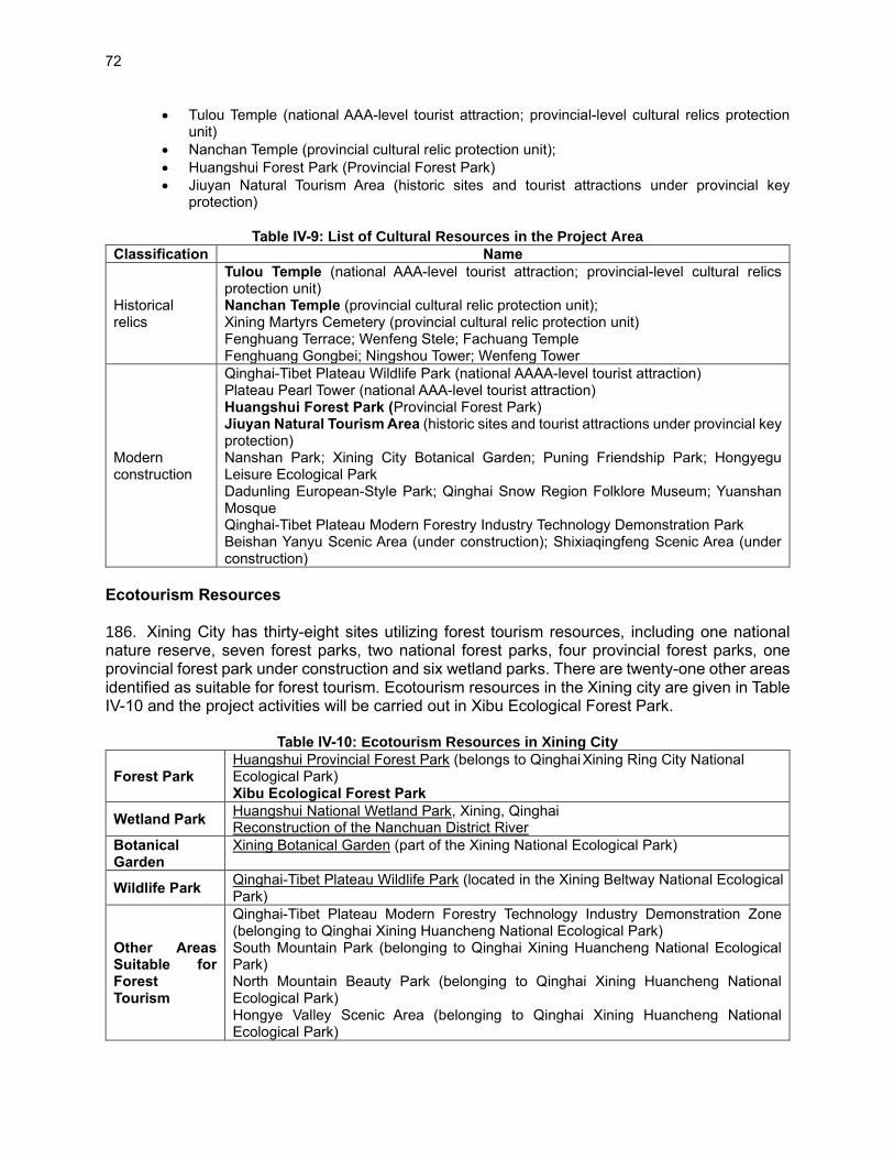
72
• Tulou Temple (national AAA-level tourist attraction; provincial-level cultural relics protection unit)
• Nanchan Temple (provincial cultural relic protection unit);
• Huangshui Forest Park (Provincial Forest Park)
• Jiuyan Natural Tourism Area (historic sites and tourist attractions under provincial key protection)
Table IV-9: List of Cultural Resources in the Project Area
Classification Name
Historical relics
Tulou Temple (national AAA-level tourist attraction; provincial-level cultural relics protection unit) Nanchan Temple (provincial cultural relic protection unit); Xining Martyrs Cemetery (provincial cultural relic protection unit) Fenghuang Terrace; Wenfeng Stele; Fachuang Temple Fenghuang Gongbei; Ningshou Tower; Wenfeng Tower
Modern construction
Qinghai-Tibet Plateau Wildlife Park (national AAAA-level tourist attraction) Plateau Pearl Tower (national AAA-level tourist attraction) Huangshui Forest Park (Provincial Forest Park) Jiuyan Natural Tourism Area (historic sites and tourist attractions under provincial key protection) Nanshan Park; Xining City Botanical Garden; Puning Friendship Park; Hongyegu Leisure Ecological Park Dadunling European-Style Park; Qinghai Snow Region Folklore Museum; Yuanshan Mosque Qinghai-Tibet Plateau Modern Forestry Industry Technology Demonstration Park Beishan Yanyu Scenic Area (under construction); Shixiaqingfeng Scenic Area (under construction)
Ecotourism Resources 186. Xining City has thirty-eight sites utilizing forest tourism resources, including one national nature reserve, seven forest parks, two national forest parks, four provincial forest parks, one provincial forest park under construction and six wetland parks. There are twenty-one other areas identified as suitable for forest tourism. Ecotourism resources in the Xining city are given in Table IV-10 and the project activities will be carried out in Xibu Ecological Forest Park.
Table IV-10: Ecotourism Resources in Xining City
Forest Park Huangshui Provincial Forest Park (belongs to Qinghai Xining Ring City National Ecological Park) Xibu Ecological Forest Park
Wetland Park Huangshui National Wetland Park, Xining, Qinghai Reconstruction of the Nanchuan District River
Botanical Garden
Xining Botanical Garden (part of the Xining National Ecological Park)
Wildlife Park Qinghai-Tibet Plateau Wildlife Park (located in the Xining Beltway National Ecological Park)
Other Areas Suitable for Forest Tourism
Qinghai-Tibet Plateau Modern Forestry Technology Industry Demonstration Zone (belonging to Qinghai Xining Huancheng National Ecological Park) South Mountain Park (belonging to Qinghai Xining Huancheng National Ecological Park) North Mountain Beauty Park (belonging to Qinghai Xining Huancheng National Ecological Park) Hongye Valley Scenic Area (belonging to Qinghai Xining Huancheng National Ecological Park)

73
Shixiaqingfeng Scenic Area (belonging to Qinghai Xining Huancheng National Ecological Park) Renmin Park
187. Shaanxi Province has five National Scenic Areas and eighty-one established A-class tourism scenic spots based on the national classification system. Six more “Tourist Scenic Spots” are under development within the province by the Shaanxi Provincial Government. The purpose of these is to promote an integrated cultural-natural attraction that places emphasis both on the cultural and natural landscapes. Gansu has one global geopark and 251 national natural landscapes, including four national scenic spots, eight national geological parks, 21 national forest parks, seven national wetland parks, 20 national nature reserves and 24 national water conservancy scenic spots. The tourism spot that will be promoted by project in Shaanxi is Huayin Forest Parkis located approximately 98 km east of Xi’an and 48 km east of Weinan.
I. Social and Economic Conditions 188. Socio-economic conditions in the project provinces and counties are summarized in the following tables.
Table IV-11: Socio-economic Indicators (2019)
Economic indicators PRC Gansu Qinghai Shaanxi
Total population (millions) 1,400. 05 26.4743 6.0782 38.76
Total agricultural population (millions) 551. 62 13.6369 2.7034 23.04
Total population of towns (millions) 848. 43 12.8374 3.3748 15.72
GDP (CNY 1 billion) 99,086. 5 871.83 296.595 2,579.32
GDP per capita (yuan) 70,892 32,995 48,981 66,649
Total agricultural output (CNY billion) 7,035.1 105.05 30.19 199.093
Total industrial output (CNY billion) 38,643.7 286.24 115.975 1198.075
Total output of tertiary industry (CNY 1 billion) 53,407.6 480.54 150.430 1182.149
Total forestry output (CNY 1 billion) 3.81 0.18172 1.060581
Disposable income per capita 30,733 6,444 28,189 24,666.3
Urban per urban capita disposable (CNY) 42,359 240,545 33,830 36,098.2
Rural per capita disposable income (CNY) 16,021 6,444 11,499 12,325.7
Forest area (million hectares) 220 0.51 5.29 8.87
Forest cover (%) 22.96 11.33 7.26 43.06
Living standing wood accumulation (one billion m3) 17.5 0.28 5.102342 CNY = Chinese Yuan, GDP = gross domestic product, PRC = People’s Republic of China.
Table IV-12: Project Area Administration Unit (2019)
This project All
The item Gansu
Province Qinghai Province
Shaanxi Province
Gansu Province
Qinghai Province
Shaanxi Province
Number of cities 2 1 8 12 2 11
The number of counties 3 2 15 64 44 71
Number of county-level cities 0 0 1 5 5 6
The number of zones 1 5 6 17 7 30
Number of townships 15 7 46 1357 403 1314
Number of administrative villages
80 29 137 16365 19946
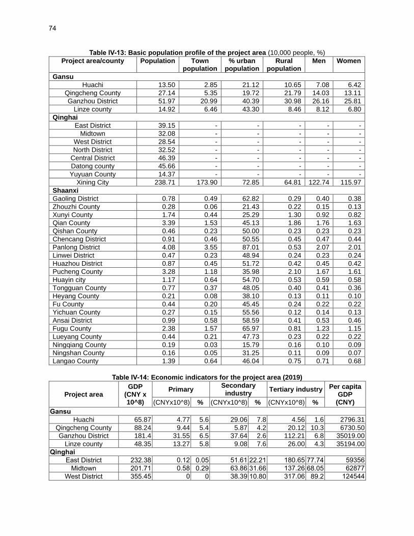
74
Table IV-13: Basic population profile of the project area (10,000 people, %)
Project area/county Population Town population
% urban population
Rural population
Men Women
Gansu
Huachi 13.50 2.85 21.12 10.65 7.08 6.42
Qingcheng County 27.14 5.35 19.72 21.79 14.03 13.11
Ganzhou District 51.97 20.99 40.39 30.98 26.16 25.81
Linze county 14.92 6.46 43.30 8.46 8.12 6.80
Qinghai
East District 39.15 - - - - -
Midtown 32.08 - - - - -
West District 28.54 - - - - -
North District 32.52 - - - - -
Central District 46.39 - - - - -
Datong county 45.66 - - - - -
Yuyuan County 14.37 - - - - -
Xining City 238.71 173.90 72.85 64.81 122.74 115.97
Shaanxi
Gaoling District 0.78 0.49 62.82 0.29 0.40 0.38
Zhouzhi County 0.28 0.06 21.43 0.22 0.15 0.13
Xunyi County 1.74 0.44 25.29 1.30 0.92 0.82
Qian County 3.39 1.53 45.13 1.86 1.76 1.63
Qishan County 0.46 0.23 50.00 0.23 0.23 0.23
Chencang District 0.91 0.46 50.55 0.45 0.47 0.44
Panlong District 4.08 3.55 87.01 0.53 2.07 2.01
Linwei District 0.47 0.23 48.94 0.24 0.23 0.24
Huazhou District 0.87 0.45 51.72 0.42 0.45 0.42
Pucheng County 3.28 1.18 35.98 2.10 1.67 1.61
Huayin city 1.17 0.64 54.70 0.53 0.59 0.58
Tongguan County 0.77 0.37 48.05 0.40 0.41 0.36
Heyang County 0.21 0.08 38.10 0.13 0.11 0.10
Fu County 0.44 0.20 45.45 0.24 0.22 0.22
Yichuan County 0.27 0.15 55.56 0.12 0.14 0.13
Ansai District 0.99 0.58 58.59 0.41 0.53 0.46
Fugu County 2.38 1.57 65.97 0.81 1.23 1.15
Lueyang County 0.44 0.21 47.73 0.23 0.22 0.22
Ningqiang County 0.19 0.03 15.79 0.16 0.10 0.09
Ningshan County 0.16 0.05 31.25 0.11 0.09 0.07
Langao County 1.39 0.64 46.04 0.75 0.71 0.68
Table IV-14: Economic indicators for the project area (2019)
Project area GDP
(CNY x 10^8)
Primary Secondary
industry Tertiary industry Per capita
GDP (CNY) (CNYx10^8) % (CNYx10^8) % (CNYx10^8) %
Gansu
Huachi 65.87 4.77 5.6 29.06 7.8 4.56 1.6 2796.31
Qingcheng County 88.24 9.44 5.4 5.87 4.2 20.12 10.3 6730.50
Ganzhou District 181.4 31.55 6.5 37.64 2.6 112.21 6.8 35019.00
Linze county 48.35 13.27 5.8 9.08 7.6 26.00 4.3 35194.00
Qinghai
East District 232.38 0.12 0.05 51.61 22.21 180.65 77.74 59356
Midtown 201.71 0.58 0.29 63.86 31.66 137.26 68.05 62877
West District 355.45 0 0 38.39 10.80 317.06 89.2 124544

75
North District 235.74 0.94 0.4 90.03 38.19 144.77 61.41 72491
Central District 165.31 29.09 17.6 84.62 51.19 51.59 31.21 35634
Shaanxi
Gaoling District 374.44 27.19 7.26 210.41 56.19 136.84 36.54 102628
Zhouzhi County 137.15 35.88 26.16 16.12 11.75 85.15 62.09 23124
Xunyi County 88.39 28.51 32.26 27.51 31.12 32.37 36.62 32942
Qian County 171.62 30.22 17.61 62.90 36.65 78.50 45.74 27958
Qishan County 179.34 23.98 13.4 94.85 52.9 60.51 33.7 38534
Chencang District 214.40 25.21 11.76 121.14 56.5 68.05 31.74 35544
Panlong District - - - - - - - -
Linwei District 427.61 - - - - - - 46626
Huazhou District 99.34 - - - - - - 23052
Pucheng County 194.16 36.05 18.57 73.80 38 84.31 43.43 26241
Huayin city 70.79 9.25 13.1 9.13 12.9 52.40 74 28571
Tongguan County 44.2 5.4 12.2 13.7 31 25.1 56.8 28944
Heyang County 104.98 28.51 27.2 19.11 18.2 57.36 54.6 23797
Fu County 66.37 16.77 25.27 27.26 41.07 22.34 33.66 26450
Yichuan County 37.78 15.20 40.23 3.97 10.51 18.61 49.26 21241
Ansai District 114.63 12.42 10.83 74.16 64.70 28.06 24.48 60287
Fugu County 564.77 9.57 1.70 405.89 71.87 149.31 26.44 200660
Lueyang County 71.17 9.44 13.27 31.80 44.68 29.93 42.05 25004
Ningqiang County 100.01 17.90 17.89 40.77 40.77 41.34 41.34 20764
Ningshan County 31.72 5.42 17.09 14.97 47.19 11.33 35.72 45059
Langao County 58.02 9.15 15.77 27.26 46.98 21.61 37.25 37042
Shiquan County 94.14 9.31 9.89 50.23 53.36 34.60 36.75 5416
J. Environmental quality 189. The project areas are located in remote and rural areas, and hence the environmental quality is expected to comply with the national requirements.
a) Surface water quality 190. There are no large industrial and mining enterprises in the project area, and the current surface water quality meets the regional water quality standards. The surface water environment quality of the project area meets the standard of Class III water area in "Surface Water Environmental Quality Standard" (GB3838-2002). 191. Gansu: The Gansu sub-project mainly involves the Malian River in Qingyang City and the Heihe section of Zhangye City. In 2019, the comprehensive evaluation results of the water quality of the bridgehead and Pu hippo head slope in Malinhening County, Qingyang City, met the requirements of the annual assessment target. Compared with 2018, the water quality of the Bridgehead section in Ning County was raised from V. to IV, and the water quality of the Matou Slope section was raised from class IV. to class III. The water quality of the two rivers as a whole showed a steady improvement trend. In February 2020, the two sections of the bridgehead and Pu hippo slope in Malinhening County were all category II water quality, which was significantly better than in the same period in previous years, and the river water quality showed an improvement trend. 192. According to the 2019 State of the Environment Bulletin of Zhangye City, the monitoring of the Heihe main stream and lake wetland section monitoring projects in Zhangye City are in line with the corresponding water functional standards, the water quality of the Falling Gorges (in
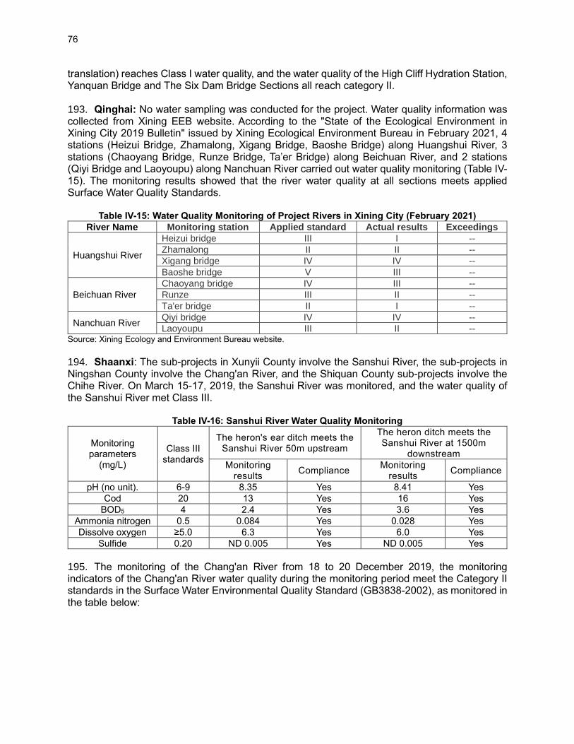
76
translation) reaches Class I water quality, and the water quality of the High Cliff Hydration Station, Yanquan Bridge and The Six Dam Bridge Sections all reach category II. 193. Qinghai: No water sampling was conducted for the project. Water quality information was collected from Xining EEB website. According to the "State of the Ecological Environment in Xining City 2019 Bulletin" issued by Xining Ecological Environment Bureau in February 2021, 4 stations (Heizui Bridge, Zhamalong, Xigang Bridge, Baoshe Bridge) along Huangshui River, 3 stations (Chaoyang Bridge, Runze Bridge, Ta’er Bridge) along Beichuan River, and 2 stations (Qiyi Bridge and Laoyoupu) along Nanchuan River carried out water quality monitoring (Table IV-15). The monitoring results showed that the river water quality at all sections meets applied Surface Water Quality Standards.
Table IV-15: Water Quality Monitoring of Project Rivers in Xining City (February 2021)
River Name Monitoring station Applied standard Actual results Exceedings
Huangshui River
Heizui bridge III I --
Zhamalong II II --
Xigang bridge IV IV --
Baoshe bridge V III --
Beichuan River
Chaoyang bridge IV III --
Runze III II --
Ta'er bridge II I --
Nanchuan River Qiyi bridge IV IV --
Laoyoupu III II -- Source: Xining Ecology and Environment Bureau website.
194. Shaanxi: The sub-projects in Xunyii County involve the Sanshui River, the sub-projects in Ningshan County involve the Chang'an River, and the Shiquan County sub-projects involve the Chihe River. On March 15-17, 2019, the Sanshui River was monitored, and the water quality of the Sanshui River met Class III.
Table IV-16: Sanshui River Water Quality Monitoring
Monitoring parameters
(mg/L)
Class III standards
The heron's ear ditch meets the Sanshui River 50m upstream
The heron ditch meets the Sanshui River at 1500m
downstream
Monitoring results
Compliance Monitoring
results Compliance
pH (no unit). 6-9 8.35 Yes 8.41 Yes
Cod 20 13 Yes 16 Yes
BOD5 4 2.4 Yes 3.6 Yes
Ammonia nitrogen 0.5 0.084 Yes 0.028 Yes
Dissolve oxygen ≥5.0 6.3 Yes 6.0 Yes
Sulfide 0.20 ND 0.005 Yes ND 0.005 Yes
195. The monitoring of the Chang'an River from 18 to 20 December 2019, the monitoring indicators of the Chang'an River water quality during the monitoring period meet the Category II standards in the Surface Water Environmental Quality Standard (GB3838-2002), as monitored in the table below:
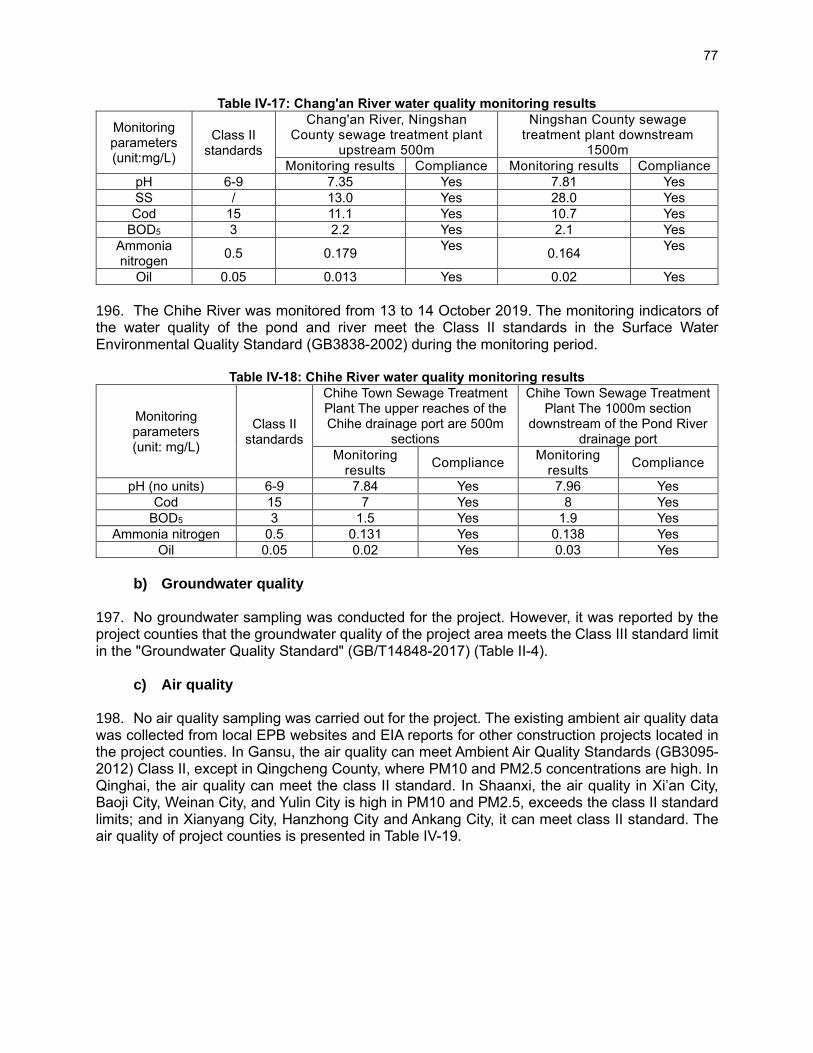
77
Table IV-17: Chang'an River water quality monitoring results
Monitoring parameters (unit:mg/L)
Class II standards
Chang'an River, Ningshan County sewage treatment plant
upstream 500m
Ningshan County sewage treatment plant downstream
1500m
Monitoring results Compliance Monitoring results Compliance
pH 6-9 7.35 Yes 7.81 Yes
SS / 13.0 Yes 28.0 Yes
Cod 15 11.1 Yes 10.7 Yes
BOD5 3 2.2 Yes 2.1 Yes
Ammonia nitrogen
0.5 0.179 Yes
0.164 Yes
Oil 0.05 0.013 Yes 0.02 Yes
196. The Chihe River was monitored from 13 to 14 October 2019. The monitoring indicators of the water quality of the pond and river meet the Class II standards in the Surface Water Environmental Quality Standard (GB3838-2002) during the monitoring period.
Table IV-18: Chihe River water quality monitoring results
Monitoring parameters (unit: mg/L)
Class II standards
Chihe Town Sewage Treatment Plant The upper reaches of the Chihe drainage port are 500m
sections
Chihe Town Sewage Treatment Plant The 1000m section
downstream of the Pond River drainage port
Monitoring results
Compliance Monitoring
results Compliance
pH (no units) 6-9 7.84 Yes 7.96 Yes
Cod 15 7 Yes 8 Yes
BOD5 3 1.5 Yes 1.9 Yes
Ammonia nitrogen 0.5 0.131 Yes 0.138 Yes
Oil 0.05 0.02 Yes 0.03 Yes
b) Groundwater quality
197. No groundwater sampling was conducted for the project. However, it was reported by the project counties that the groundwater quality of the project area meets the Class III standard limit in the "Groundwater Quality Standard" (GB/T14848-2017) (Table II-4).
c) Air quality 198. No air quality sampling was carried out for the project. The existing ambient air quality data was collected from local EPB websites and EIA reports for other construction projects located in the project counties. In Gansu, the air quality can meet Ambient Air Quality Standards (GB3095-2012) Class II, except in Qingcheng County, where PM10 and PM2.5 concentrations are high. In Qinghai, the air quality can meet the class II standard. In Shaanxi, the air quality in Xi’an City, Baoji City, Weinan City, and Yulin City is high in PM10 and PM2.5, exceeds the class II standard limits; and in Xianyang City, Hanzhong City and Ankang City, it can meet class II standard. The air quality of project counties is presented in Table IV-19.

78
Table IV-19: Ambient Air Quality in Shaanxi 2019 (mg/m3)
City County Year PM10 µg/m3
PM2.5 µg/m3
SO2 µg/m3
NO2 µg/m3
CO µg/m3
Gansu Province
Qingyang City Huachi County Feb 2021 61 18 9 5 0.8
Qingcheng County Feb 2021 80 37 19 18 1.4
Zhangye City Ganzhou District 2019 55 28 12 20 0.9
Linze County 2020 70 31 Class II Class II Class II
Qinghai Province
Xining City
2019 59 34 17 38 2.3
Shaanxi Province
Xi'an City Zhouzhi County 2019 101 59 8 30 4
Gaoling District 2019 107 70 11 46 1.8
Baoji City Qishan County 2019 66 40 7 22 1.6
Chencang District 2019 97 61 13 38 2.1
Panlong District 2019 82 51 8 34 1.6
Xianyang City Xunyi County 2020 46 29 7 11 1.4
Qian County 2020 69 40 8 26 1.4
Weinan City Pucheng County 2019 115 57 13 24 2.5
Heyang County 2019 82 45 14 26 2.4
Huazhou District 2019 94 53 12 48 1.8
Linwei District 2019 102 55 10 38 1.8
Huayin City 2019 92 56 13 40 2.5
Tongguan District 2019 91 50 16 29 1.6
Yulin City Fugu County Mar 2020 129 35 28 37 1
Ansai District 2018 58 29 14 35 1.6
Fu County 2018 77 35 17 31 1.8
Yichuan County 2018 76 35 15 30 1.6
Hanzhong City
Lueyang County 2020 39 27 10 18 2.3
Ningqiang County 2020 40 25 7 28 1.5
Ankang Shiquan County 2019 48 30 8 14 1.3
Ningshan County 2019 42 27 11 10 1.4
Langao County 2019 46 27 12 9 1.6
Standard (GB3095-2012), Class II limit 70 35 60 40 4
Note: data highlighted in yellow means exceed standard limit
d) Acoustic environment
199. The noise quality of the project area complies with the "Acoustic Environment Quality Standard" (GB3096-2008) Class 1 zone standard.
e) Coronavirus disease pandemic 200. The coronavirus disease (COVID-19) outbreak occurred in the project provinces. All project cities and counties have implemented COVID-19 prevention and control measures following the PRC and respective province’s requirements, including disinfection/cleaning of public space, temperature checks at entrances of facilities, social distancing measures, mandatory use of personal protective equipment such as facemasks and procedures to be adopted in the event any person is infected with COVID-19. The status of COVID-19 infection is given in Table IV-20.
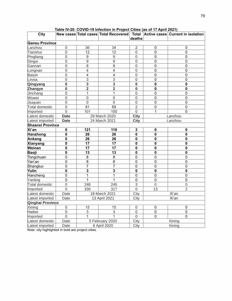
79
Table IV-20: COVID-19 Infection in Project Cities (as of 17 April 2021)
City New cases Total cases Total Recovered Total deaths
Active cases Current in isolation
Gansu Province
Lanzhou 0 36 34 2 0 0
Tianshui 0 12 12 0 0 0
Pingliang 0 9 9 0 0 0
Dingxi 0 9 9 0 0 0
Gannan 0 8 8 0 0 0
Longnan 0 4 4 0 0 0
Baiyin 0 4 4 0 0 0
Linxia 0 3 3 0 0 0
Qingyang 0 3 3 0 0 0
Zhangye 0 2 2 0 0 0
Jinchang 0 1 1 0 0 0
Wuwei 0 0 0 0 0 0
Jiuquan 0 0 0 0 0 0
Total domestic 0 91 89 2 0 0
Imported 0 101 100 0 1 0
Latest domestic Date 29 March 2020 City Lanzhou
Latest imported Date 24 March 2021 City Lanzhou
Shaanxi Province
Xi’an 0 121 118 3 0 0
Hanzhong 0 26 26 0 0 0
Ankang 0 26 26 0 0 0
Xianyang 0 17 17 0 0 0
Weinan 0 17 17 0 0 0
Baoji 0 13 13 0 0 0
Tongchuan 0 8 8 0 0 0
Yan’an 0 8 8 0 0 0
Shangluo 0 7 7 0 0 0
Yulin 0 3 3 0 0 0
Hancheng 0 1 1 0 0 0
Yanling 0 1 1 0 0 0
Total domestic 0 248 245 3 0 0
Imported 0 330 317 0 13 2
Latest domestic Date 18 March 2021 City Xi’an
Latest imported Date 13 April 2021 City Xi’an
Qinghai Province
Xining 0 15 15 0 0 0
Haibei 0 3 3 0 0 0
Imported 0 1 1 0 0 0
Latest domestic Date 5 February 2020 City Xining
Latest imported Date 6 April 2020 City Xining Note: city highlighted in bold are project cities.

80
V. POTENTIAL ENVIRONMENTAL IMPACTS AND MITIGATION MEASURES A. Project Area of Influence and Sensitive Receptors 201. To define the geographic scope of the impact assessment, the “project area of influence” and “sensitive receptors” were identified. The project area of influence was defined as the total area which might be subject to adverse impacts of the project. This was based on the locations of sensitive receptors, defined as settlements and/or environmental values that might be affected by the project construction and/or operation. The receptors comprise (i) villages and communities potentially subject to construction or operational noise, air pollution, altered water quality, and/or environment-related social impacts; (ii) public service facilities vulnerable to disturbance or pollution; and (iii) vegetation, fauna habitats, and agricultural lands within 200 m of the project area. 202. The following distances were applied to identify the sensitive receptors: (i) for construction and/or operational noise – receptors within 200 m of the noise-generating source; (ii) for construction-related air quality impacts – receptors within 200 m of the source; (iii) for local ecological environment, both the surface water area and the land area within 100 m; and the entire areas of other subcomponents. These distances, combined with the direct construction sites, were assumed to encompass the total project area of influence. Based on the characteristics of the project activities, the sensitive receptors around the project sites are mainly water bodies, vegetation and fauna habitats. The sensitive receptors near the project sites are given in Tables V-1 to V-3. All the proposed project works in Shaanxi will be carried out in forests and protected areas, and hence all project sites are considered to be sensitive receptors.

81
Table V-1: Environment Sensitive Receptors-Gansu
County Sub-project
Community or village Rivers and reservoirs
Protected areas, forest parks, scenic spots, wetlands, etc.
Cultural relics and monuments
Township Village Directio
n Distance
(m) No. of HHs
Name Distance
m Name Distance Name
Distance m
Qingcheng County
(afforestation
activities)
Gaolou Town
Gaolou Town
Yangyuan Village
E, W 28 356 / / / / / /
Qingcheng Town
Qingcheng Town
Dianziping Village
SW 179 280
/ / / / / / Qingcheng
Town Jiaozichuan
Village S 54 291
Qingcheng Town
East Wangxuan
Village W 130 86
Nanzhuang Township
Nanzhuang Township
Xinzhuang Village
E 45 317 / / / / / /
Sapu Town
Sapu Town Shiwulipu
village SW 152 156
Malian River
268m / / / / Sapu Town Sapu Village NW 81 378
Sapu Town Hanwan Village
SW 167 561
Huachi County
(afforestation
activities)
Chegnhao forest
Chenghao Town
Huolianwan Village
W 60 80 / / / / / /
Wujiao Township
Wujiao Township
Liujiawan Village
SW, NE 39 175
Yuancheng River
15m / / / /
Wujiao Township
Liliangzi Village
SW, NE 74 278
Wujiao Township
Shangchenghao Village
SW, NE 112 270
Yuele Town Dianping Village
SW, NE 83 310
Nanliang Town
Nanliang Town
Baimamiao Village
SE 175 86
/ / / / / / Nanliang
Town Gaotai Village
NW 158 105
Zifang township
Zifangpan township
Buzishan Village
SE 68 245 / / / / / /
Ganzhou District
(afforestation
activities)
Xichengyi Forest Farm
Mingyong Township
Xiaya Village E 190 130
Heihe 50 m
Heihe Wetlands National Nature
Reserve
5,100 m / / Wujiang
Town Xiejiawan
Village NE 157 642
Heihe Beach Mingyong Township
Yongji Village NW 187 160 Heihe 1,700 m / / / /
Jiulongjiang Forest Farm
Jiantan Town
Puzhuang Village
SE 57 273 Dasha River
10 m / / / / Shangqin
Town Zhaojiazhaizi
Village W 195 315
Hongshawo Forest Farm
/ / / / / Shandan
River 1,100 m / / / /
Linze County
(afforestation
activities)
Shuangquan Lake
Wetlands
Shahe Town
Heqiang Village
E, NE 180 816 Shuangqua
n Lake Reservoir
Relevancy
/ / / /
Wuquan Forest Farm
/ / / / / Heihe 1,200 m
Heihe Wetlands National Nature
Reserve
1,100 m

82 Table V-2: Environment Sensitive Receptors-Qinghai
Xining City Sub-project Community or village Rivers and reservoirs Protected areas, forest parks, scenic spots, wetlands, etc
Cultural relics and monuments
Township Village Directions Distance (m)
No. of HHs
Name Distance m
Name Distance (m)
Name Distance (m)
Huangzhong District
Afforestation and greening project in the Xibu area
Xibu Town Zuoshu Village
middle 100 50 Shihui Ditch 320 Xibu Eco Forest Park
0
Donghuayuan Village
middle 70 420
Xinping Village
middle 40 430
Xibu Village middle 135 40
Chengbei District
North and South mountains forest landscape upgrading and tending
Dabuzi Town
Jinjiawan Village
south 140 40 Balang Ditch
10
Song Jiazhai Village
south 150 90 Tuanjie Ditch
150
Yunguchuan River
660
Haizi Ditch 10
Mafang Street
Mafang Village
south 30 300
Ershilipu Guo Jiata west 70 120 Beichuan River
500
Chaoyang District
Chaoyang New Village
south 80 Beishan Tuguan Building
30
Chengdong District
North and South mountains forest landscape upgrading and tending
Shaojiakou Town
Huangshui River
700
Lejiawan Town
Chengzhong District
North and South mountains forest landscape upgrading and tending
Nanchuan East Road
Street
Nanxishan Village
west 20 300 Nanchuan River
530 Jiuyan Springs
Scenic Area
0 Xining Martyrs'
Mausoleum
600
Nanchan Temple
60
West District North and South mountains forest landscape upgrading and tending
Hutai Street
Qinghai-Tibet Plateau Wildlife Park
0
Highland Pearl Sightseeing Tower
50
Pengjiazhai Town
Huoshao Ditch
10 Huangshui Forest Park
0

83
Table V-3: Environment Sensitive Receptors-Shaanxi project Item Sensitive site Direction Distance
(m) Households/population
Protection requirements
Louguantai National Forest Rehabilitation Base Project
Air, Noise Group 6, Donglou Village ES 160 Class I, GB3095-2012) Class I, GB3096-2008) Group 5, Donglou Village EN 650
Forest Farm Residential Area N 890 160/480
Shaanxi Rare Wildlife Rescue and Research Center
N 330 /
Tao Culture Exhibition Area N 400 /
Medicine Palace Nursing Home S 160 /
Ecology Louguantai National Forest Park
The project area is located in the forest park
Protect the biodiversity and ecosystem integrity of forest parks
Heihe National Forest Park Tourism facilities and forest management and protection facilities, Zhouzhi County, Shaanxi
Air, Noise Houzhenzi Village 5-10m 50 11/23 Class I, GB3095-2012 Class I, GB3096-2008
Surface water
Heihe River S 500 / Class II, GB3838-2002
Ecology Shaanxi Heihe National Forest Park
The project area is located in the forest park
Protect the biodiversity and ecosystem integrity
Malan River Wetland Protection, Xunyi County, Shaanxi
Air, Noise CuiJia River ES 500 1296 Class I, GB3095-2012 Class I, GB3096-2008
Surface water
Sanshui River Project area Class III, GB3838-2002
Ecology Shaanxi Malan River National Wetland Park, Xunyi County
The project is located in a wetland park
Protect the biodiversity and ecosystem integrity of wetland parks
Seedling base in Linwei District, Shaanxi
Air, Noise Niujia Village W 60 30 people Class II, GB3095-2012 Class I, GB3096-2008
Afforestation Project in Shaanxi Wudishan National Forest Park, Heyang County, Shaanxi
Air, Noise Shangpo Village S Next to 10 people Class I, GB3095-2012 Class I, GB3096-2008 Chenghou Village W 150 30 people
Ecology Shaanxi Wudishan National Forest Park, Heyang County, Shaanxi
The project area is located in the forest park
Protect the biodiversity and ecosystem integrity of forest parks
Afforestation Project in Shiquan County, Shaanxi
Air, Noise Xiangyang Village WN 10 30 Class II, GB3095-2012 Class I, GB3096-2008 Kangjiaba ES 100 10
Daxing Village E 200 30
Yangjia Mountain On both sides of the road
100
Caomiao Village N 200 50
Mingxing Village W 500 1000
Tanjiawan Village E Close to 1000
Surface water
Chihe River Greening on both sides of the river Class II, GB3838-2002
Afforestation and Forest health and ecological experience Project in Langao County
Air, Noise Erba Village E Close to 3 Class II, GB3095-2012 Class I, GB3096-2008
Surface water
Lanhe River Within project area Class II, GB3838-2002
Ecology Bashan Rare Botanical Garden
Located in the project area Construction of the popular science museum in the botanical garden to protect plant resources from being affected
Walking path and Forest management project in Ningshan County
Air, Noise Guanyi Community (Involving walking trails)
S 500 16 people Class II, GB3095-2012 Class II, GB3096-2008
Group 7, Guan’er Village E 170 70 people
Sanguanmiao Village WS 300 100 people
Liujiagou WN 170 40 people
Surface water
Chang'an River W 20 / Class II, GB3838-2002
Improvement of fire prevention road in Hanshuiyuan Forest Park in Ningqiang County
Ecology Hanshuiyuan Forest Park The project area is located in the forest park
Protect the biodiversity and ecosystem of forest parks

84 project Item Sensitive site Direction Distance
(m) Households/population
Protection requirements
Afforestation and Protection Facilities Construction in Qishan County, Shaanxi Province
Ecology Zhouyuan Scenic Area Located in the project area Protect the forest vegetation resources of the scenic spot from being affected
Cultural relic
Zhougong Temple Ruins (National protection)
W Close to / The project does not carry out activities within the scope of cultural relic protection area
Phoenix Mountain Site (National protection)
E Close to /
Forest Science Popularization Experience Park Construction Project of Beipo Forest Park in Chencang District, Baoji City, Shaanxi Province
Air, Noise Xiqin Village (Involving forest science popularization experience park)
S 450 100 Class II, GB3095-2012 Class I, GB3096-2008
Tuqiao Village (Involving forest science popularization experience park)
S 420 150
Ecology Beipo Forest Park (under planning and construction)
The project is located in the forest park
Protect the biodiversity and ecosystem integrity of forest parks
Cultural relic
Nanchang Palace (Provincial protection)
S 100 / Protect Nanchang Palace unaffected
Fuxian Characteristic Woody Oil Tree Species-Wenguanguo Comprehensive Development and Construction Project
Air, Noise Luojiata Village WN Close to 70 Class II, GB3095-2012 Class I, GB3096-2008
Forest Tending in Qian County, Shaanxi Province
Cultural relic
Qianling Mausoleum (National protection)
Carrying out forest tending in the forest area around Qianling Mausoleum
Protect the cultural relic

85
B. Anticipated Project Benefits and Positive Impacts 203. Environmental benefits. The project focuses on ecological protection and restoration. The main environmental benefit of the project is to increase forest and grass vegetation coverage and reduce soil erosion and natural disasters, thereby also supporting climate change resilience and water resources management. 204. For Qinghai Province, the expected benefits include (i) forest coverage rate in the north and south mountains increased from 71.84% to >80% and Xibu green area increased from 43.7% to 68%, (ii) mean canopy closure increased from 0.4 to >0.45 and afforestation survival rate has reached 90%, (iii) reduced soil erosion. The northern and southern mountains and the Xibu area can consolidate 677,400 tons of soil and 25,900 tons of organic matter each year, and (iv) 70%-80% of residents have received environmental awareness training. For Gansu Province, the project will increase the wetland area by about 120 ha. This work will focus on Shuangquan Lake Wetland Park (an artificial reservoir), which supports seasonal numbers of >2,500 waterbirds (ducks, geese, waders).11 According to the wetland development and environmental protection plan, by 2020, Gansu Province will add 136,000 ha of protected wetlands. For Shaanxi Province, the project will increase the wetland area by about 310 ha. The project wetland activities in Gansu and Shaanxi provinces will improve the ecosystem services of these wetlands, purify the water, store and retain water during dry periods, reduces the impact of flooding and provide more habitats for wildlife, increase biodiversity in general, decrease soil erosion, and improve local eco-environmental quality; and contribute to provincial targets for wetland coverage. 205. Carbon sequestration. The new wetland and forest coverage will increase carbon sequestration. The project will reduce net GHG emissions of 324,504.97 tons of CO2e per year. 206. Reduce environmental pollution. Current agricultural activities contribute to soil and water pollution, including within the project projected areas (pollution sources include fertilizers and pesticides, litter, livestock and poultry manure, and crop straw burning). The implementation of wetland management, protection and restoration projects, reducing the impact of human activities on the wetland environment will help improve the regional ecological environment and improve the regional environmental quality.
207. Eco-tourism benefits. The project will promote the development of nature education and wildlife conservation. Visitors will learn about ecological information such as geomorphology, climate, flora and fauna, soil, etc., through tours, picnics, and adventures, but also obtain information by visiting the center, reading commentaries and educational brochures. The training activities will also increase the environmental awareness of residents in surrounding communities.
208. Socioeconomic benefits. The project will benefit about 150,985 households with 591,313 population in 31 counties, including 282,739 women (47.8%) and 101,688 low-income people (17.2%). The project will contribute to poverty reduction and development in rural areas by: (i) enhancing human capital through skills training and environmental protection awareness programs; (ii) increasing residents’ income through provisions of employment and income generation opportunities during construction and operation phases; (iii) constructing beautiful countryside for rural revitalization; and (iv) supporting sustainable livelihoods through improved biodiversity and conservation of forests and wetlands. 209. Value-added during the project preparation. The project demonstrates that international
11 Wang, J.Y. 2018. Planning for Shuangquan Lake Park in Linze County, Gansu province. Modern Gardening.

86
best practices can be adopted in the poverty area of smaller counties, contributing to sustainable water resources management, restoration of ecosystem and development of livable counties and villages. ADB value added in this project includes technology innovations: (i) a technical team will be hired composed of high-level and multi-disciplinary experts to fully demonstrate the planning, standards and target tasks, technical routes and implementation plans of each project, and participate in the whole management process; (ii) modern information technologies will be adopted into management plans; (iii) a roadmap for project implementation will be developed and benchmarking management will be implemented, (iv) establish a preliminary consultations coordination mechanism (Qinghai) and a social risk response plan (Shaanxi) to dealing with potential conflicts in the project implementation; (v) establish ecologic and socio-economic monitoring system at sub-component level and farmer households level by adopting modern information technique to capture net impacts of the project; and (vi) strengthen community participation and benefiting more women, low income/poverty as well as ethnic minorities 210. The project will leverage synergies with ADB’s wider strategic programmatic support prioritizing investments in ecological restoration and environmental protection across the YREB and YREC programs, with an emphasis on institutional strengthening, climate change adaptation and mitigation, and knowledge sharing. The project will feature innovative elements including instituting the close-to-nature forestry management approach, which is considered fundamental as the basis of eco-tourism to support rural livelihood diversification; piloting gross ecosystem product natural resource accounting; applying advances in restoration technologies for erosion management and desertification control; and forest and wetland restoration using specially selected native species suited to local climatic conditions. Monitoring activities in project design and implementation will include application of high-level technologies such as drones web-based applications for forest mapping, site surveys, and remote sensing. The project components for a wetland site (in Gansu Province) will also be linked with a regional ADB regional program under development to enhance the conservation of migratory waterbirds in the East Asian-Australasian flyway.
C. Pre-construction Phase 211. The following measures will be implemented in the engineering design and pre-construction phase to ensure the project’s environment management readiness.
(i) Institutional strengthening. (a) The national and provincial PMOs will appoint at least one full-time and qualified environment officer in the PMO team at the national level and three at the provincial level. These officers will lead the coordination of the EMP; (b) the project implementation units (PIUs) will each assign an environmental focal point as part of the PIU teams; and (c) under the loan consulting services, the national PMO will hire a loan implementation environment specialist (LIEC) to provide external support.
(ii) Safety measures for any emerging virus outbreaks such as COVID-19. In case of a new outbreak, prior to the arrival of external project personnel (e.g., workers and consultants), the PMO will implement safety procedures and screening to ensure that all staff are tested negative for COVID-19 and do not pose a threat to local human populations. This will include: (i) requirement that all project personnel is tested negative for COVID-19, (ii) external workers and consultants confirm their COVID-19 – free status to PIUs prior to arrival, and (iii) project safety and sanitation measures are distributed to all personnel and are included as contractual requirements for all staff.
(iii) Updating the EMP. In case of any changes in the detailed project design, the EMP will be updated as needed, including the mitigation measures and monitoring plan. This will be the responsibility of the PMOs, PIUs, and LIEC.

87
(iv) Training in environmental management. The LIEC will give training in the implementation and supervision of environmental mitigation measures to contractors and the construction supervision companies (CSCs).
(v) Grievance Redress Mechanism (GRM). The PMOs and PIUs will implement the project GRM at least two months before the start of construction to ensure that the related residential communities, villages, schools and hospitals are well informed and have the opportunity to discuss any concerns. This is further to the public consultations already conducted during project preparation (Section VII).
(vi) Bidding documents and contract documents. The project environmental management plan (Appendix 1) will be included in all the bidding documents and contracts for the procurement of civil works, goods and services. All contractors and subcontractors will be required to comply with the EMP.
(vii) Contractor obligations. All contractors, in their bids, will respond to the environmental clauses in the bidding documents for EMP requirements. Prior to construction, each contractor will develop its site EMP, based on the project EMP (Appendix 1), and assign at least a specific person responsible for the environment, health and safety (EHS). The site EMP shall at least include the following: (a) surface water and ecosystem protection; (b) spill control and management; (c) site drainage and soil erosion protection; (d) temporary traffic management; (e) construction site access control; (f) health and safety; (g) all site-specific mitigation measures listed in the project EMP; (h) contractor performance targets; and (i) safety measures for coronavirus disease (COVID-19), which are listed in the EMP, to strengthen the implementation of the mitigation measures. The site EMPs will be submitted to the PMO environment officer and PIU environment officers for approval, with the support from the EEBs of respective cities and counties.
(viii) Environmental management on construction sites. Ensure that during construction, the PMOs environment officers, together with environmental supervision engineers from CSCs, will be responsible for enhancing site supervision, management and appraisal, for timely identification and resolving any issues. Intermittent follow-up training during construction will be conducted.
D. Construction Phase 212. Key environmental risks anticipated due to construction include (i) impact on the protected forests and wetland resources, including their biodiversity, (ii) soil erosion, in particular during afforestation and tourism development works; (iii) temporary noise and traffic disturbance to wildlife and nearby villages and communities; (iv) air pollution (mainly fugitive dust); (v) inappropriate or uncontrolled solid waste disposal, both construction waste and domestic waste from workers; and (vi) occupational and community health and safety.
a) Impact on Protected Areas 213. Some of the project sites are located within protected forests, national parks and wetlands or located close to these areas, and hence could be affected by the footprints of the project facilities and proposed project activities. Environmental risks of the planned project works were assessed for a total of 9 sites with different protection status: 4 national parks (Heihe, Louguantai, Wudishan, Hanshuiyuan), 1 provincial park (Huangshui), 1 scenic reserve (Jiuyanquan National Tourism Area), 1 national wetland park (Malan River National Wetland Park), and two temples listed as provincial cultural relics (Tulou and Nanchan temples). In addition, environmental risks are also assessed for two important biodiversity sites (Shuangquan wetland and Xibu forest, a planned forest park). The assessment covered locations and scope of the project activities with respect to the protected areas management plans and distances distance of works to the nearest
88
natural habitat or heritage location; and timing of works in wetlands in relation to migratory. Based on this assessment, it is concluded that the impacts on the protected areas would be limited since all the project facilities are designed in compliance with the existing management plans of these protected areas and are located within the approved zones of the protected areas, such as buffer zone, tourism zone, and multi-functional zone. It will be ensured through the project implementation and operation stages, that the project activities are consistent with the approved site management plans for each site, and all works in the protected areas and forests will be carried out within the locations proposed in the IEE and feasibility study reports. List of the proposed tree species for each proposed site is given in Appendix 3. 214. The major risk associated with any afforestation activities is the potential introduction of non-native or invasive species, which threatens the existing ecosystem and biodiversity. No such risks are anticipated in the project as the project proposes to use plant species native to each specific project site and sourced from local stock within the project district and counties. The key impacts on the wetlands from the proposed activities are noise and vibration impact on migratory birds if the construction works are carried during their migratory seasons (March-April and September-October), which can be mitigated by avoiding high noise generating works during the migratory season. The impacts on cultural relics are limited since only forest tending activities will be carried out near these areas. Details of the subprojects that are located within the protected areas (or in the important biodiversity areas that are not protected areas) and a summary of impacts on these areas are given in Table V-4.
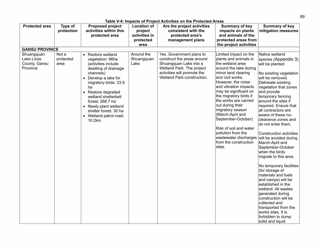
89
Table V-4: Impacts of Project Activities on the Protected Areas Protected area Type of
protection Proposed project
activities within this protected area
Location of project
activities in protected
area
Are the project activities consistent with the
protected area's management plans
Summary of key impacts on plants and animals of the
protected areas from the project activities
Summary of key mitigation measures
GANSU PROVINCE
Shuangquan Lake Linze County, Gansu Province
Not a protected area
• Restore wetland vegetation: 86ha (activities include desilting of drainage channels)
• Develop a lake for migratory birds: 33.9 ha
• Restore degraded wetland shelterbelt forest: 266.7 ha
• Newly plant wetland shelter forest: 30 ha
• Wetland patrol road: 10.2km
Around the Shuangquan Lake
Yes. Government plans to construct the areas around Shuangquan Lake into a Wetland Park. The project activities will promote the Wetland Park construction.
Limited impact on the plants and animals in the wetland area around the lake during minor land clearing and civil works. However, the noise and vibration impacts may be significant on the migratory birds if the works are carried out during their migratory season (March-April and September-October). Risk of soil and water pollution from the wastewater discharges from the construction sites.
Native wetland
species (Appendix 3) will be planted. No existing vegetation will be removed. Delineate existing vegetation that zones and provide temporary fencing around the sites if required. Ensure that all contractors are aware of these no-clearance zones and do not enter them. Construction activities will be avoided during March-April and September-October when the birds migrate to this area. No temporary facilities (for storage of materials and fuels and camps) will be established in the wetland. All wastes generated during construction will be collected and transported from the works sites. It is forbidden to dump solid and liquid

90
wastes into the wetland and its surrounding area within 1 km Animal hunting and egg collecting activities by all project personnel will be strictly prohibited. Strengthen the awareness programs on wetland protection.
QINGHAI PROVINCE
Xibu Ecological Forest Park, Huangzhong District, Xining City, Qinghai Province
It is not a nature reserve but a planned forest park that will cover an area of 217.31 km2
• Newly plant forest: 1,333.33 ha in Xibu valley;
• Landscape forest tendering in both side of Huoshao valley;
Middle and young forest tendering
Some of the project activities in south-west of Xining City are within the planned forest park
Yes. The objective of the Master Plan is to construct the sub-urban area of Xining City into a tourism and leisure park. It is planned to complete a total greening area of 168,800 mu by 2025. The forest coverage of the park has increased from 33.65% to 51.78%. The project will newly plant 20,000 mu (1,333.33 ha) of forest which is part of the Master Plan. Construction of the project will promote the implementation of the Master Plan of Xibu Ecological Forest Park
The project will plant trees on the bare slopes with sparse vegetation on both sides of Xibu valley. Plantation activities may lead to temporary soil erosion. The impact on plants and animals is minimal.
Soil erosion and sedimentation will be controlled during the land preparation by adaptation of fish-scale pits for plantation development. No clearing on steep, unstable slopes or highly erosive slopes
Jiuyanquan Natural Tourism Area, East District, Xining City, Qinghai Province
Provincial-level scenic spots in sub-urban area of Xining City
Tending of middle and young forest in Xiaoyoushan plateau forest science and technology exhibition area
The Jiuyanquan Natural Tourism area is a small part and within the project area
The scenic spot is an open mountain tourism area with local folk culture as the theme and natural mountain scenery as the landscape characteristics. The proposed project activities in the scenic area are the tending of middle and young forest, which is consistent with the
Soil compacting and puddling by machinery. Buildup of organic matter under plantations posing a fire hazard
Limitation of use of machinery in the protected areas. Periodic clearing of organic matter during tendering to avoid fire hazards

91
management plan of Jiuyanquan Natural Tourism area. The construction of the project makes the scenery of Jiuyanquan natural tourism area more beautiful. It is beneficial to the protection and construction of Jiuyanquan natural tourism area
Tulou Temple, North District, Xining City, Qinghai Province
National AAA tourist attraction and provincial-level cultural relic protection unit.
Tending of middle and young forest.
The Temple is located at the hillside of Beishan Mountain, which is the project area.
Yes. There is no construction activity within the protection area. The tending of the middle and young forest in Beishan will not affect the cultural relic.
Vibrations from machinery might have limited impact on the structural safety of the Temple. The tending activities will be carried out on the uphill side of the temple. If the soils are unstable, the tending activities may cause landslides.
• Limit the use of machinery in areas close to the temple
• .The noise and vibration generated from the tending activities should be kept minimum.
• Restrict any activities in the area from the Temple to the top of the mountain.
Huangshui Forest Park, Xining City, Qinghai Province
Provincial forest park
Tending of middle and young forest
The Forest Park is 90m north of the project area.
Huangshui forest park is not a protected area. The proposed project in Huangshui forest park is the tending of young and middle-aged forest and the upgrading of forest landscape. The construction of the project is consistent with the planning and management requirements of Huangshui forest park. The implementation of the project plays a role in improving the environment of Huangshui forest park.
No impact. The Huangshui Forest Park is in urban area which is in the north side of Xining-Hetian expressway, while the project area is in the mountain area which is located at south of the expressway.
No specific measures are needed
Nanchan temple, Xining City, Qinghai Province
Provincial-level protected cultural relic
Tending of middle and young forest
60m away from the Temple
Yes. There is no construction activity within the protection area. The tending of the middle and young forest in Nanshan will not affect the
Potential vibrations from machinery
• Limit works to only forest tendering purposes and avoid development of any new forests that

92
cultural relic. require extensive earthworks
• Carry out the forest tendering works manually to the extent feasible
SHAANXI PROVINCE
Malan River National Wetland Park in Xunyi County, Xianyang City, Shaanxi
National wetland park
• 112 ha of wetland restoration, including plantation of aquatic plants and shelter trees;
• Training wetland management staff and residents nearby.
Within the wetland park
Yes, the project activities are fully consistent with the management plan. The wetland master plan set the objective of wetland construction as: to protect and restore the natural ecosystem, and focus on wetland biodiversity protection and maintain regional ecological balance. The proposed of wetland restoration will directly increase wetland area by 112ha. The shelter trees plantation will prevent the wetland from squeezing by human activities, and explore the potential for farmland to wetland conversion as an innovative approach to wetland restoration. Training will promote communities’ participation in wetland management. Construction of wetland the management center will strengthen management of the wetland.
The potential impacts during the construction stage are soil erosion and sedimentation and disposal of solid and liquid waste generated from the construction activities. Impact on wildlife due to pollution from the above.
Native wetland
species (Appendix 3) will be planted. No temporary facilities (for storage of materials and fuels and camps) will be established in the wetland. All wastes generated during construction will be collected and transported away from the construction sites. It is forbidden to dump solid and liquid wastes into the wetland and its surrounding area within 1 km. No wetland soils transportation will be involved in the project. No agrochemicals will be used for maintaining wetland vegetation. Felling trees, collecting wild plants, hunting wild animals, picking up birds' eggs and fishing are prohibited.
• Construction of wetland management
Outside but adjacent to

93
center with an area of 1,500 square meters
the wetland park.
Heihe National Forest Park in Zhouzhi County, Xi’an City, Shaanxi
National Forest Park
• A popular science education center with an area of 3,763 square meters will be reconstructed from the existing house;
• 7.2km of leisure trail improvement
Within the forest park-core scenic spots
Yes, the project activities are fully consistent with the management plan. The master plan requires that: in addition to the necessary protection, interpretation, sightseeing, rest and safety, sanitation, service points and other facilities, the area does not plan accommodation, catering, shopping, entertainment and other facilities. The project makes rational use of existing resources on the premise of protection. The science education center mainly undertakes the functions of forest park tour service, science popularization and education, and Heihe geological exhibition, which meets the requirements of the Master Plan.
The construction activities are limited to the restoration of existing buildings and forest trails, and potential impacts are mainly associated with the civil works. Generation of demolition waste from buildings, solid waste from construction workers, dust and noise generation from the construction activities are the major impacts.
No quarrying and soil borrowing, and logging within the park and its surrounding areas Disposal of demolition and construction waste at the approved landfill sites Implementation of mitigation measures in EMP
Louguantai Forest Park, Shaanxi Province
National Forest Park
Construction of a forest health care base with an area of 104.5 ha. Details:
• Construct ecological experience zone with an area of 51,634 square meters
• Reconstruct forest health and wellness exhibition center with an area of 1,613 square meters;
• Reconstruct Forest Health and Wellness Exhibition Center
Within the forest park-scenic spots
Yes, the project activities are fully consistent with the management plan. The objective of the Louguantai Forest Park is to build the park into a place suitable for health care. The project will construct a forest health care base. These activities will promote the realization of the goal of park construction.
Impacts associated with general civil works, such as soil erosion and sedimentation, dust and air pollution, noise and vibration, generation of solid and liquid waste, and occupational health and safety risks.
Implementation of mitigation measures in EMP Disposal of demolition and construction waste at the approved landfill sites

94
with area of 2,590 square meters
• Improve forest trail: 8.72km
• Environmentally friendly toilet: 5 sets
Wudishan National Forest Park, Heyang County, Weinan City, Shaanxi Province
National Forest Park
• New shelter forest plantation: 239.4 ha;
• Low-benefits shelter forests rehabilitation: 50 ha;
• Improve 1 m wide production road which is used for watering and transporting seedlings: 15.59 km
Within forest park
Yes, the project activities are fully consistent with the management plan. The three major objectives of the forest park are: ecological protection, ecological education and health care. The project afforestation and greening activities meet the requirements of the general regulations of forest parks. The road improvement only involves limited civil works. At present, the road is not smooth and transport is difficult. The project is to level the road without hardening and pavement.
Impacts during site preparation such as soil erosion from the cleared sites and soil compacting by machinery Use of fertilizer, pesticides and herbicides having negative impacts on-site and on quality of local bodies
No clearing on steep, unstable slopes or highly erosive slopes Controlled use of chemicals and use of chemicals that have the least potential impacts
Hanshuiyuan National Forest Park in Ningqiang County, Hanzhong City, Shaanxi Province
National AAA scenic spot
Forest Park Infrastructure Repair including:
• Road reconstruction: 9.7km
• Rest pavilion: 2 sets
• Ecological parking lot: 1,000 square meters;
• Ecological restoration and road greening: 20,080 m2
Within the forest park
Yes. There is only one road from the west gate of the park to the interior scenic spot. The designed capacity can't meet the needs of tourism, park management, forest management due to traffic volume increasing year by year. The project will reconstruct and expand the existing road in Hanshuiyuan Forest Park.
Construction is limited to the restoration of existing roads and forest trails. Potential impacts are mainly associated with the civil works. Generation of demolition waste from buildings, solid waste from construction workers, dust and noise generation from the construction activities are the major impacts.
No temporary facilities for storage of materials and fuels and camps will be established in the park. No quarrying and soil borrowing, and logging within the park and its surrounding areas Disposal of construction waste at approved landfill sites.
Beipo Forest Park,
Forest park with no
New plantation: 71.93ha
Within the park
Yes One of the objectives of the
No impact on plants and animals
Implementation of mitigation measures
95
Chengcang District, Shaanxi
protection level
Ecological leisure experience area: 2.68ha
forest park is to construct an urban park to meet the entertainment and leisure needs of nearby residents
in EMP.

96
b) Soil erosion 215. Potential soil erosion from the implementation project activities is assessed considering the soil condition and vegetation coverage at the project sites, terrain conditions, and the proposed construction works. The assessment concluded that the impacts of soil erosion are moderate on the sites that are barren or contain loose soils and are located on steep and unstable mountain slopes (Xibu and Wudishan forests). The soil erosion will mainly occur during the excavation of pits for the proposed afforestation activities. The proposed fish-scale pits (see Figure III-6) will minimize the risk of soil erosion from such excavation activities. The potential impacts on soil and the proposed mitigation measures are further elaborated on below. 216. Soil erosion. Soil erosion will occur at the project sites during earthworks for plantation development. Without management, the construction works may cause soil erosion, from unprotected stockpiles of soil l, and exposed surfaces from the afforestation, land leveling, roads and buildings construction works. Erosion could also occur after completion of construction, where site restoration is inadequate. Soil compaction and puddling by machinery may also occur during site preparation works. Erosion rates are expected to increase during construction when the banks and sites near water bodies are disturbed, and surface vegetation and soil are damaged or disturbed. The most vulnerable soil erosion areas for the project are the banks of lakes, spoil sites, temporary construction roads, and other areas where surface soil is disturbed, especially on rainy days. 217. Generation of surplus spoil. The project activities will not generate any surplus spoils. The proposed lake development at Shuangquan wetland for migratory birds requires an excavation of 33.9 ha, which will generate a volume of 872,969 m3 of excavated soils. All the excavated soils will be reused in the project to develop embankment around the new lake and water-retaining landscape measures.
218. Sourcing of aggregates. The proposed road and building construction activities require sourcing of aggregates from the quarry and borrow sites. The development of quarry and borrow areas will impact the local soil, topography, and natural drainage. The project will procure aggregates from legally approved borrow or quarry sites. No new quarry and borrow sites will be established for the project. 219. The following mitigation measures for soil erosion and contamination will be adopted.
(i) Reestablishment of forest cover as soon as possible after clearing. (ii) Use of fast-growing, intermediate tree crops or mulching of exposed soils. (iii) No clearing on steep, unstable slopes or highly erosive soils. Soil erosion will be
controlled during the land preparation by adaptation of fish-scale pits for plantation development.
(iv) Limitation of plantation size or stand sizes. (v) Limitation of site preparation to dry season. (vi) All project earthworks located within 50 m of rivers and lakes, will only be conducted
between the calendar months of October to April (the dry season). (vii) Divert runoff from sites to sedimentation ponds before entering existing drainage, to
avoid clogging of drainage. (viii) Properly store petroleum products, hazardous materials and wastes on impermeable
surfaces in secured and covered areas. (ix) Strip and stockpile topsoil, and cover (by geotechnical cloth) or seed temporary soil
stockpiles.

97
(x) Provide temporary detention ponds or containment to control silt runoff. (xi) Situate construction camps, if required, and storage areas to minimize land area
required. (xii) Remove construction wastes from the site to the approved disposal sites. (xiii) Establish emergency preparedness and response plan for spills, including cleanup
equipment at each construction site and training in emergency spill response procedures.
(xiv) Train contractors and crews in emergency spill response procedures. (xv) Conduct site inspections and monitoring for soil erosion and contamination. (xvi) Transport to disposal sites. Transport will be over short distances (<10 km). (xvii) Define the quarry and borrow sites in the construction tender documents. (xviii) Sourcing of aggregates from legally approved borrow or quarry sites. Prior to using
these sites, the implementing agencies will confirm again with relevant local agencies that sites contain sufficient capacity to provide the project needs and approved licenses.
(xix) The quarrying and borrowing activities will be carried out in compliance with the measures provided in the approved licenses, including restoration of existing drainage, control of soil erosion through plantation, proper closure and restoration of quarry and borrow sites.
220. Measures for soil compaction and puddling by machinery. To mitigate the soil compaction by the machinery, the site works will be prepared manually to the extent feasible and machinery use will be limited. 221. Measures for disposal of surplus spoil. In the event that surplus spoil cannot be re-used and must be disposed of, the disposal sites will be selected based on compliance with the following criteria: (i) situated as close as possible to the works sites, to minimize transport costs, vehicle emissions, and risks associated with more distant transport of spoil, e.g., vehicle accidents, dislodging of spoil onto roads, and inadvertent transfer of invasive species or disease vectors, (ii) located at least 500 m from the rivers and wetlands, to avoid impacts to river banks or siltation after rainfall, (iii) avoidance of any protected areas, wetlands, waterways, flood retention areas, or other sensitive receptors, (iv) compliance with land zoning for appropriate land use, and (v) compliance approvals issued by the EEB and Urban Administration Bureau, subject to their site inspections and endorsement prior to any disposal of project surplus spoil. 222. Measures to avoid soil pollution from works. To reduce the risk of soil contamination from construction machinery, contractors will do the following.
(i) Store petroleum products, hazardous materials and wastes on impermeable surfaces in secured and covered areas, >500 m from waterways.
(ii) Remove all construction wastes from the site to approved waste disposal sites. Construction waste will be regularly transported off-site by the contractor for disposal at the certified sites, where the construction spoil (waste concrete, waste bricks and other solid waste) will be disposed.
(iii) Establish emergency preparedness and response actions. (iv) Provide spill cleanup measures and equipment at each construction site. (v) Train contractors and crews in emergency spill response procedures.
c) Water quality
223. The proposed afforestation works will be carried out in two wetlands (Malan River and Shuangquan wetlands) and within 50 m from 9 rivers and streams – 3 in Gansu (Marlene, Yuan

98
Cheng and Dasha), 3 in Qinghai (Lime-ditch, Burango and Haizia) and 3 in Shaanxi (Chihe, Lanhe and Chang'an). The risk of pollution on these rivers and Malan River wetland is limited as the proposed civil works are limited to afforestation. The potential risks on the Shuangquan wetland may be moderate due to excavation works to develop a new lake for migratory birds and desilting of drainage channels. These impacts will be mitigated by minimizing the sediment-laden runoff from the construction sites and avoiding the siting of any material and fuel storage facilities in the wetlands. The potential impacts on water resources and the proposed mitigation measures are further elaborated on below. 224. Water quality and wastewater management. The planned works near wetlands are likely to result in soil runoff to the wetlands, and; while inappropriate storage and handling of fuel, accidental spills, domestic wastewater discharge from construction camps, and wash-down water for machinery and vehicles could contaminate water bodies. Construction wastewater will come from washing aggregates, pouring and curing concrete, cleaning construction sites, machinery and vehicles, and human waste. 225. Construction wastewater. Construction wastewater will be produced from the maintenance and cleaning of mechanical equipment and vehicles, water from mixing and curing concrete and lost water and soil during the construction period, which is discharged as pollutants. During construction, about 20 to 30 workers will be engaged at each construction site. All the workers are from local communities, and no construction camps will be established. The estimated wastewater generation from each province is about 1.4-2.0 m3/d, with suspended solids (SS) (about 300 mg/L). If discharged in an improper manner, this has the potential to impact the existing water bodies. Construction wastewater will not be discharged onto the surrounding soil or into the surface water bodies. Sedimentation tanks will be held on-site and, after settling out of solids, the upper clear liquid will be recycled for concrete mixing and spraying the construction site for dust control, and the waste residue in the tank will be cleared and transported to the construction spoil disposal sites. Oily wastewater will require the installation of oil-water separators before the sedimentation tank. After site treatment, construction wastewater will comply with the Integrated Wastewater Discharge Standard (GB8978-1996). The standard provides the limit for pollutant concentrations and the total allowed wastewater discharge from industries and construction sites. 226. Domestic wastewater from construction workers. The workers to be engaged in the project are mostly from the local communities, and hence no construction camps will be established for the project. 227. However, in the event that construction camps are required due to unforeseen conditions (e.g., in remote locations), the following measures will in that case be implemented to minimize water pollution.
(i) Contractors will develop relevant measures on controlling the oil and other chemicals as part of their site EMPs.
(ii) Wastewater from construction activities will be collected in sedimentation tanks, retention ponds, and filter tanks to remove silts and oil.
(iii) All areas, where construction equipment and vehicles are to be washed, will be equipped with water collection basins and sediment traps.
(iv) Fuel storage, machinery maintenance workshop and vehicle cleaning areas must be located at least 500 m away from the surface waterbody.
(v) Storage facilities for fuels, oil, and other hazardous materials will be within secured areas on impermeable surfaces and provided with sorbent mats and cleanup

99
installations. (vi) Contractors’ fuel suppliers must be properly licensed, who shall follow proper protocol
for transferring fuel and the PRC standard of JT618-2004 (Transportation, Loading and Unloading of Dangerous or Harmful Goods. revised).
(vii) Earthworks along the lakes will be accompanied by measures on minimizing the sediment runoff into the water bodies, including sediment traps.
(viii) For afforestation and landscaping along the lakes, the base fertilizer will be fully applied to each plant, and the application of top fertilizer is prohibited to avoid the N and P pollution to the surface water body via surface runoff.
(ix) Portable toilets and on-site wastewater pre-treatment systems will be installed at construction camps with proper maintenance protocols.
(x) Water quality will be monitored by local environmental monitoring agencies during construction as per the EMP.
d) Air quality
228. Potential impacts on the ambient air quality from the implementation of project activities are assessed considering their proximity to the nearby settlements. 26 settlements/villages are located within 100 m from the boundary of project sites (12 in Gansu, 6 in Qinghai, and 8 in Shaanxi). The total number of households in these villages is 4,870 (3,069 in Gansu, 1620 in Qinghai and 175 in Shaanxi). Another 21 settlements between 100 and 500m from the project sites (10 in Gansu, 3 in Qinghai and 1 in Shaanxi. The main sources of air pollution are dust from land preparation for afforestation activities and emissions from machinery. The assessment concluded that the impacts on air quality and nearby communities are limited since the scale of the proposed civil works is minor. Other potential sources of air pollution and mitigation measures are described below. 229. Other air pollution sources include: (i) dust from earth excavation, filling, loading, hauling, bare earth surfaces, uncovered construction areas, and vehicle movements on unpaved roads, especially in windy days; (ii) aggregate preparation and concrete-mixing; (iii) vehicle and machinery emissions (gaseous CO, hydrocarbon and NO2) during works, including rehabilitation of roads. The quantity of dust generated will depend on wind, the humidity of the material and earth, and site conditions. 230. Mitigation measures to reduce impacts on air quality are as follows.
(i) Turn off equipment/ vehicles when not in use and limit engine idling to 5 minutes. (ii) Spraying of water daily on construction sites where fugitive dust is being generated. (iii) Locating asphalt plants and mixers >500 m downwind from the nearest residential
areas and other sensitive receptors. (iv) Dust suppression near sensitive receptors, e.g., schools, villages and residential
areas. (v) Storing petroleum or other harmful materials in the appropriate places and covering
to minimize fugitive dust and emission. (vi) Covering materials during truck transportation, in particular fine material, to avoid
spillage or dust generation. (vii) Ensure vehicle and machinery emissions comply with PRC standards of GB18352-
2005, GB17691-2005, GB11340-2005, and GB18285-2005 (Table II-11). (viii) Timely monitoring of air quality and inspections during construction, as defined in the
project EMP (EMP)

100
LR
RLL i
i −−=0
0 lg20
e) Noise 231. Potential noise and vibration impacts from the implementation of project activities are assessed considering their proximity to the nearby settlements. 9 settlements/villages are located within 40m from the boundary of project sites (2 in Gansu, 3 in Qinghai, and 4 in Shaanxi). The total number of households in these villages is 1,675 (531 in Gansu, 1030 in Qinghai and 114 in Shaanxi). The noise impacts on these communities will be mainly from machinery used for afforestation and forest tending activities. There will be no impacts on these communities from other construction activities such as ecotourism facilities. The assessment concluded that the noise quality impacts on nearby communities are limited since the scale of the proposed civil works is minor and temporary. Other potential sources of noise pollution and mitigation measures are described below. 232. The construction of ecotourism facilities (buildings and roads) will result in increased noise levels and sudden and discontinuous vibration impacts. Construction will involve excavators, bulldozers, graders, concrete-mixers, rollers, and other heavy machinery. Estimated construction noise values (at a 5 m distance from the machinery and vehicles) are in Table V-5.
Table V-5: Testing Values of Construction Machinery Noise
No. Machine Type Maximum Sound Level Lmax (B)
1 Excavator 85-95
2 Concrete mixer 86
3 Bulldozer (100 horse-power) 78-96
4 Scraper 85-95
5 Heavy truck 88-93 (speed up), 84-89 (steady speed)
6 Medium-duty truck 85-91 (speed up), 79-85(steady speed)
7 Drilling machine 96
8 Wheel loader 85-92
9 Vibrating roller 86
10 Two-wheeled two-vibrating roller 81
11 Asphalt concrete paver 82
12 Generating set 88-92
233. Estimation of noise levels. The construction equipment generates noise as a point source. The predictive model applied in this project is: Where, Li and L0 are equipment noise levels at Ri and R0, respectively. ΔL is additional diffusion attenuation produced by barriers, vegetation and air.
234. As for the impact of multiple construction machineries on a certain future position, superposition of the sound level is needed:
iLL
=
1.010lg10
235. Prediction results. Noise levels at different distances were derived after calculating the impact scope of equipment noise during construction, as defined in Table V-6. The PRC Standard of Noise Limits for Construction Sites (GB12523-2011, revised) specifies the noise limit in Class

101
II areas as 70 dB(A) during daytime and 55 dB(A) during nighttime. The standard compliance noise impact scope (m) of different machinery types are listed in Table V-6.
Table V-6: Noise Values of Construction Machineries at Different Distances [dB(A)]
Machinery Name Distance to Machinery
15m 20m 40m 60m 80m 100m 130m 150m 200m
Excavator 71 69 63 59 57 55 53 51 49
Bulldozer 72 70 64 60 57 56 54 52 50
Loader 61 59 53 49 47 45 43 41 39
Heavy truck 69 67 61 57 55 53 51 49 47
Drilling machine 72 70 64 60 57 56 54 52 50
Concrete-mixer 71 69 63 59 57 55 53 51 49
Grade II of GB12523-2011 70 (daytime)
55 (nighttime)
World Bank EHS Guideline
55 (daytime for residential and institutional area); 70 (daytime for industrial and commercial area)
45(nighttime for residential and institutional area); 70 (nighttime for industrial and commercial area)
Source: DEIA Institute, TA Consultant.
236. These values were compared with the locations of the sensitive receptors to see which villages would be within 40 m of construction works that exceed daytime noise levels of 70 dB(A), the threshold applied to this project under PRC standard GB12523-2011. To be conservative, no attempt was made to distinguish between noise emissions from different types of construction activity i.e. any works within 40 m of villages and residences were assumed to generate noise levels exceeding the threshold and so require management. The villages located within 40m of the construction activities are 2 in Gansu (531 households), 3 in Qinghai (1,030 households) and 4 in Shaanxi (114 households). The noise generated from the construction activities is assessed to be temporary and localized. 237. Mitigation measures. The following measures will be implemented to comply with PRC construction site noise limits and to protect sensitive receptors.
(i) Ensure that noise levels from equipment and machinery conform to PRC standard of GB12523-2011 (revised). Properly maintain construction vehicles and machineries to minimize noise.
(ii) Apply noise reduction devices and methods for high noise equipment operating within 200 m of the sensitive sites, e.g., schools, villages, residential areas (section V.A).
(iii) Locate high-noise activities (e.g., pilling) >500 m from sensitive areas. (iv) Prohibit operation of high-noise machinery, and movement of heavy vehicles along
urban and village roads, between 20:00 and 07:00, in accordance with provincial regulations.
(v) Take special caution at construction sites that are close to such sensitive sites as schools and villages. When construction activities are unavoidable during the school seasons, the use of heavy equipment will be restricted to weekends and non-class hours.
(vi) Place temporary hoardings or noise barriers around noise sources during construction. (vii) Monitor noise at sensitive areas at regular intervals (EMP monitoring plan in Appendix
1). If noise standards are exceeded, equipment and construction conditions shall be
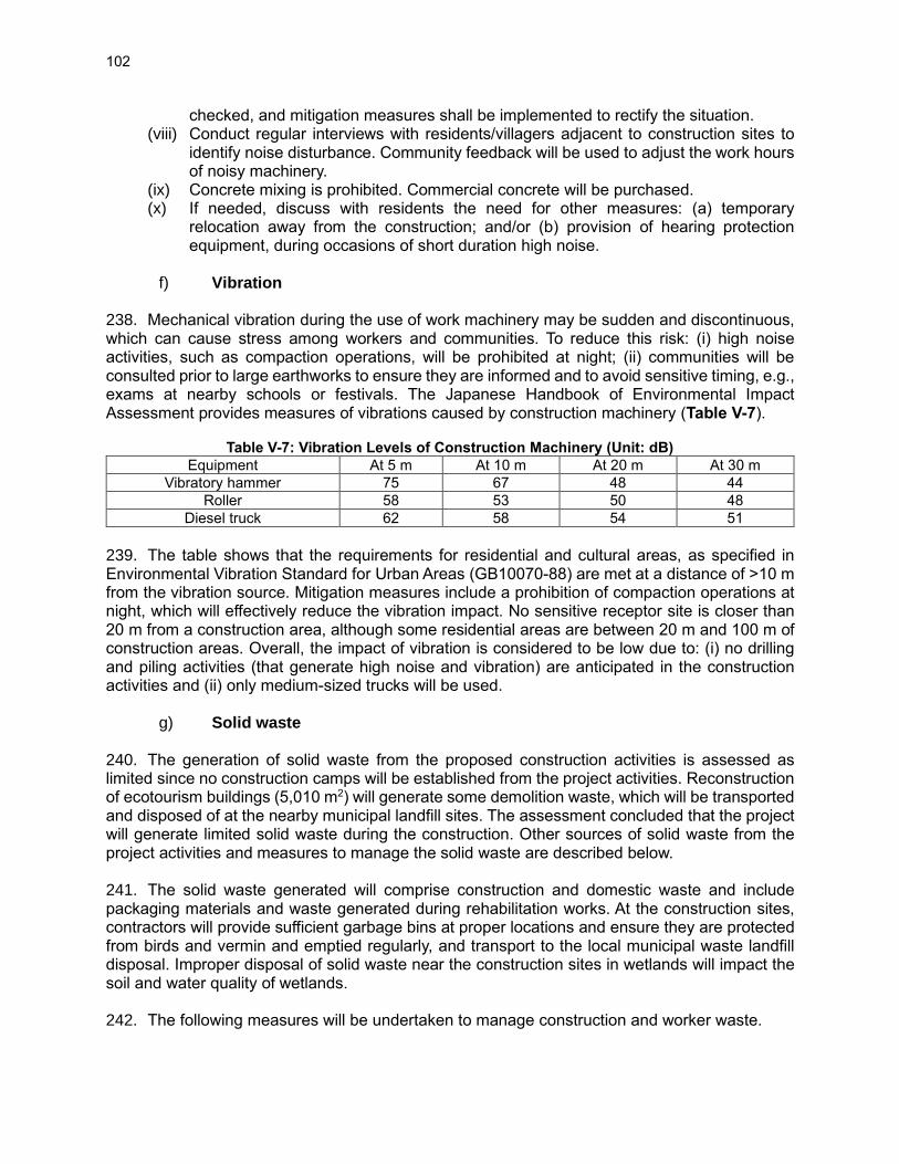
102
checked, and mitigation measures shall be implemented to rectify the situation. (viii) Conduct regular interviews with residents/villagers adjacent to construction sites to
identify noise disturbance. Community feedback will be used to adjust the work hours of noisy machinery.
(ix) Concrete mixing is prohibited. Commercial concrete will be purchased. (x) If needed, discuss with residents the need for other measures: (a) temporary
relocation away from the construction; and/or (b) provision of hearing protection equipment, during occasions of short duration high noise.
f) Vibration
238. Mechanical vibration during the use of work machinery may be sudden and discontinuous, which can cause stress among workers and communities. To reduce this risk: (i) high noise activities, such as compaction operations, will be prohibited at night; (ii) communities will be consulted prior to large earthworks to ensure they are informed and to avoid sensitive timing, e.g., exams at nearby schools or festivals. The Japanese Handbook of Environmental Impact Assessment provides measures of vibrations caused by construction machinery (Table V-7).
Table V-7: Vibration Levels of Construction Machinery (Unit: dB)
Equipment At 5 m At 10 m At 20 m At 30 m
Vibratory hammer 75 67 48 44
Roller 58 53 50 48
Diesel truck 62 58 54 51
239. The table shows that the requirements for residential and cultural areas, as specified in Environmental Vibration Standard for Urban Areas (GB10070-88) are met at a distance of >10 m from the vibration source. Mitigation measures include a prohibition of compaction operations at night, which will effectively reduce the vibration impact. No sensitive receptor site is closer than 20 m from a construction area, although some residential areas are between 20 m and 100 m of construction areas. Overall, the impact of vibration is considered to be low due to: (i) no drilling and piling activities (that generate high noise and vibration) are anticipated in the construction activities and (ii) only medium-sized trucks will be used.
g) Solid waste 240. The generation of solid waste from the proposed construction activities is assessed as limited since no construction camps will be established from the project activities. Reconstruction of ecotourism buildings (5,010 m2) will generate some demolition waste, which will be transported and disposed of at the nearby municipal landfill sites. The assessment concluded that the project will generate limited solid waste during the construction. Other sources of solid waste from the project activities and measures to manage the solid waste are described below. 241. The solid waste generated will comprise construction and domestic waste and include packaging materials and waste generated during rehabilitation works. At the construction sites, contractors will provide sufficient garbage bins at proper locations and ensure they are protected from birds and vermin and emptied regularly, and transport to the local municipal waste landfill disposal. Improper disposal of solid waste near the construction sites in wetlands will impact the soil and water quality of wetlands. 242. The following measures will be undertaken to manage construction and worker waste.

103
(i) No material storage sites should be located within the wetland areas and protected areas, and the waste generated at the construction should be collected daily and transported to the nearest landfill site.
(ii) Construction site facilities, including workers camps (if required in remote areas or in unforeseen conditions), should be located a minimum 1 km away from the wetlands and their water bodies to ensure no runoff of construction materials/worker waste to the nearest waters.
(iii) Covered garbage collection bins will be installed at each construction site. It will be the responsibility of the contractors to provide sufficient garbage bins at proper locations and ensure that they are protected from birds and vermin and emptied regularly (using the local municipal solid waste collection system by signing contracts between the contractor and the local sanitation authority). The contractors’ responsibility is included in the EMP, which will be included in bidding documents and construction contracts.
(iv) Construction waste will be recycled and reused to the extent possible (including wood, concrete, and brick debris). The remaining waste will be transported to the construction waste disposal site designated by the local city or county governments, in accordance with the Law on the Prevention and Control of Environmental Pollution by Solid Waste of the PRC and scrap material and demolition waste disposal standards promulgated by the PRC’s Ministry of Housing and Urban-Rural Construction.
h) Ecology 243. The assessment of the potential ecological impacts of the protected areas is already discussed under Section V.D.a. Shuangquan Lake wetlands are important staging grounds for migratory birds. About 50 migratory birds have been observed in these wetlands, in which 2 are first-grade protection species, 5 second-grade protection species. The wetlands are part of the larger Heihe wetland complex, located within Central Asian and East Asian – Australian Flyways. About 26 migratory birds are protected under treaties with Japan and Australia. The migratory birds will use these wetlands for resting from March to April and again from September to October. The potential noise and vibration generated from the construction activities in this wetland will significantly impact the migratory birds during their staging periods in this wetland. In Malan River Wetlands, thousands of migratory birds (74 species) are recorded each year. The project activities will not be carried out in these wetlands during the migration season, from March to April and September to October. The project will use native wetland species for the afforestation activities. Other potential impacts on the ecology of the project sites and proposed mitigation measures are described below. 244. Vegetation and flora. The site preparation activities for the development of forests in about 15,000 ha require land clearing in the proposed plantation sites. Since the proposed plantation will be done in the barren areas and degraded forests, no existing trees will be affected by the proposed land development. The existing vegetation will not be disturbed by the project activities. 245. Impacts on fauna. Risks to fauna during construction include: (i) pollution of aquatic habitats (rivers, wetlands) from construction wastewater (oils, fuels) and/or domestic wastewater from workers, which may impact fish as well as amphibians and aquatic invertebrates; and (ii) noise and visual disturbance to birds, mammals, reptiles, and/or amphibians. Mitigation measures have been developed to avoid and reduce the risk of water pollution (Sections V.). Noise and visual disturbance will be temporary.

104
246. The following mitigation measures will be applied for all works in all sites to avoid, minimize, and mitigate risks to ecological values.
(i) Clearance of vegetation will be restricted to specific construction sites. (ii) Prior to construction, vegetation and habitats will be clearly demarcated as no-go zones
for workers and machinery. (iii) Cleared sites will be immediately re-vegetated afterward. (iv) All plantation activities under the landscaping activities will only use native plant species.
In the event that non-native seedlings are required for rapid stabilization of exposed soils and sites, only sterile seedlings (i.e., which cannot propagate) will be used, to prevent the spread of weeds.
(v) To reduce the risk of spreading weeds, pest animals, and/or soil-based organisms, the project will: (a) prohibit the use of any plant species classified in the PRC as weeds – including native species – as defined by the Research Center for Biological Prevention and Control of Alien Invasion (Ministry of Agriculture and Rural Affairs) and Institute of Plant Protection (Chinese Academy of Agricultural Sciences), available at http://www.chinaias.cn/wjPart/index.aspx
(vi) To minimize the risk of soil and water pollution from the use of agricultural chemicals, the following measures will be applied to all planting activities: (a) no top-dressing fertilizer will be applied, either during the establishment of plantings or during operation and maintenance. Fertilizers will only be applied at the base of plants, to reduce the risk of non-point source pollution, (b) fertilizers will be organic, not chemical-based, and (c) for pesticides, in general, pesticide use will be avoided as far as possible.
(vii) Construction workers will be prohibited from fishing and hunting. All construction works will be limited to day time, and no works will be carried out during night time
i) Community and worker health and safety
247. Construction may cause unexpected interruptions in public services and utilities because of damage to pipelines for water supply and drainage, as well as to power cables and communication cables. Roads in the project areas are mainly narrow mountain roads, and the risk of traffic accidents may increase with construction traffic. The potential impacts on community health and safety are assessed as limited due to minor scale of the proposed civil works at each site. Contractors will implement the following EMP measures to reduce risks to community health.
i) Traffic management. A traffic management plan will be prepared by the contractor to be approved by the relevant traffic management administrations before construction. The plan will include provisions for diverting or scheduling construction traffic, regulating traffic at road crossings, selecting transport routes to reduce disturbance to regular traffic, reinstating roads, and opening them to traffic as soon as the construction is completed.
ii) Information disclosure and public consultation. Villagers, residents, and businesses will be informed in advance through media, information boards, and public consultations (Section VII), including the dates, duration, and scope of planned works.
iii) Construction site protection. Clear signs will be placed at construction sites in view of the public, informing people about the project GRM, and warning people against potential dangers such as moving vehicles, hazardous materials, and excavations, and raising awareness on safety issues. Heavy machinery will not be used at night. All sites will be secured, disabling access by the public through appropriate fencing whenever appropriate.
105
iv) Sexual exploitation, abuse, and harassment (SEAH) and disease risks. Strict requirements will be included in all personnel contracts and on-site workplace requirements for zero-tolerance of SEAH. This will include immediate investigation of any report or complaint, and immediate dismissal when abuse or harassment is confirmed.
v) All workers will be given basic training in sanitation, general health and safety matters, and work hazards. An awareness program for HIV/AIDS and other communicable diseases will be implemented for workers and the local communities.
vi) Measures for safety and resilience to COVID-19 described in Appendix 2 will integrated in the contractor health and safety plans and be strictly implemented.
vii) Core labor standards will be implemented. Civil works contracts will stipulate priorities to: (i) employ local people for works; (ii) ensure equal opportunities for women and men; (iii) pay equal wages for work of equal value and pay women’s wages directly to them; and (iv) not employ child or forced labor
viii) Interruption of public services and local utilities. Local people will be informed in advance of the time and duration of interruptions in public services and utilities.
j) Occupational health and safety 248. The potential occupational health and safety risks of the project activities are associated with working on heights (mountain slopes), working near water (wetlands and rivers), severe weather conditions, use of construction machinery, tools, and materials. The potential risks include physical hazards, including noise and vibration, dust, handling heavy materials and equipment, falling objects, work on slippery surfaces, fire hazards, and chemical hazards such as toxic fumes and vapors. The project's occupational health and safety risks are assessed as moderate and minimized by implementing an occupational health and safety plan. Contractors will each prepare an environmental, health and safety management plan (Table EMP-2 of Appendix 1), which will include the following:
(i) Provide a clean and sufficient supply of freshwater for construction sites and camps (if established).
(ii) Provide an adequate number of portable on-site latrines at construction sites and work camps and ensure that they are cleaned and maintained in a hygienic state.
(iii) Garbage receptacles at construction sites and camps will be set up, which will be periodically cleared to prevent the outbreak of diseases.
(iv) Provide personal protective equipment to comply with PRC regulations, e.g., safety boots, helmets, gloves, protective clothing, goggles, earplugs.
(v) Emergency preparedness and response plan for accidents and emergencies, including environmental and public health emergencies associated with hazardous material spills and similar events. These plans will be submitted to the local EEBs for review and approval. Emergency phone link with hospitals in the project area will be established. A fully equipped first-aid base in each construction camp will be organized.
(vi) A records management system that will store and maintain easily retrievable records against loss or damage will be established. It will include documenting and reporting of occupational accidents, diseases, and incidents. The records will be reviewed during compliance monitoring and audits.
(vii) Occupational health and safety matters will be given a high degree of publicity to all work personnel and posters will be displayed prominently at construction sites.
(viii) All workers will be given basic training in sanitation, general health and safety matters, and work hazards. An awareness program for HIV/AIDS and other communicable diseases will be implemented for workers and the local communities.
106
(ix) Core labor standards will be implemented. Civil works contracts will stipulate priorities to: (i) employ local people for works; (ii) ensure equal opportunities for women and men; (iii) pay equal wages for work of equal value and pay women’s wages directly to them; and (iv) not employ child or forced labor. Specific targets for employment have been included in the project gender action plan.
(x) Health and safety plan for emerging disease outbreaks. The project EMP Appendix 2 includes guidelines to address any emerging disease outbreaks such coronavirus (COVID-19). In the event of any new outbreaks, all project works will immediately comply with national and provincial requirements, as well as the safety guidelines in EMP Appendix 2.
249. It is expected that these risks can be effectively managed through the implementation of the EMP, including mitigation measures, capacity building, inspection, supervision, and reporting.
k) Physical cultural resources 250. Cultural heritage or historical sites exist near Xining City (capital of capital of Qinghai Province). Two heritage sites (Tulou and Nanchan temples) are located within the project sites proposed for forest tending activities. Details of these sites and potential impacts are discussed in Table V-4. The proposed forest tending activities comply with the existing management plans of the temples. There are no impacts expected on these temples, and hence the impacts on PCRs are assessed as low. The Tulou temple is located on a hill slope and the proposed tending activities on the uphill slope of the temple. If any unstable soils are located in the uphill slopes, the tending activities may cause landslides that could fall on the temple. Hence any tending activities will not be carried out in the unstable slopes near the temple site. The use of machinery will be restricted within the proximity of temples to avoid any vibration impacts. If any of the project activities disturb unknown underground cultural relics. For all project locations: (i) the contractor and implementing agency shall report to Provincial Administration of Cultural Relics immediately in the event that any cultural relics are discovered during civil works, (ii) works shall be suspended until the provincial Cultural Heritage Bureau has conducted a site assessment and provided instructions on next steps, (iii) the cost for any archaeological survey, exploration or excavation required for construction shall be included in the project budget, (iv) construction will resume only after investigation and with the permission of the appropriate authority, and (v) the clause for protection of unknown underground cultural relics will be included in the construction contracts.
l) Socioeconomic impacts 251. Most of the planned project facilities are located away from communities in urban area, towns and villages. However, construction works may cause unexpected interruption to local communities, and their municipal services if they are located close to the project sites, municipal services, e.g., in case of unintended damage to pipelines or transmission lines for water, drainage, gas, and/or electricity. Altered traffic flows and increased occurrence of slow-moving heavy vehicles may cause traffic jams and delays. These impacts will be localized and temporary. They will be managed through ongoing consultations with communities during construction (as well as operation), that will build on the consultations conducted during project preparation (Section VII), and measures for community health and safety, including a traffic management plan (Section V.D.e). These measures are included in the project EMP (Attachment 1). E. Operation Phase 252. The project forest sites will be maintained by county forest bureaus with the support from

107
village committees. Key operational risks assessed were: (i) sustainability water source for irrigation, (ii) loss of organic matter and nutrients by removal of vegetation and leaching, (iii) development of hardpans and laterization (a weathering process by which soils are depleted of soluble substances), (iv) negative impacts on-site and on quality of local water bodies from use of herbicides and pesticides, (v) disturbance to wildlife and vegetation by tourists, (vi) air and noise pollution from the forest roads, and (v) risk of forest fires.
a) Sustainability of Water Resources 253. The project requires 18 million m3 of water annually for forest irrigation, which will be sourced from the rivers. Water scarcity is a major concern in the Yellow River basin and the project may put further pressure on the scarce water resources. Hence the sustainability of the proposed water sources for the project is assessed based on the available water quota in the project counties for irrigation purposes and the water requirement for the project activities. The assessment concluded that the proposed water sources are sustainable since the water requirement of the project counties is less than 3 percent of the available irrigation water quota of the counties. A detailed description of water requirements of the project and water balance analysis is given below. Water Demand for Irrigation 254. The proposed subproject sites locate in nine river basins (Figure V-1) of the Huangshui River, the Heihe River, the Yanhe River, the Beiluo River, the Jinghe River, the Weihe River, the Hanjiang River and the Jialing River, and small tributaries directly to the mainstream of the Yellow River, some of which have significant sediment problems, such as the Yanhe River, the Beiluo River, the Jinghe River and the Weihe River. The water demand for each subproject has been estimated and presented in Table V-8.
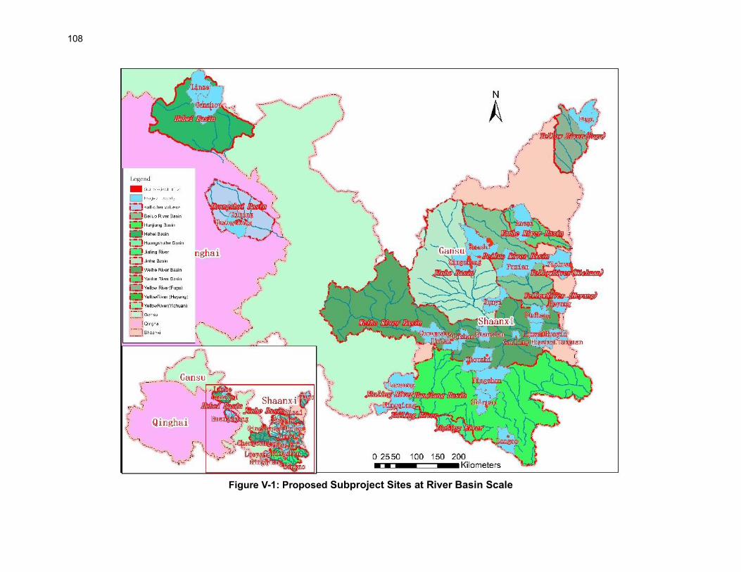
108
Figure V-1: Proposed Subproject Sites at River Basin Scale

109
Table V-8: Water Demand and Sources of Subprojects No. Major
river basin
County, province
Water demand estimation (1000m3)
Water source Water-taking measure
Supporting project
Main activities needing water Area /ha
1 Creeks directly to
Yellow River
Fugu, Shaanxi 1,095 1,615 Surface water (Kuye River)
Spraying vehicle, pump
/ 1. 1,048.00ha, low efficient forest reform; 1,048
2. 533.33ha, reforest; 533.33
3. Support facilities 0
Yichuan, Shaanxi
340 Surface water (Yellow River, Luchuan River, Baishui River)
Spraying vehicle, pump
/ 1. 643.53ha, new shelter forest. 643.53
Heyang, Shaanxi 180 Surface water (Jinshui River, Xuishui River)
Spraying vehicle, pump
/ 1. 239.40ha, new shelter forest; 239.4
2. 50ha, reforestation forest; 50
3. support facilities (service road 15.59km long and 3.5m wide).
0
2 Yanhe River
Ansai, Shaanxi 144 144 Surface water (Yanhe River)
Spraying vehicle, pump
Municipal water supply
1. 32.27ha, new scenic beauty forest; 32.27
2. 103.73ha, reforestation forest; 103.73
3. forest health base (active area, education corridor, trails, green vegetation).
0
3 Beiluo River
Fuxian, Shaanxi 278 512 Surface water (Beiluo River, Hulu River, Dashenhao River)
Spraying vehicle, pump, pipe
/ 1. 200ha, new economic forest; 200
2. support facilities (service road and path); 0
3. eco-function (Wenguan fruit center). 0
Huachi County, Gansu
234 Surface water (Liyuanpu River)
Pumping+spraying vehicle
Pump, tank truck, plastic pipe
1. 800.00ha, water and soil conservation forest (Zifangpan Town, Nanliang Town);
800
2. 1,066.7ha, forest tending (Nanliang Town). 1,066.7
4 Jinghe River
Huachi County, Gansu
0 473 Surface water (Rouyuan River)
Pumping+spraying vehicle
Pump, tank truck, plastic pipe
1. 800.00ha, low-efficiency forest transformation (Wujiao town).
800
Huachi Bereau, Gansu
144 Surface water, r (Chenghao River)
Pumping+spraying vehicle
Pump, tank truck, plastic pipe
1. 487.00ha, water and soil conservation forest; 487
2. 466.7ha, forest tending; 466.7
3. 333.33ha, low-efficiency forest transformation; 333.33
Xunyi, Shaanxi 95 Surface water (Malan River)
pump Municipal water supply
1. 63.2ha, new forest; 63.2
2. 112ha, forest restoration in Malan River; 112
3. science education center. 0
Qingcheng, Gansu
234 Surface water (Malian River, well)
Pumping+spraying vehicle
Pump, tank truck, plastic pipe
11. 800.00ha, water and soil conservation forest; 800
12.1,066.7ha, forest tending; 1,066.7
13. 800.00ha, low-efficiency forest transformation. 800
5 Weihe River
Pucheng, Shaanxi
824 3,278 Surface water (Luoxi Canal)
Luoxi Canal / 1. 133.00ha, new forest; 133
2. 270.00ha, forest tending; 270
3. house updating. 0
Chengcang, Shaanxi
112 Surface water (Baoji Main Canal from Weihe River)
pump, canal Municipal water supply, existing water supply facilities of Beishan Forest Park
1. 71.93ha, scenic beauty forest; 71.93
2. forest science popularization and experience project (toilet, septic tank, active area, green vegetation, recreational trails).
0
Panlong/Jintai, Shaanxi
54 Surface water (Baoji Total Canal from Weihe River, Wangjiaya Reservoir)
Spraying vehicle, pump
Municipal water supply
1. 25ha, new scenic beauty forest; 25
2. 35ha, low-efficiency forest transformation; 35
3. support facilities (service road); 0
4. forest relaxation (path, platform). 0

110 No. Major
river basin
County, province
Water demand estimation (1000m3)
Water source Water-taking measure
Supporting project
Main activities needing water Area /ha
Qishan, Shaanxi 312 Surface water (Xifang River, Hengshui River, Shitou River)
Spraying vehicle, pump
/ 1.108.07ha, new shelter forest; 108.07
2. 32.61ha, reforestation; 32.61
3. 36.59ha, low-efficiency forest transformation; 36.59
4. 24.22ha, forest tendering; 24.22
5. 342.68ha, closing hillsides for afforestation; 342.68
6. support facilities (service road, management station).
0
Qianxian, Shaanxi
248 Surface water (Ganhe River, Yangmaowan Canal, Qianling Reservoir)
Spraying vehicle, pump
Municipal water supply
1. 36.00ha, new forest; 36
2. 200.00ha, forestation quality improvement; 200
3. 60.00ha, forest tendering; 60
4. support facilities (service road, wall, house updating).
0
Gaoling, Shaanxi 226 Surface water (Weihe River, Jinghe River, Jiuzhi Canal)
Spraying vehicle Municipal water supply
1. 47.33ha, scenic beauty forest; 47.33
2. support facilities (service road). 0
Linwei, Shaanxi 231 subsurface water (well) pump / 1. 22.42ha plant nursery; 22.42
Huayin, Shaanxi 600 Surface water (Luofu River, Liuye River, Changjian River)
Spraying vehicle, pump
/ 1. 300ha, low efficiency forest transformation; 300
2. eco-function (toilet, greening ascension, recreational trails, active area, green vegetation, vertical greening, road greening).
0
Huazhou, Shaanxi
124 Surface water (Luowen River)
/ Municipal water supply
1. 38ha, new forest; 38
2. forest health facilities (green of 40,000m2; active area).
0.04
Tongguan, Shaanxi
478 Surface water (Tonghe River, Weihe River)
Spraying vehicle, pump
/ 1. 163.33ha, new scenic beauty forest. 163.33
Zhouzhi, Shaanxi 69 Surface water (Damang River, Heihe River, Kunyu River, Heihe Canal)
Spraying vehicle, pump
Existing water supply facilities of Louguantai Forest Park
1. Heihe River (eco-tourism facilities); 0
2. Louguantai (forest health center). 0
6 Hanjiang River
Ningshan, Shaanxi
8.6 1,258.6 Surface water (Chang'an River, Donghe River)
pump / 1. forest health (public restroom, waterproof plastic wood trail, steel bridge, green vegetation);
0
2. forest production line (Processing plant, factory afforestation, Chestnut sauce production line).
0
Shiquan, Shaanxi
929 Surface water (Ziwu River, Raofeng River, Hanjiang River, Chihe Rive)
Spraying vehicle, pump
Municipal water supply
1. 214ha, new economic forest; 214
2. 17.13ha, new shelter forest; 17.13
3. 26.66ha reforestation forest; 26.66
4. 93.34ha, forest tending; 93
5. support facilities (managing house, Fenghuangshan observation tower);
0
6. Liujintong silkworm cultural park (Han Style Golden Silkworm Experience Museum, green vegetation, ecological embankment, park roads and paving).
0
Langao, Shaanxi 321 Surface water (Siji River, Lanhe River, Pingxi River)
Spraying vehicle, pump
/ 1. 25.21ha, new special forest; 25.21
2. 128.3ha, Low-efficiency forest transformation; 128.3
3. support facilities (service road); 0
4. Forest science popularization and experience 0

111
No. Major river basin
County, province
Water demand estimation (1000m3)
Water source Water-taking measure
Supporting project
Main activities needing water Area /ha
facilities (relaxtion path, vegetation science musem, active area).
7 Jialing River
Ningqiang, Shaanxi
110 812 Surface water (Changan River, Donghe River)
existing facilities of water storage, water supply in the Park
/ 1. Laoguguan Forest Park (road updating, greening, recreation site)
0
Lueyang, Shaanxi
702 Surface water (Jialing River, Badu River, Dongdu River)
Spraying vehicle, pump
/ 1. 143.53ha, new shelter forest; 143.53
2. 148.53ha, reforestation forest; 148.53
3. support facilities (serving road, new patrol path, observation tower);
0
4. forest health base (eco-experience area, eco-culture corridor, environmental protection toilet)
0
8 Heihe River
Ganzhou, Gansu 8,211 9,864 Surface water, subsurface water (Heihe River, Shandan River)
Canal + pump+pipeline
Water-saving irrigation pipe network
1. Shelter forest development in Ganzhou District: 0
Ø 153.33ha, protection forest development in Heihetan;
153.33
Ø 100ha, artificial grassland development in Heihetan; 100
Ø 2,000ha, degraded shelter forest improvement (including irrigation facilities);
2,000
Ø 400ha, degraded shelter forest tending in Xichengyi Forest Farm (including irrigation facilities).
400
2. Nursery seeding base development in Ganzhou District:
0
Ø 20ha, Jiulongjiang Forest Farm; 20
Ø 20ha, Xichengyi Forest Farm; 20
Ø 13.3ha, Hongshawo Forest Farm. 13.3
Linze, Gansu 1,653 Surface water, subsurface water
Artesian well, canal
Water-saving irrigation pipe network
3. Wetland shelter forest development 0
Ø 104.05ha, wetland vegetation restoration; 104.05
Ø 266.7ha, restoration of wetland degraded protection forest;
266.7
Ø 73.0 ha, wetland shelter forest improvement. 73
9 Huangshui River
Xining, Qinghai 876.3 876.3 Surface water (Huangshui River; Nanchuan River, Beichuan River, Huoshao Gully, Shihui Gully)
Pumping+spraying
Water-saving irrigation pipe network
1. 1,333.33 ha, afforestation in Xibu Town (within Xibu Ecology Forest Park)
1,333.33
2. Reforestation and multi-functional approach in forest landscape management in North and South mountains (Chengdong, Chengbei, Chengzhong and Chengxi districts)
0
Ø 333.33ha, tending of mature forest for ecological function improvement;
333.33
Ø 15,333.33ha, young and middle-aged forest tending; 15,333.33
Ø 326.67ha, forest landscape restoration and improvement.
326.67
Total 18,832.9 32,866

112
Water Balance Analysis 255. A water balance analysis was performed on the water demand for each proposed subproject site both in planting and tending period, and normal growth period according to water quota of the Project Province. County-Level Water Balance Analysis
256. The water demand for the project counties and approved water releases (quota for irrigation) by each county-level government in 2020 are given in Table V-9. It can be concluded from the table, the percent of water demand for project activities is generally less than 2% to approved water quota. Only Shiquan, Lueyang, Fugu, Tongguan, Yichuan, Linze, Ganzhou, Qingcheng and Huachi counties require more than 1% of the approved water quota, and the remaining counties require less than 1% of the approved water quota. Hence, the project activities use a small part of the approved water quota of the counties, and the proposed water sources are sustainable.
Table V-9: Water Use by the Project against Approved Water Releases by County Governments
No Province County Water use by the Project (10,000 m3)
Approved Irrigation Quota (10,000 m3)
Percentage of water use
1 Qinghai Xining (5 districts) 87.6 80800 0.11
2
Gansu
Huachi (county and district)
37.8 2823.7 1.34
3 Qingcheng 23.4 8781.4 0.27
4 Ganzhou 821.1 68100.0 1.21
5 Linze 165.3 40600.0 0.41
6
Shaanxi
Zhouzhi 6.9 12700 0.05
7 Gaoling 22.6 13633 0.17
8 Qishan 31.2 15320 0.20
9 Chencang 11.2 9380 0.12
10 Panlong New District 5.4 6650 0.08
11 Xunyi 9.5 1296 0.73
12 Qian 24.84 4305 0.58
13 Pucheng 82.35 28800 0.29
14 Heyang 18 9300 0.19
15 Linwei 23.1 33700 0.07
16 Huayi 60 5600 1.07
17 Huazhou 12.4 9000 0.14
18 Tongguan 47.8 3000 1.59
19 Fugu 109.48 11000 1.00
20 Ansai 14.4 2378 0.61
21 Fu County 27.8 4875 0.57
22 Yichuan 34 1666 2.04
23 Lueyang 70.2 3600 1.95
24 Ningqiang 11 NA*
25 Shiquan 92.92 6800 1.37
26 Ningshan 0.86 4100 0.02
27 Langao 32.1 5650 0.57 Total 1883.25
* For Ningqiang county, data collection is in progress, but the water requirement for the project will be minimal similar to other counties. Further, the county is located in the Qinling Mountains in the south of Shaanxi Province, where there is abundant rainfall and water for forest irrigation.
River/Basin Level Water Balance Analysis
257. A basin level water balance analysis for Gansu and Qinghai provinces are given in Tables V-

113
10 to V-11. The water requirements of the subprojects are compared with these available irrigation waters.
Table V-10: Water Balance- Gansu
Basin Project area List of water
sources
Amount of water available
for irrigation million m3
Status of Current water
use million m3
Amount of water required for irrigation of the project
million m3
Percentage
Beiluo River
Huachi County, Qingyang City
River water and well water
/ 22 0.672 3.05%
Jinghe River
Qingyang City Qingcheng
County
River water and well water
/ 31.88 1.112 3.48%
Heihe Basin
Ganzhou District River 681 8.602 12.63
%
Heihe Basin
Linze county Shuangquan Lake Wetland
15.901 4.826 30.35
%
258. In Gansu province, the percentage of water use for the subprojects comprises 2–13% of the available water resources for irrigation purposes. For the wetland subproject in Linze county, the water from the Shuangquan Lake will be used. According to the observation of perennial water storage in Shuangquan Lake Wetland, the annual inflow of self-produced water in the wetland is 15.901 million m3/a, the ecological restoration water consumption of the wetland in the project area is 1.652 million m3/a, and the outflow water of the project area is 11.075 million m3/a, which can meet the needs of various ecological water of the project.
Table V-11: Water Balance-Qinghai
Basin Project area List of water
sources
Total water source
10,000m3/a
Present Available
Irrigation water 10,000m3/a
Future Available
Irrigation water 10,000m3/a
Project demand 10,000 m3/a
%
Huangshui
Afforestation and greening
project in Xibu District of Xining City
Pando Reservoir
2,950 462 534
282 16.5
Big Stone Gate Reservoir
1300 265 289
National Temple Camp
Canal 1,534 119 174
Emancipation canals
2,175 169 169
Xibu main canal
619 619 540
Total 8,578 1,634 1,706 876.3 16.5
259. In Qinghai, the irrigation requirement of subprojects is 16.5% of the total available water for irrigation purposes. 260. For Shaanxi Province, a similar assessment was not conducted due to a lack of adequate river basin-level data. To address this issue, the assessment of county water-level use was compared against the allocated irrigation quota for each project county based on the data presented in Table V-9, to ensure that the project water demands are within the county quotas. Although compliance with county-level quotes may not indicate confirmation against water supply for the individual rivers that water will be extracted from, the analysis confirms that for each project county in Shaanxi Province, the project will utilize less than 1% of the available irrigation quota. This provides
114
confidence in the sustainability of the project water use at the river basin level.
b) Agricultural Chemicals 261. The main pests in the forestry sector are rodents and fungal diseases (ascomycota). Mice bite the roots of plants, causing plants to die or drag the entire plant from the ground. Common methods of their control are trap and killing. The common methods of disease control are (i) remove and bury or burn the diseased leaves to reduce pathogens, (ii) spray pesticides (carbendazim and chlorothalonil) to the canopy in late spring and early summer. Fertilizers and pesticides can increase forest yields and reduce plant diseases and insect pests. At the same time, they may also cause local surface pollution and infiltrate into the ground to cause pollution. If excessive fertilization, fertilizer structure and fertilization methods are improper, it will destroy the physical and chemical properties of the soil, affect the activity of soil microorganisms, cause soil compaction, reduce the soil's comprehensive ability to retain water and fertilizer, and ultimately lead to soil degradation. The project activities to support agricultural improvement, plantings, and afforestation present risks to soil and water quality and/or community and worker health and safety from the improper handling, use, storage, or disposal of chemicals, e.g., chemical fertilizers, pesticides, and fuel or oils from project machinery and vehicles. The requirement of fertilizers and pesticides for the project have been estimated and presented in Table V-12. 262. In addition to these chemicals, water-retaining agents will be applied around the bases of tree seedlings during planting, to retain soil moisture during the critical early stages of growth (Section III.D and footnote 10; page 41). The agent likely to be used is potassium polyacrylamide, which is widely used in agricultural activities in many countries (footnote 10; page 41). PAM is considered to be relatively safe for use in environmental settings: mobility in natural environments is limited due to its high molecular weight and adsorption onto mineral surfaces; it is highly retained in porous media such as soil and easily settles in waterbeds; it is too large to penetrate biological cell membranes; it is relatively nontoxic to humans, animals, fish, or plants; and degrades rapidly in soil and water. However, high concentrations and sustained contact with skin and/or inhalation (e.g. during preparatory work for the seedling plantings) can pose risks to human health. 263. These risks will be minimized as follows.
(i) The project designs aim to promote green farming, i.e., the project context is one of improved land management and the reduced use of chemicals. The project will promote the use of organic fertilizers, manual weed control, and selective weeding, and traps, barriers, light, and sound to repel or remove pests and reduce the use of chemical pesticides.
(ii) No pesticides listed as hazardous under Classes I or II by the WHO12, or Annexes A and B of the Stockholm Convention13, or listed as prohibited or strictly controlled use under the PRC’s national regulations14 for pesticide management will be used for the project activities.
(iii) Ensure that any pesticides used are manufactured, formulated, packaged, labeled, handled, stored, disposed of, and applied according (i) to the FAO’s International Code of Conduct on Pesticide Management,15 and (ii) in a manner consistent with the recommendations
12 World Health Organization (WHO), Recommended Classification of Pesticides by Hazard and Guidelines to
Classification, (Geneva, 2009) http://www.who.int/ipcs/publications/pesticides_hazard/en/. 13 The Stockholm Convention on Persistent Organic Pollutants 2011. 14 http://www.moa.gov.cn/xw/bmdt/201911/t20191129_6332604.htm 15 FAO, International Code of Conduct on Pesticides Management (revised 2014), (Rome: FAO, 2014)
http://www.fao.org/fileadmin/templates/agphome/documents/Pests_Pesticides/Code/CODE_2014Sep_ENG.pdf.

115
given in the World Bank Group EHS Guidelines.16 (iv) Storage sites will (a) have appropriate ventilation and secondary containment, and (b) be
of restricted access to trained operators and other specifically listed persons e.g. the site manager. Persons with access with to the chemical storage rooms will be recorded in a register. Any pesticides used will be stored in their original and labeled containers. The PIU will record all the procurement and utilization of pesticides.
(v) Farmers will be encouraged to involve in project’s afforestation activities. The project activities include research on community participation and training programs for local famers on the forest maintenance. PIU will train the farmers on the safe storage, handling, application and disposal of pesticides.
(vi) All chemicals used, including pesticides and water-retaining agents, will be handled by trained operators (to understand and follow label directions for safe mixing, application and disposal). Operators will use correct personal protective equipment (PPE; e.g., gloves, overalls, eye protection, boots, respirator masks). PPE will not be taken home and will be cleaned in a segregated facility provided by the PIU.
(vii) Pesticide application technologies will be selected to minimize off-site movement or runoff (e.g., low-drift nozzles, using the largest droplet size and lowest pressure that are suitable for the product). Buffer zones will be established around the environmentally sensitive zones (e.g., watercourses, residential areas) to avoid any pesticide application in those areas.
(viii) Pesticide application methods with lower OHS risk profile will be selected (such as using lower toxicity- rated products, or using safer application methods, such as shielded sprayers, incorporation, or low-volume equipment).
(ix) Empty containers and packaging waste for pesticides and fertilizers will be collected by the dealers and manufacturers – a common process now in the PRC –who will take effective measures, e.g. money refund, to guide pesticide users to return pesticide packaging wastes in time, or collected through pesticide packaging waste recycling stations. The collected packaging waste will be recycled by manufactures or certificated companies (with license issued by provincial environment and ecology department), or disposed at landfill or inclinators as hazardous waste by certificated companies The PIU will ensure the segregation of the pesticide waste at the subproject site from all other waste and will ensure that it is returned to dealers/manufactures or pesticide packaging waste recycling stations.
16 World Bank Group. 2016. EHS Guidelines for Annual Crop Production.
https://www.ifc.org/wps/wcm/connect/topics_ext_content/ifc_external_corporate_site/sustainability-at-ifc/publications/publications_policy_ehs_annual_crop_production

116 Table V-12: Summary of Agricultural Chemicals Consumption
District / County
Subproject location
Name of chemicals
Use Area (ha)
Dosing rate
(t/ha)
Estimated dosing (t/a)
Gansu Province
Qingyang City Qingcheng County, Huachi County
Qingyang Loess Plateau Forest Ecological Restoration Zone
Fertilizer (ABT3 root powder)
It is used for seedling transplantation, seeding, afforestation and fly-seeding afforestation, as well as urban greening of large tree transplantation, to promote root system development, improve survival rate, increase anti-reversive energy
2,246.33 100% 27.08
Qingyang City Qingcheng County, Huachi County; Ganzhou District, Linze County, Zhangye City
Qingyang Loess Plateau Forest Ecological Restoration Zone The ecological restoration area of wetlands in the Heihe River Basin
Fertilizer (FA Dryland Dragon)
In the dry afforestation season spray leaf surface, the spray should be "liquid with full leaves without dripping" degree, requires that the front and back of the blade should be sprayed, spray once valid for 17 to 20 d, spray period is 20 d, In the event of a severe drought, it can be increased to 300 times the strength to increase drought resistance
2,399.33 100% 28.09
Qinghai Province
Xining City The afforestation and greening project in Xibu area
Pesticide (Bittersin (matrine)
For forest pest control, mainly the prevention and control of pine caterpillars, poplars, white dragonflies, Tea caterpillars, ruler butterflies, golden-printed hazelnuts and other forest fruit tree leaf pests.
20,000 100% 2.8
Xining City The afforestation and greening project in Xibu area
Fertilizer Balanced fertilization, NPK supplementation, improve fertilizer utilization, promote the growth of trees
20,000 100% 547
Shaanxi Province
Fugu Fugu Fertilizer Fertilize the economic forest 533.33 2.52 1,343.99
Fugu Fugu Pesticide Pest management 533.33 0.033 17.60
Shiquan Shiquan Pesticide Fertilize the economic forest 93.34 3.5 326.69
Shiquan Shiquan Pesticide Pest management 93.34 0.033 3.08
Qian Qian Fertilizer Forest breeding 400 0.75 300.00
Qishan Qishan Fertilizer Forest breeding 24.22 0.75 18.17

117
c) Impacts on Forest and Wetlands from Tourism
264. The proposed tourism development activities in the project may put pressure on the forests and wetlands. The typical impacts of tourism activities, such as travel, accommodation and recreational activities, include soil erosion and compaction, damage to vegetation, damage to vegetation, disturbance to wildlife, water pollution, increased fire frequency, vandalism, and noise. To minimize the environmental degradation associated with tourism and recreation, the following measures will be implemented:
• Appropriate land-use zoning to designate the areas that should be solely used for tourism and solely for conservation and other uses
• Direct physical protection of the areas that are sensitive for tourists
• Education of tourists
• Carryout a monitoring program to assess the impacts of tourists’ activities
• Procurement of fire-fighting facilities
d) Impact of Tourism on Wildlife 265. The environmental impacts of wildlife tourism vary greatly and depend on the type of tourist activity, tourist flow and their behaviors. General impacts on wildlife include disturbance of feeding and breeding patterns, risks transmission of diseases, and, in some cases, risk of accidents to individual animals due to road collisions. In addition to the measures discussed in the above section, the project will implement the following measures to manage these risks:
• The building of the park agencies’ capacity to effectively engage in partnerships with the tourism industry to minimizing environmental impacts
• Communication campaign for the tourists on the protection of wildlife
• Implementation of strict speed limits F. Indirect, Induced and Cumulative Impacts 266. Indirect impacts are adverse and/or beneficial environmental impacts that cannot be immediately traced to a project activity but can be causally linked. Induced impacts are adverse and/or beneficial impacts on areas and communities from unintended but predictable developments caused by a project which may occur later or at a different location. Cumulative impacts are the combination of multiple impacts from existing projects, the proposed project, and anticipated future projects that may result in significant adverse and/or beneficial impacts that would not be expected in the case of a stand-alone project.17 267. Indirect Impacts. These include (i) the generation of more waste and wastewater, from the eco-tourism facilities due to increased tourists flow, and (ii) traffic related risks associated with the travel of tourists. These risks are considered low: (i) waste and wastewater generation will meet the capacity of the existing municipal landfill and wastewater treatment capacities; (ii) including the road safety awareness programs in the community programs. 268. Induced Impacts. A likely induced impact is that reduced soil erosion and improved water quality of rivers will result in increased agricultural production and urbanization in the downstream areas. These impacts are expected to be more positive and improve socio-economic conditions in the region.
17 ADB. 2011. Sourcebook for Safeguard Requirement 1: Environment. Manila.

118
269. Cumulative Impacts. The present afforestation activities in the project provinces are being implemented on a pilot basis, and based on the success of these projects, similar afforestation activities will be implemented in the future. So, the cumulative investments of all these projects along the Silk road will have may positive impacts. These include reduction of the soil erosion from loess terrain and improvements in the forests and wetland ecology. G. Climate Change and Greenhouse Gas Emissions 270. Climate Risk Screening. According to climate data observed from 1961 to 2018, the annual temperature in project sites is varied from 2°C in Qinghai to approximately 12°C in southern Shaanxi. However, there is a consistently increasing trend across all three provinces with an average increase of 0.3°C/10a. The annual precipitation is also varied significantly from less than 200 mm in northern Gansu to 900 mm in southern Shaanxi, whilst long-term change trends are fairly stable across all project regions. However, the frequency of extreme rainfall events has an increasing trend of 7.1% from 1961 to 2018, whilst extreme temperature events have an increasing trend of 8% during the period. Extreme temperature events are particularly more frequent since the mid1990s. The climate risk screening identified the following risks which may affect the project: Project activities may be affected by higher frequencies of seasonal droughts that caused by changing precipitation patterns that tend to concentrate to fewer larger intensive rainfall events; Changed rainfall patterns may also cause more flash floods that will impose risks to many project activities; and More frequent extreme high-temperature events may impose risks to project activities by causing higher evaporation and more frequent droughts. 271. The future climate change projection is based on an analysis of 21 global climate models under two RCP scenarios (RCP4.5 and RCP8.5). The projected climate change trend is based on the analysis for 2050 climate conditions (2041-2060) with reference to the baseline period of 1961–1990.
• Temperature Increases. The median annual mean temperature is projected to increase 2.2-2.4 °C and 2.7-3.1 °C from project sites in southern Shaanxi to northern Gansu in 2050 under RCP 4.5 and RCP8.5 climate change scenarios respectively. Similar increases are also projected for extreme high temperatures across project sites.
• Rainfall Changes. The median annual precipitation is projected to increase 1.8-11.2% and 5.0-10.4% from project sites in southern Shaanxi to northern Gansu in 2050 under RCP 4.5 and RCP8.5 climate change scenarios, respectively. Because base precipitation is very low in most project sites, the projected 10% of increases does not means significant increases in terms of total millimeters. In the meantime, the 10 years return period rainfall intensity is projected to increases 5-13% and 10-33%. Higher rainfall intensity is likely to result in higher flash flood risks and increased rainfall variability.
272. Adaptation measures. Major adaptation activities are those soil and water conservation measures related to afforestation and reforestation activities in three project provinces. Those are additional measures built-in supporting forest management infrastructure to adapt to climate change caused increases in rainfall intensity and flash floods, increased drought risk caused by increases in temperature and variability in precipitation, increases in frequency and extent of forest pest and diseases, and forest fire risks exacerbated by climate change. Adaptation measures for wetland rehabilitation include those waterways connection and ecological water supplementary infrastructure, and bird breeding areas, and other measures relating to the restoration of water plants and catchment vegetation. A summary of these adaptation measures is given in Table V-13. Further, the project will procure energy-efficient equipment and vehicles to reduce energy use and fuel consumption by the project activities. The design and construction of buildings will also focus on energy-efficient measures required to reduce/mitigate extreme temperatures and increase thermal
119
comfort – this includes roof treatment, well-designed openings (windows, doors and vents), strategic ceiling level ventilation, and use of less heat-absorbing paints/colors/materials.
Table V-13: Project Measures for Climate Change Adaptation and Mitigation
Climate Risk Adaptation Activity Specific Measure
Increasing frequency and intensity of storms may exacerbate erosion of loess soils across project sites.
Construction of drainage ditches, check dams, terraces, water saving facilities, and vegetation restoration
Soil and water conservation for 24,705.58 ha of loess soil hills and desert invasion areas
Increases in frequency and extent of droughts may reduce wetland areas and biodiversity
Wetland vegetation restoration, construction of ecological water replenishment structures, and birds, and restoration of bird breeding areas
Restore 198 ha wetland vegetation and 33.9 ha of bird breeding areas, construct 4 km of ecological drainage canals and other water monitoring and management facilities for 112 ha of wetland areas
Higher rainfall intensity and temperature will require additional stormwater drainage and cooling needs
Add extra stormwater drainage capacity, extra cooling capacity, and reliable internet connection to ecotourism facilities
Construction of extra stormwater drainage and cooling capacity The design of the buildings for the project ecotourism facilities and road designs will incorporate climate-resilient measures including: (i) structural designs to withstand high winds and storm events, (ii) appropriate drainage channels for rapid discharge of rainwater and to avoid impounding, and (iii) elevated road bases as needed, in flood-prone areas. See Para. 272 for additional details.
Raise the adaptation capacity of government staff and community by training, public education programs and research
Capacity building for climate change adaptation
Capacity development related to climate change
273. Carbon sequestration. The major mitigation activities in the project implementation are afforestation and reforestation activities across three project provinces and wetland rehabilitation activities in Shaanxi and Gansu provinces. The former includes new ecological forest development, existing forest tending. The latter includes planting water plants in the wetlands and tree/shrub planting in relevant watersheds for conserving water for those wetlands. Those activities will contribute to GHG reduction by carbon sequestration. The values of areas of the revegetation are described in detail in Table V-14, which is a summary of the FSR document. The conversion factor is calculated by referring to subsection 4 in chapter 4 of the IPCC guidelines. It can be estimated that tree planting subprojects will achieve 324,454.25 tons CO2e of carbon sink per year. 274. Net Emissions. The emissions from the construction activities are expected to be minimum, and hence the total CO2e emissions generated by the project are expected to be negative. Thus, the project will result in a net carbon sink of CO2e per year. These levels are below ADB’s threshold of concern for GHG emissions (100,000 tons CO2e per year). Further, the use of 678 sets of road lamps and lawn lanterns in the project can save 63,352.32 kwh of energy per year and reduce GHG emission by 50.72 tCO2e/year. In summary, this project will reduce GHG emissions by 324,504.97 tons CO2e per year.

120
Table V-14: Estimates of GHG Reduction through Sequestration by Project Revegetation
Mitigation Activity Specific Measure Estimated GHG
Emissions Reduction (tCO2e/year)
Afforestation and reforestation
Afforestation, reforestation, and young/middle aged forest tending
320,225.69
Restoring vegetation in wetlands and related catchments
Restoring and planting water plants in wetlands, and planting trees and shrubs in relevant watershed for water conservation or protection
4,228.56
Solar road lamps Installation of 678 sets of Solar road lamps and lawn lanterns
50.72
Source: TA Consultant estimates.
121
VI. ALTERNATIVE ANALYSIS A. No Project Alternative 275. Environmental degradation and weak ecological resilience are key concerns in the fragile landscapes in Shaanxi, Gansu, and Qinghai provinces of the Silk Road region in the northwestern PRC. The region has complex eco-environment systems that are water scarce, have highly erodible low-quality soils, poor quality forestry and vegetation cover, and river systems with high sedimentation which are compounded by climate change impacts. Notable issues that have contributed to this situation are unsustainable use and overextraction of natural resources, poor state of existing natural (forest and wetland) resources, constrained institutional systems and capacity to manage complex systems, lack of reform and innovation in the sector, lack of awareness about environmental issues, and limited knowledge exchanges. Drought, wind and water erosion, and forest and grassland denudation are major issues, with around 72.8% of the region impacted by soil erosion. The region is also home to a population of 92 million mostly poor people with limited livelihood opportunities dependent directly or indirectly on natural resources. 276. Weak institutional coordination for integrated nature-based forestry and wetland protection and knowledge sharing. Environment and ecosystem protection across important ecological functional areas in the project provinces requires close cooperation and cross-sector coordination among key responsible government agencies. The Ministry of Natural Resources overall mandate extends to coordinating activities to enhance ecological resilience and improving rural livelihoods consistent with the PRC’s rural vitalization program. However, inter-agency coordination with the Ministry of Ecology and Environment, which has a key role in managing National Ecological Function Zones, agricultural non-point source pollution, and inter-provincial coordination on transboundary ecosystem management is very weak, especially at the local level. This is particularly critical for the sustainable management of forestry, shrub, and important ecological wetland areas in the project provinces. There is a need for enhanced institutional coordination among county bureaus to ensure clarity of roles and functions, and the need to raise environmental awareness and establish mechanisms for capturing and sharing knowledge with local communities to increase ownership and support for the ecological protection and sustainable management of forest and wetland areas. 277. Degraded and poor-quality forestry and wetland ecosystems. The degradation of forest and wetland areas is an important ecological and environment problem in the three project provinces, which are also key areas for soil erosion and desertification control in the PRC. Shaanxi Province has important national ecological areas with serious soil erosion and desertification, impacting the upper-middle reaches of the Yellow River, the upper-middle reaches of the Yangtze River, and the “Three North” comprehensive sandstorm control area, accounting for 52.3% of the national soil erosion area with annual downstream sediment contribution into the Yellow River and Yangtze River systems at around 920 million tons, or one-fifth of the total sediment transported by all rivers in the PRC. In the drier regions of Gansu and Qinghai, there is low forest cover which are in poor condition, and wetland areas degraded, largely due to the traditional approach of adopting monoculture forestry, coupled with poor and inadequate forest tending and management practices, and inappropriate selection of tree species not well suited to the local site and climatic conditions. This is compounded by climate change impacts through extreme weather events such as more intense droughts which further impact on already water-scare and degraded forest and wetland areas. The key challenge is the need to move away from the current monoculture forestry approach towards more climate resilient forestry and vegetation planning based on integrated ecosystem management principles to create robust functioning forests and natural vegetation landscapes compatible with the ecologically-sensitive and erosion prone conditions.

122
278. Lack of local community participation and environmental awareness of nature-based forestry and wetland conservation practices. For decades, the project provinces have been subject to intensive use of natural resources associated with an increase in population and large-scale and extractive farming which has denuded the fragile environment. This ecological deterioration has further worsened rural poverty in an already poor region. On this backdrop, there has also been a lack of public awareness and importance placed on cultivating environmental attitudes and values more holistically, insufficient ecological protection and restoration capabilities, and lack of professional management and technical personnel for forest and wetland protection. Lack of diversified rural livelihood opportunities such as eco-tourism and forest tourism remains a priority for addressing land and ecological degradation problems in the fragile ecosystems in project areas. To date, many of the existing sites for forest tourism are poorly resourced and managed. Forest tourism is in its infancy and there are few examples of quality ecotourism models to serve as examples of good practice. Forest tourism is further impeded by lack of staff capacity in eco-tourism services, planning and management, difficulty attracting and retaining skilled staff due to lack of incentives, and weak organizational capacity. 279. With the Project Scenario. The proposed project activities will address the above concerns on environmental degradation and weak ecological resilience in the fragile landscapes in Shaanxi, Gansu, and Qinghai provinces of the Silk Road. The project is expected to provide environmental benefits, including reforestation with climate-resilient species for economic purposes as well as soil and water conservation, by reducing water and wind erosion and reducing the risks for flooding in valley and landslide in hills, improved management and restoration of natural forests and wetland resources in poor conditions, the creation of forest parks for health maintenance and recreation purposes, the promotion of ecologically sound grassland management - notably in upstream catchment areas of wetlands and the improvement of rural landscapes to improve its climate resilience and biodiversity conservation, and improve landscape attractiveness for rural tourism B. Alternatives in Planning and Design of Subprojects 280. The proposed project activities and subprojects are reviewed in terms of their environmental impacts, and alternate locations and designs are proposed to minimize those impacts. Some of the subprojects proposed by the implementing agencies are excluded from the final project scope to avoid any ecological impacts. Some subprojects have initially proposed invasive species for afforestation, and they have been replaced with native species. A comparison of the original plan and recommended alternative plans is given in Table VI-1.
Table VI-1: Analysis of Alternatives in Project Planning and Design
County/ District Original Plan/Design Risk Alternate Plan/Design
Benefits of Alternate Design
Gansu Province Qingyang
Civil works are proposed in Meridian Ridge National Forest Park: 1 tourist center (2,000 m2), scenic spots (5,600 m2), tourist roads (3,000 km)
Civil works will be carried within in the core area of the national park and may significantly impact the ecological value of the forest
Cancellation of the subproject
Avoid ecological impacts
Zhang Wei Civil works in Gansu Zhang Wei National Wetland Park: 1 car
It is a Ramsar site, and the proposed civil works within
Cancellation of the subproject
Avoid ecological impacts on the Ramsar wetland

123
County/ District Original Plan/Design Risk Alternate Plan/Design
Benefits of Alternate Design
park (8,124 m2) the Ramsar site will significantly impact the ecological value of the forest
Linze County Subproject requires large-scale excavation for water storage.
Large volume of earth and rock excavation. Risks of secondary pollution
Subproject is re-designed by proposing desilting of existing drainage channels: and irrigation canals
Reduce damage to ecological values; reduce dust pollution caused by the excavation
Linze Shuangquan Lake Wetland
Alien species are proposed for afforestation near wetland (Pinus sylvestris var mongolica, Prunus virginiana, Arundo donax)
Invasive species will adversely affect the ecological integrity of the area.
Native wetland species are recommended for afforestation activities.
Avoid ecological impacts
SHAANXI PROVINCE
The Malan River wetlands are proposed for desilting
The release of pollutants from sediments will affect the downstream ecological value of the wetland
The proposed desilting activity is cancelled from the project scope. Replaced it with the restoration of vegetation on the wetland water bank
Avoid ecological impacts
Beipo Forest Park, Chencang, Shaanxi
Alien species are proposed for afforestation (Magnolia grandiflora, Prunus Cerasifera Ehrhar f. atropurpurea)
Invasive species will adversely affect the ecological integrity of the forest.
Native species are recommended for afforestation activities.
Avoid ecological impacts
Louguantai forest park, Shaanxi
Alien species Cinnamomum camphora (Linn) Presl
Invasive species will adversely affect the ecological integrity of the forest.
Alien species are removed from the list of selected species. Native species are recommended for afforestation activities
Avoid ecological impacts
Qinghai Province Xining City
Subproject proposed to transform low quality forests at higher elevations (North-South mountains 1333 masl)
The proposed area is extensive and hence requires substantial water resource
Forest transformation is recommended at a lower elevation (266.67 masl) with an ecotourism component
Mainly set in the scenic area at lower mountain elevation, reduced the required water use, and improved the landscape.
Xining City North-South Mountain Fire isolation zone:
Distance not enough to ensure safety from forest
The safety zone expanded to 68 km
Improve the safety of surrounding
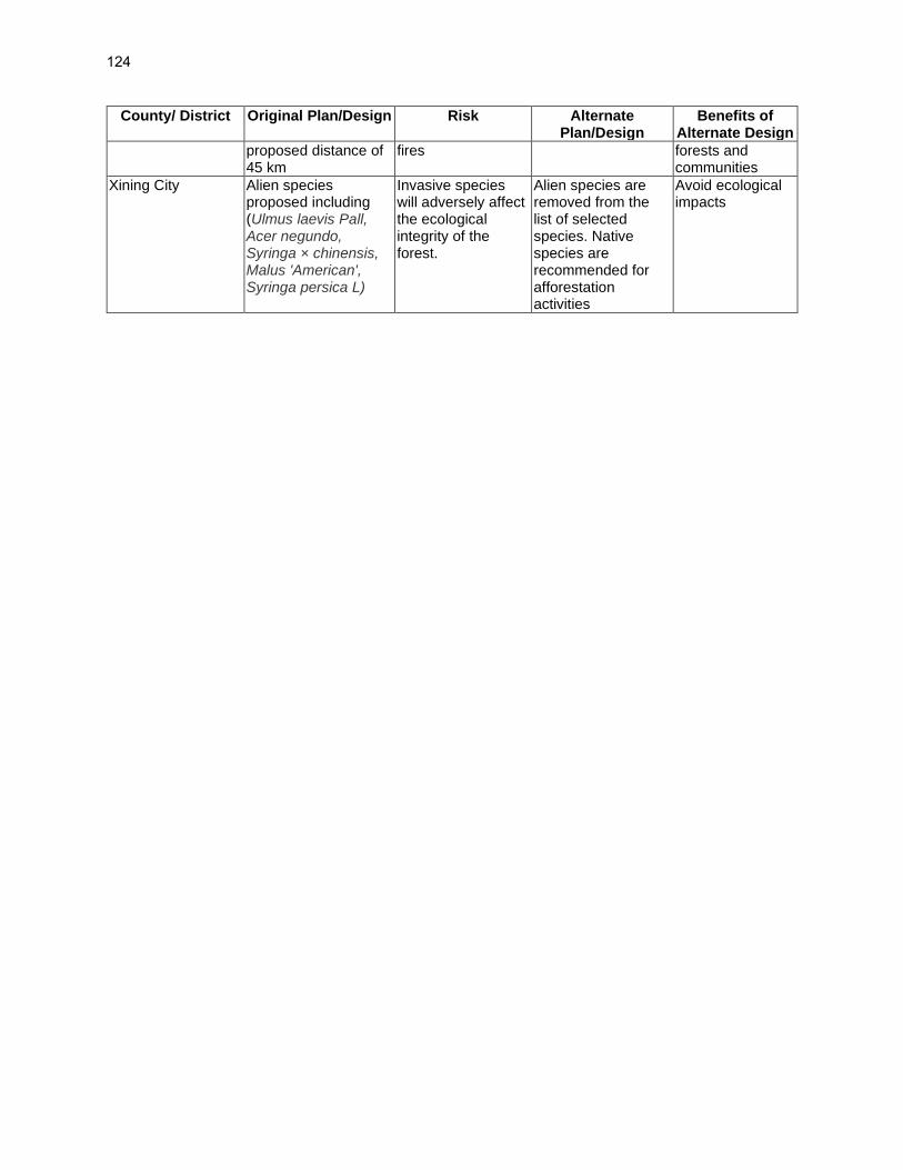
124
County/ District Original Plan/Design Risk Alternate Plan/Design
Benefits of Alternate Design
proposed distance of 45 km
fires forests and communities
Xining City Alien species proposed including (Ulmus laevis Pall, Acer negundo, Syringa × chinensis, Malus 'American', Syringa persica L)
Invasive species will adversely affect the ecological integrity of the forest.
Alien species are removed from the list of selected species. Native species are recommended for afforestation activities
Avoid ecological impacts
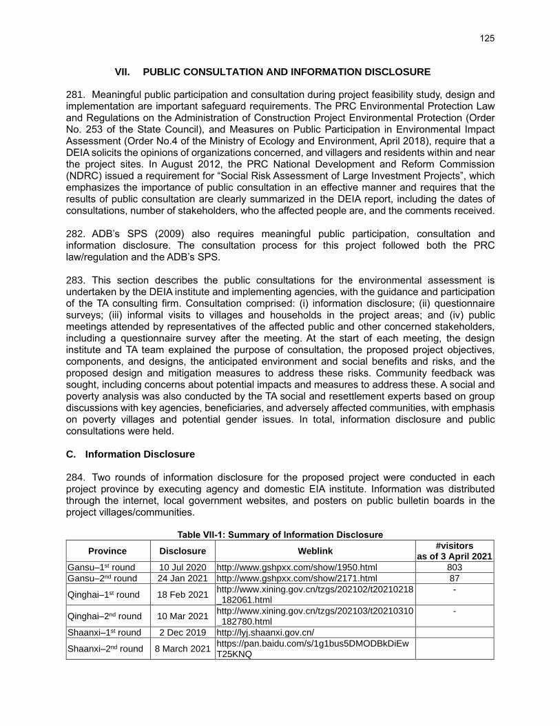
125
VII. PUBLIC CONSULTATION AND INFORMATION DISCLOSURE
281. Meaningful public participation and consultation during project feasibility study, design and implementation are important safeguard requirements. The PRC Environmental Protection Law and Regulations on the Administration of Construction Project Environmental Protection (Order No. 253 of the State Council), and Measures on Public Participation in Environmental Impact Assessment (Order No.4 of the Ministry of Ecology and Environment, April 2018), require that a DEIA solicits the opinions of organizations concerned, and villagers and residents within and near the project sites. In August 2012, the PRC National Development and Reform Commission (NDRC) issued a requirement for “Social Risk Assessment of Large Investment Projects”, which emphasizes the importance of public consultation in an effective manner and requires that the results of public consultation are clearly summarized in the DEIA report, including the dates of consultations, number of stakeholders, who the affected people are, and the comments received. 282. ADB’s SPS (2009) also requires meaningful public participation, consultation and information disclosure. The consultation process for this project followed both the PRC law/regulation and the ADB’s SPS. 283. This section describes the public consultations for the environmental assessment is undertaken by the DEIA institute and implementing agencies, with the guidance and participation of the TA consulting firm. Consultation comprised: (i) information disclosure; (ii) questionnaire surveys; (iii) informal visits to villages and households in the project areas; and (iv) public meetings attended by representatives of the affected public and other concerned stakeholders, including a questionnaire survey after the meeting. At the start of each meeting, the design institute and TA team explained the purpose of consultation, the proposed project objectives, components, and designs, the anticipated environment and social benefits and risks, and the proposed design and mitigation measures to address these risks. Community feedback was sought, including concerns about potential impacts and measures to address these. A social and poverty analysis was also conducted by the TA social and resettlement experts based on group discussions with key agencies, beneficiaries, and adversely affected communities, with emphasis on poverty villages and potential gender issues. In total, information disclosure and public consultations were held. C. Information Disclosure 284. Two rounds of information disclosure for the proposed project were conducted in each project province by executing agency and domestic EIA institute. Information was distributed through the internet, local government websites, and posters on public bulletin boards in the project villages/communities.
Table VII-1: Summary of Information Disclosure
Province Disclosure Weblink #visitors
as of 3 April 2021
Gansu–1st round 10 Jul 2020 http://www.gshpxx.com/show/1950.html 803
Gansu–2nd round 24 Jan 2021 http://www.gshpxx.com/show/2171.html 87
Qinghai–1st round 18 Feb 2021 http://www.xining.gov.cn/tzgs/202102/t20210218_182061.html
-
Qinghai–2nd round 10 Mar 2021 http://www.xining.gov.cn/tzgs/202103/t20210310_182780.html
-
Shaanxi–1st round 2 Dec 2019 http://lyj.shaanxi.gov.cn/
Shaanxi–2nd round 8 March 2021 https://pan.baidu.com/s/1g1bus5DMODBkDiEwT25KNQ

126
285. First-round of Disclosure. The first round of information disclosure was carried out from December 2, 2019. The information disclosed included (i) the name and major content of the project, (ii) contact of the implementing agency, (iii) name and contact of the EIA institute, (iv) internet link of the public comment form, and (v) ways of submitting the public comment form. Screenshots of websites on the first round of information disclosure are shown in Figures VII-1 to VII-3. 286. Second-round of Disclosure. The second round of information disclosure was undertaken from 24 January 2021, after preparation of the draft IEE, FSR and DEIA, to seek public feedback on the findings, including potential impacts and mitigation measures, and included consultations with communities and villages in and near the project sites. Screenshots of websites on the second round of information disclosure are shown in Figures VII-4 to VII-5. 287. The documents and information disclosed in the second round of information disclosure comprised: (i) a description of the project and subprojects, including project locations, scope and construction methods; (ii) the potential impacts and risks during construction and operation; (iii) a summary of the IEE and EMP (key findings, impacts, proposed mitigation measures); (iv) a summary of national laws and regulations ensuring the rights of communities to express their views; (v) methods and contact channels for public feedback (to the DEIA Institute and the PIUs), and duration of public access to DEIA report; (vi) date, time, location and organizer’s contact information for the public consultation meetings; and, (v) contact details of the PMO, IAs, DEIA Institutes and local EEBs. Links to the website pages of the executive summary of the IEE were also made available at the village communities’ offices for public access to ensure that the residents without access to the internet also had the opportunity to review and comments on the project. In addition, all information was provided in the Chinese language to ensure accessibility to residents. The consultation meetings were organized by the PMO 14 days after posting the invitation on the county website to solicit comments from residents about the project.
Figure VII-1: First round of information disclosure on Gansu EA Information Network
Website: Gansu Environment Assessment Information Network Information posted includes: 1. Project name; 2. Project location, 3. Project activities, 4. Contact info of PIU, 4. Contact info of EIA institute, 5. EIA procedure and main tasks. 6. Main ways of public opinion

127
Figure VII-2: Information disclosure at community-Qinghai
Figure VII-3: First round of information disclosure on Xining government website-Qinghai

128
Figure VII-4: Second round of information disclosure on Xining government website-
Qinghai
Information posted includes: 1. Project name; 2. Summary of the project; 3. Summary of the environmental measures; 4. The ways to acquire full EIA document; 5. Weblink to public opinion form; 6. Contact info of EIA institute and PIU; 7. Attachment: public opinion form

129
Figure VII-5: Information website disclosure-Shaanxi

130
D. Public Consultation
First Round of Public Consultations 288. Consultation meetings were held in June 2020 by the TA team and EIA design institutes at the subproject sites or in nearby village committee offices. Consultation meetings were also held with local government authorities, including EEBs, Forest Bureaus, Water Resource Bureaus, Planning Bureaus, Land Administration, and Cultural Relic Bureaus. Photographs showing these consultations are given in Figure VII-6.
Meeting with villagers of Xibu Township,
Xining, Qinghai, 5 June 2020 Meeting with residents of Chengdong District,
Xining, Qinghai, 4 June 2020
Meeting with villagers from Er’shilipu village, Wangzhai village and Chenjiazhuang village
near Jiulong Forest Farm, 18, July 2020
Meeting at Heqiang village Shuangquan Lake, Linze County, Gansu, 17 July 2020

131
Meeting with government authorities, Gaoling
District, Xi’an, Shaanxi, 8 January 2020 Meeting with government authorities, Xining
City, Qinghai 3 June 2020
Figure VII-6: 1st Round Consultation Meetings during IEE preparation 289. A summary of the comments and suggestions received during these consultations is given below.
• Complete all project construction activities within the proposed schedule.
• Reduce dust pollution from the construction activities.
• Complete all construction activities at once with careful planning and avoid repeated construction.
• Use local workforce for the project works and promote rural revitalization.
• Conduct training and awareness programs on various environmental protection issues such as waste management, reduce the use of plastic products, and protect the soil quality, and keep the city clean.
• During the construction period, the environmental protection measures should be strictly implemented, and the environmental quality should be well protected. Construction workers should be provided with training programs on pollution prevention from construction works and environmental protection education.
• Try to restore the original ecology through the proposed project activities. Plant native tree species and regularly monitor their growth, strictly control the quality in the construction process and during operation and management activities.
Second Round of Public Consultations
290. The consultation meetings were organized by the PMO and PIUs 14 days after posting the full DEIAs and the invitation on the local government websites (Table VII-2) to solicit comments from residents about the project. The 2-week disclosure duration ahead of the consultations was to provide communities adequate time for review, thereby contributing to ADB requirements for meaningful consultation. Hard copies of the summary of the DEIAs were also made provided to 159 village communities’ offices for public access to ensure that residents without access to the internet also had the opportunity to review and comment on the project. In addition, all information was provided in the Chinese language to ensure accessibility for residents.
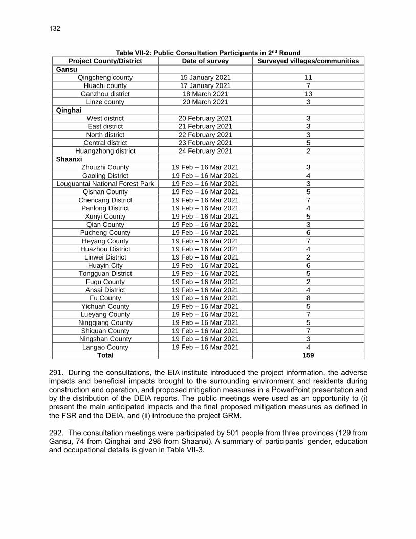
132
Table VII-2: Public Consultation Participants in 2nd Round
Project County/District Date of survey Surveyed villages/communities
Gansu
Qingcheng county 15 January 2021 11
Huachi county 17 January 2021 7
Ganzhou district 18 March 2021 13
Linze county 20 March 2021 3
Qinghai
West district 20 February 2021 3
East district 21 February 2021 3
North district 22 February 2021 3
Central district 23 February 2021 5
Huangzhong district 24 February 2021 2
Shaanxi
Zhouzhi County 19 Feb – 16 Mar 2021 3
Gaoling District 19 Feb – 16 Mar 2021 4
Louguantai National Forest Park 19 Feb – 16 Mar 2021 3
Qishan County 19 Feb – 16 Mar 2021 5
Chencang District 19 Feb – 16 Mar 2021 7
Panlong District 19 Feb – 16 Mar 2021 4
Xunyi County 19 Feb – 16 Mar 2021 5
Qian County 19 Feb – 16 Mar 2021 3
Pucheng County 19 Feb – 16 Mar 2021 6
Heyang County 19 Feb – 16 Mar 2021 7
Huazhou District 19 Feb – 16 Mar 2021 4
Linwei District 19 Feb – 16 Mar 2021 2
Huayin City 19 Feb – 16 Mar 2021 6
Tongguan District 19 Feb – 16 Mar 2021 5
Fugu County 19 Feb – 16 Mar 2021 2
Ansai District 19 Feb – 16 Mar 2021 4
Fu County 19 Feb – 16 Mar 2021 8
Yichuan County 19 Feb – 16 Mar 2021 5
Lueyang County 19 Feb – 16 Mar 2021 7
Ningqiang County 19 Feb – 16 Mar 2021 5
Shiquan County 19 Feb – 16 Mar 2021 7
Ningshan County 19 Feb – 16 Mar 2021 3
Langao County 19 Feb – 16 Mar 2021 4
Total 159
291. During the consultations, the EIA institute introduced the project information, the adverse impacts and beneficial impacts brought to the surrounding environment and residents during construction and operation, and proposed mitigation measures in a PowerPoint presentation and by the distribution of the DEIA reports. The public meetings were used as an opportunity to (i) present the main anticipated impacts and the final proposed mitigation measures as defined in the FSR and the DEIA, and (ii) introduce the project GRM. 292. The consultation meetings were participated by 501 people from three provinces (129 from Gansu, 74 from Qinghai and 298 from Shaanxi). A summary of participants’ gender, education and occupational details is given in Table VII-3.

133
Table VII-3: Details of Participants in Public Consultations in 2nd Round
Sex Education Occupation Age Range
Item M F Junior or
below Senior
College or above
Farmer Worker Clerk Teacher Others <30 -50 >50
Gansu (129 participants)
No. 106 23 29 95 5 118 5 0 0 6 7 63 59
% 82 18 22 74 4 91 4 0 0 5 5 49 46
Qinghai (74 participants)
No. 43 31 3 48 23 16 29 17 3 9 19 45 10
% 58 42 4 65 31 22 39 23 4 12 26 61 14
Shaanxi (387 responses)
No. 297 90 214 154 19 301 7 12 0 67 14 89 284
% 77 23 55 40 5 78 2 3 0 17 4 23 73
Total (590 responses)
No. 446 144 246 297 47 435 41 29 3 82 40 197 353
% 76 24 42 50 8 74 7 5 1 14 7 33 60
293. Participant's feedback on the proposed project activities is given in Table VII-4.
Table VII-4: Summary of Participants’ Response in 2nd Round Consultations
Question Answers Gansu (129 participants)
Qinghai (74 participants)
Shaanxi (298
participants)
Total (501 participants)
No. % No. % No. % No. %
Are you satisfied with local environmental quality?
Very satisfy 92 71.32 30 40.54 149 50 271 54.09
Satisfy 37 28.68 42 56.76 149 50 228 45.51
Not satisfy 0 0 2 2.70 0 0 2 0.40
What is the main local environmental issue?
Bad air quality 53 41.09 18 24.32 64 21.4 135 26.90
Bad water quality
64 49.61 26 35.14 11 3.6 101 20.11
Noise pollution 60 46.51 21 28.38 128 42.9 209 41.69
Solid waste 39 30.23 33 44.59 96 32.1 168 33.46
Bad ecological environment
28 21.71 13 17.57 0 0 41 8.18
What impact that you think the project will bring?
Good impact 112 86.82 55 74.32 238 80 405 80.92
Adverse impact 9 6.98 1 1.35 15 5 25 4.97
No idea 8 6.2 18 24.32 45 15 71 14.11
What the largest good impact that you think the project will bring?
Air quality protection
81 62.79 36 48.65 54 18.2 171 34.18
Water quality protection
96 74.42 24 32.43 38 12.7 158 31.51
Ecology environment
103 79.84 62 83.78 76 25.5 241 48.10
Noise reduction 27 20.93 21 28.38 11 3.6 59 11.72
Water saving 50 38.76 18 24.32 49 16.4 117 23.33
Solid waste reduction
24 18.6 10 13.51 16 5.5 50 10.06
Soil improvement
65 50.39 35 47.30 54 18.2 154 30.79
What the adverse impact that you
Air environmental pollution
32 24.81 8 10.81 13 4.2 53 10.48

134
Question Answers Gansu (129 participants)
Qinghai (74 participants)
Shaanxi (298
participants)
Total (501 participants)
No. % No. % No. % No. %
think the project will bring?
Water resource pollution
19 14.73 4 5.41 13 4.2 36 7.09
Ecological damage
41 31.78 9 12.16 0 0 50 9.98
Noise pollution 27 20.93 16 21.62 62 20.8 105 20.95
Water resource waste
8 6.2 15 20.27 37 12.5 60 12.03
Solid waste produce
46 35.66 23 31.08 75 25 144 28.64
Soil environmental damage
48 37.21 9 12.16 99 33.3 156 31.18
What is your main concern during the project construction period?
Noise 82 63.57 18 24.32 56 18.8 156 31.14
Dust 95 73.64 40 54.05 103 34.4 238 47.41
Water pollution 58 44.96 10 13.51 0 0 68 13.57
Ecological damage
18 13.95 10 13.51 19 6.3 47 9.34
Solid waste 25 19.38 12 16.22 46 15.6 83 16.66
Not convenient for farming
38 29.46 6 8.11 65 21.9 109 21.81
Travel inconvenience
42 32.56 30 40.54 9 3.1 81 16.22
Are you going to make a complaint if the project has impact to your daily life?
Yes 37 28.68 14 18.92 60 20 111 22.08
No 36 27.91 17 22.97 119 40 172 34.37
Depends on level of impact
56 43.41 44 59.46 119 40 219 43.75
Who you will refer to if you are going to make a complaint?
Contractor 37 28.68 23 31.08 75 25 135 26.85
IAs 21 16.28 19 25.68 32 10.7 72 14.35
EEM hotline 79 61.24 34 45.95 106 35.7 219 43.79
Village committee
77 59.69 9 12.16 32 10.7 118 23.53
Government complaints office
11 8.53 23 31.08 53 17.9 87 17.43
Do you agree the project location?
Yes 127 98.45 54 72.97 238 80 419 83.71
No 0 0 0 0.00 0 0 0 0.00
Do not care 2 1.55 20 27.03 60 20 82 16.29
What impact that you think the project will bring to your daily life?
Positive 113 87.6 54 72.97 268 90 435 86.87
Adverse 3 2.33 0 0.00 0 0 3 0.60
No idea 13 10.07 20 27.03 30 10 63 12.53
What impact that you think the project will bring to local economy development and society?
Positive 122 94.57 60 81.08 268 90 450 89.86
Adverse 1 0.78 2 2.70 0 0 3 0.60
No idea 6 4.65 12 16.22 30 10 48 9.54
Do you think the project is viable after consider the
project viable 122 94.57 64 86.49 298 100 484 96.61
project not viable
4 3.1 2 2.70 0 0 6 1.20
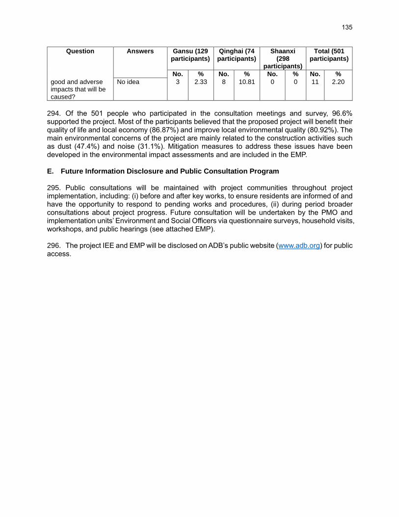
135
Question Answers Gansu (129 participants)
Qinghai (74 participants)
Shaanxi (298
participants)
Total (501 participants)
No. % No. % No. % No. %
good and adverse impacts that will be caused?
No idea 3 2.33 8 10.81 0 0 11 2.20
294. Of the 501 people who participated in the consultation meetings and survey, 96.6% supported the project. Most of the participants believed that the proposed project will benefit their quality of life and local economy (86.87%) and improve local environmental quality (80.92%). The main environmental concerns of the project are mainly related to the construction activities such as dust (47.4%) and noise (31.1%). Mitigation measures to address these issues have been developed in the environmental impact assessments and are included in the EMP. E. Future Information Disclosure and Public Consultation Program 295. Public consultations will be maintained with project communities throughout project implementation, including: (i) before and after key works, to ensure residents are informed of and have the opportunity to respond to pending works and procedures, (ii) during period broader consultations about project progress. Future consultation will be undertaken by the PMO and implementation units’ Environment and Social Officers via questionnaire surveys, household visits, workshops, and public hearings (see attached EMP). 296. The project IEE and EMP will be disclosed on ADB’s public website (www.adb.org) for public access.

136
VIII. GRIEVANCE REDRESS MECHANISM
297. A project-specific grievance redress mechanism (GRM) for environment safeguards was developed in compliance with ADB’s SPS (2009) requirement to address environmental, health, and safety concerns associated with project construction and operation. The GRM is designed to achieve the following objectives: (i) provide channels of communication for residents to raise concerns about environment-related grievances which might result from the project; (ii) prevent and mitigate adverse environmental impacts to villages and communities caused by project construction and operation, including those associated with resettlement; (iii) promote trust and productive relationships between the project agencies and residents; and (iv) build community acceptance of the project. The GRM is accessible to all residents, including women, youth, minorities, and poverty-stricken households. Multiple points of entry are available, including face-to-face meetings, written complaints, telephone conversations, e-mail, WeChat and social media. 298. Grievances to be addressed by the GRM will most likely be of disturbances e.g. dust emissions, construction noise, soil erosion and sedimentation, inappropriate disposal of construction wastes, safety measures for the protection of the public and construction workers, and/or water quality deterioration. A separate GRM has been designed for the project for issues related to land acquisition and resettlement, as these generally require different procedures and timelines to resolve compared with environmental-related grievances. 299. Currently, in project counties and cities (and generally in the PRC), when residents or organizations are negatively affected by construction or development, they may complain, individually or through their village or community committee, to the contractors, developers, the local EEB, or by direct appeal to the local courts. The weaknesses of this system are: (i) the lack of dedicated personnel to address grievances; and (ii) the lack of a specific timeframe for the redress of grievances. This project GRM addresses these weaknesses. 300. The GRM meets the regulatory standards of the PRC that protect the rights of citizens from construction-related environmental and/or social impacts. Decree No. 431 Regulation on Letters and Visits, issued by the State Council of PRC in 2005, codifies a complaint acceptance mechanism at all levels of government and protects the complainants from retaliation. Based on the regulation, the Ministry of Environmental Protection (MEP) 18 published updated Measures on Environmental Letters and Visits (Decree No. 15) in December 2010. 301. The details of the GRM, including a time-bound flow chart of procedures, are described in the project EMP (Appendix 1).
18 The current name for the MEP is the Ministry of Ecology and Environment.
137
IX. ENVIRONMENTAL MANAGEMENT PLAN
302. This IEE includes an EMP for the project (Appendix 1). Development of the EMP drew on the domestic environmental assessments, discussions with PMO and implementing agencies, and consultations with the local EEBs, other government agencies, and communities. The EMP defines mitigation measures for the anticipated environmental impacts, institutional responsibilities, and mechanisms to monitor and ensure compliance with PRC’s environmental laws, standards and regulations and ADB’s SPS. The EMP specifies the environmental risk and mitigation measures, roles and responsibilities, inspection, monitoring, and reporting arrangements, training, and GRM. The EMP will be updated after detailed design, as needed. The EMP is the over-arching document for environmental safeguards. The mitigation and monitoring measures focus largely on civil works under the project. Semi-annual environmental safeguard progress reports will be provided to ADB to report on implementation progress for the EMP.

138
X. PROJECT ASSURANCES
303. All ADB-funded projects are required to comply with a standard set of loan assurances for environmental safeguards, which focus on compliance with national laws and the project EMP. In addition, a set of project-specific assurances are included in the project agreement between ADB and the EA. See Section J of the project EMP (Appendix 1) and refer to the loan and project agreements for the final wording of the assurances.
139
XI. CONCLUSION 304. The proposed project activities in these three provinces will result in forest ecology development and the conservation and restoration of forest and wetland resources. The project is aligned with national and provincial development plans and the Asian Development Bank’s (ADB) country partnership strategies for the PRC, 2016–2020 and 2021–2025. The project outputs will be: (1) Knowledge on sustainable forest and wetland management, institutional capacity, and trans-provincial coordination strengthened, (2) Forests and wetlands protected and rehabilitated, and (3) Multi-functional ecosystem services, environmental education and management facilities, and rural livelihoods enhanced.
305. The project focuses on ecological protection and restoration. The main environmental benefit of the project is to increase forest and grass vegetation coverage and reduce soil erosion and natural disasters. Through afforestation, it will play the role of increasing vegetation coverage, greening and improving the environment, regulating the climate, preventing wind and sand, conserving water and soil, and conserving water sources. The implementation of the project will effectively improve the local ecological environment, life and production in the project area. In Qinghai province, the expected benefits include (i) the forest coverage rate in the north and south mountains will increase from the current 71.84% to more than 80%, and the Xibu green area will increase from 43.7% to 68%; (ii) the average canopy closure will increase from the current 0.4 to more than 0.45, and the afforestation survival rate will reach to 90%, Afforestation preservation rate reach to 85%; (iii) Reduced soil erosion. The northern and southern mountains and the Xibu area will consolidate 677,400 tons of soil and 25,900 tons of organic matter each year; and (Iv) 70%-80% of community residents will receive ecological knowledge training.
306. Key impacts anticipated due to construction include: (i) short-term damage to aquatic habitats in the wetlands due to the drainage clearing works; (ii) limited removal of trees and shrubs along short sections of the wetlands; (iii) short-term impacts related to soil erosion during afforestation activities; and (iv) general impacts associated with civil works such as dust and gaseous dispersion, noise, construction wastewaters; temporary traffic diversion; soil erosion; worker and community health and safety.
307. Operational risks include solid waste and wastewater generated from the eco-tourism facilities and the use of pesticides for afforestation activities. All project facilities will be under the management of the project implementation units (PIUs); each PIU will develop an operation and maintenance program for the built facilities and receive training in environment-friendly operation and maintenance of the facilities and wetland restoration.
308. Measures to avoid, minimize, and mitigate potential project impacts have been developed in a project EMP (Attachment 1). A project-specific GRM has been developed and will be implemented at the city, district/county, and site levels. Public consultations have been conducted with communities around the subproject sites. Feedback from the consulted residents and villagers included both support for the project for improving flood protection and water quality of Miluo River, raising the living standard of local residents and villagers, and concern over potential construction noise, soil erosion, dust, and odor from treatment facilities. Measures to address these concerns are incorporated in the EMP.

140
APPENDIX 1. ENVIRONMENTAL MANAGEMENT PLAN
ENVIRONMENTAL MANAGEMENT PLAN FOR THE
SILK ROAD ECOLOGICAL REHABILITATION AND PROTECTION PROJECT
People’s Republic of China
Prepared by the Provincial Forestry and Grassland Bureau of Gansu, Qinghai and Shaanxi provinces for the Asian Development Bank
This Environmental Management Plan is a document of the borrower. The views expressed herein do not necessarily represent those of ADB's Board of Directors, Management, or staff, and may be preliminary in nature. Your attention is directed to the “terms of use” section of the ADB website in which the full Initial Environmental Examination is given. In preparing any country program or strategy, financing any project, or by making any designation of or reference to a particular territory or geographic area in this document, the Asian Development Bank does not intend to make any judgments as to the legal or other status of any territory or area.

141
A. Objectives 1. This environment management plan (EMP) is for the Silk Road Ecological Rehabilitation and Protection (the project). The EMP is developed based on the initial environmental examination (IEE) of the project and in compliance with the requirements of PRC environmental laws and ADB’s Safeguard Policy Statement (SPS 2009). 2. The EMP defines appropriate mitigation measures for the anticipated environmental impacts and defines the institutional responsibilities and mechanisms to monitor and ensure compliance with PRC’s environmental laws, standards and regulations, and ADB’s SPS. The EMP specifies (i) objectives; (ii) mitigation measures; (iii) implementing organization and responsibilities; (iv) inspection, monitoring, and reporting arrangements; (v) training and institutional strengthening; (v) a feedback and adjustment mechanism; and (vi) the GRM. 3. The EMP will be reviewed and updated at the end of the detailed designs, as needed, in order to be consistent with the final design. The EMP (or its updated version) will be included as a separate annex in all bidding and contract documents. The contractors will be made aware of their obligations to implement the EMP and to budget the EMP implementation costs in their proposals. The EMP supervision and monitoring results will be used to evaluate (i) the extent and severity of actual environmental impacts against the predicted impacts, (ii) the performance of the environmental protection measures or compliance with related rules and regulations, (iii) trends of impacts; and (iv) overall effectiveness of the mitigation measures.
B. Organizations and Their Responsibilities for EMP Implementation
4. The National Forestry and Grassland Administration is the executing agency. A National Project Management Office (NPMO) has been set up, which will be responsible for overall project implementation coordination. The NPMO has appointed one full-time environmental and social officer to conduct overall coordination of implementation of the EMP and social safeguard documents (social and development action plan, gender action plan, and land use transfer framework). 5. Three Provincial Project Management Offices (PPMOs) through the provincial Forestry and Grassland Bureau are the IAs that will be responsible for overall coordination and supervision of project preparation and implementation at provincial level. Each PPMO has designated one full time environment and social officer. Municipal Project Management Office (MPMO) will be responsible for project coordination at the municipal level. 6. Relevant city/district/county forestry and grassland bureaus (CFGB) in Gansu, Qinghai, and Shaanxi provinces will act as project implementation units (PIUs) (29 PIUs in total including 1 in Qinghai - Xining, 5 PIUs in Gansu and 23 PIUs in Shaanxi), and will be responsible for coordination and implementation of all the relevant sub-projects. Details are shown in table below.
Table EMP-1: Project Implementation Organization
Organizations Management Roles and Responsibilities
Executing Agency: National Project Management Office (NPMO) of the National Forestry
Overall implementation coordination; ➢ Assess whether the EMP SDAP, GAP, and LURTF require updating due
to any changes in project design, which may have occurred after these documents were prepared.
➢ Distribute the Chinese language version of the EMP SDAP, GAP, and LURTF to three PPMOs. This should occur at least 3 months before
142
Organizations Management Roles and Responsibilities
and Grassland Administration For safeguards: one NPMO Environmental and Social Officer (combined position)
construction begins. ➢ With assistance from LIECs, update IEE and EMP as necessary for project
scope changes. ➢ Conduct meetings with PPMOs as necessary to ensure they understand
their specific responsibilities described in the EMP, SDAP, GAP, and LURTF.
➢ At least 2 months before construction begins, establish and implement the project GRM described in the EMP.
➢ Ensure that PPMOs submit required progress reports and information, including semi-annual environmental and social monitoring and reports of any issues or grievances.
➢ Review and store environmental progress reports from the PPMOs, records of any grievances, and any other relevant issues. Maintain digital copies of all information. Ensure that all information is stored in the NPMO filing system, backed up, and can be easily retrieved.
➢ Prepare consolidated semi-annual environmental monitoring and social monitoring reports that document the status of project compliance with the EMP, SDAP, GAP, and LURTF.
➢ Prepare consolidated semi-annual project progress reports (environment and social section);
➢ Prepare project completion report (environment and social section). ➢ Work closely with the PPMOs, loan implementation consultant, and other
agencies as necessary to conduct these tasks. ➢ Summarize the project experience and facilitate project replication over
the Silk Road region. Implementing Agencies: Provincial Project Management Office (PPMO) through the Provincial Forestry and Grassland Bureau
• Shaanxi PPMO
• Gansu PPMO
• Qinghai PPMO For safeguards: Shaanxi and Qinghai provinces: One PPMO Environmental Officer each Gansu Province: one combined PPMO Environmental and Social Officer position
The PPMO will be responsible for overall coordination and supervision of project preparation and implementation at provincial level, including: ➢ Distribute the Chinese language version of the SDAP, GAP, LURTF and
EMP to all relevant agencies, including the PIUs, design institute, provincial agencies for environment protection and Women Federation. This should occur at least 3 months before construction begins.
➢ Assist the NPMO environment and social officer to update SDAP, GAP, LURTF and EMP as necessary according to detail design.
➢ Assist the NPMO environment and social officer to update IEE and EMP, SDAP, GAP, and LURTF for project scope changes.
➢ Contract an environment monitoring agency (EMA) to conduct external environment monitoring as defined in the EMP (note: EMA will be contracted by Shaanxi PPMO, Gansu PPMO and Xining MPMO).
➢ Contract an EIA institute as necessary to carry out environment impact assessment for project scope changes (note: EIA institutes will be contracted by Shaanxi PPMO, Gansu PPMO and Xining MPMO).
➢ Review and verify external monitoring reports to ensure the external monitoring activities complied with environment monitoring program in the EMP.
➢ Contract a social monitoring agency to conduct external social monitoring as defined in the SDAP.
➢ Implement the monitoring and reporting requirements in the SDAP, GAP, LURTF and EMP, including timely submission of semi-annual progress reports, semi-annual environment monitoring report, semi-annual social monitoring report to the NPMO environment and social officers.
➢ Implement the project grievance redress mechanism. ➢ Make random inspections of construction sites to assess progress, meet
with contractors and/or local communities, and assess compliance with the SDAP, GAP, LURTF and EMP.
➢ Maintain digital records of all progress and information.

143
Organizations Management Roles and Responsibilities
➢ Prepare semi-annual environmental monitoring reports to NPMO ➢ Prepare semi-annual social monitoring reports to NPMO ➢ Support the NPMO environment and social officers in all of their tasks.
Municipal Project Management Office (MPMO) through the Municipal Forestry and Grassland Bureau 10 MPMOs include 1 in Gansu-Qingyang, 1 in Qinghai-Xining and 8 in Shaanxi including
• Xi’an MPMO
• Baoji MPMO
• Xianyang MPMO
• Weinan MPMO
• Yulin MPMO
• Yan’an MPMO
• Hanzhong MPMO
• Ankang MPMO
Responsible for project coordination at the municipal level: ➢ Prepare and submit to PPMO the municipal level (a) quarterly project
progress reports, (b) quarterly environmental safeguard monitoring reports, (c) quarterly social safeguard monitoring reports, and (d) midterm report, and required information for project completion report;
➢ Summarize the project experience and facilitate project replication in the
municipality.
Project Implementation Units: City/district/county Project Management Office (CPMO) under City/district/county Forestry and Grassland Bureau (CFGB) For safeguards: one Environmental Focal Point in each PIU 29 PIUs include 1 in Qinghai - Xining, 5 PIUs in Gansu and 23 PIUs in Shaanxi
Daily management of the project, including project preparation and implementation; ➢ Publicize EMP on local government website or other. ➢ Review detail design to ensure mitigation measures proposed in the
SDAP, GAP, LURTF and EMP are included in detail design. ➢ Distribute the Chinese language version of the SDAP, GAP, LURTF and
EMP to all Relevant Government Agencies, design institute, bidding agency, contractors and supervision companies. And conduct meetings with these agencies as necessary to ensure they understand their specific responsibilities. This should occur at least 3 months before construction begins.
➢ Ensure that environmental and social clauses are included in bidding document and civil work contracts.
➢ Review site EMP prepared by contractors. ➢ Conduct public consultation under the guidance of LIEC. ➢ Act as GRM focal point; implement the project grievance redress
mechanism. ➢ Make regular inspections of construction sites to assess progress, meet
with contractors and/or local communities, and assess compliance with the SDAP, GAP, LURTF and EMP.
➢ Ensure supervision companies submit monthly inspection report. Review these reports and ensure implementation status of environmental and social mitigation measures is included.
➢ Maintain digital records of all progress and information ➢ Prepare and submit to MPMO the county-level (a) quarterly project
progress reports), (b) quarterly environmental safeguard monitoring report, (c) quarterly social safeguard monitoring report, and (d) midterm report, and required information for project completion report;
➢ Support the PPMO environment and social officers in all of their tasks ➢
Loan Implementation ➢ Provide short-term bridging support to the NPMO, PPMOs, and PIUs in

144
Organizations Management Roles and Responsibilities
Start-Up Consultant (Environment) (national; continuous; short-term in the earliest stage of project effectiveness) (total of 4 positions: NPMO to recruit 1; and each PPMO to recruit 1)
the preparation for environment safeguards soon after project effectiveness, before the loan implementation environment consultant (see below) is recruited
➢ Work closely with the NPMO, PPMOs, PIUs and design institutes to ensure that preparation of the detailed engineering designs (DEDs) fully incorporates the designs and mitigation measures described in the project initial environmental examination (IEE) and environmental management plan (EMP).
➢ Assess whether any of the DEDs are sufficiently different from the preliminary designs approved by the Government and ADB that updates to the IEE, EMP are required. This may include, but not be limited to: major changes in proposed locations of facilities; new subcomponents requiring infrastructure works and/or which may have environment; and/or cancellation of approved components.
➢ With the NPMO and ADB, discuss any changes required for the IEE, EMP. Assist the NPMO to prepare any new impact assessments and/or updates as required; and to submit these to ADB for review. No changes to any of the ADB-approved documents will be made without prior approval of the Government and ADB.
➢ Assist the NPMO, PPMOs and PIUs in establishing the project grievance redress mechanism (GRM), including procedures to ensure documentation and reporting of complaints, follow-up actions, and results.
➢ Prepare environmental clauses for incorporating into bidding documents and civil work contracts.
➢ Provide training to NPMO, PPMOs and PIUs staff so that they will understand ADB’s Safeguard Policy Statement (2009), policies, and compliance requirements for environmental management; national and local regulations and standards for environmental protection, health, labor, and occupational safety; and the project IEE and EMP.
➢ Prepare progress report template, environment inspection report template. ➢ Provide hands-on guidance in preparing the first consolidated
environmental monitoring report to ADB. ➢
Loan Implementation Environmental Consultant (LIEC) (intermittent throughout project) (total of 4 positions; NPMO to recruit 1 and each PPMO to recruit 1)
➢ To be recruited under the loan implementation consulting services ➢ Assist in updating the EMP and environmental monitoring program, as
needed. ➢ Ensure project environmental readiness, including (i) mitigation measures
are incorporated into detail designs; (ii) relevant sections of the EMP are included in civil work contracts; (iii) site EMPs are prepared by contractors.
➢ Assist the NPMO, PPMOs and PIUs to implement the grievance redress mechanism (GRM), including: (i) establish and publicize the GRM; and (ii) collate and evaluate grievances received.
➢ Develop procedures to: (i) monitor EMP implementation progress; (ii) collate and evaluate data collected in the EMP environmental monitoring program
➢ Undertake site visits for EMP inspection as required. ➢ Assist the PIUs to conduct public consultation; Conduct and monitor
project compliance with the EMP and all relevant assurances and covenants in the loan and project agreements for environmental safeguards; identify any environment-related implementation issues; and, propose necessary responses in corrective action plans.
➢ Provide training to the NPMO, PPMOs, and PIUs safeguard personnel, contractors, and construction supervision companies, to ensure adequate capacity and understanding to implement the EMP
➢ Assist NPMO to prepare consolidated semi-annual environmental

145
Organizations Management Roles and Responsibilities
monitoring reports for submission to ADB. The reports will focus on progress with implementation of the EMP, compliance with environment-related project assurances, and results of the water monitoring.
External environment monitoring agency (intermittent throughout project) 3 positions: 1 recruited by Shaanxi PPMO, 1 recruited by Gansu PPMO and 1 recruited by Xining MPMO
➢ Design an environmental monitoring plan which focuses on specific variables listed in Table EMP-5; (b) includes a clear methodology and work schedule; and (c) includes any additional variables recommended.
➢ Design and establish a simple database (e.g., in Excel) to store all collected data. Data should be entered and stored in a clear and simple format that enables comparison of values over time; and ensure that data is backed up on at least one external storage device.
➢ Implement the monitoring program. ➢ Immediately report to the Shaanxi PPMO, Gansu PPMO and Xining
MPMO and PIUs any cases of noncompliance with the EMP monitoring standards
➢ Prepare and submit external environmental monitoring reports
Contractors (intermittent throughout construction)
➢ Ensure sufficient funding and human resources for proper and timely implementation of required mitigation and monitoring measures in the EMP and CEMPs throughout the construction phase.
➢ Responsible for GRM operation during the construction phase.
Construction supervision company (intermittent throughout construction)
➢ Ensure sufficient funding and human resources for supervising and instructing contractors for proper and timely implementation of required mitigation and monitoring measures in the EMP
➢ Supervise construction progress and quality ➢ Appoint qualified EHS officer for regular onsite supervision of contractors ➢ Supervise the contractor’s EMP implementation performance ➢ Undertake simple and cost-effective on-site quantitative measurements to
regularly check that construction complies with the project environmental monitoring standards and targets, especially for noise and air quality (especially during works in urban areas and villages), using a basic hand-held meter
➢ Submit monthly EMP monitoring reports to PMO and PIUs
Asian Development Bank
➢ Oversee project administration and timely execution of the loan agreements by the executing and implementing agencies
➢ Disburse loan proceeds ➢ Review procurement, consultant recruitment, progress reports, and audit
reports ➢ Review project compliance and targets against the design and monitoring
framework, EMP, and project administration manual ➢ Review and endorse updated IEE and EMP as needed ➢ Monitors project progress and conducts review missions ➢ Discloses monitoring reports on ADB public website
CPMO = City and/or County Project Management Office, DR = Design Report, MPMO = Municipal Project Management Office, NPMO = National Project Management Office, PPMO = Provincial Management Office.
7. Gansu Province. The project will establish a project management organization composed of forestry departments at the provincial, municipal, and county levels to be responsible for project management and maintenance. The project will set up 1 provincial PMO, 1 municipal PMO (Qingyang), 5 PIUs (Huachi Branch, Huachi County and Qingcheng County in Qingyang City; Ganzhou District and Linze County in Zhangye City). The PMOs and PIUs have 150 project personnel, including 63 full-time staff (21 project management staff and 42 technical staff). The project area will equipped with 87 full-time ecological forest rangers. Their main responsibilities are forest patrol and filling in inspection records. The ecological forest ranger will select local qualified poor farmers to conduct daily patrol according to relevant policies.

146
8. Shaanxi Province. The project implements three-level management at the provincial, city and county levels, with project offices set up in the provinces and cities to be responsible for project management and operation at their respective levels. At the provincial level, an ADB project leadership group is set up in charge of setting up member units, including development and reform departments, finance departments and other departments, to solve major problems in project implementation and coordinate departmental relations. A project leadership group was established at the city and county levels, with a project office in the Forestry Bureau. The setting of the city-level leading group is consistent with that of the provincial level. The county-level leading group members have added poverty alleviation offices and the township governments involved in the project. The director of local Forest Bureau has been assigned as director for the project office.
9. Qinghai Province. To ensure the smooth implementation of the project, the project will establish a three-level management organization composed of the project management department, the project leadership team and the project construction office. Construction needs to establish a project construction office as the specific management department for project implementation, whose main responsibility is to implement and organize project construction tasks.
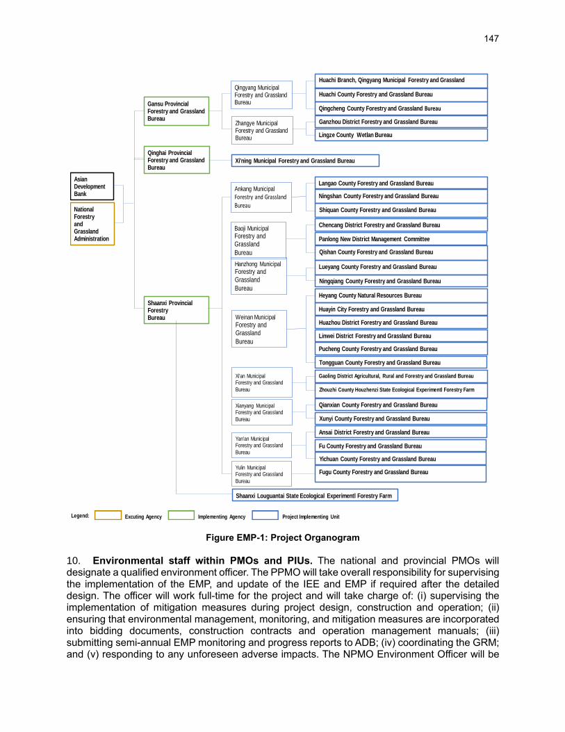
147
Figure EMP-1: Project Organogram
10. Environmental staff within PMOs and PIUs. The national and provincial PMOs will designate a qualified environment officer. The PPMO will take overall responsibility for supervising the implementation of the EMP, and update of the IEE and EMP if required after the detailed design. The officer will work full-time for the project and will take charge of: (i) supervising the implementation of mitigation measures during project design, construction and operation; (ii) ensuring that environmental management, monitoring, and mitigation measures are incorporated into bidding documents, construction contracts and operation management manuals; (iii) submitting semi-annual EMP monitoring and progress reports to ADB; (iv) coordinating the GRM; and (v) responding to any unforeseen adverse impacts. The NPMO Environment Officer will be
Legend:
AsianDevelopmentBank
NationalForestryandGrasslandAdministration
Gansu ProvincialForestry and GrasslandBureau
Qingyang MunicipalForestry and GrasslandBureau
Zhangye MunicipalForestry and GrasslandBureau
Huachi Branch, Qingyang Municipal Forestry and Grassland
Huachi County Forestry and Grassland Bureau
Qingcheng County Forestry and Grassland Bureau
Ganzhou District Forestry and Grassland Bureau
Lingze County Wetlan Bureau
Qinghai ProvincialForestry and GrasslandBureau
Xi'ning Municipal Forestry and Grassland Bureau
Shaanxi ProvincialForestryBureau
Ankang Municipal
Forestry and GrasslandBureau
Baoji Municipal
Forestry andGrassland
Bureau
Hanzhong Municipal
Forestry andGrassland
Bureau
Weinan Municipal
Forestry andGrassland
Bureau
Xi'an Municipal Forestry and Grassland
Bureau
Xianyang Municipal Forestry and Grassland
Bureau
Yan'an Municipal Forestry and Grassland
Bureau
Yulin Municipal Forestry and Grassland
Bureau
Langao County Forestry and Grassland Bureau
Ningshan County Forestry and Grassland Bureau
Shiquan County Forestry and Grassland Bureau
Chencang District Forestry and Grassland Bureau
Panlong New District Management Committee
Qishan County Forestry and Grassland Bureau
Lueyang County Forestry and Grassland Bureau
Ningqiang County Forestry and Grassland Bureau
Heyang County Natural Resources Bureau
Huayin City Forestry and Grassland Bureau
Huazhou District Forestry and Grassland Bureau
Linwei District Forestry and Grassland Bureau
Pucheng County Forestry and Grassland Bureau
Tongguan County Forestry and Grassland Bureau
Gaoling District Agricultural, Rural and Forestry and Grassland Bureau
Zhouzhi County Houzhenzi State Ecological Experimentl Forestry Farm
Qianxian County Forestry and Grassland Bureau
Xunyi County Forestry and Grassland Bureau
Ansai District Forestry and Grassland Bureau
Fu County Forestry and Grassland Bureau
Yichuan County Forestry and Grassland Bureau
Fugu County Forestry and Grassland Bureau
Shaanxi Louguantai State Ecological Experimentl Forestry Farm
Excuting Agency Implementing Agency Project Implementing Unit

148
technically supported by the loan implementation environment consultant (LIEC). Each PIU will nominate one qualified environment focal staff to check the overall implementation of environmental management provisions of the EMP and to work in close coordination with the PMO Environment Officer. 11. Loan implementation consultants. NPMO and each PPMO will engage (i) loan implementation start-up consultant (environment) on a short-term basis, to assist the PMOs with early establishment of the EMP immediately after project effectiveness, and (ii) a LIEC and loan implementation social consultant (LISC), as part of the loan consultancy implementation services for the whole duration of the project. These consultants will be recruited for intermittent (part-time) support. They will support the PMOs for capacity building for, and coordination of, the EMP implementation. The LIEC will also support contractors in developing construction site-specific environmental management plans (CEMPs) prior to construction and operation. 12. Draft terms of reference for all project environmental safeguard positions – i.e. the NPMO environment and social officer position, PPMO environmental officer positions, PIU environment and social focal points, start-up environmental consultant, LIEC, and external environmental monitoring agency, are described in the PAM.
C. Potential Impacts and Mitigation Measures 13. Tables EMP-2 and EMP-3 list the potential impacts of the project components in the project areas during project construction and operation, and proposed mitigation measures. The mitigation measures will be incorporated into detailed design, bidding documents, construction contracts and operational management manuals, by the design institutes (during detailed design) and contractors (during construction), under the supervision of the PPMO and PIU Environment Focal Points and CSCs, with technical support from the LIECs. The effectiveness of these measures will be evaluated based on environmental inspections and monitoring to determine whether they should be continued, improved, or adjusted.
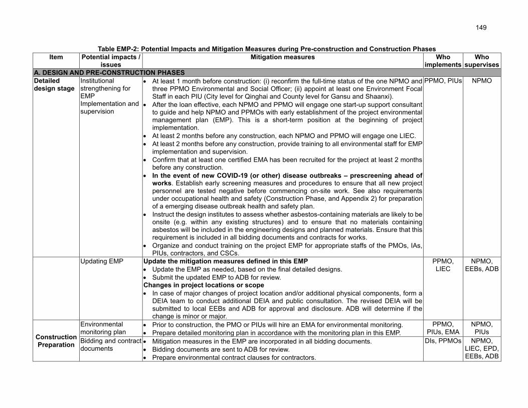
149
Table EMP-2: Potential Impacts and Mitigation Measures during Pre-construction and Construction Phases
Item Potential impacts / issues
Mitigation measures Who implements
Who supervises
A. DESIGN AND PRE-CONSTRUCTION PHASES
Detailed design stage
Institutional strengthening for EMP Implementation and supervision
• At least 1 month before construction: (i) reconfirm the full-time status of the one NPMO and three PPMO Environmental and Social Officer; (ii) appoint at least one Environment Focal Staff in each PIU (City level for Qinghai and County level for Gansu and Shaanxi).
• After the loan effective, each NPMO and PPMO will engage one start-up support consultant to guide and help NPMO and PPMOs with early establishment of the project environmental management plan (EMP). This is a short-term position at the beginning of project implementation.
• At least 2 months before any construction, each NPMO and PPMO will engage one LIEC.
• At least 2 months before any construction, provide training to all environmental staff for EMP implementation and supervision.
• Confirm that at least one certified EMA has been recruited for the project at least 2 months before any construction.
• In the event of new COVID-19 (or other) disease outbreaks – prescreening ahead of works. Establish early screening measures and procedures to ensure that all new project personnel are tested negative before commencing on-site work. See also requirements under occupational health and safety (Construction Phase, and Appendix 2) for preparation of a emerging disease outbreak health and safety plan.
• Instruct the design institutes to assess whether asbestos-containing materials are likely to be onsite (e.g. within any existing structures) and to ensure that no materials containing asbestos will be included in the engineering designs and planned materials. Ensure that this requirement is included in all bidding documents and contracts for works.
• Organize and conduct training on the project EMP for appropriate staffs of the PMOs, IAs, PIUs, contractors, and CSCs.
PPMO, PIUs NPMO
Updating EMP Update the mitigation measures defined in this EMP
• Update the EMP as needed, based on the final detailed designs.
• Submit the updated EMP to ADB for review. Changes in project locations or scope
• In case of major changes of project location and/or additional physical components, form a DEIA team to conduct additional DEIA and public consultation. The revised DEIA will be submitted to local EEBs and ADB for approval and disclosure. ADB will determine if the change is minor or major.
PPMO, LIEC
NPMO, EEBs, ADB
Construction Preparation
Environmental monitoring plan
• Prior to construction, the PMO or PIUs will hire an EMA for environmental monitoring.
• Prepare detailed monitoring plan in accordance with the monitoring plan in this EMP.
PPMO, PIUs, EMA
NPMO, PIUs
Bidding and contract documents
• Mitigation measures in the EMP are incorporated in all bidding documents.
• Bidding documents are sent to ADB for review.
• Prepare environmental contract clauses for contractors.
DIs, PPMOs NPMO, LIEC, EPD, EEBs, ADB

150
Item Potential impacts / issues
Mitigation measures Who implements
Who supervises
EMP training • LIEC, or invited environment specialists and/or officials from EEBs provide training on construction environmental management, implementation, supervision, to contractors and CSCs, in accordance with the training plan in this EMP.
LIEC NPMO, EEB
Establish GRM • Responsibility for GRM implementation is assigned to the PMO and PIU Environmental Officers and Social Officers and is included in their terms of reference.
• PMO and PIU personnel will be aware of, and trained in, the GRM, and will help support the environmental and social officers when necessary.
• Key contact details for the GRM (phone number, WeChat, address, email) will be provided on the PMO, IA and/or EEB public websites and information boards at construction sites.
PPMO, PIUs LIEC, NPMO
Site EMPs • Prior to any works, prepare site-specific EMP for individual construction sites Contractor CSC
• Review and ensure site EMP complies with the measures in this EMP PPMO, PIU LIEC, NPMO
B. CONSTRUCTION PHASE
ALL SUBPROJECTS
Topography and Soils
Earthwork, soil erosion, soil contamination
• Coordinate with other utility service providers to establish the presence of existing utility easements and avoid risk of damage and/or repeated excavation/filling
• All project earthworks located within 50 m of rivers and lakes, will only be conducted between the calendar months of October to April (the dry season)
• Plan and implement construction in staged sections (≤500 m), with one section completed and stabilized before beginning the next.
• Define spoil disposal sites and borrow pit locations, in the construction tender documents.
• Construct intercepting channels to prevent construction runoff entering waterways.
• Divert runoff from sites to sedimentation ponds before discharge to existing drainage.
• Minimize open excavation areas and trenches, including pipeline works, to <300 m sections. Use appropriate compaction techniques for pipe trenches (sewer pipelaying).
• Properly store petroleum products, hazardous materials and wastes on impermeable surfaces in secured and covered areas.
• Strip and stockpile topsoil, and cover (by geotechnical cloth) or seed temporary soil stockpiles.
• Provide temporary detention ponds or containment to control silt runoff.
• Stabilize earthwork areas within 15 days after earthworks have ceased at the sites.
• Situate construction camps (if required to be established) and storage areas to minimize land area required.
• Remove construction wastes from the site to the approved disposal sites.
• Establish emergency preparedness and response plan for spills including cleanup equipment at each construction site and training in emergency spill response procedures.
• Train contractors and crews in emergency spill response procedures.
• Conduct site inspections and monitoring for soil erosion and contamination.
Contractor CSC, PIU, PPMO,
EEB, WRB, LIEC

151
Item Potential impacts / issues
Mitigation measures Who implements
Who supervises
• Transport to disposal sites. Transport will be over short distances (<10 km). Quarry and borrow areas
• Define the quarry and borrow sites in the construction tender documents.
• Sourcing of aggregates from legally approved borrow or quarry sites. Prior to using these sites, the implementing agencies will confirm again with relevant local agencies that sites contain sufficient capacity to provide the project needs and approved licenses.
• The quarrying and borrowing activities will be carried compliance with the measures provided in the approved licenses, including restoration of existing drainage, control of soil erosion through plantation, proper closure and restoration of quarry and borrow sites.
• If available locally, purchase pre-mixed asphalt for road surface and concrete for buildings. Disposal of spoils (surplus spoil)
• The disposal sites will be selected based on compliance with the following criteria: (i) situated as close as possible to the works sites, to minimize transport costs, vehicle emissions, and risks associated with more distant transport of spoil e.g. vehicle accidents, dislodging of spoil onto roads, and inadvertent transfer of invasive species or disease vectors, (ii) located at least 500 m from the rivers and other surface water bodies, to avoid impacts to river banks or siltation after rainfall, (iii) avoidance of any protected areas, wetlands, waterways, flood retention areas, or other sensitive receptors, and (iv) compliance with land zoning for appropriate land use
• Use the existing and EEB approved disposal sites in each county.
Ambient Air Dust generated by construction activities, gaseous air pollution (SO2, CO, NOx) from construction machinery and asphalt pavement after pipeline laying
• Turn off equipment/ vehicles when not in use and limit engine idling to 5 minutes.
• Equip material stockpiles with dust shrouds.
• Spray water on construction sites and earth/material handling routes.
• Cover materials during truck transport.
• Purchase pre-mixed asphalt for road surface; if asphalt is heated and mixed onsite, asphalt mixers must be located >200 m from villages and other sensitive receptors.
• Store petroleum or other harmful materials in appropriate places.
• Ensure emissions from vehicle and machinery comply with PRC standards of GB18352-2005, GB17691-2005, GB11340-2005, GB2847-2005, and GB18285-2005.
• Provide high-horsepower equipment with tail gas purifiers.
• Commercial concrete will be purchased as possible to reduce onsite concrete mixing.
Contractor CSC, PIU, PPMO, LIEC
Noise and vibration
Noise and vibration generated from construction activities
• Ensure construction machinery conform to PRC standard of GB12523-2011.
• Properly maintain vehicles and machineries to minimize noise.
• Apply noise reduction devices or methods where noisy machinery is operating within 300 m of sensitive sites.
• Prohibit operation of machinery generating high levels of noise, and movement of heavy
Contractor CSC, PIU, PPMO, LIEC
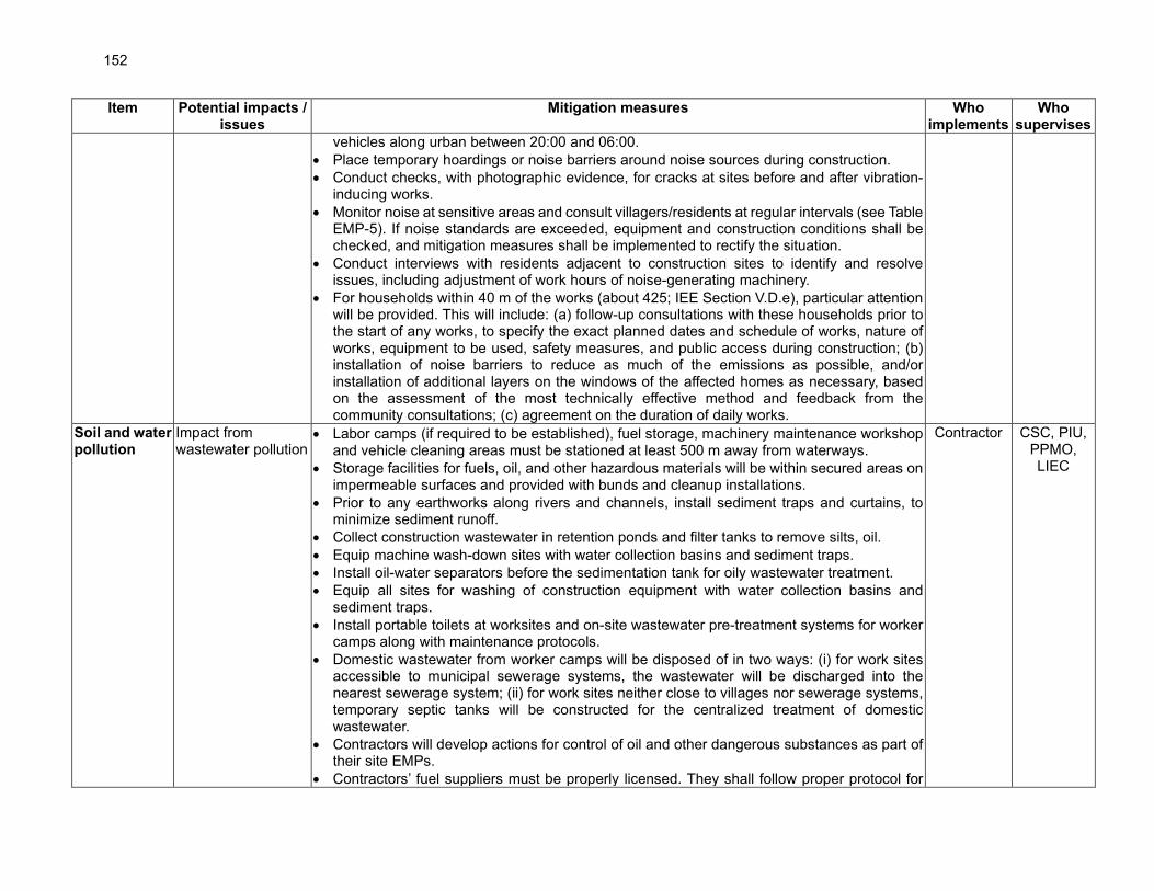
152
Item Potential impacts / issues
Mitigation measures Who implements
Who supervises
vehicles along urban between 20:00 and 06:00.
• Place temporary hoardings or noise barriers around noise sources during construction.
• Conduct checks, with photographic evidence, for cracks at sites before and after vibration-inducing works.
• Monitor noise at sensitive areas and consult villagers/residents at regular intervals (see Table EMP-5). If noise standards are exceeded, equipment and construction conditions shall be checked, and mitigation measures shall be implemented to rectify the situation.
• Conduct interviews with residents adjacent to construction sites to identify and resolve issues, including adjustment of work hours of noise-generating machinery.
• For households within 40 m of the works (about 425; IEE Section V.D.e), particular attention will be provided. This will include: (a) follow-up consultations with these households prior to the start of any works, to specify the exact planned dates and schedule of works, nature of works, equipment to be used, safety measures, and public access during construction; (b) installation of noise barriers to reduce as much of the emissions as possible, and/or installation of additional layers on the windows of the affected homes as necessary, based on the assessment of the most technically effective method and feedback from the community consultations; (c) agreement on the duration of daily works.
Soil and water pollution
Impact from wastewater pollution
• Labor camps (if required to be established), fuel storage, machinery maintenance workshop and vehicle cleaning areas must be stationed at least 500 m away from waterways.
• Storage facilities for fuels, oil, and other hazardous materials will be within secured areas on impermeable surfaces and provided with bunds and cleanup installations.
• Prior to any earthworks along rivers and channels, install sediment traps and curtains, to minimize sediment runoff.
• Collect construction wastewater in retention ponds and filter tanks to remove silts, oil.
• Equip machine wash-down sites with water collection basins and sediment traps.
• Install oil-water separators before the sedimentation tank for oily wastewater treatment.
• Equip all sites for washing of construction equipment with water collection basins and sediment traps.
• Install portable toilets at worksites and on-site wastewater pre-treatment systems for worker camps along with maintenance protocols.
• Domestic wastewater from worker camps will be disposed of in two ways: (i) for work sites accessible to municipal sewerage systems, the wastewater will be discharged into the nearest sewerage system; (ii) for work sites neither close to villages nor sewerage systems, temporary septic tanks will be constructed for the centralized treatment of domestic wastewater.
• Contractors will develop actions for control of oil and other dangerous substances as part of their site EMPs.
• Contractors’ fuel suppliers must be properly licensed. They shall follow proper protocol for
Contractor CSC, PIU, PPMO, LIEC
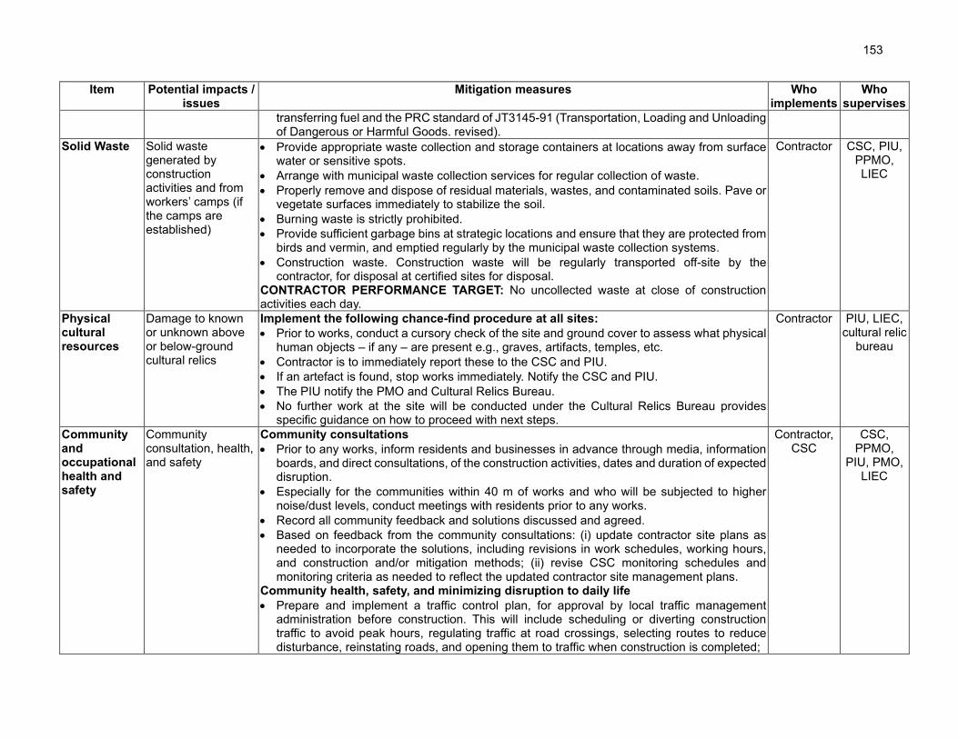
153
Item Potential impacts / issues
Mitigation measures Who implements
Who supervises
transferring fuel and the PRC standard of JT3145-91 (Transportation, Loading and Unloading of Dangerous or Harmful Goods. revised).
Solid Waste Solid waste generated by construction activities and from workers’ camps (if the camps are established)
• Provide appropriate waste collection and storage containers at locations away from surface water or sensitive spots.
• Arrange with municipal waste collection services for regular collection of waste.
• Properly remove and dispose of residual materials, wastes, and contaminated soils. Pave or vegetate surfaces immediately to stabilize the soil.
• Burning waste is strictly prohibited.
• Provide sufficient garbage bins at strategic locations and ensure that they are protected from birds and vermin, and emptied regularly by the municipal waste collection systems.
• Construction waste. Construction waste will be regularly transported off-site by the contractor, for disposal at certified sites for disposal.
CONTRACTOR PERFORMANCE TARGET: No uncollected waste at close of construction activities each day.
Contractor CSC, PIU, PPMO, LIEC
Physical cultural resources
Damage to known or unknown above or below-ground cultural relics
Implement the following chance-find procedure at all sites:
• Prior to works, conduct a cursory check of the site and ground cover to assess what physical human objects – if any – are present e.g., graves, artifacts, temples, etc.
• Contractor is to immediately report these to the CSC and PIU.
• If an artefact is found, stop works immediately. Notify the CSC and PIU.
• The PIU notify the PMO and Cultural Relics Bureau.
• No further work at the site will be conducted under the Cultural Relics Bureau provides specific guidance on how to proceed with next steps.
Contractor PIU, LIEC, cultural relic
bureau
Community and occupational health and safety
Community consultation, health, and safety
Community consultations
• Prior to any works, inform residents and businesses in advance through media, information boards, and direct consultations, of the construction activities, dates and duration of expected disruption.
• Especially for the communities within 40 m of works and who will be subjected to higher noise/dust levels, conduct meetings with residents prior to any works.
• Record all community feedback and solutions discussed and agreed.
• Based on feedback from the community consultations: (i) update contractor site plans as needed to incorporate the solutions, including revisions in work schedules, working hours, and construction and/or mitigation methods; (ii) revise CSC monitoring schedules and monitoring criteria as needed to reflect the updated contractor site management plans.
Community health, safety, and minimizing disruption to daily life
• Prepare and implement a traffic control plan, for approval by local traffic management administration before construction. This will include scheduling or diverting construction traffic to avoid peak hours, regulating traffic at road crossings, selecting routes to reduce disturbance, reinstating roads, and opening them to traffic when construction is completed;
Contractor, CSC
CSC, PPMO,
PIU, PMO, LIEC

154
Item Potential impacts / issues
Mitigation measures Who implements
Who supervises
• For all excavation along roads and easements which already have existing subsurface utilities (power cables, sewage pipes, water pipes, telecommunication cables): (i) plan and coordinate the project pipeline construction with the utility managers, (ii) check whether there are other pending projects to upgrade these utilities. Coordinate works to avoid repeated excavation of the same sections of road or easement; and work with utility managers to minimize the risk of damage or disruption to the existing utilities. If any utilities are disturbed by the construction activities, they will be rectified immediately by the contractor in coordination with the utility provider. During this period, users will be provided with alternative water supply (e.g. tankers) if the water supply pipes are broken
• Install signs at construction sites to inform people of the project GRM, potential dangers (e.g. moving vehicles, hazardous materials, excavations) and safety issues.
• Install safety barricades around all excavations, including open trenches.
• Assign personnel to direct pedestrians around dangerous work areas.
• Ensure that all sites are secure, discouraging access through appropriate fencing.
• Lock and secure all work sites to prevent unauthorized access.
• Night-time (8:00pm – 6:00am) use of heavy machinery is strictly prohibited. Sexual exploitation, abuse, and harassment (SEAH) and disease risks
• Strict requirements will be included in all personnel contracts and on-site workplace requirements for zero-tolerance of SEAH. This will include immediate investigation of any report or complaint, and immediate dismissal when abuse or harassment is confirmed.
• All workers will be given basic training in sanitation, general health and safety matters, and work hazards. An awareness program for HIV/AIDS and other communicable diseases will be implemented for workers and the local communities.
• Measures for safety and resilience to COVID-19 described in Appendix 2 will integrated in the contractor health and safety plans and be strictly implemented.
Core labor standards • Core labor standards will be implemented. Civil works contracts will stipulate priorities to: (i)
employ local people for works; (ii) ensure equal opportunities for women and men; (iii) pay equal wages for work of equal value and pay women’s wages directly to them; and (iv) not employ child or forced labor.
Interruptions to Public Services and Local Utilities • local people will be informed in advance of the time and duration of interruptions in public
services and utilities.
Occupational health and safety
• Prepare environmental, health and safety plan, to include: (i) clean and sufficient supply of fresh water for construction sites, camps, offices; (ii) sufficient latrines and other sanitary
Contractor CSC, PIU, PPMO,
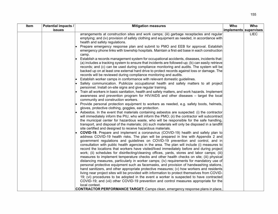
155
Item Potential impacts / issues
Mitigation measures Who implements
Who supervises
arrangements at construction sites and work camps; (iii) garbage receptacles and regular emptying; and (iv) provision of safety clothing and equipment as needed, in accordance with health and safety regulations.
• Prepare emergency response plan and submit to PMO and EEB for approval. Establish emergency phone links with township hospitals. Maintain a first-aid base in each construction camp.
• Establish a records management system for occupational accidents, diseases, incidents that: (a) includes a tracking system to ensure that incidents are followed-up; (b) can easily retrieve records; and (c) can be used during compliance monitoring and audits. The system will be backed up on at least one external hard drive to protect records against loss or damage. The records will be reviewed during compliance monitoring and audits.
• Establish worker camps in conformance with relevant domestic guidelines.
• Safety communication. Publicize occupational health and safety matters to all project personnel. Install on-site signs and give regular training.
• Train all workers in basic sanitation, health and safety matters, and work hazards. Implement awareness and prevention program for HIV/AIDS and other diseases – target the local community and construction workers.
• Provide personal protection equipment to workers as needed, e.g. safety boots, helmets, gloves, protective clothing, goggles, ear protection.
• Asbestos. In the event that materials containing asbestos are suspected: (i) the contractor will immediately inform the PIU, who will inform the PMO; (ii) the contractor will subcontract the municipal center for hazardous waste, who will be responsible for the safe handling, transport, and disposal of the materials; (iii) such materials will only be disposed in a landfill site certified and designed to receive hazardous materials.
• COVID-19. Prepare and implement a coronavirus (COVID-19) health and safety plan to address COVID-19 health risks. The plan will be prepared in line with Appendix 2 and government regulations and guidelines on COVID-19 prevention and control, and in consultation with public health agencies in the area. The plan will include (i) measures to record the locations that workers have visited/lived immediately before and during project work; (ii) schedules for disinfecting/cleaning offices, yards, stores and labor camps; (iii) measures to implement temperature checks and other health checks on site; (iii) physical distancing measures, particularly in worker camps; (iv) requirements for mandatory use of personal protective equipment such as facemasks, and provision of handwashing stations, hand sanitizers, and other appropriate protective measures; (v) how workers and residents living near project sites will be provided with information to protect themselves from COVID-19; (vi) procedures to be adopted in the event a worker is suspected to have contracted COVID-19; and (vii) other COVID-19 prevention and control measures appropriate for the local context.
CONTRACTOR PERFORMANCE TARGET: Camps clean, emergency response plans in place,
LIEC

156
Item Potential impacts / issues
Mitigation measures Who implements
Who supervises
and 100% of workers aware of emergency response procedures.
Biological resources
Protection of flora and fauna around construction sites
• Construction workers are strictly prohibited from (i) capturing any wildlife in the project areas or (ii) eating any wild animals, plants, or products while working for this project
• Clearance of vegetation will be restricted to specific construction sites
• Prior to construction, vegetation and habitats will be clearly demarcated, as no-go zones for workers and machinery.
• All planting activities, including re-vegetation, landscaping, and rehabilitation of work sites, will only use plant species which are (a) native (i.e. naturally occurring) to the project area, and (b) are sourced from local stock within the project counties, to minimize the risk of spreading invasive species through the long-distance transport of soil or materials.
• In the event that non-native seedlings are required for rapid stabilization of exposed soils and sites, only sterile seedlings will be used to prevent the spread of weeds.
• To reduce the risk of spreading weeds, pest animals, and/or soil-based organisms, the project will: (a) prohibit the use of any plant species classified in the PRC as weeds – including native species – as defined by the Research Center for Biological Prevention and Control of Alien Invasion (Ministry of Agriculture and Rural Affairs) and Institute of Plant Protection (Chinese Academy of Agricultural Sciences), available at http://www.chinaias.cn/wjPart/index.aspx.
• To avoid water pollution, no top-dressing fertilizers will be used for any of the re-vegetation, planting, afforestation, or landscaping activities. For all planting activities, fertilizer will be applied at the root mass of each plant.
• For the use of pesticides in planting, measures comprise: (a) no chemicals will be used that are listed as hazardous under Classes I or II by the World Health Organization, or which are listed as prohibited or for strictly controlled use under PRC regulations for pesticide management, (b) pesticides to be used will be low residual and low toxic, in line with the requirements of the Ministry of agriculture and Rural Affairs, and (c) training in integrated pest management will be included as part of the project capacity building for PIUs and farmers, to help reduce pesticide use.
Contractor PIUs, PPMO, LIEC,
Forestry Bureau
Impact on Wetlands (Shuangquan Lake and Malan River National Wetland)
• No construction camps will be located within the Wetland Reserve, including its buffer and pilot areas.
• The construction workers will be strictly prohibited from cutting trees and hunting of wildlife. Employees found violating would be subject to strict actions, including fines and termination of employment.
• Awareness-raising to workers on the protection of flora and fauna, including the awareness on the conservation value of the Reserve
• No existing vegetation will be removed. Clearly delineate existing vegetation that should not be cleared and provide fencing around these sites if required. Ensure that all contractors are aware of these no-clearance zones and do not enter them. The vegetation will only be cleared once it has been established that any individual animals present have fled. Before and during
Contractor PIUs, PPMO, LIEC,
Forestry Bureau

157
Item Potential impacts / issues
Mitigation measures Who implements
Who supervises
vegetation clearance or tree felling, any animals found will be removed and released to a safe place. There should be no burning of natural vegetation. The borrow animals, if found during excavation, shall also be transported to a safe place.
• Artificial lighting used on construction sites and camps at night will be shaded and directed downwards to avoid light spillage and disturbance to nocturnal birds and other wildlife.
• No wastes will be disposed of at the site. All wastes generated during construction will be collected and transported away from the construction sites.
• Air and noise emissions and wastewater discharges should strictly comply the applicable standards
• Avoid the construction activities during March-April and September-October when birds migrate to these areas
Subprojects in/around Forest Park, Scenic Spots
Impact on Protected Forests and National Parks (Xibu Ecological Forest Park, Huangshui Forest Park, Heihe National Forest, Louguantai Forest Park, Wudishan National forest park,
• No clearing on steep, unstable slopes or highly erosive slopes
• Control the soil erosion and sedimentation during land preparation by adaptation of fish-scale pits for plantation development.
• Limit the use of machinery in protected areas
• No construction camps will be located within the protected zones, including its buffer and pilot areas.
• The construction workers will be strictly prohibited from cutting trees and hunting of wildlife. Employees found violating would be subject to strict actions, including fines and termination of employment.
• Awareness-raising to workers on the protection of flora and fauna, including the awareness on the conservation value of the forests
• No existing vegetation will be removed. Clearly delineate existing vegetation that should not be cleared and provide fencing around these sites if required. Ensure that all contractors are aware of these no-clearance zones and do not enter them. If required, the vegetation will only be cleared once it has been established that any individual animals present have fled. Before and during vegetation clearance or tree felling, any animals found will be removed and released to a safe place. There should be no burning of natural vegetation. The borrow animals, if found during excavation, shall also be transported to a safe place.
• Artificial lighting used on construction sites and camps at night will be shaded and directed downwards to avoid light spillage and disturbance to nocturnal birds and other wildlife.
• No wastes will be disposed of in the open places.
• Air and noise emissions and wastewater discharges should strictly comply the applicable standards.
Contractor PIUs, PPMO, LIEC,
Forestry Bureau
Subprojects near physical cultural relics
Cultural Monuments (Tulou Temple and
• Limit the use of machinery in areas close to the cultural relics
• The noise and vibration generated from the tending activities should be kept minimum.
Contractor PIU, PPMO,
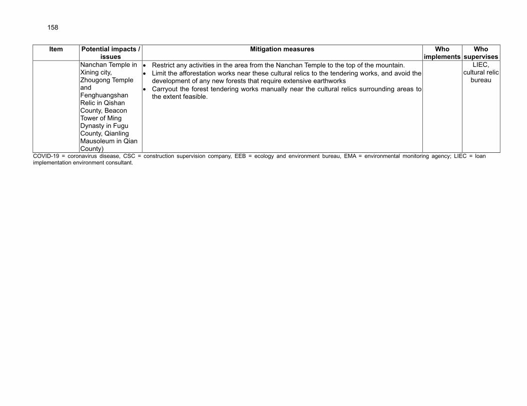
158
Item Potential impacts / issues
Mitigation measures Who implements
Who supervises
Nanchan Temple in Xining city, Zhougong Temple and Fenghuangshan Relic in Qishan County, Beacon Tower of Ming Dynasty in Fugu County, Qianling Mausoleum in Qian County)
• Restrict any activities in the area from the Nanchan Temple to the top of the mountain.
• Limit the afforestation works near these cultural relics to the tendering works, and avoid the development of any new forests that require extensive earthworks
• Carryout the forest tendering works manually near the cultural relics surrounding areas to the extent feasible.
LIEC, cultural relic
bureau
COVID-19 = coronavirus disease, CSC = construction supervision company, EEB = ecology and environment bureau, EMA = environmental monitoring agency; LIEC = loan implementation environment consultant.

159
Table EMP-3: Potential Impacts and Mitigation Measures during Operation
Issue Mitigation Measure Implement Supervise
Sustainability of water sources for irrigation
• Confirm the species selection and the water-saving measures proposed in the project design are implemented.
• Monitoring use of water for the project activities to ensure compliance with the required quota.
IA Forestry Bureau
Impacts on forest and wetland from tourism
• Appropriate land-use zoning to designate the areas that should be solely used for tourism and solely for conservation and other uses
• Direct physical protection of the areas that are sensitive for tourists
• Education of tourists
• Carryout a monitoring program to assess the impacts of tourists’ activities
• Procurement of fire-fighting facilities
IA Forestry Bureau
Impact on wildlife
• Monitoring the impact of construction activities in the wetlands on the migratory birds
• The building of the park agencies’ capacity to effectively engage in partnerships with the tourism industry to minimizing environmental impacts
• Communication campaign for the tourists on the protection of wildlife
• Implementation of strict speed limits
Forestry Bureau
Soil and water pollution from use of agro-chemicals
• Minimize the use of chemical fertilizer and maximize the use of organic fertilizers by project design
• Fertilizer will be mixed with water and provided via drip irrigation, ensuring that only small quantities are required, in small doses, and that fertilizers is retained at root bases
• Fertilizer use will be reduced through real-time monitoring soil nutrient levels
• Monitoring. The types and volumes of fertilizers and pesticides used by the subprojects will be documented in order to monitor overall use and efficiency over time.
• No top-dressing fertilizers will be used for any of the re-vegetation, planting, or landscaping activities. For all planting activities, fertilizer will be applied once, at the root mass of each plant, during planting.
IA Forestry Bureau
Handling and use of agri-chemicals – pesticides, fertilizers, and water-retaining chemicals
• No pesticides listed as hazardous under Classes I or II by the WHO, or Annexes A and B of the Stockholm Convention, or listed as prohibited or strictly controlled use under the PRC’s national regulations for pesticide management will be used for the project activities.
• Ensure that any pesticides used are manufactured, formulated, packaged, labeled, handled, stored, disposed of, and applied according to the FAO’s International Code of Conduct on Pesticide Management
• Pesticides will be stored, handled, and applied in a manner consistent with the recommendations given in the World Bank Group EHS Guidelines.
• The warehouses for storage of pesticides will have appropriate ventilation and secondary containment and should be stored in their original and labeled containers. The PIU will record all the procurement and utilization of
IA Forestry Bureau, EEB

160
Issue Mitigation Measure Implement Supervise
pesticides.
• PIU will train the farmers on the safe storage, handling, application and disposal of pesticides.
• The pesticides will be handled by the trained operators (to understand and follow label directions for safe mixing, application and disposal) and the operators will use correct PPE (e.g., gloves, overalls, eye protection, boots, respirator masks). PPEs should never be taken home and should be cleaned in a segregated facility provided by the PIU.
• Storage rooms for chemicals will be of restricted access limited to trained operators and other specifically listed persons e.g. the site manager. Persons with access with to the chemical storage rooms will be recorded in a register.
• Pesticide application technologies will be selected to minimize off-site movement or runoff (e.g., low-drift nozzles, using the largest droplet size and lowest pressure that are suitable for the product). Buffer zones will be established around the environmentally sensitive zones (e.g., water courses, residential areas) to avoid any pesticide application in those areas.
• Pesticide application methods with lower OHS risk profile will be selected (such as using lower toxicity- rated products, or using safer application methods, such as shielded sprayers, incorporation, or low-volume equipment).
• Empty containers and packaging waste for pesticides and fertilizers will be collected by the manufacturer (a common process now in the PRC) or disposed of by farmers as hazardous waste. The PIU will ensure the segregation of the pesticide waste at the subproject site from all other waste and will ensure that it is managed/disposed of by the county authorities with other toxic and hazardous waste that they collect.
Disposal of agricultural wastes:
• All biomass waste from cultivation, pruning and weeding will be reused on site wither for composting or mulch. No waste will be burnt.
• Residue of agricultural plastic film left in the soil will be minimized by (i) film mulching practices which optimize the timing of mulching and timely removal of film to shorten the mulching period; (iii) use of biodegradable polymer agricultural plastic film; (iv) where film is not degradable, promotion of agricultural plastic film recovery and recycling.
• Soil erosion:
• On the steeper slopes, slope-reversed terraces (higher elevation at the outside of the terrace than on the inside) will be equipped with bamboo-joint ditches on the lower edge inside the terrace to harvest runoff and collect eroded soil materials.
• At the lower elevation part of the tea gardens, interception dam and rainwater harvest ponds will be maintained to
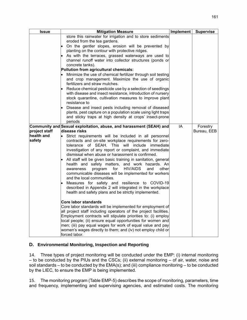
161
Issue Mitigation Measure Implement Supervise
store this rainwater for irrigation and to store sediments eroded from the tea gardens.
• On the gentler slopes, erosion will be prevented by planting on the contour with protective ridges.
• As with the terraces, grassed waterways are used to channel runoff water into collector structures (ponds or concrete tanks).
Pollution from agricultural chemicals:
• Minimize the use of chemical fertilizer through soil testing and crop management. Maximize the use of organic fertilizers and straw mulches.
• Reduce chemical pesticide use by a selection of seedlings with disease and insect resistance, introduction of nursery stock quarantine, cultivation measures to improve plant resistance to
• Disease and insect pests including removal of diseased plants, pest capture on a population scale using light traps and sticky traps at high density at crops’ insect-prone periods
Community and project staff health and safety
Sexual exploitation, abuse, and harassment (SEAH) and disease risks
• Strict requirements will be included in all personnel contracts and on-site workplace requirements for zero-tolerance of SEAH. This will include immediate investigation of any report or complaint, and immediate dismissal when abuse or harassment is confirmed.
• All staff will be given basic training in sanitation, general health and safety matters, and work hazards. An awareness program for HIV/AIDS and other communicable diseases will be implemented for workers and the local communities.
• Measures for safety and resilience to COVID-19 described in Appendix 2 will integrated in the workplace health and safety plans and be strictly implemented.
Core labor standards Core labor standards will be implemented for employment of all project staff including operators of the project facilities. Employment contracts will stipulate priorities to: (i) employ local people; (ii) ensure equal opportunities for women and men; (iii) pay equal wages for work of equal value and pay women’s wages directly to them; and (iv) not employ child or forced labor.
IA Forestry Bureau, EEB
D. Environmental Monitoring, Inspection and Reporting 14. Three types of project monitoring will be conducted under the EMP: (i) internal monitoring – to be conducted by the PIUs and the CSCs; (ii) external monitoring – of air, water, noise and soil standards – to be conducted by the EMA(s); and (iii) compliance monitoring – to be conducted by the LIEC, to ensure the EMP is being implemented. 15. The monitoring program (Table EMP-5) describes the scope of monitoring, parameters, time and frequency, implementing and supervising agencies, and estimated costs. The monitoring
162
shall comply with the standards mentioned in Chapter II. The applicable standards to be followed on ambient air, surface water, sediment and noise, and the pollutant discharges are given in Table EMP-5. 16. Internal monitoring. During the construction phase, the CSCs and the PIUs will be responsible for conducting the internal environmental monitoring in accordance with the monitoring plan. Results will be reported through the CSC monthly reports to the PIUs and PMO. 17. External monitoring. The PPMOs will contract and fund EMAs (one for each province) to conduct the external environmental monitoring described in Table EMP-5. A detailed cost breakdown will be provided by EMAs tendering for this work. The external monitoring will be conducted during the entire construction phase and first full year of operation of the relevant facility. The EMA will prepare semi-annual monitoring reports of the methods and results. The EMA will submit these to the PMO, PIU, and ADB at the same time, to ensure independence. 18. Compliance monitoring for EMP. The LIECs will review project progress and compliance with the EMP based on field visits, consultations with the PPMO and PIU environment officers, contractors, and CSCs, and review of the monitoring reports by the CSCs and EMA(s). The site visits will include comparison of the works and conditions observed with the EMP mitigation and monitoring measures in Tables EMP-2, EMP-3 and EMP-5. The site visits will include, but not be limited to: visual inspection of worker and construction solid waste at worker camps and work sites; evidence of soil erosion, water pollution, and sewage; community and occupational health and safety (camp hygiene, availability of clean water); and, evidence that emergency response plans are in place and that workers are familiar with them. There is no set frequency for these inspections: the LIEC will make site visits as often as possible within the available budget, focused especially on periods of peak construction. The findings of the LIEC will be reported to ADB through the semi-annual environment monitoring reports. 19. Environment monitoring reports (EMRs). The NPMO will submit consolidated EMRs to ADB semi-annually. The EMRs will include: (i) progress made in EMP implementation, (ii) overall effectiveness of the EMP implementation (including public and occupational health and safety), (iii) environmental monitoring and compliance, (iv) institutional strengthening and training, (v) public consultation (including GRM), and (vi) any problems encountered during construction and operation, and the relevant corrective actions undertaken. The PPMOs will prepare semi-annual EMR for each province and submit to NPMO. The NPMO will prepare consolidated EMRs and submit the English report semiannually to ADB for disclosure. A standard reporting template will be provided by ADB to NPMO and PPMOs to assist in report preparation. 20. Project completion environmental audits. Within three months after each subproject completion, or no later than a half year with permission of the local EEBs, environmental acceptance monitoring and audit reports of each subproject completion shall be: (i) prepared by a licensed environmental monitoring institute (usually, the institute is the municipal, district, or county environmental monitoring station under the municipal, district, or county EEB) in accordance with the PRC Guideline on Project Completion Environmental Audit (2001); (ii) reviewed for approval of the official commencement of individual subproject operation by environmental authorities; and (iii) reported to ADB through the semi-annual environment monitoring reports. 21. Quality assurance (QA) /quality control (QC) for compliance monitoring. To ensure accuracy of the monitoring, QA/QC procedures will be conducted in accordance with the following regulations:

163
i) Regulations of QA/AC Management for Environmental Monitoring issued by the State Environmental Protection Administration in July 2006;
ii) QA/QC Manual for Environmental Water Monitoring (Second edition), published by the State Environmental Monitoring Centre in 2001; and
iii) QA/QC Manual for Environmental Air Monitoring published by the State Environmental Monitoring Centre in 2001.
Table EMP-4: Environmental Reporting Plan
Report From To Frequency of Reporting
A. Construction Phase
Internal progress reports CSC PIU Monthly
External environment monitoring reports
EMA PPMO, PIUs Semi-annual
Environmental acceptance monitoring and audit reports
Licensed institute
EEB, PPMOs, PIUs
Within three months after component completion
Environmental monitoring report. To include the external environment monitoring reports
NPMO ADB Semi-annual
B. Operation Phase
EMP progress reports NPMO ADB Semi-annual

164 Table EMP-5: Environmental Monitoring Program for “Internal” and “External” Monitoring. See text for description of “compliance monitoring”.
Subject Parameter* Location Frequency Compliance Standard Implement Supervise
CONSTRUCTION STAGE 1. Internal monitoring – by the contractors, CSCs, and PMO and PIU Environment Officers
Ambient air quality Compliance with dust mitigation measures (Table EMP-2)
Visual inspection at all construction sites In case of any complaints, the air quality will be tested for PRC GB 3095-2012 standard
1 time / week PRC GB 3095-2012 and EHS guidelines. See IEE tables II-7.
Contractor, CSC, PIU
PPMO, LIEC
Noise LAeq: measured with hand-held meter Contractor performance targets: (i) noise level meets standard at site boundary
Construction site boundary 1 time / week minimum during peak construction levels at work sites
PRC GB12523-2011; GB12348-2008. See IEE Tables II-12 and II-13.
CSC, PIU, LIEC
PPMO, LIEC
Solid waste Garbage and construction wastes Contractor performance target: no uncollected waste at end works each day
Visual inspection at all construction sites and work-camps
Daily NA Contractor, CSC, PIU
PPMO, EEB, Sanitation bureau
Soil erosion and re-vegetation
Soil erosion intensity and survival rate of re-vegetation
Visual inspection at spoil sites and all construction sites, especially embankment sections of project river sections
1 time / week; and immediately after heavy rainfall
NA Contractor, CSC, PIU
PPMO, LIEC
Re-vegetation of shelter belts and other areas,
Visual inspection along embankment sections and all revegetation areas
At least 2 times / year
NA Contractor, CSC, PIU
PPMO
Occupational health and safety
Camp hygiene, safety, availability of clean water, EMRs Contractor performance target: camps clean, EMRs in place; 100% of workers aware of EMR procedures
Visual inspection at all construction sites and work-camps
1 time / month NA Contractor, CSC, PIU
PPMO
2. External monitoring – by a certified environment monitoring agency
Quality of sewage and discharge channels at work camps
pH, SS, NH3-N, CODCr, petroleum Domestic wastewater discharge at work-camps
2 times/year during construction
PRC GB3838-2002 and GB8978-1996. See IEE Table II-16.
EMA EEB, PMO
Construction wastewater
SS, oil, pH At wastewater discharge points of all construction sites
2 times/year during construction
PRC GB3838-2002 and GB8978-1996. See IEE Table II-16.
EMA EEB, PMO
Ambient air quality PM10 All construction sites (at least 1 point upwind, 1 point downwind) and nearby sensitive receivers
2 times / year during construction
World Bank EHS standard. See IEE Table II-7
EMA EEB, PMO, LIEC

165
Subject Parameter* Location Frequency Compliance Standard Implement Supervise
(Section IV of IEE)
Noise LAeq Boundaries of all construction sites and sensitive receivers (Chapter V-sensitive receivers within project area of influence)
2 times / year (twice a day: once in day time and once at night time, for 2 consecutive days)
PRC GB12523-2011 and GB12348-2008. See IEE Tables II-12 and II-13
EMA EEB, PMO, LIEC
OPERATION PHASE – external monitoring, by certified environment monitoring agencies Afforestation Monitoring
Site preparation standards, seedling specifications, planting specifications, afforestation survival rate (preservation rate), area verification rate, native vegetation retention, etc., implementation of environmental protection measures for multifunctional forests, wetland restoration, and supporting projects
All afforestation sites Ongoing, as required
NA Forestry Bureau
PMO
Vegetation monitoring
Species composition, species, number, height, abundance and coverage.
All afforestation sites Ongoing, as required
NA Forestry Bureau
PMO
Environmental Monitoring
Hydrology and water quality monitoring, soil moisture monitoring, soil physical and chemical properties, meteorological environmental factor monitoring
All afforestation sites Ongoing, as required
NA Forestry Bureau
PMO
Water use monitoring
Volume of water use during the first 3 years of operation
All water extraction points (both surface and groundwater)
Ongoing, as required
Target: (i) all water use will comply with county, district, and provincial annual water allocation quotas for agriculture as established by the Yellow River Basin Committee and other national and provincial regulatory agencies.
Forestry Bureau
PMO
Pesticides use monitoring
Volume of pesticides used during, at least, the first 2 years of operations of each completed project afforestation site
All afforestation sites Ongoing, as required
Target: 10% reduction in volume of applied fertilizers and pesticides per mu or hectares on forestry
Forestry Bureau
PMO
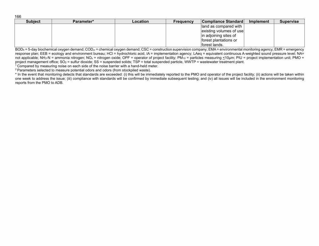
166
Subject Parameter* Location Frequency Compliance Standard Implement Supervise
land as compared with existing volumes of use in adjoining sites of forest plantations or forest lands.
BOD5 = 5-day biochemical oxygen demand; CODcr = chemical oxygen demand; CSC = construction supervision company; EMA = environmental monitoring agency; EMR = emergency response plan; EEB = ecology and environment bureau; HCl = hydrochloric acid, IA = implementation agency; LAeq = equivalent continuous A-weighted sound pressure level; NA= not applicable; NH3-N = ammonia nitrogen; NOx = nitrogen oxide; OPF = operator of project facility; PM10 = particles measuring <10μm; PIU = project implementation unit; PMO = project management office; SO2 = sulfur dioxide; SS = suspended solids; TSP = total suspended particle, WWTP = wastewater treatment plant. 1 Compared by measuring noise on each side of the noise barrier with a hand-held meter. 2 Parameters selected to measure potential odors and odors (from stockpiled waste). * In the event that monitoring detects that standards are exceeded: (i) this will be immediately reported to the PMO and operator of the project facility; (ii) actions will be taken within one week to address the issue; (iii) compliance with standards will be confirmed by immediate subsequent testing; and (iv) all issues will be included in the environment monitoring reports from the PMO to ADB.

167
E. Training and Capacity Building 22. Several previous ADB-funded loan and grant projects have been implemented in the project provinces. However, although the provincial governments are familiar with ADB requirements, there is currently little institutional memory in the PPMOs or provincial environment, forestry, and water resources departments about ADB safeguard requirements, and little or no experience among the implementing agencies with ADB procedures. The experience and capacity of individual staff within the city, district, and county EEBs for environmental management also varies considerably. Domestic EIAs and project approvals generally include limited mitigation measures, but there is not yet a regulatory requirement in the PRC for EMPs of the scope required by ADB. Implementation of the current EMP represents a significant new task for the local agencies. During the project preparation phase, preliminary training on EMP implementation was provided by the TA Consultant, including roles and responsibilities of contractors and CSCs for EMP implementation, project impacts, and mitigation measures. 23. During implementation, a capacity building program will be implemented for safeguards and technical capacity for the designed components, including: (i) implementation of the EMP, including the mitigation measures, monitoring, and reporting; and (ii) operation and maintenance of the constructed facilities. Training will be provided by the loan implementation consultants and respective city and county EEBs, facilitated by the PMO and PIUs. Trainees will include the PMO, implementing agencies, PIUs, contractors, CSCs, and relevant local bureaus (including water resources, forestry).
Table EMP-6: Project Environment Training Program
Training program
Scope of Training Trainer Trainee Time Days Persons
Procurement and contract management (emphasize EMP implementation)
• ADB procurement guidelines
• Bidding document and contract preparation, including EMP clauses
• Risk of improper procurement and mitigation measures, and handling variation orders and contract management
LIEC PMO, PIUs, EFMC
6 6 100
Implementation of EMP
• ADB safeguard policy statement requirements for EMP implementation and progress reporting
• Roles, responsibilities, monitoring, inspection, reporting in EMP – especially, at each level of responsibility (PMO, PIUs, implementation units)
• Public consultation and participation;
• GRM implementation, coordination, reporting, working with the public;
• Environment, health and safety during project construction and operation for workers and the community;
• Occupational health and safety, including (i) prevention and control of transmissible diseases and HIV/AIDS, (2)
LIEC, EEB
PMO, PIUs,
EEB, other local
bureaus
6 6/ year
100
Climate change resilience
• Energy saving and GHG emission reduction
• Carbon sink by revegetation and
LIEC PMO, OPF WRB
3 3 100

168
Training program
Scope of Training Trainer Trainee Time Days Persons
afforestation
Emergency preparedness and response planning
• Response mechanism e.g. for spills
• Mitigation measures for hydraulic sectors
• Emergency response team, procedure and actions
Experts from
EEBs, LIEC
PMO, OPF, other
bureaus
3 3 100
COVID prevention
• COVID health and safety plan
• Emergency response plan
Experts from local CDC
PMO, PIUs,
contractors
3 3 100
Total 21 21 500 ADB = Asian Development Bank, CAB = civil affairs bureau, EMP = environment management plan, EEB = environment protection bureau, EFMC = eco-compensation fund management committee, GHG = greenhouse gas, GRM = grievance redress mechanism, LIC = loan implementation consultant, OPF = operator of project facilities, = project implementation unit, PMO = project management office, WRB = water resource bureau.
F. Grievance Redress Mechanism 24. This project grievance redress mechanism (GRM) is for the identification, documentation, and preliminary management of environment-related grievances. Social safeguard issues including issues related to land acquisition or resettlement will be addressed under a social safeguard GRM. 25. The GRM is designed to achieve the following objectives: (i) provide channels of communication for communities to raise concerns about environment related grievances which might result from the project; (ii) prevent and mitigate adverse environmental impacts to villages and communities caused by project construction and operation, including those associated with resettlement through improved awareness; (iii) promote trust between the project agencies and communities; and (iv) build community acceptance of the project. The GRM is accessible to all members of the villages and communities, including women, youth, minorities and poverty-stricken villagers and residents. Multiple points of entry are available, including face-to-face meetings, written complaints, telephone conversations, e-mail, and social media. 26. The PPMO Environment Officers and PPMO Social Officers, and PIU Environment and Social Focal Points, will lead the coordination of environment GRM and social GRM. However, all project agencies and staff will be trained in the GRMs and are expected to take an active role in implementing the GRMs. At the PPMO level, the PPMO Environment Officer and PMO Social Officer will establish a GRM tracking and documentation system, conduct daily coordination with the PIU officers, arrange meetings and conduct site visits as necessary, maintain the overall project GRM database, and prepare the reporting inputs for progress reports to ADB. At the PIU level, the environment and social focal points will instruct contractors and CSCs on the GRM procedures, and coordinate with the local EEBs and other government divisions as necessary. PPMO and PIU staff will be trained and supported by the LIEC and loan implementation social consultant. 27. The contact persons for different GRM entry points, such as the PPMO and PIU environmental and social officers, contractors, operators of project facilities, and EEBs, will be identified prior to construction. The contact details for the entry points (phone numbers, addresses, e-mail addresses) will be publicly disclosed on information boards at construction sites and on the websites of the local EEBs.

169
28. The GRM will be accessible to diverse members of the villages and community, including more vulnerable groups such as women, minority and poor. Multiple points of entry, including face-to-face meetings, written complaints, telephone conversations, or e-mail, will be available. 29. If a complaint is received and filed, the PPMO and PIU officers will identify if the complaint is eligible for management under the GRM. Eligible complaints under the GRM include those where: (i) the complaint pertains to the project; and (ii) the issues arising in the complaint fall within the scope of environmental and/or social issues that the GRM is authorized to address. Ineligible complaints include those where: (i) the complaint is not project-related; (ii) the nature of the issue is outside the mandate of the GRM (such as fraud or corruption); and/or (iii) other procedures would be more appropriate to address the issue. Ineligible complaints will be documented and provided to the relevant authorities and the complainant will be informed of these steps. The procedure and timeframe for the GRM is as follows and summarized in Figure EMP-2.
• Stage 1 (5 calendar days): If a concern arises during construction or operation, the affected person may submit a written or oral complaint to the contractor (construction phase) or operator of the project facility (operation phase). The contractor will: (i) respectfully acknowledge the issue and immediately stop the causal activity (e.g. on-site construction causing high noise levels to a nearby household); (ii) not resume the activity until the complaint has been resolved; (iii) inform the PIU of the incident on the same day of the incident occurring and how the contractor has responded or will respond; (iv) give a clear reply to the affected person within two calendar days; and (v) as far as possible, resolve the problem within five calendar days from receiving the complaint. The PIU will: inform the PMO, local village committee, and Ecology and Environment Bureau of the incident within one working day of being informed by the contractor; and, subsequently keep these parties informed at all stages.
• Stage 2 (5 calendar days): If the issue cannot be resolved in Stage 1, after five calendar days, the PIU and/or PPMO will take over responsibility. Eligibility of the complaint will be assessed and a recommended solution given to the complainant and contractors within two calendar days. If the solution is agreed by the complainant, the contractors and/or facility operators (in operation) will implement the solution within five calendar days from the PIU or PMO taking over responsibility of the complaint. Written records will be made of all stages and outcomes. At the expiration of Stage 2, PMO will inform ADB of the outcome.
• Stage 3 (15 calendar days): If no solution can be identified by the PPMO and/or PIU, and/or the complainant is not satisfied with the proposed solution, the PIU and/or PMO will organize, within seven (7) calendar days, a stakeholder meeting (including the complainant, contractor and/or operator of the facility, EEB, PIU, PPMO). A solution acceptable to all shall be identified including clear steps. The contractors (during construction) and facility operators (during operation) will immediately implement the agreed solution. All attempts will be made to fully resolve the issue within 15 calendar days. Written records will be made of all stages and outcomes. At the expiration of Stage 3, PPMO will inform ADB of the outcome.
30. The contractor and/or PIU will ensure the affected person is updated at all times, in each stage, of the progress toward resolving the grievance. The GRM does not affect the right of an affected person to submit their complaints to any agency they wish to, for example the local village committee, community leaders, courts, PPMO, PIUs, governments of counties, and/or ADB. 31. The PPMO and PIUs shall bear any and all costs of implementing the GRM, including
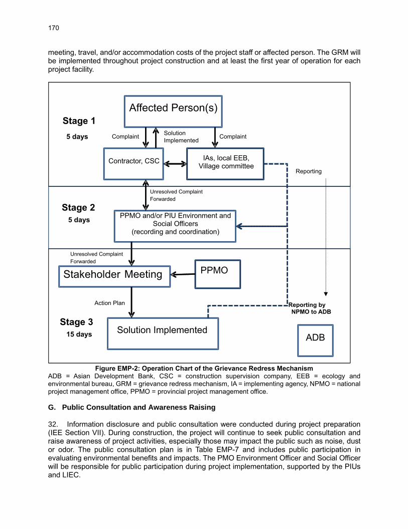
170
meeting, travel, and/or accommodation costs of the project staff or affected person. The GRM will be implemented throughout project construction and at least the first year of operation for each project facility.
Figure EMP-2: Operation Chart of the Grievance Redress Mechanism
ADB = Asian Development Bank, CSC = construction supervision company, EEB = ecology and environmental bureau, GRM = grievance redress mechanism, IA = implementing agency, NPMO = national project management office, PPMO = provincial project management office.
G. Public Consultation and Awareness Raising 32. Information disclosure and public consultation were conducted during project preparation (IEE Section VII). During construction, the project will continue to seek public consultation and raise awareness of project activities, especially those may impact the public such as noise, dust or odor. The public consultation plan is in Table EMP-7 and includes public participation in evaluating environmental benefits and impacts. The PMO Environment Officer and Social Officer will be responsible for public participation during project implementation, supported by the PIUs and LIEC.
Affected Person(s)
Contractor, CSC
PPMO and/or PIU Environment and Social Officers
(recording and coordination)
Stakeholder Meeting
Solution Implemented ADB
Complaint
Unresolved Complaint Forwarded
Solution Implemented
Action Plan
Stage 1
5 days
Stage 3
15 days
Reporting
PPMO
IAs, local EEB, Village committee
Complaint
Stage 2
5 days
Unresolved Complaint Forwarded
Reporting by NPMO to ADB

171
Table EMP-7: Public Consultation and Participation Plan
Organizer Approach Times/Frequency Subjects Participants
Construction
PMO, PIUs, LIEC
Questionnaire survey, site visits, informal interviews
Once a year during peak construction
Construction impacts; adjusting mitigation measures if necessary; feedback
Workers, residents in construction areas
Site-specific basis At least one month before the start of construction at any new site
Anticipated risks – noise, odor, other; Procedures in the event of interruptions to water and wastewater services
Public workshops and hearing
At least once during peak construction period
EMP implementation progress; construction impacts; adjusting mitigation measures if necessary; feedback
Residents, affected persons, social sectors
Operation
PMO, implementing agencies, OPF
Consultation and site visits
At least once in first year of operation
Effects of mitigation measures, impacts of operation, feedback
Affected persons and/or agencies
Public workshop As needed based on consultations
As above As above
Public survey At least once after 1 year of operation
Comments and suggestions
Project beneficiaries
EIA = environmental impact assessment, OPF = operator of project facilities, PIU = project implementation unit, PMO = project management office, LIEC = loan implementation environmental consultant.
H. Cost Estimates 33. This section provides an estimate of the cost of EMP implementation. The cost comprises expenses for three categories: the mitigation measures described in Tables EMP-2 and EMP-3; monitoring (Table EMP-5); and training (Table EMP-6). Costs are presented for the construction phase of five years and the first year of operation i.e. a total of six years. The costs do not include: (i) detailed design revisions and adjustments; (ii) internal monitoring and inspection of solid wastes disposal, soil erosion and re-vegetation, occupational health and safety during construction, as this will be included in the design, construction and construction supervision contracts; and (iii) salaries of PMO and PIU staff. Costs for mitigation measures and training are based on estimates in the DEIA and/or the experience of the TA consultants from other similar projects. All costs were discussed with the DEIA Institute, PMOs and IAs. 34. The total estimated cost for EMP implementation (Table EMP-8) only represents about xx% of the total project investment. Construction-phase costs will be paid by the contractors (as part of their contracts). Operational-phase costs will be paid by each project implementing agency (IA).
Table EMP-8: Estimated Cost for EMP Implementation for Five Years Construction and First Year
Operation (xCNY10,000)
Item Gansu Qinghai Shaanxi Total
Pre-construction phase (Table EMP-2)
1.1 Public consultation (Paid by IAs) 2 2.5 11.5 16 1.2 Environmental management expert (project start-up) (paid by PPMOs)
10 10 10 30
1.3 LIEC (paid by PPMOs) 65 45 90 200

172
Item Gansu Qinghai Shaanxi Total
Subtotal 77 57.5 111.5 246 Construction phase (Table EMP-2) – Paid by Contractors
2.1 Soil erosion and contamination 310 5 100 415 2.2 Dust and air pollution control 50 20 200 270 2.3 Noise and vibration 15 10 60 85 2.4 Surface water pollution 5 3 20 28 2.5 Solid waste 10 5 40 55 2.6 Protection of flora and fauna 20 20 80 120 2.7 Community health & safety 10 5 40 55 2.8 Occupational health & safety 10 5 40 55 Subtotal 430 73 580 1083 Operational phase (Table EMP-3) – paid by IAs
3.1 Use of agri-chemicals 17 14 11 42 3.2 Water balance studies 15 15 15 45 3.3 water quality of the wetlands 20 0 10 30 3.5 Operation and maintenance of the eco-tourism facilities
15 7.5 30 52.5
Subtotal 67 36.5 66 169.5 4. Monitoring during construction – paid by IAs
4.1 Surface water quality 20 20 60 100 4.2 Construction wastewater including water quality downstream of reservoir
10 10 43 63
4.3 Ambient air 10 6 30 46 4.4 Noise 5 3 15 23 4.5 Ecology 30 30 50 110 Subtotal 75 69 198 342 5. Monitoring during operation – paid by IAs
5.1 Ecology 5 4 10 19 5.2 Waste water service centers 5 2 6 13 5.3 Hydrology monitoring 5 5 15 25 5.4 Soil erosion 10 6 10 26 Subtotal 25 17 41 83 6. Training
6.1 Procurement and contract management - emphasize EMP implementation
10 10 10 30
6.2 EMP implementation 10 10 10 30 6.3 GRM 10 10 10 30 6.4 Climate change resilience 10 10 10 30 6.5 COVID-19 prevention 10 10 10 30 6.6 Emergency preparedness and response planning
10 10 10 30
Subtotal 60 60 60 180 Grand total (xCNY10,000) 734 313 1056.5 2103.5
CNY = Chinese Yuan, EMP = environmental management plan, GRM = grievance redress mechanism, IA = implementing agency, LIEC = loan implementation environment consultant, PPMO = provincial project management office.
I. Project Assurances for Environmental Safeguards
35. The EMP is part of the official loan and project agreement between the Government and ADB, to ensure that implementation of the EMP is complied with. The loan and project agreements also
173
include the following project-specific assurances. These are highlighted here so that all project agencies and contractors are aware of them and ensure they are complied with. Refer to the loan and project agreements for the final wording of the assurances.
(i) The Project Executing Agency will, and will cause the Project Implementing Agencies to, ensure that the preparation, design, construction, implementation, operation and decommissioning of the Project and all Project facilities comply with (a) all applicable laws and regulations of the Borrower relating to environment, health and safety; (b) the Environmental Safeguards; and (c) all measures and requirements set forth in the IEE, the EMP, and any corrective or preventative actions (i) set forth in a Safeguards Monitoring Report, or (ii) which are subsequently agreed between ADB and the Project Executing Agency.
(ii) The Project Executing Agency will, and will cause the Project Implementing Agencies to, ensure that no works will be carried out in (i) the Strict Protection Zone of any protected areas; or (ii) any critical habitats.
(iii) The Project Executing Agency will, and will cause the Project Implementing Agencies to, ensure that (i) all Project facilities which will be located in forest and/or wetland parks and reserves will (a) comply with the laws and regulations of the Borrower; (b) be consistent with the approved site management plans for each site; and (ii) all works, especially those involving forest and/or wetland parks and reserves, will be carried out within the agreed specific site locations in accordance with the scope of work set out in the Borrower’s feasibility study report and the IEE. The Project Executing Agency will, and will cause the Project Implementing Agencies to, further ensure that any proposed changes in the site locations or the scope of work will be subject to review and approval of ADB and the Borrower.
(iv) The Project Executing Agency will, and will cause the Project Implementing Agencies and Project Implementation Units to, ensure that sustainable forest and wetland management plans will be updated and implemented for forest and wetlands covered under the Project.
(v) The Project Executing Agency will, and will cause the Project Implementing Agencies to ensure that for the project afforestation sites, the volume of water used for operations of the Project facilities will be monitored against the relevant water entitlements and the results will be included in the Safeguard Monitoring Reports in accordance with the water monitoring program stipulated in the EMP.
(vi) The Project Executing Agency will, and will cause the Project Implementing Agencies to, ensure that no chemicals, including omethoate and methamidophos are used in the implementation of the Project which are listed as hazardous under Classes I or II by the World Health Organization or the use of which is strictly controlled or prohibited under the laws and regulations of the Borrower.
(vii) The Project Executing Agency will, and will cause the Project Implementing Agencies and the Project Implementation Units to (a) monitor the volume of pesticides used during, at least, the first 2 years of operations of each completed project afforestation site, and (b) achieve, at least, a 10% reduction in the volume of chemical pesticides applied per hectare, as compared to the existing baseline application rate in the same or adjoining forestry plantations.
(viii) The Project Executing Agency will, and will cause the Project Implementing Agencies and

174
the Project Implementation Units to ensure that to avoid pollution of soil and water, no top-dressing fertilizers will be used for any re-vegetation, planting or landscaping activities under the Project.
(ix) The Project Executing Agency will, and will cause the Project Implementing Agencies and the Project Implementation Units to, ensure that the dredging activities under the Project are only carried out from October to April (the dry season) each year during the implementation of the Project.
(x) The Project Executing Agency will, and will cause the Project Implementing Agencies and the Project Implementation Units to, ensure that all planting activities under the Project, including afforestation, re-vegetation, embankment construction, wetlands, landscaping and rehabilitation of construction sites will only use plant species which are (a) native to each specific project site, and (b) sourced from local stock within the project district or county where the works are carried out. In the event that non-native seedlings are required for rapid stabilization of exposed soils and sites, the Project Executing Agency will, and will cause the Project Implementing Agencies and the Project Implementation Units to ensure that only sterile seedlings are used to prevent the spread of weeds.
(xi) The Project Executing Agency will, and will cause the Project Implementing Agencies and the Project Implementation Units to ensure that no asbestos-containing materials are used during the implementation of the Project. The Project Executing Agency will, and will cause the Project Implementing Agencies and the Project Implementation Units to ensure that this requirement is included in all bidding documents and contracts for works.
J. Mechanisms for Feedback and Adjustment 36. Based on environmental inspection and monitoring reports, the PMO and PIUs shall decide, in consultation with the LIEC, whether (i) further mitigation measures are required as corrective actions, or (ii) some improvements are required for environmental management practices. The effectiveness of mitigation measures and monitoring plans will be evaluated by a feedback reporting system. Adjustment to the EMP will be made, if necessary. The PMO Environmental Officer and the LIEC will play critical roles in the feedback and adjustment mechanism. 37. If during inspection and monitoring, substantial deviation from the EMP is observed or any changes are made to the project that may cause substantial adverse environmental impacts or increase the number of affected people, then the NPMO and PPMOs will immediately consult with ADB and form an environmental assessment team to conduct additional environmental assessment. If necessary, further public consultation will be undertaken. The revised DEIAs and project IEE, including this EMP, will be submitted to the ADB for review, appraisal, and public disclosure. The revised EMP will be passed to the contractors, CSCs and OPFs for implementation.

175
APPENDIX 2: HEALTH & SAFETY PLAN FOR EMERGING DIESEASE OUTBREAKS Item Good Practices Who
implements Who
supervises
Awareness materials
• Preparation of awareness materials on emerging disease outbreaks such as COVID-19 e.g., signs, posters
• Installation of awareness signs at work sites, for visibility to workers and the general public
Contractor CSC, PIU, PMO, LIEC
Detection Measures
• Control and document the entry/exit to the work site for both workers and other parties.
• Prevent sick workers from entering the site through checking temperatures of workers and other people entering the site. Require self-reporting prior to entering the site.
• All workers to self-monitor their health, possibly with the use of questionnaires, and take their body temperature regularly.
• Thermal screening at the workplace to be considered only in the context of a combination of measures for prevention and control of COVID-19 at the workplace and along with risk communication.
Contractor CSC, PIU, PMO, LIEC
Physical Distancing measures
• Keep a distance of at least 1 meter between workers and minimize physical contact, ensure strict control over external access, and queue management (marking on the floor, barriers).
• Reduce density of people in the building (no more than 1 person per every 10 square metres), physical spacing at least 1 meter apart for work stations and common spaces, such as entrances/exits, lifts, pantries/canteens, stairs, where congregation or queuing of employees or visitors/clients might occur.
• Avoid crowding by staggering working hours to reduce the congregation of employees at common spaces such as entrances or exits.
• Implement or enhance shift or split-team arrangements, or teleworking.
• Minimise the movement of local workers in and out of the site (e.g., avoid workers returning home to affected areas, or returning to site form affected areas).
• Minimise the workers’ contact with local community.
Contractor CSC, PIU, PMO, LIEC
Respiratory measures
• All workers should wear a face mask.
• Provide adequate ventilation in indoor spaces
• If a worker is sick, they should not come to work if a member of staff or a worker feels unwell while at work, provide a medical mask so that they may get home safely.
• Where masks are used, whether in line with government policy or by personal choice, it is very important to ensure safe and proper use, care and disposal
Contractor CSC, PIU, PMO, LIEC
Hand Hygiene measures:
• Regular and thorough handwashing with soap and water or hand hygiene with alcohol-based hand-rub (a) before starting work, before eating (if possible, workers should eat outdoors, in a well-ventilated indoor space, or at different times), frequently during the work shift, especially after contact with co-workers or customers, (b) after going to the bathroom, after contact with secretions, excretions and body fluids, after contact with potentially contaminated objects (gloves, clothing, masks, used tissues, waste), and immediately after removing gloves and other protective equipment but before touching eyes, nose, or mouth.
• Hand hygiene stations, such as hand washing and hand rub dispensers, should be put in prominent
Contractor CSC, PIU, PMO, LIEC

176
Item Good Practices Who implements
Who supervises
places around the workplace and be made accessible to all staff, contractors, clients or customers, and visitors along with communication materials to promote hand hygiene
Cleaning and Disinfection
• Cleaning and Disinfection off all site facilities, including offices, accommodation, canteens and common spaces:
• Cleaning (soap, water, and mechanical action) to remove dirt, debris, and other materials from surfaces. Disinfection of dirty surfaces and objects only after cleaning.
• Most common disinfectants – sodium hypochlorite (bleach) of surface at concentration 0.1% or alcohol at least 70% concentration for surfaces which can be damaged by sodium hypochlorite.
• Priority disinfection of high-touch surfaces - commonly used areas, door and window handles, light switches, kitchen and food preparation areas, bathroom surfaces, toilets and taps, touchscreen personal devices, personal computer keyboards, and work surfaces.
• Disinfectant solutions must always be prepared and used according to the manufacturer’s instructions, including instructions to protect the safety and health of disinfection workers, use of personal protective equipment, and avoiding mixing different chemical disinfectants.
• Provide appropriate PPEs to the cleaners.
• Manage the waste as the medical waste, and dispose of it in accordance with local regulations.
Contractor CSC, PIU, PMO, LIEC
Response measures if workers found with COVID-19 symptoms
• Workers who are unwell or who develop symptoms consistent with COVID-19 to stay at home, self-isolate, and contact a medical professional or the local COVID-19 information line for advice on testing and referral (consider telemedicine and flexible sick leave policy).
• Standard operating procedures to be prepared to manage a person who becomes sick at the workplace and is suspected of having COVID-19, including isolation, contact tracing and disinfection.
• People who were in close contact at the workplace with persons with laboratory-confirmed COVID-19 should be quarantined for 14 days from the last time of the contact in accordance with WHO recommendations.
• Set out differentiated procedures for the treatment of sick persons, based on the case severity. Pay workers throughout periods of illness, isolation or quarantine.
• Set aside a part of worker accommodation for precautionary self-quarantine.
• Establish communications with local medical services and refer sick workers to there.
Contractor CSC, PIU, PMO, LIEC
Adjusting Work Practices and Manage Work Related Travels
• Consider changes to work processes and timings to minimize contact between workers (e.g., decreasing the size of work team, changing to a 24-hour work rotation).
• Cancel or postpone non-essential travel to areas with community transmission of COVID-19.
• Provide hand sanitizer to workers who must travel, advise workers to comply with instructions from local authorities where they are travelling, as well as information on whom to contact if they feel ill while travelling.
• Workers returning from an area where COVID-19 transmission is occurring should monitor themselves for symptoms for 14 days and take their temperature twice a day; if they are feeling unwell, they should stay at home, self-isolate, and contact a medical professional.
Contractor CSC, PIU, PMO, LIEC
Communication • Carefully manage the relations with the community with clear and regular communication. Contractor CSC, PIU,

177
Item Good Practices Who implements
Who supervises
and Contact With the Community
• Made aware of the procedures put in place at the site to address issues related to COVID-19.
• Practice social distancing with the local community.
PMO, LIEC
Risk communication, training, and education
• Provide posters, videos, and electronic message boards to increase awareness of COVID-19 among workers and promote safe individual practices at the workplace, engage workers in providing feedback on the preventive measures and their effectiveness.
• Provide regular information about the risk of COVID-19 using official sources, such as government agencies and WHO, and emphasize the effectiveness of adopting protective measures and counteracting rumors and misinformation.
• Special attention should be given to reaching out to and engaging vulnerable and marginalized groups of workers, such as those in the informal economy and migrant workers, domestic workers, subcontracted and self-employed workers, and those working under digital labour platforms.
• Train the workers on procedures in place by the project, and their own responsibilities in implementing them.
Contractor CSC, PIU, PMO, LIEC
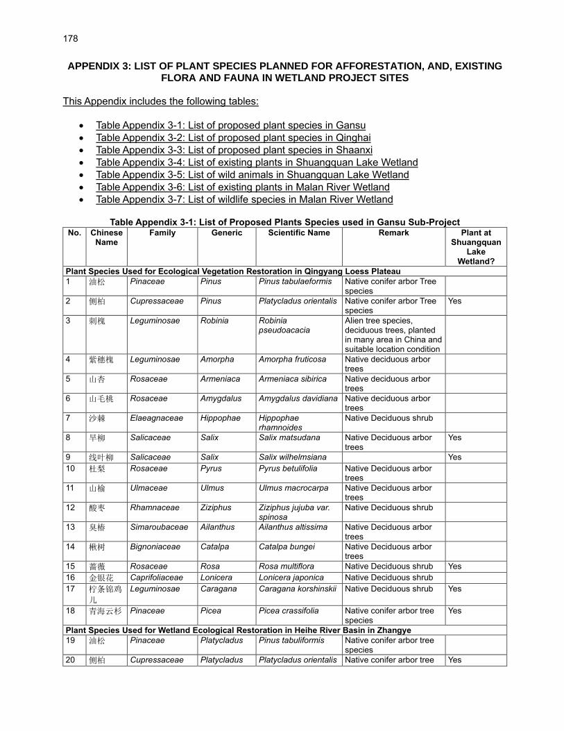
178
APPENDIX 3: LIST OF PLANT SPECIES PLANNED FOR AFFORESTATION, AND, EXISTING FLORA AND FAUNA IN WETLAND PROJECT SITES
This Appendix includes the following tables:
• Table Appendix 3-1: List of proposed plant species in Gansu
• Table Appendix 3-2: List of proposed plant species in Qinghai
• Table Appendix 3-3: List of proposed plant species in Shaanxi
• Table Appendix 3-4: List of existing plants in Shuangquan Lake Wetland
• Table Appendix 3-5: List of wild animals in Shuangquan Lake Wetland
• Table Appendix 3-6: List of existing plants in Malan River Wetland
• Table Appendix 3-7: List of wildlife species in Malan River Wetland
Table Appendix 3-1: List of Proposed Plants Species used in Gansu Sub-Project No. Chinese
Name Family Generic Scientific Name Remark Plant at
Shuangquan Lake
Wetland?
Plant Species Used for Ecological Vegetation Restoration in Qingyang Loess Plateau
1 油松 Pinaceae Pinus Pinus tabulaeformis Native conifer arbor Tree species
2 侧柏 Cupressaceae Pinus Platycladus orientalis Native conifer arbor Tree species
Yes
3 刺槐 Leguminosae Robinia Robinia pseudoacacia
Alien tree species, deciduous trees, planted in many area in China and suitable location condition
4 紫穗槐 Leguminosae Amorpha Amorpha fruticosa Native deciduous arbor trees
5 山杏 Rosaceae Armeniaca Armeniaca sibirica Native deciduous arbor trees
6 山毛桃 Rosaceae Amygdalus Amygdalus davidiana Native deciduous arbor trees
7 沙棘 Elaeagnaceae Hippophae Hippophae rhamnoides
Native Deciduous shrub
8 旱柳 Salicaceae Salix Salix matsudana Native Deciduous arbor trees
Yes
9 线叶柳 Salicaceae Salix Salix wilhelmsiana Yes
10 杜梨 Rosaceae Pyrus Pyrus betulifolia Native Deciduous arbor trees
11 山榆 Ulmaceae Ulmus Ulmus macrocarpa Native Deciduous arbor trees
12 酸枣 Rhamnaceae Ziziphus Ziziphus jujuba var. spinosa
Native Deciduous shrub
13 臭椿 Simaroubaceae Ailanthus Ailanthus altissima Native Deciduous arbor trees
14 楸树 Bignoniaceae Catalpa Catalpa bungei Native Deciduous arbor trees
15 蔷薇 Rosaceae Rosa Rosa multiflora Native Deciduous shrub Yes
16 金银花 Caprifoliaceae Lonicera Lonicera japonica Native Deciduous shrub
17 柠条锦鸡
儿
Leguminosae Caragana Caragana korshinskii Native Deciduous shrub Yes
18 青海云杉 Pinaceae Picea Picea crassifolia Native conifer arbor tree species
Yes
Plant Species Used for Wetland Ecological Restoration in Heihe River Basin in Zhangye
19 油松 Pinaceae Platycladus Pinus tabuliformis Native conifer arbor tree species
20 侧柏 Cupressaceae Platycladus Platycladus orientalis Native conifer arbor tree Yes
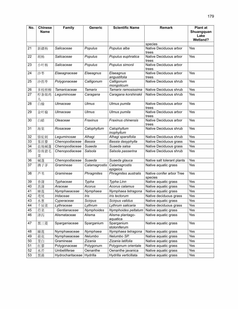
179
No. Chinese Name
Family Generic Scientific Name Remark Plant at Shuangquan
Lake Wetland?
species
21 新疆杨 Salicaceae Populus Populus alba Native Deciduous arbor trees
Yes
22 胡杨 Salicaceae Populus Populus euphratica Native Deciduous arbor trees
Yes
23 小叶杨 Salicaceae Populus Populus simonii Native Deciduous arbor trees
24 沙枣 Elaeagnaceae Elaeagnus Elaeagnus angustifolia
Native Deciduous arbor trees
Yes
25 沙拐枣 Polygonaceae Calligonum Calligonum mongolicum
Native Deciduous shrub Yes
26 多枝柽柳 Tamaricaceae Tamarix Tamarix ramosissima Native Deciduous shrub Yes
27 柠条锦鸡
儿
Leguminosae Caragana Caragana korshinskii Native Deciduous shrub Yes
28 白榆 Ulmaceae Ulmus Ulmus pumila Native Deciduous arbor trees
Yes
29 金叶榆 Ulmaceae Ulmus Ulmus pumila Native Deciduous arbor trees
Yes
30 白蜡 Oleaceae Fraxinus Fraxinus chinensis Native Deciduous arbor trees
Yes
31 海棠 Rosaceae Calophyllum Calophyllum inophyllum
Native Deciduous shrub Yes
32 骆驼刺 Leguminosae Alhagi Alhagi sparsifolia Native Deciduous shrub Yes
33 雾滨藜 Chenopodiaceae Bassia Bassia dasyphylla Native Deciduous grass Yes
34 盐地碱蓬 Chenopodiaceae Suaeda Suaeda salsa Native Deciduous grass Yes
35 珍珠猪毛
菜
Chenopodiaceae Salsola Salsola passerina Native Deciduous shrub Yes
36 碱蓬 Chenopodiaceae Suaeda Suaeda glauca Native salt tolerant plants Yes
37 拂子茅 Gramineae Calamagrostis Calamagrostis epigeios
Native aquatic grass Yes
38 芦苇 Gramineae Phragmites Phragmites australis Native conifer arbor Tree species
Yes
39 香蒲 Typhaceae Typha Typha Linn Native aquatic grass Yes
40 菖蒲 Araceae Acorus Acorus calamus Native aquatic grass Yes
41 睡莲 Nymphaeaceae Nymphaea Nymphaea tetragona Native aquatic grass Yes
42 鸢尾 Iridaceae Iris Iris tectorum Native deciduous grass Yes
43 水葱 Cyperaceae Scirpus Scirpus validus Native aquatic grass Yes
44 千屈菜 Lythraceae Lythrum Lythrum salicaria Native deciduous grass Yes
45 荇菜 Gentianaceae Nymphoides Nymphoides peltatum Native aquatic grass Yes
46 泽泻 Alismataceae Alisma Alisma plantago-aquatica
Native aquatic grass Yes
47 黑三菱 Sparganiaceae Sparganium Sparganium stoloniferum
Native aquatic grass Yes
48 睡莲 Nymphaeaceae Nymphaea Nymphaea tetragona Native aquatic grass Yes
49 荷花 Nymphaeaceae Nelumbo Nelumbo SP. Native aquatic grass Yes
50 茭白 Gramineae Zizania Zizania latifolia Native aquatic grass Yes
51 红蓼 Polygonaceae Polygonum Polygonum orientale Native aquatic grass Yes
52 水芹 Umbelliferae Oenanthe Oenanthe javanica Native aquatic grass Yes
53 黑澡 Hydrocharitaceae Hydrilla Hydrilla verticillata Native aquatic grass Yes
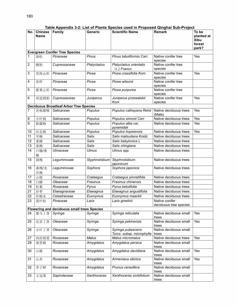
180
Table Appendix 3-2: List of Plants Species used in Proposed Qinghai Sub-Project No.
Chinese Name
Family Generic Scientific Name Remark To be planted at Xibu forest park?
Evergreen Conifer Tree Species
1 油松 Pinaceae Pinus Pinus tabuliformis Carr. Native conifer tree species
Yes
2 侧柏 Cupressaceae Platycladus Platycladus orientalis
(L.) Franco
Native conifer tree species
3 青海云杉 Pinaceae Picea Picea crassifolia Kom Native conifer tree species
Yes
4 青杄 Pinaceae Picea Picea wilsonii Native conifer tree species
5 紫果云杉 Pinaceae Picea Picea purpurea Native conifer tree species
6 祁连圆柏 Cupressaceae Juniperus Juniperus przewalskii Kom
Native conifer tree species
Yes
Deciduous Broadleaf Arbor Tree Species
7 青杨雄株 Salicaceae Populus Populus cathayana Rehd Native deciduous trees (Male)
Yes
8 小叶杨 Salicaceae Populus Populus simonii Carr Native deciduous trees Yes
9 新疆杨 Salicaceae Populus Populus alba var. pyramidali
Native deciduous trees Yes
10 河北杨 Salicaceae Populus Populus hopeiensis Native deciduous trees Yes
11 旱柳 Salicaceae Salix Salix matsudana Koidz Native deciduous trees
12 垂柳 Salicaceae Salix Salix babylonica L Native deciduous trees
13 秦柳 Salicaceae Salix Salix chingiana Native deciduous trees
14 白榆/垂
榆
Ulmaceae Ulmus Ulmus spp. Native deciduous trees
15 国槐 Leguminosae Styphnolobium Styphnolobium japonicum
Native deciduous trees
16 垂槐/龙
爪槐
Leguminosae Sophora Sophora japonica Native deciduous trees
17 山楂 Rosaceae Crataegus Crataegus pinnatifida Native deciduous trees
18 白蜡 Oleaceae Fraxinus Fraxinus chinensis Native deciduous trees
19 杜梨 Rosaceae Pyrus Pyrus betulifolia Native deciduous trees
21 沙枣 Elaeagnaceae Elaeagnus Elaeagnus angustifolia Native deciduous trees
22 丝棉木 Celastraceae Euonymus Euonymus maackii Native deciduous trees
23 落叶松 Pinaceae Larix Larix gmelinii Native conifer deciduous tree species
Flowering and deciduous small trees Species
24 暴马丁香 Syringa Syringa Syringa reticulata Native deciduous small trees
Yes
25 北京丁香 Oleaceae Syringa Syringa pekinensis Native deciduous small trees
Yes
26 小叶丁香 Oleaceae Syringa Syringa pubescens Turcz. subsp. microphylla
Native deciduous small trees
27 西府海棠 Rosaceae Malus Malus micromalus Native deciduous trees Yes
29 观赏桃 Rosaceae Amygdalus Amygdalus persica Native deciduous small trees
30 山桃 Rosaceae Amygdalus Amygdalus davidiana Native deciduous small trees
Yes
31 山杏 Rosaceae Amygdalus Armeniaca sibirica Native deciduous small trees
Yes
32 李子树 Rosaceae Amygdalus Prunus cerasifera Native deciduous small trees
33 文冠果 Sapindaceae Xanthoceras Xanthoceras sorbifolium Native deciduous small trees
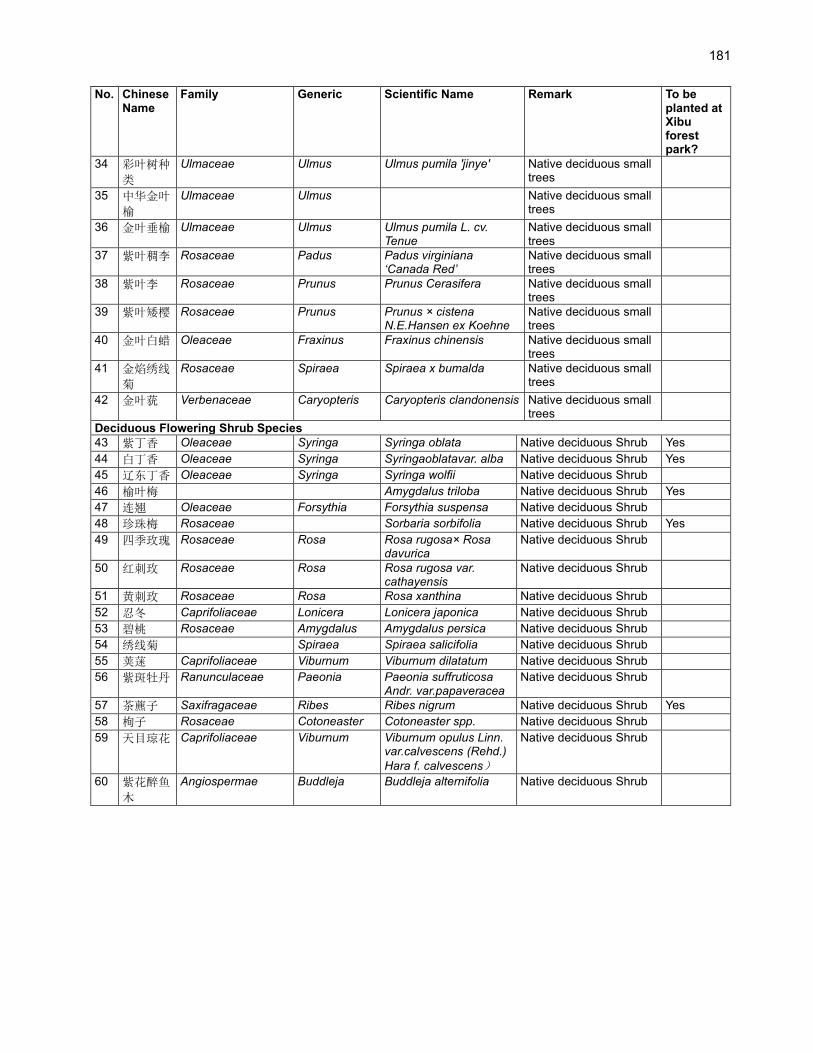
181
No.
Chinese Name
Family Generic Scientific Name Remark To be planted at Xibu forest park?
34 彩叶树种
类
Ulmaceae Ulmus Ulmus pumila 'jinye' Native deciduous small trees
35 中华金叶
榆
Ulmaceae Ulmus Native deciduous small trees
36 金叶垂榆 Ulmaceae Ulmus Ulmus pumila L. cv. Tenue
Native deciduous small trees
37 紫叶稠李 Rosaceae Padus Padus virginiana ‘Canada Red’
Native deciduous small trees
38 紫叶李 Rosaceae Prunus Prunus Cerasifera Native deciduous small trees
39 紫叶矮樱 Rosaceae Prunus Prunus × cistena N.E.Hansen ex Koehne
Native deciduous small trees
40 金叶白蜡 Oleaceae Fraxinus Fraxinus chinensis Native deciduous small trees
41 金焰绣线
菊
Rosaceae Spiraea Spiraea x bumalda Native deciduous small trees
42 金叶莸 Verbenaceae Caryopteris Caryopteris clandonensis Native deciduous small trees
Deciduous Flowering Shrub Species
43 紫丁香 Oleaceae Syringa Syringa oblata Native deciduous Shrub Yes
44 白丁香 Oleaceae Syringa Syringaoblatavar. alba Native deciduous Shrub Yes
45 辽东丁香 Oleaceae Syringa Syringa wolfii Native deciduous Shrub
46 榆叶梅 Amygdalus triloba Native deciduous Shrub Yes
47 连翘 Oleaceae Forsythia Forsythia suspensa Native deciduous Shrub
48 珍珠梅 Rosaceae Sorbaria sorbifolia Native deciduous Shrub Yes
49 四季玫瑰 Rosaceae Rosa Rosa rugosa× Rosa davurica
Native deciduous Shrub
50 红刺玫 Rosaceae Rosa Rosa rugosa var. cathayensis
Native deciduous Shrub
51 黄刺玫 Rosaceae Rosa Rosa xanthina Native deciduous Shrub
52 忍冬 Caprifoliaceae Lonicera Lonicera japonica Native deciduous Shrub
53 碧桃 Rosaceae Amygdalus Amygdalus persica Native deciduous Shrub
54 绣线菊 Spiraea Spiraea salicifolia Native deciduous Shrub
55 荚蒾 Caprifoliaceae Viburnum Viburnum dilatatum Native deciduous Shrub
56 紫斑牡丹 Ranunculaceae Paeonia Paeonia suffruticosa Andr. var.papaveracea
Native deciduous Shrub
57 茶藨子 Saxifragaceae Ribes Ribes nigrum Native deciduous Shrub Yes
58 栒子 Rosaceae Cotoneaster Cotoneaster spp. Native deciduous Shrub
59 天目琼花 Caprifoliaceae Viburnum Viburnum opulus Linn. var.calvescens (Rehd.)
Hara f. calvescens)
Native deciduous Shrub
60 紫花醉鱼
木
Angiospermae Buddleja Buddleja alternifolia Native deciduous Shrub

182
Table Appendix 3-3: List of Plants Species used in Proposed Shaanxi Sub-Project
No. Chinese
Name Family Generic Scientific Name Remark
Forest park or Scenic
spot*
A.Plant Species for Protection Forests
1 油松 Pinaceae Pinus Pinus tabuliformis Carr. Native conifer tree species
4
2 侧柏 Cupressaceae Platycladus Platycladus orientalis (L.)
Franco
Native conifer tree species
5
3 白皮松 Pinaceae Pinus Pinus bungeana Zucc Native conifer tree species
2、4
4 华山松 Pinaceae Pinus Pinus armandii Franch. Native conifer tree species
6
5 栓皮栎 Fagaceae Quercus Quercus variabilis Bl. Native deciduous trees 6
6 辽东栎 Fagaceae Quercus Quercus wutaishansea Mary
Native deciduous trees
7 石楠 Rosaceae Photinia Photinia serratifolia Native evergreen tree species
8 杜仲 Eucommiaceae
Eucommia Eucommia ulmoides Oliver Native deciduous trees
9 元宝枫 Aceraceae Acer Acer truncatum Bunge Native deciduous trees 2
10 五角枫 Aceraceae Acer Acer mono Maxim Native deciduous trees 2
11 枫杨 Juglandaceae Pterocarya Pterocarya stenoptera C Native deciduous trees 6
12 白蜡 Oleaceae Fraxinus Fraxinus chinensis Native deciduous trees
13 山桃 Rosaceae Amygdalus Amygdalus davidiana Native arbor tree species
B.Plant Species for Tree Crop
14 西府海棠 Rosaceae Malus Malus micromalus Native arbor tree species
15 桑树 Moraceae Morus Morus alba Native arbor tree species
16 文冠果 Sapindaceae Xanthoceras Xanthoceras sorbifolium Native arbor tree species
C.Plant Species for Ornament Forests
17 油松 Pinaceae Pinus Pinus tabuliformis Carr. Native conifer tree species
18 侧柏 Cupressaceae Platycladus Platycladus orientalis (L.)
Franco
Native conifer tree species
19 白皮松 Pinaceae Pinus Pinus bungeana Zucc Native conifer tree species
3
20 华山松 Pinaceae Pinus Pinus armandii Franch. Native conifer tree species
21 樟子松 Pinaceae Pinus Pinus sylvestris L. var. mongholica Litv.
Native evergreen conifer
23 刺柏 Cupressaceae Juniperus Juniperus formosana Hayata Native evergreen conifer
24 桧柏 Cupressacea Sabina Sabina chinensis (L.) Native evergreen conifer
25 臭柏 Cupressacea Sabina Sabina vulgaris Ant. Native, Conifer shrub
26 塔柏 Cupressacea Sabina Sabina chinensis cv. Pyramidalis
Native evergreen conifer
27 云杉 Pinaceae Picea Picea asperata Mast. Native evergreen conifer
28 红豆杉 Taxaceae Taxus Taxus chinensis (Pilger) Rehd
Native evergreen conifer 3
29 辽东栎 Fagaceae Quercus Quercus wutaishansea Mary
Native deciduous trees
30 石楠 Rosaceae Photinia Photinia serratifolia Native evergreen short arbor or shrub
31 桂花 Oleaceae Osmanthus Osmanthus fragrans (Thunb.) Lour.
Native deciduous trees 3
32 大叶女贞 Oleaceae Ligustrum Ligustrum compactum Native evergreen tree species
4
33 麻栎 Fagaceae Quercus Quercus acutissima Carruth Native deciduous trees
34 枇杷 Rosaceae Eriobotrya Eriobotrya japonica (Thunb.) Native evergreen tree species
4

183
No. Chinese
Name Family Generic Scientific Name Remark
Forest park or Scenic
spot*
35 红叶石楠 Rosaceae Photinia Photinia × fraseri Dress Native evergreen tree species
4
36 七叶树 Hippocastanaceae
Aesculus Aesculus chinensis Bunge Native deciduous trees 3
37 小叶杨 Salicaceae Populus Populus simonii Native deciduous trees
38 河北杨 Salicaceae Populus Populus hopeiensis Native deciduous trees
39 垂柳 Salicaceae Salix Salix babylonica L. Native deciduous trees
40 中华柳 Salicaceae Salix Salix cathayana Diels Native deciduous trees 1
41 核桃 Juglandaceae Juglans Juglans regia L. Native deciduous trees
42 红叶椿 Simaroubaceae
Ailanthus Ailanthus altissima 'Hongye' Native deciduous trees
43 五角枫 Aceraceae Acer Acer mono Maxim Native deciduous trees 4
44 海棠 Rosaceae Malu Malus spectabilis Native deciduous trees 4
45 柿子 Ebenaceae Diospyros Diospyros kaki Native deciduous trees
46 银杏 Ginkgoaceae Ginkgo Ginkgo biloba L. Native deciduous trees 3
47 楸树 Bignoniaceae Catalpa Catalpa bungei C. A. Mey Native deciduous trees
48 栾树 Sapindaceae Koelreuteria Koelreuteria paniculata Native deciduous trees 4
49 国槐 Leguminosae Styphnolobium Styphnolobium japonicum Native deciduous trees
51 杜仲 Eucommiaceae
Eucommia Eucommia ulmoides Oliver Native deciduous trees
51 枣树 Rhamnaceae Ziziphus Ziziphus jujuba Mill. Native deciduous trees
52 金叶复叶
槭 Aceraceae Acer Acer negundo ‘Aurea’ Native deciduous arbor.
53 枫杨 Juglandaceae Pterocarya Pterocarya stenoptera C Native deciduous arbor.
54 山桃 Rosaceae Amygdalus Amygdalus davidiana Native deciduous arbor.
55 山杏 Rosaceae Armeniaca Armeniaca sibirica (L.) Native deciduous arbor.
56 白桦 Betuleae Betula Betula platyphylla Suk. Native deciduous arbor.
57 桑树 Moraceae Morus Morus alba L. Native deciduous arbor.
58 梅花 Rosaceae Armeniaca Armeniaca mume Sieb. Native deciduous small arbor.
4
59 碧桃 Rosaceae Amygdalus Amygdalus persica L. var. persica f. duplex Rehd
Native deciduous small arbor.
60 石榴 Punicaceae Punica Punica granatum Native deciduous small arbor.
61 金叶榆 Ulmaceae Ulmus Ulmus pumila Native deciduous small arbor.
62 紫玉兰 Magnoliaceae Magnolia Magnolia liliflora Desr. Native deciduous small arbor.
63 黄杨 Buxaceae Buxus Buxus sinica Native deciduous small arbor or shrub.
64 胡枝子 Leguminosae Lespedeza LespedezabicolorTurcz Native deciduous small shrub.
1/5
65 紫薇 Lythraceae Lagerstroemia Lagerstroemia indica L. Native deciduous shrub. 4
66 丁香 Myrtaceae Syzygium Syzygium aromaticum (L.) Native deciduous shrub. 4
67 连翘 Oleaceae Forsythia Forsythia suspensa Native deciduous shrub. 4、5
68 海桐 Pittosporaceae Pittosporum Pittosporum tobira Native deciduous small arbor or shrub.
69 日本丽桃 Rosaceae Amygdalus Amygdalus persica Linn. var. persica f. pyramidalis Dipp
Native deciduous small arbor or shrub
70 南天竹 Berberidaceae Nandina Nandina domestica Native deciduous small arbor or shrub
71 黄栌 Anacardiaceae Cotinus Cotinus coggygria Scop Native deciduous small arbor
72 红叶小檗 Berberidaceae Berberis Berberis thunbergii var. atropurpurea
Native deciduous shrub
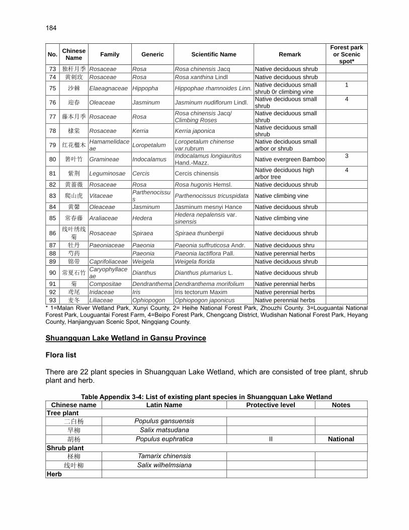
184
No. Chinese
Name Family Generic Scientific Name Remark
Forest park or Scenic
spot*
73 独杆月季 Rosaceae Rosa Rosa chinensis Jacq Native deciduous shrub
74 黄刺玫 Rosaceae Rosa Rosa xanthina Lindl Native deciduous shrub
75 沙棘 Elaeagnaceae Hippopha Hippophae rhamnoides Linn. Native deciduous small shrub 0r climbing vine
1
76 迎春 Oleaceae Jasminum Jasminum nudiflorum Lindl. Native deciduous small shrub
4
77 藤本月季 Rosaceae Rosa Rosa chinensis Jacq/ Climbing Roses
Native deciduous small shrub
78 棣棠 Rosaceae Kerria Kerria japonica Native deciduous small shrub
79 红花檵木 Hamamelidaceae
Loropetalum Loropetalum chinense var.rubrum
Native deciduous small arbor or shrub
80 箬叶竹 Gramineae Indocalamus Indocalamus longiauritus Hand.-Mazz.
Native evergreen Bamboo 3
81 紫荆 Leguminosae Cercis Cercis chinensis Native deciduous high arbor tree
4
82 黄蔷薇 Rosaceae Rosa Rosa hugonis Hemsl. Native deciduous shrub
83 爬山虎 Vitaceae Parthenocissus
Parthenocissus tricuspidata Native climbing vine
84 黄馨 Oleaceae Jasminum Jasminum mesnyi Hance Native deciduous shrub
85 常春藤 Araliaceae Hedera Hedera nepalensis var. sinensis
Native climbing vine
86 线叶绣线
菊 Rosaceae Spiraea Spiraea thunbergii Native deciduous shrub
87 牡丹 Paeoniaceae Paeonia Paeonia suffruticosa Andr. Native deciduous shru
88 芍药 Paeonia Paeonia lactiflora Pall. Native perennial herbs
89 锦带 Caprifoliaceae Weigela Weigela florida Native deciduous shrub
90 常夏石竹 Caryophyllaceae
Dianthus Dianthus plumarius L. Native deciduous shrub
91 菊 Compositae Dendranthema Dendranthema morifolium Native perennial herbs
92 鸢尾 Iridaceae Iris Iris tectorum Maxim Native perennial herbs
93 麦冬 Liliaceae Ophiopogon Ophiopogon japonicus Native perennial herbs
* 1=Malan River Wetland Park, Xunyi County, 2= Heihe National Forest Park, Zhouzhi County. 3=Louguantai National Forest Park, Louguantai Forest Farm, 4=Beipo Forest Park, Chengcang District, Wudishan National Forest Park, Heyang County, Hanjiangyuan Scenic Spot, Ningqiang County.
Shuangquan Lake Wetland in Gansu Province Flora list There are 22 plant species in Shuangquan Lake Wetland, which are consisted of tree plant, shrub plant and herb.
Table Appendix 3-4: List of existing plant species in Shuangquan Lake Wetland
Chinese name Latin Name Protective level Notes
Tree plant
二白杨 Populus gansuensis
旱柳 Salix matsudana
胡杨 Populus euphratica II National
Shrub plant
柽柳 Tamarix chinensis
线叶柳 Salix wilhelmsiana
Herb

185
冰草 Agropyron cristatum
芦苇 Phragmites australias
中间型荸荠 Heleocharis intersita
圆叶碱毛茛 Halerpestes cymbalaria
长叶碱毛茛 Halerpestes ruthenica
鹅绒委陵菜 Potentilla anserina
旋复花 Inula japonica
艾蒿 Artemisia argyi
棒头草 Polypogon fugax
甘草 Glycyrrhiza uralensis
蒙古鸦葱 Scorzonera mongolica
披针叶黄华 Thermopsis lanceolata
小花棘豆 Achnatherum inebrians
苦荬菜 Ixeris denticulata
平车前 Plantago depressa
香蒲 Typha orientalis
砂引草 Tournefortia sibirica
水葱 Scirpus validus
水莎草 Juncellus serotinus
蒲公英 Taraxacum mongolicum
刺儿菜 Cirsium setosum
节节草 Equisetum hyemale
芨芨草 Achnatherum splendens
苦豆子 Sophora alopecuroides
Source: Feasibility Study Report Design Institute, March 2021.
Fauna
1. There are 99 wild animals in Shuangquan Lake Wetland, which are consisted of birds, fish, amphibians and reptiles.
Table Appendix 3-5: List of Wild Animals in Shuangquan Lake Wetland
Chinese name Latin Name Protective level Notes
Birds
白鹡鸰 Motacilla alba LC IUCN
树麻雀 Passer montanus LC IUCN
灰椋鸟 Sturnus cineraceus LC IUCN
家燕 Hirundo rustica LC IUCN
芦苇莺 Acrocephalus scirpaceus LC IUCN
欧金翅雀 Chloris chloris LC IUCN
黑顶麻雀 Passer ammodendri LC IUCN
楔尾伯劳 Lanius sphenocercus LC IUCN
灰喜鹊 Cyanopica cyanus / /
喜鹊 Pica pica LC IUCN
白腹鸫 Turdus pallidus LC IUCN
新疆歌鸲 Luscinia megarhynchos LC II
IUCN National
赤颈鸫 Turdus ruficollis LC IUCN
白眉鸫 Eyebrowed Thrush LC IUCN
棕尾伯劳 Lanius isabellinus / /

186
Chinese name Latin Name Protective level Notes
黑翅长脚鹬 Himantopus himantopus LC IUCN
金眶鸻 Charadrius dubius LC IUCN
白腰草鹬 Tringa ochropus LC IUCN
鹤鹬 Tringa erythropus LC IUCN
凤头麦鸡 Vanellus vanellus NT IUCN
灰头麦鸡 Microsarcops cinreus LC IUCN
红脚鹬 Tringa totanus LC IUCN
反嘴鹬 Recurvirostra avosetta LC IUCN
矶鹬 Actitis hypoleucos LC IUCN
金鸻 Pluvialis fulva LC IUCN
流苏鹬 Philomachus pugnax LC IUCN
青脚滨鹬 Calidris temminckii LC IUCN
青脚鹬 Tringa nebularia II National
扇尾沙锥 Gallinago gallinago LC IUCN
长嘴剑鸻 Charadrius placidus LC IUCN
赤麻鸭 Tadorna ferruginea LC IUCN
绿头鸭 Anas platyrhynchos LC IUCN
灰雁 Anser anser LC IUCN
针尾鸭 Anas acuta LC IUCN
赤膀鸭 Anas strepera LC IUCN
斑嘴鸭 Anas poecilorhyncha LC IUCN
鹊鸭 Bucephala clangula LC IUCN
红头潜鸭 Aythya ferina VU IUCN
赤嘴潜鸭 Netta rufina LC IUCN
凤头潜鸭 Aythya fuligula LC IUCN
普通秋沙鸭 Mergus merganser LC IUCN
白眼潜鸭 Aythya nyroca NT IUCN
赤颈鸭 Anas penelope LC IUCN
大天鹅 Cygnus cygnus LC IUCN
普通鵟 Buteo buteo LC IUCN
白尾海雕 Haliaeetus albicilla I National
鹗 Pandion haliaetus LC IUCN
黄爪隼 Falco naumanni LC IUCN
棕尾鵟棕尾鵟 Buteo rufinus LC IUCN
鱼鸥 Larus ichthyaetus / /
红嘴鸥 Larus ridibundus LC IUCN
普通燕鸥 Sterna hirundo LC IUCN
黑鹳 Ciconia nigra I National
大白鹭 Ardea alba LC IUCN
苍鹭 Ardea cinerea LC IUCN
白鹭 Egretta garzetta LC IUCN
小䴙䴘 Tachybaptus ruficollis Y NFGA
凤头䴙䴘 Podiceps cristatus / /
绿背鸬鹚 Phalacrocorax capillatus LC IUCN
普通鸬鹚 Phalacrocorax carbo LC IUCN
夜鹭 Nycticorax nycticorax LC IUCN
白琵鹭 Platalea leucorodia II National
戴胜 Upupa epops LC IUCN
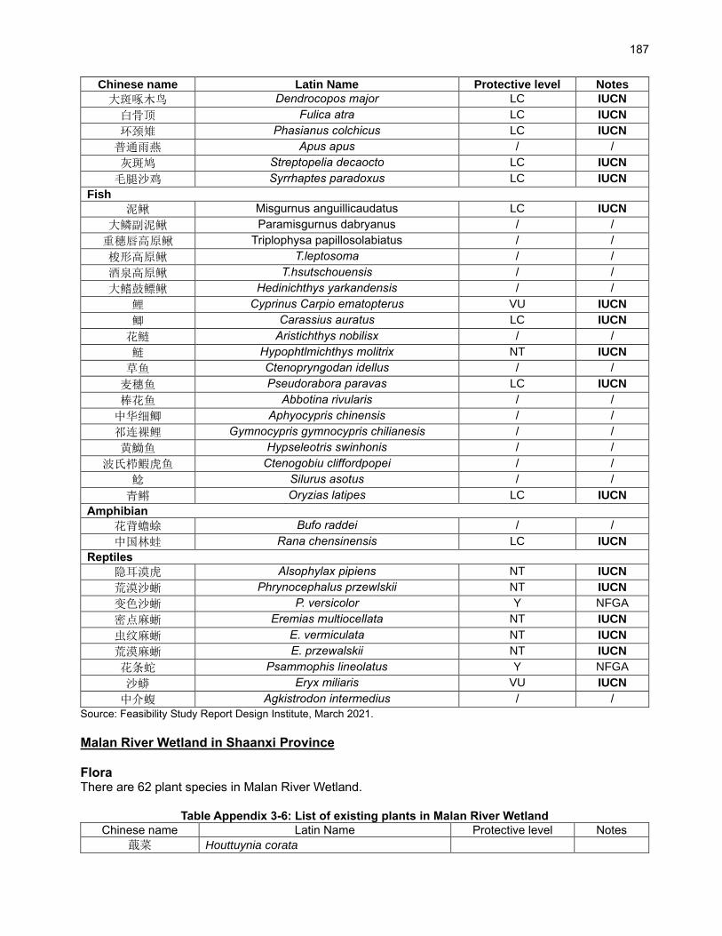
187
Chinese name Latin Name Protective level Notes
大斑啄木鸟 Dendrocopos major LC IUCN
白骨顶 Fulica atra LC IUCN
环颈雉 Phasianus colchicus LC IUCN
普通雨燕 Apus apus / /
灰斑鸠 Streptopelia decaocto LC IUCN
毛腿沙鸡 Syrrhaptes paradoxus LC IUCN
Fish
泥鳅 Misgurnus anguillicaudatus LC IUCN
大鳞副泥鳅 Paramisgurnus dabryanus / /
重穗唇高原鳅 Triplophysa papillosolabiatus / /
梭形高原鳅 T.leptosoma / /
酒泉高原鳅 T.hsutschouensis / /
大鳍鼓鳔鳅 Hedinichthys yarkandensis / /
鲤 Cyprinus Carpio ematopterus VU IUCN
鲫 Carassius auratus LC IUCN
花鲢 Aristichthys nobilisx / /
鲢 Hypophtlmichthys molitrix NT IUCN
草鱼 Ctenopryngodan idellus / /
麦穗鱼 Pseudorabora paravas LC IUCN
棒花鱼 Abbotina rivularis / /
中华细鲫 Aphyocypris chinensis / /
祁连裸鲤 Gymnocypris gymnocypris chilianesis / /
黄䱂鱼 Hypseleotris swinhonis / /
波氏栉鰕虎鱼 Ctenogobiu cliffordpopei / /
鲶 Silurus asotus / /
青鳉 Oryzias latipes LC IUCN
Amphibian
花背蟾蜍 Bufo raddei / /
中国林蛙 Rana chensinensis LC IUCN
Reptiles
隐耳漠虎 Alsophylax pipiens NT IUCN
荒漠沙蜥 Phrynocephalus przewlskii NT IUCN
变色沙蜥 P. versicolor Y NFGA
密点麻蜥 Eremias multiocellata NT IUCN
虫纹麻蜥 E. vermiculata NT IUCN
荒漠麻蜥 E. przewalskii NT IUCN
花条蛇 Psammophis lineolatus Y NFGA
沙蟒 Eryx miliaris VU IUCN
中介蝮 Agkistrodon intermedius / /
Source: Feasibility Study Report Design Institute, March 2021.
Malan River Wetland in Shaanxi Province Flora There are 62 plant species in Malan River Wetland.
Table Appendix 3-6: List of existing plants in Malan River Wetland
Chinese name Latin Name Protective level Notes
蕺菜 Houttuynia corata
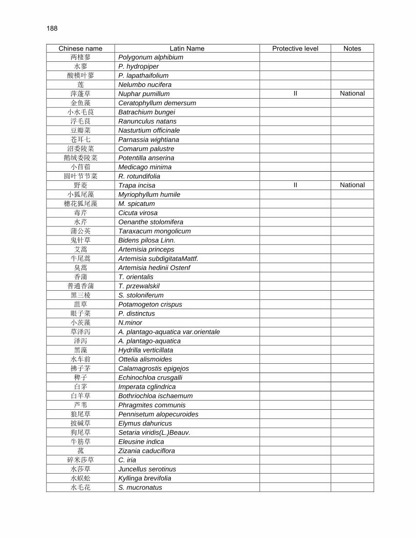
188
Chinese name Latin Name Protective level Notes
两棲蓼 Polygonum alphibium
水蓼 P. hydropiper
酸模叶蓼 P. lapathaifolium
莲 Nelumbo nucifera
萍蓬草 Nuphar pumillum II National
金鱼藻 Ceratophyllum demersum
小水毛茛 Batrachium bungei
浮毛茛 Ranunculus natans
豆瓣菜 Nasturtium officinale
苍耳七 Parnassia wightiana
沼委陵菜 Comarum palustre
鹅绒委陵菜 Potentilla anserina
小苜蓿 Medicago minima
圆叶节节菜 R. rotundifolia
野菱 Trapa incisa II National
小狐尾藻 Myriophyllum humile
穗花狐尾藻 M. spicatum
毒芹 Cicuta virosa
水芹 Oenanthe stolomifera
蒲公英 Taraxacum mongolicum
鬼针草 Bidens pilosa Linn.
艾蒿 Artemisia princeps
牛尾蒿 Artemisia subdigitataMattf.
臭蒿 Artemisia hedinii Ostenf
香蒲 T. orientalis
普通香蒲 T. przewalskil
黑三棱 S. stoloniferum
菹草 Potamogeton crispus
眼子菜 P. distinctus
小茨藻 N.minor
草泽泻 A. plantago-aquatica var.orientale
泽泻 A. plantago-aquatica
黑藻 Hydrilla verticillata
水车前 Ottelia alismoides
拂子茅 Calamagrostis epigejos
稗子 Echinochloa crusgalli
白茅 Imperata cglindrica
白羊草 Bothriochloa ischaemum
芦苇 Phragmites communis
狼尾草 Pennisetum alopecuroides
披碱草 Elymus dahuricus
狗尾草 Setaria viridis(L.)Beauv.
牛筋草 Eleusine indica
菰 Zizania caduciflora
碎米莎草 C. iria
水莎草 Juncellus serotinus
水蜈蚣 Kyllinga brevifolia
水毛花 S. mucronatus
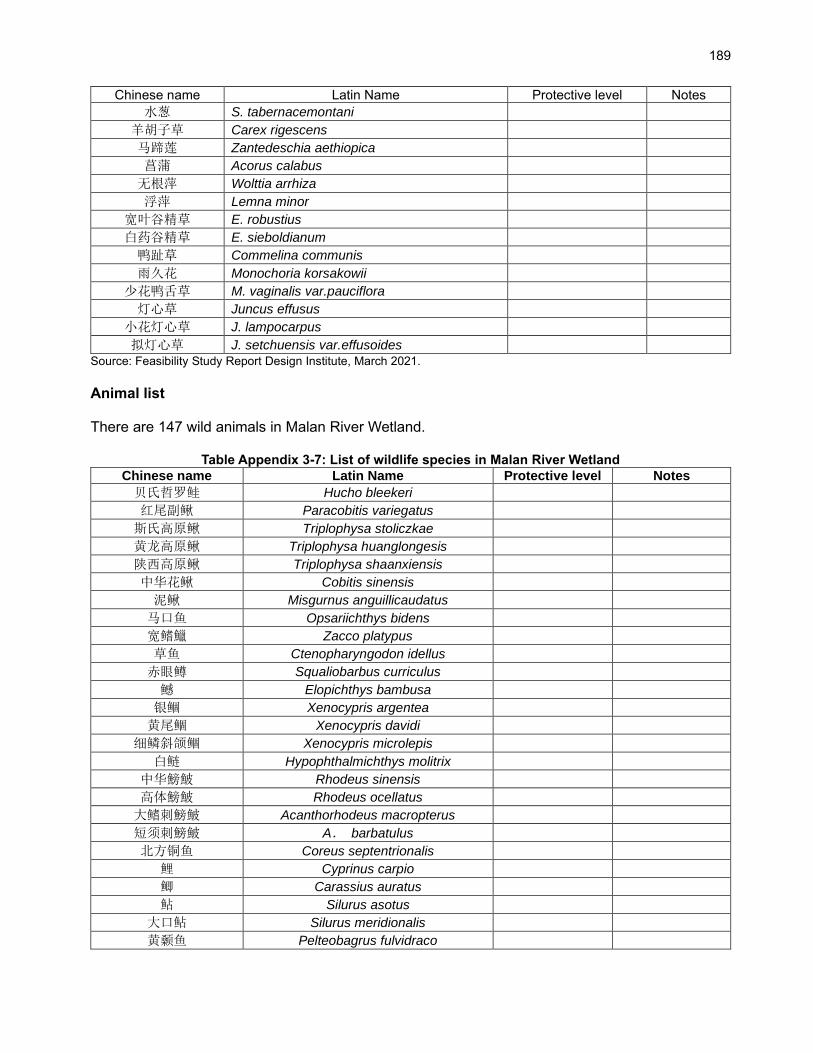
189
Chinese name Latin Name Protective level Notes
水葱 S. tabernacemontani
羊胡子草 Carex rigescens
马蹄莲 Zantedeschia aethiopica
菖蒲 Acorus calabus
无根萍 Wolttia arrhiza
浮萍 Lemna minor
宽叶谷精草 E. robustius
白药谷精草 E. sieboldianum
鸭趾草 Commelina communis
雨久花 Monochoria korsakowii
少花鸭舌草 M. vaginalis var.pauciflora
灯心草 Juncus effusus
小花灯心草 J. lampocarpus
拟灯心草 J. setchuensis var.effusoides
Source: Feasibility Study Report Design Institute, March 2021.
Animal list There are 147 wild animals in Malan River Wetland.
Table Appendix 3-7: List of wildlife species in Malan River Wetland
Chinese name Latin Name Protective level Notes
贝氏哲罗鲑 Hucho bleekeri
红尾副鳅 Paracobitis variegatus
斯氏高原鳅 Triplophysa stoliczkae
黄龙高原鳅 Triplophysa huanglongesis
陕西高原鳅 Triplophysa shaanxiensis
中华花鳅 Cobitis sinensis
泥鳅 Misgurnus anguillicaudatus
马口鱼 Opsariichthys bidens
宽鳍鱲 Zacco platypus
草鱼 Ctenopharyngodon idellus
赤眼鳟 Squaliobarbus curriculus
鳡 Elopichthys bambusa
银鲴 Xenocypris argentea
黄尾鲴 Xenocypris davidi
细鳞斜颌鲴 Xenocypris microlepis
白鲢 Hypophthalmichthys molitrix
中华鰟鮍 Rhodeus sinensis
高体鰟鮍 Rhodeus ocellatus
大鳍刺鰟鮍 Acanthorhodeus macropterus
短须刺鰟鮍 A. barbatulus
北方铜鱼 Coreus septentrionalis
鲤 Cyprinus carpio
鲫 Carassius auratus
鲇 Silurus asotus
大口鲇 Silurus meridionalis
黄颡鱼 Pelteobagrus fulvidraco

190
Chinese name Latin Name Protective level Notes
瓦氏黄颡鱼 Pelteobagrus vachelli
长吻鮠 Leiocassis longirostris
黄鳝 Monopterus albus
栉鰕虎鱼 Ctenogobius giurinus
山溪鲵 Batrachuperus pinchonii
中华蟾蜍 Bufo. gargarizans
黑斑蛙 Rana nigromaculate
崇安湍蛙 Amolops chunganensis
中国林蛙 Rana.chensinensis Key Province
隆肛蛙 Rana.quadranus
黑斑侧褶蛙 Pelophylax nigromaculata
鳖 Trionyx sinensis Ⅱ National
丽斑麻晰 Eremias argus
无蹼壁虎 Gekko japonicus
黄纹石龙子 Eumeces xanthi
锈链腹链蛇 Amphiesma craspedogaster
黄脊游蛇 Coluber Spinalis
赤链蛇 Dinodon rufozonatum
团花锦蛇 Elaphe davidi
玉斑锦蛇 E. mandarina
紫灰锦蛇 E.porphyracea
棕黑锦蛇 E.schrenckii
虎班颈槽蛇 R.tigrina
黑头剑蛇 Sibynophis chinensis
乌梢蛇 Zaocys dhumnades
小鸊鷉 Podiceps ruficollis
凤头鸊鷉 P.cristatus
鸬鹚 Phalacrocorax carbo
苍鹭 Ardea cinerea
池鹭 Ardeola bacchus
绿鹭 Butorides striatus
大白鹭 Egretta alba Key Province
中白鹭 E.intermedia Key Province
白鹭 E.garzetta Key Province
豆雁 Anser fabalis Key Province
斑头雁 A.indicus Key Province
琵嘴鸭 Anas.clypeata Key Province
针尾鸭 A.acuta
绿翅鸭 A.crecca
花脸鸭 A.formosa
罗纹鸭 A.falcata
绿头鸭 A.platyrhynchos Key Province
赤膀鸭 A.strepera
赤颈鸭 A.penelope
斑嘴鸭 A.poecilorhyncha Key Province
赤麻鸭 Tadorna ferruginea Key Province
翘鼻麻鸭 T. tadorna Key Province

191
Chinese name Latin Name Protective level Notes
赤嘴潜鸭 Netta rufina Key Province
白眉鸭 Anas querquedula
白眼潜鸭 Aythya nyroca
凤头潜鸭 A.fuligula
红头潜鸭 A.ferina
鹊鸭 Bucephala clangula
斑头秋沙鸭 Mergus albellus Key Province
普通秋沙鸭 M.merganser
鸢 Milvus korschun Ⅱ National
大鵟 Buteo hemilasius Ⅱ National
毛脚鵟 Buteo buteo Ⅱ National
秃鹫 Aegypius monachus Ⅱ National
环颈雉 Phasianus colchicus
普通秧鸡 Rallus aquaticus
红胸田鸡 Porzana fusca
白胸苦恶鸟 Amaurornis phoenicurus
黑水鸡 Gallinula chloropus
骨顶鸡 Fulica atra
彩鹬 Rostratula benghalensis Key Province
凤头麦鸡 Vanellus vanellus
灰头麦鸡 V.cinereus
剑鴴 Charadrius hiaticula
金眶鴴 C.dubius
白腰草鹬 Tringa ochropus
林鹬 T.glareola
红嘴鸥 Larus ridibundus
普通燕鸥 Sterna hirundo
岩鸽 Columba rupestris
珠颈斑鸠 Streptopelia orientalis
白腰雨燕 Apus pacificus
楼燕 A.apus
冠鱼狗 Ceryle lugubris
普通翠鸟 Alcedo atthis
蓝翡翠 Halcyon pileata
蚁鴷 Jynx torquilla
黑枕啄木鸟 Picus canus
家燕 Hirundo rustica
白鶺鴒 Motacilla alba
灰鶺鴒 M.cinerea
黄鶺鴒 M.flava
红嘴蓝鹊 Cissa erythrorhyncha
灰喜鹊 Cyanopica cyana
喜鹊 Pica pica
寒鸦 Corvus monedula
褐河乌 Cinclus pallasii
北红尾鸲 Phoenicurus auroreus
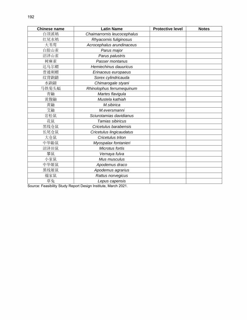
192
Chinese name Latin Name Protective level Notes
白顶溪鸲 Chaimarrornis leucocephalus
红尾水鸲 Rhyacornis fuliginosus
大苇莺 Acrocephalus arundinaceus
白脸山雀 Parus major
沼泽山雀 Parus palustris
树麻雀 Passer montanus
达乌尔蝟 Hemiechinus dauuricus
普通刺蝟 Erinaceus europaeus
纹背鼩鼱 Sorex cylindricauda
水鼩鼱 Chimarogale styani
马铁菊头蝠 Rhinolophus ferrumequinum
青鼬 Martes flavigula
黄腹鼬 Mustela kathiah
黄鼬 M.sibirica
艾鼬 M.eversmanni
岩松鼠 Sciurotamias davidianus
花鼠 Tamias sibiricus
黑线仓鼠 Cricetulus barabensis
长尾仓鼠 Cricetulus lingicaudatus
大仓鼠 Cricetulus triton
中华鼢鼠 Myospalax fontanieri
沼泽田鼠 Microtus fortis
攀鼠 Vernaya fulva
小家鼠 Mus musculus
中华姬鼠 Apodemus draco
黑线姬鼠 Apodemus agrarius
禢家鼠 Rattus norvegicus
草兔 Lepus capensis
Source: Feasibility Study Report Design Institute, March 2021.