Shear velocity structure of the Mariana mantle wedge from Rayleigh wave phase velocities
15
Shear velocity structure of the Mariana mantle wedge from Rayleigh wave phase velocities Moira L. Pyle, 1,2 Douglas A. Wiens, 1 Dayanthie S. Weeraratne, 3 Patrick J. Shore, 1 Hajime Shiobara, 4 and Hiroko Sugioka 5 Received 15 September 2009; revised 7 June 2010; accepted 18 June 2010; published 6 November 2010. [1] We examine the seismic structure of the Mariana mantle wedge using data from a combined deployment of ocean bottom seismographs and land stations in 2003–2004. We measure Rayleigh wave phase velocities and invert these results for the shear velocity structure and azimuthal anisotropy in the region. In the back‐arc region low phase velocities indicate shear velocities as low as 3.9 ± 0.1 km/s at depths of about 60 km. Locations of the lowest seismic velocities at 18.0°N–18.5°N, 16.0°N–16.5°N, and 14.0°N–14.5°N correspond to the locations of gravity lows and probably indicate the presence of temperature and melt production maxima compared to elsewhere along the spreading center. The shape of the low velocity anomaly also indicates that there is a degree of asymmetry to the thermal structure across the spreading center. The fore arc exhibits low shear velocities (V s ∼ 3.6 km/s) at depths shallower than 40 km. These low uppermost mantle velocities are likely due to serpentinization of the fore arc. Azimuthal anisotropy results suggest an average peak‐to‐peak anisotropy of about 1%–2% with a fast direction of NNE. Fore‐arc anisotropy shows arc‐parallel fast directions at shallow depth in agreement with previous shear wave splitting observations and deeper arc‐perpendicular directions influenced by the slab. Back‐arc anisotropy is largely arc perpendicular, consistent with splitting observations west of the spreading center. Citation: Pyle, M. L., D. A. Wiens, D. S. Weeraratne, P. J. Shore, H. Shiobara, and H. Sugioka (2010), Shear velocity structure of the Mariana mantle wedge from Rayleigh wave phase velocities, J. Geophys. Res., 115, B11304, doi:10.1029/2009JB006976. 1. Introduction [2] The mantle wedge is an area of intensive geological, geophysical, and geochemical study. Investigation of the processes and structure in this region is essential for an understanding of the dynamics of plate tectonics. Among the many questions that exist about the mantle wedge are those concerning the location and depth extent of melt beneath island arcs and back‐arc spreading centers and the direction and nature of mantle flow. The study of seismic velocities, anisotropy, and attenuation is a crucial component of these investigations because these measurements provide insight about many key unknowns in mantle structure such as the temperature, water content, presence of melt, composition, mantle flow patterns, and deformation styles (a discussion of the relationship of seismic observables to these physical properties is given by Wiens et al. [2006, 2008]). Most of the information we have about seismic velocities in the mantle wedge comes from body wave tomography. High‐resolution tomography images significant low velocity anomalies beneath the volcanic front and above the slab in several subduction zones [e.g., Husen et al., 2003; Reyners, 2006; Wagner et al., 2005; Zhao et al., 1994, 1997]. Tomography from the Lau region shows a large low velocity anomaly between 40 and 100 km depth beneath the back‐arc spreading center [Zhao et al., 1997]. The direction of mantle flow is usually inferred from shear wave splitting results, which can vary widely in different subduction zone environments. In the Mariana and Tonga subduction zones, complex mantle flow is suggested by fast splitting directions which are parallel near the volcanic arc and rotate to the direction of convergence in the back arc [Pozgay et al., 2007; Smith et al., 2001]. Few surface wave studies of subduction zones exist, but their analysis can provide additional constraints on the shear velocity structure and azimuthal anisotropy within the mantle wedge. [3] The Mariana subduction zone offers an excellent set- ting to examine the workings of the mantle wedge because it includes a wide variety of tectonic features, including an active back‐arc spreading center, and the marine environ- 1 Department of Earth and Planetary Sciences, Washington University in St. Louis, St. Louis, Missouri, USA. 2 Now at Department of Geology and Geophysics, University of Utah, Salt Lake City, Utah, USA. 3 Department of Geological Sciences, California State University, Northridge, California, USA. 4 Earthquake Research Institute, University of Tokyo, Tokyo, Japan. 5 Institute for Frontier Research on Earth Evolution, JAMSTEC, Yokosuka, Japan. Copyright 2010 by the American Geophysical Union. 0148‐0227/10/2009JB006976 JOURNAL OF GEOPHYSICAL RESEARCH, VOL. 115, B11304, doi:10.1029/2009JB006976, 2010 B11304 1 of 15
Transcript of Shear velocity structure of the Mariana mantle wedge from Rayleigh wave phase velocities

Shear velocity structure of the Mariana mantle wedgefrom Rayleigh wave phase velocities
Moira L. Pyle,1,2 Douglas A. Wiens,1 Dayanthie S. Weeraratne,3 Patrick J. Shore,1
Hajime Shiobara,4 and Hiroko Sugioka5
Received 15 September 2009; revised 7 June 2010; accepted 18 June 2010; published 6 November 2010.
[1] We examine the seismic structure of the Mariana mantle wedge using data from acombined deployment of ocean bottom seismographs and land stations in 2003–2004. Wemeasure Rayleigh wave phase velocities and invert these results for the shear velocitystructure and azimuthal anisotropy in the region. In the back‐arc region low phasevelocities indicate shear velocities as low as 3.9 ± 0.1 km/s at depths of about 60 km.Locations of the lowest seismic velocities at 18.0°N–18.5°N, 16.0°N–16.5°N, and14.0°N–14.5°N correspond to the locations of gravity lows and probably indicate thepresence of temperature and melt production maxima compared to elsewhere along thespreading center. The shape of the low velocity anomaly also indicates that there is a degreeof asymmetry to the thermal structure across the spreading center. The fore arc exhibits lowshear velocities (Vs ∼ 3.6 km/s) at depths shallower than 40 km. These low uppermostmantle velocities are likely due to serpentinization of the fore arc. Azimuthal anisotropyresults suggest an average peak‐to‐peak anisotropy of about 1%–2% with a fast direction ofNNE. Fore‐arc anisotropy shows arc‐parallel fast directions at shallow depth in agreementwith previous shear wave splitting observations and deeper arc‐perpendicular directionsinfluenced by the slab. Back‐arc anisotropy is largely arc perpendicular, consistent withsplitting observations west of the spreading center.
Citation: Pyle, M. L., D. A. Wiens, D. S. Weeraratne, P. J. Shore, H. Shiobara, and H. Sugioka (2010), Shear velocity structureof the Mariana mantle wedge from Rayleigh wave phase velocities, J. Geophys. Res., 115, B11304,doi:10.1029/2009JB006976.
1. Introduction
[2] The mantle wedge is an area of intensive geological,geophysical, and geochemical study. Investigation of theprocesses and structure in this region is essential for anunderstanding of the dynamics of plate tectonics. Among themany questions that exist about the mantle wedge are thoseconcerning the location and depth extent of melt beneathisland arcs and back‐arc spreading centers and the directionand nature of mantle flow. The study of seismic velocities,anisotropy, and attenuation is a crucial component of theseinvestigations because these measurements provide insightabout many key unknowns in mantle structure such as thetemperature, water content, presence of melt, composition,mantle flow patterns, and deformation styles (a discussion of
the relationship of seismic observables to these physicalproperties is given byWiens et al. [2006, 2008]). Most of theinformation we have about seismic velocities in the mantlewedge comes from body wave tomography. High‐resolutiontomography images significant low velocity anomaliesbeneath the volcanic front and above the slab in severalsubduction zones [e.g., Husen et al., 2003; Reyners, 2006;Wagner et al., 2005; Zhao et al., 1994, 1997]. Tomographyfrom the Lau region shows a large low velocity anomalybetween 40 and 100 km depth beneath the back‐arc spreadingcenter [Zhao et al., 1997]. The direction of mantle flow isusually inferred from shear wave splitting results, which canvary widely in different subduction zone environments. In theMariana and Tonga subduction zones, complex mantle flowis suggested by fast splitting directions which are parallel nearthe volcanic arc and rotate to the direction of convergence inthe back arc [Pozgay et al., 2007; Smith et al., 2001]. Fewsurface wave studies of subduction zones exist, but theiranalysis can provide additional constraints on the shearvelocity structure and azimuthal anisotropy within the mantlewedge.[3] The Mariana subduction zone offers an excellent set-
ting to examine the workings of the mantle wedge because itincludes a wide variety of tectonic features, including anactive back‐arc spreading center, and the marine environ-
1Department of Earth and Planetary Sciences, Washington University inSt. Louis, St. Louis, Missouri, USA.
2Now at Department of Geology and Geophysics, University of Utah,Salt Lake City, Utah, USA.
3Department of Geological Sciences, California State University,Northridge, California, USA.
4Earthquake Research Institute, University of Tokyo, Tokyo, Japan.5Institute for Frontier Research on Earth Evolution, JAMSTEC,
Yokosuka, Japan.
Copyright 2010 by the American Geophysical Union.0148‐0227/10/2009JB006976
JOURNAL OF GEOPHYSICAL RESEARCH, VOL. 115, B11304, doi:10.1029/2009JB006976, 2010
B11304 1 of 15

ment also has the advantage of avoiding contamination fromthe continental crust. Along the arcuate trench, the Pacificplate subducts beneath the Philippine Sea plate in a north-westerly direction (Figure 1) producing nearly strike‐slipconvergence in the north varying to almost orthogonalconvergence in the southern part of our study area withtypical trench axis depths of 6–8 km [McCaffrey, 1996;Stern et al., 2003]. Seismicity shows that the slab is nearlyvertical in our study area [Engdahl et al., 1998], and no slabrollback is observed [Stern et al., 2003]. Active serpentinitemud volcanoes are observed near the trench indicating ser-pentinization of the fore arc [Fryer, 1996; Fryer et al.,1999]. The active volcanic arc is mostly submarine southof Anatahan [Bloomer et al., 1989; Meijer, 1982]. The arc isseparated from a remnant island arc (the West MarianaRidge) by the back‐arc spreading center. The central portionof the trough began spreading around 6 Ma with a spreadinghalf rate around 2 cm/yr [Iwamoto et al., 2002].[4] In this paper, we examine Rayleigh wave phase
velocities recorded by a recent deployment of seismographslocated on islands and on the ocean bottom to study the
mantle wedge in the Mariana arc system. Rayleigh wavesare primarily sensitive to the shear velocity structure. Bodywave tomography can often generate excellent lateral reso-lution, but in the upper mantle where the raypaths arelargely vertical, velocity anomalies may be smeared verti-cally. Surface waves have improved depth resolution due totheir dispersive properties and so provide important andindependent constraints on the depth and location of shearvelocity anomalies in the oceanic mantle. In addition, shearwave structure can be difficult to obtain from body wavesdue to high attenuation of S wave arrivals in subductionzones and poor signal‐to‐noise ratio of horizontal compo-nents in ocean bottom seismometers at the base of the watercolumn. Complex structure along the raypath, which mayproduce deviations from the great circle path, multipathing,and scattering, can also present problems for surface wavestudies. Recent developments in surface wave analysisprovide a simple but effective way of dealing with most ofthese complications by modeling the incoming wave as thesum of two interfering plane waves [Forsyth and Li, 2005].We use this new method to investigate Rayleigh wave phasevelocities and their corresponding shear velocities in theMarianas to image low velocity regions beneath the volcanicarc and back‐arc spreading center. We also examine azi-muthal anisotropy of the Rayleigh waves in order to studymantle flow within the wedge.
2. Data Selection and Processing
[5] We use data obtained during the Multi‐Scale SeismicImaging of the Mariana Subduction Factory experiment.This project was a joint U.S.‐Japanese collaborative effortincluding multichannel seismic reflection, controlled sourcewide angle seismic reflection and refraction, and passiveseismic recording. Our study utilizes data from the passiveseismic deployment of the experiment which includes20 broadband land stations from the Program for ArraySeismic Studies of the Continental Lithosphere (PASSCAL),50 semibroadband ocean bottom seismographs (OBSs) fromthe U.S. National Ocean Bottom Seismograph InstrumentPool, and eight Japanese semibroadband OBSs. The instru-ments were deployed from June 2003 until May 2004. Landstations were located along the islands of the active volcanicarc, while the OBSs were densely dispersed around the islandof Pagan and over the active back‐arc spreading center andextended more sparsely from the West Mariana Ridge to thefore arc (Figure 1). Land stations used either StreckeisenSTS‐2 or Guralp CMG‐40T sensors, but due to the closestation spacing of the 40T sensors and the better long periodrecording of the STS‐2s, we use only stations with theSTS‐2 sensors for this study. The U.S. OBSs were oper-ated by Lamont Doherty Earth Observatory and usedthree‐component Mark Products L4 sensors; 15 of theinstruments had 16 bit data loggers and 35 of the instru-ments had a newer 24 bit design. The Japanese OBSs werebuilt and operated by the University of Tokyo and usedprecision measuring device (PMD) (WB2023LP) sensors.Forty‐nine of the OBSs were recovered and returned usefuldata. The 35 U.S. OBSs with the 24 bit design returneddata for only approximately 50 days due to a firmwaredefect which limited the duration of the data recording.The remaining OBSs returned data for the entire duration
Figure 1. Map of the study area. Gray (red) triangles marklocations of OBS stations which returned data, and white(blue) squares mark locations of land stations. The light gray(light blue) square marks the location of the GSN stationGUMO. The location of the trench is indicated by thehatched black line, and the locations of the back‐arc spread-ing segments are indicated by the solid black (dark red)lines. The direction of spreading is perpendicular to the linesas indicated by the double arrows. The solid black arrow in-dicates the direction of absolute plate motion for the Pacificplate. Names of seamounts mentioned in the text and someislands are shown.
PYLE ET AL.: SV IN THE MARIANAS FROM RAYLEIGH WAVES B11304B11304
2 of 15

(11 months) of the experiment. In addition, we also use datafrom the Incorporated Research Institutions for Seismology/U.S. Geological Survey (IRIS/USGS) Global Seismo-graphic Network (GSN) station GUMO located on theisland of Guam. The locations of all land and ocean bottomseismographs that returned data are given by Pozgay et al.[2007].[6] As a first step in the analysis, we examined all events
occurring between 30° and 150° from the array with depthsshallower than 200 km. Each event was visually inspectedfor a good signal‐to‐noise ratio (SNR) of the Rayleigh waveon the vertical trace at each frequency considered. Eventswith good waveforms at fewer than 10 stations were dis-carded because they generally lack enough information to beuseful for the array analysis described in section 3. Wefound a total of 59 teleseismic events that recorded usableRayleigh waves during the time of deployment. From theseevents, 37 show usable Rayleigh waves on the ocean bottomseismograph records at periods of 59 s or longer. The eventsrange in magnitude from Mw 6.0 to 7.8 and have a wideazimuthal distribution (Figure 2). The largest gap in thedistribution occurs to the ESE of the study array in thedirection of South America. Signal quality is generally bestat periods of 29–40 s, and the greatest density of crossingpaths is obtained at these periods (Figure 3). At periodsbelow 20 s and for some events at 20–22 s, waveforms areeither incoherent or demonstrate complex beating, likely dueto long path distances through complicated crustal structuresand sensitivity to the deep water column prior to arrival inthe study region. At longer periods, starting at 55 s butparticularly above 67 s, many of the smaller events exhibit areduced SNR. Despite these limitations, raypath coverage is
sufficient to permit a well‐constrained tomographic inver-sion for Rayleigh wave phase velocity at periods between20 and 67 s, with the best resolution around the island ofPagan and the back‐arc spreading center where instrumen-
Figure 2. Location of earthquakes used in this study. Darkgray (blue) circles denote earthquakes, and the light gray(red) square marks the location of the study area. Connect-ing lines show great circle paths between events and thestudy area.
Figure 3. Raypath coverage for the 20, 33, and 59 s per-iods in our study area. White (red) triangles mark locationsof OBS stations, and squares mark the locations of landstations. The light gray (white) polygons outline the areasof greatest resolution.
PYLE ET AL.: SV IN THE MARIANAS FROM RAYLEIGH WAVES B11304B11304
3 of 15

tation was the densest. Table 1 lists the number of events andraypaths used at each frequency.[7] In order to compare Rayleigh wave phases and am-
plitudes from the different types of sensors used in thisproject, the instrument response was removed from eachrecord. We tested the nominal OBS instrument response bycomparing waveforms from the Lamont OBSs locatedaround the island Pagan with the two STS‐2 stations locatedon the island. The STS‐2s have well‐known instrumentresponses (including the gain), and the Pagan stations have aclose enough proximity to the dense array of OBSs sur-rounding the island that the waveforms can be expected tobe similar at long periods with a small time discrepancy dueto different distances to the event. We chose a large eventarriving with a back azimuth such that the waveforms hadthe same theoretical arrival time at both one of the landstations and one or more of the OBSs. We removed theinstrument response to velocity using the poles and zerosfrom the raw Lamont OBS and land station records using atapered filter which is flat between 1 and 250 s. The resultingvelocity records were nearly identical, except for a differ-ence in amplitude. The amplitude at several different fre-quency ranges was measured for both the land stations andthe OBSs, and we found an average factor of differencebetween the two amplitudes as our correction for the gainfactor. For the 16 bit OBSs, the correction is −1.75, and forthe 24 bit instruments, the correction is −1.417. Only aconstant correction was required because the difference inamplitudes was consistent over the different frequencybands.[8] The instrument response for the Japanese OBSs was
tested by comparing it with that of adjacent U.S. OBSs andland stations after the amplitude correction described above.After we removed the nominal instrument response pro-vided by the manufacturer of the PMD sensor, we observeda systematic phase discrepancy between data recorded atJapanese OBSs and data recorded at adjacent U.S. stations.To compensate for this, we found an empirical correction forthe Japanese OBS instrument response using spectral divi-sion. We first select an event recorded at a Japanese OBSand an adjacent U.S. OBS with theoretical Rayleigh wavearrival times within ∼5 s of each other and good SNRbetween 15 and 100 s. The U.S. OBS recording is shifted intime to match the theoretical arrival time of the JapaneseOBS, and then both time series are transformed into thefrequency domain. Spectral division is performed to obtain acorrection to apply to other Japanese stations. To avoidpeculiarities in the correction from a particular event or
station, we average the spectral division result from fivedifferent instruments and events in order to obtain the finalcorrection applied to all of the Japanese data. The correctionin amplitude was negligible, and the phase correction is onthe order of 1–2 s at short periods (∼30–45 s) and increasesto ∼3 s at longer periods (∼75–90 s). Careful comparisons ofthe Japanese data with those of nearby U.S. OBS stationswere made after applying the correction to ensure the use ofonly high‐quality data.[9] After the instrument response was removed, we win-
dowed each seismogram around the Rayleigh wave arrivaland then applied a series of 10 mHz narrow band‐pass filterscentered around select frequencies of interest. We visuallyinspected each trace and discarded stations with poor signal‐to‐noise ratio or instrumentation problems at individualevents or frequencies. Because the inversion for each fre-quency is performed separately, it is often possible that for agiven event a particular station is used for several adjacent,but not all, frequencies. This individual trace analysis al-lows us to include many events at longer periods whichonly recorded the Rayleigh wave above the noise at a fewstations.
3. Phase Velocity Inversion Methods
[10] We invert for Rayleigh wave phase velocities usingthe two plane wave method of Forsyth and Li [2005]. Thistechnique uses phase and amplitude data from each seis-mogram to approximate the incoming wavefield as theinterference of two best fitting plane waves. Our initialattempts to use a more traditional surface wave analysiswhich corrects for deviations from the great circle path butassumes a single, planar wavefront [e.g., Lawrence et al.,2006] yielded results which were often inconsistent andunreasonable. Phase velocities were often too high or toolow to be believable, and those determined from nearlyidentical paths sometimes varied greatly. The two planewave approximation accounts for deviations from the greatcircle path as well as nonplane wave energy such as multi-pathing and scattering better than traditional methods [Li andDetrick, 2003] and produced better results for our data set.Inversion tests show that residuals in phase are reduced by30% with the two plane wave method compared to a singleplane wave approximation [Li et al., 2003]. The inversionsolves for the phase, amplitude, and propagation directionfor both of the two plane waves representing each event, aswell as the phase velocity averaged over the study area (1‐D)and at each inversion node (2‐D), and parameters for azi-muthal anisotropy. The interference of the plane waves andthe resulting vertical displacement is represented as
Uzð!Þ ¼ A1ð!Þ exp½�iðk1 � x� !tÞ þ A2ð!Þ exp½�iðk2 � x� !tÞ�;ð1Þ
where ki is the horizontal wavenumber of each wave and x isthe position vector [Forsyth and Li, 2005]. We find that thelarger of the two waves most often has a propagationdirection less than 10° from the great circle path and there isoften some consistency in the direction from period to periodfor a particular event. The smaller of the two plane wavestypically exhibits greater variability; however, often whenthere is a large difference between the great circle path and
Table 1. Number of Events and Raypaths Used at Each Period
Period (s) Number of Events Number of Paths
20 30 83122 52 147425 55 156929 57 161033 53 150040 49 136645 44 118450 41 107055 37 94559 37 90767 26 638
PYLE ET AL.: SV IN THE MARIANAS FROM RAYLEIGH WAVES B11304B11304
4 of 15

the second plane wave’s propagation direction, the amplitudeof this second wave is quite small. This is similar to the re-sults found by Forsyth and Li [2005], who found 95% ofprimary waves to be within 5° of the great circle path at 28 sand greater variation for the secondary wave. In cases wherethe two plane wave approximation does not provide a gooddescription of the incoming wavefield, the event for thatperiod is downweighted in the inversion.[11] Attenuation is accounted for in this study by using a
constant surface wave attenuation parameter given byMitchell [1995]. Further investigation of the surface waveattenuation in the region is given by Pyle [2009]. Inversionsallowing laterally varying phase velocities incorporate theuse of 2‐D finite frequency sensitivity kernels [Yang andForsyth, 2006b] based on the Born approximation of Zhouet al. [2004]. The use of finite frequency kernels is impor-tant for the consideration of Rayleigh wave sensitivity tostructure outside of the great circle raypath. The 2‐D kernelwe use only considers forward scattering of the wavefield,not backscattering; however, the use of the two plane wavemethod in conjunction with the sensitivity kernels hasyielded successful results and reduced residuals in velocityin several previous regional studies [Weeraratne et al.,2007; Yang and Forsyth, 2006a, 2006b].[12] All inversions are performed using a grid of 506
nodes (Figure 4). The main square of nodes has 0.5° spacingin both latitude and longitude, while the outer edges of thegrid have 1° spacing. The more sparsely spaced edges areused to absorb variations in the wavefield which are not well
Figure 4. Location of nodes used in phase velocityinversion. Black circles denote nodes in the fore‐arc sub-group, and white triangles denote nodes in the back‐arcsubgroup. Dark gray (red) squares mark locations of thestations.
Figure 5. (a) Uniform and regional phase velocities as a function of period for the Mariana region. Blacksquares are the average results from this study. The light gray solid line represents phase velocities pre-dicted by the shear velocity model of Wiens et al. [2006] for the Mariana back arc. Dark gray circles anddotted line are results from the fore‐arc region, and light gray triangles and dashed line are from the back‐arc region. For all curves, error bars indicate two standard deviations. (b) Back‐arc regional phase velocitycurve from Figure 5a shown by light gray triangles and dashed line. Phase velocities for 0–4 Ma (blackdashed line) and 4–20 Ma (gray dotted line) oceanic crust are from the work of Nishimura and Forsyth[1989]. The solid gray line is the back‐arc model predicted from the work of Wiens et al. [2006].
PYLE ET AL.: SV IN THE MARIANAS FROM RAYLEIGH WAVES B11304B11304
5 of 15

represented by the two plane wave approximation. Theinversion solves for the phase velocity continuously over thestudy region and is described at each node by interpolatingthe velocity at any point using a 2‐D Gaussian average ofneighboring grid points. The scale length used for theaveraging function has a trade‐off between variance andresolution. After testing a range of scale lengths, we chose avalue of 80 km which represents the best compromisebetween increasing resolution and decreasing variance. Thesame scale length is also used as a smoothing length in thefinite frequency kernels. We also assign an a priori error of0.2 km/s as moderate damping of the velocity parameters.The inversion for each frequency is performed separately.[13] The initial inversion solves for an amplitude correc-
tion at each station to account for any discrepancies in theassumed instrument responses as well as site effects. Onlyabout 50% of the stations required any amplitude correction,and of those, almost all require only a small amplitude cor-rection that is constant with frequency. Five of the 49 stationsrequired a frequency‐dependent correction. Three of thesestations were Lamont OBSs: two in the fore arc nearCelestial Seamount (Figure 1) and one in the back arc. Theother two stations requiring a frequency‐dependent correc-tion were land stations located on Rota and Tinian.
4. Results
4.1. Average Phase Velocities
[14] We begin by inverting for the average Rayleigh wavephase velocity dispersion curve for the entire region. Thisinversion takes all raypaths for a particular period (Figure 3)and solves for one average velocity for the entire study area,producing the 1‐D phase velocity curve as a function ofperiod shown in Figure 5 and listed in Table 2. We used asimple starting model that assumes a phase velocity of3.8 km/s from 20 to 29 s, 3.9 km/s from 33 to 50 s, and4.0 km/s from 55 to 67 s. The 1‐D inversion is well con-strained, and the use of different starting models does notproduce significant changes in the outcome. The resultingdispersion curve (Figure 5a) shows that phase velocities
increase steadily from 3.67 km/s at 20 s to 3.98 km/s at67 s. The 95% confidence interval is smallest (less than0.3%) at 25–29 s, where simple waveforms and low noiselevels allow for the greatest raypath coverage. The errorsincrease slightly at the shortest period and the longer periodswhere there is a lower density of observations (Figure 3), butremain less than 1%. Our results are consistent with thephase velocities predicted by the shear velocity model ofWiens et al. [2006] determined for the Mariana back arcfrom regional waveform inversion of the entire wave train,including surface waves (Figure 5a).[15] We also invert for regional velocities by grouping the
grid nodes into two subregions (the back arc and fore arc)based on the structure of the subduction zone (Figure 4).The fore‐arc subregion includes the trench and everythingeast of the active island arc, while the back‐arc subregionincludes the active volcanic arc, the back‐arc spreadingcenter, and everything west of the West Mariana Ridge. Weuse the uniform dispersion curve result from Figure 5a as astarting model and invert simultaneously for average phasevelocities in each subregion. The back‐arc dispersion curveis fairly flat between 20 and 33 s, likely due to the thin crustsurrounding the back‐arc spreading center. Above 30 s,phase velocities increase slowly from 3.75 km/s at 33 s to3.96 km/s at 67 s. Phase velocities from 25 to 60 s areslightly lower than the those from the model of Wiens et al.[2006], reaching a maximum difference of ∼1.5%, but areslightly faster than those predicted by the model ofNishimura and Forsyth [1989] for oceanic mantle of age 0–4 Ma (Figure 5b). Above 50 s our back‐arc resultsincreasingly approach the phase velocity values ofNishimura and Forsyth [1989] for 4–20 Ma. The fore‐arcphase velocities increase rapidly from 3.53 km/s at 20 s to∼4.13 km/s at 40 s. The curve flattens within error between40 and 60 s at a value of ∼4 km/s. Comparison of the tworegions shows that the fore arc is characterized by signifi-cantly lower phase velocities below 25 s and phasevelocities at 30–67 s that are up to 5% higher relative tothe arc/back‐arc regions. Formal uncertainties for the back‐arc subregion curve are comparable to those for the whole
Table 2. Average and Regional Phase Velocities
Period (s) Average C (km/s) Error (km/s) Back‐Arc C (km/s) Error (km/s) Fore‐Arc C (km/s) Error (km/s)
20 3.67 0.015 3.76 0.021 3.53 0.02222 3.70 0.009 3.72 0.013 3.66 0.01825 3.73 0.008 3.74 0.010 3.72 0.01729 3.76 0.008 3.75 0.010 3.79 0.01933 3.79 0.010 3.76 0.013 3.88 0.02340 3.84 0.010 3.79 0.013 3.98 0.02345 3.85 0.013 3.80 0.016 3.97 0.03450 3.87 0.016 3.82 0.019 4.00 0.03655 3.90 0.016 3.87 0.019 4.01 0.04259 3.94 0.021 3.90 0.026 4.03 0.05267 3.99 0.035 3.96 0.042 4.13 0.084
Figure 6. Phase velocity maps for 22, 29, 40, and 59 s periods. Maps in the left column show phase velocities, and maps inthe right column show standard errors. Velocities are contoured at 0.02 km/s, while errors are contoured at 0.01 km/s. Blacksquares and triangles mark station locations. The hatched black lines mark the location of the trench, and solid black linesmark the location of the back‐arc spreading center. Bathymetry is plotted in gray scale behind velocity and error values. Thetop color scale is for the velocity plots on the left, and the bottom color scale is for the error plots on the right.
PYLE ET AL.: SV IN THE MARIANAS FROM RAYLEIGH WAVES B11304B11304
6 of 15

Figure 6
PYLE ET AL.: SV IN THE MARIANAS FROM RAYLEIGH WAVES B11304B11304
7 of 15

region uniform curve, while the fore‐arc subregion hasslightly higher uncertainties, though they remain below0.05 km/s for almost all periods.
4.2. Laterally Varying Phase Velocities
[16] The average dispersion curves for the two subregionsare used as starting velocities for their respective nodes in aninversion which solves for lateral variations in phasevelocity by allowing the velocity to vary at every node. Thisinversion also incorporates finite frequency sensitivity ker-nels and includes terms for uniform azimuthal anisotropy.Maps of the phase velocities at each period (Figure 6) aregenerated by applying a 2‐D Gaussian averaging function tointerpolate velocities from the inversion nodes to a finergrid. The velocities are masked to show only areas with thebest resolution. Estimates of the a posteriori standard errorgenerated from the model covariance matrix and the aver-aging function are also mapped. The standard error maps(right column of Figure 6) can be used as a tool to helpevaluate the resolution of the phase velocity maps (leftcolumn) as a function of position. We run a similar inver-sion using the uniform phase velocities for the entire studyarea as the starting velocity at every node to test therobustness of our starting model. The major features of themaps (described below) are not strongly dependent on eitherof these starting models. We choose the regional startingmodel as our preferred model because it produces lowermisfits in the final results than the uniform starting model atmost frequencies.[17] From 20 to 22 s, low velocities throughout the fore
arc dominate the phase velocity maps. The transition tofaster velocities occurs west of the active island arc. Astrong low phase velocity anomaly in the fore arc persistsuntil 29 s near the line of serpentinite seamounts, primarilycentered between Celestial and Big Blue. Above 30 s the
velocity contrast east and west of the island arc reverses,with higher velocities in the fore arc at longer periods likelydue to sensitivity at increasing depth to high velocities in thesubducting slab. Three low‐velocity anomalies between theback‐arc spreading center and the island arc are prominentat periods of 22–29 s. The northern anomaly occurs near18.0°N–18.5°N, and the central anomaly is located betweenroughly 16.0°N and 16.5°N. Velocities in these anomaliesreach minimums of about 3.63 km/s at 22 s, and lowvelocities persist for periods as long as 50 s, but migratetoward the back‐arc spreading center. The southern anomalyappears at the edge of our resolution at about 14°N–14.5°N.This anomaly reaches a low velocity of 3.66 km/s at 22–29 s, but it does not extend to periods longer than 30 swithin our resolution. Standard errors are smallest in thecenter of the study area around the dense array of stationswhich surround Pagan and the back‐arc spreading center.The errors increase with increasing period beyond 29 s,partly due to decreased raypath coverage at longer periods,and partly because at longer periods the Fresnel zone isbroader, which may smooth out sensitivity to local structure.
4.3. Anisotropy
[18] The inversion for laterally heterogeneous phasevelocities includes terms for uniform azimuthal anisotropyaveraged over the entire study area (Figure 7). We observepeak‐to‐peak anisotropy of 0.7%–1.7% for periods of 20–45 s. At these periods the magnitude of anisotropy has aconstant average value of about 1.4%. Large anisotropy of3.5% is found at the 50 s period, but beyond 55 s anisotropyis not resolved from zero at the 95% confidence level. Theanomalously high value found at 50 s and the lack of reso-lution at longer periods is likely due to decreased data den-sity. The fast azimuth is approximately constant at NNE forall periods below 50 s, which is roughly consistent with atrench‐parallel direction.[19] We ran an additional inversion which allowed
anisotropy to vary independently in the back‐arc and fore‐arc regions defined in Figure 4. The results from thisinversion are shown in Figure 8. The percentage of anisot-ropy as a function of period is scattered and is not as wellconstrained as the uniform average, but we do observe someconsistencies in the direction of fast azimuths. From 22 to45 s we find fast directions in the fore arc that are NNE andtrench parallel. At the 50 s period and longer (indicatingdeeper sensitivity) the fast directions in this region rotate toa trench‐perpendicular ENE direction, similar to the averageresults. One possible explanation is that the longer periodresults sample deeper in the fore arc and likely show thedirection of anisotropy in the subducting slab. Fast direc-tions in the back arc demonstrate the poorest resolution, butthey may exhibit a fairly consistent east‐west azimuth atperiods below 50 s. The magnitude of anisotropy generallyincreases when the study is divided into regions; however,the directions in the back arc (Figure 8a) are generally closeto perpendicular to the directions in the fore arc (Figure 8b),resulting in the smaller average as observed in Figure 7.Although results for regionalized anisotropy are poorlyconstrained compared to the uniform anisotropy results,tests show that observations which are consistent in azimuthbetween three to four periods may indicate structure that isreal [Weeraratne et al., 2003].
Figure 7. Average anisotropy as a function of period. Shortbars through each symbol indicate the direction of the fastaxis of anisotropy in map view (the arrow indicates thedirection of north in map view). Error bars indicate two stan-dard deviations.
PYLE ET AL.: SV IN THE MARIANAS FROM RAYLEIGH WAVES B11304B11304
8 of 15

4.4. One‐Dimensional Average Shear Velocity Models
[20] We invert the uniform and regional phase velocitycurves for shear velocity using the work of Saito [1988] andthe method of Weeraratne et al. [2003]. The inversion is aniterative process that first predicts phase velocities based on
a starting shear velocity model and then uses a damped leastsquares inversion to find changes to the shear velocitymodel which produce the best fit between the predicted and
Figure 8. Anisotropy as a function of period for the (a) back‐arc and (b) fore‐arc regions. Short bars through each symbolindicate the direction of the fast axis of anisotropy in mapview (the arrow indicates the direction of north in map view).Error bars indicate two standard deviations. The 67 s point inthe back arc is outside the displayed scale.
Figure 9. (a) Average shear velocity as a function of depth.The gray dashed line shows the starting model from thework of Wiens et al. [2006]. Boxes indicate two standarddeviations from the average velocities over well‐resolveddepth ranges. (b) Examples of resolution kernels at 32 and90 km. (c) Shear velocity curves for the back‐arc and fore‐arc regions. The solid black line indicates our average shearvelocity model from Figure 9a, light gray triangles representthe back‐arc model, and dark gray circles represent the fore‐arc model.
PYLE ET AL.: SV IN THE MARIANAS FROM RAYLEIGH WAVES B11304B11304
9 of 15

measured phase velocities (from sections 4.1 and 4.2). Weuse the shear velocity model determined for the Marianaback arc from waveform inversion [Wiens et al., 2006](Figure 9a, dashed line) as a starting model. The model hasP wave velocities that are consistent with results from activesource studies [Calvert et al., 2008; Takahashi et al., 2007]and includes a 3 km water layer and two crustal layers withthicknesses of 4 and 3 km and fixed shear velocities of 2.9and 3.7 km/s, respectively. Since Rayleigh wave phasevelocities are primarily sensitive to shear velocity, weassume that the P velocities in the mantle are √3 multipliedby the shear velocity. Rayleigh wave velocities are also onlyweakly sensitive to density compared to other factors;therefore, we assume a density model which does notvary from iteration to iteration. We investigate a range ofdamping parameters in the form of a priori uncertaintiesfor the initial values of the velocity parameters and select0.2 km/s as the best compromise between decreasing vari-ance and increasing resolution. Each iteration is damped tothe starting model. The inversion also incorporates second‐derivative smoothing with nonzero off‐diagonals that areone third of the values of the diagonal terms in the modelcovariance matrix, providing some correlation betweenchanges in adjacent depth layers.[21] The first shear wave inversion determines an average
velocity structure across the entire study area using themeasured phase velocities from Figure 5a. Shear veloci-ties of 4.1 ± 0.1 km/s are observed from 20 to 40 kmdepth, gradually increasing to 4.35 ± 0.1 km/s at 70 km(Figure 9a). Very little change from the starting model isobserved. Shear wave velocities averaged over the study areado not exhibit strong changes in velocity with depth, likelydue to the averaging of highly variable structure in theregion. To test this, we use the average 1‐D shear velocitymodel as the starting model to invert the regional phasevelocity curves in the fore arc and back arc (Figure 5a, circlesand triangles) for shear velocity structure (Figure 9c). Thefore arc (Figure 9c, circles) has velocities which reach as lowas 3.86 ± 0.1 km/s at a depth of 18 km with a well‐resolvedsharp increase to values of nearly 4.65 ± 0.1 km/s at 70 kmdepth. The velocities then suggest a 2% negative velocitygradient below 90 km depth which approaches the startingmodel but is poorly resolved within 95% confidence. Theback arc (Figure 9c, triangles) shows a negative velocitygradient from 4.38 ± 0.1 km/s at 20 km depth to a lowvelocity zone of 4.03 ± 0.1 km/s between 50 and 70 km.Below 90 km, velocities increase with increasing depth,approaching the starting model at a depth of 115 km. These1‐D inversions for shear velocity constrain only average Svstructure and do not take into account the effects of anisot-ropy. However, because anisotropy as a function of periodappears to be roughly constant at 1.4%within error (Figure 7),
we expect that the shape of the velocity curves with depth willremain unchanged. This confidence includes variation ofanisotropy values within the error bars depicted.[22] Confidence in shear wave velocities is shown by
boxes which represent ±2 standard deviations from theaverage velocities over well‐resolved depth ranges. Un-certainties in depth are given by the width of resolutionkernels. Examples of these kernels for velocities at 32 and90 km are plotted in Figure 9b. Rayleigh waves have peaksensitivity to a depth which is approximately 4/3 of theperiod, but they remain sensitive to a finite range of depthssurrounding the peak depth. At shallow depths this range isnarrow, as shown by the resolution kernel for 32 km depthin Figure 9b. As depth increases, the width of the kernelsincreases and sensitivity to a particular depth decreases.Average and regional shear wave velocities, and the depthrange of resolution for each point, are listed in Table 3.
4.5. Laterally Varying Shear Velocities
[23] Shear velocity maps are constructed using 1‐D in-versions of phase velocities at each of the inversion nodes(Figure 10). As a starting model for these inversions, we usethe average shear velocity model for the region (Figure 9a).The three upper layers representing the water and twocrustal layers have fixed velocities with thicknesses modi-fied at each node for varying water depths and crustalthicknesses based on the model given by Takahashi et al.[2007]. Small differences in the thicknesses of these layersmake very little difference in the resulting shear velocitycurves, except at the trench where the depth of the waterlayer more than doubles. The variation in depth resolutionkernels (Figure 9b) results in each map representing anaverage over a range of depths as indicated in Table 3. Thefore arc exhibits a low velocity anomaly near the trench thatdecreases in magnitude for depths greater than 30 km.Below 40 km the fore arc is mainly characterized by highvelocities associated with the subducting slab which areshallowest near the trench and move gradually westwardwith increasing depth. Two low shear velocity anomalies areobserved between the back‐arc spreading center and islandarc located at about 18.0°N–18.5°N latitude extending to adepth of 115 km and at about 16.0°N–16.5°N extending toabout 70 km depth. A third low velocity anomaly can alsobe seen at about 14.0°N–14.5°N between the spreadingcenter and the island arc. This anomaly is weaker and morediffuse than the other two anomalies and reaches the limitsof our resolution, but it may extend to at least 50 km depth.Below 70 km the southernmost anomaly and the centralanomaly may merge, although this is likely due to decreasinglateral resolution as depth increases. All three low velocityanomalies appear to move westward toward the spreading
Table 3. Average and Regional Shear Wave Velocities
Depth (km) Average Vs (km/s) Error (km/s) Back‐Arc Vs (km/s) Error (km/s) Fore‐Arc Vs (km/s) Error (km/s) Depth Range (km)
18.0 4.13 0.088 4.39 0.095 3.86 0.097 12–2732.5 4.10 0.096 4.25 0.099 3.95 0.102 24–4250.0 4.18 0.098 4.04 0.106 4.38 0.110 38–6770.0 4.27 0.131 4.03 0.143 4.63 0.147 50–8590.0 4.26 0.161 4.10 0.169 4.62 0.172 79–128115.0 4.26 0.167 4.49 0.175 4.49 0.178 96–146
PYLE ET AL.: SV IN THE MARIANAS FROM RAYLEIGH WAVES B11304B11304
10 of 15

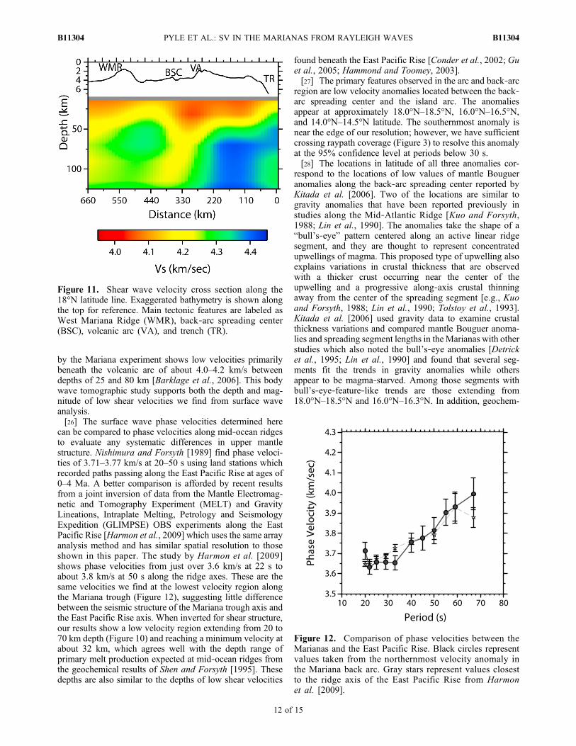
center as depth increases. A high velocity anomaly is alsoobserved at about 17.5°N near the West Mariana Ridge.[24] We put together a shear velocity cross section in the
same manner as the maps using the point by point 1‐Dinversions of phase velocities at each of the inversion nodesalong the 18°N latitude line (Figure 11). The eastern portionof the cross section is dominated by high velocities deeperthan 30 km which reach almost 4.5 km/s in the subductingslab. The fore arc has a low velocity anomaly with velocitiesthat reach as low as 4.05 km/s at shallow depths extendingto around 35–40 km just above the slab. Beneath the back‐arc spreading center and volcanic arc the cross sectionshows a pronounced low velocity zone exhibiting velocitiesas low as 4.0 km/s, with the lowest velocities betweendepths of about 20 and 70 km. The peak of this low velocityanomaly in the maps and cross section (∼30 km) appears to beslightly shallower than for the 1‐D inversion (∼50–70 km),but we believe that this is due to higher uncertainties andvertical smoothing when inverting for 2‐D shear velocities.Phase velocity curves from individual nodes (Figure 6) havehigher uncertainty compared to phase velocity curves whichaverage over a group of nodes (Figure 5). Owing to thisincreased uncertainty, the inversion of individual nodes forshear velocities is more dependent on the smoother averagestarting model, and thus the resulting velocities have poorervertical resolution. The decrease in resolution reduces theappearance of the high velocity lid in the shear velocity mapsand cross section.
5. Discussion
5.1. Back Arc and Arc
[25] The phase velocities and structure found by this studyin the back‐arc region are relatively similar to the results ofIsse et al. [2004], which relied on only the station at Guam(GUMO) and one OBS for the Mariana portion of the study.They found phase velocities over the spreading centerranging from 3.6 km/s at 25 s to 3.75 km/s at 50 s, in com-parison to phase velocities ranging from 3.64 to 3.76 km/salong the back‐arc spreading center from our maps of lateralvariation (Figure 6). Based on a larger surface wave data setand an inversion for 3‐D velocity structure, Isse et al. [2009]found shear velocities of ∼4.1 km/s between 80 and 120 kmdepth. The magnitude agrees with our observed shearvelocities, but the depth of the anomaly extends much deeperthan the anomaly we observe. However, their study has lowerresolution in the Mariana region due to the large area of studyand the use of source‐to‐receiver paths. Shear velocitytomography using local and teleseismic body waves recorded
Figure 10. Shear wave velocity maps. The depth range ofresolution for each map is indicated in Table 3. Velocitiesare contoured at 0.01 km/s. Black triangles and squaresmark locations of stations. The hatched black lines markthe location of the trench, and the solid black and whitelines mark the location of the back‐arc spreading center.White portions along the spreading center indicate sectionsalong the axis where Kitada et al. [2006] finds gravitybull’s‐eye‐like behavior. Gray‐scale bathymetry is plottedbehind velocities.
PYLE ET AL.: SV IN THE MARIANAS FROM RAYLEIGH WAVES B11304B11304
11 of 15
by the Mariana experiment shows low velocities primarilybeneath the volcanic arc of about 4.0–4.2 km/s betweendepths of 25 and 80 km [Barklage et al., 2006]. This bodywave tomographic study supports both the depth and mag-nitude of low shear velocities we find from surface waveanalysis.[26] The surface wave phase velocities determined here
can be compared to phase velocities along mid‐ocean ridgesto evaluate any systematic differences in upper mantlestructure. Nishimura and Forsyth [1989] find phase veloci-ties of 3.71–3.77 km/s at 20–50 s using land stations whichrecorded paths passing along the East Pacific Rise at ages of0–4 Ma. A better comparison is afforded by recent resultsfrom a joint inversion of data from the Mantle Electromag-netic and Tomography Experiment (MELT) and GravityLineations, Intraplate Melting, Petrology and SeismologyExpedition (GLIMPSE) OBS experiments along the EastPacific Rise [Harmon et al., 2009] which uses the same arrayanalysis method and has similar spatial resolution to thoseshown in this paper. The study by Harmon et al. [2009]shows phase velocities from just over 3.6 km/s at 22 s toabout 3.8 km/s at 50 s along the ridge axes. These are thesame velocities we find at the lowest velocity region alongthe Mariana trough (Figure 12), suggesting little differencebetween the seismic structure of the Mariana trough axis andthe East Pacific Rise axis. When inverted for shear structure,our results show a low velocity region extending from 20 to70 km depth (Figure 10) and reaching a minimum velocity atabout 32 km, which agrees well with the depth range ofprimary melt production expected at mid‐ocean ridges fromthe geochemical results of Shen and Forsyth [1995]. Thesedepths are also similar to the depths of low shear velocities
found beneath the East Pacific Rise [Conder et al., 2002; Guet al., 2005; Hammond and Toomey, 2003].[27] The primary features observed in the arc and back‐arc
region are low velocity anomalies located between the back‐arc spreading center and the island arc. The anomaliesappear at approximately 18.0°N–18.5°N, 16.0°N–16.5°N,and 14.0°N–14.5°N latitude. The southernmost anomaly isnear the edge of our resolution; however, we have sufficientcrossing raypath coverage (Figure 3) to resolve this anomalyat the 95% confidence level at periods below 30 s.[28] The locations in latitude of all three anomalies cor-
respond to the locations of low values of mantle Bougueranomalies along the back‐arc spreading center reported byKitada et al. [2006]. Two of the locations are similar togravity anomalies that have been reported previously instudies along the Mid‐Atlantic Ridge [Kuo and Forsyth,1988; Lin et al., 1990]. The anomalies take the shape of a“bull’s‐eye” pattern centered along an active linear ridgesegment, and they are thought to represent concentratedupwellings of magma. This proposed type of upwelling alsoexplains variations in crustal thickness that are observedwith a thicker crust occurring near the center of theupwelling and a progressive along‐axis crustal thinningaway from the center of the spreading segment [e.g., Kuoand Forsyth, 1988; Lin et al., 1990; Tolstoy et al., 1993].Kitada et al. [2006] used gravity data to examine crustalthickness variations and compared mantle Bouguer anoma-lies and spreading segment lengths in theMarianas with otherstudies which also noted the bull’s‐eye anomalies [Detricket al., 1995; Lin et al., 1990] and found that several seg-ments fit the trends in gravity anomalies while othersappear to be magma‐starved. Among those segments withbull’s‐eye‐feature‐like trends are those extending from18.0°N–18.5°N and 16.0°N–16.3°N. In addition, geochem-
Figure 11. Shear wave velocity cross section along the18°N latitude line. Exaggerated bathymetry is shown alongthe top for reference. Main tectonic features are labeled asWest Mariana Ridge (WMR), back‐arc spreading center(BSC), volcanic arc (VA), and trench (TR).
Figure 12. Comparison of phase velocities between theMarianas and the East Pacific Rise. Black circles representvalues taken from the northernmost velocity anomaly inthe Mariana back arc. Gray stars represent values closestto the ridge axis of the East Pacific Rise from Harmonet al. [2009].
PYLE ET AL.: SV IN THE MARIANAS FROM RAYLEIGH WAVES B11304B11304
12 of 15

ical surveys have reported areas of increased meltingbetween 16°N and 17°N [Gribble et al., 1996] and near 18°N[Stolper and Newman, 1994]. These areas fall at the samelocation of two of our phase velocity anomalies which likelyindicate the presence of melt. The southernmost low velocityanomaly at 14.0°–14.5°N does not correspond to a bull’s‐eyegravity anomaly, but it does correspond to a region with arelatively low mantle Bouguer anomaly and higher crustalthickness averages which Kitada et al. [2006] interpret as anarea of higher magmatic activity with a sheet‐like upwellingsimilar to fast spreading ridges. The correlation between lowvelocity anomalies that we observe to depths of at least 50 kmand up to 90 km in some places, low Bouguer gravityanomalies, and geochemical surveys suggests that these areareas of higher melting and that the amount of melting ishighly laterally variable along the Mariana trough.[29] To more closely examine the indication of melt
beneath the low velocity anomalies we observe near thespreading center, we compute shear velocities predicted bythe model of Faul and Jackson [2005] which describes theshear modulus and attenuation with variations in frequency,temperature, and grain size. For our model we calculate ageotherm using a mantle potential temperature of 1350°C
determined for the Mariana back arc using major elementchemistry of back‐arc basin basalts [Kelley et al., 2006]. Wevary frequency with depth using the peak depth sensitivitiesof surface waves. For all other parameters we use physicalconstants provided by Faul and Jackson [2005] and calcu-late a range of velocities for 1 Myr old oceanic crust usingdifferent grain sizes. The model is shown in Figure 13 forgrain sizes from 1 mm to 5 cm. Shear velocities determinedfrom our inversions near the back‐arc spreading center fromthe 18.0°N–18.5°N low velocity anomaly as well as the areabetween the two strong low velocity anomalies around 17°Nare plotted for comparison.[30] The resulting modeled velocities show a strong
dependence on grain size, and both of the measured velocitycurves fall within the range of velocities expected for grainsizes appropriate for the upper mantle. If the grain size issmall enough (<∼4 mm), no melt is required to fit our ob-servations. However, if the grain size is slightly larger, theshear velocities we observe, particularly from ∼30 to 50 kmdepth at the low velocity anomaly, might indicate thepresence of melt. Similar shear velocities of ∼4.0–4.1 km/sare seen to depths of ∼60 km just beneath the southern EastPacific Rise in a study using Love waves by Dunn andForsyth [2003]. Their study uses a different temperaturescaling relationship but also finds that these velocities maysuggest a small amount of melting.[31] The anomalies on the phase and shear velocity maps,
as well as the cross section, show no distinction between theback‐arc spreading center and the volcanic arc althoughpreliminary body wave tomography results suggest that thereare two separate low velocity anomalies [Barklage et al.,2006], and seismic attenuation tomography also shows twoseparate anomalies [Pozgay et al., 2009]. Our surface wavetomography results do not have the lateral resolution todistinguish between possible regions of separate back‐arcmelting and volcanic arc melting over this small area. Thewavelength for Rayleigh waves used in this study rangesfrom about 30 to 90 km for increasing periods from 20 to67 s, which is close to the separation distance of these tworegions. At greater depths the shear velocity anomaliesmove gradually closer to the back‐arc spreading center,suggesting that between 50 and 70 km the low velocitiesare probably entirely attributed to the spreading center.
5.2. Fore Arc
[32] In the fore arc, the Rayleigh wave phase velocitymaps at periods below 30 s show a strong low velocityanomaly near the trench between the Big Blue and Celestialseamounts. These low velocities are seen in the averageshear velocity curve for the fore‐arc region with values aslow as 3.85 km/s and in the cross section and shear velocitymaps to depths of around 35–40 km. Such low velocitiescannot result from thick crust, since marine seismic studiesof the fore arc show a crustal thickness of about 15 km[Takahashi et al., 2007; Calvert et al., 2008]. Preliminaryresults from body wave tomography also show a region oflow velocities in the fore arc beneath Big Blue Seamount[Barklage et al., 2006].[33] The Mariana system is well‐known for its active
serpentinite mud volcanoes, such as Big Blue, which arelocated throughout the fore arc [Fryer, 1996; Fryer et al.,1999]. Serpentinite is a hydrated form of peridotite and is
Figure 13. Comparison of measured shear velocities withvelocities predicted by the model of Faul and Jackson[2005]. The shaded gray area represents the range ofvelocities predicted for 1 Myr old oceanic crust with grainsizes ranging from 1 mm to 5 cm. Black dashed linesrepresent specific velocity curves at 1 mm, 5 mm, and 5 cm.The dark gray (red) circles represent shear velocities takenfrom the northernmost (∼18.0°N–18.5°N) low velocityanomaly in the back arc. The white (blue) circles representshear velocities taken from a point along the spreading centerin between the major low velocity anomalies (∼17°N).
PYLE ET AL.: SV IN THE MARIANAS FROM RAYLEIGH WAVES B11304B11304
13 of 15

known to exhibit lower seismic velocities than peridotite(for depths we are concerned with in the fore arc, thevelocity of serpentinite might be 2.38–2.41 km/s whilevelocities for peridotite might range from 4.46 to 4.68 km/s[Christensen, 1966]). Many other subduction zones alsoshow decreased shear velocities in the fore arc, thought to bedue to serpentinization [Hyndman and Peacock, 2003]. Inthe Marianas, Fryer et al. [1999] suggest that the muds atthe seamounts are derived directly from fluids which have aslab source between 15 and 25 km deep near the trench. Inaddition, a study from P to S converted waves also findsshear wave velocities as low as 3.6 km/s to depths of 50 kmabove the slab near the islands of Saipan and Tinian [Tibiet al., 2008]. This extends slightly deeper than ourobserved low velocities, but the anomaly in our results islocated closer to the trench where the slab is shallower.Studies of the crustal structure from active source seismicprofiling over the volcanic arc [Calvert et al., 2008] andalong a profile from the fore arc to west of the WestMariana Ridge [Takahashi et al., 2007] also find loweredupper mantle P wave velocities, although their resolutionin the fore arc is limited.
5.3. Anisotropy
[34] Our average results for the region suggest peak‐to‐peak anisotropy between 1% and 2%, with an average of1.4% for periods below 50 s, which agrees well with themagnitude of anisotropy estimated from shear wave splittingresults in the region. Pozgay et al. [2007] found 1.0%–1.6%anisotropy using data from the same deployment, andearlier studies using the station GUMO on Guam reported0.6%–2.25% anisotropy [Fouch and Fischer, 1998]. Pre-vious shear wave splitting studies suggest that the azimuthalanisotropy is spatially variable in this region. Pozgay et al.[2007] found fast directions to be mostly arc‐parallel inthe arc and back‐arc spreading center regions with arc‐perpendicular fast directions appearing in the far back arcto the west of the back‐arc spreading center, and Volti et al.[2006] found arc‐perpendicular fast directions beneath theridge axis and fast directions aligned with the absolute platemotion of the Pacific plate (NW) farther into the back arc.Fouch and Fischer [1998] and Xie [1992] found fast direc-tions that were roughly parallel to the absolute plate motion inthe Guam region. Based on the regionalized anisotropicinversion, it appears that the fast direction for our averageresults is dominated by anisotropy in the fore arc and thatthe fore arc may be characterized by a fast anisotropydirection parallel to the arc. Results in the back arc show afast direction roughly parallel to the absolute plate motion,consistent with the shear wave splitting results of Pozgayet al. [2007] and other previous studies in the region.
6. Conclusions
[35] We are able to obtain good Rayleigh wave phase andshear wave velocities from data recorded by the combinedland‐ and marine‐based Mariana experiment. The phasevelocities exhibit good agreement with values determinedfrom the East Pacific Rise. Velocities are lowest between theback‐arc spreading center and the volcanic arc at three mainlocations which coincide with the locations of low Bouguergravity anomalies, suggesting that the gravity and seismic
velocity anomalies mark areas of higher melt than other re-gions along theMariana trough. The shear velocities obtainedfrom inversion of the phase velocities indicate that the regionof melt beneath the spreading center and volcanic arc extendsto at least 50 km and in the northern region, where our res-olution is best, to at least 90 km, with the region of lowestvelocities located at 20–70 km depth. Low velocities alsoappear at uppermost mantle depths in the fore arc and arelikely associated with serpentinization of fore‐arc mantle, assuggested by the presence of serpentinite seamounts.
[36] Acknowledgments. We thank Donald Forsyth and YingjieYang for comments and help on implementing the two plane wave method.We would also like to thank the numerous people involved in the deploy-ment and collection of the seismographs. James Gaherty and an anonymousreviewer provided thorough and helpful reviews which greatly improvedthe quality of the manuscript. This research was conducted with supportfrom the MARGINS program under NSF grant OCE0001938.
ReferencesBarklage, M. E., J. A. Conder, D. A. Wiens, P. J. Shore, H. Shiobara,H. Sugioka, and H. Zhang (2006), 3‐D seismic tomography of the Marianamantle wedge from the 2003–2004 passive component of the Marianasubduction factory imaging experiment, Eos Trans. AGU, 87(52), FallMeet. Suppl., Abstract T23C‐0506.
Bloomer, S. H., R. J. Stern, and N. C. Smoot (1989), Physical volca-nology of the submarine Mariana and Volcano arcs, Bull. Volcanol., 51,210–224.
Calvert, A. J., S. L. Klemperer, N. Takahashi, and B. C. Kerr (2008),Three‐dimensional crustal structure of the Mariana island arc from seis-mic tomography, J. Geophys. Res., 113, B01406, doi:10.1029/2007JB004939.
Christensen, N. I. (1966), Elasticity of ultrabasic rocks, J. Geophys. Res.,71(24), 5921–5931.
Conder, J. A., D. W. Forsyth, and E. M. Parmentier (2002), Asthenosphericflow and asymmetry of the East Pacific Rise, MELT area, J. Geophys.Res., 107(B12), 2344, doi:10.1029/2001JB000807.
Detrick, R. S., H. D. Needham, and V. Renard (1995), Gravity anomaliesand crustal thickness variations along the Mid‐Atlantic Ridge between33°N and 40°N, J. Geophys. Res., 100(B3), 3767–3787.
Dunn, R. A., and D. W. Forsyth (2003), Imaging the transition between theregion of mantle melt generation and the crustal magma chamber beneaththe southern East Pacific Rise with short‐period Love waves, J. Geophys.Res., 108(B7), 2352, doi:10.1029/2002JB002217.
Engdahl, E. R., R. D. v. d. Hilst, and R. Buland (1998), Global teleseismicearthquake relocation with improved travel times and procedures fordepth determination, Bull. Seismol. Soc. Am., 88, 722–743.
Faul, U. H., and I. Jackson (2005), The seismological signature of temper-ature and grain size variations in the upper mantle, Earth Planet. Sci.Lett., 234, 119–134.
Forsyth, D. W., and A. Li (2005), Array analysis of two‐dimensional var-iations in surface wave phase velocity and azimuthal anisotropy in thepresence of multipathing interference, in Seismic Earth Array Analy-sis of Broadband Seismograms, edited by A. Levander and G. Nolet,pp. 81–97, AGU, Washington, D. C.
Fouch, M. J., and K. M. Fischer (1998), Shear wave anisotropy in theMariana subduction zone, Geophys. Res. Lett., 25(8), 1221–1224.
Fryer, P. (1996), Evolution of the Mariana convergent plate margin system,Rev. Geophys., 34(1), 89–125.
Fryer, P., C. G. Wheat, and M. J. Mottl (1999), Mariana blueschist mudvolcanism: Implications for conditions within the subduction zone,Geology, 27(2), 103–106.
Gribble, R. F., R. J. Stern, S. H. Bloomer, D. Stuben, T. O’Hearn, andS. Newman (1996), MORBmantle and subduction components interact togenerate basalts in the southern Mariana Trough back‐arc basin,Geochim.Cosmochim. Acta, 60(12), 2153–2166.
Gu, Y. J., S. C. Webb, A. L. Lerner‐Lam, and J. B. Gaherty (2005), Uppermantle structure beneath the eastern Pacific ocean ridges, J. Geophys.Res., 110, B06305, doi:10.1029/2004JB003381.
Hammond, W. C., and D. R. Toomey (2003), Seismic velocity anisotropyand heterogeneity beneath the Mantle Electromagnetic and TomographyExperiment (MELT) region of the East Pacific Rise from analysis of Pand S body waves, J. Geophys. Res., 108(B4), 2176, doi:10.1029/2002JB001789.
PYLE ET AL.: SV IN THE MARIANAS FROM RAYLEIGH WAVES B11304B11304
14 of 15

Harmon, N., D. W. Forsyth, and D. S. Weeraratne (2009), Thickening ofyoung Pacific lithosphere from high‐resolution Rayleigh wave tomogra-phy: A test of the conductive cooling model, Earth Planet. Sci. Lett., 278,96–109.
Husen, S., R. Quintero, E. Kissling, and B. R. Hacker (2003), Subductionzone structure and magmatic processes beneath Costa Rica constrainedby local earthquake tomography and petrological modeling, Geophys.J. Int., 155, 11–32.
Hyndman, R. D., and S. M. Peacock (2003), Serpentinization of the forearcmantle, Earth Planet. Sci. Lett., 212, 417–432.
Isse, T., H. Shiobara, Y. Fukao, K. Mochizuki, T. Kanazawa, H. Sugioka,S. Kodaira, R. Hino, and D. Suetsugu (2004), Rayleigh wave phasevelocity measurements across the Philippine sea from a broad‐bandOBS array, Geophys. J. Int., 158, 257–266.
Isse, T., et al. (2009), Seismic structure of the upper mantle beneath thePhilippine Sea from seafloor and land observation: Implications formantle convection and magma genesis in the Izu‐Bonin‐Mariana sub-duction zone, Earth Planet. Sci. Lett., 278, 107–119.
Iwamoto, H., M. Yamamoto, N. Seama, K. Kitada, T. Matsuno, Y. Nogi,T. Goto, T. Fujiwara, K. Suyehiro, and T. Yamazaki (2002), Tectonicevolution of the central Mariana Trough, Eos Trans. AGU, 83(47), FallMeet. Suppl., Abstract T72A‐1235.
Kelley, K. A., T. Plank, T. L. Grove, E. Stolper, S. Newman, and E. Hauri(2006), Mantle melting as a function of water content beneath back‐arcbasins, J. Geophys. Res., 111, B09208, doi:10.1029/2005JB003732.
Kitada, K., N. Seama, T. Yamazaki, Y. Nogi, and K. Suyehiro (2006), Dis-tinct regional differences in crustal thickness along the axis of the Mari-ana Trough, inferred from gravity anomalies, Geochem. Geophys.Geosyst., 7, Q04011, doi:10.1029/2005GC001119.
Kuo, B.‐Y., and D. W. Forsyth (1988), Gravity anomalies of the ridge‐transform system in the south Atlantic between 31 and 34.5 S:Upwelling centers and variations in crustal thickness, Mar. Geophys.Res., 10, 205–232.
Lawrence, J. F., D. A. Wiens, A. A. Nyblade, S. Anandakrishnan, P. J.Shore, and D. Voigt (2006), Rayleigh wave phase velocity analysis ofthe Ross Sea, Transantarctic Mountains and East Antarctica from a tem-porary seismograph array, J. Geophys. Res., 111, B06302, doi:10.1029/2005JB003812.
Li, A., and R. S. Detrick (2003), Azimuthal anisotropy and phase velocitybeneath Iceland: Implication for plume‐ridge interaction, Earth Planet.Sci. Lett., 214, 153–165.
Li, A., D. W. Forsyth, and K. M. Fischer (2003), Shear velocity structureand azimuthal anisotropy beneath eastern North America from Rayleighwave inversion, J. Geophys. Res., 108(B8), 2362, doi:10.1029/2002JB002259.
Lin, J., G. M. Purdy, H. Schouten, J. C. Sempere, and C. Zervas (1990),Evidence from gravity data for focused magmatic accretion along theMid‐Atlantic Ridge, Nature, 344, 627–632.
McCaffrey, R. (1996), Estimates of modern arc‐parallel strain rates in fore-arcs, Geology, 24, 27–30.
Meijer, A. (1982), Mariana‐Volcano Islands, in Andesites, edited by R. S.Thorpe, pp. 293–306, John Wiley, New York.
Mitchell, B. J. (1995), Anelastic structure and evolution of the continentalcrust and upper mantle from seismic surface wave attenuation, Rev. Geo-phys., 33(4), 441–462.
Nishimura, C. E., and D. W. Forsyth (1989), The anisotropic structure ofthe upper mantle in the Pacific, Geophys. J., 96, 203–229.
Pozgay, S. H., D. A. Wiens, J. A. Condor, H. Shiobara, and H. Sugioka(2007), Complex mantle flow in the Mariana subduction system; Evi-dence from shear wave splitting, Geophys. J. Int., 170(1), 371–386.
Pozgay, S. H., D. A. Wiens, J. A. Conder, H. Shiobara, and H. Sugioka(2009), Seismic attenuation tomography of the Mariana subduction sys-tem: Implications from thermal structure, volatile distribution, and slow‐spreading dynamics, Geochem. Geophys. Geosyst., 10, Q04X05,doi:10.1029/2008GC002313.
Pyle, M. L. (2009), Seismic Surface Wave Studies of the Mariana MantleWedge and the Transantarctic Mountains, 144 pp., Washington Univ.in St. Louis, St. Louis, Mo.
Reyners, M. (2006), Imaging subduction from the trench to 300 km depthbeneath the central North Island, New Zealand with Vp and Vp/Vs, Geo-phys. J. Int., 165, 565–583.
Saito, M. (1988), DISPER80: A subroutine package for the calculation ofseismic normal‐mode solutions, in Seismological Algorithms, edited byD. J. Doornbos, pp. 293–319, Elsevier, New York.
Shen, Y., and D. W. Forsyth (1995), Geochemical constraints on initialand final depths of melting beneath mid‐ocean ridges, J. Geophys.Res., 100(B2), 2211–2237.
Smith, G. P., D. A. Wiens, K. M. Fisher, L. M. Dorman, S. C. Webb, andJ. A. Hildebrand (2001), A complex pattern of mantle flow in the Laubackarc, Science, 292, 713–716.
Stern, R. J., M. J. Fouch, and S. L. Klemperer (2003), An overview of theIzu‐Bonin‐Mariana subduction factory, in Inside the Subduction Factory,edited by J. M. Eiler, AGU, Washington, D. C.
Stolper, E., and S. Newman (1994), The role of water in the petrogenesis ofMariana trough magmas, Earth Planet. Sci. Lett., 121, 293–325.
Takahashi, N., S. Kodaira, S. L. Klemperer, Y. Tatsumi, Y. Kaneda, andK. Suyehiro (2007), Crustal structure and evolution of the Mariana intra‐oceanic island arc, Geology, 35(3), 203–206.
Tibi, R., D. A. Wiens, and X. Yuan (2008), Seismic evidence for wide-spread serpentinized forearc mantle along the Mariana convergent mar-gin, Geophys. Res. Lett., 35, L13303, doi:10.1029/2008GL034163.
Tolstoy, M., A. J. Harding, and J. A. Orcutt (1993), Crustal thickness onthe Mid‐Atlantic Ridge: Bull’s ‐eye gravity anomalies and focused accre-tion, Science, 262, 726–729.
Volti, T., A. Gorbatov, H. Shiobara, H. Sugioka, K. Mochizuki, andY. Kaneda (2006), Shear‐wave splitting in the Mariana trough—A rela-tion between back‐arc spreading and mantle flow? Earth Planet. Sci.Lett., 244, 566–575.
Wagner, L. S., S. Beck, and G. Zandt (2005), Upper mantle structure in thesouth central Chilean subduction zone (30°–36°S), J. Geophys. Res., 110,B01308, doi:10.1029/2004JB003238.
Weeraratne, D. S., D. W. Forsyth, K. M. Fischer, and A. A. Nyblade(2003), Evidence for an upper mantle plume beneath the Tanzanian cra-ton from Rayleigh wave tomography, J. Geophys. Res., 108(B9), 2427,doi:10.1029/2002JB002273.
Weeraratne, D. S., D. W. Forsyth, Y. Yang, and S. C. Webb (2007), Ray-leigh wave tomography beneath intraplate volcanic ridges in the SouthPacific, J. Geophys. Res., 112, B06303, doi:10.1029/2006JB004403.
Wiens, D. A., K. A. Kelley, and T. Plank (2006), Mantle temperature var-iations beneath back‐arc spreading centers inferred from seismology,petrology, and bathymetry, Earth Planet. Sci. Lett., 248, 30–42.
Wiens, D. A., J. A. Conder, and U. H. Faul (2008), The seismic structureand dynamics of the mantle wedge, Annu. Rev. Earth Planet. Sci., 36,421–455.
Xie, J. (1992), Shear‐wave splitting near Guam, Phys. Earth Planet. Inter.,72, 211–219.
Yang, Y., and D. W. Forsyth (2006a), Rayleigh wave phase velocities,small‐scale convection, and azimuthal anisotropy beneath southern Cali-fornia, J. Geophys. Res., 111, B07306, doi:10.1029/2005JB004180.
Yang, Y., and D. W. Forsyth (2006b), Regional tomographic inversion ofthe amplitude and phase of Rayleigh waves with 2‐D sensitivity kernels,Geophys. J. Int., 166, 1148–1160.
Zhao, D., A. Hasegawa, and H. Kanamori (1994), Deep structure of Japansubduction zone as deried from local, regional, and teleseismic events,J. Geophys. Res., 99(B11), 22,313–22,329.
Zhao, D., Y. Xu, D. A. Wiens, L. M. Dorman, J. Hildebrand, and S. C.Webb (1997), Depth extent of the Lau back‐arc spreading center andits relation to subduction processes, Science, 278(5336), 254–257.
Zhou, Y., F. A. Dahlen, and G. Nolet (2004), Three‐dimensional sensitivitykernels for surface wave observables, Geophys. J. Int., 158, 142–168.
M. L. Pyle, Department of Geology and Geophysics, University of Utah,Salt Lake City, UT 84112, USA. ([email protected])H. Shiobara, Earthquake Research Institute, University of Tokyo, 1‐1‐1
Yayoi, Bunkyo‐ku, Tokyo 113‐0032, Japan. ([email protected]‐tokyo.ac.jp)P. J. Shore and D. A. Wiens, Department of Earth and Planetary
Sciences, Washington University in St. Louis, St. Louis, MO 63130,USA. ([email protected]; [email protected])H. Sugioka, IFREE, JAMSTEC, 2‐15 Natsushima‐Cho, Yokosuka 237‐
0061, Japan. ([email protected])D. S. Weeraratne, Department of Geological Sciences, California State
University, Northridge, CA 91330, USA. ([email protected])
PYLE ET AL.: SV IN THE MARIANAS FROM RAYLEIGH WAVES B11304B11304
15 of 15