Settlement, Culture-Contact and Interaction along the Red ...
397
HAL Id: tel-02278430 https://hal.archives-ouvertes.fr/tel-02278430 Submitted on 18 Oct 2019 HAL is a multi-disciplinary open access archive for the deposit and dissemination of sci- entific research documents, whether they are pub- lished or not. The documents may come from teaching and research institutions in France or abroad, or from public or private research centers. L’archive ouverte pluridisciplinaire HAL, est destinée au dépôt et à la diffusion de documents scientifiques de niveau recherche, publiés ou non, émanant des établissements d’enseignement et de recherche français ou étrangers, des laboratoires publics ou privés. Settlement, Culture-Contact and Interaction along the Red Sea Coastal Plain, Yemen: The Tihamah cultural landscape in the late prehistoric period (3000-900 BC) Lamya Khalidi To cite this version: Lamya Khalidi. Settlement, Culture-Contact and Interaction along the Red Sea Coastal Plain, Yemen: The Tihamah cultural landscape in the late prehistoric period (3000-900 BC). Humanities and Social Sciences. University of Cambridge, 2006. English. tel-02278430
-
Upload
khangminh22 -
Category
Documents
-
view
4 -
download
0
Transcript of Settlement, Culture-Contact and Interaction along the Red ...

HAL Id: tel-02278430https://hal.archives-ouvertes.fr/tel-02278430
Submitted on 18 Oct 2019
HAL is a multi-disciplinary open accessarchive for the deposit and dissemination of sci-entific research documents, whether they are pub-lished or not. The documents may come fromteaching and research institutions in France orabroad, or from public or private research centers.
L’archive ouverte pluridisciplinaire HAL, estdestinée au dépôt et à la diffusion de documentsscientifiques de niveau recherche, publiés ou non,émanant des établissements d’enseignement et derecherche français ou étrangers, des laboratoirespublics ou privés.
Settlement, Culture-Contact and Interaction along theRed Sea Coastal Plain, Yemen: The Tihamah culturallandscape in the late prehistoric period (3000-900 BC)
Lamya Khalidi
To cite this version:Lamya Khalidi. Settlement, Culture-Contact and Interaction along the Red Sea Coastal Plain, Yemen:The Tihamah cultural landscape in the late prehistoric period (3000-900 BC). Humanities and SocialSciences. University of Cambridge, 2006. English. �tel-02278430�

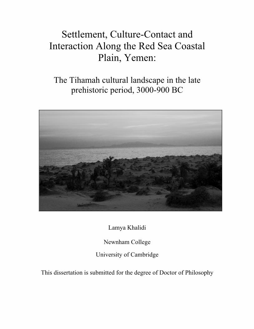
Settlement, Culture-Contact and Interaction Along the Red Sea Coastal
Plain, Yemen:
The Tihamah cultural landscape in the late prehistoric period, 3000-900 BC
Lamya Khalidi
Newnham College
University of Cambridge
This dissertation is submitted for the degree of Doctor of Philosophy
2006-03-08
Settlement, culture-contact and interaction along the Red Sea coastal plain, Yemen:
The Tihamah cultural landscape in the late prehistoric period, 3000-900 BC
Lamya Khalidi
The rise and fall of the rival South Arabian kingdoms (900 BC – AD 600) has been widely
documented through excavation and epigraphic data. This period witnessed the growth of
complex societies, each with its pantheon, a written language, and monumental architecture.
These kingdoms prospered along the desert fringe of Yemen as a result of organized large-
scale agricultural systems and the overland trade in aromatics between India and Africa, and
the Mediterranean. Yet the developments that led to the growth of these kingdoms have not
been adequately studied, leaving large discontinuities in our reconstruction of the regional,
chronological and cultural record. These gaps are partially the result of outdated perspectives,
methodologies and theoretical overviews that have dominated scholarly research in the region
for half a century. What has developed is a fragmented and unbalanced field of study that has
marginalized prehistory and minimized the importance and contribution of alternative socio-
economic communities as well as the regions they inhabited.
This dissertation addresses these gaps in the archaeological record of Yemen by focusing on
Red Sea coastal cultures in the late prehistoric period (3000-900 BC) and by tracing inter-
regional interaction between the coast and three adjacent zones. Multiple sources have been
utilized including archaeological surveys, material from previously excavated sites,
ethnographic and environmental research and historical sources. The variability and changes
in settlement strategy and cultural interaction are documented systematically within different
micro-environments of the Tihamah coastal plain. In order to address the regional imbalances

in our reconstruction of Yemen, this coastal region is compared to that to its east, namely the
adjacent western escarpment and the central highlands beyond it, and to its westerly
neighbours along the Horn of Africa littoral across the Red Sea. This research illuminates the
inextricable link that existed between humans and their landscape and how each cultural
landscape gradually formed according to its physical and perceived limitations and potentials.
Using the coastal communities – which existed at the balance of two divergent landscapes –
as a point of departure, the intricacies and levels of cultural interaction by sea on the one
hand, and by land on the other, are elucidated. Furthermore, it is shown that the variations of
such interactions were in part responsible for changes in settlement pattern and strategy, and
for the introduction of a number of ideologies and technologies that enabled large sedentary
towns to expand and thrive prior to the emergence of the South Arabian kingdoms. This
dissertation concludes by demonstrating how systematic survey strategies can reveal the
continuities which link regions and periods to one another, even if indirectly, and how the
long-term effects of small-scale interaction between groups and the perceived limitations of
certain landscapes can have long-lasting implications for cultural development.
Declaration
This dissertation is the result of my own work and includes nothing which is the outcome of
work done in collaboration except where specifically indicated in the text. This dissertation
does not exceed the word limit for the Degree Committee of the Faculty of Archaeology and
Anthropology at the University of Cambridge.
Lamya Khalidi
Settlement, Culture-Contact and Interaction Along the Red Sea Coastal
Plain, Yemen:
The Tihamah cultural landscape in the late prehistoric period, 3000-900 BC
Lamya Khalidi
Newnham College
University of Cambridge
This dissertation is submitted for the degree of Doctor of Philosophy
v
Table of Contents
Dedication xvi
Acknowledgements xvii
List of Tables xix
List of Figures xx
Chapter I 1-47
Introduction
1.1 Navigating Perspectives on Yemen 1
Politics/Geography
History/Prehistory
Chronology/Regionality
Yemen/Periphery
Scientific Methodology
1.2 Introduction to the Research 9
1.3 Discussion 14
1.4 Prehistoric Chronology: A Discussion of the Terminology 15
Geological Periods
‘Classical’ Archaeological Periods
Material Technology Ages
Terminology Used for this Dissertation
1.5 The Yemen Chronology: 21
The Prehistoric and Historic Backdrop for the Research
vi
The Classical and Medieval Sources
History of Previous Archaeological Work: Pre-History in Yemen
1.6 The Definition of a Prehistory for Yemen 26
The Palaeolithic Period (ca. 1.8Ma-10,000 years ago)
The Early Holocene ‘Neolithic’ Period (ca. 8000-3000 BC)
The Late Prehistoric ‘Bronze Age’ (ca. 3000-900 BC)
The Highlands
The Desert Fringe and Hadramawt
The Coastal Plains
Late Prehistoric to Early Historic Transition (ca.1200 – 900 BC)
The Early Historical Period: Early literate societies in South Arabia and Abyssinia
Chapter II 48-78
The Physical Context: Geography and Climate
2.1 Introduction 48
2.2 Coastal Geography: The Southern Red Sea Plains 52
The Tihamah
Climate
The Red Sea Littoral
Red Sea Winds and Currents
Corals and Wetlands
Aeolian Landforms
Coastal Land-Use
Red Sea Islands
vii
2.3 Eritrea, Djibouti and Ethiopia: The Coastal Plain and Highlands 61
2.4 Highland Geography 64
The Western Escarpment and Central Highlands
Climate
Resources
Highland Land-Use
2.5 The Westerly River Systems 69
Wadi Zabid
Wadi Rima’
Wadi Kuway’
2.6 Past Geography and Climate 74
2.7 Conclusion 77
Chapter III 79-124
Archaeological Landscape Survey: The Methodological approach
3.1 Introduction 79
3.2 Methods in Landscape Archaeology: Historical Background 80
3.3 The Current State of Archaeological Landscape Studies in Yemen 83
3.4 Techniques and Analysis in Defining the Ancient Cultural Landscape 87
Site Characteristics
Site Description and Designation
Site Label
Site Size
Site Periodization
Sampling and Collection Techniques
viii
Archaeological Landscape Features
Natural and Perceived Landscape Features
Environmental Data
Site and Landscape Taphonomy
Effects of Cultural Processes on Sites and the Landscape
Ethno-Archaeological and Anthropological Data
Influence of Political, Social and Economic Factors on Sites and the Landscape
3.5 Data Analysis 103
3.6 Scientific Analysis 103
3.7 The Study Regions 103
3.8 The Lowland Example 104
The Central Tihamah Survey
Archaeological Impact Surveys
Lowland Site Categories
Shell Middens
Artifact Scatters
Mounds
Megalithic Complexes
Tombs, Graves and Cemeteries
3.9 The Mid-Altitude Example 112
Mid-Altitude Site Categories
Standing Architecture
Rubble Mounds
Tombs, Graves and Cemeteries
ix
Artifact Scatters
3.10 The Highland Example 118
Re-assessment of the Highland Chronology
3.11 Conclusion 123
Chapter IV 125-184
Material Culture of the Tihamah Coastal Plain
4.1 Introduction 125
4.2 Shell 125
Diet
Terebralia palustris/ environmental reconstruction
Other Shell
Shell as Tools and Ornaments
Waste
Living surfaces
4.3 Faunal remains 131
Equids
Other fauna
Bone tools
4.4 Lithic Technology and Typology 135
x
4.5 Early Holocene Lithic Technologies 136
Bifaces: Type A Tools
4.6 Other tools 146
4.7 Late Prehistoric Lithic Technologies 146
Geometric Microliths: Type C tools
Pièces esquillées: Type D lithics
Al-Midamman: A technological case-study
The Tihamah Survey
Experimentation
Tool Distribution
4.8 Carnelian and Obsidian Bead Manufacture 164
4.9 Ceramic Assemblage 164
Pottery Identification
Ma’alaybah: The Early Ceramic Sequences
Sabir, Midamman, Sihi and Kashawba’: The Late Ceramic Sequences
4.10 Terracotta Figurines and Objects 183
Chapter V 185-215
Strategies of Subsistence: Prehistoric Sites of the Tihamah Coastal Plain
5.1 Introduction 185
5.2 Site Typology: 188
Strategies of Subsistence along the Tihamah Coastal Plain

xi
Shell Middens: Refuse versus Habitation
Type 1 Site: Aceramic Early Holocene shell middens (ca. 7th millennium BC)
Ash-Shumah: A Comparative Study
Type 2 Site: Holocene scatters
Type 3 Site: Aceramic Early Holocene shell middens (6th-5th millennia BC)
Gahabah (JHB) and al-Madaniyah (MAD): A Comparative Study
Type 4 Site: Late to Mid-Holocene Sites (4th –3rd millennium BC)
Surdud 1 (SRD-1): A Comparative Study
Type 6 Site: Late Prehistoric to Early Historic ceramic and? shell middens (3rd to
end of the 1st millennium BC)
Sihi: A Comparative Study
Type 5 Site: Megalithic Sites (3rd-2nd millennium BC)
Type 7 Site: Late Prehistoric to Early Historic ceramic sites (3rd to 1st millennium
BC)
5.3 Conclusion 212
Chapter VI 216-277
Megalithic Landscapes: The Tihamah Coastal Plain in the Late Prehistoric, Part I
6.1 Introduction 216
6.2 Megalithic Stone Monuments and the Domestication of the Landscape 218
The Terminology
Negotiating Interpretations of Spatial Distribution, Chronology, and Functionality
Negotiating Interpretations of Regionality
6.3 The Late Prehistoric Tihamah: 224
xii
Stone Monuments to Sprawling Settlements
al-Manassib of al-Midamman
Transportation
Discussion
al-Jerahi
Manassib al-Rukbat al-Mahbub of al-Kashawba’ (The Gas Station Site)
Am-Khamsah Bani al-Kaboos and Wali am-Khamsah
Al-Saba’a and Al-‘Uqsh
The Megalithic Anomaly: Al-Muhandid (Hijar al-Qaima/ wadi Hamili)
Discussion
6.4 Megalithic Traditions: The Horn of Africa 248
6.5 Stone Monuments of Yemen 253
Previous Discoveries
The Western Escarpment
The Highland Central Plains
Megalithic Features
Orthostats
Masna’at Maryah
The Desert Interior and Hadramawt
Interpretations of the Evidence
6.6 Megalithic Landscapes 273
The Late Prehistoric Cultural Landscape Along the Tihamah Coastal Plain
Space as Reflected Through Ancestry
Negotiating Space
Monuments as Central Places
xiii
Defining Space in the Landscape
Chapter VII 278-293
Obsidian Microlithic Technologies:
The Tihamah Coastal Plain in the Late Prehistoric, Part II
7.1 Introduction 278
7.2 Obsidian 279
Previous Work
Possible Tihamah Obsidian Sources
7.3 Obsidian from the Central Tihamah Survey Area: Analysis 284
Obsidian Analysis and Interpretation
7.4 Obsidian Microlithic Technologies 287
The African Example
Late Prehistoric Geometric Microliths in the Horn of Africa
Geometric Microliths in Arabia
Discussion
Chapter VIII 294-329
Conclusion
Negotiating the Spatial and Temporal Landscape of the Prehistoric Tihamah
Negotiating the Cultural Landscape of the Prehistoric Tihamah and Highlands
Through Settlement, Land-Use and Landscape Features
The Cultural Landscape: Land-use
The Constructed Landscape
xiv
Negotiating the Cultural Landscape of the Prehistoric Tihamah and its Adjacent
Regions Through the Symbolic, and the Perceived
The Symbolic Built Landscape
Strategies of Exhibition
Strategies of Monumentality
Territoriality
The Symbolic Natural Landscape
The Significance of the Visibility of Natural Monuments
Concepts of Space and Orientation
Concepts of Travel and Distance
Concepts of Temporality
Concepts of Verticality and Material Procurement:
Sea-bound Communities
Land-bound Communities
Discussion
Material Culture: Interpreting the Site, Site Interaction and Culture Contact
Material Culture Through Time and Space
Material Culture Through Time
Material Culture Through Space: Distribution and Site Interaction
The Role of Sites and Society in Inter-Site Interaction
Maritime Interaction
Modes of Inter-Site Interaction
Late Prehistoric Culture Contact Along the Tihamah Coastal Plain

xv
Bibliography 330-351
Appendix 1 352-364
Dedication
I dedicate this work to my parents Rashid and Mona who believed in me, to my siblings
Dima and Ismail who enriched me, to my grandmothers Selwa and Leila who nurtured me, to
Selma who naggingly mothered me, to Caterina who inspired me, to my friends and family
who tolerated me, to Augusta who guided me, to the inventor of the flip-flop and the pickers
of coffee beans, to the breathtaking Yemen of past and present and its people who continue to
enlighten me, to the Fazza that inspired me and to the Tihamah … oh the Tihamah that
continues to draw me to its shores and will forever remain a gem to mine blinded eyes.
Acknowledgments
I want to thank those funding bodies and institutions that made this work possible in the field
and elsewhere. My first season in Yemen in 2001 as well as fieldwork in 2002 in the Hazm
al-Udayn area was funded by fellowships from the American Institute for Yemeni Studies
(AIYS). The 2003 field season in the central Tihamah was funded by an IIE Fulbright grant.
Finally fieldwork in Eritrea in the summer of 2003 was funded by CAORC. In addition, the
Pelham Roberts Grant and the Anthony Wilkin Fund partially funded my research at the
University of Cambridge in 2001. Most of the time I spent in Yemen was under the auspices
of the AIYS. I am thankful to the AIYS and to Dr Maria Ellis and Dr Christopher Edens, its
directors. I would also like to thank the former and current directors of CEFAS, Dr François
Burgat and Dr Jean Lambert, for having hosted me and supported my work. My thanks go as
well to Newnham College, Cambridge.
I wish to thank the Yemeni General Organization for Antiquities, Manuscripts and Museums
and especially its former president, Dr Yusuf ‘Abdallah, for making my fieldwork and stay in
Yemen possible. I extend my deep gratitude to Dr Abd al-Karim al-Iryani and Faris Sanabani
for their generous kindness and support. I owe much to the representatives who accompanied
me on projects throughout Yemen, namely Ali Sanabani, Khaled al-‘Ansi, Ahmed Haidarah,
Amin al-Mawri and Muhammad al-Qadhi. I am especially grateful for the friendship and
dedication of Ahmed al-Mosabi and Issam Hamana, without whom I could have never done
my work in the Tihamah. I also wish to thank Dr. Yosef of the National Museum in Eritrea,
who allowed me to travel to sites throughout the country.
Fieldwork in Yemen would never have been possible had it not been for my initial work with
Dr Selma al-Radi on the Amiriyah Mosque Restoration Project and Dr Tony Wilkinson on
the Dhamar Survey Project in the highlands of Yemen. I would also like to thank the
members of the Dhamar Survey Project including Dr Krista Lewis who made so much of my
work possible and Joseph Daniels. My thanks also go to Dr Vincenzo Francaviglia for his
help in analyzing the obsidian; Dr Marie-Louise Inizan and Rémy Crassard for their help with
the lithics and their constant support, Dr Vittoria Buffa for her advice with the ceramics; and
Dr Edward Keall for his support. For their help with analysis, my thanks go to Marsha Levine
and Fiona Marshall, for help with lithics drawings Julien Espagne, and for help with ceramic
drawings, Pat Smith.
For their help in Yemen and elsewhere, I want to thank Prof. McGuire Gibson, Dr Jason Ur
and the Oriental Institute of the University of Chicago, Marylene Barrett, Rémy Audouin,
Mounir Arbach and Marco Livadiotti for the open houses, Ingrid Hehmeyer, Carl Phillips,
Burkhardt Vogt, Patrice Chevalier, Paul Zimmerman, the staff at Universal Travel and
Tourism who were marvelously resourceful, Sa’adi Salama and the Palestinian Embassy in
Sanaa.
I would not have been able to do what I have done without the aid of many Yemenis,
including ‘Ammar and Maysoun, ‘Abdallah Masoudi, driver and guardian angel, ‘Abdallah
Hadrami and especially Muhammad Nasser al-Beidhani who untiringly accompanied me.
Several families and individuals were exceedingly generous: the Al Sheikh family, Mama
Sharafiya, Bayt Hamana my Haysi family, Bayt am Zugagiyah my Fazza family, Ahmed
Mihrezi, and Bayt Shenaynah.
I received much support in Yemen and France from individuals and institutions:
the CNRS, Université de Paris X, the MMSH in Aix en Provence, Christian Robin,
Alessandro de Maigret, Sabina Antonini, Jérémie Schietecatte and Hélène David for access to
maps.
In Eritrea, in addition to Dr. Yosef, my thanks go to Travel House, Tedros Kebedde and
Solomon, the Diana Bar crew, notably Elias and Ermias, the Italian Embassy, Saba Kidane
and Bereket Mesfin. In addition to those already mentioned, family and friends were an
inspiration and a source of sustenance, both material and spiritual: Xavier Grima and Dr
Anne Carol, Bill &Bernardine, Dr Carlo Colantoni, Ben Rawlence, Mattias and hibou.
Last but by no means least, my deepest thanks go to my thesis supervisor, Dr Augusta
McMahon and my advisor Prof Charly French, for all their assistance throughout the work on
this dissertation.
xix
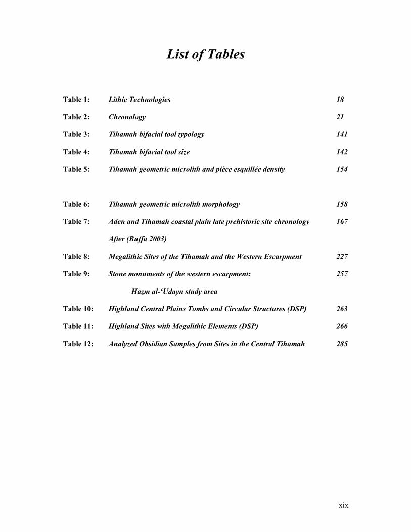
List of Tables
Table 1: Lithic Technologies 18
Table 2: Chronology 21
Table 3: Tihamah bifacial tool typology 141
Table 4: Tihamah bifacial tool size 142
Table 5: Tihamah geometric microlith and pièce esquillée density 154
Table 6: Tihamah geometric microlith morphology 158
Table 7: Aden and Tihamah coastal plain late prehistoric site chronology 167
After (Buffa 2003)
Table 8: Megalithic Sites of the Tihamah and the Western Escarpment 227
Table 9: Stone monuments of the western escarpment: 257
Hazm al-‘Udayn study area
Table 10: Highland Central Plains Tombs and Circular Structures (DSP) 263
Table 11: Highland Sites with Megalithic Elements (DSP) 266
Table 12: Analyzed Obsidian Samples from Sites in the Central Tihamah 285

xx
List of Figures
Chapter I
Figure 1: Map of the Four Study Regions (Yemen and Eritrea) 11
Map by L. Khalidi
Figure 2: Map of Prehistoric Research in Yemen 25
L. Khalidi after R. Crassard in (Crassard et al. 2005)
Chapter II
Figure 3: Map of Yemen 50
Map by L. Khalidi from base map by H. David
Figure 4: Winds over the Indian Ocean and Red Sea (May to October) 56
Taken from (Facey 2004: 10, fig.2)
Figure 5: Winds over the Indian Ocean and Red Sea (November to April) 56
Taken from (Facey 2004: 11, fig.4)
Figure 6: Map of the Horn of Africa 63
Taken from (Phillipson 1998: 10, fig.1)
Chapter III
Figure 7: Central Tihamah coastal survey transects 88
Map by L.Khalidi
Figure 8: Total coverage survey in the western escarpment survey area 89
(HU)
xxi
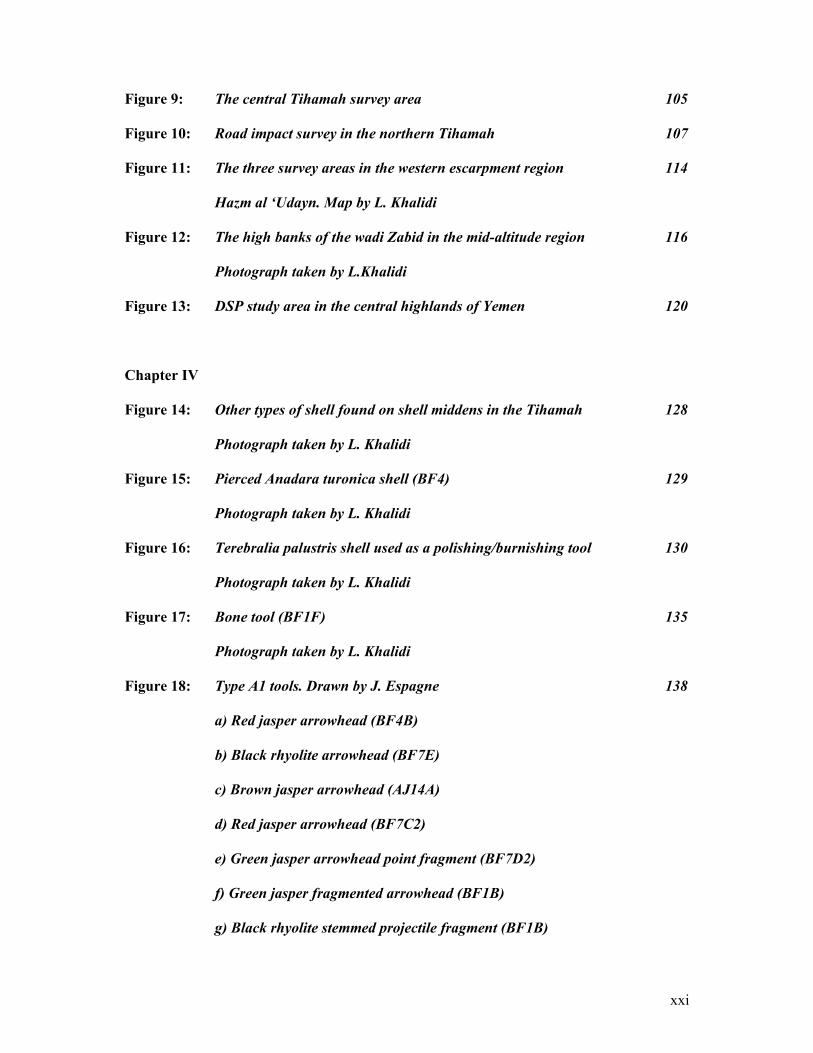
Figure 9: The central Tihamah survey area 105
Figure 10: Road impact survey in the northern Tihamah 107
Figure 11: The three survey areas in the western escarpment region 114
Hazm al ‘Udayn. Map by L. Khalidi
Figure 12: The high banks of the wadi Zabid in the mid-altitude region 116
Photograph taken by L.Khalidi
Figure 13: DSP study area in the central highlands of Yemen 120
Chapter IV
Figure 14: Other types of shell found on shell middens in the Tihamah 128
Photograph taken by L. Khalidi
Figure 15: Pierced Anadara turonica shell (BF4) 129
Photograph taken by L. Khalidi
Figure 16: Terebralia palustris shell used as a polishing/burnishing tool 130
Photograph taken by L. Khalidi
Figure 17: Bone tool (BF1F) 135
Photograph taken by L. Khalidi
Figure 18: Type A1 tools. Drawn by J. Espagne 138
a) Red jasper arrowhead (BF4B)
b) Black rhyolite arrowhead (BF7E)
c) Brown jasper arrowhead (AJ14A)
d) Red jasper arrowhead (BF7C2)
e) Green jasper arrowhead point fragment (BF7D2)
f) Green jasper fragmented arrowhead (BF1B)
g) Black rhyolite stemmed projectile fragment (BF1B)
xxii
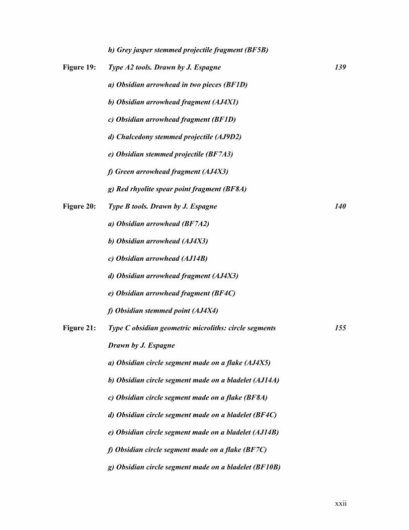
h) Grey jasper stemmed projectile fragment (BF5B)
Figure 19: Type A2 tools. Drawn by J. Espagne 139
a) Obsidian arrowhead in two pieces (BF1D)
b) Obsidian arrowhead fragment (AJ4X1)
c) Obsidian arrowhead fragment (BF1D)
d) Chalcedony stemmed projectile (AJ9D2)
e) Obsidian stemmed projectile (BF7A3)
f) Green arrowhead fragment (AJ4X3)
g) Red rhyolite spear point fragment (BF8A)
Figure 20: Type B tools. Drawn by J. Espagne 140
a) Obsidian arrowhead (BF7A2)
b) Obsidian arrowhead (AJ4X3)
c) Obsidian arrowhead (AJ14B)
d) Obsidian arrowhead fragment (AJ4X3)
e) Obsidian arrowhead fragment (BF4C)
f) Obsidian stemmed point (AJ4X4)
Figure 21: Type C obsidian geometric microliths: circle segments 155
Drawn by J. Espagne
a) Obsidian circle segment made on a flake (AJ4X5)
b) Obsidian circle segment made on a bladelet (AJ14A)
c) Obsidian circle segment made on a flake (BF8A)
d) Obsidian circle segment made on a bladelet (BF4C)
e) Obsidian circle segment made on a bladelet (AJ14B)
f) Obsidian circle segment made on a flake (BF7C)
g) Obsidian circle segment made on a bladelet (BF10B)
xxiii
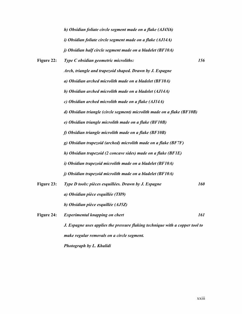
h) Obsidian foliate circle segment made on a flake (AJ4X6)
i) Obsidian foliate circle segment made on a flake (AJ14A)
j) Obsidian half circle segment made on a bladelet (BF10A)
Figure 22: Type C obsidian geometric microliths: 156
Arch, triangle and trapezoid shaped. Drawn by J. Espagne
a) Obsidian arched microlith made on a bladelet (BF10A)
b) Obsidian arched microlith made on a bladelet (AJ14A)
c) Obsidian arched microlith made on a flake (AJ14A)
d) Obsidian triangle (circle segment) microlith made on a flake (BF10B)
e) Obsidian triangle microlith made on a flake (BF10B)
f) Obsidian triangle microlith made on a flake (BF10B)
g) Obsidian trapezoid (arched) microlith made on a flake (BF7F)
h) Obsidian trapezoid (2 concave sides) made on a flake (BF1E)
i) Obsidian trapezoid microlith made on a bladelet (BF10A)
j) Obsidian trapezoid microlith made on a bladelet (BF10A)
Figure 23: Type D tools: pièces esquillées. Drawn by J. Espagne 160
a) Obsidian pièce esquillée (TH9)
b) Obsidian pièce esquillée (AJ5Z)
Figure 24: Experimental knapping on chert 161
J. Espagne uses applies the pressure flaking technique with a copper tool to
make regular removals on a circle segment.
Photograph by L. Khalidi

xxiv
Figure 25: Horizontally burnished jar with two vertically pierced handles. 169
From the site of al-‘Uqsh (southern Tihamah)
Photograph by L. Khalidi
Figure 26: Ma’alaybah ceramic types from phases 1A-C 172
Taken from (Buffa 2003)
Figure 27: Ma’alaybah ceramic types from phases 1B-C 174
Taken from (Buffa 2003)
Figure 28: Forms from the site of Kashawba’ (ZD1A & C) 175
a-e) brown burnished bowls with vertical incised decoration and horizontal
pierced handles. Sand and grit temper
f) deep brown burnished pot with impressed decoration.
Sand and grit temper
Photographs by L. Khalidi
Figure 29: An assortment of Sabir 2 forms. Clockwise from back: 176
Fenestrated vessel, footed bowl and a spouted vessel
After (Vogt 1997: 45)
Figure 30: Fenestrated vessel fragments (a-b) 178
Incense burner fragments (c-h) from central Tihamah sites
a) Fenestrated vessel fragment with punctate decoration (ZD1A)
Sand and grit temper
b) Fenestrated vessel fragment with impressed wavy-line decoration
Sand and grit temper. Remnants of red slip (ZD1A)
c) Brown burnished incense burner rim fragment (ZD1C)
Impressed decoration. Sand and grit temper
d) Red slip incense burner rim fragment (ZD1A)

xxv
Impressed and incised decoration. Sand and grit temper
e) Incense burner carination fragment (BF11)
Impressed wedge decoration. Sand and grit temper
f) Incense burner carination fragment (BF11)
Punctate decoration. Sand and grit temper
g) Incense burner carination fragment (ZD1A)
Red slip and punctate decoration. Sand and grit temper
h) Possible burnished black ware incense burner fragment
Punctate impressed decoration. Sand and grit temper (ZD1A)
Photographs by L. Khalidi
Figure 31: Punctate and wedge decorated strap handles 181
From the central Tihamah survey area
a) Strap handle with incised line decoration (BF10A)
Sand and grit temper
b) Strap handle with vertical burnishing (ZD1A)
Incised line and diagonal punctate decoration. Sand and grit temper
c) Dark brown burnished strap handle (ZD1A)
Incised line and punctate decoration. Sand and grit temper
d) Black burnished strap handle (BF11)
Incised line and punctate decoration. Sand and grit temper
e) Dark brown burnished strap handle (ZD1A)
Incised line and punctate decoration. Sand and grit temper
f) Dark brown burnished strap handle (ZD1A).
Incised line and punctate decoration. Sand and grit temper.
g) Tan burnished strap handle (ZD1A)
xxvi
Incised line and punctate decoration. Sand and grit temper
h) Dark brown burnished strap handle (BF11)
Incised line and punctate decoration. Sand and grit temper
i) Orange-tan strap handle (BF11)
Incised line and punctate decoration. Sand and grit temper
j) Sienna brown burnished strap handle (ZD1A)
Wedge impressed decoration. Sand and grit temper
k) Dark brown burnished strap handle (ZD1A)
Triangular wedge impressed decoration. Sand and grit temper
l) Tan burnished strap handle (ZD1A)
Punctate decoration. Sand and grit temper
Photographs by L. Khalidi
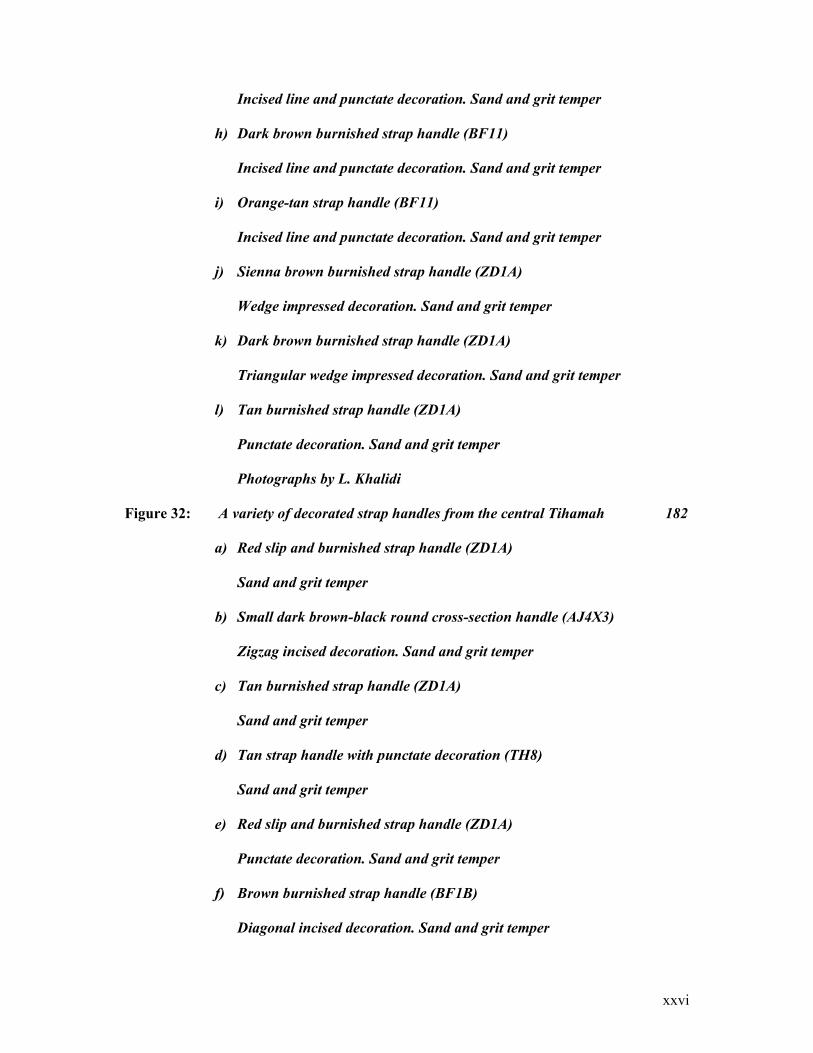
Figure 32: A variety of decorated strap handles from the central Tihamah 182
a) Red slip and burnished strap handle (ZD1A)
Sand and grit temper
b) Small dark brown-black round cross-section handle (AJ4X3)
Zigzag incised decoration. Sand and grit temper
c) Tan burnished strap handle (ZD1A)
Sand and grit temper
d) Tan strap handle with punctate decoration (TH8)
Sand and grit temper
e) Red slip and burnished strap handle (ZD1A)
Punctate decoration. Sand and grit temper
f) Brown burnished strap handle (BF1B)
Diagonal incised decoration. Sand and grit temper
xxvii
g) Brown burnished strap handle (ZD1A)
Incised triangle design and wedge impressed decoration. Sand and grit
temper
h) Tan strap handle (ZD1A)
Diamond incised and punctate decoration. Sand and grit temper
i) Dark brown burnished strap handle (BF10A)
Diamond incised line and punctate decoration. Sand and grit temper
Photographs by L. Khalidi
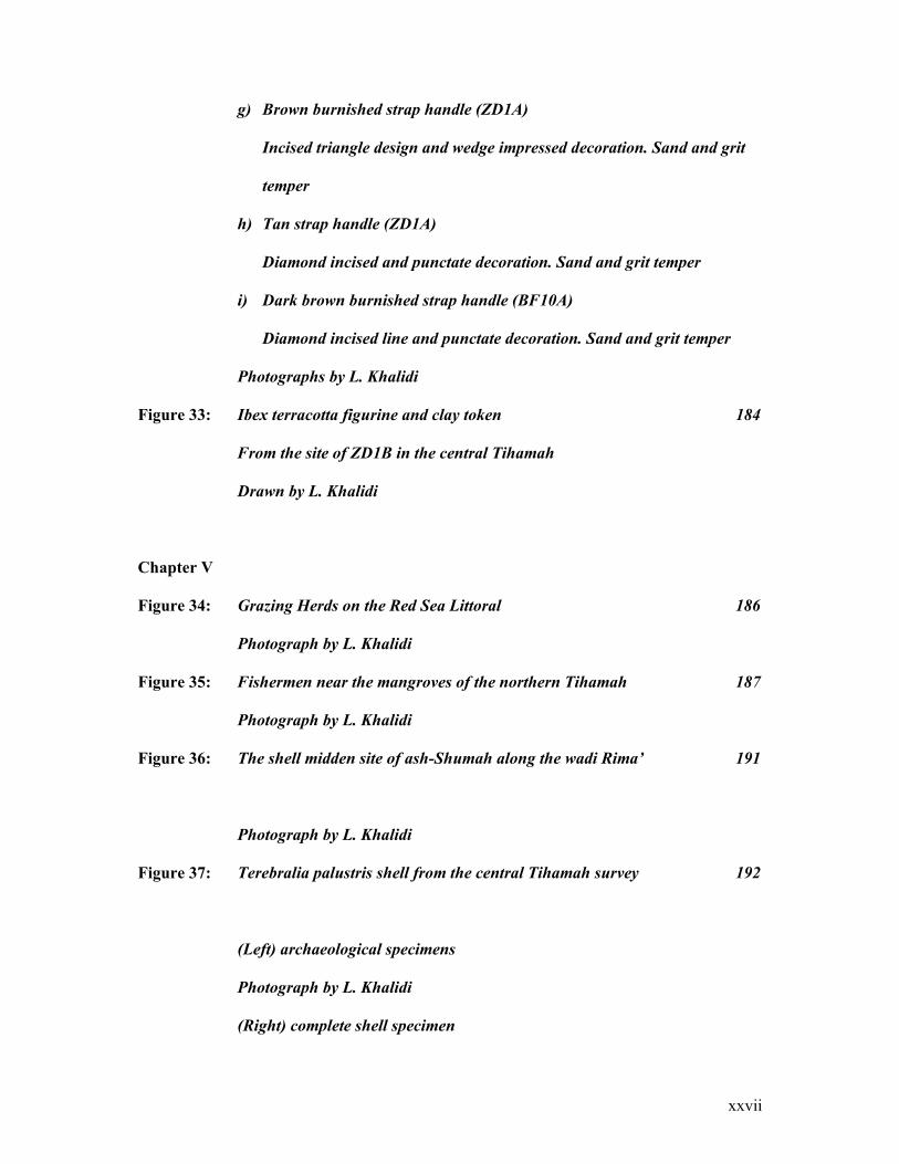
Figure 33: Ibex terracotta figurine and clay token 184
From the site of ZD1B in the central Tihamah
Drawn by L. Khalidi
Chapter V
Figure 34: Grazing Herds on the Red Sea Littoral 186
Photograph by L. Khalidi
Figure 35: Fishermen near the mangroves of the northern Tihamah 187
Photograph by L. Khalidi
Figure 36: The shell midden site of ash-Shumah along the wadi Rima’ 191
Photograph by L. Khalidi
Figure 37: Terebralia palustris shell from the central Tihamah survey 192
(Left) archaeological specimens
Photograph by L. Khalidi
(Right) complete shell specimen

xxviii
Figure 38: Teeth of the Equus asinus 193
Recovered on survey in the central Tihamah
Photograph by L. Khalidi
Figure 39: Type 1 (7th millennium BC) shell midden site distribution 194
The central Tihamah survey area
Map by L. Khalidi
Figure 40: Type 2 Holocene scatter distribution 196
A1 (7th millennium BC) and A2 (6th millennium BC) tool types
Map by L. Khalidi
Figure 41: Type 3 site distribution in relation to Type A2 and B tool types 198
Map by L. Khalidi
Figure 42: Otolith collected in the central Tihamah 200
Photograph by L. Khalidi
Figure 43: Type 4 site distribution 201
Map by L. Khalidi
Figure 44: Type 1 and Type 4 site distribution 202
The shift of sites towards the current coastline between the
7th and 4th millennia BC
Map by L. Khalidi
Figure 45: Type 6 site distribution (with Type C and D obsidian tools) 206
Map by L. Khalidi
Figure 46: Activity Areas (Type 6) with Type C and D tool distribution 207
Map by L. Khalidi
Figure 47: Type 5 sites with Type 7 mounded sites 210
xxix
Chapter VI
Figure 48: Distribution of Megalithic sites on the Tihamah Coastal Plain 226
Map by L. Khalidi
Figure 49: Al-Manassib alignment. Photograph by L. Khalidi 229
Figure 50: The islands of Zuqar and Hanish visible during mid-winter 230
Photograph by L. Khalidi
Figure 51: Crossing between the sites of Midamman and Beilul 232
Map by L. Khalidi
Figure 52: Large stones of the site of Saba’a in the southern Tihamah 242
Photograph by L. Khalidi
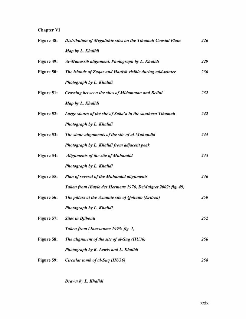
Figure 53: The stone alignments of the site of al-Muhandid 244
Photograph by L. Khalidi from adjacent peak
Figure 54: Alignments of the site of Muhandid 245
Photograph by L. Khalidi
Figure 55: Plan of several of the Muhandid alignments 246
Taken from (Bayle des Hermens 1976, DeMaigret 2002: fig. 49)
Figure 56: The pillars at the Axumite site of Qohaito (Eritrea) 250
Photograph by L. Khalidi
Figure 57: Sites in Djibouti 252
Taken from (Joussaume 1995: fig. 1)
Figure 58: The alignment of the site of al-Suq (HU36) 256
Photograph by K. Lewis and L. Khalidi
Figure 59: Circular tomb of al-Suq (HU36) 258
Drawn by L. Khalidi
xxx
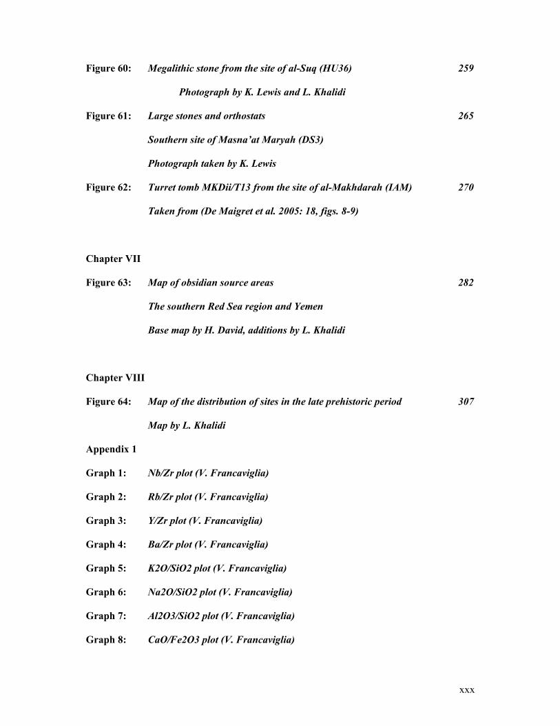
Figure 60: Megalithic stone from the site of al-Suq (HU36) 259
Photograph by K. Lewis and L. Khalidi
Figure 61: Large stones and orthostats 265
Southern site of Masna’at Maryah (DS3)
Photograph taken by K. Lewis
Figure 62: Turret tomb MKDii/T13 from the site of al-Makhdarah (IAM) 270
Taken from (De Maigret et al. 2005: 18, figs. 8-9)
Chapter VII
Figure 63: Map of obsidian source areas 282
The southern Red Sea region and Yemen
Base map by H. David, additions by L. Khalidi
Chapter VIII
Figure 64: Map of the distribution of sites in the late prehistoric period 307
Map by L. Khalidi
Appendix 1
Graph 1: Nb/Zr plot (V. Francaviglia)
Graph 2: Rb/Zr plot (V. Francaviglia)
Graph 3: Y/Zr plot (V. Francaviglia)
Graph 4: Ba/Zr plot (V. Francaviglia)
Graph 5: K2O/SiO2 plot (V. Francaviglia)
Graph 6: Na2O/SiO2 plot (V. Francaviglia)
Graph 7: Al2O3/SiO2 plot (V. Francaviglia)
Graph 8: CaO/Fe2O3 plot (V. Francaviglia)

xxxi
Graph 9: K2O/SiO2 plot (V. Francaviglia)
Graph 10: % Normative Quartz/ Sum (%) of Normative Femics (V. Francaviglia)
Graph 11: Discriminant Function (Nb, Zr, Y, Sr, Rb, Ba) (V. Francaviglia)
Graph 12: Discriminant Function (Na, Al, Si, K, Ca, Fe) (V. Francaviglia)
1
I
Introduction
1.1 Navigating Perspectives on Yemen
The historical prominence of what is now Yemen was shaped by the advantages of its
geographical and strategic position. It is situated at the convergence of interacting socio-
political networks and historically it has played a role as an intermediary in the exchange of
material goods and cultural ideologies. Southwest Arabia, the region of which Yemen forms
a part (and which also includes southwestern Saudi Arabia) lies at the crossroads of three
geographic regions: Asia, the Near East and Africa. It forms a crucial juncture for continental
and maritime interaction spheres that have existed for millennia, and it has provided channels
for contact between diverse cultures. Its legendary mystique as a land of frankincense and
myrrh, of the Queen of Sheba, and as a crossroads from one far away land to another, has
fuelled modern historical and archaeological research in the region and has left an imprint of
awe and mystery in the imaginations of many. It is therefore no surprise that in the last
century, historical and archaeological studies in Yemen have focused on the period between
900 B.C. and 600 A.D. (the so-called South Arabian period) when the great South Arabian
kingdoms rose and fell along the fringe of the Sayhad desert1 and in the central highlands, as
they vied for control over the valuable incense trade routes.
Politics/Geography
1 The “Sayhad desert” is the name that medieval Arab geographers gave to the desert now known as the Ramlat as-Sab’atayn.
2
In certain general respects geography favored the development of sailing from Arabian shores. Near
these coasts lie the most fertile parts of Arabia, al-Yaman, Hadramawt, and ‘Uman; communication
between them by sea was no more formidable than the crossing of the deserts and mountains which
separated them on land. (Hourani 1995: 4)
This region’s geographic prominence prefaced the South Arabian period. Nonetheless,
monolithic views, such as migrationist and diffusionist models that inherently imply
unidirectional change and influence, have dominated theories dealing with the development
of complex societies and large scale trade and exchange systems in Yemen. In conjunction
with Sabaeo-centric views, this has virtually dismissed the possibility that complex societies
may have existed previous to the emergence of the South Arabian kingdoms. In the case of
the Red Sea coastal plain, this dismissal is based on three false and outdated precepts that are
habitually implicated by the leading scholars in Yemeni archaeology. The first is the
assumption that if resources are available in Yemen, there is no need to procure them
elsewhere. The second is that prehistoric societies were not complex enough to navigate
across major bodies of water. The third is that complex socio-political networks must exist in
order to have trade and exchange. In all three cases, there is a disregard for the nature of the
geography of Yemen where, as a general rule, bodies of water are no more of an impediment
to travel than major mountain ranges and vast deserts. The geography is such that it hosted
interaction on many levels, especially at a small scale and where the landscapes were familiar
to those traversing them.
What underlie such perspectives are not just modern perceptions of the physical geography,
where boundaries are constructed, but also politics. Said powerfully expresses the depth to
which geography and politics can be inextricably tied, saying: “ in the history of colonial
invasion, maps are always first drawn by the victors, since maps are instruments of conquest.
Geography is therefore the art of war” (Said 1996: 28). In prehistory, national boundaries
3
were non-existent, cultural boundaries were often less marked, and seas acted as connectors.
Modern territories have political implications that are unrelated to those of ancient territories
and alternative perceptions and perspectives of landscapes. As Meskell maintains, “ We
should be aware that modern cartographies and mappings are recent inscriptions that did not
have contiguous parallels in antiquity: these national constructions can also be the result of
colonialist or imperialist imperatives” (Meskell 1998: 3). Geo-political boundaries have
impeded the movement and the continuum through space of a large number of groups
worldwide. However, in Yemen today, fishermen and nomadic groups cross these artificial
lines often, as they did in the past2.
Racial lines are also ambiguous, given the level of interaction, immigration and intermarriage
between different groups over the millennia. The Tihamah and Hadramawt’s long history of
contacts with the Horn of Africa, India, Indonesia and Malaysia and with Ottoman Turkey are
evident in the different ethnicities that make up their populations. The racial diversity that has
existed in Yemen and the surrounding regions for millennia has not lessened racist
tendencies, both in academia and Yemen in general, to overlook an African influence in the
region. Certain periods such as the Abyssinian invasion in 525 AD are attested in the
epigraphy and archaeological record and are therefore not contested. However, discussion of
pre-South Arabian exchange in African resources, and the appropriation of African
technologies and ideologies in Yemen3 are less prevalent and can be diverted into racialist or
chauvinistic polemics.
2 Until recently the northern border with Saudi Arabia was contentious and many bedouin continued to follow their seasonal desert routes in and out of both countries. Similarly, until the outbreak of the Hanish islands war between Eritrea and Yemen, fishermen from both sides continued to use Red Sea waters and either coast for fishing. Now Yemeni fishermen must have permits to cross into Eritrean waters, and vice versa. 3 Several opposing views exist on the subject and are more likely to be expressed at conferences rather than in publications.
4
In addition to politics and race, which have loomed large in defining the trajectory of
archaeology in Yemen, religion and national identity have heavily influenced the focus on the
historical period. The South Arabian period, on the one hand, exhibits a developed and
monumental architecture, an ancient Semitic language that is a precursor to Arabic, a rich
material culture and a history that forms a part of the Biblical or monotheistic narrative. It
makes up a rich and legitimate cultural heritage in the eyes of the Islamic and Arab world and
thus inspires pride in a Yemeni national identity. Prehistory on the other hand, predates
events mentioned in the Koran, the Bible and the Talmud and is thus ignored or at best
reticently tolerated in Yemen today.
History/Prehistory
Such political and theoretical preconceptions have effectively marginalized prehistory along
with its scientific methodology. Despite the fact that excavations and surveys in the region
have accumulated an adequate record of monumental architecture, elite goods and epigraphic
data from the South Arabian period, the bias towards the historical period at its most
monumental has been at the expense of studies with differing perspectives. Studies
contributing to wider socio-cultural and economic perspectives have been almost entirely
disregarded. Moreover, pre-history remains a vague and opaque period, a kind of premonition
of the rise of history. Although a number of pioneering studies have been carried out for the
prehistoric period, chiefly those dealing with the later periods leading into the advent of
writing, the gaps remain large. While the ‘Bronze Age’ (ca. 3000-900 BC) remains poorly
defined, the ‘Neolithic’ (ca. 8,000- 3000 BC) is very poorly understood and both periods are
defined by an erroneous and inappropriate terminology rooted in European and Syro-
Palestinian prehistory. Likewise, the Pleistocene, dating from 1.8 million to 10,000 years ago
(the equivalent archaeological stages of which make up the Upper, Middle and Lower
5
Palaeolithic), is virtually unknown in Yemen, given that few sites have been found, and none
have been excavated.
Chronology/Regionality
The lacunae in our information suggest that until very recently, much of the archaeological
work conducted in Yemen has been univariate in its theoretical and methodological approach.
While a large number of inscriptions, temples and public buildings are documented and
studied, comprehensive material-cultural typologies or chronologies remain provisional at
best. The prehistoric, pre-Islamic (South Arabian) and Islamic periods have been dealt with
separately and have become individual fields of study. As will be demonstrated later in this
chapter, the transitions that are key to understanding the trajectory of the cultures at hand
have not been sufficiently dealt with. The chronology therefore lacks continuity and each
period appears to begin and end abruptly.
The lack of chronological continuity is further weakened by a lack of regional continuity in
the archaeological record of Yemen. The fields of study (Prehistory, South Arabian, Islamic)
are thus constituted by sets of data that have no spatial context outside of the zones of study.
Although links between the highlands and the desert fringe to the east are frequently
insinuated, the handful of studies undertaken in these geographic regions have not followed
these links systematically. With the exception of De Maigret’s surveys in the Hada/ Khawlan
area of the highland central plains, which surveyed several river drainage systems some
distance eastwards towards the desert fringe (De Maigret et al. 1990), no attempts have been
made to follow potential regional links on the ground. The relationship between the Red Sea
coastal plain and the adjacent highlands during the ‘Bronze Age’ has likewise never been
fully investigated so that by default there is a highland and a lowland culture with nothing in
6
between. The relationship has come to be defined by isolated finds in one region or another,
such as a seashell in the highlands or a single ceramic sherd with highland affinities on the
coast. Such rare finds form part of a small-scale cross-regional interaction sphere that has
always existed, but has never been adequately demonstrated.
Yemen/Periphery
The fundamental lack of integration between the diverse geographical regions of Yemen on
both a micro and macro level is an added setback to attempts to link Yemen’s prehistory and
history to the outside world. Though lacking viable proof it is generally assumed that there
must have been an underlying southwest Arabian culture that linked all regions in Yemen to
each other. For example, this is demonstrated in the terminology that has been appropriated
for the ‘Neolithic’ tool industries in Arabia. The term ‘Arabian Bifacial Tradition’ is widely
used to describe the early Holocene bifacial lithic industries from the Tihamah to the Arabian
Gulf. The need to categorize a tool industry, which had a large amount of variability in its
forms and its chaînes opératoires just within Yemen, as Arabian, is just one indication of
attempts by many Arabian specialists4 to unjustifiably link all of peninsular Arabia under a
single cultural term. Such pigeonholing not only undermines the intricacy of regional
variability within Yemen but also of peripheral culture-contact. Furthermore, these
approaches to archaeology impede the integration of research perspectives that take account
of external interaction spheres. This is quite surprising for a country such as Yemen that has,
since prehistoric times and certainly in modern times, been distinguished from other regions
by its unique fusion of cultures.
4 See (Edens 1988: 15)
7
Just as Hadramawt has been a part of the ‘Indian Ocean World’ since prehistoric times,
distinguished from other regions of Yemen by its deep-rooted affinities with India, Indonesia
and Malaysia, the Tihamah has likewise been a part of the ‘Red Sea World’. What
distinguishes the Tihamah coastal plain today from the rest of Yemen is its African affinities.
This is mirrored in the coastal areas of east Africa (from the Horn of Africa coast down to the
Swahili coast), which is distinguished from the inland regions by its Arabian affinities. In the
case of the Tihamah, the modern African affinities are obvious and factor into every aspect of
the Tihami cultural landscape, whether in the climate, the vegetation, the traditional
architecture and the crafts. What remains debatable is whether these affinities are the
outcome of a long history of interaction or are simply more recent. The latter is unlikely
given that such integration cannot occur suddenly.
Moreover, classical texts written in the second half of the first millennium BC and at the turn
of the Common Era regarded the Red Sea as a sort of thoroughfare of activity that was
predisposed to trade and interaction. Some even went so far as to describe the cultural
landscapes of the two coasts of the southern Red Sea in a similar light. According to the
Periplus Maris Erythraei, written by an Egyptian-Greek merchant in the first century AD, the
people inhabiting the Horn of Africa or the ‘land of the Barbaroi’ are referred to by the author
as ‘Ichthyophagoi’ (fish eaters) on the coast and ‘Agriophagoi’ (wild animal eaters) and
‘Moschophagoi’ (shoot eaters) in the interior. The author writes that “ The coastal parts are
inhabited by Ichthyophagoi (“fish eaters”) living in mean huts built in narrow areas5…” (The
Periplus Maris Erythraei 1980: 51), while in describing the Arabian coast he states “ The
coastal area is, similarly, marked by clusters of the mean huts of the Ichthyophagoi…” (Ibid:
63). Although the author of the text is quite observant of cultural differences of the people
5 In Casson’s ‘General Commentary’ of the text, he interprets the ‘narrow areas’ as the point where the wadis met the coast. (Ibid: 100)
8
encountered, he nonetheless finds similarities between the two opposing coasts of the Red
Sea. It is therefore important, when dealing with regional interaction in the Tihamah, even at
the prehistoric level, to treat contact with the coast of Africa as equally viable as contact with
the highlands.
By the same token, coastal cultures that subsist at the balance of two divergent and yet
inextricably tied environments, land and sea, can be viewed as dependant equally on both
worlds. There exists a natural human tendency to focus on the land-bound aspect of such
cultures when in fact they often look seaward, depending on the land for materials that enable
them to live along these seaways. The geographical perspective that was often provided in the
texts of the Classical period was sea-oriented. Unlike many modern perspectives that regard
the world as terrestrial, surrounded by bodies of water, some Greek geographers such as
Strabo saw the inverse:
In his frame of reference (Strabo) the inhabited world was an island surrounded by the ocean. On its
fringes were found plants, animals and men who grew stranger the further away they went from the
Greek-Roman centre… (Prabha Ray 2003: 26)
Such sea-oriented perspectives are crucial to understanding the elaborate relationship that
exists between the sea and the land. A multi-directional approach can thus link maritime trade
networks with local fishing and sailing communities, which can then be related to land-based
communities and differing levels of land-based interaction.
Scientific Methodology
The above-mentioned constrictive views and theories that have inhibited the field of Yemeni
archaeology are reflected in the methodologies used. The looming spatial and chronological
9
gaps in the southwest Arabian archaeological record are in large part due to outdated field
methodologies. Systematic survey strategies that deal with human-environment relationships
have, until recently, been relegated to the margins of methodological approaches to
archaeology in Yemen. The incense trade routes, for example, are constantly mentioned,
while at the same time very little work has been done to track such extensive regional
networks on the ground. These trade routes are examples of archaeological features that have
the potential to link sites inter- and intra-regionally. They provide one line of evidence for
interaction between different geographic areas by literally connecting physical regions to
each other. Instead most attempts to follow such road networks have relied on epigraphic data
rather than archaeological survey.
In this section the wide-ranging obstacles that exist in the field of Yemeni archaeology were
presented. The next section will introduce the research by summarizing the approaches used
and the concepts that have guided the fieldwork and the analysis, in light of the current state
of Yemeni archaeology.
1.2 Introduction to the Research
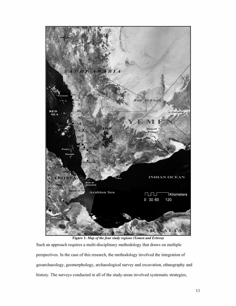
This research, which spans approximately six millennia, combines a range of spatial and
chronological data recovered from surveys conducted in four areas: the Tihamah coastal
plain, the Hazm al ‘Udayn western mid-altitude region, the Central Highlands of Yemen, and
Eritrea (fig.1). While fieldwork conducted along the Tihamah coastal plain survey is the
focus of this work, additional study areas contextualize the coast by addressing the regions
adjacent. Lying to the east of the coastal plain is the western escarpment (Hazm al ‘Udayn
study area) rising steeply to the central highland plains (Central Highlands study area). To the
west lies the Red Sea and beyond it the coast of the Horn of Africa (Eritrea study region).
10
This study uses a landscape-based approach for the recovery of data and the analysis and
interpretation of that data. This is to say that sites, for example, are not viewed as single finds
but as forming a part of a greater system of human-environment interdependence. Here the
site is linked to off-site activities, other sites and site features, the surrounding environment
and the physical geography, so that to assess the impetus behind the placement of one site
becomes a matter of evaluating a number of different factors. Although this interdependence
is not entirely reciprocal, the advantage of such a landscape approach is that it illuminates the
balance that was continuously negotiated between humans and the landscape. This balance is
expressed in the way that the physical landscape transforms into a cultural landscape. The
cultural landscape thus reflects the symbiotic relationship between the individual, the
dwelling, the site, the surroundings, the land, and the geography.
11
Figure 1: Map of the four study regions (Yemen and Eritrea)
Such an approach requires a multi-disciplinary methodology that draws on multiple
perspectives. In the case of this research, the methodology involved the integration of
geoarchaeology, geomorphology, archaeological survey and excavation, ethnography and
history. The surveys conducted in all of the study-areas involved systematic strategies,
12
documentation, and collection, where permitted. Viewed jointly, the four survey areas
constitute an altitudinal cross-section from the highlands to the lowlands and across the Red
Sea. Spatially, the horizontality linking three of the four areas (those in Yemen) was
expressed by focusing the survey in an area incorporating two major wadi systems that
bisected all of these elevation zones (highland, mid-altitude, lowland).
A multiplicity of perspectives were drawn upon by incorporating as many viewpoints as
possible, so that local knowledge of the land and of the past and local legend were as equally
pertinent as historical sources or the material record. Just as historical sources may be biased,
presenting an individual’s version of events, sometimes doubly removed, there is a strong
likelihood of error and subjectivity in the interpretation of the archaeological record, however
scientific the methodology. Taphonomic processes alone can mislead an interpretation. For
instance, if a site literally disappears from the archaeological record6, whether through human
intervention or environmental processes, there is no way to incorporate that site or its location
into the larger settlement pattern model. When such instances become the rule, and what is
not there becomes more evident than what is, historical accounts or local memory can
become the only sources remaining. In the same light, conceptual perspectives, such as the
angle from which the interpreter views a site or a landscape, can also effect basic
interpretations of the archaeological record. Just as remote sensing can provide signatures for
landscape features often not visible at close-range, a land-oriented perspective from the sea,
or a sea-oriented perspective from land can reveal physical features or perceptions of the
landscape that were either not visible or imaginable from alternative angles.
6 One such example is demonstrated at the site of Wali Am-Khamsah (TH4), a saint ‘s tomb that according to oral history used to have a large stone in the form of a cow.
13
The perspectives discussed above form the basis for the methodological, theoretical and
conceptual approach to this dissertation. Using this framework the research presented here
tackles several large obstacles and questions which contribute both to filling gaps in the
archaeological record of Yemen as well as to the broader field of archaeology, specifically in
the domains of landscape studies and prehistoric human interaction spheres.
This dissertation firstly addresses settlement strategy along the Tihamah coastal plain from
the early Holocene (‘Neolithic’) to the period of South Arabian domination. Through the
identification of different site signatures, a number of subsistence strategies are presented and
their transformation is traced throughout the periods mentioned. Using material culture and
relic landscape indicators, the transition from early Holocene hunter-forager settlements to
middle Holocene or ‘Bronze Age’ sedentary communities is demonstrated. Because these
mid-Holocene settlements continued to rely on differing subsistence strategies (fishing,
foraging, agro-pastoral) depending on their location, sedentarism is shown to be a result of
intensified interaction between the different communities and with adjacent regions. Small-
scale exchange networks linked these communities and along with the gradual domestication
of plants and animals, allowed for the growth of towns and the sustenance of larger
populations. These networks also assured the livelihood of communities that relied on
resources that were becoming less available in light of a changing environment.
This work adopts an approach that contextualizes the space and the time of interest (e.g. the
Tihamah and the late prehistoric ‘Bronze Age’) in relation to the periods that precede and
follow and the regions that lie adjacent. Although the time-span is quite long and the areas
compared numerous, this approach was taken in order to show the natural and gradual
transformation of settlements, landscape and interaction chronologically and spatially.
14
Furthermore it assesses the various impetuses for human interaction along coastal plains in
the past. It considers how human contact and interaction is affected by the physical
geography. Specifically, it contends with the relationship negotiated between humans and
what may appear to constitute physical boundaries, such as in the case of mountain ranges
and seas. Working from the raw data to the interpretation of the past cultural landscape, and
finally to a comparison with other regions, this work illustrates that the function of seas is as
one of many natural conduits for culture-contact. It further illustrates that such contact was
not dependant on large-scale trade networks, but rather on the ordinary relationships that
existed between different communities, and that gradually became more sophisticated at a
time when the availability of natural dietary resources was diminishing.
By viewing certain natural landscape features (such as rivers and seas) as potential conduits
for contact, which could have provided the means for linking regions separated by rugged
terrain, contacts both with Africa and with the highlands are investigated. It is demonstrated
that the study of sites located at geographical interfaces (foothills/littoral) can provide the
evidence for cultural transitions and contact. Here contact is viewed as the relation between
individuals and groups, and does not necessarily suppose trade, influence or control. Rather,
it constitutes a form of regular interaction that could have provided the platform for the
exchange in ideas and material goods.
1.3 Discussion
This chapter provides a chronological background to the greater study. It covers the
chronological terminology used for Yemen, and simultaneously introduces the problematics
and insinuations of such categories. The known chronological record for the region is
15
reviewed in light of previous archaeological work conducted in the region. An emphasis is
put on the prehistoric period. Although this thesis spans six millennia, it does so in order to
present the prehistoric field record of the study area temporally, so as to contextualize the
main period of interest. This period, which covers the better part of the middle Holocene,
corresponds to what is referred to as the ‘Bronze Age’. More importantly it is a period that
witnesses the sedentism of a large portion of the highland and lowland population, and the
growth of the first organized towns and cities. This transformation takes place
contemporaneously with changes in climate and the environment. The large time frame that is
presented thus serves to demonstrate that such changes did not occur in a vacuum or as one
abrupt and colossal event, but rather in a cumulative manner. The timeline will briefly span
the Paleolithic, emphasize the early and mid-Holocene (‘Neolithic’/ ‘Bronze Age’), and
succinctly review the transition into the historical period.
1.4 Prehistoric Chronology: A Discussion of the Terminology
Geological Periods
Prehistory is divided into periods, which for clarity fall into three general categories. The first
category relates to the geological periods. Two main geological periods have occurred since
the appearance of our modern human ancestors, Homo sapiens. The Pleistocene spans the
period between 1.8 million and 10,000 years ago and is divided into Lower, Middle and
Upper Pleistocene. The Holocene spans the period from 10,000 years ago to the present and
is divided into Early (10,000 – 6000 years ago), Middle (6000 – 2000 years ago) and Late
Holocene (2000 years ago – present).
16
‘Classical’ Archaeological Periods
The second category relates to the ‘classical’ archaeological periods. Europeans designated
these periods in 1865 under specific historical circumstances and with a European prehistory
in mind. These stadial terms have been adopted throughout the Old and New Worlds despite
the fact that they have specific cultural and temporal connotations (Clark 1977: 41). The
‘Palaeolithic’ and ‘Neolithic’ periods were intended to signify evolutionary stages in the
‘Stone Age’. As Graham Clark7 states:
They were intended to reflect a dichotomy between:
(a) a period during which Pleistocene animals now extinct were still living and when men lived
solely by hunting and foraging and depended on flaked stone tools;
(b) one in which only recent animals and plants existed and men practiced farming and a number
of new industrial arts, including polishing flint axes, weaving and potting.
He goes on to say that this dichotomy was strengthened by the idea that in Europe, there was
a gap in settlement between the two periods. This was of course not the case, and further
research showed that a continuity between the two periods did in fact exist. Such
terminologies, which are now outdated and unsuited in most cases even for Europe, are
utilized nonetheless in the Near East. For this reason, it is important to define them
temporally, while at the same time making sure the terminologies are used in quotations to
differentiate between what is ‘commonly used’ and what is meant.
The ‘Palaeolithic’ corresponds to the Pleistocene (1.8 Ma to 10,000 years ago) and comprises
the Lower, Middle, and Upper Palaeolithic periods. This is followed, in some regions, by a
transitional period into the ‘Neolithic’ called the ‘Epipalaeolithic’/ ‘Mesolithic’ (12,000 –
10,000 years ago).
7 (Ibid)

17
The ‘Neolithic’ period corresponds to the early and early-mid Holocene (10,000 – ca. 4,000 8
years ago). The term ‘Chalcolithic’ (7,000 – 6,000 years ago) is used in the Near East and
acts as more or less of a transitional period into the ‘Bronze Age’.
Material Technology Ages
Another classical categorization method widely used is that pertaining to the material
technology ages that include the ‘Stone Age’, ‘Bronze Age’, ‘Iron Age’ and presumably the
modern industrial or ‘Steel and Concrete Age’.
The ‘Palaeolithic’ and ‘Neolithic’ periods fall into the larger ‘Stone Age’ category, divided
into Early, Middle and Late Stone Age. ‘Stone Age’ is meant to describe the period when
man’s primary material was stone, thus determining the tool technologies used. More specific
sub-categories exist within the greater ‘Stone Age’, which refer to the development of certain
widespread tool technologies. In the ‘classical’ literature these are divided into modes 1
through 5 and are often interchangeable with the cultural terminology for the tool types such
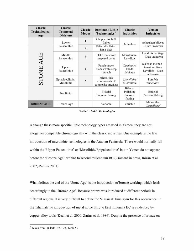
as ‘Mousterian’ or ‘Acheulian’ (Table 1).
8 The beginning and end of the ‘Neolithic’ varies considerably within Europe and in the rest of the world.
18
Classic
Technological Age
Classic Temporal Divisions
Classic Modes
Dominant Lithic Technologies 9
Classic Industries
Yemen Industries
1 Chopper tools & flakes Lower
Palaeolithic 2 Bifacially flaked
hand-axes
Acheulean Acheulean bifaces – Date unknown
Middle Palaeolithic 3 Flake tools from
prepared cores Mousterian /
Levallois
Levallois debitage – Date unknown
Upper Palaeolithic 4
Punch-struck blades with steep
retouch
‘Laminaire’ Blade
debitage
Wa’shah method – transition from
Levallois – Date unknown
Epipalaeolithic/ Mesolithic 5
Microlithic components of
composite artefacts
‘Lamellaire’ Microlithic
Possible ‘lamellaire’ ST
ON
E A
GE
Neolithic
Bifacial
Pressure flaking
Bifacial Polishing Pressure flaking
Bifacial Pressure flaking
BRONZE AGE Bronze Age Variable Variable Microlithic ‘Lamellaire’
Table 1: Lithic Technologies
Although these more specific lithic technology types are used in Yemen, they are not
altogether compatible chronologically with the classic industries. One example is the late
introduction of microlithic technologies in the Arabian Peninsula. These would normally fall
within the ‘Upper Palaeolithic’ or ‘Mesolithic/Epipalaeolithic’ but in Yemen do not appear
before the ‘Bronze Age’ or third to second millennium BC (Crassard in press, Inizan et al.
2002, Rahimi 2001).
What defines the end of the ‘Stone Age’ is the introduction of bronze working, which leads
accordingly to the ‘Bronze Age’. Because bronze was introduced at different periods in
different regions, it is very difficult to define the ‘classical’ time span for this occurrence. In
the Tihamah the introduction of metal in the third to first millennia BC is evidenced by
copper-alloy tools (Keall et al. 2000, Zarins et al. 1986). Despite the presence of bronze on
9 Taken from: (Clark 1977: 23, Table 5).
19
some prehistoric sites in Yemen, evidence for prehistoric metalworking is sparse and not
entirely convincing.
Similarly the ‘Iron Age’ that follows is contentious due to regional and temporal
discrepancies in iron’s introduction as a material and technology. Again, it is generally a first
millennium BC innovation and lasts until the Industrial Age when different metals are
introduced at a large scale. In Yemen, bronze continues to be the main material in use
throughout most of the first millennium BC, with evidence of iron slag (Lewis 2005) at the
turn of the Common Era.
Nevertheless, it should be noted that regardless of the occurrence or not of bronze and/or iron
during those time frames, in most of the literature on Yemen the ‘Bronze Age’ is equivalent
to the period between the third and first millennium BC, while the ‘Iron Age’ usually implies
the South Arabian period, or the first millennium BC until the sixth c. AD.
Terminology Used for this Dissertation
As discussed above, the classic chronological terminology is often suggestive of shifts in
subsistence and settlement strategies and is culturally specific. From the little evidence we
have thus far, it appears that the prehistoric record in Yemen does not fit into these
categories.
The Palaeolithic period in Yemen, although insufficiently represented in the archaeological
record, appears to fit into the broad definition for the ‘Palaeolithic’ outlined in the previous
section. The ‘Neolithic’ period however, which implies an agricultural revolution highlighted
by the first stages in the domestication of plants and animals and the introduction of pottery
20
production, is thus far not what is in evidence in the ‘Neolithic’ of Yemen. Aceramic
seasonal hunter-forager communities characterize the period between 10,000 and 6,000 years
ago. Until more research is carried out it is difficult to be certain whether animal and plant
domestication was in its initial stages during this time span. However, it is clear that until
what would be considered the ‘Chalcolithic’ and ‘Bronze Age’ there certainly is no
widespread evidence for pottery production or for an agricultural revolution. For the purposes
of this dissertation, the term early Holocene is preferred for this period. The early Holocene is
synonymous with the ‘Neolithic’, which will only be used in reference to the literature.
‘Bronze’ and ‘Iron’ Age are equally inappropriate terminologies. Metal objects are evidenced
during the equivalents of these periods, however it is unclear if the metalworking techniques
were local, regional, or foreign and to what extent metalwork was occurring. The terms ‘late
prehistoric’ and ‘mid-Holocene’ are preferred in reference to the ‘Bronze Age’. Towards the
end of this period is a 300-year transitional period that occurs between 1200 and 900 BC and
is characterized on some sites by letters engraved on ceramics. This is sometimes referred to
as the proto-historical period, but more accurately as the transitional late prehistoric/early
historic period. Finally the ‘Iron Age’ is synonymous with the pre-Islamic or South Arabian
period, when the South Arabian kingdoms extended their control over much of southwest
Arabia. Certain areas in Yemen were less affected by the reign of these desert kingdoms. For
the purpose of clarity the term South Arabian will be used, as it is more accurate than ‘Iron
Age’ (Table 2).
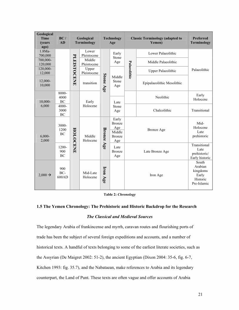
21
Geological
Time (years ago)
BC / AD
Geological Terminology
Technology Age
Classic Terminology (adapted to Yemen)
Preferred Terminology
1.8Ma-700,000
Lower Pleistocene Lower Palaeolithic
700,000-120,000
Middle Pleistocene
Early Stone Age Middle Palaeolithic
120,000- 12,000
Upper Pleistocene Upper Palaeolithic
12,000-10,000
PLE
ISTO
CE
NE
transition
Palaeolithic
Epipalaeolithic Mesolithic
Palaeolithic
Middle Stone Age
8000-4000 BC
Neolithic Early Holocene 10,000-
6,000 4000-3000 BC
Early Holocene
Stone Age
Late Stone Age Chalcolithic Transitional
Early Bronze
Age 3000-1200 BC Middle
Bronze Age
Bronze Age
Mid-Holocene
Late prehistoric 6,000-
2,000
1200-900 BC
Middle Holocene
Bronze A
ge Late Bronze
Age Late Bronze Age
Transitional Late
prehistoric/ Early historic
2,000
900 BC-
600AD
HO
LO
CE
NE
Mid-Late Holocene
Iron Age
Iron Age
South Arabian
kingdoms Early
Historic Pre-Islamic
Table 2: Chronology
1.5 The Yemen Chronology: The Prehistoric and Historic Backdrop for the Research
The Classical and Medieval Sources
The legendary Arabia of frankincense and myrrh, caravan routes and flourishing ports of
trade has been the subject of several foreign expeditions and accounts, and a number of
historical texts. A handful of texts belonging to some of the earliest literate societies, such as
the Assyrian (De Maigret 2002: 51-2), the ancient Egyptian (Dixon 2004: 35-6, fig. 6-7,
Kitchen 1993: fig. 35.7), and the Nabataean, make references to Arabia and its legendary
counterpart, the Land of Punt. These texts are often vague and offer accounts of Arabia
22
through economic transactions relating to the overland trade, and occasionally to clashes and
warfare in the region. Mention of Arabia is not explicit.
During the Classical period, when large-scale expeditions were mounted overland and by sea
to Arabia, often referred to as ‘Arabia Felix’, more detailed and extensive accounts of the
area were written, which have survived the ravages of time and the severity of historical
selection. Several of these are important to the research as they offer useful ancient accounts,
albeit later than the period at hand, of the landscapes of Arabia, of coastal culture and
subsistence and of cultural interaction and trade. Because from this period onwards many
sources mention Arabia, only those that have contributed significantly to this research will be
discussed below.
Herodotus’ accounts of Arabia were written between c. 484-425 BC and were most probably
based on Scylax’s exploration in 510 BC of the coastline from the mouth of the Indus to
Arsinoe (near modern-day Suez) (De Maigret 2002: 23). Two of the most famous works to
mention southern Arabia are Geographica by Strabo (c. 60 BC-AD 20), and Historia
Naturalis by Pliny the Elder (AD 23-79), both no doubt inspired by the brief Roman invasion
into the heart of Arabia, led by Aelius Gallus under the orders of the emperor Augustus in 24
BC (De Maigret 2002: 27). During this time, maritime trade began to overshadow the
overland routes and as a result one of the most interesting texts to survive, the Periplus Maris
Erythraei, was written by an anonymous Egyptian-Greek merchant somewhere between AD
40 and 70 10. This text describes the ports of trade of the time, along the African and Arabian
coasts of the Red Sea, the Arabian Sea and the Indian Ocean, going as far as India where
voyages often ended, or began. Great detail is paid to the merchandise that was to be found at
10 From the Introduction by Casson (ed./tr.) in: (The Periplus Maris Erythraei 1980: 6-7)
23
each port, and a distinction is always made in the text between what was imported and what
was exported. The author makes a number of cultural observations at each stop, and
comments on the ethnicities, architecture, type of boats and ports, subsistence strategies,
landscapes and the ruling authorities of the regions he passes. These observations have been
invaluable to the research, and especially to the interpretation of the data, as it has provided
an ancient perspective of the coastal landscape, its people and their interaction with each
other.
Mentions of Arabia in the Bible and Koran mainly refer to versions of the story of the Queen
of Sheba and do not concern this research directly. Several texts written by Muslim scholars,
namely the eighth book of al-Iklil by al-Hasan ibn Ahmad al-Hamdani (d. AD 945), which
concentrates on the sites and antiquities of Himyar in the central highlands of Yemen, has
proven to be a valuable source of reference for sites and landscape studies in the highlands.
Finally, three historical works, namely Sifat Bilad al-Yemen of Ibn al-Mujawir, al-Fadhl al-
Mazid of Ibn al-Dayba’ al-Shaybani (b. 866 Hijra), and Tabaqat Khawas Ahl al-Sidq wal
Ikhlas of al-Zabidi (d. 893 Hijra) were indispensable references for site and landscape studies
in the Tihamah.
History of Previous Archaeological Work: Pre-History in Yemen
As mentioned in the introduction, much of the previous archaeological work carried out in
Yemen has concentrated on the South Arabian or early historical period. Until recently this
period almost appeared to exist in limbo, with its beginning having no roots and its end
having no continuations. The major criticism for the state of research in Yemen, however, is
not that early pioneers concentrated on the historical period, or that they did not focus on the
prehistoric period. Rather, the weakness lies with more recent research, which continues to
24
follow in this tradition, hesitant to take on new theoretical and methodological perspectives.
Early archaeologists were formed within a culture-historical framework. Furthermore they
were limited not only by the lack of technology and scientific discoveries, but by a region
that was altogether unknown archaeologically and thus acted as a privileged terrain11. It is
logical that they would have begun with what was more visible and what appeared to
uniquely identify the region. Nonetheless, prehistoric archaeology was not altogether ignored.
This was especially the case in what was then South Yemen, motivated by the British
presence in the region (Schippmann 2001: 31).
One of the pioneers of a prehistoric archaeology in Yemen was Gertrude Caton-Thompson,
who in 1938 excavated the Moon Temple at Hureidha, and during the same season
discovered a scatter of knapped flint in the region of Hadramawt (Caton Thompson 1938,
Caton Thompson et al. 1939). The debitage verified the existence of a Levallois technology
(Caton Thompson 1953), while the excavation revealed a South Arabian microlithic industry
in Yemen (Caton Thompson 1944).
Other prehistoric research was undertaken in the 1960s and 70s. In South Yemen a number of
prehistoric surveys were carried out, including that of G. Lankester Harding in the former
Aden Protectorate (1959-60) (Harding 1964), G. W. Van Beek in Hadramawt (1961-62) (Van
Beek 1969), and B. Doe in the province of Lahj (mid-60s). Doe’s survey recovered a number
of hand-axes which were presumed to date to the Acheulean between 400,000-200,000 years
ago (Doe 1971: 134), while the discovery of a number of pottery sites near Aden was
significant in identifying the late prehistoric period on the coastal plain, and most importantly
the site of Sabir (Doe 1965). In the 1960s the then Italian ambassador to Sanaa, G. Benardelli, 11 In this case a ‘privileged terrain’ is in reference to the advantages and possibilities provided by a region that is a virtual terra incognita to western scholarship and is thus amenable to discovery and interpretation that is not restricted by previous or established definitions.
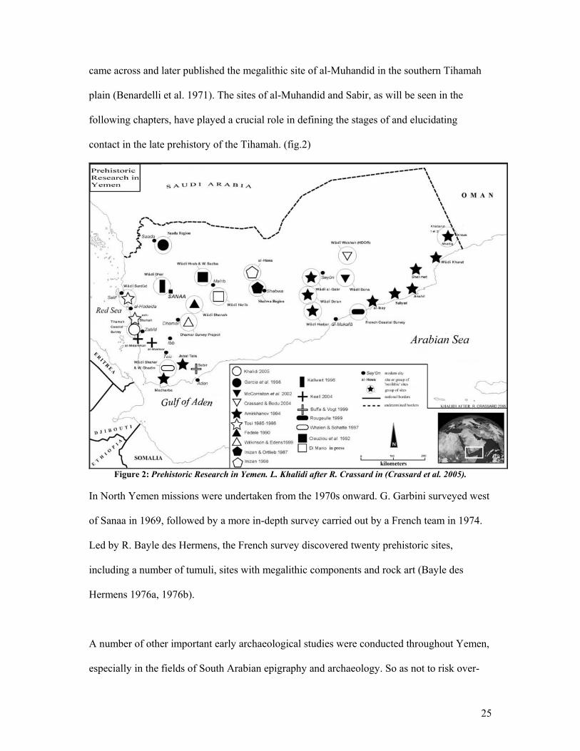
25
came across and later published the megalithic site of al-Muhandid in the southern Tihamah
plain (Benardelli et al. 1971). The sites of al-Muhandid and Sabir, as will be seen in the
following chapters, have played a crucial role in defining the stages of and elucidating
contact in the late prehistory of the Tihamah. (fig.2)
Figure 2: Prehistoric Research in Yemen. L. Khalidi after R. Crassard in (Crassard et al. 2005).
In North Yemen missions were undertaken from the 1970s onward. G. Garbini surveyed west
of Sanaa in 1969, followed by a more in-depth survey carried out by a French team in 1974.
Led by R. Bayle des Hermens, the French survey discovered twenty prehistoric sites,
including a number of tumuli, sites with megalithic components and rock art (Bayle des
Hermens 1976a, 1976b).
A number of other important early archaeological studies were conducted throughout Yemen,
especially in the fields of South Arabian epigraphy and archaeology. So as not to risk over-
26
simplifying a complex history of epigraphic South Arabian discoveries, and because this
work does not directly relate to the prehistoric period, it is preferable to refer to it where and
when it is appropriate.
1.6 The Definition of a Prehistory for Yemen
Very few archaeologists have tried to tackle the millennia leading up to the rise of the South
Arabian kingdoms of the first millennium BC, though those who have done so have
contributed a great deal of data on which we can now elaborate. Our current understanding of
the ancient landscape, material culture, social and economic systems, and faunal and
botanical studies is owing to the new scientific methodologies that have been incorporated
since the 1980s by a select few initiators of a prehistoric archaeology in Yemen. The
chronological and spatial spans of such studies are large, as are the gaps, however these
studies form the foundations for the new research being carried out by a new generation of
archaeologists. In this section, projects and discoveries that have contributed significantly to
defining more coherently the prehistory of Yemen and which relate to the chronological and
spatial issues presented in this dissertation will be reviewed in chronological order.
The Palaeolithic Period (ca. 1.8Ma-10,000 years ago)
Evidence for the Palaeolithic period in Yemen is limited. A number of isolated but undated
finds have identified that tool technologies normally characteristic of the Palaeolithic do
exist. Besides the early pioneers of archaeology in Yemen, whose work has been discussed
above, it is worth briefly mentioning the work of the Soviet mission to Hadramawt and
Mahra. A number of sites evidence the most ancient occupation discovered to date in Yemen,
which is presumed to date to the Acheulean period (Amirkhanov 1994: 222, 1997).
27
In the early 1980s Inizan carried out one of the first surveys that dealt specifically with
Pleistocene and Holocene sites and their lithic repertoire. Her approach dealt with testing a
number of different zones in the desert fringe near Shabwa in order to determine where early
prehistoric sites were located and best preserved. Two areas, the banks of the wadi Muqqah
and the summit of Hayd al-Ghalib evidenced early Palaeolithic industries, namely the
Levallois, which were studied technically for the first time in Yemen (Inizan et al. 1987: 12-
16). The Italian Archaeological Mission (IAM) and the Dhamar Survey Project (DSP) have
identified a few Palaeolithic sites in the highlands, though in both cases the lithic assemblage
is neither large nor especially diagnostic (De Maigret 2002: 118-19).
In the Hadramawt in particular, there have been a number of more recent discoveries that
span the technological stages of the Palaeolithic including Acheulean bifaces, Levallois
debitage and the blade debitage system. One recent excavation by Crassard12, carried out in
the rockshelter site of Manayzeh in the area of wadi Sana has uncovered a number of living
floors and hearths in association with a series of lithic technologies that span a large time
period (Crassard et al. 2005)13. It is the only example to date of a stratified early prehistoric
excavation with a rich tool kit.
A transitional method from the Levallois to the blade debitage system was also discovered by
Crassard14, at the site of HDOR 538, near the wadi Wa’shah in Hadramawt (Crassard et al.
2004: 77-9). Palaeolithic tools have also been found along the desert fringe, near Lahj in the
12 In charge of the French Mission to the larger Roots of Agriculture in Southern Arabia (RASA) project led by Dr. Joy McCorriston. 13 Conference paper entitled Manayzeh, an Early to Mid-Holocene occupation in Wadi Sana (Hadramawt, Yemen), presented by R. Crassard et al at the Seminar for Arabian Studies, 21 July 2005. 14 Survey carried out as part of the French Archaeological Mission in the Jawf-Hadramawt led by F. Braemer and M. Mouton.
28
south of Yemen, in the central highlands, and in the Hazm al-‘Udayn area, though in all of
these cases they were isolated finds made solely of locally available materials.
The Early Holocene ‘Neolithic’ Period (ca. 8000-3000 BC)
The early Holocene witnessed a number of changes not only in subsistence and settlement
strategy, but also in tool technology. The subsistence strategy still focused on hunting and
foraging, however, a wetter period made lakes and marshes available in the most arid parts of
Yemen (Fedele 1990, Inizan et al. 1997, Lézine et al. 1998, Sanlaville 1992, Wilkinson
1997), thus providing a new exploitable environment. Mollusc and shellfish foraging became
common along the coasts, while freshwater fish became a part of the inland lake diet. A
diverse fauna that included wild goat, wild ass, ostrich and ibex characterized this period and
as a result hunting became more specialized. Small ephemeral settlements began to appear
along the fringes of these lakes, marshes, and rivers. These are evidenced by shell middens
exhibiting postholes along the coast, small circular stone structures in the highlands and the
western escarpment and large scale scatters sometimes associated with simple structures
throughout the Ramlat as-Sabatayn and Hadramawt.
The early Holocene bifacial lithic industries of Yemen are characterized by pressure flaked
projectile points. A number of articles have over-emphasized the widespread occurrence of
this bifacial tradition, coined the ‘Arabian Bifacial Tradition’ (Edens 1982, 1988, 2001). Such
a term suggests a cultural link between diverse regions over a very large area. While it is true
that a bifacial lithic industry existed throughout the Arabian Peninsula during the early
Holocene, it also developed on other continents around this time period. This concept does
not take into account the fact that there is a large amount of inter- and intra-regional
diversification in the tool types within Arabia. Such variability is significant culturally and
29
functionally speaking and acts to distinguish an arrowhead from one area from an arrowhead
from another. Nonetheless, this term continues to be used and to define the Arabian
‘Neolithic’. As shown in the work outlined below, the picture that is gradually appearing for
the early Holocene is quite complex and requires a more culturally and regionally sensitive
terminology.
Inizan’s work in the desert fringe near Shabwa was crucial in identifying and defining the
mid-Holocene chipped stone industry. Three of a series of sites that yielded a similar flint
bifacial lithic industry were carbon dated to the late ‘Neolithic’. Many of the tool types found
were arrowheads worked by pressure flaking, while others included bifacial tools worked
either by pressure or by percussion. Although no obsidian source exists in the region, this
material was present but rare on these sites (Inizan et al. 1987: 16-21). A later study by
Charpentier and Inizan of projectile points from the early Holocene revealed the existence of
fluting in south and southeastern Arabia. This technical process, which was thought to belong
exclusively to New World prehistoric industries, involves the removal of a channel flake
along the vertical axis of a bifacial point in order to thin it. Although fluting in the New
World is dated to 11,500 BP, in Arabia it has been dated to between 8,000 and 7,000 years
ago (Charpentier et al. 2002: 39-40). This proves once again that the ‘classical’ terminology
relating either to chronology or to cultural industries is misleading. The fact that a large
number of projectile points from sites in the desert fringe and Hadramawt (inland and coastal)
in Yemen and in Oman, exhibited this technique, while other regions in Yemen and the Gulf
did not, proves that this cultural particularity existed only for parts of southern and eastern
Arabia.

30
Both the IAM and DSP projects have recovered surface artifacts pertaining to the ‘Neolithic’
period and have associated this period with a dark-grey humic paleosol that reveals a wetter,
more stable climate with more vegetation cover than that of the subsequent periods (Fedele
1985: 371, Wilkinson 1997: 7-9). An excavation of the IAM, however, has revealed a more
complete picture. Fedele excavated the site of Wadi at-Tayyilah (WTHiii) in the Khawlan
area. This open-air site contained a dozen structures in an area of 0.3 hectares. The structures
were made of stone and were elliptical in shape, had a central stone block to support a beam
for the roof, while the surfaces revealed hearths and ashy sediments. The structures appeared
to have been rebuilt and re-used, suggesting a community rooted in the area and to the space
itself, perhaps over many generations. Faunal remains comprised sheep/goat and bovids of
either the Near Eastern variety of wild ox or Bos primigenius. The bones were found in an
area of the site where burning and butchering activities were taking place. Fedele interpreted
the faunal evidence as representative of a community that relied heavily on cattle pastoralism
(De Maigret 2002: 125). In addition there was evidence of stone flaking on site, a tool kit that
included a bifacial arrowhead, scrapers, burins and drills (Fedele 1985: 371) and a small
unbaked female figurine (De Maigret 2002: 126).
The rock art of the northern highlands near Saada and the east-central highlands near Rada’
was the subject of a detailed study by Garcia and Rachad. Extensive documentation of the
rock art of these two areas, in addition to small soundings in stratified deposits of rock-
shelters, have produced a relatively reliable dated typology of different rock art styles for
Yemen. The fact that several of these sites had associated deposits that were carbon dated
allows for a terminus post quem to be designated for certain styles, even if the association of
the excavated material to the rock art is put into question, as it most always is.

31
Early Holocene art is identified by its naturalistic style and the predominant animal themes,
as well as a distinct patina and techniques. Two styles, I and II, were attributed to this period.
Shallow carvings with the animal subjects often illustrated frontally, and a general
exaggeration of the horns, characterize the first style. The site of Jabal al-Makhroug 2
(M.K.2), categorized as Style I, yielded a date of 5380-4940 BC from a radiocarbon
determination of a charred bovine bone (Rachad 1994: 105). Deep patinated carvings, with a
more diverse iconography and a predominant hunting theme, characterize the second style.
Here ibex, wild dogs, asses, and bovines dominate the fauna illustrated in these scenes,
sometimes joined by an anthropomorphic figure. The mid-Holocene or ‘Bronze Age’ style is
distinguished from the early Holocene styles by a shift to painted scenes. It features both
naturalistic (troupes of domesticated animals and cattle) and schematic (small figures, armed
and feathered anthropomorphic figures) styles (Ibid: 57-9).
Surveys carried out in the mid-1980s along the Tihamah coastal plain by the IAM and under
the direction of Tosi, revealed a number of ‘Neolithic’ shell middens made up of Terebralia
palustris shell. This mollusc, now extinct in the region, is a mangrove mud dweller, and is of
great importance for the reconstitution of coastal palaeoenvironments. The sheer amount of
these shells presumes the existence of a wetter climate and a coastline and tidal creeks lined
with mangrove forests during the Early Holocene. These middens had an associated bifacial
lithic industry made primarily of jaspers and cherts, as well as a large number of faunal
remains. One such midden, ash-Shumah (SHM), located along the Wadi Rima’, yielded a
date of cal. 6684-6475 BC (Cattani et al. 2002: 34). A number of postholes and cut walls
brought into evidence the existence of a hut structure with seasonal floor surfaces. The faunal
assemblage consisted mainly (91.90%) of bones of the true ass Equus asinus, one
domesticated cattle horn, freshwater crab and gazelle (Ibid: 44). The large percentage of
32
equid bones suggests that the inhabitants of ash-Shumah hunted, and to some degree
subsisted on the wild ass and may have begun to domesticate it as a pack animal (Ibid: 45-
50).
Further excavations and surveys were conducted towards the city of Hodeidah, and further
north along the Salif peninsula. One site, Gahabah (JHB), was also a shell midden made up of
Terebralia palustris, lithic artifacts mainly of basalt and four pieces of obsidian. What is
interesting about this site is that it also yielded small and abraded dark brown pottery sherds
(Tosi 1985: 367-8). This exhibits a possible transition into an early-mid- Holocene ceramic
phase.
The Late Prehistoric ‘Bronze Age’ (ca. 3000-900 BC)
The Highlands
The late prehistoric period is marked by the emergence of large towns, the erection of
monumental buildings and features, the widespread adoption of ceramics and a more
expedient tool kit. The introduction of bronze is not clear even though the material is present
in small amounts during this period and its wide incorporation into the South Arabian
sculptural aesthetic indicates that experimentation must have begun previously. Nonetheless,
the term ‘Bronze Age’ is not precise, nor is bronze the material that characterizes this period.
In this section ‘Bronze Age’ will be used because this period has been described this way in
the literature that is being reviewed.
The IAM was the first project to make an in-depth study of the late prehistoric period in
Yemen. The project, led by De Maigret, was begun in 1981 in the Khawlan region of the
eastern highlands and focused on understanding the stages which led to the South Arabian
33
period. Three of forty ‘Bronze Age’ sites discovered by the project, namely WYi, RAQi and
MASi were excavated, yielding the first architectural plans, botanical and faunal specimens,
ceramic and lithic typologies and carbon dates for this period (De Maigret 2002: 135-7).
Botanical specimens included wheat, barley, oats, sorghum, millet and dates (Costantini
1990).
Settlements of this period were located near the riverbanks, and consisted of small (less than
1000m2) and large (greater than 10,000 m2) sites. Smaller sites were organized around a
circular clearing and consisted of interlinked sub-rectangular to circular structures, while the
larger sites were made up of clusters of such domestic complexes and suggested basic
settlement planning (De Maigret 2002: 141-4).
The architecture was made of locally available stone. Each dwelling consisted of two oval
rooms that connected to a central courtyard. Two large stone blocks were placed in the center
of the rooms to hold up wooden roof beams, and were placed at either side of the doorway as
orthostats. The walls were made of large partially shaped stones, while the upper courses
were made of smaller stones and mud mortar. Smaller dividing walls were built inside the
rooms, and benches were built around the interior periphery of the walls. A cooking pit or
hearth lined with slabs of stone was located outside of each house complex. Some buildings
appeared to have a different plan with monumental architectural elements suggesting public
buildings (De Maigret 2002: 145).
The material culture consisted of a ceramic tradition of coarse round-bottomed hole-mouth
pots with small horizontal handles, and platters, in addition to finer small burnished rimmed
34
jars and cups. The lithic assemblage was limited to flint, quartz and obsidian debitage and a
tool kit that consisted mainly of scrapers and borers (Ibid: 150).
These discoveries ignited interest in and paved the way for future research on the late
prehistoric period in the highlands. The DSP15 began to work to the southwest of the
Khawlan area in the early 1990s. Led by Wilkinson, the on-going project has focused on the
Dhamar and Rada’ central plains. Using a landscape-oriented methodology, which focuses on
sites and their surroundings, the DSP has identified 93 ‘Bronze Age’ sites, and mapped their
land-use systems. In addition a number of sites of this period have been excavated. The most
coherent site is DS101, or Hammat al-Qa’. This site, excavated by Edens, consists of a
plateau-top site in the Qa’ Jahran. Relic terracing and threshing floors are visible along the
slopes of the plateau and demonstrate a direct association between a ‘Bronze Age’ town and
its agricultural fields. Given the faunal assemblage, which was made up of 90% sheep/goat
and 10% cattle, it is likely that the valley bottom was used as a pastoral reserve (Edens et al.
2000: 2-5). The 4.9 hectare site is surrounded by a gated defensive wall and includes an
elaborate settlement plan with domestic and monumental quarters (Ibid).
The architecture belonging to this second millennium BC site varies slightly from that found
by the Italian mission. Two types of houses were documented, the first being ‘L’ shaped, and
the second long and sub-rectangular. In both cases the walls were made of locally available
stone, the doorways were framed with orthostats and vertical divisions separate the rooms
(Ibid: 3-4). A similar situation appears at the site of Sibal (DS 66) and Kharayb (DS 228),
also dated to the second millennium BC. Sibal is a two hectare hilltop settlement with a
defensive gated outer wall and long rectilinear architecture, while Kharayb is 3 hectares in
15 A project of the University of Chicago Oriental Institute

35
size and also includes sub-rectangular houses with vertical divisions (Edens 1999). These
houses appear to be narrower than those in the Khawlan area, perhaps evidencing a
chronological change in architectural style, or else a regional variation. The ceramics at all of
these highland sites are clearly related, though there appears to be a chronological
modification of forms and a subtle regional diversification in the overall ceramic assemblages
of this period.
The Desert Fringe and Hadramawt
Tombs of the middle Holocene have been documented throughout the highlands, the desert
fringe and the Hadramawt by a number of different projects. Two comprehensive studies
have been made, one by the IAM (De Maigret et al. 2005) and the other by the French
(Steimer-Herbet 2001). Elaborate necropolises of stone turret tombs with tail-like extensions
appear throughout eastern Yemen, while circular tombs often arranged in a concentric and
stepped manner and capped with large monolithic stones characterize the highlands. The
typologies that have resulted from these studies are discussed in Chapter VI.
The Coastal Plains
The situation on the southern and western coastal plains is less clear than that of the
highlands, precisely because less is known. Although the changes that occurred between the
early and mid-Holocene are considerable in the highlands, the transitions from one phase into
the next are reflected in the gradual transformation of the architecture and tool types and a
rather logical shift from hunter-gathering to pastoralism and finally to agriculture. In contrast,
the transition on the coastal plains appears to be more abrupt. Abraded ceramic sherds found
on what otherwise appear to be ‘Neolithic’ shell middens point to one possible transition
from aceramic to ceramic societies. The diversification of shell on such middens also points
36
to a change in available resources, possibly as a result of a changing climate. This is followed
by the emergence of megalithic structures, sprawling towns and a rich ceramic tradition that
stretches from the Saudi Arabian Red Sea littoral to the Gulf of Aden. The change was in fact
not abrupt, but appears so when seen in relation to the highlands and desert fringe, which
have more conspicuous inter-regional cultural continuities.
What makes the early-mid-Holocene transition in the Tihamah appear abrupt is threefold.
The first factor is methodological. Systematic surveys had not been carried out in the region
previous to the surveys presented in this dissertation. For this reason a site and material
cultural continuum had not been established through time and space. The second factor is
temporal. Despite certain changes in the environment and in the growth of settlements, a
number of strategies continued to exist in the same manner for millennia, which on the one
hand complicates the chronological identification of these sites, and on the other hand
provides a more complete picture of such transitions. The third factor is spatial. The micro-
view must be counter-balanced with the macro. In this way, transitions that occur on a site
level can be contextualized in relation to the micro-region and to a wider coastal landscape
that links the opposite littorals of the Red Sea and those of the Gulf of Aden. In these areas, a
new organized pattern of settlement surfaced gradually as the coastal population became
more sedentary and less able to depend on hunting and foraging alone for subsistence, while
certain fishing and pastoral communities continued to exist in the same manner as before,
despite certain changes in available resources.
Four ‘Bronze Age’ sites, Ma’laybah, an-Nabwah, al-Midamman, and Sabir, which have been
excavated and thus act as models for certain coastal mid-Holocene settlements, will be
referred to extensively. A German-Russian mission, which began in 1994 and focused on the
37
Aden hinterland, excavated three sites, Ma’laybah, Sabir (both ca. 20 km north of Aden), and
the an-Nabwa shell midden in little Aden. These excavations were carried out in conjunction
with a coastal survey from Aden to the Bab al Mandab Strait.
The site of Ma’laybah, located north of Aden, is dated to between 2000 and the 13th c. BC
and divided into two periods of occupation, the more ancient I and the more recent II. What is
impressive about this site is not only the continuous ceramic sequence but the fact that there
are five levels of irrigation channels in period I alone (Buffa et al. 2001: 446). This is the
earliest evidence for irrigation agriculture on the coastal plains, a technology that was always
assumed to have existed in conjunction with sedentism and the growth of towns in the third
and second millennia BC, but that had never been proven. Although this site is located a
significant distance from the Tihamah coastal plain and is within a slightly different sphere of
interaction than the Tihamah, it has a number of strong ceramic and architectural (hut
dwellings) parallels with sites of the same period found along the Red Sea coastal plain. The
ceramics from the site are sophisticated and are characterized by a variety of well made, high-
fired vessels with skillfully rendered incised, punctate and appliqué decoration, polishing and
pattern pebble burnishing. In addition the large number of shell and fishbone found on the
site suggest an ‘early coastal oasis economy’ which was interacting with contemporary
fishing communities (Ibid).
Such a fishing community was investigated at the site of an-Nabwah, which is said to date to
the early second millennium BC by comparison to the dated ceramic sequence at Ma’laybah.
This site consisted of a typical coastal shell midden with a number of postholes and living
surfaces, suggesting hut dwellings. These were associated with hearths and a material culture

38
made up of net sinkers and a limited range of pottery forms, probably indicating a specialized
fishing economy (Ibid).
The site of Sabir, which is located 5 km west of Ma’laybah in the delta of the wadi Tuban, is
contemporary to period II at Ma’laybah and an extension of its cultural sequence. The main
occupation phase of this site is carbon dated to the period between the thirteenth and ninth c.
BC, with a subsequent re-occupation phase in the sixth c. BC (Ibid: 439). The site is a
significant tell, spreading over an area of at least 2x1 km, and with deposits reaching 4-5 m.
The outskirts of the site yielded oval and round posthole arrangements, suggesting that the
periphery of the main site consisted of hut dwellings made of perishable materials. The main
area of the town however, was characterized by monumental mud-brick architecture. The
plan of these buildings is rectilinear and was organized as two or three long vertical halls
often built adjacent to a small internal courtyard (Vogt et al. 1998: 262-3). Although this
architectural phase is quite late and fits into the late prehistoric to early historic transitional
period, it nonetheless pertains to a ‘Bronze Age’ culture. More ancient deposits, which have
yet to be excavated, lie beneath this phase. A number of specialized industrial areas were
excavated including kiln areas for ceramic production and metalsmith workshops. The
ceramic assemblage which has no obvious parallels with the highland or eastern regions
(Buffa et al. 2001: 446), the large number of anthropomorphic and zoomorphic terracotta
figurines, fishbone, shell, net sinkers, metal objects and obsidian tools (Vogt et al. 1998: 264-
5) are clear signs of a culture that is unique to the coastal areas.
Another site that resembles that of Ma’laybah and Sabir is the Tihamah site of al-Midamman.
The Canadian Archaeological Mission of the Royal Ontario Museum (CAMROM) excavated
this site over a number of seasons starting in 1997. The site spreads over an area of
39
approximately 8 km2 and is characterized by several megalithic complexes, some upright
(Keall 1998: 140). These complexes are currently spread throughout the site as they were re-
used in subsequent periods to mark graves and monuments. Interspersed between them is a
continuous dense scatter mainly made up of ceramics and lithics. Some low mounding
appears in conjunction with patches of denser scatter, although deflation in the area has
practically wiped away any stratigraphy that may have once existed, leaving only the material
remains. Excavations were carried out at the most prominent of the megalithic complexes that
dot the site, at the standing stones of al-Manassib, and at several of the low mounds. At the
base of one of the megaliths was a cache of metal objects and a large obsidian core. A date
between c. 2400 and 1800 BC was attributed to the erection of these stones, based on
comparison of the style and chemical composition of the copper-alloy tools found underneath
one of the megaliths (Keall 2004: 50). Other excavations uncovered burials marked by
smaller naturally shaped stone pillars, domestic settlement and a later phase of monumental
architecture.
A series of hearths in association with pottery, obsidian, grinding stones and a large amount
of fish bone have been suggested as the remains of domestic settlement on the site, like the
three other coastal sites discussed above. A charred dom palm fruit found in one such hearth
yielded a date of 1360 BC or 1320-970 BC (Keall 2004: 50). This date corresponds to the late
phase of Sabir (Sabir II), as do the later structures found at the site. Sometime between the
appearance of the megalithic complexes and the occupation of these dwellings, megalithic
stones were re-used in the foundations of monumental buildings. Excavations revealed three
rectilinear buildings with megalithic foundations and vertical partition walls made of mud-
brick like those at Sabir.

40
Besides the megaliths, which as yet do not appear to exist on the site of Sabir, the domestic
settlement and later monumental architecture, ceramic tradition and the predominance of
obsidian as a tool material provide a cultural link between the two sites. Buffa and Vogt have
gone so far as to call it the ‘Sabir Culture’ (Buffa et al. 2001: 437). It is agreed that a strong
link does exist, however, a number of variations were also functioning to distinguish different
areas from each other. Nevertheless, these two sites have proven that the cultural parallels
between what for our purposes are two unrelated areas on different coastal plains (the Red
Sea and the Arabian Sea) are more evident than between the coastal plain and the western
escarpment or the highlands.
Late Prehistoric to Early Historic Transition (ca.1200 – 900 BC)
For the purposes of this dissertation a discussion of this transition only as it appears in the
Tihamah will be offered. The highland transition between a ‘Bronze’ and an ‘Iron’ Age has
been the subject of a number of articles16. The situation in the desert fringe and in Hadramawt
is only slightly more clear in that certain sites that went on to become prominent towns of the
South Arabian kingdoms (such as Shabwa, Hajar bin Humeid and Yala) appear to have
continuous occupation from at least the late ‘Bronze Age’ through to the establishment of the
desert kingdoms (De Maigret 1988, De Maigret et al. 1989, Doe 1971, Sedov et al. 1994,
Sedov 1991). Despite this, theories pertaining to the settlement of tribes from the exterior still
loom large. Until more attention is paid to the prehistoric periods, such transitions will remain
enigmatic and the subject of much controversy.
The late prehistoric to early historic transition is labeled ‘South Arabian’ or ‘early historic’ in
much of the literature. ‘South Arabian’ is culturally and chronologically specific to the reign
16 For more information on the highland BA- IA transition refer to: (Lewis 2005) A number of DSP articles deal with this very subject, namely: (Wilkinson 2003).

41
of the desert kingdoms and insinuates a South Arabian control or presence. Although in some
regions sites from this period were inhabited by the precursors of the South Arabians, in other
regions such as Aden and the Tihamah this does not appear to be the case. As has been shown
above, the long occupational and material cultural continuity that existed at sites like Sabir
and Midamman demonstrates a local cultural sequence that is unrelated to what was
happening along the desert fringe between the twelfth and ninth c. BC. It could just as
legitimately be the contrary, whereby the architectural style of the late prehistoric cultures of
Sabir and al-Midamman are appropriated in the South Arabian period. Vogt and Sedov flirt
with this idea when referring to the Burnt Building 5C at Sabir by stating:
With its symmetry, proportions and layout of the main units the building anticipates to some extent the
basic plan of South Arabian temples. (Vogt et al. 1998: 263)
To assume that a culture that came before the South Arabian kingdoms is South Arabian is
false, terminologically speaking. This is not to say that South Arabian influence did not reach
these areas at an early date. In fact both al-Midamman and Sabir have yielded, albeit late in
their occupations, objects with inscribed characters that recall ancient South Arabian letters.
The inscribed characters appear to fit more comfortably in the ‘proto-writing’ category, and
in the late prehistoric period, though in the latter, only at the end of the last phase of
occupation, and with the high likelihood that the societies were illiterate and the objects were
simply imports. In the case of al-Midamman the letters were written on several ceramic
incense burners (Keall 2004: 51), while at Sabir they appear on terracotta figurine fragments
(Buffa et al. 2001: 440-1). In reference to the incense burner fragments, Keall makes a
significant point about South Arabian influence:
42
Each of these features is sufficient for some to point to a South Arabian connection. But we must be
cautious in drawing this conclusion for the culture as a whole. Features like this are very rare within
the corpus of finds, representing three out of 4000 recorded, diagnostic fragments. (Keall 2004: 51)
Finally a number of decorated facing stones were excavated in HWA, Building B at al-
Midamman. These are shallowly carved with images of snakes, oryx heads and water jars
(Ibid: 48-9), an iconography that is highly reminiscent of early Banat ‘Ad temples in the Jawf
(10th or 9th c. BC) which are in and of themselves reminiscent of Mesopotamian iconography
(Audouin et al. 2004). The fact that what appears to be South Arabian influence is in fact
likely influenced from outside of Arabia entirely, as is the case with the early iconography at
al-Midamman and in the Jawf, implies that the issue of influence and what is ‘South Arabian’
is much more complex than it appears to be. It also reaffirms the need to redefine the
terminology and take caution in casually assigning labels. It has become clear in the process
of this research that when it comes to most regions in Yemen, it is best to interpret each
culture and region in relation to its specific landscape, and to treat transitions as just that. Due
to the nature of its geography the spheres of influence are too large and diverse. This makes it
difficult to point to unidirectional change. At the same time cultures may have formed
independently despite the differing spheres of influence, as is certainly the case for the
Tihamah, and the sites of al-Midamman and Sabir.
While there are some cultural affinities with what academic tradition has declared to be typical of the
Sabaeans (implying something after the eighth century BC), there is just as much likelihood that the
common expressions reflect elements that contributed to the development of classic South Arabian
civilization, but were not the products of it. The commonalities are too limited, and the dissimilarities
too great for this to be the case. (Keall 2004: 51-2)
43
The Early Historical Period: Early Literate Societies in South Arabia and Abyssinia
The very mountainous terrain impeded the formation of a single regime, and political power was in
general fragmented among the various people of South Arabia. (Hoyland 2003: 36)
The transition into the South Arabian period is as yet unclear. However, as was mentioned
above, several recent excavations and surveys have revealed that the line between what is
prehistory and history is very vague (Audouin et al. 2004, Buffa 2003, De Maigret 1999,
Keall 2004). As with most early cultures, the impetus for the rise of complex political entities
is never a simple issue. What is known, however, stems primarily from inscriptions and
excavations. The kingdoms were numerous and consisted of entities bound by allegiance to a
patron god and a ruler who took the title of either ‘king’ (mlk) or ‘unifier’ (mkrb) (Hoyland
2003: 36). With the exception of Himyar, which rose to prominence in the highlands later
than the others, these kingdoms all had their capitals along the desert fringe (Ramlat as-
Sabatayn) so as to control the overland trade routes to the Mediterranean and Mesopotamia.
The kingdom of Saba had its metropolis at Ma’rib, Ma’in at Qarnaw, Qataban at Timna’, and
Hadramawt at Shabwa.
The chronology for the South Arabian period is much debated but lasted from about 900BC
at the earliest to 600AD. This falls within what is often considered the ‘Iron Age’ period. The
terminology that is preferred and that will be used here is the ‘Early Historic’ or ‘South
Arabian’ periods.
Many theories abound about the arrival and settlement of the South Arabians (from elsewhere
in Arabia) along the desert fringe17. It appears that many South Arabian sites, such as Hajar
bin Humeid (Van Beek 1969) and Yala (De Maigret 1988, De Maigret et al. 1989), and
17 For proponents of this debate see Von Wissman, Ryckmans and Muller in: (Schippmann 2001: 54-5).
44
especially those that acted as metropolises such as Shabwa (Breton 2000), were occupied
before the rise of the kingdoms (late second/early first millennium BC). Such continuous
occupation is not uncommon in the Near East, nor is it in Yemen. This often appears in the
archaeological record in the form of tells or mounds, which are numerous along the desert
fringe. Where excavations have been carried out, however, few soundings have reached the
lowest levels where the prehistoric and historic periods merge.
Nonetheless the information that is available evidences a South Arabian literate period that
lasted approximately 1400 years. This period witnesses the introduction of an epigraphic
record. The historical record also provides a window into the physical, cultural and ideational
landscape, as interpreted by a segment of the literate population of the time. Most interesting
are the explicit political boundaries that were formed and the way that territory was perceived
during that time. The historic period not only marks a transformation that took place in the
organization of the cultural landscape, but is also a window into the way that prehistoric
peoples may have viewed their geographic surroundings, immediate landscape and territory
in general and how contact and interaction may have been realized across such landscapes.
Like many highly involved archaeological debates, the problem with South Arabian
chronology begins with the Biblical narrative. Mention of the Queen of Sheba’s visit to King
Solomon in 1 Kings 10, would place her reign in the tenth c. BC (Hoyland 2003: 39). For the
purposes of this thesis, it is not important when or whether the Queen of Sheba visited
Solomon. What is relevant about this narrative is that it evidences that Saba was a kingdom
renowned to the outside world, and ruled by queens and kings.

45
It is not until the eighth c. BC that there is epigraphic evidence for a number of small
kingdoms, which appear on the political scene, each with its own pantheon and language.
These include the small kingdoms of al-Jawf (later Ma’in) (Audouin et al. 2004: 13), and
Awsan. Saba was one of the most prominent at this time, and a raid on one of its caravans is
attested on a Neo-Assyrian clay tablet dated to the reign of a governor of Suchu and Mari
during the mid-eighth c. BC 18.
The seventh and sixth c. BC witnessed the growth of the Sabaean kingdom with its seat at
Sirwah and Ma’rib. During this period Saba led campaigns to expand its territory, confirmed
in several inscriptions whereby smaller kingdoms were subjugated by Saba or else granted to
its allies (RES 3945, 3943)(Audouin et al. 2004: 13, Schippmann 2001: 56). It was in the
second half of the sixth c. BC that the Ma’rib dam was built, an indication of the power and
prosperity of the kingdom of Saba. This huge barrage evidences an ancient technology,
heretofore unparalleled in the region that allowed the South Arabians to control and distribute
water on a massive scale, in effect changing the arid landscape into an agricultural oasis.
Somewhere in the sixth or fifth c. BC, South Arabian ‘colonies’ were established in the
highlands of Abyssinia (present day Ethiopia and Eritrea), renewing long established contacts
across the Red Sea. Over thirty such sites are documented and were located in especially
fertile areas. It is possible that these sites make up the polity of Daamat (d’mt) attested in
inscriptions. The rulers appear to have been locals, while the architectural style, the
iconography, the architectural inscriptions, and square sectioned monolithic pillars
demonstrate a clear appropriation of South Arabian elements. These foreign elements became
18 (Cavigneaux et al. 1990: 339, 351, 357 )
46
incorporated into the pre-Aksumite culture and later the great Aksumite kingdom (Phillipson
1998: 42-8).
Between the fifth c. and fourth c. BC Mai’n, Najran (in Saudi Arabia) and probably Qataban
and Hadramawt were defeated by Saba, but eventually regained their independence. By the
mid- fourth c. BC four powers, Saba, Ma’in, Qataban and Hadramawt, co-existed along the
desert fringe (Schippmann 2001: 57).
In the first c. BC a new era began. Tribes in the highlands, the Himyarites, dominated the
desert fringe and its kingdoms. With its capital at Zafar in the central plains, Himyar’s rule is
said to begin in 115BC (Schippmann 2001: 58). This is contemporaneous with the decline of
traffic along the overland trade routes, and thus the weakening of the desert fringe kingdoms
that relied on its trade and commerce. This decline was partially a result of the establishment
of a maritime link between the Mediterranean, Red Sea and Indian Ocean world, motivated
by two factors. The successful sailing voyages from Egypt to India of Eudoxus of Cyzicus
between 117 and 109 BC, guided by the use of the monsoon winds, opened up the much-
feared route to other sailors. Egypt’s incorporation into the Roman Empire by Augustus also
added to the lure of trade along the Red Sea and the lands beyond and ship traffic increased
considerably19 (Hoyland 2003: 43-4).
The period that followed the establishment of the Himyarite kingdom was one of war, as it
tried to incorporate more territory and establish ports in line with the new maritime trade
route. While the Minaeans lost their influence in the region, the Roman attempt at invasion
under Aellius Gallus between 26 and 24 BC, provided a stage for Himyarite prominence in
19 A direct account is given in: (Strabo 1917: 2.5.12).

47
the region, which they achieved by the first c. AD (Hoyland 2003: 44-6). Threatened by the
increasing power of Himyar and the encroaching Arab tribes in the north, Saba came to an
end in the second c. AD, followed by Hadramawt in the third c. AD (Hoyland 2003: 47).
By the beginning of the Christian era, the former South Arabian colonies in Abyssinia had
planted the seeds for a new culture that became a new power in the region. With its capital at
Aksum in the Ethiopian highlands, and its main port at Adulis in the Eritrean lowlands, the
Axumite kingdom rose to prominence and became influential in South Arabia, and especially
across the Red Sea in the Tihamah.
Except for the Tihamah coast, which in 200 AD is known to have been controlled by the
Abyssinian king Gadurat (Schippmann 2001: 61), by 299 AD, the Himyarites had conquered
and unified all of South Arabia (Hoyland 2003: 47). By the fourth c. AD, the great Ma’rib
dam had given way for the first time and both Axum and Himyar had converted to
Christianity, ending an era of South Arabian religion and culture. This period ended with the
Byzantine-backed Abyssinian invasion of the Himyarite kingdom by in 525 AD (Schippmann
2001: 64-5). Himyar became an Abyssinian protectorate, only to be overtaken again as a
vassal state by the Persian Sasanids in 597-98 AD (Ibid: 66-7). By the middle of the seventh
c. AD, Islam had dominated the region, and has impacted the rest of South Arabia’s history
and culture since.
48
II The Physical Context: Geography and Climate
Si le Moyen-Orient arabe apparaît comme un ensemble très massif et continental, le rôle, direct ou
indirect, des mers est pourtant considerable. C’est d’un côté Méditerranée, de l’autre l’océan Indien,
avec les deux profondes digitations de la mer Rouge et du golfe Persique, qui font de l’ensemble du
Moyen-Orient une sorte d’isthme et ont facilité la vie de relations et les échanges
(Sanlaville 2000: 25)
2.1 Introduction
The diversity of Yemen’s landscapes has allowed for a multitude of different micro-
environments to co-exist in proximity. The range of habitats that dot the Yemeni terrain has
been exploited, adapted to and transformed by humans throughout history. It is thus
important, when discussing settlement strategy and pattern, to take into account the different
geographic regions in Yemen, the way they relate to each other and how they have changed
through time both physically and through human intervention.
As discussed in the introduction, one of the principal arguments of this dissertation is that
large bodies of water, in this case the Red Sea, have facilitated inter-continental contact. Like
the land, the sea is obstinate, providing obstacles to movement. However, like the land, the
sea is less daunting and very advantageous once its landscape and its patterns are adapted to
and form a part of the mental map. Man’s relationship with the sea is ancient and has played
a significant role, whether direct or indirect, in the development of trade and interaction. It
has also had a considerable impact on land, affecting settlement and subsistence strategies, as
49
well as cultural transformations. The Red Sea’s role in the larger geographical picture forms a
part of the section on coastal geography.
Yemen dominates the southwestern part of the Arabian Peninsula, bordered to the northeast
by Oman and to the north by Saudi Arabia. To the west lies the Red Sea, and to the southwest
the Arabian Sea which opens out into the greater Indian Ocean. The Red Sea coastal plain,
otherwise known as the Tihamah, is a flat sandy coastal plain 30 – 60 km wide and 415 km
long, stretching from Bab al Mandab to the south to the Saudi Arabian border (between Midi
and Jizan) to the north. The coastline lies at sea level gradually ascending to 250 – 350 m at
the western foothills. Moving east of the piedmont the terrain rises in high relief along the
western escarpment to the Yemeni highlands. The highlands, which soar to a maximum
height of 3760 m above sea level (a.s.l.), include a series of intermontane plains located
between 1800 to 2500 m (a.s.l.). The landscape is heavily etched with agricultural terracing,
and reaches maximum annual rainfall levels of 1000 mm (Sanlaville 1992: 6). Descending
eastward into the desert fringe, the highland topography is more gradual.
Highland plateaus descend progressively and are abruptly cut by deep depressions that lead
into the more arid climate of the desert fringe, home of the earliest South Arabian kingdoms.
The arid steppe that lies between the eastern highlands and the desert includes the drainages
of a number of large fluvial systems, drawn into the sandy depression of the Ramlat as-
Sabatayn by the Jawf-Marib graben. The Ramlat as-Sabatayn desert stretches northwest,
eventually merging with the southern end of the empty quarter of central Arabia, the large
sand dune desert referred to as the Rub’ al Khali.
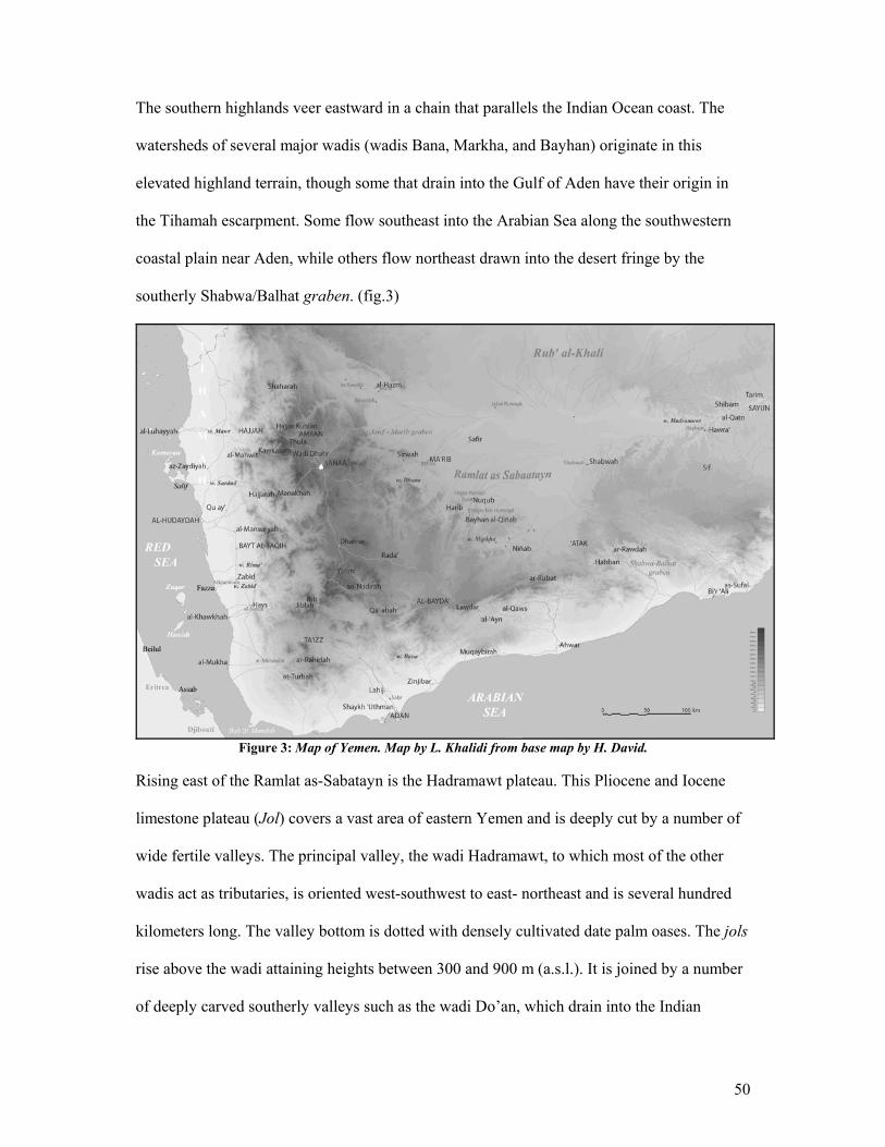
50
The southern highlands veer eastward in a chain that parallels the Indian Ocean coast. The
watersheds of several major wadis (wadis Bana, Markha, and Bayhan) originate in this
elevated highland terrain, though some that drain into the Gulf of Aden have their origin in
the Tihamah escarpment. Some flow southeast into the Arabian Sea along the southwestern
coastal plain near Aden, while others flow northeast drawn into the desert fringe by the
southerly Shabwa/Balhat graben. (fig.3)
Figure 3: Map of Yemen. Map by L. Khalidi from base map by H. David.
Rising east of the Ramlat as-Sabatayn is the Hadramawt plateau. This Pliocene and Iocene
limestone plateau (Jol) covers a vast area of eastern Yemen and is deeply cut by a number of
wide fertile valleys. The principal valley, the wadi Hadramawt, to which most of the other
wadis act as tributaries, is oriented west-southwest to east- northeast and is several hundred
kilometers long. The valley bottom is dotted with densely cultivated date palm oases. The jols
rise above the wadi attaining heights between 300 and 900 m (a.s.l.). It is joined by a number
of deeply carved southerly valleys such as the wadi Do’an, which drain into the Indian
51
Ocean. The wadi Hadramawt narrows as it veers southeast becoming the wadi Masila and
eventually drains into the Indian Ocean near Sahyut. The plateau gradually descends east-
northeast into Oman and dominates the coastline of Dhofar. The climate of the Hadramawt
region is dry and rarely reaches rainfall levels above 100 mm per annum.
The southern coast of Yemen, which forms a part of the Hadramawt fluvial system, is less
unified than the Red Sea coastal plain. Parts of the coastline are volcanic and consist of
numerous volcanoes and lava fields that plunge into the sea, while others are flat sandy
plains. The coast is dotted with a number of natural bays that have acted as ports from the late
prehistoric period and have stimulated a long history of contact with Southwest Asia and East
Africa.
Having defined the geographic relationship between the major regions of modern Yemen, a
detailed geography of the western highland to western lowland cross-section will follow. My
research comprises study areas interspersed along this westerly macro-section, which will
serve as comparisons to the main north to south coastal survey. The two sections that follow
include the coastal areas of study (Tihamah and Eritrea) and the highland areas of study (mid-
altitude western escarpment and the central highlands). This chapter sets the physical stage
for these regions, including an illustration of the current landscapes and their active
geomorphological processes. These processes both aid the reconstruction of and affect the
state of the archaeological record. The chapter will conclude with a review of the
development of the ancient landscape. Beginning with the progression of the Arabian
Peninsula into its current state, this section illustrates the geological and climatic changes that
affected human-environment relationships and helped to define the ancient cultural
landscape.

52
2.2 Coastal Geography: The Southern Red Sea Plains
The Tihamah
Half of the year we are blinded by the sun, and the other half we are blinded by the sand
- Tihamah Proverb
The Tihamah is a hyper- arid flat coastal plain lying along the southern Red Sea. It is bisected
by a series of wadi drainage systems (widyan) most of which have their catchments deep into
the Great Escarpment of the western highlands. Between the wadis the Tihamah environment
is a mosaic of intensively cultivated areas, sand dune and Acacia mellifera shrubland zones
(Munro 2001). Flood (sayl) and pump irrigation agriculture is concentrated in the wadi
floodplains. Stable and active sand formations dominate this arid landscape in the form of flat
deflated sandy plains, high aeolian dunes and low anchored dunes. Salt flats, marshes and
mangroves characterize the immediate coastal strip, especially at the southern and northern
ends of this narrow plain.
Climate
The Tihamah coastal plain is a hot and humid tropical zone with very little yearly rainfall. In
the Yemeni Tihamah annual rainfall levels reach 110mm (Hodeidah) and usually average less
than 50mm. Summer temperatures reach maximum heights above 45°C with 75 to 85%
atmospheric humidity (Sanlaville 2000: 124-5). Lying on the edge of the Indian Ocean
monsoon system, the Yemeni Tihamah benefits from the tail end of its rains and winds. The
strongest winds blow from the south during the months of March through April, while the
rest of the year they blow from the north (Facey 2004: 11).
53
The Red Sea Littoral
The Red Sea stretches 2200 km in length from the Sinai Peninsula in the north (the Gulf of
Suez to its west and the Gulf of Aqaba to its east), to the pass between Djibouti and Yemen in
the south. 300 km at its widest, and approximately 180 km at its narrowest width, it reaches
depths of up to 2500 m at its center. Such depths were acquired during the ancient Red Sea
rifting process, and correspond to the formation of the oceanic crust (Sanlaville 2000: 28).
With the Suez Canal at its head and the Bab al Mandab passageway at its foot, the Red Sea
connects with the Mediterranean Sea and Indian Ocean respectively. This was not always the
case however. Prior to the construction of the Suez canal in the 19th century, the Red Sea was
relatively isolated. Accessible only through the strait of Bab al Mandab, the Red Sea was
entered from outside only by those versed in its complex currents and wind regimes. It was
thus that sailors referred to this entryway, traversable only on calm days, as the ‘Passage of
Lamentations’ (Ibid: 32). The opening is between 20 and 30 km across, encompassing the
turbulent strait between the island of Miyun/Perim and the tip of the Yemeni cape (ca. 5 km
across). Acting as a passageway between eight modern national borders (clockwise: Egypt,
Palestine/Israel, Jordan, Saudi Arabia, Yemen, Djibouti, Eritrea, and the Sudan) and four
major geo-political zones (the Near East, the Arabian Peninsula, North Africa, and the Horn
of Africa), this sea has always, despite its precariousness and inhospitable reputation, served
as a center of maritime activity and cross-cultural contact.
A highly irregular coastline characterizes the Red Sea. In Yemen, the coast is comprised of
narrow jutting sand promontories and peninsulas (often called sharm, marsa, or ras) that act
as natural ports and refuges from the winds. These project outward at a 45°+ angle (north
northwest) from the coast and meander back towards the coast in a wide arch. They are
54
sometimes accessible only through a narrow sea corridor. The natural bays that such
promontories provide are ideal wetland and mangrove habitats. A number of processes affect
the lifespan of such naturally occurring coastal features. Along with wind induced sand
mobility and formation of offshore sand bars which can easily close off the narrow sea
corridors leading into them, alluvium from the widyan is deposited in the sea and can
eventually fill the bays, creating vast mudflats or sabkhas (Ibid: 124). Once a natural bay is
in-filled new promontories appear to develop north of them over time.
The best archaeological example of such a process is the abrupt displacement northward of
the ports of Zabid during the Islamic period. Three known Islamic coastal sites, namely (from
south to north) Kitf al Ahmar (Ziyadid), Fazza (early Rasulid), and Ghulayfiqa (late Rasulid),
served as ports for the city of Zabid during different periods. The earliest port is west of
Zabid, while later sites move progressively northward. It has been suggested by Keall that
these sites utilized such natural bays as ports, and as sedimentation built up the port location
was moved to northerly bays1. The site of Ghulayfiqa is currently located at a significant
distance from the shore, atop a large stabilized coastal dune, which overlooks vast salt flats.
These salt flats demonstrate that the silting process of such large bays can take place in the
space of only several hundred years.
Although the Tihamah coastal plain extends northward into Saudi Arabia, the focus of my
research is the southern Tihamah plain of Yemen where fieldwork was carried out. This is not
to say that there is a boundary between the two. The entire plain is unified geographically.
However, as is shown on numerous occasions throughout this dissertation, a number of
variabilities exist within cohesive regions, and there is a discernible cultural divide between
1 Keall p.c. Spring 2005. Data was later presented at a lecture given at the CEFAS, Sanaa (Spring 2005).
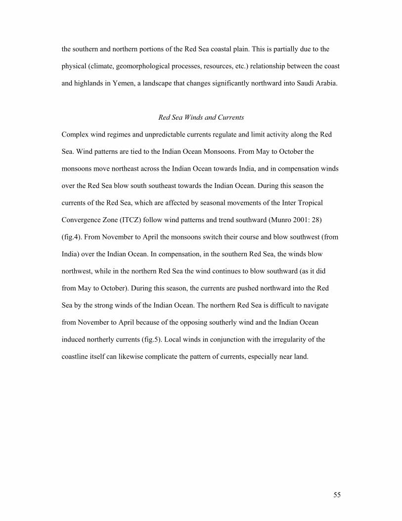
55
the southern and northern portions of the Red Sea coastal plain. This is partially due to the
physical (climate, geomorphological processes, resources, etc.) relationship between the coast
and highlands in Yemen, a landscape that changes significantly northward into Saudi Arabia.
Red Sea Winds and Currents
Complex wind regimes and unpredictable currents regulate and limit activity along the Red
Sea. Wind patterns are tied to the Indian Ocean Monsoons. From May to October the
monsoons move northeast across the Indian Ocean towards India, and in compensation winds
over the Red Sea blow south southeast towards the Indian Ocean. During this season the
currents of the Red Sea, which are affected by seasonal movements of the Inter Tropical
Convergence Zone (ITCZ) follow wind patterns and trend southward (Munro 2001: 28)
(fig.4). From November to April the monsoons switch their course and blow southwest (from
India) over the Indian Ocean. In compensation, in the southern Red Sea, the winds blow
northwest, while in the northern Red Sea the wind continues to blow southward (as it did
from May to October). During this season, the currents are pushed northward into the Red
Sea by the strong winds of the Indian Ocean. The northern Red Sea is difficult to navigate
from November to April because of the opposing southerly wind and the Indian Ocean
induced northerly currents (fig.5). Local winds in conjunction with the irregularity of the
coastline itself can likewise complicate the pattern of currents, especially near land.
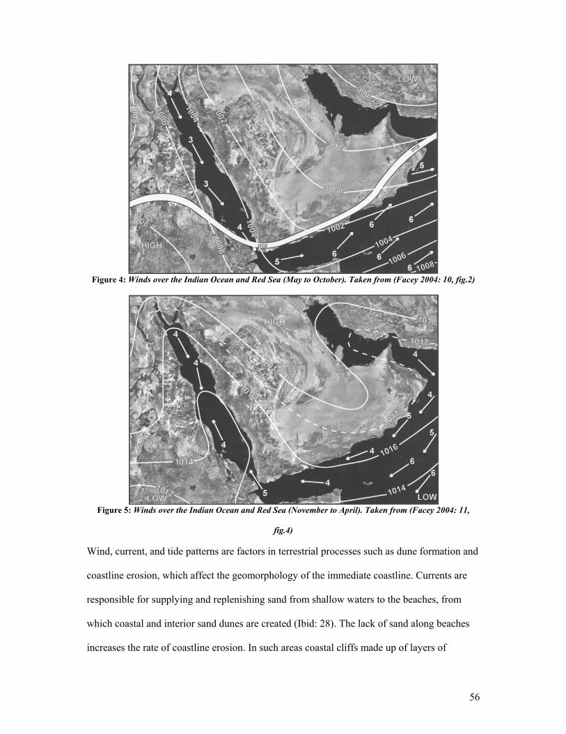
56
Figure 4: Winds over the Indian Ocean and Red Sea (May to October). Taken from (Facey 2004: 10, fig.2)
Figure 5: Winds over the Indian Ocean and Red Sea (November to April). Taken from (Facey 2004: 11,
fig.4)
Wind, current, and tide patterns are factors in terrestrial processes such as dune formation and
coastline erosion, which affect the geomorphology of the immediate coastline. Currents are
responsible for supplying and replenishing sand from shallow waters to the beaches, from
which coastal and interior sand dunes are created (Ibid: 28). The lack of sand along beaches
increases the rate of coastline erosion. In such areas coastal cliffs made up of layers of
57
Pleistocene and Holocene aeolian sands and organic sediments, as well as alluvial deposits,
suffer from acute erosion (Ibid). In the area of Fazza, near the main survey area, coastal cliffs
up to 6 m high have in the last 20 years been eroding away at an approximated average of 1
m per year 2.
Corals and Wetlands
Red Sea summer water temperatures rise to 31°C. High rates of evaporation are present (ca.
3.5 cubic meters per year) causing highly salinated waters. Most of the water of the Red Sea
is replenished by the Indian Ocean from the south so that saline counts are higher in the north
that in the south (Sanlaville 2000: 30). Such warm waters are favorable for the growth of
diverse tropical flora and fauna and corals.
The Red Sea is well known for its coral reefs, which are omnipresent along the coasts. These
include barrier reefs, coral islands and fringing reefs, which are the most common and hug
the entire coastline except at the wadi outlets. Volcanic islands such as Zuqar, Hanish and
Zubayr are likewise bordered by coral reef systems (Ibid: 31).
Coral reefs, wetlands and mangrove communities, which help to protect the coastline from
erosion, are gradually diminishing in certain areas of the Red Sea partly as a result of rapid
development. Mangrove forests continue to occupy large tracts of the Red Sea coastline,
especially north of Hodeidah. They consist mainly of the species Avicennia marina, though
Rhizophora mucronata and Bruguiera have been attested (Ibid).
2 This approximation was calculated with Dr. Edward Keall, on the basis of his experience working in the area for the last 20+ years, the author’s observations of the erosion in the immediate area in the last four years, and various personal communications.

58
Other wetlands consisting of salt marshes (sabkha), salt flats, and sea grass beds line the
Tihamah coastline. Salt marshes sustain dense halophytic vegetation, bushes and succulents.
Sea grass, one of the most productive ecosystems in the region, provides shelter for a variety
of invertebrates and fish. Vast mudflats characterize the northern coastline of Yemen. Coastal
lagoons, which like most wetlands are non static systems, are interspersed along the coast.
These wetlands minimize beach erosion by stabilizing soils along the coastline (von Zitzewitz
et al. 2003: 9-10).
Aeolian Landforms
Sand prevails over most of the landscape of the Tihamah. It exists in the form of sand plains
and dunes. These aeolian landforms originate from alluvial sands along the coastline. Dunes
can be placed in two categories, those that are ancient and those that are active. Ancient
dunes are often stabilized and anchored (no longer active) and consist of sand sheets and
ridges formed during the Pleistocene and Holocene.
Dunes formed during the Pleistocene and early Holocene appear as wide linear ridges3
oriented due east as a result of the direction of the Red Sea winds (Munro 2001: 25). During a
period of lesser sand activity these dunes stabilized and were inhabited. Sometime during the
Holocene a new active period advanced coastal sands inland. Winds blowing in a north-
easterly and south-easterly direction formed parabolic, barchan and seif dunes along the
coast, which migrated towards the foothills as eastward oriented barchan and transverse
dunes (Ibid: 26). Ancient dunes that have not been stabilized by soil forming processes such
as vegetation growth and human settlement are prone to deflation. Given the sparse
vegetation cover along most areas of the coastal plain, there is little protection from wind
3 These are clearly visible on satellite images and aerial photographs of the region, appearing on the images as parallel latitudinal ridges throughout the coastal plain.

59
erosion and deflation of ground surfaces is widespread. Many ancient dunes near the coast
that are not well anchored by vegetation, are victim to strong winds that shape them into
angular forms called yardangs (Ibid: 37).
At present large active dunes are forming and moving along the immediate coast. The dunes
of the interior Tihamah are fed by sand blowing off these coastline dunes. According to
studies undertaken in the Tihamah, dunes are currently moving from 9 to 30 meters per year
throughout the coastal plain (Munro 1999, 2001: 25-6). The situation is such whereby a site
documented one year can be buried by sand and thus invisible the following year.
Coastal Land-Use
The coastline and wadis are dotted with concentrations of the indigenous wild dom palm,
Hypaene thebica that grows where there is groundwater. Chenopodiaceae herbaceous
communities grow in saline conditions along the sabkhas while mangroves consist of
Avicennia marina. Mangrove wood is used as a building material and as firewood. Palm
fronds are used to thatch roofs and to weave mats, rope and other textiles, while the wood is
also used as a building material. Driftwood tied by palm rope is used to construct local punt
rafts used for net fishing. Salt flats and salt domes are often used to mine salt (Stone 1985:
129-30).
Small villages of round and square thatch huts are home to fishing communities that line the
entire coastline. Due to a lack of electricity to refrigerate each catch, fish is mainly sold
locally (seaside open air markets or small village markets), especially in the case of isolated
communities, or is caught for the family or village. Net fishing is most common, and takes
place along the shore, or on fishing expeditions at sea or near the islands. These expeditions
60
often take three days to two weeks depending on the distance traveled. Line fishing occurs
less regularly, though it consists of the use of a long string and hook, which is lassoed over
the head and thrown into the sea from the shore. In the past, local fishing was limited to two
or three fish species (bagha, wizif and dayrag). With competition from large fisheries, and a
greater demand in the highlands and abroad for a larger variety of fish and shellfish, local
fisherman are beginning to diversify. Despite the lack of electricity and amenities along most
of the immediate coastline, foreign fishing companies, small illegal fishing and diving posts
run by a mafia of outsiders, coastal highways and the GPS are rapidly infiltrating this isolated
and traditional subsistence niche. Fishing and herding are compatible, though most fishermen
do not have enough animals to constitute a herd. Where grazing grounds are available on the
immediate coast such as in the wadi floodplains, it is common to come across large camel,
sheep and goat herds. Fishing communities live adjacent to and among agricultural
communities and although they interact and intermarry, there is a great economic divide
between the two.
The tropical climate sustains a diverse agricultural economy consisting of indigenous and
imported domesticates such as date palm (Phoenix dactylifera), sorghum (Sorghum bicolor),
pearl millet (Pennisetum glaucum), papaya, banana, okra, sesame, henna and cash crops such
as cotton and tobacco. Except during the summer rains when large sand dunes are planted
with sorghum, land-use systems in the Tihamah are well organized and rely on the high water
table in the region. Fields owned by local families that line the river floodplains are irrigated
by well water that is pumped into irrigation channels.
A range of succulents and shrubland characterize the inland coastal plain. Beekeeping is
common along the coastal plain and varieties of honey are produced locally (Stone 1985:
61
125). Agro-pastoralists and pastoralists inhabit the inland plain. The most common herding
animals are fat-tailed sheep and goat, humped cattle and camel.
Red Sea Islands
In Yemen, the Tihamah lies directly across from the Eritrea and Djibouti coasts of the Horn
of Africa. Numerous islands lie in between, the most prominent of which are (north to south)
Farasan, Zubayr, Dahlak, Kamaran, the Hanish and Zuqar, while hundreds of smaller islands
and sand bars hug both coastlines. These islands provide important eco-niches as they are
fringed by large systems of coral. Those that lie at a distance from the mainland are to a large
degree isolated and are thus untouched by development. At the same time, these coral
systems make the islands difficult to approach for those navigating long-distances. Local
sailing communities well versed in the landscape of the Red Sea move regularly between
these islands as they are fishing havens (Phillips et al. 2004: 239). These islands are
important landmarks in the greater Red Sea world as they provide orientation and distance
markers for seafarers. The larger islands of the Red Sea are currently inhabited and
archaeological evidence has demonstrated that for example the Dahlak and Farasan
archipelagos were also inhabited in the past (Phillips et al. 2004, Zarins et al. 1981).
2.3 Eritrea, Djibouti and Ethiopia: The Coastal Plain and Highlands
Lying across the Red Sea from the Tihamah coastal plain, Eritrea is effectively a mirror
image of western Yemen. Located in an identical climatic zone, its relief consists of a flat
coastal plain that rises gradually westward towards the foothills. An eastern escarpment
ascends to the highland plateaus, which reach a maximum elevation of 4,600 m a.s.l. in the
Ethiopian highlands and 2200-2500 m in the Eritrean highlands (Curtis 2004: 57, Phillipson
1998: 11). The similarities between the two coasts are uncanny but are quite logical from a
62
geological perspective. The Red Sea rift created faulted margins on either side, which formed
the parallel escarpments.
Such Tertiary movement and large-scale volcanism formed the Ethiopian/Eritrean highlands.
It is an area made up predominantly of granite and basalt and rich in resources which include
obsidian and mineral deposits such as copper and gold (Curtis 2004: 57, Phillipson 1998: 13).
The northern coastal plain of Eritrea is flat and its watersheds lie in the Eritrean highlands.
Southward along the coastal plain lies the inhospitable Danakil depression, one of the hottest
and driest places in the world. The southern coastal region near the Eritrea/ Djibouti border
region is characterized by the Rift Valley, which is a continuation of the Red Sea formation.
In this region the watershed for river systems (Awash) lie in the Ethiopian highlands
(Phillipson 1998: 12). The central and southern regions of the coastal plain are characterized
by a volcanic landscape and rocky stretches.
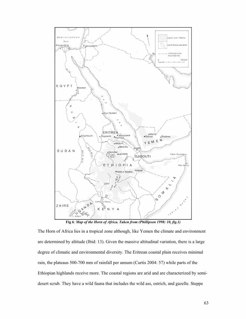
63
Fig 6: Map of the Horn of Africa. Taken from (Phillipson 1998: 10, fig.1)
The Horn of Africa lies in a tropical zone although, like Yemen the climate and environment
are determined by altitude (Ibid: 13). Given the massive altitudinal variation, there is a large
degree of climatic and environmental diversity. The Eritrean coastal plain receives minimal
rain, the plateaus 500-700 mm of rainfall per annum (Curtis 2004: 57) while parts of the
Ethiopian highlands receive more. The coastal regions are arid and are characterized by semi-
desert scrub. They have a wild fauna that includes the wild ass, ostrich, and gazelle. Steppe
64
thorn woodland and a fauna that includes elephants and antelope characterize the eastern
escarpment (Fattovich 1997: 81). The war between Eritrea and Ethiopia has had a great
impact on the environment and much of the wild fauna is now endangered in the region.
Finally the region as a whole is made up of a diversity of ethnicities including Semitic,
Cushitic and Nilo-Sahelian populations. Terraced cultivation predominates in the highlands,
while the lowlands are interspersed with pastoral communities that move between the plateau
and lowlands and fishing communities along the littoral (Ibid: 82).
2.4 Highland Geography
The Western Escarpment and Central Highlands
The highland mountain chain, oriented approximately north to south, runs parallel to the Red
Sea coast. These mountains, characterized by semi-arid peaks interspersed with intermontane
basins, tower above the Tihamah coastal plain from the east and the desert fringe from the
west. The highland massifs are a product of long-term uplift, volcanism and sea floor rifting
(Munro 2001: 12).
The highlands of Yemen form several different geographic regions. The western escarpment
and the montane plains make up a part of the larger study area.
The western escarpment begins at the foothills of the Tihamah. It was formed as a faulted
margin as a result of the rifting of the Red Sea and rises to an elevation of 1000 m a.s.l. (Ibid:
14). This area, which is one focus of my research, includes the drainage area for all the
Tihama rivers. The western edge of the escarpment is made up of colossal granite mountains
that form an impediment to the widening of the rivers as they move downslope (Ibid: 16). In
65
this area the wadis wind through deep cut gorges until they reach the foothills. This is the
case for the tributary rivers of the wadi Zabid, though once the wadi forms in the mid-altitude
region, it widens considerably and is not delimited by rock but cuts through existing
alluvium.
The scarp that was created forms the boundary between this region and the volcanic highland
plateau, located at elevations between 1500 and 3760 m (Jebel Bani Shu’ayb) a.s.l. Tertiary
and Quaternary volcanic rocks make up the elevated portions of the central highlands, while
the montane plains of the high plateau consist of lava and alluvial plains and can have insular
basins with centripetal drainage (Ibid: 14).
Down-faulted intermontane plains or graben characterize the central plains. The Dhamar
Survey Project area which will serve as the comparative highland case-study is located in the
Rada’ and Dhamar plains. Bound by the edge of the western escarpment which plunges
steeply down to the Tihamah coast, the survey area consists of a number of fertile valleys
(Qa’), plateaus, and volcanic terrain eastward towards Rada’. The survey area terminates at
the Sumara pass, after which the terrain begins to plunge into the steep heavily terraced and
fertile landscapes of Ibb and Taiz before reaching the southern foothills.
Climate
The escarpment falls within the tropical zone while most of the high plateau is located within
the sub-tropical zone (between 1500 and 2000 m a.s.l.). At higher elevations along the
highland massifs the climate is semi-arid, humidity is low and temperatures can reach
freezing. Higher elevations tend to receive higher rainfall levels, with the Ibb area reaching a
maximum average of 1161 mm per annum (Sanlaville 2000: 135). More arid areas can
66
receive as little as 500mm of rainfall annually (Wilkinson 2003: 189). Rains are seasonal, in
the spring (March – April) and late summer (August – September) and occur as a result of the
atmospheric circulation patterns of the Indian Ocean monsoon system (Lewis 2005,
Wilkinson 2003: 17). Modern regional temperatures vary according to the season but tend to
be moderate. Temperatures vary drastically by day and night, sometimes dropping to 10°C,
but average 15° - 20° C in the winter, and 20° - 26°C in the summer.
Resources
In the Oligocene, tremendous volcanic activity generated substantial accumulations of
basalts, rhyolites, and tuffas that make up the immediate rock base of this region. Volcanic
activity continued into the Quaternary though in the Dhamar/Rada’ area it stretched into the
historic periods (Sanlaville 2000: 135, Wilkinson 2003: 16). Two of the most important
volcanoes in Yemen, Jebel Lisi and Jebel Isbil, are located in the Rada’ plains. Both
volcanoes are a source of obsidian, a material widely sought after in ancient times. Jebel Isbil
is the largest volcano in the Arabian Peninsula and is surrounded by satellites of smaller
volcanoes and cinder cones.
The most available resource in the highlands is stone (granites and basalts) and semi-precious
stones. In addition to obsidian sources, the surrounding area is rich in agates and carnelians,
soapstone, iron and gold (Lewis 2005).
Highland Land-use
At risk of oversimplifying what is in reality a complex system of agriculture, we can see that local
communities utilize water from ever-larger catchments as rainfall decreases from moist highland to
arid desert fringe. (Wilkinson 2003: 189)
67
Like the variety of distinguishable micro-environments that exist latitudinally along the
Tihamah coastal plain, the verticality of the highlands comprises a range of ecological zones.
Each zone has a different flora and climate, which in conjunction with the differing
geological landscapes can influence land-use (Wilkinson 2003: 185). Acacia-Commiphora
xerophitic communities, which grow in the foothills and near wadis, can be found along the
western escarpment and in the southern highlands. Zizyphus spina-christi, which is also a
lower altitude plant, grows occasionally in the highlands. Semi-evergreen (sclerophyllous)
woodlands, and evergreen needle-leaved woodlands consisting of Olea and Juniperus
procera normally characterize the higher altitudes but are rare in Yemen today. This may be
due in part to the gradual deforestation of highland woodland due to increased land-use.
Contrary to the rare and dwindling woodlands, succulents such as the Aloe and Euphorbia are
abundant throughout the escarpment and the high plateaus (Wilkinson 2003: 19).
Higher rainfall levels and altitudes provide a range of environments that have led to the
development of land-use systems not as common in other regions of Yemen. These include
agricultural terracing, rainfed agriculture and a number of water runoff systems (Ibid: 186).
The amount of rainfall available often determines the types of water catchment systems used
and thus the way water is exploited and distributed. Rainfed agriculture is limited to areas
where the mean rainfall is between 500 and 1,200 mm per annum 4. Runoff agriculture relies
on higher altitude rain surplus collected down-slope. This occurs in slightly drier highland
climates and can be naturally occurring runoff, or else collected in water gathering canals
(saghiya). In areas where rainfall is as little as 200-300 mm per annum, this method is often
used to distribute water to valley floor fields. Where rain is even less common, dams (sedd)
are used to control wadi spate flow (Wilkinson 2003: 189). Such barrages or dams were
4 Unlike in North Mesopotamia where rain-fed agriculture can be achieved with as little as 300 mm of rainfall per annum, rapid run-off in the steep highlands of Yemen is such that more rainfall is required for cultivation.
68
common in the early historic period and were in many ways responsible for the sustainability
of the large sedentary populations that made up the various South Arabian kingdoms.
Ghayls5, wells, and water basins (birkehs) are also common for small-scale water distribution
in the highlands.
The most prevalent landscape feature in the Yemen highlands is its terraced fields.
Constructed from dry stone walls following steep mountain contours, these terraces wind up
most highland slopes and form a landscape that resembles a topographic map. Terracing is an
ancient agricultural practice utilized to cultivate steep slopes, maximize cultivable space and
water runoff and minimize soil erosion. Most villages in Yemen are located atop steep rocky
cliffs or mountaintops, while agricultural activities take place on the slopes below. This
appears to have been the case as early as the third millennium BC in the central highlands,
with evidence of plateau-top sites and contemporary terracing on the slopes below, such as at
the site of Hamat al-Qa (DS101) (Edens et al. 2000, Wilkinson 2003: 191, fig. 9.6). In more
undulating landscapes cultivation is equally common along wide valley bottoms.
Terraces are often built from the valleys upwards, so that as the lower terraces are stabilized,
higher terraces are built. Cross-valley walls or harrahs function in a similar way to terraces
but on a larger scale. Large stone walls are built across wide valleys and are eventually
infilled by sediment, creating vast valley-floor terracing. These features can minimize soil
and slope erosion, however if they are not well maintained they are likely to worsen the
degree of such erosion (Wilkinson 2003: 189-90). Such water and land management systems,
while they stabilize the landscape and increase agricultural productivity in the highlands, if
poorly managed, maintained, or abandoned over large areas, can negatively affect land-use
5 A system of collecting perennial flow from springs or pools in wadis(Wilkinson 2003: 189).
69
and the physical landscape downslope along the Great Escarpment and the coastal plain. In
extreme cases they can even destabilize entire fragile ecosystems that are nurtured by a
highland-lowland equilibrium.
The highland climate sustains an agricultural economy made up of an entirely different range
of imports and domesticates than the tropical lowlands. Along the escarpment and the lower
highlands coffee, a native of East Africa, is common, but has recently been replaced at higher
altitudes by the qat plant. Qat (Cathula edulis) is widespread in the highlands and has
replaced most other cultivable crops. Pomegranate, apricots, grape, cactus fruit (beles),
cauliflower, potatoes, cabbage, carrot, onion, lentils, beans and fenugreek are some of the
plants currently grown in the highlands. In addition to agriculture, agro-pastoral and pastoral
communities characterize the subsistence economy of the highlands.
2.5 The Westerly River Systems
River systems have helped to define the limitations and possibilities for human habitation for
millennia. They are in many ways directly and indirectly responsible for the adoption of
different modes of human subsistence over time. In addition, they act as a link between the
three Yemeni regions of study. While the western highlands provide the catchment areas, the
main watercourse forms and develops in the mid-altitude region and spreads into fans and
deltas on the coastal plain. Three altitudinal zones can thus be inextricably tied by one wadi
system, if not culturally then physically. These physical links will be touched on below, such
as the effects that current and ancient highland land-use patterns can have on the mid-altitude
region and on the coastal plain. A brief discussion of the development of the fluvial landscape
is vital to considering how these systems affected and were exploited by humans in the
prehistoric period. By understanding the current geomorphology of these widyan it becomes
70
possible to reconstruct this landscape and how its activity has affected site visibility and
taphonomy.
In the Tihamah, the few rivers that currently retain a regular flow are overexploited for flood
and irrigation agriculture in the mid-altitude regions and the inland coastal plain and do not
currently reach the sea except on rare occasions of severe flooding6. Silt deposition is most
prominent during such floods, when it is built up on the piedmont fans (Munro 2001: iii).
This accounts for the massive amounts of alluvium deposited along the coastal plain, which
then spreads out into alluvial fans towards the Red Sea. In addition, the upper catchments of
the westerly wadis suffer from moderate to severe soil erosion as a result of the degeneration
of vegetation and woodland species, the poor maintenance of agricultural terraces in the
highlands and general destabilization of slopes by poorly planned development projects
(Ibid). Such extreme human induced erosion has been taking place since the mid-Holocene,
but with modern development it has accelerated exponentially.
Unlike the mid-altitude regions and the highlands where ancient fans lie above the current
wadi channels7, older alluvial sequences in the Tihamah are buried under sand dunes, active
wadi fans and ancient channels. However, in the central Tihamah where the bulk of the
survey work for this dissertation was carried out, the majority of the older fans lie underneath
a sheet of stabilized ancient sand dunes and current mobile dunes. This makes their signatures
both on the ground and through remote sensing difficult to identify. Inter-dune corridors and
later deflated surfaces provide narrow windows where more ancient alluvial fans can be
traced.
6 Floods in six of the Tihamah river systems have reached the sea in the last 50 years (Munro 2001: 20). 7 See Chapter III. Along the Great Escarpment, these ancient alluvial fans appear as relic terraces lying above current wadi channels. These terraces are characterized by pebble and cobble surfaces that are heavily patinated from desert varnishing. Such terracing occurs in parts of the southern Tihamah (see Munro 2001: 18).
71
Three major wadi systems fall within the main survey area, located between the cities of
Hodeidah and Zabid. As suggested by variability in the archaeological record and evidence of
slightly differing geological and geomorphological histories, the wadis Zabid, Rima’ and
Kuway’ (south to north) will be discussed individually.
Wadi Zabid
The wadi Zabid catchment area, which lies between the wadi Nakhlah basin and the wadi
Rima’, encompasses 5,232 km2, of which 839 km2 are along the coastal plain. Some
catchment areas are at elevations reaching 3,000 m a.s.l. Originating near Yarim at the
southwestern edge of the montane plains and the highland survey area, along the rift and
plateaus of the western highland chain, the wadi Zabid lies on granites, sandstones and
Tertiary and acid volcanics (Ibid: 81).
At the point where the main tributaries meet and the wadi Zabid forms lies the eastern extent
of the mid-altitude survey area. In this area, the wadi Zabid acts as a cultural boundary
between the immediate south and north banks. On the northern bank loom the elevated
jagged peaks of Wasab al ‘Ali and Wasab al Safil which receive a significant amount of
rainfall yearly. The area is inhabited by highland agriculturalists. Extensive relic wadi
terraces, followed by an undulating landscape interspersed with small mountain peaks,
characterize the arid southern bank where the mid-altitude survey was concentrated. Lowland
pastoral communities, who occasionally dabble in runoff and flood irrigation in the wadi
stream itself, dominate this area. Moving a distance southeast towards Ibb, the terrain
becomes very green and elevated with extensive terracing networks maintained by highland
agricultural communities.
72
Due to high annual rainfall that rises above 1000 mm in the upper Hazm al ‘Udayn and Ibb
catchments of the wadi Zabid, the base and subsurface river flow are more consistent (Munro
2001: 82). The base flow normally consists of a light stream, which upon reaching the
foothills downstream has been exploited. A large amount of sediment flows out of the
highlands, partially due to significant erosion from lowered water tables, loss of vegetation
cover, overgrazing, and the poor upkeep of agricultural terraces (Ibid: 84).
The extensive relic terraces that make up the banks of the wadi Zabid in the mid-altitude
region and the piedmont zones are key to reconstructing the movement and fluctuations of the
wadi through time and were prime locations for prehistoric settlements. At least three wide
terraces lie along the southern bank, rising to a maximum height of 30 m above the floodplain
in areas. The higher terraces are older than the lower ones and consist of patinated gravels
and boulders.
Formation of the highest terrace in the wadi Zabid represents a period of infilling of the
valley due to aggradation in the wadis and erosion from the highlands. As an adjustment to
late Pleistocene rises in sea levels the wadi floor filled with alluvium. As sea levels receded,
repeated wadi incisions led to the abandonment of the high terrace. The middle terraces
evidence further down-cutting by the wadi into older alluvium, until it eventually cut into its
present course (Munro 2001: 17).
As the wadi Zabid reaches the coastal plain it cuts a wide course through sandy plains and
stabilized ancient dune formations. Commonly attributed to watercourses and their
73
floodplains, dark signatures on LANDSAT satellite images8 suggest slight northward
deviations of the wadi course along the coastal plain before its main delta is formed.
Following stabilized ancient inter-dune corridors near the coast the channels tend WSW. In
this area, observation of the geomorphology of the wadi Zabid fan has provided evidence of
massive flooding events in the form of alluvial deposition over large areas. Exposed sea cliff
sections in the area of Fazza, where the current course of the wadi Zabid meets the Red Sea,
show interspersed sequences of stratified gravels and flood sediments. These overlie more
ancient organic clays that suggest a wetter and more stable environment, perhaps one that
sustained extensive mangroves and marshes along the wadi fan9.
Wadi Rima’
The wadi Rima’ catchment, which lies between the wadi Zabid and wadi Kuway’,
encompasses a total area of 4,479 km2, of which 1899 km2 are along the coastal plain.
Originating in the montane plains of the central highlands, in the northern part of the highland
study area, its basin lies in areas of Tertiary volcanics, acidic volcanics and basic lavas
(Munro 2001: 78-9). From the catchment area, the slopes of the escarpment are very steep
and the wadi becomes a gorge. Heavy rains can cause severe flooding as they wind down
narrow gorges and surge onto the coastal plain.
As the wadi Rima’ reaches the foothills of the Tihamah, the highland cultivated terraces are
replaced by rainfed and runoff irrigation and pump irrigation nearer to the coast. In the latter
area cultivation is dense and diversified ranging from sorghum, wheat and henna, to papaya
and lime. The wadi and cultivation are under threat of encroaching mobile sand dunes from
the north and south. Due to strong winds and massive sheets of blowing sand, the area west
8 10 meter SPOT imagery from the former NIMA 9 (pers.obs.)
74
of al-Mudaniyah is barren save for the last few kilometers where Salvadora persica
(amsuwaq) shrubland grows densely in the main wadi floor. Near the point where the wadi
meets the sea are large southwest- northeast Aeolian dunes followed by a narrow strip of salt
flats and sandy beaches. The northern banks of the wadi near the coast consist of ancient
stabilized sand dunes underlying early to mid-Holocene shell middens, while just west of al-
Mudaniyah are significant terraced gravel beds corresponding to relic courses of the wadi.
Wadi Kuway’
The wadi Kuway’ catchment, which lies between the wadi Rima’ and wadi Kuway’,
encompasses a total area of 1,317 km2, of which 900 km2 are along the coastal plain.
Originating in slopes of acidic volcanic, rhyolite and granite outcrops in the highland
escarpment, the wadi Kuway’ reaches the plain and expands into a wide valley (Munro 2001:
77-8). While runoff and rainfed agriculture are predominant along the foothills, nearer to the
coast pump irrigation is used. Sand plains characterize the area surrounding the wadi. The
immediate banks are made up of ancient stabilized dunes, upon which are layers of early to
modern human habitation. Near the coast, the current wadi channel is dense with date palms,
Phoenix dactyliphera and wild dom palms, while it is blocked on the coastline by large
southwest- northeast oriented aeolian dunes.
2.6 Past Geography and Climate
Two interpretations of the landscape have guided both the methodological and theoretical
perspectives of my research. The first is the cultural landscape, which acts as a milieu for past
human exploits. That is to say that the landscape sets the spatial and physical conditions for
human possibility, perception and action. The second is the active physical landscape of
Yemen, which is continuously changing and being changed. This active landscape acts as a
75
repository for the products of past human action and at the same time controls the visibility of
such vestiges. In the previous section, the modern geography of the region was briefly
described. In order to understand the ancient landscape, how it was formed and changed and
current taphonomic processes that are in a state of obscuring and exposing traces of past
human occupation, it is important to discuss the geological and climatic history and the
geomorphological transformation of the regions in question.
Continental rifting in the area of the Red Sea began approximately 30 Ma (million years ago)
with uplift and extreme volcanism. Earlier sedimentary formations10 that had been buried by
volcanic lavas were uplifted. Between 26 and 22 Ma, the Red Sea rift began to open as a
result of tectonic plate movements and the separation of the Asian continent from Africa,
ceasing during the late Miocene (between 15 and 12 Ma) (Munro 2001: 13, Sanlaville 2000:
18). The narrow Red Sea formed as a result of this separation, while the uplift that resulted
gave rise to the highland massifs of Eritrea/Ethiopia on one hand and of southwest Arabia on
the other.
Environmental changes that have occurred since the separation of the Arabian Peninsula from
the African continent are in part related to the glacial cycles and variations in sea levels. The
Quaternary period witnessed a large number of glacial/interglacial cycles (approximately one
cycle every 100,000 years), with associated sea level regressions and transgressions
(Sanlaville 2000: 167-9). In my research, the focus will be on the Holocene transgression
which raised sea levels to a maximum of 120-130 m a.s.l. and the regression that followed
into the mid-Holocene (Wilkinson 2003: 22-3). The maximum stage of this marine
transgression is characterized by early Holocene coastal settlements located along a raised
10 These include the Tawilah Sandstone, the Amran Group Limestone, the Kohlan Sandstone, the Akbra Shales and the PreCambrian Basement (Munro 2001: 12).
76
shoreline 1-2 m above the current sea level (Zarins et al. 1986). The decrease in sea levels
that followed can be traced throughout the early to mid-Holocene by settlements shifting
towards the coast and by the wide salt flats that formed as a result.
In conjunction with the rise and fall of the sea levels, a Holocene lacustrine phase is
documented throughout Yemen and the Arabian Gulf. This phase provided more humid
conditions that sustained an environment of paleolakes in the highlands and deserts, enhanced
river flow and extensive mangrove forests along the Arabian coastline (Cleuziou et al. 1992,
Wilkinson 2003: 19-23). Denser mangrove forests characterized the Red Sea littoral and the
fringe of the wadi outlets during this period. This is supported by large numbers of Holocene
shell middens, made up of dense accumulations of the mangrove mud-dweller, Terebralia
palustris now extinct in Yemen (Cattani et al. 2002, Khalidi 2005, Tosi 1985, 1986). These
prehistoric shell mounds are located along the entire coastline and border along relic wadi
deltas to a significant distance from the coastline. Similarly the highlands and escarpment
were characterized by denser woodland.
The drying of the climate that ensued in the mid-Holocene presents the beginning of a stage
of landscape degradation caused by an intensified period of human-environment negotiation.
This intensification is a result of a number of factors including the drying of the climate, the
decrease in sea levels, the recession of woodland and mangrove environments and their
ecological niches (fauna/flora/marine resources), which occurred progressively and together
with the growth of populations and towns and intensified land-use. This phase (which
corresponds to the late prehistoric period) represents the initial stage of the long process of
landscape transformation and degradation that continues presently and was discussed in the
previous sections.
77
2.7 Conclusion
This chapter has illustrated the geographic and climatic relationships between the different
regions of Yemen. Geologically and geomorphologically each region is inextricably linked to
the next, so that changes in land-use in one zone can dramatically affect surrounding zones.
Furthermore there exists a density of zonations, whether latitudinal or vertical within each
region, which account for the inter-regional diversity of vegetation and land-use patterns.
Although the Tihamah coastal plain is part of the greater Red Sea system, processes in the
highlands and the western escarpment nonetheless affect its physical and thus cultural
landscape and vice versa. Conversely it has been shown that though the western escarpment
links the highlands of Yemen to its lowlands through a series of wadi systems, it also poses a
formidable physical and cultural frontier due to changes in elevation, climate and rainfall,
widely divergent landscapes and land-use systems. The mirroring coastal plains of the Red
Sea, that of the Tihamah and of Eritrea/Djibouti are more similar than they are different,
nevertheless the Red Sea though crossable remains a force of winds, currents and irregular
coastlines to overcome.
What a reconstruction of the past climate and environment of these regions has shown is that
despite the physical frontiers that exist and act to distinguish regions from each other,
geological, environmental and human induced processes in one region can affect those in
another. At the same time it has been demonstrated that although such physical frontiers may
appear to be abrupt posing insurmountable boundaries between one region and the next, they
are in fact made up of intermediary zones and are dissected by fluvial systems that facilitate
human interaction. The temporal aspect of such processes and of human interaction across

78
environmental zones is key to understanding human-environment relationships. For example
the speed at which the landscape is transforming with the introduction of modern
technologies and the effect this is having on the degradation of both ancient and modern
landscapes is not equivalent to the speed at which it occurred in prehistory. Similarly the rate
of such speeds must be taken into account when tracking cultural interaction over such a
diversity of landscapes in the prehistoric period and it should be presumed that unlike today,
a major time lag existed between one interaction and another, one crossing and another.

79
III Archaeological Landscape Survey: The Methodological Approach
Landscape is the work of the mind…Its scenery is built up as much from strata of memory as from
layers of rock. (Schama 1995: 7)
3.1 Introduction
In the last few decades there has been increased development in the science and methodology
of survey and landscape archaeology. There has been a drive away from survey as a tool for
finding sites worthy of excavation, towards a more comprehensive field that integrates the
study of ancient human activity among settlements and their fringes with ancient human
activities throughout the physical and constructed landscape. This approach, which continues
to transform and to incorporate new perspectives, has, in the last two decades, been employed
in and adapted to different areas of the Near East where ancient settlement, landscape
features, and ancient agricultural areas are densely etched. In a country such as Yemen, as
densely exploited by humans in ancient times as other Near Eastern regions, landscape
studies are extremely beneficial to understanding human interaction and spatial involvement.
Given that a holistic approach to archaeology is relatively new to Yemen, it is not surprising
that the study of archaeological landscapes is only recently emerging to take the place of ‘old
school’ reconnaissance surveys.
Archaeological surveys carried out along the Red Sea coastal plain and in the western mid-
altitude regions of Yemen between 2002 and 2004 aimed at integrating such landscape
perspectives into the overall field methodology. By viewing landscape taphonomy as the
blueprint from which to reconstruct ancient human interaction and economic strategies, a
80
broader multi-scalar interpretation of settlement, land-use and cultural connectivity systems
was made possible both on a micro and macro regional scale.
This chapter describes the methodological approaches to archaeological survey and data
analysis used for this research. Firstly an overview of the theories and concepts that have
driven the study of the landscape as an archaeological approach and the ways that landscape
studies have contributed to archaeology are discussed. This is followed by a discussion of the
current state of landscape archaeology and the benefits of using such methods in Yemen.
Details of survey strategies and data collection techniques utilized for this research are
illustrated followed by an explanation of how these methods were applied and adapted to
each study region.
3.2 Methods in Landscape Archaeology: Historical Background
The methodologies used to study landscape are varied and have changed considerably
through time. The study of landscape is an approach that has been used within different
theoretical movements (Wilkinson 2003b: 4).
Landscape perspectives have been incorporated into the three main theoretical schools of
archaeological thought: the culture-historical, the processual, and the post-processual. The
culture-historical approach, with its focus on historical text and the study of artifacts as
reflections of culture, has incorporated the study of landscape, though mainly through
interpretations of historical geography and historical sources. The work of the British school
of landscape history in the mid-1980s, which draws on land-use and field systems during the
medieval period in Britain, is the best example of the ways the landscape has been interpreted
through a culture-historical lens (Aston 1985, Oates 1968, Wilkinson 2003b: 4-5).
81
The processual approach, begun by the 1970s New Archaeology movement, which focused
on the exposure of geographically wide patterns in human behavior, reconstructions of the
environment and the importance of scientific approaches, naturally incorporated landscape
perspectives into its methodology. By employing systematic survey techniques, sampling
strategies and the testing of ecological factors as an impetus for change or adaptation, this
allowed for the recognition of the landscape as a major repository of the breadth of human
activity. This school of thought laid down the foundations for the study of archaeological
landscapes. The methods instigated by its proponents are the most widely used in Near
Eastern archaeology (Adams 1972, 1974, 1981, Adams et al. 1972, Wilkinson 1982,
Wilkinson 1989, Wilkinson et al. 1995).
The post-processual approach grew out of a reaction to the overly scientific trajectory of the
processualists. This movement incorporated the concepts of the ideational landscape or the
perceived landscape, the symbolic and ritual landscape and the power of human agency. This
approach towards landscape, though much needed, tends to put emphasis on
phenomenological perspective while often overlooking the environmental aspects, which
undoubtedly had a major hand in shaping human perceptions and identity in the past.
These three theoretical movements, rooted in the North American and British archaeological
schools of thought, have had little theoretical impact on work in the Near East. The methods
utilized by some of their proponents, especially those dealing with landscape studies, have on
the other hand been quite successful.
82
Some of the most seminal works that have paved the way for landscape survey in the Near
East were those that dealt with the archaeology of southern and northern Mesopotamia, now
Iraq and northeastern Syria. The visibility of many archaeological sites (large stratified tells
located in flat plains) in these regions made it possible for archaeologists to map settlements
and use aerial photography to recognize sites at a very early stage. As Wilkinson rightly
suggests “In western Europe, parts of the Mediterranean, and the Near East, landscape
archaeology often developed hand in hand with the growth of aerial photography.”
(Wilkinson 2003b: 10).
Many early studies (1930s and 50s) became possible as a result of the availability of remote
sensing techniques. In addition a number of pioneering studies dealt with settlement pattern,
such as Braidwood’s Amuq Survey (Braidwood 1937). From the 1960s to the 80s, a number
of surveys were conducted in Iraq that dealt directly with settlements in relation to the
landscape (Adams 1972, 1974, 1981, Adams et al. 1972, Oates 1968). These extremely
important studies are still being used and re-analyzed today, but more recent developments in
the methodological approach to survey of the landscape are in part owing to the work of T.J.
Wilkinson in Iraq and Syria (Wilkinson 1982, Wilkinson et al. 1995). His methods have had a
wide impact on a younger generation of archaeologists whose focus is on the recovery of the
archaeological landscape. Using a combination of remote sensing, GIS and intensive field
survey which have enabled the mapping of road networks, field systems, and settlement
strategy, these studies, undertaken by the members of the CAMEL lab at the University of
Chicago, have revolutionized the way the Mesopotamian landscape is understood (Ur 2002,
2003). As a result of this work, clear signatures have been observed and have facilitated the
identification of non-mounded, low-mounded and high-mounded sites throughout the region
once known as Mesopotamia.
83
A combination of methodologies used in all three schools of thought bring archaeologists
closer to a more accurate representation of the past. The use of manifold perspectives in the
study of human-environment relationships, incorporating scientific, historical and
phenomenological data, is more relevant to the reconstitution of the complex interrelationship
between humans and their surroundings in the ancient past. In a region such as the Near East
where the archaeological landscape is very much a part of the modern one and the modern
landscape daily affects the preservation of the ancient, where texts, manuscripts and
inscriptions are numerous and where the past continues to play an especially powerful role in
national and religious identity, it becomes even more crucial to incorporate as many
perspectives and methodologies as is possible.
3.3 The Current State of Archaeological Landscape Studies in Yemen
The state of archaeological research in Yemen remains underdeveloped in relation to other
parts of the Near East such as Egypt, Mesopotamia, Jordan, and Lebanon, whose legendary
ancient cultures, kingdoms and empires and the monuments they have left behind, have long
been seductive to archaeologists. Although Yemen’s past is rife with legend, its remoteness
from the rest of the Middle East and its reputation as an un-traversable country of arid deserts
and rocky highlands have contributed to its archaeological isolation. In addition, Yemen’s
archaeological sites are generally badly preserved, often consisting of no more than heaps of
stone (in the highlands), wind deflated scatters (in the Tihamah coastal plain and the open
deserts) and low mounded sites (along the desert fringe), which pale in comparison to the
mountainous stratified tells of Mesopotamia. Ancient monumental sites with preserved
architecture such as the temples and dam at Ma’rib, the partially restored site of Baraqish, the
rubble mound hilltop sites of Jebel ‘Awd and Masna’at Maryah with their monumental

84
inscriptions and the looted tells of al Jawf (which are inaccessible due to tribal conflict),
though impressive, are few and far between and to the Mesopo-Egypto-centric archaeologist
do not compare in quantity or quality to remains elsewhere in the Near East.
Conversely, Yemen’s jewel is its diverse landscape, making it one of the most challenging
and interesting regions for the study of landscape archaeology. In contrast to the flat plains of
Syria and Iraq and the arid deserts of Egypt, Yemen’s steep terraced highlands, volcanic
ruinfields, vast rocky and sandy deserts, sub-tropical coastal plains and forests, copious
riverine systems and Indian Ocean and Red Sea coasts make it a country of infinite modes of
human-landscape inter-adaptation. Easily traversable it is not; however this fact alone makes
its past – famed for its overland and maritime incense trade routes – that much more elusive
and difficult to reconstruct and at the same time that much more seductive from a landscape
perspective.
At the turn of the century, this fabled landscape attracted many travelers who often described
archaeological sites they came across in their travel memoirs. Early archaeological research
began in the mid- 1900s and included very basic site surveys (Bayle des Hermens 1976a,
1976b, Benardelli et al. 1971, Cambridge 1966, Caton Thompson 1938, 1953, Caton
Thompson et al. 1939, Doe 1965, Forbes 1923, Hamilton 1943, Shukri et al. 1954), which
continue to be carried out today, mainly as a pre-requisite to site excavation.
Intensive survey and landscape studies were introduced quite late in the history of
archaeological research in Yemen. This delayed florescence was a result of an over-emphasis
on the early historical periods, focusing on the monumental architecture and inscriptions of
the south Arabian kingdoms, while prehistory remained largely ignored. With epigraphy and
85
excavation being the predominant force leading southwest Arabian archaeology, there was
little interest in interpreting the landscape or in using scientific methods to understand the
environment outside the excavation trench. With the initiation of a prehistoric archaeology in
Yemen, however, a new, more scientific methodology had to be introduced and more refined
archaeological surveys became necessary.
It was not until the 1980s that archaeological survey incorporating geoarchaeological and
environmental studies took root in Yemen. The pioneering work of DeMaigret and the IAM
brought needed attention to the prehistory of Yemen and to the study of the cultural and
environmental landscape through the use of an interdisciplinary survey methodology (De
Maigret 2002 135-8). Surveys (followed by small scale excavations) conducted in the
Khawlan at-Tiyal and the Hada area in the central highlands in Yemen were carried out by a
team that was made up of a number of specialists including a geomorphologist, a geologist
and soil micromorphologist, a geological sourcing specialist, a paleozoologist and a
paleobotanist. This enabled a multi-scalar interpretation and reconstruction of sites and their
materials in relation to the environment within a survey context (Costantini 1986, Costantini
1990, De Maigret 1984, De Maigret et al. 1989, De Maigret et al. 1990, De Maigret et al.
1985, Fedele 1984, 1985, 1990, Francaviglia 1989). These studies in effect modernized the
way that archaeology and especially survey was carried out in Yemen, an achievement that
was long overdue.
Simultaneous with the discovery of extensive prehistoric cultures in the Khawlan region, new
research was launched in other areas of Yemen. Two surveys were carried out on the Yemeni
Tihamah coastal plain in the mid-80s, one by the IAM led by Tosi, which dealt mainly with
the prehistoric periods and used a scientific approach, and the other by Stone which involved

86
a more historical approach to archaeological survey (Cattani et al. 2002, Stone 1985, Tosi
1985, 1986). A number of archaeological surveys were also carried out along the Saudi
Arabian Tihamah coastal plain and in the Asir region by an American team directed by
Zarins (Zarins et al. 1986, Zarins et al. 1983, Zarins et al. 1981, Zarins et al. 1979, Zarins et
al. 1985).
The Paris School (Sorbonne-Nanterre), led by a number of pre-historians and scientific
specialists, surveyed in the Hadramawt and the desert fringe. The focus extended beyond the
identification of prehistoric settlements and their immediate environments to placing different
lithic technologies in a chrono-regional context (Cleuziou et al. 1980, Cleuziou et al. 1993,
Cleuziou et al. 1992, Cleuziou et al. 1997, Inizan et al. 1992, Inizan et al. 1997, Inizan et al.
1987, Rougeulle 1999, Sanlaville 1992).
Although in the cases of the IAM and Paris School projects, an emphasis was on the
prehistoric periods and on environmental reconstruction and economic subsistence strategies,
the strength of the work was in the overall technical analysis of sites and the analysis of sites
in relation to their environment, and not in the survey strategy or the reconstruction of the
cultural landscape.
The DSP directed by T.J. Wilkinson (1994 to the present) introduced the integration of the
study of the cultural landscape with that of the physical landscape in the central highlands of
Yemen (Barbanes 2000, Edens 1999, Edens et al. 1998, Edens et al. 2000, Ekstrom et al.
2003, Gibson et al. 1995, Lewis 2005, Wilkinson 1997, 2003a, Wilkinson et al. 1997,
Wilkinson et al. 1999). This survey methodology, which grew out of Wilkinson’s survey
work in Iraq and Syria, differed from the previous survey work discussed above. It applied a
87
landscape-intensive survey methodology so that the landscape, the features and the sites were
viewed as functioning as a system.
Other archaeological projects have recently adopted more systematic survey strategies that
scan the landscape in conjunction with large excavations. A French team co-directed by
Mouton and Braemer, working in the wadi Hadramawt, is currently excavating the large first
millennium BC settlement of Mukaynun while concurrently surveying the wider region to
understand the hydraulic systems used to control water for agriculture during the period the
site was settled (Arbach et al. 2005). At the same time the RASA project led by McCorriston
is doing systematic survey in the Hadramawt region, using remote sensing techniques,
statistical analyses and differential GIS to map out the ancient landscape system through
space and time (McCorriston 2000, McCorriston et al. 2001, McCorriston et al. 2002).
3.4 Techniques and Analysis in Defining the Ancient Cultural Landscape
The methodology adopted for the various surveys conducted for this dissertation is an
amalgamation of different landscape-based approaches to archaeology and is adapted to each
region of study. All of the surveys involved the use of topographic maps, aerial photographs
and satellite images, previous to, during and after the survey was carried out (when and
where they were available or accessible).
A preliminary visit was made to each area of interest in order to become familiar with the
landscape and plan a tactic for survey prior to the survey season. All surveys were geared
towards answering questions of priority, which involved filling gaps in the archaeological
and environmental record as well as dealing with more specific research questions. The

88
tactics used were planned according to the geomorphology of the region and to a preference
for working from the general to the more detailed.
Two of the surveys conducted were walking surveys guided by topographic maps and
handheld Geographical Positioning Systems (GPS). One of two methods was used in order to
cover an area of interest systematically. The first involved systematic line transects at
consistent intervals along a UTM grid (fig.7). This was most constructive along the flat
coastal plain where geographical features do not act as obstacles to line transects nor delimit
site perimeters as a plateau top would. On the coastal plain, scatters were often continuous
over long distances so that transects were useful in tracking the beginning and end of such
scatters.
Figure 7: Central Tihamah coastal survey transects
The second method was mainly used in mountainous areas where it was difficult to walk line
transects and where it was impossible to sample one part of a coherent geographical system

89
with natural boundaries. This involved the total coverage of the designated area delimited by
the beginning or end of geographical features such as rivers or mountains. If survey strategy
is limited to UTM square kilometers, the survey may cover one part of a mountain falling
within that square, while other more suitable areas for settlement and adjacent human
activities along the same mountain and its direct hinterland are not recovered because they
fall outside of the square. In contrast, the method of total coverage was adopted in order to be
able to survey the total area of naturally bounded regions in such a way as to recover the
maximum information available within a micro-settlement system. In such cases the entire
physical area was divided so that for example a mountaintop would be surveyed separately
from the four sides (N, S, E and W) of the mountain, and from the plains below it (fig.8).
Figure 8: Total coverage survey in the western escarpment survey area (HU). Map by L. Khalidi
A different method of coverage was employed in the case of the road impact surveys. These
surveys followed road alignment points plotted by road engineers. Given the distance the
highways covered (Midi – Hodeidah road alignment covers 169 km, Hodeidah – Khawkhah
alignment covers 100 km) and the time limit imposed, it was necessary to conduct a vehicle
survey following the road alignment and to incorporate walking surveys where
90
archaeological sites and monuments were identified. Because the survey was focused on the
direct impact of the road and an additional 500 m of secondary impact on each side of the
road, it was essential to sample the terrain for site signatures so as to be able to recognize
potential sites from a distance and so as to identify areas with higher densities of settlement,
such as wadi banks, that could be covered more systematically when encountered. At every
site a walking survey was conducted and collections were made.
Methods used for coverage were adaptable. If a site was seen at a distance while walking a
line transect, a tangent was made so that the site could be documented and the line transect
was then resumed. A rigid, un-adaptable framework for survey can be useful for pure
statistical data but often leads to a large amount of unanswered questions and missing data.
Site Characteristics
During survey, sites were defined on the basis of the following characteristics: ruins and
standing monuments (usually in the case of the Islamic period), high or low mounding, non-
mounded sites with traces of architecture or dense and concentrated material culture
pavements, soil discoloration, displaced shell in accumulations and in association with
material culture and/or human intervention (such as burning or purposeful systematic
breakage). In most cases sites had associated material culture elements, usually in the form of
ceramics and stone tools.
Site Description and Designation
The type, morphology, size, preserved height, matrix, soil color, density of surface materials,
state of preservation and location of each site was described.

91
The type of site fell into the general categories of structure, feature or scatter. Within these
categories, sub-categories were used to describe each type of site. A structure consists of a
built structure such as a domestic dwelling, a temple, an administrative building or a fort,
while a feature consists of an element of a structure, of a site or a site system, such as a city
wall, a cemetery, a dam, an agricultural field or threshing floor. In some cases features
appeared to be isolated from any visible site system. These isolated features often consisted
of preserved sections of roads, inscriptions, or graffiti. A scatter consists of a continuous or
concentrated material culture pavement.
Site Label
Often the local inhabitants were able to provide local names for sites. When no name was
available for the specific site, the name of the nearest village was used. In addition, all sites
were given a letter and number designation. The letter designation refers to the region,
province or sub-province, while the number following it is consecutive (1,2,3,4…).
The Tihamah coastal survey crossed four different sub-provinces including al-Tuhaytah
(TH), al-Jah (AJ), Bayt al-Faqih (BF) and Zabid (ZD). A letter (A, B, C, D…) was added in
the instance of a continuous site or subdivisions within a site. A site could thus be labeled
AJ14, while its subdivisions would be labeled AJ14A, AJ14B, AJ14C, etc.
Site Size
The size of each site was measured using one of three methods. The first was used on small
sites and involved measuring the diameter or length and width of a site with a measuring
tape. The second was used on slightly larger sites and involved pacing and the third was used
92
on large sites and involved taking GPS points along the perimeter and calculating the
measurement.
For the purpose of the surveys, sites were described as very small: (<25 m2), small: (25-100
m2), medium: (100- 250 m2), large: (250-500 m2), and very large: (500 m2 +). Certain sites
that were wider than they were long or vice versa, were measured length and width-wise, the
area was calculated and a size category was assigned. In the case of sprawling settlements,
either a calculated or estimated measurement was acquired and expressed in kilometers
squared, or else in hectares.
Height of the site was estimated in relation to a known height, or else measured using a meter
stick. Due to the numerous erosive processes widespread throughout Yemen, the preserved
height of most sites is minimal, consisting of no more than one meter of stratified deposits or
several courses of stone. In the case of structures and features the number of preserved and
visible stone courses was both counted and measured in meters. In the case of mounds,
middens and scatters the height was described as low (0-0.50 m), medium (0.50-2 m) and
high (>2 m). These height descriptions were designated relative to the average height of sites
in the regions surveyed; this is not to say that sites with a more considerable preserved height
do not exist in southwest Arabia.
Site Periodization
Periods of occupation were designated on the basis of comparison with dated sites and their
associated material culture. This was done in conjunction with site and material typologies
that were gradually formed during and after the surveys were conducted. No absolute dating

93
techniques were used, and all dates are relative. Where applicable, geological time periods
such as early and mid-Holocene are used, as are late prehistoric and early historic.
Sampling and Collection Techniques
Ceramics, lithics and associated debitage and waste, faunal remains, shell, beads, coins,
grindstones, whetstones, and bronze were some of the materials collected from the surface of
sites. No single sampling technique was used for collecting artifacts. Once the perimeter of
the site was defined, the site was usually divided into quadrants or parts and collections were
made from each area. If the site appeared to have different temporal, spatial or functional
occupation events as represented by the surface artifacts, then each area of the site was
sampled separately. If the site was small or appeared to be single period a general collection
was made throughout the site and all artifacts were grouped together. In the event of sites that
were continuous through space, changes in artifact type, shell type, density of artifact scatter,
geographic boundaries, and changes in the topography were marked by a division of site or
site area. In some cases where the site was extremely large and the artifact scatter was
relatively homogenous, random collections were made within an area of 5-10 m2 every 200 –
300 m.
A total surface collection strategy over part of or the entirety of a site not only affects the
visibility of a site or site system, but often eliminates the site entirely, especially when the
artifact scatter itself constitutes the site. In light of the embryonic state of prehistoric research
in Yemen, such collection strategies should be fully justified and warranted before they are
carried out. In the event of salvage surveys, endangered, damaged or looted sites and in some
cases single sites chosen as case-studies for statistical analysis, this collection strategy is
94
defensible. In the case of all of the surveys conducted by the author, such a strategy was
unnecessary.
The survey was intended as groundwork for future surveys that would include soundings and
possible excavation. A decision was made to make a preliminary non-obtrusive landscape
and site study in order to prioritize site placement and visibility for future work. This
included the documentation of sites along the survey trajectory as well as light sampling and
collection techniques.
Archaeological Landscape Features
From an archaeological landscape perspective, the methodology of off-site survey is equally
important to that of site survey. Such a strategy allows for the recovery of a continuous
record that includes both sites and off-site activities. Ancient off-site activities can be directly
linked to one site (fields), however they can also link many sites (roads). A number of off-site
activity areas are isolated from a single site or site system but perhaps linked to individuals
(rock-shelters), or are features that provide for an entire region or group (canals, dams). In the
case of the surveys conducted, the term ‘landscape features’ was utilized to incorporate off-
site activities. These landscape features were given site numbers unless they were associated
with a site in which case they were designated as a subdivision of a larger site system.
In the highlands and mid-altitude region, archaeological landscape features included field
terraces and walls, fields, roads, threshing floors, dams, canals, irrigation channels, cisterns,
inscriptions, graffiti, tombs, cairns, cemeteries, water holes, stone quarries, mines, kilns and
activity areas.
95
Along the coastal plain, features included field scatters, rock shelters, graves, cemeteries,
megaliths, shell refuse areas, activity areas and workshops, stone piles, hunting zones, fish
refuse areas, stone quarries, salt mines, ports, hearths, kilns and tombs.
Natural and Perceived Landscape Features
Perceived landscapes are difficult to reconstruct. Site features can occur in region- or site-
wide patterns in a way as to suggest that territory was being marked or else that a ritual space
was constructed. Certain geographical features, especially those that stand out from others,
most probably acted to distinguish one territory, region or culture from another, or else acted
to orient or guide much the way they do today. These symbolic landscape features, when
interpreted in juxtaposition to the cultural landscape, can add depth and rationale to the study
of human-landscape relations. For example, it is not simple to comprehend the use of large
stone megaliths on a stone-less flat coastal plain where the foothills are undetectable at a
distance of up to 60 km. However with the setting mid-winter sun, the appearance of the
mountainous island of Zuqar visible on the horizon not only introduces a new perspective to
ancient man’s relation to stone (which is available there) but also to the prospect of
something to attain and to cross. In this case the landscape is transformed by what is visible
so that it is less about a sea to cross and more about an island to reach. Such natural landscape
features, arrangement of sites or site elements that may have been perceived in a meaningful
way were documented.
Environmental Data
Ecological, geographical, geo-archaeological, botanical and faunal observations were
recorded on each survey. On the coastal plain this included (where and when possible) the
systematic mapping of rock outcrops, current and ancient dune formations, the current and
96
ancient coastline, gravel beds, relic wadi terraces, seawalls and wadi bank sections, current
fields and groves, natural coastal oases, salt domes, marshes, mangroves, salt lakes and salt
flats. Observations were made on the types of domesticated and wild vegetation and crops, as
well as types of wild and domesticated animals that exist in the areas of study.
Site and Landscape Taphonomy
The taphonomical processes affecting both sites and landscape were studied during the
survey. Each region experiences different types and degrees of physical transformations to its
landscape and often entire sites (or site components) are obscured. Since the mid-Holocene
(from approximately 3000 BC), there has been an increased drying of the climate (Wilkinson
2003a: 157). This, in conjunction with denser human populations and the overexploitation of
the environment for material procurement and changing subsistence economies, have been
factors in the drying up of lakes and marshes, deforestation and the depletion of certain flora
and fauna (Ibid: 158-61). This has led to massive slope erosion (colluvium) and in some cases
large deposits of alluvium, which has in turn buried many sites. This is evidenced in the
highlands, where the DSP survey has recovered very few sites along the valley floors. One
site, Hawagir (DS 293) located just south of a relic Holocene lake and dated to the second
millennium BC (Ibid: 162-3), was found by chance after occupational deposits were observed
in a natural section in the Qa’ Jahran valley floor.
In the highlands and western escarpment regions, exposed stone structures have different
degrees of weathering varnish. Exposure to sun and wind over long periods of time darkens
the color of the stone and smoothens the exposed exterior giving it a patina. The longer a
stone is exposed in situ, the darker and more varnished it will be. It is often assumed that the
older the site the darker the varnishing on the stone elements, however this can be quite
97
deceiving. There is a great amount of differential weathering; certain areas experience higher
degrees of weathering than others (e.g. the desert as opposed to the highlands). Some
prehistoric sites may have been exposed recently and so the stone is lightly colored and
appears recent, while some recent sites may have walls that are heavily varnished due to their
degree of exposure to the elements and appear old. In these cases many different variables
were taken into account in order to take advantage of weathering effects for relative dating
but also so as not to falsely interpret site periodization.
The Hazm al ‘Udayn survey in the western escarpment region focused on the relic terraces of
the southern banks of the wadi Zabid and documented a large number of sites, which most
often had architectural elements and no visible associated material culture. This lack made it
extremely difficult to date these sites. Using ethnographic, taphonomic, architectural,
settlement locational, and comparative data, a multi-faceted reading of the degrees of varnish
on stone was implemented in order to aid in the relative site chronology and typology for
each micro-region. Because the area was and continues to be sparsely inhabited, most of the
structures identified remain in situ, with very little disturbance to the sites. The area is also
sparse in vegetation and ground cover, which means that exposure to the elements is at its
most extreme. Besides the lack of disturbance to sites, the southern bank of the wadi Zabid
has a stable climate and environment. It is therefore a region where there was not a great
amount of differential exposure, so that normally the darker and more varnished stones
belonged to older sites while younger sites had gradually lesser degrees of stone weathering.
In the western lowlands, the degree of slope erosion and accumulation of sediment deposits is
visible on topographic maps where the elevation of the coastal plain rises towards the
foothills. Although most of the surveys conducted on the coastal plain were towards the
98
coastline, reconnaissance has shown that there is a decrease in the number of prehistoric sites
nearer to the foothills. Given the large amounts of sediment deposits in this area it is less
likely that there was little to no prehistoric occupation and more likely that many prehistoric
sites have been buried and obscured.
Along the coastal plain a number of other taphonomic processes affect the visibility of sites,
such as mobile dunes, which tend to bury (and protect) and/or uncover (and abrade) sites.
Wind deflation plays a significant role in the degradation of sites in the Tihamah. Most often
sites have experienced such heavy deflation that little to no stratigraphy is present and the
surface scatters that remain are of mixed periods. The effects of sand and wind erosion is so
severe that it modifies the appearance of surface artifacts, giving those that have been
exposed for a significant amount of time a patina often attributed to Palaeolithic remains.
Effects of Cultural Processes on Sites and the Landscape
Cultural processes, both ancient and recent, can result in the damage or loss of parts of the
landscape and sites. Ethnographic observation has provided some of the best clues for the
way certain cultural processes in the past have changed the landscape.
The procurement of natural materials is one such process. Traditional methods are often
gradually destructive, while modern methods that use heavy machinery are quick to take
effect. In the Tihamah, many huts along the northern coast are built from the wood of
mangroves. Because mangroves, such as those of the species Avicennia marina, which
dominate the Tihamah coastline, grow in communities, the cutting down of some trees can
affect the whole system and lead to its termination. This can change the localized ecosystem
(i.e. bird life, marine life, molluscan species, etc.) and at the same time affect the morphology
99
of the coastline given that mangroves tend to stabilize it. The same is true for the
procurement of sea coral for building1, or its removal or disturbance by the building of ports
or heavy boat traffic.
Other cultural processes that were observed, which can help to explain the loss of certain
landscape features in the past, are the digging of earth for roofing, mud-brick and mud
plaster, and for ceramic production. This can create large un-natural holes in the landscape.
Similarly the cutting of wood for building materials and fire can lead to gradual deforestation
and thus destabilization.
Ancient mining and quarrying of stone and metal ores results in both the damage of the
natural landscape, but also the creation of an archaeological landscape feature, in this case a
stone quarry.
In terms of the preservation of ancient sites and the landscape, it is important to mention the
affects of modern cultural processes. In the highlands, explosives and heavy machinery are
used for quarrying. On one occasion a Himyarite site Miqtah (DS 322) and associated graffiti
on a nearby cliff were partially destroyed by explosives used for rock quarrying.
Modern development tends to be heavily destructive especially in the case of asphalted roads
and highways. Two of the three surveys conducted along the Tihamah coastal plain involved
road impact assessment to archaeological sites. Besides roads cutting into and sometimes
obliterating archaeological sites and features in their trajectory, the direct impact to sites
includes roadwork, which involves the use of heavy machinery to dig and to remove large 1 Coral is used in building foundations and is burnt in kilns, then used to make mortar, especially in humid coastal areas. Coral was used as a building material in the 16th century merchant houses of the major ports of Makha, Hodeidah and Luhayyah that developed during the height of the coffee trade in Yemen.
100
amounts of earth (at least 40 m in width of direct impact). For example, 21 of the 38
archaeological sites documented along and near the Midi-Hodeidah coastal road alignment
were in the direct path of the road and will be totally destroyed. The indirect impact of road
building on archaeological sites and features (from 1 to 15 km on either side of the road)
involves later development such as roadside towns, petrol stations, rest stops and markets that
tend to grow rapidly along major highways. These in turn accumulate garbage and traffic,
which both disturbs and obscures sites.
Agriculture is a major factor in the damage of archaeological sites (plowing, irrigation and
terracing). The site of Kashawba’ (ZD1A), also referred to as the ‘Gas Station Site’, has in
the last two years been severely damaged by heavy bulldozing for the purpose of flattening
the field in which it lies and ridding it of dense archaeological materials which make the earth
difficult to cultivate. The site’s western extension is also endangered from plowing, while the
megalithic elements documented by the survey in 2003 have since been removed from their
original location to make way for more fields.
Stones from ancient buildings are often robbed out and re-used in later buildings, especially
those that are hewn and those that have decoration and inscriptions. In many villages in the
highlands, inscribed and decorated stones are used in traditional modern houses as
architectural decoration and are usually placed above the main entranceway. The practice of
robbing out stones from earlier settlements for use in newer structures or features is not a
modern one. Prehistoric megaliths from the site of al-Manassib in the Tihamah were re-used
for later prehistoric buildings and graves at the site of al-Midamman and later as grave
markers in the Islamic period (Keall 1998: 721-4, 2004: 46-7). Similarly, stone pillars from

101
the early historic site of Adulis along the Gulf of Zula in Eritrea were re-used as grave
markers in the Islamic period.
Ethno-Archaeological and Anthropological Data
Archaeological understanding of the economic and social landscape as well as the ideational
landscape is aided by ethnographic work in the regions of study. In the preliminary planning
of the methodology of the surveys, an ethnographic study was not a priority. While
conducting the surveys, however, it became clear that the two fields were intertwined and that
an understanding of the ancient landscape and settlement development was as equally
dependent on modern human activities and perceptions and their relationship to the landscape
as it was on the archaeological and geomorphological record. Certain regions in Yemen have
experienced minimal change in building techniques, subsistence pattern, food preparation,
location of settlements and trade routes, in some cases for the last five millennia. For this
reason, the fact of Yemen’s isolation, both geographically and socially, allows for vast
opportunities to understand the past through a study of the present.
This is especially true, though not limited to, the areas outside of the major cities in Yemen,
where development is slower to infiltrate. The local understanding of the landscape is often
profound and provides clues to the way it may have been understood in the past. Many local
names for sites and features have their origins in ancient words, while many ancient
landscape features such as field terraces, inter-valley walls and roads continue to hold the
same functions today as they did in the past.
This dissertation incorporates three years of anthropological and ethnographic studies
conducted in a number of regions throughout Yemen. These ethno-archeological studies stem
102
from restoration work conducted in the highlands and Tihamah coastal plain, months spent in
fishing villages along the Red Sea, interviews with locals, specialists and craftsmen and
experimentation with lithic technologies. Unless otherwise stated, references to modern
traditional practices are the author’s own.
Influence of Political, Social and Economic Factors on Sites and the Landscape
Certain factors resulting from political, economic and social issues may affect the
preservation of the landscape and of archaeological sites. One of the best examples of this is
war. This can be seen along the southern Eritrean coast, where the recent war with Ethiopia
has created shelters, barracks and trenches out of archaeological sites. At the site of Matara in
the Eritrean highlands, the Ethiopian army purposefully destroyed an Axumite stele as a
political statement.
Poverty and political marginalization can likewise drive a population to loot archaeological
sites in order to make a living selling stolen antiquities. This is currently the case in the
region of Jawf in Yemen where poverty looms large and as a result large numbers of sites are
being destroyed and artifacts sold illegally (Audouin et al. 2004: 7-9).
Politics can also effect the level of protection the government will offer one region’s heritage
over another’s. This extends to historical periods that are considered more important to the
nation’s identity than others. In Yemen the South Arabian and Islamic periods loom large in
defining a national identity: the South Arabian because it distinguishes Yemen’s past from
other Near Eastern countries and because Biblical and Koranic references to the kingdom of
the Queen of Sheba and her visit to King Solomon have acquired a fabled prominence for the
country, and the Islamic because of the importance of religion and Muslim identity in Yemen.
103
3.5 Data Analysis
The methodology used for the analysis of the data involves three parts. The first includes the
description, photography, and illustration of the materials collected on survey. The second
includes the digitizing of the data recovered. Site registers, GPS coordinates and photographs
were put into searchable databases. Finally, the resulting data sets were plotted using GIS,
allowing for spatial data interpretation such as site size, placement and distribution.
3.6 Scientific Analysis
Because this research did not involve excavation, only limited scientific analyses were
conducted. Obsidian samples from 14 sites recovered along the Tihamah coastal plain were
sent to a geological sources specialist, Dr. Francaviglia2 for sourcing. The results of these
analyses have been incorporated here (Chapter VII) and shed light on some interesting issues
of resource exploitation and contact. Dr. Levine3 carried out preliminary identification of
some of the faunal bones collected from the surface. All of the samples have been sent to a
faunal specialist, Dr. Marshall4, for identification and further analysis, however the work is in
progress and thus will not be incorporated here.
3.7 The Study Regions
The results of the Tihamah coastal survey as well as two archaeological impact assessment
surveys along road alignments represent the core data used for this dissertation. Data
recovered from the Hazm al ‘Udayn mid-altitude survey will serve mainly as a comparative
case-study. The work of the DSP, in which I have assisted during two of the seven seasons of
archaeological surveys and excavations, will likewise serve as a comparative case-study and 2 CNR Instituto per le Technologie Applicate in Rome 3 University of Cambridge Department of Archaeology, Zooarchaeology Laboratory 4 Washington University (St. Louis, Missouri)
104
in most cases reference to this region will be to published materials. However, Dr. Lewis5,
and myself carried out a re-analysis of the majority of materials collected by the DSP survey.
The resulting interpretations of the data, database entries and GIS are the original work of this
collaboration. Finally, a six week long reconnaissance survey undertaken in Eritrea which
involved visits to known sites and the documentation of several unknown sites, will also
serve as a comparative case-study.
3.8 The Lowland Example
The Central Tihamah Survey
The Tihamah Coastal survey, conducted in February and March of 2003, presents the main
corpus of data to which other surveys and study regions are compared.
The goal of the Tihamah Coastal Survey was to illuminate prehistoric settlement strategy and
distribution across a variety of micro-environments along the Red Sea coastal plain. These
issues set the stage for larger questions about the nature of contact and interaction along
coastal plains and the role that landscapes play in impeding or facilitating such interaction.
From east to west, the survey area falls between the coastline and the main Taiz-Hodeidah
coastal road. From north to south, the survey begins at the northern boundary of the site of al-
Midamman, excavated by the Canadian Archaeological Mission of the Royal Ontario
Museum (hereafter CAMROM), and terminates just north of the wadi Kuway’ (ca. 30 km).
The area of the survey crosses three major wadi systems: the wadi Zabid, the wadi Rima’ and
the wadi Kuway’ (fig.9).
5 Dr. Lewis focused on elaborating on available and newly recovered material dealing with the Himyarite period, while I dealt with the late prehistoric materials.
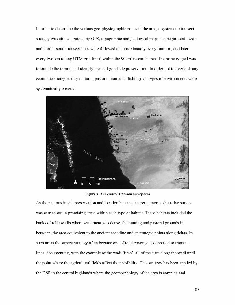
105
In order to determine the various geo-physiographic zones in the area, a systematic transect
strategy was utilized guided by GPS, topographic and geological maps. To begin, east - west
and north - south transect lines were followed at approximately every four km, and later
every two km (along UTM grid lines) within the 90km2 research area. The primary goal was
to sample the terrain and identify areas of good site preservation. In order not to overlook any
economic strategies (agricultural, pastoral, nomadic, fishing), all types of environments were
systematically covered.
Figure 9: The central Tihamah survey area
As the patterns in site preservation and location became clearer, a more exhaustive survey
was carried out in promising areas within each type of habitat. These habitats included the
banks of relic wadis where settlement was dense, the hunting and pastoral grounds in
between, the area equivalent to the ancient coastline and at strategic points along deltas. In
such areas the survey strategy often became one of total coverage as opposed to transect
lines, documenting, with the example of the wadi Rima’, all of the sites along the wadi until
the point where the agricultural fields affect their visibility. This strategy has been applied by
the DSP in the central highlands where the geomorphology of the area is complex and
106
different micro-environments are inter-woven. The survey recovered a total number of 133
sites.
Archaeological Impact Surveys
The methodology used on these surveys was discussed earlier in this chapter. The strategy
used on such surveys often depends on the circumstances of the survey and the region under
impact. The two impact surveys conducted in the Tihamah differed not only in circumstance
but also in aim.
The first involved collaboration with the Yemeni Ministry of Environment and Culture and
its objective was to halt a development project that was illegally underway, in this case a
highway. This qualifies as a form of archaeological activism whereby the methodology of the
survey is geared towards illustrating the danger such a project poses to a number of sites and
site systems in an effort to attain higher goals such as changing future development
procedures or laws, enforcing the protection of an area etc. In this case an effort was made to
identify regions of archaeological prominence, in tandem with the documentation of sites that
were in direct impact of the road’s trajectory.
The second survey was contracted by a road engineering company in order for them to assess
the damage that would be caused by and alternatives to their projected road alignment prior
to construction. The method involved more detailed documentation and collection strategies
both on the road trajectory and up to 500 m on either side of the road. A time limit was given
so that the survey had to be carried out swiftly and efficiently. Thirty-eight previously
undocumented sites were recovered on this survey (fig.10). Ground control included the use
of a handheld GPS unit to follow the road alignment and mark site coordinates. Each site was
photographed, described and artifact and environmental samples were collected. Values of
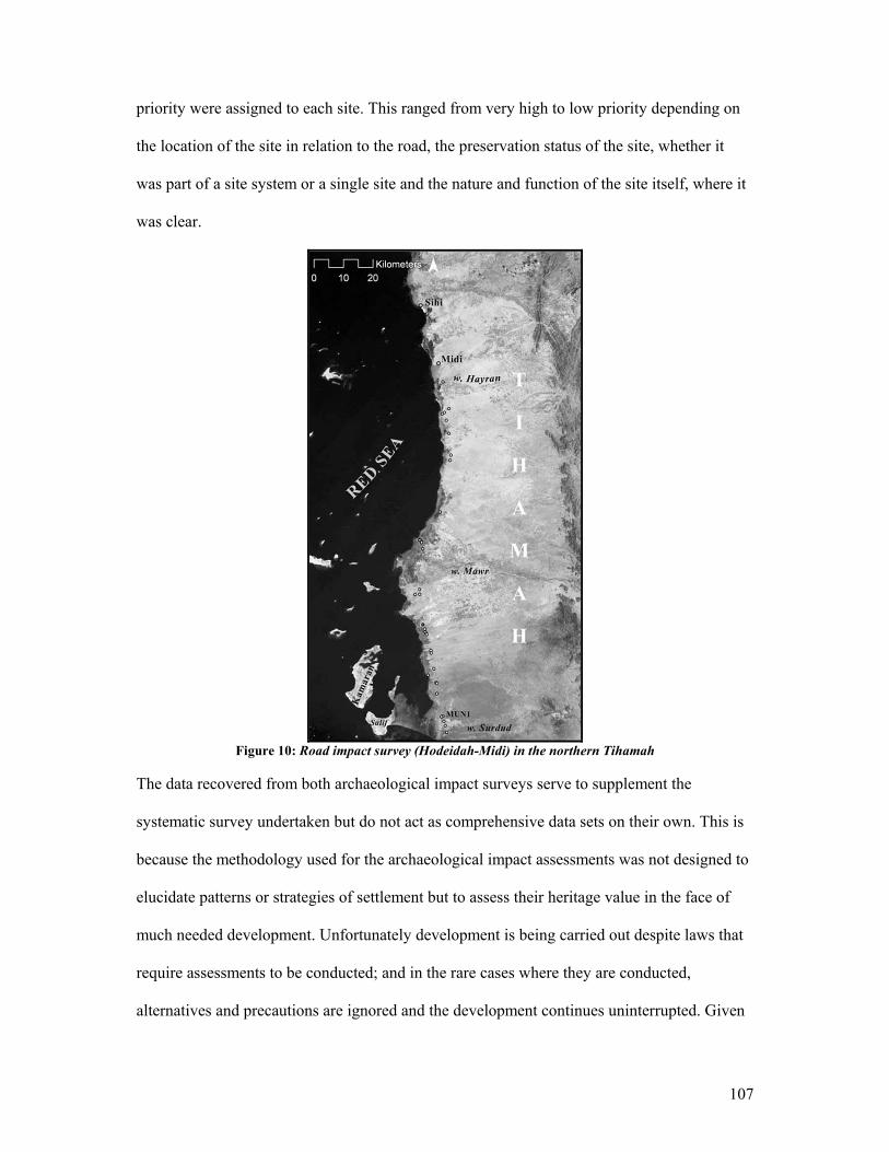
107
priority were assigned to each site. This ranged from very high to low priority depending on
the location of the site in relation to the road, the preservation status of the site, whether it
was part of a site system or a single site and the nature and function of the site itself, where it
was clear.
Figure 10: Road impact survey (Hodeidah-Midi) in the northern Tihamah
The data recovered from both archaeological impact surveys serve to supplement the
systematic survey undertaken but do not act as comprehensive data sets on their own. This is
because the methodology used for the archaeological impact assessments was not designed to
elucidate patterns or strategies of settlement but to assess their heritage value in the face of
much needed development. Unfortunately development is being carried out despite laws that
require assessments to be conducted; and in the rare cases where they are conducted,
alternatives and precautions are ignored and the development continues uninterrupted. Given
108
these circumstances, the methodology used attempted to treat all sites equally despite the
values assigned, and record and collect as much information as possible in the event of the
site disappearing.
Lowland Site Categories
Shell Middens
The majority of sites recovered were shell middens (shell refuse mounds that are often later
used as living surfaces). These were dominated by sea and mangrove shell. The majority of
the shells that make up the matrix of such middens belong to the mollusc Terebralia
palustris. During the early Holocene period, such dense mangroves6 hugged the coastline and
subsisted along and deep within the delta systems of the major rivers. Hence, sites closer to
the coastline and along the wadi banks have a higher density of shell, whereas in the drier
inland areas and within the current cultivation zones, the presence of shell is sparser but
remains a minor characteristic of sites.
Along all of the wadis surveyed, the shell scatters and shell mounds are continuous along
their banks up to the current cultivation zone, where a different type of site dominated by
artifact mounds and scatters begins to appear.
6 Mangroves characterized the entire coast of Yemen in the prehistoric period. However, the disappearance of the Terebralia palustris for instance, which appears to have been over-exploited by the late prehistoric, suggests that both the change in climate and human impingement on the landscape were factors in the gradual recession of dense wetland and mangrove systems. The decline of such habitats has risen exponentially in modern times with the introduction of large-scale development, so much so that in the last 20 years the southern Tihamah coast, which was dotted with mangrove and wetland habitats, has very few such ecosystems left. By contrast, the northern coastline of the Tihamah is still characterized by mangroves, though they also have receded dramatically.
109
Artifact Scatters
These sites, characterized by pavements of scattered artifacts, are quite common in any
archaeological survey context. In the case of early prehistoric sites, this is often all that
remains. In the case of later prehistoric sites, however, scatters are usually associated with or
make up part of mounded sites.
In the Tihamah several types of artifact scatters were recognized on the basis of the density of
artifacts and the nature of the artifacts recovered. All of these were considered sites although
several types are distinctive to specific activities.
The first distinct type included sporadic and discontinuous light scatters located in the now
arid regions between the rivers. The artifacts included bifacial arrowheads and concentrations
of faunal remains. These were interpreted as remains of hunting activity or temporary hunting
camps where the animals were butchered and prepared. The second were possibly field
scatters related to agricultural activity along the periphery of sites.
Mounds
Mounds located inland of the main modern agricultural areas appear to be better preserved
than those nearer to the coast. Nonetheless, mounding, where it is preserved, is rather low due
to exposure to wind and water erosion.
Other types of mounds have matrices dominated by ceramics, lithics, faunal remains,
architectural stone foundations, mudbrick and megalithic stones. Some are predominantly
made up of ceramics, while others are accumulations of diverse artifacts. These mounds are
110
often late prehistoric, early historic or Islamic in date and have not been exposed to
taphonomic processes for as long as the earlier prehistoric sites.
Megalithic Complexes
Complexes of large upright stones characterize megalithic sites. These prehistoric
monuments rarely appear upright in the archaeological record. In most instances the stones
will have fallen over and either remain horizontally in situ or are later re-used in other
structures or as grave markers. Although megaliths tend to be quite large and extremely hard
to miss, in certain areas they lie buried under a considerable amount of sediment and are
partially exposed. Identification of such sites will be discussed in more depth in Chapter VI.
Tombs, Graves and Cemeteries
As would be expected in any area with a rich history, a large number of cemeteries, tombs
and graves dot the Tihamah landscape. Except in the case of prominent Islamic tombs, graves
and cemeteries of all periods posed the largest obstacle to the relative dating and
identification of sites. Most inhumations were and continue to be very simple, consisting of
pits covered with earth or sand and topped with any available material. This usually includes
shell, coral, wadi cobbles and pebbles and ceramics. Many offerings are made at Islamic
graves by visiting locals. These offerings consist of an array of archaeological artifacts picked
up in the surrounding area and include lithics, shell, coral, glass, ceramics, tin cans, plastic
containers and metal objects. The ephemerality of such graves, combined with the heavy
deflation in the area and the displacement of archaeological artifacts, results in nebulous and
muddled surface scatters.
111
These scatters can easily be confused with settlement scatters and pose a major problem when
they are located on earlier sites. Observation of a deflating Islamic cemetery over the space of
a year helped to identify certain signatures for later period graves. Often these graves begin as
oval mounds oriented east – west and begin to scatter outward over time. Although
taphonomic processes rapidly disperse even the most recent graves in the region, in the case
of early modern cemeteries there is differential taphonomy. Certain graves will remain
partially intact while others resemble artifact scatters. Islamic cemeteries have a large amount
of Islamic pottery, especially glaze wares, in proportion to earlier ceramics and lithics.
Islamic coins and glass and faience beads are usually good indications that a scatter is an
Islamic cemetery.
Another observation that was made throughout Yemen, but one that is particularly evident in
the Tihamah, is the bond that modern societies have with ancient sacred places and material
objects venerated in the past. Given the conservatism of current Islamic discourses in the
modern Middle East, ties to pre-Islamic places and objects are considered sacrilegious. This
fact alone evidences the strength of this inexplicable tie to a pagan past. Large stones, such as
prehistoric megaliths, continue to be venerated even though most locals relate to the obscurity
and size of the stone within a stone-less landscape and not to an ancestry with those who
erected them. For the same reason the place where the stone or complex of stones lie remains
sacred. The significance given to the stone and hence the place is expressed in the re-use of
the stone megaliths in Islamic graves and monuments such as tombs and mosques. Some
graves and tombs are built or dug into the site where these megaliths originally rested, while
others incorporate out of situ megalithic stones. This, once again, complicates the
identification of sites. Certain patterns in the way sites with megalithic elements develop and
112
the signatures those sites have left behind have helped to relatively date the sites and establish
whether the megaliths were in situ or not. This will be discussed in more detail in Chapter VI.
3.9 The Mid-Altitude Example
The Hazm al ‘Udayn Survey project was carried out in October of 2002, following two
preliminary visits to the region to assess its archaeological potential. The study area, located
at the northwestern–most point of the Hazm al ‘Udayn province, was chosen for three
reasons. Firstly, it lies exactly midway between the coastal and the highland study regions,
and provided a potential for evidence of contact, trade and the movement of ideas between
the lowlands and highlands. Secondly it is a landscape that is suspended between the foothills
and the highland central plains. The region’s climate, environment and human - landscape
relationships are entirely different from those of the other study regions. Lastly, the area
chosen lies along the headwaters of the wadi Zabid, one of three river systems studied
intensively in the coastal region, and whose tributaries originate in the highland central
plains. This provided a single geographic system that linked the three study regions in Yemen
to each other, and that also would have provided an access route between the highlands and
lowlands in the past.
The aim of the Hazm al ‘Udayn survey was to compare the archaeological remains of this
area to those of the Tihamah coastal plain and the central highlands. This survey focused on
gaining a greater understanding of the geomorphology of the area, and the morphology,
placement, and preservation of its sites. The objective was to then establish a preliminary
chronology for the region and a typology of its artifacts.
113
Three survey areas were chosen along the wadi Zabid. Ar-Rash, lies at an altitude between
900 and 1000 m a.s.l., on the south bank and just west of the source of the wadi Zabid. Wadi
Fanaj, lies 10 km WSW of ar-Rash at an altitude between 700 and 800 m a.s.l. The al-Fanaj
survey area is located between the tributary, wadi Fanaj and the wadi Zabid. Jebel Ras
(between 400 and 600 m a.s.l.) makes up the last range of foothills along the wadi Zabid
before it reaches the coastal plain. The survey included two weeks in the area of ar-Rash, one
and a half weeks in the area of wadi Fanaj and several days in the area of Jebel Ra’s.
The survey methodology included systematic survey transects within existing UTM gridlines,
as well as within geographically defined survey blocks. The interplay of a survey block
demarcated by an existing grid system with one that incorporates natural geographic
boundaries proved successful in light of the complex and deceptive mountainous terrain of
the region. An attempt at following existing grids proved impossible, as they arbitrarily cut
through and/or overlooked geographic systems such as mountains or valleys. This created a
conflict between the recovery method (to sample systematically) and the aim of the recovery
method (to systematically sample different micro-niches). This method proved artificial and
insensitive to the natural and cultural landscape.
In the case of the ar-Rash area, the survey transect ran along existing UTM gridlines. UTM
squares of 1 km2 were systematically covered for 4 km south to north, and 3 km east to west.
However, if one square included a mountain that extended into another square outside of the
transect alignment, the entirety of the mountain would be surveyed. This meant that intended
transects were adapted to the natural topography of the region where the need arose. The
survey covered a total area of 9 km2 in ar-Rash (fig.11).
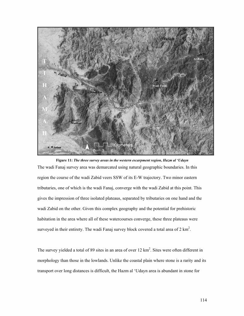
114
Figure 11: The three survey areas in the western escarpment region, Hazm al ‘Udayn
The wadi Fanaj survey area was demarcated using natural geographic boundaries. In this
region the course of the wadi Zabid veers SSW of its E-W trajectory. Two minor eastern
tributaries, one of which is the wadi Fanaj, converge with the wadi Zabid at this point. This
gives the impression of three isolated plateaus, separated by tributaries on one hand and the
wadi Zabid on the other. Given this complex geography and the potential for prehistoric
habitation in the area where all of these watercourses converge, these three plateaus were
surveyed in their entirety. The wadi Fanaj survey block covered a total area of 2 km2.
The survey yielded a total of 89 sites in an area of over 12 km2. Sites were often different in
morphology than those in the lowlands. Unlike the coastal plain where stone is a rarity and its
transport over long distances is difficult, the Hazm al ‘Udayn area is abundant in stone for
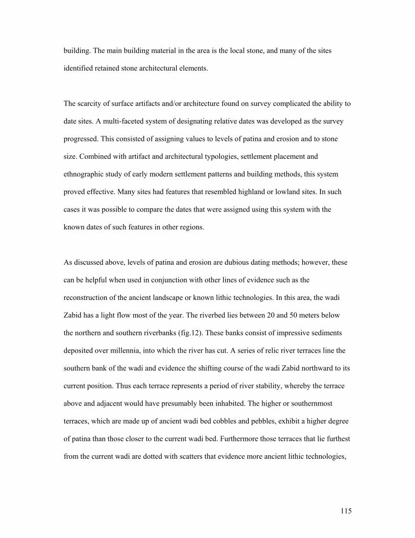
115
building. The main building material in the area is the local stone, and many of the sites
identified retained stone architectural elements.
The scarcity of surface artifacts and/or architecture found on survey complicated the ability to
date sites. A multi-faceted system of designating relative dates was developed as the survey
progressed. This consisted of assigning values to levels of patina and erosion and to stone
size. Combined with artifact and architectural typologies, settlement placement and
ethnographic study of early modern settlement patterns and building methods, this system
proved effective. Many sites had features that resembled highland or lowland sites. In such
cases it was possible to compare the dates that were assigned using this system with the
known dates of such features in other regions.
As discussed above, levels of patina and erosion are dubious dating methods; however, these
can be helpful when used in conjunction with other lines of evidence such as the
reconstruction of the ancient landscape or known lithic technologies. In this area, the wadi
Zabid has a light flow most of the year. The riverbed lies between 20 and 50 meters below
the northern and southern riverbanks (fig.12). These banks consist of impressive sediments
deposited over millennia, into which the river has cut. A series of relic river terraces line the
southern bank of the wadi and evidence the shifting course of the wadi Zabid northward to its
current position. Thus each terrace represents a period of river stability, whereby the terrace
above and adjacent would have presumably been inhabited. The higher or southernmost
terraces, which are made up of ancient wadi bed cobbles and pebbles, exhibit a higher degree
of patina than those closer to the current wadi bed. Furthermore those terraces that lie furthest
from the current wadi are dotted with scatters that evidence more ancient lithic technologies,

116
while those closer have more recent sites. The combination of several data sets allowed for
certain dating methods, such as levels of erosion, to be used more confidently.
Figure 12: The high banks of the wadi Zabid in the mid-altitude region
Sites surveyed in the region fell into a number of recurring categories. The first were
monuments all of which were Islamic in period. The following two categories were sites that
exhibited standing architecture and/or mounds of rubble. These, as well as burial structures
and artifact scatters, ranged in period from Islamic to late prehistoric.
Mid-Altitude Site Categories
Monuments
Although the survey area was sparsely inhabited and undeveloped, the wadi Zabid was a
through route in the Islamic period. A number of Ottoman period forts and towers dot the
banks of the wadi Zabid and lie on some of the higher peaks in the region. Most sites
designated as monuments were standing structures from the Islamic period and included
mosques, forts and administrative buildings.
117
Standing Architecture
Many sites in the region had some form of standing architecture. The later sites, such as
domestic dwellings of the Islamic period, were well preserved and consisted of several
standing stone courses. Most prehistoric sites were no more than one partially buried stone
course and their plans were often not clear.
Rubble Mounds
Rubble mounds were common in the study regions. Some fell under the category of standing
architecture unless no plan was visible and all that remained of the original structure was a
mound of rubble and debris. Most rubble mounds in the area were relatively small and
appeared to be remains of single dwellings or small family complexes. They did not exceed
the lowland shell middens in maximum height. The height of the mounds helped to determine
the relative age. Higher rubble mounds with remnants of standing architecture in the process
of collapse were more often than not Islamic in period, especially where high standing walls
were still visible. Later prehistoric rubble mounds were no more than 50 cm in height.
Tombs, Graves and Cemeteries
Stepped circular stone structures capped with inwardly collapsed large stone slabs
characterize prehistoric tombs in the region. The largest of these tombs are frequently mere
rubble mounds, though the circular plan can be distinguished from the collapse. Smaller
circular tombs with simpler plans were documented in the region. These occasionally reach a
height of 2 m.
Islamic graves were more easily distinguishable than those of the Tihamah and consisted of a
variety of small oval to round mounds lined and topped with large cobbles, likewise oriented
118
east – west. Because these graves are made of stone and the erosion in the region is less
acute than in the lowlands, Islamic cemeteries were clearly discernible. Several late
prehistoric circular tombs were documented.
Artifact Scatters
All of the prehistoric sites identified by the survey were aceramic. Because all of the ceramics
found on survey were Islamic glazed wares and early modern forms, it appears for the time
being that two types of artifact scatters characterize the immediate region.
The first type of scatter is made up of ceramics and occasionally glass. These ceramic scatters
can safely be dated to the greater Islamic period. Glazed wares attributed to the different
ruling dynasties are well known and existing typologies were used to date the sites. The
second type of scatter is aceramic and is characterized by lithics. Taking into consideration
location, associated architecture and lithic types, these lithic scatters can be confidently dated
to the prehistoric period.
3.10 The Highland Example
The highland survey, carried out by a team from the University of Chicago DSP, is a
culmination of survey seasons from 1994 to the present. This fieldwork, directed by T.J.
Wilkinson, uses a landscape oriented field methodology that has its origins in previous
landscape surveys, mainly those conducted by Wilkinson in the Syrian Jezirah and in Iraq
(Wilkinson 2003b). This methodology has been adapted to the highland landscapes of
Yemen, which contrast significantly to the flat tell-scapes of Mesopotamia.

119
The survey area, located in the central plains of highland Yemen, is characterized by high
elevation mountain peaks, plateaus and intermontane basins lying at altitudes between 2000
and 3000 m a.s.l. Situated between 14 and 15 degrees N latitude and 44 and 45 E longitude,
the DSP study area falls within the modern provinces of Dhamar and Ibb (fig.13).
The DSP survey involves an intensive walking survey strategy aided by GPS, topographic
and geological maps and aerial photographs. Remote sensing and the study of maps form the
basis of the pre-field preparation, which aims to identify promising areas of ancient habitation
and land-use. The fieldwork component consists of several stages. The first involves ground
control of possible archaeological signatures visible on aerial photographs, and areas that
appear on topographic and geologic maps to have been ideal for both past human settlement
and for site preservation. Maps are also used to track place names, which can be historically
significant and informative, and to identify landscape features such as water systems and
ruins. The detailed recording of sites and features and collection of archaeological and
environmental specimens follow. GPS are used both to mark the exact location of sites and
landscape features, and to orient walking transects. The first seasons of the project were
dedicated to understanding the region and its sites. A less systematic approach was used and
documentation during these early field seasons is less detailed. As more sites were recovered
and site chronology and landscape were better understood, more meticulous survey strategies
and documentation followed.

120
Figure 13: DSP study area in the central highlands of Yemen
The focus of this project is on the documentation of the cultural landscape, the recovery of
which entails sites and site systems as well as off-site activities. Most survey seasons are
accompanied by soundings or excavations carried out at promising sites, along landscape
features such as field walls and in areas where the potential for reconstructing past land-use
and environment exists.
The methodology used by the DSP forms the basis for the methodological approaches used in
other study regions discussed in this dissertation. My involvement with the DSP began in
2001, excavating under the direction of Dr. Edens and surveying under the direction of
Wilkinson, and continued in 2002 surveying under the direction of Lewis. All of the data
recovered during these surveys and excavations belong to the project and reference will
mainly be in a comparative light and to published materials. Between 2002 and 2003, Lewis
121
and myself launched a general project database and carried out re-analysis of the data and
materials recovered by the DSP survey. Interpretation, statistical analyses and visual
manipulation of this data are a product of this collaboration and are drawn from this database.
In seven survey seasons the DSP has recovered a total of 380 sites (Lewis 2005). These sites
range in period from the Paleolithic to the late Islamic. A handful of sites that have been
excavated and carbon dates have enabled a regional highland chronology to be established
(Edens 1999, Edens et al. 1998, Edens et al. 2000, Ekstrom et al. 2003, Gibson et al. 1995,
Wilkinson 1997, 2003a, Wilkinson et al. 1997). Despite this fact it appears that certain
associated typologies that are often used to date surveyed sites were had a long life span.
Regional variability and the widespread use of standard and generic local wares and tool
technologies further complicate the dating issue. However, recently acquired and analyzed
data from excavated early historic sites in the region7, in conjunction with a re-assessment of
the materials recovered by the DSP through the seasons have paved the way for a more
comprehensive chronology.
Re-assessment of the Highland Chronology
Many of the chronological problems encountered in the highlands are inherent to most
cultural chronologies and certainly to that of the southwestern Arabian Peninsula. These
issues, which have been discussed previously, have plagued Yemeni archaeology and were a
large motivating factor behind the drive to re-assess the available materials and investigate
the major gaps in the highland chronological record. The largest obstacle was in pinpointing
major economic or political transitions in a material culture that was in many cases
unaffected locally by such paradigm shifts.
7 See (Lewis 2005)
122
In order to deal with the materials contextually, a database was designed to take into account
all factors related to the recovery of data, the data sets themselves, and details of the physical
sites and associated features. This included exhaustive lists of survey techniques, state of
preservation, building materials, structural types and features, associated landscape or site
features, artifacts, and methods of date determination. Also included were site coordinates,
size, preserved height, site subdivisions and recording methods. Once the data was entered, a
re-analysis of the physical material from each site was undertaken. The materials fell into
four main categories: ceramics, lithics, small objects (beads, metal, glass, etc.) and large
objects (grindstones, architectural fragments, statuary, etc.). The study focused mainly on the
ceramic evidence, as the samples available were representative of most of the DSP sites,
while the lithics were not all available for study.
All of the ceramics from each site were grouped into types, photographed, and described.
After several hundred bags were processed a number of subtle patterns in ceramic form,
temper and surface treatment were recognized which helped to isolate types that appeared
similar. This information, alongside site data, and established carbon 14 dates, has shed light
on the slight variation among long-life ceramic forms.
The mapping of data sets using GIS has also enabled the recognition of geographic material
cultural divides. For example, a predominance of red-slip fine-ware ceramics existed on early
historic sites in the northern central plains of the survey area, whereas very few could be
found on sites in the southern central plains. Instead the southern sites had a predominance of
thick generic chaffy wares. This made it appear as though two different periods were
represented until the sites were mapped and it became clear that there were high degrees of
123
regional variability. The sites to the north were on established routes from the desert fringe to
the highlands, hence the influence of Sabaean fine wares, while the sites to the south were
predominated by a regional ceramic tradition with a rare occurrence of fine wares (Lewis
2005).
Reference will be made to the re-analysis conducted and to the general database when and
where comparisons are relevant to other study areas.
3.11 Conclusion
Yemen is a patchwork of disparate and yet interwoven landscapes. Its physical geography is
so diverse that it sustains a multiplicity of contrasting environments that exist side by side. In
the same way that these sundry environments co-exist, so do its diverse cultures that have
adapted so expertly to its eco-niches that they can appear to have nothing in common with
each other. Crossing Yemen from east to west is culturally and environmentally akin to
crossing three continents and over a dozen national borders. Such diversity was certainly
more heightened in the past than it is today given the gargantuan geographic obstacles
standing between one isolated region and another.
The relationship between these physical and cultural ancient landscapes is in essence what
drives the methodological approach to this dissertation. That is to say that the methodology is
focused on sampling these different regions in a way that allows for regional interaction to be
traced, but not in a way that flattens the range of inter- and intra- regional variability.
Systematic ground coverage was implemented in different regions, but also in different
micro-niches within those regions to account for variety within a single regional context.
124
The methodology was thus thought out prior to the surveys but was by no means set in stone.
This became an advantage when dealing with mountainous versus coastal landscapes, or
more specifically with a large torrent of rain which led a transect off course to the belly of a
system of shell middens. Such adaptability has perhaps exposed the study to more statistical
flaws, however, it has also added transparency to the method itself and multiple dimensions
to the data.
The landscapes of Yemen are in themselves multi-dimensional. They are physical, cultural,
historical and perceived. Yemen is thus a perfect place to integrate the way the three major
schools of thought, the culture-historical, the processual and the post-processual, have
incorporated landscape-based perspectives. The fieldwork carried out for this dissertation
incorporated elements from all three schools. The use of historical texts and manuscripts to
locate sites and geographical place names and to understand later land-use and road systems
through medieval historians’ eyes was helpful in reconstructing later perceptions of more
ancient archaeological sites. It also shed light on how certain medieval processes may have
effected the preservation of prehistoric and early historic sites. A systematic scientific
methodology of ground coverage allowed for a sensitivity to non-static landscapes and spatial
variation. Finally, a phenomenological approach was taken towards concepts of space,
territory and identity, aided by ethnographic observations, local memory and interpretations
of the landscape.
125
IV Material Culture of the Tihamah Coastal Plain
4.1 Introduction
This chapter presents the results of three surveys conducted in the central and northern
Tihamah coastal plain. The most diagnostic material culture elements that characterize the
surface assemblage of prehistoric sites are presented in conjunction with previously
excavated sites in the region.
4.2. Shell
Most of the sites surveyed along the Tihamah coastal plain included shell in the surface
assemblage. The single or multiple function of this shell material varied for each site,
depending on the type of shell, its density, its functional properties, and its value. Often the
function fell into one of the following categories: dietary, tool and ornament, primary or
secondary material or ingredient (such as dye, or ingredient for lime), waste, living surfaces
and building material.
Diet
In most cases, the shell species most commonly found on sites of the Tihamah, the Terebralia
palustris, were exploited for their dietary value. The monospecificity of such shell on a
majority of shell middens, as well as the recurrence of breakage and burning patterns,
evidences the exploitation of this shellfish as food. Because most shell middens in the region
have been inhabited, sometimes continuously, and have been exposed to the elements for up
126
to eight thousand years, the majority of most midden matrices are often made up of crushed
shell. Of the shells that were more than 50% complete, 100% were broken at the shell valve
or opening. This part of the shell happens to be the most fragile and therefore the most likely
to break. However, it is also the part of the shell that would have been purposefully removed
in order to retrieve the animal inside. 54 % of the total shell midden sites included a burnt
shell element of the total shell matrix. Of that 54 %, the majority were small species. This
suggests that perhaps the smaller sized species were more difficult to extricate from the shell
and the shell had to be heated in order to force the animal out. This method is still used today
to facilitate the removal of or to pry open shellfish.
Terebralia palustris/ Environmental Reconstruction
The Terebralia palustris is a mud dweller that thrives in dense mangrove environments.
Because these shells no longer exist in Yemen, they are not only a strong indicator of the
relationship between ancient coastal economies and their environment but have aided
significantly in palaeoenvironmental reconstructions. They evidence a wetter more stable
climate that sustained a heavily populated mangrove ecosystem along the entire length of the
Tihamah coastal plain stretching deep within the river deltas (Cattani et al. 2002:33). Given
the high density of shell present on these sites, it can be assumed that mollusc foraging
communities settled in proximity to these mangroves, lagoons and river deltas, if only
seasonally. It can further be assumed that if these societies traveled far from the collection
point with such molluscs they would have been at a disadvantage due to decay, odour, and
weight factors, to name a few. Systematic survey has shown that such sites appear as linear
systems and follow natural geographic features such as relic wadi terraces and the ancient
coastline. These are geographical features that are not always visible on the ground today but
become clear once mapped and juxtaposed over satellite images on which many ancient river
127
courses retain dark signatures. Given these considerations, the courses of ancient rivers and
the fringes of deltas and estuaries can quite safely be traced following the linear patterns of
these shell midden systems.
Other Shell
Not only does the widespread occurrence of Terebralia on early prehistoric sites help to
reconstruct the past environment and date sites, but the occurrence of shell middens made up
of other shell types suggests a change in this environment that sustained them. The
appearance of different shell types in association with differing material assemblages is an
indication of environmental changes and major chronological breaks in subsistence strategy
and cultural paradigms. Other than Terebralia palustris, the most common heavily exploited
shells are the Strombus which inhabits rocky substrates, the Murex species and two types of
bivalves, the Amiantis umbonella and Anadara turonica. Entire middens of these shell types
have been documented along the Tihamah, however they are certainly not as prevalent and
were less exploited than were the T. palustris. (fig.14).
Furthermore the material cultural assemblages associated with these other shell middens
provides further evidence of their being later in date than most T. palustris middens. This
observation is suggested by an IAM radiocarbon date of 375-123 BC run on fragmented
Strombus shells from the surface of the site of As-Salif -1 (SLF-1) (Tosi 1986: 403, Table 1),
an area of the Tihamah that was also surveyed by the author. Tosi makes a similar
observation, stating “ Strombus and Murex species are more characteristic of later contexts,
most likely as a consequence of changing coastal settings…” (Ibid: p.404). The excavated
shell midden site of Sihi (3rd-2nd millennium BC) in the Saudi Tihamah yielded 25-30
different species of shell, the most common of which was the Strombus species followed in
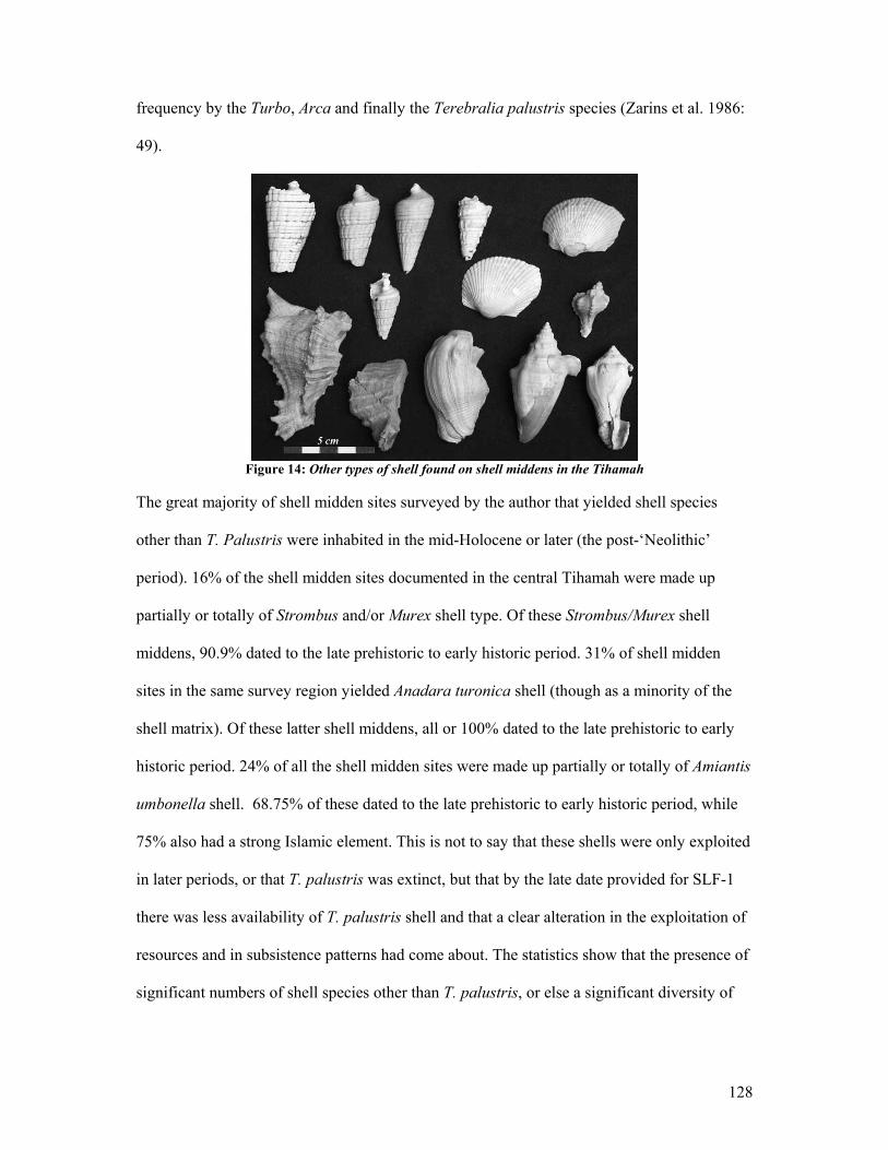
128
frequency by the Turbo, Arca and finally the Terebralia palustris species (Zarins et al. 1986:
49).
Figure 14: Other types of shell found on shell middens in the Tihamah
The great majority of shell midden sites surveyed by the author that yielded shell species
other than T. Palustris were inhabited in the mid-Holocene or later (the post-‘Neolithic’
period). 16% of the shell midden sites documented in the central Tihamah were made up
partially or totally of Strombus and/or Murex shell type. Of these Strombus/Murex shell
middens, 90.9% dated to the late prehistoric to early historic period. 31% of shell midden
sites in the same survey region yielded Anadara turonica shell (though as a minority of the
shell matrix). Of these latter shell middens, all or 100% dated to the late prehistoric to early
historic period. 24% of all the shell midden sites were made up partially or totally of Amiantis
umbonella shell. 68.75% of these dated to the late prehistoric to early historic period, while
75% also had a strong Islamic element. This is not to say that these shells were only exploited
in later periods, or that T. palustris was extinct, but that by the late date provided for SLF-1
there was less availability of T. palustris shell and that a clear alteration in the exploitation of
resources and in subsistence patterns had come about. The statistics show that the presence of
significant numbers of shell species other than T. palustris, or else a significant diversity of

129
shell types on shell middens of the Tihamah is a probable indicator of later occupation (post-
‘Neolithic’) of the site.
Shell as Tools and Ornaments
All these species have also been worked into tools and ornaments. Although small finds such
as these are often found in specific stratigraphical contexts, such as in graves or on
occupational surfaces, and are usually not well represented or else invisible as surface
artefacts, several shell tools were collected from the surface of sites. The most common
worked shells were pierced bivalves of the Anadara turonica species. These were recovered
on six ( AJ4X1, AJ4Z, AJ11B, AJ12, BF1F, BF4) sites. On the majority of the pierced shells,
the hole is located on the beak of the shell (fig.15). On the site of BF4 a cluster of pierced
shells of this species was discovered. All of the holes were located on the beak and were large
(largest = .8x1 cm) suggesting that they had been broken. Two of the four collected showed
evidence of a small piercing that appeared to then be broken open. It is possible that these
were pierced in order to pry the shell open, however if this were the case all of the shells
would be pierced. Their function may have been ornamental.
Figure 15: Pierced Anadara turonica shell (BF4)
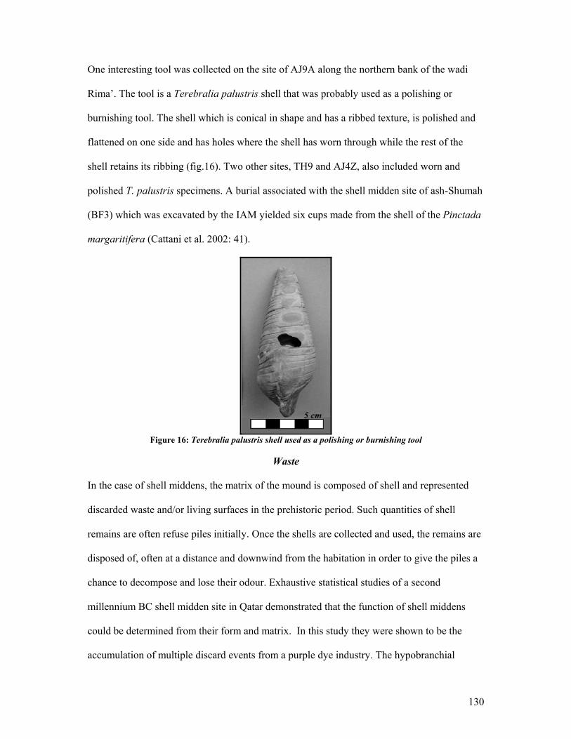
130
One interesting tool was collected on the site of AJ9A along the northern bank of the wadi
Rima’. The tool is a Terebralia palustris shell that was probably used as a polishing or
burnishing tool. The shell which is conical in shape and has a ribbed texture, is polished and
flattened on one side and has holes where the shell has worn through while the rest of the
shell retains its ribbing (fig.16). Two other sites, TH9 and AJ4Z, also included worn and
polished T. palustris specimens. A burial associated with the shell midden site of ash-Shumah
(BF3) which was excavated by the IAM yielded six cups made from the shell of the Pinctada
margaritifera (Cattani et al. 2002: 41).
Figure 16: Terebralia palustris shell used as a polishing or burnishing tool
Waste
In the case of shell middens, the matrix of the mound is composed of shell and represented
discarded waste and/or living surfaces in the prehistoric period. Such quantities of shell
remains are often refuse piles initially. Once the shells are collected and used, the remains are
disposed of, often at a distance and downwind from the habitation in order to give the piles a
chance to decompose and lose their odour. Exhaustive statistical studies of a second
millennium BC shell midden site in Qatar demonstrated that the function of shell middens
could be determined from their form and matrix. In this study they were shown to be the
accumulation of multiple discard events from a purple dye industry. The hypobranchial
131
glands of a type of marine gastropod that secretes a purple dye were extracted, and the shells
were systematically discarded. This study aimed to show that the results of such activities
leave very specific site signatures that depend on the appropriateness of the species, the
number of individual shells, the breakage patterns, and the monospecificity of the deposit
(Edens 1987:144-9). Very few of the sites encountered on survey in the Tihamah provided
such a signature, and although these shell middens may have at one point served solely as
discard piles, they all appeared to have later and/or multiple functions, whether as dwellings
or activity areas.
Living surfaces
Often these discard piles were located at a relative distance from the settlement because it
was easier and cleaner to process the molluscs near their collection point as opposed to
carrying them over long distances and living near the refuse. However, once the
decomposition took place, these mounds were ideal living surfaces. They provided drainage
during the wet season, elevated the structures above ground level, provided stable platforms
that were less vulnerable to heavy erosion than soil or sand, and were in prime locations for
settlement, e.g. near water. These middens continue to be inhabited today by fishing and
pastoral communities, especially along the banks of wadis.
4.3 Faunal remains
Like shell, faunal remains have been useful in determining a relative site chronology. When
dating a surveyed site, the presence or absence alone of certain species can help to eliminate
certain periods. Just as molluscan species became extinct due to changes in climate, so did
certain flora and fauna. The work of the IAM in the Tihamah has been instrumental for
reconstructing the faunal evidence of the Tihamah in relation to dated stratigraphy, to
132
percentages of species and of parts represented in dated contexts, and in tracing signs of
potential animal domestication.
Equids
The most diagnostic faunal remains recovered and documented on survey were equid teeth.
The teeth belong to Equus asinus, whose main habitat was the open or lightly forested steppe
(Cattani et al. 2002: 46). These were present in high densities on T. palustris shell middens
and along the interfluvial steppe. This zone of the Tihamah appears to have been a hunting
ground for early Holocene hunter-foragers. According to the light surface scatters and the
materials often represented in this area, it is likely that temporary, even seasonal hunting
camps were set up to skin, butcher and prepare the animals after the hunt.
Statistical studies by the IAM of the equid remains from the site of Ash-Shumah, however,
have illuminated a possible alternative to hunting. Equids made up the vast majority of the
faunal remains at this seventh millennium BC site and the remains were concentrated in
specific areas of the site. There is a great likelihood that these animals were in the initial
stages of domestication especially because percentages of meatless bone present on the site
point to their having been killed there. This suggests that they were brought to the site alive,
and probably functioned primarily as meat providers (Cattani et al. 2002: 44-6).
Interestingly, the range of sites excavated by the IAM show a pattern of decrease and
eventual diminishment of equid remains, in conjunction with an increase of cattle and
ovicaprine remains through time (Cattani et al. 2002: 33, Tosi 1986).
133
This goes along with the results of the surface collections carried out for this dissertation
whereby single period post-‘Neolithic’ sites have little to no equid remains on the surface. In
a similar light, 76.9% of shell midden sites in the central Tihamah, whose surface
assemblages included equid remains, were early Holocene in date.
Other fauna
Domesticated cattle, although a great minority, were also present on the site of Ash-Shumah.
The IAM record shows that by the fourth millennium BC, cattle become the overwhelming
majority, and ovicaprines appear as the minority of the faunal assemblage from excavated
and surveyed sites. At the site of Sihi there are ovicaprid, bovid, camel, sea turtle, crab and
abundant fish remains from third to second millennium BC excavated contexts (Zarins et al.
1986: 49). It is only after the fourth millennium BC that ovicaprines dominate the faunal
assemblage and sites in certain areas witness an increase in fish remains, including those of
freshwater fish (Cattani et al. 2002: 50-1).
Again, the data collected in the central Tihamah follows this pattern despite the small sample
represented. Three sites had faunal remains that were identified as cattle, all of which were
dated to the late prehistoric period. Similarly two sites had faunal remains that were identified
as ovicaprine, both of which were also dated to the late prehistoric period.
The occurrence of ostrich eggshell in the archaeological record appears to be a more long-
lasting phenomenon. Ostrich eggshell has been evidenced as early as the eighth millennium
BC and makes up a part of every assemblage including the early modern one (Cattani et al.
2002: 33 & 50). It is the function and density of this material that helps to determine the
relative age of the find. For example survey work by the IAM demonstrated that a high

134
density of ostrich eggshell occurred on the surface of early Holocene sites, while late
prehistoric sites evidence workshops where the material was chipped into tools such as
scrapers and used as a grave good in the form of containers (Cattani et al. 2002: 33, Tosi
1986: 402).
My own survey revealed the same widespread chronological pattern. Of the sites that yielded
ostrich eggshell on the surface, eight of twenty-one were shell middens and the rest consisted
of artifact scatters. Fifteen of these had an early Holocene element, while the same number
had a late prehistoric element.
Although fish remains are very difficult to find on the surface, the survey collected two
otoliths from two adjacent sites (AJ12 and AJ13B) located in the terminal area of the wadi
Rima’. The fish species have not been identified though they probably belong to sea fish
considering the location of both sites along what was the ancient coastline. Both sites have
been dated on the basis of the surface assemblage to the early to middle Holocene, falling
approximately in the fourth millennium BC.
Bone tools
A single bone tool was recovered from site BF1F on survey. This tool is made from an
unidentifiable tooth fragment, probably equid, which appears to have been carved and
smoothed. It is pointed on one end, barbed and partially pierced on one side (fig.17). It was
probably used as a spear or harpoon point. The barbs imply that it was hafted to a wooden
handle, while the presence of a sharp wedge or pin of some sort may explain the partially
pierced hole.
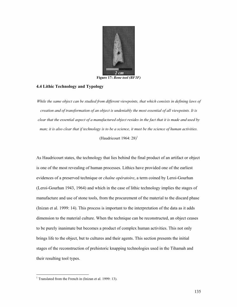
135
Figure 17: Bone tool (BF1F)
4.4 Lithic Technology and Typology
While the same object can be studied from different viewpoints, that which consists in defining laws of
creation and of transformation of an object is undeniably the most essential of all viewpoints. It is
clear that the essential aspect of a manufactured object resides in the fact that it is made and used by
man; it is also clear that if technology is to be a science, it must be the science of human activities.
(Haudricourt 1964: 28)1
As Haudricourt states, the technology that lies behind the final product of an artifact or object
is one of the most revealing of human processes. Lithics have provided one of the earliest
evidences of a preserved technique or chaîne opératoire, a term coined by Leroi-Gourhan
(Leroi-Gourhan 1943, 1964) and which in the case of lithic technology implies the stages of
manufacture and use of stone tools, from the procurement of the material to the discard phase
(Inizan et al. 1999: 14). This process is important to the interpretation of the data as it adds
dimension to the material culture. When the technique can be reconstructed, an object ceases
to be purely inanimate but becomes a product of complex human activities. This not only
brings life to the object, but to cultures and their agents. This section presents the initial
stages of the reconstruction of prehistoric knapping technologies used in the Tihamah and
their resulting tool types.
1 Translated from the French in (Inizan et al. 1999: 13).
136
Survey work in the Tihamah coastal plain has yielded a surprisingly diverse and rich lithic
assemblage. In many ways these tools have provided the most accurate chronological
indicators for sites in the area. Furthermore, the types and densities of the primary materials
available have not only been useful in determining the period, but also in tracing contact and
interaction in the case of non-available stone resources. Four recurring tool types were
singled out from the larger stone tool assemblage due to their diagnostic characteristics. The
four tool types, which include 1-2) two categories of bifacial projectiles, 3) backed geometric
microliths and 4) pièces esquillées, are all tools and/or technologically significant industries.
These will be discussed in relation to their generic categorization followed by the specific
elements and technologies that are unique to the Tihamah.
4.5 Early Holocene Lithic Technologies
Bifaces: Type A Tools
Bifaces are defined as “...objective pieces that have been extensively modified, and have two
sides or faces that meet to form a single edge that circumscribes the entire artifact; both faces
show evidence of previous flake removals.” (Andrefsky Jr. 1998: 76). Within the biface
category there are hafted and non-hafted bifaces. Hafted bifaces are evidenced in northern
Europe at the end of the Palaeolithic (Piel-Desruisseaux 2004: 162), but were most prevalent
and universally so by the Neolithic period.
Both hafted and non-hafted types of classic bifacial tools have been documented on sites in
the Tihamah. The hafted bifacially worked tools consisted mainly of arrowheads and spear-
points (projectiles). The distinction between spear-points and arrowheads was made mainly
on the basis of size. Spear-points are generally much larger points, while arrowheads are
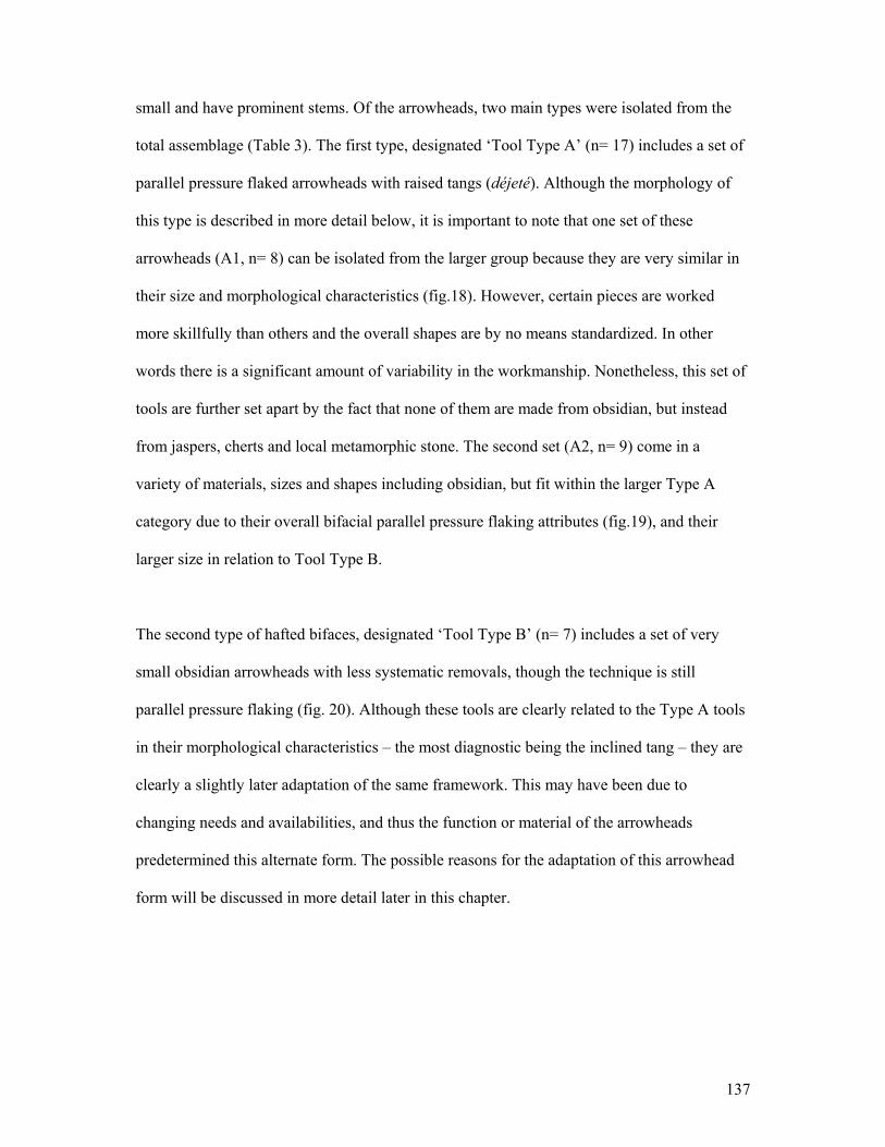
137
small and have prominent stems. Of the arrowheads, two main types were isolated from the
total assemblage (Table 3). The first type, designated ‘Tool Type A’ (n= 17) includes a set of
parallel pressure flaked arrowheads with raised tangs (déjeté). Although the morphology of
this type is described in more detail below, it is important to note that one set of these
arrowheads (A1, n= 8) can be isolated from the larger group because they are very similar in
their size and morphological characteristics (fig.18). However, certain pieces are worked
more skillfully than others and the overall shapes are by no means standardized. In other
words there is a significant amount of variability in the workmanship. Nonetheless, this set of
tools are further set apart by the fact that none of them are made from obsidian, but instead
from jaspers, cherts and local metamorphic stone. The second set (A2, n= 9) come in a
variety of materials, sizes and shapes including obsidian, but fit within the larger Type A
category due to their overall bifacial parallel pressure flaking attributes (fig.19), and their
larger size in relation to Tool Type B.
The second type of hafted bifaces, designated ‘Tool Type B’ (n= 7) includes a set of very
small obsidian arrowheads with less systematic removals, though the technique is still
parallel pressure flaking (fig. 20). Although these tools are clearly related to the Type A tools
in their morphological characteristics – the most diagnostic being the inclined tang – they are
clearly a slightly later adaptation of the same framework. This may have been due to
changing needs and availabilities, and thus the function or material of the arrowheads
predetermined this alternate form. The possible reasons for the adaptation of this arrowhead
form will be discussed in more detail later in this chapter.
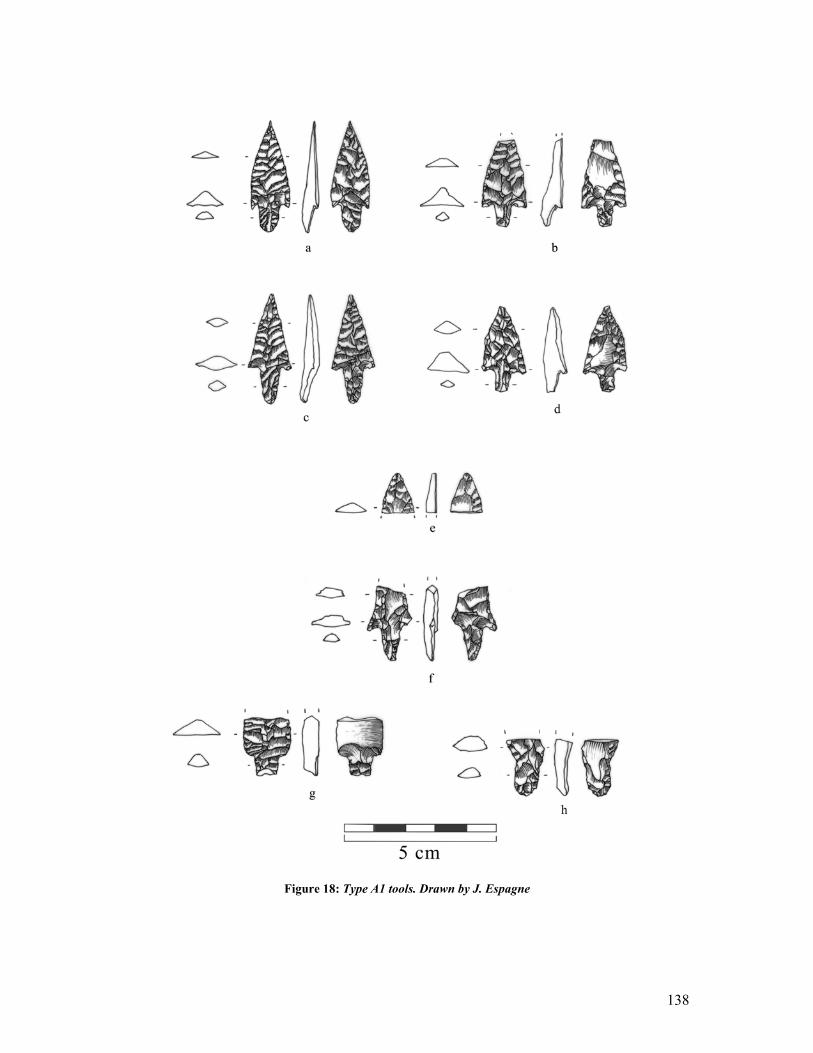
138
Figure 18: Type A1 tools. Drawn by J. Espagne
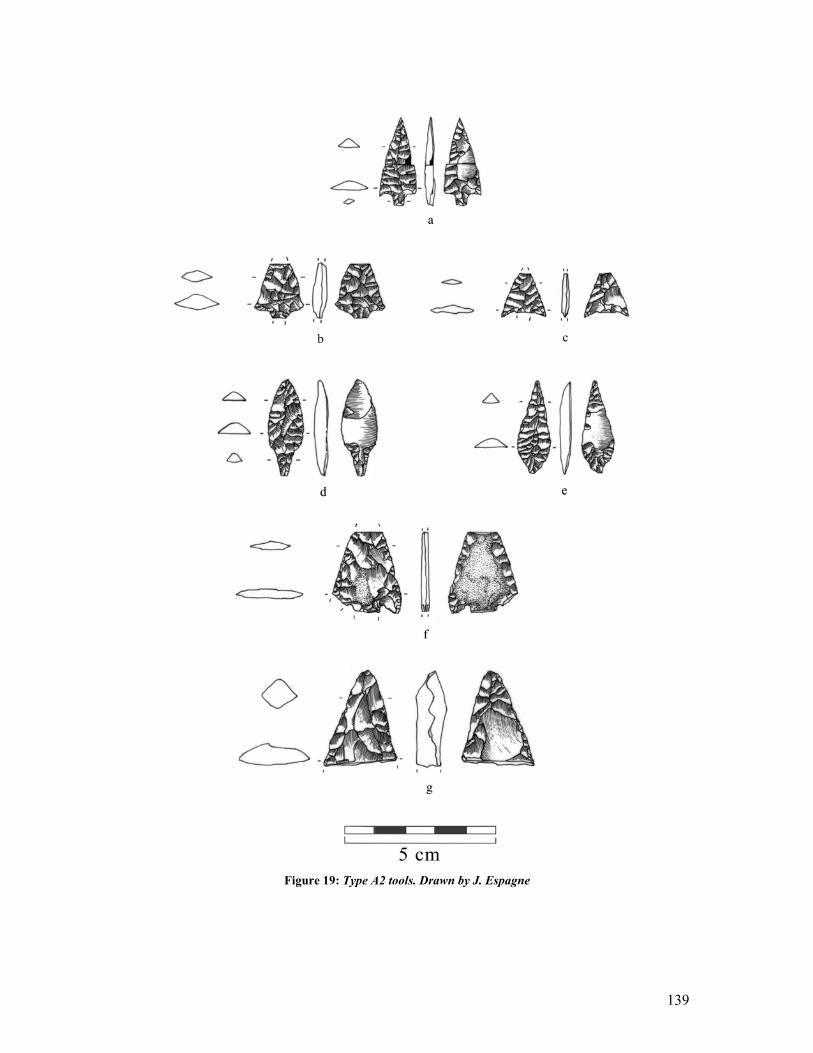
139
Figure 19: Type A2 tools. Drawn by J. Espagne
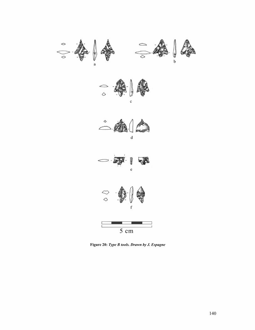
140
Figure 20: Type B tools. Drawn by J. Espagne
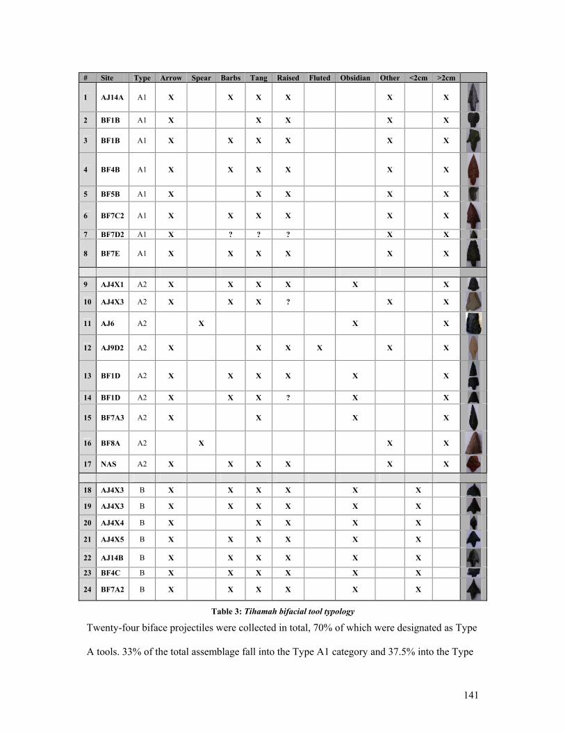
141
# Site Type Arrow Spear Barbs Tang Raised Fluted Obsidian Other <2cm >2cm
1 AJ14A A1 X X X X X X
2 BF1B A1 X X X X X
3 BF1B A1 X X X X X X
4 BF4B A1 X X X X X X
5 BF5B A1 X X X X X
6 BF7C2 A1 X X X X X X
7 BF7D2 A1 X ? ? ? X X
8 BF7E A1 X X X X X X
9 AJ4X1 A2 X X X X X X
10 AJ4X3 A2 X X X ? X X
11 AJ6 A2 X X X
12 AJ9D2 A2 X X X X X X
13 BF1D A2 X X X X X X
14 BF1D A2 X X X ? X X
15 BF7A3 A2 X X X X
16 BF8A A2 X X X
17 NAS A2 X X X X X X
18 AJ4X3 B X X X X X X 19 AJ4X3 B X X X X X X
20 AJ4X4 B X X X X X 21 AJ4X5 B X X X X X X
22 AJ14B B X X X X X X
23 BF4C B X X X X X X
24 BF7A2 B X X X X X X
Table 3: Tihamah bifacial tool typology
Twenty-four biface projectiles were collected in total, 70% of which were designated as Type
A tools. 33% of the total assemblage fall into the Type A1 category and 37.5% into the Type
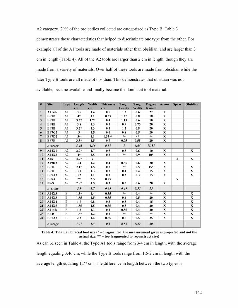
142
A2 category. 29% of the projectiles collected are categorized as Type B. Table 3
demonstrates those characteristics that helped to discriminate one type from the other. For
example all of the A1 tools are made of materials other than obsidian, and are larger than 3
cm in length (Table 4). All of the A2 tools are larger than 2 cm in length, though they are
made from a variety of materials. Over half of these tools are made from obsidian while the
later Type B tools are all made of obsidian. This demonstrates that obsidian was not
available, became available and finally became the dominant tool material.
# Site Type Length
cm Width cm
Thickness cm
Tang Length
Tang Width
Degree Raised
Arrow Spear Obsidian
1 AJ14A A1 3.6 1.4 0.5 1.2 0.6 22 X 2 BF1B A1 4* 1.1 0.55 1.2* 0.8 18 X 3 BF1B A1 3.5* 1.7* 0.4 1.15 0.6 10 X 4 BF4B A1 3.8 1.3 0.5 0.9 0.75 20 X 5 BF5B A1 3.5* 1.3 0.5 1.2 0.8 20 X 6 BF7C2 A1 3 1.5 0.6 0.8 0.5 20 X 7 BF7D2 A1 3* 1.1 0.35** ** ** ** X 8 BF7E A1 3.3* 1.5 0.7 0.75 0.55 20 X Average 3.46 1.36 0.51 1 0.65 18.57 9 AJ4X1 A2 2.9* 1.7 0.5 0.5 0.6 10 X X 10 AJ4X3 A2 4* 2.5 0.3 ** 0.9 10* X 11 AJ6 A2 4.9* 2 X X 12 AJ9D2 A2 3.4 1.2 0.4 0.85 0.6 20 X 13 BF1D A2 2.1* 1.5 0.3 ** 0.5 15* X X 14 BF1D A2 3.1 1.3 0.3 0.4 0.4 15 X X 15 BF7A3 A2 3.2 1.1 0.3 0.2 0.3 15 X X 16 BF8A A2 ** 2.5 0.75 X 17 NAS A2 2.8* 1.5 0.3 0.5 0.6 20 X Average 3.3 1.7 0.39 0.49 0.55 15 18 AJ4X3 B 1.5* 1.4 0.35 ** 0.4 ** X X 19 AJ4X3 B 1.85 1.5 0.35 0.4 0.5 20 X X 20 AJ4X4 B 1.7 0.8 0.3 0.5 0.4 15 X X 21 AJ4X5 B 1.85 1.5 0.35 0.5 0.4 20 X X 22 AJ14B B 1.8 1.3 0.2 0.55 0.4 20 X X 23 BF4C B 1.5* 1.2 0.2 ** 0.4 ** X X 24 BF7A2 B 2.2 1.4 0.35 0.8 0.5 25 X X
Average 1.77 1.3 0.3 0.55 0.42 20
Table 4: Tihamah bifacial tool size (* = fragmented, the measurement given is projected and not the actual size, ** = too fragmented to reconstruct size)
As can be seen in Table 4, the Type A1 tools range from 3-4 cm in length, with the average
length equaling 3.46 cm, while the Type B tools range from 1.5-2 cm in length with the
average length equaling 1.77 cm. The difference in length between the two types is
143
significant 2. What is perhaps even more important is the difference in thickness between
these two types. The Type A1 tools average 0.51 cm in thickness while the Type B tools
average 0.3 cm in thickness. The thinning of tools is often the result of better knapping
control3, but could also be a factor of the constraints of the material used. Given that the Type
B tools are later in date it is possible that better techniques were achieved over time that
allowed for the knapping control needed to acquire this thickness. After all, as Renfrew states
“ The history of stone tool technology shows a sporadically increasing degree of refinement.”
(Renfrew et al. 1996: 303). At the same time, the fact that all of the Type B tools were made
of obsidian while none of the Type A1 tools is equally, if not more, noteworthy. Obsidian can
be worked easily, and while it is fragile like glass, it can be manipulated to greater extremes
especially when the knapper is skilled4. It is likely that the introduction of obsidian as a tool
material in the Tihamah resulted in this variation in knapping control and thus in thinner,
smaller and lighter tools. Three of the four obsidian arrowheads categorized under Type A2
are the same thickness as the Type B tools, but are technologically and morphologically
related to the Type A1. This proves that this thinning process was unrelated to the size or
time period of the tool type, but had a direct correlation with the introduction of obsidian5 as
a tool material.
These tool types have been introduced here in order to contextualize the Tihamah assemblage
within the larger lithic tool debate in Arabia. Although the terminology has been contested,
bifacial tools originating from Yemen, Saudi Arabia, Oman and the Arabian Gulf have been
2 The length of the A2 tools is irrelevant to this discussion. These tools were categorized as such due to their systematic parallel pressure flaking which technically speaking associated them with the type A category, however they are by no means standardized. 3 The fluting process is one technological solution to thinning bifaces. Experimentation by Jaques Tixier has demonstrated the skill level and control that is needed to achieve such a process (Charpentier et al. 2002: 43). 4 For example, obsidian is the ideal material for pressure debitage due to its homogeneous nature, in (Piel-Desruisseaux 2004: 47). 5 See Chapter VII for discussions on the provenance of obsidian.
144
repeatedly categorized under one cultural term, the ‘Arabian Bifacial Tradition’ (heretofore
ABT). This label is defined by Edens as a unified tradition “…whose ‘fossile directeur’ is
the stemmed and barbed bifacial point and whose technological leitmotiv is bifacial pressure
flaking, often in combination with production of lamellar flakes as support pieces.” (Edens
1982, 1988: 30). Although regional variation is generally accepted within this larger
category, ‘bifacial tradition’ is a terminology that is so general that it can in effect encompass
most bifacial industries throughout the Old and New Worlds (Charpentier et al. 2002).
Furthermore it is not chronologically indicative seeing that such a technology appeared at
different times in different regions and continents.
The Tihamah assemblage is in itself varied while at the same time many of the forms
represented have no duplicates as of yet outside of the Tihamah. Furthermore, such tools are
significant only within their regional contexts however widespread the technology used to
shape them was. The function, material and resource availability, material limitations, and
skill level, to name a few, are as influential in determining not only the technology used but
the form of each piece. Just as it was once believed that the fluting or ‘channel-flake’
technique was distinctive to the Americas but has now been evidenced in certain parts of
Arabia (Ibid), technologies such as the parallel pressure flaking method can just as
legitimately be the result of a number of local innovations as that of peninsular-wide cultural
behaviours as insinuated by Edens (Edens 1988: 30).
The lithic tools from the Tihamah published by the IAM point to a similar typology to that
presented here. The Type A1 tool has been recovered in stratified deposits on the seventh
millennium BC site of ash-Shumah (Cattani et al. 2002: 43, fig.12-4), while Type B has been
recovered from the site of al-Gahabah dated to the sixth millennium BC (Tosi 1986: 407).
145
This further confirms not only that Type B was an adaptation of Type A, but that innovations
did occur locally and were not a result of external influences. In addition, when viewed in
conjunction with the tool typology put forward in Tables 3 & 4 above, it confirms the
suggestion put forward by the IAM, that obsidian “was not added to local resources prior to
the 6th millennium BC.” (Ibid: 44).
The adoption of obsidian has a number of significant implications. Firstly, its total adoption
by the fifth millennium BC not only confirms its effectiveness as a tool material but no doubt
influenced the technology utilized to make tools and the changes made in the pre-forms and
forms of these tools. Secondly, its increased availability in the region substantiates a demand
and a possible chosen preference for this material over other more locally available stone.
Thirdly the presence of obsidian in the region presents a number of questions related to
procurement and transport. A number of factors are at play, namely the origin of this material
and its societal significance (prestige, effectiveness of material, reverence for the stone,
degree of exchange, etc.). More information and analysis is needed to fully deal with these
questions, however they will be discussed in more detail in Chapter VII.
This is not to say that no similarities exist between the pieces collected in the Tihamah and
other regions on the peninsula. Several types, such as the chalcedony parallel pressure flaked
stemmed projectile collected from site AJ9D2 (Type A2) (fig.19d), is similar to several
pieces from the Ramlat as-Sab’atayn desert fringe6. However, this piece is an anomaly within
the larger Tihamah assemblage, reducing the significance of such a comparison. Tosi makes a
6 P.c., Inizan 2003. This piece may also be fluted in the same manner as those found in Arabia, i.e. on the tip (Ibid). The position of the fluting on the tip is controversial as it can be accidental. In the case of the other fluted projectiles found in Arabia this has been disproven as a result of the recurrence of such a technique and the same ‘chaîne opératoire’ over a number of large samples. Conversely, in the case of the AJ9D2 point, it is more likely to be accidental given that the fluted or inferior side is not retouched (often the entire piece is worked bifacially after which the channel flake is removed so that the remnants of the original removals can be seen along the edge of the piece; in (Charpentier et al. 2002: 43), and given that it is a one-off.
146
parallel between a Type B tool collected by the IAM from the site of al-Gahabah to a mid-
Holocene type from the Rub’ al-Khali series (Tosi 1986: 407, fig. 34). In the author’s opinion
the differences between the two types outweigh the similarities. The tool illustrated in this
publication is more symmetrical, the body is much wider forming a perfectly triangular shape
and the parallel pressure flaking is more systematic than the Tihamah Type B tools. These are
oblique and asymmetrical; they are smaller in width and often have concave points and
convex bodies. This piece may however be the closest parallel that exists for the Type B
tools, which remain particular to the Tihamah.
4.6 Other tools
Although many other tools such as side and end scrapers, burins, borers and retouched
blades, bladelets and flakes, are evidenced on sites of the Tihamah, they are neither unique
nor do they make up a substantial percentage of the entire assemblage. This makes it difficult
to use them as chrono-typological indicators. Following the introduction of obsidian and its
exploitation as a material resource on the coastal plain, it became the dominant tool material.
The next diagnostic tool types that appear, Types C and D, geometric microliths and pièces
esquillées respectively, are found in association with large amounts of obsidian waste and
debitage. The obsidian density found on these sites is significantly higher than what has been
recovered from single-period early Holocene sites, suggesting both that the sites are later in
date and constitute activity areas.
4.7 Late Prehistoric Lithic Technologies
Geometric Microliths: Type C tools
In many parts of the world geometric microliths are synonymous with a Mesolithic and
Palaeolithic lithic tool technology. They are found in the European and Levantine Mesolithic

147
and Epipalaeolithic, in northeast Asia and northwest North America where they are called
microblades (Andrefsky Jr. 1998: 194), and throughout the African continent. It has even
been suggested that this tool type occurred in the Levant (Negev, Sinai, Jordan, Palestine
coast) as late as the fourth millennium BC (Rosen 1983: 81) and in the Horn of Africa in the
fourth and third millennia BC (Callow et al. 1981, Joussaume 1995). They are often no more
than 2 cm wide and 5 mm thick (Ibid: 195) and come in a variety of forms, usually but not
exclusively geometric.
In Sub-Saharan and North Africa, for example, the microlithic blade industry came about in
the Late Stone Age as a successor to the Middle Stone Age industry of elaborated prepared
core or ‘Levallois technique’. A gradual reduction in the size of the tools was influenced by
the adoption of a blade technology whereby “ Long, parallel-sided blades were systematically
removed with a punch and hammer-stone from a cylindrical core.” (Renfrew et al. 1996:
303). This process was much less wasteful of the material than the earlier shaping processes
and enabled the production of a large number of blanks that could be worked into a variety of
different tools. By the Late Stone Age or Mesolithic, microliths took form as blades for
composite tools. It has been proposed that once hafted these composite tools were used as
knives or sickles (Curwin 1930, 1935, Garrod et al. 1937), adzes, as transverse arrowheads
(Clark 1932, Olszewski 1993) and as spear barbs (Phillipson 1993). This has been evidenced
through edge-wear analysis and certain remains and preserved specimens (Ackerman 1994:
110, Cadenat et al. 1960, Phillipson 1976, 1993). The function of these tools, however, varies
on a site to site basis and cannot be regionally, chronologically or morphologically
determined, nor can a single function be assumed (Andrefsky Jr. 1998: 195). Studies of
different archaeological specimens as well as ethnographic observations have led to the
148
conclusion that in many cases these tools may have had multiple functions in a single site
context (Odell 1994, Yerkes 1983).
Technologically speaking, the predetermined form of these tools has been attributed to the
micro-burin blow technique7. This technique leaves a signature debris which has yet to be
found in the Tihamah (Crassard in press). It is not however the only means of acquiring
blanks for microliths. For example, all of the microliths found on survey in the Tihamah were
made on small bladelets and flakes of obsidian and were geometric in shape. The shape of the
microliths was not predetermined in the preparation of the blank as they would have been
with the micro-burin technique, but their geometric shape was most probably determined
according to the existing form of the chosen sharp-edged flake or bladelet. Although this has
not been verified, the lack of evidence for a micro-burin technique, the occurrence of
relatively small cores and the high percentage of small flake and bladelet debitage in the
assemblage point to an opportunistic or ‘expedient’ technology8. This is further backed by the
presence of a bipolar technique on anvil, which allows for the exploitation of small nodules in
an industrial and economical way, providing the maximum amount of small flakes (Ibid). In
this same ‘expedient’ manner, the small flakes would have provided blanks that would have
been selected discriminately based on their shape, then retouched on the hafted end.
Pièces esquillées: Type D lithics
‘Pièces esquillées’ (bipolar scaled flakes), are the products of the bipolar flaking technique on
anvil. This technique involves repeated percussion or the application of heavy pressure on
one or more sides of a stone placed on an anvil. The product of this process is a stone (core,
7 For a detailed description see (Inizan et al. 1999: 82-3, Piel-Desruisseaux 2004 155-8). 8 p.c. Crassard, R. 2004. Crassard’s observation upon examining the author’s survey assemblage was that it was very similar to that of the site of al-Midamman. He verified that once again there was evidence of a bipolar flaking technique and none of a micro-burin technique.
149
flake etc.) that evidences removals from opposing directions and scaled or scarred edges
created from the shock of the blow by hammer or pressure and the counter blow from the
anvil used. These pieces have been found throughout the world and have been the topic of a
debate on the function of such a process, and whether its products act as tools or waste
(Chauchat et al. 1985, Haynes 1977, Mazière 1984, Patterson et al. 1976, 1977, White 1977).
Because the process is extremely difficult to control, the probability of fragmentation of the
stone is quite high. Such accidents are so common that in fact the products of the accidents
are signatures of such a process. ‘Bâtonnets’ for example, are created as a result of an
accident of knapping whereby the rock shatters. Similarly cores with bipolar negative bulbs
and flakes with regularly occurring damage on the distal end can be evidence for such a
process (Crassard in press).
Given that the surface collections carried out did not provide as objective a lithic record
(sample of cores, debitage, waste and tools) as would an excavation, the published excavated
lithic assemblage from the site of al-Midamman will be discussed followed by presentation of
the survey data. This Tihamah site (excavated by CAMROM) falls into the same category as
all of the surveyed sites that had a surface assemblage characterized by ceramics and
geometric microliths.
Al-Midamman: A Technological Case-Study
A technological study9 of surveyed and excavated geometric microliths on the site of al-
Midamman in the Tihamah (3rd-1st millennia BC), has demonstrated a number of recurring
patterns. Firstly, all of the surveyed obsidian tools and their bi-products had a heavy patina
which affected the technological reading, and which may have effaced any traces of use-
9 The study which concentrated on the al-Midamman (CAMROM) excavated lithic materials, was conducted by Crassard (Crassard in press).
150
wear. Conversely, the obsidian tools recovered from stratigraphic contexts were in an
excellent state of preservation. Secondly, the production of small sized flakes that ranged
between 1x1 and 2x2 cm in size was common on the site. Thirdly, the assemblage points to
the presence of geometric microliths and a bladelet production technique10, which
presumably provided the primary blanks from which the microliths were worked. Geometric
microliths from al-Midamman were all made from obsidian, and made up 14% of the
excavated tools studied. Of these the majority were trapezoids and the rest were circle
segments. All of these tools were retouched abruptly and made on flakes. Fourthly, the
assemblage also points to the presence of pièces esquillées made on flakes and possibly
cores. These pieces made up 61% of the total studied tool assemblage.
In this publication, Crassard lists several possibilities for the production sequence of these
two tool types. He concludes, however, with the observation that the most probable sequence
would have been attributed to an ‘expedient’ technology. At the site of al-Midamman the
evidence pointed to the use of a bipolar flaking technique on anvil with the aim of producing
the maximum number of elongated blanks, in this case small flakes and bladelets. These were
then retouched into geometric microliths. The small size of the pièces esquillées (core or
flake) and the presence of ‘Bâtonnets’ further points to the use of the bipolar flaking
technique on anvil, while at the same time the scarification or crushing on the edges of these
pieces implied their possible use as wedges, to split wood for example (Crassard in press).
This would mean that the possible predetermined production of small, elongated bladelets
provided the blanks for the geometric microliths. The blanks that were not chosen for this
particular tool and thus discarded were then used as wedges. Such a function would have
10 Crassard interprets the presence of micro-cores, which are usually flaked on an anvil with the intention of obtaining elongated blanks such as bladelets, as evidence of a bladelet production technique. Furthermore his study of the assemblage established that 1.5% of the total studied sample provided clues to a predetermination of a bladelet system (Crassard in press).
151
created the bipolar removal and crushed edge phenomenon characteristic of the pièce
esquillée (see fig. 23). Such a predicament only fuels the bipolar flaking debate by rendering
such pieces both waste and tool.
Finally, the study of the lithic assemblage of al-Midamman resulted in the following
conclusions. Firstly the lack of cortical cores (which implies a supply of pre-hewn primary
material) pointed to an importation of small nodules of ready-hewn material from elsewhere.
Secondly, the small size of the blanks and of the cores implied a lack of access to the material
rather than a cultural constraint11 imposed on the material. This suggests that the material was
brought to the site by a secondary agent, and would thus explain the lack of large blocks of
obsidian. The only evidence of a significant sized block is that found as a possible foundation
deposit (in association with metal tools) under one of the still-standing Midamman megaliths
(Keall et al. 2000). Its presence in such a ritual context proves that the material itself was
symbolic and value-laden. Thirdly the study revealed that there was no technological
evidence for tool-shaping on the site, that is, no bifacial pieces were produced. Fourthly the
function of the geometric microliths, presumed to be agricultural (Inizan et al. 2002), showed
no evidence of macroscopic use-wear. The function remains unknown though Crassard leans
towards their use as elements of weapons or as hide and leather working tools (Crassard in
press).
The elaborate study conducted by Crassard on the lithic assemblage of this site strengthens
the results of the Tihamah survey.
11 Here ‘cultural constraint’ implies that small flakes and pseudo-bladelets were desired, thus the product is not constrained by the dearth of material and the small size of the cores but by a cultural choice.
152
The Tihamah Survey
All of the lithics from the Tihamah survey assemblage were collected from the surface of
sites. The late prehistoric lithic assemblage has demonstrated that obsidian was the primary
tool material, and that the ‘tool-kit’ was dominated by obsidian geometric microliths and
pièces esquillées. The densities of obsidian are highest near the coast and remain consistently
moderate to high along the riverbanks but are low along the interfluvial steppe and beyond
the formation of the deltas towards the interior plain. The small size of the obsidian nodules
recovered on sites of the central Tihamah is noteworthy as it expresses either a limited access
to or availability of the material or else a desire for small nodules. Either way, the presence of
large amounts of small debitage and small tools exhibits an economical and opportunistic use
of the material available.
There are some limits to the data. As was discussed in Chapters II and III, the surfaces of
sites in the Tihamah tend to be heavily deflated and are continuously and brutally affected by
erosive processes. The surface materials are equally affected. Like the surface materials from
the site of al-Midamman, the majority of the lithic pieces collected on survey were heavily
varnished as a consequence of this erosion (wind, ground acidity etc.). As a result some of the
technological evidence, especially in the case of use-wear, may have been obliterated. The
survey collections are perhaps not as representative as stratigraphic collections, however they
provide a wider view of lithic material and tool distribution through space. It is important to
note that collections were not always systematic, and that the numbers provided are only
partially representative of the whole.
Of the sites surveyed in the central Tihamah survey, and the Hodeidah-Midi road impact
survey, 11.3% of the sites contained geometric microliths or pièces esquillées tools. In the
153
case of these sites the obsidian tool assemblage makes up 18.5% of the total obsidian
collected. This means that 81.5% of the obsidian collected on these sites consisted of obsidian
waste and debitage. Because the percentage for waste and debitage is exceptionally high it
can be said with certainty that obsidian was being worked locally. Geometric microliths make
up 9.75% of the total obsidian collected and 52.6 % of the obsidian tool assemblage. On the
other hand, the pièces esquillées make up a low 3.9% of the total obsidian collected and 21%
of the obsidian tool assemblage.
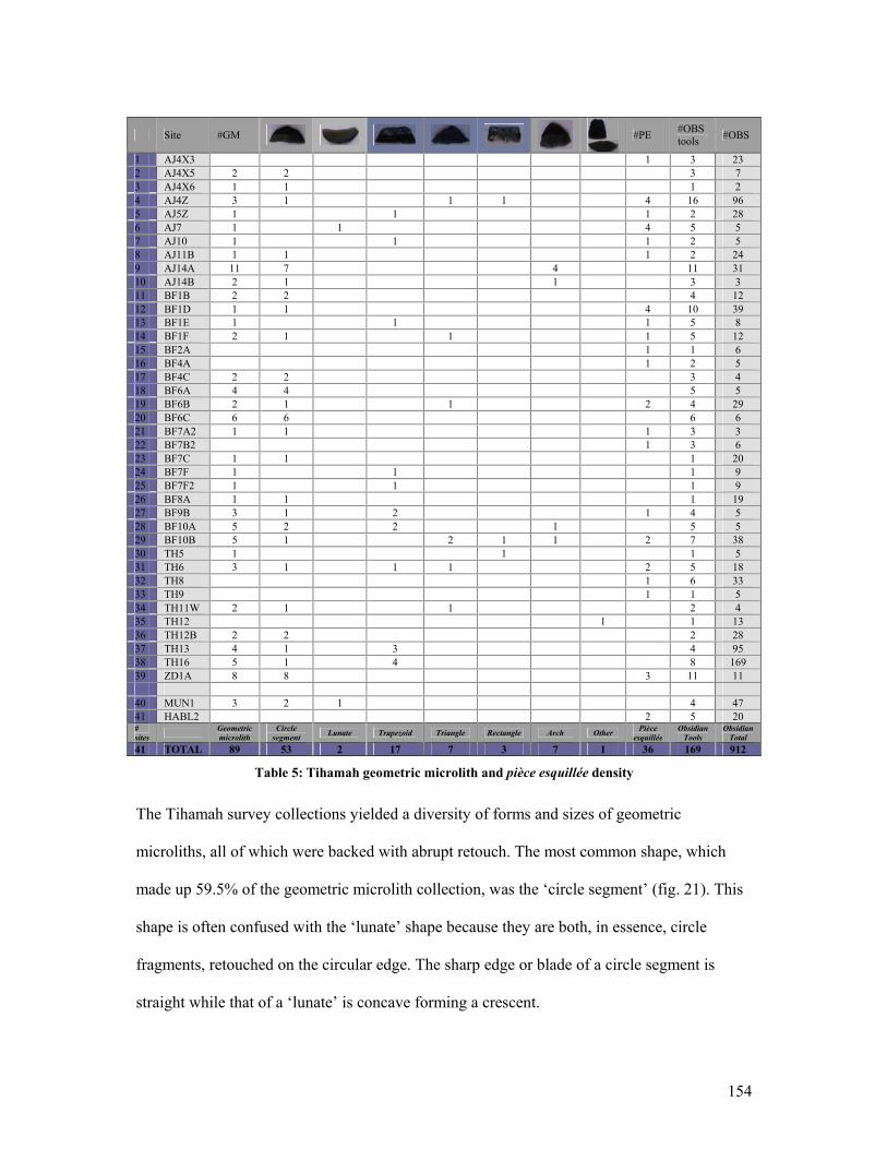
154
Site #GM
#PE #OBS
tools #OBS
1 AJ4X3 1 3 23 2 AJ4X5 2 2 3 7 3 AJ4X6 1 1 1 2 4 AJ4Z 3 1 1 1 4 16 96 5 AJ5Z 1 1 1 2 28 6 AJ7 1 1 4 5 5 7 AJ10 1 1 1 2 5 8 AJ11B 1 1 1 2 24 9 AJ14A 11 7 4 11 31 10 AJ14B 2 1 1 3 3 11 BF1B 2 2 4 12 12 BF1D 1 1 4 10 39 13 BF1E 1 1 1 5 8 14 BF1F 2 1 1 1 5 12 15 BF2A 1 1 6 16 BF4A 1 2 5 17 BF4C 2 2 3 4 18 BF6A 4 4 5 5 19 BF6B 2 1 1 2 4 29 20 BF6C 6 6 6 6 21 BF7A2 1 1 1 3 3 22 BF7B2 1 3 6 23 BF7C 1 1 1 20 24 BF7F 1 1 1 9 25 BF7F2 1 1 1 9 26 BF8A 1 1 1 19 27 BF9B 3 1 2 1 4 5 28 BF10A 5 2 2 1 5 5 29 BF10B 5 1 2 1 1 2 7 38 30 TH5 1 1 1 5 31 TH6 3 1 1 1 2 5 18 32 TH8 1 6 33 33 TH9 1 1 5 34 TH11W 2 1 1 2 4 35 TH12 1 1 13 36 TH12B 2 2 2 28 37 TH13 4 1 3 4 95 38 TH16 5 1 4 8 169 39 ZD1A 8 8 3 11 11 40 MUN1 3 2 1 4 47 41 HABL2 2 5 20 # sites Geometric
microlith Circle
segment Lunate Trapezoid Triangle Rectangle Arch Other Pièce esquillée
Obsidian Tools
Obsidian Total
41 TOTAL 89 53 2 17 7 3 7 1 36 169 912
Table 5: Tihamah geometric microlith and pièce esquillée density
The Tihamah survey collections yielded a diversity of forms and sizes of geometric
microliths, all of which were backed with abrupt retouch. The most common shape, which
made up 59.5% of the geometric microlith collection, was the ‘circle segment’ (fig. 21). This
shape is often confused with the ‘lunate’ shape because they are both, in essence, circle
fragments, retouched on the circular edge. The sharp edge or blade of a circle segment is
straight while that of a ‘lunate’ is concave forming a crescent.
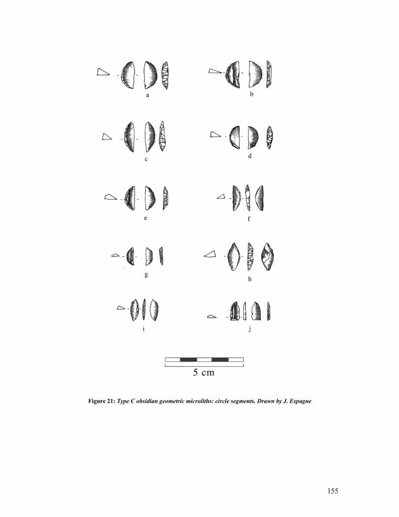
155
Figure 21: Type C obsidian geometric microliths: circle segments. Drawn by J. Espagne
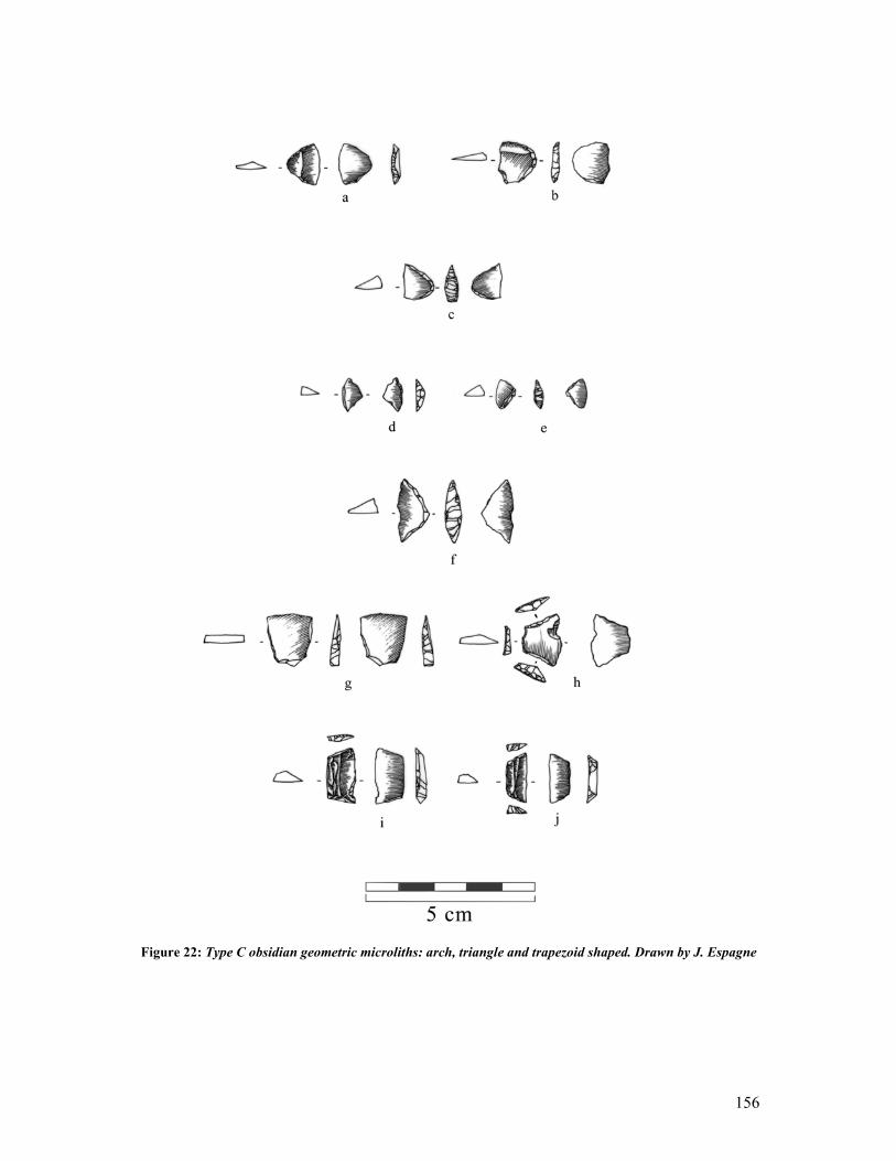
156
Figure 22: Type C obsidian geometric microliths: arch, triangle and trapezoid shaped. Drawn by J. Espagne
157
The second most common shape was the ‘trapezoid’, which made up 19% of the geometric
microlith assemblage (fig. 22: g-j). This form is usually wider than it is long and retouched on
three of its four sides, the fourth side making up the sharp edge.
‘Triangles’ and ‘arched’ microliths each make up 7.8% of the total microlith collection.
Triangular microliths came in four types, and were normally retouched on two of three sides.
The first forms a straight edge with the two remaining and retouched sides forming an angle
< 90º (fig. 22f). The second type is the classic ‘scalene’ microlith, which forms an isosceles
triangle, with a third non-retouched straight edge. The third forms one of the two above-
mentioned shapes but has a convex sharp edge (fig. 22e). Finally the fourth type is
questionable as it can either fall into the ‘triangle’ or the ‘circle segment’ categories. The
retouched edge is in this case circular, while the sharp edges form an angle, so that only one
side is retouched, while the two remaining sides act as blades (fig. 22d). The ‘arched’ type
has a curved or arched retouched edge, while the second edge forms the blade (fig. 22: a-c).
‘Rectangles’ and ‘lunates’ were rare but present in the assemblage.
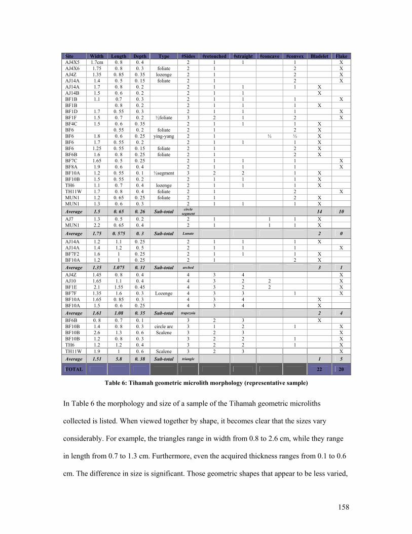
158
Site Width Length Depth Type #Sides #retouched #straight #concave #convex Bladelet Flake AJ4X5 1.7cm 0. 8 0. 4 2 1 1 1 X AJ4X6 1.75 0. 8 0. 3 foliate 2 1 2 X AJ4Z 1.35 0. 85 0. 35 lozenge 2 1 2 X AJ14A 1.4 0. 5 0. 15 foliate 2 1 2 X AJ14A 1.7 0. 8 0. 2 2 1 1 1 X AJ14B 1.5 0. 6 0. 2 2 1 1 X BF1B 1.1 0.7 0. 3 2 1 1 1 X BF1B 0. 8 0. 2 2 1 1 1 X BF1D 1.7 0. 55 0. 3 2 1 1 1 X BF1F 1.5 0. 7 0. 2 ½foliate 3 2 1 2 X BF4C 1.5 0. 6 0. 35 2 1 1 1 X BF6 0. 55 0. 2 foliate 2 1 2 X BF6 1.8 0. 6 0. 25 ying-yang 2 1 ½ ½ X BF6 1.7 0. 55 0. 2 2 1 1 1 X BF6 1.25 0. 55 0. 15 foliate 2 1 2 X BF6B 1.6 0. 8 0. 25 foliate 2 1 2 X BF7C 1.65 0. 5 0. 25 2 1 1 1 X BF8A 1.9 0. 6 0. 4 2 1 1 1 X BF10A 1.2 0. 55 0. 1 ½segment 3 2 2 1 X BF10B 1.5 0. 55 0. 2 2 1 1 1 X TH6 1.1 0. 7 0. 4 lozenge 2 1 1 1 X TH11W 1.7 0. 8 0. 4 foliate 2 1 2 X MUN1 1.2 0. 65 0. 25 foliate 2 1 2 X MUN1 1.3 0. 6 0. 3 2 1 1 1 X Average 1.5 0. 65 0. 26 Sub-total circle
segment 14 10 AJ7 1.3 0. 5 0. 2 2 1 1 1 X MUN1 2.2 0. 65 0. 4 2 1 1 1 X
Average 1.75 0. 575 0. 3 Sub-total Lunate 2 0 AJ14A 1.2 1.1 0. 25 2 1 1 1 X AJ14A 1.4 1.2 0. 5 2 1 1 1 X BF7F2 1.6 1 0. 25 2 1 1 1 X BF10A 1.2 1 0. 25 2 1 2 X Average 1.35 1.075 0. 31 Sub-total arched 3 1 AJ4Z 1.45 0. 8 0. 4 4 3 4 X AJ10 1.65 1.1 0. 4 4 3 2 2 X BF1E 2.1 1.55 0. 45 4 3 2 2 X BF7F 1.35 1.6 0. 3 Lozenge 4 3 3 1 X BF10A 1.65 0. 85 0. 3 4 3 4 X BF10A 1.5 0. 6 0. 25 4 3 4 X Average 1.61 1.08 0. 35 Sub-total trapezoid 2 4 BF6B 0. 8 0. 7 0. 1 3 2 3 X BF10B 1.4 0. 8 0. 3 circle arc 3 1 2 1 X BF10B 2.6 1.3 0. 6 Scalene 3 2 3 X BF10B 1.2 0. 8 0. 3 3 2 2 1 X TH6 1.2 1.2 0. 4 3 2 2 1 X TH11W 1.9 1 0. 6 Scalene 3 2 3 X Average 1.51 5.8 0. 38 Sub-total triangle 1 5
TOTAL 22 20
Table 6: Tihamah geometric microlith morphology (representative sample)
In Table 6 the morphology and size of a sample of the Tihamah geometric microliths
collected is listed. When viewed together by shape, it becomes clear that the sizes vary
considerably. For example, the triangles range in width from 0.8 to 2.6 cm, while they range
in length from 0.7 to 1.3 cm. Furthermore, even the acquired thickness ranges from 0.1 to 0.6
cm. The difference in size is significant. Those geometric shapes that appear to be less varied,

159
such as the circle segments and arched microliths, are still very diversified. If we take the
BF6 site series of circle segments, this variation in size and shape becomes even more glaring
because the pieces originate from the same site or site system. In this case five circle
segments were collected and they range in width from 1.25 to 1.8 cm and in length from 0.55
to 0.8 cm, while the thickness ranges from 0.15 to 0.25 cm. The shapes themselves are varied.
Three are foliates or doubly convex, one is ‘yin-yang’ in shape, meaning that the blade curves
inward then outward, and the third is a classic circle segment. The morphological
characteristics, here represented by the number of sides, the number of retouched sides and
the orientation of the sides of each tool, show once again that within each shape category a
number of morphological differences exist.
The diversity in the forms and sizes of the geometric microliths produced can be read as a
consequence of an ‘expedient’ technology whereby the shape of the blanks available
determined the shape of the tool. Such a process would result in a non-standardized (in size
and shape) microlith tool-kit like that of the Tihamah survey.
The most interesting statistic demonstrated in Table 6 is the tool blank chosen for these tools.
Bladelets make up 52% of the blanks while flakes make up 48%. The choice between a
bladelet or a flake as a microlith blank is relatively equivalent. This suggests that the small
size of the nodules and the small amount of material available created a situation whereby the
population used what obsidian blanks were available. Such a process would have been more
economical and less time-consuming.
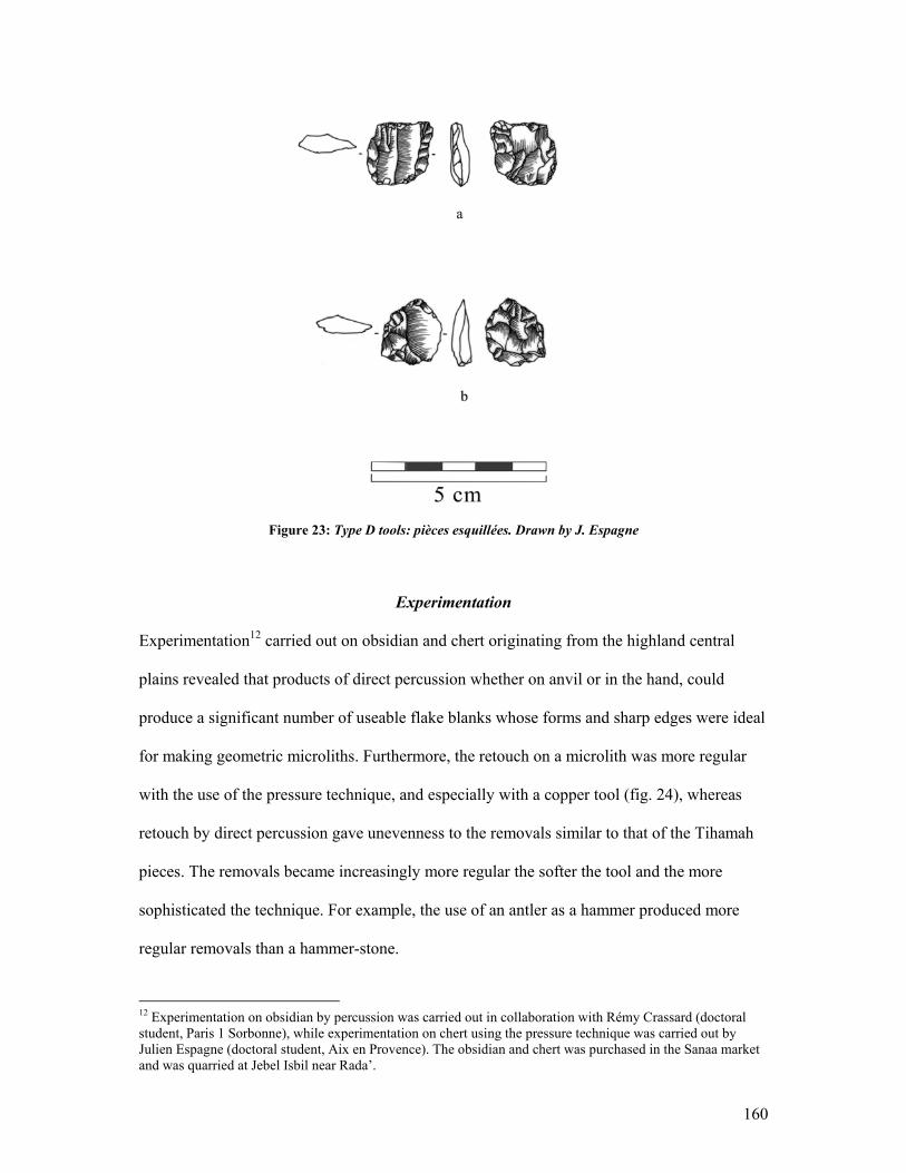
160
Figure 23: Type D tools: pièces esquillées. Drawn by J. Espagne
Experimentation
Experimentation12 carried out on obsidian and chert originating from the highland central
plains revealed that products of direct percussion whether on anvil or in the hand, could
produce a significant number of useable flake blanks whose forms and sharp edges were ideal
for making geometric microliths. Furthermore, the retouch on a microlith was more regular
with the use of the pressure technique, and especially with a copper tool (fig. 24), whereas
retouch by direct percussion gave unevenness to the removals similar to that of the Tihamah
pieces. The removals became increasingly more regular the softer the tool and the more
sophisticated the technique. For example, the use of an antler as a hammer produced more
regular removals than a hammer-stone.
12 Experimentation on obsidian by percussion was carried out in collaboration with Rémy Crassard (doctoral student, Paris 1 Sorbonne), while experimentation on chert using the pressure technique was carried out by Julien Espagne (doctoral student, Aix en Provence). The obsidian and chert was purchased in the Sanaa market and was quarried at Jebel Isbil near Rada’.
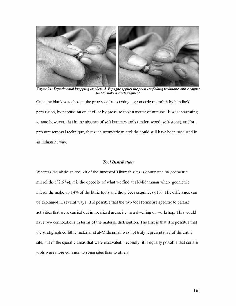
161
Figure 24: Experimental knapping on chert. J. Espagne applies the pressure flaking technique with a copper
tool to make a circle segment.
Once the blank was chosen, the process of retouching a geometric microlith by handheld
percussion, by percussion on anvil or by pressure took a matter of minutes. It was interesting
to note however, that in the absence of soft hammer-tools (antler, wood, soft-stone), and/or a
pressure removal technique, that such geometric microliths could still have been produced in
an industrial way.
Tool Distribution
Whereas the obsidian tool kit of the surveyed Tihamah sites is dominated by geometric
microliths (52.6 %), it is the opposite of what we find at al-Midamman where geometric
microliths make up 14% of the lithic tools and the pièces esquillées 61%. The difference can
be explained in several ways. It is possible that the two tool forms are specific to certain
activities that were carried out in localized areas, i.e. in a dwelling or workshop. This would
have two connotations in terms of the material distribution. The first is that it is possible that
the stratigraphied lithic material at al-Midamman was not truly representative of the entire
site, but of the specific areas that were excavated. Secondly, it is equally possible that certain
tools were more common to some sites than to others.
162
Another explanation addresses the possible weaknesses in the survey collection strategy
and/or the surface representation. In either case it is possible that the surface collections were
too sporadic and/or biased towards the collection of certain pieces over others, to be fully
representative. While during field survey an attempt was made to collect a representative
sample of the whole on each documented site, there remains an inherent human subjectivity
(in this case it is the collector) that can be just as advantageous as it is disadvantageous.
Perhaps more important is the fact that in the majority of sites, these two tool types are found
together. On the site of al-Midamman these have been found in the same stratigraphic unit
(Crassard in press). Furthermore they have been collected, and in significant quantities, from
sites throughout the central Tihamah. The largest surface concentrations of these tools were
to be found at large late prehistoric sites such as al-Midamman, Kashawba’ (ZD1A), and
MUN1. However a number of ceramic sites located along major wadi courses also yielded
high densities of obsidian and occasional obsidian geometric microliths and pièces esquillées.
The southern Tihamah has yet to be systematically surveyed, though future work will no
doubt clarify whether this tool type is to be found in the southern regions. Although the
Hodeidah-Midi road impact survey covered the northern Tihamah, the study was
concentrated on the road alignment and so was not representative of the full diversity of sites
in the northern region. During this survey, however, one very large site, MUN1 located east
of the Salif peninsula, yielded a significant number of obsidian geometric microliths and was
characterized by a relatively high density of obsidian debitage. Sites in the area were
previously surveyed and excavated by the IAM, however, there is no published mention of
geometric microliths. On the other hand, beside the mention of a micro-drill, what is
discussed in the IAM publications are a number of large sites that yielded brown-burnished
163
ceramics and high densities of obsidian (Tosi 1986). Two sites in the Salif area, MNR113 and
SLF1, published by the IAM, were presumed to date to the late prehistoric based on ceramic
comparisons with the third to first millennium BC coastal site of Sihi in the Saudi Arabian
Tihamah (Tosi 1986: 403, Zarins et al. 1986, Zarins et al. 1985), and the contemporary site of
Sabir (Buffa 2002, Buffa et al. 2001, Vogt 1997, Vogt et al. 1997, 1998) located north of
Aden.
The shell midden site of Sihi, radiocarbon dated to 2400-1300 BC, yielded a lithic
assemblage dominated by obsidian, most of which was debitage. Within the excavated
obsidian corpus were ‘backed lunates’, ‘naturally-backed geometrics’, ‘microlithic bladelets’
and several microlith bladelet cores (Zarins et al. 1986: 48). Zarins and al-Badr describe
‘backed lunates’ both in obsidian and quartzite on Saudi Tihamah shell middens as
evidencing ‘bipolar retouch on bladelets’ (Zarins et al. 1986: 43). This not only extends the
occurrence of obsidian geometric microliths further north along the Tihamah littoral, but also
suggests that the technique of bipolar flaking was also present.
The abundance and widespread occurrence of obsidian geometric microliths and pièces
esquillées, on ceramic sites of the Tihamah coastal plain indicates that these types dominated
in the late prehistoric period. The ceramic element of these sites is unique to the coastal plain
and presents a second chronological indicator for sites of this period.
13 The IAM site MNR1 may be the same site as that documented by the author and designated MUN1. It appears to be located in the same general area near the town of al-Munira after which the site was named. Because the coordinates are not given in the IAM publication and the map is too general, it is impossible to tell for the moment if the two sites are in fact one and the same. Nonetheless, the site of MUN1 yielded obsidian geometric microliths, and this proves that despite the fact that they are not mentioned in the IAM publication, that they are present as a tool type in the area.
164
4.8 Carnelian and Obsidian Bead Manufacture
Carnelian is very difficult to shape and polish without pre-heating or ‘thermal treatment’.
Furthermore, a deeper reddish-orange color is acquired as a result of this technique (Inizan
1995: 129). Thirteen sites yielded carnelian beads all of which were heat-treated. Of these,
four beads that were recovered from late prehistoric sites were pierced by percussion. This
technique involves indirect percussion whereby the pressure of the blow to a pre-formed
circular bead creates a hole through the center of the bead and leaves a signature on the
opposing side in the shape of a negative round bulb. Such a technique is evidenced in India
and Pakistan and in the Near East, most commonly in the third millennium BC (Ibid: 131-2).
The remaining carnelian beads, collected from later prehistoric sites, were drilled. Two sites,
namely AJ4Z and Kashawba’ (ZD1A), had a surface assemblage that included a number of
small heat-treated carnelian flakes which suggested small-scale carnelian bead manufacture.
Although carnelian sources are known in the central highlands near Ma’bar (Edens et al.
1998), and along the foothills of the Tihamah14, carnelian nodules were probably collected in
the wadi beds where they are abundant (Rahimi 2001)15.
Finally, two polished obsidian beads were also collected, one of which was round, and the
other thin and cylindrical. Both were collected from late prehistoric period sites.
4.9 Ceramic Assemblage
The pre-Islamic ceramic assemblage of the Tihamah is made up of a coherent assemblage of
skillfully made, high-fired, and intricately decorated ceramics that take on unique and
unprecedented forms, and it is more refined in quality and surface decoration than the pottery
from the highlands, desert fringe, and Hadramawt (Buffa 2003: 177, Keall 2004: 50). It has
14 The author has recently identified one carnelian source in the central Tihamah foothill region. 15 Pers.obs.
165
been found on late prehistoric sites throughout the Tihamah and perseveres on such sites for
over a millennium.
Until recently very little work had been carried out in the Tihamah, and the region was
considered of minimal importance during the pre-Islamic periods for lack of monumental pre-
Islamic sites. This made the discovery of such a ceramic assemblage on numerous sites in the
Tihamah that much more elusive. Parallels for the pottery have been suggested with
assemblages from early historic sites along the desert fringe, though these are more likely to
be imports from the coastal plain, or else later imitations of certain pieces (Buffa 2003: 170).
A debate has been stirred by the fact that the terminal phase of this pottery tradition includes
rare pieces incised with proto-South Arabian letters. In the monolithic tradition of
interpreting cultural influence, the occurrence of a proto-script has led many archaeologists to
believe that it implies a South Arabian dominance in the region16. This point has been driven
further by the fact that this pottery has been found at the site of al-Midamman in association
with architectural fragments decorated with Banat ‘Ad iconography similar to that found in
early South Arabian temples in the Jawf (Audouin 1991, Audouin et al. 2004, Breton 1998:
215, Keall 2004: 53, Fig. 15-18). This ceramic assemblage is presented here as an enduring
tradition that pre-dates even the direct antecedents of the South Arabian cultural tradition, and
as one that is particular to the Tihamah.
This section will discuss the method that was used on survey to distinguish between the
prehistoric and historic (South Arabian and Islamic) pottery traditions in the Tihamah. The
pottery types found in the Tihamah will be presented in conjunction with the published
prehistoric typologies.
16 (Antonini in press) in (Buffa 2003: 172). Buffa writes, in quoting Antonini, “ Elle interprète en outre la découverte de al-Midamman comme l’indication d’une ‘…voie sabéenne pour la colonization de l’Ethiopie…’”

166
Pottery Identification
Several well-known pottery traditions enabled the preliminary classification of prehistoric
versus historic pottery types. The first of these traditions are the glazed wares that
characterize the greater Islamic period and are not manufactured during any other period.
Different colored glaze technologies and decorative variations in color scheme and form
characterize different Islamic traditions and periods (‘Lustre-ware’ = Ziyadid (750-950 AD),
‘Yellow Salad ware’ = Rasulid (1350-1550 AD)). However, locally made unglazed Islamic
pottery is also common and is more difficult to distinguish from earlier types17. Because
many prehistoric ceramic forms have endured into the modern period, the temper, surface
decoration, elements of foreign origin, and degree of weathering were important indicators of
chronology. One specific tradition that is easily mistaken for a prehistoric one, primarily
because it is devoid of glazed wares and tends to be heavily varnished when found on the
surface, is the early Islamic pottery. As a result of CAMROM’s work on Islamic sites in the
Tihamah this early phase is now well known and particular decorative elements and forms
have been identified (Ciuk et al. 1996).
Knowledge of the temper, forms and decoration of the late prehistoric pottery from the
Tihamah comes from six published sites. The excavated sites include Ma’laybah and Sabir
north of Aden, the shell midden site of al-Nabwa located between Aden and Bab al Mandab,
Sihi in the Saudi Tihamah and al-Midamman which lies in the central Tihamah within the
survey zone. One site, which has not yet been excavated, is Kashawba’ (ZD1A) which forms
part of the survey data. All of these sites have numerous parallels with each other, especially
where the chronologies overlap. It appears that each site also has elements unique to its sub-
17 See (Ciuk et al. 1996) for the most coherent typology that exists for the Tihamah Islamic pottery.
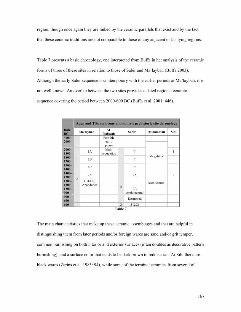
167
region, though once again they are linked by the ceramic parallels that exist and by the fact
that these ceramic traditions are not comparable to those of any adjacent or far-lying regions.
Table 7 presents a basic chronology, one interpreted from Buffa in her analysis of the ceramic
forms of three of these sites in relation to those of Sabir and Ma’laybah (Buffa 2003).
Although the early Sabir sequence is contemporary with the earlier periods at Ma’laybah, it is
not well known. An overlap between the two sites provides a dated regional ceramic
sequence covering the period between 2000-600 BC (Buffa et al. 2001: 446).
Aden and Tihamah coastal plain late prehistoric site chronology
Date BC Ma’laybah Al-
Nabwah Sabir Midamman Sihi
3000-2000
Possible early phase
2000-1800 1A Main
occupation ? 1
1800-1700 1B ?
1700-1400
1
1C
1
?
Megalithic
1400-1300 2A 2A 2
1300-1200
2 (B1/D2) Abandoned
1200-900
2B Architectural
Architectural
900-600
2
Destroyed
600 3 3 (2C) Table 7
The main characteristics that make up these ceramic assemblages and that are helpful in
distinguishing them from later periods and/or foreign wares are sand and/or grit temper,
common burnishing on both interior and exterior surfaces (often doubles as decorative pattern
burnishing), and a surface color that tends to be dark brown to reddish-tan. At Sihi there are
black wares (Zarins et al. 1985: 94), while some of the terminal ceramics from several of
168
these sites have a red slip (Keall 2004: fig. 14). They are all hand-made, and most of the
wares are high fired, though some of the larger jars and storage vessels can be less so.
The surface decoration is also unique to the Tihamah and although it can vary in its
decorative arrangement from site to site, the same techniques and decorative elements exist
across the board. Primarily there is incised decoration in the form of wedges, horizontal,
vertical and diagonal lines, chevrons, comb-incised lines and cross-hatching to name a few.
Punctates are very common and occur in different sizes. Stamped decoration also occurs in
the shape of small squares and triangles, while appliquéd motifs are not uncommon. Ridges
and handles are also quite frequently decorated, the former often exhibiting thumb and
fingernail impressions.
Finally the most common features of these late prehistoric assemblages are the handles. Many
vessels have handle-like forms such as nubs and small ledge-handles that may have acted as
decorative and/or functional elements (fig.28). The most common handle forms however, are
the horizontal and vertical pierced handle (fig.25) and the vertically oriented strap handle.
The horizontal handle sometimes appears as a double pierced handle. The strap handle is
distinctive because it is oval in cross-section and is commonly burnished, red-slipped and
decorated (fig.31-2). Finally the forms vary from period to period, though the most distinctive
are those of the later phases, which can be extremely complex. The forms will be discussed
briefly by period and in conjunction with the surveyed assemblage.

169
Figure 25:
Horizontally burnished jar with two vertically pierced handles from the site of al-‘Uqsh ( southern Tihamah)
Ma’laybah: The Early Ceramic Sequences
The Ma’laybah ceramic assemblage is the earliest and most coherent typology that exists to
date for the western coastal regions. The site is divided into two phases, 1 (the earliest) and 2
(the terminal phase). Phase 1 is sub-divided into at least three sub-phases (1A, 1B, and 1C)
and several transitional ones. The chrono-typology for this site is quite important because it
links the earliest ceramic phases not known from elsewhere with the later phases at Sabir, al-
Midamman, Kashawba’ and Sihi.
The earliest forms (1A) are less varied, consisting of pattern burnished truncated bowls and
platters, with simple round, rectilinear and convex rims. Some inwardly curved and
cylindrical bowls appear in this early phase as well as some open straight-sided vessels, some
of which exhibit small nub handles. The jars from this period are described as ‘jarres à bord
évasé’ and short-necked jars, the former occasionally exhibiting small nub or horizontal
handles. Necked vases are common as are the pierced horizontal and vertical handles that
continue to be popular into the later periods, even at Sabir (Buffa 2003). These forms
170
continue to be used and become increasingly diversified, eventually taking on forms that
become characteristic of the Sabir assemblage (Buffa et al. 2001: 446). So as to avoid
repetition, the later forms from Sabir will be presented instead of those of Ma’laybah.
The early ceramics from the site of al-Midamman, those corresponding to the megalithic
period, have not been published. It has been stated, however, that two temporal ceramic
traditions from this site are distinguishable (Keall 1998: 146). It appears, however, that like
the ceramic corpus at Ma’laybah, the early pottery is simpler but related to forms that
characterize the later Midamman ceramic assemblage. Furthermore, many of the excavated
samples from this period were small and abraded18.
Several surveyed sites in the central Tihamah yielded forms comparable to the early phases of
the Ma’laybah assemblage, while others yielded extremely small abraded and undiagnostic
sherds, which for the lack of Islamic and/or later Sabir-like ceramics, were interpreted as
falling into this early ceramic tradition. Furthermore, the sites that yielded such ceramics had
often already been classified, based on a number of other factors, as transitional from the
middle to late prehistoric.
Twenty-two sites had an abraded undiagnostic ceramic element. All of these sites were
interpreted as falling within the range of fourth to second millennium BC on the basis of
multiple factors. Because in most of these cases the sherds were not diagnostic, and the
surface treatment had been eroded away, it was impossible to compare pieces with other
assemblages.
18 P.c. Edward Keall, December 2004. The author’s observation of the surface pottery on the early parts of this site further evidenced this fact.
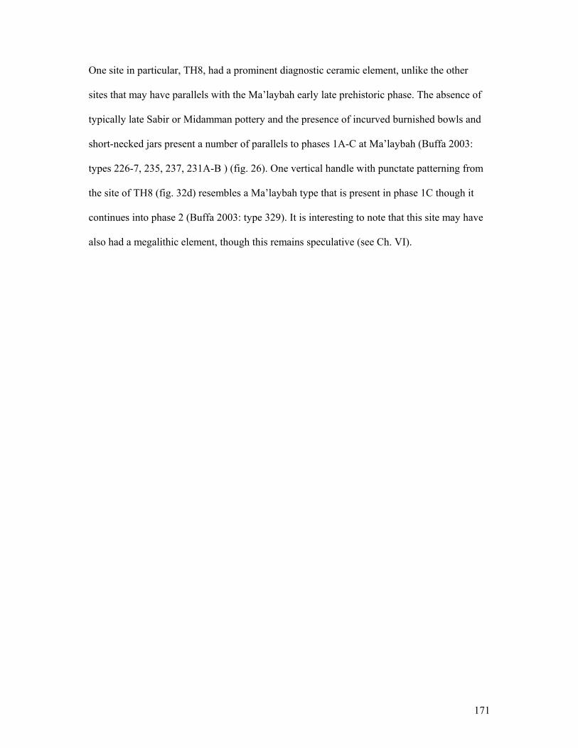
171
One site in particular, TH8, had a prominent diagnostic ceramic element, unlike the other
sites that may have parallels with the Ma’laybah early late prehistoric phase. The absence of
typically late Sabir or Midamman pottery and the presence of incurved burnished bowls and
short-necked jars present a number of parallels to phases 1A-C at Ma’laybah (Buffa 2003:
types 226-7, 235, 237, 231A-B ) (fig. 26). One vertical handle with punctate patterning from
the site of TH8 (fig. 32d) resembles a Ma’laybah type that is present in phase 1C though it
continues into phase 2 (Buffa 2003: type 329). It is interesting to note that this site may have
also had a megalithic element, though this remains speculative (see Ch. VI).
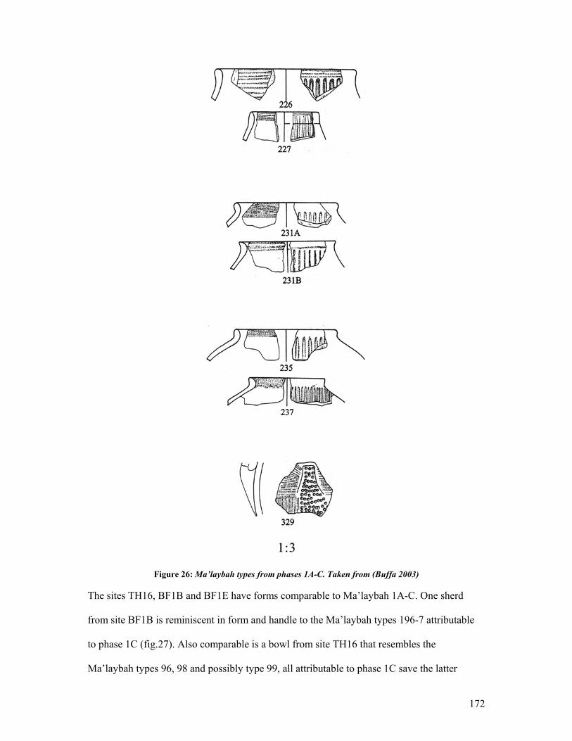
172
Figure 26: Ma’laybah types from phases 1A-C. Taken from (Buffa 2003)
The sites TH16, BF1B and BF1E have forms comparable to Ma’laybah 1A-C. One sherd
from site BF1B is reminiscent in form and handle to the Ma’laybah types 196-7 attributable
to phase 1C (fig.27). Also comparable is a bowl from site TH16 that resembles the
Ma’laybah types 96, 98 and possibly type 99, all attributable to phase 1C save the latter
173
which belongs to phase 1B (fig. 27). Surprisingly, the site of Kashawba’ (ZD1A) and one
element of its western extension (ZD1C), have a number of pieces that resemble Ma’laybah
phase 1C and in rare cases 1B forms (figs. 27-28). The ceramics from this site have been
attributed to the late Sabir and Midamman phases of occupation (Keall 1998: 143-4).
Although the parallels with the Ma’laybah assemblage are numerous, they may be forms that
have a long life in the Tihamah and that continue into the later periods.
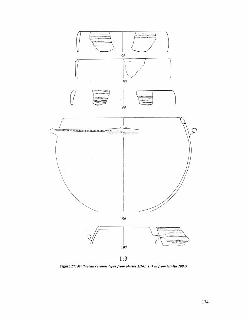
174
Figure 27: Ma’laybah ceramic types from phases 1B-C. Taken from (Buffa 2003)
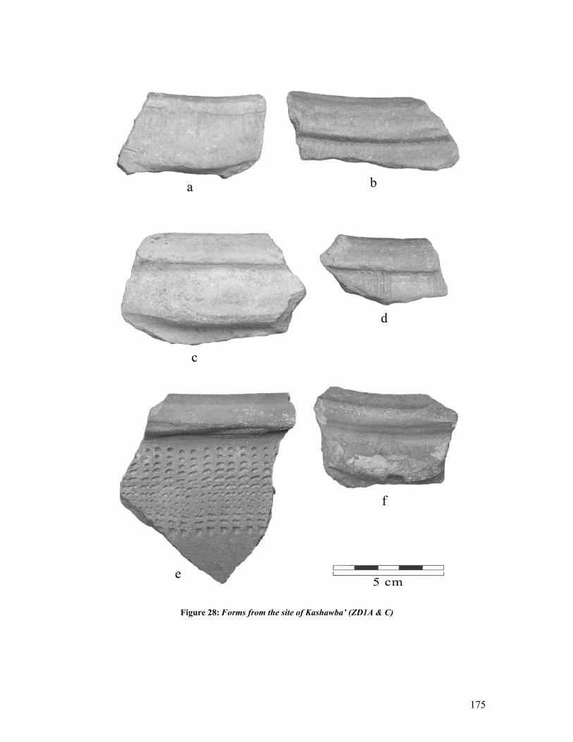
175
Figure 28: Forms from the site of Kashawba’ (ZD1A & C)
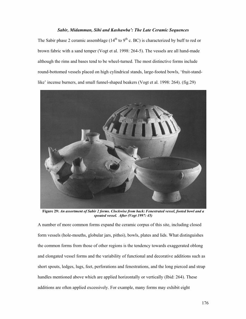
176
Sabir, Midamman, Sihi and Kashawba’: The Late Ceramic Sequences
The Sabir phase 2 ceramic assemblage (14th to 9th c. BC) is characterized by buff to red or
brown fabric with a sand temper (Vogt et al. 1998: 264-5). The vessels are all hand-made
although the rims and bases tend to be wheel-turned. The most distinctive forms include
round-bottomed vessels placed on high cylindrical stands, large-footed bowls, ‘fruit-stand-
like’ incense burners, and small funnel-shaped beakers (Vogt et al. 1998: 264). (fig.29)
Figure 29: An assortment of Sabir 2 forms. Clockwise from back: Fenestrated vessel, footed bowl and a
spouted vessel. After (Vogt 1997: 45)
A number of more common forms expand the ceramic corpus of this site, including closed
form vessels (hole-mouths, globular jars, pithoi), bowls, plates and lids. What distinguishes
the common forms from those of other regions is the tendency towards exaggerated oblong
and elongated vessel forms and the variability of functional and decorative additions such as
short spouts, ledges, lugs, feet, perforations and fenestrations, and the long pierced and strap
handles mentioned above which are applied horizontally or vertically (Ibid: 264). These
additions are often applied excessively. For example, many forms may exhibit eight
177
horizontal handles (Ibid: fig.2.2). The decoration on these ceramics is pervasive on single
vessels as well as throughout the corpus of ceramics and alternates between pattern
burnishing and geometric incisions, impressions and appliquéd designs. Painted wares are
rare and include red and white geometric designs, attributed to the late occupations of the site
(Buffa 2003).
The ceramic assemblage from al-Midamman is similar in form and temper to the Sabir phase
2 assemblage, though certain Midamman types are absent in the Sabir assemblage and vice-
versa (Keall 1998: 143-4). What is most significant about these two assemblages is that those
forms which are distinctive to the Sabir assemblage, such as the fenestrated vessels, the fruit-
stands, the short spouts and pierced handles, the oblong and elongated forms, and the
prevalent pattern burnishing, incised and punctate decoration are also present in the
Midamman assemblage19. These are also present in the ceramic assemblages of Kashawba’20
and although fewer, in the Sihi21 assemblages. What has become increasingly clear is that
certain forms and decorative elements link the ceramic assemblages found along the coastal
plains of Aden in the south, the Tihamah, and Saudi Arabia. At the same time local variations
between the coastal regions, that is to say between Aden, the central Tihamah and the
northern Tihamah (Sihi) are quite evident.
19 See: Fig.9a, 9c, 9d; Fig.10a, 10d in (Keall 1998). 20 See: Plates 95/1 b, k; 95/2 a, b, h; 95/3 a, d, i; 95/4 c; 95/5 b, g; 95/8 b, f in (Ciuk et al. 1996). 21 See: Plates 81-1-3, 9; 84-1-2, 4; 85-19 in (Zarins et al. 1985).
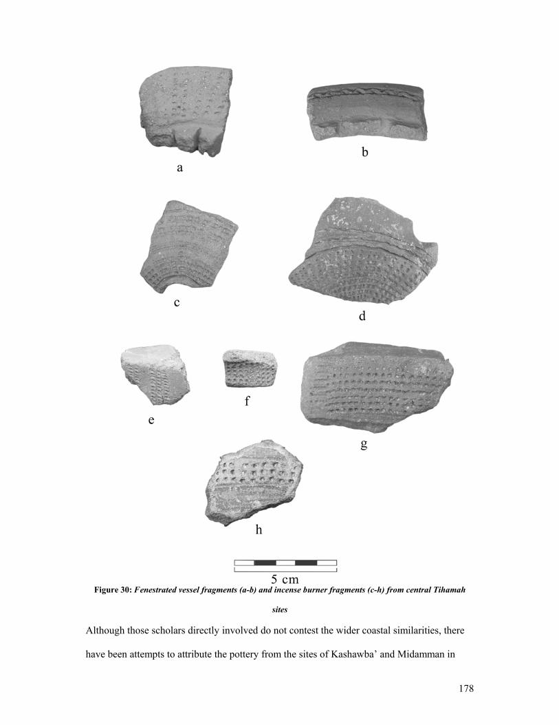
178
Figure 30: Fenestrated vessel fragments (a-b) and incense burner fragments (c-h) from central Tihamah
sites
Although those scholars directly involved do not contest the wider coastal similarities, there
have been attempts to attribute the pottery from the sites of Kashawba’ and Midamman in
179
particular to the early South Arabian period (Phillips 1998: 235). This attribution is made on
the basis of the similarities between ceramics distinctive to these two sites in the central
Tihamah and those of the early historic sites of al-Hamid and Waqir located along the central
Tihamah foothills. These sites have yielded architectural elements and inscriptions that
clearly belong to the South Arabian period while they exhibit a ceramic assemblage that
resembles the local central Tihamah corpus in its terminal phase (Phillips 1997, 1998).
A continuation of this ceramic tradition into the South Arabian period is logical, however to
attribute an early historic date or a South Arabian influence to a tradition that has been
demonstrated to have a prolonged existence is not. It must be remembered that there are no
direct parallels with the highlands or the desert fringe, so that despite the variation that exists
along the coastal plains, which should be expected, these types remain unique to the coastal
regions of Aden and the Tihamah. Finally, the prolonged existence of the forms and the
surface decoration, as has been demonstrated most clearly at the sites of Ma’laybah, Sabir
and al-Midamman, is a clear indication of a late prehistoric tradition that precedes and
possibly “contributed to the development of classic South Arabian civilization, but were not
products of it.” (Keall 2004: 51).
Six of the surveyed sites, including the newly discovered extension of Kashawba’, have
ceramic assemblages with direct parallels to the Midamman architectural phase and the Sabir
2 phase. These include fenestrated vessel fragments, incense burners, pierced horizontal
handles, pattern burnishing and incised and punctate decoration (figs.30-32).
Certain ceramic elements remain unique to the central Tihamah; they are prevalent
specifically in this area and are rare or absent in the Aden and Saudi regions. The best-
180
preserved example found on survey is the strap handle. Thirteen of the sites surveyed have
yielded these handles. These have been found in large numbers throughout the central and
northern Tihamah and are oval in cross-section, burnished and often decorated with
punctates, and incised geometric decorations (figs.31-32). While the decorative composition
of these handles is unique, the forms themselves are not. Only one design, collected from the
site of Kashawba’, has parallels with a Sabir 222 design (fig. 32h).
At the site of Sihi, the published materials do not provide much of a chronological ceramic
typology, only a description of the forms. It is not clear how the forms develop throughout
the long occupation of the site. They are divided into two types, ‘red wares’ and ‘black
wares’. Zarins does not, however, make a chronological differentiation between the two
(Zarins et al. 1986: 46-7, Zarins et al. 1985: 93-4). Interestingly, the black wares are rare to
non-existent on other sites in the Tihamah or Aden regions. Zarins has suggested a possible
African parallel for these types (Zarins et al. 1986: 51). Fattovich has correspondingly
suggested a Sihi parallel to certain late prehistoric Horn of Africa ceramic wares, namely to
the Gash group in Kassala, but also the Kerma and C-Group in Nubia (Fattovich 1997: 481).
22 P.c. Buffa, 2004.
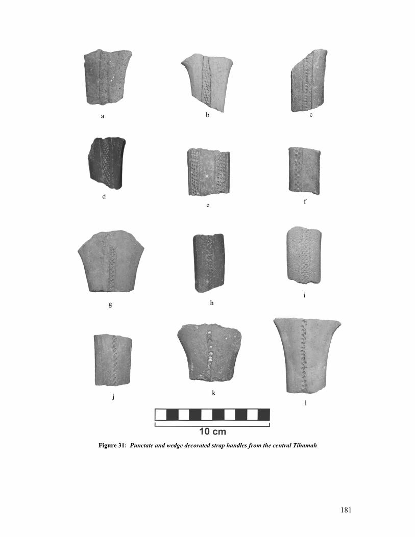
181
Figure 31: Punctate and wedge decorated strap handles from the central Tihamah
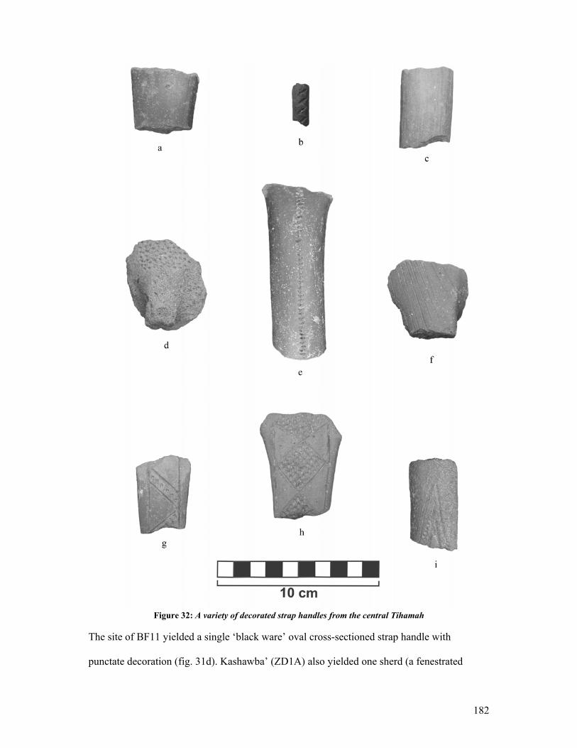
182
Figure 32: A variety of decorated strap handles from the central Tihamah
The site of BF11 yielded a single ‘black ware’ oval cross-sectioned strap handle with
punctate decoration (fig. 31d). Kashawba’ (ZD1A) also yielded one sherd (a fenestrated
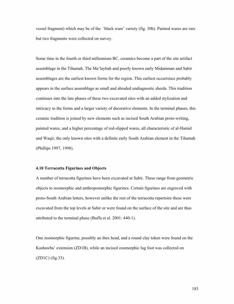
183
vessel fragment) which may be of the ‘black ware’ variety (fig. 30h). Painted wares are rare
but two fragments were collected on survey.
Some time in the fourth or third millennium BC, ceramics become a part of the site artifact
assemblage in the Tihamah. The Ma’laybah and poorly known early Midamman and Sabir
assemblages are the earliest known forms for the region. This earliest occurrence probably
appears in the surface assemblage as small and abraded undiagnostic sherds. This tradition
continues into the late phases of these two excavated sites with an added stylization and
intricacy to the forms and a larger variety of decorative elements. In the terminal phases, this
ceramic tradition is joined by new elements such as incised South Arabian proto-writing,
painted wares, and a higher percentage of red-slipped wares, all characteristic of al-Hamid
and Waqir, the only known sites with a definite early South Arabian element in the Tihamah
(Phillips 1997, 1998).
4.10 Terracotta Figurines and Objects
A number of terracotta figurines have been excavated at Sabir. These range from geometric
objects to zoomorphic and anthropomorphic figurines. Certain figurines are engraved with
proto-South Arabian letters, however unlike the rest of the terracotta repertoire these were
excavated from the top levels at Sabir or were found on the surface of the site and are thus
attributed to the terminal phase (Buffa et al. 2001: 440-1).
One zoomorphic figurine, possibly an ibex head, and a round clay token were found on the
Kashawba’ extension (ZD1B), while an incised zoomorphic lug foot was collected on
(ZD1C) (fig.33).
184
Figure 33: Ibex terracotta figurine and clay token from ZD1B in the central Tihamah. Drawn by L. Khalidi
185
V
Strategies of Subsistence: Prehistoric Sites of the
Tihamah Coastal Plain
5.1 Introduction
The Tihamah coastal plain is defined by the geographical features that bound it. Just as the
great western escarpment to the east and the Red Sea to the west give this flat and narrow
coastal plain dimension; one can imagine that these daunting landscapes have also added to
the cultural character of the region. What has become apparent in the process of conducting
this research is that what unifies the Tihamah has more to do with the stark and abrupt
contrast that exists between the Tihamah and its adjacent neighbours in the highlands than
with a deep cultural cohesion that brings together the length of the coastal plain. Because the
macro-view has a tendency to flatten out certain patterns, the nuances that exist on a micro-
scale often disappear. Due to the diverse geographical zonations, social dynamics and socio-
economic strategies that exist, the Tihamah is in fact quite varied culturally.
Not only is the Tihamah approximately 450 km long but it also reaches a significant 60 km in
width in some areas, a distance that appears narrow in relation to its length. Within this large
area there are latitudinal and longitudinal zonations to which humans have adapted through
time and which have to some degree influenced cultural inclinations. From east to west these
include the foothills, the interior sand plain, the interior river drainage and banks, the delta
floodplain, the coastal sand plain and the immediate coastline. Along the modern foothills
subsistence strategies include rain-fed agriculture, irrigation agriculture and pastoralism while
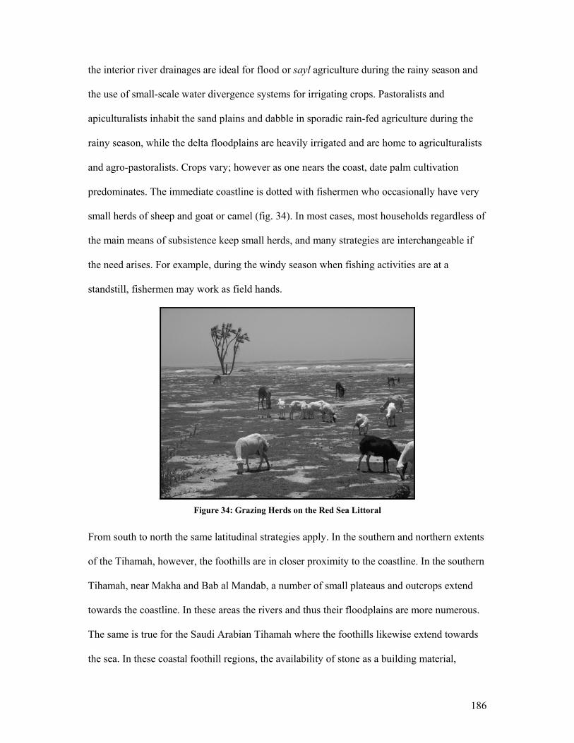
186
the interior river drainages are ideal for flood or sayl agriculture during the rainy season and
the use of small-scale water divergence systems for irrigating crops. Pastoralists and
apiculturalists inhabit the sand plains and dabble in sporadic rain-fed agriculture during the
rainy season, while the delta floodplains are heavily irrigated and are home to agriculturalists
and agro-pastoralists. Crops vary; however as one nears the coast, date palm cultivation
predominates. The immediate coastline is dotted with fishermen who occasionally have very
small herds of sheep and goat or camel (fig. 34). In most cases, most households regardless of
the main means of subsistence keep small herds, and many strategies are interchangeable if
the need arises. For example, during the windy season when fishing activities are at a
standstill, fishermen may work as field hands.
Figure 34: Grazing Herds on the Red Sea Littoral
From south to north the same latitudinal strategies apply. In the southern and northern extents
of the Tihamah, however, the foothills are in closer proximity to the coastline. In the southern
Tihamah, near Makha and Bab al Mandab, a number of small plateaus and outcrops extend
towards the coastline. In these areas the rivers and thus their floodplains are more numerous.
The same is true for the Saudi Arabian Tihamah where the foothills likewise extend towards
the sea. In these coastal foothill regions, the availability of stone as a building material,
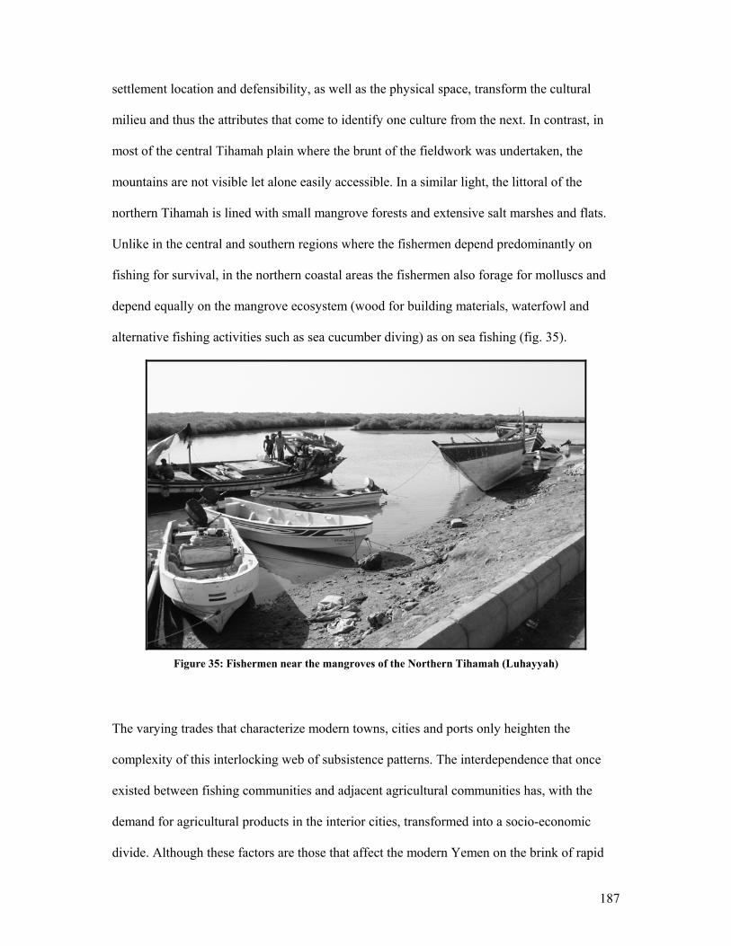
187
settlement location and defensibility, as well as the physical space, transform the cultural
milieu and thus the attributes that come to identify one culture from the next. In contrast, in
most of the central Tihamah plain where the brunt of the fieldwork was undertaken, the
mountains are not visible let alone easily accessible. In a similar light, the littoral of the
northern Tihamah is lined with small mangrove forests and extensive salt marshes and flats.
Unlike in the central and southern regions where the fishermen depend predominantly on
fishing for survival, in the northern coastal areas the fishermen also forage for molluscs and
depend equally on the mangrove ecosystem (wood for building materials, waterfowl and
alternative fishing activities such as sea cucumber diving) as on sea fishing (fig. 35).
Figure 35: Fishermen near the mangroves of the Northern Tihamah (Luhayyah)
The varying trades that characterize modern towns, cities and ports only heighten the
complexity of this interlocking web of subsistence patterns. The interdependence that once
existed between fishing communities and adjacent agricultural communities has, with the
demand for agricultural products in the interior cities, transformed into a socio-economic
divide. Although these factors are those that affect the modern Yemen on the brink of rapid
188
development, they are relevant to the discussion of settlement strategies in the prehistoric
period. Much as it does today, the diverse zonation of the coastal plain provided the means
for the existence of differing economic strategies that became inter-reliant. The intricacies of
such interdependencies and interactions are visible in the archaeological record where the line
between one subsistence strategy and the next can be vague, and where the balance between
them can be swayed in the event of external pressures.
Having viewed the data from multiple perspectives (e.g. the environment, the site, the
material culture and the physical and perceived landscape) a number of prehistoric
subsistence strategies have come to light. Early Holocene sites have demonstrated that an
environment that was entirely different from that of today sustained the population of the
Tihamah who lived seasonally according to what was available. The ensuing change in
climate brought about a transformation in subsistence strategies much akin to that which
exists today, as described above.
In this chapter site categories are defined. These are divided by period and by subsistence
strategy. Such categories were determined by comparison to previously excavated and carbon
dated sites in the region and by the presence and density of certain chronologically,
culturally, and environmentally diagnostic surface assemblages that were present on each
site.
5.2 Site Typology: Strategies of Subsistence along the Tihamah Coastal Plain
The Tihamah surveys recovered a total of 159 sites. The central Tihamah survey recovered
133 of these sites. The remaining sites were documented during road impact surveys and
reconnaissance in the northern and southern Tihamah. The majority of sites found in the
189
surveys were shell middens (n=109, 25 from the northern Tihamah) and/or artefact scatters
(n=50, 3 from the northern Tihamah, 2 from the southern Tihamah) often making up part of
larger site systems. Shell middens are dominated by marine and mangrove shell. Areas closer
to the coastline and along the wadi banks have a higher density of shell. Along the inter-
fluvial steppe and within the current cultivation zones, shell is less abundant but remains a
characteristic of sites, especially along ancient watercourses no longer visible on the ground1.
Mounding, where it is preserved, is low due to the extreme deflation in the area. Preservation
of mounds appears is best along the wadi banks and in the case of shell middens. Further
inland, sites generally consist of deflated scatter pavements. Along all of the wadis surveyed,
the shell scatters and mounds are continuous along their banks up to the current cultivation
zone, where a different type of site dominated by artefact middens and scatters begins to
appear.
As a result of recurrence of certain patterns in site morphology and associated artefact
assemblages, several site types are recognizable. Seven general site types will be discussed.
Shell Middens: Refuse versus Habitation
Shell middens can be divided into two sub-types. The first consists of refuse shell piles which
were not used as living surfaces, and the second consists of refuse shell piles that were
inhabited. Due to the lack of material culture on these refuse piles it is difficult to place them
within a specific chronological time span. It is possible, however, to divide them into
monospecific and multi-specific shell middens. This implies that in the case of the
monospecifity of a shell type such as the Terebralia palustris, it can be assumed that the site
1 Ancient dried-up watercourses are often difficult to see on the ground. In the Tihamah these are obscured by sand dunes. In many cases the presence of early prehistoric shell middens lying along an invisible axis evidences ancient wadi branches and in other cases the ancient coastline. These ancient watercourses also leave a signature on satellite images in the form of dark lines or, in the case of deltas, dark patches.
190
cannot be younger than the fourth millennium BC due to the decrease in availability of the
massive quantities of shell needed to produce such large mounds. As discussed in Chapter II,
the gradual drying of the climate during this period would have made the dense mangrove
forests that characterized the deltas and littoral of this region and allowed this species of
mollusc to thrive during the early Holocene, recede significantly. In this chapter it has been
demonstrated that later shell midden sites such as Sihi (3rd to 2nd millennium BC) and a first
millennium BC IAM site are often made up of species of shell other than the T. palustris,
namely the Strombus sp., the Murex sp. and/or bivalves.
Twenty-one monospecific T. palustris shell refuse middens were documented in total. Eight
of these were located in the central Tihamah, while thirteen were located in the northern
Tihamah. These sites have been given a probable fourth millennium BC terminus ante quem.
Seven multiple-species shell refuse middens were recovered in total. These sites have been
given a probable fourth millennium BC terminus post quem for the non- T. palustris discard
events.
Type 1 Site: Aceramic Early Holocene shell middens (ca. 7th millennium BC)
Ash-Shumah: A Comparative Study
One of the densest and best-preserved areas surveyed ran along the northern bank of the wadi
Rima’. This geographic system sustained an almost continuous occupation of shell middens
along 15 km of its bank. The site of ash-Shumah (BF3) in particular will be discussed here in
detail because it serves as a model and provides a carbon date to which other shell middens
are compared. This shell midden, which was excavated by the IAM under the direction of M.
Tosi in the 80s, was mainly composed of a single shell species, the Terebralia palustris.
Careful excavation below the surface stratum revealed a series of postholes that measured 17-
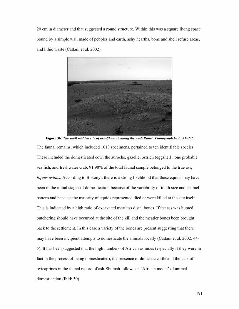
191
20 cm in diameter and that suggested a round structure. Within this was a square living space
bound by a simple wall made of pebbles and earth, ashy hearths, bone and shell refuse areas,
and lithic waste (Cattani et al. 2002).
Figure 36: The shell midden site of ash-Shumah along the wadi Rima’. Photograph by L. Khalidi
The faunal remains, which included 1013 specimens, pertained to ten identifiable species.
These included the domesticated cow, the aurochs, gazelle, ostrich (eggshell), one probable
sea fish, and freshwater crab. 91.90% of the total faunal sample belonged to the true ass,
Equus asinus. According to Bokonyi, there is a strong likelihood that these equids may have
been in the initial stages of domestication because of the variability of tooth size and enamel
pattern and because the majority of equids represented died or were killed at the site itself.
This is indicated by a high ratio of excavated meatless distal bones. If the ass was hunted,
butchering should have occurred at the site of the kill and the meatier bones been brought
back to the settlement. In this case a variety of the bones are present suggesting that there
may have been incipient attempts to domesticate the animals locally (Cattani et al. 2002: 44-
5). It has been suggested that the high numbers of African asinides (especially if they were in
fact in the process of being domesticated), the presence of domestic cattle and the lack of
ovicaprines in the faunal record of ash-Shumah follows an ‘African model’ of animal
domestication (Ibid: 50).
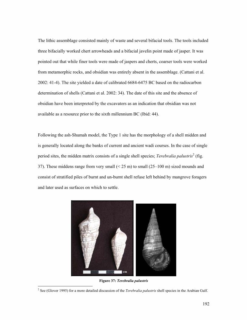
192
The lithic assemblage consisted mainly of waste and several bifacial tools. The tools included
three bifacially worked chert arrowheads and a bifacial javelin point made of jasper. It was
pointed out that while finer tools were made of jaspers and cherts, coarser tools were worked
from metamorphic rocks, and obsidian was entirely absent in the assemblage. (Cattani et al.
2002: 41-4). The site yielded a date of calibrated 6684-6475 BC based on the radiocarbon
determination of shells (Cattani et al. 2002: 34). The date of this site and the absence of
obsidian have been interpreted by the excavators as an indication that obsidian was not
available as a resource prior to the sixth millennium BC (Ibid: 44).
Following the ash-Shumah model, the Type 1 site has the morphology of a shell midden and
is generally located along the banks of current and ancient wadi courses. In the case of single
period sites, the midden matrix consists of a single shell species; Terebralia palustris2 (fig.
37). These middens range from very small (< 25 m) to small (25–100 m) sized mounds and
consist of stratified piles of burnt and un-burnt shell refuse left behind by mangrove foragers
and later used as surfaces on which to settle.
Figure 37: Terebralia palustris
2 See (Glover 1995) for a more detailed discussion of the Terebralia palustris shell species in the Arabian Gulf.

193
The presence of equid teeth (Equus asinus) (fig. 38), fragments of ostrich eggshell and
occasional marine shell characterize the surface assemblage on these sites. Small flakes and
debitage from a diversity of workable stones such as rhyolite, jasper or chert, and chalcedony,
are occasional as is the presence of Type A1 parallel pressure flaked bifacial points, while
obsidian is absent.
Figure 38: Teeth of the Equus asinus recovered on survey in the central Tihamah
The surface finds tend to be few and far between on these sites. Thirty-two ‘Type 1’ sites
have been recovered in total (fig. 39), only five of which are single period occupation. Beside
the site of ash-Shumah, two of these sites yielded Type A1 projectiles.

194
Figure 39: Type 1 (7th millennium BC) shell midden site distribution in the central Tihamah survey area
Type 2 Site: Holocene scatters
The second type of site consists of light artefact scatters, situated along the steppic inter- wadi
plains. In these areas shell middens are extremely rare. Such areas would have been at a
significant distance from ancient deltas and estuaries and thus from the mangrove forests.
There is, however, the occasional Terebralia palustris shell scatter.
These very light artefact scatters are found in windows of visibility between active dunes and
are characterized by the occasional equid tooth and ostrich eggshell. A number of Types A1,
A2 and/or B bifacial projectile points have been collected from this terrain. There is reason to
believe that this now stark and uninhabitable landscape was in fact a hunting ground for
hunter-foragers in the Holocene and that these scatters are contemporaneous with both the
early Holocene shell middens like ash-Shumah as well as later ‘Neolithic’ shell middens such
as al-Madaniyah, dated to the fifth millennium BC (Cattani et al. 2002, Tosi 1985, 1986a). It
is equally plausible, judging by some later period isolated finds and scatters, that this
Holocene landscape continued to be a hunting ground into the early historic period.
195
This landscape consisted of a treeless or lightly forested steppe in the early Holocene, an
ideal habitat for the wild ass, ostrich, and gazelle. Faunal remains from the latter two are
common in the area, while the remains of all three animals are represented at the Type 1 site
of ash-Shumah (Cattani et al. 2002: 46-50). This suggests a direct connection between a
forager-pastoralist strategy on the one hand and a forager-hunter strategy on the other. The
presence of dietary shell, wild ass, domesticated cattle, crab, aurochs and gazelle remains at
this site in conjunction with Type A1 projectiles (present both on Type 1 and 2 sites)
presumably used for hunting evidences seasonal or even parallel subsistence strategies in the
seventh millennium BC. A reliance on hunting and foraging does not necessarily presume nor
exclude mobility. The same is the case for incipient small-scale animal domestication. What
is clear is that the same population who inhabited sites like ash-Shumah and who knapped the
Type A1 projectiles using the parallel pressure flaking technique also frequented the inter-
wadi steppes to hunt. This area continues to be a hunting ground into the fifth millennium BC
as evidenced by solitary Type A2 and B projectile finds, sometimes in association with small
concentrations of faunal bone or ostrich eggshell.
Sixteen surveyed sites were designated as Type 2 scatters (fig. 40). Five of these sites yielded
A1 type projectiles, four yielded A2 type projectiles and finally three yielded B type
arrowheads.

196
Figure 40: Type 2 Holocene scatters with A1 (7th millennium BC) and A2 (6th millennium BC) tool types
Type 3 Site: Aceramic Early Holocene shell middens (6th-5th millennia BC)
Gahabah (JHB) and al-Madaniyah (MAD): A Comparative Study
The sites of al-Madaniyah and Gahabah, excavated by the IAM, are early Holocene sites
dating to the sixth to fifth millennia BC. The site of al-Madaniyah is located along the wadi
Rima’ and is interesting precisely because the ass made up 88.7% of the faunal remains from
the site (Cattani et al. 2002: 51). Gahabah, located along the wadi Rumman south of
Hodeidah, appears to have two phases. The earliest phase (JHB-1) is carbon dated to 6435-
6187 BC and to 5829-5640 BC, representing a transitional phase from the seventh to the sixth
millennium BC (Tosi 1986a: 403). This site is made up predominantly of Terebralia palustris
shell. According to the publication, the two excavations carried out yielded different bone
types, suggesting a possible early and late phase, the former dominated by equid remains and
the latter yielding an increase of cattle remains (Ibid: 407). The surface collections, however,
provided an even more interesting perspective on the dating of the site. Of the tools recovered
197
on the surface 75% were made of obsidian, including at least one that falls into the Type B
tool category (Ibid: 407). This implies that the increase of obsidian as a tool material, as has
been demonstrated for the Type A2 tool in the central Tihamah, follows the pattern of this
site whereby in the sixth millennium BC obsidian becomes a common material for bifacially
worked tools, and it dominates the tool kit by the fifth millennium BC with the Type B
obsidian arrowheads.
Shell middens characterize these sites, whose shell matrix is largely made up of the
Terebralia palustris species. These, like the Type 1 sites, are generally located along wadi
banks and the Holocene coastline and often consist of secondary occupation phases. Faunal
remains from the surfaces include mainly equid, but also cattle and ostrich eggshell. They can
be distinguished from the earlier Type 1 sites by the presence of small amounts of obsidian
and the Type A2 and B projectiles. The Type B tools are distinctive and provide a better
indication of these sites than do the Type A2 tools. This is because the Type A2 tools, as
discussed in Chapter IV, are either contemporary with or later variations of the Type A1
tools.
Because both tool types are present at Gahabah and al-Madaniyah, it is safe to date this type
of site to the sixth and fifth millennium BC. Thirty-six of the sites recovered have Type 3 site
characteristics. Six of these were documented in the northern Tihamah while the remaining
thirty were located in the central Tihamah survey area. Only five of these appeared to be
single period, that is, the surface assemblages did not provide any indication of earlier
occupation. Five of these shell middens yielded Type A2 tools and were probably occupied
during the early seventh and sixth millennia BC, while four yielded Type B tools and were
probably occupied during the sixth and fifth millennia BC (fig. 41).
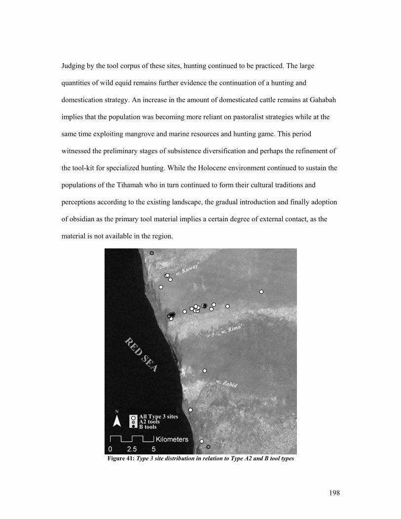
198
Judging by the tool corpus of these sites, hunting continued to be practiced. The large
quantities of wild equid remains further evidence the continuation of a hunting and
domestication strategy. An increase in the amount of domesticated cattle remains at Gahabah
implies that the population was becoming more reliant on pastoralist strategies while at the
same time exploiting mangrove and marine resources and hunting game. This period
witnessed the preliminary stages of subsistence diversification and perhaps the refinement of
the tool-kit for specialized hunting. While the Holocene environment continued to sustain the
populations of the Tihamah who in turn continued to form their cultural traditions and
perceptions according to the existing landscape, the gradual introduction and finally adoption
of obsidian as the primary tool material implies a certain degree of external contact, as the
material is not available in the region.
Figure 41: Type 3 site distribution in relation to Type A2 and B tool types
199
Type 4 Site: Late to Mid-Holocene Sites (4th –3rd millennium BC)
Surdud 1 (SRD-1): A Comparative Study
Surdud 1 was excavated by the IAM and yielded dates ranging from the early fifth to the
fourth millennium BC (Tosi 1986a: 403, Table 1) plus evidence of divisions into specialized
activity areas. These included a bead-making workshop, an activity area for the knapping of
round scrapers and one for the making of chalcedony micro-drills. The remains of clay ovens
were also documented and presumed to be in association with dwelling areas whose
sediments had eroded away and were represented by dense patches (25-30 m in diameter) of
artifact scatters (Ibid: 408). Finally the appearance of small abraded brown burnished wares
and an increase in fish remains and domestic ovicaprids pointed to a transformation in the
economic strategies of the coastal population of the Tihamah (Ibid: 414).
The fourth type of site is characterized by scatters and shell middens which tend to have an
early Terebralia palustris shell component as well as an occasional-to-moderate scatter of
shell of other species, namely a variety of Strombus sp., Murex sp., bivalves, oyster, and the
occasional cowrie shell. These sites often have a higher density of obsidian and other lithic
debitage than the Type 3 shell middens and the occasional basic utilitarian tool types (end-
and side- scrapers, etc.). The density of obsidian, however, is still low compared to later sites.
The artifact scatters are generally more diversified on these sites, so that although there is a
larger ratio of obsidian, other stones are also present. One site yielded a fragment of bronze
and two sites yielded carnelian beads made by indirect percussion. Carnelian beads are
present from the early Holocene onwards, however, piercing by indirect percussion
characterized all of the samples that were recovered from early Holocene sites. It is not until
the third millennium BC that these beads show evidence of drilling.
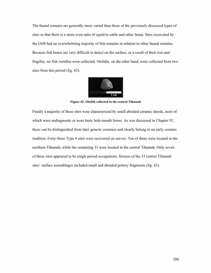
200
The faunal remains are generally more varied than those of the previously discussed types of
sites so that there is a more even ratio of equid to cattle and other fauna. Sites excavated by
the IAM had an overwhelming majority of fish remains in relation to other faunal remains.
Because fish bones are very difficult to detect on the surface, as a result of their size and
fragility, no fish vertebra were collected. Otoliths, on the other hand, were collected from two
sites from this period (fig. 42).
Figure 42: Otolith collected in the central Tihamah
Finally a majority of these sites were characterized by small abraded ceramic sherds, most of
which were undiagnostic or were basic hole-mouth forms. As was discussed in Chapter IV,
these can be distinguished from later generic ceramics and clearly belong to an early ceramic
tradition. Forty-three Type 4 sites were recovered on survey. Ten of these were located in the
northern Tihamah, while the remaining 33 were located in the central Tihamah. Only seven
of these sites appeared to be single period occupations. Sixteen of the 33 central Tihamah
sites’ surface assemblages included small and abraded pottery fragments (fig. 43).

201
Figure 43: Type 4 site distribution
The distribution of these sites is more continuous through space and spreads out over a larger
area than the Type 3 sites, though it remains concentrated along the riverbanks and coastline.
Interestingly these sites are also located closer to the coastline, which is both an indication of
a decrease in sea level and of the retreat and gradual depletion of the densely populated
mangrove forests that characterized the deltaic inlets and littoral of the earlier Holocene. In
conjunction with an increase in fish remains, the shift in settlement location towards the
coastline and the increase in fish remains demonstrate an increased reliance on fishing (fig.
44). With the depletion of the mangrove ecosystem, it is likely that the flora and fauna that it
sustained, not to mention the molluscan species that made up a large part of the early
Holocene diet, became gradually less available. Tosi states that in the two millennia
separating the sixth from the fourth millennium BC, “ basic subsistence had shifted from
foraging to food production, suggesting that the most radical transformations in the economy
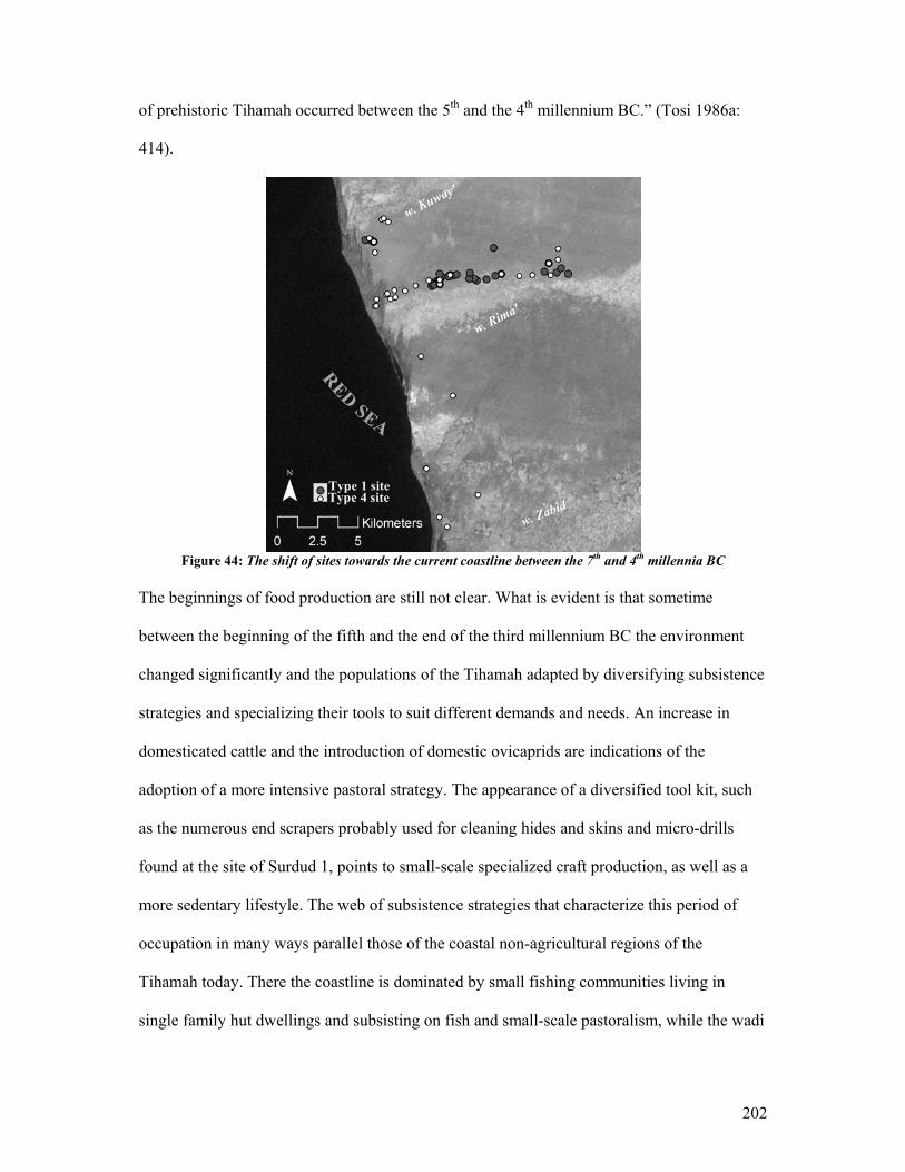
202
of prehistoric Tihamah occurred between the 5th and the 4th millennium BC.” (Tosi 1986a:
414).
Figure 44: The shift of sites towards the current coastline between the 7th and 4th millennia BC
The beginnings of food production are still not clear. What is evident is that sometime
between the beginning of the fifth and the end of the third millennium BC the environment
changed significantly and the populations of the Tihamah adapted by diversifying subsistence
strategies and specializing their tools to suit different demands and needs. An increase in
domesticated cattle and the introduction of domestic ovicaprids are indications of the
adoption of a more intensive pastoral strategy. The appearance of a diversified tool kit, such
as the numerous end scrapers probably used for cleaning hides and skins and micro-drills
found at the site of Surdud 1, points to small-scale specialized craft production, as well as a
more sedentary lifestyle. The web of subsistence strategies that characterize this period of
occupation in many ways parallel those of the coastal non-agricultural regions of the
Tihamah today. There the coastline is dominated by small fishing communities living in
single family hut dwellings and subsisting on fish and small-scale pastoralism, while the wadi
203
banks3 and inter-fluvial steppes are dotted with small conglomerates of dwellings of cattle,
camel and sheep/goat pastoralists who subsist on fish and the meat and by-products of their
herds. Certain households specialize in crafts such as weaving rope, making fishing nets,
building small watercraft, curing hides, etc.
Although the Type 5 sites follow chronologically they are spatially linked to the Type 7 sites
and will be discussed along with them.
Type 6 Site: Late Prehistoric to Early Historic ceramic and shell middens (3rd to end of the
1st millennium BC)
Sihi: A Comparative Study
Perhaps the best example of a Type 6 site is Sihi located in the Saudi Tihamah, not far from
the Yemeni border. Sihi is a coastal shell midden roughly 900 x 100 m in size with an
occupational range of 2400-1300 BC (Zarins et al. 1986: 50). The excavation failed to
recover evidence of structural remains. Instead the site is characterized by a series of single
species specific shell heaps and material culture concentrations dominated by ceramics
unique to the site but, as discussed in Chapter IV, ones that have numerous parallels to other
Tihamah and Aden coastal pottery traditions.
The shell heaps were made up of a variety of shell species, the most common of which were,
in order of frequency, Strombus sp., Turbo sp., Arca sp. and finally T. palustris. Fish remains
were common, as were crab claws. The mammal faunal remains mainly consisted of
ovicaprids, though bovid and camel were also represented (Ibid: 49).
3 Occupation continues today along the wadi banks and most villages are located atop older shell middens.
204
The majority of the lithics are made from a “…bright, lustrous obsidian” and include large
amounts of waste and debitage (Zarins et al. 1986: 48). The tool kit is dominated by obsidian
geometric microliths. Small bladelets, blades and scrapers were represented. Although there
was some flint, there is an absence of other stone materials and of awls, burins, denticulates,
notches and sickles as well as bifacial points. Common artifacts included net weights,
grindstones, steatite bowls and beads. Finally a fair number of metal objects of copper/bronze
were excavated at Sihi, including reamers, rings, fishhooks and five daggers (Ibid: 48-9)
similar to those found at the contemporaneous site of al-Midamman.
This fourth type of site usually consists of shell middens and in some cases of artefact
scatters. The middens, like Sihi, tend to have a diversity of shell species, though in the case of
prominent shell middens, an early Terebralia palustris shell component is present in addition
to other varieties. Again the other species present include a variety of bivalve, namely
Amiantis umbonella and Anadara turonica, Strombus sp., Murex sp., oyster and the
occasional cowrie shell. These are often multi-period sites but are characterized by
occasional-to-abundant pottery, obsidian geometric microliths and pièces esquillées (Types C
and D tools), a dramatic increase of obsidian debitage and a variety of lithic tools.
The diagnostic pottery found on these sites consists of dark burnished wares and oval cross-
sectioned handle fragments with punctate decoration. These handle types are also present at
dated second to early first millennium BC sites such as al-Midamman (CAMROM) and Sabir
(Buffa 2002, Buffa et al. 1999, Doe 1965, Keall 1998a, 1998b, 2004, Keall et al. 2000, Vogt
1997, Vogt et al. 1997, 1998), as well as from surface scatters from the previously known site
of Kashawba’ (Ciuk et al. 1996, Phillips 1998). These pottery types are those most often
205
associated with the Sabir 2 period (Buffa 2002, Buffa et al. 1999, Keall 1998a, 2004, Tosi
1985, 1986a, 1986b, Vogt et al. 1998), however most of these sites do not appear to have the
full repertoire of forms typical of this later period. Forty-two sites and artefact scatters that fit
into this site type were recorded, four of which are located in the northern Tihamah region.
Only eight of these sites did not have earlier occupations and can be categorized as single
period occupations.
Fifty-four percent of the sites of this type yielded Type C and/or D tools. The large amounts
of obsidian waste and debitage on many of these sites suggests that the stone was worked
locally. Some sites exhibit such high concentrations of obsidian (169 obsidian samples were
collected from the site of TH16), as to suggest specialized activity areas. Along the wadi
Rima’ clusters of these activity areas are located at 3-4 km from each other along the
riverbank and the coastline. Along the lowermost reaches of the wadi these clusters are more
frequent, occurring every 1.5 km (fig. 45). Such a pattern suggests that obsidian was plentiful
at certain points along the coastline and at the mouths of major wadi deltas from where it was
distributed upstream. The implications for maritime trade in obsidian are very strong in this
case and will be discussed further in Chapter VII.

206
Figure 45: Distribution of Type 6 sites and Type C/D obsidian tools
Interestingly, the distribution of Types C and D tools is clustered around these activity areas
(fig. 46). This suggests that the distribution of obsidian was targeted to these knapping areas,
which may have been workshops linked to conglomerate settlements. The function of these
tools remains unknown though it has been suggested that they may have been used for
hunting or for agricultural purposes (Inizan et al. 2002). Although hunting cannot be totally
eliminated as one of many subsistence strategies during this period, wild game are absent
from the artifact repertoire at Sihi. Several surveyed sites of this type yielded equid teeth,
however, they are all sites that were previously occupied in the early Holocene. The
agricultural function of these tools is possible, but cannot be proven without micro- and
macro-botanical remains of plants and the presence of silica sheen on the tools themselves.
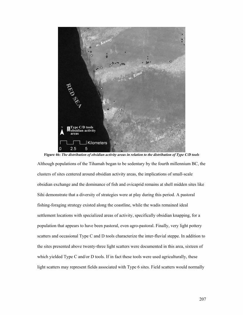
207
Figure 46: The distribution of obsidian activity areas in relation to the distribution of Type C/D tools
Although populations of the Tihamah began to be sedentary by the fourth millennium BC, the
clusters of sites centered around obsidian activity areas, the implications of small-scale
obsidian exchange and the dominance of fish and ovicaprid remains at shell midden sites like
Sihi demonstrate that a diversity of strategies were at play during this period. A pastoral
fishing-foraging strategy existed along the coastline, while the wadis remained ideal
settlement locations with specialized areas of activity, specifically obsidian knapping, for a
population that appears to have been pastoral, even agro-pastoral. Finally, very light pottery
scatters and occasional Type C and D tools characterize the inter-fluvial steppe. In addition to
the sites presented above twenty-three light scatters were documented in this area, sixteen of
which yielded Type C and/or D tools. If in fact these tools were used agriculturally, these
light scatters may represent fields associated with Type 6 sites. Field scatters would normally
208
have a similar light and continuous surface distribution of artefacts4. The contemporary Type
5 and 7 sites add to the complex web of relationships that existed between these different late
prehistoric economic strategies.
Type 5 Site: Megalithic Sites (3rd-2nd millennium BC)
Type 5 sites are megalithic sites whose functions remain largely elusive, but which make up a
part of the earlier elements of Type 6 sites5. Previous to the surveys conducted by the author,
four megalithic sites in the Tihamah had been previously discovered or mentioned. One of
these, al-Manassib, which makes up one part of the site of al-Midamman, has been dated to
between the third and second millennium BC (Keall et al. 2000). The recent discovery by the
author of two megalithic sites and a third that may have once been megalithic have enabled a
new interpretation of these sites, especially in relation to their spatial distribution.
Type 5 sites are characterized by a number of large standing or fallen stones. The stones can
exceed 3 m in height but they are often found fallen over or re-used in later sites. The surface
assemblage is sparse in their immediate vicinity, while the surrounding site is usually dense
with artefacts. A funerary and/or ritual function has been suggested for these prehistoric
monuments. More important to the discussion of subsistence and settlement strategies,
however, are the facts that these are the first non-ephemeral prehistoric structures to be found
in the Tihamah, and that the materials were not readily available nor in proximity to the sites.
The erection of such large stones has several implications. The first is that these societies had
the technology to transport extremely large and heavy stones over long distances. Secondly a
strong motive would have had to exist in order for such a large endeavor to be realized, in the
realm of procurement, transportation, construction and finally purpose or function. Thirdly,
4 See Type 7 sites for a discussion on field scatters. 5 All Type 5 sites are associated with Type 7 sites, while not all Type 7 sites have Type 5 megalithic elements.
209
the appearance of these monuments has implications for the way that the landscape was
marked and perceived, whether consciously or not. These monuments bear witness to the first
attempts made by the prehistoric populations of the Tihamah to implant foreign elements
onto the landscape, and thus to indirectly shape it. Finally the spatial pattern that is beginning
to appear demonstrates that the location of these megaliths was premeditated, even strategic.
These sites will be described in more detail in Chapter VI.
Type 7 Site: Late Prehistoric to Early Historic ceramic sites (3rd to 1st millennium BC)
The seventh type of site is very large and consists of a continuous series of large and dense
pottery scatters, which can be mounded (fig. 47). These are characterized by pottery
concentrations, mixed lithic debitage, the presence of Type C and D tools, rare to occasional
marine shell, beads, grindstones, and terracotta figurines. One published example of such a
site is that of al-Midamman, excavated by CAMROM. This site includes an earlier megalithic
element (Type 5), the site of al-Manassib, which has been dated from the end of the third to
the beginning of the second millennium BC based on stylistic attributes of associated copper
implements (Keall et al. 2000). These sites, like Sabir and al-Midamman, were most probably
continuously re-occupied from the later third millennium BC to the early first millennium
BC, lying at the transition into the South Arabian period.
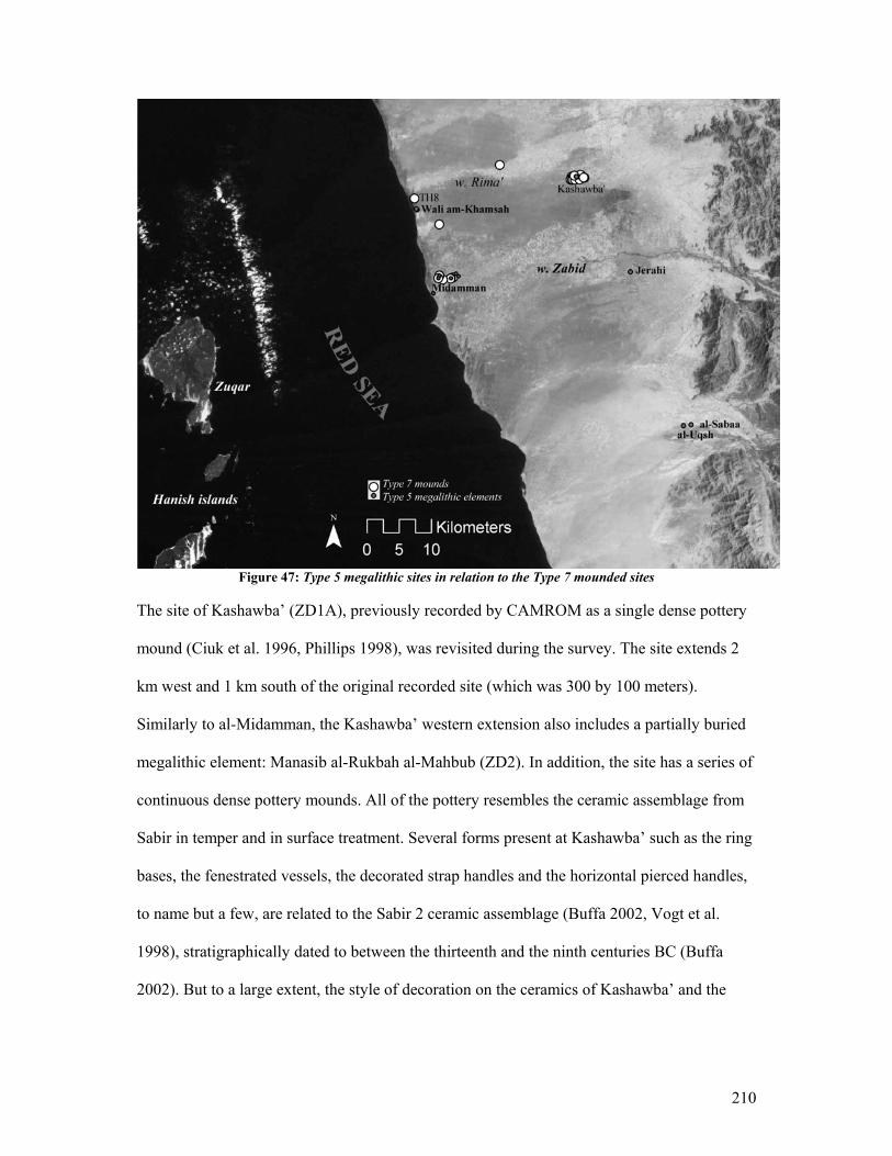
210
Figure 47: Type 5 megalithic sites in relation to the Type 7 mounded sites
The site of Kashawba’ (ZD1A), previously recorded by CAMROM as a single dense pottery
mound (Ciuk et al. 1996, Phillips 1998), was revisited during the survey. The site extends 2
km west and 1 km south of the original recorded site (which was 300 by 100 meters).
Similarly to al-Midamman, the Kashawba’ western extension also includes a partially buried
megalithic element: Manasib al-Rukbah al-Mahbub (ZD2). In addition, the site has a series of
continuous dense pottery mounds. All of the pottery resembles the ceramic assemblage from
Sabir in temper and in surface treatment. Several forms present at Kashawba’ such as the ring
bases, the fenestrated vessels, the decorated strap handles and the horizontal pierced handles,
to name but a few, are related to the Sabir 2 ceramic assemblage (Buffa 2002, Vogt et al.
1998), stratigraphically dated to between the thirteenth and the ninth centuries BC (Buffa
2002). But to a large extent, the style of decoration on the ceramics of Kashawba’ and the
211
contemporaneous Wadi Rima’ shell middens (Type 6), as well as at other sites of this period
on the Tihamah coastal plain, is a local phenomenon6.
Kashawba’ is situated between the wadi Badwah and wadi ‘Ajji, in highly cultivable land. It
is likely that the northern part of the site, nearer to the wadi Badwah, was made up of fields
associated with the occupational areas. Surveys carried out in Iraq and Syria have
demonstrated that the fields associated with large sites can be traced on survey by following
light ceramic and artefact scatters (Ur 2002, Wilkinson 1982, Wilkinson 1989). This is
explained by the fact that the garbage that accumulates on sites is used to manure fields, and
contemporaneous abandoned artefacts are mixed in and distributed evenly across the fields in
the process of plowing. The signature that is left on the ground is a very light but continuous
scatter of artefacts related to the site, in the area where the fields would have been. The
dramatic drop off, but continuous light scatter, of ceramics to the north of Kashawba’ fits this
signature and may suggest a field scatter phenomenon7.
Seven such sites were recovered throughout the Tihamah. Four of the seven yielded Type C
and/or D tools. Two of the seven sites that did not yield these tools were discovered on
reconnaissance in the northern and southern regions and were not surveyed systematically.
The only faunal remains collected on sites of this type belonged to domesticated cattle and
ovicaprids, suggesting the continuation of a strong pastoral strategy within a large settlement
context.
6 Vittoria Buffa, p.c., August 2004. It appears that many of the forms at Kashawba’ are the same as the Sabir 2 assemblage, though the Kashawba’ decoration, while utilizing the same techniques (punctates, fingernail impressions, roulette, incision, etc.), is unique in its composition. This decoration, however, is common on the Tihamah coastal plain. Only one strap handle from Kashawba’ had a decorative composition found at Sabir. For sites and published pottery of this period from the Tihamah see (Ciuk et al. 1996, Keall 1998b: Fig. 9, Tosi 1985, 1986a, Zarins et al. 1985). 7 For a discussion on the methodology of field scatter survey see (Wilkinson 1982, Wilkinson 2003).
212
The Type 5 sites are always found in the midst of these extensive settlements of the third to
first millennium BC. One possible explanation for the location of these large settlements is
linked to the location of the megalithic structures. These large monuments no doubt held
significance for the populations who erected and settled near them. The continuous
occupation of these sites suggests that in time these settlements grew to ‘urban’ proportions;
and while the megaliths came to lose their original meaning, the stone did not and was re-
used in foundations for later structures and as later grave markers. This implies that the
possible predetermined location of the megaliths indirectly determined the location of these
sprawling centers (see fig. 47).
5.3 Conclusion
Following the relative chronology suggested by the occurrence of certain artefact
assemblages and of site signatures discussed, the central Tihamah coastal survey yielded 116
prehistoric sites, 60 of which were shell middens and scatters that date to the Early Holocene,
49 of which were probable mid-Holocene sites and scatters. Eighty-two of the total 116 sites
surveyed were prominent shell middens. Systematic survey coverage has exposed a number
of different micro-zones that were exploited and settled within a small corridor of the larger
Tihamah coastal plain. This typology of sites and artefact assemblages has made it possible to
isolate different economic strategies in different ancient environmental zones.
From the seventh to the fifth millennium BC sites were concentrated along riverbanks and
along the edges of the deep mangrove forested estuaries that characterized the Tihamah
littoral during the early Holocene. During this time the forested tidal creeks and littoral
provided sustenance in the form of molluscs, fish and wild game such as aurochs. Shell
midden sites predominate, pointing to intensive mollusc foraging. The inter-fluvial steppe
213
was a lightly forested parkland ideal for roaming gazelle and equid. Sites in this area consist
of small scatters that evidence hunting camps. In addition to foraging, hunting was a prime
subsistence strategy, evidenced by a tool kit that included carefully knapped arrow- and
spear-heads.
The Types A and B projectiles which characterized the artifact assemblage during the early
Holocene are so different in form and workmanship that it is highly probable that the styles
appeared during different phases of the early Holocene time-frame. It is possible that the
Type B arrowheads were a slightly later innovation that was related to both the availability of
obsidian in greater quantities and to gradual shifts in economic strategies. Although the Type
A1 projectiles pertain to the larger corpus of Arabian parallel pressure flaked projectiles, they
are particular to the Tihamah, as evidenced by the ‘raised tang’ tradition. The Type B tools,
which also follow in the ‘raised tang’ tradition, have thus far proved to be a local Tihamah
phenomenon. By the third millennium BC, these projectiles and the knapping technologies
associated with them cease to be present. This can be explained from a number of different
perspectives.
The change in the location of settlements from the seventh to the fourth millennium BC
evidences the massive decrease in sea levels that occurred during the early Holocene (see fig.
44). Sites of the seventh millennium BC were located at least 1.5 km from the current
coastline. In areas that would have been ideal for mangrove tidal creeks, such as the river
deltas, sites were located as much as 4 km from the current coastline. Sites of the fourth
millennium BC, on the other hand, were located as close as 600 m from the current coastline.
In 3000 years and in conjunction with the drying climate, the early Holocene Tihamah
witnessed a significant change in its coastal configuration and the ecosystems it sustained.
214
The micro- environments that sustained the hunter-forager populations of the Tihamah had
greatly receded by the fourth millennium BC. It is possible that incipient attempts at
domestication of equid and cattle were at play in the seventh millennium BC, however by the
fourth, the number of domesticated animals increases further signifying a shift away from a
hunter-dominated strategy to a pastoral one. In addition the introduction of small quantities of
obsidian in the sixth millennium BC implies external contact.
By the third millennium BC large amounts of obsidian are present and it becomes the
dominant tool material. Furthermore the distribution of sites along the lowermost reaches of
the wadis becomes increasingly more clustered. In addition these clusters are interspersed8
along the length of the coastline and along the wadis, the densest concentration lying on the
deltas. Obsidian activity areas that evidence an opportunistic knapping technology and a new
tool kit dominated by geometric microliths and pièces esquillées characterize these clusters.
Domesticated cattle and ovicaprids dominated the faunal assemblage of these sites. In
addition to the sedentary pastoralist strategies characteristic of this period, a fishing economy
becomes increasingly important along the coastline. Ceramics, which begin to appear in the
fourth millennium BC, dominate the artifact assemblage of sites by the second millennium
BC, further substantiating permanent settlement strategies.
A stone megalithic tradition also appeared in the third millennium. The distribution of these
stone alignments at the mouth of the rivers and further inland where the coastal deltas begin
to form suggests the marking of space, whether conscious or not. Settlements expand around
these monuments and become so large that by the end of the first millennium BC, their size
8 In contrast to the early Holocene settlements which are continuous mainly along the riverbanks and deltas, the late prehistoric sites are located every 3-4 km over the entire littoral and riverbanks.
215
reaches ‘urban’ dimensions (8 km2). Toward the end of the late prehistoric occupation of
these sites, the megaliths are re-used in the foundations of monumental mud-brick buildings.
The presence of monumental stone megaliths, relatively large quantities of obsidian,
geometric microliths and pièce esquillées, large settlements strategically placed where the
rivers meet the sea and where the deltas form have considerable implications. All of the
factors combined suggest the presence of a number of economic strategies (fishing, pastoral,
agricultural, foraging) adapted to the existing micro-niches and resources available, while at
the same time linked by a network of material and tool distribution, namely that of obsidian.
The next chapter will focus on the late prehistoric sites of the Tihamah.
216
VI
Megalithic Landscapes: The Tihamah Coastal Plain in the Late
Prehistoric, Part I
6.1 Introduction
The main body of data presented in Chapters IV and V set the stage for an in depth discussion
of the paradigm shift which took place in the late third to early second millennium BC.
Several meaningful and inter-related events took place at this time. The evidence points to a
shift in subsistence strategy for a large segment of the population inhabiting the Tihamah. An
economy dependent on hunting and foraging began to sway in the direction of sedentism and
to diversify its economic strategies. While small fishing and pastoral communities continued
to inhabit the riverbanks and littoral, the continuous string of small single or multiple
dwellings that characterized the early Holocene settlement strategy began to cluster into more
dispersed conglomerate settlements. At the same time, large stone monuments were built in
significant areas, and around them large settlements sprawled over the space of a millennium.
These stone monuments form an extensive megalithic cultural trend that developed along the
length of the Red Sea coast of Yemen. The emergence of these megaliths marks the point in
time when populations along the coastal plain began to control their landscape by
strategically choosing locations and marking them with monuments.
217
The erection of these large stones was accompanied by a prevalence of obsidian in the
material record. The accessibility of this material, its potentials and limitations, and the
amounts available led to the adoption of new lithic technologies.
The next two chapters focus on the sought-after material that played such a major role in
shaping the cultures and cultural landscape of the third to first millennium BC Tihamah.
From the smallest to the most gargantuan of expressions, these societies formed around and
depended on the one resource that was absent in the region. Stone was the source of the
material and the root of the cultural expression of both the microlithic technologies and
megalithic landscapes that characterized the late prehistoric Tihamah. Furthermore, this
material provides the key to understanding culture-contact on an inter- and intra-regional
level. The main study area was located on the western extreme of the central Tihamah in one
of the widest areas of the coastal plain. This area is entirely devoid of stone. Moreover, not a
single mountain range, the awareness of which may have motivated contact or instilled a
desire for travel, is visible to the eastern interior. Only the large peak on the Red Sea island of
Zuqar is occasionally visible in mid-winter. The obsidian sources in the highland central
plains of Yemen, and across the Red Sea in the Horn of Africa present two possible
procurement areas. In either case the procurement of this material implies inter-regional
interaction. The presence of large pillars of granite and basalt likewise imply considerable
maritime or overland movement and the existence of relatively sophisticated transportation
technologies.
These topics will be articulated in the context of the adjacent regions and their comparable
cultural expressions. Finally, the formation of a particular Tihamah cultural landscape will be
expressed in light of the dynamic between intensified culture-contact and the formation of a
218
community-based identity. This chapter will deal with the megalithic landscapes while the
following chapter will deal with the microlithic technologies.
6.2 Megalithic Stone Monuments and the Domestication of the Landscape
The Terminology
A description of each megalithic culture that exists from northern Europe to the southern
Mediterranean, from North Africa to the Horn of Africa, from Easter Island to South America
and from the Levant to India and the Pacific would be exhaustive and unnecessary. It suffices
to illustrate a comparison, for example between the famous circular configuration of
megaliths of Stonehenge and the megalithic anthropomorphic heads of Easter Island, to show
the amount of inter-continental variability that can exist. In certain cases, however, what
distinguishes one megalithic site from another is not so clear, partially as a result of the
widespread and inappropriate use of a terminology that is culturally and regionally specific,
and one that often has functional and structural implications. In order to avoid terminological
confusion, a definition of the terms will be presented. For the sake of continuity, this work
will draw mainly on the definitions provided by Steimer-Herbet in her classification of stone
funerary monuments in Yemen and the Levant (Steimer-Herbet 2004).
A megalith is defined as a crude stone monument of large dimension1. The literal translation
would be ‘large stone’ from the Greek mega (large) and lithos (stone). This term is quite
general and is by definition appropriate to the sites discussed. A large dimension is relative to
a culture and/or region. For example, the megalithic stones in the Tihamah are small in
comparison to those at Stonehenge, but are in fact massive in their particular context.
Therefore, any large stone or stone monument that does not appear to be associated with
1 In (Rey 1992), translated from the French by the author.
219
another structure will be referred to as a megalith, whereas any large stone that is a feature of
a structure will be referred to as a megalithic feature.
The term megalithism can have connotations that evoke a widespread megalithic cultural
phenomenon. Such a term is inappropriate for the Arabian Peninsula and will only be used
where this definition is implied.
A dolmen is defined as a megalithic monument of large stones arranged in the form of a large
table2. Steimer-Herbet defines it in the context of Arabia and the Levant as a rectangular
funerary structure capped by large slabs of stone, sometimes in the form of a trilith made up
of two monolithic orthostats and a third large slab cap-stone. The burial chamber is large
enough to accommodate several deceased (Steimer-Herbet 2004: 13).
Finally, several structures that are often mistaken as megalithic as they may or may not
incorporate large stones include tumulus and turret tomb. A tumulus is defined as a domed or
mounded monument made of stones or earth that can either act to cover the deceased or, in
the case of Arabia, can cover one or several stone funerary structures of varying shapes, built
of small or large stones.
A turret tomb is defined as a conical funerary monument built of dry-stones. These have been
referred to as ‘nawamis’ and ‘Hafit tombs’ in the Levant, while Steimer-Herbet prefers to call
them ‘circular tower tombs’(Steimer-Herbet 2004). These conical tower tombs are commonly
associated with long trails of stone. These have been called trails, tails, rays and/or antenna
2 Ibid. For a historical background of the use of this term and its literal meaning consult (Steimer-Herbet 2004: 13).

220
and their function remains enigmatic. De Maigret calls these tombs ‘Arabian nuraghi’ by
comparison to the Sardinian nuraghi (De Maigret 2002: 327).
Finally a number of circular tombs have been documented in Yemen and the Horn of Africa
that are neither strictly tumuli nor turret tombs. They may be variants of these types and are
in most cases too eroded to categorize precisely. These are composed of one or more walls. In
the case of numerous walls, the outer wall is an enclosure wall and the interior walls form
concentric circles that can be raised. The better-preserved sites can be stepped in cross-
section. Some of these are made up of large upright slabs and are capped by large stone slabs
over the inner-most wall. In light of the fact that these may fit into previously defined
categories, the term ‘circular tomb’ is preferred for the purposes of this dissertation.
All of the above terms are composed of different elements or features. The burial chamber is
referred to in a number of ways depending on the shape (rectangular, circular, triangular,
etc.), the presence of a passage-way, the presence or absence of interior walls of small or
large stones, or simply a ditch-grave with earthen walls. Orthostats are monolithic upright
stones that act as features of domestic, funerary and/or monumental structures. In the case of
dolmens, they act as large upright pedestals for a third cap or lintel stone, while in a domestic
context they may flank a doorway, as is the case in the central highlands of Yemen.
Steimer-Herbet reminds us that even the term ‘megalithic tomb’ has European connotations
and is an inappropriate expression for Near-Eastern stone tombs (Steimer-Herbet 2004: 13).
It is by definition not inappropriate for all of the Arabian cases and where it is used in this
study, it is does not imply association with any European or other tradition and is used purely
as a generic descriptive term.
221
Negotiating Interpretations of Spatial Distribution, Chronology, and Functionality
Comme des milliers de monuments mégalithiques ont déjà été repérés, une masse considérable de
points peuvent être reportés sur la carte du monde, depuis le Siam, l’Inde ou Madagascar jusqu’au
Nord de l’Europe. Si, dans cet ensemble trop vaste et chronologiquement peu coherent, on considère
la seule aire méditerranéenne et européenne, une conclusion s’impose: il s’agit d’une diffusion à
partir de voyages maritimes. Ces monuments se situent avant tout dans des zones littorals,
particulièrement dans des îles
- (Braudel 1998: 159-60)
As Braudel illustrates, megalithic monuments are found throughout the ancient world and
cover a long period of prehistory among the various regions. In Europe, as in the rest of the
world, megaliths remain enigmatic and are the source of a great many theories, some
‘fantastic’ in their assertions, regarding the widespread appearance of these gargantuan stone
monuments. Many lie at great distances from stone sources, a fact that only fuels the mythical
status of such sites. Interestingly, Braudel further asserts that the majority of these sites are to
be found in littoral zones, and that were there to be a cultural diffusion of such a tradition it
would have taken effect as a result of a wider maritime network. Instead of following a
diffusionist explanation, if one were to interpret the concept of littoral-wide megalithic
distribution by entertaining the notion that humans are more likely to venerate, desire and go
to great lengths to acquire that which is out of reach and therefore rare, that coastal plains
(and perhaps also deserts) which are often but not exclusively flat sandy plains, would be the
most logical places for the manifestation of an expression such as that of megalithic
structures or stones. If this in fact were to be the case, such a notion could also be applied to
the Tihamah coastal plain. In addition, such a notion would demonstrate that the building of
222
megaliths could just as logically be an independent innovation or cultural expression in each
region, as an appropriated or imposed tradition. Braudel comes to this very conclusion by
stating that:
“ …pour écarter l’idée d’une origine orientale et d’une certaine unité de la culture mégalithique,
s’appuyant sur le fait que la chronologie existante, nous l’avons dit, ne dessine certainement pas une
progression évidente d’est en ouest – elle aboutit à la conclusion que «les idées et les techniques très
simples » qui se trouvent à la base du mégalithisme sont nées isolément, «dans une foule de regions »
et ne se communiquent guère entre elles.” (Braudel 1998: 169-70).
The idea that each of these megalithic cultures is born in isolation and that one sole origin for
such a phenomenon does not exist is a much more accurate interpretation of an occurrence
that is on one hand widespread and common, and on the other vastly varied and particular to
each region on many levels. Although it is common to distinguish cultural traditions by
emphasizing the range of differences that can exist and are possible (the further the distance,
the greater the difference), both vis-à-vis cultures and their material expressions, it remains a
fact that creativity is limited to the materials and the technologies that are available.
In some regions, it may be argued that a megalithic tradition may have occurred as a result of
the accidental transmission of external ‘stimuli’ as Clark expresses (Clark 1977: 136).
However, that megalithic traditions are widely distributed spatially cannot be explained as a
form of cultural or ideological dissemination from one group to the next. Rather, it could be a
concept that is linked to a widespread dependence on and perhaps even veneration of stone
(where it was inaccessible, as well as where it was), and to a period of change that in turn
allowed humans to experiment and push the limits of their capabilities in order to retain a

223
balance with the changes in the environment, in the availability of resources, and in the
resulting socio-economic transformations. It is most likely that in each case there is a natural
progression towards an expression of larger and more monumental structures. Whether this is
the product of an affirmation of territoriality (marking space), a domestication of the
landscape (controlling space), or purely one of many manifestations of increasingly organized
societies and denser demographics (dedicatory or funerary monuments, public spaces,
ideology), it is a matter that can only be elucidated through detailed archaeological studies in
each region.
Negotiating Interpretations of Regionality
It has been demonstrated that there are three main types of funerary monuments that
incorporate megalithic features and that can be traced throughout Yemen, Saudi Arabia and
the Levant (Steimer-Herbet 2004). Although over one hundred variants exist within these
types, it is a pattern to consider (Ibid: 97). Furthermore, this study demonstrated an overall
decrease in density of funerary monuments and necropolises towards the coastal plains and
highlands, while the deserts and their fringes were the predominant locations. In all of the
cases studied stone was readily available and the source of the stone was in proximity (Ibid:
93-4). Not only are most of these sites not located along the littoral, but also they are all in
proximity to stone. In consideration of the above-mentioned factors it is clear that while the
stone monuments of the Tihamah coastal plain may have certain similarities with these
traditions, they are radically different in meaning precisely because of their context.
Steimer-Herbet suggests that the geographical distribution of these monuments, which are
densest along the deserts and their fringes, and are located prominently on elevated terrain,
reflects an expression of territoriality for the pastoral-nomadic communities that inhabited
224
these areas (Ibid: 96). If this assertion is correct it would explain the distribution and
standardization of these sites over such a large but geographically-specific area, as the groups
themselves would have been semi-nomadic, and their livelihood dependant on movement and
contact. Furthermore, it emphasizes the importance of factoring land-use and economic
strategies into interpretations of megalithic distribution.
On a smaller scale it becomes slightly more difficult to demonstrate regional variation. The
question remains, are the similarities present as a result of similar needs, limitations, and
societal expressions among different groups, and/or does this reflect a common language
between different cultural groups operating under a similar economic strategy and within a
unified landscape?
In focusing on a similar region-wide recurrence of megalithic monuments in a country such
as Yemen that is both geographically diverse and divided, and at the same time an area
etched with the vestiges of millennia of inter-regional human interaction, it is possible to
consider at what point such comparisons continue to be meaningful and to imply
transmission, and at what point such questions become tangential.
6.3 The Late Prehistoric Tihamah: Stone Monuments to Sprawling Settlements
The Tihamah surveys have allowed for a comprehensive study of patterns in the growth and
distribution of late prehistoric sites and their megalithic components. In the previous chapter,
it was demonstrated that three site categories were identifiable for the late prehistoric (Types
5, 6 and 7). These were described in relation to their artifact assemblages, their overall site
morphology and their spatial distribution. This chapter situates them in a landscape and

225
regional context. This section focuses on the megalithic sites (Type 5) and the settlements
(Type 7) that formed and grew around and in proximity to them.
The widespread presence and location of megalithic complexes on the Tihamah coastal plain
indicates an ideological and possible cultural homogeneity, though inter-site variability is
present. Although many of the megalithic sites of the Tihamah remain unexcavated and have
buried, re-used and disturbed components, which renders their configurations and/or
alignments difficult to reconstruct with confidence, they are nonetheless unique to the coastal
plain. To better understand and interpret the continuity that is implied by the recurrence of
these monuments along the coastal plain, it is essential that each site be viewed within its
micro-context and that wider patterns not be prematurely suggested.
To date seven sites with megalithic features have been discovered along the Tihamah coastal
plain (fig. 48). The first seven sites presented in Table 8 are located along the Tihamah
coastal plain and are listed from north to south. The sixth site, al-Muhandid, is located at the
southern end of the Tihamah and, as will be demonstrated, is an anomaly to the coastal plain.
The seventh site of al-Suq is located along the western escarpment and is an anomaly to the
highlands and the coastal plain. This site will be discussed in section 6.5. Besides the site of
Midi, which was mentioned in a publication by Forbes in 1923 and has not been re-visited or
recently confirmed, the next five megalithic sites listed in Table 8 are so similar that they
evoke a single ethos within the landscape.
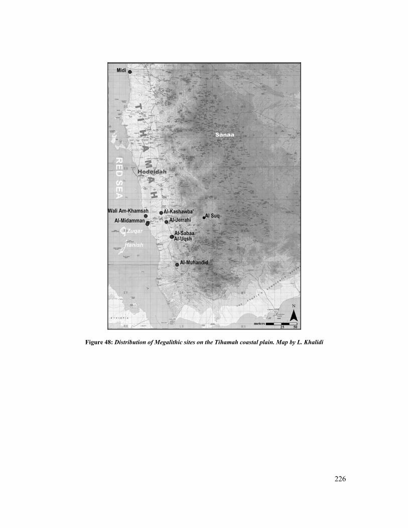
226
Figure 48: Distribution of Megalithic sites on the Tihamah coastal plain. Map by L. Khalidi

227
Site Name(s) Location Region Discovery Revisit Citations Megalithic
Features Associated
Sites
Midi Near Midi Northern Tihamah -
littoral 1923 None (Forbes
1923) Not
confirmed Not
confirmed
Am-Khamsah al-Kaboos & Wali am-Khamsah (TH4)
Wadi Rima
branch
Central Tihamah -
littoral 2003 None (Khalidi
2006)
1 Buried stone – re-
used, 1 disturbed
stone
Part of Islamic Tomb – near late
prehistoric site TH8
Manassib al-Rukbat al-Mahbub (ZD2)
Between Wadi Ajji and Wadi Badwa. N. of Zabid
Central Tihamah –
Head of Wadi
Rima’ delta
(ZD1) 1987 (ZD2) 2003
ZD1 (Phillips
1998)
ZD1 (Ciuk et al. 1996)
ZD2 (Khalidi 2006)
2 partially buried
stones – recently
disturbed
Part of the site of
Kashawba’ (ZD1A) or
the Gas Station
Site
Al-Manassib Al- Midamman
W. of Zabid
Central Tihamah –
littoral north bank of the Wadi
Zabid
1997
2003 (Khalidi 2005)
(Keall 1997, 1998b, 1999, 2000, Keall et al. 2000)
4 upright stones and numerous
fallen stones
distributes within a
large area
Al-Midamman
Al-Jerahi E. of al-Jerahi, S of Zabid
Central Tihamah –
Head of Wadi
Zabid delta
1998
2001 & 2005 (Khalidi 2006)
Keall unpublished
3 fallen stones – disturbed
Possible re-use in
Islamic graves
Not confirmed
Al-Saba’a & Al-‘Uqsh
S. of Hays
Central Tihamah –
Head of Wadi delta
2004 (Khalidi 2006)
Numerous buried stones
Al-‘Uqsh
Al-Muhandid Hijar al-Qaima Wadi Hamili
E. of Makhah
Southern Tihamah foothills
Wadi Hamili
1970
(Bayle des Hermens
1976, Phillips 1999)
(Benardelli et al. 1971)
Circular tombs and
parallel alignments
upright stones
Source of stone
adjacent
Al-Suq (HU36)
Near Suq al Khamis
Western Escarpment At source of and S. bank of Wadi Zabid
2002 (Khalidi 2005)
Circular tomb and
single alignment
fallen upright stones
Source of stone
adjacent Near Late prehistoric site HU37
Table 8: Megalithic Sites of the Tihamah and the Western Escarpment

228
al-Manassib of al-Midamman
The site of al-Manassib is located within the larger site of al-Midamman, north of the main
wadi Zabid drainage and at a distance of over one kilometer east of the current coastline. The
greater site of al-Midamman, discovered in 1997 by CAMROM, is the only one of these
megalithic sites to have been both surveyed and excavated. It will therefore provide a model
to which other megalithic sites of the Tihamah will be compared. The surface scatter related
to this site spreads over an area of eight square kilometers (Keall 1998b: 140), interrupted by
the beginning of the irrigated palm gardens to the east, the wadi al-Nassri to the north, the
wadi Zabid to the south, and large stabilized coastal sand dunes (barchan ridge dunes), (Keall
1998b: 140) which lie parallel to the coast, to the west.
The megalithic complex of al-Manassib makes up one part, albeit predominant and earliest
known, of a much larger site. An alignment of three upright freestanding granite megaliths,
and four others that have fallen but appear to be in alignment with the others, characterize
this megalithic complex (fig. 49). The largest of the seven stones is ca. 80 cm in width. The
stones range between 2.5 and 7 m in height, while the largest of the stones weighs an
approximate 6 tons (Keall 1998b: 141-2, Keall et al. 2000: 37). Several have fallen over, but
are visible, while others are simultaneously being exposed and buried by heavy wind erosion
and shifting sand dunes3. Given the power of taphonomic processes, both ancient and current,
on this heavily deflated, wind-exposed and dune tormented site, it is difficult to imagine how,
for what purpose and in what form these imposing stones may have been raised.
3 Between 2002 and 2005, seven large granite megaliths have been counted in total. Three of these are upright, while four are fallen and lie partially exposed on the surface. repeats what you’ve said in para.?
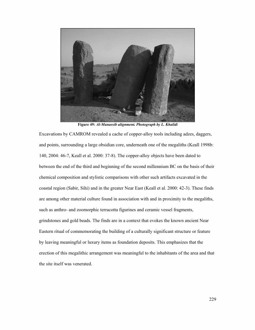
229
Figure 49: Al-Manassib alignment. Photograph by L. Khalidi
Excavations by CAMROM revealed a cache of copper-alloy tools including adzes, daggers,
and points, surrounding a large obsidian core, underneath one of the megaliths (Keall 1998b:
140, 2004: 46-7, Keall et al. 2000: 37-8). The copper-alloy objects have been dated to
between the end of the third and beginning of the second millennium BC on the basis of their
chemical composition and stylistic comparisons with other such artifacts excavated in the
coastal region (Sabir, Sihi) and in the greater Near East (Keall et al. 2000: 42-3). These finds
are among other material culture found in association with and in proximity to the megaliths,
such as anthro- and zoomorphic terracotta figurines and ceramic vessel fragments,
grindstones and gold beads. The finds are in a context that evokes the known ancient Near
Eastern ritual of commemorating the building of a culturally significant structure or feature
by leaving meaningful or luxury items as foundation deposits. This emphasizes that the
erection of this megalithic arrangement was meaningful to the inhabitants of the area and that
the site itself was venerated.
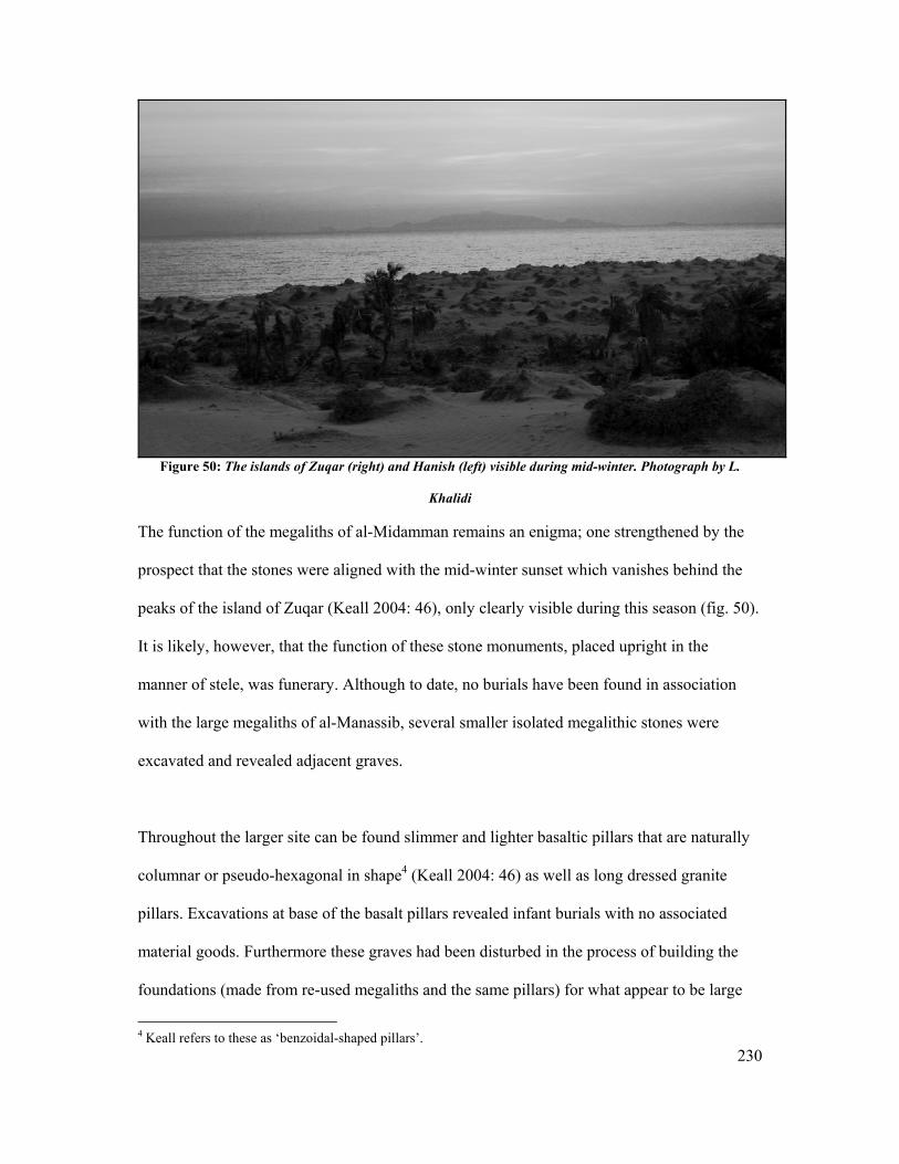
230
Figure 50: The islands of Zuqar (right) and Hanish (left) visible during mid-winter. Photograph by L.
Khalidi
The function of the megaliths of al-Midamman remains an enigma; one strengthened by the
prospect that the stones were aligned with the mid-winter sunset which vanishes behind the
peaks of the island of Zuqar (Keall 2004: 46), only clearly visible during this season (fig. 50).
It is likely, however, that the function of these stone monuments, placed upright in the
manner of stele, was funerary. Although to date, no burials have been found in association
with the large megaliths of al-Manassib, several smaller isolated megalithic stones were
excavated and revealed adjacent graves.
Throughout the larger site can be found slimmer and lighter basaltic pillars that are naturally
columnar or pseudo-hexagonal in shape4 (Keall 2004: 46) as well as long dressed granite
pillars. Excavations at base of the basalt pillars revealed infant burials with no associated
material goods. Furthermore these graves had been disturbed in the process of building the
foundations (made from re-used megaliths and the same pillars) for what appear to be large
4 Keall refers to these as ‘benzoidal-shaped pillars’.
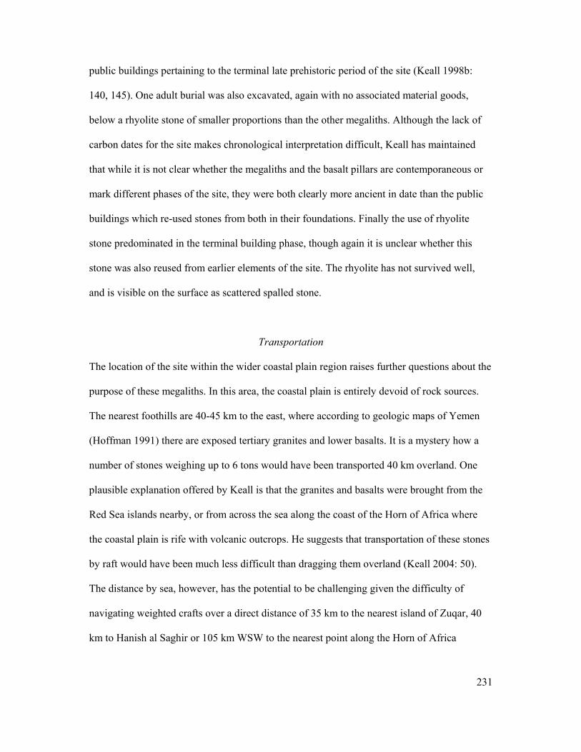
231
public buildings pertaining to the terminal late prehistoric period of the site (Keall 1998b:
140, 145). One adult burial was also excavated, again with no associated material goods,
below a rhyolite stone of smaller proportions than the other megaliths. Although the lack of
carbon dates for the site makes chronological interpretation difficult, Keall has maintained
that while it is not clear whether the megaliths and the basalt pillars are contemporaneous or
mark different phases of the site, they were both clearly more ancient in date than the public
buildings which re-used stones from both in their foundations. Finally the use of rhyolite
stone predominated in the terminal building phase, though again it is unclear whether this
stone was also reused from earlier elements of the site. The rhyolite has not survived well,
and is visible on the surface as scattered spalled stone.
Transportation
The location of the site within the wider coastal plain region raises further questions about the
purpose of these megaliths. In this area, the coastal plain is entirely devoid of rock sources.
The nearest foothills are 40-45 km to the east, where according to geologic maps of Yemen
(Hoffman 1991) there are exposed tertiary granites and lower basalts. It is a mystery how a
number of stones weighing up to 6 tons would have been transported 40 km overland. One
plausible explanation offered by Keall is that the granites and basalts were brought from the
Red Sea islands nearby, or from across the sea along the coast of the Horn of Africa where
the coastal plain is rife with volcanic outcrops. He suggests that transportation of these stones
by raft would have been much less difficult than dragging them overland (Keall 2004: 50).
The distance by sea, however, has the potential to be challenging given the difficulty of
navigating weighted crafts over a direct distance of 35 km to the nearest island of Zuqar, 40
km to Hanish al Saghir or 105 km WSW to the nearest point along the Horn of Africa
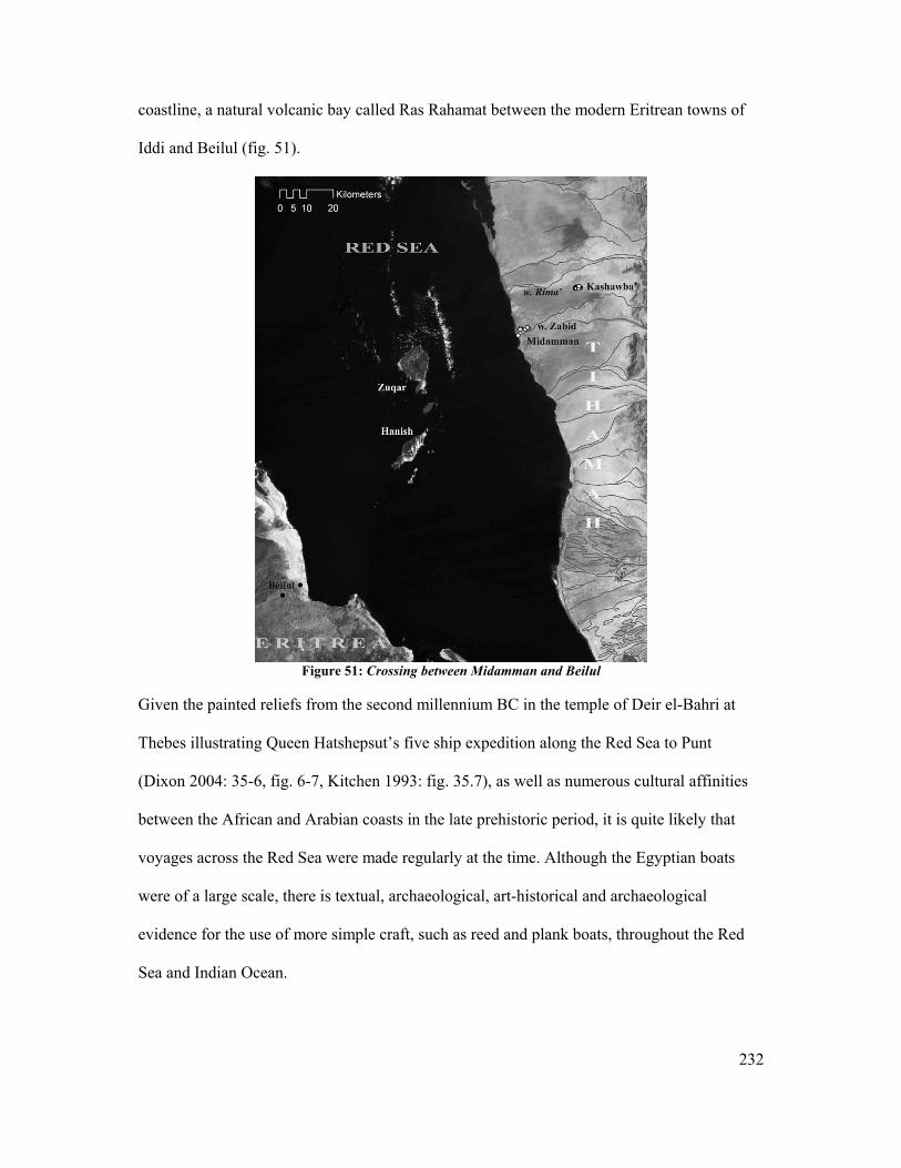
232
coastline, a natural volcanic bay called Ras Rahamat between the modern Eritrean towns of
Iddi and Beilul (fig. 51).
Figure 51: Crossing between Midamman and Beilul
Given the painted reliefs from the second millennium BC in the temple of Deir el-Bahri at
Thebes illustrating Queen Hatshepsut’s five ship expedition along the Red Sea to Punt
(Dixon 2004: 35-6, fig. 6-7, Kitchen 1993: fig. 35.7), as well as numerous cultural affinities
between the African and Arabian coasts in the late prehistoric period, it is quite likely that
voyages across the Red Sea were made regularly at the time. Although the Egyptian boats
were of a large scale, there is textual, archaeological, art-historical and archaeological
evidence for the use of more simple craft, such as reed and plank boats, throughout the Red
Sea and Indian Ocean.
233
Archaeological evidence from coastal sites in the Gulf has demonstrated the use of watercraft
as early as the fifth millennium BC. At the sites of Ain as-Sayh in eastern Saudi Arabia and
as-Sabiyah in Kuwait, a number of bitumen fragments with reed boat impressions were
discovered in association with Ubaid pottery (Carter et al. 2002, McClure et al. 1993: fig. 9,
10). Hundreds of bitumen fragments found at the site of Ra’s al-Jins in Oman dating to the
third millennium BC also bear impressions of reed bundles, tightly bound, and in a later
phase of the site (2300 BC), of wooden planks tied with cords. Besides the presence of
foreign trade items at these sites, which support the prospects of long distance sailing
voyages, approximately 20% of the bitumen fragments had barnacles on the non-impressed
side further proving the use of reed and bitumen for waterborne craft (Cleuziou et al. 1997:
68-9, Vosmer 1996: 227, fig. 11, 13). Using this evidence a reed boat model was constructed
and according to a computer evaluation such boats were not only stable and able to reach
speeds of up to 6 knots, but were capable of traveling long distances carrying tons of cargo
(Vosmer 2000: 241). From 1977-8, Thor Heyerdahl sailed in such a reed boat from Iraq to
Karachi and across the Indian Ocean to Djibouti, proving not only that it was possible but
also that these boats could sail into shallow water without capsizing (Prabha Ray 2003: 56).
In Chapter II, the configuration of the Red Sea coastline of Yemen was briefly discussed. It is
likely that in the late prehistoric period natural bays functioned as ports for mooring, but also
that most craft sailed straight onto shore. Excerpts from the Periplus Maris Erythraei
demonstrate that rafts and small craft were used to sail across the Red Sea and that they were
able to moor at small coastal market towns that provided basic anchorage (The Periplus
Maris Erythraei 1980: 57.7). The author describes the northern Red Sea coastline of Arabia
(interpreted as modern day Saudi Arabia and perhaps the northern end of the Yemeni
Tihamah) as lacking harbors and having poor anchorage (Ibid: 63.20).
234
Given the paucity of wood in the Tihamah region, it is most probable that sailing craft were
made of reed bundles, and perhaps mangrove, palm and/or driftwood like the fishing rafts
used presently by local fishermen to set fishing nets near the coastline. These rafts,
maneuvered in shallow waters with an oar or pole, are bound together by rope. These are
mentioned in Stone’s publication and are only relevant to the discussion in order to
demonstrate that perfectly stable craft, and ones still used today, can be made simply, using
very few available perishable materials, and without the use of metal nails (Stone 1985: 126).
Although in the cases of late prehistoric watercraft mentioned above bitumen was a crucial
ingredient for caulking, which in turn allowed these boats to withstand long voyages at sea,
no bitumen has been found in Yemen. Tihamah fisherman currently waterproof their hurris
with a traditional mixture called shahm (Arabic for ‘fat’) made from lime and animal fat (cow
or camel). This concoction is also said to protect the wood from worms (Ibid). Again, this
caulking method utilizes available materials (the lime can be made from fired coral) and
though it may not be as effective as bitumen is perfectly dependable as long as the boats are
caulked regularly.
In light of the above-mentioned factors it becomes quite clear that all of the materials and
technologies needed for seafaring in the Red Sea were in existence and that sailing traditions
were well established in the region in the third to second millennium BC. Furthermore it has
been demonstrated that simple craft could potentially withhold the weight of large megalithic
stones. The question remains whether other incentives for trans- Red Sea voyages existed at
this time, and if so to what degree? These questions will be dealt with in the following
chapter; however, it must first be determined whether other options for the transfer of the
stones of al-Midamman may not have been more efficient.
235
A proposition for the transfer of these stones is put forth as a possible alternative. According
to a number of recent geo-archaeological studies conducted by the Dhamar Survey Project in
the central highlands of Yemen, a moist climate existed between 9000 and 3000 BC when a
drier climate gradually ensued (Wilkinson 2003: 157). This is evidenced by relic lakes in the
highlands and interior of Arabia (Inizan et al. 1997, Lézine et al. 1998, Wilkinson 1997: 23-4,
2003: 157-61) and mid-Holocene humic paleosols in the central highlands which suggest a
period of organic stability (Wilkinson 1997: 7-9, 2003: 157). This moist, stable period is
consistent with the heavy exploitation of now extinct mangrove dwelling molluscs,
Terebralia palustris on the Tihamah coastal plain during the early Holocene ‘Neolithic’
period (Cattani et al. 2002: 34, Tosi 1985: 365, 1986: 407-8).
The period between the third and second millennium BC corresponds to the beginning of this
drying period. This suggests two things; firstly the rivers of Yemen (which currently have a
light flow for most of the year) were flowing more regularly at this time, if not massively
year-round, then seasonally, possibly allowing for rafts to flow to the coast at certain times of
the year. Secondly, if this flow was insufficient in depth for a heavily laden raft or craft, then
seasonal sayls or riverine flash floods though risky, may have provided the opportunity for
such a feat.
Transportation by land is also a possibility. An experiment conducted at La Venta, Mexico on
a first millennium BC Olmec basalt stelae demonstrated that the maximum weight that could
be lifted by 35 individuals was a two-ton column. This was done using rope-slings harnessed
by poles on the shoulders of the lifters. The average weight lifted was calculated at 100 kg
per man (Renfrew et al. 1996: 300). To lift a six-ton stone like those of al-Midamman would
236
have required 105 individuals by this calculation. It is likely in this case that a mechanism
was built to facilitate overland movement, especially over a distance of 45 km.
The three propositions for the transfer of the megaliths of al-Midamman serve to illustrate the
feasibility of such an achievement but also to stress the scale of the organization, technology,
and manpower that would have been required. Either way, it is apparent that these stones and
their presence at such a distance from their origin remained a source of admiration among the
populations that directly superseded the megalith builders and one that continued into the
Islamic period. The re-use of the megaliths and pillars continued to be commemorative, first
as funerary stele, second in the foundations of public buildings that may have been temples,
and finally in Islamic saint’s tombs and mosques. These monumental stones have never
strayed far from their primary resting places, not only because they are difficult to move but
also because the place, even the stone, remains sacred. Several megaliths have been re-used
as funerary stelae in later Islamic saints’ tombs around the greater site of al-Midamman.
Finally two mosques near the site have incorporated the stones in the architecture.
Discussion
In many ways, the continued occupation of the site of Midamman into the first millennium
BC in the area of the megalithic structures highlights the significance such monuments may
have had in the process of sedentarization, in the configuration of the society, and in the
growth of towns and centers, not only in their locations but in the resulting town planning.
Excavations have revealed that the domestic settlement5 probably consisted of perishable hut
dwellings, and in the style of the site of Sabir, they were arranged around the center of the
site which was characterized by the megaliths and later the partitioned public buildings (Keall
5 One hearth associated with a probable dwelling yielded a carbon date of 1360 BC.
237
2004: 50, fig.10). As has been shown in Chapter V, this type of site had a monumental
megalithic phase and a later stone and mud-brick architectural phase. The ceramic tradition
found in association with the megaliths continued into the later phase with added
embellishments to the forms and decoration. Similarly, obsidian is present throughout the late
prehistoric phases of the site of Midamman in the form of geometric microliths and pièces
esquillées, including in excavated contexts associated with the megaliths (Rahimi 2001: 3).
This obsidian microlithic tradition also continues into the later prehistoric phase of the site
and can be found on almost all of the sites of this period throughout the Tihamah coastal
plain. Finally the copper alloy points that were found in a cache under one of the Midamman
megaliths can be compared with similar metal points or daggers at the sites of Sabir in the
Aden area and Sihi in the Saudi Tihamah (Ibid)6, two sites that do not have megalithic
elements but resemble the site of Midamman in every other way.
Because the megaliths of the Tihamah, when they survive in situ and are not re-used or
robbed, are not usually upright and prominent like those at al-Midamman, it is rather difficult
to find them at all, let alone in their original contexts. Furthermore, surface finds in the area
in which they lie are commonly devoid to rare. It is for this reason that the consideration of
the formation of towns around these monuments is crucial to identifying them, as the towns
are large, dense with very specific material culture and difficult to miss. It is with all of these
ideas in mind that the next five sites will be discussed and interpreted as forming a late
prehistoric coastal cultural landscape.
6 For comparisons see (Keall et al. 2000) for the Midamman tools compared to (Buffa et al. 2001) for the site of Sabir and (Zarins et al. 1986) for the site of Sihi.
238
Al-Jerahi
The site of al-Jerahi, near the village of al-Mehashir, lies on the southern bank of the wadi
Zabid, approximately 30 km from the coastline and 5 km from the nearest foothills. Three
large megaliths resembling those at al-Manassib are visible on the surface in the area around
a mound that is ca. 100 m in diameter and 3 m in height and currently occupied by a dense
Islamic cemetery. One additional megalith was removed by the CAMROM team during a
survey season and taken to the museum in Zabid. All four megaliths are made of granite and
have no associated material culture visible on the surface. It is most probable that more
megaliths lie buried in the vicinity.
The first stone is 2.25 m in length, 60 cm in width and 1.40 m in minimum circumference.
The second stone is similarly 2.25 m in length, 70 cm in width and has a minimum
circumference of 1.40 m. The third stone is 2.10 m in length and 50 cm in width. All three of
these stones are similar in size and though they are oblong in shape, are not worked. This site
was first surveyed by CAMROM in the late 1990s and the author’s work only involved site
visits for comparative reasons. Given the pattern that has been elucidated it is likely that a
larger late prehistoric town extends beyond the area of the megaliths. However, several
factors affect the visibility of the extended site. Firstly the site lies at the edge of the modern
roadside town of Jerahi. Secondly the adjacent areas are heavily irrigated and plowed for
agriculture. It is probable that the only reason the site has survived is as a result of the
presence of the Islamic cemetery. Finally, because the site is located in the interior of the
coastal plain and along a course of the wadi Zabid that is now relic (according to signatures
on LANDSAT images it may have either naturally moved northward or else been purposely
redirected), sedimentation in the area is substantial.
239
Manassib al-Rukbat al-Mahbub of al-Kashawba’ (The Gas Station Site)
The Gas Station Site (al-Kashawba’, ZD1A), a mounded site dense with ceramic remains,
was discovered by CAMROM in 1987 (Ciuk et al. 1996). In 2003 the area surrounding the
site of Kashawba’ was surveyed. The site was discovered to extend 3 km west and like al-
Midamman, had a megalithic element, Manassib al-Rukbat al-Mahbub (ZD2)(Khalidi 2005).
The al-Kashawba’ western extension (ZD1B-F) is located in the interior coastal plain ca. 20
km from the nearest foothills and 25 km from the coastline, between the wadis Badwa and
‘Ajji (delta branches of the larger wadi Rima’).
The site of Manassib al-Rukbat al-Mahbub (ZD2), located in the center of the Kashawba’
western extension, includes two partially exposed granite megaliths. Both elements are well
buried under silt deposits, however the exposed part (50 cm above ground) of the larger
megalith is 116 cm long and 26 cm wide. The area around the stones is devoid of material
culture and surrounded by fallow fields. The local inhabitants of the area explained that many
more stones were once visible. Judging by how buried these megaliths are, there may be
more stones below the meter or so of sediment in the area.
The surrounding site consists of a continuous artifact scatter within which are areas of denser
artifact concentrations and recurrent mounding. This area has been interpreted as the
domestic settlement while the area to the north, as discussed in Chapter V, may have
consisted of associated agricultural fields or pastures.
The ceramics are of the same types as those from al-Midamman. Obsidian geometric
microliths and pièces esquillées are common throughout the site. Interestingly the surface
collections demonstrate that the obsidian tools are significantly higher in number than the

240
obsidian debitage and waste. Surface assemblages from late prehistoric sites towards the
coast reveal the contrary. Given the distribution of obsidian activity areas of the same period
up to this point along the wadi Rima’, it is possible that the smaller sites were producing the
tools and that the site of Kashawba’ was on the receiving end, either of the prepared
geometric microliths or else of fewer cores and primary material, and more secondary
obsidian material. This could also be a question of visibility.
With its centrally located stone monuments, the surrounding domestic settlement, and a dense
material culture dominated primarily by late prehistoric ceramics and secondarily by obsidian
geometric microliths and pièces esquillées, the site resembles that of Midamman.
Am-Khamsah Bani al-Kaboos and Wali am-Khamsah
Lying on the southern extent of the wadi Rima’ watershed and less than 1 km east of the
current coastline is the tomb of the Wali am-Khamsah (TH4A). An annual pilgrimage is
made to the tomb the first Thursday after the date harvest and offerings are made there. Local
legend has it that a large stone resembling a cow was once an integral part of the Wali’s
tomb7. According to locals, Wahabi fundamentalists swept through the area recently in an
effort to expel traditional belief in sainthood and ‘idolatry’ of objects. In this case the object
was a large stone and it was apparently removed and the site set afire. When the tomb was
visited in 2003, it was discovered that some stones lie buried at the site of the grave, though
the venerated ‘cow’ has disappeared. 7 A Wali is a deceased individual of the Muslim faith, who attained, either during their lifetime or else after their death, the equivalence of sainthood. The practice of attributing such a status to an individual is one that is common to some regions of Yemen and especially to the Tihamah. Pilgrimages are made to such tombs at specific times of the year. As in the Christian faith, many of these ‘saints’ are associated with a virtue, and visitations are often in times of need and involve offerings and prayers. Such a practice is not tolerated in most interpretations of Islam, especially more recent ones, but nonetheless remains an important element of local traditional custom and belief. In the Tihamah wali’s tombs are more numerous than mosques, and are often located in sacred places including megalithic sites. It was noted by the author that the same tradition can be observed on the Red Sea coast of Eritrea.

241
Approximately 30 m west-northwest of the tomb lies a small oblong shaped granite stone
called ‘al-Thor’ or ‘the bull’ by the locals, which is well buried. The exposed tip is desert
varnished to a dark brown color and its tip measures 54 cm in circumference. The site, Am-
Khamsah Bani al-Kaboos (TH4B), is visited at the same time as the tomb of Wali am-
Khamsah and offerings are made next to the stone. It is not clear whether these stones are
remnants or buried elements of a megalithic complex. However given the stone type, the
size, and the location, it is most likely that these pilgrimage sites lie among or have re-used
vestiges of an older site with a megalithic tradition.
TH4A and B are part of a larger Islamic site associated with the tomb, which was a
marketplace and extends as a continuous dense pottery scatter for 1km north and 400 m east.
At the northern edge of this scatter lies the site of TH8. This site resembles the Kashawba’
mounds in morphology. Although it is obscured by the Islamic site for 1 km, it may well be
another late prehistoric center like Kashawba’ and Midamman. With the domestic area
characterized by late prehistoric ceramics, dense obsidian and the presence of pièces
esquillées in conjunction with a possible megalithic element at its center, and a location on
the littoral end of the wadi Rima’, it fits the recurrent pattern for the third to first millennium
BC.
Al-Saba’a and Al-‘Uqsh
The site of al-Saba’a was identified in 2004 on an isolated impact assessment mission as a
result of illicit excavations and looting incidents on the site. It lies 1 km due east of al-‘Uqsh
and is certainly part of the same site. The continuity between the two is currently disturbed by
the southern periphery of the city of Hays and the main asphalt highway that runs north –
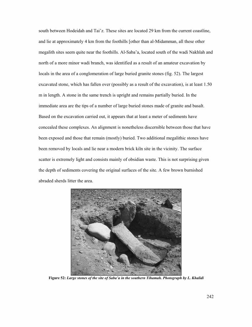
242
south between Hodeidah and Tai’z. These sites are located 29 km from the current coastline,
and lie at approximately 4 km from the foothills [other than al-Midamman, all these other
megalith sites seem quite near the foothills. Al-Saba’a, located south of the wadi Nakhlah and
north of a more minor wadi branch, was identified as a result of an amateur excavation by
locals in the area of a conglomeration of large buried granite stones (fig. 52). The largest
excavated stone, which has fallen over (possibly as a result of the excavation), is at least 1.50
m in length. A stone in the same trench is upright and remains partially buried. In the
immediate area are the tips of a number of large buried stones made of granite and basalt.
Based on the excavation carried out, it appears that at least a meter of sediments have
concealed these complexes. An alignment is nonetheless discernible between those that have
been exposed and those that remain (mostly) buried. Two additional megalithic stones have
been removed by locals and lie near a modern brick kiln site in the vicinity. The surface
scatter is extremely light and consists mainly of obsidian waste. This is not surprising given
the depth of sediments covering the original surfaces of the site. A few brown burnished
abraded sherds litter the area.
Figure 52: Large stones of the site of Saba’a in the southern Tihamah. Photograph by L. Khalidi
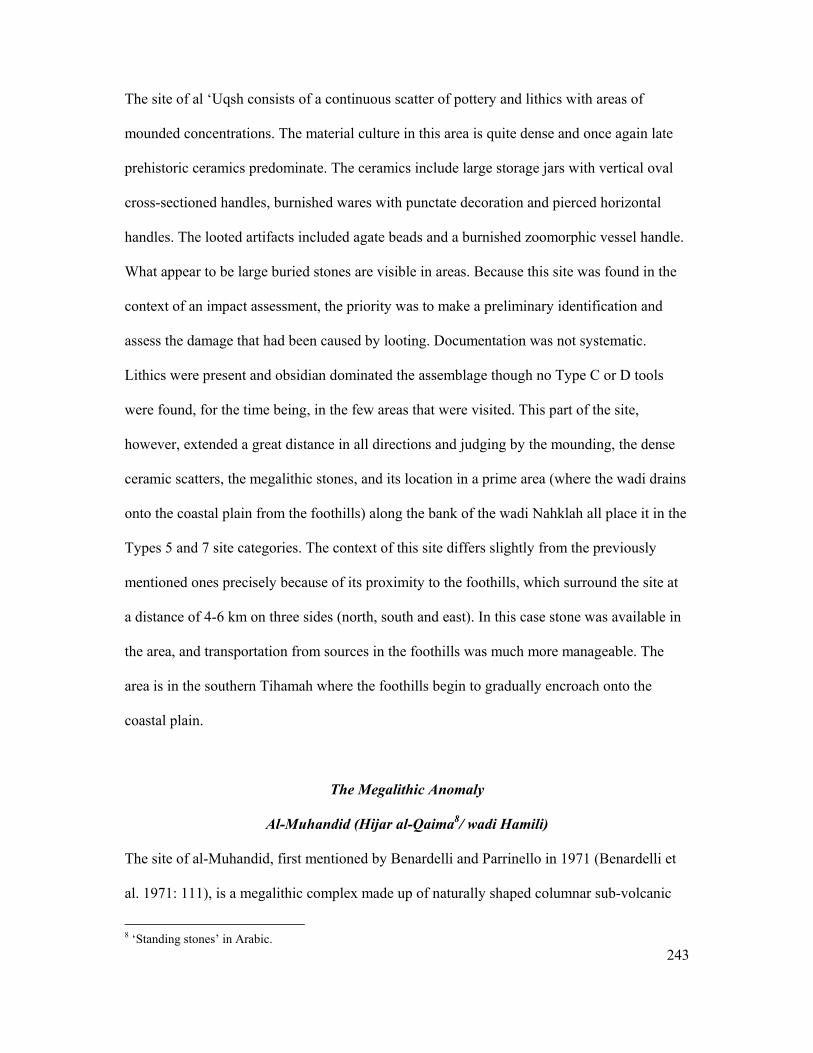
243
The site of al ‘Uqsh consists of a continuous scatter of pottery and lithics with areas of
mounded concentrations. The material culture in this area is quite dense and once again late
prehistoric ceramics predominate. The ceramics include large storage jars with vertical oval
cross-sectioned handles, burnished wares with punctate decoration and pierced horizontal
handles. The looted artifacts included agate beads and a burnished zoomorphic vessel handle.
What appear to be large buried stones are visible in areas. Because this site was found in the
context of an impact assessment, the priority was to make a preliminary identification and
assess the damage that had been caused by looting. Documentation was not systematic.
Lithics were present and obsidian dominated the assemblage though no Type C or D tools
were found, for the time being, in the few areas that were visited. This part of the site,
however, extended a great distance in all directions and judging by the mounding, the dense
ceramic scatters, the megalithic stones, and its location in a prime area (where the wadi drains
onto the coastal plain from the foothills) along the bank of the wadi Nahklah all place it in the
Types 5 and 7 site categories. The context of this site differs slightly from the previously
mentioned ones precisely because of its proximity to the foothills, which surround the site at
a distance of 4-6 km on three sides (north, south and east). In this case stone was available in
the area, and transportation from sources in the foothills was much more manageable. The
area is in the southern Tihamah where the foothills begin to gradually encroach onto the
coastal plain.
The Megalithic Anomaly
Al-Muhandid (Hijar al-Qaima8/ wadi Hamili)
The site of al-Muhandid, first mentioned by Benardelli and Parrinello in 1971 (Benardelli et
al. 1971: 111), is a megalithic complex made up of naturally shaped columnar sub-volcanic
8 ‘Standing stones’ in Arabic.
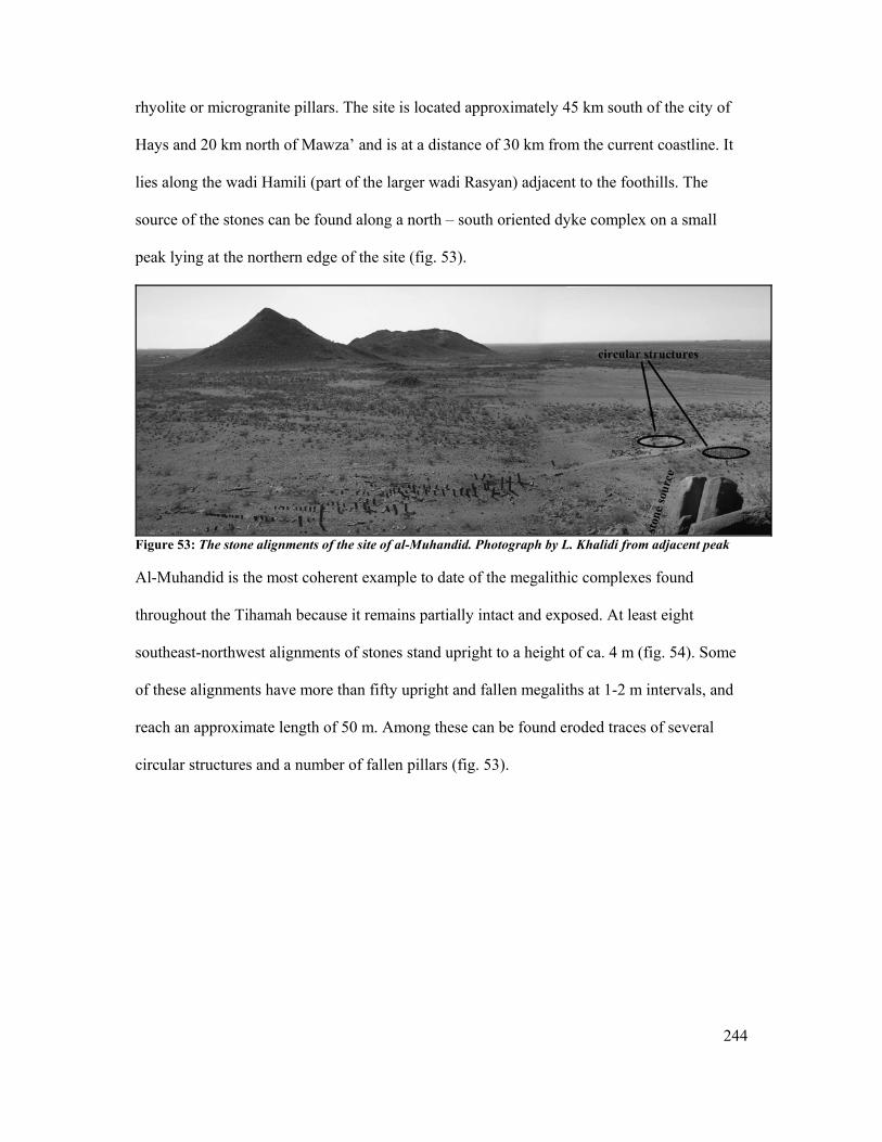
244
rhyolite or microgranite pillars. The site is located approximately 45 km south of the city of
Hays and 20 km north of Mawza’ and is at a distance of 30 km from the current coastline. It
lies along the wadi Hamili (part of the larger wadi Rasyan) adjacent to the foothills. The
source of the stones can be found along a north – south oriented dyke complex on a small
peak lying at the northern edge of the site (fig. 53).
Figure 53: The stone alignments of the site of al-Muhandid. Photograph by L. Khalidi from adjacent peak
Al-Muhandid is the most coherent example to date of the megalithic complexes found
throughout the Tihamah because it remains partially intact and exposed. At least eight
southeast-northwest alignments of stones stand upright to a height of ca. 4 m (fig. 54). Some
of these alignments have more than fifty upright and fallen megaliths at 1-2 m intervals, and
reach an approximate length of 50 m. Among these can be found eroded traces of several
circular structures and a number of fallen pillars (fig. 53).

245
Figure 54: Alignments at the site of Muhandid. Photograph by L. Khalidi
The site is characterized by occasional abraded brown ceramics including hole mouth bowls
and rare obsidian lithic debitage and waste. To the WNW of these alignments is an area of
stone rectilinear structures, built either from re-used megaliths or else from long natural
blocks from the adjacent source and foothills.
The site of al-Muhandid has a megalithic element, an adjacent domestic settlement, late
prehistoric ceramics and obsidian. It is located at a crucial juncture along a major wadi
system and fits into the more general pattern for the late prehistoric Type 5 and 7 sites of the
interior coastal plain. Yet, the complex is also anomalous to the aforementioned sites in a
number of ways. Previous analysis of the aerial photographs and a mapping of the site
(Bayle des Hermens 1976, Phillips 1999) helped to clarify that the alignments and the
circular structures may in fact be directly associated with each other in the manner of the
desert fringe tailed tombs, which will be discussed later in the chapter (fig. 55).

246
Figure 55: Plan of several of the Muhandid alignments. Taken from (Bayle des Hermens 1976)
The two interior coastal plain sites that are located in the southern Tihamah belt (al-
Muhandid and al-Saba’a) are in a different geographical context to those of the interior
central Tihamah due to their evident proximity to the foothills, and thus a slightly differing
cultural paradigm should be expected. The location of the site of al-Muhandid on the edge of
the foothills and the coastal plain, at the transition between two widely divergent
environmental and geographic zones, is highly significant. The physical proximity to a
highland environment is reflected in what may be, on an architecturally conceptual level,
highland and desert fringe cultural elements. The fact that the site still retains strong elements
of the larger Tihamah pattern of large upright megalithic stone monuments surrounded by
large domestic settlements, shows that the site is a naturally occurring hybrid that lies at the
balance of two worlds, the coastal and the highland.
247
Discussion
Having discussed the seven megalithic sites that have been previously discovered by other
archaeological missions to the region and those that have been more recently identified by the
author, and having clarified the evident link, as well as the variants that exist between them, it
is worth mentioning that one site that does not have visible megalithic elements9 is still
identifiable as a Type 7 settlement. This site, Munira 1, is located due east of the Salif
peninsula in the northern Tihamah belt. The site undoubtedly corresponds to Tosi’s MUN1
site, and though it demonstrates contiguous multiple periods of occupation, it is typified by a
continuous and extensive dense late prehistoric ceramic scatter (fenestrated vessels,
burnished wares, oval cross-sectioned handles, punctate decoration) and dense scatters of
obsidian including obsidian geometric microliths. It is located along the terminal reaches of
the wadi Surdud delta, south of the salt dome Jebel Qamah. The scatter was followed for 6
km north to south and is concentrated at points all across the entire delta of the wadi Surdud.
The site was identified during the road impact assessment survey and documentation was
limited to the road alignment, however from the western-most extent of the site surveyed (it
may continue further to the west) the ancient coastline would have been approximately 2 km
further west. The closest distance to the current coastline to the NW and SW, skirting the
Salif peninsula10, which lies due west of the site, is at least 4 km away. Judging by the late
prehistoric ceramic assemblage, the density of obsidian, the presence of geometric microliths
and the extent and location of the site it appears to fit the larger pattern discussed.
9 The absence of megalithic elements could be a result of obscured visibility, re-use or could simply be a matter of their having never existed on these sites. 10 Satellite imagery for this region shows that the location of the extensive westerly peninsula of Salif is directly in line with the terminal delta of the wadi Surdud. Interpretation of this signature in conjunction with published palaeoenvironmental reconstructions of the middle Holocene in Yemen, leads the author to believe that the Salif peninsula was an accumulation of large amounts of sediments deposited by the wadi Surdud, and did not emerge as a peninsula before the mid to late Holocene. Such an occurrence would be in line with the drying of the climate, and the resulting highland erosion and decrease in sea levels that followed.
248
A comparison of megalithic traditions in the adjacent regions will follow. It is most logical to
begin with the opposite Red Sea coast of the Horn of Africa and move eastward to the
piedmonts and escarpment, followed by the highlands and desert fringe. In the process of
demonstrating the megalithic traditions of the comparison regions it is worth keeping in mind
that, as has been the theme of this dissertation, and despite the overall unity of the late
prehistoric sites of the Tihamah coastal plain, a distinction must be acknowledged between
the differing zonations that exist within the Tihamah belt itself. Such a perspective allows for
the dimensionality that exists, vis-à-vis the geography and modes and courses of contact, to
be exposed as they were and continue to be.
6.4 Megalithic Traditions: The Horn of Africa
Three geo-political regions in the Horn of Africa will come into play in this chapter, namely
Eritrea, Djibouti and Ethiopia, as they are located directly opposite the Red Sea coast of
Yemen. Eritrea and Djibouti currently occupy the coastal area, while Eritrea and Ethiopia
occupy the escarpment and highlands.
In order not to oversimplify the diversity of strategies and cultures that make up the late
prehistoric and early historic periods of these regions in the Horn, it is important to clarify
that by demonstrating comparisons with the Tihamah, a similar or singular cultural trajectory
is not implied. Just as the Tihamah and its easterly neighbors form a complex mosaic of
interrelated and yet differing environments and cultures, so do the regions that make up the
coastal plains, foothills, and highland regions of the African Horn. It is not the aim of this
work to review the late prehistoric period of this region, but rather to put it in a geographical
context that engages the Red Sea as a conduit for contact and interaction between the two
continents. Finally this work further imparts that contact is neither linear nor is it necessarily
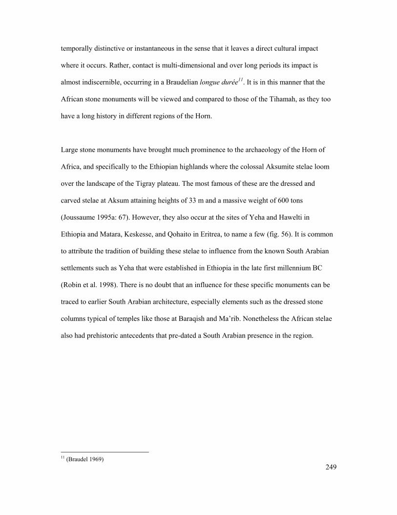
249
temporally distinctive or instantaneous in the sense that it leaves a direct cultural impact
where it occurs. Rather, contact is multi-dimensional and over long periods its impact is
almost indiscernible, occurring in a Braudelian longue durée11. It is in this manner that the
African stone monuments will be viewed and compared to those of the Tihamah, as they too
have a long history in different regions of the Horn.
Large stone monuments have brought much prominence to the archaeology of the Horn of
Africa, and specifically to the Ethiopian highlands where the colossal Aksumite stelae loom
over the landscape of the Tigray plateau. The most famous of these are the dressed and
carved stelae at Aksum attaining heights of 33 m and a massive weight of 600 tons
(Joussaume 1995a: 67). However, they also occur at the sites of Yeha and Hawelti in
Ethiopia and Matara, Keskesse, and Qohaito in Eritrea, to name a few (fig. 56). It is common
to attribute the tradition of building these stelae to influence from the known South Arabian
settlements such as Yeha that were established in Ethiopia in the late first millennium BC
(Robin et al. 1998). There is no doubt that an influence for these specific monuments can be
traced to earlier South Arabian architecture, especially elements such as the dressed stone
columns typical of temples like those at Baraqish and Ma’rib. Nonetheless the African stelae
also had prehistoric antecedents that pre-dated a South Arabian presence in the region.
11 (Braudel 1969)

250
Figure 56: The pillars at the Axumite site of Qohaito (Eritrea). Photograph by L. Khalidi
Excavations at the site of Mahal Teglinos, near Kassala in the Eritrean-Sudanese lowlands,
have demonstrated that stelae and small standing stones marked graves in the region from as
early as the mid- third millennium BC (Joussaume 1995a: 66, Phillipson 1998: 37-8).
Dolmens, made of upright stones supporting lintels, have been documented in Harar in
eastern Ethiopia and date to the late second millennium BC (Fattovich 1997: 482). Circular
structures built of large vertical slabs have been documented at the site of Aqiq (3rd –2nd
millennium BC), lying on the coast south of the Barka delta (Fattovich 2004: 71).
Joussaume remarks that two principal types of megaliths can be distinguished in the region.
The first consists of dressed stones and are located in the north and south of Ethiopia, while
the second are dolmens associated with tumuli and are located to the east in the region of
Harar. Both types are associated with funerary practices (Joussaume 1995a: 66). Some of the
megaliths that fall under the first category of dressed stone are in fact not dressed but
resemble larger versions of the crude megaliths found along the Tihamah coastal plain. These
can be found at Aksum as monolithic grave markers, and as smaller square monoliths at the
site of Hawelti south-east of Aksum (Phillipson 1998: 47). The megalithic elements of both
of these sites happens to be attributed to the pre-Aksumite period which corresponds to the
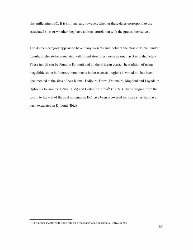
251
first millennium BC. It is still unclear, however, whether these dates correspond to the
associated sites or whether they have a direct correlation with the graves themselves.
The dolmen category appears to have many variants and includes the classic dolmen under
tumuli, or else stelae associated with round structures (some as small as 3 m in diameter).
These tumuli can be found in Djibouti and on the Eritrean coast. The tradition of using
megalithic stone in funerary monuments in these coastal regions is varied but has been
documented at the sites of Asa Koma, Tadjoura, Dorra, Doumeira, Magdoul and Loyada in
Djibouti (Joussaume 1995a: 71-5) and Beilul in Eritrea12 (fig. 57). Dates ranging from the
fourth to the end of the first millennium BC have been recovered for those sites that have
been excavated in Djibouti (Ibid).
12 The author identified this last site on a reconnaissance mission to Eritrea in 2003.

252
Figure 57: Sites in Djibouti. Taken from (Joussaume 1995: fig. 1)
One example is the shell midden site of Asa Koma located along Djibouti’s volcanic coastal
plain, which was carbon dated to the beginning of the second millennium BC (Joussaume
1995b: 32). The site has parallels with the artefact repertoire characteristic of
contemporaneous sites along the Tihamah. Besides a faunal record dominated by
domesticated cattle and fewer wild animals, a large number of fishbones, and a lithic tradition
characterized by a large number of obsidian geometric microliths, the ceramics exhibit
similar decorative elements to the ceramics of the Tihamah. Excavations on the site exposed
two small circular stone tumuli made from large blocks of basalt (Ibid: 33-6).
253
Joussaume asserts that because the tradition of circular tumuli was isolated to the eastern
regions of the Horn, that one must look across the Red Sea at sites like al-Muhandid (Ibid:
72). This point is interesting precisely because the stone funerary monuments of the Djibouti
and Eritrean coasts are comparable to al-Muhandid. However, as was discussed in the
previous section, al-Muhandid is an anomaly to the Tihamah. What is comparable and rather
significant is that just as the site of al-Muhandid is in a region of the Tihamah where the
foothills encroach onto the plain, the southern coast of Eritrea and that of Djibouti are similar.
Their coastal plains are dotted with volcanic ruinfields and abundant stone. Perhaps what we
are witnessing with regards to the megalithic traditions of both coasts is not only long-lasting
contact across the Red Sea that manifests itself in a number of ideas and experiences that are
altered and exchanged and altered again, but also a natural architectural adaptation, on one
hand to a stoneless flat coastal environment (central Tihamah) and on the other to a
coastal/piedmont (al-Muhandid/ Djibouti/ southern Eritrea) environment abundant in stone
for building.
6.5 Stone Monuments of Yemen
Previous Discoveries
Megaliths and tombs incorporating megalithic features are a common feature of the
archaeological landscape of Yemen. Large stones, placed upright or flat, dressed and crude,
and both ritual and purely architectural in their function, have been discovered in the
highlands, the western escarpment, the desert fringe, the Indian Ocean coast near Mahra, in
Saudi Arabia and as was just illustrated, in the Tihamah coastal plain.
Not far from our study area, at the site of Rajajil in the Burayda region of Saudi Arabia lie a
series of clustered upright megaliths and a number of indirectly associated tumuli and circular
254
structures (Zarins 1979). In the central plains of the Yemeni highlands, orthostats are
ubiquitous in the architecture of third and second millennium BC sites (Edens 1999, Edens et
al. 2000). Very large stone slabs often seal circular tombs of the late prehistoric and early
historic periods. Similarly, tombs discovered in the desert fringe incorporate large megalithic
stones (Braemer et al. 2001, Steimer-Herbet 2001, 2004). In the Mahra region, along the
Indian Ocean coast, prehistoric circular structures with associated dolmens were documented
(Rougeulle 1999). Such sites, or site features, are characteristic of the late prehistory of
Yemen and are often placed in what is commonly termed the ‘Bronze Age’ period (3rd to the
early 1st millennia BC). As will be discussed below, many of these monuments continue to be
built and often re-used into the early historic period.
Although the use of large stones in domestic and ritual constructions links late prehistoric or
‘Bronze Age’ sites throughout Yemen, a number of deviations set the megalithic
agglomerations found in the Tihamah apart from those of the interior. These divergences
range from spatial distribution, associated material culture and subsistence strategies to the
shape of the stones themselves. Unlike the Tihamah sites, all of the megalithic stones found
in the highlands and interior make up essential but not distinguishing components of more
complex architectural structures such as tombs or domestic dwellings. Furthermore these are
all located in proximity to stone sources.
While the closest parallels to the large oblong shaped megaliths characteristic of the Tihamah
are those found in the Ethiopian highlands and eastern coastline of the Horn of Africa, two
sites in Yemen appear to be hybrids between the monuments of the Tihamah and those of the
highlands and the desert fringe. These two sites, al-Muhandid (wadi Hamili) and al-Suq
(HU36) are anomalous to the corpus of megalithic and funerary sites in Yemen, and are not
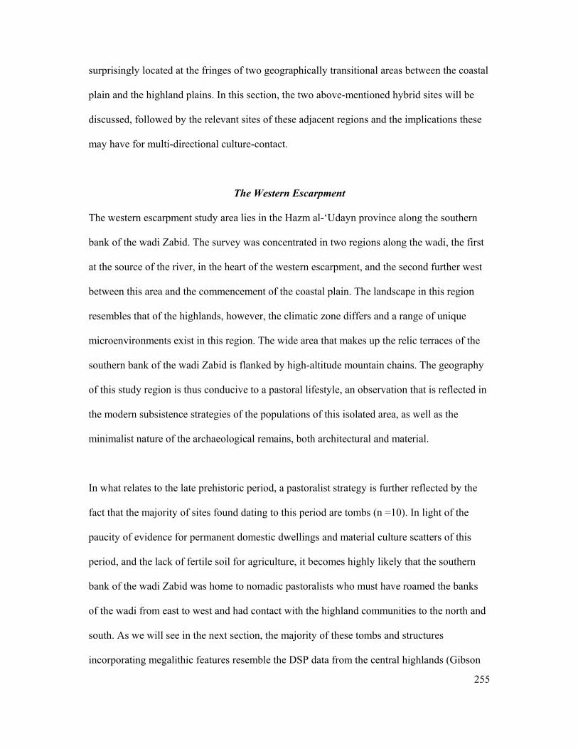
255
surprisingly located at the fringes of two geographically transitional areas between the coastal
plain and the highland plains. In this section, the two above-mentioned hybrid sites will be
discussed, followed by the relevant sites of these adjacent regions and the implications these
may have for multi-directional culture-contact.
The Western Escarpment
The western escarpment study area lies in the Hazm al-‘Udayn province along the southern
bank of the wadi Zabid. The survey was concentrated in two regions along the wadi, the first
at the source of the river, in the heart of the western escarpment, and the second further west
between this area and the commencement of the coastal plain. The landscape in this region
resembles that of the highlands, however, the climatic zone differs and a range of unique
microenvironments exist in this region. The wide area that makes up the relic terraces of the
southern bank of the wadi Zabid is flanked by high-altitude mountain chains. The geography
of this study region is thus conducive to a pastoral lifestyle, an observation that is reflected in
the modern subsistence strategies of the populations of this isolated area, as well as the
minimalist nature of the archaeological remains, both architectural and material.
In what relates to the late prehistoric period, a pastoralist strategy is further reflected by the
fact that the majority of sites found dating to this period are tombs (n =10). In light of the
paucity of evidence for permanent domestic dwellings and material culture scatters of this
period, and the lack of fertile soil for agriculture, it becomes highly likely that the southern
bank of the wadi Zabid was home to nomadic pastoralists who must have roamed the banks
of the wadi from east to west and had contact with the highland communities to the north and
south. As we will see in the next section, the majority of these tombs and structures
incorporating megalithic features resemble the DSP data from the central highlands (Gibson
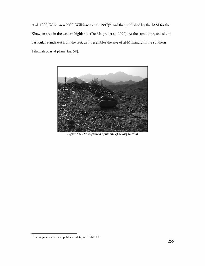
256
et al. 1995, Wilkinson 2003, Wilkinson et al. 1997)13 and that published by the IAM for the
Khawlan area in the eastern highlands (De Maigret et al. 1990). At the same time, one site in
particular stands out from the rest, as it resembles the site of al-Muhandid in the southern
Tihamah coastal plain (fig. 58).
Figure 58: The alignment of the site of al-Suq (HU36)
13 In conjunction with unpublished data, see Table 10.
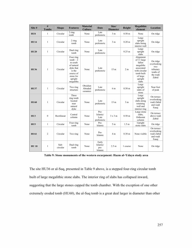
257
Site # #
Tombs Shape Features Material Culture Date Size/
Diameter Height Megalithic element Location
HU8 1 Circular 2 ring tomb None Late
prehistoric 3 m 0.50 m None On ridge
HU14 1 Circular 2 ring tomb None Late
prehistoric 3 m 0.20 m
Large upright
slabs lining interior wall
On ridge
HU20 1 Circular Dual ring tomb None Late
prehistoric 0.25 m Large
upright slabs
On ridge
HU36 1 Circular
Four ring tomb – 2 m south
of natural dyke that
is the source of stone for upright
megaliths
None Late prehistoric 15 m 2 m
Alignment of 11 large
fallen megaliths associated
with circular tomb built
of large upright slabs
On ridge overlooking
two tributary wadis of the wadi
Zabid
HU37 1 Circular Two ring structure
Obsidian Abraded ceramics
Late prehistoric 6 m 0.50 m
Large upright slabs of stone
Near foot of peak
HU60 1 Circular
Three ring tomb
located near
natural dyke
None Late prehistoric 15 m 3 m
Large upright
slabs along retaining wall and
interior ring
On terrace overlooking wadi Zabid and wadi
Fanaj
HU3 0 Rectilinear Central column None
Pre-Islamic/
Late prehistoric
3 x 3 m 0.50 m
Large stone slabs,
Orthostat column
On terrace above wadi
Zabid
HU5 1 Circular Four ring tomb None Pre-
Islamic 5 m 1.5 m Upright stone slabs On ridge
HU61 2 Circular Two ring None Pre-Islamic 4 m 0.30 m None visible
On terrace overlooking wadi Zabid and wadi
Fanaj
HU 18 1 Sub-circular
Dual ring tomb None
Early Islamic/
pre-Islamic
2.5 m 1 course None On ridge
Table 9: Stone monuments of the western escarpment: Hazm al-‘Udayn study area
The site HU36 or al-Suq, presented in Table 9 above, is a stepped four-ring circular tomb
built of large megalithic stone slabs. The interior ring of slabs has collapsed inward,
suggesting that the large stones capped the tomb chamber. With the exception of one other
extremely eroded tomb (HU60), the al-Suq tomb is a great deal larger in diameter than other
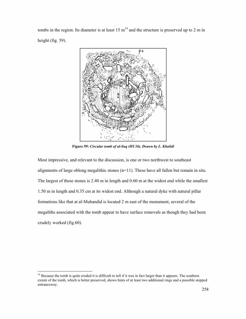
258
tombs in the region. Its diameter is at least 15 m14 and the structure is preserved up to 2 m in
height (fig. 59).
Figure 59: Circular tomb of al-Suq (HU36). Drawn by L. Khalidi
Most impressive, and relevant to the discussion, is one or two northwest to southeast
alignments of large oblong megalithic stones (n=11). These have all fallen but remain in situ.
The largest of these stones is 2.40 m in length and 0.60 m at the widest end while the smallest
1.50 m in length and 0.35 cm at its widest end. Although a natural dyke with natural pillar
formations like that at al-Muhandid is located 2 m east of the monument, several of the
megaliths associated with the tomb appear to have surface removals as though they had been
crudely worked (fig.60).
14 Because the tomb is quite eroded it is difficult to tell if it was in fact larger than it appears. The southern extent of the tomb, which is better preserved, shows hints of at least two additional rings and a possible stepped entranceway.
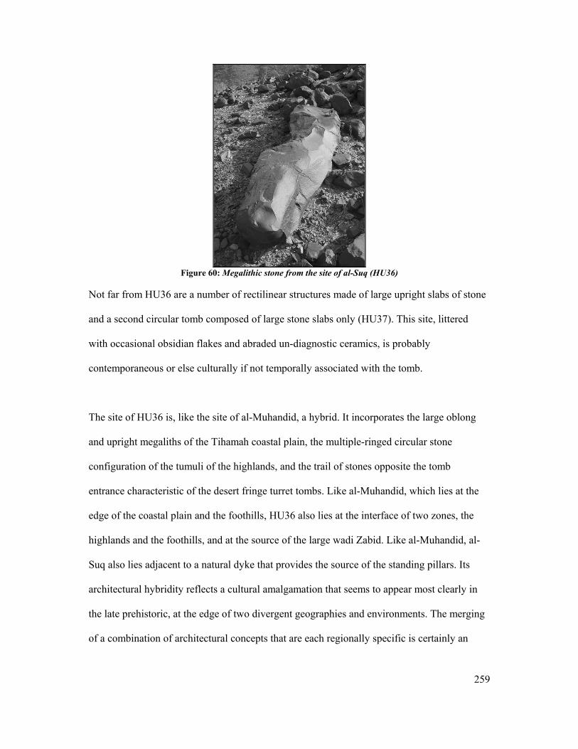
259
Figure 60: Megalithic stone from the site of al-Suq (HU36)
Not far from HU36 are a number of rectilinear structures made of large upright slabs of stone
and a second circular tomb composed of large stone slabs only (HU37). This site, littered
with occasional obsidian flakes and abraded un-diagnostic ceramics, is probably
contemporaneous or else culturally if not temporally associated with the tomb.
The site of HU36 is, like the site of al-Muhandid, a hybrid. It incorporates the large oblong
and upright megaliths of the Tihamah coastal plain, the multiple-ringed circular stone
configuration of the tumuli of the highlands, and the trail of stones opposite the tomb
entrance characteristic of the desert fringe turret tombs. Like al-Muhandid, which lies at the
edge of the coastal plain and the foothills, HU36 also lies at the interface of two zones, the
highlands and the foothills, and at the source of the large wadi Zabid. Like al-Muhandid, al-
Suq also lies adjacent to a natural dyke that provides the source of the standing pillars. Its
architectural hybridity reflects a cultural amalgamation that seems to appear most clearly in
the late prehistoric, at the edge of two divergent geographies and environments. The merging
of a combination of architectural concepts that are each regionally specific is certainly an
260
indication of multi-directional contact and exchange, though it remains unclear at what level
and over how much time.
An attribution of this monument to semi-nomadic pastoral communities may help to clarify
the issue, as their continuous movement within the boundaries of a certain environment
capable of providing the proper sustenance for their herds, like the banks of the wadi Zabid,
may have provided the link between the foothills and coastal plain and the highland plateaus.
As we have discussed in Chapter II, this point reinforces the concept that river systems can
act as routes between diverse altitudinal regions. Finally the location of this monument at the
source of the wadi Zabid, which can also be interpreted as the source of the livelihood of the
populations that inhabited its banks as well as the boundary of a geographic zone, implies
symbolic territorial demarcation. A site like al-Muhandid can also be interpreted in this light.
The following sections will discuss the late prehistoric stone monuments of the highland
plateau and finally of the desert fringe in order to demonstrate the variety of these
architectural traditions and the similarity of the expression.
The Highland Central Plains
In the highland (DSP) study area, 18 of the recorded sites (total = 380)15 were tombs or sites
with associated tombs. Some were categorized as circular structures but are presumed to be
tombs, though their function remains questionable. Due to the general dearth of material
culture around these funerary structures and their continued use from the late prehistoric to
the early historic periods, it is often difficult to be certain as to the date. Tables 10-11 provide
a brief description of these tombs and/or circular structures and their projected chronology.
15 General statistics related to the number of sites recovered by the DSP and their projected dates are based on tables formulated in (Lewis 2005: 122).

261
All but two of the funerary structures are circular, while the minority incorporates large stone
elements though these may be buried. The incorporation of large stones on the remaining
sites is questionable for the following reasons. Firstly many of these sites are heavily eroded
and/or disturbed and so the visibility of the structure layout is rather limited. Secondly, some
of these may be variants of tumuli, which tend to have underground chambers, in which case
the large stones would not be visible on the surface.
The Table below demonstrates that, like the tombs and necropolises of the desert fringe, all of
the stone monuments recovered by the DSP in the central highlands are located on elevated
terrain, further asserting the desired visibility of such structures. Unlike the desert fringe,
however, the highland terrain provided a number of interwoven environments that sustained a
range of economic strategies within condensed areas. Ancient agricultural terracing has been
traced on a number of associated late prehistoric and early historic sites such as the third –
second millennium BC site of Hammat al-Qa’ (DS101) (Wilkinson et al. 1999: 5). Although
one large late prehistoric site, Hawagir (DS293), is located along the plains (Ibid), Wilkinson
and Edens maintain that keeping with the environmental data, the valley floors “…remained a
moist grassland and may have functioned as a pastoral reserve” (Ibid: 2) into the third
millennium BC. Settlement in the late prehistoric was concentrated on plateaus, and a number
of walled and relatively densely populated towns up to 4-5 ha. in size can be found
throughout the highland central plains. These were, according to the evidence, inhabited by
agriculturalists and agro-pastoralists, while the valley floors were pasturelands for
pastoralists. The faunal remains from excavations at the site of Hammat al-Qa’ yielded a
majority of ovicaprids (90%) and a small minority of cattle remains (10%) (Edens et al. 2000:

262
2). These figures demonstrate the presence of a pastoralist strategy along with an agricultural
one in the large towns of the late prehistoric highlands.
The range in size and height of these structures may be a function of taphonomic processes
and visibility, however it is more likely to be a question of regional variability and
chronology.
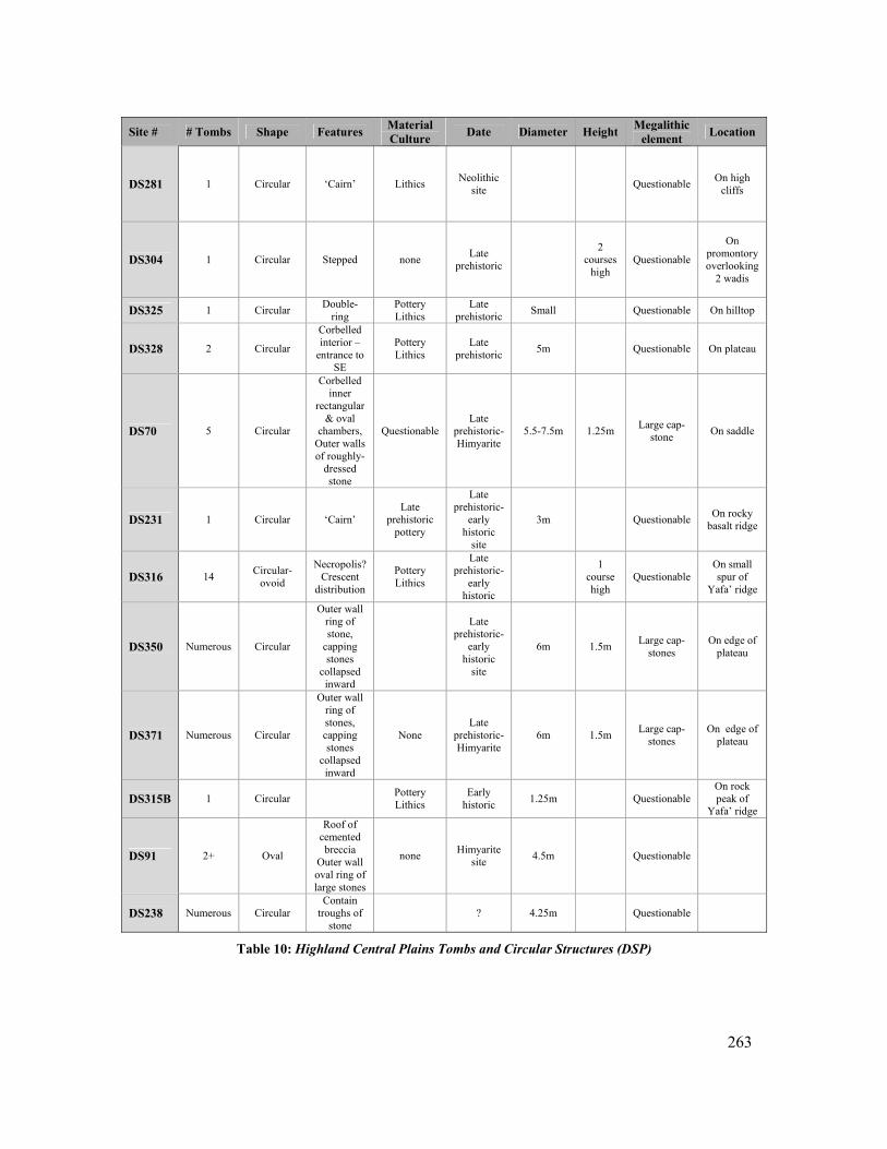
263
Site # # Tombs Shape Features Material
Culture Date Diameter Height Megalithic element Location
DS281 1 Circular ‘Cairn’ Lithics Neolithic site Questionable On high
cliffs
DS304 1 Circular Stepped none Late prehistoric
2 courses
high Questionable
On promontory overlooking
2 wadis
DS325 1 Circular Double-ring
Pottery Lithics
Late prehistoric Small Questionable On hilltop
DS328 2 Circular
Corbelled interior –
entrance to SE
Pottery Lithics
Late prehistoric 5m Questionable On plateau
DS70 5 Circular
Corbelled inner
rectangular & oval
chambers, Outer walls of roughly-
dressed stone
Questionable Late
prehistoric-Himyarite
5.5-7.5m 1.25m Large cap-stone On saddle
DS231 1 Circular ‘Cairn’ Late
prehistoric pottery
Late prehistoric-
early historic
site
3m Questionable On rocky basalt ridge
DS316 14 Circular-ovoid
Necropolis? Crescent
distribution
Pottery Lithics
Late prehistoric-
early historic
1
course high
Questionable On small spur of
Yafa’ ridge
DS350 Numerous Circular
Outer wall ring of stone,
capping stones
collapsed inward
Late prehistoric-
early historic
site
6m 1.5m Large cap-stones
On edge of plateau
DS371 Numerous Circular
Outer wall ring of stones, capping stones
collapsed inward
None Late
prehistoric-Himyarite
6m 1.5m Large cap-stones
On edge of plateau
DS315B 1 Circular Pottery Lithics
Early historic 1.25m Questionable
On rock peak of
Yafa’ ridge
DS91 2+ Oval
Roof of cemented breccia
Outer wall oval ring of large stones
none Himyarite site 4.5m Questionable
DS238 Numerous Circular Contain
troughs of stone
? 4.25m Questionable
Table 10: Highland Central Plains Tombs and Circular Structures (DSP)
264
Megalithic Features
Besides the circular tombs prevalent throughout the highland landscape, a number of large
stones that can be qualified as megalithic have been documented in the Yemen highlands.
Most megaliths of this type make up features of structures. In these cases it is the structure
that determines the function or the defining element of the building and not the megaliths
themselves. The inverse is true in the Tihamah where it is the megaliths that are the
ubiquitous element and the defining characteristic of the site. The exception for this in the
Tihamah is in the case of the re-used megaliths in later architectural structures. In these cases
the megaliths support the building but are no longer a defining feature.
Orthostats
Orthostats are upright stones that flank doorways of structures and can reach a height of 2 m
in the highlands. These large stones are more common on, though not exclusive to, late
prehistoric sites of the third and second millennium BC. At least fourteen sites in the DSP
area exhibit prominent orthostats. None of these are dated to the late prehistoric period, while
the remaining 5 are early historic and/or transitional in date.
Masna’at Maryah
The only known exception to the circular tombs and orthostats found in the Central
Highlands study area is a megalithic monument categorized as a ‘pseudo-dolmen’ by
Steimer-Herbet, and one that according to her probably did not have a funerary function
(Steimer-Herbet 2004: 11-12, fig.1). This megalithic monument, constructed of two stone
blocks that pedestal a large horizontal stone slab, is located in the south-eastern half of the
15-20 hectare plateau-top site of Masna’at Mariyah (DS3), an area that is certainly older than
the rest of this Himyarite center. Bayle des Hermens reported an alley 8m in length and
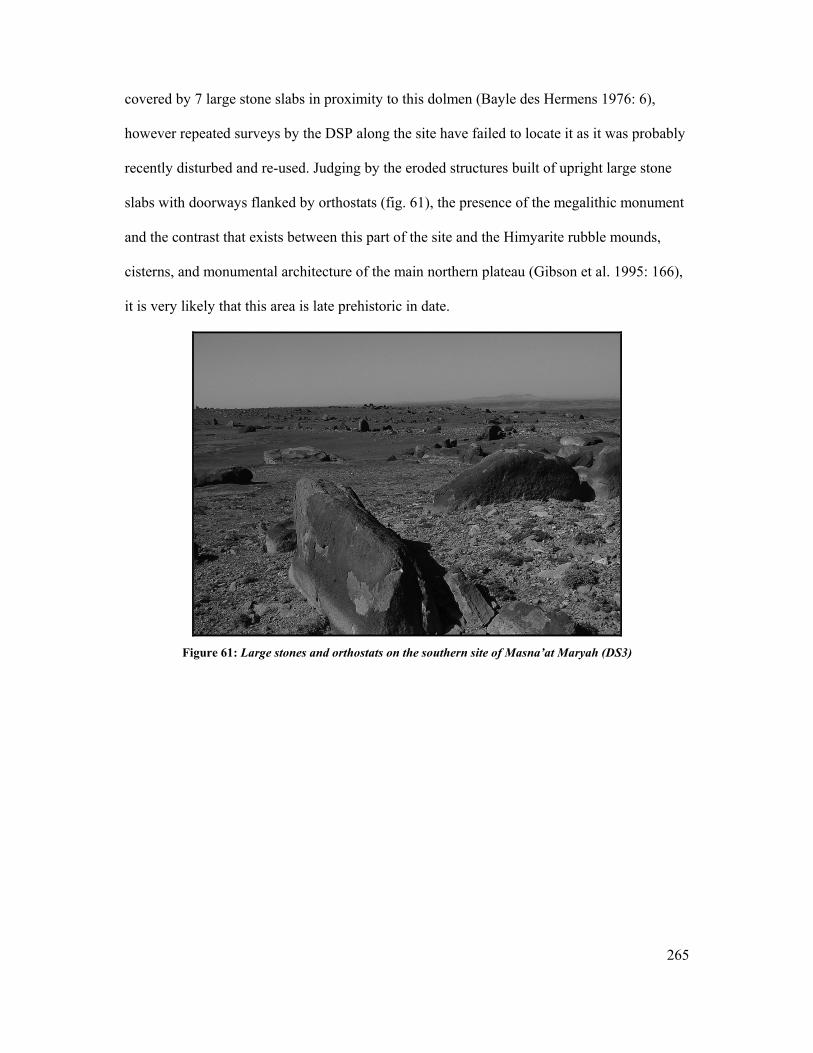
265
covered by 7 large stone slabs in proximity to this dolmen (Bayle des Hermens 1976: 6),
however repeated surveys by the DSP along the site have failed to locate it as it was probably
recently disturbed and re-used. Judging by the eroded structures built of upright large stone
slabs with doorways flanked by orthostats (fig. 61), the presence of the megalithic monument
and the contrast that exists between this part of the site and the Himyarite rubble mounds,
cisterns, and monumental architecture of the main northern plateau (Gibson et al. 1995: 166),
it is very likely that this area is late prehistoric in date.
Figure 61: Large stones and orthostats on the southern site of Masna’at Maryah (DS3)
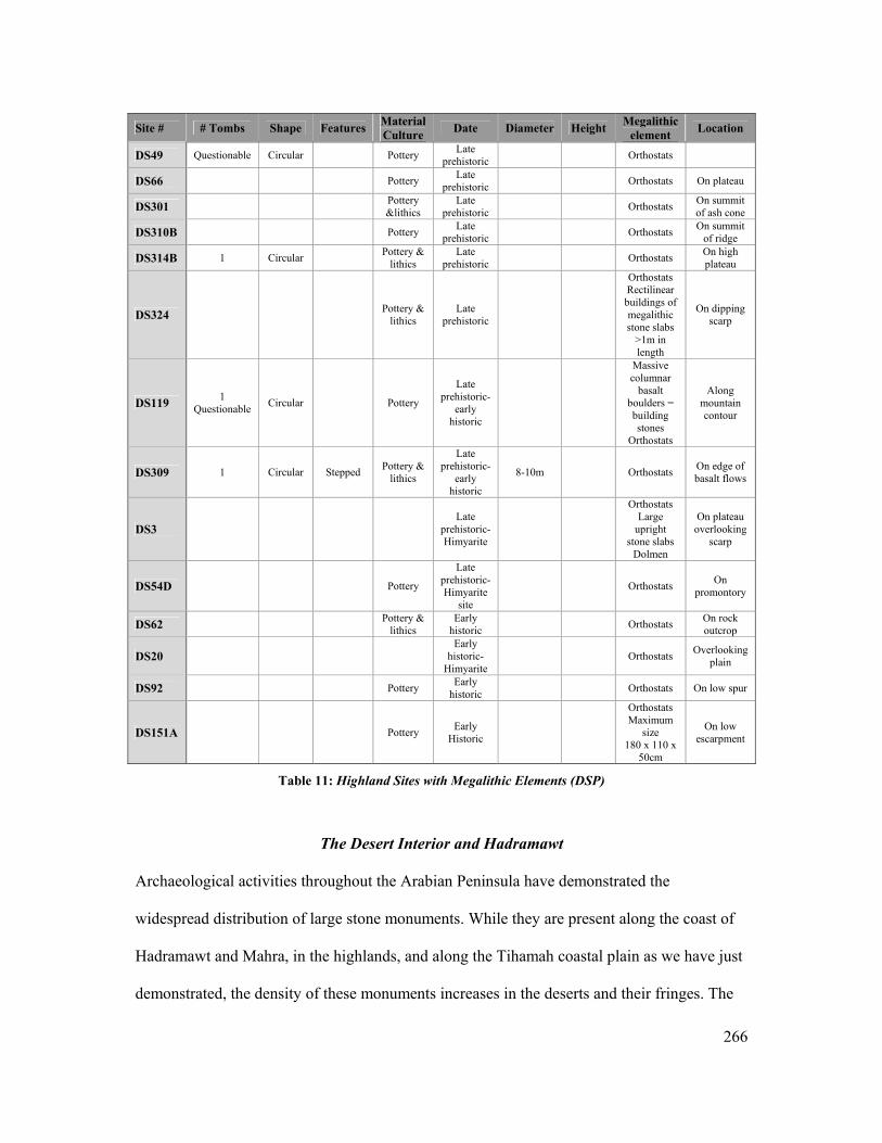
266
Site # # Tombs Shape Features Material
Culture Date Diameter Height Megalithic element Location
DS49 Questionable Circular Pottery Late prehistoric Orthostats
DS66 Pottery Late prehistoric Orthostats On plateau
DS301 Pottery &lithics
Late prehistoric Orthostats On summit
of ash cone
DS310B Pottery Late prehistoric Orthostats On summit
of ridge
DS314B 1 Circular Pottery & lithics
Late prehistoric Orthostats On high
plateau
DS324 Pottery & lithics
Late prehistoric
Orthostats Rectilinear buildings of megalithic stone slabs
>1m in length
On dipping scarp
DS119 1 Questionable Circular Pottery
Late prehistoric-
early historic
Massive columnar
basalt boulders = building stones
Orthostats
Along mountain contour
DS309 1 Circular Stepped Pottery & lithics
Late prehistoric-
early historic
8-10m Orthostats On edge of basalt flows
DS3 Late
prehistoric-Himyarite
Orthostats Large
upright stone slabs
Dolmen
On plateau overlooking
scarp
DS54D Pottery
Late prehistoric-Himyarite
site
Orthostats On promontory
DS62 Pottery & lithics
Early historic Orthostats On rock
outcrop
DS20 Early
historic-Himyarite
Orthostats Overlooking plain
DS92 Pottery Early historic Orthostats On low spur
DS151A Pottery Early Historic
Orthostats Maximum
size 180 x 110 x
50cm
On low escarpment
Table 11: Highland Sites with Megalithic Elements (DSP)
The Desert Interior and Hadramawt
Archaeological activities throughout the Arabian Peninsula have demonstrated the
widespread distribution of large stone monuments. While they are present along the coast of
Hadramawt and Mahra, in the highlands, and along the Tihamah coastal plain as we have just
demonstrated, the density of these monuments increases in the deserts and their fringes. The
267
majority have been attributed to funerary practices. A number of studies conducted on these
monuments in Yemen have illustrated that though a homogeneity exists between certain types
of monuments, there is a great amount of variability that cannot be ignored (Braemer et al.
2001, De Maigret 2002: 325-41, De Maigret et al. 2005, Rougeulle 1999, Steimer-Herbet
2001, 2004).
According to Steimer-Herbet there are three families of stone monuments that can be isolated
and that are found scattered from the southern coast of the Arabian Peninsula to the Levant.
The first family, Type A, dolmens is represented by six isolated examples documented in
Yemen, while one has been documented in Saudi Arabia (Steimer-Herbet 2004: 92, Table 8).
These structures attain an average length of 2.5 m and width of 2.1 m (Ibid: 45). The second
family, Type B, are tumuli with underground chambers. Eighteen necropolises of the tumulus
variety have been documented in Yemen, while only two have been identified in Saudi
Arabia. 25% of the necropolises between the Levant and Arabia are located in Yemen. Unlike
the necropolises of the Type C tombs that have a high density of tombs, the 18 necropolises
identified in Yemen do not exceed ten tombs in number (Ibid: 92, Table 9). Finally the walled
turret or circular tower tombs are designated Type C. These are found grouped in large
numbers in Yemen, and are commonly above ground. Thirty-seven necropolises of the turret
variety have been documented in Yemen alone, while fifty-eight have been identified in
Saudi Arabia (Ibid: 92, Table 10). Among these three families there exist 101 variants, some
of which incorporate characteristics from more than one of the three families.
For example, the entrances of the turret tombs are either constructed from two monolithic
pillars and a large stone lintel (a tradition more common to the Levant), or from small dry-
stone walling and a large stone lintel (a tradition common to three of the largest necropolises
268
in the desert fringe of Yemen), or as a fishbone arrangement of large stone slabs that forms a
triangular arched entranceway (Ibid: 71, fig. 63).
Two of the largest necropolises in Yemen, that pertain to the Type C turret tombs, are the
sites of Jebel Ruwaik with over 3000 tombs and Jebel Jidran with approximately 1500 (Ibid:
93). These turret tombs commonly have tails that can reach hundreds of meters in length.
Nine varieties of these tails exist and, according to Steimer-Herbet’s study, are all made up of
small non-megalithic stones arranged in an assortment of patterns and shapes. There does not
appear to be a standardized length or number of tails: some tombs have three or more tails,
while others have none. The orientations of these tails vary but all originate from the back
end of the tombs, opposite the entrance to the chambers (Ibid: 73-6).
Several interpretations of tailed, trailed or winged tombs from other regions have been
proposed. These range from literal interpretations of the number of stones being
representative of the number of deceased interred (Jaussen et al. 1907: 174) to symbolic
interpretations of the lines acting as passageways between the world of the living and that of
the dead (Joussaume 1985 550-4). From the point of view of the Arabian desert fringe
necropolises, it has been proposed that because the distribution of the necropolises in this
area appears to be along an ancient road network linking the Sirwah basin to the Jawf, that
these trails were built so as to be visible from these roads. De Maigret and Antonini suggest
that on the one hand “ the long stone alignments, by accompanying the travelers, perpetuated
the presence of the deceased in their eyes; on the other, the deceased were enabled, somehow
or other, to continue to travel the roads.”(De Maigret et al. 2005: 40). Excavations of these
features have not, for the time being, revealed the function such features may have held. The
single or multiple functions of these trails of stones therefore remain enigmatic, relegating all
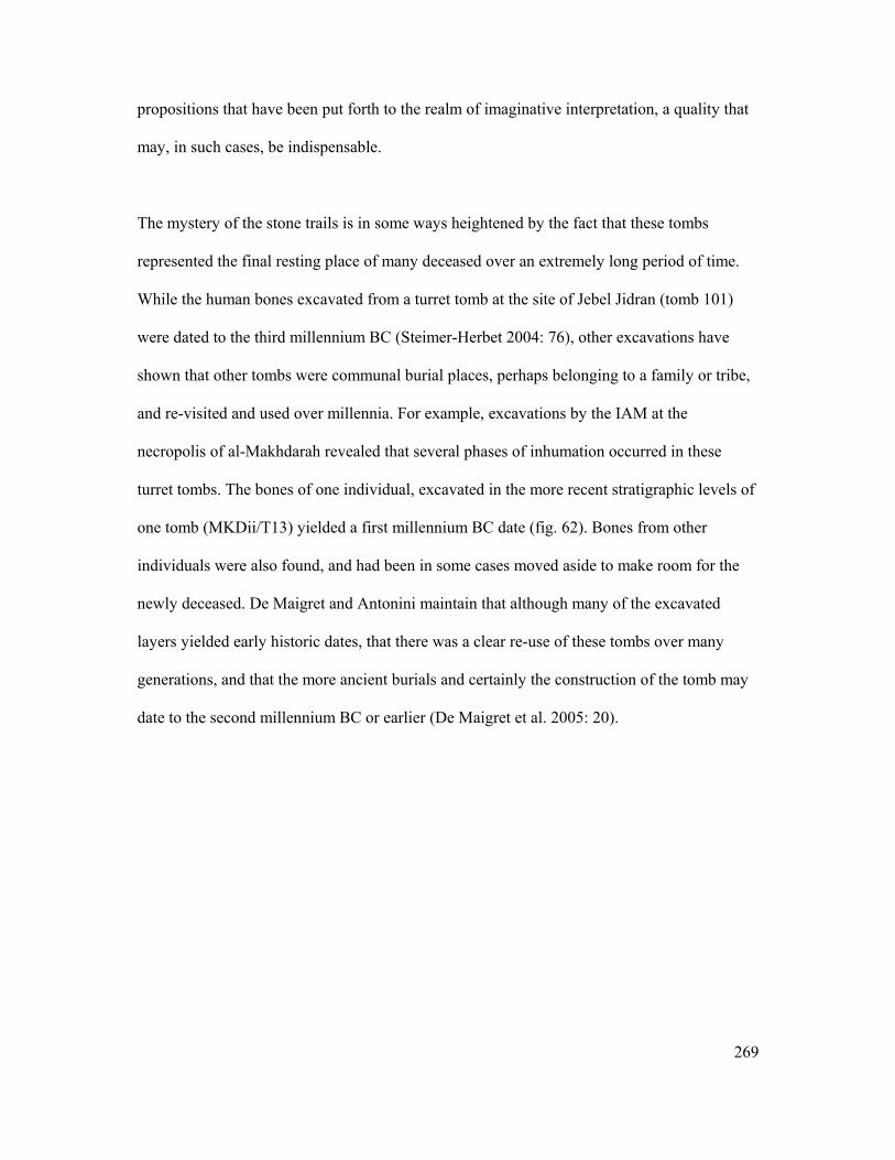
269
propositions that have been put forth to the realm of imaginative interpretation, a quality that
may, in such cases, be indispensable.
The mystery of the stone trails is in some ways heightened by the fact that these tombs
represented the final resting place of many deceased over an extremely long period of time.
While the human bones excavated from a turret tomb at the site of Jebel Jidran (tomb 101)
were dated to the third millennium BC (Steimer-Herbet 2004: 76), other excavations have
shown that other tombs were communal burial places, perhaps belonging to a family or tribe,
and re-visited and used over millennia. For example, excavations by the IAM at the
necropolis of al-Makhdarah revealed that several phases of inhumation occurred in these
turret tombs. The bones of one individual, excavated in the more recent stratigraphic levels of
one tomb (MKDii/T13) yielded a first millennium BC date (fig. 62). Bones from other
individuals were also found, and had been in some cases moved aside to make room for the
newly deceased. De Maigret and Antonini maintain that although many of the excavated
layers yielded early historic dates, that there was a clear re-use of these tombs over many
generations, and that the more ancient burials and certainly the construction of the tomb may
date to the second millennium BC or earlier (De Maigret et al. 2005: 20).
270
Figure 62: Turret tomb MKDii/T13 from the site of al-Makhdarah (IAM).
Taken from (De Maigret et al. 2005: 18, figs. 8-9)
Interpretations of the Evidence
A discussion of Steimer-Herbet’s classification of these tombs is important in the context of
this work for two reasons. Firstly the study provides a typology for structures incorporating
megalithic stones, by which a comparison to the highland, western mid-altitude, and coastal
Type 5 late prehistoric sites can be made. Secondly her study incorporates two important
elements into the discussion of site distribution and function of stone monuments in Yemen,
namely landscape and economic strategies, which will feature in subsequent discussions on
culture contact.
Although the majority of the sites that were statistically incorporated into this study are
located along the desert fringe, it is pertinent to bear in mind the observations and conclusion
derived from such a study. All of the stone tombs documented were prominently located in
elevated areas. In the case of large necropolises these tombs were spread out over an entire
plateau. Furthermore, not a single site was situated in a location where stone would have had
to be carried over large distances (Ibid: 93-4).
271
In certain cases these tombs were located in areas that mark major geographical transitions or
that can act as natural routes or passageways, such as near river systems or along the
foothills. Two previously discovered examples are the tumuli necropolises along the bank of
wadi Mawr (western escarpment), or the necropolis of al-Makhdarah along the eastern
foothills (Ibid: 94).
Distribution of the types of tombs revealed that the greatest number of the circular turret
tombs occupied the plateaus of the Ramlat as-Saba’atayn and the Jawf, in the semi-desert
zone of Yemen. Dolmens, on the other hand, were most often found in semi-arid
Mediterranean climates (Ibid: 94). In Yemen these dolmens have been found both on the
Hadramawt coast and along the desert fringe (Ibid: 59).
The choice of locating monuments along prominent relief points is most logically a matter of
visibility, but could also have been symbolic and a matter of marking territory (Ibid: 94).
Given the pattern of building these monuments at the fringes of environmental and
geographical zones, these locations mostly likely represented the areas where differing
economic strategies overlapped but may have also symbolically marked territory.
For the pastoral-nomads that inhabited and frequented these zones, the necropolises may have
signaled pasture areas, or have functioned as meeting places. Steimer-Herbet maintains that
the number of tombs reflects the longevity and persistence of the use of a space, which in turn
represents a homogeny within a society bound by a respect for the same funerary codes or
rites (Ibid: 97). She further asserts that the longevity represented by the continual re-use of a
single tomb, or more generally the necropolis, reflects a persistent link not only with an
272
architectural or cultural tradition but also with an ancestry, so that the monuments can both be
functional and commemorative while the space they inhabit is both practical and symbolic
(Ibid: 97). Finally, she suggests that the frequentation of these necropolises could have been
influential in bringing about sedentism as some of the tombs were later rebuilt and inhabited
and the existing structures and materials would have provided an additional incentive (Ibid:
96). It is worth reiterating that in the Tihamah a similar process occurs in the areas where
megalithic monuments were located.
In the context of megalithic stone monuments, it is important to note that the three types
presented above correspond to different building techniques that in certain cases do not
incorporate large stones. While the Type A is constructed of large megalithic blocks, usually
slabs, Type B is built from small blocks of stone, and Type C from dry-stone walling. The
latter two types commonly have megalithic stone features on the interior, entrance, and/or
roof, however, unlike the Type A dolmens, they are neither distinguished by the large stone
elements nor can they be categorized as megalithic monuments. Although the relationship
between these monuments and those of the Tihamah appears distant, the function of these
monuments as well as interpretations of their spatial distribution provides a parallel
occurrence of an analogous societal expression, one that involves the construction of
symbolic stone monuments in symbolic places. While the morphological characteristics of
the monuments of the Tihamah and those of the desert fringe and the Hadramawt are quite
distant, certain similarities can still be ascertained.
273
6.6 Megalithic Landscapes
The Late Prehistoric Cultural Landscape Along the Tihamah Coastal Plain
Although there is a certain degree of intra-regional variability in the form of differential
visibility, material cultural modalities, and availability of materials among the megalithic
sites of the Yemeni Tihamah coastal plain, recurring commonalities confirm that this
megalithic phenomenon is not a series of random unrelated cultural expressions.
All seven megalithic sites are located along major wadi systems either at the point where the
wadi fans out to form a delta, or at approximately 1 km inland of the point where the wadi
reaches the Red Sea (see fig. 48). The spatial distribution of these megalithic sites is most
clear along the wadis Zabid and Rima’ where a site exists at both junctures of the wadi
systems. Along the wadi Zabid, the site of al-Midamman lies approximately 1 km east of the
current coastline, while its sister site al-Jerahi lies at the juncture where the wadi Zabid splits
into a delta. Similarly, the site of Wali am-Khamsah and Am-Khamsah Bani al-Kaboos lie
along a branch of the wadi Rīma’ approximately 1 km east of the current coastline, while the
site of al-Kashawba’ lies at the juncture where the wadi Rīma’ fans into a wide delta.
Finally, those megalithic sites that were discovered or revisited on survey are elements of
much larger extensive sites that were most probably continuously occupied for a millennium.
Based on dates recovered by CAMROM from the site of al-Midamman it appears that the
megaliths of al-Manassīb date to somewhere between the end of the third millennium BC and
the beginning of the second millennium BC, while other excavated buildings whose
foundations are made of re-used megaliths date to between 1300 and 900 BC (Keall 1998a:
722, 724-5, 2004: 51-3). The early dates coincide with the appearance of other stone
monuments incorporating megalithic features in Yemen, while the later dates coincide with

274
later architectural features at the site of Sabir (north of Aden) that are similar in plan to the
late partitioned buildings at al-Midamman (Sabir phase II) (Buffa 2002: 177, Buffa et al.
1999: 439, Vogt et al. 1998: 265).
In addition to an early megalithic component, these large late prehistoric settlements are all
characterized by a parallel material culture. The ceramic tradition is distinguished by oval
cross-sectioned handles often exhibiting punctate decoration, burnished wares, fenestrated
vessels, all similar to the Ma’laybah and Sabir 2 assemblages (Buffa 2002: 180, Vogt et al.
1998: 265-9); and in the terminal phases of occupation ceramics were inscribed with old
South Arabian letters (Keall 2004: 51, fig. 22). The lithic industry is characterized by
obsidian geometric microliths and pièces esquillées, both tool types evidencing an
‘expedient’ lithic technology as well as a preference for and availability of obsidian (Crassard
in press, Rahimi 2001).
It is apparent that within the third millennium BC a paradigm shift took place along the
Tihamah coastal plain. The aceramic Terebralia palustris shell middens characteristic of the
‘Neolithic’ period show signs of later prehistoric occupation. However, a more sedentary
lifestyle characterized by gradually sprawling settlements emerged with the erection of these
megalithic complexes. Given the recurrence of this megalithic pattern from the northernmost
point (Midi) to the southernmost point (al-Muhandid) along the Tihamah coastal plain and
the tactical precision of their placement at specific points along the wadis, it is likely that the
megalithic sites of the Tihamah were not only the monumental centers of the settlements that
surrounded them but part of a cultural vernacular that was implanted on the landscape as
territorial, ritual and/or sacred markers.

275
Space as Reflected Through Ancestry
Discussion of the excavated Tihamah sites and their contemporaries in other regions has
demonstrated that these massive stone monuments, be they stelae, dolmens, or tumuli and
tomb features, had a funerary function. Whether the act of remembrance or exaltation of the
deceased was a result of sedentism or whether sedentism was partially motivated by the
presence of these monuments is still unclear. What is clear, however, is that a certain level of
social complexity had to have existed in order for there to have been a need to remember and
to venerate certain individuals in a certain way. The creation of prominent monuments and
proper graves is in essence a ‘construction of ancestorhood’, one that reflects an increased
organization in society and induces memory, which in turn ties humans to a space or to a
land. In interpreting Natufian burials at the site of Ain Mallaha, J. Parker Pearson states that
although this may be explained by an increased sedentism,
… there is probably an altogether more significant aspect underlying the elaborate treatments, the
digging of proper grave pits and the keeping of the dead beneath the community of the living. What
we may be seeing for the first time in the human experience is the explicit construction of
ancestorhood. (Parker Pearson 1999: 158)
Leaving the mark of a person in the form of a megalithic or other massive monument can be a
form of passive territoriality. To mark the place of the dead can be just that, however in so
doing, one is marking space. Furthermore by marking a space a population is symbolically
tied to it. In many ways the duality of a physically prominent landmark and its representation
of an ancestorhood, is binding. It physically and symbolically recreates the landscape, etching
it into the memory of the population of the region.

276
Negotiating Space
Monuments as Central Places
Steimer-Herbet’s suggestion that the function of necropolises within the landscape could
have been one of central meeting places for nomadic or semi-nomadic populations in the
desert-fringe of Yemen is also applicable in a sedentary context (Steimer-Herbet 2004: 97). It
is not only pertinent in the sense that such places may have been implicated in sedentism
(Ibid: 96), but also that they may have continued to be central to the organization of
settlements. The physical prominence and meaning given to such monuments may have
influenced the natural or planned growth of settlements around them In the Tihamah, all of
the megalithic sites appear to be centrally located within the larger settlement. This
demonstrates that such monuments can be key to understanding the organization of space, not
just on a macro landscape level, but on a micro town planning level.
Defining Space in the Landscape
It is worth reflecting on the paradox of meaningful space ‘creating’ the monument versus the
monument creating meaningful space. The way a monument and/or what it represents can tie
a population to the land in a number of ways has been touched upon above. However, the
space itself can be significant and inspire the building of a monument. The location of these
monuments in the Tihamah reflects, in each case, geographically meaningful areas.
Furthermore the location is in each case doubly significant as it relates both to altitudinal and
fluvial transitions such as at the source of a river (HU36), the branching of a delta (ZD2,
Jerahi, al-Saba’a, al-Muhandid), the point where a delta meets the sea (Midi, TH4,
Midamman), the transition between coastal plain and foothills (al-Saba’a, al-Muhandid) or
the transition between the end of the mid-altitude foothills and the beginning of the highland
scarp (HU36). These transitions are geographic, territorial, strategic, and symbolic. Whether

277
marking these transitions is a result of an active or a passive territoriality is irrelevant for the
time being, as in either case the presence of monuments in these locations represents the
natural boundaries of territory that are imposed by the land, and thus the natural boundaries
of human adaptation to that land.
The next chapter will deal with interaction between these territories and the people who
inhabited them. By discussing the presence of obsidian and the emergence of specific tool
types among the Tihamah communities, one perspective of the relationship that existed
between this region and those adjacent will be presented.
278
VII Obsidian Microlithic Technologies: The Tihamah Coastal Plain in
the Late Prehistoric, Part II
After about 800 stades (from Adulis) comes another, very deep, bay near whose mouth, on the right, a
great amount of sand has accumulated; under this, deeply buried, obsidian is found, a natural local
creation in that spot alone.
- Unknown Egyptian-Greek merchant (A.D. 40 – 70), (The Periplus Maris Erythraei 1980: 53)
7.1 Introduction
Chapter VI focused on analysis of the late prehistoric cultural landscape of the Tihamah
coastal plain. This period witnessed a shift from hunter-forager societies to sedentism in
towns organized around megalithic structures. This transition appears to have affected only a
segment of the population at first, however in time these towns grew and were characterized
by a widespread material culture born in the wake of newly integrated technologies and the
increase of certain materials, namely obsidian.
This chapter discusses the appearance of obsidian geometric microliths and pièces esquillées
on the Tihamah late prehistoric sites presented in the previous chapter as well as on smaller
sites located between them. The distribution of obsidian and tool types provides a window
into interaction between these sites on a micro-scale. At the same time the analysis of
samples of obsidian from the Tihamah survey, as well as a comparison with such lithic
traditions elsewhere, have significant implications for culture-contact and interaction on a
macro-scale. The presence of obsidian and the way it was manipulated on the Tihamah coast

279
establishes the presence of cross-Red Sea contact between the Tihamah and the Horn of
Africa coast.
7.2 Obsidian
While obsidian is technically a hard stone, it is in fact an authentic natural glass of volcanic
origin that forms under specific conditions. Although it is a transparent black color, it can
have different hues as a result of the presence of different metallic oxides. Due to its
numerous qualities, physical and aesthetic, it is well known as both a luxury item and tool
material throughout the prehistoric and historic world. Because it is homogeneous in nature it
is easily workable for tool production.
The function of obsidian in the Tihamah was predominantly as a tool material, which
appeared in the area in the early Holocene. In chapter IV, it was demonstrated that obsidian
tools occur in the archaeological record of the Tihamah around the sixth millennium BC. The
early presence of obsidian in the region implies contact with the central or southern highlands
and/or with the Horn of Africa coast where known obsidian sources exist. Its continued and
increased use into the late prehistoric and historic periods illustrates an established long-term
system of material procurement and exchange. Although it appears to be a simple matter of
matching samples to source characterizations, the dearth of geological source material has
complicated the issue of prehistoric obsidian procurement in southwest Arabia. A brief
discussion of the present state of our knowledge on obsidian in the region will follow.
Previous Work
Cann and Renfrew’s 1964 article followed by the work of Renfrew and Dixon on obsidian
distribution throughout western Asia were the first attempts to relate the known sources
280
throughout the Near East and the Arabian peninsula to the sites where obsidian has been
found (Cann et al. 1964, Renfrew et al. 1976, Renfrew et al. 1968). Only a few archaeological
samples were analyzed from western Arabia and the Red Sea. All of these were among the
peralkaline obsidians of the groups 4c, 4d and lg (Renfrew et al. 1976). Renfrew and Dixon
state that all of these specimens must have come from sources near and around the Red Sea
coasts. However, no sources from the Tihamah are known1, and those known sources on the
Eritrean side have yet to be sampled or sent for composition/characterization analysis.
Since the seminal work of Renfrew, Dixon and Cann in the 60s and 70s, much progress has
been made in the field of obsidian source characterization in the Mediterranean and Near
East, so much so that wider obsidian trade patterns throughout the Mediterranean world,
Mesopotamia, Syro-Palestine and the Arabian Gulf have been confidently identified (Cauvin
2002, Cauvin et al. 1998, Francaviglia 1984, 1990).
In 1989, Zarins re-assessed previous work on obsidian trade and origin in the Red Sea region.
At the time in the Arabian peninsula, only two source areas had been sampled (Zarins 1989).
The two areas (Yemen and Saudi Arabia), which include three volcanoes, had been properly
source characterized by Francaviglia (Francaviglia 1989). The situation in Arabia remains
problematic to this day. As Zarins clearly demonstrates:
Francaviglia rightly suggests that to assess source area characterizations for obsidian several
different approaches are necessary. First both standard chemical and trace element analyses are
important and both should be published since differentiating obsidian groups solely on the basis of
trace elements remains complex and elusive. In addition, as many samples as possible should be run
to establish patterns and ranges of variation2. In evaluating our Red Sea sources, the lack of
1 The author has recently identified one possible obsidian and agate source along the Tihamah foothills (2005), however the site remains speculative until samples are sent for analysis and the source is properly surveyed. 2 (Francaviglia 1984)
281
standardization is especially hard felt. Of our thirty- two reported sites, we have standard chemical
sample reports only from ten. Sites with more than one sample analyzed number only five. Trace
element analysis is available from only four sites and the number of sites which have both standard
chemical and trace element analyses is confined to the two major sites from Arabia (Jebel Abyad and
Dhamar-Reda).
(Zarins 1989: 58)
Many obsidian source localities have been mentioned by Zarins (more than 20 in Yemen, 21
in Eritrea and Djibouti, and 18 in Ethiopia) but do not appear to have been confirmed on the
ground or else sampled, as only three have been analyzed (Zarins 1989: 346, fig. 44).
Current analysis has established that many of the highland and interior obsidian specimens do
not match the three known sources. This emphasizes the need to locate and sample other
Yemeni source areas, such as those in the southern region of Ta’iz and the region north of
Sana’a. Nonetheless, geochemical analysis of 136 obsidian specimens, both primary and
knapped, originating from Yemen, the Saudi Tihamah, Dhofar, Eritrea and Ethiopia have
demonstrated that most of the knapped specimens do not have an Arabian origin
(Francaviglia 1989, 1995: 13). This verifies that it is essential to also look elsewhere, and
especially in the Horn of Africa where large numbers of sources exist in proximity to the
Tihamah.
Possible Tihamah Obsidian Sources
The two obsidian sources that have been characterized in Yemen are the sites of Jebel Isbil
and Jebel Lisi, both located in the Dhamar- Rada’ plains in the central highlands study area.
The third source to have been characterized is the site of Jebel Abyad in Saudi Arabia. The
analyzed samples have shown that the obsidian from these sources fits into the peralkaline
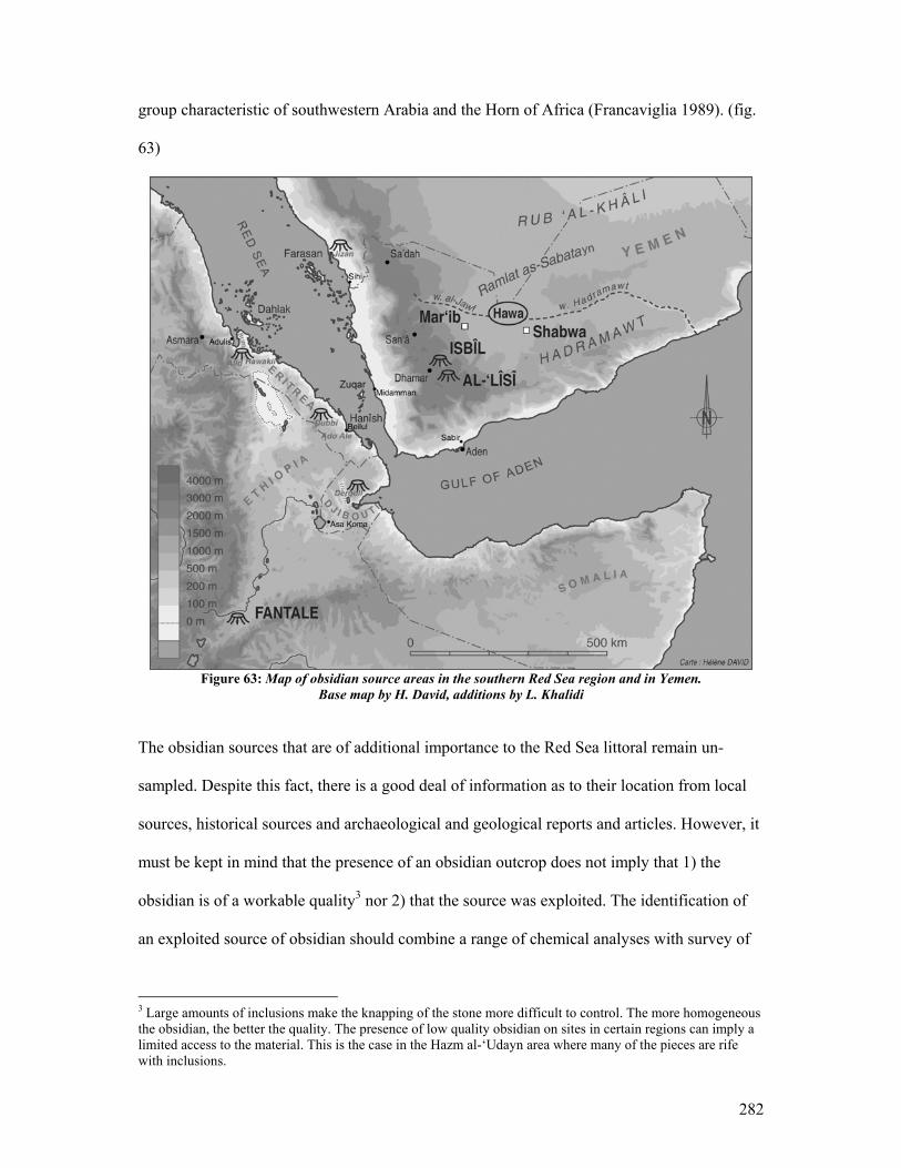
282
group characteristic of southwestern Arabia and the Horn of Africa (Francaviglia 1989). (fig.
63)
Figure 63: Map of obsidian source areas in the southern Red Sea region and in Yemen.
Base map by H. David, additions by L. Khalidi
The obsidian sources that are of additional importance to the Red Sea littoral remain un-
sampled. Despite this fact, there is a good deal of information as to their location from local
sources, historical sources and archaeological and geological reports and articles. However, it
must be kept in mind that the presence of an obsidian outcrop does not imply that 1) the
obsidian is of a workable quality3 nor 2) that the source was exploited. The identification of
an exploited source of obsidian should combine a range of chemical analyses with survey of
3 Large amounts of inclusions make the knapping of the stone more difficult to control. The more homogeneous the obsidian, the better the quality. The presence of low quality obsidian on sites in certain regions can imply a limited access to the material. This is the case in the Hazm al-‘Udayn area where many of the pieces are rife with inclusions.
283
the surrounding area in order to determine whether there were in fact activity areas where the
obsidian was quarried, prepared, and in some cases worked in the vicinity.
Three obsidian source areas in Eritrea are relevant to the discussion. The first is that of
Arafali (Hawakil source 19)(Zarins 1989). An obsidian specimen from the area of Arafali
was analyzed by Renfrew and assigned to group 6 (lj) (Renfrew et al. 1976). It is interesting
to note that two specimens from the Dahlak islands, Eritrea, one from the Farasan islands,
and several from Hureidha in the Hadramawt in Yemen match the Arafali specimen (Zarins
1990).
The second is the Alid volcano (source 20), which is located in the vicinity of Adulis. This
site lies along the Gulf of Zula and reached its fame as a major Red Sea port in the Aksumite
period. It is quite probable, however, that the site was occupied as early as the third-second
millennia BC and that it was used as a port contemporaneously (Fattovich 1985: 459). Zarins
points out that it is very probable the site was used as a port from which obsidian was
exported (Zarins 1989: 360). The two sources discussed above are located in the Buri
Peninsula source area and are across from the northern Yemeni Tihamah and the Saudi
Arabian Tihamah.
The third source area is located in the southern Red Sea region of Eritrea and lies across from
the central Tihamah survey area. Two source localities (22 and 23) in this area are mentioned
by Zarins and correspond to the Dubbi and Ado Ale sources (Zarins 1989: 351). Although the
author did not confirm the obsidian sources on a reconnaissance mission to the region, the
entire extensive volcanic zone in the area was dense with obsidian scatters. The prehistoric
284
site of Beilul4 is located in this general area. The site is characterized by a number of stone
circular tomb structures, obsidian debitage and rock art demonstrating that there was an
association between Eritrean prehistoric sites and the sources adjacent.
Until the southern Red Sea region’s Quaternary basalt outcrops are systematically surveyed
and obsidian sources are provenanced and properly collected, the state of obsidian research
and attempts at locating the origins of obsidian are limited and prone to criticism. This fact
does not, however, undermine methods that have been used to isolate patterns and to group
types of obsidian together. Given the characterized source areas in the Yemeni highlands and
Saudi Arabia, it is possible to recognize whether samples of obsidian collected from sites in
the region originated from these localities or not. In conjunction with the interpretation of
different plots, and the analysis of the spatial and density distribution of obsidian and
obsidian tool kits in specific areas, the results can be effective.
7.3 Obsidian from the Central Tihamah Survey Area: Analysis
The previous chapters have highlighted the importance of obsidian in the Tihamah coastal
plain. Certain sites have yielded a large amount of obsidian in the form of cores, flakes and
other debitage. The data suggests that although obsidian was available in the early Holocene
(by ca. 6th millennium BC) obsidian became the dominant tool material in the late prehistoric
period (ca. 3rd millennium BC) and available in relatively large quantities. Activity areas can
be isolated along the wadi branches and the general lithic assemblages from many sites
suggest that obsidian was being worked in the Tihamah itself, though it appears to have
arrived in the area in small pre-prepared nodules. Furthermore, the main study area (wadi
4 The site of Beilul was identified by the author on a reconnaissance mission to Eritrea in 2003. The permits allowed for site visits only, so the sites were documented but no collections were made.
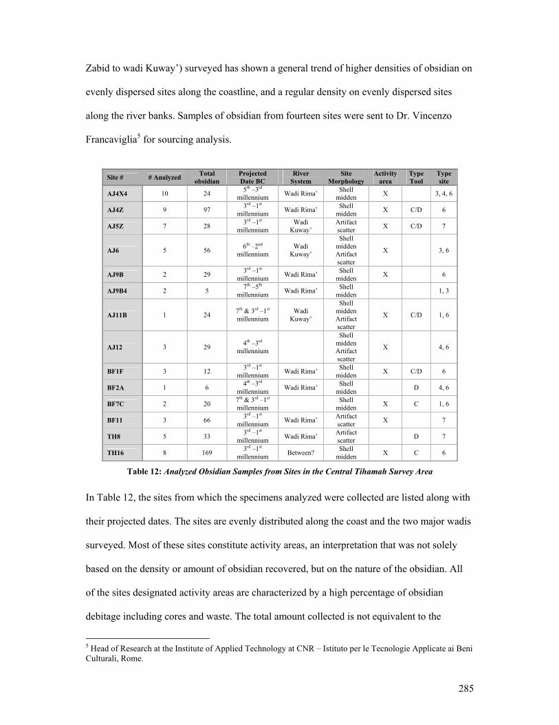
285
Zabid to wadi Kuway’) surveyed has shown a general trend of higher densities of obsidian on
evenly dispersed sites along the coastline, and a regular density on evenly dispersed sites
along the river banks. Samples of obsidian from fourteen sites were sent to Dr. Vincenzo
Francaviglia5 for sourcing analysis.
Site # # Analyzed Total
obsidian Projected Date BC
River System
Site Morphology
Activity area
Type Tool
Type site
AJ4X4 10 24 5th –3rd millennium Wadi Rima’ Shell
midden X 3, 4, 6
AJ4Z 9 97 3rd –1st millennium Wadi Rima’ Shell
midden X C/D 6
AJ5Z 7 28 3rd –1st millennium
Wadi Kuway’
Artifact scatter X C/D 7
AJ6 5 56 6th –2nd millennium
Wadi Kuway’
Shell midden Artifact scatter
X 3, 6
AJ9B 2 29 3rd –1st millennium Wadi Rima’ Shell
midden X 6
AJ9B4 2 5 7th –5th millennium Wadi Rima’ Shell
midden 1, 3
AJ11B 1 24 7th & 3rd –1st millennium
Wadi Kuway’
Shell midden Artifact scatter
X C/D 1, 6
AJ12 3 29 4th –3rd millennium
Shell midden Artifact scatter
X 4, 6
BF1F 3 12 3rd –1st millennium Wadi Rima’ Shell
midden X C/D 6
BF2A 1 6 4th –3rd millennium Wadi Rima’ Shell
midden D 4, 6
BF7C 2 20 7th & 3rd –1st millennium Shell
midden X C 1, 6
BF11 3 66 3rd –1st millennium Wadi Rima’ Artifact
scatter X 7
TH8 5 33 3rd –1st millennium Wadi Rima’ Artifact
scatter D 7
TH16 8 169 3rd –1st millennium Between? Shell
midden X C 6
Table 12: Analyzed Obsidian Samples from Sites in the Central Tihamah Survey Area
In Table 12, the sites from which the specimens analyzed were collected are listed along with
their projected dates. The sites are evenly distributed along the coast and the two major wadis
surveyed. Most of these sites constitute activity areas, an interpretation that was not solely
based on the density or amount of obsidian recovered, but on the nature of the obsidian. All
of the sites designated activity areas are characterized by a high percentage of obsidian
debitage including cores and waste. The total amount collected is not equivalent to the
5 Head of Research at the Institute of Applied Technology at CNR – Istituto per le Tecnologie Applicate ai Beni Culturali, Rome.
286
amount of obsidian scattered on these sites. A representative sample was in most cases
collected.
Finally, a range of periods of occupation and site types are represented. The majority of the
sites are late prehistoric in date, a fact that is not surprising considering that obsidian became
more available and widely used during this period.
Obsidian Analysis and Interpretation
All of the samples showed homogeneity in color (bottle green). 34 samples of the total
analyzed were selected for crushing, powderization and pelletization for traditional XRF
analysis, while the remaining samples were analyzed as is.
Different analytic approaches were used including traditional XRF, radioactive XRF, and
tube-XRF in order to retrieve major, minor and significant trace elements.
The 34 samples were analyzed by tube-XRF for the following main elements: Si, Al, Fe, Mn,
Mg, Ca, Na, K, Ti and P, and (separately) water as contained in the sample. The trace
elements: Nb, Zr, Y, Sr, Rb, Ni, Co, Cr, V, Ba, Ce, Nd and La were dosed.
The raw data was studied using discriminant analysis and conventional bi-elemental plots
including: Nb-Zr, Rb-Zr, Y-Zr, Ba-Zr, Cr-Zr, K2O-SiO2, Na2O-SiO2, Al2O3-SiO2, CaO-
Fe2O2, K2O+Na2O-SiO2, the Macdonald and Bailey and the Sigma-Tau of Alfred Rittman.
According to Francaviglia, the results of the plots have shown that of the samples chosen
from these sites, the majority definitely do not originate from the known sources in Yemen,
287
i.e. Jabal Lisi and Jabal Isbil6 (see appendix 1 for graphs). The fact that a large percent of the
archaeological samples are similar to samples from Eritrea is significant, since a large
obsidian source area exists directly across the Red Sea. The isolated samples in the
discriminant plots also demonstrate that some of the samples are not related to any analyzed
archaeological or source samples from either direction. Seeing as how more archaeological
samples from the Arabian side have been analyzed and compared to the central Tihamah
survey material, it is likely that these isolated obsidians pertain to unknown source areas in
the southern Red Sea region, and most likely in the Beilul area. Although an African origin is
not certain for all of the obsidian specimens analyzed, a discussion of microlithic
technologies that are directly related to an African tradition establishes an undeniable contact
between the two coasts of the Red Sea.
7.4 Obsidian Microlithic Technologies
Obsidian Geometric Microliths
In most parts of the world geometric microliths are synonymous with a Palaeolithic and
Mesolithic lithic tool technology. The occurrence of these tools in such late contexts in
Yemen is extremely perplexing when viewed out of geographic context. In Chapter IV, it was
demonstrated that this lithic technology occurred in tandem with a bipolar flaking technique
throughout the Tihamah coastal plain and on contemporaneous sites of the third – first
millennium BC. Furthermore, both technologies were made on obsidian only. This section
will illustrate how the late occurrence of obsidian geometric microliths and pièces esquillées
is contemporaneous with a similar phenomenon across the Red Sea.
6 This data was analyzed and interpreted by Dr. Francaviglia. (p.c. July 19, 2004).

288
The African Example
The occurrence of geometric microliths made on a variety of materials is well known from a
plethora of sites throughout sub-Saharan and North Africa. In the south and the interior these
traditions are well known from the Palaeolithic period as a successor to the Levallois
technique, while in parts of northern and eastern Africa they have a longer life-span and
continue slightly later into the Epipalaeolithic and Mesolithic (Phillipson 1993: 60-1). A list
of sites exhibiting geometric microlithic technologies in Africa would be excessive. It
suffices to say that despite some temporal variation, these sites are all attributed to Middle
and Late Stone Age industries. Furthermore they are continuous through space, occurring in
South Africa at sites such as Klasies River Mouth and Kalembo (Ibid: 66, 72), in Central
Africa at sites such as Matupi (Ibid: 83), in Eastern Africa at sites such as Kisese rockshelter
(Ibid: 85), in West Africa at sites such as Tiemassas in Senegal (Ibid: 89), and in North
Africa and the Sahara at sites such as Haua Fteah (14,000 years ago) and Columnata on the
coast (7,500 years ago) (Ibid: 94-96). In the North African and East African sequences,
however, it can be demonstrated that a later occurrence of microlithic technologies is attested
in coastal areas, while the interior and highland instances are contemporary with the rest of
Africa. The Horn of Africa provides the latest presence of geometric microlithic industries on
the African continent.
As Phillipson clearly demonstrates, East Africa and especially the African Horn have a
continuous use of this tool type from as early as the Palaeolithic into ‘Neolithic’ contexts
found alongside bifacial industries (Ibid: 85-6). These early Holocene industries can be found
in North Africa, the Sudan, the Nile valley, and greater East Africa in concurrence with lake,
river and coastal margin communities, some demonstrating the first ceramics and alternating
hunter-forager and early domestication strategies. While such modes of subsistence are
289
clearly related to the lush environments that characterized the early Holocene, the explanation
of the persistence of microlithic tool kits is less clear. It is possible that it corresponds to the
exploitation of a variety of microenvironments and a resulting specialized hunting and
incipient plant domestication, for which lighter hunting and other equipment, and economical
use of the materials and the tools was more advantageous. Because of their function as
composite tools, microlithic blades could easily be repaired or replaced without replacing the
entire implement, a factor that supports an opportunism and expediency as relates to the
materials and to tool making (Ibid: 99-100).
It thus becomes even more perplexing to trace an even later persistence of the tool kit towards
the Red Sea coast.
Late Prehistoric Geometric Microliths in the Horn of Africa
At the large site of Erkowit in Sudan, soundings and survey have yielded a microlithic
tradition which is given a date in the third millennium BC based on an associated ceramic
assemblage falling within the ‘Atbai Ceramic Tradition’ (Callow et al. 1981: 276, Fattovich
1997, Zarins 1989: 359).
The sites of Kokan and Ntanei in the Agordat area of Eritrea have yielded an abundance of
obsidian debitage including flakes and cores, as well as a microlithic technology consisting of
retouched lunates (Arkell 1954). It is suggested that the microlithic technology may belong to
the mid-second millennium BC ‘Jebel Mokram Group’ (Zarins 1989: 359).
At the port site of Adulis in Eritrea, deep soundings excavated at the turn of the century
yielded a large amount of obsidian flakes and microliths (Paribeni 1907). Several dates have
290
been suggested for the Adulis assemblage. While Fattovich assigns a date in the first
millennium BC, Zarins suggests a second millennium BC date based on ceramic parallels
with Sihi, Sabir, and SLF-1 in southwest Arabia (Fattovich 1985, Paribeni 1907, Zarins 1989:
359, Zarins et al. 1986). These ceramic parallels are rather dubious given that the ceramic
chronology for the Tihamah coastal plain is at best preliminary, however a second
millennium BC date is highly plausible given the occurrence of the tool type across the Red
Sea in this period.
At the site of Asa Koma in Djibouti, 23% of the tool assemblage (consisting of ca. 16,000
obsidian tools) (Joussaume 1995: 33-6) consisted of obsidian microlith geometrics including
both arch-shaped and circle segment samples. In addition a large number of pièces esquillées
are represented in association with bâtonnets, described in Chapter IV as waste produced
from the bipolar flaking technique (Ibid: 35-6). Based on C-14 samples, the dates obtained
for this site fall in the second millennium BC (Ibid: 32). All of the characteristics of the lithic
tradition of this site match those of the Tihamah. Although the site differs in many ways
(stone accessibility, different ceramic tradition) the contemporaneity suggests a parallel mode
of existence that is clearly linked by the Red Sea.
Similarly geometric microliths are attested from the sites of Asa Ragid7 on the coast of
Djibouti (Ibid: 30), and Goda Ondji and Rachid Hussein in the Ethiopian Harar, all dating to
the early to mid- Holocene transition (Ibid: 52-3).
7 This site has a long occupation sequence from the 5th to the late 1st millennium BC. Joussaume mentions that the geometric microliths may have been used throughout the sequence, although the ceramics date to the 2nd –1st millennium BC (Joussaume 1995: 30).
291
A microlithic tradition was documented at Er Rih island in Sudan (Callow et al. 1981: 36), at
the site of ‘Aqiq (Fattovich 1997: 276, Zarins 1989: 359) and the Red Sea Farasan islands
(Zarins 1989: 359).
A tradition of geometric microliths made on obsidian with associated obsidian pièces
esquillées was documented on the Dahlak islands in Eritrea. Blanc attributed this occurrence
to Wiltonian industries of the Mesolithic period, as at the time geometric microliths were
thought to be more ancient (Blanc 1952: 355-7). However Blanc found the occurrence of the
industries on the Red Sea island so perplexing that the problematics of whether paleographic
conditions would have allowed for occupation on this island, given the rise in sea levels, are
deliberated in the article (Ibid: 357). Given our current state of knowledge, it can now be
demonstrated that such a tool kit was used into later periods. This has been confirmed by the
parallel use of geometric microliths and (where they have been identified) pièces esquillées
made on obsidian at all of the sites mentioned above as well as those across the Red Sea
along the Yemeni Tihamah. These are dated to between the third and the late first mellinnium
BC and are a good indication that the Dahlak tool kit documented by Blanc in the 50s and
originally dated to the Mesolithic, is also late prehistoric.
The occurrence of geometric microlithic and bipolar flaking technologies that are restricted to
obsidian on late prehistoric sites throughout the Red Sea region of the Horn and the Arabian
Tihamah, removes all doubt that this is a phenomenon linked to Red Sea coastal societies.
While an African influence can be suggested for coastal Arabia, it is quite evident that the
situation had much less to do with a diffusion of material and tool technology and more to do
with an existing network of contacts and relations on the Red Sea, its islands and its coastal
plains. Given the fact that the earliest evidence for geometric microliths in Yemen happens to
292
be along the Tihamah coastal plain (Rahimi 2001), while in Africa the history is much longer
and can be traced throughout the continent, it cannot be denied that the concept is African. Its
introduction in the Yemeni and Saudi Tihamah, however, is neither diffusion nor influence; it
is rather part of the continuum that is the Red Sea World.
The fact that obsidian geometric microliths are contemporary on both coasts demonstrates
that the Red Sea was but an extension of the two coasts. In contrast, the occurrence of the
same tradition in the Yemeni desert fringe and Hadramawt in the mid-first millennium BC is
one example of the time lag that can occur across geographic transitions.
Geometric Microliths in Arabia
Chapter IV introduces the widespread presence of obsidian geometric microliths and pièces
esquillées along the Tihamah Red Sea coast (Keall 2004, Khalidi 2005, Rahimi 2001, Zarins
1989, Zarins et al. 1986, Zarins et al. 1985). This section will present the occurrence of this
technology in later contexts of interior Arabia.
Geometric microliths were first identified by Caton-Thompson in the 1930s on surveys and
excavations in the Hadramawt. Having worked in East Africa, she recognized these tools. She
collected geometric microliths from a number of first millennium BC contexts including on
survey in wadi ‘Adim, in the areas of Shibam, Meshed and Hureidha and excavated them in
situ in the Moon Temple of Hureidha as well as at two associated tombs (Caton Thompson
1938, 1944, 1953, Caton Thompson et al. 1939).
Furthermore these tools have been collected at the sites of Bir Hamad, at Shabwa and the
hinterland of Timna (Inizan et al. 2002, Sedov 1991). Inizan confidently dates the geometric
293
microliths at Shabwa and on the surface near Timna and Bir Hamad to the first millennium
BC by association with the well known and predominant South Arabian elements of these
sites (Inizan et al. 2002). A few rare examples made on chert were recovered from excavated
contexts at the first millennium BC site of Mukaynun in the Hadramawt8. Finally, a number
of obsidian geometric microliths in the form of circle segments and trapezoids were
excavated by the IAM from one tomb, MKDii/T13, on the site of al-Makhdarah along the
desert fringe. This tomb was dated to 790 BC (De Maigret et al. 2005: 20, Pl.34a).
Discussion
There is a clear temporal distinction between the occurrence of a geometric microlith toolkit
in the Tihamah and the desert fringe and Hadramawt interior of Yemen. This can be
explained in a number of ways, however until more work is carried out any explanation
remains speculative. For the time being the following can be said with certainty. The Red Sea
was an extension of both coasts and constituted an arena for a seaborne lifestyle. Although
some of the obsidian found does not match any archaeological or source samples from either
side, the clear link that existed across the Red Sea, demonstrated by the occurrence of
contemporaneous lithic tool kits and technologies on both coasts, articulates what is also clear
from the results of the obsidian analysis; that the majority of the obsidian originates on the
Horn of Africa coast. Lastly it has been demonstrated that this same tradition of geometric
microliths is more ancient in the Tihamah than elsewhere in Yemen.
8 Personal communication, 2004. Jérémie Schiettecatte, member of the French Archaeological Mission to the Hadramawt.
294
VIII Conclusion
The paradox that lies at the heart of a work that aims to define any region or culture through
multiple perspectives and approaches is that it only ever succeeds in defining it in relation to
what it is not, or to that which has already been established and categorized. This is certainly
the case for the Tihamah coastal plain, which differs vastly from adjacent regions of South
Arabia but also exhibits variability within the physical geography that circumscribes it. The
acknowledgment of such a paradox is in many ways indispensable to an impartial (if it can
ever be impartial) interpretation of the large body of data at hand. The individuality that sets
the Tihamah apart from other regions is not compromised by the recognition that the
accumulation of contacts and influences are what have always made the region what it is.
It is through this paradoxical lens that the Tihamah can be understood on the one hand as a
cultural unity, and on the other as a mosaic of interdependent communities that have adapted
to a variety of micro-niches. These micro-niches are critical to understanding the nature of
culture-contact precisely because they exist at the crucial juncture of geographic,
environmental and hence cultural transitions. The microcosm of the Tihamah is thus a
window into the macrocosm of Southwest Arabia and the African Horn.
Negotiating the Spatial and Temporal Landscape of the Prehistoric Tihamah
The landscape of the Tihamah has been interpreted in two ways in this dissertation: spatially
and temporally. In viewing the physical landscape as that which both unifies and diversifies a
295
region, settlement strategies as reflected through subsistence and human-environment
relationships have been demonstrated spatially.
In the early Holocene, the mangrove forests that characterized the deltaic littoral provided a
diverse flora and fauna for foragers who inhabited its fringes. The material evidence
demonstrates a dietary reliance on molluscs, and to a lesser degree on fish. The inter-fluvial
steppe offered an alternative fauna and a terrain conducive to hunting, so that the exploitation
of one or both environments allowed for a multitude of strategies to co-exist either
concurrently or independently. The presence of equid remains in both contexts illustrates the
presence of temporary hunting camps dispersed along the steppic plains. In contrast, the
banks and fringes of the river deltas were occupied by a continuous string of ephemeral sites
in the form of shell middens that bore evidence of cattle and incipient equid domestication as
well as of significant occupational sequences. The implication is that this area was either
seasonally occupied or else provided a base from which hunting and other activities could be
conducted seasonally. The spatial distribution of sites presents an exploitation of a number of
resources; fishing along the littoral and rivers, foraging along the river deltas, and hunting
along the lightly forested plains. Furthermore, the density of site distribution along the deltas
expresses a sustainability and stability offered by these micro-niches. Towards the interior the
visibility of the sites of this period is affected due to a greater degree of sedimentation and
intensified cultivation, both ancient and recent.
In viewing the transformation of the physical landscape through time, the concomitant
alterations in settlement distribution as reflected through newly adopted economic strategies
are demonstrated temporally.
296
The early to middle Holocene transition witnessed a gradual drying of the climate, a resulting
progressive decrease in sea levels and a recession of the mangrove habitats that supported the
early Holocene coastal communities. This can be confirmed by the steady rearrangement of
river delta and littoral site distribution further towards the coast (west) between after the
seventh millennium BC. By the fourth millennium BC sites were beginning to disperse along
the coastline and the riverbanks. The evidence points to an increase in fishing, as well as an
increase in domesticated cattle remains. The hunter-forager strategies of the earlier periods
are still evident in the material record but at a lesser scale. By the late prehistoric period, sites
retained the fourth millennium BC site dispersal strategy and began to cluster into
conglomerate settlements along the littoral and the riverbanks. The increased recession of the
lacustrine environment and a diminution of available dietary resources pushed populations
further towards the margins of shrinking eco-niches, dispersed into clusters the long string of
settlements that once occupied the area, and drove communities to diversify, specialize or
look for alternate economic strategies. There is evidence for this in the increased
representation of domesticated cattle and ovicaprids, an increase in fish remains and a
decrease in mangrove shell and wild equid. Increased settlement size and the introduction of
a non-portable material culture point to a sedentary lifestyle.
The temporal landscape is further elucidated with the continual presence of these strategies
regardless of the physical transformation of the landscape through time. It is in the spirit of
Braudelian temporality, a longue as opposed to a moyenne durée or evenements that an
underlying continuum exists (Braudel 1969: 44-60). The continued exploitation of marine
resources and fishing by littoral communities can be traced from the early Holocene until the
present day. Similarly, sea-bound communities are indicated by the presence of obsidian with
an African origin in the archaeological record from the sixth – first millennium BC. Sea-
297
bound communities continue presently to be represented along the Tihamah littoral in the
form of families of fishermen who spend more time searching for profitable fishing localities
throughout the Red Sea, often going as far as Eritrea for weeks at a time, than they do on
land.
Although these perspectives can appear static, reducing human action to the will of the
geography and environment, it is without question that in this spatial and temporal landscape,
there is a cultural landscape that is formed with conscious and unconscious human action.
Although such a landscape is difficult to trace in the archaeological record, geoarchaeological
studies have associated landscape degradation in the middle Holocene with human action and
environmental factors (Wilkinson 1997, 2003). Other examples are those of a constructed,
perceived or symbolic landscape. The latter two are, in part, a reflection of the
archaeologist’s interpretation, but can be legitimated in the presence of strong archaeological
evidence.
Negotiating the Cultural Landscape of the Prehistoric Tihamah and Highlands
Through Settlement, Land-Use and Landscape Features
The Cultural Landscape: Land-use
In the early Holocene environmental stability was present and the quasi-total human reliance
on this environment for sustenance did not require a large degree of landscape modification
or land-use. Detrimental human effects on this environment were minimal and progressive
and hence difficult to trace in the archaeological record. Early Holocene humic paleosols in
the highland sequence display organic stability (Wilkinson 1997). This indicates that even if
298
there was an overexploitation of resources during this period, the environment was stable
enough to replenish the supply.
The transformations to the landscape of Yemen in the middle Holocene have been shown to
reflect a concomitant process of climate change and intensified land-use. Human actors and
the environment are inextricably tied and a balance is continuously negotiated between the
two. The force of human actions is commonly underestimated, especially in relation to the
uncontrollable forces of nature. The direct transformations inflicted by modern humans onto
the environment have demonstrated that humans are not simply pawns to an environmental
determinism. This has been proven to be the case in Yemen’s late prehistoric period when a
number of different pressures and human actions led to sedentism, a growth in population,
intensified agricultural and pastoral land-use and organized systems of water management.
This, in conjunction with a drying climate led to deforestation, soil destabilization and
massive erosion (Ibid).
The implication is not that human activity was merely destructive but that it formed a part of
the process of human-environment negotiation. A balance with nature is retained on many
levels during this period. In the highlands, agricultural terracing both allowed for slopes to be
cultivated and at the same time stabilized slope erosion (Ibid).
The Tihamah sequence shows a similar trend of early Holocene stability represented by
highly organic clay sequences followed by middle Holocene massive flooding events
represented by thick alluvial deposits and gully formation. The degree of land-use in the late
prehistoric Tihamah remains unclear, as agricultural activity has not been adequately proven.
The irrigation canals excavated at the late prehistoric site of Ma’laybah in the Aden area are
299
the only example known to date of such an activity (Buffa 2002). The site of Kashawba’
along the interior wadi Rima’ has exhibited a pattern of field scatter reminiscent of signatures
for agricultural manuring – a strategy identified in the northern regions of Iraq and Syria
(Wilkinson 1982, Wilkinson 1989). Nonetheless, a number of lines of evidence (a drop-off of
mangrove mollusc exploitation, increase in domesticated herds, formation of large organized
settlements in association with possible small-scale agricultural activity) point to intensified
land-use and a gradual transformation of wetlands into drylands.
Human effects on the landscape are not limited to the natural landscape. The constructed
landscape had more visibility and impact (physical and symbolic) as settlements became
larger, and structures became more monumental in the late prehistoric period.
The Constructed Landscape
The construction of the landscape can occur to varying degrees. Although the larger
settlements of the late prehistoric period marked the most visible indication of a constructed
landscape, this is not to say that earlier periods or smaller settlements did not make up a part
of the built environment.
The built environment can be interpreted in a number of ways. A wider view can elucidate
the demarcation of space and territoriality, while the more detailed view can elucidate the
organization of space and town planning as well as the relations between domestic areas and
associated landscape features.
The large stone megaliths of the third – second millennium BC are the most preserved,
visible and premeditated acts of construction identified to date along the prehistoric Tihamah.
300
The scale of these stones and their deliberate placement at crucial cultural and geographic
transitions demonstrates a human demarcation of space. The stark contrast of large upright
stones on a flat sandy plain is significant to the degree of monumentality and visibility such
built elements provide within a landscape and within the perceptions of the populations in
contact with them.
The settlements that formed around these stone monuments and progressively grew larger
exhibit a less monumental and more organic construction of the Tihamah landscape. These
settlements sprawled through time, but continued to grow around the megalithic
conglomerations until the end of the first millennium BC. The large public buildings that
appeared in the terminal phase of the occupation of the late prehistoric site of al-Midamman,
for example, are also monumental and like the megaliths centralized space on the level of
settlement organization.
Finally, the materials used are significant to interpretations of such a landscape as they affect
the visibility, both physical and perceived, of a structure or feature. According to Criado “
…the construction of visibility presupposes specific material resources which help determine
the unique character and configuration of a form of visibility.” (Criado 1995: 198). The
ephemeral huts that have dotted the Tihamah landscape for millennia are camouflaged within
the landscape as they use local materials and are organic in form. The terraces of the
highlands are similarly camouflaged as they are constructed of the same materials as the
outcrops on which they are built and follow the topography of the slopes. In contrast, the
megaliths of the Tihamah are striking as their verticality and the dearth of stone in the region
makes them more visible. Such monumentality can be symbolic in a number of ways.

301
Criado divides the construction of visibility as relates to these material resources into two
categories; “… the reutilisation of natural elements, and the construction of artificial
elements” (Ibid). These two processes are inextricably tied in Yemen where the land and its
resources continue to predetermine the form and material of constructions. In the late
prehistoric and early historic highlands, natural elements were often re-used. City walls often
incorporated natural features of a cliff edge or plateau top while dam sluices were commonly
carved into existing rock interfaces. In the Tihamah it is the artificial construction that
outweighs the re-use of natural elements. It is most accurate to say that in the prehistoric
Tihamah, natural elements provided the materials for the construction of artificial elements.
In this case we may add to Criado’s former quote by stating that “… the construction of
visibility presupposes specific material resources [and the landscape] which help determine
the unique character and configuration of a form of visibility.” (Ibid: 198)
Negotiating the Cultural Landscape of the Prehistoric Tihamah and its Adjacent
Regions Through the Symbolic and the Perceived
Concepts of visibility are crucial to interpreting symbolic and perceived landscapes. Criado
mentions two strategies of visibility that are relevant to the interpretation of the symbolic and
perceived late prehistoric landscape of the Tihamah coastal plain. First are what he terms
‘strategies of exhibition’. He states that:
These strategies produce intentional results in space, but some of them may have an involuntary
temporal dimension. Moreover, in this way they can generate products and effects which have both a
spatial and temporal character. (Criado 1995: 199)
Second are strategies he terms ‘monumental’, described as ones that:
302
… attempt to highlight the visibility of social creations both within the social present and through
time, controlling and overcoming the temporal dimension of change. Monumentality produces
intentional results (both products and effects) projected both in space and time. But it can also
produce non-intentional results which project in both dimensions. (Ibid)
Both strategies are appropriate in the discussion of the building of megalithic monuments and
the way that their visibility can imply symbolism in the form of monumentality, territoriality
and social meaning.
The Symbolic Built Landscape
The third to first millennium BC witnessed an overarching expression of stone monuments
that incorporated megalithic stones. This has been documented from the highlands of the
Horn of Africa to the desert fringe of Yemen. Large funerary stone stelae and circular tombs
and tumuli characterize the Ethiopian highlands and the Djibouti, Eritrean and Sudanese
coastal lowlands. In Yemen, standing megaliths are interspersed along the rivers of the
coastal Tihamah and upright megalithic trails associated with circular structures are found
along its foothill interior. The western escarpment is dotted with circular tombs on its
promontories, at least one with an upright megalithic trail. Circular tombs located on plateau
edges and scarps and large stones mark the funerary and domestic architecture of the central
highland plains of Yemen. Necropolises composed of dry-stone turret tombs with long trails
of stone, and tumuli, are scattered along the plateaus of the desert fringe. Finally occasional
dolmens are found along the desert fringe and the coast of Hadramawt and Mahra.
These monuments incorporate both strategies of exhibition and those of monumentality.
303
Strategies of Exhibition
The use of megalithic stone elements on the one hand, and prominent structures, often with
impressive associated features in the case of the trails, on the other hand, produces intentional
results in space. The same is true for their location, which imparts visibility. In the case of the
desert fringe, the highlands and the western escarpment, all of these stone monuments (save
those associated with domestic architecture in the highlands) are located on elevated outcrops
at points where they are visible from a number of directions. Here the verticality or visibility
of the element is in the natural elevation and not necessarily in the structures themselves. In
the case of the Tihamah and in certain cases the Horn of Africa coast, it is the verticality of
the stone monuments themselves that conveys visibility. However, it is unclear whether these
had a voluntary temporal dimension. Each context is different and each individual element
may have or have not had a projected temporality.
Strategies of Monumentality
The production of both intentional and unintentional results in space and time is conveyed in
the function of most, if not all, of these structures as funerary monuments or markers.
Temporality can be reflected in the classic ‘life after death’ interpretation. Although scholars
have interpreted such a meaning in the symbolism of the turret tomb trails (De Maigret et al.
2005), it remains speculative.
However, in burying the deceased and intentionally and prominently marking the resting
place, a temporality is implied with the expression of remembrance. Memory is inherently
temporal. Such an expression of memory can also involve space in a timeless way through
the marking of an ancestry in a specific place; this is a premonition of territoriality whether
intentional or not. The best modern example of this is in Palestine, where territorial claims
304
are legitimized in light of the marked presence of an ancestry (Church of the Nativity, the
Temple Mount, etc.)(Abu El-Haj 2001: 22-38).
Finally, intentional results in space and time can be interpreted from the perspective of the
significance attributed to the materials associated with these monuments. This is a doubly
removed perspective as it implies that by using or interring valuable materials an individual
or group is attributing meaning and permanence to the space. The presence of luxury grave
goods such as carnelian beads in the turret tombs of the desert fringe (Steimer-Herbet 2004)
can imply more than just exaltation of the deceased but also of the structure that houses the
deceased. In the Tihamah, the excavated megaliths of al-Midamman produced a foundation
deposit which included a large obsidian core, metal objects and gold beads, all of which were
highly prized and locally unavailable items (Keall 2004, Keall et al. 2000). The nature of a
foundation deposit is to honor the construction of a structure. In addition, the structure itself
was made of a material, stone, that is also highly prized and locally unavailable.
Unintentional results through space and time are numerous. This concept is also relative to
who assigns intention, and at what point in time. If the intentionality is assigned by those who
built or commissioned the structure, the interpretation becomes slightly less complicated. In
the desert fringe and highlands many of the tombs and tumuli were re-used to inter the
deceased for millennia and an act of moving bodies aside to make room for more is
demonstrated in the archaeological record (De Maigret et al. 2005, Steimer-Herbet 2004). It
is doubtful that the original commissioners intended to build a structure that would house the
deceased for millennia. The growth of towns around them and the reuse in later monumental
structures of the upright megaliths of the Tihamah are similarly unintentional.
305
Territoriality
As was suggested previously, ancestry can presuppose territory. By meaningfully marking a
funerary space, the space itself becomes meaningful. In the same way, temporality, in the
form of duration of an occupation of a space, can also presume territory. The combination of
funerary monuments and the duration of settlement in the late prehistoric sites of the Tihamah
(Type 5/7) for at least a millennium makes a stronger point for territoriality in the region.
Sorenson’s fieldwork on the island of Als in Denmark has demonstrated that the duration of
settlement of an area, even in a semi-permanent sense, can bound movement to a particular
territory. She asserts that the location of barrows or burial mounds “… had a central role in
the formation of these territories, and may have provided a fixed long-term focus for groups
of communities.” (Sorensen 1992: 132). It is perhaps in the same light that these Tihamah
sites should be interpreted territorially. That is, that the presence of a monumentally central
place and the re-occupation of the area surrounding it provided a long-term focus within and
a delimitation of, territory, here interpreted as that which bounds the movement of a group.
Steimer-Herbet interprets the Yemeni desert fringe necropolises in the same way. She states
that these monuments were a focal point for the territory within which pastoral-nomadic
groups that inhabited the region moved. Moreover, she maintains that the continued re-use of
the necropolises through time, the ancestry that tied these groups to the place, as well as the
fact that the materials for building were already present, may have led to a gradual process of
sedentism (Steimer-Herbet 2004).
The location and distribution of settlements and monuments can also intentionally or
unintentionally evoke or mark territory. The location of the Tihamah megaliths is not
arbitrary. Rather, in each case, it is precise and dispersed in a meaningful way. On a macro
306
level, the parallel alignment of these monuments from the southern end to the northern end of
the Tihamah coastal plain is conspicuous and suggests a demarcation (fig. 64). Until more
monuments of this kind that fall into this same alignment are identified in the archaeological
record of the Tihamah, this interpretation of the pattern remains provisional.
The spatial distribution of these monuments is on fluvial and concurrently on geographic
junctures; the foothill/coastal transition, at the point where the delta forms and at the point
where a major river course meets the Red Sea. This can be interpreted as a naturally
occurring or unintentional demarcation of territory as all of these locations make up what
Sanlaville describes as ‘ les secteurs les plus favorables’ for human occupation during this
period (Sanlaville 2000: 165). However in the same way that they are favorable sectors for
human exploitation of the land and for settlement, they are also physically significant
transitions. These transitions are often what constitute the edge of territory. In this way
territory is dichotomous, being both natural and constructed.
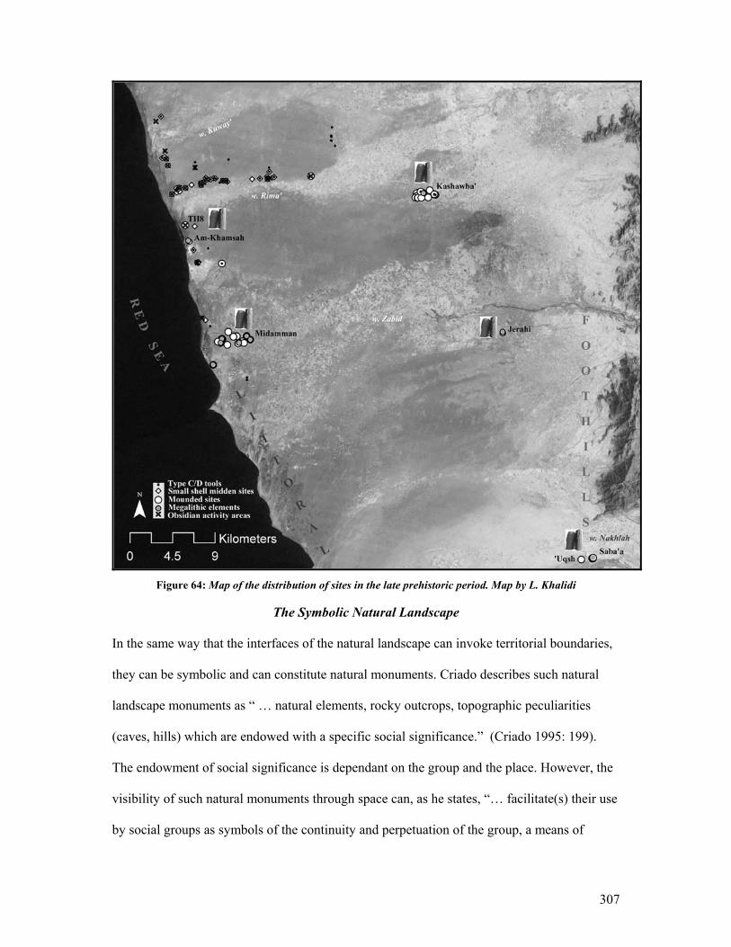
307
Figure 64: Map of the distribution of sites in the late prehistoric period. Map by L. Khalidi
The Symbolic Natural Landscape
In the same way that the interfaces of the natural landscape can invoke territorial boundaries,
they can be symbolic and can constitute natural monuments. Criado describes such natural
landscape monuments as “ … natural elements, rocky outcrops, topographic peculiarities
(caves, hills) which are endowed with a specific social significance.” (Criado 1995: 199).
The endowment of social significance is dependant on the group and the place. However, the
visibility of such natural monuments through space can, as he states, “… facilitate(s) their use
by social groups as symbols of the continuity and perpetuation of the group, a means of

308
naturalizing social discourse.” (Criado 1995: 199). Such a statement presumes that the
archaeologist as interpreter understood the ancient mind, not only on an individual but also
on a group level. Such a statement is difficult to prove without an oral history or written
sources but can be insinuated in the archaeological record, such as in the way that sites in the
Tihamah are located at significant geographic junctures. In the Tihamah case, in acting as
focal points for the groups and at the same time marking the boundary of the group’s space,
these natural features of the landscape may have been symbols of the continuity and
perpetuation of the group.
Such social significance is most visible in the archaeological record when a group marks the
natural feature symbolically. The Himyarite inscription at the site of Mariyah in the DSP area
is located on the cliff edge of one of the natural passes before the central plains plummet into
the western escarpment (it is a natural gateway characterized by an opening flanked by two
large plateaus) and is significant in this way. It marks a natural feature that represents the
edge of a geographic boundary, territory and culture. It also marks the passing of a trade route
and the presence of a large site.
In the prehistoric period, the symbolism of an inscription can be replaced by the symbolism
of a megalithic monument. The location and nature of the site of al-Muhandid in the Tihamah
insinuates the monumentality of the natural features it lies adjacent to: the commencement of
the foothills. The architecture of the monuments that make up the site is an amalgamation of
the trails of the desert fringe turret tombs, the circular tombs of the highlands and the large
upright megaliths of the Tihamah coastal plain. This monument marks the natural interface
that exists as a passageway to those adjacent regions whose cultural expressions it projects
309
architecturally. Such hybridity is an indication of the group’s awareness of what lies beyond
and the symbolic meaning of this natural frontier.
A similar situation arises at the mid-altitude site of al-Suq, which lies at the source of the
Wadi Zabid and at the edge of the ascending escarpment. Again, the site is an amalgamation
of three zonal architectural expressions; the trail, the circular tomb and the upright megaliths.
An acknowledgement of the meaning of the natural interface and its cultural connotations is
visible in the group’s architectural expression and in its location. This acknowledgement, as
represented through architecture, is invaluable to an archaeological interpretation of the social
meaning of space in the prehistoric period.
The Significance of the Visibility of Natural Monuments
Finally, there is the natural monument that is visible at a distance, visible only at certain
moments, or invisible but known to a group. Such natural monuments can have perpetuated
social meaning in the prehistoric period.
It is significant that in the central Tihamah study area, the islands of Zuqar and Hanish
become visible on clear days during mid-winter. This has several implications. The first
relates to concepts of space and orientation. The second relates to concepts of distance and
travel, the third to concepts of temporality and the fourth to concepts of verticality and
material procurement. As we have discussed in this work, there is a continuum of small sea-
bound communities that have occupied the littoral from the early Holocene until the present
day. Although the visibility of these islands does not only affect the littoral communities, it is
to these communities that such a natural monument is most pertinent as their perspective is in
most cases sea-bound.
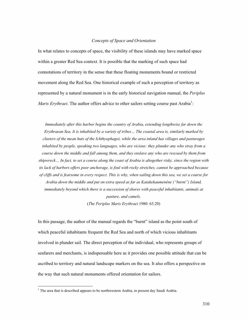
310
Concepts of Space and Orientation
In what relates to concepts of space, the visibility of these islands may have marked space
within a greater Red Sea context. It is possible that the marking of such space had
connotations of territory in the sense that these floating monuments bound or restricted
movement along the Red Sea. One historical example of such a perception of territory as
represented by a natural monument is in the early historical navigation manual, the Periplus
Maris Erythraei. The author offers advice to other sailors setting course past Arabia1:
Immediately after this harbor begins the country of Arabia, extending lengthwise far down the
Erythraean Sea. It is inhabited by a variety of tribes… The coastal area is, similarly marked by
clusters of the mean huts of the Ichthyophagoi, while the area inland has villages and pasturages
inhabited by people, speaking two languages, who are vicious: they plunder any who stray from a
course down the middle and fall among them, and they enslave any who are rescued by them from
shipwreck… In fact, to set a course along the coast of Arabia is altogether risky, since the region with
its lack of harbors offers poor anchorage, is foul with rocky stretches, cannot be approached because
of cliffs and is fearsome in every respect. This is why, when sailing down this sea, we set a course for
Arabia down the middle and put on extra speed as far as Katakekaumenêne (“burnt”) Island,
immediately beyond which there is a succession of shores with peaceful inhabitants, animals at
pasture, and camels.
(The Periplus Maris Erythraei 1980: 63.20)
In this passage, the author of the manual regards the “burnt” island as the point south of
which peaceful inhabitants frequent the Red Sea and north of which vicious inhabitants
involved in plunder sail. The direct perception of the individual, who represents groups of
seafarers and merchants, is indispensable here as it provides one possible attitude that can be
ascribed to territory and natural landscape markers on the sea. It also offers a perspective on
the way that such natural monuments offered orientation for sailors.
1 The area that is described appears to be northwestern Arabia, in present day Saudi Arabia.
311
From a land-bound perspective the visibility of the islands can also facilitate orientation, both
for sailor’s setting out to sea and for those inhabiting the coastal area.
Concepts of Travel and Distance
The presence of these islands on the horizon can also have instilled a desire of something to
attain, reach or move towards, even of something to discover. It is possible that the visibility
of Zuqar may have been a factor in motivating the earliest seafaring communities to move
beyond the coast. Once a crossing has been made it is no longer a daunting plunge into the
unknown; and it has been demonstrated in several ways throughout this thesis that the voyage
across the Red Sea, and seafaring activities within it, were not only possible but were made as
early as the sixth millennium BC.
In light of this it is evident that sea-based communities, beyond those fishermen that
remained near the shore, were already established in the early Holocene. Furthermore, they
did not regard the sea as an obstacle but as a means of survival and passage from one island
to the next, from one fishing oasis to another and from one shore to the next. With this in
mind, the islands can also be interpreted as monuments that marked the distance from one
point to the next. This is reflected throughout the Periplus Maris Erythraei in stades and or
‘days’ between one land- or sea-mark and the next (Ibid).
Modern fishing communities express distance as the time it takes to sail between one island
and the next, so that the crossing to Eritrea would entail four hours to Zuqar, two hours to
Hanish beyond, and an additional few hours to the opposite shore. They very rarely cross
directly, as they profit from island hopping by fishing along the reefs of the islands. At the
312
same time, they never go onshore on the islands and remain boat-bound until they reach the
opposite shore 2.
Concepts of Temporality
While on the one hand the distance between islands insinuates time in space, the visibility of
the island of Zuqar at one time of the year demonstrates the way that natural monuments can
evoke a different temporality. Such an occurrence was probably both enigmatic and acted to
divide seasons and mark time at a longer scale. Although other natural occurrences surely
also marked seasonality, it is possible that this powerful visual sign affirmed it.
Keall suggests that the megaliths of the site of al-Midamman are aligned with the mid-winter
sunset behind the island of Zuqar (Keall 2004). Given that the peak of the island is the most
prominent feature in the area and is the only element in the landscape, besides the upright
megaliths, that reflects verticality, it is not out of line to give such meaning to the alignment.
If this were intentional, there exists an implication of the natural monument marking both
space and time. Temporality is reflected in the appearance of the island at one time of the
year, while the alignment in relation to it is an acknowledgement by the group of that
occurrence at that time. Space on the other hand is reflected in the possibility that the island,
as the most prominent vertical marker on the landscape, acted as a point of perspective which
guided the placement of the stones in a straight line. This relates to both concepts of
orientation which have been discussed and concepts of verticality which we will discuss
below.
2 These observations were made between 2001 and 2005 by the author and are an amalgamation of conversations and cumulative study of the practices of and experience with local fishermen along the length of the Tihamah, specifically with the family of Am-Zugagiyah.

313
Concepts of Verticality and Material Procurement:
Sea-bound Communities
In the case of the island of Zuqar, it is evident that it is the landscape context within which it
sits that makes it monumental. The flatness of the coastal plain and of the sea is only made
flatter by the lack of natural vertical (and in this case visible) landmarks. It is in this spirit that
the prominent verticality of the peak that characterizes the island of Zuqar must be viewed. In
support of this perspective, it must be reiterated that in the central Tihamah mountain ranges
are not visible in any other direction.
Using the evidence we have presented for the value of stone among the prehistoric societies
of the Tihamah, both in its colossal and miniature forms, both as a building material and a
tool material, it is necessary to raise the possibility that the visibility of the peak of Zuqar had
implications for stone procurement. It is not suggested that such implications are directly
associated with the island of Zuqar, but with the association that the island has to sea-oriented
strategies for material procurement. An obsidian source, for example, is not present on Zuqar.
Stone for building, however, may have originated there, while it may have also originated
from the eastern foothills.
Until analysis is conducted on the stone monuments of the Tihamah, it is unprofitable to
speculate about the origin of the source. By contrast, the sourcing analysis of obsidian from
the central Tihamah study area has demonstrated that the majority of the samples did
originate from outside of Arabia. Given the similarity of samples from this region to those in
Eritrea, and the location of a source directly across the Red Sea, beyond the island of Zuqar
and Hanish, it becomes increasingly evident that the opposite shore provided the source of
the dominant tool material of the prehistoric societies of the central Tihamah.
314
Land-bound Communities
It must be reiterated that the width of the Tihamah can reach 60 km west to east. Within this
lateral area there are zones of variable visibility. It is within each of these zones of visibility
that perceptions of the landscape can be understood. The littoral area has been discussed in
detail above; however, at least two other zones of visibility exist along the Tihamah coastal
plain. In the central Tihamah, the lateral middle zone is an area where no mountain ranges are
visible in either direction. In this zone, the relationship to mountain ranges is attained through
contact or movement. In the foothill zone (which includes some littoral zones in the north and
south of the coastal plain) the relationship to verticality is (east) towards the foothills and
escarpment. It is only through a discussion of the configuration of the societies and their
settlements and culture contact, as reflected through their material culture and architecture,
that the relationship between these three zones of visibility within the Tihamah coastal plain
can be interpreted.
Discussion
The physical, constructed and perceived landscape has affected and reflects the trajectory of
prehistoric societies. In an overarching sense, the changes that occurred between the early
and middle Holocene in the physical, constructed and perceived landscapes are visible in the
archaeological record. What is most clear is that within this time frame the vision of the
world became progressively larger. An exploration of material culture and culture-contact
will follow.
315
Material Culture: Interpreting the Site, Site Interaction and Culture Contact
Because the materials studied were not excavated but consisted of surface assemblages
collected on survey they are not wholly representative. The detail of the analysis and the
interpretation of the material assemblages is thus limited. For example, the limited variability
visible in the surface ceramic assemblages, in conjunction with their state of preservation,
made analysis and subsequent interpretations difficult. Without more controlled stratigraphic
contexts, the interpretation of this assemblage is inconclusive.
Materialist approaches used in this dissertation are by no means bound to a particular
theoretical school, but are rather a product of the cumulative study of contexts. The materials
were studied in relation to the micro- and macro- context of the object, where it was possible.
The interpretations that will be presented here may allude to one school or another; however,
the intention is to bring dimension to the objects, the people who made them, the way they
were made, and the context in which they were made, and not to inject them with exaggerated
meaning where it is not suggested by the context. As Buchli reminds us, there is always “ the
risk of fetishising such material goods and inappropriately attributing meaning” (Buchli
1995: 187).
Without an archaeological context, the object loses meaning, and although it can acquire a
new meaning in a secondary context, it is no longer applicable to the wider multi-dimensional
interpretation of prehistoric settlement, strategy and contact that is sought in this dissertation.
As Eaton maintains, “ If an artifact does not have good context, we can do little with it
interpretively and it has no real place in the corpus of archaeological data.” (Eaton 1992: 81).
It is under the premise of understanding context in a dimensional way that the material
evidence has been presented and will be interpreted. Furthermore, it is with the notion that
316
what is invisible in the archaeological record is as significant as that which is visible, that the
author is aware of the limitations of interpretation.
This dissertation has been structured so as to let the data guide the interpretation and not vice
versa. Furthermore, it is with the knowledge that no interpretations can be entirely apolitical
that the methodology used incorporated as many lines of evidence as possible under the
circumstances and that the analysis of the data was open to multiple perspectives.
In the previous section, the landscape was discussed from temporal and spatial perspectives.
In interpreting space through time, or time through space, the boundaries, transitions and
fluidities that distinguish or link cultures from and to each other are both distinct and vague.
While the landscape can affect cultural similarities and variabilities inter- and intra-
regionally, material culture can reflect those similarities and variabilities. However, like the
landscape, material culture can be misleading when defining a culture or contact.
Material Culture Through Time and Space
There is a tendency to flatten out material culture and to either categorize it as a static cultural
expression, or attribute external influence onto it, again to highlight the contrasts. Here it is
demonstrated that like the landscape, material cultural expressions are to some degree
variable from site to site and from geographic region to region. At the same time, material
culture is most visibly appropriated and amalgamated at geographic transitions. In the case of
the prehistoric Tihamah, it is not a matter of tracing influence, but of understanding
transitions spatially and temporally. It is in understanding these transitions through which
materials, objects, people and ideas pass, that the chaîne opératoire becomes key to the
317
interpretation of material culture because it is this process in its totality that defines the active
context and meaning of the object through space and time.
Material Culture Through Time
Understanding temporality is crucial to expelling the statis that can be implied by the long-
life span of lithic and pottery traditions in the Tihamah. It has been mentioned that the
archaeological record demonstrates an underlying continuum of subsistence strategies such as
hunting and fishing, of movement between adjacent regions and of long-lived material
traditions despite the changes that occurred between the seventh and first millennia BC in
material availability, in the degree of interaction and in social rearrangements. The solid
cultural foundations of a group can explain continuity in the material culture.
The introduction of obsidian to the Tihamah around the sixth millennium BC did not have an
immediate impact on the technologies used to make stone tools. Bifacial pressure flaked
projectiles made from a variety of locally available materials (nodules available in river beds)
are found on sites of the seventh millennium BC. These same tools, made using the same
technique and incorporating similar stylistic (raised tang) and functional attributes (hunting)
are made in the sixth millennium BC but in a range of materials including obsidian. The
difference between those tools of the sixth millennium BC that were made from local cherts,
jaspers and chalcedonies and those tools made from obsidian is that the latter material
provided for better knapping control and thus thinner tools. The process of experimentation
with the workability of obsidian is demonstrated in the tools found on sites of the fifth
millennium BC, which are altogether smaller, thinner and less regular, though they retain
bifacial parallel pressure flaking and raised tang attributes. The fact that by the fifth
millennium BC obsidian becomes the primary tool material further reflects an
318
acknowledgment (through experimentation) over time of the superiority of obsidian for better
knapping control and thus a smaller, lighter and more expediently made projectile tool kit. In
this case a gradual process of experimentation with tool forms and materials can be traced
over three millennia and is related to material procurement and availability, tool function and
changes in the availability of dietary resources.
The introduction of a ceramic tradition and of an obsidian microlithic tool technology
sometime between the fourth and third millennium BC and its temporal durability until the
first millennium BC are partially due to the utilitarian functions of both assemblages but are
also a reflection of the solidity of the culture and its traditions. Furthermore, the continual
presence of obsidian in the material record from the sixth to the first millennium BC
demonstrates that the Red Sea was an extension of the Tihamah coastal plain, and that
activities along it also reflect the stability of these cultural traditions.
Material Culture Through Space: Distribution and Site Interaction
In the late prehistoric Tihamah a number of relationships have been elucidated on an intra-
and inter- site level via the technological study of the material culture and its distribution. The
survey in the central Tihamah has demonstrated that from the early to middle Holocene, an
increase in the density of obsidian is visible on sites.
Site interaction can be interpreted on a micro-regional level on the basis of the form (tool,
debitage, waste) of the obsidian, its context and its distribution. Obsidian geometric
microliths and small pièces esquillées are found side by side, the latter synonymous with a
bipolar flaking technique and an economic use of small amounts of material. The two
technologies are found on smaller dispersed sites (Type 6) along the littoral and the
319
riverbanks as well as on significantly larger sites (Types 5/7) located at the junctures of the
rivers, that is to say, at the sea and towards the interior where the delta begins to form.
Besides the obsidian tools, waste and debitage characterize the lithic assemblages on these
sites. Activity areas have been identified where the densities of obsidian are relatively high
and the lithic waste suggests knapping. The presence of small obsidian cores, batonnêts, and
a high frequency of small flakes and blades present a signature for a bipolar flaking technique
on anvil and the preparation of backed geometric microliths by percussion and perhaps on
anvil.
The highest density of obsidian is found on sites near the mouths of the deltas and along the
littoral, which suggests that the obsidian was arriving by sea. Activity areas can be identified
interspersed along the riverbanks towards the larger interior sites. Systematic survey was not
conducted east of these large interior sites. However, the western escarpment survey located
along the interior wadi Zabid demonstrated a massive drop-off of obsidian density in the mid-
altitude region. Furthermore, the obsidian in this region was of a poorer quality and did not
resemble the obsidian of the Tihamah, nor of the site of al-Midamman, which lies along the
wadi Zabid and the Red Sea coast.
The systematic study of site context, the material, the technology, the waste, and the tools,
viewed in relation to their density and distribution, constitute the evidence for the
interpretation of material procurement strategies in this area of the Tihamah coastal plain, as
well as for site interaction within the micro-region. Viewed in relation to the landscape
evidence and the obsidian source analysis for the prehistoric period, it can be surmised that
the majority of the obsidian was procured in the area of Beilul in Eritrea and arrived in small
quantities as small pre-prepared nodules on the shores of the Tihamah. Until systematic
320
survey is conducted in this area of the Eritrean coastal plain, it is unclear which sources were
being quarried and by whom. It is most likely that fishing and sailing communities had direct
access to the source; however, bartering or gift exchange with those who had access is also
possible. It is also unclear whether the obsidian was arriving at the large sites that lie at the
interface of the rivers and the sea, or else at all of the sites along the coastline. It can further
be surmised that the obsidian was then dispersed upriver and knapped at the various smaller
riverbank sites. Relatively high obsidian densities and activity areas are visible both along
smaller littoral sites as well as at larger coastal sites such as TH8 and al-Midamman.
Moreover activity areas are also common along smaller riverbank sites. The possible modes
of inter-site interaction will be discussed below.
The Role of Sites and Society in Inter-Site Interaction
Before discussing possible modes of inter-site interaction, several concepts must be taken
into account; the region that is being discussed, the societal arrangement and the maritime
link. Firstly, interpretations of inter-site interaction are limited to the surveyed micro-region
bounded by the wadi Zabid to the south, the wadi Kuway’ to the north, the site of Kashawba’
and al-Jerahi to the east. The Red Sea lies to the west and is considered as an extension of the
coastline. The fact that inter-site interaction functioned on a number of different levels and in
relation to a variety of factors in different micro-regions of the Tihamah cannot be stated
more explicitly.
Secondly, this period represents the transition between the process of sedentarization (4th –3rd
millennium BC) and the formation of hierarchical societies with centralized power systems
along the desert fringe (900 BC), represented by autonomous kingdoms. Although the growth
of towns and the organization of space within these towns suggest an emerging complexity,
321
there is nothing to suggest that the relation between small sites and the larger towns was
hierarchical or dependent. The late prehistoric Tihamah does not fit into cultural evolutionary
models that assume permanence in settlement tiering and region-wide economic subjugation
under state control. If a model is to be applied, a heterarchical one, defined by Crumley as “
the relation of elements to one another when they are unranked or when they possess the
potential for being ranked in a number of different ways”, (Crumley 1995: 3) is best suited as
it allows for a number of relationships and dependencies to exist concurrently.
Maritime Interaction
Long before history Arabs, like the rest of mankind, were making boats of skins, hollowed tree trunks,
or other suitable material, and paddling or punting their way across easy waters. They went fishing
on the sea, and began diving for pearls; perhaps they learned to row with oars. Out of these simple
activities, navigation in the proper sense developed, as men ventured further into the sea. (Hourani
1995: 3)
The amounts of obsidian present along sites in the study region are too small to suggest large-
scale trade systems. Although the presence of obsidian and the maritime activity that is
associated with it is a premonition of early historic maritime trade and exchange systems, the
evidence points to small-scale interaction between groups. Where materials are traceable,
such small-scale maritime interactions and their long temporality are often misinterpreted as a
function of large-scale trade systems (Fattovich 1996, 1997a, 1997b, Zarins 1989) as though
such systems occur suddenly.
Archaeologists are still bound to defining complexity on the basis of the presence of large-
scale organization and centralized power when complexity is apparent in many other forms.
Are the skill and knowledge that is needed to sail across the Red Sea and to move and erect
gargantuan stone monuments not complex in their own right? Complexity should be viewed
322
contextually and not be implied prematurely, as it is unnecessary to force evolutionary
trajectories onto cultures when the material record can demonstrate other trajectories through
time. Sea-bound communities vary and interact with each other and with the interior on a
number of different levels. They act as mediators between seas and shores and their increased
knowledge through time is what leads to large-scale trade.
It has been demonstrated on a number of levels that communities existed and relied on the
Red Sea and its coasts for sustenance. Movement over the sea was not organized, but was a
long established activity among littoral communities on both sides of the Red Sea. This
activity was related to exploiting the resources available on a body of water that was an
extension of their greater milieu. If trade or exchange was conducted, it existed on an
unconstrained level. There is no evidence to suggest that the voyage was made in order to
retrieve obsidian. If this had been the case there would have been more of it. It was most
likely recovered in small quantities by coastal communities that had already made the
crossing for other reasons. Given the lack of evidence for other materials or prestige items
with an African origin, any trade that would have occurred would have involved perishable
items such as cloth, spices, and food, all common to prehistoric and early historic cargoes of
the Indian Ocean and Red Sea worlds (The Periplus Maris Erythraei 1980, Prabha Ray 2003:
80). Besides trade, fishing activities, familial relations, communication and marriage most
certainly justified regular crossings and would in most cases have involved gift exchanges
rather than barter.

323
Modes of Inter-Site Interaction
Several modes of inter-site interaction are possible on the basis of the data that has been
presented here. These can be divided into modes of procurement across the sea and inter-site
interaction on land.
In what relates to obsidian from the opposite shore of the Red Sea, a number of interactions
are possible and all are probable. The first relates to the direct access of the individual or
group who has crossed from the Tihamah to the source. The second relates to the barter or
exchange of gifts between the individual or group who has crossed from the Tihamah and
another individual or group on the Eritrean coast who had access to the source (reciprocity –
home base). Conversely it can be an individual or group from the Eritrean coast who had
direct access to the source and crossed and bartered or offered a gift. Similarly an individual
or group from the Eritrean coast who had access to the source can have presented or bartered
the material with an individual or group along the Eritrean littoral who then crossed and
bartered or presented the material on the Tihamah coast. Finally, the material can have been
exchanged at any point within the sea (reciprocity – boundary), or from elsewhere in the
Horn or the Yemen interior.
Once the material reached the Tihamah shore the next step in the chaîne opératoire remains
complex and a number of possibilities are likely. The first may have occurred with sailing
communities who crossed and retrieved their own material either through procurement or
barter and who used it to make their own tools.
Another prospect is that such communities bartered or exchanged the material at a central
market town. As Prabha Ray points out “Another aspect of the maritime cultural landscape is
324
the interface between the riverine and the maritime zone. Historically, it was at or near river
mouths that market centers developed though they were also known along the coast… These
locations provided easy accessibility to the routes of the interior ” (Prabha Ray 2003: 21-2).
She argues that this was the case in India but also in most littoral communities of the Indian
Ocean World. The presence of large sites on these interfaces (al-Midamman, TH8, MUN1)
demonstrates that it was also the case in the Red Sea. These large sites provide some of the
highest densities of obsidian recovered in the Tihamah. If these large sites did provide central
marketplaces where obsidian was exchanged, it would imply a number of new modes
whereby certain groups gained access to the material and exchanged it at the markets where it
was then redistributed among the town’s population and those upriver. However if no market
existed, or if obsidian was not exchanged in this way in the larger towns, then different
families would have independently had access to the material, either direct or reciprocal. A
systematic transect survey of one of the larger sites of this type, al-Midamman, may elucidate
such intra-site distribution and density patterns.
Finally the inter-site distribution towards the interior would depend on the previously
mentioned factors. In the case of individual sites, both large and small, having their own
accessibility to the material could imply that inhabitants of the sites of the interior also
crossed the Red Sea, or that they exchanged with any number of littoral communities. A
central marketplace would imply that communities of the interior would all exchange at the
coastal markets. A down-the-line-trade model, though applicable to the site arrangement in
the study area, is not possible because there is no dramatic drop-off in density in relation to
distance from the source, as far east as the site of Kashawba’ (see fig. 64).
325
All of these modes of intra- inter- and maritime interaction are likely to have occurred at
some point between the third and first millennium BC, even concurrently. It is at differing
levels and in different ways that the communities of the prehistoric Tihamah interacted and it
is expected that over time those methods of interaction became more inextricably tied.
Late Prehistoric Culture Contact Along the Tihamah Coastal Plain
When the lady of Malik rides her camel at dawn, her litter appears like a large ship in the midst of the
valley of Dad, one of the ships of Adulis or of ibn-Yamin, which the mariner now turns aside and now
directs straight ahead; its prow cuts through the foam of the water as a gambler divides the dust with
his hand. (Tarafah: 3-5)3
The overall aim of this work was to establish the role that the Tihamah coastal plain has
played in the prehistory of Southwest Arabia. This region has consistently been reduced to a
marginal player, dotted with a few enigmatic sites characterized by scattered pottery and
standing stones. Several scholars, notably Keall (Keall 1997, 1998, 1999, 2000, 2004, Keall
et al. 2000), Zarins (Zarins 1989, 1990, Zarins et al. 1986, Zarins et al. 1985), and Phillips
(Phillips 1997, 1998, 1999, 2000, Phillips et al. 2004), have attempted to demonstrate the
remarkable cultures that occupied the prehistoric and early historic Red Sea coastal plain. The
region remains marginalized for its lack of monumentality and the African qualities
omnipresent in its faunal, botanical and material record. Like the perishable materials that
have made this stoneless semi-tropical and humid zone inhabitable through the millennia,
many of its archaeological remains have perished. The sophisticated ceramic traditions have
just recently been given their due respect (Buffa 2002, 2003, Buffa et al. 2001).
3 In (Hourani 1995: 1)

326
The place that the Tihamah occupied as a mediator between the Red Sea world and interior
Yemen is highlighted on the one hand by its geographic position and on the other by the one
material that is not easily accessible along most of the coastal plain. Stone has played a
crucial role in monumentalizing the late prehistoric structures, in shaping the lithic
technology and tools, in motivating and illuminating contact and most importantly in this
case, in making the intricacies of the prehistoric Tihamah visible in the archaeological record.
Systematic survey in the micro-regions of the Tihamah and its adjacent neighbors has
demonstrated that each region has a unique prehistoric record that is in part tied to the
geographic and environmental mosaic of each landscape and the way it has been adapted to,
and has been adapted by, humans. While the interfaces between landscapes can differentiate
one cultural adaptation from another, they can at the same time introduce cultural transitions.
It is at these cultural and geographic transitions that the cumulative exchange of ideas has
made its most profound mark. The sites of al-Muhandid and al-Suq, which lie at the
interfaces of the coastal/foothill and foothill/escarpment respectively, have made an
architectural imprint that reflects the merging of the expressions of the cultures that exist
beyond the junctures they occupy. It is thus that we can see a link between the Tihamah and
its interior, separated by a terrain that appears deceptively impassable but is clandestinely
wrought with natural channels of interaction.
The Red Sea has been shown to be an extension of the Tihamah littoral to those communities
whose perspectives and livelihoods were sea-bound. It is by reconstructing the continuum of
these sailing and fishing communities that interacted on different levels along the length and
width of the Red Sea, its islands and its opposing shores, that we can deconstruct the myth of
seas as solely constituting borders. It is through their activities on the sea and those on the
327
shore that the Red Sea becomes both a passageway and a mode of life. Through the human
momentum that accumulated in the space of five millennia along this body of water, we can
see an established maritime interactivity and a refined relationship between these littoral
communities and those on the fluvial interior of the Tihamah. Although perishable materials
and foods accompanied the diverse communities that fished, traded, pirated, and
communicated along the Red Sea, it is thanks to the light and portable obsidian that they
picked up on the opposite shore that we can trace their maritime activities.
The way that the Red Sea constitutes an extension of its opposing shores, forming an almost
singular cultural entity, is illustrated by the belated and yet contemporaneous occurrence of
obsidian geometric microliths and pièces esquillées on both littorals. These tool types can be
traced to Palaeolithic and Neolithic technologies on the African continent, but appear in a
third to first millennium context in these coastal areas alone. What this suggests is not so
much an African influence as an integration of a Red Sea world that facilitated a mutual
exchange of ideas that had a simultaneous effect on its littorals. The fact that these tool types
have been found on late prehistoric sites along the length of the Tihamah coastal plain is
evidence of the existence of Afro-Arabian contacts beyond the scope of the central Tihamah
study area and throughout the southern Red Sea region.
An Afro-Arabian link has been the subject of many scholarly works that have attempted to
trace direct evidence for contact between the two shores (Fattovich 1996, 1997a, 1997b,
Zarins 1989). Broad associations and generalizations have been made about cross-influences
and similarities between the cultures of the two regions that range from pottery styles to rock
art. At the same time as the politicized rhetoric against exploring African influence in Arabia
and Arabian influence in Africa is clearly engrained in nationalist, Pan-Africanist, and overall
328
racial and religious sentimentalities, the desire to find a link is also political. Although it is
difficult to disassociate archaeology from politics, it has been demonstrated that viewing
what appear to be boundaries as points of contact and integration and studying transitional
communities alongside more homogeneous cultural entities on a micro-level both erode the
notion of boundaries and illuminate the cultural continuities that permeate imaginary
territories.
What sets the Horn of Africa geographically apart from the rest of the continent is precisely
that which sets Yemen apart from the rest of the Arabian Peninsula. The mirroring coastal
plains, saddled by high-altitude mountain chains, were formed contemporaneously. What
exists is an almost parallel and certainly underrated cultural phenomenon that formed
independently on each shore on the one hand, and in tandem, linked by a Red Sea world that
functioned discretely and over a long period of time, on the other hand. The elements that are
African in Yemen and Yemeni in Africa are less a result of a direct influence as many would
like to believe and more a result of millennia of inconspicuous and unobtrusive movement
along the Red Sea, one that operated out of the range of the large-scale trade system radars
used to track cultural influence. Such movement was related to those modes of existence and
sea-bound communities that are rarely discussed or acknowledged precisely because they are
difficult to identify in the archaeological record. It is doubtful that the fishing communities,
island communities, local maritime traders, boat nomads and pirates who inhabited the
shores, the islands, and the deep sea between and among the two continents, viewed what
constituted their home and the source and mode of their livelihood as a barrier.
The dimensionality of contacts and interaction along the seaways of the Red Sea only adds to
the workings of a unique web of interactions on land. Complexity does not determine contact,
329
and small-scale contact does not undermine the complexity of the prehistoric societies
inhabiting the Tihamah coastal plain. The growth of late prehistoric towns organized around
megalithic structures, and later public buildings, points to a society bound by an ethos and a
progressive need to understand the landscape through controlling it. It is through the
widening of perspectives that human interaction was manifested on so many different levels
and over so many different geographic and perceived territories, and it is in the same manner
that we as archaeologists can trace it.
These territories are not simply there to be discovered, analysed, and taxonomised as culturally- and
geographically-bounded entities: they are man made and indeed men make their own history.
(Meskell 1998: 3)

330
Bibliography
Abu El-Haj, N. 2001. Facts on the Ground: Archaeological Practice and Territorial Self-
Fashioning in Israeli Society. Chicago & London: University of Chicago Press.
Ackerman, R. E. 1994. Early Cultural Complexes in Southwestern Alaska. Current Research
in the Pleistocene 11:109-111.
Adams, R., McC. 1972. "Settlement and irrigation patterns in ancient Akkad," in The City
and Area of Kish. Edited by M. Gibson, pp. 182-208. Miami: Field Research Projects.
—. 1974. "Historic patterns of Mesopotamian irrigation agriculture," in Irrigation's Impact
on Society. Edited by T. E. Downing and M. Gibson, pp. 1-6. Tucson: University of
Arizona.
—. 1981. Heartland of Cities. Chicago: University of Chicago.
Adams, R., McC., and H. Nissen. 1972. The Uruk Countryside. Chicago: University of
Chicago.
Amirkhanov, H. 1994. Research on the Palaeolithic and Neolithic of Hadramaut and Mahra.
Arabian archaeology and epigraphy 5:217-228.
—. 1997. L'Acheuléen de l'Arabie du Sud (en russe). Sovietskaya Arkeologiya 4.
Andrefsky Jr., W. 1998. Lithics: Macroscopic approaches to analysis. Cambridge Manuals
in Archaeology. Cambridge: Cambridge University Press.
Antonini, S. in press. Repertorio Iconografico Sudarabico, Tomo II: I motivi decorativi delle
Ban.t 'ad nei templi sudarabici. Roma: Académie des Inscriptions et Belles-Lettres -
Istituto per l'Africa e l'Oriente, IsIAO.
Arbach, M., A. Benoist, V. Bernard, M. Mouton, and J. Schiettecatte. 2005. Makaynun
(Yemen), a Pre-Islamic site in Oriental Hadramawt and its territory. Unpublished
conference paper.
331
Arkell, A. J. 1954. Four Occupation Sites at Agordat. Kush 2:51.
Aston, M. 1985. Interpreting the Landscape: Landscape Archaeology and Local History.
London: Routledge.
Audouin, R. 1991. "Étude du décor des temples des Banât 'Âd." Arabia Antiqua. Early
Origins of South Arabian States. (Proceedings of the First International Conference
on the Conservation and Exploitation of the Archaeological Heritage of the Arabian
Peninsula). Rome, 1991, pp. 121-142. Serie orientale Roma 70/1.
Audouin, R., and M. Arbach. 2004. Un panthéon de l'Arabie du Sud en images: Le temple I
d'as-Sawdâ'. Découvertes archéologiques dans le Jawf (République du Yemen):
Opération de sauvetage franco-yéménite du site d'as- Sawdâ' (l'antique Nashshân).
Sanaa: The General Organization of Books.
Barbanes, E. 2000. Domestic and defensive architecture on the Yemen plateau: eighth
century BCE-sixth century CE. Arabian archaeology and epigraphy 11:207-222.
Bayle des Hermens, R. 1976a. Première mission de recherches préhistoriques en République
arabe du Yémen. l'Anthropologie 80:5-37.
—. 1976b. Vue d'ensemble des résultats obtenus et civilisations préhistoriques rencontrées.
l'Anthropologie 80:35-37.
Benardelli, G., and A. E. Parrinello. 1971. Note sur alcune localita archeologiche del Yemen
- II. Annali 31:111-118.
Blanc, A.-C. 1952. "L'Industrie sur obsidienne des iles Dahlac (Mer Rouge)." Congres
Panafricain de Préhistoire, Algiers, 1952, pp. 355-357. Actes du II Congres
Panafricain de Préhistoire.
Braemer, F., T. Steimer-Herbet, L. Buchet, J. F. Saliège, and H. Guy. 2001. Le Bronze
Ancien du Ramlat As-Sabatayn (Yémen). Deux Nécropoles de la première moitié du
332
IIIe millénaire à la bordure du désert: Jebel Jidran et Jebel Ruwaiq. Paléorient 27:21-
44.
Braidwood, R. J. 1937. Mounds in the Plain of Antioch. Chicago: Oriental Institute.
Braudel, F. 1969. Écrits sur L'histoire. Paris: Flammarion.
—. 1998. Les Mémoires de la Méditerranée: Préhistoire et Antiquité: Éditions de Fallois.
Breton, J.-F. 1998. Les temples de Ma'in et Jawf (Yemen): état de la question. Syria
LXXV:61-80.
—. 2000. "Communication: Shabwa (Yémen). Traditions sémitiques, influences extérieures
(IIIe S. AV.- IIIe S. AP. J.-C.)," in Shabwa (Yémen). Traditions sémitiques, influences
extérieures (IIIe S. AV.- IIIe S. AP. J.-C.), Académie des Inscriptions & Belles-Lettres.
Comptes Rendus des Séances de L'Année 2000 Avril-Juin, pp. 849-882. Paris:
Diffusion de Boccard.
Buchli, V. 1995. "Interpreting material culture: The trouble with text," in Interpreting
Archaeology: Finding meaning in the past. Edited by I. Hodder, M. Shanks, A.
Alexandri, V. Buchli, J. Carman, J. Last, and G. Lucas, pp. 181-193. London:
Routledge.
Buffa, V. 2002. "The Sabir cultural sequence in the frame of the archaeology of coastal
Yemen and northeast Africa Bronze Age: A provisional view," in BECTHNK
APEBHEN NCTOPNN, vol. 3, pp. 175-184: Hayka.
—. 2003. De l'Age du Bronze à la formation des royaumes sud-arabiques. Une synthèse de la
periode de transition de la préhistoire récente à la periode sud-arabique. Ph.D,
Université Aix- Marseille I.
Buffa, V., and B. Vogt. 1999. "Sabir - Cultural Identity between Saba and Africa." Migration
and Kulturtransfer, Berlin, 1999, pp. 437-450. Akten des Internationalen
Kolloquiums 2:1.
333
—. 2001. "Sabir - Cultural Identity between Saba and Africa." Migration and Kulturtransfer,
Berlin, 2001, pp. 437-450. Akten des Internationalen Kolloquiums 2:1.
Cadenat, P., and J. Tixier. 1960. Une faucille préhistorique à Columnata. Libyca 8:239-258.
Callow, P., and G. Wahida. 1981. Fieldwork in Northern and Eastern Sudan. Nyame Akuma:
Bulletin of the Society of Africanist Archaeologists 18:36.
Cambridge, P. 1966. "The Shell Eaters," in Aden Magazine, vol. 12, pp. 22-24.
Cann, J. R., and C. Renfrew. 1964. "The Characterization of Obsidian and its Application to
the Mediterranean Region." 1964, pp. 111-30. Prehistoric Society Proceedings 30.
Carter, R., and H. Crawford. 2002. The Kuwait-British Archaeological Expedition to as-
Sabiyah: Report on the third season's work. Iraq 64:1-14.
Caton Thompson, G. 1938. Geology and archaeology of the Hadramaut, Southern Arabia.
Nature 142:139-142.
—. 1944. The Tombs and Moon Temple of Hureidha (Hadhramaut). Vol. No. XIII. Reports
of the Research Committee of the Society of Antiquaries of London. Oxford: Oxford
University Press.
—. 1953. Some Palaeoliths from South Arabia. Proceedings of the Prehistoric Society
19:189-218.
Caton Thompson, G., and E. W. Gardner. 1939. Climate, irrigation and early man in the
Hadramaut. Geographical Journal 93:18-38.
Cattani, M., and S. Bokonyi. 2002. "Ash-Shumah: An Early Holocene Settlement of Desert
Hunters and Mangrove Foragers in the Yemeni Tihamah," in Essays on the Late
Prehistory of the Arabian Peninsula, vol. XCII, Serie Orientale Roma. Edited by S.
Cleuziou, M. Tosi, and J. Zarins, pp. 3-52. Rome: ISIAO.
334
Cauvin, M. C. 2002. "L'obsidienne et sa diffusion dans le Proche-Orient Néolithique."
Matériaux, productions, circulations du Néolithique à l'Age du Bronze. Séminaire du
Collège de France, Paris, 2002, pp. 13-17.
Cauvin, M. C., A. Gourgaud, B. Gratuze, N. Arnaud, G. Poupeau, J.-L. Poidevin, and C.
Chataigner. Editors. 1998. L'obsidienne au Proche et Moyen Orient: Du volcan à
l'outil. Vol. 738. BAR International Series. Oxford, England: Archaeopress.
Cavigneaux, A., and B. K. Ismail. 1990. Baghdader Mitteilungen 21.
Charpentier, V., and M.-L. Inizan. 2002. Fluting In The Old World: The Neolithic Projectile
Points of Arabia. Lithic Technology 27:39-46.
Chauchat, C., C. Normand, J.-P. Raynal, and R. Santa-Maria. 1985. Le retour de la pièce
esquillée! Bulletin de la Société Préhistorique Francaise 82:35-41.
Ciuk, C., and E. J. Keall. 1996. Zabid Project Pottery Manual 1995: Pre-Islamic and Islamic
Ceramics from the Zabid area, North Yemen. Vol. 655. BAR International Series.
Oxford: Tempvs Reparatvm.
Clark, G. 1932. The Mesolithic Age in Great Britain. Cambridge: Cambridge University
Press.
—. 1977. World prehistory: in new perspective, illustrated third edition. Cambridge:
Cambridge University Press.
Cleuziou, S., and L. Costantini. 1980. Premiers éléments sur l'agriculture protohistorique de
l'Arabie Orientale. Paléorient 6:245-251.
Cleuziou, S., and M.-L. Inizan. 1993. Rapport Preliminaire de la Mission de Prospections
des Regions Bordant le Secteur Central du Systeme Fluviatile Jawf-Hadramawt (2
octobre - 29 octobre 1993). C.N.R.S, Paris.Preliminary Survey Report.
335
Cleuziou, S., M.-L. Inizan, and B. Marcolongo. 1992. Le peuplement pré- et protohistorique
du système fluviatile fossile du Jawf-Hadramawt au Yémen: (d'après l'interprétation
d'images satellite, de photographies aériennes et de prospections). Paléorient 18:5-28.
Cleuziou, S., and M. Tosi. 1997a. "Evidence for the use of aromatics in the Early Bronze Age
of Oman: Period III at RJ-2 (2300-2200 BC)," in Profumi d'Arabia, Saggi di Storia
Antica 11. Edited by A. Avanzini, pp. 57-81: <L'ERMA> di BRETSCHNEIDER.
—. 1997b. Hommes, climats et environnements de la péninsule Arabique à l'Holocène.
Paléorient 23:121-136.
Costantini, L. 1986. Plant impressions in Bronze Age pottery from Yemen Arab Republic.
East and West 34:107-115.
—. 1990. "Ecology and Farming of the Protohistoric Communities in the Central Yemeni
Highlands," in The Bronze Age Culture of Hawlan at-Tiyal and al-Hada (Republic of
Yemen). Edited by A. De Maigret, pp. 187-204. Rome: ISMEO.
Crassard, R. in press. "Obsidian lithic industries from al-Midamman (Tihama coast,
Yemen)," in Pots, Rocks and Megaliths, BAR International Series. Edited by E. J.
Keall, pp. 21. Oxford: Archaeopress.
Crassard, R., and P. Bodu. 2004. "Préhistoire du Hadramawt (Yémen) : nouvelles
perspectives." Seminar for Arabian Studies, London, 2004, pp. 67-84. Proceedings of
the Seminar for Arabian Studies 34.
Crassard, R., and L. Khalidi. 2005. De la pré-Histoire à la Préhistoire au Yémen: des données
anciennes aux nouvelles expériences méthodologiques. Chroniques Yéménites 12:1-
18.
Criado, F. 1995. "The visibility of the archaeological record and the interpretation of social
reality," in Interpreting Archaeology: Finding meaning in the past. Edited by I.
336
Hodder, M. Shanks, A. Alexandri, V. Buchli, J. Carman, J. Last, and G. Lucas, pp.
194-204. London: Routledge.
Crumley, C. L. 1995. "Heterarchy and the Analysis of Complex Societies," in Heterarchy
and the Analysis of Complez Societies, vol. 6, Archaeological Papers of the American
Anthropological Association. Edited by E. e. al, pp. 1-5. Arlington: American
Anthropological Association.
Curtis, M. C. 2004. "Ancient interaction across the southern Red Sea: new suggestions for
investigating cultural exchange and complex societies during the first millennium
BC," in Trade and Travel in the Red Sea Region, Society for Arabian Studies
Monographs No.2 and BAR International Series 1269. Edited by P. Lunde and A.
Porter, pp. 57-70. Oxford: Archaeopress.
Curwin, C. 1930. Prehistoric Flint Sickles. Antiquity 4:179-186.
—. 1935. Agriculture and the Flint Sickle in Palestine. Antiquity 9:62-66.
De Maigret, A. 1984. A Bronze Age for Southern Arabia. East and West 34:75-106.
—. 1988. The Sabaean archaeological complex in the Wadi Yala. Rome: IsMEO.
—. 1999. The Arab nomadic people and the cultural interface between the 'Fertile Crescent'
and 'Arabia Felix'. Arabian archaeology and epigraphy 10:220-224.
—. 2002. Arabia Felix: An Exploration of the Archaeological History of Yemen. London:
Stacey International.
De Maigret, A., and S. Antonini. 2005. South Arabian Necropolises: Italian Excavations at
Al-Makhdarah and Kharibat al-Ahjur (Republic of Yemen). Vol. IV. Rome: IsIAO.
De Maigret, A., C. Azzi, B. Marcolongo, and A. M. Palmieri. 1989a. Recent Pedogenesis and
Neotectonics Affecting Archaeological Sites in North Yemen. Paléorient 15:239-243.
De Maigret, A., S. Bokonyi, B. Castiello, L. Costantini, F. Di Mario, F. G. Fedele, V. M.
Francaviglia, A. Gianni, B. Marcolongo, A. M. Palmieri, and A. Zarattini. 1990. The
337
Bronze Age Culture of Hawlan at-Tiyal and al- Hada (Republic of Yemen). Vol.
XXIV. Istituto Italiano per il Medio ed Estremo Oriente: Centro Studi e Scavi
Archeologici. Rome: ISMEO.
De Maigret, A., and C. Robin. 1989b. Les Fouilles Italiennes de Yalâ: nouvelles données sur
la chronologie de l'Arabie du Sud préislamique. Comptes Rendus de l'Académie des
Inscriptions et Belles-Lettres:255-291.
De Maigret, A., M. Tosi, F. G. Fedele, B. Marcolongo, A. M. Palmieri, G. M. Bulgarelli, V.
M. Francaviglia, and L. Costantini. 1985. Archaeological Missions (Yemen):
Archaeological Activities in the Yemen Arab Republic, 1985. East and West 35:337-
375.
Dixon, D. M. 2004. "Pharaonic Egypt and the Red Sea Arms Trade," in Trade and Travel in
the Red Sea Region: Proceedings of the Red Sea Project I, Society for Arabian
Studies Monographs No.2 and BAR International Series 1269. Edited by P. Lunde
and A. Porter, pp. 33-41. Oxford: Archaeopress.
Doe, B. 1971. Southern Arabia. New Aspects of Archaeology. London: Thames and Hudson
Ltd.
Doe, D. B. 1965. Pottery Sites Near Aden. Department of Antiquities Publication Bulletin
Number 5:13.
Eaton, L. 1992. "Archaeology, Art and the Visual Metaphor: The Pursuit of Meaning in the
Past," in Art and Artifacts: Essays in Material Culture and Museum Studies, Brown
University Research Papers in Anthropology 5. Edited by H. D. Juli, pp. 81-109.
Edens, C. 1982. Toward a definition of the western Rub' al Khali "Neolithic". Atlal 6:109-
124.
338
—. 1987. A Late Second Millennium B.C. Purple Dye Industry In Qatar (Arabian Gulf):
Archaeological and Historical Interpretations. Doctor of Philosophy, Harvard
University.
—. 1988. "The Rub' al Khali revisited: the view from Nadqan," in Araby the blest, vol. 7.
Edited by D. Potts, pp. 15-43. Copenhagen: CNIP.
—. 1999. The Bronze Age of Highland Yemen: Chronological and Spatial Variability of
Pottery and Settlement. Paléorient 25:103-126.
—. 2001. A bladelet industry in southwestern Saudi Arabia. Arabian archaeology and
epigraphy 12:137-142.
Edens, C., and T. Wilkinson. 1998. Southwest Arabia During the Holocene: Recent
Archaeological Developments. Journal of World Prehistory 12:55-119.
Edens, C., T. Wilkinson, and G. Barratt. 2000. Hammat al-Qa and the roots of urbanism in
southwest Arabia. Antiquity 74:854-62.
Ekstrom, H., and C. Edens. 2003. Prehistoric Agriculture in Highland Yemen: New Results
from Dhamar. Bulletin of the American Institute for Yemeni Studies 45:23-35.
Facey, W. 2004. "The Red Sea: the wind regime and location of ports," in Trade and Travel
in the Red Sea Region, Society for Arabian Studies Monographs No.2 and BAR
International Series 1269. Edited by P. Lunde and A. Porter, pp. 7-17. Oxford:
Archaeopress.
Fattovich, R. 1985. "Elementi per la Preistoria del Sudan Orientale e dell'Etiopia
Settentrionale," in Studi di Pal. in Onore di Salvatore M. Puglisi, pp. 459? Roma.
—. 1996. "The Afro-Arabian circuit: contacts between the Horn of Africa and Southern
Arabia in the 3rd - 2nd millennia B.C." Interregional Contacts in the Later Prehistory
of Northeastern Africa: Proceedings of the International Symposium organized by the
Archaeological Commission of the Polish Academy of Sciences and the Poznan
339
Archaeological Museum, Poland, 1996, pp. 395-402. Studies in African Archaeology
5.
—. 1997a. "The Contacts between Southern Arabia and the Horn of Africa in Late Prehistoric
and Early Historical Times: A View from Africa," in Profumi D'Arabia, vol. II, Saggi
di Storia Antica. Edited by A. Avanzini, pp. 273-286. Roma: "L'ERMA" di
BRETSCHNEIDER.
—. 1997b. "The Near East and Eastern Africa: Their Interaction," in Encyclopedia of
Precolonial Africa: Archaeology, History, Languages, Cultures, and Environments.
Edited by J. O. Vogel, pp. 479-484. Walnut Creek, London, New Delhi: Altamira
Press.
—. 1997c. "The peopling of the Tigrean Plateau in ancient times (ca. 4000 B.C. - A.D. 1500):
evidence and synthesis," in The Environmental History and Human Ecology of
Northern Ethiopia in the Late Holocene: Preliminary Results of Multidisciplinary
Project, vol. 5, Studi Africanistici- Serie Etiopica. Edited by K. A. Bard, pp. 81-105.
Napoli: Istituto Universitario Orientale.
—. 2004. "The 'pre-Aksumite' state in northern Ethiopia and Eritrea reconsidered," in Trade
and Travel in the Red Sea Region, Society for Arabian Studies Monographs No.2 and
BAR International Series 1269. Edited by P. Lunde and A. Porter, pp. 71-77. Oxford:
Archaeopress.
Fedele, F. G. 1984. Fauna of Wadi Yana'im (WYi), Yemen Arab Republic. East and West
34:117-121.
—. 1985. Research on Neolithic and Holocene paleo-ecology in the Yemeni highlands. East
and West 35:369-373.
—. 1990. "Man, land and climate: Emerging interactions from the Holocene of the Yemen
Highlands," in Man's Role in the Shaping of the Eastern Mediterranean Landscape,

340
Proceedings of the Inqua/Bai Symposium on the Impact of Ancient Man on the
Landscape of the Eastern Mediterranean Region and the Near East. Edited by S.
Bottema, G. Entjes-Nieborg, and W. Van Zeist, pp. 31-42. Rotterdam/ Brookfield:
A.A. Balkema.
Forbes, R. 1923. A Visit to the Idrisi territory in 'Asir and Yemen. The Geographical Journal
62:271-278.
Francaviglia, V. M. 1984. Characterization of Mediterranean Obsidian Sources by Classical
Petrochemical Methods. Preistoria Alpina 20:311-?
—. 1989. "Obsidian sources in ancient Yemen," in The Bronze Age Culture of Khawlan at-
Tiyal and al-Hada (Yemen Arab Republic). Edited by A. De Maigret, pp. 129-134.
Roma: IsMEO.
—. 1990. Les gisements d'obsidienne hyperalcaline dans l'Ancien Monde: étude comparative.
Revue d'Archéométrie 14:43-64.
—. 1995. Il existait déjà au Néolithique un commerce d'obsidienne à travers la mer Rouge.
Revue d'Archéométrie 19:1-7.
Garrod, D. A. E., and D. M. A. Bate. 1937. The Stone Age of Mount Carmel. Vol. 1. Oxford:
Clarendon Press.
Gibson, M., and T. Wilkinson. 1995. "The Dhamar Plain, Yemen: A Preliminary Study of the
Archaeological Landscape." The Seminar for Arabian Studies, 1995, pp. 159-183.
Proceedings of the Seminar for Arabian Studies 25.
Glover, E. 1995. Molluscan evidence for diet and environment at Saar in the early second
millennium BC. Arabian archaeology and epigraphy 6:157-179.
Hamilton, R. A. B. 1943. Archaeological sites in the western Aden Protectorate. The
Geographical Journal CI:110-117.
Harding, G. L. 1964. Archaeology in the Aden Protectorates. London.
341
Haudricourt, G. 1964. La Pensée. La technologie, science humaine 115:28-35.
Haynes, G. 1977. Reply to: The myth of bipolar flaking. J. Sollberger and L. Patterson,
Newsletter of Lithic Technology V(3): 40-42, 1976. Lithic Technology VI:5-6.
Hoffman, H. D. 1991. "Geologic Map of the Republic of Yemen: Sheet Tai'zz." Hannover:
BGR.
Hourani, G. F. 1995. Arab Seafaring, 3rd edition. Princeton: Princeton University Press.
Hoyland, R. G. 2003. Arabia and the Arabs: From the Bronze Age to the Coming of Islam.
London and New York: Routledge.
Inizan, M.-L. 1995. "La cornaline de l'Indus et la voie du Golfe au IIIe millénaire." Cornaline
et pierres précieuses: La Méditerranée, de l'Antiquité à l'Islam, Musée du Louvre,
Paris, 1995, pp. 125-138. Louvre- conférences et colloques.
Inizan, M.-L., R. Audouin, S. Cleuziou, M. Mouton, and G. Tosello. 1992. Rapport
préliminaire de la mission de prospection sur le peuplement pré- et protohistorique
du Yémen dans le Wadi Markha.Survey report.
Inizan, M.-L., and V. M. Francaviglia. 2002. Les périples de l'obsidienne à travers la mer
Rouge. Journal des Africanistes 72:11-19.
Inizan, M.-L., A.-M. Lezine, B. Marcolongo, J.-F. Saliege, C. Robert, and F. Werth. 1997.
Paléolacs et peuplements holocènes du Yémen: le Ramlat As-Sabat'ayn. Paléorient
23:137-149.
Inizan, M.-L., and L. Ortlieb. 1987. Préhistoire dans la région de Shabwa au Yemen du sud
(R.D.P. Yemen). Paléorient 13:5-22.
Inizan, M.-L., M. Reduron-Ballinger, H. Roche, and J. Tixier. 1999. Technology and
Terminology of Knapped Stone. Vol. 3. Préhistoire de la Pierre Taillée. Nanterre:
CREP.
342
Jaussen, R. P., and R. P. Sauvignac. 1907. Mission archéologique en Arabie (Mars-Mai
1907) de Jérusalem au Hedjaz Médain-Saleh, 2nd edition. Paris - Cairo - 1997: Ernest
Leroux - Institut Français d'Archéologie Orientale.
Joussaume, R. 1985. Sépultures mégalithiques à Madagascar. Bulletin de la Société
Préhistorique Francaise 82:534-551.
—. 1995a. "Le Mégalithisme de l'Éthiopie," in Tiya- L'Éthiopie Des Mégalithes: Du biface à
l'art rupestre dans la Corne de l'Afrique. Edited by R. Joussaume, pp. 65-114.
Poitiers, France: P. OUDIN.
—. 1995b. "Les premières sociétés de production," in Tiya- l'Éthiopie Des Mégalithes: Du
biface à l'art rupestre dans la Corne de l'Afrique. Edited by R. Joussaume, pp. 15-63.
Poitiers, France: P. OUDIN.
Keall, E. J. 1997. "" Do You Want to See the Stones?"" in Rotunda: The Magazine of the
Royal Ontario Museum, vol. 30, pp. 12-19.
—. 1998a. "Changing Settlement along the Red Sea Coast of Yemen in the Bronze Age."
First International Congress on the Archaeology of the Ancient Near East, Rome,
1998a, pp. 719-729. Proceedings of the First International Congress on the
Archaeology of the Ancient Near East.
—. 1998b. "Encountering megaliths on the Tihamah coastal plain of Yemen." Seminar for
Arabian Studies, 1998b, pp. 139-147. Proceedings of the Seminar for Arabian Studies
28.
—. 1999. Archäologie in der Tihamah: Die Forschungen der Kanadischen Archäologischen
Mission des Royal Ontario Museum, Toronto, in Zabid und Umgebung. Jemen-
Report: Mitteilungen der Deutsch- Jemenitischen Gesellschaft e.V. 30:27-32.
—. 2000. "Changing Settlement along the Red Sea Coast of Yemen in the Bronze Age," in
First International Congress on the Archaeology of the Ancient Near East,
343
Proceedings of the First International Congress on the Archaeology of the Ancient
Near East. Edited by P. Matthiae, A. Enea, L. Peyronel, and F. Pinnock, pp. 719-729.
Rome.
—. 2004. "Possible connections in antiquity between the Red Sea coast of Yemen and the
Horn of Africa," in Trade and Travel in the Red Sea Region, Society for Arabian
Studies Monographs No.2 and BAR International Series 1269. Edited by P. Lunde
and A. Porter, pp. 43-55. Oxford: Archaeopress.
Keall, E. J., A. Giumlia-Mair, S. Stock, and A. Shugar. 2000. Copper-based implements of a
newly identified culture in Yemen. Journal of Cultural Heritage 1:37-43.
Khalidi, L. 2005. The Prehistoric and Early Historic Settlement Patterns on the Tihamah
Coastal Plain (Yemen): Preliminary Findings of the Tihamah Coastal Survey 2003.
Proceedings of the Seminar for Arabian Studies 35:115-127.
—. 2006. "Megalithic Landscapes: The development of the late prehistoric cultural landscape
along the Tihama coastal plain," in Sabaean Studies: archaeological, epigraphical
and historical studies in honor of Yusuf M. Abdallah, Alessandro de Maigret and
Christian J. Robin on the occasion of their 60th birthdays. Edited by A. M. Sholan, S.
Antonini, and M. Arbach.
Kitchen, K. A. 1993. "The Land of Punt," in The Archaeology of Africa: Food, metals and
towns. Edited by T. Shaw, P. Sinclair, B. Andah, and A. Okpoko, pp. 587-607.
London and New York: Routledge.
Leroi-Gourhan, A. 1943. Evolution et techniques I: L'homme et la matière. Paris: Albin
Michel.
—. 1964. Le geste et la parole I: Technique et langage. Paris: Albin Michel.
Lewis, K. 2005. Space and the Spice of Life: Food, Politics, and Landscape in Ancient
Yemen. Ph.D., University of Chicago.
344
Lézine, A.-M., J.-F. Saliège, F. Wertz, C. Robert, and M.-L. Inizan. 1998. Holocene Lakes
from Ramlat as-Sab'atayn (Yemen) Illustrate the Impact of Monsoon Activity in
Southern Arabia. Quaternary Research 50:290-299.
Mazière, G. 1984. La pièce esquillée, outil ou déchet? Bulletin de la Société Préhistorique
Francaise 81:182-187.
McClure, H. A., and N. Y. Al-Shaikh. 1993. Palaeogeography of an "Ubaid Archaeological
Site", Saudi Arabia. Arabian archaeology and epigraphy:107-125.
McCorriston, J. 2000. Early settlement in Hadramawt: preliminary report on prehistoric
occupation at Shi'b Munayder. Arabian archaeology and epigraphy 11:129-153.
McCorriston, J., and E. Oches. 2001. Two Early Holocene check dams from Southern Arabia.
Antiquity 75:675-6.
McCorriston, J., E. Oches, D. E. Walter, and K. L. Cole. 2002. Holocene Paleoecology and
Prehistory in Highland Southern Arabia. Paléorient 28:61-88.
Meskell, L. 1998. "Archaeology Matters," in Archaeology Under Fire: Nationalism, politics
and heritage in the Eastern Mediterranean and Middle East. Edited by L. Meskell,
pp. 1-12. London: Routledge.
Munro, R. N. 1999. Aeolian sand formations of the Tihama: Geomorphology and sand
stabilisation. HTS
—. 2001. Yemen: Study of the Integrated Drainage Systems of the Tihama Plains and Wadi
Basins. Consultant to HTS Development Ltd. Assessment Report submitted to the
Yemeni Ministry of Agriculture and Irrigation, the Tihamah Development Authority,
and the Tihama Environment Protection Project.
Oates, D. 1968. Studies in the Ancient History of Northern Iraq. London: British Academy.
Odell, G. H. 1994. The Role of Stone Bladelets in Middle Woodland Society. American
Antiquity 59:102-120.
345
Olszewski, D. I. 1993. "Zarian Microliths from Warwasi Rockshelter, Iran: Scalene Triangles
as Arrow Components," in Hunting and Animal Exploitation in the Later Paleolithic
and Mesolithic of Eurasia: Archaeological Papers of the American Anthropological
Association 4. Edited by G. L. Peterkin, H. M. Bricker, and P. Mellars, pp. 199-206.
Paribeni, R. 1907. Ricerche nel Luogo dell'Antica Adulis (Colonia Eritrea). Monumenti
Antichi 18:445-451.
Parker Pearson, M. 1999. The Archaeology of Death and Burial. Great Britain: Sutton
Publishing Limited.
Patterson, L. W., and J. B. Sollberger. 1976. The Myth of Bipolar Flaking Industries.
Newsletter of Lithic Technology V:40-41.
—. 1977. Reply by Sollberger and Patterson to comments by Haynes and White on Bipolar
Flaking. Lithic Technology VI:26-27.
The Periplus Maris Erythraei. Translation from the original Greek ed./tr. L. Casson.
Princeton: Princeton University Press. 1980.
Phillips, C. 1997. "Al-Hamid: A Route to the Red Sea?," in Profumi D'Arabia: Atti Del
Convegno, Saggi di Storia Antica 11. Edited by A. Avanzini, pp. 287-295. Roma:
<L'ERMA> di BRETSCHNEIDER.
—. 1998. "The Tihamah c. 5000 to 500 BC." Seminar for Arabian Studies, 1998, pp. 233-
237. Proceedings of the Seminar for Arabian Studies 28.
—. 1999. The mapping of al-Muhandid. Seminar for Arabian Studies.Unpublished
conference paper.
—. 2000. Temples and standing stones on the Tihamah. Society of Arabian Studies.talk given
at the Society for Arabian Studies.
346
Phillips, C., F. Villeneuve, and W. Facey. 2004a. "A Latin inscription from South Arabia."
Seminar for Arabian Studies, London, 2004a, pp. 239-250. Proceedings of the
Seminar for Arabian Studies 34.
—. 2004b. A Latin Inscription from South Arabia. Proceedings of the Seminar for Arabian
Studies 34:239-250.
Phillipson, D. W. 1976. The Prehistory of Eastern Zambia. Nairobi.
—. 1993. African Archaeology, Second Edition edition. Cambridge: Cambridge University
Press.
—. 1998. Ancient Ethiopia. London: British Museum Press.
Piel-Desruisseaux, J.-L. 2004. Outils Préhistoriques: Du galet taillé au bistouri d’obsidienne,
5e edition. Paris: Dunod.
Prabha Ray, H. 2003. The Archaeology of Seafaring in Ancient South Asia. Cambridge World
Archaeology. Cambridge: Cambridge University Press.
Rachad, M. 1994. L'art rupestre et son contexte préhistorique au Yémen dans la région de
Sàdaa: volume I. Ph.D., Université Paris I - Panthéon - Sorbonne.
Rahimi, D. 2001. Geometric microliths of Yemen: Arabian Precursors, African Connections.
Parting the Red Sea: Holocene Interactions between Northeastern Africa and Arabia.
Society for American Archaeology.Unpublished symposium paper.
Renfrew, C., and P. Bahn. 1996. Archaeology: Theories, Methods and Practice, 2nd edition
edition. London: Thames and Hudson Ltd.
Renfrew, C., and J. Dixon. 1976. "Obsidian in western Asia: a review," in Problems in
Economic and Social Archaeology. Edited by G. d. G. Sieveking, I. H. Longworth,
and K. E. Wilson, pp. 137-150. London: Duckworth.
Renfrew, C., J. Dixon, and J. R. Cann. 1968. "Further Analysis of Near Eastern Obsidian."
1968, pp. 320? Prehistoric Society Proceedings 34.
347
Rey, A. Editor. 1992. Le Micro-Robert: dictionnaire d'apprentissage de la langue française.
Paris: Dicorobert Inc.
Robin, C., and A. De Maigret. 1998. "Le grand temple de Yéha (Tigray, Éthiopie), après la
première campagne de fouilles de la mission Française (1998)." Comptes Rendus des
Séances de L'année 1998, Paris, 1998, pp. 737-798. Académie des Inscriptions &
Belles- Lettres.
Rosen, S. A. 1983. The Microlithic Lunate: An Old-New Tool Type from the Negev, Israel.
Paléorient 9:81-83.
Rougeulle. 1999. "Coastal settlements in southern Yemen: the 1996-1997 survey expeditions
on the Hadramawt and Mahra coasts." Seminar for Arabian Studies, 1999, pp. 123-
136. Proceedings of the Seminar for Arabian Studies 29.
Said, E. W. 1996. Peace and its Discontents. New York: Vintage Books.
Sanlaville, P. 1992. Changements climatiques dans la Péninsule Arabique durant le
Pléistocene supérieur et l'Holocène. Paléorient 18:5-26.
—. 2000. Le Moyen-Orient arabe: Le milieu et l'homme. Collection U - Série Géographie.
Paris: Armand Colin.
Schama, S. 1995. Landscape and Memory. New York: Knopf.
Schippmann, K. 2001. Ancient South Arabia: From the Queen of Sheba to the Advent of
Islam. Princeton: Markus Wiener Publishers.
Sedov, A., and A. Batayi. 1994. "Temples of Ancient Hadramawt." Seminar for Arabian
Studies, 1994, pp. 183-196. Proceedings of the Seminar for Arabian Studies 24.
Sedov, A. V. 1991. "On the Origins of the Agricultural Settlements in Hadramawt." Arabia
Antiqua: Early Origins of South Arabian States, Roma, 1991, pp. 67-86. Serie
Orientale Roma LXX.1.
348
Shukri, N. M., and E. Z. Basta. 1954. Petrography of the Alkaline Volcanic Rocks of Yaman.
Egyptian University Scientific Expedition to S.W. Arabia. Bulletin de l'Institut
d'Egypte 36:130-164.
Sorensen, M.-L. S. 1992. Landscape Attitudes in the Bronze Age: the Als Project. Cambridge
Archaeological Journal 2:130-136.
Steimer-Herbet, T. 2001. "Results of the excavation in Jabal Jidran (February 1999)."
Seminar for Arabian Studies, 2001, pp. 221-226. Proceedings of the Seminar for
Arabian Studies 31.
—. 2004. Classification des sépultures à superstructure lithique dans le Levant et l'Arabie
occidentale (IVe et IIIe millénaires avant J.-C.). BAR International Series 1246.
London: Archaeopress.
Stone, F. Editor. 1985. Studies on the Tihamah: The Report of the Tihamah Expedition 1982
and Related Papers. Essex: Longman.
Strabo. The geography. ed./tr. H. L. Jones. Cambridge, Ma.: Loeb. 1917.
Tarafah, i. a.-A. Mu'allaqat. ed./tr.
Tosi, M. 1985. Archaeological Activities in the Yemen Arab Republic, 1985: Tihamah
Coastal Archaeology Survey. East and West 35:363-369.
—. 1986a. Archaeological Activities in the Yemen Arab Republic, 1986: Survey and
Excavations on the Coastal Plain (Tihamah). East and West 36:400-415.
—. 1986b. The Emerging Picture of Prehistoric Arabia. Annual Revue of Anthropology
15:461-490.
Ur, J. 2002. Settlement and Landscape in Northern Mesopotamia: The Tell Hamoukar Survey
2000 - 2001. Akkadica 123:57-88.
—. 2003. CORONA satellite photography and ancient road networks: A northern
Mesopotamian case study. Antiquity 295:102-115.
349
Van Beek, G. W. 1969. Hajar bin Humeid. Investigations at a Pre-Islamic Site in South
Arabia. Vol. V. Baltimore: American Foundation for the Study of Man.
Vogt, B. 1997. "Sabr - une ville de la fin du IIe millénaire dans l'arrière-pays d'Aden," in
Yémen: Au pays de la reine de Saba. Edited by C. Robin, pp. 47-48. Paris:
Flammarion - Institut du Monde Arabe.
Vogt, B., and A. Sedov. 1997. "La culture de Sabr, sur la côte yéménite," in Yémen: Au pays
de la reine de Saba. Edited by C. Robin, pp. 42-46. Paris: Flammarion - Institut du
Monde Arabe.
—. 1998. "The Sabir culture and coastal Yemen during the second millennium BC - the
present state of discussion." 1998, pp. 261-270. Proceedings of the Seminar for
Arabian Studies 28.
von Zitzewitz, E., M. al-Maschjari, L. Khalidi, and M. Livadiotti. 2003. Environmental,
Archaeological and Cultural Landscape Impact of the planned Coastal Road, Tihama
(Al Hudayda- Al Khawkah). Yemen Ministry of Tourism and Environment -
Environment Protection Authority and the Ministry of Culture - General Organization
for Antiquities, Museums and Manuscripts.EIA- Impact assessment report.
Vosmer, T. 1996. "Watercraft and Navigation in the Indian Ocean: An Evolutionary
Perspective," in The Prehistory of Asia and Oceania (The Colloquia of the XIII
International Congress of Prehistoric and Protohistoric Sciences. Colloquium XXXII:
Trade as a Subsistence Strategy. Post-Pleistocene Adaptations in Arabia and Early
Maritime Trade in the Indian Ocean). Edited by G. Afanas'ev, S. Cleuziou, R.
Lukacs, and M. Tosi, pp. 223-42. Forli.
—. 2000. Ships in the ancient Arabian Sea: the development of a hypothetical reed model.
Proceedings of the Seminar for Arabian Studies 30:235-42.
350
White, J. P. 1977. Reply to: The myth of bipolar flaking industries. L.W. Patterson and J.B.
Sollberger, Newsletter of Lithic Technology V(3): 40, 1976. Lithic Technology VI:6.
Wilkinson, T. 1997. Holocene Environments of the High Plateau, Yemen. Recent
Geoarchaeological Investigations. Geoarchaeology 12:1-32.
—. 2003a. "The organization of settlement in highland Yemen during the Bronze and Iron
Ages." Seminar for Arabian Studies, London, 2003a, pp. 157-168. Proceedings of the
Seminar for Arabian Studies 33.
Wilkinson, T., C. Edens, and M. Gibson. 1997. The Archaeology of the Yemen High Plains:
A preliminary chronology. Arabian archaeology and epigraphy 8:99-142.
Wilkinson, T. J. 1982. The Definition of Ancient Manured Zones by Means of Extensive
Sherd-Sampling Techniques. Journal of Field Archaeology 9:323-333.
—. 1989. Extensive Sherd Scatters and Land-Use Intensity: Some Recent Results. Journal of
Field Archaeology 16:31-46.
—. 2003b. Archaeological Landscapes of the Near East. Tucson, Arizona: The University of
Arizona Press.
Wilkinson, T. J., and C. Edens. 1999. Survey and Excavation in the Central Highlands of
Yemen: Results of the Dhamar Survey Project, 1996 and 1998. Arabian Archaeology
and Epigraphy 10:1-33.
Wilkinson, T. J., and D. J. Tucker. 1995. Settlement Development in the North Jazira, Iraq: A
Study of the Archaeological Landscape. Warminster, UK: Aris and Phillips.
Yerkes, R. W. 1983. Microwear, Microdrills, and Mississippian Craft Specialization.
American Antiquity 48:499-518.
Zarins, J. 1979. Rajajil - A Unique Arabian Site from the Fourth Millennium B.C. Atlal 3:73-
77.
351
—. 1989. "Ancient Egypt and the Red Sea trade: The case for obsidian in the predynastic and
archaic periods," in Essays in Ancient Civilization presented to Helene J. Kantor, vol.
47, SAOC. Edited by A. Leonard Jr. and B. B. William, pp. 339-368.
—. 1990. "Obsidian and the Red Sea Trade : Prehistoric aspects," in South Asian
Archaeology 1987. Edited by M. Taddei and P. Callieri, pp. 507-541. Rome: Istituto
Italiano per il Medio ed Estremo Oriente.
Zarins, J., and H. Al-Badr. 1986. Archaeological Investigation in the Southern Tihama Plain
II (Including Sihi, 217-107 and Sharja, 217-172) 1405/1985. Atlal 10:36-57.
Zarins, J., A. R. Kabawi, A. a. J. Murad, and S. Rashad. 1983. Preliminary Report on the
Najran/ Ukhdud Survey and Excavations 1982/ 1402 AH. Atlal 7:22-40.
Zarins, J., A. a. J. Murad, and K. S. Al-Yish. 1981. The Second Preliminary Report on the
Southwestern Province. Atlal 5:9-42.
Zarins, J., N. Whalen, M. Ibrahim, A. a. J. Mursi, and M. Khan. 1979. Preliminary Report on
the Central and Southwestern Provinces Survey: 1979. Atlal 4:9-36; plates 1-5, 30-31.
Zarins, J., and A. Zahrani. 1985. Recent Archaeological Investigations in the Southern
Tihama Plain: ( The Sites of Athar, and Sihi, 1404/1984). Atlal 9:65-107, plates 69-
96.
352
Appendix 1
Graph 1: Nb/Zr plot (V. Francaviglia)
Graph 2: Rb/Zr plot (V. Francaviglia)
Graph 3: Y/Zr plot (V. Francaviglia)
Graph 4: Ba/Zr plot (V. Francaviglia)
Graph 5: K2O/SiO2 plot (V. Francaviglia)
Graph 6: Na2O/SiO2 plot (V. Francaviglia)
Graph 7: Al2O3/SiO2 plot (V. Francaviglia)
Graph 8: CaO/Fe2O3 plot (V. Francaviglia)
Graph 9: K2O/SiO2 plot (V. Francaviglia)
Graph 10: % Normative Quartz/ Sum (%) of Normative Femics (V. Francaviglia)
Graph 11: Discriminant Function (Nb, Zr, Y, Sr, Rb, Ba) (V. Francaviglia)
Graph 12: Discriminant Function (Na, Al, Si, K, Ca, Fe) (V. Francaviglia)
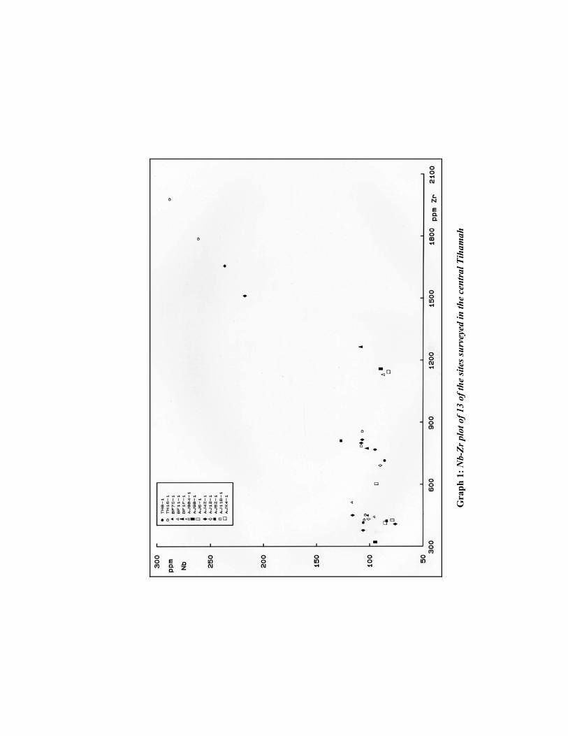
Gra
ph 1
: Nb-
Zr p
lot o
f 13
of th
e si
tes s
urve
yed
in th
e ce
ntra
l Tih
amah
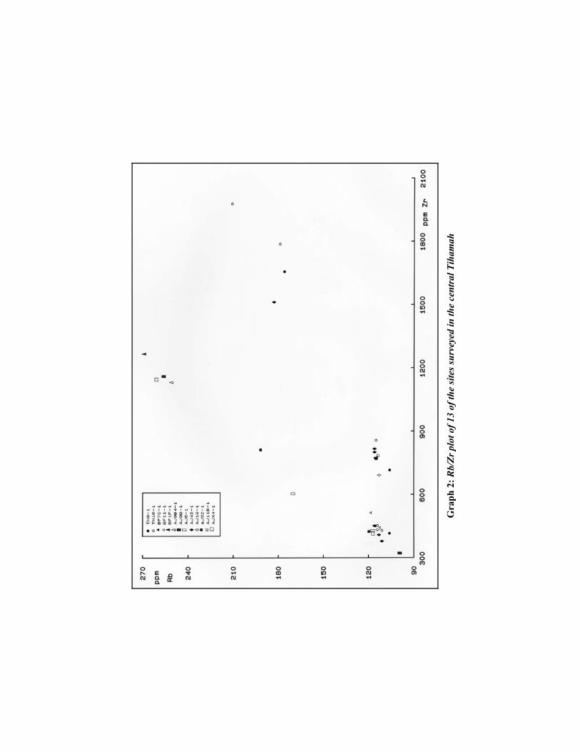
G
raph
2: R
b/Zr
plo
t of 1
3 of
the
site
s sur
veye
d in
the
cent
ral T
iham
ah
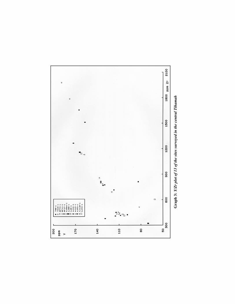
G
raph
3: Y
/Zr p
lot o
f 13
of th
e si
tes s
urve
yed
in th
e ce
ntra
l Tih
amah

G
raph
4: B
a/Zr
plo
t of 1
3 of
the
site
s sur
veye
d in
the
cent
ral T
iham
ah
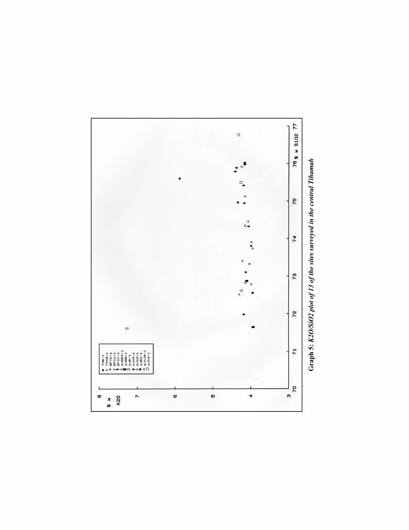
G
raph
5: K
2O/S
iO2
plot
of 1
3 of
the
site
s sur
veye
d in
the
cent
ral T
iham
ah
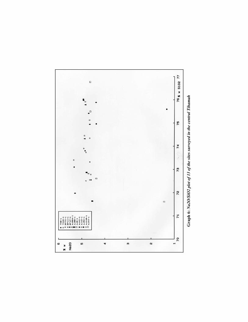
G
raph
6: N
a2O
/SiO
2 pl
ot o
f 13
of th
e si
tes s
urve
yed
in th
e ce
ntra
l Tih
amah
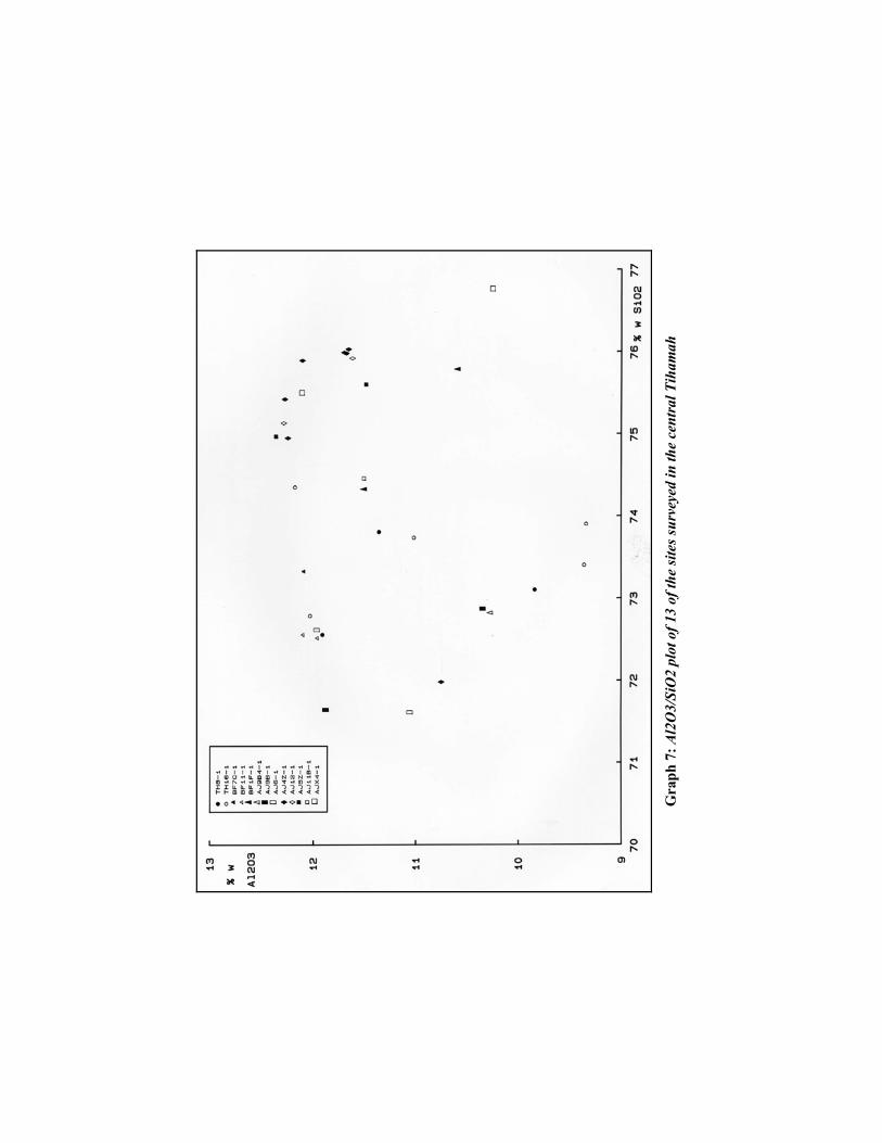
G
raph
7: A
l2O
3/Si
O2
plot
of 1
3 of
the
site
s sur
veye
d in
the
cent
ral T
iham
ah
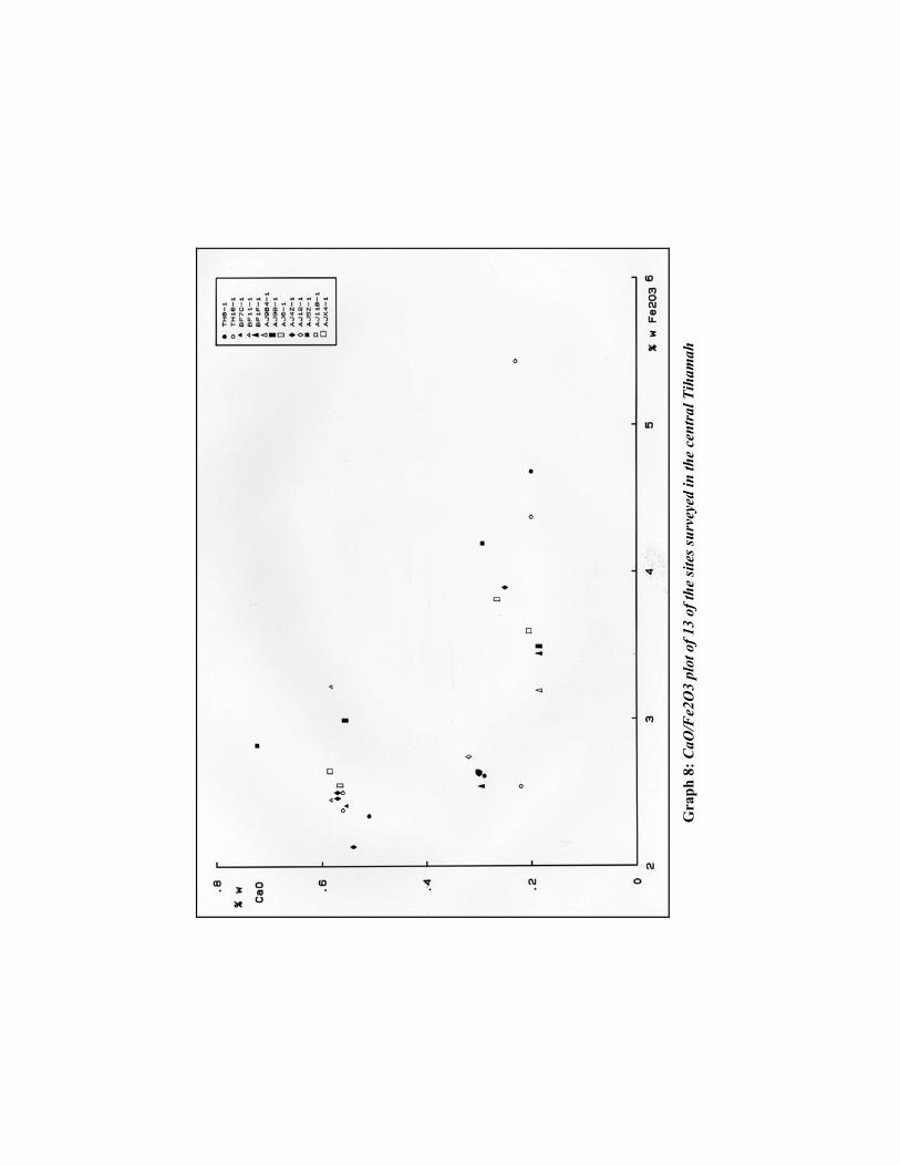
G
raph
8: C
aO/F
e2O
3 pl
ot o
f 13
of th
e si
tes s
urve
yed
in th
e ce
ntra
l Tih
amah
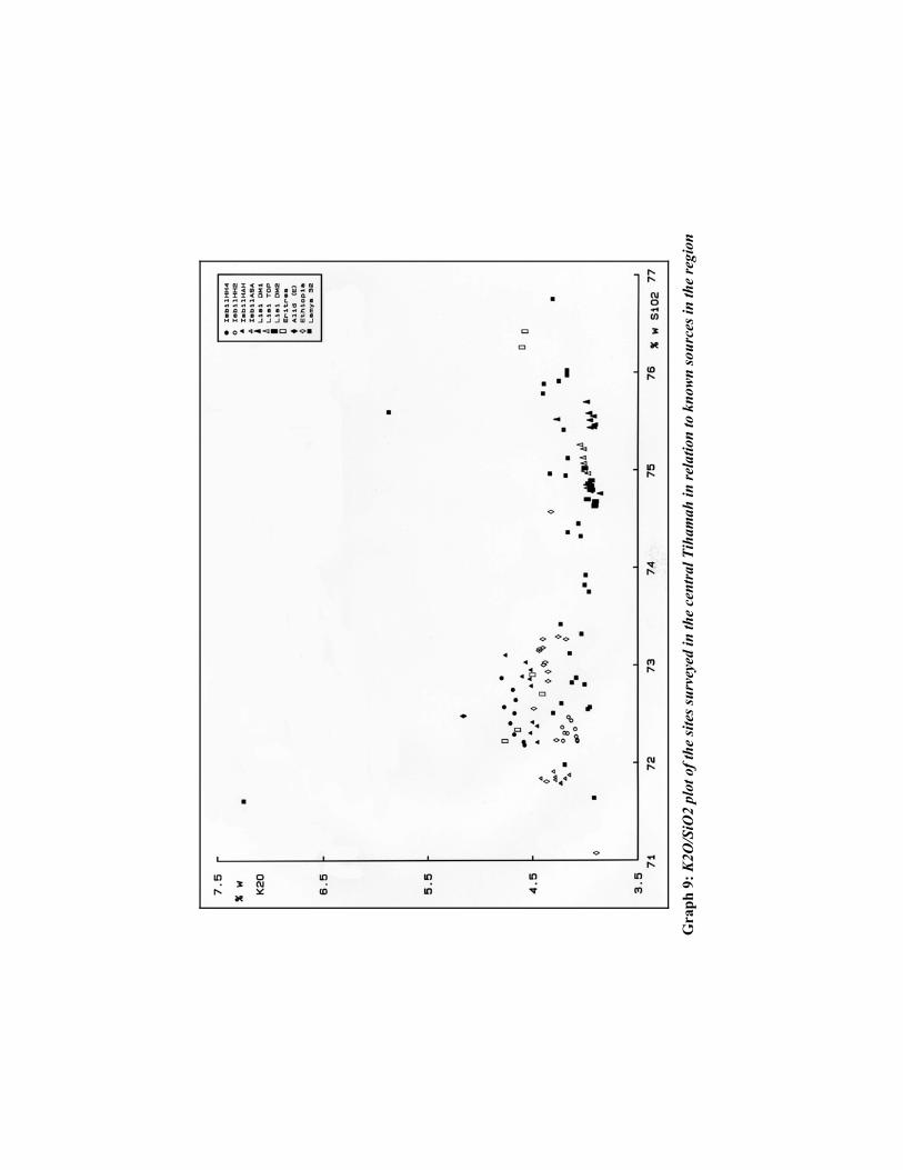
G
raph
9: K
2O/S
iO2
plot
of t
he si
tes s
urve
yed
in th
e ce
ntra
l Tih
amah
in re
latio
n to
kno
wn
sour
ces i
n th
e re
gion

G
raph
10:
% o
f nor
mat
ive
quar
tz to
% o
f nor
mat
ive
fem
ics o
f 13
site
s sur
veye
d in
the
cent
ral T
iham
ah
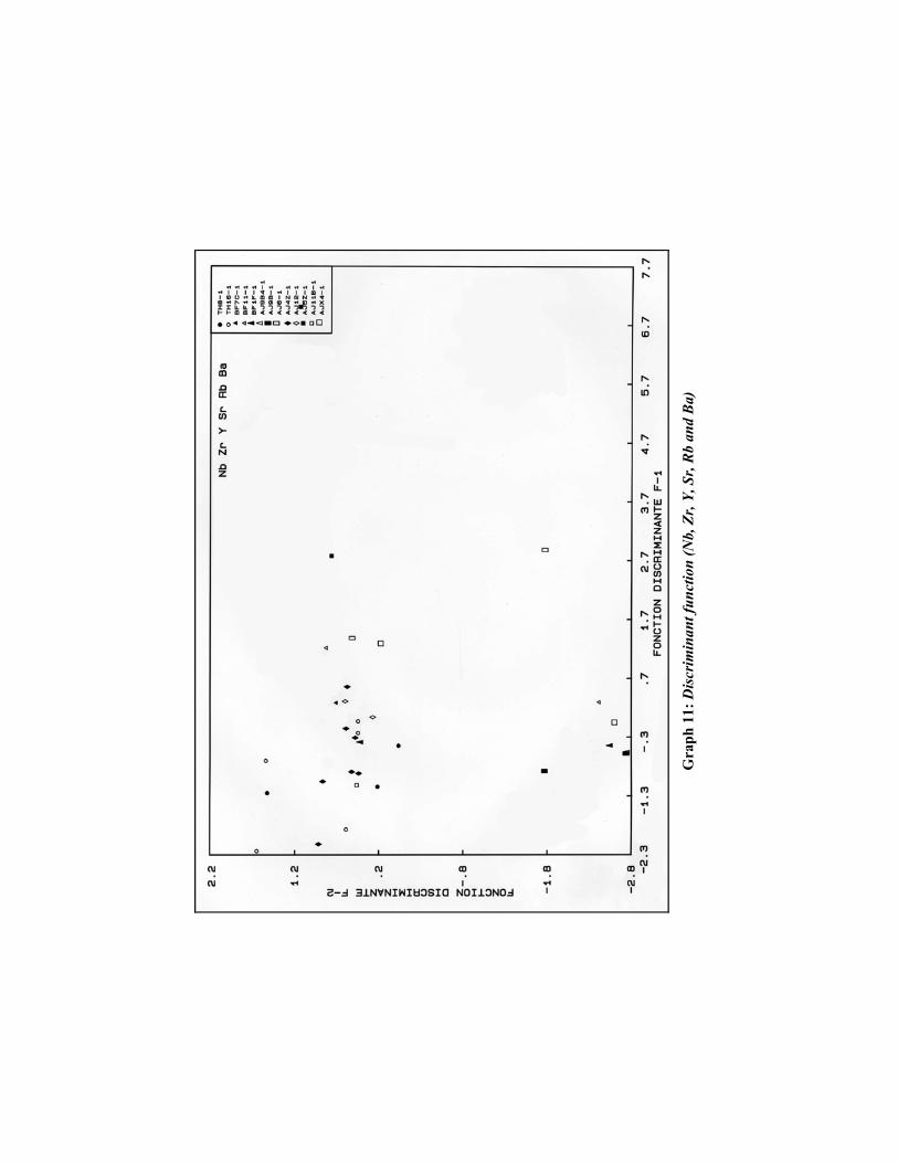
G
raph
11:
Dis
crim
inan
t fun
ctio
n (N
b, Z
r, Y,
Sr,
Rb
and
Ba)
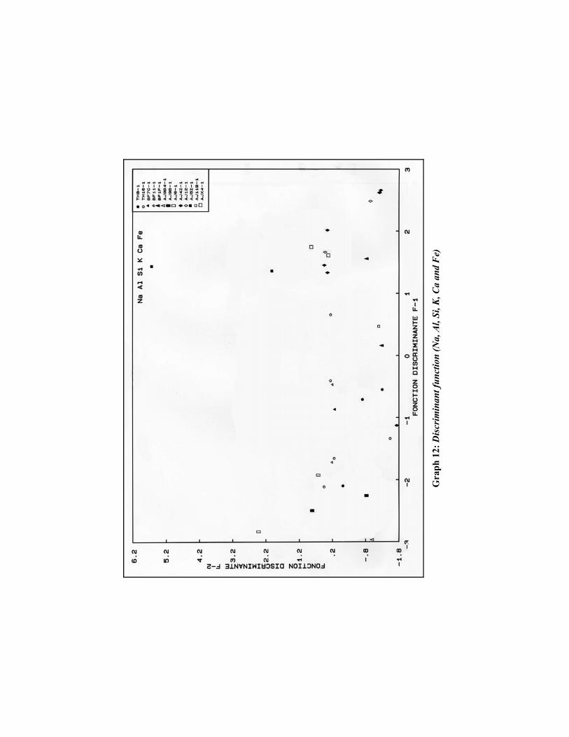
G
raph
12:
Dis
crim
inan
t fun
ctio
n (N
a, A
l, Si
, K, C
a an
d F
e)