
Sequence stratigraphy of the ANDRILL AND-2A drillcore, Antarctica: A long-term, ice-proximal record...
16
This article appeared in a journal published by Elsevier. The attached copy is furnished to the author for internal non-commercial research and education use, including for instruction at the authors institution and sharing with colleagues. Other uses, including reproduction and distribution, or selling or licensing copies, or posting to personal, institutional or third party websites are prohibited. In most cases authors are permitted to post their version of the article (e.g. in Word or Tex form) to their personal website or institutional repository. Authors requiring further information regarding Elsevier’s archiving and manuscript policies are encouraged to visit: http://www.elsevier.com/copyright
-
Upload
independent -
Category
Documents
-
view
3 -
download
0
Transcript of Sequence stratigraphy of the ANDRILL AND-2A drillcore, Antarctica: A long-term, ice-proximal record...

This article appeared in a journal published by Elsevier. The attachedcopy is furnished to the author for internal non-commercial researchand education use, including for instruction at the authors institution
and sharing with colleagues.
Other uses, including reproduction and distribution, or selling orlicensing copies, or posting to personal, institutional or third party
websites are prohibited.
In most cases authors are permitted to post their version of thearticle (e.g. in Word or Tex form) to their personal website orinstitutional repository. Authors requiring further information
regarding Elsevier’s archiving and manuscript policies areencouraged to visit:
http://www.elsevier.com/copyright
Author's personal copy
Sequence stratigraphy of the ANDRILL AND-2A drillcore, Antarctica: A long-term,ice-proximal record of Early to Mid-Miocene climate, sea-level and glacial dynamism
Christopher R. Fielding a,⁎, Greg H. Browne b, Brad Field b, Fabio Florindo c, David M. Harwood a,Lawrence A. Krissek d, Richard H. Levy b, Kurt S. Panter e, Sandra Passchier f, Stephen F. Pekar g
a Department of Earth & Atmospheric Sciences, 214 Bessey Hall, University of Nebraska-Lincoln, NE 68588-0340, USAb GNS Science, P.O. Box 30368, Lower Hutt, New Zealandc Instituto Nazionale di Geofisica e Vulcanologia, Via di Vigna Murata 605, 1-00143 Rome, Italyd School of Earth Sciences, Ohio State University, 125 South Oval Mall, Columbus, OH 43210, USAe Department of Geology, Bowling Green State University, Bowling Green, OH 43403, USAf Department of Earth & Environmental Sciences, Montclair State University, 252 Mallory Hall, 1 Normal Avenue, Montclair, NJ 07043, USAg School of Earth & Environmental Sciences, Queen's College, 65-30 Kissena Blvd., Flushing, NY 11367, USA
a b s t r a c ta r t i c l e i n f o
Article history:Received 12 August 2010Received in revised form 18 March 2011Accepted 20 March 2011Available online 24 March 2011
Keywords:MioceneAntarcticaSequence stratigraphyCyclicityMid-Miocene Climatic OptimumANDRILL SMS project
Present understanding of Antarctic climate change during the Early to Mid-Miocene, including major cycles ofglacial expansion and contraction, relies in large part on stable isotope proxies from deep sea core drilling.Here, we summarize the lithostratigraphy of the ANDRILL Southern McMurdo Sound Project drillcore AND-2A. This core offers a hitherto unavailable ice-proximal stratigraphic archive from a high-accommodationcontinental margin setting, and provides clear evidence of repeated fluctuations in climate, ice expansion/contraction and attendant sea-level change over the period c. 20.2–14.2 Ma, with a more fragmentary recordof Late Miocene and Pliocene time. The core is divided into seventy-four high-frequency (fourth- or fifth-order) glacimarine sequences recording repeated advances and retreats of glaciers into and out of the VictoriaLand Basin. The section can be resolved into thirteen longer-term, composite (third-order) sequences, whichcomprise packages of higher frequency sequences that show a consistent stratigraphic stacking pattern(Stratigraphic Motif). The distribution of the six recognized motifs indicates intervals of less and more ice-proximal, and temperate to subpolar/polar climate, through the Miocene period. The core demonstrates adynamic climate regime throughout the Early to Mid-Miocene that may be correlated to some previously-recognized events such as the Mid-Miocene Climatic Optimum, and provides a detailed reference point fromwhich to evaluate stable isotope proxy records from the deep-sea.
© 2011 Elsevier B.V. All rights reserved.
1. Introduction
The Miocene glacial history of Antarctica is incompletely knownand interpretations of environmental change, including expansionsand contractions in glacial ice volume, rely to a considerable extent onproxy geochemical records from deep ocean ODP cores (e.g., Milleret al., 1991; Abreu and Anderson, 1998; Zachos et al., 2001; Lear et al.,2004, among others). Although stable isotope excursions have beennoted within the Early Miocene record (e.g., Miller et al., 1991, 1996),there has been little opportunity to evaluate the near-field (Antarcticmargin) record of these events. A warm climatic optimum is thoughtto have characterized the Mid-Miocene (Mid-Miocene ClimaticOptimum — MMCO (~17.0–14.5 Ma)), and is also reflected by the“Monterey carbon isotope excursion” (Vincent and Berger, 1985;Woodruff and Savin, 1991; Holbourn et al., 2007). This period entailed
a complex climatic optimum succeeded by a long-term climaticdeterioration towards colder icehouse conditions (Flower andKennett, 1994; Shevenell et al., 2004; Holbourn et al., 2007). TheMMCO comprises a series of maxima and minima in δ18O records,suggesting a complex history of ice sheet fluctuation, but no near-field, high-resolution, Antarctic stratigraphic record of this timeinterval has yet been documented.
The Mid-Miocene climatic transition (14.5–13.0 Ma) is regardedby some as the time of permanent establishment of the cold polarregime of today in the East Antarctic Ice Sheet (Sugden et al., 1993;Lewis et al., 2008). Others, however, believe that warmer conditionsreturned in the Late Miocene through Early Pliocene, with the onset ofthe current “deep-freeze” regime only in the Late Pliocene (Webbet al., 1984; and see review by Barrett, 1996). Recovery of anexpanded Miocene and younger stratigraphic archive from theAntarctic continental margin is therefore a high priority for currentresearch efforts.
Much recent effort has been devoted to recovering core archives ofCenozoic paleoenvironmental change from the McMurdo Sound
Palaeogeography, Palaeoclimatology, Palaeoecology 305 (2011) 337–351
⁎ Corresponding author.E-mail address: [email protected] (C.R. Fielding).
0031-0182/$ – see front matter © 2011 Elsevier B.V. All rights reserved.doi:10.1016/j.palaeo.2011.03.026
Contents lists available at ScienceDirect
Palaeogeography, Palaeoclimatology, Palaeoecology
j ourna l homepage: www.e lsev ie r.com/ locate /pa laeo
Author's personal copy
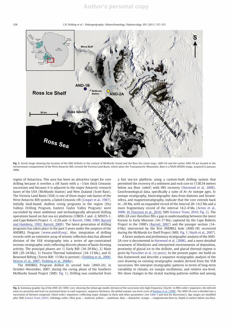
region of Antarctica. This area has been an attractive target for coredrilling because it overlies a rift basin with a N3 km thick Cenozoicsuccession and because it is adjacent to the major Antarctic researchbases of the USA (McMurdo Station) and New Zealand (Scott Base).The Victoria Land Basin (VLB) is one of three major sub-basins of theWest Antarctic Rift system, a failed Cenozoic rift (Cooper et al., 1987).Initially land-based, shallow coring programs in the region (DryValleys Drilling Program, Eastern Taylor Valley Program) weresucceeded by more ambitious and technologically advanced drillingoperations based on fast sea-ice platforms (CIROS-1 and -2, MSSTS-1,and Cape Roberts Project -1, -2/2A and -3: Barrett, 1986, 1989; Barrettand Hambrey, 1992; Barrett, 2009). The latest generation of drillingprograms has taken place in the past 5 years under the auspices of theANDRILL Program (www.andrill.org). Also, integration of drillingrecords with an extensive array of seismic reflection data has alloweddivision of the VLB stratigraphy into a series of age-constrainedtectono-stratigraphic units reflecting discrete phases of basin-formingactivity. The principal phases are 1) Early Rift (34–29 Ma), 2) MainRift (29–24 Ma), 3) Passive Thermal Subsidence (24–13 Ma), and 4)Renewed Rifting (Terror Rift: 13 Ma to present) (Fielding et al., 2006;Henrys et al., 2007; Fielding et al., 2008a).
The ANDRILL Program drilled its second hole (AND-2A) inOctober–November, 2007, during the coring phase of the SouthernMcMurdo Sound Project (SMS: Fig. 1). Drilling was conducted from
a fast sea-ice platform, using a custom-built drilling system thatpermitted the recovery of a sediment and rock core to 1138.54 metersbelow sea floor (mbsf) with 98% recovery (Harwood et al., 2008).Geochronological data, specifically a suite of Ar–Ar isotope ages, Srisotope stratigraphy, biostratigraphic data from diatoms and forami-nifera, and magnetostratigraphy, indicate that the core extends backto ~20 Ma, with an expanded record of the interval 20–14.2 Ma and amore fragmentary record of the interval 14.2–0 Ma (Acton et al.,2008; Di Vincenzo et al., 2010; SMS Science Team, 2010, Fig. 2). TheAND-2A core therefore fills a gap in understanding between the latestEocene to Early Miocene (34–17 Ma) captured by the Cape RobertsProject in the 1990's (Barrett, 2007) and the younger section (14–0 Ma) intersected by the first ANDRILL hole (AND-1B) recoveredduring the McMurdo Ice Shelf Project (MIS: Fig. 1; Naish et al., 2007).
A facies analysis and preliminary stratigraphic analysis of the AND-2A core is documented in Harwood et al. (2008), and a more detailedtreatment of lithofacies and interpreted environments of deposition,proximity of glacial ice to the drillsite, and glacial thermal regime isgiven by Passchier et al. (in press). In the present paper, we build onthis framework and describe a sequence stratigraphic analysis of thecore drawing on existing stratigraphic models derived from the VLBsuccession. We interpret stratigraphic patterns in terms of long-termvariability in climate, ice margin oscillations, and relative sea-level.We show changes in the stratal stacking patterns within and among
Fig. 1. Aerial image showing the location of the SMS drillsite in the context of McMurdo Sound and the Ross Sea (inset map). AND-2A and the earlier AND-1B are located in thewesternmost compartment of the West Antarctic Rift, termed the Victoria Land Basin, which abuts the Transantarctic Mountains. Base is a NASA MODIS image, acquired in January2008.
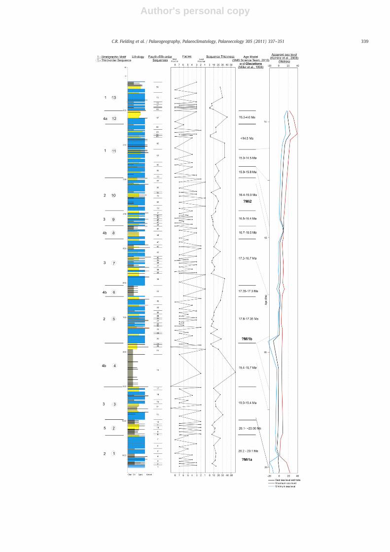
Fig. 2. Summary graphic log of the AND-2A (SMS) core, showing the initial age model, division of the succession into high-frequency (fourth- to fifth-order) sequences, the inferredmost ice-proximal and least ice-proximal facies in each sequence, sequence thickness, the global eustatic sea-level curve of Kominz et al. (2008). The AND-2A core is divided into asuccession of thirteen composite (third-order) sequences (reflecting major changes in these and other parameters (see Table 3 and text for discussion)). Age ranges are modifiedafter SMS Science Team (2010). Lithology codes: Olive gray — mudrock, yellow — sandstone, blue — diamictite, orange — conglomerate/breccia. Depth in meters below sea floor.
338 C.R. Fielding et al. / Palaeogeography, Palaeoclimatology, Palaeoecology 305 (2011) 337–351
Author's personal copy
339C.R. Fielding et al. / Palaeogeography, Palaeoclimatology, Palaeoecology 305 (2011) 337–351
Author's personal copy
genetic sequences through time, and relate these to climatic eventsincluding some inferred previously from studies of deep sea cores. Amajor outcome of this work is a record of dynamic climate fluctuationthroughout the time interval 20–14.5 Ma, including a record ofperiods considerably warmer than present.
1.1. Lithologies and sequence definition
The AND-2A core preserves a variety of terrigenous clasticlithologies, ranging from claystone, through siltstone and sandstone toconglomerate, breccia and diamictite (Fig. 2). Absolute ages have beenobtained from first-cycle volcanic components by the Ar–Armethod (DiVincenzo et al., 2010). Thirteen recurring facies have been recognizedand interpreted in terms of depositional environments ranging fromminimally ice-influenced, shallow marine settings, through ice-contactproglacial and glacimarine, to possibly subglacial environments(Table 1). Somemudrocks inparticular (Facies 1: Table 1) lack dispersedgravel, are richly fossiliferous (marine mollusks, polychaetes, forami-nifera and marine diatoms) and extensively and diversely bioturbated,suggesting times of minimal ice influence. Some diamictites showextensive boxwork veining, brecciation, shear and rotation fabricssuggesting that the drillsite was covered by grounded ice at times(Facies 7/8: Table 1). The entire section, including the near-surface,shows evidence of deposition in shelf water depths (10–100 m: Table 1;Taviani et al., 2008; Fielding et al., 2008b). Detailed descriptions andprocess/environmental interpretations of these facies are given byPasschier et al. (in press).
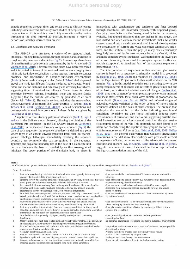
A repetitive vertical stacking pattern of lithofacies (Table 1, Figs. 3and 4) in the SMS core was observed, allowing the division of thesuccession into sequences (in the Vail-EXXON sense: cf. Catuneanuet al., 2009). In the idealized form of a complete sequence (Fig. 5), thebase of each sequence (the sequence boundary) is defined at a pointwhere there is an abrupt upward transition from finer- to coarser-grained lithology. Lithologies immediately overlying the sequenceboundary are commonly the coarsest-grained in the sequence.Typically, the sequence boundary lies at the base of a diamictite unitbut in a few cases the base is recorded by another coarse-grainedlithology. The upper portion of the diamictite body in places is
interbedded with conglomerate and sandstone and fines upwardthrough sandstones into mudrocks, typically with dispersed gravel.Overlying these facies are the finest-grained facies in the sequence,typically, fine-grained siltstones that are lacking in any gravel, arebioturbated and often contain marine invertebrate shells. Mudrockscoarsen upward into a sandstone-dominated interval showing exten-sive preservation of current and wave-generated sedimentary struc-tures, and this section is then abruptly (in many cases, erosionally/irregularly) truncated by the next sequence boundary. Overall, thickerand more complete cycles (sequences) were noted from the lower partof the core, becoming thinner and less complete upward (with somenotable exceptions). An idealized form of the complete sequence ispresented as Fig. 5.
The interpretation of sequences in this near-ice, glacimarinecontext is based on a sequence stratigraphic model first proposedby Fielding et al. (1998, 2000) and modified by Dunbar et al. (2008)for the Cape Roberts Project cores further north and also on the VLBmargin (Fig. 1). In this model, repetitive stratal stacking patterns areinterpreted in terms of advances and retreats of glaciers into and outof the basin, with attendant relative sea-level changes. Dunbar et al.(2008) usedmud content of core samples as a proxy for wave-inducedbed shear stress which, for a given wave climate, is proportional towater depth (Dunbar and Barrett, 2005), and inferred ranges ofpalaeobathymetric variation of the order of tens of meters withinsequences defined on the basis of facies changes. The premise thatunderpins this model is that the facies indicating ice-minimalconditions invariably are also those indicating deepest waterenvironments of formation, and vice-versa, suggesting eustatic sea-level fluctuation exerted a fundamental control on the glacimarinestratigraphic record of the VLB. This approach has been found to beuseful for characterizing the repetitive stratigraphic sections recov-ered frommore recent VLB cores (e.g., Naish et al., 2008, 2009; McKayet al., 2009). The general observation that Cenozoic stratigraphicsuccessions in the VLB show clear cyclicity with predictable verticalarrangements of facies, becoming less so inboard towards the presentcoastline and onshore (e.g., McGinnis, 1981; Fielding et al., in press),suggests that a coherent record of sea-level fluctuation is preserved inthe high-accommodation setting of the VLB.
Table 1List of lithofacies recognized in the AND-2A core. Estimates of formative water depths are based on analogy with calculations of Dunbar et al. (2008).
Facies Description Interpretation
1 Diatomite, opal-bearing or calcareous, fossil-rich mudstone, typically intensively anddiversely bioturbated, little if any dispersed gravel
Open marine shelfal conditions (60–100 m water depth), minimal iceinfluence
2 Siltstone to very fine-grained sandstone, intensively and diversely bioturbated, dispersedsmall gravel and calcareous fossils, soft-sediment deformation structures
Open marine shelfal conditions (60–100 m water depth), deposition fromsuspension settling, distal ice influence
3 Interstratified siltstone and very fine- to fine-grained sandstone, bioturbated and/orstratified with ripple-scale structures, typically restricted and modest intensitybioturbation, dispersed calcareous fossils, soft-sediment deformation
Open marine to restricted coastal settings (10–80 m water depth),deposition from suspension settling, and gentle currents and waves,minor ice rafting
4 Stratified, fine- to coarse-grained sandstone, dispersed to locally concentrated smallgravel, typically well sorted, with flat lamination, ripple cross-lamination, cross-beddingand hummocky cross-stratification, minimal bioturbation, locally fossiliferous
Open marine shoreface to upper offshore (10–40 m water depth), minorice rafting of gravel
5 Muddy fine-grained sandstone to sandy siltstone with dispersed gravel, typicallysoft-sediment-deformed or unstratified, locally fossiliferous, rarely bioturbated
Open marine conditions (10–60 m water depth) affected by hemipelagicfallout and supply of sediment from ice-rafting
6 Delicately stratified, interlaminated fine- and coarse-grained siltstone, fine-grainedsandstone and diamictite, dispersed gravel including diamictite clasts, some laminationrhythmic at sub-mm scale, soft-sediment and brittle deformation
Open glacimarine conditions affected by hemipelagic fallout, bottomcurrents and ice-rafting
7 Stratified diamictite, generally clast-poor, muddy to sandy matrix, commonlyfossiliferous
Open, proximal glacimarine conditions, in distal portions ofgrounding-line fans
8 Massive diamictite, clast-poor to clast-rich and typically sandy matrix, some alignmentof clast long-axes, shear structures including boxwork fracturing and brecciation
Ice-proximal glacimarine (grounding-line fan) to subglacial environments
9 Interbedded conglomerate and sandstone, thin units typically interbedded with othercoarse-grained facies, locally fossiliferous
Ice-proximal environments in the presence of meltwater, various possibledepositional settings
10 Vesicular, porphyritic, and basaltic lava Primary sheet flows erupted from a proximal vent or fissure11 Volcaniclastic breccias, monomict, composed of basaltic clasts in basaltic matrix Autobrecciation of subaerially erupted lavas12 Pyroclastic lapilli tuff, composed of glassy juvenile clasts of coarse ash to lapilli size Settling of pyroclasts through the water column13 Volcanic sedimentary breccias and sandstones, comprising texturally unmodified to
modified juvenile volcanic clasts and grains, local ripple cross-laminationReworking of volcaniclastic deposits in shallow marine waters
340 C.R. Fielding et al. / Palaeogeography, Palaeoclimatology, Palaeoecology 305 (2011) 337–351
Author's personal copy
Relative sea level changes in glaciated regions can be expected torecord a convolution of eustatic effects created by withdrawal of sea-water to form ice during glacial intervals and subsequent meltingduring deglacial periods, along with isostatic, self-gravitational, andsolid-earth deformational effects (e.g., Mitrovica and Vermeersen,2002; Bamber et al., 2009; Mitrovica et al., 2009). The magnitude, andspatial and temporal range of isostatic and gravitational effects areexpected to vary according to the lateral extent of glacial ice (forexample, whether or not it extended into the basin), and its thicknessdistribution (Brotchie and Silvester, 1969; Andrews, 1974). It is alsolikely that isostatic effects may have varied according to the thermalproperties of the underlying lithosphere, and hence according totectonic context. The study area is likely to have been characterized bya thinned and heated lithosphere during the formation of theextensional VLB, which may have dampened isostatic effects. Otherprocesses mentioned above are also likely to have played a role indetermining relative sea-level changes during glacial–nonglacial orglacial–interglacial cycles, but the net effect of these processes incombination cannot be calculated from available knowledge.
Each sequence boundary is interpreted to record a relative sea-level minimum. It is further interpreted to be a composite, time-transgressive surface in the manner now known to be typical ofsequence boundaries in general, recording a perhaps protractedrelative sea-level drawdown and lowstand (Catuneanu et al., 2009).Since the sequence boundary is typically overlain by a diamictite, thesequence boundary must also record a glacial advance into the basin.Given the known capacity of grounded glaciers to erode substantialquantities of previously-deposited sediment and transport them in abasinward direction as they advance (Lønne and Syvitski, 1997;Lønne, 2001), it is to be expected that the surface recording such anadvance will be an erosional contact in locations where ice hasoverridden the site. For this reason, Fielding et al. (2000) coined theterm “Glacial Surface of Erosion” (GSE) for such surfaces (and seeNaish et al., 2009). In more ice-distal locations, beyond the maximumextent of glacier advance, the contact need not be erosional, however,but rather is a sharp, planar contact or even a gradational coarsening-upward contact between ice-distal and more ice-proximal facies. Forthis reason, we elect not to adopt the GSE terminology herein.
The position of the glacial maximum in any given sequence maynot be easy to determine, depending upon whether there is anypreserved evidence of subglacial deposition recording ice groundingat the site of investigation, and taking into account that the maximumice advance may not have a stratigraphic record. In an ice-proximaldepositional setting, furthermore, a number of additional influenceson relative sea-level change come into play as discussed above, the neteffect of which cannot be ascertained.
In VLB Cenozoic sequences, stratal stacking patterns above thebasal diamictite or equivalent are typically fining-upward thencoarsening-upward (interpreted as recording deepening followedby shallowing), consistent with the relative sea-level fluctuationsexpected from a postglacial sea-level rise superimposed on a regimeof steady subsidence. This in turn suggests that gravitational andisostatic effects (both loading and unloading, the magnitude of whichshould be similar) could be entirely contained within the hiatalsurface of the sequence boundary and in the overlying diamictite.Accordingly, the basal diamictite is interpreted as a combination ofLowstand Systems Tract (LST) and early Transgressive Systems Tract(TST) deposits (Fig. 5). This assumption is likely an oversimplification.Nonetheless, it is consistent with stratal stacking patterns and in theabsence of a more refined model of the behavior of the Antarcticcontinental margin under repeated loading and unloading by glacialice, is adopted here. An alternative model, in which the fining-upwardinterval is the product of flexural loading during the glacial maximumand the overlying coarsening-upward interval a consequence ofsubsequent, postglacial isostatic rebound, is rejected because such aninterpretation is inconsistent with the distribution of glacial sedi-
mentological indicators including the abundance of lonestones. Theoverlying, fining-upward interval records progressively increasingpaleo-water depth, with an increasing component of hemipelagicfallout (of terrigenous clastic, biochemical, and at times volcaniclasticorigin), and is less influenced by lateral transport of sediment alongthe seabed. This interval is also assigned to the TST. Above this, aninterval of finest-grained sediment with little if any evidence of icerafting is interpreted to represent the maximum flooding zone (MFZ)following an ice retreat or deglaciation event. The expression“Maximum Flooding Zone” is used here rather than “MaximumFlooding Surface” because it is typically not possible to recognize asingle surface that records maximum marine transgression.
The succeeding coarsening-upward interval is interpreted as aHighstand Systems Tract (HST), formed when relative sea level peakedand began to drop during initiation of the next ice advance. The rate ofsedimentation at this time began to exceed the rate of accommodation,and seabed transport by currents and waves facilitated the accumula-tion of fine-grained, texturally mature sands in deltas and otherprograding, nearshore depositional systems. The sequence is cappedat the contact with the overlying diamictite as advancing ice pushedproglacial debris basinward and initiated the next lowstand.
The AND-2A drillcore has been divided into a series of seventy-four sequences, from 0.92 to 93.89 m thick (Fig. 3). Each sequence isdefined on objective criteria. Specifically, each sequence contains botha coarse-grained lower interval that preserves evidence for ice-proximal conditions, and an overlying fine-grained division thatcontains evidence for ice-distal conditions (fine-grained Facies 1–3),not merely a parting within a coarse-grained facies unit (Fig. 3). Fromthe available geochronological data (Acton et al., 2008; SMS ScienceTeam, 2010), it is likely that sequences were formed over timeframescoincident with the Milankovitch band, and can therefore beconsidered as high-frequency (fourth- or fifth-order of someworkers:Vail et al., 1991; Catuneanu, 2006) sequences.
Each of the seventy-four sequences is bounded by a basinward shiftin facies (sequence boundary), interpreted to record abrupt shallowingin paleobathymetry and in many cases (though not all), significanterosion (Fig. 3). The top ofmost sequences in the AND-2A core is abruptand erosional, although some show a continuously coarsening-upwardtrend into the overlying sequence (Figs. 3 and 5). Some sequences showtruncation of the upper coarsening-upward section, with diamictite ofthe succeeding sequence abruptly overlying mudrocks or muddysandstones (Fig. 3). Some such sequences, particularly in the uppermost225 m of the core, are diamictite-dominated and may be composites oftwo or more sequences. On the other hand, some of the thickersequences show development of multiple coarsening-upward orinterbedded mudrock/sandstone intervals that can be interpreted asparasequences within the Highstand Systems Tract.
The fact that evidence for relative sea-level drawdown within eachsequence coincides with evidence for increased proximity of glacierssuggests that geodynamic effects wereminor relative to eustatic effectsduring the accumulation of this succession (in turn suggesting that anygrounded ice across the drillsite was of only modest thickness).Furthermore, the fact that cyclicity is so clearly and persistentlyrecorded in the Miocene stratigraphy suggests that the climatic regimeremained dynamic through this interval (20.2–14.5 Ma).
The younger section (b?14 Ma to present) is relatively condensedin stratigraphic thickness and overlies a major unconformity at224.82 mbsf. The Upper Neogene section nonetheless reflects glacialcyclicity, in that fourteen sequences are preserved between 225 and40 mbsf indicating that a dynamic ice sheet margin existed throughthis time. An expanded Upper Neogene section was recovered in thefirst ANDRILL core (AND-1B) and was found to preserve more thansixty genetic sequences similar to those described herein (Krisseket al., 2007; McKay et al., 2009; Naish et al., 2009), further supportingthe interpretation of a dynamic glacial-marine environment throughthis time.
341C.R. Fielding et al. / Palaeogeography, Palaeoclimatology, Palaeoecology 305 (2011) 337–351

Author's personal copy
342 C.R. Fielding et al. / Palaeogeography, Palaeoclimatology, Palaeoecology 305 (2011) 337–351
Author's personal copy
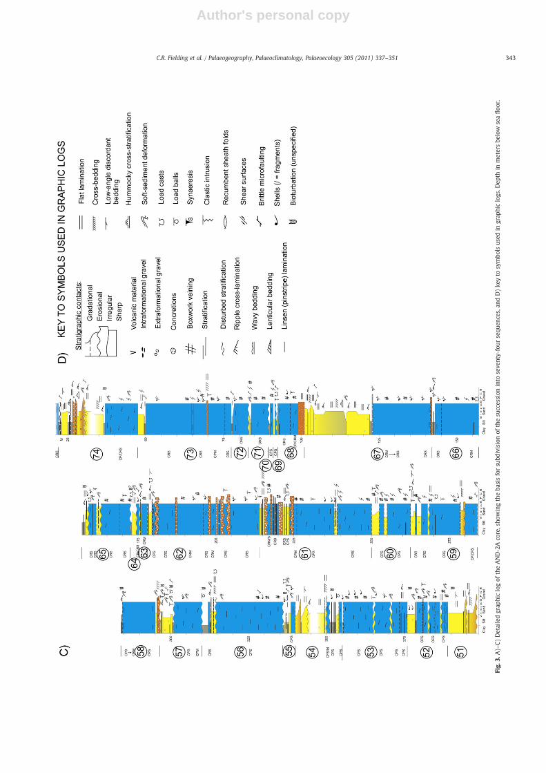
Fig.
3.A)–
C)Detailedgrap
hiclogof
theAND-2Aco
re,sho
wingtheba
sisforsu
bdivisionof
thesu
ccession
into
seve
nty-four
sequ
ences,an
dD)ke
yto
symbo
lsus
edin
grap
hiclogs.D
epth
inmetersbe
low
seafloo
r.
343C.R. Fielding et al. / Palaeogeography, Palaeoclimatology, Palaeoecology 305 (2011) 337–351
Author's personal copy
2. Vertical changes in sequence character
Changes in sequence character occur through the cored succession,and are utilized to inform interpretations of changing long-term
environmental conditions (and, in the upper part of the section,changing tectonic conditions (Fig. 2)). These include: 1) variation insequence thickness from 0.92 to 93.89 m; 2) changes in the variety andrange of facies included in sequences; 3) changes in the completeness of
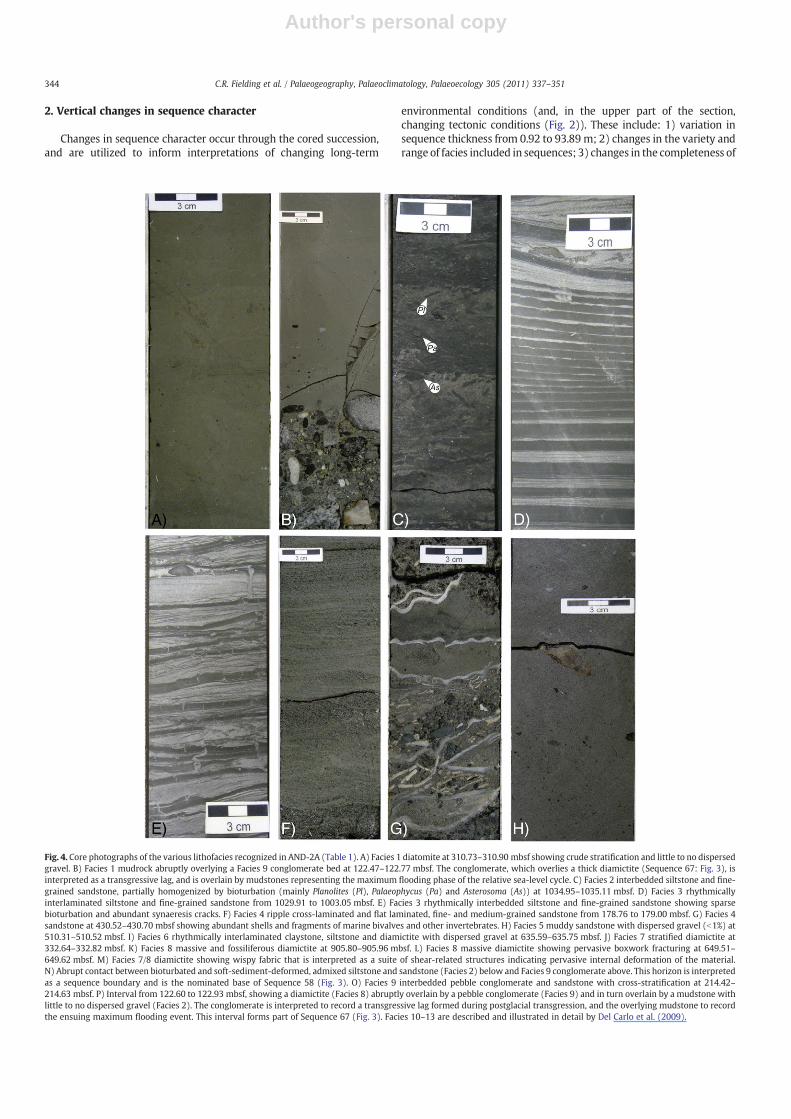
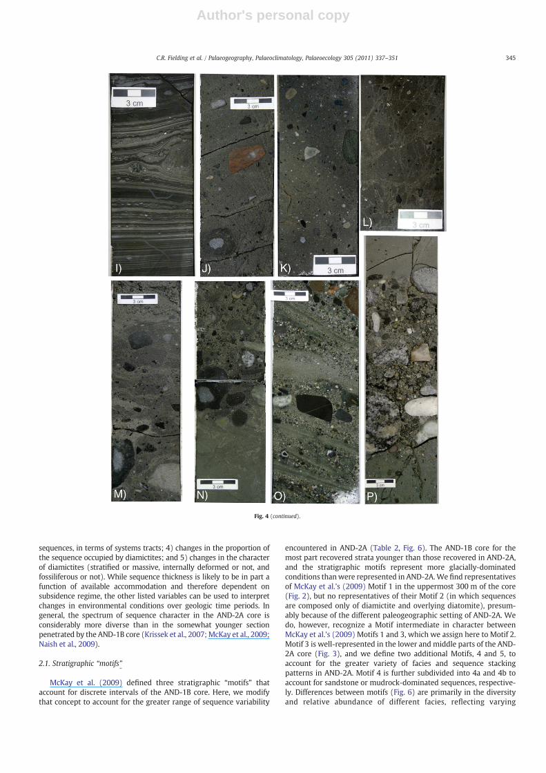
Fig. 4. Core photographs of the various lithofacies recognized in AND-2A (Table 1). A) Facies 1 diatomite at 310.73–310.90 mbsf showing crude stratification and little to no dispersedgravel. B) Facies 1 mudrock abruptly overlying a Facies 9 conglomerate bed at 122.47–122.77 mbsf. The conglomerate, which overlies a thick diamictite (Sequence 67: Fig. 3), isinterpreted as a transgressive lag, and is overlain by mudstones representing the maximum flooding phase of the relative sea-level cycle. C) Facies 2 interbedded siltstone and fine-grained sandstone, partially homogenized by bioturbation (mainly Planolites (Pl), Palaeophycus (Pa) and Asterosoma (As)) at 1034.95–1035.11 mbsf. D) Facies 3 rhythmicallyinterlaminated siltstone and fine-grained sandstone from 1029.91 to 1003.05 mbsf. E) Facies 3 rhythmically interbedded siltstone and fine-grained sandstone showing sparsebioturbation and abundant synaeresis cracks. F) Facies 4 ripple cross-laminated and flat laminated, fine- and medium-grained sandstone from 178.76 to 179.00 mbsf. G) Facies 4sandstone at 430.52–430.70 mbsf showing abundant shells and fragments of marine bivalves and other invertebrates. H) Facies 5 muddy sandstone with dispersed gravel (b1%) at510.31–510.52 mbsf. I) Facies 6 rhythmically interlaminated claystone, siltstone and diamictite with dispersed gravel at 635.59–635.75 mbsf. J) Facies 7 stratified diamictite at332.64–332.82 mbsf. K) Facies 8 massive and fossiliferous diamictite at 905.80–905.96 mbsf. L) Facies 8 massive diamictite showing pervasive boxwork fracturing at 649.51–649.62 mbsf. M) Facies 7/8 diamictite showing wispy fabric that is interpreted as a suite of shear-related structures indicating pervasive internal deformation of the material.N) Abrupt contact between bioturbated and soft-sediment-deformed, admixed siltstone and sandstone (Facies 2) below and Facies 9 conglomerate above. This horizon is interpretedas a sequence boundary and is the nominated base of Sequence 58 (Fig. 3). O) Facies 9 interbedded pebble conglomerate and sandstone with cross-stratification at 214.42–214.63 mbsf. P) Interval from 122.60 to 122.93 mbsf, showing a diamictite (Facies 8) abruptly overlain by a pebble conglomerate (Facies 9) and in turn overlain by a mudstone withlittle to no dispersed gravel (Facies 2). The conglomerate is interpreted to record a transgressive lag formed during postglacial transgression, and the overlying mudstone to recordthe ensuing maximum flooding event. This interval forms part of Sequence 67 (Fig. 3). Facies 10–13 are described and illustrated in detail by Del Carlo et al. (2009).
344 C.R. Fielding et al. / Palaeogeography, Palaeoclimatology, Palaeoecology 305 (2011) 337–351
Author's personal copy
sequences, in terms of systems tracts; 4) changes in the proportion ofthe sequence occupied by diamictites; and 5) changes in the characterof diamictites (stratified or massive, internally deformed or not, andfossiliferous or not). While sequence thickness is likely to be in part afunction of available accommodation and therefore dependent onsubsidence regime, the other listed variables can be used to interpretchanges in environmental conditions over geologic time periods. Ingeneral, the spectrum of sequence character in the AND-2A core isconsiderably more diverse than in the somewhat younger sectionpenetrated by the AND-1B core (Krissek et al., 2007; McKay et al., 2009;Naish et al., 2009).
2.1. Stratigraphic “motifs”
McKay et al. (2009) defined three stratigraphic “motifs” thataccount for discrete intervals of the AND-1B core. Here, we modifythat concept to account for the greater range of sequence variability
encountered in AND-2A (Table 2, Fig. 6). The AND-1B core for themost part recovered strata younger than those recovered in AND-2A,and the stratigraphic motifs represent more glacially-dominatedconditions thanwere represented in AND-2A.We find representativesof McKay et al.'s (2009) Motif 1 in the uppermost 300 m of the core(Fig. 2), but no representatives of their Motif 2 (in which sequencesare composed only of diamictite and overlying diatomite), presum-ably because of the different paleogeographic setting of AND-2A. Wedo, however, recognize a Motif intermediate in character betweenMcKay et al.'s (2009) Motifs 1 and 3, which we assign here to Motif 2.Motif 3 is well-represented in the lower and middle parts of the AND-2A core (Fig. 3), and we define two additional Motifs, 4 and 5, toaccount for the greater variety of facies and sequence stackingpatterns in AND-2A. Motif 4 is further subdivided into 4a and 4b toaccount for sandstone or mudrock-dominated sequences, respective-ly. Differences between motifs (Fig. 6) are primarily in the diversityand relative abundance of different facies, reflecting varying
Fig. 4 (continued).
345C.R. Fielding et al. / Palaeogeography, Palaeoclimatology, Palaeoecology 305 (2011) 337–351
Author's personal copy
environmental conditions. Cycle thickness was not considered adiagnostic characteristic, since this is influenced by a variety ofexternal factors, in addition to environment.
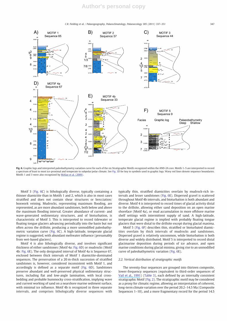
Motif 1 (Fig. 6A) is diamictite-dominated, with a relatively minorcomponent of other lithologies, typically mainly mudrocks. Diamictitesare typically unstratified, clast-rich, contain abundant intraformationalclasts and sedimentary intrusions, andmany preserve jigsaw-fit brecciafabrics and/or boxwork fracture/vein networks. Many diamictites inMotif 1 sequences also preserve rotational and other shear structures,and anomalously high bulk density/sonic velocity. The diamictites inMotif 1 sequences are interpreted to be ice-proximal, marine proglacialto subglacial deposits, formed under a dynamic climate regime thatallowed repeated advance of glacial ice over the drillsite. Abundantevidence for grounded ice suggests that tidewater glaciers weregrounded for considerable distances into the basin. This, together withthe paucity of other facies, suggests a regime in which isostatic effectswere significant, perhaps overwhelming eustatic sea-level fluctuations
to produce a relatively subdued paleobathymetric curve (Fig. 6A). Asituation in which grounded ice frequently advanced across a slowlysubsiding sea-floor explains the generally thin, incomplete and stronglytop-truncated nature of Motif 1 sequences. A sub-polar glacial regimewith minor meltwater influence is indicated by Motif 1, similar to thatadvocated for Motif 1 of McKay et al. (2009).
Motif 2 (Fig. 6B) is also diamictite-dominated but involves asomewhat greater diversity and relative thickness of non-diamictitelithologies. Diamictites show a range of properties, but less abundantshear and breccia fabrics than their Motif 1 counterparts. Some arestratified, and many are soft-sediment-deformed. In addition tomudrocks, sandstones and conglomerates occur in Motif 2 sequences(e.g., Fig. 6B). This is interpreted to reflect repeated tidewater glacialadvances into the basin, with occasional grounded ice over thedrillsite, producing a somewhat subdued paleobathymetric variationcurve. A sub-polar glacial regime with significant meltwater influenceis indicated.
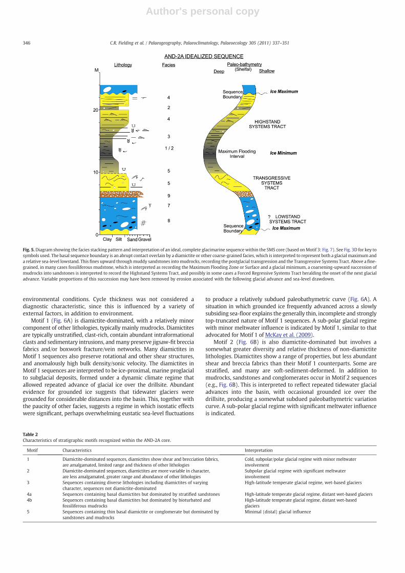
Table 2Characteristics of stratigraphic motifs recognized within the AND-2A core.
Motif Characteristics Interpretation
1 Diamictite-dominated sequences, diamictites show shear and brecciation fabrics,are amalgamated, limited range and thickness of other lithologies
Cold, subpolar/polar glacial regime with minor meltwaterinvolvement
2 Diamictite-dominated sequences, diamictites are more variable in character,are less amalgamated, greater range and abundance of other lithologies
Subpolar glacial regime with significant meltwaterinvolvement
3 Sequences containing diverse lithologies including diamictites of varyingcharacter, sequences not diamictite-dominated
High-latitude temperate glacial regime, wet-based glaciers
4a Sequences containing basal diamictites but dominated by stratified sandstones High-latitude temperate glacial regime, distant wet-based glaciers4b Sequences containing basal diamictites but dominated by bioturbated and
fossiliferous mudrocksHigh-latitude temperate glacial regime, distant wet-basedglaciers
5 Sequences containing thin basal diamictite or conglomerate but dominated bysandstones and mudrocks
Minimal (distal) glacial influence
Fig. 5.Diagram showing the facies stacking pattern and interpretation of an ideal, complete glacimarine sequence within the SMS core (based onMotif 3: Fig. 7). See Fig. 3D for key tosymbols used. The basal sequence boundary is an abrupt contact overlain by a diamictite or other coarse-grained facies, which is interpreted to represent both a glacial maximum anda relative sea-level lowstand. This fines upward throughmuddy sandstones intomudrocks, recording the postglacial transgression and the Transgressive Systems Tract. Above a fine-grained, in many cases fossiliferous mudstone, which is interpreted as recording the Maximum Flooding Zone or Surface and a glacial minimum, a coarsening-upward succession ofmudrocks into sandstones is interpreted to record the Highstand Systems Tract, and possibly in some cases a Forced Regressive Systems Tract heralding the onset of the next glacialadvance. Variable proportions of this succession may have been removed by erosion associated with the following glacial advance and sea-level drawdown.
346 C.R. Fielding et al. / Palaeogeography, Palaeoclimatology, Palaeoecology 305 (2011) 337–351
Author's personal copy
Motif 3 (Fig. 6C) is lithologically diverse, typically containing athinner diamictite than in Motifs 1 and 2, which is also in most casesstratified and does not contain shear structures or brecciation/boxwork veining. Mudrocks, representing maximum flooding, arerepresented, as are more abundant sandstones, both below and abovethe maximum flooding interval. Greater abundance of current- andwave-generated sedimentary structures, and of bioturbation, ischaracteristic of Motif 3. This is interpreted to record tidewater orfloating tongue glaciers advancing periodically into the basin but notoften across the drillsite, producing a more unmodified paleobathy-metric variation curve (Fig. 6C). A high-latitude, temperate glacialregime is suggested, with abundant meltwater influence (presumablyfrom wet-based glaciers).
Motif 4 is also lithologically diverse, and involves significantthickness of either sandstones (Motif 4a: Fig. 6D) or mudrocks (Motif4b: Fig. 6E). The only designated interval of Motif 4a is Sequence 67,enclosed between thick intervals of Motif 1 diamictite-dominatedsequences. The preservation of a 20 m-thick succession of stratifiedsandstones is, however, considered inconsistent with Motif 1, andaccordingly is defined as a separate motif (Fig. 6D). Sandstonespreserve abundant and well-preserved physical sedimentary struc-tures, including flat and low-angle lamination, with local cross-bedding and probable hummocky cross-stratification, implying waveand current working of sand on a nearshore marine sediment surface,with minimal ice influence. Motif 4b is recognized in three separateintervals, and comprises lithologically diverse sequences with
typically thin, stratified diamictites overlain by mudrock-rich in-tervals and lesser sandstones (Fig. 6E). Dispersed gravel is scatteredthroughout Motif 4b intervals, and bioturbation is both abundant anddiverse. Motif 4 is interpreted to record times of glacial activity distalto the drillsite, allowing either sand deposition on an open marineshoreface (Motif 4a), or mud accumulation in more offshore marineshelf settings with intermittent supply of sand. A high-latitude,temperate glacial regime is implied with probably floating tongueglaciers that were distal to the drillsite except during glacial maxima.
Motif 5 (Fig. 6F) describes thin, stratified or bioturbated diamic-tites overlain by thick intervals of mudrocks and sandstones.Dispersed gravel is relatively uncommon, while bioturbation is bothdiverse and widely distributed. Motif 5 is interpreted to record distalglacimarine deposition during periods of ice advance, and openmarine conditions during glacial minima, giving rise to an unmodifiedcurve of paleobathymetric variation (Fig. 6E).
2.2. Vertical distribution of stratigraphic motifs
The seventy-four sequences are grouped into thirteen composite,lower-frequency sequences (equivalent to third-order sequences ofVail et al., 1991) (Table 3), each defined by an internally consistentstratigraphic Motif (Fig. 2). The stratigraphic motif may be consideredas a proxy for climatic regime, allowing an interpretation of coherent,long-term climate variation over the period 20.2–14.5 Ma (CompositeSequences 1–10), and a more fragmentary record for the period 14.5
Fig. 6. Graphic logs and interpreted paleobathymetry variation curve for each of the six Stratigraphic Motifs recognized within the AND-2A core. Motifs 1–5 are interpreted to recorda spectrum of least to most ice-proximal and temperate to subpolar/polar climate. See Fig. 3D for key to symbols used in graphic logs. Wavy red lines denote sequence boundaries.Motifs 1 and 3 were also recognized by McKay et al. (2009).
347C.R. Fielding et al. / Palaeogeography, Palaeoclimatology, Palaeoecology 305 (2011) 337–351
Author's personal copy
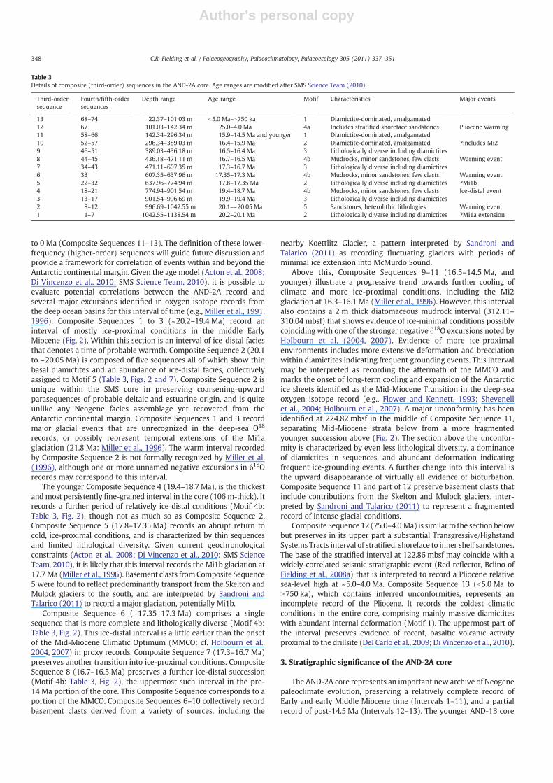
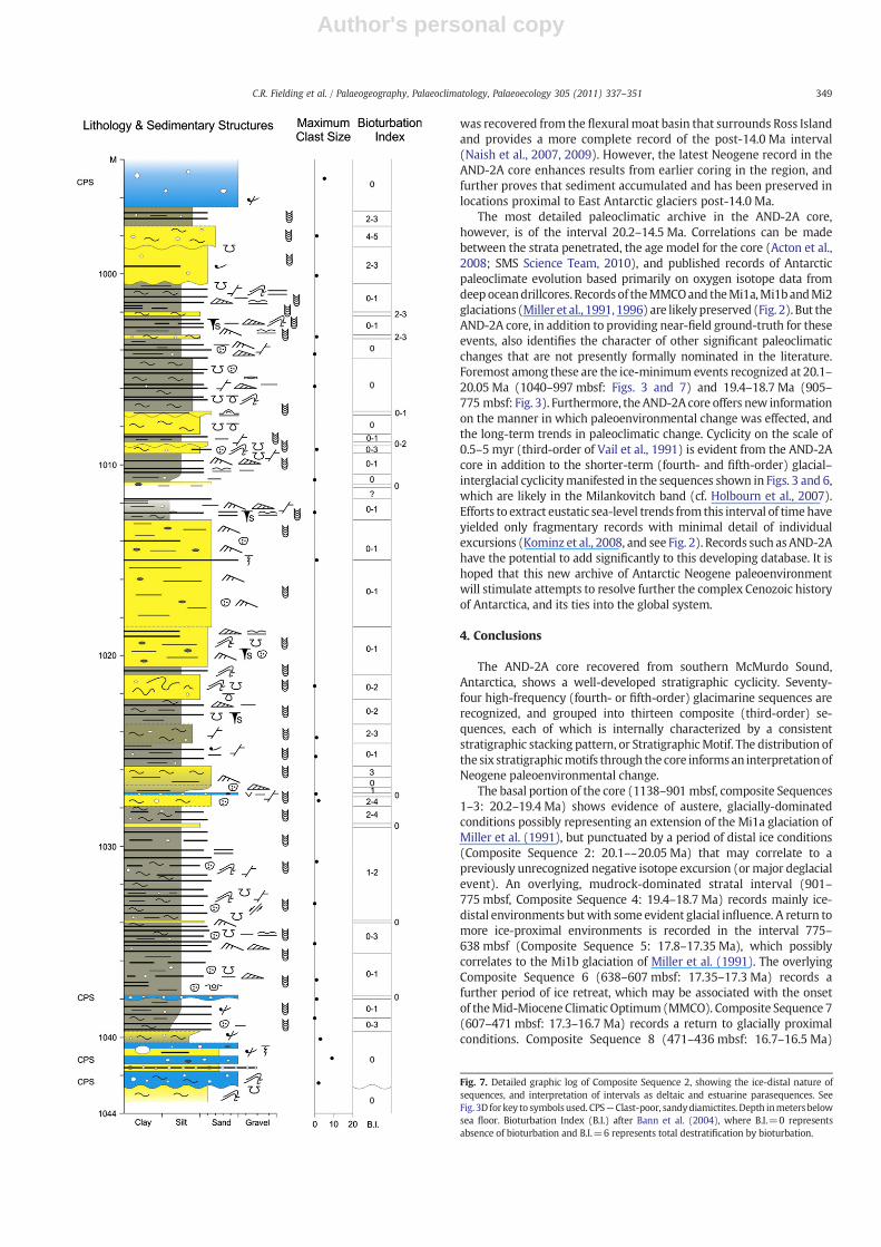
to 0 Ma (Composite Sequences 11–13). The definition of these lower-frequency (higher-order) sequences will guide future discussion andprovide a framework for correlation of events within and beyond theAntarctic continental margin. Given the age model (Acton et al., 2008;Di Vincenzo et al., 2010; SMS Science Team, 2010), it is possible toevaluate potential correlations between the AND-2A record andseveral major excursions identified in oxygen isotope records fromthe deep ocean basins for this interval of time (e.g., Miller et al., 1991,1996). Composite Sequences 1 to 3 (~20.2–19.4 Ma) record aninterval of mostly ice-proximal conditions in the middle EarlyMiocene (Fig. 2). Within this section is an interval of ice-distal faciesthat denotes a time of probable warmth. Composite Sequence 2 (20.1to ~20.05 Ma) is composed of five sequences all of which show thinbasal diamictites and an abundance of ice-distal facies, collectivelyassigned to Motif 5 (Table 3, Figs. 2 and 7). Composite Sequence 2 isunique within the SMS core in preserving coarsening-upwardparasequences of probable deltaic and estuarine origin, and is quiteunlike any Neogene facies assemblage yet recovered from theAntarctic continental margin. Composite Sequences 1 and 3 recordmajor glacial events that are unrecognized in the deep-sea O18
records, or possibly represent temporal extensions of the Mi1aglaciation (21.8 Ma: Miller et al., 1996). The warm interval recordedby Composite Sequence 2 is not formally recognized by Miller et al.(1996), although one or more unnamed negative excursions in δ18Orecords may correspond to this interval.
The younger Composite Sequence 4 (19.4–18.7 Ma), is the thickestandmost persistently fine-grained interval in the core (106 m-thick). Itrecords a further period of relatively ice-distal conditions (Motif 4b:Table 3, Fig. 2), though not as much so as Composite Sequence 2.Composite Sequence 5 (17.8–17.35 Ma) records an abrupt return tocold, ice-proximal conditions, and is characterized by thin sequencesand limited lithological diversity. Given current geochronologicalconstraints (Acton et al., 2008; Di Vincenzo et al., 2010: SMS ScienceTeam, 2010), it is likely that this interval records the Mi1b glaciation at17.7 Ma (Miller et al., 1996). Basement clasts from Composite Sequence5 were found to reflect predominantly transport from the Skelton andMulock glaciers to the south, and are interpreted by Sandroni andTalarico (2011) to record a major glaciation, potentially Mi1b.
Composite Sequence 6 (~17.35–17.3 Ma) comprises a singlesequence that is more complete and lithologically diverse (Motif 4b:Table 3, Fig. 2). This ice-distal interval is a little earlier than the onsetof the Mid-Miocene Climatic Optimum (MMCO: cf. Holbourn et al.,2004, 2007) in proxy records. Composite Sequence 7 (17.3–16.7 Ma)preserves another transition into ice-proximal conditions. CompositeSequence 8 (16.7–16.5 Ma) preserves a further ice-distal succession(Motif 4b: Table 3, Fig. 2), the uppermost such interval in the pre-14 Ma portion of the core. This Composite Sequence corresponds to aportion of the MMCO. Composite Sequences 6–10 collectively recordbasement clasts derived from a variety of sources, including the
nearby Koettlitz Glacier, a pattern interpreted by Sandroni andTalarico (2011) as recording fluctuating glaciers with periods ofminimal ice extension into McMurdo Sound.
Above this, Composite Sequences 9–11 (16.5–14.5 Ma, andyounger) illustrate a progressive trend towards further cooling ofclimate and more ice-proximal conditions, including the Mi2glaciation at 16.3–16.1 Ma (Miller et al., 1996). However, this intervalalso contains a 2 m thick diatomaceous mudrock interval (312.11–310.04 mbsf) that shows evidence of ice-minimal conditions possiblycoinciding with one of the stronger negative δ18O excursions noted byHolbourn et al. (2004, 2007). Evidence of more ice-proximalenvironments includes more extensive deformation and brecciationwithin diamictites indicating frequent grounding events. This intervalmay be interpreted as recording the aftermath of the MMCO andmarks the onset of long-term cooling and expansion of the Antarcticice sheets identified as the Mid-Miocene Transition in the deep-seaoxygen isotope record (e.g., Flower and Kennett, 1993; Shevenellet al., 2004; Holbourn et al., 2007). A major unconformity has beenidentified at 224.82 mbsf in the middle of Composite Sequence 11,separating Mid-Miocene strata below from a more fragmentedyounger succession above (Fig. 2). The section above the unconfor-mity is characterized by even less lithological diversity, a dominanceof diamictites in sequences, and abundant deformation indicatingfrequent ice-grounding events. A further change into this interval isthe upward disappearance of virtually all evidence of bioturbation.Composite Sequence 11 and part of 12 preserve basement clasts thatinclude contributions from the Skelton and Mulock glaciers, inter-preted by Sandroni and Talarico (2011) to represent a fragmentedrecord of intense glacial conditions.
Composite Sequence12 (?5.0–4.0 Ma) is similar to the section belowbut preserves in its upper part a substantial Transgressive/HighstandSystems Tracts interval of stratified, shoreface to inner shelf sandstones.The base of the stratified interval at 122.86 mbsf may coincide with awidely-correlated seismic stratigraphic event (Red reflector, Bclino ofFielding et al., 2008a) that is interpreted to record a Pliocene relativesea-level high at ~5.0–4.0 Ma. Composite Sequence 13 (b5.0 Ma toN750 ka), which contains inferred unconformities, represents anincomplete record of the Pliocene. It records the coldest climaticconditions in the entire core, comprising mainly massive diamictiteswith abundant internal deformation (Motif 1). The uppermost part ofthe interval preserves evidence of recent, basaltic volcanic activityproximal to the drillsite (Del Carlo et al., 2009; Di Vincenzo et al., 2010).
3. Stratigraphic significance of the AND-2A core
The AND-2A core represents an important new archive of Neogenepaleoclimate evolution, preserving a relatively complete record ofEarly and early Middle Miocene time (Intervals 1–11), and a partialrecord of post-14.5 Ma (Intervals 12–13). The younger AND-1B core
Table 3Details of composite (third-order) sequences in the AND-2A core. Age ranges are modified after SMS Science Team (2010).
Third-ordersequence
Fourth/fifth-ordersequences
Depth range Age range Motif Characteristics Major events
13 68–74 22.37–101.03 m b5.0 Ma–N750 ka 1 Diamictite-dominated, amalgamated12 67 101.03–142.34 m ?5.0–4.0 Ma 4a Includes stratified shoreface sandstones Pliocene warming11 58–66 142.34–296.34 m 15.9–14.5 Ma and younger 1 Diamictite-dominated, amalgamated10 52–57 296.34–389.03 m 16.4–15.9 Ma 2 Diamictite-dominated, amalgamated ?Includes Mi29 46–51 389.03–436.18 m 16.5–16.4 Ma 3 Lithologically diverse including diamictites8 44–45 436.18–471.11 m 16.7–16.5 Ma 4b Mudrocks, minor sandstones, few clasts Warming event7 34–43 471.11–607.35 m 17.3–16.7 Ma 3 Lithologically diverse including diamictites6 33 607.35–637.96 m 17.35–17.3 Ma 4b Mudrocks, minor sandstones, few clasts Warming event5 22–32 637.96–774.94 m 17.8–17.35 Ma 2 Lithologically diverse including diamictites ?Mi1b4 18–21 774.94–901.54 m 19.4–18.7 Ma 4b Mudrocks, minor sandstones, few clasts Ice-distal event3 13–17 901.54–996.69 m 19.9–19.4 Ma 3 Lithologically diverse including diamictites2 8–12 996.69–1042.55 m 20.1–~20.05 Ma 5 Sandstones, heterolithic lithologies Warming event1 1–7 1042.55–1138.54 m 20.2–20.1 Ma 2 Lithologically diverse including diamictites ?Mi1a extension
348 C.R. Fielding et al. / Palaeogeography, Palaeoclimatology, Palaeoecology 305 (2011) 337–351
Author's personal copy
was recovered from the flexuralmoat basin that surrounds Ross Islandand provides a more complete record of the post-14.0 Ma interval(Naish et al., 2007, 2009). However, the latest Neogene record in theAND-2A core enhances results from earlier coring in the region, andfurther proves that sediment accumulated and has been preserved inlocations proximal to East Antarctic glaciers post-14.0 Ma.
The most detailed paleoclimatic archive in the AND-2A core,however, is of the interval 20.2–14.5 Ma. Correlations can be madebetween the strata penetrated, the age model for the core (Acton et al.,2008; SMS Science Team, 2010), and published records of Antarcticpaleoclimate evolution based primarily on oxygen isotope data fromdeepoceandrillcores. Records of theMMCOand theMi1a,Mi1bandMi2glaciations (Miller et al., 1991, 1996) are likely preserved (Fig. 2). But theAND-2A core, in addition to providing near-field ground-truth for theseevents, also identifies the character of other significant paleoclimaticchanges that are not presently formally nominated in the literature.Foremost among these are the ice-minimumevents recognized at 20.1–20.05 Ma (1040–997 mbsf: Figs. 3 and 7) and 19.4–18.7 Ma (905–775 mbsf: Fig. 3). Furthermore, the AND-2A core offers new informationon the manner in which paleoenvironmental change was effected, andthe long-term trends in paleoclimatic change. Cyclicity on the scale of0.5–5 myr (third-order of Vail et al., 1991) is evident from the AND-2Acore in addition to the shorter-term (fourth- and fifth-order) glacial–interglacial cyclicitymanifested in the sequences shown in Figs. 3 and 6,which are likely in the Milankovitch band (cf. Holbourn et al., 2007).Efforts to extract eustatic sea-level trends from this interval of timehaveyielded only fragmentary records with minimal detail of individualexcursions (Kominz et al., 2008, and see Fig. 2). Records such asAND-2Ahave the potential to add significantly to this developing database. It ishoped that this new archive of Antarctic Neogene paleoenvironmentwill stimulate attempts to resolve further the complex Cenozoic historyof Antarctica, and its ties into the global system.
4. Conclusions
The AND-2A core recovered from southern McMurdo Sound,Antarctica, shows a well-developed stratigraphic cyclicity. Seventy-four high-frequency (fourth- or fifth-order) glacimarine sequences arerecognized, and grouped into thirteen composite (third-order) se-quences, each of which is internally characterized by a consistentstratigraphic stacking pattern, or StratigraphicMotif. The distribution ofthe six stratigraphicmotifs through the core informsan interpretationofNeogene paleoenvironmental change.
The basal portion of the core (1138–901 mbsf, composite Sequences1–3: 20.2–19.4 Ma) shows evidence of austere, glacially-dominatedconditions possibly representing an extension of the Mi1a glaciation ofMiller et al. (1991), but punctuated by a period of distal ice conditions(Composite Sequence 2: 20.1–~20.05 Ma) that may correlate to apreviously unrecognized negative isotope excursion (ormajor deglacialevent). An overlying, mudrock-dominated stratal interval (901–775 mbsf, Composite Sequence 4: 19.4–18.7 Ma) records mainly ice-distal environments butwith some evident glacial influence. A return tomore ice-proximal environments is recorded in the interval 775–638 mbsf (Composite Sequence 5: 17.8–17.35 Ma), which possiblycorrelates to the Mi1b glaciation of Miller et al. (1991). The overlyingComposite Sequence 6 (638–607 mbsf: 17.35–17.3 Ma) records afurther period of ice retreat, which may be associated with the onsetof theMid-Miocene Climatic Optimum(MMCO). Composite Sequence 7(607–471 mbsf: 17.3–16.7 Ma) records a return to glacially proximalconditions. Composite Sequence 8 (471–436 mbsf: 16.7–16.5 Ma)
Fig. 7. Detailed graphic log of Composite Sequence 2, showing the ice-distal nature ofsequences, and interpretation of intervals as deltaic and estuarine parasequences. SeeFig. 3D for key to symbolsused. CPS—Clast-poor, sandydiamictites. Depth inmetersbelowsea floor. Bioturbation Index (B.I.) after Bann et al. (2004), where B.I.=0 representsabsence of bioturbation and B.I.=6 represents total destratification by bioturbation.
349C.R. Fielding et al. / Palaeogeography, Palaeoclimatology, Palaeoecology 305 (2011) 337–351
Author's personal copy
marks a return to ice-distal conditions andmay coincidewith one of thewarmperiods of theMMCO. Composite Sequences 9–11 (16.5–14.5 Ma,and younger) record increasingly ice-proximal and climatically austereconditions, and include the Mi2 glaciation of Miller et al. (1991, 1996).These composite sequences highlight the variable nature of ice sheetbehavior prior to and during the MMCO and indicate that the Antarcticmargin remained glaciated throughmuch of this inferred period of peakglobal warmth. Above a major unconformity at 225 mbsf, a truncatedand partial record of post 14.5 Ma time is composed mainly ofamalgamated, ice-proximal diamictite units, but includes a thicksandstone-dominated interval (part of Composite Sequence 12) that isbelieved to coincide with a regional Early Pliocene relative sea-levelhighstand at ~5.0–4.0 Ma.
The AND-2A core provides a hitherto unavailable, near-field recordof dynamic paleoenvironmental history through the Early to Mid-Miocene. It allows new insights into climate change through thisrelatively poorly known interval of Earth history. In addition toproviding direct sedimentary record of events recognized previouslyin proxy stable isotope records from the deep-sea (such as the onset ofthe MMCO), it also highlights some additional, previously unrecog-nized warm events in the Early Miocene. Future research might beable to utilize this spectacular record towards the finer-scaleresolution of Neogene paleoclimate and paleoenvironmental change.
Acknowledgements
This paper is based on work supported by the National ScienceFoundation under Cooperative Agreement No. 0342484 through sub-awards administered by the ANDRILL Science Management Office(SMO) at University of Nebraska-Lincoln as part of the ANDRILL U.S.Science Support Program. We thank the SMS Drillsite and Scienceteams for their efforts in acquiring and characterizing the AND-2Acore, and Steve Fischbein at the ANDRILL SMO for assistance withdiagrams. The ANDRILL Program is a multinational collaborationbetween the Antarctic programs of Germany, Italy, New Zealand andthe United States. Antarctica New Zealand is the project operator anddeveloped the drilling system in collaboration with Alex Pyne atVictoria University of Wellington and Webster Drilling and Explora-tion Ltd. Antarctica New Zealand supported the drilling team at ScottBase; Raytheon Polar Services Corporation supported the scienceteam at McMurdo Station and the Crary Science and EngineeringLaboratory. The ANDRILL ScienceManagement Office at the Universityof Nebraska-Lincoln provided science planning and operationalsupport. Scientific studies are jointly supported by the US NationalScience Foundation (NSF), NZ Foundation for Research, Science andTechnology (FRST), the Italian Antarctic Research Program (PNRA),the German Research Foundation (DFG) and the Alfred WegenerInstitute for Polar and Marine Research (AWI). Editor David Bottjerand two anonymous referees are thanked for their reviews of thesubmitted manuscript.
References
Abreu, V.S., Anderson, J.B., 1998. Glacial eustasy during the Cenozoic: sequencestratigraphic implications. American Association of Petroleum Geologists Bulletin82, 1385–1400.
Acton, G., Crampton, J., Di Vincenzo, G., Fielding, C.R., Florindo, F., Hannah, M.J.,Harwood, D.M., Ishman, S.E., Johnson, K., Jovane, L., Levy, R.H., Lum, B., Marcano,M.C., Mukasa, S.B., Ohneiser, C., Olney, M., Riesselman, C., Sagnotti, L., Stefano, C.,Strada, E., Taviani, M., Tuzzi, E., Verosub, K.L., Wilson, G.S., Zattin, M., 2008.Preliminary integrated chronostratigraphy of the AND-2A core, ANDRILLSouthern McMurdo Sound Project Antarctica. In: Harwood, D.M., Florindo, F.,Talarico, F., Levy, R.H. (Eds.), Studies from the ANDRILL, SouthernMcMurdo SoundProject, Antarctica: Terra Antartica, 15, pp. 211–220.
Andrews, J.T. (Ed.), 1974. Glacial Isostasy. Dowden, Hutchinson & Ross, Inc.,Stroudsburg, PA. 491 pp.
Bamber, J.L., Riva, R.E.M., Vermeersen, B.L.A., LeBrocq, A.M., 2009. Reassessment of thepotential sea-level rise from a collapse of theWest Antarctic Ice Sheet. Science 324,901–903.
Bann, K.L., Fielding, C.R., MacEachern, J.A., Tye, S.C., 2004. Differentiation of estuarineand offshore marine deposits using integrated ichnology and sedimentology:Permian Pebbley Beach Formation, Sydney Basin, Australia. In: McIlroy, D. (Ed.),The Application of Ichnology to Palaeoenvironmental and Stratigraphic Analysis:Geological Society of London Special Publication, 228, pp. 179–211.
Barrett, P.J. (Ed.), 1986. Antarctic Cenozoic history from the MSSTS-1 borehole,McMurdo Sound: New Zealand Department of Scientific and Industrial ResearchBulletin, 237.
Barrett, P.J. (Ed.), 1989. Antarctic Cenozoic history from the CIROS-1 drillhole,McMurdo Sound: New Zealand Department of Scientific and Industrial ResearchBulletin, 245.
Barrett, P.J., 1996. Antarctic palaeoenvironment through Cenozoic times — a review.Terra Antartica 3, 103–119.
Barrett, P.J., 2007. Cenozoic climate and sea level history from glacimarine strata off theVictoria Land coast, Cape Roberts Project, Antarctica. In: Hambrey,M.J., Christoffersen,P., Glasser, N.F., Hubbart, B. (Eds.), Glacial Processes and Products: InternationalAssociation of Sedimentologists Special Publication, 39, pp. 259–287.
Barrett, P.J., 2009. A history of Antarctic Cenozoic glaciations — view from the margin.In: Florindo, F., Siegert, M. (Eds.), Antarctic Climate Evolution. Developments inEarth and Environmental Sciences, 8. Elsevier Science, Amsterdam, pp. 33–83.
Barrett, P.J., Hambrey, M.J., 1992. Plio-Pleistocene sedimentation in Ferrar Fiord,Antarctica. Sedimentology 39, 109–123.
Brotchie, J.F., Silvester, R., 1969. On crustal flexure. Journal of Geophysical Research 74,5240–5252.
Catuneanu, O., 2006. Principles of Sequence Stratigraphy. Elsevier, Amsterdam. 375 pp.Catuneanu, O., Abreu, V., Bhattacharya, J., Blum, M.D., Dalrymple, R.W., Eriksson, P.G.,
Fielding, C.R., Fisher, W.L., Galloway, W.E., Gibling, M.R., Giles, K.A., Holbrook, J.M.,Jordan, R., Kendall, C.G., St, C., Macurda, B., Martinsen, O.J., Miall, A.D., Neal, J.E.,Nummedal, D., Pomar, L., Posamentier, H.W., Pratt, B.R., Sarg, J.F., Shanley, K.W.,Steel, R.J., Strasser, A., Tucker, M.E., Winker, C., 2009. Towards the standardizationof sequence stratigraphy. Earth Science Reviews 92, 1–33.
Cooper, A.K., Davey, F.J., Behrendt, J.C., 1987. Seismic stratigraphy and structure of theVictoria Land Basin, western Ross Sea, Antarctica. In: Cooper, A.K., Davey, F.J. (Eds.),The Antarctic continental margin: geology and geophysics of the western Ross Sea:Circum-Pacific Council for Energy and Mineral Resources, Earth Science Series, 5B,pp. 27–65. Houston, Texas.
Del Carlo, P., Panter, K.S., Bassett, K., Di Vincenzo, G., Rocchi, S., 2009. The upperlithostratigraphic unit of ANDRILL AND-2A core (Southern McMurdo Sound,Antarctica): local Pleistocene volcanic sources, paleoenvironmental implications andsubsidence in the southern Victoria Land Basin. Global and Planetary Change 69,142–161.
Di Vincenzo, G., Bracciali, L., Del Carlo, P., Panter, K., Rocchi, S., 2010. 40Ar–39Ar dating ofvolcanogenic products from the AND-2A core (ANDRILL Southern McMurdo SoundProject, Antarctica): correlations with the Erebus Volcanic Province and implica-tions for the age model of the core. Bulletin of Volcanology 72, 487–505.
Dunbar, G.D., Barrett, P.J., 2005. Estimating palaeobathymetry of wave-gradedcontinental shelves from sediment texture. Sedimentology 52, 253–269.
Dunbar, G.D., Naish, T.R., Barrett, P.J., Fielding, C.R., Powell, R.D., 2008. Constraining theamplitude of Late Oligocene bathymetric changes in western Ross Sea duringorbitally-induced oscillations in the East Antarctic Ice Sheet: 1. Implications forglacimarine sequence stratigraphic models. Palaeogeography, PalaeoclimatologyPalaeoecology 260, 50–65.
Fielding, C.R., Harwood, D.M., Winter, D.M., Francis, J.E., in press. Neogene stratigraphyof Taylor Valley, Transantarctic Mountains, Antarctica: evidence for climatedynamism and a vegetated early Pliocene coastline of McMurdo Sound. Globaland Planetary Change, doi:10.1016/j.gloplacha.2010.09.03.
Fielding, C.R., Woolfe, K.J., Howe, J.A., Lavelle, M., 1998. Sequence stratigraphic analysisof CRP-1, Cape Roberts Project, McMurdo Sound, Antarctica. Terra Antartica 5,353–361.
Fielding, C.R., Naish, T.R., Woolfe, K.J., Lavelle, M.A., 2000. Facies analysis and sequencestratigraphy of CRP-2/2A, McMurdo Sound, Antarctica. Terra Antartica 7, 323–338.
Fielding, C.R.,Henrys, S.A.,Wilson,T.J., 2006. Rift historyof thewesternVictoriaLandBasin:anew perspective based on integration of coreswith seismic reflection data. In: Futterer,D.K., Damaske, D., Kleinschmidt, G., Miller, H., Tessensohn, F. (Eds.), Antarctica:Contributions to Global Earth Sciences. Springer-Verlag, Berlin, pp. 309–318.
Fielding, C.R., Whittaker, J., Henrys, S.A., Wilson, T.J., Naish, T.R., 2008a. Seismic faciesand stratigraphy of the Cenozoic succession in McMurdo Sound, Antarctica:implications for tectonic, climatic and glacial history. Palaeogeography, Palaeocli-matology, Palaeoecology 260, 8–29.
Fielding, C.R., Atkins, C.B., Bassett, K.N., Browne, G.H., Dunbar, G.B., Field, B.D., Frank, T.D.,Krissek, L.A., Panter, K.S., Passchier, S., Pekar, S.F., Sandroni, S., Talarico, F., ANDRILL-SMS Science Team, 2008b. Sedimentology and stratigraphy of the AND-2A Core,ANDRILL Southern McMurdo Sound Project, Antarctica. In: Harwood, D.M., Florindo,F., Talarico, F., Levy, R.H. (Eds.), Studies from the ANDRILL, SouthernMcMurdo SoundProject, Antarctica: Terra Antartica, 15, pp. 77–112.
Flower, B.P., Kennett, J.P., 1993. Middle Miocene ocean–climate transition; high-resolution oxygen and carbon isotopic records from Deep Sea Drilling Project Site588A, southwest Pacific. Paleoceanography 8, 811–843.
Flower, B.P., Kennett, J.P., 1994. The middle Miocene climatic transition: East Antarcticice sheet development, deep ocean circulation and global carbon cycling.Palaeogeography, Palaeoclimatology, Palaeoecology 108, 537–555.
Harwood, D.M., Florindo, F., Talarico, F., Levy, R. (Eds.), 2008. Studies from the ANDRILLSouthern McMurdo Sound Project, Antarctica: Terra Antartica, 15, pp. 1–235.
Henrys, S.A., Wilson, T.J., Whittaker, J.M., Fielding, C.R., Hall, J., Naish, T.R., 2007. Tectonichistory of mid-Miocene to present southern Victoria Land Basin, inferred from seismicstratigraphy inMcMurdo Sound, Antarctica. USGSOpen-File Report-2007-1047, Short
350 C.R. Fielding et al. / Palaeogeography, Palaeoclimatology, Palaeoecology 305 (2011) 337–351
Author's personal copy
Research Paper 049. National Academies Press. doi:10.3133/of2007-1047.srp049.Holbourn, A., Kuhnt, W., Simo, J.A., Li, Q.Y., 2004. Middle Miocene isotope stratigraphy
and paleoceanographic evolution of the northwest and southwest Australianmargins (Wombat Plateau and Great Australian Bight). Palaeogeography, Palaeo-climatology, Palaeoecology 208, 1–22.
Holbourn, A., Kuhnt, W., Schulz, M., Flores, J.-A., Andersen, N., 2007. Orbitally-pacedclimate evolution during the Middle Miocene “Monterey” carbon-isotope excur-sion. Earth and Planetary Science Letters 261, 534–550.
Kominz, M.A., Browning, J.V., Miller, K.G., Sugarman, P.J., Mizintseva, S., Scotese, C.R.,2008. Late Cretaceous to Miocene sea-level estimates from the New Jersey andDelaware coastal plain coreholes: an error analysis. Basin Research 20, 211–226.
Krissek, L., Browne, G., Carter, L., Cowan, E., Dunbar, G., McKay, R., Naish, T., Powell, R.,Reed, J., Wilch, T., Science Team, A.N.D.R.I.L.L.-M.I.S., 2007. Sedimentology andstratigraphy of AND-1B core, ANDRILL McMurdo Ice Shelf Project, Antarctica. TerraAntartica 14, 185–222.
Lear, C.H., Rosenthal, Y., Coxall, H.K., Wilson, P.A., 2004. Late Eocene to earlyMiocene icesheet dynamics and the global carbon cycle. Paleoceanography PA4015, 1–11.
Lewis, A.R., Marchant, D.R., Ashworth, A.C., Hedenaes, L., Hemming, S.R., Johnson, J.V.,Leng, M.J., Machlus, M.L., Newton, A.E., Raine, J.I., Willenbring, J.K., Williams, M.,Wolfe, A.P., 2008. Mid-Miocene cooling and the extinction of tundra in continentalAntarctica. Proceedings of the National Academy of Sciences 105, 10676–10680.
Lønne, I., 2001. Dynamics of marine glacier termini read from moraine architecture.Geology 29, 199–202.
Lønne, I., Syvitski, J.P., 1997. Effects of the readvance of an ice margin on the seismiccharacter of the underlying sediment. Marine Geology 143, 81–102.
McGinnis, L.D. (Ed.), 1981. Dry Valley Drilling Project: American Geophysical UnionAntarctic Research Series, 33. Washington, D.C., 465 pp.
McKay, R., Browne, G., Carter, L., Cowan, E., Dunbar, G., Krissek, L., Naish, T., Powell, R.,Reed, J., Talarico, F., Wilch, T., 2009. The stratigraphic signature of the late CenozoicAntarctic Ice Sheets in the Ross Embayment. Geological Society of America Bulletin121, 1537–1561.
Miller, K.G., Wright, J.D., Fairbanks, R.G., 1991. Unlocking the ice house: Oligocene–Miocene oxygen isotopes, eustasy and margin erosion. Journal of GeophysicalResearch 96, 6829–6848.
Miller, K.G., Mountain, G.S., Leg 150 Shipboard Party, Members of the New JerseyCoastal Plain Drilling Project, 1996. Drilling and dating New Jersey Oligocene–Miocene sequences: ice volume, global sea level, and EXXON records. Science 271,1092–1095.
Mitrovica, J.X., Vermeersen, L.L.A., 2002. Glacial isostatic adjustment and the Earthsystem. In: Mitrovica, J.X., Vermeersen, L.L.A. (Eds.), Ice Sheets, Sea Level and theDynamic Earth, Washington, D.C. American Geophysical Union GeodynamicsSeries, 29, pp. 1–2.
Mitrovica, J.X., Gomez, N., Clark, P.U., 2009. The sea-level fingerprint of West Antarcticcollapse. Science 323, 753.
Naish, T.R., Powell, R.D., Levy, R. (Eds.), 2007. Studies from the ANDRILL McMurdo IceShelf Project, Antarctica: Terra Antartica, 14, pp. 110–328.
Naish, T.R., Wilson, G.S., Dunbar, G.B., Barrett, P.J., 2008. Constraining the amplitude ofLate Oligocene bathymetric changes in western Ross Sea during orbitally-inducedoscillations in the East Antarctic Ice Sheet: (2) Implications for global sea-levelchanges. Palaeogeography, Palaeoclimatology, Palaeoecology 260, 66–76.
Naish, T., et al., 2009. Late Cenozoic stability of theWest Antarctic Ice Sheet. Nature 458,322–329. doi:10.1038/nature07867.
Passchier, S., Browne, G., Field, B., Fielding, C.R., Krissek, L.A., Panter, K., Pekar, S.F.,ANDRILL-SMS Science Team, in press. Early and Middle Miocene Antarctic glacialhistory from the sedimentary facies distribution in AND-2A, Ross Sea, Antarctica.Geological Society of America Bulletin. doi:10.1130/B30334.1.
Sandroni, S., Talarico, F., 2011. The record of Miocene climatic events in AND-2A drillcore (Antarctica): insights from provenance analyses of basement clasts. Globaland Planetary Change 75, 31–46.
SMS Science Team, 2010. An integrated age model for the ANDRILL-2A drill core. In:Kontar, K., Harwood, D.M., Florindo, F., Fischbein, S. (Compilers), ANDRILL SouthernMcMurdo Sound Project Science Integration Workshop, Erice, Italy, 6–11th April,2010, ANDRILL Contribution 16, 12–13.
Shevenell, A.E., Kennett, J.P., Lea, D., 2004. Middle Miocene Southern Ocean cooling andAntarctic cryosphere expansion. Science 305, 1766–1770.
Sugden, D.E., Marchant, D.R., Denton, G.H., 1993. The case for a stable East Antarctic IceSheet. Geografiska Annaler 75, 151–353.
Taviani, M., Hannah,M., Harwood, D.M., Ishman, S.E., Johnson, K., Olney,M., Riesselman, C.,Tuzzi, E., Askin, R., Beu, A.G., Blair, S., Cantarelli, V., Ceregato, A., Corrado, S., Mohr, B.,Nielsen, S.H.H., Persico, D., Petrushak, S., Raine, J.I., Warny, S., ANDRILL-SMS ScienceTeam, 2008. Palaeontological characterization and analysis of the AND-2A core,ANDRILL SouthernMcMurdo Sound Project, Antarctica. Terra Antarctica 15, 113–146.
Vail, P.R., Audemard, F., Bowman, S.A., Eisner, P.N., Perez-Cruz, C., 1991. Thestratigraphic signatures of tectonics, eustasy and sedimentology — an overview.In: Einsele, G., Ricken, W., Seilacher, A. (Eds.), Cycles and Events in Stratigraphy.Springer-Verlag, Berlin, pp. 617–659.
Vincent, E., Berger, W.H., 1985. Carbon dioxide and polar cooling in the Miocene: theMonterey hypothesis. In: Sundquist, E.T., Broecker, W.S. (Eds.), The carbon cycleand atmospheric CO2: natural variations Archean to present. GeophysicalMonograph, 32. AGU, Washington, D.C., pp. 455–468.
Webb, P.-N., Harwood, D.M., McKelvey, B.C., Mercer, J.H., Stott, L.D., 1984. Cenozoicmarine sedimentation and ice volume variation in the East Antarctic craton.Geology 12, 287–291.
Woodruff, F., Savin, S., 1991. Mid-Miocene isotope stratigraphy in the deep sea: high-resolution correlations, paleoclimatic cycles, and sediment preservation. Paleocea-nography 6, 755–806.
Zachos, J., Pagani, M., Sloan, L., Thomas, E., Billups, K., 2001. Trends, rhythms, andaberrations in global climate 65 Ma to present. Science 292, 686–693.
351C.R. Fielding et al. / Palaeogeography, Palaeoclimatology, Palaeoecology 305 (2011) 337–351