September 5, 2003 - City of San Diego
162
May 14, 2018 7643-44 Carrie Purcell City of San Diego – Public Works Department Engineering & Capital Projects 525 B Street, MS 908A San Diego, California 92101-4502 Subject: Biological Resources Letter Report for the Water and Storm Group 968 (WBS No. B-14099.02.02/B-15028.02.02), City of San Diego, California Dear Carrie Purcell: This letter report provides an analysis of potential biological resource impacts associated with the proposed abandonment and replacement of several deteriorated water and storm drain pipelines (WBS No. B-14099.02.02/B-15028.02.02) located in the City of San Diego, California. In accordance with the current San Diego Land Development Code Biology Guidelines (City of San Diego 2012), this survey letter report provides an introduction, a summary of the pertinent biological resource regulations, a project description, the survey methods, existing biological resources, special-status biological resources, project impacts (direct and indirect), and project mitigation. The project impacts, avoidance, and mitigation measures are discussed in accordance with the California Environmental Quality Act (CEQA), Clean Water Act (CWA), Migratory Bird Treaty Act (MBTA), California Fish and Wildlife Code, the City of San Diego Final Multiple Species Conservation Program (MSCP) Subarea Plan (City Subarea Plan) (City of San Diego 1997), and the City of San Diego’s (City’) Environmentally Sensitive Lands regulations. INTRODUCTION The proposed project addresses necessary water and storm drain pipeline improvements within the City, in the neighborhoods of Point Loma, Mission Valley, and City Heights. The project study area includes the following five project components, each including a 50-foot buffer (study area) and a 300-foot buffer for general habitat mapping: 1. Site 4 (Camino del Rio North): Replacement of an existing water main on the north side of Camino del Rio North, just west of the Interstate (I-) 8 and I-15 intersection.
-
Upload
khangminh22 -
Category
Documents
-
view
3 -
download
0
Transcript of September 5, 2003 - City of San Diego

May 14, 2018 7643-44
Carrie Purcell
City of San Diego – Public Works Department
Engineering & Capital Projects
525 B Street, MS 908A
San Diego, California 92101-4502
Subject: Biological Resources Letter Report for the Water and Storm Group 968
(WBS No. B-14099.02.02/B-15028.02.02), City of San Diego, California
Dear Carrie Purcell:
This letter report provides an analysis of potential biological resource impacts associated with
the proposed abandonment and replacement of several deteriorated water and storm drain
pipelines (WBS No. B-14099.02.02/B-15028.02.02) located in the City of San Diego, California.
In accordance with the current San Diego Land Development Code Biology Guidelines (City of
San Diego 2012), this survey letter report provides an introduction, a summary of the pertinent
biological resource regulations, a project description, the survey methods, existing biological
resources, special-status biological resources, project impacts (direct and indirect), and project
mitigation. The project impacts, avoidance, and mitigation measures are discussed in accordance
with the California Environmental Quality Act (CEQA), Clean Water Act (CWA), Migratory
Bird Treaty Act (MBTA), California Fish and Wildlife Code, the City of San Diego Final
Multiple Species Conservation Program (MSCP) Subarea Plan (City Subarea Plan) (City of San
Diego 1997), and the City of San Diego’s (City’) Environmentally Sensitive Lands regulations.
INTRODUCTION
The proposed project addresses necessary water and storm drain pipeline improvements within
the City, in the neighborhoods of Point Loma, Mission Valley, and City Heights. The project
study area includes the following five project components, each including a 50-foot buffer (study
area) and a 300-foot buffer for general habitat mapping:
1. Site 4 (Camino del Rio North): Replacement of an existing water main on the north side
of Camino del Rio North, just west of the Interstate (I-) 8 and I-15 intersection.
Ms. Carrie Purcell
Subject: Biological Resources Letter Report for the Water and Storm Group 968 (WBS No. B-
14099.02.02/B-15028.02.02), City of San Diego, California
7643-44 2 May 2018
2. Site 5 (Silvergate Avenue): Replacement of an existing water main along Silvergate
Avenue, south of Rosecroft Lane and extending east to Kellogg Way; abandonment of an
existing pipeline south of Kellogg Way and north of Rehberg Road.1
3. Site 8 (Central Avenue): Replacement of an existing water main parallel to and east of
Central Avenue.
4. Site 10 (Laurel Street): Replacement of an existing water main and addition of a storm drain
pipe between the southern terminus of Roseview Place, Laurel Street, and Home Avenue.
5. Site 12 (39th Street): Replacement of an existing water main between 39th Street, I-805,
and Manzanita Drive; abandonment of a portion of this existing water main, south of the
portion proposed for replacement.
The biological survey discussed in this letter report concentrated on identifying biological
resources that may be subject to regulation under the City’s MSCP Subarea Plan (City Subarea
Plan), Section 404 of the CWA as administered by the U.S. Army Corps of Engineers (USACE),
Section 401 of the CWA and the Porter Cologne Act as administered by Regional Water Quality
Control Board (RWQCB), Sections 1600–1603 of the California Fish and Game Code as
administered by the California Department of Fish and Wildlife (CDFW), and other potential
special-status biological resources.
PROJECT LOCATION
The proposed project includes five sites in three general locations in the City of San Diego,
California, in the neighborhoods of Point Loma, Mission Valley, and City Heights (Figure 1,
Regional Map). Portions of the water and storm water pipeline improvement project are
proposed to occur at five locations: (1) the north side of Camino del Rio North, just west of the I-
8 and I-15 intersection; (2) along Silvergate Avenue and extending east between Rehberg Road
and Silvergate Place; (3) between the southern terminus of Roseview Place, Laurel Street, and
Home Avenue; and (4) parallel to and east of Central Avenue; (5) between 39th Street, I-805,
and Manzanita Drive (Figure 2A through Figure 2C, Vicinity Map). The approximate centroid of
the Camino del Rio North location is 32°46’46.50" north latitude, 117°06’58.66" west longitude;
this site is on the U.S. Geological Service (USGS) 7.5-minute series topographic La Mesa
quadrangle map Section 17, Range 2 West, Township 16 South. The approximate centroid of the
Silvergate Avenue location is 32°42’29.42" north latitude, 117°14’43.00" west longitude; this
1 Complete surveys of this area were not feasible due to access restrictions. Aerial mapping was used as needed
to complete the vegetation mapping.

Ms. Carrie Purcell
Subject: Biological Resources Letter Report for the Water and Storm Group 968 (WBS No. B-
14099.02.02/B-15028.02.02), City of San Diego, California
7643-44 3 May 2018
site is on the USGS 7.5-minute series topographic Point Loma quadrangle map Section 12,
Range 4 West, Township 17 South. The approximate centroid of the Central Avenue location is
32°44’15.11" north latitude, 117°06’27.49" west longitude; this site is on the USGS 7.5-minute
series topographic National City quadrangle map Section 32, Range 2 West, Township 16 South.
The approximate centroid of the Laurel Street location is 32°43’52.28" north latitude,
117°05’53.10" west longitude; this site is on the USGS 7.5-minute series topographic National
City quadrangle map Section 33, Range 2 West, Township 16 South and Section 04, Range 2
West, Township 17 South. The approximate centroid of the 39th Street location is 32°44’02.20"
north latitude, 117°06’37.96" west longitude; this site is on the USGS 7.5-minute series
topographic National City quadrangle map Section 32, Range 2 West, Township 16 South.
Topography and Land Uses
Site 4 (Camino del Rio North) is generally flat within the developed area, but the elevation varies
in the northern portion of the site with north- and south-facing slopes where the San Diego River
is located. The elevation range at the Camino del Rio North site is between 40 feet above mean
sea level (AMSL) to 130 feet AMSL. The topography at Site 5 (Silvergate Avenue) site ranges
from 75 feet AMSL at the southeastern portion near Jenkins Street to 405 feet AMSL at the
northern portion along Silvergate Avenue. The topography at Site 8 (Central Avenue) site is
generally sloping from north to south with an elevation range of 210 feet AMSL to 320 feet
AMSL. At Site 10 (Laurel Street) site, the topography ranges from 160 feet AMSL to 290 feet
AMSL. The topography at Site 12 (39th Street) site ranges from 175 feet AMSL to 290 feet
AMSL. The lowest elevation point is within the dry channel at the bottom of the canyon south of
39th Street, and this canyon is surrounded by a north- and south-facing slope leading up to the
urban development along 39th street and Manzanita Drive.
All five sites are vegetated with a mixed array of native and non-native ornamental vegetation
associated with the urban setting. Given the urban setting, there is a fair amount of native habitat
at all sites including Diegan coastal sage scrub, chamise chaparral, scrub oak chaparral, and
southern willow scrub. Current land uses within and immediately surrounding the proposed
project include single and multifamily residential uses, commercial development, and traffic
from I-8 and I-15. The San Diego River is located north of the Camino del Rio North site, and
there is a dry channel at the bottom of the canyon south of 39th Street and Central Avenue sites.

Ms. Carrie Purcell
Subject: Biological Resources Letter Report for the Water and Storm Group 968 (WBS No. B-
14099.02.02/B-15028.02.02), City of San Diego, California
7643-44 4 May 2018
Soils
According to the San Diego County Soil Survey, 10 soil types were mapped in the study area and
are described in the following subsections (Bowman 1973). Series descriptions are based on the
Official Soil Series Descriptions (USDA 2017a) unless otherwise noted.
Clay Loam
The Salinas clay loam, 2% to 9% slopes, occurs within the study area. The Salinas series consists
of deep, well-drained soils that formed in alluvium weathered from sandstone and shale. Salinas
soils are on alluvial plains, fans, and terraces and have slopes of 0% to 9%. This series is
characterized as slow to medium runoff with moderately slow permeability.
Cobbly Loam
Olivenhain cobbly loam, 30% to 50% slopes, occurs within the study area. The Olivenhain series
soils are gently sloping to strongly sloping and are on dissected marine terraces at elevations of
100 to 600 feet. It is a member of the clayey-skeletal, kaolinitic, thermic family of Ultic
Palexeralfs. Typically, Olivenhain soils have brown and reddish brown, medium acid, very
cobbly loam A horizons, reddish brown and red, medium and strongly acid, very cobbly clay B2t
horizons, grading to pinkish white cobbly loam C horizons. They are well-drained with slow or
medium runoff and very slow permeability.
Fine Sandy Loam
Gaviota fine sandy loam, 9% to 30% slopes; Reiff fine sandy loam, 2% to 5% slopes; and Reiff
fine sandy loam, 5% to 9% slopes, occur within the study area. The Gaviota series consists of
very shallow or shallow, well-drained soils that formed in material weathered from hard
sandstone or meta-sandstone. Gaviota soils are on hills and mountains and have slopes of 2% to
100%. They are well and excessively well drained with very low to very high runoff and
moderately rapid permeability.
The Reiff series consists of very deep, well-drained soils formed in coarse- to medium-textured
alluvium weathered from mixed sources. Reiff soils are on flood plains and alluvial fans with 0% to
9% slopes. They are well drained with very slow to slow runoff and moderately rapid permeability.

Ms. Carrie Purcell
Subject: Biological Resources Letter Report for the Water and Storm Group 968 (WBS No. B-
14099.02.02/B-15028.02.02), City of San Diego, California
7643-44 5 May 2018
Gravelly Coarse Sand
Riverwash occurs within the study area. It is described as sandy, gravelly, or cobbly (Bowman
1973). It is excessively drained with rapid permeability (Bowman 1973).
Gravelly Loam
Redding-Urban land complex, 2% to 9% slopes, occurs within the study area. The Redding
series consists of moderately deep to duripan, well- or moderately well-drained soils that formed
in alluvium derived from mixed sources. They are on nearly level or dissected and undulating to
hilly high terraces on 0% to 30% slopes.
Loamy Coarse Sand
Marina loamy coarse sand, 2% to 9% slopes, occurs within the study area. The Marina series
consists of gently sloping to moderately steep areas on short rolling dune-like slopes at
elevations of 100 to 700 feet. They formed in old sand dunes near the coast. They are somewhat
excessively drained with slow to rapid runoff and moderate permeability.
Other
Made land and terrace escarpments occur within the study area. Bowman (1973) describes made
land as areas that have been filled with excavated and transported soil material, dredged or
paving material. Bowman (1973) describes terrace escarpments as steep to very steep
escarpments or escarpment-like landscapes, typically occurring on terraces or alluvial fans
between narrow floodplains and adjoining uplands.
REGIONAL RESOURCE PLANNING CONTEXT
The MSCP is a long-term regional conservation plan established to protect special-status species
and habitats in San Diego County. The MSCP is divided into subarea plans that are implemented
separately from one another. The project study area is within the City’s Subarea Plan. This
subarea encompasses 206,124 acres and is generally characterized by urban land use. The City
Multiple Habitat Planning Area (MHPA) is a “hard line” preserve developed by the City in
cooperation with the wildlife agencies, property owners, developers, and environmental groups.
The MHPA identifies biological core resource areas and corridors targeted for conservation, in
which only limited development may occur (City of San Diego 1997).
Ms. Carrie Purcell
Subject: Biological Resources Letter Report for the Water and Storm Group 968 (WBS No. B-
14099.02.02/B-15028.02.02), City of San Diego, California
7643-44 6 May 2018
For planning purposes, the City’s MSCP Subarea Plan has been divided into five distinct areas:
Southern Area, Eastern Area, Urban Areas, Northern Area, and Cornerstone Lands and San
Pasqual Valley. The study area is designated within the “Urban Area” of City’s MSCP Subarea
Plan. Sites 8, 10, and 12 are located in some Environmentally Sensitive Lands; Sites 4, 8, and 12
are partially within lands designated as MHPA by the City’s Subarea Plan. Site 5 is located
within the City Coastal Zone Map No. C-908 as shown in Chapter 13, Article 2, Division 4 (City
of San Diego 2014) (Figures 2A–2C).
METHODS
Data regarding biological and jurisdictional resources present within the study area were obtained
through a review of pertinent literature and field reconnaissance; both are described in detail below.
Literature Review
Dudek reviewed the following data sources to assist with the biological and jurisdiction efforts:
Natural Resource Conservation Service Websoil Survey (USDA 2016)
CDFW California Natural Diversity Database (CNDDB) (CDFW 2016, 2017a)
California Native Plant Society (CNPS) Inventory of Rare and Endangered Plants
(CNPS 2016, 2017)
MSCP (City of San Diego 1997)
USGS National Hydrography Dataset (USGS 2016)
USFWS Species Occurrence Data (USFWS 2016, 2017)
San Diego Geographic Information Source (SanGIS) database (SanGIS 2016)
Field Reconnaissance
The field survey was performed by Dudek biologists Callie Amoaku and Monique O’Conner on
December 7, 2016, and December 8, 2016 (Table 1). The biological survey was conducted in
accordance with the City’s Guidelines for Conducting Biological Surveys (City of San Diego
2012, Appendix II) and included the mapping of vegetation communities and land covers present
in the study area, an evaluation of jurisdictional wetlands or waters, and an evaluation of the
potential for special-status species to occur in the study area. A rare plant survey was conducted
on May 2, 2017, by Erin Bergman (Table 1). Additional site visits were made to refine
vegetation mapping (Table 1). Note that the study area is defined as the impact footprint for the

Ms. Carrie Purcell
Subject: Biological Resources Letter Report for the Water and Storm Group 968 (WBS No. B-
14099.02.02/B-15028.02.02), City of San Diego, California
7643-44 7 May 2018
five sites plus a 50-foot-wide study corridor surrounding each site. A 300-foot buffer around
each site was also evaluated (but not directly surveyed) for potential wildlife habitat within
surrounding areas. This is intended to better facilitate a review of all potential direct and indirect
impacts resulting from the project (i.e., trenching and staging areas).
Table 1
Survey Conditions
Date Time Personnel Survey Conditions
12/7/2016 0845–1600 Callie Amoaku, Monique O’Conner
58 degrees Fahrenheit (°F)–64°F; 10%–50% cloud cover (cc); 0–1.5 mile per hour (mph) winds
12/8/2016 1200–1500 Callie Amoaku 63°F–65°F; 20% cc; 0–1 mph winds
5/2/2017 0818–1555 Erin Bergman 70°F–76°F; 0%–10% cc; 0–3 mph winds
11/2/2017 0800–1000 Mackenzie Forgey 62°F–66°F; 100% cc; 0–2 mph winds
1/10/2018 0900–1100 Mackenzie Forgey 62°F–65°F; 10% cc; 0–5 mph winds
Resource Mapping
The survey was conducted on foot to visually cover 100% of the study area. A 200-scale (i.e.,
200 feet = 1 inch) aerial photograph map with an overlay of the project boundary was used to
map the vegetation communities and record any special-status biological resources directly in the
field. Also, the ESRI Collector application was used to electronically map the vegetation
communities and record notes, and a Trimble GeoXT was used to accurately map the exact
location of the unvegetated stream channel. Observable biological resources including perennial
plants commonly accepted as regionally special status by the CNPS, CDFW, and USFWS were
recorded on the field map and in the ESRI Collector application, where applicable. Additionally,
an assessment and determination of potential for locally recognized special-status species (i.e.,
Narrow Endemic and Covered Species listed in the City’s Subarea Plan) to occur on site was
conducted. The information recorded onto the field maps, in the ESRI Collector application, and
in the Trimble GeoXT (e.g., vegetation communities, land cover, and plant species locations)
was subsequently digitized into a Geographic Information System (GIS) format.
The vegetation community and land cover mapping is based on categories used in the City’s Biology
Guidelines, which are based on a Holland (1986) classification system and revised Holland
(Oberbauer et al. 2008). Areas on site supporting less than 20% native plant species cover were
mapped as disturbed land, and areas supporting at least 20% native plant species, but fewer than 50%
native cover, were mapped as a disturbed native vegetation community (e.g., disturbed coastal sage
scrub). Vegetation community and land cover mapping was conducted at each work location.

Ms. Carrie Purcell
Subject: Biological Resources Letter Report for the Water and Storm Group 968 (WBS No. B-
14099.02.02/B-15028.02.02), City of San Diego, California
7643-44 8 May 2018
Following completion of the field work, Dudek GIS Specialist Matthew Watson digitized the
vegetation polygons using ArcGIS. Once in ArcGIS, the acreage of each vegetation community
and land cover present on site was determined.
Jurisdictional Delineation
A jurisdictional delineation of “waters of the United States,” including wetlands, under the
jurisdiction of the USACE, CDFW, RWQCB, and City was conducted in the study area
accordance with the Wetland Delineation Manual (USACE 1987) and the Regional Supplement
to the Corps of Engineers Wetland Delineation Manual: Arid West Region (USACE 2008). A
predominance of a bed and bank with evidence of hydrology and/or hydrophytic vegetation,
where associated with a stream channel, is used to define CDFW-regulated wetlands. The limits
of areas under the jurisdiction of the City and RWQCB generally match those areas delineated as
USACE-jurisdictional. However, stream channels with evidence of an ordinary high water mark
(OHWM) that lack connectivity to waters of the United States may be considered to be under the
jurisdiction of RWQCB and CDFW but not under the jurisdiction of USACE. Further, artificially
created wetlands or seasonal drainages that lack wetlands vegetation (i.e., ephemeral and/or
intermittent channels) do not meet the City’s definition of a wetland per the San Diego Land
Development Code Biology Guidelines (City of San Diego 2012). Erosional features are not
considered regulated features by USACE, CDFW, RWQCB, or the City.
All of the sites were evaluated within the 50-foot study area for evidence of an OHWM, surface
water, and hydrophytic vegetation.
Rare Plant Survey
The rare plant survey was conducted on May 2, 2017, during the bloom period for the majority
of the rare plants that occur in the vicinity of the proposed project. Rare plants with potential to
occur on site, but bloom outside of May are primarily limited to perennial shrubs or herbs that
would have been identified during surveys. Field survey methods conformed to CNPS Botanical
Survey Guidelines (CNPS 2001) and “Protocols for Surveying and Evaluating Impacts to Special
Status Native Plant Populations and Natural Communities” (CDFG 2009). All plant species
encountered during the field surveys were identified to subspecies or variety, if applicable, to
determine sensitivity status. Latin and common names for plant species with a California Rare
Plant Rank (CRPR) (formerly CNPS List) follow the online Inventory of Rare and Endangered
Plants of California (CNPS 2017). For plant species without a CRPR, Latin and common names
follow the Rebman and Simpson (2014). If a plant is not in Rebman and Simpson (2014), Latin
names follow the Jepson Interchange List of Currently Accepted Names of Native and
Ms. Carrie Purcell
Subject: Biological Resources Letter Report for the Water and Storm Group 968 (WBS No. B-
14099.02.02/B-15028.02.02), City of San Diego, California
7643-44 9 May 2018
Naturalized Plants of California (Jepson Flora Project 2017) and common names follow the U.S.
Department of Agriculture (USDA) Natural Resources Conservation Service Plants Database
(USDA 2017b). Target species encountered were recorded as polygons using a GPS with sub-
meter accuracy and their population estimated.
Plants and Wildlife
The plant species encountered during the field survey were identified and recorded directly into a
field notebook. Those species that could not be identified immediately were brought into the
laboratory for further investigation. A compiled list of plant species observed in the study area is
presented in Appendix A.
Wildlife species detected during the field survey by sight, calls, tracks, scat, or other signs were
recorded directly onto a field notebook. Binoculars were used to aid in the identification of wildlife. In
addition to species actually detected during the survey, expected wildlife use of the site was determined
by known habitat preferences of local species and knowledge of their relative distributions in the area.
A list of wildlife species observed in the study area is presented in Appendix B.
Latin and common names of animals follow Crother (2012) for reptiles and amphibians,
American Ornithologists’ Union (AOU 2016) for birds, Wilson and Reeder (2005) for mammals,
and North American Butterfly Association (NABA 2016) and San Diego Natural History
Museum (SDNHM 2002) for butterflies.
Special-Status Species
Special-status biological resources are those defined as follows: (1) species that have been given
special recognition by federal, state, or local conservation agencies and organizations due to
limited, declining, or threatened population sizes; (2) species and habitat types recognized by
local and regional resource agencies as special status; (3) habitat areas or vegetation
communities that are unique, are of relatively limited distribution, or are of particular value to
wildlife; (4) wildlife corridors and habitat linkages; or (5) biological resources that may or may
not be considered special status, but are regulated under local, state, and/or federal laws.
Searches of the CNPS online inventory database (CNPS 2016, 2017), CNDDB online inventory
(CDFW 2016, 2017a), and USFWS occurrence data were conducted to assist in the
determination of special-status plant and animal species potentially present on site. Specifically,
both a one-quadrangle search and a nine-quadrangle search were conducted. In addition to these
state database searches, species covered under the City’s Subarea Plan, including Narrow

Ms. Carrie Purcell
Subject: Biological Resources Letter Report for the Water and Storm Group 968 (WBS No. B-
14099.02.02/B-15028.02.02), City of San Diego, California
7643-44 10 May 2018
Endemic Species, were evaluated in relation to the project to assist in determining the level of
potential to occur in the study area.
Survey Limitations
The vegetation mapping and jurisdictional delineation were conducted in the winter when most
annuals are not in bloom. However, based on characteristics observed at each of the sites, this
limitation would not have affected the jurisdictional determination. Perennial species were
identifiable and used to determine the vegetation communities. The rare plant survey was conducted
during the spring season, which resulted in detection and identification of most perennial plant
species and spring or early summer blooming annuals. The surveys were scheduled in May to
maximize detection of the special-status plants with potential to occur on site. Due to the timing of
the surveys, early blooming spring or late blooming annuals may not have been detectable.
Each study area was surveyed entirely, with the exception of Site 5 (Silvergate Avenue), which
was fenced along the south at the portion of the study area and required special access to the
Space and Naval Warfare Systems Command (SPAWAR). Vegetation mapping was done where
there was visual access from the street, but rare plant surveys were not conducted at this site. No
native habitat occurs within the actual proposed project area, but the 50-foot buffer study area
extends south into some native habitat within the SPAWAR. The only proposed project within
the SPAWAR property is abandonment of an existing pipeline. Since the City will not be
working within the SPAWAR property, no biological resources would be affected there.
RESULTS
The quantification of biological resources described herein pertains to the project study area
(project components and 50-foot buffer), totaling approximately 15.24 acres.
Vegetation Communities/Land Cover Types
The vegetation communities and land cover types recorded in all five sites and their associated
50-foot buffer are described in detail below, their acreages are presented in Table 2, and their
spatial distributions are presented on the Biological Resources Map (Figure 3A through Figure
3E, Biological Resources). Also included in Table 2 is the designation of vegetation community
sensitivity, based on rarity and ecological importance, as identified by the City’s Land
Development Manual Biology Guidelines (2012).

Ms. Carrie Purcell
Subject: Biological Resources Letter Report for the Water and Storm Group 968 (WBS No. B-
14099.02.02/B-15028.02.02), City of San Diego, California
7643-44 11 May 2018
Table 2
Vegetation Communities and Land Cover Types in the Project Study Area
Vegetation Community/Land Cover Type
Subarea Plan Tier1
Acreage
Site 4
(Camino del Rio North)
Site 5
(Silvergate Avenue)
Site 8
(Central Ave)
Site 10 (Laurel Street )
Site 12 (39th
Street) Total
Native Vegetation Communities
Diegan Coastal Sage Scrub II — 0.01 0.13 0.09 0.59 0.83
Diegan Coastal Sage Scrub – Restoration
II — — — 0.04 — 0.04
Disturbed Diegan Coastal Sage Scrub
II — — — 0.17 0.01 0.18
Scrub Oak Chaparral I — — 0.20 0.27 0.58 1.06
Non-Native Land Covers
Disturbed Habitat IV — — 0.74 0.19 0.30 1.23
Eucalyptus Woodland IV 0.04 0.11 — — 0.43 0.58
Ornamental IV — 1.34 — — — 1.34
Urban/Developed IV 1.11 5.81 1.08 1.00 0.98 9.99
Acreage Totals2 1.15 7.27 2.16 1.76 2.90 15.24
Non-Wetland Waters/Streambed
Unvegetated Channel3 — — — — 0.02 acres (251
linear feet)
0.02 acres (251
linear feet)
1 City Subarea Plan tiers from City Biology Guidelines (City of San Diego 2012). 2 Totals may not sum due to rounding. 3 This feature is overlaid and should not be counted toward the total acreage.
Diegan coastal sage scrub is composed of a variety of soft, low shrubs, characteristically
dominated by drought-deciduous species such as coastal sagebrush (Artemisia californica),
California buckwheat (Eriogonum fasciculatum), and sages (Salvia spp.), with scattered
evergreen shrubs, including lemonadeberry (Rhus integrifolia), and laurel sumac (Malosma
laurina). This vegetation community typically develops on xeric slopes (Oberbauer et al. 2008).
Diegan coastal sage scrub was identified at the Central Avenue, Laurel Street, and 39th Street sites.
At the Central Avenue site, this vegetation community was dominated by San Diego mountain-
mahogany (Cercocarpus minutiflorus), lemonadeberry, and laurel sumac. At the Laurel Street site,
this vegetation community was dominated by lemonadeberry and laurel sumac. At the 39th Street
site, this vegetation community was dominated by lemonadeberry, laurel sumac, and thick leaf yerba

Ms. Carrie Purcell
Subject: Biological Resources Letter Report for the Water and Storm Group 968 (WBS No. B-
14099.02.02/B-15028.02.02), City of San Diego, California
7643-44 12 May 2018
santa (Eriodictyon crassifolium). Diegan coastal sage scrub is ranked as Tier II habitat per the City’s
Land Development Manual Biology Guidelines (City of San Diego 2012).
Diegan coastal sage scrub restoration is similar in species composition to Diegan coastal sage
scrub but appears to be an active restoration area based on evidence of weed removal and small
coastal sage shrub plantings. Diegan coastal sage scrub is ranked as Tier II habitat per the City’s
Land Development Manual Biology Guidelines (City of San Diego 2012).
Disturbed Diegan coastal sage scrub is similar in species composition to Diegan coastal sage
scrub but has higher cover of bare ground or non-native shrubs, forbs, and grasses. Disturbed
coastal sage scrub often intergrades with annual grassland and disturbed habitat depending on the
abundance of annual grasses or non-native forbs (Oberbauer et al. 2008).
Disturbed Diegan coastal sage scrub was identified at the Laurel Street site and was dominated
by prickly Russian-thistle (Salsola tragus), lemonadeberry, California buckwheat, and laurel
sumac. Disturbed Diegan coastal sage scrub is ranked as Tier II habitat per the City’s Land
Development Manual Biology Guidelines (City of San Diego 2012).
Disturbed habitat, according to Oberbauer et al. 2008, represents areas that have been
constructed upon or otherwise physically altered to an extent that native vegetation communities
are not supported. Disturbed habitat refers to areas that are not developed yet are dominated by
non-native plant species or lack vegetation, and they are generally the result of severe or repeated
mechanical perturbation. This vegetation community is typically composed of invasive/non-
native species such as thistles (Centaurea, Cynara, and Salsola spp.), telegraph weed
(Heterotheca grandiflora), horehound (Marrubium vulgare), london rocket (Sisymbrium irio),
radishes (Raphanus spp.), hottentot-fig (Carpobrotus edulis), daisies (Glebionis spp.), sweet
fennel (Foeniculum vulgare), pampas grass (Cortaderia spp.), and fountain grass (Pennisetum
spp.) (Oberbauer et al. 2008).
Disturbed habitat was identified at the Central Avenue, 39th Street, and Laurel Street sites. This
community was composed primarily of prickly Russian-thistle and unvegetated, disturbed
ground. Disturbed habitat is not regulated by the environmental resource agencies. This land
cover is ranked as Tier IV habitat per the City’s Land Development Manual Biology Guidelines
(City of San Diego 2012). Thus, impacts to these areas would not require mitigation.
Eucalyptus woodland, although not recognized by Holland (1986) as a native plant community, is a
distinct “naturalized” vegetation type that is fairly widespread throughout Southern California and is
considered a non-native woodland habitat. It typically consists of monotypic stands of introduced
Ms. Carrie Purcell
Subject: Biological Resources Letter Report for the Water and Storm Group 968 (WBS No. B-
14099.02.02/B-15028.02.02), City of San Diego, California
7643-44 13 May 2018
Australian eucalyptus trees (Eucalyptus spp.). The understory is either depauperate or absent owing
to shade and the possible allelopathic (i.e., toxic) properties of the eucalyptus leaf litter. Although
eucalyptus woodlands are of limited value to most native plants and animals, they frequently provide
nesting and perching sites for several raptor species (Oberbauer et al. 2008).
This vegetation community was identified at the Camino del Rio North, Central Avenue, and
39th Street sites. At the Central Avenue and 39th Street sites, understory vegetation was
depauperate. At the Camino del Rio North site, eucalyptus woodland was mapped along the
south bank of the San Diego River, having a eucalyptus canopy, and an intermixed understory
containing yellowwood (Podocarpus spp.), hottentot-fig, and sweet fennel. Eucalyptus woodland
is ranked as Tier IV habitat per the City’s Land Development Manual Biology Guidelines
(2012). Thus, impacts to these areas would not require mitigation.
Ornamental plantings are typically mapped as urban/developed; however, due to the larger
swath of ornamental trees and shrubs absent hardscaped areas in Site 5, it was mapped
separately. This land cover consists primarily of non-native trees and ground covers, such as
pines (Pinus spp.), yellowwood, pepper trees (Schinus spp.), and hottentot-fig.
Scrub oak chaparral is an evergreen chaparral typically dominated by scrub oak (Quercus
berberidifolia), Nuttall’s scrub oak (Quercus dumosa), and birch leaf mountain mahogany
(Cercocarpus betuloides). Other characteristic species include Eastwood manzanita
(Arctostaphylos glandulosa), ceanothus (Ceanothus spp.), California ash (Fraxinus dipetala),
narrowleaf bedstraw (Galium angustifolium), canyon silktassel (Garrya veatchii), toyon
(Heteromeles arbutifolia), honeysuckle (Lonicera spp.), chaparral pea (Pickeringia montana),
holly leaf cherry (Prunus ilicifolia), interior live oak (Quercus wislizeni var. frutescens),
California coffee berry (Frangula californica), and poison oak (Toxicodendron diversilobum).
This vegetation community typically develops on mesic slopes (Oberbauer et al. 2008).
Scrub oak chaparral was identified at the Central Avenue, Laurel Street, and 39th Street sites. At the
Central Avenue site, this vegetation community was primarily composed of scrub oak, toyon,
chamise (Adenostoma fasciculatum), and San Diego mountain-mahogany. At the Laurel Street site,
this vegetation community was primarily composed of scrub oak, Nuttall’s scrub oak, and
lemonadeberry. At the 39th Street site, the dominant species in this vegetation community was scrub
oak, Nuttall’s scrub oak, interior live oak, laurel sumac, and thick leaf yerba santa; the areas mapped
as scrub oak chaparral at the 39th Street site appeared to have been recently revegetated with
common Diegan coastal sage scrub species. Scrub oak chaparral is ranked as Tier I habitat per the
City’s Land Development Manual Biology Guidelines (City of San Diego 2012).

Ms. Carrie Purcell
Subject: Biological Resources Letter Report for the Water and Storm Group 968 (WBS No. B-
14099.02.02/B-15028.02.02), City of San Diego, California
7643-44 14 May 2018
Urban/developed land, according to Oberbauer et al. (2008), represents areas that have been
constructed upon or otherwise physically altered to an extent that native vegetation communities are
not supported. This land cover type generally consists of semipermanent structures, homes, parking
lots, pavement or hardscape, and landscaped areas that require maintenance and irrigation (e.g.,
ornamental greenbelts). Typically, this land cover type is unvegetated (Oberbauer et al. 2008).
Within the study area, developed land includes homes, associated structures, paved
streets/sidewalks, and existing developed structures. Urban/developed land was identified at all
five sites. Urban/developed land is not regulated by the environmental resource agencies and is
often considered a disturbed category. This land cover is ranked as Tier IV habitat per the City’s
Land Development Manual Biology Guidelines (City of San Diego 2012). Thus, impacts to these
areas would not require mitigation.
Jurisdictional Delineation
Due to lack of hydrophytic vegetation, soil samples and data station information were not
collected. One unvegetated stream channel with 3 feet between OHWM was mapped within the
study area at Site 12 (Figure 3E). The unvegetated streambed has a cobble bottom, a vertical bed
and bank, and signs of scour and wracking. There are 0.02 acres (251 linear feet) of unvegetated
stream channel within the 50-foot study area.
The channel is considered an unvegetated streambed under the jurisdiction of USACE, RWQCB,
and CDFW pursuant to Sections 401 and 404 of the federal CWA and Sections 1600–1607 of the
California Fish and Game Code. The channel is identified as a blue-line stream originating
further east in Manzanita Canyon (Historic Aerials Online 2017; USGS 2016). The channel
flows in a southwesterly direction and through a series of tributaries and connects to Chollas
Creek, which flows into the Pacific Ocean at E. Harbor Drive and S. 32nd Street (USGS 2016).
Because the streambed is a seasonal drainage feature that lacks wetland-dependent vegetation, it
does not meet the definition of a City wetland.
Plants and Wildlife
A total of 105 species of native or naturalized plants were recorded within the 300-foot study
area (see Appendix A).
A total of 13 wildlife species were recorded in the study area during the 2016 survey (Appendix
B). The wildlife species observed are common, disturbance-adapted species typically found in
urban and suburban settings, such as American crow (Corvus brachyrhynchos), Anna’s
hummingbird (Calypte anna), and less goldfinch (Spinus psaltria). No mammals, reptiles, or

Ms. Carrie Purcell
Subject: Biological Resources Letter Report for the Water and Storm Group 968 (WBS No. B-
14099.02.02/B-15028.02.02), City of San Diego, California
7643-44 15 May 2018
amphibians were observed during the survey. Two invertebrates, Sonoran blue (Philotes
sonorensis) and cabbage white (Pieris rapae), were observed during the survey. There is
minimal suitable habitat for small wildlife species (e.g., reptiles, amphibians, and small
mammals) within the study area due to the percent cover of impervious surfaces, the sites’
proximity to residential development, the isolated and fragmented context of the natural
vegetation communities in the study area, and the disturbed nature of the immediately
surrounding habitat. Overall, despite the proximity to San Diego River (Site 4), canyons (Sites 8,
10, and 12), and Chollas Creek (Site 12), the diversity of wildlife species in the study area is low
due to the extent of existing development and urban setting of the study area.
Special-Status Species
Special-status plant and wildlife species refer to species regulated by federal, state, or local acts
and guidelines. This report defines special-status species as follows:
Federally listed threatened or endangered pursuant to the federal Endangered Species Act
(16 U.S.C. Sections 1531 et seq.)
State-listed threatened or endangered pursuant to the California Endangered Species Act
(CDFW 2017b, 2017c)
Plants or wildlife species described as special-status by CDFW (2017d, 2017e)
Narrow Endemic and Covered Species listed in the City’s Subarea Plan (City of San
Diego 1997)
A search of CNPS and CNDDB records was used to develop the potential for special-status plant
and wildlife species to occur in the study area due to the presence of suitable habitat within the
study area (taking into consideration such things as vegetation communities, soils, elevation, and
geographic range, and life form/blooming period). These two tables of special-status plant and
wildlife species (i.e., federally, state, or locally listed species), their favorable habitat conditions,
and their potential to occur on site based on the findings of the field investigations are presented
in Appendices C and D, respectively. Species considered special status under the City’s Subarea
Plan, including Narrow Endemic Species, are also included in these appendices.
Special-Status Plant Species
No federally or state-listed species were observed during the survey. Two special-status plants
were observed: wart-stemmed ceanothus (Ceanothus verrucosus) and Nuttall’s scrub oak.
Approximately 12 wart-stemmed ceanothus and 73 Nuttall’s scrub oak individuals are mapped

Ms. Carrie Purcell
Subject: Biological Resources Letter Report for the Water and Storm Group 968 (WBS No. B-
14099.02.02/B-15028.02.02), City of San Diego, California
7643-44 16 May 2018
on Site 12 within both the proposed work easement and the 50-foot buffer (Figure 3E).
Approximately 55 Nuttall’s scrub oak is also mapped in the center of Site 10 within the proposed
work easement and 50-foot buffer (Figure 3D). No special-status species were observed at Sites
4 and 8; Site 5 could not be surveyed due to access restrictions. No special-status wildlife species
were observed at any of the proposed project locations. Due to the limited amount of suitable
habitat for these species, the generally disturbed nature of the sites, and proximity of urban
development, the site conditions limit the potential for special-status plants and other special-
status wildlife species to occur in the study area.
No other plant species presented in Appendix C were detected during the field survey; given the
lack of unique soil types (e.g., clay, alkaline) and extent of developed/disturbed land covers,
additional special-status plants are not expected or have low potential to occur in the study area.
Special-Status Wildlife Species
No special-status wildlife species were observed during surveys. Due to the limited amount of
suitable habitat, the generally disturbed nature of the study area, and proximity of urban
development, the conditions limit the potential for the majority of special-status wildlife species
to occur in the study area.
Species with Moderate or High Potential to Occur
Several species presented in Appendix D have moderate or high potential to occur within
the study area:
Orange-throated whiptail (Aspidoscelis hyperythra) (Watch List (WL), Covered)
San Diegan tiger whiptail (Aspidoscelis tigris stejnegeri) (Species of Special Concern (SSC))
Blainville’s horned lizard (Phrynosoma blainvillii) (SSC, Covered)
Coast patch-nosed snake (Salvadora hexalepis virgultea) (SSC)
Southern California rufous-crowned sparrow (Aimophila ruficeps canescens) (WL, Covered)
Coastal California gnatcatcher (Polioptila californica californica) (federally
threatened, SSC, Covered)
Dulzura pocket mouse (Chaetodipus californicus femoralis) (SSC)
Northwestern San Diego pocket mouse (Chaetodipus fallax fallax) (SSC)
San Diego desert woodrat (Neotoma lepida intermedia) (SSC)

Ms. Carrie Purcell
Subject: Biological Resources Letter Report for the Water and Storm Group 968 (WBS No. B-
14099.02.02/B-15028.02.02), City of San Diego, California
7643-44 17 May 2018
These species and their potential to occur are described by site in Appendix D.
PROJECT DESCRIPTION
The proposed project would replace 8,380 linear feet of 8- and 12-inch-diameter cast iron and
asbestos cement distribution water main with PVC pipe, replace 193 linear feet of 18-inch-
diameter storm drain with PVC pipe, and abandon 4,560 linear feet of existing pipeline. The
proposed project would also consist of installation of one hydrant, curb ramps, and resurfacing
streets along the project alignment as required. All impacts are expected to be temporary, and
staging areas would be confined to the work area shown in Figures 3A–3E. Much of the work
would occur in developed areas (e.g., existing streets). This report focuses on work occurring
within or adjacent to environmentally sensitive areas.
All non-disturbed work areas would be revegetated and restored to preconstruction state following
construction of the project. A revegetation/erosion control report and plan sheet will be prepared in
accordance with the City’s Land Development Code requirements and MSCP Subarea Plan.
Specifically, the following project work would occur:
1. Site 4 (Camino del Rio North): The proposed work would include replacing an existing
water main. Impacts would include a 10-foot-wide work area along the proposed water
main replacement area to accommodate equipment, spoil piles, and the 6-foot-wide
trench (Figure 3A).
2. Site 5 (Silvergate Avenue): The proposed work would include replacement of an
existing water main, abandonment of a water main, and installation of sewer line. Impacts
would include work areas ranging from 5 feet to 11 feet wide, and a 100-square-foot
work area at the proposed terminus of the abandoned water main to accommodate
equipment, spoil piles, and the 6-foot-wide trench (Figure 3B).
3. Site 8 (Central Avenue): The proposed work would include replacing an existing water main.
Impacts would include a 10-foot-wide work area along the proposed water main replacement
area to accommodate equipment, spoil piles, and the 6-foot-wide trench. Additionally, one
hydrant would be installed, and an existing hydrant would be removed (Figure 3C).
4. Site 10 (Laurel Street): The proposed work would include replacing an existing water
main and storm drain pipe. Impacts would be to work areas measuring 222 linear feet
long by 15 feet wide, and 33 linear feet long by 10 feet wide along the proposed water
main replacement on Laurel Street; 193 linear feet long by 32 feet wide, and 98 linear
feet long by 10 feet wide on Roseview Place for the water main and storm drain

Ms. Carrie Purcell
Subject: Biological Resources Letter Report for the Water and Storm Group 968 (WBS No. B-
14099.02.02/B-15028.02.02), City of San Diego, California
7643-44 18 May 2018
replacement to accommodate equipment, spoil piles, and the 6-foot-wide trench; and 171
linear feet long by 10 feet wide along Highland Avenue (Figure 3D).
5. Site 12 (39th Street): The proposed work would include replacing an existing water main
and abandoning an existing water main. One segment would be replaced using trenchless
drilling (“aqua pipe”), one new alignment segment would be installed using trenchless
drilling, and one new alignment would be installed using an open trench. Four segments
would be abandoned south of the water main replacement area. Impacts would include a 10-
foot by 10-foot starting pit in the asphalt roadway on 39th Street; a 10-foot by 15-foot
receiving pit in the canyon; a 6-foot-wide trench and 20-foot-wide work area along a portion
of the proposed water main replacement off Manzanita Drive; and as a 100-square-foot work
area at the proposed terminus of the abandoned water main to accommodate equipment
(Figure 3E). Access to the canyon would be via existing footpaths and sewer access paths,
and would not result in additional vegetation or plant impacts.
PROJECT IMPACTS
This section addresses direct and indirect impacts that would result from implementation of the project.
Direct impacts may include the permanent loss of on-site habitat and the plant and wildlife
species that it contains, as well as the temporary loss of on-site habitat. Direct impacts were
quantified by overlaying the proposed impact alignment (i.e., work areas as defined above) onto
the biological resources map and evaluating the impacts by vegetation community. As stated
above, all impacts are expected to be temporary direct impacts for purposes of identifying post-
project conditions. However, based on the City’s Biology Guidelines (City of San Diego 2012),
all impacts are treated as permanent for purposes of determining mitigation requirements.
Indirect impacts refer to off-site and on-site effects that are short-term impacts (i.e., temporary)
due to the project construction or long-term (i.e., permanent) design of the project and the effects
it may have to adjacent resources. For this project, it is assumed that the potential indirect
impacts resulting from construction activities may include dust, noise, and general human
presence that may temporarily disrupt species and habitat vitality and construction-related soil
erosion and runoff. No long-term indirect impacts are assumed to occur since the project would
not result in a change of existing land use, noise, or human presence.

Ms. Carrie Purcell
Subject: Biological Resources Letter Report for the Water and Storm Group 968 (WBS No. B-
14099.02.02/B-15028.02.02), City of San Diego, California
7643-44 19 May 2018
Direct Impacts
Vegetation Communities/Land Cover Types
Implementation of the proposed project would result in direct impacts to 1.10 acres. Table 3
provides a summary of these impacts.
Table 3
Impacts to Vegetation Communities and Land Cover Types in the Proposed Project Limits
Vegetation Community/Land Cover Type
Subarea Plan Tier1
Acreage
Site 4
(Camino del Rio North)
Site 5
(Silvergate Avenue)
Site 8
(Central Avenue)
Site 10 (Laurel Street )
Site 12 (39th
Street) Total2
Native Vegetation Communities
Diegan Coastal Sage Scrub II — — 0.01 0.02 <0.01 0.03
Diegan Coastal Sage Scrub – Restoration
II — — — <0.01 — <0.01
Disturbed Diegan Coastal Sage Scrub
II — — — 0.01 — 0.01
Scrub Oak Chaparral I — — 0.01 0.06 — 0.07
Native Vegetation Communities Subtotal 0 0 0.02 0.09 <0.01 0.12
Non-Native Land Covers
Disturbed Habitat IV — — 0.09 0.10 — 0.19
Eucalyptus Woodland IV — — — — 0.04 0.04
Ornamental IV — 0.04 — — — 0.04
Urban/Developed IV 0.10 0.36 0.08 0.09 0.07 0.71
Non-Native Land Covers Subtotal 0.10 0.40 0.17 0.19 0.11 0.98
Acreage Totals2 0.10 0.40 0.20 0.28 0.12 1.10
Non-Wetland Waters/Streambed
Unvegetated Channel — — — — — —
1 Vegetation Tiers are defined by the City’s Biology Guidelines (City of San Diego 2012). 2 Numbers may not total precisely due to rounding.
Urban/developed lands, disturbed habitat, eucalyptus woodland, and ornamental plantings
account for 89% of the impacts. With the exception of eucalyptus woodland, which can provide
perching or nesting habitat for some wildlife species, these areas provide little native habitat
value and foraging opportunities for wildlife. They are Tier IV vegetation communities as
defined by the City’s Biology Guidelines, and impacts to these vegetation communities/land
covers would not be significant and no mitigation is required (City of San Diego 2012).

Ms. Carrie Purcell
Subject: Biological Resources Letter Report for the Water and Storm Group 968 (WBS No. B-
14099.02.02/B-15028.02.02), City of San Diego, California
7643-44 20 May 2018
Direct impacts to scrub oak chaparral and Diegan coastal sage scrub (including disturbed) would
total 0.12 acres and would be considered significant because the total combined impacts to these
Tier I and II communities exceeds the 0.1-acre significance threshold established by the City’s
Biology Guidelines (City of San Diego 2012), and would require mitigation (BIO-1).
Jurisdictional Resources
There is an unvegetated streambed at Site 12 (39th Street). This aquatic resource is considered a
jurisdictional streambed and as such is regulated by the USACE, RWQCB, and CDFW. Access
to Sites 8 and 12 would be along an existing public utility department sewer access path (Figures
3C and 3E). The pipeline would be installed via trenchless drilling and, therefore, would not
result in any impacts to this streambed.
Special-Status Plants
Wart-stemmed ceanothus (CRPR 2B.2; Covered Species) and Nuttall’s scrub oak (CRPR 1B.1)
were detected in the project study area during the 2017 survey. Nuttall’s scrub oak overlaps the
work areas on Site 10 (4 individuals) (Figure 3D). No additional special-status plant species were
identified during the survey. No additional special-status plant species have a moderate or high
potential to occur within the project study area, and due to the results of focused plant survey, the
extent of vegetative disturbance, and lack of suitable substrate, special-status plant species are
not expected to occur (Appendix C). Direct impacts to these plant species would be significant
and would require mitigation (BIO-2).
Special-Status Wildlife
No special-status wildlife species were detected; however, there is moderate or high potential for
orange-throated whiptail, San Diegan tiger whiptail, Blainville’s horned lizard, coast patch-nosed
snake (Salvadora hexalepis virgultea), Southern California rufous-crowned sparrow, Dulzura
pocket mouse, northwestern San Diego pocket mouse (Perognathus fallax fallax), and San Diego
desert woodrat to occur in the study area. These species are found in San Diego County and there
is suitable habitat in the study area. Due to the proximity of the sites’ to urban development and
the limited size of the suitable foraging and nesting habitat, direct impacts to all habitat for these
special-status wildlife species are not considered significant (Appendix D). Potential coastal
California gnatcatcher habitat would be temporarily impacted in Site 8 (Central Avenue) and Site
12 (39th Street). If any coastal California gnatcatcher nests are directly impacted, this would be
significant and require mitigation (BIO-3).

Ms. Carrie Purcell
Subject: Biological Resources Letter Report for the Water and Storm Group 968 (WBS No. B-
14099.02.02/B-15028.02.02), City of San Diego, California
7643-44 21 May 2018
Although raptor species have the potential to occur in the study area, lands within the impact
footprint are highly urbanized or disturbed and do not provide important habitat that would
substantially affect any species from continuing to exist within the area.
Non-Special-Status Birds (Migratory Bird Treaty Act)
Most native nesting birds are protected under the MBTA (16 U.S.C. 703–712), and nesting
raptors are afforded additional protection under California Fish and Game Code Section
3503.5. Non-special-status birds can nest on site. Direct impacts to active nests protected
under the MBTA and/or California Fish and Game Code Section 3503.5 would be a
significant impact (BIO-4).
Indirect Impacts
Vegetation Communities/Land Covers
Two native vegetation communities are mapped within the project impact footprint: coastal sage
scrub (including disturbed) and scrub oak chaparral. Short-term indirect impacts that may affect
adjacent native vegetation communities include dust, invasive plant species, and increased
human presence. Therefore, short- and long-term indirect impacts to off-site, adjacent vegetation
communities would be a significant impact (BIO-5).
Jurisdictional Resources
Site 12 supports an unvegetated stream channel regulated by the USACE, RWQCB, and CDFW
as a non-wetlands waters of the United States and state. Waters of the United States and state are
typically affected in the short term by dust, invasive plant species, and increased human presence
and in the long term by changes in the velocity of runoff during and following construction,
which could adversely affect the integrity of downstream resources causing erosion and
sedimentation. Therefore, short- and long-term indirect impacts to off-site, adjacent jurisdictional
waters would be a significant impact (BIO-6).
Special-Status Plants
Wart-stemmed ceanothus and Nuttall’s scrub oak area mapped within the impact footprint and
study area at Sites 10 and/or 12. Potential indirect impacts to these species would be similar to
those described above for vegetation communities. Therefore, short- and long-term indirect
impacts to off site, adjacent special-status plants would be a significant impact (BIO-7).

Ms. Carrie Purcell
Subject: Biological Resources Letter Report for the Water and Storm Group 968 (WBS No. B-
14099.02.02/B-15028.02.02), City of San Diego, California
7643-44 22 May 2018
Special-Status Wildlife
Most of the indirect impacts to vegetation communities previously described can also affect
special-status wildlife. Wildlife may also be indirectly affected in the short-term by construction-
related noise, which can disrupt normal activities and subject wildlife to higher predation risks.
Adverse edge effects can cause degradation of habitat quality through the invasion of pest
species. Breeding birds can be significantly affected by short-term, construction-related noise,
which can result in the disruption of foraging, nesting, and reproductive activities.
The study area supports suitable vegetation for bird nesting, including trees associated with the
street and property landscaping, as well as native habitats (coastal sage scrub and scrub oak
chaparral) that could provide nesting habitat for raptors and songbirds protected by the Migratory
Bird Treaty Act. Indirect impacts from construction-related noise may occur to breeding wildlife
if construction occurs during the breeding season (i.e., February 1 through September 15).
Wildlife that would be significantly affected by noise, based on suitable habitat in the project
vicinity and in accordance with the City’s Land Development Manual Biology Guidelines (June
2012), may occur up to 300 feet from the project work areas. Species whose breeding/nesting
may be significantly impacted by noise include all raptor species (regardless of location relative
to the MHPA) and coastal California gnatcatcher (within the MHPA only). This impact would be
significant absent mitigation (BIO-8).
Consistency with the MSCP
The following outlines the proposed project’s consistency with applicable MSCP policies and
guidelines as set forth in Section 1.4 and 1.5 of the City’s MSCP Subarea Plan.
Approximately 0.02 acres of the area to be impacted is located within MHPA lands (Figures 3A–
3E). Table 4 provides a summary of the MHPA lands within the different project sites. Direct
impacts to the MHPA are minimal and represent the minimum necessary to facilitate the required
water main and storm drain improvements.
Table 4
Impacts within MHPA Lands
Vegetation Community/Land Cover Site 4 Site 8 Site 12
Diegan coastal sage scrub — — <0.01
Disturbed habitat — <0.01 —
Scrub oak chaparral — 0.01 —
Urban/developed 0.01 — —
Total 0.01 0.01 <0.01

Ms. Carrie Purcell
Subject: Biological Resources Letter Report for the Water and Storm Group 968 (WBS No. B-
14099.02.02/B-15028.02.02), City of San Diego, California
7643-44 23 May 2018
The MSCP establishes specific guidelines that limit activities that occur within the MHPA. In
general, activities occurring within the MHPA must conform to these guidelines and, wherever
feasible, should be located in the least sensitive areas.
In accordance with Section 1.4.1 (Compatible Land Uses) of the City’s MSCP Subarea Plan, the
following land uses are considered conditionally compatible with the biological goals and objectives
of the MSCP, and thus are allowed within the City’s MHPA (City of San Diego 1997):
Passive recreation
Utility lines and roads per the directives outlined in Section 1.4.2 of the MSCP
Limited water facilities and other essential public facilities
Limited low density residential uses
Brush management (Zone 2)
Limited agriculture
Because the project proposes to replace or abandon water facilities, which is considered a
conditionally compatible use within the MHPA as outlined above, the project is consistent with
Section 1.4.1 of the City’s MSCP Subarea Plan.
Because of their importance and difficulty finding alternate locations, public infrastructure
projects are often given special consideration by the MSCP. Section 1.4.2 (General Planning
Policies and Design Guidelines) of the MSCP Subarea Plan outlines planning policies and design
guidelines for various potential uses in MHPA lands (City of San Diego 1997). To document the
proposed project’s consistency with Section 1.4.2 of the City’s Subarea Plan, a matrix has been
prepared outlining the applicability of each policy and how the project intends on demonstrating
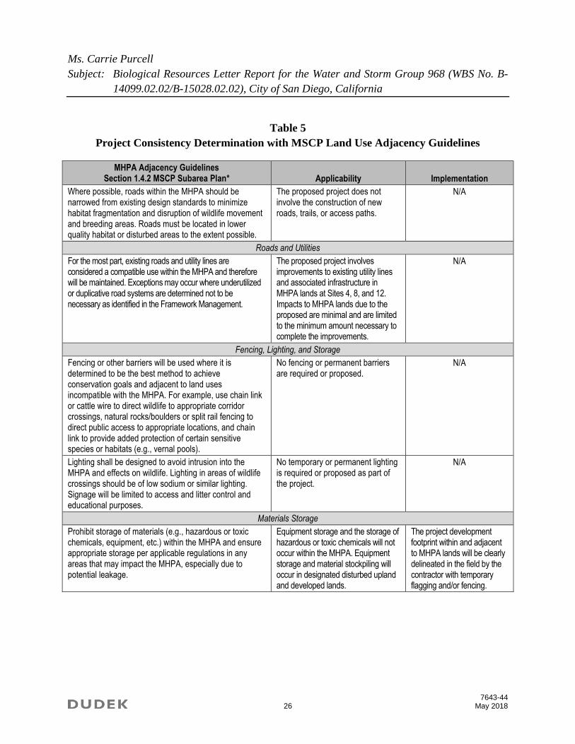
consistency with said policy (Table 5). The City’s MSCP Subarea Plan also contains policies
found in Section 1.4.3 (Land Use Adjacency Guidelines) that are designed to help limit the
impact of activities located adjacent to MHPAs (City of San Diego 1997).
The project is a compatible land use within the MHPA and follows the siting criteria outlined in
Section 1.4.2 of the MSCP. Because a portion of the project occurs adjacent to and within the
MHPA, the project is required to document compliance with the MSCP Land Use Adjacency
Guidelines Section 1.4.3. A matrix has been prepared documenting the project’s compliance with
the MSCP (Table 5). The evaluation provided in the following matrix documents the applicable
guidelines and the project’s compliance with the MSCP.

Ms. Carrie Purcell
Subject: Biological Resources Letter Report for the Water and Storm Group 968 (WBS No. B-
14099.02.02/B-15028.02.02), City of San Diego, California
7643-44 24 May 2018
Table 5
Project Consistency Determination with MSCP Land Use Adjacency Guidelines
MHPA Adjacency Guidelines Section 1.4.1 MSCP Subarea Plan* Applicability Implementation
The following land uses are considered conditionally compatible with the biological objectives of the MSCP and thus will be allowed within the City’s MHPA:
Passive recreation
Utility lines and roads in compliance with policies described in Section 1.4.2
Limited water facilities and other essential public facilities
Limited low density residential uses
Brush management (Zone 2)
Limited agriculture
The project proposes to replace or abandon water main and storm drain and therefore is a compatible land use within the City’s MHPA.
N/A
MHPA Adjacency Guidelines Section 1.4.2 MSCP Subarea Plan* Applicability Implementation
Roads and Utilities
All proposed utility lines (e.g., sewer, water, etc.) should be designed to avoid or minimize intrusion into the MHPA. These facilities should be routed through developed or developing areas rather than the MHPA, where possible. If no other routing is feasible, then the lines should follow previously existing roads, easements, rights-of-way and disturbed areas, minimizing habitat fragmentation.
Improvements to existing structures and facilities in MHPA lands at Sites 4, 8, and 12 are limited to 0.02 acres. The proposed improvements have been sited to occur in previously disturbed areas to minimize impacts to MHPA.
N/A
All new development for utilities and facilities within or crossing the MHPA shall be planned, designed, located and constructed to minimize environmental impacts. All such activities must avoid disturbing the habitat of MSCP covered species and wetlands. If avoidance is infeasible, mitigation will be required.
Minimal impacts to MHPA lands (i.e., 0.02 acres) are necessary to complete the proposed water improvements.
However all work planned is associated with existing utilities and infrastructure and does not include the construction of new utilities and facilitates in MHPA lands. Impacts to California gnatcatcher could occur in MHPA lands at Site 8 and Site 12 if work is to occur during the breeding season.
Project construction will be phased to avoid the breeding season for California gnatcatcher (March 1–August 15) at Site 8 and Site 12. If avoidance of the breeding season at this location is infeasible, preconstruction protocol-level surveys for this species shall be conducted and proper noise attenuation features, nest buffers, and nest avoidance will be implemented in the event that nesting California gnatcatchers are observed within 300 feet of the work site.

Ms. Carrie Purcell
Subject: Biological Resources Letter Report for the Water and Storm Group 968 (WBS No. B-
14099.02.02/B-15028.02.02), City of San Diego, California
7643-44 25 May 2018
Table 5
Project Consistency Determination with MSCP Land Use Adjacency Guidelines
MHPA Adjacency Guidelines Section 1.4.2 MSCP Subarea Plan* Applicability Implementation
Roads and Utilities
Temporary construction areas and roads, staging areas, or permanent access roads must not disturb existing habitat unless determined to be unavoidable. All such activities must occur on existing agricultural lands or in other disturbed areas rather than in habitat. If temporary habitat disturbance is unavoidable, then restoration of, and/or mitigation for, the disturbed area after project completion will be required.
All vegetated areas temporarily disturbed by construction will be restored with native species.
The contractor shall permanently revegetate all disturbed areas.
Construction and maintenance activities in wildlife corridors must avoid significant disruption of corridor usage. Environmental documents and mitigation monitoring and reporting programs covering such development must clearly specify how this will be achieved, and construction plans must contain all the pertinent information and be readily available to crews in the field. Training of construction crews and field workers must be conducted to ensure that all conditions are met. A responsible party must be specified.
No direct impacts to wildlife corridors are anticipated.
N/A
Roads in the MHPA will be limited to those identified in Community Plan Circulation Elements, collector streets essential for area circulation, and necessary maintenance/emergency access roads. Local streets should not cross the MHPA except where needed to access isolated development areas.
The proposed project does not involve the construction of new roads, trails, or access paths.
N/A
Development of roads in canyon bottoms should be avoided whenever feasible. If an alternative location outside the MHPA is not feasible, then the road must be designed to cross the shortest length possible of the MHPA in order to minimize impacts and fragmentation of sensitive species and habitat. If roads cross the MHPA, they should provide for fully-functional wildlife movement capability. Bridges are the preferred method of providing for movement, although culverts in selected locations may be acceptable. Fencing, grading and plant cover should be provided where needed to protect and shield animals, and guide them away from roads to appropriate crossings.
The proposed project does not involve the construction of new roads, trails, or access paths.
N/A
Ms. Carrie Purcell
Subject: Biological Resources Letter Report for the Water and Storm Group 968 (WBS No. B-
14099.02.02/B-15028.02.02), City of San Diego, California
7643-44 26 May 2018
Table 5
Project Consistency Determination with MSCP Land Use Adjacency Guidelines
MHPA Adjacency Guidelines Section 1.4.2 MSCP Subarea Plan* Applicability Implementation
Where possible, roads within the MHPA should be narrowed from existing design standards to minimize habitat fragmentation and disruption of wildlife movement and breeding areas. Roads must be located in lower quality habitat or disturbed areas to the extent possible.
The proposed project does not involve the construction of new roads, trails, or access paths.
N/A
Roads and Utilities
For the most part, existing roads and utility lines are considered a compatible use within the MHPA and therefore will be maintained. Exceptions may occur where underutilized or duplicative road systems are determined not to be necessary as identified in the Framework Management.
The proposed project involves improvements to existing utility lines and associated infrastructure in MHPA lands at Sites 4, 8, and 12. Impacts to MHPA lands due to the proposed are minimal and are limited to the minimum amount necessary to complete the improvements.
N/A
Fencing, Lighting, and Storage
Fencing or other barriers will be used where it is determined to be the best method to achieve conservation goals and adjacent to land uses incompatible with the MHPA. For example, use chain link or cattle wire to direct wildlife to appropriate corridor crossings, natural rocks/boulders or split rail fencing to direct public access to appropriate locations, and chain link to provide added protection of certain sensitive species or habitats (e.g., vernal pools).
No fencing or permanent barriers are required or proposed.
N/A
Lighting shall be designed to avoid intrusion into the MHPA and effects on wildlife. Lighting in areas of wildlife crossings should be of low sodium or similar lighting. Signage will be limited to access and litter control and educational purposes.
No temporary or permanent lighting is required or proposed as part of the project.
N/A
Materials Storage
Prohibit storage of materials (e.g., hazardous or toxic chemicals, equipment, etc.) within the MHPA and ensure appropriate storage per applicable regulations in any areas that may impact the MHPA, especially due to potential leakage.
Equipment storage and the storage of hazardous or toxic chemicals will not occur within the MHPA. Equipment storage and material stockpiling will occur in designated disturbed upland and developed lands.
The project development footprint within and adjacent to MHPA lands will be clearly delineated in the field by the contractor with temporary flagging and/or fencing.
Ms. Carrie Purcell
Subject: Biological Resources Letter Report for the Water and Storm Group 968 (WBS No. B-
14099.02.02/B-15028.02.02), City of San Diego, California
7643-44 27 May 2018
Table 5
Project Consistency Determination with MSCP Land Use Adjacency Guidelines
MHPA Adjacency Guidelines Section 1.4.3 MSCP Subarea Plan Applicability Implementation
Drainage
All new and proposed parking lots and developed areas in and adjacent to the preserve must not drain directly into the MHPA. All developed and paved areas must prevent the release of toxins, chemicals, petroleum products, exotic plant materials and other elements that might degrade or harm the natural environment or ecosystem processes within the MHPA.
Ground disturbance for the project will largely consist of utility trenching, which will create no runoff potential.
Consistent with the City Storm Water Standards, existing previously legal drainage, which flows toward the MHPA, shall be minimized.
The MHPA boundary and the limits of ground disturbance shall be clearly delineated on the construction documents and surveyed by the contractor.
At the conclusion of the project, the existing grade will be restored and the current drainage patterns will be unchanged.
Toxics
Land uses, such as recreation and agriculture, that use chemicals or generate by-products such as manure, that are potentially toxic or impactive to wildlife, sensitive species, habitat, or water quality need to incorporate measures to reduce impacts caused by the application and/or drainage of such materials into the MHPA.
No hazardous construction materials storage would be allowed, which could impact the adjacent MHPA (including fuel or sediment) and any drainage from the construction site must be clear of such materials.
Consistent with the City Storm Water Standards, existing previously legal drainage, which flows toward the MHPA, shall be minimized.
The contractor shall ensure all areas for staging, storage of equipment and materials, trash, equipment maintenance, and other construction-related activities are within the limits of the project Area of Potential Effect.
Lighting
Lighting of all developed areas adjacent to the MHPA should be directed away from the MHPA. Where necessary, development should provide adequate shielding with non-invasive plant materials (preferably native), berming, and/or other methods to protect the MHPA and sensitive species from night lighting.
No additional permanent lighting or night work is proposed for this project.
N/A

Ms. Carrie Purcell
Subject: Biological Resources Letter Report for the Water and Storm Group 968 (WBS No. B-
14099.02.02/B-15028.02.02), City of San Diego, California
7643-44 28 May 2018
Table 5
Project Consistency Determination with MSCP Land Use Adjacency Guidelines
MHPA Adjacency Guidelines Section 1.4.3 MSCP Subarea Plan* Applicability Implementation
Noise
Uses in or adjacent to the MHPA should be designed to minimize noise impacts. Berms or walls should be constructed adjacent to commercial areas, recreational areas, and any other use that may introduce noises that could impact or interfere with wildlife utilization of the MHPA. Excessively noisy uses or activities adjacent to breeding areas must incorporate noise reduction measures and be curtailed during the breeding season of sensitive species. Adequate noise reduction measures should also be incorporated for the remainder of the year.
Direct impacts to nesting water birds are not anticipated from the project description since no trees would be removed and there is no shore bird nesting habitat; however, other covered species have a moderate to high potential to forage, roost, and nest in the area and adjacent to the project vicinity at the project locations.
Protocol surveys may be required for potential impacts to certain avian species during their breeding season:
California gnatcatcher within the MHPA only (3/1–8/15). Suitable, foraging and nesting habitat is present at Site 8 and Site 12 and in areas immediately bordering the work site.
Least Bell’s vireo (3/15–9/15): There is potential habitat outside of the study area but in the vicinity of Site 4 in the San Diego River.
Southwestern willow flycatcher (5/1–8/30): There is potential habitat outside of the study area but in the vicinity of Site 4 in the San Diego River.
Barriers
New development adjacent to the MHPA may be required to provide barriers (e.g., non-invasive vegetation, rocks/boulders, fences, walls, and/or signage) along the MHPA boundaries to direct public access to appropriate locations and reduce domestic animal predation.
The proposed project involves the replacement and abandonment of water main lines and replacement of storm drain lines. However, the pipelines will be installed below ground and all areas temporarily disturbed by construction will be restored to preconstruction contours and conditions. No permanent barriers are required or proposed.
N/A

Ms. Carrie Purcell
Subject: Biological Resources Letter Report for the Water and Storm Group 968 (WBS No. B-
14099.02.02/B-15028.02.02), City of San Diego, California
7643-44 29 May 2018
Table 5
Project Consistency Determination with MSCP Land Use Adjacency Guidelines
MHPA Adjacency Guidelines Section 1.4.3 MSCP Subarea Plan* Applicability Implementation
Invasives
No invasive non-native plant species shall be introduced into areas adjacent to the MHPA.
Plant species within 100 feet of the MHPA shall comply with the Landscape Regulations (LDC142.0400 and per table 142-04F, Revegetation and Irrigation Requirements) and be non- invasive.
The contractor shall permanently revegetate all graded, disturbed, or eroded areas that will not be permanently paved or covered by structures using native species approved by the City.
Brush Management
New residential development located adjacent to and topographically above the MHPA (e.g., along canyon edges) must be set back from slope edges to incorporate Zone 1 brush management areas on the development pad and outside of the MHPA.
The project is not a structural development and would not create any new brush management zones.
N/A
Grading/Land Development
Manufactured slopes associated with site development shall be included within the development footprint for projects within or adjacent to the MHPA.
No manufactures slopes are associated with the proposed project.
N/A
MHPA Framework Management Plan Section 1.5.2 MSCP Subarea Plan* Applicability Implementation
Restoration
Restoration or revegetation undertaken in the MHPA shall be performed in a manner acceptable to the City. Where covered species status identifies the need for reintroduction and/or increasing the population, the covered species will be included in restoration/revegetation plans, as appropriate. Restoration or revegetation proposals will be required to prepare a plan that includes elements addressing financial responsibility, site preparation, planting specifications, maintenance, monitoring and success criteria, and remediation and contingency measures. Wetland restoration/revegetation proposals are subject to permit authorization by federal and state agencies.
The project will temporarily displace native sage scrub and chaparral habitats, developed and ornamental vegetation, and two special-status plants. Following project completion, the temporarily impacted areas will be revegetated and restored in place.
A revegetation plan has been prepared featuring native species that are typical of the area and erosion control features including silt fence and straw fiber rolls, where appropriate. The revegetation areas will be monitored and maintained for 25 months to ensure adequate establishment and sustainability of the plantings/seeding. This plan has been submitted to Development Services Department for review and approval.
* Source: City of San Diego 1997
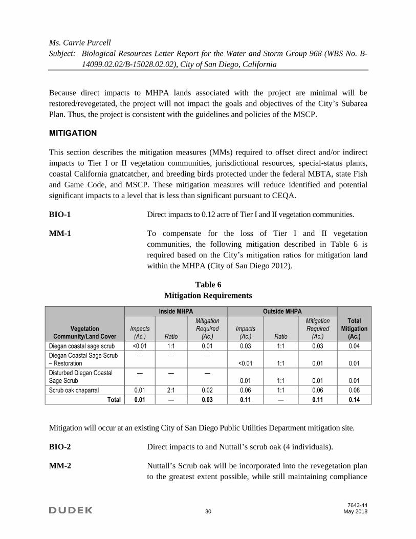
Ms. Carrie Purcell
Subject: Biological Resources Letter Report for the Water and Storm Group 968 (WBS No. B-
14099.02.02/B-15028.02.02), City of San Diego, California
7643-44 30 May 2018
Because direct impacts to MHPA lands associated with the project are minimal will be
restored/revegetated, the project will not impact the goals and objectives of the City’s Subarea
Plan. Thus, the project is consistent with the guidelines and policies of the MSCP.
MITIGATION
This section describes the mitigation measures (MMs) required to offset direct and/or indirect
impacts to Tier I or II vegetation communities, jurisdictional resources, special-status plants,
coastal California gnatcatcher, and breeding birds protected under the federal MBTA, state Fish
and Game Code, and MSCP. These mitigation measures will reduce identified and potential
significant impacts to a level that is less than significant pursuant to CEQA.
BIO-1 Direct impacts to 0.12 acre of Tier I and II vegetation communities.
MM-1 To compensate for the loss of Tier I and II vegetation
communities, the following mitigation described in Table 6 is
required based on the City’s mitigation ratios for mitigation land
within the MHPA (City of San Diego 2012).
Table 6
Mitigation Requirements
Vegetation Community/Land Cover
Inside MHPA Outside MHPA
Total Mitigation
(Ac.) Impacts
(Ac.) Ratio
Mitigation Required
(Ac.) Impacts
(Ac.) Ratio
Mitigation Required
(Ac.)
Diegan coastal sage scrub <0.01 1:1 0.01 0.03 1:1 0.03 0.04
Diegan Coastal Sage Scrub – Restoration
— — — <0.01 1:1 0.01 0.01
Disturbed Diegan Coastal Sage Scrub
— — — 0.01 1:1 0.01 0.01
Scrub oak chaparral 0.01 2:1 0.02 0.06 1:1 0.06 0.08
Total 0.01 — 0.03 0.11 — 0.11 0.14
Mitigation will occur at an existing City of San Diego Public Utilities Department mitigation site.
BIO-2 Direct impacts to and Nuttall’s scrub oak (4 individuals).
MM-2 Nuttall’s Scrub oak will be incorporated into the revegetation plan
to the greatest extent possible, while still maintaining compliance
Ms. Carrie Purcell
Subject: Biological Resources Letter Report for the Water and Storm Group 968 (WBS No. B-
14099.02.02/B-15028.02.02), City of San Diego, California
7643-44 31 May 2018
with the City's Sewer and Water guidelines, which restrict the
species that can be planted directly above or adjacent to a pipeline.
BIO-3, BIO-4, and BIO-5 Construction-related direct, temporary impacts to 0.07 acres of
potential coastal California gnatcatcher habitat. Construction-
related direct and indirect impacts may occur, if construction
occurs during the avian breeding season (i.e., February 1 through
September 15).
MM-3 The following general measures shall be implemented prior to
construction to protect wildlife from construction-related impacts.
MM-3(a) Biologist Verification – The owner/permittee shall provide a letter
to the City of San Diego’s (City) Mitigation Monitoring
Coordination (MMC) section stating that a Project Biologist
(Qualified Biologist), as defined in the City’s Biological
Guidelines (City of San Diego 2012), has been retained to
implement the project’s biological monitoring program. The letter
shall include the names and contact information of all persons
involved in the biological monitoring of the project.
1. Preconstruction Meeting – The Qualified Biologist shall
attend the preconstruction meeting, discuss the project’s
biological monitoring program, and arrange to perform any
follow up mitigation measures and reporting including site-
specific monitoring, restoration or revegetation, and additional
fauna/flora surveys/salvage.
2. Biological Documents – The Qualified Biologist shall submit
all required documentation to MMC verifying that any special
mitigation reports including but not limited to, maps, plans,
surveys, survey timelines, or buffers are completed or
scheduled per the City’s Biology Guidelines; the Multiple
Species Conservation Program (MSCP) Plan; the
Environmentally Sensitive Lands ordinance; project permit
conditions; CEQA; state and federal endangered species acts;
and/or other local, state, or federal requirements.

Ms. Carrie Purcell
Subject: Biological Resources Letter Report for the Water and Storm Group 968 (WBS No. B-
14099.02.02/B-15028.02.02), City of San Diego, California
7643-44 32 May 2018
3. Biological Construction Mitigation/Monitoring Exhibit – The
Qualified Biologist shall present a Biological Construction
Mitigation/Monitoring Exhibit (BCME), which includes the
biological documents in item 2 above. It should also include the
following: restoration/revegetation plans, plant salvage/relocation
requirements (if applicable), avian or other wildlife
surveys/survey schedules (including general avian nesting and
U.S. Fish and Wildlife Service (USFWS) protocol), timing of
surveys, avian construction avoidance areas/noise buffers/
barriers, other impact avoidance areas, and any subsequent
requirements determined by the Qualified Biologist and the City
Assistant Deputy Director (ADD)/MMC. The BCME shall
include a site plan, written and graphic depiction of the project’s
biological mitigation/monitoring program, and a schedule. The
BCME shall be approved by MMC and referenced in the
construction documents.
4. Avian Protection Requirements – To avoid any direct impacts
to raptors and/or any native/migratory birds, removal of habitat
that supports active nests in the proposed area of disturbance
should occur outside of the breeding season for these species
(February 1 to September 15). If removal of habitat in the
proposed area of disturbance must occur during the breeding
season, the Qualified Biologist shall conduct a preconstruction
survey to determine the presence or absence of nesting birds on
the proposed area of disturbance. The preconstruction survey shall
be conducted within 10 calendar days prior to the start of
construction activities (including removal of vegetation). The
applicant shall submit the results of the preconstruction survey to
City Development Services Department for review and approval
prior to initiating any construction activities. If nesting birds are
detected, a letter report or mitigation plan in conformance with the
City’s Biology Guidelines and applicable state and federal laws
(e.g., appropriate follow-up surveys, monitoring schedules,
construction and noise barriers/buffers) shall be prepared and
include proposed measures to be implemented to ensure that take
of birds or eggs or disturbance of breeding activities is avoided.

Ms. Carrie Purcell
Subject: Biological Resources Letter Report for the Water and Storm Group 968 (WBS No. B-
14099.02.02/B-15028.02.02), City of San Diego, California
7643-44 33 May 2018
The report or mitigation plan shall be submitted to the City for
review and approval and implemented to the satisfaction of the
City. The City’s MMC Section and Biologist shall verify and
approve that all measures identified in the report or mitigation
plan are in place prior to and/or during construction.
5. Resource Delineation – Prior to construction activities, the
Qualified Biologist shall supervise the placement of orange
construction fencing or equivalent along the limits of
disturbance adjacent to sensitive biological habitats and verify
compliance with any other project conditions as shown on the
BCME. This phase shall include flagging plant specimens and
delimiting buffers to protect sensitive biological resources
(e.g., habitats/flora and fauna species, including nesting birds)
during construction. Appropriate steps/care should be taken to
minimize attraction of nest predators to the site.
6. Education – Prior to commencement of construction activities,
the Qualified Biologist shall meet with the owner/permittee or
designee and the construction crew and conduct an on-site
educational session regarding the need to avoid impacts outside of
the approved construction area and to protect sensitive flora and
fauna (e.g., explain the avian and wetland buffers, flag system for
removal of invasive species or retention of sensitive plants, and
clarify acceptable access routes/methods and staging areas).
The following measures shall be implemented during construction to
ensure impacts to breeding wildlife are avoided and/or minimized.
7. Monitoring – All construction (including access/staging areas)
shall be restricted to areas previously identified, proposed for
construction activities/staging, or previously disturbed as
shown on the BCME. The Qualified Biologist shall monitor
construction activities as needed to ensure that construction
activities do not encroach into biologically sensitive areas, or
cause other similar damage, and that the work plan has been
amended to accommodate any sensitive species located during
the preconstruction surveys. In addition, the Qualified
Biologist shall document field activity via the Consultant Site

Ms. Carrie Purcell
Subject: Biological Resources Letter Report for the Water and Storm Group 968 (WBS No. B-
14099.02.02/B-15028.02.02), City of San Diego, California
7643-44 34 May 2018
Visit Record (CSVR). The CSVR shall be emailed to MMC on
the first day of monitoring, the first week of each month, the
last day of monitoring, and immediately in the case of any
undocumented condition or discovery.
8. Subsequent Resource Identification – The Qualified
Biologist shall note/act to prevent any new disturbances to
habitat, flora, and/or fauna on site (e.g., flag plant specimens
for avoidance during access). If active nests or other previously
unknown sensitive resources are detected, all project activities
that directly impact the resource shall be delayed until species
specific local, state, or federal regulations have been
determined and applied by the Qualified Biologist.
9. In the event that impacts exceed previously allowed amounts,
additional impacts shall be mitigated in accordance with the
City’s Biology Guidelines, Environmentally Sensitive Lands
regulations, MSCP Plan, CEQA, and other applicable local,
state, and federal law. The Qualified Biologist shall submit a
final BCME/report to the satisfaction of the City ADD/MMC
within 30 days of construction completion.
MM-3(b) Prior to the preconstruction meeting, the City Manager (or appointed
designee) shall verify that the Multiple Habitat Planning Area (MHPA)
boundaries and the project requirements regarding the California
gnatcatcher, as specified below, are shown on the construction plans.
No clearing, grubbing, grading, or other construction activities
shall occur at the Central Avenue or Laurel Street sites during the
California gnatcatcher breeding season (March 1 through August
15), until the following requirements have been met to the
satisfaction of the City Manager:
1. A Qualified Biologist (possessing a valid Endangered Species
Act Section 10(a)(1)(a) Recovery Permit) shall survey those
habitat areas within the MHPA that would be subject to
construction noise levels exceeding 60 decibels (dB(A)) hourly
average for the presence of the California gnatcatcher. Surveys
for California gnatcatcher shall be conducted pursuant to the

Ms. Carrie Purcell
Subject: Biological Resources Letter Report for the Water and Storm Group 968 (WBS No. B-
14099.02.02/B-15028.02.02), City of San Diego, California
7643-44 35 May 2018
protocol survey guidelines established by the USFWS within
the breeding season prior to the commencement of any
construction. If California gnatcatchers are present, then the
following conditions must be met:
a. From March 1 through August 15, no clearing, grubbing, or
grading of occupied California gnatcatcher habitat shall be
permitted. Areas restricted from such activities shall be staked
or fenced under the supervision of a Qualified Biologist; and
b. From March 1 through August 15, no construction activities
shall occur within any portion of the site where construction
activities would result in noise levels exceeding 60 dB(A)
hourly average at the edge of occupied California gnatcatcher
habitat. An analysis showing that noise generated by
construction activities would not exceed 60 dB(A) hourly
average at the edge of occupied habitat must be completed by
a Qualified Acoustician (possessing current noise engineer
license or registration with monitoring noise level experience
with listed animal species) and approved by the City Manager
at least 2 weeks prior to the commencement of construction
activities. Prior to the commencement of construction
activities during the breeding season, areas restricted from
such activities shall be staked or fenced under the supervision
of a Qualified Biologist; or
c. At least 2 weeks prior to the commencement of construction
activities, under the direction of a qualified acoustician, noise
attenuation measures (e.g., berms, walls) shall be implemented
to ensure that noise levels resulting from construction activities
will not exceed 60 dB(A) hourly average at the edge of habitat
occupied by the California gnatcatcher. Concurrent with the
commencement of construction activities and the construction
of necessary noise attenuation facilities, noise monitoring shall
be conducted at the edge of the occupied habitat area to ensure
that noise levels do not exceed 60 dB(A) hourly average. If the
noise attenuation techniques implemented are determined to be
inadequate by the Qualified Acoustician or Biologist, then the
associated construction activities shall cease until such time that

Ms. Carrie Purcell
Subject: Biological Resources Letter Report for the Water and Storm Group 968 (WBS No. B-
14099.02.02/B-15028.02.02), City of San Diego, California
7643-44 36 May 2018
adequate noise attenuation is achieved or until the end of the
breeding season (August 16). Construction noise monitoring
shall continue to be monitored at least twice weekly on varying
days, or more frequently depending on the construction
activity, to verify that noise levels at the edge of occupied
habitat are maintained below 60 dB(A) hourly average or to the
ambient noise level if it already exceeds 60 dB(A) hourly
average. If not, other measures shall be implemented in
consultation with the biologist and the City Manager, as
necessary, to reduce noise levels to below 60 dB(A) hourly
average or to the ambient noise level if it already exceeds 60
dB(A) hourly average. Such measures may include, but are not
limited to, limitations on the placement of construction
equipment and the simultaneous use of equipment.
2. If California gnatcatchers are not detected during the protocol
survey, the Qualified Biologist shall submit substantial evidence
to the City Manager and applicable resource agencies that
demonstrates whether or not mitigation measures such as noise
walls are necessary between March 1 and August 15 as follows:
a. If this evidence indicates that the potential is high for
California gnatcatcher to be present based on historical
records or site conditions, then Condition 1(a) shall be
adhered to as specified above.
b. If this evidence concludes that no impacts to this species are
anticipated, no mitigation measures would be necessary.
BIO-5, BIO-6, and BIO-7 Construction-related indirect impacts to vegetation
communities, jurisdictional resources, and special-status plants
may occur due to dust, invasive plant species, runoff, etc., both
in the short and long terms. MM-4(a) addresses short-term,
construction-related indirect impacts. MM-4(b) address long-
term, post-construction-related indirect impacts.
MM-4(a) Typical construction best management practices (BMPs) shall limit
the spread of dust, and the project Revegetation Plan shall establish
a native plant community within any temporarily disturbed areas,

Ms. Carrie Purcell
Subject: Biological Resources Letter Report for the Water and Storm Group 968 (WBS No. B-
14099.02.02/B-15028.02.02), City of San Diego, California
7643-44 37 May 2018
thus minimizing the potential for invasive plant species. Increased
human presence is a potential short-term indirect impact. During
construction, typical BMPs, such as having trash containers on site,
a demarcated limit of work, and contractor education, shall limit
the potential for trash and other human disturbance. The velocity
of runoff may also change during construction and could
potentially affect off-site sensitive vegetation communities. Under
these conditions, the City shall incorporate methods to control
runoff, including a Storm Water Pollution Prevention Plan
(SWPPP) to meet National Pollution Discharge Elimination
System (NPDES) regulations. However, if the project proposes
less than 5,000 square feet of ground disturbance and has less than
a 5-foot elevation change within each impact site, a Water
Pollution Control Plan may be required instead.
MM-4(b) Habitat restoration shall also be completed at each project location,
in accordance with the City’s Biology Guidelines and Landscape
Regulations (City of San Diego 2012). A Revegetation Plan shall
be prepared by a qualified Biological or Restoration Specialist.
Habitat restoration shall feature native species that are typical of
the area, and erosion control features shall include silt fence and
straw fiber rolls, where appropriate. The revegetation areas shall be
monitored and maintained for 25 months to ensure adequate
establishment and sustainability of the plantings/seeding.
If you have any questions regarding this report, please contact me via telephone at 760.479.4293
or via email at [email protected].
Sincerely,
______________________
Callie Amoaku
Biologist
Att.: Figures 1–3E
Appendix A, List of Vascular Plant Species Observed within the Project Study Area
Appendix B, List of Wildlife Species Observed within the Project Study Area
Appendix C, Special-Status Plant Species Potentially Occurring within the Project Study Area
Appendix D, Special-Status Wildlife Species Potentially Occurring within the Project Study Area

Ms. Carrie Purcell
Subject: Biological Resources Letter Report for the Water and Storm Group 968 (WBS No. B-
14099.02.02/B-15028.02.02), City of San Diego, California
7643-44 38 May 2018
Appendix E, Resumes
cc: Vipul Joshi, Dudek
ACKNOWLEDGEMENTS
Vegetation mapping and the jurisdictional delineation was completed by Callie Amoaku and Monique
O’Conner. Erin Bergman conducted the rare plant surveys. This report was prepared by Callie Amoaku
with senior review provided by Vipul Joshi. Editorial review was provided by Steve Taffolla and
formatting by Devin Brookhart. Resumes for these individuals are provided in Appendix E.
REFERENCES CITED
16 U.S.C. 703–712. Migratory Bird Treaty Act of 1918, as amended.
AOU (American Ornithologists’ Union). 2016. Check-List of North American Birds: List of the
2,078 Bird Species Known From the AOU Check-list Area. Accessed February 2016.
http://www.aou.org/checklist/north/full.php.
Bowman, R.H. 1973. Soil Survey, San Diego Area, California, Part 1. U.S. Department of
Agriculture, Soil Conservation Service and Forest Service. December 1973. Accessed
February 2016. http://www.nrcs.usda.gov/Internet/FSE_MANUSCRIPTS/
california/CA638/0/part1.pdf.
California Fish and Game Code, Section 3503–3513. General Bird Provisions.
CDFG (California Department of Fish and Game). 2009. “Protocols for Surveying and
Evaluating Impacts to Special Status Native Plant Populations and Natural
Communities.” Sacramento, California: CDFG.
CDFW (California Department of Fish and Wildlife). 2016. California Natural Diversity
Database (CNDDB). RareFind, Version 5.1.1 (Commercial Subscription). Sacramento,
California: CDFW, Biogeographic Data Branch. http://www.dfg.ca.gov/biogeodata/
cnddb/mapsanddata.asp.
CDFW. 2017a. California Natural Diversity Database (CNDDB). RareFind, Version 5.1.1
(Commercial Subscription). Sacramento, California: CDFW, Biogeographic Data
Branch. http://www.dfg.ca.gov/biogeodata/cnddb/mapsanddata.asp.

Ms. Carrie Purcell
Subject: Biological Resources Letter Report for the Water and Storm Group 968 (WBS No. B-
14099.02.02/B-15028.02.02), City of San Diego, California
7643-44 39 May 2018
CDFW. 2017b. “State and Federally Listed Endangered, Threatened, and Rare Plants of California.”
California Natural Diversity Database. CDFW, Biogeographic Data Branch. October 2017.
https://nrm.dfg.ca.gov/FileHandler.ashx?DocumentID=109390&inline.
CDFW. 2017c. “State and Federally Listed Endangered & Threatened Animals of California.”
California Natural Diversity Database. CDFW, Biogeographic Data Branch. July 2017.
https://nrm.dfg.ca.gov/FileHandler.ashx?DocumentID=109405&inline.
CDFW. 2017d. Special Vascular Plants, Bryophytes, and Lichens List. California Natural
Diversity Database. October 2017. https://nrm.dfg.ca.gov/FileHandler.ashx?
DocumentID=109383&inline.
CDFW. 2017e. “Special Animals List.” California Natural Diversity Database. CDFW,
Biogeographic Data Branch. July 2017. https://nrm.dfg.ca.gov/FileHandler.ashx?
DocumentID=109406&inline.
City of San Diego. 1997. City of San Diego Final MSCP Subarea Plan. Prepared by the City of
San Diego Community and Economic Development Department. March 1997.
City of San Diego. 2012. San Diego Municipal Code: Land Development Code – Biology
Guidelines. As amended April 23, 2012 by Resolution No. R-307376. Accessed
September 2017. http://www.sandiego.gov/development-services/pdf/industry/
landdevmanual/ldmbio.pdf.
City of San Diego. 2014. San Diego Municipal Code, Chapter 13: Zones. Accessed September 2017.
http://docs.sandiego.gov/municode/MuniCodeChapter13/Ch13Art02Division04.pdf.
CNPS (California Native Plant Society). 2001. “CNPS Botanical Survey Guidelines.” Published
December 9, 1983; revised June 2, 2001. http://www.cnps.org/cnps/rareplants/pdf/
cnps_survey_guidelines.pdf.
CNPS. 2016. Inventory of Rare and Endangered Plants of California (online edition, v8-02).
California Native Plant Society, Sacramento, California. Accessed November 2016.
http://www.rareplants.cnps.org/.
CNPS. 2017. Inventory of Rare and Endangered Plants of California (online edition, v8-03 0.39).
California Native Plant Society, Sacramento, California. Accessed September 28, 2017.
http://www.rareplants.cnps.org/.
Ms. Carrie Purcell
Subject: Biological Resources Letter Report for the Water and Storm Group 968 (WBS No. B-
14099.02.02/B-15028.02.02), City of San Diego, California
7643-44 40 May 2018
Crother, B.I. 2008. Scientific and Standard English Names of Amphibians and Reptiles of North
America North of Mexico, with Comments Regarding Confidence in our Understanding,
edited by J.J. Moriarty. 6th ed. Society for the Study of Amphibians and Reptiles
(SSAR); Herpetological Circular, no. 37. January 2008. https://ssarherps.org/cndb/.
Historic Aerials Online. 2017. Historic Aerials. Accessed September 2017.
http://www.historicaerials.com/.
Holland, R.F. 1986. Preliminary Descriptions of the Terrestrial Natural Communities of California.
Nongame-Heritage Program, California Department of Fish and Game. October 1986.
Jepson Flora Project. 2017. Jepson eFlora. Berkeley, California: University of California.
Accessed September 2017. http://ucjeps.berkeley.edu/interchange/.
NABA (North American Butterfly Association). 2016. “Checklist of North American Butterflies
Occurring North of Mexico.” Adapted from North American Butterfly Association
(NABA) Checklist and English Names of North American Butterflies, eds. B. Cassie, J.
Glassberg, A. Swengel, and G. Tudor. 2nd ed. Morristown, New Jersey: NABA.
Accessed February 2016. http://www.naba.org/.
Oberbauer, T., M. Kelly, and J. Buegge. 2008. Draft Vegetation Communities of San Diego
County. March 2008. Accessed December 2016. http://www.sdcanyonlands.org/
pdfs/veg_comm_sdcounty_2008_doc.pdf.
Rebman, J., and M. Simpson. 2014. Checklist of the Vascular Plants of San Diego County.
5th Edition, 2014.
SanGIS (San Diego Geographic Information Source). 2016. San Diego Geographic Information
Source. Accessed February 2016. http://www.sangis.org/.
SDNHM (San Diego Natural History Museum). 2002. “Checklist of Butterflies of San Diego
County.” Revised September 2002. Accessed September 2017. http://www.sdnhm.org/
science/entomology/projects/checklist-of-butterflies-of-san-diego-county/.
USACE (U.S. Army Corps of Engineers). 1987. Corps of Engineers Wetlands Delineation
Manual. Online ed. Environmental Laboratory, Wetlands Research Program Technical
Report Y-87-1. Vicksburg, Mississippi: U.S. Army Engineer Waterways Experiment
Station. January 1987.

Ms. Carrie Purcell
Subject: Biological Resources Letter Report for the Water and Storm Group 968 (WBS No. B-
14099.02.02/B-15028.02.02), City of San Diego, California
7643-44 41 May 2018
USACE. 2008. Regional Supplement to the Corps of Engineers Wetland Delineation Manual: Arid
West Region (Version 2.0). Environmental Laboratory, ERDC/EL TR-08-28. Vicksburg,
Mississippi: U.S. Army Engineer Research and Development Center. September 2008.
USDA (U.S. Department of Agriculture). 2016a. Web Soil Survey. USDA Natural Resources
Conservation Service, Soil Survey Staff. Accessed September 2017.
http://websoilsurvey.nrcs.usda.gov/.
USDA. 2016b. National Hydrography Dataset.
USDA. 2017a. Official Soil Series Descriptions. USDA National Resources Conservation
Service, Soil Survey Staff. Accessed October 30, 2017.
USDA. 2017b. “California.” State PLANTS Checklist. Accessed September 2017.
http://plants.usda.gov/dl_state.html.
USFWS (U.S. Fish and Wildlife Service). 2016. “Critical Habitat and Occurrence Data” [map].
Accessed November 2016. http://www.fws.gov/data.
USFWS. 2017. “Critical Habitat and Occurrence Data” [map]. Accessed September 2017.
http://www.fws.gov/data.
USGS (U.S. Geological Survey). 2016. National Hydrography Dataset (NHD). NHD flowline
map. Accessed February 2016. http://nhd.usgs.gov/data.html.
Wilson, D.E., and D.M. Reeder, eds. 2005. Mammal Species of the World: A Taxonomic and
Geographic Reference. 3rd ed. Baltimore, Maryland: Johns Hopkins University Press.

CampoImperialBeach
ChulaVista
NationalCity Bonita
Coronado
LemonGrove
Poway
Encinitas
San Diego
Carlsbad
SanMarcos Escondido
VistaValleyCenter
Camp PendletonSouth Hidden
MeadowsOceanside
Bonsall
CampPendleton
North
Fallbrook
Rainbow
Jamul
Rancho SanDiego
SpringValley
AlpineHarbisonCanyon
LakesidePine
Valley
El Cajon
Santee
Ramona San DiegoCountryEstates
Julian
BorregoSprings
SanClemente
DanaPoint
San JuanCapistrano
g
Temecula
Jacumba
Boulevard
Santa Ysabel
Imperial County
San DiegoCounty
San Diego County
San Diego County
Riverside County
15
8
15
8
5
805
5
905
195
274
741
163
98
56
75
371111
52
86
67
7679
94
78
P a c i f i c
O c e a n
S a l t o nS e a
M E X I C OM E X I C O
FIGURE 1Regional Map
City of San Diego - Water And Storm Group 968 Project
0 155 10Miles
Project Locations

Site 4
Vicinity MapCity of San Diego - Water And Storm Group 968 Project
SOURCE: USGS 7.5-Minute Series La Mesa Quadrangle.
Date
: 10/
5/201
7 -
Las
t sav
ed by
: mwa
tson
- P
ath:
Z:\P
rojec
ts\j76
4300
\44-
Wat
er a
nd S
torm
Gro
up 96
8\M
APDO
C\DO
CUME
NT\F
igure
2_Vi
cinity
.mxd
0 2,0001,000Feet
Study Area 50-Foot BufferStudy Area 300-Foot Buffer
FIGURE 2A

Site 5
Vicinity MapCity of San Diego - Water And Storm Group 968 Project
SOURCE: USGS 7.5-Minute Series Point Loma Quadrangle.
Date
: 10/
5/201
7 -
Las
t sav
ed by
: mwa
tson
- P
ath:
Z:\P
rojec
ts\j76
4300
\44-
Wat
er a
nd S
torm
Gro
up 96
8\M
APDO
C\DO
CUME
NT\F
igure
2_Vi
cinity
.mxd
0 2,0001,000Feet
Study Area 50-Foot BufferStudy Area 300-Foot BufferCoastal Zone Boundary
FIGURE 2B

Site 8
Site 12 Site 10
Vicinity MapCity of San Diego - Water And Storm Group 968 Project
SOURCE: USGS 7.5-Minute Series National City Quadrangle.
Date
: 10/
5/201
7 -
Las
t sav
ed by
: mwa
tson
- P
ath:
Z:\P
rojec
ts\j76
4300
\44-
Wat
er a
nd S
torm
Gro
up 96
8\M
APDO
C\DO
CUME
NT\F
igure
2_Vi
cinity
.mxd
0 2,0001,000Feet
Study Area 50-Foot BufferStudy Area 300-Foot Buffer
FIGURE 2C

C A M I N O D E L R I O N O R T H
P R I VA T E D R W Y
Path
: Z:\P
rojec
ts\j76
4300
\44-W
ater a
nd S
torm
Gro
up 9
68\M
APDO
C\DO
CUM
ENT\
Figu
re3_
Bio_
Reso
urce
s_M
apbo
ok.m
xd
7643-44
Biological Resources
City of San Diego - Water And Storm Group 968 Project - Site 4 - Community: Mission Valley
SOURCE: SANGIS, SANDAG 2017 FIGURE 3A
0 12562.5Feet
SITE 4
Study Area 50-Foot Buffer
Study Area 300-Foot Buffer
Stadium Mitigation Site
Multi-Habitat Planning Area
Pipelines
Water Main Replacement
Impact/Work Area
Permanent Impacts
Vegetation
Vegetation
Eucalyptus Woodland
Southern Willow Scrub
Urban/Developed
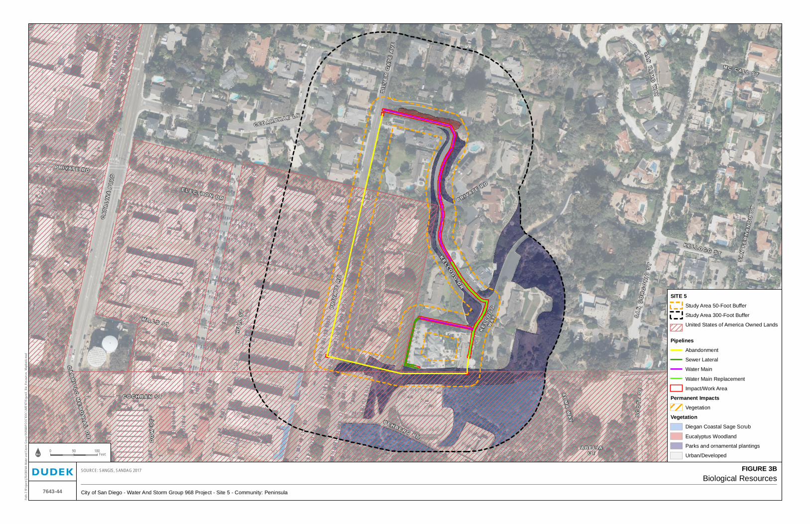
SI L
VE
R G
AT
E A
VE
A B E L I AC T
CA
TA
LI N
A B
LVD
PR
I VA
TE
RD
HU
LL
ST
KE
LLO
GG
WA
Y
P R I VAT E R D
K E L L O G G S T
PR I VAT E RD
J E N K I N S S T
DO
W S
T B E H B E R G R D
M C C A L L S T
P R I VAT E R D
SA
N F
ER
NA
ND
O S
T
C O C H R A N S T
CA
BR
I LL
O M
EM
OR
I AL
DR
SA
N R
EM
O W
AY
SA
N G
OR
GO
NIO
ST
AL
MA
WA
Y SC
OT
T S
T
M I L L S S T
E L E C T R O N D R
KE
L LOG
G D
R
C E D A R B R A E L N
Path
: Z:\P
rojec
ts\j76
4300
\44-W
ater a
nd S
torm
Gro
up 9
68\M
APDO
C\DO
CUM
ENT\
Figu
re3_
Bio_
Reso
urce
s_M
apbo
ok.m
xd
7643-44
Biological Resources
City of San Diego - Water And Storm Group 968 Project - Site 5 - Community: Peninsula
SOURCE: SANGIS, SANDAG 2017 FIGURE 3B
0 18090Feet
SITE 5
Study Area 50-Foot Buffer
Study Area 300-Foot Buffer
United States of America Owned Lands
Pipelines
Abandonment
Sewer Lateral
Water Main
Water Main Replacement
Impact/Work Area
Permanent Impacts
Vegetation
Vegetation
Diegan Coastal Sage Scrub
Eucalyptus Woodland
Parks and ornamental plantings
Urban/Developed

D A H L I A S T
A L L E Y
P OP L A R S
T
LE X I NG TO N AV E
42
ND
ST
MA N Z A N I T
A DR
AL
LE
Y
Q U I N C E S T
R E D W O O D S T
JAM
I E S WAY
MA
RL
BO
RO
UG
H A
VE
AR B OR V
I TA E S
T
40
TH
ST
AL
LE
Y
AL
LE
Y
AL
LE
Y
39
TH
ST
AL
LE
Y
CE
NT
RA
L A
VE
AL
LE
Y
41
ST
ST
AL
LE
Y
Y
Path
: Z:\P
rojec
ts\j76
4300
\44-W
ater a
nd S
torm
Gro
up 9
68\M
APDO
C\DO
CUM
ENT\
Figu
re3_
Bio_
Reso
urce
s_M
apbo
ok.m
xd
7643-44
Biological Resources
City of San Diego - Water And Storm Group 968 Project - Site 8 - Community: Mid-City Heights
SOURCE: SANGIS, SANDAG 2017 FIGURE 3C
0 16080Feet
SITE 8
Study Area 50-Foot Buffer
Study Area 300-Foot Buffer
Multi-Habitat Planning Area (MHPA)
Access Path
Hydrants
Existing Hydrant (to be removed)
Proposed Hydrant
Pipelines
Water Main Replacement
Impact/Work Area
Permanent Impacts
Vegetation
Vegetation
Diegan Coastal Sage Scrub
Disturbed Habitat
Eucalyptus Woodland
Scrub Oak Chaparral
Urban/Developed

HO
ME A
VE
HIG
HL
AN
D A
VE
L A U R E L S T
AL
LE
Y
RI D
GE
V
AL
LE
Y
46
TH
ST
44
TH
ST
LA
UR
I E L
N
44
TH
ST
FA
I RM
OU
NT
AV
E
AL
LE
Y
RO
SE
VIE
W P
L
Path
: Z:\P
rojec
ts\j76
4300
\44-
Wat
er a
nd S
torm
Gro
up 9
68\M
APDO
C\DO
CUM
ENT\
Figu
re3_
Bio_
Reso
urce
s_M
apbo
ok_S
heet
_3D.
mxd
7643-44
Biological Resources
City of San Diego - Water And Storm Group 968 Project - Site 10 - Community: Mid-City Heights
SOURCE: SANGIS, SANDAG 2017 FIGURE 3D
0 12562.5Feet
SITE 10
Study Area 50-Foot
Study Area 300-Foot
Multi-Habitat Planning Area
Access Path
Pipelines
Storm Drain Pipeline - Existing
Water Main Replacement
Impact/Work
Permanent Impacts
Vegetation
Vegetation/Rare Plants
Vegetation
Diegan Coastal Sage Scrub
Diegan Coastal Sage Scrub -Restoration
Disturbed Diegan Coastal Sage Scrub
Disturbed Habitat
Parks and ornamental plantings
Scrub Oak Chaparral
Urban/Developed
Rare Plants
Nuttall’s scrub oak

P O P L A R ST
V IOLE T S TP OP P Y P L
M A N Z A N I TA D R
AL L E Y
TU BER OSE S T
LEX I NG TO N A
V E
40
TH
ST
A L LE Y
AL
LE
Y
HA
LL
ER
ST
39
TH
ST
Path
: Z:\P
rojec
ts\j76
4300
\44-
Wat
er a
nd S
torm
Gro
up 9
68\M
APDO
C\DO
CUM
ENT\
Figu
re3_
Bio_
Reso
urce
s_M
apbo
ok_S
heet
_3E.
mxd
7643-44
Biological Resources
City of San Diego - Water And Storm Group 968 Project - Site 12 - Community: None Specified
SOURCE: SANGIS, SANDAG 2017 FIGURE 3E
0 14070Feet
SITE 12
Study Area 50-Foot Buffer
Study Area 300-Foot Buffer
Multi-Habitat Planning Area (MHPA)
Access Path
Pipelines
Abandonment
Water Main Replacement
Impact/Work Area
Permanent Impacts
Vegetation
Jurisdictional Resources
Unvegetated Channel (3-Foot Width)
Vegetation
Chamise Chaparral
Diegan Coastal Sage Scrub
Disturbed Diegan Coastal Sage Scrub
Disturbed Habitat
Eucalyptus Woodland
Scrub Oak Chaparral
Urban/Developed
Rare Plants
Nuttall’s scrub oak
wart-stemmed ceanothus
APPENDIX A List of Vascular Plant Species
Observed within the Project Study Area


APPENDIX A List of Vascular Plant Species Observed within the Project Study Area
7643-44 A-1 May 2018
VASCULAR SPECIES
GYMNOSPERMS AND GNETOPHYTES
PINACEAE—PINE FAMILY
* Pinus sp.—pine
PODOCARPACEAE—PODOCARPUS FAMILY
* Podocarpus sp.—yellowwood
MONOCOTS
AGAVACEAE—AGAVE FAMILY
Yucca schidigera—Mohave yucca
ARECACEAE—PALM FAMILY
* Washingtonia robusta—Mexican fan palm
CYPERACEAE—SEDGE FAMILY
Cyperus eragrostis—tall flatsedge
* Cyperus involucratus—African umbrella plant
POACEAE—GRASS FAMILY
* Avena barbata—slender wild oat
* Ehrharta erecta—panic veldt grass
* Arundo donax—giant reed
* Brachypodium distachyon—purple falsebrome
* Bromus diandrus—ripgut grass
* Cynodon dactylon— bermuda grass
* Hordeum murinum—mouse barley
* Lamarckia aurea—golden-top
* Melinis repens ssp. repens—natal grass
* Poa annua—annual bluegrass
* Stipa miliacea—no common name
* Piptatherum miliaceum —smilo grass
* Pennisetum setaceum— African fountain grass
* Lolium perenne —perennial ryegrass

APPENDIX A (Continued)
7643-44 A-2 May 2018
EUDICOTS
ADOXACEAE—MUSKROOT FAMILY
Sambucus mexicana —blue elderberry
AIZOACEAE—FIG-MARIGOLD FAMILY
* Carpobrotus chilensis—sea-fig
* Carpobrotus edulis— hottentot-fig
ANACARDIACEAE—SUMAC OR CASHEW FAMILY
Malosma laurina—laurel sumac
* Schinus molle—Peruvian pepper tree
* Schinus terebinthifolius—Brazilian pepper tree
Rhus integrifolia—lemonadeberry
APIACEAE—CARROT FAMILY
* Foeniculum vulgare— sweet fennel
APOCYNACEAE—DOGBANE FAMILY
* Nerium oleander—oleander
ASTERACEAE—SUNFLOWER FAMILY
* Sonchus oleraceus—common sow-thistle
Artemisia douglasiana—douglas mugwort
Baccharis sarothroides— broom baccharis
Brickellia californica—California brickellbush
Deinandra fasciculata— fascicled tarweed
Heterotheca grandiflora—telegraph weed
Pseudognaphalium beneolens—fragrant everlasting
Gnaphalium californicum—California everlasting
* Bidens pilosa var. pilosa —common beggar’s tick, Spanish needles
* Centaurea melitensis—tocalote
* Conyza bonariensis— flax-leaf fleabane
* Chrysanthemum coronarium—garland/crown daisy
* Hedypnois cretica—crete hedypnois
* Lactuca serriola—prickly lettuce
* Sonchus asper—prickly sow-thistle
Encelia californica—California encelia
Artemisia californica—coastal sagebrush
Xanthium strumarium—cocklebur

APPENDIX A (Continued)
7643-44 A-3 May 2018
Isocoma menziesii—Menzies’s golden bush
Baccharis salicifolia—mule-fat, seep-willow
Artemisia dracunculus— tarragon, dragon sagewort
BORAGINACEAE—BORAGE FAMILY
Eriodictyon crassifolium var. crassifolium—felt-leaf yerba santa
BRASSICACEAE—MUSTARD FAMILY
* Sisymbrium irio—london rocket
* Cardamine hirsuta—hairy bittercress
* Hirschfeldia incana—short-pod mustard
* Raphanus raphanistrum—jointed charlock
* Raphanus sativus—wild radish
CACTACEAE—CACTUS FAMILY
Mammillaria dioica—fish-hook cactus
Opuntia littoralis—coast prickly-pear
CAPRIFOLIACEAE—HONEYSUCKLE FAMILY
Lonicera subspicata—southern honeysuckle
CHENOPODIACEAE—GOOSEFOOT FAMILY
* Chenopodium album— lamb’s quarters
* Salsola tragus—prickly Russian-thistle, tumbleweed
CONVOLVULACEAE—MORNING-GLORY FAMILY
Calystegia macrostegia—island false bindweed
CRASSULACEAE—STONECROP FAMILY
* Crassula argentea—jade plant
CUCURBITACEAE—GOURD FAMILY
Marah macrocarpus var. macrocarpus—manroot, wild-cucumber
EUPHORBIACEAE—SPURGE FAMILY
* Chamaesyce maculata—spotted spurge
* Ricinus communis—castor bean
FABACEAE—LEGUME FAMILY
* Melilotus indicus—Indian sweetclover
Lotus scoparius—deer weed
* Acacia sp.—wattle

APPENDIX A (Continued)
7643-44 A-4 May 2018
FAGACEAE—OAK FAMILY
Quercus berberidifolia—scrub oak
Quercus wislizeni var. frutescens—interior live oak, scrub live oak
Quercus ×acutidens—Torrey’s scrub oak
Quercus dumosa—Nuttall’s scrub oak
GERANIACEAE—GERANIUM FAMILY
* Erodium cicutarium—red-stem filaree/storksbill
* Geranium molle—dove-foot geranium
LAMIACEAE—MINT FAMILY
Salvia mellifera—black sage
* Marrubium vulgare—horehound
MALVACEAE—MALLOW FAMILY
* Malva parviflora—cheeseweed
MYRSINACEAE—MYRSINE FAMILY
* Anagallis arvensis—scarlet pimpernel, poor man’s weatherglass
MYRTACEAE—MYRTLE FAMILY
* Eucalyptus sideroxylon—red iron bark
* Eucalyptus sp.—eucalyptus
OXALIDACEAE—OXALIS FAMILY
* Oxalis pes-caprae—bermuda-buttercup
PLATANACEAE—PLANE TREE, SYCAMORE FAMILY
Platanus racemosa—western sycamore
PLUMBAGINACEAE—LEADWORT FAMILY
* Plumbago auriculata—cape leadwort
POLYGONACEAE—BUCKWHEAT FAMILY
Eriogonum fasciculatum var. fasciculatum—coast California buckwheat
* Polygonum arenastrum—common knotweed, doorweed
* Rumex crispus—curly dock
Eriogonum fasciculatum—California buckwheat
RHAMNACEAE—BUCKTHORN FAMILY
Ceanothus tomentosus—ramona-lilac
Ceanothus verrucosus—wart-stemmed ceanothus

APPENDIX A (Continued)
7643-44 A-5 May 2018
ROSACEAE—ROSE FAMILY
Adenostoma fasciculatum—chamise
Cercocarpus minutiflorus— San Diego mountain-mahogany
Heteromeles arbutifolia—toyon, Christmas berry
Prunus ilicifolia ssp. ilicifolia—islay, holly-leaf cherry
Rubus ursinus—California blackberry
Prunus ilicifolia—holly leaf cherry
SALICACEAE—WILLOW FAMILY
Salix laevigata—red willow
Salix lasiolepis—arroyo willow
Populus fremontii ssp. fremontii—western cottonwood
Salix gooddingii— Goodding’s black willow
SAURURACEAE—LIZARD’S-TAIL FAMILY
Anemopsis californica—yerba mansa
SOLANACEAE—NIGHTSHADE FAMILY
Solanum douglasii—Douglas’s nightshade
Solanum parishii—Parish’s nightshade
* Nicotiana glauca—tree tobacco
URTICACEAE—NETTLE FAMILY
* Urtica urens—dwarf nettle
* Signifies introduced (non-native) species.
APPENDIX A (Continued)
7643-44 A-6 May 2018
INTENTIONALLY LEFT BLANK
APPENDIX B List of Wildlife Species Observed
within the Project Study Area


APPENDIX B List of Wildlife Species Observed within the Project Study Area
7643-44 B-1 May 2018
BIRD
BUSHTITS
AEGITHALIDAE—LONG-TAILED TITS AND BUSHTITS
Psaltriparus minimus—bushtit
FINCHES
FRINGILLIDAE—FRINGILLINE AND CARDUELINE FINCHES AND ALLIES
Spinus psaltria—lesser goldfinch
FLYCATCHERS
TYRANNIDAE—TYRANT FLYCATCHERS
Sayornis nigricans—black phoebe
Tyrannus vociferans—Cassin’s kingbird
HAWKS
ACCIPITRIDAE—HAWKS, KITES, EAGLES, AND ALLIES
Buteo jamaicensis—red-tailed hawk
HUMMINGBIRDS
TROCHILIDAE—HUMMINGBIRDS
Calypte anna—Anna’s hummingbird
JAYS, MAGPIES, AND CROWS
CORVIDAE—CROWS AND JAYS
Aphelocoma californica—California scrub-jay
Corvus brachyrhynchos—American crow
MOCKINGBIRDS AND THRASHERS
MIMIDAE—MOCKINGBIRDS AND THRASHERS
Mimus polyglottos—northern mockingbird

APPENDIX B (Continued)
7643-44 B-2 May 2018
PIGEONS AND DOVES
COLUMBIDAE—PIGEONS AND DOVES
* Columba livia—rock pigeon (rock dove)
WOOD WARBLERS AND ALLIES
PARULIDAE—WOOD-WARBLERS
Setophaga coronata—yellow-rumped warbler
INVERTEBRATE
BUTTERFLIES
LYCAENIDAE—BLUES, HAIRSTREAKS, AND COPPERS
Philotes sonorensis—Sonoran blue
PIERIDAE—WHITES AND SULFURS
Pieris rapae—cabbage white
* Signifies introduced (non-native) species.

APPENDIX C Special-Status Plant Species Potentially
Occurring within the Project Study Area


APPENDIX C Special-Status Plant Species Potentially Occurring within the Project Study Area
7643-44 C-1 May 2018
Special-Status Plant Species Potential to Occur Within the Project Area
Species
(Scientific Name/Common Name)
Status (Federal/State/ CRPR/MSCP
County Subarea Plan)
Primary Habitat Associations/ Life Form/ Blooming Period/
Elevation Range (feet)
Potential to Occur within the 50-Foot Study Area
Site 4 Site 5 Site 8 Site 10 Site 12
Abronia maritima
red sand-verbena
None/None/4.2/ None
Coastal dunes/perennial herb/Feb–Nov/0–330
Not expected to occur. No suitable vegetation present.
Acanthomintha ilicifolia
San Diego thorn-mint1
FT/SE/1B.1/ Narrow Endemic
Chaparral, coastal scrub, valley and foothill grassland, vernal pools; clay, openings/annual herb/Apr–June/30–3,150
Not expected to occur. No suitable vegetation present.
Not expected to occur. No suitable vegetation present.
Not expected to occur. This species would have been identified during plant surveys.
Not expected to occur. This species would have been identified during plant surveys.
Not expected to occur. This species would have been identified during plant surveys.
Acmispon prostrates
Nuttall’s acmispon1
None/None/1B.1/Covered
Coastal dunes, coastal scrub (sandy)/annual herb/Mar–June(July)/0–35
Not expected to occur. No suitable vegetation present.
Not expected to occur. No suitable vegetation present.
Not expected to occur. This species would have been identified during plant surveys.
Not expected to occur. This species would have been identified during plant surveys.
Not expected to occur. This species would have been identified during plant surveys.
Adolphia californica
California adolphia1
None/None/2B.1/None
Chaparral, coastal scrub, valley and foothill grassland; clay/perennial deciduous shrub/Dec–May/30–2,430
Not expected to occur. No suitable vegetation present.
Not expected to occur. No suitable vegetation present.
Not expected to occur. This species would have been identified during plant surveys.
Not expected to occur. This species would have been identified during plant surveys.
Not expected to occur. This species would have been identified during plant surveys.

APPENDIX C (Continued)
7643-44 C-2 May 2018
Special-Status Plant Species Potential to Occur Within the Project Area
Species
(Scientific Name/Common Name)
Status (Federal/State/ CRPR/MSCP
County Subarea Plan)
Primary Habitat Associations/ Life Form/ Blooming Period/
Elevation Range (feet)
Potential to Occur within the 50-Foot Study Area
Site 4 Site 5 Site 8 Site 10 Site 12
Agave shawii var. shawii
Shaw’s agave
None/None/2B.1/Covered, Narrow Endemic
Coastal bluff scrub, coastal scrub; maritime succulent scrub/perennial leaf succulent/Sep–May/5–395
Not expected to occur. No suitable vegetation present.
Not expected to occur. No suitable vegetation present.
Not expected to occur. This species would have been identified during plant surveys.
Not expected to occur. This species would have been identified during plant surveys.
Not expected to occur. This species would have been identified during plant surveys.
Ambrosia chenopodiifolia
San Diego bur-sage1
None/None/2B.1/None
Coastal scrub/perennial shrub/Apr–June/180–510
Not expected to occur. No suitable vegetation present.
Not expected to occur. No suitable vegetation present.
Not expected to occur. This species would have been identified during plant surveys.
Not expected to occur. This species would have been identified during plant surveys.
Not expected to occur. This species would have been identified during plant surveys.
Ambrosia monogyra
singlewhorl burrobrush1
None/None/2B.2/None
Chaparral, Sonoran desert scrub; sandy/perennial shrub/Aug–Nov/30–1,640
Not expected to occur. No suitable vegetation present.
Not expected to occur. No suitable vegetation present.
Not expected to occur. This species would have been identified during plant surveys.
Not expected to occur. This species would have been identified during plant surveys.
Not expected to occur. This species would have been identified during plant surveys.
Ambrosia pumila
San Diego ambrosia1
FE/None/1B.1/ Covered, Narrow Endemic
Chaparral, coastal scrub, valley and foothill grassland, vernal pools; sandy loam or clay, often in disturbed areas, sometimes alkaline/perennial rhizomatous herb/Apr–Oct/65–1,360
Not expected to occur. No suitable vegetation present.
Not expected to occur. No suitable vegetation present.
Not expected to occur. This species would have been identified during plant surveys.
Not expected to occur. This species would have been identified during plant surveys.
Not expected to occur. This species would have been identified during plant surveys.

APPENDIX C (Continued)
7643-44 C-3 May 2018
Special-Status Plant Species Potential to Occur Within the Project Area
Species
(Scientific Name/Common Name)
Status (Federal/State/ CRPR/MSCP
County Subarea Plan)
Primary Habitat Associations/ Life Form/ Blooming Period/
Elevation Range (feet)
Potential to Occur within the 50-Foot Study Area
Site 4 Site 5 Site 8 Site 10 Site 12
Aphanisma blitoides
aphanisma1
None/None/1B.2/Covered
Coastal bluff scrub, coastal dunes, coastal scrub; sandy or gravelly/annual herb/Feb–June/0–1,000
Not expected to occur. No suitable vegetation present.
Not expected to occur. No suitable vegetation present.
Not expected to occur. This species would have been identified during plant surveys.
Not expected to occur. This species would have been identified during plant surveys.
Not expected to occur. This species would have been identified during plant surveys.
Arctostaphylos glandulosa ssp. crassifolia
Del Mar manzanita1
FE/None/1B.1/ Covered
Chaparral (maritime, sandy)/perennial evergreen shrub/Dec–June/0–1,200
Not expected to occur. No suitable vegetation present.
Not expected to occur. No suitable vegetation present.
Not expected to occur. This species would have been identified during plant surveys.
Not expected to occur. This species would have been identified during plant surveys.
Not expected to occur. This species would have been identified during plant surveys.
Arctostaphylos otayensis
Otay manzanita
None/None/1B.2/Covered
Chaparral, cismontane woodland; metavolcanic/ perennial evergreen shrub/Jan–Apr/900–5,575
Not expected to occur. No suitable vegetation present.
Not expected to occur. No suitable vegetation present.
Not expected to occur. This species would have been identified during plant surveys.
Not expected to occur. This species would have been identified during plant surveys.
Not expected to occur. This species would have been identified during plant surveys.
Artemisia palmeri
San Diego sagewort1
None/None/4.2/ None
Chaparral, coastal scrub, riparian forest, riparian scrub, riparian woodland; sandy, mesic/perennial deciduous shrub/(Feb)May–Sep/45–3,000
Not expected to occur. No suitable vegetation present.
Not expected to occur. No suitable vegetation present.
Not expected to occur. This species would have been identified during plant surveys.
Not expected to occur. This species would have been identified during plant surveys.
Not expected to occur. This species would have been identified during plant surveys.

APPENDIX C (Continued)
7643-44 C-4 May 2018
Special-Status Plant Species Potential to Occur Within the Project Area
Species
(Scientific Name/Common Name)
Status (Federal/State/ CRPR/MSCP
County Subarea Plan)
Primary Habitat Associations/ Life Form/ Blooming Period/
Elevation Range (feet)
Potential to Occur within the 50-Foot Study Area
Site 4 Site 5 Site 8 Site 10 Site 12
Asplenium vespertinum
western spleenwort1
None/None/4.2/ None
Chaparral, cismontane woodland, coastal scrub; rocky/perennial rhizomatous herb/Feb–June/590–3,280
Not expected to occur. No suitable vegetation present.
Not expected to occur. No suitable vegetation present.
Not expected to occur. This species would have been identified during plant surveys.
Not expected to occur. This species would have been identified during plant surveys.
Not expected to occur. This species would have been identified during plant surveys.
Astragalus deanei
Dean’s milk-vetch1
None/None/1B.1/Covered
Chaparral, cismontane woodland, coastal scrub, riparian forest/perennial herb/Feb–May/245–2,280
Not expected to occur. No suitable vegetation present.
Not expected to occur. No suitable vegetation present.
Not expected to occur. This species would have been identified during plant surveys.
Not expected to occur. This species would have been identified during plant surveys.
Not expected to occur. This species would have been identified during plant surveys.
Astragalus tener var. titi
coastal dunes milk-vetch
FE/SE/1B.1/ Covered
Coastal bluff scrub (sandy), coastal dunes, coastal prairie (mesic); often vernally mesic areas/annual herb/Mar–May/ 0–165
Not expected to occur. No suitable vegetation present.
Atriplex coulteri
Coulter’s saltbush1
None/None/1B.2/None
Coastal bluff scrub, coastal dunes, coastal scrub, valley and foothill grassland; alkaline or clay/perennial herb/Mar–Oct/ 5–1,510
Not expected to occur. No suitable vegetation present.
Not expected to occur. No suitable vegetation present.
Not expected to occur. This species would have been identified during plant surveys.
Not expected to occur. This species would have been identified during plant surveys.
Not expected to occur. This species would have been identified during plant surveys.

APPENDIX C (Continued)
7643-44 C-5 May 2018
Special-Status Plant Species Potential to Occur Within the Project Area
Species
(Scientific Name/Common Name)
Status (Federal/State/ CRPR/MSCP
County Subarea Plan)
Primary Habitat Associations/ Life Form/ Blooming Period/
Elevation Range (feet)
Potential to Occur within the 50-Foot Study Area
Site 4 Site 5 Site 8 Site 10 Site 12
Atriplex pacifica
South Coast saltscale1
None/None/1B.2/None
Coastal bluff scrub, coastal dunes, coastal scrub, playas/annual herb/Mar–Oct/ 0–460
Not expected to occur. No suitable vegetation present.
Not expected to occur. No suitable vegetation present.
Not expected to occur. This species would have been identified during plant surveys.
Not expected to occur. This species would have been identified during plant surveys.
Not expected to occur. This species would have been identified during plant surveys.
Baccharis vanessae
Encinitas baccharis
FT/SE/1B.1/ Covered, Narrow Endemic
Chaparral (maritime), cismontane woodland; sandstone/perennial deciduous shrub/Aug, Oct, Nov/195–2,360
Not expected to occur. No suitable vegetation present.
Not expected to occur. No suitable vegetation present.
Not expected to occur. This species would have been identified during plant surveys.
Not expected to occur. This species would have been identified during plant surveys.
Not expected to occur. This species would have been identified during plant surveys.
Bahiopsis laciniata
San Diego County viguiera1
None/None/4.2/ None
Chaparral, coastal scrub/perennial shrub/Feb–June(Aug)/195–2,460
Not expected to occur. No suitable vegetation present.
Not expected to occur. No suitable vegetation present.
Not expected to occur. This species would have been identified during plant surveys.
Not expected to occur. This species would have been identified during plant surveys.
Not expected to occur. This species would have been identified during plant surveys.
Berberis nevinii
Nevin’s barberry
FE/SE/1B.1/ Covered, Narrow Endemic
Chaparral, cismontane woodland, coastal scrub, riparian scrub; sandy or gravelly/perennial evergreen shrub/(Feb)Mar–June/225–2,705
Not expected to occur. No suitable vegetation present.
Not expected to occur. No suitable vegetation present.
Not expected to occur. This species would have been identified during plant surveys.
Not expected to occur. This species would have been identified during plant surveys.
Not expected to occur. This species would have been identified during plant surveys.

APPENDIX C (Continued)
7643-44 C-6 May 2018
Special-Status Plant Species Potential to Occur Within the Project Area
Species
(Scientific Name/Common Name)
Status (Federal/State/ CRPR/MSCP
County Subarea Plan)
Primary Habitat Associations/ Life Form/ Blooming Period/
Elevation Range (feet)
Potential to Occur within the 50-Foot Study Area
Site 4 Site 5 Site 8 Site 10 Site 12
Bergerocactus emoryi
golden-spined cereus1
None/None/2B.2/None
Closed-cone coniferous forest, chaparral, coastal scrub; sandy/perennial stem succulent/May–June/5–1,295
Not expected to occur. No suitable vegetation present.
Not expected to occur. No suitable vegetation present.
Not expected to occur. This species would have been identified during plant surveys.
Not expected to occur. This species would have been identified during plant surveys.
Not expected to occur. This species would have been identified during plant surveys.
Bloomeria clevelandii
San Diego goldenstar1
None/None/1B.1/Covered
Chaparral, coastal scrub, valley and foothill grassland, vernal pools; clay/perennial bulbiferous herb/Apr–May/160–1,525
Not expected to occur. No suitable vegetation present.
Not expected to occur. No suitable vegetation present.
Not expected to occur. This species would have been identified during plant surveys.
Not expected to occur. This species would have been identified during plant surveys.
Not expected to occur. This species would have been identified during plant surveys.
Brodiaea filifolia
thread-leaved brodiaea
FT/SE/1B.1/ Covered, Narrow Endemic
Chaparral (openings), cismontane woodland, coastal scrub, playas, valley and foothill grassland, vernal pools; often clay/perennial bulbiferous herb/Mar–June/80–3,675
Not expected to occur. No suitable vegetation present.
Not expected to occur. No suitable vegetation present.
Not expected to occur. This species would have been identified during plant surveys.
Not expected to occur. This species would have been identified during plant surveys.
Not expected to occur. This species would have been identified during plant surveys.
Brodiaea orcuttii
Orcutt’s brodiaea1
None/None/1B.1/Covered
Closed-cone coniferous forest, chaparral, cismontane woodland, meadows and seeps, valley and foothill grassland, vernal pools; mesic, clay/perennial bulbiferous herb/May–July/95–5,550
Not expected to occur. No suitable vegetation present.
Not expected to occur. No suitable vegetation present.
Not expected to occur. This species would have been identified during plant surveys.
Not expected to occur. This species would have been identified during plant surveys.
Not expected to occur. This species would have been identified during plant surveys.
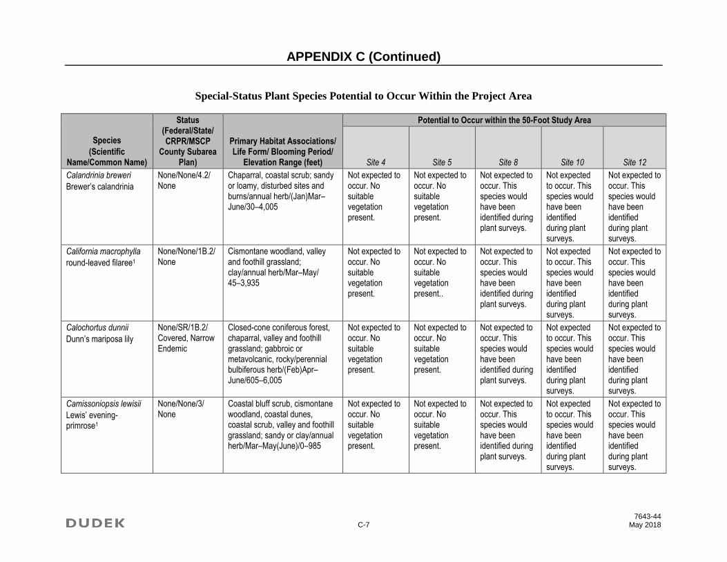
APPENDIX C (Continued)
7643-44 C-7 May 2018
Special-Status Plant Species Potential to Occur Within the Project Area
Species
(Scientific Name/Common Name)
Status (Federal/State/ CRPR/MSCP
County Subarea Plan)
Primary Habitat Associations/ Life Form/ Blooming Period/
Elevation Range (feet)
Potential to Occur within the 50-Foot Study Area
Site 4 Site 5 Site 8 Site 10 Site 12
Calandrinia breweri
Brewer’s calandrinia
None/None/4.2/ None
Chaparral, coastal scrub; sandy or loamy, disturbed sites and burns/annual herb/(Jan)Mar–June/30–4,005
Not expected to occur. No suitable vegetation present.
Not expected to occur. No suitable vegetation present.
Not expected to occur. This species would have been identified during plant surveys.
Not expected to occur. This species would have been identified during plant surveys.
Not expected to occur. This species would have been identified during plant surveys.
California macrophylla
round-leaved filaree1
None/None/1B.2/None
Cismontane woodland, valley and foothill grassland; clay/annual herb/Mar–May/ 45–3,935
Not expected to occur. No suitable vegetation present.
Not expected to occur. No suitable vegetation present..
Not expected to occur. This species would have been identified during plant surveys.
Not expected to occur. This species would have been identified during plant surveys.
Not expected to occur. This species would have been identified during plant surveys.
Calochortus dunnii
Dunn’s mariposa lily
None/SR/1B.2/ Covered, Narrow Endemic
Closed-cone coniferous forest, chaparral, valley and foothill grassland; gabbroic or metavolcanic, rocky/perennial bulbiferous herb/(Feb)Apr–June/605–6,005
Not expected to occur. No suitable vegetation present.
Not expected to occur. No suitable vegetation present.
Not expected to occur. This species would have been identified during plant surveys.
Not expected to occur. This species would have been identified during plant surveys.
Not expected to occur. This species would have been identified during plant surveys.
Camissoniopsis lewisii
Lewis’ evening-primrose1
None/None/3/ None
Coastal bluff scrub, cismontane woodland, coastal dunes, coastal scrub, valley and foothill grassland; sandy or clay/annual herb/Mar–May(June)/0–985
Not expected to occur. No suitable vegetation present.
Not expected to occur. No suitable vegetation present.
Not expected to occur. This species would have been identified during plant surveys.
Not expected to occur. This species would have been identified during plant surveys.
Not expected to occur. This species would have been identified during plant surveys.

APPENDIX C (Continued)
7643-44 C-8 May 2018
Special-Status Plant Species Potential to Occur Within the Project Area
Species
(Scientific Name/Common Name)
Status (Federal/State/ CRPR/MSCP
County Subarea Plan)
Primary Habitat Associations/ Life Form/ Blooming Period/
Elevation Range (feet)
Potential to Occur within the 50-Foot Study Area
Site 4 Site 5 Site 8 Site 10 Site 12
Castilleja plagiotoma
Mojave paintbrush
None/None/4.3/ None
Great Basin scrub (alluvial), Joshua tree woodland, lower montane coniferous forest, pinyon and juniper woodland/perennial herb (hemiparasitic)/Apr–June/980–8,200
Not expected to occur. The site is outside of the species’ known elevation range and there is no suitable vegetation present.
Ceanothus cyaneus
Lakeside ceanothus
None/None/1B.2/Covered, Narrow Endemic
Closed-cone coniferous forest, chaparral/perennial evergreen shrub/Apr–June/770–2,475
Not expected to occur. No suitable vegetation present.
Not expected to occur. No suitable vegetation present.
Not expected to occur. This species would have been identified during plant surveys.
Not expected to occur. This species would have been identified during plant surveys.
Not expected to occur. This species would have been identified during plant surveys.
Ceanothus otayensis
Otay Mountain ceanothus1
None/None/1B.2/None
Chaparral (metavolcanic or gabbroic)/perennial evergreen shrub/Jan–Apr/1,965–3,610
Not expected to occur. The site is outside of the species’ known elevation range.
Ceanothus verrucosus
wart-stemmed ceanothus1
None/None/2B.2/Covered
Chaparral/perennial evergreen shrub/Dec–May/0–1,245
Not expected to occur. No suitable vegetation present.
Not expected to occur. No suitable vegetation present.
Not expected to occur. This species would have been identified during plant surveys.
Not expected to occur. This species would have been identified during plant surveys.
Observed.

APPENDIX C (Continued)
7643-44 C-9 May 2018
Special-Status Plant Species Potential to Occur Within the Project Area
Species
(Scientific Name/Common Name)
Status (Federal/State/ CRPR/MSCP
County Subarea Plan)
Primary Habitat Associations/ Life Form/ Blooming Period/
Elevation Range (feet)
Potential to Occur within the 50-Foot Study Area
Site 4 Site 5 Site 8 Site 10 Site 12
Centromadia parryi ssp. australis
southern tarplant
None/None/1B.1/None
Marshes and swamps (margins), valley and foothill grassland (vernally mesic), vernal pools/annual herb/May–Nov/ 0–1,575
Not expected to occur. No suitable vegetation present.
Not expected to occur. No suitable vegetation present.
Not expected to occur. This species would have been identified during plant surveys.
Not expected to occur. This species would have been identified during plant surveys.
Not expected to occur. This species would have been identified during plant surveys.
Centromadia pungens ssp. laevis
smooth tarplant
None/None/1B.1/None
Chenopod scrub, meadows and seeps, playas, riparian woodland, valley and foothill grassland; alkaline/annual herb/Apr–Sep/0–2,100
Not expected to occur. No suitable vegetation present.
Not expected to occur. No suitable vegetation present.
Not expected to occur. This species would have been identified during plant surveys.
Not expected to occur. This species would have been identified during plant surveys.
Not expected to occur. This species would have been identified during plant surveys.
Chaenactis glabriuscula var. orcuttiana
Orcutt’s pincushion
None/None/1B.1/None
Coastal bluff scrub (sandy), coastal dunes/annual herb/Jan–Aug/0–330
Not expected to occur. No suitable vegetation present.
Chamaebatia australis
southern mountain misery1
None/None/4.2/ None
Chaparral (gabbroic or metavolcanic)/perennial evergreen shrub/Nov–May/980–3,345
Not expected to occur. The site is outside of the species’ known elevation range.
Chloropyron maritimum ssp. maritimum
salt marsh bird’s-beak1
FE/SE/1B.2/ Covered
Coastal dunes, marshes and swamps (coastal salt)/annual herb (hemiparasitic)/May–Oct(Nov)/0–100
Not expected to occur. No suitable vegetation present.
Chorizanthe leptotheca
Peninsular spineflower
None/None/4.2/ None
Chaparral, coastal scrub, lower montane coniferous forest; alluvial fan, granitic/annual herb/May–Aug/980–6,235
Not expected to occur. The site is outside of the species’ known elevation range.

APPENDIX C (Continued)
7643-44 C-10 May 2018
Special-Status Plant Species Potential to Occur Within the Project Area
Species
(Scientific Name/Common Name)
Status (Federal/State/ CRPR/MSCP
County Subarea Plan)
Primary Habitat Associations/ Life Form/ Blooming Period/
Elevation Range (feet)
Potential to Occur within the 50-Foot Study Area
Site 4 Site 5 Site 8 Site 10 Site 12
Chorizanthe orcuttiana
Orcutt’s spineflower
FE/SE/1B.1/None Closed-cone coniferous forest, chaparral (maritime), coastal scrub; sandy openings/annual herb/Mar–May/5–410
Not expected to occur. No suitable vegetation present.
Not expected to occur. No suitable vegetation present.
Not expected to occur. This species would have been identified during plant surveys.
Not expected to occur. This species would have been identified during plant surveys.
Not expected to occur. This species would have been identified during plant surveys.
Chorizanthe polygonoides var. longispina
long-spined spineflower1
None/None/1B.2/None
Chaparral, coastal scrub, meadows and seeps, valley and foothill grassland, vernal pools; often clay/annual herb/Apr–July/95–5,020
Not expected to occur. No suitable vegetation present.
Not expected to occur. No suitable vegetation present.
Not expected to occur. This species would have been identified during plant surveys.
Not expected to occur. This species would have been identified during plant surveys.
Not expected to occur. This species would have been identified during plant surveys.
Cistanthe maritima
seaside cistanthe
None/None/4.2/ None
Coastal bluff scrub, coastal scrub, valley and foothill grassland; sandy/annual herb/(Feb)Mar–June(Aug)/15–985
Not expected to occur. No suitable vegetation present.
Not expected to occur. No suitable vegetation present.
Not expected to occur. This species would have been identified during plant surveys.
Not expected to occur. This species would have been identified during plant surveys.
Not expected to occur. This species would have been identified during plant surveys.
Clarkia delicate
delicate clarkia1
None/None/1B.2/None
Chaparral, cismontane woodland; often gabbroic/annual herb/Apr–June/770–3,280
Not expected to occur. No suitable vegetation present.
Not expected to occur. No suitable vegetation present.
Not expected to occur. This species would have been identified during plant surveys.
Not expected to occur. This species would have been identified during plant surveys.
Not expected to occur. This species would have been identified during plant surveys.

APPENDIX C (Continued)
7643-44 C-11 May 2018
Special-Status Plant Species Potential to Occur Within the Project Area
Species
(Scientific Name/Common Name)
Status (Federal/State/ CRPR/MSCP
County Subarea Plan)
Primary Habitat Associations/ Life Form/ Blooming Period/
Elevation Range (feet)
Potential to Occur within the 50-Foot Study Area
Site 4 Site 5 Site 8 Site 10 Site 12
Clinopodium chandleri
San Miguel savory
None/None/1B.2/Covered
Chaparral, cismontane woodland, coastal scrub, riparian woodland, valley and foothill grassland; rocky, gabbroic or metavolcanic/perennial shrub/Mar–July/390–3,525
Not expected to occur. No suitable vegetation present.
Not expected to occur. No suitable vegetation present.
Not expected to occur. This species would have been identified during plant surveys.
Not expected to occur. This species would have been identified during plant surveys.
Not expected to occur. This species would have been identified during plant surveys.
Comarostaphylis diversifolia ssp. diversifolia
summer holly1
None/None/1B.2/None
Chaparral, cismontane woodland/perennial evergreen shrub/Apr–June/95–2,590
Not expected to occur. No suitable vegetation present.
Not expected to occur. No suitable vegetation present.
Not expected to occur. This species would have been identified during plant surveys.
Not expected to occur. This species would have been identified during plant surveys.
Not expected to occur. This species would have been identified during plant surveys.
Convolvulus simulans
small-flowered morning-glory1
None/None/4.2/ None
Chaparral (openings), coastal scrub, valley and foothill grassland; clay, serpentinite seeps/annual herb/Mar–July/95–2,430
Not expected to occur. No suitable vegetation present.
Not expected to occur. No suitable vegetation present.
Not expected to occur. This species would have been identified during plant surveys.
Not expected to occur. This species would have been identified during plant surveys.
Not expected to occur. This species would have been identified during plant surveys.
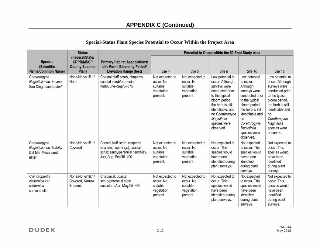
APPENDIX C (Continued)
7643-44 C-12 May 2018
Special-Status Plant Species Potential to Occur Within the Project Area
Species
(Scientific Name/Common Name)
Status (Federal/State/ CRPR/MSCP
County Subarea Plan)
Primary Habitat Associations/ Life Form/ Blooming Period/
Elevation Range (feet)
Potential to Occur within the 50-Foot Study Area
Site 4 Site 5 Site 8 Site 10 Site 12
Corethrogyne filaginifolia var. incana
San Diego sand aster1
None/None/1B.1/None
Coastal bluff scrub, chaparral, coastal scrub/perennial herb/June–Sep/5–375
Not expected to occur. No suitable vegetation present.
Not expected to occur. No suitable vegetation present.
Low potential to occur. Although surveys were conducted prior to the typical bloom period, the herb is still identifiable, and no Corethrogyne filaginifolia species were observed.
Low potential to occur. Although surveys were conducted prior to the typical bloom period, the herb is still identifiable and no Corethrogyne filaginifolia species were observed.
Low potential to occur. Although surveys were conducted prior to the typical bloom period, the herb is still identifiable and no Corethrogyne filaginifolia species were observed.
Corethrogyne filaginifolia var. linifolia
Del Mar Mesa sand aster
None/None/1B.1/Covered
Coastal bluff scrub, chaparral (maritime, openings), coastal scrub; sandy/perennial herb/May, July, Aug, Sep/45–490
Not expected to occur. No suitable vegetation present.
Not expected to occur. No suitable vegetation present.
Not expected to occur. This species would have been identified during plant surveys.
Not expected to occur. This species would have been identified during plant surveys.
Not expected to occur. This species would have been identified during plant surveys.
Cylindropuntia californica var. californica
snake cholla1
None/None/1B.1/Covered, Narrow Endemic
Chaparral, coastal scrub/perennial stem succulent/Apr–May/95–490
Not expected to occur. No suitable vegetation present.
Not expected to occur. No suitable vegetation present.
Not expected to occur. This species would have been identified during plant surveys.
Not expected to occur. This species would have been identified during plant surveys.
Not expected to occur. This species would have been identified during plant surveys.
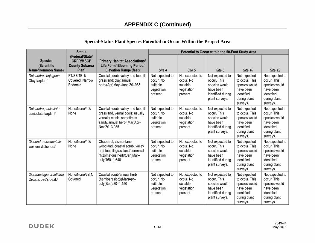
APPENDIX C (Continued)
7643-44 C-13 May 2018
Special-Status Plant Species Potential to Occur Within the Project Area
Species
(Scientific Name/Common Name)
Status (Federal/State/ CRPR/MSCP
County Subarea Plan)
Primary Habitat Associations/ Life Form/ Blooming Period/
Elevation Range (feet)
Potential to Occur within the 50-Foot Study Area
Site 4 Site 5 Site 8 Site 10 Site 12
Deinandra conjugens
Otay tarplant1
FT/SE/1B.1/ Covered, Narrow Endemic
Coastal scrub, valley and foothill grassland; clay/annual herb/(Apr)May–June/80–985
Not expected to occur. No suitable vegetation present.
Not expected to occur. No suitable vegetation present.
Not expected to occur. This species would have been identified during plant surveys.
Not expected to occur. This species would have been identified during plant surveys.
Not expected to occur. This species would have been identified during plant surveys.
Deinandra paniculata
paniculate tarplant1
None/None/4.2/ None
Coastal scrub, valley and foothill grassland, vernal pools; usually vernally mesic, sometimes sandy/annual herb/(Mar)Apr–Nov/80–3,085
Not expected to occur. No suitable vegetation present.
Not expected to occur. No suitable vegetation present.
Not expected to occur. This species would have been identified during plant surveys.
Not expected to occur. This species would have been identified during plant surveys.
Not expected to occur. This species would have been identified during plant surveys.
Dichondra occidentalis
western dichondra1
None/None/4.2/ None
Chaparral, cismontane woodland, coastal scrub, valley and foothill grassland/perennial rhizomatous herb/(Jan)Mar–July/160–1,640
Not expected to occur. No suitable vegetation present.
Not expected to occur. No suitable vegetation present.
Not expected to occur. This species would have been identified during plant surveys.
Not expected to occur. This species would have been identified during plant surveys.
Not expected to occur. This species would have been identified during plant surveys.
Dicranostegia orcuttiana
Orcutt’s bird’s-beak1
None/None/2B.1/Covered
Coastal scrub/annual herb (hemiparasitic)/(Mar)Apr–July(Sep)/30–1,150
Not expected to occur. No suitable vegetation present.
Not expected to occur. No suitable vegetation present.
Not expected to occur. This species would have been identified during plant surveys.
Not expected to occur. This species would have been identified during plant surveys.
Not expected to occur. This species would have been identified during plant surveys.

APPENDIX C (Continued)
7643-44 C-14 May 2018
Special-Status Plant Species Potential to Occur Within the Project Area
Species
(Scientific Name/Common Name)
Status (Federal/State/ CRPR/MSCP
County Subarea Plan)
Primary Habitat Associations/ Life Form/ Blooming Period/
Elevation Range (feet)
Potential to Occur within the 50-Foot Study Area
Site 4 Site 5 Site 8 Site 10 Site 12
Diplacus aridus
low bush monkeyflower
None/None/4.3/ None
Chaparral (rocky), Sonoran desert scrub/perennial evergreen shrub/Apr–July/2,460–3,935
Not expected to occur. The site is outside of the species’ known elevation range.
Dudleya attenuata ssp. attenuate
Orcutt’s dudleya
None/None/2B.1/None
Coastal bluff scrub, chaparral, coastal scrub; rocky or gravelly/perennial herb/May–July/5–165
Not expected to occur. No suitable vegetation present.
Not expected to occur. No suitable vegetation present.
Not expected to occur. This species would have been identified during plant surveys.
Not expected to occur. This species would have been identified during plant surveys.
Not expected to occur. This species would have been identified during plant surveys.
Dudleya blochmaniae ssp. blochmaniae
Blochman’s dudleya
None/None/1B.1/None
Coastal bluff scrub, chaparral, coastal scrub, valley and foothill grassland; rocky, often clay or serpentinite/perennial herb/Apr–June/15–1,475
Not expected to occur. No suitable vegetation present.
Not expected to occur. No suitable vegetation present.
Not expected to occur. This species would have been identified during plant surveys.
Not expected to occur. This species would have been identified during plant surveys.
Not expected to occur. This species would have been identified during plant surveys.
Dudleya brevifolia
short-leaved dudleya
None/SE/1B.1/ Covered, Narrow Endemic
Chaparral (maritime, openings), coastal scrub; Torrey sandstone/perennial herb/Apr–May/95–820
Not expected to occur. No suitable vegetation present.
Not expected to occur. No suitable vegetation present.
Not expected to occur. This species would have been identified during plant surveys.
Not expected to occur. This species would have been identified during plant surveys.
Not expected to occur. This species would have been identified during plant surveys.

APPENDIX C (Continued)
7643-44 C-15 May 2018
Special-Status Plant Species Potential to Occur Within the Project Area
Species
(Scientific Name/Common Name)
Status (Federal/State/ CRPR/MSCP
County Subarea Plan)
Primary Habitat Associations/ Life Form/ Blooming Period/
Elevation Range (feet)
Potential to Occur within the 50-Foot Study Area
Site 4 Site 5 Site 8 Site 10 Site 12
Dudleya variegata
variegated dudleya1
None/None/1B.2/Covered, Narrow Endemic
Chaparral, cismontane woodland, coastal scrub, valley and foothill grassland, vernal pools; clay/perennial herb/Apr–June/5–1,905
Not expected to occur. No suitable vegetation present.
Not expected to occur. No suitable vegetation present.
Not expected to occur. This species would have been identified during plant surveys.
Not expected to occur. This species would have been identified during plant surveys.
Not expected to occur. This species would have been identified during plant surveys.
Dudleya viscida
sticky dudleya
None/None/1B.2/Covered
Coastal bluff scrub, chaparral, cismontane woodland, coastal scrub; rocky/perennial herb/May–June/30–1,805
Not expected to occur. No suitable vegetation present.
Not expected to occur. No suitable vegetation present.
Not expected to occur. This species would have been identified during plant surveys.
Not expected to occur. This species would have been identified during plant surveys.
Not expected to occur. This species would have been identified during plant surveys.
Ericameria palmeri var. palmeri
Palmer’s goldenbush1
None/None/1B.1/Covered, Narrow Endemic
Chaparral, coastal scrub; mesic/perennial evergreen shrub/(July)Sep–Nov/95–1,970
Not expected to occur. No suitable vegetation present.
Not expected to occur. No suitable vegetation present.
Not expected to occur. This species would have been identified during plant surveys.
Not expected to occur. This species would have been identified during plant surveys.
Not expected to occur. This species would have been identified during plant surveys.
Eriodictyon sessilifolium
sessile-leaved yerba stanta
None/None/2B.1/None
Coastal scrub; volcanic/perennial shrub/July/555–560
Not expected to occur. No suitable vegetation present.
Not expected to occur. No suitable vegetation present.
Not expected to occur. This species would have been identified during plant surveys.
Not expected to occur. This species would have been identified during plant surveys.
Not expected to occur. This species would have been identified during plant surveys.

APPENDIX C (Continued)
7643-44 C-16 May 2018
Special-Status Plant Species Potential to Occur Within the Project Area
Species
(Scientific Name/Common Name)
Status (Federal/State/ CRPR/MSCP
County Subarea Plan)
Primary Habitat Associations/ Life Form/ Blooming Period/
Elevation Range (feet)
Potential to Occur within the 50-Foot Study Area
Site 4 Site 5 Site 8 Site 10 Site 12
Eryngium aristulatum var. parishii
San Diego button-celery1
FE/SE/1B.1/ Covered
Coastal scrub, valley and foothill grassland, vernal pools; mesic/annual/perennial herb/Apr–June/65–2,035
Not expected to occur. No suitable vegetation present.
Not expected to occur. No suitable vegetation present.
Not expected to occur. This species would have been identified during plant surveys.
Not expected to occur. This species would have been identified during plant surveys.
Not expected to occur. This species would have been identified during plant surveys.
Erysimum ammophilum
sand-loving wallflower
None/None/1B.2/Covered
Chaparral (maritime), coastal dunes, coastal scrub; sandy, openings/perennial herb/Feb–June/0–195
Not expected to occur. No suitable vegetation present.
Not expected to occur. No suitable vegetation present.
Not expected to occur. This species would have been identified during plant surveys.
Not expected to occur. This species would have been identified during plant surveys.
Not expected to occur. This species would have been identified during plant surveys.
Erythranthe diffusa
Palomar monkeyflower
None/None/4.3/ None
Chaparral, lower montane coniferous forest; sandy or gravelly/annual herb/Apr–June/4,000–6,005
Not expected to occur. The site is outside of the species’ known elevation range.
Euphorbia misera
cliff spurge1
None/None/2B.2/None
Coastal bluff scrub, coastal scrub, Mojavean desert scrub; rocky/perennial shrub/Dec–Aug(Oct)/30–1,640
Not expected to occur. No suitable vegetation present.
Not expected to occur. No suitable vegetation present.
Not expected to occur. This species would have been identified during plant surveys.
Not expected to occur. This species would have been identified during plant surveys.
Not expected to occur. This species would have been identified during plant surveys.

APPENDIX C (Continued)
7643-44 C-17 May 2018
Special-Status Plant Species Potential to Occur Within the Project Area
Species
(Scientific Name/Common Name)
Status (Federal/State/ CRPR/MSCP
County Subarea Plan)
Primary Habitat Associations/ Life Form/ Blooming Period/
Elevation Range (feet)
Potential to Occur within the 50-Foot Study Area
Site 4 Site 5 Site 8 Site 10 Site 12
Ferocactus viridescens
San Diego barrel cactus1
None/None/2B.1/Covered
Chaparral, coastal scrub, valley and foothill grassland, vernal pools/perennial stem succulent/May–June/5–1,475
Not expected to occur. No suitable vegetation present.
Not expected to occur. No suitable vegetation present.
Not expected to occur. This species would have been identified during plant surveys.
Not expected to occur. This species would have been identified during plant surveys.
Not expected to occur. This species would have been identified during plant surveys.
Frankenia palmeri
Palmer’s frankenia1
None/None/2B.1/None
Coastal dunes, marshes and swamps (coastal salt), playas/perennial herb/May–July/0–35
Not expected to occur. No suitable vegetation present.
Fremontodendron mexicanum
Mexican flannelbush
FE/SR/1B.1/ Covered
Closed-cone coniferous forest, chaparral, cismontane woodland; gabbroic, metavolcanic, or serpentinite/ perennial evergreen shrub/Mar–June/30–2,350
Not expected to occur. No suitable vegetation present.
Low potential to occur. Habitat at this site is unsuitable.
Not expected to occur. This species would have been identified during plant surveys.
Not expected to occur. This species would have been identified during plant surveys.
Not expected to occur. This species would have been identified during plant surveys.
Galium proliferum
desert bedstraw
None/None/2B.2/None
Joshua tree woodland, Mojavean desert scrub, pinyon and juniper woodland; rocky, carbonate (limestone)/annual herb/Mar–June/3,900–5,350
Not expected to occur. The site is outside of the species’ known elevation range and there is no suitable vegetation present.
Geothallus tuberosus
Campbell’s liverwort
None/None/1B.1/None
Coastal scrub (mesic), vernal pools; soil/ephemeral liverwort/30–1,970
Not expected to occur. No suitable vegetation present.
Not expected to occur. No suitable vegetation present.
Low potential to occur. There are no vernal pools on site.
Low potential to occur. There are no vernal pools on site.
Low potential to occur. There are no vernal pools on site.

APPENDIX C (Continued)
7643-44 C-18 May 2018
Special-Status Plant Species Potential to Occur Within the Project Area
Species
(Scientific Name/Common Name)
Status (Federal/State/ CRPR/MSCP
County Subarea Plan)
Primary Habitat Associations/ Life Form/ Blooming Period/
Elevation Range (feet)
Potential to Occur within the 50-Foot Study Area
Site 4 Site 5 Site 8 Site 10 Site 12
Githopsis diffusa ssp. filicaulis
Mission Canyon bluecup1
None/None/3.1/ None
Chaparral (mesic, disturbed areas)/annual herb/Apr–June/1,475–2,295
Not expected to occur. The site is outside of the species’ known elevation range.
Grindelia hallii
San Diego gumplant1
None/None/1B.2/None
Chaparral, lower montane coniferous forest, meadows and seeps, valley and foothill grassland/perennial herb/May–Oct/605–5,725
Not expected to occur. No suitable vegetation present.
Not expected to occur. No suitable vegetation present.
Not expected to occur. This species would have been identified during plant surveys.
Not expected to occur. This species would have been identified during plant surveys.
Not expected to occur. This species would have been identified during plant surveys.
Harpagonella palmeri
Palmer’s grapplinghook1
None/None/4.2/ None
Chaparral, coastal scrub, valley and foothill grassland; clay; open grassy areas within shrubland/annual herb/Mar–May/65–3,135
Not expected to occur. No suitable vegetation present.
Not expected to occur. No suitable vegetation present.
Not expected to occur. This species would have been identified during plant surveys.
Not expected to occur. This species would have been identified during plant surveys.
Not expected to occur. This species would have been identified during plant surveys.
Hesperocyparis forbesii
Tecate cypress
None/None/1B.1/Covered
Closed-cone coniferous forest, chaparral; clay, gabbroic or metavolcanic/perennial evergreen tree/260–4,920
Not expected to occur. No suitable vegetation present.
Not expected to occur. No suitable vegetation present.
Not expected to occur. This species would have been identified during plant surveys.
Not expected to occur. This species would have been identified during plant surveys.
Not expected to occur. This species would have been identified during plant surveys.

APPENDIX C (Continued)
7643-44 C-19 May 2018
Special-Status Plant Species Potential to Occur Within the Project Area
Species
(Scientific Name/Common Name)
Status (Federal/State/ CRPR/MSCP
County Subarea Plan)
Primary Habitat Associations/ Life Form/ Blooming Period/
Elevation Range (feet)
Potential to Occur within the 50-Foot Study Area
Site 4 Site 5 Site 8 Site 10 Site 12
Heterotheca sessiliflora ssp. sessiliflora
beach goldenaster1
None/None/1B.1/None
Chaparral (coastal), coastal dunes, coastal scrub/perennial herb/Mar–Dec/0–4,020
Not expected to occur. No suitable vegetation present.
Not expected to occur. No suitable vegetation present.
Not expected to occur. This species would have been identified during plant surveys.
Not expected to occur. This species would have been identified during plant surveys.
Not expected to occur. This species would have been identified during plant surveys.
Holocarpha virgata ssp. elongata
graceful tarplant1
None/None/4.2/ None
Chaparral, cismontane woodland, coastal scrub, valley and foothill grassland/annual herb/May–Nov/195–3,610
Not expected to occur. No suitable vegetation present.
Not expected to occur. No suitable vegetation present.
Not expected to occur. This species would have been identified during plant surveys.
Not expected to occur. This species would have been identified during plant surveys.
Not expected to occur. This species would have been identified during plant surveys.
Hordeum intercedens
vernal barley1
None/None/3.2/ None
Coastal dunes, coastal scrub, valley and foothill grassland (saline flats and depressions), vernal pools/annual herb/Mar–June/15–3,280
Not expected to occur. No suitable vegetation present.
Not expected to occur. No suitable vegetation present.
Not expected to occur. This species would have been identified during plant surveys.
Not expected to occur. This species would have been identified during plant surveys.
Not expected to occur. This species would have been identified during plant surveys.
Horkelia truncata
Ramona horkelia
None/None/1B.3/None
Chaparral, cismontane woodland; clay, gabbroic/perennial herb/May–June/1,310–4,265
Not expected to occur. The site is outside of the species’ known elevation range.
Hosackia crassifolia var. otayensis
Otay Mountain lotus
None/None/1B.1/None
Chaparral (metavolcanic, often in disturbed areas)/perennial herb/May–Aug/1,245–3,295
Not expected to occur. The site is outside of the species’ known elevation range.

APPENDIX C (Continued)
7643-44 C-20 May 2018
Special-Status Plant Species Potential to Occur Within the Project Area
Species
(Scientific Name/Common Name)
Status (Federal/State/ CRPR/MSCP
County Subarea Plan)
Primary Habitat Associations/ Life Form/ Blooming Period/
Elevation Range (feet)
Potential to Occur within the 50-Foot Study Area
Site 4 Site 5 Site 8 Site 10 Site 12
Isocoma menziesii var. decumbens
decumbent goldenbush1
None/None/1B.2/None
Chaparral, coastal scrub (sandy, often in disturbed areas)/perennial shrub/Apr–Nov/30–445
Not expected to occur. No suitable vegetation present.
Not expected to occur. No suitable vegetation present.
Not expected to occur. This species would have been identified during plant surveys.
Not expected to occur. This species would have been identified during plant surveys.
Not expected to occur. This species would have been identified during plant surveys.
Iva hayesiana
San Diego marsh-elder1
None/None/2B.2/None
Marshes and swamps, playas/perennial herb/Apr–Oct/30–1,640
Not expected to occur. No suitable vegetation present.
Juncus acutus ssp. leopoldii
southwestern spiny rush1
None/None/4.2/ None
Coastal dunes (mesic), meadows and seeps (alkaline seeps), marshes and swamps (coastal salt)/perennial rhizomatous herb/(Mar)May–June/5–2,955
Not expected to occur. No suitable vegetation present.
Lasthenia glabrata ssp. coulteri
Coulter’s goldfields1
None/None/1B.1/None
Marshes and swamps (coastal salt), playas, vernal pools/annual herb/Feb–June/0–4,005
Not expected to occur. No suitable vegetation present.
Lepechinia cardiophylla
heart-leaved pitcher sage1
None/None/1B.2/Covered, Narrow Endemic
Closed-cone coniferous forest, chaparral, cismontane woodland/perennial shrub/Apr–July/1,705–4,495
Not expected to occur. The site is outside of the species’ known elevation range.
Lepechinia gander
Gander’s pitcher sage
None/None/1B.3/Covered, Narrow Endemic
Closed-cone coniferous forest, chaparral, coastal scrub, valley and foothill grassland; gabbroic or metavolcanic/perennial shrub/June–July/1,000–3,295
Not expected to occur. The site is outside of the species’ known elevation range.

APPENDIX C (Continued)
7643-44 C-21 May 2018
Special-Status Plant Species Potential to Occur Within the Project Area
Species
(Scientific Name/Common Name)
Status (Federal/State/ CRPR/MSCP
County Subarea Plan)
Primary Habitat Associations/ Life Form/ Blooming Period/
Elevation Range (feet)
Potential to Occur within the 50-Foot Study Area
Site 4 Site 5 Site 8 Site 10 Site 12
Lepidium virginicum var. robinsonii
Robinson’s pepper-grass1
None/None/4.3/ None
Chaparral, coastal scrub/annual herb/Jan–July/0–2,905
Not expected to occur. No suitable vegetation present.
Not expected to occur. No suitable vegetation present.
Not expected to occur. This species would have been identified during plant surveys.
Not expected to occur. This species would have been identified during plant surveys.
Not expected to occur. This species would have been identified during plant surveys.
Leptosyne maritima
sea dahlia
None/None/2B.2/None
Coastal bluff scrub, coastal scrub/perennial herb/Mar–May/15–490
Not expected to occur. No suitable vegetation present.
Not expected to occur. No suitable vegetation present.
Not expected to occur. This species would have been identified during plant surveys.
Not expected to occur. This species would have been identified during plant surveys.
Not expected to occur. This species would have been identified during plant surveys.
Lilium humboldtii ssp. ocellatum
ocellated Humboldt lily
None/None/4.2/ None
Chaparral, cismontane woodland, coastal scrub, lower montane coniferous forest, riparian woodland; openings/perennial bulbiferous herb/Mar–July(Aug)/95–5,905
Not expected to occur. No suitable vegetation present.
Not expected to occur. No suitable vegetation present.
Not expected to occur. This species would have been identified during plant surveys.
Not expected to occur. This species would have been identified during plant surveys.
Not expected to occur. This species would have been identified during plant surveys.
Lycium californicum
California box-thorn1
None/None/4.2/ None
Coastal bluff scrub, coastal scrub/perennial shrub/(Dec)Mar, June, July, Aug/15–490
Not expected to occur. No suitable vegetation present.
Not expected to occur. No suitable vegetation present.
Not expected to occur. This species would have been identified during plant surveys.
Not expected to occur. This species would have been identified during plant surveys.
Not expected to occur. This species would have been identified during plant surveys.

APPENDIX C (Continued)
7643-44 C-22 May 2018
Special-Status Plant Species Potential to Occur Within the Project Area
Species
(Scientific Name/Common Name)
Status (Federal/State/ CRPR/MSCP
County Subarea Plan)
Primary Habitat Associations/ Life Form/ Blooming Period/
Elevation Range (feet)
Potential to Occur within the 50-Foot Study Area
Site 4 Site 5 Site 8 Site 10 Site 12
Microseris douglasii ssp. platycarpha
small-flowered microseris
None/None/4.2/ None
Cismontane woodland, coastal scrub, valley and foothill grassland, vernal pools; clay/annual herb/Mar–May/45–3,510
Not expected to occur. No suitable vegetation present.
Not expected to occur. No suitable vegetation present.
Not expected to occur. This species would have been identified during plant surveys.
Not expected to occur. This species would have been identified during plant surveys.
Not expected to occur. This species would have been identified during plant surveys.
Mobergia calculiformis
light gray lichen
None/None/3/ None
Coastal scrub (?); On rocks/crustose lichen (saxicolous)/30–35
Not expected to occur. No suitable vegetation present.
Not expected to occur. No suitable vegetation present.
Not expected to occur. This species would have been identified during plant surveys.
Not expected to occur. This species would have been identified during plant surveys.
Not expected to occur. This species would have been identified during plant surveys.
Monardella hypoleuca ssp. lanata
felt-leaved monardella
None/None/1B.2/Covered
Chaparral, cismontane woodland/perennial rhizomatous herb/June–Aug/980–5,165
Not expected to occur. The site is outside of the species’ known elevation range and there is no suitable habitat Sites 4 and 5.
Monardella stoneana
Jennifer’s monardella
None/None/1B.2/None
Closed-cone coniferous forest, chaparral, coastal scrub, riparian scrub; usually rocky intermittent streambeds/perennial herb/June–Sep/30–2,590
Not expected to occur. No suitable vegetation present.
Not expected to occur. No suitable vegetation present.
Not expected to occur. This species would have been identified during plant surveys.
Not expected to occur. This species would have been identified during plant surveys.
Not expected to occur. This species would have been identified during plant surveys.

APPENDIX C (Continued)
7643-44 C-23 May 2018
Special-Status Plant Species Potential to Occur Within the Project Area
Species
(Scientific Name/Common Name)
Status (Federal/State/ CRPR/MSCP
County Subarea Plan)
Primary Habitat Associations/ Life Form/ Blooming Period/
Elevation Range (feet)
Potential to Occur within the 50-Foot Study Area
Site 4 Site 5 Site 8 Site 10 Site 12
Monardella viminea
willowy monardella1
FE/SE/1B.1/ Covered, Narrow Endemic
Chaparral, coastal scrub, riparian forest, riparian scrub, riparian woodland; alluvial ephemeral washes/perennial herb/June–Aug/160–740
Not expected to occur. No suitable vegetation present.
Not expected to occur. No suitable vegetation present.
Not expected to occur. This species would have been identified during plant surveys.
Not expected to occur. This species would have been identified during plant surveys.
Not expected to occur. This species would have been identified during plant surveys.
Mucronea californica
California spineflower
None/None/4.2/ None
Chaparral, cismontane woodland, coastal dunes, coastal scrub, valley and foothill grassland; sandy/annual herb/Mar–July(Aug)/0–4,595
Not expected to occur. No suitable vegetation present.
Not expected to occur. No suitable vegetation present.
Not expected to occur. This species would have been identified during plant surveys.
Not expected to occur. This species would have been identified during plant surveys.
Not expected to occur. This species would have been identified during plant surveys.
Myosurus minimus ssp. apus
little mousetail1
None/None/3.1/ Covered
Valley and foothill grassland, vernal pools (alkaline)/annual herb/Mar–June/65–2,100
Not expected to occur. No suitable vegetation present.
Not expected to occur. No suitable vegetation present.
Not expected to occur. This species would have been identified during plant surveys.
Not expected to occur. This species would have been identified during plant surveys.
Not expected to occur. This species would have been identified during plant surveys.
Nama stenocarpa
mud nama1
None/None/2B.2/None
Marshes and swamps (lake margins, riverbanks)/annual / perennial herb/Jan–July/15–1,640
Not expected to occur. No suitable vegetation present.
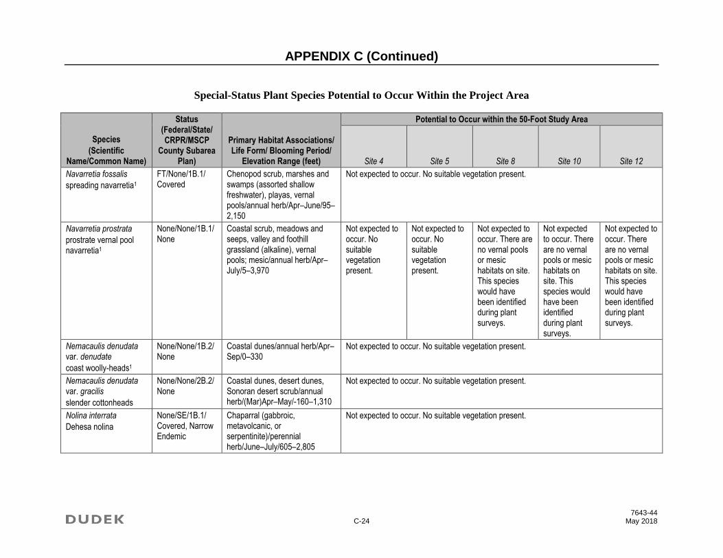
APPENDIX C (Continued)
7643-44 C-24 May 2018
Special-Status Plant Species Potential to Occur Within the Project Area
Species
(Scientific Name/Common Name)
Status (Federal/State/ CRPR/MSCP
County Subarea Plan)
Primary Habitat Associations/ Life Form/ Blooming Period/
Elevation Range (feet)
Potential to Occur within the 50-Foot Study Area
Site 4 Site 5 Site 8 Site 10 Site 12
Navarretia fossalis
spreading navarretia1
FT/None/1B.1/ Covered
Chenopod scrub, marshes and swamps (assorted shallow freshwater), playas, vernal pools/annual herb/Apr–June/95–2,150
Not expected to occur. No suitable vegetation present.
Navarretia prostrata
prostrate vernal pool navarretia1
None/None/1B.1/None
Coastal scrub, meadows and seeps, valley and foothill grassland (alkaline), vernal pools; mesic/annual herb/Apr–July/5–3,970
Not expected to occur. No suitable vegetation present.
Not expected to occur. No suitable vegetation present.
Not expected to occur. There are no vernal pools or mesic habitats on site. This species would have been identified during plant surveys.
Not expected to occur. There are no vernal pools or mesic habitats on site. This species would have been identified during plant surveys.
Not expected to occur. There are no vernal pools or mesic habitats on site. This species would have been identified during plant surveys.
Nemacaulis denudata var. denudate
coast woolly-heads1
None/None/1B.2/None
Coastal dunes/annual herb/Apr–Sep/0–330
Not expected to occur. No suitable vegetation present.
Nemacaulis denudata var. gracilis
slender cottonheads
None/None/2B.2/None
Coastal dunes, desert dunes, Sonoran desert scrub/annual herb/(Mar)Apr–May/-160–1,310
Not expected to occur. No suitable vegetation present.
Nolina interrata
Dehesa nolina
None/SE/1B.1/ Covered, Narrow Endemic
Chaparral (gabbroic, metavolcanic, or serpentinite)/perennial herb/June–July/605–2,805
Not expected to occur. No suitable vegetation present.

APPENDIX C (Continued)
7643-44 C-25 May 2018
Special-Status Plant Species Potential to Occur Within the Project Area
Species
(Scientific Name/Common Name)
Status (Federal/State/ CRPR/MSCP
County Subarea Plan)
Primary Habitat Associations/ Life Form/ Blooming Period/
Elevation Range (feet)
Potential to Occur within the 50-Foot Study Area
Site 4 Site 5 Site 8 Site 10 Site 12
Ophioglossum californicum
California adder’s-tongue
None/None/4.2/ None
Chaparral, valley and foothill grassland, vernal pools (margins); mesic/perennial rhizomatous herb/(Dec)Jan–June/195–1,720
Not expected to occur. No suitable vegetation present.
Not expected to occur. No suitable vegetation present.
Not expected to occur. There are no vernal pools or mesic habitats on site. This species would have been identified during plant surveys.
Not expected to occur. There are no vernal pools or mesic habitats on site. This species would have been identified during plant surveys.
Not expected to occur. There are no vernal pools or mesic habitats on site. This species would have been identified during plant surveys.
Orcuttia californica
California Orcutt grass
FE/SE/1B.1/ Covered
Vernal pools/annual herb/Apr–Aug/45–2,165
Not expected to occur. No suitable vegetation present.
Ornithostaphylos oppositifolia
Baja California birdbush
None/SE/2B.1/ None
Chaparral/perennial evergreen shrub/Jan–Apr/180–2,625
Not expected to occur. No suitable vegetation present.
Not expected to occur. No suitable vegetation present.
Not expected to occur. This species would have been identified during plant surveys.
Not expected to occur. This species would have been identified during plant surveys.
Not expected to occur. This species would have been identified during plant surveys.
Orobanche parishii ssp. brachyloba
short-lobed broomrape
None/None/4.2/ None
Coastal bluff scrub, coastal dunes, coastal scrub; sandy/perennial herb (parasitic)/Apr–Oct/5–1,000
Not expected to occur. No suitable vegetation present.
Not expected to occur. No suitable vegetation present.
Not expected to occur. This species would have been identified during plant surveys.
Not expected to occur. This species would have been identified during plant surveys.
Not expected to occur. This species would have been identified during plant surveys.

APPENDIX C (Continued)
7643-44 C-26 May 2018
Special-Status Plant Species Potential to Occur Within the Project Area
Species
(Scientific Name/Common Name)
Status (Federal/State/ CRPR/MSCP
County Subarea Plan)
Primary Habitat Associations/ Life Form/ Blooming Period/
Elevation Range (feet)
Potential to Occur within the 50-Foot Study Area
Site 4 Site 5 Site 8 Site 10 Site 12
Packera gander
Gander’s ragwort
None/SR/1B.2/ Covered
Chaparral (burns, gabbroic outcrops)/perennial herb/Apr–June/1310–3,935
Not expected to occur. The site is outside of the species’ known elevation range.
Pentachaeta aurea ssp. aurea
golden-rayed pentachaeta1
None/None/4.2/ None
Chaparral, cismontane woodland, coastal scrub, lower montane coniferous forest, riparian woodland, valley and foothill grassland/annual herb/Mar–July/260–6,070
Not expected to occur. No suitable vegetation present.
Not expected to occur. No suitable vegetation present.
Not expected to occur. This species would have been identified during plant surveys.
Not expected to occur. This species would have been identified during plant surveys.
Not expected to occur. This species would have been identified during plant surveys.
Phacelia ramosissima var. austrolitoralis
south coast branching phacelia
None/None/3.2/ None
Chaparral, coastal dunes, coastal scrub, marshes and swamps (coastal salt); sandy, sometimes rocky/perennial herb/Mar–Aug/15–985
Not expected to occur. No suitable vegetation present.
Not expected to occur. No suitable vegetation present.
Not expected to occur. This species would have been identified during plant surveys.
Not expected to occur. This species would have been identified during plant surveys.
Not expected to occur. This species would have been identified during plant surveys.
Phacelia stellaris
Brand’s star phacelia
None/None/1B.1/None
Coastal dunes, coastal scrub/annual herb/Mar–June/0–1,310
Not expected to occur. No suitable vegetation present.
Not expected to occur. No suitable vegetation present.
Not expected to occur. This species would have been identified during plant surveys.
Not expected to occur. This species would have been identified during plant surveys.
Not expected to occur. This species would have been identified during plant surveys.

APPENDIX C (Continued)
7643-44 C-27 May 2018
Special-Status Plant Species Potential to Occur Within the Project Area
Species
(Scientific Name/Common Name)
Status (Federal/State/ CRPR/MSCP
County Subarea Plan)
Primary Habitat Associations/ Life Form/ Blooming Period/
Elevation Range (feet)
Potential to Occur within the 50-Foot Study Area
Site 4 Site 5 Site 8 Site 10 Site 12
Pickeringia montana var. tomentosa
woolly chaparral-pea
None/None/4.3/ None
Chaparral; gabbroic, granitic, clay/evergreen shrub/May–Aug/0–5,575
Not expected to occur. No suitable vegetation present.
Not expected to occur. No suitable vegetation present.
Not expected to occur. This species would have been identified during plant surveys.
Not expected to occur. This species would have been identified during plant surveys.
Not expected to occur. This species would have been identified during plant surveys.
Pinus torreyana ssp. torreyana
Torrey pine
None/None/1B.2/Covered
Closed-cone coniferous forest, chaparral; sandstone/perennial evergreen tree/95–525
Not expected to occur. No suitable vegetation present.
Not expected to occur. No suitable vegetation present.
Not expected to occur. This species would have been identified during plant surveys.
Not expected to occur. This species would have been identified during plant surveys.
Not expected to occur. This species would have been identified during plant surveys.
Piperia cooperi
chaparral rein orchid
None/None/4.2/ None
Chaparral, cismontane woodland, valley and foothill grassland/perennial herb/Mar–June/45–5,200
Not expected to occur. No suitable vegetation present.
Not expected to occur. No suitable vegetation present.
Not expected to occur. This species would have been identified during plant surveys.
Not expected to occur. This species would have been identified during plant surveys.
Not expected to occur. This species would have been identified during plant surveys.
Pogogyne abramsii
San Diego mesa mint1
FE/SE/1B.1/ Covered
Vernal pools/annual herb/Mar–July/295–655
Not expected to occur. No suitable vegetation present.
Pogogyne nudiuscula
Otay Mesa mint1
FE/SE/1B.1/ Covered
Vernal pools/annual herb/May–July/295–820
Not expected to occur. No suitable vegetation present.
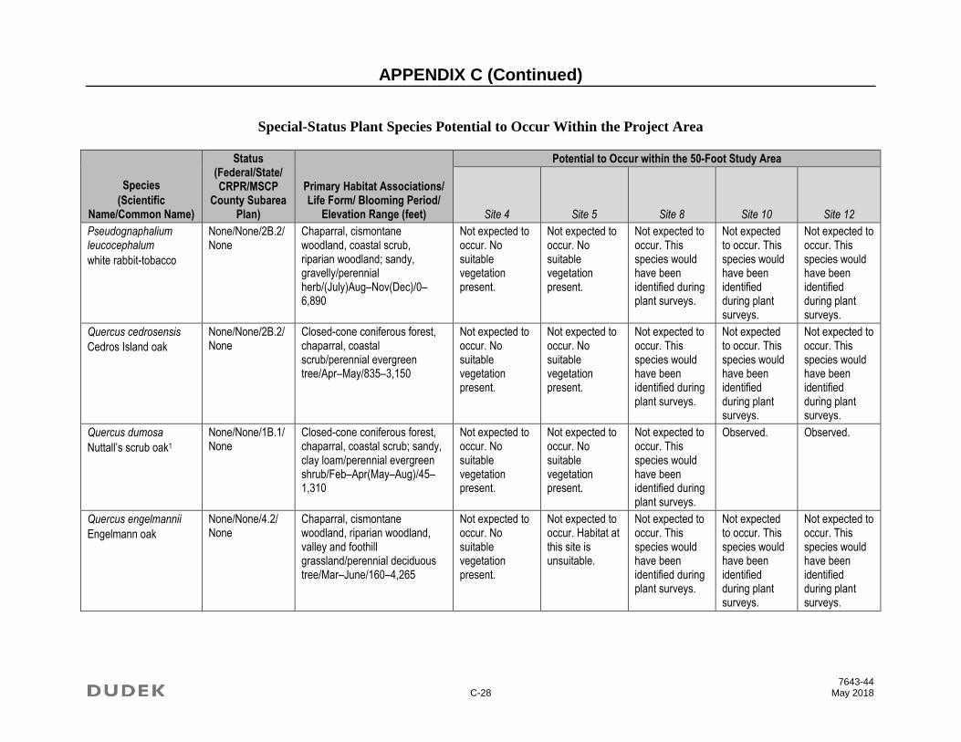
APPENDIX C (Continued)
7643-44 C-28 May 2018
Special-Status Plant Species Potential to Occur Within the Project Area
Species
(Scientific Name/Common Name)
Status (Federal/State/ CRPR/MSCP
County Subarea Plan)
Primary Habitat Associations/ Life Form/ Blooming Period/
Elevation Range (feet)
Potential to Occur within the 50-Foot Study Area
Site 4 Site 5 Site 8 Site 10 Site 12
Pseudognaphalium leucocephalum
white rabbit-tobacco
None/None/2B.2/None
Chaparral, cismontane woodland, coastal scrub, riparian woodland; sandy, gravelly/perennial herb/(July)Aug–Nov(Dec)/0–6,890
Not expected to occur. No suitable vegetation present.
Not expected to occur. No suitable vegetation present.
Not expected to occur. This species would have been identified during plant surveys.
Not expected to occur. This species would have been identified during plant surveys.
Not expected to occur. This species would have been identified during plant surveys.
Quercus cedrosensis
Cedros Island oak
None/None/2B.2/None
Closed-cone coniferous forest, chaparral, coastal scrub/perennial evergreen tree/Apr–May/835–3,150
Not expected to occur. No suitable vegetation present.
Not expected to occur. No suitable vegetation present.
Not expected to occur. This species would have been identified during plant surveys.
Not expected to occur. This species would have been identified during plant surveys.
Not expected to occur. This species would have been identified during plant surveys.
Quercus dumosa
Nuttall’s scrub oak1
None/None/1B.1/None
Closed-cone coniferous forest, chaparral, coastal scrub; sandy, clay loam/perennial evergreen shrub/Feb–Apr(May–Aug)/45–1,310
Not expected to occur. No suitable vegetation present.
Not expected to occur. No suitable vegetation present.
Not expected to occur. This species would have been identified during plant surveys.
Observed. Observed.
Quercus engelmannii
Engelmann oak
None/None/4.2/ None
Chaparral, cismontane woodland, riparian woodland, valley and foothill grassland/perennial deciduous tree/Mar–June/160–4,265
Not expected to occur. No suitable vegetation present.
Not expected to occur. Habitat at this site is unsuitable.
Not expected to occur. This species would have been identified during plant surveys.
Not expected to occur. This species would have been identified during plant surveys.
Not expected to occur. This species would have been identified during plant surveys.

APPENDIX C (Continued)
7643-44 C-29 May 2018
Special-Status Plant Species Potential to Occur Within the Project Area
Species
(Scientific Name/Common Name)
Status (Federal/State/ CRPR/MSCP
County Subarea Plan)
Primary Habitat Associations/ Life Form/ Blooming Period/
Elevation Range (feet)
Potential to Occur within the 50-Foot Study Area
Site 4 Site 5 Site 8 Site 10 Site 12
Ribes viburnifolium
Santa Catalina Island currant
None/None/1B.2/None
Chaparral, cismontane woodland/perennial evergreen shrub/Feb–Apr/95–1,150
Not expected to occur. No suitable vegetation present.
Low potential to occur. Habitat at this site is unsuitable.
Not expected to occur. This species would have been identified during plant surveys.
Not expected to occur. This species would have been identified during plant surveys.
Not expected to occur. This species would have been identified during plant surveys.
Romneya coulteri
Coulter’s matilija poppy
None/None/4.2/ None
Chaparral, coastal scrub; often in burns/perennial rhizomatous herb/Mar–July/65–3,935
Not expected to occur. No suitable vegetation present.
Not expected to occur. No suitable vegetation present.
Not expected to occur. This species would have been identified during plant surveys.
Not expected to occur. This species would have been identified during plant surveys.
Not expected to occur. This species would have been identified during plant surveys.
Rosa minutifolia
small-leaved rose
None/SE/2B.1/ Covered
Chaparral, coastal scrub/perennial deciduous shrub/Jan–June/490–525
Not expected to occur. No suitable vegetation present.
Not expected to occur. No suitable vegetation present.
Not expected to occur. This species would have been identified during plant surveys.
Not expected to occur. This species would have been identified during plant surveys.
Not expected to occur. This species would have been identified during plant surveys.
Salvia munzii
Munz’s sage1
None/None/2B.2/None
Chaparral, coastal scrub/perennial evergreen shrub/Feb–Apr/375–3,495
Not expected to occur. No suitable vegetation present.
Not expected to occur. No suitable vegetation present.
Not expected to occur. This species would have been identified during plant surveys.
Not expected to occur. This species would have been identified during plant surveys.
Not expected to occur. This species would have been identified during plant surveys.

APPENDIX C (Continued)
7643-44 C-30 May 2018
Special-Status Plant Species Potential to Occur Within the Project Area
Species
(Scientific Name/Common Name)
Status (Federal/State/ CRPR/MSCP
County Subarea Plan)
Primary Habitat Associations/ Life Form/ Blooming Period/
Elevation Range (feet)
Potential to Occur within the 50-Foot Study Area
Site 4 Site 5 Site 8 Site 10 Site 12
Selaginella cinerascens
ashy spike-moss1
None/None/4.1/ None
Chaparral, coastal scrub/perennial rhizomatous herb/65–2,100
Not expected to occur. No suitable vegetation present.
Not expected to occur. No suitable vegetation present.
Not expected to occur. This species would have been identified during plant surveys.
Not expected to occur. This species would have been identified during plant surveys.
Not expected to occur. This species would have been identified during plant surveys.
Senecio aphanactis
chaparral ragwort1
None/None/2B.2/None
Chaparral, cismontane woodland, coastal scrub; sometimes alkaline/annual herb/Jan–Apr(May)/45–2,625
Not expected to occur. No suitable vegetation present.
Low potential to occur. Habitat at this site is unsuitable.
Not expected to occur. This species would have been identified during plant surveys.
Not expected to occur. This species would have been identified during plant surveys.
Not expected to occur. This species would have been identified during plant surveys.
Sidalcea neomexicana
salt spring checkerbloom
None/None/2B.2/None
Chaparral, coastal scrub, lower montane coniferous forest, Mojavean desert scrub, playas; alkaline, mesic/perennial herb/Mar–June/45–5,020
Not expected to occur. No suitable vegetation present.
Not expected to occur. No suitable vegetation present.
Not expected to occur. This species would have been identified during plant surveys.
Not expected to occur. This species would have been identified during plant surveys.
Not expected to occur. This species would have been identified during plant surveys.
Sphaerocarpos drewei
bottle liverwort
None/None/1B.1/None
Chaparral, coastal scrub; openings, soil/ephemeral liverwort/295–1,970
Not expected to occur. No suitable vegetation present.
Not expected to occur. No suitable vegetation present.
Not expected to occur. This species would have been identified during plant surveys.
Not expected to occur. This species would have been identified during plant surveys.
Not expected to occur. This species would have been identified during plant surveys.

APPENDIX C (Continued)
7643-44 C-31 May 2018
Special-Status Plant Species Potential to Occur Within the Project Area
Species
(Scientific Name/Common Name)
Status (Federal/State/ CRPR/MSCP
County Subarea Plan)
Primary Habitat Associations/ Life Form/ Blooming Period/
Elevation Range (feet)
Potential to Occur within the 50-Foot Study Area
Site 4 Site 5 Site 8 Site 10 Site 12
Stemodia durantifolia
purple stemodia1
None/None/2B.1/None
Sonoran desert scrub (often mesic, sandy)/perennial herb/(Jan)Apr, June, Aug, Sep, Oct, Dec/590–985
Not expected to occur. No suitable vegetation present.
Stipa diegoensis
San Diego County needle grass1
None/None/4.2/ None
Chaparral, coastal scrub; rocky, often mesic/perennial herb/Feb–June/30–2,625
Not expected to occur. No suitable vegetation present.
Not expected to occur. No suitable vegetation present.
Not expected to occur. This species would have been identified during plant surveys.
Not expected to occur. This species would have been identified during plant surveys.
Not expected to occur. This species would have been identified during plant surveys.
Streptanthus bernardinus
Laguna Mountains jewelflower1
None/None/4.3/ None
Chaparral, lower montane coniferous forest/perennial herb/May–Aug/2,195–8,200
Not expected to occur. The site is outside of the species’ known elevation range.

APPENDIX C (Continued)
7643-44 C-32 May 2018
Special-Status Plant Species Potential to Occur Within the Project Area
Species
(Scientific Name/Common Name)
Status (Federal/State/ CRPR/MSCP
County Subarea Plan)
Primary Habitat Associations/ Life Form/ Blooming Period/
Elevation Range (feet)
Potential to Occur within the 50-Foot Study Area
Site 4 Site 5 Site 8 Site 10 Site 12
Stylocline citroleum
oil neststraw1
None/None/1B.1/None
Chenopod scrub, coastal scrub, valley and foothill grassland; clay/annual herb/Mar–Apr/160–1,310
Not expected to occur. No suitable vegetation present.
Not expected to occur. No suitable vegetation present.
Low potential to occur. There is one record for this species in the vicinity from 1883 which was mapped in the general vicinity of San Diego (CNDDB 2017). Based on the lack of other records for this species in the general vicinity, there is low potential for this species to occur on site.
Not expected to occur. This species would have been identified during plant surveys.
Not expected to occur. This species would have been identified during plant surveys.
Suaeda esteroa
estuary seablite1
None/None/1B.2/None
Marshes and swamps (coastal salt)/perennial herb/(May)July–Oct(Jan)/0–15
Not expected to occur. No suitable vegetation present.

APPENDIX C (Continued)
7643-44 C-33 May 2018
Special-Status Plant Species Potential to Occur Within the Project Area
Species
(Scientific Name/Common Name)
Status (Federal/State/ CRPR/MSCP
County Subarea Plan)
Primary Habitat Associations/ Life Form/ Blooming Period/
Elevation Range (feet)
Potential to Occur within the 50-Foot Study Area
Site 4 Site 5 Site 8 Site 10 Site 12
Suaeda taxifolia
woolly seablite
None/None/4.2/ None
Coastal bluff scrub, coastal dunes, marshes and swamps (margins of coastal salt)/perennial evergreen shrub/Jan–Dec/0–165
Not expected to occur. No suitable vegetation present.
Tetracoccus dioicus
Parry’s tetracoccus1
None/None/1B.2/Covered
Chaparral, coastal scrub/perennial deciduous shrub/Apr–May/540–3,280
Not expected to occur. No suitable vegetation present.
Not expected to occur. No suitable vegetation present.
Not expected to occur. This species would have been identified during plant surveys.
Not expected to occur. This species would have been identified during plant surveys.
Not expected to occur. This species would have been identified during plant surveys.
Texosporium sancti-jacobi
woven-spored lichen1
None/None/3/ None
Chaparral (openings); on soil, small mammal pellets, dead twigs, and on Selaginella spp./crustose lichen (terricolous)/195–2,165
Not expected to occur. No suitable vegetation present.
Not expected to occur. No suitable vegetation present.
Not expected to occur. This species would have been identified during plant surveys.
Not expected to occur. This species would have been identified during plant surveys.
Not expected to occur. This species would have been identified during plant surveys.
Tortula californica
California screw-moss
None/None/1B.2/None
Chenopod scrub, valley and foothill grassland; sandy, soil/moss/30–4,790
Not expected to occur. No suitable vegetation present.
Not expected to occur. No suitable vegetation present.
Not expected to occur. This species would have been identified during plant surveys.
Not expected to occur. This species would have been identified during plant surveys.
Not expected to occur. This species would have been identified during plant surveys.
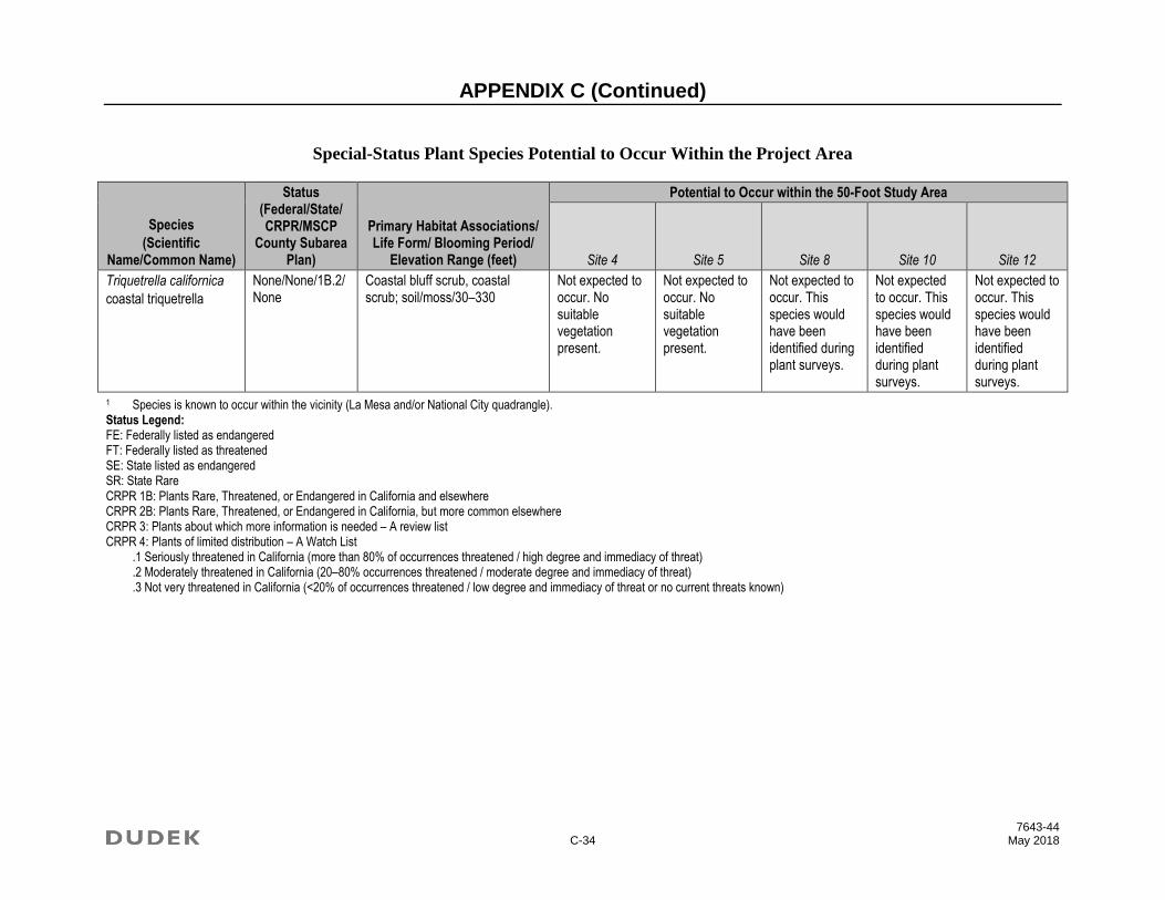
APPENDIX C (Continued)
7643-44 C-34 May 2018
Special-Status Plant Species Potential to Occur Within the Project Area
Species
(Scientific Name/Common Name)
Status (Federal/State/ CRPR/MSCP
County Subarea Plan)
Primary Habitat Associations/ Life Form/ Blooming Period/
Elevation Range (feet)
Potential to Occur within the 50-Foot Study Area
Site 4 Site 5 Site 8 Site 10 Site 12
Triquetrella californica
coastal triquetrella
None/None/1B.2/None
Coastal bluff scrub, coastal scrub; soil/moss/30–330
Not expected to occur. No suitable vegetation present.
Not expected to occur. No suitable vegetation present.
Not expected to occur. This species would have been identified during plant surveys.
Not expected to occur. This species would have been identified during plant surveys.
Not expected to occur. This species would have been identified during plant surveys.
1 Species is known to occur within the vicinity (La Mesa and/or National City quadrangle). Status Legend: FE: Federally listed as endangered FT: Federally listed as threatened SE: State listed as endangered SR: State Rare CRPR 1B: Plants Rare, Threatened, or Endangered in California and elsewhere CRPR 2B: Plants Rare, Threatened, or Endangered in California, but more common elsewhere CRPR 3: Plants about which more information is needed – A review list CRPR 4: Plants of limited distribution – A Watch List
.1 Seriously threatened in California (more than 80% of occurrences threatened / high degree and immediacy of threat)
.2 Moderately threatened in California (20–80% occurrences threatened / moderate degree and immediacy of threat)
.3 Not very threatened in California (<20% of occurrences threatened / low degree and immediacy of threat or no current threats known)
APPENDIX D Special-Status Wildlife Species Potentially
Occurring within the Project Study Area

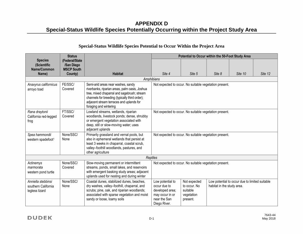
APPENDIX D Special-Status Wildlife Species Potentially Occurring within the Project Study Area
7643-44 D-1 May 2018
Special-Status Wildlife Species Potential to Occur Within the Project Area
Species
(Scientific Name/Common
Name)
Status (Federal/State
/San Diego MSCP South
County) Habitat
Potential to Occur within the 50-Foot Study Area
Site 4 Site 5 Site 8 Site 10 Site 12
Amphibians
Anaxyrus californicus
arroyo toad
FE/SSC/ Covered
Semi-arid areas near washes, sandy riverbanks, riparian areas, palm oasis, Joshua tree, mixed chaparral and sagebrush; stream channels for breeding (typically third order); adjacent stream terraces and uplands for foraging and wintering
Not expected to occur. No suitable vegetation present.
Rana draytonii
California red-legged frog
FT/SSC/ Covered
Lowland streams, wetlands, riparian woodlands, livestock ponds; dense, shrubby or emergent vegetation associated with deep, still or slow-moving water; uses adjacent uplands
Not expected to occur. No suitable vegetation present.
Spea hammondii
western spadefoot1
None/SSC/ None
Primarily grassland and vernal pools, but also in ephemeral wetlands that persist at least 3 weeks in chaparral, coastal scrub, valley–foothill woodlands, pastures, and other agriculture
Not expected to occur. No suitable vegetation present.
Reptiles
Actinemys marmorata
western pond turtle
None/SSC/ Covered
Slow-moving permanent or intermittent streams, ponds, small lakes, and reservoirs with emergent basking study areas; adjacent uplands used for nesting and during winter
Not expected to occur. No suitable vegetation present.
Anniella stebbinsi
southern California legless lizard
None/SSC/ None
Coastal dunes, stabilized dunes, beaches, dry washes, valley–foothill, chaparral, and scrubs; pine, oak, and riparian woodlands; associated with sparse vegetation and moist sandy or loose, loamy soils
Low potential to occur due to developed area; may occur in or near the San Diego River.
Not expected to occur. No suitable vegetation present.
Low potential to occur due to limited suitable habitat in the study area.

APPENDIX D (Continued)
7643-44 D-2 May 2018
Special-Status Wildlife Species Potential to Occur Within the Project Area
Species
(Scientific Name/Common
Name)
Status (Federal/State
/San Diego MSCP South
County) Habitat
Potential to Occur within the 50-Foot Study Area
Site 4 Site 5 Site 8 Site 10 Site 12
Arizona elegans occidentalis
California glossy snake1
None/SSC/ None
Commonly occurs in desert regions throughout Southern California; prefers open sandy areas with scattered brush; also found in rocky areas
Low potential to occur. There are no suitable open sandy areas within the study area.
Aspidoscelis hyperythra
orange-throated whiptail1
None/WL/ Covered
Low-elevation coastal scrub, chaparral, and valley–foothill hardwood
Not expected to occur. No suitable vegetation present.
Moderate potential to occur in shrub habitat.
Aspidoscelis tigris stejnegeri
San Diegan tiger whiptail1
None/SSC/ None
Hot and dry areas with sparse foliage, including chaparral, woodland, and riparian areas
Low potential to occur. No suitable vegetation present.
High potential to occur. This species is relatively common in San Diego County and in chaparral habitat.
Chelonia mydas
green sea turtle1
FT/None/ None
Shallow waters of lagoons, bays, estuaries, mangroves, eelgrass, and seaweed beds
Not expected to occur. No suitable habitat present.
Coluber fuliginosus
Baja California coachwhip1
None/SSC/ None
In California, restricted to southern San Diego County, where it is known from grassland and coastal sage scrub; open areas in grassland and coastal sage scrub
Not expected to occur. This species’ range is farther south along the Mexico border.
Crotalus ruber
red diamondback rattlesnake1
None/SSC/ None
Coastal scrub, chaparral, oak and pine woodlands, rocky grasslands, cultivated areas, and desert flats
Not expected to occur. No suitable vegetation present.
Low potential to occur. There are limited suitable rocky areas within the study area.
Low potential to occur. There are limited suitable rocky areas within the study area.
Diadophis punctatus similis
San Diego ringneck snake
None/None/ None
Moist habitats, including wet meadows, rocky hillsides, gardens, farmland grassland, chaparral, mixed-conifer forest, and woodland habitats
Not expected to occur. No suitable meadow or moist habitat areas present.
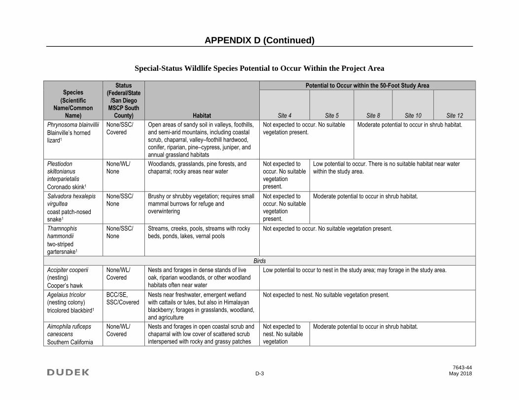
APPENDIX D (Continued)
7643-44 D-3 May 2018
Special-Status Wildlife Species Potential to Occur Within the Project Area
Species
(Scientific Name/Common
Name)
Status (Federal/State
/San Diego MSCP South
County) Habitat
Potential to Occur within the 50-Foot Study Area
Site 4 Site 5 Site 8 Site 10 Site 12
Phrynosoma blainvillii
Blainville’s horned lizard1
None/SSC/ Covered
Open areas of sandy soil in valleys, foothills, and semi-arid mountains, including coastal scrub, chaparral, valley–foothill hardwood, conifer, riparian, pine–cypress, juniper, and annual grassland habitats
Not expected to occur. No suitable vegetation present.
Moderate potential to occur in shrub habitat.
Plestiodon skiltonianus interparietalis
Coronado skink1
None/WL/ None
Woodlands, grasslands, pine forests, and chaparral; rocky areas near water
Not expected to occur. No suitable vegetation present.
Low potential to occur. There is no suitable habitat near water within the study area.
Salvadora hexalepis virgultea
coast patch-nosed snake1
None/SSC/ None
Brushy or shrubby vegetation; requires small mammal burrows for refuge and overwintering
Not expected to occur. No suitable vegetation present.
Moderate potential to occur in shrub habitat.
Thamnophis hammondii
two-striped gartersnake1
None/SSC/ None
Streams, creeks, pools, streams with rocky beds, ponds, lakes, vernal pools
Not expected to occur. No suitable vegetation present.
Birds
Accipiter cooperii (nesting)
Cooper’s hawk
None/WL/ Covered
Nests and forages in dense stands of live oak, riparian woodlands, or other woodland habitats often near water
Low potential to occur to nest in the study area; may forage in the study area.
Agelaius tricolor (nesting colony)
tricolored blackbird1
BCC/SE, SSC/Covered
Nests near freshwater, emergent wetland with cattails or tules, but also in Himalayan blackberry; forages in grasslands, woodland, and agriculture
Not expected to nest. No suitable vegetation present.
Aimophila ruficeps canescens
Southern California
None/WL/ Covered
Nests and forages in open coastal scrub and chaparral with low cover of scattered scrub interspersed with rocky and grassy patches
Not expected to nest. No suitable vegetation
Moderate potential to occur in shrub habitat.
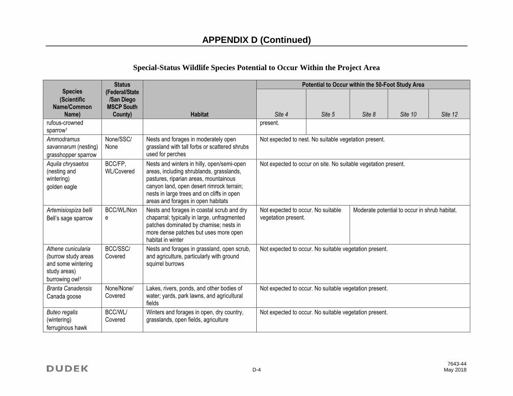
APPENDIX D (Continued)
7643-44 D-4 May 2018
Special-Status Wildlife Species Potential to Occur Within the Project Area
Species
(Scientific Name/Common
Name)
Status (Federal/State
/San Diego MSCP South
County) Habitat
Potential to Occur within the 50-Foot Study Area
Site 4 Site 5 Site 8 Site 10 Site 12
rufous-crowned sparrow1
present.
Ammodramus savannarum (nesting)
grasshopper sparrow
None/SSC/ None
Nests and forages in moderately open grassland with tall forbs or scattered shrubs used for perches
Not expected to nest. No suitable vegetation present.
Aquila chrysaetos (nesting and wintering)
golden eagle
BCC/FP, WL/Covered
Nests and winters in hilly, open/semi-open areas, including shrublands, grasslands, pastures, riparian areas, mountainous canyon land, open desert rimrock terrain; nests in large trees and on cliffs in open areas and forages in open habitats
Not expected to occur on site. No suitable vegetation present.
Artemisiospiza belli
Bell’s sage sparrow
BCC/WL/None
Nests and forages in coastal scrub and dry chaparral; typically in large, unfragmented patches dominated by chamise; nests in more dense patches but uses more open habitat in winter
Not expected to occur. No suitable vegetation present.
Moderate potential to occur in shrub habitat.
Athene cunicularia (burrow study areas and some wintering study areas)
burrowing owl1
BCC/SSC/ Covered
Nests and forages in grassland, open scrub, and agriculture, particularly with ground squirrel burrows
Not expected to occur. No suitable vegetation present.
Branta Canadensis
Canada goose
None/None/ Covered
Lakes, rivers, ponds, and other bodies of water; yards, park lawns, and agricultural fields
Not expected to occur. No suitable vegetation present.
Buteo regalis (wintering)
ferruginous hawk
BCC/WL/ Covered
Winters and forages in open, dry country, grasslands, open fields, agriculture
Not expected to occur. No suitable vegetation present.

APPENDIX D (Continued)
7643-44 D-5 May 2018
Special-Status Wildlife Species Potential to Occur Within the Project Area
Species
(Scientific Name/Common
Name)
Status (Federal/State
/San Diego MSCP South
County) Habitat
Potential to Occur within the 50-Foot Study Area
Site 4 Site 5 Site 8 Site 10 Site 12
Buteo swainsoni (nesting)
Swainson’s hawk1
BCC/ST/ Covered
Nests in open woodland and savanna, riparian, and in isolated large trees; forages in nearby grasslands and agricultural areas such as wheat and alfalfa fields and pasture
Not expected to nest. No suitable vegetation present.
Campylorhynchus brunneicapillus sandiegensis (San Diego and Orange Counties only)
coastal cactus wren1
BCC/SSC/ Covered
Southern cactus scrub patches Not expected to occur. No suitable vegetation present.
Charadrius alexandrinus nivosus (nesting)
western snowy plover1
FT, BCC/SSC/ Covered
On coasts nests on sandy marine and estuarine shores; in the interior, nests on sandy, barren or sparsely vegetated flats near saline or alkaline lakes, reservoirs, and ponds
Not expected to occur. No suitable vegetation present.
Charadrius montanus (wintering)
mountain plover
BCC/SSC/ Covered
Winters in shortgrass prairies, plowed fields, open sagebrush, and sandy deserts
Not expected to occur. No suitable vegetation present.
Circus hudsonius (nesting)
northern harrier
None/SSC/ Covered
Nests in open wetlands (marshy meadows; wet, lightly grazed pastures; old fields; freshwater and brackish marshes); also in drier habitats (grassland and grain fields); forages in grassland, scrubs, rangelands, emergent wetlands, and other open habitats
Not expected to nest. No suitable nesting habitat present. May forage within the study area.
Coccyzus americanus occidentalis (nesting)
western yellow-billed cuckoo1
FT, BCC/SE/None
Nests in dense, wide riparian woodlands and forest with well-developed understories
Not expected to nest. No suitable vegetation present within the study area.
Not expected to nest. No suitable vegetation present.

APPENDIX D (Continued)
7643-44 D-6 May 2018
Special-Status Wildlife Species Potential to Occur Within the Project Area
Species
(Scientific Name/Common
Name)
Status (Federal/State
/San Diego MSCP South
County) Habitat
Potential to Occur within the 50-Foot Study Area
Site 4 Site 5 Site 8 Site 10 Site 12
Riparian vegetation is present in the San Diego River north of the study area.
Egretta rufescens
reddish egret
None/None/ Covered
Freshwater marsh with emergent vegetation; in the Central Valley primarily nests and forages in rice fields and other flooded agricultural fields with weeds and other residual aquatic vegetation
Not expected to occur. No suitable vegetation present.
Elanus leucurus (nesting)
white-tailed kite
None/FP/ None
Nests in woodland, riparian, and individual trees near open lands; forages opportunistically in grassland, meadows, scrubs, agriculture, emergent wetland, savanna, and disturbed lands
Not expected to nest. No suitable vegetation present within the study area. Riparian vegetation is present in the San Diego River north of the study area.
Not expected to nest within the study area; may forage in the study area.
Empidonax traillii extimus (nesting)
southwestern willow flycatcher
FE/SE/ Covered
Nests in dense riparian habitats along streams, reservoirs, or wetlands; uses variety of riparian and shrubland habitats during migration
Not expected to nest. No suitable vegetation present within the study area. Riparian vegetation is present in the
Not expected to nest within the study area; may forage in the study area.

APPENDIX D (Continued)
7643-44 D-7 May 2018
Special-Status Wildlife Species Potential to Occur Within the Project Area
Species
(Scientific Name/Common
Name)
Status (Federal/State
/San Diego MSCP South
County) Habitat
Potential to Occur within the 50-Foot Study Area
Site 4 Site 5 Site 8 Site 10 Site 12
San Diego River north of the study area.
Eremophila alpestris actia
California horned lark
None/WL/ None
Nests and forages in grasslands, disturbed lands, agriculture, and beaches; nests in alpine fell fields of the Sierra Nevada
Not expected to occur. No suitable vegetation present.
Falco mexicanus (nesting)
prairie falcon1
BCC/WL/None
Forages in grassland, savanna, rangeland, agriculture, desert scrub, alpine meadows; nest on cliffs or bluffs
Not expected to nest. No suitable vegetation present.
Falco peregrinus anatum (nesting)
American peregrine falcon
FDL, BCC/SDL, FP/Covered
Nests on cliffs, buildings, and bridges; forages in wetlands, riparian, meadows, croplands, especially where waterfowl are present
Not expected to nest. No suitable vegetation or habitat present.
Haliaeetus leucocephalus (nesting and wintering)
bald eagle
FDL, BCC/SE, FP/Covered
Nests in forested areas adjacent to large bodies of water, including seacoasts, rivers, swamps, large lakes; winters near large bodies of water in lowlands and mountains
Not expected to nest. No suitable vegetation present.
Icteria virens (nesting)
yellow-breasted chat
None/SSC/ None
Nests and forages in dense, relatively wide riparian woodlands and thickets of willows, vine tangles, and dense brush
Not expected to nest. No suitable vegetation present within the study area. Riparian vegetation is present in the San Diego River north of the study area.
Not expected to nest. There is no suitable wide riparian woodland habitat within the study area.

APPENDIX D (Continued)
7643-44 D-8 May 2018
Special-Status Wildlife Species Potential to Occur Within the Project Area
Species
(Scientific Name/Common
Name)
Status (Federal/State
/San Diego MSCP South
County) Habitat
Potential to Occur within the 50-Foot Study Area
Site 4 Site 5 Site 8 Site 10 Site 12
Ixobrychus exilis (nesting)
least bittern1
BCC/SSC/ None
Nests in freshwater and brackish marshes with dense, tall growth of aquatic and semi-aquatic vegetation
Not expected to nest. No suitable vegetation present.
Laterallus jamaicensis coturniculus
California black rail1
BCC/ST, FP/None
Tidal marshes, shallow freshwater margins, wet meadows, and flooded grassy vegetation; suitable habitats are often supplied by canal leakage in Sierra Nevada foothill populations
Not expected to occur. No suitable vegetation present.
Numenius americanus (nesting)
long-billed curlew
BCC/WL/ Covered
Nests in grazed, mixed grass, and short-grass prairies; localized nesting along the California coast; winters and forages in coastal estuaries, mudflats, open grassland, and cropland
Not expected to occur. No suitable vegetation present.
Pandion haliaetus (nesting)
osprey
None/WL/ None
Large waters (lakes, reservoirs, rivers) supporting fish; usually near forest habitats, but widely observed along the coast
Not expected to nest. No suitable vegetation present.
Passerculus sandwichensis beldingi
Belding’s savannah sparrow1
None/SE/ Covered
Nests and forages in coastal saltmarsh dominated by pickleweed (Salicornia spp.)
Not expected to occur. No suitable vegetation present.
Passerculus sandwichensis rostratus (wintering)
large-billed savannah sparrow
None/SSC/ Covered
Nests and forages in open, low saltmarsh vegetation, including low halophytic scrub
Not expected to occur. No suitable vegetation present.
Pelecanus occidentalis californicus (nesting
FDL/SDL, FP/Covered
Forages in warm coastal marine and estuarine environments; in California, nests on dry, rocky offshore islands
Not expected to nest. No suitable vegetation present.

APPENDIX D (Continued)
7643-44 D-9 May 2018
Special-Status Wildlife Species Potential to Occur Within the Project Area
Species
(Scientific Name/Common
Name)
Status (Federal/State
/San Diego MSCP South
County) Habitat
Potential to Occur within the 50-Foot Study Area
Site 4 Site 5 Site 8 Site 10 Site 12
colonies and communal roosts)
California brown pelican
Phalacrocorax auritus (nesting colony)
double-crested cormorant
None/WL/ None
Nests in riparian trees near ponds, lakes, artificial impoundments, slow-moving rivers, lagoons, estuaries, and open coastlines; winter habitat includes lakes, rivers, and coastal areas
Not expected to occur. No suitable vegetation present.
Plegadis chihi (nesting colony)
white-faced ibis
None/WL/ Covered
Nests in shallow marshes with areas of emergent vegetation; winter foraging in shallow lacustrine waters, flooded agricultural fields, muddy ground of wet meadows, marshes, ponds, lakes, rivers, flooded fields, and estuaries
Not expected to nest. The study area is outside of the species’ known geographic range and there is no suitable vegetation present.
Polioptila californica
coastal California gnatcatcher1
FT/SSC/ Covered
Nests and forages in various sage scrub communities, often dominated by coastal sagebrush and buckwheat; generally avoids nesting in areas with a slope of greater than 40%; majority of nesting at less than 1,000 feet above mean sea level
Not expected to occur in the study area. No suitable vegetation present.
Moderate potential to occur within the study area. There is coastal sage scrub in the northern portion of the study area; however, it is surrounded
Moderate potential to occur within the study area. There is coastal sage scrub in the study area; however, it is surrounded by development, disturbed habitat and scrub oak
Moderate potential to occur within the study area. There is coastal sage scrub in the study area; however, it is surrounded by development, disturbed habitat, eucalyptus woodland,

APPENDIX D (Continued)
7643-44 D-10 May 2018
Special-Status Wildlife Species Potential to Occur Within the Project Area
Species
(Scientific Name/Common
Name)
Status (Federal/State
/San Diego MSCP South
County) Habitat
Potential to Occur within the 50-Foot Study Area
Site 4 Site 5 Site 8 Site 10 Site 12
by development, disturbed habitat and eucalyptus woodland. Habitat in the canyon is primarily scrub oak, which is too dense for California gnatcatcher. No California gnatcatchers have been recorded in this canyon (CNDDB 2017; USFWS 2017).
woodland. Habitat in the area includes coastal sage scrub (including disturbed). No California gnatcatchers have been recorded in the surrounding undeveloped land (CNDDB 2017; USFWS 2017).
and scrub oak woodland. Habitat in the canyon includes both disturbed coastal sage scrub and scrub oak. No California gnatcatchers have been recorded in this canyon (CNDDB 2017; USFWS 2017).
Rallus obsoletus levipes
Ridgway’s rail1
FE/SE, FP/Covered
Coastal wetlands, brackish areas, coastal saline emergent wetlands
Not expected to occur. No suitable vegetation present.
Setophaga petechia (nesting)
yellow warbler1
BCC/SSC/ None
Nests and forages in riparian and oak woodlands, montane chaparral, open ponderosa pine, and mixed-conifer habitats
Not expected to nest. No suitable vegetation present.

APPENDIX D (Continued)
7643-44 D-11 May 2018
Special-Status Wildlife Species Potential to Occur Within the Project Area
Species
(Scientific Name/Common
Name)
Status (Federal/State
/San Diego MSCP South
County) Habitat
Potential to Occur within the 50-Foot Study Area
Site 4 Site 5 Site 8 Site 10 Site 12
Sialia mexicana
western bluebird
None/None/ Covered
Nests in old-growth red fir, mixed-conifer, and lodegpole pine habitats near wet meadows used for foraging
Not expected to occur. No suitable vegetation present.
Sternula antillarum browni (nesting colony)
California least tern1
FE/SE, FP/Covered
Forages in shallow estuaries and lagoons; nests on sandy beaches or exposed tidal flats
Not expected to nest. No suitable vegetation present.
Thalasseus elegans (nesting colony)
elegant tern
None/WL/ Covered
Inshore coastal waters, bays, estuaries, and harbors; forages over open water
Not expected to nest. No suitable vegetation present.
Vireo bellii pusillus (nesting)
least Bell’s vireo1
FE/SE/ Covered
Nests and forages in low, dense riparian thickets along water or along dry parts of intermittent streams; forages in riparian and adjacent shrubland late in nesting season
Not expected to nest. No suitable vegetation present within the study area. Riparian vegetation is present in the San Diego River north of the study area.
Not expected to occur. No suitable vegetation present.
Mammals
Antrozous pallidus
pallid bat1
None/SSC/ None
Grasslands, shrublands, woodlands, forests; most common in open, dry habitats with rocky outcrops for roosting, but also roosts in artificial structures and trees
Low potential to roost; potential to forage throughout area.

APPENDIX D (Continued)
7643-44 D-12 May 2018
Special-Status Wildlife Species Potential to Occur Within the Project Area
Species
(Scientific Name/Common
Name)
Status (Federal/State
/San Diego MSCP South
County) Habitat
Potential to Occur within the 50-Foot Study Area
Site 4 Site 5 Site 8 Site 10 Site 12
Chaetodipus californicus femoralis
Dulzura pocket mouse1
None/SSC/ None
Open habitat, coastal scrub, chaparral, oak woodland, chamise chaparral, mixed-conifer habitats; disturbance specialist; 0 to 3,000 feet above mean sea level
Not expected to occur. No suitable vegetation present.
Moderate potential to occur in shrub habitat within the study area.
Chaetodipus fallax
northwestern San Diego pocket mouse1
None/SSC/ None
Coastal scrub, mixed chaparral, sagebrush, desert wash, desert scrub, desert succulent shrub, pinyon–juniper, and annual grassland
Not expected to occur. No suitable vegetation present.
Moderate potential to occur in shrub habitat within the study area.
Choeronycteris mexicana
Mexican long-tongued bat1
None/SSC/ None
Desert and montane riparian, desert succulent scrub, desert scrub, and pinyon–juniper woodland; roosts in caves, mines, and buildings
Not expected to occur. No suitable vegetation present.
Corynorhinus townsendii
Townsend’s big-eared bat
None/SSC/ None
Mesic habitats characterized by coniferous and deciduous forests and riparian habitat, but also xeric areas; roosts in limestone caves and lava tubes, built structures, and tunnels
Low potential to roost; potential to forage throughout area.
Euderma maculatum
spotted bat
None/SSC/ None
Foothills, mountains, desert regions of Southern California, including arid deserts, grasslands, and mixed-conifer forests; roosts in rock crevices and cliffs; feeds over water and along washes
Low potential to roost; potential to forage throughout area.
Eumops perotis californicus
western mastiff bat1
None/SSC/ None
Chaparral, coastal and desert scrub, coniferous and deciduous forest and woodland; roosts in crevices in rocky canyons and cliffs where the canyon or cliff is vertical or nearly vertical, trees, and tunnels
Low potential to roost; potential to forage throughout area.
Lasionycteris noctivagans
silver-haired bat
None/None/ None
Old-growth forest, maternity roosts in trees, large snags 50 feet aboveground; hibernates in hollow trees, rock crevices, buildings, mines, caves, and under sloughing bark;
Low potential to roost; potential to forage throughout area.

APPENDIX D (Continued)
7643-44 D-13 May 2018
Special-Status Wildlife Species Potential to Occur Within the Project Area
Species
(Scientific Name/Common
Name)
Status (Federal/State
/San Diego MSCP South
County) Habitat
Potential to Occur within the 50-Foot Study Area
Site 4 Site 5 Site 8 Site 10 Site 12
forages in or near coniferous or mixed deciduous forest, stream or river drainages
Lasiurus blossevillii
western red bat1
None/SSC/ None
Forest, woodland, riparian, mesquite bosque, and orchards, including fig, apricot, peach, pear, almond, walnut, and orange; roosts in tree canopy
Low potential to roost; potential to forage throughout area.
Lasiurus cinereus
hoary bat1
None/None/ None
Forest, woodland riparian, and wetland habitats; also juniper scrub, riparian forest, and desert scrub in arid areas; roosts in tree foliage and sometimes cavities, such as woodpecker holes
Low potential to roost; potential to forage throughout area.
Lasiurus xanthinus
western yellow bat1
None/SSC/ None
Valley–foothill riparian, desert riparian, desert wash, and palm oasis habitats; below 2,000 feet above mean sea level; roosts in riparian areas and palms
Not expected to occur. No suitable vegetation present.
Lepus californicus bennettii
San Diego black-tailed jackrabbit1
None/SSC/ None
Arid habitats with open ground; grasslands, coastal scrub, agriculture, disturbed areas, and rangelands
Not expected to occur. No suitable vegetation present.
Low potential to occur. The study area is likely too urbanized for this species.
Myotis ciliolabrum
western small-footed myotis
None/None/ None
Arid woodlands and shrublands, but near water; roosts in caves, crevices, mines, abandoned buildings
Low potential to roost; potential to forage throughout area.
Myotis evotis
long-eared myotis
None/None/ None
Brush, woodland, and forest habitats from sea level to 9,000 feet above mean sea level; prefers coniferous habitats; forages along habitat edges, in open habitats, and over water; roosts in buildings, crevices, under bark, and snags; uses caves as night roosts
Low potential to roost; potential to forage throughout area.
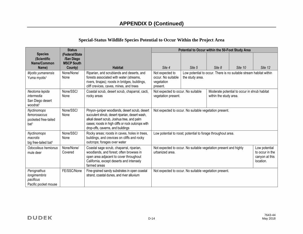
APPENDIX D (Continued)
7643-44 D-14 May 2018
Special-Status Wildlife Species Potential to Occur Within the Project Area
Species
(Scientific Name/Common
Name)
Status (Federal/State
/San Diego MSCP South
County) Habitat
Potential to Occur within the 50-Foot Study Area
Site 4 Site 5 Site 8 Site 10 Site 12
Myotis yumanensis
Yuma myotis1
None/None/ None
Riparian, arid scrublands and deserts, and forests associated with water (streams, rivers, tinajas); roosts in bridges, buildings, cliff crevices, caves, mines, and trees
Not expected to occur. No suitable vegetation present.
Low potential to occur. There is no suitable stream habitat within the study area.
Neotoma lepida intermedia
San Diego desert woodrat1
None/SSC/ None
Coastal scrub, desert scrub, chaparral, cacti, rocky areas
Not expected to occur. No suitable vegetation present.
Moderate potential to occur in shrub habitat within the study area.
Nyctinomops femorosaccus
pocketed free-tailed bat1
None/SSC/ None
Pinyon–juniper woodlands, desert scrub, desert succulent shrub, desert riparian, desert wash, alkali desert scrub, Joshua tree, and palm oases; roosts in high cliffs or rock outcrops with drop-offs, caverns, and buildings
Not expected to occur. No suitable vegetation present.
Nyctinomops macrotis
big free-tailed bat1
None/SSC/ None
Rocky areas; roosts in caves, holes in trees, buildings, and crevices on cliffs and rocky outcrops; forages over water
Low potential to roost; potential to forage throughout area.
Odocoileus hemionus
mule deer
None/None/ Covered
Coastal sage scrub, chaparral, riparian, woodlands, and forest; often browses in open area adjacent to cover throughout California, except deserts and intensely farmed areas
Not expected to occur. No suitable vegetation present and highly urbanized area.
Low potential to occur in the canyon at this location.
Perognathus longimembris pacificus
Pacific pocket mouse
FE/SSC/None Fine-grained sandy substrates in open coastal strand, coastal dunes, and river alluvium
Not expected to occur. No suitable vegetation present.
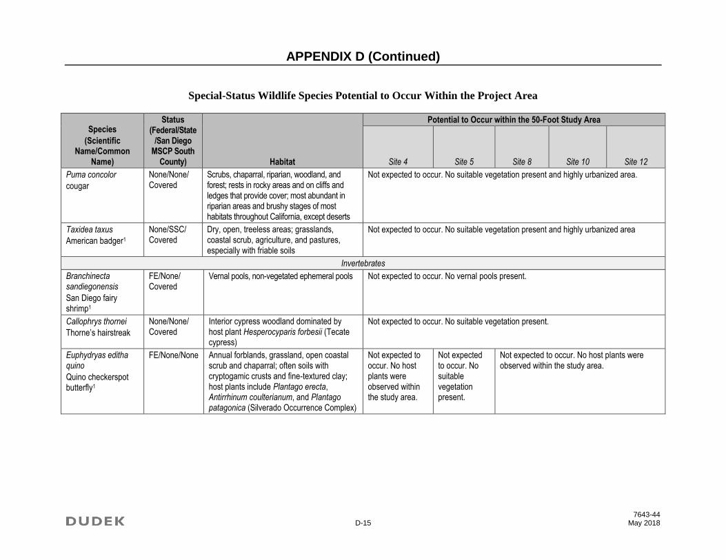
APPENDIX D (Continued)
7643-44 D-15 May 2018
Special-Status Wildlife Species Potential to Occur Within the Project Area
Species
(Scientific Name/Common
Name)
Status (Federal/State
/San Diego MSCP South
County) Habitat
Potential to Occur within the 50-Foot Study Area
Site 4 Site 5 Site 8 Site 10 Site 12
Puma concolor
cougar
None/None/ Covered
Scrubs, chaparral, riparian, woodland, and forest; rests in rocky areas and on cliffs and ledges that provide cover; most abundant in riparian areas and brushy stages of most habitats throughout California, except deserts
Not expected to occur. No suitable vegetation present and highly urbanized area.
Taxidea taxus
American badger1
None/SSC/ Covered
Dry, open, treeless areas; grasslands, coastal scrub, agriculture, and pastures, especially with friable soils
Not expected to occur. No suitable vegetation present and highly urbanized area
Invertebrates
Branchinecta sandiegonensis
San Diego fairy shrimp1
FE/None/ Covered
Vernal pools, non-vegetated ephemeral pools Not expected to occur. No vernal pools present.
Callophrys thornei
Thorne’s hairstreak
None/None/ Covered
Interior cypress woodland dominated by host plant Hesperocyparis forbesii (Tecate cypress)
Not expected to occur. No suitable vegetation present.
Euphydryas editha quino
Quino checkerspot butterfly1
FE/None/None Annual forblands, grassland, open coastal scrub and chaparral; often soils with cryptogamic crusts and fine-textured clay; host plants include Plantago erecta, Antirrhinum coulterianum, and Plantago patagonica (Silverado Occurrence Complex)
Not expected to occur. No host plants were observed within the study area.
Not expected to occur. No suitable vegetation present.
Not expected to occur. No host plants were observed within the study area.
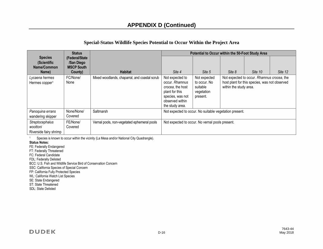
APPENDIX D (Continued)
7643-44 D-16 May 2018
Special-Status Wildlife Species Potential to Occur Within the Project Area
Species
(Scientific Name/Common
Name)
Status (Federal/State
/San Diego MSCP South
County) Habitat
Potential to Occur within the 50-Foot Study Area
Site 4 Site 5 Site 8 Site 10 Site 12
Lycaena hermes
Hermes copper1
FC/None/ None
Mixed woodlands, chaparral, and coastal scrub Not expected to occur. Rhamnus crocea, the host plant for this species, was not observed within the study area.
Not expected to occur. No suitable vegetation present.
Not expected to occur. Rhamnus crocea, the host plant for this species, was not observed within the study area.
Panoquina errans
wandering skipper
None/None/ Covered
Saltmarsh Not expected to occur. No suitable vegetation present.
Streptocephalus woottoni
Riverside fairy shrimp
FE/None/ Covered
Vernal pools, non-vegetated ephemeral pools Not expected to occur. No vernal pools present.
1 Species is known to occur within the vicinity (La Mesa and/or National City Quadrangle). Status Notes: FE: Federally Endangered FT: Federally Threatened FC: Federal Candidate FDL: Federally Delisted BCC: U.S. Fish and Wildlife Service Bird of Conservation Concern SSC: California Species of Special Concern FP: California Fully Protected Species WL: California Watch List Species SE: State Endangered ST: State Threatened SDL: State Delisted

APPENDIX E Resumes


DUDEK Page 1 of 10
EDUCATION
California Polytechnic State University, San Luis Obispo BS, Environmental Management and Protection/Minor in GIS, Cum Laude, 2006
CERTIFICATIONS
USFWS Federal 10a Survey Permit No. TE-36118B-1
- Quino Checkerspot Butterfly Surveys
- Casey’s June Beetle
CDFW Plant Voucher Collecting Permit No. 2081(a)-15-108-V
PROFESSIONAL AFFILIATIONS
The Western Section of the Wildlife Society, Southern California Chapter, Vice President
(2015–Present)
Callie Amoaku Senior Biologist/Project Manager
Callie Amoaku is a biologist with over 11 years' professional
experience as an environmental analyst specializing in field
surveys and report preparation. Mrs. Amoaku is committed to
professional management of environmental resources, including
land conservation. As a biologist with Dudek, she has coordinated
large survey efforts; and research and prepared biological
sections for environmental impact reports (EIRs), biological
technical reports (BTRs), and focused survey reports. She has also
performed wildlife and plant surveys, vegetation mapping, and
jurisdictional delineations throughout Southern California.
Project Experience
Development Ivanhoe Ranch, Pv Ivanhoe LLC, El Cajon, California.
Currently serves as project manager for the biology-related
tasks. Conducted vegetation mapping, habitat assessment and
host plant mapping for Quino checkerspot butterfly (Euphydryas editha quino) and Hermes copper
(Lycaena hermes) butterfly, conducted focused protocol surveys for Quino checkerspot butterfly and
Hermes copper butterfly, and conducted habitat assessment and focused protocol surveys for burrowing
owl (Athene cunicularia) and least Bell's vireo (Vireo bellii pusillus). Prepared a biological analysis letter
report for the Major Project Pre-Application package; attends County of San Diego meetings; assists client
with mitigation planning.
Camelot, The Camelot Project Owner LLC, San Diego County, California. As project assistant,
conducted a formal wetlands jurisdictional delineation and mapped wetlands and stream channels.
Conducted general biological reconnaissance surveys throughout the 67-acre site. Several special-status
species were mapped, including white-tailed kite (Elanus leucurus), northern harrier (Circus cyaneus),
loggerhead shrike (Lanius ludovicianus), and California adolphia (Adolphia californica).
West Oaks Due Diligence, Carlsbad West Oaks Project Owner LLC, San Diego County, California.
Conducted a formal wetland delineation and vegetation mapping for a 12.5-acre project site in Carlsbad.
Estero Trail, County of Sonoma, California. Conducted a formal wetland delineation in Sonoma County for a
proposed residential project. Mapped a variety of wetland meadow habitats, including Carex obnupta
Herbaceous Alliance, Juncus (balticus, mexicanus) Herbaceous Alliance, and Salix lasiolepis Shrubland Alliance.
Silveira Property, Marin County, California. Conducted a formal wetland delineation in Marin County.
Mapped a variety of seasonal wetlands, an estuarine wetland, and isolated wetlands.
Borrego Springs Gildred Site, The Gildred Companies, San Diego County, California. Conducted
field work for this project (vegetation mapping and formal jurisdictional delineation); prepared BTR per the
County of San Diego's guidelines. Responded to public comments on the biology section of the EIR.
Bonita Glen Drive Project Studies, Silvergate Development, Chula Vista, California. As project
manager, prepared a BTR in accordance with the City of Chula Vista's Subarea Plan and manages other
CALLIE AMOAKU – CONTINUED
DUDEK Page 2 of 10
technical studies supporting the Mitigated Negative Declaration (MND). Assists client with City
coordination and mitigation planning.
Grapevine Project, Tejon Ranch, Kern County, California. Served as project task manager and field
lead to conduct least Bell’s vireo, special-status mammals, wildlife camera studies, bat surveys, and habitat
assessments for a variety of federally and state-listed wildlife species. Served as project task manager and
field lead to conduct a formal wetlands jurisdictional delineation and mapped wetlands and waters in
accordance with regulations and guidance from the U.S. Army Corps of Engineers (ACOE), Regional Water
Quality Control Board (RWQCB), and California Department of Fish and Wildlife (CDFW). The jurisdictional
delineation and determination included extensive literature review of historic aerials and topographic
maps, the National Hydrography Dataset, and the National Wetlands Inventory; field surveying a 15,315-
acre study area; and delineating approximately 130 acres of potentially jurisdictional features. Also
performed vegetation mapping, rare plant surveys, and habitat assessments for a variety of federally and
state-listed wildlife species. Ongoing duties include preparation of a detailed BTR and 20 associated
reports and appendices, data management and review, and project management.
Grandview Street Project, Axelson and Corn, San Diego County, California. As project manager,
coordinated wildlife surveys, prepared the BTR, and assisted the client with additional regulatory issues.
Tejon Mountain Village, Kern County, California. As project assistant and biologist, performed surveys for
special-status plants, including population counts and mapping with Global Positioning System (GPS) units on the
28,000-acre project site. Assisted in preparation of the biological resources report for California Environmental
Quality Act (CEQA) documentation, including wildlife species, and portions of the draft EIR.
Proctor Valley Village 14 and Preserve, Jackson Pendo Development, San Diego County, California.
Assisted in the jurisdictional delineation; rare plant surveys, including mapping of the federally threatened
and state-endangered Otay tarplant (Deinandra conjugens); habitat mapping and focused Hermes copper
butterfly surveys; and preparation of the BTR in accordance with the County of San Diego guidelines.
Newhall Biological and Environmental Documentation, Newhall Land and Farming Company,
Santa Clarita, California. As project assistant, assisted in writing numerous BTRs and biological sections of
EIRs with detailed information about special-status wildlife species. Assisted in preparing the
Comprehensive Mitigation Implementation Plan, which consisted of organizing multiple data sets and
mitigation measures. Coordinated and performed biological surveys for spineflower (Chorizanthe), a state-
endangered and sensitive plant species, which included population counts and using GPS coordinates to
locate the boundaries of the populations. Also performed biological monitoring of known spineflower
populations, including population counts and point-intercept transects, and performed vegetation
mapping for multiple vegetation classes.
Newland Sierra, San Diego, California. As field biologist, conducted vegetation mapping, a jurisdictional
wetlands delineation, and focused rare plant surveys. Assisted in preparation of the BTR and biology
section of the EIR; responded to public comments on the Draft EIR.
Lone Oak Road, The Marker Company, Vista, California. As project task manager and field lead,
conducted a formal wetlands jurisdictional delineation and mapped wetlands and waters under the
jurisdiction of ACOE, RWQCB, and CDFW; performed vegetation mapping; prepared the biological
resources letter report; and coordinated additional field surveys.

CALLIE AMOAKU – CONTINUED
DUDEK Page 3 of 10
Bear Valley Parkway Project, Spieth-Wohlford, Escondido, California. As project task manager and
field lead, conducted a formal wetlands jurisdictional delineation and mapped wetlands and waters under
the jurisdiction of ACOE, RWQCB, and CDFW; performed vegetation mapping; and prepared the
biological resources letter report.
Warner Ranch, WHP Warner Ranch LP, San Diego County, California. As project assistant, conducted
a formal jurisdictional wetland delineation and surveys for special-status plants over approximately 80
acres within the 566-acre project site. Primary author of the BTR, written in compliance with the County of
San Diego’s guidelines for format and determining significance. Prepared the Conceptual Resource
Mitigation Plan. Attended multiple County of San Diego meetings and assisted in additional research.
Coordinated field surveys. Assisted in the preparation of the biological section of the EIR and response to
comments on the EIR.
Otay Ranch, JPB Development, San Diego County, California. As project assistant, assisted in writing a
multi-project BTR and preparing permits for 401 Water Quality Certification, 404 Pre-Construction
Notification for a Nationwide Permit, and 1600 Streambed Alteration Agreement. Organized data from
multiple years of focused surveys and coordinated graphics for the permit applications. Assisted in general
biological surveys, including focused Quino checkerspot butterfly surveys; rare plant surveys focused on
mapping the federally threatened and state-endangered Otay tarplant; and construction monitoring.
Rough Acres Ranch, Hamann Companies, San Diego County, California. Conducted two focused
survey passes for rare plants, and mapped large populations of Jacumba milk-vetch (Astragalus douglasii).
Also mapped sticky geraea (Geraea viscida) and Tecate tarplant (Deinandra floribunda). Conducted
vegetation mapping to Holland classification system.
Sycuan Slope Repair Project, Sycuan Band of Kumeyaay Nation, El Cajon, California. Served as field
biologist to conduct a formal wetlands jurisdictional delineation and mapped wetlands and waters under
the jurisdiction of ACOE.
Yokohl Ranch, Yokohl Ranch Company, Visalia, California. Performed quadrat surveys along 50-
meter (164-foot) transects to collect species density information for spiny-sepaled button celery
(Eryngium spinosepalum).
City of San Marcos, County of San Diego, California. As project biologist, conducted focused surveys
for least Bell’s vireo along San Marcos Creek. Several special-status species were detected, including least
Bell’s vireo, yellow-breasted chat (Icteria virens), and yellow warbler (Dendroica petechia). Assisted in
preparation of a Regional General Permit for the City of San Marcos.
Hallmark Project, Hallmark Communities, San Diego County, California. As project lead, conducted
biological reconnaissance surveys and prepared a biological constraints analysis and BTR for the proposed
residential development project.
ARCO AM/PM, Bonsall Service Station, San Diego County, California. As project assistant, conducted
general biological reconnaissance surveys throughout the site. Prepared a biological resources letter report
summarizing the results and proposed impacts from the project.

CALLIE AMOAKU – CONTINUED
DUDEK Page 4 of 10
Sumida Property, San Diego County, California. As field biologists, conducted general biological
reconnaissance surveys throughout the site. Prepared a biological resources letter report summarizing the
results and proposed impacts from the project. Mapped the extent of CDFW riparian habitat.
Colton Reclamation Facility, CalPortland Company, Riverside County, California. Served as project
manager for collecting vegetation data for future reclamation of the mining facility. Conducted
vegetation mapping for the undeveloped project site and collected data for density, percentage
cover, and species richness along 50-meter transects. Prepared a summary memorandum describing
the methods and results.
Focused Wildlife Surveys, Yaqui Pass and Viking Farms, Borrego Springs, California. As field
assistant, conducted general nocturnal and diurnal surveys with a focus on special-status wildlife species
on two proposed development properties. Conducted general plants surveys with a focus on special-
status plant species.
Mid-County Parkway Project, County of Riverside, California. Field biologist for study area
(approximately 1.1 to 4 miles in width and approximately 32 miles in length). Performed multiple focused
surveys for least Bell’s vireo and other special-status wildlife surveys for the mitigation areas. Identified
nests for Cooper’s hawk (Accipiter cooperi) and red-tailed hawk (Buteo jamaicensis). Conducted general
plants surveys with a focus on special-status plant species for the mitigation areas.
Trabuco Canyon, The Planning Center, County of Orange, California. As project biologist, conducted
focused surveys for least Bell’s vireo on the 1,110-acre site in Orange County. Involved hiking in steep,
rough terrain and collecting standardized data on field maps.
Ferber Ranch (Trabuco Canyon), Orange County, California. As project assistant, assisted with special-
status plant surveys and focused surveys for least Bell’s vireo. Involved steep, rough terrain and collecting
standardized data on field maps.
High Tech Project, High Tech High Learning, City of Chula Vista, California. As field assistant,
reviewed southwestern willow flycatcher (Empidonax traillii extimus) and least Bell’s vireo survey records
and assisted with writing the focused survey report.
Mid-Coast Corridor Transit Project, San Diego Association of Governments and California
Department of Transportation, San Diego County, California. Conducted a jurisdictional delineation
for the proposed project.
Brown-Headed Cowbird Trapping Program, The Crossings at Carlsbad Golf Course, City of
Carlsbad, California. Responsible for daily operation and maintenance of brown-headed cowbird
(Molothrus ater) trapping within the golf course. The trapping program is a U.S. Fish and Wildlife Service
(USFWS) requirement as mitigation for impacts to habitat for federally listed species, including least Bell’s
vireo, southwestern willow flycatcher, and California gnatcatcher (Polioptila californica).
Energy
Campo Wind Energy Environmental Surveys, Western Natural Resources LLC, San Diego County,
California. Conducted a formal wetland delineation and vegetation mapping in eastern San Diego County
on tribal lands. This delineation included mapping of numerous ephemeral drainages as well as
herbaceous wetlands.

CALLIE AMOAKU – CONTINUED
DUDEK Page 5 of 10
Dodge Flat Solar Environmental Licensing, NextEra Energy Resources, Washoe County, Nevada.
Conducted a formal wetland delineation and determination based on the regulations and guidance of the
Wetland Delineation Manual (Environmental Laboratory 1987), the Regional Supplement to the Corps of
Engineers Wetland Delineation Manual: Arid West Region (Version 2.0) (ACOE 2008) and A Field Guide to
the Identification of the Ordinary High Water Mark (OHWM) in the Arid West Region of the Western
United States: A Delineation Manual (Lichvar and McColley 2008). While not required by the state of
Nevada, the Methods to Describe and Delineate Episodic Stream Processes on Arid Landscapes for
Permitting Utility-Scale Solar Power Plants (CEC 2014) were also reviewed as part of the delineation
because the project site has similar geomorphic processes as those addressed in the CEC 2014 guidelines.
Sanborn Solar Energy Project, Kern County, California. Served as field lead for the formal jurisdictional
delineation. Specifically, the wetland delineation included mapping waters defined in the Methods to
Describe and Delineate Episodic Stream Processes on Arid Landscapes for Permitting Utility-Scale Solar
Power Plants (CEC 2014) in addition to the ACOE methods. Also conducted vegetation mapping and
focused rare plant surveys.
Edwards Solar, Terra-Gen Power LLC, Edwards Air Force Base (AFB), California. Served as field lead
for the formal jurisdictional delineation at Edwards AFB. Specifically, the wetland delineation included
mapping waters defined in the Methods to Describe and Delineate Episodic Stream Processes on Arid
Landscapes for Permitting Utility-Scale Solar Power Plants (CEC 2014). Prepared the jurisdictional
delineation report describing the methods and results of this survey.
Jacumba Solar, NextEra Energy Resources, San Diego County, California. Served as project assistant
for biology-related tasks. Conducted vegetation mapping in accordance with County of San Diego
guidelines; a habitat assessment and focused surveys for Quino checkerspot butterfly; mapped rare plants
during focused surveys; and conducted a formal wetland delineation and determination based on the
regulations and guidance of ACOE, RWQCB, and CDFW. The delineation included mapping waters defined
in the Methods to Describe and Delineate Episodic Stream Processes on Arid Landscapes for Permitting
Utility-Scale Solar Power Plants (CEC 2014) in addition to the ACOE methods.
Prepared the County of San Diego BTR and associated reports; assisted with the biological resources
section of the EIR and response to public comments. Successfully permitted the 304-acre solar project and
the project applicant was issued a Nationwide Permit Verification through NWP 51, Land-Based
Renewable Energy Generation Facilities through ACOE; a Stream Alteration Agreement through CDFW;
and a Water Quality Certification through RWQCB. The permitting process included obtaining a linear foot
waiver through ACOE and coordination with the State Historic Preservation Office (SHPO).
Tierra Del Sol Solar Project, Tierra Del Sol Solar Farm, San Diego County, California. As project
assistant and field biologist, conducted vegetation mapping and focused rare plant surveys, and assisted
the permitted Quino checkerspot butterfly biologist during focused surveys for the 420-acre solar
development site located within an unincorporated section of San Diego County. Prepared the biological
resources technical report in accordance with the County of San Diego’s guidelines, and attended public
outreach meetings.
Rugged Solar Farm, San Diego County, California. As project assistant and field biologist, conducted a
formal wetland delineation and determination based on the regulations of ACOE, RWQCB, and CDFW for
the 765-acre solar development site located within an unincorporated section of San Diego County.
Conducted vegetation mapping, prepared the biological resources technical report in accordance with the
County of San Diego’s guidelines, and attended public outreach meetings.

CALLIE AMOAKU – CONTINUED
DUDEK Page 6 of 10
Tehachapi Renewable Transmission Project, Southern California Edison (SCE), Los Angeles and San
Bernardino Counties, California. As biologist, assisted senior botanists in conducting surveys for special-
status plant species and vegetation mapping. This included mapping vegetation communities and plant
species using the Trimble Yuma geographic information system (GIS)/GPS Data Collection System. Served
as biological monitor for construction-related activities. Attended construction-monitoring workshop and
Worker Environmental Awareness Program/safety training. Construction-monitoring activities included
morning and evening sweeps of the construction areas, and monitoring crews for compliance during
vegetation removal, mobilization, and tower setup activities. Other activities included establishing
Environmentally Sensitive Areas for active nests, and monitoring and updating active nests. Reported new
nests observed. Field Reporting Environmental Database reports were completed each day to record daily
monitoring activities and nest updates.
Ocotillo Wells Solar Farm, The Gildred Companies, San Diego County, California. As project task
manager and field biologist, performed a formal jurisdictional delineation and mapped a series of
ephemeral stream channels throughout the property. Prepared the biological resources technical report in
accordance with the County of San Diego’s guidelines.
Devers Transmission Line, SCE, Riverside County, California. As field assistant, performed mapping of
jurisdictional drainages and vegetation for future transmission line towers in the Sonoran Desert. Task
included familiarity with the flora and fauna of the desert, vegetation keys, and field mapping forms. More
than 500 towers were mapped in a 4-month period. Also conducted monitoring for geotechnical testing
over a 3-month period to assist with avoidance of sensitive areas and monitor for desert tortoise
(Gopherus agassizii), Coachella Valley fringe-toed lizard (Uma inornata), and nesting raptors.
East County (ECO) Substation/Tule Wind/Energia Sierra Juarez Gen-Tie Project EIR/Environmental
Impact Statement (EIS), San Diego Gas & Electric, San Diego County, California. As project
assistant, assisted in review of environmental and focused survey reports for multiple years and
various project sites. Assisted in the preparation of EIR/EIS biological resources section as required by
the California Public Utilities Commission and Bureau of Land Management. Project includes a
substation, approximately 14 miles of new transmission line, and rebuild of the Boulevard Substation.
In addition to addressing the new substation project, the EIR/EIS also addressed, as “connected
actions,” a wind energy project encompassing approximately 15,000 acres , and a generation tie-in
required for a transmission line to connect to a wind energy project in Baja California, Mexico. Also
attended project planning meetings and provided guidance on key biological issues. Assisted in
response to comments and revisions to the Draft EIR/EIS.
Hazard Tree Removal Project, SCE, San Bernardino and San Jacinto Mountains, San Bernardino
and Riverside Counties, California. The project area encompasses 106 square miles, an estimated
62,000 acres of tree removal, more than 22,000 power poles, and 538 linear miles of utility lines. As
biologist, performs biological monitoring for trees affected by bark beetle infestations, including special-
status plant surveys and nesting wildlife species, and provides recommendations for removing trees in
environmentally sensitive areas (i.e., riparian zones). In addition, assisted in biological monitoring for trees
affected by the 2007 fires in the Lake Arrowhead area.
Focused Field Surveys and Monitoring, SCE, San Bernardino County, California. As a field assistant,
performed focused surveys for special-status species, including burrowing owl and desert tortoise in areas
designated for new tower construction. Served as a construction monitor for pole removal and replacement,

CALLIE AMOAKU – CONTINUED
DUDEK Page 7 of 10
conducting an environmental tailboard meeting, documenting special-status species, avoiding vegetation and
special-status species, and ensuring removal of all trash, including microtrash.
Daggett Ridge Wind Energy Project EIS/EIR, Bureau of Land Management and County of San
Bernardino, San Bernardino County, California. Served as project assistant for preparation of the joint
EIS/EIR for the proposed Daggett Ridge Wind Energy Project, which involves an 82.5 MW wind energy-
generating facility on approximately 2,000 acres of federal and private lands in the Barstow/Daggett
unincorporated area of San Bernardino County.
Prado 12 Kilovolt, SCE, Riverside County, California. As field biologist, conducted a general biological
reconnaissance survey for a series of proposed pole maintenance activities. Conducted a formal wetlands
jurisdictional delineation for ACOE wetlands and waters. Prepared a preliminary jurisdictional report.
Fingal Transmission Line, SCE, Riverside County, California. Assisted with special-status plant species
surveys along an existing transmission line to provide data in cases where emergency work that impacted
special-status plant species would need to be conducted.
Holcomb Valley Boy Scout Ranch Emergency Tower Repair, SCE, San Bernardino County,
California. Served as biological monitor for pole installation activities in biologically sensitive areas to
ensure avoidance of impacts to potentially occurring U.S. Forest Service threatened, endangered, and
sensitive species such as ash-gray paintbrush (Castilleja cinerea), southern mountain buckwheat
(Eriogonum kennedyi var. austromontanum), and California dandelion (Taraxacum californicum).
Resource Management Casey’s June Beetles Project, USFWS, Riverside County, California. Conducted trapping surveys for
Casey's June beetle (Dinacoma caseyi) in Palm Springs Wash for the USFWS. Handled and documented
Casey's June beetles.
Foss Lake Vector Habitat Remediation Plan, Center of Natural Lands Management, San Diego
County, California. As project task manager for biological resource tasks, conducted vegetation mapping
and a formal wetlands jurisdictional delineation, and assisted with least Bell’s vireo surveys. Prepared the BTR.
Habitat Assessment, Riverside Conservation Agency, Riverside County, California. As field assistant,
performed a habitat assessment for Quino checkerspot butterfly, a federally endangered species. The
habitat assessment consisted of documenting butterfly species and surveying for Quino host plants.
Salton Sea Species Conservation Habitat Project, Cardno ENTRIX, Imperial County, California. As
project assistant, assisted in species research for designing a series of ponds adjacent to the Salton Sea
that will provide habitat for target bird species. Assisted in preparing the biological assessment.
Rancho Mission Viejo, Orange County, California. Conducted focused coastal cactus wren
(Campylorhynchus brunneicapillus) surveys within suitable habitat. Multiple cactus wrens were observed
and mapped.
Morro Bay National Estuary Program, Morro Bay, California. As a water quality testing volunteer,
performed water quality testing, including testing for nitrogen, phosphates, dissolved oxygen, turbidity, pH,
and flow (using FloMaster).
Multiple Species Conservation Program Section, City of San Diego, California. Performed biological
surveys for native vegetation using a hand-held GIS unit and uploaded new GIS information into the
database. Reviewed plans for properties within the Multiple Habitat Plan area, ensuring that the correct

CALLIE AMOAKU – CONTINUED
DUDEK Page 8 of 10
guidelines were followed for a given plan (e.g., riparian buffer zones, landscape plans). Revised
management plans per comments from local organizations and agencies. Organized property information
for land put into a trust as part of mitigation measures.
Championship Off-Road Racing Project, City of Chula Vista, California. Conducted monitoring during
races to assess the impacts of race activity on known occurrences of special-status bird species. Yellow-
breasted chat was observed.
Transportation
Brown-Headed Cowbird Trapping Program, Oceanside-to-Escondido Rail Project, North County
Transit District, City of Oceanside, San Diego County, California. Responsible for daily operation and
maintenance of a brown-headed cowbird (Molothrus ater) trapping program along Loma Alta Creek in the City
of Oceanside. The trapping program is a USFWS requirement as mitigation for impacts to habitat for federally
listed species, including least Bell’s vireo, southwestern willow flycatcher, and California gnatcatcher.
Water/Wastewater
North Avenue Channel Protection Project, Oceanside, California. As field biologist and project
assistant, performed a formal wetlands jurisdictional delineation and mapped wetlands and waters under
the jurisdiction of ACOE, RWQCB, and CDFW, and also mapped vegetation. Additional duties included
preparation of the BTR; preparation of the joint permit applications for a 404 Pre-Construction Notification
for a Nationwide Permit, 401 Water Quality Certification, and 1600 Streambed Alteration Agreement;
attending site visits and meetings with ACOE, RWQCB, and CDFW; and ongoing coordination to obtain
project authorizations.
Buena Vista Creek, San Diego County, California. Served as a field biologist to conduct a formal
wetlands jurisdictional delineation and mapped wetlands and waters under the jurisdiction of ACOE,
RWQCB, CDFW, and the California Coastal Commission. Conducted weekly nesting bird surveys during
invasive species removal. Identified the nest of Anna’s hummingbird (Calypte anna) and established a
buffer around the nest until it was inactive.
City of San Diego, Pamo Valley Control Site, San Diego County, California. Conducted riparian bird
and nesting bird surveys along Santa Ysabel Creek. Additional duties included preparation of the BTR.
Upper Santa Ana River Wash Plan, Riverside County, California. As field assistant, revised the BTR and
response to comments for the Upper Santa Ana River Wash Plan. This included compiling data from
multiple sources, conducting habitat suitability models for special-status species, coordinating graphics,
and writing the report.
City of Carlsbad Sewer Extension, City of Carlsbad, California. As project manager, managed and
conducted the jurisdictional delineation and biological reconnaissance survey, and prepared the BTR for
two sewer extension projects within San Diego Multiple Species Habitat Conservation Plan areas.
Coordinated monitoring during construction activities to avoid impacts to nesting birds, jurisdictional
waters, and California adolphia.
Newhall Land and Farming Company Project, Santa Clara River Watershed Basin Analysis,
Counties of Ventura and Los Angeles, California. As project assistant, researched permits issued by
ACOE and CDFW, and other documents related to the Santa Clara River Watershed Basin Analysis

CALLIE AMOAKU – CONTINUED
DUDEK Page 9 of 10
project regarding impacts to jurisdictional waters and sensitive plant and wildlife species and the
mitigation for these impacts.
San Joaquin Marsh Natural Treatment System, Irvine Ranch Water District, Orange County,
California. As a field biologist and project assistant, assisted in preparation of agency permit applications.
Performed surveys for special-status wildlife species, and mapped white-tailed kite, Caspian tern
(Hydroprogne caspia), and osprey (Pandion haliaetus).
Cañada Gobernadora Multipurpose Basin Project, Santa Margarita Water District, Rancho Santa
Margarita, California. As project assistant, assisted writing the BTR for the Cañada Gobernadora
Multipurpose Basin project, which is located next to the Cañada Gobernadora Creek and north of the
Gobernadora Ecological Reserve Area.
South Orange County Wastewater Authority, Laguna Niguel, Orange County, California. Conducted
biological construction monitoring for the emergency repair of export sludge, force main pipelines
adjacent to Aliso Creek to ensure compliance with conditions within the Coastal Development Permit and
Regional General Permit.
San Timoteo Creek Alternative Discharge Outfall, Yucaipa Valley Water District, Riverside and San
Bernardino Counties, California. Conducted biological monitoring for construction of the non-potable
water outfall on San Timoteo Creek to ensure compliance with conditions within the Section 1602
Streambed Alteration Agreement. Monitoring included photo documentation and completion of a Site
Observation Report.
San Vicente Dam Project, San Diego County, California. Served as a biological monitor and conducted
environmental training for new employees. Performed construction monitoring for removal of vegetation,
including relocating snakes and common poorwill (Phalaenoptilus nuttallii).
Miramar Trunk Sewer Replacement and Permanent Access Project, City of San Diego Metropolitan
Wastewater Department (MWWD), San Diego, California. As field assistant, performed construction
monitoring for special-status wildlife species for the sewer replacement in Rose Canyon.
As-Needed Biological Services, San Diego MWWD, San Diego, California. Served as project assistant.
Reviewed and analyzed plant survey forms and incorporated pertinent information into a biological report.
Aliso Creek Water Quality SUPER Project, South Orange County Wastewater Authority, Laguna
Niguel, California. As project assistant, reviewed southwestern willow flycatcher and least Bell’s vireo
survey records and assisted with writing the focused survey report.
Specialized Training
The Western Section of the Wildlife Society Annual Conference. February 2017. Reno, Nevada.
The Western Section of the Wildlife Society Annual Conference. February 2016. Pomona, California.
The Western Section of the Wildlife Society Annual Conference. January 2015. Santa Rosa, California.
The Western Section of the Wildlife Society Annual Conference. January 2013. Sacramento, California.
Desert Washes and Waters Training and Field Workshop. January 2013. Coachella Valley, California.
San Joaquin Kit Fox Ecology, Conservation, and Survey Techniques. The Western Section of the
Wildlife Society. July 2013.
CALLIE AMOAKU – CONTINUED
DUDEK Page 10 of 10
Arid Saline Wetlands Training and Field Workshop. March 2012. Coachella Valley, California.
Introduction to Desert Tortoise Surveying, Monitoring, and Handling Techniques Workshop.
Desert Tortoise Council Workshop. November 2011. Ridgecrest, California.
40-Hour Wetland Delineation Training, Wetland Training Institute. July 2011.
The Western Section of the Wildlife Society Annual Conference. February 2011. Riverside, California.
The Western Section of the Wildlife Society Annual Conference. January 2010. Visalia, California.
Plant Families Identification: Series IV. Rancho Santa Ana Botanical Garden. Claremont, California. 2010.
Flora of Joshua Tree. Desert Institute. 2010. Joshua Tree National Park, California.
Orange County Trackers. Basic Tracking and Observing Class. Orange County Trackers. October
2009. Irvine, California.
San Diego Natural History Museum. “Rhamnaceae.” February 2009. San Diego, California.
Basic Raptor Identification: Southern California Diurnal Raptors. Sea and Sage Audubon Society.
February 2009. Huntington Beach, California.
Birds of Southern California. Sea and Sage Audubon Society. November 2008–January
2009.Huntington Beach, California.
Plant Terminology and Identification in San Diego County. San Diego State University and Field.
April 2008. California.
Observing Birds Workshop. Sea and Sage Audubon Society. January–March 2008. Huntington
Beach, California.
Introduction to the Morphology and Identification of Flowering Plants. Friends of the Jepson
Herbarium. March 2007. University of California, Berkeley.
Association of Environmental Professionals CEQA Workshop. November 2006.

DUDEK Page 1 of 11
EDUCATION
Oregon State University Undergraduate Coursework, Agricultural Science and Rangeland Management, Ongoing
San Diego State University MS, Biology/Ecology, 2009
Portland State University BS, Organismal Biology, 2007
Gonzaga University BA, Health and Fitness/Philosophy, Art Minor, 2002
BE/Secondary Teaching Certificate, Health, Physical Education, Art, Science, and Philosophy, 2002
CERTIFICATIONS
CRAM Practitioner South Coast - Estuarine Module, Vernal Pool Systems, and Riverine Systems
Authorization to Collect Voucher, State-Listed Endangered and Threatened Plants Permit No. 2081 (a)-11-35-V-2011
U.S. Fish and Wildlife Service Recovery Permit No. TE-820658 - Quino Checkerspot Butterfly (2010) - Vernal Pool Branchiopods (2013) - California Gnatcatcher-(2014) - Flat tailed horned lizard Relocation of Species Permit (2014)
International Society of Arboriculture, Certified Arborist No. 201–WE 9349A
Department of Pesticide Regulation Licensing/Certification Program, Certified Pesticide Applicator License Qualified Applicator Permit No. QAC 133983
Rangeland Management Certification, Oregon State
Emergency Response Certification: AED, CPR, Oxygen Administration, PDT (current)
RSO Certification (current)
PROFESSIONAL AFFILIATIONS
Association for Tropical Biology and Conservation
American Association for the Advancement of Science
California Native Plant Society
San Diego Farm Bureau
Erin Bergman Biologist/Certified Arborist
Erin Bergman has 14 years’ experience in biological research and
ecology. She has worked in a several communities, including the
Pacific Northwest, Puerto Rico, the Midwest, Arizona, Nevada, and
throughout California. She currently works as a biologist
performing are variety of services including vegetation mapping
(Keeler-Wolf Vegetation Classification System/Holland) and weed
mapping/monitoring, wetland monitoring (including the California
Rapid Assessment Method (CRAM)), general rare plant surveys for
the military, solar projects and wind projects. Ms. Bergman
conducts monitoring of vernal pools, completes bird surveys, and
studies rangeland ecosystems while monitoring grazing.
She works on focused rare desert plant surveys, restoration efforts
(focused mainly in riparian habitats, vernal pool communities,
southern mountains regions, and both the Sonoran and Mojave
desert) and specializes in biological monitoring on construction-
related projects. She also manages field efforts related to Quino
checkerspot butterfly (Euphydryas editha quino), burrowing owl,
California vernal pool branchiopod, and California gnatcatcher
(Polioptila californica) surveys and field wetland delineations. Ms.
Bergman also focuses research and consulting in agricultural
sciences where she is working with agricultural leases’ to select
farms and farming practices best suited to promote water quality,
water use, and natural resource planning.
Ms. Bergman has experience working with a variety of clients,
including San Diego Gas and Electric (SDG&E), City of Laguna
Niguel, Marine Corps Base (MCB) Camp Pendleton, Marine Corps
Air Station Miramar, State and County Parks, San Diego
Association of Governments (SANDAG), California Department of
Transportation (Caltrans), and confidential solar and wind clients.
She has experience with the California Environmental Quality Act
and National Environmental Policy Acts (CEQA/NEPA) and
writing sections of the following reports: environmental impact
report (EIR), environmental assessment, biological technical
report (BTR), natural environment study (NES), pre-activity study
report, biological resources report (BRR), and biological
assessment. Ms. Bergman writes 10(a) reports, restoration
reports, monitoring memos, works on data collection, data
analysis, and data management.
ERIN BERGMAN – CONTINUED
DUDEK Page 2 of 11
Project Experience
Development
Otay Ranch Village Four Development Project EIR and CEQA Compliance, Otay Valley Quarry, LLC,
Chula Vista, California. Serving as a field biologist conducting field surveys for butterfly species, rare plants,
and host plants for the Quino checkerspot butterfly for a proposed residential development project. Additional
biological monitoring and surveying tasks include jurisdictional delineation, focused wildlife surveys, and
preparation of a biological resources report.
Education
Arctostaphylos Taxonomic Studies, Contra Costa and Monterey Counties, California. Ms. Bergman
studied under University of California (UC), Berkeley program for Arctostaphylos. This program focused on
taxonomic and ecological characteristics of the particular genus. Ms. Bergman studied under
Arctostaphylos experts, Mike Vasey PhD. and Tom Parker PhD. specifically researching the Arbutoideae
group from an evolutionary context. Ms. Bergman studied rare Arctostaphylos like pallid manzanita (A.
pallida) both in the field and taxonomically. Additionally, Ms. Bergman focused on unusual characters of
the Arctostaphylos genus reflecting the role of Arctostaphylos in the history of California taxonomy.
California State Parks Fire Recovery Management Plan, San Diego, California. Ms. Bergman designed a
fire recovery plan based on the management of fuel loads at Cuyamaca Rancho State Park. Ms. Bergman
determined the number of species that had survived after reviewing burn severity levels throughout the state
park. These severity levels were due to fuel load levels. Ms. Bergman found that larger numbers of non-native
grasses were found in more severely burned sites and she designed a tree planting and management strategy
for future planting (specifically pine) because the oak species were recovering naturally.
Cuyamaca Restoration Project GIS ArcMap Analysis of Conifers, California State Parks and San
Diego State University (SDSU), San Diego, California. Performed research on individual vegetation,
vegetation communities, soils, fire history, topography, substrate, seedling/sapling clumping, animal
caching, and age determination. Gained experience with Systat, Global Positioning System (GPS),
Endnote software, and grant writing.
Ivy Removal and Restoration, Portland Parks and Recreation, No Ivy League, Portland, Oregon.
Worked in Forest Park on an urban ecology project studying the effects of the invasive English ivy (Hedera
helix) on native plant diversity. Studied the bryophyte populations where English ivy was most invasive.
Also assisted in the removal of English ivy from sections of the park.
Determining the Genetic Structure of Saltgrass, Portland State University, Oregon. Propagated saltgrass
(Distichilis spicata) for genetic structure research. Assisted in researching the genetic structure of a wetland grass
and its role in maintaining spatial segregation of the sexes to stabilize wetland ecosystems.
Determining the Invasive Effects on Broadleaf Cattail, Portland State University, Oregon. Studied a
variety of invasive nonnative grasses in local waterways and how these grasses can affect the reproductive
effort of broadleaf cattail (Typha latifolia), a native species.
Opal Creek Ancient Forest Center Rare Plant Mapping, Cascade Mountains, Salem, Oregon.
Studied Goodyera and Listera species in relation to varying land use history while comparing O-horizon
depth, soil moisture, light levels, canopy cover, and plant diversity.

ERIN BERGMAN – CONTINUED
DUDEK Page 3 of 11
Sea World Adventure Parks, San Diego, California. While working in the Conservation Education
Department, assisted with marine mammal and fish education, and served as a tour guide.
Energy
Jacumba Solar Project, Jacumba, California Performed nectar plant mapping, host plant mapping, Quino
checkerspot butterfly surveys and bird surveys for the an approximately 500-acre site. (2014-current)
Joshua Tree Surveys, Cinco Solar, Mojave, California. Mapped Joshua trees on the ground for a 50-
acre solar project. Each Joshua Tree required individual data collection on site for potential removal and
relocation. Determined diameter at breast height and recorded factors related to the condition of the
Joshua Trees.
General Rare Plant Surveys, Cinco Solar, Mojave, California. Completed rare plant surveys for a 150-
acre site and participated in wetland delineation work for this project.
Confidential Solar Project, Boulevard, California. Serving as a biologist and certified arborist assessed
oak tree populations to determine their health. A variety of oak trees and scrub oak populations were
found on-site. Reviewed morphological characteristics of oak species, disease, pathogens, branch
structure, soils, recruitment, and issues regarding oak species related to cattle grazing. Participated in
writing the final documents related to oak assessments.
Quino Checkerspot Butterfly Protocol Surveys, Invenergy Wind California, Campo, California.
Organized field crews of independent butterfly biologists to conduct surveys in areas throughout the
Campo Reservation. As a biologist, conducted Quino checkerspot butterfly surveys with permitted
biologists throughout the reservation and recorded host plant populations. Host plants found in the
eastern part of San Diego County included Coulter's snapdragon (Antirrhinum coulterianum) and Chinese
houses (Collinsia concolor).
Rare Plant and Vegetation Mapping Protocol Surveys, Invenergy Wind California, Campo,
California. Participated in the botany effort during focused rare plant surveys at the Campo Reservation.
Rare plants were documented with individual GPS locations and population numbers. Additionally,
vegetation communities were recorded as habitat changed.
Quino Checkerspot Butterfly Surveys, Concentrix/Soitec Solar, Boulevard, California. Served as a
biologist having a detailed understanding of the Quino checkerspot protocol information published by U.S.
Fish and Wildlife Service (USFWS). Organized independent biologists to run surveys for Quino checkerspot,
responsible for biology team scheduling and meetings. Provided training on the use of GPS to
independent biologists, organized data, collected all data, and downloaded data into a large database for
reporting. Performed field surveys, searched for, and recorded Quino checkerspot host plants in Eastern
San Diego County, which included blooming specimens of Coulter’s snapdragon and Chinese houses.
Recorded remnant specimens of short-bracted bird's-beak. Wrote 45-day reports for USFWS and
participated in writing the biological resources report.
Rare Plant Surveys, Confidential Solar Project, Boulevard, California. As botanist, organized botanical
field surveys for AECOM and independent botanists. Studied rare plant specimens from Eastern San Diego
County at the San Diego Natural History Museum. Performed field surveys for rare plants and assisted in
management of rare plant data collection. Also, participated in writing the BRR.

ERIN BERGMAN – CONTINUED
DUDEK Page 4 of 11
80-Megawatt LAN East Solar and LAN West Solar Project, Rugged Solar, Boulevard, California.
Prepared the documentation related to these two separate solar projects.
Palen/Blythe Section 7 Incidental Take Permit, Solar Millennium, Mojave Desert, Blythe, California.
As a field biologist, participated in the botany effort during a focused rare plant survey for six special-status
plants that had the potential to occur within the impact area of solar energy sites located in the Mojave
Desert. More than 2,000 acres of land was surveyed for the target rare plant species, in addition to the
1-mile buffer zone. Vegetation mapping and an inventory of special-status wildlife were conducted
with a focus on the desert tortoise.
Natural Communities Conservation Plan (NCCP) Enhancement and Monitoring Project, SDG&E,
San Diego County, California. As project biologist, provided field survey and reporting support to
SDG&E Land Planning and Natural Resources for habitat enhancement and monitoring associated
with impacts as a result of routine operations and maintenance activities associated with electricity
transmission and distribution lines within the SDG&E service territory. This project involved identifying
temporary impact areas that required enhancement activities per the requirements of SDG&E’s
Subregional NCCP and monitoring the success of sites that have received habitat enhancement
treatments or are recovering through natural recruitment. Specific duties included field surveys for
sensitive plants and wildlife, assessing and delineating least-impact access routes and work areas,
recommending mitigation measures, and writing project-specific reports.
NCCP Enhancement and Monitoring, SDG&E, San Diego, California. As a biologist monitored work
crews to avoid NCCP-listed species including wildlife and plant species. Ms. Bergman also monitored
ongoing passive restoration at SDG&E work sites.
NCCP On-Call Services, SDG&E, San Diego County, California. As biologist, performed fieldwork and
document preparation for on-call support to SDG&E’s Land Planning and Natural Resources Department
for planned and emergency operations and maintenance activities associated with electricity transmission
and distribution lines within San Diego and Orange Counties. This project involved evaluating potential
biological impacts from operations and maintenance activities being conducted under SDG&E’s
Subregional NCCP. A thorough understanding of SDG&E operations and maintenance activities and
operational protocols of the NCCP was required. The project consists of ongoing multiple task orders.
Manzanita Crestwood to Boulevard Transmission Line, SDG&E, Boulevard, California. Conducted
field surveys for butterfly species, rare plants, and host plants for the Quino checkerspot butterfly along
transmission line. Also mapped vegetation communities along transmission line.
Sunrise Powerlink Restoration Services, SDG&E, San Diego County, California. Participated in the
field effort to survey all SDG&E tower sites before towers were slated to be constructed. This pre-
vegetation survey served as documentation for the restoration efforts following tower construction in
temporary impact areas. Individual species were recorded in each temporary impact area. Also performed
post-impact surveys to determine the area of impact to each temporary site.
Sunrise Powerlink Restoration Services Seed Collection, SDG&E, San Diego County, California.
Participated in the field effort to collect seed from over 100 plant species from mountains west to
the desert. Collected seeds from a variety of annuals and perennials.

ERIN BERGMAN – CONTINUED
DUDEK Page 5 of 11
Military
Growth the Force Environmental Studies, Naval Facilities Engineering Command (NAVFAC)
Southwest, Marine Corps Base (MCB) Camp Pendleton, California. As a biologist, performed
vegetation mapping and rare plant survey efforts for a base-wide development project and assisted in the
preparation of related NEPA documentation.
Button-Celery Survey, NAVFAC Southwest, MCB Camp Pendleton, California. Conducted field
surveys for Pendleton button-celery (Eryngium pendletonense), a rare endemic plant species. Assisted in
the preparation of the final deliverable.
Brodiaea Surveys, NAVFAC Southwest, MCB Camp Pendleton, California. Conducted field surveys for
threadleaf brodiaea (threadleaf brodiaea), a rare endemic plant species, and participated in data downloading.
Grow the Force Fairy Shrimp Surveys, NAVFAC Southwest, MCB Camp Pendleton, California. As
biologist, participated in fairy shrimp (Branchinectidae sp.) surveys throughout the base and assisted in
surveying more than 100 pools with fairy shrimp.
Post-Exotic Removal Riparian Habitat Monitoring Plan, NAVFAC Southwest, MCB Camp
Pendleton, California. Participated in the implementation of the riparian Habitat Monitoring Plan (HMP)
in three rivers on the Camp Pendleton MCB. The HMP assessed the success of a post-exotic species
removal program in the 100-year floodplain of the Santa Margarita River, San Mateo Creek, and Las
Flores Creek. This included 156 vegetation transects and 36 CRAM assessment areas. Comparison to
success standards, recommendations on the exotic removal program, and improvements to the HMP
were provided in the HMP. Additional analysis comparing sensitive species data to time since treatment
was conducted and included in the HMP as an appendix.
Biological Monitoring of Vernal Pools for SDG&E, MCB, Miramar, California. Ms. Bergman
performed surveys for vernal pools on the Miramar MCB. She documented each vernal pool and
monitored grading on MCB for SDG&E. Monitoring spanned over 4 months. Flagging and monitoring took
place during both the wet and dry season.
Biological Monitoring of Nesting Birds, SDG&E, MCB Camp Pendleton, California. Ms. Bergman
performed monitoring for all road grading that had the potential for California gnatcatcher. This included
all areas with coastal sage scrub. Areas with the presence of California gnatcatcher were avoided. Ms.
Bergman also monitored areas with high levels of erosion for erosion control work.
Biological Monitoring of Arroyo Toad Habitat Sierra Training Area for SDG&E, MCB, Camp
Pendleton, California. Ms. Bergman worked in habitat with Arroyo toad to have crews avoid areas where
habitat was present and take measures to avoid any disturbance activities.
Wire Mountain Gnatcatcher Surveys, MCB, Camp Pendleton, California. Assisted birding specialists
with California gnatcatcher surveys near Wire Mountain. Worked in coastal sage scrub and disturbed
communities where numerous California gnatcatcher were seen.
Recreation
El Monte Valley Nature Park EIR, Endangered Habitats Conservancy, Lakeside, California. This
project involves an EIR and associated technical studies for a mineral extraction and 460-acre habitat

ERIN BERGMAN – CONTINUED
DUDEK Page 6 of 11
restoration project within the El Monte River Valley. As biologist, followed crews across the park as they
worked to create new trails for park guests and helped to flag native chaparral vegetation requested to be
preserved by park management.
Residual Dry Matter (RDM) Grassland Research and Monitoring Rangeland Study, County of San
Diego, Ramona, California. As biologist, worked with a certified rangeland specialist to determine what
effect the cattle had grazing on the Ramona Grassland Preserve. Collected residual dry matter samples for
analysis, provided recommendations, and assisted in the preparation of documents. Managed rangeland
management studies, surveys, and documentation tasks and created a monitoring program for newly
acquired areas of the Ramona Grassland Preserve. Managed field crews in plant sample collection and
wrote all required documents.
RDM Research and Monitoring Rangeland Study, County of San Diego, Santa Ysabel, California. As
a biologist, worked with a certified rangeland specialist conducting visual assessments to determine the
impacts and benefits of cattle grazing on the Eastern and Western Santa Ysabel open space preserves.
Trained rangers on the process of collecting RDM samples on the Santa Ysabel Preserve and taught
the process of collection, weighing, and calculation. As a result, of the training provided Rangers at
the preserve are able to complete all RDM tasks. Also provided recommendations, assisted in the
preparation of documents, and completed all documentation related to the 2011 RDM studies.
Wilderness Gardens Preserve Brodiaea and Thistle Survey, County of San Diego, Pauma Valley,
California. Surveyed the county park Wilderness Gardens preserve for both Brodiaea filifolia and Brodiaea
terrestris ssp. kernensis. Also surveyed for any weed disturbances that were near potential Brodiaea
terrestris ssp. kernensis populations. Weeds that were assigned to be surveyed for included all Centaurea
species. Centaurea melitensis was observed.
Resource Management
Fanita Ranch Project, HomeFed Fanita Ranch LLC, Santee, California. Conducted general and focused
biological surveys and habitat delineations on the 2,500-acre Fanita Ranch for the landowner in support of
a general plan amendment (GPA), specific plan, rezone, and tentative map being processed through the
City of Santee. Conducted general wildlife surveys, nectar and host plant surveys, rare plant surveys and
protocol level surveys for the California gnatcatcher and Quino checkerspot butterfly.
As-Needed Watershed and Resource Protection, City of San Diego, California. The City of San Diego
Public Utilities Department contracted with Dudek to provide as-needed environmental services for
projects related to watersheds, reservoirs, groundwater, and resource protection. Ms. Bergman focused
work on resource protection and water quality with relation to agricultural systems. She performed an
analysis of agricultural types with potential to lease land within the San Pasqual Valley. She reviewed
literature on a variety of agricultural types, while creating a rating system to quantify water quality, water
use, and resource protection. A farm ranking system was produced for initial farm assessment and
continual farm lease management.
As-Needed Environmental Services, City of San Diego, California. The City of San Diego contracted
with Dudek to provide as-needed environmental planning services to support the City's engineering and
capital improvement program (CIP) and ancillary projects. Ms. Bergman provided services ensuring
planning and permitting activities were in compliance with jurisdictional regulations. She worked on
projects related to water and sewer, transportation, storm drains, and restoration activities, and specifically

ERIN BERGMAN – CONTINUED
DUDEK Page 7 of 11
provided compliance reporting (including as-built plan preparation) during maintenance of Murphy
Canyon and Sorrento Valley channel maintenance projects. She also worked as a biological and air quality
monitor for these projects.
Rangeland Monitoring Bakersfield Metropolitan Sanitary Landfill (BENA SLF), Bakersfield,
California. The BENA SLF consists of 2,285 acres of land of which 963 acres are reserved for mitigation.
Grazing is used within the 963 acres of mitigation lands of which Ms. Bergman completes rangeland monitoring
tasks and reporting (2014-current).
City and County of San Francisco (SFPUC and SFCDS) Laguna Honda Reservoir Northern
(Franciscan) Coastal Scrub Restoration, San Francisco, California. Ms. Bergman completed the field
effort for rare plant surveys and vegetation mapping of the Laguna Honda Reservoir. The project
involved the restoration of approximately 5-acres of Northern (Franciscan) Coastal Scrub within the
Reservoir watershed. The project involves removal of target invasive exotics and revegetation of native
scrub habitat. The native scrub habitat revegetation is being accomplished through a combination
of exotic removal, native plant volunteer recruitment and active planting and seeding. Compiled baseline
assessment of vegetation and prepared restoration report. Monitoring included establishment of native
plants, control of nonnative weed species, and general wildlife use of the project area. Success criteria was
determined through the collection of annual transect data, analysis, and compare to project success
standards using confidence intervals. Conducted a power analysis to increase monitoring efficiency and
determined that monitoring effort could be reduced and still achieve 90 percent power. Prepared projects
documentation and annual reports.
Mesa Mint Grassland Restoration, Back County Land Trust, Alpine, California. Working on grassland
restoration specially focusing on mesa mint populations in large grassland expanses of Alpine, California, for the
backcountry land trust. Work is focused on field surveys and seed collection.
Railroad Plant Salvage Project, SANDAG, San Ysidro, California. Project consists of salvaging six
species of rare plants. As a biologist, led crews in the collection of seed and general plant salvage. Also
worked on seed collection throughout the site.
Otay Sweetwater Revegetation Project, SANDAG, Otay, California. Project consists of monitoring the
restoration occurring at the Otay Revegetation site. As biologist, monitored the site for weed
infestation and marked all weed species with a GPS for removal. Also assisted in photo documentation
of the field site.
Dennery Canyon Vernal Pool Restoration Project for D and D Wildlife Habitat Restoration, Otay
Mesa, California. Worked on restoration for a 45-acre vernal pool site in Otay Mesa. Worked on plant
propagation, rare plant surveys, plant collections, burrowing owl surveys, seed dispersing methods, and
butterfly surveys. The success of this project set a new standard for vernal pool restoration in the San
Diego area.
Santa Ana River Land Management, Army Corps of Engineers (ACOE) Los Angeles District, Corona,
California. Assisted in the initial steps of fieldwork preparation and organization relating to property
ownership and designating random points for wildlife surveys and vegetation monitoring.
Dennery West Biological Mitigation, SANDAG, Otay Mesa, California. As a biologist, worked on
wildlife surveys. Focused butterfly surveys were conducted with other permitted biologists to determine if

ERIN BERGMAN – CONTINUED
DUDEK Page 8 of 11
the Quino checkerspot butterfly would inhabit the restoration site. Also propagated host plants for the
Quino checkerspot. Created vegetation maps of dotseed plantain (Plantago erecta) and purple owls clover
(Castilleja exserta) occurring on the site. Managed field crews and report writing for Quino checkerspot
monitoring in the second year. Focused on fieldwork related to vegetation transects, California gnatcatcher
and Quino checkerspot surveys on the restoration site. Wrote 45-day reports and wrote the wildlife species
sections of the report for SANDAG.
Vegetation Classification System Development, SANDAG, San Diego, California. Collected data on
plant community compositions, describing the most abundant vegetation at random points throughout
the county. In addition, recorded all the vegetation in that local area to tough books (mini computers). A
variety of data was collected, ranging from on-site plant species, integrated photos of the community,
percent cover of vegetation, slope and aspect, latitude and longitude data, and site notes. Soils were
keyed out using a soil key and recorded at each site similar to soils keyed in wetland delineations.
Invasive Nonnative Species Plant Mapping, SANDAG, San Diego, California. SANDAG is currently
developing a regional framework and strategy for the management of invasive plants for approximately
1.3 million acres of Western San Diego County. Under a separate contract, SANDAG has tasked a project
team of invasive plant experts with developing this plan. Ms. Bergman is working to create a new database
of geospatially linked data to consolidate the attributes of the existing dataset and add additional fields
useful for the management and interpretation of invasive species distribution. Will also participate in the
field effort, which will verify the accuracy of the mapping effort.
Tecate Cypress Mapping, SANDAG, San Diego, California. SANDAG seeks to acquire baseline
knowledge of the distribution and status of Tecate cypress within San Diego County. Participated in the
mapping effort related to this species.
Borderfield State Park Long-Term Monitoring Project, Audubon Society, San Diego, California. Led
biologists and volunteers in bird and vegetation monitoring. Monitoring included transects in a variety of
habitats, such as dunes, salt marsh, upland habitats, chaparral, coastal sage scrub, and riparian communities.
Saprophytic Orchid Distribution in Old Growth Rain Forest, National Science Foundation, Rio
Grande, Puerto Rico. Researched saprophytic orchids with relation to land use history. Analyzed location
and distribution of plant species, managed data with JMP and STATISTICA, ran Excel programs to analyze
large distributions, and analyzed leaf litter and soils samples, which resulted in published work.
Chollas Creek Cactus Wren Habitat Restoration, Groundworks San Diego, National City, California.
As a biologist, organized and completed the vegetation mapping for this site. Plants that provided habitat
for the cactus wren were of particular focus, and nests were recorded. These included cactus that were of
older stature with many spines (Cylindropuntia sp.). Focused attention on Rhamnus crocea species due to
its importance as a host plant for the Hermes copper (Lycaena hermes) butterfly. All other rare plants were
recorded individually, or population size was recorded. The majority of rare plants found at the site were
San Diego barrel cactus (Ferocactus viridescens) and California adolphia (Adolphia californica).
Wilderness Gardens Preserve Argentine Ant Survey, County of San Diego, Pauma Valley,
California. Ant surveys were done per U.S. Geological Survey protocol to determine ant Species located
with Brodiaea terrestris ssp. kernensis. Baited ants on note card with butter cookies to determine if any
non-native ants were observed in sections of the park with meadows.

ERIN BERGMAN – CONTINUED
DUDEK Page 9 of 11
Transportation
Bay Area Toll Authority (BATA) and Caltrans District 4- Bay Area Bridge Eastern Span Tree
Installation, Oakland, California Worked with another certified arborist identifying tree selection, health,
and extractions for Phoenix canariensis to be placed within the touch down and toll plaza areas of the new
Eastern span of the Bay Bridge. Responsibilities included health and hazard assessment inspections of
selected palms across the state of California, sampling and testing for pathogens (Fusarium oxysporum)
and reviewing environmental data.
St. Paul’s Cathedral EIR, Caltrans, San Diego, California. This project-level EIR was prepared to
evaluate the environmental effects of the proposed St. Paul’s Cathedral and Residences project. As a
biologist, provided knowledge and identification of ornamental plants from Mediterranean climates that
surrounded the project site, ranging from South Africa to Australia.
Escondido Creek Wetland Riparian Flood Avoidance Dredge Expansion Project, San Diego County
Water Authority, California. As a certified arborist collected data for over 500 ornamental trees.
Documented all the species and recorded the nativity status. Some trees were to be removed prior to
dredging activities.
Lonestar Vernal Pool Monitoring, Caltrans, Otay, California. Managed all field work and reporting,
conducted field surveys to map and monitor over 130 pools with vernal pool plants. Organized all data
related to the project and completed all reports during the wet and dry seasons.
Dennery Canyon Vernal Pool Restoration Project Seed Bulking and Plant Propagation, Caltrans,
Otay Mesa, California. Project consists of enhancement and construction of more than 30 vernal pools and
adjacent upland habitat for Quino checkerspot butterfly habitat. As biologist, assisted in the collection of seed
of several vernal pool plant species, worked on seed bulking of sensitive plant species, and propagated both
vernal pool plants and upland plants in the annex.
State Route (SR) 125 South Restoration Site, Caltrans and South Bay Expressway, San Diego,
California. As biologist worked on the mitigation for construction of SR-125 to include vernal pool
restoration, and Quino checkerspot butterfly and cactus wren (Campylorhynchus brunneicapillus) habitat
restoration. Provided qualitative and quantitative botanical surveys of vernal pools and Quino checkerspot
habitats, and worked on the propagation of rare plants specific to Otay Mesa.
Otay Truck Trail Road Expansion Vegetation Mapping and Biological Surveys, SANDAG and
Caltrans, Otay, California. As biologist worked on a field assessment reviewing rare plants and soils, and
wildlife. Organized and completed the vegetation map for the site. Participated in and wrote the NES
associated with this project. Organized and completed Quino checkerspot butterfly and western burrowing
owl protocol surveys for the project site.
U.S. Route 95 (US-95) Constraints Analysis, Arizona Department of Transportation (ADOT) Yuma,
Arizona. As a biologist worked on a field assessment to map out the vegetation communities and
constraints analysis for rare plants and wildlife along US-95 in Yuma, Arizona. Directed the rare plant
surveys for the project site and wrote sections of the constraints analysis.
Miramar Gnatcatcher Surveys, Caltrans, San Diego, California. Assisted birding specialists with California
gnatcatcher surveys and worked in coastal sage scrub where numerous California gnatcatcher were seen.
ERIN BERGMAN – CONTINUED
DUDEK Page 10 of 11
Culvert Repair Project Gnatcatcher Surveys, Caltrans, Camp Pendleton, California. Assisted birding
specialists with California gnatcatcher surveys on coastal bluff scrub and coastal sage scrub habitat while
monitoring crews working on culvert repairs.
SR-126 Widening Project Biological Survey and Monitoring, County of Los Angeles-Department
of Public Works, Los Angeles, California. Completed rare plant surveys, general wildlife surveys, and
vegetation mapping and monitoring for construction at the SR-126 widening site. Specifically worked on
racking legless lizard populations and relocating them to a CDFW approved location. Collected over 15
legless lizards for relocation and collected some of the native perennials for mitigation sites.
Interstate 10 (I-10) Jurisdictional Delineation (JD), ADOT, Tucson, Arizona. As biologist, worked on a
field assessment mapping washes and drainages across 404 I-10 in Tucson and assisted with the JD.
Water/Wastewater/Agriculture
San Pasqual Valley Agricultural Assessment, City of San Diego, California. Performed agricultural
selection and assessment of over 25 farm types with relation to water quality, water use and natural
resource impacts. Created a database for rating agricultural systems for continual farm management and
initial farm assessment.
Wetland/Riparian Enhancement Project, San Diego County Water Authority, Escondido, California. As
a botanist and restoration ecologist, assisted in the monitoring of 21 acres of wetland/riparian enhancement
within a conservation easement established within the 100-year floodplain of Escondido Creek.
Sulphur Creek Restoration Project, City of Laguna Niguel, Laguna Niguel, California. This project
was designed to create, restore, and enhance wetland and riparian communities and establish a
native sage scrub buffer along a 1.5-mile stretch of Sulphur Creek in the Aliso Creek Watershed.
Performed annual vegetation surveys and data collection. Year 1 annual monitoring and baseline
data collection were completed in June 2008 for each of the project components (Upper Sulphur
Creek and Lower Sulphur Creek). Performed vegetation mapping for the project sites and participated in
document preparation.
Santa Ana River Mainstem Project Habitat Monitoring, Agri-Chemical Supply, Norco, California. As
biologist, participated in the botanical effort of monitoring vegetation communities before a large-scale
removal of invasive species was to occur. Performed field vegetation analysis on transects next to the
Santa Ana River, which provided information on the percent cover of species, with a focus on nonnative
invasive, such as giant reed (Arundo donax) and broadleaved pepperweed (Lepidium latifolium), which
are having a detrimental effect on the river.
Otay Conveyance Pipeline Project, Otay Water District, San Diego County, California. As a biologist,
completed rare plant surveys, vegetation mapping, burrowing owl (Athene cunicularia) and Quino
checkerspot butterfly surveys.
Santa Ana River Marsh Restoration, USFWS, Orange County, California. As a biologist, conducted a
floristic inventory and vegetation mapping within the Santa Ana River Marsh Restoration Area.
Lake Wohlford Dam Replacement, City of Escondido, San Diego County, California. As a biologist,
participated in the botany field effort, including vegetation mapping and focused rare plant and wildlife
species surveys for project site and 500-foot buffer.

ERIN BERGMAN – CONTINUED
DUDEK Page 11 of 11
Van Norman Vegetation Mapping and Rare Plant Surveys, Los Angeles Department of Water and
Power, Los Angeles, California. Completed all vegetation mapping and rare plant surveys for a
dredging project that the Los Angeles Department of Water and Power had to perform. It needed to
clear vegetation right next to the stream bed. Also monitored for vegetation removal having crews avoid
any bird populations.
Santa Ana River Valley Nonnative Vegetation Removal and Bird Survey Project, Norco, California.
Served as a biologist assisting with bird use counts and assisting in focused protocol-level surveys for the least
Bell’s vireo as part of a 5-year study to measure the effects of invasive nonnative vegetation removal within a
250-acre section of the Santa Ana River Valley on Federally listed and resident bird species.
Laurel Ridge Storm Drain Biological Assessment, City of San Diego, California. As a biologist worked
on a field assessment reviewing the rare plants, soils, and wildlife at Laurel Ridge, and directed the rare
plant surveys for project site, wrote a constraints analysis, and the BTR.
Publications
Franklin, Janet and Bergman, E. 2011. Patterns of Pine Regeneration Following a Large, Severe Wildfire in
the Mountains of Southern California. The Journal of Canadian Forestry (41): 810–821.
Bergman, E. and Ackerman, J.D. 2006. Land Use History Affects the Distribution of a Saprophytic Orchid
(Wullschlaegelia calcarata) in Puerto Rico’s Tabonuco Forest Biotropica.
Teaching Positions
Instructor, Vernal Pool CRAM –Plant identification for vernal pools
Instructor, San Diego State 201 B Biological Sciences for science majors
Specialized Training
Wetland training Institute -wetland delineation training-2015
Desert Tortoise Council Handling Feb. 2014- Workshop completed-observed authorized
demonstrations and requirements
Tarweeds (UC Berkeley) 2012
Carex (UC Berkeley) 2012
Juncus (UC Berkeley) 2012
Rare Flora of the Panamint Mountains (Death Valley-UC Berkeley) 2011
Advanced Grasses (UC Berkeley) 2011
MSCP Rare plant Monitoring Workshop 2010
Mojave Desert Fall Blooming Endemic Plant Workshop (CNPS) -2009

DUDEK Page 1 of 2
EDUCATION
University of California, San Diego
BA, Political Science, Public Law Emphasis, 2011
Devin Brookhart Publications Specialist Lead
Devin Brookhart is the Publications Specialist Lead with over 6 years’
experience in various aspects of publishing, including producing,
designing, editing, and proofreading documents. Her experience
includes publications project management, supervising other team
members, providing quality control, executing extensive layout and
design work in the Adobe Creative Suite, and developing processes and procedures to facilitate operations. Ms.
Brookhart is detail-oriented, has excellent communication skills, and prides herself on accomplishing a job well
done. She is especially attentive to deadlines and understands the necessity of proper time management,
always striving to improve efficiency wherever possible.
As the production lead, she has been involved in the formatting, proofreading, and production of biological
assessments (BAs), biological resources technical reports (BTRs), environmental impact reports (EIRs),
environmental impact statements (EISs), initial study/mitigated negative declarations (IS/MNDs), and proposals.
Additionally, Ms. Brookhart makes work assignments, coordinates the production of large deliverables, provides
status, analyzes processes, and oversees quality control of the Publications formatting and production group.
Work assignment duties include planning, scheduling, conducting, and coordinating document production
efforts between production staff and technical staff, project managers, legal staff, and clients to ensure that work
is completed according to established requirements and schedules.
Selected Project Experience
City of Palo Alto U.S. Highway 101 Overpass and Reach Trail at Adobe Creek Project Environmental
Impact Report/Environmental Impact Assessment.
Desert Renewable Energy Conservation Plan (DRECP).
Environmental Impact Report/Environmental Impact Statement for the Master Special Use Permit and
Permit to Construct Power Line Replacement Projects for the California Public Utilities Commission, the
United States Department of Agriculture, and the Forest Service (Cleveland National Forest).
Soitec Solar Development Project Environmental Impact Report.
University Villages Environmental Impact Report.
Villa Storia Environmental Impact Report.
Village 2 Environmental Impact Report.
Yuba-Sutter Regional Conservation Plan Environmental Impact Report/Environmental Impact Statement.
Wine and Viticulture Facility Environmental Documents, California Polytechnic University, San Luis
Obipso, California. Technical publisher in charge of production for an Initial Study (IS) for the proposed Wine
and Viticulture facility on the Cal Poly campus.
Replacement Housing and Dining Facility EIR, Cal Poly Pomona, California. Lead publications expert for
the production of EIR for new campus student housing and dining commons. The existing dining facility and
several existing residence halls have reached their usable life and need replacement. The project entails
construction of seven new housing buildings, a new state-of-the-art food preparation/dining commons facility,
a new central plant, transportation improvements, and other ancillary recreation and open space areas around
the new building complex. Due to the age and architectural status of several of the existing housing facilities,
DEVIN BROOKHART – CONTINUED
DUDEK Page 2 of 2
significant, immitigable impacts to historic resources will be documented. Traffic and transportation impacts are
also documented in the EIR.
Administrative Building Replacement MND, Cal Poly Pomona, California. Lead for production of an MND
for the proposed amendment to the 2000 Campus Master Plan for the construction and relocation of the
Administration Replacement Project. Several existing administrative departments and services in the Classroom
Laboratory and Administration (CLA) Building need seismic retrofits. The university has determined that it would
be more cost effective to construct a new Administration Building and relocate the departments and services in
the CLA building to the new Administration Building.
Specific Plan EIR, Chapman University, Orange County, California. Technical publisher in charge of
production for an EIR for the University's Specific Plan (SP) Update, that served as the University's Master Plan
for growth and development within the City of Orange.
Master Plan Update CEWQA Documents, Coast Community College District, Orange County,
California. Lead publications expert for the production for two EIRs, one MND, and three categorical
exemptions for the recently completed comprehensive master plan update by Coast Community College
District (CCCD). The work spans several geographic locations and involves the Cities of Newport Beach, Costa
Mesa, Westminster, Garden Grove, and Huntington Beach. Issues range from traffic and parking; adjacent
neighbor concerns associated with noise, traffic, and parking; to general growth inducement.
Relevant Previous Experience
Publications Assistant, Dudek, 2011–2014. As a Publications Assistant for Dudek, Ms. Brookhart formatted
and produced myriad technical documents and marketing proposals. Her work involved bringing documents
into Dudek’s templates, creating PDFs with integrated graphics and navigation, producing materials,
coordinating with external print vendors, designing PowerPoint presentations, quality checks on digital and hard
copy deliverables, and technical troubleshooting within the Microsoft Office and Adobe Creative suites.
Custom Project Editor, University Readers Inc., 2011–2012. As a custom project editor, Ms. Brookhart was
responsible for all custom textbook project management for the greater San Diego area. Her duties included
extensive project workflow oversight, client retention, supervision of production team assistants, quality control
checks on printed and digital products, maintenance of positive relationships with publishing partners, and
production design work in the Adobe Creative Suite. Ms. Brookhart specialized in maintaining and improving
program relationships with large business schools and received a Recognition of Service Award for
departmental excellence in December 2011.
Editor-in-Chief, The Great Oak Gazette, 2004–2007. As editor-in-chief, Ms. Brookhart oversaw a staff of 30
for the monthly publication of a student newspaper. Her responsibilities included editorial oversight of all
publications, production design work in the Adobe Creative Suite, copyediting, graphic design of
advertisements, publication marketing, development and execution of advertising contracts, article writing,
journalistic photography, workshop planning, educational instruction of publication staff members, and public
relations management.
DUDEK Page 1 of 13
EDUCATION
University of California, San Diego BS, Evolution, Behavior, and Ecology, 1997
CERTIFICATIONS
Quino Checkerspot Butterfly and Vernal Pool Branchiopods (Fairy Shrimp) Surveys, USFWS Federal Permit No.TE-019949-2
PROFESSIONAL AFFILIATIONS
California Native Plant Society
Ecological Society of America
U.S. Green Building Council
Vipul Joshi Senior Project Manager, Ecologist
Vipul Joshi is a senior project manager and ecologist with 19
years’ professional experience specializing in natural resources
management planning. Mr. Joshi focuses on providing
ecological and management solutions to clients responsible for
sustaining multiple natural resources on lands throughout
California. Mr. Joshi has a background and training in botanical
surveying, permit acquisition, permit compliance, and project
management. He is experienced with Southern California flora
and environmental regulations. Mr. Joshi also has extensive
experience in managing constraints analysis, entitlement
processing, permit acquisition, and biological construction
monitoring for a variety of public and private projects.
Mr. Joshi has specific experience with California Environmental Quality Act (CEQA) processing with a
variety of local jurisdictions; state and federal Endangered Species Act permit processing; wetlands
permitting, including nationwide and individual permits from the U.S. Army Corps of Engineers (ACOE);
and management of permit compliance. Specific biological survey skills include rare plant surveys, focused
presence/absence surveys for the state-listed and federally listed Quino checkerspot butterfly (Euphydryas
editha quino) and vernal pool fairy shrimp (Branchinecta lynchi), project-level vegetation mapping,
wetlands delineation, vernal pool identification, vernal pool watershed mapping, and general biological
assessment of functions and values.
Project Experience
Development
Tejon Mountain Village, Tejon Mountain Village, LLC, Kern County, California. Responsible for
development of the vegetation mapping protocol and documentation of physical characteristics of the site,
including hydrology, soils, climate, and geography. The Tejon Mountain Village project consists of 28,000 acres
of undeveloped land on the southern border of Kern County. Also the lead biologist in developing the resource
management plan (RMP) for the project. The RMP will describe the comprehensive long-term management of
natural resources, including biological, cultural, geologic, hydrologic, and agricultural resources.
Resource Management and Development Plan, Newhall Land and Farming Co., Los Angeles and
Ventura Counties, California. Lead biologist for the development of the resource management and
development plan, which is a comprehensive document describing regulated impacts and mitigation for
the 12,000-acre study area. In addition to describing in detail various infrastructure development
components of the project, was responsible for compiling and integrating various mitigation measures into
a systematic preserve management and monitoring plan that ensures the long-term preservation of
multiple species and habitats.
Roselle Street Technology Center, CLL-Roselle LLC, San Diego, California. Provided project
management for entitlement processing on a 15-acre site adjacent to Soledad Canyon Creek. Tasks
included negotiation with wetlands resource agencies to allow encroachment into required coastal
wetlands buffer.

VIPUL JOSHI – CONTINUED
DUDEK Page 2 of 13
Our Lady of Mount Carmel Catholic Church, Catholic Diocese of San Diego, San Diego, California.
Conducted baseline vegetation surveys, wetlands delineation, rare plants survey, vernal pool identification,
and vernal pool watershed mapping. Drafted a biological resources technical report for a mitigated negative
declaration (MND) and participated in community meetings and response to comments. Drafted resource
management plan for on-site open space management and avoidance of long-term impacts to adjacent U.S.
Fish and Wildlife Service (USFWS) National Wildlife Refuge property. Prepared and processed wetlands
permit applications with ACOE, California Department of Fish and Game (CDFG), and Regional Water Quality
Control Board (RWQCB), including locating appropriate mitigation and acquiring permits.
Lux Art Institute, Carltas Company, Encinitas, California. Provided biological resource mapping,
including vegetation mapping, wetlands delineation, and rare plant survey for 20-acre property. Provided
constraints analysis, evaluation of project impacts pursuant to a habitat loss permit under Section 4(d) of the
federal Endangered Species Act, and management of permit compliance.
Fry’s Electronics, San Marcos, California. Provided initial vernal pool identification and mapping utilizing
portable global positioning system (GPS) and conducted wetlands delineation and rare plant mapping.
Rare plant mapping included pool-by-pool floral inventory and mapping of state- and federally listed
endemic vernal pool plant species.
Eastlake Village Center North, Eastlake LLC, Chula Vista, California. Provided wetlands delineation,
wetlands avoidance recommendations, and resource agency confirmation for 100-acre commercial center.
San Jacinto Valley, Riverside County Flood Protection District, Riverside County, California.
Provided biological resource mapping, wetlands delineation, and rare plant survey for endemic alkali
species within San Jacinto River floodplain.
Otay Ranch, Otay Ranch Company, Chula Vista, California. Provided biological resource surveys and
documentation for various developments covering over 4,000 acres of vacant land. Tasks included
vegetation mapping, rare plant surveys, wetlands delineations, fairy shrimp surveys, and Quino
checkerspot butterfly surveys. Provided biological resources technical report pursuant to CEQA
documentation and assisted in preparation of second-tier environmental impact report (EIR), development
of wetlands and endangered species permitting strategies, and preparation and processing of Section 404
Nationwide Permits 14 and 39, Section 401 Water Quality Certification, Section 1601 Streambed Alteration
Agreement, and Section 7 Biological Opinion. Managed compliance with various permit conditions.
Tejon Industrial Complex Comanche Point Mitigation Area, Tejon Ranch Corporation, Kern
County, California. Provided baseline biological resource and mitigation planning assessment for a 3,300-
acre mitigation area on Tejon Ranch. Prepared a property analysis record for initial and ongoing costs of
management per the requirements of a USFWS biological opinion for the project.
Viking Farms and Yaqui Ranch, GDC Development, Borrego Springs, California. Served as lead
botanist preparing vegetation mapping, wetlands delineation, and focused rare plant surveys for
approximately 1,000 acres on two properties supporting Sonoran desert habitats.
Planning Areas Nos. 1, 2, 18, and 19, The Irvine Community Development Company, Irvine,
California. Provided vegetation mapping, wetlands delineation, and rare plant mapping for over 5,000
acres of vacant land.

VIPUL JOSHI – CONTINUED
DUDEK Page 3 of 13
Native Grassland Mapping Project, Rancho Mission Viejo Company, Mission Viejo, California.
Provided native/non-native grassland assessment for over 5,000 acres of vacant land.
McCrink Ranch, McCrink Ranch LLC, Santa Fe Valley, California. Provided project management,
wetlands delineation, wetlands permitting strategy, and wetland mitigation identification for a 600-acre
multiuse master-planned community with over 20 acres of potential wetland impacts.
Sunset Ridge, Shapouri & Associates, Riverside County, California. Provided project management for
EIR and environmental assessment for 1,100 units on 800 acres of land supporting sensitive biological
resources, including a regional habitat linkage.
Lago San Marcos, Toll Brothers Inc., San Marcos, California. Provided project management for mixed-
use development on 200-acre property within a critical regional habitat linkage. Project tasks included
biological resource mapping, scoping of EIR with various subconsultants, and entitlement planning.
Fanita Ranch, Barratt American, Santee, California. Provided vegetation mapping, rare plant surveys,
and wetlands delineation for a 2,000-acre property.
Newhall Ranch Specific Plan Biological Surveys, Newhall Land and Farming Company, Santa
Clarita, California. Provided rare plant surveys, including focused surveys for the endangered San
Fernando Valley spineflower (Chorizanthe parryi var. fernandina), on more than 10,000 acres.
Ferber Ranch (Trabuco Canyon), The Planning Center, Orange County, California. Conducted
vegetation mapping, jurisdictional wetlands delineation, and focused rare plant surveys in 2005 and 2006
for Trabuco Canyon Project, which encompasses over 1,110 acres.
University Commons, Brookfield Homes, San Marcos, California. Provided project management of
environmental permit compliance for mixed-use development. Managed ongoing biological construction
monitoring for compliance with Section 401 Water Quality Certification, Section 404 Nationwide Permit 39,
Section 1603 Streambed Alteration Agreement, and Section 7 Biological Opinion.
Midbayfront Development Project, City of Chula Vista, California.. Provided biological resource
mapping review for 4 million square feet of commercial and residential development on San Diego Bay.
Cielo del Norte, Cielo del Norte LLC, San Diego County, California. Served as project manager for
500-acre development in a critical preserve planning area. Provided baseline vegetation and rare plant
surveys, biological technical report, EIR biological sections, Section 404, 401, and 1602 wetlands permits,
and Section 4(d) Habitat Loss Permit. Participated in multiple screencheck EIR processing with the County
of San Diego. Evaluated and negotiated off-site mitigation on six parcels throughout San Diego County.
Prepared habitat management plans and property analysis records for three mitigation parcels totaling
over 500 acres of biological open space.
Canyon View/Poinsettia Lane, Acacia Investments LLC, City of Carlsbad, California. Served as project
manager for a 40-acre proposed residential development, extension of Poinsettia Lane, and biological
open space area. Performed botanical surveys, including vegetation mapping, detailed exotics mapping,
jurisdictional wetlands delineation, rare plant surveys, habitat restoration surveys, and protocol surveys for
San Diego fairy shrimp. Prepared various reports for analysis of project impacts (including alternative
development plans) by the City of Carlsbad (pursuant to CEQA and the City’s Habitat Management Plan)
and by state and federal resource agencies (pursuant to the federal Clean Water Act, California Fish and
Game Code, and state Porter-Cologne Act).
VIPUL JOSHI – CONTINUED
DUDEK Page 4 of 13
Portola Hills, Portola Hills LLC, Orange County, California. Managed botanical surveys and
jurisdictional wetlands delineation for an approximately 200-acre private landholding in the foothills of the
Santa Ana Mountains. Performed field surveys and analyzed potential for occurrence of rare, threatened,
and endangered plant species.
Higgins (Chesapeake) Estates, Rilington Communities, San Marcos, California. Provided project
management capabilities for entitlement and permit processing for medium-scale residential development.
Assignments include project planning, resource mapping, impact assessment pursuant to CEQA, permitting
strategy, permit acquisition/negotiations for Section 401 Water Quality Certification, Section 1601 Streambed
Alteration Agreement, Section 404 Nationwide Permit 39, and Section 4(d) Habitat Loss Permit, mitigation
identification, and management of permit compliance.
Rancho Coronado Village North, D.R. Horton, San Marcos, California. Provided general biological
survey and report in conformance with a final map condition. Processed Section 4(d) Habitat Loss Permit
exemption with City of San Marcos, USFWS, and CDFG for additional brush management areas. Processing
included evaluation of previous mining permits, CEQA documentation, historical clearing and grading, and
current environmental laws and regulations. Managed environmental permit compliance via biological
construction monitoring.
Copley Property, City of San Marcos, California. Provided jurisdictional wetlands delineation of riparian
habitat and four vernal pool basins on a 20-acre property. Monitored ponding conditions during the
winter and, after ponding was determined to be insufficient, coordinated and assisted in dry season
sampling of vernal pool basins for presence/absence of listed fairy shrimp species.
Nickel Creek, Rilington Communities, Ramona, California. Provided baseline vegetation, wetlands
delineation, and rare plant mapping for a 14-acre multifamily residential development on the Santa Maria
River. Coordinated with architect on least impactive development design and coordinated with County of
San Diego to design a multiuse trail connection along the river while avoiding impacts to jurisdictional
waters. Provided biological resources technical report evaluating project impacts pursuant to CEQA.
San Ysidro Low Income Housing Development, City of San Diego, California. Assisted in wetlands
permitting of low-income housing development. Identified suitable revegetation mitigation areas within
Otay River adjacent to historic quarry operations. Oversaw approval of mitigation site by City of San Diego,
City of Chula Vista, and wetlands resource agencies.
Manchester Avenue Residential Development, Chang Development LLC, Encinitas, California.
Provided project management for entitlement processing of medium-scale residential subdivision on
coastal property supporting a number of rare vegetation communities and plant species. Project
capabilities included vegetation mapping, rare plant surveys, wetlands delineation, impact assessment
pursuant to CEQA, and permitting strategy for impacts to jurisdictional wetlands and state- and federally
endangered species.
Summit at Carlsbad, Pacific Properties, Carlsbad, California. Provided project management for wetlands
permit processing of multifamily residential development. Tasks included wetlands delineation, permitting
strategy, mitigation identification, biological construction monitoring, and management of permit compliance of
Section 401 Water Quality Certification, Section 1601 Streambed Alteration Agreement, and Section 404
Nationwide Permit 39. Managed environmental permit compliance via biological construction monitoring.

VIPUL JOSHI – CONTINUED
DUDEK Page 5 of 13
El Apajo (Positano) Estates, Christopher Hill Development Inc., Fairbanks Ranch, San Diego
County, California. Provided project management for wetlands permit processing and permit compliance
for estate residential development. Tasks included wetlands delineation; mitigation identification;
negotiation and processing of Section 404 Individual Permit, Section 401 Water Quality Certification, and
Section 1601 Streambed Alteration Agreement; avoidance of potential Section 7 consultation; and
development of a perpetual management plan for a 25-acre wetlands preserve area on the San Dieguito
River incorporating part of the Coast-to-Crest Trail. Managed environmental permit compliance via
biological construction monitoring.
Ramblas de las Flores, Bankers Union Trust, Rancho Santa Fe, California. Provided project
management of entitlement processing for a medium-scale residential development on a 60-acre site
supporting multiple sensitive biological resources. Tasks included vegetation mapping, wetlands
delineation, rare plant mapping, and impact assessment pursuant to CEQA.
Shaw Project, Shapouri & Associates, Santa Fe Valley, California. Provided project management for
biological resources analysis of 250-acre residential development. Tasks included evaluation of Multiple
Species Conservation Program (MSCP) Multiple Habitat Planning Area (MHPA) boundary adjustment.
Waldenmayer Lot Split, Norbert and Corrine Waldenmayer, Vista, California. Provided vegetation
mapping and findings in support of issuance of a habitat loss permit pursuant to Section 4(d) of federal
Endangered Species Act.
Chocolate Mountain Ranch, Chocolate Mountain Ranch Estates, San Diego County, California.
Provided biological resource mapping, wetlands delineation, impact analysis, documentation pursuant to
CEQA, and analysis of conformance with biological mitigation ordinance of County MSCP for 300-acre
residential development bordering Cleveland National Forest.
Del Mar Surf and Turf, Caruso Property Management Inc., Del Mar, California. Provided wetlands
delineation and constraints analysis for proposed development adjacent to San Dieguito Lagoon.
Keystone Wildomar Development, Keystone Development, Wildomar, California. Provided wetlands
delineation and permit strategy for planned residential development.
Levatino Property, Pacific Gulf Properties, Carlsbad, California. Provided biological resource mapping,
rare plant surveys, and wetlands delineation for 20-acre property. Evaluated development constraints in
consideration of regional planning efforts and state and federal regulations.
Maldanado Property, Western Pacific Housing, Carlsbad, California. Provided biological resource
mapping, rare plant surveys, and wetlands delineation for 50-acre property. Evaluated development
constraints in consideration of regional planning efforts and state and federal regulations.
Manzanita Partners, Jack Henthorn & Associates, Carlsbad, California. Provided biological resources
mapping, vernal pool surveys, and wetlands delineation for 50-acre property.
Mediterranean Village, MaNipe LLC, San Diego, California. Provided biological resource mapping,
wetlands delineation, and impact analysis pursuant to CEQA.

VIPUL JOSHI – CONTINUED
DUDEK Page 6 of 13
Palos Vista Biological Survey, Palos Vista LLC, Escondido, California. Provided biological resource
mapping and wetlands delineation for 500-acre residential development.
Santa Fe Meadows, Shapouri & Associates, Santa Fe Valley, California. Provided vegetation mapping,
rare plant survey, and wetlands delineation for 40-acre residential development area.
Schleuniger Property, Highgrove Development, Riverside County, California. Assisted in wetlands
delineation, permit preparation, and processing pursuant to Section 404 Nationwide Permit 26, Section 401
Water Quality Certification, and Section 1601 Streambed Alteration Agreement.
Torrey Ranch, Garden Communities/TR II LLC, San Diego, California. Provided wetlands delineation,
vegetation mapping, grassland assessment, and wetlands permit preparation and processing pursuant to
Section 404 Nationwide Permit 26, Section 1601 Streambed Alteration Agreement, and Section 404 Water
Quality Certification.
Via de la Valle Project, Shapouri & Associates, San Diego, California. Provided biological resource
mapping, wetlands delineation, rare plant survey, and development constraints analysis for 20-acre
property on steep hillsides adjacent to San Dieguito Lagoon.
Vineyards, Shapouri & Associates, Rancho Santa Fe, California. Provided biological resource mapping,
wetlands delineation, rare plant survey, and development constraints analysis for 50-acre property.
Willowbrook Project, Norton Construction, Oceanside, California. Provided biological resource
mapping and evaluation of project impacts pursuant to CEQA and Section 4(d) of the federal Endangered
Species Act.
Zagara Property, Mr. John Zagara, Rancho Santa Fe, California. Provided biological resource mapping,
wetlands delineation, and constraints analysis for property supporting coastal wetlands.
Education
Social and Behavioral Sciences Building, California State University, San Marcos, San Diego
County, California. Provided project management for wetlands permit acquisition (Sections 401, 404, and
1600) and permit compliance. Tasks included fast-track scheduling, negotiating mitigation, developing a
habitat restoration plan, providing required pre-construction notifications, and monitoring construction
activities for permit compliance.
Westview High School, Poway Unified School District, San Diego County, California. Provided
jurisdictional wetlands delineation and permit preparation, including Section 404 Individual Permit, Section
401 Water Quality Certification, and Section 1601 Streambed Alteration Agreement, and assisted in permit
processing, mitigation identification, and development of a habitat restoration plan. Developed and
evaluated detailed alternatives analysis related to wetland impact avoidance and minimization.
Cathedral Catholic High School, Catholic Diocese of San Diego, San Diego, California. Provided
project management for wetlands permitting and construction permit compliance. Tasks included wetlands
delineation and permit preparation and processing, including Section 404 Nationwide Permit 39, Section 401
Water Quality Certification, Section 1601 Streambed Alteration Agreement, mitigation identification, and
management of biological construction monitoring.

VIPUL JOSHI – CONTINUED
DUDEK Page 7 of 13
Student Housing Facility, California State University San Marcos, San Diego County, California.
Provided project management for wetlands permit acquisition (Sections 401, 404, and 1603) and biological
construction monitoring. Tasks included fast-track scheduling, negotiating mitigation, developing a habitat
restoration plan, providing required pre-construction notifications, and monitoring construction activities
for permit compliance.
Campus Master Plan Update, San Diego State University, San Diego, California. Assessed biological
conditions throughout the campus related to the Campus Master Plan update. Coordinated general
botanical and wildlife surveys of campus development areas. Provided written assessment of existing
conditions and potential impacts for CEQA documentation.
Ocean Knolls Elementary School, City of Encinitas, California. Provided biological resource mapping for
constraints analysis and mitigation evaluation within natural canyon and disturbed areas surrounding school.
Grauer School, City of Encinitas, California. Provided biological resource mapping and analysis of
project impacts under CEQA and a habitat loss permit pursuant to Section 4(d) of the federal Endangered
Species Act.
Energy
Valley–Rainbow 500-Kilovolt Interconnect Project, California Public Utilities Commission, Riverside
and San Diego Counties, California. Accumulated and analyzed data regarding potential biological
impacts related to various project components, including the 30-mile 500-kilovolt transmission line,
throughout Riverside and San Diego counties. Drafted biological resources technical report to document
existing conditions and potential direct, indirect, and cumulative effects and to determine significance
pursuant to CEQA.
Hazard Tree Removal Project, Southern California Edison (SCE), San Bernardino and San Jacinto
Mountains, Riverside and San Bernardino Counties, California. Serves as primary botanist. Responsible
for conducting biological surveys along all Edison circuits within the San Bernardino and San Jacinto
Mountains prior to removal of bark-beetle-infested trees, drought-stressed trees, and other damaged trees
from the vicinity of its poles, lines, and other facilities. The project area encompasses 106 square miles, an
estimated 62,000 acres of tree removal, 22,000+ power poles, and 538 linear miles of utility lines.
Responsibilities include project meetings, coordinating work schedule, coordinating with SCE personnel and
U.S. Forest Service (USFS) biologists regarding site-specific sensitivities, conducting biological surveys of all
lines within San Bernardino National Forest, and writing biological assessments for the USFS.
Pole and Utilities Replacement Project, SCE, Orange, Riverside, Los Angeles, Kern, Santa Barbara,
Ventura, and San Bernardino Counties, California. Served as primary botanist. Responsibilities included
conducting habitat assessments for sensitive plant species at multiple locations. Responsibilities included
project meetings, coordinating work schedules, coordinating with SCE personnel and USFS biologists
regarding site-specific sensitivities, and writing biological assessments for the USFS.
Municipal
Salt Creek Gravity Sewer, City of Chula Vista, California. Developed project alternatives and permitting
strategy with City of Chula Vista and project engineers for 11-mile gravity sewer along north edge of Otay
River Valley. Provided baseline vegetation mapping, wetlands delineation, and rare plant surveys. Prepared
biological technical report and EIR biological evaluation for CEQA compliance. Submitted and coordinated

VIPUL JOSHI – CONTINUED
DUDEK Page 8 of 13
acquisition of Section 404 Nationwide Permit 12, Section 401 Water Quality Certification, Section 1603
Streambed Alteration Agreement, and Section 7 Biological Opinion, including identification of mitigation
alternatives. Coordinated construction monitoring and permit compliance.
North Agua Hedionda Sewer Rehabilitation, City of Carlsbad, California. Provided project
management for 0.5-mile sewer relocation project from initial constraints analysis, environmental
permitting, and compliance monitoring. Assignments included vegetation mapping, tidal wetlands
delineation, rare plant surveys, development of engineering alternatives, permitting strategies, public
scoping meetings, analysis of alternative impacts, EIR biological resources documentation, tidal wetlands
mitigation identification, Section 404 Nationwide Permit 14, Section 401 Water Quality Certification,
Section 1603 Streambed Alteration Agreement, Coastal Development Permit, Section 7 Biological Opinion,
compliance monitoring and reporting during construction, and overall project planning in terms of
scheduling and budget.
La Golondrina and La Costa Meadows Sewer Lines, City of Carlsbad, California. Provided biological
surveys and report evaluation potential impacts for microtunnel project in terms of CEQA, the Carlsbad
Habitat Management Plan, Section 401/404 of the federal Clean Water Act, and Section 1600 of the state
Fish and Game Code.
Wolf Canyon Gravity Sewer, City of Chula Vista, California. Responsible for wetlands delineation,
vegetation mapping, and biological constraints analysis for an approximately 3-mile gravity sewer line
through critical regional reserve area.
San Luis Rey Emergency Sewer Repair, Rainbow Municipal Water District, San Luis Rey River,
California. Provided wetlands permitting oversight (Section 404 Nationwide Permit 12, Section 401 Water
Quality Certification, and Section 1603 Streambed Alteration Agreement), mitigation strategy, and
management of biological monitoring for emergency sewer repair traversing the river.
Bonita Pipeline, County of San Diego, California. Provided biological resources mapping, wetlands
delineation, CEQA documentation, and mitigation strategy for multiple-segment sewer replacement in the
central part of the city.
Drainage Master Plan, City of Vista, California. Provided evaluation of potential biological resource
impacts for over 700 future infrastructure projects throughout the City of Vista, including through habitat
preserve areas. Developed evaluation criteria and mitigation measures for potentially significant impacts
for programmatic EIR.
Escondido Gravity Sewer Emergency, City of Harmony Grove, California. Provided assessment of
post-emergency impacts, preparation, and processing of Section 404 Nationwide Permit, Section 1601
Streambed Alteration Agreement, and Section 401 Water Quality Certification, and mitigation identification
for multiple location emergency sewer repairs following El Niño storms.
Ladera Ranch Wastewater Conveyance System, City of Rancho Mission Viejo, California. Provided
wetlands delineation and biological resource mapping for multiple component projects. Determined
methods of sensitive resource avoidance.

VIPUL JOSHI – CONTINUED
DUDEK Page 9 of 13
Resource Management
Salton Sea Species Conservation Habitat Project, California Department of Fish and Wildlife
(CDFW), Imperial County, California. Dudek is a subconsultant to Cardno ENTRIX, providing the CDFW
and California Department of Water Resources assistance in the planning, design, and permitting of this
wildlife habitat restoration project. Mr. Joshi is the lead regulatory permitting specialist responsible for
preparation of applications and processing of permits under the state and federal Endangered Species
Acts, federal Clean Water Act, and state Fish and Game Code. He successfully completed a 404(b)(1)
Alternatives Analysis and Section 7 Consultation for desert pupfish, to assist the Army Corps of Engineers
in determining the Least Environmentally Damaging Practicable Alternative (LEDPA) for the project. This
led to issuance of a 10-year permit to allow the staged implementation of a project that will ultimately
affect up to 2,700 acres of jurisdictional waters of the US. The project consists of creating approximately
3,700 acres of new saline pond habitat near the confluence of the New River and the Salton Sea. The
project would result in the establishment of new shallow water habitat for fish and fish-eating bird species
that use the Salton Sea for breeding, migratory stopover, and residential habitat.
San Jacinto Wildlife Area Management Plan/ Initial Study/Environmental Documentation,
California Wildlife Foundation, Riverside County, California. Served as project manager for
preparation of a land management plan (LMP) and associated CEQA and National Environmental Policy
Act (NEPA) documentation for a 21,000-acre open space area owned and managed by the CDFG. The
contract was administered by the California Wildlife Foundation and funded by the Wildlife Conservation
Board. Dudek was involved in establishing existing and long-term management goals, identifying
measurable and meaningful project benchmarks, and exploring desired outreach efforts. Provided overall
project management and coordination for the team and conducted a literature/document compilation
and review of management plans, land use policies, and relevant technical reports to address CEQA Initial
Study Checklist (and possible NEPA) issues. Managed numerous public outreach meetings, biological
reconnaissance surveys, agency consultations, and preparation of the LMP. The LMP addressed the
conservation and management of soil types, vegetation, wildlife habitats, sensitive species, farmlands,
hydrology, total maximum daily loads of water quality constituents, invasive weeds, fire management,
existing utilities and infrastructure, erosion and sedimentation, hazardous materials, public access and
recreation, vehicular access, and visitor interpretation and education facilities.
LaBorde Canyon Off-Highway Vehicle Park Study, Riverside County Transportation and Land
Management Agency, Riverside County, California. Provided baseline vegetation mapping and plant
species inventory.
Camino Ruiz Neighborhood Park, Parks and Recreation Department, City of San Diego, California.
Provided biological resources technical report for EIR processing of a neighborhood park on Los
Peñasquitos Canyon preserve. Work included analysis of multiple park alternatives, land use adjacency
guidelines, and analysis of MHPA boundary adjustment.
Otay Preserve, City of Chula Vista, California. Served as lead botanist establishing baseline biological
conditions for a 1,350-acre open space preserve. Services provided included vegetation mapping, rare
plant survey, non-native invasive species mapping, and reporting.
Habitat Management Plan, City of Carlsbad, California. Provided evaluation of species coverage for
over 30 plant and animal species based on multifaceted regional conservation plan.

VIPUL JOSHI – CONTINUED
DUDEK Page 10 of 13
Multiple Species and Habitat Conservation Plan (HCP), Western Riverside County, California.
Provided habitat account, plant species accounts, and wetlands policy for regional HCP.
Chula Vista Subarea Plan, City of Chula Vista, California. Provided biological resource analysis of plan
impacts for EIR pursuant to CEQA.
Revegetation Monitoring, City of San Diego, California. Assisted in the collection of data within
revegetated wetlands in accordance with monitoring criteria of the City of San Diego and wetlands
resource agencies.
Oak Tree Mitigation, Ramona Water District, City of Ramona, California. Collected data for final
3 years of 5-year monitoring period. Provided annual reports to County of San Diego and quarterly
reports to the Ramona Water District. Coordinated final signoff by the County of San Diego of fulfillment
of mitigation requirements.
Lake Val Sereno, Rancho Santa Fe, California. Conducted wetlands delineation of a 50-acre riparian
habitat area on Escondido Creek and identified areas where habitat restoration and enhancement could
occur. Conducted jurisdictional determination with ACOE staff.
Pauma Valley Preserve, Pauma Valley, California. Conducted biological resource mapping and habitat
conservation evaluation for a 1,000-acre potential habitat mitigation bank.
Rancho Santa Fe Park, Rancho Santa Fe, California. Conducted wetlands delineation and vegetation
mapping for 1-mile stretch of San Dieguito River for purposes of determining potential for wetlands
mitigation bank.
The Escondido Creek Conservancy Parcel, Harmony Grove, California. Provided wetlands delineation,
vegetation mapping, and identification of wetlands restoration and enhancement opportunities within a
76-acre parcel.
Black Mountain MHPA, San Diego County, California. Conducted biological resources inventory of a
2,000-acre preserve area as part of required MSCP monitoring/management plan.
Lake Calavera, City of Carlsbad, California. Conducted biological resource mapping and inventory for a
500-acre preserve area as part of regional HCP planning process.
Wilson Valley, Anza, Riverside County, California. Conducted Quino checkerspot butterfly surveys on a
1,000-acre property.
Transportation
San Marcos Creek Roadway Improvements Project, City of San Marcos, California. Delineated
wetlands, prepared vegetation map, and conducted rare plant surveys along San Marcos Creek from State
Route 78 to Lake San Marcos.
State Route 125 South, California Department of Transportation/California Transportation
Ventures, Southern California. Provided support in preparation of Section 7 Biological Assessment and
permit compliance negotiations. Conducted vegetation mapping and rare plant and Quino checkerspot
butterfly surveys for various mitigation site alternatives. Drafted conceptual revegetation and
management plans for various mitigation sites, including sites on south edge of Otay River Valley, Otay
Mesa, and Otay Mountain.

VIPUL JOSHI – CONTINUED
DUDEK Page 11 of 13
Mid-County Parkway, Riverside County Transportation Commission, Riverside County, California.
Provided focused rare plant and fairy shrimp surveys for potential alignment alternative study for a
proposed 32-mile transportation corridor.
Linda Vista Road Extension, City of San Marcos, California. Provided project management for
biological resource constraints assessment of three road extensions. Tasks included vegetation mapping,
wetlands delineation, and identification of future survey requirements and biological constraints for various
alignment alternatives.
Fire Station Access Road, Horizon Christian Fellowship, Fairbanks Ranch, California. Provided
project management for wetlands resource constraints analysis for bridge and access road. Provided
wetlands delineation and resource avoidance recommendations.
Rancho Santa Fe Road Realignment, City of Carlsbad, California. Provided assistance with wetlands
permitting and project management of environmental permit compliance for joint locally/federally funded
project. Permitting including preparation and processing of Section 401 Water Quality Certification, Section
404 Nationwide Permits 14, 18, and 33, and a Section 1601 Streambed Alteration Agreement. Assisted in
preparation of CEQA/NEPA documentation. Managed ongoing biological construction monitoring and
environmental permit compliance, including compliance with regional Section 10 HCP.
Olympic Parkway, City of Chula Vista, California. Provided management of biological construction
monitoring and permit compliance during construction of approximately 8-mile, four-lane roadway.
Vista Sorrento Parkway, City of San Diego, California. Provided wetlands delineation and wetlands
permitting pursuant to a Section 401 Water Quality Certification, Section 404 Nationwide Permit 14, and a
Section 1601 Streambed Alteration Agreement.
Water/Wastewater
San Diego River and San Vicente Creek Groundwater and Biological Resource Baseline Study,
Public Utilities Department, City of San Diego, California. Serving as project manager to develop and
implement a 2-year groundwater and biological resources baseline survey to acquire data for
environmental evaluation of potential groundwater production wells within alluvial aquifers of two
drainage systems.
Tijuana River Valley Wetlands Mitigation Project, San Diego County Water Authority (SDCWA),
San Diego County, California. Provided services to the SDCWA to establish a wetlands mitigation bank in
the Tijuana River Valley. The wetlands established would be used for the mitigation of the SDCWA's
ongoing and proposed water supply and storage facilities projects (particularly the raising of the San
Vicente Reservoir) to increase the emergency water supply sources in its service area. Provided biological
resource surveys documentation pursuant to CEQA evaluation, and permit applications and processing
with the ACOE, RWQCB, CDFG, and City of San Diego. Provided Public Notice and agency negotiation for
an Umbrella Bank Enabling Instrument approving a county-wide banking system to mitigate the SDCWA’s
30-year capital improvement and maintenance and operations program.
Yucaipa Non-Potable Water Distribution System, Yucaipa Valley Water District, San Bernardino
and Riverside Counties, California. Provided baseline vegetation mapping, wetlands delineation, and
rare plant surveys for 500-acre riparian study area.
VIPUL JOSHI – CONTINUED
DUDEK Page 12 of 13
Moreno–Lakeside Pipeline, SDCWA, San Diego County, California. Responsible for wetlands
delineation, permitting, mitigation identification, and negotiations for 8-mile water distribution pipeline.
Permit preparation and acquisition included Section 404 Nationwide Permit 12, Section 401 Water Quality
Certification, Section 1603 Streambed Alteration Agreement, and Section 7 Biological Opinion.
Water and Sewer Master Plan, City of Carlsbad, California. Provided evaluation of potential biological
resource impacts for over 60 future infrastructure projects throughout the City of Carlsbad, including
coastal preserve areas. Developed evaluation criteria and mitigation measures for potentially significant
impacts for programmatic EIR.
Assessment District 19, Eastern Municipal Water District, Rancho California, California. Provided
wetlands delineation and recommendations for wetlands impacts avoidance for water pipeline installation,
and road-surfacing project.
San Joaquin Reservoir Project, Irvine Ranch Water District, Irvine, California. Responsible for
evaluating potential biological impacts pursuant to CEQA for an EIR for the conversion of the 3,000-
acre-foot potable-water reservoir to a reclaimed water storage reservoir. Project included multiple
infrastructure upgrades.
La Costa Golf Course Reclaimed Water Line, City of Carlsbad, California. Provided wetlands
delineation, wetlands permitting avoidance, and evaluation of biological resources impacts pursuant to
CEQA for an MND.
Lake Matthews Vegetation Clearing, Metropolitan Water District, Riverside County, California. Provided
evaluation of potential regulated biological resources within two proposed vegetation clearing areas.
Pipe 6, Metropolitan Water District, Riverside County, California. Conducted rare plant surveys and
Quino checkerspot butterfly surveys over approximately 20-mile-long alignment.
4S Ranch Water Storage Facility, Olivenhain Municipal Water District, Rancho Bernardo, California.
Conducted vegetation mapping, wetlands delineation, impact analysis pursuant to CEQA for an MND and
pursuant to a Section 404 Nationwide Permit, Section 1603 Streambed Alteration Agreement, and Section
401 Water Quality Certification.
Santa Fe Valley Force Main, Rancho Santa Fe Community Service District, Santa Fe Valley,
California. Provided wetlands delineation, permit preparation, and processing pursuant to Section
404 Nationwide Permit 12, Section 1603 Streambed Alteration Agreement, and Section 401 Water
Quality Certification.
Foussant Well Demolition, City of Carlsbad, California. Provided biological resource mapping for
multiple-well demolition project. Tasks included development of permit strategy, evaluation of project
impacts for an MND, and avoidance of impacts to least Bell’s vireo and arroyo toad.
Emergency Channel Maintenance, City of San Diego, California. Served as project manager for as-
needed biological services contract. Arranged staffing and implemented biological assessment of
emergency channel and storm drain maintenance activities. Assessed and recommended impact
minimization and avoidance measures including implementation of best management practices to reduce
stormwater runoff pollution. Provided on-call, 24/7 service. Provided wetlands delineation and impact

VIPUL JOSHI – CONTINUED
DUDEK Page 13 of 13
assessment documentation in support of emergency permit applications to the ACOE, CDFG, RWQCB, and
California Coastal Commission. Provided monitoring reports to document permit compliance.
Tijuana River Valley Emergency Channel Maintenance Project, City of San Diego, California. Served
as project manager for implementation of emergency maintenance activities within 1.5 miles of drainage
channels within the Tijuana River Valley. Services included processing of Section 404 Individual Permit, issued
within 3 weeks of Notice to Proceed on the project, compliance monitoring for a 7-day-per-week
construction schedule, and after-the-fact negotiations with USFWS regarding avoidance of light-footed
clapper rail.
Poway Creek Silt Removal, City of Poway, California. Provided baseline surveys, project management,
and permit acquisition for creek silt removal affecting over 3 acres of riparian habitat. Assignments included
resource mapping, development of least impactive feasible alternative with project engineer, evaluation of
project for an MND, and wetlands permit preparation and processing for Section 404 Individual Permit,
Section 1603 Streambed Alteration Agreement, and Section 401 Water Quality Certification.
Perris Valley Storm Drain, Lateral B, Riverside County Flood Control and Water Conservation
District, Riverside County, California. Provided wetlands delineation of 2-mile-long, open flood-control
channel for deepening and widening. Analyzed CEQA and wetlands permitting strategies and provided
biological resources technical report and wetlands permit applications for Section 404 Nationwide Permits
3, 12, and 14, Section 1603 Streambed Alteration Agreement, and Section 401 Water Quality Certification.
Met with ACOE staff to confirm wetlands delineation.
Canada Gobernadora Multipurpose Basin Project, Santa Margarita Water District, Orange County,
California. Conducted rare plant surveys that included a focused survey for San Diego tarplant (Deinandra
[Hemizonia] paniculata), southern tarplant (Centromadia parryi spp. australis), and many-stemmed
dudleya (Dudleya multicaulis).
Hale Avenue Resource Recovery Facility (HARRF) Flood Control Project, City of Escondido,
California. Prepared Section 404, Section 401, and Section 1601 permit applications and assisted in the
preparation of an MND for the proposed Escondido Creek enhancement and flood protection project
adjacent to the HARRF. The proposed project consists of raising the existing levees and widening the
existing stream channel, resulting in impacts to over 4 acres of “waters of the United States,” including
wetlands, under the jurisdiction of the ACOE and CDFG. Managed biological monitoring and permit
compliance during initial construction phases.
Wetlands Permitting, El Camino Memorial Park, City of San Diego, California. Provided project
management services for after-the-fact permitting of emergency bank protection activities along Carroll
Canyon Creek with the ACOE, CDFG, RWQCB, and City of San Diego. Services provided included wetland
delineation, permit applications, permit processing, and preparation of a conceptual wetlands mitigation plan.
Lower Rosan Arroyo Trabuco Wetlands Mitigation Project, City of San Juan Capistrano, California.
Conducted wetlands delineation and wetlands mitigation identification for conversion of concrete channel to
5-acre natural bottom flood control and wetland mitigation area.
Palomar Transfer Station, City of Carlsbad, California. Provided biological resource mapping, wetlands
delineation, and avoidance recommendations for expansion of a regional waste transfer station.
DUDEK Page 1 of 3
EDUCATION
University of California, Santa Barbara
BS, Environmental Studies, 2015
CERTIFICATIONS
CDFW, Caulerpa Surveyor (exp. 9/20/18)
PADI Advanced Diver
PADI Rescue Diver
First Aid and CPR
PROFESSIONAL AFFILIATIONS
AEP
Monique O’Conner Biologist
Monique O’Conner is a biologist with 1.5 years’ professional
experience in general biological resource surveys, rare plant
surveys, vegetation mapping, various wildlife surveys, and data
collection/analysis. She has excellent field skills and has
experience specifically with vegetation mapping, rare plant
surveys, assorted wildlife surveys, and biological monitoring.
She has strong writing skills and assists with various biological
report preparations.
Project Experience
Development
Warner Ranch Biological Consulting Services, WHP Warner Ranch LP, Pala, California. Conducted
rare plant surveys.
Pala Mesa Project, Beazer Homes Holding Corporation, Fallbrook, California. Conducted biological
monitoring for planned development at the Pala Mesa site.
Proctor Valley Villages 14, Chula Vista, California. Assisted with preparation of Biological Technical
Report (BTR).
Fanita Ranch Project, HomeFed Fanita Rancho LLC, Santee, California. Assisted with jurisdictional
wetland delineation field work in accordance with the methods prescribed in the 1987 U.S. Army Corps of
Engineers (ACOE) Wetlands Delineation Manual, the 2008 Regional Supplement to the ACOE Wetland
Delineation Manual: Arid West Region (Version 2.0), and the 2008 ACOE and U.S. Environmental
Protection Agency (EPA) Rapanos Guidance. Project involved vegetation mapping and soil classification.
Also assisted with California gnatcatcher (Polioptila californica) surveys.
West Coyote Hills, Chevron Land and Development Company, Orange County, California. Assisted
with California gnatcatcher surveys.
Yokohl Ranch Project, The Yokohl Ranch Company LLC, Tulare County, California. Assisted with
preparation of cumulative impacts report.
Education
2016 Facilities Master Plan Update, MiraCosta Community College District, Oceanside, California.
Conducted pre-construction nesting bird and bat surveys.
Energy
Solar Energy Project, Sanborn Solar LLC, Kern County, California. Conducted rare plant surveys.
Municipal
San Diego Association of Governments (SANDAG) Continuing Services Agreement, AECOM
Technical Services Inc., San Diego County, California. Conducted biological monitoring for

MONIQUE O’CONNER – CONTINUED
DUDEK Page 2 of 3
construction activities such as vegetation removal and establishment of work limits. Worked as an
approved USFWS-approved Ridgway's rail (Rallus obsoletus) monitor to conduct daily flushes.
Resource Management
Upper Oso Habitat Restoration Project, Habitat Restoration Sciences Inc., Rancho Santa Margarita,
California. Assisted with botanical data collection at this active restoration site.
Casey’s June Beetle Project, U.S. Fish and Wildlife Service (USFWS), Riverside County, California.
Assisted with Casey's June beetle surveys (Dinacoma caseyi) in Palm Desert, California.
Avian and Vegetation Pilot Monitoring Studies for the Southern Habitat Reserve, Rancho Mission
Viejo Land Trust, Orange County, California. Assisted with avian point-count surveys.
Transportation
Mid-Coast Corridor Project, PGH Wong Engineering, San Diego County, California. Worked as a
USFWS-approved Ridgway's rail monitor and conducted daily flushes.
California High-Speed Rail Preconstruction, Dragados-Flatiron Joint Venture, Fresno, California.
Assisted with Environmental Mitigation Management and Assessment (EMMA) report preparation for
demolition, geotechnical, and potholing locations in addition to data management for wetland
delineation, EMMA reports, mitigation measures, and various other components. Also assisted with
as-needed project staffing.
Tribal
Natural Resources Management Plan (NRMP), Sycuan Band of Kumeyaay Nation, El Cajon,
California. Conducted vegetation mapping, botanical data collection, and data analysis and assisted with
updating NRMP documents.
Water/Wastewater
Coast Highway 101 Sewer Pump Station Rehab, City of Encinitas, California. Served as the lead
biological monitor. Conducted environmental awareness trainings and daily biological monitoring site
visits, and assisted in the preparation of the biological monitoring report.
Master Stormwater Maintenance Program, Michael Baker International, San Diego, California.
Conducted biological monitoring for channel maintenance and vegetation removal at the Smythe Channel.
This included guiding the crew on the removal of non-native species.
Industrial Stormwater Monitoring Support, Frog Environmental, San Diego County, California.
Conducted stormwater sampling and monitoring at various industrial facilities in the San Diego area.
Monterey Bay Regional Water Project Environmental Impact Report (EIR)/Environmental Impact
Statement (EIS), California State Lands Commission, Monterey County, California. Assisted with
preparation of the Terrestrial Biological Resources Report.
On-Call Environmental Services, Los Angeles Department of Water and Power (LADWP),
California. Assisted with preconstruction arroyo toad (Bufo californicus) surveys at the Castaic Power Plant
site. Conducted biological monitoring for the Castaic Power Plant maintenance project.

MONIQUE O’CONNER – CONTINUED
DUDEK Page 3 of 3
Sewer Master Plan, Rincon del Diablo Municipal Water District, Escondido, California. Assisted with
preparation of Biological Resources chapter in the EIR.
California Department of Transportation (Caltrans) Stormwater Monitoring Services, Amec Foster
Wheeler, Irvine, California. Conducted stormwater monitoring and sampling at assigned runoff
detention basins in Irvine, California.
As-Needed Environmental Services, City of San Diego, California. Assisted with preparation of 60-day
report and BTR. Conducted site visits for biological construction monitoring and post-maintenance
updates for Chollas Creek and Sorrento Channel. Conducted vernal pool polygon mapping along various
portions of the San Vicente Pure Water Pipeline.
Operations and Maintenance (O&M) EIRs, Metropolitan Water District of Southern California
(MWD), Orange and San Bernardino Counties, California. Assisted with the habitat assessment for the
Western San Bernardino Distribution System Infrastructure Protection Program (DSIPP) impact footprint.
Conducted vegetation community/land cover mapping and field verification surveys for modeled habitat
where special-status plant species have a potential to occur.
Storm Water Facility Maintenance Project, City of San Marcos, California. Assisted with annual report
writing through compiling information and data from site observation reports, permits, photos, etc.
As-Needed and Emergency Consultant Services, City of San Diego, California. Assisted with
preparation of Biological Resources Letter Report for the Replacement Sewer and Water Pipeline Project.
Assisted with database searches and determinations for species potential to occur, and field work including
biological reconnaissance surveying, vegetation mapping, biological construction monitoring, and
jurisdictional wetland delineation.
Specialized Training
Noise monitor training, May 2016. Dudek, Encinitas, California.
Advanced California Environmental Quality Act (CEQA) workshop, February 2016. Association of
Environmental Professionals (AEP), San Diego, California.

DUDEK Page 1 of 5
EDUCATION
University of California, Berkeley BA, English, 2008
PROFESSIONAL AFFILIATIONS
Phi Beta Kappa
Steve Taffolla Technical Editor
Steve Taffolla is a technical editor with over 6 years’ editorial
experience, specializing in the preparation of complex,
multidisciplinary environmental documents. As a member of
the Dudek team, Mr. Taffolla has been the principal technical
editor for numerous California Environmental Quality Act
(CEQA) documents, including initial studies (ISs), mitigated
negative declarations (MNDs), and environmental impact reports (EIRs). He is also responsible for
reviewing air quality, biological resources, hydrology, and visual quality technical reports.
Mr. Taffolla ensures consistency in project terminology, documentation, and style, specializing in document
management and task coordination among numerous project contributors. He possesses a profound
understanding and respect for deadlines, time management, and scheduling, working with project
managers to complete reports on time and within budget.
Project Experience
Development
Yokohl Ranch Development Project, County of Tulare, California. Currently serving as lead technical
editor for preparation of a programmatic and project-level EIR for the 36,000-acre Yokohl Ranch
development project in Tulare County, California. Tasks include integrating contributions from various
project team members, including technical and legal staff, while ensuring consistent tone, style, and
terminology throughout the document. The project proposes development in three major phases, each
corresponding to a separate subarea (Area Development Plans I, II, and III), which would occur over a
period of 20 to 30 years. Key issues include aesthetics, biology, cultural resources, and water supply.
Tejon Mountain Village, Tejon Mountain Village LLC, Kern County, California. Provided editorial
support for a 2081 incidental take permit application in accordance with the California Endangered Species
Act. Developed project-specific style guidance, edited revised text, and helped compile the document
prior to submittal. Dudek is assisting Tejon Mountain Village LLC’s master-planned community
development by providing comprehensive environmental design and planning services for a 28,000-acre
study area in Kern County. Environmental services include biological surveys, a sustainability plan, a
geographic information system (GIS) database, a fire behavior modeling and protection plan, permitting,
and hydrologic studies.
Gateway at the Mile Project, Sudberry Properties Inc. and the City of National City, San Diego County,
California. Served as lead editor for the draft IS/MND and visual quality technical report for the Gateway
project. Developed project-specific style guidance and worked closely with the project manager to establish a
consistent approach to documentation of visual data. Dudek provided environmental services to meet CEQA
requirements for the project, a commercial development located on an approximately 26-acre site primarily
within the City of National City, California.
Rancho de Paseo Valencia Project, City of Corona, Riverside County, California. Served as lead
editor for the draft EIR for the Rancho de Paseo Valencia development project, overseeing editorial review
of the document by multiple technical editors. Also managed the project’s overall deliverable schedule.

STEVE TAFFOLLA – CONTINUED
DUDEK Page 2 of 5
Dudek has been contracted by the City of Corona to provide an EIR for this 65.4-acre, single-family
residential subdivision at the southerly boundary of the City of Corona. Dudek will also be responsible for
the mitigation monitoring and reporting program.
Education
Campus Master Plan EIR, California State Polytechnic University, Pomona, California. Provided
editorial support by reviewing several sections of the EIR and developing the document’s template. The
university contracted Dudek to provide professional services and CEQA documentation for the Campus
Master Plan, which required the preparation of a comprehensive program EIR. Dudek assisted the
university in preparing the program EIR and evaluating the cumulative impacts, growth-inducing impacts,
and irreversible significant effects on the environment of subsequent campus projects.
Moreno Valley College Parking Garage Structure, Riverside Community College District, Riverside,
California. Served as lead editor for the draft IS/MND, ensuring uniform terminology, style, and
documentation under a tight deadline. The Riverside Community College District proposes to construct a
new parking garage within the boundaries of the existing Moreno Valley College located in Moreno Valley,
California. Due to the continued growth of the college and the existing need for additional on-site parking,
the district has determined that a new parking structure is required at that location.
Energy Desert Renewable Energy Conservation Plan (DRECP), California Energy Commission, Southern
California. Edited numerous wildlife and plant species profiles prepared in support of the DRECP Baseline
Biology Report. The California Energy Commission and the California Natural Resources Agency (California
Department of Fish and Game) selected Dudek to prepare the Habitat Conservation Plan/Natural
Community Conservation Plan for the DRECP. The DRECP was established by Governor Schwarzenegger’s
Executive Order S-14-08, which identifies targets for increasing California’s renewable energy portfolio. When
completed, the DRECP is expected to further these objectives and accelerate the processing of renewable
projects in the California desert (Mojave and Colorado Deserts), encompassing parts of six counties.
East County Substation/Tule Wind/Energia Sierra Juarez Gen-Tie Projects EIR/Environmental
Impact Statement (EIS), California Public Utilities Commission (CPUC) and Bureau of Land
Management (BLM), San Diego County, California. Provided editorial support for various sections of
the EIR/EIS as required by the CPUC and BLM for San Diego Gas & Electric’s East County Substation
project, which includes a 500/230/138-kilovolt (kV) substation, approximately 14 miles of new 138 kV
transmission line, and rebuild of the Boulevard Substation. Also prepared documents for the
administrative record and organized public comment letters. The final EIR/EIS was published in October
2011, and the BLM published its Record of Decision on the Tule Wind Project in December 2011. The
CPUC certified the final EIR in April 2012.
Wind Energy Ordinance Amendment, County of San Diego, California. Lead technical editor for the
Wind Energy Ordinance Amendment EIR responsible for reviewing sections of the EIR and ensuring
consistency with the County of San Diego’s document-preparation and editorial standards. The Department
of Planning and Land Use contracted Dudek as part of an as-needed staffing agreement to prepare a
program EIR for the County’s zoning ordinance amendment related to wind energy systems. After previously
preparing an MND for the ordinance, and after circulation for public review and receipt of comment letters
from community planning groups, local residents, and other stakeholders, the Department of Planning and
Land Use decided to prepare a program EIR to address potential impacts associated with implementation of
the new ordinance revisions.

STEVE TAFFOLLA – CONTINUED
DUDEK Page 3 of 5
Devers to Palo Verde No. 2 Transmission Line Project, Southern California Edison, Riverside and
San Bernardino Counties, California. Provided editorial support for the project, which involved
reviewing the joint permit applications and jurisdictional delineation report. Southern California Edison
contracted Dudek to conduct biological surveys for several specific endangered species along the route of
the proposed Devers to Palo Verde No. 2 Electrical Transmission Line. Preliminary and final reports were
prepared for each species in accordance with state and federal protocol for submission to the required
resource agencies in California.
Daggett Ridge Wind Energy Project EIS/EIR, BLM and County of San Bernardino, San Bernardino
County, California. Provided editorial support for preparation of the joint EIS/EIR for the proposed
Daggett Ridge Wind Farm, an 82.5-megawatt (MW) wind energy-generating facility on approximately
2,000 acres of federal and private lands in the Barstow/Daggett unincorporated area of San Bernardino
County. Also quality checked sections reviewed by other technical editors.
Siskiyou Telephone Company Godfrey Ranch Project, CPUC and Siskiyou Telephone Company,
Siskiyou County, California. Served as lead technical editor, developing document management
techniques in addition to conducting a full-scale editorial review. Guided the document through the
administrative draft to public review. Siskiyou Telephone Company intends to provide telephone and
broadband service capability to residences in the Godfrey Ranch area. The project would place a
telecommunication cable within a conduit along Cecilville Road, U.S. Forest Service 39N30, and a short
section (0.1 mile) of a private road.
Central Valley Gas Storage Project, CPUC and Central Valley Gas Storage LLC, Colusa County,
California. Served as lead technical editor, conducting a complete editorial review of the IS/MND and
providing documentation and administrative support to the project manager. Also edited all responses to
public comments and coordinated publication of the final MND. Central Valley Gas Storage LLC proposes
to convert, construct, and operate the depleted Princeton Gas Field as a natural gas storage facility. The
project would provide natural gas storage by injecting natural gas into the Princeton Gas Field, a depleted
natural gas reservoir located approximately 2,200 feet underground.
Sacramento Natural Gas Storage (SNGS) Project, CPUC and SNGS LLC, Sacramento County,
California. Assisted with editorial tasks for responses to comments, including editing for grammar,
punctuation, and style, as well as resolving questions about documentation. The project involves injecting
natural gas into the Florin Gas Field, which is located 3,800 feet below the earth’s surface in residential,
industrial, commercial, and agricultural areas in the City of Sacramento and portions of Sacramento
County. Dudek responded to the high volume of public comments and prepared all CEQA documents
necessary to complete the EIR.
Resource Management
Salton Sea Species Conservation Habitat Project, California Department of Water
Resources/California Department of Fish and Game, Imperial and Riverside Counties, California.
Currently serving as lead technical editor for regulatory permitting documents required for the project.
Tasks include ensuring consistency in data and terminology across multiple permitting documents and
leading the production effort for submittal to the relevant agencies. The project consists of creating
approximately 2,400 acres of new saline pond habitat near the confluence of the New and Alamo Rivers
and the Salton Sea. The project would result in the establishment of new shallow water habitat for fish and
fish-eating bird species that use the Salton Sea for breeding, migratory stopover, and residential habitat.

STEVE TAFFOLLA – CONTINUED
DUDEK Page 4 of 5
Transportation
San Diego Association of Governments (SANDAG) Environmental On-Call Services for Rail
Projects, RailPros, San Diego County, California. Provided editorial review for a number of project
documents, including the Design Criteria Manual and project study reports (PSRs). Dudek is performing a
range of professional environmental services, including peer review of the Draft Water Quality Technical
Report and the Draft Cultural and Historical Inventory and Impacts Assessment Report for the Sorrento to
Miramar, Phase 1, Curve Realignment and Second Track Project; preparation of environmental sections for
the Design Criteria Manual for the Los Angeles to San Diego (LOSSAN) Rail Corridor; and preparation of
PSRs for 20 project sites along the LOSSAN Rail Corridor, including a number of double-track segments,
pedestrian crossings, and parking lots.
College Boulevard Bridge Widening Project, City of Oceanside, California. Served as lead technical
editor for this MND. The project entails widening College Boulevard Bridge from four to six lanes. The
purpose of the proposed project is to widen both the College Boulevard Bridge and approach roadways
to facilitate improved circulation and reduce existing congestion on the local roadway system. The
proposed improvements would require modifications to College Boulevard from the bridge to Adams
Street and at the College Boulevard/North River Road intersection. Several existing public facilities,
including utilities, sidewalks, and the San Luis Rey River Bike Trail located along the southern bank of the
San Luis Rey River, would be modified to accommodate the widened bridge/roadway.
Water/Wastewater
Wastewater Treatment Plant Upgrade Project, Seeley County Water District, Imperial County,
California. Led the editorial review process for this project’s EIR and associated technical reports. Provided
document management services and coordinated production in addition to the editorial review. Seeley
County Water District hired Dudek to design and environmentally permit its wastewater treatment plant
upgrade project. The proposed project would entail improvements to the secondary treatment
components, in addition to construction of new components, to bring all treated effluent up to California
Health and Safety Code Title 22 recycled water standards.
Cañada Gobernadora Multipurpose Basin Project, Santa Margarita Water District, Orange County,
California. Served as the lead technical editor, performing a full-scale editorial review of the project’s
MND. Created the project-specific style sheet and reviewed the document for readability and consistency.
The Santa Margarita Water District, in partnership with Rancho Mission Viejo LLC, proposes to construct
the Cañada Gobernadora Multipurpose Basin on approximately 35 acres of land. The basin would capture
and naturally treat urban runoff and storm flows to reduce downstream erosion and sedimentation,
address excessive surface water and groundwater, and improve water quality in Gobernadora Creek.
Relevant Previous Experience
Focus Academy, English Language and Composition Tutor, Irvine, California
Developed lessons in vocabulary, grammar, and essay writing for English language learners
Scheduled daily sessions and tailored content to students’ particular learning needs
Managed a wide range of interpersonal relationships with parents, students, and coworkers

STEVE TAFFOLLA – CONTINUED
DUDEK Page 5 of 5
University of California Office of the President, Department of Communications Staff,
Oakland, California
Researched for and had material published in the University’s publications, including Introducing the University (2009–2010), Answers for Transfers (2009–2010), and UC Notes (various)
Composed and edited content for the University’s website, www.universityofcalifornia.edu
Conducted extensive independent research via Internet and telephone for myriad projects
Evaluated facts and figures, and provided detailed analyses of results from such research
Southwestern College Sun Newspaper, Staff Writer/News Editor, Chula Vista, California
Conducted interviews with campus faculty, staff, administrators, and community leaders
Edited others’ work using Microsoft Word’s “Track Changes” for accuracy, flow, grammar, and
Associated Press style
Organized and led staff and editorial meetings
Southwestern College, Face-to-Face and Online Writing Tutor, Chula Vista, California
Tutored various forms of composition, including argumentative, expository, creative, and journalistic
Created a blog, The House of Tutor, for fellow tutors to share questions and experiences
Facilitated an original writing workshop for students in March 2006
Telecommuted from Berkeley, California, as an online writing tutor from August 2006 to
December 2007