Senigallia Urban Archaeological Project. Discovery, protection and conservation of a Sanctuary of...
11
Senigallia Urban Archaeological Project. Discovery, protection and conservation of a Sanctuary of the first Roman colonists during urban works in progress Federica BOSCHI | Francesco BELFIORI | Federica GALAZZI Department of History and Culture, Section of Archaeology, University of Bologna Abstract: In the context of the Senigallia Urban Archaeological Project, started in 2010 by an agreement between the Department of History and Culture (Section of Archaeology) of the University of Bologna, the Municipality of Senigallia and the Soprintendenza per i Beni Archeologici delle Marche, at the end of 2011 an important operation of archaeology was carried out in a urbanized space where building works were in progress for the realization of a new housing complex with underground garages. The procedure has contemplated a GPR survey of the whole area, which revealed some interesting reflections at a considerable depth. The following excavations were subjected to a constant archaeological monitoring, revealing a situation of extraordinary importance. In fact, the investigation has discovered a sacred complex probably founded by the first Roman colonists at the beginning of the 3th century B.C., and the remains of the Roman urban walls. Stratigraphy and pottery analysis allows us to reconstruct the history of this relevant sector of the ancient urban landscape. In a first time, the sanctuary was sub divo and extra moenia with rituals organized all around votive stones. In a second phase two sacella were build up, probably at the same time of the city wall construction, making the sanctuary a urban sacred place. Despite this important discovery, a new procedure, agreed with all the subjects involved, allowed the building works to go on: roman ruins were disassembled and reassembled in a deeper level with a designed technique, enriching the modern construction with a project for public fruition and site promotion. The operation carried out represents an example of compatibility between the need of development of the modern city and the protection and conservation of its archaeological heritage. Thus, new precious data have been acquired, in particular about the foundation of Sena Gallica: the sacella were probably dedicated to Feronia and Fortuna goods, related to the Romanization and the water, and their orientation reflect the primary Roman urban plan. Keywords: Urban Archaeology, Development-led Archaeology, “Preventive Archaeology”, Roman Sanctuary, Measures for conservation Introduction The Senigallia Urban Archaeological Project was born in 2010 thanks to an agreement between the Section of Archaeology of the Department of History and Culture of Bologna University, the Senigallia Municipality and the Soprintendenza per i Beni Archeologici delle Marche (LEPORE et alii 2012a; LEPORE et alii 2012b). In this context, at the end of 2011 an important operation of “preventive archaeology” has been carried out in a urbanized space of the modern town (via Baroccio 26), in relation to a new edification project of a sector occupied by a building bound to demolition, an ex-gym (Fig. 1).
Transcript of Senigallia Urban Archaeological Project. Discovery, protection and conservation of a Sanctuary of...

Senigallia Urban Archaeological Project.
Discovery, protection and conservation of a Sanctuary of the first Roman colonists
during urban works in progress
Federica BOSCHI | Francesco BELFIORI | Federica GALAZZI
Department of History and Culture, Section of Archaeology, University of Bologna
Abstract: In the context of the Senigallia Urban Archaeological Project, started in 2010 by an agreement
between the Department of History and Culture (Section of Archaeology) of the University of Bologna, the
Municipality of Senigallia and the Soprintendenza per i Beni Archeologici delle Marche, at the end of 2011 an
important operation of archaeology was carried out in a urbanized space where building works were in
progress for the realization of a new housing complex with underground garages. The procedure has
contemplated a GPR survey of the whole area, which revealed some interesting reflections at a considerable
depth. The following excavations were subjected to a constant archaeological monitoring, revealing a
situation of extraordinary importance. In fact, the investigation has discovered a sacred complex probably
founded by the first Roman colonists at the beginning of the 3th century B.C., and the remains of the Roman
urban walls. Stratigraphy and pottery analysis allows us to reconstruct the history of this relevant sector of
the ancient urban landscape. In a first time, the sanctuary was sub divo and extra moenia with rituals
organized all around votive stones. In a second phase two sacella were build up, probably at the same time
of the city wall construction, making the sanctuary a urban sacred place.
Despite this important discovery, a new procedure, agreed with all the subjects involved, allowed the building
works to go on: roman ruins were disassembled and reassembled in a deeper level with a designed
technique, enriching the modern construction with a project for public fruition and site promotion. The
operation carried out represents an example of compatibility between the need of development of the
modern city and the protection and conservation of its archaeological heritage. Thus, new precious data
have been acquired, in particular about the foundation of Sena Gallica: the sacella were probably dedicated
to Feronia and Fortuna goods, related to the Romanization and the water, and their orientation reflect the
primary Roman urban plan.
Keywords: Urban Archaeology, Development-led Archaeology, “Preventive Archaeology”, Roman
Sanctuary, Measures for conservation
Introduction
The Senigallia Urban Archaeological Project was born in 2010 thanks to an agreement between the Section
of Archaeology of the Department of History and Culture of Bologna University, the Senigallia Municipality
and the Soprintendenza per i Beni Archeologici delle Marche (LEPORE et alii 2012a; LEPORE et alii 2012b).
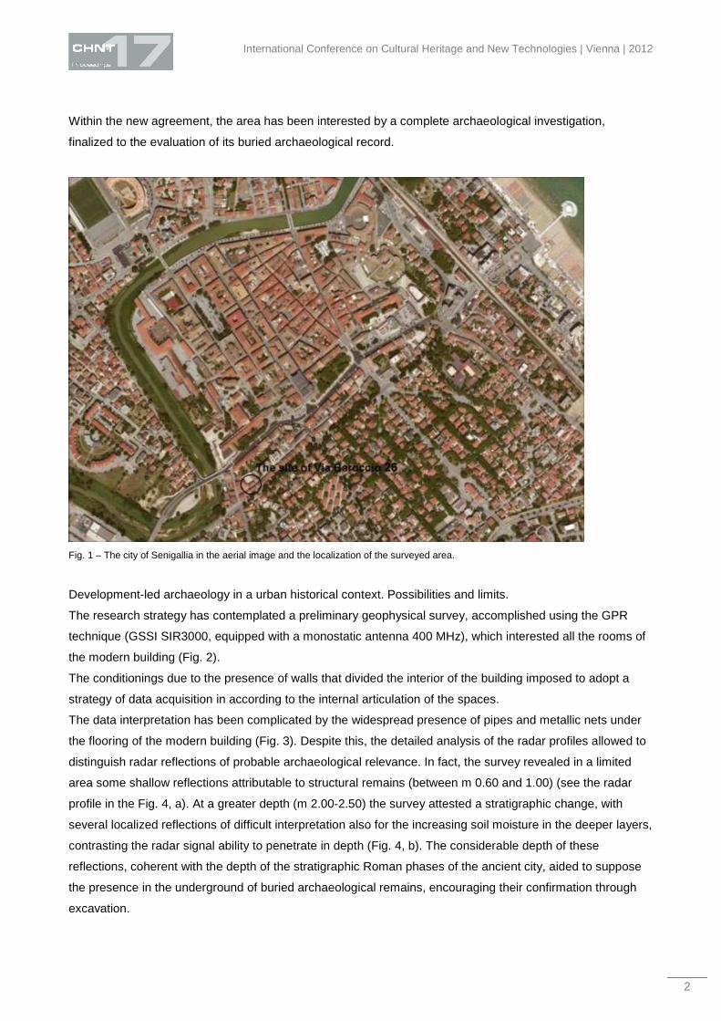
In this context, at the end of 2011 an important operation of “preventive archaeology” has been carried out in
a urbanized space of the modern town (via Baroccio 26), in relation to a new edification project of a sector
occupied by a building bound to demolition, an ex-gym (Fig. 1).
International Conference on Cultural Heritage and New Technologies | Vienna | 2012
2
Within the new agreement, the area has been interested by a complete archaeological investigation,
finalized to the evaluation of its buried archaeological record.
Fig. 1 – The city of Senigallia in the aerial image and the localization of the surveyed area.
Development-led archaeology in a urban historical context. Possibilities and limits.
The research strategy has contemplated a preliminary geophysical survey, accomplished using the GPR
technique (GSSI SIR3000, equipped with a monostatic antenna 400 MHz), which interested all the rooms of
the modern building (Fig. 2).
The conditionings due to the presence of walls that divided the interior of the building imposed to adopt a
strategy of data acquisition in according to the internal articulation of the spaces.
The data interpretation has been complicated by the widespread presence of pipes and metallic nets under
the flooring of the modern building (Fig. 3). Despite this, the detailed analysis of the radar profiles allowed to
distinguish radar reflections of probable archaeological relevance. In fact, the survey revealed in a limited
area some shallow reflections attributable to structural remains (between m 0.60 and 1.00) (see the radar
profile in the Fig. 4, a). At a greater depth (m 2.00-2.50) the survey attested a stratigraphic change, with
several localized reflections of difficult interpretation also for the increasing soil moisture in the deeper layers,
contrasting the radar signal ability to penetrate in depth (Fig. 4, b). The considerable depth of these
reflections, coherent with the depth of the stratigraphic Roman phases of the ancient city, aided to suppose
the presence in the underground of buried archaeological remains, encouraging their confirmation through
excavation.

Boschi | Belfiori | Galazzi – Senigallia Urban Archaeological Project
3
Fig. 2 – Data acquisition with the ground penetrating radar GSSI SIR 3000.
Fig. 3 – Archaeological preventive measures. GPR survey of the building bound to demolition.

International Conference on Cultural Heritage and New Technologies | Vienna | 2012
4
Fig. 4 – Radar profiles. The depth is expressed in values of time (nanosecond).
At the same time, an accurate analysis of the historical sources and cartography has been realized,
favouring the collecting of new information on the examined area.
In particular, in the Catasto Gregoriano (19th century) the area appears very different than today,
represented as a courtyard or a garden. Therefore, the historical cartography seems to suggest that this
sector was interested by a urbanization process only in recent times (Fig. 5).
The excavation has confirmed the geophysical results, allowing to bring at light an extraordinary and
complex stratigraphic sequence, which goes from the beginning of the 3rd century BC to the 18th century. In

Boschi | Belfiori | Galazzi – Senigallia Urban Archaeological Project
5
particular, the archaeological investigation showed that the shallower radar reflections were due to the
remains of furnaces of XVIII century, while the deeper features to the Roman levels of the archaeological
stratigraphy.
Fig. 5 – The surveyed area in the Catasto Gregoriano (XVIII c.)
This case of study shows the relevance of the Senigallia Urban Archaeological Project also from a
methodological point of view, providing data and foods for thought in matter of “preventive archaeology” in
urban historical contexts. The importance of the evaluative process is unquestionable but it’s absolutely
more complicated than in countryside contexts. Urban deposits are unfortunately not usually susceptible to
geophysical or electronic surveys, however, working in a living historic town provides others favourable
conditions not often available in the countryside, as the existence of a collective historical memory and the
works of modern contractors, that can observed for collecting important contributions to the map of
underground deposits (CARVER 2009, pp. 347-356). The operation carried on in the site of Via Baroccio 26
confirms perfectly this assumption, imposing the need to support the geophysical techniques with many
others data sources. In our case, the preliminary GPR survey allowed to acquire data on the “quality” of the
deposits, in terms of depth and preservation of the archaeological remains, but at the same time underline
the limits of the system for analysing a living historic town, with a heavy and complex stratification. The data
interpretation needs to be integrated with a deeper historical knowledge of the urban site, which considers
also the most recent urban operations, and possibly with a concrete stratigraphic inspection, for better
sustaining the diagnostic evaluation.
(FE. B.)
The archaeological excavation
The archaeological evidence shows that in the early 3rd century BC this area was used as a sanctuary,
which was located within a natural landscape with a wide presence of water, at the confluence of two rivers.
The worship was organized around a simple and small temple (an oikos) with the depositions of votive
objects outside and inside the sacred building (Fig. 6).

International Conference on Cultural Heritage and New Technologies | Vienna | 2012
6
In the western part of the excavated area, the archaeological exploration has revealed a large ditch
containing remains of big sherds of yellow sandstone, elements that represent the evidence of the urban
walls, which were never seen before.
Fig. 6 – The area of the sanctuary discovered with the excavation.
Stratigraphy and pottery analysis allows us to reconstruct the history of this relevant sector of the ancient
urban landscape, which is strictly connected with the foundation of the colony of Sena Gallica. About this
problem, Titus Livy and Polybius report two different dates about the institution of the colony, respectively
290 BC and 284 BC. Stratigraphy seems to agree with literary tradition, showing, for the beginning of the 3rd
century BC, two main periods that are identified as the birth and the development of the sanctuary. In a first
time, between the end of the 4th century BC and 284 BC, the sanctuary was sub divo and extra moenia
(urban walls weren’t built yet) with rituals organized all around votive stones. These stones represent only
one of the stages that made up the ritual route: in fact, at this phase belong to also an eschara, for the
worship dedicated to chthonian gods, and a bothros, that in our case was a simple circular hole for
containing the offers to the chthonian deities. A second phase started during the 284 BC, when the two
sacella were built up. Only one of the sacella is entirely visible, the second one is partially covered by the
limits of the construction site. With the second phase, the sacella respect and take over the earlier evidence
of the sanctuary, continuing to be used. The sacellum, which was entirely visible, incorporated a votive stone
in its northern wall and the eschara inside, while the bothros was located behind the two sacella. The sacella
had a rectangular plant (m 6,5 x m 4,7) with two thresholds on the short sides. The threshold on the west
side probably was the main entry, emphasized by two angular stones. The other threshold was the way out,
which led to the road for the centre of the city. The building technique employed tegulae in the foundation
walls, while the elevation had to be composed by unfired clay bricks. The northern stratigraphic section
shows that the urban walls and the sacella cut the living level of the sanctuary of the first period (Fig. 7). This
means that this sector of the city was interested by one and only planned intervention: in fact, when the city
walls were built, the sacred area was transformed in a urban sanctuary. Thus, the second phase represents

Boschi | Belfiori | Galazzi – Senigallia Urban Archaeological Project
7
the purpose of the central power of structuring the sanctuary and, more in general, the entire city (LEPORE
2012; LEPORE et alii 2012a).
Fig. 7 – A detail of the northern section and of the trench for the foundation of the urban walls.
The urban walls were built in yellow sandstone blocks, in according to the other examples of roman
republican walls known in this territory (Ariminum, Pisaurum, Auximum, Firmum Picenum). Turning to the
worship, in the sanctuary the cult remained the same along the centuries: the churchgoers prayed at the
stones and offered libations into the bothros, while food offers were burned near the eschara. A lot of shells
and an egg perfectly preserved inside a little jar, closed with a cover, are the most important evidence of the
kind of offers that were performed in the sanctuary. Open forms of pottery, like cups, say that also liquids
were offered: probably milk, wine and honey. Furthermore, the analysis of the worship remains and the
ancient landscape (characterized by water and swamped zones) compared with other similar contexts
reveals that the cult was directed to a chthonian sphere. The lack of epigraphic evidence doesn’t allow to
identify with precision the revered deity, but it’s probably that the cult was dedicated to a group of gods. The
most precise comparison is with the Lucus pisaurensis (in the area of Pesaro), a sub divo sanctuary founded
before the birth of the colony inside a sacred wood, with a similar worship organized around votive stones.
The sacred complex discovered in Via Baroccio confirms the presence in the territory of Roman people prior
to the official birth of the colony, offering new precious data about the Romanization of the Ager Gallicus and
in central Italy between 4th and 3rd centuries BC.
The only discovery of materials dated back to the Republican period reveals that the sanctuary lived until the
Augustan age, when probably this area was abandoned.
(FR. B.)

International Conference on Cultural Heritage and New Technologies | Vienna | 2012
8
Pottery analysis
The preliminary study of the potteries discovered during the excavation allows us to date back the origins of
the sanctuary to the 3rd century BC.
The potteries from the USS 5, 10, and 11 testified the main phases of life of the sanctuary and emerge for
particular relevance. The three layers are characterized by numerous depositions of cups and paterae in
black-gloss ware that were ritually broken, and by some sherds of roman common-ware and roman coking-
ware, which result very important for dating the site.
A lot of sherds related to a variety of bowls, cups and paterae in black-gloss ware are comparable to the
forms Morel 1551, 1552, 2538, 2670, 2784 and 2982 (MOREL 1981). These fragments would be dated to
the early 3rd century BC, corresponding to the earliest phase of the sanctuary (Figg. 8, a-f).
Fig. 8 – Senigallia, Via Baroccio 26. US5. a) Bowl in black-gloss ware comparable to the form Morel 2670. b) Bowl in black-gloss ware
comparable to the form Morel 2784. c) Bowl in black-gloss ware comparable to the form Morel 2670. d) Bowl in black-gloss ware
comparable to the form Morel 2784. e) Pan in roman coking-ware comparable to the pan type Olcese 1. f) Pan in roman coking-ware
comparable to the pan type Olcese 1. g) US11. Bowl in black-gloss ware comparable to the form Morel 1552. h) Bowl in black-gloss
ware comparable to the form Morel 2981.
At the same period belong some samples of jars in roman common-ware with everted rim and ovoid body,
analogous to the Olla Type Olcese 1, attested between IV-III century BC, and to the Olla Type Olcese 2,

Boschi | Belfiori | Galazzi – Senigallia Urban Archaeological Project
9
dated between the end of the 4th and the 3rd century BC (OLCESE 2003). As indicated before, the examples
of roman coking-ware are particularly indicative for the chronology and interpretation of this site. Especially
the fragments relevant to pans, one of which is characterized by overlying tense with rounded thickened rim
and wide groove for positioning the lid, seems attributable to the pan type Olcese 1, which date back from
the end of 4th to the 3rd century BC (OLCESE 2003) (Fig. 8, e). Another sample of roman coking-ware is
associable with a pan with overlying tense with pointed thickened rim and a wide groove for positioning the
lid. This fragment is comparable to the pan type Olcese 1, dated from the end of the 4th to the 3rd century BC,
and to the pan attested at the Villa of the Auditorium in Rome, where it’s ascribed to the 3rd century BC
(OLCESE 2003; D’ALESSIO, DI GIUSEPPE 2005) (Fig. 8, f). All these objects compose the “Servizio Tipo of
the colonist”, dated to the late 4th - early 3rd century BC. Although the morphological comparisons seem to
suggest a relation with the potteries from the Lazio area, at this moment we can’t exclude the possibility of a
local production. The US 11 identifies the second phase of life of the sacred area. In fact, within it many
depositions of bowls and cups of black-gloss ware comparable with the forms Morel 1551, 1552, 2982
(MOREL 1981) were found (Fig. 8, g-h). These depositions were discovered in a fragmentary state and
overturned, with old fractures that indicate intentional breakings of the ceramics, in relation to different
liturgical acts. Moreover, under the bowls and cups in black-gloss ware, groups of three or four shells were
found (Fig. 9, a). The second phase of the sanctuary can be ascribed in the course of the 3rd century BC.
The US 10 allows the identification of the third stage of life of the sanctuary, which started from the 3rd
century BC. This layer was characterized by some depositions of roman common-ware and roman coking-
ware. Sherds similar to the Olla type Olcese 1 and pieces comparable to the Olla Type Olcese 2 (OLCESE
2003) stand out for relevance. However, the most surprising finding is a globular Olla, covered by a lid, and
containing an egg (Fig. 9, b).
Fig. 9 – Senigallia, Via Baroccio 26. a) US11. A group of shells discovered under a bowls in black-gloss ware. b) US10. Olla with lid,
containing an egg.
Concluding, the preliminary analysis of the material culture allows us to recognize the life of the sanctuary
over the 3rd century BC.
(F. G.)

International Conference on Cultural Heritage and New Technologies | Vienna | 2012
10
A good compromise between past, present and future
The operation carried out in via Baroccio has a particular relevance also from a procedural point of view. In
fact, the necessities to avoid the problems connected with the wide presence of ground water and, above all,
with the development of the modern town, have lead to a particular solution, which takes into account all
these aspects but prioritising the conservation and enhancement of the archaeological remains. In order to
find a good compromise between protection of the discoveries and concerns of the building company, the
adopted method has contemplated the movement of the structures and their subsequent relocation within
the underground locals designed to parking, respecting the original position but at an inferior height, and
enriching the modern construction with a project for public fruition and site promotion. The structures were
protected with an innovative system of harness, specifically realized and applied for the first time at
Senigallia (Fig. 10).
Fig. 10 – Measures for protection, conservation and public fruition of the archaeological evidence.
This resolution has prevented the interruption of the building’s planning and, at the same time, has favoured
the conservation of the archaeological heritage, moving it away from the groundwater, as well as its public
fruition. In fact, despite the new construction will be a private residential complex, the new project will provide
a part in charge of museum, with a public entrance for the tour visit.
(F. B. | F. B. | F. G.)

Boschi | Belfiori | Galazzi – Senigallia Urban Archaeological Project
11
References CARVER M. 2009, Archaeological investigation, London; New York: Routledge.
D’ALESSIO M.T., DI GIUSEPPE H., 2005, La Villa dell’Auditorium tra sacro e profano, in: B. SANTILLO FRIZELL, A. KLYNNE, Roman
villas around the Urbs. Interaction with landscape and environment. Proceedings of the conference at the Swedish Institute in Rome,
September 17 - 18, 2004, Rome 2005: 177- 196.
DE DONATIS M., LEPORE G., SUSINI S., SILANI M., BOSCHI F., SAVELLI D. 2012, Sistemi Informativi Geografici e Modellazione
Tridimensionale per la Geo-Archeologia a Senigallia: nuove scoperte e nuove ipotesi. In: 7a Riunione Annuale del Gruppo GIT “Geology
and Information Technology”. Bologna, 13-15 giugno 2012, Rome: Società Geologica Italiana, vol. 19, pp. 16-19.
LEPORE G. 2012, Il santuario dei primi coloni di Sena Gallica?, in «Picus» XXXII (2012), pp. 103-132. ISSN 0394-3968.
LEPORE G., BELFIORI F., BOSCHI F., CASCI CECCACCI T., SILANI M. 2012a, Nuovi dati sull'origine di Sena Gallica, in «Ocnus»,
vol. 20 (2012), pp. 1-25, Issn: 1122-6315.
LEPORE G., CIUCCARELLI M.R., ASSENTI G., BELFIORI F., BOSCHI F., CARRA M.L., CASCI CECCACCI T., DE DONATIS M.,
MAINI E., SAVELLI D., RAVAIOLI E., SILANI M., VISANI F. 2012b, Progetto "Archeologia Urbana a Senigallia" I: le ricerche di Via
Cavallotti, in «Fasti On Line Documents & Research», 12, pp. 1-19.
MOREL J.P. 1981, Céramique campanienne: les formes, Roma.
OLCESE G. 2003, Ceramiche comuni a Roma e in area romana: produzione, circolazione e tecnologia (tarda età repubblicana – prima
età imperiale), Mantova.
Imprint:
Proceedings of the 17th International Conference on Cultural Heritage and New Technologies 2012 (CHNT 17, 2012)
Vienna 2013
http://www.chnt.at/proceedings-chnt-17/
ISBN 978-3-200-03281-1
Editor/Publisher: Museen der Stadt Wien – Stadtarchäologie
Editorial Team: Wolfgang Börner, Susanne Uhlirz
The editor’s office is not responsible for the linguistic correctness of the manuscripts.
Authors are responsible for the contents and copyrights of the illustrations/photographs.