Scientific Study of ELECTORAL CONSTITUENCIES
21
Iqra University Islamabad Scientific Study of ELECTORAL CONSTITUENCIES Khyber Pakhtunkhwa NA-14, Kohat By Liaqat Amin, M.Phil. IDS Roll No.13199 January 26, 2012
Transcript of Scientific Study of ELECTORAL CONSTITUENCIES

Iqra University Islamabad
Scientific Study of ELECTORAL CONSTITUENCIES
Khyber Pakhtunkhwa NA-14, Kohat
By Liaqat Amin, M.Phil. IDS Roll No.13199
January 26, 2012

2
C o n t e n t s
1- Maps 2- Geographical location 3- Some Glimpses of NA-14 Socio-economic Profile 4- Diversity is the identity 5- History 6- Renowned Educational Organizations 7- Socio-economic Conditions 8- Agriculture/Horticulture 9- Industrial Units, Kohat District 10. Area, Population by Sex, Sex Ratio, Population Density, House Hold Size and Growth Rate 11. Electoral History
12. From the Present to the Future of the Constituency
Sources: Source # 1: Union Councils Report (Norowal) Census 1998 – Kohat Basic Population and Housing Data by Union Councils Source # 2: Web portal of Election Commission of Pakistan Source # 3: History books.
Appendix: 1. NA-14 Polling Stations (with polling booths showing male/female voters separately.
2. NA-14 Polling Station-wise results (showing male/female voters and turn out jointly.

3
Iqra University Islamabad
Profile of NA-14 Kohat
By Liaqat Amin
M.Phil (IDS)
Roll No.13199.
Geography and Location: NA-14 (Map- 1 to Map-4) Kohat comprises the whole district of Kohat where there
are three provincial assembly constituencies (PF-37 Kohat-I, (map-7) PF-38 Kohat-II (Map-8) and PF-39
Kohat-III (Map-9)). There are 02 tehsils, 31 union councils, 141 mauzas, a municipal committee, 2 town
committees and a cantonment.
In 1982, its tehsil Karak was upgraded to district and thus that now form the adjoining NA-15 (Map-10). Its
tehsil Hangu was upgraded to independent district in 1996 and now form NA-16 (Map-11). However, Kohat
still hosts divisional headquarters, which include both these districts.
Only the river Indus separates the district/constituency from districts Attock, NA-58 Attock-11, (Map-5) and
Mian Wali NA-72 Mianwali-11 (Map-6) respectively in the East and South and it is via here the historic
Khushal Garh rail-road bridge that the district/constituency is about 170 Km from Rawalpindi-Islamabad.
From Peshawar via Indus High way, the district is some 46 KM. On another road from Kohat via its Lachai
Tehsil and union council Shakar Dara, one can easily cross Indus River to Mian Wali district of Punjab, which
lies in its South. On Indus highway from Peshawar Kohat is linked to Bannu and Waziristan and to Zoab
Baluchistan and so with Multan and Karachi and Sindh. On the west side of the district/constituency the road
leads to Hangu, Thal and Kurram Agency and thus the Durand Line/Pak-Afghan Border. The restive Orakzai
agency is also contiguous (in the North-West) with this district/constituency. Besides the railways line, of
which a narrow gage line was extended (now abandoned) up to Kurrum, the city also has an air stripe.

4
The main thing important with reference to Kohat is not its only administrative headquarters but strategic
location as it is on the one hand contiguous with Darra Adam Khiel, itself administered under the title of
Frontier Region (FR) Kohat and occupied by Adam Khel, on of the 4 sub sections/clans of the Afridi tribe
having occupied strategic Khyber Agency (Khyber pass included) while on the other hand it is a central market
to the tribal and mountainous areas/regions. So the name Koh (mountain) and hat (from hatai means shop).
Some Glimpses:
2. NA-14/Kohat District at a Glance
Area 2545 Sq.Kms.
Population - 1998 562644 persons
Male 282844 (50.27%)
Female 279800 (49.73 %)
Sex Ratio (males per 100 females) 101.1
Populaltion Density 221.1 per Sq. Km
Urban Population 151913 (26.99%)
Rural Population 410731 (73.00%)
Average Household Size 7.5
Literacy Ratio (10 +) 44.1%
Male 65.0 %
Female 23.5 %
Population - 1981 326617 persons

5
Average Annual Growth Rate (1981 - 98) 3.25 %
Total Housing Units 74695
Pacca Housing Units 46314 (62.00 %)
Housing Units having Electricity 64368 (86.17 %)
Housing Units having Piped Water 27525 (36.85 %)
Housing Units using Gas for Cooking 8223 (11.01 %)
Administrative Units
Tehsils 02
Union Councils 31
Mauzas 141
Municipal Committees 01
Town Committees 02
Cantonment 01
It might be due to the presence of mountain range separating Kohat from the Peshawar plains as well as the
Khyber Pass that it is here that we find the end of Qandahari accent of Pashto as just below in Darra Adam
Khiel we find a totally different Yousafzais’ accent. Interestingly, the strife on the bank of river Indus occupied
by Khattak tribes starting immediately from the Attock Bridge in District Noushera touching the Marwat tribe
in Lakki Marwat and spreading over the whole of District Karak, still attached with Kohat Division, traverses
Kohat. The Pashto accent of Khattaks’ is also similar to the Qandhahari Pashto unlike that of the Yousafzais,
whose belt rather home/centre District Swabai touches Nowshera very much where these Khattaks’ belt starts.
To be specific, Kohat’s Chorlakai union council, on the bank of river Indus touches Nowshera.
It is due to these geographical and linguistic differences that it is from here that the whole of the area/districts
up to D.I.Khan are euphemistically referred to as the southern districts of Khyber Pakhtunkhwa.
Not only had this, but the Hindko language spoken in Kohat also has an accent unique to the city despite the
fact that it has the oldest cantonment there. (It is worth mentioning that wherever there is a cantonment through
out the Khyber Pakhtunkhwa there is some population of Hindku speaking people too.)

6
Diversity is the identity of the constituency: As far as the diversity of the constituency/district is concerned,
though predominantly occupied by pashtuns and there being no ethnic tension there but tribal features are
visible among the people. The suffix of one’s tribal identity will always be there with every ones name. Apart
from Hindku, the mother tongue of renowned Chief Justice of erstwhile West Pakistan and famous writer late
Justice M.R.Keyani was Persian who came from the historic village Shahpur situated in the West of the city of
Kohat where the remains of the residences of Durranis are also famous.
It may or may not be due to this diversity but the district/constituency has given us the writers and poets of
international repute like the aforementioned justice M.R.Keyani, Ahmad Faraz, Ayub Sabir, Agha Mohammad
Barq and Soraj Narayen etc. By the way Tariq Banuri of IPPC fame also comes from this constituency/district.
By the way not only the incumbent Governor Barrister Masaud Kausar but the former military Governor Syed
Iftikhar Hussain Shah also belongs to this district/constituency. Previously, Kausar had remained Speaker of
the provincial assembly too. He is the brother of poet Ahmad Faraz.
The separation of Karak reduced the dominance of Khattak tribe on the district while that of the Hangu, that of
Banguish and Shia sect. Thus, the diversity has now again become manageable. The main pashtun tribes are
Bangash, Khattak and Afridies who form the major part of the population of the constituency/district. Hindku
is mostly spoken and understood in Kohat city and adjacent areas.
The population of Kohat district is Muslim, the Sunni predominate and there is also large Shias population
settled in the district. They stretch from Chikarkot Bala, Sherkot to Kachai (i.e. southern border of Kohat).
Usterzai Payan is the largest village of Shias. Former Chief Justice of PHC Syed Ibne Ali comes from here. It
is an educated and civilized village. It is also popular because of Al-Asar College. Al-Asr College is run by an
NGO. Chali Bagh, Jauzara, and Kachai(Katsi) are famous for their natural springs. People come here in
summer day from far of places.
There are some Christian families, which settled during the British colonial rule, most of whom are employees
of Municipal Committee, Cantonment Board and defense services also reside in Kohat city and Cantonment
area. Some scattered families of Hindus also reside in Kohat, Kachai and Marai while a good numbers of
Balmiks are employed in various local bodies.
History: The early history of the district is limited to the vaguest traditions. It is said that in the Buddhist
times, two Rajas named Adh and Kohat settled along with the northern border of the district. The remnants of
the Buddhist day is a road cut off the mountain side, on the western skirts of the Jawaki hills near Kotal Post
which leads by an even gradient towards the crest. Well before his victory in Pani Path, Mughal Invader Babur
visited Kohat in 1505, as has been mentioned in Tuzk-i-Babri, for him the inhabitants were Afghans.

7
After Babar the history of Kohat revolves around two major tribes of Bangash and Khattak. The wars and
rivalries between the two tribes are very much there in the poetry of Khushal Khan Khattak, the British
administrators and orientialist.
Alexander Burnes, who had previously visited the whole of Peshawar plains as a spy, when openly and
officially reached Peshawar city to call on Shah Zaman Khan, he had to wait for two days, as the later was busy
in Kohat. It was after that visit that the British attached Kohat in 1849, the first of the cities on the right bank of
river Indus to have been occupied from Afghanistan. The first thing the British did was to establish a
cantonment there and post an Assistant Commissioner.
The story of Ajab Khan Afridi (in 1926) is one of the examples when the whole British administration was
brought to a stand-still. Previously, in 1924, this was the only district where serious anti-Hindu riots took place.
Rivers and Streams: The people can neither use water the water of Indus River for irrigation nor drinking
because of the area lying on alleviation.
Kohat Toi is a principal stream, which enters from Hangu district and flowing to east and southeast, drains into
river Indus. The river has a small perennial flow, which disappears before it reaches the town of Kohat, it
reappears again at some distance down stream and then flows continuously to the Indus. The Kohat Toi has
several small torrents or tributaries, which join it at different places. Another, stream Teri Toi, flows from west
to east, in the southern half of the district, and joins the river Indus. It has little or no perennial flow.
The main source of water is Tanda, Gandyali, Chanda Fateh Khan barani dams.
Flora: The common trees are ber, Blueberry, sanatha, phulal, olea etc. All kinds of roses, bougainvillea,
kashmalo, gul-e-nargis, gui-e-dawoodi Chameli and other seasonal flowers are planted and sown in the district.
Fauna: Typical wildlife found in the district are hare, jackal, wolf, fox, wild cat, chakor, black partridge, grey
partridge, urial, chinkara, blue bull, hogdeer, water fowl. People are found of keeping birds, and fighter dogs.
Worth seeing Places: Raza Mansion Usterzai Payan, Kotal and Kohat Pass, Masjid Haji Bahadur, The Bridge
of Khushal Garh, The remnants of the Durranis at Shahpur, Kohat Fort, KUST, Kohat Board, Kohat Tunnel,
Kohat Cantonment, Kotal Town (KDA), Usterzai Payan, Sherkot,Chiker-kot-Bala and Tanda Dam
Renowned Educational Organizations: Kohat University of Science & Technology, Preston University
Kohat. Cadet College Kohat, Garrison Cadet College Kohat, Frontier Education Foundation Academy,
Postgraduate College for Boys, Postgraduate College for Women, Iqra Public School, Army Public School &
College, Fazaia College and Peace Associates bayna tor speen, jungle khel, tanda dam, Al-Asar Academy

8
Usterzai Payan, and the ISSB selection centre. The establishment of university and BISE in the constituency
has re-established its central importance in the area/region.
Socio-economic Conditions:
Journals: Weekly Hamdam, Weekly Sharar, Weekly Uqab, Weekly Dastak, Weekly Tehqeeq,Nayab (literary
magazine), Monthly Kohat on Line, Monthly Shehr-e-Sukhan (literary magazine), Daily Taseer, Weekly
Kohatnews, Monthly HAQAIQ Kohat
Media:
• Radio Pakistan Kohat
• Radio KUST
Radio-KUST FM 98.2 MHz was launched on 14th of August, 2009. It is primarily an educational broadcasting
radio with a fairly wide coverage. It is reportedly heard in nearly three Agencies of FATA, Kurum, Aurakzai
and Khyber, besides Kohat and its surrounding cities like Karrak, Hangu and Darra Adam Khel.
Utility services: The city is facilitated with three dams; Tanda Dam and Gandiali Dam. The former is located
in the SW of the city and the later is located in the SE. The 3rd Chanda Fateh Khan Dam has been recently built
in Lachai town.
Economic Scenario: Kohat is famous for agri products and hand made kohati chappal. Agricultural products
of the area include wheat, maize, barley, guava and citrus fruit. Poultry and local breeds of cattle are also good
source of income for the people of Kohat.
Different regions of Kohat are characterized by the production of different items e.g. Billitang is famous for the
production of mazri products. These products are being sold in Kohat, Peshawar and Islamabad markets, while
some organizations have started exporting them to UK and Holland as well.
Shakar Darra is famous for Bee keeping and Honey processing. About 150 bee keeping farms are currently
present in Kohat district making it a good source of income for the habitants of this area Tanda Dam was built
in 1960s near Kohat city towards the Hangu district. It is the main source of irrigation to adjoining areas. It has
lovely surroundings, which attract a large number of people especially on weekends. The peaceful recreation
provided by its natural beauty is unsurpassed. Main bazaars of the area are Kohat, Gumbat, Lachi and Bilitang.
Lachi is the main vegetable market and also Sub Tehsil of District Kohat. Gumbat is alos Sub Tehsil of Kohat
and is the main market located on Pindi Kohat Road.
Agriculture/Horticulture: The major crops grown in the district are wheat, barley, onion, garlic (Rabi),
maize, rice, bajra, ground nut, chari, and sugarcane (Kharif). Guava is the major fruit of area and Kohat is

9
famous for its quality and taste. This fruit gives very high return to the farmers. Others fruits are apricot,
mulberry, citrus, etc.
Garlic and ladyfinger are the leading vegetables which give maximum income to the farmer. Other vegetables
grown in the district are onion, potato, bringel, turnip, carrot, tomato and chilies among others.
Provision of adequate and dependable source of irrigation water is essential for the economic and social uplift
of the area. In Kohat district only 25 percent of the total cultivated area is irrigated. The main source of
irrigation is Tanda Dam. Furthermore, there are a number of tube wells and civil channels which supply water
for irrigation purposes.
Forestry: At present about 2.5 percent of the total land is under forest. Mostly forests are subtropical scrub
with major species like acacia, oleo cuspidate etc.
Livestock, Fisheries and Dairy development: The local cattle breeds available in Kohat are Lohani, Dani and
mix breeds which are non-productive and are being changed by artificial insemination with Frezien breed to
improve milk/meat production. Similarly the local goats are being crossed with Beetal goats to increase their
milk/mutton production. Under rural improvement of poultry program, the local poultry is being protected
against
various diseases through preventive inoculation and the poultry is crossed with Foamy breeds to improve the
eggs production.
Industry: As far as industrial development is concerned Kohat is lagging behind as compare to other big cities
of the country. Forward efforts are needed to uplift the pace of industrial development in this region. However
three big units established in Kohat including Kohat Cement, Babri Cotton and Saif Cotton Mills and the
Janana the maloocho Textile Mill are the major contributors to the economy of not only Kohat region but for
the national economy as well.
Industrial Units, Kohat District Textile Units: 3, Cement: 1, Ghee units: 1(Closed),Arms: 3, Flour Mills: 6,
Cement Based Industry: 3, Carpet: 1, Dall Factory: 2, Mineral Based industry: 1, and Ice Factory: 10.
Small Industrial Estate Kohat, Ice Factory: 1, Wood: 2, Paper & paper board: 1, and Dall Factory: 1.
Though exact figures could not be found but large population/laborers form part of Pakistani immigrants. The
following table from the booklet Basic Population and Housing Data by Union Councils, published by
Population Census Organisation, provides brief but specific insights into the demography of the constituency
based on 1998 census.

10
AREA, POPULATION BY SEX, SEX RATIO, POPULATION DENSITY,
HOUSE HOLD SIZE AND GROWTH RATE.
Administrative AREA (SQ KM)
POPULATION 1998
POPULATION DENSITY PER SQ KM
AVERAGE HOUSEHOLD SIZE
POPULATION
1981-96 AVERAGE ANNUAL GROWTH RATE(%AG
E)
BOTH SEXES MALE FEMALE SEX RATIO
1 2 3 4 5 6 7 8 9 10
Kohat DISTRICT
Rural
Urban
2545 562644 282844 279800 101.1 221.1 7.5 326617 3.25
410731 198880 211851 63.9 7.5 238798 3.24
151913 83964 67949 123.6 7.5 87819 3.27
Kohat Tehsil Rural Urban
461842 235425 226417 104.0 7.7 263958 3.34
335215 163920 171295 95.6 7.7 186354 3.51
126627 71505 55122 129.7 7.7 77604 2.92 Kohat MC 95863 50385 45478 110.8 7.4 55832 3.23 Kohat Cantt 30764 21120 9644 219.0 8.9 21772 2.05 Lachi Tehsil 100802 47419 53383 88.8 6.8 52359 2.83
Rural 75516 34960 40556 86.2 6.8 52444 2.17 Urban 25286 12459 12827 97.1 6.7 10215 5.47
Lachi T.C 15684 7812 7872 99.2 6.8 10215 2.55 Shakardara
T.C 9602 4647 4955 93.8 6.5 - -
Specifics: As stated above the total area of the constituency/district is 2545 Sq.Kms, with a population of
562644 out of which 282844 i.e.50.27 % were male and 279800 i.e. 49.73 % female. Some 151913 (26.99%)
were urban and 410731 (73.00%) Population was rural. As per 1998 census average annual growth rate (1981 –
98) was 3.25%. Literacy ratio in the District/constituency is 44.1% with 65 % among male and 23.5 per cent
female. Of its 74695 housing units 46314 i.e 62 % are pacca, with 86.17 per cent (64368) having electricity,
36.85 % (27525) pipe water and 11.01 % (8223) using gas for cooking. (Of late due to oil and gas discovery in
Shakardara, gas is available but the facility has not been extended to majority of the sprawling population in
the district/constituency).
Electoral History: During the one-unite i.e. 1970s election it was called NW-12 Kohat, and till the elections of
1997, it was NA-9 but in 2002 the constituency was numbered as NA-14 Kohat.

11
Elections of 2008:
In 2008, general elections, the total registered voters were 357556 of which 101567 votes were polled which
come to be 28.41 % to registered voters. Out of these polled votes 98618 were declared valid while 3029 were
rejected. Pir Dilawar Shah of Awami National Party was elected securing 30681 votes which are 32 %. He
was followed by former district nazim and independent candidate Malak Mohammad Asad Khan with 23030
votes which stands 27 per cent. Former Federal Minister Syed Iftikhar Hussain Gilani, who was contesting as
independent candidate was No.3 with 17466 votes which are 24 % of the total. The 4th candidate was Molana
Abdul Hai of Mutthida Majlis-e-Amal Pakistan with 10573 votes which are 18 per cent of the total votes
polled.
The Attached Provincial assembly constituencies:
i)PF-37 (Kohat-I):
In the attached provincial assembly PF-37 (Kohat-I), registered Votes were 113487 out of which the number of
polled votes were 39522 which are again 34.83%. 1308 votes were rejected and 38218 were declared valid.
Independent candidate Amjid KhanAfridi was declared elected with 12927 votes which are 34 % who was
closely followed by another independent candidate Aurangzeb Khan with 12818 votes. ANP candidate Shaukat
Habib was No.3 with 11743 votes which too are about 31 % of the total polled votes. Just 2 % votes were share
by other three candidates.
ii)PF-38 (Kohat-II):
In PF-38 (Kohat-II) the number of registered voters was 133111 of which the number of polled votes was
32533 which are 24.44 %. The number of rejected votes was 632 while 31946 votes were declared valid.
Independent candidate Syed Qalb-e-Hassan secured 11233 votes which are 36 per cent of the total votes polled.
He was followed by ANP’s Shahbaz Gul with 7627 votes’ i.e 25 %. The 3rd and 4th candidates were
respectively former Chief Justice of PHC Syed Ibne Ali of Pakistan People’s Party Parliamentarians with 6310
(20%) and Maulana Fakhr-ur-Rehman of MMA with 2493 votes (19%).
iii)PF-39 (Kohat-III):
The number of registered votes was 110957 of which 26.69% i.e. 29619 were polled. 635 votes were rejected
and thus 28994 votes were declared as valid. Dr. Iqbal Din of Mutthida Majlis-e-Amal Pakistan (MMA) was
elected with 10232 votes which are 35% of the total votes polled. Late Shad Mohammad Khan of Pakistan

12
People’s Party (Sherpao) and former provincial minister was the runner up with 8697(30%) votes. Independent
candidate Imtiaz Shahid Qureshi got 7816 votes (27%).
Thus, unlike the National Assembly constituency where the candidate of ANP was elected, two independent
and one MMA candidates were elected MPAs from the attached provincial assembly. It shows that the
people’s/electorates attention was focused on individual candidates instead of party affiliation.
The elections of 2002: Mufti Ibrar Sultan of Muttahidda Majlis-e-Amal Pakistan was elected MNA
from here securing 46130 votes followed by former federal minister in the PPP cabinet Syed Iftikhar
Hussain Gillani of Pakistan Muslim League (QA) with 14277 votes and an independent candidate Sheharyar
Afridi with 12083 votes. The candidate of Awami National Party, Fazal Rahim Khattak was number 4, with
11299 votes. Former MNA, Javed Ibrahim Paracha of Pakistan Muslim League (N) stood No.5th with just 2712
votes.
The elections of 1997: Javid Ibraheem Paracha of Muslim League(Nawaz) was elected MNA from there.
In the elections of 1993 and 1990, Syed Iftikhar Hussain Gilani was consecutively elected MNA but first
as PDA/ (PPP) candidate and later as PML (N) candidate. In the elections of 1988, Maulavi Naimatullah,
an IJI candidate who had also remained JUI, MNA from here in the 1970’s was elected. The details of
the votes secured by different candidates in the four elections held from 1988 to 1997 are available on the
next page.

13

14
3. FER-2007 Un-Verified Voters were 175,464, the FER-2007 Verified Voters 230,918; the FER-2007
Voters were 406,382 as NADRA augmented it by 222,403 while for 20011 the DER-2011 Voters are
453,321.1
During the previous elections there were 353799 votes in total of which 196113 were male and 157686
females. In all there were 317 polling stations with 918 polling booths of which 413 are for female and 505 for
male2.
As the Election Commission of Pakistan is still working on cross checking the electoral rolls and allows in an
improved form the registration of voters, we are making rough estimates for this purpose the following pages.
Though these estimates can be further specified but are calculated in a general form just to have an idea of the
upcoming elections.
1 http://ecp.gov.pk/VoterStats.aspx downloaded on 23/12/11. 2 http://ecp.gov.pk/VoterStats.asp

15
From the Present to the Future of the Constituency
The estimates: The following tables contain some estimates/approximation regarding the population, male and female ratio, and voters with
such differences, literacy and expected turn out. Each table is preceded by the methodology working out these statistics. The base for these
calculations have been taken the whole population, the whole growth rate and the whole male-female ratio avoiding rural urban or other
individual areas specifications for the sake of brevity. Thus the whole estimates are rough.
1) Calculated at the 1998 growth rate, (3.25) the district/constituency should have the estimated population till end 2012 as mentioned in
the table as per the following formula:
(i) the population of the previous year X growth rate, (3.25)= col.4
(ii) The population of the previous year + the total increase i.e. sum total of (i) above OR Col.2X3=4 and 4+2=5 1 2 3 4 5 year existing rate Increase total 1998 562644 3.25% 562644 562644 1999 562644 3.25% 18285 580929 2000 580929 3.25% 18880 599809 2001 599809 3.25% 19493 619302 2002 619302 3.25% 20127 639429 2003 639429 3.25% 20781 660210 2004 660210 3.25% 21456 681666 2005 681666 3.25% 22154 703820 2006 703820 3.25% 22874 726694 2007 726694 3.25% 23617 750311 2008 750311 3.25% 24385 774696 2009 774696 3.25% 25177 799873 2010 799873 3.25% 25995 825868 2011 825868 3.25% 26840 852708 2012 852708 3.25% 27713 880421 Thus, by the year end 2012, we will have an estimated 880421 population for the constituency NA-14 Kohat.
2) The male population estimated at the 1998 growth rate (i.e.50.27) should be: The estimated population till end 2012 as per 1 above X the male ratio by the 1998 censes:
Estimated population for 2012 1998 male rate 2012 number of male estimated 880421 50.27% 442587
3) The female Population estimated at the 1998 ratio (i.e.49.73) should be: The estimated population till end 2012 as per 1 above X the female ratio by the 1998 censes:
Estimated population for 2012 1998 F/male rate 2012 number of F/male estimated 880421 49.73% 437833

16
4) The Urban population should be estimated at the 1998 (i.e.26.99) ratio: The estimated population till end 2012 as per 1 above X the urban ratio by the 1998 censes: Estim. for 2012 Urban share as per 1998
census total urban (growth in urban and rural equally estimated)
1 2 3 (1X2) 880421 26.99% 237625
5. The Rural population should be estimated at the 1998 (i.e.26.99) ratio: The estimated population till end 2012 as per 1 above X the rural ratio by the 1998 censes: Estim. for 2012 Rural share as per 1998
census total rural (growth in urban and rural equally estimated)
1 2 3 (1X2) 880421 73% 642707
6) The literate population should be: total estimated population X literacy ratio Estim. for 2012 Literacy ratio as per 1998
census total rural (growth in urban and rural equally estimated)
1 2 3 (1X2) 880421 44.1% 388265
7) The illiterate population should be: total population X illiteracy ratio i.e. (100-literate): Estim. for 2012 Illiteracy ratio as per 1998
census total rural (growth in urban and rural equally estimated)
1 2 3 (1X2) 880421 100-44.1=55.9% 492155

17
8) The literate male population should be (at equal literacy rate both in urban and rural): Estimated population of the males (as per column 2 above) X male literacy ratio: Estim. male for end 2012 Illiteracy ratio as per 1998
census total rural (growth in urban and rural equally estimated)
1 2 3 (1X2) 442587
65 % 287681
9) The literate F/male population should be (at equal literacy rate both in urban and rural): The estimate female population as per table 3 above X ratio of female literacy
*Note that, this will still be too crude an estimation because the 10+ of the 1998 will have at the minimum been 24+ in 2012:
Estim. for 2012 literacy ratio as per 1998 census
total rural (growth in urban and rural equally estimated)
1 2 3 (1X2) 437833
23.5 % 102890*
10) The illiterate male population should be (at equal literacy rate both in urban and rural, though literacy ratio in urban and rural must be different but we take it so just for the sake of brevity): The estimated male population as per Table-2 above X (100-literacy ratio): Estim. Male for end 2012 Illiteracy ratio as per 1998
census total rural (growth in urban and rural equally estimated)
1 2 3 (1X2) 442587
100-65=35 % 154905

18
11) The illiterate F/male population should be (at equal rate both in urban and rural, though literacy ratio in urban and rural must be different but we again take it so just for the sake of brevity): The estimated female population as per table-3 above X (100-female literacy ratio): Estim. Female for end 2012
Illiteracy female ratio as per 1998 census
total rural (growth in urban and rural equally estimated)
1 2 3 (1X2) 437833
100-23=77 % 337131
12. The number of voters can be estimated as: The number of voters in 2007 X population growth rate X years since 2007 (which comes to 12 till 2012) + the number of registered voters in 2007: Note: the difference with Draft electoral rolls (DER) 2011 and our estimation, which shows that at least both are incorrect.
Year Voters Growth rate Increase Total As per DER 2011
1 2 3 4 5 6 Brought
forward @ popul. Growth
Col.2XCol.3 Col.2+Col.4
2008 357556 3.25% 11620 369176
2009 369176 -do- 11998 381174
2010 381174 -do- 12388 393562
2011 393562 -do- 12790 406352 453321*
2012 406352 -do- 13206 419558 468053**
* As published by Election Commission of Pakistan ** DER 2011 X population growth rate (i.e.3.25) *! However, the number of votes mentioned as the total of those assigned to polling stations was 353799. Thus in these tables we will make no difference between the two counting and determine male and female voters numbers from this figure.
13. The number of Female voters as per their share of population after 2007 election should be: a) Total expected voters as per col.5 of table-12 X Female population ratio b) DER 2011 X female ratio c) Female ratio as per 1998 census X total expected voters as per col.5 of table-12: d) Estimated voters as per col.6 of table 12 above X female ratio as per 1998 census:
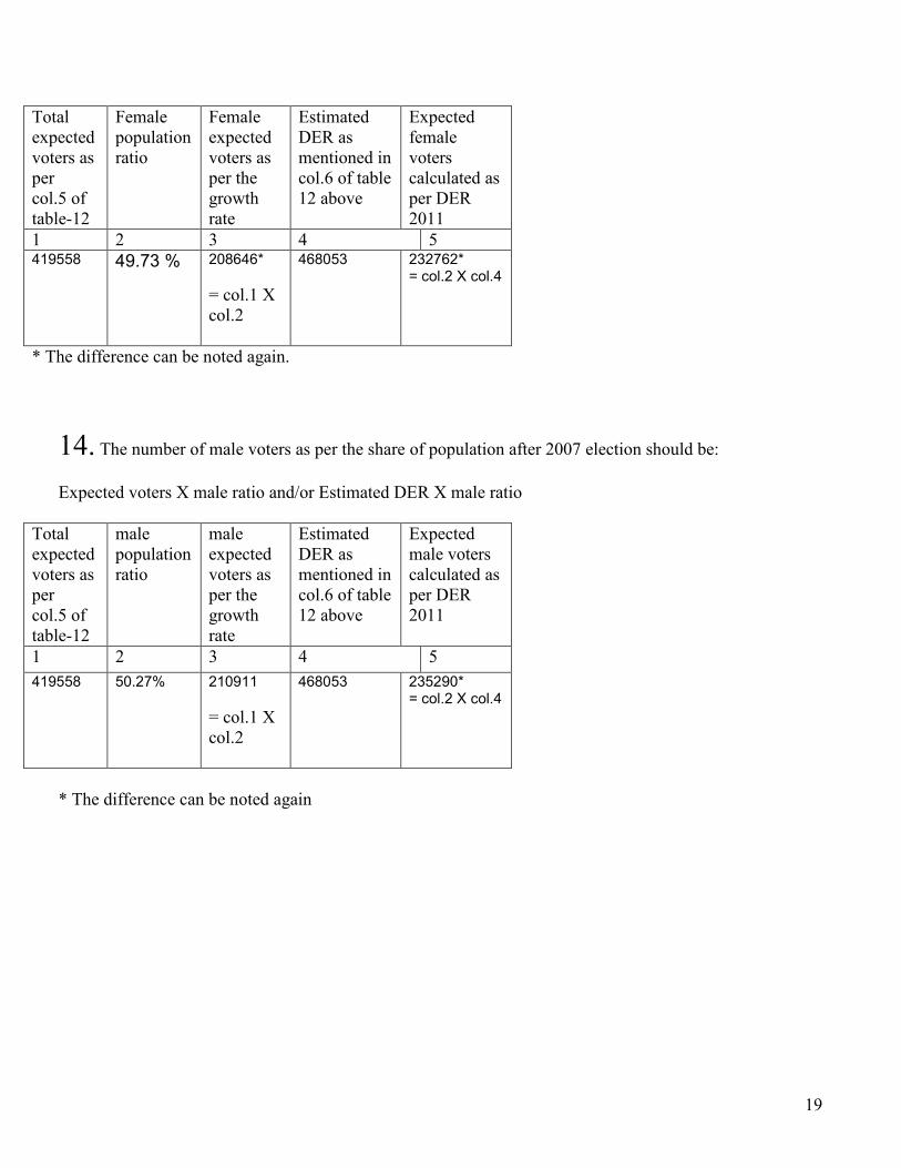
19
Total expected voters as per col.5 of table-12
Female population ratio
Female expected voters as per the growth rate
Estimated DER as mentioned in col.6 of table 12 above
Expected female voters calculated as per DER 2011
1 2 3 4 5 419558 49.73 % 208646*
= col.1 X col.2
468053 232762* = col.2 X col.4
* The difference can be noted again.
14. The number of male voters as per the share of population after 2007 election should be: Expected voters X male ratio and/or Estimated DER X male ratio
Total expected voters as per col.5 of table-12
male population ratio
male expected voters as per the growth rate
Estimated DER as mentioned in col.6 of table 12 above
Expected male voters calculated as per DER 2011
1 2 3 4 5 419558 50.27% 210911
= col.1 X col.2
468053 235290* = col.2 X col.4
* The difference can be noted again

20
15. The number of literate voters as per the share of population after 2007 election should be: Expected voters X literacy ratio and/or Estimated DER X literacy ratio
Total expected voters as per col.4 of table-12
Literacy ratio
Literate voters as per the growth rate
Estimated DER as mentioned in col.6 of table 12 above
Literate expected voters as per the DER rate.
1 2 3 4 5 419558 44.1 % 185025
=(1X2) 468053 (col. 2X4)=
206411
16. The number of illiterate voters as per the share of population after 2007 election should be: Expected voters X illiteracy ratio and/or Estimated DER X illiteracy ratio
Total expected voters as per col.4 of table-12
illiteracy ratio= total-literate
Literate voters as per the growth rate
Estimated DER as mentioned in col.6 of table 12 above
Literate expected voters as per the DER rate.
1 2 3 4 5 419558 100-44.1
=55.9 % 234532 =(1X2)
468053 (col. 2X4)= 261641

21
17. The number of voters NOT turning for votes as per the share of population after 2007 election should be: Expected voters X (100-turn out ratio) and/or Estimated DER X (100-turn out ratio)
Total expected voters as per col.4 of table-12
The rat of un-polled votes= (100-28.41 % (turn out)
The expected unpolled votes (1X2), as per the 2007-8 elections
Voters estimated as per the DER2011, as mentioned in col.6 of table 12 above
The number of unpolled votes as per the DER2011, estimates
1 2 3 4 5 419558 71.1% 298305
468053 332785
Thus out of 419559 just 121254 voters i.e. (419558-298305 Or (as per the DER estimates) out of 468053 just 135268 i.e. (468053-332785) voters are expected to turn out on the day of elections.
15. The number of female voters NOT turning for votes as per the share of population after 2007 election should be:
Total expected female voters as per 12 col.3
The rat of un-polled female votes as per the list of polling stations
The expected unpolled votes (1X2)
The number of unpolled female votes as per the DER, 2011 rate.
202705
? ? ? ?
So this is an area which should be probed particularly when the society in the constituency is semi-tribal/ traditional/religious and patriarchal. But the data could not be found out. The problem is that the male and female voters can be separately counted from the election rolls assigned to each polling station and booths but the results have been jointly compiled and no turn out data segregated on gender basis is available. It is worth mentioning that after the 2008 elections, a number of advocacy groups have demanded the publication of such segregated data.
***************************************************************