Satellite-Based Monitoring of Looting and Damage to Archaeological Sites in Syria
24
journal of eastern mediterranean archaeology and heritage studies, vol. 2, no. 2, 2014 Copyright © 2014 e Pennsylvania State University, University Park, PA Following up on the recent JEMAHS Forum discussing cultural property crimes in the context of armed conflict (Kila 2013), this article presents an analysis of recent satellite imagery revealing patterns of looting and damage to archaeological sites in Syria that have taken place as a consequence of the ongoing civil war. As discussed by several contributors to the JEMAHS Forum (e.g., Al Quntar 2013; Ali 2013; Cunliffe 2013), Syria has an extraordinarily rich archaeological heri- tage, as home to the world’s first sedentary agricultural villages, thousands of major Bronze and Iron Age sites (Akkermans and Schwartz 2003), and some of the most spectacular Roman and medieval ruins in the world (Burns 2009; Butcher 2003) with six World Heritage sites listed and 12 others under consideration (UNESCO 2014). As in any conflict, these cultural resources come under threat of looting as well as more direct forms of damage from bulldozing, construction activities, or shelling and gunfire (Kila 2013). Since March 2011, when civil unrest began in Syria, access to most sites by either archaeologists or antiquities officials has been extremely limited. With little or no direct obser- vation by trained professionals, most of our informa- tion regarding war-related damage to archaeological sites, monuments, and other cultural properties comes instead from journalists, as well as from reports, pho- tos, and videos uploaded to social media sites. As this pilot study demonstrates, analysis of satellite imagery offers a powerful means to monitor war-related looting and damage to sites in Syria until archaeologists and antiquities officials are able to conduct ground inspec- tions. Results suggest that damage to sites is quite widespread across Syria, but also shows that most loot- ing is concentrated on later period sites (Roman–Early Islamic), while earlier Bronze and Iron Age tell sites are particularly vulnerable to damage from the construc- tion of military garrisons. Notes on a Disappearing Past Satellite-Based Monitoring of Looting and Damage to Archaeological Sites in Syria Jesse Casana Mitra Panahipour is article presents analysis of recent, high-resolution satellite imagery to document looting and damage to archaeological sites in Syria that have taken place as a consequence of the ongoing civil war. e effort relies on 2012 and 2013 GeoEye and WorldView imagery covering 30 key sites, alongside freely available imagery served on Google Earth and Bing Maps. Results reveal widespread damage to archaeological sites across the country, caused both by looting and military activities. Ongoing satellite-based monitoring provides a powerful method to document looting and destruction, and will ultimately prove helpful in structuring post-war damage assessment and reconstruction in Syria. abstract
Transcript of Satellite-Based Monitoring of Looting and Damage to Archaeological Sites in Syria

journal of eastern mediterranean archaeology and heritage studies, vol. 2, no. 2, 2014Copyright © 2014 The Pennsylvania State University, University Park, PA
Following up on the recent JEMAHS Forum discussing cultural property crimes in the context of armed conflict (Kila 2013), this article presents an analysis of recent satellite imagery revealing patterns of looting and damage to archaeological sites in Syria that have taken place as a consequence of the ongoing civil war. As discussed by several contributors to the JEMAHS
Forum (e.g., Al Quntar 2013; Ali 2013; Cunliffe 2013), Syria has an extraordinarily rich archaeological heri-tage, as home to the world’s first sedentary agricultural villages, thousands of major Bronze and Iron Age sites (Akkermans and Schwartz 2003), and some of the most spectacular Roman and medieval ruins in the world (Burns 2009; Butcher 2003) with six World Heritage sites listed and 12 others under consideration (UNESCO 2014). As in any conflict, these cultural resources come under threat of looting as well as more direct forms of damage from bulldozing, construction activities, or shelling and gunfire (Kila 2013). Since March 2011, when civil unrest began in Syria, access to most sites by either archaeologists or antiquities officials has been extremely limited. With little or no direct obser-vation by trained professionals, most of our informa-tion regarding war-related damage to archaeological sites, monuments, and other cultural properties comes instead from journalists, as well as from reports, pho-tos, and videos uploaded to social media sites. As this pilot study demonstrates, analysis of satellite imagery offers a powerful means to monitor war-related looting and damage to sites in Syria until archaeologists and antiquities officials are able to conduct ground inspec-tions. Results suggest that damage to sites is quite widespread across Syria, but also shows that most loot-ing is concentrated on later period sites (Roman–Early Islamic), while earlier Bronze and Iron Age tell sites are particularly vulnerable to damage from the construc-tion of military garrisons.
Notes on a Disappearing Past
Satellite-Based Monitoring of Looting and Damage to Archaeological Sites in Syria
Jesse Casana
Mitra Panahipour
This article presents analysis of recent, high-resolution satellite imagery to document looting and damage to archaeological sites in Syria that have taken place as a consequence of the ongoing civil war. The effort relies on 2012 and 2013 GeoEye and WorldView imagery covering 30 key sites, alongside freely available imagery served on Google Earth and Bing Maps. Results reveal widespread damage to archaeological sites across the country, caused both by looting and military activities. Ongoing satellite-based monitoring provides a powerful method to document looting and destruction, and will ultimately prove helpful in structuring post-war damage assessment and reconstruction in Syria.
abstract
JEMAHS 2.2_04_Casana_Panahipour_NOTE.indd 128 03/06/14 9:55 AM

JourNal of EastErN MEDitErraNEaN arChaEology aND hEritagE stuDiEs | 129
Background
The most widely disseminated reports of war-related destruction and damage to sites and monuments in Syria have been produced by journalists, and thus have understandably focused largely on historic buildings or monuments, such as the destruction of a minaret at the Ummayad mosque in Aleppo (e.g., Watson 2013), the burning of that city’s historic souq (e.g., Weaver 2012), or the bombardment of the Crusader castle at Krak des Chevaliers (e.g., Al Jazeera 2013). However, these reports do not indicate how widespread such incidents are across the country and, in many cases, reports are based on photos and videos posted to social media sites by partisan actors in the conflict. Thus, the sources of information may be at least in part politically motivated.
In May 2012, Cunliffe published a study that attempted to use journalistic and social media sources to compile a more complete picture of the nature and extent of war-related damage (2012). She found credible evidence of damage at many World Heritage sites and candidate sites including Palmyra, Bosra, and Apamea, as well as at many of the so-called Dead Cities, the well-preserved Roman and late Roman ruins that dot the hills of western Syria. More recently, the Syrian govern-ment’s Directorate General of Antiquities and Museums (DGAM) has begun releasing periodic reports that sum-marize their knowledge of looting and other damage to sites (e.g., Abdulkarim 2013; 2014). Unfortunately, many top DGAM officials were forced to leave the country over the past few years for both political and safety reasons, and those who remain in Syria are generally unable to inspect sites as travel to most areas of Syria remains dangerous. Thus, even DGAM reports rely, to a large extent, on second-hand information provided by non-specialists. In addition, DGAM summaries have been criticized as politically motivated propaganda because they report almost exclusively on damage to sites that are in opposition-held areas and lay all blame at the feet of rebels and thieves, meanwhile failing to report on well-documented cases of site damage and looting in Assad regime-held regions (Al Quntar 2013; Ali 2013).
In late 2012, high-resolution Quickbird imagery from April 2012 covering the Roman city of Apamea was posted on Google Earth and revealed a stunning degree of looting at the site, all of which had taken place over the preceding eight months (Trafficking Culture 2012). Apamea is a candidate to be a World Heritage site (UNESCO 2014) and is among the best preserved Roman-period cities anywhere in the world. The city was founded following the conquest of Syria by Alexander the Great, and soon became one of the principal urban centers of the region (Ball 2000; Butcher 2003). The city was occupied throughout the Hellenistic, Roman, and late Roman periods (ca. 330 BCE–614 CE); how-ever, sometime during the seventh or eighth century, Apamea, along with most other contemporary settle-ments in the northern Levant, was largely abandoned. Settlement continued on the high, upper citadel, which was re-fortified during the medieval period and remains occupied today, but the remainder of the city remained largely abandoned, leading to its relatively good state of preservation. Apamea, now with its magnificent colon-naded street largely reconstructed, was among the top tourist destinations in Syria until the start of the cur-rent war.
Imagery revealed that between July 2011 and April 2012, about two-thirds of Apamea was intensely looted, appearing now as a pockmarked, almost lunar, land-scape. The initial discovery of the looting on Google Earth-served imagery was soon picked up by news media around the world and became an exemplar of the dire cultural heritage situation in Syria. However, it remained unclear to what degree the kind of extreme looting vis-ible at Apamea was widespread or if the site was a sad, but unusual, case. The example of Apamea nonethe-less makes clear that analysis of recent high-resolution satellite imagery is a powerful way to monitor looting and site destruction remotely, as has been also demonstrated in Iraq (Stone 2008; Jahjah et al. 2007) and elsewhere (e.g., Contreras 2010). Furthermore, observations derived from satellite imagery provide an independent cross-check against less verifiable reports from media or government sources.
JEMAHS 2.2_04_Casana_Panahipour_NOTE.indd 129 03/06/14 9:55 AM
130 | SAteLLite-BASeD Monitoring of Looting AnD DAMAge
Methodology
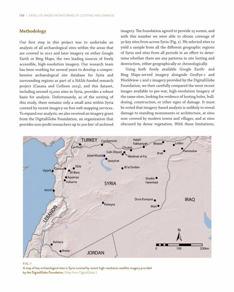
Our first step in this project was to undertake an analysis of all archaeological sites within the areas that are covered in 2012 and later imagery on either Google Earth or Bing Maps, the two leading sources of freely accessible, high-resolution imagery. Our research team has been working for several years to develop a compre-hensive archaeological site database for Syria and surrounding regions as part of a NASA-funded research project (Casana and Cothren 2013), and this dataset, including around 15,000 sites in Syria, provides a robust basis for analysis. Unfortunately, as of the writing of this study, there remains only a small area within Syria covered by recent imagery on free web mapping services. To expand our analysis, we also received an imagery grant from the DigitalGlobe Foundation, an organization that provides non-profit researchers up to 500 km2 of archived
imagery. The foundation agreed to provide 25 scenes, and with this number we were able to obtain coverage of 30 key sites from across Syria (Fig. 1). We selected sites to yield a sample from all the different geographic regions of Syria and sites from all periods in an effort to deter-mine whether there are any patterns in site looting and destruction, either geographically or chronologically.
Using both freely available Google Earth- and Bing Maps-served imagery alongside GeoEye-1 and Worldview-1 and 2 imagery provided by the DigitalGlobe Foundation, we then carefully compared the most recent images available to pre-war, high-resolution imagery of the same sites, looking for evidence of looting holes, bull-dozing, construction, or other signs of damage. It must be noted that imagery-based analysis is unlikely to reveal damage to standing monuments or architecture, at sites now covered by modern towns and villages, and at sites obscured by dense vegetation. With these limitations,
f i g . 1a map of key archaeological sites in syria covered by recent high-resolution satellite imagery provided by the Digitalglobe foundation. (Map from Digitalglobe.)
JEMAHS 2.2_04_Casana_Panahipour_NOTE.indd 130 03/06/14 9:55 AM

JourNal of EastErN MEDitErraNEaN arChaEology aND hEritagE stuDiEs | 131
it often reveals patterns of damage to sites with great clar-ity. Below, we present examples of damage we have been able to recognize, first focusing on two regions of Syria, the Orontes Valley and the lower Balikh Valley, where the largest amount of 2012 and later imagery is available. We then present findings at other individual sites through-out Syria, comparing major sites of the Roman through Early Islamic periods (ca. 150 BCE–1100 CE) to sites of the earlier Bronze and Iron Ages (ca. 3000–500 BCE). Finally, we offer an analysis of the general trends we have been able to identify, noting both limitations and recom-mendations for ongoing monitoring efforts.
The Orontes Valley
The Orontes River flows north through western Syria, from its headwaters in the highlands of Lebanon to its debouchment into the Mediterranean from the Hatay province of Turkey. Within the well-watered and fertile valley through which the river flows lie some of Syria’s largest cities, including Homs and Hama, as well as a rich record of ancient settlement. Within this region, Google Earth currently provides some of the most extensive coverage from 2012 and later, including in the vicinity of Apamea.
Apamea
At Apamea, where extensive looting has already been well documented, analysis reveals a spatial pattern in the loot-ing that has not been widely discussed in media reports. On the north of the site in particular, it is evident that looting activities are concentrated almost entirely on the eastern portion of the site that is owned and managed by the Syrian government (Fig. 2). As is common at very large sites like Apamea, much of the ancient settlement area, even that within the late Roman fortification walls, is privately owned and is cultivated annually. A road that cuts through the center of the site demarcates these privately held areas to the west from the government-owned areas to the east, and the April 2012 image shows that only four or five holes were placed in privately held areas. Our most recent GeoEye-1 image from November 4, 2012 shows that looting holes have begun to encroach
west of the modern road, but still remain largely concen-trated on the government-owned heritage site (Fig. 3).
Media reports discussed by Cunliffe (2012) and Ali (2013) suggest that Assad-regime forces shelled Apamea and bulldozed part of the medieval citadel’s walls in order to construct a road to better supply troops garrisoned at this strategic spot. The satellite imagery from 2012 offers confirmation of the continuing presence of Assad forces at Apamea, with the construction of a large military gar-rison on a small promontory at the center of the site. In this image, a building, the site of the former tourist restaurant, has been encircled by a bulldozed earthen bunker, with a tank emplacement on the eastern side. The looting trenches at Apamea are not small, metal detect-ing holes, but typically measure up to 3 m on a side. The size and sheer number of these holes, as well as the short period over which they were dug, indicates that they were either made using machinery, such as a backhoe or an excavator, or involved a small army of laborers, either of which would have been observed by military forces occupying the site. Comparing a Google Earth-served image from September 27, 2012, to a GeoEye-1 image from November 4 of the same year shows that looting continued during this six-week period, contemporary with the presence of Assad’s military forces on the site, thereby suggesting that the military was either directly involved or at least tacitly complicit in the looting.
Tell Jifar
Expanding our search beyond Apamea reveals many other smaller sites in the vicinity that have been simi-larly impacted by looting and the construction of military garrisons. One of the most revealing is the small mound of Tell Jifar, located just 2.5 km east of Apamea, opposite a small reservoir. The April 2012 Google Earth-served imag-ery shows that the entire top of the small tell has been transformed into a military garrison (Fig. 4). Tanks, other vehicles, and artillery are positioned in bunkers that ring the top of the mound and several military tents have been erected on the upper mound as well as along its southern edge. The base of the mound on its southern, eastern, and western sides has been subjected to extreme looting, the size and character of which appears very similar to looting holes at Apamea. However, in this case, earlier imagery
JEMAHS 2.2_04_Casana_Panahipour_NOTE.indd 131 03/06/14 9:55 AM

f i g . 2the north end of apamea on July 19, 2011, and april 3, 2012. the government-owned portion of the site was severely looted over this eight-month period, while the privately held area west of the modern road was left largely untouched. (Map data ©2014 google earth and Digital globe.)
JEMAHS 2.2_04_Casana_Panahipour_NOTE.indd 132 03/06/14 9:55 AM

f i g . 3During the construction of an assad-regime military garrison at apamea in 2012 (left), looting continued to expand as illustrated in google Earth-served images from april 3 and september 27, 2012, and a geoEye-1 image from November 4, 2012. (Map data ©2014 google earth, Digitalglobe, and Digitalglobe foundation.)
JEMAHS 2.2_04_Casana_Panahipour_NOTE.indd 133 03/06/14 9:55 AM

f i g . 4tell Jifar, 2.5 km east of apamea, as seen on google Earth-served imagery from april 2012, December 2007, september 2003, and on a CoroNa image from July 1969. the 2012 image reveals extensive looting and military-related damage, but looting had begun at least ten years earlier. the CoroNa image reveals an occupation below the main mound apparently being targeted by looters. (Map data ©2014 google earth and Digitalglobe.)
JEMAH
S 2.2_04_Casana_Panahipour_N
OTE.indd 134
03/06/14 9:55 AM
JourNal of EastErN MEDitErraNEaN arChaEology aND hEritagE stuDiEs | 135
from December 2007 shows that there was already exten-sive looting at that time with an even earlier image from September 2003 showing that looting had begun at the site more than a decade ago. Nonetheless, a compari-son of looting from 2007 and 2012 shows that the size and extent of holes expanded considerably since the war began. Moreover, it seems likely that the looting exper-tise that developed at Tell Jifar over the past decade laid the foundation for the massive increase in scale that the imagery reveals took place after the war made it possible to do so. The close association between looting holes and the military garrison, with many large holes just a few meters outside of the tents, again suggests either direct or indirect involvement of military personnel in looting.
The fact that looting trenches at Tell Jifar are concen-trated almost entirely at the base of the mound rather than on the mound itself is also revealing as to the looters’ objec-tives. In western Syria, most mounded tell sites like Tell Jifar have long histories of settlement, particularly during the Bronze and Iron Ages (ca. 3000–500 BCE), while later settlements of the Hellenistic, Roman and late Roman peri-ods (ca. 300 BCE–650 CE) are often located at topographi-cally flat sites, dispersed in large numbers throughout the landscape (Casana 2007; 2012). Archaeological surveys reveal that it is quite common for tell sites to have late period occupations of Roman or medieval date off the main mound, and Tell Jifar is likely one such site. Declassified CORONA satellite imagery from July 1969 shows that there is a light patch of soil south of the main mound, generally indicative of anthropogenic soils associated with ancient settlement (Menze and Ur 2012; Wilkinson, Beck and Philip 2006). This area corresponds precisely to the area of intense looting as seen in Fig. 4. Thus, looters in this case are mostly likely specifically targeting a late period settle-ment, rather than the Bronze and Iron Age mound.
Tell Qarqur
Tell Qarqur, located about 35 km downriver from Apamea, has been the site of American Schools of Oriental Research (ASOR)-sponsored excavations since 1993 (Dornemann 2012a–b), and the author directed investigations at the site from 2005–2010 (Casana, Herrmann and Fogel 2008; Casana 2014). Tell Qarqur is located at the junction between the main north–south road through the Orontes Valley and one of the main east–west roads connecting
Aleppo and inland Syria with Latakiya and the coast. As such, the site today is and has been throughout much of 10,000-year occupational history situated in a strategic location. Archaeological evidence shows that the site was fortified many times in the past, going back at least to the early third millennium BCE and continuing through the Crusader period, so it is perhaps unsurprising that the site was chosen as a location for a large military garrison at the start of the current conflict.
The most recent Google Earth-served pre-war image available, dating to June 28, 2010, was acquired while the ASOR team was excavating the site and the open trenches, equipment tents, and team bus are visible in the image (Fig. 5). However, an image from July 2011 shows that by then the northern half of the site had been transformed into a military garrison with numer-ous tanks or other military vehicles lining the edge of the mound and several more guarding the road at the base of the site. Several military tents are also set up on the east and south sides of the main mound. The establishment of this Assad-regime military garrison was contemporary with the intense fighting that took place in the town of Jisr Shugur, just 5 km to the north, in June 2011 (Chulov, Weaver and Meikle 2011). The creation of large bunkers on sites like Tell Qarqur cre-ates massive bulldozing scars, while the stationing of troops on the site inevitably leads to damage to open excavation trenches. A later image from September 23, 2012, shows the continued presence of at least two mili-tary vehicles or tanks on the site, but a GeoEye-1 image from November 4, 2012, shows that the military had abandoned the site, perhaps in response to the increas-ing domination of rebel forces in the region.
The kinds of damage illustrated above are quite wide-spread in recent satellite imagery from the region sur-rounding Apamea with numerous small sites garrisoned by regime forces, including Tell Baqalou, Tell Houash, Tell Braidij, and Tell Zajrit and several others subjected to intense looting including Tell Sheikh Sultan, Tell Salba, and Er-Rubba (Fig. 6). At Er-Rubba, severe loot-ing predates the war as at Tell Jifar discussed above, but at all of the other sites damage is entirely war related. The patterns identified thus far suggest that as more imagery becomes available, it is likely the scope and severity of site destruction and looting in the region will increase.
JEMAHS 2.2_04_Casana_Panahipour_NOTE.indd 135 03/06/14 9:55 AM

136 | SAteLLite-BASeD Monitoring of Looting AnD DAMAge
The Balikh Valley
The region of Raqqa, at the confluence of the Euphrates and Balikh Rivers in northern Syria, also has recent high-resolution imagery available on Google Earth. Our study expands on this using recent images of a number of key sites further north up the Balikh Valley. Collectively, analysis of these data reveal several key trends, includ-ing the existence of widespread and sometimes extreme looting of sites that predates the current war, as well as the expansion of looting since the war, but concentrated primarily at later period sites.
The early prehistoric sites in our study, including Sabi Abyad, a major Pottery Neolithic (Halaf-related) site (Akkermans et al. 2006); Tell Zeidan with a long history of Late Neolithic and Chalcolithic settlement (Stein 2009); and Hammam et Turkman with major Ubaid, Late Chalcolithic, and Bronze Age occupations (Van Loon 1988), all show little evidence of looting or other damage in imagery from October 10, 2012 (Fig. 7). These sites, while all home to major excavation projects and quite well-known among archaeologists, do not appear to be (at this stage) the type of sites being targeted by looters. Likewise, analysis of the geographic distribution of military activity in Syria shows that the Balikh and surrounding regions have seen very lit-tle armed conflict (Syria Needs Analysis Project 2013), and thus mounds in this area appear, at least for the time being, much less likely to be garrisoned by military forces.
On the other hand, the 38-ha mound of Tell Bi’a, identified with the ancient city of Tuttul, shows intense looting damage, but only on one small area in the south-western portion of the site (Fig. 8). Tell Bi’a is best known for its Early and Middle Bronze Age (third to mid-second millennia BCE) monumental architecture and cuneiform archives (Strommenger and Kohlmeyer 2000; Miglus and Strommenger 2007), but the site also sits adjacent to the extensive remains of the late Roman (fourth–seventh centuries CE) and Early Islamic (seventh–tenth centu-ries CE) city of Raqqa, most of which is now covered by modern buildings but is clearly visible in 1960s CORONA satellite imagery (Challis et al. 2004; Hritz 2013). The intensive looting at Tell Bi’a is concentrated almost exclusively on the small part of the site that was home to Hellenistic, Roman, and Byzantine settlement, while the large, excavated remains of the Bronze Age palatial architecture appear to be of little interest.
A similar phenomenon is evident at a large, predomi-nantly late Roman/Early Islamic site known as Thoul Nayel just 500 m southeast of Tell Zeidan (Curvers 1991; Hritz 2013). The site, which is part of an extensive series of remains surrounding the late Roman city of Callinicum (modern Raqqa), has been intensely looted (see Fig. 7). In an October 2012 image, looting holes cover virtually the entirety of the site, but comparison with an April 2011 image shows that much of this damage predates the cur-rent civil war. A careful analysis reveals an expansion of looting between April 2011 and October 2012, but that is simply the continuation of a long tradition of looting in the region.
Further north up the Balikh River basin is the large Early Islamic settlement of Medinet al-Far, notable for its massive rectilinear fortification systems and well- preserved architectural remains (Wilkinson 1998; Walmsley 2007). The site was initially founded during the Early Islamic period as part of a series of border cit-ies defending against the Byzantine Empire to the north (Eger 2012), and has been the site of Syrian-sponsored excavations for many years. Google Earth-served imagery from August 2010 shows already extensive looting dam-age across most of the 100-ha ancient settlement, while DigitalGlobe imagery from October 2012 shows that, like at other sites in the region, the number and size of loot-ing holes has increased since the start of the war (Fig. 9).
Roman and Medieval Sites
Data from the Orontes and Balikh regions where more coverage by recent high-resolution imagery is available show a strong preference for looting at later period sites, particularly of the Roman, late Roman, and Early Islamic periods, and this picture is largely confirmed by a number of other sites in our study. In addition to those major late-period sites already discussed (e.g., Apamea, Medinet al-Far, and Thoul Nayel), we acquired imagery through DigitalGlobe for several other significant late-period sites including Amrit, Bosra, Cyrrhus, Al-Bara, Jebel Khalid, Palmyra, and Dura Europos. Many of these sites are reported to have suffered war-related damage, including media stories covering the encampment of refugees and rebel fighters within the tombs and stone buildings at Al-Bara and other Dead Cities, and Al-Bara
JEMAHS 2.2_04_Casana_Panahipour_NOTE.indd 136 03/06/14 9:55 AM

JourNal of EastErN MEDitErraNEaN arChaEology aND hEritagE stuDiEs | 137
was specificially noted as the likely location of damage to historic monuments in Cunliffe’s study (2012). More of such damage is reported in the most recent damage assessment by DGAM (Abdulkarim 2014). In November 2012, imagery of Al-Bara and its hinterland, where several other Dead Cities are located, the tree cover and modern buildings make recognition of looting or damage to the site quite challenging.
Similarly, at the site of Amrit, a large city founded on the Syrian coast during the Achaemenid period and notable for its well-preserved tombs and ritual build-ings, dense vegetation prohibits obvious identification of looting. The same is true at Cyrrhus, a key Roman/late Roman city on the modern Syrian-Turkish border, and at
Bosra, a Roman city in far southern Syria that is largely obscured by a modern town. At Bosra in particular, a World Heritage site where intense fighting has taken place throughout the current war, there have been many reports of looting and shelling damage to monuments (Cunliffe 2012; Abdulkarim 2013), but these are difficult to see in our imagery. Reports are nonetheless credible and suggest that even while we cannot see it in satellite imagery, there has likely been significant damage at most of these sites.
At Dura Europos, a well-known Hellenistic–late Roman city in far eastern Syria, located on a high bluff above the Euphrates River, we are able to see significant looting in imagery from November 14, 2012 (Fig. 10). Ironically,
f i g . 5a topographic map of tell Qarqur and google Earth-served images from June 2010 during excavations and July 2011 when the northern end of the site had been transformed into a military garrison. tanks and other military vehicles are indicated with arrows. (Map data ©2014 google earth and Digitalglobe.)
JEMAHS 2.2_04_Casana_Panahipour_NOTE.indd 137 03/06/14 9:56 AM
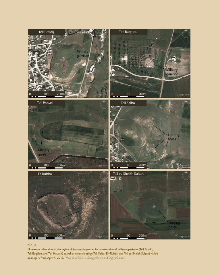
f i g . 6Numerous other sites in the region of apamea impacted by construction of military garrisons (tell Braidij, tell Baqalou, and tell houash) as well as severe looting (tell salba, Er-rubba, and tell es-sheikh sultan) visible in imagery from april 4, 2012. (Map data ©2014 google earth and Digitalglobe.)
JEMAHS 2.2_04_Casana_Panahipour_NOTE.indd 138 03/06/14 9:56 AM

f i g . 7tell Zeidan (left), a Neolithic and early Chalcolithic site, has no evidence of looting as of october 2012. thoul Nayal, a roman and late roman site 500 m to the southwest, was intensely looted prior to the war as seen in april 2011 (center) with expanded looting visible in october 2012 (right). (Map data ©2014 google earth and Digitalglobe.)
JEMAH
S 2.2_04_Casana_Panahipour_N
OTE.indd 139
03/06/14 9:57 AM

f i g . 8tell Bi’a on a geoEye-1 image from october 10, 2012, reveals dense looting on the southwestern corner of the site where post-Bronze age settlement is concentrated. (Courtesy of the Digitalglobe foundation.)
JEMAHS 2.2_04_Casana_Panahipour_NOTE.indd 140 03/06/14 9:57 AM

f i g . 9the square fortification on the northern end of Medinet al-far, as seen on a geoEye-1 image from october 10, 2012, revealing extensive looting across much of the site. (Courtesy of the Digitalglobe foundation.)
JEMAHS 2.2_04_Casana_Panahipour_NOTE.indd 141 03/06/14 9:57 AM

f i g . 10Dura Europos in september 2007 imagery (top). Extensive looting, mostly predating the war, is visible in the area just outside the Palmyrene gate, seen here (inset) on a geoEye-1 image from November 14, 2012. (Map data ©2014 google earth and Digitalglobe.)
JEMAHS 2.2_04_Casana_Panahipour_NOTE.indd 142 03/06/14 9:58 AM

JourNal of EastErN MEDitErraNEaN arChaEology aND hEritagE stuDiEs | 143
Dura Europos originally came to archaeological attention through Breasted’s publication of late Roman frescoes that were exposed by the construction of military bun-kers at the site during the lead-up to the Arab Revolt of 1920–1922 (Breasted 1924). Imagery predating the cur-rent war from September 2007 shows that, like at many other major late-period sites, looting was already wide-spread long before the war with hundreds or possibly thousands of looting holes visible both inside and out-side the fortification walls. Our imagery from November 2012 shows that since the war, the number of looting holes has continued to increase, although in practice it would be somewhat of a challenge to find somewhere not already looted in recent years.
For two other major late-period sites in our study, Palmyra and Jebel Khalid, the most recent archived imag-ery available is too old (dating to July 2010 and April 2011) to reveal war-related damage. They nonetheless confirm the suggestion from other sites in the study that looting was already quite widespread prior to the war, with many looting holes visible at both sites. The longstanding tradi-tion of looting at these sites makes it likely that given the breakdown of government authority, such activities have already intensified and will continue to increase in scale in the future.
Bronze and Iron Age Sites
Several of the images supplied by the GeoEye Foundation target major Bronze and Iron Age (ca. 3000–500 BCE) sites found throughout different parts of Syria, including Ugarit (Ras Shamra), Tell Asharne, Ebla (Tell Mardikh), Tell Ashtara, Tell es-Sweyhat, Carchemish, Tell Chuera, Tell Halaf, Tell Fakhariyah, Tell Brak, Tell Mozan, Tell Leilan, Hamoukar, Tell Sheikh Hammad, and Mari (Tell Harriri). Most of these sites have been the subject of decades-long excavation campaigns by European and North American archaeologists, and several including Ebla and Mari were reported to have been damaged by looters in government reports (Abdulkarim 2013; 2014). Our analysis found rela-tively little visible evidence of looting or destruction at most of these sites, suggesting that at least at the time our images were acquired, the sort of extreme looting evident at sites in the Orontes and Balikh Valleys as well as at later period sites
throughout Syria is not widespread at these sites; however, many may have suffered damage from the war.
Ebla (Tell Mardikh)
The ancient city of Ebla (modern Tell Mardikh) has been home to Italian-sponsored excavations since the 1960s that famously uncovered a large palace and cuneiform archive dating to the Early Bronze Age IV (late third millennium BCE) (Matthiae and Marchetti 2013). The archive, found in the structure dubbed Palace G, along with a wealth of archae-ological evidence spanning the mid-third to mid-second millennia BCE, has made Ebla one of the best resources for the history, politics, and material culture of the Near East during this period. Reports of looting at Ebla began to surface on social media in 2012, and the site is highlighted as one damaged by looters in July 2013 and January 2014 reports by DGAM.
However, a GeoEye-1 image of Ebla dated November 4, 2012 does not reveal evidence of significant looting at the site (Fig. 11a). Of course, we would be unable to see dam-age to the ancient building remains, which have been well documented (Ali 2013; Abdulkarim 2014). There are some reports that looters may be digging tunnels into the side of the site’s central mound (Cunliffe, pers. comm.), which would also be unlikely to appear in imagery. It is also possi-ble, as with any of our images, that looting and other kinds of damage have taken place since the image was acquired. The one major change we can see at Ebla during 2012 is the creation of what appears to be a military camp inside the site (Fig. 11b). A dense cluster of military tents surrounded by a fortification bunker is evident adjacent to one of the Italian excavation areas on the northwestern part of the site. The massive ancient earthen walls of Ebla, preserved to 20–30 m in height, create a natural defensive feature now as they did during the Bronze Age (Fig. 11c). As seen in the Orontes Valley discussion above, the presence of military installations on the site does not bode well for its future.
Tell Chuera
Tell Chuera is a major Bronze Age city in north-central Syria and has been the subject of several German-sponsored excavation projects going back to the 1950s
JEMAHS 2.2_04_Casana_Panahipour_NOTE.indd 143 03/06/14 9:58 AM

f i g . 11Ebla (tell Mardikh) on a geoEye-1 image from November 4, 2012 (a), revealing the construction of a military installation inside the Bronze age fortification walls of the ancient city (b). the ancient walls, pictured here at the excavated southwestern city gate (c), offer an easily defended location. (Black-and-white photos courtesy of the Digitalglobe foundation and color photo by J. Casana.)
JEMAH
S 2.2_04_Casana_Panahipour_N
OTE.indd 144
03/06/14 9:58 AM
JourNal of EastErN MEDitErraNEaN arChaEology aND hEritagE stuDiEs | 145
(Meyer 2010). The site is best known for its massive Early Bronze Age (third millennium BCE) settlement, compris-ing a high central mound surrounded by two circular, concentric fortification systems. The site was also home to a key administrative center during the Middle Assyrian period in the late second millennium BCE.
Analysis of a GeoEye-1 image from September 2013 shows little evidence of looting or damage to the main Bronze Age portions of the site (Fig. 12). However, a large number of looting holes similar in size to those at Apamea are visible just outside the fortifications to the north, with a smaller number outside the site to the west. These were dug sometime between the time our image was acquired and September 2012, the most recent image available on Bing Maps. While archaeological investigations have not documented the nature of archaeological remains in these off-site areas, it is possible that they may contain extra-mural cemeteries contemporary with the main phases of occupation at Tell Chuera. On the other hand, a 1968 CORONA satellite image shows that the looting holes are concentrated on an area of light-colored soil which, again, is often indicative of anthropogenic soils associated with ancient settlement. If looters are targeting an occupation rather than a cemetery or other off-site feature, its position vis-à-vis the main mound suggests it would be a chrono-logically distinct component of the site and thus possibly a late-period settlement, perhaps of Roman or late Roman date. While we cannot be certain of the specific target of looting at Tell Chuera, a focus on a late-period settlement would fit the patterns we observe across the country.
Tell Ashtara
Tell Ashtara is a large mounded site in far southern Syria, close to the modern Jordanian border, and was likely the ancient city of Aštaroth, depicted in an eighth-century BCE relief from Nimrud (Bryce 2012: 79). The site was excavated by a Syrian expedition in the 1960s, revealing a massive Iron Age fortification system as well as earlier occupations in the Middle and Late Bronze Age. A WorldView-1 image of the site from August 27, 2013, shows that between that date and the most recent Bing Maps image from August 2011, the top and northern sides of the mound have been severely damaged by large holes (Fig. 13). The strong shad-ows on several holes at the top of the mound suggest they are of substantial depth, possibly 2–3 m. The holes at Tell
Ashtara are quite different in appearance from the looting holes recognized at many other sites in our study, as they are often of oblong shape and scattered across the mound in unusual configurations. They are also, however, distinct from the defensive garrisons created by Assad’s military forces, which are typically built using bulldozers and exca-vators and appear quite orderly. Tell Ashtara is located in one of the regions of Syria most securely held by the Free Syrian Army (Syria Needs Analysis Project 2013), and thus the large holes at the site may be best interpreted as military bunkers for opposition forces.
Synthesis
This pilot study, relying on a small sample of donated imagery alongside freely available Google Earth- and Bing Maps-served imagery, has successfully identified worri-some patterns of looting and damage to archaeological sites across Syria. Of the 30 major sites for which we acquired imagery from the DigitalGlobe Foundation, our analysis recognized ten sites that have suffered relatively severe war-related damage, either from looting or the construc-tion of military garrisons (Table 1). In addition, in areas where recent, high-resolution images are freely available, such as in the middle Orontes Valley, looting and damage appears quite widespread at many smaller sites. Moreover, at numerous major sites including Bosra, Cyrrus, Mari, and Palmyra where the date of available imagery or ground cover prevent identification of war-related damage in our analy-sis, credible media or government reports show extensive damage to ancient buildings or monuments. Thus, imagery analysis considered alongside ground-based observations suggests that the Syrian civil war is having quite a severe impact on the archaeological heritage of the country.
While available imagery is still too inconsistent in geo-graphic and temporal terms to provide quantifiable data regarding trends in looting or other damage, we are still able to recognize patterns in the types of sites that appear to be most at risk. In general, in regions that had well-established traditions of looting predating the war, like those around Raqqa and Apamea, the intensity of looting has increased considerably in recent years. Throughout all parts of Syria, we also find a strong preference for looting of sites dating to the Roman, late Roman, or Early Islamic periods. At every major late period site covered
JEMAHS 2.2_04_Casana_Panahipour_NOTE.indd 145 03/06/14 9:58 AM
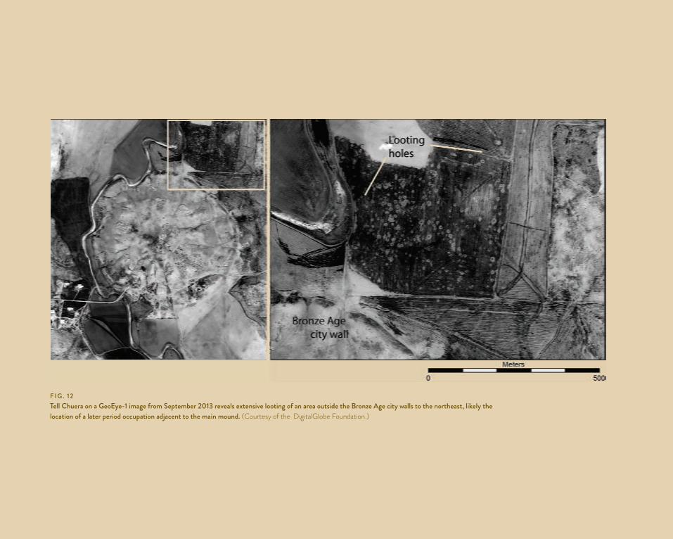
f i g . 12tell Chuera on a geoEye-1 image from september 2013 reveals extensive looting of an area outside the Bronze age city walls to the northeast, likely the location of a later period occupation adjacent to the main mound. (Courtesy of the Digitalglobe foundation.)
JEMAH
S 2.2_04_Casana_Panahipour_N
OTE.indd 146
03/06/14 9:59 AM

f i g . 13tell ashtara in far southern syria on a WorldView-1 image from august 27, 2013, revealing many large holes across the top and sides of the mound dug since the start of the war. (Courtesy of the Digitalglobe foundation.)
JEMAH
S 2.2_04_Casana_Panahipour_N
OTE.indd 147
03/06/14 9:59 AM

148 | SAteLLite-BASeD Monitoring of Looting AnD DAMAge
Site Imagery Date War-Related Reported Damage Pre-War Observed Damage War-Related Observed Damageal-Bara Nov. 2012 Encampment of refugees;
shelling damage; lootingamrit aug. 2013apamea Nov. 2012 Bulldozing; shelling damage; looting Extreme looting; military
garrisontell asharne Jan. 2013 Extensive urban developmenttell ashtara (aštaroth) aug. 2013 looting severe trenches or looting holestell Baqalou april 2012 Military garrison tell Bi’a (tuttul) oct. 2012 severe looting gradual expansion of lootingBosra oct. 2013 looting; shelling damage Extensive urban developmenttell Braidij april 2012 Military garrisontell Brak feb. 2013Carchemish oct. 2013tell Chuera sep. 2013 lootingCyrrhus aug. 2012 looting; shelling damageDura Europos Nov. 2012 looting; vandalism gradual expansion of lootingEbla (tell Mardikh) Nov. 2012 looting; vandalism Military garrisonEr-rubba april 2012 severe looting Expansion of lootingtell fakhariyah feb. 2013tell halaf Dec. 2012 Extensive urban development Expansion of cemetery
on moundhamman et-turkman oct. 2012tell houash april 2012 Military garrisonhamoukar aug. 2012Jebel Khalid July 2010 occasional looting N/atell Jifar Nov. 2012 severe looting severe looting; military garrisontell leilan april 2013Mari (tell hariri) June 2012 looting; vandalismMedinet al-far oct. 2012 looting severe looting Expansion of lootingtell Mozan feb. 2013Palmyra april 2011 shelling damage occasional looting N/atell Qarqur Nov. 2012 Military garrisonsabi abyad oct. 2012tell salba april 2012 severe lootingtell sheikh sultan april 2012 lootingtell es-sweyhat oct. 2012sheikh hamad Jan. 2012thoul Nayel oct. 2012 Extreme looting Expansion of lootingugarit (ras shamra) May 2013 Vandalismtell Zeidan oct. 2012Note: “reported Damage” is that known from media or government reports, while “observed Damage” is that documented on satellite imagery.
ta B l E 1 s u M M a r y o f D a M a g E t o a r C h a E o l o g i C a l s i t E s t h at a r E Pa r t o f t h i s s t u Dy
JEMAHS 2.2_04_Casana_Panahipour_NOTE.indd 148 03/06/14 9:59 AM

JourNal of EastErN MEDitErraNEaN arChaEology aND hEritagE stuDiEs | 149
in our study where imagery could reasonably be expected to reveal looting (i.e., excluding those where vegetation or modern buildings obscure the ground), large num-bers of looting holes were identified. Most of these sites, particularly those in more remote regions such as Dura Europos and Medinet al-Far, show severe looting dam-age that predates the war, and, in many cases, most nota-bly at Apamea and smaller sites in its vicinity, the scale of looting has increased dramatically since the war. The preference for looting of late-period sites could be driven by several factors, including what kinds of antiquities are easier to sell, such as mosaics or sculptural fragments. Some preference for late-period sites may also be related to the much greater abundance of gold, silver, and other metals generally found at such sites, if looting is driven by metal detecting.
In contrast, very little evidence of looting can be found at early prehistoric, Bronze, or Iron Age sites in the study. At Bronze Age sites where we do see loot-ing, as at Tell Bi’a, Tell Chuera, and Tell Jifar, it seems to almost exclusively target areas off or adjacent to the main mounds, and thus is most likely focused on late-period components of these sites. However, prominent Bronze and Iron Age mounds are being damaged quite severely in many cases by the construction of military garrisons on top of them. Large tell sites often occupy naturally strategic points and frequently form some of the most obvious high points in the landscape, thus being attractive to military commanders. Our study has found severe damage related to military activities at numerous sites including Tell Qarqur, Tell Jifar, Ebla, and Tell Ashtara, and we can expect that many other mounded sites are being similarly impacted. The dam-age resulting from such activities is not limited to direct bulldozing and trenching, but also from the strewing of
bullet casings, ordinance, and trash, creating challenges for archaeological excavations at these sites long into the future. Geographically, the areas shown to have the most intense conflict, such as northwestern Syria, are also those where the most military-related site damage appears to be taking place. Future studies might there-fore target areas that have seen the most military con-flict for new imagery acquisition.
Finally, it is important to note the temporal limita-tion of our current study, as in general, the more recent the available image is, the more likely it will reveal loot-ing or damage. For example, at Tell Chuera, a relatively recent Google Earth-served image from September 2012 shows no evidence of damage to the site, while imagery from a year later reveals extensive looting. Thus, efforts like those presented here to monitor looting and damage to sites across Syria should be ongoing until the conflict ends and archaeologists and antiquities officials are able to return and conduct ground assessments of damage.
Note1. A portion of the imagery presented in this project was provid-
ed by a grant from the DigitalGlobe Foundation and we are grateful for their support of our investigations. Research was undertaken at the Center for Advanced Spatial Technologies at the University of Arkansas and we owe our thanks to its director, Prof. Jackson Cothren, staff member Adam Barnes, and student volunteer Cameron Wright for assistance with the project. Results presented herein benefited from discus-sions with Emma Cunliffe and Kathayrn Hanson, and both deserve enormous credit for their ongoing efforts to monitor and publicize the cultural heritage crisis in Syria. A prelimi-nary version of this article was presented at the 2014 meeting of the Archaeological Institute of America in a special session dedicated to archaeology in conflict zones, and thanks goes to the session organizers and participants, especially Laura Childs, Fred Hiebert, Laurie Rush, and Corine Wegener for helpful discussion.
jesse casana is an associate professor in the Department of Anthropology at the University of Arkansas and also serves as chair of the American Schools of Oriental Research’s Damascus Committee. He is a specialist in the settlement and environ-mental histories of the Near East as well as in archaeological remote sensing, and until the start of the current war, he directed archaeological fieldwork at the site of Tell Qarqur in western Syria.
mitra panahipour holds a MA in landscape archaeology from the University of Birmingham in the United Kingdom and is currently a PhD student in the Department of Anthropology at the University of Arkansas.
JEMAHS 2.2_04_Casana_Panahipour_NOTE.indd 149 03/06/14 9:59 AM

150 | SAteLLite-BASeD Monitoring of Looting AnD DAMAge
referencesAbdulkarim, M. 2013. Archaeological Heritage in Syria during
the Crisis, 2011–2013. Damascus: Directorate General of Antiquities and Museums, Ministry of Culture.
———. 2014. Directorate General of Antiquities and Museums Annual Report 2013. Damascus: Directorate General of Antiquities and Museums, Ministry of Culture.
Akkermans, P. M. M. G., and G. M. Schwartz. 2003. The Archaeology of Syria: From Complex Hunter-Gatherers to Early Urban Societies (c. 16,000–300 BC). Cambridge World Archaeology. Cambridge: Cambridge University Press.
———, R. Cappers, C. Cavallo, O. Nieuwenhuyse, B. Nilhamn, and I. N. Otte. 2006. Investigating the Early Pottery Neolithic of Northern Syria: New Evidence from Tell Sabi Abyad. American Journal of Archaeology 110:123–56.
Al Jazeera. 2013. Syria Crusader Castle Damaged by Air Raid. July 13. http://www.aljazeera.com/news/middleeast/ 2013/07/201371310630457364.html (accessed January 27, 2014).
Al Quntar, S. 2013. Syrian Cultural Property in the Crossfire: Reality and Effectiveness of Protection Efforts. Journal of Eastern Mediterranean Archaeology and Heritage Studies 1:348–51.
Ali, C. 2013. Syrian Heritage under Threat. Journal of Eastern Mediterranean Archaeology and Heritage Studies 1:351–66.
Ball, W. 2000. Rome in the East: The Transformation of an Empire. London: Routledge.
Breasted, J. H. 1924. Oriental Forerunners of Byzantine Painting: First-Century Wall Paintings from the Fortress of Dura on the Middle Euphrates. Oriental Institute Publications 1. Chicago: University of Chicago Press.
Bryce, T. 2012. The Routledge Handbook of the Peoples and Places of Ancient Western Asia: The Near East from the Early Bronze Age to the Fall of the Persian Empire. London: Routledge.
Burns, R. 2009. The Monuments of Syria: A Guide. Rev. edn. London: I. B. Tauris.
Butcher, K. 2003. Roman Syria and the Near East. Los Angeles: J. Paul Getty Museum/Getty Publications.
Casana, J. 2007. Structural Transformations in Settlement Systems of the Northern Levant. American Journal of Archaeology 111:195–221.
———. 2012. Site Morphology and Settlement History in the Northern Levant. In Landscape, Transport & Communication. Vol. 1 of Proceedings of the 7th International Congress on the Archaeology of the Ancient Near East, 12 April–16 April 2010, The British Museum and UCL, London, ed. R. Matthews and J. Curtis, 593–608. Wiesbaden: Harrassowitz.
———. 2014. The Late Roman Landscape of the Northern Levant: A View from Tell Qarqur and the Lower Orontes River Valley. Oxford Journal of Archaeology 33 (2):193–219.
———, and J. Cothren. 2013. The CORONA Atlas Project: Orthorectification of CORONA Satellite Imagery and Regional-Scale Archaeological Exploration in the Near East. In Mapping Archaeological Landscapes from Space, ed. D. C. Comer and M. J. Harrower, 33–43. SpringerBriefs in Archaeology. New York: Springer.
———, J. T. Herrmann, and A. Fogel. 2008. Deep Subsurface Geophysical Prospection at Tell Qarqur, Western Syria. Archaeological Prospection 15:1–19.
Challis, K., G. Priestnall, A. Gardner, J. Henderson, and S. O’Hara. 2004. Corona Remotely-Sensed Imagery in Dryland Archaeology: The Islamic City of al-Raqqa, Syria. Journal of Field Archaeology 29:139–53.
Chulov, M., M. Weaver, and J. Meikle. 2011. Syria Ratchets Up Military Operation on Jisr al-Shughour. The Gaurdian, June 10. http://www.theguardian.com/world/2011/jun/10/syria-military-jisr-al-shughour (accessed January 27, 2014).
Contreras, D. A. 2010. Huaqueros and Remote Sensing Imagery: Assessing Looting Damage in the Virú Valley, Peru. Antiquity 84:544–55.
Cunliffe, E. 2012. Damage to the Soul: Syria’s Cultural Heritage in Conflict. Palo Alto, CA: Durham University and Global Heritage Fund. http://ghn.globalheritagefund.com/uploads/documents/document_2107.pdf (accessed January 27, 2014).
———. 2013. No Longer Lost in the Wilderness: Cultural Property Crimes in Conflict. Journal of Eastern Mediterranean Archaeology and Heritage Studies 1:343–47.
Curvers, H. H. 1991. Bronze Age Society in the Balikh Drainage (Syria). PhD diss., University of Amsterdam.
Dornemann, R. H. 2012a. The Qarqur Challenge: Middle Islamic through Iron Age. Near Eastern Archaeology 75:162–76.
———. 2012b. The Qarqur Challenge: The Bronze Age and Earlier. Near Eastern Archaeology 75:220–31.
Eger, A. 2012. The Spaces between the Teeth: A Gazetteer of Towns on the Islamic-Byzantine Frontier. Istanbul: Ege Yayınları.
Hritz, C. 2013. A Malarial-Ridden Swamp: Using Google Earth Pro and Corona to Access the Southern Balikh Valley, Syria. Journal of Archaeological Science 40:1975–87.
Jahjah, M., C. Ulivieri, A. Invernizzi, and R. Parapetti. 2007. Archaeological Remote Sensing Application Pre-Post War Situation of Babylon Archaeological Site—Iraq. Acta Astronautica 61:121–30.
Kila, J. D. 2013. Inactive, Reactive, or Pro-Active? Cultural Property Crimes in the Context of Contemporary Armed Conflicts. Journal of Eastern Mediterranean Archaeology and Heritage Studies 1:319–42.
Matthiae, P., and N. Marchetti, eds. 2013. Ebla and Its Landscape: Early State Formation in the Ancient Near East. Walnut Creek, CA: Left Coast Press.
Menze, B. H., and J. A. Ur. 2012. Mapping Patterns of Long-Term Settlement in Northern Mesopotamia at a Large Scale. Proceedings of the National Academy of Sciences of the United States of America 109:778–87.
Meyer, J.-W., ed. 2010. Vorbericht zu den Grabungskampagnen 1998 bis 2005. Vol. 2 of Ausgrabungen in Tell Chuera in Nordost-Syrien. Wiesbaden: Harrassowitz.
Miglus, P. A., and E. Strommenger. 2007. Der Palast A. Vol. 7 of Ausgrabungen in Tall Bi’a/Tuttul. Wissenschaftliche Veröffentlichung der Deutschen Orient-Gesellschaft 114. Wiesbaden: Harrassowitz.
Stein, G. 2009. Tell Zeidan. Oriental Institute Annual Report 2008–2009:126–38.
JEMAHS 2.2_04_Casana_Panahipour_NOTE.indd 150 03/06/14 9:59 AM
JourNal of EastErN MEDitErraNEaN arChaEology aND hEritagE stuDiEs | 151
Stone, E. C. 2008. Patterns of Looting in Southern Iraq. Antiquity 82:125–38.
Strommenger, E., and K. Kohlmeyer. 2000. Die Schichten des 3. Jahrtausends v. Chr. im Zentralhügel E. Vol. 3 of Ausgrabungen in Tall Bi’a/Tuttul. Wissenschaftliche Veröffentlichung der Deutschen Orient-Gesellschaft 101. Saarbrücken: Saarbrücker Druckerei und Verlag.
Syria Needs Analysis Project. 2013. October Regional Analysis for Syria (RAS). Part I: Syria. 30 October. http://acaps.org/en/pages/syria-snap-project (accessed January 27, 2014).
Trafficking Culture. 2012. Looting at Apamea Recorded via Google Earth. http://traffickingculture.org/data/looting-at-apamea-recorded-via-google-earth/(accessed January 27, 2014).
UNESCO. 2014. Syrian Arab Republic. http://whc.unesco.org/en/statesparties/sy (accessed January 27, 2014).
Van Loon, M. N., ed. 1988. Hammam et-Turkman I: Report on the University of Amsterdam’s 1981–84 Excavations in Syria. 2 vols. Uitgaven van het Nederlands Historisch-Archaeologisch Instituut te Istanbul 63. Istanbul: Nederlands Historisch-Archeologisch Instituut te Istanbul.
Walmsley, A. 2007. Early Islamic Syria: An Archaeological Assessment. Duckworth Debates in Archaeology. Bristol: Bristol Classical Press.
Watson, L. 2013. “This Is Like Blowing Up the Taj Mahal”: Fierce Fighting Reduces Iconic 11th-Century Minaret at Syria Mosque to Rubble. The Daily Mail, April 24. http://www.dailymail.co.uk/news/article-2314459/Umayyad-Mosque-Archaeologists-left-horrified-historic-11th-century-minaret-reduced-rubble.html (accessed January 27, 2014).
Weaver, M. 2012. Syria Crisis: Aleppo’s Historic Souk Burns as Violence Continues. The Gaurdian, October 1. http://www .theguardian.com/world/middle-east-live/2012/oct/01/syria-aleppo-souk-destroyed-live (accessed January 27, 2014).
Wilkinson, K. N., A. R. Beck, and G. Philip. 2006. Satellite Imagery as a Resource in the Prospection for Archaeological Sites in Central Syria. Geoarchaeology 21:735–50.
Wilkinson, T.J. 1998. Water and Human Settlement in the Balikh Valley, Syria: Investigations from 1992–1995. Journal of Field Archaeology 25 (1):63–87.
JEMAHS 2.2_04_Casana_Panahipour_NOTE.indd 151 03/06/14 9:59 AM