Lands Administration Office Lands Department - Practice Note
Upload
khangminh22Category
view
1download
0
SAN DIEGO LAGOONS . . ' · ... ' . ' . ~
Title and BoundarY lnlorn1ation
Compiled by the staff of the
California Slate Lands Commission FEBRUARY 1 , 1985

TABLE OF CONTENTS
Statement on Ti de and Submerged Lands ............................ .
Agua Hedi onda Lagoon ............................................. .
Ba ti qui tos Lagoon ................................................ .
Buena Vista Lagoon ............................................... .
Las Flores Marsh ................................................. .
Los Penasqui tos Lagoon ........................................... .
San Dieguito Lagoon .............................................. .
San Elijo Lagoon ................................................. .
San Mateo Marsh .................................................. .
Santa Margarita· -Marsh ............................................ .
Sweetwater Marsh ................................................. .
Tijuana Estuary . ................................................. .
NOTE: This draft material has been prepared for staff use only and must not be distributed to other than State Lands Commission staff or staff of the Land Law Section of the State Attorney General's Office until authorized by the State Lands Commission.
The purpose of this booklet is to provide staff with a quick desk reference to some facts about each lagoon. It is intended to be updated or revised as new and additional information is obtained.
Page
2
3
13
23
34
41
51
59
68
76
84
96

STATEMENT ON TIDE AND SUBMERGED LANDS
The State of California was admitted to the Union on September 9, 1850, on an equal footing with all other states. Because of the equal footing doctrine, California received all the title-related interests in and to the tidelands and inland waters which were previously held by the United States. These interests consisted generally of both the underlying fee title, {jus privatum) and also a public trust {jus publicum).
During the 19th century, laws were enacted by the State Legislature generally providing for the sale to private owners of certain wetlands. Included under this category were swamp and overflowed, salt marsh, and tidelands. During the period most such wetlands were sold, inadequate data on tidal measurements existed so as to enable prospective purchasers to identify with certainty whether desired lands were either swamp and overflowed, tidelands, or submerged lands. As a consequence, lands were sometimes sold under an erroneous categorization as to the true character of the wetland.
Recognizing this as a problem, the State Legislature, in 1872, passed an act for the relief of certain purchasers of State-owned wetlands. Because of the limited application of this curative statute, however, some serious title questions remain as to the nature and extent of the interest acquired by individuals purportedly purchasing State-owned wetlands.
In other situations, areas of tide and submerged lands were sometimes included within the exterior boundaries of lands confirmed to persons holding title under grants from the Mexican government prior to 1846. In these situations, case law is presently insufficient to identify with confidence the extent of the State's interest vis-a-vis the private ownership rights acquired from the Mexican sovereign. for the purpose of this discussion, title holdings within the pueblo lands of a city are deemed to be of the same nature as those in grants to individuals.
?

I
I ORANGE I
COUNTY ~-~-~-{._ ) ' ........... ___ , .........
I ._~~~~~-E~~:__ ______ _ ,
SJ-\J"J DJ£ G 0 BUENA VISTA LAGOON
llGUll HEDIONDll LllGOON
BEACH
<!> SAN DIEGO
CHULA VISTA
TIJUANA ESTUARY ----------------------MEX\CO BAJA CALIFORNIA

z I 0 a_ 0 LO <t (.!) I'-a:: <t m (.!) ....J 0 <t ~
t- 0 <X> 0 LL. z >-I 0 0 a:: a_
0 <t ....J w ::::> <t I a::
aJ a:: <t w w ::::> LL. <t (.!)
<t
4

DRAFT - FOR STAFF USE ONLY w 20725.5
AGUA HEDIONDA LAGOON
l. Purported acquisition by the State of California reflected by documents in the public record:
None.
2. Purported disposition by the State of California reflected by documents in the public record:
None.
3. Comments:
The lagoon, in its natural condition, appeared to contain tide and submerged lands; however, see statement concerning status of such lands when they are·located within the exterior boundaries of ranchos(page 2}.
Agua Hedionda Lagoon is located within the exterior boundaries of Rancho Agua Hedi onda, which was confi nned to Juan Mari a Marron on December 12, 1872.
The plat indicates Rancho Agua Hedionda contained 13,311.01 acres. There is. no description of the lagoon in the field notes for the survey of Rancho Agua Hedionda, nor is there any infonnation that the lagoon was meandered at the time of the survey in August 1858, by John C. Hays, Deputy Surveyor.
February 1, 1985
c:
This infonnation reflects only record data and does not indicate a detennination by the State of the validity or legal effect to be given to the patents or a 1·determi nation as to the character of the land.

' rl -(
~ -~l ~-
t . l -· ~-
,, ~···
,,..
~
. , -".
("•··
\ , "·
.. . I
,-
\...... -. -.. ..
--.. -_ -----4-.,,,...
,
/
ti::
~ i
6
- .,. ,,.~ .. '\: ~II
l 1m:1 I If•
~i~ -._..
l ~
l
J ' . 1. l t t ~- -
; l<~!'lt~l'fli~l' l HPIHl'U u ~ ~ ~ ~ ~ ~ - ~ ~ ~
Ii .,j ............. .
__ ,,,.
.... , J .N: -J . II.)
~t' -.
tt J li ' 11~~ ~Jl " I
I
ji}J' L '
1~.J ~ 'Ill: r. Cl ... .. i
'° () ~.
__ J' I
CD· ; . :
.. .
\.. . ·'-
. -~ ~'.
~~\- . 1 . '. ! '< I
. i I j I
0 :I: (.) <( Zc <( z a::: 0
(X) lJ.J Ci lO
(X) :I: lJ.J ~ :I:
~ <( 0 :J ~ C.!> <( <( _J a..

0
8

.·
"I I
I
0 ____ : -··- ... --;.~--
~ - .... ~o 9

0
~
(/>
7
.z. I __,
0 ~1 I
7
I
0
7 08'
,..;>,
7
~
-.z.
7
21'
.,,. o,.
I -, \
1s, O;,
't>-ll "''\
/ -,--
\
\ I;
I
I' ',) /
I
--
tfote Grns, brudl or111mt·1ndvepi.tton 11nltssothefwlses11Dwn
/
' /'- - ......
\ _ _,
'
1.
\
\
I
I
I
l::,.Ap,INJ

c <(
lL. ::::> 0 0 z >-0 LU - a:: I-a:: CJ)
0 ::::> CL. _. <( z
<( CJ)
·- . ____ ___..~
------~- -·
/,. c
11
CJ) (!) CJ)
::::>
-0 0 0 N
CD II
U) = en Cl)
Q u
CJ)
~! /l- ... ···1
i . I
\

__. N
\ \· ',
0 96
'·"\• ~-------
tll
\ '\.
""-, ~
\ \ .\,
'
\\
('). ..,, ...,, -<" ....
\ ""' \
'r I
\ \"
\ \
I I '$
\
llR Bristol Cove Property Owners Assn.
lil.IIl Hunts Partnership
~ San Diego Gas 8 Electric Co.
~ Atchison, Topeka 8 Santa Fe Railway Co.
' \
'~ \ r . \\ ""-\· -~ . \
LAND HOLDERS
1984
AGUA HEDIONOA LAGOON
Scale 111= 2000'

I
I ORANGE I
COUNTY ~-~-~-~ ) ' .. , ......... r-- '"'i-~~~!!P~~~'!._ .. _____ _
I
SAN ONOFRE
BUENA VISTA LAGOON
AGUA H EDIONDA LAGOON
SAN ELIJO LAGOON-.._
SAN DIEGUIT-=0-~~ LAGOON
LOS PENASQUITos-~ LAGOON
SJ-\J'-J DJ.EGO
BEACH
• MISSION BEACH
0 SAN DIEGO
CHULA VISTA
TIJUANA ESTUARY -------------.. ---M·Ex,co BAJA CALlfORNIA
13

f
14

DRAFT - FOR STAFF USE ONLY w 20725 .2
BATIQUITOS LAGOON
1. Purported acquisition by the State of California reflected by documents in the public record:
Tl 2S, R4W, SBM.
Lots 11 through 20 of Section 33 (223.47 acres) acquired by S & 0 Patent No. 130, Los Angeles, approved Novent>er 23, 1905.
Lots 9 through 15 of Section 34 (191 .47 acres) acquired by S & 0 Patent No. 130, Los Angeles, approved November 23, 1905.
Lots 10 through 17 and SE~ of NW~ of Section 35, acquired by S & O Patent No. 130, Los Angeles, approved November 23, 1905.
2. Purported disposition by the State of California reflected by documents in the public record:
Desc.
Tl2S, R4W, SBM
Section 33
Lot 17
Lots 13 and 20
Lots 11, 12, 14, 15, 16, 18, and 19
Section 34
Lots 9 through 15
Section 35
Lots 10 thru l?, and SE~ of SW~
February 1, 1985
Patentee Date
Nathan A. Eaton 4/19/1887
Jacob Gruendike and Thomas E. Metcalf 1/14/1887
Thomas E. Metcalf 8/05/1887
Thomas E. Metcalf 8/05/1887
Thomas E. Metcalf 8/05/1887
s & 0 Lo ca ti on
1686
2203
2429
2429
2429
This info.nuation reflects only record data and does not indicate a determi~ nation by the State of the validity or legal effect to be given to the patents or a detennination as to the character of the 1 and.
15

DRAFT - FOR STAFF USE ONLY
3. Convnents:
Batiquitos Lagoon was ~egregated from surrounding uplands by government meander line.
The lagoon, in its natural condition, appeared to contain tide and submerged lands.
February 1, 1985
16
. .
This information reflects only record ~ata and does not indicate a detennination by the State of the validity or l~gal effect to be given to the patents or a detennination as to the character of the land.

t~ ~1 "
~ ~':$ '"' • "" (.')
~
~~ ~~ '-)~
~ ~
® ~ ~' ~
j
~
~ r · ~
t..;, ;;;,
~
~ ~
~~ J!" · ~
17
~ ~ a.. ::::c: en z ;: 0 1--

r I C
~ c; I
18
~ <( _J a. a. --:I: (/) z
~

19

20

N __,
\
A PORTION OF
ENCINITAS QUAD
USGS
1968 Scale 111=2000 1

N N
" \ ' \ \
~ \\\ \ ' ' \ \ \ \ \ \
\ / \9 \
\ '"" \ \ \ \ \ \
\
BATIQUITOS LAGOON
T 125, R4W, SBM Scale 111 = 20001
J ' \ ) l "' 1 1 .,-,, .... -, uzr· - vurr r 0 ,~
RECORD LAND HOLDERS 1984
IDilill! W. H. HUNT
mmrnrn STATE OF CALIFORNIA
§ SEA BLUFF ASSOCIATES
• HSL I GROUP I
[!] LEUCADIA COUNTY WATER DISTRICT
WILLIAM C. SAVAGE ~
• COMMUNITY BANK ( CORP.)

ORANGE COUNTY
I
I I
~-----~ ) "- .. , ........... r- ~ RIVERSIDE COUNTY --------....._ ________ _
BUENA V/STALllGOO SJ--\J\J DJEGO
AGUA H EDIONDA LAGOON
SAN ELIJO LAG N-~
SAN UIT..::.0-~IQIP ~--- AGOON
LOS PENASQUITOS-~ LAGOON
• MISSION BEACH
<!> SAN DI EGO
CHULA VISTA
TIJUANA ESTUARY -----------------·-MEX\CO BAJA CAL\FORNIA
23

:c z a. 0 IO
ii 0 I'-<.!) CJ')
<.!) <{
~ .....J ~
CD 0 LL. ~ >-:c 0 CJ) 0::: a.
> <{ :::> .....J <{ 0::: <{ z CD
0::: w w w :::> LL. <{ CD
24

\{ 20725. 6 DRAFT - FOR STAFF USE ONLY
BUENA VISTA LAGOON
1. Purported acquisition by the State of California reflected by documents in the public record:
TllS, R5W, SBM.
All of fractional Section 36 (614.46 acres) was acquired on December 27, 1870, approval date of the United States plat of survey, under the School Land Grant, Act of Congress approved March 3, 1853 (10 Stat. 244).
TllS, R4W, SBM.
Lot 3, Section 31, was acquired as lieu land by Clear List No. 20, Los Angeles, approved November 19, 1891. Lot 2 was acquired as lieu land by Clear List No. 29, Los Angeles, approved October 22, 1910 .
. . Tl 2S, R5W, SBM.
There was no acquisition by the State of California of Section 1.
2. Purported disposition by the State of California reflected by documents in the public record:
Desc.
Section 36,
N~ of NE~
NE~ of NW~, SW~ of NW~ and Lot l
E~ of SW~, s~ of NE~ and SE~ of NW~
NW~ of NW~
NW~ of SE~
Lot 2
February 1, 1985
Patentee
TllS, R5W, SBM.
J. Chauncey Hayes
J. Chauncey Hayes
J. Chauncey Hayes
J. Chauncey Hayes
Date
4/25/1885
4/25/1885
4/25/1885
5/04/1885
School Land Location
LA 1194
LA 1554
LA 1791
LA 2051
James A. Boxley 12/15/1885 LA 2037
J. Chauncey Hayes 3/02/1886 LA 2279
25
this information reflects only record data and does not indicate a determination by the State of the validity or legal effect to be given to the patents or a determination as to the character of the land.
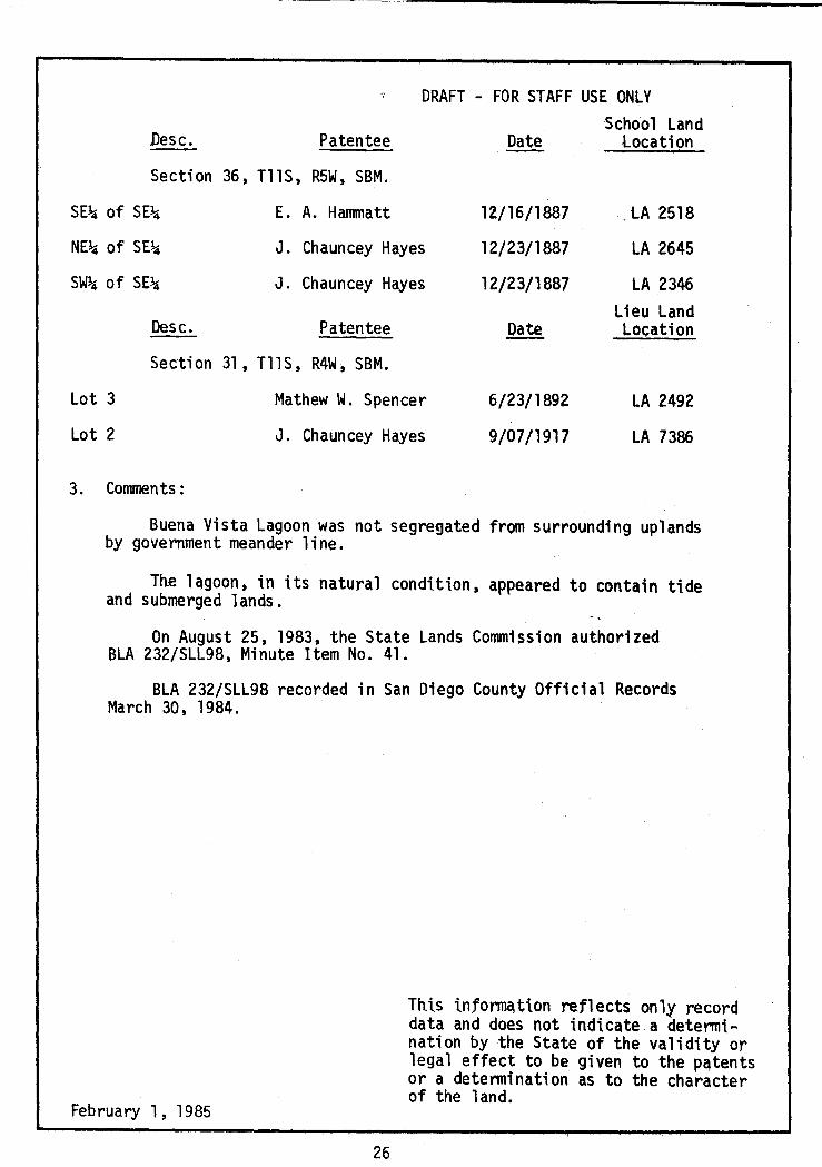
Desc. Patentee
DRAFT - FOR STAFF USE ONLY
Date -·School Land
location
Section 36, TllS, R5W, SBM.
SE~ of SE~ E. A. Hammatt 12/16/1887 LA 2518
NE~ of SE~ J. Chauncey Hayes 12/23/1887 LA 2645
SW~ of SE~ J. Chauncey Hayes 12/23/1887 LA 2346 Lieu Land
Desc. Patentee Date Location
Section 31, TllS, R4W, SBM.
Lot 3
Lot 2
3. Comments :
Mathew W. Spencer
J. Chauncey Hayes
6/23/1892
9/07/1917
LA 2492
LA 7386
Buena Vista Lagoon was not segregated from s~rrounding uplands by government meander line.
Th.e hgoon, in its natural condition, appeared to contain tide and submerged lands.
On August 25, 1983, the State Lands Commission authorized BLA 232/SLL98, Minute Item No. 41.
BLA 232/SLL98 recorded in San Diego County Official Records March 30, 1984.
February 1, 1985
26
This informqtlon reflects only record data and does not indicate a determination by the State of the validity or legal effect to be given to the patents or a determination as to the character of the 1 and.

't ' " .. ' ' " ~ fl
~ ~'" ~~~ h ~
""' ~ "'' \\ -~ .. ~-~ ~~ ~ ~~~
:i 'i~~ ~ ~ l;S
..; ~ ~~ ~ ~~ ~.,~ ~
~ ..
27
0 l'<X>
1. ·~
t .\ ~
' ~ ,, ~ ~ ~ ) ~ ' ~ "I
~-·~
\
" " ' ~ " " \)
•'\ -.::
~ a. a. ::r: en z 3: 0 I-
~h ~ ~ 's.\ ~~~ 'i:'' '

.-..i•.'"-•''.I'
~·.' ~!· I!;:
28
I I i I I I

N l.O
Township N°12 Sou th,
-.... ~. -.
'"""'n'"...,N°5West.
-....,; "":.
"":. ""'· -:..12
. 75~
g
San Bernardino Mer id 1an.
. \' "''""'\~~··"\~".,;.'" \' ., ': . .., .. .i
t~-sfi,it.T~.\$ Iv~
F u .. t. c,oPY
~~~
/l'97re9'orc v/ /-",,,4//<' /..r.J/·n./ .ec-1.s b:e ~?,-.r·rs
·" DF:
.,/
T"r<".' •,?60•'"1" -?<"c/~or ·'"h.,.·rr,'l'h/1,o
Nft-'<'4 •''"'""""' 6<:!".,-rr <:" ,.,_,.-,,,.,.,.,_,,, • .,.,,..,, <;>rr,-_,.
:>uN v.s yor ,;~,..,,er~0>/ :f ('.>,-¥,,:,,- ""'·
<:.C,/,~nr'?_,C>'_,
/$8.~
1883
TOWNSHIP PLAT

30

G
31
0
Q)
0 0 en
0

w N
"'o
54
,6'o
\
\~ ~\
' ' ',
"~,
84
I /8
\ '-
cs
Q
0 ' 'C' ) 26
~-"\ \
'-~ I
\\
A PORTION OF SAN LU IS REY QUAD
USGS 1968
Scale 111=20001

' ITiliI:I!J State of California 11111111111111 Pup Properties IIIIIIl1 oceanside Three c::::s.'S:S:l AtchisonJ Topeka &
Santa Fe Railway Co. ! c:::::::J See p. 33A
:ARLSBAD
'~ .
+
!-.••
#,;>' :•
•, .. ~ .. 29 .
I ' '
·; , l' ••
,_,/..-·'' ,'11 • • . :,:'· .. ·· //• ~;~ .·?~.: I , • ;l• f' .Y. • ·' •• • /1: .,,;• •/>• ••
'IEI Carnl't\o•.·' t •//•• • Co•Jntry Cfwp ' >~-.. ·• •. o __ ;' 1
- - ').If- ~ --c, ;r- + _ 1_.I 1~/.:'. r-~~~ ~ 'l:i :1~ ,.!- _£+--=
Sewage - --Disposal •• k-_,.,..--,,.... ·- -- ...... '!__ -- ------,~;:-i -·-'<'> ~ 1
fll'l I.CC/ Shopping w.~:\, ~'-:?.:.::}:• :1' I Center ,~~;_~('%;:;.
31
AVE
I- -
,,
:;; :-:----
I
I I •
" I' '-.,,,... ',, //j,~ "-,,
,,;/,"' ',, c· Lr..'//-.- ----~{s l~J -,_ ,&_-11) ~'l" - "
;!} \~~~~· ', \
,._\
' ·\' r - '
" 11 ·- ' ;.
c-""'; /\ • L,,_, ,..,,,~-- / \ ~' . ( \ , '
\ <' I ~,, ·I ~
'·-~c • /, 0 ' ~ . ~ "'\ yr£Dfc . &. \ / \ ,(:, '7- '\
\'0·---} ·'" :: ,, • --.---'I \ ·~;:'-"-" l/K
!-/' ·. irl/r \ v - \ I/ . , . ;fL---.-/' ' I_:=~~ \_fC ,-c{D~
"•• "-- I '"'-ill h :, . \ -, .. ,,..,, ~ ,J, . ·., ,. ,-~
+ ""· ~(,:T~i: ; '-, '~'!c"" ~-l ~t !~ '\,
,_-?'' ~~\/> ,,~ '\<' "Jo - . :/¢-;::- '. ''.;:<;."'
~ ,~ «ts_jP-. • -i-_,, -.,-Jf-" .--< :, WT
0 •
iV!t"' I .
» I
't
r ,<~k , if!~·~-' "\ ,1 ,~-tii.· \ ·'
I ,- ~~(_ _,
·: ~ i I \\ \)\1 ' ,,.
28~~~('~\~. '~ , I 'f i' \':'-: \)o \ 'I
--- - /; ~-) ! \.
~"f-
RECORD LAND HOLDERS
1985
Valley Jr High Seh•
M" BUENA VISTA LAGOON
Scale: 111= 2000' I> ~~,,.Y • 1yJJJ~~ \ ··~
/--- ·.\ .\ -' ~
----~

w w 1lJ
1, 2, 3, 4, s . ·:•=::mm
6, 7, 8, 9 ··;:~ ·. -, ,~
IT!IIi!:iIJ State of California IIEEEB H. Tenaglia
~ RJB Enterprises ~ Native Sun - Carew ~ Lagoon Association
~~i -'-~ I
~~ ! I
1. N. Tenaglia 2. Investment Operating Corp. 3. S. Haskell 4. R. Norvet 5. J. Madden
6. H. Darling
T 11 I 7. v. Caber l y 8. J. Schwarzenbach T 121 9. H. Colmery I
RECORD LAND HOLDERS
1985 BUENA VISTA LAGOON
NOT TO SCALE

ORANGE COUNTY
SAN ONOFRE
LAS FLORES MARSH
BUENA VISTA LAGOON
LOS PENASQUITOS---4eo.. LAGOON
34
SJ-\J'\J DJ.EGO
BEACH
• MISSION BEACH
<!> SAN DI EGO
CHULA VISTA
--------------MEX\ CO BAJA CALIFORNIA

:I: :I: Q.. CJ) <[ a:
~ a: <[ (.!) ~ m 0 .....
LL. CJ) r--:-0 w
:I: 0 a: C\J Q.. g w ...J z
LL. ::::> <[ CJ) -:> a: <[ w ...J <[
35

DRAFT - FOR STAFF USE ONLY w 20725
LAS FLORES MARSH
1. Purported acquisition by the State of California reflected by documents in the public record:
None.
2. Purported disposition by the State of California reflected by documents in the public record:
None.
3. Comments:
The marsh, in its natural condition, appeared to contain tide and submerged lands; however, see statement concerning status of such lands when they are located within the exterior boundaries of ranchos (page 2).
Las Flores Marsh is located within the exterior bo~ndaries of Rancho Santa Margarita y Las Flores, which was confinned to Pio Pico, et al, on March 28, 1879.
The plat indicates Rancho Santa Margarita y Las Flores contained 133,440.78 acres. Las Flores Marsh was not meandered in the surveys of 1876, 1877 and 1878, by Wm. P. Reynolds and Wm. Minto, Deputy Surveyors.
February 1 , 1985
36
This information reflects only record data and does not indicate a detennination by the State of the validity or legal effect to be given to the patents or a detennination as to the character of the land.

w -....!
_, ~-
"'Ir'-
.1 .... ,, """~'
_, ,...,
'J
r>
"'!· . .,
·I.
' .J4 .. " -.C.t.J,,i' • , .1 ;- ~··•· •; I
.. )t fl .. ~.,,» ..... .. I ( ... --.~ ........ ., -
................... .. ((,,..,.·,";(
i-- - ___ -i. _____ --- - ----- ·----r-----.... ;.
··-.~~ ;,..11'9 (;-+
...______
o,,.
------,-----
J>,.,,,..,
~
• ;. • ~
#~ .. Ttlll ftllW
/
~
~ ' &
·l\11.11
,, Vl'f".#•
. ,...., .. ,. ,., ... , "" .. 1 •• ,.., ..
... 1 •• - ••
.. <l•·'r' ..... "', ..... I
If. --·~· ..... Ill·"' ..... . ".I Y•'WW •• IC ........ , . ·-·· .. ,, //( ..... ,.
... '! . ...,.,
.. , .....
...... t~;;d:1 ;;· . I I I I: ;;~:: :,·: ;;::
£ ./J,e.y .,(. ,, IQ, 1'.,: .,, ~
.. -.,,~ .. -~··· #~~, ~ ,/i!l:..-.4 r:Jf,...c:...f,, -~ C-.r ...
n ~.-
• ··u-.#~ . ., ....... &.••I.._. ·: ...... ,-=-~- ·· '.9.'._..,
~- -· .. ..:.::.: ... APPROVED 1879
PLAT OF THE RANCHO SANTA MARGARITA
Y LAS FLORES

' \ \ ' ' \ \ II'' '
\ 1-- '·
\ \ 0 '·· \
\ \ \ ..... ~ 1- "· \
\ t. J
-- ___ -_\_ - -~'v --- -' ( '------{
T ' I • \ I
38
l I ·---~,-- ----+-- - -....:-...
! I
/ (
~
\ I
(/) z (!) 0
d5 ~ (.) ~ b (/) Cl. v 0 :::> ~ v 0 u..oiov~ Q (.). I !'() :
I- en -z 0 . - Q) 0 I- 0 -- 0 z 8 I- :::c: (/) ~ Cl. Cl. a:: <( <(
,-····--

w l.O
\_~
~
0 < ~
0
24
L_
~ \~ \
\ \ ' ' ¥
\ \ ,,
0 ~
47
\
27
\
"' \ \
\,
$
24
7 \ I
~ ~
7
·::.
\ ··~,
' \ \ . ' ' \ \ \ .. ''' \<0
' \ \
\ "·",,, 27
(
\~ ~·,
~\
.\
\_ <'·
i'9
'·
.\
'\. \~ '.,'
', \
A PORTION OF LAS PU LGAS CANYON QUAD
USGS 1968
II 20 I Scale I = 00

""'" 0
·~
c.
\, -'\ ·"· \ \ ·,
\ \
c< \ \ '·\
\ '
\, \
\ \ ' \ ., .,
'-..!., 7 '.
',\ \
\ ~ ~
.. \
'·· \ .
' \
"\\ "-, \cl
0 ~
.,
\
\ '\,
. \
- \ CJ> •
\ \
\ \ \
\ \,
$
c<
,_;)
'
· 7 ~ ~
" I
7
b { :! United States of America
\ \\,
\ ·.,
-.\ \
I
', .,_
( \
\
·v.o "\, \
I
\
cl \ .
\ \
\. \__ . \
\\'·,'
·.,,_ \
~ Atchison Topeka and Santa i=;e RR l9
'\, ., \~ ",'
'· \
RECORD LAND HOLDERS 1984
LAS FLORES MARSH
Scale I 11= 2000 1

I
I ORANGE I
COUNTY ~-~-~-{._ ) """ .. , "-.. r-- "'i-~~~~_E~~~:_ ______ _
SAN ONOFRE
SAN ELIJO LAGOON-
SAN DIEGUIT-=-0----1~ ~ LAGOON
~ LOS PENllSQU/TOS ~ LAGOON Q ~
~
~
0
~ "lx\>.. TIJUANA ESTUARY
41
SJ-\J"J DJ.EGO
(!) SAN DIEGO
CHULA VISTA
----------------------- MEX\CO BAJA CALIFORNIA

42
z
§ ~ u... <( <( 0 _J ~ a:: en ·'-' z 0 m 0 0 ..._ ,..:-~ ..._ :::::::> (\J
~ gs 0 w a..11.~z _J <( z :::::::> <( w J
a:: ~ a.. w <( en
g

DRAFT - fOR STAFF USE ONLY w 20725. 3
LOS PENASQUITOS LAGOON
.1. Purported acquisition by the State of California reflected by documents in the public record:
None.
2. Purported disposition by the State of California reflected by documents in the public record:
None.
3. Comments:
Most of the lagoon lies within the exterior boundaries of the Pueblo Lands of San Diego; the remainder lies in Section 25, Tl4S, R4W, SBM. The Pueblo Lands of San Diego were surveyed in 1858 by John C. Hayes, Deputy Surveyor and granted to the trustees of the City of San Diego on April 10, 1874. Section 25 was surveyed in 1874 by John Goldsworthy, Deputy Surveyor and four Federal patents were issued beginning in 1880.
Government Patents.
Desc. Patentee Date
Section 25, Tl4S, R4W, SBM
NW~ of NE~, NE~ of NE~, SE~ of NE~, Lot 6
Lots l, 2, 3, & 4
Lot 5
Lot 7
February 1 , 1985
D. D. Brady
Georgie D. Weed
Benjamin F. Allen
John Work
September 10, 1880
June 15, 1892
June 22, 1895
June 22, 1895
43
This information reflects only record data and does not indicate a determination by the State of the validity or legal effect to be given to the patents or a determination as to the character of the land.

DRAFT - FOR STAFF USE ONLY w 20725.3
The 1agoon, in its natural condition, appeared to contain tide and submerged land; however, see statement concerning status of such lands when they are located within the exterior boundaries of ranchos (page 2).
There was no mention of the lagoon in the government surveys or the patent descriptions.
February l, 1985
44
This information reflects only record data and does not indicate a detennination by the State of the validity or legal effect to be given to the patents or a detennination as to the character of t~e land.

I ;.¥I I 11- 1 J .,,, .., I •1
.. -'WJ,,. .. ~ ... <H ,.,.,,,,,
, .... I ,,,,,~,,, ..,,.,., ,, .,,,,,."" .. ,,.,,,~
, .... ,.,. .. ,,, . .1 ,,,,.,,.. Lie•
• s..-c.- , ••• , .II• , '••• . , ,,,., ,.,,.
'" NUw U•• J 1111{,"1 ''"• '" ,,.,,.,., .,. ,. '.,,. ... , .. I S611f,111 '••• I I"' 1¥ Ill le
'1" S/l-,.L. '••• 11 .T"li'Jll U.111 ti lll'A"" ••- • Al 1',,, 1•1• ,. ,..,.A,. "'"• I,., __ ,., 11,., .,. s,,,.w ••••• ,,,.,,..,... ... h
'' r '".., .. '"'·'"' '"'SMw I :.1 I ,., .. ,.,,,,, ..... ~..,,
JI #Ill
,,,,,,
T. //#$., R.3W
I .>f ~ ' I
I ·' .. ii.Jl'if.
45
FLAT -'"••
PUESLO LANOSofSAN DIE.GO hn•lf.y-/1...J lo"-
PR[$1DCNT _, TWUSTUS Jtl..CITTSMIDllQO ~ ...... _.,........_ ....
ti.$ SVltY£YOlt G£N£1PAL ~,,
,,..,.,. C. Hap,.o.,..s.,., .,.,,,,.1111 ._,, ..._.., ... ,.----·"!¥ _,. ••• ""' .... ., ~ I'• U.S. Mt I ,,,,.,,.,,.,... flll s. .. .,.. ... ,,., ,,, a...........-.-.,, ......... ,. -'·- ,.,, C
C• .......... •rus~ A.... !2 Jl-Nrh••/·•·• ._,,,_, , .. ,, ..
1858
=
PLAT OF THE PUEBLO LANDS OF SAN DIEGO

I-<( _J a..
(D a.. ,.._ CX> .J:
CJ') z
~1i1111~1 ~ I-
' { ~~ ·I·' .
f ~ ~I ~1 111- ~~ !
4 ~ ~ ~ ' ' l!,11~ J* i ~~
i t . ~
Q ••• '
~ l' '
t
~ ~ ~1 ~ ~ ~
~ ~'}
~~ ~ ~ .. '~ ~ 'l !'
~ ~.f
,~:;.'II~ ~ ~..,.~I+.
\ ,l
~ ~
~ ~ I "ii .. ~ ., ~t
~ .. ~. ~ '~ J ~ ~ .
~ ·l ' ' J
J'~
~ : t .2 ~" '
i ·~ ~
~ :.; 1
·11 ~·
. ~l
" "·"'' ~
r. 'iti~ ..
~·
·r, "'"'
{ Jj 11: 'If J IL~ t-~ .~'1~>4-l
~ ~
PACIF1C
46

(/) t-(!)
~ a: <I
(.) :::c 0 (/) (.) v :::::> (.)
0 0 0
LL :::c C\J O'> C\J
0 Cl. I <X> II
= z <I t- <X>
0 a: 0 Q)
(!) 0 t- 0 z a:
0
Cl. (/)
0 0 Cl. t-<I
. ----+---
+ c-c
F
47

+:a:>
..
16' I
.__/ \. /~ ... L
i
. . ../ '
/~./
\_ .-~.('~:~~~ .. // TORREY PINES PARK
cc1nPau1
/
•\ '
\ ~ \
j \ _. \
....OTo HO. 112
\.J
N. w. R-. U.S.N~ ltU 6. I H.6. R..,,.. U.!J.N~ 19N ~
SIM/Jltloturid.INtA
117'15' I
\
If
,,, .... ,,.··
' L
_ ... ....:.:-.. ,,, .. ...., ....... · ··,,.,
A PORTION OF USC 8 GS AIR PHOTO COMPILATION
No. T-5410 1933-1934
Scale 111 = 2000
1

..i:::. l.O
\ I
'
\
\ \( \ \ \ \ \a-.
I I I I
\ \ \ \ I I 116\ \ I
\ \ I i
·, I \ \
:, \ I ' \ '
' ~ 'I '' ~ \ I '
" / :
i
i
\ i I ' ./0
I
I ' '1
\ ' I \
\ \ ; \ \, I<(_ '
'O I i I \
\ ' \ I I
\
I t 43
\
I \ I I
DEL MAR QUAD USGS 1967
Scale 111= 20001

<..n 0
I \ I
\
\ I
I I
\
\
I 7 \
' \ (I
·'" I I
i i
j ,/Q
I I I
I
\ '1
w 0 I
\ I i \
\i /9\
I I I \
t\
43 I I I
\
\\ \
[., i \ I \
\y\ l1m:;1m1m!I State of California
IIIIIII San Diego Gas 8c Electric Co.
~ Atchison Topeka and Santa Fe RR
RECORD LAND HOLDERS
1984
LOS PENASQUITOS LAGOON
Scale I 11= 2000 1

I
I ORANGE I
COUNTY ~-~-~-~ ) ........... , ____ , ..........
I ._~~~~-E~~~~~-------SAN ONOFRE
SANTA MARGARITA MARSH
$ll~IJIEGU/TO /.llGOON ~ LOS PENASQUITOS----. ~ LAGOON
a ~
~
~
c ~
SJ-\01 DJ£GO
• MISSION BEACH
<!> SAN DIEGO
CHULA VISTA
~'<\>.. TIJUANA ESTUARY -----------;Emo ___ _ BAJA CALIFORNIA
51

z :r: 0 I{) a.. 0 I'-<( (!) m a:: <( (!) _J ~
~ lJ... ~
(X)
0 >-:r: 0 a:: a.. :::> <( (!) :::> _J w a:: <( Cl co a:: w z lJ... w <( <( Cf)
52

DRAFT - FOR STAFF USE ONLY w 20725. l 1
SAN DIEGUITO LAGOON
l. Purported acquisition by the State of California reflected by documents in the public record:
Tl 4S , R4W , SBM.
NE\, NE\ of NW\, N~ of SE\, Lots l, 2, and 3, Section 11 and SW\ of Section 12 (totaling 538.38 acres) acquired by S & 0 Patent 114, Los Angeles, approved 10/15/1904.
2. Purported disposition by the State of California reflected by documents in the public record:
Desc.
Tl 4S, R4W, SBM
Metes & Bounds ( 532. 72 acres)
3. Comments :
Patentee Date
San Dieguito Reclamation District 10/21/1889
s & 0 Location
S. D. 15
San Dieguito Lagoon was not segregated from surrounding uplands by government meander line.
The lagoon, in its natural condition, appeared to contain tide and submerged lands.
February l , 1985
This infonnation reflects only record data and does not indicate a detennination by the State of the validity or legal effect to be given to the patents or a determination as to the character of the land.
53

FA CI _F1 C
54

<..T1 <..T1 -r
i !
~
~
'(
·\I A PORTION oF uses Gs
TOPOGRAPHIC CHART ._\ . ' ,· ./-:-:
C···<·I . . ·' \·\:.~":. .. :t~ .. .(;~ '.;:. \' :.·' '>·".'" . . :-"·1· \ .. ' ..
. ,'-.. ., . . . . I
NO. T-2014
1889 Scale 111=2000
1

SH .. YH!>OJ.OH .. .:110 ll w 11
:::::::::::H
:: ! ......... 11
i
~~~~~:::::::;;;;:::!!
r-------------------i
56

LL c -o 0 <t 0 :::> 0 z 0 en (\J 0 ~ a: (!) U) II
= I- <t en CJ) a: ~ :::> Q) 0 a.. ...J 0
(,)
<t LLJ en r c .!!!.-
<:: ------._
0
CJ'. ,.------· ..._.
- -- -- -· ---· - -
-· r1:-- ---- -···
, __ .----·- -
p A C
~/ 1
----·
57

CJ'l (X)
"•!
"'·I :o:;, ii '
' \ ..
I .'4 •
~ Atchison, Topeka & Santa Fe Railway Co. l!IddddJ Bircher - Del Mar V:=:t:=:m~1 Abbas Moshtagi IIllIIIlilllIII City of Del Mar llillllllllll Jefferson EZZ2Z3 Scripps Foundation ~ State of California II!I!I!I!l 22nd Agricultural District ~ San Diego Open Space Park Facilities ~ Zibatique Inc.
·"" ,'XI
'"' '"' .~ ,l> "!--
SA N
RECORD LAND HOLDERS
1984 SAN DIEGUITO LAGOON
Scale 1"=2000'

SJ-\J'j DJ£GO
BATIQUITOS LAGOON
SAN El/JOlllGOON---SAN DIEGUIT..:::O _ __,~
LAGOON
BEACH
LOS PENASQUITOS---ii!lo.. LAGOON
<3 SAN DIEGO
CHULA VISTA
Tl JUANA ESTUARY -------- -------------~ MEX\CO BAJA CAUFORN\A
59

:I: z a.. <l: 0 0:: 0
f2 (.!) (.!)
f2 <l: _J m
0 LL. 0 .. :I: 0 -::> N a.. _J
_J w ~ <l: z ~ 0:: <l: w (f)
<l:
60

DRAFT,- FOR STAFF USE ONLY w 20725.4
SAN ELIJO LAGOON
1. Purported acquisition by the State of California reflected by documents in the. public record:
2.
Tl3S, R4W, SBM.
N~ of SW~, Section 25 (80.00 acres); S~ Section 26 (320.00 acres); Lot 3 (33.00 acres), Lot 4 (20.90 acres) and E~ of SE~ (80.00 acres), Section 27; Lot 1 (12.65 acres), Lot 2 (7.36 acres) and NE~ of NE~, Section 34, and NW~ of NW~ (40 acres) Section 35, acquired by S & O Patent 174, Los Angeles, approved 12/20/1916. The SW~ of NW~ (40.00 acres) Section 25 was acquired by S & 0 Patent 220, Los Angeles, approved 12/03/1928.
Purported disposition by the State of California reflected by documents in the public record:
s & 0 Desc. Patentee Date Location
Tl 3S, R4W, SBM Section 25
SW~ of NW~ Frank Peterson 2/14/1888 1614
N~ of SW~
Section 26
s~
Section 27
E~ of SE~ Lots 3 and 4 {134.80 acres to plat)
according
February 1 , 1985
J. S. Pitcher 7 /13/1912 1656
Hector MacKinnon 3/07 /1889 1613
J. S. Pitcher 7 /31 /1912 1656
61
Jhis information reflects only record data and does not indicate a determination by the State of the validity or legal effect to be given to the patents or a determination as to the character of the land.

Desc.
Section 34
DRAFT - FOR STAFF USE ONLY
Patentee Date s & 0
Location
NE~ of NE~ Nathan S. Lockwood 9/23/1887
9/23/1887
1634
1654 SE~ of NE~ Nathan S. Lockwood (Not listed or patented to State by United States)
Lot 2 W. A. Sickler 7 /13/1906
3/12/1907
2524
3721 Lot 1 W. N. Bradbury
Section 35
NW~ of NW~ Nathan S. Lockwood 9/23/1887 1634
3. Comments:
San Elijo Lagoon was not segregated from surrounding uplands by government meander line.
The lagoon, in its natural condition, appeared to contain tide and submerged lands.
On February 26, 1976, the State Lands Commission approved for distribution the Boundary Study Report concerning San Elijo Lagoon. In that report, the staff concluded that the natural bed of the lagoon has from historical times been subject to tidal influence. The State, therefore, claims title to the lagoon as sovereign tidelands.
The State Lands Commission at its Marc~ 1977 meeting, Calendar Item No. 19, issued a public agency permit for a term of 66 years, effective April 1, 1977, to the Wildlife Conservation Board and/or the County of San Diego for purposes of Wildlife habitat, environmental protection and management, and coastal wetlands restoration. This permit is to the area below the 2.5 foot elevation contour as shown on the U. S. Corps of Engineers maps of the Survey of April, 1974, District File Nos. 215/61 through 215/72.
February 1, 1985
62
lhis information reflects only record data and does not indicate a determination by the State of the validity or legal effect to be given to the patents or a determination as to the character of the land.

63
(X) (X)
~ ...J a.. a.. :c CJ)
z
~

CJ) ..... (!)
I 1o 0:: . d5 <( ~ -0 iO :::c (.) (.) co 0 CJ) a> co 0 c I :::> (.) co co N I I II +
------- --i ---:-- IJ.... J: -- 0 a.. I r-- =-I <(
..... co
I z 0:: 0 co Q)
0 (!) c z 0 ..... 0 CJ) 0:: a.. 0 0
.....
+J ~t- f
~ I i . :
64

. ·-·
~
65

m m
\ '1
i\ , I
llr
\27 \
\
I
A PORTION OF ENCINITAS ANO
RANCHO SANTA FE QUADS USGS 1968
Scale 111 = 2000
1

~I
~sandcastle Ltd. 1. Nature Conservancy ~ Nature Conservancy 2. Hagio Michio ~State of California - The Lodge Limited
PRC 5328.9/BLA 158 Roy Waldroop Kenneth Liberty ., \'.'\'II lr0lll/lt-__y II Robert Irish
.,
Crescent Beach Ltd. Scott Monroe
$~"', \H"1.. - .1-..\~ \\ \ l " I~ ~ \,;h \:\~FJ"~~ \ l,_,11\~c_~~//''l\'R-'i0~\"-."-.d ~I State of California
"' ~\~ ~~~) ::n~· l _ _ ( 1~11: _ )~~~dlv')\\ I~ !Ill \ (('.U\ .-=\·ch. ~~A.VJ::::-',~ JI\'.!( (111 Mi 1 ton Smith Dome Ltd. Nature Conservancy
3. Nature Conservancy Kenneth Liberty ..,
~ ,
~~~~((/""\\\~~1) l 8~K~r~J_ \l~;,;J~~?V/ Y y<:y/-~o/:- - //.I Crescent Beach Ltd. __ ,,.. ,// Scott Monroe
Cardiff-by~the-Se~ (Cardiff) \
c) ,., \~cJll..\'l,(
State Beach <Not part Of BLA 158)
4
7:~ ~l~·~ //J0····t -: ~-, Mi 1 ton Smith
·. \-- Dome Ltd. ··'.\~~ 4. Solana Beach
LJ\\ O\~ 111\~~'V'rf'. 11\Jil \..._, 'V\~ lrl<~'n~\I I/ ,// I ,,-., .o~;~ :~5,,(/'~ Sanitation District
RECORD LAND HOLDERS 1984
SAN ELIJO LAGOON Scale: 111 = 2000'
f

ORANGE COUNTY
r--
I
L---' ,)
SAN ONOFRE
SllNMllTEO MllRSH
AGUA H EDIONDA LAGOON
·1.... .............
........... "i RIVERSIDE COUNTY ________ ...__ _____ .._. __ _
SJ-\J"-J DJEGO
BEACH
• MISSION BEACH
<!> SAN DIEGO
CHULA VISTA
---------------------MEX\ CO
BAJA CAUFORN\A
68

I a_ I <t (/)
a:: a:: ~ <.!:> <t g ~ m
0 ll.. 0 cD I 0
w C\J a_ ~ w _J ~ z <t z =>
--:> a:: <t w Cf) <t
69

DRAFT - FOR STAFF USE ONLY w 20725
SAN MATEO MARSH
1. Purported acquisition by the State of California reflected by documents in the public record:
None.
2. Purported disposition by the State of California reflected by documents in the public record:
None.
3. Corrments:
The marsh in its natural condition, appeared to contain tide and submerged lands; however, see statement concerning status of such lands when they are located within the exterior boundaries of ranchos (page 2).
San Mateo Marsh is located within the exterior boundaries of Rancho Santa Margarita y Las Flores, which was confinned to Pio Pico, et al, on March 28, 1879. -. ·
The plat of Rancho Santa Margarita y Las Flores approved March 28, 1879, indicates the rancho contained 133,440.78 acres. The field notes of the final survey makes reference to an "open Laguna" (lagoon) at the station in the area of San Mateo Marsh, but it was not meandered. The survey was conducted in 1876, 1877 and 1878 by Wm. P. Reynolds and Wm. Minto, Deputy Surveyors.
February 1, 1985
Jhis information reflects only record data and does not indicate a determination by the State of the validity or legal effect to be given to the patents or a determination as to the character of the land.
70

....... __,
. -~-{. ~/ -=------ .,,. .l~W""-
.... ,1.l ,. ~ ~'-·
.,,., '-
I
:.-
./: ; _ ... '· > ''·• ,,,..,,.. ~
.' ~ / ... ,,.,
--;.. ., ·I· ~~.
1-' _; A._._.~~~ .. , / I ~ •
L7<- :-"' :-( __ _
', v . '~, '
. . """' l.A/-.:•tt .. ,-
•1 .... H'Ji.t\"; ..
-~~ '~>
........ ""'· ..,_ ~·
//
--,....<
-~>l~ .. --.. v
I,
I· ' '~ , . r,~ .. : I -~~ ~.>;:-. . ''t_'1tl'H4o'f.;~ 'O -~ .,,.'7
;-. /If if
... ·,,
~./"
,•"'
,,-:,..,.. ... .... ,... ....... ..,. ""., "t . <>'
,.~ •. t.~ • /;S<· .. .,,,0. "·•·,,, ·•,''11.,
.U U ( .''; ~f.\l .\ ,f~
/
'fll."ilt. I\
;,_
' ' 0
"'
i,,:;:;_,.
.1:,/I/.,,
·----- ·-..__
J ·J
·~ ·t~,.. ' -~ / .\ ·.,, •) .:
1.~~ll:, __ .,(~ ,~ ,. . .i.''
.,-:u~.11 =;j\·
;> ~~"./ ·' i v "
.. ·J :····· ,.tJ{lt.\. . • ,,. ~,
: " . " ,~· ~, ' ' .· '':;, - 1 -
. ,J / . \'~ ' •. . I " \· --~"" 1 '\ ... ,,..-t· ! I /
1 ....... 11 ,\\'
/f',.-~\·~ r -i...; •·' 1 u
~/' ~t
J-.
1"' 1."'I ii l\i'.
..:: \: « ::: :§
~ ::: ~ .,_ ....
·1 :,o."i/l H~
~ '"" L' ,4 '" .,/
·'~ .. /,. ;: .. -~' .. ,... _.; "
.··.' ,,/ /., .. , ... ;;. . ,/ (
"· #.· " .,.,~ ' ...........
";
,, :n;j
PLAT ' '-, SANTA MAR~~~I;~ LAS rtDlll!S \
1·· -· ..,. I PIO PICO 1-t .1! ,
1 ·i .... r1n"f."inu 1;1-;.\J:Jt u
11"!'11<"1,n .-... II .If.,..' .',t~ '··
--~-------
r-_:c .:1:
,, ' ·11
~_J ;:::_
L:
/ ./
J . Ci
/ I
--........ -- · . ""'""''"''',,If"-
APPROVEDl879
PLAT OF THE RANCHO
SANTA MARGARITA
Y LAS FLORES

... -........ · .. · ... ·· ... · . ., ·~ ..
·-.. ~
..... -........ . ·· ...
. ., :..,,, !'.> ·•. " ·•.• ·.'.T ...,;···
:'.~0'~:<, >
., ... ... ';s, •
"· . ..,
\
·.... '~ .. :.·· .... '·.
, ··, ·· r· ...... ,. · .. f .. · ... ' i:r
., -14,.
'. ..... t» •• •. -.,,
72

-...J w
24'--
36'
I
i 36'
" SAN MATEO POINT
Q
v ~
~I
I
/( ,/ \
/ ,'
,/','
i --1---
//,'
l::.cuch1/lo.IB86
// ,//
' ' I 'I
I
' ~
I
I
' \ " (~,, __ )
""\\) Wa/iorT.lnk. l<M46 ~\
,/ ... /·:d\, ... /~~ ... ,, ... ,, ....... ,;. -·"''' . I." ~"'·'··"·a .... - I?l!l·~--..-~ " 'tnb.' · w· .·:: ;~··:··:-.-.: .. :'~'.if.~ 1 , • : ·'·· ·.·
A PORTION OF USC SGS AIR PHOTO COMPILATION
NO. T-5415 1934
Scale 1"=2000'

.......
.+=>
1 ....
Q}~
0
..p 7..-J,..
0
?1
··~* *
..,,,..
0
11
0 ~
.:..:-
54
":-;,:
,?,'
0
0
~
7
<'8
vt,.. ,,
~
~
7
Jo,
7
~
,"'S
• •• ..J
24 :
ii
.... 61 .,
(>
7 22· '/..-' .;>; ·. 7
<' ..,,. vt,.. .,,.
3.5
\
10
6 ', -- " ',
24
30.
1,1
..... , 5
"-. · .. ~/.: ·:::· '~c\-~::,,, '\;,
24 ·, 6 ,_ \
A PORTION OF
SAN CLEMENTE QUAD USGS
1968 Scale 111= 2000'

-....J <..n
;n ,,....
I ! l
tj>,.;. . ..p
'7"'1--0
27
,.._.* *
_11
"""' 0
0 ~
42
54
'.9 \~ SAN Cl.KMENT~
~,.;: STAT~ IJEACH.
~
~~ .?/
~
7
<'8
...J_.. ·1,
0
0 ~\
~
7
Jo.
·,,"S
~ United States of America
rn:J Atchison, Topeka 8 Santa Fe Railway Co.
......
I/
\ ''II
24 .
/"'
0
7 22 ·/.,, ~'
7 < ~
...J_..
7
JS
.,.10
\
24
'· . 30. ,B·
-"-.'.J-
0 24
RECORD LAND HOLDERS 1984
SAN MATEO MARSH Scale 1
11= 20001

ORANGE COUNTY
I
I I
~-----~ ) ' ............
.. .--' .. , RIVERSIDE COUNTY
I '------------------
SANTA MARfJARIT. MARIN BUENA VISTA LAGOON
AGUA H EDIONDA LAGOON
SAN ELIJO LAGOON-..,..,
SAN OIEGUIT.=..0----1ii1tr LAGOON
LOS PENASQUITOS-.....,.,. LAGOON
76
SJ-\J'\J DJ£GO
BEACH
LA JOLLA
MISSION BEACH
0 SAN DIEGO
CHULA VISTA
~-.. -~------ MEX\CO BAJA CALlFORNlA

::r: en ::r: a: I{) a.. <( I"-<( ~ ()) a: ~ (!)
~ g a:> 1.1.. a: 0 o~ >-::r: a: a.. a: <(
<( :::> _J ~ a:
<( CD a: ~ w
1.1.. w z <( <( en
77

D~fT 7 fOR STAFF USE ONLY w 20725
SANTA MARGARITA MARSH
1. Purported acquisition by the State of California reflected by documents in the public record:
None.
2. Purported disposition by the State of California reflected by documents in the public record:
None.
3. Conments:
The marsh, in its natural condition, appeared to contain tide and submerged lands; however, see statement concerning status of such lands when they are located within the exterior boundaries of ranchos (page 2).
Santa Margarita Marsh is located within the exterior boundaries of Rancho Santa Margarita y Las Flores, which was confinned to Pio Pico, et al, on March 28, 1879.
The plat of Rancho Santa Margarita y Las Flores, approved March 28, 1879, indicates the rancho contained 133,440.78 acres. The field notes of the final survey refers to the marshy land of Santa Margarita Creek, but it was not meandered. The survey was conducted in 1876, 1877 and 1878, by Wm. P. Reynolds and Wm. Minto, Deputy Surveyors.
February 1, 1985
78
This infonnation reflects only record data and does not indicate a detennination by the State of the validity or legal effect to be given to the patents or a detennination as to the character of the land.

I
'·
1',~\
~·
•.'
"~)' •J,/'
~ ~ .
~ r
') -
79
r T;T. -
I
•'-+-I ~ .. '.' ',
., ·'I'~· .Vllfl/I" otp111JJ/
I
en
""' 00
63 > 0 a:: a. a. <(
-: ' ': ~ \
•, 'i j _..
. ~~ ,-~ '~ '~ <·'t'
·--~=-----t-------r--------':'°~ ! '
. ,, ' "
~·
~··-~!~- ~-
.':- t '.'._ ~--::=...
,_ ;.,'>cf . ..,:.: ~
';...,.... ~ \--.·
··~::»~::'
.• l L
:::
;-.

i>
~
f 80
en (!) I-d5 a:: u ~ 0 en u 0 0 :::> 0 u <D 0 L1.. m <D C\J
0 ::c I I II
0.. I- ~ = z <t <D 0 a:: 0 92 ~ I- (!) z c
(,)
a:: 0 en 0 0.. 0.. 0 <t I-
~~~~'~,, ~~',"//./_,// /
//
~//
/~
1 --~ .. .•.. f

' \ \
--~., ' ,1-.,. \
\~" ~ '·~-z. I ,, ' 11 \"'1- ' ) / ·-~ (" 'l /
\ 11':-
co _,
(fl
7
///_.,... __ _,_,,..
(/ /, / v
f; ~ r _,,._/
1/--/ ,.,
/1,
Ir
> f ---
111~1111/i:i, 1:11!1
1111;111:1~111
/'
I
\. q.
"\ '\
,P I f
i{ / \ { \
)..._ - .r - ''\,\~\ \ I ..
\ \ 't1
\ :1 \ : \:'
,,/'
Mote:Alli.lllllflll,lnlll• Rmi·lricll ............ --·
R•yt.19"_8
·Ii !Jill'
,11111'
'1'11111111·
1111
// /,//'
,,/Y .. ~7 ,sy
,_-$ ,<•/
.. .. /
.... '! .. / .. /
A PORTION OF USC 8 GS
+---- AIR PHOTO COMPILATION / )
// .1 NO. T-5413
// 1934
--~'· \~ I I,// .. .-.. :: Scale 1"=2000'
"o ....,. ~ 0 {fl
............ ...............
-- .-
"' "'
z -i:i::::
O'\
< '
..... ___ ::s
,II
"' '•
02
LL 0 z 0 j:: a:: ~ <t
0...-:
,'
':'
,i
" "'
/ -"·
" -,
~
" ..
'f f \>
\) ~ u
"'
c ~ b 0 0
0 LL.I (f) <X> C\I
c (!) U> ="· <n m (f) ::> z .!! <t LL.I
c (.)
u (f)
0
b
~
'£
f 0
.. It)
.· .·
/ //
,
/
.J.''

();) w
27
\
"' \ , \ '\ . \0
'\
J8
' ' '~g
Q 1(
c.. 'C'
~
._, ,,
28
\
I
1 tfe::i:miq United States of America
~ Atchison, Topeka 8 Santa Fe Railway Co.
13''\.
\ \
-,,
•. Jlj
•?
0
~
\ ,,
~::>5
J• ~,,
'6
-,_.,
'6
.._',•? RECORD LAND HOLDERS
1984
SANTA MARGARITA MARSH Scale 1
11=2000
1

ORANGE COUNTY
BUENA VISTA LAGOON
AGUA H EDIONDA LAGOON
SAN ELIJO LAGOON-.._
SAN DIEGUIT-=-0---wiii.., LAGOON
LOS PENASQUITOS--..... LAGOON
TIJUANA ESTUARY
84
S}-\J'\J DJ .E G 0
----------~----MEX\CO
BAJA CALlFORN\A

co ()1
'•
AERIAL PHOTOGRAPH OF A PORTION OF SAN DIEGO BAY,
SWEETWATER MARSH
ACROSS THE BAY, CENTER OF PHOTOGRAPH
FEBRUARY 18, 1975

DRAFT - FOR STAFF USE ONLY
SWEETWATER MARSH
w 20725 w 21567.1
1. Purported acquisition by the State of California reflected by documents in the public record:
None.
2. Purported disposition by the State of California reflected by documents in the public record:
None.
3. Comments:
The marsh, in its natural condition, appeared to contain tide and submerged lands; however, see statement concerning status of such lands when they are located within the exterior boundaries of ranchos (page 2).
Sweetwater Marsh is located within the exterior boundaries of Rancho de la Nacion, which was confirmed to Juan Forster on February 27, 1866. . .
The plat indicates Rancho de la Nacion contained 26,631.94 acres. The field notes of the final survey of the Rancho La Nacion contain references to the "Salt Marsh", but it was not meandered. The survey was commenced June 13, 1858, and the survey was completed June 18, 1858, by John C. Hays, Deputy Surveyor.
Two Boundary Line Agreements exist in the area of Sweetwater Marsh. BLA No. 4, dated January 15, 1947, was to establish the Ordinary High Water Mark between Monument Nos. 48 and 84 of the d'Hemecourt MHTL Survey. The natural boundary was being obliterated by the deposit of dredging spoils. BLA No. 9, dated December 18, 1950, was to establish the Ordinary High Water Mark along the easterly side of San Diego Bay between Monument Nos. 87 and 124 of the d'Hemecourt MHTL Survey.
February 1, 1985
86
This information reflects only record data and does not indicate a detennination by the State of the validity or legal effect to be given to the patents or a determination as to the character of the land.

!I 11
Ji
ii'
I I
I
I •I
i '
N
, ,\' .. ,/'.
~. .,.:;.
::: ~ ;.If i ! ~ 4" ':\ ... ;,,
'- 'o
~ ~ •Ii .,. ' ~ ~ ' '
.. ....
~ :~
of tlll'
PORT Of SAN DI [ G 0 IB.>O.
l~'"1\~t~ ~~'l 1C{(Hhluwn.~1
, 1 :1' arr 111 /(1tli1nus,/at Ion· wol,-r. //,,,,,I' on thr lu11· 011/s1r/,
1
i ll\ 1.-rrr- l11Jn1 o" l}//}('f'r,J or I'..'{ Sfrr/}nslttp ,lfr1 ... •r1d111,Vlls.
: 1 1,,a/ IAuu "M11/,. o/' l'flll ;,,. A./J. Crrn'. I. ,, . .
'I I: l'.~.M1lil!olj' )lepoi, •:,tnhlbh<'<l nt :-;~,..San Jhl'~o.
S1·alr of S,tatutr .\tiles.
.. ' t ilL11 ,I I fn1tial PQint of
ii - -= ------ ·--~ ~-. :.:: __ -~ - . ,----··--, . ----·------ . -- - =--"""--~~~
87
:/:
, ( I II!
I' .! I I '. : ,-~
!1
·!
l 1'
,1
! ' ..
l i -I -· I
'.'""o
'"~ 11 I
. I:;.:__ . ,!'
: I •' .\ :' ,,...., -.:
I' ~v I I ,,t 1 ..... ,
""' ) <>
1~ ~-
!I I''
11 ~ i
~ 1U I'
J J ,, ...... ,.,., '~
,~ 1i·;,,,rh ,
-11 ','
f :I

... . ' • . ,, -
' I • ~ i •
I oo ~-. - - ~ H:-1 -~·
i --+
f_I I i •
---c -
__ , ------,-! - <" -~ ----~ ~;r--- I ..i• I • ; ~
---~---r
I -+
·r
s A N D I E G 0
' - D1~C 0 1 F I c 0 c ~ ~ "l\T
c ;..
J _J \IL if Sl
! '~ ! ~ju
t;i
" . " j "' !W11 il ~
- 2
"'!r.;~ : &l!ij~~
! -
J~ - fj~ ·1i
r
I r .g ~i 1 t
I, - I~•~• -I f' ·.~
-~,hi~Ad \ ~~
' ... .. ' , __ .. '
·I ; ..'\- I
88

1~ • 'f.,
·' lurr,/ .,
t~f/
.'.\
•.
11;
" ...
DY.OUR "" u no.
\ \'f.'
89
\
\ \
\ \
\ ', I
\ ------.>-_.
\
\ \ -r
\
'II l ;: .JllHN!ilO:'ll
MTHl'ln', l AMNllLI. fl "FMl' .. !lJl:LI.
Portion of
WADLEIGH 1S MAP
OF THE CITY OF SAN DIEGO
1888
I

......... ' ..
~;· "~.
\'
.. "'.·.,, ... J,. ·. ,. • ,. . ..... ~~
2,
'I •' ' :1 J
.. -.. ·~· .... , .. ,,_,,\.
• L .·.•,,,· '"(",· ... .·.·.~ ... ........ 11_,_.,.,
.. , .. .fc ,\•
''"" . ' ·'·'~I
•IJ, ., . .· •'C ,. I .. ,,,,., , .. •J , >+ .... 1.\.•Jt1
·.
P,, Ii''""°'' ;~hi Atinc1,o a :.A0..·1J.11 ,,,,.;,,.;""" •1htK.4A,,,,fftl/A.,,, .;,,,.. ,...,..Ao,,,,/~ .. ,.. __ ,,_,.,,_,,,.,,,,"'''"_.~_.,.,.liAI m 1.i11,, OIY...,, u.s .s-_.,c.-· <Hr,,. .I.,, ~,ar• ~.1,r.,,.,.
,,,......~ J 1t1Stl
90
I
. -~· ~. ·. ' t ..
I
,,
......
PLAT .r,-._ MNCHOc1o1oNACION
fi11ol4' ronfi,mnl '• ..Tuo,, Fo, J l'v
Svrnt;ed v11t:l•r 111.slrvrl1on.J Ii-"'"~ l/ S Jurv'll"' t;,,.,,,..,,,
Jy JOhnC' f/t71.p.lJ,,o 'Svn/
.£,'" /t!fct C""'fll,,,m" 26iiJ/.H Arn•
------------------528
1858
PLAT OF THE RANCHO DE LA NACION

I--o er
IJ... <( <X) 0 0 :I: 0 0 z (.) <X) C\J
I'- II 0 I <X) = I- (/) I- <X) er (!)
Q) 0 ~ 0 0 ~ z 0 (.) <( (/) (/)
::::>
I.+· !
..... 0
G
J _ _})_
91

l..O N
+
+
Dolphin at End of Pier south of U. S Desiroyer Base 1933
t
i-
+ " +
+ +
L::,, North Range Marker Lower ?a)I 1933
+ +
+
-_ \\: + 6 ......- Cupola Cottonseed Wa.1.:!hcus1f]933
Cotton!S6ed/9.;lj...., ~
+ JOINS 11e.1<E. w11ii-s11£E.1 NO. 1-s31\
+ + +
117°105'
30000 s +
!!7°:0
31" 40'
+
+
A PORTION OF USC B GS
AIR PHOTO COMPILATION
NO. T-5372 1933
Scale 111= 20001

\D w
23
\ _,a 1· I I
---,
19
16
1 /Seaplane I Runway "'
I 16
,13 tn I > 14 I
I
' I '::Z. "' I
"'I ~· ... ~-
I I 'C) t:i1 I ~ ....... 8\2°\ tr.I
I I
I I \'" 0 . ' I I I 0 ' I .:._ \
I I \n"' • '1 •tll I 10 I II ,t" I ~>
n• \ >:' :S24 ~ '~~
1 0:\ I Qi> Zi C'l' ~·. :>.! OI ~ 'iZ. "' I
'""1"" C'l~-1 "'
\ I I I '
I I I (() I I ,
~
ii&'. ...
!i.;1~~~
6
::-·:.:·.;.·.· .. ·-.- ................... .
18
~----......"""
I 7 I I • 1C'l ~ I 10
l!ll I I~ 20 o "'I I l I 8! \~
I I I I .,,J, I 5 I i3 I I ,..(' I 15
~ \ I
~ I lo:i I I It:'
"' I \ ~-< ' I~ I I I
\
19
6 6
21
~"'
20
0
-"'~"ac v. --<r""""- \v" 11
\\ \\
II 1: \\ J .,::;~~::::--
I'~~"'"'~"' b G~23
A PORTION OF NATIONAL CITY QUAD
USGS 1967
Scale 111 =20001

l..C ~
I I I 26
23
'-- 18 --I I \ - ,Q ~ -~~ ~'\:\\ ·~--~ I 19
16
-- -, 1 /Seaplane
/ Runway IO
16 .:;;·;·;i}/,;::.:::;;,\ LJ:~ ;;_'l~ 11'\ ~\\'\~
,'3 tll I > 14
I ~ I I (()
~
II~ it) iiill ._, '""4 8\20\ -,·m
I I I '. \! i :o I I. ·, R ,, ' -;, ' \ I~ •I , I I \? ·' :\-~ g\. \1 •< ~ .• ;;2•
7 · to~
&~~·· "' ~ 1"'1~:... I I 'CJ)
: I·. I I I I I \
<o ~ '\ I '. I 7 \' ~ : l ,\ I
s:%. I ~9, ' ' •0'
C::s::J San Diego & Arizona Eastern Railwav Co. c::r::r::TIJ Santa Fe Land Improvement ~ Ioannis Merziotis []IlIO Joeneal Street Tr. llIIIIIIIIIID San Diego Gas & Electric Co. t~~~\i Southern Pacific Transportation Co.
I
10
t\,..)•i.., - "!-( ').a,'\Jvj o\\z 1
RECORD LAND HOLDERS
1985
SWEETWATER MARSH Scale 111= 2000'

~ (.Tl
23
\--18 l l 19
Iii
...... ')
/Seaplane I II 00
I Runwmy I j ·,6 \
I )2 \13 tll
\ > /4
\~
~\ ()~'3 --t --'. ~\\t) '''""~ ' .
9\ , I "-
!\'\ ia~, 10 \\ '\· \d \ti .4- ..:.i ••. , j \ ~t:\-lA> 'ij ,, :S2l'~~
~ \ ~ "\\ ..... ,,, 7 •\ \ I \_ ·· .. ,, ~a \ 1 f, ... S~ ~ L ~.:=:_:::_~s~:>..,\
2 \ \1 i \ \ . ~------ .... \ J~ \\ i ~ \.\Ii, .~ \. T, / i1 - \ 1
, \ ~ 1\19\' 10 I \ I .? 1\ I '10. I I • \ \ •',•\201'1 '.\,
/ '{\ .. I I : ',I \ 15'. ·I> I "'-.I I c5', \ " \
i i \ ' \
5
' : ·. " \ I II I ~ \21\ SjJ3 i I 3 \ " .. , ' 15 :
~ '' ~ I i :j i ~! ..,, ·s I I ' . ., : 5
I_ I -" ~ ~ ~; 3
.?0
BOUNDARY LINE AGREEMENTS
N0.4-1947 NO. 9-1950
SWEETWATER MARSH
Scale 111=2000
1

ORANGE COUNTY
I
I I
~-----~ ) ...................
___ , .. ......_ RIVERSIDE COUNTY
I ·------------------
BUENA VISTA LAGOON SJ-\j\J DJ.EGO
AGUA H EDIONDA LAGOON
BEACH SAN ELIJO LAGOON-.,_,
SAN DIEGUIT...::.O_--wo., LAGOON • DEL MAR
LOS PENASQUITOS---. LAGOON
MISSION BEACH
DIEGO
96

>-:::r:: ~
:J 0.. ..... <t f3 IO a:: ~ (.!) <t
(J')
~ z r<)" <t 0 <t :J C\l
:::r:: IJ... -:> >-0.. 0 ..... a:: _J IJ... <t <t 0 :J a:: z z w 0 <t <t .....
-:>
a:: 0 0..
97
DRAFT - FOR STAFF USE ONLY 1
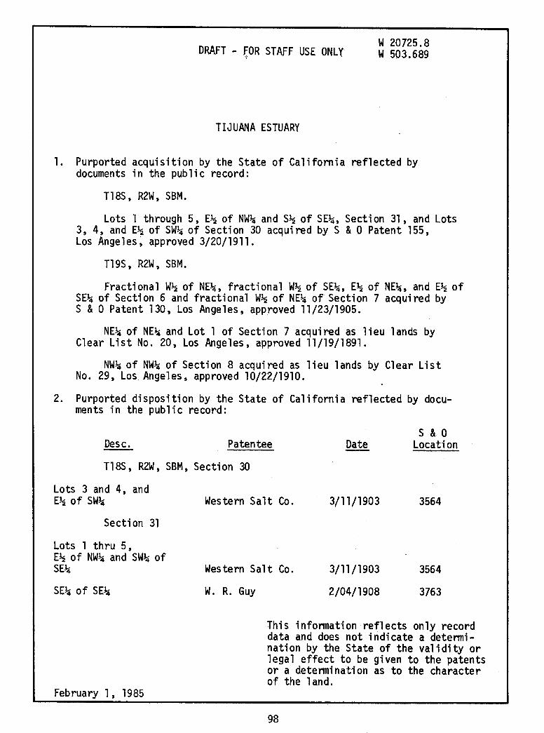
TIJUANA ESTUARY
w 20725.8 w 503.689
1. Purported acquisition by the State of California reflected by documents in the public record:
Tl8S, R2W, SBM.
Lots 1 through 5, E~ of NW~ and S~ of SE~, Section 31, and Lots 3, 4, and E~ of SW~ of Sec ti on 30 acquired by S & 0 Patent 155, Los Angeles, approved 3/20/1911.
T19S, R2W, SBM.
Fractional W~ of NE~, fractional W~ of SE~, E~ of NE~, and E~ of SE~ of Section 6 and fractional W~ of NE~ of Section 7 acquired by S & 0 Patent 130, Los Angeles, approved 11/23/1905.
NE~ of NE~ and Lot 1 of Section 7 acquired as 1 i eu 1 ands by Clear List No. 20, Los Angeles, approved 11/19/1891.
NW~ of NW~ of Section 8 acquired as lieu lands by Clear List No. 29, Los Angeles, approved 10/22/1910.
2. Purported disposition by the State of California reflected by documents in the public record:
Desc. Patentee Date s & 0
Location
Tl8S, R2W, SBM, Section 30
Lots 3 and 4, and E~ of SW~
Section 31
Lots l thru 5, E~ of NW~ and SW~ of SE~
SE~ of SE~
February 1, 1985
Western Salt Co. 3/11/1903 3564
Western Salt Co. 3/11/1903
2/04/1908
3564
3763 W. R. Guy
This information reflects only record data and does not indicate a determination by the State of the validity or legal effect to be given to the patents or a determination as to the character of the land.
98

DRAFT - FOR STAFF USE ONLY s & 0
Desc, Patentee Date 'Location
T19S, R2W, SBM, Section 6
Fractiona1 W~ of E~
NE~ of SE~
E~ of NE~
SE~ of SEJ..i
Section 7
Fractional W~ of NEJ..i
NE~ of NEJ..i and Lot l
Section 8
NW~ of NW~
3. Comments:
J. E. Coggeshall
w. R. Guy
A. G. Lawrey
D. T. Fowler
J. E. Coggeshall
W. H. Carlson
Harry Shaubert
l~/30/1907
2/04/1908
1/27/1913
8/12/1872
12/30/1907
2/13/1895
l/16/1911
3733
3763
s & 0 Survel'.
SD 2
SD 13
s & 0 Location
3733
Lieu Land Location
LA 2458
LA 7573
Tijuana Estuary was not segregated from surrounding uplands by government meander lines.
The lagoon is known to contain tide and submerged lands. tn February, 1978, tide gauges were instal1ed throughout the estuary by the National Ocean Survey for the purpose of measuring the rise and fall of the tidal waters (W 20932). Gauge readings were also recorded for a few days in November, 1974, which were used by National Ocean Survey to calculate preliminary tidal datums.
February l, 1985
This information reflects on 1,y record data and does not indicate a determination by the State of the validity or legal effect to be given to the patents or ~determination as to the character of the land.
99

I ,I
I ~
d I
i ;! ., ,,
ii
' ... ' .:. ......
• ... ... •ll
'
. ...
SKRTCH of thf'
., l
':\
~-
PORT Of' SAN DIEGO
1850.
1'.~.Militai;. ll .. pot, F.stnl>listwd ut Nt'w San Dioeo.
100
r• Ir I,
I 11
11
I I I•
!-i'
:I. I !
r f i . s.rnt•~•.9·'"'"'"1 . ,,_,,,,,.A I,
I . . I: ) --- '
' i' ~ : i 1,: i'
I. I ,,
11 ;I.
I: Ii Ii :1

' .. "/ .. .' l· ,,
, '· ' _, I'
,. \ ~Od' ~
',-" ,-" .
'ltl' .. ,i.1
I rt ft \ '
';
101
\4;\
I', I• \ ·. \ ' '~~;-'--
.- \ t
I' \ ·- ~ __ ....
\ \ff!~\', . ·. ~-__ .,.. • I tJ
\ \ " ··;-,---\-____ \ " -~ _--;," -
~ \ .. ,/;,, .
___ \---\, -- \ \
nn•tt:uv .. J.'Al\"llh 11'11
·,
. --fl -.~- ~
/, ----
----~
.JnH!OU)!'C
MrnrHT.' ARAot.L I • Fiii.Kii I R.1'Hl"tlflllCL&. .. '
Portion of WADLEIGH1S MAP
OF THE
CITY OF SAN DIEGO 1888

~)
~)JJ '• ..., ,, !A . ..
•, J
---~~~~~~.r.~~i.l · ·~\..:_ ·p A v
'
102
H fl '~ l. I
i
~
' ~
~· ~
.i Si ';
~

1 c c l
.., •
103
0 c
'\ t ~ ,. ~,. 'i ~~ ~~~d
J ~ ~ ' )
-t . i " ....
'<l .:::~:
~ ~ ... l't n:ii~ ' I ~~~~ -f.
~ p ~ J'H ~
11; -s( . . . ~ a"' I .. J i ~ 1 ·-.r' ' ; .
1, 1 l ~ i-;. \, !! t ... ,: J~ t~ 1 ) i ~ f I ~ j .
• H).
~ h·j. ~' .
"i }~· JJ ,·l l. j . J l i 1 . J ~ ~

·:, ·~
·:, :_
.. t ! : ;-.t tt J ~ ~ ~ ~1 -l I! ... J ~;: ~ :
~ ~ ~ ~.:.. l ~ .... ~
~ f .. - .. -.. ...... t ...
h' " •. \ l::; . " d . !P
104
.. ~
:\;) ;!
,~ \}l I~ ' !~ l " ' . ~-l ~ ~~ ! .! ~ ~-:-. , ..; ~~~:. 4;,, ,, ~ ~
~
.. ~
0 ~ CX>
~:i ~- ?\. ! t ·p ~ ... t-~ ~ .1~f 1k1 I ~~ :Ft 1. ~f ·I'" tat ~?t ~ .. ~ . ~~ .. 11=1b ~ :• ~ . ~ (~· i ft1l!~ . : i~ \ ~ l?"j!
! "I I .1, \ :- !~ ~ ui•aa·~ '~. t~t. ?~ \! ,._ . ·~· .. '!I'\ l~.·~l 1 • .. "'? t "3i~~!
ca I)
~
I<[ ...J a. a. -:c CJ)
z ~
~
r,i~
ct ti)
C:J1 ·-t-
..
·~
i 2
~ 2 " "

Cl. <t ~
LL 0 >-w z > 0 a: I- ~
Cf) a: 0 I-Cl. Cf)
<t <t 0 u Cf)
~
i J_ I
,,
0 c
........
. ,... "':.·· ...... '
. , .... ·-~. 't···
~, ........ .
105
l() <D r<> C\J
~ l() a>
0 2
" !:, .... ~
-0 0 0 C\J II
= Q)
0 (.)
Cf)
r t: I I'
1· j;

I I i
... ~
LJ f /
I
I
JDCDJ/ BBD r 1 JBBD=o= ~·~: t===ll
:JDL:=J -]DD ]DD,, JC]7/ ] _ __..- I
" 1,' I
1,
'1
'\ ,, \\ \\ ,,
,, ,, " . ,,
106
.· . . ,. ,\ '···
~ .... .
.......... "J '. '
'· .
en z (.!) 0
dS !i ~ ...J
:::::> a: "" LL ~ {g OU? z 0 . 0 F- 0 -oz ..... z a: a. ~ a: <l <l
rt> rt> en
' .
8 0 (\J II
Q.)
0 u en
., '
I ~
-- . --~--- -·-
. !

,! ~I
Co)
.......
1~ ,/
~
--' 0
Co)
" 28
·-~ \ _,/
. .J (J
~ 26
.J6
25 \ '.
5u
38 CD
29
49 36
-~
32s°'r A- ;f:,£:-o --~ ::1 I I
I r
>ol>o i>::1i>::
··. ~!~ 1 ••~-=,..Eif!ll.Mi) ''. ' . 8!lj
" ... --·· '?
r II CORPORA ·,, l>Q!l>Q ! :: d "" - SUNSH , ' " ,, " --.- ,. I ' : •i' I L :
i
3r~-~-z0/ I
• o I o I
w 0
-- l ,l--- " l' I ----, ' ,::-,=\"" -----«: ·:"f : :: \\ \U' 1~-- ,.,_ ·. II II
"'' .-" ' ' li!~ ' h, "" '" • " ,. ' i\ I ..• : ::;te II .. // \\ // • II --~:;-:;-:-;~;;~),:'.J~d--------,.\ t ,,·.1 <'10 ' ",, ---·-·. " ~J , .. / _;, - ~ II ,;1 \\ \I · .... ··-. ..''• II I ~:::::::::-- .~--- ----
' , , ,.~.,, """ -- ' ,. " r , " _"'.- ,,;,--!-"?
--~
:.'" 1f ··r:-%f ;---·::r s:~t ';;;~-"~~rf·~-~~~ · ="~ "~: ... ·· -'·" I •• ., " I ' I I "
.,, =:::6----~';)~::::~~~,' ('J,•. (:~Ti ,l
4>.,;., e;r
Gaging Station
l I Well
--~r-~
~
Wells
0
I~: II \ 0 .. 1~1 II - I lli1 tl ··--.
:::: :: \ j I II · ... j'· .. , 911 MONUMEN ·,
,,;--=\, ~ . 00 II'' II ..... ··~ l";i;l 111 II
,%s·,~----- ~ !\ ~ i'i i ii 1"· .• , . .'~;; ..:l Ill 11 ·~ - ' G.¥f:ri~>-~-~ 1 ___ 1 L
A PORTION OF IMPERIAL BEACH QUAD
USGS
1967 Scale 1
11=2000 1
~ _,,,,,

--' 0 o::i
L}~,j -i;:J
\.)
~
~~;:.
I ~ I
~
\.) ~ '
,, I
c
\ )
_, !
\
28
',~ \ -N
l, / '
.Jo
~ 26
-"' "-25
50
]/j
2'.;:;
JiN:i~~ml City of San Diego C=:J San Diego Gas & Electric ~ State of California E'illli1I United States of America
"''
co.
.II '
~ II: -< Q z :;;. 0 Ill
16
ll
I I I I L_,
I I I '
AVE:
llf~ it' ~ ~ ..J
.:.. Q
5 :ti __ ..,_
Gravel "-'-. • ,x.Pit 4>·
(
I Well --~~-If.:
8'!
loe~ Gaging Station
~
Wells
RECORD LAND HOLDERS
1985
Tl JUANA ESTUARY
Scale 111 = 20001

r
-__. 0 co
I
v
~
~ ~
~
\..:)
~
~
!:::::::':':':::::::::!City of San Diego ~ San Diego Gas & Electric Co. ~ State of California llIIlI1 United States of America
!·Pa-rk 1~(·· ~--o ~aate~ ;• •• \ • ,,;'<.: " -k-~L·~,-~.-""-'-·~ -~- ~ '• ~{/~·.~.<·
:1 ,.o -- !1· ., ~· I II. ~r •--· /) ,-~ .. .. .. '"I _ 0~'( 28 .11, ___ -_:: Emot~· _ , •r..i Cl .... - · L :1- S,ch \ \ • :-.P ~ ..
-- -. , 1111.. ii'~"· \"' ' Nestor- • : ".,,-z- . •,- _. !1" ( /". \ -,, I:,. ~
• ~VE :, 2
~~L • _ /··~-,:- ., !~ - lriiHHHP~~j-·-·~,: '1
I • . - ' ~~lifu~~ .:;: ~ "~,
I ·>E~t~~I Ne"lo•
' 11 -· ~· l~;;~~:;:;1~-~~ IRM 16 1
jV 11 Mt Olivet; f . -~ r ; 11 : 1• Cem' · =-1 urio ·~ ' ·1 1:.. Lk' '1
1·1
1
_( ___ -•a - 11 1l~o- :;.,. \ _ ~J
-'[ _ Ir•-,;-"-~ -7~;;;_-.-. ~- ~-.:;~·i'J2 ij-=----=--=-:= -'=--~-----_Jj .• • O• • ~_,/ n • • + •
~- - - ~- ~ J' ;,w/h;'.' - I ~ · I __ ·o n
~-- ------- - - .... : _ _/~ ~-:-:~-~
! ~11 --, __ ~- -
~ 33r- /io· /-
2 ( __ ~ ·~I ii-l
-•~j'.d- '-"=o_AV~=
II ,--- I ""- ~ II / -
w 0
II 1· . I ~ II (-.c?Q __ , ..J
::"_ -- - 0 11 ~~t---...,.. ~ "'-~;'tel ~l~.•l
11..11.1.,,..a.ji.1,jl.ll.i.ll.ll.ll.ll.iMii;i;i;i;i~~i;i;i;i;i;i;Ml__:+.L - Well I Ga:7~ ll IT: Station l! I'll
~ I
0 Wells 0
RECORD LAND HOLDERS
1985
TIJUANA ESTUARY
Scale 111 = 2000'

__. 0 o:>
I
\_)
~
~
\"~·-~'\1 ~
Xii:
\_)
~
~
!:::::::::::==::=:::::) City of San Diego ~ San Diego Gas & Electric Co. f'22d State of California lllIIl1 United States of America
···J!-.;:l-~'.Pa-~k;!~.~ ---- _ •• I - _.L_·. ~ • 'I \ , -'· -- c _, ·lW.. ~· o. I I h"ate' .•• -
I
"j'("Q I•. - - . , '- - .. _ tll ,,\ •_ # 4'~ 'i '.' .. '
~ ,, ' •• _, -4- .,:: ·• • y.W;'''
L 28 if=:= Erno1\; \ >.!11 •: .<Jf·~;:;,. ,
11
··~ Srh \ , \"''.;a ·~:; -. • - Ir• :, Ii ""I~ . \ > :: t'dJ .. . · .:.: 5= !
1
1 i· '1 .Nes_tor ·I. • <
!''(£ I, / " , - 'I: "-z.·.
1 ~2 / L • '1.J?.· ~ I - - / E~~:~K' ~ ··/<-~
. 1·"'"'"""''-~_..,, '
i~~[~i 'o •· ~"'"\, ~: /jf1'1 ,II Mt 01 ·'·~~..;. ..... ·~~l. ::;_Schtot
1 1, 1vet: 1 , ~--- 1 •
IL l~o Com~ /, ;;:1·.i · , \l l1•=-=· -- -- ...... _,._ -~-. / •
• _, .. -:~~--·'72-·;:j~-.-~~ l!JD•::.-::~;.~~~~ 32 --------------- --- .... - - • Wf-.__';,'. / ~ i n - 0
I ~ --, __ ~:=:---/ ~-:::-=_ 331~- - -y '/ !
11 '° ./- 1
w 0
-~i'N"'_ :~,Ji c._, ·~: t l''------,-L;~m [_ . r-~./-1", i -~ ~~r -~ I" 0 \._ I'' ~~ .
:-rtJUJuwUUIJllilr'P1l2f"·~2~·~~il··~1::1·~··..:;:1; =~~~~I ·~"'"' 0-- -~I:---~ - --~ Well
l( )f II" ~ ~
• 0
~ll, e,. Gaging Station
I i
'"
Wells
RECORD LAND HOLDERS
1985
Tl JUANA ESTUARY
Scale 111= 2000'
Copyright © 2022 FDOKUMEN