RSPO NOTIFICATION OF PROPOSED NEW PLANTING
57
1 RSPO NOTIFICATION OF PROPOSED NEW PLANTING This notification shall be on RSPO website for 30 days as required by the RSPO procedures for new plantings (http://www.rspo.otg/?q=page/535). It has also been posted on local on-site notice boards. Tick whichever is appropriate √ This is a completely new development and stakeholders may submit comments This is part of an ongoing planting and is meant for notifications only Company : Biase Plantation Limited (Calaro Extension) Subsidiary : Wilmar International Limited RSPO Membership No: 2-0017-05-000-00 on behalf Wilmar International Limited since on 15 August 2005 Location of Proposed New Planting: Atan Odot village and Uwet village, Odukpani and Akamkpa Local Government Area, Cross River State, Nigeria. GPS Reference: Calaro Extension Area of Biase Plantation Limited is geographically located on Latitude: 8 0 16‘51“to 8 0 21‘26“North and Longitude: 5 0 15‘ 30“ to 5 0 17‘ 47“ East.
-
Upload
khangminh22 -
Category
Documents
-
view
1 -
download
0
Transcript of RSPO NOTIFICATION OF PROPOSED NEW PLANTING

1
RSPO NOTIFICATION OF PROPOSED NEW PLANTING This notification shall be on RSPO website for 30 days as required by the RSPO procedures for new plantings (http://www.rspo.otg/?q=page/535). It has also been posted on local on-site notice boards. Tick whichever is appropriate
√ This is a completely new development and stakeholders may submit comments
This is part of an ongoing planting and is meant for notifications only
Company : Biase Plantation Limited (Calaro Extension)
Subsidiary : Wilmar International Limited RSPO Membership No: 2-0017-05-000-00 on behalf Wilmar International Limited since on 15 August 2005 Location of Proposed New Planting: Atan Odot village and Uwet village, Odukpani and Akamkpa Local Government Area, Cross River State, Nigeria. GPS Reference: Calaro Extension Area of Biase Plantation Limited is geographically located on Latitude: 80 16‘51“to 80 21‘26“North and Longitude: 50 15‘ 30“ to 50 17‘ 47“ East.

RSPO New Planting Procedure Assessment Report
CALARO Extension Estate of Biase Plantation Ltd – Cross River State, Nigeria
2
Location of the Proposed New Planting Total area acquired by Biase Plantation Limited (BPL) according to the MoU between the government of Cross River State of Nigeria and Uwet & Atan Odot Communities / Ikot Eyidok dated on 10 January 2013 and MoU between the landlord communities and Biase Plantation Ltd dated on 10th December 2015 is 3,066.214ha (shown on survey plan no. RIU/CR/191/12). This included potential overlaps with the Uwet-Odot Forest Reserve and the Oban Forest Reserve. Subsequent re-demarcation has excluded the areas of overlap and reduced the total concession area to 2,368.94 Ha (Deed of grant between the government of Cross River State of Nigeria and Biase Plantations Ltd). However, maps generated by the HCV/HCS team based on shapefiles available, generated a total area of 2,367.45 representing a 1.49ha difference (due to planimetric errors). All the HCV, Carbon Assessment and EIA reports and maps have been done using the area of 2,367.45. This difference attributed to planimetric error will not impede the final management plan put in place by the company. By the time of conducting the audit, all areas are still not planted by the company. The total area of 2,368.94ha will be managed by BPL. In all, HCV area covers 260ha; secondary forests with higher carbon stocks covers 377ha; buffer along the Uwet-Odot Forest Reserve covers 19ha; other riparian buffers cover 90ha; community set-aside land at the Akpa Uwet enclave covers 95ha; community set-aside land at Okopedi-Uwet and Effeffiom-Uwet covers 17ha; and the maximum area that can be developed for oil palm, including roads and other infrastructures will cover 1509.45 ± 1.49ha. The proposed project area of 2,368.94ha is located at Atan Odot village (433.354 ha), Ikot Eyidot (211.774 ha) and Uwet village (1,723.812 ha), in Akamkpa Local Government Area and Odukpani Local Government Area of Cross River State, Nigeria (see Figure 1). General company location information is:
Description Information Goverment Administration : Akamkpa Local Government Area and Odukpani Local
Government Area, Cross River State, Nigeria Boundaries:
North : Okopedi-Uwet & Effeffiom-Uwet communities South : Ikot Eyidok Family Community East : Calabar River and Forest Reserve West : Forest Reserve
Biase Plantation Ltd (Calaro extension) has obtained some document related to legality such as: 1. The right to use : Memorandum of Understanding between The Government of Cross
River State of Nigeria and Uwet & Atan Odot Communities/Ikot Eyidok Family in Akamkpa & Odukpani LGA respectively dated on 10 January 2013 (as shown on survey plan No. RIU/CR/191/12 dated on 3 March 2012 with total areas are 3,066.214 ha) whereas the one of considerations is the compensation to be paid by Biase Plantations Limited for unexhausted improvements on the parcels of land surrendered by the host community at the approved and contemporary government rate and particularly as specified in the schedule hereto, the host community holds itself bound to this MOU for a term of 99 years from the date hereof.
2. The right to use: MoU between the landlord communities and Biase Plantation Ltd dated on 10 December 2015 stating a total area of 3,066.214ha.
RSPO New Planting Procedure Assessment Report
CALARO Extension Estate of Biase Plantation Ltd – Cross River State, Nigeria
3
3. The right to use: Deed of grant between the government of Cross River State of Nigeria
and Biase Plantation Ltd with total areas are 2,368.94ha where the one of considerations is 1). The investor paying through the government to the host community the monetary compensation for all unexhausted improvement on the land and observing; 2). During the subsistence of this grant, the investor shall pay host community an annual ground rent/royalty as contained in the schedule thereto, such rents to be subject to an upward review at the rate of 10% every 10 years.
4. Certificate of incorporation on behalf Biase Plantation Ltd No.405067 dated on 11 February 2011.
Environmental Impact Assessment (EIA) report for Calaro Oil Palm Plantation Extension Project at Akamkpa - Odukpani LGA, Cross River State has not been approved. Current condition to get approval is submitting report to Department of Environmental Compliance Monitoring, Field Office Calabar - Cross River State (evidence of letter No. FMENV/CF/AD/102/VOL1/6 dated on 8 March 2016). For further action, the Department of Environmental Compliance Monitoring will submit same to head office of the Federal Ministry of Environment, Abuja. At the moment, the EIA report is undergoing technical review by the technical committee of the Federal Ministry of Environment and approval will be granted within a month from 15th June 2016. This means land clearing will only commence after the NPP Public Consultation has elapsed and after the EIA is approved. The company has made the following efforts to get EIA approval, i.e.: • Letter on 2nd Feb 2014 from company to Department of environmental assessment, brown
house, independence way – Federal Ministry of Environment regarding application for the registration of the EIA.
• Letter on 8 Oct 2014 from company regarding application for interim EIA approval. • Site verification on 15 April 2015 by Federal Ministry of Environment (head office and field
office Calabar). • Letter No. FMENV/EA/EIA/2887/39 dated on 21 April 2015 regarding follow up from
application of EIA i.e. 1). It was required panel review process (based on site verification exercise is category 1), 2). Field data gathering shall be complete, 3). The participation of ministry officials and ensure full quality assurance/quality control (QA/QC) measures for laboratory analyses in line with standard practices, 4). Submit 10 hard copies and 2 soft copies of the draft EIA report.
• Letter dated on 6 July 2015 from company regarding the submission of draft EIA report. • Letter No. FMEnv/EA/EIA/2887/Vol.1/47 dated on 22 July 2015 regarding public display
exercise on newspaper and radio. Whereas, the date, venue and your company’s responsibilities for the panel review exercise will be communicated to company later. Evidence of public display on newspaper was available and redaction of radio announcement was available too.
• Letter from Field office Calabar, Department of environmental compliance monitoring – Federal Ministry of Environment no. FMENV/CF/AD/102/Vol1/6 dated on 8 March 2016 regarding submission of final EIA report to field office Calabar and they shall further submit same to head office in Abuja for to get approval by a technical committee.
A comprehensive and participatory independent Social and Environmental Impact Assessment (SEIA) and High Conservation Value (HCV) assessment were conducted by national licensed from Andelsta Limited and RSPO licensed assessor from Proforest, which involved internal and external stakeholders. Additional to these assessments, BPL also conducted Land Use Change Analyses and High Carbon Stock assessment. Scope of

RSPO New Planting Procedure Assessment Report
CALARO Extension Estate of Biase Plantation Ltd – Cross River State, Nigeria
4
these assessments is in accordance with the current condition with total areas are 2,368.94 Ha. The results are incorporated into the operational management planning to develop the new planting. The company is in the process of completing a standalone document of its GHG and Carbon Stock Report. Once completed, the report will be forwarded to the ERWG. Location maps were prepared and presented in the SEIA and HCV assessment reports, including all findings and management recommendation from the assessors. The project location is shown in Figure 1 and Figure 2 below. The SEIA and HCV Summary reports include additional maps showing the topography, soil, landscape, land cover, satellite image and HCV areas.

RSPO New Planting Procedure Assessment Report
CALARO Extension Estate of Biase Plantation Ltd – Cross River State, Nigeria
5
Figure 1: Location of the Calaro Extension Area oil palm plantation in Akamkpa LGA and Odukpani LGA, Cross River State, Nigeria
RSPO New Planting Procedure Assessment Report
CALARO Extension Estate of Biase Plantation Ltd – Cross River State, Nigeria
6
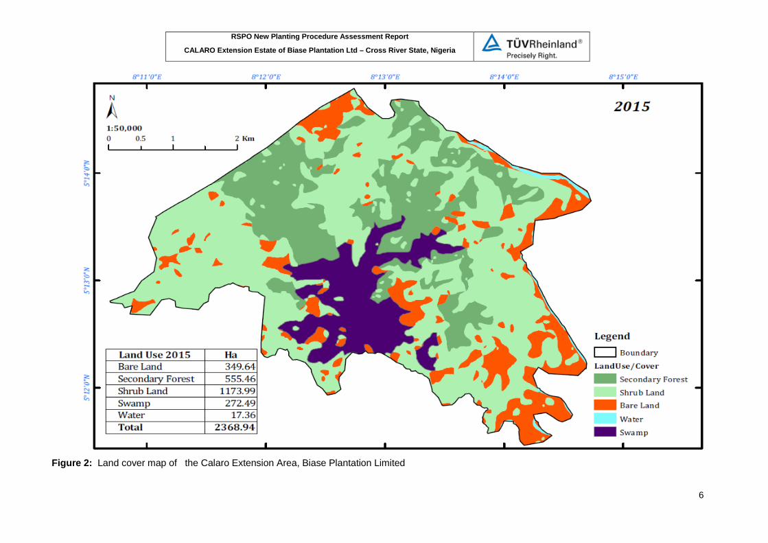
Figure 2: Land cover map of the Calaro Extension Area, Biase Plantation Limited
RSPO New Planting Procedure Assessment Report
CALARO Extension Estate of Biase Plantation Ltd – Cross River State, Nigeria
7
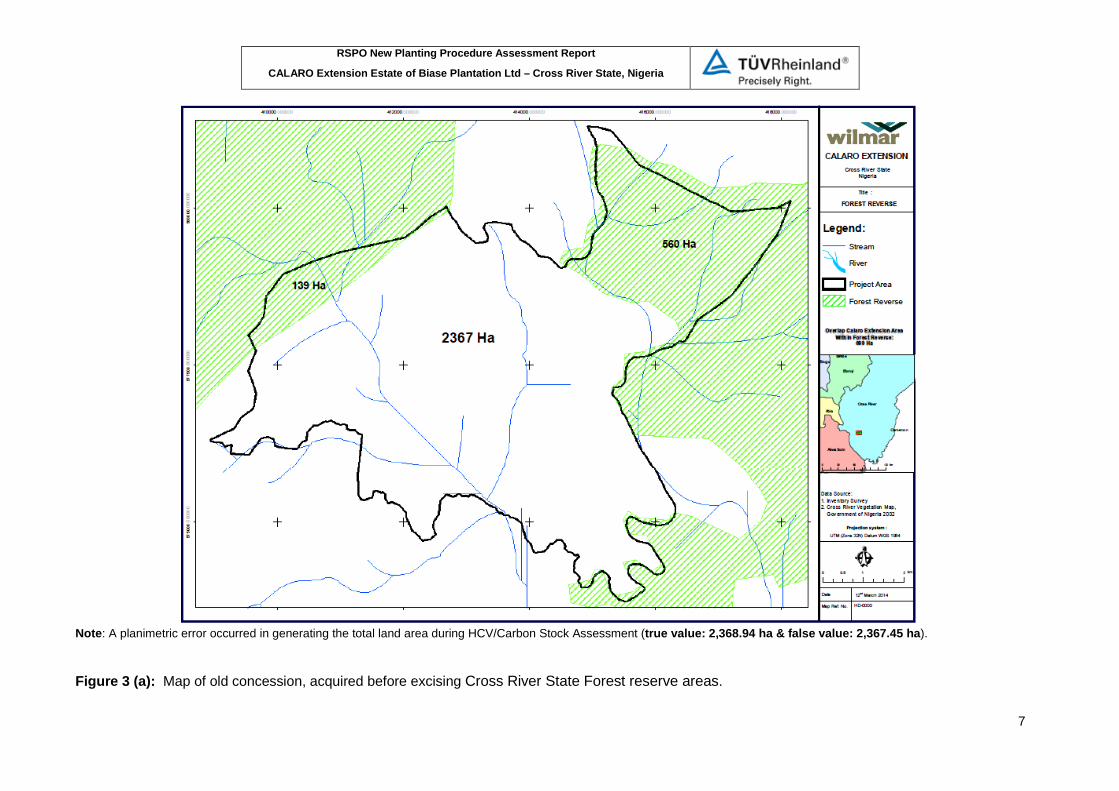
Note: A planimetric error occurred in generating the total land area during HCV/Carbon Stock Assessment (true value: 2,368.94 ha & false value: 2,367.45 ha). Figure 3 (a): Map of old concession, acquired before excising Cross River State Forest reserve areas.
RSPO New Planting Procedure Assessment Report
CALARO Extension Estate of Biase Plantation Ltd – Cross River State, Nigeria
8
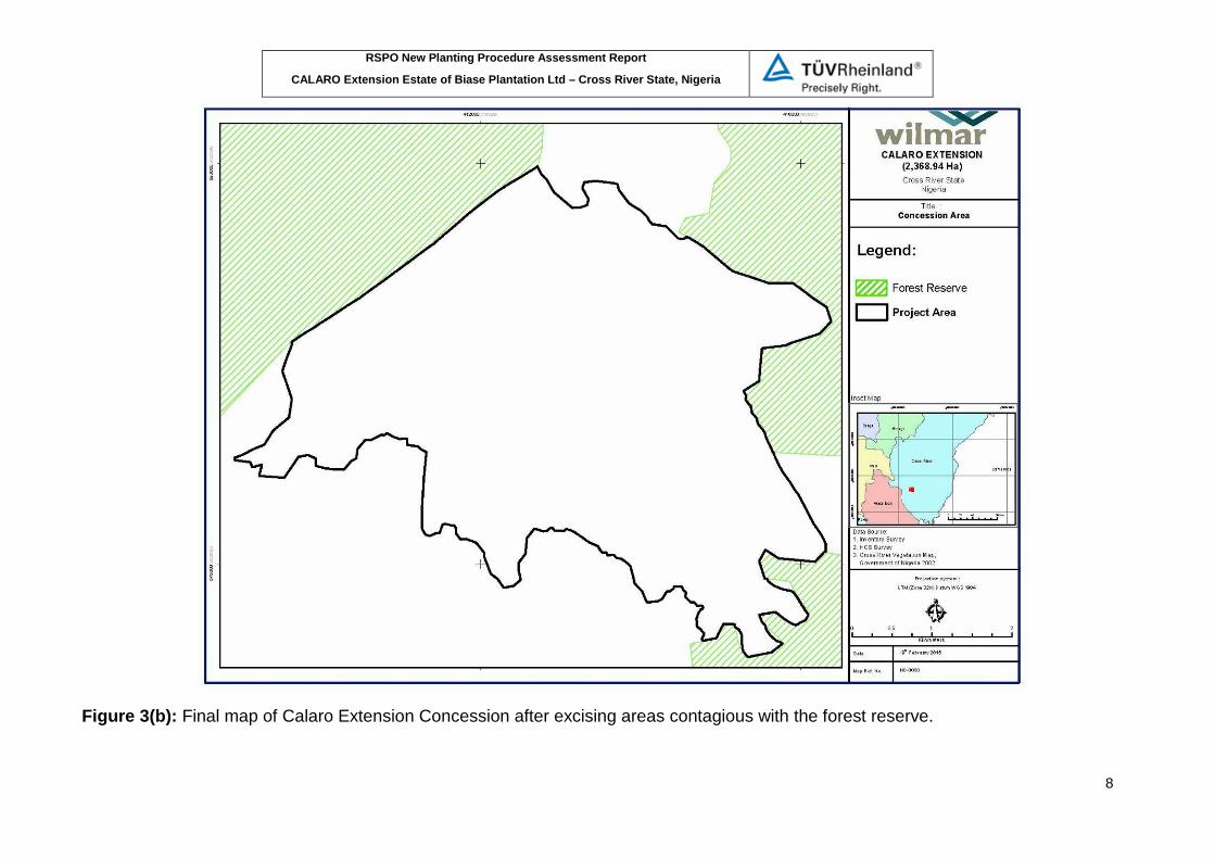
Figure 3(b): Final map of Calaro Extension Concession after excising areas contagious with the forest reserve.

RSPO New Planting Procedure Assessment Report
CALARO Extension Estate of Biase Plantation Ltd – Cross River State, Nigeria
9
SUMMARY FROM ESI & HCV ASSESSMENTS: Summary of assessment findings of EIA Assessor and their credentials The environmental impact assessment (EIA) of Calaro oil palm plantation extension project in Akamkpa-Odukpani LGA, Cross River State, Nigeria on March 2016 was carried out by an independent consultant i.e Andelsta Limited. The firm has established expertise in the country and is accredited by the Nigeria government to undertake EIA at the national level. Andelsta Limited, address: 7A Vaal street, Off Rhine Street, Ibrahim Badamasi Babangida Boulevard, Maitama, Abuja, Nigeria, Tel: 08022790020, 08096174011, 08037206011, website: www.andelsta.com and email: [email protected]. EIA study was prepared by a multidisciplinary team of consultants and technicians are: • Dr Godwin O. Igile as Chief consultant/EIA expert • Dr U.A Offor as Microbiology/hydrobiology • Oden U. Oden as Hydrogeology/geology/sediments • Engr. Finntan Ibeshi as soils, agriculture and land use • Dr U.I Uquetan as socio-economics & geography • Dr A.I Isika as health impact studies • Alfred Obeten as Chemistry/environmental quality • Daniel O. Igile as water chemistry • Dr O. Ofem as Data/statistical analysis • Chistiana Okon as Manuscripts preparation/secretariat
EIA methods The environmental impact assessment (EIA) methods are: 1. Desktop studies/literature review,
Desktop studies were undertaken to acquire an environmental database required for the EIA studies. The literature search included information from previous studies.
2. Consultation, Consultations with project stakeholders was carried out using questionnaires and by verbal interviews. Youth and Women groups, farmers and community leaders were consulted in both Odukpani and Akamkpa LGAs. Consultation were conducted in February, June and September 2014. Wilmar International Limited in collaboration with Biase Plantations Limited had consultation with relevant stakeholders. Stakeholder’s views and opinions concerning the proposed project and its associated/potential impacts have been integrated into the EIA process. However, consultations will continue throughout the project lifestyle and issues raised by concerned and affected parties will be considered. The results of all concluded consultations are included as bases for potential impact assessment and as such have been clearly documented in this EIA report. The stakeholders consulted included the federal ministry of environmental (FMEnv), cross river state ministry of environmental, cross river state ministry of agriculture and natural resources, Cross River State geographic information agency, cross river state investment and promotion bureau and host communities and relevant non-governmental organizations.
3. Field research Field-Research was undertaken as to complement/verify or otherwise information gathered from desktop studies. Specific information on the ecological and socioeconomic
RSPO New Planting Procedure Assessment Report
CALARO Extension Estate of Biase Plantation Ltd – Cross River State, Nigeria
10
conditions of the project environment was gathered during fieldwork execution. In particular, the survey covered the following environmental components: • The physical environment - water and sediment characteristics, soil characteristic, air
quality, noise and potential natural hazards; • The biological environment - water, sediment, and soil microbiology, benthos,
plankton, flora and fauna (particularly rare and endangered species); • The socio-economic and cultural environment – population, land use and patterns of
land ownership and tenure, community structure, employment, distribution, public health, cultural heritage, customs, aspirations and attitudes, etc.
4. Federal Ministry of Environment conducted verification of exercise at the project location.
Summary of environmental impact The significant environmental and social issues which could arise from each phase activities are: Evaluation of preparatory phase impacts: • Nursery development: employment opportunities is a moderate positive impact • Plantation development: land acquisition and compensation issues is major • Bridge construction over the Calabar river: public/traffic safety issues is moderate Evaluation of constructional phase impacts: • Nursery development: ecological impacts are minor, biomass generation is minor, water
security is minor, influx of immigrants is minor, air quality deterioration and noise nuisance is minor.
• Plantation development : employment opportunities is major positive impact, improved local/national economy is major positive impact, improved institutional/national revenue is moderate positive impact, improved roads and communications infrastructure is major positive impact, land acquisition/ownership issues is major, livelihood issues is minor, community structure and security issues is moderate, receiving water quality deterioration and change in local hydrology is moderate, air quality deterioration is minor, noise nuisance is moderate, solid waste management issues is moderate, loss of biodiversity is major, threats to resident crops is moderate, soil stability and erosion is moderate, impact on soil fertility and acidification is moderate, sanitation problems is moderate, aesthetics and visual intrusion is major, removal of cultural sites is minor, wind shelter/breaks is moderate, biomass generation and CO2 balance is moderate,
• Bridge construction is moderate.
Summary of evaluation of impacts during the construction phase are given below:
Component Associated impact Impact categorization Potential impact
Ambient air quality Dust emissions from site preparation, excavation, material handling another construction activities, cough & catarrh
Minor/negative impact
Minor negative impact inside plant premises. Short term
Noise Noise generation from construction activities, construction equipment and vehicular movement
Minor/negative impact
Minor negative impact near noise generation sources inside premises. No significant impact on ambient noise levels at sensitive receptors. Short term
Water quality Increased TSS, TDS, BOD, COD and Turbidity of surface water. Alteration of pH
Major/negative No significant negative impact. However, hazardous chemicals should be handled properly. Short term

RSPO New Planting Procedure Assessment Report
CALARO Extension Estate of Biase Plantation Ltd – Cross River State, Nigeria
11
Evaluation of operational phase impacts: • Nursery operation: chemicals management is moderate, water quality deterioration is
minor, solid waste management is moderate. • Plantation operation : pest infestation, solid waste management issues, soil degradation
and food security is minor, Wind shelter/breaks is moderate, Biomass generation and CO2 balance is moderate, Bridge construction is moderate, Impact on soil fertility and acidification is moderate, Sanitation problems is moderate, Aesthetics and visual intrusion not significant, Occupational health and safety issues is major, Biodiversity management issues is moderate, Occupational/public health and safety issues is moderate.
• Bridge construction: employment opportunities is major positive impact, improved local/national economy is major positive impact, improved institutional/national revenue is moderate positive impact, improved roads and communications infrastructure is major positive impact, community structure and security issues is moderate.
• Water security is moderate • Water pollution and effluent management issues is major • Impact on downstream water users is moderate • Noise nuisance is moderate • Aesthetic and visual intrusion is minor • Public health and safety issues is moderate • Occupational health and safety issues is major • Chemical management is moderate • Emergency situations is major Summary of evaluation of operational phase impact below:
Component Associated impact Impact categorization
Potential impact
Ambient air quality Particulate emissions. Minor/negative impact
Minor negative impact
Noise Noise operational activities including vehicular movement
Minor/negative impact
Minor negative impact
Water quality Increased TSS, TDS, BOD, COD and Turbidity of surface water. Alteration of pH. Trace pesticide residues. Oil/fuel and waste spills and wastewater from processing
Major/negative No significant adverse impact and wastewater generated from sites will be treated and then disposed
Land use Loss of some community Major/negative
Land use and aesthetics
Land development, loss of farmlands, deforestation
Minor/positive impact
Positive impact. Development of integrated plant will increase the aesthetics of the area.
Soils Construction and excavation activity leading to topsoil removal and erosion.
Minor/project procedure
No impact
Ecology flora and fauna
Habitat disturbance during excavation and Construction. Loss of natural vegetation due to felling
Minor/negative No impact as the area is devoid of any vegetation
Socio-economics Increased job opportunity for locals
Major/positive impact
Overall positive impact
Traffic pattern Increased Air Particulate emissions.
Minor/negative impact
Minor negative impact

RSPO New Planting Procedure Assessment Report
CALARO Extension Estate of Biase Plantation Ltd – Cross River State, Nigeria
12
Component Associated impact Impact categorization
Potential impact
farmlands impact Water usage Ground & water surface water
will be used for nursery growing and operational
Minor/negative No negative impact as ground water is readily available at the site at 7-15 m of depth
Soils Alteration of top soil quality due to use of agro-chemicals, storage of solid wastes, fuel and material spills
Minor/negative impact
No negative impact
Solid waste management
Generation of solid waste, increase BOD, COD, CH4
Minor/negative
Erosion issues Increased erosion due to open land and topography
Major/negative
Ecology (flora and fauna)
Loss of natural vegetation and wild animals due to felling. Land use change
Major/negative impact
No negative impact
Socio-economics Increase family income, employment
Major/positive impact
Traffic pattern Slight increase in traffic No negative impact due to proposed plant as increase in traffic is insignificant
Summary of assessment findings of SIA Assessor and their credentials The social impact assessment (SIA) of Calaro oil palm plantation extension project in Akamkpa-Odukpani LGA, Cross River State, Nigeria on September 2014 was carried out by an independent consultant i.e. Proforest. The firm has established expertise in the RSPO process to undertake SIA. Proforest, address: PMB L76, Legon, Accra - Ghana, Telp : +233 (0) 302 542975, website : www.proforest.com and email : [email protected]. SIA was carried out by a team of specialist from Proforest and African Research Association Managing Development in Nigeria (ARADIN). The expert combined have several years of experience in carrying out SIA for forestry and agricultural projects in several countries in Africa including Ghana, Nigeria, Cameroon and Gabon. The team are: • Isaac Abban-Mensah as agricultural and socio-cultural expert included as team leader • Elikplim Agbitor as social and best practise • James Odey as sociologist • Mary Undebe as social researcher • Mercy Rabi as social researcher • Emmanuel Owan as social and environmental expert
SIA methods The overall methodology for the SIA was based on the requirement of the Calabar State laws and best international practice. The chronology of activities carried out during the impact assessment included: 1. Review of concession maps and definition of impact area 2. Reconnaissance survey/scoping exercise 3. Review of data, laws and publications to gather baseline data

RSPO New Planting Procedure Assessment Report
CALARO Extension Estate of Biase Plantation Ltd – Cross River State, Nigeria
13
4. State level stakeholder consultations (the first was prior to field survey and second round of state level consultations after completion of the field data collection and drafting of proposed recommendations)
5. Field survey and host communities’ consultations. The field survey in Atan Odot was conducted from 05-07 March 2014, in Ikot Eyidok family unit (of Etak Inoi community) from 10-12 March 2014, in Uwet from December 2011 to February 2012 & 18 March 2014 and finally on 22 July 2014 for all host communities & state-level stakeholders on 23 July 2014. For the Uwet community, a detailed field survey was undertaken between December 2011 and February 2012 prior to the development of the Calaro concession. For the purpose of the SIA for the Calaro Extension, therefore, no detailed field survey was carried out. Rather, a one-day revalidation exercise was undertaken on the 18th of March 2014 during which the SIA report for Calaro concession was reviewed with community representatives, and review of the community’s needs and the community map developed between December 2011 and February 2012. The following survey tools were used during the field survey are: • Semi-structured interviews • Household questionnaire surveys • Participatory mapping • Focus group discussions
In carrying out the FGDs, Participatory Rural Appraisal (PRA) techniques such as brainstorming and preference voting matrix were used.
Summary of social impact The following are some of the potential positive socio-economic benefits of the proposed development of the agro-industrial oil palm plantation are: 1. Employment creation. 2. Commercial opportunities for small and medium scale businesses 3. Improve income and standards of living 4. Introduction of high yielding varieties of oil palm and sustainable management of palm
plantations. 5. Training and capacity building for employees and smallholders. 6. Revenue to local communities through royalties’ payment to landlord communities. 7. Tax revenue for the state government. 8. Contribution to meeting the country’s palm oil demand. 9. Contribution to rural development (support to the development of rural electrification,
potable water, etc.). 10. Potential for smallholder schemes. 11. Commercial opportunities for small and medium scale enterprises including petty trading. Whereas, the potential negative impacts include: 1. Loss of farmlands, biodiversity, community conservation and NTFP collection areas. 2. Influx of plantation workers with potential of antisocial behaviour and impact on family
structures, social networks and indigenous cultural values. 3. Water pollution due to agro-chemicals, sewage from worker’s camps and POME. 4. Air and noise pollution. 5. Impact of movement of vehicles and machinery on public safety. 6. Impacts on food security and prices of food products. 7. Occupational health and safety. 8. Pressure on public infrastructure/facilities/amenities.

RSPO New Planting Procedure Assessment Report
CALARO Extension Estate of Biase Plantation Ltd – Cross River State, Nigeria
14
The results of evaluation of relative importance and nature of impact are:
Impact Evaluation of importance of impact
Location Reversibility Duration Significance Positive impact
Employment creation and business opportunities
Local/regional Irreversible Long term High
Increased revenue Local/regional/national
Irreversible Long term High
Contribution to education and healthcare
Local Irreversible Long term High
Contribution to rural poverty reduction
Local Irreversible Long term High
Training and capacity building for sustainable oil palm production
Local/regional Irreversible Long term High
Contribution to rural infrastructural development (water, sanitation, communication)
Local Irreversible Long term High
Negative impact Presence of migrant workers and potential impacts on local social and cultural structures
Local Irreversible Long term High
Potential risk of anti-social behaviour due to influx of migrant workers
Local Irreversible Long term High
Loss of farmlands Local Reversible Long term Medium Loss of NTFP collection areas Local Reversible Long term Medium Loss of biodiversity Regional Irreversible Long term High Water and air pollution Local Irreversible Long term High Soil erosion, siltation of rivers and potential flooding
Local Reversible Long term Medium
Exposure of communities to health and safety risks
Local Irreversible Long term High
Pressure on, and damage to local infrastructure (e.g. roads)
Local Reversible Short term Low
Occupational health and safety risks at the work place
Precise Irreversible Long term High
Summary of assessment findings of HCV: The High Conservation Value Assessment of CALARO Extension Estate of Biase Plantation Ltd area was carried out by an independent consultant from Proforest, PMB L76, Legon Accra, Ghana. Email: [email protected], Telephone number: +44 (0) 1865243439. Final HCV report produced on September 2014. The HCV assessor team composition consists of RSPO-approved and non-approved as below: 2). Isaac Abban-Mensah (Team Leader, RSPO HCV Lead Assessor) Isaac has a background in sustainable agricultural development and socio-economics of tropical forestry. He has diverse work and research experience in natural resource governance, commodity certification, smallholder development and high conservation values within forestry and agricultural landscapes. Isaac is a graduate of the University of Copenhagen and currently works as senior project manager based in Proforest’s Africa

RSPO New Planting Procedure Assessment Report
CALARO Extension Estate of Biase Plantation Ltd – Cross River State, Nigeria
15
Regional office. His role includes working with stakeholders in the region to create an enabling environment for increased implementation of sustainability requirements and providing direct technical support for commodity producers to meet certification requirements. He has led a number of High Conservation Value assessments and Strategic Impact Assessments in both forestry and agricultural sectors in Africa and South East Asia. He leads Proforest’s Sustainable Oil Palm Programme in Africa and is the coordinator of the RSPO. 2). Abraham Baffoe (Flora and fauna expert) Abraham has MS in Forestry and Environmental Policy from the Louisiana State University, USA and has over 16 years of experience working on natural resource management with a specialization in sustainable forest management, forest policy and forest and oil palm certification. His experience involves managing forestry projects, developing and implementing forest certification programs and providing support to forest standard setting and policy implementation bodies as well as leading HCV assessments for oil palm plantations development. As the Forest Program Leader at the WWF West Africa Forest Program Office in Ghana, he coordinated several forestry projects including providing technical support to the FLEGT/VPA process. He has also participated in a number of certification audits and has provided training and technical support to companies on forest certification for the Global Forest and Trade Network, a program he managed in Ghana during 2003-2007. Abraham is an Associate Director at Proforest and approved by RSPO as a team leader for HCV assessments. 3). Odey James Olabi (Socio-economic study Specialist) James has over five years’ experience working and managing social NGO in the Cross River State, Nigeria. His experience focused on community based natural resource management including; land use planning community forestry, resources mapping, livelihood activities for poverty alleviation with forest communities; experience in participatory governance and climate change. He has also worked on adaptation and gender mainstreaming. 4). Emmanuel Danquah (Lead fauna surveys) Dr. Emmanuel Danquah is the Head of the Department of Wildlife and Range Management and a Senior Lecturer at the Kwame Nkrumah University of Science and Technology (KNUST) in Ghana. Having worked for several years in the NGO sector, Emmanuel’s academic background is interdisciplinary, with a combination of rich academic and research experience in the biodiversity sector. He has over 20 papers and technical reports to his credit. Emmanuel’s recent areas of research include HCV assessments, biodiversity monitoring and impact assessments of natural resource-based projects, green economies in biosphere reserves, endangered species management protected areas governance, indigenous people and conservation, and traditional knowledge in natural resource management. 5). David Kenfack, PhD (Carbon assessment) David Kenfack is a Programme Coordinator for CTFS-SIGEO Africa since July 2012 to date. He holds PhD Ecology, Evolution and Systematics from University of Missouri, Saint Louis. His expertise involves forest ecology, Systematics, Molecular Biology, Botanical Inventories and Forest Dynamics. 6). Akomaye Ashikem (Flora specialist) Ashikem is a Forest Officer with the Cross River State Forestry Commission (CRSFC) currently stationed in the Boki Local Government Area of Cross Rivers State where he carries out his duties. He has more than 10 years of experience in biodiversity assessment especially in monitoring economically valued tree species in the forests of Cross River State. For this assessment, Mr. Ashikem was responsible for conducting an inventory of plants in the area.
RSPO New Planting Procedure Assessment Report
CALARO Extension Estate of Biase Plantation Ltd – Cross River State, Nigeria
16
7). Ugbe, Joseph Agorye (Botanical survey) Joseph works with the CRSFC of the State Forestry. He is a research expert in both wildlife and plants with special focus on aquatic species. Joseph will work with the fauna team while being responsible for assessing the hepertofauna in the concessions.
Assessment also supported by some local facilitators for community focus group discussion, participatory mapping and consultation HCV Identifying Methods on the ground was carried out as follow Since there is no HCV National Toolkit for Nigeria, HCV assessment has thus relied on the HCV definitions, methods and interpretations outlined in the Common Guidance for the Identification of High Conservation Values 2013. Additionally, the team used the Global HCV Toolkit and associated “Good Practice Guidelines” developed by Proforest. To ensure that decisions made regarding HCVs identified are relevant within the national context, this assessment process consulted widely with conservation experts, government agencies and relevant non-governmental agencies to ensure the interpretation process are consistent with specific national requirements. Other references used include the Ghana HCV Toolkit, the International Union for Conservation of Nature and Natural Resources (IUCN) Red List of Threatened Species (2014), Global (International Union for the Conservation of Nature (IUCN)) and National Ranking in IUCN/WCMC’s Nigeria Biodiversity Report (1988) and other guidelines as well as the relevant Laws of Nigeria were also taken into consideration. The assessment covers area of 2,367.45 ha and has not been planted with any commercial oil palms. The total area as mentioned in HCV documents slightly different from the area filed by the company with a total area of 2368.94ha which might be caused by a planimetric error. The assessment was also expanded into villages and other areas which are of considerable importance to the surrounding proposed plantation area. The wider landscape analysis was provided both in biophysical and socio-cultural context with some important description and maps. Landscape context covered regional context, national context and conservation in the Cross River State. The initial consultations were held during the scoping activity in October 2012 and during the main assessment in March 2014. The field assessment started in October 2012, through February 2014. The second round of consultations was conducted in July 2014. The field assessment was carried out after a pre-assessment scoping activities and desk-based literature review. Assessment conducted included a biological assessment of the flora, fauna and the general vegetation and relief of the area as well as a comprehensive socio-economic survey. The assessment team relied on the GIS team of Wilmar for appropriate maps which were required for the field work. Details of the data collection process and tools are provided below: Planimetric Base maps for the GIS were created using vector layer data for roads, perennial rivers, administrative boundaries from IUCN (International Union for Nature of Conservation) database and the Digital Chart of the World (DCW). Paper maps on the areas’ relief were obtained and cartographic maps from the land surveyors that demarcated the areas’ boundaries were made available by the company. Some official maps obtained from the Cross River Forestry Commission indicating the locations and sizes of all protected areas in the state. A combination of satellite images of the study area was utilized for the survey.
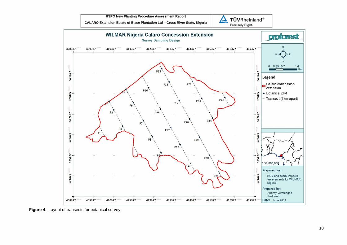
Sample design for botanical and fauna survey Analysed satellite imagery is used to determine good sample design for botanical survey. Systematically allocated plots is used to capture the different vegetation types in the concession. A total of seven transect lines spaced from each other 1 km were generated.
RSPO New Planting Procedure Assessment Report
CALARO Extension Estate of Biase Plantation Ltd – Cross River State, Nigeria
17
Botanical survey The sampling design aimed at achieving a 1% sampling effort. A number of 1 ha sampling plots were systematically overlaid on the concession map. This lay-out ensured an adequate coverage of concession edges, swampy vegetations, secondary regeneration, bush fallows and farmlands. Twenty-five of such 1 ha plots were laid out on the concession map to attain a 1% sampling intensity. Each 1 ha plot consisted of a 20 m X 500 m strip laid on transects running north-west to south east. Each 500m x 20m plot was then sub-divided into twenty-five 20m X 20m quadrats. The edges of each quadrat were flagged and the team took a detailed inventory of plants in the quadrats. Layout of botanical survey shown in Figure 4 below.
RSPO New Planting Procedure Assessment Report
CALARO Extension Estate of Biase Plantation Ltd – Cross River State, Nigeria
18
Figure 4. Layout of transects for botanical survey.

RSPO New Planting Procedure Assessment Report
CALARO Extension Estate of Biase Plantation Ltd – Cross River State, Nigeria
19
Fauna Survey The sampled fauna environment included large mammals, small terrestrial mammals, avifauna and herpetofauna. Sampling taken along selected trails and transects in 10 systematically distributed sampling plots (500m x 500m). See Figure 5.

RSPO New Planting Procedure Assessment Report
CALARO Extension Estate of Biase Plantation Ltd – Cross River State, Nigeria
20
Figure 5 Map of the distribution of fauna sampling plots (Black squares)
RSPO New Planting Procedure Assessment Report
CALARO Extension Estate of Biase Plantation Ltd – Cross River State, Nigeria
21
Community survey The socio-economic and cultural surveys were conducted to capture social and cultural HCVs (HCV 5 and HCV 6) in the area and covered all the landlord communities. Data collection involved a series of household surveys, focus group discussions, participatory community mapping and town hall meetings. Three communities considered as target of survey namely Atan Odot, Uwet and Ikot Eyidok Family.
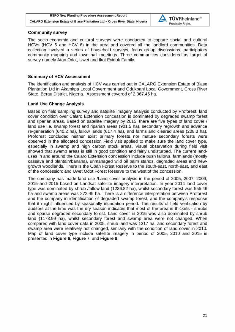
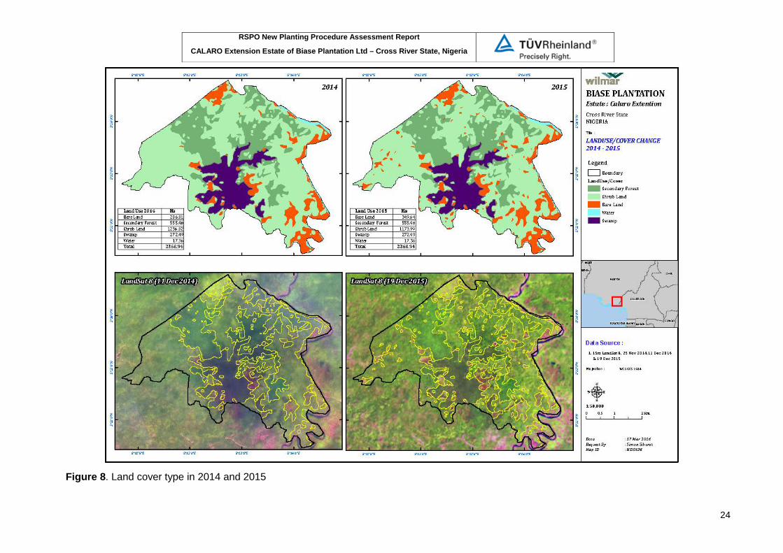
Summary of HCV Assessment The identification and analysis of HCV was carried out in CALARO Extension Estate of Biase Plantation Ltd in Akamkpa Local Government and Odukpani Local Government, Cross River State, Berau District, Nigeria. Assessment covered of 2,367.45 ha. Land Use Change Analysis Based on field sampling survey and satellite imagery analysis conducted by Proforest, land cover condition over Calaro Extension concession is dominated by degraded swamp forest and riparian areas. Based on satellite imagery by 2015, there are five types of land cover / land use i.e. swamp forest and riparian areas (901.5 ha), secondary regrowth and advance re-generation (640.2 ha), fallow lands (617.4 ha), and farms and cleared areas (208.3 ha). Proforest concluded neither exist primary forests nor mature secondary forests were observed in the allocated concession Field visit applied to make sure the land cover type, especially in swamp and high carbon stock areas. Visual observation during field visit showed that swamp areas is still in good condition and fairly undisturbed. The current land-uses in and around the Calaro Extension concession include bush fallows, farmlands (mostly cassava and plantain/banana), unmanaged wild oil palm stands, degraded areas and new-growth woodlands. There is the Oban Forest Reserve to the south-east, north-east, and east of the concession; and Uwet Odot Forest Reserve to the west of the concession. The company has made land use /Land cover analysis in the period of 2005, 2007, 2009, 2015 and 2015 based on Landsat satellite imagery interpretation. In year 2014 land cover type was dominated by shrub /fallow land (1236.82 ha), whilst secondary forest was 555.46 ha and swamp areas was 272.49 ha. There is a difference interpretation between Proforest and the company in identification of degraded swamp forest, and the company’s response that it might influenced by seasonally inundation period. The results of field verification by auditors at the time was the dry season indicates that most of the area is thickets - shrubs and sparse degraded secondary forest. Land cover in 2015 was also dominated by shrub land (1173.99 ha), whilst secondary forest and swamp area were not changed. When compared with land cover data in 2005, shrub land was 1317 ha, and secondary forest and swamp area were relatively not changed, similarly with the condition of land cover in 2010. Map of land cover type include satellite imagery in period of 2005, 2010 and 2015 is presented in Figure 6, Figure 7, and Figure 8.

RSPO New Planting Procedure Assessment Report
CALARO Extension Estate of Biase Plantation Ltd – Cross River State, Nigeria
22
Figure 6: Land cover type in 2005 and 2006

RSPO New Planting Procedure Assessment Report
CALARO Extension Estate of Biase Plantation Ltd – Cross River State, Nigeria
23
Figure 7. Land cover type in 2010 and 2011
RSPO New Planting Procedure Assessment Report
CALARO Extension Estate of Biase Plantation Ltd – Cross River State, Nigeria
24
Figure 8. Land cover type in 2014 and 2015
RSPO New Planting Procedure Assessment Report
CALARO Extension Estate of Biase Plantation Ltd – Cross River State, Nigeria
25
Carbon Stock Assessment Carbon stock estimated for the Calaro Extension concession ranged from 0.35 t in transect 21 to 44.65 t in transect 18 and averaged 19±13 t/ha. Secondary forest accounted for 27.04% of the total area in the concession and 39.78% of the total carbon stock, followed by the swamp forests accounting for 37.5% of carbon stocks. Carbon stocks were highest for Berlinia sp, Symphonia globulifera and Sterculia oblonga beside Elaeis guineensis Mean carbon stock in the Calaro Extension concession acquired by Wilmar was 19 t/ha. This value is very low compared to other tropical forests. In the lowland moist evergreen forest in Korup National Park, Cameroon, carbon stock in trees with dbh≥10 cm is higher (range 100 – 267 t/ha, mean 161±35 t/ha) (Kenfack et al. unpublished data). In the semi-deciduous forest in Lobeké National Park, Eastern Cameroon, carbon stocks are even higher, with a mean of 187.92 t/ha (Zapfack et al. 2009). The low carbon stock can be attributed to the low tree density (106 individuals/ha compared to 491 individuals/ha in Korup) and the abundance of pioneer species that generally have a low wood density.
Based on the proportion of each vegetation type in the concession, the total carbon stock by trees with dbh≥10 cm can be inferred to 54,763.24 tons. Smaller sized trees with dbh [1-10 cm] were estimated to store an additional 2,800 tons of carbon, making a total of 57,563 tons of carbon in the Wilmar concession. The company is working Carbon Stock report to be forwarded to the ERWG with this NPP documents. Landscape and Site Context The Calaro Extension concession straddles two local government areas. The Uwet axis is located in the Akamkpa Local Government Area, whilst the Atan Odot axis is located in the Odukpani Local Government Area. The concession is located North of Calabar, and South of the villages of Atan Odot and Uwet. Mainly the Uwet Odot Forest Reserve borders it on the north side and the Oban Forest Reserve also borders it to the southeast side. There are farmlands and community lands mainly in the northeast and the southwestern parts of the concession. Description at the regional context contains information on the Guinean High Forest which is important for unique wildlife especially for primate conservation, but also with the highest threat. In addition to its fauna conservation significance, the Guinean High Forests are also home to several species of economic plants such as the African mahogany (Khaya and Entandophragma), African Ebony (Diospyros gracilis) and Iroko (Milicia excelsa). Additionally, the oil palm (Elaeis guineensis) is native to this hotspot. This remnant forest is highly fragmented largely by logging and agricultural activities, settlements and other developmental projects. At the national context covered description on threat to Nigerian forest and conservation infrastructure in Nigeria. Some threats to conservation found in the region such as illegal logging, forest fires, population pressure, hunting and poaching, agricultural expansion and shifting cultivation practise. The Cross River State context include analysis on vegetation structure and composition, biodiversity, hydrogeography, soil and terrain. The Cross River State is known to host the bulk of the remaining natural vegetations in Nigeria (up to 50% of the country’s remaining forests). Estimates have it that that approximately some 36% of the land area of the state is forested. Though, this cover continues to be threatened by various anthropogenic activities, its extent represents a very important natural resource estate for the country. The concession areas are located in the lowland rainforest zones of Nigeria. The actual vegetation in the concession consists of a combination of (a). patches of degraded forests mainly in swampy; (b) patches of advanced regeneration of trees in small clusters and heavily degraded forests (c). bush fallows; (d) existing farmlands, mainly small scale and occupying a few hectares at most and (e). bare land and recent clearings. The areas south of the Uwet-Odot forest reserve contain many natural creeks, rivers and seasonally inundated areas. As the concession is situated in a low lying area, there is an intricate

RSPO New Planting Procedure Assessment Report
CALARO Extension Estate of Biase Plantation Ltd – Cross River State, Nigeria
26
network of small streams, swamps and flood plains including those that empty into the Calabar River. Topography characteristic represented by the slope classes. The proposed site had mainly level, undulating, rolling and hilly land. The consession located mostly on flat undulating area (92.27%), and the rest is undulating roll (7.48%) and hilly (0.25%). The elevation of Calaro Extension Area based on the contours on the topographic maps ranges from around 10 metres to over 60 metres. Soil type dominated by psedogley-gleysol; sandy clay to clay associated with local incidences of ferrasols and acrisols-pseudogleys (81.31%) and small portion of psedogley-gleysol; 50-90 cm loamy sand to sandy clay associated with acrisols and ferrasol, sporadic lithosol and cambisol-pseudogleys (14.53%); and ferrasols associated with acrisol and incidences of rankers originated from iron crust (4.16%). Map of slope classes and soil is presented in Figure 9. The populations in the area comprise of people with different ancestries and history, even though several customs and cultures are shared. The Atan Odot community with an estimated resident population of 2,500 persons is located off Calabar- Itu Highway by Okrikang junction about 65 kilometres from Calabar. The people of Atan Odot are predominantly farmers and predominantly grow cassava which serves both subsistence and commercial purposes. Uwet Community in Uwet Clan belongs to Unyagha political ward of Akamkpa Local Government Area of Cross River State. Uwet has an estimated resident population of about six hundred and forty-three (643) people as at December, 2011. Uwet is located around the bank of River Calabar, about one kilometre from the Calaro Estate and about seven Kilometres from the Akamkpa Local Government Council Secretariat. The members of Uwet community live in a cluster settlement pattern. The people of Uwet community are predominantly farmers and grow cassava primarily. Cassava serves both subsistence and commercial purposes. The community has both a community forest where major farming activities and hunting activities are carried out and a forest reserve nearby.

RSPO New Planting Procedure Assessment Report
CALARO Extension Estate of Biase Plantation Ltd – Cross River State, Nigeria
27
Figure 9. Map of slope of Calaro Extension

RSPO New Planting Procedure Assessment Report
CALARO Extension Estate of Biase Plantation Ltd – Cross River State, Nigeria
28
Figure 10: Soil distribution map (bottom) of Calaro extension area

RSPO New Planting Procedure Assessment Report
CALARO Extension Estate of Biase Plantation Ltd – Cross River State, Nigeria
29
Findings of HCV areas The findings of HCV assessment show that the concession does not contain any primary forest or areas of peat soils. However, some HCV areas has been identified within the proposed area namely HCV 1.1 HCV 1.2, HCV 3, HCV 4.1, and HCV 5. Total identified HCV areas is 741.5 ha of the total proposed area and most of them located within swamp area/degraded secondary forest. (see Figure 10). The HCV area within swamp and secondary forest area also serve as high carbon stock area and will be maintained and protected. The important element of HCV 1.1 refers to areas that are set aside for protection and are equivalent to IUCNs protected area categories. These areas are usually gazetted as protected under national, state or regional laws. The concession does not contain any protected areas; neither is it contained inside a Protected Area, however the concessions adjoin a protected area as defined under national or state laws. The concession directly shares boundaries with the southern edges of Uwet Odot Forest Reserve as well as the Oban Block Forest Reserve. The north-western boundaries of the Calaro Extension estate share direct boundaries with the Uwet-Odot Forest Reserve, whilst the South-eastern and eastern boundaries of the concession are only separated from the Oban Group Forest Reserve by the Cross River. Given the close proximity of the concession to the two forest reserves HCV 1.1 is present. A 50 m buffer area along the Uwet-Odot forest reserve is identified as HCV 1.1. The important element of HCV 1.2 refers to the existence of Critically Endangered, Endangered (E), or vulnerable (VU) species under the IUCN Red List, Appendix I of CITES or those listed as protected under the country’s legislations. At the time of HCV study successfully recorded 22 species of mammals, 84 birds, and 8 reptiles. Most of the species observed during the assessment are listed as least concern (LC) on the IUCN Red List. Three species classified as Vulnerable (VU) and one classified as Near Threatened (NT) on the IUCN Red List were also recorded. These were the Red-capped Mangabey (Cercocebus torquatus) VU, Dwarf Crocodile (Osteolaemus tetraspis) VU, the African Grey Parrot (Psittacus erithacus) VU, and Tree Pangolin (Dendrohyrax dorsalis) NT. The assessment also observed the Sitatunga (Tragelaphus spekeii), which is listed as a least concerned species on the IUCN Red List. However, the species is assessed to be locally endangered. In many parts of the Guinean Forest Zone in West Africa, including Ghana, Niger, Sierra Leone and Togo, the species is considered to have already gone extinct, whilst populations in Nigeria are known to be critically threatened. Several evidence of the activity of the African Slender-snouted Crocodile (Mecistops cataphractus) observed in the concession. The African Slender –snouted Crocodile is listed as critically endangered (CR) on the IUCN Red List. All observations of this species were made in the swampy vegetation’s which is important to supporting wildlife habitat. Presence of the Slender-snouted Crocodile (CR) and Sitatunga (locally endangered) in swampy areas is considered as HCV 1.2 The assessment process observed a total of 86 species belonging to 31 families in the concession. The identified species list was dominated by species that are found most commonly in degraded or recently cleared areas such as Musanga cecropioides, and Albizia zygia. The species was dominated by species that are typically found in swamps, seasonally inundated and riparian areas such as Mitragyna stipilosa, Alstonia boonei, Uapaca guineensis Pentaclethra macrophylla and additionally also found Berlinia uriculata which occurs in stand in swampy areas. The most common species observed during the assessment was the oil palm Elaeis guineensis. Some vegetation species are listed in IUCN Redlist or on CITES Appendices, such as Nauclea diderrichii (VU), and Diospyrus sp (CITES). However, though the concession does not contain many large diameter trees or no matured then those species is not classified as HCV 1.2. Findings on HCV 3 related to the existence of freshwater swamps ecosystem in the concession that are naturally rare in the region and threat to their continued existence. The swamp forests in the concession have undergone relatively less damage compared to the
RSPO New Planting Procedure Assessment Report
CALARO Extension Estate of Biase Plantation Ltd – Cross River State, Nigeria
30
nearby degraded forests. Additionally, all the sightings of vulnerable, near threatened and critically endangered species took place in the swamp forests. This area was also very rich in terms of species diversity with a richness index of 8 and a diversity index of 1.54. Given the fact swamp forests generally are not well covered in the protected area network and also given the presence of numerous species of conservation interest in the swamp forests, the swamp forests in the concession are considered as HCV 3. Findings on HCV 4.1 refers to the existence of ecosystem or areas that important for the protection of water bodies on which local communities depend for their water supply or livelihood, and flood controlling to the downstream area. Based on networks of rivers and streams map is known that the Calaro extension area was in at least 5 sub-watersheds system within Cross River watershed. The concession has networks of streams, rivulets and creeks flowing through it, some of which drain southwards and eastwards into the Calabar River. The Uwet and Atan Odot communities conduct fishing in these rivers as part of their livelihoods. It is also expected that a number of downstream communities would depend on these rivers for fishing and also household consumption. Most of these water bodies still have fairly intact vegetation’s along them that play a crucial role in maintaining bank stability and maintaining the riparian ecosystems. These streams and rivers mainly drain into the Calabar River and subsequently into the Cross River which is also known to provide an important source of fisheries resources All such vegetation along water bodies and watersheds in the concession have been identified as HCV 4.1. Small rivers /creek are already within the swampy areas, whilst special buffer area with 100 m along Calabar River applied for HCV 4.1 management.
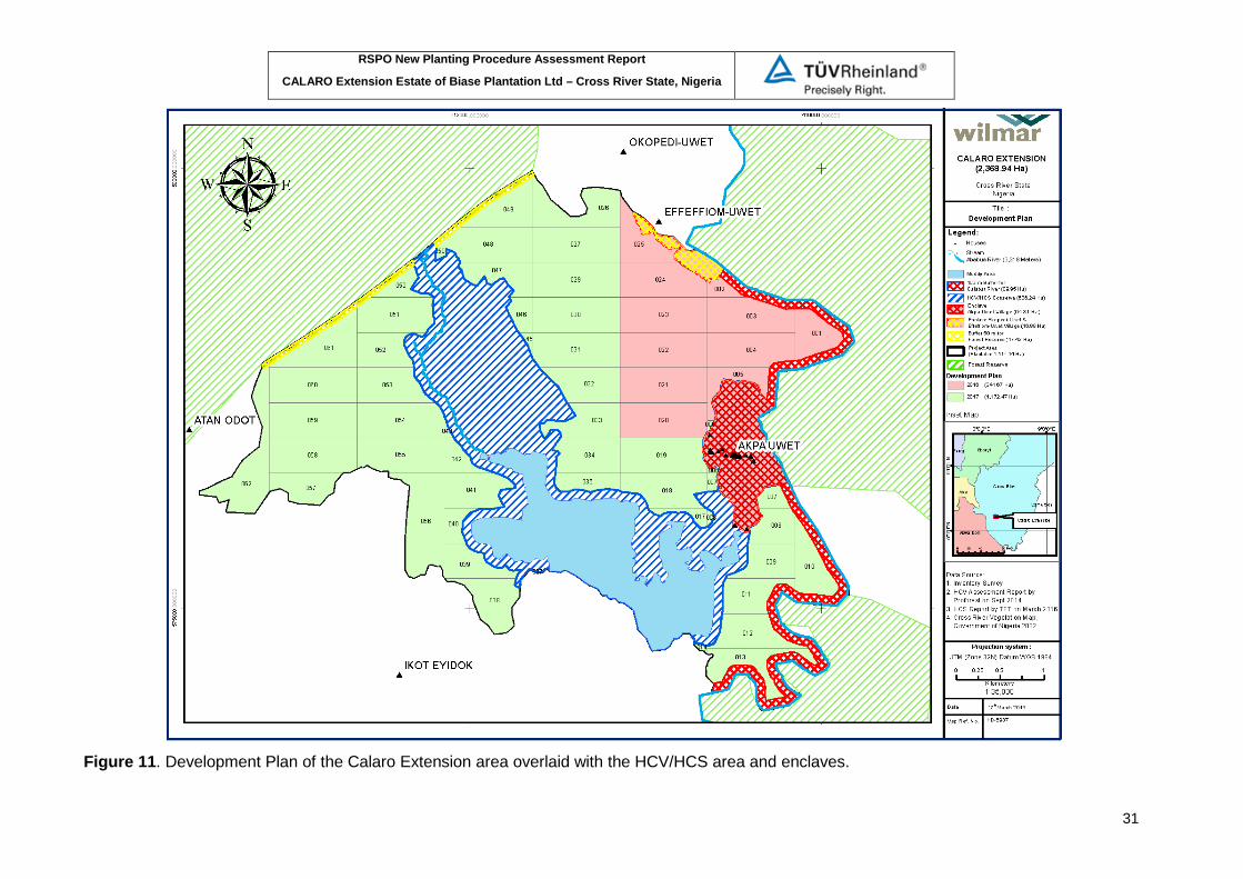
The existence of HCV 5 is based on interviews/discussions with local communities surround the concession. The networks of water bodies in the area play a crucial role in the livelihoods of a number of communities. The Calabar River in particular, together with its tributaries is an important fishing ground. The villages of Uwet and Atan Odot both have an important fisheries resource at a place called Ababua towards the east of the concession. This forms a critical part of the livelihood of many villagers and serves as an important and affordable protein source for the villages. This area (Ababua), the river and all its tributaries have hence been identified as HCV 5 and must be protected. Even though the NTFP in the landscape is not categorized as HCV, assessors recommend that BPL should carry out its operations in a way that allows for access to these resources or the provision of alternatives whichever is appropriate possibly through the ongoing FPIC process. In addition to HCV area through public consultation with multi stake-holder some secondary forest area also will be protected as high carbon stock areas which is integrated with the management of HCV swamp forest. The company should ensure this HCV must be protected and managed well and should be clear excluded from land clearing activities. Based on development plan map and the statement area, all the HCV areas are will be maintained and excluded from planting plan. Total area of HCV/HCS to be managed is 722.64 Ha or less 5 Ha than identified HCV by assessor. Actually there are no stones are set on the ground for a definite delineation of HCV/HCS area, so that the figure is still indicative. The existence of two enclaves are already have been taken into account in the development plans with a total area of 111.19 ha. During the observation, it was found some enclave/village boundary stones with the project area. The area to be planted or developed is approximately 1535.11 Ha. Figure 10 below shows land clearing plan in 2 years overlaid with HCV and HCS areas inside the proposed area.
RSPO New Planting Procedure Assessment Report
CALARO Extension Estate of Biase Plantation Ltd – Cross River State, Nigeria
31
Figure 11. Development Plan of the Calaro Extension area overlaid with the HCV/HCS area and enclaves.

RSPO New Planting Procedure Assessment Report
CALARO Extension Estate of Biase Plantation Ltd – Cross River State, Nigeria
32
Refers to above map, HCV 1.1 boundary 50 m buffer area along the Uwet-Odot forest reserve is not drawn yet. Stakeholders’ Consultation Two rounds of stakeholder consultations at the state government level and with the host communities were carried out. The consultations which were carried out prior to and after the field assessments aimed at eliciting stakeholders’ input into the assessment process and the HCV management recommendations respectively. The initial consultations were held during the scoping activity in October, 2012 and during the main assessment in March 2014. The second round of consultations was conducted in July, 2014. Consultations at the state level comprise of two stages, the first is consultation with government institutions prior to field assessment and the second is consultation with non-government organizations and experts after field assessment. Consultation process with government institutions was useful in obtain an understanding of the company’s legal obligation in terms of sustainable natural resource management and obligations to local communities in the catchment area of the concessions. Institutions consulted included the Forestry Commission, the Ministry of Agriculture, Ministry of Lands and Housing, The Justice Ministry and the Information Ministry. Consultation with NGO organisations and experts which involved in natural resource management and planning in the Cross River State to obtain some information on key environmental and social issues that ought to be addressed during the assessment process. Organisations consulted included: Wildlife Conservation Society (WCS), the NGO Coalition for the Environment (NGOCE), Nature Conservation Foundation, RRDC and other independent consultants on agriculture and tenure within the region. In addition to these formal consultations, the individual host communities were consulted throughout the socio-economic survey process which is more emphasized in SEIA aspects. Comments and inputs of all stakeholders consulted as follows: Table 1. Comments and inputs raised during state-level stakeholder consultation for HCV assessment
Date Institution / Organisation Contact person Summary of comments
Sunday 21st October, 2012
Wilmar/Biase Plantation
Mr. Lee Kok The state government has been able to secure some lands ca 3,000ha for Wilmar, as an extension to the existing Calaro estate. Land demarcation and community engagement are ongoing. Wilmar would Continue with its FPIC process once the demarcation processes are completed.
Monday, 22nd Oct, 12
Cross River Forestry Commission
Innocent Ntufam From a preliminary look at the maps provided, the Calaro extension does not appear to impinge on the boundaries of any protected area. However, there is the need to investigate the boundaries more with the mapping unit. Plantation development can bring rural development into the communities. However, it is essential to also ensure that the nearby-protected areas are maintained. Before land preparation takes place, the Forestry Commission should be invited to conduct a census of commercial merchantable trees in the concession and prepare a bill for the Biase Plantations Ltd.
Monday, 22nd Oct, 12
Cross River Forestry Commission
Bridgit Nkor The initial concession maps show some overlaps with the Oban Block FR and the Uwet-Odot FR. All areas of overlap need to be excised from the concession. Additionally, it is important for the company to
RSPO New Planting Procedure Assessment Report
CALARO Extension Estate of Biase Plantation Ltd – Cross River State, Nigeria
33
Date Institution / Organisation Contact person Summary of comments
manage its operations in a way that minimises the pressure on adjoining protected areas. The fact that a significant portion of agricultural lands in the community is going to be taken away implies that there would be a significant pressure on the forests nearby for hunting logging and even farming. The company needs to implement steps that address these potential challenges.
Monday, 22nd Oct, 12
CR Tourism Development Board
Tony Bassey Oil palm plantations form part of the rural development plans of the state. This has the potential to promote rural development and open up the villages for trade. However, the plantation establishment process should effectively engage with local communities and look into providing alternatives to those who might lose livelihood sources as a result of the concession acquisition. Additionally, it would be useful for the company to contribute to the effective management of conservation efforts nearby.
Tuesday, 23rd Oct, 12
Commissioner of Lands
Raphael Uche The commission has noted the slight overlaps with the boundaries of the concession. A team would be working to re-demarcate the new boundaries of the concession. The area that is to be given out is designated for agricultural development. Once the correct boundaries and the true extent of the concession has been established, it is expected that some compensation would be paid to the communities. The usual approach is also to have an MOU with the communities that spell out the responsibilities of all parties.
Saturday, 27th Oct, 2012
RRDC Odey Oyama A preliminary look at the location of the concession indicates that it would be suitable for the oil palm plantation development. There is also the need to ensure that there are adequate safeguards in place to avoid the depletion of nearby protected areas. Additionally, the engagement process with the local communities should be free, open and transparent. Wilmar currently has major issues with local communities and overlaps with protected areas in other locations in the state.
24th July, 2014 NGO Coalition for the Environment
Edwin Usang The proposed project is a potentially good one and can positively impact on the local economic landscape. However, it is critical to look into the implementation of appropriate safeguards to manage the impacts on society and the environment. How are those farmers who would lose livelihoods benefit from the programme? How do we ensure that the integrity of the nearby-protected areas is maintained? How well are communities engaged in decision making? How do we ensure that the recommendations from the HCV, SIA and EIA are well implemented and monitored?
24th July, 2014 WCS Dr Imong Plans towards biodiversity protection in the concession should take an integrated landscape

RSPO New Planting Procedure Assessment Report
CALARO Extension Estate of Biase Plantation Ltd – Cross River State, Nigeria
34
Date Institution / Organisation Contact person Summary of comments
approach. Leaving patches of conservation areas inside the concession would have limited conservation significance. It is essential to look at how the conservation areas within the concession can interact with the broader landscape, and what is its significance. Additionally, the company should explore the possibility of contributing to conservation efforts in the broader landscape.
Tabel 2. Comments and inputs raised during state-level stakeholder consultation for SIA assessment
Name Designation Organisation/Community
Comments/suggestions/recommendations
Chief Egan Anohobi
Ministry of Agric.
Wilmar for the purpose of its corporate responsibility should be ready to share hybrid seeds with other growers to avoid conflicts. Response from Mr. Lee (General Manager of Wilmar): Lee: In the short term, the planting materials are for planting on the nucleus estates. However, discussions are ongoing with Ministry of Agric to set up outgrower scheme. The members of the scheme would have to abide by RSPO P&C in order to be able to supply to Wilmar mills. There are also discussions that in the future, seedlings would be sold to other growers (independent smallholders) at cost of production (not at profit). Response from Ubane Ubi Bassey (Desk Officer, Oil palm – Ministry of Agric): There are ongoing discussions with Wilmar confirmed by Mr. Lee. Forms have been given out for local growers to apply to join the outgrower scheme and awaiting responses. Most local growers want to utilise their current stands before changing to the new variety. Wilmar should engage local growers and processors more actively. Engagement with the Oil Palm Growers Association of Nigeria (OPGAN) would be a good starting point. Wilmar should consider assisting with the RSPO NI process.
Chief Edwin Usang
Executive Director
NGOCE The issue of FPIC is very critical and from all indications, the community was not properly consulted. Are there reports of the FPIC process to be shared? Response from Wilmar: FPIC was conducted and the records are available. Response from Victor Bassey (Youth Secretary, Atan Odot): From inception of the process, the communities were well consulted and engaged by Wilmar and government consultants. Response from Charles Okon Etim (Community representative, Uwet; and Wilmar staff): The State government informed communities of intention to lease land to Wilmar. Government brought in an organisation called Consort to facilitate the process. The communities (all groups) consulted internally and with government and Wilmar. Communities then drafted an MoU with Wilmar before the Deed of Grant was singed between the government and Wilmar. The CRS Governor was present at
RSPO New Planting Procedure Assessment Report
CALARO Extension Estate of Biase Plantation Ltd – Cross River State, Nigeria
35
Name Designation Organisation/Community
Comments/suggestions/recommendations
the final meeting where communities reiterated their concerns and later agreement was signed. Response from Ita Bassey Ita (Representative, Ikot Eyidok): Community was given sufficient information and time to consult internally and with government and Wilmar before accepting to host the project. Response from Mr. Egbai Ojah (Director, Forestry Commission): Wilmar consulted the Forestry Commission prior to development. FC did its own assessment of concession areas and made recommendations to Wilmar. In recognition of the fact that there are no National interpretations for HCV in Nigeria, it is necessary to develop one for Nigeria. Issue of contention in acquiring the Calaro Extension concession is critical because some issues are still in court whilst Wilmar is still expanding. This might have implication on the project development. Chief Edwin added that within corporate social responsibility there should be a benefit sharing mechanism clearly set out from the outset. The channel for executing the CSR should also be clearly defined. What are the safeguards go ensuring that Wilmar implements the SIA recommendations? Response from Elikplim Agbitor (Proforest): Accredited independent bodies will ensure that the RSPO guidelines are met in respect of all the concerns raised by stakeholders which are also contained in the RSPO P&C. This will be done through the certification and surveillance audits. Are the improved varieties GMO? This is important because it borders on ethical issues? Response from Mr. Lee (Wilmar): The improved varieties are not GMO. They are a result of plant breeding, with parent materials from Nigeria and Ghana. One of the touted potential positive impacts is Wilmar contributing to domestic palm oil deficit. Will Wilmar actually sell in the domestic market or export? Response from Mr. Lee (Wilmar): Wilmar will process and sell locally. Wilmar has refinery in Lagos and at the moment importing CPO from Malaysia and Indonesia to refine because of deficit in local supply. All sold locally under brand names such as frytol. Also sold to PZ cussons, uniliver, etc.
Caroline Olory ACP CRNP Commented that from past experience, communities are seen to give consent and later decline. Wilmar and other relevant stakeholders should thread carefully and manage information appropriately to avoid conflicts in future. There should be offset activities and contributions to conservation efforts by Wilmar in the concession area.
Odigha Odigha Board Chairman
CRSFC We should look at the environmental, economic and social justice issues and considers the gains of tomorrow. We should learn lessons from the Niger Delta experience and strike a balance. All issues should be factored in terms of cost and benefits and ensure that it fits into the approach of green economy. In all our practices, people, food security and the environment should be considered.
Mr. Lee Kok General Biase 500ha of original concession area was excised for use as

RSPO New Planting Procedure Assessment Report
CALARO Extension Estate of Biase Plantation Ltd – Cross River State, Nigeria
36
Name Designation Organisation/Community
Comments/suggestions/recommendations
Seng Manager Plantations Limited
community farm lands to ensure food security.
Mr. Owali Ilem Private investor
Suggests that communities should engage the services of independent consultants to advise them on the implication of their decisions while engaging with Wilmar
Liza Gadsby Director Pandrillus How often does RSPO visit plantation sites to check operations? Response from Isaac (Proforest): Every year an independent assessment body comes to check operations after the main certification audit. Charged Wilmar to take note of the potentially increasing need for farmland by outsiders (non-indigenes) who would migrate into the area to take up jobs with Wilmar; this can be a critical concern and Wilmar should plan for that eventuality.
Mr. Egbai Ojah Director Forestry Commission
Wilmar have not respected the advice given by the forestry commission and the guideline on buffer zone protection in the Ibiae concession; concern that in Ibiae, Wilmar bulldozed and planted in riparian buffer zones resulting in siltation of streams that feed into the Cross River and constitutes the major source of water for the community. Wilmar needed to give assurance that this would not occur in other areas, including Calaro Extension. In the meantime, he urged Wilmar to provide alternative source of water for the affected community.
Victor Bassey Community representative (Youth Secretary)
Uwet Wanted to know from forestry commissioner when the boundary of the Uwet Odot Forest Reserve was extended further into Uwet community land. Response from Mr. Odigha Odigha (Board Chairman, Forestry Commission): the community should send representatives to the Forestry Commission offices for discussions on the issue.
Ruth Akagu NCF All through the discussions, emphasis has been on what Wilmar should do. The success of the project is however a shared responsibility of all stakeholders, communities, CSOs and government institutions; the investor (Wilmar) needs support and input of all stakeholders. All must play their part. The entire burden should not be left on Wilmar.
Tabel 3. Comments and inputs raised during host communities’ stakeholder consultation
Name of participant
Community / Organisation
Designation Comments / suggestions / recommendations
Asia Ekpo
Uwet
Community Representative
He wanted to find out whether Biase Plantations Limited planned to supply local oil palm farmers with improved planting materials (seedlings). In response to H/H Asufa’s question, the General Manager for Biase Plantations Ltd. (Mr. Lee Kok Seng) stated that in the short term, the improved seedlings would be planted on Wilmar’s estates. He however explained that discussions were ongoing with the CRS Ministry of Agriculture to agree on modalities for developing an outgrower scheme after which Wilmar would supply the improved seedlings to local farmers at cost of production

RSPO New Planting Procedure Assessment Report
CALARO Extension Estate of Biase Plantation Ltd – Cross River State, Nigeria
37
Name of participant
Community / Organisation
Designation Comments / suggestions / recommendations
(no profit). Victor E. Bassey
Atan Odot
Youth Secretary Victor mentioned that the host communities grow vegetables in the mud flats along the rivers and streams after the floodwaters recede. He wanted to know whether they would be allowed to continue with this practice when Biase Plantation Limited starts operations. Isaac Abban-Mensah of Proforest responded that since Wilmar is a member of RSPO, they are bound to protect all riparian areas within their concession as required in the RSPO Principles and Criteria. As such, no agricultural activity would be permitted in the riparian areas within the concession.
Chief Efiong Bassey
Atan Odot Village Elder He requested that Biase Plantations Ltd commences operations in the concession as soon as possible. He further requested that the company carries out road construction at the outset of operations to open up the area and provide access to Atan Odot and Uwet. Mr. Lee, in response to the requests from Chief Bassey, stated that the company would wish to start operations soon. However, there are requirements that the company needed to meet prior to commencement of operations. These include SIA, EIA and HCV assessments that are still ongoing.
James Odey ARADIN James mentioned that during the public consultations conducted in the data collection phase of the assessment, the youths in Atan Odot complained that they were not engaged during consultations for land acquisition. He further mentioned that some members of the communities also stated during data collection that they did not understand the modalities for valuation of crops and the compensation. He wanted to know if these concerns still existed. The representatives of the various communities (and community groups) present said that the concerns mentioned by James had been addressed. They also unanimously asserted that there was broad-base consultation during the land acquisition process. Victor Bassey of Atan Odot however felt the issue of the modalities for valuation and compensation had still not been clarified adequately.
Chief Efiong Bassey
Atan Odot Village Elder He said that local communities have been hunting animals from the concession area for generations and wanted to know if they would be permitted to do so when operations commence. In response to this, Isaac Abban-Mensah of Proforest stated that a number of protected animal species were identified in the concession area during the HCV assessments. He added that it is the responsibility of the company to protect these animals. As such, hunting of these animals would not be allowed. Isaac urged the communities to assist the company in protecting those
RSPO New Planting Procedure Assessment Report
CALARO Extension Estate of Biase Plantation Ltd – Cross River State, Nigeria
38
Name of participant
Community / Organisation
Designation Comments / suggestions / recommendations
animals for posterity. Isaac Abban-Mensah
Proforest Isaac wanted to know if there were any sacred areas, areas of cultural importance or burial sites within the concession that needed to be protected. Response from chiefs and elders of the communities: There are no sacred areas within the concession or anywhere else on the community lands since the community members are all Christians. Neither are there burial sites since deceased persons are buried in homesteads.
Victor Effiong Bassey
Atan Odot Youth Secretary i. He notified participants of a group of ponds called Ababua within Wilmar’s concession from which the communities fish; flood waters from the surrounding rivers and streams carry fish into these ponds. Other members of the host communities confirmed this. A request was made that Wilmar protects these ponds and grants communities access to fish from them. Isaac Abban-Mensah responded that the ponds would be mapped out as part of the HCV assessment. ii. The value of compensation paid for loss of farmlands was not adequate. We wish to know the modality used for compiling such compensation. Response from Isaac of Proforest: Compensation was determined based on the hectare and this was determined by the State Government iii. We presented a case to the government requesting a review of the land rate but are yet to receive a response.
Chief Olbort Asufa
Uwet Village Head Apart from the fish stock in the Ababua ponds, bush meat and NTFPs are found everywhere in the community forests so this cannot prevent Wilmar from development. Uwet community have never had a shrine; sacrifices used to be carried out in the river but now that everybody is a Christian such practices are no longer in existence. There is a village, Akpa Uwet, close to Uwet and within the concession that should not be evicted. In response, Isaac Abban Mensah of Proforest stated that the village would be mapped out as part of the HCV assessment. Wilmar should confirm every correspondence to Wilmar from the communities as originating from the appointed community representatives by calling the community leaders. This is because there is the tendency for unappointed individuals to speak on behalf of the community without the communities’ consent.
Rev. Godwin E. Asuquo
Ikot Eyidok Community Representative
If other natural resources such as solid minerals are found within the concession area, who takes ownership? Response from Isaac: Any resources below the surface do not belong to the company. In Nigeria, natural resources below the ground belong to the government so the government decides who mines such resources.
Uwet & Atan Odot chiefs and elders
We are willing to contribute additional land to make up the 5,000 hectares required for an oil mill to be established in the area.
Charles Okon Etim
Uwet Community representative
We as a community are not comfortable with the rates to be paid as land rent to communities. The communities have communicated through the Ministry of Agric to his

RSPO New Planting Procedure Assessment Report
CALARO Extension Estate of Biase Plantation Ltd – Cross River State, Nigeria
39
Name of participant
Community / Organisation
Designation Comments / suggestions / recommendations
Excellency, the Governor of CRS for upward review. Now that copies of the lease agreement have been given to community leaders, it is important for other community members to be aware of the contents of the agreements. We appeal to Wilmar to help grade Atan Odot / Uwet road to facilitate movement in and out of the communities. We also appeal that when improved seeds are ready for distribution to outgrowers, it should pass through community leaders.

RSPO New Planting Procedure Assessment Report
CALARO Extension Estate of Biase Plantation Ltd – Cross River State, Nigeria
40
SUMMARY OF PLANS: a. Summary of Management and Mitigation Plans (SEIA) There are some management & mitigation plan of environmental issues i.e : Table 4. Management & mitigation plans for negative environmental effects & management
plans to promote positive environmental effect Potential
Impact Action plan Adherence indicator Timing Person
Responsible Erosion Prevention/loss of fertility
Pueraria javanica and Calopogonium mucunoides will be planted immediately after land clearing to ensure nitrogen fixation and prevent erosion
Pueraria javanica & Calopogonium mucunoides is being maintained in areas of development
Immediately after land clearing
General Manager
Areas with slopes above 20 degrees will be marked and set aside
Areas marked in GIS database and left undeveloped
Before development
General Manager
Felled vegetation will be windrowed
Stacked egetation between planting rows
During land clearing
General Manager
Roads will be compacted to stabilize surface and reduce erosion until suitable surfacing is established
Roads are compacted and there is no erosion visible during rains
During land clearing
General Manager
Adequate drainage systems will be Established at regular intervals to drain and limit concentration of runoff; particular attention will be paid to areas prone to flooding. Drainage will be centered around main outlet drains by initially constructing field drains at 1:8 rows (to prevent over rainage) and if additional drainage is required drainage will be enhanced to 1:4
Drainage system is sufficient and are well maintained and clear of blockages
During plantation establishment
General Manager/Regional Manager/RSPO Compliance Manager
A system for managing Storm water will be developed
Storm water management system in place
After land clearing
General Manager/Regional Manager
Sediment traps will be established at regular intervals where applicable
Sediment traps are established and maintained
After land clearing
General Manager /RSPO Compliance Manager
A control and monitoring plan for erosion and sediment control will be established and implemented families
Documented Plan Before land clearing
General Manager /RSPO Compliance Manager
Pollution of surface/ground water
Riparian buffer zones will be delineated and maintained around bodies of water and along rivers According to width. Contractors will be trained in proper felling
Demarcation of buffer zones
Record of any encroachments
Before land clearing
RSPO Compliance Manager/HCVF Manager

RSPO New Planting Procedure Assessment Report
CALARO Extension Estate of Biase Plantation Ltd – Cross River State, Nigeria
41
Potential Impact Action plan Adherence
indicator Timing Person Responsible
techniques to ensure damage to the areas is avoided. Any accidental encroachments on these areas will be recorded and the area will be replanted
Household waste water will be processed before discharging and discharge areas will be monitored
Records of water quality tests of discharge water
Continuous RSPO Compliance Manager/ QEHS Manager
A water quality monitoring and management plan will be established for testing of surface water. Buffer zones will be maintained to ensure that there is no runoff of chemicals into surface water
Water analysis report
Every 6 months RSPO Compliance Manager/HCVF Manager
A pollution prevention and clean-up procedure will be established to address chemical spills or leaks.
Procedure on Record
N.A Regional Manager/RSPO Compliance Manager/QEHS Manager
All waste will be properly disposed of in enclosed areas and a waste management plan will be established
Record of quantities and types of waste products
During development/ continuous
RSPO Compliance Manager/yQEHS Manager
Refueling and chemical transfer will only occur in bonded areas with concrete bases
Bunded areas are maintained
During development
RSPO Compliance Manager/QEHS Manager
GHG emissions
Consumption of oil and use of generators will be controlled and monitored
Monitoring sheet Continuous RSPO Compliance Manager/ QEHS Manager
Land clearing activities will be strictly limited to planned areas and buffer zones & set aside forest areas will be maintained and and monitored
Map of limits of land clearing
Before development of each phase
General Manager/RSPO Compliance Manager
Reducing noise and vibration
All vehicle and mechanical equipment will be provided with mufflers and maintained in good working condition according to manufacturers maintenance schedule
Maintenance record
Continuous Regional Manager/QEHS Manager
Workers will be equipped with PPE for protecting against ill-effects of noise and vibration
PPE Awareness factsheet Issuance Register
Continuous
Regional Manager/QEHS Manager
Construction will be limited to daylight hours during the week to reduce noise
No activity outside of working hours
Continuous
Regional Manager/QEHS Manager
Change in Landscape
A plan for land clearing has been established and conversion will be strictly limited to areas identified for planting and infrastructure
Development does not infringe on set aside areas
Before development
General Manager/Regional Manager

RSPO New Planting Procedure Assessment Report
CALARO Extension Estate of Biase Plantation Ltd – Cross River State, Nigeria
42
Potential Impact Action plan Adherence
indicator Timing Person Responsible
development The mill site will be carefully
integrated in the site taking into account environmental and social considerations (sight, sound, proximity to set aside areas)
Incorporation in GIS map
Prior to development of the mill
General Manager/RSPO Compliance Manager
HCV areas, riparian buffer zones, and highly sloped areas will be maintained
Incorporation in GIS maps and Boundaries delimited
Continuous
RSPO Compliance Manager/HCV Manager
Loss and disturbance of biodiversity
Clearing will be limited to areas identified as suitable for planting and for the establishment of infrastructure
Incorporation in GIs map and adherence to clearing plan
Land clearing General Manager/Regional Manager
HCV areas will be delineated in GIS database and boundaries will be demarcated on the ground
HCV Maps and boundaries delimited
Prior to land clearing
GIS Expert/HCV Manager
A monitoring plan of riparian buffer zones and HCV areas will be established
Monitoring Report (frequency of observation of indicators of faunal presence )
Once a year HCV Manager
Hunting by Olam workers will be strictly prohibited; Villagers will be permitted to continue to use fishing grounds but hunting may be limited
Agreement on hunting areas during FPIC process
Continuous RSPO Compliance Manager/HCV Manager
Noise from development will be limited to working hours to allow for the movement across the site of faunal species at night and to prevent excess disturbance of inhabitants of conservation areas
No activities outside of working hours
Continuous RSPO Compliance Manager/HCV Manager
Risk of Accidents and disturbance of workers during plantation development (exposure to sharp tools and heavy equipment)
A QEHS policy and rollout plan has been established and will be reviewed on a regular basis
Documented QEHS plan
Before/During Development
QEHS Manager
Workers will be provided with and trained in the use of the appropriate Personal Protection Equipment
Health and safety report
Continuous QEHS Manager
Workers will be provided with and trained in the use of appropriate Personal Protection Equipment (protective coveralls, dust mask, goggles, gloves and boots) and responsible application of phytosanitary products
Health and Safety Report (Record of Accidents) Record of Training
Continuous QEHS Manager
Storage & Use of Phytosanitary products
Workers will be provided with and trained in the use of appropriate Personal Protection Equipment (protective coveralls, dust mask, goggles, gloves and boots) and responsible application of
Health and Safety Report (Record of Accidents) Record of Training
Continuous
QEHS Manager

RSPO New Planting Procedure Assessment Report
CALARO Extension Estate of Biase Plantation Ltd – Cross River State, Nigeria
43
Potential Impact Action plan Adherence
indicator Timing Person Responsible
phytosanitary products After 3 months, pregnant or
nursing women will be prohibited from applying phytosanitary agents and be reassigned to maintenance of buildings and/or the crèche
Medical certificates
Continuous
QEHS Manager
Workers responsible for application of phytosanitary agents will undergo regular blood screening
Medical certificates/Records of screening
Continuous
QEHS Manager
An eye wash/shower will be provided in the case of direct contact with chemicals
Washing stations in storage areas
When chemical storage is established
QEHS Manager
All products will be labelled with relevant MSDS and clear safe-use signage
Labeling is clearly displayed
Continuous
QEHS Manager
An isolated, ventilated room will be established for storage of phytosanitary products and access will be limited to appointed personnel; clear hazard signage will be established at each entrance
Clearly signed, locked storage Area. No noxious smells
During development
QEHS Manager
Products will be clearly labeled and arranged according to their application (ie. pesticide, herbicide, fungicide, miticide)
Products are in specified places Relevant labels are in place
Continuous
QEHS Manager
Staff will be trained in management of stock and safe application of productions; workers will be informed about sickness related to the application of and exposure to phytosanitary products
Records of stock
Continuous
QEHS Manager
A QEHS plan will be documented and implemented; workers will be trained in safe working practices including the proper use of PPE, what to do in the case of an accident, and the use of first aid kits which will be provided at regular intervals throughout the plantation.
Records of implementation of Health and Safety Plan through training events, monitoring of accident and incidents and repsonse time to accidents
Continuous
QEHS Manager
Exposure to venemous Animals
Anti-venom will be kept in the infirmary in the case of a snake-bite incident
Stock of anti-venom within expiry date
Continuous
QEHS Manager
Workers who have been identified as suitable peer educators will be trained to identify venomous snakes in the area and how to care for snake bite victims
Record of training sessions
Continuous
QEHS Manager

RSPO New Planting Procedure Assessment Report
CALARO Extension Estate of Biase Plantation Ltd – Cross River State, Nigeria
44
Potential Impact Action plan Adherence
indicator Timing Person Responsible
Modification of hydrology, reduction in source
Fertilizer and pesticide inputs will be recorded and justified. Inputs may be adjusted and distributed over time where possible
Records of fertilizer use
Continuous
Assistant Managers/ QEHS Manager
Empty fresh fruit bunches will be returned to the plantation to be used as mulch which will be spread in the inter-rows or around the base of the palms or some of the empty fruit bunches will be used as boiler fuel
Evidence of use of empty FFB
Continuous
Assistant Managers/ RSPO Compliance Manager
Water debit from courses will be calculated as well as the minimum flow in the stream selected for supplying water for the nursery and pre-nursery
Records of debit
Continuous
RSPO Compliance Manager/HCV Manager
A piezometer will be used for monitoring of the water table level
Record of water table levels
Continuous RSPO Compliance Manager/HCV Manager
Biodiversity—contamination of terrestrial and aquatic flora and fauna/emergence of invasive species
The national system for the authorization of pesticides will be adhered to in order to limit the damage inflicted by pesticides on non-target species
Absence of contamination
Continuous
General Manager/RSPO Compliance Manager/QEHS Manager
Reduce GHG Emissions
Where ever possible, low polluting modes of transport will be used and fuel consumption will be controlled
Fuel consumption sheet
Continuous
Regional Manager
A management plan for household waste will be developed taking into account the collection, sorting and storage of recyclables as well
Documented management plan
Prior to development of housing
QEHS Manager
Household waste management
Closed trash receptacles will be provided in housing area
No litter
Prior to development of housing
QEHS Manager
A leak proof, covered landfill center of 25x15x 2m will be established and monitored under the waste management plan
Monitoring sheet
During development
QEHS Manager
Vegetative Waste
Felled vegetation will be windrowed to ensure nutrients are returned to the soil
Windrows
During land clearing
General Manager
A waste management plan for Employee Continuous QEHS Manager

RSPO New Planting Procedure Assessment Report
CALARO Extension Estate of Biase Plantation Ltd – Cross River State, Nigeria
45
Potential Impact Action plan Adherence
indicator Timing Person Responsible
collection, sorting and storage of ordinary industrial waste recyclables will be established; workers will Ordinary Industrial Waste be informed of proper handling and disposal of waste in the appropriate receptacle
Information Sheets Absence of pollution
Hazardous Industrial Waste
A waste management plan for the collection, treatment, storage and disposal of hazardous industrial waste will be established according to best practices
Documented monitoring plan schedule for waste disposal Absence of pollution
Continuous
QEHS Manager
Table 5. Management & mitigation plans for negative socio-economic effects to minimize
negative socio-economic impact/enhance social contributor Potential Impact Action plan Adherence
indicator Timing Person Responsible
Reduction or loss of areas for hunting, fishing or collection and exploitation of timber & non-timber forest products
Areas used by villages for the collection of firewood & construction materials, fishing camps, collection of non-timber forest products, and subsistence farming have been identified through social participatory mapping and will be either excised from the zone or, indemnified
Benchmarking of actions taken towards meeting demands raised during the PRA &FGD process Number of grievances
Indemnification will be provided based on laws & regulations as well as the manner agreed on with communities during the Free, Prior and Informed Consent Process
Number of grievances
Before development /Frequent Monitoring
Social Manager/ Village Representatives
An Wilmar social team responsible for continued engagement with communities and a monitoring committee with representatives from each village group will be established in collaboration with local authorities.
Periodic and minuted meetings with clear resolutions on issues raised
Establish record of grievances/ comments from villages
Grievance procedure in place
Loss of Sacred or Cultural Sites
Sites of sacred or cultural relevance to nearby communities have been identified and will either be set aside, excised or indemnified based on the agreement with local communities. In the case that they are set aside within the site as an HCV management area, a monitoring plan will be established to ensure respect of
Monitoring Plan in Place Sites are delineated in GIS database
Before development begins/ Frequent Monitoring
Social Manager/Village Representatives
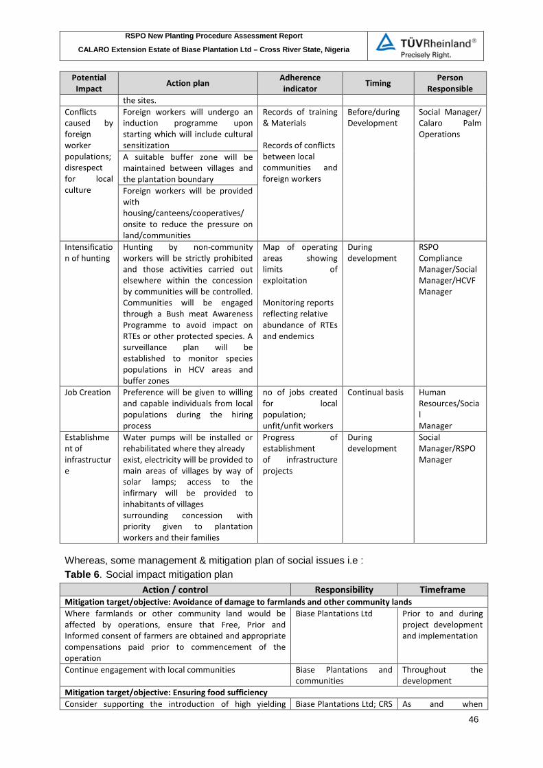
RSPO New Planting Procedure Assessment Report
CALARO Extension Estate of Biase Plantation Ltd – Cross River State, Nigeria
46
Potential Impact Action plan Adherence
indicator Timing Person Responsible
the sites. Conflicts caused by foreign worker populations; disrespect for local culture
Foreign workers will undergo an induction programme upon starting which will include cultural sensitization
Records of training & Materials Records of conflicts between local communities and foreign workers
Before/during Development
Social Manager/ Calaro Palm Operations
A suitable buffer zone will be maintained between villages and the plantation boundary Foreign workers will be provided with housing/canteens/cooperatives/ onsite to reduce the pressure on land/communities
Intensification of hunting
Hunting by non-community workers will be strictly prohibited and those activities carried out elsewhere within the concession by communities will be controlled. Communities will be engaged through a Bush meat Awareness Programme to avoid impact on RTEs or other protected species. A surveillance plan will be established to monitor species populations in HCV areas and buffer zones
Map of operating areas showing limits of exploitation Monitoring reports reflecting relative abundance of RTEs and endemics
During development
RSPO Compliance Manager/Social Manager/HCVF Manager
Job Creation Preference will be given to willing and capable individuals from local populations during the hiring process
no of jobs created for local population; unfit/unfit workers
Continual basis
Human Resources/Social Manager
Establishment of infrastructure
Water pumps will be installed or rehabilitated where they already exist, electricity will be provided to main areas of villages by way of solar lamps; access to the infirmary will be provided to inhabitants of villages surrounding concession with priority given to plantation workers and their families
Progress of establishment of infrastructure projects
During development
Social Manager/RSPO Manager
Whereas, some management & mitigation plan of social issues i.e : Table 6. Social impact mitigation plan
Action / control Responsibility Timeframe Mitigation target/objective: Avoidance of damage to farmlands and other community lands Where farmlands or other community land would be affected by operations, ensure that Free, Prior and Informed consent of farmers are obtained and appropriate compensations paid prior to commencement of the operation
Biase Plantations Ltd
Prior to and during project development and implementation
Continue engagement with local communities Biase Plantations and communities
Throughout the development
Mitigation target/objective: Ensuring food sufficiency Consider supporting the introduction of high yielding Biase Plantations Ltd; CRS As and when

RSPO New Planting Procedure Assessment Report
CALARO Extension Estate of Biase Plantation Ltd – Cross River State, Nigeria
47
Action / control Responsibility Timeframe varieties of crops to increase productivity Ministry of Agric
identified as viable option
Consider supplying farm inputs and credit to farmers on agreed terms
Biase Plantations Ltd
Throughout project implementation
Consider provision of agricultural extension services to farmers
Biase Plantations Ltd Throughout project implementation
Consider provision on modern farm implements and processing mills (e.g. cassava mill) on terms agreed with the communities
Biase Plantations Ltd
Throughout project implementation
Mitigation target/objective: To minimize influx of plantation workers and its implications for communities’ family structures and social networks Priority should be given to host communities for all categories of workers to be recruited provided they have the requisite knowledge and expertise
Biase Plantations and communities
Throughout the project’s life
Sensitise migrant workers on the need to respect the local socio-cultural systems
Biase Plantations Throughout the project
Monitor the conduct of workers in the communities (through regular interactions with the communities) and take disciplinary actions against those found to consistently and grossly undermine the local norms and value systems
Biase Plantations, Host communities
Throughout the project
Monitor social impacts of operations on local communities and population
Biase Plantations Ltd 3 Years after commencement, then biennially
Mitigation target/objective: To ensure that plantation development and processing activities do not destroy traditional conservation, HCV and NTFP collection areas Adoption, implementation and monitoring of HCV, SIA and EIA recommendations
Biase Plantations
Throughout project life
Continuous engagement with host communities Biase Plantations and communities
Throughout project life
Compliance with policies legal, regulatory and traditional systems
Biase Plantations Throughout project life
Training and instructions for field operators and supervisors
Biase Plantations Annually
Effective and efficient monitoring of plantation management and operational plans
Biase Plantations Throughout project life
Support enforcement of measures (in collaboration with the relevant state institutions) to control unauthorized activity in HCV areas
Biase Plantations Throughout project life
Mitigation target/objective: Minimizing water pollution Adopt and implement impact assessment management recommendations (HCV and EIA)
Biase Plantations Throughout project life
Develop, implement and review a detailed Water Management Plan
Biase Plantations Prior to and during project implementation
There shall be no development in buffer zones and watershed. Riparian vegetation must be maintained and chemical use prohibited
Biase Plantations and contractors
Throughout project life
Develop a detailed Integrated Pest Management Plan which permits use of chemicals as a last resort
Biase Plantations Prior to nursery and plantation establishment
Only agro-chemicals registered by the National Environmental Standards and Regulations Enforcement Agency (NESREA) or those allowed under Nigerian laws should be used
Biase Plantations Throughout project life
Develop and implement instructions for application of Biase Plantations Ltd Before plantation

RSPO New Planting Procedure Assessment Report
CALARO Extension Estate of Biase Plantation Ltd – Cross River State, Nigeria
48
Action / control Responsibility Timeframe agro-chemicals field activities Persistent Organic Pollutants banned under Stockholm Convention of 17th May 2004 should not be used
Biase Plantations Throughout project life
Develop and implement a Waste Management Plan Biase Plantations Prior to and during project implementation
Dumping of waste (including POME) into water bodies must be avoided but where necessary, the waste should be treated to an acceptable standard (as per NESREA requirements)
Biase Plantations and contractors
Throughout project life
Respect and compliance with legal and regulatory requirements
Biase Plantations and contractors
Throughout project life
Mitigation target/objective: Minimise air pollution Ensure recommendations contained in EIA are fully implemented
Biase Plantations and contractors
Throughout project life
Implement dust suppression measures for vehicles such as wetting of roads on regular basis during dry seasons and as and when necessary (i.e. surface treatment), gravelling or application of palm kernel shells on roads (surface improvement), reducing traffic and enforcing speed limits on dusty roads
Biase Plantations and contractors
Throughout project life
Continually pursue cleaner technology in the mill to reduce smoke emissions
Biase Plantations Ltd Throughout project life
Install a system that captures methane from effluent ponds for use as energy
Biase Plantations Ltd As and when the company can afford the technology
Mitigation target/objective: To avoid or minimise the exposure of workers and local communities to health and safety risks All tasks should be risk assessed Biase Plantations In 1st year of
operation Standard Operating Procedures should be developed for undertaking operations and implemented
Biase Plantations Prior to and during project implementation
Application of agro-chemicals should be in strict compliance with manufacturer’s instructions and generally established safety procedures
Biase Plantations Throughout project life
Workers should be provided with PPEs appropriate to each task
Biase Plantations Throughout project life
Skills audits should be undertaken to determine training and skills development requirements
Biase Plantations Throughout the project
When required, implement training and skills development programs for employees
Biase Plantations Throughout the project
Ensure all vehicles are in good working condition, drivers are qualified and adhere to road safety rules
Biase Plantations Throughout project life
Ensure workers have appropriate and safe means of transport to and from work site
Biase Plantations Throughout project life
Ensure drivers adhere to speed limits and institute and implement sanctions against violators
Biase Plantations Throughout project life
Regular assessment of medical status of workers in high risk task areas (e.g. chemical handlers)
Biase Plantations Throughout project life
Ensure that loads are secured safely on vehicles during transport
Biase Plantations Throughout project life
Adoption and implementation of health education programmes (e.g. on STDs) for workers and communities
Biase Plantations and worker unions
Throughout project life
Provide remedial healthcare services for workers and Biase Plantations Throughout project

RSPO New Planting Procedure Assessment Report
CALARO Extension Estate of Biase Plantation Ltd – Cross River State, Nigeria
49
Action / control Responsibility Timeframe communities life Mitigation target/objective: To minimise impacts of operations on public facilities Where feasible, Biase Plantations should provide similar facilities or infrastructure for its operations
Biase Plantations As and when necessary
Ensure that damage caused to public facilities are appropriately fixed and within reasonable timeframe
Biase Plantations and contractors
Soon after damage Is identified
Develop guidelines for key activities that could potentially impact on public facilities
Biase Plantations Within 2 years of operations
Regular and effective monitoring of operation’s impacts on public facilities and infrastructure
Biase Plantations To be part of monitoring
Support to the development of public facilities and infrastructure (e.g. schools, road building and maintenance, electricity etc.)
Biase Plantations Throughout project life
Mitigation target/objective: To avoid displacement of communities and people Measures shall be taken to avoid displacement of communities and people
Biase Plantations Throughout project life
Where displacement of people and/or communities are necessary measures are taken to ensure their Free Prior and Informed Consent are sought
Biase Plantations Throughout project life
Where displacement of people and/or communities occur appropriate and acceptable compensations are paid
Biase Plantations Throughout project life
Displacement of people and/or communities are carried out in accordance with Nigeria’s legal requirements and international best practice
Biase Plantations Throughout project life
Mitigation target/objective: To maximise local employment and ensure reasonable quality of life and working conditions of workers in plantations and mills Ensure workers’ conditions including salaries and wages are at least the same or exceeds the conditions for similar category of work in Nigeria
Biase Plantations and contractors
Throughout project life
Dialogue, regular interactions and effective communication with workers union
Biase Plantations and Workers reps
Throughout project life
Develop and implement code of conduct to cover the activities of workers house on site
Biase Plantations Throughout project life
Ensure workers have appropriate and safe means of transport to and from work site
Biase Plantations Throughout project life
Adopt and implement disputes and grievance resolution policy
Biase Plantations Throughout project life
b. Summary of Management and Mitigation Plans (HCV).
There are some recommendations has been made for HCV management and mitigation plans through threat analysis and multi-stakeholders inputs. Table 7 shows a summary of HCVs identified with management plan for Calaro Extension Estate (BPL) Table 7: HCV Management Recommendation
HCV Findings Management Objective Spatial Presence Management Plan 1.1 Protected Areas
Boundaries with the Uwet Odot and Oban Forest Reserve
To ensure the maintenance of adequate buffer zone to reduce impact of operations on nearby PAs
To maintain a 100m buffer zone along the boundaries with the forest reserves. No conversion to take place in these buffer areas
1.2 Rare,
Slender snout crocodile and
To ensure maintenance of the population of
Few individuals of the slender-snout
The recommended set aside swampy area is excluded from

RSPO New Planting Procedure Assessment Report
CALARO Extension Estate of Biase Plantation Ltd – Cross River State, Nigeria
50
threatened, endangered species
Sitatunga Slender-snout crocodiles and Sitatunga. Maintain populations of other threatened species
crocodile and the Sitatunga known to be present in Nigeria
conversion. The population of the endangered species is monitored on a regular basis
3 Rare, threatened, endangered ecosystems
Swampy vegetations
To maintain swamps and their vegetations to continue to serve as habitat for species
Blocks of swamps dispersed through the concession
The recommended set aside swampy area is excluded from conversion. The population of the endangered species is monitored on a regular basis
4.1 Forests critical to water catchments
Riparian buffers
To ensure perpetual flow of clean water and fishery resources for the host communities by setting aside and maintaining appropriate buffer zones for all rivers and streams in the concessions.
All rivers in the concessions
Riparian vegetation and buffering of rivers and streams. 10m at each side of streams < 5 metres width, 50 m buffer for rivers 5 < 20m width and 100 m for rivers with width <20m. Management recommendations include protection and maintenance of buffer zones, erosion control practices for all areas with slopes of above 5 degrees.
5 Critical livelihood sources
Present at the Ababua River and riparian buffer zones
To ensure that the oil palm plantation development programme does not threaten communities’ access to water resources.
Rivers in the concession
Implementing the recommended buffer zone and erosion control measures.
The Biase Plantation Limited is also developed HCV mitigation and monitoring plans based on above HCV management recommendation. Timelines of programs and activities to mitigate and monitor HCV areas described in the following table below. Table 8 Summary of HCVs Mitigation and Monitoring Measures Plan an in the Calaro Extension Estate
Objective HCV Ref Action to mitigate Monitoring measures /
expected result Timeline Maintaining water quality and the HCVs it supports Protection of rivers
4.1
Buffering of water bodies Water bodies in the concessions serve as sources of water and as fishing grounds for communities in the area and are therefore classified as HCV 4.1
Set aside buffer zones included in GIS database as HCV 4.1
ALL
Accurate mapping of all HCVs and their management areas in the concessions should be carried out including mapping of steep slopes.
Availability of accurate maps of all HCVs management areas
ALL
Designation of a responsible person for all “HCVs” to provide training and ensuring that field workers adhere to management recommendations for HCV areas

RSPO New Planting Procedure Assessment Report
CALARO Extension Estate of Biase Plantation Ltd – Cross River State, Nigeria
51
Objective HCV Ref Action to mitigate Monitoring measures /
expected result Timeline
1.2, 1.4, 4.1
Workers and staff responsible for HCV delineate 10 metre buffer zones on each side of streams (<5m width)
Measure river width/buffer zone width Buffer zones included in GIS database
HCV field team to delineate 50-meter buffer zones on each side of rivers with width of 5-20m
Measure river width/buffer zone width Buffer zones included in GIS database
HCV field team to delineate 100 meters’ buffer zones on each side of major rivers with width greater than 20 m e.g. the Cross River)
Measure river width/buffer zone width Buffer zones included in GIS database
1.2, 1.4, 4.1
Land preparation teams are trained to respect buffer zones
Evidence of training and understanding of buffer zones management and monitoring recommendations and requirements Buffer zones are respected
Land preparation teams are provided with maps of areas identified as protected areas
Land preparation teams are trained to carry out land conversion laterally to buffer zones to avoid having it destroyed by falling trees and shrubs
No impact on buffer zones
ALL
Regular monitoring to ensure that buffer zones requirements are respected If buffer zones are not respected, corrective actions must be taken immediately
Corrective actions record
Bridges and means of crossing rivers must be pre-planned
Bridges and means of crossing rivers must be done according to recognized best practices
Check erosion around bridges
Erosion control
ALL
HCV or environmental management field team are trained to implement and respect erosion control recommendations
Training records and proof of application of required measures
1.2, 1.4, 4.1, 4.2
Areas with slopes above 25 degrees are excluded from conversion
Areas above 25 degrees are delineated on the ground and recorded in GIS database and on maps
Areas with slopes between 18 and 25 degrees are identified and mapped. Such areas may be planted on condition that erosion control measures such as terracing is
Area delineated on the ground, recorded in GIS database and appropriately mapped.
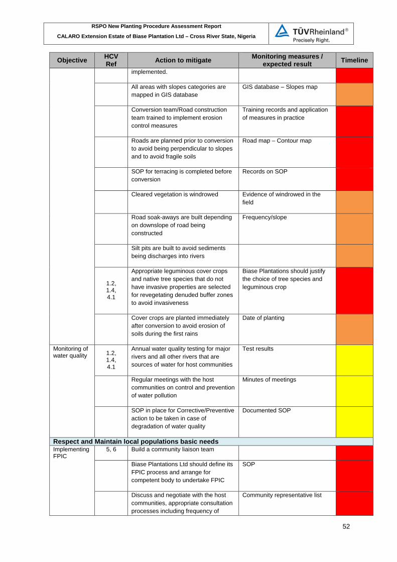
RSPO New Planting Procedure Assessment Report
CALARO Extension Estate of Biase Plantation Ltd – Cross River State, Nigeria
52
Objective HCV Ref Action to mitigate Monitoring measures /
expected result Timeline implemented.
All areas with slopes categories are mapped in GIS database
GIS database – Slopes map
Conversion team/Road construction team trained to implement erosion control measures
Training records and application of measures in practice
Roads are planned prior to conversion to avoid being perpendicular to slopes and to avoid fragile soils
Road map – Contour map
SOP for terracing is completed before conversion
Records on SOP
Cleared vegetation is windrowed Evidence of windrowed in the field
Road soak-aways are built depending on downslope of road being constructed
Frequency/slope
Silt pits are built to avoid sediments being discharges into rivers
1.2, 1.4, 4.1
Appropriate leguminous cover crops and native tree species that do not have invasive properties are selected for revegetating denuded buffer zones to avoid invasiveness
Biase Plantations should justify the choice of tree species and leguminous crop
Cover crops are planted immediately after conversion to avoid erosion of soils during the first rains
Date of planting
Monitoring of water quality 1.2,
1.4, 4.1
Annual water quality testing for major rivers and all other rivers that are sources of water for host communities
Test results
Regular meetings with the host communities on control and prevention of water pollution
Minutes of meetings
SOP in place for Corrective/Preventive action to be taken in case of degradation of water quality
Documented SOP
Respect and Maintain local populations basic needs Implementing FPIC
5, 6 Build a community liaison team
Biase Plantations Ltd should define its FPIC process and arrange for competent body to undertake FPIC
SOP
Discuss and negotiate with the host communities, appropriate consultation processes including frequency of
Community representative list
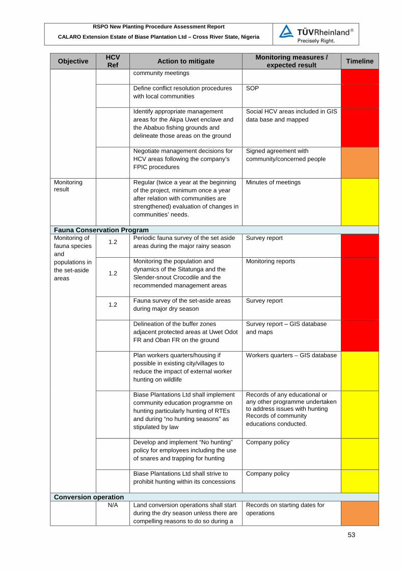
RSPO New Planting Procedure Assessment Report
CALARO Extension Estate of Biase Plantation Ltd – Cross River State, Nigeria
53
Objective HCV Ref Action to mitigate Monitoring measures /
expected result Timeline community meetings
Define conflict resolution procedures with local communities
SOP
Identify appropriate management areas for the Akpa Uwet enclave and the Ababuo fishing grounds and delineate those areas on the ground
Social HCV areas included in GIS data base and mapped
Negotiate management decisions for HCV areas following the company’s FPIC procedures
Signed agreement with community/concerned people
Monitoring result
Regular (twice a year at the beginning of the project, minimum once a year after relation with communities are strengthened) evaluation of changes in communities’ needs.
Minutes of meetings
Fauna Conservation Program Monitoring of fauna species and populations in the set-aside areas
1.2 Periodic fauna survey of the set aside areas during the major rainy season
Survey report
1.2
Monitoring the population and dynamics of the Sitatunga and the Slender-snout Crocodile and the recommended management areas
Monitoring reports
1.2 Fauna survey of the set-aside areas during major dry season
Survey report
Delineation of the buffer zones adjacent protected areas at Uwet Odot FR and Oban FR on the ground
Survey report – GIS database and maps
Plan workers quarters/housing if possible in existing city/villages to reduce the impact of external worker hunting on wildlife
Workers quarters – GIS database
Biase Plantations Ltd shall implement community education programme on hunting particularly hunting of RTEs and during “no hunting seasons” as stipulated by law
Records of any educational or any other programme undertaken to address issues with hunting Records of community educations conducted.
Develop and implement “No hunting” policy for employees including the use of snares and trapping for hunting
Company policy
Biase Plantations Ltd shall strive to prohibit hunting within its concessions
Company policy
Conversion operation N/A Land conversion operations shall start
during the dry season unless there are compelling reasons to do so during a
Records on starting dates for operations

RSPO New Planting Procedure Assessment Report
CALARO Extension Estate of Biase Plantation Ltd – Cross River State, Nigeria
54
Objective HCV Ref Action to mitigate Monitoring measures /
expected result Timeline rainy season
N/A Land conversion should start away from the protected areas and moving gradually towards those areas
Scientific Research N/A Development of partnership on
hydrology research
Implement recommendation in the field N/A Designation of a responsible person
for monitoring the field implementations of HCV management recommendations
Legend Actions to be implemented: Before conversion During conversion After planting
Refers to stakeholder consultation minutes of meeting, Cross River Forestry Commission was reminded that is important for the company to manage its operations in a way that minimises the pressure on adjoining protected areas. There is HCV 1.1 has been identified on the adjacent to Uwet Odot FR and management plan also recommended to maintain a 100m buffer zone along the boundaries with the forest reserves. However, BPL has not included this area to be mitigated. A buffer as HCV 1.1 need to mitigated to reduce impact of operations on nearby Protection Areas. No conversion to take place in these buffer areas and should be expressed in development map plan.
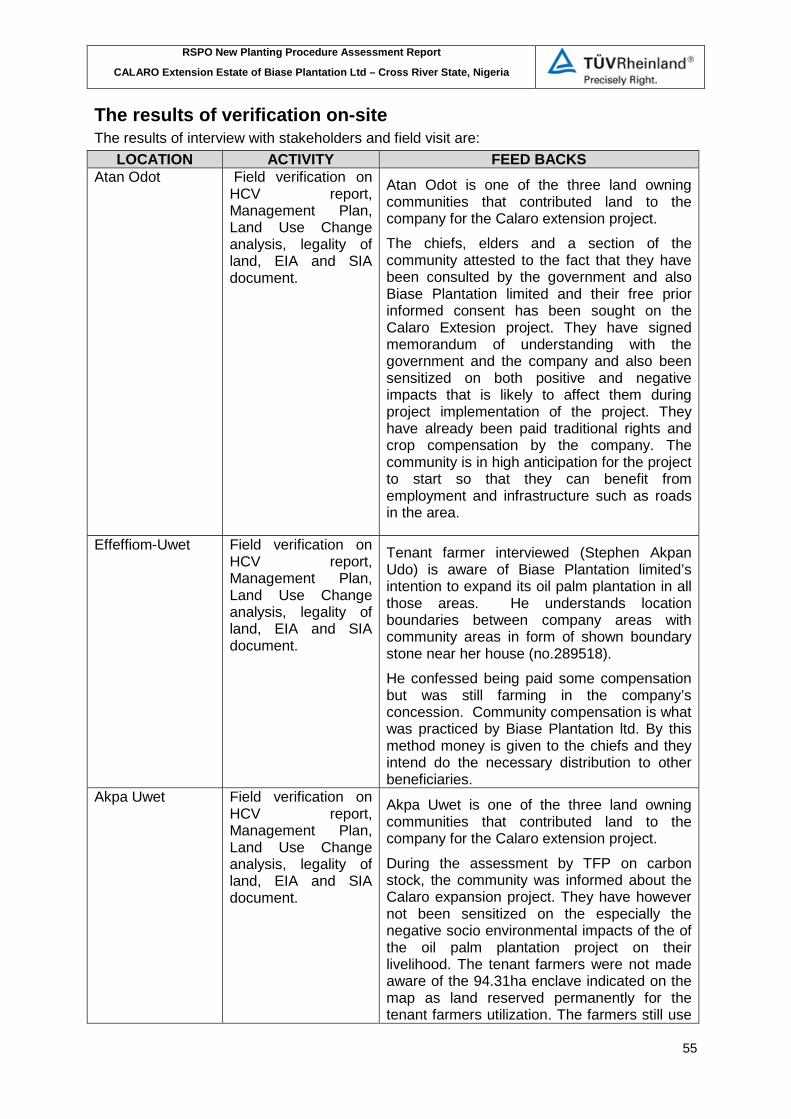
RSPO New Planting Procedure Assessment Report
CALARO Extension Estate of Biase Plantation Ltd – Cross River State, Nigeria
55
The results of verification on-site The results of interview with stakeholders and field visit are:
LOCATION ACTIVITY FEED BACKS Atan Odot Field verification on
HCV report, Management Plan, Land Use Change analysis, legality of land, EIA and SIA document.
Atan Odot is one of the three land owning communities that contributed land to the company for the Calaro extension project. The chiefs, elders and a section of the community attested to the fact that they have been consulted by the government and also Biase Plantation limited and their free prior informed consent has been sought on the Calaro Extesion project. They have signed memorandum of understanding with the government and the company and also been sensitized on both positive and negative impacts that is likely to affect them during project implementation of the project. They have already been paid traditional rights and crop compensation by the company. The community is in high anticipation for the project to start so that they can benefit from employment and infrastructure such as roads in the area.
Effeffiom-Uwet Field verification on HCV report, Management Plan, Land Use Change analysis, legality of land, EIA and SIA document.
Tenant farmer interviewed (Stephen Akpan Udo) is aware of Biase Plantation limited’s intention to expand its oil palm plantation in all those areas. He understands location boundaries between company areas with community areas in form of shown boundary stone near her house (no.289518). He confessed being paid some compensation but was still farming in the company’s concession. Community compensation is what was practiced by Biase Plantation ltd. By this method money is given to the chiefs and they intend do the necessary distribution to other beneficiaries.
Akpa Uwet Field verification on HCV report, Management Plan, Land Use Change analysis, legality of land, EIA and SIA document.
Akpa Uwet is one of the three land owning communities that contributed land to the company for the Calaro extension project. During the assessment by TFP on carbon stock, the community was informed about the Calaro expansion project. They have however not been sensitized on the especially the negative socio environmental impacts of the of the oil palm plantation project on their livelihood. The tenant farmers were not made aware of the 94.31ha enclave indicated on the map as land reserved permanently for the tenant farmers utilization. The farmers still use

RSPO New Planting Procedure Assessment Report
CALARO Extension Estate of Biase Plantation Ltd – Cross River State, Nigeria
56
LOCATION ACTIVITY FEED BACKS fire as medium of land preparation. It also observed that illegal logging was taking place in the conservation area. This practice has drastically reduced the carbon stock level of High conservation area.
High Conservation Value areas.
Field verification on HCV report, Management Plan, Land Use Change analysis
It also observed that illegal logging was taking place in the conservation area. This practice has drastically reduced the carbon stock level of the High conservation areas.
Riparian Calabar river
Burning of new farmland by local communities
-

RSPO New Planting Procedure Assessment Report
CALARO Extension Estate of Biase Plantation Ltd – Cross River State, Nigeria
57
VERIFICATION STATEMENT: Biase Plantation Limited opted for document verification and field verification to conduct the New Planting Procedure (NPP). Audit team from TUV Rheinland Indonesia conducted desk study / verification of document and verification of the project site on 10th – 12th March 2016 in project area. The audit team members are Hendra Fachrurozy (legal land, company aspect, environment & social aspect) and Riswan (HCV aspect) and 1 (one) local expert - Frank Adu. The social and environmental assessments (SEIA) and High Conservation Value (HCV) were detailed, comprehensive and professionally carried out. The management plan has included the findings of the SEIA and HCV conducted by national licensed and the RSPO licensed assessors as well as incorporating in the HCV, environmental and social impact assessments findings. A note made on the absent of mitigation and monitoring plan for HCV 1.1 area along the boundaries with the Uwet Odot Forest Reserves. Total areas used in NPP document is 2,368.94 ha (new size). The company has also prepared a comprehensive and professional Carbon Stock Report, that it will be sending to the ERWG as a standalone document for review during this NPP Notification. The company has fully commitment to not starting land clearing without the approval of their EIA by the government and without the final approval and completion of the NPP Public Consultation. Biase Plantation Limited has adhered to the RSPO New Planting Procedures and has documented the assessments and plans according to the RSPO templates issued in May, 2010. The opinion of the TUV Rheinland auditors that the HCV & ESI assessment and management plan at Biase Plantation Limited are comprehensive, professional and complied to RSPO principles, criteria and indicators for the new development area. Signed on behalf of TUV Rheinland Indonesia
Hendra Fachrurozy Lead Auditor Date: 23 May 2016 On behalf of the company, I acknowledge the responsibilities of the company to implement the management and mitigations plans. Signed on behalf of the company,
… Date: 23 May 2016